Embed Size (px)
Citation preview
TS 2H - e-Land Administration Projects
Dimitris ROKOS, Konstantinos KYRIAZIS and Panos LOLONIS
Setting Up the Infrastructure for Improving the Development of Cadastre en Greece
FIG Congress 2010
Facing the Challenges – Building the Capacity
Sydney, Australia, 11-16 April 2010
1/18
Setting Up the Infrastructure for Improving the Development of
Cadastre in Greece
Dimitris ROKOS, Konstantinos KYRIAZIS and Panos LOLONIS, Greece
Key words: cadastre, land management, land administration, NSDI, INSPIRE
SUMMARY
Since the early 19th
century Greece has adopted the French originated system of Registrations
and Mortgages as a public register of real property owners and the deeds that they have been
involved in. The development of the Greek Cadastre has started in the mid 1990s. The
project advances through a demanding procedure which requires input by many different data
sources and the involvement of different entities (beneficiaries, state agencies that manage
state land or issue acts that modify the cadastral situation in an area, registrars, notaries,
lawyers and surveyors). So far, with the cadastral programs initiated in the 1990’s, only a
small part of the Country has been included in the cadastral project.
In order to advance the project of developing Cadastre at a faster pace, Ktimatologio S.A., the
company responsible to develop and maintain Cadastre in Greece, undertook a large project,
with the co-financing of the European Union which aimed to develop a data and technology
infrastructure that will improve the efficiency and effectiveness of developing Cadastre in
Greece taking advantage of economies of scale that can be achieved by country – wide
interventions.
The project was initiated in 2005. Currently most of the actions included in it have been
completed and its products have already started being used in the new cadastral survey
program that is currently underway, which will include in the cadastre all the major urban
centers of the Country. The benefits of using this infrastructure are already evident to all the
parties involved in the new cadastral program by providing high quality data and services to
all. Furthermore, the results of the large project will greatly contribute to the improvement of
the effectiveness of all the state agencies that must use cadastral or spatial data during their
daily operation.
TS 2H - e-Land Administration Projects
Dimitris ROKOS, Konstantinos KYRIAZIS and Panos LOLONIS
Setting Up the Infrastructure for Improving the Development of Cadastre en Greece
FIG Congress 2010
Facing the Challenges – Building the Capacity
Sydney, Australia, 11-16 April 2010
2/18
Setting Up the Infrastructure for Improving the Development of
Cadastre in Greece
Dimitris ROKOS, Konstantinos KYRIAZIS and Panos LOLONIS, Greece
1. Background
The project of developing Cadastre in Greece was initiated by the Ministry of Environment,
Physical Planning and Public Works back in 1994. The Cadastral System aims to replace the
existing system of Registrations and Mortgages, which maintains in paper-form a register of
all the deeds on real properties that a particular person has been involved in, in a particular
area (person-based organization of the information). This register is not complete (e.g. the
rights of the State are not registered), does not ensure legal security of the transactions and
does not allow the identification of the existing owners or the location of a real property.
Furthermore, there are even more problems plaguing the real property market in Greece that
make the situation even more complex, such as:
− The Greek State does not know the extent of the land it owns (i.e. forested areas
and coastal zones)
− State agencies that issue acts that modify real properties and their ownership status
maintain paper records that are not well-organized and information is very hard to
retrieve from them.
− Topographic plans whenever they are issued for land parcels not only are seldom
agreed among neighbours but in many cases they are drafted in local reference
systems, making their reliability low.
− The records of the Registrations’ and Mortgage Offices contain all the information
since their establishment without being able to assess the current owner of a real
property unless a lawyer runs a full legal evaluation of all the registered
information concerning this real property for a period of at least 30 to 50 years.
In this context, the Greek Cadastre comes as a uniform and always up-to-date system of
registrations, which consist of the geometric description and the ownership status of all the
real properties of the Country, overseen and guaranteed by the State. Thus, the term Cadastre
in Greece is used to describe a system that combines Cadastre and Land Register.
The first cadastral programmes started back in 1996-1998 and covered about 340 regions of
the country. With the completion of these programmes, 8.500 square kilometers and 6.1
million property rights had been registered in the Cadastre. For the operation of the Cadastre
in these areas, 97 interim Cadastral Offices have been established.
However, these programmes came across serious problems that resulted in considerable
delays and budget overruns showing that a new approach was needed in order to carry out
successfully the development of the Greek Cadastre.
2. DATA AND IT INFRASTRUCTURE FOR A MODERN CADASTRE
In order to deal with all this uncertainty and to better prepare the continuation of the Cadastral
project for the rest of the country, Ktimatologio S.A. the company responsible for the
development and the operation of Cadastre in Greece, with the assistance and the co -
TS 2H - e-Land Administration Projects
Dimitris ROKOS, Konstantinos KYRIAZIS and Panos LOLONIS
Setting Up the Infrastructure for Improving the Development of Cadastre en Greece
FIG Congress 2010
Facing the Challenges – Building the Capacity
Sydney, Australia, 11-16 April 2010
3/18
financing of the European Commission, drafted the terms of reference for a major
infrastructure project that would drastically alter the real property information landscape in
Greece.
The large project was titled “Data and IT Infrastructure for a Modern Cadastre” with an
overall budget of about 80 million euros (without V.A.T.) and it was included in the 3rd
Community Support Framework (CSFIII), under the Operational Programme “Information
Society” with 50% co financing by the Greek State and the European Commission.
The project aimed at the establishment of a functional, high quality database at a national
level which would contain preliminary cadastral data and the necessary IT infrastructure in
order to support optimized cadastral survey projects until the completion of the development
of the Cadastre in Greece.
The large project included a series of subprojects, which, apart from the commencement of
the new cadastral survey studies for the large urban centers of the Country, which is not dealt
with in the context of this paper, involved the following:
− Setting up a complete national GPS reference network and similar positioning
service (HEPOS) for the entire Greek State, in order to become the basic geodetic
and surveying infrastructure for all cadastral projects from now on.
− Preliminary delineation of forests and forested areas for the whole country.
− Development of basemaps for delineating the coastal zone for the whole country.
− Digitization of existing cadastral data on rural areas of the country (land
consolidation and land distribution acts) and development of a database
compatible with the database of the Greek Cadastre.
− Development for the whole country very large-scale fully orthorectified imagery as
a basemap for the cadastral surveys of urban areas and orthoimagery on a scale of
1:5 000 as a basemap for the cadastral surveys of agricultural, forested and
mountainous areas.
− Establishment of IT infrastructure and services to support the management of these
activities, as well as, provide state-of-the-art services in the context of the new
cadastral projects.
− Digitization of the Cadastral Books and Maps in the existing Cadastral Offices for
the islands Kos, Leros and Rhodes (Dodecanese Cadastre).
2.1 The Hellenic Positioning System
The Hellenic POsitioning System (HEPOS) was established by KTIMATOLOGIO S.A. in
order to improve, homogenize and facilitate the cadastral survey activities in Greece. The
system allows for the determination of high precision and homogeneous coordinates
throughout the whole country, setting up an infrastructure that, at the same time, reduces the
cost and the effectiveness of GPS-surveying.
The HEPOS system, which was fully operational within 13 months after the contract signing,
consists of 98 permanent GPS reference stations (Figure 1), a control center and
communication lines (main and backup) that supports data transfer between the reference
stations and the control center.
HEPOS supports all common GPS techniques for post-processing and real-time surveying. In
particular, for network-based positioning the techniques of VRS, FKP and MAC are

TS 2H - e-Land Administration Projects
Dimitris ROKOS, Konstantinos KYRIAZIS and Panos LOLONIS
Setting Up the Infrastructure for Improving the Development of Cadastre en Greece
FIG Congress 2010
Facing the Challenges – Building the Capacity
Sydney, Australia, 11-16 April 2010
4/18
supported. For post-processing applications, RINEX and Compact RINEX files are provided
for RS and VRS at observation intervals of 1, 2, 5, 10, 15, 20, 30 or 60 sec.
At the same time, HEPOS modernizes the geodetic infrastructure of the country. Since 1987,
the official reference system of Greece is the Hellenic Geodetic Reference System of 1987
(HGRS87). This system is implemented by trigonometric points throughout the Country.
Taking into consideration that a) these trigonometric points are poorly maintained and b) there
are considerable tectonic movements that move parts of the Country towards different
directions, this reference framework for ground surveys has become quite problematic
causing major incompatibilities among measurements in the context of different projects by
different agencies, thus reducing the possibility of data re-usability among state agencies.
HEPOS, however, introduces a new geodetic reference frame as a realization of ETRS89.
The new system is named HTRS07 (Hellenic Terrestrial Reference System 2007) and aspires
to become the new national reference system. Towards this direction, a two-way
transformation model between HTRS07 and HGRS87 has been established. To accomplish
this, approximately 2470 trigonometric points, evenly distributed all over Greece, have been
measured in a national GPS measuring campaign in a period of 8 months. The measured
points are shown in Figure 4.
Figure 1. Graphic representation of the HEPOS reference network.

TS 2H - e-Land Administration Projects
Dimitris ROKOS, Konstantinos KYRIAZIS and Panos LOLONIS
Setting Up the Infrastructure for Improving the Development of Cadastre en Greece
FIG Congress 2010
Facing the Challenges – Building the Capacity
Sydney, Australia, 11-16 April 2010
5/18
Figure 2: The 2470 trigonometric points measured for the computation of transformation
parameters.
2.2 Forest delineation
In Greece, forested areas belong by default to the Greek State, unless a private person can
prove that he/she has titles that date back to the late 19th
century or an official deed of
concession by the State. In order to determine the forested areas, forest maps must be
developed through a complex and demanding procedure (stereoscopic photointerpretation and
field verification), taking into consideration the current land cover of an area, the land cover
back in 1945 (using 1945 aerial photography) and any administrative deeds issued by the
local forest services. The completion of forest maps for the entire country is a project with a
timetable of more than 10 years. For this reason, a project that would produce a preliminary
delineation of the forested areas by simple monoscopic photointerpretation of current and
1945 orthoimagery (Figure X) gives a good first approximation of the extents of forests in the
Country for planning reasons and as input data in the process of developing forest maps. The
project was carried out in 14 months running 6 contracts in parallel to cover the entire
Country. The results of the project gave for the first time a reliable measure of the extents of
forest land in the Country providing a very useful tool for physical planning and
environmental protection.

TS 2H - e-Land Administration Projects
Dimitris ROKOS, Konstantinos KYRIAZIS and Panos LOLONIS
Setting Up the Infrastructure for Improving the Development of Cadastre en Greece
FIG Congress 2010
Facing the Challenges – Building the Capacity
Sydney, Australia, 11-16 April 2010
6/18
Figure 3. Delineation of forested areas in 1945 imagery (in red) and recent imagery (in green)
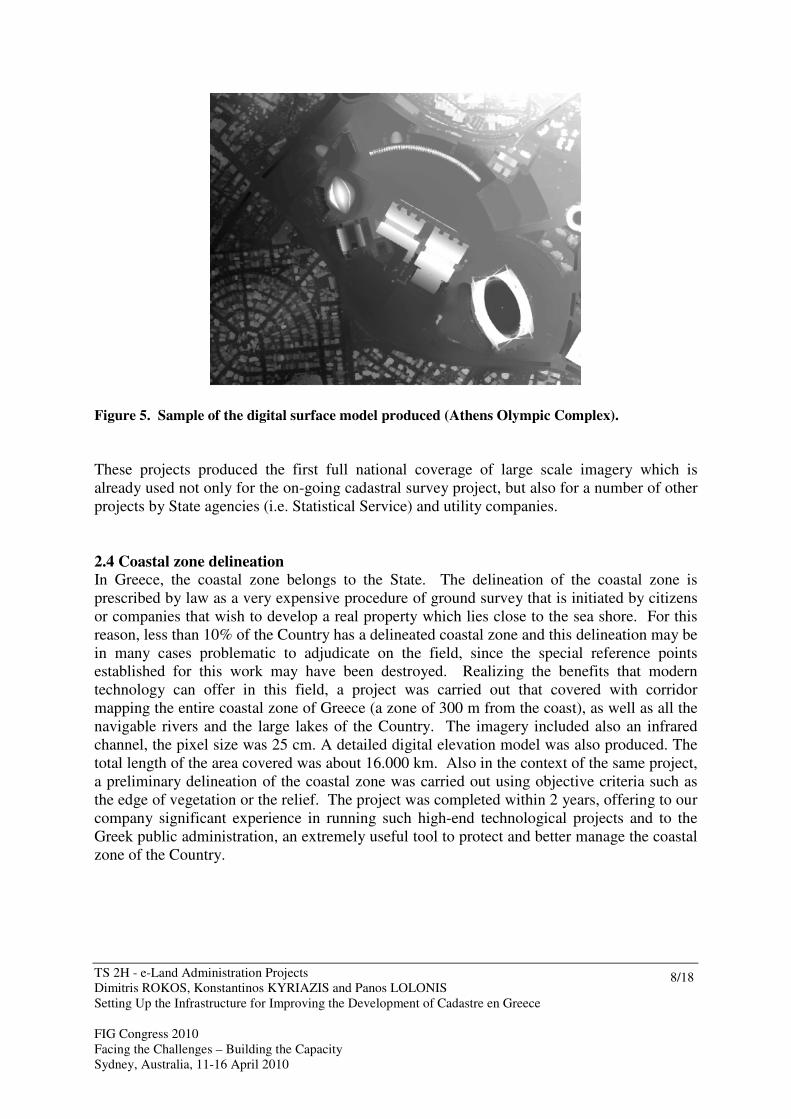
2.3 National coverage of orthoimagery
The development of the Cadastre in Greece is based on aerial photography which is used to
identify land parcel boundaries. In this context, for the purpose of extending Cadastre to
cover the whole country, 3 contracts were carried out in parallel to produce a national
coverage of orthoimagery with a pixel size of 50cm and the corresponding digital elevation
model. The projects were completed in 2,5 years.
Especially for the large urban centers of the Country covering about 3.500 square kilometers,
a separate contract was carried out that produced fully rectified orthoimagery with a pixel size
of 20cm and the corresponding digital surface model (DSM) (Figure X).

TS 2H - e-Land Administration Projects
Dimitris ROKOS, Konstantinos KYRIAZIS and Panos LOLONIS
Setting Up the Infrastructure for Improving the Development of Cadastre en Greece
FIG Congress 2010
Facing the Challenges – Building the Capacity
Sydney, Australia, 11-16 April 2010
7/18
Figure 4. Samples from the fully-rectified orthoimagery produced for the urban areas (Athens’
Olympic Complex).
TS 2H - e-Land Administration Projects
Dimitris ROKOS, Konstantinos KYRIAZIS and Panos LOLONIS
Setting Up the Infrastructure for Improving the Development of Cadastre en Greece
FIG Congress 2010
Facing the Challenges – Building the Capacity
Sydney, Australia, 11-16 April 2010
8/18
Figure 5. Sample of the digital surface model produced (Athens Olympic Complex).
These projects produced the first full national coverage of large scale imagery which is
already used not only for the on-going cadastral survey project, but also for a number of other
projects by State agencies (i.e. Statistical Service) and utility companies.
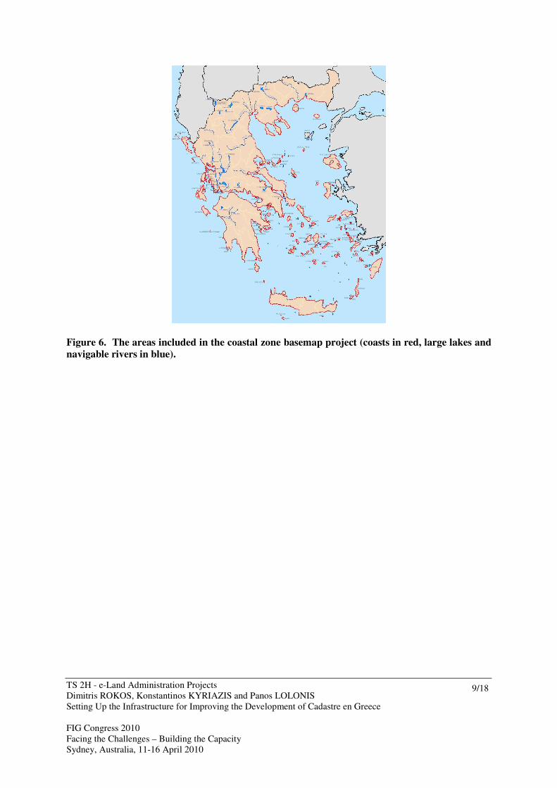
2.4 Coastal zone delineation
In Greece, the coastal zone belongs to the State. The delineation of the coastal zone is
prescribed by law as a very expensive procedure of ground survey that is initiated by citizens
or companies that wish to develop a real property which lies close to the sea shore. For this
reason, less than 10% of the Country has a delineated coastal zone and this delineation may be
in many cases problematic to adjudicate on the field, since the special reference points
established for this work may have been destroyed. Realizing the benefits that modern
technology can offer in this field, a project was carried out that covered with corridor
mapping the entire coastal zone of Greece (a zone of 300 m from the coast), as well as all the
navigable rivers and the large lakes of the Country. The imagery included also an infrared
channel, the pixel size was 25 cm. A detailed digital elevation model was also produced. The
total length of the area covered was about 16.000 km. Also in the context of the same project,
a preliminary delineation of the coastal zone was carried out using objective criteria such as
the edge of vegetation or the relief. The project was completed within 2 years, offering to our
company significant experience in running such high-end technological projects and to the
Greek public administration, an extremely useful tool to protect and better manage the coastal
zone of the Country.
TS 2H - e-Land Administration Projects
Dimitris ROKOS, Konstantinos KYRIAZIS and Panos LOLONIS
Setting Up the Infrastructure for Improving the Development of Cadastre en Greece
FIG Congress 2010
Facing the Challenges – Building the Capacity
Sydney, Australia, 11-16 April 2010
9/18
Figure 6. The areas included in the coastal zone basemap project (coasts in red, large lakes and
navigable rivers in blue).

TS 2H - e-Land Administration Projects
Dimitris ROKOS, Konstantinos KYRIAZIS and Panos LOLONIS
Setting Up the Infrastructure for Improving the Development of Cadastre en Greece
FIG Congress 2010
Facing the Challenges – Building the Capacity
Sydney, Australia, 11-16 April 2010
10/18
Figure 7. Samples of the coastal zone imagery and delineation.

TS 2H - e-Land Administration Projects
Dimitris ROKOS, Konstantinos KYRIAZIS and Panos LOLONIS
Setting Up the Infrastructure for Improving the Development of Cadastre en Greece
FIG Congress 2010
Facing the Challenges – Building the Capacity
Sydney, Australia, 11-16 April 2010
11/18
Figure 8. Sample of the detailed digital elevation model produced in the context of the coastal
zone basemap project.
2.5 Digitization of land consolidation and land redistribution acts
Land consolidation and land redistribution acts are the basis for developing cadastre in
agricultural areas. The official archives are dispersed in prefectural level in paper form kept
by the local competent agencies. Because of this, management of this information has been
problematic, reaching to the point that even basic statistics such as the extent of the country
covered by land consolidation/land redistribution acts could not be derived. Ktimatologio
S.A. with the co-operation of AGROGI S.A. a company of the Ministry of Agriculture
responsible to manage State rural lands carried out a project that involved the collection of all
the acts from the local agencies, scanning of the maps and tables, georeference of the maps
and production of a digital geo-database with all the information of these acts. The project
was carried out in-house by the two agencies employing over 60 persons fulltime for a period
of 2,5 years.
As a result, the valuable archive of all these administrative acts has been preserved and for the
first time useful information on a national scale can be deducted on the extent and the
characteristics of ownership in agricultural land in Greece.

TS 2H - e-Land Administration Projects
Dimitris ROKOS, Konstantinos KYRIAZIS and Panos LOLONIS
Setting Up the Infrastructure for Improving the Development of Cadastre en Greece
FIG Congress 2010
Facing the Challenges – Building the Capacity
Sydney, Australia, 11-16 April 2010
12/18
Figure 9. Samples of scanned and vectorized maps of a land consolidation act.

TS 2H - e-Land Administration Projects
Dimitris ROKOS, Konstantinos KYRIAZIS and Panos LOLONIS
Setting Up the Infrastructure for Improving the Development of Cadastre en Greece
FIG Congress 2010
Facing the Challenges – Building the Capacity
Sydney, Australia, 11-16 April 2010
13/18
Figure 10. A sample of a land consolidation table and a digital record produced from it.
2.6 IT infrastructure and web services for cadastral surveys
KTIMATOLOGIO S.A. has taken major steps into setting up a technological infrastructure
that:
- supports effectively the development and operation of the Cadastre, by providing advanced
technological solutions that ensure security, high availability and performance,
standardization and quality control of all the procedures,
- provides modern services to the citizens especially during the cadastral development stage,
- builds up a high performance data infrastructure that can effectively support the operation of
state administration in multiple levels, as well as become a major player in the context of
INSPIRE.
KTIMATOLOGIO S.A. has set up state-of-the-art data centers (primary and disaster
recovery) with high availability (99,99%), modern networking, security and backup
mechanisms and high storage capacity (120 TB in each), where all its data and applications
reside (central storage).
To improve the efficiency of new cadastral survey studies and to provide better services to all
interested parties, a series of applications have been developed inhouse.

TS 2H - e-Land Administration Projects
Dimitris ROKOS, Konstantinos KYRIAZIS and Panos LOLONIS
Setting Up the Infrastructure for Improving the Development of Cadastre en Greece
FIG Congress 2010
Facing the Challenges – Building the Capacity
Sydney, Australia, 11-16 April 2010
14/18
2.6.1 Services to citizens
Online internet applications have been developed for all the persons (natural or legal) who
want to declare their real property to the Cadastre during a cadastral survey study. Through
this application a user can online:
- declare all the information necessary to register his/her property to the Cadastre,
- identify the location of the declared real property on orthophotomaps,
- pay the cadastral fee using his/her credit card,
- send scanned copies of the deeds that support his/her declaration,
- print a receipt
2.6.2 Services to legal persons
For the legal persons that have a great number of rights to declare, KTIMATOLOGIO S.A.
developed a special application to allow them to produce a database with all the information
about their real property rights, and submit it electronically to the Cadastre. This application
has been used in the cadastral survey projects that were initiated in 2008 by most of the banks
operating in Greece.
2.6.3 Services to KT contractors of cadastral surveys
For the contractors carrying out the cadastral survey projects, KTIMATOLOGIO S.A. has
developed a special application used to receive, register and geo-locate on orthophotomaps all
the declarations that were presented in the cadastral survey offices. All the declarations'
information registered by this application was in real-time stored in KTIMATOLOGIO S.A.'s
data center. The application allows, among other things, uniform codification of all the
information registered, online checks that prohibit a number of mistakes during data entry,
computation of the corresponding cadastral fee for each declaration, real time monitoring of
the progress of the work and real time access to all the declaration data from KT's
headquarters.
These applications have already been successfully employed during the current cadastral
survey programme that involved in its first phase, the declaration of about 7.000.000 property
rights in over 100 municipalities.
2.6.4 Ktimatologio S.A.’s ERP
Also in the context of the Large Project, an Enterprise Resource Planning System was
introduced in Ktimatologio S.A. in order to manage the daily operations of the company. The
system includes as basic modules Human Resources Management, Accounting, Document
Management, Customer Relationship Management, Sales, Workflows and Project
Management. The project lasted two and a half years and now the system is operational in all
the departments of the company.
2.7 Digitization of the Dodecanese Cadastre
Since 1929, a cadastral system implemented by the Italians was set up for the islands of
Rhodes, Kos and part of the island of Leros. Since then the system is operating in paper form
maintaining a register consisting of cadastral index maps, individual real property plans,
cadastral books and deeds that generate, alter or annul the registered rights. The project
involved the scanning of the existing archive of these cadastral offices, georeference and
vectorizing of the cadastral maps and finally the development of a GIS database compatible

TS 2H - e-Land Administration Projects
Dimitris ROKOS, Konstantinos KYRIAZIS and Panos LOLONIS
Setting Up the Infrastructure for Improving the Development of Cadastre en Greece
FIG Congress 2010
Facing the Challenges – Building the Capacity
Sydney, Australia, 11-16 April 2010
15/18
with the data model used for the Greek Cadastre. The project was completed in 30 months
and it involved the digitization of over 6,3 million pages of documents and the development
of a digital database of over 800.000 real property rights.
Figure 11. Converting cadastral sheets in digital records.
Figure 12. A GIS system based on the original paper maps was developed
3. CONCLUSIONS
All actions included in the Ktimatologio’s CSFIII large project were organised on the basis of
experience acquired from the first three cadastral survey programmes. In particular, an effort
was made to avoid the barriers and risks encountered during implementation of those three

TS 2H - e-Land Administration Projects
Dimitris ROKOS, Konstantinos KYRIAZIS and Panos LOLONIS
Setting Up the Infrastructure for Improving the Development of Cadastre en Greece
FIG Congress 2010
Facing the Challenges – Building the Capacity
Sydney, Australia, 11-16 April 2010
16/18
programmes which led to delays in the completion of the projects and increased costs. The
actions included in the Large Project were designed and organised in such a way as to:
− Achieve the maximum possible economies of scale. This was done by discriminating
the cadastral survey activities (such as basemap production) which could be carried
out effectively at national level achieving considerable economies of scale, from those
which require detailed examination at a local level.
− Ensure optimum contract management. The Large Project was organised into a
relatively small number of large contracts which allowed Ktimatologio S.A. to more
closely monitor them and better manage them, a fact which has a positive impact on
the cost and quality of the said projects.
− Ensure maximum cost savings due to the use of advanced technology. The economies
of scale achieved by national scale projects allowed the use of state-of-the-art
technology, which, although considered more expensive, realized greater benefits and
in the long run reduced the cost of cadastre.
− Ensure optimum use of existing data in cadastral surveys. This is achieved by digitising
and distributing data in the archives of various agencies. Contractors having direct
access to this material can achieve considerable cost savings.
This new management approach translates into more cost effective and more efficient
implementation of the work required to develop the Greek Cadastre. They also contribute to
its timely implementation and to the quality assurance of its deliverables.
Moreover, the deliverables of the Large Project offer unique opportunities and advantages to
Greek society above and beyond the development of the Greek Cadastre. These opportunities
and advantages include:
− Giving Greek businesses the opportunity to invest in state-of-the-art data collection and
processing technologies due to implementation of nationwide projects and to create
economies of scale.
− Many of the databases produced in the context of the Large Project are powerful tools,
readily available in the hands of the Greek authorities to effectively protect
environmentally vulnerable areas which are under pressure.
− Improving the position of individual beneficiaries and clarifying any restrictions or
claims which exist in relation to properties since the data will be public.
− Creating a joint, uniform database from the deliverables of the large project, will form a
functional framework for many public and private sector organisations so they can
organise their own data, and thus avoid repeated and overlapping surveying and
mapping activities while at the same time offering a common, stable basis for
intergovernmental and cross-sectoral cooperation.
− Finally, with the deliverables of these projects, Greece takes a significant step towards
implementing the aims of the INSPIRE directive
TS 2H - e-Land Administration Projects
Dimitris ROKOS, Konstantinos KYRIAZIS and Panos LOLONIS
Setting Up the Infrastructure for Improving the Development of Cadastre en Greece
FIG Congress 2010
Facing the Challenges – Building the Capacity
Sydney, Australia, 11-16 April 2010
17/18
REFERENCES
Gianniou, M., 2009. National Report of Greece to EUREF 2009. EUREF Annual Symposium,
May 27-30 2009, Florence.
Gianniou M. (2008): “HEPOS: Modern network-based GPS surveying”, GIS GPS 2008: A
supplement to Civil Engineering Surveyor, The Journal of the Civil Engineering Surveyors
UK , 2008, p.p 4-7.
Gianniou M. (2008): “HEPOS: Designing and Implementing an RTK-Network”,
Geoinformatics Magazine for Surveying, Mapping & GYS Professionals, Jan./Feb. 2008 Vol
11, p.p 10-13.
Ktimatologio S.A., 2004. Major Structural Fund Projects Request for Confirmation of the
Rate of E.C. Contribution, Project: Data And I.T. Infrastructure For A Modern Cadastre (in
Greek). Document submitted by the Greek Authorities of the Operational Programme
“Information Society” to the European Commission.
Lolonis, P., 2006. The Hellenic Cadastre: Use of modern technologies to develop an IT and
data infrastructure to facilitate large scale cadastral survey procedures Shaping the Change
XXIII FIG Congress Munich, Germany, October 8-13, 2006.
Rokos, D., 2009. The Cadastral System of Greece. Cadastral Information Systems - A
Resource For The E.U. Policies: Overview on the Cadastral Systems of the E.U. Member
States, Part II. Permanent Committee on Cadastre in the European Union and Czech Office
for Surveying, Mapping and Cadastre.
CONTACTS
Dr. Dimitris Rokos
KTIMATOLOGIO S.A. (Hellenic Cadastre)
Mesoghion 288
Holargos, Athens
GREECE
Tel. +302106505664
Email: [email protected]
Web site: http://www.ktimatologio.gr
Dr. Konstantinos Kyriazis
KTIMATOLOGIO S.A. (Hellenic Cadastre)
Mesoghion 288
Holargos, Athens
GREECE
Tel. +302106505770
Email: [email protected]
Web site: http://www.ktimatologio.gr
TS 2H - e-Land Administration Projects
Dimitris ROKOS, Konstantinos KYRIAZIS and Panos LOLONIS
Setting Up the Infrastructure for Improving the Development of Cadastre en Greece
FIG Congress 2010
Facing the Challenges – Building the Capacity
Sydney, Australia, 11-16 April 2010
18/18
Dr. Panos Lolonis
KTIMATOLOGIO S.A. (Hellenic Cadastre)
Mesoghion 288
Holargos, Athens
GREECE
Tel. +302106505636
Email: [email protected]
Web site: http://www.ktimatologio.gr