Embed Size (px)
Citation preview
SETTLEMENT PATTERNS AND ENVIRONMENTAL CHANGES IN HUMAN
OCCUPATION ON THE LEFT BANK OF THE PARANÁ RIVER (PARANÁ STATE, BRAZIL)
Francisco S. NOELLI
Lab. de Arqueologia, Etnologia e Etno-História Universidade Estadual de Maringá (Brasil)
Introduction
During the last seven or eight thousand years the banks of the high Paraná River and its affluents and biota drew various human communities. While numberless archaeological sites exist in this extensive basin, historical sources abound that register not merely the presence of many indigenous peoples, but also a continuum
of European occupation (CNSA; Noelli, in press 2 ). However, the analyses of these historical processes and their social, cultural and economical aspects are still in a fledging stage. Information on the subject is in fact scanty and limited. This analysis becomes more interesting once during time interval occupation area was
under expressive climatic changes (Stevaux, 2000).
Natural Sciences specialists have for some time now been devoting their studies to the ecosystems occupied and exploited by these populations. In fact, research has been going on for many decades in Argentina and in Paraguay and during the last
forty years in Brazil too. The amount of knowledge produced by geologists, biologists, palinologists, physicists and chemists is indispensable for the investigation of adaptation strategies and ways of living used by peoples who lived in the region.
The first aim of current research is to show systematically a cross-section of the archaeological evidence along the left bank of the Paraná River in the state of Paraná, Brazil. Secondly, since the last human occupation prior to the European
settlements was made by the Guarani speakers, a discussion will ensue on the process of environmental changes during the last 2000 years, or rather, previous to the period thought of by botanists as undergoing man-impacted modifications.
Analysis of the area
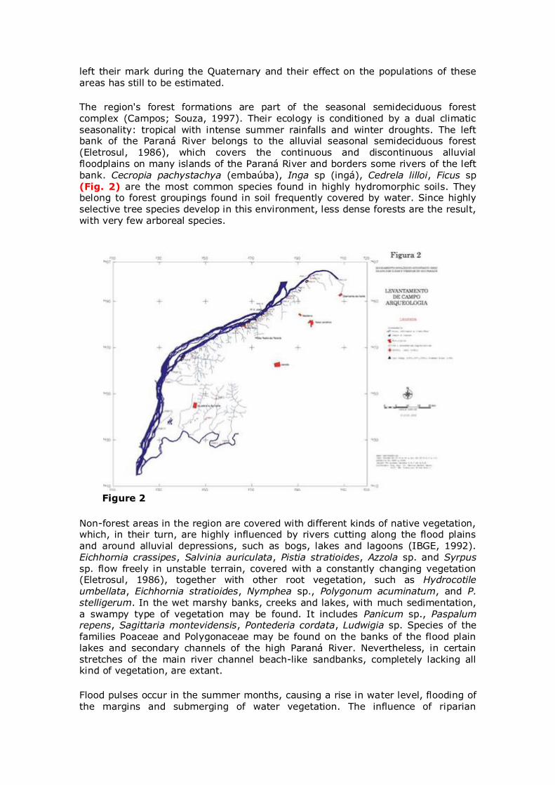
Archaeological research was developed within an area extending some 400km in length by 15km in breadth (average of 5km) along the Paraná River, between the mouth of the Iguaçu River and that of the Paranapanema River. The area has been
divided into three sectors: 1) from the mouth of the Iguaçu River to that of the Piquiri River; 2) from the mouth of the Piquiri River to that of the Ivaí River (Fig. 1) from the mouth of the Ivaí River to that of the Paranapanema River (Fig. 1).
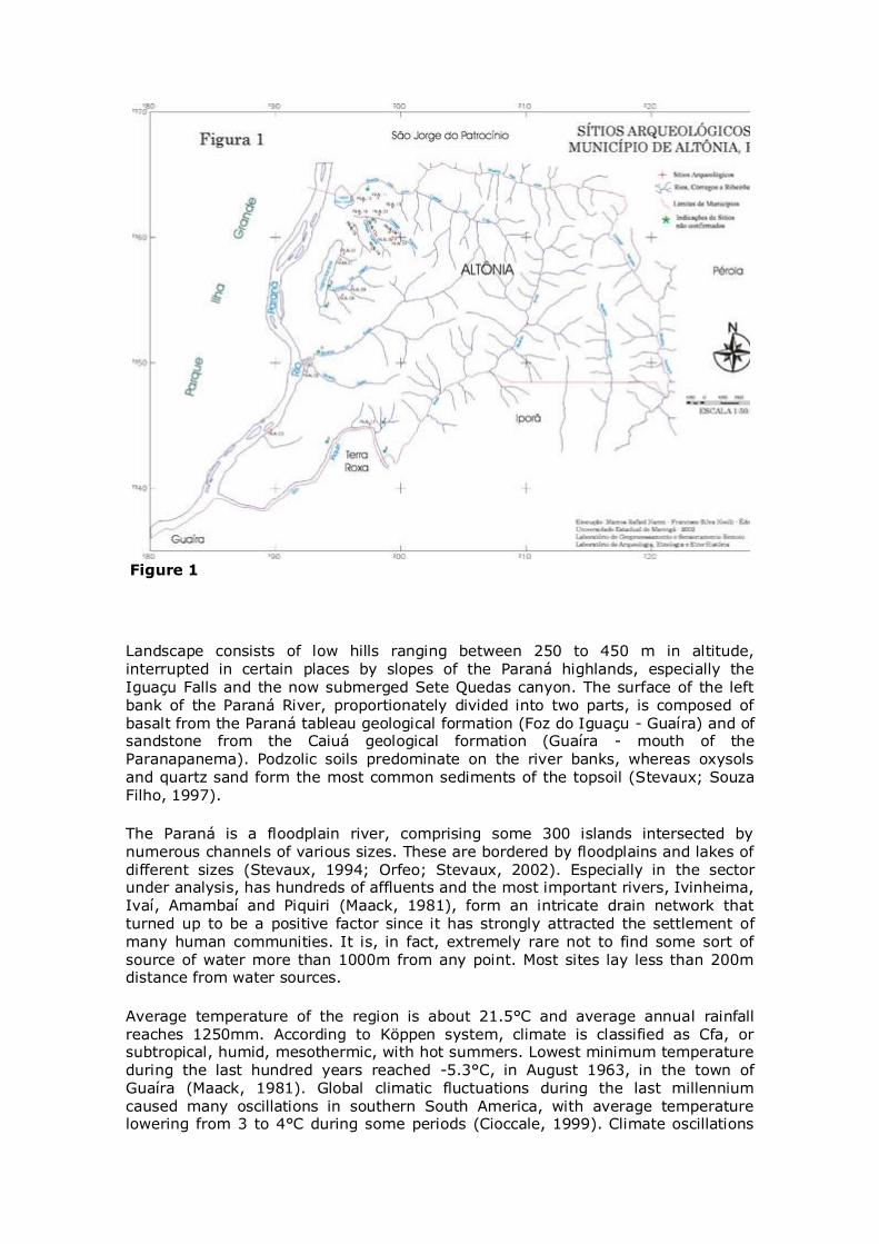
Figure 1
Landscape consists of low hills ranging between 250 to 450 m in altitude, interrupted in certain places by slopes of the Paraná highlands, especially the
Iguaçu Falls and the now submerged Sete Quedas canyon. The surface of the left bank of the Paraná River, proportionately divided into two parts, is composed of basalt from the Paraná tableau geological formation (Foz do Iguaçu - Guaíra) and of sandstone from the Caiuá geological formation (Guaíra - mouth of the Paranapanema). Podzolic soils predominate on the river banks, whereas oxysols
and quartz sand form the most common sediments of the topsoil (Stevaux; Souza Filho, 1997).
The Paraná is a floodplain river, comprising some 300 islands intersected by
numerous channels of various sizes. These are bordered by floodplains and lakes of different sizes (Stevaux, 1994; Orfeo; Stevaux, 2002). Especially in the sector under analysis, has hundreds of affluents and the most important rivers, Ivinheima, Ivaí, Amambaí and Piquiri (Maack, 1981), form an intricate drain network that turned up to be a positive factor since it has strongly attracted the settlement of
many human communities. It is, in fact, extremely rare not to find some sort of source of water more than 1000m from any point. Most sites lay less than 200m distance from water sources.
Average temperature of the region is about 21.5°C and average annual rainfall reaches 1250mm. According to Köppen system, climate is classified as Cfa, or subtropical, humid, mesothermic, with hot summers. Lowest minimum temperature during the last hundred years reached -5.3°C, in August 1963, in the town of Guaíra (Maack, 1981). Global climatic fluctuations during the last millennium
caused many oscillations in southern South America, with average temperature lowering from 3 to 4°C during some periods (Cioccale, 1999). Climate oscillations
left their mark during the Quaternary and their effect on the populations of these
areas has still to be estimated.
The region's forest formations are part of the seasonal semideciduous forest complex (Campos; Souza, 1997). Their ecology is conditioned by a dual climatic
seasonality: tropical with intense summer rainfalls and winter droughts. The left bank of the Paraná River belongs to the alluvial seasonal semideciduous forest (Eletrosul, 1986), which covers the continuous and discontinuous alluvial floodplains on many islands of the Paraná River and borders some rivers of the left
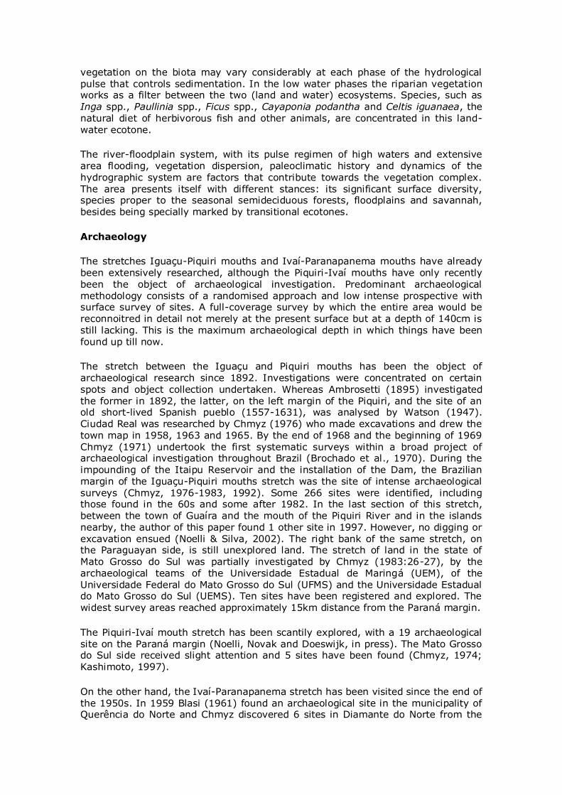
bank. Cecropia pachystachya (embaúba), Inga sp (ingá), Cedrela lilloi, Ficus sp (Fig. 2) are the most common species found in highly hydromorphic soils. They belong to forest groupings found in soil frequently covered by water. Since highly selective tree species develop in this environment, less dense forests are the result, with very few arboreal species.
Figure 2
Non-forest areas in the region are covered with different kinds of native vegetation, which, in their turn, are highly influenced by rivers cutting along the flood plains and around alluvial depressions, such as bogs, lakes and lagoons (IBGE, 1992). Eichhornia crassipes, Salvinia auriculata, Pistia stratioides, Azzola sp. and Syrpus sp. flow freely in unstable terrain, covered with a constantly changing vegetation (Eletrosul, 1986), together with other root vegetation, such as Hydrocotile
umbellata, Eichhornia stratioides, Nymphea sp., Polygonum acuminatum, and P. stelligerum. In the wet marshy banks, creeks and lakes, with much sedimentation, a swampy type of vegetation may be found. It includes Panicum sp., Paspalum repens, Sagittaria montevidensis, Pontederia cordata, Ludwigia sp. Species of the
families Poaceae and Polygonaceae may be found on the banks of the flood plain lakes and secondary channels of the high Paraná River. Nevertheless, in certain stretches of the main river channel beach-like sandbanks, completely lacking all kind of vegetation, are extant.
Flood pulses occur in the summer months, causing a rise in water level, flooding of the margins and submerging of water vegetation. The influence of riparian
vegetation on the biota may vary considerably at each phase of the hydrological
pulse that controls sedimentation. In the low water phases the riparian vegetation works as a filter between the two (land and water) ecosystems. Species, such as Inga spp., Paullinia spp., Ficus spp., Cayaponia podantha and Celtis iguanaea, the natural diet of herbivorous fish and other animals, are concentrated in this land-
water ecotone.
The river-floodplain system, with its pulse regimen of high waters and extensive area flooding, vegetation dispersion, paleoclimatic history and dynamics of the
hydrographic system are factors that contribute towards the vegetation complex. The area presents itself with different stances: its significant surface diversity, species proper to the seasonal semideciduous forests, floodplains and savannah, besides being specially marked by transitional ecotones.
Archaeology
The stretches Iguaçu-Piquiri mouths and Ivaí-Paranapanema mouths have already been extensively researched, although the Piquiri-Ivaí mouths have only recently
been the object of archaeological investigation. Predominant archaeological methodology consists of a randomised approach and low intense prospective with surface survey of sites. A full-coverage survey by which the entire area would be reconnoitred in detail not merely at the present surface but at a depth of 140cm is still lacking. This is the maximum archaeological depth in which things have been
found up till now.
The stretch between the Iguaçu and Piquiri mouths has been the object of archaeological research since 1892. Investigations were concentrated on certain
spots and object collection undertaken. Whereas Ambrosetti (1895) investigated the former in 1892, the latter, on the left margin of the Piquiri, and the site of an old short-lived Spanish pueblo (1557-1631), was analysed by Watson (1947). Ciudad Real was researched by Chmyz (1976) who made excavations and drew the town map in 1958, 1963 and 1965. By the end of 1968 and the beginning of 1969
Chmyz (1971) undertook the first systematic surveys within a broad project of archaeological investigation throughout Brazil (Brochado et al., 1970). During the impounding of the Itaipu Reservoir and the installation of the Dam, the Brazilian margin of the Iguaçu-Piquiri mouths stretch was the site of intense archaeological
surveys (Chmyz, 1976-1983, 1992). Some 266 sites were identified, including those found in the 60s and some after 1982. In the last section of this stretch, between the town of Guaíra and the mouth of the Piquiri River and in the islands nearby, the author of this paper found 1 other site in 1997. However, no digging or excavation ensued (Noelli & Silva, 2002). The right bank of the same stretch, on the Paraguayan side, is still unexplored land. The stretch of land in the state of Mato Grosso do Sul was partially investigated by Chmyz (1983:26-27), by the archaeological teams of the Universidade Estadual de Maringá (UEM), of the Universidade Federal do Mato Grosso do Sul (UFMS) and the Universidade Estadual do Mato Grosso do Sul (UEMS). Ten sites have been registered and explored. The widest survey areas reached approximately 15km distance from the Paraná margin.
The Piquiri-Ivaí mouth stretch has been scantily explored, with a 19 archaeological
site on the Paraná margin (Noelli, Novak and Doeswijk, in press). The Mato Grosso do Sul side received slight attention and 5 sites have been found (Chmyz, 1974; Kashimoto, 1997).
On the other hand, the Ivaí-Paranapanema stretch has been visited since the end of
the 1950s. In 1959 Blasi (1961) found an archaeological site in the municipality of Querência do Norte and Chmyz discovered 6 sites in Diamante do Norte from the
mid-1966 to 1970 (Chmyz, 1974). Between 1982 and 1991 Chmyz (1984, 1992)
found 2 more sites in the same municipality. In 2000 the UEM team started a regional survey of the area within the context of the scientific activities developed for the establishment of the Federal Environmental Protection Area of the Northwestern Paraná (APA). A systematic surface survey was undertaken between
the Rosana Dam (on the Paranapanema River) and the mouth of the Ivaí River. Twenty-nine new archaeological sites were discovered (Noelli et al., 2003). APA survey area comprised 145km in length by 4km distance from the rivers Paraná and Paranapanema.
APA is directly related with investigations made by Kashimoto and Martins (Kashimoto, 1997; Kashimoto; Martins, 2004; Martins, Kashimoto and Tatumi, 1999, 2002), and undoubtedly both areas may be considered a single archaeological region due to possible social and political networks among its
occupants, especially the Guarani. The area has also direct links with the lower and middle Paranapanema River (Chmyz, 1977, 1984, 1992; Kunzli, 1987; Faccio, 1998; Morais, 2000). On the right margin of the Paraná River, in the state of Mato Grosso do Sul, 11 more archaeological sites were discovered on the same stretch by Chmyz (1974), by the UEM team and by Kashimoto (1997; Kashimoto; Martins, 2004).
The islands have been only scantily investigated. Actually they are potentially very important from the subsistence and defensive strategic aspect. Sixteenth century
documents register that the Guarani had intensive agriculture in the floodable islands of the mouth of the River Plata and synchronised planting and harvesting according to the rise and fall of the water level.
The 323 archaeological sites known along the 400 km of Paraná State an area only partially investigated suggest the tip of an iceberg. If one takes into account the density of sites already discovered, the probability of others being discovered is certainly very high.
Populations
The region's population has been classified according to the material evidence in the archaeological site. Generically divided into hunter-gatherers and agricultural
populations, the former comprises two large technological horizons which Brazilian archaeology calls Umbu and Humaitá traditions, found in south Brazil, in certain areas of the state of São Paulo and in the Misiones region, Argentina (Kern, 1981; Schmitz, 1987; Dias, 1994; Hoeltz, 1997; Prous, 1992; Morais, 2000; Noelli,
2000). Chmyz (1982; 1984) suggested local and regional subsets called Vinitu (Umbu), Pirajuí and Inajá phases, besides two others, Tatuí and Ipacaraí, without any link with the former. Archaeological registers show that the sites were small open-air settlements whose day-to-day affairs failed to contribute towards the production and disposing of organic material that would change significantly the
soil's chemistry. They seem to have been neither agricultural people, nor forest managers, nor pottery producers. Their most common trace is the stone artefact, mainly arrowheads, in the Umbu tradition. This latter item is absent in the Humaitá tradition, which is characterised by the manufacture of large bifacial artefacts
(various authors, such as Prous, 1992; Dias, 1994; Hoeltz, 1997, have discussed such division). According to dating by Chmyz (1983; 1993; Chmyz; Chmyz, 1986), their presence near the Paraná River was prior to 8,000 BP (all C14 dating in Tables 1 and 2 below were made by the Smithsonian Institute). Chmyz identified certain sites below the 7,000 BP level, which makes them even older. Other sites in the South and Southeast Brazil, belonging to the same tradition, have been dated 12,000 BP (Schmitz, 1987; Prous, 1992; Noelli, 2000). No demographic estimates
exist and there are no studies on the regional related systems between the Umbu
and Humaitá sites. Even their feeding behaviour is still unknown.
Table 1. Dating of hunter-gatherer (pre-ceramic) sites in Paraná State
Municipality Tradition/
Phase
Site Base of archaeological layer (m)
Dates BP Laboratory
Foz do Iguaçu Vinitu PR – FI – 43
1.0 4035±150 Sl 5044
Foz do Iguaçu Humaitá PR – FI – 21
0.50 6269±80 Sl 4992
Diamante do Norte Itaguajé PR – NL –
08 0.50 8115±80 Sl 6401
Guaíra Tatuí PR – TO – 49
0.45 4069±75 Sl 5045
Foz do Iguaçu Humaitá PR – FI – 21
0.40 2854±60 Sl 4995
Foz do Iguaçu Humaitá PR – FI – 21
0.30 2305±70 Sl 4991
Foz do Iguaçu Humaitá PR – FI – 21
0.70 6869±105 Sl 4993
Foz do Iguaçu Humaitá PR – FI –
21 0.60 6910±75 Sl 4994
Itaguajé Itaguajé PR – AP – 45
0.90 6715±135 Sl 6498
Ceramist populations have left many archaeological sites and may furnish us much historical information, since they are still represented by populations who currently speak the Guarani, Kaingang and Xokleng languages. In fact, they form two great cultural stocks, Tupi (Guarani) and Jê (Kaingang and Xokleng). The former hailed from the middle Amazon and the latter from central Brazil (Brochado, 1984; Urban, 1992; Noelli, 1998a, 1999). In successive colonisation processes they occupied southern Brazil before 2,200 BP (Table 2).
Table 2. Dating of Guarani sites
Municipality Site Base of archaeological layer (m)
Dates BP Sample
São Miguel do Iguaçu PR – Fl – 140 0.20 2195± 75*
Sl 5028
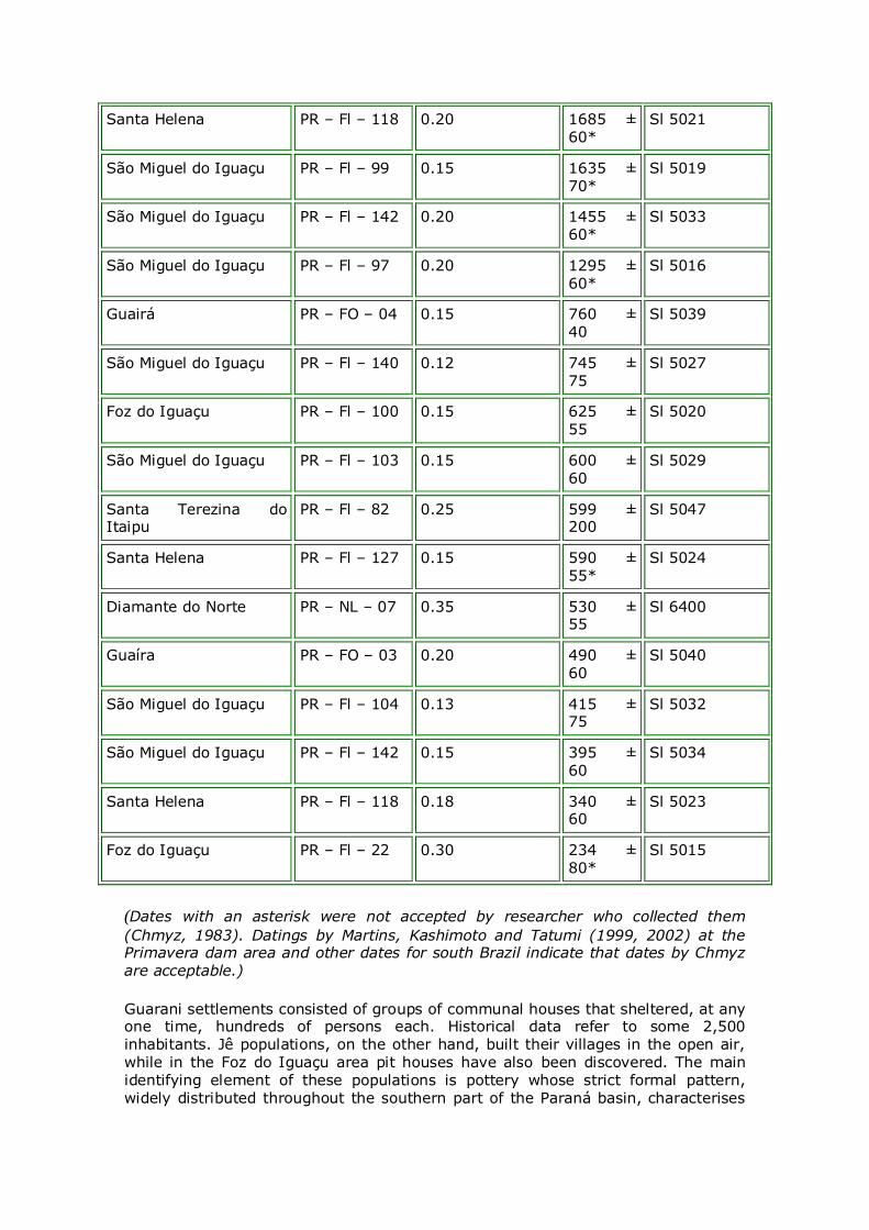
Santa Helena PR – Fl – 118 0.20 1685 ± 60*
Sl 5021
São Miguel do Iguaçu PR – Fl – 99 0.15 1635 ± 70*
Sl 5019
São Miguel do Iguaçu PR – Fl – 142 0.20 1455 ± 60*
Sl 5033
São Miguel do Iguaçu PR – Fl – 97 0.20 1295 ±
60* Sl 5016
Guairá PR – FO – 04 0.15 760 ± 40
Sl 5039
São Miguel do Iguaçu PR – Fl – 140 0.12 745 ± 75
Sl 5027
Foz do Iguaçu PR – Fl – 100 0.15 625 ± 55
Sl 5020
São Miguel do Iguaçu PR – Fl – 103 0.15 600 ± 60
Sl 5029
Santa Terezina do Itaipu
PR – Fl – 82 0.25 599 ± 200
Sl 5047
Santa Helena PR – Fl – 127 0.15 590 ± 55*
Sl 5024
Diamante do Norte PR – NL – 07 0.35 530 ± 55
Sl 6400
Guaíra PR – FO – 03 0.20 490 ± 60
Sl 5040
São Miguel do Iguaçu PR – Fl – 104 0.13 415 ± 75
Sl 5032
São Miguel do Iguaçu PR – Fl – 142 0.15 395 ±
60 Sl 5034
Santa Helena PR – Fl – 118 0.18 340 ± 60
Sl 5023
Foz do Iguaçu PR – Fl – 22 0.30 234 ± 80*
Sl 5015
(Dates with an asterisk were not accepted by researcher who collected them
(Chmyz, 1983). Datings by Martins, Kashimoto and Tatumi (1999, 2002) at the Primavera dam area and other dates for south Brazil indicate that dates by Chmyz are acceptable.)
Guarani settlements consisted of groups of communal houses that sheltered, at any one time, hundreds of persons each. Historical data refer to some 2,500 inhabitants. Jê populations, on the other hand, built their villages in the open air, while in the Foz do Iguaçu area pit houses have also been discovered. The main
identifying element of these populations is pottery whose strict formal pattern, widely distributed throughout the southern part of the Paraná basin, characterises
sharply the technological styles of their artisans. Pit houses are highly indicative of
Jê populations.
Further, layers of Archaeological Black Earth (ABE) in the midst of podzolic earth indicate a long permanence of the Guarani and a great processing activity in
vegetal organic matter within their villages. Forest-clearing by fire plus agriculture practised by these populations actually caused environmental changes. However, they managed to reproduce their agricultural and forest system for over 1,700 years on the margins of the Paraná River and its affluents. Amazon peoples have
used a similar system (Noelli, 1993, 1996; Balée, 1994; 2000).
Since no ABE registers for Jê people are extant, its absence requires a different type of standard to evaluate their processing and disposing of organic matter. At the time being, due to lack of data, it may be stated that settlements may have
been occupied for a very short span of time.
The dissemination of tropical plant species, originally from other regions, by Jê and Guarani populations is another aspect that should be taken into account. In fact,
they distributed a sort of "plant package" throughout the regions they colonised. If one takes into account that the natives originated from the Amazon and that they transported their plants in just the same way as they did their cultural material, one may surely say they disseminated a "set" of more or less defined vegetal species throughout large extensive territories, lying mainly in southern Brazil.
Archaeological sites in the stretch Foz do Iguaçu-Paranapanema mouth
Choosing settlement sites
It must be emphasised that this is the first analysis of settlement patterns of the populations that occupied the areas close to the Paraná River, on the left bank of the stretch between the mouths of the Rivers Iguaçu and Paranapanema. Data that
define pattern of settlement are (1) topographic compartmentalisation; (2) distance from the Paraná River; (3) altitude of the site with reference to the level of the Paraná River; (4) altitude of site with reference to sea level; (5) distance from the nearest water source; (6) colour of the archaeological soil; (7) base of the archaeological layer.
Topographic compartmentalisation
Topographic compartmentalisation is the localisation of the site within the land relief and may be divided into (1) top; (2) slope; (3) terrace; (4) top/slope; (5) slope/terrace; (6) island (Table 3). Analysis of topographic compartmentalisation
showed that slopes are the commonest places for the establishment of sites with a 65.63%. Top and the transition interval top/slope came next with 15.78%. Terrace and transition interval terrace/slope were less relevant, with a mere 10.21%. Perhaps due to lack of research sites on the islands are scarce.
Predominance of slope occupations reveals that there was a deep concern about drainage in the settlements and it seems that it was a deliberate decision to keep the huts and other structures away from humidity and marshy places. No data are available on the inclination angle of such topographic compartmentalisation and
inference is greatly impaired.
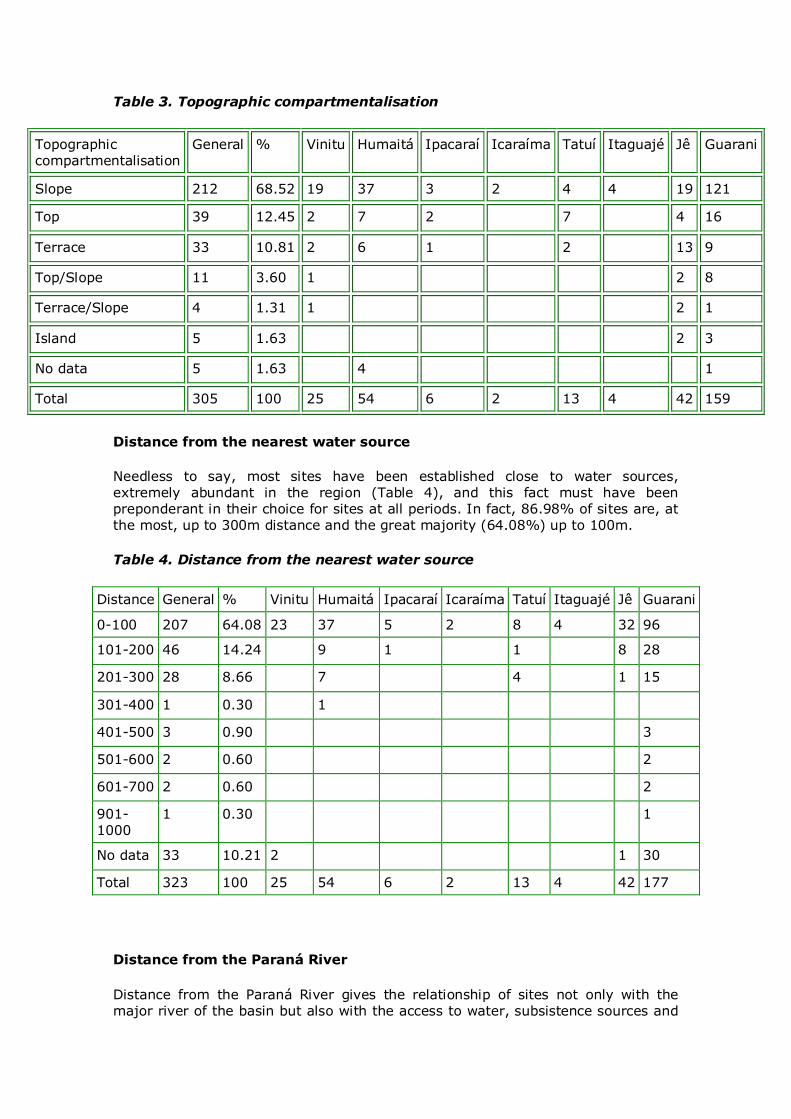
Table 3. Topographic compartmentalisation
Topographic compartmentalisation
General % Vinitu Humaitá Ipacaraí Icaraíma Tatuí Itaguajé Jê Guarani
Slope 212 68.52 19 37 3 2 4 4 19 121
Top 39 12.45 2 7 2 7 4 16
Terrace 33 10.81 2 6 1 2 13 9
Top/Slope 11 3.60 1 2 8
Terrace/Slope 4 1.31 1 2 1
Island 5 1.63 2 3
No data 5 1.63 4 1
Total 305 100 25 54 6 2 13 4 42 159
Distance from the nearest water source
Needless to say, most sites have been established close to water sources, extremely abundant in the region (Table 4), and this fact must have been preponderant in their choice for sites at all periods. In fact, 86.98% of sites are, at the most, up to 300m distance and the great majority (64.08%) up to 100m.
Table 4. Distance from the nearest water source
Distance General % Vinitu Humaitá Ipacaraí Icaraíma Tatuí Itaguajé Jê Guarani
0-100 207 64.08 23 37 5 2 8 4 32 96
101-200 46 14.24 9 1 1 8 28
201-300 28 8.66 7 4 1 15
301-400 1 0.30 1
401-500 3 0.90 3
501-600 2 0.60 2
601-700 2 0.60 2
901-1000
1 0.30 1
No data 33 10.21 2 1 30
Total 323 100 25 54 6 2 13 4 42 177
Distance from the Paraná River
Distance from the Paraná River gives the relationship of sites not only with the major river of the basin but also with the access to water, subsistence sources and
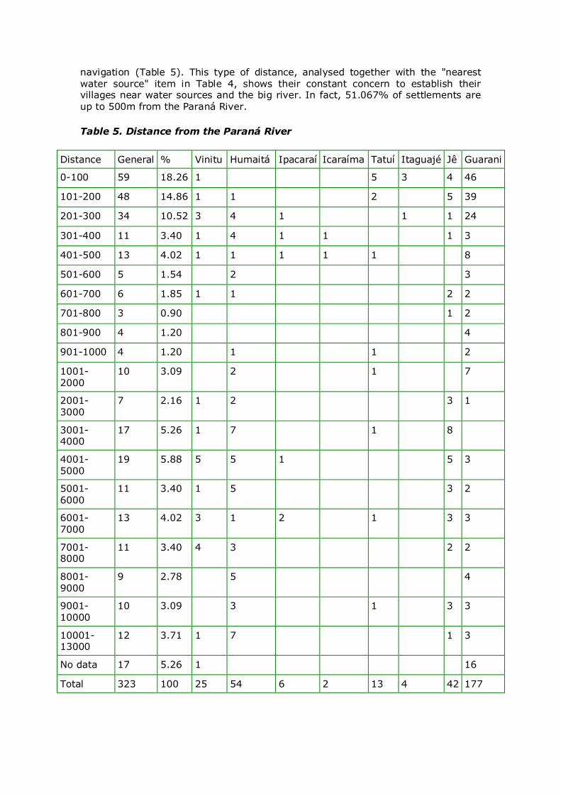
navigation (Table 5). This type of distance, analysed together with the "nearest
water source" item in Table 4, shows their constant concern to establish their villages near water sources and the big river. In fact, 51.067% of settlements are up to 500m from the Paraná River.
Table 5. Distance from the Paraná River
Distance General % Vinitu Humaitá Ipacaraí Icaraíma Tatuí Itaguajé Jê Guarani
0-100 59 18.26 1 5 3 4 46
101-200 48 14.86 1 1 2 5 39
201-300 34 10.52 3 4 1 1 1 24
301-400 11 3.40 1 4 1 1 1 3
401-500 13 4.02 1 1 1 1 1 8
501-600 5 1.54 2 3
601-700 6 1.85 1 1 2 2
701-800 3 0.90 1 2
801-900 4 1.20 4
901-1000 4 1.20 1 1 2
1001-2000
10 3.09 2 1 7
2001-3000
7 2.16 1 2 3 1
3001-4000
17 5.26 1 7 1 8
4001-5000
19 5.88 5 5 1 5 3
5001-6000
11 3.40 1 5 3 2
6001-7000
13 4.02 3 1 2 1 3 3
7001-8000
11 3.40 4 3 2 2
8001-9000
9 2.78 5 4
9001-10000
10 3.09 3 1 3 3
10001-13000
12 3.71 1 7 1 3
No data 17 5.26 1 16
Total 323 100 25 54 6 2 13 4 42 177
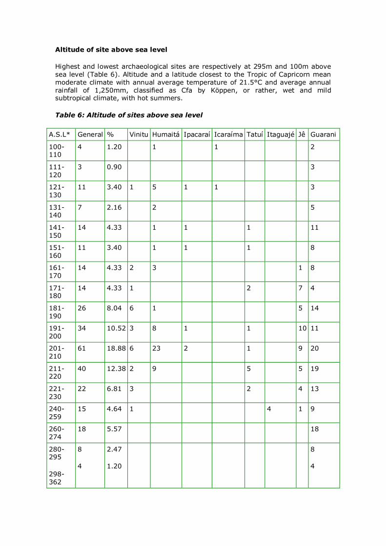
Altitude of site above sea level
Highest and lowest archaeological sites are respectively at 295m and 100m above sea level (Table 6). Altitude and a latitude closest to the Tropic of Capricorn mean moderate climate with annual average temperature of 21.5°C and average annual
rainfall of 1,250mm, classified as Cfa by Köppen, or rather, wet and mild subtropical climate, with hot summers.
Table 6: Altitude of sites above sea level
A.S.L* General % Vinitu Humaitá Ipacaraí Icaraíma Tatuí Itaguajé Jê Guarani
100-110
4 1.20 1 1 2
111-120
3 0.90 3
121-
130 11 3.40 1 5 1 1 3
131-140
7 2.16 2 5
141-
150 14 4.33 1 1 1 11
151-160
11 3.40 1 1 1 8
161-170
14 4.33 2 3 1 8
171-180
14 4.33 1 2 7 4
181-190
26 8.04 6 1 5 14
191-
200 34 10.52 3 8 1 1 10 11
201-210
61 18.88 6 23 2 1 9 20
211-220
40 12.38 2 9 5 5 19
221-230
22 6.81 3 2 4 13
240-259
15 4.64 1 4 1 9
260-274
18 5.57 18
280-295
298-
362
8
4
2.47
1.20
8
4
No data
17 5.26 5
Total 323 100 25 54 6 2 13 4 42 177
*a.s.l.: above sea level
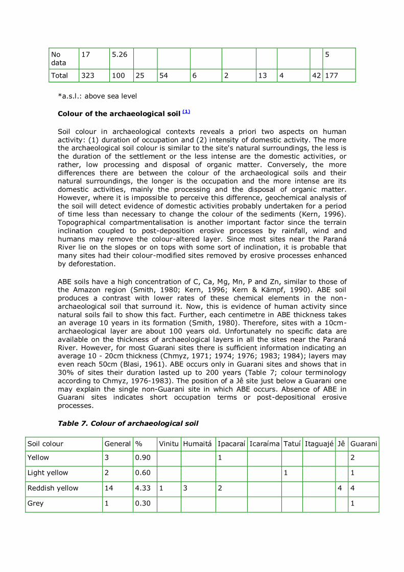
Colour of the archaeological soil (1)
Soil colour in archaeological contexts reveals a priori two aspects on human activity: (1) duration of occupation and (2) intensity of domestic activity. The more the archaeological soil colour is similar to the site's natural surroundings, the less is the duration of the settlement or the less intense are the domestic activities, or rather, low processing and disposal of organic matter. Conversely, the more
differences there are between the colour of the archaeological soils and their natural surroundings, the longer is the occupation and the more intense are its domestic activities, mainly the processing and the disposal of organic matter. However, where it is impossible to perceive this difference, geochemical analysis of
the soil will detect evidence of domestic activities probably undertaken for a period of time less than necessary to change the colour of the sediments (Kern, 1996). Topographical compartmentalisation is another important factor since the terrain inclination coupled to post-deposition erosive processes by rainfall, wind and humans may remove the colour-altered layer. Since most sites near the Paraná River lie on the slopes or on tops with some sort of inclination, it is probable that many sites had their colour-modified sites removed by erosive processes enhanced by deforestation.
ABE soils have a high concentration of C, Ca, Mg, Mn, P and Zn, similar to those of the Amazon region (Smith, 1980; Kern, 1996; Kern & Kämpf, 1990). ABE soil produces a contrast with lower rates of these chemical elements in the non-archaeological soil that surround it. Now, this is evidence of human activity since
natural soils fail to show this fact. Further, each centimetre in ABE thickness takes an average 10 years in its formation (Smith, 1980). Therefore, sites with a 10cm-archaeological layer are about 100 years old. Unfortunately no specific data are available on the thickness of archaeological layers in all the sites near the Paraná River. However, for most Guarani sites there is sufficient information indicating an average 10 - 20cm thickness (Chmyz, 1971; 1974; 1976; 1983; 1984); layers may even reach 50cm (Blasi, 1961). ABE occurs only in Guarani sites and shows that in 30% of sites their duration lasted up to 200 years (Table 7; colour terminology according to Chmyz, 1976-1983). The position of a Jê site just below a Guarani one
may explain the single non-Guarani site in which ABE occurs. Absence of ABE in Guarani sites indicates short occupation terms or post-depositional erosive processes.
Table 7. Colour of archaeological soil
Soil colour General % Vinitu Humaitá Ipacaraí Icaraíma Tatuí Itaguajé Jê Guarani
Yellow 3 0.90 1 2
Light yellow 2 0.60 1 1
Reddish yellow 14 4.33 1 3 2 4 4
Grey 1 0.30 1
Yellowish grey 4 1.20 2 2
Light grey 16 4.95 1 1 13 1
Dark grey 11 3.40 2 2 7
Dark grey/Reddish brown
2 0.60 2
Brown 2 0.60 1 1
Yellowish brown 2 0.60 1 1
Reddish brown 105 32.50 16 35 2 1 4 17 30
Light brown 15 4.64 3 1 1 2 4 4
Dark brown 43 13.31 6 6 3 3 25
ABE 51 15.78 1 50
No data 52 16.09 1 2 49
Total 323 100 25 54 6 2 13 4 42 177
Archaeological layer
Position of the archaeological layer related to current soil surface shows that 41.46% of sites are between 11 and 50cm deep (Table 8). No data are extant on layer thickness for most of the sites under analysis and we still are unable to define
patterns of sedimentary depositions after the abandoning of site.
Table 8 shows that a 10-30cm depth predominates in Jê and Guarani sites as from the last 2,200 BP. However, it should be remembered that Jê sites lower than 40cm
are pit houses dug in the soil. Moreover, 30-80cm layers, with a trend for greater depths reaching roughly some 140cm, predominate at other sites, all hunter-gatherers, dated between 2,300 and 8,110 BP. In the stretch Guaíra-Paranapanema mouth where the present author made his researches, the stratigraphic sequence is constant. As a general rule, there is an archaeological
infertile layer ranging between a few centimetres and 1m between the occupation level of agricultural and hunter-gatherer populations. Normally the layer has sediments with scanty organic traces and its formation coincides with the second dry event that occurred between 3,500 and 2,500 BP in the upper Paraná River
(Stevaux, Souza Filho & Jabur, 1997; Stevaux & Santos, 1998). The end of this dry period marks the beginning of the occupation by ceramists and the reduction/disappearance of hunter-gatherer sites. In fact, climatic changes have a neat relationship with the processes of human occupation on the continent. The 4,000-2,000 BP period corresponds to a great demographic upheaval in the
Amazon region (Brochado, 1984) involving many pottery and agricultural peoples in their geographical expansion towards and occupation in eastern South America. Two expansion fronts made headway to southern Brazil between 2,500 and 2,000 BP: (1) Guarani populations began settling in the states of Mato Grosso do Sul, the
western area of the state of São Paulo, Paraná, Santa Catarina, Rio Grande do Sul,
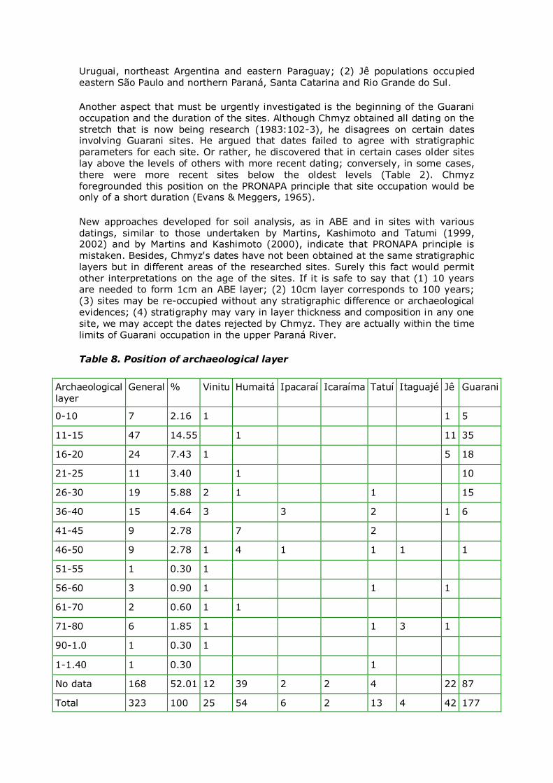
Uruguai, northeast Argentina and eastern Paraguay; (2) Jê populations occupied
eastern São Paulo and northern Paraná, Santa Catarina and Rio Grande do Sul.
Another aspect that must be urgently investigated is the beginning of the Guarani occupation and the duration of the sites. Although Chmyz obtained all dating on the
stretch that is now being research (1983:102-3), he disagrees on certain dates involving Guarani sites. He argued that dates failed to agree with stratigraphic parameters for each site. Or rather, he discovered that in certain cases older sites lay above the levels of others with more recent dating; conversely, in some cases,
there were more recent sites below the oldest levels (Table 2). Chmyz foregrounded this position on the PRONAPA principle that site occupation would be only of a short duration (Evans & Meggers, 1965).
New approaches developed for soil analysis, as in ABE and in sites with various
datings, similar to those undertaken by Martins, Kashimoto and Tatumi (1999, 2002) and by Martins and Kashimoto (2000), indicate that PRONAPA principle is mistaken. Besides, Chmyz's dates have not been obtained at the same stratigraphic layers but in different areas of the researched sites. Surely this fact would permit
other interpretations on the age of the sites. If it is safe to say that (1) 10 years are needed to form 1cm an ABE layer; (2) 10cm layer corresponds to 100 years; (3) sites may be re-occupied without any stratigraphic difference or archaeological evidences; (4) stratigraphy may vary in layer thickness and composition in any one site, we may accept the dates rejected by Chmyz. They are actually within the time
limits of Guarani occupation in the upper Paraná River.
Table 8. Position of archaeological layer
Archaeological layer
General % Vinitu Humaitá Ipacaraí Icaraíma Tatuí Itaguajé Jê Guarani
0-10 7 2.16 1 1 5
11-15 47 14.55 1 11 35
16-20 24 7.43 1 5 18
21-25 11 3.40 1 10
26-30 19 5.88 2 1 1 15
36-40 15 4.64 3 3 2 1 6
41-45 9 2.78 7 2
46-50 9 2.78 1 4 1 1 1 1
51-55 1 0.30 1
56-60 3 0.90 1 1 1
61-70 2 0.60 1 1
71-80 6 1.85 1 1 3 1
90-1.0 1 0.30 1
1-1.40 1 0.30 1
No data 168 52.01 12 39 2 2 4 22 87
Total 323 100 25 54 6 2 13 4 42 177
Environmental changes by the Guarani
Owing to a lack of data on hunter-gatherer and Jê populations, we will only discuss the environmental changes made by the Guarani. However, if hunter-gatherer populations have occupied the region for well over 6,000 years, they should have
caused some sort of changes in the vegetation. Besides, it would be improbable that they hadn't handled certain species of vegetation. The same must have occurred with the Jê populations: they too have practised agriculture and managed various vegetation species. Historical information from colonial documents has been
obtained on the Guarani. The quality and quantity of such documents have been so notorious that it has been possible to build a model of space occupation, common to all groups that settled throughout the vast Paraná basin (Noelli, 1993, 1994, 1996, 1997, 1998a, 1999, 2000; Noelli et al., 2003).
Guarani basic land unit was the tekohá, the space within the domains of a village, comprising the areas occupied by huts, agricultural land, fallow land, fishing and hunting areas, paths, cemeteries, creeks, established in forest clearings. The huts in a Guarani settlement were built in a clearing, usually in an elliptical form or
distributed in various contiguous clearings. In proportion to population growth, the villages either became simply larger or were fissioning into new open spaces in the neighbouring woods. Breaches would eventually occur that divided the inhabitants into two or more groups that would further occupy areas in the periphery of the tekohás. New villages would thus be established at greater distances from those
that originated them.
The nuclear family (father, mother and children), with an average membership of six people, was the basic Guarani social organisation. Nevertheless, a polygamic
family may well have comprised groups of 40, 50 or more members. On the other hand, nuclear families associated themselves around a person of some importance. The extended family, a social unit inhabiting the "long house" measuring 50m long by 18m wide, would thus arise. A village might have one or more extended families and would group together some 3,000 persons, especially at the most strategic points of the region. Marriage, commercial and military aims favoured alliance networks among the villages. Conservative analyses based on historical documentation estimate that the Guarani population would have reached approximately 1.5 million persons in the western area of the state of Paraná during
the first quarter of the 17th century (Melià, 1986). It may even have been three time that number since the same author did not consider fully 16th century events in which various epidemic diseases had decimated the indigenous populations of the region.
Our analysis on Guarani villages and their organisation gives the social context within the agricultural and forest model of the natives who colonised the entire stretch of land from the mouth of the Iguaçu to that of the Paranapanema. At least during 1,700 years they changed the region's phytogeography by the introduction of a "plant package" originating from the Amazon, Chaco, Pantanal and high Paraná River regions (Tables 9 and 11). Stevaux even informs that pollen analyses in areas close to the Paranapanema mouth showed the presence of the manioc plant (Maniot esculenta Crantz) in 1,700 BP. Older pollen may still be found since the Guarani have been on the site even before 2,000 BP.
Due to their local and inter-regional exchange network along various millennia, the Guarani would very probably have introduced in this region plant species which were native of southern Brazil, of the Atlantic rainforest and the pampas. They have also manipulated certain species to enhance their productivity. The maté (Ilex paraguariensis), the pine-tree (Araucaria angustifolia) and fruit-bearing trees, such
as the jaboticabeira (Plinia trunciflora), are special examples. Many types of palm
trees were cultivated for food and prime matter. Literature and present day inhabitants of the shores of the Paraná River and its affluents report that there had been (perhaps there still are) a few acres of land in mid-forest planted with a certain species. This is certainly a remnant of ancient Guarani agricultural
manipulation.
Basic Guarani agriculture started with the coivara or the swidden burning of a patch of forest to prepare the site for a swidden gardening. Other spaces, kitchen gardens
at the back of the huts, path sides, clearings produced by fallen trees, banks of watercourses, swampy areas and islands, were used for the cultivation of staple food. Swiddens belonged to extended families, although they were divided into smaller spaces for the nuclear family or kindred nuclear families. Every six persons had an average of approximately 2.5 hectares of young swidden. A large extensive
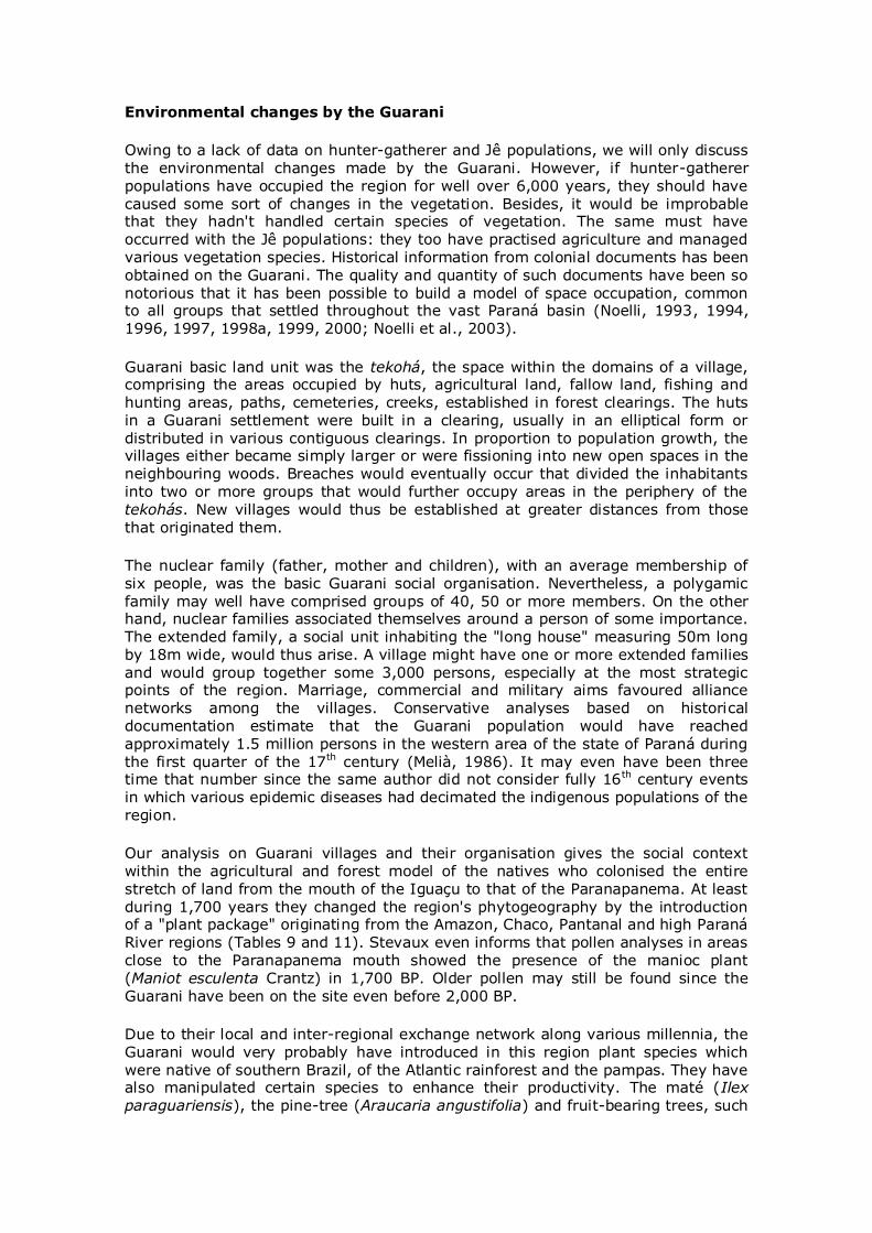
family of about 600 individuals could have up to 250 hectares of gardening land in forest clearings throughout many years. It is important to note that planting space was normally opened every year and staple food harvested during four or more years (Table 9). Among the Guarani, however, produce could be limitless, since in some plantations many species were planted with different aims (food, prime matter, medicine)(Table 11). An extended family could simultaneously have various plantations, at different stages, producing different species. They could also have older swiddens kept fallow for 20, 30 or more years, in which they could raise many other products. In the young swidden some 139 distinct tuberous and graniferous species of the staple food packet were cultivated (Table 9).
Table 9. Sample of some species cultivated by the Guarani
Common name Guarani nomenclature Scientific name
Nº of cultivars
Tuberous
Manioc Mandi’o Manihot esculenta 24
Sweet-potato Jety Ipomoea batatas 21
Potato Maky Solanum tuberosum 01
Yam Kara Dioscorea spp 09
Mbakuku Pachyrrhizus erosus 03
Mangarito Tajao Xanthosoma sagittifolium 02
Arrowroot Akuti Maranta arundinacea 01
White potato Makyxi Oxalis spp 04
Mbery sai’yu Canna glauca 01
Graníferas
Maize Avati Zea mais 13
Beans Kumanda Phaseolus spp 16
Purplewood Ka’aruru Amaranthus spp 04
Quina Ka’are Chenopodium spp ?
Peanuts Manduvi Arachis hypogaea 07
Manduvira Lupinus spp 01
Guandu beans Kumanda Yvyra’i Cajanus spp 01
Cumandá cha’i Strophostyles diversifolia 01
Broad beans Kumanda usu Canavalia spp 01
Job's tears. Mbaguero Coix lacrima-jobi 01
This agroflorestal model has in fact caused environmental changes and significant human interference which have been largely discarded by botanists researching the area between the mouths of the Iguaçu and the Paranapanema. These scientists normally take into account changes occurring since the 1950s. The annual opening of clearings coupled to agricultural practice and to the systematic transplantation of various species resulted in phytosociological and phytogeographical alterations. The repetition of these practices during some 1,700 years or more has surely modified the physiognomy of the vegetation close to the Paraná and its affluents. A broadening of species varieties have surely occurred (Noelli, 1998b). Changes, nevertheless, have not merely occurred in swiddens. The forest was also a network of paths interconnecting the different places frequented by the settlements and for exploration within the territory of the village. A contemporary example of such environmental changes shows the potentiality of human intervention in biodiversity. In the case of the Gorotire-Kayapós of the Xingu basin,
... these paths border the agricultural zones. It is extremely common to find a whole stretch of land, some 4m wide, cleared of trees. It is not easy to calculate the length of these paths ... A conservative estimate may give an area of 500 km by approximately 2.5m made of paths opened by the Gorotire... One may perceive that the modified area is extensive. The margins of these paths are planted with a great variety of yams, sweet-potato, cupá, plants of the Marantaceae, Zingiberaceae, Araceae families, and other non-identified tuberous vegetation. Hundreds of medicinal herbs and fruit trees also contribute towards a diversification
of the flora. An example may be given: a survey made in a 3km-path recorded (1) 185 planted trees belonging to 15 different species; (2) approximately 1,500 medicinal herbs belonging to a indeterminate number of species; (3) about 3,500 plants used as food, belonging to an also indeterminate number of species (Posey,
1987, p. 177, translated by author).
Species handled/managed by the Guarani
A systematic analysis of Guarani historical and ethnological information will establish a list of species that might be compared to that produced by botanists. Although we do not unfortunately know the total number of plants used or known
by the natives, Gatti (1985) identified some 1,500 species for Paraguay and border areas. Other researchers have given extensive lists from different places in Argentina, Brazil and Uruguay (Noelli, 1993).
The incomplete Guarani list, certainly needing updates due to modern scientific discoveries and taxonomic re-definitions, may be compared to local and regional lists produced by botanists. I myself compared the already identified flora found near the Paranapanema mouth, in the municipalities of Porto Rico and Taquaruçu, near the Paraná River (Souza, Cislinski and Romagnolo, 1997; Romagnolo, 1997;
Campos, 1997; Kita 2001). Up till now, researchers have identified some 541 phanerogamic species and admit the existence of more. There may be over 800
species in an area that has undergone deep botanical changes caused by
deforestation, agriculture, extraction of medicinal herbs and cattle ranching.
In a preliminary survey comparing the botanists' and the natives' lists we have verified that the Guarani used or at least knew of at least 432 species, or 79.85%
of the 541 species identified up to the now in Porto Rico.
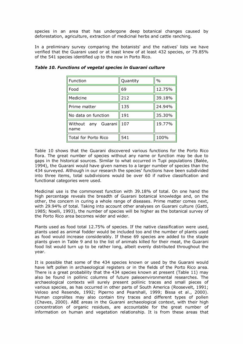
Table 10. Functions of vegetal species in Guarani culture
Function Quantity %
Food 69 12.75%
Medicine 212 39.18%
Prime matter 135 24.94%
No data on function 191 35.30%
Without any Guarani name
107 19.77%
Total for Porto Rico 541 100%
Table 10 shows that the Guarani discovered various functions for the Porto Rico flora. The great number of species without any name or function may be due to gaps in the historical sources. Similar to what occurred in Tupi populations (Balée, 1994), the Guarani would have given names to a larger number of species than the 434 surveyed. Although in our research the species' functions have been subdivided into three items, total subdivisions would be over 60 if native classification and functional categories were used.
Medicinal use is the commonest function with 39.18% of total. On one hand the high percentage reveals the breadth of Guarani botanical knowledge and, on the other, the concern in curing a whole range of diseases. Prime matter comes next, with 29.94% of total. Taking into account other analyses on Guarani culture (Gatti, 1985; Noelli, 1993), the number of species will be higher as the botanical survey of the Porto Rico area becomes wider and wider.
Plants used as food total 12.75% of species. If the native classification were used, plants used as animal fodder would be included too and the number of plants used as food would increase considerably. If these 69 species are added to the staple plants given in Table 9 and to the list of animals killed for their meat, the Guarani food list would turn up to be rather long, albeit evenly distributed throughout the year.
It is possible that some of the 434 species known or used by the Guarani would have left pollen in archaeological registers or in the fields of the Porto Rico area. There is a great probability that the 434 species known at present (Table 11) may also be found in pollinic columns of future paleoenvironmental researches. The archaeological contexts will surely present pollinic traces and small pieces of various species, as has occurred in other parts of South America (Roosevelt, 1991; Veloso and Resende, 1992; Piperno and Pearshall, 1999; Bissa et al., 2000). Human coprolites may also contain tiny traces and different types of pollen (Chaves, 2000). ABE areas in the Guarani archaeological context, with their high concentration of organic residues, are accountable for the great number of information on human and vegetation relationship. It is from these areas that
collections of different samples should be taken. In fact, ABEs are a data bank for
the region's fauna since the village garbage lies there and, consequently, a great quantity of bones from food remnants.
FINAL CONSIDERATIONS
Archaeological and historical data reveal that the geology, the climate and the
ecosystems of the Paraná River's area of influence have been an asset for human settlements. Since 8,000 BP human populations found in these places the means to live and reproduce their society, even though, due to the fledging stage of our research, only the upper point of the iceberg has been detected and investigated. Available data show that hunter-gatherer and agricultural societies have continuously occupied the sites. Hunter-gatherer societies have remained in the region for nearly 6,000 years, whereas pottery peoples lived in these places for the last 1,800 years. Their social and historical reproduction was disrupted by Europeans who, through wars, diseases and social-economical structure, caused the greatest demographic disaster ever. At least one million people were wiped out by the start of the 17th century. As we have seen in the case of the Guarani, all these people must have caused considerable environmental changes and possibly provoked still unknown geological modifications.
What were the changes and problems imposed by the environment and climatic changes? Hunter-gatherer populations witnessed climate changes and their effects on the vegetation and fauna between 8,000 and 2,000 BP. What were the consequences of changes on daily life, culture, food and health of these populations? Did droughts, especially those occurring between 3,500 and 2,000 BP, diminish the region's demographic density? What is the relationship between the end of the second drought period, in about 2,000 BP, and the start of the Guarani and Jê colonisation in south Brazil?
The region of the upper Paraná River is an area with high possibilities in archaeological research due to its natural characteristics that attracted different populations along the millennia. Increasing research work by Earth Sciences and Botany will certainly be an asset for the thorough understanding of human occupation in ancient environments.
ACKNOWLEDGEMENTS: I would like to thank Igor Chmyz for his intensive archaeological research along the Paraná River and whose results have been constantly used in our research. Thanks are also due to Iriana Tanaka for her comments, suggestions and for the text on vegetation; to Dirce C. Kern, of the Emílio Goeldi Museum, for information on ABE; to Carlos Alberto Panek Jr., for revisions of text and tables; to José C. Stevaux, of the Universidade Estadual de Maringá, for his encouragement which he gave the author during the writing of the manuscript and for the geological information on the Paraná River. Needless to say, the opinions are the author's own responsibility.
NOTES:
1 References to Munsell Color Chart are not given since archaeologists who dealt with the above-mentioned sites did not use them.
REFERENCES:
MBROSETTI, J. B. Los cementerios de prehistóricos del alto Paraná (Misiones). Boletín del Instituto Geográfico Argentino, v. 16, p. 227-257. 1895.
BALÉE, W. Antiquity of traditional knowledge in Amazonia: The Tupí-Guaraní Family and Time. Ethnohistory, v. 47, n. 2, 2000.
BALÉE, W. Footprints in the forest. New York: Columbia University Press. 1994.
BISSA, W. M. Evolução paleoambiental na Planície Costeira do Baixo Ribeira durante a ocupação sambaquieira. Revista do Museu de Arqueologia e Etnologia, v. 10, p. 89-102. 2000.
BLASI, O. Algumas notas sobre a jazida arqueológica de Três Morrinhos – Querência do Norte – Rio Paraná. Boletim Paranaense de Geografia, Curitiba, v.2-3, p.49-78, 1961.
BROCHADO, J. P. An ecological model of the spread of pottery and agriculture into Eastern South America. Urbana-Champaign. Doctoral Thesis in Anthropology, University of Illinois at Urbana-Champaign, 1984.
BROCHADO, J. P. et al. Brazilian archeology in 1968: An interim report on the National Program of Archeology Research - PRONAPA. American Antiquity, v. 35, n. 1, p. 1-23. 1970.
CAMPOS, J. C. Análise dos desflorestamentos, estrutura dos fragmentos de florestas e avaliação do banco de sementes do solo da ilha Porto Rico na planície de inundação do alto rio Paraná, Brasil. Maringá: UEM - Doctoral Thesis, 1997.
CAMPOS, J. C.; SOUSA, M. C. Vegetação. In A. E. A. M. Vazzoler; A. A. Agostinho and N. S. Hahn (Eds.). A Planície de inundação do alto rio Paraná: aspectos físicos, biológicos e socioeconômicos. Maringá: Eduem. p. 331-342. 1997.
CIOCCALE, M. A. Climatic fluctuations in the Central Region of Argentina in the last 1000 years. Quaternary International, v. 62, p. 35-47.1999.
CNSA. Cadastro Nacional de sítios Arqueológicos. Instituto do Patrimônio Histórico e
Artístico Nacional. (www.iphan.gov.br/cnsa).
CHAVES, S. A. M. Estudo palinológico de coprólitos pré-históricos holocênicos coletados na Toca do Boqueirão do sítio da Pedra Furada. Contribuições
paleoetnológicas, paleoclimáticas e paleoambientais para a Região Sudeste do Piauí – Brasil. Revista do Museu de Arqueologia e Etnologia, v. 10, p. 103-120. 2000.
CHMYZ, I. (Coord.). Projeto arqueológico Itaipú (1975-1983). Curitiba, Convênio Itaipú/IPHAN, 1976-1983.
CHMYZ, I. and CHMYZ, J. C. G. Datações radiométricas em áreas de salvamento
arqueológico. Revista do Centro de Ensino e Pesquisas Arqueológicas. Curitiba, Universidade Federal do Paraná, v. 5, p.69-77, 1986.
CHMYZ, I. Arqueologia e Historia da Vila espanhola de Ciudad Real do Guairá.
Cadernos de Arqueologia, v. 1, p.7-103, 1976.
CHMYZ, I. Dados Arqueológicos do Baixo Rio Paranapanema e do Alto Rio Paraná. PRONAPA 5 .Publicações Avulsas do Museu Paranaense Emílio Goeldi, nº 26,
p.67-90, 1974.
CHMYZ, I. Estado atual das pesquisas arqueológicas na margem esquerda do rio Paraná (Projeto arqueológico Itaipu). Estudos Brasileiros. Curitiba, Centro de Estudos Brasileiros da Universidade Federal do Paraná, v. 8, nº 13, p.5-39, 1982.
CHMYZ, I. Pesquisas Arqueológicas no Médio e Baixo Rio Iguaçu, Paraná. PRONAPA 4. Publicações Avulsas do Museu Paranaense Emílio Goeldi, nº 15, p.87-114, 1971.
CHMYZ, I. Pesquisas Paleoetnográficas efetuadas no vale do rio Paranapanema. Paraná – São Paulo. Boletim de Psicologia e Antropologia. Curitiba, v. 5, 1977.
CHMYZ, I. Projeto Arqueológico Rosana-Taquaruçu. Curitiba: UFPR-CESP, 1984.
CHMYZ, I. Relatório de atividades do projeto arqueológico Rosana – Taquaruçu. Curitiba: CESP/FUNDAR, 1992.
DIAS, A. S. Repensando a tradição Umbu a partir de um estudo de caso. Porto Alegre, 1994. Master's Thesis in Archaeology, Pontifícia Universidade Católica do Rio Grande do Sul.
EVANS, C.; MEGGERS, B. M. Guia para prospecção arqueológica no Brasil. Belém: Museu Paraense Emílio Goeldi, 1965.
FACCIO, N. Arqueologia do cenário das ocupações horticultoras da Capivara, Baixo Paranapanema – SP. São Paulo: USP - Doctoral Thesis, 1998.
GATTI, C. Enciclopedia Guaraní-Español de conocimientos Paraguayos. Asunción: Arte Nuevo, 1985.
HOELTZ, S. E. Artesãos e artefatos pré-históricos do vale do rio Pardo. Santa Cruz do Sul: EDUNISC, 1997.
KASHIMOTO, E. M. Variáveis ambientais e arqueológicas no alto Paraná. São Paulo: USP - Doctoral Thesis, 1997.
KASHIMOTO, E.M.; MARTINS, G.R. Archaeology of the Holocene in the upper
Paraná River, Mato Grosso do Sul State, Brazil. Quaternary International, vol. 114, n. 1, p. 67-86. 2004.
KERN, A. A. Le précéramique du plateau sud-brésilien. Paris, Doctoral Thesis in
Archaeology, École des Hautes Études en Sciences Sociales. 1981.
KERN, D. and KÄMPF, N. Análise química e morfológica dos solos com TPA e sua
importância para os estudos arqueológicos. Revista do CEPA, v. 17, n. 20, p. 277-286. 1990.
KERN, D. C. Geoquímica e Pedogeoquímica de sítios arqueológicos com
terra preta na Floresta Nacional de Caxiuanã (Portel-Pará). Belém, Doctoral Thesis in Geology, Universidade Federal do Pará. 1996.
MAACK, R. Geografia do Paraná. Rio de Janeiro: José Olympio, 1981.
MARTINS, G. R. and KASHIMOTO, E. M. Arqueologia do contexto do rio Jauru (MT). Revista do Museu de Arqueologia e Etnologia, v. 10, p. 121-143. 2000.
MARTINS, G. R.; KASHIMOTO, E. M. and TATUMI, S. H. Datações arqueológicas em
Mato Grosso do Sul. Revista do Museu de Arqueologia e Etnologia, v. 9, p. 73-93. 1999.
MARTINS, G. R.; KASHIMOTO, E. M. and TATUMI, S. H. Novas datações
arqueológicas em Mato Grosso do Sul. Revista do Museu de Arqueologia e Etnologia, v. 9, p. 317-320. 2002.
MELIÀ, B. El Guarani conquistado y reducido. Asunción: CEADUC, 1988.
MORAIS, J. L. Arqueologia da Região Sudeste. Revista USP, n. 44. p. 194-217. 2000.
NOELLI, F. S. Sem Tekohá não há Tekó (em busca de um modelo etnoarqueológico da subsistência e da aldeia Guarani aplicado a uma área de domínio no delta do Jacuí-RS). Porto Alegre: Pontifícia Universidade Católica do Rio Grande do Sul. Master thesis of History, 1993.
NOELLI, F. S. El Guaraní agricultor. Acción, 177:17-23. 1994.
NOELLI, F. S. As hipóteses sobre o centro de origem e as rotas de expansão dos Tupi. Revista de Antropologia, v. 39, n.2, p. 7-53. 1996.
NOELLI, F. S. The Tupi: explaining origin and expansion in terms of Archaeology and Historical Linguistics. Antiquity, v. 72, n. 277, p. 648-63. 1998a.
NOELLI, F. S. Aportes históricos e etnológicos para o reconhecimento da classificação Guarani de comunidades vegetais no século XVII. Fronteiras. Revista de História, v. 2, n. 4, p. 275-296. 1998b.
NOELLI, F. S. Repensando os rótulos e a História dos Jê no sul do Brasil a partir de
uma interpretação interdisciplinar. In: P. P. Funari; E. G. Neves and I. Podgorny (orgs). Teoria Arqueológica na América do Sul. São Paulo: MAE/USP. p. 218-269. 1999.
NOELLI, F. S. A ocupação humana na região sul do Brasil: Arqueologia, debates e perspectivas – 1872 – 2000. Revista USP, n. 44. p. 218-269. 2000a.
NOELLI, Francisco S. A presença Guarani desde 2.000 anos atrás: contribuição para
a História da ocupação humana do Paraná. In: R. C. Rolim; S. A Pellegrini and R. B. Dias (orgs.). História, espaço e meio ambiente (VI Encontro Regional de História, ANPUH – PR). Maringá: ANPUH. p. 403-414. 2000b.
NOELLI et al. Agricultores Guarani na Pré-História da Região Noroeste do Paraná.
Universidade e Sociedade, n. 19, p. 63-69. 2003.
NOELLI, F. S. Catálogo de sítios arqueológicos de populações ceramistas do Brasil meridional (RS, SC, PR, SP e MS), Uruguai, Paraguai oriental e
nordeste da Argentina. (in press 2).
NOELLI, F. S.; NOVAK, E. S.; DOESWIJK, A. L. Levantamento Arqueológico na área da Lagoa Xambrê, município de Altônia, Paraná. Fronteiras Revista de História,
in press.
ORFEO, O., STEVAUX, J. C. Hydraulic and morphological characteristics of middle and upper reaches of the Paraná River (Agentina and Brazil). Geomorphology, v. 44, n. 3-4, p. 309-322. 2002.
PIPERNO, D. and PEARSALL, B. The Origins of Agriculture in the Lowland Neotropics. San Diego: Academic Press, 1998.
POSEY, D. A. Manejo da floresta secundária, capoeiras, campos e cerrados (Kayapó). In. D. Ribeiro (ed.). Summa Etnológica Brasileira, v. 1, Petrópolis: Vozes, p. 173-185. 1987.
PROUS, A. Arqueologia Brasileira. Brasília: Editora Universidade de Brasília, 1992.
ROMAGNOLO, M. B. and SOUZA, M. C. Análise florística e estrutural de florestas ripárias do alto rio Paraná. Acta Botânica Brasileira, v. 14, n. 2, p. 163-174.
2000.
ROOSEVELT, A. C. Moundbuilders of the Amazon. New York: Academic Press, 1991.
SCHMITZ, P. I. Prehistoric hunter and gatherers of Brazil. Journal of World Prehistory, v. 1, n. 1, p. 53-126. 1987.
SILVA, J. B.; NOELLI, F. S. A aquisição de recursos líticos pelos ocupantes Jê da ilha do Major, Guairá, Paraná. Fronteiras, Revista de História, 6 (12):113-129. 2002.
SMITH, N. J. Anthrosols and human carrying capacity in Amazonia. Annals of the
Association of American Geographers, v. 70, n. 4, p. 553-566. 1980.
SOUZA FILHO, E. and STEVAUX, J. C. Geologia e geomorfologia do complexo rio Baía, Curutuba, Ivinheima. In A. E. A. M. Vazzoler; A. A. Agostinho & N. S. Hahn
(Eds.). A Planície de inundação do alto rio Paraná: aspectos físicos, biológicos e socioeconômicos. Maringá: Eduem. p. 3-46.1997.
SOUZA, M. C.; CISLINSKI, J. & ROMAGNOLO, M. B. Levantamento florístico. In A.
E. A. M. Vazzoler; A. A. Agostinho & N. S. Hahn (Eds.). A Planície de inundação do alto rio Paraná: aspectos físicos, biológicos e socioeconômicos. Maringá: Eduem. p. 345-370.1997.
STEVAUX, J. C. O rio Paraná: geomorfogênese, sedimentologia e evolução
quaternária de seu curso superior. São Paulo: USP - Doctoral Thesis, 1994.
STEVAUX, J. C. Climatic events during the Late Pleistocene and Holocene in the
Upper Paraná River: Correlation with NE Argentina and South-Central Brazil. Quaternary International, v.72, p. 73-86. 2000.
STEVAUX, J. C. e SANTOS, M. L. Palaeohydrological changes in the upper Paraná
river, Brazil, during the late Quaternary: a facies approach. In: G. Benito; V. R. Baker e K. J. Gregory (eds). Palaeohydrology and environmental change. New York: Willey. p. 273-285. 1998.
STEVAUX, J. C.; SOUZA FILHO, E. and JABUR, I. C. A história quaternária do rio Paraná em seu alto curso. In A. E. A. M. Vazzoler; A. A. Agostinho & N. S. Hahn (Eds.). A Planície de inundação do alto rio Paraná: aspectos físicos, biológicos e socioeconômicos. Maringá: Eduem. p. 47-72.1997.
URBAN, G. A História da cultura brasileira segundo as línguas nativas. In: CUNHA, M. C. (Org). História dos índios no Brasil. São Paulo: Cia das Letras/FAPESP/SMC. p. 87-102. 1992.
VELOSO, T. P. G. and RESENDE, E. M. T. P. Vestígios alimentares nos sítios arqueológicos sob abrigos de Minas Gerais. Anais do III Congresso da ABEQUA. Belo Horizonte. p. 389-414. 1992.
WATSON, V. D. Ciudad Real: A Guarani-Spanish site on the Alto Paraná. American Antiquity, v. 13, n. 2, p. 163-176. 1947.