Embed Size (px)
Citation preview
SETTLEMENT PROPOSALS DEVELOPMENT PLAN DOCUMENT
SCHEDULE OF PROPOSED MAIN MODIFICATIONS TO THE LOCAL PLAN – SETTLEMENT PROPOSALS DOCUMENT
Blue Text, Underlined: Main Modifications additional text to the Local
plan) Red, Strike-through Text: Main Modification Deleted text)
Number Page Paragraph Change Reason
MM30 4 & 5 Proposals Map
and Key
Delete proposals map and key this will be shown in the Core Strategy.
As discussed at the first session of the examination hearing to provide clarity in conformity with the NPPF.
5 After paragraph
1.1
Insert an additional sentence with new numbering which would read as follows; This Local Plan supersedes the 1995 (as amended 1999) East Lindsey Local Plan in its entirety.
As discussed at the first session of the examination hearing to provide clarity in conformity with the NPPF.
7 1.8 Rewrite the paragraph to read as follows; The Council has assessed the likely needs for additional land for employment and housing and this document sets out which sites are allocated to meet those needs. These allocations are intended to enable a continuous delivery of sites for at least 15 years (for housing). The Plan is subject to a 5 yearly review to ensure an
adequate supply of housing and to assess the impact of a policy of housing restraint on the coast. These allocations are intended to enable a continuous delivery of sites until the end of the plan period. The Plan is subject to a review by April 2022 to ensure an adequate supply of housing and to assess the impact of the policy of restraint on the Coast”.
7 1.9 Amend the paragraph so that it reflects the figures for housing in the Core Strategy; The Core Strategy sets out that there is a requirement to provide sites for 7819 homes from 2017 to 2031. The total of the 7819 homes will be split between the inland towns and the Coastal Zone. The Coast with a policy of housing restraint because of flood risk will be limited to existing commitments of 1257 homes, leaving approximately 6562 homes to be delivered inland. The Council will carry out a full review of its housing policies with a review being submitted for examination by April 2022.The Council’s Objectively Assessment of Housing Need (OAHN) establishes a requirement to provide sites for 7215 homes plus a further 553 homes the result of the District`s undersupply. The total of 7768 homes will be split between the inland towns and large villages and the coast. The coast, with a policy of housing restraint because of flood risk will be limited to existing commitments, leaving approximately 6460 homes to be delivered inland.
To provide clarity and link up with the information in the Core Strategy in conformity with the NPPF.
10 2.2 Add an additional two sentences at the end which reads This will provide guidance to those wishing to develop the sites set out in this document and provide a starting point for any negotiations. Matters which the Council wishes to see positively addressed on individual sites are set out in the policies.
As discussed at the examination hearing to provide clarity in conformity with the NPPF.
10 2.5 Add in an additional paragraph after 2.5 which would read as follows; The starting point for the capacity of each site is the average density for the relevant tier of the Settlement Pattern based on the average of sites already developed. The average densities are;
• Towns – 26 per hectare
As discussed at the examination hearing to provide clarity with regard to the capacities used and to be in conformity with the NPPF.
• Large villages – 19 per hectare • Medium villages – 14 per hectare • Small villages – 12 per hectare
The capacity figure for each site has sometimes been adjusted to take into account site factors.
11 2.7 Amend the paragraph so that it is clearer, to read as follows; Housing growth inland will be distributed across the inland towns and inland large villages. Table A below, shows the allocation of housing in each settlement. The figures are not intended as maximum figures. The minimum amount of housing for each relevant settlement is set out in Table A. Table B below shows the allocated amount of housing against the housing target and other sources of housing that could come forward during the plan period.
As discussed at the examination hearing to provide clarity in conformity with the NPPF.
11 Amend Table A
as set out below
Amend Table A as set out below; As discussed at the examination hearing to provide clarity in conformity with the NPPF.
SETTLEMENT ALLOCATI
ON
ALFORD –This is the minimum amount of housing that should be allocated in the Alford
Neighbourhood Development Plan.
161 66
BINBROOK 0
BURGH LE MARSH 95 148
CONINGSBY/TATTERSHALL 417
FRISKNEY 59
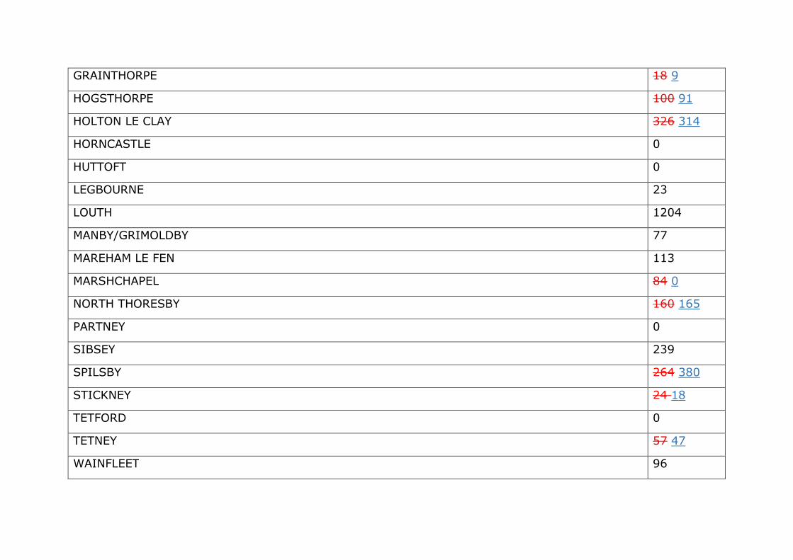
GRAINTHORPE 18 9
HOGSTHORPE 100 91
HOLTON LE CLAY 326 314
HORNCASTLE 0
HUTTOFT 0
LEGBOURNE 23
LOUTH 1204
MANBY/GRIMOLDBY 77
MAREHAM LE FEN 113
MARSHCHAPEL 84 0
NORTH THORESBY 160 165
PARTNEY 0
SIBSEY 239
SPILSBY 264 380
STICKNEY 24 18
TETFORD 0
TETNEY 57 47
WAINFLEET 96
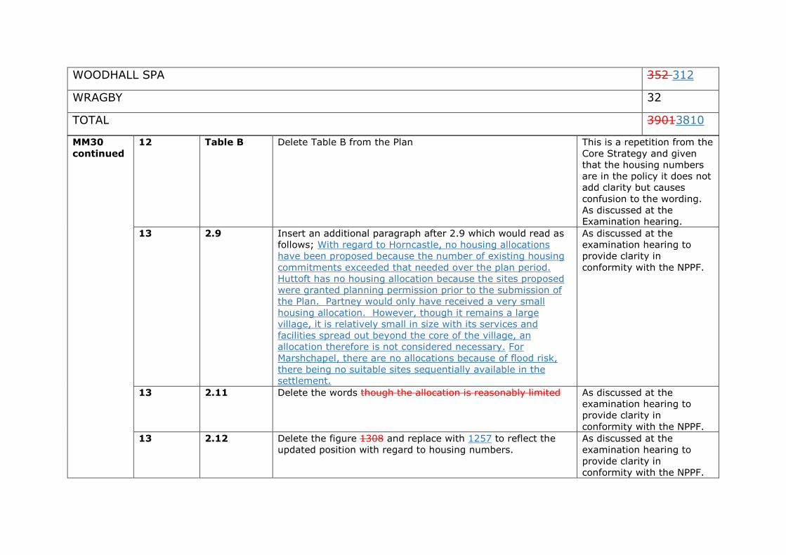
WOODHALL SPA 352 312
WRAGBY 32
TOTAL 39013810
MM30
continued
12 Table B Delete Table B from the Plan This is a repetition from the Core Strategy and given that the housing numbers are in the policy it does not add clarity but causes confusion to the wording. As discussed at the Examination hearing.
13 2.9 Insert an additional paragraph after 2.9 which would read as follows; With regard to Horncastle, no housing allocations have been proposed because the number of existing housing commitments exceeded that needed over the plan period. Huttoft has no housing allocation because the sites proposed were granted planning permission prior to the submission of the Plan. Partney would only have received a very small housing allocation. However, though it remains a large village, it is relatively small in size with its services and facilities spread out beyond the core of the village, an allocation therefore is not considered necessary. For Marshchapel, there are no allocations because of flood risk, there being no suitable sites sequentially available in the settlement.
As discussed at the examination hearing to provide clarity in conformity with the NPPF.
13 2.11 Delete the words though the allocation is reasonably limited As discussed at the examination hearing to provide clarity in conformity with the NPPF.
13 2.12 Delete the figure 1308 and replace with 1257 to reflect the updated position with regard to housing numbers.
As discussed at the examination hearing to provide clarity in conformity with the NPPF.
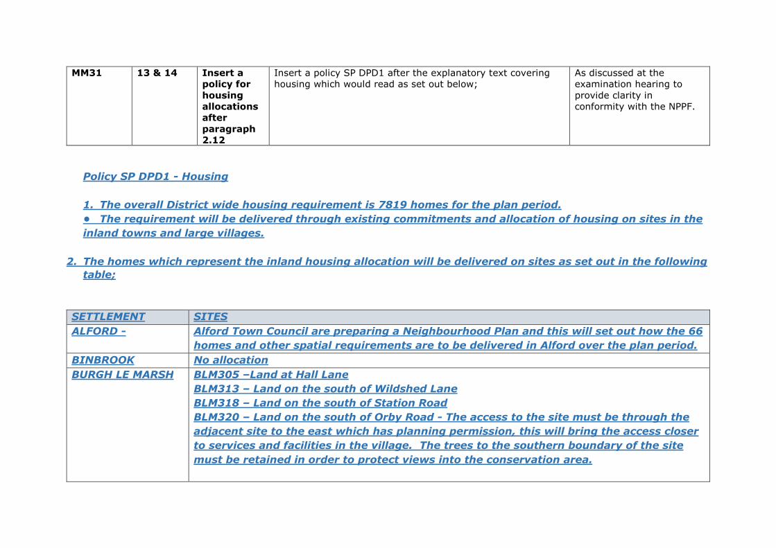
MM31 13 & 14 Insert a
policy for
housing
allocations
after
paragraph
2.12
Insert a policy SP DPD1 after the explanatory text covering housing which would read as set out below;
As discussed at the examination hearing to provide clarity in conformity with the NPPF.
Policy SP DPD1 - Housing
1. The overall District wide housing requirement is 7819 homes for the plan period.
• The requirement will be delivered through existing commitments and allocation of housing on sites in the
inland towns and large villages.
2. The homes which represent the inland housing allocation will be delivered on sites as set out in the following
table;
SETTLEMENT SITES
ALFORD - Alford Town Council are preparing a Neighbourhood Plan and this will set out how the 66
homes and other spatial requirements are to be delivered in Alford over the plan period.
BINBROOK No allocation
BURGH LE MARSH BLM305 –Land at Hall Lane
BLM313 – Land on the south of Wildshed Lane
BLM318 – Land on the south of Station Road
BLM320 – Land on the south of Orby Road - The access to the site must be through the
adjacent site to the east which has planning permission, this will bring the access closer
to services and facilities in the village. The trees to the southern boundary of the site
must be retained in order to protect views into the conservation area.
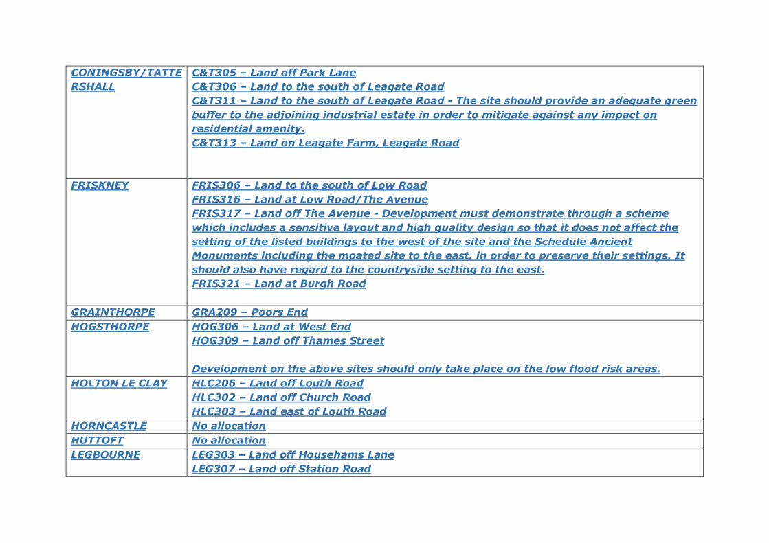
CONINGSBY/TATTE
RSHALL
C&T305 – Land off Park Lane
C&T306 – Land to the south of Leagate Road
C&T311 – Land to the south of Leagate Road - The site should provide an adequate green
buffer to the adjoining industrial estate in order to mitigate against any impact on
residential amenity.
C&T313 – Land on Leagate Farm, Leagate Road
FRISKNEY FRIS306 – Land to the south of Low Road
FRIS316 – Land at Low Road/The Avenue
FRIS317 – Land off The Avenue - Development must demonstrate through a scheme
which includes a sensitive layout and high quality design so that it does not affect the
setting of the listed buildings to the west of the site and the Schedule Ancient
Monuments including the moated site to the east, in order to preserve their settings. It
should also have regard to the countryside setting to the east.
FRIS321 – Land at Burgh Road
GRAINTHORPE GRA209 – Poors End
HOGSTHORPE HOG306 – Land at West End
HOG309 – Land off Thames Street
Development on the above sites should only take place on the low flood risk areas.
HOLTON LE CLAY HLC206 – Land off Louth Road
HLC302 – Land off Church Road
HLC303 – Land east of Louth Road
HORNCASTLE No allocation
HUTTOFT No allocation
LEGBOURNE LEG303 – Land off Househams Lane
LEG307 – Land off Station Road
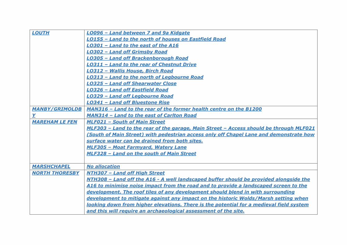
LOUTH LO096 – Land between 7 and 9a Kidgate
LO155 – Land to the north of houses on Eastfield Road
LO301 – Land to the east of the A16
LO302 – Land off Grimsby Road
LO305 – Land off Brackenborough Road
LO311 – Land to the rear of Chestnut Drive
LO312 – Wallis House, Birch Road
LO313 – Land to the north of Legbourne Road
LO325 – Land off Shearwater Close
LO326 – Land off Eastfield Road
LO329 – Land off Legbourne Road
LO341 – Land off Bluestone Rise
MANBY/GRIMOLDB
Y
MAN316 – Land to the rear of the former health centre on the B1200
MAN314 – Land to the east of Carlton Road
MAREHAM LE FEN MLF021 – South of Main Street
MLF303 – Land to the rear of the garage, Main Street – Access should be through MLF021
(South of Main Street) with pedestrian access only off Chapel Lane and demonstrate how
surface water can be drained from both sites.
MLF305 – Moat Farmyard, Watery Lane
MLF328 – Land on the south of Main Street
MARSHCHAPEL No allocation
NORTH THORESBY NTH307 – Land off High Street
NTH308 – Land off the A16 - A well landscaped buffer should be provided alongside the
A16 to minimise noise impact from the road and to provide a landscaped screen to the
development. The roof tiles of any development should blend in with surrounding
development to mitigate against any impact on the historic Wolds/Marsh setting when
looking down from higher elevations. There is the potential for a medieval field system
and this will require an archaeological assessment of the site.
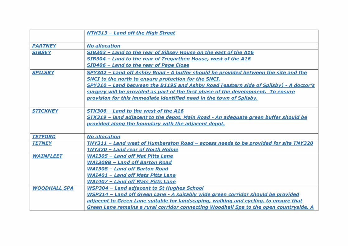
NTH313 – Land off the High Street
PARTNEY No allocation
SIBSEY SIB303 – Land to the rear of Sibsey House on the east of the A16
SIB304 – Land to the rear of Tregarthen House, west of the A16
SIB406 – Land to the rear of Page Close
SPILSBY SPY302 – Land off Ashby Road - A buffer should be provided between the site and the
SNCI to the north to ensure protection for the SNCI.
SPY310 – Land between the B1195 and Ashby Road (eastern side of Spilsby) - A doctor’s
surgery will be provided as part of the first phase of the development. To ensure
provision for this immediate identified need in the town of Spilsby.
STICKNEY STK306 – Land to the west of the A16
STK319 – land adjacent to the depot, Main Road - An adequate green buffer should be
provided along the boundary with the adjacent depot.
TETFORD No allocation
TETNEY TNY311 – Land west of Humberston Road – access needs to be provided for site TNY320
TNY320 – Land rear of North Holme
WAINFLEET WAI305 – Land off Mat Pitts Lane
WAI308B – Land off Barton Road
WAI308 – Land off Barton Road
WAI401 – Land off Mats Pitts Lane
WAI407 – Land off Mats Pitts Lane
WOODHALL SPA WSP304 – Land adjacent to St Hughes School
WSP314 – Land off Green Lane - A suitably wide green corridor should be provided
adjacent to Green Lane suitable for landscaping, walking and cycling, to ensure that
Green Lane remains a rural corridor connecting Woodhall Spa to the open countryside. A
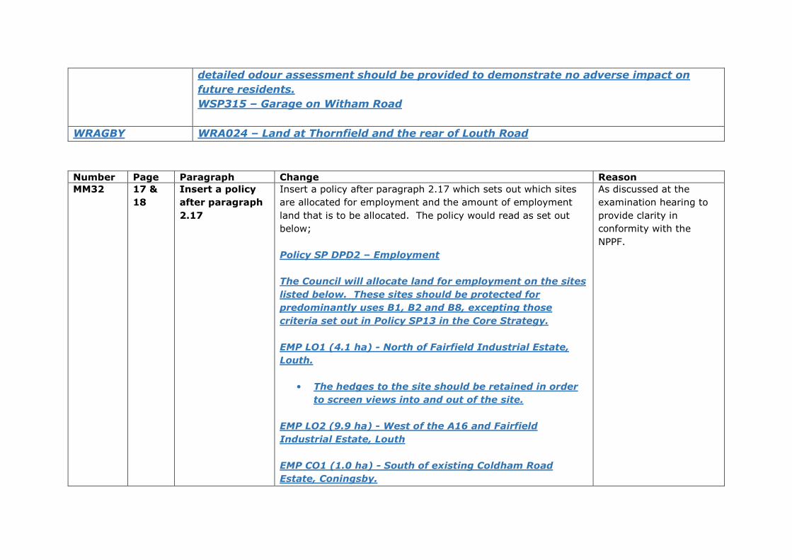
detailed odour assessment should be provided to demonstrate no adverse impact on
future residents.
WSP315 – Garage on Witham Road
WRAGBY WRA024 – Land at Thornfield and the rear of Louth Road
Number Page Paragraph Change Reason
MM32 17 &
18
Insert a policy
after paragraph
2.17
Insert a policy after paragraph 2.17 which sets out which sites
are allocated for employment and the amount of employment
land that is to be allocated. The policy would read as set out
below;
Policy SP DPD2 – Employment
The Council will allocate land for employment on the sites
listed below. These sites should be protected for
predominantly uses B1, B2 and B8, excepting those
criteria set out in Policy SP13 in the Core Strategy.
EMP LO1 (4.1 ha) - North of Fairfield Industrial Estate,
Louth.
• The hedges to the site should be retained in order
to screen views into and out of the site.
EMP LO2 (9.9 ha) - West of the A16 and Fairfield
Industrial Estate, Louth
EMP CO1 (1.0 ha) - South of existing Coldham Road
Estate, Coningsby.
As discussed at the
examination hearing to
provide clarity in
conformity with the
NPPF.
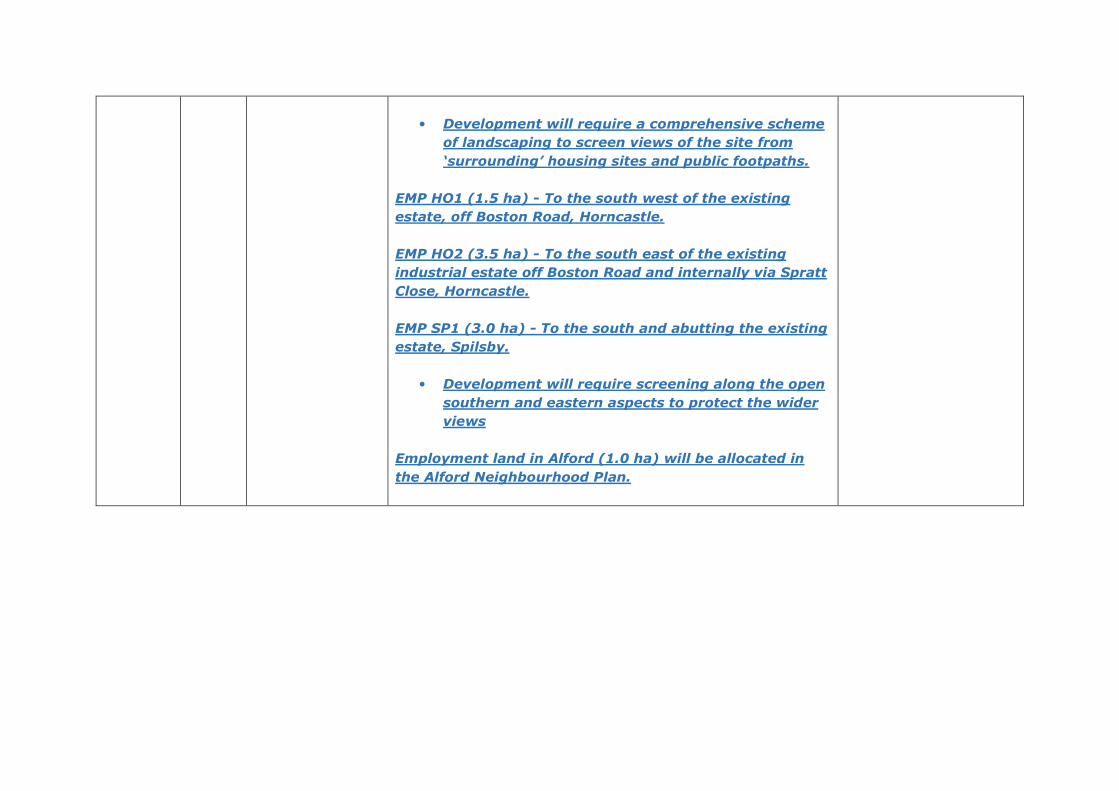
• Development will require a comprehensive scheme
of landscaping to screen views of the site from
‘surrounding’ housing sites and public footpaths.
EMP HO1 (1.5 ha) - To the south west of the existing
estate, off Boston Road, Horncastle.
EMP HO2 (3.5 ha) - To the south east of the existing
industrial estate off Boston Road and internally via Spratt
Close, Horncastle.
EMP SP1 (3.0 ha) - To the south and abutting the existing
estate, Spilsby.
• Development will require screening along the open
southern and eastern aspects to protect the wider
views
Employment land in Alford (1.0 ha) will be allocated in
the Alford Neighbourhood Plan.
12
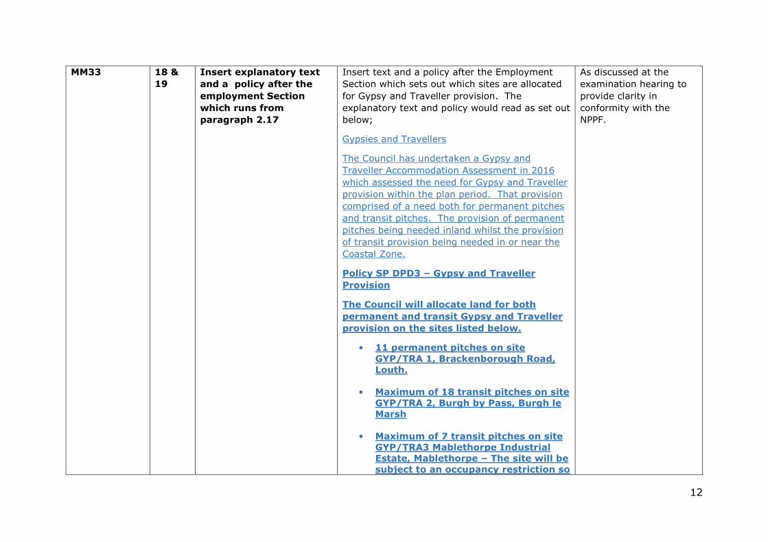
MM33 18 &
19
Insert explanatory text
and a policy after the
employment Section
which runs from
paragraph 2.17
Insert text and a policy after the Employment
Section which sets out which sites are allocated
for Gypsy and Traveller provision. The
explanatory text and policy would read as set out
below;
Gypsies and Travellers
The Council has undertaken a Gypsy and
Traveller Accommodation Assessment in 2016
which assessed the need for Gypsy and Traveller
provision within the plan period. That provision
comprised of a need both for permanent pitches
and transit pitches. The provision of permanent
pitches being needed inland whilst the provision
of transit provision being needed in or near the
Coastal Zone.
Policy SP DPD3 – Gypsy and Traveller
Provision
The Council will allocate land for both
permanent and transit Gypsy and Traveller
provision on the sites listed below.
• 11 permanent pitches on site
GYP/TRA 1, Brackenborough Road,
Louth.
• Maximum of 18 transit pitches on site
GYP/TRA 2, Burgh by Pass, Burgh le
Marsh
• Maximum of 7 transit pitches on site
GYP/TRA3 Mablethorpe Industrial
Estate, Mablethorpe – The site will be
subject to an occupancy restriction so
As discussed at the
examination hearing to
provide clarity in
conformity with the
NPPF.
13
that it should only be occupied
between the 15th of March and the
31st of October or the following
Sunday of each year because of flood
risk.
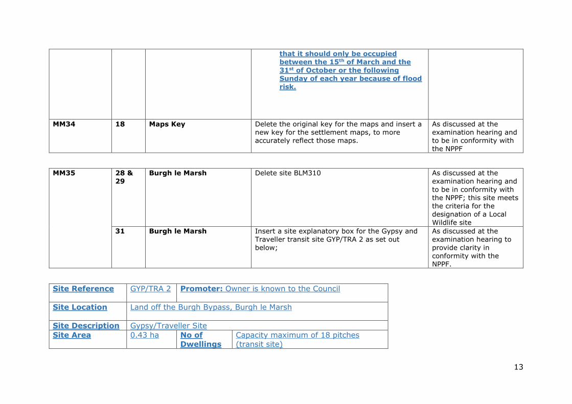
MM34 18 Maps Key Delete the original key for the maps and insert a new key for the settlement maps, to more accurately reflect those maps.
As discussed at the examination hearing and to be in conformity with the NPPF
MM35 28 &
29
Burgh le Marsh Delete site BLM310 As discussed at the examination hearing and to be in conformity with the NPPF; this site meets the criteria for the designation of a Local Wildlife site
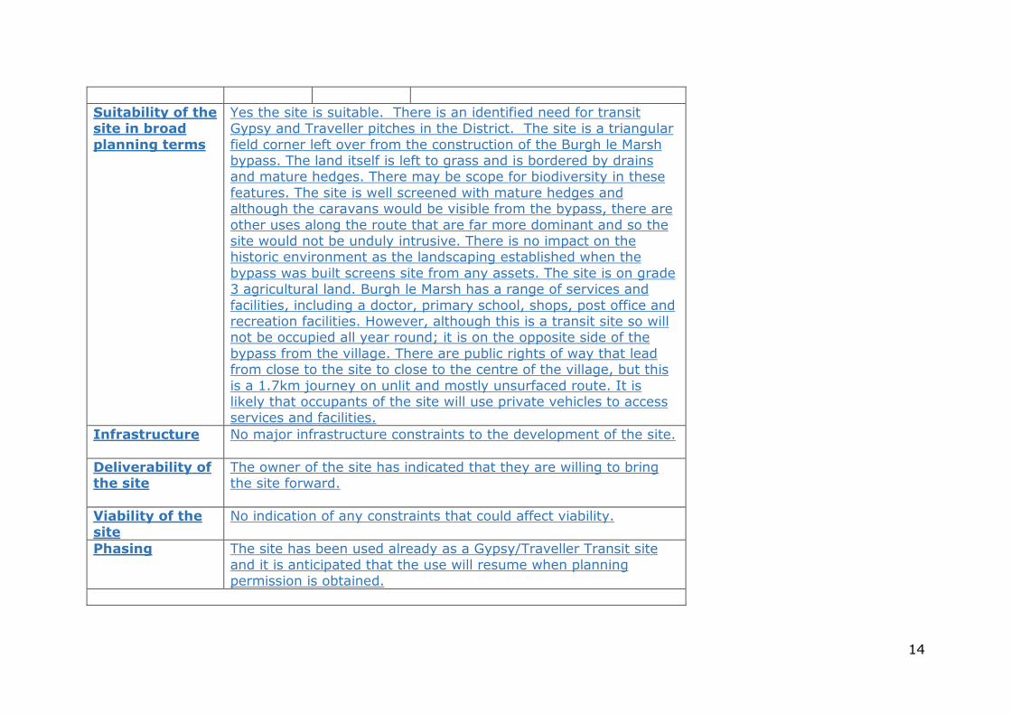
31 Burgh le Marsh Insert a site explanatory box for the Gypsy and Traveller transit site GYP/TRA 2 as set out below;
As discussed at the examination hearing to provide clarity in conformity with the NPPF.
Site Reference GYP/TRA 2 Promoter: Owner is known to the Council
Site Location
Land off the Burgh Bypass, Burgh le Marsh
Site Description Gypsy/Traveller Site Site Area 0.43 ha No of
Dwellings
Capacity maximum of 18 pitches (transit site)
14
Suitability of the site in broad
planning terms
Yes the site is suitable. There is an identified need for transit Gypsy and Traveller pitches in the District. The site is a triangular field corner left over from the construction of the Burgh le Marsh bypass. The land itself is left to grass and is bordered by drains and mature hedges. There may be scope for biodiversity in these features. The site is well screened with mature hedges and although the caravans would be visible from the bypass, there are other uses along the route that are far more dominant and so the site would not be unduly intrusive. There is no impact on the historic environment as the landscaping established when the bypass was built screens site from any assets. The site is on grade 3 agricultural land. Burgh le Marsh has a range of services and facilities, including a doctor, primary school, shops, post office and recreation facilities. However, although this is a transit site so will not be occupied all year round; it is on the opposite side of the bypass from the village. There are public rights of way that lead from close to the site to close to the centre of the village, but this is a 1.7km journey on unlit and mostly unsurfaced route. It is likely that occupants of the site will use private vehicles to access services and facilities.
Infrastructure
No major infrastructure constraints to the development of the site.
Deliverability of the site
The owner of the site has indicated that they are willing to bring the site forward.
Viability of the
site
No indication of any constraints that could affect viability.
Phasing The site has been used already as a Gypsy/Traveller Transit site and it is anticipated that the use will resume when planning permission is obtained.
15
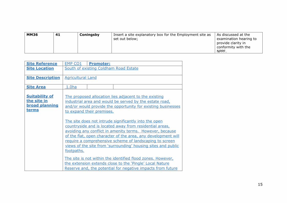
MM36 41 Coningsby Insert a site explanatory box for the Employment site as set out below;
As discussed at the examination hearing to provide clarity in conformity with the NPPF.
Site Reference EMP CO1 Promoter: Site Location
South of existing Coldham Road Estate
Site Description Agricultural Land
Site Area 1.0ha
Suitability of
the site in broad planning terms
The proposed allocation lies adjacent to the existing
industrial area and would be served by the estate road,
and/or would provide the opportunity for existing businesses
to expand their premises.
The site does not intrude significantly into the open
countryside and is located away from residential areas,
avoiding any conflict in amenity terms. However, because
of the flat, open character of the area, any development will
require a comprehensive scheme of landscaping to screen
views of the site from ‘surrounding’ housing sites and public
footpaths.
The site is not within the identified flood zones. However,
the extension extends close to the ‘Pingle’ Local Nature
Reserve and, the potential for negative impacts from future
16
businesses on the biodiversity of that area will need to be
considered.
Infrastructure
There are no major infrastructure constraints to the development of the site.
Deliverability of
the site
The site would appear to be deliverable.
Viability of the site
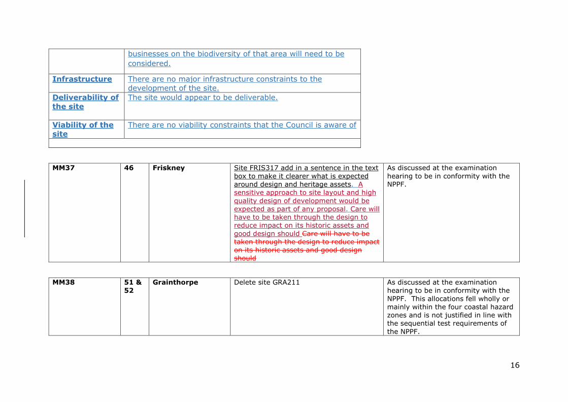
There are no viability constraints that the Council is aware of
MM37
46 Friskney Site FRIS317 add in a sentence in the text box to make it clearer what is expected around design and heritage assets. A sensitive approach to site layout and high quality design of development would be expected as part of any proposal. Care will have to be taken through the design to reduce impact on its historic assets and good design should Care will have to be taken through the design to reduce impact on its historic assets and good design should
As discussed at the examination hearing to be in conformity with the NPPF.
MM38 51 &
52
Grainthorpe Delete site GRA211 As discussed at the examination hearing to be in conformity with the NPPF. This allocations fell wholly or mainly within the four coastal hazard zones and is not justified in line with the sequential test requirements of the NPPF.
17
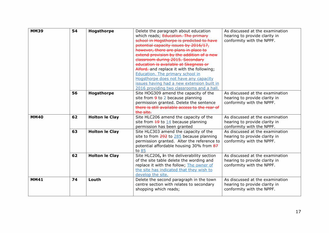
MM39 54 Hogsthorpe Delete the paragraph about education which reads; Education. The primary school in Hogsthorpe is predicted to have potential capacity issues by 2016/17, however, there are plans in place to extend provision by the addition of a new classroom during 2015. Secondary education is available at Skegness or Alford. and replace it with the following; Education. The primary school in Hogsthorpe does not have any capacity issues having had a new extension built in 2016 providing two classrooms and a hall.
As discussed at the examination hearing to provide clarity in conformity with the NPPF.
56 Hogsthorpe Site HOG309 amend the capacity of the site from 9 to 2 because planning permission granted. Delete the sentence there is still available access to the rear of the site.
As discussed at the examination hearing to provide clarity in conformity with the NPPF.
MM40 62 Holton le Clay Site HLC206 amend the capacity of the site from 19 to 14 because planning permission has been granted
As discussed at the examination hearing to provide clarity in conformity with the NPPF.
63 Holton le Clay Site HLC303 amend the capacity of the site to from 292 to 285 because planning permission granted. Alter the reference to potential affordable housing 30% from 87 to 85
As discussed at the examination hearing to provide clarity in conformity with the NPPF.
62 Holton le Clay Site HLC206, in the deliverability section of the site table delete the wording and replace it with the follow; The owner of the site has indicated that they wish to develop the site.
As discussed at the examination hearing to provide clarity in conformity with the NPPF.
MM41 74 Louth Delete the second paragraph in the town centre section with relates to secondary shopping which reads;
As discussed at the examination hearing to provide clarity in conformity with the NPPF.
18
“The adjoining side streets and alleyways comprise the secondary shopping area, with Aswell Street in particular being home to restaurants and cafes (A3 uses). Close to the town centre residential properties sit side by side with the typical uses.”
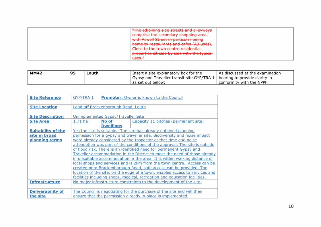
MM42 95 Louth Insert a site explanatory box for the Gypsy and Traveller transit site GYP/TRA 1 as set out below;
As discussed at the examination hearing to provide clarity in conformity with the NPPF.
Site Reference GYP/TRA 1 Promoter: Owner is known to the Council
Site Location
Land off Brackenborough Road, Louth
Site Description Unimplemented Gypsy/Traveller Site Site Area 1.71 ha No of
Dwellings
Capacity 11 pitches (permanent site)
Suitability of the
site in broad
planning terms
Yes the site is suitable. The site has already obtained planning permission for a gypsy and traveller site. Biodiversity and noise impact were already considered by the Inspector at that time and noise attenuation was part of the conditions of the approval. The site is outside of flood risk. There is an identified need for permanent Gypsy and Traveller accommodation in the District to meet the need of those already in unsuitable accommodation in the area. It is within walking distance of local shops and services and is 2km from the town centre. Access can be created onto Brackenborough Road, safe access can be provided. The location of the site, on the edge of a town, enables access to services and facilities including shops, medical, recreation and education facilities.
Infrastructure
No major infrastructure constraints to the development of the site.
Deliverability of
the site
The Council is negotiating for the purchase of the site and will then ensure that the permission already in place is implemented.
19
Viability of the
site
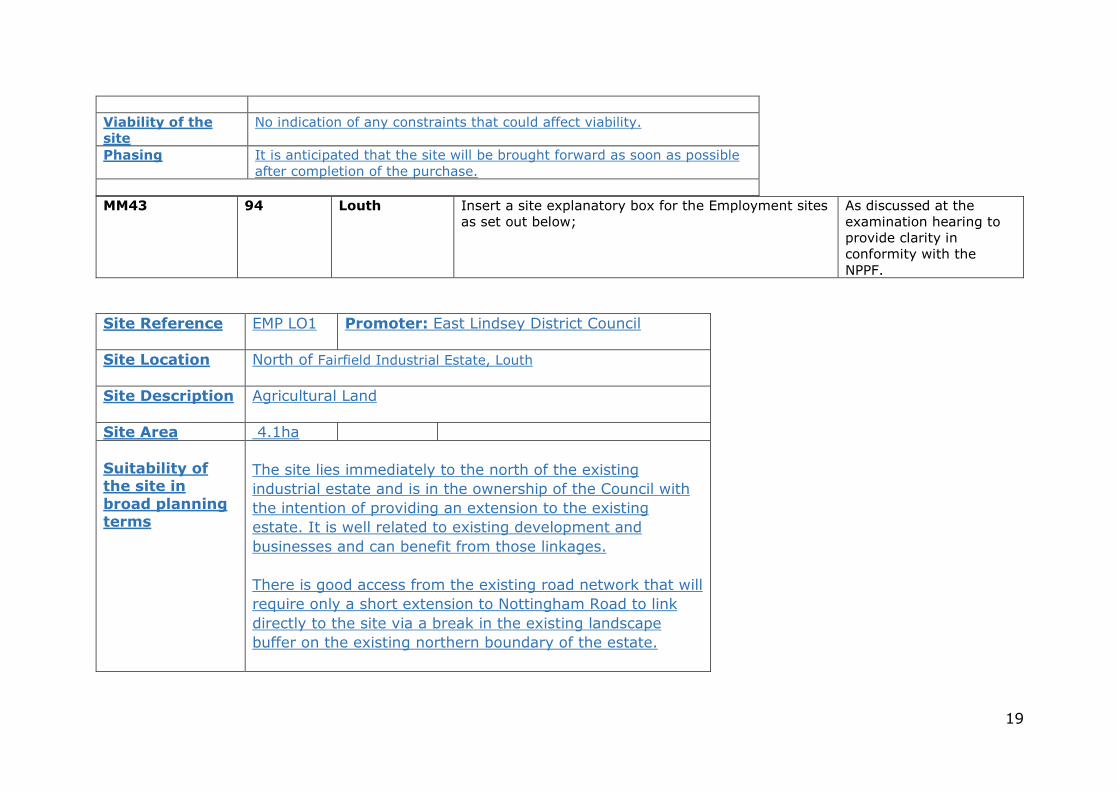
No indication of any constraints that could affect viability.
Phasing It is anticipated that the site will be brought forward as soon as possible after completion of the purchase.
MM43 94 Louth Insert a site explanatory box for the Employment sites as set out below;
As discussed at the examination hearing to provide clarity in conformity with the NPPF.
Site Reference EMP LO1 Promoter: East Lindsey District Council
Site Location
North of Fairfield Industrial Estate, Louth
Site Description Agricultural Land
Site Area 4.1ha
Suitability of the site in
broad planning terms
The site lies immediately to the north of the existing
industrial estate and is in the ownership of the Council with
the intention of providing an extension to the existing
estate. It is well related to existing development and
businesses and can benefit from those linkages.
There is good access from the existing road network that will
require only a short extension to Nottingham Road to link
directly to the site via a break in the existing landscape
buffer on the existing northern boundary of the estate.
20
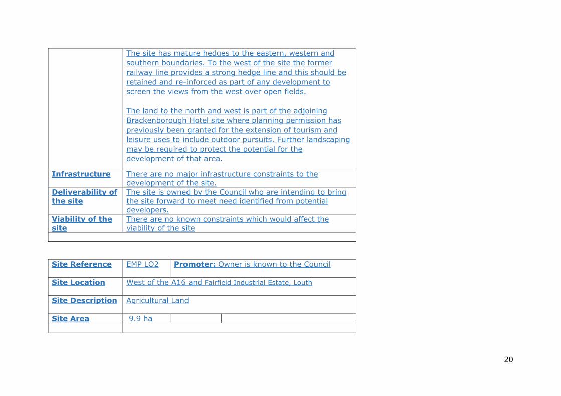
The site has mature hedges to the eastern, western and
southern boundaries. To the west of the site the former
railway line provides a strong hedge line and this should be
retained and re-inforced as part of any development to
screen the views from the west over open fields.
The land to the north and west is part of the adjoining
Brackenborough Hotel site where planning permission has
previously been granted for the extension of tourism and
leisure uses to include outdoor pursuits. Further landscaping
may be required to protect the potential for the
development of that area.
Infrastructure
There are no major infrastructure constraints to the development of the site.
Deliverability of the site
The site is owned by the Council who are intending to bring the site forward to meet need identified from potential developers.
Viability of the site
There are no known constraints which would affect the viability of the site
Site Reference EMP LO2 Promoter: Owner is known to the Council
Site Location
West of the A16 and Fairfield Industrial Estate, Louth
Site Description Agricultural Land
Site Area 9.9 ha
21
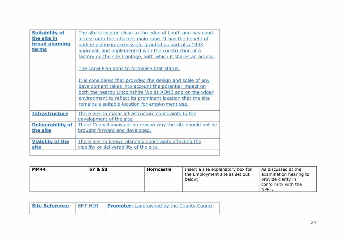
Suitability of
the site in broad planning terms
The site is located close to the edge of Louth and has good
access onto the adjacent main road. It has the benefit of
outline planning permission, granted as part of a 1993
approval, and implemented with the construction of a
factory on the site frontage, with which it shares an access.
The Local Plan aims to formalise that status.
It is considered that provided the design and scale of any
development takes into account the potential impact on
both the nearby Lincolnshire Wolds AONB and on the wider
environment to reflect its prominent location that the site
remains a suitable location for employment use.
Infrastructure
There are no major infrastructure constraints to the development of the site.
Deliverability of the site
There Council knows of no reason why the site should not be brought forward and developed.
Viability of the
site
There are no known planning constraints affecting the viability or deliverability of the site.
MM44 67 & 68 Horncastle Insert a site explanatory box for the Employment site as set out below;
As discussed at the examination hearing to provide clarity in conformity with the NPPF.
Site Reference EMP HO1 Promoter: Land owned by the County Council
22
Site Location
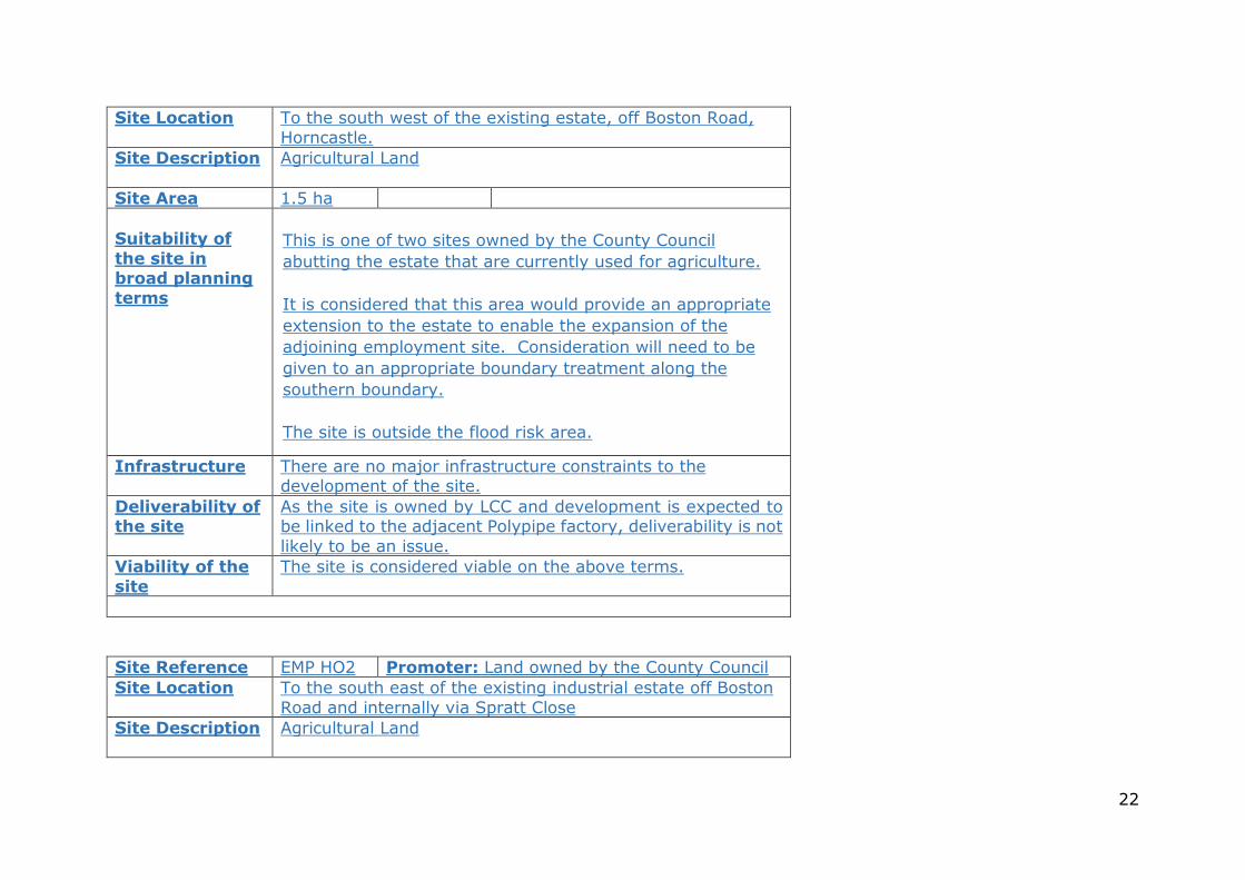
To the south west of the existing estate, off Boston Road, Horncastle.
Site Description Agricultural Land
Site Area 1.5 ha
Suitability of
the site in broad planning terms
This is one of two sites owned by the County Council
abutting the estate that are currently used for agriculture.
It is considered that this area would provide an appropriate
extension to the estate to enable the expansion of the
adjoining employment site. Consideration will need to be
given to an appropriate boundary treatment along the
southern boundary.
The site is outside the flood risk area.
Infrastructure
There are no major infrastructure constraints to the development of the site.
Deliverability of the site
As the site is owned by LCC and development is expected to be linked to the adjacent Polypipe factory, deliverability is not likely to be an issue.
Viability of the
site
The site is considered viable on the above terms.
Site Reference EMP HO2 Promoter: Land owned by the County Council Site Location
To the south east of the existing industrial estate off Boston Road and internally via Spratt Close
Site Description Agricultural Land
23
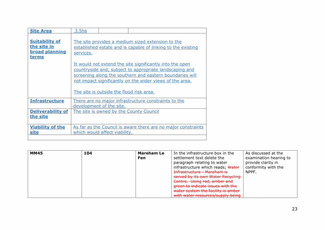
Site Area 3.5ha
Suitability of
the site in broad planning terms
The site provides a medium sized extension to the
established estate and is capable of linking to the existing
services.
It would not extend the site significantly into the open
countryside and, subject to appropriate landscaping and
screening along the southern and eastern boundaries will
not impact significantly on the wider views of the area.
The site is outside the flood risk area.
Infrastructure
There are no major infrastructure constraints to the development of the site.
Deliverability of the site
The site is owned by the County Council
Viability of the
site
As far as the Council is aware there are no major constraints which would affect viability.
MM45 104 Mareham Le
Fen
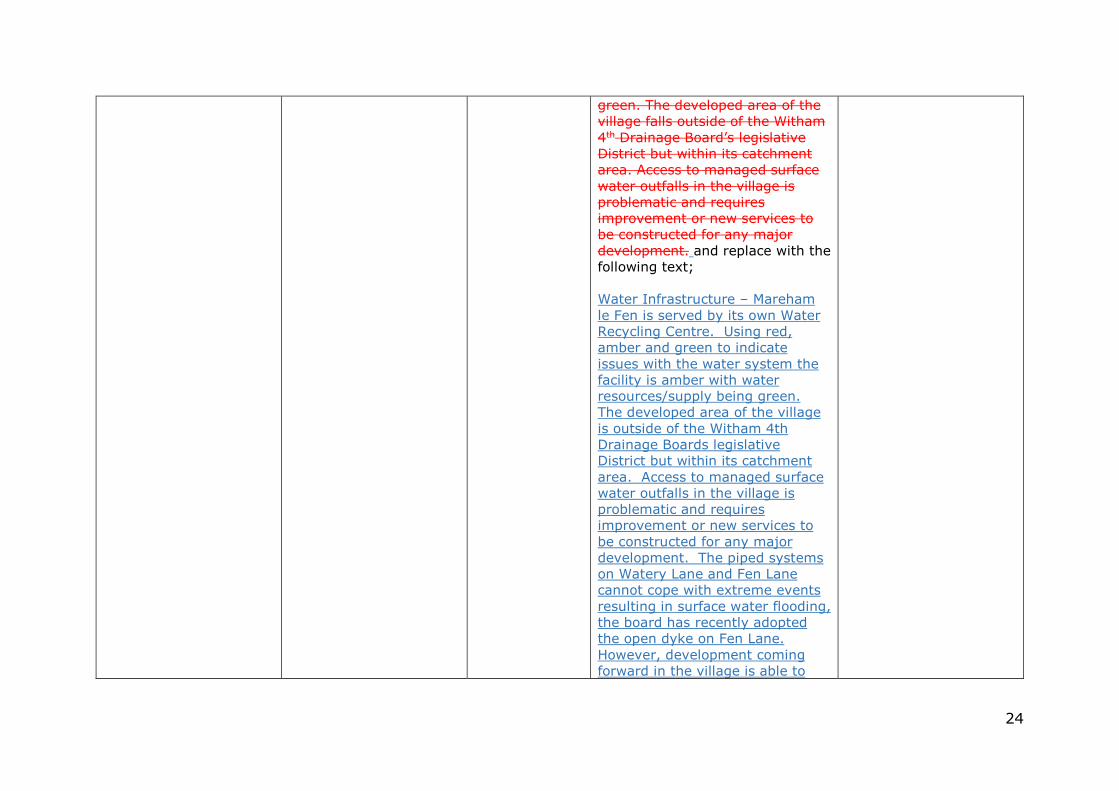
In the infrastructure box in the settlement text delete the paragraph relating to water infrastructure which reads; Water Infrastructure - Mareham is served by its own Water Recycling Centre. Using red, amber and green to indicate issues with the water system the facility is amber with water resources/supply being
As discussed at the examination hearing to provide clarity in conformity with the NPPF.
24
green. The developed area of the village falls outside of the Witham 4th Drainage Board’s legislative District but within its catchment area. Access to managed surface water outfalls in the village is problematic and requires improvement or new services to be constructed for any major development. and replace with the following text; Water Infrastructure – Mareham le Fen is served by its own Water Recycling Centre. Using red, amber and green to indicate issues with the water system the facility is amber with water resources/supply being green. The developed area of the village is outside of the Witham 4th Drainage Boards legislative District but within its catchment area. Access to managed surface water outfalls in the village is problematic and requires improvement or new services to be constructed for any major development. The piped systems on Watery Lane and Fen Lane cannot cope with extreme events resulting in surface water flooding, the board has recently adopted the open dyke on Fen Lane. However, development coming forward in the village is able to
25
demonstrate that drainage issues can be overcome.
108 Mareham le
Fen – Site
MLF305
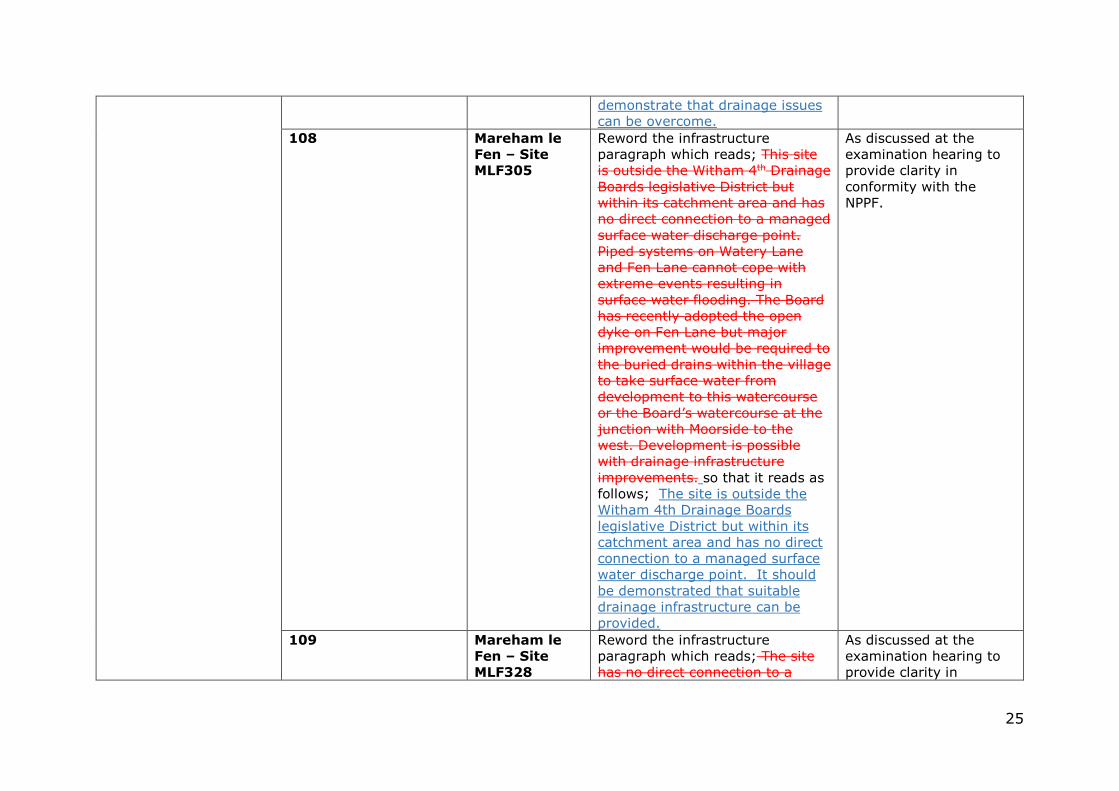
Reword the infrastructure paragraph which reads; This site is outside the Witham 4th Drainage Boards legislative District but within its catchment area and has no direct connection to a managed surface water discharge point. Piped systems on Watery Lane and Fen Lane cannot cope with extreme events resulting in surface water flooding. The Board has recently adopted the open dyke on Fen Lane but major improvement would be required to the buried drains within the village to take surface water from development to this watercourse or the Board’s watercourse at the junction with Moorside to the west. Development is possible with drainage infrastructure improvements. so that it reads as follows; The site is outside the Witham 4th Drainage Boards legislative District but within its catchment area and has no direct connection to a managed surface water discharge point. It should be demonstrated that suitable drainage infrastructure can be provided.
As discussed at the examination hearing to provide clarity in conformity with the NPPF.
109 Mareham le
Fen – Site
MLF328
Reword the infrastructure paragraph which reads; The site has no direct connection to a
As discussed at the examination hearing to provide clarity in
26
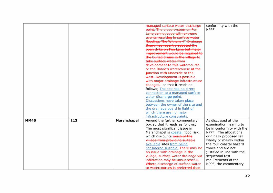
managed surface water discharge point. The piped system on Fen Lane cannot cope with extreme events resulting in surface water flooding. The Witham 4th Drainage Board has recently adopted the open dyke on Fen Lane but major improvement would be required to the buried drains in the village to take surface water from development to this watercourse or the Board’s watercourse at the junction with Moorside to the west. Development is possible with major drainage infrastructure changes. so that it reads as follows; The site has no direct connection to a managed surface water discharge point. Discussions have taken place between the owner of the site and the drainage board in light of which there are no major infrastructure constraints.
conformity with the NPPF.
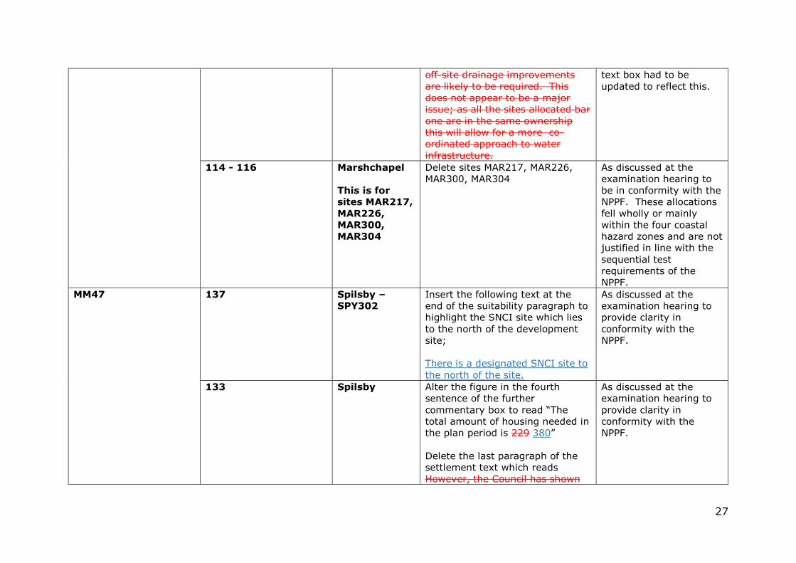
MM46 112 Marshchapel Amend the further commentary box so that it reads as follows; The most significant issue in Marshchapel is coastal flood risk, which discounts much of the village from providing suitable available sites from being considered suitable. There may be an issue with drainage in the village, surface water drainage via infiltration may be unsuccessful. Where discharge of surface water to watercourses is preferred then
As discussed at the examination hearing to be in conformity with the NPPF. The allocations originally proposed fell wholly or mainly within the four coastal hazard zones and are not justified in line with the sequential test requirements of the NPPF, the commentary
27
off-site drainage improvements are likely to be required. This does not appear to be a major issue; as all the sites allocated bar one are in the same ownership this will allow for a more co-ordinated approach to water infrastructure.
text box had to be updated to reflect this.
114 - 116 Marshchapel
This is for
sites MAR217,
MAR226,
MAR300,
MAR304
Delete sites MAR217, MAR226, MAR300, MAR304
As discussed at the examination hearing to be in conformity with the NPPF. These allocations fell wholly or mainly within the four coastal hazard zones and are not justified in line with the sequential test requirements of the NPPF.
MM47 137 Spilsby –
SPY302
Insert the following text at the end of the suitability paragraph to highlight the SNCI site which lies to the north of the development site; There is a designated SNCI site to the north of the site.
As discussed at the examination hearing to provide clarity in conformity with the NPPF.
133 Spilsby Alter the figure in the fourth sentence of the further commentary box to read “The total amount of housing needed in the plan period is 229 380” Delete the last paragraph of the settlement text which reads However, the Council has shown
As discussed at the examination hearing to provide clarity in conformity with the NPPF.
28
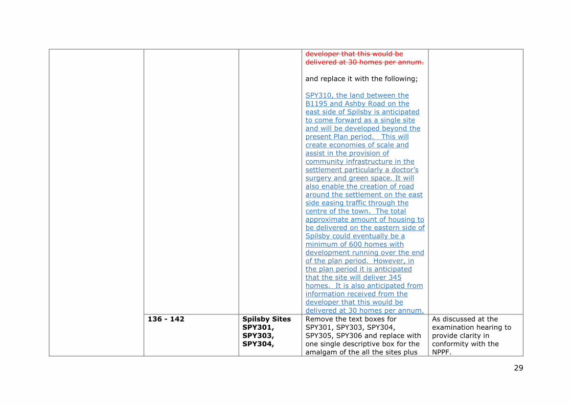
on the map the whole of the eastern side of the town as SPY310, this includes sites SPY301, SPY303, SPY304, SPY305 and SPY306 and land further out to the east, much of which will remain in agricultural use and be amenity green space. Whilst not all this area is proposed for development a substantial percentage of it will be given over to green space, it is appropriate that the Council show the full direction on its map. This is because the sites on the eastern side of Spilsby will be working together to bring forward a single larger development over and beyond the present plan period. This will create economies of scale and assist in the provision of community infrastructure in the settlement particularly a doctor’s surgery and green space. It will also enable the creation of a road around the settlement on the east side, easing traffic through the centre. It is not anticipated that all the sites will come forward during the plan period but the total approximate amount of housing to be delivered on the eastern side of Spilsby could eventually be a minimum of 600 homes. It is anticipated from information received from the
29
developer that this would be delivered at 30 homes per annum. and replace it with the following; SPY310, the land between the B1195 and Ashby Road on the east side of Spilsby is anticipated to come forward as a single site and will be developed beyond the present Plan period. This will create economies of scale and assist in the provision of community infrastructure in the settlement particularly a doctor’s surgery and green space. It will also enable the creation of road around the settlement on the east side easing traffic through the centre of the town. The total approximate amount of housing to be delivered on the eastern side of Spilsby could eventually be a minimum of 600 homes with development running over the end of the plan period. However, in the plan period it is anticipated that the site will deliver 345 homes. It is also anticipated from information received from the developer that this would be delivered at 30 homes per annum.
136 - 142 Spilsby Sites
SPY301,
SPY303,
SPY304,
Remove the text boxes for SPY301, SPY303, SPY304, SPY305, SPY306 and replace with one single descriptive box for the amalgam of the all the sites plus
As discussed at the examination hearing to provide clarity in conformity with the NPPF.
30
SPY305,
SPY306
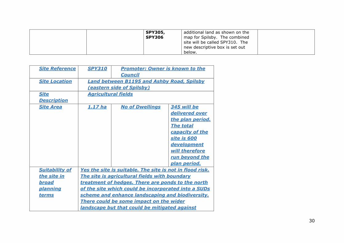
additional land as shown on the map for Spilsby. The combined site will be called SPY310. The new descriptive box is set out below.
Site Reference SPY310 Promoter: Owner is known to the
Council
Site Location
Land between B1195 and Ashby Road, Spilsby
(eastern side of Spilsby)
Site
Description
Agricultural fields
Site Area 1.17 ha No of Dwellings
345 will be
delivered over
the plan period.
The total
capacity of the
site is 600
development
will therefore
run beyond the
plan period.
Suitability of
the site in
broad
planning
terms
Yes the site is suitable. The site is not in flood risk.
The site is agricultural fields with boundary
treatment of hedges. There are ponds to the north
of the site which could be incorporated into a SUDs
scheme and enhance landscaping and biodiversity.
There could be some impact on the wider
landscape but that could be mitigated against
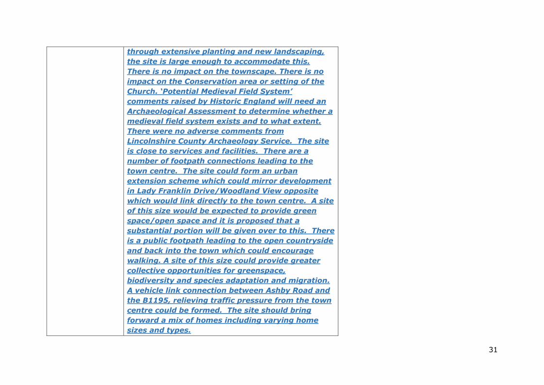
31
through extensive planting and new landscaping,
the site is large enough to accommodate this.
There is no impact on the townscape. There is no
impact on the Conservation area or setting of the
Church. ‘Potential Medieval Field System’
comments raised by Historic England will need an
Archaeological Assessment to determine whether a
medieval field system exists and to what extent.
There were no adverse comments from
Lincolnshire County Archaeology Service. The site
is close to services and facilities. There are a
number of footpath connections leading to the
town centre. The site could form an urban
extension scheme which could mirror development
in Lady Franklin Drive/Woodland View opposite
which would link directly to the town centre. A site
of this size would be expected to provide green
space/open space and it is proposed that a
substantial portion will be given over to this. There
is a public footpath leading to the open countryside
and back into the town which could encourage
walking. A site of this size could provide greater
collective opportunities for greenspace,
biodiversity and species adaptation and migration.
A vehicle link connection between Ashby Road and
the B1195, relieving traffic pressure from the town
centre could be formed. The site should bring
forward a mix of homes including varying home
sizes and types.
32
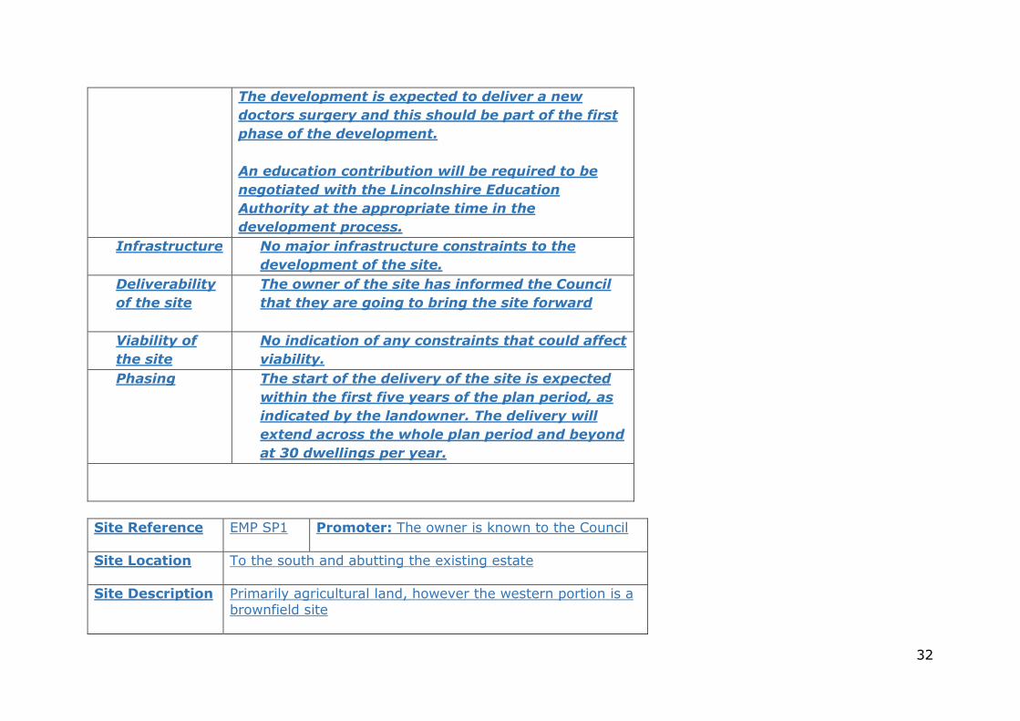
The development is expected to deliver a new
doctors surgery and this should be part of the first
phase of the development.
An education contribution will be required to be
negotiated with the Lincolnshire Education
Authority at the appropriate time in the
development process.
Infrastructure
No major infrastructure constraints to the
development of the site.
Deliverability
of the site
The owner of the site has informed the Council
that they are going to bring the site forward
Viability of
the site
No indication of any constraints that could affect
viability.
Phasing The start of the delivery of the site is expected
within the first five years of the plan period, as
indicated by the landowner. The delivery will
extend across the whole plan period and beyond
at 30 dwellings per year.
Site Reference EMP SP1 Promoter: The owner is known to the Council
Site Location
To the south and abutting the existing estate
Site Description Primarily agricultural land, however the western portion is a brownfield site
33
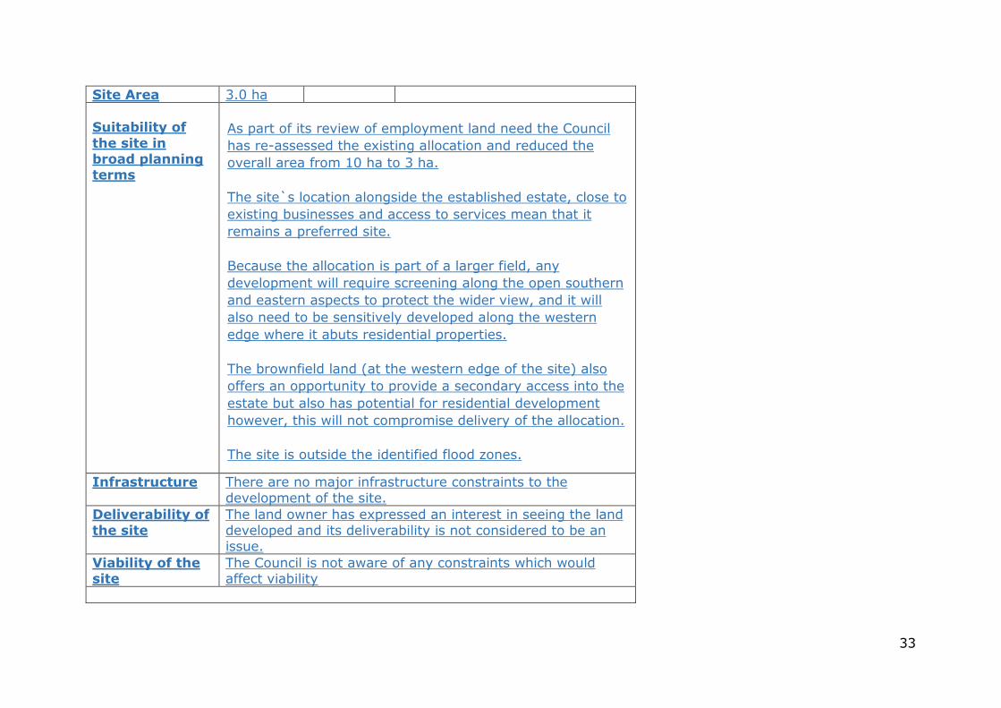
Site Area 3.0 ha
Suitability of
the site in broad planning terms
As part of its review of employment land need the Council
has re-assessed the existing allocation and reduced the
overall area from 10 ha to 3 ha.
The site`s location alongside the established estate, close to
existing businesses and access to services mean that it
remains a preferred site.
Because the allocation is part of a larger field, any
development will require screening along the open southern
and eastern aspects to protect the wider view, and it will
also need to be sensitively developed along the western
edge where it abuts residential properties.
The brownfield land (at the western edge of the site) also
offers an opportunity to provide a secondary access into the
estate but also has potential for residential development
however, this will not compromise delivery of the allocation.
The site is outside the identified flood zones.
Infrastructure
There are no major infrastructure constraints to the development of the site.
Deliverability of
the site
The land owner has expressed an interest in seeing the land developed and its deliverability is not considered to be an issue.
Viability of the site
The Council is not aware of any constraints which would affect viability
34
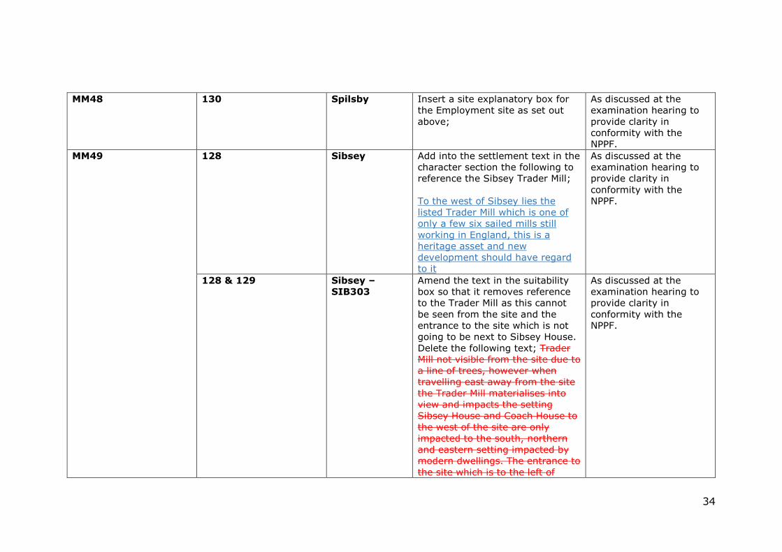
MM48 130
Spilsby Insert a site explanatory box for the Employment site as set out above;
As discussed at the examination hearing to provide clarity in conformity with the NPPF.
MM49 128 Sibsey Add into the settlement text in the character section the following to reference the Sibsey Trader Mill; To the west of Sibsey lies the listed Trader Mill which is one of only a few six sailed mills still working in England, this is a heritage asset and new development should have regard to it
As discussed at the examination hearing to provide clarity in conformity with the NPPF.
128 & 129 Sibsey –
SIB303
Amend the text in the suitability box so that it removes reference to the Trader Mill as this cannot be seen from the site and the entrance to the site which is not going to be next to Sibsey House. Delete the following text; Trader Mill not visible from the site due to a line of trees, however when travelling east away from the site the Trader Mill materialises into view and impacts the setting Sibsey House and Coach House to the west of the site are only impacted to the south, northern and eastern setting impacted by modern dwellings. The entrance to the site which is to the left of
As discussed at the examination hearing to provide clarity in conformity with the NPPF.
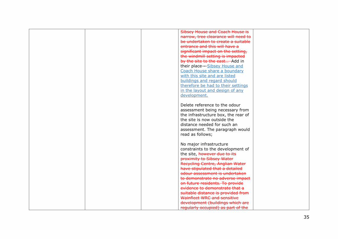
35
Sibsey House and Coach House is narrow, tree clearance will need to be undertaken to create a suitable entrance and this will have a significant impact on the setting, the windmill setting is impacted by the site to the east… Add in their place – Sibsey House and Coach House share a boundary with this site and are listed buildings and regard should therefore be had to their settings in the layout and design of any development. Delete reference to the odour assessment being necessary from the infrastructure box, the rear of the site is now outside the distance needed for such an assessment. The paragraph would read as follows; No major infrastructure constraints to the development of the site, however due to its proximity to Sibsey Water Recycling Centre, Anglian Water have stipulated that a detailed odour assessment is undertaken to demonstrate no adverse impact on future residents. To provide evidence to demonstrate that a suitable distance is provided from Wainfleet WRC and sensitive development (buildings which are regularly occupied) as part of the
36
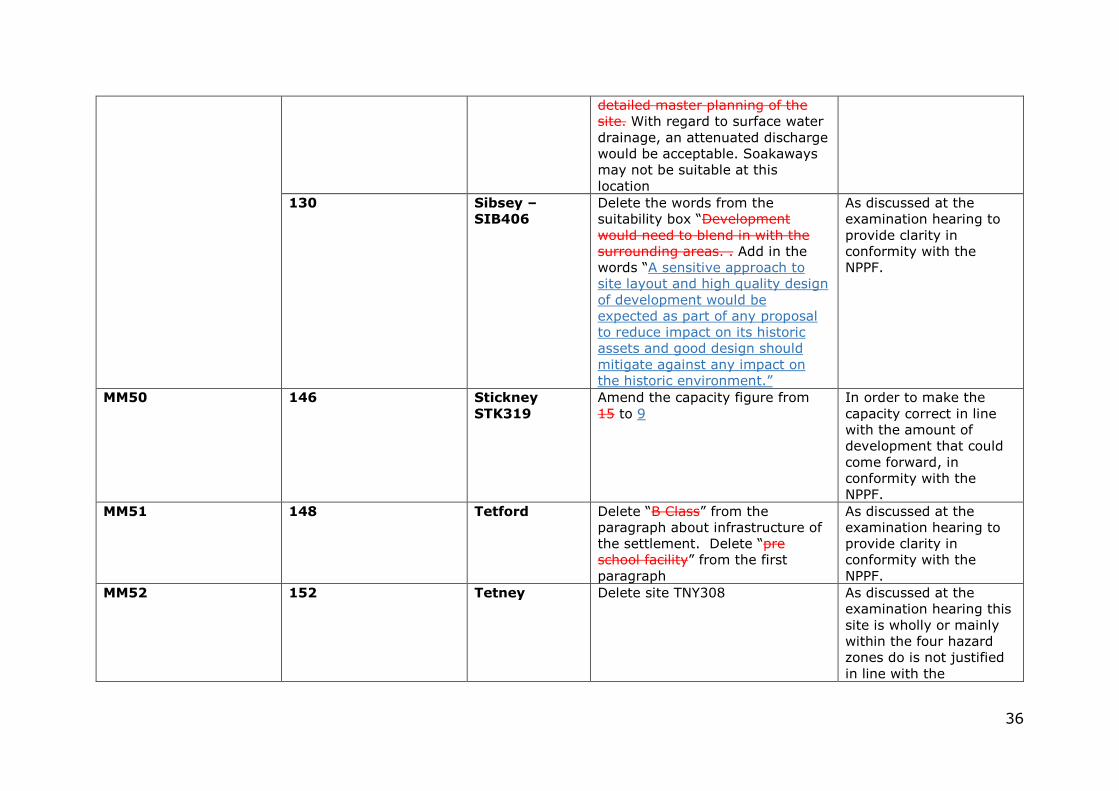
detailed master planning of the site. With regard to surface water drainage, an attenuated discharge would be acceptable. Soakaways may not be suitable at this location
130 Sibsey –
SIB406
Delete the words from the suitability box “Development would need to blend in with the surrounding areas. . Add in the words “A sensitive approach to site layout and high quality design of development would be expected as part of any proposal to reduce impact on its historic assets and good design should mitigate against any impact on the historic environment.”
As discussed at the examination hearing to provide clarity in conformity with the NPPF.
MM50 146 Stickney
STK319
Amend the capacity figure from 15 to 9
In order to make the capacity correct in line with the amount of development that could come forward, in conformity with the NPPF.
MM51 148 Tetford Delete “B Class” from the paragraph about infrastructure of the settlement. Delete “pre school facility” from the first paragraph
As discussed at the examination hearing to provide clarity in conformity with the NPPF.
MM52 152 Tetney Delete site TNY308 As discussed at the examination hearing this site is wholly or mainly within the four hazard zones do is not justified in line with the
37
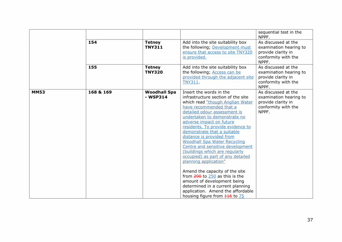
sequential test in the NPPF.
154 Tetney
TNY311
Add into the site suitability box the following; Development must ensure that access to site TNY320 is provided.
As discussed at the examination hearing to provide clarity in conformity with the NPPF.
155 Tetney
TNY320
Add into the site suitability box the following; Access can be provided through the adjacent site TNY311.
As discussed at the examination hearing to provide clarity in conformity with the NPPF.
MM53 168 & 169 Woodhall Spa
- WSP314
Insert the words in the infrastructure section of the site which read “though Anglian Water have recommended that a detailed odour assessment is undertaken to demonstrate no adverse impact on future residents. To provide evidence to demonstrate that a suitable distance is provided from Woodhall Spa Water Recycling Centre and sensitive development (buildings which are regularly occupied) as part of any detailed planning application” Amend the capacity of the site from 290 to 250 as this is the amount of development being determined in a current planning application. Amend the affordable housing figure from 116 to 75
As discussed at the examination hearing to provide clarity in conformity with the NPPF.
38
MM54 175 Box showing
the existing
coastal
housing
commitments
Amend the figures in the box so that they reflect the up to date position as at the 1st March 2017 as set below; Addlethorpe 0
Anderby 2
Chapel St. Leonards 152 148
Croft 15 17
Ingoldmells 176 171
Mablethorpe 128 127
New Leake 0
North Cotes 0
North Somercotes 55 52
Saltfleetby All Saints 7 4
Saltfleetby St. Clements 0
Saltfleetby St. Peter 1
Skegness 608 563
Skidbrooke + Saltfleet Haven 3 10
South Somercotes 0
Sutton On Sea 155
Theddlethorpe All Saints 0
Theddlethorpe St. Helen 6 7
As discussed at the examination hearing to provide clarity in conformity with the NPPF.
39
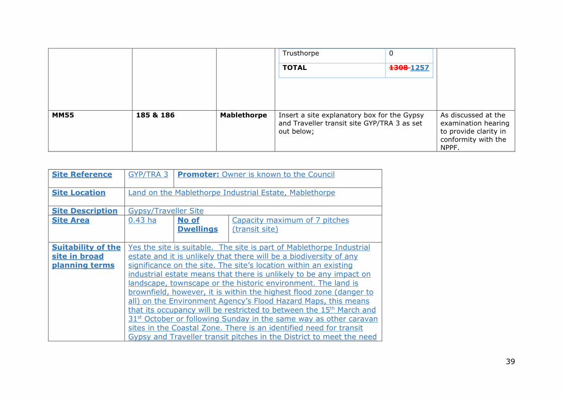
Trusthorpe 0
TOTAL 1308 1257
MM55 185 & 186 Mablethorpe Insert a site explanatory box for the Gypsy and Traveller transit site GYP/TRA 3 as set out below;
As discussed at the examination hearing to provide clarity in conformity with the NPPF.
Site Reference GYP/TRA 3 Promoter: Owner is known to the Council
Site Location
Land on the Mablethorpe Industrial Estate, Mablethorpe
Site Description Gypsy/Traveller Site Site Area 0.43 ha No of
Dwellings Capacity maximum of 7 pitches (transit site)
Suitability of the
site in broad planning terms
Yes the site is suitable. The site is part of Mablethorpe Industrial estate and it is unlikely that there will be a biodiversity of any significance on the site. The site’s location within an existing industrial estate means that there is unlikely to be any impact on landscape, townscape or the historic environment. The land is brownfield, however, it is within the highest flood zone (danger to all) on the Environment Agency’s Flood Hazard Maps, this means that its occupancy will be restricted to between the 15th March and 31st October or following Sunday in the same way as other caravan sites in the Coastal Zone. There is an identified need for transit Gypsy and Traveller transit pitches in the District to meet the need
40
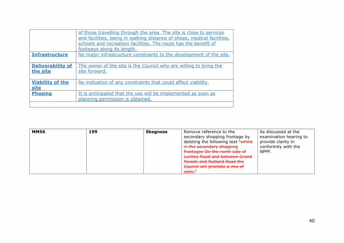
of those travelling through the area. The site is close to services and facilities, being in walking distance of shops, medical facilities, schools and recreation facilities. The route has the benefit of footways along its length.
Infrastructure
No major infrastructure constraints to the development of the site.
Deliverability of the site
The owner of the site is the Council who are willing to bring the site forward.
Viability of the
site
No indication of any constraints that could affect viability.
Phasing It is anticipated that the use will be implemented as soon as planning permission is obtained.
MM56 199 Skegness Remove reference to the secondary shopping frontage by deleting the following text “whilst in the secondary shopping frontages On the north side of Lumley Road and between Grand Parade and Rutland Road the Council will promote a mix of uses.”
As discussed at the examination hearing to provide clarity in conformity with the NPPF.