Embed Size (px)
DESCRIPTION
Final report of a detailed study examining opportunities to restore and enhance lochs, watercourses and wetland habitats. Funded by SEPA.
Citation preview

17 September 2013 Water GCV Green Network Partnership
Seven Lochs Wetland Park Scoping Report

Prepared by: ............................................................. Checked by: ........................................................................
Adam Chapman Cathryn Spence Glen Middleton
Graduate Engineer Principal Modeller Principal Engineer
Approved by: .............................................................
Peter Robinson
Regional Director
Seven Lochs Wetland Park Scoping Report
Rev No Comments Checked by Approved by Date
0 Preliminary draft issued to client for data on peat restoration GM PR 26 June 2013
1 Final Report following GCV-GNP comments GM PR 12 July 2013
2 Final Report following GCV-GNP comments GM PR 17 September 2013
Telephone: Website: http://www.aecom.com
Job No 60289449 Reference Date Created 17 September 2013
This document has been prepared by AECOM Limited for the sole use of our client (the “Client”) and in accordance with
generally accepted consultancy principles, the budget for fees and the terms of reference agreed between AECOM Limited
and the Client. Any information provided by third parties and referred to herein has not been checked or verified by AECOM
Limited, unless otherwise expressly stated in the document. No third party may rely upon this document without the prior and
express written agreement of AECOM Limited.

Executive Summary ........................................................................................................................................................................ 5
1 Study site ........................................................................................................................................................................... 6
2 Types of Opportunities and Options ............................................................................................................................... 9 2.1 Removal of structures from the channel ................................................................................................................. 9
2.2 Re-profiling and naturalising the channel ............................................................................................................. 10
2.3 Naturalising loch edges and islands ..................................................................................................................... 13
2.4 Reducing capacity of land drains to encourage localised storage in low lying marshy areas; .............................. 14
2.5 Peatland / raised bog restoration .......................................................................................................................... 15
2.6 Integrated green infrastructure and surface water management in new development. ........................................ 17
3 Data used for the analysis .............................................................................................................................................. 19 3.1 Previous studies and reference documents .......................................................................................................... 19
3.2 Tools and data-sets .............................................................................................................................................. 19
4 Analysis ........................................................................................................................................................................... 20
5 Molendinar Burn .............................................................................................................................................................. 25 5.1 Overview .............................................................................................................................................................. 25
5.2 Frankfield Loch and Stepps .................................................................................................................................. 27
5.3 Opportunity 2 – Daylighting Molendinar Burn and remove Pumping Station ........................................................ 29
5.4 Opportunity to increase connectivity between Stepps and Frankfield Loch .......................................................... 31
5.5 Channel naturalisation at Stepps (Opportunity 4) ................................................................................................. 32
5.6 Frankfield Loch margins (Opportunity 3) .............................................................................................................. 34
Table of Contents
6 Drumpellier Country Park and Lochend Loch .............................................................................................................. 35 6.1 Drumpellier Country Park (South of Lochend Loch) - Raised bog restoration (Opportunity 10) ......................... 37
6.2 Lochend Loch – Naturalisation of banks and restoration of islands for habitat (Opportunity 12) .......................... 39
7 Bothlin Burn – Wetland Core ......................................................................................................................................... 42 7.1 Gartloch Pools and Upper Bothlin Burn Channel naturalization and Habitat Creation (Opportunity 21) ............... 45
7.2 Bothlin Burn downstream of Gartloch Road (Opportunity 23) ............................................................................... 47
7.3 Bothlin Burn, downstream of Bishop Loch (Opportunity 25) ................................................................................. 51
7.4 Garnkirk Moss SINC (Opportunity 35) .................................................................................................................. 53
7.5 Commonhead Moss – peatland restoration (Opportunity 16) ............................................................................... 56
7.6 Cardowan Moss – peatland restoration (Opportunity 20) ..................................................................................... 58
7.7 Craigend Moss - Peatland restoration (Opportunity 26) ....................................................................................... 61
7.8 Daylighting Bothlin Burn Culvert (Opportunity 29) ................................................................................................ 63
7.9 Culvert under B806 near Gartcosh (Opportunity 34) ............................................................................................ 65
8 Glenboig and Garnqueen Burn ...................................................................................................................................... 67 8.1 Garnqueen Burn (Opportunity 31 and 32) ............................................................................................................ 69
8.2 Channel & Culvert from Garnqueen Loch (Opportunity 36) .................................................................................. 71
9 Prioritised List ................................................................................................................................................................. 72 9.1 Next Steps ............................................................................................................................................................ 73
References .................................................................................................................................................................................... 74
Appendix A .................................................................................................................................................................................... 75

List of Figures
Figure 1: Site Characteristics ........................................................................................................................................................ 7 Figure 2: Seven Lochs Wetland Park Study Area ........................................................................................................................ 8 Figure 3: Location of Long-list of Opportunities ....................................................................................................................... 22 Figure 4: Map of Molendinar Burn system ................................................................................................................................. 25 Figure 5: Map of Environmental Designations ........................................................................................................................... 26 Figure 6: Map of Ground Levels within the Molendinar Burn system ...................................................................................... 27 Figure 7: Ground levels and key features through Frankfield and Stepps .............................................................................. 28 Figure 8: Diversion ditch to Garnkirk Burn ................................................................................................................................ 28 Figure 9: Culvert beneath Loch Road ......................................................................................................................................... 28 Figure 10: Location of Molendinar Pumping Station ................................................................................................................. 29 Figure 11: Molendinar Pumping Station ..................................................................................................................................... 29 Figure 12: Opportunity for channel naturalisation and Stepps ................................................................................................ 32 Figure 13: Frankfield Loch margins ............................................................................................................................................ 34 Figure 14: Map of Drumpellier Country Park and Lochend Loch ............................................................................................. 35 Figure 15: Map of Designated Areas ........................................................................................................................................... 36 Figure 16: Map of DTM ................................................................................................................................................................. 36 Figure 17: Sluice Gate at Lochend Loch .................................................................................................................................... 39 Figure 18: Margins of Lochend Loch .......................................................................................................................................... 40 Figure 19: Key features of the wetland core .............................................................................................................................. 43 Figure 20: Bothlin Burn Ground Model / Elevation .................................................................................................................... 44 Figure 21: Key Features of Upper Bothlin Burn ......................................................................................................................... 45 Figure 22: Key Features in Bothlin Burn d/s Gartloch Road .................................................................................................... 47 Figure 23: Ground levels / elevation in Bothlin Burn ................................................................................................................ 48 Figure 24: Typical Cross-section of Bothlin Burn ..................................................................................................................... 49 Figure 25: Areas affecting flooding in Bothlin Burn .................................................................................................................. 49 Figure 26: Key Features d/s Bothlin Burn .................................................................................................................................. 51 Figure 27: d/s Bothlin Burn – Flood Extents .............................................................................................................................. 52
Figure 28: Key Features of Gartcosh SINC area ........................................................................................................................ 53 Figure 29: Ground model (elevations in Gartcosh SINC area) ................................................................................................. 54 Figure 30: Ground model and key features of Commonhead Moss ......................................................................................... 56 Figure 31: Key Features of Cardowan Moss .............................................................................................................................. 58 Figure 32: Ground Model Elevations at Cardowan Moss .......................................................................................................... 59 Figure 33: Key Features of Craigend Wood ............................................................................................................................... 61 Figure 34 Location of Bothlin Burn Culvert ............................................................................................................................... 63 Figure 35 Location of Culvert under B806 .................................................................................................................................. 65 Figure 36: Key Feature of Garnqueen Burn and Glenboig ........................................................................................................ 68 Figure 37: Opportunity at Garnqueen Burn ................................................................................................................................ 69
List of Tables
Table 1: Short-list of options, including category ..................................................................................................................... 23 Table 2: Flow Estimates for Drumpellier Country Park ............................................................................................................. 37 Table 3: Cost estimate for peatland restoration for the 20ha area: .......................................................................................... 37 Table 4: Flow Estimates for Upper Bothlin Burn ....................................................................................................................... 46 Table 5: Cost estimate for peatland restoration for the 62ha area: .......................................................................................... 55 Table 6: Cost estimate for peatland restoration for the 15ha area: .......................................................................................... 57 Table 7: Cost estimate for peatland restoration for the 5ha area: ............................................................................................ 59 Table 8: Cost estimate for peatland restoration for the 2ha area: ............................................................................................ 61 Table 9: Prioritised List of Opportunities ................................................................................................................................... 72 Table A1: Long list of opportunities and categories that set out further analysis. ................................................................ 75
AECOM Seven Lochs Wetland Park – Scoping Report 5
Capabilities on project:
Water
Destined to become Scotland's largest urban wildlife site, the Seven Lochs Wetland Park is an
exemplar of Green Network planning and delivery. Straddling the Glasgow / North Lanarkshire
boundary at Gartloch Gartcosh the Wetland Park sits at the heart of a Spatial Priority for
Green Network delivery including Glasgow and Clyde Valley Strategic Development Plan, May
2012.
The park will demonstrate how integrated green infrastructure (IGI) can be designed into
regeneration projects and proposals for new development. It will also protect and enhance the
Green Network and support the creation of a major new visitor attraction.
A key component of the Seven Lochs Wetland Park is to protect and enhance the existing
wetland habitat and to undertake strategic water environment restoration that provides
multiple benefits such as improved public open space, integrated water management, water
sensitive urban design, wetland habitat enhancement and creation, ecological improvements,
and habitat connectivity delivering ecosystem services, such as carbon capture and storage
and surface water management. This scoping stage is the first stage in developing a strategy
for short-term, medium-term and long-term actions that contribute to water environment
restoration and identifying opportunities that will require co-operation across a number of
organisations.
The aim of this Scoping Study is to identify opportunities for water environment restoration
which provide multiple benefits to the existing and future community in and around the Seven
Lochs Wetland Park.
To deliver the water environment restoration and habitat enhancements, integrated with
community growth, the Seven Lochs Wetland Park Project has two integrated streams of
delivering the vision of the wetland park;
- Design and development of Integrated Green Infrastructure as part of Community
Growth Area (CGA) development that incorporates elements of integrated wetland
habitat, SUDS and water sensitive urban design (including surface water
management and urban green space);
- Wetland Habitat Creation opportunities outside of CGAs including site specific
opportunities, such as opening up culverts, channel naturalisation and habitat
restoration.
An integrated approach to wetland habitat creation will provide a cohesive strategy for water
environment restorations that will bring together the two streams of delivery. Opportunities and
site specific actions can be identified and evaluated within a framework that includes water
management, habitat benefits and cost effectiveness.
AECOM have worked with Collective Architecture on Green Infrastructure components within
Community Growth Areas producing a Surface Water Management Strategy for the Wetland
Park that focuses on Water Sensitive Urban Design such as Green-Streets and wetland
features to provide both attenuation and water quality management functions.
Executive Summary
AECOM Seven Lochs Wetland Park – Scoping Report 6
Capabilities on project:
Water
The proposed Seven Lochs Wetland Park is located within the central belt of Scotland, lying
within the boundaries of both Glasgow City Council and North Lanarkshire Council, and forms
parts of the Glasgow Green Belt. The study area encompasses approximately 24km2 at OS
grid reference 268800, 667000.
Figure 2 shows the extent of the study area which stretches from Hogganfield Loch in the west
to Woodend Loch and Lochend Loch in the east.
The western edge of the park is situated 5km to the east of Glasgow City Centre. The study
area stretches for 8.7km east to west at its widest extents, from the east end of Glasgow
towards Coatbridge in North Lanarkshire.
The location within the central belt provides an opportunity for the Seven Lochs Wetland Park
to be of national significance. The proposed park has excellent transport connections and is
surrounded by established communities on all sides and will therefore not only attract visitors
from further afield but also provide benefits to local communities
Much of the area is low lying rural land, with surrounded by low density housing development.
The land is principally planar in character interspersed with a number of small drumlins and
consisting of open fields and hedgerows. There are large areas of historic peat cutting as well
as features left from previous mining activity, such as bings and mine shafts.
A substantial proportion of the study area is composed of natural or semi-natural open green
space in the form of open water, woodland, wetland and moss. There are pockets of scattered
woodland which include field boundaries and riparian corridors as well as plantation,
community, mature estate and dense semi-natural woodland, along with substantial peat
deposits.
Two large public parks, Drumpellier and Hogganfield Parks, are located along the periphery of
the study area.
Water is a dominant feature of the landscape in the form of open water, burns and seasonally
flooded or persistently wet ground with a complex catchment area converging on the Bothlin
Burn then draining to the east and north.
The site contains multiple wetlands including seven shallow kettle ponds or ‘depressions’
formed by the glacial retreat during the last ice age and referred to as the ‘Garnkirk chain’.
Interspersed within the wetlands are areas of agricultural land (both working and fallow), and
areas of ancient and long established woodland and grassland. The site is of considerable
ecological importance for wildlife and contains one of the largest reed bed habitats in central
Scotland.
Along with the lochs there are a number of watercourses, drainage ditches, small ponds and
wetlands which form a complex system along which water moves through the area. The
natural lochs vary from the extensively modified banks of Hogganfield and Lochend Loch to
the agricultural boundaries of Gartloch Ponds through to the well vegetated margins of Bishop
Loch and Woodend Loch.
Several drainage ditches have become blocked, either accidentally or deliberately, whilst
others have become blocked through the natural process of siltation.
Significant regeneration and new development is proposed in the area. Both Glasgow City and
North Lanarkshire Councils have identified a number of Community Growth Areas for up to
4500 new homes over the next 15 – 20 years. Major regeneration work is underway along the
southern edge of the park at Easterhouse and Garthamlock, and a number of smaller housing
developments within and around the park area, and a major new Business park is being
developed at Gartcosh.
1 Study site
AECOM Seven Lochs Wetland Park – Scoping Report 7
Capabilities on project:
Water
The main water bodies of the study area, as shown in Figure 2 and include:
- Hogganfield Loch
- Frankfield Loch
- Bishop Loch
- Johnston Loch
- Lochend Loch
- Woodend Loch
- Garnqueen Loch
- Gartloch Pools; (new pools emerging at Gartloch which may be the result of former
mining activity)
The main watercourses within the area include:
- Bothlin Burn
- Molendinar Burn
- Bishop Burn
- Tolcross Burn
- Whamflet Burn
Existing area designations on the site include Sites of Special Scientific Interest (SSSI), Local
Nature Reserves (LNR) and a country park at Drumpellier.
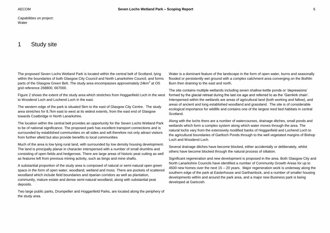
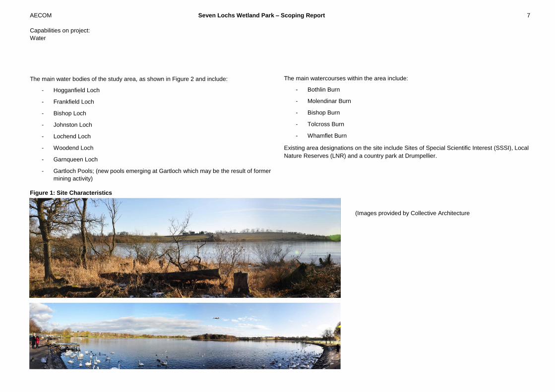
Figure 1: Site Characteristics
(Images provided by Collective Architecture
-

AECOM Seven Lochs Wetland Park – Scoping Report 8
Capabilities on project:
Water
Figure 2: Seven Lochs Wetland Park Study Area

AECOM Seven Lochs Wetland Park – Scoping Report 9
Capabilities on project:
Water
This section examines opportunities for water environment restoration and wetland habitat
creation that are most relevant to the Seven Lochs Wetland Park area. It describes the
following types of approaches:
- Removals of structures from the channel;
- Re-profiling and naturalising the channel;
- Naturalising loch edges and islands;
- Reducing capacity of land drains to encourage localised storage in low lying marshy
areas;
- Peatland / raised bog restoration;
- Integrated green infrastructure and surface water management in new development.
More detailed guidance on undertaking water environment restoration is available from a
number of sources within Scotland, UK and Europe, including:
SEPA Habitat management - best practice guidance
http://www.sepa.org.uk/water/water_regulation/regimes/engineering/habitat_enhancement/bes
t_practice_guidance.aspx
River Restoration Centre - Manual of River Restoration Techniques
http://www.therrc.co.uk/rrc_manual.php
Rivers by design – rethinking development and river restoration (Environment Agency 2013) -
http://www.restorerivers.eu/Publications/tabid/2624/mod/11083/articleType/ArticleView/articleI
d/3468/Rivers-by-Design.aspx
RSPB, Our Conservation Work – Advice http://www.rspb.org.uk/ourwork/conservation/advice/
2.1 Removal of structures from the channel
Culverts and structures within the watercourse provide barriers to movement of species.
Limiting the length of culvert required for roads and other structures and ensuring that the
design encourages movement at a range of flows can reduce the impact of culvert.
There are a number of man-made structures and culverts within the Seven Lochs Wetland
Park, these culverts and other structures can be a barrier to particular species such as water
voles, reducing the connectivity across the Seven Lochs Wetland Park. There are a number of
culverts and other structures that could potentially be modified or removed in the longer term
to improve connectivity. An initial review of function and key features of these structures has
been completed and key benefits and constraints to removal of these structures undertaken.
In general new channels would be created by breaking out existing pipes/culverts and
providing earth lined channels. The channels could include 1/3 side slopes which could be
landscaped and stabilised through the use of green engineering solutions such as coir rolls,
faggots, and rip rap. Environmental enhancements could include riffle weirs created by stone
blocks and also landscaping. Meandering could be added to the channel in some areas to
promote wetted wildlife habitats. New headwalls could be formed using ‘green’ gabions that
blend with the park.
2 Types of Opportunities and
Options

AECOM Seven Lochs Wetland Park – Scoping Report 10
Capabilities on project:
Water
2.2 Re-profiling and naturalising the channel
These options focus on improving bank morphology by re-profiling the bank and re-creating
meanders or sinuous multi-channel. There are a number of channels within the Seven Lochs
Wetland Park that are straight with steep banks or concrete lined. These channels do not
provide a habitat with high ecological potential for plants and animals.
Naturalising watercourses provides opportunities to enhance and increase habitat available for
a number of faunal species which rely on aquatic habitats for breeding/resting and foraging.
Species such as water vole require earth banks in which to create burrows both below and
above the water level. Earth banks will allow for the development of riparian and aquatic
vegetation which will provide a food source and cover for water vole as well as foraging
habitat for bats, small mammals and birds as vegetated banks will attract insects. An open
channel allows easy movement of mammals along the bank side such as otter, providing
green corridors along which to navigate their territory; the establishment of bankside
vegetation will also provide cover and resting sites. Naturalised channels will be more
favourable for fish which will provide a food source for otter and some species of birds.
One of the options being reviewed is re-profiling the channel with a focus on the banks to
provide a range of different hydrological conditions and bank features to encourage different
species such as water voles.
Re-profiling of the channel to create meanders provides habitats through increased storage
and a range of habitats. A natural channel will include a range of plants and animals that
require different hydrological conditions that change as flow within the channel changes.
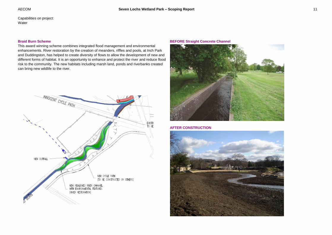
Example : The Braid Burn project (AECOM) is an example of naturalising channel as
part of flood management work.
Re-profiled channel with range of habitats
AECOM Seven Lochs Wetland Park – Scoping Report 11
Capabilities on project:
Water
Braid Burn Scheme
This award winning scheme combines integrated flood management and environmental
enhancements. River restoration by the creation of meanders, riffles and pools, at Inch Park
and Duddingston, has helped to create diversity of flows to allow the development of new and
different forms of habitat. It is an opportunity to enhance and protect the river and reduce flood
risk to the community. The new habitats including marsh land, ponds and riverbanks created
can bring new wildlife to the river.
BEFORE Straight Concrete Channel
AFTER CONSTRUCTION
AECOM Seven Lochs Wetland Park – Scoping Report 12
Capabilities on project:
Water
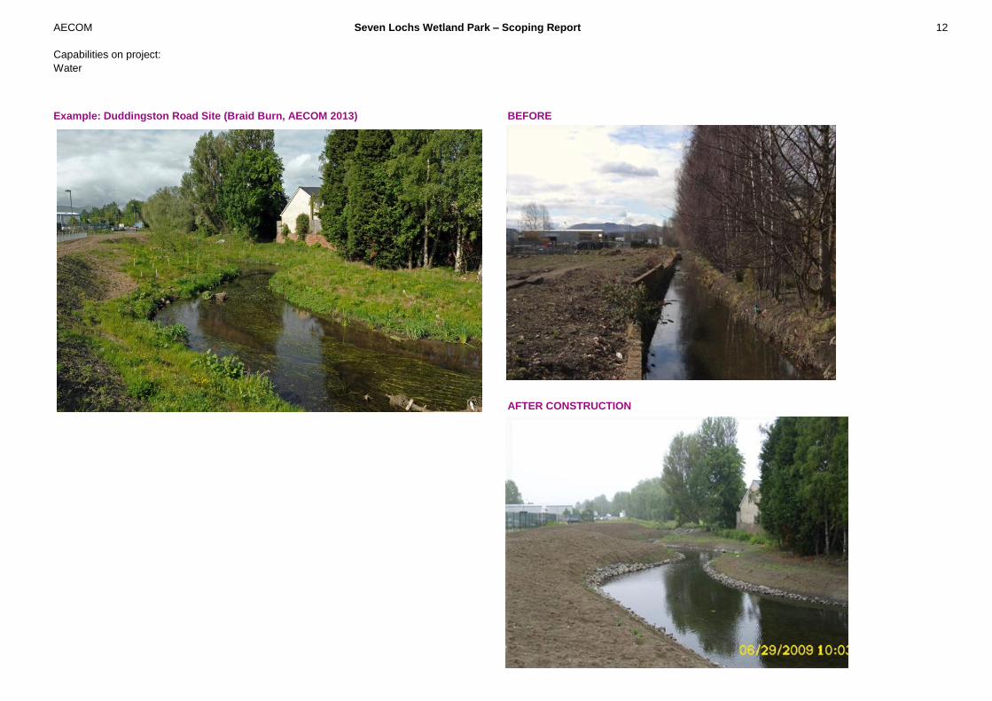
Example: Duddingston Road Site (Braid Burn, AECOM 2013)
BEFORE
AFTER CONSTRUCTION

AECOM Seven Lochs Wetland Park – Scoping Report 13
Capabilities on project:
Water
2.3 Naturalising loch edges and islands
Naturalising the loch edges provides a variety of vegetation and habitats, for example
removing existing concrete or hard stone margins to provide a range of habitat including reed
beds, gravel and shingle. Also providing a variety of small inlets and varying flow regime will
provide a great range of habitat. Earth banks will allow for the development of aquatic
vegetation which will provide a food source and cover for water vole as well as foraging
habitat for bats, small mammals and birds as vegetated banks will attract insects.
Islands within waterbodies provide nesting, roosting and loafing sites secure from land-based
predators, and many bird species will choose them in preference to mainland locations with
similar habitat features. Islands are also created to concentrate birds in front of hides to
provide visitors to reserves with good views without disturbing the birds. The species found on
islands will vary depending on the habitat and location of the water body. Several small
islands in a water body are more valuable to a breeding colony than one large one (RSPB,
2013).
This can be achieved through building the islands higher and providing a range of wetlands
habitats or modifications to water levels within the Loch. Planting vegetation on the islands will
create a habitat for various creatures including native and migrating birds.

AECOM Seven Lochs Wetland Park – Scoping Report 14
Capabilities on project:
Water
2.4 Reducing capacity of land drains to encourage localised storage in low lying
marshy areas;
The purpose of reducing or removing the capacity of land drains is to encourage localised flow
and storage within low lying wetland sites and through improved connectivity at low-normal
flows such as scrapes. The result includes wet grassland or marshy area that has a range of
plants with different wetting and drying regimes and reduced flood risk downstream. These
include wetter areas that are connected to the main drainage areas by backwaters or well
connected storage areas. They include elements of wet grassland and rushes.
Example : Braid Burn Scheme (AECOM, 2013)
Example : Fiskerton Fen Nature Reserve (AECOM, 2013)

AECOM Seven Lochs Wetland Park – Scoping Report 15
Capabilities on project:
Water
2.5 Peatland / raised bog restoration
Peatlands are naturally dominated by sphagnum moss vegetation which thrives in
cool wet conditions. Peat is formed below the living surface layer as the dead
remains of bog mosses and other plants are preserved in wet, acidic conditions,
creating a set of unique landscapes and habitats. This peat soil builds up over
millennia and can reach depths of over five metres in places. Peatland has been
degraded by drainage (moor gripping), burning, tree planting and grazing. (RSPB
Scotland)
Lowland raised bogs are a rare and threatened habitat. Managing them for
conservation purposes will not only benefit biodiversity, it can also contribute to flood
management, erosion control downstream and carbon storage combined with a
range of management options. This Option aims to bring lowland raised bogs into
favourable condition by ensuring that management is undertaken with the
conservation of lowland bog as the key priority and to the best possible standards.
Over the past 100 years, the area of relatively undisturbed lowland raised bog in the
UK is estimated to have diminished by around 94%, from 95,000 hectares to
approximately 6,000 hectares today. Historically, the greatest decline has occurred
through afforestation, peat extraction and agricultural intensification, including
drainage. These activities have all contributed to the drying out of the bogs. The key
to achieving good condition is the maintenance or restoration of suitable water levels
(Scottish Government, 2013).
Bogs, which grow on peat land, are an effective organism that can help combat
climate change as they act as sinks, absorbing carbon dioxide from the atmosphere.
There is an opportunity to re-wet this peat land by damming the existing manmade
channel drains and removing trees and shrubs. This will create a backup of flow
upstream of the dam, providing water for the bogs and reduce the drying of the bog
by vegetation. The dams can be constructed to incorporate a weir so that during high
flows water overtops the dam and continues to feed downstream boggy areas or,
eventually, drain into the Loch.
Example : Glasgow City Council Volunteers installing plastic dams (photo
courtesy of Glasgow City Council)
AECOM Seven Lochs Wetland Park – Scoping Report 16
Capabilities on project:
Water
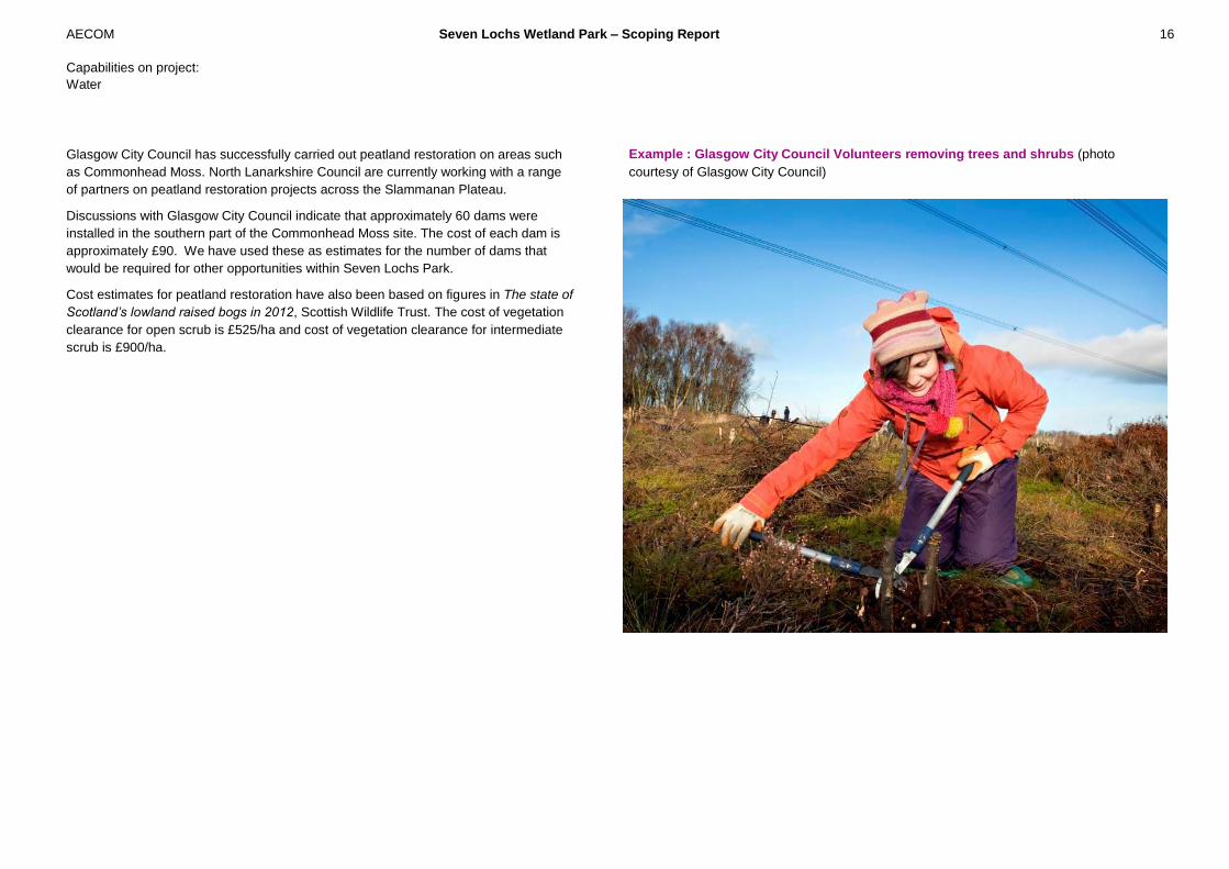
Glasgow City Council has successfully carried out peatland restoration on areas such
as Commonhead Moss. North Lanarkshire Council are currently working with a range
of partners on peatland restoration projects across the Slammanan Plateau.
Discussions with Glasgow City Council indicate that approximately 60 dams were
installed in the southern part of the Commonhead Moss site. The cost of each dam is
approximately £90. We have used these as estimates for the number of dams that
would be required for other opportunities within Seven Lochs Park.
Cost estimates for peatland restoration have also been based on figures in The state of
Scotland’s lowland raised bogs in 2012, Scottish Wildlife Trust. The cost of vegetation
clearance for open scrub is £525/ha and cost of vegetation clearance for intermediate
scrub is £900/ha.
Example : Glasgow City Council Volunteers removing trees and shrubs (photo
courtesy of Glasgow City Council)

AECOM Seven Lochs Wetland Park – Scoping Report 17
Capabilities on project:
Water
2.6 Integrated green infrastructure and surface water management in new
development.
Seven Lochs Wetland Park aims to integrate water management into the residential
development with integrated water management and use of Water Sensitive Urban Design.
Example : Upton Mixed Use development included many areas of water sensitive urban
design (AECOM, 2013).

AECOM Seven Lochs Wetland Park – Scoping Report 18
Capabilities on project:
Water
Water Sensitive Urban Design – Greenstreets concept for integrated wetland and public open space (AECOM, 2013)

AECOM Seven Lochs Wetland Park – Scoping Report 19
Capabilities on project:
Water
3.1 Previous studies and reference documents
A number of previous studies have been completed that provide key information and tools to
review options for water environment restoration within the wetland park. The studies include:
Gartloch and Gartcosh Hydrological Study, AECOM, December 2011
This study included hydrological analysis and hydraulic modelling of the watercourses within
the wetland park.
Gartloch and Gartcosh Surface Water Management Strategy, AECOM, December 2011
A strategy for surface water management within the Community Growth Areas with a focus on
integrated water management and water sensitive urban design elements such as green
streets, sustainable urban drainage.
The Seven Lochs Wetland Park - Masterplan and Visioning study, Collective Architecture,
March 2013.
Manual of River Restoration Techniques, River Restoration Centre, April 2002.
The manual provides examples of successful river restoration and provides standard
terminology and definitions into restoration of water environment.
3.2 Tools and data-sets
Previous studies have also provided a series of tools and data-sets that can be used and
adapted to identify and analyse opportunities within the Seven Lochs Wetland Park.
A Digital Terrain Model (DTM) - Ground Model of the Study Area was developed as part of
previous studies, based on LiDAR it provides a complete coverage of ground levels across the
study area. DTM was supplied through Glasgow and Clyde Valley Green Network
Partnerships (GCV-GNP) from Glasgow City Council (Infoterra).
Channel survey of the channels and key drainage paths was completed as part of the
Hydrological Study. The channel survey provides details of the channel cross-sections and
structures such as culverts, weirs and sluice gates. The survey provided key information on
existing structures and normal measured water levels within the study area.
A hydrological assessment was undertaken as part of the Hydrological Study, this analysis
provides a series of Flood Estimation Handbook (FEH) in-flow boundaries and associated
calculations of flow. The FEH boundaries at a series of points within the study area have been
used to review a range of flows including base-flow, 1 in 2 year flow event and a more
extreme 1 in 200 year flow event. The FEH boundaries are incorporated within the hydraulic
model and therefore included within the modelling analysis.
An Infoworks RS hydro-dynamic model was developed for the Molendinar Burn, Bothlin
Burn and Bishop Burn. The model includes channel cross-sections and storage areas. The
model has been used to review changes in conveyance and storage for a number of
opportunities.
Aerial Photography of the Study Area based on Mapinfo – Microsoft Bing Aerial Imagery.
The aerial photography was used to review the existing vegetation cover and features within
the study area;
Photos of key features within the study area were taken during a series of site visits as part
of the Hydrological Study. These photos provide further information on channel form, condition
of structures and vegetation within the site.
3 Data used for the analysis
AECOM Seven Lochs Wetland Park – Scoping Report 20
Capabilities on project:
Water
This scoping study has been undertaken in consultation with project partners and has
included:
- Initial identification of a long list of water environment restoration opportunities across
the wetland park;
- Workshop with project partners to further develop a long- list of opportunities and
constraints;
- Preliminary analysis of the long-list to develop a short list of water environment
restoration options;
- A more detailed analysis of the short-list options;
- Identification of prioritised list of options, identifying actions to implement options,
including further analysis.
A long-list of opportunities was developed through work by GCV Green Network Partnership
and initial analysis undertaken by AECOM. This long-list was further developed with Project
Partners through a Workshop held on 9th April 2013 in Glasgow.
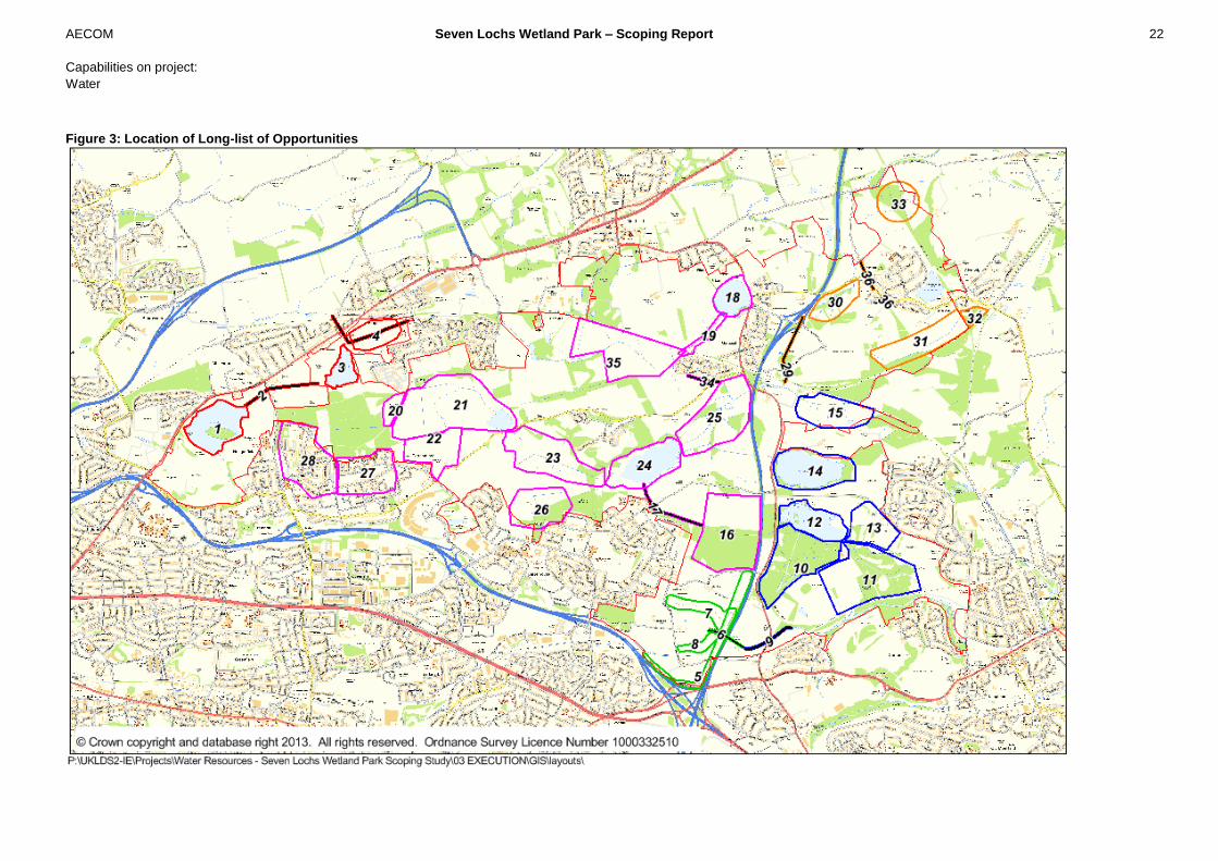
Figure 3 shows the long-list of opportunities. Initial assessment of these was carried out by
AECOM to help develop a short-list for detailed analysis.
Options were reviewed to identify potential benefits, the time-scale for implementation,
requirement for working in partnership with other organisations and the mechanisms for
delivery of actions. As there are a significant number of opportunities for habitat wetland
creation, the opportunities were also split into three categories:
A. Opportunities that can be delivered by the Wetland Park Project in the short-term (5-
6 years);
B. Opportunities that will be delivered through another mechanism or in partnership with
another organisation;
C. Longer term opportunities.
Short-term opportunities to be delivered linked to the initial development of the Seven Lochs
Wetland Park were split into two categories depending upon the main mechanism through
which they could be delivered:
1. Wetland habitat creation through land management / restoration;
2. Integrated Green Infrastructure within Community Growth Areas (CGAs) and other
planned development.
There may be some overlap where opportunities are adjacent to CGAs or other developments
and could be delivered as part of wider environment enhancement linked to that development.
Comments and categorisation of the long-list of options is set out in Appendix A.
This initial analysis and categorisation was used to identify a short-list of water environment
restoration opportunities– see Table 1. The following sections present a detailed analysis of
shortlisted options. This includes:
- all those categorised as A.1.
- some longer-term options (those categorised as C+) to provide key information on
the issues including benefits and constraints.
Opportunities categorised as A2 have been examined in detail by GCVGNP, Collective
Architecture and others as part of the Seven Lochs Wetland Park Green Network / Green
Infrastructure Study and are therefore not considered in detail here, except where there is the
potential to link Integrated Green Infrastructure within developments to water environment
restoration on adjacent land.
4 Analysis

AECOM Seven Lochs Wetland Park – Scoping Report 21
Capabilities on project:
Water
Detailed assessment was completed by AECOM utilising expertise in integrated water
management, river engineering, ecology, water quality, hydrology and flood risk management
to develop a short-list for further analysis. The criteria for assessment included:
- Existing hydraulic and hydrologic opportunities;
- Historic and existing land and water management;
- Existing Habitat networks
- Access / recreation
- Water Framework Directive objectives
- Flood risk management
- Water quality
- Cost-benefit assessment
AECOM Seven Lochs Wetland Park – Scoping Report 22
Capabilities on project:
Water
Figure 3: Location of Long-list of Opportunities

AECOM Seven Lochs Wetland Park – Scoping Report 23
Capabilities on project:
Water
Table 1: Short-list of options, including category
No Location Description Category Notes
Molendinar Burn
Review of combined opportunity 3&4, this provides an opportunity for improved wetland park habitat within proposed nature reserve area. It is close to the station and it therefore has
potential for gateway into the park that encourages people into the area.
2
Molendinar Burn
Culvert and
pumping station
Open up the culvert and remove pumping
station. In conjunction with naturalisation of
channel and could allow additional flood
storage on playing fields.
C+ Medium-list analysis – review if this is possible and to understand the benefits and
constraints. Need to note if this is possible.
Longer term option.
3 Frankfield Loch
Naturalisation of the banks, wetting and drying
regime and improved habitat for wading birds.
Improved connectivity between Stepps and
Frankfield Loch during low flows.
A1
Currently two connections, one low level and the other high level – can switch these
over so that at low flows water can flow through to Frankfield Loch and at high flows the
water flows through culvert and under railway line. Need to ensure that there isn’t an
increase in flow through to Garnqueen Burn.
4 Stepps
Channel naturalisation with low flow connection
through to Frankfield, de-culverting of link under
the railway.
A1
As above
Drumpellier Country Park and Lochend Loch
10
Drumpellier Country
Park – South of
Lochend Loch
Significant deep peat that could be re-wetted as
part of naturalisation and removal of drains and
trees within the Park. Create connected peat
and wet woodland.
A1
Can be developed as part of a Habitat Action Plan.
An understanding of hydrological inflows is required and how this may improve water
management.
12 Lochend Loch
Naturalisation of Lochend Loch, improve bank
habitat whilst improving public access.
Included revegetation and habitat
improvements on the islands.
A1
Habitat enhancement could provide connectivity and ecological potential.
Bothlin Burn – Wetland Core
16
Commonhead
Moss and
associated channel
Modify the drainage and remove trees to re-wet
the bog and restore peatland.
A1-A2
SNH funded Peatland restoration is underway in southern part of Commonhead Moss
more can be done. GCC don't own all land but with funding could allow to purchase rest
by joint funding. The CGA development to the west could incorporate the provision of
ownership of land to the north and the on-going management as a natural bog (This
would be delivered as part of green infrastructure).
20 Cardowan Moss
Peatland restoration through drainage and
vegetation modifications.
A1
This area provides water vole habitat and need to ensure that any opportunity improves
existing habitat. This is existing and historic lowland raised bog, water level
management and changes in drainage to restore peatland.
21
Bothlin Burn
downstream of
Naturalise the channel with areas of water
attenuation through improved wetlands.
A1
Wetland Core with integrated series of channel naturalization, backwaters, increased
wetland area and low flow paths into low lying marshy areas.
AECOM Seven Lochs Wetland Park – Scoping Report 24
Capabilities on project:
Water
No Location Description Category Notes
Cardowan Moss
23
Downstream of
Gartlock Road
Re-profile the channel to create water
attenuation through wetlands during low and
moderate flows. Remove the existing drains
and re-instate more natural drainage with areas
of re-wetted peat, wet grassland and wet
woodland.
A1
Wetland Core with integrated series of channel naturalization, backwaters, increased
wetland area and low flow paths into low lying marshy areas.
25
Downstream of
Bishop Loch
This low lying area prone to flooding can be
used to create integrated wetland, naturalised
channel and flood storage. Key biodiversity
zone free from disturbance (pets)
A1
Wetland Core with integrated series of channel naturalization, backwaters, increased
wetland area and low flow paths into low lying marshy areas.
26 Craigend Wood
Peatland restoration, remove drains and trees
and re-wet this site.
A1
The majority of Craigend Wood drains down to the wetland core and will also be linked
with the wetland core through public access and connectivity with Community Growth
Areas.
29 Bothlin Burn Culvert
De-culvert/daylight this culvert and open up this
watercourse
C+ This opportunity could be explored as part of the re-development of the business park.
34
Gartcosh - culvert
under B806
De-culvert/ daylight this culvert to provide
connectivity
C+
This culvert provides main connection of this tributary of the Bothlin Burn and is a
barrier to ecological connectivity. There is an opportunity to improve connectivity. There
is existing and planned re-development that may provide both opportunities and
constraints of removing this culvert.
35
Garnkirk Moss
SINC
Remove / modify the drainage and vegetation
to restore bog.
A1
This is quite an extensive area of historic peatland, low lying, marshy area. Drainage
has been developed to drain this area more quickly, the drainage could be modified to
improve wetland habitat and water quality.
Garnqueen Burn and Glenboig
31
Right bank of
Garnqueen Burn
Integrated flood management to ease flooding
issues upstream. Potential area for channel
naturalisation as part of the Community Growth
Area.
A1
Opportunity needs to ensure connectivity with water sensitive urban design elements for
integrated water management on the right bank. On the left bank opportunity for
wetland habitat creation that links across the channel to CGA.
32
Garnqueen Football
Ground
Channel naturalisation and flood storage either
side of Garnqueen Burn.
A1
As above – area for water management
36
Channel & Culvert
from Garnqueen
Loch
Drainage path via culvert and open channel
could be opened up through Play Area and
close to the CGA watercourse improvements
and channel naturalisation
A1 / A2 Part of Green Infrastructure, initial review of opportunity within Community Growth Area
and existing community. Opportunity to incorporate integrated water management.
AECOM Seven Lochs Wetland Park – Scoping Report 25
Capabilities on project:
Water
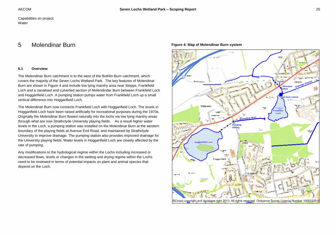
5.1 Overview
The Molendinar Burn catchment is to the west of the Bothlin Burn catchment, which
covers the majority of the Seven Lochs Wetland Park. The key features of Molendinar
Burn are shown in Figure 4 and include low lying marshy area near Stepps, Frankfield
Loch and a canalised and culverted section of Molendindar Burn between Frankfield Loch
and Hogganfield Loch. A pumping station pumps water from Frankfield Loch up a small
vertical difference into Hogganfield Loch.
The Molendinar Burn now connects Frankfield Loch with Hogganfield Loch. The levels in
Hogganfield Loch have been raised artificially for recreational purposes during the 1970s.
Originally the Molendinar Burn flowed naturally into the lochs via low lying marshy areas
through what are now Strathclyde University playing fields. As a result higher water
levels in the Loch, a pumping station was installed on the Molendinar Burn at the western
boundary of the playing fields at Avenue End Road, and maintained by Strathclyde
University to improve drainage. The pumping station also provides improved drainage for
the University playing fields. Water levels in Hogganfield Loch are closely affected by the
rate of pumping.
Any modifications to the hydrological regime within the Lochs including increased or
decreased flows, levels or changes in the wetting and drying regime within the Lochs
need to be reviewed in terms of potential impacts on plant and animal species that
depend on the Loch.
Figure 4: Map of Molendinar Burn system
5 Molendinar Burn
AECOM Seven Lochs Wetland Park – Scoping Report 26
Capabilities on project:
Water
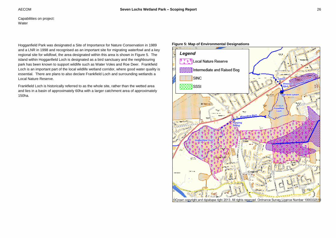
Hogganfield Park was designated a Site of Importance for Nature Conservation in 1989
and a LNR in 1998 and recognised as an important site for migrating waterfowl and a key
regional site for wildfowl, the area designated within this area is shown in Figure 5. The
island within Hogganfield Loch is designated as a bird sanctuary and the neighbouring
park has been known to support wildlife such as Water Voles and Roe Deer. Frankfield
Loch is an important part of the local wildlife wetland corridor, where good water quality is
essential. There are plans to also declare Frankfield Loch and surrounding wetlands a
Local Nature Reserve.
Frankfield Loch is historically referred to as the whole site, rather than the wetted area
and lies in a basin of approximately 60ha with a larger catchment area of approximately
150ha.
Figure 5: Map of Environmental Designations

AECOM Seven Lochs Wetland Park – Scoping Report 27
Capabilities on project:
Water
Figure 6: Map of Ground Levels within the Molendinar Burn system
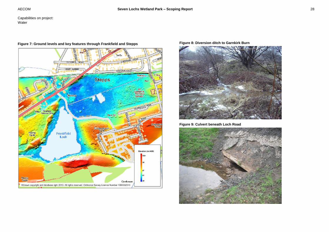
5.2 Frankfield Loch and Stepps
The drainage through the Stepps area is characterized by a channel with limited flow and
straight flat channel, areas of peatland and low lying marshy area (Figure 7). The drainage
ditch, shown in Figure 8, has been created to increase the speed of run-off through the
railway culvert and into Garnkirk Burn. This culvert is thought to discharge into the
Garnkirk Burn to the north of the railway line.
Historically Frankfield Loch flowed east towards Stepps before flowing north into Garnkirk
Burn. The channel between Frankfield Loch and Hogganfield Loch is thought to have been
dug in the 17th century to improve flows through to town mills (source: Forbes Meek).
Flows from Frankfield Loch eastward were further restricted by the development of Loch
Road as part of a residential development, there is a high level culvert that can convey
water toward Stepps and into drainage ditch under the railway culvert if levels in Frankfield
Loch are high.
The primary source of inflow to the Loch is overland flow during storm events. Flow from
low lying marshy areas to the north-east flow via the diversion ditch to Garnkirk Burn.
Frankfield Loch discharges via two outfalls, one at the south-west of the loch and one at
the north. The south-western outfall drains to the Molendinar Burn before entering a
pumping station on Avenue End Road, which is maintained by Strathclyde University. The
pumping of water in the Molendinar Burn is controlled by float switches and thus the water
levels in the Molendinar Burn, and hence Frankfield Loch, are maintained.
The northern outfall is a high level culvert that outfalls east towards Stepps (Figure 9), this
can only flow when water in the Loch is high. If this occurs water flows through this culvert
into the low lying drainage area near Stepps (east of Loch Road) and then via the
diversion ditch and through culvert under the railway line and into Garnkirk Burn.
AECOM Seven Lochs Wetland Park – Scoping Report 28
Capabilities on project:
Water
Figure 7: Ground levels and key features through Frankfield and Stepps
Figure 8: Diversion ditch to Garnkirk Burn
Figure 9: Culvert beneath Loch Road
AECOM Seven Lochs Wetland Park – Scoping Report 29
Capabilities on project:
Water
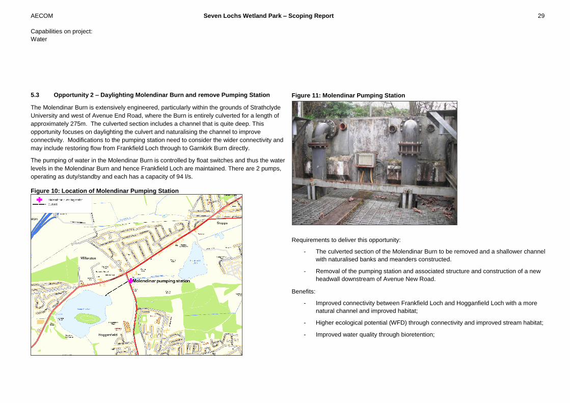
5.3 Opportunity 2 – Daylighting Molendinar Burn and remove Pumping Station
The Molendinar Burn is extensively engineered, particularly within the grounds of Strathclyde
University and west of Avenue End Road, where the Burn is entirely culverted for a length of
approximately 275m. The culverted section includes a channel that is quite deep. This
opportunity focuses on daylighting the culvert and naturalising the channel to improve
connectivity. Modifications to the pumping station need to consider the wider connectivity and
may include restoring flow from Frankfield Loch through to Garnkirk Burn directly.
The pumping of water in the Molendinar Burn is controlled by float switches and thus the water
levels in the Molendinar Burn and hence Frankfield Loch are maintained. There are 2 pumps,
operating as duty/standby and each has a capacity of 94 l/s.
Figure 10: Location of Molendinar Pumping Station
Figure 11: Molendinar Pumping Station
Requirements to deliver this opportunity:
- The culverted section of the Molendinar Burn to be removed and a shallower channel
with naturalised banks and meanders constructed.
- Removal of the pumping station and associated structure and construction of a new
headwall downstream of Avenue New Road.
Benefits:
- Improved connectivity between Frankfield Loch and Hogganfield Loch with a more
natural channel and improved habitat;
- Higher ecological potential (WFD) through connectivity and improved stream habitat;
- Improved water quality through bioretention;

AECOM Seven Lochs Wetland Park – Scoping Report 30
Capabilities on project:
Water
- Amenity for local residents including dog walkers and other recreational users;
- Easier access for maintenance and reduced maintenance costs;
- An open channel provides greater ecological benefits.
Constraints:
- The Molendinar Burn system has been extensively modified over the last 400 years
and although naturalising parts of the system could provide benefit restoring natural
flow regime is a significant undertaking requiring modification to the hydrological
regime;
- Current water levels in Hogganfield Loch are raised artificially and water pumped up
to the Loch. Without the pump the Loch levels are likely to decrease and change both
the recreational use, hydrological regime and associated habitat;
- The cost of removing the pumping station, de-culverting the watercourse and
ensuring continued hydraulic performance of the Hogganfield-Frankfield system will
be expensive;
- Flooding upstream of the pumping station such as Avenue End Road and University
of Strathclyde playing fields caused by a backup of flow from Hogganfield Loch;
- If playing fields are used for storage, flooding of Cumbernauld Road, Loch Road and
Avenue End road;
- The use of Hogganfield Loch and the playing fields by recreational users will be
impacted;
- Hogganfield Park is a designated Site of Importance for Nature Conservation (SINC)
and a key site for variety of rare birds and mammals, the environment around the
Loch has changed and adapted to the culvert and pumping station - modifications to
the flow regime may have detrimental impact on the existing ecological potential
within the Park;
- Culverts around Strathclyde University are known to suffer from siltation resulting
from infilling and mining subsidence of Frankfield Loch. Siltation has the potential to
decrease the channel capacity and may require regular maintenance;
- This option will require extensive negotiations with the University and consultation
with local residents who may be against relinquishing the recreational facilities for
flood storage.

AECOM Seven Lochs Wetland Park – Scoping Report 31
Capabilities on project:
Water
5.4 Opportunity to increase connectivity between Stepps and Frankfield Loch
Adjusting the connectivity between Stepps and Frankfield Loch by opening up a culvert at low
water levels within Stepps and increasing the volume of flow through of Frankfield Loch.
Improvements to habitat connectivity between the Loch and Stepps;
Frankfield Loch is known to be shallow and Ground model and survey data indicate that
normal water levels within Frankfield Loch are approximately 82m, the ground levels at Stepps
are around 81.6m AOD. As Water levels in Frankfield Loch are higher than the channel near
Stepps, opening up low level connections will drain the Loch. Water will not flow from
Frankfield Loch via a uni-directional / flapped outfall due to the difference in normal water
levels. Restoring flows through to Stepps would result in less water flowing down Molendinar
Burn and into Hogganfield Loch and affecting the hydrological regime of the park.

AECOM Seven Lochs Wetland Park – Scoping Report 32
Capabilities on project:
Water
5.5 Channel naturalisation at Stepps (Opportunity 4)
Stepps Station is located on the edge of the wider Frankfield Loch site and approximately
700m north-east of the Loch itself. Therefore, there is great potential at this site for public
access and amenity and the opportunity to provide a high quality wetland gateway into the
park. There is a small area of intermediate and raised bog to the north of the drainage
channel, which could benefit from decreased drainage time and wetter regime.
The channel through Stepps is currently straight. Changing the channel profile by
introducing meanders, re-routing flow through low lying wetland areas and reducing
conveyance through increased connectivity with the low lying areas could improve the
wetland habitat. Changes to the area to increase wetland areas should reflect the existing
topography. Figure 12 shows the low lying areas that can readily be connected to the
drainage path to encourage flow through the wetlands at low flows and flow toward the
existing culvert. New channels could focus on habitat creation for water vole, drawing in
similar work undertaken by North Lanarkshire council at Brownsburn Local Nature Reserve.
The low lying areas highlighted in the DTM below provide an ideal location for
naturalisation of the watercourse and would focus on habitat creation, with vegetation
growth, for wading birds and water voles, which have been observed in the area. Low lying
areas to the east of Loch Road could also be integrated into the channel to provide flood
storage in times of high flows and shallow pools of water during low flows.
Figure 12: Opportunity for channel naturalisation and Stepps
AECOM Seven Lochs Wetland Park – Scoping Report 33
Capabilities on project:
Water
Costs:
A review the types of channel modifications and ground modifications that could be
undertaken at Stepps has been completed by experienced Engineers and compared against
standard industry costs. The costs have been developed to provide a guide to the likely cost
and identify magnitude of cost and associated benefits. A 100% optimism bias has also been
included to ensure a conservative estimate of cost.
For channel work enhancements, ground work and environmental enhancements for the
700m of channel and 4 hectares of wetland the cost estimate is £800,000.
Benefits:
- Improvements to the banks with more connectivity with low lying wetland areas will
result in improved vegetation diversity and habitat within the channel margins;
- Creation of asymmetric channel bed will allow low volumes of water to trickle through
to the storage area during low flows to create small pools of water creating wetland
habitat;
- During high flows the wetland areas can be developed to increase flood retention and
reduce flood risk both within the Park and downstream;
Key considerations:
- Flows within Stepps are relatively low with a base-flow of 0.014m3/sec, there is in-
sufficient flow to define channel with meanders. There is greater scope for
encouraging low flow drainage via wetland;
- The proposal will result in increased retention of water within the Stepps area, need
to ensure that during high flows there is no increase in flood risk;
AECOM Seven Lochs Wetland Park – Scoping Report 34
Capabilities on project:
Water
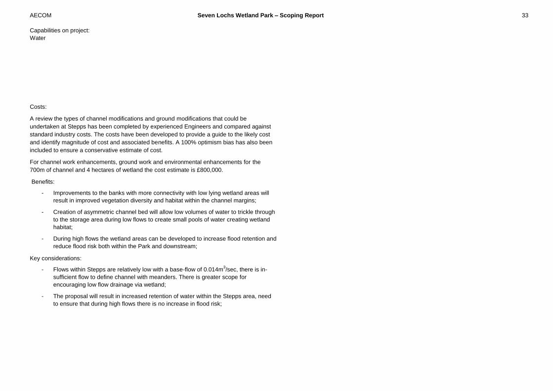
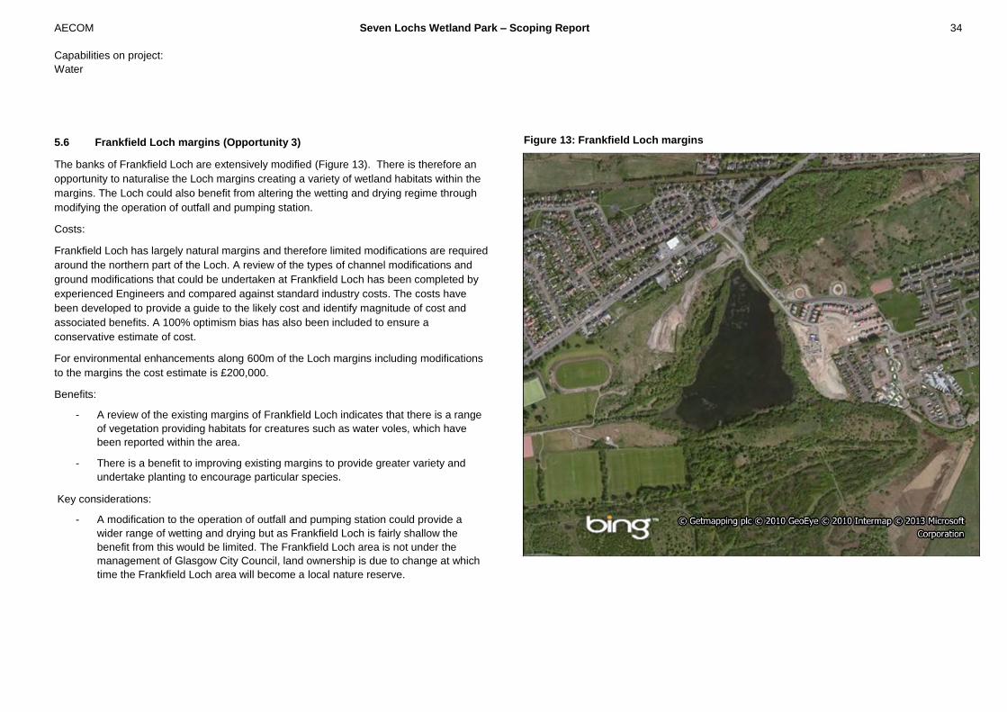
5.6 Frankfield Loch margins (Opportunity 3)
The banks of Frankfield Loch are extensively modified (Figure 13). There is therefore an
opportunity to naturalise the Loch margins creating a variety of wetland habitats within the
margins. The Loch could also benefit from altering the wetting and drying regime through
modifying the operation of outfall and pumping station.
Costs:
Frankfield Loch has largely natural margins and therefore limited modifications are required
around the northern part of the Loch. A review of the types of channel modifications and
ground modifications that could be undertaken at Frankfield Loch has been completed by
experienced Engineers and compared against standard industry costs. The costs have
been developed to provide a guide to the likely cost and identify magnitude of cost and
associated benefits. A 100% optimism bias has also been included to ensure a
conservative estimate of cost.
For environmental enhancements along 600m of the Loch margins including modifications
to the margins the cost estimate is £200,000.
Benefits:
- A review of the existing margins of Frankfield Loch indicates that there is a range
of vegetation providing habitats for creatures such as water voles, which have
been reported within the area.
- There is a benefit to improving existing margins to provide greater variety and
undertake planting to encourage particular species.
Key considerations:
- A modification to the operation of outfall and pumping station could provide a
wider range of wetting and drying but as Frankfield Loch is fairly shallow the
benefit from this would be limited. The Frankfield Loch area is not under the
management of Glasgow City Council, land ownership is due to change at which
time the Frankfield Loch area will become a local nature reserve.
Figure 13: Frankfield Loch margins

AECOM Seven Lochs Wetland Park – Scoping Report 35
Capabilities on project:
Water
Drumpellier Country Park is located to the east of the study area, north-west of Coatbridge.
The park covers 250 ha of lowland heath, mixed woodlands and open grassland and
includes two kettle pond lochs, Woodend Loch and Lochend Loch (Figure 14). Lochend
Loch and Woodend Loch are connected by a sluice structure that maintains water levels
within each area. Lochend Loch has been extensively modified and includes areas of semi-
natural habitat which include rare species and large areas of structures such as moorings.
Roads and paths around Lochend Loch provide the greatest access into Drumpellier
Country Park and car-parking and recreational facilities exist around the Loch. Woodend
Loch is more natural with limited access and is a Site of Special Scientific Interest (SSSI).
The Monklands Canal lies towards the southern perimeter of the park. The lochs and the
canal attract a large number of water birds, both resident and over-wintering migrants, and
the loch shores and woodland floor provides an abundance of wild flora. The woodlands are
also rich in bird life, small wild animals and many types of fungi. (North Lanarkshire Council,
2013)
The area to the south of Lochend Loch is intermediate and raised bog, improved drainage
through the site has resulted in drying out of the bog and trees have established through this
area.
Figure 14: Map of Drumpellier Country Park and Lochend Loch
6 Drumpellier Country Park and
Lochend Loch
AECOM Seven Lochs Wetland Park – Scoping Report 36
Capabilities on project:
Water
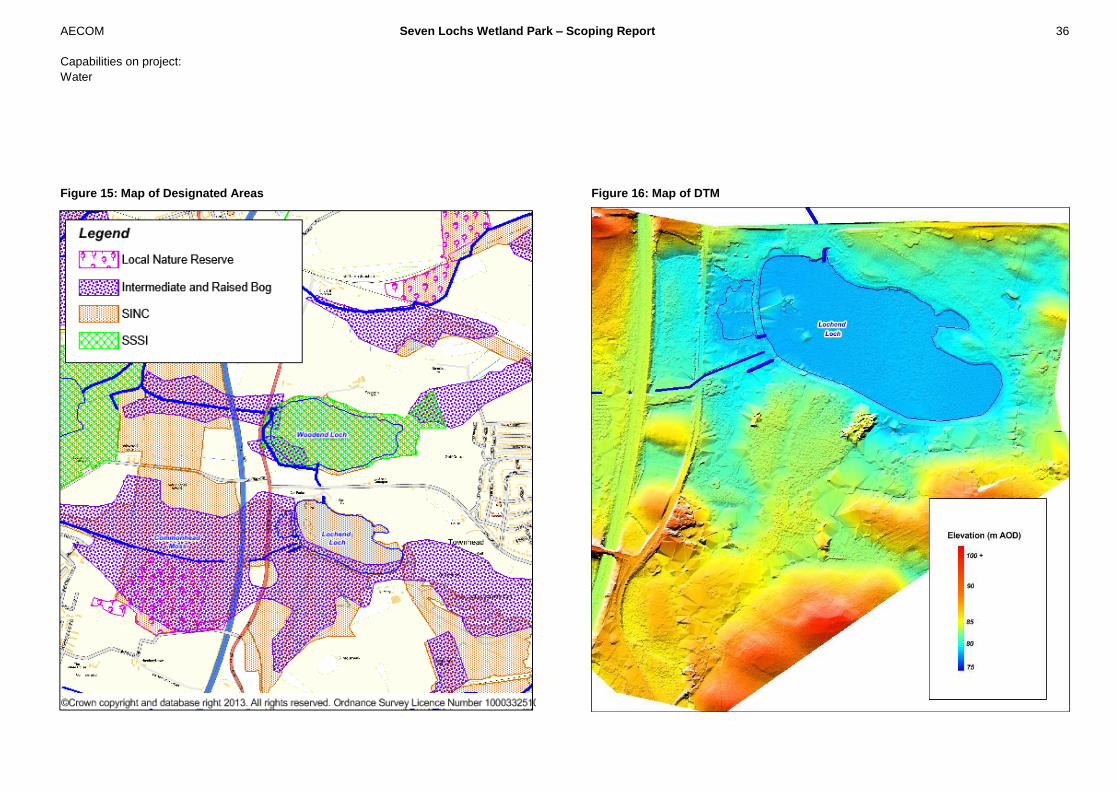
Figure 15: Map of Designated Areas Figure 16: Map of DTM

AECOM Seven Lochs Wetland Park – Scoping Report 37
Capabilities on project:
Water
6.1 Drumpellier Country Park (South of Lochend Loch) - Raised bog restoration
(Opportunity 10)
The area to the south of the Loch is intermediate and raised bog which has been drained and
birch trees have colonized this area further drying the peat. The area of the Park that included
intermediate raised bog covers an area of approximately 20ha and is situated on a deep peat
foundation. The restoration of the raised bog requires re-wetting by:
- Reducing drainage by blocking drains at low flows, installing dams; and
- Removal of birch trees and other types of vegetation.
The area that would be targeted for modifications to the drainage and vegetation has limited
catchment area and drains across this site south to Lochend Loch, contributing to inflow into
Lochend Loch via a number of man-made drains that have been installed to improve drainage.
Installing small dams in the drains not only helps to provide a favourable environment for the
bog but also help to attenuate flows into Lochend Loch and will therefore reduce flooding
around Lochend Loch and Woodend Loch. A key consideration for any works at Drumpellier
Country Park will be to ensure a balance between the wetland and woodland habitats within
the park.
The results of the AECOM hydrological study in 2011 indicate that the low lying area to the
west of Lochend Loch is flooded regularly including during a 1 in 2 year storm.
Improvements to the existing bog habitat will result in direct rainfall being more readily
absorbed within the bog and flow more slowly toward Lochend Loch. Changes to the drainage
system will result in reduced peak flows as the drainage system is dammed. A review of the
catchment inflows in this area of Seven Lochs Wetland Park shows that base-flow is low and
modifications to the drainage system to reduce conveyance will result in a wetter area of bog,
slower response to rainfall and reduced peak flows to Lochend Loch. Inflows to Lochend Loch
developed in Hydrological Study are:
Table 2: Flow Estimates for Drumpellier Country Park Inflow point Base flow (m
3/sec)
(not scaled) Peak flow (m
3/sec)
1 in 2 year Peak flow (m
3/sec)
1 in 200 year B5 0.022 0.442 2.979 *baseflow calculation is an estimate based on FEH parameters
6.1.1 Cost of peatland restoration
A review of the aerial imagery indicates that much of the site is covered by intermediate
(closed scrub); this also provides a conservative estimate of cost of vegetation removal.
Within the drainage system a dam could be installed every 50m at a cost of £90 each. A
review of OS mapping indicates that there are approximately 3000m of drains within the 20ha
area, requiring 60 dams.
Table 3: Cost estimate for peatland restoration for the 20ha area:
Type of cost Cost per unit Cost for 20 ha site
Vegetation clearance £900/ha £18,000
Dam installation (60 dams required) £90 per dam £5,400
Sub-total £23,400
Total with 100% bias £46,800
Benefits:
- Contribute to water quality management;
- Contribute to flood management within the wider catchment;
- Restoration of peatland habitat providing habitat for many protected species;

AECOM Seven Lochs Wetland Park – Scoping Report 38
Capabilities on project:
Water
Key considerations
- Drumpellier Park is an important recreational destination for the community and
any restoration will need to contribute to the visitor experience within the park;
- There are a number of structures such as drains, footpaths, roads and associated
culverts that impact on drainage that require further analysis to understand the
localised drainage.
The preliminary analysis indicates that peatland restoration at Drumpellier Park could
potentially be a cost effective habitat enhancement that contributes to water management.
Further more detailed analysis should include an on-site review of all drainage ditches and
vegetation is undertaken and detailed consultation with the Park Rangers at Drumpellier to
undertake a detailed concept design for peatland restoration.
AECOM Seven Lochs Wetland Park – Scoping Report 39
Capabilities on project:
Water
6.2 Lochend Loch – Naturalisation of banks and restoration of islands for habitat
(Opportunity 12)
Lochend Loch is situated to the east of the study area, to the south-east of Bishop Loch and
the south of Woodend Loch. It has a surface area of approximately 14.1ha and a water level
of approximately 78m AOD.
The loch is an important recreational area with activities such as boating, fishing, walking etc.
There is a boat dock close to the visitors centre and a path encircling the loch which may also
be engaged for public recreation. At the western edge of the loch a path separates a smaller
set of lochs that are hydraulically connected to the main part of the Loch at low flows.
There are two islands within the Loch which at the current water level are partly submerged.
There is, however, a small pocket of trees within the main body of water to the west of the
loch. These trees stand on a stretch of raised land that now carries the access route around
the lake, which once formed an island (Figure 18).
The margins of the loch have been extensively engineered, possibly to facilitate the path,
incorporating built and un-built banks with little vegetation. The limited vegetated margins of
Lochend Loch are relatively undisturbed with several nationally scarce or notable species
present.
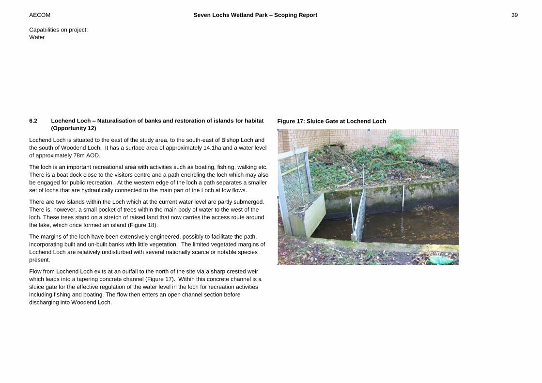
Flow from Lochend Loch exits at an outfall to the north of the site via a sharp crested weir
which leads into a tapering concrete channel (Figure 17). Within this concrete channel is a
sluice gate for the effective regulation of the water level in the loch for recreation activities
including fishing and boating. The flow then enters an open channel section before
discharging into Woodend Loch.
Figure 17: Sluice Gate at Lochend Loch
AECOM Seven Lochs Wetland Park – Scoping Report 40
Capabilities on project:
Water
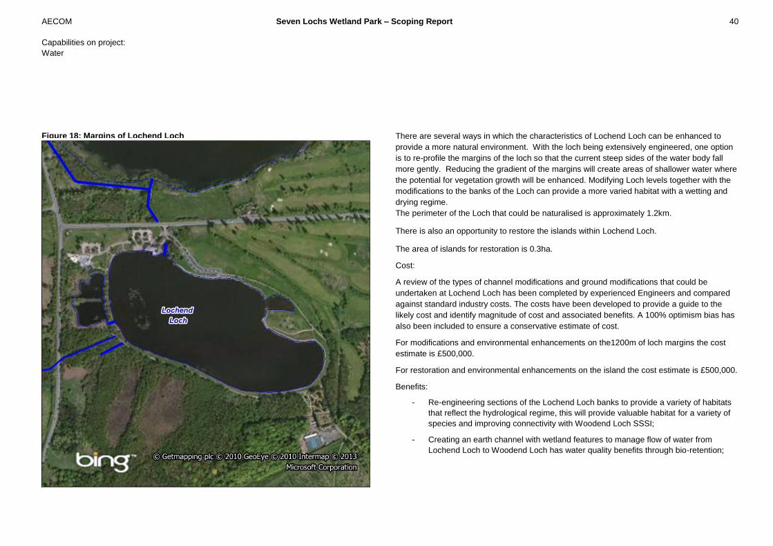
Figure 18: Margins of Lochend Loch There are several ways in which the characteristics of Lochend Loch can be enhanced to
provide a more natural environment. With the loch being extensively engineered, one option
is to re-profile the margins of the loch so that the current steep sides of the water body fall
more gently. Reducing the gradient of the margins will create areas of shallower water where
the potential for vegetation growth will be enhanced. Modifying Loch levels together with the
modifications to the banks of the Loch can provide a more varied habitat with a wetting and
drying regime.
The perimeter of the Loch that could be naturalised is approximately 1.2km.
There is also an opportunity to restore the islands within Lochend Loch.
The area of islands for restoration is 0.3ha.
Cost:
A review of the types of channel modifications and ground modifications that could be
undertaken at Lochend Loch has been completed by experienced Engineers and compared
against standard industry costs. The costs have been developed to provide a guide to the
likely cost and identify magnitude of cost and associated benefits. A 100% optimism bias has
also been included to ensure a conservative estimate of cost.
For modifications and environmental enhancements on the1200m of loch margins the cost
estimate is £500,000.
For restoration and environmental enhancements on the island the cost estimate is £500,000.
Benefits:
- Re-engineering sections of the Lochend Loch banks to provide a variety of habitats
that reflect the hydrological regime, this will provide valuable habitat for a variety of
species and improving connectivity with Woodend Loch SSSI;
- Creating an earth channel with wetland features to manage flow of water from
Lochend Loch to Woodend Loch has water quality benefits through bio-retention;

AECOM Seven Lochs Wetland Park – Scoping Report 41
Capabilities on project:
Water
- Improved amenity for the public;
- Re-vegetation of island will improve water quality through bio-retention and enhance
the ecosystem;
- The islands will have limited access and re-vegetation and restoration of the islands
will provide wetland habitat for nesting birds;
Key considerations:
- Lochend Loch is one of the most accessible recreational areas within Seven Lochs
Wetland Park. Any changes to the Loch need to enhance existing recreational users,
such as anglers, who have a strong sense of ownership of the loch;
- Will require detailed re-engineering and landscaping to ensure that the available
space and local environment is maximised;
- May be limited for locations without the repositioning of the pedestrian path;
- May disturb potentially existing rare species;
- Woodend Loch is a SSSI and water level management between the Lochs including
volume and quality need to be carefully managed;
- Construction and rehabilitation of the island may affect water quality within Lochend
Loch;
- There will remain a need for a culvert to some extent as the outfall flows beneath
Townhead Road

AECOM Seven Lochs Wetland Park – Scoping Report 42
Capabilities on project:
Water
The core of the wetland park will be the Bothlin Burn watercourse and neighbouring areas.
There are significant opportunities to provide multi-functional water management, public
amenity and wetland habitat creation within this central core. This includes peatland
restoration areas such as Cardowan Moss, Commonhead Moss and Craigend Moss; wetland
areas such as Gartloch Pools, Bishop Loch and Bothlin Burn wetlands upstream of the M73
(Figure 19).
Flows through the Bothlin Burn are substantial and provide real opportunity to undertake
channel restoration, wetland habitat creation and connections with the Planned Development
Areas. This low lying area includes a series of pools, low sinuosity watercourses and peatland
that has been artificially drained (Figure 20) and as a result there is less connectivity with low
lying wetland areas.
The Bothlin burn originates from a spring located to the west of the study area, south of Red
Deer village residential park, and flows easterly through agricultural grazing lands to the
Gartloch pools, so called as there is a newer emerging permanent pond forming on the
easterly side of the B806 Garthloch roadway, underneath which the exiting flows of the
primary Garthloch pond flow through a culvert. The B806 road is affected by flooding, at
particular times of the year high pond water levels together with a dip in the elevation of the
road result in inundation of the road. The flow direction and features are shown in Figure 19
and 20 overleaf. This has been confirmed by hydraulic modelling analysis carried out by
AECOM in 2011 which indicates that the road will flood during 1 in 10 year storm event.
Large areas of the wetland core area are designated as Sites of Importance for Nature
Conservation (SINC). Bishop Loch and its surrounds including downstream wetlands are also
designated as Site of Special Scientific Interest (SSSI) and Local Nature Reserve (LNR).
There is potential to expand Bishop Loch LNR to include surrounding wetland areas.
There are areas of intermediate and raised bog within this wetland core focussed on higher
ground.
The vision for this wetland core is to provide an integrated series of high quality wetland
habitat with a variety of water environments with good quality access for the community.
There are numerous benefits to restoring more natural flow by:
- incorporating meanders into the channel;
- blocking some man-made drains to create natural wetland areas that are inundated
more frequently
- re-connecting the watercourse with wetland;
- Pools and ponds that are connected at medium to high flows;
- Connectivity with existing wetland habitat such as Bishop Loch;
- Specific areas of peatland restoration.
This area has also been identified as key public access with footpaths, bike paths and a
number of access points linked to new development within and around the Wetland Park.
The proposed Wetland Core flows through the heart of the study area and will consist of
channel modification and wetland creation along the route of the Bothlin Burn from the origin
point of the Burn up to the M73 motorway.
7 Bothlin Burn – Wetland Core

AECOM Seven Lochs Wetland Park – Scoping Report 43
Capabilities on project:
Water
Figure 19: Key features of the wetland core
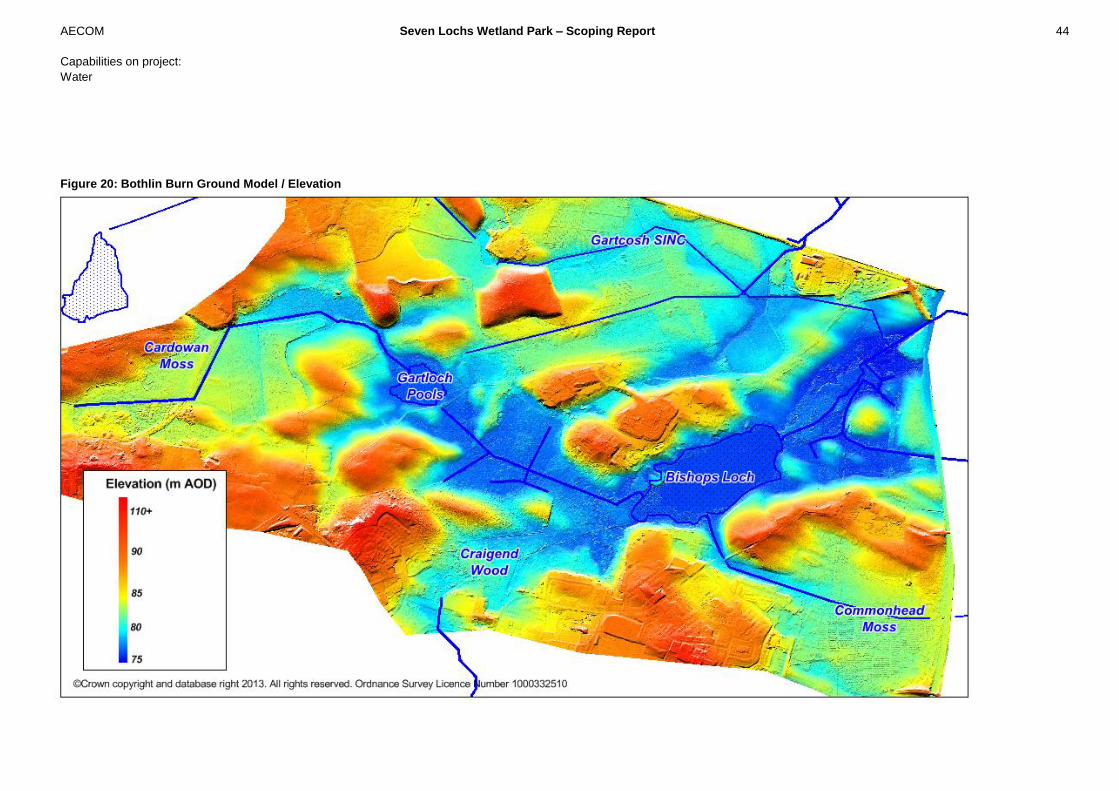
AECOM Seven Lochs Wetland Park – Scoping Report 44
Capabilities on project:
Water
Figure 20: Bothlin Burn Ground Model / Elevation

AECOM Seven Lochs Wetland Park – Scoping Report 45
Capabilities on project:
Water
7.1 Gartloch Pools and Upper Bothlin Burn Channel naturalization and Habitat
Creation (Opportunity 21)
This part of the wetland core is well connected with Community Growth Areas to the south
and provides a key access route from Hogganfield Park to the west through to Bishop Loch
to the east. The main drainage path through this area is low lying and drains to Gartloch
Pools.
There are opportunities to create wetland habitat that is site specific and also adds
connectivity through the Seven Lochs Wetland Park. This could include:
- Meanders
- Changes in bed profile of the channel,
- Connected wetland such as backwaters,
Significant volumes of water are stored within the low lying areas, particularly around
Gartloch Pools. There is an opportunity to create more flood storage reducing flood risk
downstream and also to provide bio-retention to improve the quality of water that flows
through to Bishop Loch and beyond.
Figure 21: Key Features of Upper Bothlin Burn

AECOM Seven Lochs Wetland Park – Scoping Report 46
Capabilities on project:
Water
This area of Bothlin Burn is at the upper area of the catchment and review of the hydrological
inflows indicates that baseflow is low and flows are low overall with 1 in 2 year peak of only
0.29m3/sec as shown in Table 4 below.
Table 4: Flow Estimates for Upper Bothlin Burn
Inflow point Base flow (m3/sec)
(not scaled) Peak flow (m
3/sec)
1 in 2 year Peak flow (m
3/sec)
1 in 200 year B1 0.010 0.290 1.839 *baseflow calculation is an estimate based on FEH parameters
There are opportunities to improve the water environment by impeding drainage with the
installation of small dams in channel wetland areas and areas of off-line storage such as wet
grassland. These should be created within the low lying areas in close proximity to the exiting
drainage route.
The flows within the channel are not sufficient for channel modifications such as meanders
and channel re-profiling.
Costs:
A review of the types of channel modifications and ground modifications that could be
undertaken at Bothlin Burn has been completed by experienced Engineers and compared
against standard industry costs. The costs have been developed to provide a guide to the
likely cost and identify magnitude of cost and associated benefits. A 100% optimism bias has
also been included to ensure a conservative estimate of cost.
For channel work enhancements, ground work and environmental enhancements for the
1000m of channel and 4 hectares of wetland the cost estimate is £700,000.
Benefits:
- Contributes to flood management and water quality;
- Wetland habitat creation and connectivity across the wetland core.
- Gartloch Road is at flood risk. Design of wetlands could reduce peak flows and
volumes at this location.
Key considerations:
- As flows within this reach of Bothlin Burn are low there is limited opportunity for
defined channel, alternatively the development of wet grassland within the existing
channel is an option;
- Requires an understanding of how wetlands will affect water levels, and thus how the
wetlands will function during high and low flows.
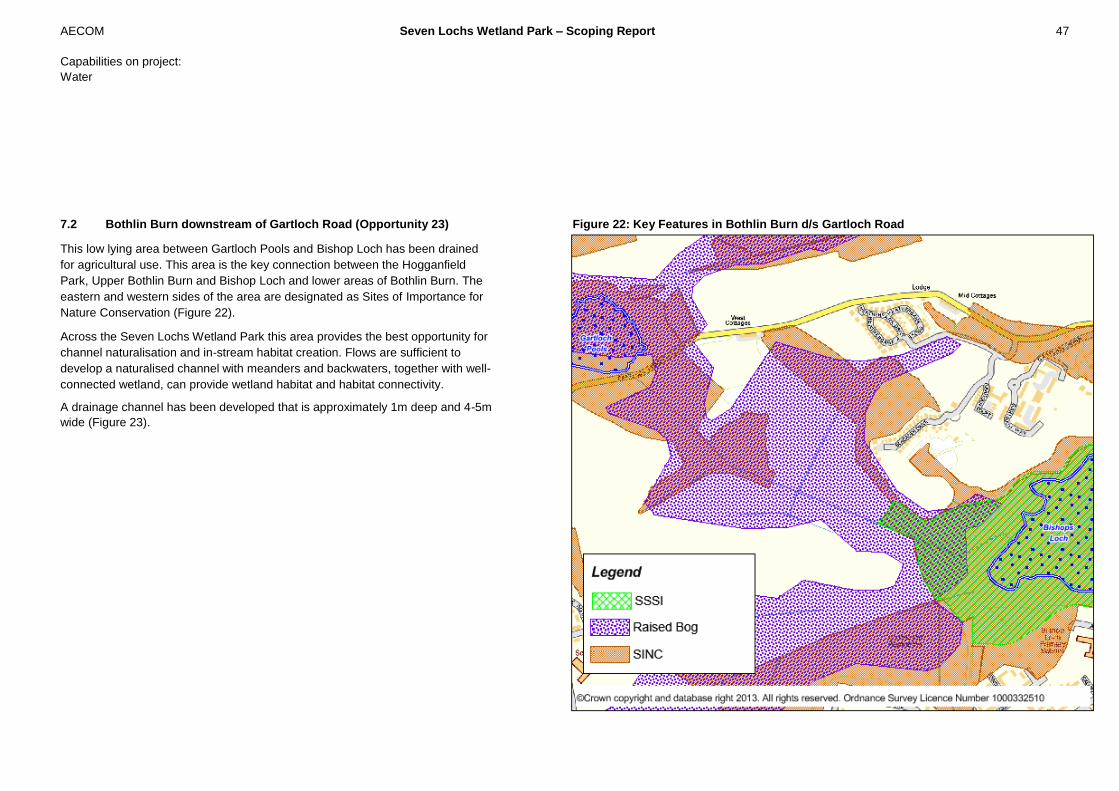
AECOM Seven Lochs Wetland Park – Scoping Report 47
Capabilities on project:
Water
7.2 Bothlin Burn downstream of Gartloch Road (Opportunity 23)
This low lying area between Gartloch Pools and Bishop Loch has been drained
for agricultural use. This area is the key connection between the Hogganfield
Park, Upper Bothlin Burn and Bishop Loch and lower areas of Bothlin Burn. The
eastern and western sides of the area are designated as Sites of Importance for
Nature Conservation (Figure 22).
Across the Seven Lochs Wetland Park this area provides the best opportunity for
channel naturalisation and in-stream habitat creation. Flows are sufficient to
develop a naturalised channel with meanders and backwaters, together with well-
connected wetland, can provide wetland habitat and habitat connectivity.
A drainage channel has been developed that is approximately 1m deep and 4-5m
wide (Figure 23).
Figure 22: Key Features in Bothlin Burn d/s Gartloch Road
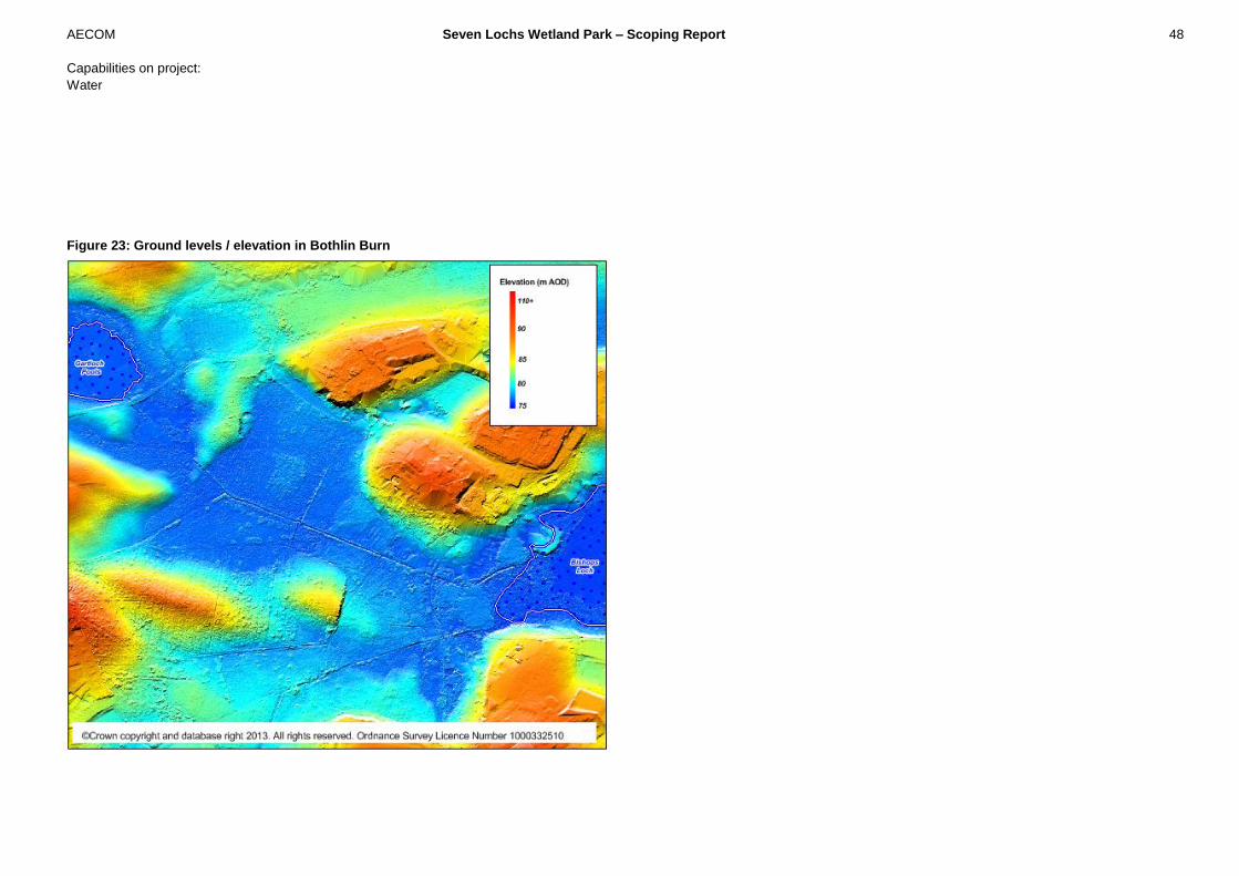
AECOM Seven Lochs Wetland Park – Scoping Report 48
Capabilities on project:
Water
Figure 23: Ground levels / elevation in Bothlin Burn

AECOM Seven Lochs Wetland Park – Scoping Report 49
Capabilities on project:
Water
Figure 24: Typical Cross-section of Bothlin Burn
The channel has a low gradient of 1:1300 and bed levels drop by approximately 1m between
Gartloch Pools and Bishop Loch. This man-made channel has been created to increase
drainage from this area and to improve the sites potential for agriculture. Parts of this area are
affected by flooding at more extreme events. Figure 25 shows that minor-shallow flooding
occurs during the 1 in 10 year event and more widespread flooding (also shallow) occurs at 1
in 200 year event. These areas of moderate flood risk highlight opportunities for wetland
habitat that is connected at lower flows and can also provide increased storage to reduce
flood risk downstream.
Figure 25: Areas affecting flooding in Bothlin Burn
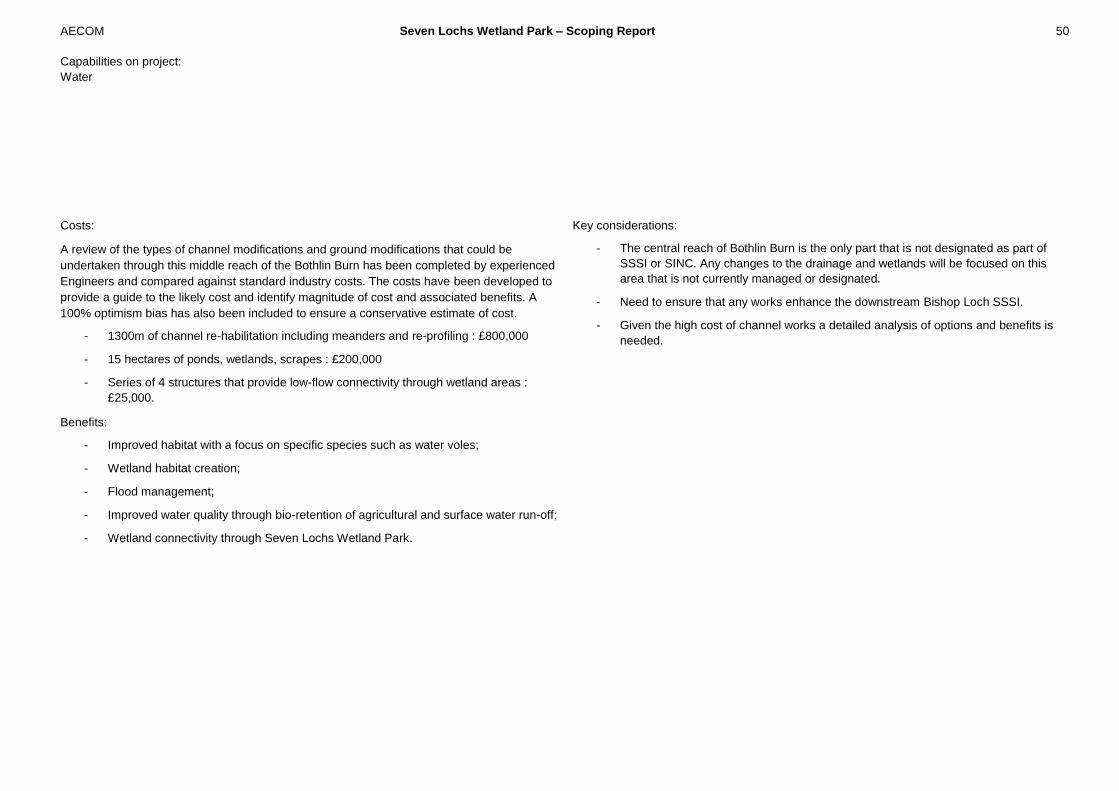
AECOM Seven Lochs Wetland Park – Scoping Report 50
Capabilities on project:
Water
Costs:
A review of the types of channel modifications and ground modifications that could be
undertaken through this middle reach of the Bothlin Burn has been completed by experienced
Engineers and compared against standard industry costs. The costs have been developed to
provide a guide to the likely cost and identify magnitude of cost and associated benefits. A
100% optimism bias has also been included to ensure a conservative estimate of cost.
- 1300m of channel re-habilitation including meanders and re-profiling : £800,000
- 15 hectares of ponds, wetlands, scrapes : £200,000
- Series of 4 structures that provide low-flow connectivity through wetland areas :
£25,000.
Benefits:
- Improved habitat with a focus on specific species such as water voles;
- Wetland habitat creation;
- Flood management;
- Improved water quality through bio-retention of agricultural and surface water run-off;
- Wetland connectivity through Seven Lochs Wetland Park.
Key considerations:
- The central reach of Bothlin Burn is the only part that is not designated as part of
SSSI or SINC. Any changes to the drainage and wetlands will be focused on this
area that is not currently managed or designated.
- Need to ensure that any works enhance the downstream Bishop Loch SSSI.
- Given the high cost of channel works a detailed analysis of options and benefits is
needed.

AECOM Seven Lochs Wetland Park – Scoping Report 51
Capabilities on project:
Water
7.3 Bothlin Burn, downstream of Bishop Loch (Opportunity 25)
Downstream of Bishop Loch there is a confluence of a number of tributaries of
the Bothlin Burn from Woodend Loch and Garkirk. This low lying area
immediately upstream of the M73 is a series of braided channels, ponds and
wetland areas. The area immediately downstream of Bishop Burn is
designated as Site of Special Scientific Interest (SSSI) and most of the site is
part of Site of Importance for Nature Conservation (SINC) (Figure 26).
This is an important part of the integrated wetlands through this central core
and the area was highlighted in initial discussions with project partners.
However, given the already high quality of wetland habitats in this area, as
recognised by the SSSI designation, there are limited opportunities to enhance
the water environment. The opportunity for naturalised channels and improved
habitats in tributary drains could be examined through a detailed review of
flood risk and also of how any hydrological changes may impact areas
designated as SSSI or SINC (Figure 27).
A more detailed assessment of this area could be undertaken to identify
opportunities that are compatible with the existing designation and existing
wetland habitat within this area.
Figure 26: Key Features d/s Bothlin Burn
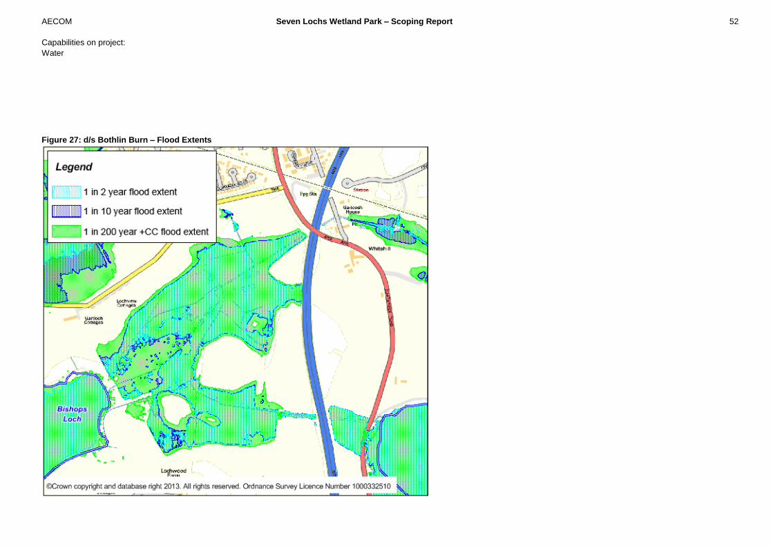
AECOM Seven Lochs Wetland Park – Scoping Report 52
Capabilities on project:
Water
Figure 27: d/s Bothlin Burn – Flood Extents
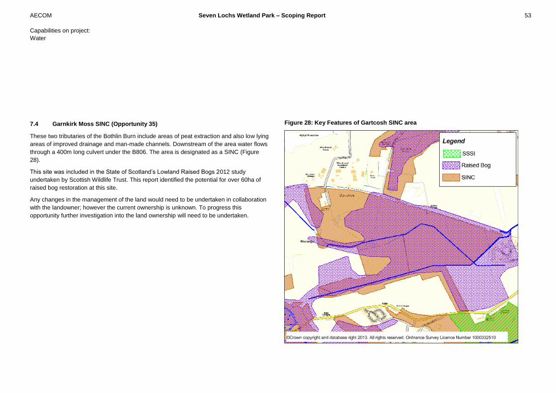
AECOM Seven Lochs Wetland Park – Scoping Report 53
Capabilities on project:
Water
7.4 Garnkirk Moss SINC (Opportunity 35)
These two tributaries of the Bothlin Burn include areas of peat extraction and also low lying
areas of improved drainage and man-made channels. Downstream of the area water flows
through a 400m long culvert under the B806. The area is designated as a SINC (Figure
28).
This site was included in the State of Scotland’s Lowland Raised Bogs 2012 study
undertaken by Scottish Wildlife Trust. This report identified the potential for over 60ha of
raised bog restoration at this site.
Any changes in the management of the land would need to be undertaken in collaboration
with the landowner; however the current ownership is unknown. To progress this
opportunity further investigation into the land ownership will need to be undertaken.
Figure 28: Key Features of Gartcosh SINC area
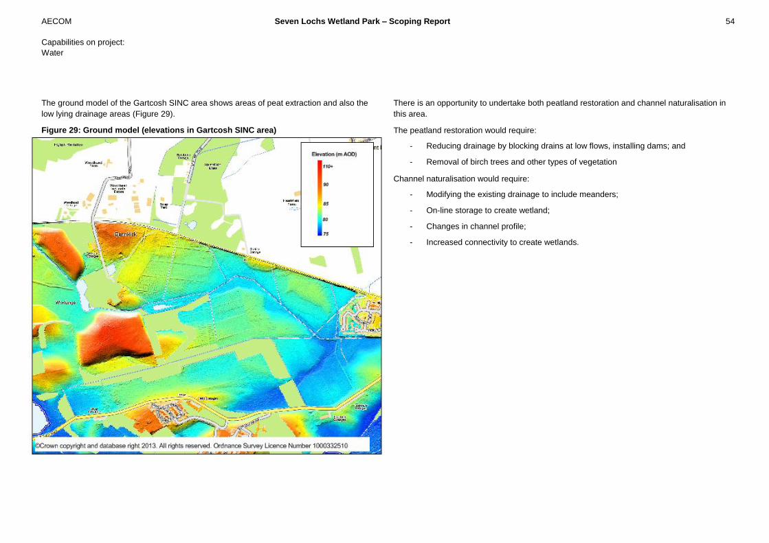
AECOM Seven Lochs Wetland Park – Scoping Report 54
Capabilities on project:
Water
The ground model of the Gartcosh SINC area shows areas of peat extraction and also the
low lying drainage areas (Figure 29).
Figure 29: Ground model (elevations in Gartcosh SINC area)
There is an opportunity to undertake both peatland restoration and channel naturalisation in
this area.
The peatland restoration would require:
- Reducing drainage by blocking drains at low flows, installing dams; and
- Removal of birch trees and other types of vegetation
Channel naturalisation would require:
- Modifying the existing drainage to include meanders;
- On-line storage to create wetland;
- Changes in channel profile;
- Increased connectivity to create wetlands.
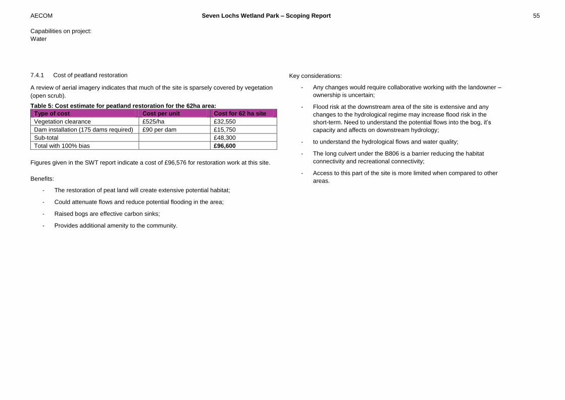
AECOM Seven Lochs Wetland Park – Scoping Report 55
Capabilities on project:
Water
7.4.1 Cost of peatland restoration
A review of aerial imagery indicates that much of the site is sparsely covered by vegetation
(open scrub).
Table 5: Cost estimate for peatland restoration for the 62ha area:
Type of cost Cost per unit Cost for 62 ha site
Vegetation clearance £525/ha £32,550
Dam installation (175 dams required) £90 per dam £15,750
Sub-total £48,300
Total with 100% bias £96,600
Figures given in the SWT report indicate a cost of £96,576 for restoration work at this site.
Benefits:
- The restoration of peat land will create extensive potential habitat;
- Could attenuate flows and reduce potential flooding in the area;
- Raised bogs are effective carbon sinks;
- Provides additional amenity to the community.
Key considerations:
- Any changes would require collaborative working with the landowner –
ownership is uncertain;
- Flood risk at the downstream area of the site is extensive and any
changes to the hydrological regime may increase flood risk in the
short-term. Need to understand the potential flows into the bog, it’s
capacity and affects on downstream hydrology;
- to understand the hydrological flows and water quality;
- The long culvert under the B806 is a barrier reducing the habitat
connectivity and recreational connectivity;
- Access to this part of the site is more limited when compared to other
areas.

AECOM Seven Lochs Wetland Park – Scoping Report 56
Capabilities on project:
Water
7.5 Commonhead Moss – peatland restoration (Opportunity 16)
Commonhead Moss is situated to west of the M73 besides Lochend Loch. Parts of
Commonhead Moss were designated a Local Nature Reserve (LNR) in 2009 and is one of
the largest area of raised bog in Glasgow. The drier edges of the bog are fringed by birch
woodland and wet heath habitat. Commonhead Moss has a channel running from east to
west through the site that drains this area and there are a series of smaller drains to
facilitate drainage. Extensive peat extraction has taken place at the site which can be seen
in the ground model for the area. Commonhead Moss has a limited catchment area and
flows from the site are low (Figure 30).
The southern area of Commonhead Moss is a Local Nature Reserve and is managed by
Glasgow City Council. Glasgow City Council has undertaken significant peat restoration
within this area of Commonhead Moss including birch removal and the installation of dams
to re-wet the site have resulted in regeneration of vegetation to a good standard and
recolonisation of raised bog vegetation in areas that have seen peat extraction.
This opportunity focuses on increasing the area of peatland restoration outside of the area
that is currently being managed by Glasgow City Council. The northern area of
Commonhead Moss is privately owned and there is an opportunity to manage and restore
raised bog in this area through the development of CGAs. The opportunity will also
incorporate elements of water sensitive urban design into the CGAs to provide multi-
benefits that enhance water environment through this area.
A review of the GIS coverage of intermediate and raised bog and area of land that is
managed by Glasgow City Council indicates that approximately 15ha of Commonhead
Moss is suitable for peatland restoration.
Figure 30: Ground model and key features of Commonhead Moss

AECOM Seven Lochs Wetland Park – Scoping Report 57
Capabilities on project:
Water
7.5.1 Cost of peatland restoration
A review of aerial imagery indicates that much of the site is sparsely covered by vegetation
(open scrub).
Table 6: Cost estimate for peatland restoration for the 15ha area:
Type of cost Cost per unit Cost for 15 ha site
Vegetation clearance £900/ha £13,500
Dam installation (60 dams required) £90 per dam £5,400
Sub-total £18,900
Total with 100% bias £37,800
Benefits:
- The restoration of peat land will create extensive potential habitat;
- Could attenuate inflow into Bishop Loch and reduce potential flooding in the area;
- Raised bogs are effective carbon sinks;
- Integrated with surface water management for Community Growth Areas;
- Peatland restoration at Commonhead Moss has been successful and this increases
this area and improves connectivity;
- Provides additional amenity to the community.
Key considerations:
- Need to understand the hydrological flows and water quality;
- Need to understand the potential flows into the bog, it’s capacity and affects on
downstream hydrology

AECOM Seven Lochs Wetland Park – Scoping Report 58
Capabilities on project:
Water
7.6 Cardowan Moss – peatland restoration (Opportunity 20)
Cardowan Moss is situated at the top of the Bothlin Burn catchment. Cardowan Moss is a
Site of Importance for Nature Conservation (SINC) and the western part of Cardowan
Moss is designated as part of Local Nature Reserve (Figure 31). Cardowan Moss is well
connected with numerous pathways that link the areas with Hogganfield Park and is well
used for recreation. The western edge of the Moss is managed (owned) by the nearby
Craigendmuir Caravan and Campsite and there are also access tracks from the site
through Cardowan Moss.
Figure 31: Key Features of Cardowan Moss
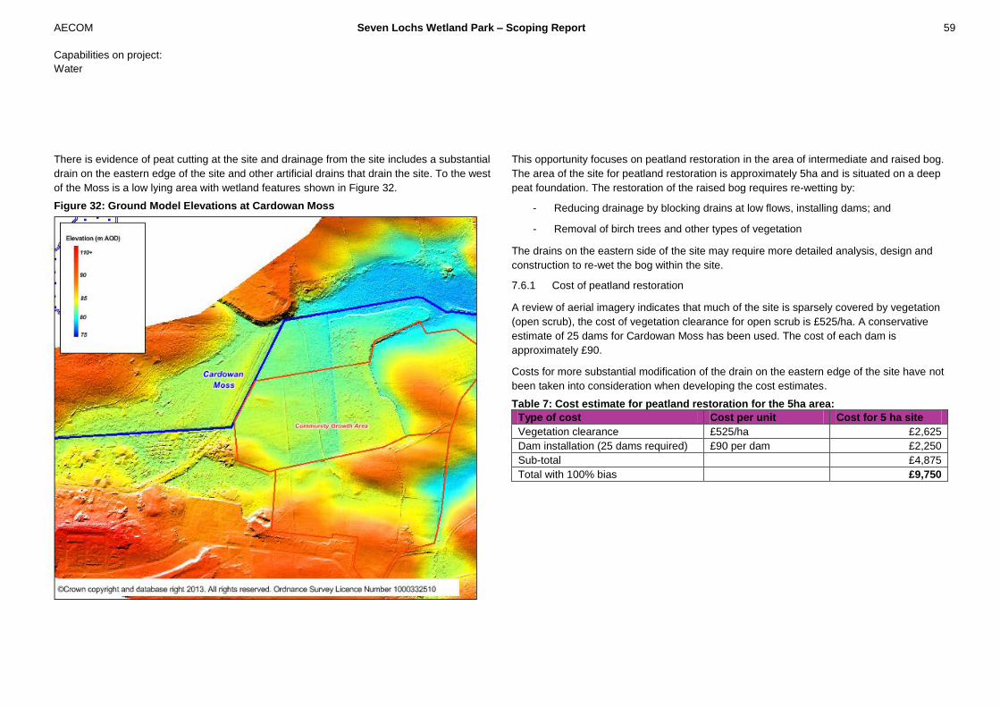
AECOM Seven Lochs Wetland Park – Scoping Report 59
Capabilities on project:
Water
There is evidence of peat cutting at the site and drainage from the site includes a substantial
drain on the eastern edge of the site and other artificial drains that drain the site. To the west
of the Moss is a low lying area with wetland features shown in Figure 32.
Figure 32: Ground Model Elevations at Cardowan Moss
This opportunity focuses on peatland restoration in the area of intermediate and raised bog.
The area of the site for peatland restoration is approximately 5ha and is situated on a deep
peat foundation. The restoration of the raised bog requires re-wetting by:
- Reducing drainage by blocking drains at low flows, installing dams; and
- Removal of birch trees and other types of vegetation
The drains on the eastern side of the site may require more detailed analysis, design and
construction to re-wet the bog within the site.
7.6.1 Cost of peatland restoration
A review of aerial imagery indicates that much of the site is sparsely covered by vegetation
(open scrub), the cost of vegetation clearance for open scrub is £525/ha. A conservative
estimate of 25 dams for Cardowan Moss has been used. The cost of each dam is
approximately £90.
Costs for more substantial modification of the drain on the eastern edge of the site have not
been taken into consideration when developing the cost estimates.
Table 7: Cost estimate for peatland restoration for the 5ha area:
Type of cost Cost per unit Cost for 5 ha site
Vegetation clearance £525/ha £2,625
Dam installation (25 dams required) £90 per dam £2,250
Sub-total £4,875
Total with 100% bias £9,750
AECOM Seven Lochs Wetland Park – Scoping Report 60
Capabilities on project:
Water
Benefits:
- The release of peat land will create extensive potential habitat;
- Could attenuate inflow at the top of Bothlin Burn and reduce flood risk through the
system;
- Raised bogs are effective carbon sinks;
- Integrated with surface water management for Community Growth Areas;
- This area is well connected with Local Nature Reserve and access via Hogganfield
Loch improves habitat connectivity and also connectivity for the community.
Key considerations:
- The part of the site that includes the major drainage path is managed and owned by
the Caravan Site. Any modification to the drainage will require collaborative working
with the owners;
- Small area of raised bog that is closely linked to wetland area to the west;
- Requires significant habitat enhancement;
- Need to understand the hydrological flows and water quality.
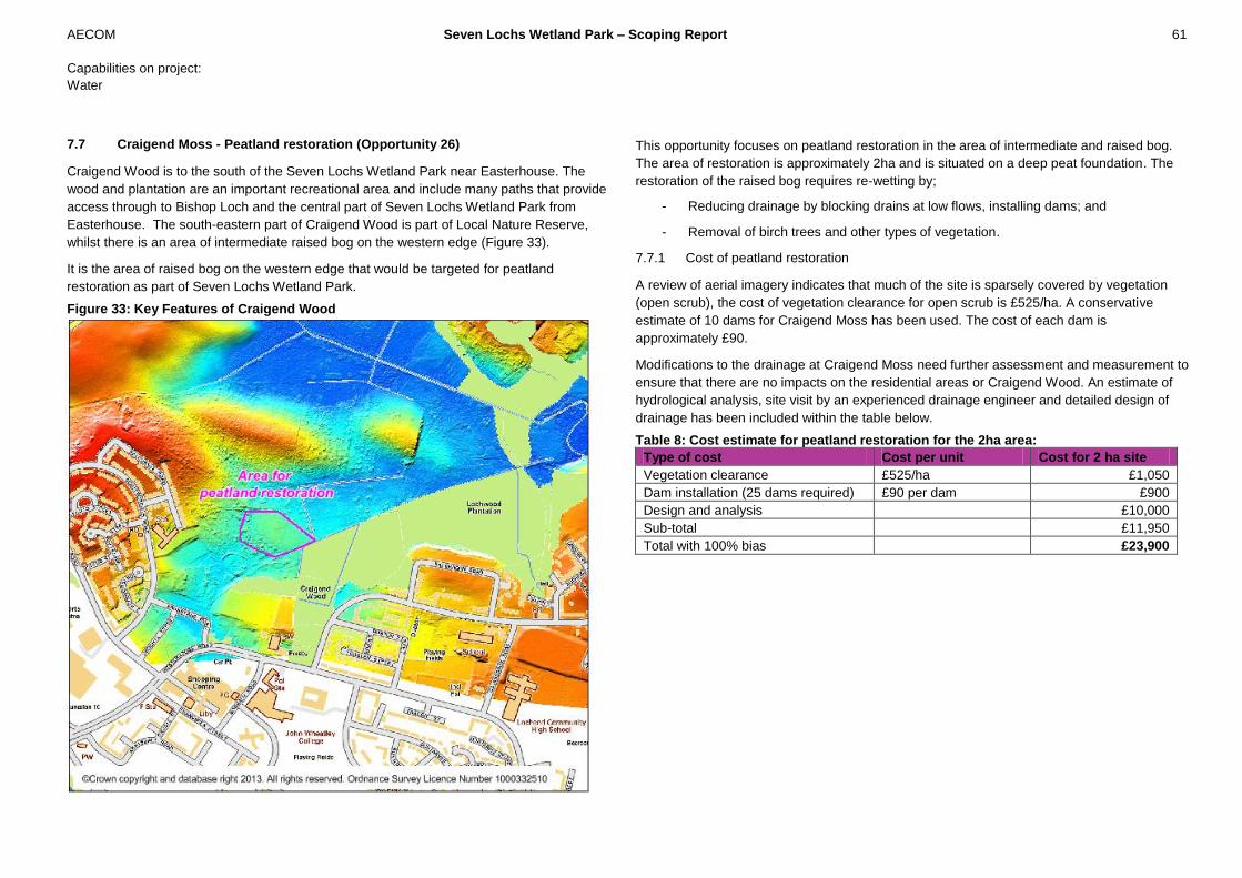
AECOM Seven Lochs Wetland Park – Scoping Report 61
Capabilities on project:
Water
7.7 Craigend Moss - Peatland restoration (Opportunity 26)
Craigend Wood is to the south of the Seven Lochs Wetland Park near Easterhouse. The
wood and plantation are an important recreational area and include many paths that provide
access through to Bishop Loch and the central part of Seven Lochs Wetland Park from
Easterhouse. The south-eastern part of Craigend Wood is part of Local Nature Reserve,
whilst there is an area of intermediate raised bog on the western edge (Figure 33).
It is the area of raised bog on the western edge that would be targeted for peatland
restoration as part of Seven Lochs Wetland Park.
Figure 33: Key Features of Craigend Wood
This opportunity focuses on peatland restoration in the area of intermediate and raised bog.
The area of restoration is approximately 2ha and is situated on a deep peat foundation. The
restoration of the raised bog requires re-wetting by;
- Reducing drainage by blocking drains at low flows, installing dams; and
- Removal of birch trees and other types of vegetation.
7.7.1 Cost of peatland restoration
A review of aerial imagery indicates that much of the site is sparsely covered by vegetation
(open scrub), the cost of vegetation clearance for open scrub is £525/ha. A conservative
estimate of 10 dams for Craigend Moss has been used. The cost of each dam is
approximately £90.
Modifications to the drainage at Craigend Moss need further assessment and measurement to
ensure that there are no impacts on the residential areas or Craigend Wood. An estimate of
hydrological analysis, site visit by an experienced drainage engineer and detailed design of
drainage has been included within the table below.
Table 8: Cost estimate for peatland restoration for the 2ha area:
Type of cost Cost per unit Cost for 2 ha site
Vegetation clearance £525/ha £1,050
Dam installation (25 dams required) £90 per dam £900
Design and analysis £10,000
Sub-total £11,950
Total with 100% bias £23,900
AECOM Seven Lochs Wetland Park – Scoping Report 62
Capabilities on project:
Water
Benefits:
- The release of peat land will create extensive potential habitat;
- Could attenuate inflow at the top of Bothlin Burn and reduce flood risk through the
system;
- Raised bogs are effective carbon sinks;
- Integrated with surface water management for Community Growth Areas;
- This area is well connected with Local Nature Reserve and access through to Bishop
Loch improves habitat connectivity and also connectivity for the community.
Key considerations:
- Integration of raised bog restoration with the management of adjacent woodland
habitats;
- This area of Craigend Moss is a small area at only 2 ha and undertaking peatland
restoration by modifying the drainage and re-wetting the raised bog without affecting
surface water run-off or changing the hydrological regime of the wood will be more
difficult to achieve and require more detailed analysis and design;
- It is in close proximity to residential properties at Easterhouse;
- Need to understand the hydrological flows and water quality.

AECOM Seven Lochs Wetland Park – Scoping Report 63
Capabilities on project:
Water
7.8 Daylighting Bothlin Burn Culvert (Opportunity 29)
Downstream of the M73 motorway, after the confluence with the Garnqueen Burn the Bothlin
Burn flows northwards in a 700m long culvert under the railway line (figure 34), the site of the
former Gartcosh Steelworks, and Auldyards Road. This opportunity focuses on de-culverting
of the long culvert under the former Gartcosh Steelworks and is part of a proposed business
park development.
Figure 34 Location of Bothlin Burn Culvert
There is an opportunity to de-culvert and open up this watercourse as part of the
redevelopment of the former Gartcosh Steelworks site. The culvert provides a significant
barrier to habitat connectivity and opening up the culvert has the potential to improve the
water management within the proposed business park and also to improve habitat. According
to a report in 2000 by Ironside Farrar the masterplan identifies an area of 90ha for a potential
single user industrial site. A 1998 flood study of the redevelopment by Halcrow found that
impermeable extents are expected to increase and that the additional runoff from the site will
contribute an extra 2.4% to the storm runoff from the catchment. An open section of Bothlin
Burn has the potential to provide water sensitive urban design elements within the business
development improving water quality, storm water management and providing amenity within
the park.
Bothlin Burn flowing into railway culvert

AECOM Seven Lochs Wetland Park – Scoping Report 64
Capabilities on project:
Water
Costs:
A review of the types of channel modifications and ground modifications that could be
undertaken at the Bothlin Burn culvert has been completed by experienced Engineers and
compared against standard industry costs. The costs have been developed to provide a guide
to the likely cost and identify magnitude of cost and associated benefits. A 100% optimism
bias has also been included to ensure a conservative estimate of cost.
For modification of the culvert and opening up of the channel for a length of 600m the cost
estimate is: £1,000,000. This area is a former steel works and there are likely to be issues
relating to the site being contaminated. The cost of remediation has not been included within
this estimate.
Benefits:
- Opportunity to naturalise the Bothlin Burn channel and incorporate a bespoke and
imaginative route through the industrial site, with respect to the masterplan;
- The reach of Bothlin Burn immediately downstream of the culvert includes newt
habitat that could be expanded;
- Opportunity to integrate the open channel with other potential SUDS options, and
contribute to flood storage, water quality and amenity
- Opportunity to differentiate the site from traditional industrial locations;
- Decrease the impermeable area and hence decrease the volume of surface runoff;
- Provide easier access for maintenance and surveying.
Key considerations:
- Partnership working with Scottish Water and North Lanarkshire Council is needed to
link any plans to the development of the Business Park.
- Short sections of new culvert under railway, Craignethan Drive and Motorway are still
required;
- There may be limited scope within the current masterplan to open out the
watercourse;
- The developers of the industrial site will be keen to optimise space for industrial
purposes and may be reluctant to release space for the watercourse or SUDS with a
large land take;
- The 1998 Flood Study by Halcrow found that providing attenuation of run-off from the
site will produce no benefits;
- The culvert is deep and potential land take to open up the culvert is high;
- Cost of opening up the culvert is substantial with re-engineering of 600m of channel.

AECOM Seven Lochs Wetland Park – Scoping Report 65
Capabilities on project:
Water
7.9 Culvert under B806 near Gartcosh (Opportunity 34)
The culvert conveys water from Garnkirk area of Bothlin Burn under the B806, the location is
shown in Figure 35. This long culvert, approximately 400m long, drains the Bothlin Burn into
the low lying wetland area upstream of the M73. The culvert is a barrier to connectivity
between these different areas of the central wetland area.
Figure 35 Location of Culvert under B806
Culvert entrance near Inverary Drive
7.9.1 Opportunity
There is an opportunity to significantly reduce the length of this culvert and open out the
majority of the culverted stretch to create an open channel. Culverted sections through open
land (approximately 200m in length) could be released with the creation of new headwalls to
connect the new open channel to the existing culverts.

AECOM Seven Lochs Wetland Park – Scoping Report 66
Capabilities on project:
Water
Costs:
A review the types of channel modifications and ground modifications that could be
undertaken at B806 has been completed by experienced Engineers and compared against
standard industry costs. The costs have been developed to provide a guide to the likely cost
and identify magnitude of cost and associated benefits. A 100% optimism bias has also been
included to ensure a conservative estimate of cost.
For modification of the culvert and opening up of the channel for a length of 200m the cost
estimate is: £500,000.
Benefits:
- Increased connectivity for habitat and also local amenity for the community including
dog walkers and other recreational users;
- The area both upstream and downstream of the culvert has the highest flood risk
within the Seven Lochs Wetland Park. Integrated water management with wetland
habitat can provide more flexibility in how flooding is managed;
- Provide easier access for maintenance;
- An open channel provides greater ecological benefits.
Key considerations:
- As the watercourse is in close proximity to housing off Inverary Drive (approximately
120m), a detailed assessment of any flood risk associated with de-culverting would
be needed;
- A culvert is still required beneath Gartloch Road (B806);
- As part of Gartloch and Gartcosh FRA Report (AECOM, 2011) modelling showed
that during a 2% AEP storm (50 year return period) the fields between Inverary Drive
and the B806 flooded extensively.
AECOM Seven Lochs Wetland Park – Scoping Report 67
Capabilities on project:
Water
Garnqueen Burn is located to the east of the study area and is a tributary of Bothlin Burn,
flowing north-east to west. Garnqueen Burn originates to the north-east of Glenboig flowing
south-west before entering a culvert beneath Coatbridge Road (B804) (Figure 36). The burn
then flows south-westerly through football playing grounds and past the former steel works at
Gartcosh, where it meets the Bothlin Burn. It is likely that the Garnqueen Burn has water
quality issues such as contaminated surface water discharges from the former steel works at
Gartcosh and leachate from two landfill waste sites.
The west of the site is located in the Railway Junction zone of the Gartcosh Nature Reserve.
The Nature Reserve is home to the largest Great Crested Newt population in Scotland, with
an estimated 1000 adults present (as of November 2012) (McNeil, 2013). There have also
been otters observed in Bothlin Burn to the west of the site, the watercourse which takes flow
from the Garnqueen.
One of the key CGAs is located within the area to the north of Garnqueen Burn and detailed
plans are currently being produced for a new visitor centre at Garnqueen Loch, and with
Gartcosh Rail Station in the locality this provides a gateway into the wetlands park for
residents and visitors.
Garnqueen Loch does not discharge into Garnqueen Burn but instead flows parallel to the
B804 to discharge directly into the Bothlin Burn.
8 Glenboig and Garnqueen Burn

AECOM Seven Lochs Wetland Park – Scoping Report 68
Capabilities on project:
Water
Figure 36: Key Feature of Garnqueen Burn and Glenboig
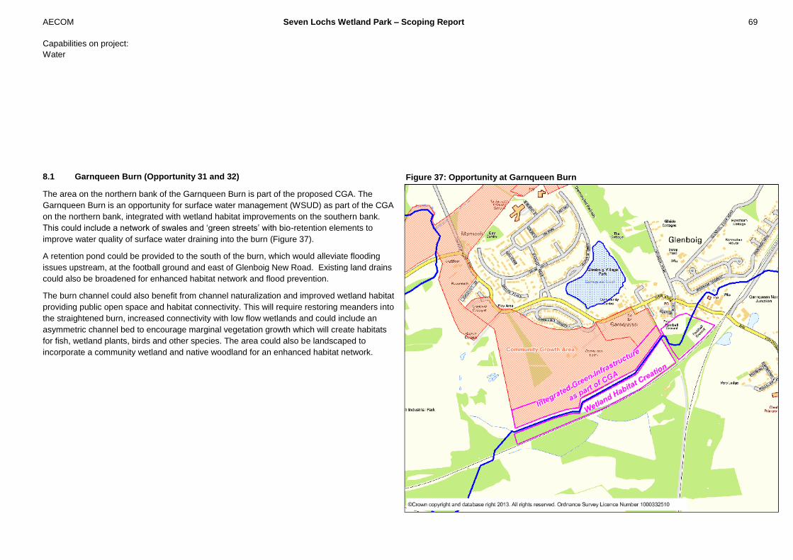
AECOM Seven Lochs Wetland Park – Scoping Report 69
Capabilities on project:
Water
8.1 Garnqueen Burn (Opportunity 31 and 32)
The area on the northern bank of the Garnqueen Burn is part of the proposed CGA. The
Garnqueen Burn is an opportunity for surface water management (WSUD) as part of the CGA
on the northern bank, integrated with wetland habitat improvements on the southern bank.
This could include a network of swales and ‘green streets’ with bio-retention elements to
improve water quality of surface water draining into the burn (Figure 37).
A retention pond could be provided to the south of the burn, which would alleviate flooding
issues upstream, at the football ground and east of Glenboig New Road. Existing land drains
could also be broadened for enhanced habitat network and flood prevention.
The burn channel could also benefit from channel naturalization and improved wetland habitat
providing public open space and habitat connectivity. This will require restoring meanders into
the straightened burn, increased connectivity with low flow wetlands and could include an
asymmetric channel bed to encourage marginal vegetation growth which will create habitats
for fish, wetland plants, birds and other species. The area could also be landscaped to
incorporate a community wetland and native woodland for an enhanced habitat network.
Figure 37: Opportunity at Garnqueen Burn

AECOM Seven Lochs Wetland Park – Scoping Report 70
Capabilities on project:
Water
An analysis of the potential for improved flood management using the hydraulic model of the
Bothlin Burn was undertaken. Modelling results indicate that in the existing situation flooding
occurs upstream of the Garnqueen North Junction and at the football ground. The model was
modified to simulate increased water storage on the north and south bank of Garnqueen Burn.
These areas at low flows will incorporate well-connected wetlands and at high flows water will
overtop the bank and be stored within the floodplain areas.
The results of the hydraulic modelling indicate that increased storage on Garnqueen Burn
reduces flood risk downstream.
Costs:
A review of the types of channel modifications and ground modifications that could be
undertaken through this middle reach of the Garnqueen Burn has been completed by
experienced Engineers and compared against standard industry costs. The costs have been
developed to provide a guide to the likely cost and identify magnitude of cost and associated
benefits. A 100% optimism bias has also been included to ensure a conservative estimate of
cost.
- 1200m of channel re-habilitation including meanders and re-profiling : £900,000
- 10 hectares of ponds, wetlands, scrapes : £180,000
- Water management structures and storage: £20,000
This area is a former steel works and there are former landfills in this vicinity, there is likely to
be a requirement to remediate the contaminated areas of the site. The cost of remediation has
not been included within this estimate.
Benefits:
- Improved habitat and habitat connectivity for great crested newts, water vole and
other species;
- reduced flood levels upstream of the site;
- Integrated surface water management and improvements in water quality;
- Engineering and construction can be undertaken as part of the development of the
Community Growth Area;
Key considerations:
- This area has included a former steel works and there are closed landfills. Any works
to both the channel and adjacent areas is likely to require remediation and
management of contaminated waste. A full review of previous land-use and site
investigation should be undertaken to determine the cost of these options.
- Survey of protected species, and potential requirement for temporary relocation;
- Need to understand the potential flows into the burn, it’s capacity and affects on
downstream hydrology;
- SUDS components may need to consider levels of treatment for existing potentially
contaminated leachate/runoff;
- Need to understand the flow regime of the river so that the storage basin can operate
effectively in times of high and low flows.

AECOM Seven Lochs Wetland Park – Scoping Report 71
Capabilities on project:
Water
8.2 Channel & Culvert from Garnqueen Loch (Opportunity 36)
Garnqueen Loch, located in a residential area within Glenboig, drains via a series of culverts
and open channels along the route of the Glenboig Road (B804). This area is part of a CGA
and the route of the channel and culvert is through these growth areas.
There is potential to open up the culvert to improve habitat connectivity and public open space
by opening up the existing culvert adjacent to the play area off Glenboig Road, south of Dinyra
Place, through approximately 130m of open land. This will require new headwalls to connect
the new open channel to the existing culverts. There is also potential to open out the existing
culvert adjacent to Glenboig Road, to the north of Chesnut Grove, to create approximately
400m of open channel through wooded areas.
Costs:
A review the types of channel modifications and ground modifications that could be
undertaken at Garnqueen has been completed by experienced Engineers and compared
against standard industry costs. The costs have been developed to provide a guide to the
likely cost and identify magnitude of cost and associated benefits. A 100% optimism bias has
also been included to ensure a conservative estimate of cost.
For modification of the culvert and opening up of the channel for a length of 400m the cost
estimate is : £800,000.
Benefits:
- This area is part of CGAs and there is significant benefit to opening up the channel
for integrated water management, public open space and wetland habitat;
- Improving the wetland habitat with good connections through to known areas of Newt
habitat;
- Potential improvements to water quality for flows out of Garnqueen Loch.
Key considerations:
- Creating water management infrastructure adjacent to the play area will require
extensive liaison;
- Open watercourses next to children’s play areas may increase risks;
- Culverted sections are still required beneath Glenboig Road. These could also
increase risks if not properly maintained;
- Creating the open watercourse north of Chesnut Grove will involve tree loss;
- De-culverting the watercourse will alter the flow regime within the watercourse and
this could increase the risk of flooding to houses and roads adjacent to the open
sections;
- Overhead power cables above the existing culverted section north of Chesnut Grove
will create an extra hazard.

AECOM Seven Lochs Wetland Park – Scoping Report 72
Capabilities on project:
Water
A review of the benefits, costs and key considerations has been undertaken to identify key
priorities. Table 8 sets out an overview of benefits and key considerations for all the
opportunities categorised as A1. It identifies those which deliver multiple benefits and
summarises the key considerations noted in the detailed analysis.
The opportunities are also classed using a traffic light system:
Green – clear approach, multiple benefits, projects should be taken forward in the short-term.
Amber – more limited benefits, projects should be taken forward as opportunities arise.
Red – multiple benefits, but more detailed consideration of approach required to understand
costs and benefits.Table 9: Prioritised List of Opportunities
Benefits Key considerations
No Location Hab
ita
t
Cre
ati
on
Hab
ita
t
Co
nn
ec
tivit
y
Pe
atl
an
d
Res
tora
tio
n
Flo
od
Ma
na
ge
men
t
Pu
bli
c A
cc
es
s
& A
me
nit
y
Inte
gra
ted
Wa
ter
Ma
na
ge
men
t
Hig
h C
os
t
La
nd
Ow
ne
rsh
ip
Des
ign
ate
d /
Pro
tec
ted
Deli
ve
r li
nk
to
gre
en
infr
as
tru
ctu
re
in C
GA
Co
mm
un
ity
co
ns
ult
ati
on
En
ha
nc
em
en
t
on
ly
4 Stepps wetland
16
Commonhead Moss and associated
channel
10
Drumpellier Country Park – South of
Lochend Loch
20 Cardowan Moss
12 Lochend Loch
35 Garnkirk Moss SINC area
3 Frankfield Loch
26 Craigend Moss
25 Downstream of Bishop Loch
23 Downstream of Gartloch Road
31 & 32 Garnqueen Burn
21
Bothlin Burn downstream of Cardowan
Moss
9 Prioritised List
AECOM Seven Lochs Wetland Park – Scoping Report 73
Capabilities on project:
Water
9.1 Next Steps
The traffic light classification indicates what is now required of partners to take the
opportunities forward to delivery.
For those opportunities classed as green it is recommended that these are taken forward pro-
actively, and that the next steps should include:
- Detailed site visit by ecologist / river engineer to identify and quantify benefits and
implementation actions
- Detailed modelling and review of the topographic levels;
- Development of specific restoration / enhancement plan
- More detailed cost assessment;
- Further detailed FRA needed where we need to consider risk;
- Identification of potential funding sources.
It is recommended that opportunities classed as amber are taken forward on a more reactive
basis. This could include writing them into funding applications and site management plans
where opportunities arise.
For opportunities classed as red it is again recommended that a proactive approach is taken.
However, given their considerable cost, the need to work with private developers, and the
potential to link these to development, the next steps should include:
- more detailed appraisal of the restoration / enhancement options in order to
determine the approach to be taken;
- Hydrological assessment to examine impacts on water quality and quantity;
- Habitat network analysis and survey to identify opportunities for biodiversity and
impacts upon protected species;
- Analysis of costs and benefit.
Another key consideration in taking forward all the opportunities identified here is the need for
engagement and consultation with communities and landowners. Some of the opportunities
will see considerable change to well used public sites, and community engagement will be
part of the development of implementation plans. In others funding opportunities can only be
realised by working with private landowners.
It will also be important to gather detailed baseline information on the water environment for all
the opportunities identified, and to monitor impacts following restoration and enhancement
works. Some of this monitoring and survey may be suitable as student research projects, and
it is recommended that links are established with Universities and other academic institutions.
Monitoring and survey work may also be a useful mechanism through which local people can
be involved in the restoration project, and it is recommended that the potential to develop
‘citizen science’ programmes linked to these sites is explored.
A second stake holder workshop is planned to begin to explore these next steps with project
partners and other key stakeholders.
AECOM Seven Lochs Wetland Park – Scoping Report 74
Capabilities on project:
Water
AECOM, 2011, Gartloch and Gartcosh - Surface Water Management Strategy
AECOM, 2011 Gartloch and Gartcosh - Hydrological Study
Collective Architecture, March 2011, The Seven Lochs Wetland Park - Masterplan and Visioning study.
Glasgow City Council, 2011, Land and Environmental Services Hogganfield Park and Local Nature Reserve Management Plan 2011 – 2016.
Matthews, P, Hughes, J and Dowse, G. (2012) The state of Scotland’s lowland raised bogs in 2012, Finding from a survey of 58 Scottish lowland raised bogs and analysis of change since
1994/1995, Scottish Wildlife Trust, Edinburgh.
McNeil, 2013, (http://www.glasgownaturalhistory.org.uk/gn25_4/mcneill.pdf)
Meek, Forbes, 2013, email to Scott Ferguson about history of Molendinar Burn.
North Lanarkshire Council, 2013, Facilities and services at Drumpellier Country Park, http://www.northlanarkshire.gov.uk/index.aspx?articleid=6515
River Restoration Study, April 2002, Manual of River Restoration Techniques.
RSPB Scotland, (2012) Realising the Benefits of Peatlands - Overcoming policy barriers to peatland restoration
RSPB Scotland (2013) Artificial islands, http://www.rspb.org.uk/ourwork/conservation/advice/islands/
Scottish Government, 2013, Management of lowland raised bogs,
(http://www.scotland.gov.uk/Topics/farmingrural/SRDP/RuralPriorities/Packages/SustainableFloodManagem/Managementoflowlandraised)
References

AECOM Seven Lochs Wetland Park – Scoping Report 75
Capabilities on project:
Water
Table A1: Long list of opportunities and categories that set out further analysis.
No Location Description Category Notes
1 Hogganfield Naturalise the banks of the Loch B
This is already happening, need to refer to LNR management plan
2 Molendinar Burn Culvert and pumping station
Open up the culvert and remove pumping station. In conjunction with naturalisation of channel and additional flood storage on playing fields.
C+
Medium-list analysis – review if this is possible and to understand the benefits and constraints. need to note if this is possible. Longer term option.
3 Frankfield Loch
Naturalisation of the banks, wetting and drying regime and improved habitat for wading birds. Improved connectivity between Stepps and Frankfield Loch during low flows.
A1
Currently two connections, one low level and the other high level – can switch these over so that at low flows water can flow through to Frankfield Loch and at high flows the water flows through culvert and under railway line. Need to ensure that there isn’t an increase in flow through to Garnqueen Burn.
4 Stepps
Channel naturalisation with low flow connection through to Frankfield, de-culverting of link under the railway.
A1
As above
5 Motorway Corridor Tree planting to create a corridor along the Motorway edges.
B Work being undertaken by Highways Authority on adding lanes – tree planting and corridor could be included within their improvements.
6 Monkland Canal De-culverting C Longer term
7 Easterhouse CGA Naturalisation of channel as part of the CGA development – integrated into the development
A2 Part of CGA – Green Infrastructure
8
Tollcross Burn – Netherhouse (area to north of railway)
Potential wetland habitat with link under Motorway to connect with other potential areas to the east of the Motorway.
A2 Part of CGA – Green Infrastructure
Appendix A

AECOM Seven Lochs Wetland Park – Scoping Report 76
Capabilities on project:
Water
No Location Description Category Notes
9 Monklands Canal De-culverting and improving connectivity with Drumpellier Country Park
C Longer term
10 Drumpellier Country Park – South of Lochend Loch
Significant deep peat that could be re-wetted as part of naturalisation and removal of drains and trees within the Park. Create connected peat and wet woodland.
A1
Can be developed as part of a Habitat Action Plan. An understanding of hydrological inflows is required and how this may improve water management.
11
Garnheath Wood – low lying area to the north of Monkland canal Habitat naturalisation and flood management
C Longer term opportunity
12 Lochend Loch
Naturalisation of Lochend Loch, improve bank habitat whilst improving public access. Included revegetation and habitat improvements on the islands.
A1
Habitat enhancement could provide connectivity and ecological potential.
13 Golf Course Integrated water features for surface water management and habitat.
B Habitat enhancements that can link to wider habitat Action Plan for the park.
14 Woodend Loch Improve habitat around the perimeter of the Loch and connectivity with Lochend Loch.
- Loch is already a SSSI and is in good condition. It needs ongoing management and monitoring.
15 Garnqueen Burn Removal of drains, re-wetting and drainage naturalisation of bog area.
C This area is privately owned, at the edge of the park. Low priority for GCV-GNP
16 Commonhead Moss and associated channel
Modify the drainage and remove trees to re-wet the bog and restore peatland.
A1-A2
SNH funded Peatland restoration is underway in southern part of Commonhead Moss more can be done. GCC don't own all land but with funding could allow to purchase rest by joint funding. The CGA development to the west could incorporate the provision of ownership of land to the north and the on-going management as a natural bog (This would be delivered as part of green infrastructure).

AECOM Seven Lochs Wetland Park – Scoping Report 77
Capabilities on project:
Water
No Location Description Category Notes
17 From Commonhead Moss to Bishop Lock Channel naturalisation to improve connectivity.
A2 Green Infrastructure as part of CGA development
18 Johnston Loch
Habitat improvements with wetting and drying around edge of Loch and stand-off area with wetland habitat to help improve water quality.
- Loch is O.K. Requires on-going maintenance and monitoring.
19 Channels from Johnston Loch
Channel naturalisation and wetlands / water management along the course of the drain. Improve connection under the railway line.
A2 Green Infrastructure to be delivered as part of CGA
20 Cardowan Moss Peatland restoration through drainage and vegetation modifications.
A1
This area provides water vole habitat and need to ensure that any opportunity improves existing habitat. This is existing and historic lowland raised bog, water level management and changes in drainage to restore peatland.
21 Bothlin Burn downstream of Cardowan Moss
Naturalise the channel with areas of water attenuation through improved wetlands.
A1
Wetland Core with integrated series of channel naturalization, backwaters, increased wetland area and low flow paths into low lying marshy areas.
22 Garthamlock CGA
Integrated wetland, channels and water attenuation as part of the development of this community growth area.
A2 Green Infrastructure – delivered as part of CGA
23 Downstream of Gartlock Road
Re-profile the channel to create water attenuation through wetlands during low and moderate flows. Remove the existing drains and re-instate more natural drainage with areas of re-wetted peat, wet grassland and wet woodland.
A1
Wetland Core with integrated series of channel naturalization, backwaters, increased wetland area and low flow paths into low lying marshy areas.
24 Bishop Loch (SSSI) Improve buffering around edges of Loch to improve water quality.
- In good condition, improve connectivity upstream and downstream of the Loch.
25 Downstream of Bishop Loch
This low lying area prone to flooding can be used to create integrated wetland, naturalised channel and
A1
Wetland Core with integrated series of channel naturalization, backwaters, increased wetland area and low flow paths into

AECOM Seven Lochs Wetland Park – Scoping Report 78
Capabilities on project:
Water
No Location Description Category Notes
flood storage. Key biodiversity zone free from disturbance (pets)
low lying marshy areas.
26 Craigend Moss Peatland restoration, remove drains and trees and re-wet this site.
A1
The majority of Craigend Wood drains down to the wetland core and will also be linked with the wetland core through public access and connectivity with Community Growth Areas.
28 Craigend – existing properties Retro-fitting SUDS
B Delivered by others as part of on-going water management.
27 Garthamlock – existing properties Retro-fitting SUDS
B Delivered by others as part of on-going water management.
29 Bothlin Burn Culvert De-culvert/daylight this culvert and open up this watercourse
C+ This opportunity could be explored as part of the re-development of the business park.
30 Downstream of Bothlin Burn culvert
Improve ponds and water habitat (existing newt habitat), integrated with channel naturalisation of Bothlin Burn.
- Already in good condition, important to provide connectivity to this area.
31 Right bank of Garnqueen Burn
Integrated flood management to ease flooding issues upstream. Potential area for channel naturalisation as part of the Community Growth Area.
A1
Opportunity needs to ensure connectivity with water sensitive urban design elements for integrated water management on the right bank. On the left bank opportunity for wetland habitat creation that links across the channel to CGA.
32 Garnqueen Football Ground
Channel naturalisation and flood storage either side of Garnqueen Burn.
A1
As above – area for water management
33 North of Glenboig
Historic deep peat, habitat creation and re-wetting to improve bog conditions. Removal of drains and re-wet this area,
C Longer term opportunity, could link to other peat habitats beyond the park study area.
34 Gartcosh - culvert under B806
De-culvert/ daylight this culvert that links the these areas to provide connectivity
C+
This culvert provides main connection of this tributary of the Bothlin Burn and is a barrier to ecological connectivity. There is an opportunity to improve connectivity. There is existing and
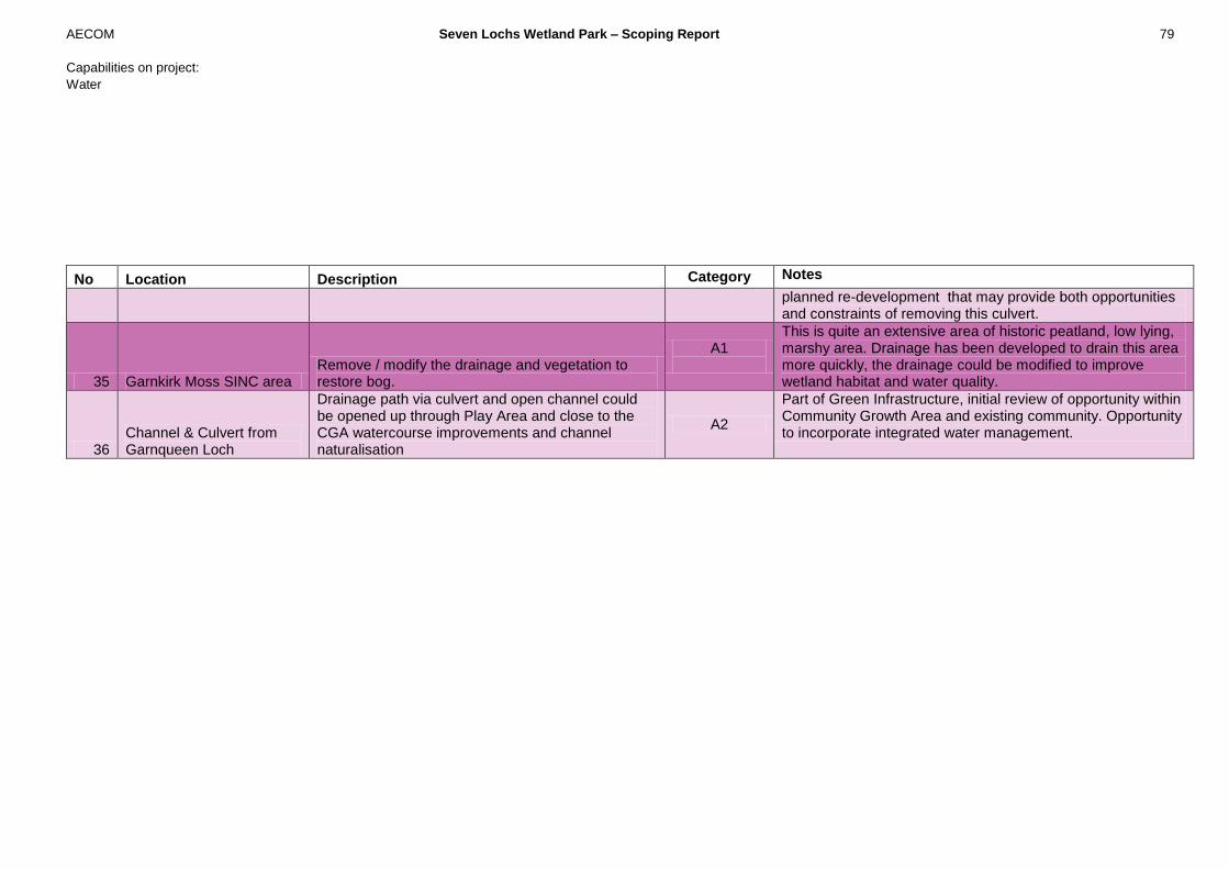
AECOM Seven Lochs Wetland Park – Scoping Report 79
Capabilities on project:
Water
No Location Description Category Notes
planned re-development that may provide both opportunities and constraints of removing this culvert.
35 Garnkirk Moss SINC area Remove / modify the drainage and vegetation to restore bog.
A1
This is quite an extensive area of historic peatland, low lying, marshy area. Drainage has been developed to drain this area more quickly, the drainage could be modified to improve wetland habitat and water quality.
36 Channel & Culvert from Garnqueen Loch
Drainage path via culvert and open channel could be opened up through Play Area and close to the CGA watercourse improvements and channel naturalisation
A2
Part of Green Infrastructure, initial review of opportunity within Community Growth Area and existing community. Opportunity to incorporate integrated water management.

AECOM Seven Lochs Wetland Park – Scoping Report 80
Capabilities on project:
Water