Embed Size (px)
Citation preview
JMA/WMO Workshop on Quality Management in Surface, Climate and Upper-air Observation in RAII (ASIA), Tokyo, Japan, 27-30 July 2010
S f M t l i l &Surface Meteorological & Upper-air Services inUpper-air Services in KMA
Hyuk Je Leey
Observation Policy DivisionObservation Policy Division
Korea Meteorological Administration (KMA)

Organization of KMA g
Contents
1 Surface Observation1. Surface Observation
2 U i Ob ti2. Upper-air Observation
3. Sensor/instrument Calibration
4. Standard Observational Site
5. Current Issue
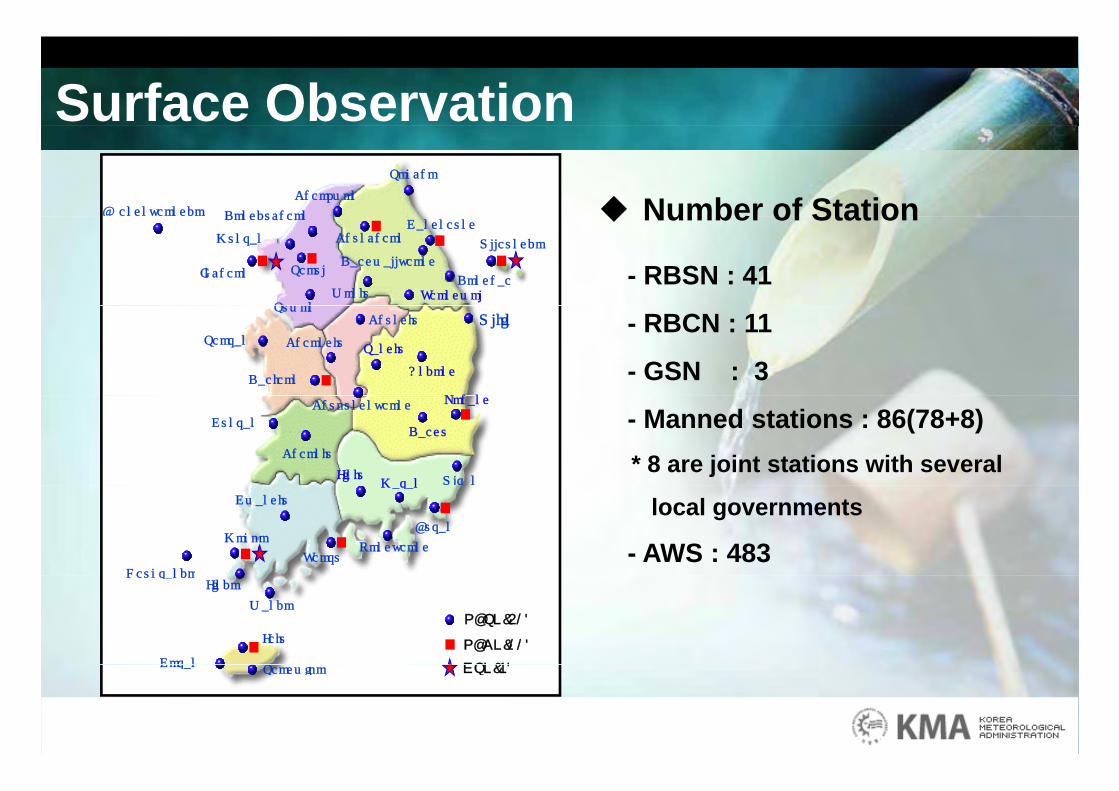
Surface Observation
Number of StationBaengnyeongdo Dongducheon
Cheorwon
Sokcho
Number of Station
- RBSN : 41
g y g Dongducheon
Donghae
Chuncheon
Yeongwol
Ulleungdo
Daegwallyeong
Munsan
Seoul
Suwon
Gangneung
Incheon
Wonju
- RBCN : 11
- GSN : 3 Seosan
Chungju
Cheongju
Andong
UljinSuwon
Daejeon
Sangju
P h
- Manned stations : 86(78+8)* 8 are joint stations with several
Gunsan
Chupungnyeong
Jinju
Daegu
Cheonju
Ulsan
Pohang
Masan
local governments
- AWS : 483Busan
Heuksando
GwangjuMasan
TongyeongMokpo
Yeosu
Gosan
HeuksandoJindo
Wando
Jeju
S i
RBSN(41)
RBCN(11)
GSN(3)Gosan Seogwipo GSN(3)
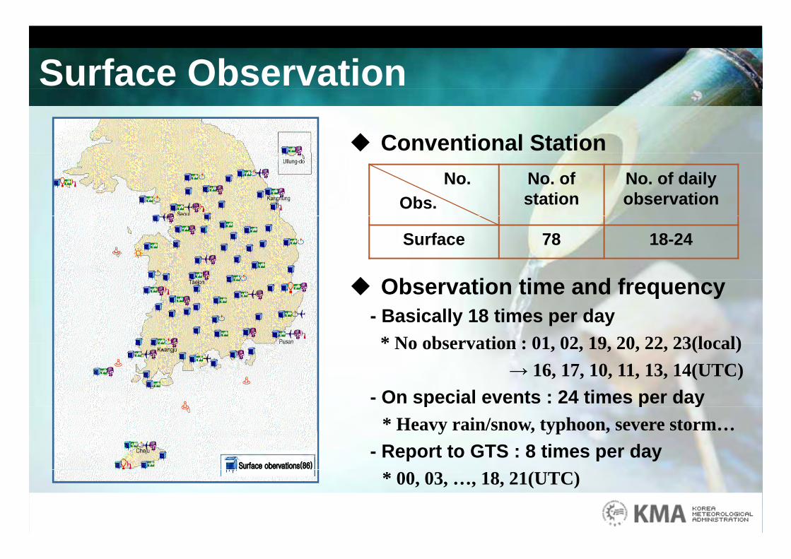
Surface Observation Conventional Station
No. Obs.
No. of station
No. of daily observation
Surface 78 18-24
Ob ti ti d f Observation time and frequency- Basically 18 times per day
* No observation : 01 02 19 20 22 23(local)* No observation : 01, 02, 19, 20, 22, 23(local)→ 16, 17, 10, 11, 13, 14(UTC)
- On special events : 24 times per dayp p y* Heavy rain/snow, typhoon, severe storm…
- Report to GTS : 8 times per day * 00, 03, …, 18, 21(UTC)
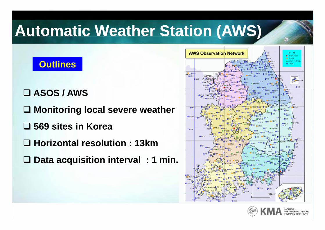
Automatic Weather Station (AWS)Automatic Weather Station (AWS)
Outlines
( )( )
Outlines
ASOS / AWS
Monitoring local severe weather
569 sites in Korea
H i t l l ti 13k Horizontal resolution : 13km
Data acquisition interval : 1 min.
Automatic Weather Station (AWS)Automatic Weather Station (AWS)
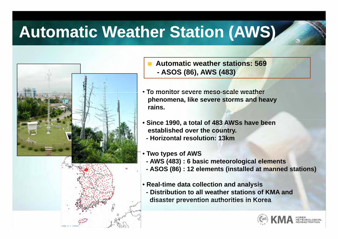
Automatic weather stations: 569
( )( )
Automatic weather stations: 569- ASOS (86), AWS (483)
• To monitor severe meso-scale weather• To monitor severe meso-scale weather phenomena, like severe storms and heavy rains.
• Since 1990, a total of 483 AWSs have beenestablished over the country.
- Horizontal resolution: 13km
• Two types of AWS- AWS (483) : 6 basic meteorological elements- ASOS (86) : 12 elements (installed at manned stations)
• Real-time data collection and analysis- Distribution to all weather stations of KMA and
disaster prevention authorities in Koreadisaster prevention authorities in Korea
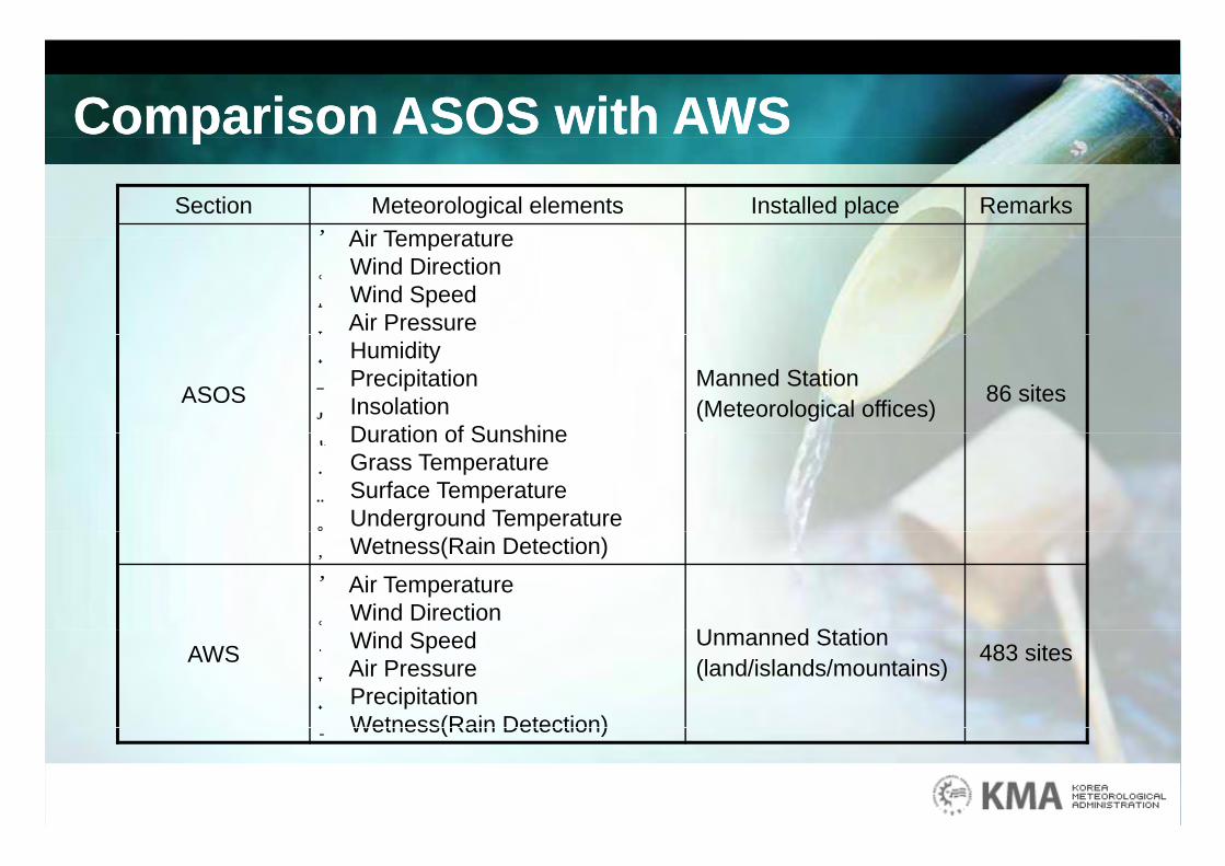
Comparison ASOS with AWSComparison ASOS with AWSppSection Meteorological elements Installed place Remarks
① Air Temperature① Air Temperature ②Wind Direction ③Wind Speed ④ Air Pressure
ASOS
⑤ Humidity ⑥ Precipitation⑦ Insolation ⑧ Duration of Sunshine
Manned Station(Meteorological offices) 86 sites
⑧ Duration of Sunshine ⑨ Grass Temperature ⑩ Surface Temperature⑪ Underground Temperature ⑫Wetness(Rain Detection)① Air Temperature ②Wind Direction ③ U d St ti
AWS ③Wind Speed ④ Air Pressure⑤ Precipitation ⑥Wetness(Rain Detection)
Unmanned Station(land/islands/mountains) 483 sites
⑥Wetness(Rain Detection)
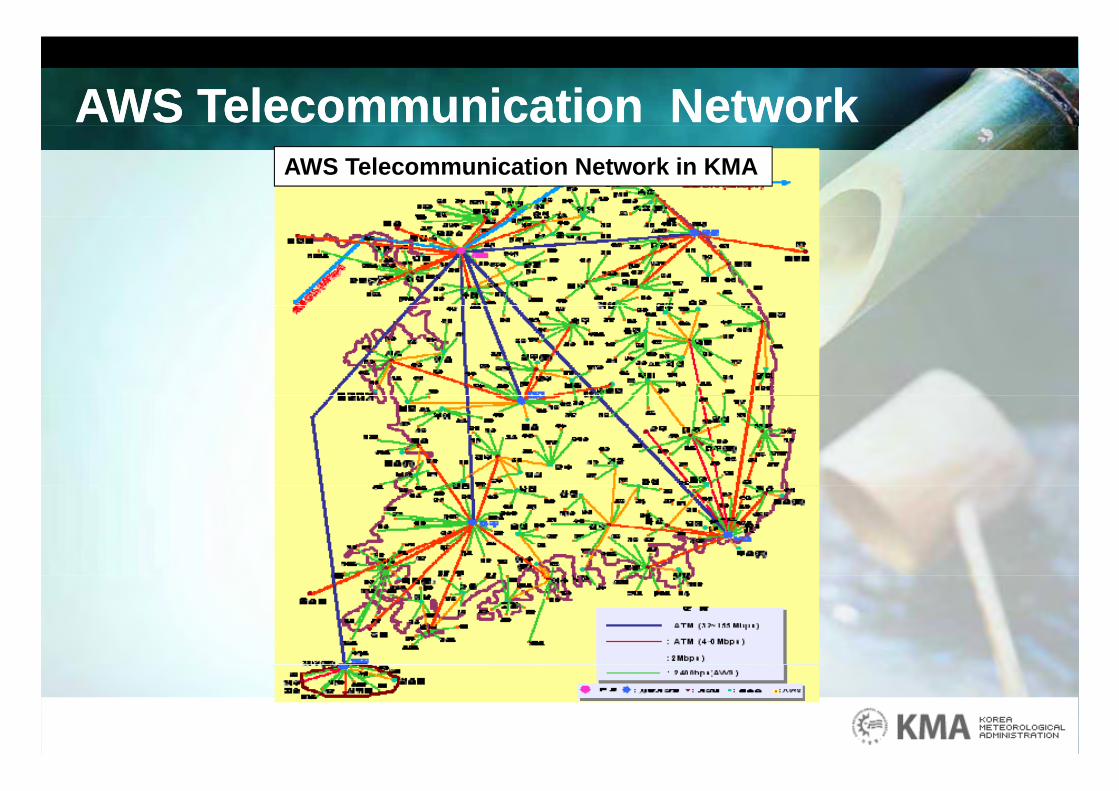
AWS Telecommunication NetworkAWS Telecommunication NetworkAWS Telecommunication Network in KMA
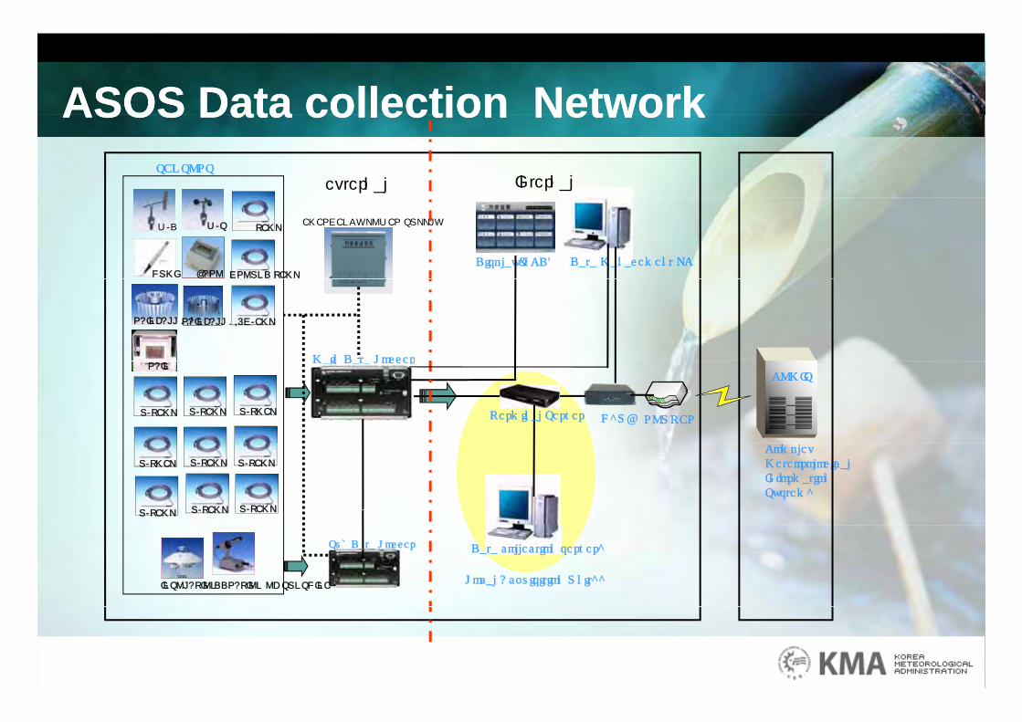
ASOS Data collection NetworkASOS Data collection NetworkASOS Data collection NetworkASOS Data collection NetworkSENSORS
external Internal
Data Management PCDisplay(LCD)
W/D W/S TEMP
HUMI BARO GROUND TEMP
EMERGENCY POWER SUPPLY
Main Data Logger
RAINFALL 0.5G/EMPRAINFALL 0.1
Main Data Logger
H`UB
COMIS
ROUTERU/TEMP U/TEMP
RAIN
U/TMEP Terminal Server
Complex Meteorological Information System`
U/TEMPU/TMEP U/TEMP
U/TEMP U/TEMP U/TEMP
CM21CM21
INSOLATIONDDRATION OF SUNSHINE
Sub Data Logger Data collection server`
Local Acquisition Unit``
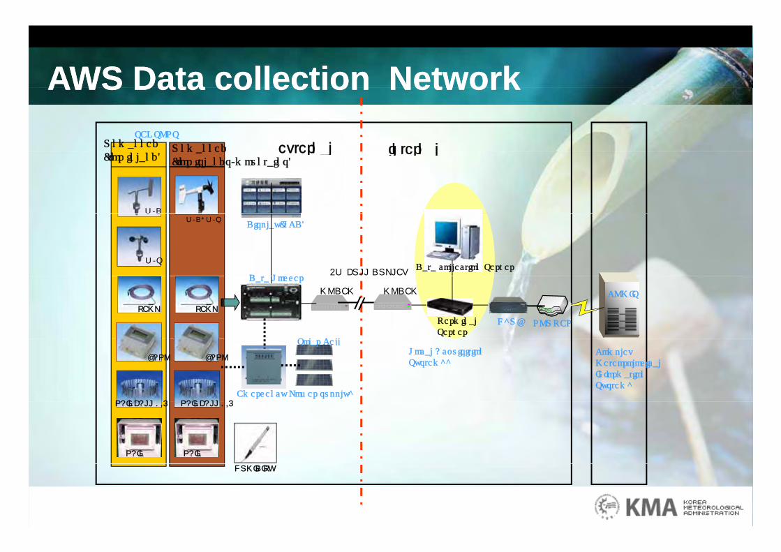
AWS Data collection NetworkAWS Data collection NetworkAWS Data collection NetworkAWS Data collection NetworkSENSORS
Unmanned external internalUnmanned
W/D
(for inland)external internalUnmanned
(for islands/mountains)
D t L
Display(LCD)
W/D
W/SData collection Server
W/D, W/S
4W FULL DUPLEXData Logger
H`UB
COMIS
ROUTER
TEMP
Terminal Server
TEMP
MODEM MODEM
S l C ll
BARO
RAINFALL 0 5
BARO
RAINFALL 0 5Emergency Power supply`
Solar CellComplex Meteorological Information System`
Local Acquisition System``
RAINFALL 0.5
RAIN
RAINFALL 0.5
RAIN
HUMIDITY
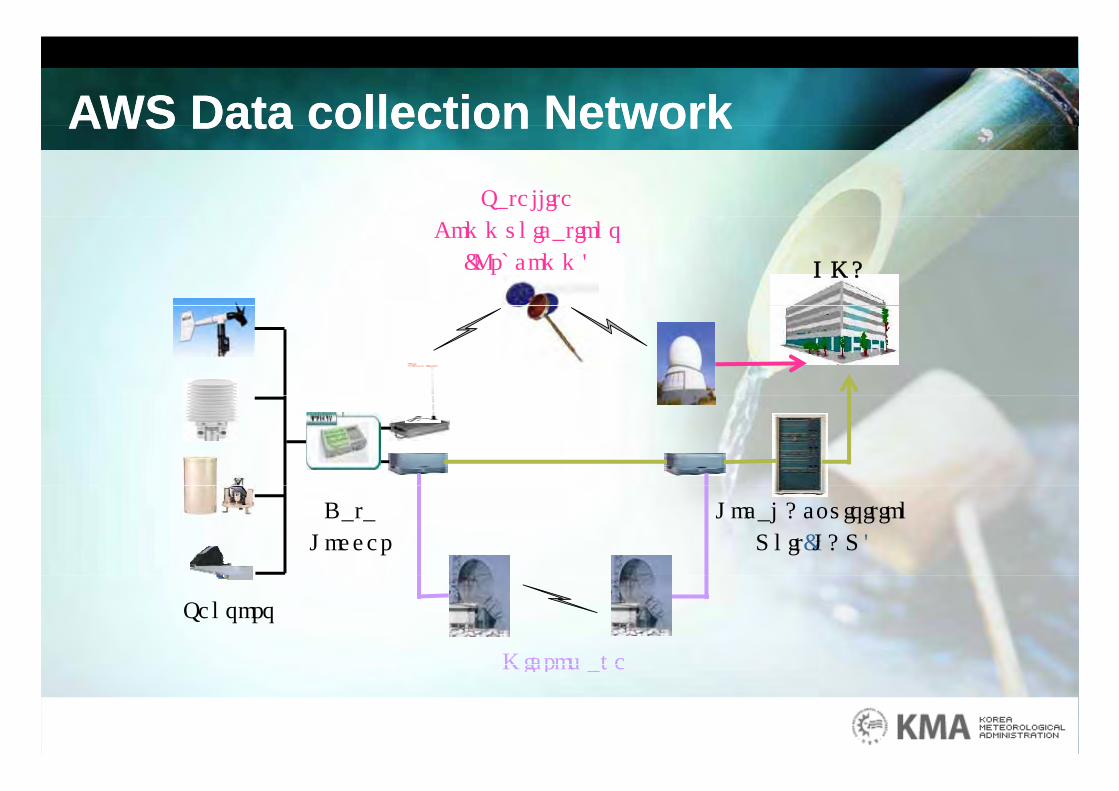
AWS Data collection NetworkAWS Data collection NetworkAWS Data collection NetworkAWS Data collection NetworkSatellite
Communications
(Orbcomm) KMA
Data
Logger
Local Acquisition
Unit(LAU)
Microwave
Sensors
Microwave
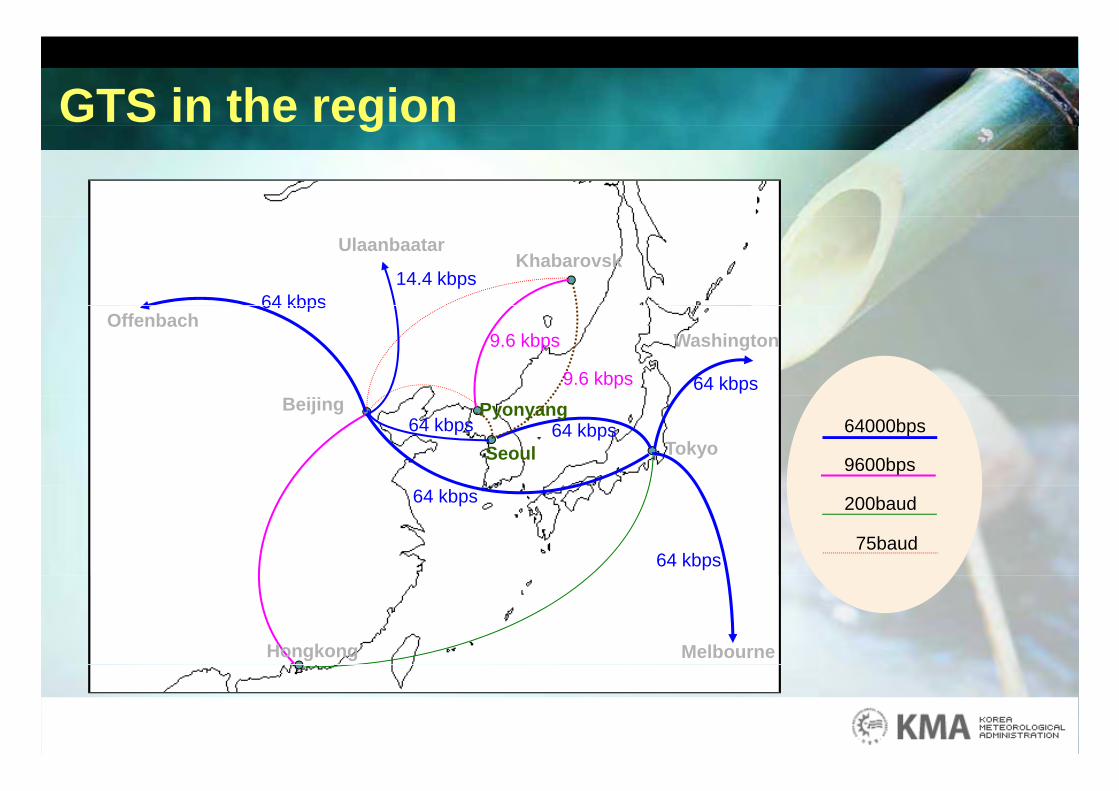
GTS in the regiong
Khabarovsk
64 kbps
Ulaanbaatar
14.4 kbps
WashingtonOffenbach
64 kbps
64 kbps9.6 kbps
9.6 kbps
TokyoSeoul
PyonyangBeijing64 kbps64 kbps 64000bps
9600bps
64 kbps
64 kbps
200baud
75baud
MelbourneHongkong
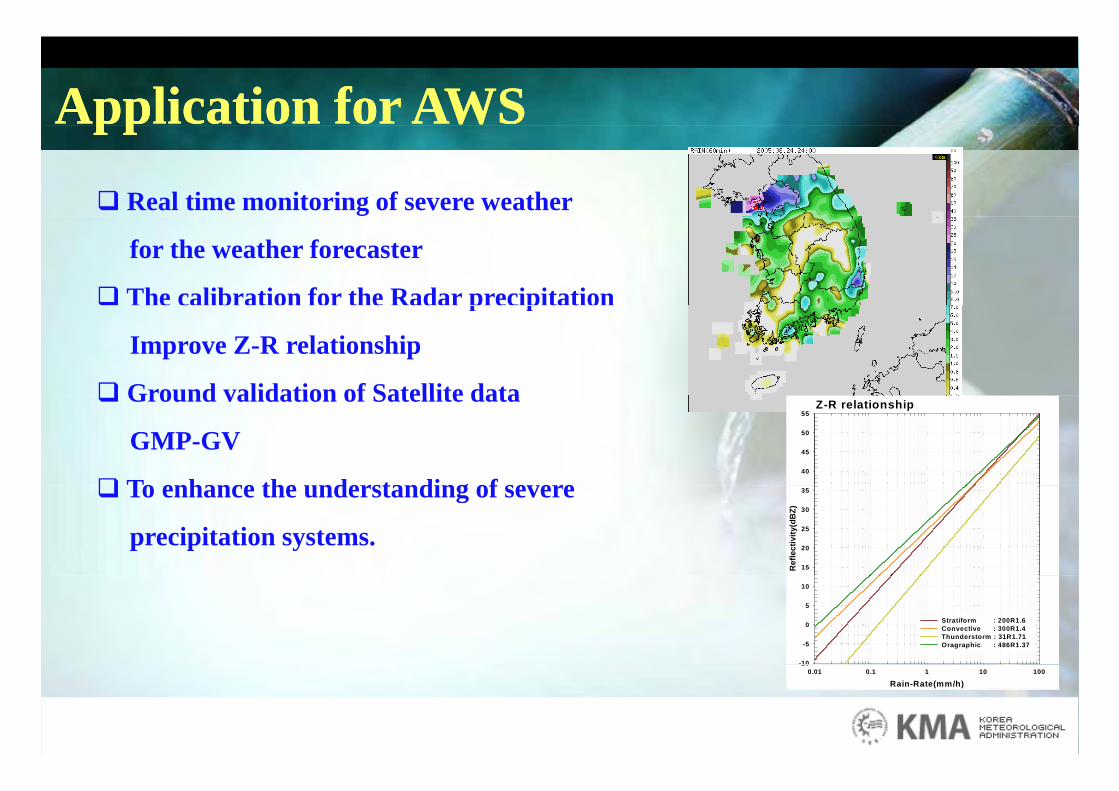
Application for AWSApplication for AWSpppp Real time monitoring of severe weather
for the weather forecaster
The calibration for the Radar precipitation The calibration for the Radar precipitation
Improve Z-R relationship
Ground validation of Satellite data Ground validation of Satellite data
GMP-GV
To enhance the understanding of severe
Z-R relationship
40
45
50
55
To enhance the understanding of severe
precipitation systems.
Ref
lect
ivity
(dB
Z)
15
20
25
30
35
-10
-5
0
5
10
Stratiform : 200R1.6 Convective : 300R1.4 Thunderstorm : 31R1.71 Oragraphic : 486R1.37
Rain-Rate(mm/h)0.01 0.1 1 10 100
10
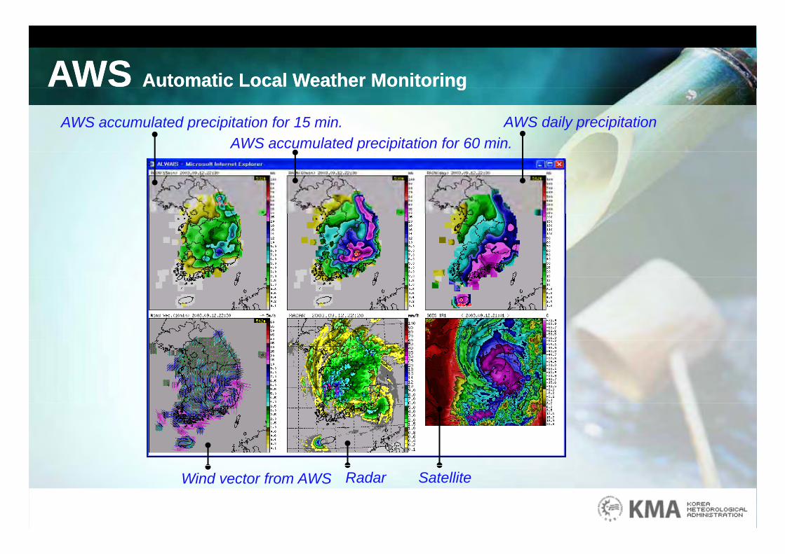
AWS Automatic Local Weather MonitoringAWS Automatic Local Weather Monitoringgg
AWS accumulated precipitation for 15 min. AWS daily precipitationAWS accumulated precipitation for 60 min.
Wind vector from AWS SatelliteRadar
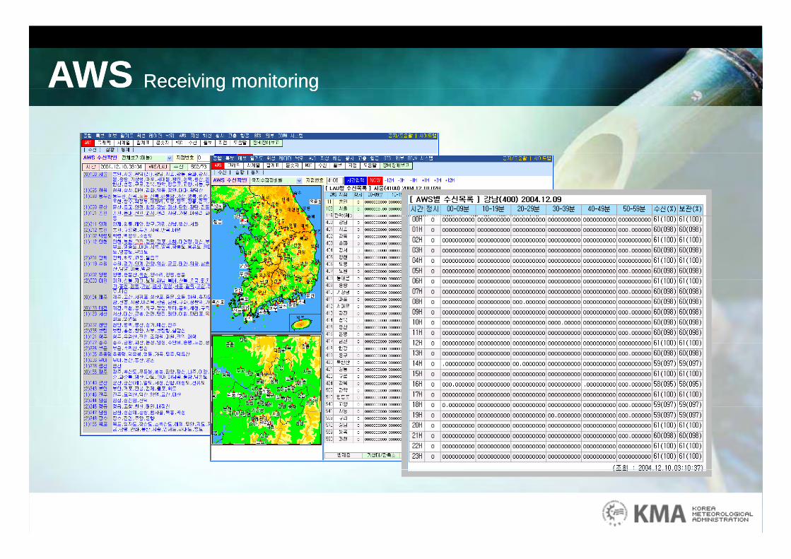
AWS Receiving monitoringAWS Receiving monitoringg gg g
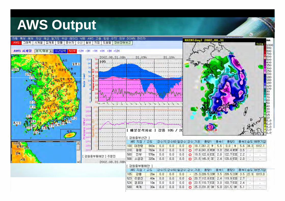
AWS OutputAWS Output
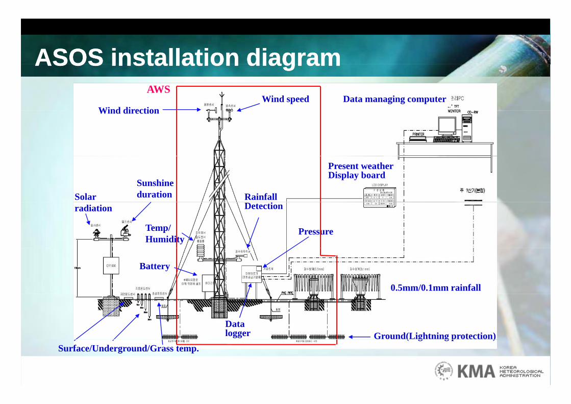
ASOS installation diagramASOS installation diagramASOS installation diagramASOS installation diagramWind speed
Wind directionData managing computer
AWS
Wind direction
Present weather Display board
Rainfall Solar Sunshine duration
Temp/Humidity
Detectionradiation
Pressure
Battery
0.5mm/0.1mm rainfall
Data logger Ground(Lightning protection)
Surface/Underground/Grass temp.( g g p )
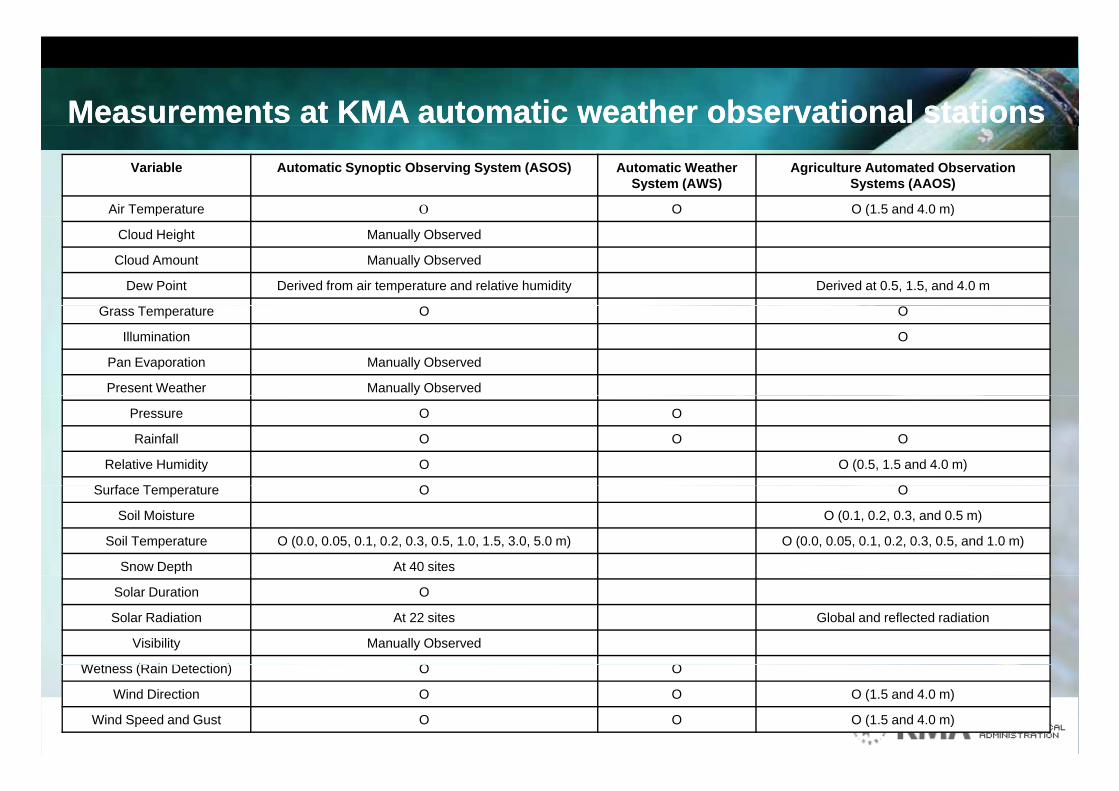
Measurements at KMA automatic weather observational stations Measurements at KMA automatic weather observational stations Variable Automatic Synoptic Observing System (ASOS) Automatic Weather
System (AWS)Agriculture Automated Observation
Systems (AAOS)
Air Temperature O O (1.5 and 4.0 m)p ( )
Cloud Height Manually Observed
Cloud Amount Manually Observed
Dew Point Derived from air temperature and relative humidity Derived at 0.5, 1.5, and 4.0 m
Grass Temperature O O
Illumination O
Pan Evaporation Manually Observed
Present Weather Manually Observed
Pressure O O
Rainfall O O O
Relative Humidity O O (0.5, 1.5 and 4.0 m)
S f T t O OSurface Temperature O O
Soil Moisture O (0.1, 0.2, 0.3, and 0.5 m)
Soil Temperature O (0.0, 0.05, 0.1, 0.2, 0.3, 0.5, 1.0, 1.5, 3.0, 5.0 m) O (0.0, 0.05, 0.1, 0.2, 0.3, 0.5, and 1.0 m)
Snow Depth At 40 sites
Solar Duration O
Solar Radiation At 22 sites Global and reflected radiation
Visibility Manually Observed
W t (R i D t ti ) O OWetness (Rain Detection) O O
Wind Direction O O O (1.5 and 4.0 m)
Wind Speed and Gust O O O (1.5 and 4.0 m)
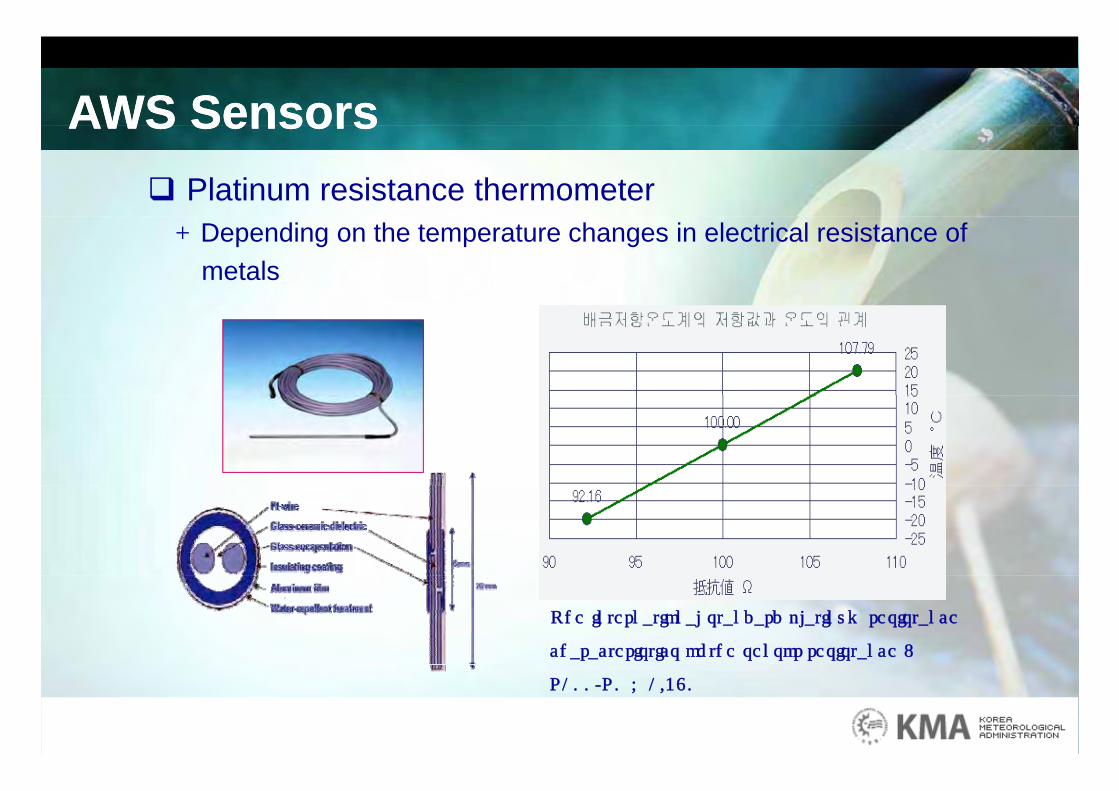
AWS SensorsAWS SensorsAWS SensorsAWS Sensors Platinum resistance thermometer- Depending on the temperature changes in electrical resistance of
metals
• The international standard platinum resistance
characteristics of the sensor resistance :
R100/R0 = 1.380
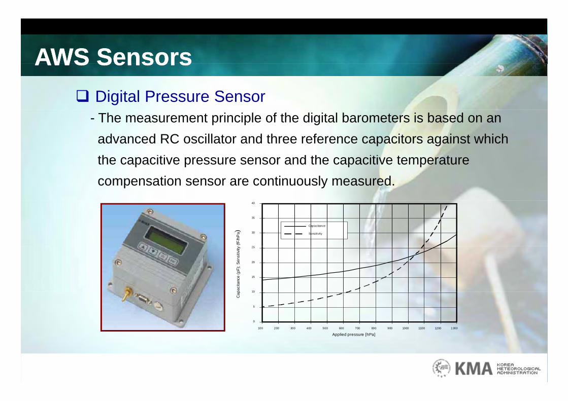
AWS SensorsAWS SensorsAWS SensorsAWS Sensors Digital Pressure Sensor
- The measurement principle of the digital barometers is based on an advanced RC oscillator and three reference capacitors against which th iti d th iti t tthe capacitive pressure sensor and the capacitive temperature compensation sensor are continuously measured.
2
30
35
40
Capacitance
Sensi tivity(fF
/hP
a)
10
15
20
25
paci
tanc
e (p
F); S
ensi
tivity
0
5
10
100 200 300 400 500 600 700 800 900 1000 1100 1200 1300
Cap
Applied pressure [hPa]
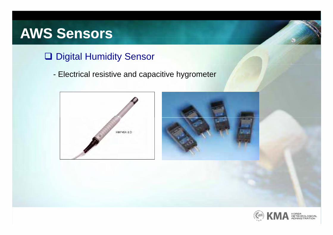
AWS SensorsAWS SensorsAWS SensorsAWS Sensors Digital Humidity Sensor
- Electrical resistive and capacitive hygrometer
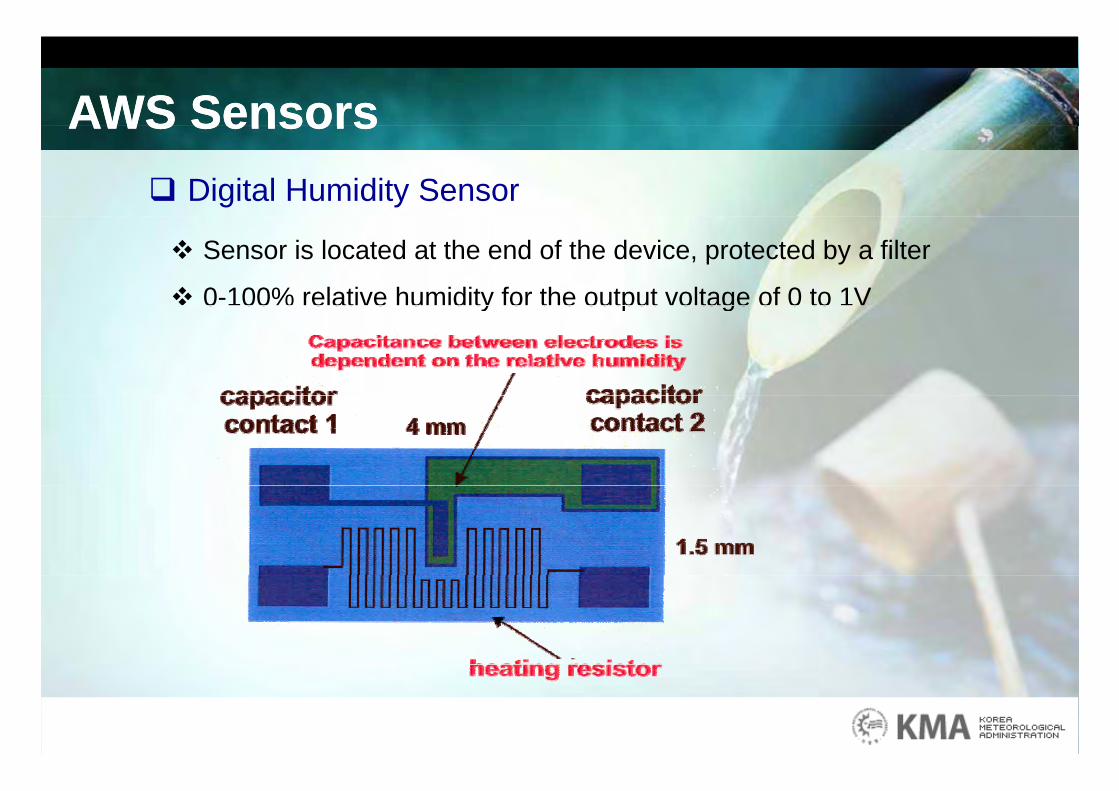
AWS SensorsAWS SensorsAWS SensorsAWS Sensors Digital Humidity Sensor
Sensor is located at the end of the device, protected by a filter
0-100% relative humidity for the output voltage of 0 to 1V 0 100% relative humidity for the output voltage of 0 to 1V
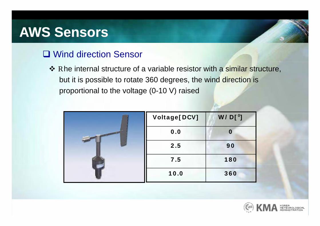
AWS SensorsAWS SensorsAWS SensorsAWS SensorsWind direction Sensor The internal structure of a variable resistor with a similar structure,
but it is possible to rotate 360 degrees, the wind direction is proportional to the voltage (0-10 V) raised
Voltage[DCV] W/D[⁰]
0.0 0
2.5 90
7.5 180
10.0 360
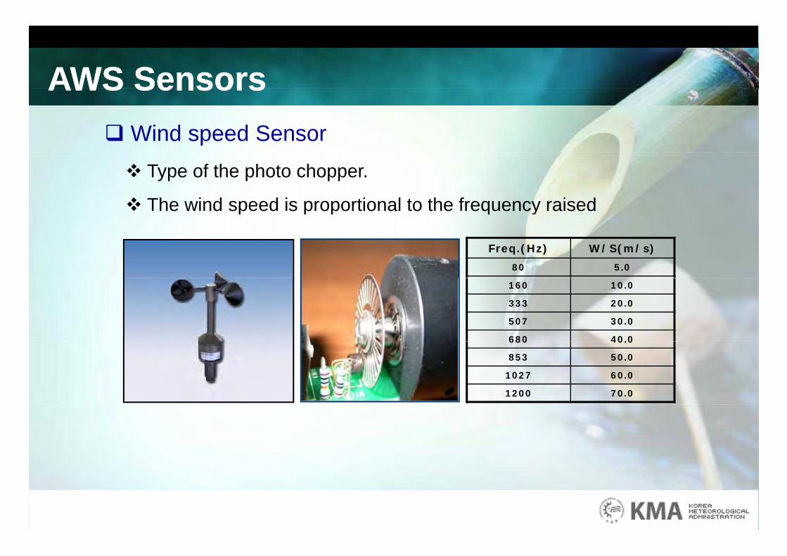
AWS SensorsAWS SensorsAWS SensorsAWS SensorsWind speed Sensor Type of the photo chopper.
The wind speed is proportional to the frequency raised
Freq.(Hz) W/S(m/s)
80 5.0
160 10.0
333 20.0
507 30.0
680 40.0680 40.0
853 50.0
1027 60.0
1200 70.0
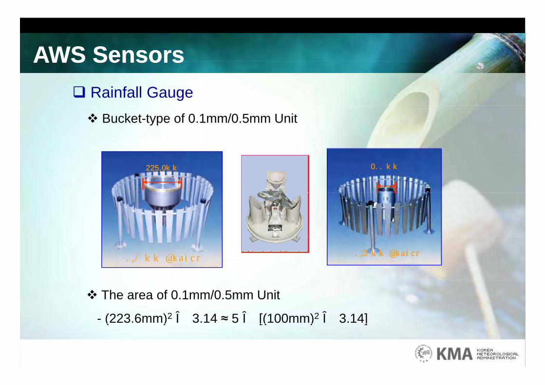
AWS SensorsAWS SensorsAWS SensorsAWS Sensors Rainfall Gauge Bucket-type of 0.1mm/0.5mm Unit
447.2mm 200 mm
0.1 mm Bucket 0.5 mm Bucket
The area of 0.1mm/0.5mm Unit
- (223.6mm)2ⅹ 3.14 ≈ 5 ⅹ [(100mm)2ⅹ 3.14] ( ) [( ) ]
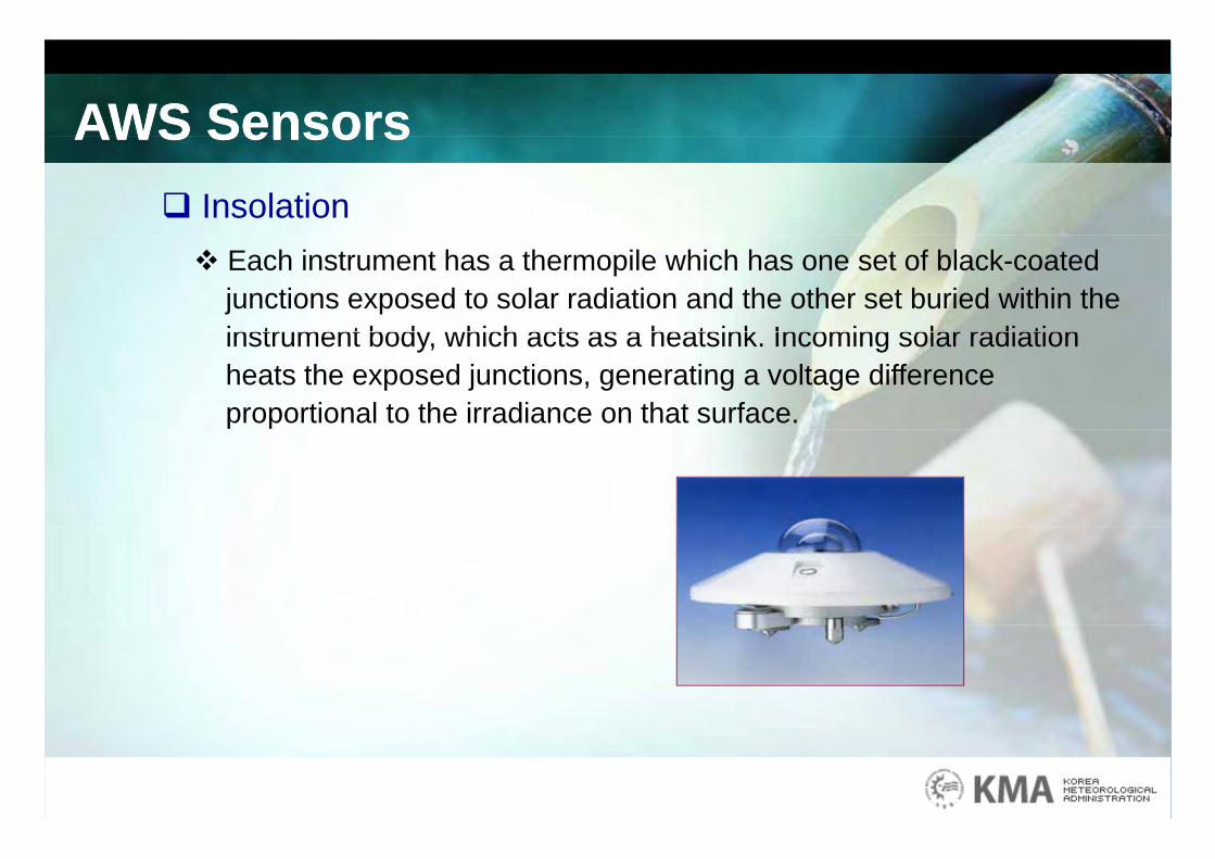
AWS SensorsAWS SensorsAWS SensorsAWS Sensors Insolation Each instrument has a thermopile which has one set of black-coated
junctions exposed to solar radiation and the other set buried within the instrument body which acts as a heatsink Incoming solar radiationinstrument body, which acts as a heatsink. Incoming solar radiation heats the exposed junctions, generating a voltage difference proportional to the irradiance on that surface.
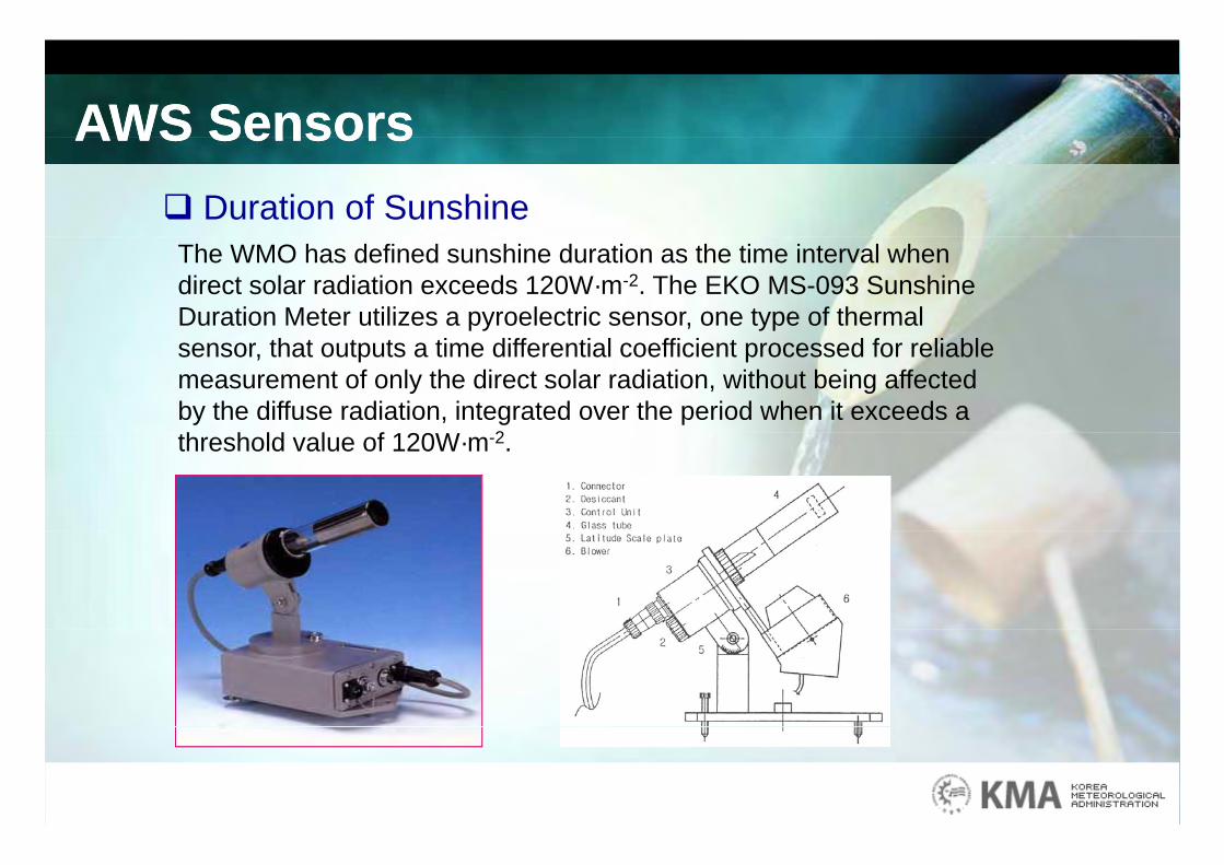
AWS SensorsAWS SensorsAWS SensorsAWS Sensors Duration of Sunshine
The WMO has defined sunshine duration as the time interval when direct solar radiation exceeds 120W·m-2. The EKO MS-093 Sunshine Duration Meter utilizes a pyroelectric sensor, one type of thermal sensor, that outputs a time differential coefficient processed for reliable measurement of only the direct solar radiation, without being affected by the diffuse radiation, integrated over the period when it exceeds a h h ld l f 120W 2threshold value of 120W·m-2.
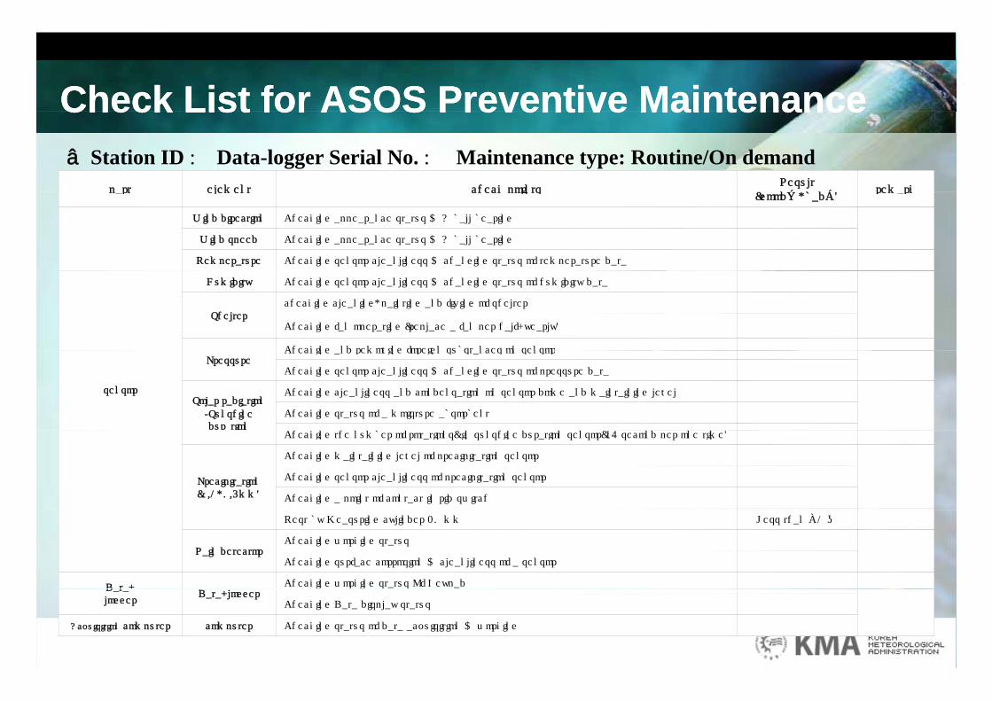
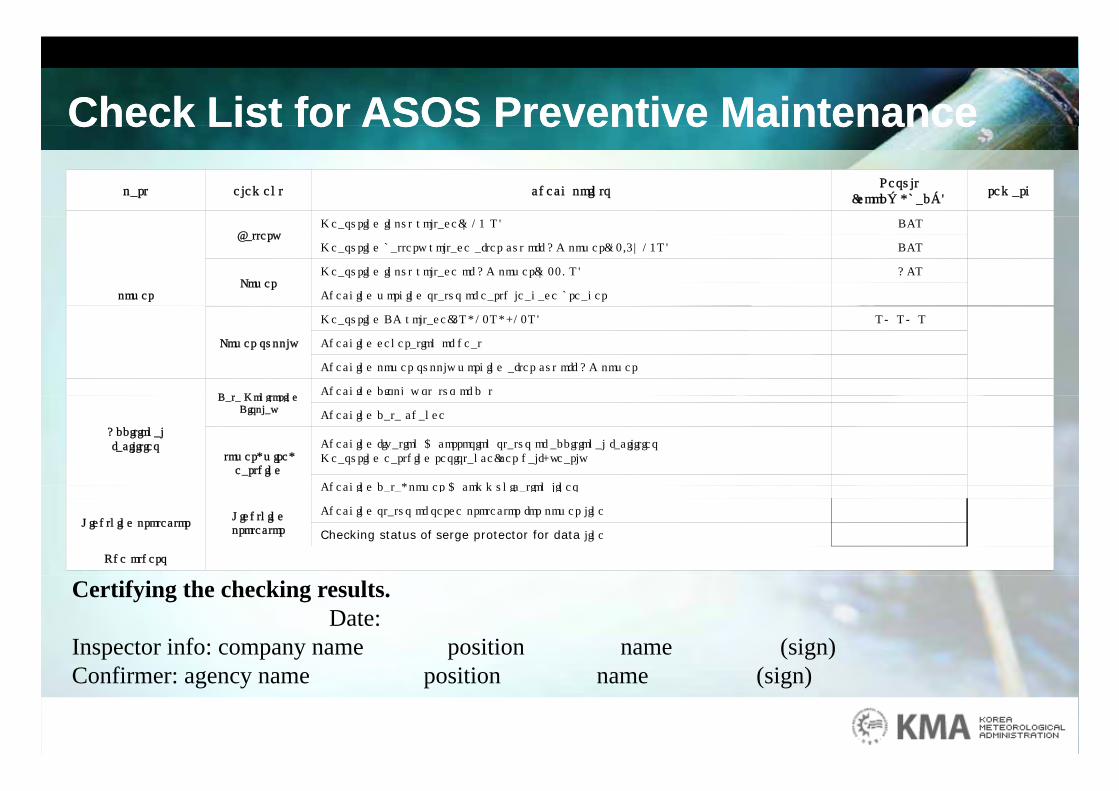
Check List for ASOS Preventive MaintenanceCheck List for ASOS Preventive MaintenanceCheck List for ASOS Preventive MaintenanceCheck List for ASOS Preventive Maintenance
part element check pointsResult
( d○ b d )remark
□ Station ID : Data-logger Serial No. : Maintenance type: Routine/On demandpart element check points
(good○, bad×)remark
Wind direction Checking appearance status & A ball bearing
Wind speed Checking appearance status & A ball bearing
Temperature Checking sensor cleanliness & changing status of temperature data
Humidity Checking sensor cleanliness & changing status of humidity data
Shelterchecking cleaning, painting and fixing of shelter
Checking fan operating (replace a fan per half-yearly)
Checking and removing foreign substances on sensor
sensor
PressureChecking and removing foreign substances on sensor
Checking sensor cleanliness & changing status of pressure data
Solar radiation/Sunshine duration
Checking cleanliness and condensation on sensor dome and maintaining level
Checking status of a moisture absorbent
C i i ( i i i (36 i )Checking the number of rotations( in sunshine duration sensor(36 second per one time)
Precipitation(0.1, 0.5mm)
Checking maintaining level of precipitation sensor
Checking sensor cleanliness of precipitation sensor
Checking a point of contact in rid switch
Test by Measuring cylinder 20 mm Less than ±1 ㎜
Rain detectorChecking working status
Checking surface corrosion & cleanliness of a sensor
Data- Checking working status Of KeypadDatalogger
Data-loggerChecking Data display status
Acquisition computer computer Checking status of data acquisition & working
Check List for ASOS Preventive MaintenanceCheck List for ASOS Preventive MaintenanceCheck List for ASOS Preventive MaintenanceCheck List for ASOS Preventive Maintenancepart element check points
Result(good○, bad×)
remark
power
BatteryMeasuring input voltage(~13 V) DCV
Measuring battery voltage after cut off AC power(12.5~13V) DCV
Power Measuring input voltage of AC power(~220V) ACV
Checking working status of earth leakage breaker
Power supply
Measuring DC voltage(5V, 12V, -12V) V/ V/ V
Checking generation of heat
Checking power supply working after cut off AC power
Data MonitoringChecking display status of data
Additionalfacilities
Data Monitoring Display
g p y
Checking data change
tower, wire, earthing
Checking fixation & corrosion status of additional facilitiesMeasuring earthing resistance(per half-yearly
Checking data power & communication linesChecking data, power & communication lines
Lightning protectorLightning protector
Checking status of serge protector for power line
Checking status of serge protector for data line
The others
Certifying the checking results.Date:
Inspector info: company name position name (sign)Confirmer: agency name position name (sign)

Upper-air Observationpp
Number of StationSokcho
Number of Station
- RBSN : 7Baengnyeongdo
Osan AB
- RBCN : 7
- GSN : 1
- Manned stations : 7Pohang
Heuksando
Gwangju AB
Gosan
Heuksando
RBSN(7)
RBCN(7)GUAN(1)GUAN(1)

Upper-air Observation
Sokcho R di d 7 it
ppCheolwon
Gangneung
Sokcho
WonjuMunsan
BaengnyeongdoRadiosonde : 7 sites
Wind profiler : 10 sites
Chupungnyeong
Osan
Bukgyeongnyeolbido
Uljin
Wind profiler : 10 sites
Radiometer : 9 sites
Gunsan
Pohang
Namwon ᄋ Resolution : 91kmᄋ Interval : 12h(radiosonde)
Gwangju
Haenam
Masan
ᄋ Interval : 12h(radiosonde)10min(Windprofiler)10min(Radiometer)
Heuksando
Gosan
Radionsonde(7)
Wind Profiler(10)
R di t (9)Gosan Radiometer(9)
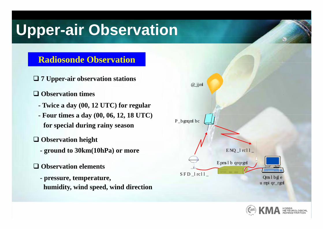
Upper-air Observation
Radiosonde Observation
pp
7 Upper-air observation stations
Radiosonde Observation
Ballon
Observation times
- Twice a day (00, 12 UTC) for regularFour times a day (00 06 12 18 UTC)- Four times a day (00, 06, 12, 18 UTC) for special during rainy season
Observation height
Radiosonde
Observation height- ground to 30km(10hPa) or more
Observation elements Ground ststion
GPS antenna
Observation elements
- pressure, temperature, humidity, wind speed, wind direction
UHF antennaSounding workstation

Upper-air ObservationZ
EWNWind profiler Observation
pp
Complements of the radiosondes 10 observation stations
EWS
10 observation stations Specifications
- Frequency : 1290MHz
HE
IGH
T
- Height resolution : 50 ~ 200 m- Antenna : Dipole Array
Range : 100 m ~ 5 kmTIME
H
- Range : 100 m ~ 5 km
Products
i i i i- Horizontal and vertical wind velocity
- Intensity of turbulence and precipitation
H i ht f t h i b d l l- Height of atmospheric boundary level
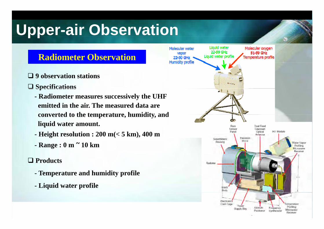
Upper-air ObservationRadiometer Observation
pp
9 observation stations Specifications Specifications
- Radiometer measures successively the UHF emitted in the air. The measured data areconverted to the temperature humidity andconverted to the temperature, humidity, andliquid water amount.
- Height resolution : 200 m(< 5 km), 400 m- Range : 0 m ~ 10 km
Products
- Temperature and humidity profile
- Liquid water profile
Upper-air Observation
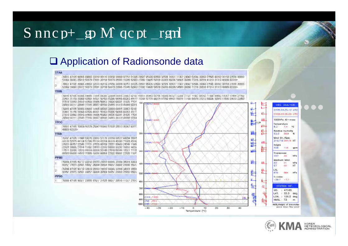
Application of Radionsonde data
pp
GAS Ch iGAS Charging
Preparing for flying
Flight and observation
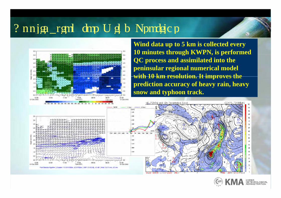
Application for Wind ProfilerApplication for Wind ProfilerWind data up to 5 km is collected every 10 minutes through KWPN, is performed10 minutes through KWPN, is performed QC process and assimilated into the peninsular regional numerical modelwith 10 km resolution It improves thewith 10 km resolution. It improves theprediction accuracy of heavy rain, heavy snow and typhoon track.
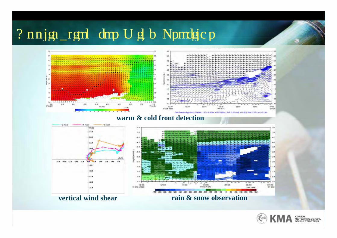
Application for Wind ProfilerApplication for Wind Profiler
warm & cold front detectionwarm & cold front detection
rain & snow observationvertical wind shear a & s ow obse vat overtical wind shear
Application for Radiometer
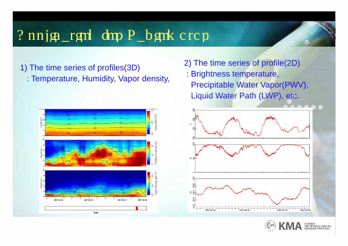
1) The time series of profiles(3D) 2) The time series of profile(2D)
Application for Radiometer
1) The time series of profiles(3D): Temperature, Humidity, Vapor density,
) p ( ): Brightness temperature,Precipitable Water Vapor(PWV), Liquid Water Path (LWP) etcLiquid Water Path (LWP), etc.
KMA Calibration SystemKMA Calibration SystemKMA Calibration System KMA Calibration System
C lib ti Calibration
- When the sensor is installed- After repaired- Regularlyegu a y· at the laboratory
* Temperature Pressure Humidity Wind direction/speed* Temperature, Pressure, Humidity, Wind direction/speed,
Solar duration/radiation, Rain, Evaporation, Data-logger
· at the field (On-site intercomparisons) at the field (On site intercomparisons)
* Temperature, Rain, and Wind sensors, etc.
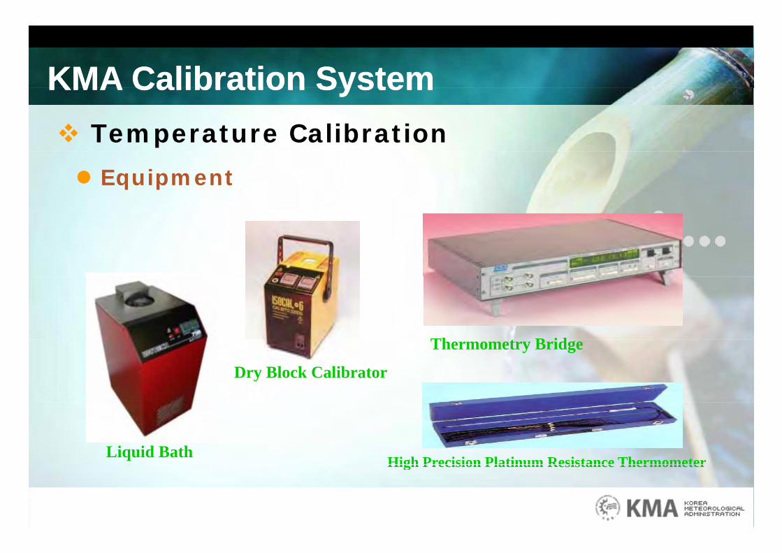
KMA Calibration SystemKMA Calibration SystemKMA Calibration System KMA Calibration System Temperature Calibration
Equipment
Th t B id
Dry Block Calibrator
Thermometry Bridge
Liquid Bath High Precision Platinum Resistance ThermometerHigh Precision Platinum Resistance Thermometer
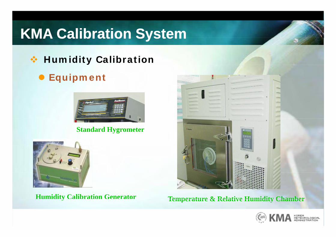
KMA Calibration SystemKMA Calibration SystemKMA Calibration System KMA Calibration System Humidity Calibration
Equipment
Standard Hygrometer
Temperature & Relative Humidity ChamberHumidity Calibration Generator Temperature & Relative Humidity Chambery
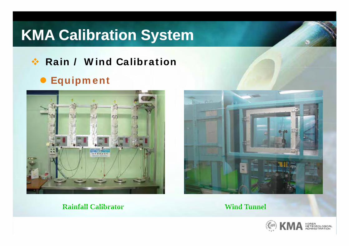
KMA Calibration SystemKMA Calibration SystemKMA Calibration System KMA Calibration System Rain / Wind Calibration
Equipment
Rainfall Calibrator Wind TunnelRainfall Calibrator Wind Tunnel
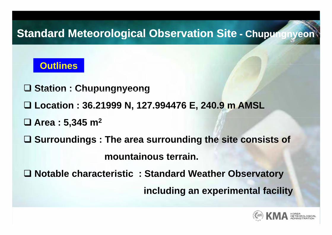
Standard Meteorological Observation Site - ChupungnyeonStandard Meteorological Observation Site - Chupungnyeong p g yg p g y
OutlinesOutlines
Station : Chupungnyeong Station : Chupungnyeong
Location : 36.21999 N, 127.994476 E, 240.9 m AMSL
Area : 5,345 m2
Surroundings : The area surrounding the site consists of g g
mountainous terrain.
N t bl h t i ti St d d W th Ob t Notable characteristic : Standard Weather Observatory
including an experimental facility
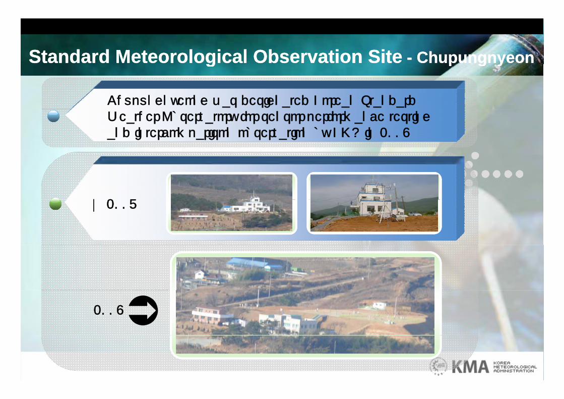
Standard Meteorological Observation Site - ChupungnyeonStandard Meteorological Observation Site - Chupungnyeon
Chupungnyeong was designated Korean Standard
g p g yg p g y
Weather Observatory for sensor performance testingand intercomparison observation by KMA in 2008
2007~ 2007
2008
Standard Meteorological Observation Site - ChupungnyeonStandard Meteorological Observation Site - Chupungnyeon
Pit Gauge [Precipitation Reference]Pit Gauge [Precipitation Reference]
g p g yg p g y
Pit Gauge [Precipitation Reference]Pit Gauge [Precipitation Reference]
TypeType Vibrating wire load sensorVibrating wire load sensorCollection areaCollection area 200 200 ㎠㎠ResolutionResolution 0.1 mm0.1 mm
Precipitation Reference Standard (2 ea)Precipitation Reference Standard (2 ea)
Resolution Resolution 0.1 mm 0.1 mm ModeModel T200l T200--B(Geonor, Norway)B(Geonor, Norway)
Precipitation Reference Standard (2 ea)Precipitation Reference Standard (2 ea)
TypeType Tipping bucketTipping bucketCollection areaCollection area 314314 ㎠㎠
i i i W ki S d d (2 )i i i W ki S d d (2 )
Collection areaCollection area 314314 ㎠㎠ResolutionResolution 0.5 mm 0.5 mm
Precipitation Working Standard (2 ea)Precipitation Working Standard (2 ea)
Standard Meteorological Observation Site - ChupungnyeonStandard Meteorological Observation Site - Chupungnyeon
DFIRDFIR (Double Fence Inter(Double Fence Inter comparison Reference)comparison Reference)
g p g yg p g y
DFIR DFIR (Double Fence Inter(Double Fence Inter--comparison Reference)comparison Reference)
TypeType Weight (load cell)Weight (load cell)Collection areaCollection area 200 cm2200 cm2Resolution Resolution 0.1 mm 0.1 mm M dM d l Pl i 2(OTT G )l Pl i 2(OTT G )
S f ll R f St d dS f ll R f St d d
ModeModel Pluvio2(OTT, Germany)l Pluvio2(OTT, Germany)
Snowfall Reference StandardSnowfall Reference Standard
Standard Meteorological Observation Site - ChupungnyeonStandard Meteorological Observation Site - Chupungnyeon
Radiation MeasurementRadiation Measurement
g p g yg p g y
Radiation MeasurementRadiation Measurement
TypeType Absolute PyrheliometerAbsolute PyrheliometerISO lebelISO lebel Primary StandardPrimary StandardModeModel PMO_6(WRC, Swiss)l PMO_6(WRC, Swiss)
TypeType Thermistor sensor, PyranometerThermistor sensor, Pyranometer
ISO lebelISO lebel Secondary StandardSecondary Standard
Radiation Reference Standard (Radiation Reference Standard (2 2 ea)ea)
yyModeModel l CMP21(Kipp & Zonen, Netherland)CMP21(Kipp & Zonen, Netherland)
TypeType Thermisor sensor, PyrheliometerThermisor sensor, PyrheliometerISO lebelISO lebel First Class(CHP1)First Class(CHP1)
Radiation Working StandardRadiation Working Standard
Standard Meteorological Observation Site - ChupungnyeonStandard Meteorological Observation Site - Chupungnyeon
Precipitation windshield performance testingPrecipitation windshield performance testing
g p g yg p g y
Precipitation windshield performance testingPrecipitation windshield performance testing
Standard Meteorological Observation Site - BoseongStandard Meteorological Observation Site - Boseong
Outlines
g gg g
Outlines
Station : Boseong Station : Boseong
Location : 34.7633 N, 127.2123 E, 2.8 m AMSL
Area : 135,000 m2
Surroundings : The site is a flatland surrounded by g y
agricultural land, facing the South Sea
N t bl h t i ti St d d W th Ob t Notable characteristic : Standard Weather Observatory
including an experimental facility

Standard Meteorological Observation Site - BoseongStandard Meteorological Observation Site - Boseongg gg g
Standard Meteorological Observation Site - BoseongStandard Meteorological Observation Site - Boseongg gg g
Joint Weather StationJoint Weather Station
Standard Meteorological Observation Site - BoseongStandard Meteorological Observation Site - Boseongg gg g
Tower
Radiation
Wind
Temperature/Humidity
Aerosol300m
AutoSondeVisibility A S
ASOS
CO2
Wind profiler
MWR
MRR
ySensor
ORG
PARSIVEL
Underground temp/moist Flat farmland (rice)
~ 1km
Sea Levelp
Sea Level
Standard Meteorological Observation Site - BoseongStandard Meteorological Observation Site - Boseongg gg g
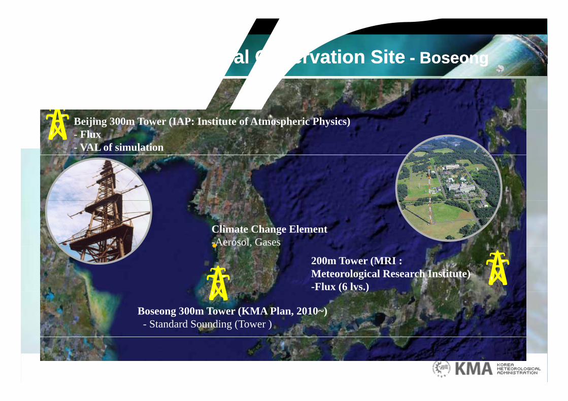
종합기상관측타워 설치Beijing 300m Tower (IAP: Institute of Atmospheric Physics)- Flux- VAL of simulation
Climate Change Element-Aerosol, Gases
200m Tower (MRI : Meteorological Research Institute)-Flux (6 lvs.)
,
Boseong 300m Tower (KMA Plan, 2010~)- Standard Sounding (Tower )
( )
일본 MRI 타워 중국IAP 타워
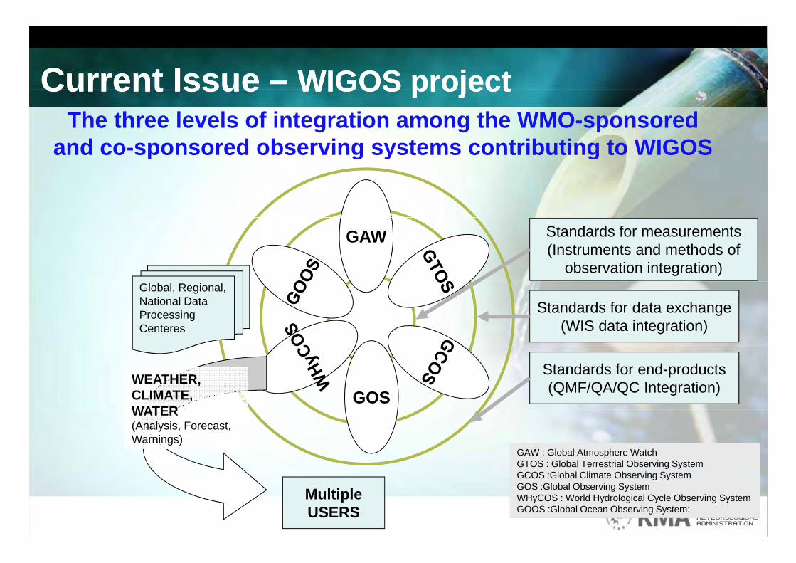
Current Issue – WIGOS projectCurrent Issue – WIGOS projectCurrent Issue WIGOS projectCurrent Issue WIGOS projectThe three levels of integration among the WMO-sponsored
and co-sponsored observing systems contributing to WIGOSand co sponsored observing systems contributing to WIGOS
GAW Standards for measurements(Instruments and methods of
observation integration)Global, Regional, National Data Processing Centeres
Standards for data exchange(WIS data integration)
GOSWEATHER,CLIMATE, WATER
Standards for end-products(QMF/QA/QC Integration)
WATER(Analysis, Forecast, Warnings)
GAW : Global Atmosphere WatchGTOS : Global Terrestrial Observing SystemGCOS Gl b l Cli t Ob i S t
MultipleUSERS
GCOS :Global Climate Observing System GOS :Global Observing System WHyCOS : World Hydrological Cycle Observing System GOOS :Global Ocean Observing System:
Current Issue – WIGOS projectCurrent Issue – WIGOS projectCurrent Issue WIGOS projectCurrent Issue WIGOS project
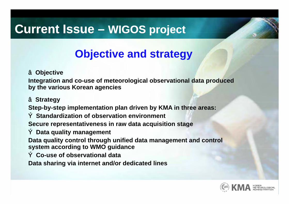
Objective and strategyObjective and strategy□ ObjectiveI t ti d f t l i l b ti l d t d dIntegration and co-use of meteorological observational data produced by the various Korean agencies
□ StrategygyStep-by-step implementation plan driven by KMA in three areas:○ Standardization of observation environmentSecure representativeness in raw data acquisition stageSecure representativeness in raw data acquisition stage ○ Data quality management Data quality control through unified data management and control system according to WMO guidancesystem according to WMO guidance○ Co-use of observational dataData sharing via internet and/or dedicated lines
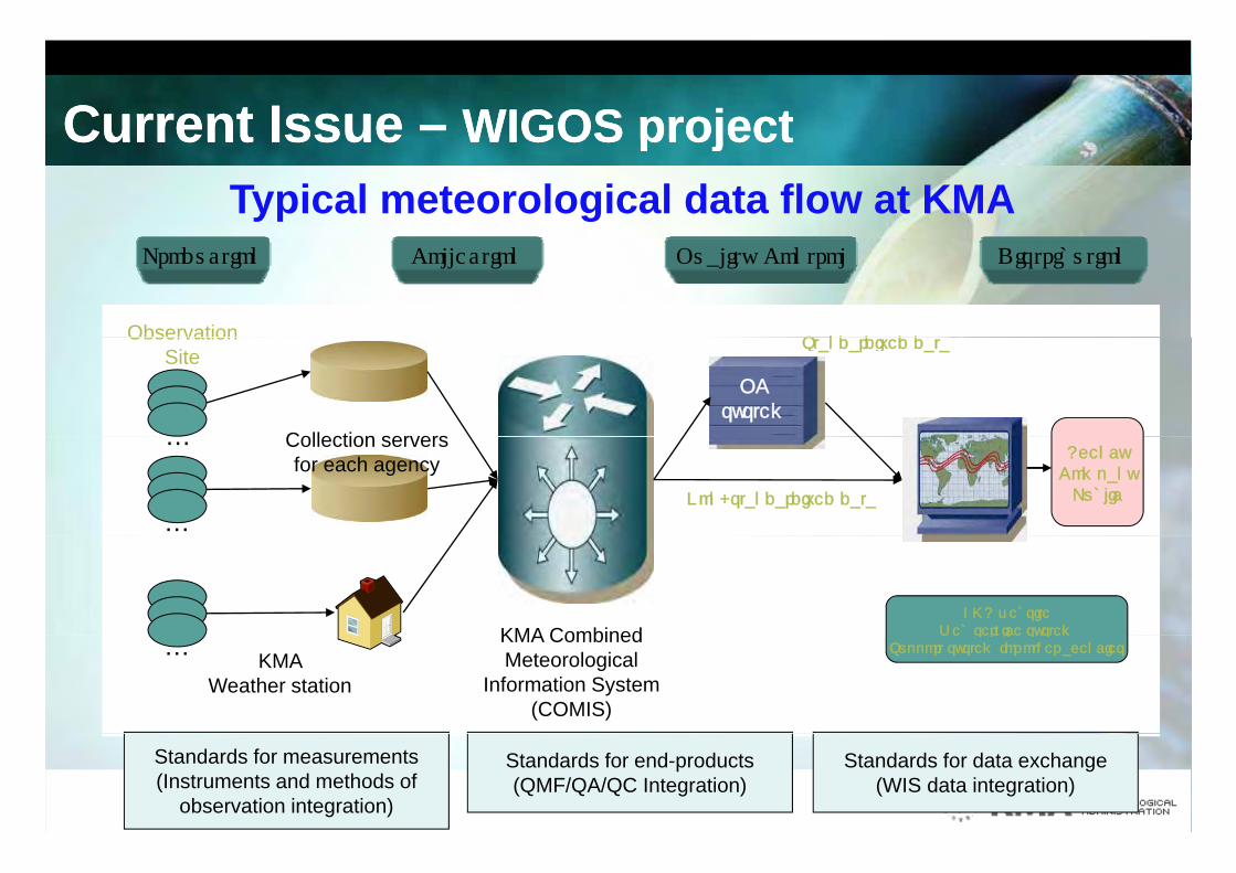
Current Issue – WIGOS projectCurrent Issue – WIGOS projectCurrent Issue WIGOS projectCurrent Issue WIGOS projectTypical meteorological data flow at KMA
Production Collection Quality Control Distribution
St d di d d tObservation
Collection servers
Standardized data
QCsystem
ObservationSite
AgencyCompanyPublic
Collection serversfor each agency
…
…Non-standardized data
KMA websiteWeb service systemKMA Combined Web service system
Support system for other agencies… KMA Weather station
KMA Combined Meteorological
Information System(COMIS)
Standards for measurements(Instruments and methods of
observation integration)
Standards for end-products(QMF/QA/QC Integration)
Standards for data exchange(WIS data integration)
Current Issue – WIGOS projectCurrent Issue – WIGOS projectCurrent Issue WIGOS projectCurrent Issue WIGOS project
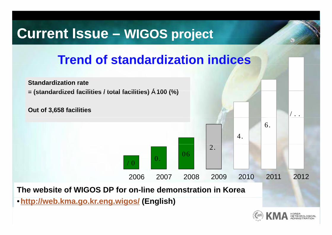
Trend of standardization indicesStandardization rate= (standardized facilities / total facilities) ×100 (%)
100
= (standardized facilities / total facilities) ×100 (%)
Out of 3,658 facilities
60
80
1220
2840
2006 2007 2008 2009 2010 2011 2012
The website of WIGOS DP for on-line demonstration in Korea•http://web.kma.go.kr.eng.wigos/ (English)
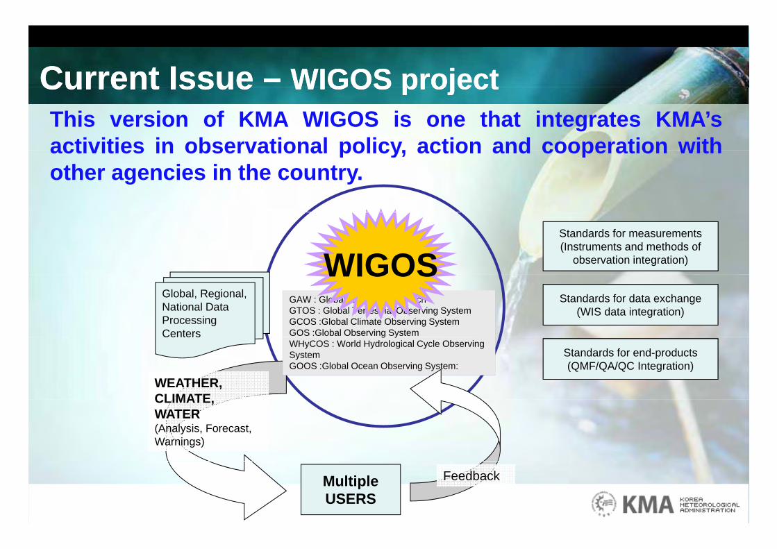
Current Issue – WIGOS projectCurrent Issue – WIGOS projectCurrent Issue WIGOS projectCurrent Issue WIGOS projectThis version of KMA WIGOS is one that integrates KMA’sactivities in observational policy action and cooperation withactivities in observational policy, action and cooperation withother agencies in the country.
Standards for measurements(Instruments and methods of
observation integration)WIGOSGlobal, Regional, National Data Processing Centers
Standards for data exchange(WIS data integration)
GAW : Global Atmosphere WatchGTOS : Global Terrestrial Observing SystemGCOS :Global Climate Observing System GOS :Global Observing System
WIGOS
WEATHER,CLIMATE
Centers
Standards for end-products(QMF/QA/QC Integration)
g yWHyCOS : World Hydrological Cycle Observing System GOOS :Global Ocean Observing System:
CLIMATE, WATER(Analysis, Forecast, Warnings)
MultipleUSERS
Feedback
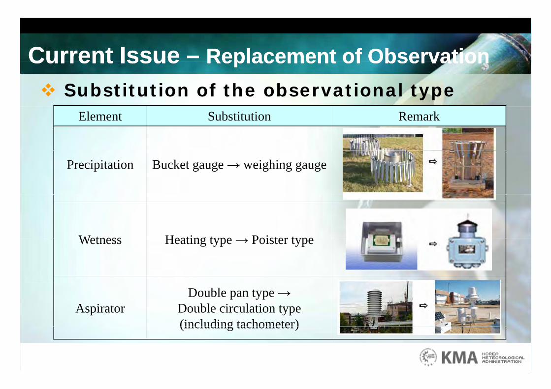
Current Issue – Replacement of ObservationCurrent Issue – Replacement of ObservationCurrent Issue Replacement of ObservationCurrent Issue Replacement of Observation Substitution of the observational type
Element Substitution Remark
Precipitation Bucket gauge → weighing gauge
Wetness Heating type → Poister typeWetness Heating type → Poister type
Aspirator Double pan type →
Double circulation type (including tachometer)(including tachometer)
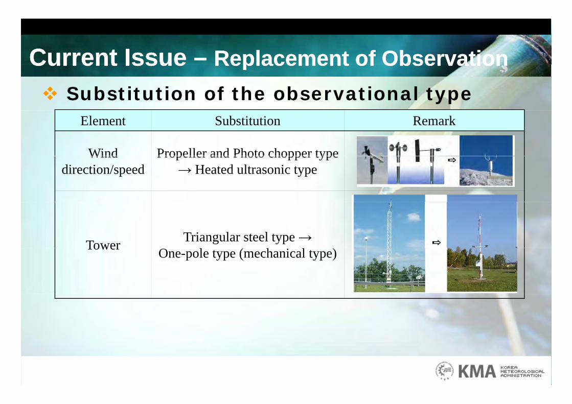
Current Issue – Replacement of ObservationCurrent Issue – Replacement of ObservationCurrent Issue Replacement of ObservationCurrent Issue Replacement of Observation Substitution of the observational type
Element Substitution Remark
Wind Propeller and Photo chopper typeWind direction/speed
Propeller and Photo chopper type → Heated ultrasonic type
Tower Triangular steel type →Tower One-pole type (mechanical type)
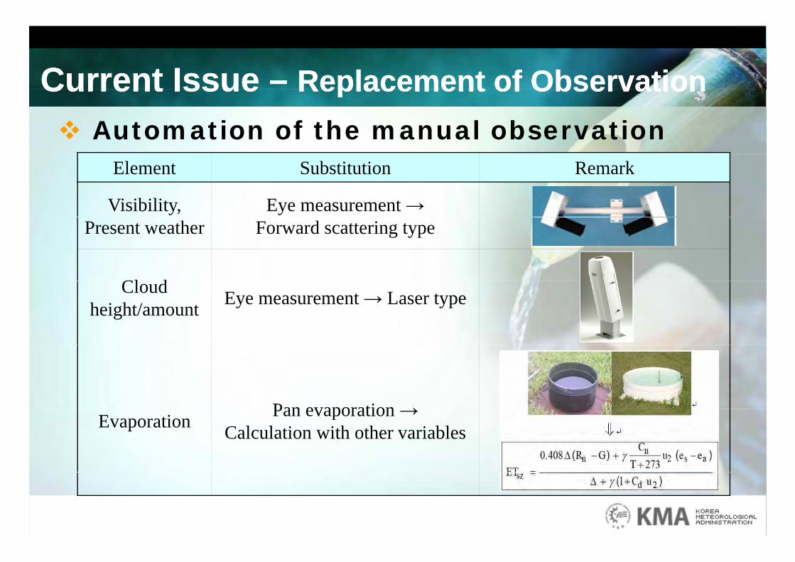
Current Issue – Replacement of ObservationCurrent Issue – Replacement of ObservationCurrent Issue Replacement of ObservationCurrent Issue Replacement of Observation Automation of the manual observation
Element Substitution Remark
Visibility, Eye measurement →Present weather Forward scattering type
Cl dCloud height/amount Eye measurement → Laser type
Pan evaporation →Evaporation Pan evaporation →Calculation with other variables
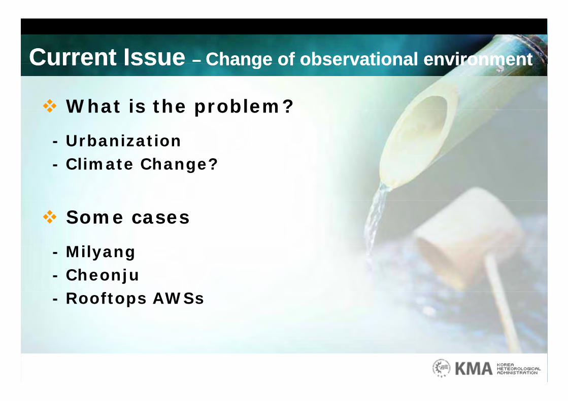
Current Issue – Change of observational environmentCurrent Issue – Change of observational environmentCurrent Issue Change of observational environmentCurrent Issue Change of observational environment
What is the problem? What is the problem?
- Urbanization- Climate Change?
Some cases
Mil- Milyang- Cheonju
f- Rooftops AWSs
Current Issue – Change of observational environmentCurrent Issue – Change of observational environmentCurrent Issue Change of observational environmentCurrent Issue Change of observational environment
Milyang case
- Recorded the highest temperature in the summer
of 2005 in Korea
- The request of Milyang citizenThe request of Milyang citizen
* Cause : The construction of large roadways and marts near
the Milyang weather station in January 2005
* Request : The relocation of the station
Why? Taking dishonor for the hottest city in Korea
→ Not coming to Milyang for tour in the summer→ Not coming to Milyang for tour in the summer

Current Issue – Change of observational environmentCurrent Issue – Change of observational environmentCurrent Issue Change of observational environmentCurrent Issue Change of observational environment
Milyang case
- The action of the KMA* Notify the relocation is not allowed due to the continuity of Notify the relocation is not allowed due to the continuity of
observational data, especially for climatology
* Suggest the intercomparison with new temperatures atgg p p
other places in Milyang.
- Results* The almost similar result! The temperature is the highest!
→ Not only the construction of roadways and marts,but also the urbanization of the city including climate change
- Then, will we relocate the station to other proper place? If we should do, why?

Current Issue – Change of observational environmentCurrent Issue – Change of observational environmentCurrent Issue Change of observational environmentCurrent Issue Change of observational environment
Cheonju case
- The area near the Cheonju station was designated to the new developmental districtto the new developmental district
- The request of Cheonju citizen* The relocation of the station* The relocation of the station
Why? Property infringement→ No construction of high buildings near the station, No construction of high buildings near the station,
because of the protection of the observation, especially wind* KMA has gone to efforts to ensure proper siting the
station. KMA has sending the document to the local
government about the prevention of building developments
near the station at the beginning of every yearnear the station at the beginning of every year
Current Issue – Change of observational environmentCurrent Issue – Change of observational environmentCurrent Issue Change of observational environmentCurrent Issue Change of observational environment
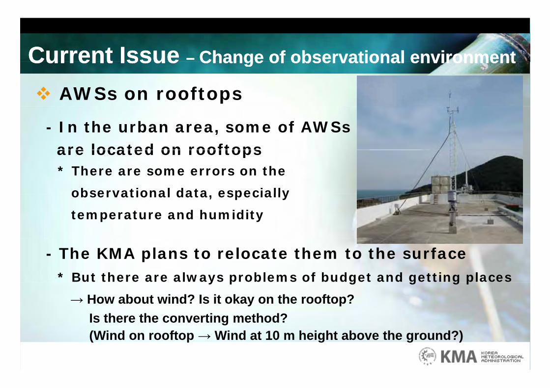
AWSs on rooftops
- In the urban area, some of AWSsare located on rooftops are located on rooftops * There are some errors on the
observational data especially observational data, especially
temperature and humidity
- The KMA plans to relocate them to the surface* But there are always problems of budget and getting placesy p g g g p
→ How about wind? Is it okay on the rooftop?Is there the converting method?(Wind on rooftop → Wind at 10 m height above the ground?)
Current Issue – Change of observational environmentCurrent Issue – Change of observational environmentCurrent Issue Change of observational environmentCurrent Issue Change of observational environment
Relocation of the observation stations Relocation of the observation stations
- Should the station relocate at outside of city for the synoptic observation? * It is different between urban and synoptic observation
- Is it okay to separate automatic and manual observation at different places?observation at different places?* What is the proper distance between the both?
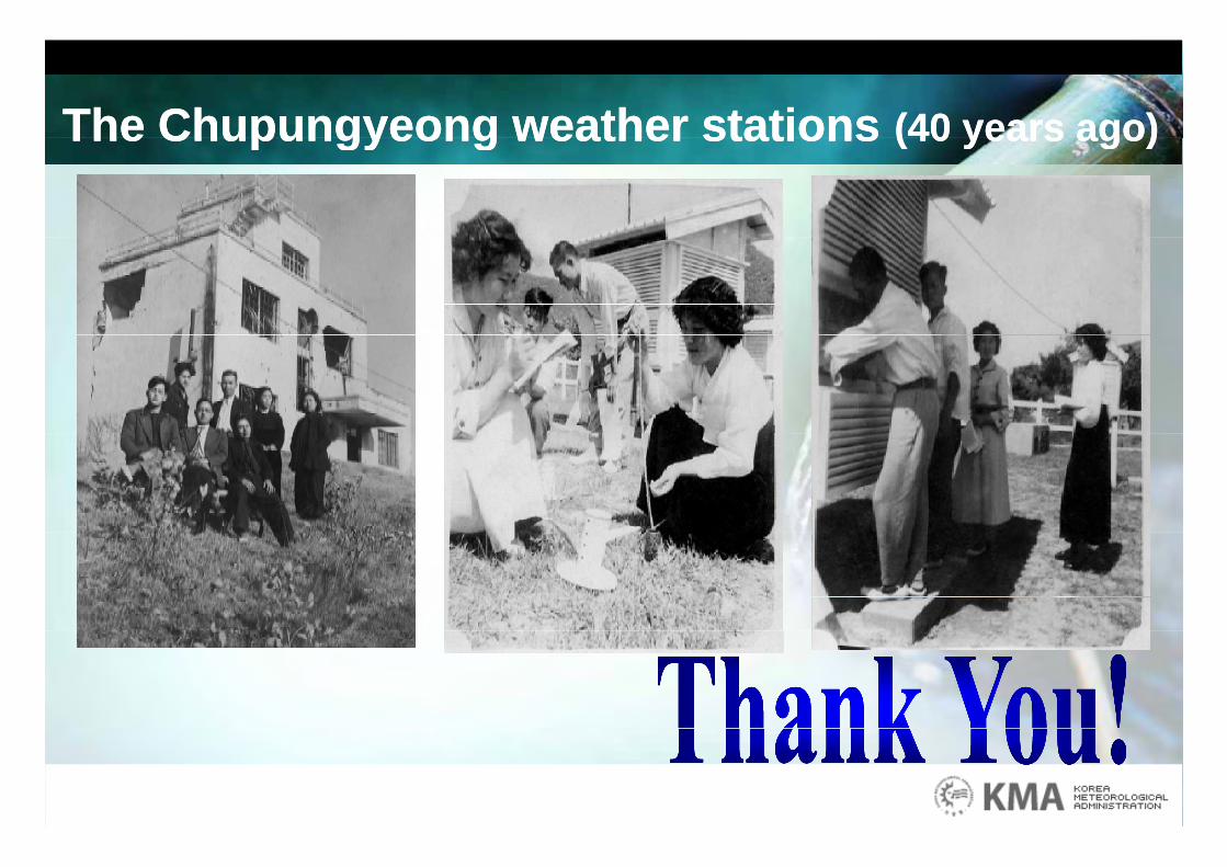
The Chupungyeong weather stations (40 years ago)The Chupungyeong weather stations (40 years ago)The Chupungyeong weather stations (40 years ago)The Chupungyeong weather stations (40 years ago)