Embed Size (px)
Citation preview
CEQR TECHNICAL MANUAL 8 - 1 JANUARY 2012 EDITION
SHADOWS
CHAPTER 8
Within urban environments, the structures constituting the city’s built fabric constantly cast shadows in their imme-diate vicinity. As the city develops and redevelops, the extent and duration of the shadows cast are altered. As this process continues, direct sunlight exposure becomes an increasingly scarce resource for people and nature. This chap-ter focuses on the interaction between proposed new and altered structures and the shadows they may cast on open space, historic and cultural resources and natural areas.
Sunlight and shadows affect people and their use of open space all day long and throughout the year, although the ef-fects vary by season. Sunlight can entice outdoor activities, support vegetation, and enhance architectural features, such as stained glass windows and carved detail on historic structures. Conversely, shadows can affect the growth cycle and sustainability of natural features and the architectural significance of built features.
The purpose of this chapter is to assess whether new structures may cast shadows on sunlight sensitive publicly-accessible resources or other resources of concern such as natural resources, and to assess the significance of their im-pact. Potential mitigation strategies and alternatives are also presented and should be examined when significant ad-verse shadow impacts are identified. Because of the sunlight-sensitive nature of many open spaces, historic, cultural, and natural resources, this chapter is closely linked to the data and analyses from Chapter 7, “Open Space,” Chapter 9, “Historic and Cultural Resources,” and Chapter 11, “Natural Resources.”
The majority of projects subject to CEQR do not require a detailed shadow analysis. Section 200 describes the first tier of analysis to screen most projects for the purpose of assessing shadow impacts. As with each technical area assessed under CEQR, it is important for an applicant to work closely with the lead agency during the entire environmental re-view process. As appropriate, the lead agency may determine it is appropriate to consult or coordinate with the city’s expert technical agencies for a particular project. Here, the New York City Department of City Planning (DCP) should be consulted for information, technical review, and recommendations relating to shadows. With regard to mitigation, the New York City Landmarks Preservation Commission (LPC), the New York City Department of Environmental Protection (DEP), and the New York City Department of Parks and Recreation (DPR) may also be of assistance. As needed by the consultation, it is recommended that these expert agencies be contacted as early as possible in the environmental re-view process. Section 700 further outlines appropriate coordination with these expert agencies.
SHADOW. A shadow is the condition that results when a building or other built structure blocks the sunlight that would otherwise directly reach a certain area, space or feature.
INCREMENTAL SHADOW. An incremental shadow is the additional, or new, shadow that a building or other built structure resulting from a proposed project would cast on a sunlight-sensitive resource during the year.
SUNLIGHT-SENSITIVE RESOURCES OF CONCERN. The sunlight-sensitive resources of concern are those resources that de-pend on sunlight or for which direct sunlight is necessary to maintain the resource’s usability or architectural inte-grity. The following are considered to be sunlight-sensitive resources:
PUBLIC OPEN SPACE. All public open space as identified in Chapter 7, “Open Space” (e.g. parks, beaches, playgrounds, plazas, schoolyards, greenways, landscaped medians with seating).
ARCHITECTURAL RESOURCES. Architectural resources are those features of architectural resources identi-fied in Chapter 9, “Historic and Cultural Resources,” that depend on direct sunlight for their enjoy-
100. DEFINITIONS
2012
SHADOW.SHAD A shA would othewould o
INCREMREM
2strustru
TIONSTIONS2 Techn
ical the dhe
“Natural Restural Re
ot require a detequire a depurpose of asseurpose of asse
cant to work cloo work cld agency may dgency may
ticular project.ticular project.nical review, anl review, an
eservation Comvation CoCity Departmeny Departme
mmended that mmended thon 700 further oon 700 further o
Manua
lsh
d throughout troughout ation, and enha, and enh
nversely, shadosely, shadof built featurebuilt feature
es may cast shmay cast ural resources, al resources,
o presented ano presented anht-sensitive ht-sensitive
and aand a
Oute d
SHADOW.DOW resulting fromulting from
GHT-SENSITIVE REGHT-SENSITIVE R
nd on sunlight on sunligThe folloThe follo
ofis the conditithe condiectly reach tly reac f
n i
f Date
on (LPCarks and Recarks and Re
expert agenciepert agencies appropriate cppropriate
D
- datidatthe Nth
DO shadow anahadow anshadow impactshadow impa
with the lead awith the lead ae it is approe it is app
York C York C
NOTs on sunlight on sunligo assess the signassess the sig
ould be examineould be exame of many openf many openfrom Chaptefrom Chapt
USEhis chahis cha
ast on open t on open
ar, although ther, although tarchitectural fearchitectural feffect the groffect the g
CEQR TECHNICAL MANUAL 8 - 2 JANUARY 2012 EDITION
SHADOWS
ment by the public. Only the features that are sunlight-sensitive (described below) should be consi-dered, as opposed to the entire architectural resource:
Buildings containing design elements that are part of a recognized architectural style that de-pends on the contrast between light and dark design elements (e.g. deep recesses or voids such as open galleries, arcades, recessed balconies, deep window reveals, and prominent rustication).
Buildings distinguished by elaborate, highly carved ornamentation.
Buildings with stained glass windows.
Exterior materials and color that depend on direct sunlight for visual character (e.g. the po-lychromy (multicolored) features found on Victorian Gothic Revival or Art Deco facades).
Historic landscapes, such as scenic landmarks including vegetation recognized as an historic feature of the landscape (e.g. weeping beeches or pansy beds).
Features in structures where the effect of direct sunlight is described as playing a significant role in the structure’s significance as an historic landmark. Examples include the William Les-caze House and Office, 211 E. 48 St. in Manhattan, significant as the first modern (1933) row-house in New York, noted for its early use of glass block, glass bricks, and ribbon windows (LPC and S/NR listed), and LPC designated housing projects such as the Williamsburg Houses in Brooklyn and the Cherokee Apartments in Manhattan, both of which were planned to maximize light by use of site planning and architectural features, such as open stair towers and balconies.
NATURAL RESOURCES. Natural resources identified in Chapter 11, “Natural Resources,” where the intro-duction of shadows may alter the resource’s condition or microclimate:
Surface water bodies.
Wetland resources.
Upland resources.
Significant, sensitive or designated resources; such as coastal fish and wildlife habitats.
OTHER RESOURCES.
Greenstreets (planted areas within the unused portions of roadbeds that are part of the Greenstreets program).
NON SUNLIGHT-SENSITIVE RESOURCES. For the purposes of CEQR the following are not considered to be sunlight-sensitive resources and their assessment for shadow impacts is not required:
City streets and sidewalks (except when improved as part of a greenstreet).
Buildings or structures other than those defined above.
Private open space as defined in Chapter 7, “Open Space” (e.g. not publicly accessible private open space, front and back yards, stoops, vacant lots).
Project-generated open space. Shadows on project-generated open space are not considered significant under CEQR. However, when the condition of the project-generated open space is included as part of the qualitative open space analysis in Chapter 7, “Open Space,” a discussion of how shadows would af-fect the new space may be warranted.
SHADOW IMPACT. In general, a significant adverse shadow impact occurs when the incremental shadow added by a proposed project falls on a sunlight-sensitive resource and substantially reduces or completely eliminates direct
2012
GGrere
ON SUNLIGHT-SESUNLIGHT-SE
sensitive resosensitive res
Techn
icalgn
Apartmeartmplanning andnning and
ources identifieurces identifieer the resource’he resource’
odies. es.
sources. rces.
d resources. sources.
gnificant, sensitgnificant, sen
ESOURCES.ESOURCES
enstr
Manua
lr visual chual cRevival or Art Dval or Art
g vegetation recgetation reansy beds). y beds)
t sunlight is desnlight is deoric landmark. Eoric landmark.
nhattan, signifiattan, signifiuse of glass buse of glass bd housing d housin
in in
Outtreetseets
Buildings or strngs or str
Private opePrivate ope space, froce
ProjeProje
of ts ts
E RESOURCESOUR
and their assed their ass
d sidewd sidew
Date
r designated resgnated res
planted areas planted areas ogram). ogram).
FoF
- DO cturactur
Chapter 11, “NaChapter 11, “Ndition or microcdition or micro
NOTd as playind as plles include theles include t
as the first modethe first modglass bricks, anglass bricks, a
cts such as the cts such as the an, both of an, both of
atures,atur
USEg.g. the p the po-o-acades). cades).
ed as an histored as an histo
CEQR TECHNICAL MANUAL 8 - 3 JANUARY 2012 EDITION
SHADOWS
sunlight exposure, thereby significantly altering the public’s use of the resource or threatening the viability of ve-getation or other resources. Each case must be considered on its own merits based on the results of the shadow assessment (Section 300) and the guidance provided in Section 400, “Assessment of Shadow Impacts.”
The shadow assessment considers projects that result in new shadows long enough to reach a sunlight-sensitive re-source. Therefore, a shadow assessment is required only if the project would either result in (a) new structures (or ad-ditions to existing structures including the addition of rooftop mechanical equipment) of 50 feet or more or (b) be lo-cated adjacent to, or across the street from, a sunlight-sensitive resource. However, where a project’s height increase is ten feet or less and it is located adjacent to, or across the street from, a sunlight-sensitive open space resource, which is not a designated New York City Landmark or listed on the State/National Registers of Historic Places or eligible for these programs, the lead agency may determine, in consultation with DPR, whether a shadow assessment is re-quired in that case.
The shadow assessment begins with a preliminary screening assessment (Section 310) to ascertain whether a project’s shadow may reach any sunlight-sensitive resources at any time of the year. If the screening assessment does not elimi-nate this possibility, a detailed shadow analysis (Section 320) is required in order to determine the extent and duration of the incremental shadow resulting from the project. The detailed shadow analysis provides the necessary information for the assessment of shadow impacts, which describes the effect of shadows on the sunlight-sensitive resources and their degree of significance. The results of the screening assessment and the detailed shadows analysis should be do-cumented.
The effects of shadows on a sunlight-sensitive resource are site-specific; therefore, the screening assessment and sub-sequent shadow assessment (if required) are performed for each of the sites where a new structure could be built as a result of a project (e.g. for projected and potential development sites). The following discussion outlines the approach and framework of the shadow assessment. A hypothetical example is illustrated throughout this chapter to describe the analysis.
310. PRELIMINARY SCREENING ASSESSMENT
311. Base map
The first step in conducting the screening assessment is to develop a base map that illustrates the proposed site location in relationship to the sunlight-sensitive resources. The base map includes the location of the proposed project, the street layout, and the locations of the sunlight-sensitive resources defined previously in Section 110. The base map should be drawn at a scale appropriate for the proposed project’s size and the number and location of sunlight-sensitive resources. The map should be oriented with true north at the top of the map and display a true north arrow and a graphic scale bar.
The base map should also contain topographic information, either from a site survey or from a readily availa-ble source like the USGS topographic maps. Topography is critical to determining possible shadow impacts because the height of a structure is affected by the site elevation. To illustrate, a 100 foot structure at ±0 ele-vation is lower in height than an identical structure on a site with an elevation of +30 feet and, therefore, its shadow effect would be less in most cases.
200. DETERMINING WHETHER A SHADOW ASSESSMENT IS REQUIRED
300. SHADOW ASSESSMENT
2012
ma
t step in step location in relocation in re
roposed projectosed projecSection 110. TSection 110number annumbeof the mof the m
TheThe
Techn
ical The dhe
cribes the efes the escreening assesning asses
sitive resourcee resourceed) are performare perfor
ed and potentiaed and potentiaassessment. A essment. A
REENING ASSEREENING AS
ndu
Mansessment (Sectessment (Secme of the year.me of the year.) is required) is required
led shled sh
anua
lwhwght-senst-sen
al Registers of egisters ofPR, whether a whether a
an
Outat
nd displadisp
map should alp should aource like the Uurce like the U
ause the heighuse the heighn is lower n is lowe
effeff
ofhip hip
street layeet lase map shoumap sho
of sunlighof sunliga truea true
Date
NT
he screening ahe screening athe sunlithe sun
aa
- exaex DO hadt and the t and the
ite-specific; thete-specific; theeach of the seach of the
t sites)t sites)
NOT10) to ascertain0) to ascertaine screening assee screening a
der to determinto determinanalysis providnalysis prov
on the on ailai
OT OT USE
oo(b) (b) beb l
ght increase t increase pace resource,pace resource,
c Places or eligic Places or eligiow assessment assessment
CEQR TECHNICAL MANUAL 8 - 4 JANUARY 2012 EDITION
SHADOWS
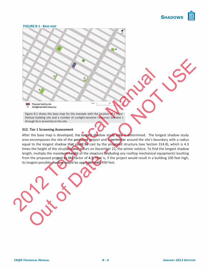
FIGURE 8-1 - BASE MAP
Figure 8-1 shows the base map for the example with the location of a hypo-thetical building site and a number of sunlight-sensitive resources (labeled 1 through 6) in proximity to the site.
312. Tier 1 Screening Assessment
After the base map is developed, the longest shadow study area is determined. The longest shadow study area encompasses the site of the proposed project and a perimeter around the site’s boundary with a radius equal to the longest shadow that could be cast by the proposed structure (see Section 314.8), which is 4.3 times the height of the structure and occurs on December 21, the winter solstice. To find the longest shadow length, multiply the maximum height of the structure (including any rooftop mechanical equipment) resulting from the proposed project by the factor of 4.3. That is, if the project would result in a building 100 feet high, its longest possible shadow would be approximately 430 feet.
2012
Techn
icalllo lesou
al he longest shadongest sha
e proposed projoposed prthat could be cthat could be
ucture and occuure and occximum height oum height o
roject by the faect by the fae shadow woulde shadow would
Manua
l
Mn of a hypMabe
Out of
Date struct
of 4.3. That 3. Thatpproximately 4roximately
-bebe(inclu(in
i
DO OOtudy area is detudy area is dea perimeter a perimet
roposedroposed
NOT USE
CEQR TECHNICAL MANUAL 8 - 5 JANUARY 2012 EDITION
SHADOWS
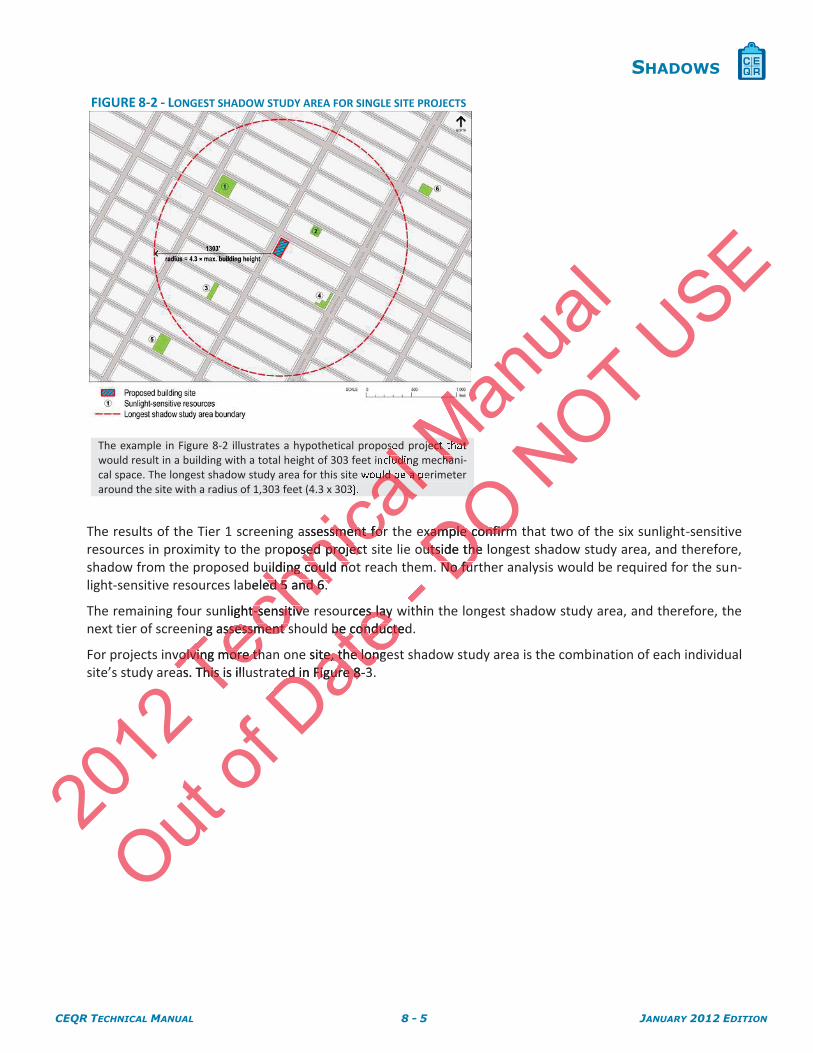
FIGURE 8-2 - LONGEST SHADOW STUDY AREA FOR SINGLE SITE PROJECTS
The example in Figure 8-2 illustrates a hypothetical proposed project that would result in a building with a total height of 303 feet including mechani-cal space. The longest shadow study area for this site would be a perimeter around the site with a radius of 1,303 feet (4.3 x 303).
The results of the Tier 1 screening assessment for the example confirm that two of the six sunlight-sensitive resources in proximity to the proposed project site lie outside the longest shadow study area, and therefore, shadow from the proposed building could not reach them. No further analysis would be required for the sun-light-sensitive resources labeled 5 and 6.
The remaining four sunlight-sensitive resources lay within the longest shadow study area, and therefore, the next tier of screening assessment should be conducted.
For projects involving more than one site, the longest shadow study area is the combination of each individual site’s study areas. This is illustrated in Figure 8-3.
2012
Techn
icalse lludin
al uld be a p
cal
assessment forsment foroposed project sed projec
uilding could nouilding could nobeled 5 and 6. ed 5 and 6.
nlight-sensitivet-sensitiveng assessment sng assessment s
volving more thvolving more thas. This is illuas. This i
Manua
l
MMect that Mha
Out of
Dateurces lay es lay
be conductedbe conducte
e site, the longete, the longed in Figure 8ed in Figure 8-3
- thin
DO OOexample confirmxample confirmoutside the looutside the
No furNo fu
NOT USE
CEQR TECHNICAL MANUAL 8 - 6 JANUARY 2012 EDITION
SHADOWS
FIGURE 8-3 - LONGEST SHADOW STUDY AREA FOR MULTIPLE SITE PROJECTS
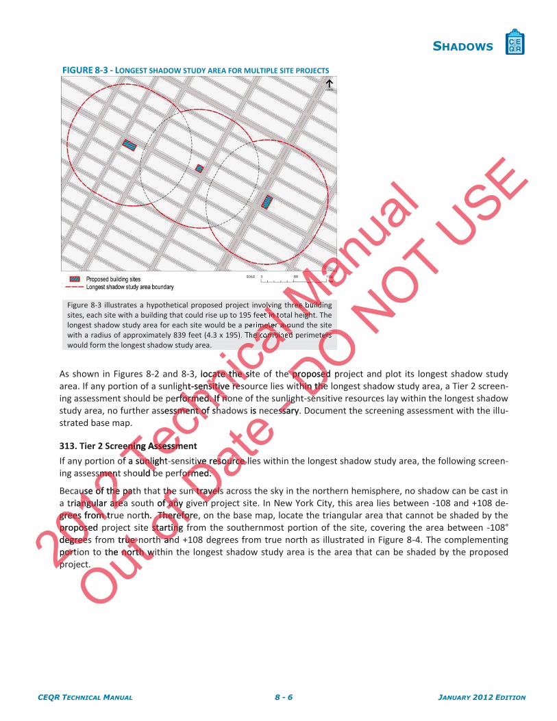
Figure 8-3 illustrates a hypothetical proposed project involving three building sites, each site with a building that could rise up to 195 feet in total height. The longest shadow study area for each site would be a perimeter around the site with a radius of approximately 839 feet (4.3 x 195). The combined perimeters would form the longest shadow study area.
As shown in Figures 8-2 and 8-3, locate the site of the proposed project and plot its longest shadow study area. If any portion of a sunlight-sensitive resource lies within the longest shadow study area, a Tier 2 screen-ing assessment should be performed. If none of the sunlight-sensitive resources lay within the longest shadow study area, no further assessment of shadows is necessary. Document the screening assessment with the illu-strated base map.
313. Tier 2 Screening Assessment
If any portion of a sunlight-sensitive resource lies within the longest shadow study area, the following screen-ing assessment should be performed.
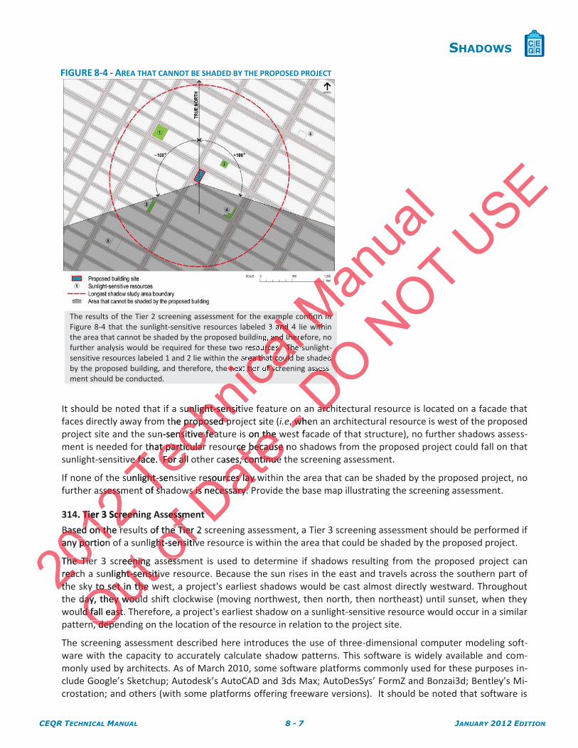
Because of the path that the sun travels across the sky in the northern hemisphere, no shadow can be cast in a triangular area south of any given project site. In New York City, this area lies between -108 and +108 de-grees from true north. Therefore, on the base map, locate the triangular area that cannot be shaded by the proposed project site starting from the southernmost portion of the site, covering the area between -108° degrees from true north and +108 degrees from true north as illustrated in Figure 8-4. The complementing portion to the north within the longest shadow study area is the area that can be shaded by the proposed project.
2012sment smen
use of the patuse of the patriangular areaangular area
grees from trgrees from tproposed proposdegreesegreeportiporpp
Techn
icalolv l in t
al meter aro
cale combined
ca, locate the sitcate the sht-sensitive ressensitive re
erformed. If noformed. If nossessment of shsment of sh
ening Assessmening Assessm
of a sunlight-of a sunliould bb
MMree buildMigh
anua
l
Outct
m true noue the north winorth w
ofthe the
h of any gf anyrth. Therefore Therefor
e starting fstartingh andh and
Date s is n
tive resource lietive resource formed. formed.
n travels n travelsnn
-nlignligssary.ssa
DO OOOters
Oe proposed pre proposedthin the thin the
ee
NOT USE
CEQR TECHNICAL MANUAL 8 - 7 JANUARY 2012 EDITION
SHADOWS
FIGURE 8-4 - AREA THAT CANNOT BE SHADED BY THE PROPOSED PROJECT
The results of the Tier 2 screening assessment for the example confirm in Figure 8-4 that the sunlight-sensitive resources labeled 3 and 4 lie within the area that cannot be shaded by the proposed building, and therefore, no further analysis would be required for these two resources. The sunlight-sensitive resources labeled 1 and 2 lie within the area that could be shaded by the proposed building, and therefore, the next tier of screening assess-ment should be conducted.
It should be noted that if a sunlight-sensitive feature on an architectural resource is located on a facade that faces directly away from the proposed project site (i.e. when an architectural resource is west of the proposed project site and the sun-sensitive feature is on the west facade of that structure), no further shadows assess-ment is needed for that particular resource because no shadows from the proposed project could fall on that sunlight-sensitive face. For all other cases, continue the screening assessment.
If none of the sunlight-sensitive resources lay within the area that can be shaded by the proposed project, no further assessment of shadows is necessary. Provide the base map illustrating the screening assessment.
314. Tier 3 Screening Assessment
Based on the results of the Tier 2 screening assessment, a Tier 3 screening assessment should be performed if any portion of a sunlight-sensitive resource is within the area that could be shaded by the proposed project.
The Tier 3 screening assessment is used to determine if shadows resulting from the proposed project can reach a sunlight-sensitive resource. Because the sun rises in the east and travels across the southern part of the sky to set in the west, a project's earliest shadows would be cast almost directly westward. Throughout the day, they would shift clockwise (moving northwest, then north, then northeast) until sunset, when they would fall east. Therefore, a project's earliest shadow on a sunlight-sensitive resource would occur in a similar pattern, depending on the location of the resource in relation to the project site.
The screening assessment described here introduces the use of three-dimensional computer modeling soft-ware with the capacity to accurately calculate shadow patterns. This software is widely available and com-monly used by architects. As of March 2010, some software platforms commonly used for these purposes in-clude Google’s Sketchup; Autodesk’s AutoCAD and 3ds Max; AutoDesSys’ FormZ and Bonzai3d; Bentley’s Mi-crostation; and others (with some platforms offering freeware versions). It should be noted that software is
2012
ssessmssess
4. Tier 3 ScreenTier 3 Screen
Based on the rBased on the rany portion any portion
The Tiehe Tiereacreactht
Techn
iclm land
al , and there
calrces. The s
caea that could
icanext tie f scre
nicsunlight-sensitivunlight-sensithe proposed pproposed p
n-sensitive featnsitive feathat particular that particular
e face. For all oe face. For al
sunlight-senssunlight-nt of shsh
Manua
l
MMnfirm in Mwith
Outcreening enin
unlight-sensitivht-sensitivy to set in the wy to set in the
day, they woulay, they woululd fall east. Td fall east
n, depen depe
of ssessmessm
of the Tier 2 the Tierlight-sensitivht-sensitiv
sesssess
Datesit
s on the wn the rce because nce because
cases, continue s, continue
resources lay wresources lay ws is necessary. ws is necessary.
tt
-.. whe whst fa
DO DOOOd
DOsses
DOarcharch
NOT USE
CEQR TECHNICAL MANUAL 8 - 8 JANUARY 2012 EDITION
SHADOWS
constantly upgraded, renamed, or new platforms are introduced. Therefore, consultation with the Environ-mental Assessment and Review Division of the Department of City Planning regarding current software is rec-ommended. If access to this software is not available, the screening can be carried out manually through a graphic analysis without the need of a computer. The manual procedure is explained in the Appendix.
314.1. Use of three-dimensional computer modeling The model should include (1) three-dimensional representations of the elements of the base map de-scribed above; (2) a “reasonable worst case” three-dimensional representation of the proposed project as described below; and (3) the three-dimensional representation of the topographic infor-mation within the area being analyzed. At this stage of the assessment, the surrounding buildings should not be included in the model so that it may be determined whether shadows from the pro-posed project would reach a sunlight-sensitive resource. The surrounding built context is included in the next tier of analysis.
In order for the computer software to accurately represent sunlight shadows, the three-dimensional model should be set up as follows:
All the three-dimensional objects must be at the same scale.
Ensure the direction of true north is correctly setup.
The geographic location data for New York City is entered as:
New York City, City Hall. Latitude: 40°42'23" north (40.706389°) Longitude: 74°0'29" west (74.008056°)
The selected time zone is Eastern Standard Time. Daylight savings time should not be used.
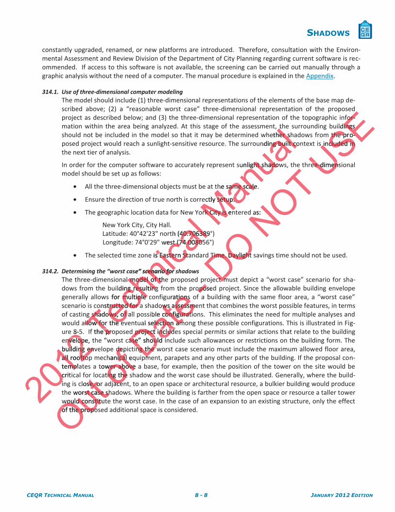
314.2. Determining the “worst case” scenario for shadows The three-dimensional model of the proposed project must depict a “worst case” scenario for sha-dows from the building resulting from the proposed project. Since the allowable building envelope generally allows for multiple configurations of a building with the same floor area, a “worst case” scenario is constructed for a shadows assessment that combines the worst possible features, in terms of casting shadows, of all possible configurations. This eliminates the need for multiple analyses and would allow for the eventual selection among these possible configurations. This is illustrated in Fig-ure 8-5. If the proposed project includes special permits or similar actions that relate to the building envelope, the “worst case” should include such allowances or restrictions on the building form. The building envelope depicting the worst case scenario must include the maximum allowed floor area, all rooftop mechanical equipment, parapets and any other parts of the building. If the proposal con-templates a tower above a base, for example, then the position of the tower on the site would be critical for locating the shadow and the worst case should be illustrated. Generally, where the build-ing is close, or adjacent, to an open space or architectural resource, a bulkier building would produce the worst case shadows. Where the building is farther from the open space or resource a taller tower would constitute the worst case. In the case of an expansion to an existing structure, only the effect of the proposed additional space is considered.
2012
8-5envelope, nvelopbuilding envuilding enall rooftopall rooftotemplampcriticii
Techn
icalth (40.70638940.706389
west (74.00805st (74.00805
e is Eastern Stas Eastern St
se” scenario for cenario for al model of the model of th
ilding resulting ng resultings for multiple cmultiple
onstructed for aonstructed for ashadows, of alshadows, of
llow for the ellow for the ef the proe pr
e “
Manua
lthtether shher s
nding built cong built co
unlight shadowht shado
he same scale. same scale
ectly setup. setup.
rk City is enrk City is en
Outr l
close, or se, oworst case shst case sh
would constitutwould constitof the propoof the propo
ofdepde
chanical eqical tower above awer aboveating the sing the
jacejace
Dateth
urations tionsows assessmews assessm
ible configuraticonfiguratial selection amelection am
project include project includase” should inase” should i
ng the wng the pmpm
-oposeoposa b
DO Time. Daylight Time. Daylight
ctct mm
NOT as:
USEfofor-r-
ildings ings the prthe p o--
s included in s included in
ee-dimensiee-dimen
CEQR TECHNICAL MANUAL 8 - 9 JANUARY 2012 EDITION
SHADOWS
FIGURE 8-5 - EXAMPLE OF “WORST CASE” SCENARIO BUILDING ENVELOPE
The example in Figure 8-5 illustrates a hypothetical proposed project of a tower 263 feet in height on a 60 foot high building base with a 40 foot tall mechanical bulkhead on top of the tower and setbacks from the street. The building would have a total height of 303 feet including mechanical space. The “worst case” scenario building envelope includes all por-tions of the site that could be occupied by the building, configured in all possible ways.
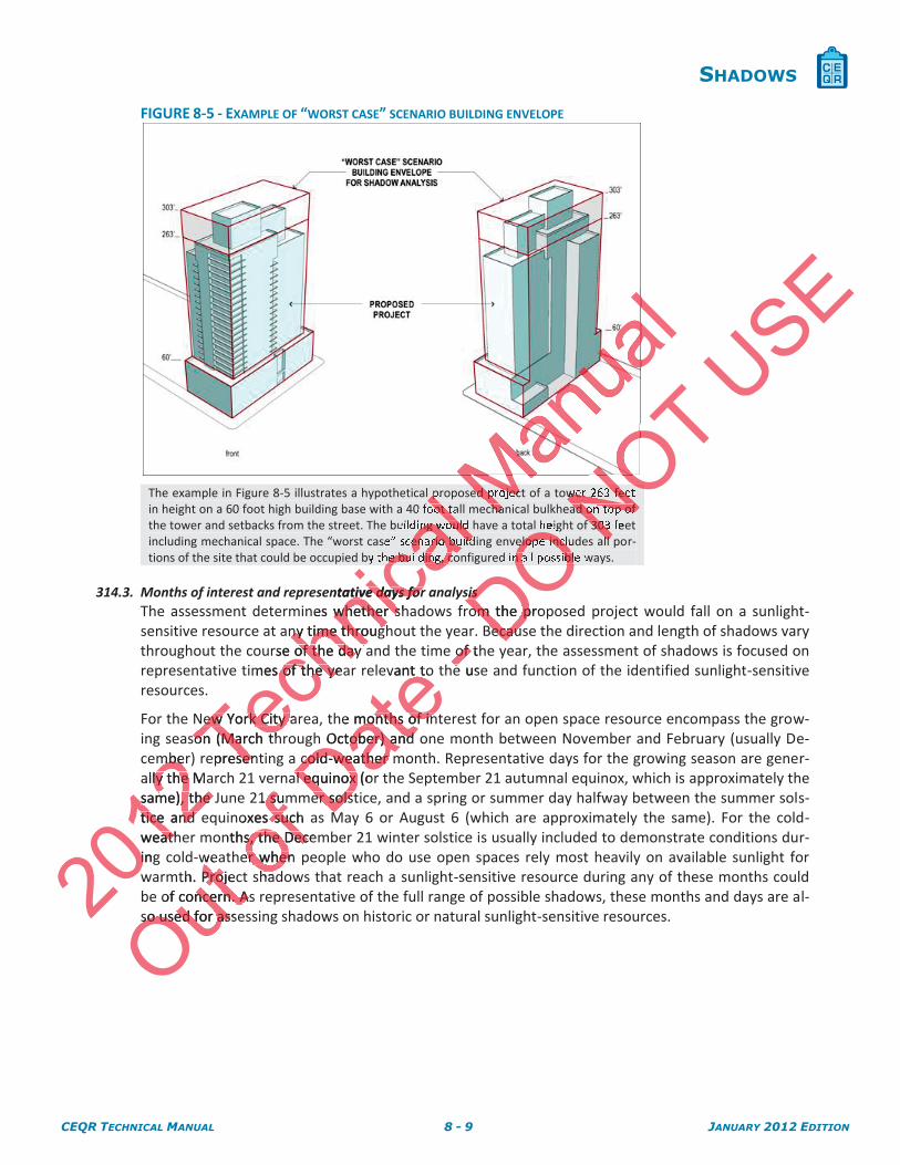
314.3. Months of interest and representative days for analysis The assessment determines whether shadows from the proposed project would fall on a sunlight-sensitive resource at any time throughout the year. Because the direction and length of shadows vary throughout the course of the day and the time of the year, the assessment of shadows is focused on representative times of the year relevant to the use and function of the identified sunlight-sensitive resources.
For the New York City area, the months of interest for an open space resource encompass the grow-ing season (March through October) and one month between November and February (usually De-cember) representing a cold-weather month. Representative days for the growing season are gener-ally the March 21 vernal equinox (or the September 21 autumnal equinox, which is approximately the same), the June 21 summer solstice, and a spring or summer day halfway between the summer sols-tice and equinoxes such as May 6 or August 6 (which are approximately the same). For the cold-weather months, the December 21 winter solstice is usually included to demonstrate conditions dur-ing cold-weather when people who do use open spaces rely most heavily on available sunlight for warmth. Project shadows that reach a sunlight-sensitive resource during any of these months could be of concern. As representative of the full range of possible shadows, these months and days are al-so used for assessing shadows on historic or natural sunlight-sensitive resources.
2012mbermbe
ally the Maly the same), the Jsame), the tice and tice and weathatingi
Techn
icalp loot t
al ing would
calenario build
cahe building, co
entative days fortive days fornes whether shwhether s
ny time througny time througrse of the day aof the day
imes of the yeaof the ye
New York City aNew York City ason (March thson (March th
epresentsenh
MMed projecMcha
al
Outwe
th. ProjecProjof concern. Asncern. As
so used for asseso used for as
of 1 sum sum
oxes such sucnths, the Deces, the Dec
er when er whenhadh
Date he
vant to
he months of inmonths of inh October) and ober) and
cold-weather mcold-weather al equinox (oral equinox
er solster solstMM
- of thof e use
DOOOelope inclu
On all possibl
sis sis om the proom the p
BecausBecau
NOT NONOwer 263 feetNO
ad on top of N303Nll
USE
CEQR TECHNICAL MANUAL 8 - 10 JANUARY 2012 EDITION
SHADOWS
FIGURE 8-6 - MONTHS OF INTEREST AND REPRESENTATIVE DAYS FOR ANALYSIS
For the representative growing season months, it is not necessary to analyze those months where it is found that no shadow from the project would reach a sunlight-sensitive resource.
For the cold-weather months, if it is found that no shadow from the project would reach a sunlight-sensitive resource on the December 21 analysis day, then the assessment should be performed for a representative day in either November, January or February in order to confirm that no shadow from the project would reach a sunlight-sensitive resource during any of those months.
314.4. Timeframe window of analysis The shadow assessment considers those shadows occurring between 1.5 hours after sunrise and 1.5 hours before sunset. Shadows occurring earlier and later are long, move fast, and generally blend with shadows from existing structures. At times outside the timeframe window of analysis, the sun is located near the horizon and the sun’s rays reach the Earth at close to tangential angles diminishing the amount of energy delivered by the sun’s rays and producing shadows that grow in length expo-nentially until the sun reaches the horizon and sets. Because of these conditions, the shadows occur-ring between 1.5 hours after sunrise and 1.5 hours before sunset are not considered significant under CEQR, and their assessment is not required. For the assessment, standard, not daylight savings, time is used. Table A1 (Shadow Factors and Time of Day for Each Shadow Angle, June 21, May 6, March 21, December 21) in the Appendix lists all times within the timeframe window of analysis for four repre-sentative days.
314.5. Conducting the shadow assessment Once the three-dimensional computer model has been set up, shadow analyses should be performed for each of the representative days for analysis in the months of interest within the timeframe win-dow of analysis, as described in Subsections 314.3 and 314.4.
ducOnce the nce thfor each of r each of dow of anadow of an
Techn
icale shadowshadow
rring earlier ang earlier atures. At times s. At times
he sun’s rays re sun’s raysered by the sud by the su
aches the horizs the horizrs after sunrise s after sunris
sessment is nosment is no1 (Shadow Factadow Fac
1) in the 1) in the AppenAppenecdays. day
g the shade sharee-d
Manua
lary to analyze to analyze t
ght-sensitive reensitive r
ow from the prrom the prhen the assessn the asse
February in ordebruary in orource during anource during an
Out of
prespreas descrdes Date
irend Time oTime o
ts all times wis all times w
sessment sessment ional computeional compute
tative daytative dad ind in
-or the or thay
DObe
er are loer are lode the timefrathe timef
the Earth at clothe Earth at cloys and producins and produc
s. Becauses. Becausforefore
NOTwould rewoushould be perhould be
confirm that noconfirm that nhose months. hose months.
een 1.5 heen 1.5 hmomo
USEmonths where months where
a
CEQR TECHNICAL MANUAL 8 - 11 JANUARY 2012 EDITION
SHADOWS
FIGURE 8-7 - THREE-DIMENSIONAL COMPUTER MODEL SET UP FOR TIER 3 SCREENING
ASSESSMENT
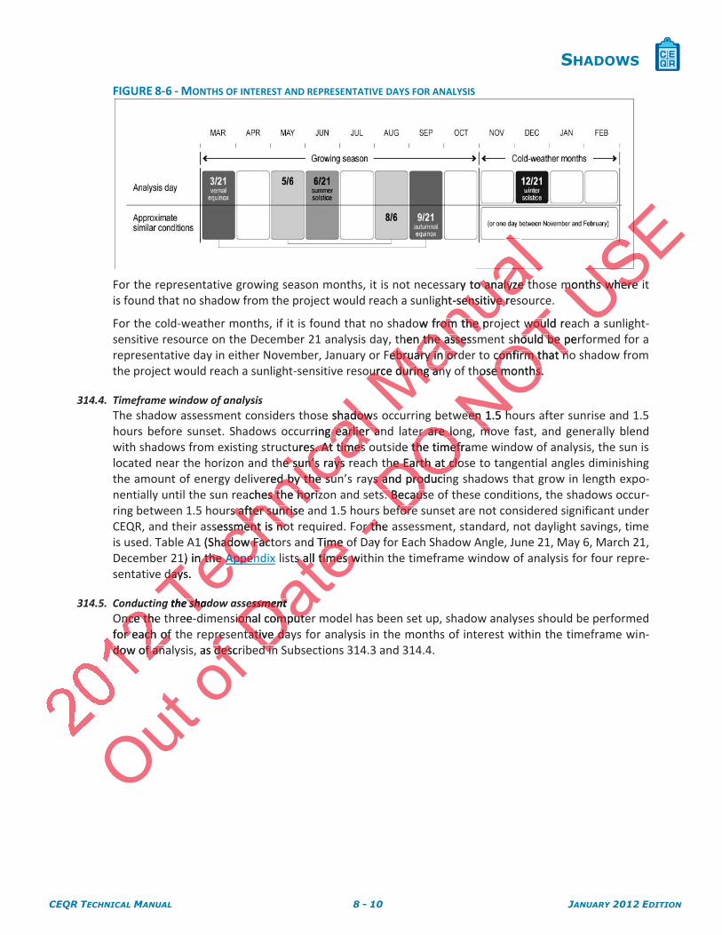
Figures 8-7a, 8-7b, 8-7c and 8-7d illustrate the range of shadows that would occur from the proposed building in the example (303 feet tall) on four representative days for analysis. Each figure shows the shadows occurring approximately every 60 minutes from the start of the analysis day (1.5 hours after sunrise) until the end of the analysis day (1.5 hours before sunset).
FIGURE 8-7A - TIER 3 SCREENING ASSESSMENT FOR THE DECEMBER 21 ANALYSIS DAY
The results of the screening assessment for the December 21 analysis day show that shadows from the proposed building would be cast on the sunlight-sensitive resource labeled 1 from the start of the analysis day at 8:51 a.m. and would remain on the re-source until sometime before 10:00 a.m. Shadows from the proposed building would not reach the sunlight-sensitive resource labeled 2 on the analysis day.
201
hnica
lale of
alet tall) on
calurring appr
caurs after sunr
icaNING ASSESSMENG ASSESSMEN
Manua
l
Mws
OO
DOOOly every 6
DOhe end of th
DODDECEMBER ECEMBER 2
NOT NNoccur from Nays N
USE
CEQR TECHNICAL MANUAL 8 - 12 JANUARY 2012 EDITION
SHADOWS
FIGURE 8-7B - TIER 3 SCREENING ASSESSMENT FOR THE MARCH 21/SEPTEMBER21
ANALYSIS DAY
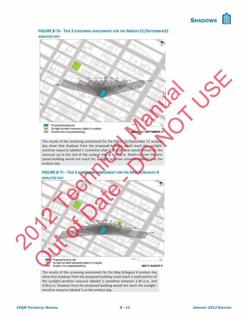
The results of the screening assessment for the March 21/September 21 analysis day show that shadows from the proposed building could reach the sunlight-sensitive resource labeled 2 sometime after 2:30 p.m. and would remain on the resource up to the end of the analysis day at 6:29 p.m. Shadows from the pro-posed building would not reach the sunlight-sensitive resource labeled 1 on the analysis day.
FIGURE 8-7C - TIER 3 SCREENING ASSESSMENT FOR THE MAY 6/AUGUST 6
ANALYSIS DAY
The results of the screening assessment for the May 6/August 6 analysis day show that shadows from the proposed building could reach a small portion of the sunlight-sensitive resource labeled 2 sometime between 2:30 p.m. and 4:30 p.m. Shadows from the proposed building would not reach the sunlight-sensitive resource labeled 1 on the analysis day.
2012
chnic
alalMarch 2
albuilding cou
car 2:30 p.m. a
icasis day at 6:29 p.icasunlight ns
nicCREENING ASSESCREENING AS
MMua
l
O
- DOOthe su
Oremain on
DO s from the
DOurce labeled 1 on
DOAY AY 6/6/
NOT NNysis N
USE
CEQR TECHNICAL MANUAL 8 - 13 JANUARY 2012 EDITION
SHADOWS
FIGURE 8-7D - TIER 3 SCREENING ASSESSMENT FOR THE JUNE 21 ANALYSIS
DAY
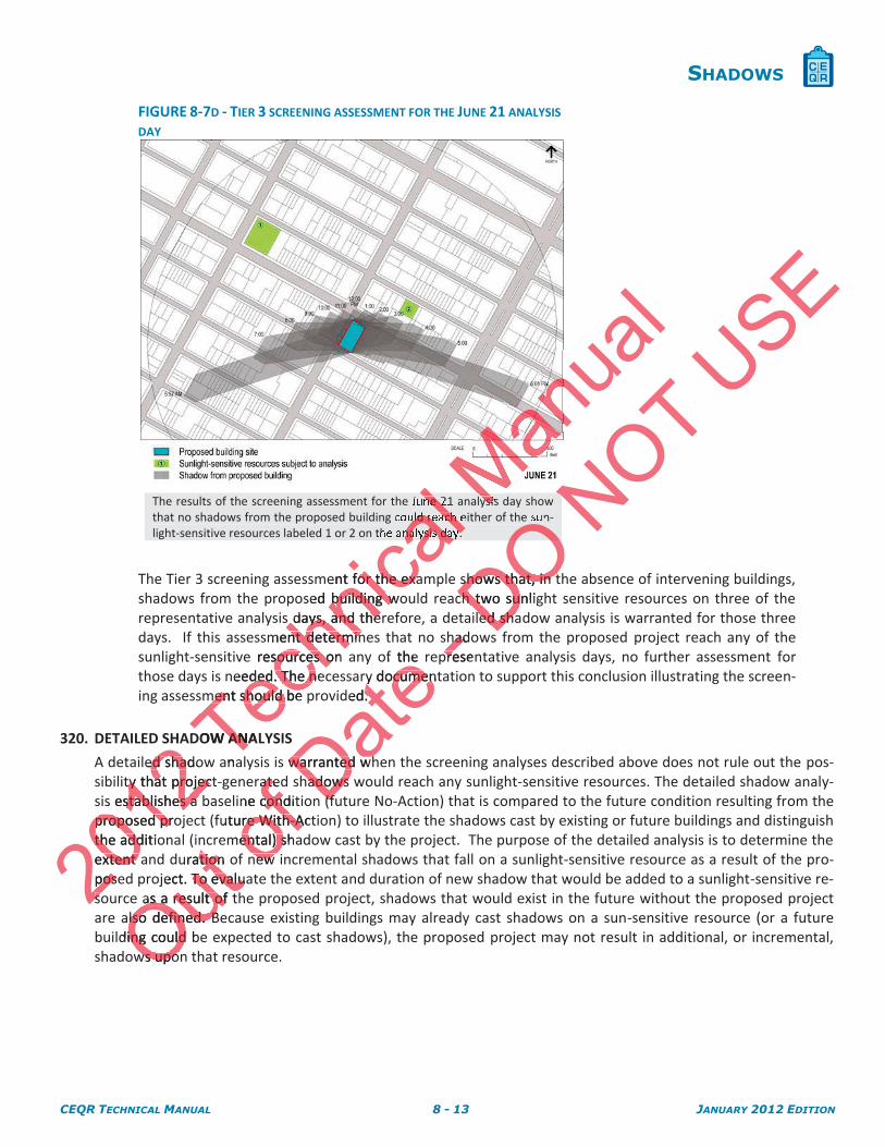
The results of the screening assessment for the June 21 analysis day show that no shadows from the proposed building could reach either of the sun-light-sensitive resources labeled 1 or 2 on the analysis day.
The Tier 3 screening assessment for the example shows that, in the absence of intervening buildings, shadows from the proposed building would reach two sunlight sensitive resources on three of the representative analysis days, and therefore, a detailed shadow analysis is warranted for those three days. If this assessment determines that no shadows from the proposed project reach any of the sunlight-sensitive resources on any of the representative analysis days, no further assessment for those days is needed. The necessary documentation to support this conclusion illustrating the screen-ing assessment should be provided.
320. DETAILED SHADOW ANALYSIS
A detailed shadow analysis is warranted when the screening analyses described above does not rule out the pos-sibility that project-generated shadows would reach any sunlight-sensitive resources. The detailed shadow analy-sis establishes a baseline condition (future No-Action) that is compared to the future condition resulting from the proposed project (future With-Action) to illustrate the shadows cast by existing or future buildings and distinguish the additional (incremental) shadow cast by the project. The purpose of the detailed analysis is to determine the extent and duration of new incremental shadows that fall on a sunlight-sensitive resource as a result of the pro-posed project. To evaluate the extent and duration of new shadow that would be added to a sunlight-sensitive re-source as a result of the proposed project, shadows that would exist in the future without the proposed project are also defined. Because existing buildings may already cast shadows on a sun-sensitive resource (or a future building could be expected to cast shadows), the proposed project may not result in additional, or incremental, shadows upon that resource.
2012
H
ed shadoed shaty that projectty that projec
s establishes a stablishes a proposed proproposed prthe additiothe addextent axtent posepossoso
Techn
icallne 2
al uld reach
calnalysis day.
ent for the exaor the exased building wobuilding w
days, and ther days, and thement determinnt determin
e resources on sources oneeded. The neded. The n
ment should be ment should be
OW ANALAN
ana
MMysis
nual
Outnc
uration otionject. To evaluaTo evalu
as a result of tas a result ofalso defined. Blso defined. Bding could bing could
ws upows upo
ofratedate
ne conditconduture With-Acre With-Amental) shaental) s
new new
Date of the
ry documenty documended. .
warranted whwarranted whhadows whadows
(f(f
-hadhadpresenpre
DO OOOshows that, in tshows that, in tch two sunligch two su
ed shaed sha
NOT N
USE
CEQR TECHNICAL MANUAL 8 - 14 JANUARY 2012 EDITION
SHADOWS
FIGURE 8-8 - EFFECTS OF EXISTING BUILDINGS
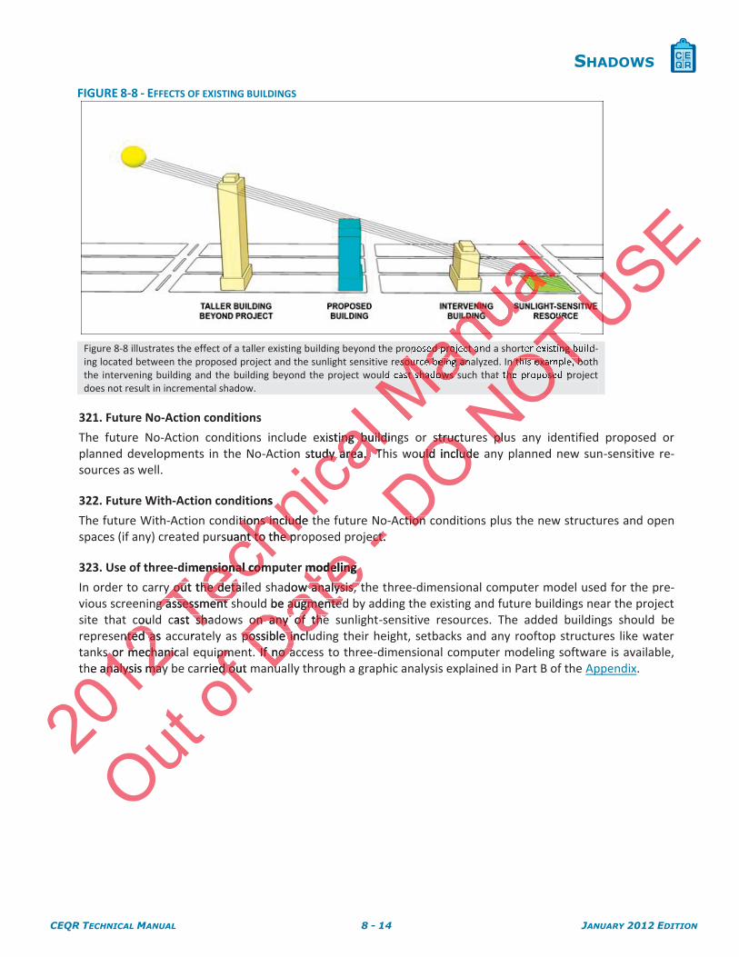
Figure 8-8 illustrates the effect of a taller existing building beyond the proposed project and a shorter existing build-ing located between the proposed project and the sunlight sensitive resource being analyzed. In this example, both the intervening building and the building beyond the project would cast shadows such that the proposed project does not result in incremental shadow.
321. Future No-Action conditions
The future No-Action conditions include existing buildings or structures plus any identified proposed or planned developments in the No-Action study area. This would include any planned new sun-sensitive re-sources as well.
322. Future With-Action conditions
The future With-Action conditions include the future No-Action conditions plus the new structures and open spaces (if any) created pursuant to the proposed project.
323. Use of three-dimensional computer modeling
In order to carry out the detailed shadow analysis, the three-dimensional computer model used for the pre-vious screening assessment should be augmented by adding the existing and future buildings near the project site that could cast shadows on any of the sunlight-sensitive resources. The added buildings should be represented as accurately as possible including their height, setbacks and any rooftop structures like water tanks or mechanical equipment. If no access to three-dimensional computer modeling software is available, the analysis may be carried out manually through a graphic analysis explained in Part B of the Appendix.
2012
couented as anted a
s or mechanics or mechaniche analysis maynalysis may
Techn
icalexisting buildining buildi
study area. Tudy area. T
ons
itions include ttions includrsuant to the prant to the p
mensional comnsional com
y out the detaily out the detag assessment sg assessment s
cast shadshura
Mananed project a
Mansource being an
Mast shadows s
Ma
Out of
ipmepmrried out md ou Date
ed
r modeling modeling
adow analysis, t analysis, d be augmentedaugmented
on any of theon any of thepossible inclupossible inclu
. If no a. If no anunu
- ect. ect. DO structustructould include uld includ
ction ction
NOTOTer existing b
OTn this example, b
OThe propose
NOplupl
USE
CEQR TECHNICAL MANUAL 8 - 15 JANUARY 2012 EDITION
SHADOWS
FIGURE 8-9 - THREE-DIMENSIONAL COMPUTER MODEL OF FUTURE NO-ACTION
CONDITIONS
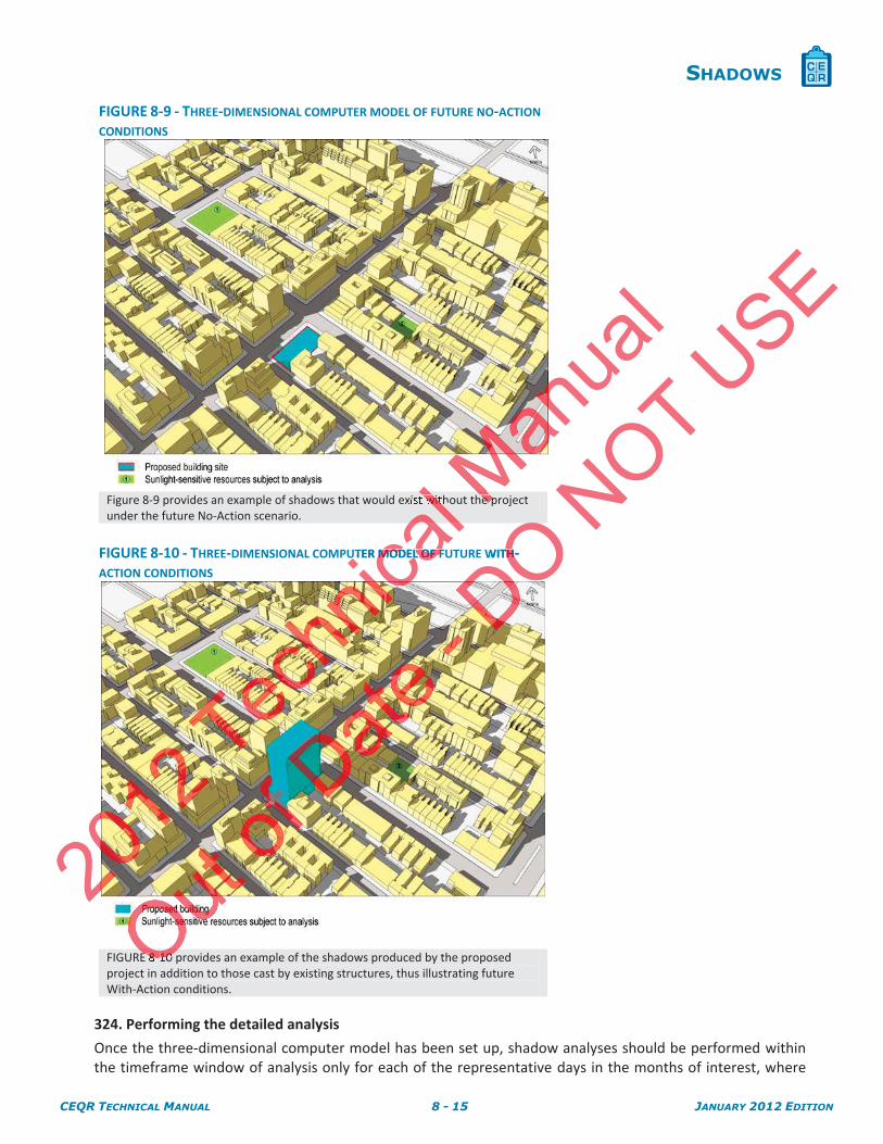
Figure 8-9 provides an example of shadows that would exist without the project under the future No-Action scenario.
FIGURE 8-10 - THREE-DIMENSIONAL COMPUTER MODEL OF FUTURE WITH-ACTION CONDITIONS
FIGURE 8-10 provides an example of the shadows produced by the proposed project in addition to those cast by existing structures, thus illustrating future With-Action conditions.
324. Performing the detailed analysis
Once the three-dimensional computer model has been set up, shadow analyses should be performed within the timeframe window of analysis only for each of the representative days in the months of interest, where
20
nical l with
al UTER MODEL OF FMODEL OF F
MMhe p
anua
l
OOE 8-10O
DO OOWITHTH-
NOT USE
CEQR TECHNICAL MANUAL 8 - 16 JANUARY 2012 EDITION
SHADOWS
the Tier 3 screening assessment could not rule out the possibility of shadows reaching a sunlight-sensitive re-source.
The shadow attributable to the project is the increment beyond shadows that would be cast in the existing or future No-Action condition. The objective of the detailed analysis is to identify incremental shadows and doc-ument the time at which incremental shadows enter and exit the sunlight-sensitive resource in order to de-termine the total time that incremental shadows are cast on the resource.
325. Documenting the extent and duration of incremental shadows
The results of the detailed shadow analysis should be documented in graphic form and accompanied by a ta-ble summarizing the extent and duration of incremental shadows.
Graphic material documenting the conditions on each of the sunlight-sensitive resources at which an incre-mental shadow occurs should be submitted. The graphic material should include:
The base map illustrating the proposed project site location in relation to the sunlight-sensitive re-sources.
A site plan of the affected sunlight sensitive resources at an appropriate scale to illustrate incre-mental shadows on the resources in question that includes:
o Shadows resulting from the future No-Action conditions
o Shadows resulting from the future With-Action conditions
o The incremental shadow on the sunlight-sensitive resource highlighted in a contrasting tone (i.e. red) with its outline delineated.
o In the case of incremental shadows on sunlight-sensitive features of historic resources it may be necessary to provide axonometric drawings documenting conditions on those fea-tures (such as windows) that cannot be assessed from a site plan.
The material should include a graphic scale bar and identify the direction of true north as well as the repre-sentative analysis day and time being illustrated.
The summary table should include the following information for each of the sunlight-sensitive resources on which an incremental shadow occurs:
Name of the sunlight-sensitive resource.
Representative analysis days.
Timeframe window of analysis (1.5 hours after sunrise and 1.5 hours before sunset) for the day analyzed.
Time of incremental shadow entering the sunlight-sensitive resource (enter time).
Time of incremental shadow exiting the sunlight-sensitive resource (exit time).
Total duration of incremental shadow in hours and minutes.
A note confirming that daylight savings time has not been used.
2012
Na
Represep
Timefrmefranaana
Techn
icalfuture Wture
w on the sunln the suns outline delineutline deline
cremental shadmental shasary to providey to provid
h as windows) twindows)
de a graphic sc graphic scand time being iime being
e should include should includental shadow oental shadow
e of the suthe
ta
Manua
lnsitive resourceve resourcd include: lude:
tion in relation n in relation
ources at an aources at an athat includes: t includes:
NoNo-Action co-Action co
h-Acth-A
Out of
Time of incree of incre
Total duratTotal dura
A noteno
of window ndow
rementalementa
Dater
ated.
following infoollowing inf:
-sensitive resou-sensitive reso
lysis days. lysis days.
anaana
- dentidenDO ensitive ensitive
on sunlight-senon sunlight-senmetric drawinmetric draw
e assessee assess
NOTe se s
riate scale to iriate scale to
ns
ditions ditions
ourcour
USEby a ty a a-a-
which an incrhich an incre-e
ght-sensitght-sens
CEQR TECHNICAL MANUAL 8 - 17 JANUARY 2012 EDITION
SHADOWS
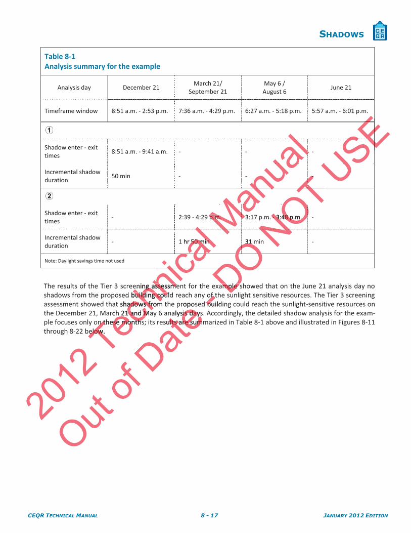
Table 8-1 Analysis summary for the example
Analysis day December 21 March 21/
September 21 May 6 /August 6
June 21
Timeframe window 8:51 a.m. - 2:53 p.m. 7:36 a.m. - 4:29 p.m. 6:27 a.m. - 5:18 p.m. 5:57 a.m. - 6:01 p.m.
Shadow enter - exit times
8:51 a.m. - 9:41 a.m. - - -
Incremental shadow duration
50 min - - -
Shadow enter - exit times
- 2:39 - 4:29 p.m. 3:17 p.m. - 3:48 p.m. -
Incremental shadow duration
- 1 hr 50 min 31 min -
Note: Daylight savings time not used
The results of the Tier 3 screening assessment for the example showed that on the June 21 analysis day no shadows from the proposed building could reach any of the sunlight sensitive resources. The Tier 3 screening assessment showed that shadows from the proposed building could reach the sunlight-sensitive resources on the December 21, March 21 and May 6 analysis days. Accordingly, the detailed shadow analysis for the exam-ple focuses only on these months; its results are summarized in Table 8-1 above and illustrated in Figures 8-11 through 8-22 below.
2012
Techn
ical 1 hr 50 min50 min
cccaicening assessmeening assessme
d building couldbuilding cout shadows fromadows from
arch 21 and Mah 21 and Mn these monthsn these months
elow. elow.
Manua
l
aaaanp.m.p.m. 3
Out of
Date propo
nalysis days.sis daysesults are summults are sum
-of tof tbuildbu
DO 31 m31
OOODOample sample s
NOT --
TTTTm. -- 3:48 p.m.3:48 p.m.
USEEEEEEE
CEQR TECHNICAL MANUAL 8 - 18 JANUARY 2012 EDITION
SHADOWS
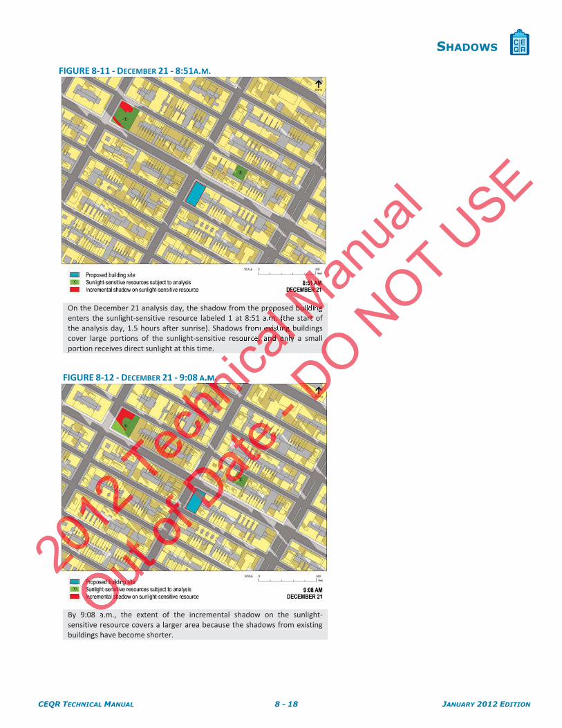
FIGURE 8-11 - DECEMBER 21 - 8:51A.M.
On the December 21 analysis day, the shadow from the proposed building enters the sunlight-sensitive resource labeled 1 at 8:51 a.m. (the start of the analysis day, 1.5 hours after sunrise). Shadows from existing buildings cover large portions of the sunlight-sensitive resource, and only a small portion receives direct sunlight at this time.
FIGURE 8-12 - DECEMBER 21 - 9:08 A.M.
By 9:08 a.m., the extent of the incremental shadow on the sunlight-sensitive resource covers a larger area because the shadows from existing buildings have become shorter.
20
hnica
lro lm. (
al m existing
cale, and only
caA.M. .
Manua
l
MMbuilding Mart
OO
DO OOONOT U
SE
CEQR TECHNICAL MANUAL 8 - 19 JANUARY 2012 EDITION
SHADOWS
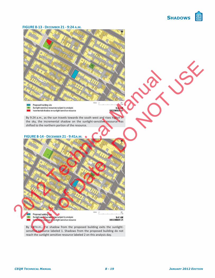
FIGURE 8-13 - DECEMBER 21 - 9:24 A.M.
By 9:24 a.m., as the sun travels towards the south west and rises higher in the sky, the incremental shadow on the sunlight-sensitive resource has shifted to the northern portion of the resource.
FIGURE 8-14 - DECEMBER 21 - 9:41A.M.
By 9:41a.m., the shadow from the proposed building exits the sunlight-sensitive resource labeled 1. Shadows from the proposed building do not reach the sunlight sensitive resource labeled 2 on this analysis day.
20
icalld lve r
al Man
ual
MMhigher in Me h
OOuO9:41a.m., thOtive resouO
DO NOT U
SE
CEQR TECHNICAL MANUAL 8 - 20 JANUARY 2012 EDITION
SHADOWS
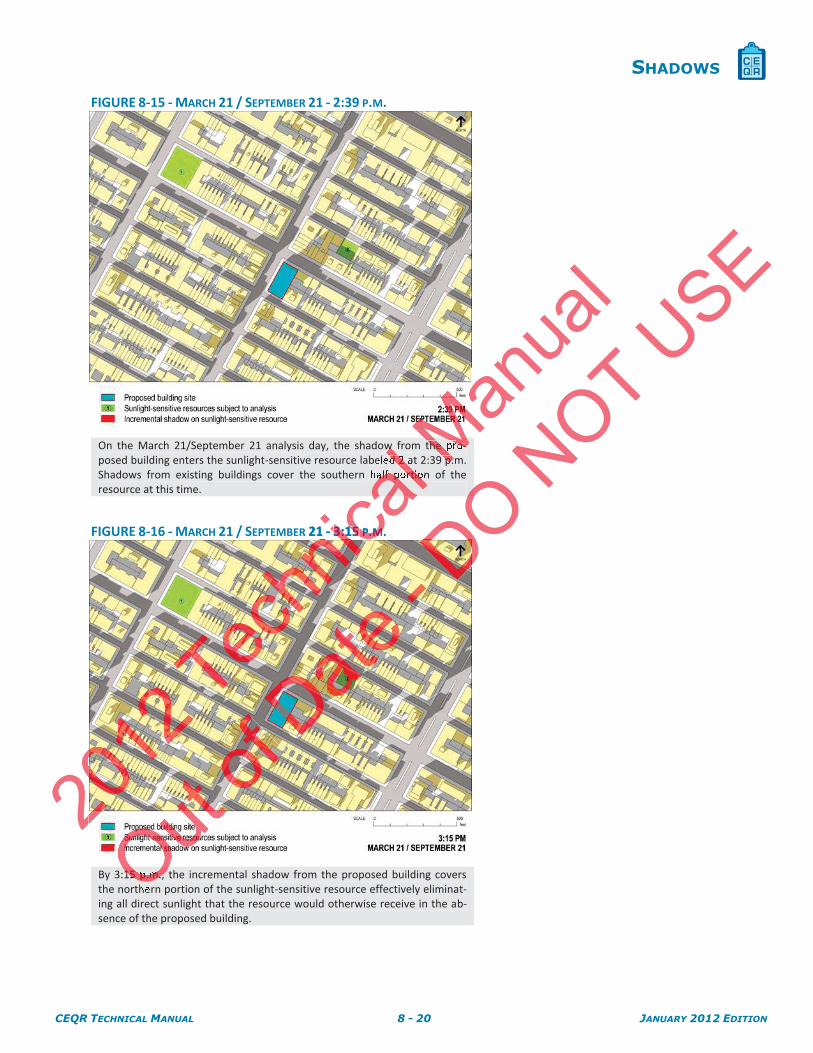
FIGURE 8-15 - MARCH 21 / SEPTEMBER 21 - 2:39 P.M.
On the March 21/September 21 analysis day, the shadow from the pro-posed building enters the sunlight-sensitive resource labeled 2 at 2:39 p.m. Shadows from existing buildings cover the southern half portion of the resource at this time.
FIGURE 8-16 - MARCH 21 / SEPTEMBER 21 - 3:15 P.M.
By 3:15 p.m., the incremental shadow from the proposed building covers the northern portion of the sunlight-sensitive resource effectively eliminat-ing all direct sunlight that the resource would otherwise receive in the ab-sence of the proposed building.
20
nical
w ld 2 a
al alf portio
cal
R 21 - 3:153:15 P P..MM
Manua
l
MMthe pro-Mp.
OO15 p.m., O
DO OONOT U
SE
CEQR TECHNICAL MANUAL 8 - 21 JANUARY 2012 EDITION
SHADOWS
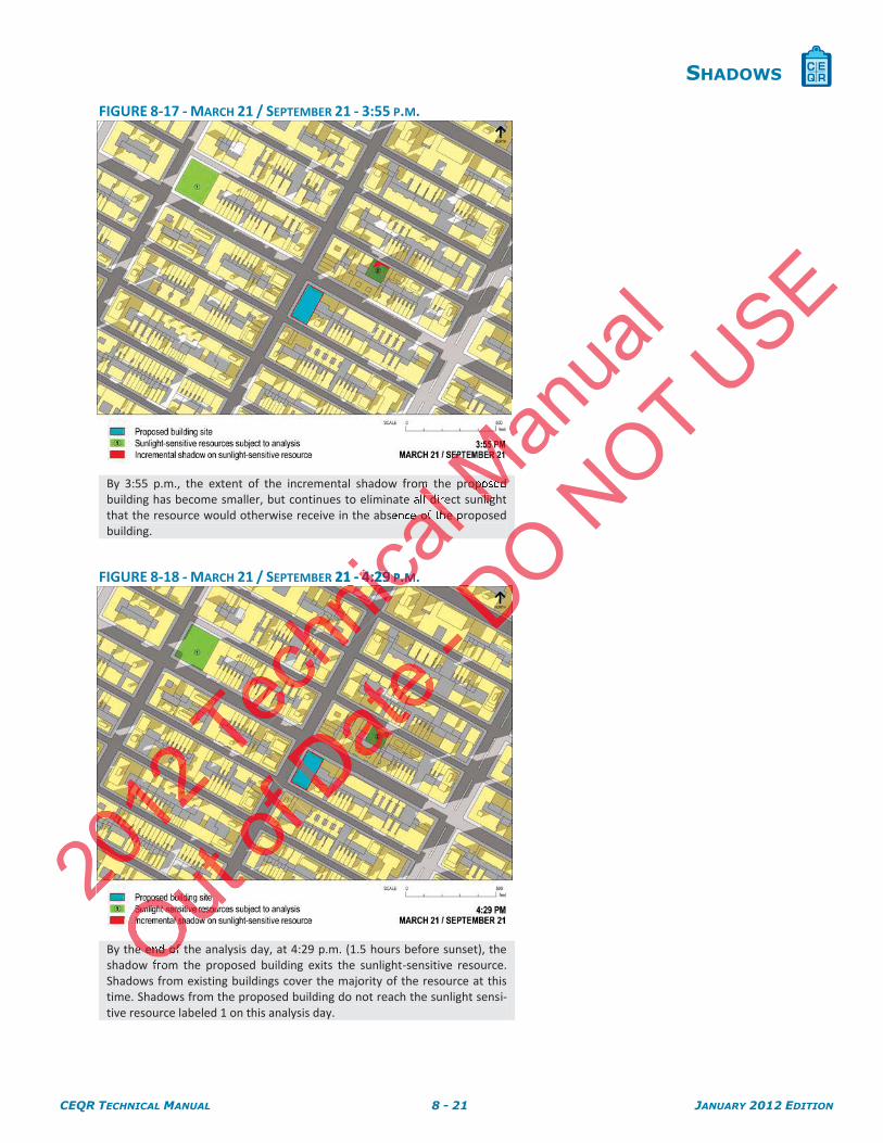
FIGURE 8-17 - MARCH 21 / SEPTEMBER 21 - 3:55 P.M.
By 3:55 p.m., the extent of the incremental shadow from the proposed building has become smaller, but continues to eliminate all direct sunlight that the resource would otherwise receive in the absence of the proposed building.
FIGURE 8-18 - MARCH 21 / SEPTEMBER 21 - 4:29 P.M.
By the end of the analysis day, at 4:29 p.m. (1.5 hours before sunset), the shadow from the proposed building exits the sunlight-sensitive resource. Shadows from existing buildings cover the majority of the resource at this time. Shadows from the proposed building do not reach the sunlight sensi-tive resource labeled 1 on this analysis day.
20
nical
m ll dir
al ce of the p
cal
R 21 - 4:294:29 P P..MM
Manua
l
MMroposed Mnlig
OOe end of O
DO OONOT U
SE
CEQR TECHNICAL MANUAL 8 - 22 JANUARY 2012 EDITION
SHADOWS
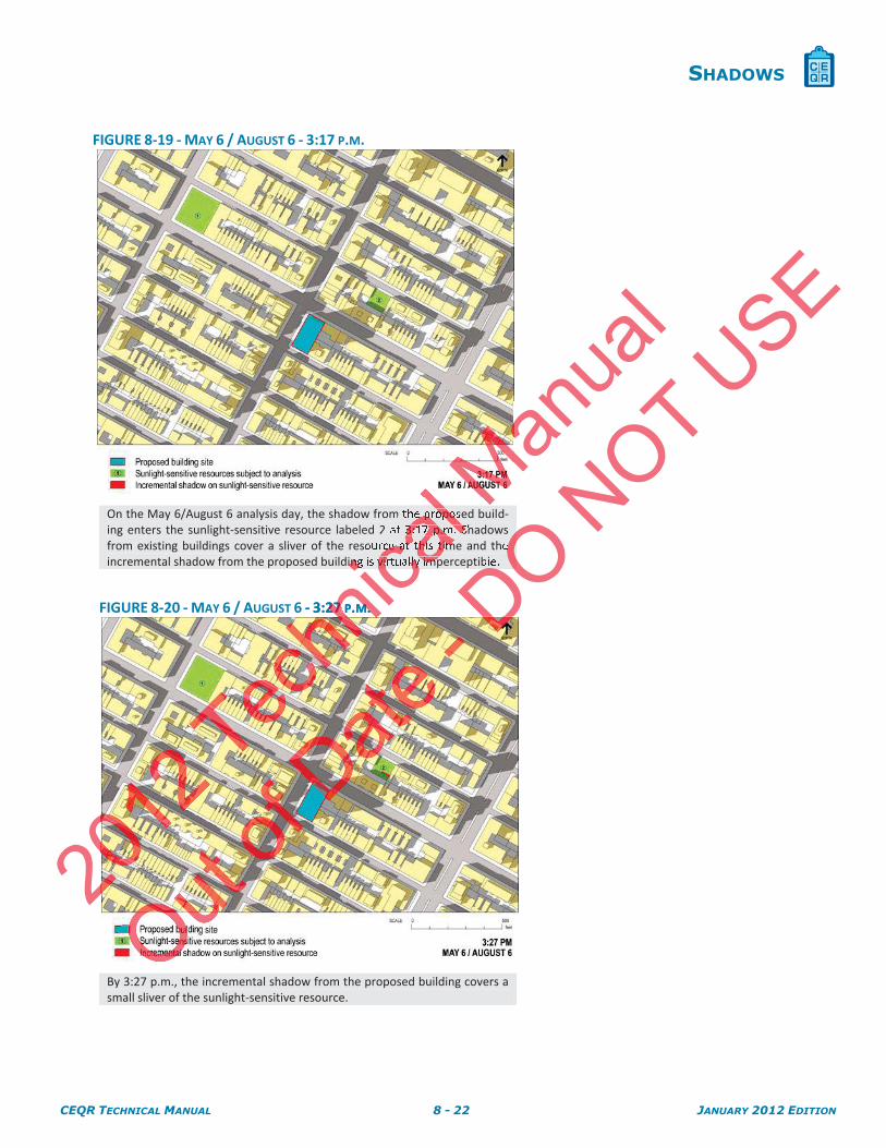
FIGURE 8-19 - MAY 6 / AUGUST 6 - 3:17 P.M.
On the May 6/August 6 analysis day, the shadow from the proposed build-ing enters the sunlight-sensitive resource labeled 2 at 3:17 p.m. Shadows from existing buildings cover a sliver of the resource at this time and the incremental shadow from the proposed building is virtually imperceptible.
FIGURE 8-20 - MAY 6 / AUGUST 6 - 3:27 P.M.
By 3:27 p.m., the incremental shadow from the proposed building covers a small sliver of the sunlight-sensitive resource.
20
hnica
lale proposal 3:17 p.m. S
cace at this tim
icaing is virtually imp
6 - 3:2727 P .MM. .
MManua
l
O
DO DOOe
DONOT U
SE
CEQR TECHNICAL MANUAL 8 - 23 JANUARY 2012 EDITION
SHADOWS
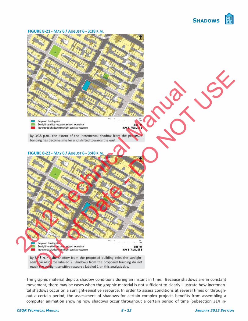
FIGURE 8-21 - MAY 6 / AUGUST 6 - 3:38 P.M.
By 3:38 p.m., the extent of the incremental shadow from the proposed building has become smaller and shifted towards the east.
FIGURE 8-22 - MAY 6 / AUGUST 6 - 3:48 P.M.
By 3:48 p.m., the shadow from the proposed building exits the sunlight-sensitive resource labeled 2. Shadows from the proposed building do not reach the sunlight sensitive resource labeled 1 on this analysis day.
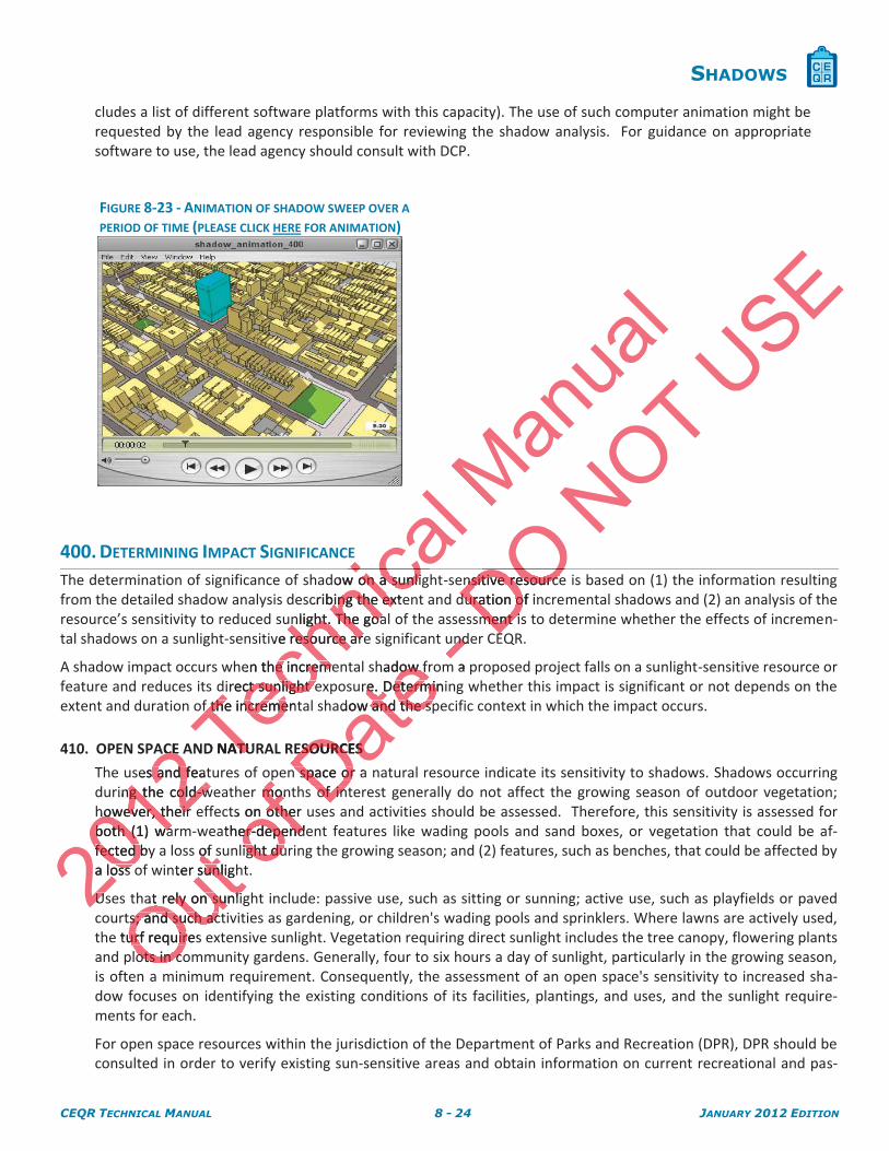
The graphic material depicts shadow conditions during an instant in time. Because shadows are in constant movement, there may be cases when the graphic material is not sufficient to clearly illustrate how incremen-tal shadows occur on a sunlight-sensitive resource. In order to assess conditions at several times or through-out a certain period, the assessment of shadows for certain complex projects benefits from assembling a computer animation showing how shadows occur throughout a certain period of time (Subsection 314 in-
20
cal lm l
M.
Manua
l
MMroposed M
OuOu3:48 p.m., the shOsitive resouOh the sunl
DO NOT U
SE
CEQR TECHNICAL MANUAL 8 - 24 JANUARY 2012 EDITION
SHADOWS
cludes a list of different software platforms with this capacity). The use of such computer animation might be requested by the lead agency responsible for reviewing the shadow analysis. For guidance on appropriate software to use, the lead agency should consult with DCP.
FIGURE 8-23 - ANIMATION OF SHADOW SWEEP OVER A
PERIOD OF TIME (PLEASE CLICK HERE FOR ANIMATION)
The determination of significance of shadow on a sunlight-sensitive resource is based on (1) the information resulting from the detailed shadow analysis describing the extent and duration of incremental shadows and (2) an analysis of the resource’s sensitivity to reduced sunlight. The goal of the assessment is to determine whether the effects of incremen-tal shadows on a sunlight-sensitive resource are significant under CEQR.
A shadow impact occurs when the incremental shadow from a proposed project falls on a sunlight-sensitive resource or feature and reduces its direct sunlight exposure. Determining whether this impact is significant or not depends on the extent and duration of the incremental shadow and the specific context in which the impact occurs.
410. OPEN SPACE AND NATURAL RESOURCES
The uses and features of open space or a natural resource indicate its sensitivity to shadows. Shadows occurring during the cold-weather months of interest generally do not affect the growing season of outdoor vegetation; however, their effects on other uses and activities should be assessed. Therefore, this sensitivity is assessed for both (1) warm-weather-dependent features like wading pools and sand boxes, or vegetation that could be af-fected by a loss of sunlight during the growing season; and (2) features, such as benches, that could be affected by a loss of winter sunlight.
Uses that rely on sunlight include: passive use, such as sitting or sunning; active use, such as playfields or paved courts; and such activities as gardening, or children's wading pools and sprinklers. Where lawns are actively used, the turf requires extensive sunlight. Vegetation requiring direct sunlight includes the tree canopy, flowering plants and plots in community gardens. Generally, four to six hours a day of sunlight, particularly in the growing season, is often a minimum requirement. Consequently, the assessment of an open space's sensitivity to increased sha-dow focuses on identifying the existing conditions of its facilities, plantings, and uses, and the sunlight require-ments for each.
For open space resources within the jurisdiction of the Department of Parks and Recreation (DPR), DPR should be consulted in order to verify existing sun-sensitive areas and obtain information on current recreational and pas-
400. DETERMINING IMPACT SIGNIFICANCE
2012
ACE ACE
ses and feats and fring the cold-wg the cold-w
however, their however, their both (1) waboth (1) wafected byfected ba loss oss
UsU
Techn
icdow on a sunligon a sunlicribing the extebing the ex
nlight. The goanlight. The goave resource areresource are
en the incremee incremedirect sunlight edirect sunlight e
f the incrementf the increme
D NATUATU
ical
icMan
ual
Out s of sof s
nter sunlighsunli
at rely on sunliat rely on sunlits; and such acts; and such ac
turf requires urf requirots in coots in c
a m
of r monmon
ts on other un othether-dependeer-depend
light duright du
Datehadow frow f
ure. Determinire. Determidow and the spand the sp
ESOURCES ESOURCES
n space or a n space orof intof in
- ndend
m a p
DOnsitive resourcensitive resourceduration of induration o
ment isment iEEDO DO
NOT USE
CEQR TECHNICAL MANUAL 8 - 25 JANUARY 2012 EDITION
SHADOWS
sive activities in sunlit areas of the park, as well as planned capital projects that may result in a change to existing sunlight-sensitive features.
Although shadows on project-generated open space are not considered significant under CEQR, the assessment of shadows on project-generated open space should be conducted and documented with the same level of detail as other sunlight-sensitive open space resources when such project generated open space is included qualitatively as part of a detailed analysis required Chapter 7, “Open Space.”
411. Assessment
A site plan and inventory of the features that constitute the open space or natural resource as well as a survey detailing existing conditions, quality and levels of use of the open space are needed to determine the signific-ance of the shadow cast in the future With-Action. The majority of this information may be already available through the analysis in Chapter 7, “Open Space,” and Chapter 11, “Natural Resources,” respectively, and should be used as part of the assessment.
The site plan should show the boundary and layout of the open space or natural resource, the location of ve-getation and sunlight-sensitive features, its built structures, and other features of the open space, including paved areas. The site plan should identify the direction of true north and include a graphic scale bar, and may be complemented by an aerial photograph and photographs of the open space features. Figure 8-24 below provides an example of an open space site plan.
To carry out the assessment, the composite shadows obtained from the detailed shadows analysis are overla-id on the open space site plan in order to determine the areas and sunlight-sensitive features of the open space that would be cast in the project’s incremental shadow. The assessment is performed for all the months of interest when incremental shadows are predicted to be cast on the open space or natural resource.
In the area that would be cast in the project's incremental shadow, it may be necessary to inventory vegeta-tion, noting species, caliper, height, and age. Such inventory may be presented in the site plan. It may be ad-visable to use the services of a recreation planner, landscape architect, or horticulturist to inventory, survey, and assess the sensitivity of the open space to shadow. When the sunlight-sensitive resource is under the ju-risdiction of DPR, determinations about the relative shade tolerance of existing vegetation should be re-viewed by DPR.
If the open space or natural resource supports activities that rely on sunlight and would be cast in project shadow, it is also appropriate to survey its use. This should be done on a sunny day in the spring, summer, or fall, preferably on the weekend or at the time of peak use. Based on this work, the activities, plants, or other facilities in the open space that need sunlight and may be affected by project shadows should be identified and may be identified in the site plan. To the extent possible, the acceptable and minimum amounts of daily sunlight required for the plants or activities should be estimated.
412. Estimating the relative loss of sunlight from incremental shadows
Where the incremental shadows from the project fall on sunlight-sensitive features or uses, additional analy-sis is required to assess the loss of sunlight relative to sunlight that would be available without the project. It is necessary to estimate shadow patterns on the affected area of the open space or resource throughout the day in order to assess how shadows, both incremental shadows from the project and shadows cast by existing structures, affect the sensitive features. It should also be assessed whether these sensitive features are al-ready subject to substandard sunlight conditions in the absence of additional incremental shadows from the project. The assessment should consider all shadows on the portion of the sunlight-sensitive features or uses affected by the project's incremental shadow throughout the day. The analysis should be undertaken for each of the months of interest where the effects of incremental shadows from the project could be significant.
It should be noted that the shade created by trees and other natural features is not considered to be shadow of concern for the impact analysis; however, incremental shadow on a tree-shaded environment may create a
abls in the oin the
may be identifmay be identunlight requiredght required
412. Estima412. Es
Where Where sis issis iisis
Techn
icalows ows
etermine thmine tcremental shadental shad
re predicted to redicted to
e project's incroject's incht, and age. Suand age. S
a recreation plaa recreation plf the open spache open spa
rminations abonations abo
e or natural ree or natural lso appropriatelso appropriateon the wee w
n s
Manua
l eded toded ormation mayation ma
atural Resourcl Resourc
pace or naturae or naturand other featurother featu
rue north and inrue north and raphs of the ophs of the op
ained frained f
Outcrementeme
ired to assessto assessssary to estimassary to estim
in order to assen order to assectures, affectures, aff
subjectsubjecth
of thethe
he plants plan
relative losslative los
shadshad
Date e rela
e supports actipports actiurvey its use. Thy its use. T
or at the time or at the timehat need sunligat need sunlig
e plan. Te plan. Tactact
-w. Ww. We shade s
DOnd
he assesshe assesst on the openon the op
tal shadow, it mtal shadow, it mntory may be ntory may
ape arcape arc
NOT urce, urcethe open sthe op
e a graphic scalee a graphic scpace features. Fce features. F
e detailed shade detailed snlight-sennlight-sen
nt int
USE survey survey he signifihe signific-c-
eady available ady available espectively, anpectively, an
locatiolocatio
CEQR TECHNICAL MANUAL 8 - 26 JANUARY 2012 EDITION
SHADOWS
significant impact as the incremental shadow is not redundant with tree shade, and the tree canopy may be considered a sunlight-sensitive resource.
Consideration of this inventory of available open space resources within the Open Space study area outlined in Chapter 7, “Open Space,” may be helpful in assessing the significance of the loss of sunlight for active or passive recreational uses. For example, if many of the parks in the study area already have shadows on simi-lar sun sensitive features, the additional loss of sunlight in parks may be more critical.
Some open spaces contain facilities that are not sensitive to sunlight. These are usually paved, do not contain sitting areas, vegetation or unusual or historic plantings that necessitate sunlight, and do not accommodate active uses. Incremental shadows on these portions of an open space resource should be documented and disclosed but are not generally considered significant under CEQR.
The significance of shadows cast on an open space should be closely examined in relation to the open space’s utilization rates, as discussed in Chapter 7, “Open Space,” in order to determine the potential for the shadows to affect the times of day the space is commonly used. This is particularly important when shadows are cast on open spaces that fall within an area without similar sunlit resources. Estimating the loss of sunlight on paved or hardscape open spaces that accommodate active uses–such as basketball and tennis courts–may be determined based on how the active area is used by the community and the utilization rate of such spaces as described and assessed in Chapter 7, “Open Space.” While this loss of sunlight is generally not considered significant, the lead agency should consider how the area is used by the community and the utilization rate of such spaces as described and assessed in Chapter 7, “Open Space,” in order to determine the significance of the incremental shadow.
420. HISTORIC RESOURCES
The shadow sensitivity of the sunlight-sensitive features of an historic structure depends on its design and setting. If any of the characteristics or elements that make the resource historically significant depend on sunlight, it is ne-cessary to inventory those features to determine their sensitivity to a reduction in sunlight. The assessment should consider the specific context in which the incremental shadow occurs and provide an analysis of how other shadows from existing structures affect the sunlight-sensitive features of the historic resource throughout the day.
Additional guidance regarding the identification of sunlight-sensitive features and assessment of stained glass windows can be found in the National Park Service (NPS) Preservation Brief 17, “Architectural Character: Identify-ing the Visual Aspects of Historic Buildings as an Aid to Preserving Their Character,”, and NPS Preservation Brief 33: “The Preservation and Repair of Historic Stained and Leaded Glass.”
421. Assessment
The assessment of shadows on an historic resource focuses only on those features or portions of the historic resource that are sunlight-sensitive and can be enjoyed by the public. Only the incremental shadow duration on the sun-sensitive features of the historic resource is of concern. The assessment of shadows on an historic resource requires a site plan and inventory of the sunlight-sensitive features. The inventory discusses the his-toric significance of the affected features and how the features are enjoyed by the public, including views from streets and other publicly accessible places. The sunlight-sensitive features should be described in detail and illustrated as necessary with drawings and/or photographs, including axonometric drawings when the af-fected features cannot be assessed on a site plan. The majority of this information may be already available in Chapter 9, “Historic and Cultural Resources,” and should be used as part of the assessment.
The inventory of sunlight-sensitive features may also be determined by checking the LPC designation report for LPC designated properties, scenic landmarks, and (publicly accessible) interiors, or the State/National Reg-ister nomination form for State/National Register listed properties. The State/National Register listings com-prise the entirety of the building and/or structure and do not distinguish between publicly and privately ac-
2012
ua
2 PreservPrese21. Assessment Assessment
The assessmeThe assessmresource thresourcon the son the resouesototo
Techn
ical r 7, 7
ht-sensitive featensitive feaments that maknts that ma
atures to deteres to dete context in whiontext in wh
structures affecctures affec
nce regarding tnce regardinbe fbe found in theound in the
spects of Hcts oTon a
Manua
l shs
mined in relatio in relatioetermine the pmine the p
icularly importaarly imporesources. Estimurces. Estim
es–such as bassuch as basommunity and tmmunity and
While tWhile this loss his loss rea is used byrea is used b
en Spacen Spa
Out e
nsitive itiveequires a site res a site
gnificance of thnificance of thm streets and otstreets and otd illustrated asllustrated
featurefeature9
ofshadows on andows on anlight-sensight-sen
turestures
Date sunl
entification of fication of nal Park ServicPark Servic
c Buildings as ac Buildings as
Dapair of Historic pair of Historic D
-meme-sens-se
DO of an historic strof an historic st
esource historesource hisensitivitsensitivi
shsh
NOT hg the log th
l and tennis and tetilization rate ofilization rate o
nlight is generaght is gencommunity and mmunity and
order to deterorder to d
USEainin
odate odatnted and d and
he open space’se open spaceal for the shadoal for the shadoshadows arshadows
of suof su
CEQR TECHNICAL MANUAL 8 - 27 JANUARY 2012 EDITION
SHADOWS
cessible interiors. Building interiors that are State/National Register listed or eligible, or LPC designated, are included in the types of resources that may receive potential shadow impacts. All other interiors are not con-sidered under this type of analysis. Consult with the staff of the LPC to confirm presence or absence of sun-light-sensitive features on LPC and S/NR eligible properties.
430. DETERMINING IMPACT SIGNIFICANCE
The scenarios illustrated below provide general guidelines for determining impact significance and supplement the considerations described in Sections 410 and 420. As with every technical area, each project must be consi-dered on its own merits, taking into account its unique circumstances. For instance, the precise location of the in-cremental shadow within the sunlight-sensitive resource (or the presence of well-lit resources in close proximity to the affected resource) may be highly relevant because the incremental shadow may affect specific features that are key to the character, use, survival or enjoyment of the sun-sensitive resource. For the purposes of CEQR, the determination of impact significance on ambiguous cases should be done in a conservative manner. In all cas-es, the rationale for the determination of impact significance should be clearly presented in the resulting envi-ronmental review document.
In general, an incremental shadow is not considered significant when its duration is no longer than 10 minutes at any time of year and the resource continues to receive substantial direct sunlight. A significant shadow impact generally occurs when an incremental shadow of 10 minutes or longer falls on a sunlight sensitive resource and results in one of the following:
VEGETATION
A substantial reduction in sunlight available to a sunlight-sensitive feature of the resource to less than the minimum time necessary for its survival (when there was sufficient sunlight in the future without the project).
A reduction in direct sunlight exposure where the sensitive feature of the resource is already subject to substandard sunlight (i.e., less than minimum time necessary for its survival).
HISTORIC AND CULTURAL RESOURCES
A substantial reduction in sunlight available for the enjoyment or appreciation of the sunlight-sensitive features of an historic or cultural resource.
OPEN SPACE UTILIZATION
A substantial reduction in the usability of open space as a result of increased shadow (should cross reference with information provided in Chapter 7, “Open Space,” regarding anticipated new users and the open space’s utilization rates throughout the affected time periods).
FOR ANY SUNLIGHT-SENSITIVE FEATURE OF A RESOURCE
Complete elimination of all direct sunlight on the sunlight-sensitive feature of the resource, when the complete elimination results in substantial effects on the survival, enjoyment, or, in the case of open space or natural resources, the use of the resource.
In determining impact significance, it is appropriate to consult with the appropriate government agency in which the affected sunlight-sensitive resource jurisdiction falls, including DPR, LPC, or other agencies, as required. Be-low is a non-exclusive list of examples of significant impacts caused by incremental shadows.
EXAMPLES A chapel attached to a 19th century cathedral that is designated as a New York City Landmark, listed in the State and National Register of Historic Places, and a designated National Historic Landmark would receive incremental shadows on some of its stained glass windows from a proposed building. The review finds that the interiors of such religious structures are important to their character and that the qualities that the stained glass windows impart to the interior are a major part of the overall architectural intent in this church
2012
A sArefererefthe opehe op
FOR ANY FOR ANY
Techn
ical ght available tovailable to
y for its survivar its surviv
sunlight exposnlight exponlight (nlight (i.e.i.e., less, less
RAL RESOURCES RESOURCE
ntial reductionl reductionve features of ave features of a
CE UTILIZATICE UTILIZ ON
bstantialntiae
Manua
l well-lit ll-lishadow maadow m
tive resource.esource. FFe done in a cone in a co
uld be clearly pbe clearly
ant when its duant when its dsubstantial direbstantial dire
minutes or longminutes or long
Out mpletple
space or nace or
termining impacermining impaaffected sunliffected sunls a non-ex a non-ex
of ce’s uce’s
HT-SENSITIVE FNSITIV
te eliminationeliminatioeliminatlimina
Date unlight avaght ava
oric or cultural ic or cultura
ction in the usaction in the usaormation proormation p
zation zation
- b
DOnlight-senlight-sen
en there was sthere wa
re the sensitre the senm time m time
NOTntet
n is no longer tn is no longenlight. A signiflight. A signif
lls on a sunlightls on a sunlig
ee
USEe cone co
n of the i of the in-ose proximity ose proximity
specific featurepecific featuree purposes of Cpurposes of C
ive manner. Inive manner. Inn the resun the res
CEQR TECHNICAL MANUAL 8 - 28 JANUARY 2012 EDITION
SHADOWS
and part of the Gothic Revival style. After assessing the extent and duration of the incremental shadow, it is determined that the darkening would occur for a substantial part of the day on the stained glass windows and would constitute a significant impact. In addition, the impact would occur regardless of whether the ca-thedral holds services when the incremental shadow is cast.
A 19th century scenic landmark that is designated as a New York City Landmark, listed in the State and Na-tional Register of Historic Places, and a designated National Historic Landmark would receive incremental shadow from a proposed building. After taking into account the time of the year, shadow duration during the day and the number of days a years of the incremental shadow, the review finds that the park is sensi-tive to the incremental shadows because they detract from the experience of a seemingly naturalistic envi-ronment that was part of the design intent of the park, that the addition of incremental shadow would en-danger the rare and exotic plant species that were part of its original horticultural design, and that the in-cremental shadows could therefore constitute a significant impact.
A 20th century office building that is designated a New York City Landmark that also has a publicly accessi-ble interior garden atrium that is designated as a New York City interior landmark would receive incremental shadow from a proposed structure. The full height atrium is considered an outstanding and unique example of an “urban greenhouse.” After taking into account the extent and duration of the incremental shadow, the review finds that the incremental shadow that would be cast on the atrium would detract from the pub-lic’s appreciation and enjoyment of the space and could therefore result in a significant shadow impact.
DETERMINING IMPACT SIGNIFICANCE FOR THE EXAMPLE USED THROUGHOUT THE CHAPTER The results of the example’s detailed shadow analysis document the extent and duration of the in-cremental shadows that the proposed project would cast on two sunlight-sensitive resources, summa-rized in Table 8-1 and illustrated in Figures 8-11 through 8-22.
SUNLIGHT-SENSITIVE RESOURCE EXAMPLE 1:
Incremental shadows from the proposed building would reach the sunlight-sensitive resource la-beled 1 only on the December 21 analysis day. No incremental shadows from the proposed build-ing would reach the resource on other analysis days.
On the December 21 analysis day, incremental shadows from the proposed building would enter the sunlight-sensitive resource at 8:51 a.m. (the start of the analysis day) and would exit the re-source at 9:41 a.m., remaining in the resource for a total of 50 minutes.
At the start of the analysis day at 8:51 a.m. (Figure 8-11) the resource is almost covered in sha-dows from both the proposed building and from existing buildings. By 9:08 a.m. (Figure 8-12), both shadows have shifted north allowing sunlight to reach the south east corner of the resource where the playground is located (see site plan in Figure 8-23). By 9:24 (Figure 8-13), both sha-dows have shifted further north and to the east allowing sunlight to reach approximately half of the resource, including a large portion of the central lawn area. By 9:41 a.m. (Figure 8-14), the in-cremental shadow exits the resource and although the existing building to the east casts some shadow on it, sunlight reaches the majority of the resource.
2012
At dows dowboth shaoth shwhereheredowd
Techn
ical MPLE UPLE
hadow analow anad project wouldject would
n Figures 8-11 thures 8-11 t
CE EXAMPLE 1MPLE 1: :
s from the propm the prohe December 21e December
h the resource he resource
cember 21 anamber 21 annlight-sensitive nlight-sensitive
rce at 9:41 a.m.rce at 9:41 a.m
e start of rt oom
Manua
l of incof inhorticulturarticultur
ty Landmark thandmark thCity interior landinterior land
m is considered onsideredthe extent andthe extent an
would be cast ould be cast od could therefod could therefo
THROUTHR
Outeso
ementalentashadow on itdow on it
ofhavha
playgrounygrove shifted furtshifted furrce, includie, inclu
adowadow
Date her
day, incremeincremrce at 8:51 a.m at 8:51 a.m
aining in the resng in the re
nalysis day at 8nalysis day at 8he proposed bhe proposed b
hifted nohifted ns los l
-yysis dysisDO ume
on two suon two sh 8--22.2
ing woulding woul incinc
NOTk wouwo
tstanding atstandation of the incation of the
atrium would datrium would dsult in a significault in a signifi
THE CHAPTER THE CHAPTERthe extethe e
ghtght
USEis senis se
alistic envlistic envi-ow would eow would en-n-
and that the ind that the i
has a publiclyhas a publeceive eceive
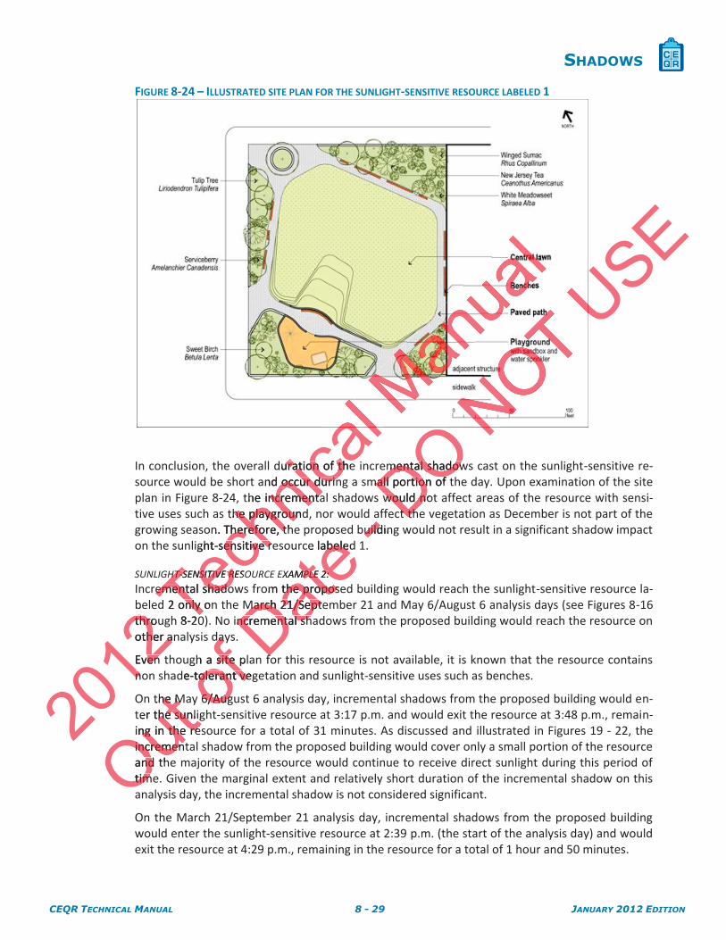
CEQR TECHNICAL MANUAL 8 - 29 JANUARY 2012 EDITION
SHADOWS
FIGURE 8-24 – ILLUSTRATED SITE PLAN FOR THE SUNLIGHT-SENSITIVE RESOURCE LABELED 1
In conclusion, the overall duration of the incremental shadows cast on the sunlight-sensitive re-source would be short and occur during a small portion of the day. Upon examination of the site plan in Figure 8-24, the incremental shadows would not affect areas of the resource with sensi-tive uses such as the playground, nor would affect the vegetation as December is not part of the growing season. Therefore, the proposed building would not result in a significant shadow impact on the sunlight-sensitive resource labeled 1.
SUNLIGHT-SENSITIVE RESOURCE EXAMPLE 2: Incremental shadows from the proposed building would reach the sunlight-sensitive resource la-beled 2 only on the March 21/September 21 and May 6/August 6 analysis days (see Figures 8-16 through 8-20). No incremental shadows from the proposed building would reach the resource on other analysis days.
Even though a site plan for this resource is not available, it is known that the resource contains non shade-tolerant vegetation and sunlight-sensitive uses such as benches.
On the May 6/August 6 analysis day, incremental shadows from the proposed building would en-ter the sunlight-sensitive resource at 3:17 p.m. and would exit the resource at 3:48 p.m., remain-ing in the resource for a total of 31 minutes. As discussed and illustrated in Figures 19 - 22, the incremental shadow from the proposed building would cover only a small portion of the resource and the majority of the resource would continue to receive direct sunlight during this period of time. Given the marginal extent and relatively short duration of the incremental shadow on this analysis day, the incremental shadow is not considered significant.
On the March 21/September 21 analysis day, incremental shadows from the proposed building would enter the sunlight-sensitive resource at 2:39 p.m. (the start of the analysis day) and would exit the resource at 4:29 p.m., remaining in the resource for a total of 1 hour and 50 minutes.
2012
bethrouthroother anher a
Even vennon
Techn
ical
duration of theuration of thand occur durinoccur durin
the incrementancrementathe playgroundhe playgroun
n. Therefore, thTherefore, tght-sensitive reensitive r
HT-SENSITIVE RESOHT-SENSITIVE Remental shadoemental shadod 2 only ononly
8-20
Out the Mhe M
ter the sunlihe sunliing in the reng in the reincremenincremenand thndtimtim
of dayda
gh a site plasite e-tolerant vegolerant ve
6/Aug6/Aug
Date pos
e labeledabele
EXAMPLE 2: MPLE 2: om the proposethe propos
March 21/SepteMarch 21/Septencremental shncremental sh
ff
-uildinuildDO
mental shadowmental shadowmall portion of mall portion of
would notwould noct thct th
N
USE
CEQR TECHNICAL MANUAL 8 - 30 JANUARY 2012 EDITION
SHADOWS
As discussed and illustrated in Figures 15 - 18, the incremental shadow from the proposed build-ing would substantially reduce and eventually eliminate the sunlight that would reach the re-source during a relatively long period of time. The shadow would affect the resource’s vegetation as March is part of the growing season and would affect sunlight-sensitive uses in the resource. Therefore, the proposed building would result in a significant shadow impact on the sunlight-sensitive resource labeled 2.
Where a significant impact is identified, potential mitigation strategies must be assessed to reduce or eliminate, to the greatest extent practicable, the effects caused by incremental shadows.
In all cases, additional mitigation strategies that involve modifications to the height, shape, size or orientation of the proposed building may be explored and include:
The reorientation of building bulk to avoid incremental shadow on sunlight-sensitive features of the open space, natural or historic resource.
The reduction of the overall height of the project.
Exploring the use of alternative technologies that may reduce the height of the project and reduce shadow im-pacts (i.e. the use of dry cooling towers vs. wet cooling towers).
The relocation of the project to a different site, when appropriate.
For open space resources, the types of mitigation that may be appropriate include relocating sunlight-sensitive fea-tures within an open space to avoid sunlight loss, relocating, replacing or monitoring vegetation for a set period of time, undertaking additional maintenance to reduce the likelihood of species loss, or providing for replacement facili-ties on another nearby site. Other potential mitigation strategies include the redesign or reorientation of the open space site plan to provide for replacement facilities, vegetation or other features. Where the affected open space is a city park, it is appropriate for the lead agency to coordinate mitigation options with the Department of Parks and Recreation (DPR). The lead agency may also wish to coordinate with DPR as an expert agency on open spaces that are not city parks.
For historic resources, potential mitigation strategies include the use of artificial lighting to simulate the effect of sun-light on features such as stained glass windows. Where the affected historic resource is a New York City landmark, a LPC-calendared or eligible property or a National Register listed or eligible structure or property, it is appropriate for the lead agency to coordinate mitigation options with LPC. The lead agency may also wish to coordinate with LPC as an expert agency on historic resources that are not NYC landmarks.
Potential mitigation strategies to reduce or eliminate a significant shadow impact on natural resources may be coordi-nated with the Department of Environmental Protection (DEP).
These mitigation strategies can become alternatives to be analyzed in accordance to the project’s goals and objectives.
Where a significant shadow impact is identified, potential alternatives to reduce or eliminate significant impacts should be explored, including:
The reorientation of building bulk to avoid incremental shadow on sunlight-sensitive features of the open space, natural or historic resource.
The reduction of the overall height of the project.
Exploring the use of alternative technologies where substituting one technology for another may reduce the height of the project and reduce shadow impacts (i.e. the use of dry cooling towers vs. wet cooling towers).
500. MITIGATION
600. ALTERNATIVES 2012
orcy to cocy to c
ncy on historincy on histor
tial mitigation smitigation sed with the Depd with the De
These mitigatiThese mitiga
00.0. AA
Techn
ical te, when when
ion that may bhat may bt loss, relocatit loss, relocat
e to reduce theo reduce thtential mitigatitial mitigati
cement facilitient facilitiehe lead agencye lead agenc
ency may also wy may also
potential mitigpotential mch as stained gch as stained g
igible prope prdinat
Manua
l ede
height, shape, sht, shape,
ow on sunlighton sunlight
ay reduce the hay reduce the hng towers). ng towers).
roro
Ousignificant shagnificant shaed, includind, includi
eoOut rategietegi
NATIVESNATIVE
Ouof rcrc
gies to reduto reent of Environmof Environ
can beccan bec
Date o co
strategies incluategies incluwindows. Wheredows. Whe
or a National Reor a National Rgation options gation options
that are nothat are n
o
-tenate natDO
propriate propriateplacing or mocing or m
hood of specieshood of speciestegies includetegies inc
n or othen or othtigtig
NOT itiveitiv
t of the project of the proje
udud
USEinate, to the ate, to the
r orientation oforientation o
atures oatures o
EE
CEQR TECHNICAL MANUAL 8 - 31 JANUARY 2012 EDITION
SHADOWS
The relocation of the project to a different site, when appropriate.
710. REGULATIONS AND STANDARDS
There are no specific city, state, or federal statutory regulations or standards governing the analysis and assess-ment of shadows.
720. APPLICABLE COORDINATION
Coordination with DCP is required when it is an involved agency and the project includes an action subject to ap-proval by the City Planning Commission. The lead agency should coordinate with those agencies that identify, op-erate, or have jurisdiction over the sunlight-sensitive resources identified in this chapter is recommended. The as-sessment of shadow impacts on a sunlight-sensitive resource and the development of mitigation strategies should be coordinated with the appropriate agency with jurisdiction over the resource. Mitigation would typically require the approval or commitment of such agency. Agencies typically consulted include the Department of Parks and Recreation for sunlight-sensitive open space resources, the Landmarks Preservation Commission for historic and cultural sunlight-sensitive resources, and the Department of Environmental Protection for sunlight-sensitive natu-ral resources.
730. LOCATION OF INFORMATION
The Department of City Planning maintains copies of the Sanborn maps, Fire Insurance Underwriters maps, and tax maps for the entire city. These sources are also available online (except Sanborn maps) and in local public libraries. City Maps are available for viewing in the Borough President's office in each borough and at the Department of City Planning.
New York City Department of City Planning 22 Reade Street New York, NY 10007 www.nyc.gov/dcp Online publications: http://www.nyc.gov\html\dcp\html\subcats\products.shtml Bookstore: www.nyc.gov/html/dcp/html/pub/publist.shtml
The Department of Parks and Recreation maintains a database of the City’s public open spaces available online. For additional information see also Section 730 (Location of Information) of Chapter 7, “Open Space,” for a detailed list of informational resources regarding open space.
New York City Department of Parks and Recreation The Arsenal 830 Fifth Avenue New York, NY 10065 www.nyc.gov/parks
The Landmarks Preservation Commission maintains a database of the City’s historic and cultural landmarks with a variety of information available online including historic district maps and designation reports.
New York City Landmarks Preservation Commission Municipal Building 1 Centre Street, 9th Floor New York, NY 10007 www.nyc.gov/landmarks
700. REGULATIONS AND COORDINATION
2012
he Depahe Deonline. For nline. ForSpaceSp ,”,” for fo
N
Techn
ical aintains copies ons copies
These sources aThese sources available for vieailable for v
nning. ng.
partment of Citpartment of Citt
NY 10007 0007c.gov/dcpov/dcpece publications: e publication
okstore: okstor www.nwww.Tement
Manua
l ject includet includte with those aith those a
ed in this chaptthis chapte developmentvelopmen
r the resource. e resource. ally consulted iconsulted i
e Landmarks Pre Landmarks Pnt of Environmef Environm
OutAr
30 Fifth FiftNew York, Nw York, Nwww.nyc.www.nyc
OuThe LandThe Lanwith awith a
of nana
tailed listed l
rk City DepartmCity Deparal al
nu
Date
/www.nyc.gov\ww.nyc.gov
ateov/html/dcp/httml/dcp/hatrks and Recrearks and Recreanformationnformatio
infoinfo
- DO
Sanborn Sanbornso available onavailable o
in the Boroughin the Borough
NOT ation watione the Departthe De
ation Commissation CommisProtection for sotection f
psps
USEon subject to an subject to aes that identify,s that identif
ecommended. ecommended. tion strategtion strate
d typd typ
CEQR TECHNICAL MANUAL 8 - 32 JANUARY 2012 EDITION
SHADOWS
New York City Department of Environmental Protection
59-17 Junction Boulevard, 13th Floor Flushing, NY 11373 www.nyc.gov/dep
2012
Techn
ical M
anua
l
Out of
Date - D
O NOT U
SE