Embed Size (px)
Citation preview
1
SHAKEMAP USE, DEVELOPMENTS, AND RELATED SYSTEMS
David J. WALD1 and C. Bruce WORDEN2 and Kuo-wan LIN3
Over the past decade the U. S. Geological Survey's (USGS) ShakeMap system—and similar systems around to world—have been developed and employed to rapidly quantify near real time earthquake shaking distributions. These systems have evolved from simply a useful means of visually depicting earthquake ground motions to indispensable tools for earthquake response, planning, loss-modeling, and public information. Since its inception, the ShakeMap system has broadened the range of real time earthquake products available to consumers through enhanced formats and associated tools that use shaking to help prioritize response or estimate impact. In turn, regional and national ShakeMap operators and other scientists have made valuable improvements and contributions, and users have developed innovative applications of these real time earthquake products.
A perhaps underappreciated aspect of the ShakeMap system is its capability to estimate shaking parameters (and their uncertainty) at all points on a dense grid of locations within the domain of the map (Worden et al., 2010). This “smart” interpolation—combining site-corrected prediction-equation estimates with both reported intensity and recorded ground motions—allows informed best estimates at any site of interest. This functionality adds capabilities beyond simple interpolation of recorded shaking values. Providing site-specific shaking estimates has facilitated, for instance, studies and analyses at sites of earthquake building and other damage, calibration of losses to portfolios, and the evaluation of shaking associate with landsliding, liquefaction, and other ground deformation. Likewise, the gridded shaking estimates allow the USGS PAGER (Prompt Assessment of Global Earthquakes for Response) and other openly deployed and commercial loss-estimation systems to produce loss estimates in near real time, for historic earthquakes, and for earthquake scenarios.
In the United States (U.S.), ShakeMap has gained prominence for varied critical applications in diverse user sectors—primarily for situational awareness in disaster response—but traction has been gained for evaluating critical facilities, for businesses, the financial sector, structural engineering analyses, and disaster management. Many users also create response and recovery plans and mitigation strategies using ShakeMap primarily through earthquake scenario planning exercises. For example, segments of the financial sector have embraced real time estimates of shaking hazard and loss assessment for monetary decisions. A number of investment instruments and insurance portfolios employing ShakeMap now include, for example, Catastrophe Bonds (“cat bonds”; e.g., Swiss Re), legislatively mandated rapid estimates of insured losses (e.g., the California Earthquake Authority), and disaster-contingent credit facilities (emergency loans; e.g., Inter-American Development Bank). These financial instruments facilitate transferring risk due to potentially catastrophic events and rely on independent, third party, hazard and loss assessments. Other sectors of the ShakeMap user community—notably critical facilities operators, critical lifeline infrastructure, and transportation—are accommodated by the deployment of the ShakeCast system.
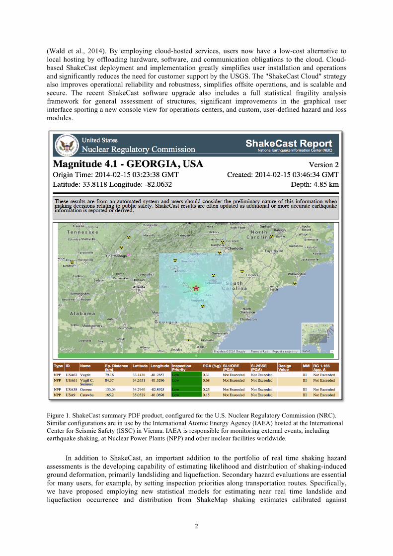
The USGS ShakeCast system is a freely available, post-earthquake situational awareness application (Lin et al., 2008); it has been significantly upgraded and re-released (Version 3 shown in Figure 1) in early 2014. The updated software release coincides with porting ShakeCast to “the cloud" 1 Supervisory Geophysicist, U.S. Geological Survey, Golden, [email protected] 2 Geophysicist, U.S. Geological Survey, Pasadena, through Synergetics Inc., [email protected] 3 Geophysicist, U.S. Geological Survey, Golden, [email protected]
2
(Wald et al., 2014). By employing cloud-hosted services, users now have a low-cost alternative to local hosting by offloading hardware, software, and communication obligations to the cloud. Cloud-based ShakeCast deployment and implementation greatly simplifies user installation and operations and significantly reduces the need for customer support by the USGS. The "ShakeCast Cloud" strategy also improves operational reliability and robustness, simplifies offsite operations, and is scalable and secure. The recent ShakeCast software upgrade also includes a full statistical fragility analysis framework for general assessment of structures, significant improvements in the graphical user interface sporting a new console view for operations centers, and custom, user-defined hazard and loss modules.
Figure 1. ShakeCast summary PDF product, configured for the U.S. Nuclear Regulatory Commission (NRC). Similar configurations are in use by the International Atomic Energy Agency (IAEA) hosted at the International Center for Seismic Safety (ISSC) in Vienna. IAEA is responsible for monitoring external events, including earthquake shaking, at Nuclear Power Plants (NPP) and other nuclear facilities worldwide.
In addition to ShakeCast, an important addition to the portfolio of real time shaking hazard assessments is the developing capability of estimating likelihood and distribution of shaking-induced ground deformation, primarily landsliding and liquefaction. Secondary hazard evaluations are essential for many users, for example, by setting inspection priorities along transportation routes. Specifically, we have proposed employing new statistical models for estimating near real time landslide and liquefaction occurrence and distribution from ShakeMap shaking estimates calibrated against
D. Wald, C. B. Worden, and K. Lin 3
historical ShakeMaps and ground deformation case histories (Nowicki et al., 2014; Zhu et al., 2014). These empirical models employ globally-available susceptibility variables including topographic slope, surficial geology, Vs30, distance to rivers, and the compound topographic index, or CTI, a wetness index.
Vs30—the time-averaged shear velocity in the top 30 meters of the crust—serves not only as the correlative for ShakeMap ground motion site amplification, but also as a proxy for soil strength in the liquefaction analyses (Zhu et al., 2014). As such, we have developed an enhanced Vs30 mapping scheme that allows for the combination of topographic slope and geological unit Vs30 proxies along with interpolation that employs statistical kriging (Thompson et al., 2014). We have implemented and are testing the reliability of Nowicki et al’s and Zhu et al.’s preliminary landslide and liquefaction models for use in both the ShakeCast and PAGER systems and plan to provide these as additional maps in conjunction with the other ShakeMap shaking parameter layers.
For improved loss calibration, scientific interest, and scenario planning, we have also released a major update of the ShakeMap Atlas, which includes forty years (1973-2012) of important historic global earthquakes. In addition to educational and scientific uses, the Atlas is fundamental for earthquake hazard studies and losses, secondary hazard modeling calibration, and earthquake scenario exercises. The PAGER system, for example, depends on this ShakeMap Atlas for empirical loss calibration. Nearly one hundred of the Atlas events which have significant losses have been contributed to the Global Earthquake Model’s (GEM) Earthquake Consequences Database (Pomonis and So, 2012) where they form the basis of point shaking hazard estimates at locations of significant earthquake consequences databased therein.
Because a well-constrained ShakeMap is dependent on a robust, real-time earthquake source, site amplification, and shaking data, it is worth considerable scientific and technical effort to improve the quality and quantity of ShakeMap macroseismic and ground motion data, propagation and site characterization, and finite fault models, and any other useful constraints. Ongoing developments and other progress on ShakeMap strategies, users, and uses will be highlighted. Algorithmic and continuing contributions from the scientific community and other ShakeMap users have contributed to significantly improved ShakeMap operations; such efforts and contributions are greatly appreciated.
REFERENCES Kammerer AM, Godoy AR, Stovall S, Ake JP, Altinoyollar A, Bekiri N, Wald DJ, and Lin K (2011)
“Developing and Implementing a Real-Time Earthquake Notification System for Nuclear Power Plant Sites using the USGS Shakecast System”, Transactions, SMiRT 21; 6-11,New Delhi, India, 8 pp
Lin K, and Wald DJ (2008) ShakeCast Manual, U.S. Geol. Survey Open File Rep. 2008; 2008-1158, 90 pp Nowicki MA, Wald DJ, Hamburger MW, Hearne M, Thompson EM. (2014) “Development of a Globally
Applicable Model for Near Real-Time Prediction of Seismically Induced Landslides”, Engineering Geology (2014), doi: 10.1016/j.enggeo.2014.02.002
Pomonis A, and So E (2012) GEM Earthquake Consequences Database Global Component Project, GEM Technical Report V2.0, 65 pp., GEM Foundation, Pavia, Italy
Thompson, EM, Wald DJ, and Worden CB (2014) “A Vs30 Map for California with Geologic and Topographic Constraints”, Bull. Seism. Soc. Am., in review
Wald DJ, Lin K, Turner L and Bekiri N (2014) “U.S. Geological Survey's ShakeCast System: A Cloud-based Future”, Proceedings of the Tenth U.S. National Conference on Earthquake Engineering (10NCEE), Anchorage, Alaska
Worden CB, Wald DJ, Allen TI, Lin K, Garcia D, and Cua G (2010) “A Revised Ground-Motion and Intensity Interpolation Scheme for ShakeMap”, Bull. Seism. Soc. Am., 100, No. 6, 3083–3096
Zhu J, Daley D, Baise LG, Thompson EM, Wald DJ, and Knudsen KL (2013) “A Geospatial Liquefaction Model for Rapid Response and Loss Estimation”, Earthquake Spectra, 2014; in press