Embed Size (px)
Citation preview

Shared Bike/Bus Lanes: Do They Work? Sara Jane Hendricks Senior Research Associate University of South Florida
Mary Anne Koos Special Projects Coordinator Florida Department of Transportation
CUTR Webcast Online Series Thursday, September 20, 2012

What is a Shared Bicycle/Bus Lane (SBBL)?
Panama City Beach Source: Streetscape Design
Manual

Interest is increasing to do more with limited street right-of-way
• SBBLs are less common in the U.S. than in the U.K. and several European nations.
• SBBLs function in different settings. • Few studies have evaluated their safety or
effectiveness. • SBBLs tend to be initiated by local
governments rather than transit agencies.

Presentation Objectives
• Share findings on – Available guidance in U.S. states and
municipalities – General characteristics of existing SBBLs – Four case study examples – Key considerations for SBBL design and
operation – Recommendations for further research

State Guidance • Illinois DOT: Bureau of Design and Environment Manual
– SBBL minimum width 16.5 ft to curb face • Maryland: Bicycle and Pedestrian Design Guidelines
– An SBBL is typically wider than standard 11-foot lane – Must plan in consultation with Bicycle and Pedestrian
Coordinator • Washington, D.C.: Bicycle Facility Design Guide
– No guidance for SBBL but DDOT Bicycle Facility Design Guide illustrates alternative configurations for bike facilities relative to bus stops where there is limited right-of-way
• Washington State: Design Manual M22.01.07 – Suggests consideration of SBBL “…where bus speeds and
volumes are low…”

Municipal Guidance • Pima County DOT, City of Tucson DOT, AZ: Pavement Marking
Design Manual – Recommends minimum and standard SBBL widths – Illustrates accepted configuration for SBBLs
• City of San Francisco, CA: Bicycle Plan Update – Recommends range for SBBL width – Recommends study of safety of SBBLs – http://www.bettermarketstreet.org
• City of Albuquerque, NM: Bikeways and Trails Master Plan Design Guidelines – Recommends range for SBBL width – Recommends use of SBBL where width for separate and adjacent
bike and bus lanes is unavailable • City of Minneapolis, MN: Bicycle Facility Design Guidelines
– Recommends minimum and standard SBBL widths – Lists considerations: bicycle volumes, bus frequency, sufficient SBBL
width for passing within the lane, time restrictions
General Findings
• Identified 27 examples of existing SBBLs in U.S.
• Identified 10 other examples of facilities that are unofficial, planned, under study, former, or unusually designed
• Found variations by bus stop spacing, existence of parking lanes, colored lanes, and time restrictions
Chestnut Street, Philadelphia, PA Source: Michelle DeRobertis

During off-peak travel periods, some SBBLs allow on-street parking

SBBL Characteristics 1. Short Connector Segments
9th St. NW, Washington,
D.C. Photo credit: JoAnne Fiebe

SBBL Characteristics 2. Urban/Downtown Locations
Elliot Ave. W 15th Ave. W Seattle, WA Source: John
Mauro

SBBL Characteristics 3. Suburban/Low Density
MD 528 (Coastal Highway) near 70th St. Ocean City, Maryland Source: John Ciccarelli

Case Study: MD 528 Coastal Hwy, Ocean City, MD
Signage indicates interrupted section Photo credit: John Ciccarelli
17th Street to E. 145th Street
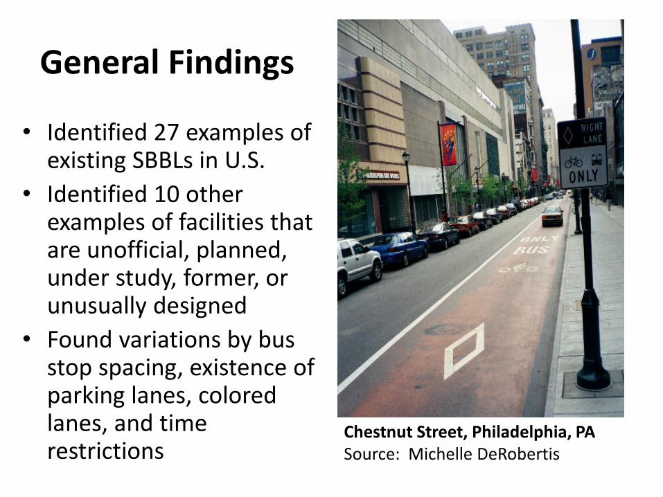
Coastal Highway lane configuration

Coastal Highway SBBL Features Location 7.4 miles between 17th St. and E 145th St.
Date opened Operated as bus lanes prior to late 1980’s, SBBL since then
Facility type SBBL both northbound and southbound. Northbound SBBL is interrupted for 5 blocks between 59th St. and 64th St.
Other permitted vehicles
Right-turning vehicles, scooters, and ScootCoupes™ (engine size under 49 cc)
SBBL width 11-12.5 ft.
Block length Generally 300 ft. with some variation
Bus stop frequency Usually every other block
Speed limit 35-40 mph; 30 mph for scooters (Maryland State law)
Traffic signal spacing Approximately every 1000 ft.
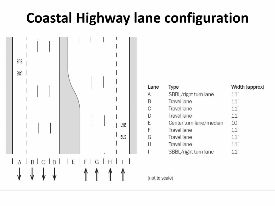
Case Study: 7th and 9th Sts. NW, Washington, D.C.
Between Pennsylvania Avenue and Mount Vernon Square

9th St. NW lane configuration type 1

9th St. NW configuration type 1 Photo credit: JoAnne Fiebe

9th St. NW lane configuration type 2

9th St. NW configuration type 2 Photo credit: JoAnne Fiebe

SBBL lane markings at beginning of each block
Photo credit: JoAnne Fiebe
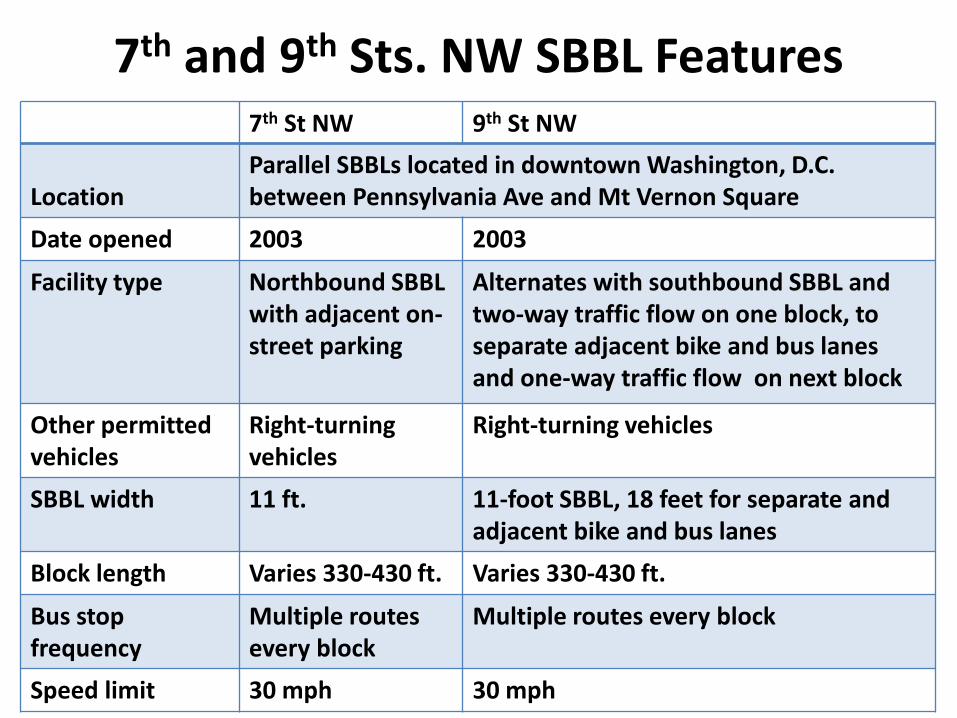
7th and 9th Sts. NW SBBL Features 7th St NW 9th St NW
Location
Parallel SBBLs located in downtown Washington, D.C. between Pennsylvania Ave and Mt Vernon Square
Date opened 2003 2003
Facility type Northbound SBBL with adjacent on-street parking
Alternates with southbound SBBL and two-way traffic flow on one block, to separate adjacent bike and bus lanes and one-way traffic flow on next block
Other permitted vehicles
Right-turning vehicles
Right-turning vehicles
SBBL width 11 ft. 11-foot SBBL, 18 feet for separate and adjacent bike and bus lanes
Block length Varies 330-430 ft. Varies 330-430 ft.
Bus stop frequency
Multiple routes every block
Multiple routes every block
Speed limit 30 mph 30 mph

Case Study: Hennepin Avenue, Minneapolis, MN
11th St. to Washington Ave. S Hennepin Avenue Prior to lane reconfiguration Source: Minneapolis Public Works

Hennepin Avenue lane configurations
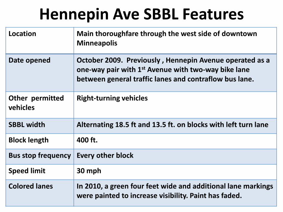
Hennepin Ave SBBL Features Location Main thoroughfare through the west side of downtown
Minneapolis
Date opened October 2009. Previously , Hennepin Avenue operated as a one-way pair with 1st Avenue with two-way bike lane between general traffic lanes and contraflow bus lane.
Other permitted vehicles
Right-turning vehicles
SBBL width Alternating 18.5 ft and 13.5 ft. on blocks with left turn lane
Block length 400 ft.
Bus stop frequency Every other block
Speed limit 30 mph
Colored lanes In 2010, a green four feet wide and additional lane markings were painted to increase visibility. Paint has faded.
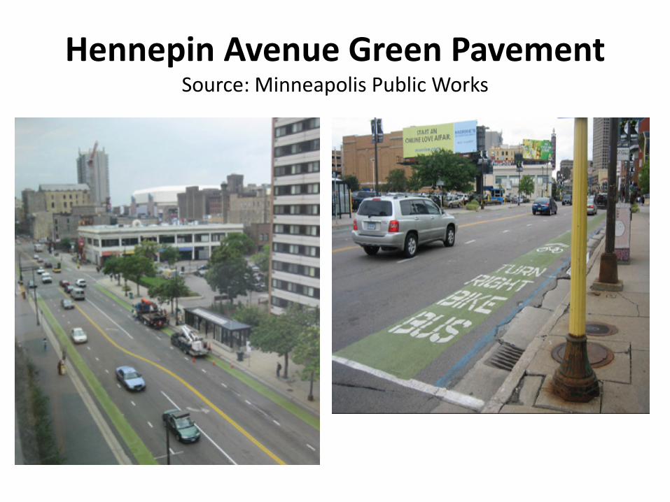
Hennepin Avenue Green Pavement Source: Minneapolis Public Works
• Hennepin Avenue, Minneapolis, MN
• Source: Minneapolis Public Works
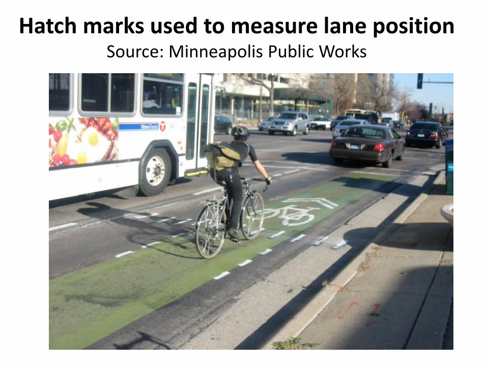
Hatch marks used to measure lane position Source: Minneapolis Public Works

Case Study: Chestnut St., Philadelphia, PA
6th Street to 18th Street, Center City
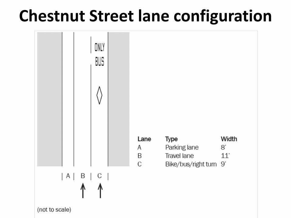
Chestnut Street lane configuration

Chestnut Street SBBL features Location Chestnut St. in heavily congested Center City, proximate to
three universities
Date opened In 1990s, Chestnut St was converted from a two-way busway to eastbound one-way flow for general traffic and SBBL.
Roadway configuration
One general traffic lane, SBBL adjacent to curb on south side of street, on-street parking lane on north side.
Facility type SBBL Other permitted vehicles
Right-turning vehicles
SBBL width 9 ft. Block length 400 ft. Bus stop frequency
Every block
Speed limit 25 mph Colored lane Originally colored red. Paint faded and will not be repainted.

Bicycle/Bus Interaction
Walnut Street (separate bike lane), Philadelphia Source: DVRPC
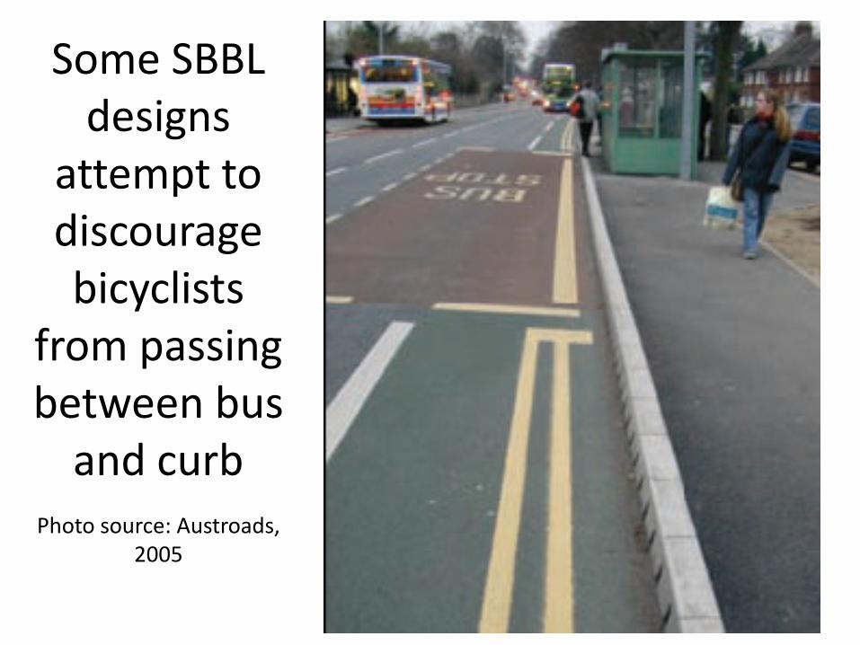
Some SBBL designs
attempt to discourage bicyclists
from passing between bus
and curb
Photo source: Austroads, 2005

Main Problems Cited
Enforcement of SBBL exclusive use Large volumes of right-turning vehicles in the SBBL
Source: Minneapolis Public Works

Comparative SBBL Posted Speed Limits City Street Speed Limit (mph) Width (ft)
Eugene, OR Kincaid St. 20 15
Philadelphia, PA Chestnut St. 25 9
Fort Worth, TX Throckmorton and Houston Sts.
25-30 11
Denver, CO 19th St. 30 12-18
Minneapolis, MN Hennepin Ave. 30 13.5-18.5
Seattle, WA Stewart St. 30 12
Tucson, AZ E Broadway Blvd. 35-40 9-12
Madison, WI Mineral Point Rd. 35-40 13.5
Rehoboth Beach, DE Coastal Highway 1 45 12
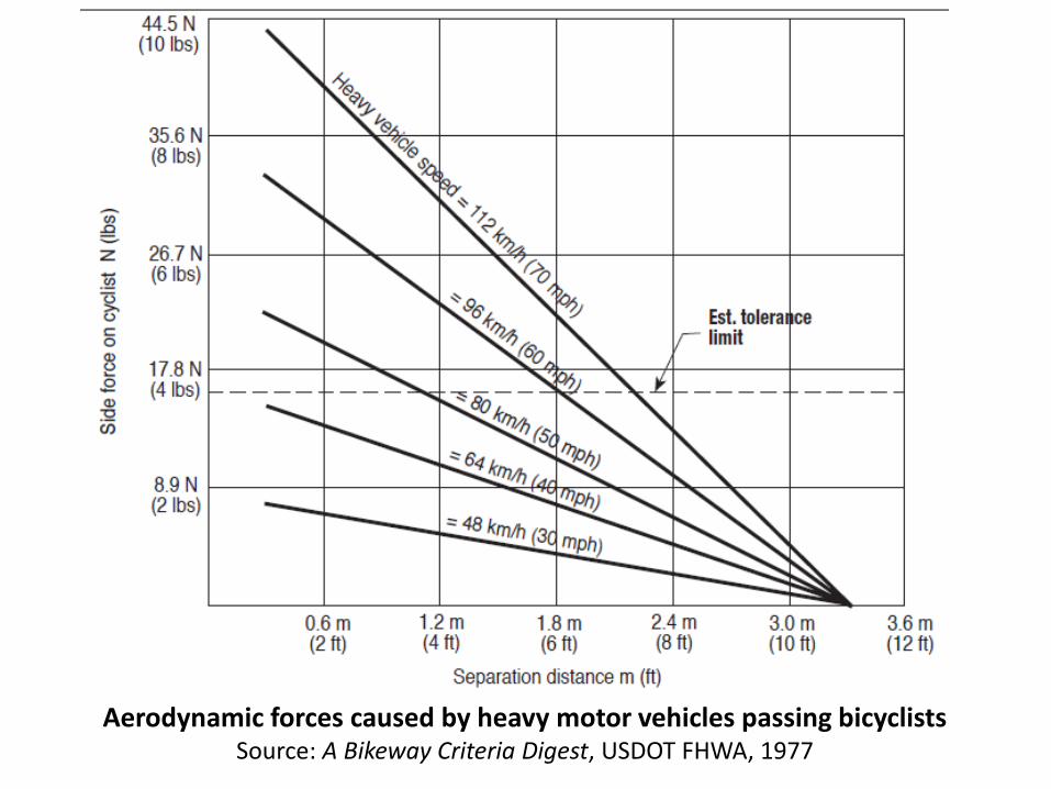
Aerodynamic forces caused by heavy motor vehicles passing bicyclists Source: A Bikeway Criteria Digest, USDOT FHWA, 1977

Lane Width Recommendations Compared to Actual
Source Facility Type Width (ft) Source Type
Transport Research Laboratory Study
SBBL 13.1 Study recommendations
Cardiff Guide SBBL 13.1-16.7 Official guide
University of N. Florida SBBL 16 Study recommendations
University of N. Florida SBBL 17 Study recommendations (curb and gutter)
Various U.S. cities SBBL 10-18 Official guides
FDOT Plans Preparation Manual
Wide curb lane 14 SHS design criteria
1999 AASHTO Guide for the Development of Bicycle Facilities
Wide curb lane 14 National recommendation
U.S. SBBLS SBBL 9-16 Actual widths
U.S. separate but adjacent facilities
Separate but adjacent
15-20 Actual widths

Narrow-width bicycle/bus lane To pass, one must enter adjacent lane

Bus enters adjacent lane to pass cyclist
9th St. NW, Washington, D.C. Credit: JoAnne Fiebe

Narrow-width SBBL with advisory cycle lane

Wide-width SBBL
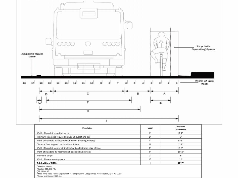
Description Label Minimum
Dimensions
Width of bicyclist operating space Aa 3′ 4″
Minimum clearance required between bicyclist and bus Bb 3′
Width of standard 40-foot transit bus (not including mirrors) Cc 8′ 6 ″
Distance from edge of bus to adjacent lane D 1′ 9 ″
Width of bicyclist (center of tire located two feet from edge of lane) Ea 2′ 6″
Width of standard 40-foot transit bus (including mirrors) Fc 10′ 2″
Wide lane stripe Gd 8″
Width of bus operating space He 12′
Total width of SBBL I 16′ 7″ a AASHTO 1999 5. b Section 316.083 F.S. c TTI 1996, 37. d Mary Anne Koos, Florida Department of Transportation, Design Office. Conversation, April 30, 2012. e Sando and Moses 2010, 44.

Narrow-width SBBL with partial bus bay and advisory cycle lane along left side of SBBL

Separate channel for bicyclists routed to the right of the bus stop

Cycle channel routed around bus stop Source: Cycling England Gallery

Bicycle/Bus Interaction “The leapfrogging concept is overrated. Cyclists typically pass buses and leave them in their wake.” Bicycle and Pedestrian Planner, City of Baltimore
Chestnut Street, Philadelphia, PA Source: John S. Allen

Bus Operator Training • Always assume there is a bicyclist on the right • Check mirrors and slow down before pulling over • Stop as close to the curb as possible at a bus stop • Remember bicyclists you pass, in case bus
passenger suddenly requests to stop • Anticipate bicyclist evasive maneuvers where there
is on-street parking,
Sources: City of Chicago Department of Transportation, Chicago Transit Authority, Washington Metropolitan Area Transit Authority, Delaware Department of Transportation, Central Connecticut Bicycle Alliance
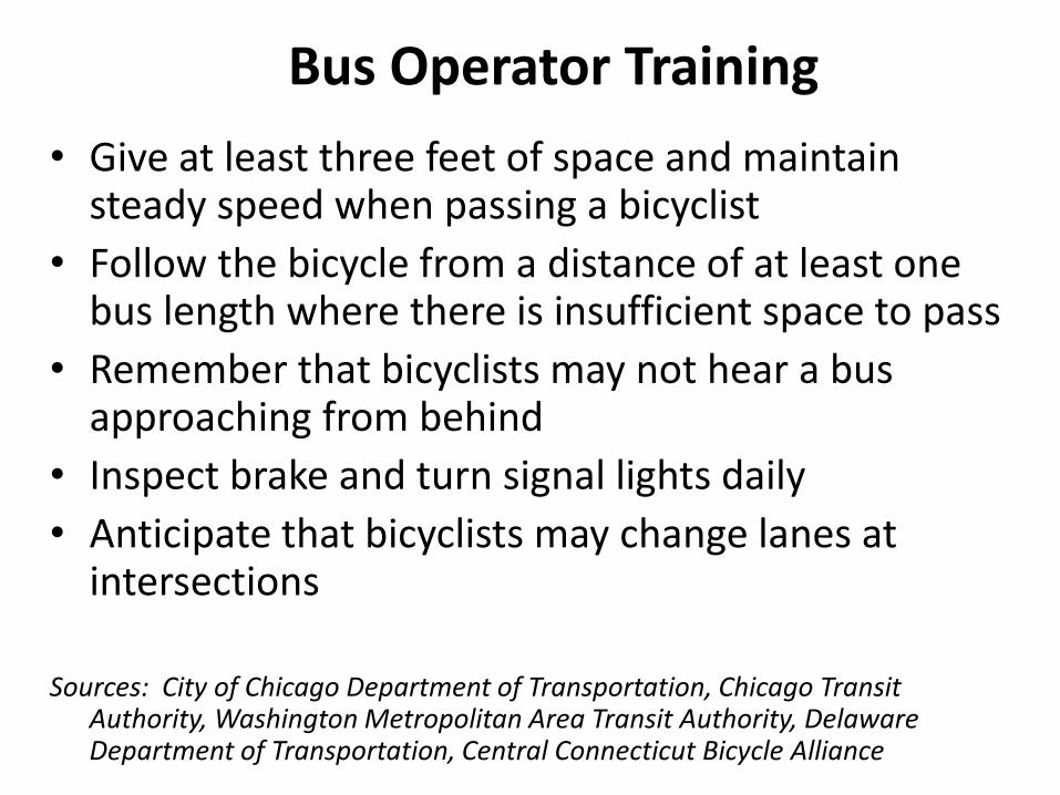
Bus Operator Training • Give at least three feet of space and maintain
steady speed when passing a bicyclist • Follow the bicycle from a distance of at least one
bus length where there is insufficient space to pass • Remember that bicyclists may not hear a bus
approaching from behind • Inspect brake and turn signal lights daily • Anticipate that bicyclists may change lanes at
intersections Sources: City of Chicago Department of Transportation, Chicago Transit
Authority, Washington Metropolitan Area Transit Authority, Delaware Department of Transportation, Central Connecticut Bicycle Alliance

Public Information Campaigns Hennepin Avenue, Minneapolis
Source: City of Minneapolis Public Works, excerpt from brochure

More Research Is Needed On:
1. Effect of SBBLs on encouraging bicycling
2. Better ways to collect bicycle traffic count data
3. Mobility impacts of an SBBL upon all modes
4. Crash analysis of SBBLs, esp. compared to other bicycle facility types
5. Evaluation of alternative bus stop treatments
6. Determination of the maximum safe speed
7. Characteristics of gaps in traffic that are necessary to provide safe passing opportunities
8. Effective ways to enforce SBBL restrictions
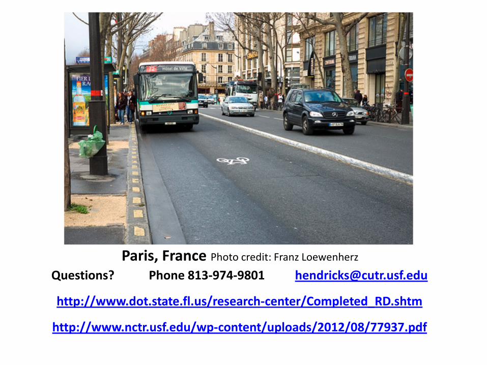
Paris, France Photo credit: Franz Loewenherz
Questions? Phone 813-974-9801 [email protected]
http://www.dot.state.fl.us/research-center/Completed_RD.shtm
http://www.nctr.usf.edu/wp-content/uploads/2012/08/77937.pdf