Embed Size (px)
Citation preview
AG-LAND INVESTMENT BROKERS 275Sale Lane / P. O. Box 896
Red Bluff, CA 96080
530.529.4400 office / 530.527.5042 fax
The information contained herein is from sources deemed reliable, however, accuracy is not guaranteed. AG-LAND Investment Brokers assumes no liability
as to errors, omissions or future operating and investment results. Buyer assumes responsibility to perform their own investigation and due diligence. This offering is subject to prior sale, price change or withdrawal from market without notice.
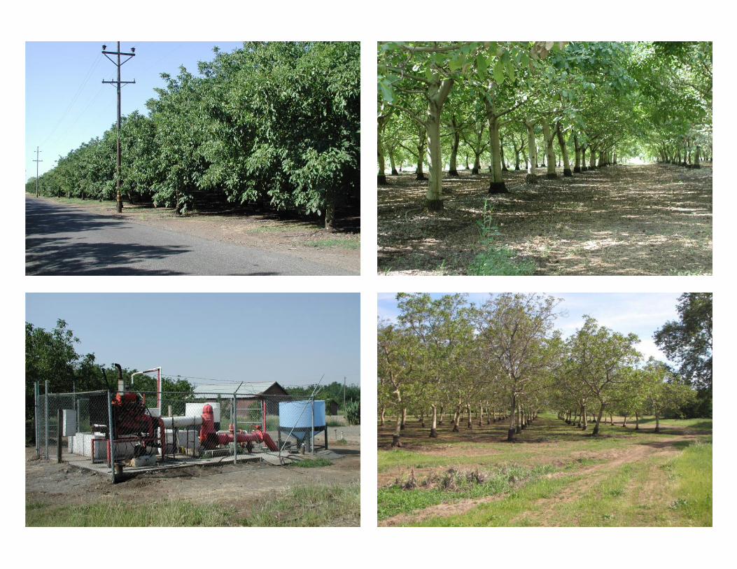
Shasta Blvd. Walnut & Prune Orchard
Los Molinos, California Listing Price: $775,000. Seller financing available upon approved credit and terms.
Property: 75 +/- total acres consisting of 66 +/- acres planted to producing
English walnuts(40 acres) and French prunes (26 acres). The balance of the acreage
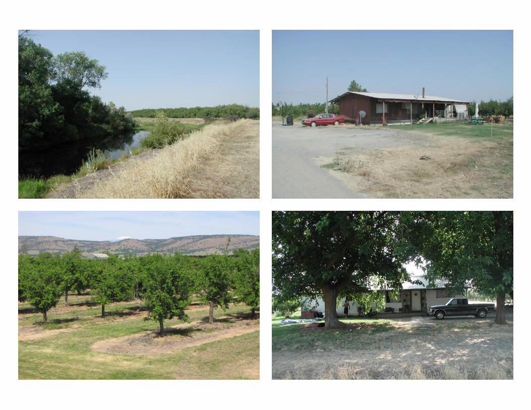
consists of roads, drains, farmstead areas and lands within Dye Creek. Improvements
include (2) homes and multiple farm buildings.
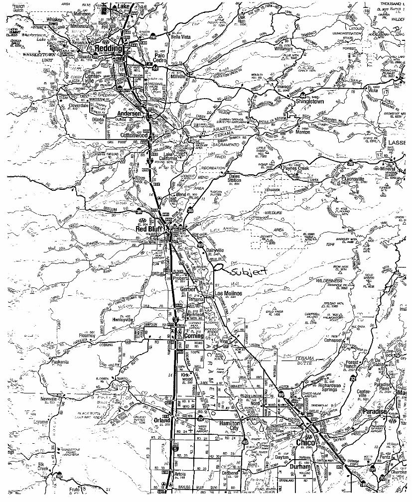
Location: The property is located in central Tehama County, east of the
Sacramento River. It is about 9 miles (S) of Red Bluff and 3 miles (N) of Los Molinos.
The address for the farmstead parcel is 10260 Shasta Boulevard, Los Molinos, CA, 96055.
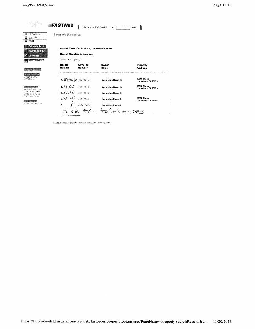
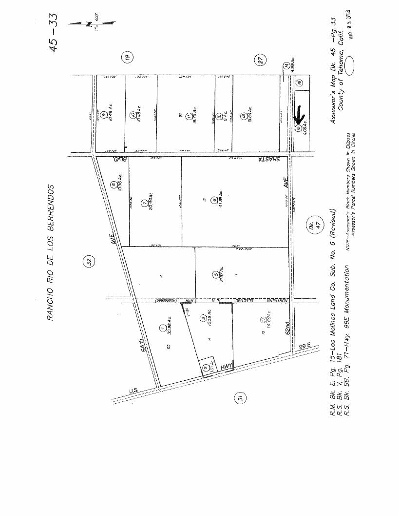
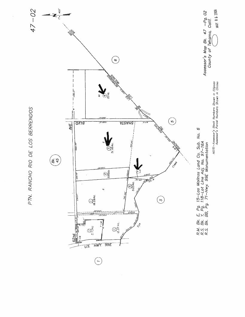
Zoning: Tehama County Assessor Parcel Numbers are 045-330-15, 845-330-
15(mobile), 047-020-03, 04 & 07. APN 045-330-15 is zoned EA, Exclusive Agriculture
(Cropland), 20 acre minimum. The other parcels are zoned EA-AP, Exclusive Agriculture
(Cropland), Agricultural Preserve, 40 acre minimum. Current annual property taxes are
$7,052.
Soils: 37% +/- of the farmland is At, Anita Keefers Complex, class III soil;
33% +/- is Vy, Vina clay loam, class I soil and 17%+/- is Millrace gravelly fine sandy
loam, class IV soil.
Topography: Flat to level to grade. Dye Creek, a year round stream borders the
property on the south side. Dye Creek flows east to west and discharges into the
Sacramento River. The property offers exceptional views of Lassen Peak and eastern
mountain ranges.
Water: Irrigation water is provided by (1) AG well with diesel engine. The
orchards are irrigated by a micro-jet irrigation system with above ground drip tubing.
Domestic water is provided by (2) wells using electric submersible pumps, one for the (2)
homes and another for the farmstead
Trees: 40 +/- acres are planted to bearing English Walnuts on Northern
California Black Walnut rootstock. The walnut varieties are primarily Vina (32 acres) and
Hartley (8 acres). 26 +/- acres are planted to older French Prune on Mariani rootstock.
AG-LAND INVESTMENT BROKERS 275Sale Lane / P. O. Box 896
Red Bluff, CA 96080
530.529.4400 office / 530.527.5042 fax
The information contained herein is from sources deemed reliable, however, accuracy is not guaranteed. AG-LAND Investment Brokers assumes no liability
as to errors, omissions or future operating and investment results. Buyer assumes responsibility to perform their own investigation and due diligence. This offering is subject to prior sale, price change or withdrawal from market without notice.
Production : The 2013 walnut production was 2,225 +/- in-shell pounds per acre.
The 2013 prune production was 0.9 +/- dry tons per acre
Improvements: Located on the 4.06 acre parcel at 10318 Shasta Blvd. is a 1959 built
home, 3 bedroom, 1 bath, 1,456 sqft and a 1979 built mobile home, 1,056 sqft. Each home
is currently rented on a “month to month basis” for $500.00 per month. Located on the 20
acre parcel at 10260 Shasta Blvd. are several farm buildings, domestic water well and area
which used to accommodate a RV hook-up.
Wildlife: The Dye Creek corridor is a natural haven for wildlife such as Wild
Hog, Turkey, Quail and Dove.
Depreciation: The improvements on this property such as the trees, irrigation systems
and buildings may offer significant deprecation advantages to the prospective Buyer.
Mineral Rights: All oil, gas, mineral and water rights owned by Seller will transfer to
the Buyer.
Crop: Current crops are included in the sale provided Buyer reimburses Seller
cultural costs including orchard management fee and crop insurance premiums from
11/01/2013 to close of escrow.
Contact Info: Please contact the Listing Brokers, Bert Owens or Sam Mudd.
Bert Owens, California Brokers License Number 01707128
530.529.4400, office / 530.524.4900, cell
[email protected], email
www.aglandbrokers.com, website
Sam Mudd, California Brokers Number 01710463
530.529.4400, office / 530.949-4054, cell
[email protected], email
www.aglandbrokers.com, website
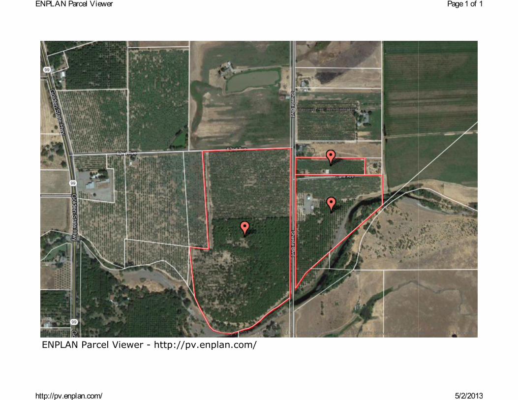
ENPLAN Parcel Viewer - http://pv.enplan.com/Imagery 2013 DigitalGlobe, U.S. Geological Survey, USDA Farm Service Agency, Map data 2013 Google -
Page1 of 1ENPLAN Parcel Viewer
5/2/2013http://pv.enplan.com/
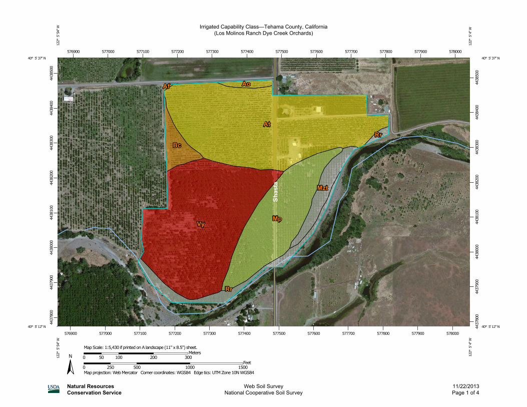
Irrigated Capability Class—Tehama County, California(Los Molinos Ranch Dye Creek Orchards)
Natural ResourcesConservation Service
Web Soil SurveyNational Cooperative Soil Survey
11/22/2013Page 1 of 4
4437
800
4437
900
4438
000
4438
100
4438
200
4438
300
4438
400
4438
500
4437
800
4437
900
4438
000
4438
100
4438
200
4438
300
4438
400
4438
500
576900 577000 577100 577200 577300 577400 577500 577600 577700 577800 577900 578000
576900 577000 577100 577200 577300 577400 577500 577600 577700 577800 577900 578000
40° 5' 37'' N12
2° 5
' 54'
' W40° 5' 37'' N
122°
5' 4
'' W
40° 5' 12'' N
122°
5' 5
4'' W
40° 5' 12'' N
122°
5' 4
'' W
N
Map projection: Web Mercator Corner coordinates: WGS84 Edge tics: UTM Zone 10N WGS840 250 500 1000 1500
Feet0 50 100 200 300
MetersMap Scale: 1:5,430 if printed on A landscape (11" x 8.5") sheet.
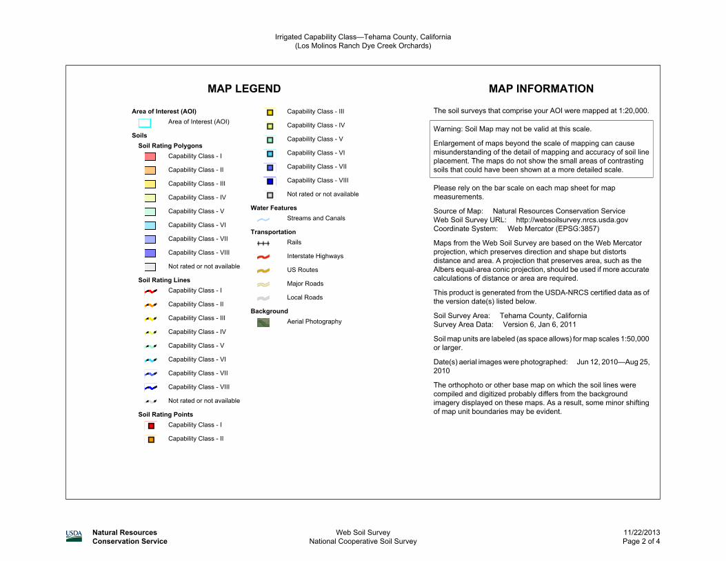
MAP LEGEND MAP INFORMATION
Area of Interest (AOI)Area of Interest (AOI)
SoilsSoil Rating Polygons
Capability Class - I
Capability Class - II
Capability Class - III
Capability Class - IV
Capability Class - V
Capability Class - VI
Capability Class - VII
Capability Class - VIII
Not rated or not available
Soil Rating LinesCapability Class - I
Capability Class - II
Capability Class - III
Capability Class - IV
Capability Class - V
Capability Class - VI
Capability Class - VII
Capability Class - VIII
Not rated or not available
Soil Rating PointsCapability Class - I
Capability Class - II
Capability Class - III
Capability Class - IV
Capability Class - V
Capability Class - VI
Capability Class - VII
Capability Class - VIII
Not rated or not available
Water FeaturesStreams and Canals
TransportationRails
Interstate Highways
US Routes
Major Roads
Local Roads
BackgroundAerial Photography
The soil surveys that comprise your AOI were mapped at 1:20,000.
Warning: Soil Map may not be valid at this scale.
Enlargement of maps beyond the scale of mapping can causemisunderstanding of the detail of mapping and accuracy of soil lineplacement. The maps do not show the small areas of contrastingsoils that could have been shown at a more detailed scale.
Please rely on the bar scale on each map sheet for mapmeasurements.
Source of Map: Natural Resources Conservation ServiceWeb Soil Survey URL: http://websoilsurvey.nrcs.usda.govCoordinate System: Web Mercator (EPSG:3857)
Maps from the Web Soil Survey are based on the Web Mercatorprojection, which preserves direction and shape but distortsdistance and area. A projection that preserves area, such as theAlbers equal-area conic projection, should be used if more accuratecalculations of distance or area are required.
This product is generated from the USDA-NRCS certified data as ofthe version date(s) listed below.
Soil Survey Area: Tehama County, CaliforniaSurvey Area Data: Version 6, Jan 6, 2011
Soil map units are labeled (as space allows) for map scales 1:50,000or larger.
Date(s) aerial images were photographed: Jun 12, 2010—Aug 25,2010
The orthophoto or other base map on which the soil lines werecompiled and digitized probably differs from the backgroundimagery displayed on these maps. As a result, some minor shiftingof map unit boundaries may be evident.
Irrigated Capability Class—Tehama County, California(Los Molinos Ranch Dye Creek Orchards)
Natural ResourcesConservation Service
Web Soil SurveyNational Cooperative Soil Survey
11/22/2013Page 2 of 4
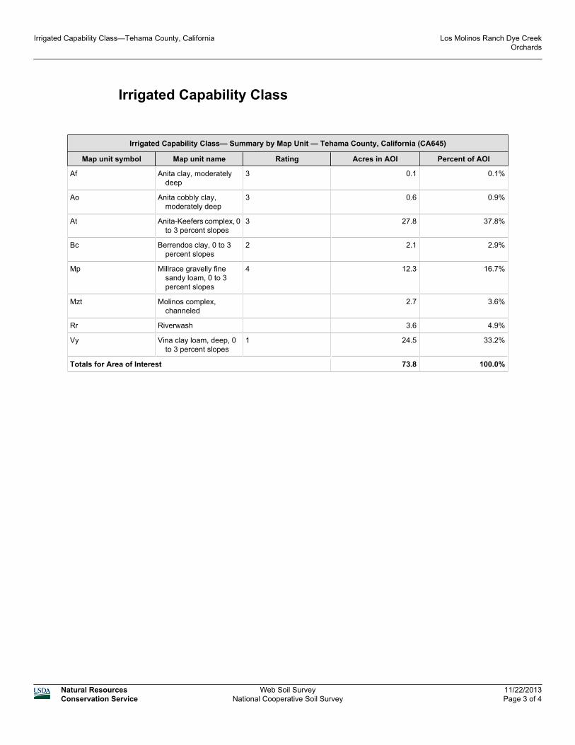
Irrigated Capability Class
Irrigated Capability Class— Summary by Map Unit — Tehama County, California (CA645)
Map unit symbol Map unit name Rating Acres in AOI Percent of AOI
Af Anita clay, moderatelydeep
3 0.1 0.1%
Ao Anita cobbly clay,moderately deep
3 0.6 0.9%
At Anita-Keefers complex, 0to 3 percent slopes
3 27.8 37.8%
Bc Berrendos clay, 0 to 3percent slopes
2 2.1 2.9%
Mp Millrace gravelly finesandy loam, 0 to 3percent slopes
4 12.3 16.7%
Mzt Molinos complex,channeled
2.7 3.6%
Rr Riverwash 3.6 4.9%
Vy Vina clay loam, deep, 0to 3 percent slopes
1 24.5 33.2%
Totals for Area of Interest 73.8 100.0%
Irrigated Capability Class—Tehama County, California Los Molinos Ranch Dye CreekOrchards
Natural ResourcesConservation Service
Web Soil SurveyNational Cooperative Soil Survey
11/22/2013Page 3 of 4
Description
Land capability classification shows, in a general way, the suitability of soils for mostkinds of field crops. Crops that require special management are excluded. The soilsare grouped according to their limitations for field crops, the risk of damage if theyare used for crops, and the way they respond to management. The criteria used ingrouping the soils do not include major and generally expensive landforming thatwould change slope, depth, or other characteristics of the soils, nor do they includepossible but unlikely major reclamation projects. Capability classification is not asubstitute for interpretations that show suitability and limitations of groups of soilsfor rangeland, for woodland, or for engineering purposes.
In the capability system, soils are generally grouped at three levels-capability class,subclass, and unit. Only class and subclass are included in this data set.
Capability classes, the broadest groups, are designated by the numbers 1 through8. The numbers indicate progressively greater limitations and narrower choices forpractical use. The classes are defined as follows:
Class 1 soils have few limitations that restrict their use.
Class 2 soils have moderate limitations that reduce the choice of plants or thatrequire moderate conservation practices.
Class 3 soils have severe limitations that reduce the choice of plants or that requirespecial conservation practices, or both.
Class 4 soils have very severe limitations that reduce the choice of plants or thatrequire very careful management, or both.
Class 5 soils are subject to little or no erosion but have other limitations, impracticalto remove, that restrict their use mainly to pasture, rangeland, forestland, or wildlifehabitat.
Class 6 soils have severe limitations that make them generally unsuitable forcultivation and that restrict their use mainly to pasture, rangeland, forestland, orwildlife habitat.
Class 7 soils have very severe limitations that make them unsuitable for cultivationand that restrict their use mainly to grazing, forestland, or wildlife habitat.
Class 8 soils and miscellaneous areas have limitations that preclude commercialplant production and that restrict their use to recreational purposes, wildlife habitat,watershed, or esthetic purposes.
Rating Options
Aggregation Method: Dominant Condition
Component Percent Cutoff: None Specified
Tie-break Rule: Higher
Irrigated Capability Class—Tehama County, California Los Molinos Ranch Dye CreekOrchards
Natural ResourcesConservation Service
Web Soil SurveyNational Cooperative Soil Survey
11/22/2013Page 4 of 4
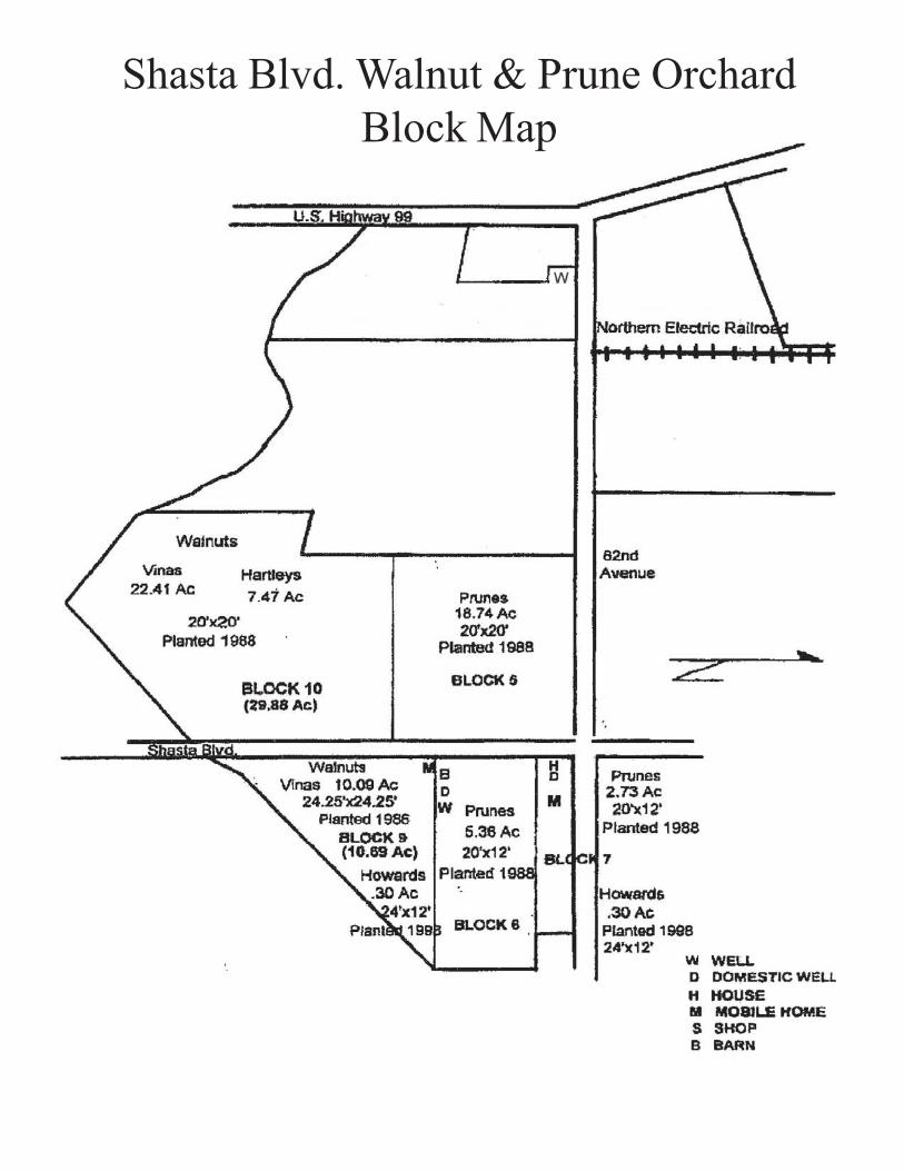
Shasta Blvd. Walnut & Prune OrchardBlock Map