Embed Size (px)
Citation preview

Shuler
(NWFWMD ILF Program Mitigation Project Site)
Contents:
Summary of Twelve Components of the Compensatory Mitigation Plan
UMAM Credit Assessment
Mitigation Service Area

Summary of Twelve Components of the Compensatory Mitigation Plan

Northwest Florida Water Management District
In-Lieu Fee Program
Shuler Mitigation Area
(Summary of 12 Elements Required by § 332.4(c) of the 2008 EPA/USACE Final Compensatory
Mitigation Rule for All In-Lieu Fee Program Project Plans; See Attached Shuler Property
Mitigation Documents for Additional Explanation and Detail)
22 September 2014
1—Objectives
Perpetual preservation and management of 485 acres of high-quality, palustrine forested
wetlands (FLUCCS 615 – Bottomland) in the eastern portion of the Shuler conservation
easement property adjacent to the Ochlockonee River.
2—Site Selection Criteria
This site was selected as part of an ongoing effort to acquire, preserve, and restore wetlands and
water resources within the Ochlockonee River watershed. The Northwest Florida Water
Management District (NWFWMD) acquired a conservation easement (less-than fee acquisition)
on the 1,573.66-acre (±) Shuler Property in July, 2008. This easement protects the entire
1,573.66 acres from development, although only 485 acres of high-quality, palustrine forested
wetlands adjacent to the Ochlockonee River will initially be included in the In-Lieu Fee
Program. The eastern portion of the property is characterized by high-quality, forested wetlands
and associated upland buffers, whereas the western portion has been degraded from past
silvicultural practices. Although the conservation easement allows for NWFWMD restoration of
degraded wetlands in the western portion of the property, there are no near-term plans to do so.
3—Site Protection Instrument
This site is protected by a conservation easement recorded with Liberty County, Florida on
7/28/08.
4—Baseline Information
Maps (attached)
Location of Shuler Property
2013 DOQ of Shuler Property Conservation Easement
2013 DOQ of Shuler ILF Area
Soils of Shuler ILF Area
LiDAR of Shuler ILF Area
USGS Quad Map of Shuler ILF Area
1952 B&W Aerial of Shuler ILF Area
1937 B&W Aerial of Shuerl ILF Area
Conservation Easement (attached)

The Shuler conservation easement site consists of 1,573.66± acres. Approximately 800-
900 acres are wetlands. Wetlands in the western portion of the Shuler property are highly
disturbed. Those in the eastern portion adjacent to the Ochlockonee River are generally of high
quality. The 485 acres initially included in the In-Lieu Fee Program consist entirely of high-
quality, bottomland hardwood forest (FLUCCS 615).
5—Determination of Credits
Mitigation credits were determined by the Uniform Mitigation Assessment Method (UMAM).
The UMAM determination of 33.95 credits for the preservation of 485 acres of bottomland
hardwood forest (FLUCCS 615) was approved by USACE. Release of mitigation credits was
determined by the USACE in consultation with a mitigation review team.
6—Detailed Work Plan
The Shuler conservation easement property (including the 485-acre area included in the
NWFWMD ILF Program) will be maintained in a natural state in perpetuity.
7—Maintenance Plan
The site will be preserved and managed in a natural state according to the terms of the
conservation easement and associated federal and state permits.
8—Performance Standards
No observable decline in natural community health
Nuisance vegetation ≤5% cover per acre.
Exotic vegetation ≤1% cover per acre.
9—Monitoring
Monitoring protocols necessary to ensure effective preservation and management will be
conducted annually in perpetuity, or the duration of the NWFWMD ILF Program. Annual
reports will be generated and posted at www.NWFWMDwetlands.com (or any successor
website). Specific monitoring for this site will include annual panoramic photos at established
points, and may include periodic pedestrian surveys by a qualified biologist.
10—Long-term Management
The site will be preserved and managed in a natural state according to the terms of the
conservation easement.
11—Adaptive Management Plan
All ecological restoration projects are site specific and multiple endpoints are possible owing to
the stochastic nature of ecological processes. Additionally, human activities offsite and beyond
the control of the NWFWMD may also influence the course of restoration. If changes in the
implementation of this mitigation plan become necessary, the NWFWMD will first obtain
approvals from the USACE. The NWFWMD will demonstrate good-faith efforts to comply with
restoration requirements and will not invoke an alleged need for adaptive management as a
pretext for non-compelling reasons.

12—Financial Assurances
The NWFWMD is a governmental entity created by the Florida Water Resources Act of 1972
with the mission of protecting water resources protection and ecosystem integrity. Funds are
specifically earmarked to implement and maintain mitigation.
As of July, 2014, the NWFWMD had greater than $15,000,000 available in a dedicated
mitigation fund. This fund was established to receive payment from sales of mitigation credits
and to ensure adequate funding for the implementation and long-term management of mitigation
sites, in accordance with 62-342.850 FAC.
Other Information
Any additional information requested by the USACE to determine the appropriateness,
feasibility, and practicability of this compensatory mitigation project will be provided.

Location of Shuler Property
0 5 10Miles XOchlockonee River Watershed
Shuler Property
£¤90
§̈¦10
Liberty Co.
Midway
Gadsden Co.
Quincy
Æ·20
£¤27
O
c h l
o c k
o n e
e
R i v e r
Talla.
Lak
e Talquin
Wakulla Co.
Leon Co.
Æ·12
Havana
Och
lockonee
Rive
r
Æ·20
Æ·267
Æ·267
Æ·65
Æ·12

Shuler Conservation Easement - 2013 DOQ
0 0.25 0.5 Miles[
Ochlockonee River
Æ·67
485-Acre High-quality, Palustrine ForestedWetland Area Included in ILF Program
PotentialFuture
RestorationArea
(West)C O N S E R V A T I O N E A S E M E N T

Shuler ILF Area - 2013Ochlockonee River
Shuler Conservation Easement Boundary
ILF Area
2013 DOQ0 0.1 0.2 Miles[

Shuler ILF Area - SoilsOchlockonee River
Shuler Conservation Easement Boundary
ILF Area
NRCS Soil Survey0 0.1 0.2 Miles[
Elloree, Bibb, and Meggett soils, 0 to 3 percent slopes, frequently floodedGarcon, Ochlockonee, and Ousley soils, occasionally floodedRutlege, Bibb, and Surrency soils, frequently floodedOther Soils

Shuler ILF Area - LiDAROchlockonee River
Shuler Conservation Easement Boundary
ILF Area
0 0.1 0.2 Miles[High
Low

Shuler ILF Area - USGS Quad MapOchlockonee River
Shuler Conservation Easement Boundary
ILF Area
0 0.1 0.2 Miles[

Shuler ILF Area - 1952Ochlockonee River
Shuler Conservation Easement Boundary
ILF Area
1952 B&W Aerials
0 0.1 0.2 Miles[

Shuler ILF Area - 1937Ochlockonee River
Shuler Conservation Easement Boundary
ILF Area
1937 B&W Aerials
0 0.1 0.2 Miles[


UMAM Credit Assessment

Cur or
W/Out With Raw Time PF Adjusted UMAM
Polygon Acres L1 L2 W1 W1 C1 C2 Score Score Delta Lag Factor Risk Delta Credits
Polygon A 485.00 9 10 10 10 9 10 0.93 1.00 0.07 1 1 1 0.07 33.95
(Total Credits) 33.95
L1 = Location and Landscape Support (Without Mitigation Project)
L2 = Location and Landscape Support (With Mitigation Project)
W1 = Water Environment (Without Mitigation Project)
W2 = Water Environment (With Mitigation Project)
C1 = Vegetation Community Structure (Without Mitigation Project)
C2 = Vegetation Community Structure (With Mitigation Project)
Shuler Bottomland Preservation - UMAM Credit Assessment
25 April 2012 (US Army Corps of Engineers)

Form 62-345.900(1), F.A.C. [ effective date ]
Additional relevant factors
---
Assessment conducted by Assessment date(s)
US Army Corps of Engineers (Andy Kizlauskas) 4/25/2012
---
SR 65; Ochlockonee River; Tates Hell State Forest. Not unique.
Functions Mitigation for previous permit/other historic use
Flood abatement; water quality; detritus export; floral and faunal habitat. None
Anticipated Wildlife Utilization Based on Literature Review (List of
species that are representative of the assessment area and reasonably
expected to be found )
Anticipated Utilization by Listed Species (List species, their legal
classification (E, T, SSC), type of use, and intensity of use of the
assessment area)
--- ---
Observed Evidence of Wildlife Utilization (List species directly observed, or other signs such as tracks, droppings, casings, nests, etc.)
Geographic relationship to and hydrologic connection with wetlands, other surface water, uplands
Wetlands adjacent and contiguous to Ochlockonee River. Buffered by Ochlockonee River to east and silvicultural areas to west.
Assessment area description
Bottomland hardwood forest adjacent to Ochlockonee River.
Significant nearby features Uniqueness (considering the relative rarity in relation to the
regional landscape.)
Basin/Watershed Name/Number Affected Waterbody (Class) Special Classification (i.e.OFW, AP, other local/state/federal designation of importance)
Ochlockonee III ---
FLUCCS code Further classification (optional) Impact or Mitigation Site? Assessment Area Size
615 (Approximate) --- Mitigation 485 Acres
Shuler - Bottomland Preservation Not Applicable Polygon A
PART I – Qualitative Description(See Section 62-345.400, F.A.C.)
Site/Project Name Application Number Assessment Area Name or Number

w/out pres
w/out pres
w/out pres
w/out mit
Functional Gain w/Mitigation (Adjusted Delta * Acres) = 33.95Raw Delta = [w/mit - w/out mit] Adjusted Delta [(Raw Delta * PF) / (T
* R)] = 0.070.07
Score = sum of above scores/30 (if
uplands, divide by 20) Preservation Adjustment Factor
(PF) = 1UMAM Functional Assessment
w/mit Time Lag Factor = 10.93 1.00
Risk Factor = 1 Polygon Acreage = 485.00
.500(6)(c)Community structure
Without Preservation - Plausible impacts include logging of bottomland hardwood forest, lack of proactive
management if exotic vegetation were to invade, lack of BMPs in adjacent silvicultural buffers, and construction
of several hunt cabins or river houses on bluff along Ochlockonee River. With Preservation - Elimination of
threats to existing high-quality, bottomland forested wetlands.
Vegetation and/or Benthic
Community
w/pres
9 10
.500(6)(a) Location and
Landscape Support Without Preservation - Plausible impacts include logging of bottomland hardwood forest, lack of proactive
management if exotic vegetation were to invade, lack of BMPs in adjacent silvicultural buffers, and possible
construction of several hunt cabins or river houses on bluff along Ochlockonee River. With Preservation -
Elimination of threats to existing high-quality, bottomland forested wetlands.
w/pres
9 10
.500(6)(b)Water Environment
(N/A for Uplands)
Without Preservation - No substantive change. With Preservation - No substantive change.
w/pres
10 10
Scoring Guidance Optimal (10) Moderate(7) Minimal (4) Not Present (0)The scoring of each
indicator is based on what
would be suitable for the
type of wetland or surface
water assessed
Condition is optimal and
fully supports
wetland/surface water
functions
Condition is less than
optimal, but sufficient to
maintain most
wetland/surface
waterfunctions
Minimal level of support of
wetland/surface water
functions
Condition is insufficient to
provide wetland/surface
water functions
Impact or Mitigation Assessment conducted by: Assessment date:
Mitigation US Army Corps 4/25/2012
Shuler - Bottomland Preservation Not Applicable Polygon A
PART II – Quantification of Assessment Area (impact or mitigation)(See Sections 62-345.500 and .600, F.A.C.)
Site/Project Name Application Number Assessment Area Name or Number

Shuler Bottomland Preservation UMAM Assessment Area
Ochlockonee River
Shuler Property Boundary
UMAM BottomlandAssessment Polygon
(485 Acres)
2010 DOQ0 0.1 0.2 Miles[

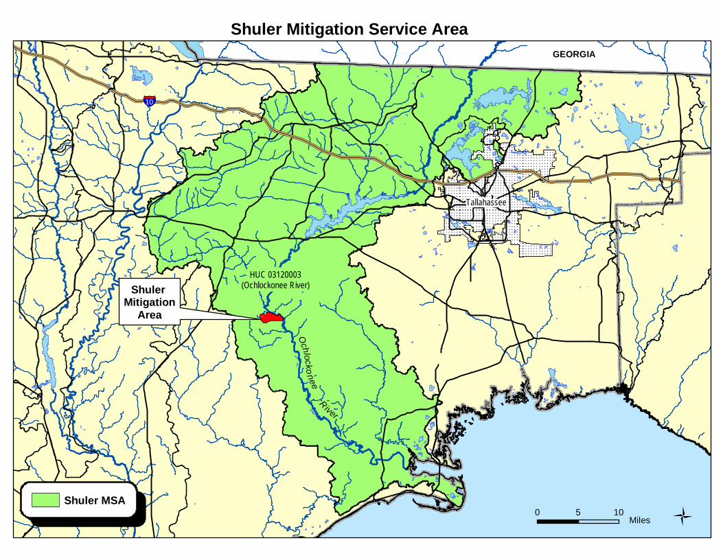
Mitigation Service Area

The Shuler Mitigation Service Area (MSA) covers approximately 1,300 mi2, and is defined as
that portion of the 8-digit Hydrologic Unit Code (HUC) 03120003 (i.e., the Lower Ochlockonee
River watershed) occurring in Florida. Total area for HUC 03120003 is approximately 1,560
mi2; ~83% of the watershed occurs in Florida, with the remainder in Georgia.
Shuler Mitigation Service Area
0 5 10 Miles 1
Tallahassee
GEORGIA
§̈¦10
Shuler MSA
HUC 03120003(Ochlockonee River)Shuler
MitigationArea
OchlockoneeRiver

Total Potential Credits = 33.95
Task
No.
%
Credit
Release
Number
of
Credits
100% 33.95
100% 33.95
Performance-based Milestone
CREDITS RELEASED AS OF JUNE 12, 2013
Totals:
Schedule of Credit Release
Shuler Tract Mitigation Area