Embed Size (px)
Citation preview
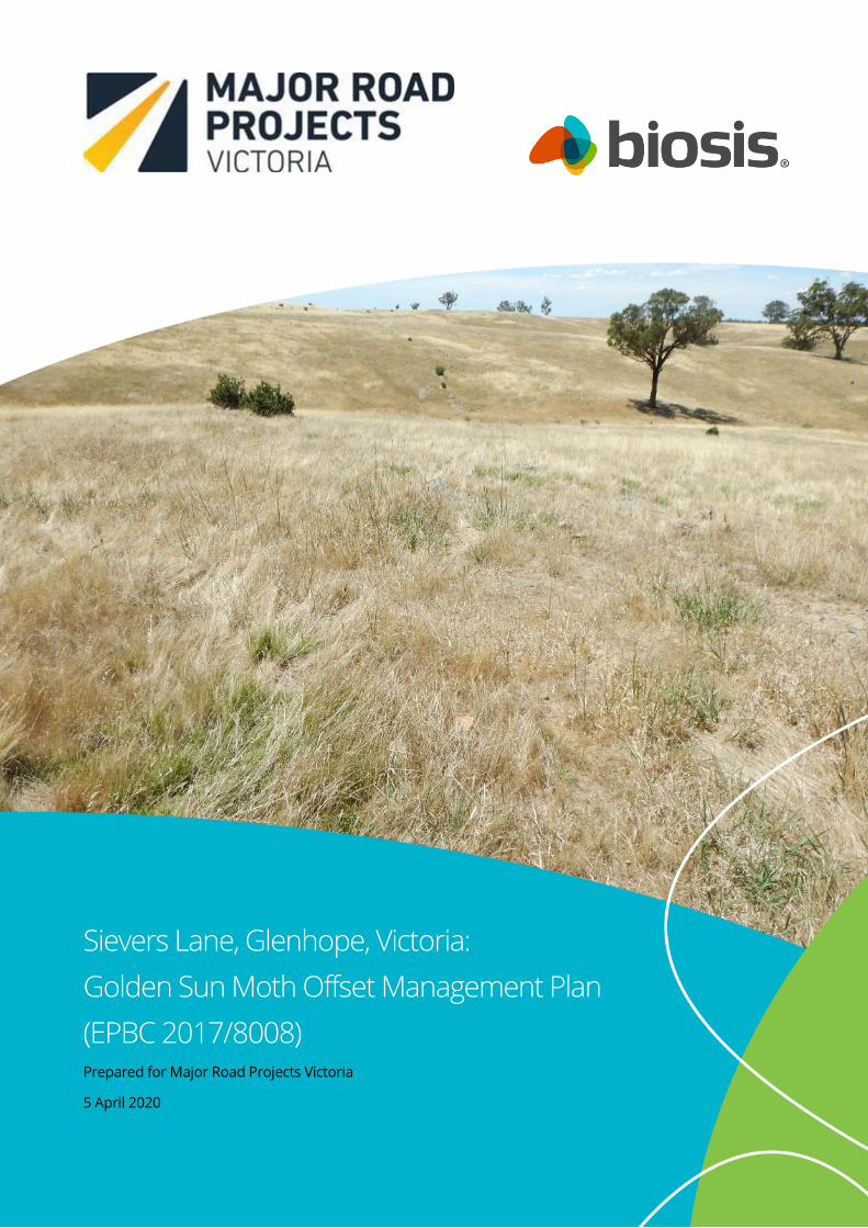
Sievers Lane, Glenhope, Victoria:
Golden Sun Moth Offset Management Plan
(EPBC 2017/8008) Prepared for Major Road Projects Victoria
5 April 2020
© Biosis Pty Ltd
This document is and shall remain the property of Biosis Pty Ltd. The document may only be used for
the purposes for which it was commissioned and in accordance with the Terms of the Engagement for
the commission. Unauthorised use of this document in any form whatsoever is prohibited.
Disclaimer:
Biosis Pty Ltd has completed this assessment in accordance with the relevant federal, state and local
legislation and current industry best practice. The company accepts no liability for any damages or loss
incurred as a result of reliance placed upon the report content or for any purpose other than that for
which it was intended.
© Biosis 2020 - Leaders in Ecology and Heritage Consulting Sievers Lane, Glenhope, Offset Management Plan (EPBC 2017/8008) ii
Biosis offices
NEW SOUTH WALES
Albury
Phone: (02) 6069 9200
Email: [email protected]
Newcastle
Phone: (02) 4911 4040
Email: [email protected]
Sydney
Phone: (02) 9101 8700
Email: [email protected]
Wollongong
Phone: (02) 4201 1090
Email: [email protected]
VICTORIA
Ballarat
Phone: (03) 5304 4250
Email: [email protected]
Melbourne (Head Office)
Phone: (03) 8686 4800
Email: [email protected]
Wangaratta
Phone: (03) 5718 6900
Email: [email protected]
Document information
Report to: Major Road Projects Victoria (MRPV)
Prepared by: Steve Mueck & Daniel Gilmore
Biosis project no.: 26332
File name: 26332.SieversLn.GSM.OMP.FINAL.18022020
Citation: Biosis 2020. Sievers Lane, Glenhope, Victoria: Golden Sun Moth
Offset Management Plan (EPBC 2017/8008). Report for Major Road Projects
Victoria. Authors: Mueck S & Gilmore D, Biosis Pty Ltd, Melbourne. Project no.
26332
Document control
Acknowledgements
Biosis acknowledges the contribution of the following people and
organisations in undertaking this study:
• Kathryn Woods, Ross Bradbury & Nerilee Kerslake: Major Road
Projects Victoria
• Paul Dettmann: Kinrara Pty Ltd
Biosis staff involved in this project were:
• Sally Mitchell, Sonika Kumar and Gareth Davies (mapping)
Version Internal reviewer Date issued
Draft 01 MV 16/03/2018
Draft 02 SGM 16/12/2018
Draft 03 SGM 28/02/2019
Draft 04 SGM 05/03/2019
Draft 05
Final 01
SGM
MV
07/03/2019
22/08/2019
Fin 02 SGM 05/05/20
© Biosis 2020 – Leaders in Ecology and Heritage Consulting Sievers Lane, Glenhope, Offset Management Plan (EPBC 2017/8008) iii
Contents
Summary .................................................................................................................................................................... v
1. Introduction .................................................................................................................................................... 1
1.1 Project background .............................................................................................................................................1
1.2 Objectives ........................................................................................................................................................... 12
1.3 Report structure ................................................................................................................................................ 12
1.4 Relevant EPBC approval conditions (EPBC Number 2017/8008) ........................................................... 13
2. Part A: Offset suitability .............................................................................................................................. 15
2.1 Development Site Details ................................................................................................................................ 15
2.2 Vegetation Approved for Removal ................................................................................................................ 15
2.3 Description of offset site – Sievers Lane, Glenhope, Victoria .................................................................. 15
2.4 Offset site suitability ......................................................................................................................................... 19
3. Part B: Offset Implementation .................................................................................................................. 23
3.1 Offset site details .............................................................................................................................................. 23
3.2 Strategy for Offset Site ..................................................................................................................................... 23
3.3 Offset security, management responsibility and reporting requirements .......................................... 24
3.4 Offset completion criteria ............................................................................................................................... 26
3.4.1 Future site condition - completion criteria ...................................................................................... 26
3.4.2 Performance criteria............................................................................................................................. 26
3.5 Limitations and uncertainty............................................................................................................................ 27
3.6 Ongoing management commitments ......................................................................................................... 28
3.7 Risk assessment and adaptive management ............................................................................................. 28
3.8 Management actions and land use commitments ................................................................................... 31
3.8.1 Fencing .................................................................................................................................................... 32
3.8.2 Woody weeds ......................................................................................................................................... 32
3.8.3 Herbaceous weeds ............................................................................................................................... 33
3.8.4 Pest animals ........................................................................................................................................... 33
3.8.5 Biomass / Organic Litter control ........................................................................................................ 33
3.9 Monitoring .......................................................................................................................................................... 37
3.9.1 Baseline Site Condition ........................................................................................................................ 37
3.9.2 Continuous monitoring ....................................................................................................................... 38
3.9.3 Fence monitoring .................................................................................................................................. 39
3.9.4 Weed monitoring .................................................................................................................................. 39
3.9.5 Pest animal monitoring ....................................................................................................................... 40
3.9.6 Tree and shrub monitoring ................................................................................................................. 40
3.9.7 Golden Sun Moth Monitoring ............................................................................................................ 41
3.10 Reporting ............................................................................................................................................................ 41
3.11 Auditing ............................................................................................................................................................... 42
3.12 Plan review ......................................................................................................................................................... 42
© Biosis 2020 – Leaders in Ecology and Heritage Consulting Sievers Lane, Glenhope, Offset Management Plan (EPBC 2017/8008) iv
4. Schedule of management actions, risks, monitoring and reporting .................................................. 44
5. References ..................................................................................................................................................... 54
Appendices ............................................................................................................................................................... 55
Appendix 1 DoEE EMP Guidelines Risk Framework ................................................................................ 56
Appendix 2 Glossary ..................................................................................................................................... 57
Tables
Table 1 Offset Site Details ................................................................................................................................... 23
Table 2 Security and Management Responsibility and Reporting Requirements ...................................... 24
Table 3 Herbaceous weeds to be controlled – method and timing .............................................................. 33
Table 4 Management plan actions and timing for offsets on the Sievers Lane offset site ....................... 44
Table 5 Risk assessment and management ..................................................................................................... 49
Table 6 Monitoring schedule .............................................................................................................................. 52
Table 7 Reporting schedule ................................................................................................................................ 53
Figures
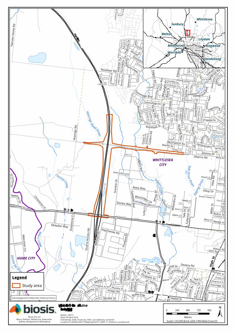
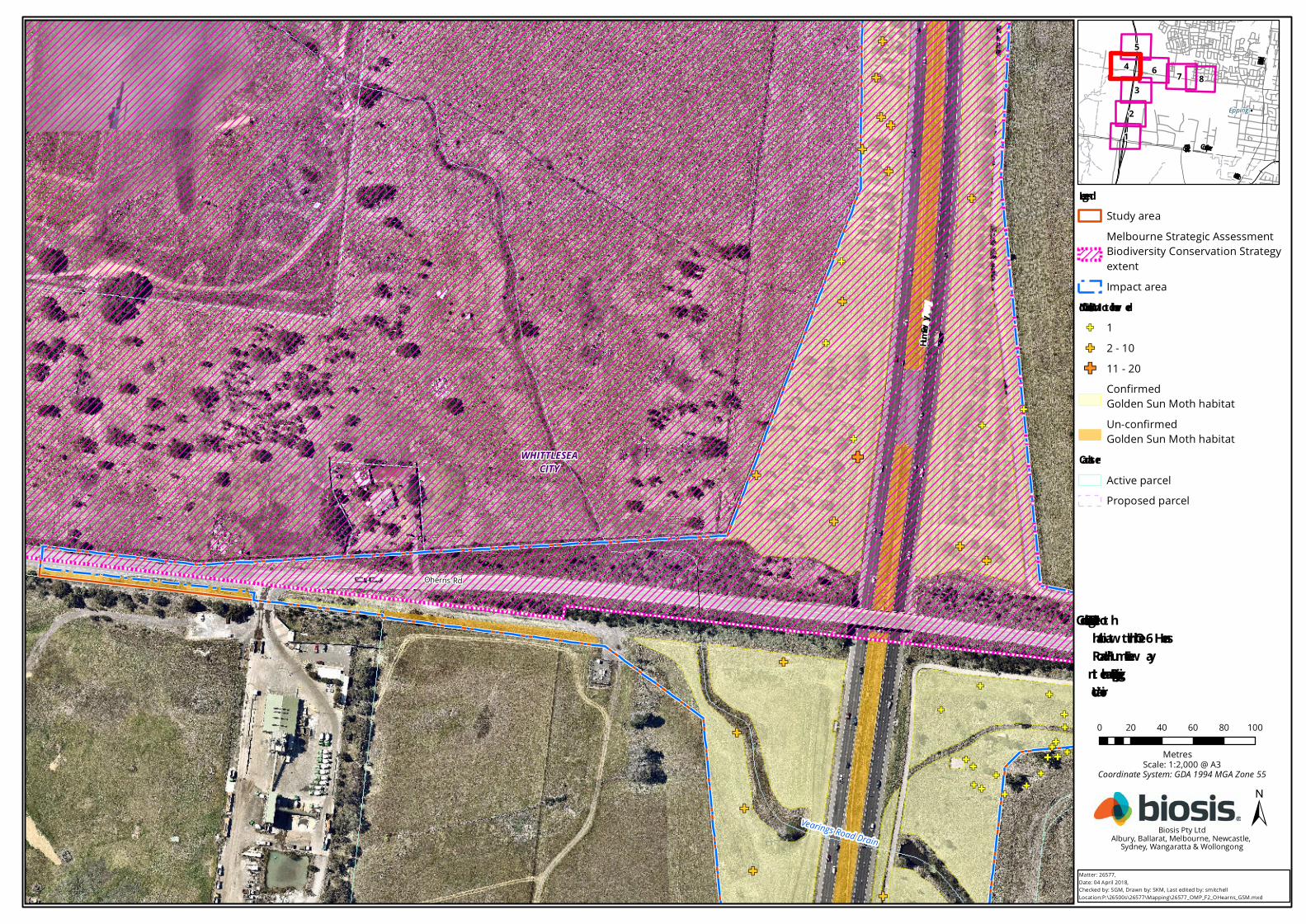
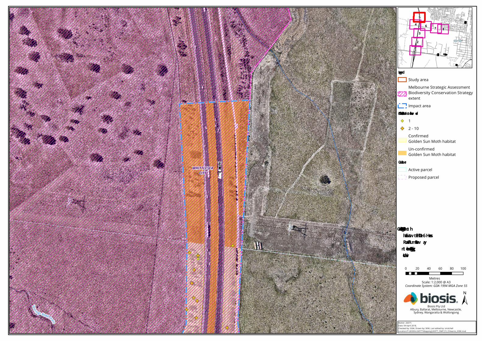
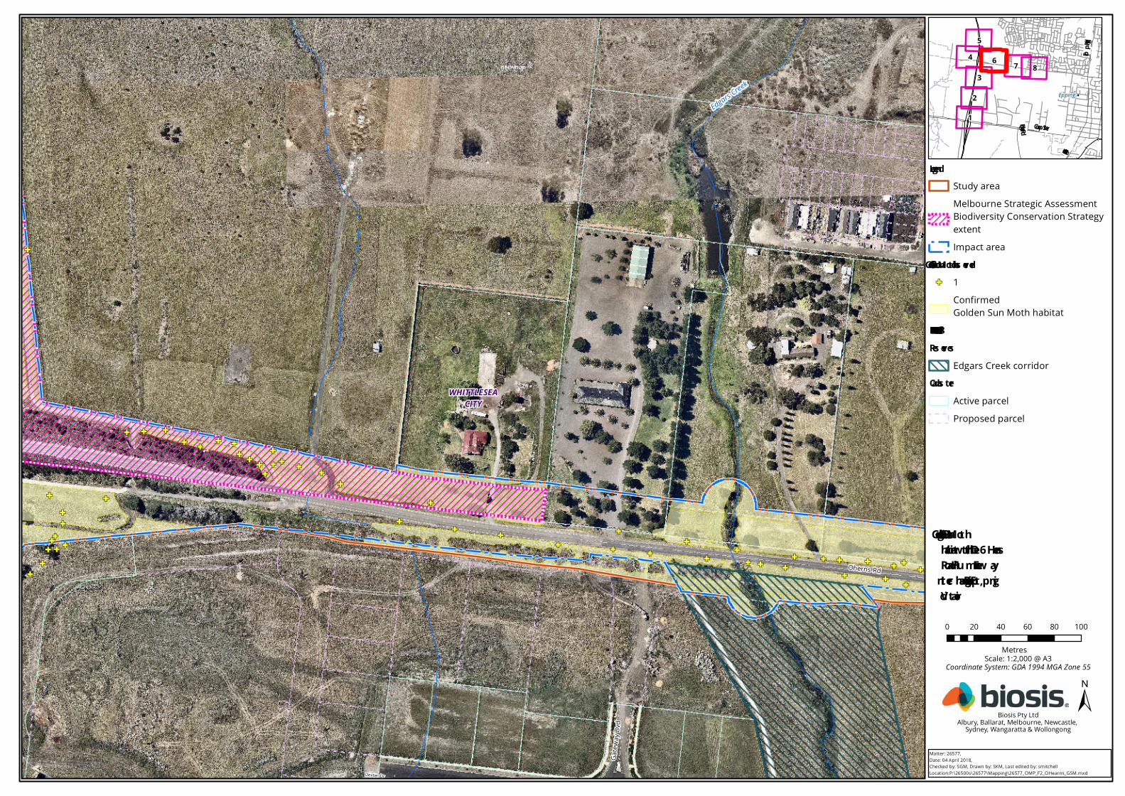
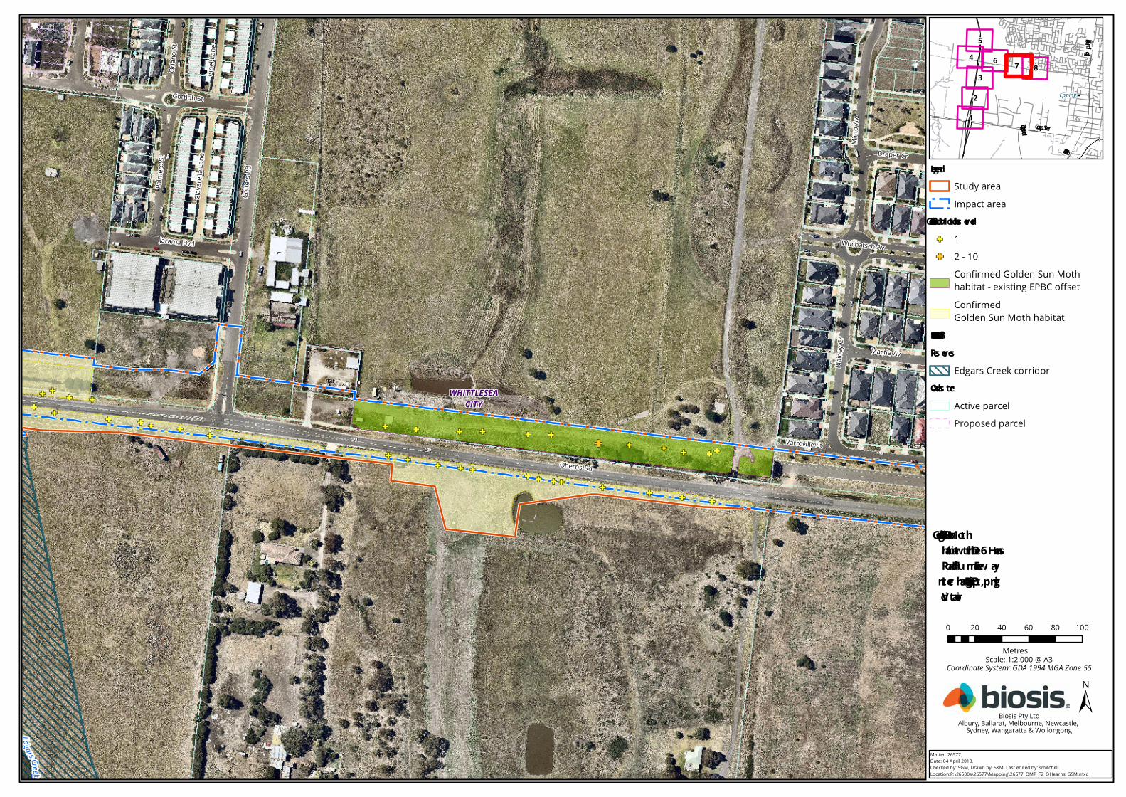
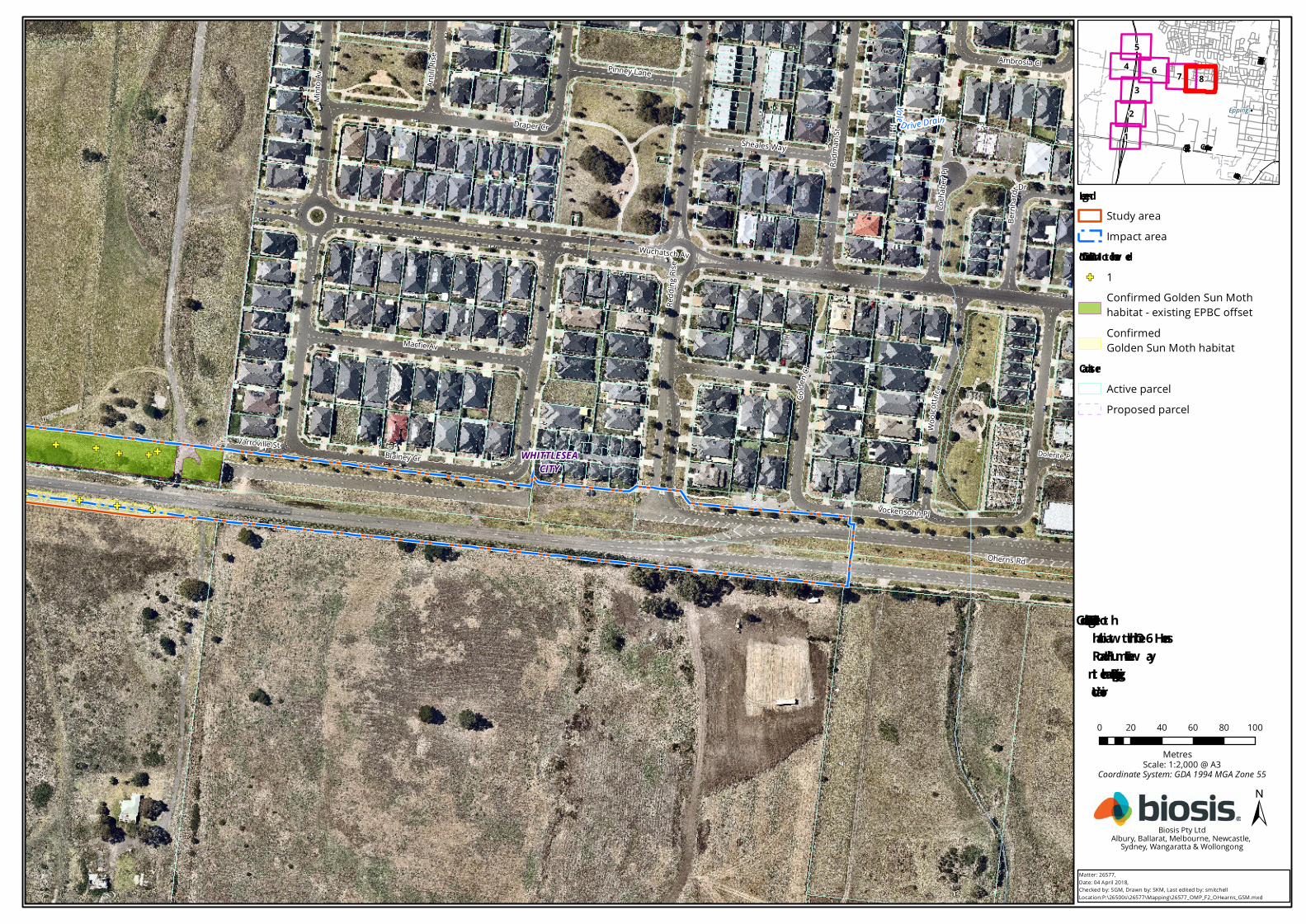
Figure 1 Location of the O’Herns Road/Hume Freeway Interchange Project, Epping Victoria ..................... 2
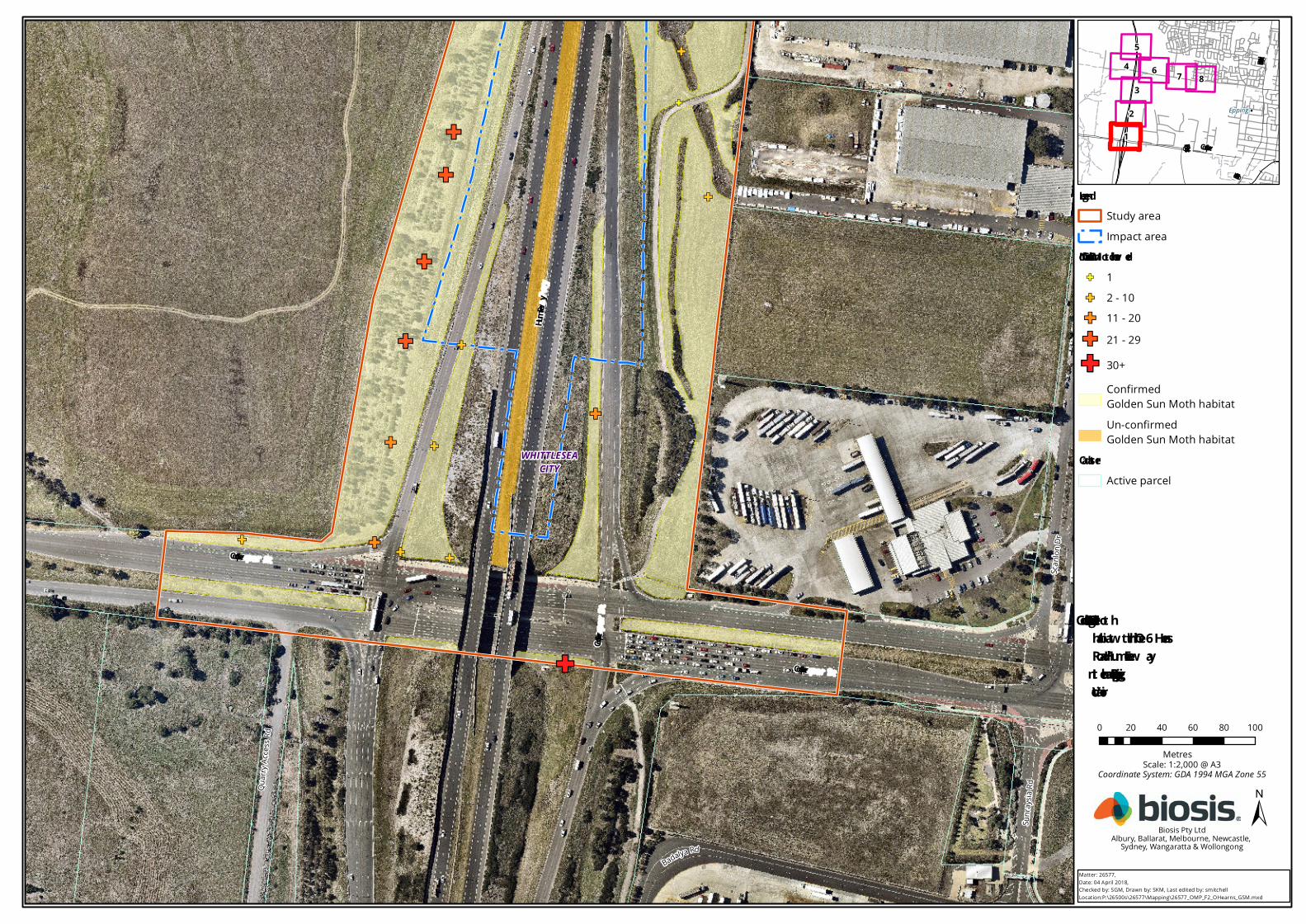
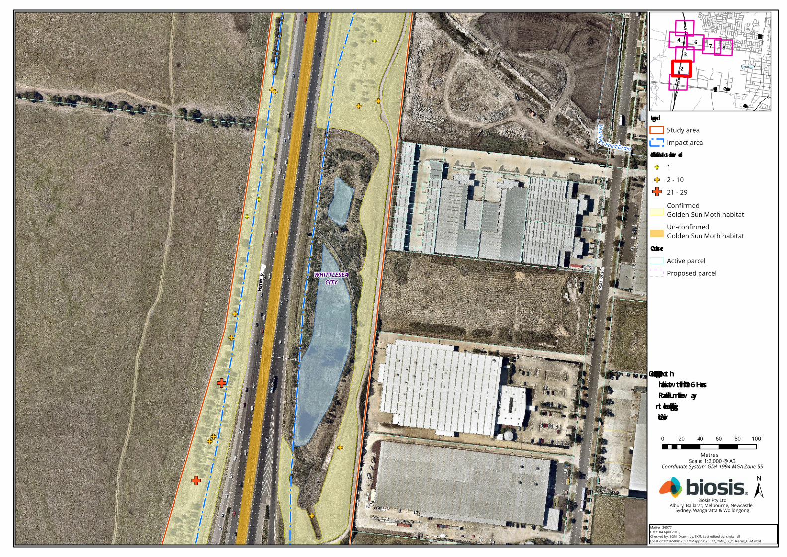
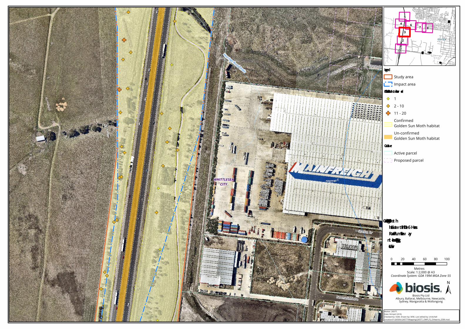
Figure 2 Golden Sun Moth habitat within the O’Herns Road/Hume Freeway Interchange Project,
Epping Victoria ......................................................................................................................................... 3
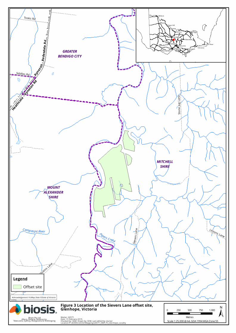
Figure 3 Location of the Sievers Lane offset site, Glenhope Victoria ............................................................. 11
Figure 4 Golden Sun Moth survey effort 2019/2020 survey season Sievers Lane offset site,
Glenhope, Victoria ................................................................................................................................. 17
Figure 5 Golden Sun Moth records, 2019/2020 survey season, Sievers Lane offset site,
Glenhope, Victoria. ................................................................................................................................ 18
© Biosis 2020 – Leaders in Ecology and Heritage Consulting Sievers Lane, Glenhope, Offset Management Plan (EPBC 2017/8008) v
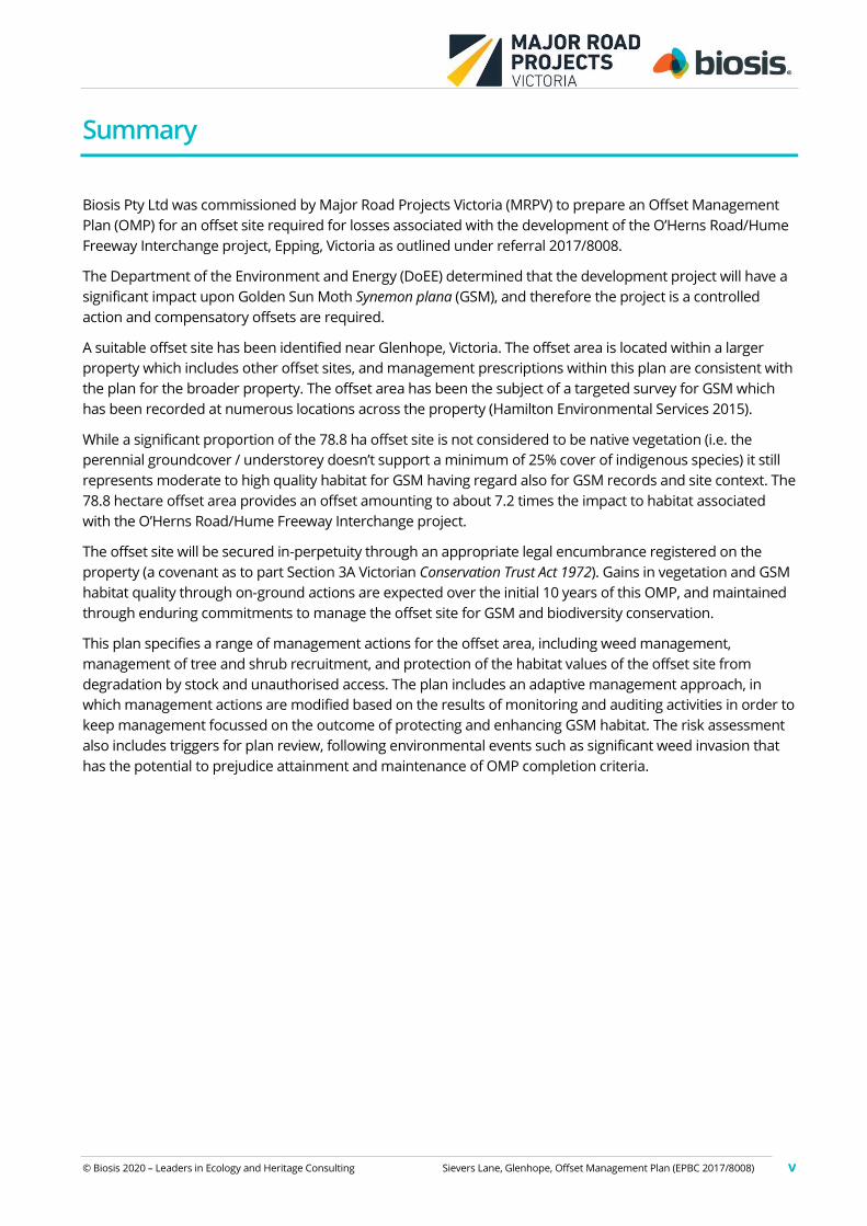
Summary
Biosis Pty Ltd was commissioned by Major Road Projects Victoria (MRPV) to prepare an Offset Management
Plan (OMP) for an offset site required for losses associated with the development of the O’Herns Road/Hume
Freeway Interchange project, Epping, Victoria as outlined under referral 2017/8008.
The Department of the Environment and Energy (DoEE) determined that the development project will have a
significant impact upon Golden Sun Moth Synemon plana (GSM), and therefore the project is a controlled
action and compensatory offsets are required.
A suitable offset site has been identified near Glenhope, Victoria. The offset area is located within a larger
property which includes other offset sites, and management prescriptions within this plan are consistent with
the plan for the broader property. The offset area has been the subject of a targeted survey for GSM which
has been recorded at numerous locations across the property (Hamilton Environmental Services 2015).
While a significant proportion of the 78.8 ha offset site is not considered to be native vegetation (i.e. the
perennial groundcover / understorey doesn’t support a minimum of 25% cover of indigenous species) it still
represents moderate to high quality habitat for GSM having regard also for GSM records and site context. The
78.8 hectare offset area provides an offset amounting to about 7.2 times the impact to habitat associated
with the O’Herns Road/Hume Freeway Interchange project.
The offset site will be secured in-perpetuity through an appropriate legal encumbrance registered on the
property (a covenant as to part Section 3A Victorian Conservation Trust Act 1972). Gains in vegetation and GSM
habitat quality through on-ground actions are expected over the initial 10 years of this OMP, and maintained
through enduring commitments to manage the offset site for GSM and biodiversity conservation.
This plan specifies a range of management actions for the offset area, including weed management,
management of tree and shrub recruitment, and protection of the habitat values of the offset site from
degradation by stock and unauthorised access. The plan includes an adaptive management approach, in
which management actions are modified based on the results of monitoring and auditing activities in order to
keep management focussed on the outcome of protecting and enhancing GSM habitat. The risk assessment
also includes triggers for plan review, following environmental events such as significant weed invasion that
has the potential to prejudice attainment and maintenance of OMP completion criteria.
© Biosis 2020 – Leaders in Ecology and Heritage Consulting Sievers Lane, Glenhope, Offset Management Plan (EPBC 2017/8008) 1
1. Introduction
1.1 Project background
Biosis Pty Ltd was commissioned by Major Road Projects Victoria (MRPV) to prepare an Offset Management
Plan (OMP) for an offset site required for losses associated with the O’Herns Road/Hume Freeway
Interchange Project, Epping, Victoria as outlined under referral 2017/8008 (Figure 1).
An ecological assessment of the O’Herns Road site, including a habitat hectare assessment, is documented by
Biosis (2017a). That report identifies the condition and extent of native vegetation and Golden Sun Moth
Synemon plana (GSM) habitat to be impacted and protected in association with the proposed development
(Figure 2). Biosis (2017a) was used, in conjunction with the Environment Protection and Biodiversity
Conservation Act 1999 (EPBC Act) offsets policy, to identify the extent of GSM habitat to be protected outside
the project area.
A native vegetation removal permit has been approved by the City of Whittlesea for the interchange project
(717308). Clearing associated with the development of the interchange was also assessed by the Department
of Environment, Land, Water and Planning (DELWP) as part of the development approvals process. The
development has also been assessed and approved by the Department of Environment and Energy (DoEE)
under the Environment Protection and Biodiversity Conservation Act 1999 (EPBC Act) through referral
2017/8008.
The plans developed by MRPV would result in clearing of 10.888 ha of GSM habitat (Figure 2) (note this
excludes areas covered by the Melbourne Strategic Assessment and within the Aurora subdivision).
Offsets for the proposed development are prescribed by both state (DELWP) and federal (DoEE) regulators.
Offsets prescribed under the EPBC Act and relevant Victorian requirements cannot be generated concurrently
and will therefore be sourced separately. Offsets proposed for this project under the EPBC Act involve
securing an external offset supporting 78.8 ha of GSM habitat.
The EPBC Act offset prescription for GSM is proposed to be sourced from a 78.8 ha section of Lots 3 to 6 of
PS727973 at Sievers Lane, Glenhope (Figure 3). An ecological assessment of the proposed external offset area
was conducted by Biosis (2018). This report provides the basic ecological information to support this OMP
and identified a contiguous area of GSM habitat known to support a significant population of GSM (Hamilton
Environmental Services 2015, 2017, this report).
Management of the external EPBC Act offset will involve protection and active ecological management of 78.8
hectares of relatively unimproved pasture which supports various degrees of native and introduced GSM
food plants.
The overall development of the O’Herns Road/Hume Freeway Interchange Project will be conducted over a
period of about 18 months. The project is expected to begin in mid to late 2019.
The Sievers Lane offset site is approximately 87 kilometres north north-west of the O’Herns Road
development site. The O’Herns Road interchange is within the Victorian Volcanic Plain (VVP) Bioregion while
the Sievers Lane offset site is mapped by DELWP as being within the Goldfields bioregion
(www.delwp.vic.gov.au). However, the northern end of the offset site clearly supports an outlier of olivine
basalt consistent with the geology of parts of the VVP bioregion.
A glossary of technical terms used throughout this OMP is provided in Appendix 2.
Edgars Creek
Vearings Road Drain
YaleDriv e Drain
Ainslie Rd Drain
Epping
Drain
C entral Creek
Merri
Creek
Harve
st Ho
me Rd
Miro Pl
Monash St
Culle
n St
Wuchatsch Av
Empress Av
Bail St
Silve
rstone
Cct
Vilc in
s Vew
s
Corbett Av
ManorHouseDr
Broadleaf Dr
The H
orizo
n
Huskisson Av
Shiel
ds St
Crimson CrBlessin
gton Pde
Dra p erCr
CotchinCl
Werri
b ee C
r
ReddingRise
Aberf
eldy G
r
Ceris
e Av
Brunswick Dr
Woodson Dr
Saxony Dr
Young St
Verde Pde
Rockfield St
Gre e
nfield
s Dr
Deveny Rd
Cloverfield Cr
Gammage Bvd
Chigwell Pl
Edgars R d
Moffat Dr
Gol dminers Pl
Silver Tree Way
Gillwe
ll Rd
Newton DrRufus St
Dunolly StHu
ntin g
tonTce
Coulstock St
Kalara Cl
Oherns Rd
Fulham Way
Piazza
Way
Contempo Bvd
Bagat
elleAv
Tesselaar Rd
Macke
nzie
Dr
Alth o
r pS t
AlhambraDr
Kiama Dr
Malle
e Ct
The Stead
Aries Dr
Jovic Rd
Rakia
Dr
PinO
ak Mews
Duffy
St
Buller Pde
Bada
lya Rd
Haymarket Rd
Steen Av
Hall St
Buckhurst Av
Vocke n sohn
P l
Loca Cct
Crawf o rd Cr
Mille
r St
Hilde rstone A v
Produ
ce Dr
Os mondCr
Phoen
ix Cct
Echuc
a Way
Param
ount
Rise
Eaststone Av
Eynes bury View
Partridge St
StokeCct
BerrimaCr
The Parade
Inve rloch St
Moss Rd
Amhe
rst St
Augu
staDr
Wyen
aGr
Dayb
reak S
t
Be ndoc
St
Sunc
roft D
r
Farmley Way
Bel
lerive Rd
Festiv
al Gr
Joyfields Pl
Plus
hCct
Ocallaghan Av
Dohe
rty W
ay
WendoureeView
Tripani Av
Monaco Cct
Wyperf el d Way
Ardenal Cr
Prilep Hts
Bran
x holm
e St
Bellarine Dr
Jan Ct
Blaze
St
Curtin Av
Hidco
teTce
White
light
Av
Memorial Av
Bellavista DrPreseli Ct
Mosaic Dr
Feldgrau Rise
Gene
sis D
r
Rotino Cr
Reve
lation
Rd
Seppies RdWalkhill Dr
LanaiAvViviennesTce
Aberc
rombi e
Gr
Perease Rd
Devon Ct
DeRossi Bvd
Arna u d Loo
p
Paior
Cct
Wurundjeri Dr
Gambier Ct
Quarr
y Acce
ss Rd
Evolve
Esp
Jocely
n St
C i ty V
iew
CrCeladonSt
GatewayBvd
Frank
St
Dunbar Ct
Church St
Yale
Dr
Re d rock Rd
Berriga n St
Lara
Way
Wal lagaraughPwy
Cadiz Walk
Kanimbla Dr
Brett C
t
Everest Ct
Macedon Pde
Viewbank Ct
Al les
si Av
Manor Ct
St Na
um Tc
e
Loug htonAv
Ke aneC
r
Linoa
kAv
Muller St
Fulla
rton D
r
Annalise Av
Frewin St
Ruby Ct
Urba
n Dr
Cobu
ngra
Gr
Tourmaline DrZinnober Gdns
Nebel StVienna Ch
Camouflage Dr
North
side D
r
Pike St
Carney St
Creeds Farm Lane
Yalmy Av
S aintl y
Av
M elto
nCr
Yarro
wee C
r
Webb Ct
RosemaryDr
Kens
al La
ne
Cerridwe
nSt
Aditi
Lane
Kouk
oura
DrOckletree Pl
Da pple sha de Av
Elizabeth Dr
Humffray Walk
Soda
s Lan
e
Kay Av
Bud Lane
Helm Ct
Choc olate Lilly S
t
Wistow Ch
Taberer Ct
Ashford Way
Viewgrand Bvd
Vanessa Av
Bemm
Lane
Eame
s Av
Eden
valeBvd
Alysam St
K a thryn Av
Colden Cl
Beresford Rd
Countryfields Bvd
Mayflower Mew s
Nor th
park
Dr
Groe
n Lane
Tall Sedge StKe
f ford
Av
Mossf
ieldRi s
e
Orian
o St
Pittard Walk
Ciava
rella
Lane
Palm
ero St
Cotte
rs Rd
Link Ct
Jarret
t St
Lydia
Ct
Wedge St
Robayn e Ct
Subia
co Rd
Lees
onGr
Jersey
Dr
Kirkw
ood A
v
Murphy St
Judith Ct
Dilop Dr
Merri Con
Railway Rd
S to nega
teDr
Sunra
ysia
Rd
Anahit Dr
Mckellar Way
Ballan
omaGrn
Gray
stone
Ct
Donovan S t
Rising Lane
Macfie Av
Produ
ction
Dr
Cooper St
Ezero St
Nancye Dr
Geary Av
View
Rd
Teschke Walk
Bernhardt Dr
Anderson St
Calveley Pl
Gipps Ct
Dexter Dr
Veari
ngs R
d
Farad
ay St
Connection Dr
Treska Link
Transit Dr
Mary Ct
Willa
ndra
Dr
Legacy RdFert ile St Cla
remon
t Pl
Bulait
Dr
Clav e
llC
r
Dunmore St
Langri d ge Dr
Scanlo
n Dr
Chifley St
Currawon
g Av
Ricky Way
Newmarket Lane
Dream Haven Ct
Biodiv
ersity
Bvd
Taryn DrHig
h St
Kingsford St
Mombassa D r
Avon
dale
Rd
Wins
lowAv
Teal Cr
Metrolink Cct
Shirley WayCompanion Pl
Co o per St
HighSt
Kingsway Dr
Edgars Rd
Mount View Rd
Childs Rd
Co o per St
Craigieburn Rd
Hume Fwy
HUME CITY
WHITTLESEACITY
Acknowledgement:VicMap Data ©State of Victoria
Matter: 26577,Date: 04 April 2018,Checked by: SGM, Drawn by: SKM, Last edited by: smitchellLocation:P:\26500s\26577\Mapping\26577_OMP_F1_OHearns_Locality.mxd
LegendStudy area
Scale 1:25,000 @ A4, GDA 1994 MGA Zone 55
0 240 480 720 960
Metres ±Biosis Pty LtdAlbury, Ballarat, Melbourne, Newcastle,
Sydney, Wangaratta & Wollongong
Figure 1 Lo catio n o f the O’Herns Ro ad/HumeFreeway Interchange Pro ject, Epping Victo ria
!
!
!
!
!
!
!
!
!
Sunbury
MelbourneWerribee
Dandenong
Melton
Whittlesea
RingwoodLilydale
GF
GF
GF
GF
GF
GFGFGF
GF
GF
GF
GF
GF
GF
GF
GF
Quarr
y Acce
ss Rd
Sunra
ysia R
d
Scanlo
n Dr
Badalya Rd
Cooper St
Cooper St
Cooper StHume Fwy
WHITTLESEACITY
!Epping
Cooper St
High St
Epping Rd
Edgars Rd
4 6 7 83
2
1
5
Matter: 26577,Date: 04 April 2018,Checked by: SGM, Drawn by: SKM, Last edited by: smitchellLocation:P:\26500s\26577\Mapping\26577_OMP_F2_OHearns_GSM.mxd
Scale: 1:2,000 @ A3Coordinate System: GDA 1994 MGA Zone 55
Biosis Pty LtdAlbury, Ballarat, Melbourne, Newcastle,
Sydney, Wangaratta & Wollongong
±
Figure 2.1 Golden Sun Mothhabitat w ithin the O’HernsRoad/Hume Freew ayInterchange Project, Epping,Victoria
0 20 40 60 80 100
Metres
LegendStudy areaImpact area
No. of Golden Sun Moth observ erdGF 1GF 2 - 10GF 11 - 20GF 21 - 29
GF 30+Confirmed Golden Sun Moth habitatUn-confirmedGolden Sun Moth habitat
CadastreActive parcel
GF
GF
GF
GF
GF
GF
GF
GF
GF
GF
GF
GF
GFGF
GF
GF
GF
Vearing s Road Drain
Scanlo
n Dr
Hume Fwy
WHITTLESEACITY
!Epping
Cooper St
High St
Epping Rd
Edgars Rd
4 6 7 83
2
1
5
Matter: 26577,Date: 04 April 2018,Checked by: SGM, Drawn by: SKM, Last edited by: smitchellLocation:P:\26500s\26577\Mapping\26577_OMP_F2_OHearns_GSM.mxd
Scale: 1:2,000 @ A3Coordinate System: GDA 1994 MGA Zone 55
Biosis Pty LtdAlbury, Ballarat, Melbourne, Newcastle,
Sydney, Wangaratta & Wollongong
±
Figure 2.2 Golden Sun Mothhabitat w ithin the O’HernsRoad/Hume Freew ayInterchange Project, Epping,Victoria
0 20 40 60 80 100
Metres
LegendStudy areaImpact area
No. of Golden Sun Moth observ erdGF 1GF 2 - 10GF 21 - 29
Confirmed Golden Sun Moth habitatUn-confirmedGolden Sun Moth habitat
CadastreActive parcelProposed parcel
GF
GF
GF
GF
GF
GF
GF
GF
GF
GF
GF
GF
GF
GF
GF
GF
GF
GF
GF
GF
GF
GF
GF
GF
GF
GF
GF
Vearings Road Drain
Dexter Dr
Scanlon Dr
Newmarket Lane
Hume Fwy
WHITTLESEACITY
!Epping
Cooper St
High St
Epping Rd
Edgars Rd
4 6 7 83
2
1
5
Matter: 26577,Date: 04 April 2018,Checked by: SGM, Drawn by: SKM, Last edited by: smitchellLocation:P:\26500s\26577\Mapping\26577_OMP_F2_OHearns_GSM.mxd
Scale: 1:2,000 @ A3Coordinate System: GDA 1994 MGA Zone 55
Biosis Pty LtdAlbury, Ballarat, Melbourne, Newcastle,
Sydney, Wangaratta & Wollongong
±
Figure 2.3 Golden Sun Mothhabitat w ithin the O’HernsRoad/Hume Freew ayInterchange Project, Epping,Victoria
0 20 40 60 80 100
Metres
LegendStudy areaImpact area
No. of Golden Sun Moth observ erdGF 1GF 2 - 10GF 11 - 20
Confirmed Golden Sun Moth habitatUn-confirmedGolden Sun Moth habitat
CadastreActive parcelProposed parcel
GF
GF
GF
GF
GF
GF
GF
GFGF
GF
GF
GF
GF
GF
GF
GF
GF
GF
GF
GF
GF
GF
GF
GF
GF
GFGF
GF
GFGF
GFGF
GF
GFGF
GF
GF GFGF
GFGF
GF
GF
Vearings Road Drain
Oherns Rd
Hume Fwy
WHITTLESEACITY
!Epping
Cooper St
High St
Epping Rd
Edgars Rd
4 6 7 83
2
1
5
Matter: 26577,Date: 04 April 2018,Checked by: SGM, Drawn by: SKM, Last edited by: smitchellLocation:P:\26500s\26577\Mapping\26577_OMP_F2_OHearns_GSM.mxd
Scale: 1:2,000 @ A3Coordinate System: GDA 1994 MGA Zone 55
Biosis Pty LtdAlbury, Ballarat, Melbourne, Newcastle,
Sydney, Wangaratta & Wollongong
±
Figure 2.4 Golden Sun Mothhabitat w ithin the O’HernsRoad/Hume Freew ayInterchange Project, Epping,Victoria
0 20 40 60 80 100
Metres
LegendStudy areaMelbourne Strategic AssessmentBiodiversity Conservation Strategy extentImpact area
No. of Golden Sun Moth observ erdGF 1GF 2 - 10GF 11 - 20
Confirmed Golden Sun Moth habitatUn-confirmedGolden Sun Moth habitat
CadastreActive parcelProposed parcel
GF
GF
GF
GFGFGF
GF
GF
GF
GF
GF
Vearings Road Drain
Hume Fw y
WHITTLESEACITY
!Epping
Cooper St
High St
Epping Rd
Edgars Rd
4 6 7 83
2
1
5
Matter: 26577,Date: 04 April 2018,Checked by: SGM, Drawn by: SKM, Last edited by: smitchellLocation:P:\26500s\26577\Mapping\26577_OMP_F2_OHearns_GSM.mxd
Scale: 1:2,000 @ A3Coordinate System: GDA 1994 MGA Zone 55
Biosis Pty LtdAlbury, Ballarat, Melbourne, Newcastle,
Sydney, Wangaratta & Wollongong
±
Figure 2.5 Golden Sun Mothhabitat w ithin the O’HernsRoad/Hume Freew ayInterchange Project, Epping,Victoria
0 20 40 60 80 100
Metres
LegendStudy areaMelbourne Strategic AssessmentBiodiversity Conservation Strategy extentImpact area
No. of Golden Sun Moth observ erdGF 1GF 2 - 10
Confirmed Golden Sun Moth habitatUn-confirmedGolden Sun Moth habitat
CadastreActive parcelProposed parcel
GF
GFGF
GFGF
GF
GF GFGF
GFGF
GF
GF
GF GF GF
GFGF
GF GF
GFGF
GFGF
GF
GF
GFGF
GF
GF
GF GF GFGF GF
GF
GFGFGF
GFGFGFGF
GFGF
GF
GFGF
GF
GF
GF
GFGF
GF
Edgars Creek
Oherns Rd
Dexter Dr
Gatew
ay Bv
d
WHITTLESEACITY
!Epping
Coop er St
High St
Epp ing Rd
Edgars Rd
4 6 7 83
2
1
5
Matter: 26577,Date: 04 April 2018,Checked by: SGM, Drawn by: SKM, Last edited by: smitchellLocation:P:\26500s\26577\Mapping\26577_OMP_F2_OHearns_GSM.mxd
Scale: 1:2,000 @ A3Coordinate System: GDA 1994 MGA Zone 55
Biosis Pty LtdAlbury, Ballarat, Melbourne, Newcastle,
Sydney, Wangaratta & Wollongong
±
Figure 2.6 Golden Sun Mothhabitat w ithin the O’HernsRoad/Hume Freew ayInterc hange Projec t, Ep p ing,Vic toria
0 20 40 60 80 100
Metres
LegendStudy areaMelbourne Strategic AssessmentBiodiversity Conservation Strategy extentImpact area
No. of Golden Sun Moth observerdGF 1
Confirmed Golden Sun Moth habitat
EPBC Referral No. 2012/6298Reserves
Edgars Creek corridor Cadas tre
Active parcelProposed parcel
GFGFGFGFGFGF
GFGFGFGFGFGF
GFGF
GF GF GFGF GF GFGF
GFGF
GFGF
GFGF GF
GF GF
GFGFGFGFGF
GFGF
E dgars Creek
Gottloh St
Jarama Bvd Wuchatsch Av
Varroville St
Minto
Av
Draper Cr
Macfie Av
Orian
o St
Cinel
Lane
Blaine
y Cr
Cotte
rs Rd
Ciava
rella
Lane
Palm
ero St
Oherns Rd
WHITTLESEACITY
!Epping
Coop er St
High St
Epp ing Rd
Edgars Rd
4 6 7 83
2
1
5
Matter: 26577,Date: 04 April 2018,Checked by: SGM, Drawn by: SKM, Last edited by: smitchellLocation:P:\26500s\26577\Mapping\26577_OMP_F2_OHearns_GSM.mxd
Scale: 1:2,000 @ A3Coordinate System: GDA 1994 MGA Zone 55
Biosis Pty LtdAlbury, Ballarat, Melbourne, Newcastle,
Sydney, Wangaratta & Wollongong
±
Figure 2.7 Golden Sun Mothhabitat w ithin the O’HernsRoad/Hume Freew ayInterc hange Projec t, Ep p ing,Vic toria
0 20 40 60 80 100
Metres
LegendStudy areaImpact area
No. of Golden Sun Moth observerdGF 1GF 2 - 10
Confirmed Golden Sun Mothhabitat - existing EPBC offsetConfirmed Golden Sun Moth habitat
EPBC Referral No. 2012/6298Reserves
Edgars Creek corridor Cadas tre
Active parcelProposed parcel
GFGFGFGFGFGF
GFGF
GFGF
Yale
D rive Drain
Wuchatsch Av
Draper Cr
Redd
ing Ri
se
Minto
Av Antill
Rise
Dolerite Pl
Vockensohn Pl
Loch
aber
Pl
C olde
n Cl
Ambrosia Cl
Varroville StBlainey Cr
Radm
an St
Pinney Lane
Sheales Way
Bern
hardt
Dr
Oherns Rd
Macfie Av
Woolc
ot tTce
WHITTLESEACITY
!Epping
Cooper St
High St
Epping Rd
Edgars Rd
4 6 7 83
2
1
5
Matter: 26577,Date: 04 April 2018,Checked by: SGM, Drawn by: SKM, Last edited by: smitchellLocation:P:\26500s\26577\Mapping\26577_OMP_F2_OHearns_GSM.mxd
Scale: 1:2,000 @ A3Coordinate System: GDA 1994 MGA Zone 55
Biosis Pty LtdAlbury, Ballarat, Melbourne, Newcastle,
Sydney, Wangaratta & Wollongong
±
Figure 2.8 Golden Sun Mothhabitat w ithin the O’HernsRoad/Hume Freew ayInterchange Project, Epping,Victoria
0 20 40 60 80 100
Metres
LegendStudy areaImpact area
No. of Golden Sun Moth observ erdGF 1
Confirmed Golden Sun Mothhabitat - existing EPBC offsetConfirmed Golden Sun Moth habitat
CadastreActive parcelProposed parcel
P ipers Creek
Campaspe River
Stone
Jug L
ane
Lintons Lane
Siddles Rd
Sieve
rsLa
n e
Dickins La
ne
Tooks Rd
Kyneton -
Rede
s da le
Rd
Heathcot
e - Kyneto
n Rd
GREATERBENDIGO CITY
MITCHELLSHIRE
MOUNTALEXANDER
SHIRE
!
!
!
!!
!
!
!
!
!
!
!
!
!
!!
!
!!! !
!
!
!
!
!
!
!
Mildura
KerangSwan Hill
HamiltonBallarat
Ararat
Warrnambool
Echuca
Bendigo
Wodonga
TraralgonMelbourne
GeelongLakesEntrance
Cann River
Mansfield
Acknowledgement: VicMap Data ©State of Victoria
LegendOffset site
Scale 1:25,000 @ A4, GDA 1994 MGA Zone 55
0 250 500 750 1,000
Metres ±Biosis Pty LtdAlbury, Ballarat, Melbourne, Newcastle, Sydney, Wangaratta & Wollongong
Figure 3 Location of the Sievers Lane offset site,Glenhope, VictoriaMatter: 26577,Date: 15 February 2019,Checked by: SGM, Drawn by: SKM, Last edited by: jturnerLocation:P:\26300s\26332\Mapping\26577_OMP_F3_Glenhope_Locality
© Biosis 2020 – Leaders in Ecology and Heritage Consulting Sievers Lane, Glenhope, Offset Management Plan (EPBC 2017/8008) 12
1.2 Objectives
The objective of the OMP is to document the development site and offset site details to meet EPBC Act
approval requirements of offsetting impacts to GSM by securing, maintaining and improving GSM habitat
within the designated offset site. The objectives of this plan are to:
• Improve the condition of 78.8 hectares of GSM habitat at the Sievers Lane offset property in a
manner consistent with the EPBC Act Environmental Offsets Policy;
• support establishment of legal security arrangements for the in perpetuity protection and
management of the offset site;
• Undertake management actions to protect and improve the quality of native vegetation and GSM
habitat within the offset site;
• Provide a timetable of management actions, outcomes and progress reviews;
• Detail appropriate monitoring and evaluation of management actions and completion criteria; and
• Attain and maintain the offset completion criteria for the life of the EPBC Act approval for EPBC
2017/8008.
This OMP is consistent with regional priority recovery and threat abatement actions in the Department of
Environment’s Approved Conservation Advice for Synemon plana (Golden Sun Moth) (DoEE 2013), including:
• Establishing formal conservation arrangements, management agreements and covenants on private
land.
• Preventing ongoing loss and degradation of habitat and retaining and protecting natural vegetation
remnants within the known distribution of the species.
• Monitoring known populations to determine the species’ status.
• Monitoring the effectiveness of management actions and the need to adapt them if necessary.
• Control of invasive weeds that threaten habitat.
• Implementation of appropriate grazing and burning to maintain and enhance habitat values for the
species.
1.3 Report structure
The structure and content of the OMP is consistent with the requirements of the ‘Standard Offset Plan’
template provided by DELWP and is organised in a number of parts:
• Introduction - This section summarises the background information relevant to the Project,
including the purpose and scope of the work and the assessment methodology.
• Part A: Offset Suitability - This section assesses the suitability of the proposed offset site, and
includes details regarding approved clearing, gain and site improvement calculations. Part A should
be read in conjunction with Part B, but due to its technical nature, the information it contains is not
intended to be placed on title (e.g. Covenant under the Victorian Conservation Trust Act 1972).
• Part B: Offset Implementation - This section describes how the offset is to be implemented. Part B
includes details regarding landowner and EPBC Act approval holder commitments, management
activities, monitoring and reporting. This section is intended for those responsible for implementing
the OMP, including MRPV and future landowners. Information in this section is intended to be placed
on title.
The plan also addresses the requirements of guidelines for the preparation of an OMP under the EPBC Act
Environmental Offsets Policy (Commonwealth of Australia 2014).
© Biosis 2020 – Leaders in Ecology and Heritage Consulting Sievers Lane, Glenhope, Offset Management Plan (EPBC 2017/8008) 13
1.4 Relevant EPBC approval conditions (EPBC Number 2017/8008)
Condition 8 of the EPBC approval states that The approval holder must submit to the Department an Offset
Management Plan for the offset area.
The EPBC approval conditions relevant to this OMP and where they are addressed in in the OMP are outlined
below.
Relevant EPBC Approval Condition Where addressed in OMP
8 b Demonstrate how the offset area
and environmental services will
compensate for the loss of 10.88 ha of
Golden Sun Moth habitat consistent
with the EPBC Environmental Offsets
Policy.
The suitability of the offset site and the offset calculations are
provided in Section 2.4. Implementation of the plan is described
in Section 3 and a schedule of management actions, risks,
monitoring and reporting is detailed in Section 4. It is anticipated
that the proposed management actions outlined in the plan will
result in the required condition improvement to compensate for
the loss of 10.88 ha of GSM habitat.
c must include but not be limited to:
c i A description of the offset area
including location, size, condition,
environmental values present and
surrounding land uses
Section 2.3
c ii Baseline data and other
supporting evidence that documents
the presence and baseline quality of
Golden Sun Moth habitat within the
offset area
Section 2.3, Section 2.4, Figure 4 (GSM records)
c iii Maps and shapefiles of the offset
area
Location of the offset is illustrated in Figure 3. Shapefiles have
been provided to DoEE.
c iv Specific objectives to
demonstrate Golden Sun Moth
habitat quality improvement over the
life of the approval
Performance criteria are described in section 3.4.2 and
summarised in Table 4. Criteria include completion of scheduled
management, monitoring and reporting activities (Section 3.4.2).
c v Specific management actions, and
timeframes for implementation, to be
carried out to meet the specific
objectives to improve the quality of
Golden Sun Moth habitat within the
offset area
Section 3.6 describes ongoing management commitments which
will be carried out in perpetuity.
Section 3.7 describes the key management issues which will be
addressed by the plan. It is anticipated that an active
management period of ten years will be required to achieve the
required quality gain, with maintenance to continue in
perpetuity.
Management actions are described in greater detail in Section
3.8. This sets out the key issues and measures by which they will
be addressed.
Table 4 provides a schedule of management actions and how
often they will be implemented.
© Biosis 2020 – Leaders in Ecology and Heritage Consulting Sievers Lane, Glenhope, Offset Management Plan (EPBC 2017/8008) 14
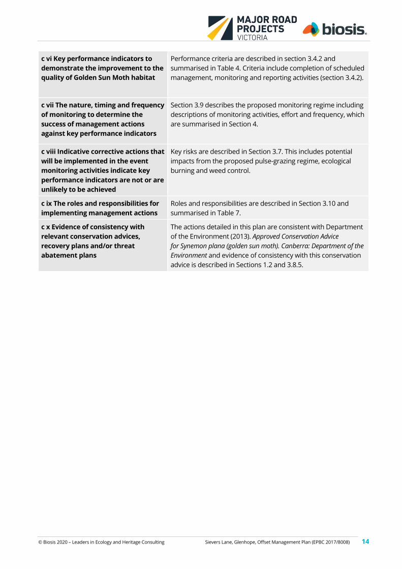
c vi Key performance indicators to
demonstrate the improvement to the
quality of Golden Sun Moth habitat
Performance criteria are described in section 3.4.2 and
summarised in Table 4. Criteria include completion of scheduled
management, monitoring and reporting activities (section 3.4.2).
c vii The nature, timing and frequency
of monitoring to determine the
success of management actions
against key performance indicators
Section 3.9 describes the proposed monitoring regime including
descriptions of monitoring activities, effort and frequency, which
are summarised in Section 4.
c viii Indicative corrective actions that
will be implemented in the event
monitoring activities indicate key
performance indicators are not or are
unlikely to be achieved
Key risks are described in Section 3.7. This includes potential
impacts from the proposed pulse-grazing regime, ecological
burning and weed control.
c ix The roles and responsibilities for
implementing management actions
Roles and responsibilities are described in Section 3.10 and
summarised in Table 7.
c x Evidence of consistency with
relevant conservation advices,
recovery plans and/or threat
abatement plans
The actions detailed in this plan are consistent with Department
of the Environment (2013). Approved Conservation Advice
for Synemon plana (golden sun moth). Canberra: Department of the
Environment and evidence of consistency with this conservation
advice is described in Sections 1.2 and 3.8.5.
© Biosis 2020 – Leaders in Ecology and Heritage Consulting Sievers Lane, Glenhope, Offset Management Plan (EPBC 2017/8008) 15
2. Part A: Offset suitability
This section provides details of the clearing site, assesses the suitability of the proposed offset site, and
includes details regarding approved clearing, gain and site improvement calculations. This section should be
read in conjunction with Part B, but due to its technical nature, the information it contains is not intended to
be placed on title (e.g. Covenant under the Victorian Conservation Trust Act 1972). The location of the clearing
site and the proposed offset site are provided in Figures 1 and 3 respectively.
2.1 Development Site Details
Landowner of development site Department of Transport
Location and address of development site O’Herns Road Interchange with the Hume Freeway, Epping, Victoria
Local Government Area City of Whittlesea
Catchment Management Authority Port Phillip and Western Port
Responsible Authority Department of Environment, Land, Water and Planning
Permit applicant MRPV
Native Vegetation Removal Permit (ID) 717308
Date Approved 04 May 2018
2.2 Vegetation Approved for Removal
Vegetation / habitat removal associated with the O’Herns Road/Hume Freeway Interchange Project (Figure 1)
has been approved under the City of Whittlesea Native Vegetation Removal Permit 717308. Vegetation
proposed for removal is described in the biodiversity assessment prepared by Biosis (2017a) and the 10.888
ha GSM habitat to be removed is identified in Figure 2.
2.3 Description of offset site – Sievers Lane, Glenhope, Victoria
The offset site at Sievers Lane at Glenhope (78.8 hectares), has been identified as meeting Commonwealth
offset policy requirements. The following summarises the existing conditions at the Sievers Lane offset site,
including current permitted uses on the land and its suitability as an offset as assessed against
Commonwealth requirements.
The proposed offset site is located in central Victoria near the locality of Glenhope, approximately 87
kilometres north north-west of the Melbourne central business district (Figure 2). The property is within the
Goldfields Bioregion (http://maps.biodiversity.vic.gov.au/viewer/?viewer=NatureKit), on the eastern bank of
Pipers Creek, and surrounds an undeveloped road reserve. It is dominated by undulating hills with a
sedimentary geology. However, an outlier of quaternary basalt geology occurs in the northern end of the site
and along Pipers Creek.
The broader property was surveyed by Stephen Mueck (accredited DELWP vegetation quality assessor HH173
– current until 24/5/2018) on 2 March 2018. Data was collected to provide a general assessment on the
condition of the vegetation present and the overall structure of the vegetation present. Notes were taken as
to the location and extent of pest plants and animals, with a focus on target weeds such as woody weeds
(Biosis 2018).
© Biosis 2020 – Leaders in Ecology and Heritage Consulting Sievers Lane, Glenhope, Offset Management Plan (EPBC 2017/8008) 16
A population of GSM was recorded across the property in 2014 and 2017 (Hamilton Environmental Services
2015, 2019). Additional individuals were observed late in the 2017/18 flight season (S. Mueck pers. obs.) and
during targeted surveys performed by Biosis in the 2019/20 flight season (Biosis 2020).
Biosis (2020) conducted baseline surveys for GSM using standard survey techniques during the 2019/20 flight
season. This included four surveys (25 November, 9 December, 16 December and 27 December) although the
flight season appeared to be largely over by the third survey.
Vegetation
The offset site only supports scattered eucalypts including River Red-gums Eucalyptus camaldulensis in the
north and a combination of Bundy Eucalyptus goniocalyx, Yellow Box Eucalyptus melliodora, and Grey Box
Eucalyptus microcarpa elsewhere.
DELWP identifies the native (pre-1750) vegetation of the site as a combination of the ecological vegetation
classes (EVC) Plains Grassy Woodland (EVC 55) on the volcanic geology in the northern third of the site, Valley
Grassy Forest (EVC 47) along drainage lines and adjacent to the volcanic geology in the middle third and
otherwise as Heathy Dry Forest (EVC 20) (southern areas).
Shrubs are typically absent apart from a few scattered Black Wattle Acacia mearnsii and Tree-violet Melicytus
dentatus.
A modified ground cover, typically dominated by annual introduced grasses such as Oats Avena spp., Bromes
Bromus spp., Fescue Vulpia spp. and Rye-grass Lolium spp. There are also patchy areas of perennial pasture
species (weeds) such as Brown-top Bent Agrostis capillaris, Toowoomba Canary-grass Phalaris aquatica and
Cocksfoot Dactylis glomerata.
However, native ground cover species are scattered across the site and occasionally form small patches
which would be classified as native vegetation. Common species include Wattle Mat-rush Lomandra filiformis,
Common Wheat-grass Anthosachne scabra, Weeping Grass Microlaena stipoides, Spear-grasses Austrostipa
spp., Kangaroo Grass Themeda triandra and Wallaby-grasses Rytidosperma spp.
The undulating hills are typically rocky and appear to have been overlooked for cultivation. The ground cover
is relatively open and perennial grasses provide an open tussock structure with bare rock and open ground
readily apparent.
Relatively flat areas are uncommon. These areas tend to have a more uniform and dense cover of grass
except where rocky ground makes that cover discontinuous.
Golden Sun Moth Habitat
The open nature of the grassy ground cover and the scattered to common presence of suitable food plants
(such as Wallaby-grasses and Spear-grasses) provides suitable habitat for GSM.
GSM baseline abundance surveys, conducted as per Significant Impact Guidelines for the Critically
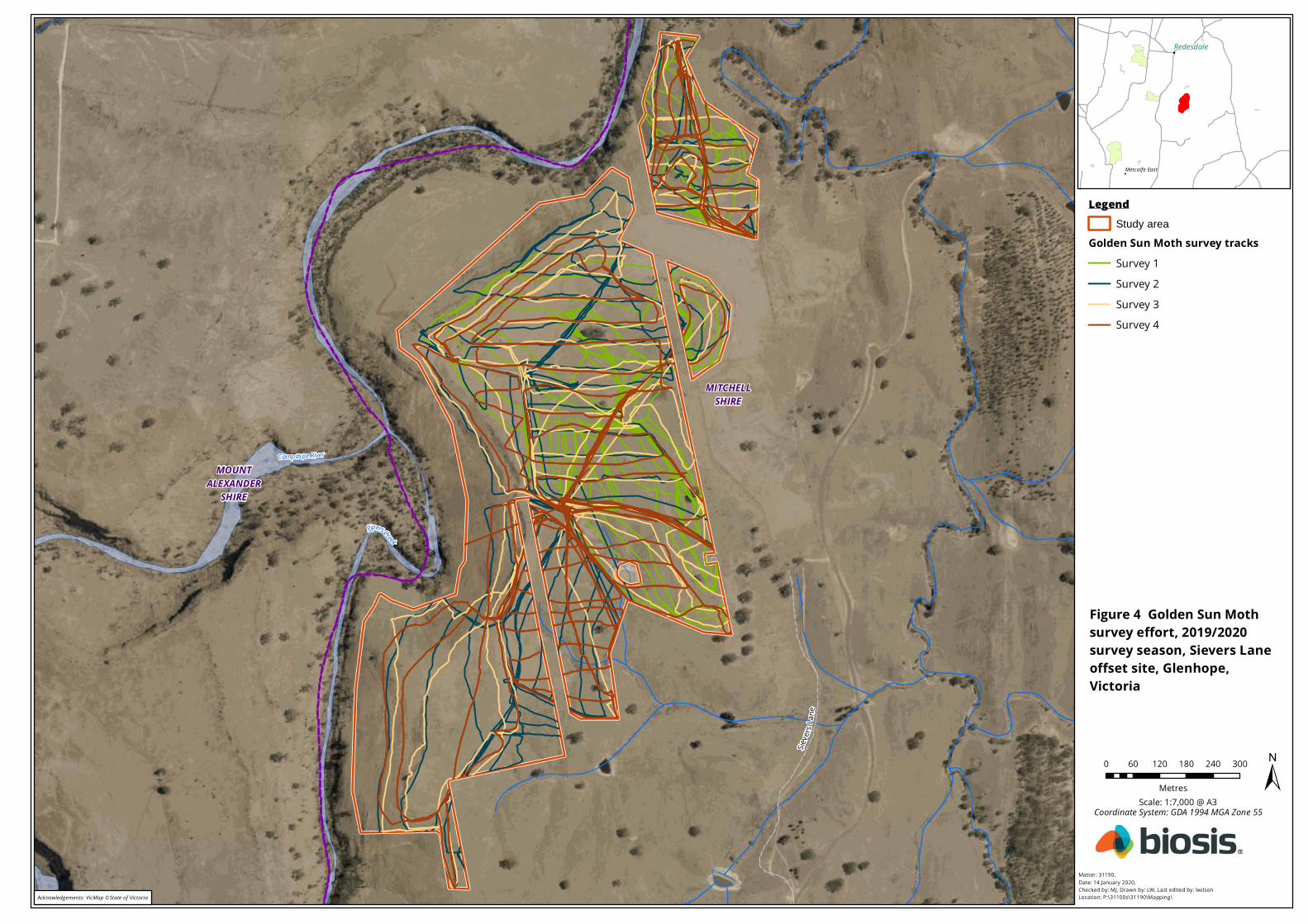
Endangered Golden Sun Moth (DEWHA 2009), were performed by Biosis (2020), (Figure 4). These surveys
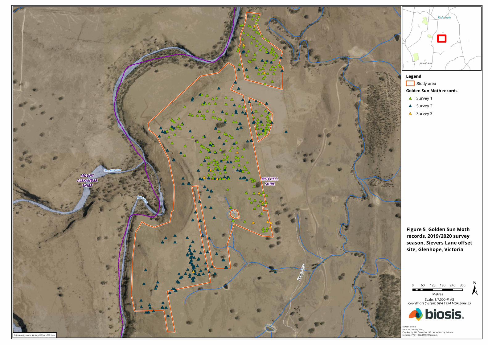
identified 1085 GSM over the four surveys recording 627, 439, 19 and 0 individuals in successive surveys
(Figure 5). The final survey is excluded from the species density calculation and is replaced by a repeat of the
third survey (19 individuals). A total of 1104 individuals is used for the population estimate over four surveys
within the 78.8 hectare site and provides a density of 14.01 individuals per hectare.
Sieve
rsLa
ne
PipersCreek
Campaspe RiverMOUNT
ALEXANDERSHIRE
MITCHELLSHIRE
!
!
!
Metcalfe East
Redesdale
Matter: 31190,Date: 14 January 2020,Checked by: MJ, Drawn by: LW, Last edited by: lwilsonLocation: P:\31100s\31190\Mapping\
Scale: 1:7,000 @ A3Coordinate System: GDA 1994 MGA Zone 55
±0 60 120 180 240 300
Metres
Figure 4 Golden Sun Moth survey effort, 2019/2020 survey season, Sievers Lane offset site, Glenhope, Victoria
LegendStudy area
Golden Sun Moth survey tracksSurvey 1Survey 2Survey 3Survey 4
Acknowledgements: VicMap ©State of Victoria
#*
#*
#*
#*
#*
#*
#*#*
#*
#*#*#*
#*
#*
#*
#*
#*
#*
#*
#*#*
#*
#*
#*
#*
#*
#*
#*
#*
#*
#*
#*
#*
#*
#*
#*
#*
#*
#*#*
#*
#*
#*
#*
#*
#*
#*#*
#*
#*
#*
#*
#*
#*
#*
#*
#*
#*
#*
#*
#*
#*
#*
#*#*
#*
#*
#*
#*
#*
#*
#*
#*
#*
#*
#*#*
#*
#*
#*
#*
#*
#*
#*
#*#*
#*
#*
#*
#*
#*
#*
#*
#*
#*
#*
#*
#*
#*
#*
#*#*
#*
#*
#*
#*
#*
#*#*
#*
#*
#*
#*
#*
#*
#*
#*
#*
#*
#*#*
#*
#*
#*
#*
#*
#*
#*
#*
#*
#*
#*
#*
#*
#*
#*
#*
#*
#*
#*
#*
#*
#*
#*
#*
#*
#*
#*
#*
#* #*
#*
#*
#*
#*
#*
#*
#*
#*
#*
#*
#*
#*
#*
#*
#*
#*
#*#*#*
#*
#*
#*
#*
#*
#*
#*
#*
#*
#*
#*
#*
#*
#*
#*
#*
#*
#*
#* #*
#*
#*
#*
#*
#*
#*
#*
#*
#*
#*
#*#*
#*
#*
#*
#*
#*
#*
#*
#*
#*
#*
#*
#*
#*
#*#* #*
#*
#*
#*
#*
#*
#*
#*
#*
#*
#*
#*
#*
#*
#*
#*
#*#*#*
#*
#*#*
#*#*
#*
#*#*
#*#*#*
#*
#*
#*#*
#*#*#*
#*#*#*#*#*#*
#*
#*
#*
#*#*
#*
#*
#*
#*
#*
#*
#*#*
#*
#*
#*#*
#*
#*#*
#*#*#*
#*#*#*
#*#*
#*#*
#*
#*#*#*
#*
#*
#*
#*#*
#*#*#*#*#*#*#*
#*
#*
#*
#*
#*
#* #*#*
#*
#*#*
#*#*
#*
#*
#*#*
#*#*
#*#*
#*#*
#*#*
#*#*#*#*#*
#*
#*#*
#*#*
#*#*
#*#*#*#*
#*#*#*
#*
#*#*
#*
#*#*#*
#*
#*#*
#*#*
#*
#*
#*#*#*#*#*#*
#*#*#*
#*
#*
#*#*
#*
#*
#*
#*
#*
#*
#*
#*#*
#*
#*#*#*
#*#*
#*
#*#*
#*#*
#*
#*#*#*
#*#*#*
#*#*#*
#*#*
#*#*#*#*#*#*#*#*#*#*
#*
#*#*#*#*#*#*
#*
#*#*#*#*#*#*#*#*#*#*#*#*
#*#*#*#*#*
#*#*#*#*#*#*#*
#*#*#*
#*#*#*#*
#*
#*#*
#*
#*#*#*#*#*
#*
#*
#*#*#*
#*
#*
Sieve
rsLa
ne
PipersCreek
Campaspe RiverMOUNT
ALEXANDERSHIRE
MITCHELLSHIRE
!
!
!
Metcalfe East
Redesdale
Matter: 31190,Date: 14 January 2020,Checked by: MJ, Drawn by: LW, Last edited by: lwilsonLocation: P:\31100s\31190\Mapping\
Scale: 1:7,000 @ A3Coordinate System: GDA 1994 MGA Zone 55
±0 60 120 180 240 300
Metres
Figure 5 Golden Sun Moth records, 2019/2020 survey season, Sievers Lane offset site, Glenhope, Victoria
LegendStudy area
Golden Sun Moth records#* Survey 1#* Survey 2#* Survey 3
Acknowledgements: VicMap ©State of Victoria
© Biosis 2020 – Leaders in Ecology and Heritage Consulting Sievers Lane, Glenhope, Offset Management Plan (EPBC 2017/8008) 19
2.4 Offset site suitability
The proposed offset site has been subject to past land clearing for the grazing of domestic stock (sheep and
cattle). It has been subject to some level of pasture improvement activities which has established a patchy
cover of selected agricultural grasses such as Rye-grass, Oats, Toowoomba Canary-grass and Cocksfoot. While
the site may have been subject to some level of fertilizer application, the existing vegetation suggests any
application has been infrequent.
While most of the ground cover does not support a sufficient component of perennial native species to be
defined as native vegetation (i.e. Victoria’s definition of native vegetation requires 25% of the perennial
ground cover to be composed of native species for areas to be defined as a patch of native vegetation), the
rocky sedimentary slopes do support small patches of spear-grasses, wallaby grasses and Kangaroo Grass
which achieve this threshold.
Weed cover is typically dominated by annual introduced grasses. However, noxious weeds such as Spear
Thistle Cirsium vulgare, Paterson's Curse Echium plantagineum, Spiny Rush Juncus acutus, Gorse Ulex europaeus,
Variegated Thistle Silybum marianum and Chilean Needle-grass Nassella neesiana, while present at relatively
low abundance, retain the potential to degrade the GSM habitat present.
Shrub and tree regeneration is present but the development of the vegetation from an open grassland to a
shrubland or woodland is constrained by browsing of domestic stock and presumably the local population of
Eastern Grey Kangaroos.
There are also signs of the presence of European Rabbit (scratchings and latrine sites).
As such, active ecological management of the site is expected to be able to provide improvements in the
condition of habitat for GSM.
Method for calculating offset site suitability
The suitability of the site as an offset was assessed using the EPBC Act Offsets Assessments Guide to ensure it
meets the requirements of the Department’s EPBC Act Environmental Offsets Policy (October 2012).
Assessments of species habitat quality are based on separate assessments of three parameters: site context,
site condition and species stocking rate based on scoring criteria defined under previously approved GSM
assessment protocols (Biosis 2019) as follows:
Site context is assessed as a score out of three as follows:
• 0/3 = Habitat patch* size <0.25 ha.
• 1/3 = Habitat patch size more than 0.25 ha and up to 10 ha.
• 2/3 = Habitat patch size more than 10 ha, shaped appropriately** to reduce edge effects.
• 3/3 = Habitat patch size more than 10 ha, shaped appropriately to reduce edge effects, slightly sloped
(3° or less) and north-facing, minimal shading.
*A patch is considered to be an area of suitable habitat separated from other areas of suitable habitat by
>200m of unsuitable habitat, or barriers to flight
**Assessed on a case by case basis.
Note: Add 1 point (up to a maximum of 3) if the proposed offset results in an occupied linkage between 2
populations.
Site condition is assessed as a score out of three as follows:
• 0/3 = dominated by introduced vegetation that isn’t a known food source.
© Biosis 2020 – Leaders in Ecology and Heritage Consulting Sievers Lane, Glenhope, Offset Management Plan (EPBC 2017/8008) 20
• 1/3 = dominated by poor quality native vegetation (VQA score greater than or equal to 30/75)
including <20% cover of known food source.
• 2/3 = dominated by moderate quality native vegetation (VQA score 31-45/75) including between 20%
and 40% cover known food source and limited inter-tussock space (or dominated by introduced
vegetation that is a known food source (i.e. Chilean needle grass) where species stocking rate is
greater than 20 moths per hectare*
• 3/3 = dominated by high quality native vegetation (VQA equal to or greater than 46/75) including
>40% cover known food source, appropriate inter-tussock space.
*Density calculated as an average across the area of suitable habitat. Density to be rounded up if rounding is required.
Species stocking rate is assessed as a score out of four as follows:
• 0/4 = species not present
• 1/4 = 0-5 males per hectare*
• 2/4 = >5-20 males per hectare
• 3/4 = >20-50 males per hectare
• 4/4 = >50 males per hectare
*Density calculated as an average across the area of suitable habitat. Density to be rounded up if rounding is
required. It is expected that impact and offset sites to be surveyed on four occasions during the flying season
and the survey results to be summed (consistent with survey guidelines). Justification will need to be provided
to the Department to support proceeding in the absence of suitable survey effort. For clarity, if lower survey
effort is accepted, the Department will consider:
– for impact sites, the highest recorded density is assumed to be the remaining score (e.g. three surveys
detect 5, 10, 15/ hectare, therefore the assumed score is 45/ hectare). If only one survey record of 5/
hectare, then assumed total 20/ hectare.
– for offset sites, the lowest record is assumed to be the remaining score (e.g. three surveys detect 5, 10,
15/ hectare, therefore the assumed score is 35/ hectare). If only one survey record of 5/ hectare, then
assumed total 20/ hectare.
Calculations for offset site suitability
The offset site GSM habitat quality score of the Sievers Lane offset site is set at 5/10 based on the presence of
a large population of GSM (Biosis 2020) within a large area (greater than 100 hectares) area of modified
(dominated by introduced vegetation) but suitable habitat, contiguous with other areas of modified occupied
habitat, which is otherwise imbedded within a broader area of unsuitable habitat.
This is assessed to provide the following scores which contribute to the start quality of the Sievers Lane offset
site:
• Site Context score of 2/3 (more than 10 ha but does not satisfy the requirements for 3/3)
• Site Condition Score of 1/3 (not moderate quality native vegetation or dominated by other known
food plant and therefore reverts to the level below 2/3)
• Stocking Rate score of 2/4 (density of 14.01 individuals per hectare)
The quality of such areas when managed in a manner with little or no consideration for the biodiversity
values can deteriorate rapidly. In Victoria, there are no restrictions to practices such as the application of
fertiliser, high stocking rates, seeding areas with exotic pasture or changing the type of animal traditionally
raised within a property (i.e. changing from sheep to cattle or horses). All such practices are considered as of
right uses associated with farming land, whether or not such areas support native vegetation. Given the
agricultural nature of such habitat, business as usual (BAU) under this land use is likely to result in GSM
© Biosis 2020 – Leaders in Ecology and Heritage Consulting Sievers Lane, Glenhope, Offset Management Plan (EPBC 2017/8008) 21
habitat suffering significant declines in condition within a relatively short period of time. These impacts would
include an increase in the abundance of introduced pasture species such as Toowoomba Canary-grass
Phalaris aquatica, Oat Avena spp. and Cocksfoot Dactylis glomerata, which are not known GSM food species,
both from natural and farmer facilitated spread. Other likely impacts include the spread of agricultural
chemicals such as superphosphate which is known to be toxic to native grasses which are a GSM food source.
The resultant habitat decline therefore occurs as a result of an increase in the abundance of introduced, non-
GSM food pasture species and a decrease in the known food resource. This would also be expected to result
in a decline in the overall density of animals present.
Without the establishment of an offset site, a decline in condition from a score of 5/10 to 4/10 is considered
conservative for a 10-year period. The future quality of this site without offset is therefore set at 4/10.
An elevated level of weed control and permanent application of targeted management to improve the habitat
for GSM is expected to provide an improvement by elevating the site condition of Sievers Lane from habitat
dominated by poor quality native vegetation with <20% cover of known food plants to moderate quality
vegetation with between 20 and 40% cover of known food plants (which improve the site condition score
from 1/3 to 2/3). It is also possible that the density of animals could increase from 5 to 20 animals per hectare
to 20 to 50 animals per hectare. This would provide an equivalent improvement in the habitat provided by an
increase in the condition of the vegetation present. The future quality with offset is therefore elevated to 6/10.
The presence of GSM within the offset site could suggest BAU management is such that the species can
continue to inhabit the site in perpetuity. However this assumption ignores the continual and ongoing
expansion of introduced species which degrade this type of habitat and ongoing, even if erratic, facilitation of
this process by normal farm management. In this context BAU management for agricultural production will
almost always result in habitat decline and eventual extinction as has proven to be the case across the
landscape. This ongoing threat is clearly documented in the approved conservation advice for this species
(pages 2-3 under threats).
There is no information on the extent of GSM in the broader environment nor on any thresholds of change
likely to result in its local extinction. However BAU is considered a threat to this environment as ongoing
agricultural practices focus on pasture improvement to the detriment of indigenous species which provide
the food resource for this species.
A percentage confidence level in the degree of habitat loss and change is a required input for the offset
calculator. Given limited knowledge a conservative approach based on broader observations in habitat
change is appropriate. DoEE have nominated the annual probability of extinction for a critically endangered
species as 6.8%. Given there is a limited extent of habitat for this species in any region and BAU is considered
to provide an ongoing threat, selecting a risk of loss without offset of 10% is considered both conservative
and realistic. Lower estimates (i.e. 5%) would suggest a finer scale understanding of potential ongoing impacts
to this species which does not have any supporting information, while an estimate of 10% at least provides
some level of accord with the DoEE probability of local extinction.
The risk of loss without offset is therefore not solely dependent on events such as clearing or land-use
intensification. GSM habitat is being lost as a result of BAU without needing to be offset under Victorian or
Commonwealth legislation. The offset site is not readily identified as a patch of native vegetation (DELWP map
only small isolated patches of native vegetation in this area) and changes of this vegetation would not attract
biodiversity offsets under the Victorian Planning and Environment Act 1987. Continuing use rights exist over the
offset site land (e.g. use for grazing and pasture improvement) and continued use of the land in an
agricultural context (without intensification of use) could result in complete loss of the GSM habitat that is
present. Continuing use would be exempt from the requirement for offsets under the EPBC Act.
When such a site is secured for an offset the risk of loss is considered to decline significantly. However,
despite this the potential for loss is not considered zero as unknown circumstances could still influence the
© Biosis 2020 – Leaders in Ecology and Heritage Consulting Sievers Lane, Glenhope, Offset Management Plan (EPBC 2017/8008) 22
survivorship of this species at this site. The risk of loss with offset is set at the lowest level above zero (i.e. 1%)
to reflect the low probability of the vegetation, habitat and stocking density deteriorating.
Again these assumptions are provided with a relatively high degree of confidence (set at 80% for the risk
settings and 90% for the quality settings) because of our observations over time in areas managed for the
protection and maintenance of GSM populations. Risk settings are set at a lower confidence level because of
the general lack of information relating to ongoing declines under BAU and potential threats even with
protection. A higher level of confidence is provided for the quality settings because of regular observations
that active management will improve habitat and the lack of management will result in habitat decline. The
single unit score changes are considered conservative, particularly limiting the decline in habitat condition to
a single unit.
Based on the assumptions outlined and as described in Biosis (2019), an offset protecting 78.8 hectares of
GSM habitat at Sievers Lane would satisfy the current policy requirements (i.e. provide a 100% or greater
direct offset).
Current permitted land uses
The property is zoned Farming Zone (FZ) within the Mitchell Shire Planning Scheme. The purpose of the FZ is
to provide for the use of land for agriculture including the establishment of plantations for timber production
over areas of at least 40 hectares.
The property is also subject to the Environmental Significance Overlay (ESO2). The objective of the ESO2 is to
protect and maintain water quality and water yield in the Eppalock and Mollison Creek (Pyalong) Special
Water Supply Catchment Areas. However, this ESO provides no restrictions for normal agricultural activities
such as grazing, fencing, timber production etc.
Within Victoria, removal of native vegetation is controlled under Clause 52.17 of the Victoria Planning
Provisions. Some removal of native vegetation is currently permitted (exempt from a planning permit
requirement – See Clause 52.17-7) to the minimum extent possible, for activities including:
• Removal of dead vegetation (except for dead trees with a diameter at breast height greater than 40
cm at 1.3 metres above ground level).
• Removal of vegetation for construction of a boundary fence.
• Mowing of understorey grass vegetation to a height of 100 millimetres above ground level.
• Grazing by domestic stock.
• Timber harvesting of ‘reasonable amounts’ for personal use, including firewood and construction of
fences or buildings.
• Pruning of up to 1/3 of the foliage of individual plants.
• Treatment of pest animal burrows or weed infestations.
• Stone exploration or extraction.
• Fire protection, including periodic fuel reduction burning or construction of firebreaks and firefighting
access tracks.
There are no existing buildings within the property in which the proposed offset site is located.
Existing offset arrangements
The proposed offset site has not been allocated for the provision of any other offsets, either under the EPBC
Act Environmental Offsets Policy or for provision of offsets under any current or past Victorian policy,
including the Biodiversity Assessment Guidelines or the Net Gain Framework. Other sections of the property
contain habitat and records of GSM. These sections may be subject to separate, future offset arrangements
for other projects.
© Biosis 2020 – Leaders in Ecology and Heritage Consulting Sievers Lane, Glenhope, Offset Management Plan (EPBC 2017/8008) 23
3. Part B: Offset Implementation
This section presents the actions required to implement the OMP. The OMP details methods for the
management, conservation and improvement of native vegetation at the offset site for the benefit of the
protected matter (GSM) over a ten year period commencing from EPBC Act approval of this OMP. These
actions are required over the initial ten year period and, while the OMP may be updated after that period with
approval from DoEE, active ecological management to maintain or improve GSM habitat condition is required
for the life of the EPBC Act Approval and from thereon in perpetuity.
All works will be conducted by a suitably qualified and experienced contractor and/or the landholder.
Prescribed management actions are, where relevant, in accordance with the Victorian BushBroker standards
for management (DSE 2012a, DSE 2012b and DSE 2012c).
The OMP aims to achieve habitat improvement gains through on-ground actions and therefore is required to
be achievable, straightforward and practical. All of the management actions specified must be measurable
and support the offset completion criteria.
3.1 Offset site details
Table 1 provides details of the offset site, including the landowner, parcel details and local government
property information.
Table 1 Offset Site Details
Offset Site Details
Landowner of offset site Kinrara Pty Ltd of Burke and Wills Track, Kyneton VIC 3444
Type of offset 3rd party
Location and address of offset site Portions of Lots 1 – 4, Sievers Lane, Glenhope VIC 3444
Area of offset site 78.8 ha
Parish Glenhope
Allotment Lots 3 - 6 PS 727973
Volume / Folio 11609 / 429 - 432
Local Government Area Mitchell Shire
Council Property Number 120655
Bioregion Goldfields
3.2 Strategy for Offset Site
The offset site is to be secured and managed for the purposes of conservation for GSM in perpetuity. This
offset site is a smaller component of a larger area of farmland which will be managed in a sympathetic
manner on a voluntary basis. The current land owners have secured formal offset agreements to protect
other portions of this broader area of GSM habitat but the nominated section of this parcel has not been
allocated for the provision of any other offsets, either under the EPBC Act Environmental Offsets Policy or for
© Biosis 2020 – Leaders in Ecology and Heritage Consulting Sievers Lane, Glenhope, Offset Management Plan (EPBC 2017/8008) 24
provision of offsets under any past or present Victorian policy, including the Biodiversity Assessment
Guidelines or the Net Gain Framework.
All easements noted on the current title have been excluded from the offset area. No future easements can
be applied to the offset area as these are likely to conflict with the objectives of this OMP.
3.3 Offset security, management responsibility and reporting requirements
MRPV has located a suitable offset site and negotiated an agreement with the owner(s) of the property. The
proposed offset area is located within a larger property on Sievers Lane, Glenhope. The property is owned by
Kinrara Pty Ltd (or other future owner), who will be responsible for ongoing management of the offset site
throughout the period of this plan.
The offset site will be secured and managed for the purposes of conservation in perpetuity via covenant as to
Section 3A Victorian Conservation Trust Act 1972 managed by the Trust for Nature (TfN). The management
strategy for the proposed offset site consists of implementing a vegetation OMP incorporating the
management of ground cover biomass using the timed grazing of domestic stock, weed and vermin control
and regular monitoring. Details of security and management responsibility are shown in Table 2.
Table 2 Security and Management Responsibility and Reporting Requirements
Responsibility
Who is liable/responsible for meeting offset requirements? Major Road Projects Victoria
Type of security Covenant as to part Section 3A
Victorian Conservation Trust Act 1972
Date of commencement for the covenant To be completed in 2019
Date covenant registered on-title To be completed in 2019
Offset site management responsibility Kinrara Pty Ltd
Offset Monitoring Responsibility Kinrara Pty Ltd
Site management Kinrara Pty Ltd
Monitoring Kinrara Pty Ltd
Auditing Major Road Projects Victoria
Reporting responsibility (to TfN) Kinrara Pty Ltd
Reporting responsibility (to DoEE) Major Road Projects Victoria
Plan review Major Road Projects Victoria
The offset area will be secured in-perpetuity via a covenant as to part Section 3A Victorian Conservation Trust
Act 1972, to be registered on the title in 2019. The encumbrance registered on title requires the landholder
and future owners to manage the land in accordance with this OMP or any future approved revisions of this
plan.
© Biosis 2020 – Leaders in Ecology and Heritage Consulting Sievers Lane, Glenhope, Offset Management Plan (EPBC 2017/8008) 25
The covenant will specifically state the in-perpetuity land-use commitments across the offset site to:
• Retain and manage all native vegetation as directed by this offset management plan;
• Retain all fallen timber and branches;
• Exclude domestic stock except as permitted by this plan;
• Exclude the use of stock feed such as hay or other material which could support weed seeds that is
sourced from outside the offset area. Sterile feed such as pellets may be sourced externally;
• Eliminate any woody weeds and control the cover of other high threat weeds ensuring this cover
does not exceed levels achieved upon attainment of Year 10 offset completion criteria;
• Ensure that pest animals are controlled and that level of control attained at the completion of Year 10
of management is maintained in perpetuity.
• Exclude pasture improvement and any type of cultivation and cropping;
• Exclude fertilizer application for the first ten years of the covenant. TfN may then permit low levels of
fertilizer application if the land owner can prove this will not adversely impact native vegetation or
GSM habitat.
• Control the accumulation of ground cover biomass through either the controlled grazing of sheep
and/or cattle or using the controlled application of fire;
• Monitoring for any new and emerging weeds and continuously treating those weeds to avoid further
seed set, dispersal or infestation; and
• Maintain a progressive annual works plan which caters to current conditions and prescribes ongoing
management with the promotion of native perennial grasses, and attainment and maintenance of
offset completion criteria, as its primary objective.
• Monitor and report on the abundance of GSM within the offset site during the first flight season after
EPBC Act approval of this OMP and then during the flight seasons in years 2, 4, 6, 8 and 10 of this
OMP and thereafter as requested by DoEE.
Implementation of this management plan is the overall responsibility of MRPV, which has engaged the land
owner (Kinrara Pty Ltd) to deliver the offset outcomes on MRPV’s behalf. However, direct management
responsibility may be delegated to a designated site manager and/or managing ecologist. The land owner is
responsible for engaging a qualified ecologist to conduct monitoring (Section 3.9) with reports submitted to
TfN, MRPV and DoEE. Management actions by the land owner will be overseen by the TfN as part of the legal
protection over the site.
The TfN is responsible for:
• Undertaking site inspections at least 4 times over the initial 10 year period and provide input into the
annual works program.
• Review of ecological monitoring reports including an assessment of attainment and maintenance of
the offset completion criteria.
Implementation of the management plan will be monitored by the TfN, who will verify that the management
actions have been carried out appropriately.
Implementation of the OMP will begin from the date of the approval or as otherwise agreed with the
landowner with registration of the covenant to be completed as soon as possible in 2019. While preparation
of the covenant is expected to be completed in mid 2019, formal signing of the covenant by the Minister may
be delayed by other priorities. However, MRPV will pay all the prescribed fees within four weeks of the
approval of this OMP. These fees will be non-refundable and the covenant signing will therefore be an
administrative formality.
© Biosis 2020 – Leaders in Ecology and Heritage Consulting Sievers Lane, Glenhope, Offset Management Plan (EPBC 2017/8008) 26
Funding for implementation of this OMP has been agreed between MRPV, the land owner and TfN. Where
appropriate, or otherwise agreed, funding will be held by the TfN and paid to the land owner over the 10 year
management period as per a land owner agreement. This will include agreed funding for anticipated ongoing
management required to maintain completion criteria at the offset site in perpetuity, beyond the initial 10
year period during which the completion criteria are achieved.
3.4 Offset completion criteria
The key environmental outcomes / criteria to be achieved through protection and management of the offset
area are:
• Permanent legal protection of 78.8 hectares of GSM habitat;
• Physical protection of the habitat area from manageable threats including uncontrolled stock grazing,
weed infestations and degradation by pest animals.
• Attainment of GSM habitat condition completion criteria, as measured by habitat monitoring.
3.4.1 Future site condition - completion criteria
The offset calculations used to define the extent of the offset area (Biosis 2019), specify an improvement in
average habitat condition throughout the offset site over the period of the OMP from 5/10 to 6/10. Habitat
condition will be assessed using the habitat features known to support GSM, including the presence of an
open tussock grassland structure (with at least 5% but preferably 20 – 40% open ground or inter-tussock
spaces) and the abundance of known food plants such as spear-grasses Austrostipa spp. and wallaby-grasses
Rytidosperma spp.
Specifically, the 78.8 hectare offset site must achieve the following site condition:
a) be dominated by moderate quality native vegetation (VQA site condition score 31-45/75); and
b) a cover including between 20% and 40% cover known food source for Golden Sun Moth with
appropriate inter-tussock space/bare ground (<5% cover); or
c) be dominated by introduced vegetation that is a known food source (i.e. Chilean needle grass) where
the species stocking rate is greater than 20 moths per hectare.
Alternatively the GSM stocking rate would need to increase from the existing measure of between 5 and 20
males per hectare to between 20 and 50 males per hectare where a failure to meet the targets was
attributable to site management, as opposed to seasonable variation.
The most appropriate outcome is attainment of (a) above. Monitoring assessments will be undertaken in
marked quadrats distributed through the offset site as described in Section 3.9. Key performance targets for
continuous improvement in the quality of GSM habitat include:
a) a continuous decline in the abundance of perennial, introduced pasture grasses (such as Brown-top
Bent, Toowoomba Canary-grass and Cocksfoot) at a measureable rate to be identified by annual
monitoring; and
b) an increase in the density of perennial native grass species at a rate measurable by annual monitoring.
Attaining the nominated future condition class will require the VQA site condition score to be between 31 and
45 out of 75 and the ground cover to include between 20% and 40% cover of known food grasses with at least
some inter-tussock spaces (1%-5%) although a greater cover of inter-tussock spaces is acceptable as this is
also an indicator of better quality GSM habitat.
3.4.2 Performance criteria
Key performance criteria for this OMP are:
© Biosis 2020 – Leaders in Ecology and Heritage Consulting Sievers Lane, Glenhope, Offset Management Plan (EPBC 2017/8008) 27
• Controlling stock and preventing unauthorised vehicle access by maintaining boundary fencing to the
standard detailed in the Management Standards for Native Vegetation Offset Sites (DELWP 2019).
• Preparation of a detailed baseline report on the flora of the offset site against which the effectiveness
of management activities can be compared.
• Establishment of 10 monitoring quadrats and 10 photo points to form the basis of vegetation
monitoring to document changes in GSM habitat quality over time, performance in continuous
improvement, and assessment against habitat quality completion criteria.
• Improving GSM habitat quality through the removal of all existing woody weeds and maintaining
woody weed levels at <1% cover by the end of year 1 of commencement of the plan.
• Annual monitoring and control of woody and herbaceous weeds with weed control carried out in
accordance with the Management Standards for Native Vegetation Offset Sites (DELWP 2019).
• Implementation of a biomass management (grazing) regime to develop and maintain an open
grassland structure.
• Implementation of a biomass management (grazing) regime to reduce the abundance of perennial
weeds while increasing the abundance of grasses which are known food plants for GSM.
• Introduced perennial grass cover within the offset site reduced to at least 50% of baseline cover at the
end of 10 years of management. As a general measure of continuous improvement, a measurable
reduction in these weeds will be identifiable every two years using information collected in quadrats.
Note that this will include the control of Chilean Needle-grass which is a GSM food plant. However,
this weed is relatively rare within the offset site and its control is not expected to have a measurable
impact on the GSM population.
• New and emerging woody weeds identified and eradicated.
• Implementation of a GSM survey monitoring and evaluation program.
• No measurable decline in the abundance and area of occupancy of GSM within the offset area.
• Identification and removal of surface harbour for pest animals.
• Control of rabbits and foxes in accordance with the Management Standards for Native Vegetation Offset
Sites (DELWP 2019 including achieving a target of no active fox dens or rabbit warrens within the
offset area.
• New and emerging pest animals identified and prevented from establishing in the offset area.
• Monitoring and management of indigenous tree and shrub regeneration to ensure regeneration
does not degrade the quality of GSM habitat in the offset area.
• Prepare annual reports detailing the monitoring and management actions and outcomes outlined in
this OMP
The gradual improvement of the offset site will be identifiable by the gradual decrease in the extent of
perennial grassy weeds and the gradual increase in the overall cover of indigenous grasses, most of which are
GSM food plants.
3.5 Limitations and uncertainty
This management plan has been formulated using information from recently conducted site inspections
(Biosis 2018). The OMP has been subject to external review and quality assurance by TfN as part of the
process to register the site covenant. Relevant federal and state government policies, procedures and
databases have also been consulted where appropriate.
The proposed offset site supports a population of GSM, which has been confirmed by recording the species
within the offset site during targeted surveys in the 2014/15, 2017/18 and 2018/19 flight seasons (Hamilton
© Biosis 2020 – Leaders in Ecology and Heritage Consulting Sievers Lane, Glenhope, Offset Management Plan (EPBC 2017/8008) 28
Environmental Services 2015, 2018, 2019), from incidental observations by Biosis late in the 2017/18 flight
season and from surveys conducted in the 2019/2020 flight season by Biosis.
The OMP includes a reasonable expectation that the control of environmental weeds to reduce their cover
and prevent / restrict their production of seed, while concurrently encouraging the growth and seed
production of the existing cover of indigenous grasses, will result in an increase in the abundance and cover
of native grasses. As most of the native grasses present are GSM food plants, this management strategy is
expected to improve the habitat condition for GSM. However, there is a possibility that the recruitment of
indigenous species will be slower than expected or prolonged drought conditions may inhibit recruitment.
If seed production is restricted by unforeseen circumstances such as drought then seed collection and
dispersal options would be investigated. Alternatively the time period for active management would be
extended to compensate for any lag in the establishment of native grasses.
3.6 Ongoing management commitments
The offset site will be managed for the conservation of GSM.
From the commencement of the approved OMP and conservation agreement, the landowner agrees to
undertake the following management commitments in perpetuity:
• Eliminating all woody weeds through continuous detection, treatment and infestation prevention.
• Monitoring for any new and emerging weeds and eliminate through continuous detection, treatment
and infestation prevention.
• Controlling rabbits, hares and foxes to an extent above existing legal requirements.
• Retaining all standing trees, dead or alive.
• Retaining fallen logs and fallen branches.
• Exclude stock except as otherwise specified under this approved plan.
• Exclude the use of stock feed such as hay or other material which could support weed seeds that is
sourced from outside the offset area. Sterile feed such as pellets may be sourced externally;
• Exclude pasture improvement (but not ground cover rehabilitation to increase the cover of native
grasses and herbs), and cultivation for commercial cropping;
• Exclude fertilizer application for the first ten years of the covenant, and only apply superphosphate
fertiliser after this time in accordance with written agreement from the TfN. TfN may permit low levels
of fertilizer application if the land owner can demonstrate that this will not adversely impact native
vegetation or GSM habitat quality.
3.7 Risk assessment and adaptive management
Active ecological management is expected to provide a high probability of generating improvements in the
condition of the vegetation present (i.e. increasing the abundance of native grasses and herbs while
decreasing the abundance of introduced species) and attainment of the offset completion criteria. Note
however that the extent of this offset has conservatively been based on the assumption that management
will, at a minimum, improve the condition of GSM habitat present so as to be dominated by moderate quality
native vegetation (VQA site condition score 31-45/75) including between 20% and 40% cover known food
source with limited inter-tussock space (<5%) (note that a greater cover of inter-tussock space is acceptable).
The management actions proposed in this plan are based on a combination of experience in the
management of native grasslands and grassy woodlands, documents prepared by Victoria’s Department of
Environment, Land, Water and Planning (DELWP) (i.e. DSE 2009) and other publications (i.e. Marshall 2013,
Williams et al. 2015).
© Biosis 2020 – Leaders in Ecology and Heritage Consulting Sievers Lane, Glenhope, Offset Management Plan (EPBC 2017/8008) 29
The proposed strategies for the management of this site are consistent with established practices for the
management of grasslands and grassy woodlands elsewhere including State conservation reserves and offset
sites.
The active involvement of TfN is also expected to provide high quality guidance and advice to the landholder
in their management of the site.
The monitoring protocols documented in this plan are considered adequate to detect attainment of the offset
completion criteria (above).
The plan includes a basic strategy (pulse grazing) for ground-cover biomass control which is considered a
major ecological management requirement for the site. Where this fails to deliver the prescribed outcome in
any one year, ecological burning provides an option to achieve the required biomass management target (i.e.
maintaining an open grassland environment dominated by native species). The application of one or both of
these management actions will provide the biomass control outcome required.
It is acknowledged that the response of natural environments to management can be unpredictable and
management activities need to be flexible to respond to changing conditions and unpredictable events.
Examples of potential risks are outlined in Table 5 and discussed below. Seasonal conditions can also vary
greatly from year to year and influence offset site management actions in any one year. This seasonality is
recognised in this offset plan by allowing for flexibility around timing of actions at the discretion of the land
manager in consultation with TfN so as to attain and maintain performance and completion criteria.
There is some risk that biomass control is not properly managed in any one year. This has the potential to
occur in response to above average rainfall years when ground cover growth is persistently high and wet
conditions restrict stock access or limits opportunities for the application of ecological burning to reduce
biomass. If such events occur, the land manager will ensure additional efforts are made by in subsequent
years to maintain the rate of improvement required.
Another major ecological management requirement is weed control, with the objective of reducing the overall
presence of weeds and reducing biomass. Varying seasonal conditions will provide triggers for changes in the
abundance of different species, particularly weeds. The greatest risk to achieving the required outcomes is a
failure to conduct an appropriate level of work at an appropriate time or the occurrence of persistent adverse
conditions restricting an appropriate management response. The regular site inspections will allow land
managers to anticipate changes in seasonal conditions and respond accordingly. Persistent, well timed
management actions will be able to take advantage of seasonal fluctuations to achieve the completion
criteria.
Woody weeds in particular are currently absent from the offset site and it will be a relatively simple
management exercise to maintain this condition. While woody weeds will probably colonise the site from
near-by infestations, seedlings will be detected through monitoring and controlled by the proposed on-going
works. If live, woody weeds are detected in the offset area beyond Year 2 of the plan corrective actions would
be required (e.g. increase woody weed control activities to ensure elimination of these species within one
year).
Similarly control works will target perennial weeds including Canary-grasses, Brown-top Bent and Cocksfoot.
Persistent herbicide application is an effective control measure for these species and while these species are
likely to reinvade from surrounding infestations, ongoing works are planned to cope with the associated
management requirements. If adequate resources are not allocated to these tasks, the cover of these species
may remain static or increase. Any observations or monitoring which detect an increase in perennial weeds
above the previous assessed conditions and percentage cover will trigger a requirement for a greater
management input (the required corrective action being targeted increased management actions). In that
context additional site observations (over and above formal monitoring) collected by TfN (or an independent
© Biosis 2020 – Leaders in Ecology and Heritage Consulting Sievers Lane, Glenhope, Offset Management Plan (EPBC 2017/8008) 30
ecologist) is essential in providing feedback on the efficacy of management.
Another significant risk associated with the management of this site is the occurrence of climatic triggers
which would increase the abundance of weed species by triggering the germination of any soil stored seed
reserves. In the first instance management will over allocate resources to weed control as the more
comprehensive control achieved by such works the lower the ability these species have to recover /
recolonise. Integrating herbicide control works with biomass control works (grazing and/or fire) increases the
efficacy of both actions and the outcomes-based approach to this plan (i.e. to attain and maintain the offset
completion criteria) supports this approach. Given persistent management occurs it is considered a relatively
low risk that the completion criteria will not be achieved.
If after the first 8 years of management, the monitoring results indicate that the completion criteria are
unlikely to be achieved, DoEE will be contacted to determine potential additional future offset requirements.
If the offset area fails to attain and maintain the completion criteria at or following year 10, but during the
period of EPBC Act Approval, an additional offset will be provided to account for the failed offset. DoEE will be
consulted to determine the suitability of the replacement offset.
Active management to target the control of pest plants and to manage the accumulation of ground-cover
biomass is advantageous to both the health of a native grassy ground-cover but also to the ability of GSM to
persist within this environment. As such the proposed management regime is considered unlikely to have a
negative impact on GSM. This has been our experience where Biosis has managed other grassland reserves
in metropolitan Melbourne. If the GSM monitoring detects significantly fewer GSM observations (i.e. a decline
of over 50%) in successive monitoring events potential causes for such a decline would be investigated and
appropriate corrective actions implemented. Such an outcome resulting from the implementation of this
OMP is considered highly unlikely (i.e. low risk).
The risk of trampling during the GSM breeding has been considered and poses a low risk to GSM persistence.
Male moths are capable flying away (avoiding being trampled). Females are also capable of short flights and
could be expected to avoid trampling. Any (small) impact that trampling might have on the vegetation within
the offset area is outweighed by the benefits grazing has in reducing biomass and thus maintaining and
improving GSM habitat quality. Biosis and other consultants have documented high quality GSM habitat in
areas subjected to moderate and in some cases heavy grazing during and trampling by domestic livestock
and in these sites moths have persisted and indeed thrived with this management regime for many years.
This OMP describes management and monitoring actions at the offset site for the 10 year period following
commencement of the OMP. At the end of that period management and monitoring actions will be reviewed
in light of the new condition of the offset and any new information relating to the management of this type of
grassy woodland environment. Note that active conservation management is required for the period of this
OMP and the quality of the vegetation needs to be maintained in perpetuity. The timing of actions is based on
adaptive management. By monitoring management actions, and habitat condition, management will be
adapted to ensure the stated commitments in the OMP are achieved. Also over time, new management
techniques may become available, or further information on the ecology and status of the vegetation
communities onsite may necessitate adjustment to management actions. The landowner will continue to
receive advice from TfN on any developments in grassy woodland management and update the OMP as
appropriate in perpetuity.
Section 4 includes tables of management actions (Table 4) and a risk assessment (Table 5) with associated
monitoring (Table 6) and reporting (Table 7) programs.
Key risks identified in Table 5 include:
• Unauthorised entry of domestic stock or vehicles into the offset area;
• Woody weed infestations;
© Biosis 2020 – Leaders in Ecology and Heritage Consulting Sievers Lane, Glenhope, Offset Management Plan (EPBC 2017/8008) 31
• Failure to detect and control new infestations, as well as failure to reduce existing infestations;
• Failure to increase the species composition and density of perennial native grasses
• Rabbit infestations;
• Over abundant tree regeneration; and
• An unexplainable decline in the abundance of GSM.
Failure of the adaptive management approach to adequately respond to risks, as identified in monitoring
reports (Section 3.10) or audits (Section 3.11), will result in a review of this plan, as discussed in Section 3.12
and Table 5.
3.8 Management actions and land use commitments
This section outlines the actions required to achieve the completion criteria by Year 10. The offset site is to be
secured and managed for conservation purposes in perpetuity. Management actions described below are to
be implemented for a period of 10 years. The OMP will be revised after the end of the initial ten year period to
ensure it remains appropriate for maintaining the completion criteria. The revised OMP will continue to apply
to the land and the landowner will continue to manage the offset site after the completion of year 10 as
specified under the covenant. Formal reporting to DoEE will be required for the ten year period of this OMP
but the offset will be managed for conservation in perpetuity.
The broad objective of site management will be to produce a decrease in the abundance of perennial weeds
with a commensurate increase in the abundance of perennial native species, particularly grasses which are
known food plants for GSM.
Offsets will be achieved by:
• Weed control:
– Ensuring that weed cover declines continuously.
– Ensuring that the cover of introduced perennial grasses decreases by 50% of the baseline
monitoring cover (this will at least improve the Lack of Weeds score).
– Eliminating all woody weeds.
– Monitoring for any new and emerging weeds and eliminate.
• Limiting organic litter and biomass accumulation as compared to the relevant EVC benchmark.
• Monitoring the regeneration of eucalypts and conducting ecological thinning as required to prevent
the formation of a dense sward of young regrowth. The maximum density will be one tree per 5000
square metres (average per definable offset management unit (paddocks or land parcels)).
• Controlling rabbits, hares and foxes (over and above existing legal requirements).
• Monitoring and controlling new and emerging pest animals.
• Retaining all standing trees, dead or alive.
• Retaining fallen logs and fallen branches.
• Excluding stock except as otherwise prescribed by this plan.
The management actions listed below outline the prescribed actions for achieving the required gains through
active management (maintenance and improvement) and permanent protection of the offset site. Table 4
specifies these prescribed actions and the timing for implementation. These actions will be applied to the
entire offset area as identified in Figure 4.
Prior to works being undertaken each year an annual works program (based on Table 4) will be developed by
an experience bushland regenerator. The person undertaking the works will prepare a detailed works
© Biosis 2020 – Leaders in Ecology and Heritage Consulting Sievers Lane, Glenhope, Offset Management Plan (EPBC 2017/8008) 32
program in consultation with TfN. The works program for the coming year will also address issues that may
not have been anticipated in formulating this original management plan. The OMP will be updated as
required with any revised versions of the OMP to be submitted to the DoEE for approval.
3.8.1 Fencing
Threats, including stock grazing must be able to be managed within the offset area at all times. Unauthorised
access must also be prevented, particularly access via vehicle for unauthorised firewood collection.
Preventing access will also minimise soil disturbance, soil compaction and the import of weeds and
pathogens. The intention of fencing is to protect the property from threats in perpetuity.
The property boundary is currently fenced and has adjacent features, e.g. limited access from the west
because of the presence of Pipers Creek and the Campaspe River, that currently control access and threats
effectively. There is no requirement to provide additional fencing for the offset area, as it is located within a
fully fenced property.
Monitoring of access and threats will be conducted on an ongoing basis with fencing repaired or upgraded as
required to control threats.
Posts marking the boundary of the offset site will be set up at the beginning of the offset period to clearly
identify the area for monitoring and management purposes. Posts will be located in accordance with advice
from a qualified ecologist to ensure impacts to native vegetation are avoided.
If existing land-use rights are to be fully exercised in the remainder of the broader parcel, fencing to control
stock access to the offset site will be required. Fencing will meet the minimum standard set by DELWP’s
fencing standards in BushBroker Information Sheet 12 - Standards for Management – Fencing, to establish a
sturdy stock proof fence. If rabbit populations impacting the site cannot be controlled to an adequate level
(based on advice from TfN) then fencing protecting the offset site will be upgraded to a rabbit proof standard.
The landowner will ensure all fencing around the perimeter of the property is maintained in good condition
according to the standard detailed in the Management Standards for Native Vegetation Offset Sites (DELWP
2019)., for the term of the EPBC Act approval and as otherwise required in perpetuity by the TfN covenant.
3.8.2 Woody weeds
Elimination of all woody weeds
Woody weeds present and otherwise known from the local area include Blackberry Rubus anglocandicans,
Horehound Marrubium vulgare and Gorse Ulex europaeus. The few woody weeds present throughout the
offset site will be removed within the first year after the OMP commencement date. Any woody weed recruits
subsequently observed within the offset site will be recorded and effectively treated within 6 months of
observation. Woody weeds will not be permitted to set seed and will be effectively treated before any viable
seed is produced.
Any other woody weeds recorded on site will be eliminated. Any impact to Indigenous plants will be
minimised during treatment of woody weeds. Woody weeds will be controlled by either cut & paint
techniques, spot spraying or be hand pulled. Monitor areas controlled for woody weeds for any re-sprouting
or seedlings and eradicate.
New and emerging woody weeds
Monitoring for new and emerging woody weeds will be conducted throughout the year for the term of the
agreement, and any new and emerging woody weeds eliminated.
Refer to the standard detailed in the Management Standards for Native Vegetation Offset Sites (DELWP 2019).
© Biosis 2020 – Leaders in Ecology and Heritage Consulting Sievers Lane, Glenhope, Offset Management Plan (EPBC 2017/8008) 33
3.8.3 Herbaceous weeds
Control of all herbaceous weeds
The Catchment and Land Protection Act 1994 (CaLP Act) lists noxious weeds and requires that all landowners
take reasonable steps to prevent the spread of, eradicate and / or control noxious weeds on their land.
The control of high threat and listed noxious weed species is a key management action within the offset site
and must be adequately addressed if the completion criteria are to be achieved.
All weeds will be treated. Weeds listed in Table 3 were found on site and are considered to be a high threat.
These weeds will be monitored each year to ensure their cover is continuously reduced. Increasing cover of
these weeds will be controlled using the methods outlined in Table 3 or as otherwise approved by TfN.
Herbaceous weeds will be treated before the plant has flowered and set seed. Impacts to indigenous plants
will be minimised during treatment.
Relatively flat areas with a low erosion risk can be treated more intensively than areas on slopes which are
more erosion prone.
Refer to the standard detailed in the Management Standards for Native Vegetation Offset Sites (DELWP 2019).
New and emerging herbaceous weeds
Monitoring for new and emerging herbaceous weeds will be conducted throughout the year for the term of
the agreement, and any new and emerging weeds eliminated. In addition to any high threat weeds, this must
include any noxious weeds listed under the CaLP Act.
3.8.4 Pest animals
The Catchment and Land Protection Act 1994 lists rabbits, hares and foxes as established pest animals and
requires that all landowners take reasonable steps to prevent the spread of, and as far as possible eradicate,
established pest animals on their land.
Rabbits and hares will be monitored and controlled throughout the year. If rabbit activity is detected on the
site the land owner will implement a comprehensive control strategy in accordance with the standard
detailed in the Management Standards for Native Vegetation Offset Sites (DELWP 2019).This involves fumigation,
hand collapsing of burrows and baiting. Carcasses will be removed to prevent poisoning of native predators.
Foxes are a threat to native fauna and will be controlled if found on the property. Fox dens where present will
be destroyed through fumigation and hand collapse.
Any observations of pest animals within the offset site during other activities will be recorded. Pest animals
will be formally monitored annually in November through the conduct of spotlight transects across the offset
site. This is expected to require about 2 to 4 hours of walking across the site. This assessment of the presence
and abundance of each pest species will be included in the annual report. Control works will ensure that the
abundance of any pest species is maintained at low to negligible levels.
Active control works targeting pest animals are not expected to have any negative impact on GSM located at
the offset site. The land owner will monitor and control rabbits, hares and foxes all year round as well as any
new and emerging pest animals.
3.8.5 Biomass / Organic Litter control
Biomass management throughout the offset site is essential to maintain the open tussock grassy ground
cover structure preferred by GSM. While there are no specific guidelines for habitat management for GSM
within the relevant conservation advice for GSM (DoEE 2013), habitat degradation of grassland and grassy
woodland environments is a known threat for the species.

© Biosis 2020 – Leaders in Ecology and Heritage Consulting Sievers Lane, Glenhope, Offset Management Plan (EPBC 2017/8008) 34
Where there is a sustained build up in ground cover biomass over any one year, resulting in a reduction of
inter-tussock space to an average of less than 30%, biomass will need to be actively reduced. Site productivity
is a key determinant of ecosystem responses to disturbance regimes and in productive systems frequent
disturbance (i.e. 1 to 5 year intervals) are commonly required to maintain diversity. This is because potentially
dominant species, predominantly grasses, can rapidly re-establish between disturbances causing the sub-
dominant inter-tussock species to be outcompeted (Morgan 2015).
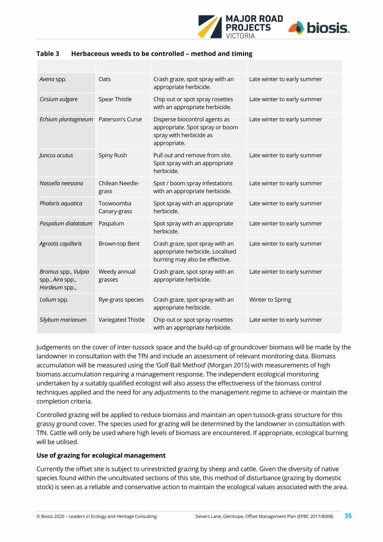
© Biosis 2020 – Leaders in Ecology and Heritage Consulting Sievers Lane, Glenhope, Offset Management Plan (EPBC 2017/8008) 35
Table 3 Herbaceous weeds to be controlled – method and timing
Scientific name Common name Method Timing
Avena spp. Oats Crash graze, spot spray with an
appropriate herbicide.
Late winter to early summer
Cirsium vulgare Spear Thistle Chip out or spot spray rosettes
with an appropriate herbicide.
Late winter to early summer
Echium plantagineum Paterson's Curse Disperse biocontrol agents as
appropriate. Spot spray or boom
spray with herbicide as
appropriate.
Late winter to early summer
Juncus acutus Spiny Rush Pull out and remove from site.
Spot spray with an appropriate
herbicide.
Late winter to early summer
Nassella neesiana Chilean Needle-
grass
Spot / boom spray infestations
with an appropriate herbicide.
Late winter to early summer
Phalaris aquatica Toowoomba
Canary-grass
Spot spray with an appropriate
herbicide.
Late winter to early summer
Paspalum dialatatum Paspalum Spot spray with an appropriate
herbicide.
Late winter to early summer
Agrostis capillaris Brown-top Bent Crash graze, spot spray with an
appropriate herbicide. Localised
burning may also be effective.
Late winter to early summer
Bromus spp., Vulpia
spp., Aira spp.,
Hordeum spp.,
Weedy annual
grasses
Crash graze, spot spray with an
appropriate herbicide.
Late winter to early summer
Lolium spp. Rye-grass species Crash graze, spot spray with an
appropriate herbicide.
Winter to Spring
Silybum marianum Variegated Thistle Chip out or spot spray rosettes
with an appropriate herbicide.
Late winter to early summer
Judgements on the cover of inter-tussock space and the build-up of groundcover biomass will be made by the
landowner in consultation with the TfN and include an assessment of relevant monitoring data. Biomass
accumulation will be measured using the ‘Golf Ball Method’ (Morgan 2015) with measurements of high
biomass accumulation requiring a management response. The independent ecological monitoring
undertaken by a suitably qualified ecologist will also assess the effectiveness of the biomass control
techniques applied and the need for any adjustments to the management regime to achieve or maintain the
completion criteria.
Controlled grazing will be applied to reduce biomass and maintain an open tussock-grass structure for this
grassy ground cover. The species used for grazing will be determined by the landowner in consultation with
TfN. Cattle will only be used where high levels of biomass are encountered. If appropriate, ecological burning
will be utilised.
Use of grazing for ecological management
Currently the offset site is subject to unrestricted grazing by sheep and cattle. Given the diversity of native
species found within the uncultivated sections of this site, this method of disturbance (grazing by domestic
stock) is seen as a reliable and conservative action to maintain the ecological values associated with the area.
© Biosis 2020 – Leaders in Ecology and Heritage Consulting Sievers Lane, Glenhope, Offset Management Plan (EPBC 2017/8008) 36
While grazing by domestic stock will continue as a method of biomass reduction at this site, it will be
undertaken in a controlled manner as outlined in this OMP. Biomass accumulation control at this site will
therefore be in accordance with the standards for management of ecological grazing published by DSE
(2009).
The offset site supports patches of native grassy understorey but in general does not support enough
indigenous ground cover to be uniformly defined as native vegetation (DELWP 2017). Timed grazing in the
offset area to maintain an open tussock grassland structure is seen as a precautionary management method
to disadvantage introduced annual and perennial grasses and provide an advantage to native perennial
grasses. Grazing of domestic stock will utilise both sheep and cattle. The use of cattle is more suited for the
initial knockdown in high biomass areas or areas containing extensive areas of dry grass or weeds not
palatable to sheep.
Grazing by other domestic stock including but not restricted to goats and horses will be excluded from the
offset site by this plan and the conservation covenant.
The timing of grazing will be controlled to allow native species to grow and set seed over the spring to mid-
summer period (DSE 2009). Stock will be excluded or only occur at very low levels (i.e. less than 20% of
recommended stocking rates) from the beginning of October to the end of December annually, for the life of
the OMP. However, this period will be flexible to reflect the prevailing climatic conditions and allow the period
of grazing exclusion to be varied on ecological advice. The landowner will keep records of the number of
stock, timing and duration of grazing within the offset area. This data will be provided to the TfN on an annual
basis as part of the Landholder monitoring and reporting process. This data and the resultant impact on
biomass will provide the basis for an on-going grazing strategy to be approved by the TfN or an independent
ecologist approved by the TfN.
The only exception to requirements specified for the control of grazing is if an ecological burn is planned and
occurs during the grazing period. In this instance a fire management plan produced by the landholder in
consultation with TfN will inform when grazing will be removed to allow for a build-up in biomass to establish
post-fire.
Note that the objective of grazing is to maintain an open tussock ground cover structure and to allow native
perennial grasses to set seed and increase their abundance over time, in order to attain and maintain the
offset completion criteria.
Use of fire for ecological management
Burning within the offset area will be undertaken only with due consideration to relevant health and safety
issues, in consultation with the Country Fire Authority and in line with a fire management plan completed by a
suitably qualified consultant. The following provides guidelines for use of burning only in an ecological sense.
While grazing by domestic stock will be the typical manner in which ground cover biomass will be regulated,
the controlled application of fire is an efficient and cost-effective alternative technique for reducing biomass
in grassy ecosystems such as those that occur within the offset site. Importantly, burning (compared to
grazing or slashing) allows greater access and efficiency for weed control and increased natural regeneration
of indigenous plant species. While burning may enhance germination of indigenous species, it can also be
expected to promote certain exotic species and as such post-burning weed control will be vital to effective
weed control. However, stimulating the soil-stored weed seed bank is seen as positive as this allows this seed
bank to be exhausted through active management.
Burning is acknowledged as an important component of the natural disturbance regime in grassy ecosystems
but because of the habitat requirements for GSM, burning will be restricted to outside the GSM flight season
(generally November to January in Victoria). This allows management to be consistent with the relevant
conservation advice.
© Biosis 2020 – Leaders in Ecology and Heritage Consulting Sievers Lane, Glenhope, Offset Management Plan (EPBC 2017/8008) 37
The controlled application of fire will be used for biomass reduction in all or parts of the offset site. Selected
areas of grassland may be burnt to tackle particular weed issues or to assist in the lowering of soil nitrogen
and phosphorous which would also assist in weed control works. However no area is to be burnt more
frequently than once every three years (unless approved by TfN in consultation with a qualified ecologist).
Burning will be conducted in a mosaic pattern and any individual burn will not burn the entire site.
The landowner will prepare maps identifying the fire history of the offset area to ensure biomass control
efforts are at appropriate frequencies and recorded. Details of fire and grazing within the offset will also be
documented in the annual reporting as outlined in Section 3.10.
Any ecological burns will be conducted during benign (nil to low wind and mild temperature) weather
conditions and are likely to be patchy (i.e. not result in the uniform burning of all areas). Patch burning will
ensure an array of small patches are burnt covering no more than about a hectare for any burnt patch. This
will be mapped by GPS to ensure appropriate tracking of management actions.
No portion of the offset site will be burnt at a frequency of more than three times over any decade covered
by this OMP. This is considered a low fire frequency for the management of grassy ecosystems.
Any burning strategy will minimise impacts to GSM and the potential for fire to spread in an uncontrolled
manner. Ecological burning will:
• be in accordance with a controlled burn plan, developed in consultation with the CFA, TfN and
following any Council requirements.
• be applied when grazing is deemed insufficient to manage biomass.
• only occur outside the prescribed declared fire danger period for this region.
• only occur outside the flight season of the species (November to January) in late summer or autumn
• implemented in a mosaic fashion with no more than 20% of the site in any one year.
• be monitored, measuring the extent of burns and influence on GSM habitat quality.
Burnt areas will be protected from grazing for at least 6 months immediately following the burn to allow
species regeneration and recruitment to occur. A cover of ground-storey vegetation above 60% is be required
before grazing can be re-introduced.
3.9 Monitoring
3.9.1 Baseline Site Condition
While the condition of the broader area of grassland is documented by Biosis (2018), details of the specific
matters relating to the selected offset area of 78.8 hectares will be established by the collection of baseline
condition data. These data will provide the baseline information for future comparisons and assessments to
define the efficacy and progress of the management of the offset site to achieve the completion criteria.
Within three months of approval of this OMP and prior to the commencement of any management activities
a suitably experienced botanist will systematically survey the site and collect information on the flora species
(native and introduced) present and maintain a complete list of all vascular species observed. Notes will be
taken on the distribution and location of weed species with GPS waypoints recorded to provide detailed
information on the location, extent and severity of target pest plant infestations. This information will be
mapped to provide a guide to both management activities and allow a visual assessment of management
progress over the life of the plan.
GPS locations will be recorded and mapped to identify the location of any threatened species observed and
the location of any other survey and monitoring infrastructure (i.e. photo points and monitoring quadrats).
A minimum of ten permanent five by five metre monitoring quadrats will be established within the offset site,
having regard for the size, nature and variability of management zones (paddocks). The minimum of 10 plots
© Biosis 2020 – Leaders in Ecology and Heritage Consulting Sievers Lane, Glenhope, Offset Management Plan (EPBC 2017/8008) 38
was selected on the basis of the extent of the site (provide at least 1 plot per ten hectares), the topographic
variation present (upper, mid and lower slopes, ridgetops and valley floors) and the variations in site
conditions (across a spectrum of weed dominated to predominantly native).
These locations will be defined during the baseline site inspection prior to the commencement of other
management works and will be representative of the offset site. They will be evenly distributed across the site
and if considered appropriate, additional monitoring sites can be included. Quadrats will be clearly marked
and accurately located by GPS or similar within the offset site. These quadrats will be used to assess and
record the percentage total vegetation cover, the percentage cover of inter-tussock spaces (bare ground), the
average height of vegetation and the cover of native and exotic life-forms. These areas will also include the
collection of biomass data using the golf ball method (Morgan 2015). These data will be collated, in
conjunction with the observations made on herbaceous and woody weeds collected during the systematic
site assessment survey, and be used to report on the baseline condition of the offset site. Ongoing
monitoring will then assess progress in the management of weeds (including grasses) and biomass over the
entire offset site. Ongoing use of the established monitoring plots will continue if this information is required
to evaluate ongoing compliance with the completion criteria.
Five of these plots will be expanded to cover one hectare. Each of these one hectare areas will be subject to a
assessment to score the site condition components associated with a habitat hectare assessment using the
relevant EVC benchmark identified by DELWPs mapping of ecological vegetation classes at each location. The
data collected will be used to evaluate changes in vegetation condition with the target outcome being the
increase in site condition scores outlined in Section 3.4.1.
A project database will be maintained allowing for data storage and protection, data extraction, quality
control, analysis, interpretation, reporting and presentation. The landowner and TfN will have ownership of all
data collected, and be responsible for its distribution, availability and licensing to DoEE for compliance and
recovery planning purposes.
All of the permanent vegetation monitoring quadrats established by the botanist will also serve as permanent
photo points. Photo points will be located to adequately characterise the current vegetation condition. Using
a selected marker point for the vegetation monitoring quadrat, a photo will be taken facing the four points of
the compass (N, S, E & W). These baseline photos will be used to provide a visual document and for
monitoring the vegetation response to management until the end of this OMP.
The average level of open inter-tussock spaces (as determined by the 10 monitoring plots) will be taken as the
average open space available across the offset site unless the broad observations taken during the annual
vegetation monitoring indicate this result is atypical.
Improving the abundance and cover of Spear-grasses and Wallaby-grasses identified in the baseline
vegetation condition assessment will be taken as improving the relevant food resources for GSM. The
abundance of these plant genera will be measured in the 10 monitoring plots established for vegetation
condition monitoring. Improving these levels will be taken as the improvement of food resources for GSM. A
25% reduction in the cover of these species will be taken as a trigger for corrective management action.
3.9.2 Continuous monitoring
Monitoring of the site is an integral component of the regular site management activities. Such monitoring
identifies changes early, allowing an appropriate and timely management response to matters which would
otherwise undermine the objectives of the OMP. This includes observations by the landowner during normal
activities within the offset site and broader property. Such observations are important for maintaining things
such as the integrity of fencing and site security. While these are normal land management activities they
have also been formalised in this OMP (See Table 4).
© Biosis 2020 – Leaders in Ecology and Heritage Consulting Sievers Lane, Glenhope, Offset Management Plan (EPBC 2017/8008) 39
Regular site inspections (of about three to five hours at least every two months) to provide general condition
observations are also a requirement of this plan (See Table 4). At a minimum the landowner must keep a
diary of any works conducted within the offset site and record any observations which could influence or
initiate a management response (e.g. “observed seedlings of a new woody weed in the middle of the offset
site today. Will spot spray these with an appropriate herbicide by the end of the week”). These details provide
valuable information on the management of the site and detail the commitment of the landowner to the
OMP.
More general supervision/monitoring of the offset site will be undertaken by the TfN to ensure the grassy
ground cover response to management actions achieve the offset completion criteria. TfN will visit the site a
minimum of four times over any 10 year period (at least the spring of years 1, 3, 6 and 10) and will liaise with
the land owner annually regarding the development of an annual works plan.
The progress of management works will be inspected by the land owner on a regular basis (at a minimum
once every 2 months). The land owner will provide a management progress report to TfN on an annual basis
(or more frequently as required).
Records of all management actions will be kept to provide evidence of completed works and management
tasks.
A list of plant species observed, noting which, if any, weed species have become locally extinct will be
maintained for the offset site by the landowner. While all data collection will be the responsibility of the
landowner, all data collected will be provided to DoEE on request.
Annual vegetation monitoring assessments conducted by suitably qualified ecologists will include a broad
assessment of the entire offset site to document the general overall condition of the site and the ability of
management works to attain and maintain the OMPs completion criteria).
3.9.3 Fence monitoring
Surveys of the property boundary fence will be conducted quarterly, and when visiting the site to conduct
other monitoring or management actions. Any damage to the fence that may allow vehicles or stock to enter
outside of the parameters outlined in this OMP will be repaired within seven days.
3.9.4 Weed monitoring
Weed monitoring will be conducted annually in spring (September – November). There will be three
components to the monitoring:
• Inspection of the entire offset area by a suitably qualified ecologist for woody weeds, by walking and /
or driving throughout the area such that a visual inspection (including with binoculars) would detect
the presence of any woody weeds. Complete coverage of the offset site will likely require at least four
hours of survey. All patches of infestations or individual plants will be mapped with a GPS, and the
locations will be supplied to the weed management contractor/landholder for treatment. Subsequent
monitoring will then revisit previously mapped/identified infestations to evaluate the success of weed
control, as well as inspecting the entire offset site for new infestations.
• While conducting the woody weed surveys, notes will be taken regarding the cover of herbaceous
weed species, and cover will be estimated to the nearest five percent cover. Species and areas
suitable for targeted treatment (such as spot spraying), will be mapped and supplied to the weed
management contractor/landholder for treatment.
• A minimum of ten five by five metre quadrats will be established in selected locations across the
offset site. Each monitoring quadrat will be representative of the management unit identified for that
portion of the offset site. These quadrats will be used to assess and record the:
© Biosis 2020 – Leaders in Ecology and Heritage Consulting Sievers Lane, Glenhope, Offset Management Plan (EPBC 2017/8008) 40
– percentage % total vegetation cover;
– percentage % cover of inter-tussock spaces and % cover bare ground;
– floristic composition (with a focus on GSM food species and weed species);
– total % cover GSM food species, % native and exotic grasses, % Rytidosperma spp. cover, and
% cover of Chilean Needle-grass;
– grassland structure and biomass using the ‘golf-ball’ method (Morgan 2015);
– average height of vegetation (and grasses/GSM food species); and
– the cover of native and exotic life-forms.
These data will be collated and, in conjunction with the observations made on herbaceous weeds
collected in association with woody weed monitoring, will be used to assess performance toward
offset completion criteria, continuous improvement in specific criteria, and inform adaptive
management.
• The permanent vegetation monitoring quadrats established by the botanist will also serve as
permanent photo points. Photo points will be located to adequately characterise the current
vegetation condition, and include a range of weed species. Using a selected marker point for the
vegetation monitoring quadrat, a photo will be taken facing the four points of the compass (N, S, E &
W). These baseline photos will be used to provide a visual document and for monitoring the
vegetation response to management.
3.9.5 Pest animal monitoring
Signs of pest animals (rabbits, hares and foxes) will be recorded during weed monitoring surveys, and at all
other times when visiting the offset site. In particular, the locations of any active rabbit warrens will be
mapped using GPS, and the locations supplied to the pest animal management contractor/landholder for
treatment. Subsequent monitoring will then revisit previously mapped warrens to check for on-going use, as
well as searching for new warrens throughout the offset area.
More formal monitoring for the presence of pest animals will occur annually in November. This will include a
systematic spotlight survey of the offset site lasting no less than three hours. The results of this survey will be
included in the annual report to the DoEE.
3.9.6 Tree and shrub monitoring
A dense cover of tree and / or shrub recruitment will reduce the overall suitability of the GSM habitat. While
grazing would likely limit the establishment of woody native species, there is some potential for dense stands
of woody native species to develop as a result of changed management activities.
Tree and shrub recruitment within 10 metres of an identifiable drainage line on moderate to steep slopes will
be encouraged. This will also provide greater landscape resilience to erosion. However at a broader scale, the
regeneration of woody native species (trees and shrubs) will need to be controlled to prevent it becoming a
dominant feature of the offset area.
An open cover of tree regeneration is considered desirable as it is likely that an open woodland was the
natural condition of this environment and allows both the structure and species composition of GSM habitat
to be maintained. In that context an initial density for tree regeneration, beyond any regeneration along
defined drainage lines, be restricted to one tree for every 5000 square metres. If monitoring indicates that no
tree regeneration is able to cope with the grazing regime applied to the offset site then selected tree
regeneration may be protected with localised fencing to prevent browsing by domestic stock.
© Biosis 2020 – Leaders in Ecology and Heritage Consulting Sievers Lane, Glenhope, Offset Management Plan (EPBC 2017/8008) 41
3.9.7 Golden Sun Moth Monitoring
Monitoring during the flight season for GSM is considered essential for DoEE to be satisfied as to the
continued suitability of the site and its management as an offset for impacts to GSM. Baseline monitoring the
population of GSM within the offset site will occur in the first flight season after the EPBC Act approval of this
OMP (expected to be the 2019/20 flight season). Monitoring will record the location and number of
individuals observed along monitoring transects as described below.
As the species is known to occur at the offset site no reference site is required for monitoring the population
of GSM. However, prior to surveys being conducted, reports of GSM flying in or around Melbourne are likely
to provide a useful indicator to identify the start of the flight season around Glenhope.
Monitoring for GSM will occur every year during the flight season. While some information on the abundance
of GSM within the offset site is provided by Hamilton Environmental Services (2015, 2018 & 2019) these
surveys are not evenly distributed across the site, do not represent four systematic surveys and do not record
information relating to habitat condition within the offset. Baseline monitoring data on the distribution and
abundance of GSM within the offset site is therefore required to be collected during the 2019/20 flight
season. Repeated monitoring of these transects every second year for the duration of this OMP will be
conducted to evaluate the persistence and relative abundance of Golden Sun Moth at this site. Ongoing
monitoring every second year will then be required for the duration of this OMP.
A monitoring event includes four GSM surveys (i.e. the site is assessed four times during a flight season) to
document the occurrence and abundance of GSM within the offset site. The results of these surveys will be
compared to the original baseline surveys (2019 /20 flight season) and those of the previous monitoring
event. Surveys will be conducted biennially for the first ten year period of this OMP. Surveys will be
undertaken during the GSM flight season, which in this region is expected to be between November and
December. As the timing of the flight season varies annually and geographically, surveys will be initiated from
when warm weather is considered likely to stimulate emergence. In this region this is expected to occur
anytime from late October onwards. Any observations of GSM during monitoring for vegetation condition
and during inspections by the land owner or TfN will be recorded and reported.
Surveys within the flight season are to be spaced at least one week apart to allow for variations in emergence
patterns. Surveys will take place when conditions are suitable for male flight (generally >20oC, bright, clear
days, full sun, absence of rain and wind other than a light breeze) between 10:00 hrs and 15:00 hrs.
Each survey will systematically walk over the entire offset site using two suitably qualified ecologists
separated by about 200 metres. Each pair of transects will then be separated by another 200 metres and be
located to cover all sections of the offset site. The beginning and end of each transect will be recorded as a
GPS waypoint. Tracks will be recorded using a GPS and a waypoint taken for each location where GSM are
observed.
Any obvious changes to the habitat characteristics of the offset area will be recorded during the GSM survey.
This will be supported by relevant photos of the habitat or management issues identified.
The results of each survey will be reported to TfN and DoEE. The report will also include an assessment of any
changes or trends noted in either the habitat condition or number of GSM observed noted by the ecologist.
3.10 Reporting
Unless otherwise advised by the Minister, the landowner, via the approval holder (MRPV), must submit a
report annually to TfN and DoEE for the duration of this OMP. Reports are to be submitted at least two
months prior to the anniversary date of the execution of the OMP to allow time for compliance to be
© Biosis 2020 – Leaders in Ecology and Heritage Consulting Sievers Lane, Glenhope, Offset Management Plan (EPBC 2017/8008) 42
assessed before the anniversary date. Reports will also be published on the MRPV website within 3 months of
every 12 month anniversary.
The Annual Report will address progress against the commitments set out in this OMP. Annual Reports will
provide enough detail in the form of written comments and supporting evidence that an assessor can easily
determine the completion of/progress against the management commitments and completion criteria for the
offset site.
The annual report will include:
• Details of management actions, including on ground works, undertaken within the reporting period.
• Results of monitoring activities, including fence condition, weeds, pest animals, habitat quality,
vegetation quality and ground cover biomass accumulation / the cover of open ground.
• Tracking and evaluation of results in comparison to management performance targets and
completion criteria
• Site photographs including from ten defined photo points.
• Details of compliance or non-compliance with the schedule of management actions (Table 4).
• Details of compliance or non-compliance with performance targets (Section 3.4.2).
• Details of any incidents or new and emerging management issues, with recommendations for
corrective action and plan review in order to attain the offset completion criteria.
• Any triggers exceeded and which corrective actions were implemented
• Details of any GSM monitoring events including an assessment of the relevant results.
The reporting schedule is detailed in Table 7.
3.11 Auditing
The approval holder (MRPV) is responsible for auditing the implementation and effectiveness of the OMP.
Audits will be conducted by an independent ecologist at the following stages:
• At the end of the first year of site management - this is to ensure that initial management and
monitoring actions are conducted to the satisfaction of the approval holder and DoEE, including
implementing the legal security mechanism, ensuring the property is securely fenced, and that other
initial management and baseline monitoring actions have commenced.
• At the end of the fourth year of site management – this will involve a review of four annual
monitoring and management reports, as well as an independent assessment of the condition of GSM
habitat within the site.
• At the end of the eighth year of site management – as per the four year audit.
• Following the completion of the 10th year – to be an audit of the implementation and effectiveness of
this OMP.
The timing of scheduled audits is detailed in Table 7. Additional audits may be triggered as a result of a plan
review (Section 3.12) or following an environmental incident resulting in significant change to site conditions,
as identified in the risk assessment (Table 5).
3.12 Plan review
This plan includes an adaptive management approach, where corrective actions may be triggered by events
occurring within the offset site, or the results of monitoring activities. A review of the OMP will only be
© Biosis 2020 – Leaders in Ecology and Heritage Consulting Sievers Lane, Glenhope, Offset Management Plan (EPBC 2017/8008) 43
necessary in the event of a major incident that makes a significant change to the character or condition of the
offset area. The most likely such event is a major wildfire, as described in Table 5.
If a plan review is triggered, this will be conducted by MRPV in consultation with the offset site owner and
DoEE. Any future adaptive management changes will be incorporated into the OMP and an updated version
of the OMP will be supplied to DoEE for approval.
The OMP review will involve changes to any part of the OMP, in order to adequately respond to the trigger
and re-direct management actions towards achieving the offset completion criteria under potentially altered
site conditions.
This could involve changes to:
• Specific details of offset site management methods.
• Monitoring methodology.
• Schedules of monitoring, reporting and auditing.
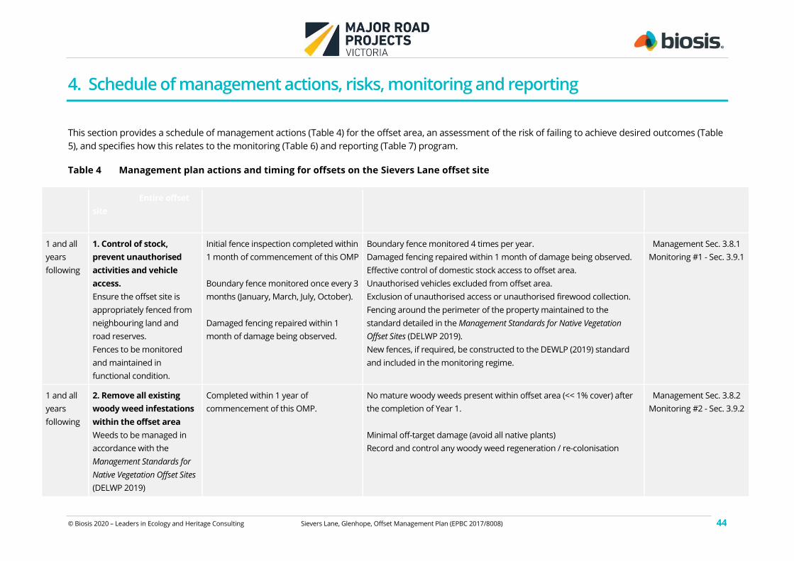
© Biosis 2020 – Leaders in Ecology and Heritage Consulting Sievers Lane, Glenhope, Offset Management Plan (EPBC 2017/8008) 44
4. Schedule of management actions, risks, monitoring and reporting
This section provides a schedule of management actions (Table 4) for the offset area, an assessment of the risk of failing to achieve desired outcomes (Table
5), and specifies how this relates to the monitoring (Table 6) and reporting (Table 7) program.
Table 4 Management plan actions and timing for offsets on the Sievers Lane offset site
Year No Objective – Entire offset
site
Timing of activity – month(s) Performance criteria Related management
and monitoring activity
(# -see Table 6)
1 and all
years
following
1. Control of stock,
prevent unauthorised
activities and vehicle
access.
Ensure the offset site is
appropriately fenced from
neighbouring land and
road reserves.
Fences to be monitored
and maintained in
functional condition.
Initial fence inspection completed within
1 month of commencement of this OMP
Boundary fence monitored once every 3
months (January, March, July, October).
Damaged fencing repaired within 1
month of damage being observed.
Boundary fence monitored 4 times per year.
Damaged fencing repaired within 1 month of damage being observed.
Effective control of domestic stock access to offset area.
Unauthorised vehicles excluded from offset area.
Exclusion of unauthorised access or unauthorised firewood collection.
Fencing around the perimeter of the property maintained to the
standard detailed in the Management Standards for Native Vegetation
Offset Sites (DELWP 2019).
New fences, if required, be constructed to the DEWLP (2019) standard
and included in the monitoring regime.
Management Sec. 3.8.1
Monitoring #1 - Sec. 3.9.1
1 and all
years
following
2. Remove all existing
woody weed infestations
within the offset area
Weeds to be managed in
accordance with the
Management Standards for
Native Vegetation Offset Sites
(DELWP 2019)
Completed within 1 year of
commencement of this OMP.
No mature woody weeds present within offset area (<< 1% cover) after
the completion of Year 1.
Minimal off-target damage (avoid all native plants)
Record and control any woody weed regeneration / re-colonisation
Management Sec. 3.8.2
Monitoring #2 - Sec. 3.9.2
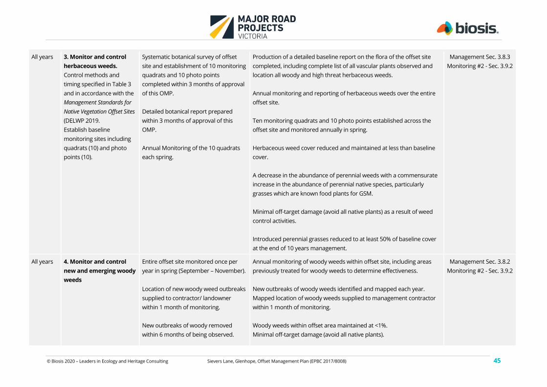
© Biosis 2020 – Leaders in Ecology and Heritage Consulting Sievers Lane, Glenhope, Offset Management Plan (EPBC 2017/8008) 45
All years 3. Monitor and control
herbaceous weeds.
Control methods and
timing specified in Table 3
and in accordance with the
Management Standards for
Native Vegetation Offset Sites
(DELWP 2019.
Establish baseline
monitoring sites including
quadrats (10) and photo
points (10).
Systematic botanical survey of offset
site and establishment of 10 monitoring
quadrats and 10 photo points
completed within 3 months of approval
of this OMP.
Detailed botanical report prepared
within 3 months of approval of this
OMP.
Annual Monitoring of the 10 quadrats
each spring.
Production of a detailed baseline report on the flora of the offset site
completed, including complete list of all vascular plants observed and
location all woody and high threat herbaceous weeds.
Annual monitoring and reporting of herbaceous weeds over the entire
offset site.
Ten monitoring quadrats and 10 photo points established across the
offset site and monitored annually in spring.
Herbaceous weed cover reduced and maintained at less than baseline
cover.
A decrease in the abundance of perennial weeds with a commensurate
increase in the abundance of perennial native species, particularly
grasses which are known food plants for GSM.
Minimal off-target damage (avoid all native plants) as a result of weed
control activities.
Introduced perennial grasses reduced to at least 50% of baseline cover
at the end of 10 years management.
Management Sec. 3.8.3
Monitoring #2 - Sec. 3.9.2
All years 4. Monitor and control
new and emerging woody
weeds
Entire offset site monitored once per
year in spring (September – November).
Location of new woody weed outbreaks
supplied to contractor/ landowner
within 1 month of monitoring.
New outbreaks of woody removed
within 6 months of being observed.
Annual monitoring of woody weeds within offset site, including areas
previously treated for woody weeds to determine effectiveness.
New outbreaks of woody weeds identified and mapped each year.
Mapped location of woody weeds supplied to management contractor
within 1 month of monitoring.
Woody weeds within offset area maintained at <1%.
Minimal off-target damage (avoid all native plants).
Management Sec. 3.8.2
Monitoring #2 - Sec. 3.9.2
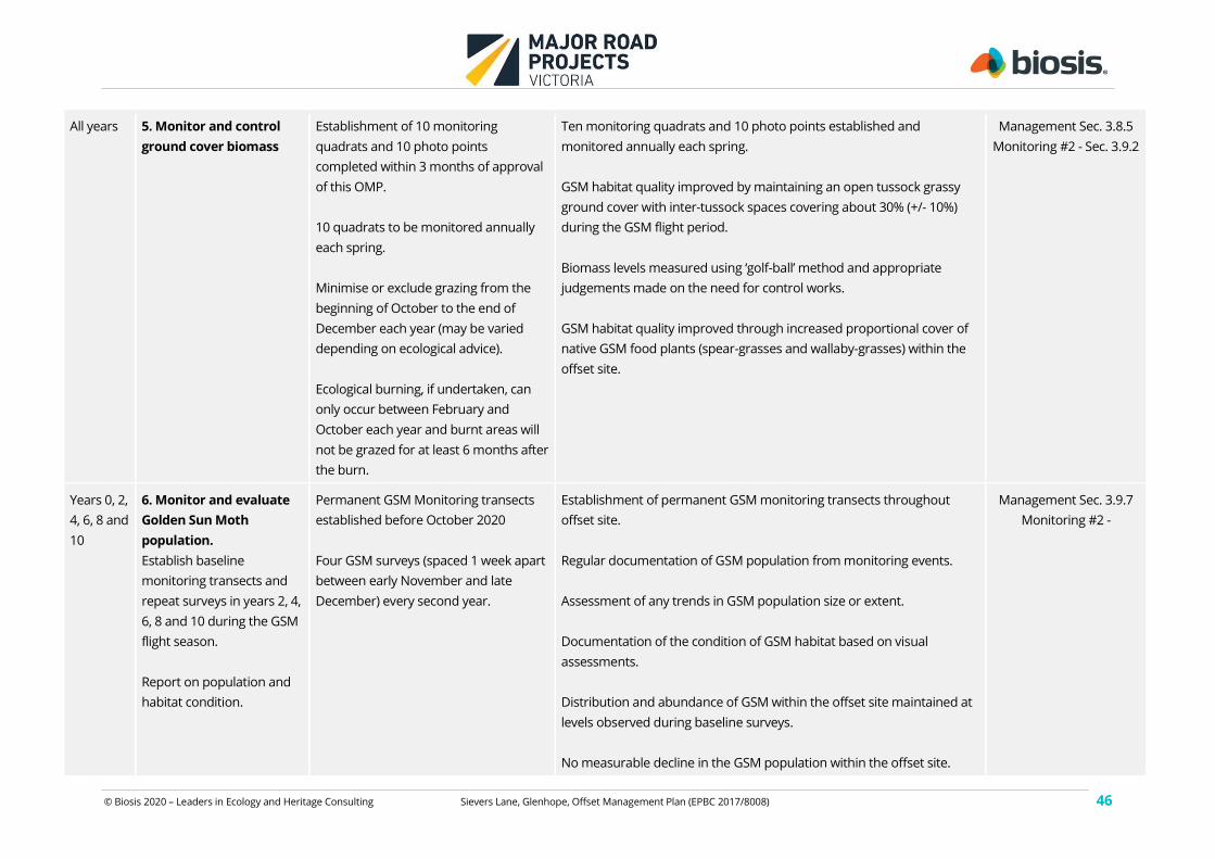
© Biosis 2020 – Leaders in Ecology and Heritage Consulting Sievers Lane, Glenhope, Offset Management Plan (EPBC 2017/8008) 46
All years 5. Monitor and control
ground cover biomass
Establishment of 10 monitoring
quadrats and 10 photo points
completed within 3 months of approval
of this OMP.
10 quadrats to be monitored annually
each spring.
Minimise or exclude grazing from the
beginning of October to the end of
December each year (may be varied
depending on ecological advice).
Ecological burning, if undertaken, can
only occur between February and
October each year and burnt areas will
not be grazed for at least 6 months after
the burn.
Ten monitoring quadrats and 10 photo points established and
monitored annually each spring.
GSM habitat quality improved by maintaining an open tussock grassy
ground cover with inter-tussock spaces covering about 30% (+/- 10%)
during the GSM flight period.
Biomass levels measured using ‘golf-ball’ method and appropriate
judgements made on the need for control works.
GSM habitat quality improved through increased proportional cover of
native GSM food plants (spear-grasses and wallaby-grasses) within the
offset site.
Management Sec. 3.8.5
Monitoring #2 - Sec. 3.9.2
Years 0, 2,
4, 6, 8 and
10
6. Monitor and evaluate
Golden Sun Moth
population.
Establish baseline
monitoring transects and
repeat surveys in years 2, 4,
6, 8 and 10 during the GSM
flight season.
Report on population and
habitat condition.
Permanent GSM Monitoring transects
established before October 2020
Four GSM surveys (spaced 1 week apart
between early November and late
December) every second year.
Establishment of permanent GSM monitoring transects throughout
offset site.
Regular documentation of GSM population from monitoring events.
Assessment of any trends in GSM population size or extent.
Documentation of the condition of GSM habitat based on visual
assessments.
Distribution and abundance of GSM within the offset site maintained at
levels observed during baseline surveys.
No measurable decline in the GSM population within the offset site.
Management Sec. 3.9.7
Monitoring #2 -
© Biosis 2020 – Leaders in Ecology and Heritage Consulting Sievers Lane, Glenhope, Offset Management Plan (EPBC 2017/8008) 47
All years 7. Monitor and evaluate
Golden Sun Moth habitat
condition.
Utilise 10 quadrats used for
weed monitoring and other
general observations.
10 quadrats to be monitored annually
each spring.
A decrease in the abundance of perennial weeds with a commensurate
increase in the abundance of perennial native species, particularly
grasses which are known food plants for GSM.
Ten monitoring quadrats and 10 photo points established and
monitored annually each spring.
GSM habitat quality improved by maintaining an open tussock grassy
ground cover with inter-tussock spaces covering about 30% (+/- 10%)
during the GSM flight period.
Documentation of the condition of GSM habitat based on the
abundance of GSM food plants and inter-tussock spaces.
Management Sec. 3.9.1
Monitoring #6
All years 8. Monitor and control
Rabbits, Hares and Foxes.
Monitor signs of rabbits, hares and
foxes annually during vegetation
condition surveys and incidentally
throughout the year
Formal monitoring of pest animals to be
carried out once per year through
spotlight surveys along pre-determined
transects. First survey to commence
within 3 months of the approval of this
OMP
Control of pest animals to occur
throughout the year. Fumigate fox dens
in August and September when the
vixen and cubs are confined to the den.
Signs of pest animals documented incidentally during vegetation
surveys.
Locations of rabbit warrens and artificial harbour mapped.
Removal of all surface harbour such as rubbish, woody weeds and
artificial piles of logs and rocks.
Rabbits managed in accordance with the Management Standards for
Native Vegetation Offset Sites (DELWP 2019.
No fresh ground disturbance by pest animals (particularly rabbits)
observed in the offset area.
No active rabbit warrens within offset area, minimal surface harbour for
rabbits and hares present (excluding natural harbour such as logs and
rocks).
No active fox dens within offset area.
Management Sec. 3.8.4
Monitoring #3 - Sec. 3.9.5
© Biosis 2020 – Leaders in Ecology and Heritage Consulting Sievers Lane, Glenhope, Offset Management Plan (EPBC 2017/8008) 48
Abundance of each pest species reduced to and maintained at low
levels.
All years 9. Monitor and control all
new and emerging pest
animals.
Monitor signs of new and emerging pest
animals annually during vegetation
condition surveys and incidentally
throughout the year
Effective control numbers of any new and emerging pests.
No new or emerging pest animals establishing within the offset area.
Management Sec. 3.8.4
Monitoring #3 - Sec. 3.9.5
All years 10. Monitor tree and
shrub regeneration and
undertake ecological
thinning if required (section
3.6.6).
Autumn each year. Maintenance of an open / scattered cover of immature canopy trees
and understorey trees or large shrubs in the offset area to a level of not
greater than one tree and 10 shrubs per 5000 square metres.
If trees and shrubs exceed these densities then they will be thinned to
achieve the designated target.
Management Sec. 3.8
Monitoring #4 - Sec. 3.9.6
All years 11. Prepare and submit
an annual report.
Submit 2 months prior to agreement
anniversary date. Annual reporting
under this OMP will be aligned with the
reporting requirements of the
BushBroker Agreement.
Annual report is signed, dated and submitted by the landholder at least
2 months prior to the anniversary date of the agreement, as specified in
the BushBroker agreement.
Refer to section 3.10
© Biosis 2020 – Leaders in Ecology and Heritage Consulting Sievers Lane, Glenhope, Offset Management Plan (EPBC 2017/8008) 49
Table 5 Risk assessment and management
This risk assessment uses the risk framework from the DoEE EMP guidelines. The likelihood and consequence classification is summarised in Appendix 1.
Objective
(refer to
Table 4)
Event or circumstance
Lik
eli
ho
od
Consequence Risk
level
Trigger Contingency/s Related
monitoring
activity (#
See Table 6)
1 Unauthorised entry of domestic
stock to the offset area.
Grazing, browsing and trampling
damage to vegetation. Damage
to or loss of juvenile trees and
shrubs
Unlikely Minor Low Domestic stock sighted on offset site out of
authorised periods.
Remove stock or Reduce stocking
rate.
Repair fencing.
Monitor vegetation.
1
1 Entry of vehicles to offset area.
Damage to understorey
vegetation, soil compaction.
Unlikely Minor Low Vehicle observed on offset site.
Evidence of recent vehicle access e.g. tyre
tracks.
Repair fencing.
Assess adequacy of fencing.
1
1 Unauthorised access. Unlikely Minor Low Evidence of firewood collection or physical
disturbance observed.
Assess adequacy of fencing. 1
2, 3, 4 Woody weeds are identified
within offset area. Herbaceous
weed cover exceeds baseline
levels.
Possible Minor Low Woody weeds are detected.
Herbaceous weed cover exceeds baseline
levels.
Control weeds. Minimise off-target
damage (avoid all native plants)
2
5 & 7 Native grasses fail to recolonise
areas opened up by weed
control works
Possible Moderate Medium Areas subject to the control of perennial
grassy weeds become dominated by annual
weeds or bare ground.
Review grazing strategy to allow
native grasses to set seed.
Harvest and disperse native grass
seed to effected areas.
2 & 6
© Biosis 2020 – Leaders in Ecology and Heritage Consulting Sievers Lane, Glenhope, Offset Management Plan (EPBC 2017/8008) 50
Objective
(refer to
Table 4)
Event or circumstance
Lik
eli
ho
od
Consequence Risk
level
Trigger Contingency/s Related
monitoring
activity (#
See Table 6)
7, 8 Pest animals observed within
offset site.
Damage to understorey
vegetation or recruiting trees
and shrubs.
Possible Moderate Medium Fresh ground disturbance or scats of pest
animals observed in the offset area.
Active rabbit warrens observed within offset
area.
Active fox dens observed within offset area.
New and emerging pest observed within
offset area.
Destroy fox dens and rabbit
warrens through fumigation and
hand collapse.
Undertake control works for new
and emerging pests as
appropriate.
3
9 Tree and shrub recruitment is
significantly above or below that
allowed under this OMP.
Possible Minor Low Cover of immature trees and shrubs are
more than defined.
Recruitment of immature trees and shrubs
not observed.
Ecological thinning to achieve
target density of tree
regeneration.
Undertake action to encourage
regeneration and address threats
to regeneration.
4
6 GSM population drops
significantly without apparent
reason
Possible Critical Severe Population of GSM declines by over 50% in
comparison to any previous years without
explanation as to how it may recover or
habitat condition noted as significantly lower
than previous year and recovery is uncertain.
Review ecological management
parameters. Review plan.
5
7 Fail to approach site condition /
stocking rate targets by year 8
Possible High Medium Perennial grassy weeds have not significantly
reduced in extent at the end of year 8 and the
site condition and/or GSM monitoring
indicates that target gains are unlikely to be
achieved.
Increase levels of management
(i.e. more intensive weed control)
2,5 & 6
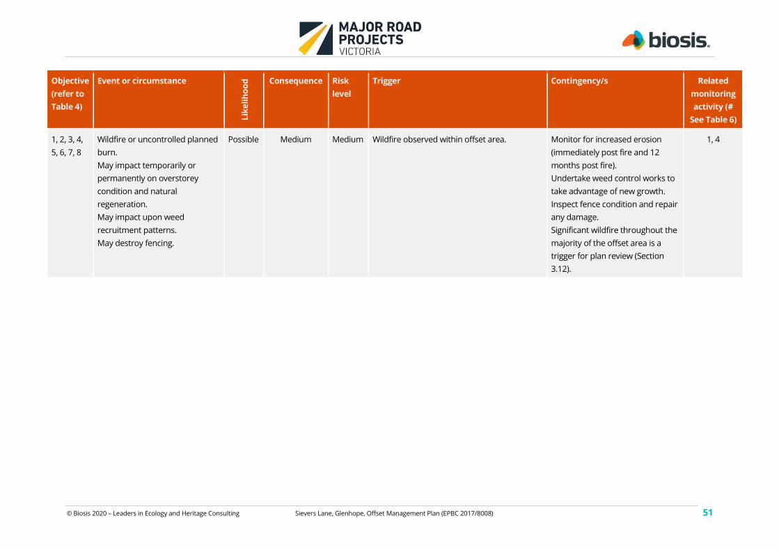
© Biosis 2020 – Leaders in Ecology and Heritage Consulting Sievers Lane, Glenhope, Offset Management Plan (EPBC 2017/8008) 51
Objective
(refer to
Table 4)
Event or circumstance
Lik
eli
ho
od
Consequence Risk
level
Trigger Contingency/s Related
monitoring
activity (#
See Table 6)
1, 2, 3, 4,
5, 6, 7, 8
Wildfire or uncontrolled planned
burn.
May impact temporarily or
permanently on overstorey
condition and natural
regeneration.
May impact upon weed
recruitment patterns.
May destroy fencing.
Possible Medium Medium Wildfire observed within offset area. Monitor for increased erosion
(immediately post fire and 12
months post fire).
Undertake weed control works to
take advantage of new growth.
Inspect fence condition and repair
any damage.
Significant wildfire throughout the
majority of the offset area is a
trigger for plan review (Section
3.12).
1, 4
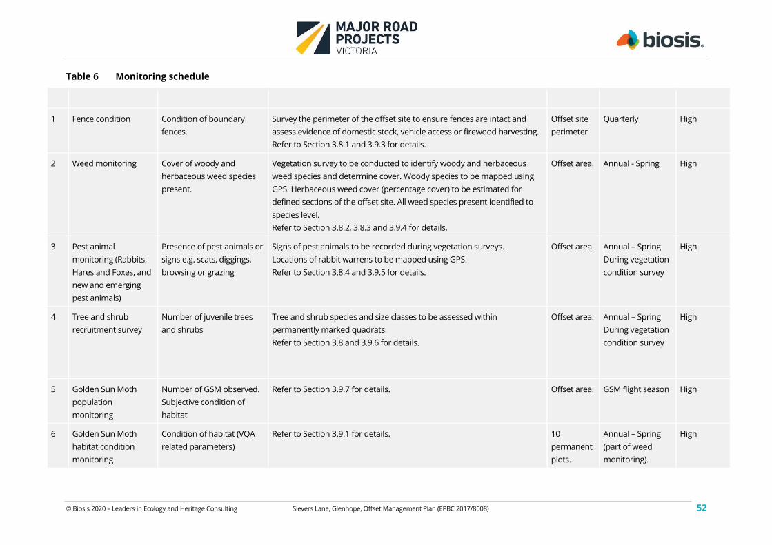
© Biosis 2020 – Leaders in Ecology and Heritage Consulting Sievers Lane, Glenhope, Offset Management Plan (EPBC 2017/8008) 52
Table 6 Monitoring schedule
# Monitoring activity Parameter/s measured Survey / monitoring guidelines Where When Reliability
1 Fence condition Condition of boundary
fences.
Survey the perimeter of the offset site to ensure fences are intact and
assess evidence of domestic stock, vehicle access or firewood harvesting.
Refer to Section 3.8.1 and 3.9.3 for details.
Offset site
perimeter
Quarterly High
2 Weed monitoring Cover of woody and
herbaceous weed species
present.
Vegetation survey to be conducted to identify woody and herbaceous
weed species and determine cover. Woody species to be mapped using
GPS. Herbaceous weed cover (percentage cover) to be estimated for
defined sections of the offset site. All weed species present identified to
species level.
Refer to Section 3.8.2, 3.8.3 and 3.9.4 for details.
Offset area. Annual - Spring High
3 Pest animal
monitoring (Rabbits,
Hares and Foxes, and
new and emerging
pest animals)
Presence of pest animals or
signs e.g. scats, diggings,
browsing or grazing
Signs of pest animals to be recorded during vegetation surveys.
Locations of rabbit warrens to be mapped using GPS.
Refer to Section 3.8.4 and 3.9.5 for details.
Offset area. Annual – Spring
During vegetation
condition survey
High
4 Tree and shrub
recruitment survey
Number of juvenile trees
and shrubs
Tree and shrub species and size classes to be assessed within
permanently marked quadrats.
Refer to Section 3.8 and 3.9.6 for details.
Offset area. Annual – Spring
During vegetation
condition survey
High
5 Golden Sun Moth
population
monitoring
Number of GSM observed.
Subjective condition of
habitat
Refer to Section 3.9.7 for details. Offset area. GSM flight season High
6 Golden Sun Moth
habitat condition
monitoring
Condition of habitat (VQA
related parameters)
Refer to Section 3.9.1 for details. 10
permanent
plots.
Annual – Spring
(part of weed
monitoring).
High
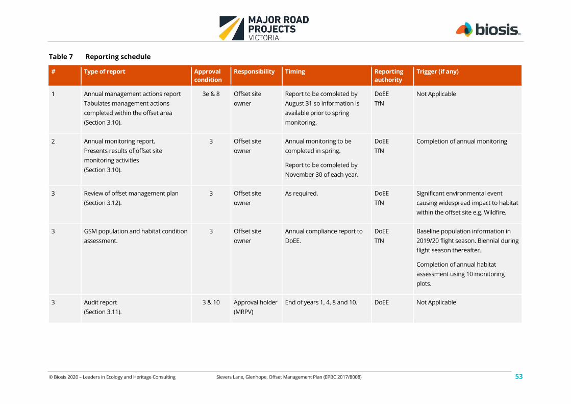
© Biosis 2020 – Leaders in Ecology and Heritage Consulting Sievers Lane, Glenhope, Offset Management Plan (EPBC 2017/8008) 53
Table 7 Reporting schedule
# Type of report Approval
condition
Responsibility Timing Reporting
authority
Trigger (if any)
1 Annual management actions report
Tabulates management actions
completed within the offset area
(Section 3.10).
3e & 8 Offset site
owner
Report to be completed by
August 31 so information is
available prior to spring
monitoring.
DoEE
TfN
Not Applicable
2 Annual monitoring report.
Presents results of offset site
monitoring activities
(Section 3.10).
3 Offset site
owner
Annual monitoring to be
completed in spring.
Report to be completed by
November 30 of each year.
DoEE
TfN
Completion of annual monitoring
3 Review of offset management plan
(Section 3.12).
3 Offset site
owner
As required. DoEE
TfN
Significant environmental event
causing widespread impact to habitat
within the offset site e.g. Wildfire.
3 GSM population and habitat condition
assessment.
3 Offset site
owner
Annual compliance report to
DoEE.
DoEE
TfN
Baseline population information in
2019/20 flight season. Biennial during
flight season thereafter.
Completion of annual habitat
assessment using 10 monitoring
plots.
3 Audit report
(Section 3.11).
3 & 10 Approval holder
(MRPV)
End of years 1, 4, 8 and 10. DoEE Not Applicable
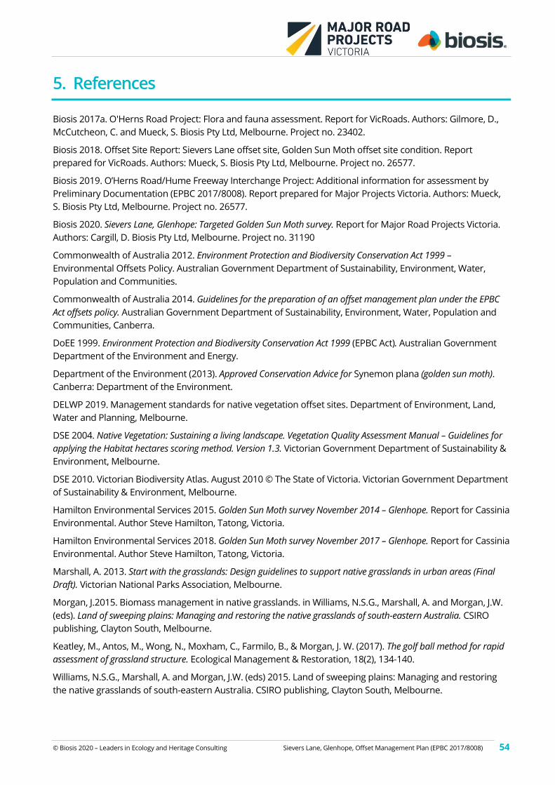
© Biosis 2020 – Leaders in Ecology and Heritage Consulting Sievers Lane, Glenhope, Offset Management Plan (EPBC 2017/8008) 54
5. References
Biosis 2017a. O'Herns Road Project: Flora and fauna assessment. Report for VicRoads. Authors: Gilmore, D.,
McCutcheon, C. and Mueck, S. Biosis Pty Ltd, Melbourne. Project no. 23402.
Biosis 2018. Offset Site Report: Sievers Lane offset site, Golden Sun Moth offset site condition. Report
prepared for VicRoads. Authors: Mueck, S. Biosis Pty Ltd, Melbourne. Project no. 26577.
Biosis 2019. O’Herns Road/Hume Freeway Interchange Project: Additional information for assessment by
Preliminary Documentation (EPBC 2017/8008). Report prepared for Major Projects Victoria. Authors: Mueck,
S. Biosis Pty Ltd, Melbourne. Project no. 26577.
Biosis 2020. Sievers Lane, Glenhope: Targeted Golden Sun Moth survey. Report for Major Road Projects Victoria.
Authors: Cargill, D. Biosis Pty Ltd, Melbourne. Project no. 31190
Commonwealth of Australia 2012. Environment Protection and Biodiversity Conservation Act 1999 –
Environmental Offsets Policy. Australian Government Department of Sustainability, Environment, Water,
Population and Communities.
Commonwealth of Australia 2014. Guidelines for the preparation of an offset management plan under the EPBC
Act offsets policy. Australian Government Department of Sustainability, Environment, Water, Population and
Communities, Canberra.
DoEE 1999. Environment Protection and Biodiversity Conservation Act 1999 (EPBC Act). Australian Government
Department of the Environment and Energy.
Department of the Environment (2013). Approved Conservation Advice for Synemon plana (golden sun moth).
Canberra: Department of the Environment.
DELWP 2019. Management standards for native vegetation offset sites. Department of Environment, Land,
Water and Planning, Melbourne.
DSE 2004. Native Vegetation: Sustaining a living landscape. Vegetation Quality Assessment Manual – Guidelines for
applying the Habitat hectares scoring method. Version 1.3. Victorian Government Department of Sustainability &
Environment, Melbourne.
DSE 2010. Victorian Biodiversity Atlas. August 2010 © The State of Victoria. Victorian Government Department
of Sustainability & Environment, Melbourne.
Hamilton Environmental Services 2015. Golden Sun Moth survey November 2014 – Glenhope. Report for Cassinia
Environmental. Author Steve Hamilton, Tatong, Victoria.
Hamilton Environmental Services 2018. Golden Sun Moth survey November 2017 – Glenhope. Report for Cassinia
Environmental. Author Steve Hamilton, Tatong, Victoria.
Marshall, A. 2013. Start with the grasslands: Design guidelines to support native grasslands in urban areas (Final
Draft). Victorian National Parks Association, Melbourne.
Morgan, J.2015. Biomass management in native grasslands. in Williams, N.S.G., Marshall, A. and Morgan, J.W.
(eds). Land of sweeping plains: Managing and restoring the native grasslands of south-eastern Australia. CSIRO
publishing, Clayton South, Melbourne.
Keatley, M., Antos, M., Wong, N., Moxham, C., Farmilo, B., & Morgan, J. W. (2017). The golf ball method for rapid
assessment of grassland structure. Ecological Management & Restoration, 18(2), 134-140.
Williams, N.S.G., Marshall, A. and Morgan, J.W. (eds) 2015. Land of sweeping plains: Managing and restoring
the native grasslands of south-eastern Australia. CSIRO publishing, Clayton South, Melbourne.

© Biosis 2020 – Leaders in Ecology and Heritage Consulting Sievers Lane, Glenhope, Offset Management Plan (EPBC 2017/8008) 55
Appendices
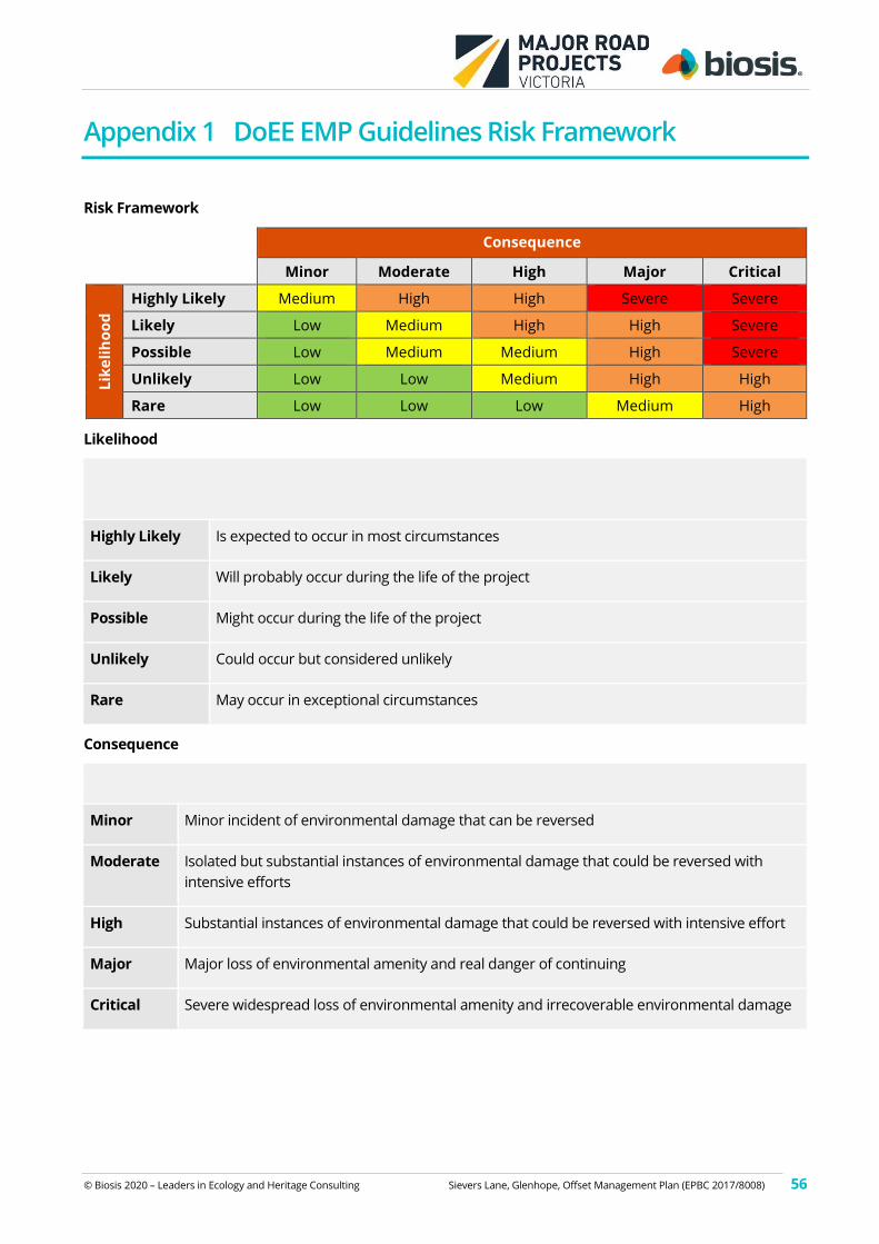
© Biosis 2020 – Leaders in Ecology and Heritage Consulting Sievers Lane, Glenhope, Offset Management Plan (EPBC 2017/8008) 56
Appendix 1 DoEE EMP Guidelines Risk Framework
Risk Framework
Consequence
Minor Moderate High Major Critical
Lik
eli
ho
od
Highly Likely Medium High High Severe Severe
Likely Low Medium High High Severe
Possible Low Medium Medium High Severe
Unlikely Low Low Medium High High
Rare Low Low Low Medium High
Likelihood
Qualitative measure of likelihood (how likely is it that this event/circumstances will occur after
management actions have been put in place/are being implemented
Highly Likely Is expected to occur in most circumstances
Likely Will probably occur during the life of the project
Possible Might occur during the life of the project
Unlikely Could occur but considered unlikely
Rare May occur in exceptional circumstances
Consequence
Qualitative measure of consequences (what will be the consequence / result if the issue does occur)
Minor Minor incident of environmental damage that can be reversed
Moderate Isolated but substantial instances of environmental damage that could be reversed with
intensive efforts
High Substantial instances of environmental damage that could be reversed with intensive effort
Major Major loss of environmental amenity and real danger of continuing
Critical Severe widespread loss of environmental amenity and irrecoverable environmental damage
© Biosis 2020 – Leaders in Ecology and Heritage Consulting Sievers Lane, Glenhope, Offset Management Plan (EPBC 2017/8008) 57
Appendix 2 Glossary
This appendix contains definitions of technical terms used in this OMP.
Items marked with an asterisk (*) are cited from DELWP (2007b)
Benchmark*
A standard vegetation –quality reference point,
dependent on vegetation type, which is applied
in Habitat hectare assessments. Represents the
average characteristics of a mature and
apparently long undisturbed state of the same
vegetation type.
Biodiversity*
The variety of all life forms, the different plants,
animals and microorganisms, the genes they
contain, and the ecosystems of which they form
a part.
Bioregion*
Biogeographic areas that capture the patterns
of ecological characteristics in the landscape or
seascape, providing a natural framework for
recognising and responding to biodiversity
values. A landscape based approach to
classifying the land surface using a range of
environmental attributes such as climate,
geomorphology, lithology and vegetation.
Canopy Tree
Defined in the Habitat Hectare (DSE 2004)
vegetation quality assessment method, as a
mature tree that is greater than three metres in
height, and is normally found in the upper layer
of the relevant vegetation type.
Completion Criteria
Targets defined under the EPBC Act approved
OMP required to be achieved by management at
the completion of the OMP.
DBH (Diameter at Breast Height)*
The diameter of the main trunk of a tree
measured 1.3 m above ground level.
Ecological vegetation class (EVC)*
A native vegetation type classified on the basis
of a combination of its floristic, life form,
environmental and ecological characteristics.
EPBC Act
Environmental Protection and Biodiversity
Conservation Act 1999
Habitat hectares*
Combined measure of condition and extent of
native vegetation. This measure is obtained by
multiplying the site’s condition score (measured
between 0 and 1) with the area of the site (in
hectares).
Habitat score*
The score assigned to a habitat zone that
indicates the quality of the vegetation relative to
the ecological vegetation class benchmark – sum
of the site condition score and landscape
context score, usually expressed as a
percentage or on a scale of 0 to 1.
Habitat zone*
A discrete area of native vegetation consisting of
a single vegetation type (EVC) within an assumed
similar quality. This is the base spatial unit for
conducting a Habitat hectare assessment.
Separate Vegetation Quality Assessments (or
Habitat hectare assessments) are conducted for
each habitat zone within the designated
assessment area.
Indigenous vegetation*
The type of native vegetation that would have
normally been expected to occur on the site
prior to European settlement.
Offset*
Protection and management (including
revegetation) of native vegetation at a site to
generate a gain in the contribution that native
vegetation makes to Victoria’s biodiversity. An
offset is used to compensate for the loss to
Victoria’s biodiversity from the removal of native
vegetation.
© Biosis 2020 – Leaders in Ecology and Heritage Consulting Sievers Lane, Glenhope, Offset Management Plan (EPBC 2017/8008) 58
Offset Management Plan (OMP)
A document which sets out the requirements for
establishment, protection and management of
an offset site.
Scattered tree*
An indigenous canopy tree that does not form
part of a remnant patch of native vegetation
(see definition of remnant patch of native
vegetation).
Site
An area of land that contains contiguous
patches of native vegetation or scattered trees,
within the same ownership.
Site gain
Predicted improvement in the condition, or the
condition and extent, of native vegetation at a
site (measured in Habitat hectares) generated
by the landowner committing to active
management and increased security.
Recruitment*
The production of new generations of plants,
either by allowing natural ecological processes
to occur (regeneration etc.), by facilitating such
processes such as regeneration to occur, or by
actively revegetating (replanting, reseeding). See
Revegetation.
Remnant vegetation*
Native vegetation that is established or has
regenerated on a largely natural landform. The
species present are those normally expected in
that vegetation community. Largely natural
landforms may have been subject to some past
surface disturbance such as some clearing or
cultivation (or even the activities of the nineteenth
century gold rushes) but do not include man-
made structures such as dam walls and quarry
floors.
Understorey*
Understorey is all vegetation other than mature
canopy trees – includes immature trees, shrubs,
grasses, herbs, mosses, lichens and soil crust. It
does not include dead plant material that is not
attached to a living plant. More information on
understorey life forms is set out in the Vegetation
Quality Assessment Manual (DSE 2004).


![Allure~ MD Tropical warehouse moth (cocoa moth) [Ephestia cautel/a], Tobacco moth [Ephestia elute/la], Raisin moth [Cadra figulilel/a] 3. APPLICATION: Place dispensers every 20 to](https://img.pdfslide.net/doc/110x75/5fc80c76c4631870720794eb/allure-md-tropical-warehouse-moth-cocoa-moth-ephestia-cautela-tobacco-moth.jpg)