Embed Size (px)
Citation preview
California Environmental Quality Act
Significance Determination
Thresholds
Development Services Department
JANUARY 2011*
*Note: Development Services Department staff periodically revises
sections of the thresholds in response to CEQA case law, and
changes in federal, state, and local regulations. Staff also
periodically provides updated information and clarification and
direction for environmental analysts.
ii
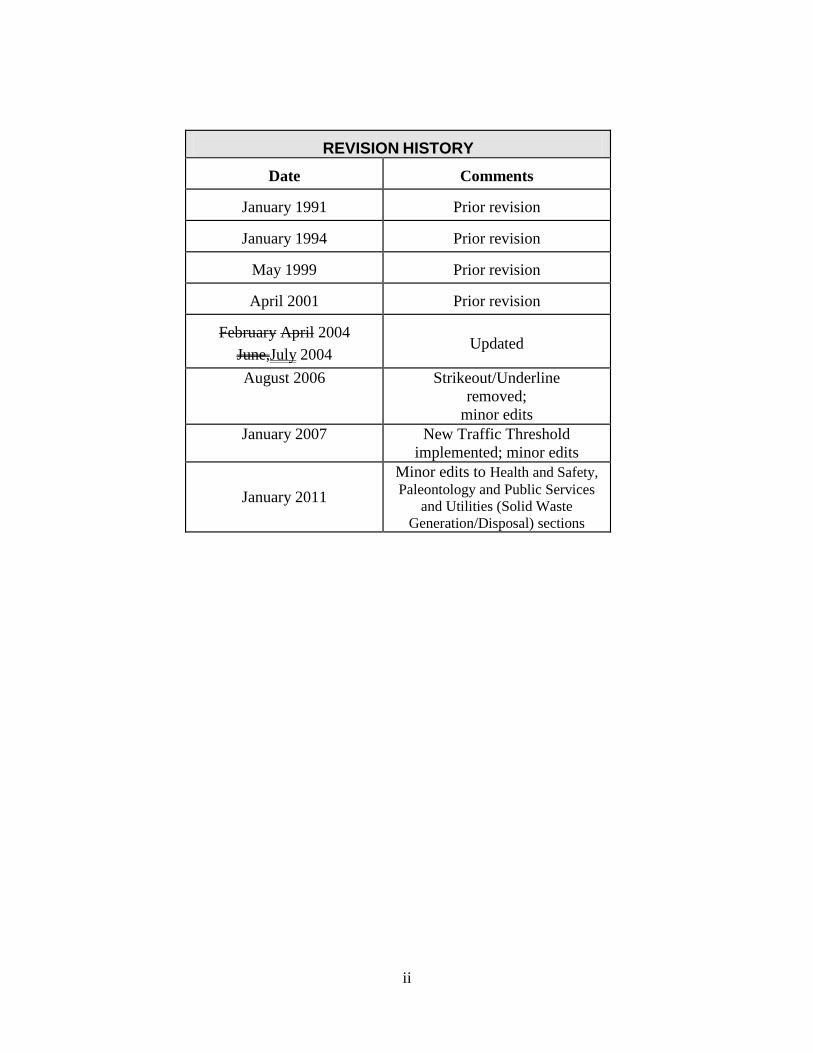
REVISION HISTORY
Date
Comments
January 1991
Prior revision
January 1994
Prior revision
May 1999
Prior revision
April 2001
Prior revision
February April 2004
June,July 2004
Updated
August 2006
Strikeout/Underline
removed;
minor edits
January 2007
New Traffic Threshold
implemented; minor edits
January 2011
Minor edits to Health and Safety,
Paleontology and Public Services
and Utilities (Solid Waste
Generation/Disposal) sections
iii
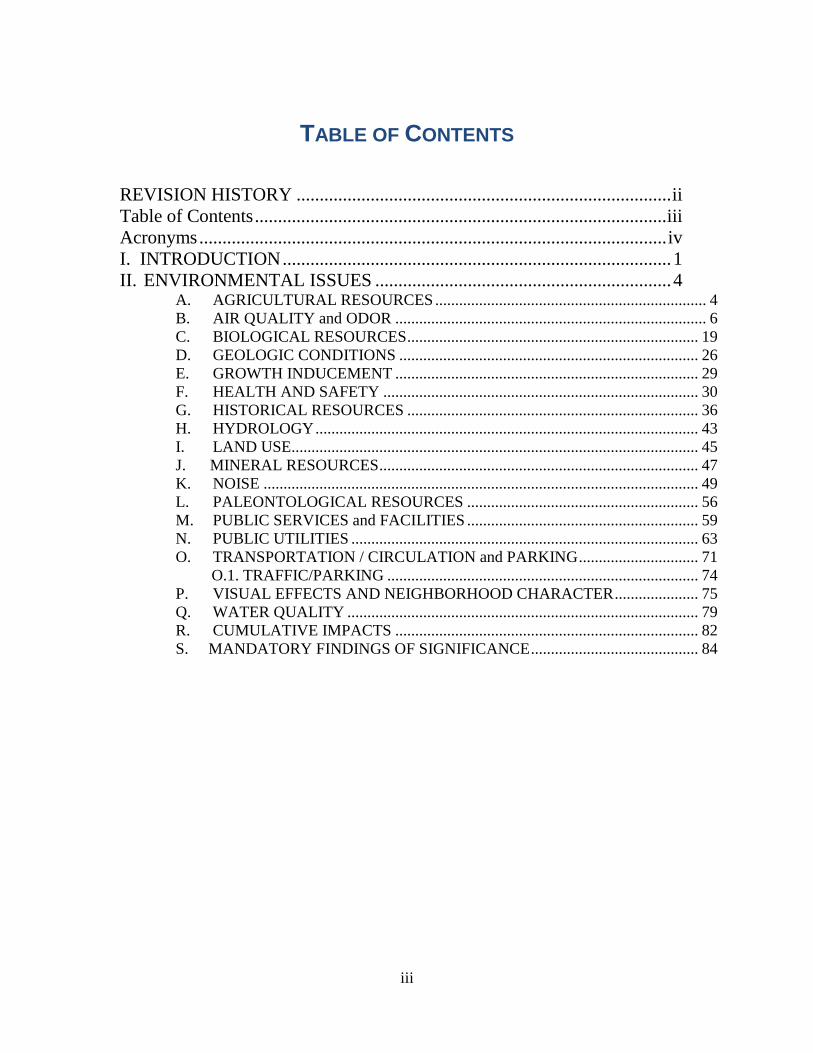
TABLE OF CONTENTS
REVISION HISTORY ................................................................................. ii
Table of Contents ......................................................................................... iii
Acronyms ..................................................................................................... iv
I. INTRODUCTION .................................................................................... 1
II. ENVIRONMENTAL ISSUES ................................................................ 4
A. AGRICULTURAL RESOURCES .................................................................... 4 B. AIR QUALITY and ODOR .............................................................................. 6
C. BIOLOGICAL RESOURCES ......................................................................... 19 D. GEOLOGIC CONDITIONS ........................................................................... 26 E. GROWTH INDUCEMENT ............................................................................ 29 F. HEALTH AND SAFETY ............................................................................... 30
G. HISTORICAL RESOURCES ......................................................................... 36 H. HYDROLOGY ................................................................................................ 43
I. LAND USE...................................................................................................... 45 J. MINERAL RESOURCES ................................................................................ 47 K. NOISE ............................................................................................................. 49
L. PALEONTOLOGICAL RESOURCES .......................................................... 56 M. PUBLIC SERVICES and FACILITIES .......................................................... 59
N. PUBLIC UTILITIES ....................................................................................... 63 O. TRANSPORTATION / CIRCULATION and PARKING .............................. 71
O.1. TRAFFIC/PARKING .............................................................................. 74 P. VISUAL EFFECTS AND NEIGHBORHOOD CHARACTER ..................... 75
Q. WATER QUALITY ........................................................................................ 79 R. CUMULATIVE IMPACTS ............................................................................ 82 S. MANDATORY FINDINGS OF SIGNIFICANCE .......................................... 84
iv
ACRONYMS
AAQA ............................................................................................. Ambient Air Quality Standards
ADT ............................................................................................................... Average Daily Traffic
AAOZ ............................................................................................ Airport Approach Overlay Zone
AEOZ .............................................................................................. Airport Environs Overlay Zone
APCD ................................................................................................. Air Pollution Control District
APE ............................................................................................................ Area of Potential Effects
AQIA............................................................................................... Air Quality Impact Assessment
AQMD ......................................................................................... Air Quality Management District
BDR .................................................................................. Building Development Review Division
BMP ....................................................................................................... Best Management Practice
CAAQS .......................................................................... California Ambient Air Quality Standards
CARB .............................................................................................. California Air Resources Board
CCR................................................................................................. Code of California Regulations
CEQ...................................................................... United States Council on Environmental Quality
CEQA .................................................................................... California Environmental Quality Act
CFR ............................................................................... United States Code of Federal Regulations
CGS ....................................................................................................... California Geologic Survey
CNEL ....................................................................................... Community Noise Equivalent Level
CLUP ............................................................................................... Comprehensive Land Use Plan
CO ........................................................................................................................ Carbon Monoxide
CUP .............................................................................................................. Conditional Use Permit
dB ........................................................................................................................................... decibel
DEH .......................................................................... County Department of Environmental Health
DSD............................................................................................Development Services Department
EAS ................................................................................................ Environmental Analysis Section
EDU ......................................................................................................... Equivalent Dwelling Unit
EIR ..................................................................................................... Environmental Impact Report
EMF .................................................................................................... Electric and Magnetic Fields
EPA ...................................................................... United States Environmental Protection Agency
ESD ......................................................................................... Environmental Services Department
ESL .............................................................................................. Environmentally Sensitive Lands
FAA............................................................................................... Federal Aviation Administration
FEMA ............................................................................. Federal Emergency Management Agency
FPF .......................................................................................................................Flood Plain Fringe
FW.................................................................................................................................... Flood Way
GI .................................................................................................................. Geologic investigation
GR ........................................................................................................................... Geologic Report
HAZMAT .......................................................................................................... hazardous materials
HUD ............................................................ U.S. Department of Housing and Urban Development
LDC........................................................................................................... Land Development Code
LEA ....................................................................................................... Local Enforcement Agency
LDR........................................................................................................Land Development Review
v
LOS ......................................................................................................................... Level of Service
MHPA ..................................................................................................Multi-Habitat Planning Area
MRZ ............................................................................................................. Mineral Resource Zone
MSCP ................................................................................ Multiple Species Conservation Program
µg/m3 ...................................................................................................... microgram per cubic meter
NAAQS ............................................................................. National Ambient Air Quality Standards
NEPA ........................................................................................ National Environmental Policy Act
NOx ..................................................................................................................... Oxides of Nitrogen
OHP.................................................................................................. Office of Historic Preservation
O3 ............................................................................................................................................ Ozone
ppm ......................................................................................................................... parts per million
PM10 .................................................................................................... Respirable Particulate Matter
PM 2.5 ............................................................................................................ Fine Particulate Matter
REDI ........................................................ Regional Economic and Demographic Mapping System
ROG ............................................................................................................ Reactive Organic Gases
RPO ................................................................................ Resource Protection Ordinance (outdated)
RPZ ............................................................................................................Runway Protection Zone
RTK............................................................................................................................ Right to Know
RTIP ...................................................................... Regional Transportation Improvement Program
RTP .................................................................................................... Regional Transportation Plan
RWQCB .............................................................................. Regional Water Quality Control Board
SFHA ..................................................................................................... Special Flood Hazard Area
SDG&E ................................................................................. San Diego Gas and Electric Company
SANDAG ............................................................San Diego Regional Association of Governments
SMARA ................................................................................. Surface Mining and Reclamation Act
SIP ........................................................................................................... State Implementation Plan
SOx ......................................................................................................................... Oxides of Sulfur
SR ................................................................................................................................... Soils Report
SUSMP ..................................................................... Standard Urban Storm Water Mitigation Plan
SWPPP .................................................................................. Stormwater Pollution Prevention Plan
TCM ............................................................................................. Transportation Control Measures
TLV ............................................................................................................... Threshold Limit Value
VOC ................................................................................................... Volatile Organic Compounds
1
I. INTRODUCTION
The purpose of these Significance Determination Thresholds (also known as Guidelines) is to
assist City of San Diego staff, project proponents, and the public in determining whether, based
on substantial evidence, a project may have a significant effect on the environment under Section
21082.2 of the California Environmental Quality Act1 (CEQA), and therefore the environmental
impact requires mitigation. They are not intended to be stand alone policies and are to be used in
conjunction with commonly accepted professional standards, judgments, and practices. These
guidelines should be updated when necessary in response to changes in CEQA, case law, and
refinement of recognized scientific analysis of impact thresholds. The City of San Diego has
been using these thresholds since 1991 and has provided regular updates. Section 15064.7 of the
CEQA Guidelines encourages public agencies to develop and publish such analytical tools.
These Thresholds include information on 19 environmental issues as listed in, and to be used in
conjunction with, the Initial Study Checklist. They provide technical guidance in evaluating the
potential significance of a project‘s environmental impact and provide a consistent and objective
basis for determining the level of impacts. They also recognize that the level of impacts depend
upon a multitude of factors such as project setting, design, construction, etc.
SIGNIFICANCE THRESHOLDS
The determination of whether a project may have a significant effect on the environment calls for
careful judgment on the part of the agency involved, based to the extent possible on scientific
and factual data. An ironclad definition of a significant impact is not possible because the
significance of an activity may vary with the setting. For example, an activity which is not
significant in an urban area may be significant in a rural area (CEQA Guidelines Section 15064).
According to CEQA Statutes at Section 21082.2:
(a) The lead agency shall determine whether a project may have a significant effect on the
environment based on substantial evidence in light of the whole record.
(b) The existence of public controversy over the environmental effects of a project shall not
require the preparation of an environmental impact report if there is no substantial
evidence in light of the whole record before the agency that the project may have a
significant effect on the environment.
(c) Argument, speculation, unsubstantiated opinion or narrative, evidence which is clearly in
accurate or erroneous, or evidence of social or economic impacts which do not contribute
to, or are not caused by, physical impacts on the environment, is not substantial evidence.
Substantial evidence shall include facts, reasonable assumptions predicated upon facts,
and expert opinion supported by facts.
1 State of California Public Resources Code, Division 13. http://www.leginfo.ca.gov/calaw.html
2
(d) If there is substantial evidence, in light of the whole record before the lead agency, that a
project may have a significant effect on the environment, an environmental impact report
shall be prepared.
(e) Statements in an environmental impact report and comments with respect to an
environmental impact report shall not be deemed determinative of whether the project
may have a significant effect on the environment.
This key decision as to whether a project may have a significant effect must be based on
substantial evidence in the record. Section 15384 of the CEQA Guidelines defines "substantial
evidence" as:
(a) Substantial evidence as used in these guidelines means enough relevant information and
reasonable inferences from this information that a fair argument can be made to support a
conclusion, even though other conclusions might also be reached. Whether a fair
argument can be made that the project may have a significant effect on the environment
is to be determined by examining the whole record before the lead agency. Argument,
speculation, unsubstantiated opinion or narrative, evidence which is clearly erroneous or
inaccurate, or evidence of social or economic impacts which do not contribute to, or are
not caused by physical impacts on the environment does not constitute substantial
evidence.
(b) Substantial evidence shall include facts, reasonable assumptions predicted upon facts, and
expert opinion supported by facts
In most instances, the evidence in the record provides a clear link to the decision to prepare an
EIR, Mitigated Negative Declaration, or Negative Declaration. However, according to the
CEQA Guidelines in marginal cases where it is not clear whether there is substantial evidence
that a project would have a significant effect on the environment, the Lead Agency is guided by
Section 15064 (7(g) of the CEQA Guidelines:
―After application of the principals set forth above in Section 15064(f), and in marginal cases
where it is not clear whether there is substantial evidence that a project may have a
significant effect on the environment, the lead agency shall be guided by the following
principal: If there is disagreement among expert opinion supported by facts over the
significance of an effect on the environment, the Lead Agency shall treat the effect as
significant and shall prepare an EIR.‖
USE OF REGULATORY STANDARDS AS THRESHOLDS OF SIGNIFICANCE
In October 2002, the California Court of Appeal for the Third District issued a decision in the
case Communities for a Better Environment v. California Resources Agency, Case No. C)38844
(10/28/02). Among other decisions, the court invalidated CEQA Guidelines Section 15064(h),
which required lead agencies to rely on adopted environmental standards to determine
significance. The Court held that Section 15064(h) conflicted with CEQA‘s standard for
determining whether to prepare an EIR whenever it can be fairly argued on the basis of
substantial evidence that a project may have a significant environmental impact.

3
In general, DSD’s Significance Determination Thresholds may be used to determine a
project’s potential impacts, but analysts are cautioned to remember that in some cases
there may be substantial evidence of significant impact even when a project does not exceed
the threshold.
4
II. ENVIRONMENTAL ISSUES
A. AGRICULTURAL RESOURCES
A significant impact on agricultural resources may result from a project which involves the
conversion of Prime Farmland*, Unique Farmland**, or Farmland of Statewide Importance***
(as defined by the State of California on its Important Farmlands Map) to non-agricultural use.
In San Diego, such land is generally located in portions of the undeveloped northern and
southernmost areas of the City.
* Prime Farmland is land with the best combination of physical and chemical features for the production of agricultural crops.
It includes:
• All land which qualifies for a rating as Class I or II on the United States Department of Agriculture (USDA) Natural
Resources Conservation Service (formerly the Soil Conservation Service) Land Use Capability classifications. The
Capability classification indicates the suitability of soils for most kinds of crops. Groupings are made according to the
limitation of the soils when used to grow crops and the risk of damage to soils when they are used in agriculture Soils
are grouped in eight classes, from I through VIII, with Group I having the highest rating.
• Land which qualifies for a rating of 80 to 100 on the Storie Index. The Storie Index expresses numerically (based on a
100-point scale) the relative degree of suitability, or value of a soil for general intensive agriculture. Profile
characteristics, soil surface texture, slope, and other factors such as drainage and salinity are considered in the Index
rating.
• Land which supports livestock used for the production of food and fiber and which has an annual carrying capacity
equivalent to at least one animal unit per acre, as defined by the USDA.
• Land planted with fruit or nut bearing trees, vines, bushes, or crops that have a non-bearing period of less than five
years and which will normally return, during the commercial bearing period on an annual basis, from the production of
unprocessed agricultural plant production, not less than $200 per acre.
• Land which has returned from the production of unprocessed agricultural plant products at an annual gross value of not
less than $200 per acre for three of the previous five years.
** Unique Farmland is land of lesser quality soils used for the production of the state's leading agricultural cash crops.
***Farmland of Statewide Importance is land with a good combination of physical and chemical features for the production of
agricultural crops.
INITIAL STUDY CHECKLIST QUESTIONS
The following are from the City‘s Initial Study Checklist and provides guidance to determine
potential significance to Agricultural Resources:
Would the proposal result in:
1. Conversion of a substantial amount of Prime Farmland*, Unique Farmland** or
Farmland of Statewide Importance*** (Farmland) as shown on the maps prepared
pursuant to the Farmland Mapping and Monitoring Program of the California Resources
Agency, to non-agricultural use?
2. Conflict with existing zoning for agricultural use, or Williamson Act contract?
3. Involve other changes in the existing environment which due to their location or nature,
could result in conversion of Farmland, to non-agricultural use?
5
SIGNIFICANCE THRESHOLDS
In evaluating the potential for a significant agricultural resources impacts, analysts should
consult the Soil Survey, San Diego Area, Part III (USDA 1973) to determine the Storie Index
rating and Capability Group of the soils on the project site. Other resources include the State of
California Important Farmlands Map and Environmental Impact Reports prepared for subarea
plans and community plan updates. Some of these documents contain maps identifying the
various categories of farmland.
The determination of substantial amount cannot be based on any one numerical criterion (i.e.,
one acre), but rather on the economic viability of the area proposed to be converted. Another
factor to be considered is the location of the area proposed for conversion. If the site itself is too
small to be economically viable, would the proposed use affect the surrounding operations? For
instance, the installation of a small housing complex on a formerly agricultural site may preclude
or limit future pesticide spraying activities in an adjacent area with the potential to support food
crops.
For purposes of defining significant agricultural resources and identifying impacts, it should be
noted that the economic viability of a site is based on the characteristics that allow agricultural
operations that can make a profit – not on a comparison of agricultural activities with other types
of uses that may be more profitable.
6
B. AIR QUALITY and ODOR
Impact analysis for air quality should ensure that current air quality regulatory compliance
attainment status is not adversely affected by stationary sources of emission, including CO
hotspots, from new development. Table A-1 shows San Diego is designated ―non-attainment‖ for
ozone and particulate matter.2 The CEQA review should include measures to reduce project-
related ozone and particulate matter emissions to ensure that new developments do not contribute
to San Diego‘s non-attainment status for these pollutants.
Table A-1
SAN DIEGO ATTAINMENT DESIGNATIONS
Pollutant
Attainment Status
State Federal
Carbon Monoxide Attainment Attainment
Lead Attainment Attainment
Nitrogen Dioxide Attainment Attainment
Ozone Non-Attainment Attainment for 1-hr; not 8-hr.
Maintenance3
PM10 Non-Attainment Unclassified
Sulfur Dioxide Attainment Attainment
Sulfates Attainment no federal standard
Hydrogen Sulfide Unclassified no federal standard
Visibility Unclassified no federal standard
INITIAL STUDY CHECKLIST QUESTIONS
The following are from the City‘s Initial Study Checklist and provides guidance to determine
potential significance to Air Quality:
Would the proposal result in:
1. A conflict with or obstruct implementation of the applicable air quality plan?
2. A violation of any air quality standard or contribute substantially to an existing or
projected air quality violation?
3. Exposing sensitive receptors to substantial pollutant concentrations?
4. Creating objectionable odors affecting a substantial number of people? (See C-1)
5. Exceeding 100 pounds per day of Particulate Matter (PM)(dust)?
6. Substantial alteration of air movement in the area of the project?
SIGNIFICANCE THRESHOLDS
These air quality significance thresholds are based primarily on regulatory thresholds. However,
use of regulatory standards as the sole threshold for significance [former CEQA section
15064(h)] was struck from CEQA pursuant to Communities For A Better Environment v.
California Resources Agency, Case No. CO38844 (10/28/02). The former guideline specified
2 Source: San Diego Air Pollution Control District 9SDAPCD). 2001 Annual Report.
http://www.sdapcd.co.san-diego.ca.us/annual/ANNUAL.PDF. Designation for PM 2.5 and the 8-hour ozone
standard were pending at time of this revision. 3 Attainment for 1-hr.standard was promulgated by the US EPA on July 28, 2003; On 4/04 San Diego was
classified as non-attainment for 8-hr. standard .
7
that if a change in the environment is not a significant effect if the change complies with a
regulatory standard found in a statute, ordinance, rule, or regulation. The court held that
Guideline 15064(h) conflicted with CEQA‘s standard for determining whether to prepare an
Environmental Impact Report (EIR). An agency must prepare an EIR whenever it can be fairly
argued on the basis of substantial evidence that a project may have a significant environmental
impact. The court reasoned that Guideline 15064(h) might be construed to allow an agency to
avoid preparing an EIR by deeming an impact insignificant based upon compliance with an
adopted regulatory standard, even if other substantial evidence supported a fair argument that a
significant impact could occur.
Given the October 2002 ruling, reliance on the SDAPCD regulatory standards in Table 1 can no
longer be used as the sole determinant of significance. The SDAPCD thresholds are provided in
this document as a guideline to be considered on a case-by-case basis with other substantial
evidence in light of the whole record to determine if the project may have a significant air quality
impact. ―Other substantial evidence‖ may include factors such as the proximity of sensitive
receptors as discussed below.
The following Air Quality Thresholds are arranged in three parts beginning with the broadest,
and narrowing to the most specific. Use of these should be applied as a screening tool to see
where the project aligns along a sliding scale of potential significance. If sensitive receptors
are involved, the more restrictive of the guidelines should be applied.
General Thresholds
A project may have a significant air quality environmental impact if it could:
a. Conflict with or obstruct implementation of the applicable air quality plan
b. Violate any air quality standard or contribute substantially to an existing or projected air
quality violation
c. Result in cumulatively considerable net increase of any criteria pollutant for which the
project region is non-attainment under an applicable federal or state ambient air quality
standard (including release emissions which exceed quantitative thresholds for ozone
precursors)
d. Expose sensitive receptors4 to substantial pollutant concentrations including air toxics
such as diesel particulates. … As adopted by the South Coast Air Quality Management
District (SCAQMD) in their CEQA Air Quality handbook5 (Chapter 4), a sensitive receptor is
a person in the population who is particularly susceptible to health effects due to exposure to
an air contaminant than is the population at large. Sensitive receptors (and the facilities that
house them) in proximity to localized CO sources, toxic air contaminants or odors are of
particular concern. Examples include:
4 Consider sensitive receptors in locations such as day care centers, schools, retirement homes, and
hospitals or medical patients in residential homes close to major roadways or stationary sources, which could be
impacted by air pollutants.
5 http://www.aqmd.gov/ceqa/hdbk.html
8
Long-Term Health Care Facilities
Rehabilitation Centers
Convalescent Centers
Retirement Homes
Residences – such as medical patients in homes
Schools
Playground
Child Care Centers
Athletic Facilities
Methodology: The public involvement process of CEQA should be used to help determine the
conditions of the existing environment to make a reasonable determination if sensitive
receptors are present. The environmental planner should make a field visit as appropriate as
part of the environmental initial study which should include specific analysis for sensitive
receptors. Using visual survey data and resources such as maps and signs or other identifying
features, the planner should specifically look for the following locations/conditions:
Medical patients at:
Adult/senior day care
Senior citizen centers/facilities/retirement homes
Hospitals/convalescent homes/long-term health care facilities
Acute care/walk-in ambulatory care clinics
Rehabilitation centers
Elderly persons/athletes/students/children at:
Public parks/playgrounds
Long-term care/assisted living facilities
Churches
Schools
Child care centers/homes
Athletic fields
Note: It is not always possible to know if a sensitive receptor exists adjacent to a project site.
For example, a sensitive receptor may exist in a residential site such as an elderly patient living
at home requiring in-home care, or a person with asthma, or a person with a compromised
immune system. Applicants are not required to conduct door-to-door surveys to determine
whether medical patients reside in private dwellings.
e. Create objectionable odors affecting a substantial number of people; or
f. Release substantial quantities of air contaminants beyond the boundaries of the premises
upon which the stationary source emitting the contaminants is located.6
6 San Diego Municipal Code, Chapter 14, Article 2, Division 7, ―Off-Site Development Impact
Regulations‖ paragraph 142.0710, ―Air Contaminant Regulations.‖
9
Federally-supported transportation projects must demonstrate conformity with the State
Implementation Plan (SIP) (―transportation conformity‖) to ensure that new transportation
projects would not jeopardize air quality in non-attainment areas. The SIP is the federally
approved regional air quality strategy to attain and/or maintain health standards. The
conformity requirement applies only to federal non-attainment and attainment/maintenance
areas. Further discussion of transportation conformity is provided in item 4 below.
Projects that include stationary sources with impacts that may be significant under these
general thresholds may also need an Air Quality Impact Assessment (AQIA) to be prepared
in accordance with SDAPCD Rule 20.2.7
Note: The APCD applies the AQIA requirement for air quality permitting purposes to
stationary sources of emissions. The SDAPCD did not establish these general air
quality thresholds specifically for CEQA purposes or to assess mobile source
emissions.
SDAPCD Thresholds
The SDAPCD provides criteria in Regulation II, Rule 20.2, Table 20-2-1, ―AQIA Trigger
Levels.‖ Apply these thresholds as a screening criteria for potential impact significance for
stationary sources. If sensitive receptors are involved, or if the potential exists for a
significantly cumulative air quality impact, apply the more restrictive Ambient Air Quality
Standard (AAQS) threshold from Table A-3.
Table A-2
SAN DIEGO AIR POLLUTION CONTROL DISTRICT POLLUTANT THRESHOLDS
FOR STATIONARY SOURCES
POLLUTANT EMISSION RATE
Lb/hr lb/day tons/yr
Carbon Monoxide (CO)
100
550
100
Oxides of Nitrogen (NOx)
25
250
40
Particulate Matter (PM10)
--
100
15
Oxides of Sulfur (SOx) (b)
25
250
40
Lead and Lead Compounds ©
--
3.2
0.6
Particulate Matter, 2.5 microns (PM2.5)
--
--
--
Volatile Organic Compounds
(VOC)Reactive Organic Gases (ROG)
--
137(e)
15
d. Source: SDAPCD Rule 1501, 20.2(d)(2)
e. San Diego Air Basin has been in attainment of SOx standard due to sulfur-free natural gas for electricity generation and
lack of heavy industrial/manufacturing uses in the region.
7 SDAPCD Regulation II, Rule 20.2 (d) (2). http://www.sdapcd.co.san-diego.ca.us/rules/randr.htm
For help, contact the SDAPCD at (858) 650-4700 or the California Air Resources Board (CARB) Compliance
Assistance Program at 1-800-468-1786.
10
f. Lead emissions have steadily declined due to catalytic converters and increased use of lead-free gasoline. San Diego is
no longer required to monitor for lead.
g. VOC threshold based on SCAQMD levels per South Coast Air Quality Management District SDAPCD (9/01) and the
Monterey Bay APCD (MBAPCD) which has similar federal and state attainment status as San Diego.
3. State and Federal Ambient Air Quality Standards (AAQS) Thresholds
Apply AAQS as the threshold where accepted methodology exists when the project involves
a sensitive receptor or if the potential exists for a significant cumulative air quality impact.8
AAQS are established by the regulators to protect even the most sensitive individuals. The
federal EPA standard is the National Ambient Air Quality Standards (NAAQS). The more
restrictive state standard is the California Ambient Air Quality Standards (CAAQS) as
defined by the CARB. Apply current CAAQS. Both sets of standards (as of March 2003)
are shown in Table A-3 below.9
Note: applying the significance criteria in Table A-3 requires a more rigorous analysis to determine if the
threshold would be exceeded. Computer-aided air quality modeling would likely be required to reach this
determination. Modeling regional or local concentrations of criteria pollutants from mobile sources is practical
only for CO; there are no state recommended models for assessing regional ozone concentrations or local PM10
concentration from mobile sources. Table A-3
NATIONAL AND STATE AMBIENT AIR QUALITY STANDARDS (a)
Pollutant Averaging
Time
California Standards
Federal Standards
Concentration
Method
Primary
Secondary
Method
Ozone (O3)
1 hour
0.09 ppm
(180 µg/m3) Ultraviolet
photometry
0.12 ppm
(235 µg/m3) Same as
Primary
Ultraviolet
Photometry 8 hour --
0.08 ppm
(157 µg/m3)
Respirable
Particulate
Matter
(PM10)
24 hour 50µg/m3 (b)
Gravimetric
or Beta
Attenuation
150µg/m3
Same as
Primary
Inertial
Separation and
Gravimetric
Analysis
Annual
Arithmetic
Mean
20µg/m3 50µg/m3
Fine
Particulate
Matter
(PM2.5)
24 hour
no separate state standard 65µg/m3
Annual
Arithmetic
Mean 12µg/m3
Gravimetric
or Beta
Attenuation
15µg/m3
Carbon
Monoxide 8 hour
9.0 ppm
(10 mg/m3)
Non-
Dispersive
9.0 ppm
(10 mg/m3) None Non-Dispersive
Infrared
8 http://www.arb.ca.gov/research/aaqs/aaqs.htm
9 http://www.arb.ca.gov/research/aaqs/aaqs.htm
11
Pollutant Averaging
Time
California Standards
Federal Standards
Concentration
Method
Primary
Secondary
Method
(CO) 1 hour
20 ppm
(23 mg/m3)
Infrared
Photometry 35 ppm
(40 mg/m3)
Photometry
Nitrogen
Dioxide
(NO2)
Annual
Arithmetic
Mean
--
Gas Phase
Chemi-
Juninescense
0.053 ppm
(100µg/m3) Same as
Primary
Standard
Gas Phase
Chemi-
Juninescense 1 hour
0.25 ppm (470µg/m3) --
Lead
30 day
average 1.5 µg/m3
Atomic
Absorption
-- -- High volume
Sampler and
Atomic
Absorption
Calendar
Quarter -- 1.5 µg/m3
Same as
Primary
Standard
Sulfur
Dioxide
(SO2)
Annual
Arithmetic
Mean
--
Ultraviolet
Fluorescence
0.030 ppm
(80µg/m3) --
Spectrophoto-
metry (Pararo-
saniline
Method)
24 hour 0.04 ppm (105µg/m3)
0.14 ppm
(365µg/m3) --
3 hour -- --
0.5 ppm
(1300µg/m3)
1 hour
0.25 ppm (655µg/m3)
--
--
Visibility
Reducing
Particulates
8 hour
Extinction coefficient of 0.23 per
kilometer—visibility of ten miles or
more due to particles when relative
humidity is less than 70%. Method:
Beta Attenuation and Transmittance
through Filter Tape.
No federal standards
Sulfates
24 hour
25 µg/m3
Iiron
Chroma-
tography
Hydrogen
Sulfide (H2S)
1 hour 0.03 ppm (42µg/m3)
Ultraviolet
Fluorescence
Vinyl
Chloride 24 hour 0.01 ppm (26µg/m3)
Gas Chroma-
tography
Table footnotes: a Data from April 2004 from CARB. Apply current AAQS:
http://www.arb.ca.gov/research/aaqs/caaqs/caaqs.htm. See also SDAPCD Rule 20.1 (Table 20.1-7). Refer to the
CARB web site for use of this table.
b On June 20, 2002, the CARB approved staff‘s recommendation to revise the PM10 annual average standard
to 20 μg/m 3 and to establish an annual average standard for PM2.5 of 12 μg/m3 . On June 5, 2003, the Office of
Administrative Law approved the amendments for the regulations for the State Ambient Air Quality Standards for
particulate matter (PM) and sulfates. Information regarding these revisions can be found at:
http://www.arb.ca.gov/research/aaqs/std-rs/std-rs.htm.

12
4. Transportation Conformity with State Implementation Plan (SIP)
Federally-supported transportation projects must demonstrate conformity with the State
Implementation Plan SIP (―transportation conformity‖) to ensure that new transportation
projects would not jeopardize air quality in non-attainment areas. The San Diego Regional
Association of Governments (SANDAG) demonstrates conformity for projects in the
Regional Transportation Plan (RTP). Therefore, projects identified in the March 2003
SANDAG 203010 Regional Transportation Plan demonstrate transportation conformity. The
San Diego Air Pollution Control District (SDAPCD) Regional Air Quality Strategy is the
San Diego element of the SIP. Note that Transportation Control Measures are not a part of
the RAQS. Note that federally-supported non-transportation projects must align with the
general conformity requirement.
5. CO Hotspot Screening
The environmental review should also consider the localized health effect of carbon
monoxide (CO). Although the San Diego Air Basin is currently an attainment area for CO,
exhaust emissions can potentially cause a direct, localized ―hotspot‖ impact at or near the
proposed development. The primary source of this pollutant for the San Diego Air Basin in
2001 was mobile sources (mostly on-road passenger vehicles).11 CO is a product of
incomplete combustion of fossil fuel; unlike ozone, CO is emitted directly out of a vehicle
exhaust pipe at a congested major roadway intersection with sensitive receptors nearby, and
where vehicles are either idling or moving at a stop-and-go pace.
CO Hotspot screening should follow current accepted protocol by the California Air
Resources Board and/or the San Diego County Air Pollution control District. For example,
the EMFAC12 computer model may be appropriate for estimating vehicle emissions.
Effective June 30, 2003, new CO studies must use EMFAC (short for ―Emission Factor‖)
which is capable of estimating current and forecast emissions for vehicles for gas, diesel, or
electric vehicles. The air quality analyst should select the most appropriate methodology in
consultation with City of San Diego staff.
If quantitative evaluation is necessary, the computer model CALINE-4 (or equivalent) using
the most recent CO emission factors should be applied.
Significance Determination Examples
The following are only examples of projects or actions that might trigger these levels. They
are not to be applied as significance determination thresholds but are for screening
purposes only.
1. 950 Single-Family Units/9,500 Average Daily Trips (ADT)
10
http://www.sandag.org/ 11 Data from http://www.arb.ca.gov/aqd/almanac/almanac01/almanac01.htm 12 http://www.dot.ca.gov/hg/env/air/ctemfac.htm
13
In areas of the City of San Diego where traffic flow is not below (worse than) Level of
Service (LOS) C and where development is not located within 100 feet of a congested
freeway, significant cumulative air quality impacts could result from the development of 950
or more single-family units. Using URBEMIS 200313, the estimated 9,500 ADT generated
by 950 units would result in the following emissions.
NOx – 153 pounds per day in summer; 234 pounds per day in winter; 180 pounds per day annual average;
ROG – 126 pounds per day in summer; 141 pounds per day in winter; 141 pounds per day annual average;
CO – 1,580 pounds per day in summer; 1,738 pounds per day in winter; 1,633 pounds per day annual average.
In this example, the significance thresholds would be exceeded for ROG and CO.
Multi-family, commercial, industrial, or institutional development resulting in 9,500
ADT or more could also result in impacts requiring mitigation.
2. 500 Single-Family Units/5,000 ADT
Additional CO consideration should be given for wood-burning fireplaces. If the 500 homes
contain wood-burning fireplaces, and these fireplaces were used on an average of 50 days per
year, and each fireplace burned one-eighth of a cord of firewood per year, 615 pounds of CO
would be emitted each year or 12 pounds of CO per day in winter.
3. LOS Degradation for Roads
If a proposed development causes a six-lane road to deteriorate to LOS E or worse, the
resulting longer queuing at the traffic signals could cause a localized significant air quality
impact. A site specific CO hotspot analysis should be performed to determine if health
standards are potentially violated and to identify any affected sensitive receptor.
If a proposed development causes a six-lane road to drop to LOS F, the resultant extended
wait at the signalized intersections could cause a significant air quality impact. A site-
specific CO hotspot screening and/or analysis should be performed to determine if health
standards are potentially violated and to identify any affected sensitive receptor.
If a proposed development causes a four-lane road to drop to LOS E or worse, the extended
wait at the signalized intersection could cause a significant air quality impact. A site specific
CO hotspot screening and/or analysis should be performed to determine if health standards
are potentially violated and to identify any affected sensitive receptor.
If a proposed development is within 400 feet of a sensitive receptor and the LOS is worse than
D, a site-specific CO hotspot analysis should be performed to determine if health standards are
potentially exceeded and to determine the level of adverse effect on the receptors.
4. 100 Pounds per Day PM10 (Airborne Dust) Criteria
San Diego is non-attainment for PM10. While it is true that windborne particulate matter
from other areas sometimes contributes to the non-attainment status, particular emphasis
should be placed on identifying potential PM10 emissions and specifying mitigation/control
13
Use current URBEMISmodel
14
measures to be used during project construction activities. Construction grading and
demolition dust accounts for 30% of all PM10 emissions in the San Diego Air Basin. Road
dust (both paved and unpaved roads) from sources such as vehicle tire wear on paved roads,
accounts for 47% of all PM10 emissions.
The South Coast Air Quality Management District‘s CEQA Air Quality Handbook (1993)
estimate of PM10 emissions from site grading is 26.4 pounds per graded acre; roughly 100
pounds of PM10 is generated by grading 4.0 acres per day. The estimate is for use as a
screening tool to help determine if the 100 pounds of dust would be exceeded.
It should be noted that daily watering of the site prior to/during grading reduces the dust
emissions by 50%; a second daily watering reduces the dust emissions by 75%. Another
acceptable control has been to phase the grading such that the area to be graded each day is
kept below the 100 pounds per day threshold.
Alternatively, a project would not result in a significant impact if specified dust controls are
included on the project plans such that visible dust plumes would be retained within the
property lines. Dust controls would include not only watering, but other measures such as the
preventing of trackout, paving of unpaved roads, covering or treating stockpiles, etc., with
the extent of controls varying with the size of the project.
Another major source of airborne dust is caused by vehicle travel on paved roads; it is
estimated that one pound of airborne dust is produced for each 2,100 of vehicle miles
traveled At an average trip length of nine miles per ADT and ten ADTs per single family
home, a new development of 2,300 units would cause 100 pounds of airborne dust; likewise
any new development causing or attracting 23K ADTs would result in 100 pounds of
airborne dust.
Dust is also associated with demolition of existing structures. Evaluation of projects should
consider potential for dust generation from demolition. Asbestos containing materials may be
present in the structure to be demolished. Notice is required to be provided by the project
applicant to the SDAPCD (APCD) prior to demolition. The website and address for San
Diego APCD are as follows:
http://www.sdapcd.co.san diego.ca.us/permits/asbestos.html
San Diego APCD
Compliance Div., Asbestos Section
9150 Chesapeake Drive
San Diego, CA 92123 (858) 650-4554
5. Stationary Sources
Consider potential impacts from existing stationary sources. For new stationary
(―non-vehicular‖) sources, contact the SDAPCD.14 Instruct the applicant to complete
14 If a project includes a new or modified stationary air source, refer the applicant to the SDAPCD for permitting help:
(858) 650-4700 or at http://www.sdapcd.co.san-diego.ca.us/.
15
DSD form DS-3163, ―Hazardous Materials Questionnaire.‖ See DSD Info Bulletin 11615 for
more information. This bulletin has a sign-off block for SDAPCD to review potential air
contaminants from non-vehicular sources. Remember that a permitted sources does not
necessarily mean that the source is not ―significant‖ under CEQA.16 A project with a
permitted stationary source may make a considerable contribution to cumulative traffic
impacts or may have potential for localized health/air quality impacts.
Air Quality Cumulative Impacts Data Sources
The following data sources should be reviewed to help make a determination of potential
significance and/or for cumulative impacts assessment.
1. Site-specific emission data from the SDAPCD is available on-line at:
http://www.sdapcd.co.san diego.ca.us/gtoxics/Project1/SourceEmissions.htm.
This database includes a cancer risk estimator index. A score between 1 and 100
generally means that the facility will be required to conduct a Health Risk Assessment.
2. The CARB provides an on-line air quality forecaster at:
http://www.arb.ca.gov/app/emsinv/fcemssumcat.html
The web-based tool will provide an estimate of emissions in the following categories:
total organic gases, reactive organic gases, ROG, CO, NOX2, SOX2, PM10, and PM25.
3. To evaluate emissions from stationary sources in an area (for example, by Zip Code), or
to support a Hotspot screening, the California Air Resources Board provides an on-line
facility query tool:
http://www.arb.ca.gov/app/emsinv/facinfo/facinfo.php
4. Hotspot analysis -The SDAPCD has also evaluated potential Hotspot issues for
San Diego County in its report, ―2001 Air Toxics ―Hot Spots‖ Program Report for
San Diego County‖(October 2002):
http://www.sdapcd.co.san diego.ca.us/gtoxics/toxics_reports.html
5. The U.S. Environmental Protection Agency (EPA) Envirofacts on-line database provides
environmental information from a variety of EPA databases:
http://www.epa.gov/enviro/index_java.html
Note: Cumulative regional air quality impacts cannot be mitigated at the project level.
15
http://www.sandiego.gov/development-services/industry/infobulletins.shtml
16 Use of regulatory standards as a threshold for significance [former CEQA section 1506(h)]was struck from CEQA
pursuant to Communities For A Better Environment v. California Resources Agency, Case No. CO38844 (10/28/02).
16
ODOR
Projects that involve offensive odors may be a nuisance to neighboring uses, including
businesses, residences, sensitive receptors, and public areas. For example, heavy industrial
projects and livestock farming operations with the potential to expose sensitive receptors to
objectionable odors could be deemed to have a significant impact. Significant odor impacts on
residential areas and sensitive receptors warrant close scrutiny. Considerable attention should
also be given to other land uses where people congregate such as recreational areas, work sites,
and commercial areas. Analysis of potential odor impacts should be conducted for sources of
odorous emissions, and receptors located near odorous sources.
INITIAL STUDY CHECKLIST QUESTION
The following are from the City‘s Initial Study Checklist and provides guidance to determine
potential significance from Odor:
Would the proposal result in:
1. Creating objectionable odors affecting a substantial number of people?
SIGNIFICANCE THRESHOLDS
Determining the significance of potential odor impacts should be based on what is known about
the quantity of the odor compound(s) that would result from the project‘s proposed use(s), the
types of neighboring uses potentially affected, the distance(s) between the project‘s point
source(s) and the neighboring uses such as sensitive receptors, and the resultant concentration(s)
at the receptors. A more detailed odor analysis may be required to fully evaluate and determine
significance of the potential impacts if the proposed project would result in objectionable odors
to nearby sensitive receptors.
For a project proposing placement of sensitive receptors near an existing odor source, a
significant odor impact will be identified if the project site is closer to the odor source than any
existing sensitive receptor where there has been more than one confirmed or three confirmed
complaints per year (averaged over a three week period) about the odor source.
For projects proposing placement of sensitive receptors near a source of odors where there is
currently no nearby existing receptors, the determination of significance should be based on the
distance and frequency at which odor complaints from the public have occurred in the vicinity of
a similar odor source at another location.
The San Diego Municipal Code also addresses odor impacts at Chapter 14, Article 2, Division 7
paragraph 142.0710, ―Air Contaminant Regulations‖ which states:
Air contaminants including smoke, charred paper, dust, soot, grime, carbon, noxious acids,
toxic fumes, gases, odors, and particulate matter, or any emissions that endanger human
health, cause damage to vegetation or property, or cause soiling shall not be permitted to
emanate beyond the boundaries of the premises upon which the use emitting the
contaminants is located.
17
If a proposed project is determined to result in significant odor problems, mitigation measures
should be identified. For some projects such as restaurants, add-on controls or process changes,
such as carbon absorption, or other filtration may reduce emissions to below a level of
significance.
For City of San Diego Metropolitan Wastewater Department (MWWD) projects, the ―Odor
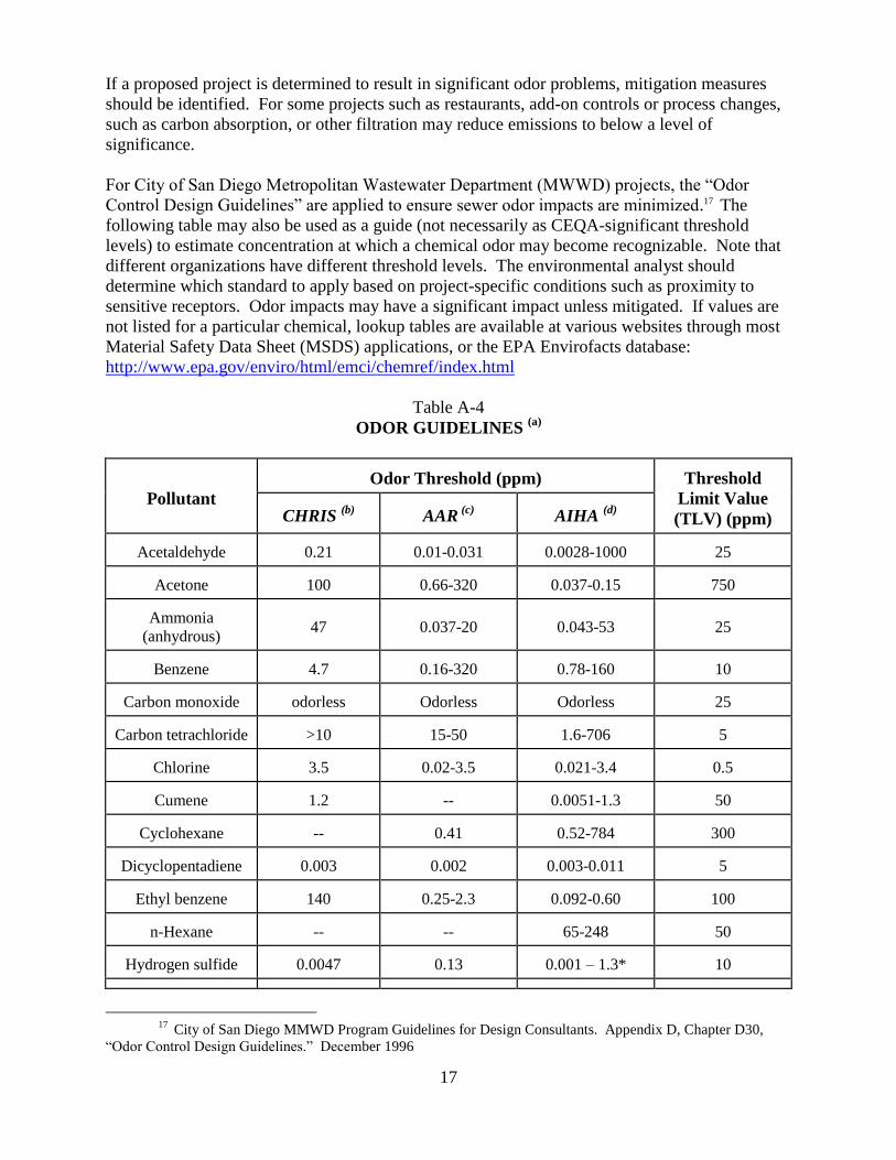
Control Design Guidelines‖ are applied to ensure sewer odor impacts are minimized.17 The
following table may also be used as a guide (not necessarily as CEQA-significant threshold
levels) to estimate concentration at which a chemical odor may become recognizable. Note that
different organizations have different threshold levels. The environmental analyst should
determine which standard to apply based on project-specific conditions such as proximity to
sensitive receptors. Odor impacts may have a significant impact unless mitigated. If values are
not listed for a particular chemical, lookup tables are available at various websites through most
Material Safety Data Sheet (MSDS) applications, or the EPA Envirofacts database:
http://www.epa.gov/enviro/html/emci/chemref/index.html
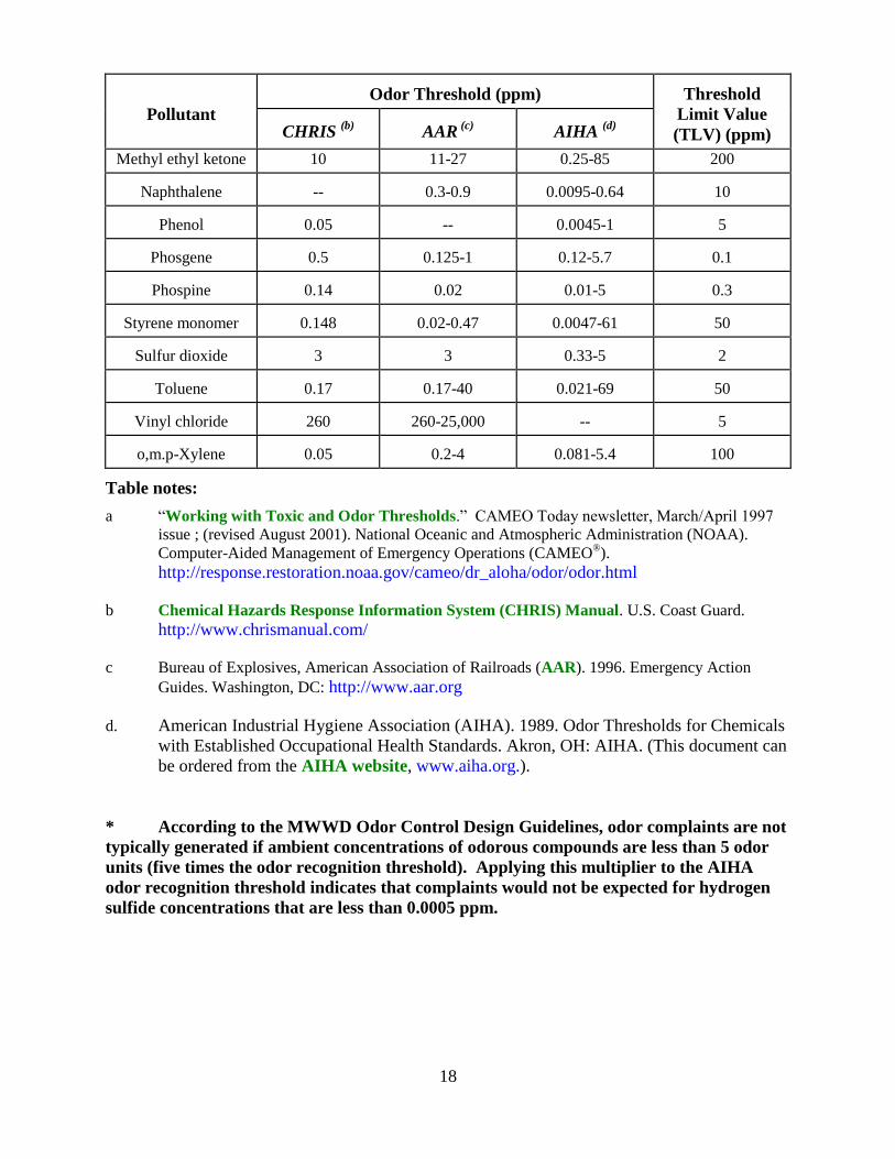
Table A-4
ODOR GUIDELINES (a)
Pollutant
Odor Threshold (ppm)
Threshold
Limit Value
(TLV) (ppm)
CHRIS
(b)
AAR
(c)
AIHA
(d)
Acetaldehyde
0.21
0.01-0.031
0.0028-1000
25
Acetone
100
0.66-320
0.037-0.15
750
Ammonia
(anhydrous)
47
0.037-20
0.043-53
25
Benzene
4.7
0.16-320
0.78-160
10
Carbon monoxide
odorless
Odorless
Odorless
25
Carbon tetrachloride
>10
15-50
1.6-706
5
Chlorine
3.5
0.02-3.5
0.021-3.4
0.5
Cumene
1.2
--
0.0051-1.3
50
Cyclohexane
--
0.41
0.52-784
300
Dicyclopentadiene
0.003
0.002
0.003-0.011
5
Ethyl benzene
140
0.25-2.3
0.092-0.60
100
n-Hexane
--
--
65-248
50
Hydrogen sulfide
0.0047
0.13
0.001 – 1.3*
10
17
City of San Diego MMWD Program Guidelines for Design Consultants. Appendix D, Chapter D30,
―Odor Control Design Guidelines.‖ December 1996
18
Pollutant
Odor Threshold (ppm)
Threshold
Limit Value
(TLV) (ppm)
CHRIS
(b)
AAR
(c)
AIHA
(d)
Methyl ethyl ketone 10 11-27 0.25-85 200
Naphthalene
--
0.3-0.9
0.0095-0.64
10
Phenol
0.05
--
0.0045-1 5
Phosgene
0.5
0.125-1
0.12-5.7
0.1
Phospine
0.14
0.02
0.01-5
0.3
Styrene monomer
0.148
0.02-0.47
0.0047-61
50
Sulfur dioxide
3
3
0.33-5
2
Toluene
0.17
0.17-40
0.021-69
50
Vinyl chloride
260
260-25,000
--
5
o,m.p-Xylene
0.05
0.2-4
0.081-5.4
100
Table notes:
a ―Working with Toxic and Odor Thresholds.‖ CAMEO Today newsletter, March/April 1997
issue ; (revised August 2001). National Oceanic and Atmospheric Administration (NOAA).
Computer-Aided Management of Emergency Operations (CAMEO®).
http://response.restoration.noaa.gov/cameo/dr_aloha/odor/odor.html
b Chemical Hazards Response Information System (CHRIS) Manual. U.S. Coast Guard.
http://www.chrismanual.com/
c Bureau of Explosives, American Association of Railroads (AAR). 1996. Emergency Action
Guides. Washington, DC: http://www.aar.org
d. American Industrial Hygiene Association (AIHA). 1989. Odor Thresholds for Chemicals
with Established Occupational Health Standards. Akron, OH: AIHA. (This document can
be ordered from the AIHA website, www.aiha.org.).
* According to the MWWD Odor Control Design Guidelines, odor complaints are not
typically generated if ambient concentrations of odorous compounds are less than 5 odor
units (five times the odor recognition threshold). Applying this multiplier to the AIHA
odor recognition threshold indicates that complaints would not be expected for hydrogen
sulfide concentrations that are less than 0.0005 ppm.
19
C. BIOLOGICAL RESOURCES
Sensitive biological resources are defined by the City of San Diego Municipal Code as:
• Lands that have been included in the Multi-Habitat Planning Area (MHPA) as identified
in the City of San Diego Multiple Species Conservation Program (MSCP) Subarea Plan
(City of San Diego, 1997);
• Wetlands (as defined by the Municipal Code, Section 113.0103);
• Lands outside the MHPA that contain Tier I Habitats, Tier II Habitats, Tier IIIA Habitats,
or Tier IIIB Habitats as identified in the Biology Guidelines (July 2002 or current edition)
of the Land Development manual;
• Lands supporting species or subspecies listed as rare, endangered, or threatened;
• Lands containing habitats with narrow endemic species as listed in the Biology
Guidelines of the Land Development manual; and
• Lands containing habitats of covered species as listed in the Biology Guidelines of the
Land Development manual.
For projects within the City of San Diego or carried out by the City of San Diego which may
affect sensitive biological resources, potential impacts to such sensitive biological resources must
be assessed. The following criteria and information are provided for guidance during this
process.
INITIAL STUDY CHECKLIST QUESTIONS
The following are from the City‘s Initial Study Checklist and provides guidance to determine
potential significance to Biological Resources:
Would the proposal result in:
1. A substantial adverse impact, either directly or through habitat modifications, on any
species identified as a candidate, sensitive, or special status species in the MSCP or other
local or regional plans, policies or regulations, or by the California Department of Fish
and Game (CDFG) or U.S. Fish and Wildlife Service (USFWS)?
2. A substantial adverse impact on any Tier I Habitats, Tier II Habitats, Tier IIIA Habitats,
or Tier IIIB Habitats as identified in the Biology Guidelines of the Land Development
manual or other sensitive natural community identified in local or regional plans,
policies, regulations, or by the CDFG or USFWS?
3. A substantial adverse impact on wetlands (including, but not limited to, marsh, vernal
pool, riparian, etc.) through direct removal, filling, hydrological interruption, or other
means?
4. Interfering substantially with the movement of any native resident or migratory fish or
wildlife species or with established native resident or migratory wildlife corridors,
including linkages identified in the MSCP Plan, or impede the use of native wildlife
nursery sites?
20
5. A conflict with the provisions of an adopted Habitat Conservation Plan, Natural
Conservation Community Plan, or other approved local, regional, or state habitat
conservation plan, either within the MSCP plan area or in the surrounding region?
6. Introducing land use within an area adjacent to the MHPA that would result in adverse
edge effects?
7. A conflict with any local policies or ordinances protecting biological resources?
8. An introduction of invasive species of plants into a natural open space area?
SIGNIFICANCE THRESHOLDS
Impacts to biological resources are assessed by City staff through the CEQA review process, and
through review of the project‘s consistency with the Environmentally Sensitive Lands (ESL)
regulations, the Biology Guidelines (July 2002) and with the City‘s MSCP Subarea Plan. Before
a determination of the significance of an impact can be made, the presence and nature of the
biological resources must be established.
The following two steps summarize the procedure for collecting the necessary information.
STEP 1:
Determine the extent of biological resources and values present on the site. The analyst needs to
visit the site and review existing biological information (e.g. MSCP vegetation maps). If there is
any evidence that the site supports or recently supported biological resources, significant
biological resources (see clarification in Step 2), a survey or letter report is necessary.
A factor in making this determination is whether or not the site has been illegally graded or grubbed.
In some cases it is appropriate to consider the biological values on the site before a disturbance such
as grading or fire. In general, if the site has been legally graded or grubbed and/or is characterized
by ruderal species, is not included in the City‘s MHPA, and does not support wetlands or Tier I, II
or III habitat, it probably does not support significant biological resources.
Note: The presence of trash and debris on a site does not indicate a lack of biological habitat.
In addition, lack of vegetation due to fire, clearing of vegetation for brush management (Zone 2
is impact neutral), unauthorized off-road vehicle use or other uses also does not preclude the
presence of potential habitat.
An affirmative answer to any of the following questions indicates that significant biological
resources MAY be present:
a. The site has been identified as part of the MHPA by the City‘s MSCP Subarea Plan.
b. The site supports or could support (e.g. in different seasons/rainfall conditions, etc.) Tier
I, II, or IIIA & B vegetation communities (such as grassland, chaparral, coastal sage
scrub, etc.). The CEQA determination of significant impacts may be based on what was
on the site (e.g. if illegal grading or vegetation removal occurred, etc.), as appropriate.
21
c. The site contains, or comes within 100 feet of a natural or manufactured drainage
(determine whether it is vegetated with wetland vegetation). The site occurs within the
100-year flood plain established by the Federal Emergency Management Agency
(FEMA) or the Flood Plain Fringe (FPF)/ Flood Way (FW) zones.
d. The site does not support a vegetation community identified in Table 2 or 3 (Tier I, II,
IIIA or IIIB) of the Biology Guidelines (July 2002); however, wildlife species listed as
threatened or endangered or other protected species may use the site (e.g. California least
terns on dredge spoil, wildlife using agricultural land as a wildlife corridor, etc.).
STEP 2:
Based on Step 1, if significant biological resources are present, then a survey to determine the
nature and extent of the biological resources on the site is warranted (See Guidelines for
Conducting Biology Surveys, revised 2002). The survey should identify which biological
resources are present on the site and its immediately surrounding area, and the number and extent
of each type. As appropriate and when relevant to the biological resources found on site, the
survey should also discuss the nature and quality of the biological resources in the immediate
vicinity of the project site.
The significance and/or sensitivity of the resource can be determined at this stage, however, a
resource may be more vulnerable to some kinds of development than to others. Sensitivity
and/or significance of impacts is, therefore, more appropriately considered in the context of the
proposed project, as discussed below.
Biology Significance Determination
1. Direct Impacts
The direct, indirect and cumulative impacts of a project must be analyzed for significance.
The first step in making the determination is to identify the nature of the impact, and the
extent, and degree of direct impacts to biological resources. A direct impact is a physical
change in the environment which is caused by and immediately related to the project. An
example of a direct physical change in the environment is the removal of vegetation due to
brushing, grubbing, grading, trenching, and excavating.
In order to determine the extent of impacts, the acreage of each habitat type to be lost should
be quantified. If an upland, categorize the land into one of the four Tier categories (I -IV),
which are listed on Table 3 of the Biology Guidelines (July 2002). If a natural wetland,
categorize as indicated on Table 2 of the Biology Guidelines (July 2002). In addition, the
boundaries of the MHPA should be determined and any proposed encroachment should be
quantified. Where possible, the extent or number of individuals of sensitive, threatened, rare,
or endangered species to be taken or harassed should also be quantified. In order to
determine the degree of the impact, fragmentation of habitat, loss of foraging area for
sensitive species, and other factors should be considered.
The City‘s permit to ‗take‘ covered species under the MSCP is based on the concept that
90% of lands within the MHPA will be preserved. Any encroachment into the MHPA (in
22
excess of the allowable encroachment by a project) would be considered significant and
require a boundary adjustment which would include a habitat equivalency assessment to
ensure that what will be added to the MHPA is at least equivalent to what would be removed.
In addition, lands containing Tier I, II, IIIa and IIIb [(see Table 3 of City‘s Biology
Guidelines (July 2002)] and all wetlands [see Table 2 of City‘s Biology Guidelines
(July 2002)] are considered sensitive and declining habitats. As such, impacts to these
resources may be considered significant. Lands designated as Tier IV are not considered to
have significant habitat value and impacts would not be considered significant.
Impacts to individual sensitive species, outside of any impacts to habitat, may also be
considered significant based upon the rarity and extent of impacts. Impacts to state or
federally listed species and all narrow endemics [see the City‘s Biology Guidelines (July
2002)] should be considered significant. Certain species covered by the MSCP [see page 26
of the Biology Guidelines (July 2002)] and other species not covered by the MSCP, may be
considered significant on a case-by-case basis taking into consideration all pertinent
information regarding distribution, rarity, and the level of habitat conservation afforded by
the MSCP.
Notes:
(a) Total upland impacts (Tiers I- IIIB) less than 0.1 acre are not considered significant and
do not require mitigation. See Section 3 (Cumulative Impacts) relative to native
grasslands.
(b) Impacts to non-native grasslands totaling less than 1.0 acres which are completely
surrounded by existing urban developments are not considered significant and do not
require mitigation. Examples may include urban infill lots.
(c) Total wetland impacts less than 0.01 acre are not considered significant and do not
require mitigation. THIS DOES NOT APPLY TO VERNAL POOLS or wetlands within
the Coastal Zone.
(d) Brush management Zone 2 thinning activities, while having the potential to adversely
affect biological resources, are not considered potentially significant inside the MHPA or,
to the extent that non-covered species are not impacted, outside the MHPA, because of
the implementation of the MSCP. Brush management Zone 2 thinning outside the
MHPA which affects non-covered species is potentially significant. Brush management
not conducted in accordance with brush management regulations, regardless of where it
is located, is also potentially significant.
(d) Mitigation is not required for impacts to non-native grassland habitat when impacted for
the purpose of wetland or other native habitat creation.
(e) Habitat mitigation is not required for impacts to manufactured slopes or areas that have
been planted with native species for the purpose of erosion control. For example, in order
to qualify for this exception, substantiation of previous permits and mitigation must be
provided.
23
Noise mitigation, however may be required for significant noise impacts to certain avian
species during their breeding season depending upon the location of the slope (such as
adjacent to an MHPA) and what birds may be present in the area such as the California
gnatcatcher, least Bell‘s vireo, southern willow flycatcher, least tern, cactus wren,
tricolored blackbird, or western snowy plover. If these avian species (except for the
California gnatcatcher) are present, then mitigation will be required if construction or
operational noise levels would exceed 60 db(A), or the existing ambient noise level if
already above 60dB(A) during the breeding season. For California gnatcatcher habitat
within the MHPA and occupied, construction or operational noise levels exceeding 60
dB(A) (or exceeding the existing ambient noise level if already above 60 dB(A)) during
the breeding season is considered significant. There are no restrictions for the
gnatcatcher outside the MHPA anytime of the year.
In addition, inside the MHPA, impact avoidance areas are required for Cooper‘s hawk, northern
harrier, golden eagle, burrowing owl, and southwestern pond turtle. See Biology Guidelines,
Section II, A. 2 & 4. and Section 9.12 of the Implementing Agreement.
(f) Removal/control of non-native plants is not considered to constitute a significant habitat
impact for which compensatory habitat acquisition, preservation, or creation for the area
impacted is required. Mitigation for indirect impacts such as erosion control or off-site
infestation by non-native species may be needed.
2. Indirect Impacts
CEQA Guidelines §15064(d) provides the following guidance regarding identification of
direct versus indirect impacts:
In evaluating the significance of the environmental effect of a project, the Lead Agency shall
consider direct physical changes in the environment which may be caused by the project and
reasonably foreseeable indirect physical changes in the environment which may be caused by
the project.
a. An indirect impact is a physical change in the environment which is not immediately
related to the project, but which is caused indirectly by the project. If a direct impact in
turn causes another physical change in the environment, then the secondary changes is an
indirect impact. For example, the dust from heavy equipment that would result from
grading for a sewage treatment plant could settle on nearby vegetation and interfere with
photosynthetic processes; and the construction equipment noise levels could interrupt
reproductive behavior within adjacent sensitive avian breeding habitats during the
breeding season.
b. An indirect physical change is to be considered only if that change is a reasonably
foreseeable impact which may be caused by the project. A change which is speculative or
unlikely to occur is not reasonably foreseeable.
Depending on the circumstances, indirect impacts of a project may be as significant as the
direct impacts of the project. In general, however, indirect impacts are easier to mitigate than
direct ones. Some impacts may be considered indirect impacts in some circumstances and
24
direct impacts under other circumstances. Indirect impacts include but are not limited to, the
following impacts:
a. The introduction of urban meso-predators into a biological system;
b. The introduction of urban runoff into a biological system;
c. The introduction of invasive exotic plant species into a biological system;
d. Noise and lighting impacts (note: consider both construction/demolition and operational
phases of the project); and
e. Alteration of a dynamic portion of a system, such as stream flow characteristics or fire
cycles; and
f. loss of a wetland buffer that includes no environmentally sensitive lands.
3. Cumulative Impacts
The MSCP was designed to compensate for the regional loss of biological resources
throughout the region. Projects that conform with the MSCP as specified by the Subarea
Plan, and implementing ordinances, (i.e. July 2002 Biology Guidelines and ESL Regulations)
are not expected to result in a significant cumulative impact for those biological resources
adequately covered by the MSCP. These resources include the vegetation communities
identified as Tier I through IV (see City‘s July 2002 Biology Guidelines, and the MSCP
covered species list (see Appendix A of the City of San Diego‘s MSCP Subarea Plan).
All direct impacts to vernal pools are significant and cumulatively significant. Impacts to
vernal pools may be mitigated in accordance with the criteria in the Biology Guidelines.
Direct impacts to perennial native grasslands that are greater than 0.1 acre are significant and
cumulatively significant. Direct impacts to this habitat type are mitigated via Tier I per
Biology Guidelines. Cumulative impacts may be mitigated only via creation at a 1:1
ratio or greater with the feasibility of creation to be evaluated on a case-by-case basis.
Impacts to species covered by the MSCP (see Appendix A of MSCP Subarea Plan) would
not generally be considered cumulatively significant, provided the project is in full
compliance with the MSCP and its implementing regulations. Impacts to state- or federally-
listed species not covered by the MSCP may be considered cumulatively significant. Each
situation will be evaluated on a case-by-case basis.
It is expected that many other sensitive species not analyzed for coverage under the MSCP
will be adequately conserved through the MSCP‘s habitat-based mitigation plan. A rare
circumstance may arise, however, where impacts to a particular species may still result in a
cumulatively significant impact. The project-level biological survey report would identify
those species and describe why a cumulative impact still exists in light of the habitat level of
protection provided by the MSCP. Depending on the size of the impact, the salt marsh daisy
(Lasthenia glabrata ssp. coulteri) found in salt pannes) and the little mouse tail (Myosurus
minimus) found in vernal pools) would be examples of non-covered species that might be
considered rare enough to conclude cumulatively significant impacts.
25
WEB SITES FOR REFERENCED DOCUMENTS
Biology Survey Guidelines:
http://www.sandiego.gov/mscp/pdf/biosurvey.pdf
Biology Guidelines:
http://www.sandiego.gov/mscp/pdf/biolog.pdf
MSCP Subarea Plan:
http://www.sandiego.gov/mscp/pdf/subarea.pdf
Environmentally Sensitive Lands Regulations:
http://clerkdoc.sannet.gov/legtrain/mc/MuniCode Chapter14/Ch14Art03Division01
26
D. GEOLOGIC CONDITIONS
Geologic conditions exist within certain areas of the City of San Diego which have the potential
to pose serious problems when land is developed. Unstable slopes, slide prone soils, and faults
occur in many parts of the City. Seismically liquefiable areas exist near the bays and rivers. The
Geologic Hazard maps which are part of the City of San Diego Seismic Safety Study indicate
where adverse geological conditions exist which will require some level of evaluation by a
geologist, an engineer, or both.
Table F-1 describes which type of geologic report is required for specific zones identified on the
Seismic Safety Study. Depending on the nature of the proposed project, the requirements can be
waived in portions of zone 53 where the topography is flat, or where an evaluation by a City
geologist determines that the geologic impact to the project is negligible. * In areas considered at
high risk for liquefaction, the report can be deferred to the Building Development Review (BDR)
Division until the Building Permit stage if no environmentally sensitive resources are likely to be
impacted. Studies for potentially active faults may also be deferred to BDR based on an
evaluation by a City staff geologist. Soil investigations may also be deferred if no sensitive
environmental resources would be affected by the findings of the report.
* Note: All project grading components, including offsite improvements such as roads,
must be included in the analysis. Therefore, for those project components where BDR
would not typically review, approve and require compliance with geotechnical report
recommendations (i.e., areas outside the building pad), the analysis must be done during
the discretionary stage of project review.
Table F-1
GEOTECHNICAL STUDY REQUIREMENTS (City of San Diego Information Bulletin 515)
Hazard Category Group I Group II Group III Group IV Group V Group VI Group VII
11, 13, 21, 31, 41
GI
GI
GI
GI
GI
GI SR
12, 22-27, 42-47
GR
GI
GR
GI
GR
GR* SR
32, 48, (53 & 54
if in hilly terrain)
GR*
SR & GR*
GR*
GR*
--
-- SR
51, 52, 55,
(53 & 54
if flat terrain)
GR*
SR*
--
--
--
-- SR
Table F-1 notes:
GI = Geotechnical Investigation
GR = Geotechnical Reconnaissance
SR = Soil Report
27
GEOLOGIC HAZARD CATEGORIES (from The City of San Diego‘s Seismic Safety Study, 1995 Edition)
Fault Zones:
11 active, Alquist-Priolo Earthquake Fault Zone
12 potentially active: inactive, presumed inactive or activity unknown
13 downtown special fault zone
Landslides:
21 confirmed, known, or highly suspected
22 possible or conjectured
Slide-Prone Formations:
23 Friars: neutral or favorable geologic structure
24 Friars: unfavorable geologic structure
25 Ardath: neutral or favorable geologic structure
26 Ardath: unfavorable geologic structure
27 Otay, Sweetwater and others
Liquefaction:
31 high potential – shallow groundwater, major drainages, hydraulic fills
32 low potential – fluctuating groundwater, minor drainages
Coastal Bluffs
41 generally unstable: num. landslides, high steep bluffs, severe erosion, unfavorable geol. structure
42 generally unstable: unfavorable bedding planes, high erosion
43 generally unstable: unfavorable jointing, local high erosion
44 moderately stable: mostly stable formations, local high erosion
45 moderately stable: some minor landslides, minor erosion
46 moderately stable: some unfavorable geologic structure, minor or no erosion
47 generally stable: favorable geologic structure, minor or no erosion, no landslides
48 generally stable: broad beach areas, developed harbor
Other Terrain
51 level mesas – underlain by terrace deposits and bedrock: nominal risk
52 other level areas, gently sloping to steep terrain, favorable geologic structure, low risk
53 level or sloping terrain, unfavorable geologic structure, low to moderate risk
54 steeply sloping terrain, unfavorable or fault controlled geologic structure, moderate risk
55 modified terrain (graded sites): nominal risk
* Reports in these categories will not be routed to LDR Geology staff for review; the report will be accepted
"as is" unless the reviewing sections have questions. A condition will be included that final geological review
will occur in BDR prior to issuance of a building permit.
28
Building Type/ Land Use Group
Group I: Tentative and Vesting Tentative Maps; Subdivision Maps, Lot Splits Group II: Grading Permits Group III: Neighborhood Development Permit (NDP), Site Development
Permits (SDP) for Environmentally Sensitive Lands, or Coastal
Development Permits (CDP) Group IV: Planned Development Permit (PDP) Group V: Conditional Use Permit (CUP) Group VI: Map Waivers
Group VII: Grading Permits for underground storage and removal and/or soil
remediation
"Geologic Report" refers to the Geologic Investigation or Geologic Reconnaissance as
designated by Table F 1 and defined in the City‘s "Technical Guidelines for Geotechnical
Reports. (October 1988)" Please refer to these guidelines for the requirements of a Geologic
Report
INITIAL STUDY CHECKLIST QUESTIONS
The following Initial Study Checklist questions are from the City‘s Initial Study Checklist, and
provide guidance to determine potential significance for geologic conditions?
Would the proposal:
1. Expose people or structures to geologic hazards such as earthquakes, landslides, mudslides,
ground failure, or similar hazards?
2. Result in a substantial increase in wind or water erosion of soils, either on or off the site?
3. Be located on a geologic unit or soil that is unstable or that would become unstable as a result
of the project, and potentially result in on- or off-site landslide, lateral spreading, subsidence,
liquefaction or collapse?
SIGNIFICANCE THRESHOLDS
EAS staff should work closely with LDR-Geology to determine if a project would have
significant impacts and if mitigation is necessary. This should be determined on a case-by-case
basis. Typically, standard construction practices recommended in a geologic report would not be
mitigation.
29
E. GROWTH INDUCEMENT
Growth inducement is not clearly defined in CEQA as are other issues. It is usually associated
with those projects that foster economic or population growth, or the construction of additional
housing, either directly or indirectly which results in the construction of major and new
infrastructure facilities. Also a change in land use policy, or projects that provide economic
stimulus such as industrial or commercial uses may induce growth as discussed below.
Accelerated growth may further strain existing community facilities or encourage activities that
could significantly affect the surrounding environment. The impacts of growth inducement are
associated with other issues such as the effects on biological or historical resources, traffic, air
quality, public services, etc.
INITIAL STUDY CHECKLIST QUESTIONS
Would the proposal:
1. Induce substantial population growth in an area, (for example, by proposing new homes
and commercial or industrial businesses beyond the land use density/intensity envisioned
in the community plan)?
2. Substantially alter the planned location, distribution, density, or growth rate of the
population of an area?
3. Include extensions of roads or other infrastructure not assumed in the community plan or
adopted Capital Improvements Project list, when such infrastructue exceeds the needs of
the project and could accommodate future developments?
SIGNIFICANCE THRESHOLDS
A two step analysis needs to be done. The first step is to determine if the project is growth
inducing. This includes projects that foster economic growth or population, or construct a new
water or sewer line where none previously existed. If this is the case, then this must be analyzed
(Step two) in the appropriate issue area.
If the project requires an EIR, Growth Inducement is a mandatory section. The EIR must
analyze the consequences of growth; for instance, existing infrastructure may not be able to
accommodate a major subdivision, industrial complex, or commercial center and the project may
require new facilities that in turn result in impacts. According to Section 15126.2 (d) of the
CEQA Guidelines, ―It must not be assumed that growth in any area is necessarily beneficial,
detrimental, or of little significance to the environment.‖ In general, the analysis must avoid
speculation and focus on probable growth patterns or projections. Conclusions must also be
presented that determines whether this impact is significant and/or unavoidable, and provide for
mitigation or avoidance.
30
F. HEALTH AND SAFETY
The following issue areas are discussed in these significance criteria guidelines:
• Hazardous Materials/Public Safety
• Human Health
• Brush Management
1. Hazardous Materials/Public Safety
As residential redevelopment and new residential construction occurs in or near areas
historically used for industry, agriculture, commerce, solid waste (e.g. landfills, former
landfill sites, or fuel storage) contaminated soils and groundwater can be found. As part of
the environmental review process, steps must be taken to disclose and address the safe
removal, disposal and/or remediation of hazardous materials. There are federal, state and
local government requirements that must be incorporated into projects which address these
issues. Affected facilities would range in scope from establishments specifically designed to
handle hazardous/toxic materials (e.g., waste treatment facilities) to underground tanks
associated with automotive service stations. In addition there are other public safety issues
associated with development proposals in proximity to airports, in flood-prone areas, and in
areas susceptible to brush fires.
For non-residential projects, instruct the applicant to complete Development Services
Department (DSD) form DS-3163, "Hazardous Materials Questionnaire." See City of San
Diego Information Bulletin 116 for more information.
(www.sandiego.gov/development-services/industry/pdf/infobulletin/ib116.pdf)
2. Human Health
Human health issues address health hazards (both known and perceived), such as exposure to
disease-carrying vectors; contamination due to sewage spills; proximity to electromagnetic
fields (EMF) associated with electric transmission lines and communications facilities; and
uses in proximity to former or active underground storage tank sites; fuel-storage tank farms,
sewage treatment plants, or areas where toxic chemicals may be stored.
A. Vector Control
The County of San Diego Department of Environmental Health (DEH) regulates vector
control. A vector is any insect or other arthropod, rodent, or other animal of public health
significance capable of causing human discomfort and injury, or capable of harboring or
transmitting the causative agents of human disease. Projects constructing ponds, or other
potential vector habitat should consult with DEH to determine mitigation measures to
minimize vector impacts.
B. Electromagnetic Fields (EMF)
Studies of the potential for adverse public health effects of EMF are inconclusive. A
statement or conclusion of impacts would be speculative. In accordance with CEQA
31
Section 15145, the known information about EMF is summarized and no conclusion of
significance is reached.
The California Department of Health Services (DHS), California Electric and Magnetic Fields
Program provides information regarding known possible health effects from EMF created by the
use of electricity. DHS references the National EMF Research and Public Information
Dissemination (RAPID) Program, established by Congress as part of the Energy Policy Act of
1992, which has published its findings concluding evidence of the risk of cancer from EMF
around power lines is weak. The report recognizes that EMF exposure "cannot be recognized as
entirely safe" but "believes that the probability that EMF exposure is truly a health hazard is
currently small" with "marginal scientific support that exposure to this agent is causing any
degree of harm." The report concludes that efforts to reduce exposure to EMF should continue.
C. Radio Frequency (RF) and Wireless Communication Facilities
On February 8, 1996, the Telecommunications Act of 1996 was signed into law. Section 740
of the Act states as follows: ―No state or local government or instrumentality thereof may
regulate the placement, construction, and modification of wireless service facilities on the
basis of the environmental effects of radio frequency emissions to the extent that such
facilities comply with the commission‘s regulations concerning such emissions.‖
Communications antennas emit varying levels of radio frequency (RF) energy. RF emissions
are regulated by the Federal Government. Refer to www.fcc.gov for more information.
Below a certain threshold of RF power there is virtually no danger at any distance or
direction from the transmitting antenna. Above that threshold, the installation is generally
designed to ensure that the areas in which people are likely to be found are exposed to a
minimum and safe level of RF energy. The American National Standards Institute (ANSI),
and the Institute of Electrical and Electronic Engineers (IEEE) have established the standard
for safe exposure levels of RF energy for wireless facilities. RF emission levels are usually
expressed and measured as a ―power density‖ or flux which is described in terms of power
per unit area. This is the power which flows outward from the transmitter and passes though
a given area. The intensity of radiation diminishes exponentially at greater distances from the
source, and the exposure, even within the ―beam,‖ at sufficient distance presents no
exposure danger. The accepted standard for safe exposure to RF energy from the proposed
type of facility is 580 microwatts per square centimeter (µW/cm2). The exposure level
associated with most cellular facilities is about 0.01% of the accepted standard, or 5.8
µW/cm2 at 50 feet, which is well below the established safety level. If antennas would be
placed in conjunction with other existing antennae at the same location, Federal
Communication Commission (FCC) rules require the total exposure from all facilities to fall
within the guideline limits.
As part of the development review process for wireless communication facilities, the City
requires that wireless carriers submit a certified cumulative RF report demonstrating
compliance with the FCC standards. Refer to City of San Diego Information Bulletin No.
536. (wwwsandiego.gov/development-services/industry/pdf/infobulletin/ib536.pdf)
32
D. Schools
CEQA provides guidance on health and safety impacts for school facilities at Statute
Sections 21151.2, 21151.4, 21151.8 and Guideline Section 15186. State-funded schools
must also address school siting criteria of Title 5 of the California Code of Regulations,
Division 1, Ch 13, Sub Chapter 1, and "School Facilities Construction."
The citing of facilities which may emit hazardous or acutely hazardous materials or may
handle acutely hazardous materials with a quarter of a mile of a school may result in a
significant impact.
CEQA Statute Section 21151.4 states:
An environmental impact report shall not be certified or a negative declaration shall not be
approved for any project involving the construction or alteration of a facility within a 1/4 of a
mile of a school which might reasonably be anticipated to emit hazardous or acutely hazardous
air emission, or that would handle acutely hazardous material or a mixture containing acutely
hazardous material in a quantity equal to or greater than the state threshold quantity specified
pursuant to subdivision (i) of Section 25532 of the Health and Safety Code, that may pose a
health or safety hazard to persons who would attend or would be employed at the school, unless
both of the following occur:
(1) The lead agency preparing the environmental impact report or negative declaration
has consulted with the school district having jurisdiction regarding the potential
impact of the project on the school.
(2) The school district has been given written notification of the project not less than 30
days prior to the proposed approval of the environmental impact report or negative
declaration.
3. Brush Management
A specialized public safety issue arises in cases where the brush management18 requirements
cannot be met. An example is a residential lot abutting a publicly-owned open space area,
where brush removal, trimming or thinning may be precluded. Another example is a
situation where a reduction in the brush management requirements is allowed through
alternative compliance. In such cases, the Fire Chief may modify the requirements of brush
management on a case-by-case basis. The approval of the Fire Chief must be given in these
circumstances in order to avoid a significant public safety impact. See Municipal Code
Section 142.0412 (i-j). The environmental analyst should work with DSD-Landscaping Staff
and the Fire Chief to ensure the requirements are met. Ensure brush management activities
are coordinated with MSCP staff where there may be potential impacts to MHPA lands.
18
http:www.sandiego.gov/fireandems/inspections/brush.shtml
33
INITIAL STUDY QUESTIONS
The following Initial Study Checklist questions are from the City‘s Initial Study Checklist and
provide guidance to determine the potential significance of Health and Safety issues:
Would the proposal:
1. Expose people or structures to a significant risk of loss, injury, or death involving
wildland fires, including when wildlands are adjacent to urbanized areas or where
residences are intermixed with wildlands?
2. Result in hazardous emissions or handle hazardous or acutely hazardous materials,
substances, or waste within a quarter-mile of an existing or proposed school?
3. Impair implementation of, or physically interfere with an adopted emergency response
plan or emergency evacuation plan?
4. Be located on a site which is included on a list of hazardous materials sites compiled
pursuant to Government Code Section 65962.5 and, as a result, create a significant hazard
to the public or environment?
5. Expose people to toxic substances, such as pesticides and herbicides, some of which have
long-lasting ability, applied to the soil during previous agricultural uses?
6. Result in a safety hazard for people residing or working in a designated airport influence
area?
7. Result in a safety hazard for people residing or working within two miles of a private
airstrip or a private airport or heliport facility that is not covered by an adopted Airport
Land Use Compatibility Plan?
SIGNIFICANCE THRESHOLDS
1. Projects which propose the handling, storage and treatment of hazardous materials, e.g., a
Hazardous Waste Facility, falling under Municipal Code Section 141.1001 Hazardous Waste
Research Facilities and Section 141.1002‖ must prepare a risk assessment in conformance
with the Tanner Act. The Hazardous Materials Management Division of the County of
San Diego Department of Environmental Health (DEH) determines if projects are subject to
Tanner Act provisions.
For non-residential projects, instruct the applicant to complete Development Services
Department form DS-3163, "Hazardous Materials Questionnaire." Refer to City of San
Diego Information Bulletin 116 for more information.
www.sandiego.gov/development-services/industry/pdf/infobulletin/ib116.pdf
Note: Please include the following in the environmental document as applicable: Existing
and recently enacted legislation to protect the public from any potential impacts from the use
of hazardous materials. This legislation includes the Clean Air Act, the Clean Water Act, the
34
Comprehensive Environmental Response, Compensation and Liability Act, and the Toxic
Substances Control Act.
At the local level the City Fire Department screens inventories of substances and inspects
sites every 12 months; the County Health Department screens inventories, inspects facilities
every 15 months and reviews the hazardous Materials Business Plan, and the County Air
Pollution Control District evaluates projects for possible toxic emissions and issues permits
as necessary.
2. Project sites on or near known contamination sources may result in a significant impact.
Sources of this information are:
a. San Diego County Environmental Assessment Case Listing.
http://www.sdcounty.ca.gov/deh/hazmat/ust.html
b. State Department of Toxic Substances Control (DTSC)
http://www.dtsc.ca.gov/database/index.cfm
c. Other possible sources - Sanborn maps, Fire Department records, topographic/existing
conditions surveys.
d. Site-specific emission data from the San Diego Air Pollution Control District (SDAPCD)
http://www.sdapcd.org/index.html
e. State Water Resources Control Board: http://www.geotracker.swrcb.ca.gov
3. Project sites that meet one or more of the following criteria may result in a significant impact.
a. Located within 1,000 feet of a known contamination site.
b. Located within 2,000 feet of a known ―border zone property‖ (also known as a
―Superfund‖ site) or a hazardous waste property subject to corrective action pursuant to
the Health and Safety Code.
c. DEH site file closed. These cases are especially important where excavation (e.g.,
sewer/water pipeline projects, below grade parking, basements) is involved. DEH often
closes a listing when there is no longer danger to the existing use on the property. Where
a change in use is proposed DEH should be consulted. Excavation, which would disturb
contaminated soils, potentially resulting in the migration of hazardous substances (e.g.,
along utility trench lines), would require consultation by the applicant and analyst with
DEH. The applicant may be required to obtain a concurrence letter from DEH
subsequent to participation in the Voluntary Assistance Program (VAP). Information
regarding the County of San Diego VAP can be found on the internet at:
http://www.sdcounty.ca.gov/deh/water/sam_voluntary_assistance_program.html.
d. Located in Centre City San Diego, Barrio Logan or other areas known or suspected to
contain contamination sites (Check with DEH).
35
e. Located on or near an active or former landfill. Hazards associated with methane gas
migration and leachates should be considered. Consult with the Local Enforcement
Agency (LEA) for assistance.
f. Properties historically developed with industrial or commercial uses which involved
dewatering (the removal of groundwater during excavation), in conjunction with major
excavation in an area with high groundwater (such as downtown).
Where dewatering is involved, prior to issuance of any permit that would allow
excavation which requires dewatering, a plan for disposal of the dewatering effluent and
a permit, if needed, from the Regional Water Quality Control Board or the Industrial
Waste Division of MWWD, shall be provided to LDR by the applicant. A Dewatering
Discharge Permit (NPDES No. CA 1018804) shall be obtained for the removal and
disposal of groundwater (if necessary) encountered during construction. Discharge under
this permit will require compliance with a number of physical, chemical, and thermal
parameters (as applicable), along with pertinent site-specific conditions, pursuant to
direction from the RWQCB. Wells, including test wells, and soil percolation tests are not
considered dewatering activities.
g. Projects located in a designated airport influence area and where the Federal Aviation
Administration (FAA) has reached a determination of "hazard" through FAA Form 7460-
1, "Notice of Proposed Construction or Alteration" as required by FAA regulations in the
Code of Federal Regulations (CFR) Title 14 §77.13. Note: if the FAA determines the
project would be considered a hazard, a Site Development Permit (SDP) in accordance
with Process 5 would be required for Council approval in accordance with the Municipal
Code §126.0502(e).
Inconsistency with an Airport‘s Land Use Compatibility Plan (ALUCP) could be a
significant impact.
For a project within the boundaries of a comprehensive airport land use plan, or if a
comprehensive land use plan has not been adopted for a project within two nautical miles
of a public airport or public use airport, CEQA Section 21096 and CEQA State
Guidelines Section 15154 requires that the lead agency consider whether the project
would result in a safety hazard or noise problem for persons using the airport or for
persons residing or working in the project area in order to adopt a negative declaration or
mitigated negative declaration.
h. Located on a site presently or previously used for agricultural purposes. Pesticides are
routinely used during agricultural operations. Pesticides do not degrade easily; therefore,
a soils assessment may be required. Contact the San Diego County Department of
Environmental Health Site Assessment and Mitigation Program for guidance regarding
each project site.
36
G. HISTORICAL RESOURCES
Historical resources include all properties (historic, archaeological, landscapes, traditional, etc.)
eligible or potentially eligible for the National Register of Historic Places, as well as those that may
be significant pursuant to state and local laws and registration programs such as the California
Register of Historical Resources or the City of San Diego Historical Resources Register.
―Historical resource‖ means site improvements, buildings, structures, historic districts signs,
features (including significant trees or other landscaping), places, place names, interior elements
and fixtures designated in conjunction with a property, or other objects of historical
archaeological, scientific, educational, cultural, architectural, aesthetic, or traditional significance
to the citizens of the City and the region. They include buildings, structures, objects,
archaeological sites, districts or landscapes possessing physical evidence of human activities that
are typically over 45 years old, regardless of whether they have been altered or continue to be
used. Historical resources also include traditional cultural properties.
The following definitions are based, for the most part, on the California Office of Historic
Preservation‘s (OHP) ―Instructions for Recording Historical Resources‖ and are used to
categorize different types of historical resources when they are recorded.
A ―building‖ is a construction created principally to shelter any form of human activity (e.g., a
house, barn, church, hotel or similar construction). The term building may also be used to refer
to a historically and functionally related unit, such as a courthouse and jail or a house and barn.
The term ―structure‖ is used to distinguish buildings from those functional constructions usually
made for purposes other than creating human shelter. Constructed by humans, structures include
large scale engineering projects such as water control systems (e.g. dams, reservoirs, aqueducts,
water towers, etc.) or transportation systems (e.g., railroads, bridges, roads, trails, etc.), as well as
mine shafts, kilns, ovens, light-houses, radio telescopes, etc.
The term ―object‖ is used to distinguish buildings and structures from those constructions that
are primarily artistic in nature or are relatively small in scale and simply constructed. Although
it may be moveable, by nature or design, an object is associated with a specific setting or
environment (i.e. sculpture, monuments, boundary markers, statuary and fountains, etc.).
An ―archaeological site‖ is the location of a significant event, a prehistoric or historic occupation
or activity, or a building or structure (whether standing, ruined or vanished) where the location
itself possesses historical, cultural or archaeological value regardless of the value of any existing
structure. Archaeological sites which consist of fewer than three associated artifacts and/or
ecofacts within a 40 square meter area are commonly called isolates.
A ―district‖ possesses a significant concentration, linkage or continuity of archaeological sites,
buildings, structures, objects, and/or landscapes united historically or aesthetically by plan or
physical development. In addition, districts may include a variety of resources as listed above.
A ―landscape‖ may be classified as cultural, designed or rural. A cultural landscape is a
geographical area which has been used by people; shaped or modified by human activity,
occupation or intervention;‘ or is imbued with significant value in the belief system of a culture or
37
society. A designed landscape is consciously laid out by a professional designer according to
academic or professional standards, theories or philosophies of landscaped architecture; or by an
amateur using a recognized style or tradition. It may have a historical association with a
significant person, trend or event in landscape gardening or landscape architecture, or a significant
relationship to the theory or practice of landscape architecture. A rural historic landscape is a
geographic area that historically has been used by people, or shaped or modified by human
activity, occupancy or intervention. It is usually a district possessing a significant concentration,
linkage, or continuity of land use, vegetation, buildings, structures, roads, waterways and natural
features. In this concentration, it provides a distinct sense of time and place.
A ―traditional cultural property‖ is a locale which has been, and often continues to be of
religious, mythological, cultural, economic and/or social importance to an identifiable ethnic
group. This includes sacred area where religious ceremonies have been or currently are
practiced or which are central to a group‘s origins as a people. Also included are areas where
plants or other materials have been or currently are gathered for food, medicine or other
economic purposes. These kinds of traditional cultural properties may not possess physical
evidence of human activities. Traditional cultural properties also include neighborhoods which
have been modified over time by ethnic or folk group use in such a way that the physical and
cultural manifestations of the ethnic or folk culture are still distinguishable today. Cultural
expressions shared within familial, ethnic, occupational, or regional groups include but are not
limited to; technical skill, language, music, oral history, ritual, pageantry, and handicraft
traditions which are learned orally, by limitation or in performance, and are generally maintained
without benefit of formal instruction or institutional direction. Physical features may include:
distinctive landscape and settlement patterns, architectural topologies, materials and methods of
construction, and ornamental detailing.
It is important to note, that the different kinds of historical resources described above may not be
mutually exclusive. Historic buildings, structures and/or objects are frequently associated with
archaeological sites. Similarly, archaeological sites may also comprise traditional cultural
properties for the Native American community.
1. Impacts
The impact assessment is based on the Area of Potential Effect (APE) which includes the
area of both the direct and indirect impacts of a proposed project on a historical resource.
The potential for cumulative impacts to historical resources must also be assessed for
significance. In order to identify the extent and degree of the impacts, the APE must be
established on the proposed project site plan or map. Once the boundaries of the APE have
been defined and the resources have been evaluated for significance, the project impacts will
be addressed by the City manager based on the project design. If a historical resource is not
significant, both the resource and the effect on it must be noted in the Initial Study on the
EIR, but will not be considered further in the CEQA process.
38
2. Direct Impacts
All components of a development must be considered in evaluating potential impacts to
historical resources. Direct impacts generally result from activities that will cause damage to
or have an adverse effect on the resource, such as but not limited to
. Grading
. Road construction
Excavation for sewer and water
pipelines and appurtenances
Staging areas
Access roads
Demolition, grading and excavation
activities
Deterioration due to neglect
Alteration or repair of a historic structure
Inappropriate and/or unauthorized repair
New addition
Relocation from original site
Isolation of a historic resource from its setting, when the setting contributes to its
significance
Soil Stockpiling
Construction of trails in open space
Increased awareness or exposure of resource
3. Indirect Impacts
Indirect impacts are included within the APE. In the built environment, indirect impacts
include the introduction of visual, audible or atmospheric effect that are out of character with
the historic property or alter its setting, when the setting contributes to the property‘s
significance. Examples include, but are not limited to, the construction of a large scale
building, structure, object, or public works project that has the potential to cast shadow
patterns on the historic property, intrude into its view shed, generate substantial noise, or
substantially increase air pollution or wind patterns. Increases in air pollution can result in
adverse effects to historically designated buildings (chimney soot, dust, debris, etc.).
Increased wind patterns can result in adverse effects to an archaeological site if, through
removal of vegetation or structure, the wind exposes the site or feature that was previously
protected from the wind. Conversely, an adverse effect could occur from blocking a natural
wind pattern at a sacred site where the wind is integral to the ritual or experience.
For archaeological resources and traditional cultural properties, indirect impacts are often the
result of increased public accessibility to resources not otherwise subject to impacts which
may result in an increased potential for vandalism and site destruction. Placing sites into
open space does not always mean that there will not be the potential for indirect impacts to
the resource. Therefore,resources placed into open space need to be evaluated for indirect
impacts.
39
4. Cumulative Impacts
Cumulative impacts can result from individually minor but collectively significant projects
taking place over a period of time. According to the City‘s Historical Resources Guidelines
(April 2001), the loss of a historical resource database due to mitigation by data recovery
may be considered a cumulative impact. In the built environment, cumulative impacts most
often occur to districts, where several minor changes to contributing properties, their
landscaping, or to their setting over time could result in a significant loss of integrity to the
district as a whole.
INITIAL STUDY CHECKLIST QUESTIONS
The following are from the City‘s Initial Study Checklist and provides guidance to determine
potential significance to Historical Resources.
Will the proposal result in:
1. An alteration, including the adverse physical or aesthetic effects and/or the destruction of
a prehistoric or historic building (including an architecturally significant building),
structure, or object or site?
2. Any impact to existing religious or sacred uses within the potential impact area?
3. The disturbance of any human remains, including those interred outside of formal
cemeteries?
SIGNIFICANCE THRESHOLDS
Federal, state and local criteria have been established for the determination of historical resource
significance. The Historical Resources Regulations of the Land Development Code pertain only
to historical resources that meet the definitions contained in Chapter 11, Article 3, Division 1 of
the Code and may differ from the definition of historical resources in these Guidelines and from
a determination of significance under CEQA, as provided below.
NATIONAL REGISTER OF HISTORIC PLACES
The National Register criteria, contained in National Register Bulletin 16 (U.S. Department of the
Interior 1986:1), state that: The quality of significance in American history, architecture, archaeology,
engineering and culture is present in districts, sites, buildings, structures and objects that posses
integrity of location, design, setting, materials, workmanship, feeling and association, and;
A. That are associated with events that have made a significant contribution to the broad
patterns of our history; or
B. That are associated with the lives of persons significant in our past; or
C. That embody the distinctive characteristics of a type, period, or method of construction;
or that represent the work of a master; or that possess high artistic values; or that
represent a significant and distinguishable entity whose components may lack individual
distinction; or
40
D. That has yielded, or may be likely to yield information important in prehistory or history.
Criteria Considerations Exceptions: Ordinarily cemeteries, birthplaces, or graves of historical
figures, properties owned by religious institutions or used for religious purposes, structures that
have been moved from their original locations, reconstructed historic buildings, properties
primarily commemorative in nature, and properties that have achieved significance within the
past 50 years will not be considered eligible for the National Register. However, such properties
will qualify if they are integral parts of districts that do meet the criteria or if they fall within the
following categories:
A. A religious property deriving primary significance from architectural or artistic distinction
or historical importance; or
B. A building or structure removed from its original location but which is significant
primarily for architectural value, or which is the surviving structure most importantly
associated with a historic person or event; or
C. A birthplace or grave of a historical figure of outstanding importance, if there is no other
appropriate site or building directly associated with his or her productive life; or
D. A cemetery which derives its primary significance from graves of persons of transcendent
importance, from age, from distinctive design features, or from association with historic
events; or
E. A reconstructed building when accurately executed in a suitable environment and
presented in a dignified manner as part of a restoration master plan, and when no other
building or structure with the same association has survived; or
F. A property primarily commemorative in intent if design, age, tradition, or symbolic value
has invested it with its own historical significance; or
G. A property achieving significance within the past 50 years, if it is of exceptional
importance.
CALIFORNIA ENVIRONMENTAL QUALITY ACT
For the purposes of CEQA, a significant historic resource is one which qualifies for the
California Register of Historical Resources or is listed in a local historic register or deemed
significant in a historical resource survey, as provided under Section 5024.1(g) of the Public
Resources Code. A resource that is not listed in, or determined to be eligible for listing in, the
California Register of Historical Resources, not included in a local register of historic resources,
or not deemed significant in a historical resource survey may nonetheless be historically
significant for purposes of CEQA.
The City‘s determination of significance of impacts on historical and unique archaeological
resources is based on the criteria found in Section 15064.5 of the State CEQA Guidelines. For
additional information, see the City‘s Historical Resources Guidelines.
41
CITY OF SAN DIEGO PROGRESS GUIDE AND GENERAL PLAN
Significance criteria as outlined in the Progress Guide and General Plan reflect a broad definition
of historical, architectural and cultural importance; a perspective of local, rather than state or
national significance; and the belief that all aspects of history are potentially of equal
importance.
CITY OF SAN DIEGO HISTORICAL RESOURCES REGISTER
Any improvement, building, structure, sign, interior element and fixture, site, place, district, area
or object may be designated as historic by the City of San Diego Historical Resources Board if it
meets any of the following criteria:
A. Exemplifies or reflects special elements of the City‘s, a community‘s or a neighborhood‘s
historical, archaeological, cultural, social, economic, political, aesthetic, engineering,
landscaping, or architectural development;
B. Is identified with persons or events significant in local, state or national history;
C. Embodies distinctive characteristics of a style, type, period or method of construction or is a
valuable example of the use of indigenous materials or craftsmanship;
D. Is representative of the notable work of a master builder, designer, architect, engineer,
landscape architect, interior designer, artist or craftsman;
E. Is listed on or has been determined eligible by the National Park Service for listing on the
National Register of Historic Places or is listed or has been determined eligible by the
California OHP for listing on the State Register of Historical Resources; or
F. Is a finite group of resources related to one another in a clearly distinguishable way; or is a
geographically definable area or neighborhood containing improvements which have a
special character, historical interest or aesthetic value; or which represent one or more
architectural periods or styles in the history and development of the City.
CITY OF SAN DIEGO CEQA SIGNIFICANCE
As stated above, if a resource is not listed in, or determined eligible for listing in, the California
Register, not included in a local register, or not deemed significant in a historical resource
survey, it may nonetheless be historically significant. The significance of an historical resource
is based on the potential for the resource to meet one or more of the criteria presented above,
including the potential to address important research questions as documented in a site specific
technical report prepared as part of the environmental review process. Research priorities for the
prehistoric, ethnohistoric and historic periods of San Diego history are discussed in Appendix A
(San Diego History) to the City‘s ―Historical Resources Guidelines‖ and should be used in the
determination of historical significance. As a baseline, the City of San Diego has established the
following criteria to be used in the determination of significance under CEQA.
42
An archaeological site must consist of at least three associated artifacts/ecofacts (within a 40
square meter area) or a single feature. Archaeological sites containing only a surface component
are generally considered not significant, unless demonstrated otherwise. (Testing is required to
document the absence of subsurface deposit.) Such site types may include isolated finds,
bedrock milling stations, sparse lithic scatters, and shellfish processing stations. All other
archaeological sites are considered potentially significant. The determination of significance is
based on a number of factors specific to a particular site, including site size, type and integrity;
presence or absence of a subsurface deposit, soil stratigraphy, features, diagnostics, and datable
material; artifact and ecofact density; assemblage complexity; cultural affiliation; association
with an important person or event; and ethnic importance.
The determination of significance for historic buildings, structures, objects and landscapes is
based on age, location, context, association with an important person or event, uniqueness, and
integrity.
A site will be considered to possess ethnic significance if it is associated with a burial or
cemetery; religious, social or traditional activities of a discrete ethnic population; an important
person or event as defined by a discrete ethnic population; or the belief system of a discrete
ethnic population.
NON-SIGNIFICANT RESOURCE TYPES
Isolates consist of less than three artifacts/ecofacts within a 40 square meter area. Sparse Lithic
Scatters are identified and evaluated based on criteria from the OHP‘s ―California
Archaeological Resource Identification and Data Acquisition Program; Sparse Lithic Scatters‖
(February 1988). Isolated Bedrock Milling Stations are defined as having no associated site
within a 40 meter radius and lacking a subsurface component. Shellfish Processing Sites are
defined as containing a minimal amount of lithics (i.e. less than five or six) and no subsurface
deposit.19
Historic buildings, structures, objects and landscapes are generally not significant if they are less
than 45 years old. A non-significant building or structure located within an historic district is by
definition not significant.
Resources found to be non-significant as the result of a survey and assessment will require no
further work beyond documentation of the resources (including site records) and inclusion in the
survey and assessment report.
19
If it can be determined by the Principal Investigator that the minimal amount of materials from different
classes of lithics on-site represents a significant resource based on their potential to address important research
questions, then the resource would no longer fall under the category ―non-significant resource type.‖
43
H. HYDROLOGY
Hydrology is defined as the science dealing with the properties, distribution, and circulation of
surface water, ground water and atmospheric water. The quantity of water which flows in a creek
or river is calculated based on historic climactic conditions combined with the watershed
characteristics. The slope and shape of the watershed, soil properties, recharge area, and relief
features are watershed characteristics which influence the quantity of surface flows.
As land is developed, impervious area is increased, thereby increasing runoff. The increased
volume of water in a drainage way may have short-lived, but rather dramatic, impacts during
storm events. The potentially adverse impacts include, but are not limited to, property damage
and disturbance of wildlife habitat.
INITIAL STUDY CHECKLIST QUESTIONS
The following Initial Study Checklist questions are from the City‘s Initial Study Checklist, and
provide guidance to determine potential significance for impacts in Hydrology:
Would the proposal result in:
1. A substantial increase in impervious surfaces and associated increased runoff?
2. Substantial alteration to on- and off-site drainage patterns due to changes in runoff flow rates
or volumes?
SIGNIFICANCE THRESHOLDS
1. If a project would result in increased flooding on- or off-site there may be significant impacts
on upstream or downstream properties and to environmental resources.
Significant impacts may result if the project would impose flood hazards on other properties
or if the project proposes to develop wholly or partially within the 100-year floodplain
identified in the Federal Emergency Management Agency (FEMA) maps. Compliance with
Council Policy 600-14 may provide evidence that an impact is not significant or is mitigated.
Policy 600-14 prohibits development within areas of special flood hazard except under
certain circumstances. The policy requires approval by the floodplain administrator before
construction, development or alteration begins within any area of special flood hazard.
2. If a project would result in decreased aquifer recharge there may be significant impacts on
hydrologic conditions and well-water supplies because the area available for aquifer recharge
is reduced. When a subsurface water source fails to be recharged by rainfall, its volume will
be reduced. Reduced groundwater elevation can affect landholders who are dependent on
well water, vegetation, and surface water replenishment. In addition, if a project would result
in extraction of water from an aquifer, impacts on hydrologic conditions would be significant
if there would be a net deficit in the aquifer volume or a reduction in the local groundwater
table.
Projects which would create over 1.0 acres of impermeable hardscape in areas utilizing well-
water and projects which would install groundwater extraction wells may result in significant
impacts. Analysts should contact the Regional Water Quality Control Board for guidance in
44
evaluating this type of impact, as the threshold amount of new impermeable surface may
vary from case to case.
For commercial or multi-residential projects (a single-family residence is excluded) using
groundwater as a source of water supply, the project applicant must address potential impacts
to the neighboring wetlands or other developments(as applicable) in the area that rely on
groundwater to assure that there is a sustainable groundwater supply for the proposed project.
Otherwise, a significant and unmitigated impact could occur and an EIR could be required.
Alternatively, the project would need to provide for municipal water.
3. If a project would grade, clear, or grub more than 1.0 acre of land, especially into slopes over
a 25% grade, and would drain into a sensitive water body or stream there may be significant
impacts on stream hydrology if uncontrolled runoff results in erosion and subsequent
sedimentation of downstream water bodies.
4. If a project would result in modifications to existing drainage patterns there may be
significant impacts on environmental resources such as biological communities and
archaeological resources.
Projects where drainage patterns are influenced such that existing vegetation would decline
because long- or short-term, soil-plant-water relationships would no longer meet habitat
requirements. A project would generally have a significant hydrologic impact on biological
resources if the project would result in a degradation in the function and value of the existing
habitat or if the project would alter the habitat type.
Projects which would result in substantial changes to stream-flow velocities or quantities
may result in a significant impact (to be determined on a case by case basis; streambed
characteristics will affect determination). Refer to the project‘s hydrology study, if any, for
the analysis of this issue.
There may be significant impacts on downstream properties and/or environmental resources
if drainage patterns are changed. Projects which, when identified in a drainage study would
cause adverse impacts on downstream properties or environmental resources as a result of a
change in the drainage pattern would result in a significant impact. Refer to the project‘s
hydrology study for the analysis of this issue.
Hydrology References:
FEMA Maps: Maps can be accessed at the FEMA website at www.FEMA.org. Click on the
FEMA Flood Map Store, then click on Map Search. Use the free ―how-to‖ guidelines and be
aware a ―plus sign‖ icon may be shown next to the view button if any map revisions (LOMRs)
have occurred. Click on the plus sign to review the map revisions.
45
I. LAND USE
In accordance with state planning and zoning law, the City of San Diego has adopted a Progress
Guide and General Plan which provides a comprehensive long-term plan for the development of
the City. The City is in the process of updating the General Plan and has recently adopted the
Strategic Framework Element (City of Villages) as part of this update. Consistency with the
Strategic Framework Element should be discussed and evaluated as appropriate in environmental
documents.
In addition, the City has adopted community and specific/precise plans which provide growth
development goals and guidelines for the various communities and subareas. These plans
include land use elements and also may include design, resource management and environmental
elements or goals. The City of San Diego MSCP Subarea Plan also contains guidelines for
development within and adjacent to the MHPA.
The project should be assessed for consistency with any of the adopted plans and regulations
(City of San Diego Municipal Code) which govern the region and the particular site. An
inconsistency with a plan is not by itself a significant environmental impact; the inconsistency
would have to relate to an environmental issue to be considered significant under CEQA.
INITIAL STUDY CHECKLIST QUESTIONS
The following Initial Study Checklist questions are from the City‘s Initial Study Checklist, and
provide guidance to determine potential significance for Land Use:
Would the proposal:
1. Require a deviation or variance, and the deviation or variance would in turn result in a
physical impact on the environment?
2. Result in a conflict with the environmental goals, objectives and recommendations of the
community plan in which it is located?
3. Conflict with the provisions of the City‘s Multiple Species Conservation Program
Subarea Plan or other approved local, regional or state habitat conservation plan?
4. Physically divide an established community?
5. Result in land uses which are not compatible with an adopted airport Comprehensive
Land Use Plan (CLUP)?
SIGNIFICANCE THRESHOLDS
The following may be considered significant land use impacts:
1. Inconsistency/conflict with the environmental goals, objectives, or guidelines of a
community or general plan.
46
2. Inconsistency/conflict with an adopted land use designation or intensity and indirect or
secondary environmental impacts occur (for example, development of a designated school or
park site with a more intensive land use could result in traffic impacts).
3. Substantial incompatibility with an adopted plan. For example: a rock crusher in a residential
area would result in land use conflicts related to environmental consequences (i.e. noise), and
environmental impacts would result. As a general rule, projects that are consistent with the
zoning and compatible with surrounding uses should not result in land use impacts.
4. Development or conversion of general plan or community plan designated open space or
prime farmland20 to a more intensive land use.
5. Incompatible uses as defined in an airport land use plan or inconsistency with an airport's
Comprehensive Land Use Plan (CLUP) as adopted by the Airport Land Use Commission
(ALUC) to the extent that the inconsistency is based on valid data. CEQA, Section 21096
and 15154 requires this land use/health and safety analysis. For additional information,
consult the California Airport Land Use Planning Handbook,21 or the applicable
Comprehensive Land Use Plan (CLUP):
• Brown Field (adopted September 21, 1981)
• Montgomery Field (adopted July 27, 1984)
• MCAS Miramar (adopted September 28, 1990, amended September 25, 1992)
• Lindbergh Field (adopted February 28, 1992, amended April 22, 1994)
6. Inconsistency/conflict with adopted environmental plans for an area. For example, a use
incompatible with MSCP for development within the MHPA would fall into this category.
7. Significantly increase the base flood elevation for upstream properties, or construct in a
Special Flood Hazard Area (SFHA) or floodplain/wetland buffer zone.
20 http://www.consrv.ca.gov/DLRP/fmmp/pubs/soils/sandiego.pdf 21
http://www.dot.ca.gov/hq/planning/aeronaut/documents/ALUPHComplete-7-02rev.pdf
47
J. MINERAL RESOURCES
A project could cause a potentially significant impact to mineral resources if it resulted in the
loss of availability of a known mineral resource that would be of value to the region and the
residents of the state. An impact could also result from the loss of availability of a locally
important mineral resource recovery site identified in a general plan, specific plan, or other land
use plan.
For the purpose of CEQA analysis, "mineral resources" refers to aggregate resources. Aggregate
consists of sand, gravel, and crushed rock. Aggregate provides bulk and strength in construction
materials such as portland cement concrete and asphaltic concrete. Blocks of granite rock are
quarried for decorative rock, monuments, and surface plaster. Large irregular blocks of stone are
quarried for use as riprap. Decomposed granite is taken from pits for use as a base under road
pavements and cold-mixed asphaltic pavement.
In accordance with guidelines established by the State Mining and Geology Board, mineral
deposits in western San Diego County have been classified into Mineral Resources Zones
(MRZs) as follows:
MRZ1 : areas where adequate information indicates that no significant mineral
deposits are present or where it is judged that little likelihood exists for
their presence;
MRZ 2: areas where adequate information indicates that significant mineral
deposits are present or where it is judged that a high likelihood for their
presence exists;
MRZ 3: areas containing mineral deposits, the significance of which cannot be
evaluated from available data;
MRZ 4: areas where available information is inadequate for assignment to any
other MRZ.
Note: The State Mining and Geology Board maps may be purchased by visiting the
following web site:
http://www.consrv.ca.gov/cgs/minerals/mlc/SMARA_pubs_2001.pdf
INITIAL STUDY CHECKLIST QUESTIONS
The following are from the City‘s Initial Study Checklist and provides guidance to determine
potential significance to mineral resources:
Would the proposal result in:
1. The loss of availability of a significant mineral resource (e.g. sand or gravel) as identified
the Open File Report 96-04, Update of Mineral Land Classification: Aggregate Materials
in the Western San Diego County Production – Consumption Region, 1996, Department
of Conservation, California Department of Geological Survey (located in the EAS
library)?
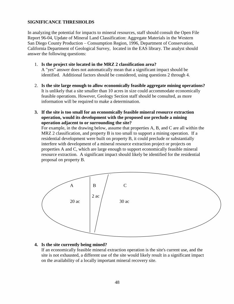
48
SIGNIFICANCE THRESHOLDS
In analyzing the potential for impacts to mineral resources, staff should consult the Open File
Report 96-04, Update of Mineral Land Classification: Aggregate Materials in the Western
San Diego County Production – Consumption Region, 1996, Department of Conservation,
California Department of Geological Survey, located in the EAS library. The analyst should
answer the following questions:
1. Is the project site located in the MRZ 2 classification area?
A "yes" answer does not automatically mean that a significant impact should be
identified. Additional factors should be considered, using questions 2 through 4.
2. Is the site large enough to allow economically feasible aggregate mining operations?
It is unlikely that a site smaller than 10 acres in size could accommodate economically
feasible operations. However, Geology Section staff should be consulted, as more
information will be required to make a determination.
3. If the site is too small for an economically feasible mineral resource extraction
operation, would its development with the proposed use preclude a mining
operation adjacent to or surrounding the site?
For example, in the drawing below, assume that properties A, B, and C are all within the
MRZ 2 classification, and property B is too small to support a mining operation. If a
residential development were built on property B, it could preclude or substantially
interfere with development of a mineral resource extraction project or projects on
properties A and C, which are large enough to support economically feasible mineral
resource extraction. A significant impact should likely be identified for the residential
proposal on property B.
4. Is the site currently being mined?
If an economically feasible mineral extraction operation is the site's current use, and the
site is not exhausted, a different use of the site would likely result in a significant impact
on the availability of a locally important mineral recovery site.
A B C
2 ac
20 ac 30 ac
49
K. NOISE
Noise is defined as unwanted or objectionable sound. Noise levels compatible with a person‘s
life, health and enjoyment of property are regulated by Local, State, and Federal regulations,
including the City of San Diego Progress Guide and General Plan, City Noise Abatement and
Control Ordinance, California Noise Insulation Standards (Title 24), the State Public Utilities
Code regulating airports, and other regulations. A direct and/or indirect noise impact should be
evaluated in relation to applicable City standards, particularly, the City of San Diego Progress
Guide and General Plan (Transportation Element). The following significance thresholds are in
accordance with the City‘s Progress Guide and General Plan (Transportation Element) Land Use
Compatibility with Annual Community Noise Equivalent Levels (CNEL).
Measurement of sound involves three variables, (1) magnitude; (2) frequency; and (3) duration.
Noise levels in the City of San Diego are expressed and compared as dB (A) CNEL.
Definitions
The following definitions shall have the same meaning as defined in the Section 59.5.0102 of the
City of San Diego Municipal Code:
A-Weighting
As in decibel A-weighting (dB [A]). Represents the frequency characteristics of the average
human ear for various sound intensities. An A-Weight sound filters out lower frequencies, and
provides a good indicator of the annoyance potential of a noise.
Average Sound Level
A sound level typical of the sound levels at a certain place during a given period of time,
averaged by the general rule of combination for sound levels, said general rule being set forth in
American National Standard Specifications for Sound Level Meters 1.4-1971. Average sound
level is also called equivalent continuous sound level. (Leq)
Community Noise Equivalent Level (CNEL)
An average sound level during a 24-hour day, obtained after addition of five (5) decibels to
sound levels in the evening from 7:00 p.m. to 10:00 p.m., and after addition of ten (10) decibels
to sound levels in the night before 7:00 a.m. and after 10:00 p.m.
CNEL recognizes that noise annoyance is related to duration, how often the noise is present, how
long it persists, and when it occurs.
Decibel (dB)
A unit measure of sound (noise) level.
Just as feet is used to measure distances, decibels are used to measure sound (noise) levels. The
decibel is defined as 10 times the common logarithm of the ratio of two amounts of sound power.
The human ear can hear sounds from less than 10 dB to over 100 dB (sounds which are 100,000
times greater that the faintest sounds). Table K-1 shows the approximate relationship between
sound level changes and peoples judgment of the relative loudness of the change.
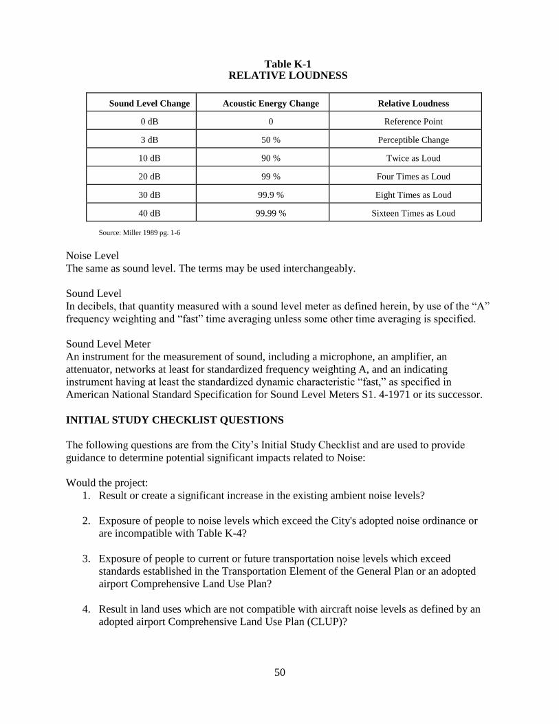
50
Table K-1
RELATIVE LOUDNESS
Sound Level Change
Acoustic Energy Change
Relative Loudness
0 dB
0
Reference Point
3 dB
50 %
Perceptible Change
10 dB
90 %
Twice as Loud
20 dB
99 %
Four Times as Loud
30 dB
99.9 %
Eight Times as Loud
40 dB
99.99 %
Sixteen Times as Loud
Source: Miller 1989 pg. 1-6
Noise Level
The same as sound level. The terms may be used interchangeably.
Sound Level
In decibels, that quantity measured with a sound level meter as defined herein, by use of the ―A‖
frequency weighting and ―fast‖ time averaging unless some other time averaging is specified.
Sound Level Meter
An instrument for the measurement of sound, including a microphone, an amplifier, an
attenuator, networks at least for standardized frequency weighting A, and an indicating
instrument having at least the standardized dynamic characteristic ―fast,‖ as specified in
American National Standard Specification for Sound Level Meters S1. 4-1971 or its successor.
INITIAL STUDY CHECKLIST QUESTIONS
The following questions are from the City‘s Initial Study Checklist and are used to provide
guidance to determine potential significant impacts related to Noise:
Would the project:
1. Result or create a significant increase in the existing ambient noise levels?
2. Exposure of people to noise levels which exceed the City's adopted noise ordinance or
are incompatible with Table K-4?
3. Exposure of people to current or future transportation noise levels which exceed
standards established in the Transportation Element of the General Plan or an adopted
airport Comprehensive Land Use Plan?
4. Result in land uses which are not compatible with aircraft noise levels as defined by an
adopted airport Comprehensive Land Use Plan (CLUP)?
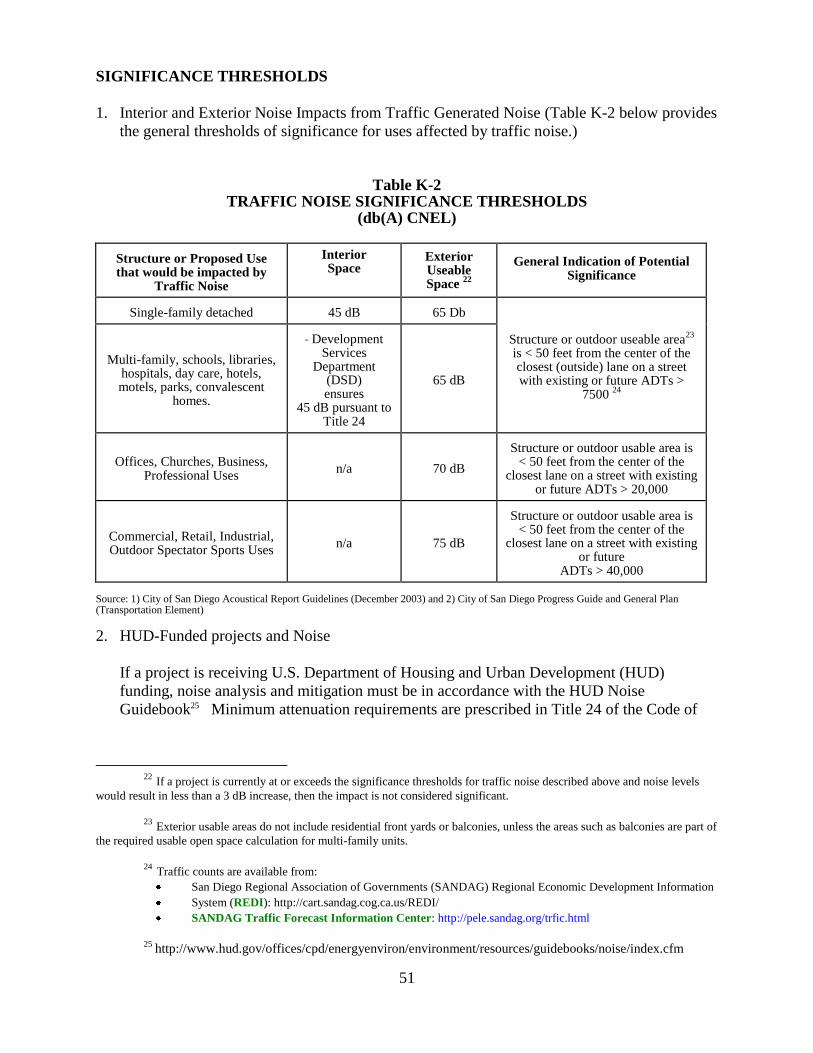
51
SIGNIFICANCE THRESHOLDS
1. Interior and Exterior Noise Impacts from Traffic Generated Noise (Table K-2 below provides
the general thresholds of significance for uses affected by traffic noise.)
Table K-2
TRAFFIC NOISE SIGNIFICANCE THRESHOLDS (db(A) CNEL)
Structure or Proposed Use that would be impacted by
Traffic Noise
Interior Space
Exterior Useable Space
22
General Indication of Potential Significance
Single-family detached
45 dB
65 Db
Structure or outdoor useable area
23
is < 50 feet from the center of the closest (outside) lane on a street with existing or future ADTs >
7500 24
Multi-family, schools, libraries,
hospitals, day care, hotels, motels, parks, convalescent
homes.
Development
Services Department
(DSD) ensures
45 dB pursuant to Title 24
65 dB
Offices, Churches, Business,
Professional Uses
n/a
70 dB
Structure or outdoor usable area is
< 50 feet from the center of the closest lane on a street with existing
or future ADTs > 20,000
Commercial, Retail, Industrial, Outdoor Spectator Sports Uses
n/a
75 dB
Structure or outdoor usable area is
< 50 feet from the center of the closest lane on a street with existing
or future ADTs > 40,000
Source: 1) City of San Diego Acoustical Report Guidelines (December 2003) and 2) City of San Diego Progress Guide and General Plan (Transportation Element)
2. HUD-Funded projects and Noise
If a project is receiving U.S. Department of Housing and Urban Development (HUD)
funding, noise analysis and mitigation must be in accordance with the HUD Noise
Guidebook25 Minimum attenuation requirements are prescribed in Title 24 of the Code of
22 If a project is currently at or exceeds the significance thresholds for traffic noise described above and noise levels
would result in less than a 3 dB increase, then the impact is not considered significant.
23 Exterior usable areas do not include residential front yards or balconies, unless the areas such as balconies are part of
the required usable open space calculation for multi-family units.
24 Traffic counts are available from:
San Diego Regional Association of Governments (SANDAG) Regional Economic Development Information
System (REDI): http://cart.sandag.cog.ca.us/REDI/
SANDAG Traffic Forecast Information Center: http://pele.sandag.org/trfic.html
25
http://www.hud.gov/offices/cpd/energyenviron/environment/resources/guidebooks/noise/index.cfm
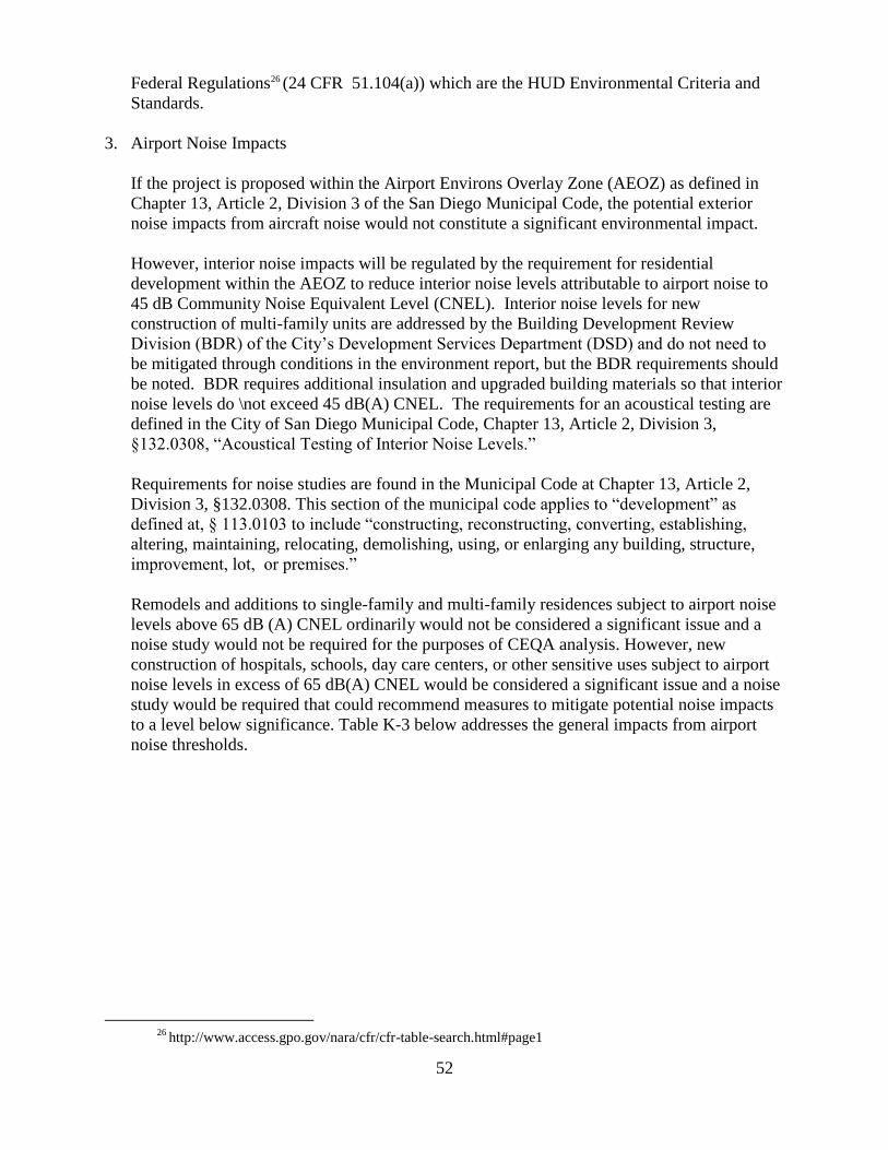
52
Federal Regulations26 (24 CFR 51.104(a)) which are the HUD Environmental Criteria and
Standards.
3. Airport Noise Impacts
If the project is proposed within the Airport Environs Overlay Zone (AEOZ) as defined in
Chapter 13, Article 2, Division 3 of the San Diego Municipal Code, the potential exterior
noise impacts from aircraft noise would not constitute a significant environmental impact.
However, interior noise impacts will be regulated by the requirement for residential
development within the AEOZ to reduce interior noise levels attributable to airport noise to
45 dB Community Noise Equivalent Level (CNEL). Interior noise levels for new
construction of multi-family units are addressed by the Building Development Review
Division (BDR) of the City‘s Development Services Department (DSD) and do not need to
be mitigated through conditions in the environment report, but the BDR requirements should
be noted. BDR requires additional insulation and upgraded building materials so that interior
noise levels do \not exceed 45 dB(A) CNEL. The requirements for an acoustical testing are
defined in the City of San Diego Municipal Code, Chapter 13, Article 2, Division 3,
§132.0308, ―Acoustical Testing of Interior Noise Levels.‖
Requirements for noise studies are found in the Municipal Code at Chapter 13, Article 2,
Division 3, §132.0308. This section of the municipal code applies to ―development‖ as
defined at, § 113.0103 to include ―constructing, reconstructing, converting, establishing,
altering, maintaining, relocating, demolishing, using, or enlarging any building, structure,
improvement, lot, or premises.‖
Remodels and additions to single-family and multi-family residences subject to airport noise
levels above 65 dB (A) CNEL ordinarily would not be considered a significant issue and a
noise study would not be required for the purposes of CEQA analysis. However, new
construction of hospitals, schools, day care centers, or other sensitive uses subject to airport
noise levels in excess of 65 dB(A) CNEL would be considered a significant issue and a noise
study would be required that could recommend measures to mitigate potential noise impacts
to a level below significance. Table K-3 below addresses the general impacts from airport
noise thresholds.
26
http://www.access.gpo.gov/nara/cfr/cfr-table-search.html#page1
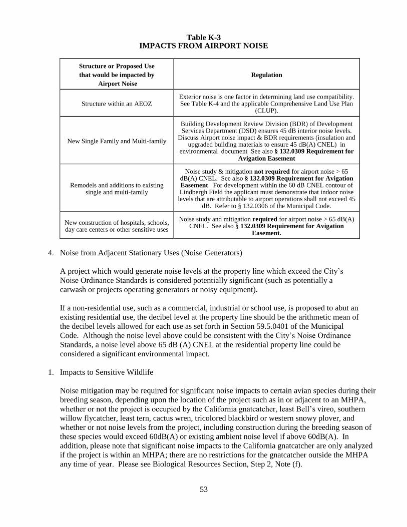
53
Table K-3 IMPACTS FROM AIRPORT NOISE
Structure or Proposed Use
that would be impacted by
Airport Noise
Regulation
Structure within an AEOZ
Exterior noise is one factor in determining land use compatibility. See Table K-4 and the applicable Comprehensive Land Use Plan
(CLUP).
New Single Family and Multi-family
Building Development Review Division (BDR) of Development Services Department (DSD) ensures 45 dB interior noise levels.
Discuss Airport noise impact & BDR requirements (insulation and upgraded building materials to ensure 45 dB(A) CNEL) in
environmental document See also § 132.0309 Requirement for Avigation Easement
Remodels and additions to existing
single and multi-family
Noise study & mitigation not required for airport noise > 65
dB(A) CNEL. See also § 132.0309 Requirement for Avigation Easement. For development within the 60 dB CNEL contour of Lindbergh Field the applicant must demonstrate that indoor noise
levels that are attributable to airport operations shall not exceed 45 dB. Refer to § 132.0306 of the Municipal Code.
New construction of hospitals, schools, day care centers or other sensitive uses
Noise study and mitigation required for airport noise > 65 dB(A)
CNEL. See also § 132.0309 Requirement for Avigation Easement.
4. Noise from Adjacent Stationary Uses (Noise Generators)
A project which would generate noise levels at the property line which exceed the City‘s
Noise Ordinance Standards is considered potentially significant (such as potentially a
carwash or projects operating generators or noisy equipment).
If a non-residential use, such as a commercial, industrial or school use, is proposed to abut an
existing residential use, the decibel level at the property line should be the arithmetic mean of
the decibel levels allowed for each use as set forth in Section 59.5.0401 of the Municipal
Code. Although the noise level above could be consistent with the City‘s Noise Ordinance
Standards, a noise level above 65 dB (A) CNEL at the residential property line could be
considered a significant environmental impact.
1. Impacts to Sensitive Wildlife
Noise mitigation may be required for significant noise impacts to certain avian species during their
breeding season, depending upon the location of the project such as in or adjacent to an MHPA,
whether or not the project is occupied by the California gnatcatcher, least Bell‘s vireo, southern
willow flycatcher, least tern, cactus wren, tricolored blackbird or western snowy plover, and
whether or not noise levels from the project, including construction during the breeding season of
these species would exceed 60dB(A) or existing ambient noise level if above 60dB(A). In
addition, please note that significant noise impacts to the California gnatcatcher are only analyzed
if the project is within an MHPA; there are no restrictions for the gnatcatcher outside the MHPA
any time of year. Please see Biological Resources Section, Step 2, Note (f).
54
6. Temporary Construction Noise
Temporary construction noise which exceeds 75 dB (A) Leq at a sensitive receptor would be
considered significant. Construction noise levels measured at or beyond the property lines of
any property zoned residential shall not exceed an average sound level greater than 75-
decibles (dB) during the 12-hour period from 7:00 a.m. to 7:00 p.m. In addition, construction
activity is prohibited between the hours of 7:00 p.m. of any day and 7:00 a.m. of the
following day, or on legal holidays as specified in Section 21.04 of the San Diego Municipal
Code, with exception of Columbus Day and Washington‘s Birthday, or on Sundays, that
would create disturbing, excessive, or offensive noise unless a permit has been applied for
and granted beforehand by the Noise Abatement and Control Administrator, in conformance
with San Diego Municipal Code Section 59.5.0404.
Additionally, where temporary construction noise would substantially interfere with normal
business communication, or affect sensitive receptors, such as day care facilities, a
significant noise impact may be identified.
7. Noise/Land Use Compatibility
Noise is one factor to be considered in determining whether a land use is compatible. Land
use compatibility noise factors are presented in Table K-4. Compatible land uses are shaded.
Incompatible land uses are unshaded. The transition zone between compatible and
incompatible should be evaluated by the environmental planner to determine whether the use
would be acceptable based on all available information and the extent to which the noise
from the proposed project would affect the surrounding uses.
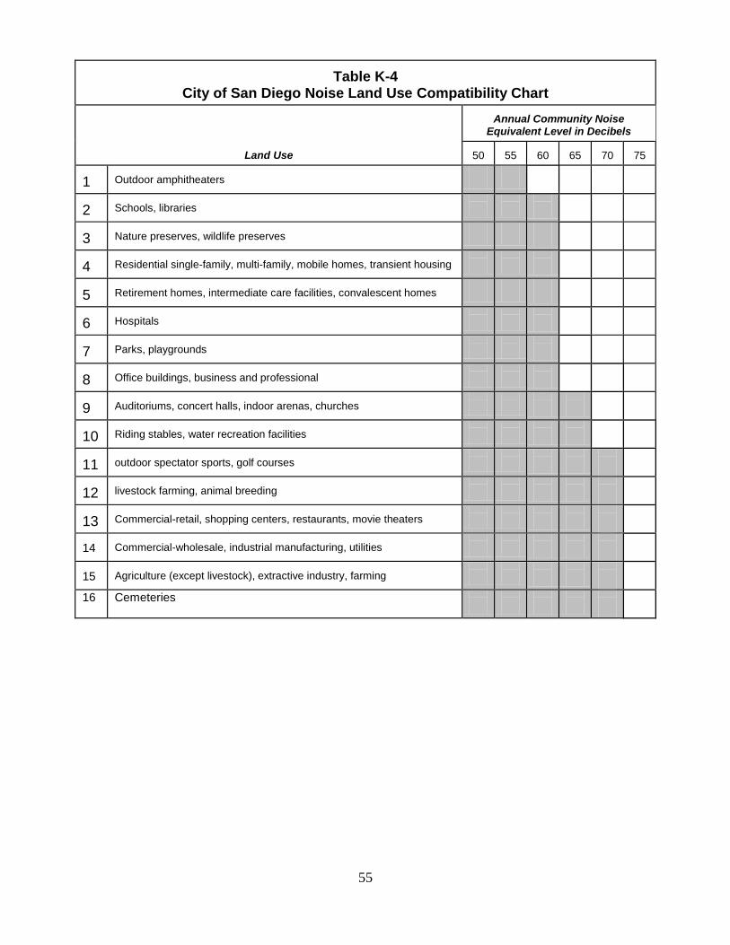
55
Table K-4 City of San Diego Noise Land Use Compatibility Chart
Land Use
Annual Community Noise
Equivalent Level in Decibels
50 55
60
65
70
75
1
Outdoor amphitheaters
2
Schools, libraries
3
Nature preserves, wildlife preserves
4
Residential single-family, multi-family, mobile homes, transient housing
5
Retirement homes, intermediate care facilities, convalescent homes
6
Hospitals
7
Parks, playgrounds
8
Office buildings, business and professional
9
Auditoriums, concert halls, indoor arenas, churches
10
Riding stables, water recreation facilities
11
outdoor spectator sports, golf courses
12
livestock farming, animal breeding
13
Commercial-retail, shopping centers, restaurants, movie theaters
14
Commercial-wholesale, industrial manufacturing, utilities
15
Agriculture (except livestock), extractive industry, farming
16 Cemeteries
56
L. PALEONTOLOGICAL RESOURCES
Paleontology is the science dealing with the study of prehistoric life preserved as fossils in
geologic deposits. As such, paleontology informs society about the history of life, about ancient
ecosystems, environments, and climates, and about the origin and evolution of species and
patterns and possible causes of extinction.
Fossils (paleontological resources) are the remains and/or traces of prehistoric life and represent
an important and nonrenewable natural resource. Fossil remains such as bones, teeth, shells, and
wood are found in the geologic deposits (sedimentary rock formations) within which they were
originally buried. For planning purposes, paleontological resources can be thought of as
including not only actual fossil remains, but also the localities where those fossils are collected,
and the geologic deposits/formations/rock units containing the localities.
Because fossils are buried in sedimentary rock layers (strata), they are vulnerable to destructive
processes of both natural weathering and erosion as well as manmade earthmoving operations.
Impacts to paleontological resources may occur during grading activities associated with project
construction, especially for large-scale excavations (e.g., residential housing tracts and new
roadway projects) and possibly in urban redevelopment projects where excavation (e.g., for
subsurface parking structures) would be done in previously undisturbed geologic
deposits/formations/rock units. Where the potential for paleontological impacts exists,
mitigation usually involves on-site paleontological monitoring of excavation activities so that
exposed fossils may be recovered.
INITIAL STUDY QUESTIONS
The following Initial Study Checklist question is from the City‘s Initial Study Checklist, and
provides guidance to determine potential significance for impacts to Paleontological Resources:
Would the project:
1. Require over 1,000 cubic yards of excavation in a high resource potential geologic
deposit/formation/rock unit?
2. Require over 2,000 cubic yards of excavation in a moderate resource potential
geologic deposit/formation/rock unit?
SIGNIFICANCE THRESHOLDS
1. Determine the geologic deposit/formation/rock unit underlying a project area. If there are
sedimentary rocks such as those found in the coastal areas, they usually contain fossils. If
there are granitic or volcanic rocks such as those found in the inland areas (Mission Gorge,
etc), they usually will not contain fossils.
2. See Paleontological Determination Matrix.
Note: Significant impacts to paleontological resources are most often mitigated by the
implementation of a monitoring program. The monitoring program is carried out under the
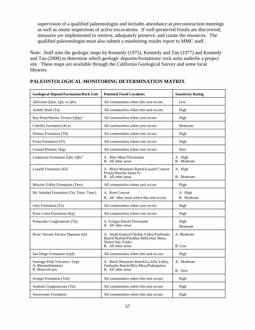
57
supervision of a qualified paleontologist and includes attendance at preconstruction meetings
as well as onsite inspections of active excavations. If well-preserved fossils are discovered,
measures are implemented to retrieve, adequately preserve, and curate the resources. The
qualified paleontologist must also submit a monitoring results report to MMC staff.
Note: Staff uses the geologic maps by Kennedy (1975), Kennedy and Tan (1977) and Kennedy
and Tan (2008) to determine which geologic deposits/formations/ rock units underlie a project
site. These maps are available through the California Geological Survey and some local
libraries.
PALEONTOLOGICAL MONITORING DETERMINATION MATRIX Geological Deposit/Formation/Rock Unit
Potential Fossil Localities
Sensitivity Rating
Alluvium (Qsw, Qal, or Qls)
All communities where this unit occurs
Low
Ardath Shale (Ta)
All communities where this unit occurs
High
Bay Point/Marine Terrace (Qbp) 1
All communities where unit occurs
High
Cabrillo Formation (Kcs)
All communities where unit occurs
Moderate
Delmar Formation (Td)
All communities where unit occurs
High
Friars Formation (Tf)
All communities where unit occurs
High
Granite/Plutonic (Kg)
All communities where unit occurs
Zero
Lindavista Formation (Qln, Qlb) 2
A. Mira Mesa/Tierrasanta B. All other areas
A. High B. Moderate
Lusardi Formation (Kl)
A. Black Mountain Ranch/Lusardi Canyon Poway/Rancho Santa Fe B. All other areas
A. High B. Moderate
Mission Valley Formation (Tmv)
All communities where unit occurs
High
Mt. Soledad Formation (Tm, Tmss, Tmsc)
A. Rose Canyon
B. All other areas where this unit occurs
A. High
B. Moderate
Otay Formation (To)
All communities where unit occurs
High
Point Loma Formation (Kp)
All communities where unit occurs
High
Pomerado Conglomerate (Tp)
A. Scripps Ranch/Tierrasanta B. All other areas
High
Moderate
River /Stream Terrace Deposits (Qt)
A. South Eastern/Chollas Valley/Fairbanks Ranch/Skyline/Paradise Hills/Otay Mesa, Nestor/San Ysidro B. All other areas
A. Moderate B. Low
San Diego Formation (Qsd)
All communities where this unit occurs.
High
Santiago Peak Volcanics (Jsp) A. Metasedimentary B. Metavolcanic
A. Black Mountain Ranch/La Jolla Valley, Fairbanks Ranch/Mira Mesa/Peñasquitos B. All other areas
A. Moderate
B. Zero
Scripps Formation (Tsd)
All communities where this unit occurs
High
Stadium Conglomerate (Tst)
All communities where this unit occurs
High
Sweetwater Formation
All communities where this unit occurs
High
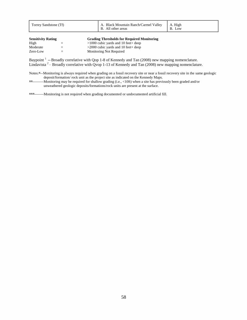
58
Torrey Sandstone (Tf)
A. Black Mountain Ranch/Carmel Valley B. All other areas
A. High B. Low
Sensitivity Rating Grading Thresholds for Required Monitoring High = >1000 cubic yards and 10 feet+ deep
Moderate = >2000 cubic yards and 10 feet+ deep
Zero-Low = Monitoring Not Required
Baypoint 1 --
Broadly correlative with Qop 1-8 of Kennedy and Tan (2008) new mapping nomenclature.
Lindavista 2 – Broadly correlative with Qvop 1-13 of Kennedy and Tan (2008) new mapping nomenclature.
Notes:* Monitoring is always required when grading on a fossil recovery site or near a fossil recovery site in the same geologic
deposit/formation/ rock unit as the project site as indicated on the Kennedy Maps.
** Monitoring may be required for shallow grading (i.e., <10ft) when a site has previously been graded and/or
unweathered geologic deposits/formations/rock units are present at the surface.
*** Monitoring is not required when grading documented or undocumented artificial fill.
59
M. PUBLIC SERVICES and FACILITIES
Appendix G of the CEQA Guidelines asks whether a project would result in substantial adverse
physical impacts from the construction or alteration of governmental facilities needed to
maintain acceptable service ratios, response times, or other performance objectives for any of the
public services. Thus, this and other CEQA guidelines indicate that the Lead Agency should
focus the evaluation of impacts on the physical effects of constructing or altering public
facilities.
However, the guidelines also discuss health and safety issues that can result from the
introduction of people to hazardous or overcrowded situations as significant impacts:
Section 15065(d), Mandatory Findings of Significance states, “The environmental effects of
a project will cause substantial adverse effects on human beings, either directly or
indirectly.”
Section 15126.2 (a) specifically addresses the need to disclose potential significant effects to
public services and states, “An EIR shall identify and focus on the significant environmental
effects of the proposed project … Direct and indirect significant effects of the project on the
environment shall be clearly identified and described, giving due consideration to both the
short-term and long-term effects. The discussion should include relevant specifics of the
area, the resources involved, physical changes, alterations to ecological systems, and
changes induced in population distribution, population concentration, the human use of the
land (including commercial and residential development), health and safety problems caused
by physical changes, and other aspects of the resource base such as water, historical
resources, scenic quality, and public services. The EIR shall also analyze any significant
environmental effects the project might cause by bringing development and people into the
area affected. For example, an EIR on a subdivision astride an active fault line should
identify as a significant effect the seismic hazard to future occupants of the subdivision. The
subdivision would have the effect of attracting people to the location and exposing them to
the hazards found there. “
The number, location, and size of public facilities such as fire and police stations, public schools,
libraries, parks, and other governmental services and facilities should be identified at the
community plan level. The City of San Diego Planning Department should coordinate with the
appropriate departments in making these determinations. The facilities financing and
development impact fees should also be anticipated at this time.
INITIAL STUDY CHECKLIST QUESTIONS
The following questions are from the City‘s Initial Study Checklist. They provide guidance to
determine potential significance of the physical effects of constructing and/or altering Public
Services, including the development of Parks and Recreational Resources:
Would the proposal:
1. Have an effect upon, or result in a need for new or altered governmental services in any
of the following areas:
60
Police protection Parks or other recreational facilities
Fire/Life Safety protection Maintenance of public facilities, including roads
Libraries Schools
If so, the focus of the analysis should be on the physical impacts of constructing the
public service facilities.
SIGNIFICANCE THRESHOLDS
Public Services
The analyst should evaluate the significance of a project‘s impacts related to construction of
public service facilities as follows:
a. Does the project conflict with the community plan in terms of the number, size, and
location of public service facilities?
b. If so, are there direct impacts from construction of proposed new public service facilities
needed to serve the project? (See also Section E. Growth Inducement.)
1. Police and Fire-rescue services
For police and fire-rescue services, the following should also be considered and referred to the
Police and/or Fire-Rescue Departments if the project exceeds the threshold of 75 dwelling units
or 100,000 square feet of non-residential construction.
c. Is the project located in a brush fire hazard area, hillside, or an area with inadequate fire
hydrant services or street access? (Also see Section F. Health and Safety).
d. Does the project involve the use, manufacture or storage of toxic, readily-combustible, or
otherwise hazardous materials? (Also see Section F. Health and Safety).
e. Would the project‘s location provide for adequate SDFD access as determined by Fire
and Life Safety staff to be in conformance with the California Fire Code and Fire and
Hazard Prevention Services Policy A-00-1?
f. Would the project substantially affect Police or Fire-Rescue response times (i.e., increase
the existing response times in the project area)?
For question ―c-f‖, the Police and/or Fire Departments will review the project to determine
whether it would substantially affect these issue areas as well as following response times:
Police: Priority 1 call goal by neighborhood from current budget
Fire-Rescue: 5 minutes from the time the alarm is received to arrival of the first engine at the
scene of the incident (1 minute chute + 4 minute travel) and 9 minute response
time (1 minute chute + 8 minute travel) for initial full alarm assignment (3
engines and 1 truck).
61
The affected department(s) should advise the analyst of whether the effect is due to a lack of
facilities, traffic congestion, or a lack of personnel or equipment.
Large and small developers are required to fund construction of new facilities with Developer
Impact Facilities (DIFs) and Facility Benefit Assessment Districts (FBAs) as conditions of
project approvals to address capital costs of Police and Fire-Rescue services.
At the present time, significant response time deficiencies due to a lack of personnel or
equipment can be helped only by continued, mandatory approval by the City Council of the
affected department‘s budget proposal for operations within the affected area because developers
cannot be required to fund ongoing operational costs nor can they make budgetary decisions
regarding such funding.
The Environmental Setting section of the environmental document should identify the stations
that provide services to the project site, and should include the response times to the project site.
Public Facilities
1. Schools
Senate Bill (SB) 50 was enacted on August 27, 1998. The bill authorized a $9.2 billion K-12
school and higher education bond to be presented to the voters of California. The state bond
measure, known as the ―Class Size Reduction Kindergarten - University Public Education
Facilities Bond Act of 1998,‖ was approved by the voters on November 3, 1998.
SB 50 significantly revised developer fee and mitigation procedures for school facilities as
set forth in Government Code Section 65996. The legislation holds that the statutory fees are
the exclusive means of considering and mitigating school impacts. It does not just limit the
mitigation that may be required -- it limits the scope of the review and the findings to be
adopted for school impacts. Once the statutory fee is paid, the impact would be mitigated
because of the provision that the statutory fees constitute full and complete mitigation.
What this means is that the City is legally prohibited from imposing any mitigation related to
school facilities, because the applicants are required by state law to pay school facilities fees.
Environmental documents for larger residential projects should include information provided
by the appropriate school districts about the existing conditions and capacities, but should
conclude that the impacts are mitigated through the implementation of SB 50. However,
project permits can include a measure requiring verification that the statutory fees have been
paid prior to the issuance of any notice to proceed with project grading or construction.
2. Libraries
The General Plan establishes guidelines and standards for branch libraries. Ideally, branch
libraries should serve a resident population of 30,000 and may be established when a service
area, which is expected to grow to 30,000 residents within 20 years of library construction,
has a minimum population of 18,000 to 20,000. Branches should be located in areas of
62
intense human activity, with a 2.0-mile maximum service area, where trips can be combined
with other daily trips.
The City of San Diego is also part of a county-wide cooperative relationship known as the
Serra Cooperative Library System. This system allows residents of the City of San Diego
and San Diego County to use the facilities of public libraries.
The Environmental Setting section of environmental documents for medium to large
residential projects should identify the location of the nearest branch libraries and the
distance of each from the project site. For those projects located on or near the limits of the
City of San Diego, the Serra Cooperative Library facilities should also be identified. The
provision of adequate libraries is a planning and facilities issue, and project applicants are
required to make fair share contributions to the public facilities.
3. Parks and Recreational Resources
The City‘s General Plan provides the following guidelines for population-based parks:
a. Neighborhood parks and facilities should serve a resident population of between 3,500
and 5,000 within an approximately half-mile radius. The facility should be five (5) acres
in size when located next to an elementary school and 10 acres when the facility must
stand alone.
b. Community parks and recreation centers should serve a resident population of between
18,000 and 25,000 within an approximately 1½-mile radius. The facility should be 13
acres in size when located adjacent to a junior high school and 20 acres when the facility
must stand alone.
The General Plan guidelines for resource-based park are as follows:
a. Resource-based parks should provide approximately 15 to 17 acres per 1,000 residents
City-wide. It is important to note that resource-based parks are identified with an area of
outstanding scenic, natural, or cultural interest. However, portions of these parks may
serve as a community park.
The City‘s Park and Recreation Department and Planning Department are part of the multi-
disciplinary review team for development projects. They are responsible for determining
whether there would be a park deficiency within the community planning areas. As with
libraries, the provision of parks is a planning and facilities issue, so the Environmental
Setting section of the document should discuss the development‘s effect on any park
deficiencies in the area, but should not conclude that such effects are CEQA impacts.
63
N. PUBLIC UTILITIES
In view of the continued growth experienced within the City of San Diego, it is the City‘s goal to
ensure that public utilities will be made available on an equitable basis, without jeopardizing
human health and safety.
The group of public utilities, as discussed in this section consist of:
• Electrical Power and Natural Gas (Energy) (In evaluating a project‘s effects on energy
conservation in the preparation of Environmental Impact Reports, staff and consultants
are directed to Appendix F of the CEQA Guidelines.)
• Solar Energy
• Communication Systems
• Solid Waste Generation / Disposal
• Water and Sewer
• Water Conservation
Utility providers are typically a combination of City, quasi-public agencies, and privately owned
companies and corporations.
The utility providers, in coordination with State and Federal agencies that regulate their activities
(CPUC, CAISO, FERC, etc.), identify significant shortages and associated impacts to existing
and planned utilities that may be created by projects proposed within their service areas. Each
utility provider establishes its own threshold criteria for utility capacity and service expansion.
As briefly discussed below, the extension, expansion, rerouting, and construction of new public
and private utility needs are generally addressed on a project-by-project basis. With one
exception (energy conservation), the analysis of impacts related to public and private
utilities should focus on the physical impacts associated with their installation. Such
physical impacts should be addressed in their respective impact areas (e.g., biological,
archaeological, paleontological resources, etc.). In EIRs, it may be appropriate to consider the
growth inducement potential of large utility projects; however, this discussion should be
contained in the Growth Inducement section.
The following guidance should be considered in determining whether the utility work could have
significant environmental impacts.
Would the removal, construction, and/or relocation of the utility:
• Be compatible with existing and adjacent land uses?
• Change drainage or affect water quality/runoff?
• Affect air quality?
• Affect biological resources including habitat? Consider access road locations.
• Have a negative aesthetic effect? Visual simulations might be necessary.
• Impact historical resources?
• Increase noise levels to sensitive receptors?
64
INITIAL STUDY CHECKLIST QUESTIONS
The following are taken from the City‘s Initial Study Checklist and provides guidance on
potential significance for the following Public Utilities issues:
Would the proposal:
1. Result in a need for new systems, or require substantial alterations to existing utilities, the
construction of which would create physical impacts?
Natural gas Water Sewer
Communication systems Solid waste disposal
2. Result in the use of excessive amounts of fuel or energy (e.g. natural gas)?
3. Result in the use of excessive amounts of power?
4. Use of excessive amounts of water?
5. Landscaping which is predominantly non-drought resistant vegetation?
SIGNIFICANCE THRESHOLDS
1. Electrical Power and Natural Gas (Energy)
Electrical power and natural gas service is commonly provided by the San Diego Gas and
Electric Company (SDG&E) throughout the San Diego metropolitan area. Power and gas
requirements for upcoming development projects are handled on a case-by-case basis, and
SDG&E consults with developers to incorporate energy saving devices into project design,
where feasible.
Forecasting future electric power and natural gas consumption demand is performed on a
continual basis by SDG&E. In situations where projects with large power loads are planned,
these new large power loads are considered together with other existing or anticipated future
loads in the project vicinity, and electrical substations are upgraded or new substations are
built if the capacities of existing substations are exceeded. Direct impacts to electrical and
natural gas facilities are addressed and mitigated by SDG&E at the time incoming
development projects occur and are not typically evaluated by City staff.
An overall finding that the project would not have a significant environmental effect is not
adequate for SDG&E to plan and implement an electric transmission or substation project in
accordance with the permitting requirements of the California Public Utilities Commission‘s
General Order 131-D. For SDG&E to be able to comply with GO 131-D and CEQA when
its facilities are a component of a larger development project, the environmental document
must make a separate finding that the proposed removal and/or construction or relocation of
SDG&E's electric facilities as part of the larger project does not have the potential for
significant effect on the environment. For additional information, contact SDG&E at (858)
637-3708.
65
2. Solar Energy
With respect to solar energy, projects that would result in substantial shading of roofs as to
preclude future installation of solar systems may be considered to have significant
environmental impacts.
3. Communication Systems
Communications system(s) for telephone, large-scale computer systems, and cable television,
are serviced by utility providers such as SBC, AT&T, IBM, and other independent cable
companies. Communication system needs for incoming projects are serviced by these utility
providers on an as-needed basis.
SBC (formerly Pacific Bell) is mandated by the State Public Utilities Code to provide
telephone service wherever it is requested throughout the State of California. SBC, therefore,
must provide ongoing telephone service and plan for continual extensions of fiber optic lines.
Forecasting future service demand is performed by computerized statistical modeling based
on land use patterns, zoning, and other growth indicators. When possible, SBC engineers
contact developers regarding future development plans early on in a project‘s conceptual
planning stages, to establish upcoming service demand. For line extensions through remote
areas to new development projects, a minimal hook-up fee is charged to the developer.
4. Solid Waste Generation/Disposal
The California Public Resources Code requires each city in the state to divert at least 50%
percent of its solid waste from landfill disposal through source reduction, recycling,
composting, and transformation. The City has enacted codes and policies aimed at helping
the City to achieve this diversion level, including the Refuse and Recyclable Materials
Storage Regulations (Municipal Code Chapter 14, Article 2 Division 8), Recycling
Ordinance (Municipal Code Chapter 6, Article 6, Division 7), and the Construction and
Demolition (C & D) Debris Deposit Ordinance (Municipal Code Chapter 6, Article 6,
Division 6). Projections indicate that diversion rates achieved by these regulations and
ordinances alone will not be sufficient to achieve the 50% diversion level. To compound the
problem, the City‘s Miramar Landfill is projected to close before 2016, making efforts that
preserve landfill space especially important.
The following solid waste thresholds discuss the level at which compliance with
regulations/ordinances is not sufficient, and therefore the inclusion of solid waste
considerations in the review and preparation of environmental documents is necessary to
address project construction, demolition, and ongoing waste generation. The Waste
Management Plan would assure that the overall waste produced is reduced sufficiently to
comply with waste reduction targets established in the Public Resources Code.
INITIAL STUDY QUESTION
1. Would the proposed project have an effect upon, or result in a need for new or altered
solid waste facilities?
66
SIGNIFICANCE THRESHOLDS
Construction/demolition/renovation projects meeting or exceeding the following thresholds
are considered to have potentially significant solid waste impact based on solid waste
generation estimates and require the preparation of a waste management plan:
Cumulative Impacts
1. Projects that include the construction, demolition, and/or renovation of 40,000 square feet
or more of building space may generate approximately 60 tons of waste or more, and are
considered to have cumulative impacts on solid waste facilities.
While all projects are required to comply with the City‘s waste management
ordinances, cumulative impacts are mitigated by the implementation of a project-
specific Waste Management Plan which reduces solid waste impacts to below a level
of significance.
Direct Impacts
1. Projects that include the construction, demolition, or renovation of 1,000,000 square feet
or more of building space may generate approximately 1,500 tons of waste or more and
are considered to have direct impacts on solid waste facilities.
Direct impacts result from the generation of large amounts of waste which stresses
existing facilities. Waste management planning is based on a steady rate of waste
generation and doesn‘t assume increased waste generation due to growth.
While all projects are required to comply with the City‘s waste management
ordinances, direct and cumulative impacts are mitigated by the implementation of
project-specific Waste Management Plans which may reduce solid waste impacts to
below a level of significance.
For projects over 1,000,000 square feet, a significant direct and cumulative solid
waste impact would result if the compliance with the City‘s ordinances and the Waste
Management Plan fail to reduce the impacts of such projects to below a level of
significance and/or if a Waste Management Plan for the project is not prepared and
conceptually approved by the Environmental Services Department prior to
distribution of the draft environmental document for public review.
LEED Projects Exceeding the Significance Thresholds
1. Projects that intend certification as LEED Silver or better would include LEED
measures as part of their waste management plan. This would demonstrate
implementation of sustainability measures intended to assure minimal project
―environmental footprint,‖ including mitigating the types of impacts caused by waste
generation.
67
Public Projects
1. Public projects are required to adhere to City of San Diego Administrative
Regulations and project specifications that require that the overall waste produced is
reduced sufficiently to comply with waste reduction targets established in the Public
Resources Code. Furthermore, Council Policy 900-14 requires City projects to
achieve the U.S. Green Building Council‘s LEED Silver standard for all new
buildings and major renovations over 5,000 feet.
2. Projects complying with the City of San Diego Administrative Regulations are not
required to prepare a Waste Management Plan.
These thresholds are consistent with the General Plan policies and the General Plan PEIR
mitigation including PF-I.2. ―Maximize waste reduction and diversion‖ and CE-A.2 ―Reduce
waste by improving management and recycling programs.‖
Be aware that some existing Environmental Impact Reports (EIRs) may impose other
thresholds and/or mitigation measures such as discussed below:
• Redevelopment Agency Projects
The City of San Diego Redevelopment Agency has enacted more stringent thresholds for
solid waste impacts in some of its EIRs. If the project is located in a Redevelopment District,
consult the applicable EIR to determine the significance threshold and/or mitigation
measures. For example, the North Park Redevelopment Project Final EIR (SCH 93-121105)
sets a threshold of 10,000 square feet of construction, demolition, or remodeling and requires
mitigation to prepare a Waste Management Plan if this threshold is met.
WASTE MANAGEMENT PLAN
If the project would exceed the significance threshold for solid waste generation, a Waste
Management Plan must be prepared by the applicant, conceptually approved by the
Environmental Services Department (ESD) and discussed in the environmental document.
The Plan must be implemented by the applicant and address the demolition, construction, and
occupancy phases of the project as applicable to include the following:
a. A timeline for each of the three main phases of the project (demolition, construction,
and occupancy).
b. Tons of waste anticipated to be generated (demolition, construction, and occupancy).
c. Type of waste to be generated (demolition, construction, and occupancy).
d. Describe how the project will reduce the generation of construction and demolition
(C & D) debris
e. Describe how the C & D materials will be reused on-site
f. Include the name and location of recycling, reuse, and landfill facilities where
recyclables and waste will be taken if not reused on-site
g. Describe how the C&D waste will be source separated if a mixed C&D facility is not
used for recycling
h. Describe how the waste reduction and recycling goals will be communicated to
subcontractors
68
i. Describe how a "buy recycled" program for green construction products, including
mulch and compost will be incorporated into the project.
j. Describe how the Refuse and Recyclable Materials Storage Regulations (LDC
Chapter 14, Article 2 Division 8) will be incorporated into design of building's waste
storage area
k. Describe how compliance with the Recycling Ordinance (Municipal Code Chapter 6,
Article 6, Division 7) will be incorporated in the operational phase
l. Describe any International Standards of Operation (ISO)1, or other certification, if
any.
1
ISO certification means there has been a commitment to reduce ongoing waste.
5. Water and Sewer
Potable water (fresh water) and sewer requirements for incoming development projects are
administered by the City Water and Metropolitan Wastewater Departments. Water and
sewer demand is handled on a project-by-project basis, where developers are now required to
submit water and sewer studies using the measurement of equivalent dwelling units (EDUs).
The incorporation of water conservation devices into project designs are encouraged or
required, such as the use of low-flush toilets, low-flow faucets, and timers on lawn sprinklers.
In projects with over 30 EDUs, a dual feed water pipeline system is required in case one of
the pipelines fails. This is necessary to ensure continual water service to the project and
adequate water pressure for fire protection. Also, since July of 1989, all development
projects are required to install an additional water pipeline reserved for reclaimed water.
Water and sewer trunk lines are continually monitored in the field to determine remaining
levels of capacity. The Engineering Division plans its capital improvement projects several
years prior to pipelines actually reaching capacity. It is also the Engineering Division‘s belief
that both the water and sewer system will be able to accommodate future growth.
For projects potentially affecting water and/or sewer lines, the California Department of
Health Services Drinking Water Field Operations Branch requires notification if the
separation between potable water and sewer or recycled water at any point is less than ten
feet horizontal or one foot vertical. A minimum six inch vertical separation is required to be
maintained between utilities. Potentially significant impacts could result if these separation
distances are not maintained. The focus of the analysis should be on the construction of
water and sewer facilities.
Senate Bills 610 and 221
For certain types of large projects (see list below), Senate Bill 610 requires that the
environmental document prepared for each project contain a discussion regarding the
availability of water to meet the projected water demands of the project for a 20-year
planning horizon, including single and multiple dry years. Senate Bill 221 requires the
decisionmaker to make a finding that the project's water demands for the planning horizon
will be met before approving a Tentative Map.
69
The types of projects subject to Senate Bills 610 and 221 are the following:
a. Residential developments of more than 500 units;
b. Shopping centers or businesses employing more than 1,000 people or having more
than 500,000 square feet of floor space;
c. Commercial office buildings employing more than 1,000 people or having more than
250,000 square feet of floor space;
d. Hotels or motels having more than 500 rooms;
e. Industrial, manufacturing, or processing plants or industrial parks planned to house
more than 1,000 people or having more than 650,000 square feet of floor space;
f. Mixed use projects that include one or more of the above types of projects;
g. Projects that would demand an amount of water equivalent to, or greater than, the
amount of water required by a 500 dwelling unit project.
For each of the types of projects listed above, the analyst should send a memo to the
Principal Water Resource Specialist at the Water Department, giving the project details and
requesting that the water availability analysis be done. The Water Department will
coordinate with the County Water Authority, and will provide the analyst with the
information needed for the environmental document.
6. Water Conservation
San Diego‘s arid climate and the fact that the majority of the region‘s water is imported,
results in a limited water supply and availability. The drought cycles have resulted in a water
conservation program throughout the City and region. According to San Diego Municipal
Code Section 147.04, all buildings, prior to a change in ownership, are required to be
certified as having water-conserving plumbing fixtures in place. All residential, commercial,
and industrial water customers who receive water from the City of San Diego Water
Department are affected by this Ordinance.
In terms of water conservation, the following factors should be considered (list is not
inclusive) in determining baseline impacts on water conservation:
A significant impact may result if the following occurs:
1. The project would use excessive amounts of potable water. For example, a golf
course use or certain industrial uses result in substantial water usage compared to
most other uses. Projects should be encouraged to use reclaimed water whenever
possible. See Item 7 below and subitems (b) and (g) in previous discussion regarding
Senate Bills 610 and 221.
2. A project proposes predominantly non-drought resistant landscaping and excessive
water usage for irrigation and other purposes. See Section 142.0401 regarding the use
of drought-tolerant landscaping.
7. Recycled Water Reuse
70
Recycled water use is regulated by Ordinance 0-17327 (―Mandatory Reuse Ordinance‖)
adopted by the City Council on July 24, 1989. This Ordinance specifies that ―recycled
water shall be used within the City where feasible and consistent with the legal
requirements, preservation of public health, safety, and welfare, and the environment.‖
Compliance with this Ordinance for new development is made a condition of tentative
maps, land use permits, etc. based on the project‘s location within an existing or proposed
recycled water service area. In addition, the City Water Department is proposing
additional retrofit criteria in conjunction with the Public Utilities Advisory Commission.
Compliance with the Mandatory Reuse Ordinance is assured via permit conditions and
therefore no significance thresholds for CEQA analysis is required. The physical
placement of any reuse lines would be analyzed for impacts as part of the normal
discretionary process.
71
O. TRANSPORTATION / CIRCULATION and PARKING
Note: This section is to be applied for projects deemed complete on or after January 1,
2007. For projects deemed complete prior to January 1, 2007, the following Section
O.1. on Page 73 is to be applied.
Project-related traffic impacts are one of the most commonly identified environmental impacts
under the CEQA. Traffic operations and safety impacts are addressed in this section. Other
environmental impacts associated with project- related traffic and transportation infrastructure
improvements (e.g., air quality, noise, biology) are addressed in the applicable sections of this
manual which pertain to such issues.
Direct traffic impacts are those projected to occur at the time a proposed development becomes
operational, including other developments not presently operational but which are anticipated to
be operational at that time (near term).
Cumulative traffic impacts are those projected to occur at some point after a proposed
development becomes operational, such as during subsequent phases of a project and when
additional proposed developments in the area become operational (short-term cumulative) or
when the affected community plan area reaches full planned build out (long-term cumulative).
It is possible that a project‘s near term (direct) impacts may be reduced in the long term, as
future projects develop and provide additional roadway improvements (for instance, through
implementation of traffic phasing plans). In such a case, the project may have direct impacts but
not contribute considerably to a cumulative impact.
For intersections and roadway segments affected by a project, level of service (LOS) D or better
is considered acceptable under both direct and cumulative conditions.
INITIAL STUDY CHECKLIST QUESTIONS
The following are taken from the City‘s Initial Study Checklist. They provide guidance on
determining the potential significance of impacts to transportation, circulation systems, and
parking:
Would the proposal result in:
1. Traffic generation in excess of specific community plan allocation?
2. An increase in projected traffic which is substantial (see table on following page) in
relation to the existing traffic load and capacity of the street system?
3. Addition of a substantial amount of traffic to a congested freeway segment, interchange,
or ramp as shown in the table on the next page?
4. An increased demand for off-site parking?
5. Effects on existing parking?
6. Substantial impact upon existing or planned transportation systems?
7. Substantial alterations to present circulation movements including effects on existing
public access to beaches, parks, or other open space areas?

72
8. Increase in traffic hazards for motor vehicles, bicyclists or pedestrians due to a proposed,
non-standard design feature (e.g., poor sight distance or driveway onto an access-
restricted roadway)?
9. A conflict with adopted policies, plans or programs supporting alternative transportation
models (e.g., bus turnouts, bicycle racks)?
SIGNIFICANCE THRESHOLDS
The following thresholds have been established to determine significant traffic impacts:
1. If any intersection, roadway segment, or freeway segment affected by a project would
operate at LOS E or F under either direct or cumulative conditions, the impact would be
significant if the project exceeds the thresholds shown in the table below.
2. At any ramp meter location with delays above 15 minutes, the impact would be significant if
the project exceeds the thresholds shown in the table below.
3. If a project would add a substantial amount of traffic to a congested freeway segment,
interchange, or ramp, the impact may be significant.
4. Addition of a substantial amount of traffic to a congested freeway segment, interchange, or
ramp as shown in the table below?
5. If a project would increase traffic hazards to motor vehicles, bicyclists or pedestrians due to
proposed non-standard design features (e.g., poor sight distance, proposed driveway onto an
access-restricted roadway), the impact would be significant. Note: analysts should refer
readers to a discussion of this issue in the Health and Safety section of the environmental
document.
5. If a project would result in the construction of a roadway which is inconsistent with the
General Plan and/or a community plan, the impact would be significant if the proposed
roadway would not properly align with other existing or planned roadways.
6. If a project would result in a substantial restriction in access to publicly or privately owned
land, the impact would be significant.
Level of Service
with Project *
Allowable Change Due To Project Impact **
Freeways Roadway
Segments Intersections
Ramp
Metering
V/C Speed
(mph) V/C
Speed
(mph)
Delay
(sec.)
Delay
(min.)
E (or ramp meter delays
above 15 min.)
0.010 1.0 0.02 1.0 2.0 2.0
F (or ramp meter delays
above 15 min.)
0.005 0.5 0.01 0.5 1.0 1.0
Note 1: The allowable increase in delay at a ramp meter with more than 15 minutes delay and freeway LOS E is 2
minutes.
73
Note 2: The allowable increase in delay at a ramp meter with more than 15 minutes delay and freeway LOS F is 1
minute.
* All LOS measurements are based upon Highway Capacity Manual procedures for peak-hour conditions.
However, V/C ratios for roadway segments are estimated on an ADT/24-hour traffic volume basis (using
Table 2 of the City‘s Traffic Impact Study Manual. The acceptable LOS for freeways, roadways, and
intersections is generally ―D‖ (―C‖ for undeveloped locations). For metered freeway ramps, LOS does not
apply. However, ramp meter delays above 15 minutes are considered excessive.
** If a proposed project‘s traffic causes the values shown in the table to be exceeded, the impacts are
determined to be significant. The project applicant shall then identify feasible improvements (within the
Traffic Impact Study) that will restore/and maintain the traffic facility at an acceptable LOS. If the LOS
with the proposed project becomes unacceptable (see above * note), or if the project adds a significant
amount of peak-hour trips to cause any traffic queues to exceed on- or off-ramp storage capacities, the
project applicant shall be responsible for mitigating the project‘s direct significant and/or cumulatively
considerable traffic impacts.
KEY: Delay = Average control delay per vehicle measured in seconds for intersections, or minutes for ramp
meters
LOS = Level of Service
Speed = Speed measured in miles per hour
V/C = Volume to Capacity ratio
PARKING
Parking requirements vary by land use and location and are dictated by the City of San Diego
Municipal Code and adopted by the City Council policies.
SIGNIFICANCE THRESHOLDS
Non-compliance with the City‘s parking ordinance does not necessarily constitute a significant
environmental impact. However, it can lead to a decrease in the availability of existing public
parking in the vicinity of the project. Generally, if a project is deficient by more than ten percent
of the required amount of parking and at least one of the following criteria applies, then a
significant impact may result:
1. The project‘s parking shortfall or displacement of existing parking would substantially
affect the availability of parking in an adjacent residential area, including the availability
of public parking.
2. The parking deficiency would severely impede the accessibility of a public facility, such
as a park or beach.
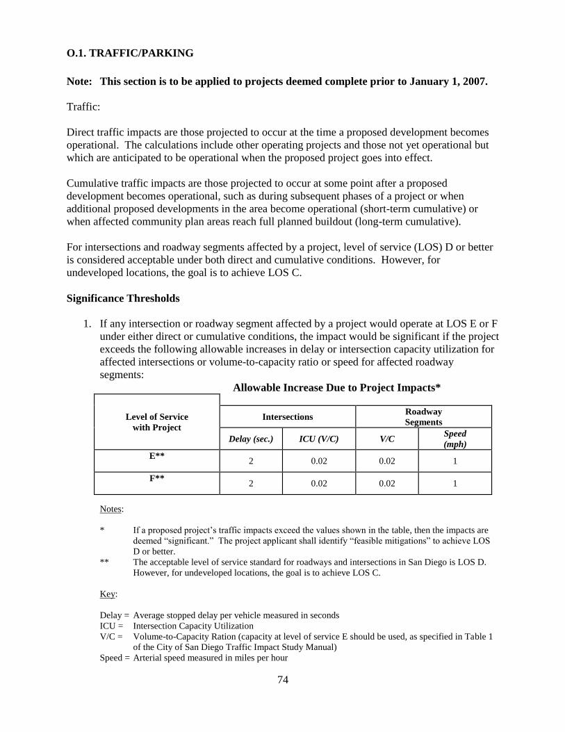
74
O.1. TRAFFIC/PARKING
Note: This section is to be applied to projects deemed complete prior to January 1, 2007.
Traffic:
Direct traffic impacts are those projected to occur at the time a proposed development becomes
operational. The calculations include other operating projects and those not yet operational but
which are anticipated to be operational when the proposed project goes into effect.
Cumulative traffic impacts are those projected to occur at some point after a proposed
development becomes operational, such as during subsequent phases of a project or when
additional proposed developments in the area become operational (short-term cumulative) or
when affected community plan areas reach full planned buildout (long-term cumulative).
For intersections and roadway segments affected by a project, level of service (LOS) D or better
is considered acceptable under both direct and cumulative conditions. However, for
undeveloped locations, the goal is to achieve LOS C.
Significance Thresholds
1. If any intersection or roadway segment affected by a project would operate at LOS E or F
under either direct or cumulative conditions, the impact would be significant if the project
exceeds the following allowable increases in delay or intersection capacity utilization for
affected intersections or volume-to-capacity ratio or speed for affected roadway
segments:
Allowable Increase Due to Project Impacts*
Level of Service
with Project
Intersections Roadway
Segments
Delay (sec.) ICU (V/C) V/C Speed
(mph)
E**
2 0.02 0.02 1
F**
2 0.02 0.02 1
Notes:
* If a proposed project‘s traffic impacts exceed the values shown in the table, then the impacts are
deemed ―significant.‖ The project applicant shall identify ―feasible mitigations‖ to achieve LOS
D or better.
** The acceptable level of service standard for roadways and intersections in San Diego is LOS D.
However, for undeveloped locations, the goal is to achieve LOS C.
Key:
Delay = Average stopped delay per vehicle measured in seconds
ICU = Intersection Capacity Utilization
V/C = Volume-to-Capacity Ration (capacity at level of service E should be used, as specified in Table 1
of the City of San Diego Traffic Impact Study Manual)
Speed = Arterial speed measured in miles per hour
75
P. VISUAL EFFECTS AND NEIGHBORHOOD CHARACTER
Making the determination of a significant impact on visual quality is highly subjective.
Identifying how a proposed development would fit or blend with the existing scale and character
of the surrounding developed and natural environment is the key to determining significance. A
project may meet all of its height, bulk, scale and zoning requirements and still have a significant
visual impact on the environment if it is not in character with the surrounding development and
natural landforms.
INITIAL STUDY CHECKLIST QUESTIONS
The following are from the City‘s Initial Study Checklist and provides guidance to determine
potential significance for impacts to Visual Quality and Neighborhood Character.
Would the proposal result in:
1. A substantial obstruction of any vista or scenic view from a public viewing area as
identified in the community plan?
2. The creation of a negative aesthetic site or project?
3. Project bulk, scale, materials, or style which would be incompatible with surrounding
development?
4. Substantial alteration to the existing or planned character of the area, such as could occur
with the construction of a subdivision in a previously undeveloped area? Note: for
substantial alteration to occur, new development would have to be of a size, scale, or
design that would markedly contrast with the character of the surrounding area.
5. The loss of any distinctive or landmark tree(s), or stand of mature trees as identified in
the community plan? (Normally, the removal of non-native trees within a wetland as part
of a restoration project would not be considered significant).
6. Substantial change in the existing landform?
7. Substantial light or glare which would adversely affect daytime or nighttime view in the
area?
SIGNIFICANCE THRESHOLDS
1. Views
Projects that would block public views from designated open space areas, roads, or parks or
to significant visual landmarks or scenic vistas (Pacific Ocean, downtown skyline,
mountains, canyons, waterways) may result in a significant impact. To meet this significance
threshold, one or more of the following conditions must apply:
a. The project would substantially block a view through a designated public view corridor
as shown in an adopted community plan, the General Plan, or the Local Coastal Program.
Minor view blockages would not be considered to meet this condition. In order to
determine whether this condition has been met, consider the level of effort required by
the viewer to retain the view;
b. The project would cause substantial view blockage from a public viewing area of a public
resource (such as the ocean) that is considered significant by the applicable community
76
plan. Unless the project is moderate to large in scale, condition ―c‖ would typically have
to be met for view blockage to be considered substantial;
c. The project exceeds the allowed height or bulk regulations, and this excess results in a
substantial view blockage from a public viewing area;
d. The project would have a cumulative effect by opening up a new area for development,
which will ultimately cause ―extensive‖ view blockage. (Cumulative effects are usually
considered significant for a community plan analysis, but not necessarily for individual
projects. Project level mitigation should be identified at the community plan level).
View blockage would be considered ―extensive‖ when the overall scenic quality of a
visual resource is changed; for example, from an essentially natural view to a largely
manufactured appearance.
Note: Views from private property are not protected by CEQA or the City of San Diego.
2. Neighborhood Character/Architecture:
Projects that severely contrast with the surrounding neighborhood character. To meet this
significance threshold, one or more of the following conditions must apply:
a. The project exceeds the allowable height or bulk regulations and the height and bulk of
the existing patterns of development in the vicinity of the project by a substantial margin.
b. The project would have an architectural style or use building materials in stark contrast to
adjacent development where the adjacent development follows a single or common
architectural theme (e.g., Gaslamp Quarter, Old Town).
c. The project would result in the physical loss, isolation or degradation of a community
identification symbol or landmark (e.g., a stand of trees, coastal bluff, historic landmark)
which is identified in the General Plan, applicable community plan or local coastal
program.
d. The project is located in a highly visible area (e.g., on a canyon edge, hilltop or adjacent
to an interstate highway) and would strongly contrast with the surrounding development
or natural topography through excessive height, bulk, signage, or architectural
projections.
e. The project would have a cumulative effect by opening up a new area for development or
changing the overall character of the area (e.g., rural to urban, single-family to multi-
family). As with views, cumulative neighborhood character effects are usually
considered significant for a community plan analysis, but not necessarily for individual
projects. Project level mitigation should be identified at the community plan level.
Analysts should also evaluate the potential for a project to initiate a cumulative effect by
building structures that substantially differ from the character of the vicinity through
height, bulk, scale, type of use, etc., when it is reasonably foreseeable that other such
changes in neighborhood character will follow.
77
3. Land Form Alteration
Grading
Projects that significantly alter the natural landform. To meet this significance threshold,
typically the following conditions must apply:
a. The project would alter more than 2,000 cubic yards of earth per graded acre by either
excavation or fill. Grading of a smaller amount may still be considered significant in
highly scenic or environmentally sensitive areas. Excavation for garages and basements
are typically not held to this threshold. In addition, one or more of the following
conditions (1-3) must apply to meet this significance threshold.
1) The project would disturb steep hillsides in excess of the encroachment allowances of
the Environmentally Sensitive Lands regulations (LDC Chapter 14, Article 3,
Division 1). In evaluating this issue, environmental staff should consult with permit
staff.
2) The project would create manufactured slopes higher than ten feet or Steeper than 2:1
(50 percent).
3) The project would result in a change in elevation of steep hillsides as defined by the
SDMC Section 113.0103 from existing grade to proposed grade of more than five feet
by either excavation or fill, unless the area over which excavation or fill would
exceed five feet is only at isolated points on the site. (A continuous elevation change
of five feet may be noticeable in relation to surrounding areas. In addition, such a
change may require retaining walls and other features to stabilize slopes, potentially
resulting in a manufactured appearance.)
4) The project design includes mass terracing of natural slopes with cut or fill slopes in
order to construct flat-pad structures. (This item moved from ―Development
Features‖ section below.)
b. However, the above conditions may not be considered significant if one or more of the
following apply:
1) The grading plans clearly demonstrate, with both spot elevations and contours, that
the proposed landforms will very closely imitate the existing on-site landform and/or
the undisturbed, pre-existing surrounding neighborhood landforms. This may be
achieved through ―naturalized‖ variable slopes.
2) The grading plans clearly demonstrate, with both spot elevations and contours, that
the proposed slopes follow the natural existing landform and at no point vary
substantially from the natural landform elevations.
3) The proposed excavation or fill is necessary to permit installation of alternative
design features such as step-down or detached buildings, non-typical roadway or
78
parking lot designs, and alternative retaining wall designs which reduce the project‘s
overall grading requirements.
4. Development Features
Projects that have a negative visual appearance. To meet this significance threshold, one or
more of the following conditions must apply:
a. The project would create a disorganized appearance and would substantially conflict with
City codes (e.g., a sign plan which proposes extensive signage beyond the City‘s sign
ordinance allowance).
b. The project significantly conflicts with the height, bulk, or coverage regulations of the
zone and does not provide architectural interest (e.g., a tilt-up concrete building with no
offsets or varying window treatment).
c. The project includes crib, retaining or noise walls greater than six feet in height and 50
feet in length with minimal landscape screening or berming where the walls would be
visible to the public.
d. The project is large and would result in an exceeding monotonous visual environment
(e.g., a large subdivision in which all the units are virtually identical).
e. The project includes a shoreline protection device in a scenic, high public use area, unless
the adjacent bluff areas are similarly protected.
These conditions may become more significant for projects which are highly visible from
designated open spaces, roads, parks, or significant visual landmarks. The significance
threshold may be lower for such projects. Refer to the project‘s applicable community plan
and the Urban Design Element of the City‘s Progress Guide and General Plan for more
information on visual quality.
5. Light/Glare
Projects that would emit or reflect a significant amount of light and glare. To meet this
significance threshold, one or more of the following must apply:
a. The project would be moderate to large in scale, more than 50 percent of any single
elevation of a building‘s exterior is built with a material with a light reflectivity greater
than 30 percent (see LDC Section 142.07330(a)), and the project is adjacent to a major
public roadway or public area.
b. The project would shed substantial light onto adjacent, light-sensitive property or land
use, or would emit a substantial amount of ambient light into the nighttime sky. Uses
considered sensitive to nighttime light include, but are not limited to, residential, some
commercial and industrial uses, and natural areas.

79
Q. WATER QUALITY
Water quality is affected by sedimentation caused by erosion, by runoff carrying contaminants,
and by direct discharge of pollutants (point-source pollution). As land is developed, the new
impervious surfaces send an increased volume of runoff containing oils, heavy metals,
pesticides, fertilizers and other contaminants (non-point source pollution) into adjacent
watersheds.
Degradation of water quality impacts human health, as well as wildlife systems. Sedimentation
can cause impediments to stream flow, creating dams and ultimately stagnant pools. In addition,
oxygen availability is affected by sedimentation and degradation of water quality. Available
oxygen significantly influences aquatic and riparian habitats. Fertilizers can create algal bloom
and lead to eutrophication. Eutrophication occurs when waters become rich in mineral and
organic nutrients resulting in a proliferation of plant life, especially algae This, in turn, reduces
the dissolved oxygen content in the water and often causes the reduction of biodiversity of the
habitat. The ultimate result is negative alteration of the habitat.
The Municipal Storm Water National Pollutant Discharge Elimination System (NPDES) Permit
(Municipal Permit), issued on February 21, 2001 to the City of San Diego by the San Diego
Regional Water Quality Control Board (Regional Board), requires the development and
implementation of storm water pollution best management practices (BMPs), both during
construction and in projects‘ permanent designs, to reduce pollutants discharged from the project
site, to the maximum extent practicable. To address pollutants that may be generated from the
new development once the site is in use, the Municipal Permit further requires that the City
implement a series of permanent BMPs described in the Model Standard Urban Storm Water
Mitigation Plan or SUSMP (pronounced ―sue-sump‖) which is contained in the City‘s Storm
Water Standards manual and was approved by the Regional Board on June 12, 2002. The City‘s
Storm Water Standards manual is intended to provide information on how to comply with all of
the City‘s permanent and construction storm water BMP requirements, including the Model
SUSMP, for private and public development projects in the City of San Diego.
Compliance with the Water Quality Standards is assured through permit conditions provided by
LDR Engineering. Adherence to the City‘s Stormwater Standards is considered to preclude
water quality impacts unless substantial evidence supports a fair argument that a significant
impact will still occur.
• The Storm Water Manual is available online at:
http://www.sannet.gov/developmentservices/news/pdf/stormwatermanual.pdf
• The Storm Water Requirements Applicability Checklist is available online at:
http://www.sannet.gov/development services/news/pdf/ds 5601stormwtr.pdf
• Other state stormwater requirements are available online at:
http://www.sannet.gov/development services/news/strmwtrpermit.shtml
80
WATER QUALITY SUBMITTAL REQUIREMENTS
1. For every project upon formal project submittal, the applicant must complete and submit the
Storm Water Requirements Applicability Checklist in order to determine the project's storm
water Best Management Practices (BMPs) requirements during construction and post
construction.
2. If the project requires treatment control BMPs, as per the Storm Water Applicability
Checklist, the applicant must submit a Water Quality Technical Report consistent with the
City of San Diego's Storm Water Standards. The report must include, but not be limited to,
BMP maintenance schedules and the responsible party for future maintenance and associated
costs. The report must also address water quality by describing the type of pollutants which
would be generated during construction and post construction, as well as identifying
pollutants to be captured and treated by the proposed BMPs.
BIOLOGICAL RESOURCE REFERENCE
1. If the project discharges into receiving waters within Environmentally Sensitive Lands or
waterbodies listed on the Regional Water Quality Control Board 303(d) Impaired Water
Body List: http://www.swrcb.ca.gov/303dupdate.html, and the potential exists for significant
impacts to biological resources, the biological report and the environmental document should
discuss the BMPs to be implemented in order to preclude impacts to biological resources.
Analysts should note that this potential impact should be addressed in the Biological
Resources section of environmental documents.
2. Adverse water quality effects could include:
a. stream channelization/hardscaping which may affect water quality by reducing vegetation
which shades and cools the water; and
b. channel lining which can decrease biological assimilation by increasing flow velocities
and/or reducing permeability and adsorption potential (including bacteriological
assimilation).
GROUNDWATER
1. If the project would result in the creation of ponded water not related to water quality
treatment devices (i.e. detention basins) analysis of groundwater conditions associated with
the proposed project may be warranted. A similar analysis may be required if a private
sewage disposal system is proposed. Conversely, if the utilization of groundwater resources
potentially impacts wetlands or surface flow, or adjacent project(s) dependent on existing
groundwater resources, a full hydrogeologic analysis of the proposed development and
attendant impacts must be performed.
Note: Projects located within the Los Peñasquitos Lagoon Restoration and Enhancement
Fee Boundaries (See Figure 2 of the City‘s Coastal Development Information Guide,
November 1988) are required to pay a fee to the Los Penasquitos Lagoon Enhancement fund.
In addition, the projects are required to comply with City Clerk Document No. 00-1 7068,
which requires the implementation of certain erosion and siltation control measures during
construction for projects draining into Los Peñasquitos or San Dieguito Lagoon. The
81
requirements, however, do not provide post-construction erosion and pollution controls.
Additional mitigation would usually be required in conjunction with the Los Peñasquitos
Lagoon requirements.
SIGNIFICANCE THRESHOLDS
Compliance with the Water Quality Standards is assured through permit conditions provided by
LDR Engineering for private projects. For public projects compliance is the responsibility of the
particular department implementing the project. Adherence to the City‘s Stormwater Standards is
the Water Quality threshold.
If it is determined that BMPs are to be used to protect another specific environmental resource
(biological resources, etc.) and these BMPs are above what is required for the project to achieve
compliance with the City‘s Water Quality Standards, the BMPs should be regarded as mitigation
measures. The BMPs should be discussed and included as mitigation in the environmental
document under the heading of the resource they are meant to protect.
For example, a silt fence around oak trees to avoid siltation of the roots is a biological mitigation
measure which should be addressed in the biological resources discussion area of the
environmental document.
82
R. CUMULATIVE IMPACTS
Section 15130 (a)(1) of the CEQA Guidelines states: ―As defined in Section 15355, a
cumulative impact consists of an impact which is created as a result of the combination of the
project evaluated in the Environmental Impact Report (EIR) together with other projects causing
related impacts. An EIR should not discuss impacts which do not result in part from the project
evaluated in the EIR.‖
Section 15355 defines cumulative impacts as follows:
―Cumulative impacts‖ refer to two or more individual effects which, when considered together,
are considerable or which compound or increase other environmental impacts.
(a) The individual effects may be changes resulting from a single project or a number of separate
projects.
(b) The cumulative impact from several projects is the change in the environment which results
from the incremental impact of the project when added to other closely related past, present
and reasonably foreseeable probable future projects. Cumulative impacts can result from
individually minor but collectively significant projects taking place over a period of time.
Discussion of Contributions To Cumulative Impacts
In October 2002, the California Court of Appeal for the Third District issued a decision in the
case Communities For A Better Environment v. California Resources Agency, Case No.
CO38844 (10/28/02). Among other decisions, the court invalidated the State CEQA Guidelines
at 15064(i)(4) and 15130(a)(4) regarding de minimis contributions to cumulative impacts. Under
the now invalidated Guideline, an agency could determine that the incremental impacts of a
project were not cumulatively considerable when they would make only a "de minimis"
contribution to a significant cumulative effect.
However, the court found that "A lead agency may determine that a project's incremental
contribution to a cumulative effect is not cumulatively considerable if the project will comply
with the requirements in a previously approved plan or mitigation program which provides
specific requirements that will avoid or substantially lessen the cumulative problem. . . . " Since
many projects could conceivably contribute to a significant cumulative effect, it is important to
consider the incremental effect and determine measures to substantially lessen the cumulative
impacts to below a level of significance. The court suggested that the greater the cumulative
environmental problem, the lower the threshold should be for determining the significance of a
project's contribution to that cumulative problem.
Identification of Future Cumulative Projects
The same court case referenced above also invalidated Section 15130(b)(1)(B)2. CEQA requires
an agency to consider how a project‘s impacts will cumulate with the impacts of past, present,
and probably future projects. This Guideline provided that probable future projects could be
limited to certain categories of projects: projects with a pending application for approval;
projects included in adopted agency plans; project anticipated as later phases of previously-
83
approved project; ―or‖ public agency projects for which money has been budgeted. However,
the court found that to the extent this section might be read disjunctively to allow a lead agency
to include only one category of projects in its list of probably future projects, it invalidated this
section.
For additional reference on how to consider cumulative impacts, see the report prepared by the
United States Council on Environmental Quality (CEQ), "Considering Cumulative Effects under
the National Environmental Policy Act (NEPA)."
SIGNIFICANCE THRESHOLDS
CEQA requires a discussion of cumulative impacts when they are significant. The determination
of cumulative significance calls for reasonable effort to discover and disclose other related
projects. The direct and indirect impacts of each related project need to be identified and looked
at comprehensively. CEQA provides various alternative methods to achieve an adequate
discussion of cumulative impacts (see CEQA Guidelines Section 15130 noting the repealed
sections of 15064(i)(4) and 15130(a)(4)). Some of the sections of this report provide significance
determination criteria for cumulative impacts under individual issue areas (e.g. biology, air
quality, traffic). However, in general the following rule of thumb should apply for determining
significant cumulative impacts:
1. If there are known documented existing significant impacts occurring in a community,
additional increments would exacerbate the impact (e.g. an overloaded transportation
system).
2. If a community plan and/or precise plan identifies cumulative impacts in the community
wide EIR, individual projects which contribute significantly to the community wide impacts
would be considered cumulatively significant.
3. A large scale project (usually regional in nature) for which direct impacts are mitigated by
the collective number of individual impacts results in a cumulative impact.
84
S. MANDATORY FINDINGS OF SIGNIFICANCE
CEQA sets forth the three mandatory findings of significance listed below. That is, a potential
impact must be considered significant if a Lead Agency determines that any of the mandatory
findings of significance apply, and an EIR must be prepared.
INITIAL STUDY QUESTIONS:
1. Does the project have the potential to substantially degrade the quality of the environment,
substantially reduce the habitat of a fish or wildlife species, cause a fish or wildlife
population to drop below self-sustaining levels, threaten to eliminate a plant or animal
community, reduce the number or restrict the range of an endangered, rare or threatened
species, or eliminate important examples of the major periods of California history or
prehistory?
2. Does the project have possible environmental effects which are individually limited but
cumulatively considerable? (―Cumulatively considerable‖ means that the incremental effects
of an individual project are considerable when viewed in connection with the effects of past
projects, the effects of other current projects, and the effects of probable future projects)?
3. Does the project have environmental effects of a project which would cause substantial
adverse effects on human beings, either directly or indirectly?