Embed Size (px)
Citation preview

Silviculture Report
Bald Salvage & Restoration Project
Prepared by: /s/ Terre Pearson Ramirez 6/20/2015
Terre Pearson Ramirez, Forester Date
Reviewed by: /s/ Scott Stawairski 6/20/2015
Scott Stawairski, Forest Silviculturist Date

THIS PAGE INTENTIONALLY BLANK
Bald Project, Silviculture Report 6/20/2015 1
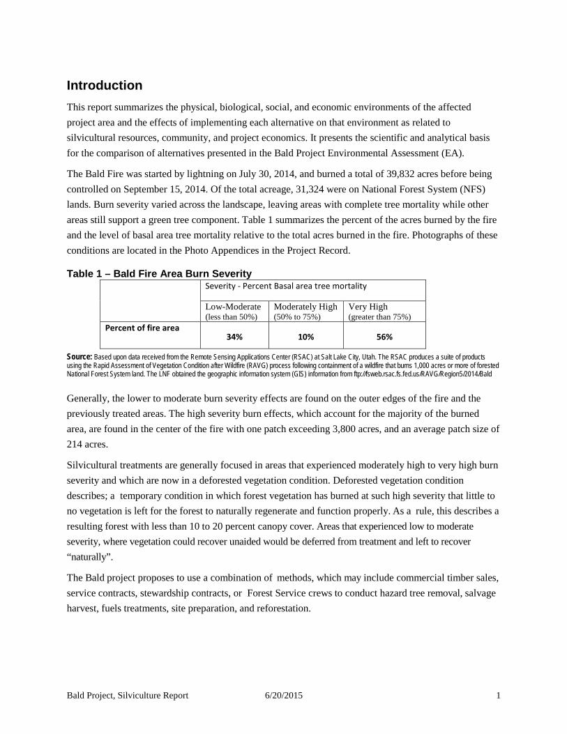
Introduction This report summarizes the physical, biological, social, and economic environments of the affected project area and the effects of implementing each alternative on that environment as related to silvicultural resources, community, and project economics. It presents the scientific and analytical basis for the comparison of alternatives presented in the Bald Project Environmental Assessment (EA).
The Bald Fire was started by lightning on July 30, 2014, and burned a total of 39,832 acres before being controlled on September 15, 2014. Of the total acreage, 31,324 were on National Forest System (NFS) lands. Burn severity varied across the landscape, leaving areas with complete tree mortality while other areas still support a green tree component. Table 1 summarizes the percent of the acres burned by the fire and the level of basal area tree mortality relative to the total acres burned in the fire. Photographs of these conditions are located in the Photo Appendices in the Project Record.
Table 1 – Bald Fire Area Burn Severity
Severity - Percent Basal area tree mortality
Low-Moderate (less than 50%)
Moderately High (50% to 75%)
Very High (greater than 75%)
Percent of fire area 34% 10% 56%
Source: Based upon data received from the Remote Sensing Applications Center (RSAC) at Salt Lake City, Utah. The RSAC produces a suite of products using the Rapid Assessment of Vegetation Condition after Wildfire (RAVG) process following containment of a wildfire that burns 1,000 acres or more of forested National Forest System land. The LNF obtained the geographic information system (GIS) information from ftp://fsweb.rsac.fs.fed.us/RAVG/Region5/2014/Bald
Generally, the lower to moderate burn severity effects are found on the outer edges of the fire and the previously treated areas. The high severity burn effects, which account for the majority of the burned area, are found in the center of the fire with one patch exceeding 3,800 acres, and an average patch size of 214 acres.
Silvicultural treatments are generally focused in areas that experienced moderately high to very high burn severity and which are now in a deforested vegetation condition. Deforested vegetation condition describes; a temporary condition in which forest vegetation has burned at such high severity that little to no vegetation is left for the forest to naturally regenerate and function properly. As a rule, this describes a resulting forest with less than 10 to 20 percent canopy cover. Areas that experienced low to moderate severity, where vegetation could recover unaided would be deferred from treatment and left to recover “naturally”.
The Bald project proposes to use a combination of methods, which may include commercial timber sales, service contracts, stewardship contracts, or Forest Service crews to conduct hazard tree removal, salvage harvest, fuels treatments, site preparation, and reforestation.

Bald Project, Silviculture Report 6/20/2015 2
Overview of Issues Addressed
Reforestation would expedite the beneficial re-establishment of a forested landscape capable of producing a variety of wood products, wildlife habitat, and ecological services. To compare between alternatives the following measurements are analyzed in this report: acres of hazard tree treatment, acres of land salvage logged, volume of timber and biomass removed, acres of fuels treatment and site preparation, acres of reforestation, and changes in vegetation type.
The Bald project was designed to address the following needs:
1) Immediately reduce numerous safety hazards caused by the Bald Fire. 2) Recover economic timber value before marketability is drastically reduced as a consequence of
insect activity, decay, and staining from fungi. 3) Reduce fuel loads, to adequately prepare sites for regeneration and reduce future loadings that
create conditions prime for devastating reburns. 4) Promote the re-establishment of fire resistant, shade-intolerant conifer and hardwood species. 5) Maintain roads needed for project implementation.
Affected Environment
Physical Environment
Hat Creek Ranger District (HCRD) lies within a transition zone between the southern Cascade mountain range and the northern Sierra Nevada mountain range of northeast California. Within and surrounding the project area the terrain is broken into a series of meadows, bitterbrush / sagebrush flats, and upland forests. Topography varies from broad and flat to sloping terrain with elevations from approximately 3,600 feet to 5,700 feet. Most slopes within proposed treatment areas are less than 35 percent, with some short pitches that exceed 35 percent.
Volcanic cones and their associated valley flows are the dominant geologic features in the area. Soils derived from andesite, basalt, and rhyolite vary from shallow to deep. This geology makes the area suited to growing timber and shrubs. Forest site class is 3 (III), 4 (IV), and 5(V). Timber regeneration potential is moderate with plantablilty moderate to high. The natural productivity is low to moderate with the limiting factor being the low precipitation (Kliewer 1994). See the Bald Soil Report for additional attributes of the soils underlying the project area.
The climate of the project area is characterized by hot, dry summers and cold, moist winters with temperatures ranging from -30 to 110 degrees Fahrenheit and an annual mean of 50 degrees. The growing season is about 120 days. Most precipitation occurs from November to April, and at elevations above 5,000 feet, the majority is snow. Very little rainfall occurs during the summer months; however, thunderstorms producing dry lightning are common. Precipitation averages 40 inches per year, falling primarily as snow above 4,000 feet (USDA Forest Service 1993).
Bald Project, Silviculture Report 6/20/2015 3
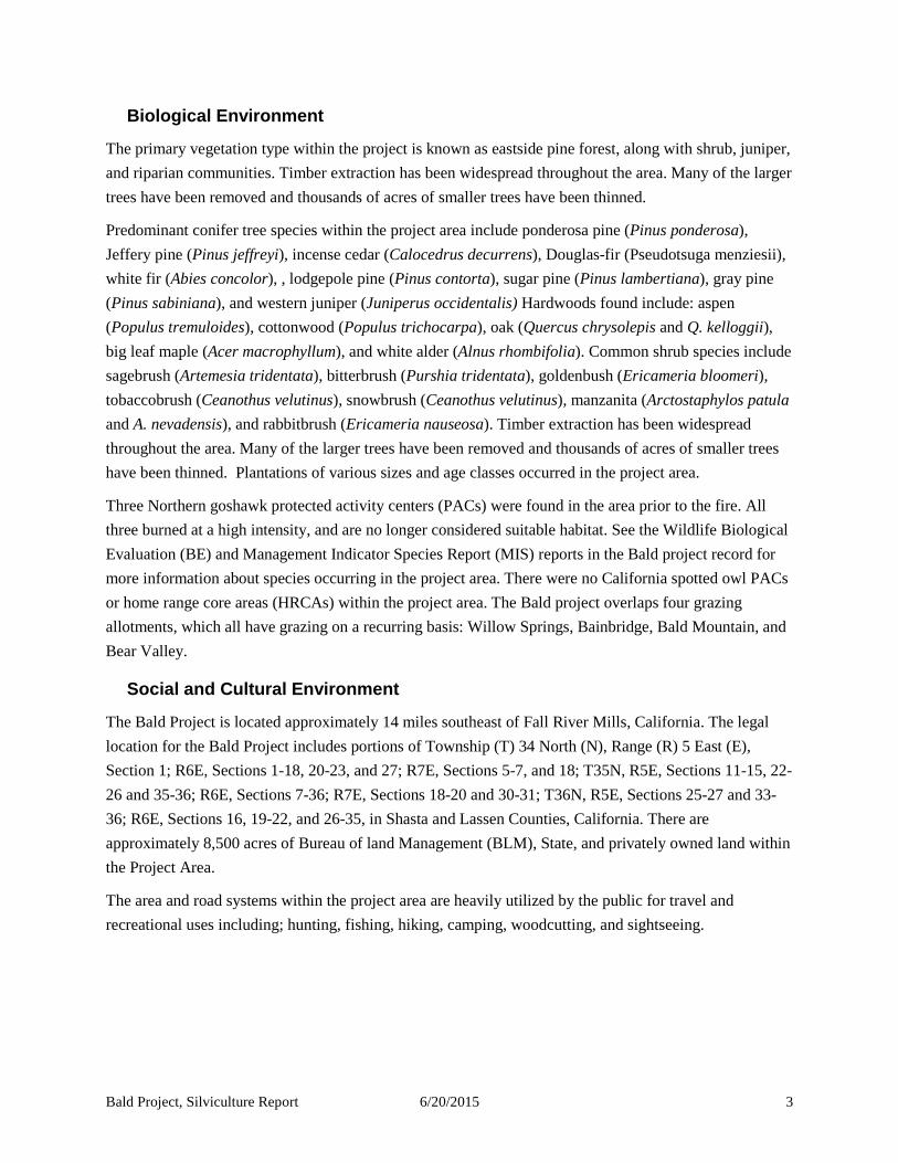
Biological Environment
The primary vegetation type within the project is known as eastside pine forest, along with shrub, juniper, and riparian communities. Timber extraction has been widespread throughout the area. Many of the larger trees have been removed and thousands of acres of smaller trees have been thinned.
Predominant conifer tree species within the project area include ponderosa pine (Pinus ponderosa), Jeffery pine (Pinus jeffreyi), incense cedar (Calocedrus decurrens), Douglas-fir (Pseudotsuga menziesii), white fir (Abies concolor), , lodgepole pine (Pinus contorta), sugar pine (Pinus lambertiana), gray pine (Pinus sabiniana), and western juniper (Juniperus occidentalis) Hardwoods found include: aspen (Populus tremuloides), cottonwood (Populus trichocarpa), oak (Quercus chrysolepis and Q. kelloggii), big leaf maple (Acer macrophyllum), and white alder (Alnus rhombifolia). Common shrub species include sagebrush (Artemesia tridentata), bitterbrush (Purshia tridentata), goldenbush (Ericameria bloomeri), tobaccobrush (Ceanothus velutinus), snowbrush (Ceanothus velutinus), manzanita (Arctostaphylos patula and A. nevadensis), and rabbitbrush (Ericameria nauseosa). Timber extraction has been widespread throughout the area. Many of the larger trees have been removed and thousands of acres of smaller trees have been thinned. Plantations of various sizes and age classes occurred in the project area.
Three Northern goshawk protected activity centers (PACs) were found in the area prior to the fire. All three burned at a high intensity, and are no longer considered suitable habitat. See the Wildlife Biological Evaluation (BE) and Management Indicator Species Report (MIS) reports in the Bald project record for more information about species occurring in the project area. There were no California spotted owl PACs or home range core areas (HRCAs) within the project area. The Bald project overlaps four grazing allotments, which all have grazing on a recurring basis: Willow Springs, Bainbridge, Bald Mountain, and Bear Valley.
Social and Cultural Environment
The Bald Project is located approximately 14 miles southeast of Fall River Mills, California. The legal location for the Bald Project includes portions of Township (T) 34 North (N), Range (R) 5 East (E), Section 1; R6E, Sections 1-18, 20-23, and 27; R7E, Sections 5-7, and 18; T35N, R5E, Sections 11-15, 22-26 and 35-36; R6E, Sections 7-36; R7E, Sections 18-20 and 30-31; T36N, R5E, Sections 25-27 and 33-36; R6E, Sections 16, 19-22, and 26-35, in Shasta and Lassen Counties, California. There are approximately 8,500 acres of Bureau of land Management (BLM), State, and privately owned land within the Project Area.
The area and road systems within the project area are heavily utilized by the public for travel and recreational uses including; hunting, fishing, hiking, camping, woodcutting, and sightseeing.

Bald Project, Silviculture Report 6/20/2015 4
Management Objectives The desired conditions for the project area are guided by the direction contained in the 1992 Lassen National Forest Land and Resource Management Plan (LRMP) and 1993 Record of Decision (ROD) as amended by the 2004 Sierra Nevada Forest Plan Amendment (SNFPA) Final Supplemental Environmental Impact Statement (FSEIS) and Record of Decision (ROD), and the 2007 SNFP Management Indicator Species Amendment. The Bald project is designed to be consistent with the desired conditions described in the Forest Plan.
The LRMP provides specific management direction by assigning areas to one of 17 management prescriptions. Management prescriptions apply a theme for management based on underlying land suitability and regulation classes. Prescriptions represent general management intent. The LRMP states (page 4-7) that final land allocations will be done at the project level, after a site-specific environmental analysis has been completed. Prescription maps do not generally display areas smaller than 200 acres (LRMP, page 4-7). Only one prescription can apply to a given acre of land; a list of priority can be found in the LRMP on page 4-39.
Additionally, the LRMP and the Sierra Nevada Forest Plan Amendment (SNFPA) 2004 imposes additional direction as standards and guidelines, including treatments that are cost-effective and contribute to community stability.
The project area is located in the Ladder management area (MA5) as identified in the LRMP. Designated management prescriptions identified in the LRMP are Non-Timbered Wildlife (A), Range-Wildlife (B), Rocky-Sparse Timber (K), and Timber (T). The objectives for each prescription is discussed below.
A: Non-Timber Wildlife. The purpose of this prescription is to maintain or improve habitat for species that are at least partially dependent on non-forest or non-commercial forests (LRMP p. 4-40). Emphasized practices include fire and fuels management, range administration and management, visual resource management, wildlife habitat management, and fish habitat management.
B: Range- Wildlife. The purpose of this prescription is to provide forage for livestock and wildlife and to improve soil and vegetative conditions (LRMP p.4-42). Emphasized practices include fire and fuels management, range administration and management, visual resource management, wildlife habitat management, and fish habitat management.
K: Rocky/Sparse Timber. The purpose of this prescription is to maintain timber stands on rocky, unplantable (by artificial means) land and on lands with sparse to poorly stocked eastside pine (LRMP p. 4-56). Emphasized practices include visual resource management, limited timber management, wildlife habitat management, and fish habitat management.
T: Timber. This prescription emphasizes wood production and utilization while maintaining other resource values (LRMP p. 4-71). Management practices emphasized include facility construction/ reconstruction, road maintenance, fuels management, fire management, and full timber management.

Bald Project, Silviculture Report 6/20/2015 5
Management of the project area is also guided by direction in the Sierra Nevada Forest Plan Amendment (SNFPA). Within the Bald Fire perimeter, pertinent land allocations defined by the SNFPA include northern goshawk protected activity centers (PACs), Riparian Conservation Areas (RCAs), General Forest, and Old Forest Emphasis Area.
Northern Goshawk Protected Activity Centers. The desired conditions for stands within PACS are: (1) at least two tree canopy layers, (2) dominant and codominant trees with average diameters of at least 24 inches diameter breast height (dbh), (3) at least 60 to 70 percent canopy cover, (4) some very large snags, and (5) snag and down woody material levels that are higher than average (SNFPA ROD p.38)
General and Old Forest Emphasis. Forest structure generally resembles pre-settlement conditions. High levels of horizontal and vertical diversity exist at the landscape scale (SNFPA ROD p.41)
Riparian Conservation Areas. There are multiple desired conditions. A summary of the ones that pertain to silvicultural resources are noted. For the full text, see the SNFPA ROD p.p. 42-43.
Species composition and structural diversity of plant and animal communities in riparian areas, wetlands, and meadows provide desired habitat conditions and ecological functions.
The distribution and health of biotic communities in special aquatic habitats (such as springs, seeps, vernal pools, fens, bogs, and marshes) perpetuates their unique functions and biological diversity.
Soils with favorable infiltration characteristics and diverse vegetative cover absorb and filter precipitation and sustain favorable conditions of stream flows. In-stream flows are sufficient to sustain desired conditions of riparian, aquatic, wetland, and meadow habitats and keep sediment regimes as close as possible to those with which aquatic and riparian biota evolved.
The physical structure and condition of stream banks and shorelines minimizes erosion and sustains desired habitat diversity. The ecological status of meadow vegetation is late seral (50 percent or more of the relative cover of the herbaceous layer is late seral with high similarity to the potential natural community). A diversity of age classes of hardwood shrubs is present and regeneration is occurring.
Meadows are hydrologically functional. Sites of accelerated erosion, such as gullies and headcuts are stabilized or recovering. Vegetation roots occur throughout the available soil profile.
The Forest Plan provides for ecosystem restoration following large, catastrophic disturbance events. Restoration activities may be conducted in all land allocations and include objectives for managing disturbed areas for long-term fuel profiles, restoring habitat, and recovering the economic value of some dead and dying trees. Restoration projects can include salvage of dead and dying trees for economic value as well as for fuels reduction (SNFPA ROD, pp. 4 and 6).
Forest Plan Standards and guidelines help managers to design post-disturbance restoration projects to reduce potential soil erosion and the loss of soil productivity caused by loss of vegetation and ground

Bald Project, Silviculture Report 6/20/2015 6
cover; protect and maintain wildlife habitat; manage development of fuel profiles over time; and recover the value of timber killed or severely injured by the disturbance (SNFPA ROD p. 52).
Ecological Restoration
Recently adopted mandates for Region 5 of the Forest Service, stipulate that ecological restoration will be the central driver of wildland and forest stewardship in the Pacific Southwest Region (USDA Forest Service 2011). Forest Service policy with regard to ecological restoration is broad in scope. As stated in the Forest Service Manual, “The aim is to reestablish and retain ecological resilience of National Forest System lands and associated resources to achieve sustainable management and provide a broad range of ecosystem services. Healthy, resilient landscapes will have greater capacity to survive natural disturbances and large scale threats to sustainability, especially under changing and uncertain future environmental conditions, such as those driven by climate change and increasing human uses” (FSM 2020.2). Ecological resilience is normally defined as the capacity of a system to cope with stress and to bounce back when the stress diminishes. It is measured by the rate at which a system returns to equilibrium following perturbation. Stressed ecosystems are less resilient than unstressed ecosystems.
Inherent goals of Forest Service restoration policy include ecosystem health, ecosystem services, and sustainability. Ecosystem health, in addition to resilience, has two other major criteria: vigor and organization. Vigor is measured in terms of energy flow, nutrient cycling and productivity. Organization refers to ecosystem complexity, which tends to increase with secondary succession in terms of number of species and the variety and intricacy of interactions. Stressed ecosystems typically display reduced species richness, fewer symbiotic relationships, and more opportunistic species.
In the face of climate change and population pressures there has now developed a complex matrix of natural and anthropogenic disturbance within which management regimes must be superimposed to meet National Forest and national policy objectives. Restoration of degraded lands means rebuilding functional ecosystems, but not necessarily restoring sites to resemble their original conditions in all aspects. Forest Service goals are less concerned with establishing historically functioning ecosystems as establishing ecosystems that are resilient in the face of current and projected disturbance regimes.
Silvicultural Objectives
The desired silvicultural condition of the Bald project is to apply treatments across the fire-affected area to provide for the successful establishment of early seral stage vegetation with an appropriate mix of species of trees and level of stocking. Treatments prescribed should aid in the reduction of fuels to provide for public and worker safety and lessen the risk for high intensity reburns to protect the reforestation investment. Prescribed treatments proposed for harvest are designed to conserve soil and water resources and not allow significant or permanent impairment of the productivity of the land (NFMA 1976).

Bald Project, Silviculture Report 6/20/2015 7
Multiple Use Objectives
Project objective would also meet the following direction from the Lassen National Forest Land and Resource Management Plan (LMRP) and the 2004 Sierra Nevada Forest Plan Amendment Final Supplemental Environmental Impact Statement Record of Decision (SNFPA FSEIS ROD 2004).
• LMRP – Provide a stable and cost-efficient road system through appropriate construction, re- construction, and/or maintenance (p. 4-16).
• LMRP – Conduct an active program of salvage/sanitation harvesting while meeting specified snag levels as stated in the Forest-wide Standards and Guidelines, Management Prescriptions, and Management Area direction (p. 4-30).
• LMRP – Provide a mosaic of chaparral age and size classes to meet Management Area direction (p. 4-30).
• LMRP – As a part of timber stand regeneration, plant or otherwise encourage all native commercial tree species in naturally occurring proportions across the entire Forest (p. 4-31).
• SNFPA FSEIS ROD – Determine the need for ecosystem restoration projects following large, catastrophic disturbance events (wildfire, etc.). Objectives for restoration projects may include limiting fuel loads over the long term, restoring habitat, and recovering economic value from dead and dying trees (p. 52).
• SNFPA FSEIS ROD – Salvage harvest of dead and dying trees may be conducted to recover the economic value of this material and to support objectives for reducing hazardous fuels, improving forest health, reintroducing fire, and /or re-establishing forested conditions (p. 52).
• SNFPA FSEIS ROD – Design [salvage] projects to protect and maintain critical wildlife habitat. Examples are activities that would: (1) avoid areas where forest vegetation is still largely intact, provide for sufficient quantities of large snags, (3) maintain existing large woody material as needed, (4) provide for additional large woody material and ground cover as needed, (5) accelerate development of mature forest habitat through reforestation and other cultural means, and (6) provide for a mix of seral stages over time (p. 52).
• SNFPA FSEIS ROD – Design projects to manage the development of fuel profiles over time. Examples are activities that would: (1) remove sufficient standing and activity generated material to balance short-term and long-term surface fuel loading and (2) protect remnant old forest structure (surviving large trees, snags, and large logs) from high severity re-burns or other severe disturbance events in the future (p. 52).
• SNFPA FSEIS ROD – Encourage hardwoods in plantations. Promote hardwoods after stand- replacing events. Retain buffers around existing hardwood trees by not planting conifers within 20 feet of the edge of hardwood tree crowns (p. 53).

Bald Project, Silviculture Report 6/20/2015 8
• SNFPA FSEIS ROD – Riparian Conservation Objective #3 - Ensure a renewable supply of large down logs that: (1) can reach the steam channel and (2) provide suitable habitat within and adjacent to the Riparian Conservation Area (p. 33).
• SNFPA FSEIS ROD – Allow hazard tree removal within RCA or CAR. Allow mechanical ground disturbing fuels treatments, salvage harvest, or commercial fuelwood cutting within RCA or CAR when the activity is consistent with Riparian Conservation Objectives (RCO). Utilize low ground pressure equipment, helicopters, over the snow logging, or other non-ground disturbing actions to operate off existing roads when needed to achieve RCO. Ensure that existing roads, landings, and sked skid trails meet Best Management Practices. Minimize the construction of new skid trails or roads for access into RCA for fuel treatments, salvage harvest, commercial fuelwood cutting, or hazard tree removal (p. 64-65).
Compliance with Other Relevant Laws, Regulations, Policies, and Plans
Multiple-Use Sustained Yield Act of 1960 requires that national forest lands shall be administered for a variety of multiple uses, and that all resources shall be maintained as renewable in perpetuity for regular periodic output of several products and services at a sustainable level.
National Environmental Policy Act of 1969 (NEPA) established procedures for decision-making, disclosure of effects, and public involvement on all major federal actions.
National Forest Management Act of 1976 (NFMA) including its amendments to the Forest and Rangeland Renewable Resources Planning Act of 1974 state that it is the policy of the Congress that all forested lands in the National Forest System be maintained in appropriate forest cover with species of trees, degree of stocking, rate of growth and conditions of stand designed to secure the maximum benefits of multiple use sustained yield management in accordance with land management plans.
Forest plans and amendments comply with the Organic Administration Act of 1897 (at 16 U.S.C. 475, 551), Weeks Law of 1911, as amended (at 16 U.S.C. 515, 552), Knutson-Vandenberg Act of 1930 (16 U.S.C. at 576b), Sikes Act (Fish and Wildlife Conservation) of September 15, 1960 (16 U.S.C. at 670g), Endangered Species Act of 1973 (P.L. 93-205, 87 Stat. 884; 16 U.S.C. 1531- 1544, as amended), Forest and Rangeland Renewable Resources Planning Act (RPA) of 1974, as amended by National Forest Management Act (NFMA) of 1976 (16 U.S.C. 1600-1614, 472a), and the Code of Federal Regulations under Title 36, Chapter II, Parts 200-299.
Scope of Analysis The geographic analysis area used to analyze the direct, indirect, and cumulative effects on project vegetation is defined by the project area boundary.
The analysis in this report is based on field reconnaissance of the project area and a variety of data sources including: aerial photography, satellite imagery, Lassen National Forest Geographic Information System (GIS) files (Veg09), and remote sensing data from the Rapid Assessment of Vegetation Condition

Bald Project, Silviculture Report 6/20/2015 9
after Wildfire (RAVG) for the Bald fire, 2014. Pre-cruise data was collected in October of 2014 within proposed salvage units to determine the extent of tree mortality and potential volume to be removed. Plot data was not collected in stand-alone fuels and reforestation units, but stand conditions were visually assessed to the greatest extent possible. On-the-ground conditions may vary from those represented by the Vegetation and RAVG layers.
The spatial boundary used to analyze for silvicultural cumulative effects is the project area. Stand and site conditions outside the project area generally have little effect on treated stands, with the exception of effects on forest insect populations and the risk of fire spread from adjacent untreated stands.
The temporal scale for this analysis is based on current cumulative vegetation conditions. It is assumed that the current vegetation conditions are the sum of all past actions that have occurred within the analysis area. In a broader sense, current vegetation structure and composition reflects the historical management regimes. This vegetation structure and composition includes attributes of the current landscape including existing vegetation types, fuel treatments, past harvest, plantations, and burned areas. Management activities and disturbances since 1983 were considered in this analysis because the effects of the past silvicultural treatments and events are still occurring. Management activities and events prior to this are considered in this analysis as far as they have shaped current stand structure conditions. See the Past, Ongoing, and Reasonably Foreseeable Future Actions (PORFFA) Summary Report for the Bald Project for a list of specific past, present, and foreseeable future actions.
The temporal boundary of the vegetation effects analysis extends 5years into the future when considering the cumulative effects of other foreseeable future actions in combination with these proposed actions, though the proposed actions themselves are considered to a time 20 years into the future for treatment effectiveness. It is important to note that unknown or unanticipated wildfires, disease outbreaks, or mortality may occur in the analysis area within the 20 year timeframe – these potential future events are not included as part of this analysis
Pre- and Post- Fire Stand Conditions
Pre-settlement, low elevation forests on the Hat Creek Ranger District (HCRD) were comprised of open stands dominated by large pines (ponderosa pine and Jeffrey pine). The openings supported a large diversity of grasses and flowers, with scattered pockets of shrubs. They were maintained by a disturbance regime of frequent, low-intensity fires. At higher elevations, the predominantly pine forests gave way to mixed pine and white fir, then east-side mixed conifer, and at the highest elevations, red fir. The landscape of the Bald Fire had been heavily influenced over the last 150 years by past management activities that include grazing, timber management, and fire exclusion.
The lack of fire led to changes in both the structure and composition of the vegetation within the project area and surrounding area. Stands had become denser, with a larger number of trees per acre in the smaller size class then had historically been found in the area. Approximately 10,680 acres (34 percent of the project area) had burned since 1910. Of those, approximately 5,220 acres were prior to 1965, showing

Bald Project, Silviculture Report 6/20/2015 10
the lack of fire on the landscape in the last 50 years. See the Fire and Fuels Report for a further discussion on fuel conditions before to the Bald fire.
Prior to the Bald Fire, approximately 73 percent of the project area was considered forested and 2 percent barren. Due to the high intensity of the fire, it is estimated that only 15 percent of the project area remains forested, and 81 percent of the area is considered barren (Table 2). These forested areas are generally found on the outer edges of the fire perimeter, while the deforested areas are in the center of the project area
Table 2. Project Area Cover Types Pre and Post Bald Fire
CWHR Code Pre-Fire Post-Fire
USFS Cover Type Acres Percent of
Project Area Acres Percent of
Project Area Forest Eastside Pine * EPN,JPN,PPN 20,288 65% 4,164 13% Lodgepole pine LPN 12 <1% 1 <1% Juniper JUN 301 1% 90 <1% Sierran mixed conifer SMC 1,570 5% 302 <1% Blue oak-gray pine BOP 177 1% 11 <1% Montane hardwood-conifer MHC 370 1% 111 <1% Montane hardwood MHW 294 1% 12 <1%
Montane riparian MRI 9 <1% 0 0% Subtotal Forest Type 23,021 73% 4,691 15%
Shrub-Herbaceous Chaparral** MCH,MCP 4,854 15% 435 1% Sagebrush SGB 1,744 6% 478 2% Low sage LSG 442 1% 235 1% Bitterbrush BBR 82 <1% 2 <1% Annual grasslands AGS 4 <1% 2 <1% Perennial grassland PGS 418 1% 147 <1% Wet meadow WTM 95 <1% 20 <1% Lacustrine (Aquatic) LAC 33 <1% 9 <1%
Subtotal Shrub-Herbaceous 7,672 24% 1,328 4%
Barren (rock, gravel, soil) BAR 631 2% 25,305 81%
Total Project Area 31,324 100% 31,324 100% *includes eastside pine, ponderosa pine, and Jeffery pine **montane and mixed chaparral
Source: Eagle Lake Ranger District GIS (Veg09)

Bald Project, Silviculture Report 6/20/2015 11
Tree Size and Density and Shrub Class Distribution
Conifer size and density class distribution can be shown using the California Wildlife Habitat Relationship (CWHR) system. While tree diameter tends to be a poor predictor of tree age, CWHR size class can be used to demonstrate seral stages and approximate age classes across the project area. The distribution of CWHR size and canopy classes of the forest and shrub cover types on National Forest System Lands (NFS Lands) in the project area before the Bald fire is displayed in Table 3. The post- fire condition is shown in Table 4.

Bald Project, Silviculture Report 6/20/2015 12
Table 3. Pre-Fire Vegetation - CWHR Size and Density in the Project Area
NonTimber Seed
-ling
Size Class 2 Sapling
(1" - 5.9" dbh)
Size Class 3 Pole
(6" - 10.9" dbh)
Size Class 4 Small
(11" - 23.9" dbh)
Size Class 5 Medium/Large
(≥ 24" dbh) Totals
Bar Grass Shrub 1 S P M D S P M D S P M D S P M D Eastside Pine 5 325 294 206 6 4,692 9,346 4,266 1,124 16 8 20,288 Lodgepole pine 8 4 12 Juniper 5 138 122 26 0 10 301 Sierran mixed conifer
16 3 154 330 752 315 1,570
Blue oak-gray pine 129 48 0 0 177 Montane hardwood-conifer
31 4 167 87 49 32 370
Montane hardwood 24 34 156 3 58 5 10 4 294
Montane riparian 9 9 Chaparral 4,854 4,854 Sagebrush 1,744 1,744 Low sage 442 442 Bitterbrush 82 82 Annual grasslands 4 4 Perennial grassland 418 418 Wet meadow 95 95 Lacustrine (Aquatic) 33 33
Barren 631 631 Total Acres 631 550 7,122 24 48 533 301 206 9 5,346 9,938 5,103 1,475 26 4 8 31,324
Percent of Area 2 2 23 <1 <1 2 1 1 <1 17 32 16 5 <1 <1 <1 100%
Seral Stage Shrub
Tree seedlings, saplings, and poles Small sawtimber Medium/Large
sawtimber Early Seral Mid-Seral Mid to Late Seral
23% 3% 70% <1% Source: Eagle Lake Ranger District GIS (Combination of Veg09 and RAVG = CWHR_FSOnly_RAVGID_ClipProjectArea) There were no CWHR size class 6 (2-story stands) within the project area

Bald Project, Silviculture Report 6/20/2015 13
Table 4. Post-Fire Vegetation - CWHR Size and Density in the Project Area (Existing Condition)
NonTimber
Seed-
ling
Size Class 2 Sapling
(1" - 5.9" dbh)
Size Class 3 Pole
(6" - 10.9" dbh)
Size Class 4 Small
(11" - 23.9" dbh)
Size Class 5 Medium/Large
(≥ 24" dbh) Totals
Bar Grass Shrub 1 S P M D S P M D S P M D S P M D Eastside Pine 129 85 60 905 2,245 610 158 4,192 Lodgepole pine 1 1 Juniper 1 39 33 16 1 90 Sierran mixed conifer
11 30 94 124 43 302
Blue oak-gray pine 9 2 11 Montane hardwood-conifer
9 62 19 14 7 111
Montane hardwood 1 6 4 1 12
Montane riparian Chaparral 435 435 Sagebrush 478 478 Low sage 235 235 Bitterbrush 2 2 Annual grasslands 2 2 Perennial grassland 147 147 Wet meadow 9 9 Lacustrine (Aquatic)
Barren 25,297 25,297 Total Acres 25,297 158 1,150 1 156 85 60 1,050 2,393 765 208 1 31,324
Percent of Area 81 <1 4 <1 1 <1 <1 3 8 2 1 <1 100%
Seral Stage Shrub
Tree seedlings, saplings, and poles Small sawtimber Medium/Large sawtimber
Early Seral Mid-Seral Mid to Late Seral
4% 1% 14% <1 % Source: Eagle Lake Ranger District GIS (Combination of Veg09 and RAVG = CWHR_FSOnly_RAVGID_ClipProjectArea)

Bald Project, Silviculture Report 6/20/2015 14
Environmental Effects - Alternative 1 – Proposed Action
Alternative 1 was developed to accomplish the purpose and need for the Bald Project by evaluating existing vegetation conditions, burn patterns and intensities, management prescriptions, and land allocations within the analysis area. The objective of the project is to fall and remove or leave in place hazard trees along publically used Forest Service roads (maintenance level 2 and higher), salvage merchantable dead trees, treat standing fuels to reduce future surface fuel loading, and artificially reforest by planting appropriate growing sites in the project area. Alternative 1 includes transportation recommendations to actively manage the forest transportation system within the project area. This would include maintenance, reconstruction, decommissioning, and construction of temporary roads. See the Bald EA for a full description of Alternative 1.
Table 5. Proposed treatments and estimated acres in the Bald Project
Alternative 1 Estimated Acres
Percent of Project Area
Hazard Tree Removal* 4,815 15%
Area Salvage 3,632 12%
Area Fuels 5,499 18%
Reforestation Only 417 1%
Total proposed for treatment 14,363 46%
Natural Recovery 16,961 54%
*This acreage includes the acres of the actual roadbed.
Direct and Indirect Effects Hazard Tree Removal
Fire-affected hazard trees posing critical threats to safety would be felled and removed or felled and left in place along 131 miles of maintenance level 2 (ML2) and higher roads, and along 10 miles of right-of-way along the Burlington Northern Santa-Fe railway within the Bald Fire perimeter. Incidental hazards along the roads immediately adjacent to the fire perimeter may also require treatment.
Trees designated for treatment are based on guidelines developed to meet two objectives. This balance aims to retain healthy forested conditions while providing for safety and access to the area.
• Remove those trees that are dead or have a high probability of mortality due to fire-injury or have structural defects that indicate high failure potential to abate potential hazards to visitors and improve safety and access within the Bald Fire area and
• Retain those trees that would likely survive to maintain visual quality, wildlife habitat, and recreational values.

Bald Project, Silviculture Report 6/20/2015 15
Hazard tree marking guidelines are based upon two reports developed by Region 5 Forest Health Protection.
1. Fire-injured tree marking guidelines #RO-11-01 (Smith and Cluck 2011). The guideline criteria for delayed, fire-related conifer tree mortality are based on percent crown length killed. The probability of mortality (Pm) level is t h e threshold where all trees meeting or exceeding a selected Pm level are marked for removal. The number of trees removed from a project area would generally vary with different Pm levels; fewer trees would be marked at higher Pm levels (a more conservative mark) and more trees would be marked at lower Pm levels (a less conservative mark). As safety is the primary concern along roads the probability of mortality level chosen was Pm=0.6.
These guidelines take into account pre and post-bud flushing in conifers in determining potential mortality.
2. Hazard tree marking guidelines Report #RO-12-01 (Angwin et al. 2012)
Merchantable timber would be removed using timber sale contracts. Sub-merchantable trees and non-merchantable hazard trees would be felled the resulting fuels treated with one or more of the following methods: biomass removal, mastication, felling and lopping, machine piling and burning, or broadcast burning. The fuels treatment would depend upon the amount of surface fuel loading present. This work would be completed using service contracts or Forest Service personnel.
No snag retention is planned within the road hazard units. Where available, at least five logs per acre greater the 12-inches in diameter would be retained in contact with the soil surface to meet soil and wildlife needs. For ephemeral streams in hazard tree units, ground based mechanical equipment would be restricted to the road prism. Reforestation strategies in the Hazard Tree units would be the same as adjacent stands.
The 4,815 acres of hazard tree treatment represents 15 percent of the Bald fire within the project area. For analysis purposes a buffer of 150 feet from the roads was used but only trees that have the potential to strike the road would be designated for removal under this prescription. This includes both fire killed and damaged many trees as well as live trees where fire affected the structural integrity and root system.
Direct effects of the hazard tree treatment would be removal of hazards along publically traveled roads and utilization of forest products. Timber sales generate revenue for the Forest Service, which can be used to accomplish post-harvest treatments. Timber sales also help support the forest product industries as well as, the local communities that rely on revenue generated by forest products.
Within the treatment corridor, salvage harvest would reduce excessive fuels in the future, thus decreasing potential fire severity if the area were to burn again (Brown et al. 2003)

Bald Project, Silviculture Report 6/20/2015 16
Area Salvage Harvesting
Fire-killed and fire-injured trees within the Bald Fire perimeter would be harvested. Merchantable trees would be removed as sawlogs if operations occur before the wood deteriorates. Non-merchantable trees would be removed as biomass, masticated, felled and lopped, machine piled and burned or broadcast burned to meet desired fuel conditions.
The objectives in the salvage treatment units are to: • remove those trees that are dead or have a high probability of mortality due to fire-injury and • retain those trees that would likely survive to maintain wildlife habitat and desired forest cover.
Trees designated for removal are based on the same guidelines discussed above except probability of mortality level is set at 0.7 probability of mortality level (Pm = 0.7)
Area salvage harvesting would occur on approximately 3,632 acre or 12 percent of the project area. The salvage harvest operations would utilize ground-based, mechanical harvesting to remove fire-killed and fire-injured trees from treatment areas on slopes 35 percent or less. On slopes greater than 35 percent, only non-mechanical methods would be used to create openings for artificial regeneration.
Following salvage removal, natural and activity-generated fuels would be masticated, broadcast burned or piled mechanically or by hand, and the piles burned The number of acres treated by broadcast burning or pile burning is dependent on the amount of biomass removed from within the mechanical or hand treatment units. If more biomass is removed, the number of broadcast or pile burning acres would most likely decrease. The maximum degree of burning is used in analysis of this proposal.
Direct effects of salvage harvest would be the capture of economic value. The potential revenue from a timely executed timber sale could help offset the costs of other treatments such as removal of fire-killed biomass, additional fuel treatment, and reforestation costs.
Damage to residual trees and vegetation may occur during harvesting operations including damage to stems, bark scraping, wrenched stems, broken branches, broken tops, and crushed foliage (McIver et al. 2003). These effects are typical in logging operations, but care would be taken to minimize the potential for damage to residual trees. The Forest Service would inspect timber sales during harvesting to ensure that damage to residual trees and vegetation is within reasonable tolerances.
Damage and/or mortality of natural regeneration may occur during harvesting operations, particularly in ground-based harvesting treatments (Donato 2006). Areas where the risk of seedling damage and/or mortality is greatest would be within or near skid trails and landings. However, reforestation after salvage logging activities would allow managers to have better control over density, spacing and desirable conifer species. The LRMP soil quality standards provides direction that landings and permanent skid trails should not encompass more than 15 percent of timber stands. Consequently, damage and/or mortality of natural regeneration due to harvesting operations would be limited in size and scale to skid trails dispersed through the stand.

Bald Project, Silviculture Report 6/20/2015 17
Indirectly, salvage harvest would reduce excessive fuels in the future, thus decreasing potential fire severity if the area were to burn again (Brown et al. 2003). Salvage harvest would facilitate artificial and natural regeneration efforts and help protect plantations, which are both an investment of money and resources, once they become established. Harvesting dead and dying trees that are in excess of other resource needs would provide a safer work environment during tree planting and release. Seedlings and saplings would be at high risk from any wildfire event in early stages of growth due to low crown heights and heavy shrub growth. Reducing existing and future heavy fuel loading prior to planting would help to protect young plantations should wildfire occur in the future. Reduced fuels from salvage operations could increase public and worker safety.
Area Fuel Treatments
In areas that burned at moderate and high severity and where timber does not meet merchantability standards, hazard abatement, fuels reduction, and site preparation for reforestation would be accomplished by biomass removal, mastication, felling and lopping, machine piling and burning, or broadcast burning. Ground based mechanical methods would be used areas on slopes 35 percent or less. On slopes greater than 35 percent, only non-mechanical operations would be allowed. In all areas, trees designated for removal would use the same guidelines as discussed above under Area Salvage. Activity-generated fuels would be broadcast burned or piled mechanically or by hand, and piles burned.
Area fuels treatments would occur on approximately 5,499 acre or 18 percent of the project area. This work would be completed using service contracts or Forest Service personnel; most likely, after area salvage treatments are completed.
The number of acres treated by broadcast burning or pile burning is dependent on the amount of biomass removed from within the mechanical or hand treatment units. If more biomass is removed, the number of broadcast or pile burning acres would most likely decrease. The maximum degree for burning is used in analysis of this proposal.
Like salvage harvest, the fuels treatments would reduce excessive fuels in the future, thus decreasing potential fire severity if the area were to burn again (Brown et al. 2003), and increase firefighter safety. Fuels treatments would also facilitate artificial and natural regeneration efforts and help protect plantations, which are both an investment of money and resources, once they become established. Harvesting dead and dying trees that are in excess of other resource needs would provide a safer work environment during tree planting and release. Seedlings and saplings would be at high risk from any wildfire event in early stages of growth due to low crown heights and heavy shrub growth. Reducing existing and future heavy fuel loading prior to planting would help to protect young plantations should wildfire occur in the future.
Damage to residual trees and vegetation may occur during treatment operations including damage to stems, bark scraping, wrenched stems, broken branches, broken tops and crushed foliage (McIver et al. 2003). These effects are typical in operations involving mechanical equipment, but care would be taken to

Bald Project, Silviculture Report 6/20/2015 18
minimize the potential for damage to residual trees. The Forest Service would inspect contracts during treatment to ensure that damage to residual trees and vegetation is within reasonable tolerances.
Damage and/or mortality of natural regeneration may occur during treatment operations, particularly in ground-based harvesting treatments (Donato 2006). Areas where the risk of seedling damage and/or mortality is greatest would be within or near skid trails and landings. However, reforestation after fuel reduction activities would allow managers to have better control over density, spacing and desirable conifer species.
Reforestation
Reforestation would occur on approximately 12,200 acres within the project area. This includes the areas proposed for salvage and fuels treatments and an additional 417 acres that would be “reforestation only.
Tree planting strategies would be implemented to comply with Region 5 Stocking Guidelines over time. These guidelines define future minimum and recommended stocking levels by forest type and site class, ranging from 75 to 300 trees per acre. Lower quality sites would have lower stocking levels than higher quality sites, contributing to a heterogeneous forest structure across the landscape. Planted tree species would be appropriate for the site and would include a mixture of Jeffrey, ponderosa, western white, sugar pine, Douglas fir, and incense cedar. Only native tree species grown from locally collected seed sources would be planted. White fir and lodgepole pine would likely re-establish via natural regeneration where the species existed prior to the fire and seed trees or a seed source is present. Performance of artificial regeneration has been known to exceed that of natural regeneration (Minore and Laacke 1992, Shepperd et al. 2006, Newton et al. 2006).
Reforestation strategies are based upon the primary objectives for the land base. On the T (timber emphasis) and K (timber emphasis on rocky ground) designated management prescriptions, the objective would be to create conditions of a fully stocked stand. On A and B (range-wildlife emphasis) designated management prescriptions the growth and production of timber is a lesser objective. Reforestation objectives on A and B areas would be to maintain a tree component on the landscape. Natural regeneration is a reforestation strategy that would be used in areas where live trees remain on site or in the adjacent areas, areas dominated by montane chaparral, juniper, or are economically or technically infeasible, and in retention islands.
Planting strategies proposed for reforestation include conventional planting, founder stands, cluster planting, and natural regeneration.
Conventional planting is an effective reforestation method to achieve full tree stocking. Spacing between trees for conventional planting would depend on site conditions and future desired conditions. In areas with good access, productive soils, and high moisture (topographic catch areas or north to northeast facing slopes), spacing would be approximately 12 by 12 feet. Wide-spaced conventional planting (15 by 15 feet) would also be implemented on less productive sites and/or steeper slopes.

Bald Project, Silviculture Report 6/20/2015 19
Cluster planting is a method that creates a more heterogeneous forest structure across the landscape. Clusters of three to five trees (spaced 5 to 8 feet apart within the cluster) in a triangle are planted at 25 to 30 foot spacing depending on desired stocking. A variety of species can be planted at each or a subset of clusters can be planted to provide for species diversity. Based on survival and competition, this method would result in a more heterogeneous distribution of trees, which would increase forest resiliency. This method would typically be used in areas with poor to moderate site quality, low moisture (south and west facing slopes, shallow soils or topographic loss areas), rocky areas, steep or inaccessible areas, or in areas where aesthetics are of value.
Founder stands are small plantings typically one acre in size distributed across areas in the landscape in 5 to 10 percent of stands that have no seed source. Founder stands are designed to create small stands that would eventually mature to seed set and promote natural regeneration. Founder stands would be strategically located in productive micro-sites and in locations that improve the probability for future seed dispersal (e.g. ridge tops).
Natural regeneration is a reforestation strategy that would be considered in areas dominated by montane chaparral, hardwoods, and RCAs, areas economically or technically infeasible, or where live trees remain on site or in the adjacent area.
Depending on initial spacing of the seedlings, subsequent precommercial thinning (PCT) treatments may be required. PCT can be used in planted areas to create spatial heterogeneity in the second entry to meet desired stocking levels that meet long-term ecological and/or fuel objectives. Future PCT is not included in this analysis.
Sprouting shrubs and vegetation may need to be treated adjacent to planted trees to reduce competition for site resources in order to assure establishment. This may be done through manual or mechanical cutting methods such as grubbing, mastication, or the use of brush cutters. All site preparation would occur prior to planting. Reforestation would typically need to occur within two years to increase the probability of survival of the planted trees with the competing brush.
First- and third-year survival examinations on all planted units would occur. Planted units would be assessed for competing vegetation and the need for follow-up treatment to ensure survival and stocking are met. Areas that do not meet stocking may be replanted. The proposed action includes at least one release treatment using manual or mechanical methods such as hand grubbing, mastication, or brush cutting to control competing vegetation within one to three years and a second treatment conducted within two to five years of planting. Control of competing vegetation would remove vegetation a minimum of four feet in all directions around approximately 150 to 200 of the best trees per acre. No herbicides would be used. Animal control actions such as protective barriers or trapping may be used if warranted. Sites planted with trees should be certified of establishment five years after planting.
The direct effects of artificial reforestation would be the re-establishment of fire resistant; shade intolerant conifer species before shrub, grass, and forb competition preclude natural regeneration of these tree species. Reforestation activities are proposed to take advantage of bare ground now before

Bald Project, Silviculture Report 6/20/2015 20
subsequent growth of shrubs, forbs and grasses fully occupy the proposed units (Tappeiner and McDonald 1996, Sessions et al. 2004). Planting trees as soon as possible following a fire ensures the best possible survival rate, especially without use of herbicides to release planted seedlings from vegetation competition. Deferring reforestation treatments would result in the need for even more ground disturbing activities to achieve any reforestation results. Deferred site preparation activities would need to treat highly competitive vegetation by pulling shrubs and scraping the ground to expose bare mineral soil. Even with these kinds of measures, trees planted at a later time would have a lower survival rate than those planted immediately following the wildfire (Sessions et al. 2004). Additionally more snags may need to be cut down for safety reasons if reforestation activities are deferred. Weakened fire damaged trees would continue to die in the years following the wildfire.
Vegetative species that become established early in the post-fire environment influence forest dynamics for decades to centuries. Research in post-fire natural regeneration demonstrates that desirable natural regeneration may be inhibited by dominance of woody shrubs (Tappeiner and McDonald 1996, Gray et al. 2005, Moghaddas et al. 2008)
Establishment of conifers after wildfires can be spatially variable over a long regeneration period (Turner et al. 1997, Shatford et al. 2007, Zhang et al. 2008) and shade intolerant tree species may be excluded from sites indefinitely because these tree species might not produce seed for several years following the fire, or the seed source may be destroyed (Tappeiner and McDonald 1996). While natural regeneration closest to seed sources is the most reliable, longer distance regeneration is dependent on favorable seed development, dispersal mechanisms, seedbed receptiveness, and microsite conditions such as aspect, soil moisture, light levels, and presence of competing vegetation.
Post-fire regeneration research in the Storrie fire on the Lassen National Forest found the lowest densities of Pinus spp. in the unchanged and high fire severity areas (Crotteau et al. 2013, Crotteau et al. 2014) which may result in an ecosystem type shift. Crotteau et al. (2014) found the lowest overall seedling densities and poorest conifer stocking were observed in the high-severity burned areas. Additionally, a study of tree regeneration patterns and shrub dynamics for stand-replacing patches within five recent fires in the northern Sierra Nevada including the Storrie fire, found that although tree regeneration densities varied considerably. Over 50 percent of the sampled stand-replacing patches and approximately 80 percent of all plots had no tree regeneration. The percentage of patches and plots without pine regeneration was even higher, 72 percent and 87 percent respectively (Collins et al. 2010).
Forest Transportation System Management
Salvage operations would have effects on forest stand structure. Tractor and biomass removal operations would require small clearings or landings, generally less than one half acre in size, to store logs and biomass material prior to removal. These openings would also be used to service equipment. Landing size depends on the topography and the number of trees utilizing the landing. These clearings are expected to reforest with conifers based on field review of past landings within the project area.

Bald Project, Silviculture Report 6/20/2015 21
Where possible, the existing forest transportation system would be used to provide access to treatment units. Road maintenance, including surface protection and erosion control, would be performed on portions of the system as needed for project implementation. A dust abatement plan would be included to control wind-caused erosion from road use. National Forest System roads and non-paved County roads used for haul would receive pre-, during-, and post-haul maintenance. Trees would be cleared from road right-of-ways for maintenance and non-system road upgrades. Most trees to be removed are saplings and seedlings, which have become established since road construction or the last road maintenance treatment.
Approximately 2.2 miles of existing non-system roads within the project area would be needed for project implementation, including salvage and fuels treatments, reforestation, and maintenance due to the changed condition caused by the fire These non-system roads would be added to the Forest transportation system as ML 2 roads. Approximately 1 mile of temporary roads may be constructed to access proposed treatment areas. Following project implementation, these temporary roads would be decommissioned. Clearing for harvest and road construction operations is expected to impact less than one percent of the treated areas.
Construction of skid trails, landings, and temporary roads would require incidental removal of trees beyond those described for silvicultural purposes. However, the location and size of skid trails, landings and temporary roads and the trees harvested for the construction of such facilities must be approved and agreed upon by the Forest Service. Live tree removal would be permitted by necessity to allow for such facilities and would be avoided whenever practicable. Therefore, the removal of trees for operability would be an incidental component of harvesting activities, of minimal size and scale and highly dispersed and would have negligible effects on forest vegetation.
Vegetation Diversity and Resiliency
Reforestation strategies include considerations for vegetative diversity where it exists within the project area. Integrated design features were developed as part of Alternative 1 to encourage hardwoods and enhance meadow and riparian funtion.
• Black oak, aspen, and other hardwoods, alive or dead, would be retained and protected within treatment units within the limits of safety and operability.
• Conifers would not be planted within 20 feet of live California black oak and white oak tree crowns, including sprouts greater than three feet tall.
• Conifers would not be planted within 150 feet of aspen and cottonwood communties on the east, south and west side of the stand or 100 feet on the north side to maximize light to the stand and allow for expansion. In addition if monitoring indicats browsing is inhibiting the recruitment of regenerating aspen and cottenwoods, fencing would be constructed to protect regenaration until suckers and sprouts exceed the browse line.
• Along stream channels with existing riparian communities (e.g. willow, alder,sedges, juncus, etc.) reforestation of conifer species would not occurr within 20 feet of the riparian plant community.

Bald Project, Silviculture Report 6/20/2015 22
• No conifer planting would occur within 50 feet of a meadow edge. From fifty feet of the meadow edge and out, planting density would increase using the planting stategy and spacing based on the surrounding forest stand condition.
Pre-fire shrub and herbaceous vegetation comprised approximately 24 percent of the project area. These areas are expected to recover and remain as shrub and herbaceous vegetation. In addition, the approximately 8,700 acres timbered acres that burned at high severity and are not proposed for treatment would become dominated by shrubs. Additional areas in proposed units would not be treated. No reforestation would occur in retention areas, once the snags fall, these areas would temporarily function as openings within a re-forested conifer-dominated landscape.
Regeneration surveys completed on the Hat Creek Ranger District over the last few years have found below approximately 50 percent survival rate of planted trees after 5 years when herbicides are not used to control competing vegetation. Shrubs, forbs, and grasses would become a component of planted areas and maintain vegetation diversity.
Following treatments understory vegetation would also be expected to recover. Livestock grazing would be deferred within the fire perimeter until all rangelands are in satisfactory or better ecological condition with stable or upward trends.
To provide for snags and down woody debris across the treatment areas, retention islands would designated in all treatment units except road hazard removal units. Retention islands would consist of small-untreated patches within the boundary of treatment units that range in size commonly between two to five acres, and would comprise 20 percent of the acres within each unit. Retention islands would be distributed across the units to provide a variety of burned conditions representative of those present in the unit prior to treatment. Since no reforestation would occur in retention areas, once the snags fall, these areas would temporarily function as openings within a re-forested conifer-dominated landscape. Snags deemed as safety hazards during operations would be felled and left on site.
Snag retention differs in the the RCA land allocation to provide for future coarse woody recruitment that would provide aquatic habitat structural diversity and hydrologic function such as sediment routing. Within RCAs a minimum of 8 to 10 snags greater than 15 inches in diameter would be retained per 100 feet (where available). With the proposed treatment areas, approximately 1,150 acres would be treated within RCAs adjacent to stream channels and seasonal wetlands.
Throughout the treatments area, at least five logs per acre greater the 12 inches in diameter would be retained (where available) in contact with the soil surface to meet soil and wildlife needs.
Forest Health
Many areas that burned at low to moderate severity have high numbers of trees damaged by the fire leaving them weakened and highly susceptible to bark beetle attack (Gibson et al 2009, DeMars and Roettgering 1982). Trees with damaged and exposed cambium resulting from the Bald fire could be at risk to an increase in heart and root rot infections (Mallams et al. 2010). The extent of fire-damaged trees

Bald Project, Silviculture Report 6/20/2015 23
provides opportunity for bark beetle populations to increase to epidemic levels and expand in to unburned areas. Salvage harvest and danger tree removal would reduce the extent of weakened fire damaged trees and help protect green forests.
To reduce the risk of creating future hazards along the hazard tree corridors all stumps, 24 inches in diameter and greater within 200 feet of NFS roads would be treated in a vegetation types except aspen, with either Sporax®, Cellu-Treat®, or a similarly registered product, to prevent the spread of annosus root disease. When applied properly, the use of these products has been shown to be up to 90 percent effective at preventing new infections of annosus root disease on stump surfaces (Schmitt et al. 2000). The USDA Forest Service prepared a final report entitled “Human Health and Ecological Risk Assessment for Borax (Sporax)” in 2006. When properly applied, the use of borax compounds concerning environmental risk and human health risk are negligible (Wilber-Ellis 2001)..
Control measures to protect aquatic features and TES plants are described in the Integrated Design Features under Alternative 1. Stump treatments would not occur within 25 feet of live streamcourses and meadows/wetlands or known locations of Sensitive and Special Interest Plants. Application rates would be low (generally less than two pounds per acre) within RCAs. Most RCAs in the project area, where operations and applications would occur, buffer seasonally flowing streams. Typically, at the time of year when these streams would be running water, logging operations would not be occurring. Location and application rates within RCAs would also be affected because of the conifer retention requirements within the RCAs. Both location and application rate of the product would pose little potential for water contamination. Application would not occur during heavy rainfall events to avoid washing off target stump surfaces (Human Health and Ecological Risk Assessment for Borax (Sporax) 2006). Research indicates that if a significant spill occurred, it is unlikely that measured amounts in water would be above background, natural levels of boron. The potential for leaching is low as it is adsorbed to mineral particles in the soil (Human Health and Ecological Risk Assessment for Borax (Sporax) 2006).
Carbon Sequestration
Forests play a major role in the carbon cycle, with carbon being stored in live trees, biomass on the forest floor and in soils. Carbon Dioxide (CO2 ) is released through burning, decomposition, and respiration of living organisms. Over long periods, as long as forests exist, they would continue to absorb carbon.
The results of a recent study suggest that a mature green-canopy stand provides most benefit in terms of carbon sequestration. For forests that suffer high fire mortality, unsalvaged stands retain the most carbon onsite (Powers et.al. 2013). However, after 10 years, stands have not recovered from disturbance in terms of either site occupation or carbon sequestration (Pretzsch 2009). Partial or complete removal of snags from the forest along with post-fire planting could theoretically increase overall long-term carbon storage by promoting forest regeneration and storage of carbon in recalcitrant (coarse wood) forest products offsite (Johnson et al. 2005, Mitchell et al. 2009). Timber harvesting transfers carbon stored in trees to a “product pool”. Once converted to lumber or wood products the carbon is emitted over time as carbon dioxide as the wood products decay or combust.

Bald Project, Silviculture Report 6/20/2015 24
The total amount of carbon stored within the plant or tree is proportional to its biomass, both above ground (trunk, foliage, leaf litter, etc.) and below ground (roots). A study on reforestation on the Fountain Fire in Northern California indicated it took only 36 years for an intensively managed plantation to carry as much aboveground stem volume as pre-fire stands that were approximately 70 years old (Zhang et al. 2008). Reforestation activities under Alternative 1 would increase both the rate of growth and eventual biomass density of the area, thereby increasing the uptake of carbon. The reforested areas would more quickly develop a higher capacity to act as a carbon dioxide “sink” compared to stands especially if not immediately reforested.
Forest management can aid in the regulation of carbom emmisions. Recent rsearch has indicated two of California’s recent large fires (Rim 2012 and King 2013) released emissions equal to what 3.1 million cars produce in a year. This research suggests that total emissions form these two fires represent only a fraction of the total emissions that will come from their burn scars over the next few decades as the trees begin to decay. Removal and utilization of woody biomass for energy generation, like fuels treatments proposed in the Bald Project, could result in a carbon-negative energy production process (Sierra Nevada Conservancy, The State of the Sierra Nevada’s Forests Update: Spring 2015).
Tree Size and Density and Shrub Class Distribution
Treatments would affect the conifer size and density class distribution in the project area. These changes in size and density class distribution can be shown using the California Wildlife Habitat Relationship (CWHR) system. Assumptions on Post treatment CWHR size and density classes:
(1) Pre-fire conifer areas that burned at high severity currently classified as barren (BAR) that are proposed for planting would classified as seedling, size class 1, undetermined canopy cover and over time would increase in size class and density; and
(2) Pre-fire conifer areas that burned high severity currently classified as barren (BAR) that are not proposed for planting, are expected to become shrub dominated.
(3) Grasslands, wet meadows, and lacustrine areas would naturally recover to pre-fire conditions.
(4) Shrublands would also naturally regenerate to shrub systems although species composition may be more chaparral dominated.
(5) Areas of oak and other hardwoods would resprout but would also be more mixed with a shrub component.
Table 6 shows the distribution of CWHR tree size and density classes for post treatment for Alternative 1.

Bald Project, Silviculture Report 6/20/2015 25
Table 6. Post-Fire Vegetation - CWHR Size and Density in the Project Area
NonTimber Seed-
ling
Size Class 2 Sapling
(1" - 5.9" dbh)
Size Class 3 Pole
(6" - 10.9" dbh)
Size Class 4 Small
(11" - 23.9" dbh)
Size Class 5 Medium/Large
(≥ 24" dbh) Totals
Bar Grass Shrub 1 S P M D S P M D S P M D S P M D Eastside Pine 9,150 129 85 60 905 2,245 610 158 13,342 Lodgepole pine 11 1 12 Juniper 41 1 39 33 16 1 131 Sierran mixed conifer
833 11 30 94 124 43 1,135
Blue oak-gray pine 166 9 2 177 Montane hardwood-conifer
49 9 62 19 14 7 160
Montane hardwood 282 1 6 4 1 294
Montane riparian 9 9 Chaparral 12,615 12,615 Sagebrush 1,744 1,744 Low sage 442 442 Bitterbrush 82 82 Annual grasslands 4 4 Perennial grassland 418 418 Wet meadow 95 95 Lacustrine (Aquatic) 33 33 Barren 631 631
Total Acres 631 550 14,883 10,541 1 156 85 60 1,050 2,393 765 208 1 31,324
Percent of Area 2 2 47 34 <1 1 <1 <1 3 8 2 1 <1 100%
Seral Stage Shrub
Tree seedlings, saplings, and poles Small sawtimber Medium/Large sawtimber
Early Seral Mid-Seral Mid to Late Seral
47% 35% 14% <1% Source: Eagle Lake Ranger District GIS (Combination of Veg09 and RAVG = CWHR_FSOnly_RAVGID_ClipProjectArea)

Bald Project, Silviculture Report 6/20/2015 26
Cumulative Effects All Treatments
Experience on the Hat Creek Ranger District and surrounding lands has shown that forested conditions may not occur for decades or longer after a stand replacing wildfire, resulting in a loss of overall forest cover, if left to natural regeneration. Dense shrub communities become established which may slowly (greater than 50 years) be overtaken by shade intolerant white fir trees (Abies concolor) that become established beneath the shrubs (Tappeiner and McDonald 1996). Shade intolerant tree species would be scarce or non-existent. With the proposed action, approximately 35 percent of the project area would consist of young plantations. Plantations would consist of a mixture of native tree species suited to the site and elevation that may not otherwise be available. Previous plantations in the project area have developed a well-defined shrub layer that persist for decades until trees become tall enough to shade out shrub competition. Plantations established without the use of herbicides for shrub control (less than 23 years of age) generally have approximately a 40 percent shrub component, as survival of planted trees is much more variable when only hand grubbing is utilized for release creating variable shrub inclusions within plantations. Where planted tree mortality is high, shrub inclusions should persist until the next disturbance occurs or until reforestation occurs naturally when a seed source becomes available.
Artificial regeneration with native conifer seedlings would allow for the return of forested cover in a much shorter time period than natural recovery would allow. Artificial regeneration would also affect future stand composition and structure. This could speed the recovery of habitat for forest dependent wildlife species. Sparsely treed mature forests, CWHR size and density classes 4P, 4S, 5P, and 5S (see Table 3 for CWHR categories) that are planted would develop into multi-storied forests with a component of understory vegetation.
Areas not treated would develop with natural regeneration of shrubs, grasses, forbs, and/or trees depending on local seed sources and presence of root sprouting species. Approximately 50 percent of the project area would consist of existing montane chaparral and untreated burned barren areas that would develop into shrub dominated vegetation cover. Shrub dominated areas would persist for an indefinite time and contribute to landscape diversity.
In hardwood and riparian community treatment areas, planting strategies would allow understory shrub and herbaceous communities to re-establish and increase coverage in future years. Hardwood regeneration would likely improve and help to promote long-term sustainability and resiliency of these stands.
Snag retention leave-islands left untreated would become dense pockets of understory species, especially shrub species and standing dead trees. Snags are expected to remain standing for 8 to 20 years (Ritchie et al. 2013), and would then fall to the ground and become down woody material. These would create pockets of heterogeneity in the future, providing a non-timbered aspect to the landscape. These leave islands would affect worker and public safety: however, because these leave-islands are relatively small

Bald Project, Silviculture Report 6/20/2015 27
and dispersed, and would not be placed adjacent to roads, the safety risk posed by these leave islands is relatively low. Also, reforestation would not occur within 50 feet of these leave islands, protecting planter safety.
Public activities such as firewood cutting have and would continue to have little effect on stand structures except within small, localized settings. While firewood cutting occurs throughout the project area, the level of removal of dead wood has no appreciable effect on stand growth or understory regeneration. Ground disturbance from vehicles accessing firewood can injure small trees, as well as expose mineral soil as a seedbed for new seedlings; however, live overstory trees still provide the most dominant influence on understory development.
Effects of Harvest Operations and Roads
Road construction from past projects throughout the project area has decreased the forested area. Existing roads consist of approximately 320 acres of formerly forested lands that are now within road right-of-ways. Effects from a combination of road construction and temporary road decommissioning in Alternative 1 would result in an overall decrease of land in road right-of-way. Upgrading approximately 2.2 miles of non-system route to ML2 roads would have no additional land clearing effect; these routes have existed on the ground for many years. The temporary road would be decommissioned after use and planted with the adjacent units.
Environmental Effects - Alternative 2 – No Action Under the No Action alternative, none of the activities proposed under Alternative 1 would be implemented. These hazard trees would be felled and left in place. The No Action alternative would not preclude activities already approved in this area or activities planned as separate projects. No fuels treatments, site preparation, or reforestation would occur. Current management practices such as road maintenance and fire suppression would continue.
To protect public safety hazards trees would be felled as part of road maintenance. These hazard trees would be felled and left in place.
Direct and Indirect Effects Hazard Tree Removal
Removal of hazard trees would result in similar effects as those described for Alternative 1. Roads where hazard trees are not removed immediately would continue to present a risk for members of the visiting public as well as Forest Service employees, contractors and adjacent private landowners in those areas
Salvage
There would be no recovery of the economic value of any of the fire-killed trees.

Bald Project, Silviculture Report 6/20/2015 28
Fuels Treatment
Over time fuel loading would increase throughout the project area as trees die and snags fall over (Brown et al. 2003, McIver and Ottmar 2007, Ritchie et al. 2013). Research conducted in 2010 on the Lassen National Forest investigating carbon sequestration and storage within the Storrie Fire area estimated average fuel loads at approximately 174 tons per acre in non-salvaged, high fire severity, forested areas (Powers et al. 2013 converting carbon metric tons per hectare to biomass English tons per acre). The majority of the fuels consisted of approximately 72.9 tons per acre of standing dead trees (snags), 72.0 tons per acre of coarse woody debris larger than 1.97 inches in diameter, and 11.6 tons per acre of fine wood 0.39 to 1.97 inches in diameter and no live trees.
Heavy fuel loading can become a hindrance to fire suppression and standing snags can become a safety hazard. Standing snags can also contribute to fire behavior and fire spread by acting as a source of embers that can be lofted into the air and carried down wind, starting spot fires (van Wagtendonk 2006). There would be a potential for continuing tree mortality due to insect and disease activity as well as increased safety hazards along Forest system roads.
Reforestation, Vegetation Diversity and Resiliency
Alternative 2 would allow stands to recover naturally. By deferring silvicultural treatments, the opportunity to accelerate restoration of coniferous forest types would be forgone Re-establishment of forest cover would rely on natural regeneration and could take decades or longer.
Existing stand conditions would persist and develop unaltered by active management. Within the high severity fire areas (80% of the project area) and the site would be rapidly colonized by grasses, forbs, and shrubs within three to five years (Gray et al. 2005, Moghaddas et al. 2008). Standing snags would persist for eight to ten years. Low and moderate fire severity areas (20% of the project area) with a component of live overstory trees would reseed with natural tree regeneration depending on timing of seed production and vegetation composition. Fire has a positive influence on seedling density by improving the substrate for seedling establishment (Moghaddas et al. 2008). Natural regeneration depends on adjacent seed sources and not all species of a mixed conifer forest may be well represented. Plantations that existed before the Bald fire would not be planted to acceptable stocking levels. Any tree seedlings that become established with competing shrubs would have slow initial growth rates for possibly 30 to 50 years (Nagel and Taylor 2005) before emerging above the chaparral canopy. Under Alternative 2 accessibility would limit future forest management activities (including cultural treatments to enhance survival and growth of natural regeneration) due to the high cost and safety concerns.
Forest Transportation System Management
Roads where hazard trees are not removed would continue to present a risk for members of the visiting public as well as Forest Service employees, contractors and adjacent private landowners in those areas

Bald Project, Silviculture Report 6/20/2015 29
Forest Health
Many areas that burned at low to moderate severity have high numbers of trees damaged by the fire leaving them weakened and highly susceptible to bark beetle attack (Gibson et al. 2009, DeMars and Roettgering 1982). Trees with damaged and exposed cambium resulting from the Bald fire could be at risk to an increase in heart and root rot infections (Mallams et al. 2010). The extent of fire-damaged trees provides opportunity for bark beetle populations to increase to epidemic levels and expand in to unburned areas.
As in Alternative 1, Sporax®, Cellu-Treat®, or a similarly registered product would be applied all stumps, 24 inches in diameter and greater created as hazard trees are felled to prevent the spread of annosus root disease. See the discussion under Alternative 1 for effects.
Carbon Sequestration
As discussed under Alternative 1 forests play a major role in the carbon cycle, with carbon being stored in live trees, biomass on the forest floor and in soils. The recent Bald Fire diminished the capacity of the landscape to store carbon.
The snags (and eventual down logs) would continue to store carbon, releasing it slowly as they decay. Areas previously occupied by trees would convert to shrub-dominated areas. This vegetation would store carbon but at a lesser rate given that the total amount of carbon stored within the plant or tree is proportional to its biomass, both above ground (trunk, foliage, leaf litter, etc.) and below ground (roots).
Tree Size and Density and Shrub Class Distribution
It is expected that tree distribution throughout all of the diameter ranges, as well as basal area, in areas of moderately-high to high fire severity would remain low for many decades.
Cumulative Effects
Under the No Action Alternative, the harvesting of fire-killed and fire-injured trees on NFS lands would be limited to the roadside hazard removal during road maintenance. This would provide for safe travel on roads open to the public within the project area; however, due to the scale and timing of maintenance, many road segments of untreated burned areas would exist. Roads may need to be administratively closed until hazards could be abated.
Stand conditions within the Bald Fire perimeter prior to the fire were heavily influenced by mining, historic harvest practices, and fire suppression. This resulted in conditions that along with weather lead to Bald Fire. Over time, the no action alternative would again lead to higher fuel loads from brush and dead and downed trees, which are likely to perpetuate future fires in this area. Increased surface fuels would result in increased flame lengths leading to increased mortality of residual live trees and naturally regenerated conifers. Future fires would further limit availability of natural seed sources; thus, resulting in an even lower likelihood of burned areas naturally regenerating into forest cover types. Some fires, both

Bald Project, Silviculture Report 6/20/2015 30
human and lighting caused, would likely continue to escape initial attack in severe fire weather conditions over the next 20-30 years. Standing snags pose serious safety threats to firefighting personnel and heavy large ground fuels overgrown by brush limit firefighting tactics available to suppression forces. For further discussion regarding future potential fire behavior, see the Fire and Fuels Report.
Environmental Effects - Alternative 3 – Road Hazard Only To respond to concerns raised during public scoping, the Responsible Official has proposed limiting treatment to hazard tree removal (approximately 129 miles of roads). Commercial sized hazards would be felled and removed along ML2 and higher roads. Sub-merchantable hazards would be felled and left in place or piled and burned. No other site preparation or reforestation would occur adjacent to these roads. No other management activities (besides those previously authorized) would occur. The total footprint of treatments on national forest lands under Alternative 3 would be approximately 4,736 acres. Existing roads used under this alternative would be repaired and maintained.
Table 7. Proposed treatments and estimated acres in the Bald Project
Alternative 3 Estimated Acres
Percent of Project Area
Hazard Tree Removal* 4,736 15%
Natural Recovery 26,588 85%
*This acreage includes the acres of the actual roadbed.
Direct, Indirect, and Cumulative Effects Hazard Tree Removal
Direct effects of the hazard tree treatment would be removal of hazards along publically traveled roads and utilization of forest products. Timber sales generate revenue for the Forest Service, which can be used to accomplish post-harvest treatments. Timber sales also help support the forest product industries as well as the local communities that rely on revenue generated by forest products.
Without salvage and post-harvest reduction of small diameter fuels, there would be no decrease in future fuel loading, no decrease in the potential fire severity, and no increase in firefighters’ safety.
Reforestation, Vegetation Diversity and Resiliency
The effects are the same as discussed under Alternative 2
Forest Health
The effects are the same as discussed under Alternative 2
Carbon Sequestion
The effects are the same as discussed under Alternative 2

Bald Project, Silviculture Report 6/20/2015 31
Tree Size and Density and Shrub Class Distribution
The effects are the same as discussed under Alternative 2
Cumulative Effects
The effects are the same as discussed under Alternative 2
Comparison of Alternatives To compare between alternatives the following measurements are analyzed in this report: acres of hazard tree treatment, acres of land salvage logged, volume of timber and biomass removed, acres of fuels treatment and site preparation; acres of reforestation; and changes in vegetation type.
Table 8. Comparision of Alternatives
Objective
Alternatives
1 – Proposed Action 2 – No Action 3 – Roadside Hazard Only
Reduction of Safety Hazards Roadside Hazard Trees 4,815 acres 0 acres 4,736 acres
Recover Economic Timber Value & Reduce Future Fuels
Area Salvage 3,632 acres 0 acres 0 acres Volume removed 39.3 mmbf 0 mbf 23.0 mmbf
Reduce Future Fuels Area Fuels 5,499 acres 0 acres 0 acres
Promote Forest Reestablishment Reforestation 12,200 acres 0 acres 0 acres
mmbf = one million board feet
With reforestation, Alternative 1 would return stands to an appropriate forest cover that is required by NFMA quicker than Alternative 3 or the no action alternative. The Bald project area was approximately 70 percent forested prior to the fire. After the fire, only 15 percent of the project area remained forested. Treatments proposed in the proposed action would increase the forested type to approximately 50 percent of the area. Considerations for hardwoods, riparian vegetation, if Alternative 1 would help create healthy, resilient landscapes mandated in the Region 5 Ecological Restoration.

Bald Project, Silviculture Report 6/20/2015 32
Economic Analysis Analysis Methods
The social and economic environment of the Lassen National Forest is described in the Forest Plan. This economic analysis is not designed to model all economic factors used in an intensive and complex timber sale appraisal process. This economic analysis takes a less complex but consistent and systematic approach to display the relative differences in financial efficiency (i.e. relevant revenues and costs) for the alternatives.
This analysis is commensurate with direction provided in Forest Service Handbook (FSH) 2409.17, Chapter 8 for the economic analysis. This economic analysis will not revisit information presented in the Lassen LRMP, 2001 SNFPA FEIS, and 2004 SNFPA FSEIS but will focus on the time frame associated with implementing hazard tree removal, salvage harvest, fuels treatment, and reforestation in the Bald project. The period for completing timber removal would take approximately two years, fuels, and reforestation activities are expected to take between two and five years.
Timber harvest values utilized for this analysis based on a recent Hat Creek Ranger District timber appraisal. Cost of mechanical and manual fuels treatments and site preparation, manual tree planting, and manual seedling release are based on recent service contract prices and Knutson-Vandenberg (KV) sale area improvement plans and brush disposal plans. They are estimated total future costs with the addition of inflation and overhead costs. Post salvage treatments would be partially funded from the project’s timber sale receipts. Timber volume estimates are based on estimates obtained from timber pre-cruise and visual estimates.
Not all costs and values are represented in the economic analysis. Calculations do not include costs and values for those items that cannot be estimated in dollar terms or easily estimated, such as agency administration and overhead. The analysis does not take into account non-priced benefits such as long-term wildlife habitat, improved watershed conditions, control of noxious weeds, and reduced fire hazard. There are no essential reforestation costs with the Bald proposed action since there are no proposed regeneration harvest cuts, only salvage logging.
Direct and Indirect Effects
Hazard Tree and Salvage Units
Table 9 displays the estimated volume and value from the proposed hazard tree and salvage treatments. Table 10 is a list of proposed post salvage treatments and associated costs within the salvage units and immediately adjacent hazard tree areas.

Bald Project, Silviculture Report 6/20/2015 33
Table 9. Estimated Total Timber Yield and Value for Action Alternatives
Product Total Volume Total Value
Alternative 1 Hazard Tree and Salvage 39.3 mmbf $982,500
Alternative 3 Hazard Tree ** 23.0 mmbf $574,627
* Total volume of trees greater than or equal to 10-inches diameter at breast height **Roadside hazards w/ commercial size and high severity
Table 10. Fuels Treatments, Site Preparation, and Reforestation Costs for Action Alternatives Activity Total Future Costs
Alternative 1 Mechanical Biomass Cut and Pile (5,500 ac) $3,822,500 Site Preparation (12,200 ac) $3,050,000 Tree Planting (12,200) $4,880,000 Manual/Mechanical Seedling Release (12,200 acres) $4,148,000 Pile Burning (5,500 ac) $ 522,500
Total $16,423,000 Alternative 3 Hand Cut and Pile (2,750 ac) $1,993,750 Pile Burning (2,750 ac) $ 261,250
Total $2,255,000
The analysis predicted a negative return for Alternatives 1 and 3. Trust funds from the sale of timber would be used to partially fund post-harvest site preparation and reforestation activities. There would be an economic return of money to the community from associated harvesting activities, processing and sale of forest products, and from service contracts awarded to complete post-harvest activities. The post-harvest treatments (Table 10) would be accomplished using trust funds from the sale of timber and appropriated money.
Employment opportunities can have direct, indirect, or induced effects on the local economy. Direct effects are associated with the primary producer. For example, the manufacturing of lumber from the Bald project has a direct effect on employment opportunities. Indirect effects account for employment in service industries that serve the lumber manufacturer. These industries may include logging, trucking, fuel supplies, etc. Induced effects are determined by wages. Wages paid to workers by the primary and service industries are circulated through the economy for food, housing, transportation, and other living expenses. The sum of direct, indirect, and induced effects is the total economic impact in terms of jobs. This typically ranges from 10 to 15 jobs per 2,000 CCF (13 jobs per 2,000 CCF for this analysis).
The sum of direct, indirect and induced effects is the total economic impact in terms of jobs. In addition to the direct employment that would result from the harvesting and fuel reduction treatments in Alternative 1, there would be some additional benefits to the local economy as wages earned by those

Bald Project, Silviculture Report 6/20/2015 34
employees are spent on living expenses. Alternative 1 would generate an estimated 360 jobs. Using a salary of $51,000 per job, total employee related income would be approximately $18,354,400. Alternative 3 would generate an estimated 211 jobs; with a total employee related income would be approximately $10,741,760. Table 11 shows the projected benefit to cost ratio for the action alternatives.
Table 11. Project Benefit/Cost Ratio for Action Alternatives
Benefit Cost Net Present Value *Benefit/Cost Ratio
Alternative 1 $982,500 $16,423,000 -$15,494,500 0.06
Alternative 3 $574,627 $2,255,000 -$1,680,373 0.26
* 1.0 = break even; > 1.0 = positive return; < 1.0 = negative return
The action alternatives would provide timber yield tax, administered by the State Board of Equalization. This tax is not paid by the Forest but is paid by private timber operators and is based on the amount of timber harvested in a given year on both private and public lands. The tax is 2.9 percent of the value of the harvested timber. The taxes are collected by the state, and approximately 80 percent is returned to the counties in which the timber was harvested.
The action alternatives would also provide Forest Reserve money to Lassen and Shasta Counties in which the Bald project is located. The county would receive 25 percent of the revenues raised from the sale of timber to be used for county roads and public schools. For over 100 years, this revenue sharing act has been providing revenues for rural counties and schools.
Cumulative Effects
Alternatives 1 and 3
The action alternatives would result in a positive effect on local industries that depend on service contracts or a steady supply of forest products, as well as counties that use timber yield taxes to fund county programs. These local industries currently lack opportunities related to fuels reduction, site preparation, and timber harvest activities. The local economy would receive benefits from associated employment such as in food, lodging, and transportation businesses. The alternatives would have a positive effect on maintaining local infrastructure that is imperative to implementing future fuels reduction projects. The alternatives could provide additional opportunities for employment and rural community stability because reforestation activities could continue into the future.
The cumulative effects of the action alternatives would include increased overall economic activity in the local counties. Though it is not a requirement, it is assumed in this analysis that most products would be processed locally due to high hauling costs of products and equipment. It is also assumed that employment would be derived from Tehama, Plumas, Lassen, Butte, and other adjacent counties as well as from other areas throughout northern California. The Bald project area revenues and service contract employment would complement other projects across the forest.

Bald Project, Silviculture Report 6/20/2015 35
Alternatives 2
Alternative 2 would result in a negative effect on local industries that depend on service contracts or a steady supply of forest products, as well as counties that use timber yield taxes to fund county programs. These local industries currently lack opportunities related to fuels reduction, site preparation, and timber harvest activities. The local economy would also not receive benefits from associated employment such as in food, lodging, and transportation businesses. Throughout northern California, cumulative years of reduced timber harvesting activities, particularly on federal lands, have resulted in the loss of infrastructure to complete such activities. The loss of infrastructure, including local mill closures, could significantly reduce or eliminate future economic and environmental opportunities from National Forest System lands. The continuation of current conditions under the No Action alternative would preclude opportunities for long-term employment and rural community stability because activities related to forest restoration would not occur.

Bald Project, Silviculture Report 6/20/2015 36
References Angwin, P.A., D.R. Cluck, P.J. Zambino, B.W. Oblinger, and W.C. Woodruff. 2012. Hazard Tree
Guidelines for Forest Service Facilities and Roads in the Pacific Southwest Region, April 2012, Report #RO-12-01. US Forest Service, Pacific Southwest Region, Forest Health Protection, 40 p.
Brown, J.K., E.D. Reinhardt, and K.A. Kramer. 2003. Course Woody Debris: Managing Benefits and Fire Hazard in the Recovering Forest. Rocky Mountain Research Station - General Technical Report - 105. Fort Collins, CO. USDA Forest Service, 16 p.
Collins, Dr. B., C. Dow, G. Roller, and Dr. S. Stephens. 2010. Tree Regeneration and Shrub Dynamics in Stand-replacing Fire Patches. In Chapter 1: Fuels and Fire at the Landscape Scale of the Plumas Lassen Administrative Study 2011 Annual Report, US Department of Agriculture, Forest Service, Pacific Southwest Research Station, pp. 9-13.
Crotteau, J.S., J. M. Varner III, and M.W. Ritchie. 2013. Post-fire regeneration across a fire severity gradient in the southern Cascades. Forest Ecology and Management, 287 (2013), pp. 103-112.
Crotteau, J.S., M.W. Ritchie, and J.M. Varner III. 2014. A mixed-effects heterogeneous negative binomial model for post-fire conifer regeneration in northeastern California, USA. Forest Science.
DeMars, C J., and B, H. Roettgering. 1982. "Western pine beetle." Forest Insect and Disease Leaflet 1. US Department of Agriculture, Forest Service.
Donato, D. C., J. B. Fontaine, J. L. Campbell, W. D. Robinson, J. B. Kauffman, and B. E. Law. 2006. Response to Comments on "Post-Wildfire Logging Hinders Regeneration and Increases Fire Risk Science 4 August 2006: 313 (5787), 615. [DOI:10.1126/science.1126583]
Gibson, Ken, Sandy Kegley, and Barbara Bentz. "Mountain pine beetle." The Bark Beetles, Fuels, and Fire Bibliography (2009): 41.
Gray, A.N., H.S.J. Zald, R.A. Kern, and M. North. 2005. Stand Conditions Associated with Tree Regeneration in Sierran Mixed-Conifer Forests. Forest Science, 51 (3), pp. 198-210.
Johnson, D. W., Murphy, J. F., Susfalk, R. B., Caldwell, T. G., Miller, W. W., Walker, R. F., & Powers, R. F. (2005). The effects of wildfire, salvage logging, and post-fire N-fixation on the nutrient budgets of a Sierran forest. Forest Ecology and Management, 220(1), 155-165.Kliewer, G. F. 1994. Soil Survey of Lassen National Forest Area California. USDA Forest Service, Pacific Southwest Region, Vallejo, California.
Kliewer, G. F. 1994. Soil Survey of Lassen National Forest Area California. USDA Forest Service, Pacific Southwest Region, Vallejo, California.
Mallams, K. M., K. L. Chadwick, and P.A. Angwin. "Forest Insect & Disease Leaflet 52." US Department of Agriculture, Forest Service.
McIver, J.D, P.W. Adams, J.A. Doyal, E.S. Drews, B.R. Hartsough, L.D. Kellogg, . C.G. Niwa, . R.Ottmar,R. Peck, M. Taratoot, T. Torgersen, and A. Youngblood, 2003. Mechanized Logging for Fuel Reduction in Northeastern Oregon Mixed Conifer Stands. Western Journal of Applied Forestry, 18(4) (2003), pp. 238-249.
McIver, J.D. and R. Ottmar. 2007. Fuel mass and stand structure after post-fire logging of a severely burned ponderosa pine forest in northeastern Oregon. Forest Ecology and Management, 238 (2007), pp. 268-279.
Minore D. and R.J. Laacke. 1992. Natural Regeneration. In Reforestation Practices in Southwestern Oregon and Northern California, Ch. 11 (eds.) S.D. Hobbs, S.D. Tesch, P.W. Owston, R.E. Stewart, J.C. Tappeiner II, and G.E. Wells, Forest Research Laboratory, Oregon State University, Corvallis, OR pp. 258-283.
Mitchell, S. R., Harmon, M. E., & O'connell, K. E. (2009). Forest fuel reduction alters fire severity and long-term carbon storage in three Pacific Northwest ecosystems. Ecological Applications, 19(3),

Bald Project, Silviculture Report 6/20/2015 37
643-655. Moghaddas, J.J., R.A. York, and S.L. Stephens. 2008. Initial response of conifer and California black oak
seedlings following fuel reduction activities in a Sierra Nevada mixed conifer forest. Forest Ecology and Management, 255, pp. 3141-3150.
Nagel, T.A. and A.H. Taylor. 2005. Fire and persistence of montane chaparral in mixed conifer forest landscapes in the northern Sierra Nevada, Lake Tahoe Basin, California, USA. Journal of the Torrey Botanical Society, 132 (3), pp. 442-457.
National Forest Management Act (NFMA). 1976. 16 U.S.C. 1600 Newton, M., S. Fitzgerald, R.R. Rose, P.W. Adams, S.D. Tesch, J. Sessions, T. Atzet, R.F. Powers, and
C. Skinner. 2006. Comment on “Post-Wildfire Logging Hinders Regeneration and Increases Fire Risk.” Science, volume 313, 4 August 2006, 615a p.
Powers, E.M., J.D. Marshall, J. Zhang, and L. Wei. 2013. Post-fire management regimes affect carbon sequestration and storage in a Sierra Nevada mixed conifer forest. Forest Ecology and Management, 291 (2013), pp. 268-277.
Pretzsch, H. (2009). Application of Forest Simulation Models for Decision Support in Practice. In Forest Dynamics, Growth and Yield (pp. 515-551). Springer Berlin Heidelberg.
Ritchie, M.W., E.E. Knapp, and C.N. Skinner. 2013. Snag longevity and surface fuel accumulation following post-fire logging in a ponderosa pine dominated forest. Forest Ecology and Management, 287 (2013), pp. 113-122.
Schmitt, C. L.; Parmeter, John R.; Kliejunas, John T. 2000. Annosus Root disease of Western Conifers (FIDL). Forest Insect & Disease Leaflet 172. [LaGrande, OR:] U.S. Dept. of Agriculture, Forest Service, Pacific Northwest Research Station
Sessions, J., P. Bettinger, R. Buckman, M. Newton, and J. Hamann. 2004. Hastening the Return of Complex Forests Following Fire The Consequences of Delay. Journal of Forestry, 102, April/May 2004, pp. 38-45.
Shatford, J.P.A., D.E. Hibbs, and K.J. Puettmann. 2007. Conifer Regeneration after Forest Fire in the Klamath-Siskiyous: How Much, How Soon? Journal of Forestry, 105, April/May 2007, pp. 139-146.
Shepperd, W.D., C.B. Edminster, and S.A. Mata. 2006. Long-Term Seedfall, Establishment, Survival, and Growth of Natural and Planted Ponderosa Pine in the Colorado Front Range. Western Journal of Applied Forestry, 21 (1), pp. 19-26.
Smith, S.L. and D.R. Cluck, 2011. Marking Guidelines for Fire-Injured Trees in California, May 2011, Report #RO-11-01, US Forest Service, Region 5, Forest Health Protection.
Tappeiner, J.C. and P.M. McDonald. 1996. Regeneration of Sierra Nevada Forests. Vol. 3, Ch. 12 in Sierra Nevada Ecosystem Project final report to Congress: Status of the Sierra Nevada, Sierra Nevada Ecosystem Project Science Team. Centers for Water and Wildland Resources, Univ. of California, Davis, CA. 1100 p.
Turner, M.G., W.H. Romme, R.H. Gardner, and W.W. Hargrove. 1997. Effects of fire size and pattern on early succession in Yellowstone National Park. Ecological Monographs, volume 67, no. 4, pp. 411-433.

Bald Project, Silviculture Report 6/20/2015 38
USDA Forest Service. Lassen National Forest Land and Resource Management Plan Record of Decision (1993) and Final Environmental Impact Statement (1992). USDA Forest Service, Pacific Southwest Region, Vallejo, California.
USDA Forest Service. 2004. Sierra Nevada Forest Plan Amendment. Final Environmental Impact Statement and Record of Decision. USDA Forest Service, Pacific Southwest Region, Vallejo, California.
USDA Forest Service. 2005. Pacific Southwest (R-5) Forest Service Reforestation Handbook 2409.17 Vallejo California.
USDA Forest Service. 2006. Human Health and Ecological Risk Assessment for Borax (Sporax). USDA Forest Service, Pacific Southwest Region, Vallejo, California.
USDA Forest Service. 2011. Region 5 Ecological Restoration. Leadership Intent. USDA Forest Service, Pacific Southwest Region, Vallejo, California, 4 p.
van Wagtendonk, J.W. 2006. Fire as a Physical Process. Pages 38-57 in: Sugihara, N.G., J.W. van Wagtendonk, J. Fites-Kaufman, K.E. Shaffer, and A.E. Thode (eds.). Fire in California’s ecosystems. University of California Press, Berkeley. 578 p.
Wilbur-Ellis Company. 2001. SPORAX: A Borax fungicide for control of Annosus Root Disease, Material Safety Data Sheet, CDMS, Inc., Fresno, CA, 1 p.
Zhang, J., J. Webster, R.F. Powers, and J. Mills. 2008. Reforestation after the Fountain Fire in Northern California: An Untold Success Story. Journal of Forestry, December 2008, pp. 425-430.