Embed Size (px)
Citation preview

Geomorphology 256 (2016) 68–80
Contents lists available at ScienceDirect
Geomorphology
j ourna l homepage: www.e lsev ie r .com/ locate /geomorph
Simulatingmesoscale coastal evolution for decadal coastal management:A new framework integrating multiple, complementarymodelling approaches
Barend van Maanen a,⁎, Robert J. Nicholls a, Jon R. French b, Andrew Barkwith c, Davide Bonaldo d,Helene Burningham b, A. Brad Murray e, Andres Payo a,f, James Sutherland g, Gillian Thornhill b,Ian H. Townend h, Mick van der Wegen i,j, Mike J.A. Walkden k
a Faculty of Engineering and the Environment, University of Southampton, University Road, Southampton SO17 1BJ, United Kingdomb Coastal and Estuarine Unit, UCL Department of Geography, University College London, Gower Street, London WC1E 6BT, United Kingdomc British Geological Survey, Keyworth, Nottingham NG12 5GG, United Kingdomd Institute of Marine Sciences, National Research Council (CNR-ISMAR), Arsenale Tesa 104, Castello 2737/F, Venice, Italye Division of Earth and Ocean Sciences, Nicholas School of the Environment, Center for Nonlinear and Complex Systems, Duke University, Durham, NC, USAf Oxford University Centre for the Environment, South Parks Road, Oxford OX1 3QY, United Kingdomg HRWallingford, Howbery Park, Wallingford OX10 8BA, United Kingdomh CoastalSEA, Winchester SO23 0JT, United Kingdomi UNESCO-IHE, PO Box 3015, 2601 DA, Delft, The Netherlandsj Deltares, Postbus 177, 2600 MH, Delft, The Netherlandsk WSP, Keble House, Southernhay Gardens, Exeter EX1 1NT, United Kingdom
⁎ Corresponding author.E-mail address: [email protected] (B. van M
http://dx.doi.org/10.1016/j.geomorph.2015.10.0260169-555X/© 2015 Elsevier B.V. All rights reserved.
a b s t r a c t
a r t i c l e i n f oArticle history:Received 15 August 2014Received in revised form 21 October 2015Accepted 27 October 2015Available online 9 November 2015
Keywords:Coastal morphologyHybrid modelling approachMorphodynamicsModel couplingShoreline management
Coastal and shorelinemanagement increasingly needs to consider morphological change occurring at decadal tocentennial timescales, especially that related to climate change and sea-level rise. This requires the developmentofmorphologicalmodels operating at amesoscale, defined by time and length scales of the order 101 to 102 yearsand 101 to 102 km. So-called ‘reduced complexity’ models that represent critical processes at scales not muchsmaller than the primary scale of interest, and are regulated by capturing the critical feedbacks that govern land-form behaviour, are proving effective as a means of exploring emergent coastal behaviour at a landscape scale.Such models tend to be computationally efficient and are thus easily applied within a probabilistic framework.At the same time, reductionist models, built upon a more detailed description of hydrodynamic and sedimenttransport processes, are capable of application at increasingly broad spatial and temporal scales. More qualitativemodelling approaches are also emerging that can guide the development and deployment of quantitativemodels, and these can be supplemented by varied data-driven modelling approaches that can achieve new ex-planatory insights from observational datasets. Such disparate approaches have hitherto been pursued largelyin isolation bymutually exclusivemodelling communities. Brought together, they have the potential to facilitatea step change in our ability to simulate the evolution of coastal morphology at scales that are most relevant tomanaging erosion and flood risk. Here, we advocate and outline a new integratedmodelling framework that de-ploys coupled mesoscale reduced complexity models, reductionist coastal area models, data-driven approaches,and qualitative conceptual models. Integration of these heterogeneous approaches gives rise to model composi-tions that can potentially resolve decadal- to centennial-scale behaviour of diverse coupled open coast, estuaryand inner shelf settings. This vision is illustrated through an idealised composition ofmodels for a ~70 km stretchof the Suffolk coast, eastern England. A key advantage ofmodel linking is that it allows awide range of real-worldsituations to be simulated from a small set of model components. However, this process involves more than justthe development of software that allows for flexible model coupling. The compatibility of radically differentmodelling assumptions remains to be carefully assessed and testing aswell as evaluating uncertainties ofmodelsin composition are areas that require further attention.
© 2015 Elsevier B.V. All rights reserved.
aanen).
1. Introduction
The increasing concentration of human populations close to opencoast and estuarine shores places great pressure on the living and
69B. van Maanen et al. / Geomorphology 256 (2016) 68–80
non-living resources of these coastal environments (Vitousek et al.,1997; Turner, 2000). These resources serve multiple human needsincluding settlement, marine energy, recreation, transport, aquaculture,as well as safety. Managing such competing interests requires athoughtful and considered approach. A key area of difficulty stemsfrom the extent to which diverse functions and values are underpinnedby complex geomorphological systems in which landforms evolvedynamically under the influence of both natural and anthropogenicforcing (Valiela, 2006; Nicholls et al., 2007). Climate change is widelyaccepted to be one of the main drivers of coastal change (Wong et al.,2014), not only through accelerated sea-level rise (Pilkey and Cooper,2004) but also through changes in wave climate and the attendantmodification to alongshore sediment transport regimes (Chini et al.,2010; Chini and Stansby, 2012; Bonaldo et al., 2015). Since it is themorphology that mediates the linkage between marine and coastalprocesses and the risks of erosion and flooding, there is a pressingneed for coastal geomorphic science to rise to the challenge of deliver-ing an important contribution to the overall management of coastalcommunities in the face of increasing variability and change (see alsoLane (2013)).
As French and Burningham (2009) argue, one of the grand chal-lenges facing coastal geomorphology today is to improve our ability tomake quantitative predictions of morphological change at a scale thatis relevant to longer-term strategic coastal management. FollowingFrench et al. (this issue— a), this scale is herein referred to as the meso-scale, and is characterised by time horizons of the order 101 to 102 yearsand less rigorously imposed spatial dimensions of the order 101 to102 km. Such predictions of coastal change should be delivered withinan uncertainty framework that is robust enough to informmanagementand policy thinking. An additional tier of complexity stems from theextent to which natural geomorphic systems have been influenced byhuman activities (Haff, 2002). This is a particular problem at the coast,given the extent to which many decades or even centuries of coastalprotection, estuarine reclamation, dam construction and dredginghave led to the depletion of natural sediment systems (Komar, 1999;Lotze et al., 2006) and now constrain the adjustment of landforms tochanges in sea level, wave climate, and other drivers (Hapke et al.,2013).
The problematic nature of mesoscale coastal change predictionoriginates in several ways. This scale, for example, is awkwardly placedbetween more traditional areas of research that address either smallerscale processes, which have been investigated through detailed obser-vational, experimental and modelling studies, or larger scale coastal
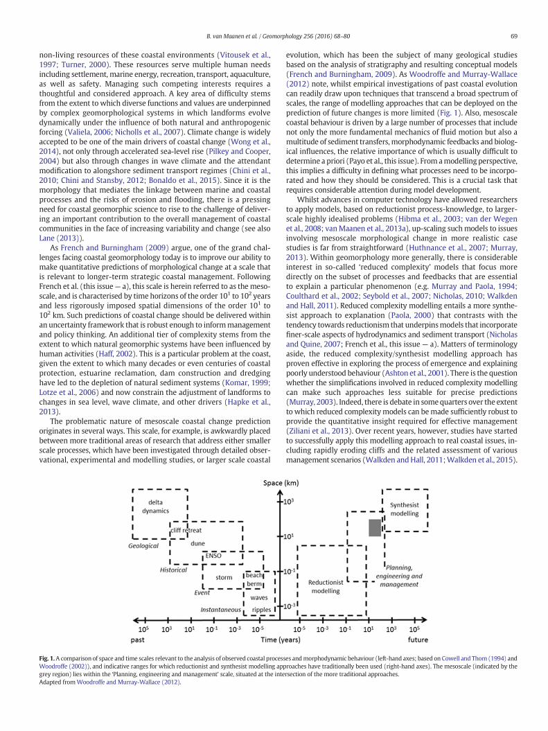
Fig. 1.A comparison of space and time scales relevant to the analysis of observed coastal processWoodroffe (2002)), and indicative ranges for which reductionist and synthesist modelling appgrey region) lies within the ‘Planning, engineering and management’ scale, situated at the inteAdapted fromWoodroffe and Murray-Wallace (2012).
evolution, which has been the subject of many geological studiesbased on the analysis of stratigraphy and resulting conceptual models(French and Burningham, 2009). As Woodroffe and Murray-Wallace(2012) note, whilst empirical investigations of past coastal evolutioncan readily draw upon techniques that transcend a broad spectrum ofscales, the range of modelling approaches that can be deployed on theprediction of future changes is more limited (Fig. 1). Also, mesoscalecoastal behaviour is driven by a large number of processes that includenot only the more fundamental mechanics of fluid motion but also amultitude of sediment transfers, morphodynamic feedbacks and biolog-ical influences, the relative importance of which is usually difficult todetermine a priori (Payo et al., this issue). Fromamodelling perspective,this implies a difficulty in defining what processes need to be incorpo-rated and how they should be considered. This is a crucial task thatrequires considerable attention during model development.
Whilst advances in computer technology have allowed researchersto apply models, based on reductionist process-knowledge, to larger-scale highly idealised problems (Hibma et al., 2003; van der Wegenet al., 2008; vanMaanen et al., 2013a), up-scaling suchmodels to issuesinvolving mesoscale morphological change in more realistic casestudies is far from straightforward (Huthnance et al., 2007; Murray,2013). Within geomorphology more generally, there is considerableinterest in so-called ‘reduced complexity' models that focus moredirectly on the subset of processes and feedbacks that are essentialto explain a particular phenomenon (e.g. Murray and Paola, 1994;Coulthard et al., 2002; Seybold et al., 2007; Nicholas, 2010; Walkdenand Hall, 2011). Reduced complexity modelling entails a more synthe-sist approach to explanation (Paola, 2000) that contrasts with thetendency towards reductionism that underpinsmodels that incorporatefiner-scale aspects of hydrodynamics and sediment transport (Nicholasand Quine, 2007; French et al., this issue — a). Matters of terminologyaside, the reduced complexity/synthesist modelling approach hasproven effective in exploring the process of emergence and explainingpoorly understood behaviour (Ashton et al., 2001). There is the questionwhether the simplifications involved in reduced complexity modellingcan make such approaches less suitable for precise predictions(Murray, 2003). Indeed, there is debate in somequarters over the extentto which reduced complexitymodels can bemade sufficiently robust toprovide the quantitative insight required for effective management(Ziliani et al., 2013). Over recent years, however, studies have startedto successfully apply this modelling approach to real coastal issues, in-cluding rapidly eroding cliffs and the related assessment of variousmanagement scenarios (Walkden andHall, 2011;Walkden et al., 2015).
es andmorphodynamic behaviour (left-hand axes; based on Cowell and Thom (1994) androaches have traditionally been used (right-hand axes). The mesoscale (indicated by thersection of the more traditional approaches.

70 B. van Maanen et al. / Geomorphology 256 (2016) 68–80
At the same time, the capability ofmodels based onmore fundamen-tal hydrodynamic and sediment transport processes has continued toevolve. A key development on this front is the harnessing of thepower of distributed computing to allow numerical solution of theequations of fluid motion at much larger spatial scales whilst simulta-neously increasing the spatial resolution (Cowles, 2008; Amoudryand Souza, 2011). In addition, a variety of data-driven approacheshave been developed that utilise the expanding archive of observationaldata to reveal causal linkages from analyses of past morphologicalchange and, potentially, generate quantitative predictions of futurechange (Reeve and Karunarathna, 2011). Finally, new qualitativemodelling approaches have also emerged, which can inform the specifi-cation of model domains, component landforms and human influences(French et al., this issue — b), as well as identify the key feedbacks thatneed to be represented mechanistically in order to capture the essenceof the overall system behaviour (Payo et al., this issue).
From the preceding overview, it is evident that there continues to besignificant progress in the rather separate fields of reduced complexityand reductionist modelling, as well as in data-driven and conceptualmodelling. Viewed in isolation, all these developments have the scopeto inform and improve our understanding of coastal evolution at themesoscale. However, if we can integrate them into an overarchingframework, where the approaches inform each other, we believe signif-icant progress can be made (Nicholls et al., 2012). Previous studies thathave combined conceptually different modelling approaches, such asDawson et al. (2009) who adopted extensive reductionist wave model-ling in combination with reduced complexity morphodynamic model-ling, have proven the additional merit of model integration. Effectivelyintegrating models that are based on different fundamental visionsand assumptions and operate over different spatial and temporal scalesis, however, not trivial (Voinov and Shugart, 2013; Sutherland et al.,2014) and this process would benefit from a more formal frameworkthat highlights the potential links between the various approaches.Accordingly, in this paper we present an overall vision for a hierarchicalmodelling framework for mesoscale coastal change that is intended tohelp facilitate the overall integration process. It considers the opencoast, estuaries and the inner shelf and their interactions as a coupledsystem, including all phases of sediment, from fine-grained transportof silts and clays potentially at the scale of shelf seas, to non-cohesivesediment transported at the scale of littoral cells and sub-cells.
The paper is structured as follows. Section 2 elaborates on the specif-ic characteristics and relative strengths of reductionist and reducedcomplexity models. The framework to integrate the varying modellingapproaches is presented in Section 3, and in Section 4 this modellingframework is illustrated with reference to the Suffolk coast, easternEngland. Section 5 considers the practical difficulties of linking models,both conceptually and in software. Finally, Section 6 considers someissues associated with model evaluation and application within a prob-abilistic uncertainty framework.
2. Reductionist versus reduced complexity models
The possibility of easily adjusting both boundary and forcing condi-tions hasmade the application ofmodels to study the geomorphologicalevolution of environmental systems increasingly popular. Differenttypes of models are available, and equally diverse is the modellingtypology. One class of models are built upon a detailed descriptionof the faster and smaller scale processes. These models, commonlyreferred to as ‘bottom-up’ or reductionist models, are developedby attempting to include all the processes that can potentially affectthe system's evolution as accurately as practical (Murray, 2003;Huthnance et al., 2007). The possibility of adopting this approach forsimulating mesoscale morphological evolution has been questioned(De Vriend et al., 1993); debate exists whether the process representa-tions adopted within reductionist models can ever be accurate enoughand sufficiently complete to reproduce the non-linear and complex
behaviour that drives coastal evolution, and whether they allow for allpotential response pathways and system states (see also Phillips,2007). Irrespective of the computing power available, error propagationwhen up-scaling from the faster and smaller scale processes to the scaleof interest is likely to hinder the ability of reductionist models to deliverquantitatively accurate predictions for the mesoscale (Murray, 2013).
More synthesist models (Paola, 2000) represent an alternative andcontrasting approach. Murray (2007) describes this class of modelsas those that are built upon the modelling strategy of explicitlyrepresenting only processes and interactions on scales not too muchsmaller than those of interest— and parameterizing (rather than explic-itly simulating) the pertinent effects of the much faster and smallerscale processes. In geomorphology, this approach has given rise to aplethora of so-called reduced complexity models, chiefly related toaspects of river channel evolution and fluvial landscape evolution(Nicholas and Quine, 2007; van De Wiel et al., 2007). Theoretically,this approach rests on the ‘emergent phenomena’ perspective, inwhich the collective behaviours of many degrees of freedom can leadto the emergence of effectively new variables and interactions thatoperate on larger spatial and temporal scales (Werner, 1999). In thiscontext it is worth mentioning that the concepts of eliminating unnec-essary detail to focus on the scale of interest essentially apply to allscales and virtually all forms of environmental modelling involvechoices in the level of complexity that is both tractable and appropriatefor the problem being addressed (see also Nicholas and Quine (2007)).
There is clearly merit in addressing challenges of coastal manage-ment by defining the processes and variables that are most relevant atthe mesoscale defined above. Following this approach, the pitfallsrelated to model imperfections cascading upward through the scalescan be avoided (Murray, 2013). Of course, for such models to bequantitatively reliable, the parameterizations – which initially caneven consist of poorly constrained ‘rules’ –must be honed by synthesis-ing the results of observations and detailedmodelling. The constructionof more synthesist models can be challenging as reliable parameteriza-tionsmight not be readily available and obtainingwell-accepted param-eterizations of the faster and smaller scale processes is not alwaysstraightforward.
Apart from the more philosophical questions of how to simulatemulti-scale systems and whether or not it is possible to accuratelypredict large-scale morphodynamic behaviour starting from the fasterand smaller scale processes, there are additional concerns when apply-ing reductionist modelling techniques to the mesoscale. Reductionistmodels are computationally intensive and even though our ability toperform computationally demanding simulations is likely to keep onincreasing (especially through various forms of parallel computing),using these models to perform regional- and decadal-scale simulationsof morphological change becomes problematic from a practical pointof view. In this context, however, it is worth noting that strategieshave been developed that allow reductionist coastal area models to beused in the study of mesoscale coastal change (Coco et al., 2013).These strategies involve innovative morphodynamic updating tech-niques and are used to bridge the gap between short-term hydrody-namic and transport processes, varying over hours to days, andmorphological changes, often taking place over much longer time pe-riods (Roelvink, 2006). Modelling approaches adopting this techniquehave been particularly useful in exploring the formation and evolutionof channel networks in highly idealised tidal settings (Hibma et al.,2003; Marciano et al., 2005; Dastgheib et al., 2008; van der Wegenet al., 2008; van Maanen et al., 2011). Recently, this development hasalso resulted in the successful application of reductionist coastal areamodels to simulate decadal morphological evolution of real estuarinesystems (Ganju et al., 2009; van der Wegen et al., 2011; van derWegen and Jaffe, 2013). A probable reason for this success lies in thefact that these studies address confined and highly constrained systems.In the morphodynamic prediction, the interaction of the major tidalmovement with the initial bathymetry and the estuarine plan form
71B. van Maanen et al. / Geomorphology 256 (2016) 68–80
likely dominates the variability from uncertain model inputs andprocess definitions (e.g. the applied sediment transport formulationsor initial bed composition). Hence, despite these promising modellingefforts, it remains uncertain whether this approach can be easilyextended to other coastal systems. Also, the computational demand islikely to remain an issue, especially given the need to predict futurechanges within a probabilistic uncertainty framework, which implieslarge ensembles of model runs.
The degree to which physical processes can be parameterized varieswidely, ranging from only subtle simplifications to highly abstractedrepresentations of the smaller and faster scale processes. The lattertype of model has been especially successful in discovering the essentialprocesses responsible for the emergence of large-scale geomorphicpatterns (e.g. Ashton et al., 2001). As pointed out by Murray (2007),however, those models that attempt to include only a minimumnumber of processes with the aim of gaining maximum insight are notnecessarily capable of addressing more specific questions, such asmanagement problems in real world settings. In this context, modelscan be too abstract for some purposes. This inevitably leads tochallengeswhen simulating themesoscale, asmodels should be compu-tationally efficient, but also capable of resolving the dynamics that are ofinterest to coastal engineers and managers.
The modelling tool SCAPE (Soft Cliff And Platform Erosion;Walkdenand Hall (2005)) is an example of a mesoscale reduced complexitymodel that has been used to answer real-world coastal managementquestions. Its applications have ranged from local studies of shoreerosion to the simulation of large-scale coastal management strategies(Dickson et al., 2007; Appeaning Addo et al., 2008; Dawson et al.,2009). SCAPE is conceptually related to models like that of Ashtonet al. (2001) in that dynamic behaviour emerges from the key real-world interactions that are simulated. The approach taken to developthis model was distinct, however, in that it was implemented for specif-ic locations and was designed from the outset to also representengineering interventions, such as seawalls and groynes. This led tothe inclusion of a greater number of processes and a broader systemof interactions. While this was necessary for the purposes of coastalmanagement, it increased the need to rely more heavily on poorlyconstrained behavioural rules. Although the application of SCAPE andthe comparison to field observations show that this approach hasworked well, it is important to note that when the number of includedprocesses needs to be increased, one must adhere to the underlyingconceptual framework of the model. Also, increasing the number ofprocesses modelled carries the danger that insights might be obscureddue to the lack of clarity over which processes are governing thebehaviour. Despite these dangers it will often be necessary, for thepurposes of coastal management, to capture a broad set of processesand interactions.
3. Framework for model integration
3.1. Framework description
Since reduced complexity models have already been successfullyapplied to real coastal management issues, and this type of model hasproven to be effective in simulating realistic emergent behaviours andgeomorphic change over larger spatial and temporal scales (Walkdenand Hall, 2005; Dawson et al., 2009), it is worth further exploring thefull potential of this modelling strategy in generating quantitativepredictions of mesoscale coastal evolution. The applicability of meso-scale reduced complexity models can potentially be enhanced by inte-grating them within a framework that is structured by overarchingconceptual models and also includes more reductionist coastal areamodels and data-driven analyses. Such an approach, as schematised inFig. 2, also brings the hitherto largely separate modelling communitiesin these four areas together to exploit the complementary insightsthat these diverse approaches have to offer. Reduced complexitymodels
occupy a central position within the proposed framework as the prima-ry means of simulating coastal geomorphic behaviour. It should benoted though that these models are closely linked to the otherapproaches and that information exchange is of key importance. Tohighlight the type of information that is being exchanged, we brieflyoutline the main capabilities of conceptual models, coastal area modelsand data-driven approaches to show how these can better inform theconstruction and application of the mesoscale reduced complexitymodels.
3.2. Conceptualmodels of coupled coastal, estuarine and inner shelf systems
Simulating mesoscale coastal evolution requires a system-levelapproach and appreciation of the interactions that occur between theopen coast, estuaries, and the shallow sea bed. The process of conceptu-ally analysing the coast highlights this interconnectivity, and this hasrecently been strengthened by the development of a formal Coastaland Estuarine System Mapping (CESM) approach (French et al.,this issue — b) that re-engages with systems theory and builds onestablished conceptual frameworks such as the coastal tract concept ofCowell et al. (2003). CESM is founded on a hierarchical ontology ofcomponent landforms (e.g. spit, ebb delta, tidal flat, cliff, dune, innershelf banks) that are organised into larger-scale open coast, estuary orinner shelf complexes. These natural features are supplemented byhuman interventions, which may be structural (e.g. seawalls, groynes)or non-structural (e.g. beach nourishment, dredging). System mapsare configured with reference to sediment pathways as well as influ-ences (such as the effect of a jetty on an inlet channel) that are not asso-ciated with a mass flux. Although CESM can be a pencil and paperexercise, it is supported by software that allows mapping to be under-taken within a geospatial context, aided by informative secondarydatasets describing coastal geology, terrain, erosion and flood defenceinfrastructure and even modelled residual sediment transport vectorsfrom coastal area models.
CESM captures a system state averaged over a time interval that islong enough to exclude extraneous variability (e.g. seasonal beachrotation), but short enough to exclude trends that lead to gross changesin configuration (though localised state changes, such as barrier break-down, can be included if these are persistent and relevant to the meso-scale; French et al. (this issue— b)). As such, it is useful for specifying thespecific landform systems that need to bemodelled. An additional stageof conceptual modelling that can further guide not only the selectionbut also the evaluation of more mechanistic models involves the appli-cation of causal loop analysis (Lane, 2000). This uses causal loopdiagrams to indicate the positive and negative feedbacks betweenstate and flow variables and determine, ahead of more quantitativemodelling, whether processes are likely to have a reinforcing or abalancing effect. As such, a more detailed overview of the structureand functioning of geomorphic systems can be attained. Payo et al.(this issue) show how causal loop analysis can be applied to the coastalsystem at different scales, ranging from the active layer, throughlandforms, to landform complexes. The role of causal loop diagrams be-comes particularly evidentwhen assessing the importance of individualprocesses in driving overall system behaviour.
Within the integrated modelling framework (Fig. 2), system mapsand causal loop diagrams can be used jointly to define the extent ofthe model domain and the landforms and landform complexes thatneed to be simulated by the mesoscale reduced complexity models.They also guide the construction of the latter (arrow 1 in Fig. 2). Inessence, the conceptual models inform the decision making of whatprocesses, interactions andhuman influences should be includedwithinthe geomorphic models and what can be excluded without neglectingrelevant geomorphic behaviour. This is of particular importance whenconsidering the mesoscale as it can be a daunting task to identify thekey governing processes over these larger temporal and spatial scales.As such, the conceptual analysis of the coast provides a platform that
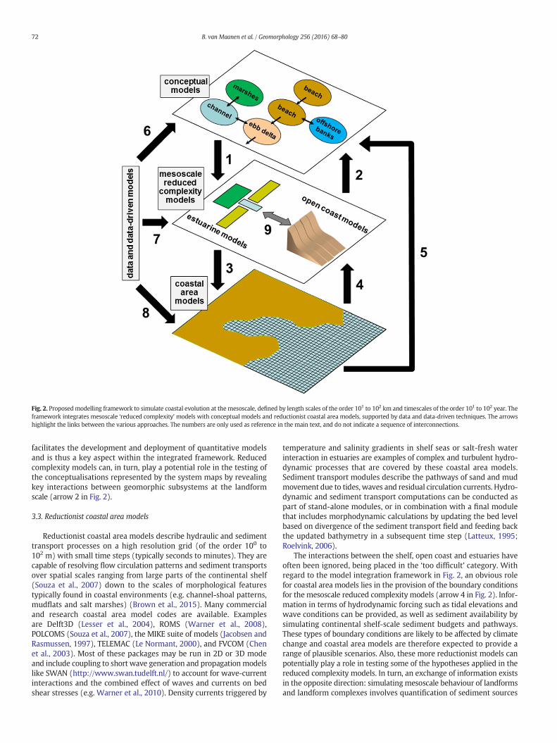
Fig. 2. Proposed modelling framework to simulate coastal evolution at the mesoscale, defined by length scales of the order 101 to 102 km and timescales of the order 101 to 102 year. Theframework integrates mesoscale ‘reduced complexity’ models with conceptual models and reductionist coastal area models, supported by data and data-driven techniques. The arrowshighlight the links between the various approaches. The numbers are only used as reference in the main text, and do not indicate a sequence of interconnections.
72 B. van Maanen et al. / Geomorphology 256 (2016) 68–80
facilitates the development and deployment of quantitative modelsand is thus a key aspect within the integrated framework. Reducedcomplexity models can, in turn, play a potential role in the testing ofthe conceptualisations represented by the system maps by revealingkey interactions between geomorphic subsystems at the landformscale (arrow 2 in Fig. 2).
3.3. Reductionist coastal area models
Reductionist coastal area models describe hydraulic and sedimenttransport processes on a high resolution grid (of the order 100 to102 m) with small time steps (typically seconds to minutes). They arecapable of resolving flow circulation patterns and sediment transportsover spatial scales ranging from large parts of the continental shelf(Souza et al., 2007) down to the scales of morphological featurestypically found in coastal environments (e.g. channel-shoal patterns,mudflats and salt marshes) (Brown et al., 2015). Many commercialand research coastal area model codes are available. Examplesare Delft3D (Lesser et al., 2004), ROMS (Warner et al., 2008),POLCOMS (Souza et al., 2007), the MIKE suite of models (Jacobsen andRasmussen, 1997), TELEMAC (Le Normant, 2000), and FVCOM (Chenet al., 2003). Most of these packages may be run in 2D or 3D modeand include coupling to short wave generation and propagationmodelslike SWAN (http://www.swan.tudelft.nl/) to account for wave-currentinteractions and the combined effect of waves and currents on bedshear stresses (e.g. Warner et al., 2010). Density currents triggered by
temperature and salinity gradients in shelf seas or salt-fresh waterinteraction in estuaries are examples of complex and turbulent hydro-dynamic processes that are covered by these coastal area models.Sediment transport modules describe the pathways of sand and mudmovement due to tides, waves and residual circulation currents. Hydro-dynamic and sediment transport computations can be conducted aspart of stand-alone modules, or in combination with a final modulethat includes morphodynamic calculations by updating the bed levelbased on divergence of the sediment transport field and feeding backthe updated bathymetry in a subsequent time step (Latteux, 1995;Roelvink, 2006).
The interactions between the shelf, open coast and estuaries haveoften been ignored, being placed in the ‘too difficult’ category. Withregard to the model integration framework in Fig. 2, an obvious rolefor coastal area models lies in the provision of the boundary conditionsfor the mesoscale reduced complexity models (arrow 4 in Fig. 2). Infor-mation in terms of hydrodynamic forcing such as tidal elevations andwave conditions can be provided, as well as sediment availability bysimulating continental shelf-scale sediment budgets and pathways.These types of boundary conditions are likely to be affected by climatechange and coastal area models are therefore expected to provide arange of plausible scenarios. Also, these more reductionist models canpotentially play a role in testing some of the hypotheses applied in thereduced complexity models. In turn, an exchange of information existsin the opposite direction: simulatingmesoscale behaviour of landformsand landform complexes involves quantification of sediment sources
73B. van Maanen et al. / Geomorphology 256 (2016) 68–80
and sinks, and this type of information can be fed back into the coastalarea models (arrow 3 in Fig. 2). In addition to this two-way coupling,the large-scale sediment pathways simulated by the coastal areamodelscan be used further to inform and validate the conceptualisation ofmesoscale open coast-estuary-shelf interactions derived from CESM(arrow 5 in Fig. 2). Hence the models can be applied in qualitative andquantitative modes.
Although coastal area models in the framework proposed here arenot directly used for morphological predictions, they do play a crucialrole in informing the morphodynamic modelling. As with all models,it thus remains necessary to be fully aware of their limitations. Sedimenttransport modelling, in particular, is still mainly based on empiricalexpressions (Amoudry and Souza, 2011). Sediment diffusivities, settlingvelocities, and cohesive processes like flocculation all have an impact onthe dynamics of sediment. The performance of reductionist models isclearly dependant on how well these aspects are represented andparameterized. In addition, the proper implementation of closuremodels for turbulence and mixing is challenging but neverthelessessential to quantitatively predict sediment dynamics and resultingnet fluxes (Wang et al., 2012). Fortunately, the level of description andthe accuracy of coastal area models have greatly improved over thelast few decades and ongoing developments will almost certainlycontinue to improve their predictive abilities.
3.4. Data and data-driven approaches
The increasing pressure on coastal geomorphic systems and thegrowing awareness that these systems are highly dynamic have result-ed in the implementation of systematic coastalmonitoring programmes(Bradbury et al., 2002; van Koningsveld and Mulder, 2004; Nichollset al., 2013). The extensive datasets that are being obtained by theseprogrammes provide a major source of scientific insights. Some ofthese datasets are now also sufficiently extensive to be used for arange of different data-driven methods. For example, advanced statisti-cal analysis techniques such as wavelet analysis can be used to identifycertain patterns of behaviour within a dataset (Short and Trembanis,2004). These behaviours can then be used tomake predictions of futurechange based on appropriate extrapolation. Additionally, techniques areavailable to reveal links between datasets of two or more differentvariables. An example is canonical correlation analysis and Horrillo-Caraballo and Reeve (2008) showed how such a method can be usedtomake predictions of anunknown variable, such as beachmorphology,based on another variable for which projections into the future do exist,such as wave height.
Apart from using data time-series to make direct predictions basedon the extrapolation of trends and behaviours, the knowledge andinsights obtained by analysing coastal measurements can also be usedto inform and construct the reduced complexity models (arrow 7 inFig. 2). A simple example is the inclusion of an equilibriumbeachprofile,derived by extensive empirical studies (Bruun, 1954; Dean, 1977),within a model such as SCAPE (Walkden and Hall, 2005). A largenumber of equilibriummodels are also available for tidal inlet systems,including the well-known relationship between tidal prism and thecross-sectional area of the channel (O'Brien, 1931, 1969; Jarrett,1976). Similar types of empirical relationships exist between tidalprism and ebb-tidal delta volume (Walton and Adams, 1976), andbasin area, tidal range and flat volume (Eysink and Biegel, 1992).ASMITA is an example of a reduced complexity model that adoptsthese empirical relationships to simulate the mesoscale evolution oftidal embayments and estuaries (Stive et al., 1998; Rossington et al.,2011).
Another class of data-driven approaches is based on machine learn-ing techniques. Their applicability in a variety of coastal disciplines hasrapidly increased over the past few years. Examples ofmachine learningtechniques include artificial neural networks, boosted regression treesand genetic programming. These techniques are highly effective in
linking input and output vectors and have been used to develop power-ful predictors in the field of hydrodynamics (Tsai and Lee, 1999;Sztobryn, 2003; Browne et al., 2007), sediment dynamics (vanMaanen et al., 2010; Oehler et al., 2012; Yoon et al., 2013; Goldsteinand Coco, 2014), and morphodynamics, as shown by Tsai et al. (2000)who used neural networks to study beach profile evolution. Recently,Goldstein et al. (2014) extended the use ofmachine learning techniquesby incorporating the generated predictors (in this case of near-bedreference concentration and ripple geometry) into a numerical modelof inner-shelf sorted bedforms. The new hybrid model was reported tobe capable of generating novel autogenic behaviour. This demonstrationof successfully addingmachine learning components to a process-basednumerical model suggests that a similar strategy could be adoptedwhen constructing mesoscale reduced complexity models, as thesemodels could also benefit from including predictors gained throughmachine learning applications.
It should be noted that regardless of whether data-driven methodsare applied to make direct predictions or used to construct and informreduced complexity models, the applicability of these methods is limit-ed by the range of conditions which are covered by the dataset fromwhich they are derived. An additional concern is that data-drivenapproaches can provide only limited physical insights, although theydo allow the formalised exploration of large data sets. Data-drivenapproaches are often seen as black-boxes with little, if any, capacity toenhance understanding of the dataset from which they have beenderived (Cunge, 2003). Although interpreting the knowledge gainedby black-box type models is not straightforward, a variety of methodsis available that can help to overcome this disadvantage and whichcan be used to analyse the dataset and the physical processes involved(e.g. Gevrey et al., 2003).
Fig. 2 also depicts an exchange of information from observationaldata to the conceptual models (arrow 6 in Fig. 2) and to the coastalarea models (arrow 8 in Fig. 2). In the former case, this link representsthe feed of quantitative information into the systemmaps.With respectto the latter, coastal measurements are vital in testing the ability of thecoastal area models to provide realistic large-scale sediment pathwaysand hydrodynamic forcing conditions for the reduced complexitymodels.
4. Example of an integratedmodelling approach— the Suffolk coast
4.1. Description Suffolk coast and problem definition
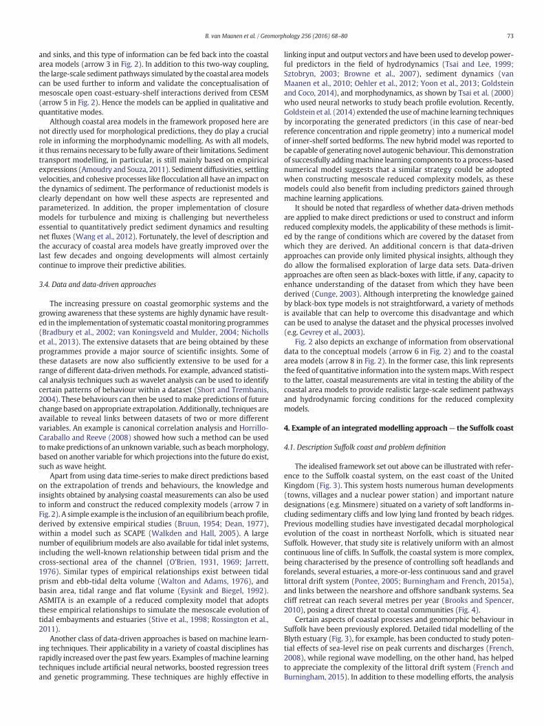
The idealised framework set out above can be illustrated with refer-ence to the Suffolk coastal system, on the east coast of the UnitedKingdom (Fig. 3). This system hosts numerous human developments(towns, villages and a nuclear power station) and important naturedesignations (e.g. Minsmere) situated on a variety of soft landforms in-cluding sedimentary cliffs and low lying land fronted by beach ridges.Previous modelling studies have investigated decadal morphologicalevolution of the coast in northeast Norfolk, which is situated nearSuffolk. However, that study site is relatively uniform with an almostcontinuous line of cliffs. In Suffolk, the coastal system is more complex,being characterised by the presence of controlling soft headlands andforelands, several estuaries, a more-or-less continuous sand and gravellittoral drift system (Pontee, 2005; Burningham and French, 2015a),and links between the nearshore and offshore sandbank systems. Seacliff retreat can reach several metres per year (Brooks and Spencer,2010), posing a direct threat to coastal communities (Fig. 4).
Certain aspects of coastal processes and geomorphic behaviour inSuffolk have been previously explored. Detailed tidal modelling of theBlyth estuary (Fig. 3), for example, has been conducted to study poten-tial effects of sea-level rise on peak currents and discharges (French,2008), while regional wave modelling, on the other hand, has helpedto appreciate the complexity of the littoral drift system (French andBurningham, 2015). In addition to these modelling efforts, the analysis
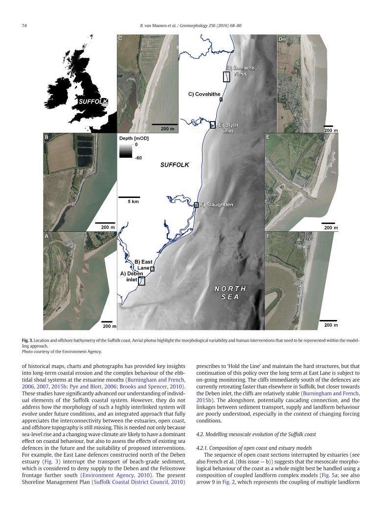
Fig. 3. Location and offshore bathymetry of the Suffolk coast. Aerial photos highlight themorphological variability and human interventions that need to be representedwithin themodel-ling approach.Photo courtesy of the Environment Agency.
74 B. van Maanen et al. / Geomorphology 256 (2016) 68–80
of historical maps, charts and photographs has provided key insightsinto long-term coastal erosion and the complex behaviour of the ebb-tidal shoal systems at the estuarine mouths (Burningham and French,2006, 2007, 2015b; Pye and Blott, 2006; Brooks and Spencer, 2010).These studies have significantly advanced our understanding of individ-ual elements of the Suffolk coastal system. However, they do notaddress how the morphology of such a highly interlinked system willevolve under future conditions, and an integrated approach that fullyappreciates the interconnectivity between the estuaries, open coast,and offshore topography is still missing. This is needed not only becausesea-level rise and a changingwave climate are likely to have a dominanteffect on coastal behaviour, but also to assess the effects of existing seadefences in the future and the suitability of proposed interventions.For example, the East Lane defences constructed north of the Debenestuary (Fig. 3) interrupt the transport of beach-grade sediment,which is considered to deny supply to the Deben and the Felixstowefrontage further south (Environment Agency, 2010). The presentShoreline Management Plan (Suffolk Coastal District Council, 2010)
prescribes to ‘Hold the Line’ and maintain the hard structures, but thatcontinuation of this policy over the long term at East Lane is subject toon-going monitoring. The cliffs immediately south of the defences arecurrently retreating faster than elsewhere in Suffolk, but closer towardsthe Deben inlet, the cliffs are relatively stable (Burningham and French,2015b). The alongshore, potentially cascading connection, and thelinkages between sediment transport, supply and landform behaviourare poorly understood, especially in the context of changing forcingconditions.
4.2. Modelling mesoscale evolution of the Suffolk coast
4.2.1. Composition of open coast and estuary modelsThe sequence of open coast sections interrupted by estuaries (see
also French et al. (this issue— b)) suggests that themesoscale morpho-logical behaviour of the coast as a whole might best be handled using acomposition of coupled landform complex models (Fig. 5a; see alsoarrow 9 in Fig. 2, which represents the coupling of multiple landform
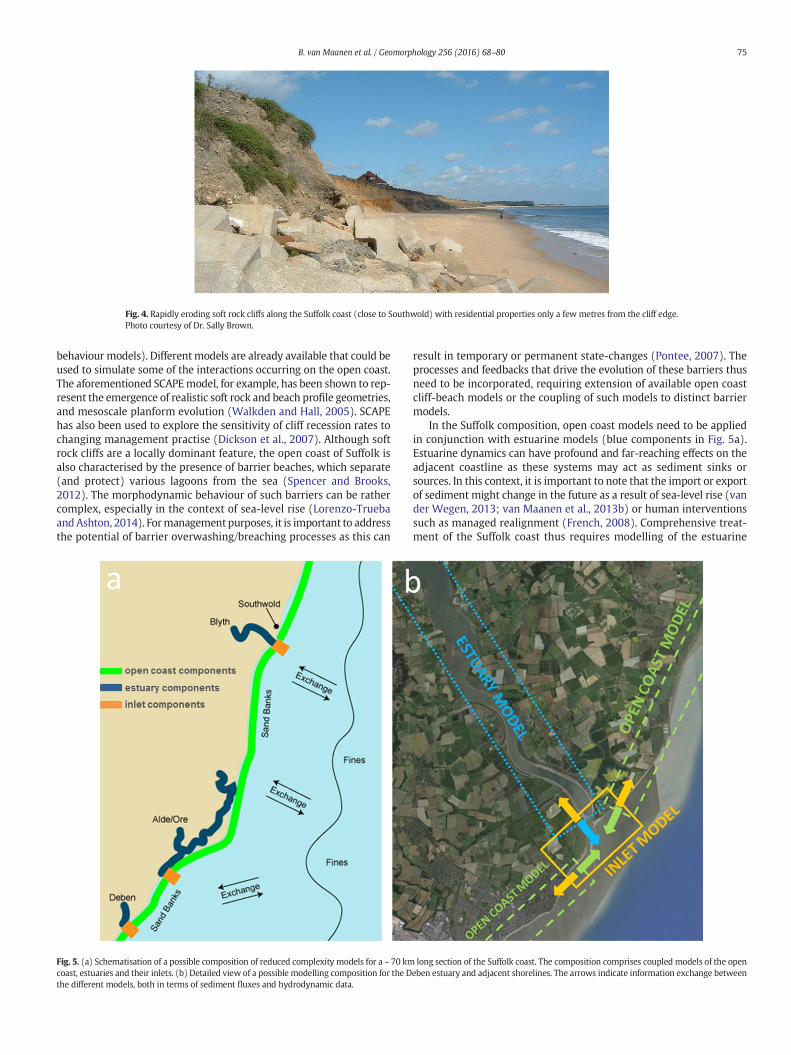
Fig. 4. Rapidly eroding soft rock cliffs along the Suffolk coast (close to Southwold) with residential properties only a few metres from the cliff edge.Photo courtesy of Dr. Sally Brown.
75B. van Maanen et al. / Geomorphology 256 (2016) 68–80
behaviour models). Differentmodels are already available that could beused to simulate some of the interactions occurring on the open coast.The aforementioned SCAPEmodel, for example, has been shown to rep-resent the emergence of realistic soft rock and beach profile geometries,and mesoscale planform evolution (Walkden and Hall, 2005). SCAPEhas also been used to explore the sensitivity of cliff recession rates tochanging management practise (Dickson et al., 2007). Although softrock cliffs are a locally dominant feature, the open coast of Suffolk isalso characterised by the presence of barrier beaches, which separate(and protect) various lagoons from the sea (Spencer and Brooks,2012). The morphodynamic behaviour of such barriers can be rathercomplex, especially in the context of sea-level rise (Lorenzo-TruebaandAshton, 2014). Formanagement purposes, it is important to addressthe potential of barrier overwashing/breaching processes as this can
Fig. 5. (a) Schematisation of a possible composition of reduced complexity models for a ~ 70 kmcoast, estuaries and their inlets. (b) Detailed view of a possible modelling composition for the Dthe different models, both in terms of sediment fluxes and hydrodynamic data.
result in temporary or permanent state-changes (Pontee, 2007). Theprocesses and feedbacks that drive the evolution of these barriers thusneed to be incorporated, requiring extension of available open coastcliff-beach models or the coupling of such models to distinct barriermodels.
In the Suffolk composition, open coast models need to be appliedin conjunction with estuarine models (blue components in Fig. 5a).Estuarine dynamics can have profound and far-reaching effects on theadjacent coastline as these systems may act as sediment sinks orsources. In this context, it is important to note that the import or exportof sediment might change in the future as a result of sea-level rise (vander Wegen, 2013; van Maanen et al., 2013b) or human interventionssuch as managed realignment (French, 2008). Comprehensive treat-ment of the Suffolk coast thus requires modelling of the estuarine
long section of the Suffolk coast. The composition comprises coupled models of the openeben estuary and adjacent shorelines. The arrows indicate information exchange between
76 B. van Maanen et al. / Geomorphology 256 (2016) 68–80
systems of the Blyth, Alde/Ore and Deben (Fig. 3 and blue componentsin Fig. 5a). Long-termmorphological dynamics in estuarine and lagoon-al systems are often described in terms of perturbations with respect toan equilibrium condition that can be formalised in terms of a relation-ship between hydrodynamics and morphology or between hydrody-namics and sediment transport regime. ASMITA (Stive et al., 1998) isone suchmodel that uses such empirically derived equilibrium relation-ships that are available for estuarine environments. It has been widelyused in the study of Dutch Wadden Sea inlets to explore sea-level riseeffects (van Goor et al., 2003) and to hindcast and predict the morpho-logical response to the closure of the Zuiderzee (Kragtwijk et al., 2004).More recently, the application of ASMITA was extended to include UKestuaries and itwas shown that the effects of dredging and reclamationscould be accurately reproduced (Rossington et al., 2011). The ability tocapture the effects of human interventions is of key importance whenmodelling the Suffolk estuaries as these systems have undergonemajor transformations in the past and further interventions are expect-ed in the future, especially now thatmanaged realignment is growing inpopularity as a means of flood defence and to restore ecosystemfunctions (French, 2008). Other mesoscale estuarine models exist andin addition to the available modelling tools based on equilibriumconcepts, it is worth mentioning here that developments have beencarried out towards generating novel models of estuarine behaviourthat apply cellular automata and/or other highly parameterized routingschemes to simulate tidal flows and morphodynamics (Dearing et al.,2006; D'Alpaos et al., 2007; Kirwan and Murray, 2007; Bentley andKarunarathna, 2012; Thornhill et al., 2015). These models are far lesscomputationally intensive than traditional reductionist models, andcan potentially resolve a richer set of behaviours than models confinedby empirical equilibrium relationships.
Simulating coastal behaviour at the regional scale envisaged hererequires capturing the exchanges and feedbacks between estuarineenvironments and the open coast. Although our knowledge of thegoverning processes at this interface is often limited, various ap-proaches exist that might facilitate our representation of the opencoast-estuary coupling. De Vriend et al. (1994), for example, connecteda tidal inlet with the adjacent coast by building a behavioural modelfor the outer delta, adjusting a two-line model for uninterruptedcoasts to include the principal transport mechanisms near the inlet.Kraus (2000) presented a model that can be used to calculate sand-bypassing rates at ebb-tidal shoals. Ebb delta volumes and the bypassingmechanisms are computed by analogy to a reservoir system, whereeach reservoir can fill to a maximum (equilibrium) volume. Thismodel has been applied in numerous engineering and science studiesand it has also been adopted to study broader scale morphodynamicchange (Hanson et al., 2011). Existing ebb-tidal delta models havealmost all been developed for sandy environments and this will needadapting for the mixed sand-gravel inlets and shoals that characterisethe Suffolk coast (Burningham and French, 2006, 2007). These inletmodels will sit in between the models that simulate the behaviour ofthe open coast and estuaries (Fig. 5b) and a continuous exchange ofinformation will occur between all these components, both in terms ofsediment fluxes and hydrodynamic data. Such a model compositioncan then be used to study future morphological change under scenariosof sea-level rise, changing wave climate, and different open coast andestuary management strategies.
4.2.2. Informing the estuary-inlet-open coast compositionIn addition to the interaction between the estuaries, their inlets and
the open coast, there are other factors that affect the long-term andlarge-scale morphodynamic evolution of the Suffolk coast. The offshoretopography, in particular, is highly complex with numerous sandbanks(Burningham and French, 2015b). These sandbanks provide wavesheltering and determine the overall amount of energy that reachesthe coast in turn driving alongshore variations in coastal retreat rates.A way forward here is to include these effects by running a coastal
area model to simulate wave propagation from deep water over thecomplex bathymetry to the boundary of the morphological model.Dawson et al. (2009) followed this strategy in a study of the Norfolkcoast of England. They applied the TOMAWAC wave model to generatethe boundary conditions necessary to conduct SCAPE simulations of clifferosion and a similar approach could be adopted for Suffolk.
When addressing the mesoscale, appreciation of the abundanceof different sediment size fractions and their potentially differentresponses to a given forcing is crucial (Luo et al., 2013). Over spatialscales of 10 to 100 km, for example, fine sediment supply through clifferosion might feed estuarine systems by transport in suspension, in-cluding those at a significant distance, while coarse material can buildthe beachesmore locally (within the relevant sub-cell and cell). Usually,in beach-cliff models like SCAPE, the fate of fine sediments that arereleased by cliff erosion is not assessed and the material is lost fromthe system. Coastal area models can play another important rolehere as these models can be used for particle tracking to define large-scale sediment pathways and provide information on sediment avail-ability that can be used as boundary conditions for the estuarinemorphodynamic models (see also Brown et al., 2015). Assessing theeffect of sandbanks on wave impacts and exploring the fate of finesediment released by cliff erosion are two concrete examples of howcoastal area models can help to inform simulations of mesoscale coastalmorphodynamic behaviour.
5. Model coupling
Theprocess of effectively linkingmodel components and assemblingthem into new configurations is critical, as this allows a wide range ofreal-world situations to be simulated and a wider variety of scientificproblems to be solved (Peckham et al., 2013). In the context of our ap-proach to coastal modelling and highlighted by the Suffolk case-studyas presented in the previous section, an example would be linking amodel of the open coast with an estuary model as a way of examiningthe influence of one landform complex on another. The frameworkproposed here requires the static (one-way) and dynamic (two-way)coupling of multiple models at a range of spatial-temporal scales.There are several standards and platforms currently available that pro-vide a flexible linking environment (Buis et al., 2006; Gregersen et al.,2007; Pearce et al., 2011; Craig et al., 2012; Peckham et al., 2013) andsome of these platforms, such as CSDMS (Peckham et al., 2013) andOpenMI (Gregersen et al., 2007; Harpham et al., 2014) have alreadybeen used to control dynamic linkages within coastal environments(Ashton et al., 2013; Rogers and Overeem, 2013; Zhou et al., 2013).However, coupling models is not a trivial task and in the remainder ofthis section we highlight some key caveats.
When linking complex models the choice of exchange parametersand variables is crucial. In the design of new models sufficient thoughtmust be given to define which quantities other models may need touse. This is complicated by the fact that the model developer will notnecessarily know a priori what other models may be coupled to theirown, and what quantities those models would need to utilise as inputs(Sutherland et al., 2014). Associated with this is the issue of differingtime steps, units, grid sizes and types, all of whichmay be incompatiblebetween models (see also Voinov and Shugart (2013)). A way forwardhere is to write additional modules that can take the output from onemodel, and then adapt it by (for example) converting units, resamplinggrids, or interpolating time steps (Harpham et al., 2014).
A further issue to be considered is at what conceptual level themodels will be linked. Referring back to the Suffolk composition(Fig. 5) as an example, a cliff evolution component can form an integrat-ed part of the mesoscale open coast model, with variables and parame-ters that are exposed for use by other models at the overall open coastlevel. Alternatively, the cliff model could be provided as a stand-alonelandform model that can be linked to a beach model and a platformmodel in an open coast composition via one of the linking platforms.
77B. van Maanen et al. / Geomorphology 256 (2016) 68–80
The choice depends on the intended model use and potentially also onthe model developer. Basing compositions on landforms could rapidlyproduce unwieldy compositions of many models, with implicationsfor both the computational overhead of data exchange, and the com-plexity of the various adaptors that may be required to connect themodels. On the other hand, the coupling of a multitude of stand-alonelandform models increases the flexibility in terms of model choice andfacilitates experimenting with different approaches as individualmodels may be more easily replaced.
6. Model testing and assessing uncertainty
Different kinds of models are designed to address different sorts ofquestions and thus require custom-fit methods of evaluating modelutility. For the bottom-up reductionistmodels, constructed to representa geographically specific location with maximum realism and detail,testing model utility by using the common approach of quantitativelycomparing the value of variables at particular locations and times inthe model with observations is appropriate (Sutherland et al., 2004;French, 2010). However, for models on the other side of the modellingspectrum, i.e. highly abstracted models, which are intended to enhancegeneric understanding of coastal change, other ways of model testingare needed (Murray, 2003). When simulating the long-term andlarge-scale evolution of coastal systems, the traditional approach ofmaking a direct comparison betweenmodelled andmeasured variablesto test themodelmay be challenging for other reasons.Model imperfec-tions, combined with instabilities and emergent behaviours, mean thatmodel results become less likely to be accurate in detail (e.g. morpho-logical structures occurring in the same times and places in model andobservations) as the simulation progresses through time (Kamphuis,2013), although there are notable exceptions related to the strong influ-ence from lateral boundary conditions as shown by van derWegen andRoelvink (2012) in their modelling study of long-term estuarinemorphodynamics. In cases where boundary conditions do not steerthe long-term evolution, and where morphodynamic instabilities areinherent in a system, comparing the characteristic behaviours exhibitedby the model with the characteristic behaviours observed in nature ismore appropriate. Papers describing simulations of morphodynamicevolution in tidal embayments have shown how model results can betested at a more aggregated level, using morphological characteristicssuch as basin hypsometry and tidal network properties (D'Alpaoset al., 2005; Marciano et al., 2005; Yu et al., 2012; van Maanen et al.,2013a).
The issue of error accumulation through time can be different forcertain types of reduced complexity models developed specifically forthemesoscale. Over the short-term, errors are likely to be large (relativeto a reductionist model) due to the more abstract representation ofprocesses. However, the inclusion of broader sets of processes and thefeedbacks that govern them brings the possibility of actually avoidingthe accumulation of small errors. In this context, it is not always theaim of the reduced complexity model to precisely represent reality,but instead to not deviate too far from it. This has implications whenchoosing the model initial conditions, as a feedback-based behaviouralmodel of a real site will tend to require a period of spin-up, duringwhich it is run to establish some sort of dynamic equilibrium. Thisbecomes the starting condition for subsequent projections of futurechange (as opposed to using an observed state of the site, which ismore normally the case with traditional reductionist modelling). Suchan approach has been adopted in modelling studies of for examplecliff coasts and barrier islands to assess the impacts of future sea-levelrise (Dickson et al., 2007; Moore et al., 2014). It further underminesthe process of validation based on direct comparisons with measuredvariables. Instead such a reduced complexity model may be betterjudged by its capacity to represent real-world forms, perhaps fromquite unrealistic starting conditions, and by its ability to simulate rela-tive changes.
Testing and understandingmodel outcome and, related to this, eval-uating uncertainties, becomes even more complex when a coupledlandform system is being simulated with a set of sub-system models,as proposed here. A potential way forward lies in the use of MonteCarlo techniques. Current advances in processing power allow the useof these techniques on increasingly complex, coupled, modellingsystems (Lee et al., 2001; Lastra et al., 2008; Callaghan et al., 2013).Monte Carlo techniques provide a general framework that allows forthe assessment of uncertainty and for defining a range of possibleoutcomes. As part of this strategy, the model or model composition isrun many times with different forcing conditions and model settingsbased on a repeated random sampling method to obtain a distributionof the unknown entity. Clearly, this is facilitated by model codes thatare computationally efficient. To refer back to the cliff model SCAPE,this model has been applied in Monte Carlo mode to define potentialcliff recession rates in response to sea-level rise (Walkden and Hall,2005; Walkden et al., 2015). One can imagine how Monte Carlo tech-niques can be used to analyse the cascade of uncertainty from climateforcing, through coastal response to natural hazards on the coast. It isthis type of information that is of specific interest to coastal managersas it provides the basis for risk-based land use planning and engineeringdecision-making (Hall et al., 2002).
7. Discussion and conclusions
The development of sound coastal and shorelinemanagement strat-egies requires improved predictions of coastal change at the mesoscale.This drives the need to simulate the coastal environment at the system-level and to appreciate the crucial interactions that occur between theopen coast, estuaries, and the shallow sea bed. Given the strength andweaknesses of the various model types currently available, a multi-model approach guided by an integrated framework is likely to berequired. In this paper, we have proposed such a framework, whichbrings together a variety of different modelling approaches and whichcan support compositions existing of reduced complexity modelsinformed by reductionist, data-driven, and also conceptual models.This integrated approach could help us to deliver quantitative predic-tions of mesoscale coastal change and provide a key step forwardin our attempt to simulate such a complex system. Moreover, theproposed framework facilitates a participatory modelling approach(Voinov and Bousquet, 2010), which allows for a more active engage-ment with the relevant stakeholders. This is partly accomplishedthrough the use of Coastal and Estuarine System Mapping (Frenchet al., this issue - b). Stakeholders can actively participate in the processof developing these systemmaps and, as such, share their knowledge ofthe coastal system and its behaviour. Since it is the systemmapping thatdefines the landforms and landform complexes that need to bemodelled, stakeholders can thus directly influence thewaymodel com-position are being built. The present tendency towards open sourcecommunity models and the ongoing efforts to develop external modelcoupling interfaces and standards (as exemplified by e.g. the Communi-ty Surface Dynamics Modeling System, CSDMS and OpenMI) also stim-ulate a participatory approach as it becomes increasingly possible to puttogether new compositions and discuss with stakeholders the type ofmodels that need to be included.
Specific attention has been given here to describe the variouspossible information exchanges between the different modelling ap-proaches. To illustrate the proposed modelling framework, the Suffolkcoast has been presented as a system for which an integratedmodellingapproach could be beneficial. This example case study represents a spe-cific geographical location for which particular processes and feedbacksdrive the long-term and large-scale morphodynamic behaviour. None-theless, thedescribed process of developing a coupledmodelling systemis generic at a high level, and can readily be applied to coastal systemselsewhere.
78 B. van Maanen et al. / Geomorphology 256 (2016) 68–80
A key issue is related to the level at which physical processes shouldbe explicitly represented within the models of mesoscale landformevolution. In this context, the reduced complexity modelling approachhas been found to be particularly useful. These models have proven tobe effective inmodelling realistic emergent behaviours and geomorphicchange over larger spatial and temporal scales.With increasing comput-ing power and the ongoing development of reductionist modellingtechniques, however, it is clear that the range of large-scale and long-termphenomena that can bemodelled starting from the scales requiredfor direct hydrodynamic simulation are growing. For certain kinds ofconstrained estuarine systems, the reductionist approach has alreadyproven to be capable of providing a sound basis for predictions of futureevolution (Ganju and Schoellhamer, 2010) and, as such, this opens uppossibilities to apply reductionist coastal area models to answer practi-cal management questions. The overlap between the scales of coastlineand estuary behaviours that can be addressed with both reducedcomplexity and reductionist models is thus growing as well. Whiledebate remains in the community about which of these end membersto lean towards, agreement exists that: 1) some degree of synthesis ofthe effects of relatively small scale processes into parameterizationsfor models of larger-scale phenomena should be embraced; and2) that when more than one model, or type of model, can be used toaddress the same question, using all the models available (an effort-intensive endeavour) is desirable. This is because different modelshave different strengths, and comparingmodel results promotes insightand practical forecasts, as well as shedding light on issues around confi-dence and uncertainty.
It can also be expected that in the near future reductionist andreduced complexity models will become increasingly and more tightlylinked. A morphodynamic coastal area model, for example, could beset up for the simulation of the foreshore domain of a tidal inlet tostudy the ebb tidal delta behaviour over decades. Thismodel can be con-nected at the inlet with an ASMITA type of model (not including highresolution grids in the estuarine basin) or beach/dune/cliff/platformmodels at the coast, allowing for fast runs including dynamics in thebasin and at the coastline. This type of coupling is promising andcould give new insights to the study of coastal morphodynamics.
Regardless of the type of modelling approach that is being adopted,it remains essential to realise the importance of communicating themodel results to the wider public, especially when it involves studyingthe effects of human interventions and climate change. In the end,improving predictions of mesoscale coastal change is set out here as aspecific goal within the overall aim to advance the way coastal systemsare managed. Our coasts, however, evolve in a complex socio-economicenvironment and management decisions directly affect the livelihoodsof many coastal communities. This clearly drives the need to make themodel output, assumptions, as well as operational limitations as trans-parent as possible. Developing a solid and continuous dialogue betweencoastal scientist, stakeholders and policy makers is thus of the utmostimportance and determines the overall success of the modellingprocess. Also, while improved predictions of mesoscale coastal changewill support themanagement of flooding and erosion risks, a more sus-tainable socio-economic outlook on a society living near an erodingcoast, including the development of a range of adaptive responses thattake into account human needs, is equally important (Brown et al.,2014). In the end, it is a better understanding of themultiple interactingdrivers of change, including both climatic and non-climatic factors,which will help us to achieve a less hazardous environment for coastalcommunities.
Acknowledgements
This work was funded by the Natural Environment Research Council(NERC) as part of the Integrating COAstal Sediment SysTems (iCOASST)project (NE/J005541/1), with the Environment Agency as an embeddedproject stakeholder. The authors gratefully acknowledge the helpful
discussions with other iCOASST project teammembers and with the in-vited attendees of the iCOASST International Conference on SimulatingDecadal Coastal Morphodynamics, held from 15 to 17 October 2013 inSouthampton, UK. The authors also thank the reviewers for providingdetailed and constructive feedback.
References
Amoudry, L.O., Souza, A.J., 2011. Deterministic coastal morphological and sediment trans-port modeling: a review and discussion. Rev. Geophys. 49. http://dx.doi.org/10.1029/2010RG000341 (RG).
Appeaning Addo, K., Walkden, M., Mills, J.P., 2008. Detection, measurement and predic-tion of shoreline recession in Accra, Ghana. ISPRS J. Photogramm. Remote Sens. 63,543–558.
Ashton, A., Murray, A.B., Arnoult, O., 2001. Formation of coastline features by large-scaleinstabilities induced by high-angle waves. Nature 414, 296–300.
Ashton, A.D., Hutton, E.W., Kettner, A.J., Xing, F., Kallumadikal, J., Nienhuis, J., Giosan, L.,2013. Progress in coupling models of coastline and fluvial dynamics. Comput. Geosci.53, 21–29.
Bentley, I., Karunarathna, H., 2012. A novel cellular automata approach to estuarinemorphodynamic modelling. Coast. Eng. Proc. 1 (11 pp.).
Bonaldo, D., Benetazzo, A., Sclavo, M., Carniel, S., 2015. Modelling wave-driven sedimenttransport in a changing climate: a case study for northern Adriatic Sea (Italy). Reg.Environ. Chang. 15, 45–55.
Bradbury, A.P., McFarland, S., Beck, R., Horne, J., 2002. Development of a strategic coastalmonitoring programme for southeast England. 28th Conference of Coastal Engineering.ASCE, Cardiff, UK, pp, pp. 3234–3246.
Brooks, S.M., Spencer, T., 2010. Temporal and spatial variations in recession rates andsediment release from soft rock cliffs, Suffolk coast, UK. Geomorphology 124, 26–41.
Brown, J.M., Amoudry, L.O., Souza, A.J., Rees, J., 2015. Fate and pathways of dredgedestuarine sediment spoil in response to variable sediment size and baroclinic coastalcirculation. J. Environ. Manag. 149, 209–221.
Brown, S., Nicholls, R.J., Hanson, S., Brundrit, G., Dearing, J.A., Dickson, M.E., Gallop, S.L.,Gao, S., Haigh, I.D., Hinkel, J., Jimenez, J.A., Klein, R.J.T., Kron, W., Lazar, A.N., Neves,C.F., Newton, A., Pattiaratachi, C., Payo, A., Pye, K., Sanchez-Arcilla, A., Siddal, M.,Shareef, A., Tompkins, E.L., Vafeidis, A.T., van Maanen, B., Ward, P.J., Woodroffe, C.D.,2014. Shifting perspectives on coastal impacts and adaptation. Nat. Clim. Chang. 4,752–755. http://dx.doi.org/10.1038/nclimate 2344.
Browne, M., Castelle, B., Strauss, D., Tomlinson, R., Blumenstein, M., Lane, C., 2007. Near-shore swell estimation from a global wind-wave model: spectral process, linear,and artificial neural network models. Coast. Eng. 54, 445–460.
Bruun, P., 1954. Coast erosion and the development of beach profiles. Tech. Memo. 44,Beach Erosion Board. U.S. Army Corps of Engineers (82 pp.).
Buis, S., Piacentini, A., Déclat, D., 2006. PALM: a computational framework for assemblinghigh-performance computing applications. Concurr. Comput. 18, 231–245.
Burningham, H., French, J.R., 2006. Morphodynamic behaviour of a mixed sand–gravelebb-tidal delta: Deben estuary, Suffolk, UK. Mar. Geol. 225, 23–44.
Burningham, H., French, J.R., 2007. Morphodynamics and sedimentology of mixed-sediment inlets. J. Coast. Res. 50, 710–715.
Burningham, H., French, J.R., 2015a. Large-scale spatial variability in the contemporarycoastal sand and gravel resource, Suffolk, eastern UK. Proceedings Coastal Sediments2015. USA, San Diego (13 pp.).
Burningham, H., French, J.R., 2015b. Shoreline-Shoreface Dynamics on the Suffolk Coast.Crown Estate.
Callaghan, D.P., Ranasinghe, R., Roelvink, D., 2013. Probabilistic estimation of stormerosion using analytical, semi-empirical, and process based storm erosion models.Coast. Eng. 82, 64–75.
Chen, C., Liu, H., Beardsley, R.C., 2003. An unstructured grid, finite-volume, three-dimensional, primitive equations ocean model: application to coastal ocean andestuaries. J. Atmos. Ocean. Technol. 20, 159–186.
Chini, N., Stansby, P.K., 2012. Extreme values of coastal wave overtopping accounting forclimate change and sea level rise. Coast. Eng. 65, 27–37.
Chini, N., Stansby, P.K., Leake, J., Wolf, J., Roberts-Jones, J., Lowe, J., 2010. The impact of sealevel rise and climate change on inshore wave climate: a case study for East Anglia(UK). Coast. Eng. 57, 973–984.
Coco, G., Zhou, Z., van Maanen, B., Olabarrieta, M., Tinoco, R., Townend, I., 2013.Morphodynamics of tidal networks: advances and challenges. Mar. Geol. 346, 1–16.http://dx.doi.org/10.1016/j.margeo. 2013.08.005.
Coulthard, T.J., Macklin, M.G., Kirkby, M.J., 2002. A cellular model of Holocene upland riverbasin and alluvial fan evolution. Earth Surf. Process. Landf. 27, 269–288.
Cowell, P.J., Thom, B.G., 1994. Morphodynamics of coastal evolution. In: Carter, R.W.G.,Woodroffe, C.D. (Eds.), Coastal Evolution: Late Quaternary Shoreline Morphodynamics.Cambridge University Press, Cambridge, United Kingdom and New York, NY, USA,pp. 83–86.
Cowell, P.J., Stive, M.J., Niedoroda, A.W., de Vriend, H.J., Swift, D.J.P., Kaminsky, G.M.,Capobianco, M., 2003. The coastal-tract (part 1): a conceptual approach to aggregatedmodeling of low-order coastal change. J. Coast. Res. 19, 812–827.
Cowles, G.W., 2008. Parallelization of the FVCOMcoastal oceanmodel. Int. J. High Perform.Comput. Appl. 22, 177–193.
Craig, A.P., Vertenstein, M., Jacob, R., 2012. A new flexible coupler for earth systemmodel-ing developed for CCSM4 and CESM1. Int. J. High Perform. Comput. Appl. 26, 31–42.
Cunge, J.A., 2003. Of data and models. J. Hydroinf. 5, 75–98.D'Alpaos, A., Lanzoni, S., Marani, M., Fagherazzi, S., Rinaldo, A., 2005. Tidal network
ontogeny: channel initiation and early development. J. Geophys. Res. 110, F02001.
79B. van Maanen et al. / Geomorphology 256 (2016) 68–80
D'Alpaos, A., Lanzoni, S., Marani, M., Rinaldo, A., 2007. Landscape evolution in tidalembayments: modeling the interplay of erosion, sedimentation, and vegetationdynamics. J. Geophys. Res. 112, F01008. http://dx.doi.org/10.1029/2006JF000537.
Dastgheib, A., Roelvink, J.A., Wang, Z.B., 2008. Long-term process-based morphologicalmodeling of the Marsdiep Tidal Basin. Mar. Geol. 256, 90–100.
Dawson, R.J., Dickson, M.E., Nicholls, R.J., Hall, J.W., Walkden, M.J.A., Stansby, P.K.,Mokrech, M., Richards, J., Zhou, J., Milligan, J., Jordan, A., Pearson, S., Rees, J., Bates,P.D., Koukoulas, S., Watkinson, A.R., 2009. Integrated analysis of risks of coastalflooding and cliff erosion under scenarios of long term change. Clim. Chang. 95,249–288.
Dean, R.G., 1977. Equilibrium beach profiles: U.S. Atlantic and the Gulf Coasts. Ocean Eng.Rep. 12. Dep. Civ. Eng., Univ., Delaware, Newark, DE
Dearing, J.A., Richmond, N., Plater, A.J., Wolf, J., Prandle, D., Coulthard, T.J., 2006. Modellingapproaches for coastal simulation based on cellular automata: the need and potential.Phil. Trans. R. Soc. A 364, 1051–1071.
De Vriend, H., Capobianco, M., Chesher, T., De Swart, H.D., Latteux, B., Stive, M., 1993.Approaches to long-term modelling of coastal morphology: a review. Coast. Eng.21, 225–269.
De Vriend, H.J., Bakker, W.T., Bilse, D.P., 1994. A morphological behaviour model for theouter delta of mixed-energy tidal inlets. Coast. Eng. 23, 305–327.
Dickson, M.E., Walkden, M.J.A., Hall, J.W., 2007. Systemic impacts of climate change on aneroding coastal region over the twenty-first century. Clim. Chang. 84, 141–166.
Environment Agency, 2010. Coastal Morphology Report Bawdsey (22 pp.).Eysink, W.D., Biegel, E.J., 1992. ISOS*2 Project, impact of sea-level rise on the morphology
of the Wadden Sea in the scope of its ecological function, investigation on empiricalmorphological relations. Delft Hydraulics, Report H. 1300 (66 pp.).
French, J.R., 2008. Hydrodynamic modelling of estuarine flood defence realignment as anadaptive management response to sea-level rise. J. Coast. Res. 24, 1–12.
French, J.R., 2010. Critical perspectives on the evaluation and optimization of complexnumerical models of estuary hydrodynamics and sediment dynamics. EarthSurf. Process. Landf. 35, 174–189.
French, J.R., Burningham, H., 2009. Coastal geomorphology: trends and challenges. Prog.Phys. Geogr. 33, 117–129.
French, J.R., Burningham, H., 2015. Wave-driven sediment pathways on a gravel-dominated coast subject to a strongly bi-modal wave climate. Proceedings CoastalSediments 2015. USA, San Diego (13 pp.).
Ganju, N.K., Schoellhamer, D.H., 2010. Decadal-timescale estuarine geomorphic changeunder future scenarios of climate and sediment supply. Estuar. Coasts 33, 15–29.
Ganju, N.K., Schoellhamer, D.H., Jaffe, B.E., 2009. Hindcasting of decadal-timescale estua-rine bathymetric change with a tidal-timescale model. J. Geophys. Res. 114, F04019.
Gevrey, M., Dimopoulos, I., Lek, S., 2003. Review and comparison of methods to study thecontribution of variables in artificial neural network models. Ecol. Model. 160,249–264.
Goldstein, E.B., Coco, G., 2014. A machine learning approach for the prediction of settlingvelocity. Water Resour. Res. 50, 3595–3601.
Goldstein, E.B., Coco, G., Murray, A.B., Green, M.O., 2014. Data-driven components in amodel of inner-shelf sorted bedforms: a new hybridmodel. Earth Surf. Dyn. 2, 67–82.
Gregersen, J.B., Gijsbers, P.J.A., Westen, S.J.P., 2007. OpenMI: open modelling interface.J. Hydroinf. 9, 175–191.
Haff, P.K., 2002. Neogeomorphology. Eos Trans. Am. Geophys. Union 83, 310–317.Hall, J.W., Meadowcroft, I.C., Lee, E.M., van Gelder, P.H.A.J.M., 2002. Stochastic simulation
of episodic soft coastal cliff recession. Coast. Eng. 46, 159–174.Hanson, H., Connell, K.J., Larson, M., Kraus, N.C., Beck, T.M., Frey, A.E., 2011. Coastal evolu-
tion modeling at multiple scales in regional sediment management applications.Proceedings of Coastal Sediments 2011. World Scientific Publishing Company,pp. 1920–1932.
Hapke, C.J., Kratzmann, M.G., Himmelstoss, E.A., 2013. Geomorphic and human influenceon large-scale coastal change. Geomorphology 199, 160–170.
Harpham, Q., Cleverley, P., Kelly, D., 2014. The FluidEarth 2 implementation of OpenMI2.0. J. Hydroinf. 16, 890–906.
Hibma, A., De Vriend, H.J., Stive, M.J.F., 2003. Numerical modelling of shoal pattern forma-tion in well-mixed elongated estuaries. Estuar. Coast. Shelf Sci. 57, 981–991.
Horrillo-Caraballo, J.M., Reeve, D.E., 2008. An investigation of the link between beachmorphology and wave climate at Duck, NC, USA. J. Flood Risk Manage. 1, 110–122.
Huthnance, J.M., Karunarathna, G., Lane, A., Manning, A.J., Norton, P., Reeve, D.E.,Spearman, J., Soulsby, R.L., Townend, I.H., Wright, A., 2007. Development of estuarymorphological models. Flood Risk Assessment II. Institute of Mathematics and itsApplications, Southend on Sea, UK, pp. 131–140 (2007).
Jacobsen, F., Rasmussen, E.B., 1997. MIKE 3 MT: a 3-dimensional mud transport model,technical rep. DG-12 to the Commission of the European Communities. DanishHydraulic Institute, Hørsholm, Denmark.
Jarrett, J.T., 1976. Tidal Prism-Inlet Area Relationships, General Investment of Tidal InletsReport 3. U.S. Army Coastal Eng. Res. Cent, Fort Belvoir, Va (32 pp.).
Kamphuis, J.W., 2013. Uncertainty, research, science, and engineering in in coastaldynamics. Proceedings of Coastal Dynamics 2013, Paper No. 110 (10 pp.).
Kirwan, M.L., Murray, A.B., 2007. A coupled geomorphic and ecological model of tidalmarsh evolution. Proc. Natl. Acad. Sci. 104, 6118–6122.
Komar, P.D., 1999. Coastal change— scales of processes and dimensions of problems. Pro-ceedings Coastal Sediments’99 vol. 1. American Society of Civil Engineers, New York,pp. 1–17.
Kragtwijk, N.G., Zitman, T.J., Stive, M.J.F., Wang, Z.B., 2004. Morphological response of tidalbasins to human interventions. Coast. Eng. 51, 207–221.
Kraus, N.C., 2000. Reservoir model of ebb-tidal shoal evolution and sand bypassing.J. Waterw. Port Coast. Ocean Eng. 126, 305–313.
Lane, D.C., 2000. Diagramming conventions in system dynamics. J. Oper. Res. Soc. 51,241–245.
Lane, S.N., 2013. 21st century climate change: where has all the geomorphology gone?Earth Surf. Process. Landf. 38, 106–110.
Lastra, J., Fernandez, E., Diez-Herrero, A., Marquinez, J., 2008. Flood hazard delineationcombining geomorphological and hydrological methods: an example in the NorthernIberian Peninsula. Nat. Hazards 45, 277–293.
Latteux, B., 1995. Techniques for long-term morphological simulation under tidal action.Mar. Geol. 126, 129–141.
Lee, E.M., Hall, J.W., Meadowcroft, I.C., 2001. Coastal cliff recession: the use of probabilisticprediction methods. Geomorphology 40, 253–269.
Le Normant, C., 2000. Three-dimensional modelling of cohesive sediment transport in theLoire estuary. Hydrol. Process. 14, 2231–2243.
Lesser, G.R., Roelvink, J.A., van Kester, J.A.T.M., Stelling, G.S., 2004. Development andvalidation of a three-dimensional morphological model. Coast. Eng. 51, 883–915.
Lorenzo-Trueba, J., Ashton, A.D., 2014. Rollover, drowning, and discontinuous retreat:distinct modes of barrier response to sea-level rise arising from a simplemorphodynamic model. J. Geophys. Res. 119, 779–801.
Lotze, H.K., Lenihan, H.S., Bourque, B.J., Bradbury, R.H., Cooke, R.G., Kay, M.C., Kidwell, S.M.,Kirby, M.X., Peterson, C.H., Jackson, J.B.C., 2006. Depletion, degradation, and recoverypotential of estuaries and coastal seas. Science 312, 1806–1809.
Luo, J., Li, M., Sun, Z., O'Connor, B.A., 2013. Numerical modelling of hydrodynamics andsand transport in the tide-dominated coastal-to-estuarine region. Mar. Geol. 342,14–27.
Marciano, R., Wang, Z.B., Hibma, A., de Vriend, H.J., Defina, A., 2005. Modeling of channelpatterns in short tidal basins. J. Geophys. Res. 110, F01001. http://dx.doi.org/10.1029/2003JF000092.
Moore, L.J., Patsch, K., List, J.H., Williams, S.J., 2014. The potential for sea-level-rise-induced barrier island loss: insights from the Chandeleur Islands, Louisiana, USA.Mar. Geol. 355, 244–259.
Murray, A.B., 2003. Contrasting the goals, strategies, and predictions associated with sim-plified numerical models and detailed simulations. In: Wilcock, P.R., Iverson, R.M.(Eds.), Prediction in Geomorphology. American Geophysical Union, Washington, D.C. http://dx.doi.org/10.1029/135GM11.
Murray, A.B., 2007. Reducing model complexity for explanation and prediction. Geomor-phology 90, 178–191.
Murray, A.B., 2013. Which models are good (enough), and when? In: Shroder, J., Baas,A.C.W. (Eds.), Treatise on GeomorphologyQuantitative Modeling of Geomorphologyvol. 2. Academic Press, San Diego, CA, pp. 50–58
Murray, A.B., Paola, C., 1994. A cellular model of braided rivers. Nature 371, 54–57.Nicholas, A.P., 2010. Reduced-complexity modeling of free bar morphodynamics in allu-
vial channels. J. Geophys. Res. Earth Surf. 115, F04021. http://dx.doi.org/10.1029/2010JF001774.
Nicholas, A.P., Quine, T.A., 2007. Crossing the divide: representation of channels andprocesses in reduced-complexity river models at reach and landscape scales.Geomorphology 90, 318–339.
Nicholls, R.J., Wong, P.P., Burkett, V.R., Codignotto, J.O., Hay, J.E., McLean, R.F., Ragoonaden,S., Woodroffe, C.D., 2007. Coastal systems and low-lying areas, climate change 2007:impacts, adaptation and vulnerability. Contribution of working group II to the fourthassessment report of the intergovernmental panel on climate change. In: Parry, M.L.,Canziani, O.F., Palutikof, J.P., van der Linden, P.J., Hanson, C.E. (Eds.), CambridgeUniversity Press. UK, Cambridge, pp. 315–356.
Nicholls, R.J., Bradbury, A., Burningham, H., Dix, J., Ellis, M., French, J., Hall, J.W.,Karunarathna, H.U., Lawn, J., Pan, S., Reeve, D.E., Rogers, B., Souza, A.J., Stansby, P.K.,Sutherland, J., Tarrant, O., Walkden, M., Whitehouse, R., 2012. iCOASST–IntegratingCoastal Sediment Systems. Proceedings of the International Conference on CoastalEngineering, Santander, Spain (15 pp.).
Nicholls, R.J., Townend, I.H., Bradbury, A.P., Ramsbottom, D., Day, S.A., 2013. Planningfor long-term coastal change: experiences from England and Wales. Ocean Eng.71, 3–16.
O'Brien, M.P., 1931. Estuary tidal prism related to entrance areas. Civ. Eng. 1, 738–739.O'Brien, M.P., 1969. Equilibrium flow areas of inlets on sandy coasts. J. Waterw. Harb. Div.
95, 43–52.Oehler, F., Coco, G., Green, M.O., Bryan, K.R., 2012. A data-driven approach to predict
suspended-sediment reference concentration under non-breaking waves. Cont.Shelf Res. 46, 96–106.
Paola, C., 2000. Quantitative models of sedimentary basin filling. Sedimentology 47,121–178.
Pearce, G., Harpham, Q., Harper, A., 2011. FluidEarth—use of the OpenMI Tool Pipistrelle topromote integrated modelling in the water/environment sector. OpenWater sympo-sium. UNESCO-IHE, Delft, The Netherlands.
Peckham, S.D., Hutton, E.W.H., Norris, B., 2013. A component-based approach to integrat-ed modeling in the geosciences: the design of CSDMS. Comput. Geosci. 53, 3–12.
Phillips, J.D., 2007. The perfect landscape. Geomorphology 84, 159–169.Pilkey, O.H., Cooper, J.A.G., 2004. Society and sea level rise. Science 303, 1781–1782.Pontee, N.I., 2005. Management implications of coastal change in Suffolk, UK. Proc. ICE-
Mar. Eng. 158, 69–83.Pontee, N.I., 2007. Realignment in low-lying coastal areas: UK experiences. Proc. ICE-Mar.
Eng. 160, 155–166.Pye, K., Blott, S.J., 2006. Coastal processes and morphological change in the Dunwich-
Sizewell area, Suffolk, UK. J. Coast. Res. 22, 453–473.Reeve, D.E., Karunarathna, H., 2011. A statistical–dynamicalmethod for predicting estuary
morphology. Ocean Dyn. 61, 1033–1044.Roelvink, J.A., 2006. Coastal morphodynamic evolution techniques. Coast. Eng. 53,
277–287.Rogers, K., Overeem, I., 2013. Modeling Floodplain Dynamics: Can the Ganges–Brahmaputra
Delta Keep pace with 21st Century Sea Level Rise? American Geophysical Union, FallMeeting 2013, Abstract #EP31A-0830
80 B. van Maanen et al. / Geomorphology 256 (2016) 68–80
Rossington, S.K., Nicholls, R.J., Stive, M.J.F., Wang, Z.B., 2011. Estuary schematisation inbehaviour-oriented modelling. Mar. Geol. 281, 27–34.
Seybold, H., Andrade, J.S., Herrmann, H.J., 2007. Modeling river delta formation. Proc. Natl.Acad. Sci. 104, 16804–16809.
Short, A.D., Trembanis, A.C., 2004. Decadal scale patterns in beach oscillation and rotationNarrabeen Beach, Australia: time series, PCA andwavelet analysis. J. Coast. Res. 523-532.
Souza, A.J., Holt, J.T., Proctor, R., 2007. Modelling SPM on the NW European shelf seas. In:Balson, P.S., Colins, M.B. (Eds.), Coastal and Shelf Sediment Transport. GeologicalSociety, London, Special Publications 274, pp. 147–158.
Spencer, T., Brooks, S.M., 2012. Methodologies for measuring and modelling change incoastal saline lagoons under historic and accelerated sea-level rise, Suffolk coast,eastern England. Hydrobiologia 693, 99–115.
Stive, M.J.F., Capobianco, M., Wang, Z.B., Ruol, P., Buijsman, M.C., 1998. Morphodynamicsof a tidal lagoon and the adjacent coast. In: Dronkers, S. (Ed.), Physics of Estuaries andCoastal Seas. Balkema, Rotterdam, pp. 397–407.
Suffolk Coastal District Council, 2010. Waveney District Council, Environment Agency.Suffolk SMP2 Sub-cell 3c, Policy Development Zone 6 — Orford Ness to Cobbold'sPoint (66 pp.).
Sutherland, J., Peet, A.H., Soulsby, R.L., 2004. Evaluating the performance of morphologicalmodels. Coast. Eng. 51, 917–939.
Sutherland, J., Townend, I.H., Harpham, Q.K., Pearce, G.R., 2014. From integration tofusion: the challenges ahead. In: Riddick, A.T., Kessler, H., Giles, J.R.A. (Eds.), Integrat-ed Environmental Modelling to Solve Real World Problems: Methods, Visions andChallenges. Geological Society, London, Special Publications 408. http://dx.doi.org/10.1144/SP408.6.
Sztobryn, M., 2003. Forecast of storm surge by means of artificial neural network. J. SeaRes. 49, 317–322.
Thornhill, G., French, J.R., Burningham, H., 2015. ESTEEM — a new ‘hybrid complexity’model for simulating estuary morphological change at decadal to centennial scales.Proceedings Coastal Sediments 2015, San Diego, USA (13 pp.).
Tsai, C.-P., Lee, T.-L., 1999. Back-propagation neural network in tidal-level forecasting.J. Waterw. Port Coast. Ocean Eng. 125, 195–202.
Tsai, C.-P., Hsu, J.R.-C., Pan, K.-L., 2000. Prediction of storm-built beach profile parametersusing neural network. Coastal Engineering Preceedings. ASCE, pp. 3048–3061.
Turner, R.K., 2000. Integrating natural and socio-economic science in coastal manage-ment. J. Mar. Syst. 25, 447–460.
Valiela, I., 2006. Global Coastal Change. Wiley-Blackwell (376 pp.).van De Wiel, M.J., Coulthard, T.J., Macklin, M.G., Lewin, J., 2007. Embedding reach-scale
fluvial dynamics within the CAESAR cellular automaton landscape evolution model.Geomorphology 90, 283–301.
van derWegen, M., 2013. Numerical modeling of the impact of sea level rise on tidal basinmorphodynamics. J. Geophys. Res. 118, 447–460.
van der Wegen, M., Jaffe, B., 2013. Towards a probabilistic assessment of process-based,morphodynamic models. Coast. Eng. 75, 52–63.
van der Wegen, M., Roelvink, J.A., 2012. Reproduction of estuarine bathymetry by meansof a process-based model: Western Scheldt case study, The Netherlands. Geomor-phology 179, 152–167.
van der Wegen, M., Wang, Z.B., Savenije, H.H.G., Roelvink, J.A., 2008. Long-termmorphodynamic evolution and energy dissipation in a coastal plain, tidal embay-ment. J. Geophys. Res. 113, F03001. http://dx.doi.org/10.1029/2007JF000898.
van der Wegen, M., Jaffe, B.E., Roelvink, J.A., 2011. Process-based, morphodynamichindcast of decadal deposition patterns in San Pablo Bay, California, 1856–1887.J. Geophys. Res. Earth Surf. 116, F02008.
van Goor, M.A., Zitman, T.J., Wang, Z.B., Stive, M.J.F., 2003. Impact of sea-level rise on themorphological equilibrium state of tidal inlets. Mar. Geol. 202, 211–227.
van Koningsveld, M., Mulder, J.P.M., 2004. Sustainable coastal policy developments in TheNetherlands. A systematic approach revealed. J. Coast. Res. 20, 375–385.
van Maanen, B., Coco, G., Bryan, K.R., Ruessink, B.G., 2010. The use of artificial neural net-works to analyze and predict alongshore sediment transport. Nonlinear Process.Geophys. 17, 395–404. http://dx.doi.org/10.5194/npg-17-395-2010.
van Maanen, B., Coco, G., Bryan, K.R., 2011. A numerical model to simulate the formationand subsequent evolution of tidal channel networks. Aust. J. Civ. Eng. 9, 61–71.
van Maanen, B., Coco, G., Bryan, K.R., 2013a. Modelling the effects of tidal range and initialbathymetry on the morphological evolution of tidal embayments. Geomorphology191, 23–34. http://dx.doi.org/10.1016/j.geomorph.2013.02.023.
van Maanen, B., Coco, G., Bryan, K.R., Friedrichs, C.T., 2013b. Modeling themorphodynamic response of tidal embayments to sea-level rise. Ocean Dyn. 63,1249–1262.
Vitousek, P.M., Mooney, H.A., Lubchenco, J., Melillo, J.M., 1997. Human domination ofEarth's ecosystems. Science 277, 494–499.
Voinov, A., Bousquet, F., 2010. Modelling with stakeholders. Environ. Model Softw. 25,1268–1281.
Voinov, A., Shugart, H.H., 2013. ‘Integronsters’, integral and integrated modeling. Environ.Model Softw. 39, 149–158.
Walkden, M.J.A., Hall, J.W., 2005. A predictive mesoscale model of the erosion and profiledevelopment of soft rock shores. Coast. Eng. 52, 535–563.
Walkden, M.J.A., Hall, J.W., 2011. A mesoscale predictive model of the evolution and man-agement of a soft-rock coast. J. Coast. Res. 27, 529–543.
Walkden, M.J.A., Dickson, M.E., Hall, J.W., 2015. Simulating the shore and cliffs of NorthNorfolk. In: Nicholls, R.J., Dawson, R.J., Day, S.A. (Eds.), Broad Scale Coastal Simulation:New Techniques to Understand and Manage Shorelines in the Third Millennium.Springer, Dordrecht (349 pp.).
Walton, T.L., Adams, W.D., 1976. Capacity of inlet outer bears to store sand. Coast. Eng.Proc. 1, 1919–1937.
Wang, Z.B., Hoekstra, P., Burchard, H., Ridderinkhof, H., De Swart, H.E., Stive, M.J.F., 2012.Morphodynamics of theWadden Sea and its barrier island system. Ocean Coast. Man-age. 68, 39–57.
Warner, J.C., Sherwood, C.R., Signell, R.P., Harris, C.K., Arango, H.G., 2008. Development ofa three-dimensional, regional, coupled wave, current, and sediment-transportmodel.Comput. Geosci. 34, 1284–1306.
Warner, J.C., Armstrong, B., He, R., Zambon, J.B., 2010. Development of a coupled ocean–atmosphere–wave–sediment transport (COAWST) modeling system. Ocean Model.35, 230–244.
Werner, B., 1999. Complexity in natural landform patterns. Science 284, 102–104.Wong, P.P., Losada, I.J., Gattuso, J.-P., Hinkel, J., Khattabi, A., McInnes, K., Saito, Y., Sallenger,
A., 2014. Coastal systems and low-lying areas. In: Field, C.B., Barros, V.R., Dokken, D.J.,Mach, K.J., Mastrandrea, M.D., Bilir, T.E., Chatterjee, M., Ebi, K.L., Estrada, Y.O., Genova,R.C., Girma, B., Kissel, E.S., Levy, A.N., MacCracken, S., Mastrandrea, P.R., White, L.L.(Eds.), Climate Change 2014: Impacts, Adaptation, and Vulnerability. Part A: Globaland Sectoral AspectsContribution ofWorking Group II to the Fifth Assessment Reportof the Intergovernmental Panel of Climate Change. Cambridge University Press, Cam-bridge, UK and New York, NY, USA, pp. 361–409.
Woodroffe, C.D., 2002. Coasts: Form, Process and Evolution. Cambridge University Press,Cambridge (623 pp.).
Woodroffe, C.D., Murray-Wallace, C.V., 2012. Sea-level rise and coastal change: the past asa guide to the future. Quat. Sci. Rev. 54, 4–11.
Yoon, H.-D., Cox, D.T., Kim, M., 2013. Prediction of time-dependent sediment suspensionin the surf zone using artificial neural network. Coast. Eng. 71, 78–86.
Yu, Q., Wang, Y., Flemming, B., Gao, S., 2012. Modelling the equilibrium hypsometry ofback-barrier tidal flats in the German Wadden Sea (southern North Sea). Cont.Shelf Res. 49, 90–99.
Zhou, Z., de San Roman, B.L., Nicholls, R.J., 2013. An OpenMI-based combined model foralongshore sediment transport and shoreline change. Proc. ICE-Mar. Eng. 166,175–186.
Ziliani, L., Surian, N., Coulthard, T.J., Tarantola, S., 2013. Reduced-complexity modeling ofbraided rivers: assessing model performance by sensitivity analysis, calibration, andvalidation. J. Geophys. Res. Earth Surf. 118, 2243–2262. http://dx.doi.org/10.1002/jgrf.20154.