Embed Size (px)
Citation preview
BOPRC OSCP
ANNEX 4
PERSONNEL DETAILS
June 2014
434 Bay of Plenty Marine Oil Spill Contingency Plan
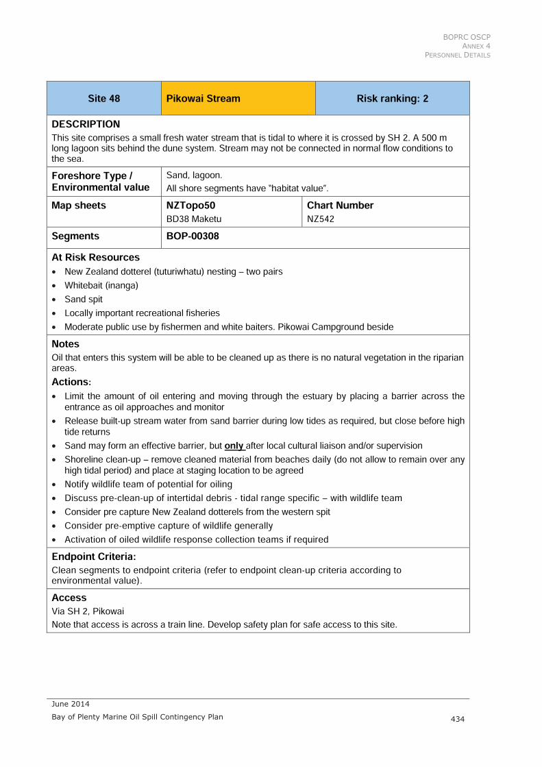
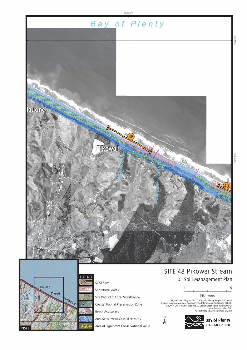
Site 48 Pikowai Stream Risk ranking: 2DESCRIPTION This site comprises a small fresh water stream that is tidal to where it is crossed by SH 2. A 500 m long lagoon sits behind the dune system. Stream may not be connected in normal flow conditions to the sea. Foreshore Type / Environmental value
Sand, lagoon. All shore segments have “habitat value”.
Map sheets NZTopo50BD38 Maketu
Chart Number NZ542
Segments BOP-00308 At Risk Resources• New Zealand dotterel (tuturiwhatu) nesting – two pairs • Whitebait (inanga) • Sand spit • Locally important recreational fisheries • Moderate public use by fishermen and white baiters. Pikowai Campground beside NotesOil that enters this system will be able to be cleaned up as there is no natural vegetation in the riparian areas. Actions:• Limit the amount of oil entering and moving through the estuary by placing a barrier across the
entrance as oil approaches and monitor • Release built-up stream water from sand barrier during low tides as required, but close before high
tide returns• Sand may form an effective barrier, but only after local cultural liaison and/or supervision • Shoreline clean-up – remove cleaned material from beaches daily (do not allow to remain over any
high tidal period) and place at staging location to be agreed • Notify wildlife team of potential for oiling • Discuss pre-clean-up of intertidal debris - tidal range specific – with wildlife team • Consider pre capture New Zealand dotterels from the western spit • Consider pre-emptive capture of wildlife generally • Activation of oiled wildlife response collection teams if required Endpoint Criteria:Clean segments to endpoint criteria (refer to endpoint clean-up criteria according to environmental value).AccessVia SH 2, PikowaiNote that access is across a train line. Develop safety plan for safe access to this site.

BOPRC OSCP
ANNEX 4
SENSITIVE AREAS AND COASTAL INFORMATION
June 2014
435 Bay of Plenty Marine Oil Spill Contingency Plan
Preferred Response Option MatrixMost preferred Least preferred Feasibility
Containment and Recovery High Sand boom across entrance On water Recovery High Shallow coastal shoreline Dispersant Application Low Shallow coastal shoreline Shoreline Clean-up High Access to stream area is over
trainline Natural Recovery Medium High intensity coastline
Hauone
Pikowai
Pik
ow
ai S
tream
Rua
taniw
ha
Str
ea
m
Pikowau R
oad
Ha
uo
ne
Roa
d
Mim
B a y o f P l e n t y
!!(49
!!(48
2832500
63
65
000
63
67
500
Oil Spill Management Plan
SITE 48 Pikowai Stream
±INSET
LEGEND

BOPRC OSCP
ANNEX 4
PERSONNEL DETAILS
June 2014
436 Bay of Plenty Marine Oil Spill Contingency Plan
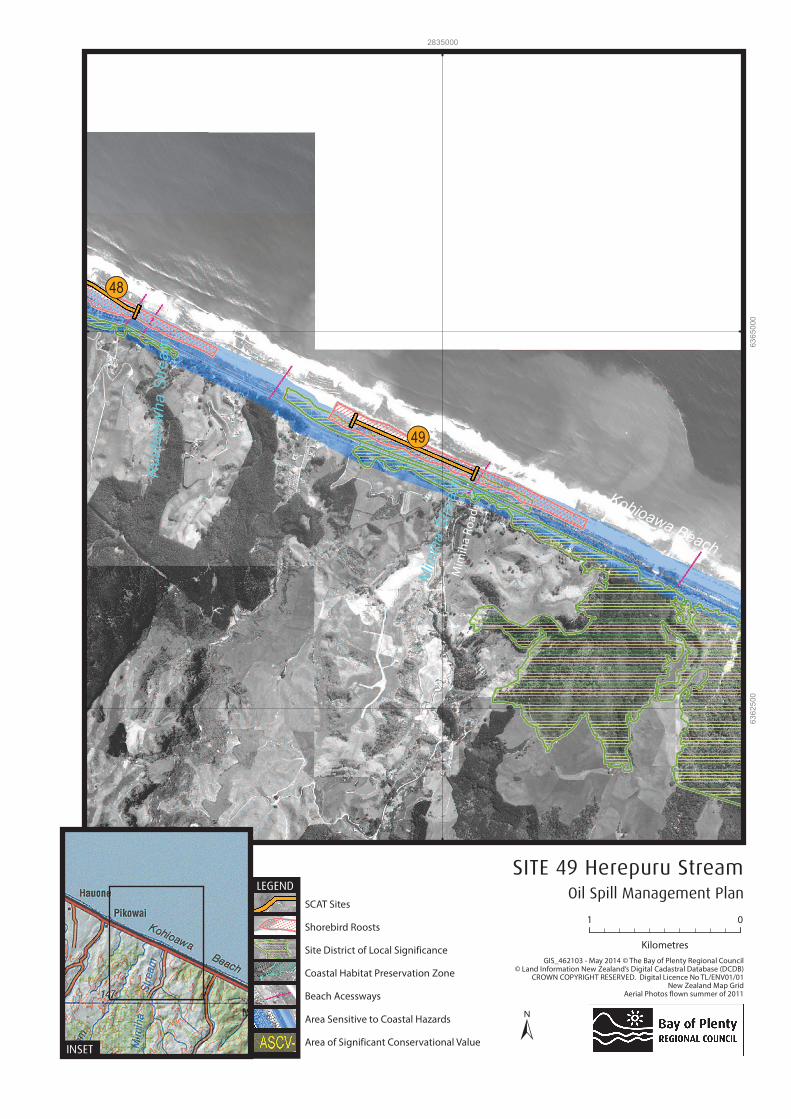
Site 49 Herepuru Stream Risk ranking: 2DESCRIPTIONThis site includes a small fresh water stream with a tidal lagoon area enclosed behind the sand-spit. The stream may not be connected in normal flow conditions to the sea and the mouth is highly mobile. Foreshore Type / Environmental Value
Sand, riparian vegetation, saltmarsh, steep beaches. All shore segments have “habitat value.
Map sheets NZ Topo 50BE39 Edgecumbe
Chart Number NZ 542
Segments BOP-00310 At Risk Resources• New Zealand dotterel (tuturiwhatu) nesting • White bait (inanga) • Common gecko (mokomoko) • Lagoon • Riparian vegetationNotesModerate public use: fishermen and white baiters Oil that enters the low energy system of this lagoon will remain for some time. Oil will harm saltmarsh habitat and whitebait spawning areas. Actions: • Notify wildlife team • Discuss pre-clean-up of intertidal debris - tidal range specific – to maintain gecko habitat • Consider pre-emptive capture of New Zealand dotterel • Consider pre-emptive capture of wildlife generally • Activation of oiled wildlife response collection teams if required • Prevent/minimise oil ingress into this system • Consider collection and recovery on sandy areas • Bulldoze entrance closed at high tides and release river water when required (see STM for small
estuaries – feasibility dependent on river flow)AccessVia SH 2, note that access is across a train line. Develop safety plan for safe access to this site. Preferred Response Option Matrix
Most preferred Least preferred Feasibility Containment and Recovery High Sand boom across entrance On water Recovery High Shallow coastal shoreline Dispersant Application Low Shallow coastal shoreline Shoreline Clean-up High Good access along this
coastline Natural Recovery Medium High intensity coastline
Rua
taniw
ha
Str
ea
m
Mim
iha S
tream
Kohioawa Beach
!!(48
!!(49
2835000
63
62
500
63
65
000
Oil Spill Management Plan
SITE 49 Herepuru Stream
±INSET
LEGEND
BOPRC OSCP
ANNEX 4
SENSITIVE AREAS AND COASTAL INFORMATION
June 2014
437 Bay of Plenty Marine Oil Spill Contingency Plan
Site 50 Matata Lagoon Risk ranking: 1DESCRIPTION This site comprises of the Matata River with associated wetland and stream confluence. A western fresh water side lagoon/wetland is connected only at high spring tides; the eastern side stream is connected through a flood gate.Foreshore Type / Environmental Value
High dune protected from coastline, Mud substrate, lagoon/wetland, saltmarsh. Riparian vegetation. All shore segments have “habitat value”.
Map sheets NZ Topo 50 BE 39 Edgecumbe
Chart Number NZ 542
Segments BOP-00490, BOP-00650, BOP- 00660, BOP- 00500 At Risk Resources • Fresh water wetland lagoon, control by weir and one way flap gate. Raupo predominant • Recovering ecosystem • Channels and islands within the lagoon, although this is not directly connected to the sea • Numerous bird species including at risk and threatened bird species, e.g.: banded rail (kataitai),
fern bird (kareni), bittern (matuku h repo), spotless crake (p weto), white heron (k tuku), New Zealand dotterel (tuturiwhatu)
• Whitebait (inanga) • Very high cultural values • Motorcamp beside, high amenity useNotesOil that enters the low energy systems of this estuary will remain for some time. Oil will harm intertidal and sand flats habitat.Actions:• Prevent/minimise oil ingress into this system • Establish collection and recovery on sandy areas on eastern side of estuary mouth • Lagoon will only receive water from the river estuary on an extreme spring tide through
overtopping of the one way weir. Weir just serviced, if threat please call Peter Cavaner (harbour superintendent) 027 5708283 and will arrange a watch. Very minimal risk of oil reaching the lagoon
• Notify wildlife team of potential for oiling • Discuss pre-clean-up of intertidal debris - tidal range specific – with wildlife team • Consider pre-emptive capture of New Zealand dotterels if present • Consider pre-emptive capture of wildlife generally • Activation of oiled wildlife response collection teams if requiredAccessVia SH 2, Matata. Access track to eastern side arm. Locked gate access to western wetland weir (BOPRC have key).

BOPRC OSCP
ANNEX 4
PERSONNEL DETAILS
June 2014
438 Bay of Plenty Marine Oil Spill Contingency Plan
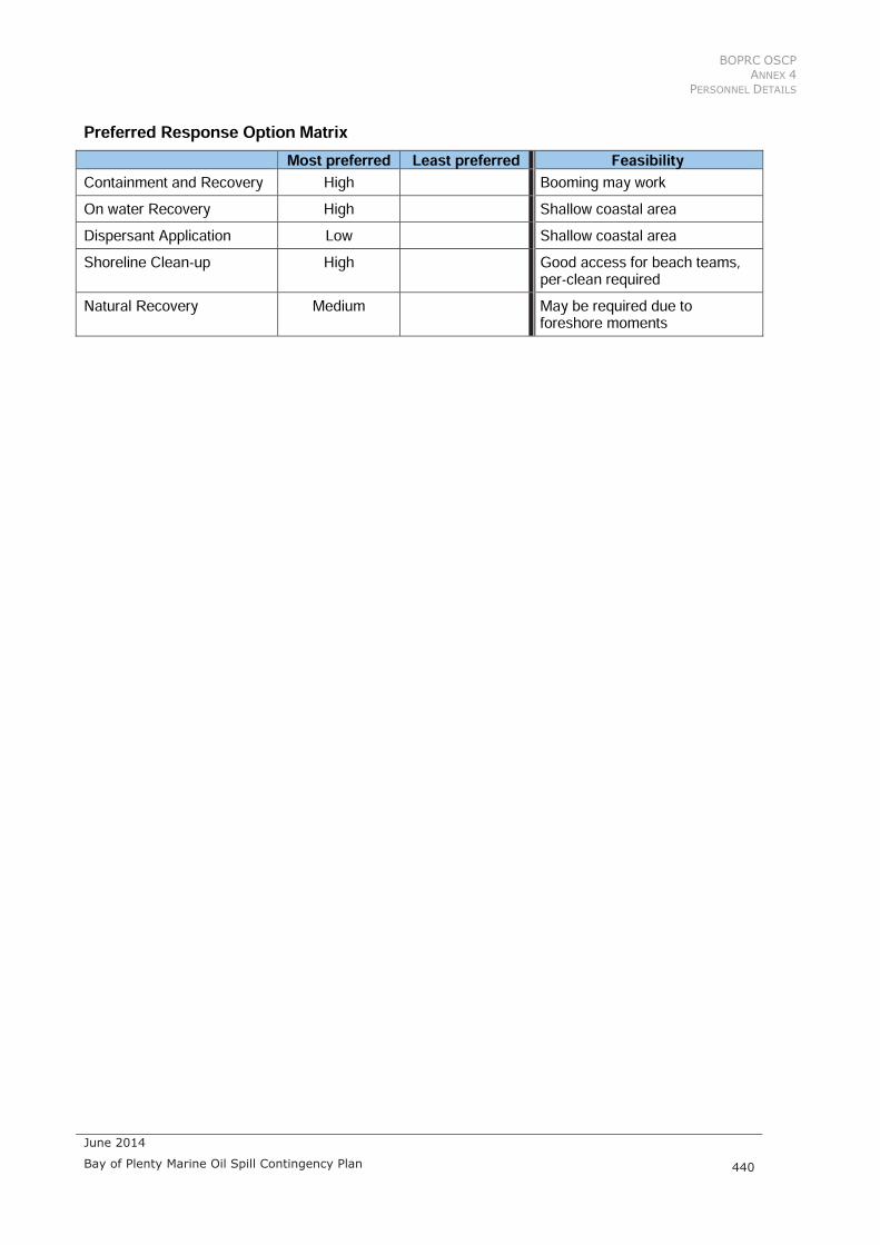
Preferred Response Option Matrix Most preferred Least preferred Feasibility
Containment and Recovery High Sandy coastal area, unlikely On water Recovery High Prior to reaching shore with
appropriate vessel Dispersant Application Low Proximity to shore, water depth Shoreline Clean-up High Sandy shoreline, pre-clean
required Natural Recovery Medium Some natural recovery may be
required due to foreshore moments

Tara
we
raR
ive
rtua Beach*
!!(50
2842500 2845000
63
60
000
63
62
500
Oil Spill Management Plan
SITE 50 Matata Lagoon
±INSET
LEGEND

BOPRC OSCP
ANNEX 4
SENSITIVE AREAS AND COASTAL INFORMATION
June 2014
439 Bay of Plenty Marine Oil Spill Contingency Plan
Site 51 Rangitaiki River East Risk ranking: 1DESCRIPTION This site comprises the Rangitaiki river with a lagoon branching off to the east behind the dunes. This lagoon is connected to the river by a collapsed culvert with no flood gate protection, and is known as Thornton Wildlife Management Reserve. Within the gazetted rohe moana (area) of Ng ti Awa. Foreshore Type / Environmental Value
Sand, riparian vegetation, saltmarsh, Lagoon All shore segments have “habitat value
Map sheets NZ Topo 50 BE 39 Edgecumbe
Chart Number NZ 542
Segments BOP – 00550, 01480, 01490, 00580 At Risk Resources • Numerous at risk bird species including: banded rail (kataitai), spotless crake (p weto), bittern
(matuku h repo), and fern bird (kareni). Also New Zealand dotterel (tuturiwhatu) • Freshwater fish - White bait (inunga) • Lagoon - Raupo dominant, predominantly fresh water wetland • Cultural sites: Nohonga (settlement) beside reserve • There are two archaeological sites in proximity to the river banks, W15/356 (Midden - lens of
crushed tuatua) and W15/335 (no information). These should be noted when considering response options and avoided if possible or discussed with Iwi
• Moderate public use including fishermen and White BaitersNotesOil that enters the low energy systems of this estuary will remain for some time. Oil will harm intertidal and sand flats habitat Actions:• Limit the amount of oil entering and moving through the estuary by placing protection across the
entrance culvert. Repair or fill collapsed culvert to prevent oil entering lagoon/ wetland – reopen when possible
• Establish and maintain protective oil deflection at estuary entrance. Booming may be of assistance with oil directed to the SANDY western side for collection or snares may be sufficient. Note that current velocities on incoming tide may be over 2 kts
• Notify wildlife team of potential for oiling • Discuss pre-clean-up of intertidal debris - tidal range specific – with wildlife team • Consider pre-emptive Capture Of New Zealand dotterels • Consider pre-emptive capture of wildlife generallyAccessVia Thornton Hall Road, accessed from Thornton road on the south-east side of road bridge.
BOPRC OSCP
ANNEX 4
PERSONNEL DETAILS
June 2014
440 Bay of Plenty Marine Oil Spill Contingency Plan
Preferred Response Option Matrix Most preferred Least preferred Feasibility
Containment and Recovery High Booming may work On water Recovery High Shallow coastal area Dispersant Application Low Shallow coastal area Shoreline Clean-up High Good access for beach teams,
per-clean required Natural Recovery Medium May be required due to
foreshore moments

Ran
gitaiki R
iver
Th or n to n B e a c h
ASCV-10
!!(51
2850000 2852500
63
57
500
63
60
000
Oil Spill Management Plan
SITE 51 Rangitaiki River East
±INSET
LEGEND
BOPRC OSCP
ANNEX 4
SENSITIVE AREAS AND COASTAL INFORMATION
June 2014
441 Bay of Plenty Marine Oil Spill Contingency Plan
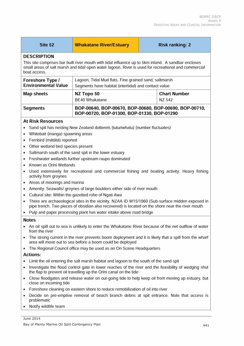
Site 52 Whakatane River/Estuary Risk ranking: 2 DESCRIPTION This site comprises bar built river mouth with tidal influence up to 5km inland. A sandbar encloses small areas of salt marsh and tidal open water lagoon. River is used for recreational and commercial boat access. Foreshore Type / Environmental Value
Lagoon, Tidal Mud flats, Fine grained sand, saltmarsh Segments have habitat (intertidal) and contact value
Map sheets NZ Topo 50 BE40 Whakatane
Chart Number NZ 542
Segments BOP-00640, BOP-00670, BOP-00680, BOP-00690, BOP-00710, BOP-00720, BOP-01300, BOP-01330, BOP-01290
At Risk Resources• Sand spit has nesting New Zealand dotterels (tuturiwhatu) (number fluctuates) • Whitebait (inanga) spawning areas • Fernbird (m t t ) reported • Other wetland bird species present • Saltmarsh south of the sand spit in the lower estuary • Freshwater wetlands further upstream raupo dominated • Known as Orini Wetlands • Used extensively for recreational and commercial fishing and boating activity. Heavy fishing
activity from groynes • Areas of moorings and marina • Amenity: Seawalls/ groynes of large boulders either side of river mouth • Cultural site: Within the gazetted rohe of Ngati Awa • There are archaeological sites in the vicinity, NZAA ID W15/1060 (Sub-surface midden exposed in
pipe trench. Two pieces of obsidian also recovered) is located on the shore near the river mouth • Pulp and paper processing plant has water intake above road bridgeNotes• An oil spill out to sea is unlikely to enter the Whakatane River because of the net outflow of water
from the river • The strong current in the river prevents boom deployment and it is likely that a spill from the wharf
area will move out to sea before a boom could be deployed • The Regional Council office may be used as an On Scene Headquarters Actions:• Limit the oil entering the salt marsh habitat and lagoon to the south of the sand spit • Investigate the flood control gate in lower reaches of the river and the feasibility of wedging shut
the flap to prevent oil travelling up the Orini canal on the tide • Close floodgates and release water on out-going tide to help keep oil from moving up estuary, but
close on incoming tide • Foreshore cleaning on eastern shore to reduce remobilization of oil into river • Decide on pre-emptive removal of beach branch debris at spit entrance. Note that access is
problematic • Notify wildlife team

BOPRC OSCP
ANNEX 4
PERSONNEL DETAILS
June 2014
442 Bay of Plenty Marine Oil Spill Contingency Plan
• Discuss pre-clean-up of intertidal debris - tidal range specific – with wildlife • Consider pe-emptive capture of New Zealand dotterel • Consider pre-emptive capture of wildlife generally • Activation of oiled wildlife response collection teams if required • Investigate protecting paper mill intake AccessSouthern saltmarsh can be accessed through town centre. Northern areas (beaches, wetlands and sand spit) can be accessed via Keepa Road and Bunyan Road (locked gate, contact WDC for key/ access). Coastal beaches and sand spit access via beach. Coastlands, Whakatane. There is a boat launching ramp and commercial wharf in the Whakatane River adjacent to the Whakatane township. Preferred Response Option Matrix
Most preferred Least preferred Feasibility Containment and Recovery High Strong tide currents may prohibit
this. On water Recovery High Strong tide currents may prohibit
this. Dispersant Application Low Water depth won’t allow Shoreline Clean-up High Requires a pre-clean Natural Recovery Medium Can be a high intensity coastline
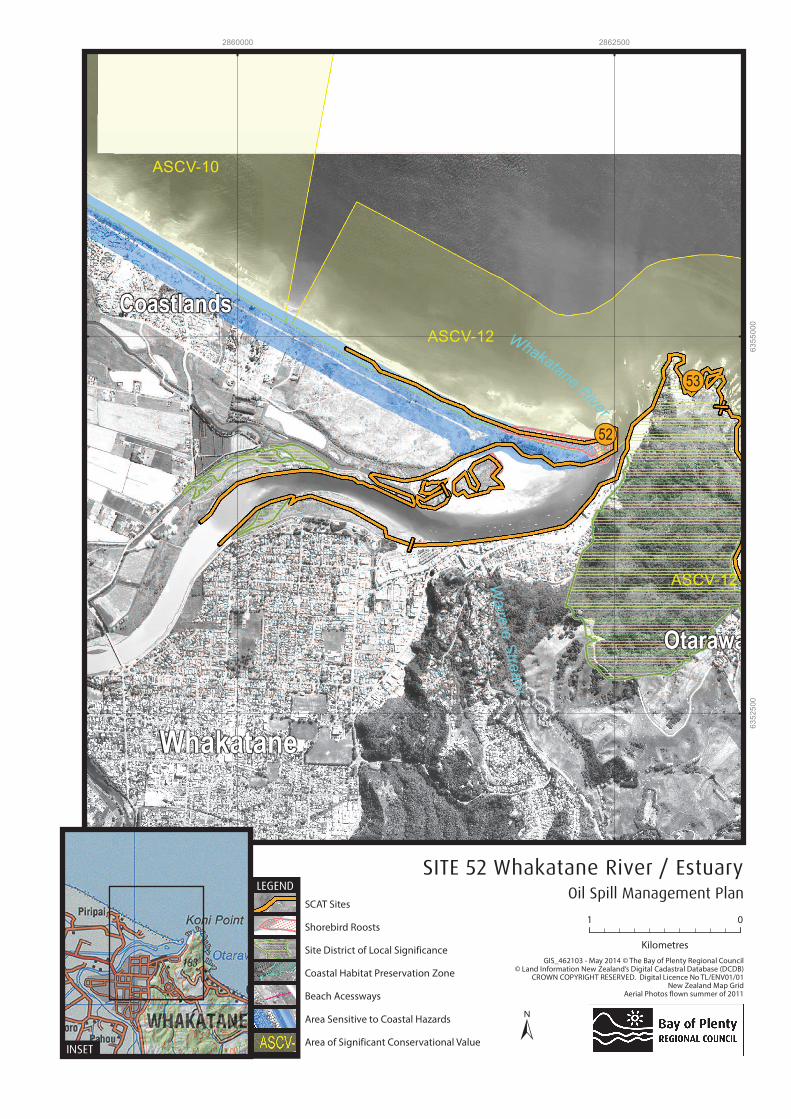
CoastlandsW
aire
re S
tream
Koh
Otarawai
O
Whakatane
Whakatane
River
ASCV-10
ASCV-12
ASCV-12
!!(53
!!(52
2860000 2862500
63
52
500
63
55
000
Oil Spill Management Plan
SITE 52 Whakatane River / Estuary
±INSET
LEGEND