Embed Size (px)
Citation preview
The Underlying Causes and Impacts of Fires in South-east Asia Site 7, Ketapang, West Kalimantan Province
Site 7. Tumbang Titi, West Kalimantan Province, Indonesia
by
Suyanto, S., Ruchiat, Y., Erman, A., Maus, P., Stolle, F., Hadi, D.P., Dennis, R., and Applegate, G.
In collaboration with Yayasan Dian Tama (YDT) West Kalimantan
Site Report
August 2000
The Underlying Causes and Impacts of Fires in South-east Asia Site 7, Ketapang, West Kalimantan Province
The underlying causes and impacts of fires in South-east Asia Site 7. Tumbang Titi, West Kalimantan Province, Indonesia
by
S. Suyanto1, Yayat Ruchiat1, Andi Erman2, Paul Maus3, Iwan Kurniawan1, Fred Stolle1, Danan Prasetyo Hadi1, Rona Dennis2 and Grahame Applegate2
In collaboration with Yayasan Dian Tama (YDT) West Kalimantan 1 International Centre for Research in Agroforestry (ICRAF) 2 Center for International Forestry Research (CIFOR) 3 United States Forest Service (USFS)
Map and layout design: Rizki Pandu Permana Copy editing: Erik Meijaard
Corresponding author and contact address: Grahame Applegate
Center for International Forest Research (CIFOR) PO Box 6596 JKPWB
10065 Jakarta Indonesia
Cover photo: Imperata grasslands in Kalimantan Photo by: Erik Meijaard
The Underlying Causes and Impacts of Fires in South-east Asia Site 7, Ketapang, West Kalimantan Province i
Table of Contents Page No.
ABBREVIATIONS AND TERMS .................................................................................................................. III
ACKNOWLEDGMENTS ................................................................................................................................ IV
SUMMARY .........................................................................................................................................................V
1. INTRODUCTION........................................................................................................................................1
2. SITE DESCRIPTION..................................................................................................................................3
3. METHODOLOGY.......................................................................................................................................7
3.1 SOCIO-ECONOMIC STUDY METHODS....................................................................................................... 7 3.2 REMOTE SENSING AND GIS..................................................................................................................... 7
3.2.1 Landsat TM and SAR image level ..................................................................................................7 3.2.2 Derivation of fire hot spots.............................................................................................................9
4. RESULTS ...................................................................................................................................................10
4.1 FIRES..................................................................................................................................................... 10 4.1.1 Landscape level ............................................................................................................................10 4.1.2 Imperata and its vulnerability to fire ...........................................................................................11 4.1.3 Alternative land-use on Imperata grasslands ..............................................................................13 4.1.4 Fire Information from Hot-spots..................................................................................................18
4.2 LAND COVER/USE CHANGES ................................................................................................................ 19 4.2.1 Land Degradation: The expansion of Imperata grasslands.........................................................20 4.2.2 Landsat TM and SAR Image level ................................................................................................22
5. UNDERLYING CAUSES..........................................................................................................................26
6. POLICY IMPLICATIONS .......................................................................................................................27
7. REFERENCES...........................................................................................................................................28
The Underlying Causes and Impacts of Fires in South-east Asia Site 7, Ketapang, West Kalimantan Province ii
FIGURES: FIGURE 2-1 LOCATION OF STUDY SITE.................................................................................................................... 3 FIGURE 2-2 LOCATIONS AND LANDMARKS IN STUDY SITE ...................................................................................... 4 FIGURE 2-3 LANDSCAPE LEVEL SKETCH MAP OF TUMBANG TITI SITE ................................................................... 6 FIGURE 3-1 SAR COHERENCE PRODUCTS SHOWING THE CHANGES IN THE TUMBANG TITI STUDY SITE BETWEEN
1996 AND 1998. .................................................................................................................................. 8 FIGURE 4-1 IMPERATA GRASSLANDS NEAR MAHAWA VILLAGE............................................................................. 13 FIGURE 4-2 DAMAGED YOUNG OIL PALM AT PT DUTA SUMBER NABATI AS A RESULTS OF UNCONTROLLED
BURNING OF IMPERATA GRASSLAND................................................................................................... 15 FIGURE 4-3 ACACIA MANGIUM TREES THAT SURVIVED THE 1997 FIRE IN PT TAWANG MAJU ............................... 18 FIGURE 4-4 TUMBANG TITI SITE AND THE 1997 HOT-SPOTS DISTRIBUTION .......................................................... 19 FIGURE 4-5 ILLEGAL LOGGING ACTIVITIES AND SHORT-ROTATION SHIFTING CULTIVATION LEADING TO LAND
DEGRADATION................................................................................................................................... 21 FIGURE 4-6 RUBBER FORESTS IN NANGA KELAMPAI DAMAGED BY OPEN GOLD MINING ACTIVITIES .................... 22 FIGURE 4-7 CHANGES IN NATURAL FOREST FOR THE COMMON AREA BETWEEN 1989 LANDSAT TM AND SAR
COHERENCE PRODUCTS FROM 1996 AND 1998. ................................................................................ 23 FIGURE 4-8 GRAPHIC PORTRAYAL OF LAND COVER CHANGES OCCURRING IN THE COMBINED LANDSAT TM–SAR
COHERENCE IMAGE AREA SURROUNDING THE TUMBANG TIT SITE BETWEEN 1986 AND 1998. .......... 25 TABLES: TABLE 3-1 COVER CATEGORIES MAPPED FOR EACH OF THE THREE DATES OF SATELLITE IMAGERY....................... 8 TABLE 4-1 FIELD-BASED ESTIMATION OF BURNT AREA IN 1997 BY VEGETATION TYPE AND SUB-SITE ................ 10 TABLE 4-2 AREA BURNED IN RELATION TO LAND COVER TYPE IN 1997 .............................................................. 11 TABLE 4-3 AREA (HA) IN IMPERATA GRASSLAND BEFORE AND AFTER THE 1997 FIRES IN 3 SUB-SITES................ 12 TABLE 4-4 TOTAL AREA PLANTED BY THE 3 OIL PALM PLANTATION COMPANIES IN THE SEI MELAYU SUB-SITE.15 TABLE 4-5 REALIZATION OF TRANSMIGRANTS PLACEMENT UNDER THE NES SYSTEM BY 3 OIL PALM PLANTATION
COMPANIES AT SEI MELAYU SUB-SITE, 1991-1999 ........................................................................... 16 TABLE 4-6 LAND CLEARING AND PLANTING OF ACACIA AND SUNGKAI BY HTI PT TAWANG MAJU (IN HA) ....... 17 TABLE 4-7 FIRE HOT-SPOT DENSITIES OVER TIME IN THE TUMBANG TITI STUDY AREA ....................................... 18 TABLE 4-8 AREA IN DIFFERENT LAND COVER TYPE IN 1997 ................................................................................ 21 TABLE 4-9 LAND COVER CHANGES OCCURRING IN THE TM IMAGE-WIDE AREA SURROUNDING THE KETAPANG
SITE BETWEEN 1986 AND 1998. ......................................................................................................... 24
The Underlying Causes and Impacts of Fires in South-east Asia Site 7, Ketapang, West Kalimantan Province iii
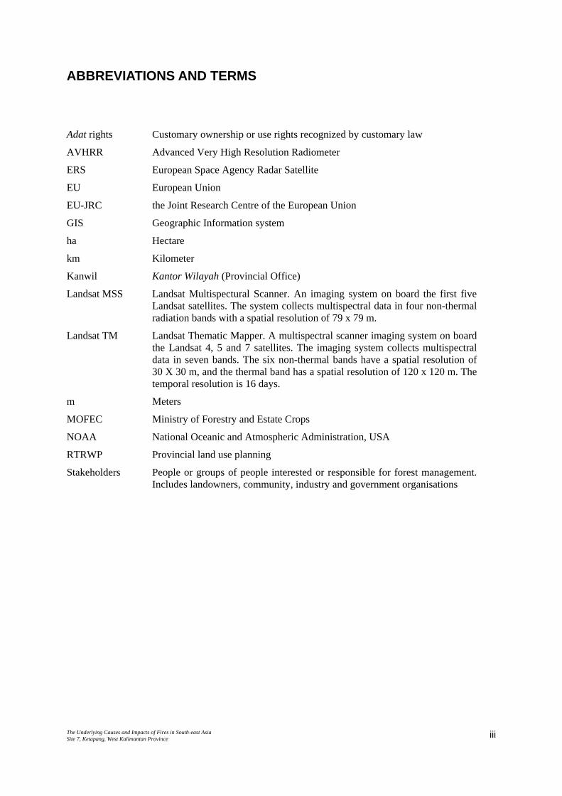
ABBREVIATIONS AND TERMS
Adat rights Customary ownership or use rights recognized by customary law
AVHRR Advanced Very High Resolution Radiometer
ERS European Space Agency Radar Satellite
EU European Union
EU-JRC the Joint Research Centre of the European Union
GIS Geographic Information system
ha Hectare
km Kilometer
Kanwil Kantor Wilayah (Provincial Office)
Landsat MSS Landsat Multispectural Scanner. An imaging system on board the first five Landsat satellites. The system collects multispectral data in four non-thermal radiation bands with a spatial resolution of 79 x 79 m.
Landsat TM Landsat Thematic Mapper. A multispectral scanner imaging system on board the Landsat 4, 5 and 7 satellites. The imaging system collects multispectral data in seven bands. The six non-thermal bands have a spatial resolution of 30 X 30 m, and the thermal band has a spatial resolution of 120 x 120 m. The temporal resolution is 16 days.
m Meters
MOFEC Ministry of Forestry and Estate Crops
NOAA National Oceanic and Atmospheric Administration, USA
RTRWP Provincial land use planning
Stakeholders People or groups of people interested or responsible for forest management. Includes landowners, community, industry and government organisations
The Underlying Causes and Impacts of Fires in South-east Asia Site 7, Ketapang, West Kalimantan Province iv
ACKNOWLEDGMENTS
This research is supported by the United States Forest Service, CIFOR and ICRAF. We are
grateful to our respondents in the study site for their cooperation and patience during our
interviews. We would like to thank Drs. Donatus Rantan (Executive Director of Yayasan Dian
Tama) for organizing the field survey and also Leonardus Rantan, Wawan Pudji, Irawan
Sihombing, and Egidius (Yayasan Dian Tama staff) for their excellent work during the
survey, and Dr. Unna Chokkalingam for providing insightful comments. In addition, we
would like to thank the JICA/PKA Forest Fire Prevention and Management Project in Bogor
for kindly providing their hot-spot data set.
The Underlying Causes and Impacts of Fires in South-east Asia Site 7, Ketapang, West Kalimantan Province v
SUMMARY
This report provides an analysis of causes and impacts of vegetation fires in the Tumbang Titi
area, Ketapang District, West Kalimantan Province, Indonesia. The Landstat TM and SAR
Image level analysis indicated that natural forest decreased from 473,300 ha in 1989 to
127,335 ha in 1996. Socio-economic research at the landscape level indicated that alang-
alang (Imperata cylindrica) accounted for almost 22% of the land cover of the study area. In
1997, large-scale fires burned up 29 % of the land area of the site, including Imperata
grassland, remaining forest, and smallholder and largescale plantations. Imperata grasslands
were most affected by the 1997 fires. Socio-economic research indicated that three main
forces were responsible for land degradation from humid tropical rain forest to Imperata
grassland: shifting cultivation, commercial logging and illegal gold mining.
Three phases of land use change were evident on this study site. First, the widespread
development of Imperata grasslands as the final stage of land degradation, following the
intensive exploitation and conversion of humid tropical rain forest. Second, the expansion of
smallholder, large scale commercial, and local government interest in using the Imperata
grasslands. And third, local community shift to more profitable land use activities such as
gold mining in the wake of the economic crisis.
Site Tumbang Titi
The Underlying Causes and Impacts of Fires in South-east Asia Site 7. Tumbang Titi, West Kalimantan Province, Indonesia
1
1. INTRODUCTION
Large-scale fires and associated smoke are an increasing problem in Indonesia and
surrounding countries. For instance, major fires occurring in the El Niño years 1982/1983,
1987, 1991, 1994, and 1997/1998 (Dennis, 1999) devastated large areas of forest and caused
significant economic losses, both in Indonesia where most fires occurred and in neighboring
countries. The economic costs of the 1997/98 fires in Indonesia have been estimated to exceed
9 billion US$ with carbon emissions high enough to elevate Indonesia to one of the largest
polluters in the world (Asian Development Bank, 1999; Barber and Schweithelm, 2000). The
major causes of these fires are, however, still largely unclear. Some have blamed small-scale
farmers, others large-scale estates for causing fires, suggesting that these actors deliberately
set fires to forest to open up land for plantations or agriculture. In 1994, the Indonesian
government blamed slash-and-burn activity by smallholders as the major cause of fire, and
they estimated that these people were responsible for more than 85.2 % of the 5,000,000 ha
burned (Jakarta Post, 7 October 1994). Environmental NGOs, however, blamed activities by
forest concessionaires and plantation owners as the major cause of fires (Jakarta Post, 3
October 1994). In contrast, taking advantage of data obtained from fire hot-spot information
and satellite imagery, all institutions including government agencies believe that large-scale
land clearing for plantations of fast growing trees for pulpwood and oil palm were the major
causes of fire in 1997 and 1998. Yet, fires occurred at multiple scales and for many reasons,
and impacts on local communities and forest had a variety of complex causes.
In this report, the Center for International Forestry Research (CIFOR), the International
Centre for Research in Agroforestry (ICRAF), and the United States Forest Service (USFS)
provide a study of the underlying causes and impacts of vegetation fires in Indonesia. The aim
is to answer questions about the reasons (why), nature (what), perpetrators (who), and
locations (where) that were associated with the fires. Several methods of information
gathering were used ranging from satellite-derived remote sensing imagery at the landscape
level to in-depth field investigations at the village level. When used in combination, a more
complete picture of the 1997 fires can be developed. For example, images from satellites
provide information on the location, extent, and the type of land cover burned. However, only
through extensive interviews with local people combined with on-the-ground participatory
mapping, can an answer be found to whom was responsible for the fires and what were their
underlying reasons. From the field investigations and the use of a Geographic Information
Site Tumbang Titi
The Underlying Causes and Impacts of Fires in South-east Asia Site 7. Tumbang Titi, West Kalimantan Province, Indonesia
2
System (GIS), a more accurate estimate of what burned can be determined at the landscape
level.
This study will apply three levels of spatial analysis: island-wide, province, and site. At the
site-specific level, the study focuses on the relationship between fire and land cover/land use
change. The province wide (Landsat TM-level) study will concentrate on general land cover
change, burn scars and hot-spots, and compare these pattern with the site-level findings.
Finally, hot-spots for Kalimantan as a whole will be compared to those for the province and
the site.
The Tumbang Titi area was chosen as a research site because of the high frequency and
density of hot spots in 1997 as compared to other parts of Kalimantan.
Site Tumbang Titi
The Underlying Causes and Impacts of Fires in South-east Asia Site 7. Tumbang Titi, West Kalimantan Province, Indonesia
3
2. SITE DESCRIPTION
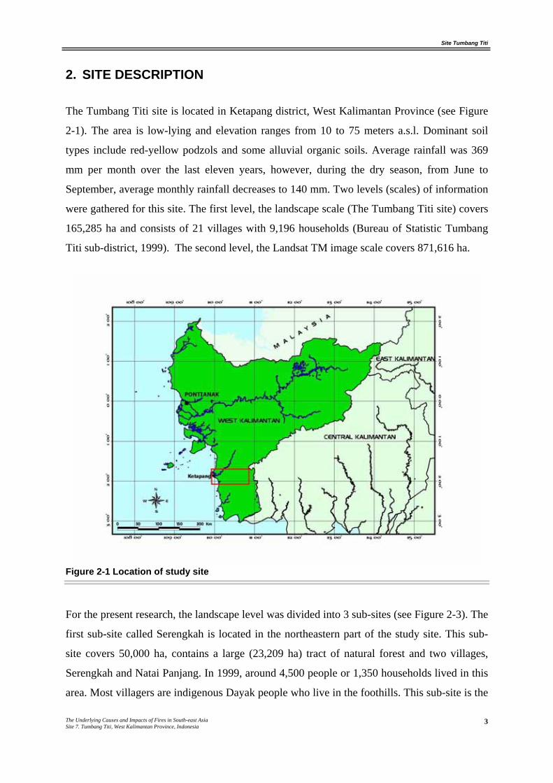
The Tumbang Titi site is located in Ketapang district, West Kalimantan Province (see Figure
2-1). The area is low-lying and elevation ranges from 10 to 75 meters a.s.l. Dominant soil
types include red-yellow podzols and some alluvial organic soils. Average rainfall was 369
mm per month over the last eleven years, however, during the dry season, from June to
September, average monthly rainfall decreases to 140 mm. Two levels (scales) of information
were gathered for this site. The first level, the landscape scale (The Tumbang Titi site) covers
165,285 ha and consists of 21 villages with 9,196 households (Bureau of Statistic Tumbang
Titi sub-district, 1999). The second level, the Landsat TM image scale covers 871,616 ha.
Figure 2-1 Location of study site
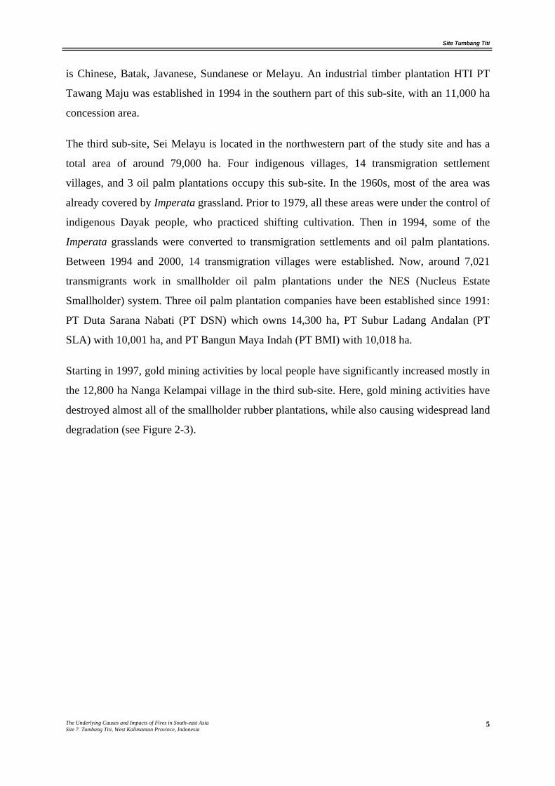
For the present research, the landscape level was divided into 3 sub-sites (see Figure 2-3). The
first sub-site called Serengkah is located in the northeastern part of the study site. This sub-
site covers 50,000 ha, contains a large (23,209 ha) tract of natural forest and two villages,
Serengkah and Natai Panjang. In 1999, around 4,500 people or 1,350 households lived in this
area. Most villagers are indigenous Dayak people who live in the foothills. This sub-site is the
Site Tumbang Titi
The Underlying Causes and Impacts of Fires in South-east Asia Site 7. Tumbang Titi, West Kalimantan Province, Indonesia
4
most remote, with poor accessibility until 1996. The customary laws (adat) for land
ownership and fire management are more strictly enforced on this sub-site.
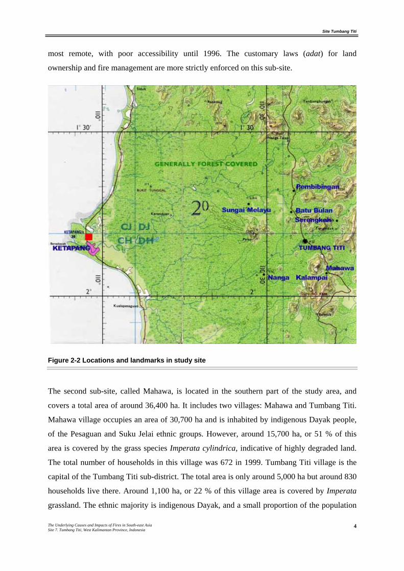
Figure 2-2 Locations and landmarks in study site
The second sub-site, called Mahawa, is located in the southern part of the study area, and
covers a total area of around 36,400 ha. It includes two villages: Mahawa and Tumbang Titi.
Mahawa village occupies an area of 30,700 ha and is inhabited by indigenous Dayak people,
of the Pesaguan and Suku Jelai ethnic groups. However, around 15,700 ha, or 51 % of this
area is covered by the grass species Imperata cylindrica, indicative of highly degraded land.
The total number of households in this village was 672 in 1999. Tumbang Titi village is the
capital of the Tumbang Titi sub-district. The total area is only around 5,000 ha but around 830
households live there. Around 1,100 ha, or 22 % of this village area is covered by Imperata
grassland. The ethnic majority is indigenous Dayak, and a small proportion of the population
Site Tumbang Titi
The Underlying Causes and Impacts of Fires in South-east Asia Site 7. Tumbang Titi, West Kalimantan Province, Indonesia
5
is Chinese, Batak, Javanese, Sundanese or Melayu. An industrial timber plantation HTI PT
Tawang Maju was established in 1994 in the southern part of this sub-site, with an 11,000 ha
concession area.
The third sub-site, Sei Melayu is located in the northwestern part of the study site and has a
total area of around 79,000 ha. Four indigenous villages, 14 transmigration settlement
villages, and 3 oil palm plantations occupy this sub-site. In the 1960s, most of the area was
already covered by Imperata grassland. Prior to 1979, all these areas were under the control of
indigenous Dayak people, who practiced shifting cultivation. Then in 1994, some of the
Imperata grasslands were converted to transmigration settlements and oil palm plantations.
Between 1994 and 2000, 14 transmigration villages were established. Now, around 7,021
transmigrants work in smallholder oil palm plantations under the NES (Nucleus Estate
Smallholder) system. Three oil palm plantation companies have been established since 1991:
PT Duta Sarana Nabati (PT DSN) which owns 14,300 ha, PT Subur Ladang Andalan (PT
SLA) with 10,001 ha, and PT Bangun Maya Indah (PT BMI) with 10,018 ha.
Starting in 1997, gold mining activities by local people have significantly increased mostly in
the 12,800 ha Nanga Kelampai village in the third sub-site. Here, gold mining activities have
destroyed almost all of the smallholder rubber plantations, while also causing widespread land
degradation (see Figure 2-3).
Site Tumbang Titi
The Underlying Causes and Impacts of Fires in South-east Asia Site 7. Tumbang Titi, West Kalimantan Province, Indonesia
6
Figure 2-3 Landscape Level Sketch map of Tumbang Titi site
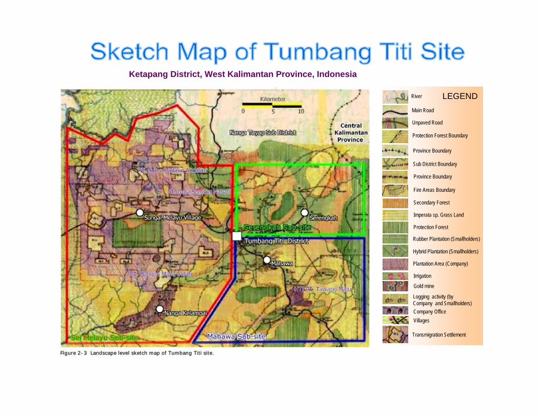
Ketapang District, West Kalimantan Province, Indonesia
River
Protection Forest Boundary
Main Road
Unpaved Road
Province Boundary
Sub District Boundary
Province Boundary
Fire Areas Boundary
Rubber Plantation (Smallholders)
Hybrid Plantation (Smallholders)
Plantation Area (Company)
Irrigation
Company Office
Gold mine
Logging activity (byCompany and Smallholders)
Villages
Transmigration Settlement
Secondary Forest
Protection Forest
Imperata sp. Grass Land
LEGEND
Figure 2-3 Landscape level sketch map of Tumbang Titi site.B
y : Y
ruch
iat a
nd A
Erm
an
Site Tumbang Titi
The Underlying Causes and Impacts of Fires in South-east Asia Site 7. Tumbang Titi, West Kalimantan Province, Indonesia
7
3. METHODOLOGY
3.1 Socio-economic Study Methods
In collaboration with a local environmental NGO (Yayasan Dian Tama), sketch mapping at
landscape level and rural appraisal was conducted between May and July 2000. The sketch
map was developed based on a Ketapang District topography map with a scale of 1:100,000,
an administration map with a scale of 1:200,000, and the Tumbang Titi sub-District situation
map with a scale of 1:100,000. Subsequently, formal and informal community leaders,
community members, logging companies and local government officers were interviewed,
and several field visits for additional information were made. Information obtained through
interviews included the history of the plantations and villages, the history of land clearing and
planting, land clearing techniques, fire history, demography, land use, agricultural activities,
and land tenure conflicts. The information provided through these interviews was added onto
the existing base maps, and checked during the field visits.
3.2 Remote Sensing and GIS
3.2.1 Landsat TM and SAR image level
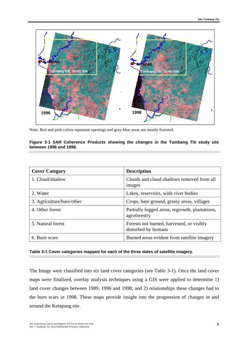
Information about land cover and land cover changes in the Ketapang area was derived from a
combination of Landsat Thematic Mapper (TM) 1989, and ERS Synthetic Aperture Radar
(SAR) 1996 and 1998 satellite imagery. Since this area of Indonesia is often covered with
clouds and haze, SAR was used for assessing land cover prior to and after the fires. The SAR
imagery covers an area of approximately 100 km by 100 km covering 1 million hectares. The
SAR sensor is carried on-board the ERS-1 and ERS-2 satellites. Since radar sensors supply
their own cloud penetrating electromagnetic energy, they are useful for obtaining information
that cannot be gathered by optical sensors relying on emitted or reflected energy. While fire
scars, forests, and agricultural areas are visually distinguishable on the radar image, the radar
was not as useful for delineating the borders between different types of forest. Distinguishing
between natural forest, other forest, or burn scars with standing trees was difficult. Figure 3-2
shows the Coherence Product images acquired in 1996 and 1998. In general, red and pink
areas are more open while blue and gray areas are forested.
Site Tumbang Titi
The Underlying Causes and Impacts of Fires in South-east Asia Site 7. Tumbang Titi, West Kalimantan Province, Indonesia
8
Note: Red and pink colors represent openings and gray-blue areas are mostly forested.
Figure 3-1 SAR Coherence Products showing the changes in the Tumbang Titi study site between 1996 and 1998.
Cover Category Description 1. Cloud/shadow Clouds and cloud shadows removed from all
images 2. Water Lakes, reservoirs, wide river bodies 3. Agriculture/bare/other Crops, bare ground, grassy areas, villages 4. Other forest Partially logged areas, regrowth, plantations,
agroforestry 5. Natural forest Forests not burned, harvested, or visibly
disturbed by humans 6. Burn scars Burned areas evident from satellite imagery
Table 3-1 Cover categories mapped for each of the three dates of satellite imagery.
The Image were classified into six land cover categories (see Table 3-1). Once the land cover
maps were finalized, overlay analysis techniques using a GIS were applied to determine 1)
land cover changes between 1989, 1996 and 1998; and 2) relationships these changes had to
the burn scars in 1998. These maps provide insight into the progression of changes in and
around the Ketapang site.
Ketapan Ketapan
1996 1998
Tumbang Titi, Study Site Tumbang Titi, Study Site
Site Tumbang Titi
The Underlying Causes and Impacts of Fires in South-east Asia Site 7. Tumbang Titi, West Kalimantan Province, Indonesia
9
3.2.2 Derivation of fire hot spots
We used fire hotspot data recorded by the EU project based in South Sumatera for the years
1992 and 1993. For the years 1997-1999, we used reliable data available for the area from the
Japanese International Cooperation Agency (JICA) – MOFEC Fire Protection and
Management project based in Bogor, West Java.
Site Tumbang Titi
The Underlying Causes and Impacts of Fires in South-east Asia Site 7. Tumbang Titi, West Kalimantan Province, Indonesia
10
4. RESULTS
4.1 Fires
4.1.1 Landscape level
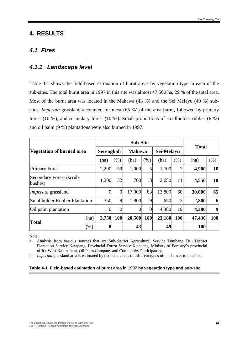
Table 4-1 shows the field-based estimation of burnt areas by vegetation type in each of the
sub-sites. The total burnt area in 1997 in this site was almost 47,500 ha, 29 % of the total area.
Most of the burnt area was located in the Mahawa (43 %) and the Sei Melayu (49 %) sub-
sites. Imperata grassland accounted for most (65 %) of the area burnt, followed by primary
forest (10 %), and secondary forest (10 %). Small proportions of smallholder rubber (6 %)
and oil palm (9 %) plantations were also burned in 1997.
Sub-Site
Serengkah Mahawa Sei-Melayu Total
Vegetation of burned area
(ha) (%) (ha) (%) (ha) (%) (ha) (%)
Primary Forest 2,200 59 1,000 5 1,700 7 4,900 10
Secondary Forest (scrub-bushes) 1,200 32 700 3 2,650 11 4,550 10
Imperata grassland 0 0 17,000 83 13,800 60 30,800 65
Smallholder Rubber Plantation 350 9 1,800 9 650 3 2,800 6
Oil palm plantation 0 0 0 0 4,380 19 4,380 9
(ha) 3,750 100 20,500 100 23,180 100 47,430 100Total
(%) 8 43 49 100
Note: a. Analysis from various sources that are Sub-district Agricultural Service Tumbang Titi, District
Plantation Service Ketapang, Provincial Forest Service Ketapang, Ministry of Forestry’s provincial office West Kalimantan, Oil Palm Company and Community Participatory.
b. Imperata grassland area is estimated by deducted areas of different types of land cover to total size.
Table 4-1 Field-based estimation of burnt area in 1997 by vegetation type and sub-site
Site Tumbang Titi
The Underlying Causes and Impacts of Fires in South-east Asia Site 7. Tumbang Titi, West Kalimantan Province, Indonesia
11
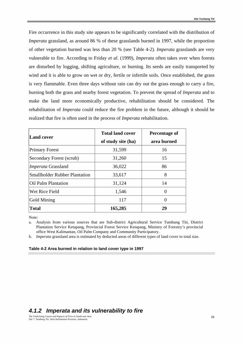
Fire occurrence in this study site appears to be significantly correlated with the distribution of
Imperata grassland, as around 86 % of these grasslands burned in 1997, while the proportion
of other vegetation burned was less than 20 % (see Table 4-2). Imperata grasslands are very
vulnerable to fire. According to Friday et al. (1999), Imperata often takes over when forests
are disturbed by logging, shifting agriculture, or burning. Its seeds are easily transported by
wind and it is able to grow on wet or dry, fertile or infertile soils. Once established, the grass
is very flammable. Even three days without rain can dry out the grass enough to carry a fire,
burning both the grass and nearby forest vegetation. To prevent the spread of Imperata and to
make the land more economically productive, rehabilitation should be considered. The
rehabilitation of Imperata could reduce the fire problem in the future, although it should be
realized that fire is often used in the process of Imperata rehabilitation.
Total land cover Percentage of Land cover
of study site (ha) area burned
Primary Forest 31,599 16
Secondary Forest (scrub) 31,260 15
Imperata Grassland 36,022 86
Smallholder Rubber Plantation 33,617 8
Oil Palm Plantation 31,124 14
Wet Rice Field 1,546 0
Gold Mining 117 0
Total 165,285 29
Note: a. Analysis from various sources that are Sub-district Agricultural Service Tumbang Titi, District
Plantation Service Ketapang, Provincial Forest Service Ketapang, Ministry of Forestry’s provincial office West Kalimantan, Oil Palm Company and Community Participatory.
b. Imperata grassland area is estimated by deducted areas of different types of land cover to total size.
Table 4-2 Area burned in relation to land cover type in 1997
4.1.2 Imperata and its vulnerability to fire
Site Tumbang Titi
The Underlying Causes and Impacts of Fires in South-east Asia Site 7. Tumbang Titi, West Kalimantan Province, Indonesia
12
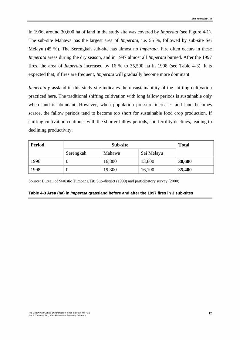
In 1996, around 30,600 ha of land in the study site was covered by Imperata (see Figure 4-1).
The sub-site Mahawa has the largest area of Imperata, i.e. 55 %, followed by sub-site Sei
Melayu (45 %). The Serengkah sub-site has almost no Imperata. Fire often occurs in these
Imperata areas during the dry season, and in 1997 almost all Imperata burned. After the 1997
fires, the area of Imperata increased by 16 % to 35,500 ha in 1998 (see Table 4-3). It is
expected that, if fires are frequent, Imperata will gradually become more dominant.
Imperata grassland in this study site indicates the unsustainability of the shifting cultivation
practiced here. The traditional shifting cultivation with long fallow periods is sustainable only
when land is abundant. However, when population pressure increases and land becomes
scarce, the fallow periods tend to become too short for sustainable food crop production. If
shifting cultivation continues with the shorter fallow periods, soil fertility declines, leading to
declining productivity.
Sub-site Period
Serengkah Mahawa Sei Melayu
Total
1996 0 16,800 13,800 30,600
1998 0 19,300 16,100 35,400
Source: Bureau of Statistic Tumbang Titi Sub-district (1999) and participatory survey (2000)
Table 4-3 Area (ha) in Imperata grassland before and after the 1997 fires in 3 sub-sites
Site Tumbang Titi
The Underlying Causes and Impacts of Fires in South-east Asia Site 7. Tumbang Titi, West Kalimantan Province, Indonesia
13
Figure 4-1 Imperata grasslands near Mahawa village.
The absence of Imperata in the Serengkah sub-site is yet unexplained. The area is hilly and
still covered by local protection forest (29 %). Moreover, the incentive to protect forest is
high, because of strong customary laws (adat) in this area and active collection of honey from
the forest. However, more in-depth study is needed to find out why Mahawa and Sei Melayu
have large areas of Imperata grassland, while these are absent in the Serengkah sub-site.
Answering the question is important as it relates to reducing the fire problem. In addition, the
social, institutional and policy constraints in rehabilitation of Imperata on this site need to be
determined to provide guidelines to policy makers for reducing the fire problem.
4.1.3 Alternative land-use on Imperata grasslands
MacKinnon et al. (1996) mention that in Kalimantan areas characterized by Imperata
cylindrica or other invasive grasses are expanding rapidly with forest depletion, and then
decreasing with conversion to more successful forms of land management. Rehabilitation of
these grasslands is critical for reducing the pressure on remaining forest and making the land
more productive. According to Friday et al. (1999), Imperata grassland rehabilitation depends
on fire control. The rehabilitation of Imperata grassland through the establishment of oil
palm, industrial timber, or smallholder rubber plantations could help prevent fires in the long
Site Tumbang Titi
The Underlying Causes and Impacts of Fires in South-east Asia Site 7. Tumbang Titi, West Kalimantan Province, Indonesia
14
term. In the short term, however, fire is often used in land preparation for establishing those
land use types on Imperata grassland.
In our study site, there are four different types of Imperata grassland use: through the
establishment of oil palm and industrial timber plantations, transmigration settlements and
smallholder rubber plantations. These different approaches will be discussed in more detail
below.
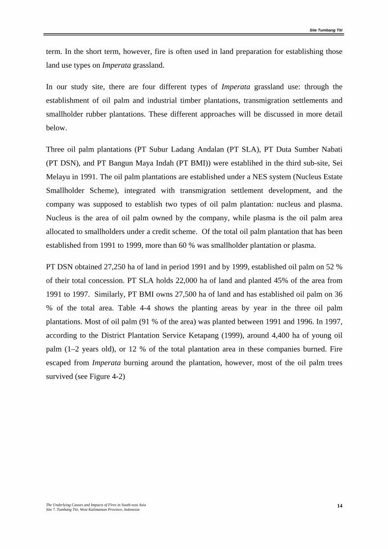
Three oil palm plantations (PT Subur Ladang Andalan (PT SLA), PT Duta Sumber Nabati
(PT DSN), and PT Bangun Maya Indah (PT BMI)) were establihed in the third sub-site, Sei
Melayu in 1991. The oil palm plantations are established under a NES system (Nucleus Estate
Smallholder Scheme), integrated with transmigration settlement development, and the
company was supposed to establish two types of oil palm plantation: nucleus and plasma.
Nucleus is the area of oil palm owned by the company, while plasma is the oil palm area
allocated to smallholders under a credit scheme. Of the total oil palm plantation that has been
established from 1991 to 1999, more than 60 % was smallholder plantation or plasma.
PT DSN obtained 27,250 ha of land in period 1991 and by 1999, established oil palm on 52 %
of their total concession. PT SLA holds 22,000 ha of land and planted 45% of the area from
1991 to 1997. Similarly, PT BMI owns 27,500 ha of land and has established oil palm on 36
% of the total area. Table 4-4 shows the planting areas by year in the three oil palm
plantations. Most of oil palm (91 % of the area) was planted between 1991 and 1996. In 1997,
according to the District Plantation Service Ketapang (1999), around 4,400 ha of young oil
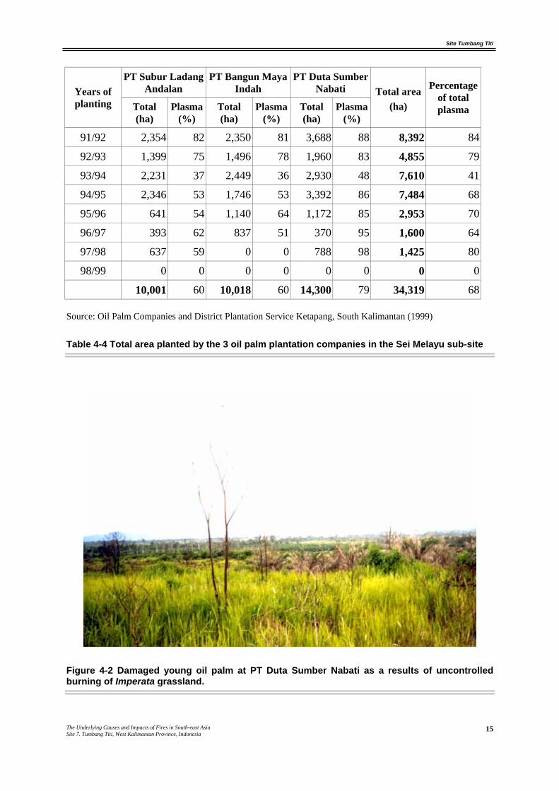
palm (1–2 years old), or 12 % of the total plantation area in these companies burned. Fire
escaped from Imperata burning around the plantation, however, most of the oil palm trees
survived (see Figure 4-2)
Site Tumbang Titi
The Underlying Causes and Impacts of Fires in South-east Asia Site 7. Tumbang Titi, West Kalimantan Province, Indonesia
15
PT Subur Ladang Andalan
PT Bangun Maya Indah
PT Duta Sumber Nabati Years of
planting Total (ha)
Plasma (%)
Total (ha)
Plasma (%)
Total (ha)
Plasma (%)
Total area (ha)
Percentage of total plasma
91/92 2,354 82 2,350 81 3,688 88 8,392 84
92/93 1,399 75 1,496 78 1,960 83 4,855 79
93/94 2,231 37 2,449 36 2,930 48 7,610 41
94/95 2,346 53 1,746 53 3,392 86 7,484 68
95/96 641 54 1,140 64 1,172 85 2,953 70
96/97 393 62 837 51 370 95 1,600 64
97/98 637 59 0 0 788 98 1,425 80
98/99 0 0 0 0 0 0 0 0
10,001 60 10,018 60 14,300 79 34,319 68
Source: Oil Palm Companies and District Plantation Service Ketapang, South Kalimantan (1999)
Table 4-4 Total area planted by the 3 oil palm plantation companies in the Sei Melayu sub-site
Figure 4-2 Damaged young oil palm at PT Duta Sumber Nabati as a results of uncontrolled burning of Imperata grassland.
Site Tumbang Titi
The Underlying Causes and Impacts of Fires in South-east Asia Site 7. Tumbang Titi, West Kalimantan Province, Indonesia
16
The establishment of oil palm plantations in this site is integrated with the establishment of
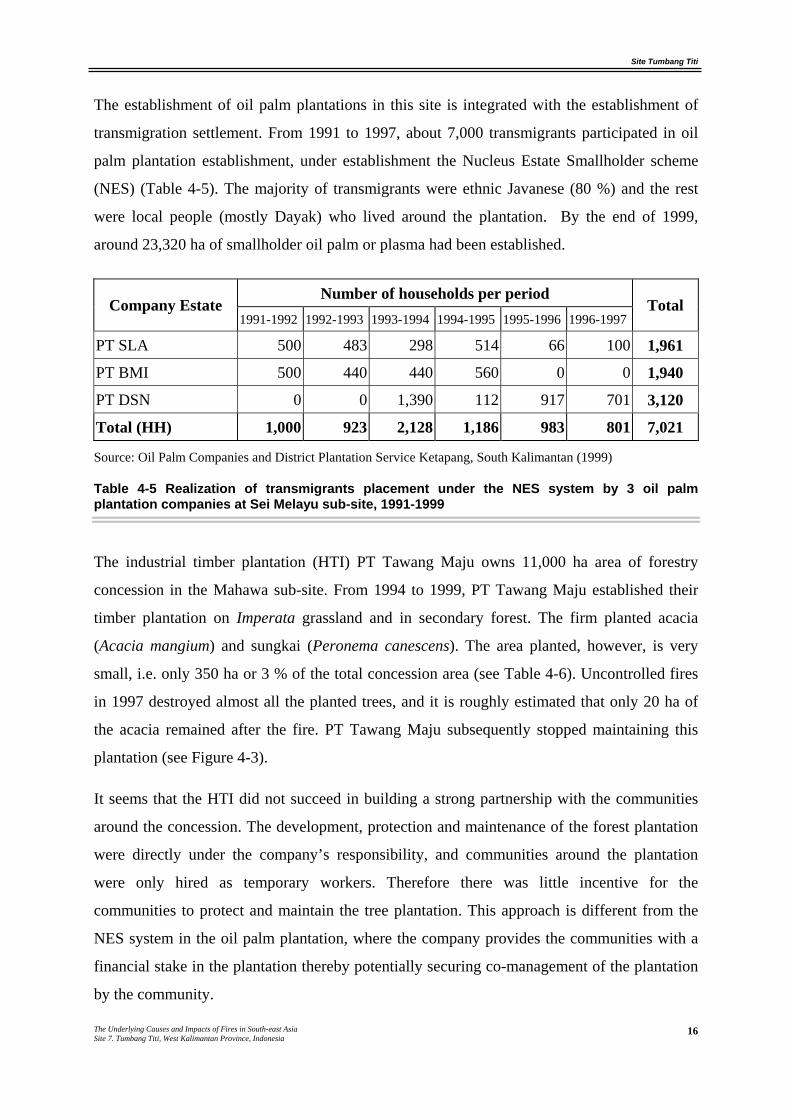
transmigration settlement. From 1991 to 1997, about 7,000 transmigrants participated in oil
palm plantation establishment, under establishment the Nucleus Estate Smallholder scheme
(NES) (Table 4-5). The majority of transmigrants were ethnic Javanese (80 %) and the rest
were local people (mostly Dayak) who lived around the plantation. By the end of 1999,
around 23,320 ha of smallholder oil palm or plasma had been established.
Number of households per period Company Estate
1991-1992 1992-1993 1993-1994 1994-1995 1995-1996 1996-1997 Total
PT SLA 500 483 298 514 66 100 1,961
PT BMI 500 440 440 560 0 0 1,940
PT DSN 0 0 1,390 112 917 701 3,120
Total (HH) 1,000 923 2,128 1,186 983 801 7,021
Source: Oil Palm Companies and District Plantation Service Ketapang, South Kalimantan (1999)
Table 4-5 Realization of transmigrants placement under the NES system by 3 oil palm plantation companies at Sei Melayu sub-site, 1991-1999
The industrial timber plantation (HTI) PT Tawang Maju owns 11,000 ha area of forestry
concession in the Mahawa sub-site. From 1994 to 1999, PT Tawang Maju established their
timber plantation on Imperata grassland and in secondary forest. The firm planted acacia
(Acacia mangium) and sungkai (Peronema canescens). The area planted, however, is very
small, i.e. only 350 ha or 3 % of the total concession area (see Table 4-6). Uncontrolled fires
in 1997 destroyed almost all the planted trees, and it is roughly estimated that only 20 ha of
the acacia remained after the fire. PT Tawang Maju subsequently stopped maintaining this
plantation (see Figure 4-3).
It seems that the HTI did not succeed in building a strong partnership with the communities
around the concession. The development, protection and maintenance of the forest plantation
were directly under the company’s responsibility, and communities around the plantation
were only hired as temporary workers. Therefore there was little incentive for the
communities to protect and maintain the tree plantation. This approach is different from the
NES system in the oil palm plantation, where the company provides the communities with a
financial stake in the plantation thereby potentially securing co-management of the plantation
by the community.
Site Tumbang Titi
The Underlying Causes and Impacts of Fires in South-east Asia Site 7. Tumbang Titi, West Kalimantan Province, Indonesia
17
Due to failure of the timber plantation, PT Tawang Maju now plans to convert the industrial
timber tree concession to an oil palm plantation. They argue that acacia and sungkai trees do
not grow well in this area, while they are also vulnerable to fire. Therefore, in July 2000, the
firm proposed to establish an oil palm plantation under the KKPA system (Cooperative
Plasma Scheme) together with the Mahawa communities of the Punuk, Petebang, Rengas and
Beringin sub-villages. However, the land conversion has not yet been legally approved.
Area Planted Period Area cleared
acacia sungkai
1994/1995 130 50 0
1995/1996 110 0 0
1996/1997 110 50 250
1997/1998 100 0 0
1998/1999 0 0 0
Total 450 100 250
Source: Report and plan planning in HTI PT Tawang Maju maps
Table 4-6 Land clearing and planting of acacia and sungkai by HTI PT Tawang Maju (in hectares)
Site Tumbang Titi
The Underlying Causes and Impacts of Fires in South-east Asia Site 7. Tumbang Titi, West Kalimantan Province, Indonesia
18
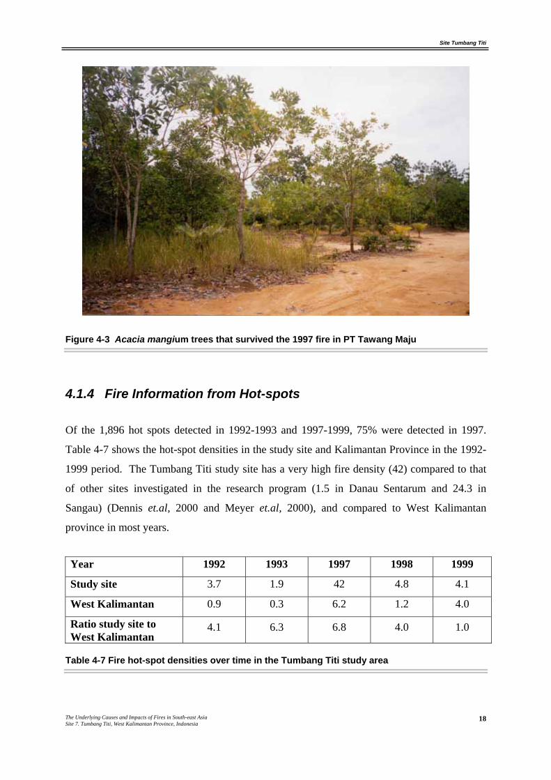
Figure 4-3 Acacia mangium trees that survived the 1997 fire in PT Tawang Maju
4.1.4 Fire Information from Hot-spots
Of the 1,896 hot spots detected in 1992-1993 and 1997-1999, 75% were detected in 1997.
Table 4-7 shows the hot-spot densities in the study site and Kalimantan Province in the 1992-
1999 period. The Tumbang Titi study site has a very high fire density (42) compared to that
of other sites investigated in the research program (1.5 in Danau Sentarum and 24.3 in
Sangau) (Dennis et.al, 2000 and Meyer et.al, 2000), and compared to West Kalimantan
province in most years.
Year 1992 1993 1997 1998 1999
Study site 3.7 1.9 42 4.8 4.1
West Kalimantan 0.9 0.3 6.2 1.2 4.0
Ratio study site to West Kalimantan
4.1 6.3 6.8 4.0 1.0
Table 4-7 Fire hot-spot densities over time in the Tumbang Titi study area
Site Tumbang Titi
The Underlying Causes and Impacts of Fires in South-east Asia Site 7. Tumbang Titi, West Kalimantan Province, Indonesia
19
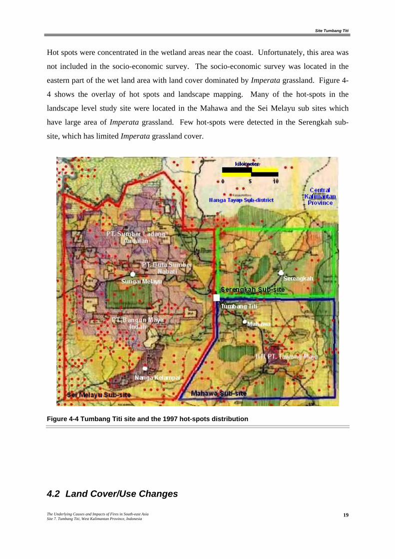
Hot spots were concentrated in the wetland areas near the coast. Unfortunately, this area was
not included in the socio-economic survey. The socio-economic survey was located in the
eastern part of the wet land area with land cover dominated by Imperata grassland. Figure 4-
4 shows the overlay of hot spots and landscape mapping. Many of the hot-spots in the
landscape level study site were located in the Mahawa and the Sei Melayu sub sites which
have large area of Imperata grassland. Few hot-spots were detected in the Serengkah sub-
site, which has limited Imperata grassland cover.
Figure 4-4 Tumbang Titi site and the 1997 hot-spots distribution
4.2 Land Cover/Use Changes
Site Tumbang Titi
The Underlying Causes and Impacts of Fires in South-east Asia Site 7. Tumbang Titi, West Kalimantan Province, Indonesia
20
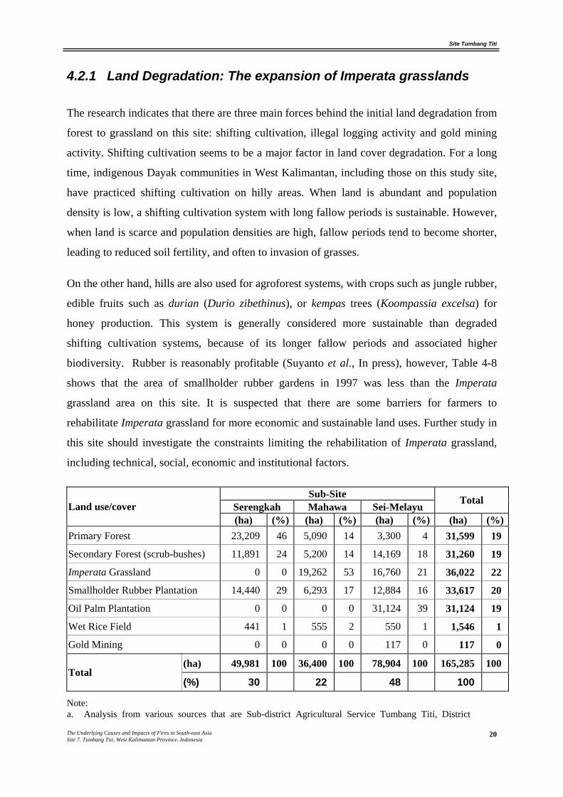
4.2.1 Land Degradation: The expansion of Imperata grasslands
The research indicates that there are three main forces behind the initial land degradation from
forest to grassland on this site: shifting cultivation, illegal logging activity and gold mining
activity. Shifting cultivation seems to be a major factor in land cover degradation. For a long
time, indigenous Dayak communities in West Kalimantan, including those on this study site,
have practiced shifting cultivation on hilly areas. When land is abundant and population
density is low, a shifting cultivation system with long fallow periods is sustainable. However,
when land is scarce and population densities are high, fallow periods tend to become shorter,
leading to reduced soil fertility, and often to invasion of grasses.
On the other hand, hills are also used for agroforest systems, with crops such as jungle rubber,
edible fruits such as durian (Durio zibethinus), or kempas trees (Koompassia excelsa) for
honey production. This system is generally considered more sustainable than degraded
shifting cultivation systems, because of its longer fallow periods and associated higher
biodiversity. Rubber is reasonably profitable (Suyanto et al., In press), however, Table 4-8
shows that the area of smallholder rubber gardens in 1997 was less than the Imperata
grassland area on this site. It is suspected that there are some barriers for farmers to
rehabilitate Imperata grassland for more economic and sustainable land uses. Further study in
this site should investigate the constraints limiting the rehabilitation of Imperata grassland,
including technical, social, economic and institutional factors.
Sub-Site Serengkah Mahawa Sei-Melayu
Total Land use/cover (ha) (%) (ha) (%) (ha) (%) (ha) (%)
Primary Forest 23,209 46 5,090 14 3,300 4 31,599 19
Secondary Forest (scrub-bushes) 11,891 24 5,200 14 14,169 18 31,260 19
Imperata Grassland 0 0 19,262 53 16,760 21 36,022 22
Smallholder Rubber Plantation 14,440 29 6,293 17 12,884 16 33,617 20
Oil Palm Plantation 0 0 0 0 31,124 39 31,124 19
Wet Rice Field 441 1 555 2 550 1 1,546 1
Gold Mining 0 0 0 0 117 0 117 0
(ha) 49,981 100 36,400 100 78,904 100 165,285 100 Total
(%) 30 22 48 100
Note: a. Analysis from various sources that are Sub-district Agricultural Service Tumbang Titi, District
Site Tumbang Titi
The Underlying Causes and Impacts of Fires in South-east Asia Site 7. Tumbang Titi, West Kalimantan Province, Indonesia
21
Plantation Service Ketapang, Provincial Forest Service Ketapang, Ministry of Forestry’s provincial office West Kalimantan, Oil Palm Company and Community Participatory.
b. Imperata grassland area is estimated by deducted areas of different types of land cover to total size.
Table 4-8 Area in different land cover type in 1997
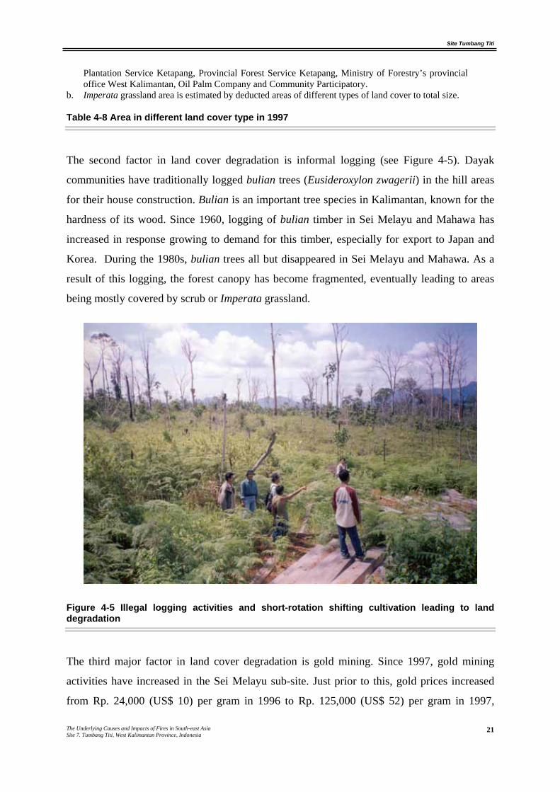
The second factor in land cover degradation is informal logging (see Figure 4-5). Dayak
communities have traditionally logged bulian trees (Eusideroxylon zwagerii) in the hill areas
for their house construction. Bulian is an important tree species in Kalimantan, known for the
hardness of its wood. Since 1960, logging of bulian timber in Sei Melayu and Mahawa has
increased in response growing to demand for this timber, especially for export to Japan and
Korea. During the 1980s, bulian trees all but disappeared in Sei Melayu and Mahawa. As a
result of this logging, the forest canopy has become fragmented, eventually leading to areas
being mostly covered by scrub or Imperata grassland.
Figure 4-5 Illegal logging activities and short-rotation shifting cultivation leading to land degradation
The third major factor in land cover degradation is gold mining. Since 1997, gold mining
activities have increased in the Sei Melayu sub-site. Just prior to this, gold prices increased
from Rp. 24,000 (US$ 10) per gram in 1996 to Rp. 125,000 (US$ 52) per gram in 1997,
Site Tumbang Titi
The Underlying Causes and Impacts of Fires in South-east Asia Site 7. Tumbang Titi, West Kalimantan Province, Indonesia
22
equaling a 420 % increase in price. Now, in the Sei Melayu sub-site, most Nanga Kelampai
communities explore and mine the land for gold, including their own rubber gardens. The
gold mining activities had also spread into the State-owned Inhutani II forest concession and
transmigration areas. In 1998, the Government tried to stop this by pointing out the illegality
of gold mining, but the communities argued that their activities were legal. In 1998, they had
obtained official permission from the Directorate General for General Mining of Ketapang
District for a Local Community Mining Area (Wilayah Pertambangan Rakyat).
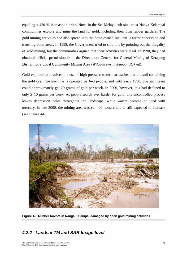
Gold exploration involves the use of high-pressure water that washes out the soil containing
the gold ore. One machine is operated by 6–8 people, and until early 1998, one such team
could approximately get 20 grams of gold per week. In 2000, however, this had declined to
only 5–10 grams per week. As people search ever harder for gold, this uncontrolled process
leaves depression holes throughout the landscape, while waters become polluted with
mercury. In late 2000, the mining area was ca. 400 hectare and is still expected to increase
(see Figure 4-6).
Figure 4-6 Rubber forests in Nanga Kelampai damaged by open gold mining activities
4.2.2 Landsat TM and SAR Image level
Site Tumbang Titi
The Underlying Causes and Impacts of Fires in South-east Asia Site 7. Tumbang Titi, West Kalimantan Province, Indonesia
23
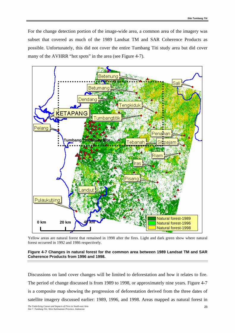
For the change detection portion of the image-wide area, a common area of the imagery was
subset that covered as much of the 1989 Landsat TM and SAR Coherence Products as
possible. Unfortunately, this did not cover the entire Tumbang Titi study area but did cover
many of the AVHRR “hot spots” in the area (see Figure 4-7).
Yellow areas are natural forest that remained in 1998 after the fires. Light and dark green show where natural forest occurred in 1992 and 1986 respectively.
Figure 4-7 Changes in natural forest for the common area between 1989 Landsat TM and SAR Coherence Products from 1996 and 1998.
Discussions on land cover changes will be limited to deforestation and how it relates to fire.
The period of change discussed is from 1989 to 1998, or approximately nine years. Figure 4-7
is a composite map showing the progression of deforestation derived from the three dates of
satellite imagery discussed earlier: 1989, 1996, and 1998. Areas mapped as natural forest in
Natural forest-1989 Natural forest-1996 Natural forest-1998
0 km 20 km 40 km
Tumbang Titi, Study Site

Site Tumbang Titi
The Underlying Causes and Impacts of Fires in South-east Asia Site 7. Tumbang Titi, West Kalimantan Province, Indonesia
24
1998 are shown as yellow. Areas mapped as natural forest in 1996 are shown as light green
and include the yellow. Finally, areas mapped as natural forest in 1989 are shown as dark
green and include those areas shown as light green as well as yellow.
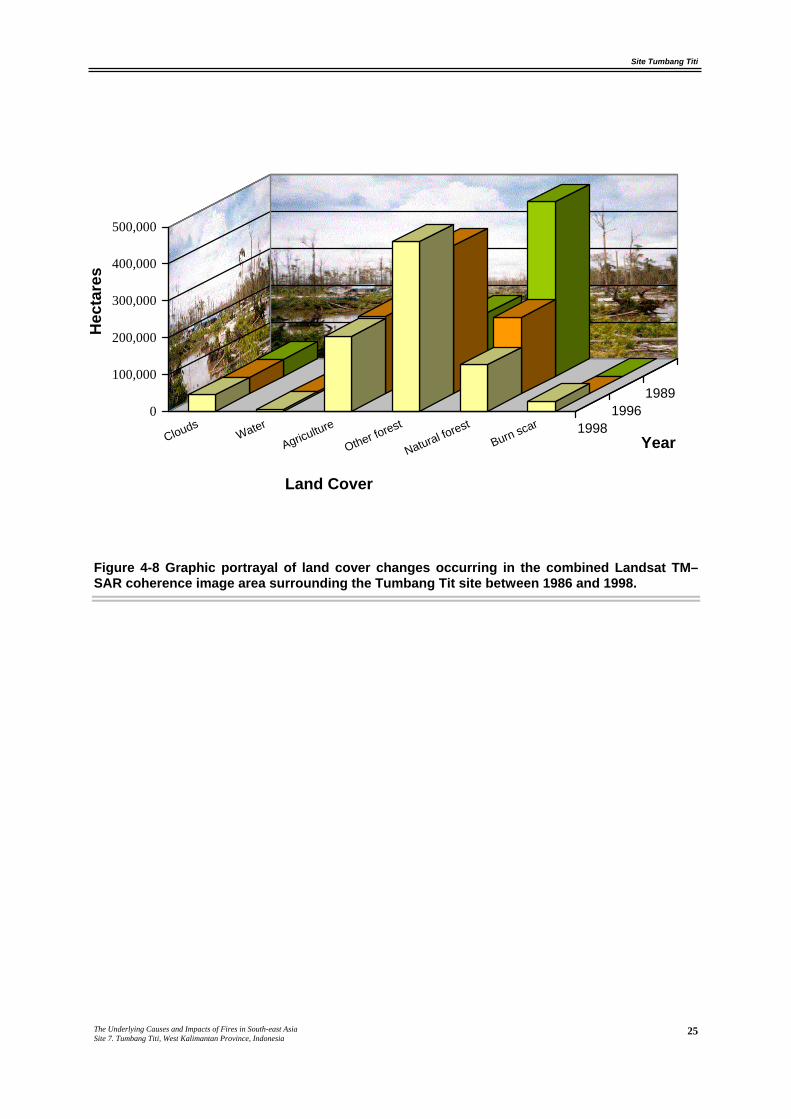
Land cover overtime is shown in Table 4-9. Natural forest decreased from 54 percent of the
total image area in 1989 to around 15 percent in 1998, of amounting to an average annual
decrease of around four percent. Since the SAR Coherence Products may not be accurate for
mapping burn scars, we cannot attribute a particular percentage of deforestation to fire.
1989 1996 1998 Land cover
ha % cover ha % cover ha % cover
Clouds 45,819 5 45,819 5 45,819 5
Water 5,869 1 6,338 1 5,975 1
Agriculture 173,457 20 210,332 24 204,561 23
Other forest 173,167 20 401,309 46 460,048 53
Natural forest 473,304 54 207,817 24 127,335 15
Burn scar 0 0 0 0 27,878 3
Total 871,616 100 871,616 100 871,616 100
Table 4-9 Land cover changes occurring in the TM image-wide area surrounding the Ketapang site between 1986 and 1998.
Figure 4-8 shows graphically the changes taking place in the study site. Note that as the
occurrence of natural forest has decreased, the occurrence of other forest and agriculture has
increased.
Site Tumbang Titi
The Underlying Causes and Impacts of Fires in South-east Asia Site 7. Tumbang Titi, West Kalimantan Province, Indonesia
25
Figure 4-8 Graphic portrayal of land cover changes occurring in the combined Landsat TM–SAR coherence image area surrounding the Tumbang Tit site between 1986 and 1998.
0
100,000
200,000
300,000
400,000
500,000
CloudsWater
Agriculture
Other forest
Natural forestBurn scar
19891996
1998Year
Land Cover
Hec
tare
s
Site Tumbang Titi
The Underlying Causes and Impacts of Fires in South-east Asia Site 7. Tumbang Titi, West Kalimantan Province, Indonesia
26
5. UNDERLYING CAUSES
This study revealed a positive correlation between the area of Imperata grassland and burnt
areas on this site. This indicates that Imperata grasslands are prone to fire. A large fire started
accidentally on this site in 1997, and rapidly got out control and escaped into Imperata
grassland. In 1997, around 86 % (31,000 ha) of the Imperata grasslands in the site were
burned. The main source of fire came from shifting cultivation and illegal logging activities.
The large area of Imperata grasslands indicates a high rate of land degradation on this site.
Unsustainable shifting cultivation and illegal logging activity seem to be the major causes of
this degradation. The rehabilitation of Imperata grassland into more economic and relatively
more sustainable land use by both large and smallholders is still sub-optimal. Improvement of
Imperata rehabilitation programs involving oil palm and timber plantation establishment
could reduce the fire and smoke problem in the long term. In the short term, however, fire is
still used in the required land clearing activities for such programs.
Site Tumbang Titi
The Underlying Causes and Impacts of Fires in South-east Asia Site 7. Tumbang Titi, West Kalimantan Province, Indonesia
27
6. POLICY IMPLICATIONS
Based on the analysis of the underlying causes of fire in the Ketapang, some policy
implications for both the national and provincial level are outlined.
A. Rehabilitate Imperata grasslands for more economic and sustainable land use.
B. Identify technical, social, economic and institutional constraints to the rehabilitation of
Imperata grasslands and remove the barrier.
C. Provide incentives for rehabilitation of Imperata grasslands and ensure strong
participation by local communities for successful rehabilitation of Imperata.
D. Provide technical assistance by improving the agricultural extension system, and provide
good quality planting material to improve rubber productivity.
E. Priority development of small or large scale plantations in Imperata grasslands with
incentives for all of the land’s stakeholders.
F. Initiate research on identification of timber species suitable for rehabilitating Imperata
grassland and integrated with community development. For example, CIFOR in
collaboration with NGO (Yayasan Dian Tama) has been carrying out a community
development project through rehabilitation of Imperata grassland using Trees: a model
approach growing Vitex pubescens for charcoal production in Tumbang Titi, Ketapang
District, West Kalimantan.
G. Reduce gold mining activities
Site Tumbang Titi
The Underlying Causes and Impacts of Fires in South-east Asia Site 7. Tumbang Titi, West Kalimantan Province, Indonesia
28
7. REFERENCES
ADB and BAPPENAS (1999). Causes, extent, impact and costs of 1997/98 fires and drought.
Final report, Annex 1 and 2. Planning for fire prevention and drought management project.
Asian Development Bank TA 2999-INO. Fortech, Pusat Pengembangan Agribisnis, Margueles
Pöyry, Jakarta, Indonesia.
Barber, C.V. & Schweithelm, J. (2000). Trial by fire. Forest fires and forestry policy in
Indonesia's era of crisis and reform. World Resources Institute (WRI), Forest Frontiers
Initiative. In collaboration with WWF-Indonesia and Telapak Indonesia Foundation,
Washington D.C, USA.
Bureau of Statistic Tumbang Titi sub-district (1999). Tumbang Titi in Figure, 1999. Biro
Pusat Statistik (BPS) Province, Ketapang, Indonesia.
Dennis, R.A. (1999). A review of fire projects in Indonesia 1982 - 1998. Center for
International Forestry Research, Bogor.
Friday, K.S., Drilling, M.E. & Garrity, D.P. (1999). Imperata grassland rehabilitation using
agroforestry and assisted natural regeneration. International Centre for Research in
Agroforestry (ICRAF), Bogor, Indonesia.
MacKinnon, K., Hatta, G., Halim, H. & Mangalik, A. (1996). The ecology of Kalimantan,
Periplus Editions, Singapore.
Suyanto, S., Tomich, T. & Otsuka, K. (In press). Land Tenure and farm management
efficiency: The case of smallholder rubber production in customary land areas of Sumatra.
Agroforestry System

![THE REGIONAL AQUIFER SYSTEM UNDERLYING THE … · The use of computer simulation is an ... [Plates in separate case] ... the Atlantic Coastal province from North Carolina through](https://img.pdfslide.net/doc/110x75/5ae6a67a7f8b9ae1578dfb4f/the-regional-aquifer-system-underlying-the-use-of-computer-simulation-is-an.jpg)