Embed Size (px)
Citation preview
www.leeds.gov.uk/yourcity
Publication DraftLeeds Local Development Framework
Development Plan DocumentSeptember 2015
Site Allocations Plan and Aire Valley Leeds Area Action Plan
Nature Conservation Background Paper
2
Contents:
Page
1.0 Schedule of Designated Nature Conservation Sites 1.1 Introduction 3 1.2 Policy Background 3 1.3 Designated International and National Sites 4 1.4 Designated Local Sites 4 1.4.1 New Terminology for Designated Local Sites 5 1.4.2 Role of the West Yorkshire Local Sites Partnership 5 1.4.3 Status of Local Sites identified in the 2006 UDP 6 1.4.3.1 Current Status of SEGI and LNRs identified in the 2006 UDP 6 1.4.3.2 Current Status of Leeds Nature Areas identified in the 2006 UDP 6 1.4.4 New Local Wildlife Sites & Local Geological Sites designated since the 2006 UDP
7
1.5 Hierarchy of Designated Sites from UDP to LDF 8 1.6 Additional note on Policy G8 8 2.0 Leeds Habitat Network 2.1 Introduction 9 2.2 Background 9 2.3 The role of the Leeds Habitat Network 10 2.4 How the Leeds Habitat Network has been identified 11 2.5 How to view the Leeds Habitat Network 12 Appendices Appendix 1 - Schedule of Nature Conservation Designations from UDP 2006 Volume 2 Appendix 8
14
Appendix 2 - Local Wildlife Sites & Local Geology Sites since UDP 2006 18 Appendix 3 – Maps Showing Nature Conservation Designations: Appendix 3i - Map 1 Nature Conservation Designations & Leeds Habitat Network 20 Appendix 3ii - Map 2 Updated 2014 Leeds Habitat Network with broad habitat categories
21
Appendix 3iii - Map 3 Comparison between 2012 Leeds Habitat Network and Updated 2014 Leeds Habitat Network
22
3
NATURE CONSERVATION DESIGNATIONS BACKGROUND PAPER RELATING TO SITE ALLOCATIONS PLAN AND AIRE VALLEY LEEDS AREA ACTION PLAN
1.0 Schedule of Designated Nature Conservation Sites 1.1 Introduction This paper supports the preparation of the Site Allocation Plan and forms part of the evidence base for the assessment of sites and Sustainability Appraisal. It also provides guidance to help implement Policies G8 and G9 of the Core Strategy. Details are provided of the update of the District’s designated nature conservation sites since 2006, which has been used as a basis to help inform the preparation of the SAP and AVLAAP and related Site Requirements. It is acknowledged that during the lifetime of the Leeds Local Development Framework (LDF) an ongoing review of designated sites will be required. This report seeks to provide an up to date schedule of designated nature conservation sites, it explains any changes in terminology of designated sites since the 2006 Leeds Unitary Development Plan (UDP), and finally explains how additional sites will be identified during the lifetime of the Leeds LDF. 1.2 Policy Background The National Planning Policy Framework recognises the importance of having a hierarchy of designated nature conservation sites: Para. 113 Local planning authorities should set criteria based policies against which proposals for any development on or affecting protected wildlife or geodiversity sites or landscape areas will be judged. Distinctions should be made between the hierarchy of international, national and locally designated sites,24 so that protection is commensurate with their status and gives appropriate weight to their importance and the contribution that they make to wider ecological networks.
Para. 117 To minimise impacts on biodiversity and geodiversity, planning policies should:
identify and map components of the local ecological networks, including the hierarchy of international, national and locally designated sites of importance for biodiversity, wildlife corridors and stepping stones that connect them and areas identified by local partnerships for habitat restoration or creation;
24 Government Circular 06/2005 Biodiversity and Geological Conservation – Statutory Obligations And Their Impact Within The Planning System. Page 32 para. 95 titled “Local Sites” of this Government Circular refers to separate guidance that will be produced by Defra for the development and management of systems to identify these sites. In 2006 Defra produced a report “Local Sites – Guidance on their Identification, Selection and Management” which fulfils this function.
4
The Leeds Unitary Development Plan (UDP) 2006 Volume 1 section 5.6.10 described the different names used for designated nature conservation sites and their relative level of importance. All of the designated sites as of 2006 are listed in the UDP Volume 2 Appendix 8 and all of these designated sites have been saved as part of the approved Leeds Local Development Framework. The UDP 2006 policies that referred to these designated sites are N49, N50 and N51 and these have now been replaced by the Core Strategy Policies G8 and G9.
However, the designated sites on the schedule of the UDP Volume 2 Appendix 8 (see Appendix 1 of this Report) will continue to be used to implement Policy G8 and G9 of the more recent Core Strategy but it is recognised that the District’s nature conservation resource requires an ongoing review to ensure land use planning decisions are based on up to date information. Within this context, it is noted that the designation of International, National and Local sites is via a series of processes as set out below. These reflect national and local guidance but do not have the same weight as via the Development Plan process but nevertheless have status as providing up to date information in assisting the implementation of Core Strategy Policies. 1.3 Designated International & National Sites The District has 17 nationally important Sites of Special Scientific Interest (SSSI). These are the most important sites in the District and receive statutory protection. There have been no more nationally important sites added since the LCC UDP 2006. However, one SSSI (South Pennine Moorlands SSSI) has also been designated as part of a larger site of European level of importance – South Pennine Moorlands Phase 2 Special Protection Area (SPA) and Special Area of Conservation (SAC). 1.4 Designated Local Protection Sites UDP Volume 2 Appendix 8 schedule of designated local sites lists 3 different types of Local Site (see Appendix 1 of this document for list of sites and Appendix 3 provides maps):
Sites of Ecological or Geological Interest (SEGIs) – 43 sites Local Nature Reserves (LNRs) – 6 sites Leeds Nature Areas (LNAs) – 113 sites
SEGIs are non-statutory Local Sites intended to represent a countywide (West Yorkshire) level of importance so are of secondary importance below the nationally designated SSSIs.
It is less easy to define the level of importance of LNRs in the hierarchy because parts of some LNRs are also SSSIs and some are SEGIs, and some may be neither. Their designation is based on public appreciation and access as well as nature
5
conservation importance. Although they receive a level of statutory protection under the National Parks & Access to the Countryside Act 1949 in planning terms they fulfil a similar level of importance to other non-statutory Local Sites and therefore are considered to be of secondary importance in the hierarchy - alongside SEGIs.
LNAs are non-statutory Local Sites that represent a third level of designated site and are the lowest level of importance in the hierarchy of designated sites.
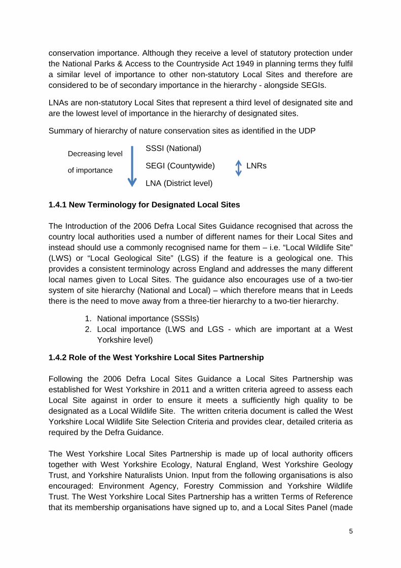
Summary of hierarchy of nature conservation sites as identified in the UDP
SSSI (National)
SEGI (Countywide) LNRs
LNA (District level)
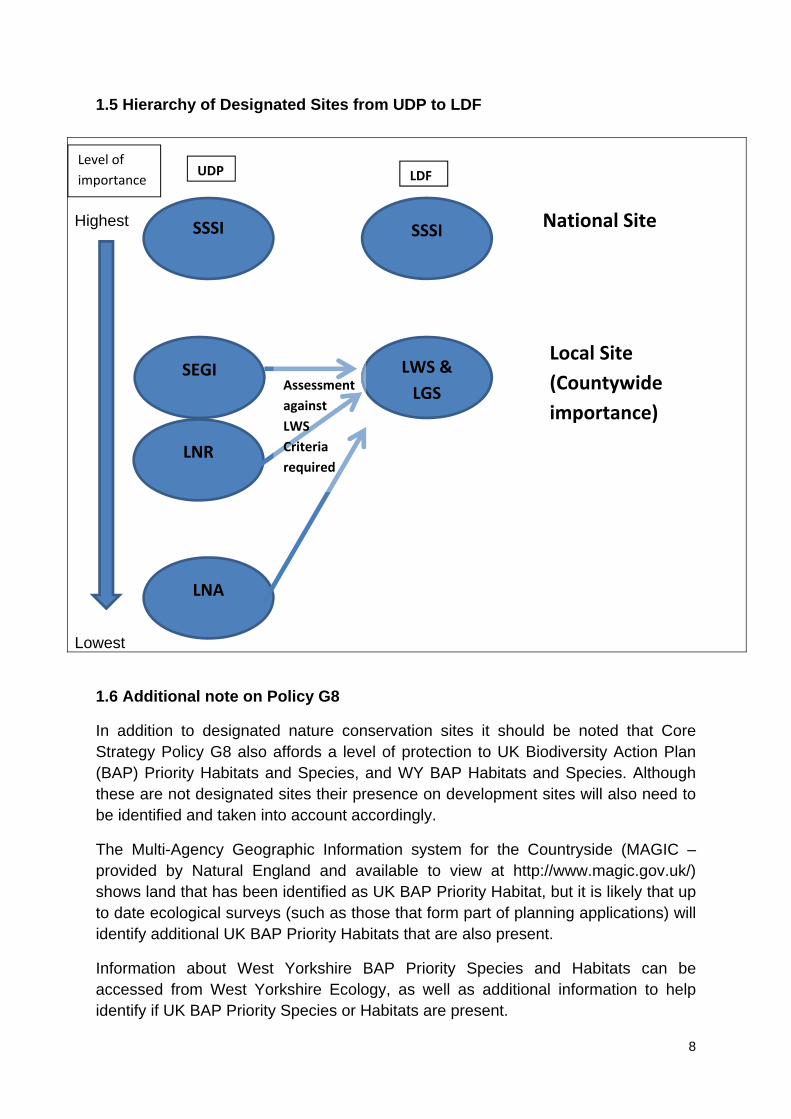
1.4.1 New Terminology for Designated Local Sites The Introduction of the 2006 Defra Local Sites Guidance recognised that across the country local authorities used a number of different names for their Local Sites and instead should use a commonly recognised name for them – i.e. “Local Wildlife Site” (LWS) or “Local Geological Site” (LGS) if the feature is a geological one. This provides a consistent terminology across England and addresses the many different local names given to Local Sites. The guidance also encourages use of a two-tier system of site hierarchy (National and Local) – which therefore means that in Leeds there is the need to move away from a three-tier hierarchy to a two-tier hierarchy.
1. National importance (SSSIs) 2. Local importance (LWS and LGS - which are important at a West
Yorkshire level)
1.4.2 Role of the West Yorkshire Local Sites Partnership Following the 2006 Defra Local Sites Guidance a Local Sites Partnership was established for West Yorkshire in 2011 and a written criteria agreed to assess each Local Site against in order to ensure it meets a sufficiently high quality to be designated as a Local Wildlife Site. The written criteria document is called the West Yorkshire Local Wildlife Site Selection Criteria and provides clear, detailed criteria as required by the Defra Guidance. The West Yorkshire Local Sites Partnership is made up of local authority officers together with West Yorkshire Ecology, Natural England, West Yorkshire Geology Trust, and Yorkshire Naturalists Union. Input from the following organisations is also encouraged: Environment Agency, Forestry Commission and Yorkshire Wildlife Trust. The West Yorkshire Local Sites Partnership has a written Terms of Reference that its membership organisations have signed up to, and a Local Sites Panel (made
Decreasing level
of importance
6
up of local wildlife and geology experts) meets regularly to propose Local Sites and put them to the Local Sites Partnership for their approval and designation. 1.4.3 Status of Local Sites identified in the 2006 UDP All of the designated Local Sites from the 2006 UDP have been saved and carried forward in the Leeds LDF, but in order to ensure these sites are still of sufficient value to justify protection through the planning system all these Local Sites will need to be reassessed against the 2011 West Yorkshire Local Wildlife Site Selection Criteria and be formally approved by the West Yorkshire Local Sites Partnership where the relevant Criteria are met. The new terminology of LWS and LGS will not be used until the Local Sites carried forward from the UDP are formally assessed against the 2011 Criteria. 1.4.3.1 Current Status of SEGI and LNRs identified in the 2006 UDP The SEGIs and LNRs from the 2006 LCC UDP Volume 2 Appendix 8 schedule have not yet been assessed against the West Yorkshire Local Wildlife Site Selection Criteria. It is likely that they will meet the 2011 LWS Criteria but these sites have not yet been formally re-surveyed and assessed against the Criteria. Over the timescale of the Leeds LDF all the Local Sites from the UDP will need to be re-assessed against the 2011 Local Wildlife Site Selection Criteria and an updated schedule of designated nature conservation sites produced to reflect this. 1.4.3.2 Current Status of Leeds Nature Areas identified in the 2006 UDP The lowest (or third) level of site designation identified in the UDP will cease to be used as part of the LDF (Core Strategy Policy G8) but only after all the listed LNA sites have been assessed against the West Yorkshire Local Wildlife Site Selection Criteria to see if they are of countywide (West Yorkshire) importance – and therefore designated as a Local Wildlife Site. LNAs that do not meet the 2011 West Yorkshire Local Wildlife Site Selection Criteria may still justify being included as part of the Leeds Habitat Network (see next section in this report) and thereby receive an appropriate level of protection under Core Strategy Policy G9. At the time of this report a review of all LNAs has commenced to assess them against the West Yorkshire Local Wildlife Sites Selection Criteria. This process will continue through 2015/16 and is likely to result in:
some of these LNA sites becoming Local Wildlife Sites some LNA sites already integrated into the Updated 2014 Leeds Habitat
Network some LNA sites no longer receiving any protection through the LDF
7
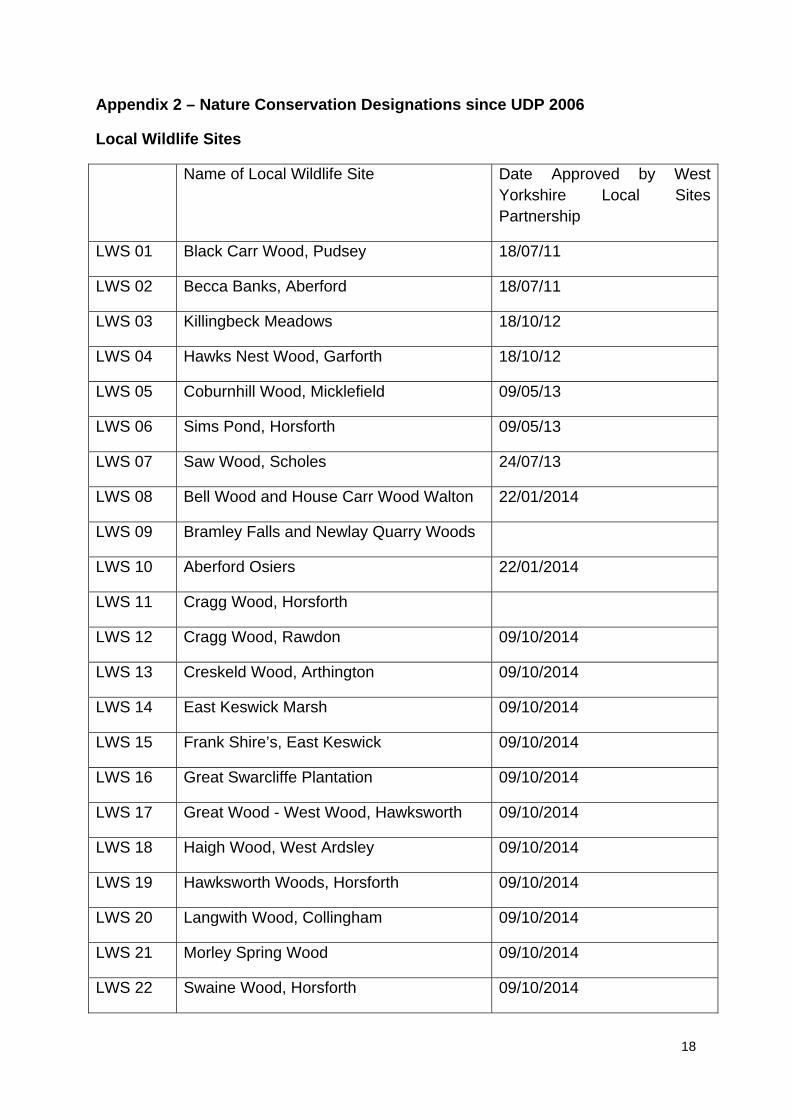
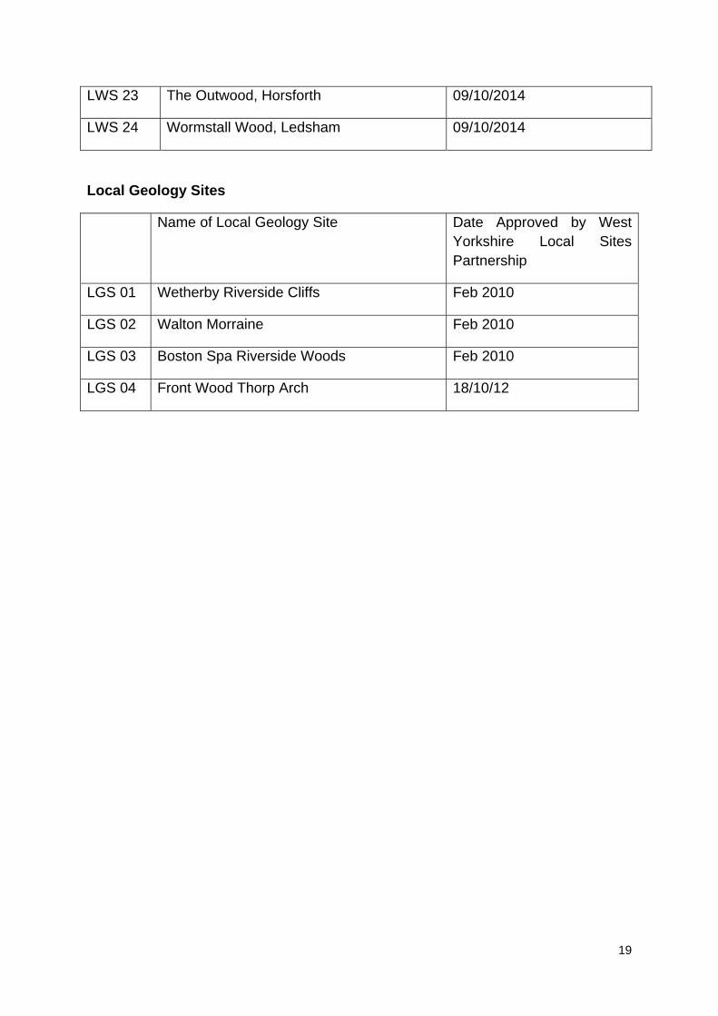
Any LNAs that have not yet been formally assessed against the West Yorkshire Local Wildlife Site Selection Criteria but are considered at this time that they may meet the Criteria will be considered by the West Yorkshire Local Sites Partnership during 2015/16. 1.4.4 New Local Wildlife Sites & Local Geological Sites designated since the 2006 UDP Any sites that have been assessed against the 2011 West Yorkshire Local Wildlife Site Selection Criteria and approved by the West Yorkshire Local Sites Partnership will be shown as a LWS or LGS accordingly in this report. At the time of this report there have been 24 LWS and 4 LGS assessed and approved by the West Yorkshire Local Sites Partnership – most of these sites have been identified as a result of the programme of reassessing existing third-tier LNA sites in partnership with West Yorkshire Ecology. See Appendix 2 for list of sites and Appendix 3 for maps. As well as reassessing previously designated Local Sites from the UDP (SEGIs, LNRs and LNAs) against the West Yorkshire Local Wildlife Site Selection Criteria it is likely that there are other sites in the District that have not been previously identified and designated. These new sites may also come forward as resources allow for a site survey and assessment against the West Yorkshire Local Wildlife Site Selection Criteria.
It is expected that where up to date ecological surveys, of land forming part of planning applications, identifies any undesignated habitats that may be of LWS value that the applicant will carry out a further assessment of the site against the West Yorkshire Local Site Selection Criteria.
8
1.5 Hierarchy of Designated Sites from UDP to LDF
Highest Lowest
1.6 Additional note on Policy G8
In addition to designated nature conservation sites it should be noted that Core Strategy Policy G8 also affords a level of protection to UK Biodiversity Action Plan (BAP) Priority Habitats and Species, and WY BAP Habitats and Species. Although these are not designated sites their presence on development sites will also need to be identified and taken into account accordingly.
The Multi-Agency Geographic Information system for the Countryside (MAGIC – provided by Natural England and available to view at http://www.magic.gov.uk/) shows land that has been identified as UK BAP Priority Habitat, but it is likely that up to date ecological surveys (such as those that form part of planning applications) will identify additional UK BAP Priority Habitats that are also present.
Information about West Yorkshire BAP Priority Species and Habitats can be accessed from West Yorkshire Ecology, as well as additional information to help identify if UK BAP Priority Species or Habitats are present.
SSSI
LNR
SEGI
LNA
SSSI
LWS &
LGS
National Site
Local Site
(Countywide
importance)
Level of
importance
Assessment
against
LWS
Criteria
required
UDP LDF
9
2.0 Leeds Habitat Network
2.1 Introduction
Since the 2006 UDP there has been a change in perspective regarding how nature conservation should be approached for long-term success. As well as ensuring protection of the most important designated nature conservation sites, more efforts have been directed towards the creation of ecological networks to facilitate species mobility and encourage healthy species populations. The current National Planning Policy Framework was published in 2012 and refers to ecological networks in Para. 109:
“minimising impacts on biodiversity and providing net gains in biodiversity where possible, contributing to the Government’s commitment to halt the overall decline in biodiversity, including by establishing coherent ecological networks that are more resilient to current and future pressures.” 2.2 Background Relevant research that contributed to this step-change includes an independent review titled ‘Making Space for Nature’, which was led by Professor Sir John Lawton and published in 2010. The review assessed the quality of the suite of “wildlife sites” in England and their ability to provide for the long-term health of the natural environment. Findings showed that provisions for wildlife were lacking in many aspects and the author suggested that “we need a step-change in our approach to wildlife conservation, from trying to hang on to what we have, to one of large-scale habitat restoration and re-creation, under-pinned by the re-establishment of ecological processes and ecosystem services, for the benefits of both people and wildlife”. This is summarised using four key words: more, bigger, better and joined.
During 2011, the Government released a Natural Environment White Paper titled ‘The Natural Choice’. One of the key recommendations in this paper is the creation of Nature Improvement Areas (NIAs) in order to provide larger and more connected spaces for wildlife. Natural England released a report to accompany the White Paper, which is titled “Think BIG: How and why landscape-scale conservation benefits wildlife, people and the wider economy”. This states that “we need to better integrate the needs of wildlife into land-use decisions and management, both in our countryside and in our towns and cities. In so doing, we are likely to benefit not just wildlife but our economy and society as a whole through the provision of ecosystem services”.
Another publication, the ‘State of Nature’ report, was produced in 2013 by many of the major nature conservation organisations working in collaboration. The report provides findings from a review of the population status of a range of British wildlife
10
species. It found that the majority of the species reviewed had experienced population declines during the past five decades.
Major nature conservation organisations have recognised for some time the benefits of implementing a more holistic, landscape-scale approach to nature conservation. This is reflected in projects by various organisations including:
The Wildlife Trusts’ ‘Living Landscapes’ projects, which began in 2006 and aim to establish corridors of wildlife-rich landscape and create wildlife connectivity between designated nature sites.
The RSPB’s ‘Futurescapes’ projects, launched in 2010, aim to retain and enhance the quality of important wildlife sites throughout the UK by increasing the size of the sites. Through linking local land parcels to the key sites they hope to enhance the abundance of species.
The charity Buglife launched a project called ‘B-Lines’ in 2011, through which they aim to create and restore at least 150,000 hectares of nectar-rich habitat throughout Britain. This would provide valuable wildlife corridors to support a diversity of plants and invertebrates and provide food for many other species.
2.3 The role of the Leeds Habitat Network The Leeds Core Strategy shows a strategic Leeds Habitat Network on Map 17 and was created in 2012 to help implement Policy G9 “Biodiversity Improvements” (i) and (iii). The Leeds Habitat Network aims to protect the integrity and connectivity of areas in Leeds with nature conservation value, as well as guiding the best locations for provision of new areas and opportunities for habitat creation and enhancement. Between 2013 and 2014 a project between Leeds City Council and West Yorkshire Ecology was established to update the Leeds Habitat Network and map its components to a more detailed level to help inform the Site Allocations Plan and Sustainability Appraisal process. This has led to a subsequent revision of the strategic Leeds Habitat Network Map across all of Leeds which is based on aerial photo interpretation and site assessments by a project officer at West Yorkshire Ecology.
The Updated 2014 Leeds Habitat Network highlights existing notable ecological links within the District as well as linking into the surrounding districts (notably Bradford and Wakefield which have existing Wildlife Habitat Networks). The Updated 2014 Leeds Habitat Network should enable species populations to be sustained by maintaining the existing physical ecological corridors, which can provide sustainable ecosystem services. This can be achieved through the use of the Updated 2014 Leeds Habitat Network as a guidance tool for decision-making relating to the placing of future developments and priority areas for biodiversity enhancements.
11
Where development pressure occurs at locations covered by the Leeds Habitat Network consideration will firstly need to be given to whether a designated site or UK BAP Priority Habitat or Species will be affected (and therefore be assessed against Policy G8). Where an impact has been identified on the Leeds Habitat Network and consideration against G9 is required there is a presumption that any development must be designed to include a positive contribution to the habitat network and that the integrity and physical connectivity of the Leeds Habitat Network can continue to function.
2.4 How the Updated 2014 Leeds Habitat Network has been identified
The Updated 2014 Leeds Habitat Network was produced using a Geological Information System (GIS): MapInfo Professional 12.0, which enabled all relevant available data to be gathered and displayed on the same GIS workspace. The data utilised was:
Bing aerial photography (2011) OS Mastermap Topography basemap & Waterline (2012) Culverted watercourse links (2011) Designated site boundaries: Special Area of Conservation (SAC), Special
Protection Area (SPA), Site of Special Scientific Interest (SSSI), Local Nature Reserve (LNR), Site of Ecological and Geological Interest (SEGI), Leeds Nature Area (LNA)
UK Biodiversity Action Plan (BAP) habitat coverage (2009/ 2010) Ancient woodland boundaries Phase 1 habitat data (1990 full West Yorkshire coverage, 2008 Leeds –
Bradford border coverage, 2009 Wyke Beck coverage) National Vegetation Classification (NVC) data (SEGI data 2002, LNA data
2013/ 2014) Tree Preservation Order (TPO) designations (2003 – 2014) Proposed Open Space (2012) Green Infrastructure Corridors (April 2010) Leeds Council Strategic Flood Risk Assessment (SFRA) flood zones 2 and 3
(2007) Class 1 and Class 2 Archaeology Sites (2014)
The main types of habitat included within the Updated 2014 Leeds Habitat Network are: broad-leaved and mixed woodland, scrub, hedgerows, (agriculturally) unimproved/ species-rich semi-improved grassland, rivers/ becks, ponds, fen/ marsh and features with restoration potential such as quarries and old allotment sites. The concept of ‘stepping stones’ has been utilised to incorporate important habitat parcels within the Updated 2014 Leeds Habitat Network where it has not been possible to identify a suitable natural link.
Land within the Leeds City Council SFRA Flood Zones 2 and 3 that lies within the catchments of the River Aire, River Wharfe and River Calder has been included in
12
the Updated 2014 Leeds Habitat Network (excluding any already developed land). This has been incorporated within the ‘other’ habitat layer and has been included as three separate blocks - one for each catchment area.
2.5 How to view the Updated 2014 Leeds Habitat Network
The Updated 2014 Leeds Habitat Network can be viewed spatially with the option of base-maps including aerial photography or ordnance survey. There are data sets available for each land parcel that is part of the Updated 2014 Leeds Habitat Network. The data can be viewed in a tabular format and specific data sets can be selected out (using the GIS function) if required, such as quarries or ponds. Data for each land parcel (usually a unit such as a pond/series of ponds, individual field or woodland block) can also be individually selected from within the GIS mapping window by clicking on it with the Information button.
The Updated 2014 Leeds Habitat Network is available as five separate data sets (GIS layers), which cover:
1. Woodland: mainly broad-leaved/ mixed woodlands, dense scrub and hedgerows
2. Grassland: mainly semi-improved species-rich and some unimproved grassland
3. Wetland: rivers/becks (including culverted stretches), ponds, lakes, fen/marsh
4. Heathland: dry heath, bracken
5. ‘Other’ habitat types: quarries, gardens, flood plains
The Updated 2014 Leeds Habitat Network is also available as a combined data table (GIS layer). Data sets are provided for each land parcel. The data table covers:
Habitat type (i.e. – planted broad-leaved woodland and scrub)
Source/s of data used to assess the land parcel (i.e. – aerial photographs, Phase 1 data or field survey work)
designation status (i.e. – Local Nature Reserve, Site of Ecological or Geological Importance)
Size (in hectares)
Additional comments (whether the land parcel lies within/partially within the flood zone (2 or 3), proposed open space, contains any TPO designations or intersects with the Green Infrastructure Corridor. Any other additional relevant information available is also included here).
13
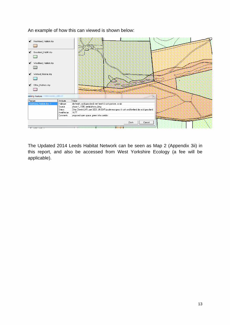
An example of how this can viewed is shown below:
The Updated 2014 Leeds Habitat Network can be seen as Map 2 (Appendix 3ii) in this report, and also be accessed from West Yorkshire Ecology (a fee will be applicable).
14
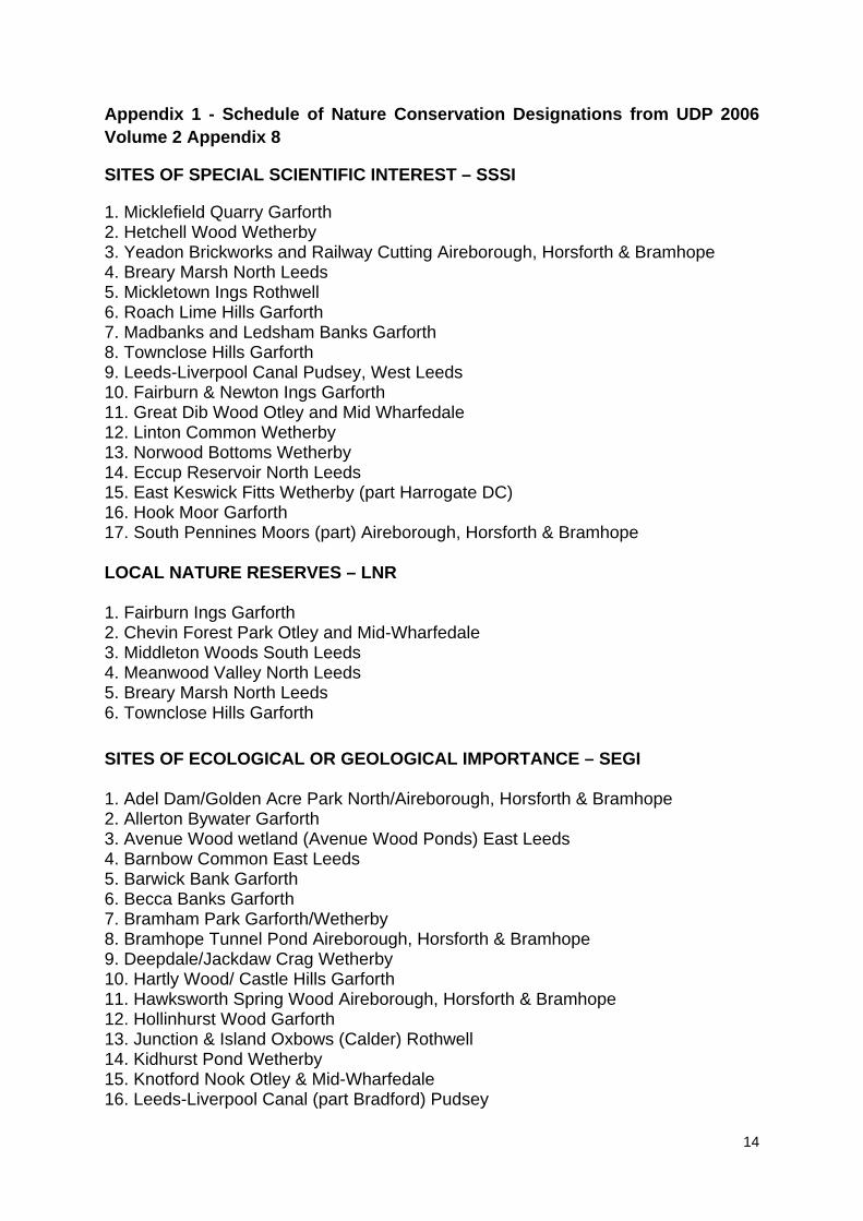
Appendix 1 - Schedule of Nature Conservation Designations from UDP 2006 Volume 2 Appendix 8
SITES OF SPECIAL SCIENTIFIC INTEREST – SSSI
1. Micklefield Quarry Garforth 2. Hetchell Wood Wetherby 3. Yeadon Brickworks and Railway Cutting Aireborough, Horsforth & Bramhope 4. Breary Marsh North Leeds 5. Mickletown Ings Rothwell 6. Roach Lime Hills Garforth 7. Madbanks and Ledsham Banks Garforth 8. Townclose Hills Garforth 9. Leeds-Liverpool Canal Pudsey, West Leeds 10. Fairburn & Newton Ings Garforth 11. Great Dib Wood Otley and Mid Wharfedale 12. Linton Common Wetherby 13. Norwood Bottoms Wetherby 14. Eccup Reservoir North Leeds 15. East Keswick Fitts Wetherby (part Harrogate DC) 16. Hook Moor Garforth 17. South Pennines Moors (part) Aireborough, Horsforth & Bramhope LOCAL NATURE RESERVES – LNR 1. Fairburn Ings Garforth 2. Chevin Forest Park Otley and Mid-Wharfedale 3. Middleton Woods South Leeds 4. Meanwood Valley North Leeds 5. Breary Marsh North Leeds 6. Townclose Hills Garforth SITES OF ECOLOGICAL OR GEOLOGICAL IMPORTANCE – SEGI 1. Adel Dam/Golden Acre Park North/Aireborough, Horsforth & Bramhope 2. Allerton Bywater Garforth 3. Avenue Wood wetland (Avenue Wood Ponds) East Leeds 4. Barnbow Common East Leeds 5. Barwick Bank Garforth 6. Becca Banks Garforth 7. Bramham Park Garforth/Wetherby 8. Bramhope Tunnel Pond Aireborough, Horsforth & Bramhope 9. Deepdale/Jackdaw Crag Wetherby 10. Hartly Wood/ Castle Hills Garforth 11. Hawksworth Spring Wood Aireborough, Horsforth & Bramhope 12. Hollinhurst Wood Garforth 13. Junction & Island Oxbows (Calder) Rothwell 14. Kidhurst Pond Wetherby 15. Knotford Nook Otley & Mid-Wharfedale 16. Leeds-Liverpool Canal (part Bradford) Pudsey
15
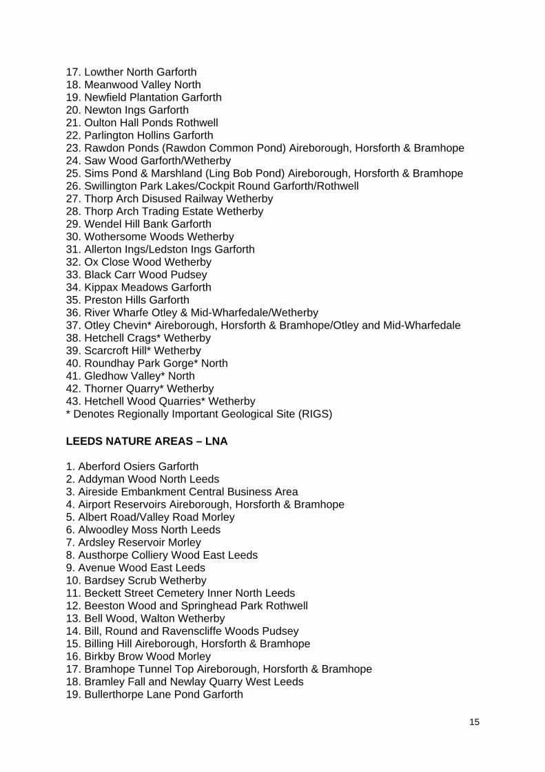
17. Lowther North Garforth 18. Meanwood Valley North 19. Newfield Plantation Garforth 20. Newton Ings Garforth 21. Oulton Hall Ponds Rothwell 22. Parlington Hollins Garforth 23. Rawdon Ponds (Rawdon Common Pond) Aireborough, Horsforth & Bramhope 24. Saw Wood Garforth/Wetherby 25. Sims Pond & Marshland (Ling Bob Pond) Aireborough, Horsforth & Bramhope 26. Swillington Park Lakes/Cockpit Round Garforth/Rothwell 27. Thorp Arch Disused Railway Wetherby 28. Thorp Arch Trading Estate Wetherby 29. Wendel Hill Bank Garforth 30. Wothersome Woods Wetherby 31. Allerton Ings/Ledston Ings Garforth 32. Ox Close Wood Wetherby 33. Black Carr Wood Pudsey 34. Kippax Meadows Garforth 35. Preston Hills Garforth 36. River Wharfe Otley & Mid-Wharfedale/Wetherby 37. Otley Chevin* Aireborough, Horsforth & Bramhope/Otley and Mid-Wharfedale 38. Hetchell Crags* Wetherby 39. Scarcroft Hill* Wetherby 40. Roundhay Park Gorge* North 41. Gledhow Valley* North 42. Thorner Quarry* Wetherby 43. Hetchell Wood Quarries* Wetherby * Denotes Regionally Important Geological Site (RIGS) LEEDS NATURE AREAS – LNA 1. Aberford Osiers Garforth 2. Addyman Wood North Leeds 3. Aireside Embankment Central Business Area 4. Airport Reservoirs Aireborough, Horsforth & Bramhope 5. Albert Road/Valley Road Morley 6. Alwoodley Moss North Leeds 7. Ardsley Reservoir Morley 8. Austhorpe Colliery Wood East Leeds 9. Avenue Wood East Leeds 10. Bardsey Scrub Wetherby 11. Beckett Street Cemetery Inner North Leeds 12. Beeston Wood and Springhead Park Rothwell 13. Bell Wood, Walton Wetherby 14. Bill, Round and Ravenscliffe Woods Pudsey 15. Billing Hill Aireborough, Horsforth & Bramhope 16. Birkby Brow Wood Morley 17. Bramhope Tunnel Top Aireborough, Horsforth & Bramhope 18. Bramley Fall and Newlay Quarry West Leeds 19. Bullerthorpe Lane Pond Garforth
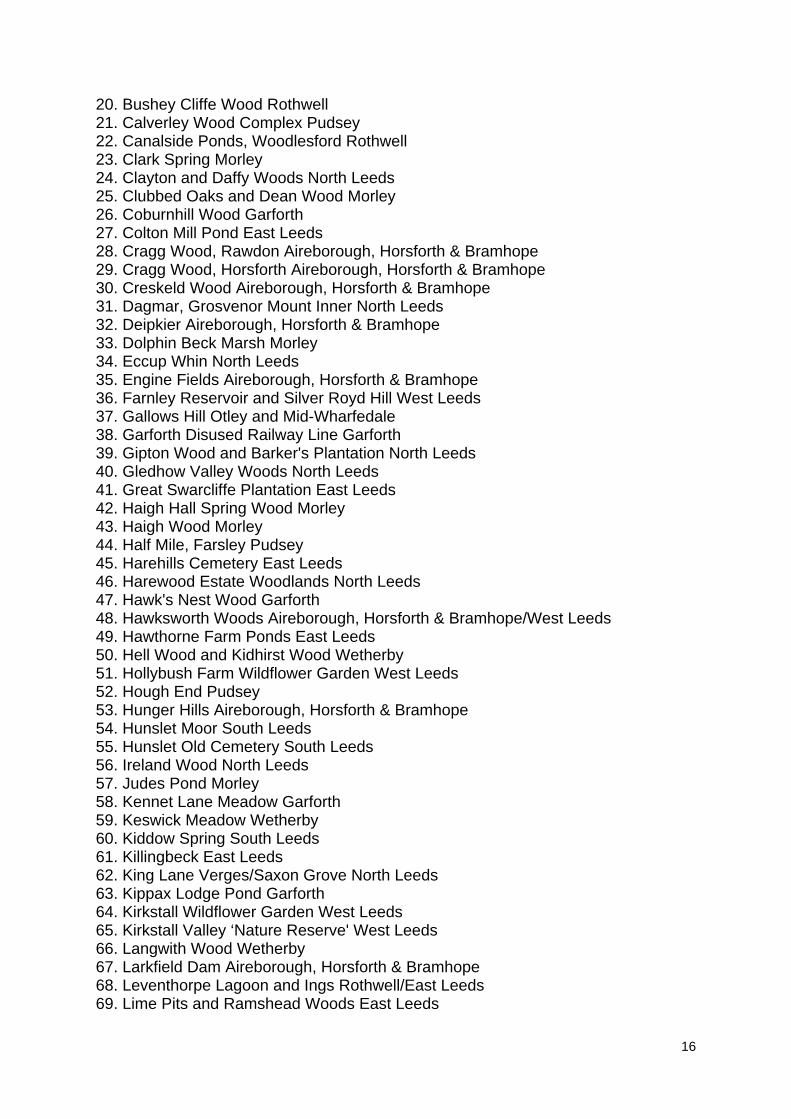
16
20. Bushey Cliffe Wood Rothwell 21. Calverley Wood Complex Pudsey 22. Canalside Ponds, Woodlesford Rothwell 23. Clark Spring Morley 24. Clayton and Daffy Woods North Leeds 25. Clubbed Oaks and Dean Wood Morley 26. Coburnhill Wood Garforth 27. Colton Mill Pond East Leeds 28. Cragg Wood, Rawdon Aireborough, Horsforth & Bramhope 29. Cragg Wood, Horsforth Aireborough, Horsforth & Bramhope 30. Creskeld Wood Aireborough, Horsforth & Bramhope 31. Dagmar, Grosvenor Mount Inner North Leeds 32. Deipkier Aireborough, Horsforth & Bramhope 33. Dolphin Beck Marsh Morley 34. Eccup Whin North Leeds 35. Engine Fields Aireborough, Horsforth & Bramhope 36. Farnley Reservoir and Silver Royd Hill West Leeds 37. Gallows Hill Otley and Mid-Wharfedale 38. Garforth Disused Railway Line Garforth 39. Gipton Wood and Barker's Plantation North Leeds 40. Gledhow Valley Woods North Leeds 41. Great Swarcliffe Plantation East Leeds 42. Haigh Hall Spring Wood Morley 43. Haigh Wood Morley 44. Half Mile, Farsley Pudsey 45. Harehills Cemetery East Leeds 46. Harewood Estate Woodlands North Leeds 47. Hawk's Nest Wood Garforth 48. Hawksworth Woods Aireborough, Horsforth & Bramhope/West Leeds 49. Hawthorne Farm Ponds East Leeds 50. Hell Wood and Kidhirst Wood Wetherby 51. Hollybush Farm Wildflower Garden West Leeds 52. Hough End Pudsey 53. Hunger Hills Aireborough, Horsforth & Bramhope 54. Hunslet Moor South Leeds 55. Hunslet Old Cemetery South Leeds 56. Ireland Wood North Leeds 57. Judes Pond Morley 58. Kennet Lane Meadow Garforth 59. Keswick Meadow Wetherby 60. Kiddow Spring South Leeds 61. Killingbeck East Leeds 62. King Lane Verges/Saxon Grove North Leeds 63. Kippax Lodge Pond Garforth 64. Kirkstall Wildflower Garden West Leeds 65. Kirkstall Valley ‘Nature Reserve' West Leeds 66. Langwith Wood Wetherby 67. Larkfield Dam Aireborough, Horsforth & Bramhope 68. Leventhorpe Lagoon and Ings Rothwell/East Leeds 69. Lime Pits and Ramshead Woods East Leeds
17
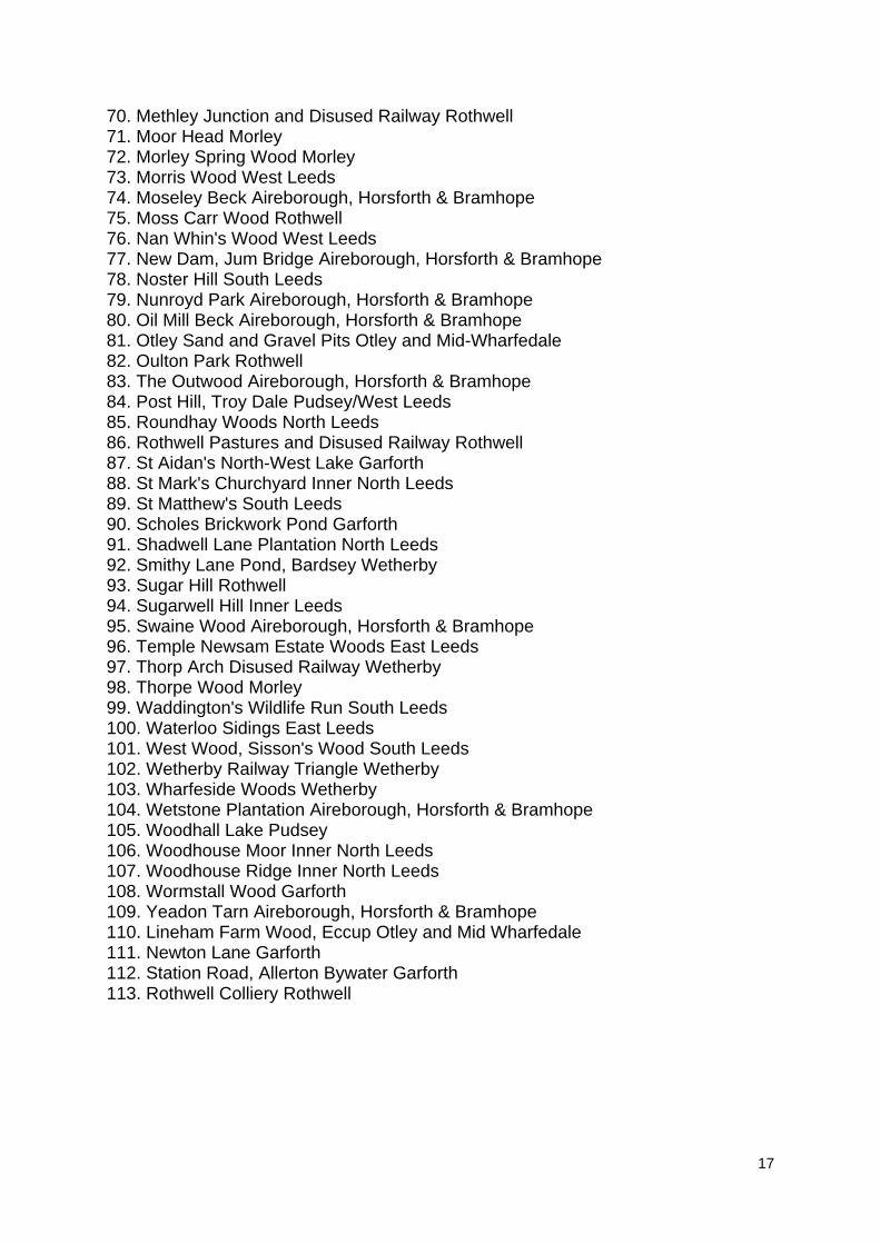
70. Methley Junction and Disused Railway Rothwell 71. Moor Head Morley 72. Morley Spring Wood Morley 73. Morris Wood West Leeds 74. Moseley Beck Aireborough, Horsforth & Bramhope 75. Moss Carr Wood Rothwell 76. Nan Whin's Wood West Leeds 77. New Dam, Jum Bridge Aireborough, Horsforth & Bramhope 78. Noster Hill South Leeds 79. Nunroyd Park Aireborough, Horsforth & Bramhope 80. Oil Mill Beck Aireborough, Horsforth & Bramhope 81. Otley Sand and Gravel Pits Otley and Mid-Wharfedale 82. Oulton Park Rothwell 83. The Outwood Aireborough, Horsforth & Bramhope 84. Post Hill, Troy Dale Pudsey/West Leeds 85. Roundhay Woods North Leeds 86. Rothwell Pastures and Disused Railway Rothwell 87. St Aidan's North-West Lake Garforth 88. St Mark's Churchyard Inner North Leeds 89. St Matthew's South Leeds 90. Scholes Brickwork Pond Garforth 91. Shadwell Lane Plantation North Leeds 92. Smithy Lane Pond, Bardsey Wetherby 93. Sugar Hill Rothwell 94. Sugarwell Hill Inner Leeds 95. Swaine Wood Aireborough, Horsforth & Bramhope 96. Temple Newsam Estate Woods East Leeds 97. Thorp Arch Disused Railway Wetherby 98. Thorpe Wood Morley 99. Waddington's Wildlife Run South Leeds 100. Waterloo Sidings East Leeds 101. West Wood, Sisson's Wood South Leeds 102. Wetherby Railway Triangle Wetherby 103. Wharfeside Woods Wetherby 104. Wetstone Plantation Aireborough, Horsforth & Bramhope 105. Woodhall Lake Pudsey 106. Woodhouse Moor Inner North Leeds 107. Woodhouse Ridge Inner North Leeds 108. Wormstall Wood Garforth 109. Yeadon Tarn Aireborough, Horsforth & Bramhope 110. Lineham Farm Wood, Eccup Otley and Mid Wharfedale 111. Newton Lane Garforth 112. Station Road, Allerton Bywater Garforth 113. Rothwell Colliery Rothwell
18
Appendix 2 – Nature Conservation Designations since UDP 2006
Local Wildlife Sites
Name of Local Wildlife Site Date Approved by West Yorkshire Local Sites Partnership
LWS 01 Black Carr Wood, Pudsey 18/07/11
LWS 02 Becca Banks, Aberford 18/07/11
LWS 03 Killingbeck Meadows 18/10/12
LWS 04 Hawks Nest Wood, Garforth 18/10/12
LWS 05 Coburnhill Wood, Micklefield 09/05/13
LWS 06 Sims Pond, Horsforth 09/05/13
LWS 07 Saw Wood, Scholes 24/07/13
LWS 08 Bell Wood and House Carr Wood Walton 22/01/2014
LWS 09 Bramley Falls and Newlay Quarry Woods
LWS 10 Aberford Osiers 22/01/2014
LWS 11 Cragg Wood, Horsforth
LWS 12 Cragg Wood, Rawdon 09/10/2014
LWS 13 Creskeld Wood, Arthington 09/10/2014
LWS 14 East Keswick Marsh 09/10/2014
LWS 15 Frank Shire’s, East Keswick 09/10/2014
LWS 16 Great Swarcliffe Plantation 09/10/2014
LWS 17 Great Wood - West Wood, Hawksworth 09/10/2014
LWS 18 Haigh Wood, West Ardsley 09/10/2014
LWS 19 Hawksworth Woods, Horsforth 09/10/2014
LWS 20 Langwith Wood, Collingham 09/10/2014
LWS 21 Morley Spring Wood 09/10/2014
LWS 22 Swaine Wood, Horsforth 09/10/2014
19
LWS 23 The Outwood, Horsforth 09/10/2014
LWS 24 Wormstall Wood, Ledsham 09/10/2014
Local Geology Sites
Name of Local Geology Site Date Approved by West Yorkshire Local Sites Partnership
LGS 01 Wetherby Riverside Cliffs Feb 2010
LGS 02 Walton Morraine Feb 2010
LGS 03 Boston Spa Riverside Woods Feb 2010
LGS 04 Front Wood Thorp Arch 18/10/12
www.leeds.gov.uk/yourcity
Site Allocations Plan and Aire Valley Leeds Area Action Plan
Retail Background Paper
Publication DraftLeeds Local Development Framework
Development Plan DocumentSeptember 2015
Site Allocations Plan and Aire Valley Leeds Area Action PlanEnvironmental Designations Background Paper
Publication DraftLeeds Local Development Framework
Development Plan DocumentSeptember 2015
For more information, please contact:LDF Publication Draft Consultation
Forward Planning & ImplementationThe Leonardo Building
2 Rossington StreetLeeds LS2 8HD
Email: Site Allocations: [email protected]
Aire Valley Leeds AAP: [email protected]: www.leeds.gov.uk/yourcity