Embed Size (px)
Citation preview

������������ �� ������������ ��������������������
Site Selection For Strategic Waste Management Facilities: Additional Sites
Report December 2007 www.erm.com
Oxfordshire County Council
Site Selection for Strategic Waste Management Facilities Additional Sites
Reference: 0051809.07
December 2007
Prepared by: Louise Strack & Poulomee Basu
This report has been prepared by Environmental Resources Management the trading name of Environmental Resources Management Limited, with all reasonable skill, care and diligence within the terms of the Contract with the client, incorporating our General Terms and Conditions of Business and taking account of the resources devoted to it by agreement with the client. We disclaim any responsibility to the client and others in respect of any matters outside the scope of the above. This report is confidential to the client and we accept no responsibility of whatsoever nature to third parties to whom this report, or any part thereof, is made known. Any such party relies on the report at their own risk.
For and on behalf of Environmental Resources Management Approved by: Dave Ackroyd ______________ Signed: _________________________________ Position: Partner _________________________ Date: 14 December 2007___________________
CONTENTS
1 SITE SELECTION FOR STRATEGIC WASTE MANAGEMENT FACILITIES: ADDITIONAL SITES 1
1.1 SUMMARY 1 1.2 OBJECTIVE OF THE REPORT 2 1.3 ASSESSMENT OF ADDITIONAL SITES 3
SITE 221 SITE G, MOD, PALMER AVENUE, BICESTER 4
2 CONCLUSIONS 10
ANNEX A SITE PLANS ANNEX B PERFORMANCE OF ADDITIONAL SITES AGAINST CRITERIA
ENVIRONMENTAL RESOURCES MANAGEMENT OCC
1
1 SITE SELECTION FOR STRATEGIC WASTE MANAGEMENT FACILITIES: ADDITIONAL SITES
1.1 SUMMARY
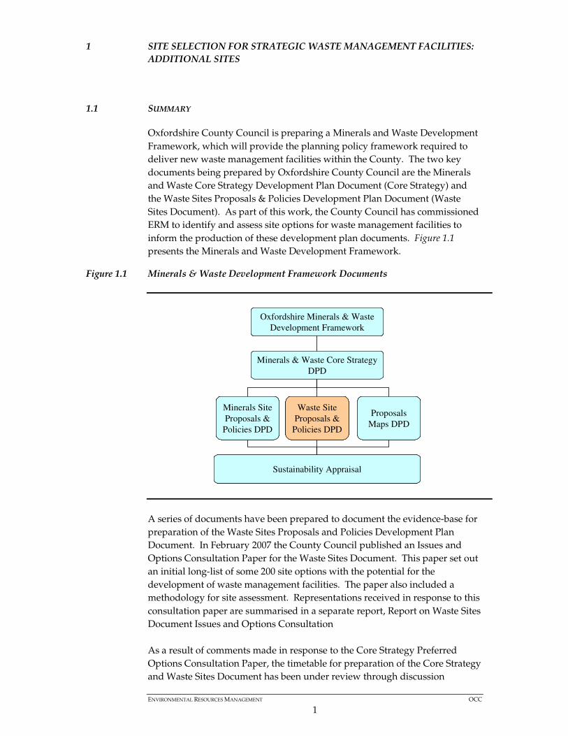
Oxfordshire County Council is preparing a Minerals and Waste Development Framework, which will provide the planning policy framework required to deliver new waste management facilities within the County. The two key documents being prepared by Oxfordshire County Council are the Minerals and Waste Core Strategy Development Plan Document (Core Strategy) and the Waste Sites Proposals & Policies Development Plan Document (Waste Sites Document). As part of this work, the County Council has commissioned ERM to identify and assess site options for waste management facilities to inform the production of these development plan documents. Figure 1.1 presents the Minerals and Waste Development Framework.
Figure 1.1 Minerals & Waste Development Framework Documents
A series of documents have been prepared to document the evidence-base for preparation of the Waste Sites Proposals and Policies Development Plan Document. In February 2007 the County Council published an Issues and Options Consultation Paper for the Waste Sites Document. This paper set out an initial long-list of some 200 site options with the potential for the development of waste management facilities. The paper also included a methodology for site assessment. Representations received in response to this consultation paper are summarised in a separate report, Report on Waste Sites Document Issues and Options Consultation As a result of comments made in response to the Core Strategy Preferred Options Consultation Paper, the timetable for preparation of the Core Strategy and Waste Sites Document has been under review through discussion
Oxfordshire Minerals & Waste Development Framework
Minerals & Waste Core Strategy DPD
Minerals Site Proposals &
Policies DPD
Sustainability Appraisal
Waste Site Proposals &
Policies DPD
Proposals Maps DPD
Oxfordshire Minerals & Waste Development Framework
Oxfordshire Minerals & Waste Development Framework
Minerals & Waste Core Strategy DPD
Minerals & Waste Core Strategy DPD
Minerals Site Proposals &
Policies DPD
Minerals Site Proposals &
Policies DPD
Sustainability AppraisalSustainability Appraisal
Waste Site Proposals &
Policies DPD
Waste Site Proposals &
Policies DPD
Proposals Maps DPDProposals
Maps DPD
ENVIRONMENTAL RESOURCES MANAGEMENT OCC
2
between the County Council and the Government Office for the South East (GOSE). The County Council wished for the site selection work to continue not withstanding any change to the timetable. An Interim Report on Site Selection for Strategic Waste Management Facilities – Stage 1 Report: Shortlist of Sites (Interim Report Stage 1) was published in July 2007. This report gave advice to the County Council on how to go forward with site selection and identified a short list of sites that may be suitable for strategic waste management (treatment) facilities. Interim Report Stage 1 identified 24 sites as suitable for detailed assessment. An Interim Report on Site Selection for Strategic Waste Management Facilities – Stage 2 Report: Detailed Assessment was published in September 2007. This report gave advice to the County Council on which of the selected sites would be most suitable for strategic waste management (treatment) facilities. This report also identified four further sites which were put through the same shortlisting process as outlined in Interim Report Stage 1, to check they were appropriate for further, detailed assessment. 28 sites in total were subject to detailed site assessment.
Box 1.1 Summary of documents produced for development of the Waste Site Proposals & Policies Development Plan Document
1.2 OBJECTIVE OF THE REPORT
This report presents site assessment work undertaken in addition to the Interim Report on Site Selection for Strategic Waste Management Facilities – Stage 2 Report: Detailed Assessment (September, 2007). Following completion of this report, in October 2007, two further sites in Oxfordshire were recognised to have the potential for waste management development. These sites are outlined below and shown on plans in Annex A.
Site Number Site Name District
220 Site 'E' MoD, Bicester CDC
221 Site 'G' MoD, Bicester CDC
• Issues & Options Consultation Paper for Waste Sites Document • Report on Waste Sites Document Issues and Options Consultation. • Waste Management Need Assessment Report • Interim Report on Site Selection for Strategic Waste Management
Facilities – Stage 1 Report: Shortlist of Sites • Interim Report on Site Selection for Strategic Waste Management
Facilities – Stage 2 Report: Detailed Assessment

ENVIRONMENTAL RESOURCES MANAGEMENT OCC
3
1.3 ASSESSMENT OF ADDITIONAL SITES
1.3.1 Shortlisting
These two additional sites were subjected to the same assessment methodology as all the other sites considered by ERM as detailed in Interim Report on Site Selection for Strategic Waste Management Facilities – Stage 1 Report: Shortlist of Sites. The results of the short listing exercise for the two additional sites can be found in Annex B. Site G MoD Bicester was identified as being appropriate for further analysis through a detailed site assessment. Site E was rejected as a result of the shortlisting exercise. Site boundary maps for both locations are provided in Annex A.
1.3.2 Detailed Site Assessment
The following section of this report presents the detailed site assessment for Site G. It establishes: baseline data for the site, including any existing use or conditions; site access; and relationship with neighbouring uses. Details of the purpose and source of the criteria used are provided on page 3 of the Interim Report on Site Selection for Strategic Waste Management Facilities – Stage 1 Report: Shortlist of Sites. Further detail on the development and application of the criteria is in Annex B of that report and also in Annex B of the Interim Report on Site Selection for Strategic Waste Management Facilities – Stage 2 Report: Detailed Assessment.
ENVIRONMENTAL RESOURCES MANAGEMENT OCC
4
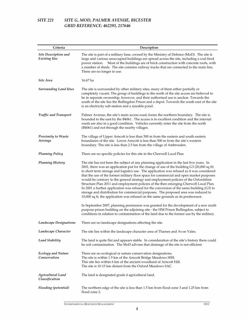
SITE 221 SITE G, MOD, PALMER AVENUE, BICESTER GRID REFERENCE: 462293, 217646
Criteria Description
Site Description and Existing Use
The site is part of a military base, owned by the Ministry of Defence (MoD). The site is large and various unoccupied buildings are spread across the site, including a coal fired power station. Most of the buildings are of brick construction with concrete roofs, with a number of sheds. The site contains railway tracks that are connected to the main line. These are no longer in use.
Site Area 16.67 ha
Surrounding Land Uses The site is surrounded by other military sites, many of them either partially or completely vacant. The group of buildings to the north of the site access are believed to be in separate ownership, however, and their authorised use is unclear. Towards the south of the site lies the Bullingdon Prison and a depot. Towards the south east of the site is an electricity sub-station and a sizeable pond.
Traffic and Transport Palmer Avenue, the site’s main access road, forms the northern boundary. The site is bounded to the east by the B4061. The access is in excellent condition and the internal roads are also in a good condition. Vehicles currently enter the site from the north (B4061) and not through the nearby villages.
Proximity to Waste Arisings
The village of Upper Arncott is less than 500 m from the eastern and south eastern boundaries of the site. Lower Arncott is less than 500 m from the site’s western boundary. The site is less than 2.5 km from the village of Ambrosden.
Planning Policy There are no specific policies for this site in the Cherwell Local Plan.
Planning History The site has not been the subject of any planning application in the last five years. In 2001, there was an application put for the change of use of the building G3 (20,000 sq ft) to short term storage and logistics use. The application was refused as it was considered that the use of the former military floor space for commercial and open market purposes would be contrary to the general strategy and employment policies of the Oxfordshire Structure Plan 2011 and employment policies of the then emerging Cherwell Local Plan. In 2001 a further application was refused for the conversion of the same building (G3) to storage and distribution for commercial purposes. The proposed area was reduced to 10,000 sq ft, the application was refused on the same grounds as its predecessor.
In September 2007, planning permission was granted for the development of a new multi purpose prison building on the adjoining site - the HM Prison Bullingdon, subject to conditions in relation to contamination of the land due to the former use by the military.
Landscape Designations
Landscape Character
There are no landscape designations affecting the site.
The site lies within the landscape character area of Thames and Avon Vales.
Land Stability The land is quite flat and appears stable. In consideration of the site’s history there could be soil contamination. The MoD advises that drainage of the site is not efficient.
Ecology and Nature Conservation
There are no ecological or nature conservation designations. The site is within 1.5 km of the Arncott Bridge Meadows SSSI. This site lies within 6 km of the ancient woodland of Arncott Hill. The site is 10-15 km distant from the Oxford Meadows SAC.
Agricultural Land Classification
The land is designated grade 4 agricultural land.
Flooding (potential) The northern edge of the site is less than 1.5 km from flood zone 3 and 1.25 km from flood zone 2.
ENVIRONMENTAL RESOURCES MANAGEMENT OCC
5
Criteria Description
Groundwater Quality The site is not located within any major aquifers. It is located within 2 km of a Minor Aquifer.
Historic Environment There are no listed buildings near the site. There are two archeologically important sites in the village of Ambrosden approximately 0.5 - 1 km distant from the site. However, there are no archaeological constraints for this site.
Recreational Activities Development of this site would not impact upon recreational activities.
Air Quality/Noise/ Issues of Environmental Nuisance
The site is situated in a rural area; the villages of Upper and Lower Arncott are less than 500 m from the site. The nearest residential properties are situated in these villages. Bullingdon prison is situated to the south of the site within 200m distance, there are current plans to extend the prison with the addition of a new building. Appropriate safeguards could be applied to ensure that waste development at this site would not result in unacceptable environmental nuisance or impact upon local amenity.
Proximity to Existing Waste Facilities
The site is part of a military base which operates its own waste management facilities
Proximity to Landfill: Manor Farm - 6.02 km Proximity to Treatment: Oxford Sewage Treatment Works (Processing) – 11.6 km Proximity to Recycling: 3.08 km Proximity to Transfer Station: Ardley Fields Farm – 11.5 km Proximity to Composting: Ardley Quarry – 11.4 km
Landscape/ Visual Impact The northern edge of the site is well screened by dense, evergreen trees. There are also many trees and hedges within the site. However, the power station and associated chimney, located in the eastern part of the site, are quite exposed and extend above the height of the nearby trees. The power station and chimney are clearly visible from the B4061, and the eastern end of Palmer Avenue when travelling towards the site. Substantial building in this area would be expected to result in a negative landscape and/or visual impact. The rest of the site could more comfortably accommodate buildings without significant landscape or visual impact.
Site Ownership The site is owned by the Ministry of Defence. The MOD is willing to sell the land to a waste operator if waste development on the site were to be approved.
Site 2 Site G, MOD, Palmer Avenue, Bicester Preliminary Conclusions
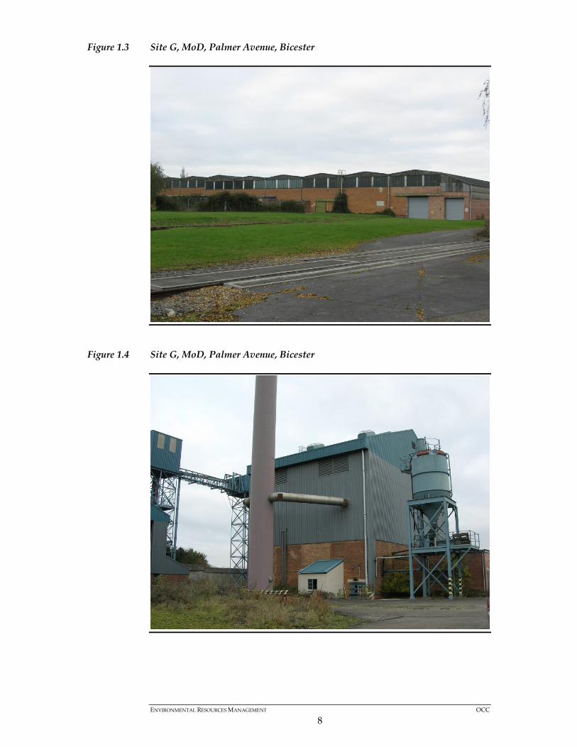
The site is a former military base, owned by the Ministry of Defence (MoD). The site is currently unoccupied, but under constant surveillance and a high level of security. There are a number of buildings consisting of sheds, large warehouse type buildings of brick construction with concrete roofs and a disused power station with chimney on site; these are all unoccupied. A rail line enters the site from the south west corner and runs through the middle of the site. There are a series of rail intersections on ‘G’ site that split off and service a number of different areas. One of these enters the largest shed (building G3) which is situated to the south eastern corner of the site. The rail line also exits the site on the eastern boundary and connects to another vacant MoD site, site ‘A’.

ENVIRONMENTAL RESOURCES MANAGEMENT OCC
6
There are a few small water reservoirs and several metres of exposed pipelines within the site. Moreover, there is a training facility for military guard dogs; this would be relocated if the site were to be developed. The site is well screened from Palmer Avenue, along the northern boundary, by dense evergreen trees, although the north east corner is exposed. Within the site, there are a number of well established trees. Site G is quite large (nearly 17 ha) and the majority of the buildings, with exception to the power station building and chimney, are well screened. It would appear more logical to concentrate any new development in this area and use the opportunity to improve the wider landscape by keeping the north east part of the site more open. The surrounding landscape is fairly flat, although land to the south west (Arncott Hill) is raised and it would be possible to look down into the site from this aspect. This site lies 15 km distant from the Oxford Meadows Special Areas for Conservation (SAC). ERM considers that the development of a waste management facility is not likely to have a significant effect on the identified SAC. There is also a possibility of there being protected species colonising the area adjoining the pond and this would require firther investigation prior to development. Site G would benefit from improvement that could in part be delivered through high standard of design in new waste development. There are a number of large unused buildings that over time will deteriorate. It would be unrealistic to expect these buildings to be removed without some form of alternative development taking place – not least to cover the cost of its demolition. Alternatively, some of the buildings already on site may be capable of re-use as part of an alternative development. The majority of the buildings are reported to be of sound construction with the exception of building G3 which would require a new roof. There is an existing power station that is reported to be in a good condition. There are a number of above-ground pipelines located on the site. In addition, the site offers an opportunity to use the rail connection that exists on site with the potential to reduce the need for road transport. The MoD advise that the rail network on site is reported to be in good condition and has a direct link (through the military complex) to the rail network to the south of the county (a connection to the rail network to the north would need to be routed through Oxford and require further investigation). Transporting waste by rail for short-haul movement is logistically more complex and may not be deliverable: however, this is a potential attribute of the site which could be explored by a developer. ERM concludes that this site offers potential for development of a strategic waste management facility. It is located close to significant sources of waste arisings (Bicester) and there are potential markets for the recovery of energy generated by waste management facilities. The site is close to the county

ENVIRONMENTAL RESOURCES MANAGEMENT OCC
7
boundary with Buckinghamshire; any waste movement from another sub region however would need to be in line with regional policy. The site already benefits from good site access and links with the wider road network, as well as potential for waste transport by rail. Oxfordshire Highways Department advise that HGV movements should avoid journeys through nearby settlements, including Ambrosden and Lower Arncott. The A41 south of Bicester is heavily trafficked at times. The capacity of the site (in terms of tonnage of waste to be handled per annum) could only be determined following a detailed transport assessment. This will demonstrate: • the number of HGV movements required to be made to the site; and • the capacity of the road network to handle them satisfactorily (having due
regard to traffic likely to be generated by development committed to take place in the area).
Site G is distant from an SAC and would be unlikely to impact on local residential or recreational amenities. In addition to delivering part of the required waste management infrastructure within the County, a comprehensive use of the site for waste development could bring added benefits, including potential improvements to the appearance of the area.
Figure 1.2 Site G, MoD, Palmer Avenue, Bicester
ENVIRONMENTAL RESOURCES MANAGEMENT OCC
8
Figure 1.3 Site G, MoD, Palmer Avenue, Bicester
Figure 1.4 Site G, MoD, Palmer Avenue, Bicester

ENVIRONMENTAL RESOURCES MANAGEMENT OCC
9
Figure 1.5 Site G, MoD, Palmer Avenue, Bicester
Figure 1.6 Site G, MoD, Palmer Avenue, Bicester
ENVIRONMENTAL RESOURCES MANAGEMENT OCC
10
2 CONCLUSIONS
Section 1 of this report has discussed site 221 in detail and provides ERM’s preliminary conclusion that, in common with the seven other sites considered appropriate to be safeguarded for a future strategic waste use (1), Site ‘G’ MoD Bicester is considered appropriate to accommodate a strategic waste use – the site capacity to be determined by a detailed traffic study assessing the nature and number of HGV movements to the site and their impact on the surrounding road network.
(1) Interim Report on Site Selection for Strategic Waste Management Facilities – Stage 2 Report: Detailed Assessment (ERM September 2007)

Annex A
Site Plans
CLIENT: SIZE: TITLE:
DATE: 24/09/2007
DRAWN: IG
CHECKED:
APPROVED:
PROJECT: 0051809
SCALE: 1:10,000DRAWING: REV:
KEY:Oxfordshire County Council A4 Site E: Bicester
SiteE.mxd 0
Site Boundary
SOURCE: Reproduced from Ordnance Survey digital map data. © Crowncopyright, All rights reserved. 2007 License number 0100031673.PROJECTION: British National Grid
File:
0051
809O
xfordG
IS_L
S\Ph
ase 1
0\MXD
\Site
E.mxd
ERMEaton House Walbrook CourtNorth Hinksey LaneOxford OX2 0QSTel: 01865 384800Fax: 01865 204982.0 200
Metres

CLIENT: SIZE: TITLE:
DATE: 24/09/2007
DRAWN: IG
CHECKED: LS
APPROVED:
PROJECT: 0051809
SCALE: 1:10,000DRAWING: REV:
KEY:Oxfordshire County Council A4 Site G: Bicester
SiteG.mxd 0
Site Boundary
SOURCE: Reproduced from Ordnance Survey digital map data. © Crowncopyright, All rights reserved. 2007 License number 0100031673.PROJECTION: British National Grid
File:
0051
809O
xfordG
IS_L
S\Ph
ase 1
0\MXD
\Site
G.mx
d
ERMEaton House Walbrook CourtNorth Hinksey LaneOxford OX2 0QSTel: 01865 384800Fax: 01865 204982.0 200
Metres

Annex B
Performance of Additional Sites Against Criteria

Performance of Additional Sites Against Short List Criteria
1 2 3 5 6 7 9 11
Area of SearchSize
(hectares) A Road Access SAC SAM SSSIAncient
WoodlandListed
BuildingSensitive Receptor AONB Green Belt
Available for waste
development?Loss of C&D or metal facility? Flood Zone
Forms part of an existing industrial
site?
Is it undeveloped or is the building
derelict? Rural greenfield
Site No. Description
220 Site 'E' MoD, Bicester Bicester 5k 2.7 A41 Outside No Outside <0.5km Adjacent Yes Outside Outside Yes No None No n/a Yes - Part NoNB Criteria 5: Single residential property with zone of influence. Other housing at Kestrel Way Separated from site by major road and roundabout.
221 Site 'G' MoD, Bicester Bicester 5-10k 16.4 B4011 Outside No Outside <1.km No No Outside Outside Yes No<0.5 km FZ 2 & 3
No n/a No YesSite more than 2k from an ‘A’ road (criteria 3) but is served by site access and ‘B’ road of appropriate standard and absence of conflict with other criteria mean indicate that it should be the subject of detailed assessment.
Key 1 Number of sites that go through to Detailed Site AssessmentSite scores positively against this criteriaSite scores negatively against this criteriaCriteria has two parts to its overall assessment, yes indicates acceptable
Short List CriteriaSite Through to Detailed
Assessment? Comments
4 8 10