Embed Size (px)
Citation preview
SITE SUMMARY REPORT
Arlington Dump
NONCD 0000644
Yadkin County
Hurricane Recovery Act of 2005
State of North Carolina
State Contract N06009S Schnabel Project No. 06210002.15
July 31, 2009
Prepared for:
North Carolina Department of Environmental and Natural Resources
Superfund Section
Inactive Hazardous Sites Branch
401 Oberlin Road, Suite 150
Raleigh, NC 27605
Prepared by:
Schnabel Engineering South, P.C.
11-A Oak Branch Drive
Greensboro, North Carolina 27407
(336) 274-9456
Benjamin L. Bradley
Project Scientist/Report Author Signature
Gary Rogers, L.G.
Senior Associate/Reviewer Signature
TABLE OF CONTENTS
Site Location Research Summary
Areas of Note
Site Summary
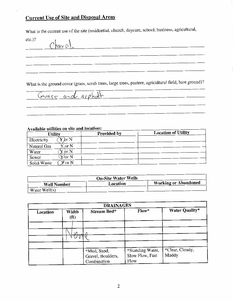
1.0 Site Conditions
1.1 On-site Structures
1.2 Current Site Usage
1.3 On-site Water Supply Wells and Intakes
1.4 Surface Water Features
1.5 Disposal Area
1.6 Disposal Area Conditions
1.7 Evidence of Human Activity
1.8 Potential Landfill Gas Migration Pathways
1.9 Physical Barriers
1.10 Other Pertinent Information
2.0 Vicinity Conditions
2.1 Structures Located on Adjacent Properties
2.2 Water Supply Wells and Intakes
2.3 Current Land Usage
2.4 Surface Water Features
3.0 Aerial Photography Review
TABLES
Table 1 Tabulated GPS Coordinates
FIGURES
Figure 1 USGS Topographic Map
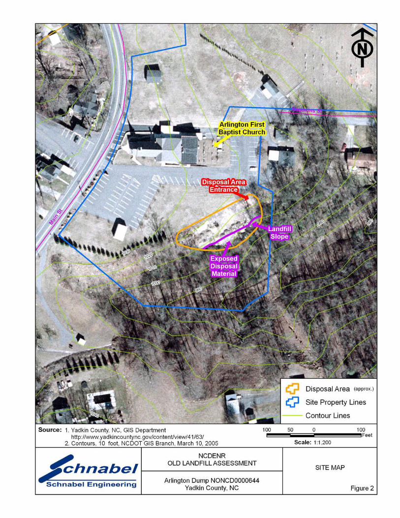
Figure 2 Site Map
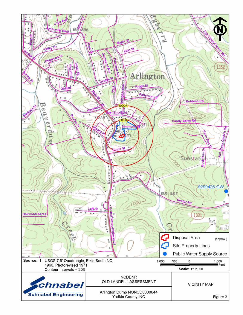
Figure 3 Vicinity Map
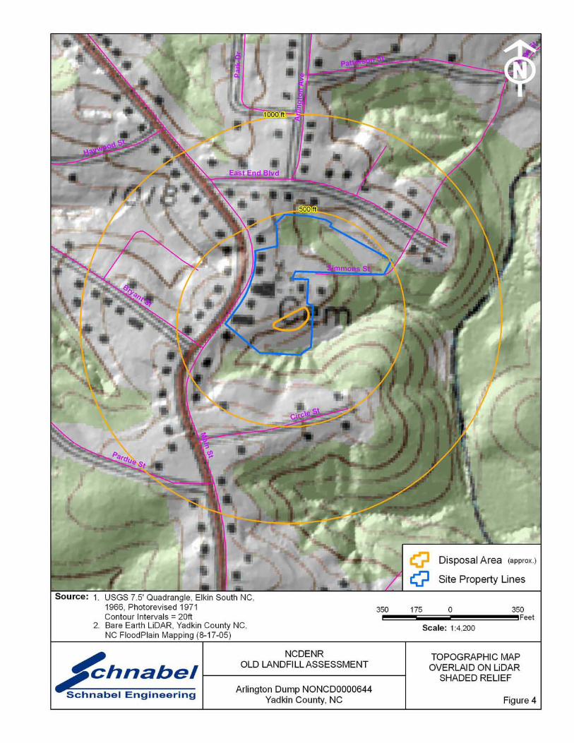
Figure 4 Topographic Map Overlaid On LiDAR Shaded Relief
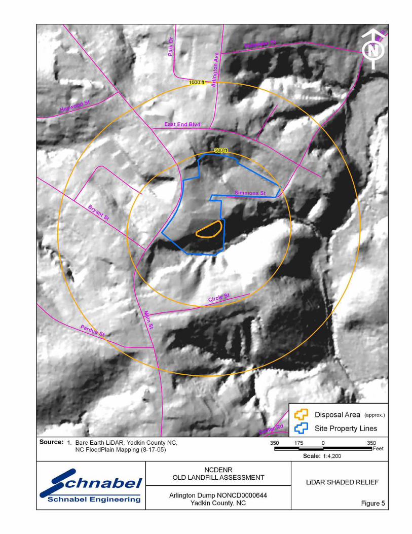
Figure 5 LiDAR Shaded Relief
APPENDICES
Appendix A Field Reconnaissance Sheet
Appendix B Tax Records
Appendix C Records of Communication\Site Visit Permission Letter
Appendix D Site Photographs
Appendix E Aerial Photographs
FILE: G:\2006_PROJECTS\06210002_(NCDENR_OLD_UNLINED_LANDFILL)\TASK_15_YADKIN_CO\0644-ARLINGTON DUMP\REPORT\FINAL\NONCD0000644_ARLINGTONDUMP_FINALSITESUMMARYREPORT_2008-07-14.DOC

Arlington Dump
NONCD 0000644
1
SITE LOCATION RESEARCH SUMMARY
ID NUMBER: NONCD 0000644
SITE NAME(S): Arlington Dump
LOCATION: 345 South Main Street, Jonesville, NC 28642
COUNTY: Yadkin
LANDFILL SIZE: 0.3 acres (Disposal Area enclosed by GPS points obtained during site
visit)
PROPERTY SIZE: 7.0 acres (from Yadkin County GIS)
DATE OPENED: 1960 (data obtained from Bryan Wyatt, Arlington First Baptist Church,
Grounds Manager)
DATE CLOSED: 1972 (data obtained from Bryan Wyatt, Arlington First Baptist Church,
Grounds Manager)
CURRENT OWNER: Arlington First Baptist Church
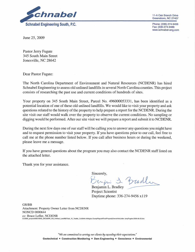
CURRENT OWNER CONTACT: Pastor Jerry Fugate CURRENT OWNER ADDRESS: 345 South Main Street, Jonesville, NC 28642
CURRENT OWNER TELEPHONE NUMBER: 336-835-2470
TAX PARCEL No./PIN No.: Parcel No. 4960-00-05-3331
DEED REFERENCE: Deed Book 530, Deed Page 520
COORDINATES: (at site entrance of Parcel 4960-00-05-3331 from on-site reading from
handheld GPS)
State Plane Coordinates (NAD83, meters): Northing: 275908 Easting: 445149.
Latitude: N36o 13’ 24.3” Longitude: W80
o 49’ 45.0”
AREAS OF NOTE
1) The Arlington First Baptist Church and cemetery are located on the Site.
2) The Arlington First Baptist Church allows the Town of Jonesville to dispose of broken
concrete on the Disposal Area.
3) Residences and the Arlington Fire & Rescue are located within 1,000 feet of the Disposal
Area.

Arlington Dump
NONCD 0000644
2
SITE SUMMARY
1.0 SITE CONDITIONS
This section discusses the observed conditions on the Site, as defined as the property (Tax Parcel
4960-00-05-3331) on which the Disposal Area is located. The Disposal Area is defined as the
area observed or reported to have been used for waste placement or burial. The boundary
(perimeter) of this area is the observed limit of waste material based on field observations.
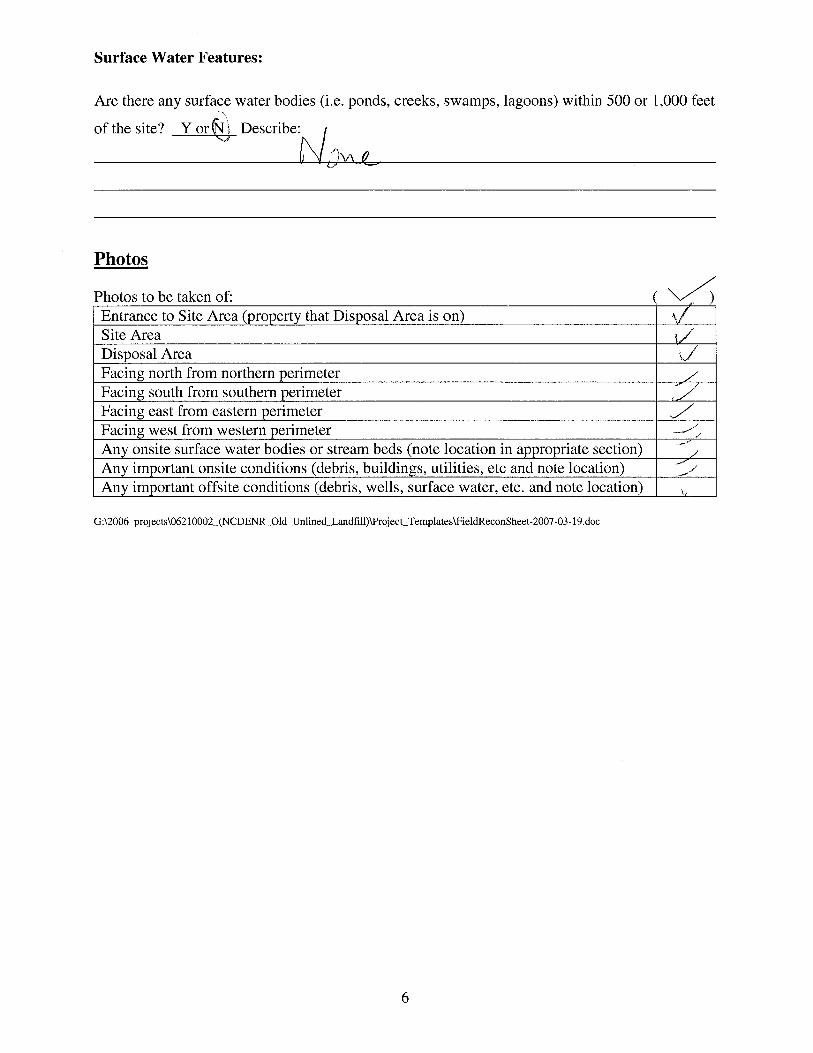
Photographs illustrating site conditions are included in Appendix D.
The Site is located in Yadkin County, near Jonesville, NC. Driving directions to the Site from the
intersection of Interstate 77 North and US Highway 21 is as follows:
1) Take US Highway 21 (Main Street) north toward Jonesville and drive approximately 2.5
miles.
2) Arlington First Baptist Church is located on the right at 345 South Main Street.
1.1 On-site Structures
The Arlington First Baptist Church and three garages are located on the Site. The church is
located about 175 feet northwest of the Disposal Area. The church is in an apparent up-gradient
direction from the Disposal Area.
1.2 Current Site Usage
According to Mr. Bryan Wyatt, Church Grounds Manager, the Site is used by Arlington First
Baptist Church. The church also allows the Town of Jonesville to dispose of concrete and asphalt
on the Disposal Area.

Arlington Dump
NONCD 0000644
3
1.3 On-Site Water Supply Wells and Intakes
No on-site water supply wells were observed on the Site during the site visit. A water meter was
observed on the Site during the site visit. No fire hydrants were observed on the Site during the
site visit.
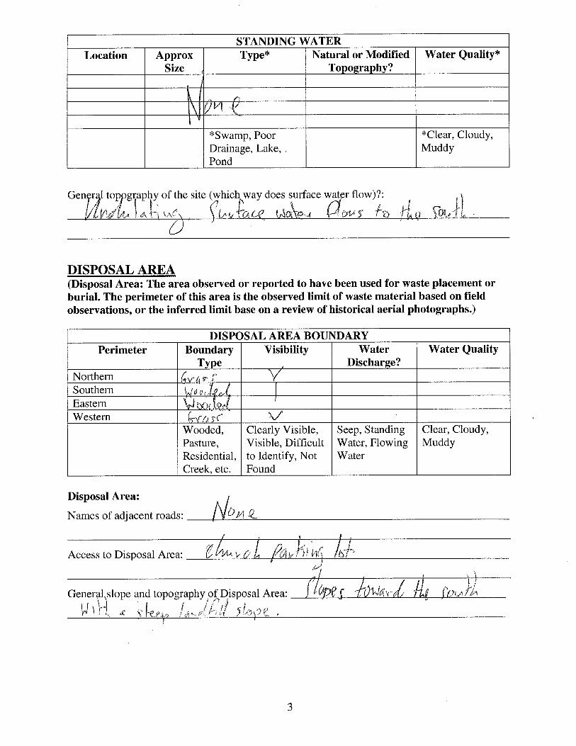
1.4 Surface Water Features
During the site visit, surface water features were not observed on the Site.
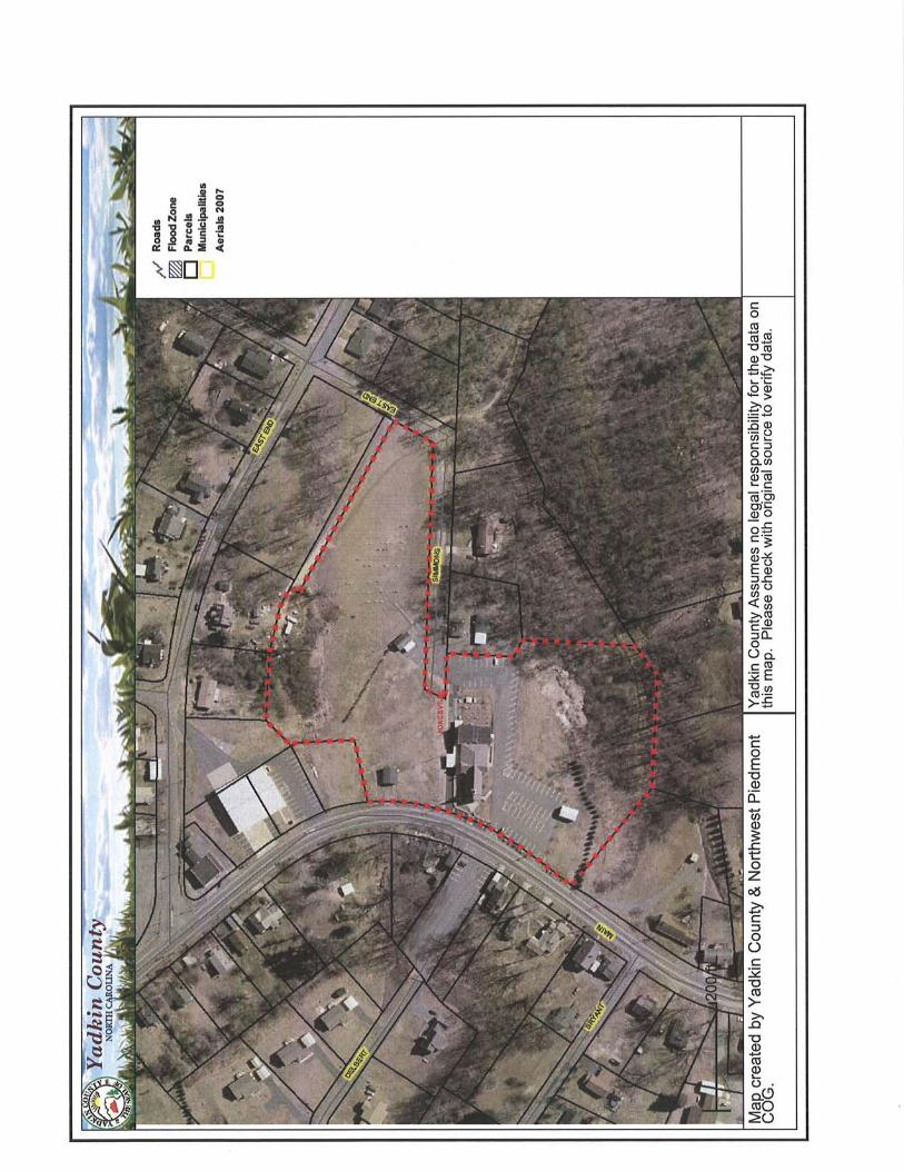
1.5 Disposal Area
Access to the Disposal Area is from the Arlington First Baptist Church parking lot. The Disposal
Area occupies 0.3 acres based on the Disposal Area perimeter shown on Figures 1 through 3.
The Disposal Area generally slopes to the south. A comparison of the topography from the 1966
USGS 7.5 minute topographic quadrangle map (20 foot contours) with the 2005 topographic map
from NCDOT (20 foot contours) suggests that up to about 10 feet of material has been placed on
the southwest side of the Disposal Area. These estimated depths are approximate and differences
in scale and methods of mapping are not sufficient to evaluate some changes in topography.
GPS coordinates were taken of the Disposal Area perimeter. The approximate Disposal Area
perimeter is illustrated on the figures and on aerial photographs in Appendix E. A table of GPS
coordinates for the Site entrance and the Site perimeter is presented in Table 1. The Disposal
Area perimeter location is approximate and is based on visual observations made at the time of
the site visit. Figures 4 and 5 show LiDAR shaded relief superimposed on the Disposal Area.

Arlington Dump
NONCD 0000644
4
1.6 Disposal Area Conditions
The Disposal Area was covered with grass, vines, briars, and small trees. A landfill slope was
observed on the southeastern side of the Disposal Area. Visible debris, including concrete,
asphalt, tires, furniture, and white goods, were observed on the landfill slope.
The observed Disposal Area was on a single tax parcel, Parcel Number 4960-00-05-3331. The
boundaries of the Disposal Area were visible during the site visit.
No notable erosion, depressions or hummocky topography, offensive odors, stained or discolored
soils, or slope failures were observed during the site visit.
1.7 Evidence of Human Activity
According to Mr. Bryan Wyatt, Church Grounds Manager, waste disposal of concrete and
asphalt still occurs on the Disposal Area (Photos 3 and 5).
1.8 Potential Landfill Gas Migration Pathways
There were no visible or evident potential gas migration pathways such as stormwater drain
systems, underground utilities, septic systems, or drain fields observed on the Disposal Area or
on the Site.
1.9 Physical Barriers
Access to the Site is from the Arlington First Baptist Church parking lot. The Disposal Area is
difficult to enter from the south due to dense vegetation.

Arlington Dump
NONCD 0000644
5
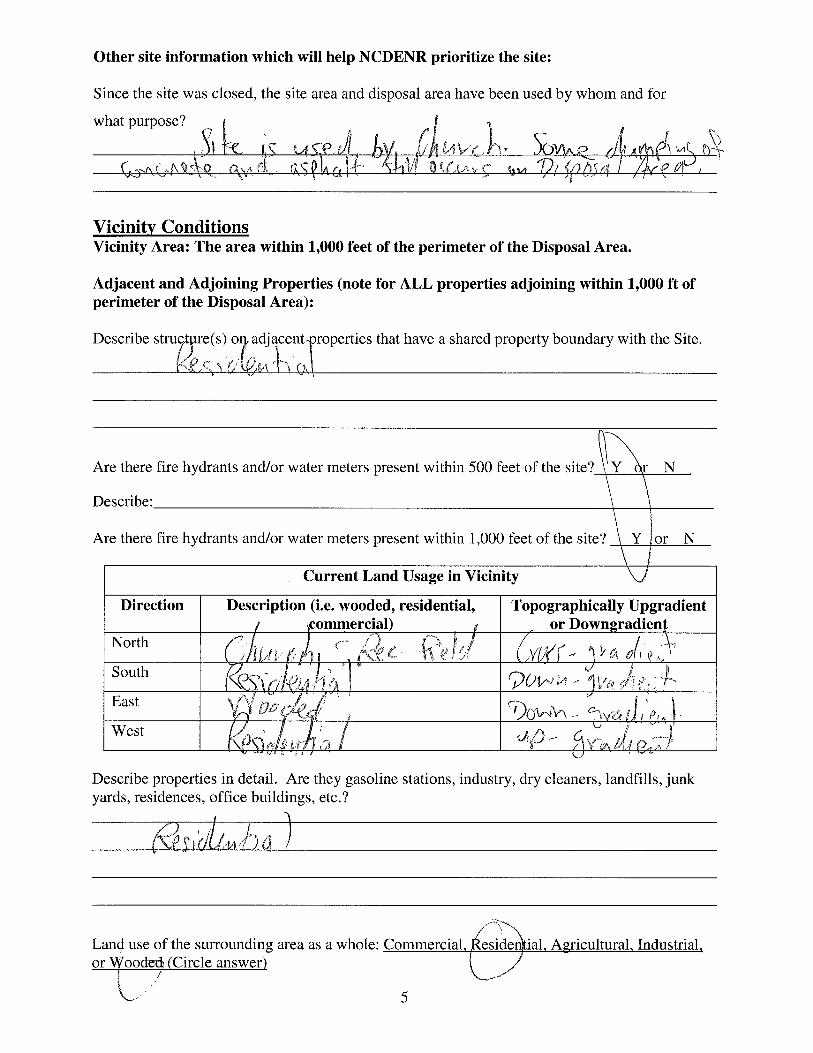
1.10 Other Pertinent Information
Some history of the Site was obtained during conversations with persons familiar with the Site.
The information obtained indicates that:
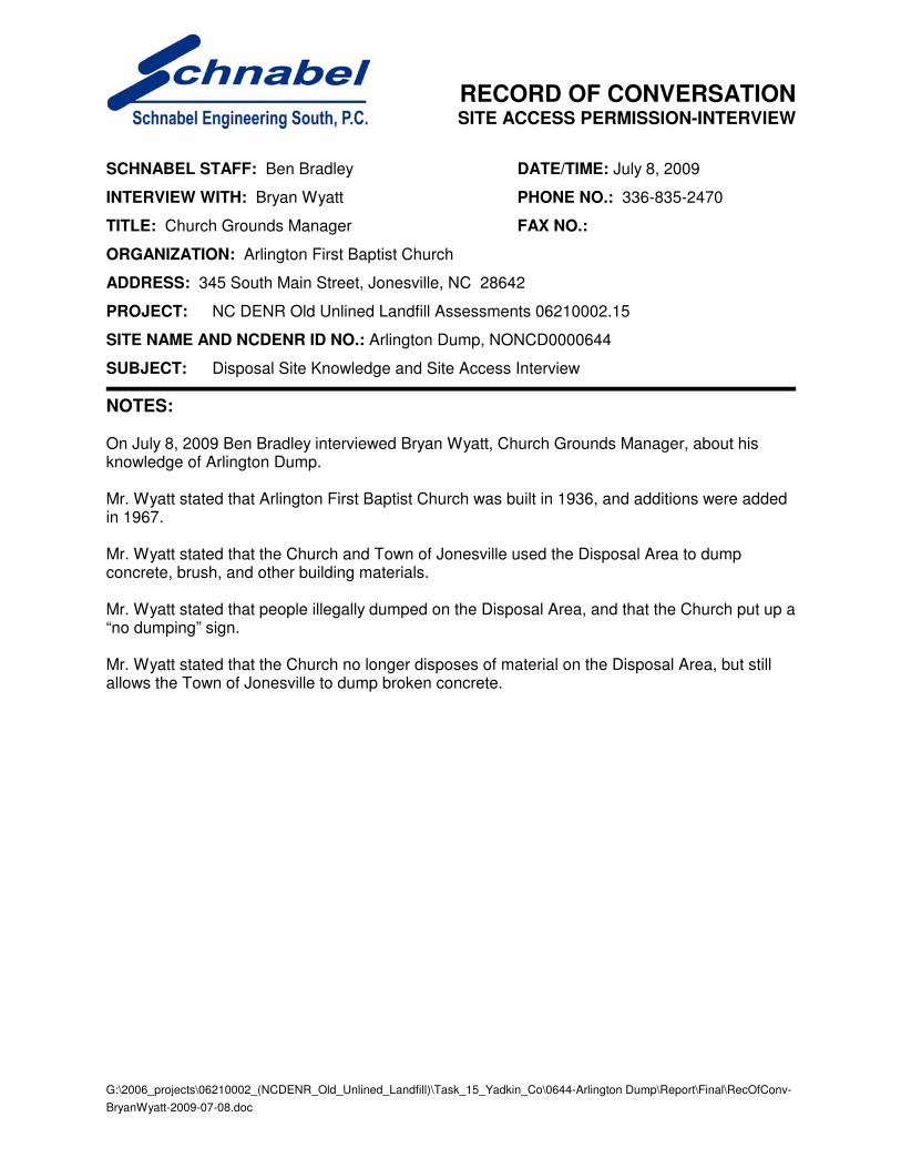
• Mr. Bryan Wyatt, Church Grounds Manager, stated that the Site is used by the
Arlington First Baptist Church which was built in 1936 with building additions in
1967.
• Mr. Wyatt stated that the Church no longer uses the Disposal Area, but does allow the
Town of Jonesville to dispose of broken concrete and asphalt.
• Mr. Wyatt stated that the Church and Town of Jonesville used the Disposal Area to
dump concrete, brush, and other building materials.
• Mr. Wyatt stated that people illegally dumped on the Disposal Area, and that the
Church put up a “no dumping” sign.
• Ms. Tammy Shore, Town of Jonesville Utilities Clerk, stated that the Town of
Arlington was annexed into the Town of Jonesville a few years ago.
• Ms. Shore stated that she remembered a disposal area at the Arlington First Baptist
Church located approximately one mile south of what used to be the center of the
Town of Arlington.
• Ms. Shore stated that the Town of Jonesville places broken concrete and asphalt at
Arlington First Baptist Church.
• Mr. Roger Martin, Town of Jonesville Public Works Director, stated that he had no
knowledge of a Disposal Area near Arlington First Baptist Church.
• Mr. Martin stated that the Town of Arlington may have used the Site as a Disposal Area,
but that the Town of Arlington and the Town of Jonesville have now merged.
Notes from conversations with people familiar with the site are included in Appendix C. The
information obtained from these conversations has not been verified or confirmed.
Arlington Dump
NONCD 0000644
6
2.0 VICINITY CONDITIONS
This section describes the observed general conditions in the vicinity of the Site, as defined as an
area within 1,000 feet of the perimeter of the Disposal Area. Photographs illustrating vicinity
conditions are included in Appendix D.
2.1 Structures Located on Adjacent Properties
Structures described in this section are located on adjacent properties that have a shared property
boundary with the Site.
Several residences on multiple tax parcels are located to the north, west, and south of the Site.
Two residences on separate tax parcels border the perimeter of the Site to the east. The Arlington
Fire & Rescue (Tax Parcels 4960-09-05-1557, 4960-09-05-0697, 4960-00-05-3716, 4960-09-05-
1488) is adjacent to the Site to the north. These structures are shown on Figure 2 and on aerial
photographs in Figures E1 through E4 in Appendix E.
2.2 Water Supply Wells and Intakes
Water supply wells or well houses were not observed at residences along South Main Street and
East Bend Boulevard within a 1,000-foot radius of the Disposal Area. Water meters were
observed in the yards of several of the residences and fire hydrants were observed within 1,000
feet of the Site.
The nearest public water supply registered on the NCDENR Public Water Supply Section’s
database (as of January 2008) is a public water supply well located at Fall Creek Baptist Church
3380 Fall Creek Church Road, Jonesville, NC 28642. This location is ¾ of a mile in an apparent
up-gradient direction from the Site. The location and permit number for this well are shown on
Figure 1.
Arlington Dump
NONCD 0000644
7
2.3 Current Land Usage
Property in the vicinity of the Site is primarily residential, except for the area to the east which is
wooded. Land usage at the time of the site visit within 1,000 feet of the Disposal Area perimeter
was:
North: Arlington First Baptist Church, cemetery, Arlington Fire and Rescue and
residences, apparent up-gradient direction from site.
South: Wooded and residences, apparent down-gradient direction from site.
East: Two residences and wooded, apparent cross- and down-gradient direction from
site.
West: Arlington First Baptist Church parking lot and residences, apparent up-gradient
direction from site.
2.4 Surface Water Features
During the site visit, no surface water features were observed on the Site. Sandyberry Creek is
located approximately 1,500 feet to the east and flows northward to the Yadkin River.

Arlington Dump
NONCD 0000644
8
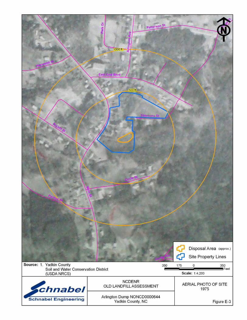
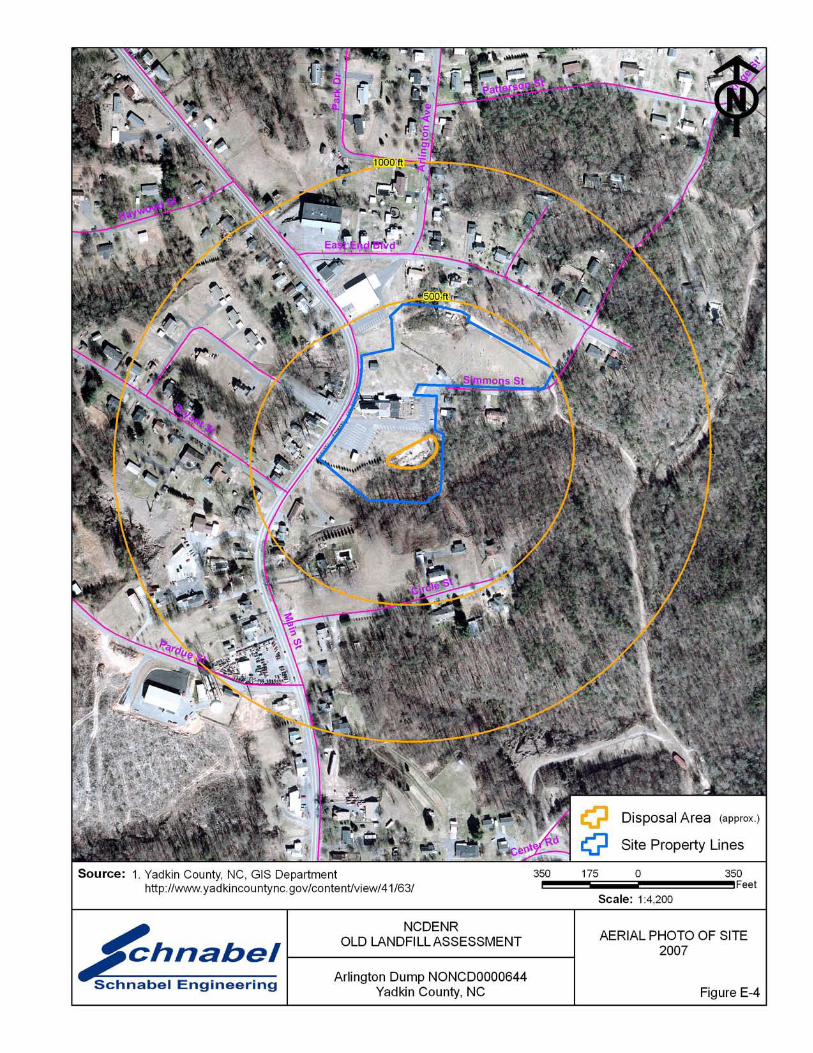
3.0 AERIAL PHOTOGRAPHY REVIEW
Aerial photographs were reviewed for the years 1966, 1975 and 2007. The reported years of
operation of the Site were from 1960 to 1972. Observations of each of the photographs are
included in the following table. Copies of the aerial photographs are included in Appendix E.
Some aerial photographs are reproductions of original aerial photographs and have some
distortion; therefore, overlaid Disposal Area Boundaries and other features may vary from their
actual locations. Hand drawn lines and notations on the photographs denote soils mapping
information drawn on the original photographs by the USDA NRCS.
Flight Year Observations Source
1966 Disposal Area partially cleared. The Arlington First Baptist
Church is visible on the central part of the Site. The Site
appears to be wooded and undeveloped in the northern part
and along the southern and eastern perimeters. Residences are
present to the north, south, and west of the Site. Two
residences are present to the east of the Site perimeter.
1
1975 Disposal Area is covered by vegetation and undeveloped. 1
2007 Piles of debris in Disposal Area are visually evident in the
southwestern part of the Site. The aerial photograph shows
conditions representative of those observed during the visit.
2
Sources of aerial photos:
1) USDA NRCS office in Yadkin County, NC
2) Yadkin County GIS, http://www.yadkincountync.gov/content/view
This report was prepared specifically for the use of NCDENR Inactive Sites Branch under the
Scope of Work defined in our contract dated October 26, 2005. Use of this document for
other purposes or by other parties is at the sole risk of the user.

TABLE
Arlington Dump
NONCD 0000644
9
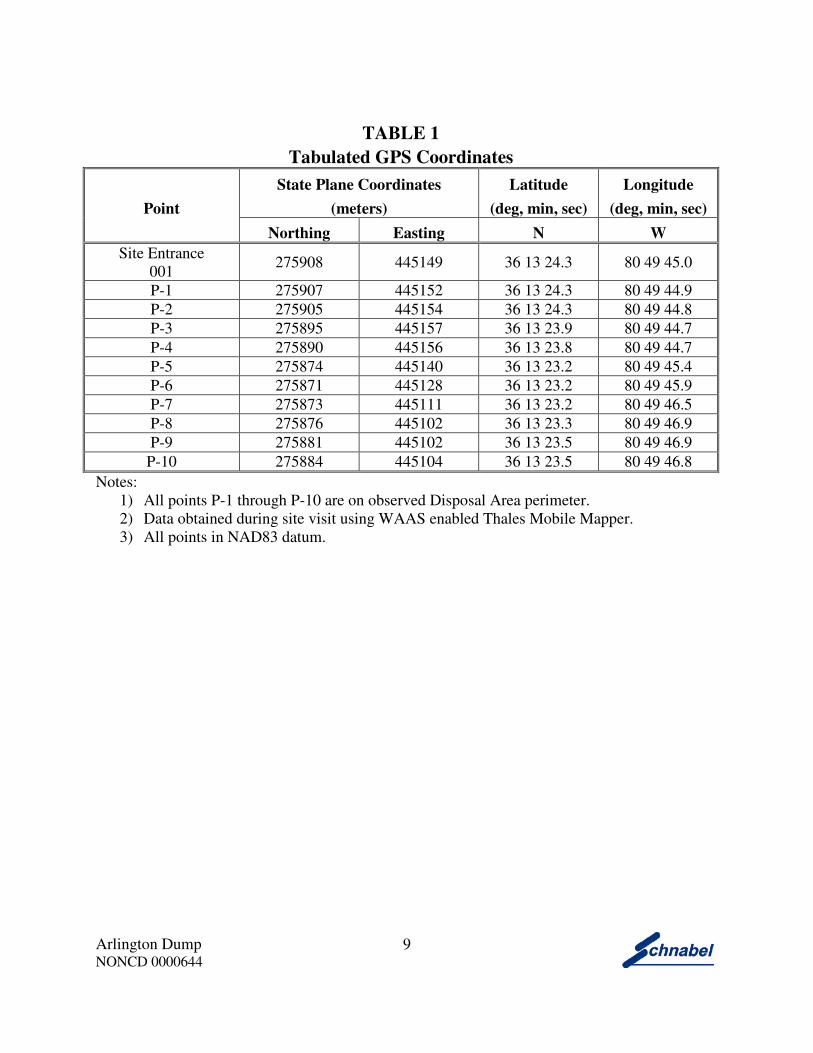
TABLE 1
Tabulated GPS Coordinates
Point
State Plane Coordinates
(meters)
Latitude
(deg, min, sec)
Longitude
(deg, min, sec)
Northing Easting N W
Site Entrance
001 275908 445149 36 13 24.3 80 49 45.0
P-1 275907 445152 36 13 24.3 80 49 44.9
P-2 275905 445154 36 13 24.3 80 49 44.8
P-3 275895 445157 36 13 23.9 80 49 44.7
P-4 275890 445156 36 13 23.8 80 49 44.7
P-5 275874 445140 36 13 23.2 80 49 45.4
P-6 275871 445128 36 13 23.2 80 49 45.9
P-7 275873 445111 36 13 23.2 80 49 46.5
P-8 275876 445102 36 13 23.3 80 49 46.9
P-9 275881 445102 36 13 23.5 80 49 46.9
P-10 275884 445104 36 13 23.5 80 49 46.8
Notes:
1) All points P-1 through P-10 are on observed Disposal Area perimeter.
2) Data obtained during site visit using WAAS enabled Thales Mobile Mapper.
3) All points in NAD83 datum.

FIGURES


FIELD RECONNAISSANCE SHEET


TAX RECORDS


RECORDS OF COMMUNICATION/SITE
VISIT PERMISSION LETTER


G:\2006_projects\06210002_(NCDENR_Old_Unlined_Landfill)\Task_15_Yadkin_Co\0644-Arlington Dump\Report\Final\RecOfConv-
TammyShore-2009-07-01.doc
RECORD OF CONVERSATION INTERVIEW
SCHNABEL STAFF: Ben Bradley DATE/TIME: July 1, 2009
INTERVIEW WITH: Tammy Shore PHONE NO.: 1-877-728-6798
TITLE: Utilities Clerk FAX NO.:
ORGANIZATION: Town of Jonesville
ADDRESS: 116 East Market Street, Elkin, NC 28621
PROJECT: NC DENR Old Unlined Landfill Assessments 06210002.15
SITE NAME AND NCDENR ID NO.: Arlington Dump, NONCD0000644
SUBJECT: Disposal Site Knowledge
NOTES: On July 1, 2009 Ben Bradley interviewed Tammy Shore, Town of Jonesville Utilities Clerk, about her knowledge of Arlington Dump. Ms. Shore stated that the Town of Arlington was annexed into the Town of Jonesville a few years ago. Ms. Shore stated that she remembered a dumping area at the Arlington First Baptist Church located approximately one mile south of what used to be the center of the Town of Arlington. Ms. Shore stated that the Town of Jonesville places broken concrete and asphalt at Arlington First Baptist Church.
G:\2006_projects\06210002_(NCDENR_Old_Unlined_Landfill)\Task_15_Yadkin_Co\0644-Arlington Dump\Report\Final\RecOfConv-
BryanWyatt-2009-07-08.doc
RECORD OF CONVERSATION SITE ACCESS PERMISSION-INTERVIEW
SCHNABEL STAFF: Ben Bradley DATE/TIME: July 8, 2009
INTERVIEW WITH: Bryan Wyatt PHONE NO.: 336-835-2470
TITLE: Church Grounds Manager FAX NO.:
ORGANIZATION: Arlington First Baptist Church
ADDRESS: 345 South Main Street, Jonesville, NC 28642
PROJECT: NC DENR Old Unlined Landfill Assessments 06210002.15
SITE NAME AND NCDENR ID NO.: Arlington Dump, NONCD0000644
SUBJECT: Disposal Site Knowledge and Site Access Interview
NOTES: On July 8, 2009 Ben Bradley interviewed Bryan Wyatt, Church Grounds Manager, about his knowledge of Arlington Dump. Mr. Wyatt stated that Arlington First Baptist Church was built in 1936, and additions were added in 1967. Mr. Wyatt stated that the Church and Town of Jonesville used the Disposal Area to dump concrete, brush, and other building materials. Mr. Wyatt stated that people illegally dumped on the Disposal Area, and that the Church put up a “no dumping” sign. Mr. Wyatt stated that the Church no longer disposes of material on the Disposal Area, but still allows the Town of Jonesville to dump broken concrete.

G:\2006_projects\06210002_(NCDENR_Old_Unlined_Landfill)\Task_15_Yadkin_Co\0644-Arlington Dump\Report\Final\RecOfConv-
RogerMartin-2009-07-31.doc
RECORD OF CONVERSATION INTERVIEW
SCHNABEL STAFF: Ben Bradley DATE/TIME: July 31, 2009
INTERVIEW WITH: Roger Martin PHONE NO.: 336-835-4068
TITLE: Public Works Director FAX NO.:
ORGANIZATION: Town of Jonesville
ADDRESS: 116 East Market Street, Elkin, NC 28621
PROJECT: NC DENR Old Unlined Landfill Assessments 06210002.15
SITE NAME AND NCDENR ID NO.: Arlington Dump, NONCD0000644
SUBJECT: Disposal Site Knowledge
NOTES: On July 31, 2009 Ben Bradley interviewed Roger Martin, Town of Jonesville Public Works Director, about his knowledge of Arlington Dump. Mr. Martin stated that he did not have any knowledge of the Disposal Area near Arlington First Baptist Church. Mr. Martin stated that the Town of Arlington may have used the Site as a Disposal Area, but that the Town of Arlington and the Town of Jonesville have now merged.

SITE PHOTOGRAPHS
Arlington Dump, NONCD0000644
PHOTOGRAPH No.: 1
Photo Taken: 07-08-09
LOCATION:
Arlington Dump entrance. Disposal Area entrance located at Arlington Baptist Church parking lot at 345 South Main Street.
COMMENTS:
Photo taken facing toward the southwest.
PHOTOGRAPH No.: 2
Photo Taken: 07-08-09
LOCATION:
Northwest boundary of Disposal Area.
COMMENTS:
Photo taken facing toward the northeast.
Arlington Dump, NONCD0000644
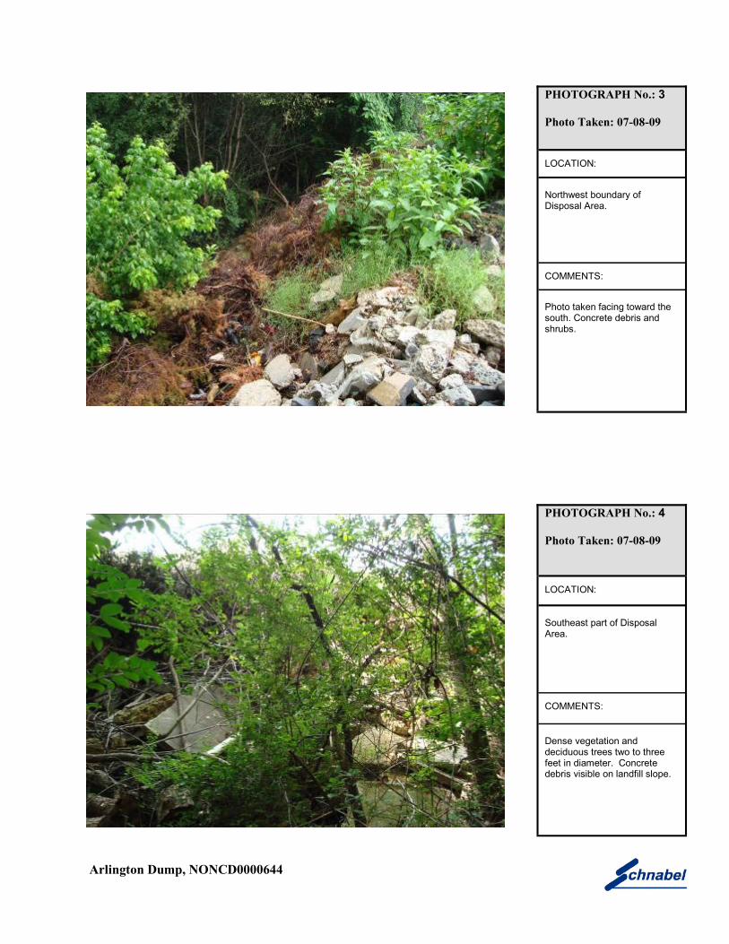
PHOTOGRAPH No.: 3
Photo Taken: 07-08-09
LOCATION:
Northwest boundary of Disposal Area.
COMMENTS:
Photo taken facing toward the south. Concrete debris and shrubs.
PHOTOGRAPH No.: 4
Photo Taken: 07-08-09
LOCATION:
Southeast part of Disposal Area.
COMMENTS:
Dense vegetation and deciduous trees two to three feet in diameter. Concrete debris visible on landfill slope.

Arlington Dump, NONCD0000644
PHOTOGRAPH No.: 5
Photo Taken: 07-08-09
LOCATION:
Southeast part of Disposal Area.
COMMENTS:
Asphalt debris.
PHOTOGRAPH No.: 6
Photo Taken: 07-08-09
LOCATION:
Southwestern boundary of Disposal Area.
COMMENTS:
Furniture and concrete debris located at bottom of landfill slope.

Arlington Dump, NONCD0000644
PHOTOGRAPH No.: 7
Photo Taken: 07-08-09
LOCATION:
Southwestern part of Disposal Area.
COMMENTS:
Metal debris and water heater in dense vegetation.
PHOTOGRAPH No.: 8
Photo Taken: 07-08-09
LOCATION:
Southwestern part of Disposal Area.
COMMENTS:
Discarded tires.

AERIAL PHOTOGRAPHS