Embed Size (px)
Citation preview

9
182 SOUTH DOWNS LOCAL PLAN: ADOPTED 2 JULY 2019 (2014–33)
SITES & SETTLEMENTS
Image: Ditchling High Street. © Richard Reed

1839. sITEs & sETTLEmENTs
INTRODUCTION9.1 This chapter allocates sites for development in line with the spatial strategy of the Local Plan for a medium level of development dispersed across the towns and villages of the National Park. The Local Plan allocations make a substantial contribution to meeting the requirements for Housing, Gypsies, Travellers and Travelling Showpeople and Employment set out in Policies SD26: Supply of Homes, SD33: Gypsies, Travellers and Travelling Showpeople and SD35: Employment Land respectively. Further allocations are made in NDPs.
9.2 The allocations are supported by an extensive and robust evidence base. The principle topic based studies supporting the allocations are the Settlement Facilities Assessment115, SHLAA116, Gypsies, Travellers and Travelling Showpeople Background Paper117, the ELR118 and the SFRA Levels 1119and 2120. A number of other studies relating to the first purpose of the National Park also support the allocations particularly the SDILCA. Finally, a detailed background paper121looks at all the potential housing sites that were considered for allocation in this Plan. There has also been extensive consultation with local communities on the allocations particularly with the town and parish councils.
9.3 There are also many sites allocated for development in NDPs. All the allocated sites are identified on the park-wide Policies Map with further details
115 Settlement Facilities Assessment (South Downs National Park Authority, 2015)116 Strategic Housing Land Availability Assessment (South Downs National Park
Authority, 2016)117 Gypsies, Travellers and Travelling Showpeople Background Paper (South Downs
National Park Authority, 2016)118 Employment Land Review (G.L. Hearn, 2015 and South Downs National Park
Authority, 2017)119 Water Cycle and Strategic Flood Risk Assessment Level 1 (Amec, 2015)120 Strategic Flood Risk Assessment Level 1 Update and Level 2 (Amec Foster Wheeler,
2017)121 Background Paper on Housing Allocations for the South Downs Local Plan (South
Downs National Park Authority, 2018)
shown on Inset Maps. It should be noted that there are also a small number of Local Plan allocations in designated neighbourhood planning areas.
9.4 Three of the allocations in this chapter are identified as strategic housing allocations. They are not critical to achieving the 2050 Vision for the National Park in the same way as the strategic sites, but are nevertheless important locally in terms of regeneration and meeting local housing need.
9.5 The allocations are set out in this chapter by settlement. There is a short introduction to each settlement, which is followed by a brief description of individual sites highlighting key opportunities and constraints, although this is not intended to be exhaustive. Individual policies are set out for each allocation site with development parameters and site specific development requirements with which a planning application would need to comply in order to receive planning permission. Finally, the policy lists specific documents that will be required to support applications for the site.
9.6 It should be noted that relevant policies are not listed for each site, and that it is important for the plan to be read as a whole. All development plan policies will be taken into account in determining planning applications for site allocations, along with other material considerations.
Local Plan ObjectivesThe following Local Plan objectives are considered most relevant for this section:
Objective 4: To achieve a sustainable use of ecosystem services thus enhancing natural capital across the landscapes of the National Park and contributing to wealth and human health and wellbeing
Objective 7: To conserve and enhance the villages and market towns of the National Park as thriving centres for residents, visitors and businesses
Objective 8: To protect and provide for the social and economic wellbeing of National Park communities supporting local jobs, affordable homes and local facilities

184 SOUTH DOWNS LOCAL PLAN: ADOPTED 2 JULY 2019 (2014–33)
ECOSYSTEM SERVICES9.7 Site allocations are recognised as important for achieving conservation and enhancement of the ecosystem services in the National Park. In order to understand how site allocations may affect ecosystem services, it was necessary to map the demands on and opportunities for ecosystem services across the National Park.
9.8 The GIS based tool, EcoServ GIS, a newly developed piece of software, was used which is able to map some ecosystem services. The ecosystem services mapped across the National Park are set out in Figure 9.1.
9.9 EcoServ GIS was first used to identify which allocations are located in areas that provide multiple ecosystem services and are therefore particularly important. Site allocations within these key areas were then analysed further to develop criteria within the policy on matters to conserve and enhance these ecosystem services. Symbols are found at the start of the relevant site allocation policies to show which ecosystem services are identified. The matters to be addressed on ecosystem services will be secured through planning obligation and/or condition. It should also be noted that many of the site specific development requirements relating, for example, to flooding and biodiversity also provide multiple ecosystem services.
FIGURE 9.1: KEY TO ECOSYSTEM SERVICES SYMBOLS
Water Quality/ Water Purification
Pollination Climate Change Regulation
Carbon Storage
Air Quality/ Air Purification
Accessible Natural Green Space
Green Travel
Education Noise Regulation
ALFRISTON9.10 Alfriston is a historic village located in the valley of the River Cuckmere south of the A27 trunk road in the east of the National Park. The Cuckmere valley is narrow and flat bottomed with Alfriston sited above the river on the western bank. Routes within Alfriston are generally on a north-south orientation. Modern development has spread north and west of the historic core. Alfriston has a population of approximately 830 people.

1859. sITEs & sETTLEmENTs
FORMER ALLOTMENTS, ALFRISTON
Site Area: 0.4ha
Current Use: Agricultural buildings and woodland
Environmental Designations: Within 50m of floodplain grazing marsh priority habitat Dark Skies: E0/E1(a)
Flood Risk: Eastern portion of site within fluvial Flood Zones 2 and 3
Historic Environment: Alfriston Conservation Area; Within setting of listed buildings
9.11 The site is located within the historic core of the village. The site is currently under-utilised comprising several poor quality agricultural outbuildings and modest quality woodland.
9.12 The site is within a sensitive area within the Alfriston Conservation Area. Building materials, heights and scale should suitably reflect the design guidance set out in the Alfriston Conservation Area Character Appraisal and Management Plan122. The existing agricultural buildings are not considered worthy of conversion to residential use. There is a high potential for archaeological interest. The eastern boundary of the site should be appropriately landscaped to provide a suitable transition to the river valley.
9.13 Residential development should be sited in the western and central portion of the site outside Flood Zones 2 and 3. It is considered that the area within the allocation site within Flood Zones 2/3 should not be developed. Development proposals will be expected to incorporate SuDS. Due to potential for ground water flooding, attenuation SuDS are probably the most suitable option for this site. The Level 1 Update and Level 2 SFRA provides recommendations for a site specific flood risk assessment and the suitability and design of SuDS.
122 Alfriston Conservation Area Character Appraisal and Management Plan (South Downs National Park Authority, 2014)
9.14 Development must include suitable vehicular access and on-site parking. Proposals should demonstrate that safe vehicular and pedestrian access and egress can be made from the site taking into account flood risk. Where vehicular access is dependent on off-site improvement works these should be sought through a planning obligation. Suitable publicly accessible pedestrian access should be provided through the site to both North Street and the PRoW to the east of the site.
9.15 A TA will be needed to understand the effect of additional trips will have on the surrounding road network. The TA should take full account of local flood risk and identify suitable vehicular access and egress to the site taking full account of the historic roads in the village.
9.16 The allocation site is closely related (50 metres) to a priority habitat (Floodplain Grazing Marsh) associated with the Cuckmere River and other watercourses, and as such may be home to protected species outside the site. An ecological survey of the site will be required to ensure that protected species in the local area will not be harmed and opportunities to enhance biodiversity in line with local strategies are identified.
9.17 The woodland within the site appears to be of modest quality. Development proposals should identify all trees worthy of retention and then be retained within the site. Given the current agricultural use, the extent of land contamination should be assessed and mitigated, where necessary, prior to occupation.
9.18 Development proposals should therefore be informed by the following evidence studies:
� Arboricultural Impact Assessment, Arboricultural Method Statement and associated Tree Protection Plan;
� Archaeological Assessment; � Ecology Assessment including Protected Species Survey; � FRA; � Heritage Statement; � Land Contamination Survey; and � TA.

186 SOUTH DOWNS LOCAL PLAN: ADOPTED 2 JULY 2019 (2014–33)
Allocation Policy SD58: Former Allotments, Alfriston (see map pg 187)
1. Land at the Former Allotments, Alfriston is allocated for the development of 5
to 10 residential dwellings (Class C3 Use). Planning permission will not be granted for any other uses. Detailed proposals that meet the following site specific development requirements will be permitted:a) To conserve and enhance the form and fabric of the Alfriston Conservation
Area and preserve the setting of local heritage assets;
b) Provide a suitably landscaped transition to the river valley;
c) All housing to be located in Flood Zone 1;
d) Safe vehicular and pedestrian access and egress should be provided during flooding;
e) Floor levels of habitable areas, where appropriate and proven necessary, to be designed to take into account flood risk and climate change;
f) A suitable internal road layout which provides for larger vehicles including refuse vehicles;
g) A publicly accessible route should be provided through the site from North Street to the PRoW to the east of the site;
h) To enhance biodiversity and provide for protected species;
i) Protect and enhance trees within the site worthy of retention;
j) To provide all necessary vehicular parking on-site to avoid additional on street parking in local roads; and
k) Flood compensation storage should be provided for any ground raising or built development on Flood Zone 3 (including allowance for future climate change).
2. Proposals which include security gates or other barriers which preclude the residential areas of the development from becoming fully accessible, inclusive and integrated to the local community will not be permitted.
3. In order for the development to have an overall positive impact on the ability of the natural environment to contribute to ecosystem services, development proposals must address the following:a) Where trees are lost, provide higher quality new tree planting on site;
b) New planting should be suitable for pollinating species; and
c) Minimise hard surfaced areas on site, and use permeable surfaces and soft landscaping where possible to maximise infiltration of water and reduce surface water run-off.
1879. sITEs & sETTLEmENTs
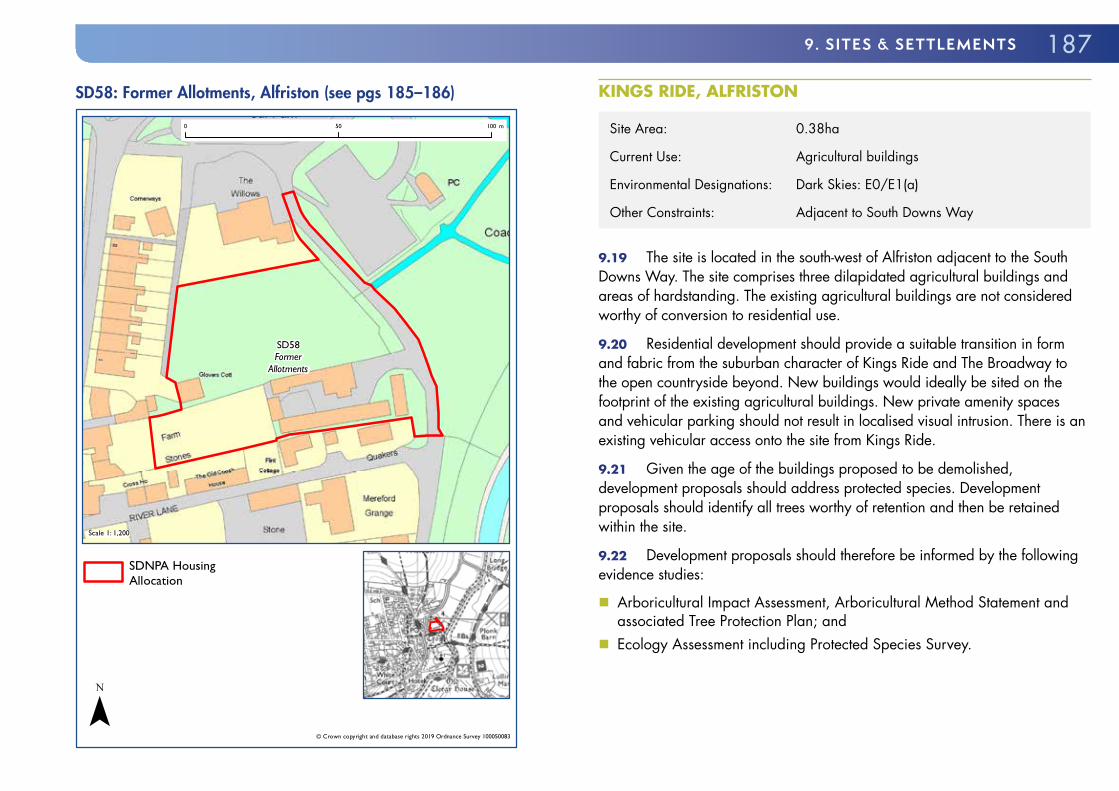
SD58: Former Allotments, Alfriston (see pgs 185–186)
SD58Former
Allotments
Scale 1: 1,200
© Crown copyright and database rights 2019 Ordnance Survey 100050083
0 50 100 m
SDNPA HousingAllocation
¯
KINGS RIDE, ALFRISTON
Site Area: 0.38ha
Current Use: Agricultural buildings
Environmental Designations: Dark Skies: E0/E1(a)
Other Constraints: Adjacent to South Downs Way
9.19 The site is located in the south-west of Alfriston adjacent to the South Downs Way. The site comprises three dilapidated agricultural buildings and areas of hardstanding. The existing agricultural buildings are not considered worthy of conversion to residential use.
9.20 Residential development should provide a suitable transition in form and fabric from the suburban character of Kings Ride and The Broadway to the open countryside beyond. New buildings would ideally be sited on the footprint of the existing agricultural buildings. New private amenity spaces and vehicular parking should not result in localised visual intrusion. There is an existing vehicular access onto the site from Kings Ride.
9.21 Given the age of the buildings proposed to be demolished, development proposals should address protected species. Development proposals should identify all trees worthy of retention and then be retained within the site.
9.22 Development proposals should therefore be informed by the following evidence studies:
� Arboricultural Impact Assessment, Arboricultural Method Statement and associated Tree Protection Plan; and
� Ecology Assessment including Protected Species Survey.

188 SOUTH DOWNS LOCAL PLAN: ADOPTED 2 JULY 2019 (2014–33)
Allocation Policy SD59: Kings Ride, Alfriston
1. Land at Kings Ride, Alfriston is allocated for the development of 6 to 8
residential dwellings (Class C3 Use). Planning permission will not be granted for any other uses. Detailed proposals that meet the following site specific development requirements will be permitted:a) A suitable transition in built form and fabric from the low density
residential development to the east and north and the open countryside to the south and west;
b) Private amenity space and vehicular parking to be suitably sited and landscaped;
c) Boundary treatments appropriate for a site adjacent to open countryside;
d) The existing vehicular access should be retained;
e) The site layout must not include opportunities to provide future vehicular access into adjacent fields;
f) Sufficient easement to the adjacent gas pipeline; and
g) No significant harm to the amenity of the South Downs Way.
2. In order for the development to have an overall positive impact on the ability of the natural environment to contribute to ecosystem services, development proposals must address the following:a) Protect and enhance trees within the site where possible, and where trees
are lost, provide at least the equivalent in new tree planting on site;
b) Minimise hard surfaced areas on site; and
c) New planting that should be suitable for pollinating species.
SD59: Kings Ride, Alfriston (see pgs 187–188)
SD59KingsRide
Scale 1: 1,000
© Crown copyright and database rights 2019 Ordnance Survey 100050083
0 50 100 m
SDNPA HousingAllocation
¯

1899. sITEs & sETTLEmENTs
BINSTED9.23 Binsted is a village in the Western Weald broad area approximately 3.5 miles east of Alton. The village has developed in an L-shape along the old road from Alton eastwards towards Alice Holt. Binsted has a conservation area centred on the Grade I Listed Church. The larger part of the village, including the allocation site, is outside the conservation area. Traditional building materials used in Binsted reflect the location on the edge of the Weald with brick, hung tiles, some malmstone and numerous half-timbered buildings.
LAND AT CLEMENTS CLOSE, BINSTED
Site Area: 0.5ha
Current Use: Paddock
Environmental Designations: Within the East Hampshire Hangers BOA
Within groundwater vulnerability area
Within 5km of Wealden Heaths SPA
Dark Skies: E0/E1(a)
9.24 The site is located to the south of Binsted and is accessed from an existing cul-de-sac with modern houses. The site comprises a modestly sized paddock with mature trees and hedgerows on the southern and eastern boundaries. There is an existing vehicular access onto the site from Clements Close. There are existing cables across the site which will have to be grounded or re-routed to accommodate development.
9.25 The site is not widely visible in the wider landscape and is situated away from the Binsted Conservation Area, however the appropriate use of traditional materials would be supported.
9.26 The site is within 5 kilometres of the Wealden Heath SPA and as such suitable mitigation of the impact of the development should be provided.
9.27 Development proposals should contribute towards t_he aims of the Hampshire Hangers BOA and be informed by the following evidence stud_ies:
� Arboricultural Impact Assessment, Arboricultural Method Statement and associated Tree Protection Plan;
� Archaeological Survey; � Ecology Assessment including Protected Species Survey; and � Project-level HRA.

190 SOUTH DOWNS LOCAL PLAN: ADOPTED 2 JULY 2019 (2014–33)
Allocation Policy SD60: Land at Clements Close, Binsted1. Land at Clements Close, Binsted is allocated for the development of 10 to 12
residential dwellings (Class C3 Use). Planning permission will not be granted for any other uses. Detailed proposals that meet the following site specific development requirements will be permitted:a) Appropriate mitigation of the impact of the development on the Wealden
Heath SPA which should be informed by a Project-level HRA;
b) The existing vehicular access should be retained and the existing on-site cables grounded or appropriately re-routed;
c) Improvements to biodiversity in line with local strategies;
d) To provide all necessary vehicular parking on-site to avoid additional on street parking in local roads; and
e) Provides a pedestrian link to adjoining Footpath 28.
2. In order for the development to have an overall positive impact on the ability of the natural environment to contribute to ecosystem services, development proposals must address the following:a) Protect and enhance trees within the site where possible, and where trees
are lost, provide at least the equivalent in new tree planting on site;
b) Minimise hard surfaced areas on site; and
c) New planting should be suitable for pollinating species.
SD60: Land at Clements Close, Binsted (see pgs 189–190)
SD60Land at
Clements Close
Scale 1: 1,700
© Crown copyright and database rights 2019 Ordnance Survey 100050083
0 50 100 150 m
SDNPA HousingAllocation
¯

1919. sITEs & sETTLEmENTs
NEW BARN STABLES, THE STREET, BINSTED
Site Area: 0.17 ha
Current Use: Permanent site for Gypsies and Travellers
9.28 The site lies just off The Street to the rear of a number of homes of mixed age and style. This is an existing private Gypsy and Traveller site with permanent planning permission for 1 pitch. It is bordered by trees and hedging to the north and east and adjoins a sand school and paddocks to the immediate south and west. Beyond the immediate site lies farmland of mixed field size bordered by hedgerows and field trees.
9.29 The site is accessed from The Street using the existing entrance to the property. On the opposite side of the road are arable fields. The site has a limited, localised effect on landscape character with views of any development from the south being seen within the context of the existing buildings on this and adjoining sites.
9.30 Permission already exists for equestrian related commercial activity on the land and this is not altered by this allocation for a further pitch.
9.31 Development proposals should therefore be informed by the following evidence studies:
� Sewerage and Utilities Assessment
Allocation Policy SD61: New Barn Stables, The Street, Binsted (see map pg 192)1. Land at New Barn Stables, Binsted is allocated for the development of 1
additional permanent Gypsy and Traveller pitch. Planning permission will not be granted for any uses other than the Gypsy and Traveller pitches and those appropriate to the needs of equestrian uses. Detailed proposals that meet the following site specific development requirements will be permitted:a) It must be laid out to ensure sufficient room is available to allow vehicles to
turn around within the site;
b) Surface water drainage must be controlled on site and foul drainage must be effectively treated before discharge;
c) Existing mature trees and hedgerows bordering the site must be retained and reinforced;
d) The development should be occupied only by those who fulfil the definition of a Gypsy or Traveller;
e) Minimise hard surfaced areas on site; and
f) New planting that should be suitable for pollinating species.

192 SOUTH DOWNS LOCAL PLAN: ADOPTED 2 JULY 2019 (2014–33)
SD61: New Barn Stables, The Street, Binsted (see pg 191)
SD61New BarnStables, The
Street, Binsted,Alton, GU34 4PF
Scale 1: 1,200
© Crown copyright and database rights 2019 Ordnance Survey 100050083
0 50 100 m
SDNPA Gypsy andTraveller site allocation
¯
BURITON9.32 Buriton is a nucleated spring line village located on the Greensand Terrace right at the foot of the chalk ridge. The spring line contributes to its character. The historic centre of the village is dominated by a large pond, from which a stream flows northwards, carving a deep and dramatic grassy valley through the terrace. The core of the village is at the point where the lane that forms the main village street bends sharply around the head of that valley. At the village core around the pond are the church and manor house, backing directly onto the foot of the chalk scarp.
9.33 The great majority of the village has been developed in a north-westerly direction along the High Street and Petersfield Road. Further out is a sizeable area of late twentieth-century housing. North east of the core and separated from the main part of the village by the steep valley, there is a further cluster of houses of various ages located a short distance up North Lane. Building materials are diverse, reflecting the position under the chalk scarp, with much use of malmstone.
LAND AT GREENWAY LANE, BURITON
Site Area: Approximately 0.5ha
Current Use: Paddock
Environmental Designations: Dark Skies: E1(a)
9.34 The site is located to the west of Buriton and could be accessed from Greenway Lane. The site comprises a modestly sized paddock with mature hedgerows and some trees. To the east of the site is an existing residential area comprising modern houses. The site has no known environmental designations or constraints.
9.35 All suitable opportunities should be taken to create a new public footpath, parallel to Greenway Lane, between the site and the Greenway Lane railway bridge.

1939. sITEs & sETTLEmENTs
9.36 Development proposals should be informed by the following evidence studies:
� Arboricultural Impact Assessment, Arboricultural Method Statement and associated Tree Protection Plan; and
� LVIA.
Allocation Policy SD62: Land at Greenway Lane, Buriton1. Land at Greenway Lane, Buriton is allocated for the development of 8 to 10
residential dwellings (Class C3 Use). Planning permission will not be granted for any other uses. Detailed proposals that meet the following site specific development requirements will be permitted:a) A suitable transition in built form and fabric from the residential
development to the east and the open countryside to the west, taking account of the guidance set out in the Village Design Statement;
b) Existing mature trees and hedgerows to be retained and enhanced;
c) Boundary treatments appropriate for a site adjacent to open countryside;
d) To provide all necessary vehicular parking on-site to avoid additional on street parking in local roads;
e) New vehicular access from Greenway Lane and new pedestrian access which links to the existing pedestrian route which links Greenway Lane to Glebe Road; and
f) The site layout must not include opportunities to provide future vehicular access into adjacent fields.
SD62: Land at Greenway Lane, Buriton (see pgs 192–193)
SD62Land at
Greenway Lane
Scale 1: 1,600
© Crown copyright and database rights 2019 Ordnance Survey 100050083
0 50 100 150 m
SDNPA HousingAllocation
¯

194 SOUTH DOWNS LOCAL PLAN: ADOPTED 2 JULY 2019 (2014–33)
CHERITON/HINTON MARSH9.37 Cheriton is a historic village located in the Western Downs broad area near the source of the River Itchen and close to the site of a civil war battle in 1644. Cheriton is essentially a linear village along the path of the River Itchen albeit with open areas between parts of the village. The historic core of Cheriton is the northernmost part of the village with a large area of twentieth century housing to the south-east. The smaller settlements of Hinton Marsh and new Cheriton are located south of the A272.
LAND SOUTH OF THE A272 AT HINTON MARSH, CHERITON
Site Area: 0.86ha
Current Use: Residential and paddock
Flood Risk: Groundwater
Environmental Designations: The River Itchen SSSI and SAC priority habitat
(Floodplain grazing marsh) is approximately 150 metres to the west
Dark Skies: E1(a)
Dark Skies: E1(a)
9.38 Land South of the A272 is located in the Hinton Marsh area of Cheriton. The site comprises two existing residential dwellings and curtilage with frontage onto the A272, and to the rear an area of paddocks.
9.39 The site is located in an environmentally sensitive area close to the River Itchen. Suitable evidence should be provided to ensure that development would not be harmful to the River Itchen SSSI and SAC. Given the proximity of the River Itchen development proposals should be supported by suitable protected species surveys and include appropriate biodiversity improvements into the scheme.
9.40 Development should take account of the close proximity of Hinton Ampner House and Gardens with sensitively designed housing and landscape
boundaries on each side of the site. Whilst not historically significant, the existing thatched cottage on the site is considered worthy of retention and offers a sensitive frontage on to the A272.
9.41 Vehicular access should be provided from the A272. In the absence of a suitable pedestrian route on the southern side of the A272 in this area, off-site improvement works to enable safe pedestrian access and egress to the northern side of the A272 may be necessary.
9.42 The Cheriton area is not (as of 2017) on mains drainage. Development proposals will need to demonstrate no significant impact on the local environment.
9.43 The allocation site will come forward in conjunction with suitable public access and landscape improvements to the off-site meadow area through which the River Itchen flows approximately 150 metres to the west. This will be secured through a planning obligation.
9.44 The site is also at risk from groundwater flooding due to winterbournes located within the vicinity of the site. In addition historical borehole records indicate a spring was present on site around 1900. This may reactivate during wet periods. The Level 1 Update and Level 2 SFRA provides recommendations for a site specific flood risk assessment and the suitability and design of SuDS.
9.45 Development proposals should therefore be informed by the following evidence studies:
� Drainage Strategy; � EIA including Protected Species Survey; � Heritage Statement; � LVIA; � Project-level HRA; � FRA; and � TA including Vehicular Access Assessment.

1959. sITEs & sETTLEmENTs
Allocation Policy SD63: Land South of the A272 at Hinton Marsh, Cheriton (see map pg 196)
1. Land South of the A272 at Hinton Marsh, Cheriton is allocated for the
development of 12 to 15 residential dwellings (Class C3 Use). Planning permission will not be granted for any other uses. Detailed proposals that meet the following site specific development requirements will be permitted:a) To demonstrate that there would be no likely significant effect on the River
Itchen SSSI & SAC through development of the site for residential use;
b) Development should provide a suitable transition in built form and fabric from the existing residential areas to the north and west and the open countryside to the south and east;
c) Development should include a suitable area of public open space within the site;
d) A suitable vehicular and pedestrian access;
e) To provide all necessary vehicular parking on-site to avoid additional on street parking;
f) Off-site pedestrian access improvements;
g) Existing mature trees and hedgerows to be retained;
h) To provide suitable on-site foul water and surface water drainage;
i) The location of new housing and access roads to have regard to low lying areas prone to groundwater emergence; and
j) To provide off-site suitable public access to the River Itchen in the area south of the A272 approximately 150 metres to the west of the allocation site.
2. In order for the development to have an overall positive impact on the ability of the natural environment to contribute to ecosystem services, development proposals must address the following:a) Protect and enhance trees within the site where possible, and where trees
are lost, provide at least the equivalent in new tree planting on site. Trees on the site boundary should be retained and new tree planting should be undertaken;
b) Retain suitable existing habitat for pollinating species where possible. New planting should be suitable for pollinating species; and
c) Minimise hard surfaced areas on site, and use permeable surfaces and soft landscaping where possible to maximise infiltration of water and reduce surface water run-off.
196 SOUTH DOWNS LOCAL PLAN: ADOPTED 2 JULY 2019 (2014–33)
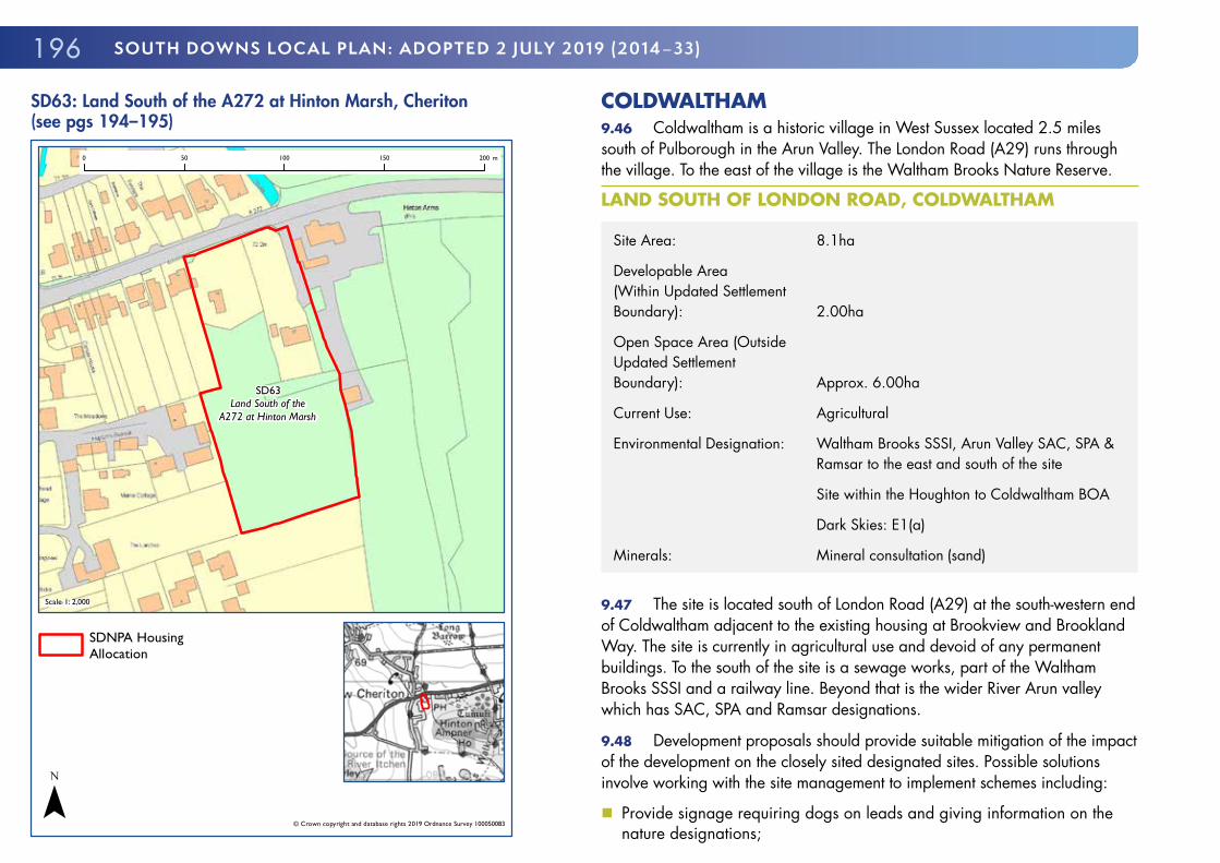
SD63: Land South of the A272 at Hinton Marsh, Cheriton (see pgs 194–195)
SD63Land South of the
A272 at Hinton Marsh
Scale 1: 2,000
© Crown copyright and database rights 2019 Ordnance Survey 100050083
0 50 100 150 200 m
SDNPA HousingAllocation
¯
COLDWALTHAM9.46 Coldwaltham is a historic village in West Sussex located 2.5 miles south of Pulborough in the Arun Valley. The London Road (A29) runs through the village. To the east of the village is the Waltham Brooks Nature Reserve.
LAND SOUTH OF LONDON ROAD, COLDWALTHAM
Site Area: 8.1ha
Developable Area (Within Updated Settlement Boundary): 2.00ha
Open Space Area (Outside Updated Settlement Boundary): Approx. 6.00ha
Current Use: Agricultural
Environmental Designation: Waltham Brooks SSSI, Arun Valley SAC, SPA & Ramsar to the east and south of the site
Site within the Houghton to Coldwaltham BOA
Dark Skies: E1(a)
Minerals: Mineral consultation (sand)
9.47 The site is located south of London Road (A29) at the south-western end of Coldwaltham adjacent to the existing housing at Brookview and Brookland Way. The site is currently in agricultural use and devoid of any permanent buildings. To the south of the site is a sewage works, part of the Waltham Brooks SSSI and a railway line. Beyond that is the wider River Arun valley which has SAC, SPA and Ramsar designations.
9.48 Development proposals should provide suitable mitigation of the impact of the development on the closely sited designated sites. Possible solutions involve working with the site management to implement schemes including:
� Provide signage requiring dogs on leads and giving information on the nature designations;

1979. sITEs & sETTLEmENTs
� Funding for leaflets regarding recreational disturbance, to be delivered to new householders;
� Funding for Take the Lead Campaign, dog ambassadors and the provision of dog bins; and
� Ten year monitoring programme of dog numbers visiting the SSSI and of any changes to subsequent management burden arising from an increase in dog numbers.
9.49 The designated sites are sensitive to change in local hydrology and as such development proposals should incorporate suitable surface water and foul water drainage. The site should provide between 25 and 30 dwellings and associated open space. The open space will be secured in perpetuity through a planning obligation. It should be noted that the proposed area of open space is located outside the settlement boundary for Coldwaltham as defined on the Policies Map.
9.50 The site itself is of biodiversity value and any development proposal will need to be demonstrably guided by the existing nature conservation interest of the site, which will be informed by appropriate survey. It will be necessary to design the development to maximise existing habitats and species and retain a large proportion of undeveloped land for the purpose of retaining and enhancing biodiversity. It is of key importance therefore that the development itself and the residual open space are designed around the existing biodiversity value and not to provide amenity grassland except for that area adjacent to the south west boundary of the new homes. This must be carefully designed in order to provide a net gain in biodiversity at the local level.
9.51 The allocation site is also located in a wider area identified as a groundwater SPZ. Development proposals will need to demonstrate no significant impact on groundwater resources.
9.52 The National Park Authority has produced a Development Brief123125 for the allocation site and will expect proposals to accord with the Brief. The site has medium/high to high landscape sensitivity and as such will need to
123 125 Land South of London Road, Coldwaltham Development Brief (South Downs National Park Authority, 2018)
come forward within a robust and appropriate landscape and townscape led development strategy. The northern, western and southern boundaries of the site each have specific landscape sensitivities, which development must respond to and reinforce where appropriate.
9.53 The site has a settlement separation function between Coldwaltham and the nearest settlement to the west, Watersfield. Development must retain and improve that sense of separation between the two settlements.
9.54 Residential development should reinforce local distinctiveness and respond to the local character and vernacular in West Sussex through the predominant use of traditional materials. To optimise the potential of the residential area it should incorporate high quality, appropriately scaled, and inclusive public open space.
9.55 The westernmost and southern portions of the site should be retained as landscaped open space to be secured permanently through a suitable planning obligation. The form of that open space should be informed by local community engagement and biodiversity evidence. The open space should provide a suitable transition from the existing and proposed residential areas to the Waltham Brooks SSSI.
9.56 Vehicular access to the site should be from a new access from the A29. Development should provide suitable pedestrian and cycle routes to connect to existing residential areas and the adjacent open countryside. The proposal should incorporate a new pedestrian route from the A29 into the public open space which links into the wider countryside.

198 SOUTH DOWNS LOCAL PLAN: ADOPTED 2 JULY 2019 (2014–33)
9.57 Development provides an opportunity to improve the quality of the public realm of the residential area to the east. Existing boundary treatments not formed by mature trees and hedgerows should be removed and replaced, where appropriate, with suitable alternatives. Improvements to the existing children’s play area in the adjacent housing area would be preferred to new provision within the proposed residential area.
9.58 The development, both the residential areas and open space, should provide suitable biodiversity improvements in line with local strategies.
9.59 Development proposals should therefore be informed by the following evidence studies:
� Arboricultural Impact Assessment, Arboricultural Method Statement and associated Tree Protection Plan;
� Ecology Assessment including Protected Species Survey; � FRA including Surface Water Management Plan; � Hydrological Survey; � LVIA; and � Project-level HRA.
Allocation Policy SD64: Land South of London Road, Coldwaltham (see map pg 199)1. Land South of London Road, Coldwaltham, is allocated for the development
of 25 to 30 residential dwellings (Class C3 Use). Development for a Class A1 (Shop) unit with a net sales floorspace up to a maximum of 280m² with suitable vehicular parking for customers will also be permitted. The remainder of the allocation site should be retained as open space. Planning permission will not be granted for any other uses.
2. Detailed proposals that meet the following site specific development requirements will be permitted:a) To demonstrate that there would be no likely significant effect on the
Waltham Brookes Site of Special Scientific Interest (SSSI), the Amberley Wild Brooks SSSI, and no adverse effects on the integrity of The Mens Special Area of Conservation (SAC) and the Arun Valley SAC, SPA and Ramsar Site and that suitable mitigation, where deemed necessary, will be secured through planning obligations and/or planning conditions;
b) Development must be informed by a comprehensive landscape and design strategy and through reinforcing local distinctiveness provide a suitable transition in form and fabric from the existing residential areas to the east and the open countryside to the north, west and south;
c) Development must be demonstrably biodiversity-led and guided by the biodiversity value of the site. It will be necessary to design the development to maximise existing habitats and species and retain a large proportion of undeveloped land for the purpose of retaining and enhancing biodiversity;
d) To provide the residual area of the allocation as open space with the primary purpose of retaining and enhancing the existing biodiversity value of the site and to provide an alternative to designated sites in the Arun Valley;
e) To provide a new vehicular and pedestrian access from the A29 London Road and suitable pedestrian & cycle links to the rest of the settlement and adjacent open countryside;

1999. sITEs & sETTLEmENTs
f) To provide all necessary vehicular parking on-site to avoid additional on street parking in adjacent residential areas;
g) To provide appropriate biodiversity improvements reflecting relevant national and local strategies including a meadow management plan;
h) Existing mature trees and hedgerows to be retained and enhanced;
i) To provide suitable flood risk mitigation;
j) Demonstrate no significant harm to be caused to groundwater resources;
k) Improvements to the public realm of the adjacent housing area including removing existing boundary treatments and replaced with suitable alternatives where appropriate;
l) Demonstrate that the proposal would not have a significant harmful impact on the supply of local minerals;
m) Foul drainage to connect to the mains system at the nearest point of capacity;
n) Provide suitable SuDS to protect adjacent sites with nature conservation designations from adverse hydrological impacts and is designed to incorporate existing biodiversity;
o) Provide adequate separation between Coldwaltham Wastewater Treatment Works and the development to allow odour dispersion on the basis of an odour assessment to be undertaken in consultation with Southern Water; and
p) Provide future access to the existing sewerage infrastructure for maintenance and upsizing purposes.
3. The National Park Authority has prepared a Development Brief to assist the delivery of the site. Development proposals in broad conformity with the Development Brief will be permitted.
SD64: Land South of London Road, Coldwaltham (see pgs 196–199)
SD64Land South ofLondon Road
Scale 1: 5,700
© Crown copyright and database rights 2019 Ordnance Survey 100050083
0 50 100 150 200 250 300 350 400 450 500 m
SDNPA HousingAllocation
I I Mixed Use Allocation(SD64) – open space
¯

200 SOUTH DOWNS LOCAL PLAN: ADOPTED 2 JULY 2019 (2014–33)
DROXFORD9.60 Droxford is an historic village located in the Dip Slope broad area on the upper reaches of the River Meon. For much of its history the manor was a possession of the Bishops of Winchester. The village is essentially linear in form, originally built on a raised terrace slightly elevated from the river. Droxford is particularly noteworthy for its collection of well-preserved eighteenth and early nineteenth century domestic architecture.
LAND AT PARK LANE, DROXFORD
Site Area: 1.04ha
Current Use: Agricultural buildings
Flood Risk: Surface water flood risk across centre of site and groundwater flood risk
Other Constraints: Adjacent to Droxford Conservation Area
Wayfarers Way long distance footpath
Environmental Designations: Dark Skies: E1(a)
9.61 The site is located to the west of the historic core of Droxford adjacent to the Junior School on Park Lane. Park Lane is a narrow country lane lined with mature hedgerows which restrict views into the allocation site.
9.62 The site is located in a sensitive area adjacent to the Droxford Conservation Area boundary. Given the proximity of the site to the conservation area it is considered appropriate for building materials, heights and scale to suitably reflect the design guidance set out in the Conservation Area Appraisal124126. Given that Droxford is noted for its historic domestic architecture it is considered that the allocation site provides a good opportunity to reinterpret this using historic building materials and vernacular. There is also a high potential for archaeological interest.
124 126 Droxford Conservation Area Character Appraisal and Management Plan (South Downs National Park Authority, 2015)
9.63 The centre of the development site is identified as having surface water flood risk and as such proposals should include suitable mitigation. The site is located in a wider area identified as having groundwater vulnerability and as such proposals should demonstrate no significant harm to water resources. The Level 1 Update and Level 2 SFRA provides recommendations for a site specific flood risk assessment and suitability and design of SuDS.
9.64 A TA will be required to understand what effect the additional trips generated by the development will have on the operation of Park Lane and more importantly the impact on the Park Lane/Police Station Lane junction and surrounding road network, and taking account of the Junior School. The precise number and type of homes should be informed by this evidence, and ensure that safe access can be achieved to proposed and existing development accessed via Park Lane.
9.65 Development should include suitable vehicular access taking account of the narrow character of Park Lane. Where vehicular access is dependent on off-site improvement works these should be sought through a planning obligation. Development should be served by sufficient suitable off-street vehicular parking to avoid additional pressure on Park Lane.
9.66 Park Lane forms part of the Wayfarers Way long distance footpath. Development must not harm the amenity of this long distance route.
9.67 Development proposals should therefore be informed by the following evidence studies:
� Arboricultural Impact Assessment, Arboricultural Method Statement and associated Tree Protection Plan;
� Archaeological Assessment; � FRA; � Heritage Statement; � Highways Assessment; � LVIA; and � TA.

2019. sITEs & sETTLEmENTs
Allocation Policy SD65: Land at Park Lane, Droxford (see map pg 202)
1. Land at Park Lane, Droxford is allocated for the development of approximately
26 residential dwellings (Class C3 Use) provided that this level of development is supported by a TA demonstrating that safe access can be achieved, and that the design is of a high quality which sympathetically conserves and enhances the setting of local heritage assets. Planning permission will not be granted for any other uses with the exception of a small area of community parking in that part of the site adjacent to Park Lane.
2. Detailed proposals that meet the following site specific development requirements will be permitted:a) The conservation and enhancement of the setting of local heritage assets
including the Droxford Conservation Area;
b) A suitable transition in built form and fabric from the residential areas to the north and east and the open countryside to the south and west;
c) Safe pedestrian and vehicular access and egress, which where this is dependent on off-site highways improvements will be secured through suitable planning obligations;
d) Provision of all necessary vehicular parking on-site to avoid additional on street parking in local roads;
e) The location of new housing and access roads to have regard to areas prone to surface water flooding and potential groundwater emergence;
f) Demonstrate no significant harm to be caused to groundwater resources;
g) No significant harm to the amenity of the adjacent Wayfarer’s Way; and
h) No significant harm to the amenity of users of the adjacent school.
3. In order for the development to have an overall positive impact on the ability of the natural environment to contribute to ecosystem services, development proposals must address the following:a) Protect and enhance hedgerows and trees within the site where possible,
and where they are lost, provide at least the equivalent in new planting on site;
b) Minimise hard surfaced areas on site; and
c) New planting should be suitable for pollinating species.

202 SOUTH DOWNS LOCAL PLAN: ADOPTED 2 JULY 2019 (2014–33)
SD65: Land at Park Lane, Droxford (see pgs 200–201)
SD65Land at Park
Lane
Scale 1: 2,000
© Crown copyright and database rights 2019 Ordnance Survey 100050083
0 50 100 150 200 m
SDNPA HousingAllocation
¯
EASEBOURNE9.68 Easebourne is located in the Western Weald broad area and is one of the National Park’s larger villages with a population of just under 2,500. It is a historic estate village north of Midhurst and the centre of the Cowdray Estate, which includes Cowdray Park a Registered Historic Park and Garden. The core of Easebourne is a conservation area notable for its numerous old sandstone buildings. The Ruins of Cowdray Park, the Priory, the Refectory and Easebourne Parish Church of St. Mary’s are all Grade I buildings. Easebourne has a distinctive local vernacular comprising many historic buildings which utilises the local sandstone and the notable yellow ‘Gold Cup’ painted window frames of many of the Cowdray Estate cottages.
COWDRAY WORKS YARD, EASEBOURNE
Site Area: Approximately 0.9ha
Current Use: Commercial
Flood Risk: Surface water flood risk through western part of site and groundwater flood risk
Historic Environment: Area of high archaeological interest; Site adjacent to Easebourne Conservation Area (north and west); Listed buildings (7) closely related to the site; Site adjacent to Cowdray House Registered Park & Garden (south and east)
9.69 The site is considered suitable for mixed-use development including housing and commercial use. The floorspace for each commercial use class will be limited to a maximum amount.
9.70 The allocation site is previously developed land closely related to a number of significant heritage assets including the Easebourne Conservation Area, Cowdray Park and the Grade I Listed Easebourne Priory, Refectory and St Mary’s Church. As such, the design of development proposals should be fully informed by suitable landscape, townscape and historic environment analysis which takes full account of the setting and significance of these

2039. sITEs & sETTLEmENTs
heritage assets. A Conservation Area Character Appraisal and Management Plan is currently being prepared for Easebourne and the application should pay due regard to this when it is published.
9.71 Given the high quality of the form and fabric of Easebourne it is expected that development proposals should be of a high standard in terms of architecture, townscape and public realm. Development proposals should be inclusively designed by providing publicly accessible pedestrian routes from Easebourne Lane through to Cowdray Park where there is a PRoW close to the site boundary.
9.72 The site has also high archaeological interest and as such development proposals should be supported by on-site field surveys. The western part of the development site is identified as having surface water flood risk. The site is also vulnerable from groundwater emergence associated with the dry valley aligned with Easebourne Lane and Easebourne Street. As such, proposals should include suitable flood risk mitigation. The Level 1 Update and Level 2 SFRA provides recommendations for a site specific flood risk assessment and the suitability and design of SuDS. Development proposals should be supported by a site-specific flood risk assessment and will be expected to incorporate sustainable drainage to address surface water.
9.73 Development proposals should include suitable vehicular access, on-site parking and suitable pedestrian access to Cowdray Park. Proposals for commercial use should include sensitively designed outside storage and vehicular parking. Given the existing commercial use of the site development proposals should be supported by a land contamination survey.
9.74 Development proposals should therefore be informed by the following evidence studies:
� Archaeological Assessment; � FRA; � Heritage Statement; � LVIA; � Land Contamination Survey; and � SFRA and Management Plan.
Allocation Policy SD66: Cowdray Works Yard, Easebourne (see map pg 204)
1. Land at the Cowdray Works Yard, Easebourne is allocated for mixed use
development including 16 to 20 residential dwellings (Class C3 Use) and commercial buildings (Class A1, A3 and B1 Uses only) with a total net floorspace of up to 1,500m². Development for Class A1 (Shop) units and Class A3 (Food and Drink) with a net sales floorspace up to a maximum of 280m² for each will be permitted in principle. The design of the proposed form and fabric will be of a high quality, which sympathetically conserves and enhances the setting of local heritage assets. Planning permission will not be granted for any other uses.
2. Detailed proposals that meet the following site specific development requirements will be permitted:a) A publicly accessible pedestrian route from Easebourne Lane through to
Cowdray Park;b) Provision of all necessary vehicular parking on-site to avoid additional on
street parking in Easebourne; c) The location of new housing and access roads to have regard to areas of
surface water flooding and potential groundwater emergence; andd) SuDS to mitigate risk of surface water flooding.
3. Proposals which include security gates or other barriers which preclude the residential areas of the development from becoming fully accessible, inclusive and integrated to the local community will not be permitted.
4. In order for the development to have an overall positive impact on the ability of the natural environment to contribute to ecosystem services, development proposals must address the following:a) Maximise available space for new tree planting particularly at the site
boundaries;b) Minimise hard surfaced areas on site; andc) New planting should be suitable for pollinating species.

204 SOUTH DOWNS LOCAL PLAN: ADOPTED 2 JULY 2019 (2014–33)
SD66: Cowdray Works Yard, Easebourne (see pgs 202–203)
SD66Cowdray Works
Yard
Scale 1: 2,000
© Crown copyright and database rights 2019 Ordnance Survey 100050083
0 50 100 150 200 m
SDNPA HousingAllocation
¯
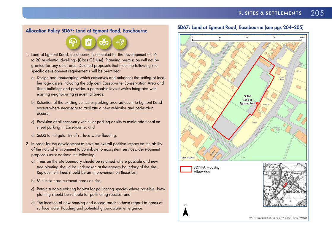
LAND AT EGMONT ROAD, EASEBOURNE
Site Area: 0.7 haCurrent Use: Paddock; Car parkingFlood Risk: Surface water flood risk on western and southern boundariesHistoric Environment: Adjacent to Easebourne Conservation Area; Listed buildings adjacent to the site
9.75 The site is located on the western side of Easebourne Lane in a predominantly residential area. The eastern and northern boundaries of the site are contiguous with the Easebourne Conservation Area. On the eastern boundary of the site are two listed houses. There is an additional listed house to the north of the site, which is visible to and from the site. The residential areas to north, west and south predominantly comprise two-storey, twentieth century housing. To the north and north-west of the site is an extensive area of backland parking and garaging of generally low townscape value. To the south of the site is an existing school.
9.76 The site is currently under-utilised and provides an opportunity through a well-designed residential scheme to improve the overall quality of the local townscape and pedestrian accessibility. Development proposals should also conserve and enhance local heritage assets including the setting of the Easebourne Conservation Area and adjacent listed buildings.
9.77 Development should include suitable vehicular access, on-site parking and pedestrian routes to improve permeability of the wider area. The lowermost part of the site, and the proposed access is at risk of surface water flooding. There is also groundwater emergence vulnerability associated with the dry valley aligned with Easebourne Street and Easebourne Lane. As such, proposals should include flood risk mitigation. The Level 1 Update and Level 2 SFRA provides recommendations for a site specific flood risk assessment and the suitability and design of SuDS.
9.78 Development proposals should therefore be informed by the following evidence studies:
� Heritage Statement; and � Surface Water Management Plan and FRA.
2059. sITEs & sETTLEmENTs
Allocation Policy SD67: Land at Egmont Road, Easebourne
1. Land at Egmont Road, Easebourne is allocated for the development of 16
to 20 residential dwellings (Class C3 Use). Planning permission will not be granted for any other uses. Detailed proposals that meet the following site specific development requirements will be permitted:a) Design and landscaping which conserves and enhances the setting of local
heritage assets including the adjacent Easebourne Conservation Area and listed buildings and provides a permeable layout which integrates with existing neighbouring residential areas;
b) Retention of the existing vehicular parking area adjacent to Egmont Road except where necessary to facilitate a new vehicular and pedestrian access;
c) Provision of all necessary vehicular parking on-site to avoid additional on street parking in Easebourne; and
d) SuDS to mitigate risk of surface water flooding.
2. In order for the development to have an overall positive impact on the ability of the natural environment to contribute to ecosystem services, development proposals must address the following:a) Trees on the site boundary should be retained where possible and new
tree planting should be undertaken at the eastern boundary of the site. Replacement trees should be an improvement on those lost;
b) Minimise hard surfaced areas on site;
c) Retain suitable existing habitat for pollinating species where possible. New planting should be suitable for pollinating species; and
d) The location of new housing and access roads to have regard to areas of surface water flooding and potential groundwater emergence.
SD67: Land at Egmont Road, Easebourne (see pgs 204–205)
SD67Land at
Egmont Road
Scale 1: 2,000
© Crown copyright and database rights 2019 Ordnance Survey 100050083
0 50 100 150 200 m
SDNPA HousingAllocation
¯

206 SOUTH DOWNS LOCAL PLAN: ADOPTED 2 JULY 2019 (2014–33)
FORMER EASEBOURNE SCHOOL, EASEBOURNE
Site Area: Approximately 2.1ha
Current Use: Former school buildings and grounds
Flood Risk: Surface water flood risk in Easebourne Lane and groundwater flood risk
Historic Environment: Site partly within, and partly adjacent to, the Easebourne Conservation Area; Listed school building Grade II listed; Listed cottage adjacent to site boundary
9.79 The site comprises a disused former school and school grounds located on the western side of Easebourne Street to the north-east of the core of the village. Easebourne Street has an, essentially, rural character with many vernacular cottages interspersed with larger historic houses and some modern dwellings. There are a number of listed houses on Easebourne Lane with particular concentrations to the south-west and north-east of the allocation site. To the west and east is open countryside.
9.80 The former school buildings are located north-east of a gap in built form across Easebourne Lane. Development proposals should retain this gap whilst including suitable frontage development. The northern portion of the allocation site including the existing areas of hardstanding is considered suitable for redevelopment. The southernmost portion of the site is considered suitable for 2 residential dwellings.
9.81 Given the high quality of the form and fabric of Easebourne Conservation Area it is expected that development proposals should be of a high standard in terms of design and landscaping. Areas considered suitable for frontage development include the portion of the site between the more southern of the two existing vehicular entrance and Bellings Barn, and the existing area of hardstanding adjacent to the neighbouring listed cottage. New frontage buildings could be reasonably staggered with no particular building line in Easebourne Street.
9.82 The listed core of the school building is considered suitable for residential conversion. Any scheme must demonstrate the enhancement and long-term conversion and integrity of the listed building and its setting. The demolition of the modern elements of the school building would improve the setting of the adjacent listed buildings and the Easebourne Conservation Area within which they are located. It is considered that the redevelopment of the area incorporating the footprint of the modern school buildings and areas of hardstanding would be best served by a scheme which predominantly reflected the various local estate dwelling vernaculars or suitably reinterpreted it for the twenty-first century.
9.83 Development proposals must include sufficient on-site vehicular parking to avoid on-street parking in Easebourne Lane. Development which incorporates the existing vehicular accesses would be preferred. The reprofiling of the existing vehicular access from Easebourne Lane to the large area of hardstanding adjacent to the school buildings is acceptable subject to suitable landscape improvements. Given the lack of a footway on Easebourne Lane, the opportunity to provide a new footpath/cycle path linking the site to Glaziers Lane to the west of the site should be explored.
9.84 Some small areas of the site, and the proposed access, are at risk of surface water flooding. There is also groundwater emergence vulnerability associated with the dry valley aligned with Easebourne Valley and Easebourne Lane. As such, proposals should include suitable flood risk mitigation. Development proposals will be expected to incorporate Sustainable Drainage Systems to address surface water flood risk. The Level 1 Update and Level 2 SFRA provides recommendations for a site specific FRA and the suitability and design of SuDS.
9.85 Development proposals should therefore be informed by the following evidence studies:
� FRA and Surface Water Management Plan; � Heritage Statement; and � LVIA.

2079. sITEs & sETTLEmENTs
Allocation Policy SD68: Former Easebourne School, Easebourne
1. Land at the former Easebourne School is allocated for the development of
16 to 20 residential dwellings (Class C3 Use) including the conversion of the listed portion of the existing school building. Planning permission will not be granted for any other uses. Detailed proposals that meet the following site specific development requirements will be permitted:a) Development proposals should conserve and enhance the setting of local
heritage assets including the Easebourne Conservation Area and listed buildings;
b) The central portion of the site shall be retained as an appropriately scaled open visual gap across the site;
c) Frontage development will be permitted either side of this open visual gap;
d) Retention of the southernmost existing vehicular access;
e) The location of new housing and access roads to have regard to areas of surface water flooding and potential groundwater emergence; and
f) The development should provide a new appropriately-designed through-footpath and cycle link for residents of the development between the site and Glaziers Lane.
2. In order for the development to have an overall positive impact on the ability of the natural environment to contribute to ecosystem services, development proposals must address the following:a) Protect and enhance trees within the site where possible, and where trees
are lost, provide at least the equivalent in new tree planting on site; and
b) New planting should be suitable for pollinating species.
SD68: Former Easebourne School, Easebourne (see pgs 206–207)
SD68Former
Easebourne School
Scale 1: 3,500
© Crown copyright and database rights 2019 Ordnance Survey 100050083
0 50 100 150 200 250 300 350 m
SDNPA HousingAllocation
¯

208 SOUTH DOWNS LOCAL PLAN: ADOPTED 2 JULY 2019 (2014–33)
FINDON9.86 Findon is a medium size village located in the Dip Slope broad area of the National Park. The present village developed in the late middle ages on a junction of historic roads, and is focused around a compact, historic village core (The Square), which has a number of small shops, pubs and a post office. The historic hamlet of Nepcote also falls within the settlement boundary to the north. From the 19th century, the village has become renowned for its annual Sheep Fair on Nepcote Green and as a centre for racehorse training and equestrian activities. The settlement underwent significant residential expansion during the 20th century, such that much of the village is now characterised by more modern estates and architectural styles.
9.87 Findon Parish Council produced an NDP, which was ‘made’ in 2016. The Findon NDP does not, however, set a settlement boundary nor allocate housing sites. The National Park Authority is therefore determining a settlement boundary and housing site allocations through the Local Plan.
LAND AT ELM RISE, FINDON
Site Area: 0.7ha
Current Use: Paddock
Environmental Designation: Within wider area of various Protected Notable Species
Within South Downs Way Nature Improvement Area
Within EA SPZ
Flood Risk: Groundwater or surface water flooding to access
9.88 The site is located to the north east of the village core, and is bordered on three sides by residential development. The northern boundary borders a larger area of paddocks to the north, along which mature hedgerows provide significant screening. The site provides good opportunity to provide modest-sized dwellings.
9.89 The site can be seen from the A280 Long Furlong to the west, however these views are in the context of existing residential development sitting above the site to the east. As the site is more elevated at its eastern part, there is potential to impact on views from the public bridleway crossing fields to the north. It will be important that development enhances these views. The more substantial built elements of development should be focused on the western and southern parts of the site, where the land sits lower in the landscape and is well-screened. Single-storey housing will be encouraged in the more elevated parts of the allocation site.
9.90 The site has potential to provide valuable wildlife habitats, and is within a wider area of Protected Notable Species. An ecological survey of the whole site will be required to ensure that development enhances opportunities for these species to flourish. The site is also at risk of potential surface water or groundwater flooding to access. A site specific FRA should therefore accompany any planning application for this site and should particularly consider the flood risk to access and egress. The Level 1 Update and Level 2 SFRA provides recommendations for a site specific FRA and the suitability and design of SuDS.
9.91 Development of the site would give opportunity to provide a new publicly accessible footpath from Elm Rise to the northern end of Stable Lane, via the existing track to the immediate north-east corner of the site, to create a new link from the village to open downland to the east. This is considered appropriate to comply with Policy SD20: Walking, Cycling and Equestrian Routes. Public open space should be incorporated along this corridor, in a way that integrates with the wider site layout and public realm within the site.
9.92 Development proposals should therefore be informed by the following evidence studies:
� Landscape Assessment; � Ecology Survey and Protected Species Survey; � LVIA; and � FRA.

2099. sITEs & sETTLEmENTs
Allocation Policy SD69: Land at Elm Rise, Findon
1. Land at Elm Rise, Findon is allocated for the development of between 14
and 18 residential dwellings (Class C3 Use). Planning permission will not be granted for any other uses. Detailed proposals that meet the following site specific development requirements will be permitted:a) To enhance biodiversity, and in particular provide for local notable and
protected species;
b) Development should be focused on the western and southern parts of the site, and provide a suitably landscaped transition to more elevated areas;
c) Demonstrate no significant harm to be caused to groundwater resources;
d) Vehicular access should be provided via existing access from Elm Rise; and
e) The development should provide public green space integrated with an attractive, publicly accessible through-footpath and cycle link between Elm Rise and the northern end of Stable Lane.
2. In order for the development to have an overall positive impact on the ability of the natural environment to contribute to ecosystem services, development proposals must address the following:a) Protect and enhance trees within the site where possible, and where trees
are lost, provide at least the equivalent in new tree planting on site. Trees on the site boundary should be retained and new tree planting should be undertaken;
b) Minimise hard surfaced areas on site, and use permeable surfaces and soft landscaping where possible to maximise infiltration of water and reduce surface water run-off; and
c) New planting should be suitable for pollinating species.
SD69: Land at Elm Rise, Findon (see pgs 208–209)
SD69Land at Elm
Rise
Scale 1: 1,800
© Crown copyright and database rights 2019 Ordnance Survey 100050083
0 50 100 150 m
SDNPA HousingAllocation
¯

210 SOUTH DOWNS LOCAL PLAN: ADOPTED 2 JULY 2019 (2014–33)
SOLDIERS FIELD HOUSE, FINDON
Site Area: 0.6ha
Current Use: Single residential plot with large house
Environmental Designations: Within wider area of various Protected Notable Species
Within South Downs Way Nature Improvement Area
Within EA SPZ
Flood Risk: Parts of site susceptible to surface water and groundwater flooding
Groundwater or surface water flooding
9.93 The site is located on the eastern edge of the village and comprises a large residential plot, consisting of a large, modern house and garden enclosed on all sides by a substantial beech hedge.
9.94 The site is visible from the public footpath network around Cissbury Ring. It is also visible from, and therefore within the setting of, the Grade II Listed Wattle House on the edge of Nepcote Green. The existing building is prominent from these viewpoints, and is not considered to be of an architectural quality that benefits the site and local area.
9.95 Redevelopment of the site provides an opportunity to deliver modest-sized dwellings that better meet local housing needs. It also provides opportunity to improve the character of the area and enhance views of the site, through a design and layout that better responds to the traditional architectural styles seen in Findon.
9.96 Development proposals should be accompanied by a detailed LVIA to ensure short-term and long-term enhancement of the site’s setting. The existing beech hedge should be retained until improved and mature landscaping and screening, using native species, has been achieved through implementing the landscape plan.
9.97 The site as exists is not likely to provide significant wildlife interest, however the wider area hosts Protected Notable Species. Proposals should enhance biodiversity by creating new habitats and subsistence, particularly for notable species in the area. Some parts of the site are at potential risk from surface and groundwater flooding. Proposals should incorporate sustainable drainage systems to address surface water flooding and preserve the integrity of the SPZ. The Level 1 Update and Level 2 SFRA provides recommendations for a site specific FRA and the suitability and design of SuDS.
9.98 Access to the site is via a private single-track road (Soldiers Field Lane). A Transport Assessment will be required to confirm the trips generated by the proposals and the effect on the Lane and surrounding road network. Development proposals should suitably address any highway safety or access issues identified.
9.99 Development proposals should therefore be suitably informed by the following evidence studies:
� Archaeological Assessment; � Ecology Assessment and Protected Species Survey; � LVIA; � Transport Statement; and � FRA.
2119. sITEs & sETTLEmENTs
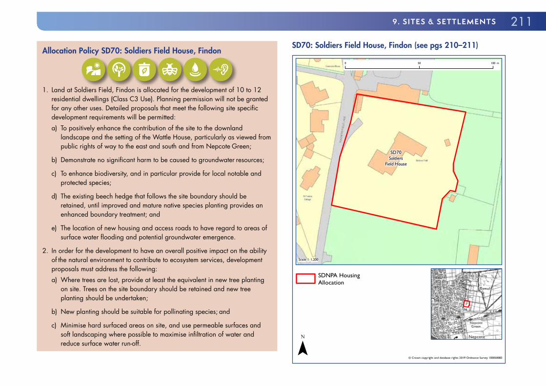
Allocation Policy SD70: Soldiers Field House, Findon
1. Land at Soldiers Field, Findon is allocated for the development of 10 to 12
residential dwellings (Class C3 Use). Planning permission will not be granted for any other uses. Detailed proposals that meet the following site specific development requirements will be permitted:a) To positively enhance the contribution of the site to the downland
landscape and the setting of the Wattle House, particularly as viewed from public rights of way to the east and south and from Nepcote Green;
b) Demonstrate no significant harm to be caused to groundwater resources;
c) To enhance biodiversity, and in particular provide for local notable and protected species;
d) The existing beech hedge that follows the site boundary should be retained, until improved and mature native species planting provides an enhanced boundary treatment; and
e) The location of new housing and access roads to have regard to areas of surface water flooding and potential groundwater emergence.
2. In order for the development to have an overall positive impact on the ability of the natural environment to contribute to ecosystem services, development proposals must address the following:a) Where trees are lost, provide at least the equivalent in new tree planting
on site. Trees on the site boundary should be retained and new tree planting should be undertaken;
b) New planting should be suitable for pollinating species; and
c) Minimise hard surfaced areas on site, and use permeable surfaces and soft landscaping where possible to maximise infiltration of water and reduce surface water run-off.
SD70: Soldiers Field House, Findon (see pgs 210–211)
SD70Soldiers
Field House
Scale 1: 1,200
© Crown copyright and database rights 2019 Ordnance Survey 100050083
0 50 100 m
SDNPA HousingAllocation
¯

212 SOUTH DOWNS LOCAL PLAN: ADOPTED 2 JULY 2019 (2014–33)
GREATHAM9.100 Greatham is a village about 6 miles north of Petersfield with a population of about 800 people. Greatham has a public house, primary school and village hall. It is a linear village of the Western Weald which runs along the old main Petersfield to Farnham road, straddling two distinct landscape areas. The older part of the village to the west, much of which is covered by a conservation area, lies among the gently rolling fields of the Mixed Farmland and Woodland Vale landscape area, with many mature trees and distant views of the Hangers. Traditional building materials here include much use of sandstone.
9.101 Further north east, beyond the valley of a tributary of the Rother, the housing along the road becomes newer and denser as the land rises to sandy oak, birch and pine woods in the Wealden Farmland and Heath Mosaic landscape area, part of which are designated local wildlife sites. The eastern end of the village is in close proximity to land used by military. On the northern and eastern edge of the settlement is the Woolmer Forest SAC and the Wealden Heaths Phase II SPA.
LAND AT PETERSFIELD ROAD, GREATHAM
Site Area: 2.4ha
Current Use: Horticultural nursery
Environmental Designations: Adjacent to Rother Valley BOA
Wealden Heaths Phase II SPA
Groundwater SPZ
Dark Skies: E0
Flood Risk: Risk of surface water flooding
Historic Environment: Greatham Conservation Area to south of site;
Listed building on western side of Petersfield Road
9.102 The site is a wholesale nursery adjacent to the settlement boundary of Greatham. The site is surrounded by residential properties to the northeast of the site, agricultural land to the south, a village hall and school to the west. The allocation site is outside but closely sited to the north boundary of the Greatham Conservation Area. There is a large, listed residential dwelling opposite the western boundary of the site. The site has high potential for archaeological interest.
9.103 The allocation site is considered suitable to provide up to 40 residential dwellings and an area of public open space. This may be toward the south east of the boundary, where density should decrease in order to mitigate landscape impact. The allocation site may also provide an opportunity to provide Greatham with a modestly sized retail unit in the heart of the village next to the school and village hall. As such, a Class A1 (Shop) unit with a floorspace under 280 square metres with suitable off-road parking would be acceptable in principle. First floor residential accommodation would be acceptable above a retail unit.
9.104 The site is approximately 600m from the Wealden Heaths Phase II SPA. Advice from Natural England will be required on appropriate measures to mitigate the impacts of recreational disturbance.
9.105 Development should be supported by a LVIA and the form and fabric of development should seek to reinforce the local distinctiveness of Greatham, with the density of development decreasing from north-west to south-east. The appropriate use of local buildings materials such as coursed ironstone or malmstone would be welcomed. Existing mature trees and hedgerows should be retained and enhanced. New boundary treatments should be carefully considered. The eastern boundary of the site should be appropriately landscaped, with a significant vegetative buffer, to provide a suitable transition to the river valley. A sewer easement runs along the north-west boundary, and development within this easement must be avoided.
9.106 Development will be required to take into account and contribute to the aims of the Rother Valley BOA.
9.107 The existing vehicular access should be utilised and necessary improvements made to it and Petersfield Road where identified. Development

2139. sITEs & sETTLEmENTs
should facilitate a publicly accessible off-road pedestrian route from opposite the existing PRoW next to Hill View through to the existing PRoW on the eastern boundary of the site.
9.108 Discussion should take place with the National Park Authority prior to any specific development proposal to develop the site, to establish what mineral resource information is required by the Mineral Planning Authority. It is recommended that if the proposal overlays a safeguarded minerals resource that a Minerals Assessment Report is produced for the Mineral Planning Authority, submitted prior to the submission of an application to allow for early discussions to take place.
9.109 Development proposals should therefore be informed by the following evidence studies:
� Arboricultural Impact Assessment, Arboricultural Method Statement and associated Tree Protection Plan;
� Archaeological Survey; � FRA; � Heritage Statement; � LVIA; � Minerals Assessment Report; � Project-level HRA; and � GI Strategy.
Allocation Policy SD71: Land at Petersfield Road, Greatham (see map pg 214)
1. Land at Petersfield Road, Greatham is allocated for the development of 35
to 40 residential dwellings (Class C3 Use) and associated open space. Development for a Class A1 (Shop) unit with a net sales floorspace up to a maximum of 280m² with suitable vehicular parking for customers will also be permitted. Planning permission will not be granted for any other uses. Detailed proposals that meet the following site specific development requirements will be permitted:
2. The site specific development requirements are:a) Development proposals should provide clear transition in form and layout
with a reduced build intensity from Petersfield Road east towards the open countryside;
b) Development proposals should conserve and enhance the setting of local heritage assets including the Greatham Conservation Area and Local Listed Buildings and use local building materials to reinforce local distinctiveness (which may include sandstones);
c) Provide suitable mitigation towards the Wealden Heaths SPA, which should be informed by a Project-level HRA;
d) Provide suitable mitigation measures to avoid increases in localised surface water flooding;
e) Demonstrate no significant harm to be caused to groundwater resources;
f) Retain the existing vehicular access and, where identified as necessary to provide safe access and egress, improvements to both the vehicular access and to off-site highways;
g) Provide a publicly accessible off-road pedestrian route from Petersfield Road to the existing PRoW to the east of the allocation site;

214 SOUTH DOWNS LOCAL PLAN: ADOPTED 2 JULY 2019 (2014–33)
h) Provision of a significant area of public open space within the site which provides for a transition between the development and the countryside; and
i) Retain and enhance existing mature trees and site boundaries and new site boundaries appropriate to the local landscape.
3. In order for the development to have an overall positive impact on the ability of the natural environment to contribute to ecosystem services, development proposals must address the following:a) Protect and enhance trees within the site where possible, and where trees
are lost, provide at least the equivalent in new tree planting on site. Trees on the site boundary should be retained and new tree planting should be undertaken; and
b) New planting should be suitable for pollinating species.
SD71: Land at Petersfield Road, Greatham (see pgs 212–214)
SD71Land at
Petersfield Road
Scale 1: 2,800
© Crown copyright and database rights 2019 Ordnance Survey 100050083
0 50 100 150 200 250 m
SDNPA HousingAllocation
¯

2159. sITEs & sETTLEmENTs
LAND AT FERN FARM, LONGMOOR ROAD, GREATHAM
Site Area: 0.8ha
Current Use: Gypsy & Traveller site plus paddocks (2 temporary pitches)
Environmental Designations: Within 400m of the Wealden Heaths Phase II SPA
Dark Skies: E0
Flood Risk: Risk of surface water flooding
9.110 The site lies on the southern side of Longmoor Road in Greatham. Longmoor Road links Greatham with the Longmoor Camp and the A3. The site itself is irregularly shaped and slopes down from north to south. The northern end of the site adjoins a number of residential properties and gardens. The southern part of the allocation contains two pitches plus a utility room, parking and hard standing for Gypsies and Travellers. These would be retained. South of the allocation is a paddock, which adjoins woodland and large ponds to the south and east and further paddocks and small enclosures to the west.
9.111 The site is accessed from Longmoor Road. The northern part of the allocation is more visually exposed than the central and southern part. The existing Gypsy and Traveller site has no visual impacts beyond the immediate boundaries. The site is closely related to the existing village and its relative containment limits its impact on the wider area. The allocation does not include the southern extent of the land and therefore restricts development to following the building line established along Wolfmere Lane.
9.112 Development proposals should therefore be informed by the following evidence studies:
� Foul Sewerage and Utilities Assessment; � FRA; � Lighting Assessment; � Biodiversity Survey and Report; and � Project-level HRA.
Allocation Policy SD72: Land at Fern Farm, Greatham (see map pg 216)
1. The southern part of the Land at Fern Farm, Greatham is allocated for the
development of 4 (total) permanent Gypsy and Traveller pitches. Planning permission will not be granted for any other uses. Detailed proposals that meet the following site specific development requirements will be permitted:a) Provide an attractive street frontage to Longmoor Road, reflecting the
transition from village to woodland in this location;
b) Provide improved sight lines at entrance to site;
c) Provide suitable, permanent access to the Gypsy and Traveller pitches taking into account the need to manoeuvre larger vehicles. The Gypsy and Traveller site must be laid out to ensure sufficient room is available to allow vehicles to turn around within the site;
d) Using the existing vegetation as a base, the boundaries should be reinforced to enclose the site;
e) The site must contain significant planting in order to reduce the urbanising impact of the development and provide a transition to the woodland and ponds beyond;
f) Surface water drainage must be controlled on site;
g) No commercial activities should take place on the land, including the storage of materials, in order to protect the amenity of existing and new neighbours; and
h) The Gypsy & Traveller development should be occupied only by those who fulfil the definition of a Gypsy or Traveller.

216 SOUTH DOWNS LOCAL PLAN: ADOPTED 2 JULY 2019 (2014–33)
2. In order to have an overall positive impact on the ability of the natural environment to contribute goods and services, development proposals should address the following:a) New planting should be suitable for pollinating species; and
b) Minimise hard surfaced areas on site, and use permeable surfaces and soft landscaping where possible to maximise infiltration of water and reduce surface water run-off.
SD72: Land at Fern Farm, Greatham (see pgs 215–216)
SD72Fern Farm, Longmoor
Road, Greatham
Scale 1: 2,000
© Crown copyright and database rights 2019 Ordnance Survey 100050083
0 50 100 150 200 m
SDNPA Gypsy andTraveller site allocation
¯

2179. sITEs & sETTLEmENTs
ITCHEN ABBAS9.113 Itchen Abbas is a linear village located in the Western Downs approximately four miles north-east of Winchester. Itchen Abbas developed along the northern edge of the River Itchen, a SSSI and SAC. Most of the community buildings are located around the junction between the main road (B3047) and a north-south lane which crosses the River Itchen. The older houses in Itchen Abbas are mainly scattered in a linear fashion along the main road. The allocation site is a typical example of this. Characteristic building materials in the older houses are brick, sometimes mixed with flints, reflecting the chalky surroundings.
LAND AT ITCHEN ABBAS HOUSE, ITCHEN ABBAS
Site Area: Approximately 0.50 ha
Current Use: Residential garden
Environmental Designations: Site located close to River Itchen SSSI and SAC
Itchen Valley BOA
Dark Skies: Transition
Historic Environment: Avington Park Conservation Area and Grade II* Registered Park and Garden 150m to the South
Contamination: Within 250m of historic landfill site
9.114 The site is located in the east of the village. The site is closely related to the River Itchen SSSI and SAC. Suitable evidence should be provided to demonstrate that development would not be harmful to the River Itchen SSSI and SAC.
9.115 The site is currently a domestic garden with the land noticeably rising towards the north. The Avington Park Conservation Area and Grade II* Registered Park and Garden is approximately 150m to the south of the allocation site.
9.116 New development would need to ensure that surface water runoff was suitably addressed.
9.117 Vehicular access would need to be from either the existing or a new access. Development should be served by sufficient suitable off-street vehicular parking to avoid additional pressure on local roads. There is an existing PRoW on the eastern boundary of the site. Development should not harm the amenity of the PRoW.
9.118 The site is within 250 metres of an historic landfill site and as such investigations into potential contamination should be carried out.
9.119 Development proposals should therefore be informed by the following evidence studies:
� Ecology Assessment including Protected Species Survey; � Land Contamination Survey; � Heritage Statement; � Project-level HRA; and � Surface Water Management Plan.

218 SOUTH DOWNS LOCAL PLAN: ADOPTED 2 JULY 2019 (2014–33)
Allocation Policy SD73: Land at Itchen Abbas House, Itchen Abbas
1. Land at Itchen Abbas House, Itchen Abbas is allocated for the development
of 8 to 10 residential dwellings (Class C3 Use). Planning permission will not be granted for any other uses. Detailed proposals that meet the following site specific development requirements will be permitted:a) To demonstrate that there would be no likely significant effect on the River
Itchen SSSI and SAC;
b) Development must provide a suitable transition in form and fabric towards the open countryside to the east, north and south;
c) The site boundaries should be suitably landscaped;
d) The development should provide a suitable new vehicular access if the current vehicular access is not suitable or available;
e) Enhance the amenity, character and functionality of the adjacent PRoW
f) To contribute towards the aims of the Itchen Valley BOA; and
g) To provide all necessary vehicular parking on-site to avoid additional on street parking in adjacent roads.
2. In order for the development to have an overall positive impact on the ability of the natural environment to contribute to ecosystem services, development proposals must address the following:a) Protect and enhance trees within the site where possible, and where trees
are lost, provide at least the equivalent in new tree planting on site. Trees on the site boundary should be retained and new tree planting should be undertaken;
b) Minimise hard surfaced areas on site; and
c) New planting should be suitable for pollinating species.
SD73: Land at Itchen Abbas House, Itchen Abbas (see pgs 217–218)
SD73Land at ItchenAbbas House
Scale 1: 1,500
© Crown copyright and database rights 2019 Ordnance Survey 100050083
0 50 100 150 m
SDNPA HousingAllocation
¯

2199. sITEs & sETTLEmENTs
KINGSTON NEAR LEWES9.120 Kingston near Lewes is located in the Ouse Valley two miles (3.2 km) south of Lewes.
LAND AT CASTELMER FRUIT FARM, KINGSTON NEAR LEWES
Site Area: Approximately 0.72ha
Current Use: Mixed: Residential, commercial (Garage), a portion of extensive orchard
Flood Risk: Groundwater emergence from chalk aquifer
9.121 The allocation site comprises a small commercial garage, two large but dilapidated greenhouses, a residential dwelling, gardens and a portion of extensive orchards. There is an existing vehicular access from Ashcombe Lane which serves the allocation site and five other existing residential dwellings.
9.122 Development within the allocation site should take full account of the local topography, the trees within the site and be informed by a LVIA. Ecological and arboricultural improvements should be considered across all of the site including those parts proposed for built development.
9.123 The site is considered to provide a particular opportunity to provide new homes with both private and shared amenity spaces through, for example, the utilisation of the existing orchards. It is considered that local distinctiveness could be reinforced through contemporary designs using sustainable materials. The south facing orientation of site should be fully exploited in the site layout and building design.
9.124 Boundaries between dwellings should be carefully considered and must be compatible with the site treescape and local landscape. The site boundaries should be upgraded using suitable local materials. Existing mature trees on the sensitive site boundaries should be retained and protected.
9.125 Residential development will be sited only in the south western portion of the wider Castelmer Fruit Farm site, in the area currently occupied by the existing dwelling, the MOT garage, greenhouses and a small part of the orchard. This area has the lowest elevation of the allocation and is reasonably
well-enclosed by existing trees on the southern boundary. However, the final siting of buildings must be informed by a comprehensive arboricultural survey.
9.126 A very small portion of the site is at risk from surface water flooding. The site is situated on the side of a dry valley feature. Groundwater emergence from the chalk aquifer is most likely along the mapped surface water pathways around the edge of the site. The Level 1 Update and Level 2 SFRA provides recommendations for a site specific FRA, and the suitability and design of SuDS.
9.127 Given there is an existing MOT and servicing garage within the site, development proposals should be informed by a land contamination survey.
9.128 Development proposals should be informed by and come forward in conjunction with access, landscape, and ecological improvement strategies. The undeveloped part of the southern portion of the site should be retained as a publicly accessible open space. Adjacent to the north of the site is a large area of woodland which is in the same ownership as the site allocation and is identified as a priority habitat. This offers the opportunity to provide both public access to a high quality woodland and ecological improvements to a Priority Habitat.
9.129 Opportunities should be sought to provide a suitable off-site link to existing PRoW to the north and east of the allocation site.
9.130 Publicly accessible routes and open spaces within the allocation site will be secured through a suitable planning obligation. Suitable developer contributions to enable off-site cycle and pedestrian improvements may also be secured.
9.131 Development proposals should therefore be informed by the following evidence studies:
� Arboricultural Impact Assessment, Arboricultural Method Statement and associated Tree Protection Plan;
� Archaeological Survey; � Ecology Assessment including Protected Species Survey; � FRA including Surface Water Management Plan; � LVIA; and � Land Contamination Survey.
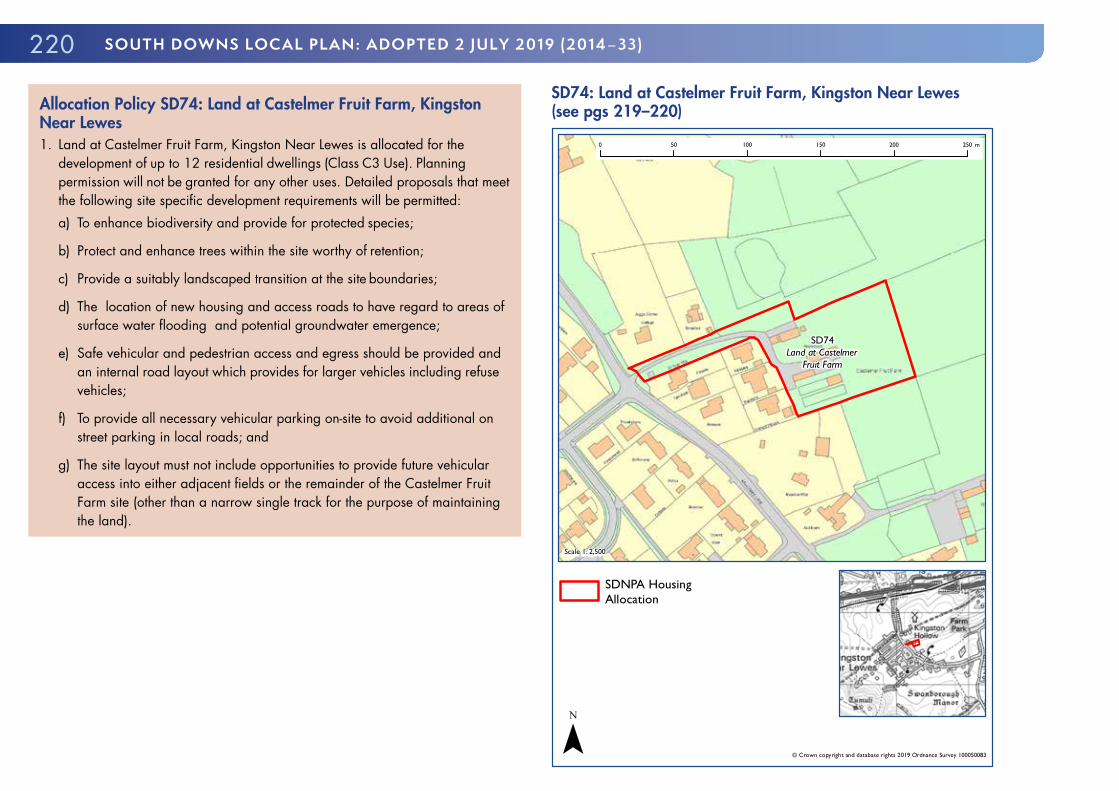
220 SOUTH DOWNS LOCAL PLAN: ADOPTED 2 JULY 2019 (2014–33)
Allocation Policy SD74: Land at Castelmer Fruit Farm, Kingston Near Lewes1. Land at Castelmer Fruit Farm, Kingston Near Lewes is allocated for the
development of up to 12 residential dwellings (Class C3 Use). Planning permission will not be granted for any other uses. Detailed proposals that meet the following site specific development requirements will be permitted:a) To enhance biodiversity and provide for protected species;
b) Protect and enhance trees within the site worthy of retention;
c) Provide a suitably landscaped transition at the site boundaries;
d) The location of new housing and access roads to have regard to areas of surface water flooding and potential groundwater emergence;
e) Safe vehicular and pedestrian access and egress should be provided and an internal road layout which provides for larger vehicles including refuse vehicles;
f) To provide all necessary vehicular parking on-site to avoid additional on street parking in local roads; and
g) The site layout must not include opportunities to provide future vehicular access into either adjacent fields or the remainder of the Castelmer Fruit Farm site (other than a narrow single track for the purpose of maintaining the land).
SD74: Land at Castelmer Fruit Farm, Kingston Near Lewes (see pgs 219–220)
SD74Land at Castelmer
Fruit Farm
Scale 1: 2,500
© Crown copyright and database rights 2019 Ordnance Survey 100050083
0 50 100 150 200 250 m
SDNPA HousingAllocation
¯

2219. sITEs & sETTLEmENTs
THE PUMP HOUSE, KINGSTON RIDGE, KINGSTON NEAR LEWES9.132 The site is located at the north western end of the Kingston Ridge cul-de-sac. To the west of The Pump House is a stable block and adjacent to that is a bunded enclosure containing a caravan. A mature hedgerow forms the northern boundary of the site beyond which is a garden and then expansive, open rolling downland. The site shares an access with The Pump House. To the south is a paddock and then further residential properties on large plots.
9.133 This is an existing private Gypsy and Traveller site with temporary planning permission. The site has a limited, localised effect on landscape character with views being well contained and it is not subject to overlooking.
9.134 Development proposals should therefore be informed by the following evidence study:
� Fowl Sewerage and Utilities Assessment
Allocation Policy SD75: The Pump House, Kingston Near Lewes1. The Pump House, Kingston is allocated for the development of 1 (total)
permanent Gypsy and Traveller pitch. Planning permission will not be granted for any uses other than a Gypsy and Traveller pitch and equestrian uses. Detailed proposals that meet the following site specific development requirements will be permitted:a) It must be laid out to ensure sufficient room is available to allow vehicles to
turn around within the site;
b) Surface water drainage must be controlled on site and foul drainage must be effectively treated before discharge;
c) Bunding must be retained;
d) Existing mature trees and hedgerows bordering the site must be retained and reinforced; and
e) The development should be occupied only by those who fulfil the definition of a Gypsy or Traveller.
SD75: The Pump House, Kingston Near Lewes
SD75The Pump House,Kingston Ridge,
Kingston,BN7 3JX
Scale 1: 800
© Crown copyright and database rights 2019 Ordnance Survey 100050083
0 50 m
SDNPA Gypsy andTraveller site allocation
¯

222 SOUTH DOWNS LOCAL PLAN: ADOPTED 2 JULY 2019 (2014–33)
LEWES9.135 Lewes is the county town of the administrative county of East Sussex and historically of all of Sussex. Lewes has a long history as a bridging point and as a market town located on the River Ouse. The town was the site of the Battle of Lewes in 1264 and has many historic landmarks including Lewes Castle. As of 2011 Lewes has a population of approximately 17,300.
9.136 Lewes Town Council prepared the NDP for Lewes Town. The NDP allocates sites for housing, but does not include the strategic housing allocation of Old Malling Farm. The NDP does not allocate employment land.
STRATEGIC HOUSING ALLOCATION: LAND AT OLD MALLING FARM, LEWES
Site Area: 10.0ha (approx. 6.6ha developable)
Current Use: Agriculture
Environmental Constraints: Offham Marshes SSSI
Disused Railway Cutting Site of Importance
SINC
Flood Risk: Part of site susceptible to fluvial, tidal and groundwater flooding
Historic Environment: Malling Deanery Conservation Area, Grade II* St Michael’s Church, high archaeological potential
9.137 Parts of site are susceptible to fluvial, tidal and groundwater flooding. The site is situated on the northern side of the town in a ‘green finger’ between the 1970s part of the Malling Estate to the east and the River Ouse, mainline railway and Landport Estate to the west. The site is currently in agricultural use.
9.138 Development of the site could adversely impact the special qualities of the National Park, for instance on landscape and views, on recreational activities (the Ouse Valley Way), on tranquillity (including dark night skies), on
historical features and cultural heritage (including the conservation area, listed building and archaeological remains), and on nearby wildlife and habitats.
9.139 The site is located close to significant local heritage assets. To the south of the site lies the Malling Deanery Conservation Area, including the Grade II* St Michaels Church. The site also lies within an area of high archaeological potential being in the vicinity of a medieval settlement and the ruins of a college of Benedictine Canons.
9.140 The site is located close to the Offham Marshes SSSI on the opposite side of the River Ouse and adjacent to the Disused Railway Cutting Site of Importance to Nature Conservation SINC on the eastern boundary of the site.
9.141 Nevertheless, taking a landscape and ecosystem services led approach, a sensitively designed scheme could be accommodated at Old Malling Farm. Development should take into take into account the range of significant constraints and impacts on the SDNP and incorporate an appropriate range of mitigation measures and suitable GI.
9.142 Much of the site is Agricultural Land Classification Grade 2, with some Sub-grade 3a, and therefore constitutes best and most versatile agricultural land, the loss of which is to be avoided where possible. However, in this case the few alternative options for strategic level residential development around Lewes town have been ruled out for other reasons, such as being of even greater landscape sensitivity within the National Park.
9.143 As identified by the SDNPA, landscape mitigation measures must address the following sensitivities:
� Views from the site to local landmark features including chalk hills, church towers and Lewes Castle give this site a strong sense of place;
� The strong rural, tranquil and natural character of the Ouse Valley with no development apparent on its eastern banks, save for historic settlement associated with Old Malling Farm and Lewes Malling Deanery;
� The visually sensitive western edge of the site above the Ouse Valley floor where development would intrude into the valley;
� The site is seen in the context of the wider Ouse Valley floodplain when the site is viewed from elevated locations to the east and west;
2239. sITEs & sETTLEmENTs
� From elevated locations to the west the entire site is clearly visible and visually separates the historic settlement of Old Malling Farm and Lewes Malling Deanery;
� From elevated locations to the east the northern field of the site is visually prominent and is seen as part of the wider Ouse Valley corridor; and
� The Ouse corridor to the north of Lewes was included in the South Downs National Park as providing a high quality setting to Lewes town for reasons of its intrinsic scenic attraction, cultural heritage and nature conservation.
9.144 Various measures are suggested to address these, including development on parts of the site only and at a lower density, and pulling development back and away from the western, southern and northern parts of the site. Other suggestions include:
� Providing only limited night lighting on the site and the use of low level lighting where required;
� Ensuring the use of dark colours for roofs; � Retaining views out of the site to surrounding landmarks; � Retaining some areas of floodplain with no access; and � Ensuring that any improved access to the floodplain does not unduly extend urbanising influences, including that signage and surfaces, gates and fencing are low key.
9.145 These various measures will be reviewed and considered for inclusion in a Design Brief. This will be informed by a detailed site appraisal, which shall include 3D computer modelling of the site and its context; appropriate Verified Photomontages; and ZTV plots from appropriate locations within the site.
9.146 The design of buildings should reinforce local distinctiveness through the use of suitable materials and vernacular. It is considered by the SDNPA that the site has potential to deliver a scheme with a contemporary vernacular although suitable traditional designs would also be welcomed. Boundary treatments and roof materials should be particularly sensitively designed and appropriate for the local context.
9.147 There is an existing access bridge over the disused railway cutting providing single track access to Old Malling Farm from Old Malling Way. A further double width access point onto Monks Way, which is at grade and currently used for agricultural vehicles, is situated at the northern end of the site. Monks Way would form the principal access to the site, with the railway bridge providing secondary access for pedestrians, cyclists and emergency use, as well as access to the former farm buildings.
9.148 Through the Green Infrastructure Strategy and a Travel Plan the development should provide a strategic network of non-vehicular routes that link the site to the adjacent open countryside, residential areas, open spaces and Lewes town centre. This includes improving existing routes where necessary and providing suitably designed new routes.
9.149 Transport evidence shows that significant development of this site should be contingent on highway improvement works at the Earwig corner junction of the A26 with the B2192 on the edge of the town to the east of the site. This is a junction that already experiences congestion, particularly at peak times, and therefore the further strain from new development (including from other development in Lewes town and at Ringmer) will need to be mitigated.
9.150 Development consistent with this policy, as well as other development in the area will enable this mitigation to occur, possibly through a traffic light system to improve the flow of traffic through the junction. In addition, mitigation measures associated with the impact of development at Old Malling Farm will be required at the critical junction of Church Lane/Malling Hill and at the Brooks Road/Phoenix Causeway roundabout, in agreement with the local highway authority. Traffic calming measures are also required to reduce the amount of existing traffic using the access roads to the site so that they can accommodate the additional traffic movements that will be generated by the development.
9.151 The development will provide a connection to the sewerage system at the nearest point of adequate capacity as advised by the service provider.
9.152 Most of the site is at low risk of fluvial flooding apart from the area closest to the northern boundary which is prone to both fluvial and tidal flooding. The site access is at risk from potential surface water flooding.

224 SOUTH DOWNS LOCAL PLAN: ADOPTED 2 JULY 2019 (2014–33)
Groundwater emergence is most likely in the north of the site within the floodplain, where the water table is close to the surface. The Level 1 Update and Level 2 SFRA provides recommendations for a site specific FRA, and the suitability and design of the SuDS.
9.153 By virtue of the size of the site and the proposed number of residential dwellings development proposals could be considered under the Environmental Impact Assessment Regulations. As such, it is recommended that formal pre-application advice is sought on this issue.
9.154 Development proposals should therefore be informed by the following evidence studies:
� Arboricultural Impact Assessment, Arboricultural Method Statement and associated Tree Protection Plan;
� Archaeological Assessment; � Drainage Strategy; � Ecology Assessment which includes a Protected Species Survey and a Biodiversity Strategy;
� FRA; � Heritage Statement; � Hydrological Assessment; � Land Contamination Survey; � LVIA; � Lighting and Noise Assessments; � Topographical Survey; and � TA.
Allocation Policy SD76: Land at Old Malling Farm, Lewes (see map pg 226)
1. Land at Old Malling Farm is allocated for the development of between
220 and 240 residential dwellings (Class C3 Use). Development should be informed by a comprehensive and integrated Design Brief to be undertaken either by the National Park Authority (NPA) or by the applicant and then subject to the NPA’s approval.
2. The Design Brief should be landscape and ecosystem services led and include a GI Strategy and a Site Masterplan, both of which should be informed by suitable evidence on vehicular and non-vehicular access, arboriculture, drainage and flood risk, ecology, heritage, hydrology, lighting and views.
3. The GI Strategy should provide a suitable strategic scale multifunctional network linking together the site, Lewes and the surrounding open countryside taking into account the range of significant constraints and impacts on the South Downs National Park.
4. The Masterplan should fully set out the GI Strategy, provide a suitable hierarchy of vehicular and pedestrian routes and an appropriate transition across the site in built form, fabric and density.
5. Detailed proposals that meet the following site specific development requirements will be permitted:a) The primary vehicular access point is to be off Monks Way at a point
opposite Mantell Close;
b) The existing former railway bridge forms a secondary access point for emergency use and an access for pedestrians and cyclists and to the existing farm buildings;
c) Suitably designed access for pedestrians and cyclists should be provided from the site to the disused railway line adjacent to the site;

2259. sITEs & sETTLEmENTs
d) Development on the site is contingent on appropriate off-site highway improvement works, to be provided in agreement with the Local Highway Authority, at the Earwig corner junction of the A26 with the B2192, the junction of Church Lane/Malling Hill and at the Brooks Road/Phoenix Causeway roundabout and suitable traffic calming in local roads;
e) Development should provide sufficient clearance for growing space of existing and proposed trees within the site and on all site boundaries;
f) All housing development should be located within Flood Zone 1 only;
g) Flood compensation storage should be provided for any ground raising or built development in Flood Zone 3 (including allowance for future climate change);
h) No development other than Essential Infrastructure or Water Compatible development in Flood Zone 3b;
i) Floor levels of habitable areas, where appropriate and proven to be necessary, to be designed to take into account flood risk and climate change;
j) Safe vehicular and pedestrian emergency access and egress to be provided taking into account flood risk;
k) An appropriate surface water and foul water drainage strategy is agreed with relevant authorities and service providers;
l) Development shall incorporate views within, to and from the site to surrounding landmarks and features including from the elevated chalk hills to the east and west, from Hamsey to the north, and from Lewes itself;
m) Impacts on tranquility, dark night skies and biodiversity should be minimised through appropriate mitigation and good design; and
n) Suitable on-site equipped play space.
6. In order for the development to have an overall positive impact on the ability of the natural environment to contribute to ecosystem services, development proposals must address the following:a) Provision of suitable pedestrian and cycle links to the adjacent countryside
and to the existing rights of way network;
b) Protect and enhance trees within the site where possible, and where trees are lost, provide at least the equivalent in new tree planting on site. Trees on the site boundary should be retained and new tree planting should be undertaken particularly at the western and eastern fringes of the site;
c) New planting should be suitable for pollinating species; and
d) Minimise hard surfaced areas on site, and use permeable surfaces and soft landscaping where possible to maximise infiltration of water and reduce surface water run-off.

226 SOUTH DOWNS LOCAL PLAN: ADOPTED 2 JULY 2019 (2014–33)
SD76: Land at Old Malling Farm, Lewes (see pgs 222–225)
SD76Land at OldMalling Farm
Scale 1: 7,600
© Crown copyright and database rights 2019 Ordnance Survey 100050083
0 50 100 150 200 250 300 350 400 450 500 m
SDNPA HousingAllocation
¯
MALLING BROOKS, LEWES
Site Area: 2.67ha
Current Use: Cleared woodland
Flood Risk: The whole site is within Flood Risk Zone 3
9.155 This is a large greenfield site within the settlement boundary for Lewes, between the edge of the principal employment site of Central Lewes, which is safeguarded under Policy SD35 and residential areas to the north and east. Most of the site was previously allocated for employment in the former Lewes Local Plan. Planning permission has been granted for a number of schemes on the site including landscaping125. Preparatory construction works began on the site in summer 2015, including clearance of the site.
9.156 The site is owned by one of the owners of North Street Quarter, which is a strategic site allocated in this plan. In 2016 that development was granted planning permission for redevelopment, including a substantial net loss of employment floorspace. The committee report recommending approval of that application made note of the likelihood that “redevelopment of the North Street Quarter may … trigger the implementation of industrial development at Malling Brooks… which indicates a reasonable supply of industrial floorspace.” The Employment Land Review Update 2017126 found that the site should be allocated for employment use, since it constitutes an important element of the supply of new employment land in the National Park.
9.157 The site formerly had the character of ‘brooks’; that is, pastureland drained by numerous ditches, which had become overgrown by mature trees. The site is visible in views from the hills surrounding Lewes, and partially screens the adjacent industrial estate from some views. There are numerous records of protected and notable species in the area and most notably of reptiles on site.
125 127 Planning applications LW/07/1608, LW/12/0342/NP, SDNP/13/02119/NMA, SDNP/16/01255/FUL and SDNP/13/04579/DCOND
126 Employment Land Review Update (South Downs National Park Authority, 2017)

2279. sITEs & sETTLEmENTs
9.158 The whole site is within Flood Risk Zone 3A. However, it is defended by the flood defences protecting the wider Brooks Road area, and commercial/industrial uses are defined as ‘less vulnerable’ in flood risk terms and in principle appropriate for Zone 3A. A FRA including Sequential Test accompanied the original application for the site. A new watercourse is proposed to be constructed through the landscaped belt around the northern and eastern sides of the site, draining into an existing watercourse which runs through the broader industrial estate and into the Ouse behind the Tesco superstore. As well as performing a drainage role this feature will also partly mitigate the loss of the former habitats which covered the central portion of the site, and buffer adjacent residential areas from the new industrial units.
9.159 The roofs of the industrial units are proposed as green roofs, which in combination with the landscape strip will mitigate the impact of the development in wider views. Natural England and the EA raised no objection to the scheme, conditional on the implementation in full of recommendations from the relevant studies that accompanied the 2007 application. Since the site has now been largely cleared of vegetation it is of additional importance to ensure that these measures are carried forward into any potential revised scheme.
9.160 Due to its former wetland nature the site has been identified as having high potential for wetland archaeology, including prehistoric organic remains.
9.161 There are two historic landfill records overlapping the boundaries of the site and the southern end of the site is also within HSE Outer and to some degree Middle Zones, However, the latter zones are centred on a site already developed for housing and it is considered that these constraints can be overcome by condition.
9.162 A public footpath cuts across the north-western end of the site. The development will retain much of this footpath within the landscaping belt, but a portion of it will run past one of the proposed buildings. This footpath provides a link from the South Malling area into the industrial estate and towards the town centre, and its attractiveness to pedestrians must be protected and enhanced.
9.163 The main principles of development are already set out in the existing planning permissions on the site, in particular the detailed specifications relating to flood risk management, landscaping and biodiversity. It is considered necessary to allocate the site to ensure any future changed proposals that come forward continue to accord with those requirements. In addition, the development of the site is needed to accommodate businesses displaced from the North Street Quarter development and for that reason it is essential the site comes forward for the proposed uses in parallel with the strategic site.
9.164 Development proposals should therefore be informed by the following evidence studies:
� Archaeological surveys, including fieldwork assessment; � A TA and travel plan to the satisfaction of the Highway Authority; � A scheme for the provision of surface water drainage works, including details of underground storage tanks to attenuate flows to the main drainage system, where required; and
� A scheme to deal with the risks associated with contamination of the site.

228 SOUTH DOWNS LOCAL PLAN: ADOPTED 2 JULY 2019 (2014–33)
Allocation Policy SD77: Malling Brooks, Lewes1. Land at Malling Brooks, Lewes is allocated for the development of
approximately 7,040m2 of B1/B2/B8 employment uses and appropriate landscaping. Planning permission will not be granted for any other uses. Detailed proposals that meet or exceed the following site specific development requirements will be permitted:a) Landscaping to retain and enhance the previous ecological connectivity of
the site, to cover around 30% of the site. The northern and eastern sections of the site must provide broad landscape strips of at least 20m, planted with native species and incorporating a watercourse, in accordance with the plans submitted with planning applications SDNP/13/04579/DCOND and SDNP/13/02155/FUL, and appropriate management proposals secured through Section 106 agreement;
b) All main roofs on the site should take the form of green roofs;
c) Protection and enhancement of the footpath running through the site;
d) The phasing of development to be coordinated with that of the North Street Quarter to provide a smooth transition for businesses displaced from the latter site;
e) A comprehensive approach to flood risk will be adopted and development will be undertaken in accordance with the recommendation of an agreed Site Specific FRA;
f) Development to be undertaken in accordance with the findings and conclusions of the Ecological Assessment Report dated December 2007 Revision 1 and the Ecological Design Strategy dated December 207 Revision 3, accompanying Planning Application LW/07/1608; and
g) Parking spaces ancillary to the development, at a level acceptable to the highway authority.
SD77: Malling Brooks, Lewes (see pgs 226–228)
SD77MallingBrooks
Scale 1: 5,200
© Crown copyright and database rights 2019 Ordnance Survey 100050083
0 50 100 150 200 250 300 350 400 450 500 m
SDNPA EmploymentSite Allocation SD77
¯
2299. sITEs & sETTLEmENTs
MIDHURST9.165 Midhurst is a historic market town set in the Western Weald of the National Park. It lies on the River Rother 12 miles north of Chichester. Just across the River Rother, in the parish of Easebourne, is the ruin of the Tudor Cowdray House. The population of Midhurst in 2011 was approximately 5,000 people.
9.166 In the post-war period the population expanded significantly with the construction of modern suburbs. These were, however, built entirely outside the historic core and had no significant impact on its historic structure and character. Midhurst’s historic core exhibits an unusual degree of autonomy and separation from later phases of expansion due to the topographic and ownership characteristics of the surrounding landscape. The physical proximity and influence of the Cowdray Estate is one of Midhurst’s special features whose spacious, managed natural environment confers stately qualities upon the town.
9.167 The busy area of North Street and surrounding streets contain a mix of both multiple retailers and many independent stores, restaurants and cafes. The town contains a good mix of services and facilities including primary schools, the Grange Community Centre, and the Midhurst Rother College which serves a large area stretching well beyond the town.
STRATEGIC HOUSING ALLOCATION: WEST SUSSEX COUNTY COUNCIL DEPOT AND FORMER BRICKWORKS, MIDHURST
Site Area: 2.7ha
Current Use: Council depot; Public household recycling facility; Aggregate storage and processing; Vehicle and plant hire
Environmental Designation: Adjacent to SINC, LWS and Priority Habitat Area Stedham, Iping, Woolbeding Crescent BOA
Flood Risk: Risk of surface water flooding
9.168 This strategic housing allocation site consists of two adjacent land parcels. The West Sussex County Council (WSCC) Depot is a partially derelict area of previously developed land, currently used to accommodate various local authority operations, with a small amount of office accommodation. Approximately 0.2 hectares of the depot site is used as the main public household recycling depositary for Midhurst. The Employment Land Review Update127 concluded that the WSCC depot site was a poor quality under-occupied site that should be considered for other uses.
9.169 The former Midhurst Brickworks, famed for producing “Midhurst White” bricks, closed in 1985 and is currently occupied by a company that stores and processes aggregate. Some of the original structures remain in situ on site, but are in a state of dereliction. This site is also substantially underused, and hence in need of regeneration.
9.170 It is considered that the two parcels together offer a substantial opportunity to improve the local environment for this corner of Midhurst, by providing a housing-led scheme. The National Park Authority has produced a Development Brief for the allocation site and will expect proposals to accord with the Brief.
9.171 The site is located adjacent to sensitive heathland and woodland at Midhurst Common, which is a LWS, and identified as a SINC. Furthermore, parts of the site have been identified as potential habitats for protected and notable species. The site includes an area that is part of the Stedham, Iping, Woolbeding Crescent BOA.
9.172 Therefore, using an ecosystem services approach, development on the site will need to deliver positive benefits to Midhurst Common, in respect of wildlife, setting and GI. Development should enhance identified ecological networks, and provide for heathland restoration and creation. It will be particularly important to ensure an appropriate interface between built development and the adjacent heathland and woodland, for example through providing a wildlife buffer as a ‘soft’ urban/heathland interface, and
127 129 Employment Land Review Update (South Downs National Park Authority, 2017)

230 SOUTH DOWNS LOCAL PLAN: ADOPTED 2 JULY 2019 (2014–33)
carefully designed wildlife corridors through the site. The possible impacts of the development on bats in general and Barbastelle Bats in particular should be taken into account as part of the development control process. If mature hedgerows/treelines and foraging opportunities can be preserved it is likely that no issues will arise.
9.173 A further key objective will be to provide high-quality pedestrian links through the site which improves public access to the Common. These should be achieved through partnership working with the National Park Authority and other relevant stakeholders. As the site includes a section of the former Petersfield to Pulborough railway line, an appropriate route should be safeguarded for a future non-motorised through transport route in line with Policy SD20: Walking, Cycling and Equestrian Routes.
9.174 The Authority will expect the respective landowners to work closely, to achieve and deliver a comprehensive masterplan, to ensure an exemplar development befitting this sensitive part of the National Park. It will be necessary to safeguard a vehicular access from the existing (or equivalent) access from Bepton Road into and through the Depot site, to residential development on the former Brickworks site such that traffic need not pass along Station Road and through the Midhurst Business Park.
9.175 Development proposals should therefore be informed by the following evidence studies:
� Archaeological Assessment; � Arboricultural Impact Assessment, Arboricultural Method Statement and associated Tree Protection Plan;
� Ecology Assessment and Protected Species Survey; � FRA and Surface Water Management Plan; � Ground Stability Survey; � Land Contamination Survey; � Lighting Assessment; and � Project-level HRA.
Strategic Allocation Policy SD78: West Sussex County Council Depot and Former Brickworks Site, Midhurst (see map pg 231)
1. The West Sussex County Council Depot and former Brickworks site is
allocated for a residential-led development (Class C3 Use). A masterplan for the whole site should be submitted as part of any outline or full planning application. Development for between approximately 65 to 90 dwellings will be permitted. Development for other complementary uses will be permitted where such uses are justified through the whole-site masterplan, and are shown to meet a local need. Planning permission will not be granted for any proposals which prejudice the whole of the site being bought forward for development. Detailed proposals that meet the following site specific development requirements will be permitted:a) Deliver an ecosystem services-led solution to mitigate the sensitive interface
with Midhurst Common, provide positive enhancements to wildlife habitats within and surrounding the site, and contribute to the aims of the Stedham, Iping, Woolbeding Cresence BOA;
b) To demonstrate that there would be no likely significant effect on the Singleton & Cocking Tunnels SAC;
c) Provide wildlife corridors within the site as part of a site-specific Wildlife Management and Enhancement Plan;
d) Provide high-quality pedestrian links through the site linking into Midhurst Common and hence the long distance Serpent Trail, and ensure a route is safeguarded for a potential future non-motorised travel route along the approximate line of the former Petersfield to Pulborough railway line;
e) Retain, or relocate to an appropriate location to be approved by the Authority, the Household Recycling Facility ensuring an equivalent standard and capacity of provision;

2319. sITEs & sETTLEmENTs
e) Retain, or relocate to an appropriate location to be approved by the Authority, the Household Recycling Facility ensuring an equivalent standard and capacity of provision;
f) Safeguard a suitable vehicular access route through the Depot site to allow for vehicular access to the former Brickworks site direct from Bepton Road;
g) Provide a pedestrian/cycle/emergency vehicle access to the former Brickworks site from Station Road;
h) Provide suitable on-site surface water drainage; and
i) The location of new housing and access roads to have regard to localised areas of potential surface water flood risk.
2. In order for the development to have an overall positive impact on the ability of the natural environment to contribute ecosystem services, development proposals should address the following:a) Provision of suitable pedestrian and cycle links to the adjacent countryside
and to the existing rights of way network;
b) Protect and enhance trees within the site where possible, and where trees are lost, provide at least the equivalent in new tree planting on site. Trees on the site boundary should be retained and new tree planting should be undertaken;
c) Retain suitable existing habitat for pollinating species where possible. New planting should be suitable for pollinating species; and
d) Minimise hard surfaced areas on site, and use permeable surfaces and soft landscaping where possible to maximise infiltration of water and reduce surface water run-off.
3. The National Park Authority has prepared a Development Brief to assist the delivery of the site. Development proposals in broad conformity with the Development Brief will be permitted128.
128 West Sussex County Council Depot and Former Brickworks Site, Development Brief (South Downs National Park Authority, 2018)
SD78: West Sussex County Council Depot and Former Brickworks Site, Midhurst (see pgs 229–231)
SD78Depot and former
Brickworks site
Scale 1: 4,500
© Crown copyright and database rights 2019 Ordnance Survey 100050083
0 50 100 150 200 250 300 350 400 450 m
SDNPA HousingAllocation
¯

232 SOUTH DOWNS LOCAL PLAN: ADOPTED 2 JULY 2019 (2014–33)
STRATEGIC HOUSING ALLOCATION: HOLMBUSH CARAVAN PARK, MIDHURST
Site Area: Approximately 5.0ha
Current Use: Former caravan site and large pond
Environmental Designations: Tree Preservation Order
Flood Risk: Fluvial Flood Zones 2/3; Groundwater flooding; Some surface water flood risk at site boundaries
9.176 This strategic housing allocation site is previously developed land comprising a disused caravan site centred on a large pond. The site would appear to be located in an historic mineral extraction site and has notably visual advantages being contained within a bowl in the townscape of Midhurst and well screened by mature trees.
9.177 The National Park Authority has produced a Development Brief for the allocation site and will expect proposals to accord with the Brief129. The Authority will expect the site promoters to deliver an exemplar ecosystem-led development which delivers a suitable housing scheme in conjunction with local environmental improvements. Given its landscape context it is considered that the site could be suitable for housing of either contemporary or traditional design.
9.178 Development on the site will need to deliver positive benefits to biodiversity within the site such as wildlife corridors and connected to GI outside the site. The site has an existing Tree Preservation Order. Development proposals should include strategies for improving and maintaining the quality of waterbodies within the site. Trees worthy of retention should be identified. Development proposals should include an arboricultural strategy which sets out improvements to the treescape of the site. The possible impacts of the development on bats in general and Barbastelle Bats in particular should be taken into account as part of the development control process. If mature
129 Holmbush Caravan Site, Development Brief (South Downs National Park Authority 2018)
hedgerows/treelines and foraging opportunities can be preserved it is likely that no issues will arise.
9.179 The site has flood risk issues. The centre of the site is within the EA Fluvial Flood Risk Zones 2 and 3. There are some areas of surface water flood risk in areas adjacent to the site boundary. The site is identified as an area of high groundwater floor risk. As such, development proposals should be supported by suitable FRAs and hydrogeological surveys. The Level 1 Update and Level 2 SFRA provides recommendation for a site specific FRA and the suitability and design of SuDS.
9.180 Development proposals should therefore be informed by the following evidence studies:
� Development Masterplan; � Arboricultural Impact Assessment, Arboricultural Method Statement and associated Tree Protection Plan;
� Ecology Assessment incorporating a Protected Species Survey; � FRA; � Ground Stability Survey; � Hydrogeological Survey; � Land Contamination Survey; � LVIA; � Lighting Assessment; � HRA; and � TA.

2339. sITEs & sETTLEmENTs
Strategic Allocation Policy SD79: Holmbush Caravan Park, Midhurst (see map pg 234)
1. Holmbush Caravan Park, Midhurst is allocated for the development of 50
to 70 residential dwellings (Class C3 Use). Planning permission will not be granted for any other uses. Detailed proposals that meet the following site specific development requirements will be permitted:a) To provide positive enhancements to the treescape, waterbodies, wildlife
corridors and habitats within the site;
b) To demonstrate that there would be no likely significant effect on the Singleton & Cocking Tunnels SAC;
c) All housing development should be located within Flood Zone 1;
d) Floor levels of habitable areas, where appropriate and proven to be necessary, to be designed to take into account flood risk and climate change;
e) Safe vehicular and pedestrian emergency access and egress should be provided during flooding;
f) Incorporation of suitable site boundary treatments;
g) Provision of pedestrian routes through the site linking into adjacent open spaces; and
h) Retention and improvement of, where necessary, the existing vehicular access.
2. In order for the development to have an overall positive impact on the ability of the natural environment to contribute ecosystem services, development proposals must address the following:a) Protect and enhance trees within the site where possible. Trees on the site
boundary should be retained and new tree planting should be undertaken;
b) Retain suitable existing habitat for pollinating species where possible. New planting should be suitable for pollinating species; and
c) Minimise hard surfaced areas on site, and use permeable surfaces and soft landscaping where possible to maximise infiltration of water and reduce surface water run-off.
3. The National Park Authority has prepared a Development Brief to assist the delivery of the site. Development proposals in broad conformity with the Development Brief will be permitted.

234 SOUTH DOWNS LOCAL PLAN: ADOPTED 2 JULY 2019 (2014–33)
SD79: Holmbush Caravan Park, Midhurst (see pgs 232–233)
SD79Holmbush
Caravan Park
Scale 1: 3,900
© Crown copyright and database rights 2019 Ordnance Survey 100050083
0 50 100 150 200 250 300 350 m
SDNPA HousingAllocation
¯
LAND AT THE FAIRWAY, MIDHURST
Site Area: 0.1ha
Current Use: Residential car parking
Environmental Designation: Tree Preservation Order
Proximity to Singleton & Cocking Tunnels SAC
9.181 The site is located within the southern suburbs of Midhurst, with access off The Fairway. A large mature hornbeam tree within the site, which is subject to a Tree Preservation Order, contributes to the character of the site. A disused railway tunnel entrance in the southeast corner of the site provides historical character and context. The possible impacts of the development on bats in general and barbastelle bats in particular should be taken into account as part of the development control process. A Project-level HRA is required to ensure there is no likely significant effect on the Singleton & Cocking Tunnels SAC.
9.182 The developable area of the site consists of informal residential parking for the three apartment blocks, together with landscaped areas. The land is considered to be under-used at present, and suitable for a well-designed residential development that enhances the character of the area and draws attention to its special features. Given the surrounding context and topography, flatted development of a suitable scale would be an appropriate development.
9.183 Development proposals will be expected to provide, where necessary, an appropriate level of car parking, in line with adopted standards, for both the existing flats (Perth House, Adelaide House and Brisbane House) and the new dwellings.
9.184 The site is located at an area where the Centurion Way, an existing long distance footpath between Chichester and West Dean, may be incorporated in the future. As such, development proposals should not prejudice future potential access for pedestrians and cyclists in line with Policy SD20: Walking, Cycling and Equestrian Routes. It is recommended that land for a suitable route at the edge of the site is suitably reserved.

2359. sITEs & sETTLEmENTs
9.185 Development proposals should therefore be informed by the following evidence studies:
� Arboricultural Impact Assessment, Arboricultural Method Statement and associated Tree Protection Plan;
� Protected Species Survey; and � Project-level HRA.
Allocation Policy SD80: Land at the Fairway, Midhurst1. Land at the Fairway, Midhurst is allocated for the development of 8 to 10
residential dwellings (Class C3 Use). Planning permission will not be granted for any other uses. Detailed proposals that meet the following site specific development requirements will be permitted:a) The existing hornbeam tree will be retained, and an appropriate protective
buffer applied;
b) The development will enhance the setting of the old railway tunnel entrance, and ensure that there are public views to it;
c) Development must provide car parking to appropriately replace existing provision, and additionally provide parking for the new development; and
d) To demonstrate that there would be no likely significant effect on the Singleton & Cocking Tunnels SAC.
SD80: Land at the Fairway, Midhurst (see pgs 234–235)
SD80Land at
the Fairway
Scale 1: 500
© Crown copyright and database rights 2019 Ordnance Survey 100050083
0 50 m
SDNPA HousingAllocation
¯

236 SOUTH DOWNS LOCAL PLAN: ADOPTED 2 JULY 2019 (2014–33)
LAND AT LAMBERTS LANE, MIDHURST
Site Area: 0.4 hectares
Current Use: Disused youth club, WI meeting hall and tennis/ netball courts
Environment Designations: Proximity to Singleton & Cocking Tunnels SAC
Historic Environment: Edge of Midhurst Conservation Area, within 20m of Lassiters Cottage (Grade II listed building)
Flood Risk: Surface water flooding on sports court at northern boundary
9.186 The site is a previously developed site which is sustainably located close to Midhurst town centre. The larger part of the allocation site was formerly part of the old Midhurst Grammar School site. This included 3 hard surfaced tennis/netball courts, and a single storey building previously used by a youth group, which has now been replaced by a modern building on a separate site to the north. A small portion was formerly owned by the Women’s Institute and occupied by a small meeting hall. Both buildings and the tennis/netball courts are now vacant and derelict.
9.187 The site is accessed via Lamberts Lane, which is a narrow residential road, constrained at both ends by historic buildings and fabric acting to limit its width and visibility. A TS will be required which in particular addresses whether Lamberts Lane and associated junctions can safely accommodate the planned development set out in this allocation and the adjacent allocation, Land at Park Crescent (Local Plan Policy SD82). The lowermost part of the site and the proposed site access is at risk from surface water flooding. The Level 1 Update and Level 2 SFRA provided recommendations for a site specific FRA and the suitability and design of SuDS.
9.188 Given the site is contiguous with the allocation site Land at Park Crescent vehicular access should be provided through this allocation site. The scheme design and layout should ensure that a through vehicular and
pedestrian route is provided. Development proposals which prejudice the development of the adjacent allocation site will not be permitted.
9.189 The site is located on the edge of the Midhurst Conservation Area, and within 20 metres of a Grade II listed building, Lassiters Cottage, which lies to the east. Development proposals will be required to respond positively to the area’s historic character and the setting of the listed building and conservation area. Particular attention should be given to enhancing the frontage onto Lamberts Lane. The possible impacts of the development on bats in general and barbastelle bats in particular should be taken into account as part of the development control process. If mature hedgerows/treelines and foraging opportunities can be preserved it is likely that no issues will arise.
9.190 Development proposals should therefore be informed by the following evidence studies:
� Arboricultural Impact Assessment, Arboricultural Method Statement and associated Tree Protection Plan;
� Archaeological Survey; � Heritage Statement; � Surface Water FRA and Management Plan; � Project-level HRA; and � TS.
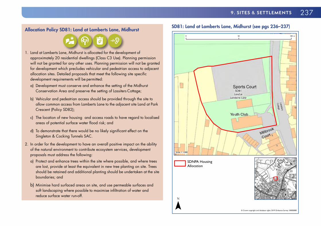
2379. sITEs & sETTLEmENTs
Allocation Policy SD81: Land at Lamberts Lane, Midhurst
1. Land at Lamberts Lane, Midhurst is allocated for the development of
approximately 20 residential dwellings (Class C3 Use). Planning permission will not be granted for any other uses. Planning permission will not be granted for development which precludes vehicular and pedestrian access to adjacent allocation sites. Detailed proposals that meet the following site specific development requirements will be permitted:a) Development must conserve and enhance the setting of the Midhurst
Conservation Area and preserve the setting of Lassiters Cottage;
b) Vehicular and pedestrian access should be provided through the site to allow common access from Lamberts Lane to the adjacent site Land at Park Crescent (Policy SD82);
c) The location of new housing and access roads to have regard to localised areas of potential surface water flood risk; and
d) To demonstrate that there would be no likely significant effect on the Singleton & Cocking Tunnels SAC.
2. In order for the development to have an overall positive impact on the ability of the natural environment to contribute ecosystem services, development proposals must address the following:a) Protect and enhance trees within the site where possible, and where trees
are lost, provide at least the equivalent in new tree planting on site. Trees should be retained and additional planting should be undertaken at the site boundaries; and
b) Minimise hard surfaced areas on site, and use permeable surfaces and soft landscaping where possible to maximise infiltration of water and reduce surface water run-off.
SD81: Land at Lamberts Lane, Midhurst (see pgs 236–237)
SD81Land at
Lamberts Lane
Scale 1: 1,000
© Crown copyright and database rights 2019 Ordnance Survey 100050083
0 50 100 m
SDNPA HousingAllocation
¯

238 SOUTH DOWNS LOCAL PLAN: ADOPTED 2 JULY 2019 (2014–33)
LAND AT PARK CRESCENT, MIDHURST
Site Area: 0.3 hectares
Current Use: Residential gardens
Flood Risk: Potential for surface water and ground groundwater flooding
9.191 The site is located northwest of the historic core of Midhurst, on the edge of the settlement. It consists of a large area of residential garden in the curtilage of 12 Park Crescent, together with smaller portions of the gardens for 9, 10 and 11 Park Crescent respectively. The site is contiguous to the east with the site Land at Lamberts Lane, Midhurst (Policy SD81), with open sports fields to the north, and a steep incline up to Midhurst Tennis Club forming the western boundary.
9.192 The site is located close to Midhurst town centre, and in principle a modest-scale residential development would be considered suitable to help meet housing need.
9.193 The site is generally well-screened from the public realm. However, views of the site can be gained from Lamberts Lane across the open sports pitches that serve Midhurst and Rother College. The site contains three prominent trees that contribute to the wider character of the area. These trees should be preserved in situ. To do so will require a carefully considered site layout, which avoids buildings intruding on the semi-wooded western portion of the site. The possible impacts of the development on bats in general and barbastelle bats in particular should be taken into account as part of the development control process. If mature hedgerows/treelines and foraging opportunities can be preserved it is likely that no issues will arise.
9.194 The current vehicular access to the site is the side access to 12 Park Crescent, which is not considered adequate to provide access to new homes, given its restricted width and close proximity to neighbouring properties. Access will therefore need to be provided from Lamberts Lane via the adjacent allocated site and not via Park Crescent. Lamberts Lane is a narrow residential
road, constrained at both ends by historic buildings and fabric acting to limit its width and visibility.
9.195 A TS will be required which in particular addresses whether Lamberts Lane can safely accommodate the increase in vehicle movements that will arise from the proposed development. The site is also at risk of potential surface water or groundwater flooding to access. A site specific FRA should therefore accompany any planning application for this site and should particularly consider the flood risk to access and egress. The Level 1 Update and Level 2 SFRA provides recommendations for a site specific FRA and the suitability and design of SuDS.
9.196 Development proposals should therefore be informed by the following evidence studies:
� TS; � Arboricultural Impact Assessment, Arboricultural Method Statement and associated Tree Protection Plan;
� Project-level HRA; � Protected Species Survey; and � FRA.
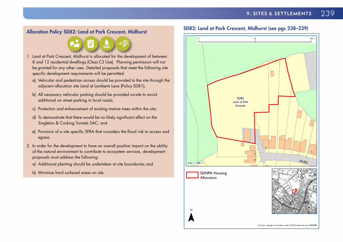
2399. sITEs & sETTLEmENTs
Allocation Policy SD82: Land at Park Crescent, Midhurst
1. Land at Park Crescent, Midhurst is allocated for the development of between
8 and 12 residential dwellings (Class C3 Use). Planning permission will not be granted for any other uses. Detailed proposals that meet the following site specific development requirements will be permitted:a) Vehicular and pedestrian access should be provided to the site through the
adjacent allocation site Land at Lamberts Lane (Policy SD81);
b) All necessary vehicular parking should be provided on-site to avoid additional on street parking in local roads;
c) Protection and enhancement of existing mature trees within the site;
d) To demonstrate that there would be no likely significant effect on the Singleton & Cocking Tunnels SAC; and
e) Provision of a site specific SFRA that considers the flood risk to access and egress.
2. In order for the development to have an overall positive impact on the ability of the natural environment to contribute to ecosystem services, development proposals must address the following:a) Additional planting should be undertaken at site boundaries; and
b) Minimise hard surfaced areas on site.
SD82: Land at Park Crescent, Midhurst (see pgs 238–239)
SD82Land at Park
Crescent
Scale 1: 1,000
© Crown copyright and database rights 2019 Ordnance Survey 100050083
0 50 100 m
SDNPA HousingAllocation
¯

240 SOUTH DOWNS LOCAL PLAN: ADOPTED 2 JULY 2019 (2014–33)
OFFHAM (EAST SUSSEX)9.197 Offham is a small village on the A275 just north of Lewes. Nearby Cooksbridge contains local services and facilities.
OFFHAM BARNS, NORTH OF OFFHAM FILLING STATION, THE STREET, OFFHAM
Site Area: 0.3 ha
Current Use: Gypsy & Traveller site
Environmental Designations: Dark Skies: E0
Flood Risk: Potential for spring flow and localised groundwater flooding
9.198 The site is located between Lewes and Cooksbridge on the eastern side of the A275, and just to the south of its junction with the B2116. The allocation will enable a small northern extension of the existing Gypsy & Traveller site at Offham Barns, north of the Offham Road Service Station, to take place.
9.199 The site as a whole is bordered on its southern and western boundary by mature hedging. The existing caravans and mobile homes are separated from the northern part of the site by a further hedge. To the east is a large open field. The site is flat and set slightly below the field levels. The existing Gypsy & Traveller site is well established and contains four pitches plus stabling and horses. There is a localised area of surface water ponding that occupies a significant part of the site. The site is also situated on the side of a dry valley. While most groundwater emergence will occur in the base of the valley, spring flow may also occur in the valley sides in particularly wet periods. The Level 1 Update and Level 2 SFRA provides recommendations for a site specific FRA and the suitability and design of the SuDS.
9.200 Development proposals should therefore be suitably informed by the following evidence studies:
� Foul Sewerage and Utilities Assessment; � Lighting Assessment; and � FRA including Surface Water Management Plan.
Allocation Policy SD83: Offham Barns, Offham (see map pg 241)1. Land at Offham Barns, Offham is allocated for the development of four
permanent Gypsy and Traveller pitches. Planning permission will not be granted for any other uses. Detailed proposals that meet the following site specific development requirements will be permitted:a) Laid out to ensure sufficient room is available to allow vehicles to turn
around within the site;
b) Surface water drainage must be controlled on site and foul drainage must be effectively treated before discharge;
c) The location of pitches and new access roads to have regard to areas of surface water flooding and potential groundwater emergence;
d) Designed to avoid an increase in the feeling of urbanisation in this location, including keeping any associated buildings to a minimum in both number and scale;
e) Contain significant planting in order to break up the hardstanding that will be required and reduce the urbanising impact of an increase in the site size;
f) Existing hedgerows bordering the site must be retained and reinforced; and
g) The development should be occupied only by those who fulfil the definition of a Gypsy or Traveller.

2419. sITEs & sETTLEmENTs
SD83: Offham Barns, Offham (see pg 240)
SD83Land North of existingOffham site BN7 3QE
Scale 1: 1,000
© Crown copyright and database rights 2019 Ordnance Survey 100050083
0 50 100 m
SDNPA Gypsy andTraveller site allocation
¯
SELBORNE9.201 Selborne is an historic village located on the Scarp Slope in the north-west of the National Park. Selborne is most famous for its association with the eminent naturalist Revd. Gilbert White.
LAND TO THE REAR OF KETCHERS FIELD, SELBORNE
Site Area: 0.2ha
Current Use: Agricultural
Environmental Designation: Wealden Heath SPA; Hampshire Hangers BOA
Dark Skies: E1(a)
Flood Risk: Surface and groundwater flood risk
Heritage Designation: Selborne Conservation Area to north of site
9.202 The allocation site is located in the south of the village beyond the historic core in the Selborne Conservation Area, adjacent to an existing area of modern housing.
9.203 The allocation site is suitable for modern housing but given its location on the edge of Selborne the appropriate use of local traditional materials and vernacular, including low rise buildings, that reinforce local distinctiveness would also be welcomed. Development should provide appropriate site boundaries given the open countryside to the east, and should continue the existing adjacent off site vegetative boundaries using appropriate species.
9.204 Development must include suitable vehicular access and on-site parking. The likely access is an existing PRoW and as such development is dependent on this being suitable for vehicular use. The surface treatment of the access should be informed by its use also for non-motorised users and by the character of the vicinity. Where vehicular access is dependent on off-site improvement works these should be delivered through a planning obligation. Development should be served by sufficient suitable off-street vehicular parking to avoid additional pressure on local roads.
242 SOUTH DOWNS LOCAL PLAN: ADOPTED 2 JULY 2019 (2014–33)
9.205 A small area in the lowermost part of the site along its south eastern boundary and the proposed access is at risk from surface water flooding. New development would need to ensure that surface water runoff was suitably addressed. Development may be required to be accompanied by a groundwater study. The Level 1 Update and Level 2 SFRA provides recommendations for a site specific FRA and the suitability and design of SuDS.
9.206 Development should contribute towards the aims of the Hampshire Hangers BOAa. The site is located 290 metres from the Hampshire Hangers SAC and within 5km of the Wealden Heaths Phase II SPA and as such development proposals should, if required, provide suitable mitigation.
9.207 Development proposals should therefore be informed by the following evidence studies:
� Arboricultural Impact Assessment, Arboricultural Method Statement and associated Tree Protection Plan;
� Highways Assessment; � Project-level HRA; and � Surface Water FRA and Management Plan.
Allocation Policy SD84: Land at Ketchers Field, Selborne (see map pg 243)
1. Land at Ketchers Field, Selborne is allocated for the development of 5 to 6
residential dwellings (Class C3 Use). Planning permission will not be granted for any other uses. Detailed proposals that meet the following site specific development requirements will be permitted:a) A suitable transition in built form and fabric from the housing to the west to
the open countryside to the east;
b) Site boundaries sympathetic to the local landscape;
c) Vehicular access compatible with non-vehicular users of, and not harmful to the amenity of, the existing PRoW;
d) To provide all necessary vehicular parking on-site to avoid additional on street parking in local roads;
e) The internal site layout should provide suitable turning provision for a long wheel based vehicle;
f) Appropriate mitigation for the impact of development on the Wealden Heath SPA which should be informed by a Project-level HRA;
g) The location of new housing and access roads to have regard to localised areas of potential surface water flooding and groundwater emergence; and
h) Retention and protection of existing mature trees along the PRoW/likely existing access.
2. In order for the development to have an overall positive impact on the ability of the natural environment to contribute to ecosystem services, development proposals must address the following:a) Provision of suitable pedestrian and cycle links to the existing rights of way
network and permissive paths;
b) Protect and enhance trees located at and close to the site boundaries where possible, and where trees are lost, provide at least the equivalent in new tree planting on site. Trees should be retained and additional planting should be undertaken at the north east and south site boundaries;
c) Retain suitable existing habitat for pollinating species where possible. New planting should be suitable for pollinating species; and
d) Minimise hard surfaced areas on site, and use permeable surfaces and soft landscaping where possible to maximise infiltration of water and reduce surface water run-off.

2439. sITEs & sETTLEmENTs
SD84: Land at Ketchers Field, Selborne (see pgs 241–242)
SD84Land at
Ketchers Field
Scale 1: 1,300
© Crown copyright and database rights 2019 Ordnance Survey 100050083
0 50 100 m
SDNPA HousingAllocation
¯
SHEET9.208 Sheet is a riverside village at a bridge across the River Rother, at the junction of historic roads to Petersfield, Portsmouth, Chichester, Midhurst and London. In the past it prospered as a result of its riverside location, with a fulling mill and smithy making use of the natural resources of the area. Later, the coming of the turnpikes and railways brought more development to Sheet and its southern edges are now contiguous with Petersfield. However, the village centre retains a rural atmosphere with rows of small cottages and the tall spire of the Victorian church dominating views along the narrow and sometimes sunken lanes.
STRATEGIC HOUSING ALLOCATION: LAND AT PULENS LANE, SHEET
Site Area: Approximately 3.6ha
Current Use: Paddock, woodland
Environmental Designations Fluvial Flood Zones 2 and 3
Priority habitats (deciduous woodland and floodplain grazing marsh)
SINC (Sheet Mill Alders) groundwater vulnerable
Rother BOA
Minerals:
Mineral Safeguarding Area (sharp sand and gravel)
9.209 The allocation site comprises a large area of open paddock and woodland adjacent to the River Rother. The site is located adjacent to established residential areas in Petersfield but within Sheet Parish.

244 SOUTH DOWNS LOCAL PLAN: ADOPTED 2 JULY 2019 (2014–33)
9.210 The National Park Authority has produced a Development Brief for the allocation site and will expect proposals to accord with the Brief130.
9.211 The site should be developed as a mixed use scheme of between 15 and 18 residential dwellings and associated publicly accessible open space.
9.212 Development at the site should reinforce local distinctiveness by taking full account of the site’s location adjacent to the River Rother in the far Western Weald and as such the townscape shall comprise either traditionally designed and constructed buildings and/or comprise innovative designs which suitably reinterpret the traditional buildings of the Western Weald using contemporary designs with local materials. Development proposals which include Carbon Neutral or Passivhaus Standard homes will be strongly encouraged.
9.213 The formality, height, enclosure and density of the built form shall broadly decrease across the site from the north-west to the south-east. The site building line shall be to the west/south of one main vehicular route which itself shall be located beyond the fluvial flood zones associated with the River Rother. The clear majority of dwellings, including market and affordable homes, will have a frontage view of open space. Backland development away from the main route will be limited to one area only, broadly located where the depth of the site is greatest.
9.214 Development proposals should be informed by and come forward in conjunction with Access, Landscape and Ecological improvement strategies. These strategies should take account of the following to ensure appropriate active land management for the locally designated sites:
� Signage requiring dogs on leads during bird nesting season and provides information about the River Rother;
� Funding for leaflets regarding recreational disturbance, to be delivered to new householders; and
� Funding for Take the Lead Campaign, dog ambassadors and the provision of dog bins.
130 Land at Pulens Lane, Sheet Development Brief (South Downs National Park Authority, 2018)
9.215 The land adjacent to the River Rother for a depth of approximately 20 metres shall be provided as a broadly linear, publicly accessible woodland park adjacent to the River Rother with the aim improving local accessibility and site ecology. This will be secured in perpetuity through a planning obligation. It should be noted that the proposed area of public open space is located outside the settlement boundary for Sheet as defined on the Policies Map. Policy SD25 sets a clear distinction between land within a settlement boundary and open countryside. Outside of settlement boundaries, land will be treated as open countryside.
9.216 Development shall come forward only in conjunction with a suitable vehicular access from the local highway network. Pedestrian and cycle access must however be provided through the existing site access from Pulens Lane even if not utilised as a main vehicular access route. The site is also at risk of surface water flooding with several isolated low points also at risk, as well as the site access road. Groundwater emergence is most likely in the floodplain. The presence of flood embankments could prevent the drainage of groundwater flooding from affected areas. The Level 1 Update and Level 2 SFRA provides recommendations for a site specific FRA and the suitability and design of SuDS.
9.217 There is a Grade II listed cottage adjacent to existing northern entrance route which development proposals should appropriately address.
9.218 Development proposals should therefore be informed by the following evidence studies:
� Arboricultural Impact Assessment, Arboricultural Method Statement and associated Tree Protection Plan;
� Archaeological Survey; � Ecology Assessment including Protected Species Survey; � FRA including Surface Water Management Plan; � Heritage Statement; � TA; � LVIA; and � Land Contamination Survey.

2459. sITEs & sETTLEmENTs
Allocation Policy SD85: Land at Pulens Lane, Sheet (see map pg 246)1. Land at Pulens Lane, Sheet is allocated for the development of 15 to 18
residential dwellings (Class C3 Use) and publicly accessible open space. Planning permission will not be granted for any other uses.
2. Detailed proposals that are in broad conformity with the Development Brief and that meet the following site specific development requirements will be permitted:a) A publicly accessible cycle and pedestrian route should be provided
through the entirety of the site from Pulens Lane to the eastern boundary;
b) An area of publicly accessible open space should be provided adjacent to the River Rother;
c) Enhance biodiversity and provide for protected species;
d) Protect and enhance trees within the site worthy of retention;
e) Provide a suitably landscaped transition at the site boundaries;
f) All residential development to be located in Flood Zone 1;
g) Floor levels of habitable areas, where appropriate and proven necessary, to be designed to take into account flood risk and climate change;
h) Incorporation of a buffer strip between the development and Flood Zone 3b, the extent of which should be investigated as part of the master planning process;
i) Safe vehicular and pedestrian access and egress should be provided (including during flooding);
j) The internal road layout to provide for larger vehicles including refuse vehicles;
k) To provide all necessary vehicular parking on-site to avoid additional on street parking in local roads;
l) Demonstrate that the proposal would not have a significant harmful impact on the supply of local minerals; and
m) The site layout must not include opportunities to provide future vehicular access into adjacent fields.
3. The National Park Authority has prepared a Development Brief to assist the delivery of the site. Development proposals in broad conformity with the Development Brief will be permitted.

246 SOUTH DOWNS LOCAL PLAN: ADOPTED 2 JULY 2019 (2014–33)
SD85: Land at Pulens Lane, Sheet (see pgs 243–245)
SD85Land at Pulens
Lane
Scale 1: 5,600
© Crown copyright and database rights 2019 Ordnance Survey 100050083
0 50 100 150 200 250 300 350 400 450 500 m
SDNPA HousingAllocation
I II I Mixed Use Allocation
(SD85) – public openspace
¯
SOUTH HARTING9.219 South Harting is a springline village on the greensand terrace, dominated by the chalk ridge immediately to the south, from which the South Downs Way overlooks the settlement. It is located in the Scarp Slope broad area of the National Park. The original main village street, partly the main Chichester to Petersfield road, roughly follows the route of a stream away from the foot of the Downs. A conservation area covers the historic core, extending some way up the road leading to Midhurst. Older buildings in the village are notable for their rich variety of materials derived from the varied geology of the parish. More modern housing areas are found to the east. There is a small employment site at Church Farm. The village supports a school, public house, post office and shop as well as the imposing Grade I listed church.
LAND AT LOPPERS ASH, SOUTH HARTING
Site Area: Approximately 0.6ha
Current Use: Arable land
Environmental Designations: Dark Skies: E1(a) – West of main core zone
Historic Environment: High archaeological potential
9.220 This site forms part of a much larger arable field on the eastern edge of the village. The allocated area is along the frontage of New Lane, a narrow country lane which leads away from Elsted Road towards the South Downs ridge, forming a popular route for walkers and cyclists. The site is set around one metre above the lane, which is slightly sunken. There is a gentle but noticeable slope up from the northern to the southern end of the site.
9.221 To protect glimpsed views of the Downs from New Lane to some extent, the dwellings should be limited in size and potentially arranged as semi-detached pairs, and should respond to the development immediately to the north and south, with ample space between them providing glimpses of the South Downs.

2479. sITEs & sETTLEmENTs
9.222 The site is immediately to the west of the main core zone for the Dark Night Sky Reserve and this should be accounted for in design proposals, with south and east facing fenestration minimised. The site is also prominent in views of South Harting village from the east and south-east, including Harting Down, and the quality of these views, including key landscape features, must be protected through the design and landscaping of development. High archaeological potential has also been identified on the site.
9.223 There is an area of surface water flood risk in the lane adjacent to the site. Suitable mitigation should be used to ensure the development addresses this flood risk.
9.224 Development proposals should therefore be informed by the following evidence studies:
� Archaeological Assessment; � Highways Assessment; and � Landscape Assessment.
Allocation Policy SD86: Land at Loppers Ash, South Harting (see map pg 248)
1. Land at Loppers Ash, South Harting is allocated for the development of 6 to 8
residential dwellings (Class C3 Use). Planning permission will not be granted for any other uses. Detailed proposals that meet the following site specific development requirements will be permitted:a) A single vehicular access to the allocation site from New Lane;
b) To provide all necessary vehicular parking on-site to avoid additional on street parking in adjacent roads;
c) The site layout must not include opportunities for future vehicular access into adjacent fields; and
d) Development to retain glimpsed landscape views from New Lane.
2. In order for the development to have an overall positive impact on the ability of the natural environment to contribute to ecosystem services, development proposals must address the following:a) Minimise hard surfaced areas on site; and
b) New planting should be suitable for pollinating species.

248 SOUTH DOWNS LOCAL PLAN: ADOPTED 2 JULY 2019 (2014–33)
SD86: Land at Loppers Ash, South Harting (see pgs 246–247)
SD86Land at
Loppers Ash
Scale 1: 1,200
© Crown copyright and database rights 2019 Ordnance Survey 100050083
0 50 100 m
SDNPA HousingAllocation
¯
LAND NORTH OF THE FORGE, SOUTH HARTING
Site Area: 0.1ha
Current Use: Arable land
Flood Risk: Surface water flood risk affects southern corner and adjacent road.
Environmental Designations: Dark Skies: Part E1(a)
Historic Environment: South Harting Conservation Area
9.225 This site forms part of a much larger arable field on the north-eastern edge of the village. The allocated area is along the frontage of Elsted Road, a relatively busy lane which connects South Harting with Midhurst. The site is located in a sensitive position in its immediate context, being adjacent to the village conservation area, though of limited impact in wider views as a result of topography. The field slopes down relatively sharply to the road and especially to the south-eastern corner of the site. A flat stream corridor lies adjacent to the east.
9.226 The site is of importance to the setting of South Harting Conservation Area and any development must preserve and enhance that setting. Since the site currently makes a positive contribution to that setting, this means that the development must be designed to a high standard. The site adjoins the South Harting Conservation Area to the west (the house called ‘South Bank’), the south (Elsted Road, including the site’s own verge, and the new housing opposite) and close by to the west (Horses Knapp cottages, although the intervening field is outside the conservation area).
9.227 Particular care must be had to the impact of development on views eastwards along Elsted Road towards the site. Boundary treatments on the site will be particularly important.
9.228 Entrance(s) to the site must be carefully sited with adequate visibility splays.

2499. sITEs & sETTLEmENTs
9.229 The site is immediately to the west of the main core zone for the Dark Night Sky Reserve and this should be accounted for in design proposals.
9.230 Surface water flood risk is an issue adjacent to and overlapping the site, with no public surface water sewers available. However, the adjacent stream valley is also of ecological value. Care will therefore be needed with surface water disposal. The Level 1 Update and Level 2 SFRA provides recommendations for a site specific FRA and the suitability and design of SuDS.
9.231 Lighting and fenestration must also be ecologically sensitive to avoid light pollution impacts on the stream corridor.
9.232 Development proposals should therefore be suitably informed by the following evidence studies:
� Archaeological and historic environment surveys; � Ecology Assessment; � Heritage Statement; and � Surface Water FRA and Management Plan.
Allocation Policy SD87: Land North of the Forge, South Harting (see map pg 250)
1. Land North of the Forge, South Harting is allocated for the development of
5 to 6 residential dwellings (Class C3 Use). Planning permission will not be granted for any other uses. Detailed proposals that meet the following site specific development requirements will be permitted:a) Development must preserve and enhance the setting of South Harting
Conservation Area, with special regard to views from the west;
b) The location of new housing and access roads to have regard to localised areas of potential surface water flooding; and
c) To provide all necessary vehicular parking on-site to avoid additional on street parking in local roads.
2. In order for the development to have an overall positive impact on the ability of the natural environment to contribute to ecosystem services, development proposals must address the following:a) Minimise hard surfaced areas on site, and
b) New planting should be suitable for pollinating species.

250 SOUTH DOWNS LOCAL PLAN: ADOPTED 2 JULY 2019 (2014–33)
SD87: Land North of the Forge, South Harting (see pgs 248–249)
SD87Land North of
the Forge
Scale 1: 700
© Crown copyright and database rights 2019 Ordnance Survey 100050083
0 50 m
SDNPA HousingAllocation
¯
STEDHAM9.233 The village of Stedham together with the smaller village of Iping are combined into a single parish approximately two miles west of Midhurst in West Sussex to the north of the A272. The parish is located in the Western Weald broad area of the National Park. The historic core of Stedham, a conservation area, is the northern portion of the village. The southern portion of Stedham is a larger area of modern housing. To the south of the A272 is Iping Common SSSI.
STEDHAM SAWMILL, STEDHAM
Site Area: 1.3ha
Current Use: Commercial; Undeveloped open space
Environmental Designation: Iping Common SSSI (to south of site)
Dark Skies: E1(a)
Heritage Designation: Listed building adjacent to northern boundary of site
9.234 The allocation is a large open area located between Stedham and the A272. The eastern portion of the site is previously developed land currently used as a joinery workshop and commercial storage. The western portion of the site is open and undeveloped. The north, west and south of the site are mostly bounded by mature trees and vegetation which affords the site a degree of enclosure. To the east of the site are fields and outbuildings. The site has an existing vehicular access from A272. There are PRoW on the eastern boundary of the site and registered common land on the western boundary of the site.
9.235 The allocation site is located close to the Stedham Common and Iping Common Sites of SSSI which are south of the A272. Iping Common is a nationally protected heathland which is amongst other things important for Nightjar, a ground-nesting species. These birds are very vulnerable to being flushed out by dogs. As such development proposals must demonstrate that any impacts, including hydrological impacts, can be suitably mitigated. Possible

2519. sITEs & sETTLEmENTs
solutions involve working with the site management to implement schemes including:
i) Signage requiring dogs on leads during bird nesting season and provides information on the SSSI;
ii) Funding for leaflets regarding recreational disturbance, to be delivered to new householders;
iii) Funding for Take the Lead Campaign, dog ambassadors and the provision of dog bins;
iv) Enhancements including upgrading surfaces of footpaths through Stedham and north of the village to encourage dog walking away from the Common;
v) Introduction of heathland species in the development site to be secured via long term management plans and working closely with the Wildlife Trusts to provide exemplar greenspace provision through the development; and
vi) Working with relevant organisations such as the Wildlife Trust and Natural England to maximise the potential for net-gain for biodiversity through the development.
9.236 In addition, an ecological survey and mitigation plan will also be required and the southern portion of the site will be kept free of development to serve a range of functions, including land for biodiversity enhancements, a transition from development to the Common and concentrating development to the north of the site thereby ensuring that Stedham remains a village focused on School Lane (in accordance with its historic character) and not joined to the A272, and to ensure that development enhances opportunities for local ecology and protected species to flourish. Given the history of commercial use on the site, development proposals should be informed by a land contamination survey.
9.237 The allocation site is suitable for mixed-use development comprising business units and residential development. Given the enclosed nature of the site and the proposed co-location of commercial buildings there is scope for
the design of the housing to be either contemporary or traditional. There is also scope to take an innovative approach to providing business units and homes that are integrated and support the key sectors of farming, forestry and tourism. This could include live-work units and small workshops that are compatible and can be integrated with residential uses. Development proposals should address the setting of the listed farmhouse closely sited to the north of the site.
9.238 Development proposals should therefore be informed by the following evidence studies:
� Ecology Assessment including Protected Species Survey; � FRA and Surface Water Management Plan; � Heritage Statement and Archaeological Assessment; � Hydrogeological Survey; � Land Contamination Survey; � LVIA; and � Lighting Assessment.

252 SOUTH DOWNS LOCAL PLAN: ADOPTED 2 JULY 2019 (2014–33)
Allocation Policy SD88: Stedham Sawmill, Stedham (see map pg 253)
1. Land at Stedham Sawmill, Stedham is allocated for mixed-use development
of up to 16 residential dwellings (Class C3 Use), approximately 1500m2 employment uses (Class B1b & c Business Use) and approximately 0.35ha of land for biodiversity protection and enhancements. Planning permission will not be granted for any other uses.
2. Detailed proposals that meet the following site specific development requirements will be permitted:a) It is demonstrated that there would be no significant adverse impact on the
Stedham Common or Iping Common SSSI through development of the site;
b) There is no harm to the amenity of the PRoW on the eastern and western boundaries;
c) To provide a publicly accessible and attractive cycle and pedestrian route from the site to School Lane to the north, and a direct pedestrian access to common land to the immediate west of the site (north of the A272);
d) Land to the south remains undeveloped and biodiversity enhancements are provided in order to provide a demonstrable gain in biodiversity and a transition from urban to rural development;
e) The design of the housing and employment uses complement each other allowing them to be successfully integrated;
f) The scheme is designed to look to the village to the north and opportunities to integrate with the existing community are maximised;
g) The existing vehicular access to the south is improved for use by occupants of all buildings, in a way that conserves and enhances the rural look and feel of this part of the A272;
h) To provide all necessary vehicular parking on-site to avoid additional on street parking; and
i) Ensure run-off and drainage is managed to safeguard against any adverse impact on heathland to the south.
3. In order for the development to have an overall positive impact on the ability of the natural environment to contribute to ecosystem services, development proposals must address the following:a) Maximise available space for tree planting or heathland habitat creation.
Protect and enhance trees within the site where possible, and where trees are lost, provide at least the equivalent in new tree planting on site. Trees on the site boundary should be retained and new tree planting should be undertaken;
b) Minimise hard surfaced areas on site; and
c) New planting should be suitable for pollinating species.

2539. sITEs & sETTLEmENTs
SD88: Stedham Sawmill, Stedham (see pgs 250–252)
SD88StedhamSawmill
Scale 1: 2,400
© Crown copyright and database rights 2019 Ordnance Survey 100050083
0 50 100 150 200 m
SDNPA HousingAllocation
Biodiversity Enhancements (area to remain undeveloped) SD88
¯
STEEP 9.239 Steep is a village and civil parish located on the Scarp Slope of the National Park. Its nearest town is Petersfield, which lies 1.4 miles (2.3 km) south of the village, just off the A3. It has two public houses, The Harrow and the Cricketers Inn, with the former being an 18th century Grade II listed building. According to the 2011 Census, it had a population of 1,391.
LAND SOUTH OF CHURCH ROAD, STEEP
Site Area: 0.7ha
Current Use:
Environmental Designations:
Flood Risk:
Field
Closely sited to Hampshire Hangers BOA
Potential for surface water flooding in small area of site
9.240 The allocation site is located in the centre of Steep, north of Bedales School. The site is undeveloped. The site is closely sited to the Hampshire Hangers BOA. Development should seek to support the aims of the related Hangers strategy. The site is bounded by mature trees which should be retained and protected. The site has previously been earmarked for recreational use, therefore proposals should provide approximately 20% of the total area as informal public open space accessible from the village hall and car park. A very small part of the site at the south eastern corner is shown to be at risk of surface water flooding which may increase as a result of climate change over the lifetime of the development. The Level 1 Update and Level 2 SFRA provides recommendations for a site specific FRA and the suitability and design of SuDS.
9.241 Development proposals should therefore be informed by the following evidence studies:
� Arboricultural Impact Assessment, Arboricultural Method Statement and associated Tree Protection Plan;
� Heritage Statement; and � Surface Water FRA.

254 SOUTH DOWNS LOCAL PLAN: ADOPTED 2 JULY 2019 (2014–33)
Allocation Policy SD89: Land South of Church Road, Steep
1. Land South of Church Road, Steep is allocated for the development of between
8 and 12 residential dwellings (Class C3 Use). Planning permission will not be granted for any other uses. Detailed proposals that meet the following site specific development requirements will be permitted:a) Site boundaries sympathetic to the local landscape;
b) To provide all necessary vehicular parking on-site to avoid additional on street parking in local roads;
c) The site layout must not include opportunities for future vehicular access into adjacent fields;
d) Retention and protection of existing mature trees;
e) The location of housing and access roads to have regard to localised areas of potential surface water flood risk; and
f) A proportion of the site should be provided as public open space directly accessible from the village hall and car park.
2. In order for the development to have an overall positive impact on the ability of the natural environment to contribute to ecosystem services, development proposals must address the following:a) Minimise hard surfaced areas on site; and
b) New planting should be suitable for pollinating species.
Policy SD89: Land South of Church Road, Steep (see pgs 253–254)
SD89Land South ofChurch Road
Scale 1: 1,200
© Crown copyright and database rights 2019 Ordnance Survey 100050083
0 50 100 m
SDNPA HousingAllocation
¯

2559. sITEs & sETTLEmENTs
STROUD9.242 Stroud is a village and civil parish in in the Western Downs broad area of the National Park. It is 1.4 miles (2.3 km) west of Petersfield, on the A272 road. The nearest railway station is Petersfield, 1.4 miles (2.3 km) east of the village.
LAND AT RAMSDEAN ROAD, STROUD
Site Area: 1.4ha
Current Use:
Historic Environment:
Flood Risk:
Paddock
Roman Villa (Scheduled Ancient Monument) within 200m
Surface water flooding and adjacent to watercourse
9.243 To the north of the application site is the Seven Stars public house and the northern boundary of the site itself is defined by a small watercourse. To the south of the site are terraced houses with long rear gardens. The terraced houses front on to Ramsdean Road and the rear gardens extend significantly to the east. Further to the south of the terraced houses is Langrish Primary School. To the south of the school is a PRoW running in a west to east direction. The site is bounded by Ramsdean Road to the west and a field boundary to the east. To the north-east of the site (approximately 180 metres from the site) is a Roman Villa which is a Scheduled Ancient Monument. Within the north-west corner of the site itself are some existing brick built stables.
9.244 The allocation site is suitable for residential development delivering between 26 and 30 new dwellings. Provision of a community building such as a village hall is also acceptable in principle.
9.245 Development proposals should be landscape-led and provide a masterplan which integrates the development into local GI. Existing topographical features such as streams and vegetation should be suitably accounted for in the masterplan and contribute towards achieving a sense of place. Development proposals should also reinforce local distinctiveness through built form and fabric.
9.246 The site is of archaeological potential and is located in a wider area noted for high archaeological interest and adjacent to an area noted for land contamination. As such, development proposals should be supported by suitable assessments.
9.247 The northern end of the site adjacent to the existing watercourse is prone to surface water flooding and therefore any proposal should address the related flood risk. The flood risk also affects the adjacent Ramsdean Road from which access is gained to the site. The Level 1 Update and Level 2 SFRA provides recommendations for a site specific FRA and the suitability and design of SuDS.
9.248 Development proposals would need to be supported by at least a Phase 1 ecological survey report concentrating on those species that are realistically likely to occur.
9.249 There are trees on and adjacent to the northern and eastern boundaries of the site, which are important in the landscape and thus retained. Development proposals should be supported by a suitable Arboricultural Impact Assessment, Arboricultural Method Statement and associated Tree Protection Plan which informs the site masterplan.
9.250 Development proposals should therefore be informed by the following evidence studies:
� Arboricultural Impact Assessment, Arboricultural Method Statement and associated Tree Protection Plan;
� Archaeological Assessment; � Ecology Survey; � FRA and Surface Water Management Plan; � Heritage Statement; � Highways Assessment; � Land Contamination Assessment; and � LVIA.

256 SOUTH DOWNS LOCAL PLAN: ADOPTED 2 JULY 2019 (2014–33)
Allocation Policy SD90: Land at Ramsdean Road, Stroud (see map pg 257)
1. Land at Ramsdean Road, Stroud is allocated for the development of 26 to 30
residential dwellings (Class C3 Use) and a community building (Class D1 Use). Planning permission will not be granted for any other uses. Detailed proposals that meet the following site specific development requirements will be permitted:a) Development must provide a suitable transition in form and fabric from the
existing residential areas to the west and the open countryside to the east;
b) To provide suitable pedestrian and cycle links to the adjacent open countryside;
c) To provide a new vehicular and pedestrian access from Ramsdean Road;
d) To provide all necessary vehicular parking on-site to avoid additional on street parking;
e) The site layout must not include opportunities for future vehicular access into adjacent fields;
f) To provide biodiversity enhancements;
g) The location of new housing and access roads to have regard to areas at risk of flooding from the watercourse forming the northern boundary of the site;
h) Floor levels of habitable areas, where appropriate and proven to be necessary, to take into account flood risk and future climate change; and
i) Safe means of emergency access and egress during flooding to be demonstrated for all developed areas of the site.
2. In order for the development to have an overall positive impact on the ability of the natural environment to contribute to ecosystem services, development proposals must address the following:a) Provision of suitable pedestrian and cycle links to the adjacent countryside
and to the existing rights of way network;
b) Protect and enhance trees within the site where possible, and where trees are lost, provide at least the equivalent in new tree planting on site. Trees should be retained and additional planting should be undertaken at the site boundaries;
c) New planting should be suitable for pollinating species; and
d) Minimise hard surfaced areas on site, and use permeable surfaces and soft landscaping where possible to maximise infiltration of water and reduce surface water run-off.

2579. sITEs & sETTLEmENTs
SD90: Land at Ramsdean Road, Stroud (see pgs 255–256)
SD90Land at
Ramsdean Road
Scale 1: 2,000
© Crown copyright and database rights 2019 Ordnance Survey 100050083
0 50 100 150 200 m
SDNPA HousingAllocation
¯
WEST ASHLING9.251 West Ashling is a village located on the Coastal Plain of the National Park approximately 3.5 miles west of Chichester. It is one of a collection of small communities in the Parish of Funtington. Its most well known features are the West Ashling Mill and large mill pond and during the War was the location of two runways.
LAND SOUTH OF HEATHER CLOSE, WEST ASHLING
Settlement: West Ashling
Site area:
Mineral:
Current Use:
Environmental Designations:
0.7ha
Mineral Safeguarding Area
Paddock
Within 5.6km of the Solent Coast SPA
Dark Skies: E1(a)
9.252 The site is located to the south of the village. Vehicular and pedestrian access would be from Portal Close, a recent residential development. There are no particular historic constraints.
9.253 The form and fabric of development should take account of the site’s location in the wider landscape with appropriate landscape boundaries on each side of the site. The local area and existing site boundaries may host protected species and as such development proposal should be supported by suitable ecological surveys.
9.254 The allocation site is within 5.6km of the Solent Coast SPAs and as such development will need to provide suitable mitigation in order for development to demonstrate compliance with the Habitats Regulations.
9.255 Development should be served by sufficient suitable off-street vehicular parking to avoid additional pressure on local roads.
9.256 The site is within a Mineral Safeguarding Area for unconsolidated gravel. Development proposals will need to demonstrate that development can

258 SOUTH DOWNS LOCAL PLAN: ADOPTED 2 JULY 2019 (2014–33)
acceptably sterilise the site without significant harmful impact on the supply of local minerals.
9.257 Development proposals should therefore be informed by the following evidence studies:
� Arboricultural Impact Assessment, Arboricultural Method Statement and associated Tree Protection Plan;
� Ecology Assessment; and � Minerals Assessment Report.
Allocation Policy SD91: Land South of Heather Close, West Ashling (see map pg 259)
1. Land South of Heather Close, West Ashling is allocated for the development of
between 15 and 17 residential dwellings (Class C3 Use). Planning permission will not be granted for any other uses. Detailed proposals that meet the following site specific development requirements will be permitted:a) Provide suitable mitigation towards the Solent SPA;
b) Development must provide a suitable transition in form and fabric from the housing east and north and the open countryside to the south and west;
c) The site boundaries should be suitably landscaped and the mature trees and hedgerows on the western boundary protected;
d) The existing vehicular access should be made from Portal Close;
e) To provide all necessary vehicular parking on-site to avoid additional on street parking in adjacent roads;
f) The site layout must not include opportunities for future vehicular access into adjacent fields;
g) Demonstrate that the proposal would not have a significant harmful impact on the supply of local minerals; and
h) Provide a connection at the nearest point of adequate capacity in the sewerage network, in collaboration with the service provider.

2599. sITEs & sETTLEmENTs
2. In order for the development to have an overall positive impact on the ability of the natural environment to contribute to ecosystem services, development proposals must address the following:a) Protect and enhance trees within the site where possible, and where trees
are lost, provide at least the equivalent in new tree planting on site. Trees should be retained and additional planting should be undertaken at the site boundaries;
b) New planting should be suitable for pollinating species; and
c) Minimise hard surfaced areas on site, and use permeable surfaces and soft landscaping where possible to maximise infiltration of water and reduce surface water run-off
SD91: Land South of Heather Close, West Ashling (see pgs 257–259)
SD91Land South ofHeather Close
Scale 1: 1,500
© Crown copyright and database rights 2019 Ordnance Survey 100050083
0 50 100 150 m
SDNPA HousingAllocation
¯

260 SOUTH DOWNS LOCAL PLAN: ADOPTED 2 JULY 2019 (2014–33)
WEST MEON9.258 West Meon is an historic village located on the Dip Slope broad area of the National Park. Its hilly relief gives views across the surrounding countryside to and from the village. The nucleus of the village is at a crossroads where the main road between Fareham and Alton (the A32) rises up northwards out of the Meon Valley, separating from the road that continues along the valley to East Meon and Petersfield. The village has a complex form. Traditional building materials in the village include brick, flint and render, and there are a notable number of thatched houses. West Meon is sited at the head of the Meon Valley Trail, and the South Downs Way passes nearby to the south, across the hill fort of Old Winchester Hill.
LAND AT LONG PRIORS, WEST MEON
Site Area: Approx 0.5ha
Current Use:
Flood Risk:
Agricultural field
Surface water and ground water
Surface water flooding and potential for groundwater emergence
9.259 The site is located in the north-west of the village. The site is a portion of a larger agricultural field. The site is located between two existing housing estates and tennis courts. The elevation of the site rises notably from west to east. The site is located in a sensitive position in the wider open landscape. A LVIA will be required to inform the site layout and design. Existing mature trees should be safeguarded. The northern and eastern boundaries of the site should include suitable new hedgerows and biodiversity improvements.
9.260 A new vehicular access should be facilitated from Long Priors, an adjacent residential road. A new pedestrian access should be provided linking the site with the adjacent recreation ground to improve pedestrian permeability in a part of the village with a number of cul-de-sacs, and link through to the PRoW to the west of Long Priors. The lowermost part of the site adjacent to the existing access and the wider road network in the vicinity are at risk of surface
water flooding. Climate change may increase this risk over the lifetime of the development. Groundwater emergence is also most likely towards the western lower part of the FRA and the suitability and design of SuDS.
9.261 Development proposals should therefore be informed by the following evidence studies:
� Arboricultural Impact Assessment, Arboricultural Method Statement and associated Tree Protection Plan;
� FRA; � Highways Assessment; � Hydrogeological Survey; � LVIA; and � Surface Water and Groundwater FRA.
Allocation Policy SD92: Land at Long Priors, West Meon (see map pg 261)
1. Land at Long Priors, West Meon is allocated for the development of between
10 and 12 residential dwellings (Class C3 Use). Planning permission will not be granted for any other uses. Detailed proposals that meet the following site specific development requirements will be permitted:a) Development must provide a suitable transition in form and fabric from the
housing to the south and west to the open countryside to the north;
b) The site boundaries should be compatible with the open character of the adjacent countryside;
c) A publicly accessible footpath to be secured through a suitable planning obligation should be provided from the PRoW to the west into the site through to the recreation ground to the east;

2619. sITEs & sETTLEmENTs
d) The development should be supported by a suitable vehicular access which safeguards existing mature trees, including their Root Protection Zones;
e) To provide all necessary vehicular parking on-site to avoid additional on street parking in adjacent roads;
f) Existing vehicular parking spaces in Long Priors lost to facilitate a new vehicular access must be re-provided within the development site in addition to those serving the proposed new dwellings;
g) The location of new housing and access roads to have regard to areas of surface water flooding and potential groundwater emergence; and
h) Demonstrate no significant harm to be caused to groundwater resources.
2. In order for the development to have an overall positive impact on the ability of the natural environment to contribute to ecosystem services, development proposals must address the following:a) Provision of suitable pedestrian and cycle links to the adjacent countryside
and to the existing rights of way network;
b) Protect and enhance trees within the site where possible, and where trees are lost, provide at least the equivalent in new tree planting on site. Trees should be retained and additional planting should be undertaken at the site boundaries;
c) Minimise hard surfaced areas; and
d) Retain suitable existing habitat for pollinating species where possible. New planting should be suitable for pollinating species.
SD92: Land at Long Priors, West Meon (see pgs 260–261)
SD92Land at
Long Priors
Scale 1: 1,700
© Crown copyright and database rights 2019 Ordnance Survey 100050083
0 50 100 150 m
SDNPA HousingAllocation
¯