Embed Size (px)
Citation preview

NON CLASSIFICATO
SIXEN sensors and data processing
Francesco Soldovieri
Institute for Electromagnetic Sensing of the Environment
National Research Council
Via Diocleziano 328, 80124, Napoli
www.irea.cnr.it

NON CLASSIFICATO
Necessities for sensing system
Flexibility: capability to operate in different environmental/operational scenarios
Scalability: capability to reconfigure the sensors suite on the basis of requirements
Multi spatial: approach based on different observational platforms covering from the territory vision to localized inspection
Multi temporal from continuous surveillance to “on demand” inspections

NON CLASSIFICATO
Integration as key factor
Integration of different sensors and
observational platforms and technologies
Platforms: Satellite, airborne, drones,
carrier, men
Technologies: optical, Infrared, radar,
Lidar,….
NON CLASSIFICATO
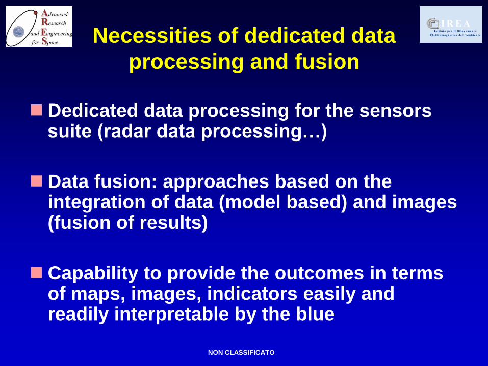
Necessities of dedicated data
processing and fusion
Dedicated data processing for the sensors suite (radar data processing…)
Data fusion: approaches based on the integration of data (model based) and images (fusion of results)
Capability to provide the outcomes in terms of maps, images, indicators easily and readily interpretable by the blue

NON CLASSIFICATO
Expertise available at
ARES-IREA Consortium
Electromagnetic modeling of the
scenarios
Advanced radar data processing from
different platforms (Satellite, Helo,
carrier..)
Capability to deal with real situations
Possibility to build/assemble sensors
and systems

NON CLASSIFICATO
Experimental test with FLGPR in collaboration with IDS- Ingegneria dei sistemi S.p.A.
ridge horn antennas 45° tilted and 93.5 cm spaced
the antenna are mounted on a moving platform 1.42 m far from the air-
soil interface and are connected to a network analyzer
working frequency range 0.4 – 2 GHz
a sandy soil (εb=4) hiding several targets ha been surveyed

NON CLASSIFICATO
GPR data processing from
airborne platform
x [m]
z [
m]
TSVD
100 200 300 400 500 600 700 800 900 1000 1100
0
50
100
150
P-band radar working in
the band 150-160 MHz on
a helicopter at the height
of about 1000 m
Capability to investigate
the subsurface
Tomographic reconstruction

NON CLASSIFICATO
Synthetic Aperture Radar (SAR)
data processing from airborne platform
P-band radar working in the band around 450 MHz
on a helicopter at the height of about 1000 m

NON CLASSIFICATO
Synthetic Aperture Radar (SAR)
data processing from airborne platform
P-band radar working in the band around 450 MHz
on a helicopter at the height of about 1000 m

NON CLASSIFICATO
Drones with visible and IR sensors

NON CLASSIFICATO
IED
Troop Carrier: An example

NON CLASSIFICATO
Troop Carrier: An example
Ground penetraring Radar operating in the band ranging from hundreds of MHz to several GHz, allocated on the front and / or sides of the mobile means which is located in front of the column. This radar system is capable of probing the ground in front and to the sides of the road to detect the presence of explosive devices buried or exposed (configuration GPR). The same radar system, in a different configuration can be used for surveillance and remote sensing of objects and persons located over an obstacle, which can be constituted for example by a masonry or by foliage (configuration TWI). You can think of a solution in which the sled on which the radar is allocated (or the array of antennas) is rotated so as to illuminate the soil before (GPR) and then the objects at a great distance (TWI). A possible technological solution is the use of stepped frequency systems that ensure high sensitivity and reconfigurable antennas that can adapt to different operational solutions. Finally it should be stressed, as in the case of objects in a larger distance to the TWI configuration, the allocation of these systems on different means could allow to exploit the concept of synthetic aperture so as to achieve better performance in terms of spatial resolution obtainable, up to one required in object detection Infrared cameras capable on the one hand to ensure the night vision and the other to detect thermal anomalies in the soil. These anomalies can be attributed to both the landslide need to bury that in the presence of unexploded ordnance themselves. A possible technological solution is constituted by a "Smart Thermal Camera" with its embedded data processing module; This makes it possible to draw data directly into the camera and then transfer to the operator's console only the processed image. . Radar sensor localization / movement at very high speed of rotation (allocated on mobile means) based on the phenomena of Doppler detection, capable of detecting the speed of the car in the direction opposite to that of the column and / or the direction of arrival of projectiles (Sniper localization) in a manner to minimize the losses in the case of sniper and surprise attacks. In the configuration described, the sensors are allocated on a mobile means, however they may also be used by soldiers on foot and in this case one can think of a multi-sensory instrumentation that integrates a metal detector, a GPR (detection of physical objects) and biosensors and detectors based on gamma rays for the detection of explosive particles in the air.

NON CLASSIFICATO
Alongside the above mentioned techniques, suitable for the detection and localization of physical objects capable of offending (people, explosive devices ..), the platform can be equipped with an additional class of sensors suitable for the location of ignition sources (eg type e) ordnance. In this phase, the sensors must be able to detect and locate electromagnetic sources. A possible solution consists of an array consisting of antennas located individually on the means of the column, which operates in a band different from the radar sensors mentioned above, where the different position of the antennas in the space may allow the location of possible sources of the electromagnetic type . In conclusion, you can think of to a total system platform sensing / moving column having a configuration like this: Means in the head and tail of the column on which are allocated to the multi-monostatic radar, the infrared cameras and radar to high rotation speed. The command center for the platform should be allocated in the middle of the vehicles column (?). This configuration ensures redundancy of instrumentation, control in both directions of travel of the road and adequate protection of the control center. Other means of column equipped with antennas for detection of electromagnetic sources and possibly antennas for the realization of the antenna synthetic active. Finally it should be pointed out, as the use of the techniques mentioned above is favored in case the troops operate in the same environment and location repeatedly. Indeed, in this case, the techniques will benefit from an approach where the abnormalities are associated with differences in the scenes investigated. By way of example shows the case of the TWI where the presence of people and objects beyond an obstacle (people in a building or hidden over the foliage) is obtained by comparing the processed image in the absence and presence of the objects.
Troop Carrier: An example