Embed Size (px)
Citation preview

SLAC’s Continuously Operating GPS Station
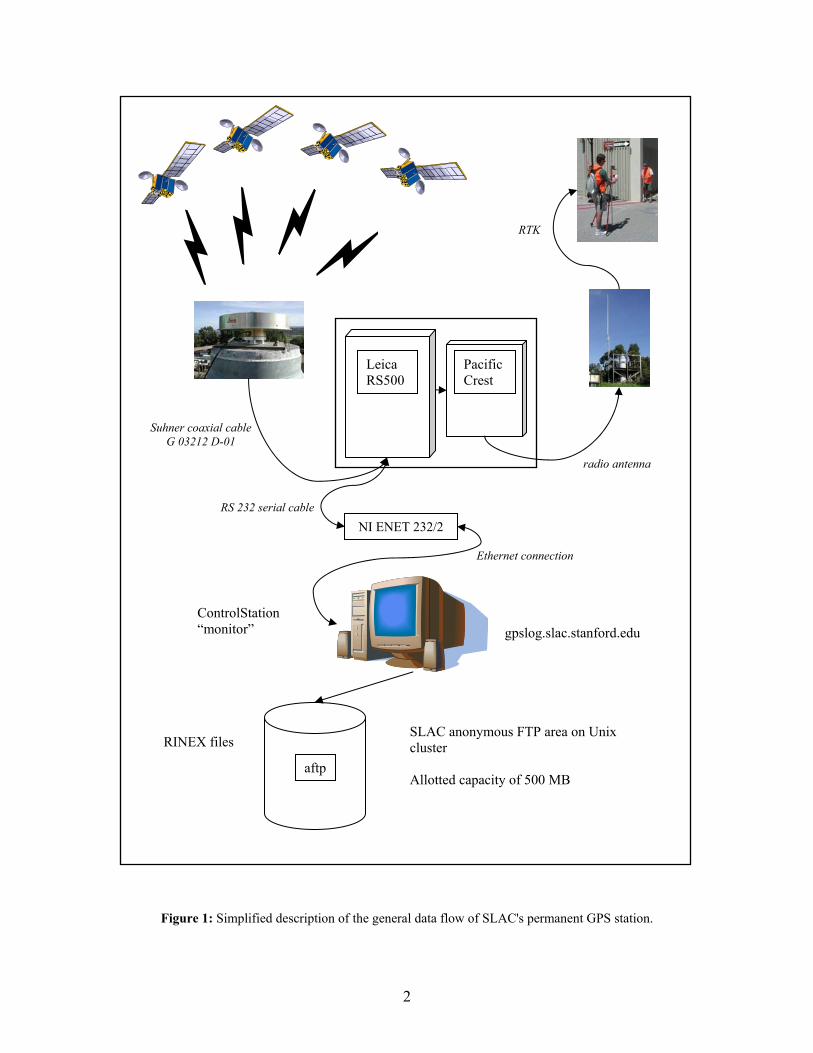
1. Introduction The main purpose of the continuously operating GPS station at SLAC is to serve as a reference station (master station) for real-time kinematic (RTK) GPS surveys. The GPS rover receives the correction signal which is produced by the master station and sent out via the radio antenna (Pacific Crest). With RTK-GPS being a relative measurement procedure, it is essential that the 3D position of the master station is well known. Errors in the position of the master station directly propagate into position errors of the rover position. If the coordinates of the master station are given in a well-defined reference datum, such as realized for instance in the International Terrestrial Reference Frame 2000 (ITRF2000), the coordinates of the rover station will automatically be obtained in the same reference frame. The master station was installed at monument M40 of the SLC (SLAC Linear Collider) network and collects data since spring 2002. The only major change in the first two years of operation concerns the change from the Leica SR530 receiver to the Leica RS500. This receiver swap was necessitated by the wish to completely automate the data gathering procedure and to remotely control the system. Thus, the general data flow takes the form as depicted in Figure 1. The signal emanating from the GPS satellites is captured by the omni-directional choke ring antenna Leica AT-504 located at monument M40 and fed into the Leica RS500 receiver. The receiver processes the collected data and outputs the following:
• RTK correction signal that is then transmitted via the Pacific Crest radio antenna to possible users within a radius of about 10 km;
• Leica binary observation files that are stored both on the receiver-internal Compact flash card (in ring buffer mode) and externally on the data logging PC that runs Leica’s ControlStation software (IP address: gpslog.slac.stanford.edu).
The Leica binary observation files of the logging PC are automatically converted into RINEX (Receiver INdependent EXchange format) observation and navigation (broadcast ephemeris) files and archived. The RINEX observation files, finally, are uploaded to the anonymous ftp site of SLAC’s computing center and made available to the outside world. The RINEX observation files are subsequently used to compute a daily solution. There is a delay of 3 weeks between recording and evaluating the observation files, because precise orbits for the satellites only become available after 2-3 weeks after the observation day. A description of the data evaluation with the Bernese GPS Software Version 4.2 will be given in a later section.
2
Figure 1: Simplified description of the general data flow of SLAC's permanent GPS station.
Leica RS500
Pacific Crest
gpslog.slac.stanford.edu
RTK
ControlStation “monitor”
SLAC anonymous FTP area on Unix cluster Allotted capacity of 500 MB
RINEX files
aftp
radio antenna
NI ENET 232/2
Ethernet connection
RS 232 serial cable
Suhner coaxial cable G 03212 D-01
3
From a data set of 411 days (from day 124 of 2002 to day 170 of 2003) a coordinate and velocity solution has been determined. Due to intermittent observation periods in the first year of operation only 322 days actually have observation data for SLAC M40. The estimated coordinates and velocities plus their accuracy estimates in ITRF2000 and NAD83 are compiled in Table 1. The reference epoch is 26-NOV-2002 (2002.90). Table 1: Coordinates, velocities, and accuracy estimates for the station SLAC M40 at the epoch 2002.90.
ITRF2000 NAD83 X -2703115.889 m ±0.8 mm -2703115.216 m Y -4291767.281 m ±1.4 mm -4291768.545 m Z 3854247.836 m ±1.4 mm 3854247.799 m vX -25.2 mm/a ±2.5 mm/a -8.8 mm/a vY 24.2 mm/a ±3.9 mm/a 24.9 mm/a vZ 9.2 mm/a ±3.5 mm/a 20.3 mm/a φ N37°24´59.45851” ±0.6 mm N37°24’59.44353” λ W122°12´15.34051” ±0.4 mm W122°12’15.28996” h 63.689 m ±2.0 mm 64.231 m vn 11.6 mm/a ±1.4 mm/a 26.1 mm/a ve -34.2 mm/a ±1.2 mm/a -20.7 mm/a vu 0.0 mm/a ±5.5 mm/a -0.6 mm/a
The coordinates of the master station used in SLAC’s RTK-GPS surveying are the latitude, longitude, and height values given in the North American Datum 1983 (NAD83); the respective values are reproduced in bold face in Table 1.
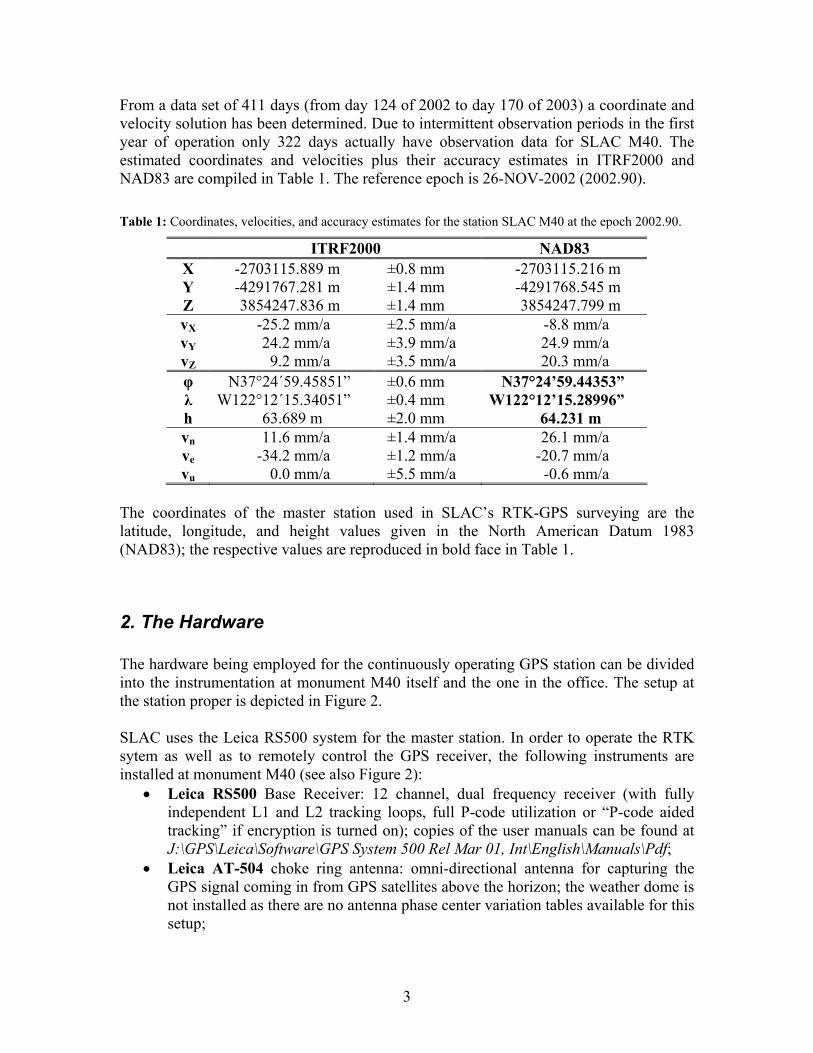
2. The Hardware The hardware being employed for the continuously operating GPS station can be divided into the instrumentation at monument M40 itself and the one in the office. The setup at the station proper is depicted in Figure 2. SLAC uses the Leica RS500 system for the master station. In order to operate the RTK sytem as well as to remotely control the GPS receiver, the following instruments are installed at monument M40 (see also Figure 2):
• Leica RS500 Base Receiver: 12 channel, dual frequency receiver (with fully independent L1 and L2 tracking loops, full P-code utilization or “P-code aided tracking” if encryption is turned on); copies of the user manuals can be found at J:\GPS\Leica\Software\GPS System 500 Rel Mar 01, Int\English\Manuals\Pdf;
• Leica AT-504 choke ring antenna: omni-directional antenna for capturing the GPS signal coming in from GPS satellites above the horizon; the weather dome is not installed as there are no antenna phase center variation tables available for this setup;

4
• Pacific Crest PDL base modem: 35 watt radio modem for RTK corrections transmission. The modem’s frequency range is 410-430 MHz, where the PDL is actually set to the governmental frequency of 416.425 MHz (stored in channel 0). When transmitting the TX light flashes. If this is not the case, cycle the power.
• Pacific Crest fiberglass omni-directional radio antenna: antenna for transmitting the GPS-RTK correction signal to the rover receivers;
• National Instruments ENET-232/2: Ethernet serial interface device, a device that removes the cable length limitation for the RS232 serial cable by facilitating the communication between GPS receiver and logging PC through an Ethernet connection; the file J:\GPS\National Instruments\ENET-232-2\UserManual.pdf contains the user manual of this device;
• American Power Conversion Corp. Back-UPS XS 1000: uninterruptible power supply with 1000 VA, prevents damages to the GPS receiver and the radio modem due to power surges and outages, the battery buffer provides power supply for roughly 1 hour;
• Ethernet connection; • Power supplies for Leica RS500 and Pacific Crest PDL: please note that the
power supplies are setup in a crossed way, meaning, e.g., that the power supply for Leica RS500 is located to the right whereas the instrument proper is to be found to the left in the weatherproof box.
Furthermore, a lightning arrester is installed in order to minimize the risk of lightning damage.
The hardware in the office consists of a Windows XP PC, another APC Back-UPS XS 1000 unit, and an Ethernet connection. The UPS buffers power outages of about 30 minutes providing power to the CPU and the screen. The Windows PC is the platform to
Figure 2: Hardware setup of SLAC's permanent GPS station at monument M40.
Leica AT-504radio antennaEthernet connection
PDL 35 radio
NI ENET-232/2
APC Back-UPS
Power for RS500
Power for PDL
Leica RS500
5
run Leica’s ControlStation software on and is mainly meant for data logging. In the rest of the paper it will thus be referred to as the logging PC. Please note that although power outages of less than half an hour do not affect the data logging, Ethernet network problems actually do. A stalled network will stop the external logging of the data onto the logging PC. Thus, once the network is back up the “lost data” need to be recovered from the ring buffer of the Compact flash card of the receiver. The daily adjustment of the regional GPS network is performed on a Linux-PC. This is due to the fact that the Windows/DOS version of Bernese GPS Software Version 4.2 does not run properly the automated processing engine BPE. Daily crashes are rather the rule than the exception. The Linux version, on the other hand, runs very stable. A detailed description of the daily evaluation of the GPS data is given in section 4.
3. The Software This section deals with the software that facilitates the data logging, monitors the integrity of the logging, and does the upload to the anonymous ftp space. In addition, a data back-up scheme is introduced.
3.1 Data Logging The data logging involves several software packages to be running on the logging PC. The current versions of the involved program packages are:
• NI Serial Device Server Software for Windows 2000/NT Version 1.01; • Leica Geosystems ControlStation Software Version 4.25; • In-house ControlStation Monitor Program (“monitor”), coded in Microsoft Visual
Basic Version 6.0. National Instruments Serial Device Server Software: In order to be able to communicate with the GPS receiver via the NI ENET-232/2 serial device server the National Instruments Serial Device Server software needs to be installed. The installation software is provided on two floppy disks and is straight forward. A mirror image of the original floppies can be found on the J-drive under J:\GPS\National Instruments\NI_SOFT_x, where x stands for 1 and 2. The routine setup.exe does the actual installation. After installation the following program parts can be found under Start>>Programs>>National Instruments>>NI Serial Device Server:
• Diagnostics • Ethernet Device Configuration • Firmware Update • Readme • User Manual
6
For the Ethernet Device Configuration the following settings were used: • Serial number: 0101C40F • Ethernet address: 00:80:2f:10:00:3d • Firmware version: A.1 • Hostname: M40GPS • IP address: 134.79.160.77 • Subnet mask: 255.255.252.0 • Gateway: 134.79.163.1 • DNS server: 134.79.16.9 • Comment (optional): M40GPS
These settings allot the IP address 134.79.160.77 (m40gps.slac.stanford.edu) to the NI ENET-232/2. In the next step the serial port(s) need to be configured. This is done with the NI Ports utility to be found in the Windows XT Control Panel. For M40GPS the two ports of the NI ENET-232/2 are mapped to the following (virtual) COM ports of the logging PC:
• Port 1 → COM3 • Port 2 → COM4
Please note that when a new mapping is set the Windows system needs to be rebooted. A pass/fail check can be performed with the Diagnostics routine. Known problems: Occasionally the NI ENET-232/2 freezes and data logging is stalled. When this happens you might try one of the following (in order of precedence):
1. Perform a Diagnostics to check if the problem actually originates from the NI ENET-232/2 device;
2. Delete the COM port mapping and then reconfigure it. This implies a reboot of the system afterwards.
3. Reset the ENET device physically by switching the device off and then holding the RESET button on the back of the instrument pressed for more than 3 seconds when switching it back on. The device needs to be reconfigured after a physical reset.
If all these remedies fail, it is possible that the Ethernet itself is not working properly. In this case SLAC’s computing center needs to be contacted. In fact, there was one such occurrence when an Ethernet switch failed to work. Leica ControlStation Vers. 4.25: The ControlStation software provides a minimum reference station configuration providing fundamental data logging and differential correction capabilities. It connects to the sensor (here: Leica RS500) to control and collect data. The setup at SLAC employs an NI ENET-232/2 device (located in the weatherproof box, see Figure 2) that allows the logging PC to be run in the office (since the necessity of connecting the GPS receiver directly to a PC via RS-232 serial cable is not given anymore). Figure 3 gives an overview of the available ports of the GPS receiver and its connection to the logging PC.
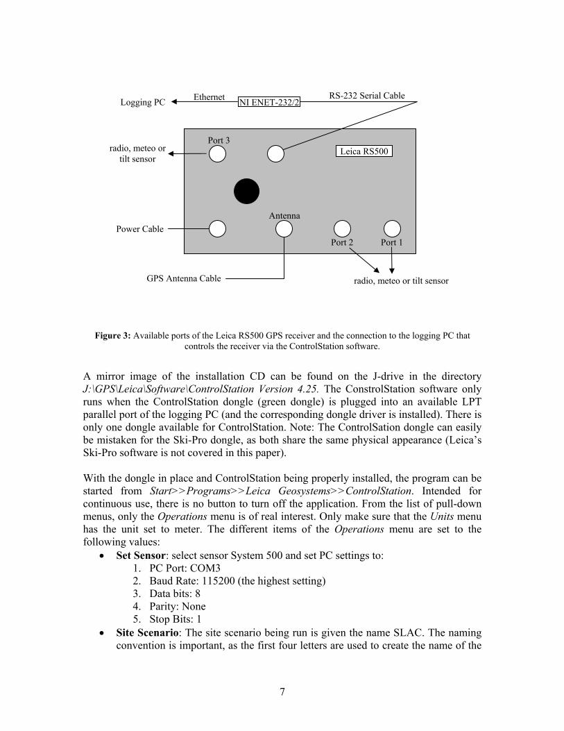
7
Figure 3: Available ports of the Leica RS500 GPS receiver and the connection to the logging PC that controls the receiver via the ControlStation software.
A mirror image of the installation CD can be found on the J-drive in the directory J:\GPS\Leica\Software\ControlStation Version 4.25. The ConstrolStation software only runs when the ControlStation dongle (green dongle) is plugged into an available LPT parallel port of the logging PC (and the corresponding dongle driver is installed). There is only one dongle available for ControlStation. Note: The ControlSation dongle can easily be mistaken for the Ski-Pro dongle, as both share the same physical appearance (Leica’s Ski-Pro software is not covered in this paper). With the dongle in place and ControlStation being properly installed, the program can be started from Start>>Programs>>Leica Geosystems>>ControlStation. Intended for continuous use, there is no button to turn off the application. From the list of pull-down menus, only the Operations menu is of real interest. Only make sure that the Units menu has the unit set to meter. The different items of the Operations menu are set to the following values:
• Set Sensor: select sensor System 500 and set PC settings to: 1. PC Port: COM3 2. Baud Rate: 115200 (the highest setting) 3. Data bits: 8 4. Parity: None 5. Stop Bits: 1
• Site Scenario: The site scenario being run is given the name SLAC. The naming convention is important, as the first four letters are used to create the name of the
Power
Terminal
Leica RS500
Antenna
Port 2 Port 1
Port 3
radio, meteo or tilt sensor
radio, meteo or tilt sensor
Power Cable
GPS Antenna Cable
RS-232 Serial Cable NI ENET-232/2Logging PC Ethernet

8
RINEX observation files and SLAC is the allotted site name. The site scenario has the following parameters:
1. SiteID: SLAC 2. Latitude: N37 24 59.443530 3. Longitude: W122 12 15.289960 4. Height: 64.2310 m 5. Port A: Baud Rate 115200, Device PC-CDU 6. Port B: Baud Rate 9600, Device Radio, RTCM Version 2.2,
Message types 1&2&3&18&19&22 7. Port C: Baud Rate 9600, Device Radio, CMR 8. Minimum elevation angle: 0 9. Antenna type: AT504 Pillar 10. Antenna height: 0.0000 m 11. Time offset: -8 hours (local time minus GPS time). When daylight savings
time is on, the time offset reduces to -7 hours. Still, there is no real need to adjust the time offset, as the time difference only has informative character and does not influence the actual operation of the system.
In this scenario, two RTK correction signals are sent out: RTCM and CMR. The RTCM signal is fed into the Pacific Crest radio modem/antenna in order to be transmitted to the rover receivers operating on the SLAC site. The CMR signal, on the other hand, is passed on via the internet to a server at Haselbach Surveying Equipment (www.haselbachinstruments.com). From there a user may download the correction data (not implemented yet).
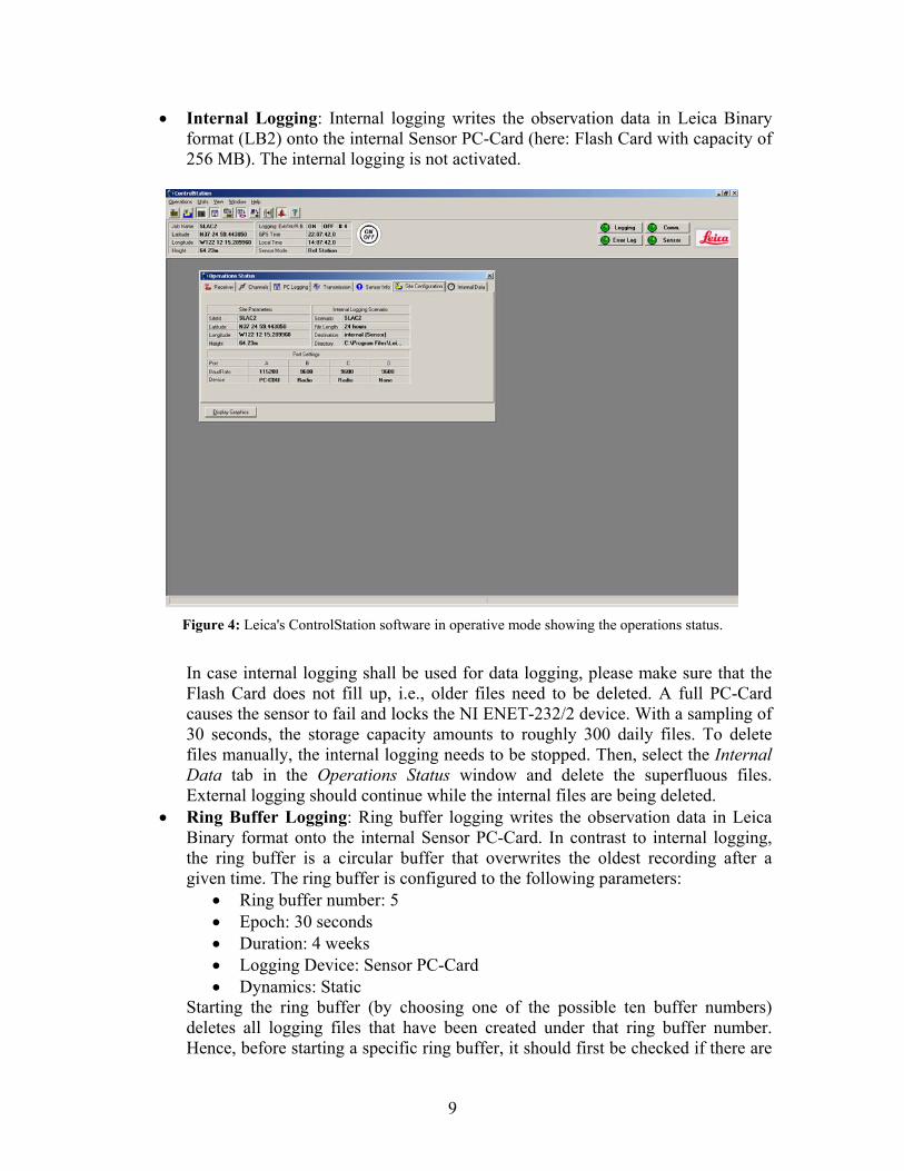
• Show Status: Gives an overview of the operations status of the Leica system. Different mission critical information can be viewed by activating the corresponding tabs: Receiver, Channels, PC Logging, Transmission, Sensor Info, Site Configuration, Internal Data, and Display Graphics. The information displayed is mostly self-explanatory. Figure 4 gives an example showing the operations status at a given time.
• Logging: The Logging button of the ControlStation toolbar activates the external logging to the logging PC. The logging parameters are set to:
1. File length: 24 hours 2. Logging rate 30 seconds
The logging data is written to the default directory as proposed by ControlStation: C:\Program Files\Leica Geosystems\ControlStation\PC. When logging files at a length of 24 hours, the daily observation files are stored in subdirectories for year, month, and day. The Automatic RINEX conversion is turned on, whereas the automatic zipping of the RINEX files is turned off. This creates 3 kinds of observation files: Leica Binary LB2, RINEX observation, and RINEX navigation. For the day of the year (DOY) 275 of 2003, for instance, the files are named:
1. SLAC2750.03f 2. RINEX\SLAC2750.03O 3. RINEX\SLAC2750.03N
Please note that the last character of the RINEX observation file is the upper case letter “o” (and not the number zero).
9
• Internal Logging: Internal logging writes the observation data in Leica Binary format (LB2) onto the internal Sensor PC-Card (here: Flash Card with capacity of 256 MB). The internal logging is not activated.
Figure 4: Leica's ControlStation software in operative mode showing the operations status.
In case internal logging shall be used for data logging, please make sure that the Flash Card does not fill up, i.e., older files need to be deleted. A full PC-Card causes the sensor to fail and locks the NI ENET-232/2 device. With a sampling of 30 seconds, the storage capacity amounts to roughly 300 daily files. To delete files manually, the internal logging needs to be stopped. Then, select the Internal Data tab in the Operations Status window and delete the superfluous files. External logging should continue while the internal files are being deleted.
• Ring Buffer Logging: Ring buffer logging writes the observation data in Leica Binary format onto the internal Sensor PC-Card. In contrast to internal logging, the ring buffer is a circular buffer that overwrites the oldest recording after a given time. The ring buffer is configured to the following parameters:
• Ring buffer number: 5 • Epoch: 30 seconds • Duration: 4 weeks • Logging Device: Sensor PC-Card • Dynamics: Static
Starting the ring buffer (by choosing one of the possible ten buffer numbers) deletes all logging files that have been created under that ring buffer number. Hence, before starting a specific ring buffer, it should first be checked if there are

10
important files to be downloaded. If in doubt, a different ring buffer number should be chosen, leaving the files of the doubtful ring buffer unharmed. The ring buffer logging writes to the same memory segment of the Flash Card over and over again. This continuous overwrite operation may cause damage to the memory segment, eventually resulting in data loss through retrieval errors. In order to use different parts of the Flash Card, it appears to be good practice to switch to a different buffer number every so often, say, every 6-8 months.
• Download: The download option enables the user to download internal and/or ring buffer logging files. Please note that the download operation cannot be performed while external logging is running. The download operation also includes the optional automatic conversion to RINEX files and the automatic zipping of the RINEX files. Depending on whether the data originate from internal or ring buffer logging, the downloaded files are to be found in the following directories:
• C:\Program Files\Leica Geosystems\ControlStation\INT • C:\Program Files\Leica Geosystems\ControlStation\RB
This needs to be kept in mind when further processing the data. • Convert: This tool is provided for the case that a Leica binary LB2 file needs to
be converted to RINEX format at a later stage. In addition to the RINEX conversion, automatic zipping may be activated.
When starting the ControlStation software for the first time, make sure that the Leica RS500 GPS receiver is turned off. ControlStation will automatically power on the receiver. If this does not happen, try first the On/Off button of ControlStation and secondly the power switch of the receiver itself. Installing a new Windows patch: Currently, about once per month it is necessary to install a new security patch for the Windows system. This usually involves a reboot of the operating system, clearly interrupting the external data logging. Still, there is no work-around. In order to avoid having to set the sensor, scenario, etc. anew, it turned out to be sufficient to stop external logging and then to close ControlStation by hitting the Windows close button in the upper right hand corner of the window. After confirming that you really want to stop the application, you can do the patching. Following the Windows patch reboot, restart ControlStation. In the first 5 to 10 seconds of operation ControlStation will give an error message, stating that ControlStation is unable to communicate with the sensor or that the sensor config data are not yet available. This will stop soon. Clear the error message from the log file and reactivate external logging. This should do the trick. Problem: Incomplete RINEX navigation file: For unknown reasons it happens once in a while that the RINEX navigation file only contains data for the first two hours of the day. A strong indication of this problem is when in the “monitor” section (see below) the difference between a daily code solution and an average solution amounts to more than 100 m (in this case a warning message is emailed to the operator). As the broadcast ephemerides (RINEX navigation file) are not used in the data processing with Bernese, this problem is of minor concern. Furthermore,

11
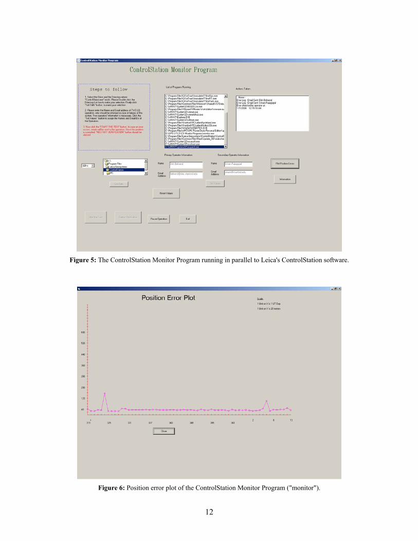
if need be, generic broadcast ephemerides can be downloaded from the internet (e.g, ftp://cddisa.gsfc.nasa.gov/pub/gps/gpsdata/04029/04n/brdc0290.04n.Z for day 029 of year 2004). Still, for the data integrity test within “monitor” the RINEX navigation file should be complete. It turned out that stopping external logging and then reactivating it, does solve the problem (for the following day). Problem: Missing RINEX navigation file: A crash of the Ethernet connection might bring about a misalignment between the settings active in the receiver and in the ControlStation software. This manifests itself in the external logging only creating RINEX observation files, but no RINEX navigation files. To cure this try first to upload the session settings from ControlStation to the sensor. Only when this is not working, stop the logging (external and ring buffer). Then close ControlStation, delete the files C:\WINNT\controlstation.ini and C:\Program Files\Leica Geosystems\ControlStation\controlstation.cfg, restart ControlStation, put in the relevant session setting, and do the session info upload to the sensor. ControlStation Monitor Program (“monitor”) The “monitor” program fulfills two main tasks: (1) check if ControlStation is running and has no entry in the error log, (2) run scripts to rename, reformat, and quality check the recorded RINEX files. The program is written in Visual Basic and should run in parallel to ControlStation (start ControlStation first). The source code of the “monitor” program resides on the logging PC in the directory: D:\GPS UTILS\CS Monitor Programs. The D-partition was favored over the C-partition in order to make a porting to a different platform more transparent. The program is started by running the executable monitor.exe. A less favored way of initiating the program is to activate it out of the Visual Basic environment. This should preferably only be done when there is a need for changing the source code. After starting the program a three step procedure needs to be followed for setting up the program properly (with the steps being described in the upper left hand corner of the ControlStation Monitor Program; see also Figure 5): 1. Select the absolute path where to find Leica’s ControlStation software. This includes
the drive letter and the complete path. After double clicking the name ControlStation in the selection window, click the Set Path icon. Currently the path to the Leica software is: C:\Program Files\Leica Geosystems\ControlStation.
2. Choose two operators to send email error/warning messages to. For this, give the name and the email addresses and the click the Set Values icon.
3. Activate the settings by pressing the Start the test icon. After a few seconds “monitor” checks the list of programs running on the logging PC. If this list does not contain ControlStation, an error log is emailed to the operator. The operator should Pause Operation, determine the reason why ControlStation is not running, restart ControlStation, and finally Restart Verification within “monitor”.
12
Figure 5: The ControlStation Monitor Program running in parallel to Leica's ControlStation software.
Figure 6: Position error plot of the ControlStation Monitor Program ("monitor").
13
A rough check on data validity is performed by comparing a fast coordinate solution (code solution) derived from the daily RINEX observation and navigation files (broadcast ephemerides) to a precise solution that was determined over a long period of time (one year) with precise orbits using Bernese. The code solution is done by UNAVCO’s teqc software (teqc resides in C:\GPS UTILS\TEQC) and gives a position fix that is good to 30-40 m. “monitor” sends a warning message via email to the operator when the difference of the two solutions exceeds 100 m. The daily position errors are stored in the file D:\GPS UTILS\CS Monitor Programs\ploterr.txt. The last 60 days of this time series can be plotted directly out of “monitor” by hitting the Plot Position Errors icon. Figure 6 shows an example position error plot. The RINEX files created by ControlStation do not fully comply with the RINEX Vers. 2.10 conventions. To ensure compatibility, “monitor” passes the original RINEX files through teqc for reformatting. This is done at the same time as the code solution is produced with teqc being invoked at 0005 hours UTC. The invocation time translates into 1605 hours PST and 1705 hours PDST. For “monitor” to run properly make sure that the time zone setting of the logging PC is set to GMT. A wrong time setting might result in an incorrect storage location for the teqc’ed files and/or truncated observation data files. For data handling and storage “monitor” makes use of three DOS batch files: GPSFIMOV.BAT, NAMEEXT.BAT, and NEWYRDIR.BAT. These batch files are called directly out of “monitor” with no user intervention needed. In addition to invoking the position fixing and the reformatting, the batch files write resulting data files onto the D-drive under the directory D:\GPSData. In the SLAC subdirectory the Leica binary LB2 observation files are archived (example of first 7 days of the year 2004):
D:\GPSData\SLAC\2004\ D:\GPSData\SLAC\2004\RBSLAC04.O01 D:\GPSData\SLAC\2004\RBSLAC04.O02 D:\GPSData\SLAC\2004\RBSLAC04.O03 D:\GPSData\SLAC\2004\RBSLAC04.O04 D:\GPSData\SLAC\2004\RBSLAC04.O05 D:\GPSData\SLAC\2004\SLAC001.04f D:\GPSData\SLAC\2004\SLAC005.04f D:\GPSData\SLAC\2004\SLAC006.04f D:\GPSData\SLAC\2004\SLAC007.04f
The files of the type SLAC00x.04f are the binaries recorded with the external logging. The RBSLAC04.O0x are binaries created by ring buffer logging and were downloaded by hand. The ring buffer functions as a back-up to the external logging. And, in the case at hand, days of external logging at the beginning of the year were lost due to a naming problem. The procedure on how to download the ring buffer files and putting them into the processing chain is described further down. Here, we just want to point out that the ring buffer number is 04, and that the numbering 01 to 05 at the end of the files equals the day numbering of the year (or month) merely by coincidence. The RINEX navigation and observation files as well as the summary file of the teqc quality control run are stored under the directory D:\GPSData\Public. For the first day of the year 2004 the respective files are:
14
D:\GPSData\Public\2004\SLAC0010.04N D:\GPSData\Public\2004\SLAC0010.04O.gz D:\GPSData\Public\2004\SLAC0010.04S
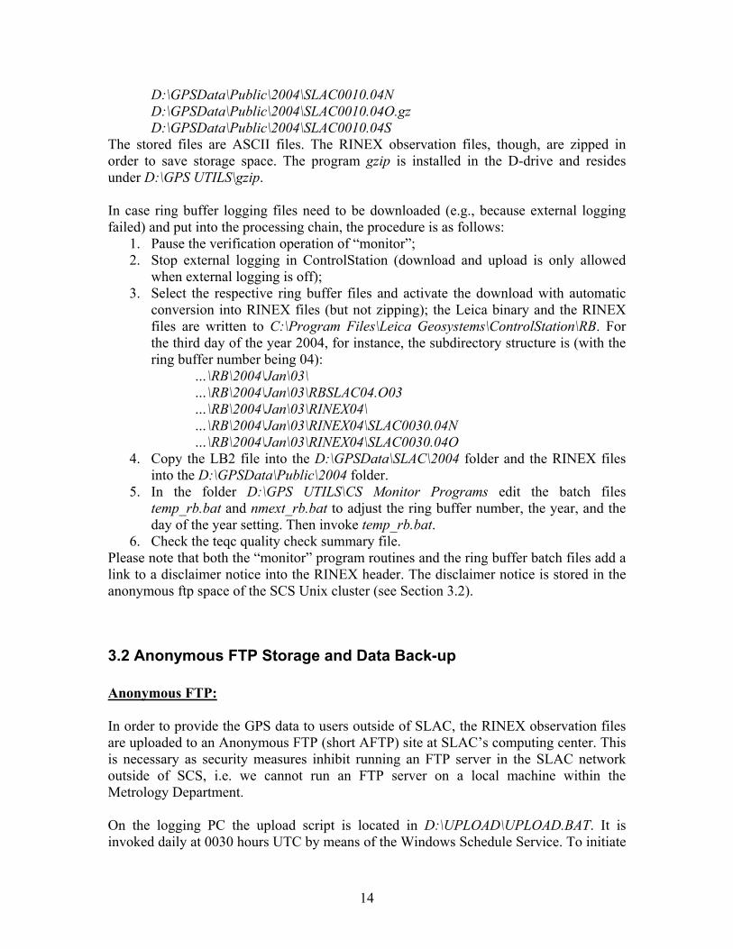
The stored files are ASCII files. The RINEX observation files, though, are zipped in order to save storage space. The program gzip is installed in the D-drive and resides under D:\GPS UTILS\gzip. In case ring buffer logging files need to be downloaded (e.g., because external logging failed) and put into the processing chain, the procedure is as follows:
1. Pause the verification operation of “monitor”; 2. Stop external logging in ControlStation (download and upload is only allowed
when external logging is off); 3. Select the respective ring buffer files and activate the download with automatic
conversion into RINEX files (but not zipping); the Leica binary and the RINEX files are written to C:\Program Files\Leica Geosystems\ControlStation\RB. For the third day of the year 2004, for instance, the subdirectory structure is (with the ring buffer number being 04):
…\RB\2004\Jan\03\ …\RB\2004\Jan\03\RBSLAC04.O03 …\RB\2004\Jan\03\RINEX04\ …\RB\2004\Jan\03\RINEX04\SLAC0030.04N …\RB\2004\Jan\03\RINEX04\SLAC0030.04O
4. Copy the LB2 file into the D:\GPSData\SLAC\2004 folder and the RINEX files into the D:\GPSData\Public\2004 folder.
5. In the folder D:\GPS UTILS\CS Monitor Programs edit the batch files temp_rb.bat and nmext_rb.bat to adjust the ring buffer number, the year, and the day of the year setting. Then invoke temp_rb.bat.
6. Check the teqc quality check summary file. Please note that both the “monitor” program routines and the ring buffer batch files add a link to a disclaimer notice into the RINEX header. The disclaimer notice is stored in the anonymous ftp space of the SCS Unix cluster (see Section 3.2).
3.2 Anonymous FTP Storage and Data Back-up Anonymous FTP: In order to provide the GPS data to users outside of SLAC, the RINEX observation files are uploaded to an Anonymous FTP (short AFTP) site at SLAC’s computing center. This is necessary as security measures inhibit running an FTP server in the SLAC network outside of SCS, i.e. we cannot run an FTP server on a local machine within the Metrology Department. On the logging PC the upload script is located in D:\UPLOAD\UPLOAD.BAT. It is invoked daily at 0030 hours UTC by means of the Windows Schedule Service. To initiate
15
the upload script for daily runs at the mentioned time, the following command was executed once in a DOS window:
at 0:30 /every:M,T,W,Th,F,S,Su D:\UPLOAD\UPLOAD.BAT To check the currently scheduled commands run the at command without any option. The upload script does an AFTP connection to the incoming FTP space of the SCS Unix cluster. SCS discourages a direct upload to the outgoing FTP space, as this involves a named FTP connection to the Unix cluster (the outgoing FTP space can only be filled by users of the Unix cluster) and thus storing of the Unix cluster username and password in some form on the logging PC. The RINEX observation file is copied into the directory
/afs/slac.stanford.edu/public/incoming/behrend which is simply seen as
/incoming/behrend when doing an AFTP to ftp.slac.stanford.edu. On the Unix cluster a crontab (cron is the Unix command schedule service) job moves the uploaded file from the incoming space to the appropriate outgoing space. SCS has its own flavor of crontab named trscrontab which is tailored to the AFS file system needs. As the time zone of the Unix cluster is set to PST (with the daylight savings option activated), the update script is started at 1735 hours PST or PDST. This corresponds to 0035 hours UTC during summer time and 0135 hours UTC at all other times. The update script is located in /afs/slac/u/pa/behrend/scripts/updftp.scr. The scheduler program trscrontab was started from flora03.slac.stanford.edu with the options
flora03 35 17 * * * /afs/slac/u/pa/behrend/scripts/updftp.scr by putting the above line into a file and running the command
trscrontab filename To check which scheduled jobs are set via trscrontab use the following command:
trscrontab –l where the option is the letter ell. If an error occurs during the execution of the trscrontab job, an alert message is emailed to the owner of the job. The update script moves the current RINEX file from the /incoming/behrend directory to /afs/slac.stanford.edu/public/groups/pa/rinex/2004 (assuming that the observation data stem from the year 2004). The file /afs/slac/public/groups/pa/rinex/Disclaimer.txt contains the disclaimer notice that goes with the RINEX files. The available storage capacity of the outgoing FTP space amounts to 500 MB. With a daily observation file occupying about 0.65 MB of mass storage, this provides storage space for some two years. Then, a part of the data needs to be backed up and stored away. Data Back-up: For data security the collected data should be backed up at regular intervals. Furthermore, due to a limited size of the hard disk of the logging PC (and of the AFTP area), data segments are to be burned on CD at reasonable time intervals freeing the necessary space.
16
One measure of data security is duplication. The first data duplication occurs when the data are logged externally and within the ring buffer. As after 4 weeks the oldest data are overwritten within the ring buffer, however, this is no permanent security measure. A permanent duplication occurs, on the other hand, when the daily observation files are copied from the C:\Program Files\Leica Geosystems\ControlStation\PC area to the D:\GPSData area. A further duplication takes place when the daily RINEX observation files are uploaded to the AFTP space. At the end of the year both the data from the C-drive and the data from the D-drive should be saved onto CD. To increase security an incremental back-up may be made every 4 months.
4. Bernese GPS Software Version 4.2 BERNESE GPS Software Version 4.2 was acquired in February 2002 in order to perform in depth analysis and long-term studies of the collected GPS data. BERNESE is a platform independent software package based on standard FORTRAN-77 and FORTRAN-90 modules that are being driven by a menu system. The data analysis can be automated to a large extent by means of batch processes of the BERNESE Processing Engine (BPE). The highest accuracy requirements are met by processing dual frequency code and phase measurements as well as by modeling or introducing models for the ionospheric and tropospheric signal delay, antenna phase center variations, and ocean tide loading effects as examples. BERNESE constitutes a state-of-the-art scientific software package which is also being employed worldwide by survey agencies to evaluate permanent local or regional GPS networks. As Windows XP is the operating system standard of the Metrology Department, BERNESE was initially installed in the Windows environment. Unfortunately, it turned out that the BERNESE Processing Engine (BPE) does not work stable under this operating system: the processing crashed almost daily making a manual re-processing necessary. This completely defeated the realization of a fully automated analysis of the GPS data. Since there was no possible workaround in sight, the only possible way to go was to change to a different operating system: Linux. With no dedicated Linux-PC running in the Alignment Group, a virtual machine software (VMWare) was installed on a Windows host. This software facilitates running almost any operating system within a VMWare window on the host PC. As guest operating system Red Hat Linux 7.2 was chosen and the Linux version of BERNESE was installed. The DOS batch files of the BPE were translated into equivalent script files in Linux. It appears that the BPE under Linux runs very stable and, so far, there has been no major disruption. And, it was possible to completely automate the daily GPS data analysis. Thus, in this section we describe how to operate BERNESE in the Linux operating system environment (basic concepts of the Linux system are assumed known), the
17
processing steps performed in the daily GPS data evaluation, and the derivation of coordinates and their velocities.
4.1 BERNESE GPS Software Version 4.2 under Red Hat Linux 7.2 BERNESE can be described as a collection of FORTRAN routines that are being invoked by a menu system. The FORTRAN routines do not make use of language extensions and are, therefore, platform independent. Platform dependence comes into play when the menu system is put on top of the routines, because, for instance, the creation of file lists (operating system dependence) and clear screen or cursor positioning commands (terminal type dependence) differ from platform to platform. Another platform related issue are tasks that are outside of the capabilities of standard FORTRAN such as the execution of system commands under the control of a FORTRAN program. The Linux operating system has to provide a FORTRAN compiler for creating the necessary executables from the source codes. The standard installation of Red Hat Linux 7.2 provides the GNU compiler g77. In its standard Linux installation process, BERNESE is compiled with g77 with Optimization activated (default setting). The compilation works fine, but unrecoverable run-time errors occur when BERNESE is actually used. Deactivating the optimization option cures the problem. Another feasible approach is to use a different compiler. The current installation of BERNESE is compiled with the Intel Fortran Compiler (IFC) Version 7.0. The IFC was favored before the g77, as it understands both FORTRAN 77 and FORTRAN 90. Both compilers yield the same results for a test data set (g77 with the optimization option disabled). A description of the BERNESE installation process is beyond the scope of this paper and the reader is referred to Chapter 25 of the BERNESE user manual where this topic is extensively covered. Here it shall suffice to describe the necessary steps to start the menu system after a successful installation and to outline how to use the menu system. This will be followed by a description of the automatization (scripts and commands). Handling the Menu System: After logging on to the Linux PC, the Bernese environment is prepared by invoking the LOADGPS script in the $HOME directory:
[linux]$ ./LOADGPS The script performs some subdirectory substitutions and defines Bernese relevant variables. The menu system can then be started by the G script:
[linux]$ G The invocation directly leads into the primary panel of the menu system (see Figure 7). The primary panel belongs to the group of so-called program panels that are used to navigate through the various levels of the menu system and to select the actual program. Program panels are simplified panels that do not contain input fields. A sublevel is selected by entering the level number after the ‘Enter Selection:’ field followed by hitting the <Enter> key. Going up one level is accomplished by the key sequence =Q <Enter>.
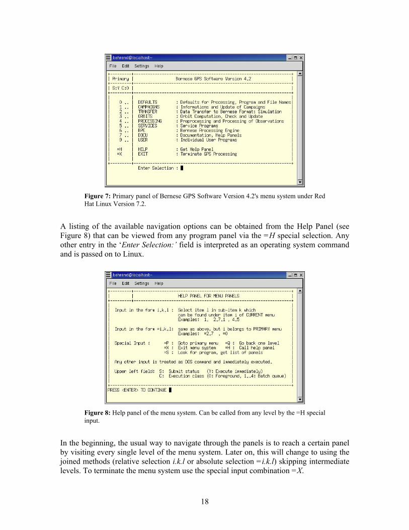
18
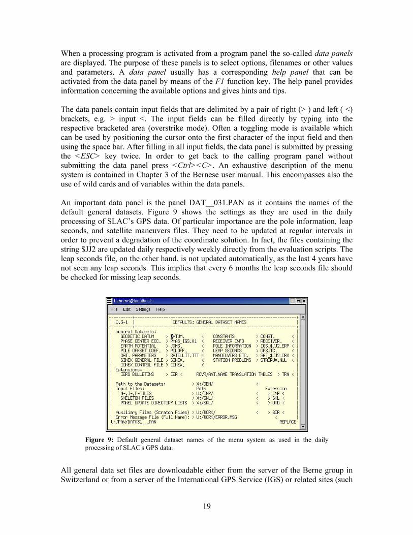
A listing of the available navigation options can be obtained from the Help Panel (see Figure 8) that can be viewed from any program panel via the =H special selection. Any other entry in the ‘Enter Selection:’ field is interpreted as an operating system command and is passed on to Linux.
In the beginning, the usual way to navigate through the panels is to reach a certain panel by visiting every single level of the menu system. Later on, this will change to using the joined methods (relative selection i.k.l or absolute selection =i.k.l) skipping intermediate levels. To terminate the menu system use the special input combination =X.
Figure 7: Primary panel of Bernese GPS Software Version 4.2's menu system under Red Hat Linux Version 7.2.
Figure 8: Help panel of the menu system. Can be called from any level by the =H special input.
19
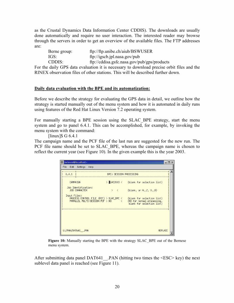
When a processing program is activated from a program panel the so-called data panels are displayed. The purpose of these panels is to select options, filenames or other values and parameters. A data panel usually has a corresponding help panel that can be activated from the data panel by means of the F1 function key. The help panel provides information concerning the available options and gives hints and tips. The data panels contain input fields that are delimited by a pair of right (> ) and left ( <) brackets, e.g. > input <. The input fields can be filled directly by typing into the respective bracketed area (overstrike mode). Often a toggling mode is available which can be used by positioning the cursor onto the first character of the input field and then using the space bar. After filling in all input fields, the data panel is submitted by pressing the <ESC> key twice. In order to get back to the calling program panel without submitting the data panel press <Ctrl><C>. An exhaustive description of the menu system is contained in Chapter 3 of the Bernese user manual. This encompasses also the use of wild cards and of variables within the data panels. An important data panel is the panel DAT__031.PAN as it contains the names of the default general datasets. Figure 9 shows the settings as they are used in the daily processing of SLAC’s GPS data. Of particular importance are the pole information, leap seconds, and satellite maneuvers files. They need to be updated at regular intervals in order to prevent a degradation of the coordinate solution. In fact, the files containing the string $JJ2 are updated daily respectively weekly directly from the evaluation scripts. The leap seconds file, on the other hand, is not updated automatically, as the last 4 years have not seen any leap seconds. This implies that every 6 months the leap seconds file should be checked for missing leap seconds.
All general data set files are downloadable either from the server of the Berne group in Switzerland or from a server of the International GPS Service (IGS) or related sites (such
Figure 9: Default general dataset names of the menu system as used in the dailyprocessing of SLAC's GPS data.
20
as the Crustal Dynamics Data Information Center CDDIS). The downloads are usually done automatically and require no user interaction. The interested reader may browse through the servers in order to get an overview of the available files. The FTP addresses are:
Berne group: ftp://ftp.unibe.ch/aiub/BSWUSER IGS: ftp://igscb.jpl.nasa.gov/pub CDDIS: ftp://cddisa.gsfc.nasa.gov/pub/gps/products
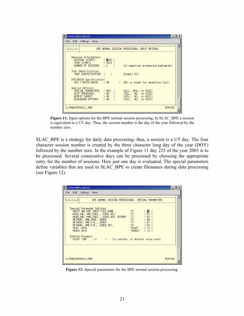
For the daily GPS data evaluation it is necessary to download precise orbit files and the RINEX observation files of other stations. This will be described further down. Daily data evaluation with the BPE and its automatization: Before we describe the strategy for evaluating the GPS data in detail, we outline how the strategy is started manually out of the menu system and how it is automated in daily runs using features of the Red Hat Linux Version 7.2 operating system. For manually starting a BPE session using the SLAC_BPE strategy, start the menu system and go to panel 6.4.1. This can be accomplished, for example, by invoking the menu system with the command:
[linux]$ G 6.4.1 The campaign name and the PCF file of the last run are suggested for the new run. The PCF file name should be set to SLAC_BPE, whereas the campaign name is chosen to reflect the current year (see Figure 10). In the given example this is the year 2003.
After submitting data panel DAT641__.PAN (hitting two times the <ESC> key) the next sublevel data panel is reached (see Figure 11).
Figure 10: Manually starting the BPE with the strategy SLAC_BPE out of the Bernese menu system.
21
SLAC_BPE is a strategy for daily data processing; thus, a session is a UT day. The four character session number is created by the three character long day of the year (DOY) followed by the number zero. In the example of Figure 11 day 225 of the year 2003 is to be processed. Several consecutive days can be processed by choosing the appropriate entry for the number of sessions. Here just one day is evaluated. The special parameters define variables that are used in SLAC_BPE to create filenames during data processing (see Figure 12).
Figure 11: Input options for the BPE normal session processing. In SLAC_BPE a session is equivalent to a UT day. Thus, the session number is the day of the year followed by thenumber zero.
Figure 12: Special parameters for the BPE normal session processing.
22
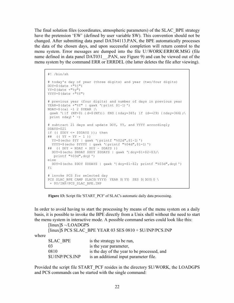
The final solution files (coordinates, atmospheric parameters) of the SLAC_BPE strategy have the pretension ‘EW’ (defined by user variable $W). This convention should not be changed. After submitting data panel DAT64113.PAN, the BPE automatically processes the data of the chosen days, and upon successful completion will return control to the menu system. Error messages are dumped into the file U:\WORK\ERROR.MSG (file name defined in data panel DAT031__.PAN, see Figure 9) and can be viewed out of the menu system by the command ERR or ERRDEL (the latter deletes the file after viewing).
In order to avoid having to start the processing by means of the menu system on a daily basis, it is possible to invoke the BPE directly from a Unix shell without the need to start the menu system in interactive mode. A possible command series could look like this:
[linux]$ ~/LOADGPS [linux]$ PCS SLAC_BPE YEAR 03 SES 0810 + $U/INP/PCS.INP
where SLAC_BPE is the strategy to be run, 03 is the year parameter, 0810 is the day of the year to be processed, and $U/INP/PCS.INP is an additional input parameter file.
Provided the script file START_PCF resides in the directory $U/WORK, the LOADGPS and PCS commands can be started with the single command:
Figure 13: Script file 'START_PCF' of SLAC's automatic daily data processing.
#! /bin/sh # today's day of year (three digits) and year (two/four digits) DOY=$(date +"%j") YY=$(date +"%y") YYYY=$(date +"%Y") # previous year (four digits) and number of days in previous year YEAR=$(date +"%Y" | gawk '{print $1-1}') NDAY=$(cal -1 2 $YEAR |\ gawk '{if (NF>0) {d=$(NF)}} END {nday=365; if (d==29) {nday=366};\ print nday}' -) # subtract 21 days and update DOY, YY, and YYYY accordingly DDAYS=021 if (( $DOY <= $DDAYS )); then ## (( YY = YY - 1 )) YY=$(echo $YY | gawk '{printf "%02d",$1-1}') YYYY=$(echo $YYYY | gawk '{printf "%04d",$1-1}') ## (( DOY = NDAY + DOY - DDAYS )) DOY=$(echo $NDAY $DOY $DDAYS | gawk '{doy=$1+$2-$3;\ printf "%03d",doy}') else DOY=$(echo $DOY $DDAYS | gawk '{doy=$1-$2; printf "%03d",doy}') fi # invoke PCS for selected day PCS SLAC_BPE CAMP SLAC${YYYY} YEAR ${YY} SES ${DOY}0 \ + $U/INP/PCS_SLAC_BPE.INP
23
[linux]$ ~/LOADGPS RUN_SCRIPT START_PCF where START_PCF needs to contain the PCS command. This last invocation can be done by any scheduler available under the operating system with crontab being the standard choice on a Linux system. The cron job at SLAC activates the daily processing at 4 a.m. PST (respectively the active time zone of the Linux PC). The chosen time is arbitrary; the only time to be avoided is between 2 and 3 a.m. due to possible problems by changing from winter to summer time and vice versa. The command
[linux}$ crontab –l lists the implemented options of the cron job. For SLAC_BPE these are:
00 04 * * * /home/behrend/LOADGPS RUN_SCRIPT START_PCF >/dev/null The contents of the script file ‘START_PCF’ is listed in Figure 13. Please note the time delay of 21 days between recording and evaluating the GPS data. This time span is needed due to the fact that precise orbit information only becomes available 2 to 3 weeks after the observation day. In order to get the daily processing data organized, they are grouped into yearly campaign directories: SLAC2002, SLAC2003, SLAC2004, and so on. The resulting coordinates are to be found in the files SLAC20yy/STA/EW_yyddd.CRD, where ‘yy’ stands for the year (two digits) and ‘ddd’ for the day of the year (three digits). The coordinates are loosely constrained to the ITRF2000 (non-fiducial orbits, no station fixed in least-squares adjustment).
4.2 GPS Data Evaluation Strategy SLAC_BPE The GPS data evaluation is largely based on Example 1 “Regional Campaign” of the Bernese user manual (Chapter 4.1). In order to get a deeper understanding of the processing steps, it is suggested that the interested reader reprocesses the steps of the example using the user manual as guidance. Here, we reproduce the regional campaign in a version tailored to the SLAC network. Furthermore, we describe aspects of the Bernese Processing Engine (BPE) relevant for the implementation of the strategy SLAC_BPE. Figure 14 shows the Procedure Control File (PCF) named SLAC_BPE.PCF that constitutes the major building stone for running the strategy SLAC_BPE. The PCF file resides in the directory $U/PCF and, in quintessence, calls the scripts that are listed under the heading of the same name. The scripts are called in sequential order with the following script waiting for the termination of the previous script(s). The used scripts are identical to the ones of the user manual example except for those that contain SLAC in their name. These scripts are altered and tailored to the specific needs at SLAC. They reside in the directory $U/SCRIPT. Each script invokes one or more Bernese Fortran program(s). The options for these programs (i.e., the data panels of the menu system) need to be assembled beforehand. The
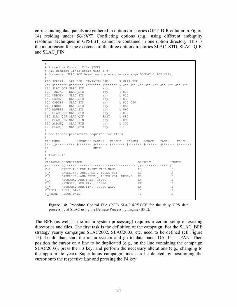
24
corresponding data panels are gathered in option directories (OPT_DIR column in Figure 14) residing under $U/OPT. Conflicting options (e.g., using different ambiguity resolution techniques in GPSEST) cannot be contained in one option directory. This is the main reason for the existence of the three option directories SLAC_STD, SLAC_QIF, and SLAC_FIN.
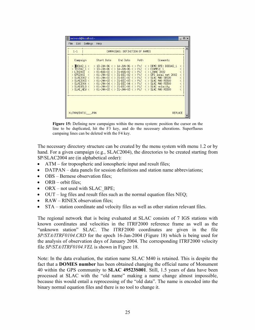
The BPE (as well as the menu system processing) requires a certain setup of existing directories and files. The first task is the definition of the campaign. For the SLAC_BPE strategy yearly campaigns SLAC2002, SLAC2003, etc. need to be defined (cf. Figure 15). To do that, start the menu system and go to data panel DAT11___.PAN. Then position the cursor on a line to be duplicated (e.g., on the line containing the campaign SLAC2003), press the F3 key, and perform the necessary alterations (e.g., changing to the appropriate year). Superfluous campaign lines can be deleted by positioning the cursor onto the respective line and pressing the F4 key.
# # Procedure Control File (PCF) # All comment lines start with a # # Comments: SLAC PCF based on the example campaign DOCU42_1 PCF file # PID SCRIPT OPT_DIR CAMPAIGN CPU P WAIT FOR.... 3** 8******* 8******* 8******* 8******* 1 3** 3** 3** 3** 3** 3** 3** 3** 3** 010 SLAC_COP SLAC_STD any 1 020 PRETAB SLAC_STD any 1 010 030 ORBGEN SLAC_STD any 1 020 040 RXOBV3 SLAC_STD any 1 030 050 CODSPP SLAC_STD any 1 030 040 060 SNGDIF SLAC_STD any 1 050 070 MAUPRP SLAC_STD any 1 060 080 SLAC_STD SLAC_STD any 1 070 090 SLAC_QIF SLAC_QIF FAST 1 080 100 SLAC_FIN SLAC_FIN any 1 090 110 ADDNEQ SLAC_FIN any 1 100 120 SLAC_DEL SLAC_STD any 1 110 # # additional parameters required for PID's # PID USER PASSWORD PARAM1 PARAM2 PARAM3 PARAM4 PARAM5 PARAM6 3** 12********** 8******* 8******* 8******* 8******* 8******* 8******* 8******* 110 SKIP # # That's it # VARIABLE DESCRIPTION DEFAULT LENGTH 8******* 40************************************** 16************** 2* V_O ORBIT AND ERP INPUT FILE NAME R3 2 V_X BASELINE, AMB.FREE., 10DEG WGT E0 2 V_Z BASELINE, AMB.FREE., 10DEG WGT, RESRMS EB 2 V_U NETWORK, AMB.FREE, 15DEG EN 2 V_V NETWORK, AMB.FIX., 15DEG EF 2 V_W NETWORK, AMB.FIX., 10DEG WGT. EW 2 V_PLUS PLUS DAYS +0 2 V_MINUS MINUS DAYS -0 2
Figure 14: Procedure Control File (PCF) SLAC_BPE.PCF for the daily GPS data processing at SLAC using the Bernese Processing Engine (BPE).
25
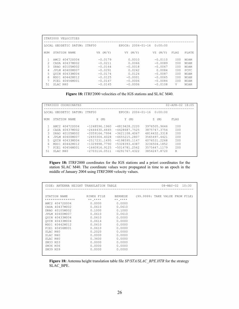
The necessary directory structure can be created by the menu system with menu 1.2 or by hand. For a given campaign (e.g., SLAC2004), the directories to be created starting from $P/SLAC2004 are (in alphabetical order): • ATM – for tropospheric and ionospheric input and result files; • DATPAN – data panels for session definitions and station name abbreviations; • OBS – Bernese observation files; • ORB – orbit files; • ORX – not used with SLAC_BPE; • OUT – log files and result files such as the normal equation files NEQ; • RAW – RINEX observation files; • STA – station coordinate and velocity files as well as other station relevant files. The regional network that is being evaluated at SLAC consists of 7 IGS stations with known coordinates and velocities in the ITRF2000 reference frame as well as the “unknown station” SLAC. The ITRF2000 coordinates are given in the file $P/STA/ITRF0104.CRD for the epoch 16-Jan-2004 (Figure 18) which is being used for the analysis of observation days of January 2004. The corresponding ITRF2000 velocity file $P/STA/ITRF0104.VEL is shown in Figure 18. Note: In the data evaluation, the station name SLAC M40 is retained. This is despite the fact that a DOMES number has been obtained changing the official name of Monument 40 within the GPS community to SLAC 49523S001. Still, 1.5 years of data have been processed at SLAC with the “old name” making a name change almost impossible, because this would entail a reprocessing of the “old data”. The name is encoded into the binary normal equation files and there is no tool to change it.
Figure 15: Defining new campaigns within the menu system: position the cursor on the line to be duplicated, hit the F3 key, and do the necessary alterations. Superfluous campaing lines can be deleted with the F4 key.
26
ITRF2000 COORDINATES 02-APR-02 18:05 -------------------------------------------------------------------------------- LOCAL GEODETIC DATUM: ITRF00 EPOCH: 2004-01-16 0:00:00 NUM STATION NAME X (M) Y (M) Z (M) FLAG 1 AMC2 40472S004 -1248596.1960 -4819428.2220 3976505.9646 I00 2 CASA 40437M002 -2444430.4445 -4428687.7525 3875747.3754 I00 3 DRAO 40105M002 -2059164.7994 -3621108.4067 4814432.3318 I00 4 JPLM 40400M007 -2493304.4028 -4655215.2807 3565497.4421 I00 5 QUIN 40433M004 -2517231.1495 -4198595.1147 4076531.2268 I00 6 MDO1 40442M012 -1329998.7790 -5328393.4387 3236504.1852 I00 7 PIE1 40456M001 -1640916.9125 -5014781.2562 3575447.1179 I00 51 SLAC M40 -2703116.0511 -4291767.4322 3854247.8720 R
Figure 18: ITRF2000 coordinates for the IGS stations and a priori coordinates for thestation SLAC M40. The coordinate values were propagated in time to an epoch in themiddle of January 2004 using ITRF2000 velocity values.
ITRF2000 VELOCITIES -------------------------------------------------------------------------------- LOCAL GEODETIC DATUM: ITRF00 EPOCH: 2004-01-16 0:00:00 NUM STATION NAME VX (M/Y) VY (M/Y) VZ (M/Y) FLAG PLATE 1 AMC2 40472S004 -0.0179 0.0010 -0.0110 I00 NOAM 2 CASA 40437M002 -0.0211 0.0066 -0.0089 I00 NOAM 3 DRAO 40105M002 -0.0164 -0.0018 -0.0067 I00 NOAM 4 JPLM 40400M007 -0.0291 0.0242 0.0084 I00 PCFC 5 QUIN 40433M004 -0.0174 0.0124 -0.0087 I00 NOAM 6 MDO1 40442M012 -0.0125 -0.0001 -0.0065 I00 NOAM 7 PIE1 40456M001 -0.0147 -0.0006 -0.0084 I00 NOAM 51 SLAC M40 -0.0145 -0.0006 -0.0108 V NOAM
Figure 18: ITRF2000 velocities of the IGS stations and SLAC M40.
CODE: ANTENNA HEIGHT TRANSLATION TABLE 08-MAY-02 10:30 ------------------------------------------------------------------------------- STATION NAME RINEX FILE BERNESE (99.9999: TAKE VALUE FROM FILE) **************** **.**** **.**** AMC2 40472S004 0.0000 0.0000 CASA 40437M002 0.0610 0.0610 DRAO 40105M002 0.1000 0.1000 JPLM 40400M007 0.0610 0.0610 QUIN 40433M004 0.0610 0.0000 QUIN 40433M004 0.0614 0.0000 MDO1 40442M012 0.0610 0.0000 PIE1 40456M001 0.0610 0.0000 SLAC M40 0.2020 0.0000 SLAC M40 0.0000 0.0000 SLAC M40 0.3600 0.0000 SM33 M33 0.0000 0.0000 SM36 M36 0.0000 0.0000 SM39 M39 0.0000 0.0000
Figure 18: Antenna height translation table file $P/STA/SLAC_BPE.HTR for the strategy SLAC_BPE.
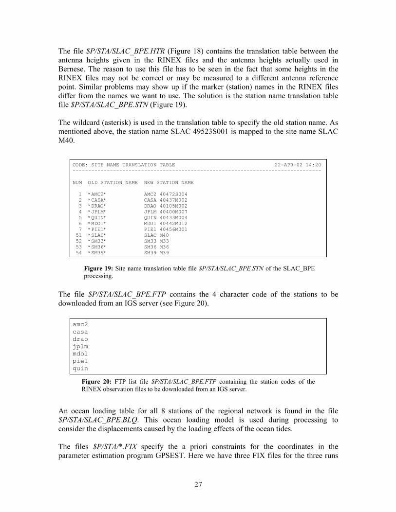
27
The file $P/STA/SLAC_BPE.HTR (Figure 18) contains the translation table between the antenna heights given in the RINEX files and the antenna heights actually used in Bernese. The reason to use this file has to be seen in the fact that some heights in the RINEX files may not be correct or may be measured to a different antenna reference point. Similar problems may show up if the marker (station) names in the RINEX files differ from the names we want to use. The solution is the station name translation table file $P/STA/SLAC_BPE.STN (Figure 19). The wildcard (asterisk) is used in the translation table to specify the old station name. As mentioned above, the station name SLAC 49523S001 is mapped to the site name SLAC M40.
The file $P/STA/SLAC_BPE.FTP contains the 4 character code of the stations to be downloaded from an IGS server (see Figure 20).
An ocean loading table for all 8 stations of the regional network is found in the file $P/STA/SLAC_BPE.BLQ. This ocean loading model is used during processing to consider the displacements caused by the loading effects of the ocean tides. The files $P/STA/*.FIX specify the a priori constraints for the coordinates in the parameter estimation program GPSEST. Here we have three FIX files for the three runs
amc2 casa drao jplm mdo1 pie1 quin
Figure 20: FTP list file $P/STA/SLAC_BPE.FTP containing the station codes of the RINEX observation files to be downloaded from an IGS server.
CODE: SITE NAME TRANSLATION TABLE 22-APR-02 14:20 -------------------------------------------------------------------------------- NUM OLD STATION NAME NEW STATION NAME 1 *AMC2* AMC2 40472S004 2 *CASA* CASA 40437M002 3 *DRAO* DRAO 40105M002 4 *JPLM* JPLM 40400M007 5 *QUIN* QUIN 40433M004 6 *MDO1* MDO1 40442M012 7 *PIE1* PIE1 40456M001 51 *SLAC* SLAC M40 52 *SM33* SM33 M33 53 *SM36* SM36 M36 54 *SM39* SM39 M39
Figure 19: Site name translation table file $P/STA/SLAC_BPE.STN of the SLAC_BPE processing.
28
of GPSEST (see Figure 21). In the second step (SLAC_QIF.FIX) the coordinates of the station JPLM are fixed, whereas in the other two they are constrained to 0.1 mm. The choice to constrain station JPLM is somewhat arbitrary; it is one of the “best stations” in the chosen network.
Finally, there are two important files in the directory $X/GEN which were not explained in the discussion of Figure 9. First, the file $X/GEN/PHAS_IGS.01 contains the positions (and variations) of the phase centers for various antenna types. It is important to use correct receiver and antenna names. If the header information in the RINEX observation files is not correct, it is necessary to use a translation table. This translation table can be found in the file $X/GEN/SLAC_BPE.TRN (Figure 22).
Now, we have all auxiliary files available and can proceed with describing the actual processing steps. The session length is defined in panel 1.3.2 (see Figure 23). We have
SLAC_STD.FIX: 4 JPLM 40400M007 0.0001 0.0001 0.0001 SLAC_QIF.FIX: 4 JPLM 40400M007 SLAC_FIN.FIX: 4 JPLM 40400M007 0.0001 0.0001 0.0001
Figure 21: The a priori constraint files $P/STA/*.FIX for the coordinates in the parameter estimation program GPSEST.
RECEIVER/ANTENNA TRANSLATION TABLE (NEW IGS NAMES) 13-MAR-02 14:07-------------------------------------------------------------------------------- OLD RECEIV. TYPE OLD ANTENNA TYPE NEW RECEIV. TYPE NEW ANTENNA TYPE ROGUE SNR-8000 DORNE MARGOLIN T ROGUE SNR-8000 AOAD/M_T TRIMBLE 4000SSE 4000ST L1/L2 GEO TRIMBLE 4000SSE TRM14532.00 ROGUE SNR-12 RM DORNE MARGOLIN B ROGUE SNR-12 RM AOAD/M_B ROGUE SNR-8000 DORNE MARGOLIN ROGUE SNR-8000 AOAD/M_B TURBOROGUE SNR-8 DORNE MARGOLIN T ROGUE SNR-8000 AOAD/M_T ASHTECH Z-XII3 ASH700936C_M ASHTECH Z-XII3 ASH700936C_M ASHTECH Z-XII3 ASH700936D_M ASHTECH Z-XII3 ASH700936D_M ASHTECH Z-XII3 ASH700829.3 ASHTECH Z-XII3 700829 ASHTECH Z-XII3T AOAD/M_T ASHTECH Z-XII3T AOAD/M_T LEICA SR530 AT503 PILLAR LEICA SR530 LEIAT503 LEICA SR530 AT504 PILLAR LEICA SR530 LEIAT504 AOA SNR-12 ACT AOAD/M_T AOA SNR-12 ACT AOAD/M_T ROGUE SNR-8000 AOAD/M_T ROGUE SNR-8000 AOAD/M_T ROGUE SNR-8100 AOAD/M_T ROGUE SNR-8100 AOAD/M_T AOA BENCHMARK AC AOAD/M_T AOA BENCHMARK AC AOAD/M_T LEICA SR530 LEICA AT504 LEICA SR530 LEIAT504 LEICA SR530 LEIAT504 LEICA SR530 LEIAT504 LEICA SR530 LEICA AT503 LEICA SR530 LEIAT503 LEICA SR530 LEIAT503 LEICA SR530 LEIAT503 LEICA RS500 LEIAT504 LEICA SR530 LEIAT504 ASHTECH UZ-12 AOAD/M_T ASHTECH UZ-12 AOAD/M_T
Figure 22: Receiver and antenna type translation table file $X/GEN/SLAC_BPE.TRN.
29
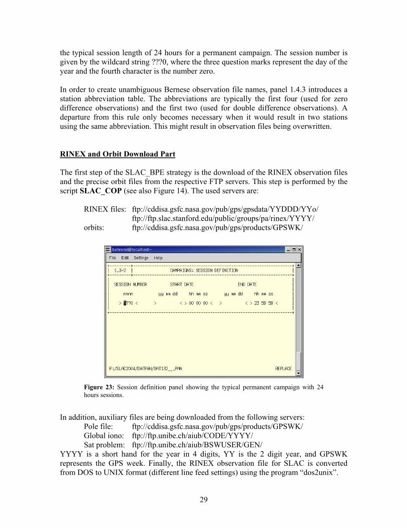
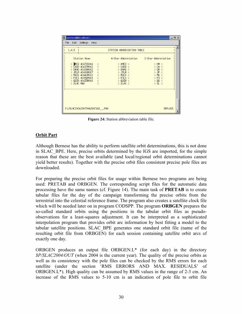
the typical session length of 24 hours for a permanent campaign. The session number is given by the wildcard string ???0, where the three question marks represent the day of the year and the fourth character is the number zero. In order to create unambiguous Bernese observation file names, panel 1.4.3 introduces a station abbreviation table. The abbreviations are typically the first four (used for zero difference observations) and the first two (used for double difference observations). A departure from this rule only becomes necessary when it would result in two stations using the same abbreviation. This might result in observation files being overwritten. RINEX and Orbit Download Part The first step of the SLAC_BPE strategy is the download of the RINEX observation files and the precise orbit files from the respective FTP servers. This step is performed by the script SLAC_COP (see also Figure 14). The used servers are:
RINEX files: ftp://cddisa.gsfc.nasa.gov/pub/gps/gpsdata/YYDDD/YYo/ ftp://ftp.slac.stanford.edu/public/groups/pa/rinex/YYYY/ orbits: ftp://cddisa.gsfc.nasa.gov/pub/gps/products/GPSWK/
In addition, auxiliary files are being downloaded from the following servers:
Pole file: ftp://cddisa.gsfc.nasa.gov/pub/gps/products/GPSWK/ Global iono: ftp://ftp.unibe.ch/aiub/CODE/YYYY/ Sat problem: ftp://ftp.unibe.ch/aiub/BSWUSER/GEN/
YYYY is a short hand for the year in 4 digits, YY is the 2 digit year, and GPSWK represents the GPS week. Finally, the RINEX observation file for SLAC is converted from DOS to UNIX format (different line feed settings) using the program “dos2unix”.
Figure 23: Session definition panel showing the typical permanent campaign with 24hours sessions.
30
Orbit Part Although Bernese has the ability to perform satellite orbit determinations, this is not done in SLAC_BPE. Here, precise orbits determined by the IGS are imported, for the simple reason that these are the best available (and local/regional orbit determinations cannot yield better results). Together with the precise orbit files consistent precise pole files are downloaded. For preparing the precise orbit files for usage within Bernese two programs are being used: PRETAB and ORBGEN. The corresponding script files for the automatic data processing have the same names (cf. Figure 14). The main task of PRETAB is to create tabular files for the day of the campaign transforming the precise orbits from the terrestrial into the celestial reference frame. The program also creates a satellite clock file which will be needed later on in program CODSPP. The program ORBGEN prepares the so-called standard orbits using the positions in the tabular orbit files as pseudo-observations for a least-squares adjustment. It can be interpreted as a sophisticated interpolation program that provides orbit arc information by best fitting a model to the tabular satellite positions. SLAC_BPE generates one standard orbit file (name of the resulting orbit file from ORBGEN) for each session containing satellite orbit arcs of exactly one day. ORBGEN produces an output file ORBGEN.L* (for each day) in the directory $P/SLAC2004/OUT (when 2004 is the current year). The quality of the precise orbits as well as its consistency with the pole files can be checked by the RMS errors for each satellite (under the section ‘RMS ERRORS AND MAX. RESIDUALS’ of ORBGEN.L*). High quality can be assumed by RMS values in the range of 2-3 cm. An increase of the RMS values to 5-10 cm is an indication of pole file to orbit file
Figure 24: Station abbreviation table file.
31
inconsistencies. When the RMS values reach meter values, it is time to go to the next bar and have a drink. Transfer Part In the transfer part the RINEX observation files (ASCII format) are converted into (binary) Bernese format. This is accomplished by the program RXOBV3, where the script file invoking this program for automatic processing has the same name (confer Figure 14). RXOBV3 creates zero-difference observation files in the directory (assuming year 2004) $P/SLAC2004/OBS. Each RINEX observation file corresponds to 4 Bernese observation files; e.g.:
$P/SLAC2004/RAW/SLAC0290.04O → $P/SLAC2004/OBS/SLAC0290.CZH $P/SLAC2004/OBS/SLAC0290.CZO $P/SLAC2004/OBS/SLAC0290.PZH $P/SLAC2004/OBS/SLAC0290.PZO
The header information is decoupled from the actual data (H=header, O=observation data). Furthermore, the code and phase information is separated. The menu system automatically creates the zero-difference observation lists OBSLIST.CDZ (zero-difference code observations) and OBSLIST.PHZ (zero-difference phase observations) in the directory $P/SLAC2004/DATPAN. Processing Part Now the processing part of the Bernese GPS software can be invoked. In order to determine daily coordinate solutions four programs have to be run. The first program is called CODSPP (identical script name). Its main task is to compute the receiver clock corrections. The receiver clock has to be synchronized with GPS time to better than 1 µs. It is possible to compute the receiver clock error to that degree of accuracy using the zero-difference code measurements. The distance equivalent of 1 µs amounts to roughly 300 m, an rms value that is readily available even from C/A-code measurements (pseudorange measurement noise is about 0.3 m for the P(Y)-code and 3 m for the C/A-code). CODSPP uses standard least-squares adjustment to determine the receiver clock error. The adjustment also provides an estimate for the receiver coordinates (code solution). This is useful in order to obtain a priori coordinates for an unknown station. The receiver clock corrections computed by CODSPP are stored both in the code observation and in the phase observation files. The second processing program (and script) is called SNGDIF. As the name suggests, SNGDIF creates single differences (baselines) from the zero-difference phase observation files and stores them in single difference phase observation files. We use the recommended strategy of OBS-MAX that selects baselines based upon the number of common observations between the station pairs. Note: The basic observables of the
32
Bernese GPS Software are double differences. The double differences are created from the single-difference files at a later stage by program GPSEST. The main task of program MAUPRP (Manual and AUtomatic PRe-Processing) is the cycle-slip screening. It screens single-difference phase observation files, forming and analyzing all useful linear combinations of phase observations. MAUPRP does not make use of code measurements; the pre-processing is thus code-independent. We use the recommended strategy COMBINED for the frequency to check (data panel 4.4.2.1), i.e., the ionosphere-free linear combination L3 of the L1 and L2 measurements is employed for cycle slip detection. A detailed description of the algorithm underlying MAUPRP can be found in Chapter 10.5 of the Bernese user manual. The least-squares adjustment of the double difference observations is done with program GPSEST. GPSEST is used three times with different settings and modes; the corresponding scripts (see Figure 14) are named SLAC_STD, SLAC_QIF, and SLAC_FIN. These scripts go together with the option directories of the same names. The purposes of the three GPSEST adjustments are: 1. SLAC_STD: GPSEST is run in session mode in order to create a so-called
ambiguity-free (or float) L3 solution. This means that the ambiguities are not solved to be integer values, but are rather real (float) values. L3 is the ionosphere-free linear combination. We do not expect any final results from this run, but we want to check the quality of data and save the residuals after the least-squares adjustment. Please note that we do not sample the observations in this run. This is important for checking all observations. As residuals are to be written into the residual output file, the ambiguities cannot be pre-eliminated. The residual file is then screened for outliers using program RESRMS. Any detected outlier is marked in the single-difference observation files using program SERVOBS. The outliers are thus excluded from the further processing. An important piece of information in the log file of the GPSEST run (e.g., $P/SLAC2004/OUT/R3_04009.OUT) is the a posteriori rms error. This rms error should have a value in the range of 0.0010 to 0.0015 m. If the rms error is significantly higher this may mean that either the observation data stem from a low-quality receiver, that the data were collected under extremely bad conditions, or that the pre-processing step (CODSPP, MAUPRP) was not successfully performed. Another output of this GPSEST run are estimates for the tropospheric delay values. They are written onto files of the type $P/SLAC2004/ATM/R3_04009.TRP. We solve for tropospheric delays every 2 hours. This troposphere information will serve as input in the following GPSEST runs (SLAC_QIF).
2. SLAC_QIF: In this GPSEST run all baselines are processed separately and the phase ambiguities are resolved using the QIF (Quasi-Ionosphere-Free) strategy. The baseline processing mode is necessary because of the tremendous number of
33
parameters. The resolution of ambiguities in session mode requires too much CPU and memory. With a network of 8 stations, 7 independent baselines need to be evaluated; i.e., GPSEST is invoked 7 times during SLAC_QIF. The troposphere estimates of the previous step (SLAC_STD) are introduced as known parameters. Stochastic ionosphere parameters, however, are estimated, since the ambiguity resolution is done on L1&L2 (and not the ionosphere-free linear combination). SLAC_QIF being an intermediate processing step, the ionosphere parameters are pre-eliminated epochwise from the normal equation system. The resolved ambiguity values are stored in the observation files and a summary is written to the chosen GPSEST log file. For the network at hand about 70-80% of the ambiguities can be fixed to integer values. Ambiguities that could not be resolved are treated as real values in all subsequent program runs.
3. SLAC_FIN: The final parameter estimation is done with program GPSEST in session mode. We process the ionosphere-free (L3) linear combination. No station is kept fixed. Ambiguities which have been resolved in the previous runs of program GPSEST using the QIF strategy are introduced as known. The unresolved ambiguities (estimated as real-valued parameters) are pre-eliminated. We use the higher sampling rate of 300 s (i.e. 5 minutes). The coordinates of all stations are treated as unknown parameters, as this is important to retain flexibility for later changes of the reference frame (station constraints) using the program ADDNEQ. However, for numerical reasons it is necessary to constrain the coordinates of one station to a small sigma. Here, we constrain the coordinates of station JPLM to 0.0001 m. The estimation of troposphere parameters is mandatory for a campaign of this type. We estimate 12 parameters per station and day; this is equivalent to estimating tropospheric parameters (zenith delays) every two hours. In addition, one troposphere gradient parameter per station and day is estimated. The final estimated parameters (coordinates, troposphere, and normal equations) are written to respective files with the pretension ‘EW_’. For day 009 of the year 2004 the results files are: • $P/SLAC2004/STA/EW_04009.CRD • $P/SLAC2004/ATM/EW_04009.TRP • $P/SLAC2004/OUT/EW_04009.NEQ The log file of program GPSEST is located in $P/SLAC2004/OUT/EW_04009.OUT. For a quick check of the validity of the solution, verify that the a posteriori sigma of unit weight does not exceed 1.5 mm.
Removal of obsolete files
34
The last step of the SLAC_BPE strategy is the deletion of superfluous files. This concerns mainly protocol and summary files as well as obsolete residual files. All other files are retained until the data back-up has been performed.
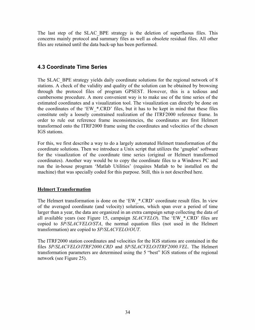
4.3 Coordinate Time Series The SLAC_BPE strategy yields daily coordinate solutions for the regional network of 8 stations. A check of the validity and quality of the solution can be obtained by browsing through the protocol files of program GPSEST. However, this is a tedious and cumbersome procedure. A more convenient way is to make use of the time series of the estimated coordinates and a visualization tool. The visualization can directly be done on the coordinates of the ‘EW_*.CRD’ files, but it has to be kept in mind that these files constitute only a loosely constrained realization of the ITRF2000 reference frame. In order to rule out reference frame inconsistencies, the coordinates are first Helmert transformed onto the ITRF2000 frame using the coordinates and velocities of the chosen IGS stations. For this, we first describe a way to do a largely automated Helmert transformation of the coordinate solutions. Then we introduce a Unix script that utilizes the ‘gnuplot’ software for the visualization of the coordinate time series (original or Helmert transformed coordinates). Another way would be to copy the coordinate files to a Windows PC and run the in-house program ‘Matlab Utilities’ (requires Matlab to be installed on the machine) that was specially coded for this purpose. Still, this is not described here. Helmert Transformation The Helmert transformation is done on the ‘EW_*.CRD’ coordinate result files. In view of the averaged coordinate (and velocity) solutions, which span over a period of time larger than a year, the data are organized in an extra campaign setup collecting the data of all available years (see Figure 15, campaign SLACVELO). The ‘EW_*.CRD’ files are copied to $P/SLACVELO/STA, the normal equation files (not used in the Helmert transformation) are copied to $P/SLACVELO/OUT. The ITRF2000 station coordinates and velocities for the IGS stations are contained in the files $P/SLACVELO/ITRF2000.CRD and $P/SLACVELO/ITRF2000.VEL. The Helmert transformation parameters are determined using the 5 “best” IGS stations of the regional network (see Figure 25).
35
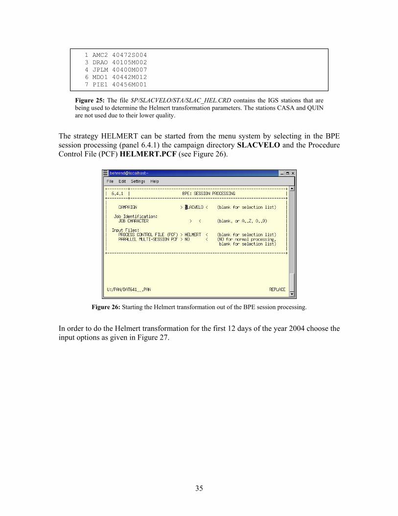
The strategy HELMERT can be started from the menu system by selecting in the BPE session processing (panel 6.4.1) the campaign directory SLACVELO and the Procedure Control File (PCF) HELMERT.PCF (see Figure 26).
In order to do the Helmert transformation for the first 12 days of the year 2004 choose the input options as given in Figure 27.
1 AMC2 40472S004 3 DRAO 40105M002 4 JPLM 40400M007 6 MDO1 40442M012 7 PIE1 40456M001
Figure 25: The file $P/SLACVELO/STA/SLAC_HEL.CRD contains the IGS stations that are being used to determine the Helmert transformation parameters. The stations CASA and QUIN are not used due to their lower quality.
Figure 26: Starting the Helmert transformation out of the BPE session processing.
36
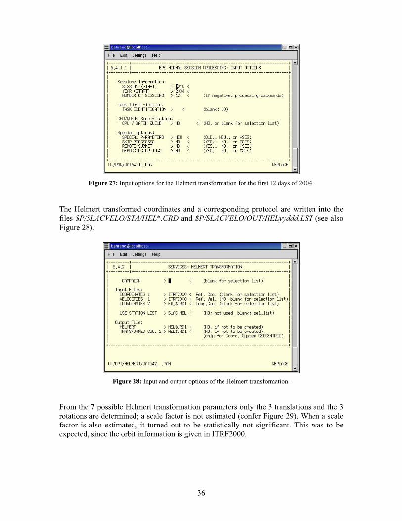
The Helmert transformed coordinates and a corresponding protocol are written into the files $P/SLACVELO/STA/HEL*.CRD and $P/SLACVELO/OUT/HELyyddd.LST (see also Figure 28).
From the 7 possible Helmert transformation parameters only the 3 translations and the 3 rotations are determined; a scale factor is not estimated (confer Figure 29). When a scale factor is also estimated, it turned out to be statistically not significant. This was to be expected, since the orbit information is given in ITRF2000.
Figure 27: Input options for the Helmert transformation for the first 12 days of 2004.
Figure 28: Input and output options of the Helmert transformation.
37
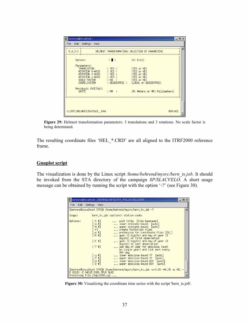
The resulting coordinate files ‘HEL_*.CRD’ are all aligned to the ITRF2000 reference frame. Gnuplot script The visualization is done by the Linux script /home/behrend/mysrc/bern_ts.job. It should be invoked from the STA directory of the campaign $P/SLACVELO. A short usage message can be obtained by running the script with the option ‘-?’ (see Figure 30).
Figure 29: Helmert transformation parameters: 3 translations and 3 rotations. No scale factor isbeing determined.
Figure 30: Visualizing the coordinate time series with the script 'bern_ts.job'.
38
By default, the resulting time series plots are displayed on screen in separate windows for each station. With the option ‘-f’ it is possible to write the output plots into PostScript files.
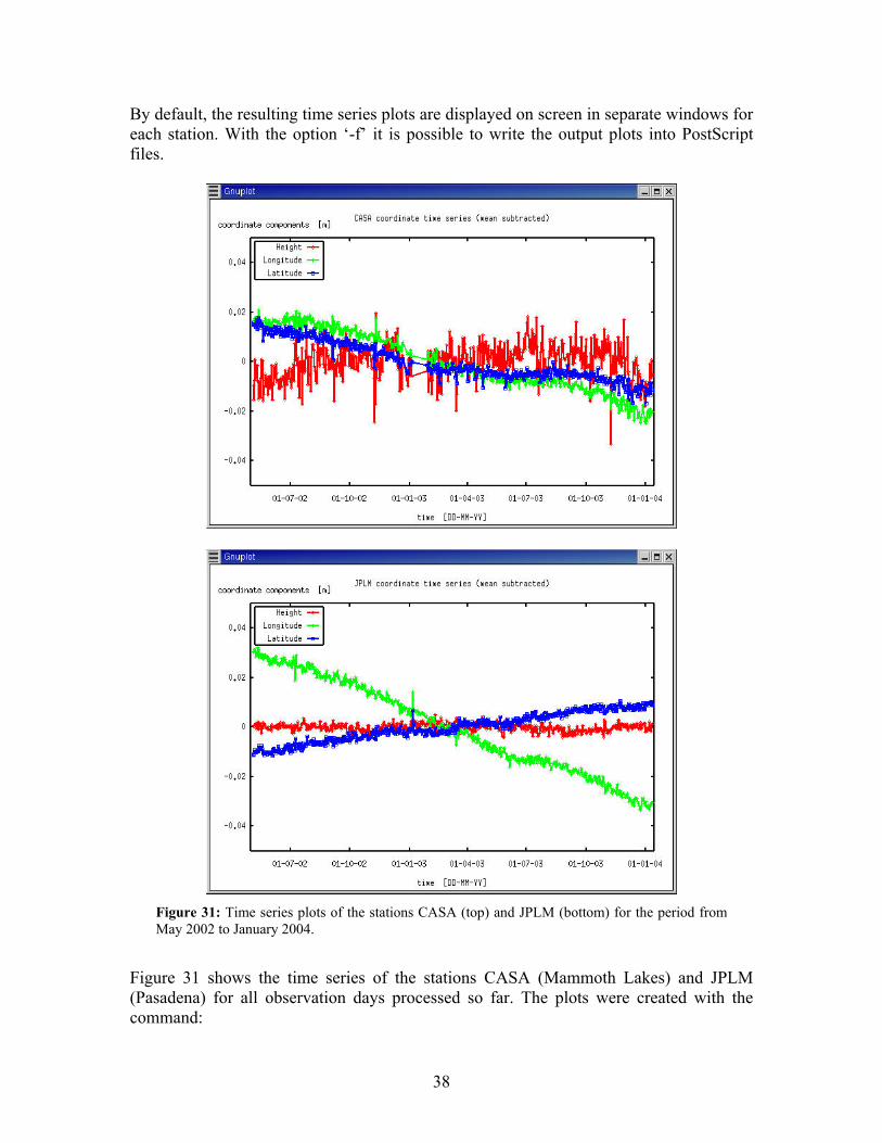
Figure 31 shows the time series of the stations CASA (Mammoth Lakes) and JPLM (Pasadena) for all observation days processed so far. The plots were created with the command:
Figure 31: Time series plots of the stations CASA (top) and JPLM (bottom) for the period from May 2002 to January 2004.
39
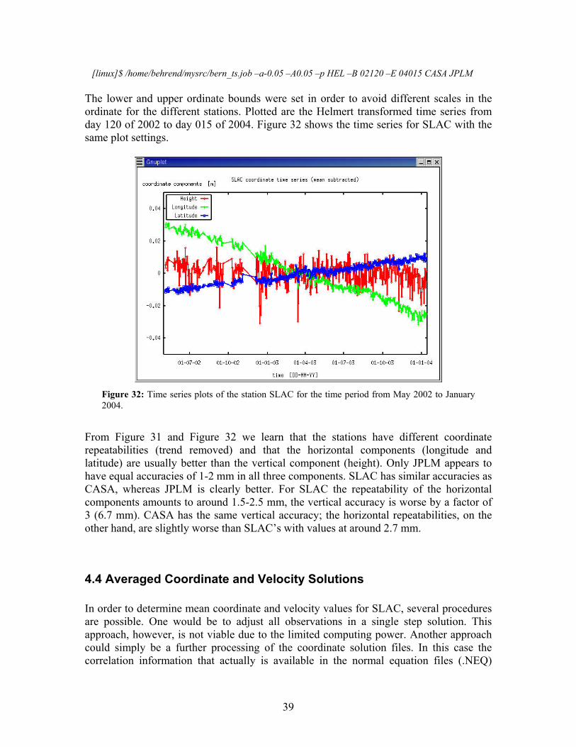
[linux]$ /home/behrend/mysrc/bern_ts.job –a-0.05 –A0.05 –p HEL –B 02120 –E 04015 CASA JPLM The lower and upper ordinate bounds were set in order to avoid different scales in the ordinate for the different stations. Plotted are the Helmert transformed time series from day 120 of 2002 to day 015 of 2004. Figure 32 shows the time series for SLAC with the same plot settings.
From Figure 31 and Figure 32 we learn that the stations have different coordinate repeatabilities (trend removed) and that the horizontal components (longitude and latitude) are usually better than the vertical component (height). Only JPLM appears to have equal accuracies of 1-2 mm in all three components. SLAC has similar accuracies as CASA, whereas JPLM is clearly better. For SLAC the repeatability of the horizontal components amounts to around 1.5-2.5 mm, the vertical accuracy is worse by a factor of 3 (6.7 mm). CASA has the same vertical accuracy; the horizontal repeatabilities, on the other hand, are slightly worse than SLAC’s with values at around 2.7 mm.
4.4 Averaged Coordinate and Velocity Solutions In order to determine mean coordinate and velocity values for SLAC, several procedures are possible. One would be to adjust all observations in a single step solution. This approach, however, is not viable due to the limited computing power. Another approach could simply be a further processing of the coordinate solution files. In this case the correlation information that actually is available in the normal equation files (.NEQ)
Figure 32: Time series plots of the station SLAC for the time period from May 2002 to January2004.
40
would be neglected. Hence, the optimal approach is the stacking of the normal equations. This sequential adjustment procedure yields the same results as the bulk adjustment. Bernese provides the program ADDNEQ for this purpose. An excellent outline for the usage of ADDNEQ (aside from the respective chapter in the user manual) can be found on the web page of UNAVCO under the URL: http://www.unavco.ucar.edu/~braunj/bernese/lectures/addneq_notes/vel_est.html Here, we reproduce part of the description tailored to the problem at hand. Velocity estimation with ADDNEQ requires at least two normal equation files (NEQ files) for two distinct epochs as input. The estimate of velocity is bounded by the repeatability of the station coordinates and the length of the time series. In an ideal situation, the velocity estimates would utilize high quality daily solutions spanning multiple years. The velocity estimates should always be considered with some degree of scientific skepticism. There are two general types of velocity estimation strategies: relative and absolute. 1. Relative velocity estimation: Estimate velocities relative to one or more stable
stations. It may also be called local or regional velocity estimation. This method is used when the deformation of interest is contained within a region that is either not well aligned to the ITRF reference frame, or where the velocity field is small relative to the ITRF velocity of the region so that estimating absolute velocity fields would yield solutions that are completely dominated by errors and the ITRF velocity field. Examples include volcano deformation, or motions completely contained within a tectonic plate.
2. Absolute velocity estimation: Absolute velocities in some expression of an ITRF reference frame. This solution provides velocities in an absolute global reference frame. An example of this type of velocity estimate might be the deformation across plate boundary zones or the determination of what tectonic plate a station is located on.
There are two types of solutions that can be computed with ADDNEQ. A “free solution” and a “fixed solution”. The free solution is generally a better solution than a fixed solution, but sometimes there are not enough stations with quality a priori velocities and coordinates to form a free solution. 1. Free solution: In this type of solution the constraint on the estimates of station
coordinates and velocities is done through the error minimization of a coordinate transformation. The coordinates and velocities of all stations are computed. This is useful when there are at least two stations (and preferably at least three stations) within the network that are considered reference stations. The solution minimizes errors that could be introduced into a network solution by holding a station fixed to a priori coordinates. An example of this type of solution might be something like this: There is a network of stations with at least three of the stations being regular IGS sites with established ITRF coordinates and velocities. The free solution is computed by minimizing the rotation and translation transformation of the three IGS stations onto their known ITRF coordinates (and velocities). The resulting solution has estimates of
41
all the stations (including the IGS stations), and can be considered consistent with the ITRF reference frame.
2. Fixed solution: The coordinates (and velocities, if computing absolute velocities) of one or more stations are tightly constrained (fixed) to their input a priori values. This is done when only one or two IGS stations are included in the network processing. An example of this might be when one or two stations are part of the IGS regular network and have well established ITRF coordinates.
There are four solution strategies that can be computed with ADDNEQ. You have to decide which solution best fits your problem. • Absolute-free strategy: Velocities are estimated in the global ITRF reference frame
by minimizing the rotation and translation transformation of at least two or three stations onto the existing ITRF a priori coordinate system.
• Absolute-fixed strategy: Velocities are estimated by tightly constraining the coordinates and velocities of one or two stations onto their predefined ITRF values.
• Relative-free strategy: Velocities are estimated by minimizing the translation and rotation transformation of at least two stations onto their a priori coordinates. The velocity of these stations is considered to be zero.
• Relative-fixed strategy: Velocities are estimated by tightly constraining the a priori coordinates of one or two stations. The velocity of these stations is considered to be zero.
When you estimate velocities, you also want to compute reasonable statistics. This requires that ADDNEQ be run multiple times:
1. to properly weight the input NEQ files; 2. to estimate the velocity of the stations; 3. to compute reasonable statistics of repeatabilities.
The regional network evaluated at SLAC consists of 7 IGS stations plus the “unknown station” of SLAC, meaning there are enough stations with well established coordinates and velocities for doing a free solution. In order to obtain velocities in the ITRF2000 reference frame, the solution needs to absolute. Thus, we apply the absolute-free strategy. All normal equation files to be used as input for the velocity estimation are grouped together in the directory $P/SLACVELO/OUT. The a priori coordinate and velocity files ITRF2000.CRD and ITRF2000.VEL need to be located in the directory $P/SLACVELO/STA. The a priori velocity for SLAC was derived from the no net rotation plate tectonics model NUVEL1A. A better a priori value is to be expected when taking the velocity value of the neighboring CORS station SUAA. Thus, a second velocity file is provided under the name ITRFSUAA.VEL having the NUVEL1A velocity replaced by the velocity of SUAA. In the following we compile the data panels of a complete ADDNEQ run using the absolute-free strategy (3 step procedure).
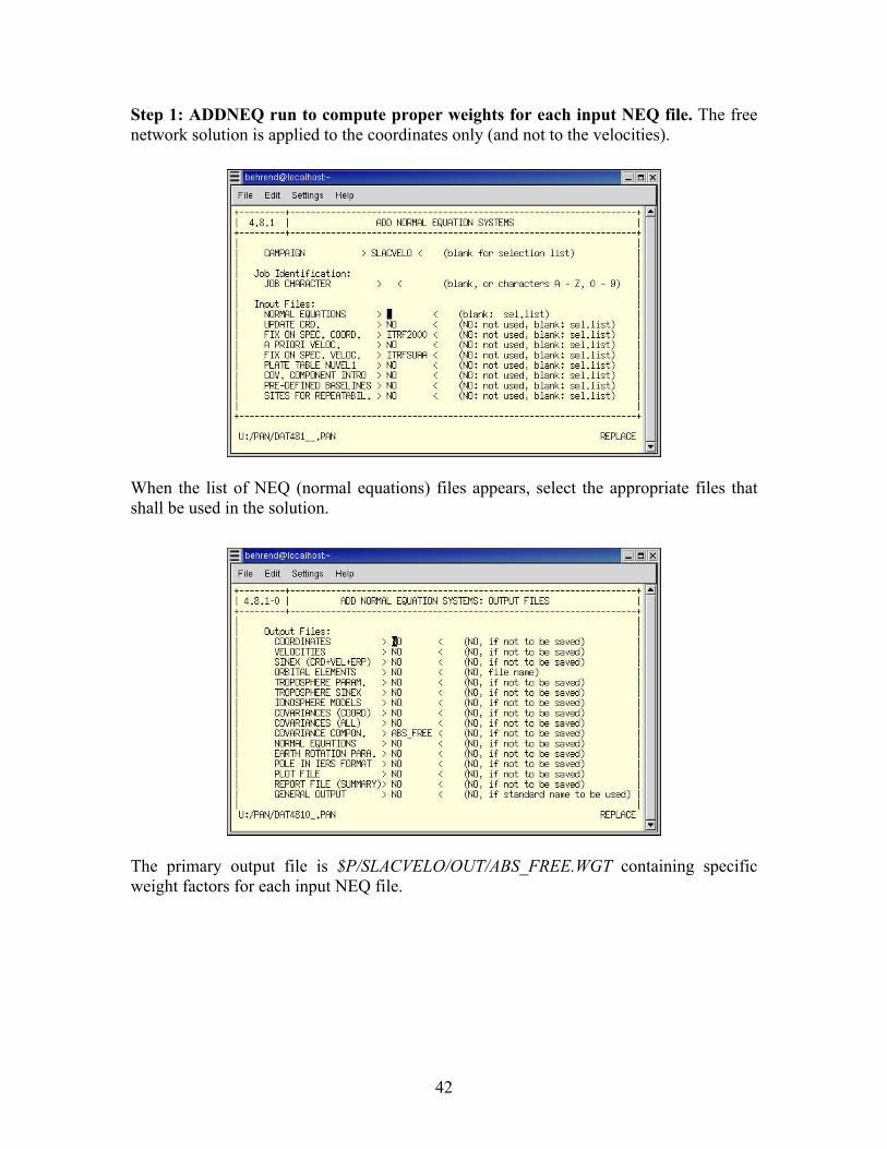
42
Step 1: ADDNEQ run to compute proper weights for each input NEQ file. The free network solution is applied to the coordinates only (and not to the velocities).
When the list of NEQ (normal equations) files appears, select the appropriate files that shall be used in the solution.
The primary output file is $P/SLACVELO/OUT/ABS_FREE.WGT containing specific weight factors for each input NEQ file.
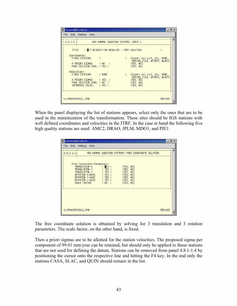
43
When the panel displaying the list of stations appears, select only the ones that are to be used in the minimization of the transformation. These sites should be IGS stations with well defined coordinates and velocities in the ITRF. In the case at hand the following five high quality stations are used: AMC2, DRAO, JPLM, MDO1, and PIE1.
The free coordinate solution is obtained by solving for 3 translation and 3 rotation parameters. The scale factor, on the other hand, is fixed. Then a priori sigmas are to be allotted for the station velocities. The proposed sigma per component of 99.01 mm/year can be retained, but should only be applied to those stations that are not used for defining the datum. Stations can be removed from panel 4.8.1-1.4 by positioning the cursor onto the respective line and hitting the F4 key. In the end only the stations CASA, SLAC, and QUIN should remain in the list.
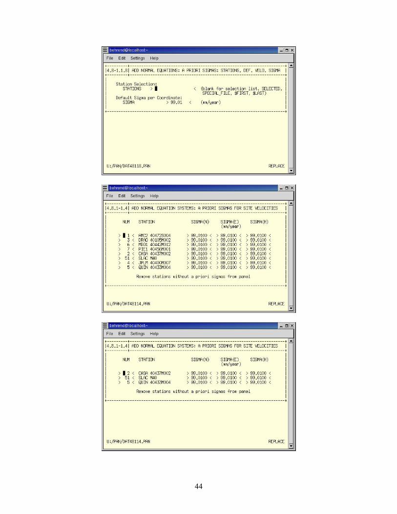
44
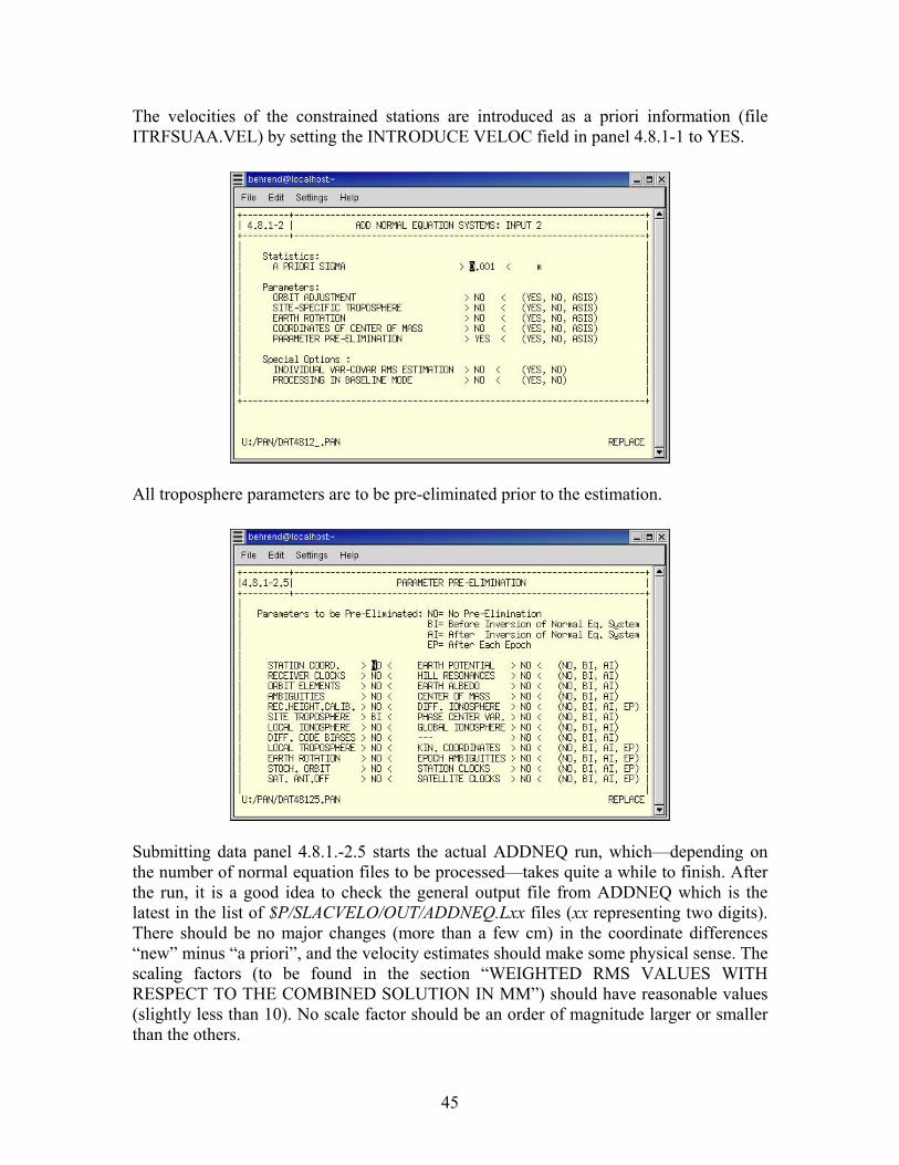
45
The velocities of the constrained stations are introduced as a priori information (file ITRFSUAA.VEL) by setting the INTRODUCE VELOC field in panel 4.8.1-1 to YES.
All troposphere parameters are to be pre-eliminated prior to the estimation.
Submitting data panel 4.8.1.-2.5 starts the actual ADDNEQ run, which—depending on the number of normal equation files to be processed—takes quite a while to finish. After the run, it is a good idea to check the general output file from ADDNEQ which is the latest in the list of $P/SLACVELO/OUT/ADDNEQ.Lxx files (xx representing two digits). There should be no major changes (more than a few cm) in the coordinate differences “new” minus “a priori”, and the velocity estimates should make some physical sense. The scaling factors (to be found in the section “WEIGHTED RMS VALUES WITH RESPECT TO THE COMBINED SOLUTION IN MM”) should have reasonable values (slightly less than 10). No scale factor should be an order of magnitude larger or smaller than the others.
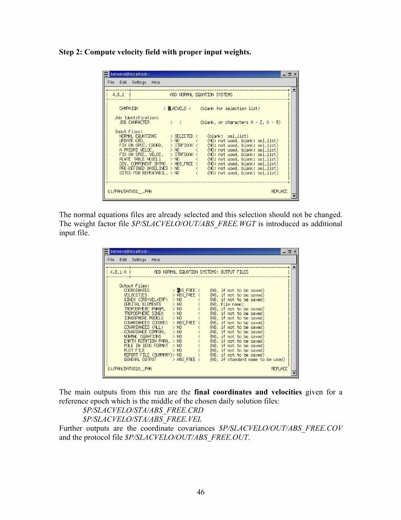
46
Step 2: Compute velocity field with proper input weights.
The normal equations files are already selected and this selection should not be changed. The weight factor file $P/SLACVELO/OUT/ABS_FREE.WGT is introduced as additional input file.
The main outputs from this run are the final coordinates and velocities given for a reference epoch which is the middle of the chosen daily solution files:
$P/SLACVELO/STA/ABS_FREE.CRD $P/SLACVELO/STA/ABS_FREE.VEL
Further outputs are the coordinate covariances $P/SLACVELO/OUT/ABS_FREE.COV and the protocol file $P/SLACVELO/OUT/ABS_FREE.OUT.
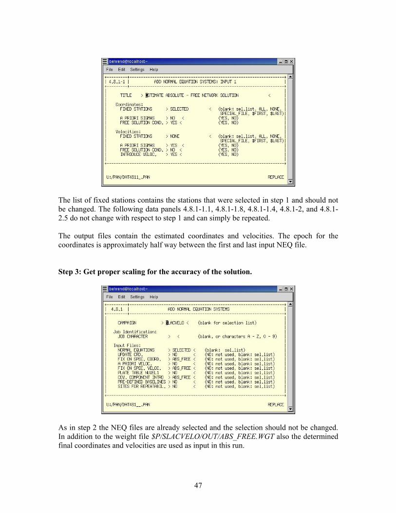
47
The list of fixed stations contains the stations that were selected in step 1 and should not be changed. The following data panels 4.8.1-1.1, 4.8.1-1.8, 4.8.1-1.4, 4.8.1-2, and 4.8.1-2.5 do not change with respect to step 1 and can simply be repeated. The output files contain the estimated coordinates and velocities. The epoch for the coordinates is approximately half way between the first and last input NEQ file. Step 3: Get proper scaling for the accuracy of the solution.
As in step 2 the NEQ files are already selected and the selection should not be changed. In addition to the weight file $P/SLACVELO/OUT/ABS_FREE.WGT also the determined final coordinates and velocities are used as input in this run.
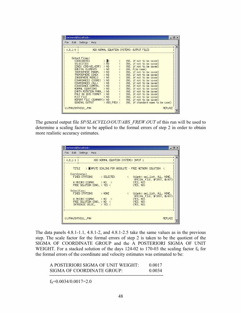
48
The general output file $P/SLACVELO/OUT/ABS_FREW.OUT of this run will be used to determine a scaling factor to be applied to the formal errors of step 2 in order to obtain more realistic accuracy estimates.
The data panels 4.8.1-1.1, 4.8.1-2, and 4.8.1-2.5 take the same values as in the previous step. The scale factor for the formal errors of step 2 is taken to be the quotient of the SIGMA OF COORDINATE GROUP and the A POSTERIORI SIGMA OF UNIT WEIGHT. For a stacked solution of the days 124-02 to 170-03 the scaling factor fS for the formal errors of the coordinate and velocity estimates was estimated to be:
A POSTERIORI SIGMA OF UNIT WEIGHT: 0.0017 SIGMA OF COORDINATE GROUP: 0.0034 fS=0.0034/0.0017=2.0
49
Applying this factor gives accuracies of about 0.5 mm for the horizontal coordinate components and 2.0 mm for the vertical component. The corresponding velocity accuracies amount to 1.3 mm/a (horizontal) and 5.5 mm/a (vertical).
4.5 Data Back-up After about 3 weeks of daily GPS data processing, there is enough data accumulated to fill a CD (about 700 MB). In order to free space, these data need to be backed up and then all superfluous files can be deleted from the hard disk. For this purpose, three small kludgy shell scripts are available: backup.job, clean_backup.job, and purge.job. The script backup.job copies all files of the days that are to be backed up into a specified directory (e.g., SLAC2003). The bounding days and the corresponding year are to be set in the script manually by using an arbitrary text editor.
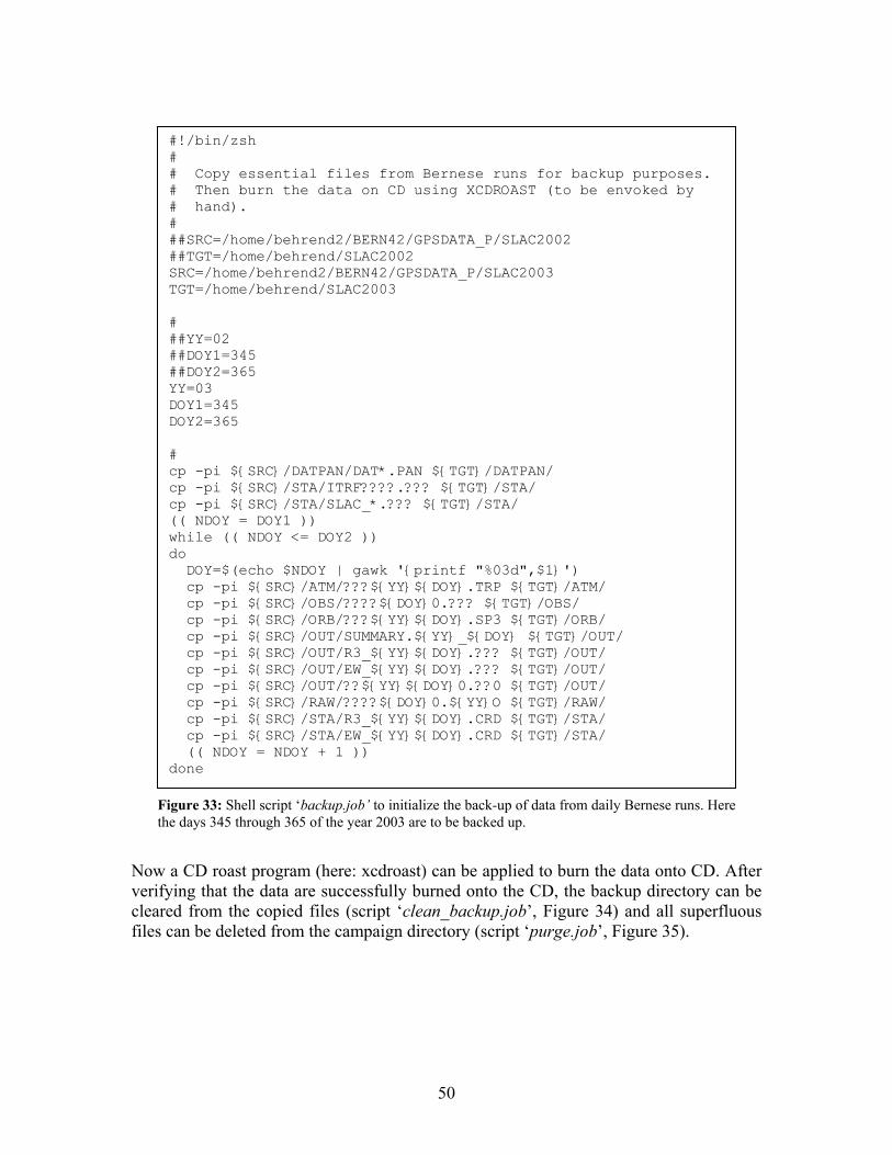
50
Now a CD roast program (here: xcdroast) can be applied to burn the data onto CD. After verifying that the data are successfully burned onto the CD, the backup directory can be cleared from the copied files (script ‘clean_backup.job’, Figure 34) and all superfluous files can be deleted from the campaign directory (script ‘purge.job’, Figure 35).
#!/bin/zsh # # Copy essential files from Bernese runs for backup purposes. # Then burn the data on CD using XCDROAST (to be envoked by # hand). # ##SRC=/home/behrend2/BERN42/GPSDATA_P/SLAC2002 ##TGT=/home/behrend/SLAC2002 SRC=/home/behrend2/BERN42/GPSDATA_P/SLAC2003 TGT=/home/behrend/SLAC2003 # ##YY=02 ##DOY1=345 ##DOY2=365 YY=03 DOY1=345 DOY2=365 # cp -pi ${SRC}/DATPAN/DAT*.PAN ${TGT}/DATPAN/ cp -pi ${SRC}/STA/ITRF????.??? ${TGT}/STA/ cp -pi ${SRC}/STA/SLAC_*.??? ${TGT}/STA/ (( NDOY = DOY1 )) while (( NDOY <= DOY2 )) do DOY=$(echo $NDOY | gawk '{printf "%03d",$1}') cp -pi ${SRC}/ATM/???${YY}${DOY}.TRP ${TGT}/ATM/ cp -pi ${SRC}/OBS/????${DOY}0.??? ${TGT}/OBS/ cp -pi ${SRC}/ORB/???${YY}${DOY}.SP3 ${TGT}/ORB/ cp -pi ${SRC}/OUT/SUMMARY.${YY}_${DOY} ${TGT}/OUT/ cp -pi ${SRC}/OUT/R3_${YY}${DOY}.??? ${TGT}/OUT/ cp -pi ${SRC}/OUT/EW_${YY}${DOY}.??? ${TGT}/OUT/ cp -pi ${SRC}/OUT/??${YY}${DOY}0.??0 ${TGT}/OUT/ cp -pi ${SRC}/RAW/????${DOY}0.${YY}O ${TGT}/RAW/ cp -pi ${SRC}/STA/R3_${YY}${DOY}.CRD ${TGT}/STA/ cp -pi ${SRC}/STA/EW_${YY}${DOY}.CRD ${TGT}/STA/ (( NDOY = NDOY + 1 )) done
Figure 33: Shell script ‘backup.job’ to initialize the back-up of data from daily Bernese runs. Here the days 345 through 365 of the year 2003 are to be backed up.

51
When the files relevant for ADDNEQ are copied to $P/SLACVELO, they can be completely removed from the daily processing directory.
5. Conclusions
##cd SLAC2002 cd SLAC2003 rm ATM/* DATPAN/* OBS/* ORB/* OUT/* RAW/* STA/* cd -
Figure 34: Shell script 'clean_backup.job' for freeing up the backup directory.
#!/bin/zsh # # Delete files from Bernese runs after a backup has been # done. Retain files that are necessary for ADDNEQ. # ##SRC=/home/behrend2/BERN42/GPSDATA_P/SLAC2002 SRC=/home/behrend2/BERN42/GPSDATA_P/SLAC2003 # ##YY=02 ##DOY1=345 ##DOY2=365 YY=03 DOY1=345 DOY2=365 # (( NDOY = DOY1 )) while (( NDOY <= DOY2 )) do DOY=$(echo $NDOY | gawk '{printf "%03d",$1}') rm ${SRC}/ATM/???${YY}${DOY}.TRP rm ${SRC}/OBS/????${DOY}0.??? rm ${SRC}/ORB/???${YY}${DOY}.SP3 rm ${SRC}/OUT/SUMMARY.${YY}_${DOY} rm ${SRC}/OUT/R3_${YY}${DOY}.??? rm ${SRC}/OUT/??${YY}${DOY}0.??0 rm ${SRC}/RAW/????${DOY}0.${YY}O rm ${SRC}/STA/R3_${YY}${DOY}.CRD (( NDOY = NDOY + 1 )) done
Figure 35: Shell script 'purge.job' to delete superfluous files, but retain necessary files forADDNEQ.

52
This documentation described some aspects of the continuously operating GPS station at SLAC, covering topics from the hardware setup over the data collection up to data processing. It is by no means exhaustive. In the appendix the interested reader may find additional information and a collection of the data panels as they are used in the automatic data processing in the strategy SLAC_BPE.

53
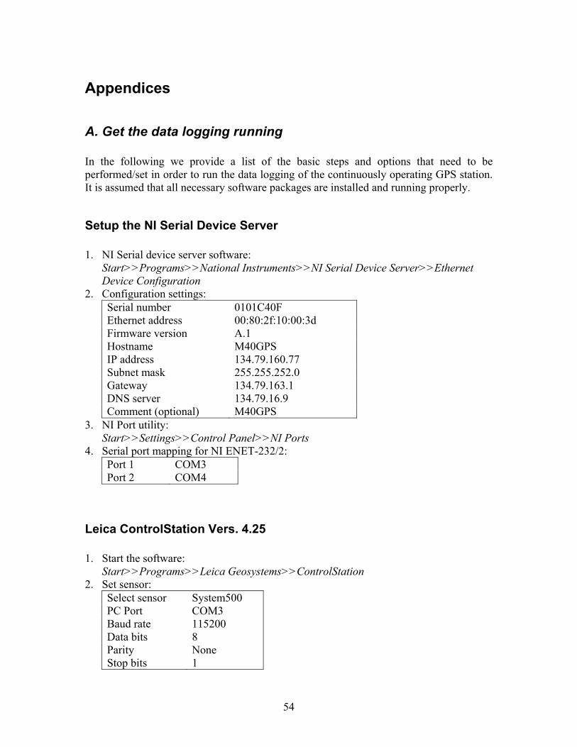
54
Appendices
A. Get the data logging running In the following we provide a list of the basic steps and options that need to be performed/set in order to run the data logging of the continuously operating GPS station. It is assumed that all necessary software packages are installed and running properly.
Setup the NI Serial Device Server 1. NI Serial device server software:
Start>>Programs>>National Instruments>>NI Serial Device Server>>Ethernet Device Configuration
2. Configuration settings: Serial number 0101C40F Ethernet address 00:80:2f:10:00:3d Firmware version A.1 Hostname M40GPS IP address 134.79.160.77 Subnet mask 255.255.252.0 Gateway 134.79.163.1 DNS server 134.79.16.9 Comment (optional) M40GPS
3. NI Port utility: Start>>Settings>>Control Panel>>NI Ports
4. Serial port mapping for NI ENET-232/2: Port 1 COM3 Port 2 COM4
Leica ControlStation Vers. 4.25 1. Start the software:
Start>>Programs>>Leica Geosystems>>ControlStation 2. Set sensor:
Select sensor System500 PC Port COM3 Baud rate 115200 Data bits 8 Parity None Stop bits 1
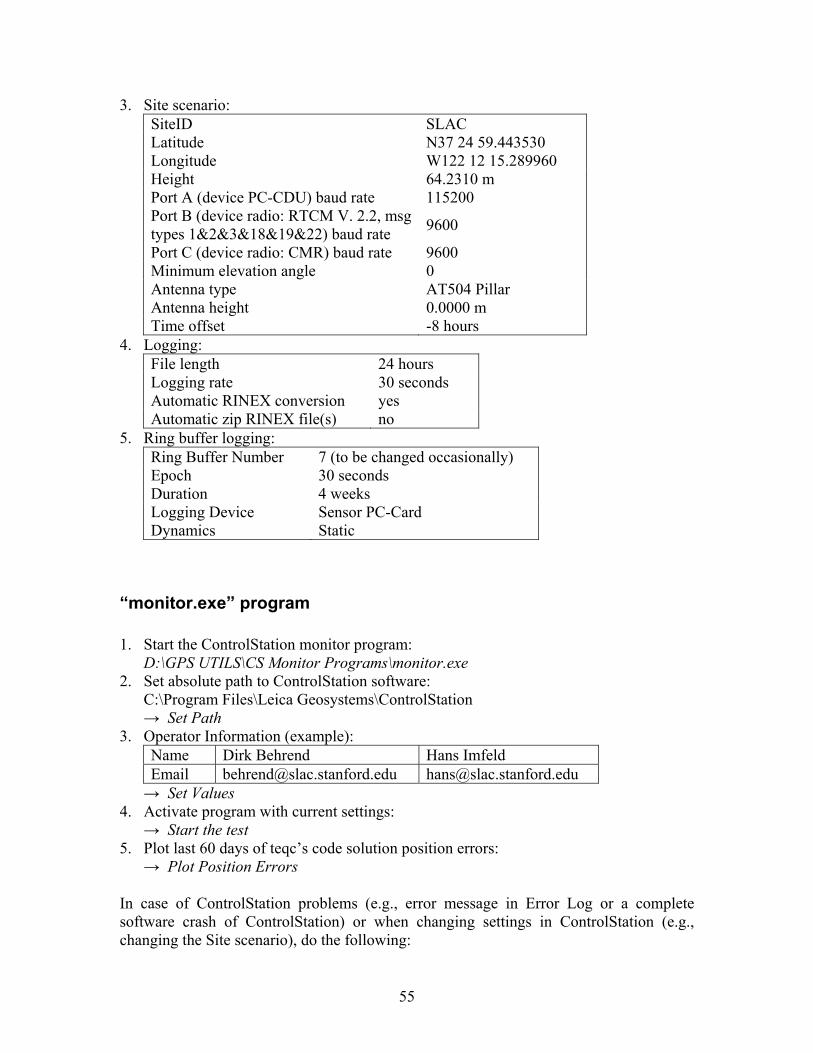
55
3. Site scenario: SiteID SLAC Latitude N37 24 59.443530 Longitude W122 12 15.289960 Height 64.2310 m Port A (device PC-CDU) baud rate 115200 Port B (device radio: RTCM V. 2.2, msg types 1&2&3&18&19&22) baud rate 9600
Port C (device radio: CMR) baud rate 9600 Minimum elevation angle 0 Antenna type AT504 Pillar Antenna height 0.0000 m Time offset -8 hours
4. Logging: File length 24 hours Logging rate 30 seconds Automatic RINEX conversion yes Automatic zip RINEX file(s) no
5. Ring buffer logging: Ring Buffer Number 7 (to be changed occasionally) Epoch 30 seconds Duration 4 weeks Logging Device Sensor PC-Card Dynamics Static
“monitor.exe” program 1. Start the ControlStation monitor program:
D:\GPS UTILS\CS Monitor Programs\monitor.exe 2. Set absolute path to ControlStation software:
C:\Program Files\Leica Geosystems\ControlStation → Set Path
3. Operator Information (example): Name Dirk Behrend Hans Imfeld Email [email protected] [email protected] → Set Values
4. Activate program with current settings: → Start the test
5. Plot last 60 days of teqc’s code solution position errors: → Plot Position Errors
In case of ControlStation problems (e.g., error message in Error Log or a complete software crash of ControlStation) or when changing settings in ControlStation (e.g., changing the Site scenario), do the following:
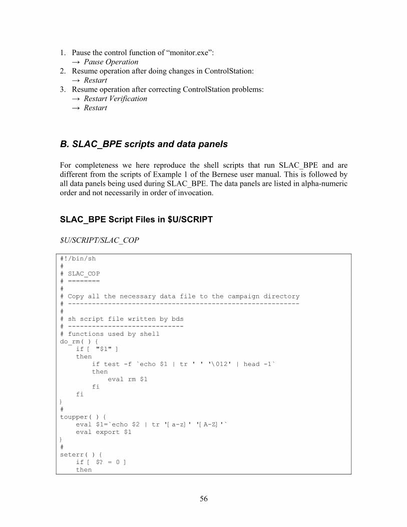
56
1. Pause the control function of “monitor.exe”: → Pause Operation
2. Resume operation after doing changes in ControlStation: → Restart
3. Resume operation after correcting ControlStation problems: → Restart Verification → Restart
B. SLAC_BPE scripts and data panels For completeness we here reproduce the shell scripts that run SLAC_BPE and are different from the scripts of Example 1 of the Bernese user manual. This is followed by all data panels being used during SLAC_BPE. The data panels are listed in alpha-numeric order and not necessarily in order of invocation.
SLAC_BPE Script Files in $U/SCRIPT $U/SCRIPT/SLAC_COP #!/bin/sh # # SLAC_COP # ======== # # Copy all the necessary data file to the campaign directory # ---------------------------------------------------------- # # sh script file written by bds # ----------------------------- # functions used by shell do_rm( ) { if [ "$1" ] then if test -f `echo $1 | tr ' ' '\012' | head -1` then eval rm $1 fi fi } # toupper( ) { eval $1=`echo $2 | tr '[a-z]' '[A-Z]'` eval export $1 } # seterr( ) { if [ $? = 0 ] then
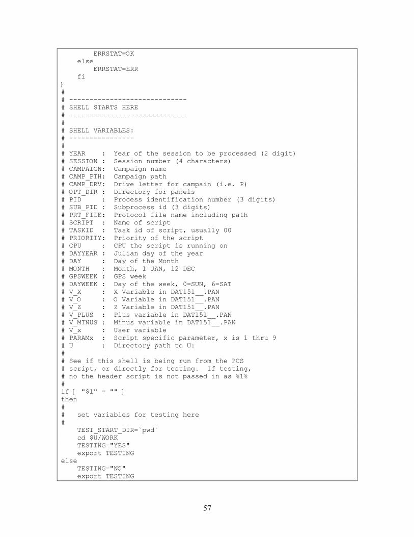
57
ERRSTAT=OK else ERRSTAT=ERR fi } # # ----------------------------- # SHELL STARTS HERE # ----------------------------- # # SHELL VARIABLES: # ---------------- # # YEAR : Year of the session to be processed (2 digit) # SESSION : Session number (4 characters) # CAMPAIGN: Campaign name # CAMP_PTH: Campaign path # CAMP_DRV: Drive letter for campain (i.e. P) # OPT_DIR : Directory for panels # PID : Process identification number (3 digits) # SUB_PID : Subprocess id (3 digits) # PRT_FILE: Protocol file name including path # SCRIPT : Name of script # TASKID : Task id of script, usually 00 # PRIORITY: Priority of the script # CPU : CPU the script is running on # DAYYEAR : Julian day of the year # DAY : Day of the Month # MONTH : Month, 1=JAN, 12=DEC # GPSWEEK : GPS week # DAYWEEK : Day of the week, 0=SUN, 6=SAT # V_X : X Variable in DAT151__.PAN # V_O : O Variable in DAT151__.PAN # V_Z : Z Variable in DAT151__.PAN # V_PLUS : Plus variable in DAT151__.PAN # V_MINUS : Minus variable in DAT151__.PAN # V_x : User variable # PARAMx : Script specific parameter, x is 1 thru 9 # U : Directory path to U: # # See if this shell is being run from the PCS # script, or directly for testing. If testing, # no the header script is not passed in as %1% # if [ "$1" = "" ] then # # set variables for testing here # TEST_START_DIR=`pwd` cd $U/WORK TESTING="YES" export TESTING else TESTING="NO" export TESTING
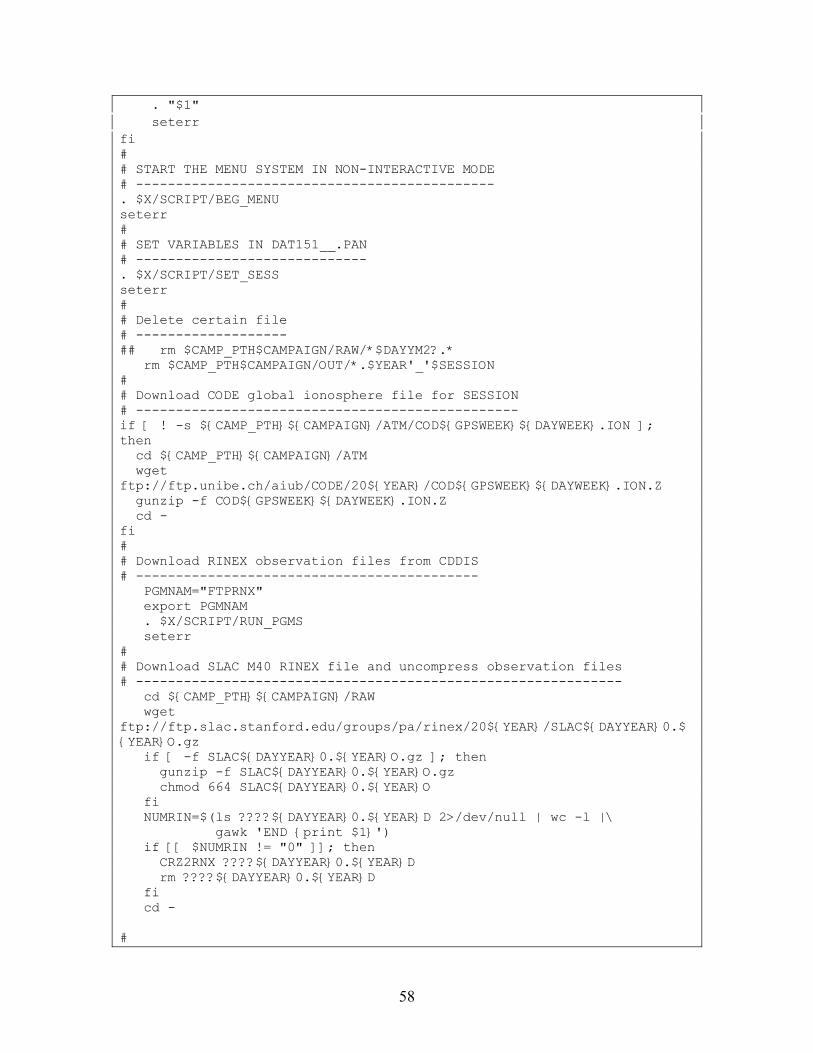
58
. "$1" seterr fi # # START THE MENU SYSTEM IN NON-INTERACTIVE MODE # --------------------------------------------- . $X/SCRIPT/BEG_MENU seterr # # SET VARIABLES IN DAT151__.PAN # ----------------------------- . $X/SCRIPT/SET_SESS seterr # # Delete certain file # ------------------- ## rm $CAMP_PTH$CAMPAIGN/RAW/*$DAYYM2?.* rm $CAMP_PTH$CAMPAIGN/OUT/*.$YEAR'_'$SESSION # # Download CODE global ionosphere file for SESSION # ------------------------------------------------ if [ ! -s ${CAMP_PTH}${CAMPAIGN}/ATM/COD${GPSWEEK}${DAYWEEK}.ION ]; then cd ${CAMP_PTH}${CAMPAIGN}/ATM wget ftp://ftp.unibe.ch/aiub/CODE/20${YEAR}/COD${GPSWEEK}${DAYWEEK}.ION.Z gunzip -f COD${GPSWEEK}${DAYWEEK}.ION.Z cd - fi # # Download RINEX observation files from CDDIS # ------------------------------------------- PGMNAM="FTPRNX" export PGMNAM . $X/SCRIPT/RUN_PGMS seterr # # Download SLAC M40 RINEX file and uncompress observation files # ------------------------------------------------------------- cd ${CAMP_PTH}${CAMPAIGN}/RAW wget ftp://ftp.slac.stanford.edu/groups/pa/rinex/20${YEAR}/SLAC${DAYYEAR}0.${YEAR}O.gz if [ -f SLAC${DAYYEAR}0.${YEAR}O.gz ]; then gunzip -f SLAC${DAYYEAR}0.${YEAR}O.gz chmod 664 SLAC${DAYYEAR}0.${YEAR}O fi NUMRIN=$(ls ????${DAYYEAR}0.${YEAR}D 2>/dev/null | wc -l |\ gawk 'END {print $1}') if [[ $NUMRIN != "0" ]]; then CRZ2RNX ????${DAYYEAR}0.${YEAR}D rm ????${DAYYEAR}0.${YEAR}D fi cd - #
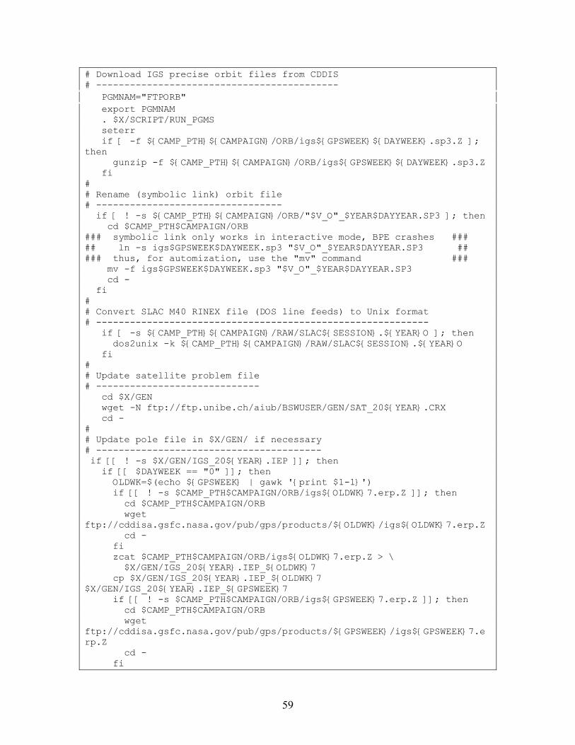
59
# Download IGS precise orbit files from CDDIS # ------------------------------------------- PGMNAM="FTPORB" export PGMNAM . $X/SCRIPT/RUN_PGMS seterr if [ -f ${CAMP_PTH}${CAMPAIGN}/ORB/igs${GPSWEEK}${DAYWEEK}.sp3.Z ]; then gunzip -f ${CAMP_PTH}${CAMPAIGN}/ORB/igs${GPSWEEK}${DAYWEEK}.sp3.Z fi # # Rename (symbolic link) orbit file # --------------------------------- if [ ! -s ${CAMP_PTH}${CAMPAIGN}/ORB/"$V_O"_$YEAR$DAYYEAR.SP3 ]; then cd $CAMP_PTH$CAMPAIGN/ORB ### symbolic link only works in interactive mode, BPE crashes ### ## ln -s igs$GPSWEEK$DAYWEEK.sp3 "$V_O"_$YEAR$DAYYEAR.SP3 ## ### thus, for automization, use the "mv" command ### mv -f igs$GPSWEEK$DAYWEEK.sp3 "$V_O"_$YEAR$DAYYEAR.SP3 cd - fi # # Convert SLAC M40 RINEX file (DOS line feeds) to Unix format # ----------------------------------------------------------- if [ -s ${CAMP_PTH}${CAMPAIGN}/RAW/SLAC${SESSION}.${YEAR}O ]; then dos2unix -k ${CAMP_PTH}${CAMPAIGN}/RAW/SLAC${SESSION}.${YEAR}O fi # # Update satellite problem file # ----------------------------- cd $X/GEN wget -N ftp://ftp.unibe.ch/aiub/BSWUSER/GEN/SAT_20${YEAR}.CRX cd - # # Update pole file in $X/GEN/ if necessary # ---------------------------------------- if [[ ! -s $X/GEN/IGS_20${YEAR}.IEP ]]; then if [[ $DAYWEEK == "0" ]]; then OLDWK=$(echo ${GPSWEEK} | gawk '{print $1-1}') if [[ ! -s $CAMP_PTH$CAMPAIGN/ORB/igs${OLDWK}7.erp.Z ]]; then cd $CAMP_PTH$CAMPAIGN/ORB wget ftp://cddisa.gsfc.nasa.gov/pub/gps/products/${OLDWK}/igs${OLDWK}7.erp.Z cd - fi zcat $CAMP_PTH$CAMPAIGN/ORB/igs${OLDWK}7.erp.Z > \ $X/GEN/IGS_20${YEAR}.IEP_${OLDWK}7 cp $X/GEN/IGS_20${YEAR}.IEP_${OLDWK}7 $X/GEN/IGS_20${YEAR}.IEP_${GPSWEEK}7 if [[ ! -s $CAMP_PTH$CAMPAIGN/ORB/igs${GPSWEEK}7.erp.Z ]]; then cd $CAMP_PTH$CAMPAIGN/ORB wget ftp://cddisa.gsfc.nasa.gov/pub/gps/products/${GPSWEEK}/igs${GPSWEEK}7.erp.Z cd - fi
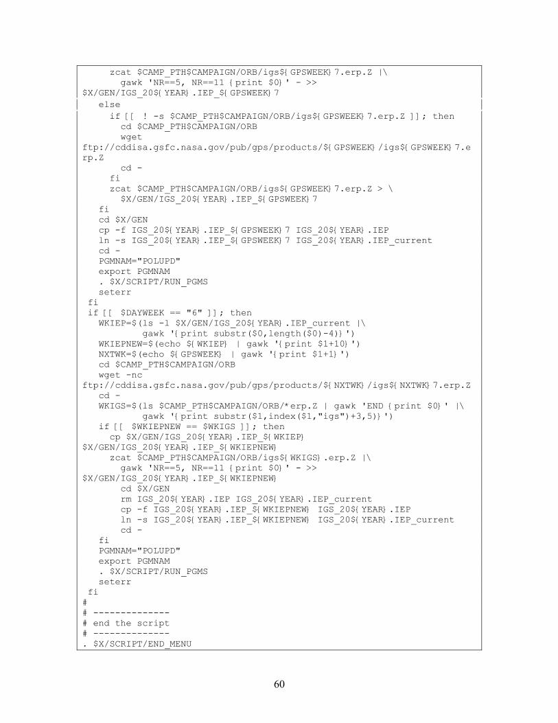
60
zcat $CAMP_PTH$CAMPAIGN/ORB/igs${GPSWEEK}7.erp.Z |\ gawk 'NR==5, NR==11 {print $0}' - >> $X/GEN/IGS_20${YEAR}.IEP_${GPSWEEK}7 else if [[ ! -s $CAMP_PTH$CAMPAIGN/ORB/igs${GPSWEEK}7.erp.Z ]]; then cd $CAMP_PTH$CAMPAIGN/ORB wget ftp://cddisa.gsfc.nasa.gov/pub/gps/products/${GPSWEEK}/igs${GPSWEEK}7.erp.Z cd - fi zcat $CAMP_PTH$CAMPAIGN/ORB/igs${GPSWEEK}7.erp.Z > \ $X/GEN/IGS_20${YEAR}.IEP_${GPSWEEK}7 fi cd $X/GEN cp -f IGS_20${YEAR}.IEP_${GPSWEEK}7 IGS_20${YEAR}.IEP ln -s IGS_20${YEAR}.IEP_${GPSWEEK}7 IGS_20${YEAR}.IEP_current cd - PGMNAM="POLUPD" export PGMNAM . $X/SCRIPT/RUN_PGMS seterr fi if [[ $DAYWEEK == "6" ]]; then WKIEP=$(ls -l $X/GEN/IGS_20${YEAR}.IEP_current |\ gawk '{print substr($0,length($0)-4)}') WKIEPNEW=$(echo ${WKIEP} | gawk '{print $1+10}') NXTWK=$(echo ${GPSWEEK} | gawk '{print $1+1}') cd $CAMP_PTH$CAMPAIGN/ORB wget -nc ftp://cddisa.gsfc.nasa.gov/pub/gps/products/${NXTWK}/igs${NXTWK}7.erp.Z cd - WKIGS=$(ls $CAMP_PTH$CAMPAIGN/ORB/*erp.Z | gawk 'END {print $0}' |\ gawk '{print substr($1,index($1,"igs")+3,5)}') if [[ $WKIEPNEW == $WKIGS ]]; then cp $X/GEN/IGS_20${YEAR}.IEP_${WKIEP} $X/GEN/IGS_20${YEAR}.IEP_${WKIEPNEW} zcat $CAMP_PTH$CAMPAIGN/ORB/igs${WKIGS}.erp.Z |\ gawk 'NR==5, NR==11 {print $0}' - >> $X/GEN/IGS_20${YEAR}.IEP_${WKIEPNEW} cd $X/GEN rm IGS_20${YEAR}.IEP IGS_20${YEAR}.IEP_current cp -f IGS_20${YEAR}.IEP_${WKIEPNEW} IGS_20${YEAR}.IEP ln -s IGS_20${YEAR}.IEP_${WKIEPNEW} IGS_20${YEAR}.IEP_current cd - fi PGMNAM="POLUPD" export PGMNAM . $X/SCRIPT/RUN_PGMS seterr fi # # -------------- # end the script # -------------- . $X/SCRIPT/END_MENU
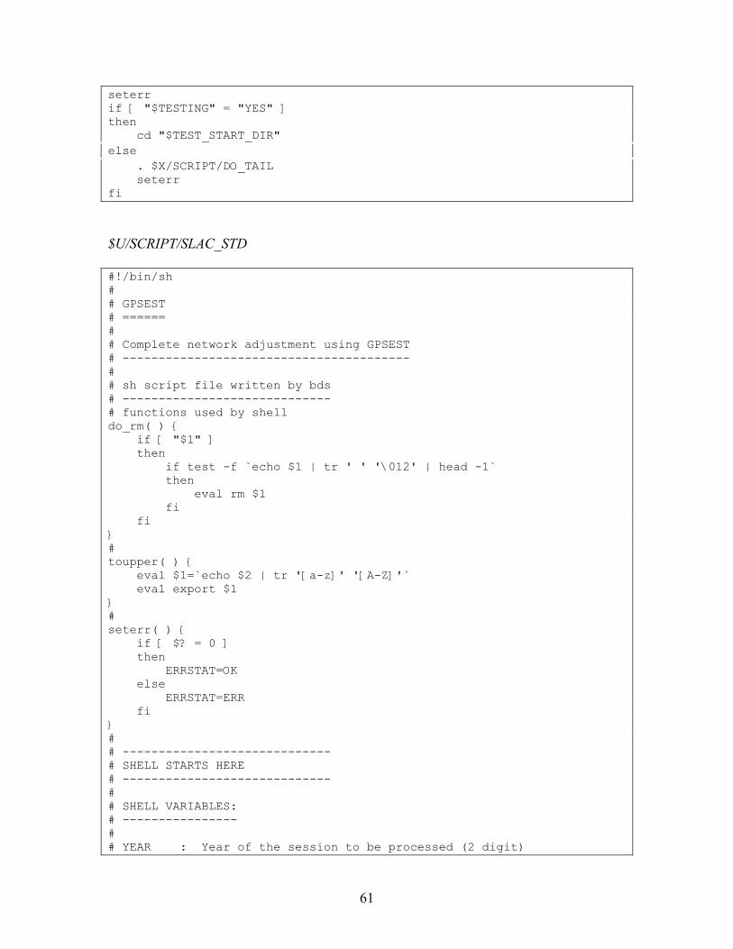
61
seterr if [ "$TESTING" = "YES" ] then cd "$TEST_START_DIR" else . $X/SCRIPT/DO_TAIL seterr fi
$U/SCRIPT/SLAC_STD #!/bin/sh # # GPSEST # ====== # # Complete network adjustment using GPSEST # ---------------------------------------- # # sh script file written by bds # ----------------------------- # functions used by shell do_rm( ) { if [ "$1" ] then if test -f `echo $1 | tr ' ' '\012' | head -1` then eval rm $1 fi fi } # toupper( ) { eval $1=`echo $2 | tr '[a-z]' '[A-Z]'` eval export $1 } # seterr( ) { if [ $? = 0 ] then ERRSTAT=OK else ERRSTAT=ERR fi } # # ----------------------------- # SHELL STARTS HERE # ----------------------------- # # SHELL VARIABLES: # ---------------- # # YEAR : Year of the session to be processed (2 digit)
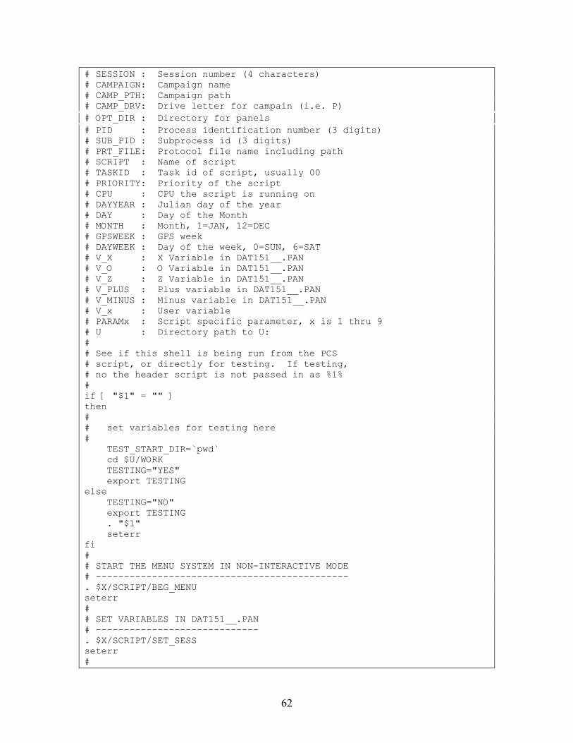
62
# SESSION : Session number (4 characters) # CAMPAIGN: Campaign name # CAMP_PTH: Campaign path # CAMP_DRV: Drive letter for campain (i.e. P) # OPT_DIR : Directory for panels # PID : Process identification number (3 digits) # SUB_PID : Subprocess id (3 digits) # PRT_FILE: Protocol file name including path # SCRIPT : Name of script # TASKID : Task id of script, usually 00 # PRIORITY: Priority of the script # CPU : CPU the script is running on # DAYYEAR : Julian day of the year # DAY : Day of the Month # MONTH : Month, 1=JAN, 12=DEC # GPSWEEK : GPS week # DAYWEEK : Day of the week, 0=SUN, 6=SAT # V_X : X Variable in DAT151__.PAN # V_O : O Variable in DAT151__.PAN # V_Z : Z Variable in DAT151__.PAN # V_PLUS : Plus variable in DAT151__.PAN # V_MINUS : Minus variable in DAT151__.PAN # V_x : User variable # PARAMx : Script specific parameter, x is 1 thru 9 # U : Directory path to U: # # See if this shell is being run from the PCS # script, or directly for testing. If testing, # no the header script is not passed in as %1% # if [ "$1" = "" ] then # # set variables for testing here # TEST_START_DIR=`pwd` cd $U/WORK TESTING="YES" export TESTING else TESTING="NO" export TESTING . "$1" seterr fi # # START THE MENU SYSTEM IN NON-INTERACTIVE MODE # --------------------------------------------- . $X/SCRIPT/BEG_MENU seterr # # SET VARIABLES IN DAT151__.PAN # ----------------------------- . $X/SCRIPT/SET_SESS seterr #
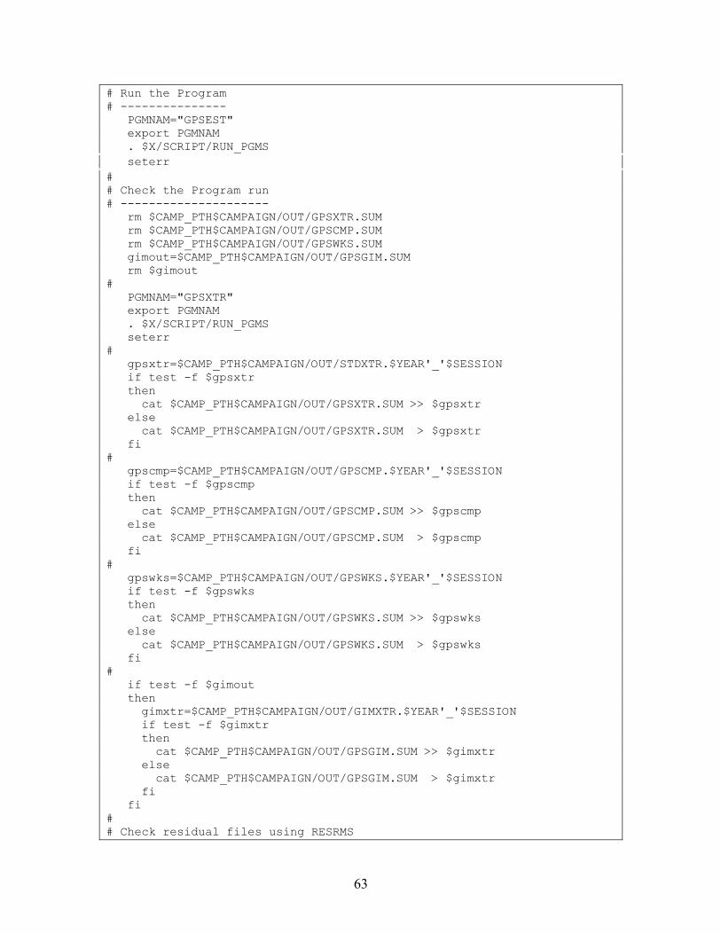
63
# Run the Program # --------------- PGMNAM="GPSEST" export PGMNAM . $X/SCRIPT/RUN_PGMS seterr # # Check the Program run # --------------------- rm $CAMP_PTH$CAMPAIGN/OUT/GPSXTR.SUM rm $CAMP_PTH$CAMPAIGN/OUT/GPSCMP.SUM rm $CAMP_PTH$CAMPAIGN/OUT/GPSWKS.SUM gimout=$CAMP_PTH$CAMPAIGN/OUT/GPSGIM.SUM rm $gimout # PGMNAM="GPSXTR" export PGMNAM . $X/SCRIPT/RUN_PGMS seterr # gpsxtr=$CAMP_PTH$CAMPAIGN/OUT/STDXTR.$YEAR'_'$SESSION if test -f $gpsxtr then cat $CAMP_PTH$CAMPAIGN/OUT/GPSXTR.SUM >> $gpsxtr else cat $CAMP_PTH$CAMPAIGN/OUT/GPSXTR.SUM > $gpsxtr fi # gpscmp=$CAMP_PTH$CAMPAIGN/OUT/GPSCMP.$YEAR'_'$SESSION if test -f $gpscmp then cat $CAMP_PTH$CAMPAIGN/OUT/GPSCMP.SUM >> $gpscmp else cat $CAMP_PTH$CAMPAIGN/OUT/GPSCMP.SUM > $gpscmp fi # gpswks=$CAMP_PTH$CAMPAIGN/OUT/GPSWKS.$YEAR'_'$SESSION if test -f $gpswks then cat $CAMP_PTH$CAMPAIGN/OUT/GPSWKS.SUM >> $gpswks else cat $CAMP_PTH$CAMPAIGN/OUT/GPSWKS.SUM > $gpswks fi # if test -f $gimout then gimxtr=$CAMP_PTH$CAMPAIGN/OUT/GIMXTR.$YEAR'_'$SESSION if test -f $gimxtr then cat $CAMP_PTH$CAMPAIGN/OUT/GPSGIM.SUM >> $gimxtr else cat $CAMP_PTH$CAMPAIGN/OUT/GPSGIM.SUM > $gimxtr fi fi # # Check residual files using RESRMS
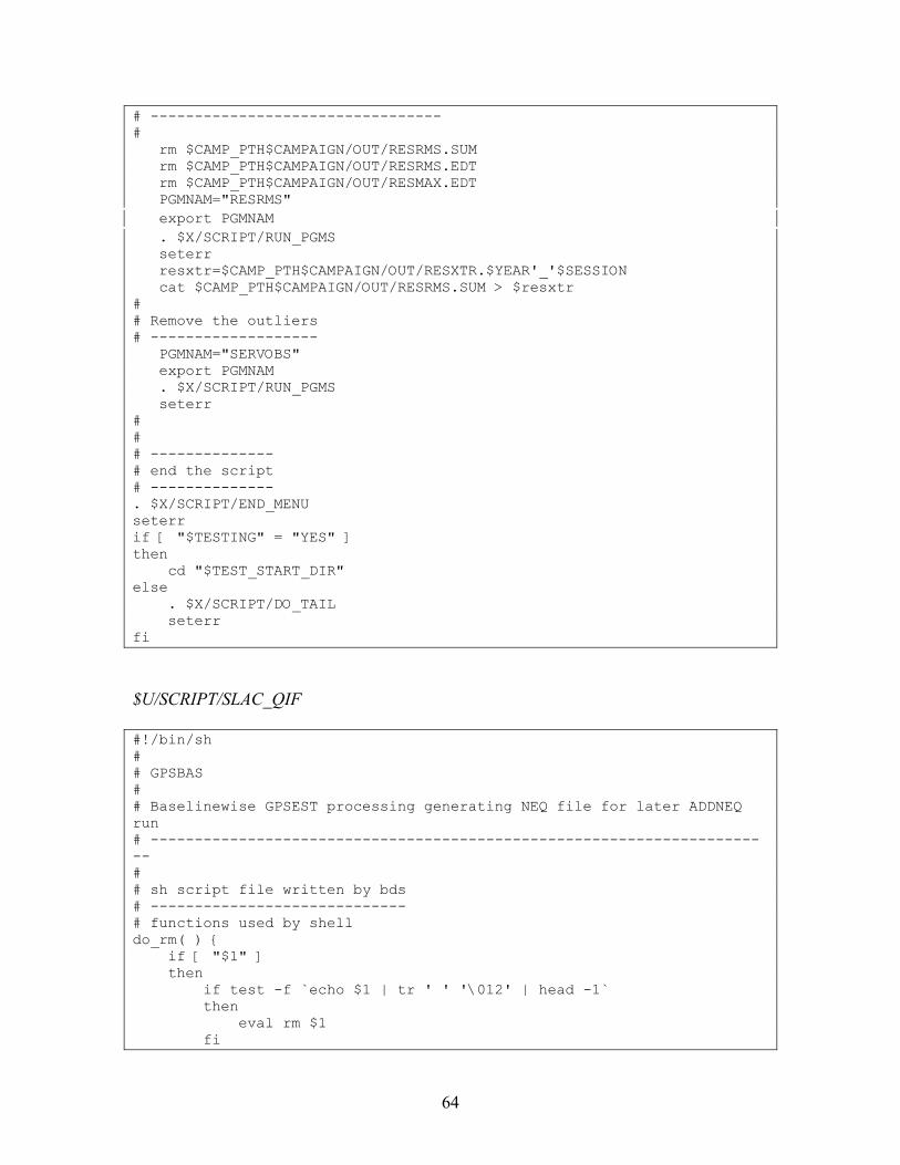
64
# --------------------------------- # rm $CAMP_PTH$CAMPAIGN/OUT/RESRMS.SUM rm $CAMP_PTH$CAMPAIGN/OUT/RESRMS.EDT rm $CAMP_PTH$CAMPAIGN/OUT/RESMAX.EDT PGMNAM="RESRMS" export PGMNAM . $X/SCRIPT/RUN_PGMS seterr resxtr=$CAMP_PTH$CAMPAIGN/OUT/RESXTR.$YEAR'_'$SESSION cat $CAMP_PTH$CAMPAIGN/OUT/RESRMS.SUM > $resxtr # # Remove the outliers # ------------------- PGMNAM="SERVOBS" export PGMNAM . $X/SCRIPT/RUN_PGMS seterr # # # -------------- # end the script # -------------- . $X/SCRIPT/END_MENU seterr if [ "$TESTING" = "YES" ] then cd "$TEST_START_DIR" else . $X/SCRIPT/DO_TAIL seterr fi
$U/SCRIPT/SLAC_QIF #!/bin/sh # # GPSBAS # # Baselinewise GPSEST processing generating NEQ file for later ADDNEQ run # ----------------------------------------------------------------------- # # sh script file written by bds # ----------------------------- # functions used by shell do_rm( ) { if [ "$1" ] then if test -f `echo $1 | tr ' ' '\012' | head -1` then eval rm $1 fi
65
fi } # toupper( ) { eval $1=`echo $2 | tr '[a-z]' '[A-Z]'` eval export $1 } # seterr( ) { if [ $? = 0 ] then ERRSTAT=OK else ERRSTAT=ERR fi } # # ----------------------------- # SHELL STARTS HERE # ----------------------------- # # SHELL VARIABLES: # ---------------- # # YEAR : Year of the session to be processed (2 digit) # SESSION : Session number (4 characters) # CAMPAIGN: Campaign name # CAMP_PTH: Campaign path # CAMP_DRV: Drive letter for campain (i.e. P) # OPT_DIR : Directory for panels # PID : Process identification number (3 digits) # SUB_PID : Subprocess id (3 digits) # PRT_FILE: Protocol file name including path # SCRIPT : Name of script # TASKID : Task id of script, usually 00 # PRIORITY: Priority of the script # CPU : CPU the script is running on # DAYYEAR : Julian day of the year # DAY : Day of the Month # MONTH : Month, 1=JAN, 12=DEC # GPSWEEK : GPS week # DAYWEEK : Day of the week, 0=SUN, 6=SAT # V_X : X Variable in DAT151__.PAN # V_O : O Variable in DAT151__.PAN # V_Z : Z Variable in DAT151__.PAN # V_PLUS : Plus variable in DAT151__.PAN # V_MINUS : Minus variable in DAT151__.PAN # V_x : User variable # PARAMx : Script specific parameter, x is 1 thru 9 # U : Directory path to U: # # See if this shell is being run from the PCS # script, or directly for testing. If testing, # no the header script is not passed in as %1% #
66
if [ "$1" = "" ] then # # set variables for testing here # TEST_START_DIR=`pwd` cd $U/WORK TESTING="YES" export TESTING else TESTING="NO" export TESTING . "$1" seterr fi # # START THE MENU SYSTEM IN NON-INTERACTIVE MODE # --------------------------------------------- . $X/SCRIPT/BEG_MENU seterr # # SET VARIABLES IN DAT151__.PAN # ----------------------------- . $X/SCRIPT/SET_SESS seterr # # SHELL SCRIPT-NAME BODY # ---------------------- # # Update the observation table (just in case) # up1=$CAMPAIGN export up1 up2=$CAMP_PTH export up2 up3="BOTH" export up3 up4="SINGLE" export up4 . $X/SCRIPT/AUTO_UPD # # clean up old residual files # PGMNAM="GPSEST" export PGMNAM . $X/SCRIPT/CLEAN_UP seterr rm $CAMP_PTH$CAMPAIGN/OUT/*$SESSION.OUT rm $CAMP_PTH$CAMPAIGN/OUT/*$SESSION.NEQ # # get a temporary file name # tmpid=$$ export tmpid tmpfil1="tmp1"$tmpid".txt" export tmpfil1
67
tmpfil2="tmp3"$tmpid".txt" export tmpfil2 # # get a list of phase single difference files # filspec=""$CAMP_PTH""$CAMPAIGN"/OBS/????"$SESSION".PSH" export filspec for file in $filspec do echo processing "$file" echo "$file" > "$tmpfil1" $X/EXE/RBPE PRSLIN "$tmpfil1" "$tmpfil2" seterr file_r=`cat "$tmpfil2"` export file_r echo file_r is "$file_r" file_r4=`echo "$file_r" | cut -c1-4` echo file_r4 is "$file_r4" # pp1="$U/PAN/DAT151__.PAN" export pp1 pp2="CODE4" export pp2 pp3=""$file_r4"" export pp3 . $X/SCRIPT/PUTKEYWE seterr . $X/SCRIPT/RUN_PGMS seterr done do_rm "$tmpfil1" do_rm "$tmpfil2" # # Check the GPSEST runs # --------------------- rm $CAMP_PTH$CAMPAIGN/OUT/COOXTR.SUM rm $CAMP_PTH$CAMPAIGN/OUT/QIFXTR.SUM rm $CAMP_PTH$CAMPAIGN/OUT/AMBXTR.SUM PGMNAM="GPSXTR" export PGMNAM # pp1="$U/PAN/DAT565__.PAN" export pp1 pp2="GENOUT" export pp2 pp3="????\$SS2" export pp3 . $X/SCRIPT/PUTKEYWE seterr # pp1=$U/PAN/DAT565__.PAN export pp1 pp2="CRDOUT" export pp2 pp3="COOXTR" export pp3
68
. $X/SCRIPT/PUTKEYWE seterr # . $X/SCRIPT/RUN_PGMS seterr # cooxtr=$CAMP_PTH$CAMPAIGN/OUT/COOXTR.$YEAR'_'$SESSION if test -f $cooxtr then cat $CAMP_PTH$CAMPAIGN/OUT/COOXTR.SUM >> $cooxtr else cat $CAMP_PTH$CAMPAIGN/OUT/COOXTR.SUM > $cooxtr fi # qifxtr=$CAMP_PTH$CAMPAIGN/OUT/QIFXTR.$YEAR'_'$SESSION cat $CAMP_PTH$CAMPAIGN/OUT/QIFXTR.SUM > $qifxtr # ambxtr=$CAMP_PTH$CAMPAIGN/OUT/AMBXTR.$YEAR'_'$SESSION cat $CAMP_PTH$CAMPAIGN/OUT/AMBXTR.SUM > $ambxtr # # -------------- # end the script # -------------- . $X/SCRIPT/END_MENU seterr if [ "$TESTING" = "YES" ] then cd "$TEST_START_DIR" else . $X/SCRIPT/DO_TAIL seterr fi
$U/SCRIPT/SLAC_FIN #!/bin/sh # # GPSEST # ====== # # Complete network adjustment using GPSEST # ---------------------------------------- # # sh script file written by bds # ----------------------------- # functions used by shell do_rm( ) { if [ "$1" ] then if test -f `echo $1 | tr ' ' '\012' | head -1` then eval rm $1 fi fi
69
} # toupper( ) { eval $1=`echo $2 | tr '[a-z]' '[A-Z]'` eval export $1 } # seterr( ) { if [ $? = 0 ] then ERRSTAT=OK else ERRSTAT=ERR fi } # # ----------------------------- # SHELL STARTS HERE # ----------------------------- # # SHELL VARIABLES: # ---------------- # # YEAR : Year of the session to be processed (2 digit) # SESSION : Session number (4 characters) # CAMPAIGN: Campaign name # CAMP_PTH: Campaign path # CAMP_DRV: Drive letter for campain (i.e. P) # OPT_DIR : Directory for panels # PID : Process identification number (3 digits) # SUB_PID : Subprocess id (3 digits) # PRT_FILE: Protocol file name including path # SCRIPT : Name of script # TASKID : Task id of script, usually 00 # PRIORITY: Priority of the script # CPU : CPU the script is running on # DAYYEAR : Julian day of the year # DAY : Day of the Month # MONTH : Month, 1=JAN, 12=DEC # GPSWEEK : GPS week # DAYWEEK : Day of the week, 0=SUN, 6=SAT # V_X : X Variable in DAT151__.PAN # V_O : O Variable in DAT151__.PAN # V_Z : Z Variable in DAT151__.PAN # V_PLUS : Plus variable in DAT151__.PAN # V_MINUS : Minus variable in DAT151__.PAN # V_x : User variable # PARAMx : Script specific parameter, x is 1 thru 9 # U : Directory path to U: # # See if this shell is being run from the PCS # script, or directly for testing. If testing, # no the header script is not passed in as %1% # if [ "$1" = "" ] then
70
# # set variables for testing here # TEST_START_DIR=`pwd` cd $U/WORK TESTING="YES" export TESTING else TESTING="NO" export TESTING . "$1" seterr fi # # START THE MENU SYSTEM IN NON-INTERACTIVE MODE # --------------------------------------------- . $X/SCRIPT/BEG_MENU seterr # # SET VARIABLES IN DAT151__.PAN # ----------------------------- . $X/SCRIPT/SET_SESS seterr # # Run the Program # --------------- PGMNAM="GPSEST" export PGMNAM . $X/SCRIPT/RUN_PGMS seterr # # Check the Program run # --------------------- rm $CAMP_PTH$CAMPAIGN/OUT/GPSXTR.SUM rm $CAMP_PTH$CAMPAIGN/OUT/GPSCMP.SUM rm $CAMP_PTH$CAMPAIGN/OUT/GPSWKS.SUM gimout=$CAMP_PTH$CAMPAIGN/OUT/GPSGIM.SUM rm $gimout # PGMNAM="GPSXTR" export PGMNAM . $X/SCRIPT/RUN_PGMS seterr # gpsxtr=$CAMP_PTH$CAMPAIGN/OUT/GPSXTR.$YEAR'_'$SESSION if test -f $gpsxtr then cat $CAMP_PTH$CAMPAIGN/OUT/GPSXTR.SUM >> $gpsxtr else cat $CAMP_PTH$CAMPAIGN/OUT/GPSXTR.SUM > $gpsxtr fi # gpscmp=$CAMP_PTH$CAMPAIGN/OUT/GPSCMP.$YEAR'_'$SESSION if test -f $gpscmp then cat $CAMP_PTH$CAMPAIGN/OUT/GPSCMP.SUM >> $gpscmp
71
else cat $CAMP_PTH$CAMPAIGN/OUT/GPSCMP.SUM > $gpscmp fi # gpswks=$CAMP_PTH$CAMPAIGN/OUT/GPSWKS.$YEAR'_'$SESSION if test -f $gpswks then cat $CAMP_PTH$CAMPAIGN/OUT/GPSWKS.SUM >> $gpswks else cat $CAMP_PTH$CAMPAIGN/OUT/GPSWKS.SUM > $gpswks fi # if test -f $gimout then gimxtr=$CAMP_PTH$CAMPAIGN/OUT/GIMXTR.$YEAR'_'$SESSION if test -f $gimxtr then cat $CAMP_PTH$CAMPAIGN/OUT/GPSGIM.SUM >> $gimxtr else cat $CAMP_PTH$CAMPAIGN/OUT/GPSGIM.SUM > $gimxtr fi fi # # # -------------- # end the script # -------------- . $X/SCRIPT/END_MENU seterr if [ "$TESTING" = "YES" ] then cd "$TEST_START_DIR" else . $X/SCRIPT/DO_TAIL seterr fi
$U/SCRIPT/SLAC_DEL #!/bin/sh # # SLAC_DEL # ======== # # Create a "protocol" of the run and delete some files # ---------------------------------------------------- # # sh script file written by bds # ----------------------------- # functions used by shell do_rm( ) { if [ "$1" ] then if test -f `echo $1 | tr ' ' '\012' | head -1`
72
then eval rm $1 fi fi } # toupper( ) { eval $1=`echo $2 | tr '[a-z]' '[A-Z]'` eval export $1 } # seterr( ) { if [ $? = 0 ] then ERRSTAT=OK else ERRSTAT=ERR fi } # # ----------------------------- # SHELL STARTS HERE # ----------------------------- # # SHELL VARIABLES: # ---------------- # # YEAR : Year of the session to be processed (2 digit) # SESSION : Session number (4 characters) # CAMPAIGN: Campaign name # CAMP_PTH: Campaign path # CAMP_DRV: Drive letter for campain (i.e. P) # OPT_DIR : Directory for panels # PID : Process identification number (3 digits) # SUB_PID : Subprocess id (3 digits) # PRT_FILE: Protocol file name including path # SCRIPT : Name of script # TASKID : Task id of script, usually 00 # PRIORITY: Priority of the script # CPU : CPU the script is running on # DAYYEAR : Julian day of the year # DAY : Day of the Month # MONTH : Month, 1=JAN, 12=DEC # GPSWEEK : GPS week # DAYWEEK : Day of the week, 0=SUN, 6=SAT # V_X : X Variable in DAT151__.PAN # V_O : O Variable in DAT151__.PAN # V_Z : Z Variable in DAT151__.PAN # V_PLUS : Plus variable in DAT151__.PAN # V_MINUS : Minus variable in DAT151__.PAN # V_x : User variable # PARAMx : Script specific parameter, x is 1 thru 9 # U : Directory path to U: # # See if this shell is being run from the PCS # script, or directly for testing. If testing,
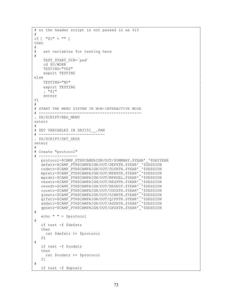
73
# no the header script is not passed in as %1% # if [ "$1" = "" ] then # # set variables for testing here # TEST_START_DIR=`pwd` cd $U/WORK TESTING="YES" export TESTING else TESTING="NO" export TESTING . "$1" seterr fi # # START THE MENU SYSTEM IN NON-INTERACTIVE MODE # --------------------------------------------- . $X/SCRIPT/BEG_MENU seterr # # SET VARIABLES IN DAT151__.PAN # ----------------------------- . $X/SCRIPT/SET_SESS seterr # # Create "protocol" # ----------------- protocol=$CAMP_PTH$CAMPAIGN/OUT/SUMMARY.$YEAR'_'$DAYYEAR defxtr=$CAMP_PTH$CAMPAIGN/OUT/DEFXTR.$YEAR'_'$SESSION codxtr=$CAMP_PTH$CAMPAIGN/OUT/CODXTR.$YEAR'_'$SESSION mprxtr=$CAMP_PTH$CAMPAIGN/OUT/MPRXTR.$YEAR'_'$SESSION mprdel=$CAMP_PTH$CAMPAIGN/OUT/MPRDEL.$YEAR'_'$SESSION resxtr=$CAMP_PTH$CAMPAIGN/OUT/RESXTR.$YEAR'_'$SESSION resedt=$CAMP_PTH$CAMPAIGN/OUT/RESEDT.$YEAR'_'$SESSION cooxtr=$CAMP_PTH$CAMPAIGN/OUT/COOXTR.$YEAR'_'$SESSION gimxtr=$CAMP_PTH$CAMPAIGN/OUT/GIMXTR.$YEAR'_'$SESSION qifxtr=$CAMP_PTH$CAMPAIGN/OUT/QIFXTR.$YEAR'_'$SESSION addxtr=$CAMP_PTH$CAMPAIGN/OUT/ADDXTR.$YEAR'_'$SESSION gpsxtr=$CAMP_PTH$CAMPAIGN/OUT/GPSXTR.$YEAR'_'$SESSION # echo " " > $protocol # if test -f $defxtr then cat $defxtr >> $protocol fi # if test -f $codxtr then cat $codxtr >> $protocol fi # if test -f $mprxtr
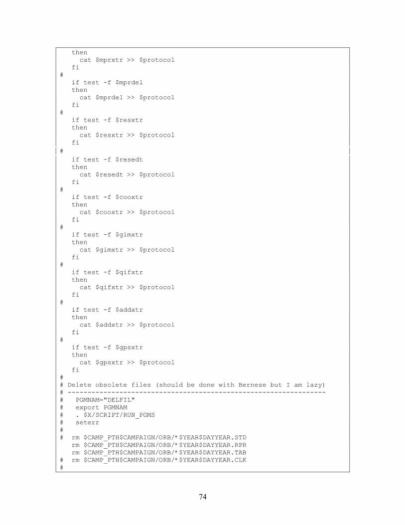
74
then cat $mprxtr >> $protocol fi # if test -f $mprdel then cat $mprdel >> $protocol fi # if test -f $resxtr then cat $resxtr >> $protocol fi # if test -f $resedt then cat $resedt >> $protocol fi # if test -f $cooxtr then cat $cooxtr >> $protocol fi # if test -f $gimxtr then cat $gimxtr >> $protocol fi # if test -f $qifxtr then cat $qifxtr >> $protocol fi # if test -f $addxtr then cat $addxtr >> $protocol fi # if test -f $gpsxtr then cat $gpsxtr >> $protocol fi # # Delete obsolete files (should be done with Bernese but I am lazy) # ----------------------------------------------------------------- # PGMNAM="DELFIL" # export PGMNAM # . $X/SCRIPT/RUN_PGMS # seterr # # rm $CAMP_PTH$CAMPAIGN/ORB/*$YEAR$DAYYEAR.STD rm $CAMP_PTH$CAMPAIGN/ORB/*$YEAR$DAYYEAR.RPR rm $CAMP_PTH$CAMPAIGN/ORB/*$YEAR$DAYYEAR.TAB # rm $CAMP_PTH$CAMPAIGN/ORB/*$YEAR$DAYYEAR.CLK #
75
## rm $CAMP_PTH$CAMPAIGN/OUT/????$DAYYEAR?.NQ0 ## rm $CAMP_PTH$CAMPAIGN/OUT/????$DAYYEAR?.NEQ mv "$CAMP_PTH$CAMPAIGN/OUT/EW_$YEAR$DAYYEAR.OUT" \ "$CAMP_PTH$CAMPAIGN/OUT/EW_$YEAR$DAYYEAR.OUT2" rm $CAMP_PTH$CAMPAIGN/OUT/????$DAYYEAR?.OUT mv "$CAMP_PTH$CAMPAIGN/OUT/EW_$YEAR$DAYYEAR.OUT2" \ "$CAMP_PTH$CAMPAIGN/OUT/EW_$YEAR$DAYYEAR.OUT" rm $CAMP_PTH$CAMPAIGN/OUT/*.$YEAR'_'$SESSION # rm $CAMP_PTH$CAMPAIGN/OUT/CODXTR.SUM rm $CAMP_PTH$CAMPAIGN/OUT/DEFWKS.SUM rm $CAMP_PTH$CAMPAIGN/OUT/DEFXTR.SUM rm $CAMP_PTH$CAMPAIGN/OUT/DEFXTP.SUM rm $CAMP_PTH$CAMPAIGN/OUT/MPRXTR.SUM rm $CAMP_PTH$CAMPAIGN/OUT/COOXTR.SUM rm $CAMP_PTH$CAMPAIGN/OUT/GPSCMP.SUM rm $CAMP_PTH$CAMPAIGN/OUT/GPSGIM.SUM rm $CAMP_PTH$CAMPAIGN/OUT/GPSPOL.SUM rm $CAMP_PTH$CAMPAIGN/OUT/GPSWKS.SUM rm $CAMP_PTH$CAMPAIGN/OUT/GPSXTR.SUM rm $CAMP_PTH$CAMPAIGN/OUT/AMBXTR.SUM rm $CAMP_PTH$CAMPAIGN/OUT/QIFXTR.SUM rm $CAMP_PTH$CAMPAIGN/OUT/RESRMS.SUM rm $CAMP_PTH$CAMPAIGN/OUT/RESRMS.EDT # # -------------- # end the script # -------------- . $X/SCRIPT/END_MENU seterr if [ "$TESTING" = "YES" ] then cd "$TEST_START_DIR" else . $X/SCRIPT/DO_TAIL seterr fi
Data Panels in $U/OPT/SLAC_STD +---------+--------------------------------------------------------------------+ | 0-1.1 | BATCH PROCESSING: SUBMIT TIME | +---------+--------------------------------------------------------------------+ | | | yy mm dd hh mm ss | | | | Submit Job After: > 94 02 01 < > 00 00 00 < (blank: immediately) | | | +------------------------------------------------------------------------------+ +---------+--------------------------------------------------------------------+ | 0-1 | DEFAULTS: PROCESSING | +---------+--------------------------------------------------------------------+ | | | Job Processing Defaults: | | SUBMIT JOBS > NO < (YES or NO) | | JOB CLASS > 3 < (0:Foreground, 1-4: Batch Queues)|
76
| (-1 to -4: Scheduled Execution) | | ROUTE JOB OUTPUT TO FILE > YES < (YES or NO) | | ROUTE ERROR MSG TO FILE > YES < (YES or NO, non-interactive only)| | GENERAL PATH TO JOB OUTPUT > U:/OUT/ < | | DIGITS OF JOB OUTPUT NUMBER > 2 < (2 or 3) | | | | Table Processing Defaults: | | CONFIRM DELETE > YES < (YES or NO) | | | | Path to Main Program Submit Files: | | PATH > U:/WORK/ < | | | +------------------------------------------------------------------------------+ +---------+--------------------------------------------------------------------+ | 0.2-1 | DEFAULTS: TRANSFER PROGRAM NAMES | +---------+--------------------------------------------------------------------+ | | | Rawdata Transfer: | | ASHTECH to RINEX (Obs, Nav) > ASRINEXO < > ASRINEXN < > ASRINEXG < *)| | MINIMAC to RINEX (Obs, Nav) > MCRINEXO < > MCRINEXN < *)| | ROGUE to RINEX (Obs, Nav) > RGRINEXO < > RGRINEXN < *)| | TRIMBLE to RINEX (Obs, Nav) > TRRINEXO < > TRRINEXN < *)| | WM-102 to RINEX (Obs, Nav) > W2RINEXO < > W2RINEXN < *)| | | | RINEX Met.File Creation > RXMETEO < *)| | Concatenate RINEX (Obs, Nav) > CCRINEXO < > CCRINEXN < > CCRINEXG < *)| | Concatenate Precise Orbit Files > CCPREORB < *)| | Split RINEX obs files > RNXSPLIT < *)| | | | Simulation Program > GPSSIM < | | | | Path to the Programs > XG:/ < | | Path to the Programs *) > XG:/ < | +------------------------------------------------------------------------------+ +---------+--------------------------------------------------------------------+ | 0.2-2 | DEFAULTS: RINEX TRANSFER PROGRAM NAMES | +---------+--------------------------------------------------------------------+ | | | Bernese to RINEX: | | OBSERVATIONS > BV3RXO < | | BROADCASTS > BV3RXN < | | METEO > BV3RXM < | | | | RINEX to Bernese: | | OBSERVATIONS > RXOBV3 < | | BROADCASTS > RXNBV3 < | | METEO > RXMBV3 < | | | | RINEX to Precise: | | BROADCASTS > RXNPRE < | | | | Pseudographics > RNXGRA < | | Phase Test > RNXCYC < | | Rinex Smoothing > RNXSMT < | | | | Path to the Programs > XG:/ < | | | +------------------------------------------------------------------------------+ +---------+--------------------------------------------------------------------+ | 0.2-3 | DEFAULTS: ORBIT PROGRAM NAMES | +---------+--------------------------------------------------------------------+ | | | Broadcast Ephemeris: | | MANUAL BROADCAST CHECK > BRDCHK < AUTOM. BROADCAST CHECK > BRDTST < | | BROADCAST E. to TABULAR > BRDTAB < | | | | Standard Orbits: | | GENERATE STD.ORBITS > ORBGEN < UPDATE STD.ORBITS > UPDSTD < | | NEW STD.ORBITS > NEWSTD < COMPARE STD.ORBITS > STDDIF < | | STD.ORBITS to ASCII > STDFMT < ASCII to STD.ORBITS > FMTSTD < | | DEFINE STD.ORBITS (NEW) > DEFO93 < UPDATE STD.ORBITS (NEW) > UPDO93 < |
77
| ORBIT IMPROVEMENT > ORBIMP < COMPARE OSC. ELEMENTS > STDELE < | | | | Precise Ephemeris: | | PRECISE EPH. to TABULAR > PRETAB < CREATE PRECISE EPHEM. > STDPRE < | | | | Satellite Clocks: | | CREATE SAT.CLOCK FILE > SATCLK < | | | | Path to the Programs: > XG:/ < | | | +------------------------------------------------------------------------------+ +---------+--------------------------------------------------------------------+ | 0.2-4 | DEFAULTS: PROCESSING PROGRAM NAMES | +---------+--------------------------------------------------------------------+ | | | Preprocessing: | | CODE PREPROCESSING > CODCHK < | | SINGLE POINT POSITIONING > CODSPP < | | SINGLE DIFFERENCE FILES > SNGDIF < | | OLD PHASE PREPROCESSING > OBSTS1 < | | NEW PHASE PREPROCESSING > MAUPRP < | | | | Processing: | | PARAMETER ESTIMATION > GPSEST < | | IONOSPHERE ESTIMATION > IONEST < | | ADD NORMAL EQUATIONS > ADDNEQ < | | ADD NORMAL EQUATIONS > ADDNEQ2 < | | | | Path to the Programs > XG:/ < | | | +------------------------------------------------------------------------------+ +---------+--------------------------------------------------------------------+ | 0.2-5 | DEFAULTS: SERVICE PROGRAM NAMES | +---------+--------------------------------------------------------------------+ | | | Observation Files: | | BINARY TO FORMATTED > OBSFMT < FORMATTED TO BINARY > FMTOBS < | | GRAPHICS OF OBSERV.FILE > SATGRA < MARK/RESET OBSERVATIONS > SATMRK < | | SPLIT OBSERVATION FILES > OBSSPL < CHANGE HEADER CONTENT > CHGHED < | | NEQs: BIN / ASCII > NEQ2ASC < | | Residuals: | | DISPLAY RESIDUALS > REDISP < GRAPHIC TOOL (GT) *) > GT < | | CHECK RESIDUALS > RESRMS < | | Coordinates: | | HELMERT TRANSFORMATION > HELMR1 < COMPARE COORD.FILES > COMPAR < | | MERGE COORDINATE FILES > CRDMRG < | | Pole: | | UPDATE POLE FILE > POLUPD < EXTRACT POLE INFO > POLXTR < | | Job Output Extractions | | CODXTR (CODSPP) > CODXTR < DEFXTR (DEFSTD) > DEFXTP < | | MPRXTR (MAUPRP) > MPRXTR < GPSXTR (GPSEST) > GPSXTR < | | PREWEI (ORBIMP,PRECISE) > PREWEI < | | | | Path to the Programs > XG:/ < | | Path to the Programs *) > X:/EXE/ < | +------------------------------------------------------------------------------+ +---------+--------------------------------------------------------------------+ | 0.2-6 | DEFAULTS: BPE PROGRAM NAMES | +---------+--------------------------------------------------------------------+ | | | Coordinates: | | CHECK COORDINATE FILES > CRDCHK < | | CHECK RINEX COORDINATES > CRDRNX < | | CHECK RINEX FILE HEADERS > PREPRX < | | | | Path to the Programs > XB:/ < | | | +------------------------------------------------------------------------------+ +---------+--------------------------------------------------------------------+ | 0.3-1 | DEFAULTS: GENERAL DATASET NAMES |
78
+---------+--------------------------------------------------------------------+ | General Datasets: | | GEODETIC DATUM > DATUM. < CONSTANTS > CONST. < | | PHASE CENTER ECC. > PHAS_IGS.01 < RECEIVER INFO > RECEIVER. < | | EARTH POTENTIAL > JGM3. < POLE INFORMATION > IGS_$JJ2.ERP < | | POLE OFFSET COEF. > POLOFF. < LEAP SECONDS > GPSUTC. < | | SAT. PARAMETERS > SATELLIT.TTT < MANOEUVERS ETC. > SAT_$JJ2.CRX < | | SINEX GENERAL FILE > SINEX. < STATION PROBLEMS > STACRUX.NUL < | | IONEX CONTROL FILE > IONEX. < | | Extensions: | | IERS BULLETINS > IER < RCVR/ANT.NAME TRANSLATION TABLES > TRN < | | | | Path to the Datasets: > X:/GEN/ < | | Input Files: Path Extension | | N-,I-,F-FILES > U:/INP/ < > INP < | | SKELETON FILES > X:/SKL/ < > SKL < | | PANEL UPDATE DIRECTORY LISTS > X:/SKL/ < > UPD < | | | | Auxiliary Files (Scratch Files) > U:/WORK/ < > SCR < | | Error Message File (Full Name): > U:/WORK/ERROR.MSG < | +------------------------------------------------------------------------------+ +---------+--------------------------------------------------------------------+ | 0.3-2 | DEFAULTS: OBSERVATION DATAFILES | +---------+--------------------------------------------------------------------+ | | | Code: Extension Extension | | HEADERS > CZH < OBSERVATIONS > CZO < | | S.DIFF. HEADERS > CSH < S.DIFF. OBSERVATIONS > CSO < | | FORMATTED > FCO < | | Phase: | | HEADERS > PZH < OBSERVATIONS > PZO < | | S.DIFF. HEADERS > PSH < S.DIFF. OBSERVATIONS > PSO < | | FORMATTED > FPH < | | Ranges: | | HEADERS > CZH < OBSERVATIONS > CZO < | | FORMATTED > FCO < | | | | Path from Campaign Subdirectory to Files | | OBS.FILES > OBS/ < | | RAWDATA (RINEX) > RAW/ < | | ORIGINAL RINEX FILES > ORX/ < | +------------------------------------------------------------------------------+ +---------+--------------------------------------------------------------------+ | 0.3-3 | DEFAULTS: ORBIT DATASET EXTENSIONS | +---------+--------------------------------------------------------------------+ | | | Orbits: | | BROADCAST EPHEMERIS > BRD < TABULAR ORBITS > TAB < | | STANDARD ORBITS > STD < RAD.PRESSURE COEFF. > RPR < | | ORBITAL ELEMENTS > ELE < PRECISE EPHEMERIS > SP3 < | | | | Orbit files in ASCII: | | STANDARD ORBITS > FSO < RAD.PRESSURE COEFF. > FRP < | | | | Path from Campaign Subdirectory to Files | | ALL ORBIT FILES > ORB/ < | | | +------------------------------------------------------------------------------+ +---------+--------------------------------------------------------------------+ | 0.3-4 | DEFAULTS: MISCELLANEOUS DATASETS | +---------+--------------------------------------------------------------------+ | | | Miscellaneous: Extension Path fm Campaign Subdir to File | | COORDINATES > CRD < > STA/ < | | STATION VELOCITIES > VEL < > STA/ < | | STATION ECCENTERS > ECC < > STA/ < | | OCEAN LOADING > BLQ < > STA/ < | | STATION NAME TRANSL. > STN < > STA/ < | | ANTENNA HEIGHT TRANS. > HTR < > STA/ < | | BASELINE DEFINITIONS > BSL < > STA/ < | | CLUSTER DEF. INPUT > CLU < > STA/ < |
79
| CLUSTER DEF. OUTPUT > CLB < > STA/ < | | SPECIAL FIXED STAT FILE > FIX < > STA/ < | | SPECIAL STATION FTP FILE > FTP < > STA/ < | | TROPOSPHERE APRIORI SIGMA > SIG < > STA/ < | | REC. ANT. ORIENTATIONS > AZI < > STA/ < | | METEO DATA > MET < > ATM/ < | | TROPOSPHERE PARAMETERS > TRP < > ATM/ < | | TROPOSPHERE GRADIENTS > GRD < > ATM/ < | | TROPOSPHERE SINEX > TRO < > ATM/ < | | IONOSPHERE MODELS > ION < > ATM/ < | | IONOSPHERE MAPS (IONEX) > INX < > ATM/ < | | DIFFERENTIAL CODE BIASES > DCB < > ORB/ < | | REC./SAT. CLOCKS > CLK < > ORB/ < | | RESIDUALS > RES < > OUT/ < | | PROGRAM OUTPUT > OUT < > OUT/ < | | COVARIANCES > COV < > OUT/ < | | NORMAL EQUATIONS > NEQ < > OUT/ < | | NORMAL EQUATIONS > NQ0 < > OUT/ < | | ANTENNA PHASE CENT.(GRID) > PHG < > OUT/ < | | ANTENNA PHASE CENT.(HARM) > PHH < > OUT/ < | | OUTPUT FILES > LST < > OUT/ < | | PLOT FILES > PLT < > OUT/ < | | EARTH ROTATION PARAMETERS > ERP < > OUT/ < | | IERS FORMAT ERP FILE > IEP < > OUT/ < | | SINEX FORMAT (CRD,VEL,ERP)> SNX < > OUT/ < | | COVARIANCE COMPONENTS > WGT < > OUT/ < | | SATMARK EDIT INFO FILE > EDT < > OUT/ < | | LIST OF FILE TO DELETE > DEL < > OUT/ < | | SUMMARY OUTPUT FILE > SUM < > OUT/ < | | JOB OUTPUT SUMMARIES > SMC < > SME < > OUT/ < | | JOB OUTPUT FILES > OUT/ < | +------------------------------------------------------------------------------+ +---------+--------------------------------------------------------------------+ | 0.3-5 | DEFAULTS: BPE GENERAL DATASETS | +---------+--------------------------------------------------------------------+ | | | Process Control Files: | | PATH TO PCF FILES > U:/PCF/ < PCF FILE EXTENSION > PCF < | | | | Process Scripts: | | PATH TO USER SCRIPTS > U:/SCRIPT/ < SCRIPT EXTENSION > < | | | | Panel Set Directory Starting Path: | | PATH TO PANEL SETS > U:/OPT/ < | | | | CPU and Queue selection: | | CPU FILE NAME > U:/WORK/PCFCTL.CPU < | | | +------------------------------------------------------------------------------+ +---------+--------------------------------------------------------------------+ | 0.3-6 | DEFAULTS: PBE MISCELLANEOUS DATASETS | +---------+--------------------------------------------------------------------+ | | | Miscellaneous: Extension Path fm Campaign Subdir to File | | BASELINE LIST FILE > BSL < > STA/ < | | | +------------------------------------------------------------------------------+ +---------+--------------------------------------------------------------------+ | 0.4-1 | DEFAULTS: FTP SCRIPT NAMES | +---------+--------------------------------------------------------------------+ | | | FTP Scripts: | | DOWNLOAD IGS RINEX DATA > FTPRNX < | | DOWNLOAD IGS PRECISE ORBITS > FTPORB < | | DOWNLOAD CODE STATION INFO > FTPSTA < | | DOWNLOAD CODE SATELLITE INFO > FTPSAT < | | DOWNLOAD CODE POLE INFO > FTPPOL < | | | | Path to the Scripts > X:/EXE/ < | | |
80
+------------------------------------------------------------------------------+ +---------+--------------------------------------------------------------------+ | 0.4-2 | DEFAULTS: BPE SCRIPT NAMES | +---------+--------------------------------------------------------------------+ | | | BPE Scripts: | | PROCESS CONTROL SCRIPT > PCS < | | | | Path to the Scripts > X:/EXE/ < | | | +------------------------------------------------------------------------------+ +---------+--------------------------------------------------------------------+ | 0.4 | PROCESSING: DEFINE FILENAME PARAMETERS FOR AUTOMATIC PROCESSING | +---------+--------------------------------------------------------------------+ | | | Station 1 > < Station 2 > < | | (2-char abbreviation goes into parameter '$i') | | (4-char abbreviation goes into parameter '$STi') | | (full station name goes into parameter '$STATIONi') | | | | Session number 1 > < Session number 2 > < | | Session number 3 > < Session number 4 > < | | (3-digit session number i goes into parameter '$Di') | | | | Code 1 > < Code 2 > < | | (4-char code i goes into parameter '$CDi') | | | | Examples of filenames: | | Zero Difference Filename $ST1$D1* | | Single Difference Filename $1$2$D10 | | Standard Orbit Filename B2$D2$D3 | | | +------------------------------------------------------------------------------+ +---------+--------------------------------------------------------------------+ | 0.9-7 | DEFAULTS: WD2PWV PROGRAM NAMES | +---------+--------------------------------------------------------------------+ | | | transformation of wet delay to PWV | | TRANSFORM WET DELAY FILES > WD2PWV < | | | | Path to the Programs > XG:/ < | | | +------------------------------------------------------------------------------+ +---------+--------------------------------------------------------------------+ | 1.5.1 | PROCESSING: FILENAME PARAMETERS FOR AUTOMATIC PROCESSING | +---------+--------------------------------------------------------------------+ | | | Station Parameters: | | $STATION1 > < $STATION2 > < | | ($i will be set to 2-char station abbrev, $STi to 4-char abbrev) | | | | 4-character Parameters: | | $CD1 > < $CD2 > < | | $CD3 > < $CD4 > < | | | | 3-character Parameters: | | $D1 > 078 < $D2 > < | | $D3 > < $D4 > < | | | | 2-character Parameters: | | $M > 03 < $O > R3 < $T > 19 < | | $U > EN < $V > EF < $W > EW < | | $X > E0 < $Y > 02 < $Z > EB < | | | | 6-character Session Parameters (+ - allowed): | | $JRSS1 > 020780 +0 -0 < $JRSS2 > 020780 < | | $JRSS3 > < $JRSS4 > < | | $JRS+1 > < $JRS-1 > < | | $JRS+2 > < $JRS-2 > < | | |
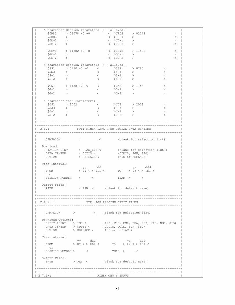
81
| 5-character Session Parameters (+ - allowed): | | $JRD1 > 02078 +0 -0 < $JRD2 > 02078 < | | $JRD3 > < $JRD4 > < | | $JD+1 > < $JD-1 > < | | $JD+2 > < $JD-2 > < | | | | $GDY1 > 11582 +0 -0 < $GDY2 > 11582 < | | $GD+1 > < $GD-1 > < | | $GD+2 > < $GD-2 > < | | | | 4-character Session Parameters (+ - allowed): | | $SS1 > 0780 +0 -0 < $SS2 > 0780 < | | $SS3 > < $SS4 > < | | $S+1 > < $S-1 > < | | $S+2 > < $S-2 > < | | | | $GW1 > 1158 +0 -0 < $GW2 > 1158 < | | $G+1 > < $G-1 > < | | $G+2 > < $G-2 > < | | | | 4-character Year Parameters: | | $JJ1 > 2002 < $JJ2 > 2002 < | | $JJ3 > < $JJ4 > < | | $J+1 > < $J-1 > < | | $J+2 > < $J-2 > < | | | +------------------------------------------------------------------------------+ +---------+--------------------------------------------------------------------+ | 2.0.1 | FTP: RINEX DATA FROM GLOBAL DATA CENTERS | +---------+--------------------------------------------------------------------+ | | | CAMPAIGN > < (blank for selection list) | | | | Download: | | STATION LIST > SLAC_BPE < (blank for selection list ) | | DATA CENTER > CDDIS < (CDDIS, IGN, SIO) | | OPTION > REPLACE < (ADD or REPLACE) | | | | Time Interval: | | yy ddd yy ddd | | FROM > $Y < > $D1 < TO > $Y < > $D1 < | | or | | SESSION NUMBER > < YEAR > < | | | | Output Files: | | PATH > RAW < (blank for default name) | | | +------------------------------------------------------------------------------+ +---------+--------------------------------------------------------------------+ | 2.0.2 | FTP: IGS PRECISE ORBIT FILES | +---------+--------------------------------------------------------------------+ | | | CAMPAIGN > < (blank for selection list) | | | | Download Options: | | ORBIT IDENT. > IGS < (IGS, COD, EMR, ESA, GFZ, JPL, NGS, SIO) | | DATA CENTER > CDDIS < (CDDIS, CODE, IGN, SIO) | | OPTION > REPLACE < (ADD or REPLACE) | | | | Time Interval: | | yy ddd yy ddd | | FROM > $Y < > $D1 < TO > $Y < > $D1 < | | or | | SESSION NUMBER > < YEAR > < | | | | Output Files: | | PATH > ORB < (blank for default name) | | | +------------------------------------------------------------------------------+ +---------+--------------------------------------------------------------------+ | 2.7.1-1 | RINEX OBS.: INPUT |
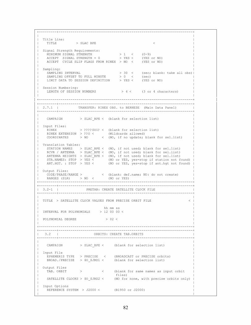
82
+---------+--------------------------------------------------------------------+ | | | Title Line: | | TITLE > SLAC BPE < | | | | Signal Strength Requirements: | | MINIMUM SIGNAL STRENGTH > 1 < (0-9) | | ACCEPT SIGNAL STRENGTH = 0 > YES < (YES or NO) | | ACCEPT CYCLE SLIP FLAGS FROM RINEX > NO < (YES or NO) | | | | Sampling: | | SAMPLING INTERVAL > 30 < (sec; blank: take all obs)| | SAMPLING OFFSET TO FULL MINUTE > 0 < (sec) | | LIMIT DATA TO SESSION DEFINITION > YES < (YES or NO) | | | | Session Numbering: | | LENGTH OF SESSION NUMBERS > 4 < (3 or 4 characters) | | | +------------------------------------------------------------------------------+ +---------+--------------------------------------------------------------------+ | 2.7.1 | TRANSFER: RINEX OBS. to BERNESE (Main Data Panel) | +---------+--------------------------------------------------------------------+ | | | CAMPAIGN > SLAC_BPE < (blank for selection list) | | | | Input Files: | | RINEX > ????$D1? < (blank for selection list) | | RINEX EXTENSION > ??O < (Wildcards allowed) | | COORDINATES > NO < (NO, if no update; blank for sel.list) | | | | Translation Tables: | | STATION NAMES > SLAC_BPE < (NO, if not used; blank for sel.list) | | RCVR / ANTENNA > SLAC_BPE < (NO, if not used; blank for sel.list) | | ANTENNA HEIGHTS > SLAC_BPE < (NO, if not used; blank for sel.list) | | STA.NAMES: STOP > YES < (NO or YES, yes=stop if station not found) | | ANT.HGT. : STOP > YES < (NO or YES, yes=stop if ant.hgt not found) | | | | Output Files: | | CODE/PHASE/RANGE > < (blank: def.name; NO: do not create) | | RANGES (SLR) > NO < (NO or YES) | +------------------------------------------------------------------------------+ +---------+--------------------------------------------------------------------+ | 3.2-1 | PRETAB: CREATE SATELLITE CLOCK FILE | +---------+--------------------------------------------------------------------+ | | | TITLE > SATELLITE CLOCK VALUES FROM PRECISE ORBIT FILE < | | | | hh mm ss | | INTERVAL FOR POLYNOMIALS > 12 00 00 < | | | | POLYNOMIAL DEGREE > 02 < | | | +------------------------------------------------------------------------------+ +---------+--------------------------------------------------------------------+ | 3.2 | ORBITS: CREATE TAB.ORBITS | +---------+--------------------------------------------------------------------+ | | | CAMPAIGN > SLAC_BPE < (blank for selection list) | | | | Input File | | EPHEMERIS TYPE > PRECISE < (BROADCAST or PRECISE orbits) | | BROAD./PRECISE > $O_$JRD1 < (blank for selection list) | | | | Output Files | | TAB. ORBIT > < (blank for same names as input orbit | | files) | | SATELLITE CLOCKS > $O_$JRD2 < (NO for none, with precise orbits only) | | | | Input Options | | REFERENCE SYSTEM > J2000 < (B1950 or J2000) | | |
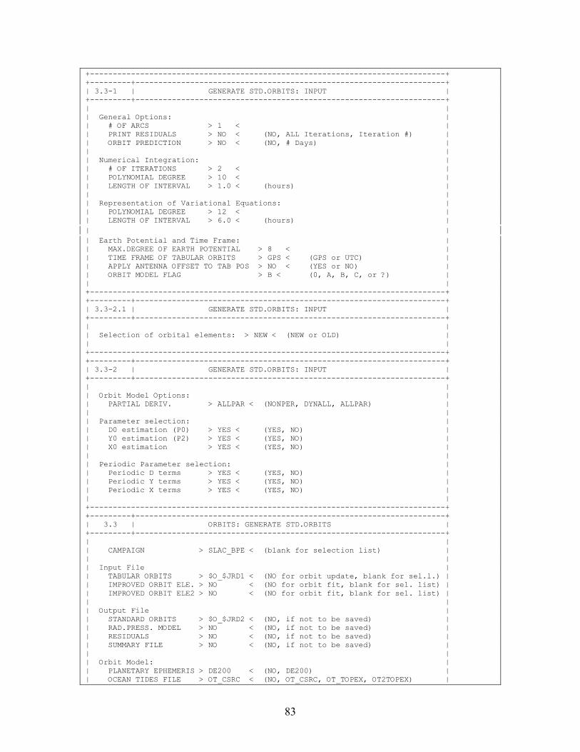
83
+------------------------------------------------------------------------------+ +---------+--------------------------------------------------------------------+ | 3.3-1 | GENERATE STD.ORBITS: INPUT | +---------+--------------------------------------------------------------------+ | | | General Options: | | # OF ARCS > 1 < | | PRINT RESIDUALS > NO < (NO, ALL Iterations, Iteration #) | | ORBIT PREDICTION > NO < (NO, # Days) | | | | Numerical Integration: | | # OF ITERATIONS > 2 < | | POLYNOMIAL DEGREE > 10 < | | LENGTH OF INTERVAL > 1.0 < (hours) | | | | Representation of Variational Equations: | | POLYNOMIAL DEGREE > 12 < | | LENGTH OF INTERVAL > 6.0 < (hours) | | | | Earth Potential and Time Frame: | | MAX.DEGREE OF EARTH POTENTIAL > 8 < | | TIME FRAME OF TABULAR ORBITS > GPS < (GPS or UTC) | | APPLY ANTENNA OFFSET TO TAB POS > NO < (YES or NO) | | ORBIT MODEL FLAG > B < (0, A, B, C, or ?) | | | +------------------------------------------------------------------------------+ +---------+--------------------------------------------------------------------+ | 3.3-2.1 | GENERATE STD.ORBITS: INPUT | +---------+--------------------------------------------------------------------+ | | | Selection of orbital elements: > NEW < (NEW or OLD) | | | +------------------------------------------------------------------------------+ +---------+--------------------------------------------------------------------+ | 3.3-2 | GENERATE STD.ORBITS: INPUT | +---------+--------------------------------------------------------------------+ | | | Orbit Model Options: | | PARTIAL DERIV. > ALLPAR < (NONPER, DYNALL, ALLPAR) | | | | Parameter selection: | | D0 estimation (P0) > YES < (YES, NO) | | Y0 estimation (P2) > YES < (YES, NO) | | X0 estimation > YES < (YES, NO) | | | | Periodic Parameter selection: | | Periodic D terms > YES < (YES, NO) | | Periodic Y terms > YES < (YES, NO) | | Periodic X terms > YES < (YES, NO) | | | +------------------------------------------------------------------------------+ +---------+--------------------------------------------------------------------+ | 3.3 | ORBITS: GENERATE STD.ORBITS | +---------+--------------------------------------------------------------------+ | | | CAMPAIGN > SLAC_BPE < (blank for selection list) | | | | Input File | | TABULAR ORBITS > $O_$JRD1 < (NO for orbit update, blank for sel.l.) | | IMPROVED ORBIT ELE. > NO < (NO for orbit fit, blank for sel. list) | | IMPROVED ORBIT ELE2 > NO < (NO for orbit fit, blank for sel. list) | | | | Output File | | STANDARD ORBITS > $O_$JRD2 < (NO, if not to be saved) | | RAD.PRESS. MODEL > NO < (NO, if not to be saved) | | RESIDUALS > NO < (NO, if not to be saved) | | SUMMARY FILE > NO < (NO, if not to be saved) | | | | Orbit Model: | | PLANETARY EPHEMERIS > DE200 < (NO, DE200) | | OCEAN TIDES FILE > OT_CSRC < (NO, OT_CSRC, OT_TOPEX, OT2TOPEX) |
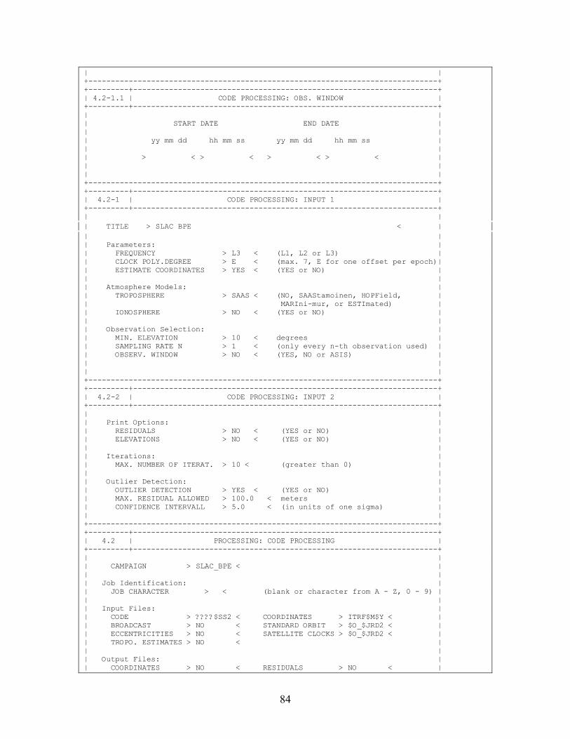
84
| | +------------------------------------------------------------------------------+ +---------+--------------------------------------------------------------------+ | 4.2-1.1 | CODE PROCESSING: OBS. WINDOW | +---------+--------------------------------------------------------------------+ | | | START DATE END DATE | | | | yy mm dd hh mm ss yy mm dd hh mm ss | | | | > < > < > < > < | | | | | +------------------------------------------------------------------------------+ +---------+--------------------------------------------------------------------+ | 4.2-1 | CODE PROCESSING: INPUT 1 | +---------+--------------------------------------------------------------------+ | | | TITLE > SLAC BPE < | | | | Parameters: | | FREQUENCY > L3 < (L1, L2 or L3) | | CLOCK POLY.DEGREE > E < (max. 7, E for one offset per epoch)| | ESTIMATE COORDINATES > YES < (YES or NO) | | | | Atmosphere Models: | | TROPOSPHERE > SAAS < (NO, SAAStamoinen, HOPField, | | MARIni-mur, or ESTImated) | | IONOSPHERE > NO < (YES or NO) | | | | Observation Selection: | | MIN. ELEVATION > 10 < degrees | | SAMPLING RATE N > 1 < (only every n-th observation used) | | OBSERV. WINDOW > NO < (YES, NO or ASIS) | | | | | +------------------------------------------------------------------------------+ +---------+--------------------------------------------------------------------+ | 4.2-2 | CODE PROCESSING: INPUT 2 | +---------+--------------------------------------------------------------------+ | | | Print Options: | | RESIDUALS > NO < (YES or NO) | | ELEVATIONS > NO < (YES or NO) | | | | Iterations: | | MAX. NUMBER OF ITERAT. > 10 < (greater than 0) | | | | Outlier Detection: | | OUTLIER DETECTION > YES < (YES or NO) | | MAX. RESIDUAL ALLOWED > 100.0 < meters | | CONFIDENCE INTERVALL > 5.0 < (in units of one sigma) | | | +------------------------------------------------------------------------------+ +---------+--------------------------------------------------------------------+ | 4.2 | PROCESSING: CODE PROCESSING | +---------+--------------------------------------------------------------------+ | | | CAMPAIGN > SLAC_BPE < | | | | Job Identification: | | JOB CHARACTER > < (blank or character from A - Z, 0 - 9) | | | | Input Files: | | CODE > ????$SS2 < COORDINATES > ITRF$M$Y < | | BROADCAST > NO < STANDARD ORBIT > $O_$JRD2 < | | ECCENTRICITIES > NO < SATELLITE CLOCKS > $O_$JRD2 < | | TROPO. ESTIMATES > NO < | | | | Output Files: | | COORDINATES > NO < RESIDUALS > NO < |
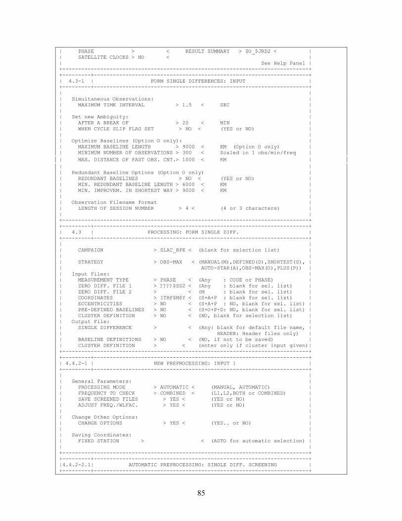
85
| PHASE > < RESULT SUMMARY > $O_$JRD2 < | | SATELLITE CLOCKS > NO < | | See Help Panel | +------------------------------------------------------------------------------+ +---------+--------------------------------------------------------------------+ | 4.3-1 | FORM SINGLE DIFFERENCES: INPUT | +---------+--------------------------------------------------------------------+ | | | Simultaneous Observations: | | MAXIMUM TIME INTERVAL > 1.5 < SEC | | | | Set new Ambiguity: | | AFTER A BREAK OF > 20 < MIN | | WHEN CYCLE SLIP FLAG SET > NO < (YES or NO) | | | | Optimize Baselines (Option O only): | | MAXIMUM BASELINE LENGTH > 9000 < KM (Option O only) | | MINIMUM NUMBER OF OBSERVATIONS > 300 < Scaled in 1 obs/min/freq | | MAX. DISTANCE OF FAST OBS. CNT.> 1000 < KM | | | | Redundant Baseline Options (Option O only) | | REDUNDANT BASELINES > NO < (YES or NO) | | MIN. REDUNDANT BASELINE LENGTH > 6000 < KM | | MIN. IMPROVEM. IN SHORTEST WAY > 9000 < KM | | | | Observation Filename Format | | LENGTH OF SESSION NUMBER > 4 < (4 or 3 characters) | | | +------------------------------------------------------------------------------+ +---------+--------------------------------------------------------------------+ | 4.3 | PROCESSING: FORM SINGLE DIFF. | +---------+--------------------------------------------------------------------+ | | | CAMPAIGN > SLAC_BPE < (blank for selection list) | | | | STRATEGY > OBS-MAX < (MANUAL(M),DEFINED(D),SHORTEST(S), | | AUTO-STAR(A),OBS-MAX(O),PLUS(P)) | | Input Files: | | MEASUREMENT TYPE > PHASE < (Any : CODE or PHASE) | | ZERO DIFF. FILE 1 > ????$SS2 < (Any : blank for sel. list) | | ZERO DIFF. FILE 2 > < (M : blank for sel. list) | | COORDINATES > ITRF$M$Y < (S+A+P : blank for sel. list) | | ECCENTRICITIES > NO < (S+A+P : NO, blank for sel. list) | | PRE-DEFINED BASELINES > NO < (S+O+P+D: NO, blank for sel. list) | | CLUSTER DEFINITION > NO < (NO, blank for selection list) | | Output File: | | SINGLE DIFFERENCE > < (Any: blank for default file name, | | HEADER: Header files only) | | BASELINE DEFINITIONS > NO < (NO, if not to be saved) | | CLUSTER DEFINITION > < (enter only if cluster input given)| +------------------------------------------------------------------------------+ +---------+--------------------------------------------------------------------+ | 4.4.2-1 | NEW PREPROCESSING: INPUT 1 | +---------+--------------------------------------------------------------------+ | | | General Parameters: | | PROCESSING MODE > AUTOMATIC < (MANUAL, AUTOMATIC) | | FREQUENCY TO CHECK > COMBINED < (L1,L2,BOTH or COMBINED) | | SAVE SCREENED FILES > YES < (YES or NO) | | ADJUST FREQ./WLFAC. > YES < (YES or NO) | | | | Change Other Options: | | CHANGE OPTIONS > YES < (YES.. or NO) | | | | Saving Coordinates: | | FIXED STATION > < (AUTO for automatic selection) | | | +------------------------------------------------------------------------------+ +---------+--------------------------------------------------------------------+ |4.4.2-2.1| AUTOMATIC PREPROCESSING: SINGLE DIFF. SCREENING | +---------+--------------------------------------------------------------------+
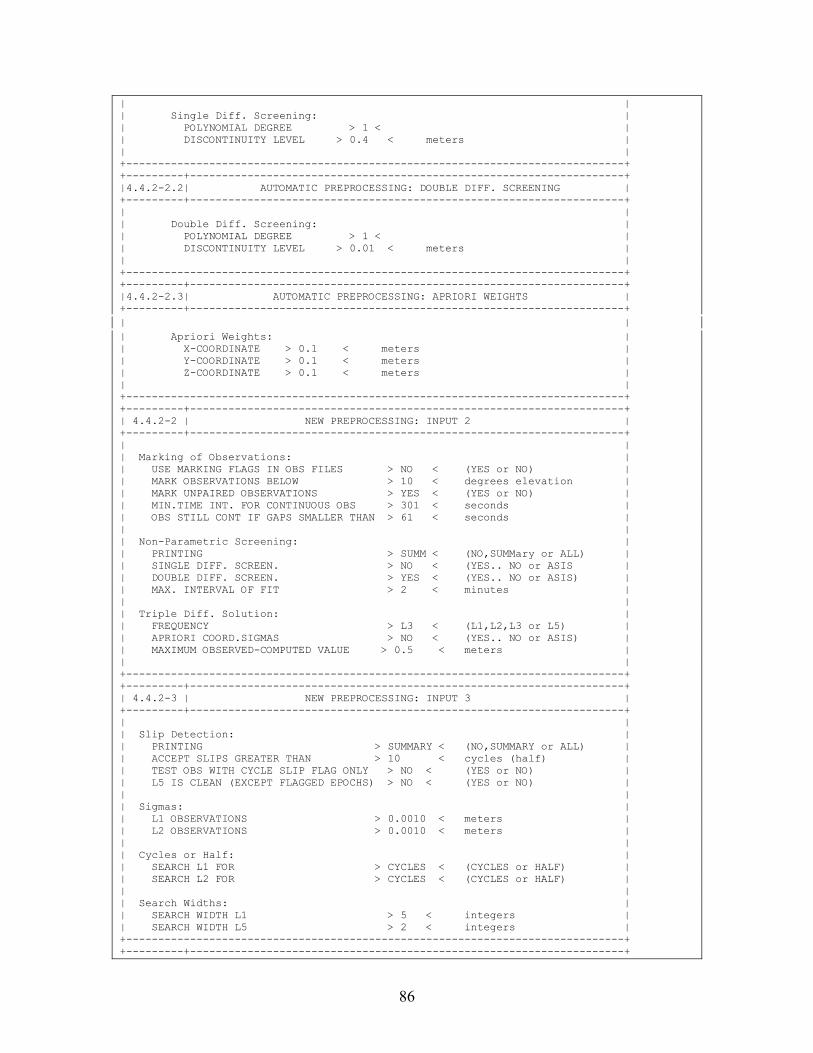
86
| | | Single Diff. Screening: | | POLYNOMIAL DEGREE > 1 < | | DISCONTINUITY LEVEL > 0.4 < meters | | | +------------------------------------------------------------------------------+ +---------+--------------------------------------------------------------------+ |4.4.2-2.2| AUTOMATIC PREPROCESSING: DOUBLE DIFF. SCREENING | +---------+--------------------------------------------------------------------+ | | | Double Diff. Screening: | | POLYNOMIAL DEGREE > 1 < | | DISCONTINUITY LEVEL > 0.01 < meters | | | +------------------------------------------------------------------------------+ +---------+--------------------------------------------------------------------+ |4.4.2-2.3| AUTOMATIC PREPROCESSING: APRIORI WEIGHTS | +---------+--------------------------------------------------------------------+ | | | Apriori Weights: | | X-COORDINATE > 0.1 < meters | | Y-COORDINATE > 0.1 < meters | | Z-COORDINATE > 0.1 < meters | | | +------------------------------------------------------------------------------+ +---------+--------------------------------------------------------------------+ | 4.4.2-2 | NEW PREPROCESSING: INPUT 2 | +---------+--------------------------------------------------------------------+ | | | Marking of Observations: | | USE MARKING FLAGS IN OBS FILES > NO < (YES or NO) | | MARK OBSERVATIONS BELOW > 10 < degrees elevation | | MARK UNPAIRED OBSERVATIONS > YES < (YES or NO) | | MIN.TIME INT. FOR CONTINUOUS OBS > 301 < seconds | | OBS STILL CONT IF GAPS SMALLER THAN > 61 < seconds | | | | Non-Parametric Screening: | | PRINTING > SUMM < (NO,SUMMary or ALL) | | SINGLE DIFF. SCREEN. > NO < (YES.. NO or ASIS | | DOUBLE DIFF. SCREEN. > YES < (YES.. NO or ASIS) | | MAX. INTERVAL OF FIT > 2 < minutes | | | | Triple Diff. Solution: | | FREQUENCY > L3 < (L1,L2,L3 or L5) | | APRIORI COORD.SIGMAS > NO < (YES.. NO or ASIS) | | MAXIMUM OBSERVED-COMPUTED VALUE > 0.5 < meters | | | +------------------------------------------------------------------------------+ +---------+--------------------------------------------------------------------+ | 4.4.2-3 | NEW PREPROCESSING: INPUT 3 | +---------+--------------------------------------------------------------------+ | | | Slip Detection: | | PRINTING > SUMMARY < (NO,SUMMARY or ALL) | | ACCEPT SLIPS GREATER THAN > 10 < cycles (half) | | TEST OBS WITH CYCLE SLIP FLAG ONLY > NO < (YES or NO) | | L5 IS CLEAN (EXCEPT FLAGGED EPOCHS) > NO < (YES or NO) | | | | Sigmas: | | L1 OBSERVATIONS > 0.0010 < meters | | L2 OBSERVATIONS > 0.0010 < meters | | | | Cycles or Half: | | SEARCH L1 FOR > CYCLES < (CYCLES or HALF) | | SEARCH L2 FOR > CYCLES < (CYCLES or HALF) | | | | Search Widths: | | SEARCH WIDTH L1 > 5 < integers | | SEARCH WIDTH L5 > 2 < integers | +------------------------------------------------------------------------------+ +---------+--------------------------------------------------------------------+
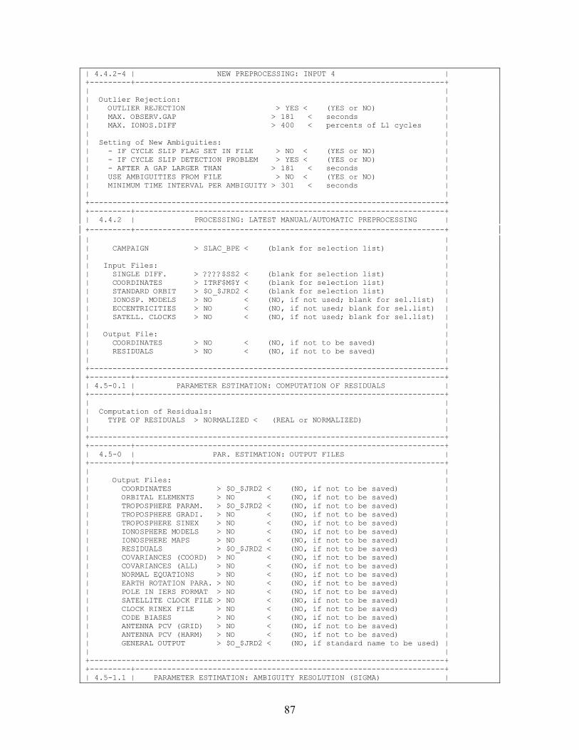
87
| 4.4.2-4 | NEW PREPROCESSING: INPUT 4 | +---------+--------------------------------------------------------------------+ | | | Outlier Rejection: | | OUTLIER REJECTION > YES < (YES or NO) | | MAX. OBSERV.GAP > 181 < seconds | | MAX. IONOS.DIFF > 400 < percents of L1 cycles | | | | Setting of New Ambiguities: | | - IF CYCLE SLIP FLAG SET IN FILE > NO < (YES or NO) | | - IF CYCLE SLIP DETECTION PROBLEM > YES < (YES or NO) | | - AFTER A GAP LARGER THAN > 181 < seconds | | USE AMBIGUITIES FROM FILE > NO < (YES or NO) | | MINIMUM TIME INTERVAL PER AMBIGUITY > 301 < seconds | | | +------------------------------------------------------------------------------+ +---------+--------------------------------------------------------------------+ | 4.4.2 | PROCESSING: LATEST MANUAL/AUTOMATIC PREPROCESSING | +---------+--------------------------------------------------------------------+ | | | CAMPAIGN > SLAC_BPE < (blank for selection list) | | | | Input Files: | | SINGLE DIFF. > ????$SS2 < (blank for selection list) | | COORDINATES > ITRF$M$Y < (blank for selection list) | | STANDARD ORBIT > $O_$JRD2 < (blank for selection list) | | IONOSP. MODELS > NO < (NO, if not used; blank for sel.list) | | ECCENTRICITIES > NO < (NO, if not used; blank for sel.list) | | SATELL. CLOCKS > NO < (NO, if not used; blank for sel.list) | | | | Output File: | | COORDINATES > NO < (NO, if not to be saved) | | RESIDUALS > NO < (NO, if not to be saved) | | | +------------------------------------------------------------------------------+ +---------+--------------------------------------------------------------------+ | 4.5-0.1 | PARAMETER ESTIMATION: COMPUTATION OF RESIDUALS | +---------+--------------------------------------------------------------------+ | | | Computation of Residuals: | | TYPE OF RESIDUALS > NORMALIZED < (REAL or NORMALIZED) | | | +------------------------------------------------------------------------------+ +---------+--------------------------------------------------------------------+ | 4.5-0 | PAR. ESTIMATION: OUTPUT FILES | +---------+--------------------------------------------------------------------+ | | | Output Files: | | COORDINATES > $O_$JRD2 < (NO, if not to be saved) | | ORBITAL ELEMENTS > NO < (NO, if not to be saved) | | TROPOSPHERE PARAM. > $O_$JRD2 < (NO, if not to be saved) | | TROPOSPHERE GRADI. > NO < (NO, if not to be saved) | | TROPOSPHERE SINEX > NO < (NO, if not to be saved) | | IONOSPHERE MODELS > NO < (NO, if not to be saved) | | IONOSPHERE MAPS > NO < (NO, if not to be saved) | | RESIDUALS > $O_$JRD2 < (NO, if not to be saved) | | COVARIANCES (COORD) > NO < (NO, if not to be saved) | | COVARIANCES (ALL) > NO < (NO, if not to be saved) | | NORMAL EQUATIONS > NO < (NO, if not to be saved) | | EARTH ROTATION PARA. > NO < (NO, if not to be saved) | | POLE IN IERS FORMAT > NO < (NO, if not to be saved) | | SATELLITE CLOCK FILE > NO < (NO, if not to be saved) | | CLOCK RINEX FILE > NO < (NO, if not to be saved) | | CODE BIASES > NO < (NO, if not to be saved) | | ANTENNA PCV (GRID) > NO < (NO, if not to be saved) | | ANTENNA PCV (HARM) > NO < (NO, if not to be saved) | | GENERAL OUTPUT > $O_$JRD2 < (NO, if standard name to be used) | | | +------------------------------------------------------------------------------+ +---------+--------------------------------------------------------------------+ | 4.5-1.1 | PARAMETER ESTIMATION: AMBIGUITY RESOLUTION (SIGMA) |
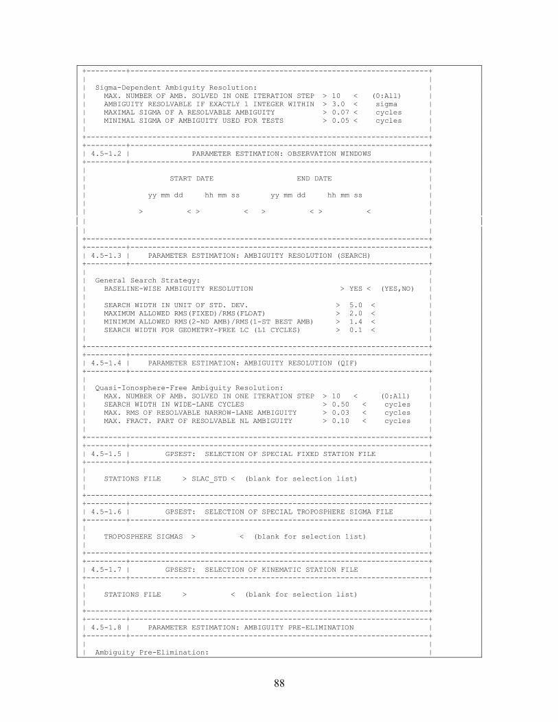
88
+---------+--------------------------------------------------------------------+ | | | Sigma-Dependent Ambiguity Resolution: | | MAX. NUMBER OF AMB. SOLVED IN ONE ITERATION STEP > 10 < (0:All) | | AMBIGUITY RESOLVABLE IF EXACTLY 1 INTEGER WITHIN > 3.0 < sigma | | MAXIMAL SIGMA OF A RESOLVABLE AMBIGUITY > 0.07 < cycles | | MINIMAL SIGMA OF AMBIGUITY USED FOR TESTS > 0.05 < cycles | | | +------------------------------------------------------------------------------+ +---------+--------------------------------------------------------------------+ | 4.5-1.2 | PARAMETER ESTIMATION: OBSERVATION WINDOWS | +---------+--------------------------------------------------------------------+ | | | START DATE END DATE | | | | yy mm dd hh mm ss yy mm dd hh mm ss | | | | > < > < > < > < | | | | | +------------------------------------------------------------------------------+ +---------+--------------------------------------------------------------------+ | 4.5-1.3 | PARAMETER ESTIMATION: AMBIGUITY RESOLUTION (SEARCH) | +---------+--------------------------------------------------------------------+ | | | General Search Strategy: | | BASELINE-WISE AMBIGUITY RESOLUTION > YES < (YES,NO) | | | | SEARCH WIDTH IN UNIT OF STD. DEV. > 5.0 < | | MAXIMUM ALLOWED RMS(FIXED)/RMS(FLOAT) > 2.0 < | | MINIMUM ALLOWED RMS(2-ND AMB)/RMS(1-ST BEST AMB) > 1.4 < | | SEARCH WIDTH FOR GEOMETRY-FREE LC (L1 CYCLES) > 0.1 < | | | +------------------------------------------------------------------------------+ +---------+--------------------------------------------------------------------+ | 4.5-1.4 | PARAMETER ESTIMATION: AMBIGUITY RESOLUTION (QIF) | +---------+--------------------------------------------------------------------+ | | | Quasi-Ionosphere-Free Ambiguity Resolution: | | MAX. NUMBER OF AMB. SOLVED IN ONE ITERATION STEP > 10 < (0:All) | | SEARCH WIDTH IN WIDE-LANE CYCLES > 0.50 < cycles | | MAX. RMS OF RESOLVABLE NARROW-LANE AMBIGUITY > 0.03 < cycles | | MAX. FRACT. PART OF RESOLVABLE NL AMBIGUITY > 0.10 < cycles | | | +------------------------------------------------------------------------------+ +---------+--------------------------------------------------------------------+ | 4.5-1.5 | GPSEST: SELECTION OF SPECIAL FIXED STATION FILE | +---------+--------------------------------------------------------------------+ | | | STATIONS FILE > SLAC_STD < (blank for selection list) | | | +------------------------------------------------------------------------------+ +---------+--------------------------------------------------------------------+ | 4.5-1.6 | GPSEST: SELECTION OF SPECIAL TROPOSPHERE SIGMA FILE | +---------+--------------------------------------------------------------------+ | | | TROPOSPHERE SIGMAS > < (blank for selection list) | | | +------------------------------------------------------------------------------+ +---------+--------------------------------------------------------------------+ | 4.5-1.7 | GPSEST: SELECTION OF KINEMATIC STATION FILE | +---------+--------------------------------------------------------------------+ | | | STATIONS FILE > < (blank for selection list) | | | +------------------------------------------------------------------------------+ +---------+--------------------------------------------------------------------+ | 4.5-1.8 | PARAMETER ESTIMATION: AMBIGUITY PRE-ELIMINATION | +---------+--------------------------------------------------------------------+ | | | Ambiguity Pre-Elimination: |
89
| EXECUTION > SESSION < (once per SESSION, every EPOCH, every n seconds) | | | +------------------------------------------------------------------------------+ +---------+--------------------------------------------------------------------+ | 4.5-1 | PARAMETER ESTIMATION: INPUT 1 | +---------+--------------------------------------------------------------------+ | TITLE > SLAC BPE < | | | | Frequency: | | FREQUENCY > L3 < (L1,L2,L3,L4,L5,L1&L2,L3&L4,MIXED, | | WUEBBena/Melbourne, or DTEC) | | Fixed Station(s): | | STATION > NONE < (blank for sel.list, ALL or NONE, | | Kin. Station(s): SPECIAL_FILE.. $FIRST, $LAST) | | STATION > NONE < (blank for sel.list, ALL or NONE, | | SPECIAL_FILE.. $FIRST, $LAST) | | Ambiguities: | | RESOLUTION STRATEGY > NO < (ELIMIN..NO,ROUND,SEARCH..SIGMA..QIF..)| | INTRODUCE WIDELANE > NO < (YES or NO) | | INTRODUCE L1 AND L2 > NO < (YES or NO) | | SAVE AMBIGUITIES > NO < (YES or NO) | | Observation selection: | | MIN. ELEVATION > 10 < degrees | | SAMPLING RATE > 0 < sec (0: all observations) | | OBSERV. WINDOW > NO < (YES.. NO or ASIS) | +------------------------------------------------------------------------------+ +---------+--------------------------------------------------------------------+ | 4.5-2.1 | PARAMETER ESTIMATION: PRINTING | +---------+--------------------------------------------------------------------+ | | | Print: | | NUMBER OF OBSERV. IN FILES > NO < (YES or NO) | | POS.ECCENT./RECEIVER INFO > NO < (YES or NO) | | CLOCK POLYNOMIAL COEFF. > NO < (YES or NO) | | AMBIGUITIES IN FILES > NO < (YES or NO) | | PARAMETER CHARACTERIZATION > NO < (YES or NO) | | CONSTANTS, ANT. OFFSETS, ION. COEFF. > NO < (YES or NO) | | SATELLITE ELEVATIONS > NO < (YES or NO) | | SYNCHRONIZATION ERRORS > NO < (YES or NO) | | NUMBER OF DBL.DIFF.OBSERV. > NO < (YES or NO) | | AMBIGUITIES FOR EACH ITERATION STEP > NO < (YES or NO) | | 5-DEGREE BIN OBSERVATION STATISTICS > NO < (YES or NO) | | | +------------------------------------------------------------------------------+ +---------+--------------------------------------------------------------------+ | 4.5-2.2 | PARAMETER ESTIMATION: HELMERT | +---------+--------------------------------------------------------------------+ | | | Coord.system: | | COORD.SYSTEM > LOCAL < (LOCAL or GEOCENTRIC) | | | | Parameters: | | ROTATION X-AXIS > YES < (YES or NO) | | ROTATION Y-AXIS > YES < (YES or NO) | | ROTATION Z-AXIS > YES < (YES or NO) | | SCALE FACTOR > YES < (YES or NO) | | | +------------------------------------------------------------------------------+ +---------+--------------------------------------------------------------------+ |4.5-2.3.1| PARAMETER ESTIMATION: STOCHASTIC ORBIT PARAMETERS | +---------+--------------------------------------------------------------------+ | Default values: | | Force Types (max. 3 types allowed): A-priori Sigma | | | | (1) RADIAL > 1.D-6 < | | (2) PERPENDICULAR TO (1), IN ORBIT PLANE > 1.D-5 < | | (3) NORMAL TO ORBIT PLANE > 1.D-9 < (0 or blank: | | (4) DIRECTION TO THE SUN > < don't take) | | (5) Y-DIRECTION IN SATELLITE FRAME > < | | (6) X-DIRECTION IN SATELLITE FRAME > < | | |
90
| Number of sets per day: > 2 < | | | | List of Satellites (prn numbers, 99(=ALL), 98(=ECL), 97(=ECLspec)): | | (blank field = take default values) | | | | GROUP #PAR SIGMA1 SIGMA2 SIGMA3 | | | | > 99 < > < > < > < > < | | | +------------------------------------------------------------------------------+ +---------+--------------------------------------------------------------------+ | 4.5-2.3 | PARAMETER ESTIMATION: ORBITS | +---------+--------------------------------------------------------------------+ | | | ORBIT ESTIMATION FOR > ALL < (ALL, GPS, or GLONASS) | | | | Orbital Elements: (a priori sigmas) | | SEMI MAJOR AXIS > YES < (YES,NO) > 0.000 < m | | ECCENTRICITY > YES < (YES,NO) > 0.0000000 < | | INCLINATION > YES < (YES,NO) > 0.0000 < arc sec | | ASCENDING NODE > YES < (YES,NO) > 0.0000 < arc sec | | PERIGEE > YES < (YES,NO) > 0.0000 < arc sec | | ARG. OF LATITUDE > YES < (YES,NO) > 0.0000 < arc sec | | | | Dynamical Parameters: (a priori sigmas) | | D0 estimation (P0) > YES < (YES, NO) > 0.0D-09 < m/s**2 | | Y0 estimation (P2) > YES < (YES, NO) > 0.0D-09 < m/s**2 | | X0 estimation > NO < (YES, NO) > 1.0D-09 < m/s**2 | | | | Periodic Dynamical Parameters: (a priori sigmas) | | Periodic D0 terms > NO < (YES, NO) > 1.0D-09 < m/s**2 | | Periodic Y0 terms > NO < (YES, NO) > 1.0D-09 < m/s**2 | | Periodic X0 terms > NO < (YES, NO) > 1.0D-09 < m/s**s | | | | Stochastic Parameters: > YES < (YES,NO) | | | +------------------------------------------------------------------------------+ +---------+--------------------------------------------------------------------+ |4.5-2.4.0| PARAMETER ESTIMATION: SITE-SPECIFIC TROPOSPHERE PARAMETERS | +---------+--------------------------------------------------------------------+ | | | General Zenith Apriori Sigmas: General Gradient Apriori Sigmas: | | ABSOLUTE > 5.0000 < m ABSOLUTE > 5.0000 < m | | RELATIVE > 5.0000 < m RELATIVE > 5.0000 < m | | | | Special Zenith Apriori Sigmas: Special Gradient Apriori Sigmas: | | ABSOLUTE > 0.0000 < m ABSOLUTE > 0.0000 < m | | RELATIVE > 0.0000 < m RELATIVE > 0.0000 < m | | | | Special Station Selection (no estimation if special sigmas set to 0.0): | | STATIONS > NONE < (blank for selection list, NONE, | | NO_TROPO, SPECIAL_FILE.. $FIRST, $LAST)| | Set-up of Parameters: | | MAPPING FUNCTION > DRY_NIELL < (COSZ, HOPFIELD, DRY_NIELL, | | or WET_NIELL) | | GRADIENT ESTIMATION MODEL > NO < (NO, TILTING, or LINEAR) | | MODE OF PARAMETER SET-UP > NUM < (NUM: num/sess; MIN: minutes) | | # ZEN PAR/SESS OR INTERVAL > 12 < (num/sess or minutes) | | # GRD PAR/SESS OR INTERVAL > 1 < (num/sess or minutes) | | | +------------------------------------------------------------------------------+ +---------+--------------------------------------------------------------------+ |4.5-2.4.3| PARAMETER ESTIMATION: A PRIORI SIGMAS FOR SITE COORDINATES | +---------+--------------------------------------------------------------------+ | | | NUM STATION SIGMA(N) SIGMA(E) SIGMA(H) | | (meters) | | | | > 1 < AMC2 > 0.0001 < > 0.0001 < > 0.0001 < | | | | Remove stations without a priori sigmas from panel |
91
| | +------------------------------------------------------------------------------+ +---------+--------------------------------------------------------------------+ |4.5-2.4.4| PARAMETER ESTIMATION: EARTH ROTATION PARAMETERS | +---------+--------------------------------------------------------------------+ | | | Model: | | TOTAL NUMBER OF PARAMETER SETS > 1 < | | | | Earth Rotation (ERP) and Nutation Parameters (NUT): | | # param./set (0-4) default a priori sigma | | X-POLE > 2 < > < (mas) | | Y-POLE > 2 < > < (mas) | | UT1-UTC > 2 < > < (msec) | | DELTA EPSILON > 0 < > < (mas) | | DELTA PSI > 0 < > < (mas) | | | | CONTINUITY BETWEEN SETS > BOTH < (NO, ERP, NUT, BOTH) | | CONSTRAIN DRIFTS TO ZERO > NUT < (NO, ERP, NUT, BOTH) | | | | # of Values per Set Stored in Files: | | BERNESE POLE FILE > 3 < IERS POLE FILE > 3 < | | | +------------------------------------------------------------------------------+ +---------+--------------------------------------------------------------------+ |4.5-2.4.5| PARAMETER ESTIMATION: SATELLITE-SPECIFIC A PRIORI SIGMAS | +---------+--------------------------------------------------------------------+ | | | SATELLITE FROM TO SIGMA | | prn yy mm dd hh mm ss yy mm dd hh mm ss meter | | | | > < > < > < > < | | | +------------------------------------------------------------------------------+ +---------+--------------------------------------------------------------------+ |4.5-2.4.6| PARAMETER ESTIMATION: COORDINATES OF CENTER OF MASS | +---------+--------------------------------------------------------------------+ | | | Coordinates of Center of Mass: | | | | Estimate A Priori Sigma (m) | | | | X-COMPONENT > YES < (YES, NO) > 0.0000 < | | Y-COMPONENT > YES < (YES, NO) > 0.0000 < | | Z-COMPONENT > YES < (YES, NO) > 0.0000 < | | | +------------------------------------------------------------------------------+ +---------+--------------------------------------------------------------------+ |4.5-2.4.7| PARAMETER ESTIMATION: STOCHASTIC IONOSPHERE PARAMETERS | +---------+--------------------------------------------------------------------+ | | | Stochastic Ionosphere Parameters: | | | | EPOCH-WISE PRE-ELIMINATION > YES < (YES,NO) | | ELIMINATION OF REFERENCE IONOSPHERE PARAMETERS > NO < (YES,NO) | | ELEVATION-DEPENDENT PARAMETER CONSTRAINING > YES < (YES,NO) | | | | ABSOLUTE A PRIORI SIGMA ON SINGLE DIFFERENCE LEVEL > 0.25 < m | | RELATIVE A PRIORI SIGMA OF IONOSPHERIC RANDOM WALK > 0.00 < m/min**1/2| | | +------------------------------------------------------------------------------+ +---------+--------------------------------------------------------------------+ |4.5-2.4.8| PARAMETER PRE-ELIMINATION | +---------+--------------------------------------------------------------------+ | | | Parameters to be Pre-Eliminated: NO= No Pre-Elimination | | BI= Before Inversion of Normal Eq. System | | AI= After Inversion of Normal Eq. System | | EP= After Each Epoch | | | | STATION COORD. > NO < EARTH POTENTIAL > NO < (NO, BI, AI) |
92
| RECEIVER CLOCKS > NO < HILL RESONANCES > NO < (NO, BI, AI) | | ORBIT ELEMENTS > NO < EARTH ALBEDO > NO < (NO, BI, AI) | | AMBIGUITIES > NO < CENTER OF MASS > NO < (NO, BI, AI) | | REC.HEIGHT.CALIB. > NO < DIFF. IONOSPHERE > EP < (NO, BI, AI, EP) | | SITE TROPOSPHERE > NO < PHASE CENTER VAR. > NO < (NO, BI, AI) | | LOCAL IONOSPHERE > NO < GLOBAL IONOSPHERE > NO < (NO, BI, AI) | | DIFF. CODE BIASES > NO < --- > NO < (NO, BI, AI) | | LOCAL TROPOSPHERE > NO < KIN. COORDINATES > NO < (NO, BI, AI, EP) | | EARTH ROTATION > NO < EPOCH AMBIGUITIES > NO < (NO, BI, AI, EP) | | STOCH. ORBIT > NO < STATION CLOCKS > NO < (NO, BI, AI, EP) | | SAT. ANT.OFF > NO < SATELLITE CLOCKS > NO < (NO, BI, AI, EP) | | | +------------------------------------------------------------------------------+ +---------+--------------------------------------------------------------------+ |4.5-2.4.9| PARAMETER ESTIMATION: SATELLITE ANTENNA OFFSETS | +---------+--------------------------------------------------------------------+ | | | Satellite Antenna Offsets: | | | | Component in Satellite Estimate | | Coordinate System | | | | X-COMPONENT > YES < (YES, NO) | | Y-COMPONENT > YES < (YES, NO) | | Z-COMPONENT > YES < (YES, NO) | | | +------------------------------------------------------------------------------+ +---------+--------------------------------------------------------------------+ |4.5-2.4.B| PARAMETER ESTIMATION: A PRIORI SIGMAS: STATIONS AND DEFAULT SIGMA | +---------+--------------------------------------------------------------------+ | | | Station Selection: | | STATIONS > SPECIAL_FILE < (blank for selection list, SELECTED, | | SPECIAL_FILE.., $FIRST, $LAST) | | Default Sigma per Coordinate: | | SIGMA > 0.0001 < (meters) | | | +------------------------------------------------------------------------------+ +---------+--------------------------------------------------------------------+ |4.5-2.4.C| PARAMETER ESTIMATION: GLOBAL IONOSPHERE MODEL PARAMETERS | +---------+--------------------------------------------------------------------+ | | | Number of Ionosphere Models and Coefficients: | | NUMBER OF COEFFICIENT SETS PER SESSION > 1 < | | STATION-SPECIFIC MODELS > NO < (YES, NO) | | MAXIMUM DEGREE OF SPHERICAL HARMONICS > 12 < | | MAXIMUM ORDER OF SPHERICAL HARMONICS > 8 < | | | | Modeling Characteristics: | | TIME-DEPENDENCY > STATIC < (STATIC or DYNAMIC) | | SUN-FIXED REFERENCE FRAME > GEOMAGNETIC < (GEOGRAPHIC or GEOMAGNETIC) | | LONGITUDE OF THE SUN > MEAN < (MEAN or TRUE) | | MAPPING FUNCTION > COSZ < (NONE or COSZ) | | | | Additional Information: | | A PRIORI HEIGHT OF SINGLE LAYER > 450.00 < km | | LATITUDE OF GEOMAGNETIC POLE > 79.00 < degrees | | LONGITUDE OF GEOMAGNETIC POLE > -71.00 < degrees | | ABSOLUTE SIGMA FOR COEFFICIENTS > 0.00 < TECU (0: no sigma) | | RELATIVE SIGMA FOR COEFFICIENTS > 0.00 < TECU (0: no sigma) | | | +------------------------------------------------------------------------------+ +---------+--------------------------------------------------------------------+ |4.5-2.4.D| PARAMETER ESTIMATION: HEIGHT OF SINGLE LAYER | +---------+--------------------------------------------------------------------+ | | | Number of Single-Layer Height Parameters: | | NUMBER OF HEIGHT PARAMETERS > ALL < (one for ALL ionosphere models, | | one for EACH ionosphere model) | | | | A Priori Sigma for Height Parameters: |
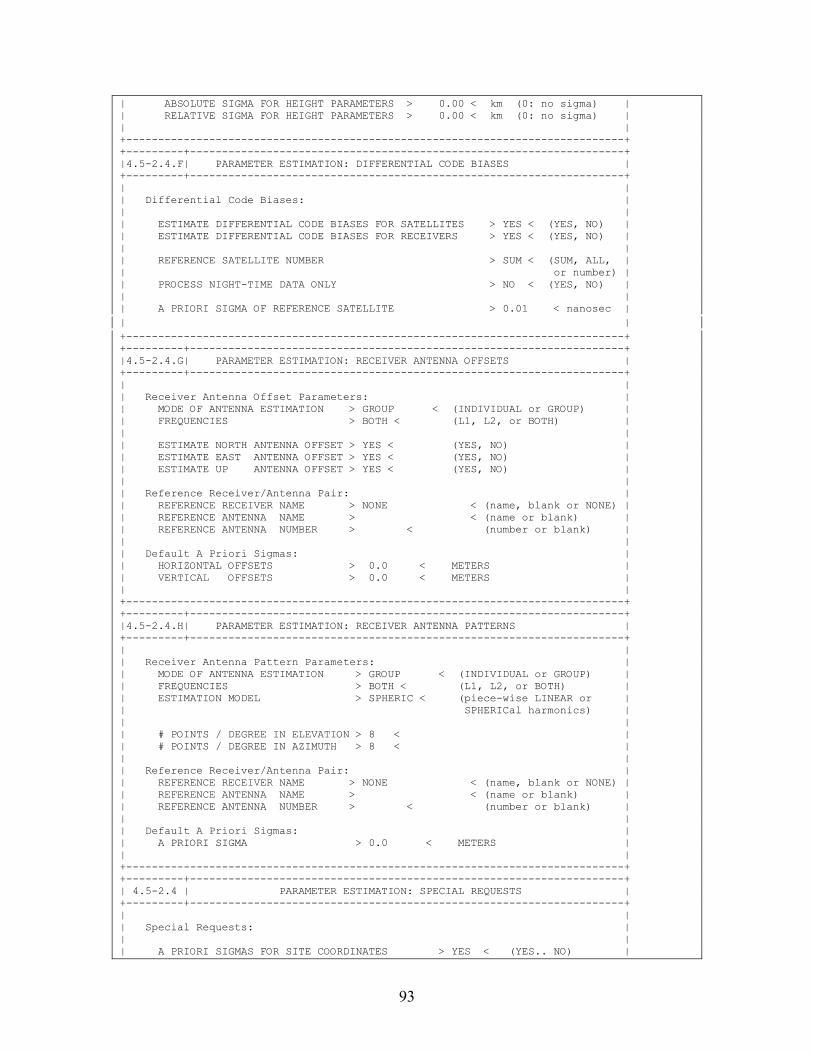
93
| ABSOLUTE SIGMA FOR HEIGHT PARAMETERS > 0.00 < km (0: no sigma) | | RELATIVE SIGMA FOR HEIGHT PARAMETERS > 0.00 < km (0: no sigma) | | | +------------------------------------------------------------------------------+ +---------+--------------------------------------------------------------------+ |4.5-2.4.F| PARAMETER ESTIMATION: DIFFERENTIAL CODE BIASES | +---------+--------------------------------------------------------------------+ | | | Differential Code Biases: | | | | ESTIMATE DIFFERENTIAL CODE BIASES FOR SATELLITES > YES < (YES, NO) | | ESTIMATE DIFFERENTIAL CODE BIASES FOR RECEIVERS > YES < (YES, NO) | | | | REFERENCE SATELLITE NUMBER > SUM < (SUM, ALL, | | or number) | | PROCESS NIGHT-TIME DATA ONLY > NO < (YES, NO) | | | | A PRIORI SIGMA OF REFERENCE SATELLITE > 0.01 < nanosec | | | +------------------------------------------------------------------------------+ +---------+--------------------------------------------------------------------+ |4.5-2.4.G| PARAMETER ESTIMATION: RECEIVER ANTENNA OFFSETS | +---------+--------------------------------------------------------------------+ | | | Receiver Antenna Offset Parameters: | | MODE OF ANTENNA ESTIMATION > GROUP < (INDIVIDUAL or GROUP) | | FREQUENCIES > BOTH < (L1, L2, or BOTH) | | | | ESTIMATE NORTH ANTENNA OFFSET > YES < (YES, NO) | | ESTIMATE EAST ANTENNA OFFSET > YES < (YES, NO) | | ESTIMATE UP ANTENNA OFFSET > YES < (YES, NO) | | | | Reference Receiver/Antenna Pair: | | REFERENCE RECEIVER NAME > NONE < (name, blank or NONE) | | REFERENCE ANTENNA NAME > < (name or blank) | | REFERENCE ANTENNA NUMBER > < (number or blank) | | | | Default A Priori Sigmas: | | HORIZONTAL OFFSETS > 0.0 < METERS | | VERTICAL OFFSETS > 0.0 < METERS | | | +------------------------------------------------------------------------------+ +---------+--------------------------------------------------------------------+ |4.5-2.4.H| PARAMETER ESTIMATION: RECEIVER ANTENNA PATTERNS | +---------+--------------------------------------------------------------------+ | | | Receiver Antenna Pattern Parameters: | | MODE OF ANTENNA ESTIMATION > GROUP < (INDIVIDUAL or GROUP) | | FREQUENCIES > BOTH < (L1, L2, or BOTH) | | ESTIMATION MODEL > SPHERIC < (piece-wise LINEAR or | | SPHERICal harmonics) | | | | # POINTS / DEGREE IN ELEVATION > 8 < | | # POINTS / DEGREE IN AZIMUTH > 8 < | | | | Reference Receiver/Antenna Pair: | | REFERENCE RECEIVER NAME > NONE < (name, blank or NONE) | | REFERENCE ANTENNA NAME > < (name or blank) | | REFERENCE ANTENNA NUMBER > < (number or blank) | | | | Default A Priori Sigmas: | | A PRIORI SIGMA > 0.0 < METERS | | | +------------------------------------------------------------------------------+ +---------+--------------------------------------------------------------------+ | 4.5-2.4 | PARAMETER ESTIMATION: SPECIAL REQUESTS | +---------+--------------------------------------------------------------------+ | | | Special Requests: | | | | A PRIORI SIGMAS FOR SITE COORDINATES > YES < (YES.. NO) |
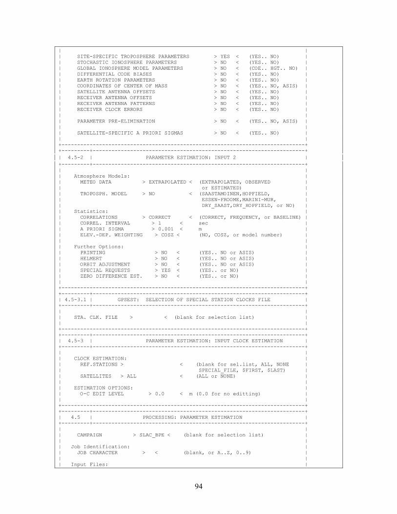
94
| | | SITE-SPECIFIC TROPOSPHERE PARAMETERS > YES < (YES.. NO) | | STOCHASTIC IONOSPHERE PARAMETERS > NO < (YES.. NO) | | GLOBAL IONOSPHERE MODEL PARAMETERS > NO < (COE.. HGT.. NO) | | DIFFERENTIAL CODE BIASES > NO < (YES.. NO) | | EARTH ROTATION PARAMETERS > NO < (YES.. NO) | | COORDINATES OF CENTER OF MASS > NO < (YES.. NO, ASIS) | | SATELLITE ANTENNA OFFSETS > NO < (YES.. NO) | | RECEIVER ANTENNA OFFSETS > NO < (YES.. NO) | | RECEIVER ANTENNA PATTERNS > NO < (YES.. NO) | | RECEIVER CLOCK ERRORS > NO < (YES.. NO) | | | | PARAMETER PRE-ELIMINATION > NO < (YES.. NO, ASIS) | | | | SATELLITE-SPECIFIC A PRIORI SIGMAS > NO < (YES.. NO) | | | +------------------------------------------------------------------------------+ +---------+--------------------------------------------------------------------+ | 4.5-2 | PARAMETER ESTIMATION: INPUT 2 | +---------+--------------------------------------------------------------------+ | | | Atmosphere Models: | | METEO DATA > EXTRAPOLATED < (EXTRAPOLATED, OBSERVED | | or ESTIMATED) | | TROPOSPH. MODEL > NO < (SAASTAMOINEN,HOPFIELD, | | ESSEN-FROOME,MARINI-MUR, | | DRY_SAAST,DRY_HOPFIELD, or NO) | | Statistics: | | CORRELATIONS > CORRECT < (CORRECT, FREQUENCY, or BASELINE) | | CORREL. INTERVAL > 1 < sec | | A PRIORI SIGMA > 0.001 < m | | ELEV.-DEP. WEIGHTING > COSZ < (NO, COSZ, or model number) | | | | Further Options: | | PRINTING > NO < (YES.. NO or ASIS) | | HELMERT > NO < (YES.. NO or ASIS) | | ORBIT ADJUSTMENT > NO < (YES.. NO or ASIS) | | SPECIAL REQUESTS > YES < (YES.. or NO) | | ZERO DIFFERENCE EST. > NO < (YES.. or NO) | | | +------------------------------------------------------------------------------+ +---------+--------------------------------------------------------------------+ | 4.5-3.1 | GPSEST: SELECTION OF SPECIAL STATION CLOCKS FILE | +---------+--------------------------------------------------------------------+ | | | STA. CLK. FILE > < (blank for selection list) | | | +------------------------------------------------------------------------------+ +---------+--------------------------------------------------------------------+ | 4.5-3 | PARAMETER ESTIMATION: INPUT CLOCK ESTIMATION | +---------+--------------------------------------------------------------------+ | | | CLOCK ESTIMATION: | | REF.STATIONS > < (blank for sel.list, ALL, NONE | | SPECIAL_FILE, $FIRST, $LAST) | | SATELLITES > ALL < (ALL or NONE) | | | | ESTIMATION OPTIONS: | | O-C EDIT LEVEL > 0.0 < m (0.0 for no editting) | | | +------------------------------------------------------------------------------+ +---------+--------------------------------------------------------------------+ | 4.5 | PROCESSING: PARAMETER ESTIMATION | +---------+--------------------------------------------------------------------+ | | | CAMPAIGN > SLAC_BPE < (blank for selection list) | | | | Job Identification: | | JOB CHARACTER > < (blank, or A..Z, 0..9) | | | | Input Files: |
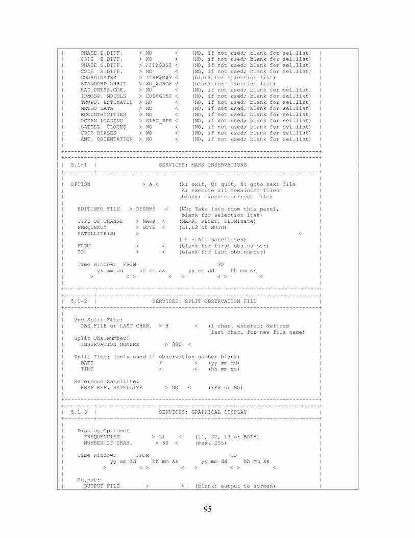
95
| PHASE Z.DIFF. > NO < (NO, if not used; blank for sel.list) | | CODE Z.DIFF. > NO < (NO, if not used; blank for sel.list) | | PHASE S.DIFF. > ????$SS2 < (NO, if not used; blank for sel.list) | | CODE S.DIFF. > NO < (NO, if not used; blank for sel.list) | | COORDINATES > ITRF$M$Y < (blank for selection list) | | STANDARD ORBIT > $O_$JRD2 < (blank for selection list) | | RAD.PRESS.COE. > NO < (NO, if not used; blank for sel.list) | | IONOSP. MODELS > COD$GDY2 < (NO, if not used; blank for sel.list) | | TROPO. ESTIMATES > NO < (NO, if not used; blank for sel.list) | | METEO DATA > NO < (NO, if not used; blank for sel.list) | | ECCENTRICITIES > NO < (NO, if not used; blank for sel.list) | | OCEAN LOADING > SLAC_BPE < (NO, if not used; blank for sel.list) | | SATELL. CLOCKS > NO < (NO, if not used; blank for sel.list) | | CODE BIASES > NO < (NO, if not used; blank for sel.list) | | ANT. ORIENTATION > NO < (NO, if not used; blank for sel.list) | | | +------------------------------------------------------------------------------+ +---------+--------------------------------------------------------------------+ | 5.1-1 | SERVICES: MARK OBSERVATIONS | +---------+--------------------------------------------------------------------+ | | | OPTION > A < (X: exit, Q: quit, N: goto next file | | A: execute all remaining files | | blank: execute current file) | | | | EDITINFO FILE > RESRMS < (NO: Take info from this panel, | | blank for selection list) | | TYPE OF CHANGE > MARK < (MARK, RESET, ELIMInate) | | FREQUENCY > BOTH < (L1,L2 or BOTH) | | SATELLITE(S) > < | | ( * : All satellites) | | FROM > < (blank for first obs.number) | | TO > < (blank for last obs.number) | | | | Time Window: FROM TO | | yy mm dd hh mm ss yy mm dd hh mm ss | | > < > < > < > < | | | +------------------------------------------------------------------------------+ +---------+--------------------------------------------------------------------+ | 5.1-2 | SERVICES: SPLIT OBSERVATION FILE | +---------+--------------------------------------------------------------------+ | | | 2nd Split File: | | OBS.FILE or LAST CHAR. > H < (1 char. entered: defines | | last char. for new file name) | | Split Obs.Number: | | OBSERVATION NUMBER > 330 < | | | | Split Time: (only used if observation number blank) | | DATE > < (yy mm dd) | | TIME > < (hh mm ss) | | | | Reference Satellite: | | KEEP REF. SATELLITE > NO < (YES or NO) | | | +------------------------------------------------------------------------------+ +---------+--------------------------------------------------------------------+ | 5.1-3 | SERVICES: GRAPHICAL DISPLAY | +---------+--------------------------------------------------------------------+ | | | Display Options: | | FREQUENCIES > L1 < (L1, L2, L3 or BOTH) | | NUMBER OF CHAR. > 80 < (max. 255) | | | | Time Window: FROM TO | | yy mm dd hh mm ss yy mm dd hh mm ss | | > < > < > < > < | | | | Output: | | OUTPUT FILE > < (blank: output to screen) |
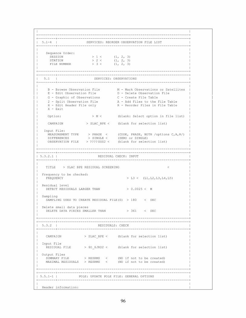
96
| | +------------------------------------------------------------------------------+ +---------+--------------------------------------------------------------------+ | 5.1-4 | SERVICES: REORDER OBSERVATION FILE LIST | +---------+--------------------------------------------------------------------+ | | | Sequence Order: | | SESSION > 1 < (1, 2, 3) | | STATION > 2 < (1, 2, 3) | | FILE NUMBER > 3 < (1, 2, 3) | | | +------------------------------------------------------------------------------+ +---------+--------------------------------------------------------------------+ | 5.1 | SERVICES: OBSERVATIONS | +---------+--------------------------------------------------------------------+ | | | B - Browse Observation File M - Mark Observations or Satellites | | E - Edit Observation File D - Delete Observation File | | G - Graphic of Observations C - Create File Table | | 2 - Split Observation File A - Add Files to the File Table | | H - Edit Header File only R - Reorder Files in File Table | | X - Exit | | | | Option: > M < (blank: Select option in file list) | | | | CAMPAIGN > SLAC_BPE < (blank for selection list) | | | | Input File: | | MEASUREMENT TYPE > PHASE < (CODE, PHASE, BOTH /options C,A,R/) | | DIFFERENCES > SINGLE < (ZERO or SINGLE) | | OBSERVATION FILE > ????$SS2 < (blank for selection list) | | | +------------------------------------------------------------------------------+ +---------+--------------------------------------------------------------------+ | 5.3.2.1 | RESIDUAL CHECK: INPUT | +---------+--------------------------------------------------------------------+ | | | TITLE > SLAC BPE RESIDUAL SCREENING < | | | | Frequency to be checked: | | FREQUENCY > L3 < (L1,L2,L3,L4,L5) | | | | Residual level | | DETECT RESIDUALS LARGER THAN > 0.0025 < M | | | | Sampling | | SAMPLING USED TO CREATE RESIDUAL FILE(S) > 180 < SEC | | | | Delete small data pieces | | DELETE DATA PIECES SMALLER THAN > 361 < SEC | | | +------------------------------------------------------------------------------+ +---------+--------------------------------------------------------------------+ | 5.3.2 | RESIDUALS: CHECK | +---------+--------------------------------------------------------------------+ | | | CAMPAIGN > SLAC_BPE < (blank for selection list) | | | | Input File | | RESIDUAL FILE > $O_$JRD2 < (blank for selection list) | | | | Output Files | | SUMMARY FILE > RESRMS < (NO if not to be created) | | MAXIMAL RESIDUALS > RESRMS < (NO if not to be created) | | | +------------------------------------------------------------------------------+ +---------+--------------------------------------------------------------------+ | 5.5.1-1 | POLE: UPDATE POLE FILE: GENERAL OPTIONS | +---------+--------------------------------------------------------------------+ | | | Header information: |
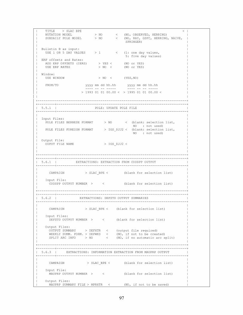
97
| TITLE > SLAC BPE < | | NUTATION MODEL > NO < (NO, OBSERVED, HERRING) | | SUBDAILY POLE MODEL > NO < (NO, RAY, GSFC, HERRING, NAIVE, | | SPRINGER) | | | | Bulletin B as input: | | USE 1 OR 5 DAY VALUES > 1 < (1: one day values, | | 5: five day values) | | ERP offsets and Rates: | | ADD ERP OFFSETS (IERS) > YES < (NO or YES) | | USE ERP RATES > NO < (NO or YES) | | | | Window: | | USE WINDOW > NO < (YES,NO) | | | | FROM/TO yyyy mm dd hh.hh yyyy mm dd hh.hh | | ---- -- -- ----- ---- -- -- ----- | | > 1993 01 01 00.00 < > 1995 01 01 00.00 < | | | +------------------------------------------------------------------------------+ +---------+--------------------------------------------------------------------+ | 5.5.1 | POLE: UPDATE POLE FILE | +---------+--------------------------------------------------------------------+ | | | Input Files: | | POLE FILES BERNESE FORMAT > NO < (blank: selection list, | | NO : not used) | | POLE FILES FOREIGN FORMAT > IGS_$JJ2 < (blank: selection list, | | NO : not used) | | | | Output File: | | OUPUT FILE NAME > IGS_$JJ2 < | | | | | +------------------------------------------------------------------------------+ +---------+--------------------------------------------------------------------+ | 5.6.1 | EXTRACTIONS: EXTRACTION FROM CODSPP OUTPUT | +---------+--------------------------------------------------------------------+ | | | CAMPAIGN > SLAC_BPE < (blank for selection list) | | | | Input File: | | CODSPP OUTPUT NUMBER > < (blank for selection list) | | | +------------------------------------------------------------------------------+ +---------+--------------------------------------------------------------------+ | 5.6.2 | EXTRACTIONS: DEFSTD OUTPUT SUMMARIES | +---------+--------------------------------------------------------------------+ | | | CAMPAIGN > SLAC_BPE < (blank for selection list) | | | | Input Files: | | DEFSTD OUTPUT NUMBER > < (blank for selection list) | | | | Output Files: | | OUTPUT SUMMARY > DEFXTR < (output file required) | | WEEKLY SUMM. FORM. > DEFWKS < (NO, if not to be created) | | SPLIT ARC INFO > NO < (NO, if no automatic arc split) | | | +------------------------------------------------------------------------------+ +---------+--------------------------------------------------------------------+ | 5.6.3 | EXTRACTIONS: INFORMATION EXTRACTION FROM MAUPRP OUTPUT | +---------+--------------------------------------------------------------------+ | | | CAMPAIGN > SLAC_BPE < (blank for selection list) | | | | Input File: | | MAUPRP OUTPUT NUMBER > < (blank for selection list) | | | | Output Files: | | MAUPRP SUMMARY FILE > MPRXTR < (NO, if not to be saved) |
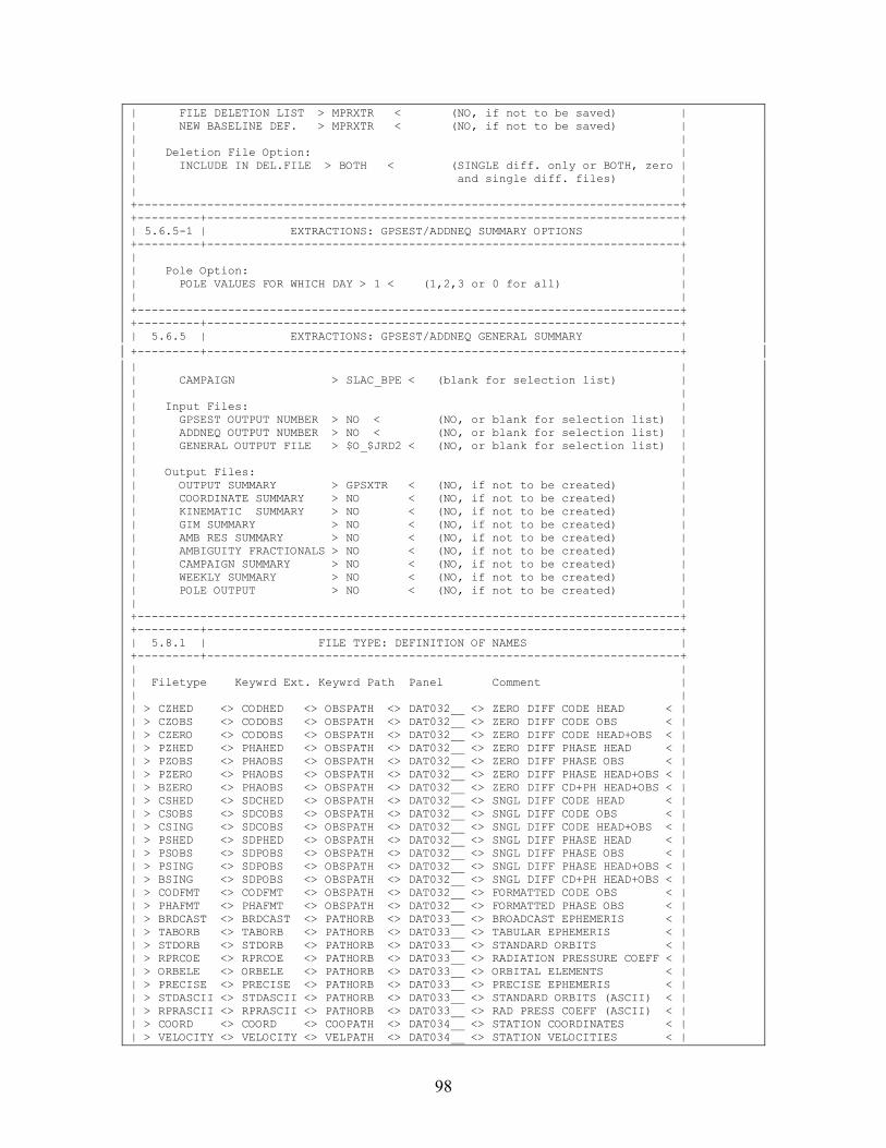
98
| FILE DELETION LIST > MPRXTR < (NO, if not to be saved) | | NEW BASELINE DEF. > MPRXTR < (NO, if not to be saved) | | | | Deletion File Option: | | INCLUDE IN DEL.FILE > BOTH < (SINGLE diff. only or BOTH, zero | | and single diff. files) | | | +------------------------------------------------------------------------------+ +---------+--------------------------------------------------------------------+ | 5.6.5-1 | EXTRACTIONS: GPSEST/ADDNEQ SUMMARY OPTIONS | +---------+--------------------------------------------------------------------+ | | | Pole Option: | | POLE VALUES FOR WHICH DAY > 1 < (1,2,3 or 0 for all) | | | +------------------------------------------------------------------------------+ +---------+--------------------------------------------------------------------+ | 5.6.5 | EXTRACTIONS: GPSEST/ADDNEQ GENERAL SUMMARY | +---------+--------------------------------------------------------------------+ | | | CAMPAIGN > SLAC_BPE < (blank for selection list) | | | | Input Files: | | GPSEST OUTPUT NUMBER > NO < (NO, or blank for selection list) | | ADDNEQ OUTPUT NUMBER > NO < (NO, or blank for selection list) | | GENERAL OUTPUT FILE > $O_$JRD2 < (NO, or blank for selection list) | | | | Output Files: | | OUTPUT SUMMARY > GPSXTR < (NO, if not to be created) | | COORDINATE SUMMARY > NO < (NO, if not to be created) | | KINEMATIC SUMMARY > NO < (NO, if not to be created) | | GIM SUMMARY > NO < (NO, if not to be created) | | AMB RES SUMMARY > NO < (NO, if not to be created) | | AMBIGUITY FRACTIONALS > NO < (NO, if not to be created) | | CAMPAIGN SUMMARY > NO < (NO, if not to be created) | | WEEKLY SUMMARY > NO < (NO, if not to be created) | | POLE OUTPUT > NO < (NO, if not to be created) | | | +------------------------------------------------------------------------------+ +---------+--------------------------------------------------------------------+ | 5.8.1 | FILE TYPE: DEFINITION OF NAMES | +---------+--------------------------------------------------------------------+ | | | Filetype Keywrd Ext. Keywrd Path Panel Comment | | | | > CZHED <> CODHED <> OBSPATH <> DAT032__ <> ZERO DIFF CODE HEAD < | | > CZOBS <> CODOBS <> OBSPATH <> DAT032__ <> ZERO DIFF CODE OBS < | | > CZERO <> CODOBS <> OBSPATH <> DAT032__ <> ZERO DIFF CODE HEAD+OBS < | | > PZHED <> PHAHED <> OBSPATH <> DAT032__ <> ZERO DIFF PHASE HEAD < | | > PZOBS <> PHAOBS <> OBSPATH <> DAT032__ <> ZERO DIFF PHASE OBS < | | > PZERO <> PHAOBS <> OBSPATH <> DAT032__ <> ZERO DIFF PHASE HEAD+OBS < | | > BZERO <> PHAOBS <> OBSPATH <> DAT032__ <> ZERO DIFF CD+PH HEAD+OBS < | | > CSHED <> SDCHED <> OBSPATH <> DAT032__ <> SNGL DIFF CODE HEAD < | | > CSOBS <> SDCOBS <> OBSPATH <> DAT032__ <> SNGL DIFF CODE OBS < | | > CSING <> SDCOBS <> OBSPATH <> DAT032__ <> SNGL DIFF CODE HEAD+OBS < | | > PSHED <> SDPHED <> OBSPATH <> DAT032__ <> SNGL DIFF PHASE HEAD < | | > PSOBS <> SDPOBS <> OBSPATH <> DAT032__ <> SNGL DIFF PHASE OBS < | | > PSING <> SDPOBS <> OBSPATH <> DAT032__ <> SNGL DIFF PHASE HEAD+OBS < | | > BSING <> SDPOBS <> OBSPATH <> DAT032__ <> SNGL DIFF CD+PH HEAD+OBS < | | > CODFMT <> CODFMT <> OBSPATH <> DAT032__ <> FORMATTED CODE OBS < | | > PHAFMT <> PHAFMT <> OBSPATH <> DAT032__ <> FORMATTED PHASE OBS < | | > BRDCAST <> BRDCAST <> PATHORB <> DAT033__ <> BROADCAST EPHEMERIS < | | > TABORB <> TABORB <> PATHORB <> DAT033__ <> TABULAR EPHEMERIS < | | > STDORB <> STDORB <> PATHORB <> DAT033__ <> STANDARD ORBITS < | | > RPRCOE <> RPRCOE <> PATHORB <> DAT033__ <> RADIATION PRESSURE COEFF < | | > ORBELE <> ORBELE <> PATHORB <> DAT033__ <> ORBITAL ELEMENTS < | | > PRECISE <> PRECISE <> PATHORB <> DAT033__ <> PRECISE EPHEMERIS < | | > STDASCII <> STDASCII <> PATHORB <> DAT033__ <> STANDARD ORBITS (ASCII) < | | > RPRASCII <> RPRASCII <> PATHORB <> DAT033__ <> RAD PRESS COEFF (ASCII) < | | > COORD <> COORD <> COOPATH <> DAT034__ <> STATION COORDINATES < | | > VELOCITY <> VELOCITY <> VELPATH <> DAT034__ <> STATION VELOCITIES < |
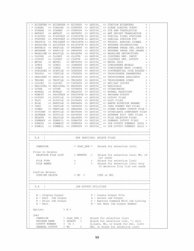
99
| > ECCENTER <> ECCENTER <> ECCPATH <> DAT034__ <> STATION ECCENTERS < | | > OCEANL <> OCNLOAD <> OCNPATH <> DAT034__ <> OCEAN LOADING COEFF. < | | > STANAM <> STANAM <> STNPATH <> DAT034__ <> STA NAM TRANSLATION < | | > ANTHGT <> ANTHGT <> HGTPATH <> DAT034__ <> ANT HEIGHT TRANSLATION < | | > FIXSTAT <> FIXSTEXT <> FIXSTPTH <> DAT034__ <> SPECIAL FIXED STATIONS < | | > FTPSTAT <> FTPSTEXT <> FTPSTPTH <> DAT034__ <> SPECIAL STATION FTP < | | > TROPSIG <> TRSIGEXT <> TRSIGPTH <> DAT034__ <> TROPOS. APRIORI SIGMAS < | | > ANTAZIMU <> AZISTEXT <> AZISTPTH <> DAT034__ <> ANTENNA ORIENTATIONS < | | > ANTGRID <> PHGFILE <> PHGPATH <> DAT034__ <> ANTENNA PHASE CEN.(GRID) < | | > ANTHARM <> PHHFILE <> PHHPATH <> DAT034__ <> ANTENNA PHASE CEN.(HARM) < | | > BASELINE <> BSLFILE <> BSLPATH <> DAT034__ <> BASELINE DEFINITIONS < | | > CLUINP <> CLIEXT <> CLIPTH <> DAT034__ <> CLUSTERS DEF. INPUT < | | > CLUOUT <> CLOEXT <> CLOPTH <> DAT034__ <> CLUSTERS DEF. OUTPUT < | | > METEO <> METEO <> METPATH <> DAT034__ <> METEO DATA < | | > IONOS <> IONOS <> IONPATH <> DAT034__ <> IONOSPHERE MODELS < | | > IONEX <> IONEX <> INXPATH <> DAT034__ <> IONOSPHERE MAPS (IONEX) < | | > DCBIASES <> DCBFILE <> DCBPATH <> DAT034__ <> DIFFERENTIAL CODE BIASES < | | > TROPOS <> ITRFILE <> ITRPATH <> DAT034__ <> TROPOSPHERE PARAMETERS < | | > GRADIENT <> GRDFILE <> GRDPATH <> DAT034__ <> TROPOSPHERE GRADIENTS < | | > TROSNX <> TROFILE <> TROPATH <> DAT034__ <> TROPOSPHERE SINEX < | | > CLOCKS <> CLOCKS <> CLKPATH <> DAT034__ <> REC/SAT CLOCKS < | | > RESIDUAL <> RESIDUAL <> RESPATH <> DAT034__ <> RESIDUALS < | | > COVAR <> COVAR <> COVPATH <> DAT034__ <> COVARIANCES < | | > NOREQU <> NOREQU <> NEQPATH <> DAT034__ <> NORMAL EQUATIONS < | | > PGMOUT <> PGOUTEXT <> PGOUTPTH <> DAT034__ <> PROGRAM OUTPUT < | | > OUTPUT <> OUTFILE <> OUTPATH <> DAT034__ <> OUTPUT FILES < | | > PLOT <> PLTFILE <> PLTPATH <> DAT034__ <> PLOT FILES < | | > POLE <> ERPFILE <> ERPPATH <> DAT034__ <> EARTH ROTATION PARAMS < | | > IERS <> IEPFILE <> IEPPATH <> DAT034__ <> IERS FORMAT ERP FILES < | | > SINEX <> SNXFILE <> SNXPATH <> DAT034__ <> SINEX FORMAT OUTPUT FILE < | | > COVCOMP <> WGTFILE <> WGTPATH <> DAT034__ <> COVARIANCE COMPONENT FILE< | | > SATMARK <> EDTFILE <> EDTPATH <> DAT034__ <> SATMARK EDIT INFO FILES < | | > DELETE <> DELFILE <> DELPATH <> DAT034__ <> FILE DELETION FILES < | | > SUMMARY <> SUMAFIL <> SUMAPTH <> DAT034__ <> SUMMARY OUTPUT FILES < | | > SUMXYZ <> SUMMXYZ <> SUMPATH <> DAT034__ <> JOB OUTPUT SUMMARY (XYZ) < | | > SUMELL <> SUMMELL <> SUMPATH <> DAT034__ <> JOB OUTPUT SUMMARY (ELL) < | | | +------------------------------------------------------------------------------+ +---------+--------------------------------------------------------------------+ | 5.8 | BPE SERVICES: DELETE FILES | +---------+--------------------------------------------------------------------+ | | | CAMPAIGN > SLAC_BPE < (blank for selection list) | | | | Files to Delete: | | DELETION FILE LIST > MPRXTR < (blank for selection list; NO, if | | not used) | | FILE TYPE > < (blank for selection list) | | FILE NAMES > < (blank for selection list; only | | if deletion file list not used) | | | | Confirm delete: | | CONFIRM DELETE > NO < (YES or NO) | | | +------------------------------------------------------------------------------+ +---------+--------------------------------------------------------------------+ | 5.9 | JOB OUTPUT UTILITIES | +---------+--------------------------------------------------------------------+ | | | B - Display Output F - Create Output File | | E - Edit Job Output D - Delete Job Output | | P - Print Job Output C - Execute Command With Job Listing | | X - Exit N - Set Next Job Output Number | | | | Option: > B < | | | | Job: | | CAMPAIGN > SLAC_BPE < (blank for selection list) | | PROGRAM NAME > GPSEST < (blank for selection list, *: all) | | OUTPUT NUMBER > 01 < (L:Last, NO, or blank for sel. list) | | GENERAL OUTPUT > NO < (NO, or blank for selection list) |
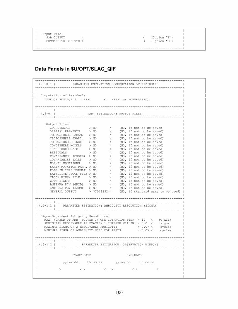
100
| | | Output File: | | JOB OUTPUT > < (Option "F") | | COMMAND TO EXECUTE > < (Option "C") | | | +------------------------------------------------------------------------------+
Data Panels in $U/OPT/SLAC_QIF +---------+--------------------------------------------------------------------+ | 4.5-0.1 | PARAMETER ESTIMATION: COMPUTATION OF RESIDUALS | +---------+--------------------------------------------------------------------+ | | | Computation of Residuals: | | TYPE OF RESIDUALS > REAL < (REAL or NORMALIZED) | | | +------------------------------------------------------------------------------+ +---------+--------------------------------------------------------------------+ | 4.5-0 | PAR. ESTIMATION: OUTPUT FILES | +---------+--------------------------------------------------------------------+ | | | Output Files: | | COORDINATES > NO < (NO, if not to be saved) | | ORBITAL ELEMENTS > NO < (NO, if not to be saved) | | TROPOSPHERE PARAM. > NO < (NO, if not to be saved) | | TROPOSPHERE GRADI. > NO < (NO, if not to be saved) | | TROPOSPHERE SINEX > NO < (NO, if not to be saved) | | IONOSPHERE MODELS > NO < (NO, if not to be saved) | | IONOSPHERE MAPS > NO < (NO, if not to be saved) | | RESIDUALS > NO < (NO, if not to be saved) | | COVARIANCES (COORD) > NO < (NO, if not to be saved) | | COVARIANCES (ALL) > NO < (NO, if not to be saved) | | NORMAL EQUATIONS > NO < (NO, if not to be saved) | | EARTH ROTATION PARA. > NO < (NO, if not to be saved) | | POLE IN IERS FORMAT > NO < (NO, if not to be saved) | | SATELLITE CLOCK FILE > NO < (NO, if not to be saved) | | CLOCK RINEX FILE > NO < (NO, if not to be saved) | | CODE BIASES > NO < (NO, if not to be saved) | | ANTENNA PCV (GRID) > NO < (NO, if not to be saved) | | ANTENNA PCV (HARM) > NO < (NO, if not to be saved) | | GENERAL OUTPUT > $CD4$SS2 < (NO, if standard name to be used) | | | +------------------------------------------------------------------------------+ +---------+--------------------------------------------------------------------+ | 4.5-1.1 | PARAMETER ESTIMATION: AMBIGUITY RESOLUTION (SIGMA) | +---------+--------------------------------------------------------------------+ | | | Sigma-Dependent Ambiguity Resolution: | | MAX. NUMBER OF AMB. SOLVED IN ONE ITERATION STEP > 10 < (0:All) | | AMBIGUITY RESOLVABLE IF EXACTLY 1 INTEGER WITHIN > 3.0 < sigma | | MAXIMAL SIGMA OF A RESOLVABLE AMBIGUITY > 0.07 < cycles | | MINIMAL SIGMA OF AMBIGUITY USED FOR TESTS > 0.05 < cycles | | | +------------------------------------------------------------------------------+ +---------+--------------------------------------------------------------------+ | 4.5-1.2 | PARAMETER ESTIMATION: OBSERVATION WINDOWS | +---------+--------------------------------------------------------------------+ | | | START DATE END DATE | | | | yy mm dd hh mm ss yy mm dd hh mm ss | | | | > < > < > < > < | | | | |
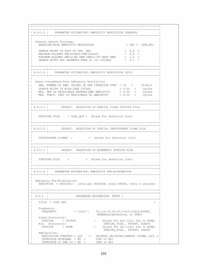
101
+------------------------------------------------------------------------------+ +---------+--------------------------------------------------------------------+ | 4.5-1.3 | PARAMETER ESTIMATION: AMBIGUITY RESOLUTION (SEARCH) | +---------+--------------------------------------------------------------------+ | | | General Search Strategy: | | BASELINE-WISE AMBIGUITY RESOLUTION > YES < (YES,NO) | | | | SEARCH WIDTH IN UNIT OF STD. DEV. > 5.0 < | | MAXIMUM ALLOWED RMS(FIXED)/RMS(FLOAT) > 2.0 < | | MINIMUM ALLOWED RMS(2-ND AMB)/RMS(1-ST BEST AMB) > 1.4 < | | SEARCH WIDTH FOR GEOMETRY-FREE LC (L1 CYCLES) > 0.1 < | | | +------------------------------------------------------------------------------+ +---------+--------------------------------------------------------------------+ | 4.5-1.4 | PARAMETER ESTIMATION: AMBIGUITY RESOLUTION (QIF) | +---------+--------------------------------------------------------------------+ | | | Quasi-Ionosphere-Free Ambiguity Resolution: | | MAX. NUMBER OF AMB. SOLVED IN ONE ITERATION STEP > 10 < (0:All) | | SEARCH WIDTH IN WIDE-LANE CYCLES > 0.50 < cycles | | MAX. RMS OF RESOLVABLE NARROW-LANE AMBIGUITY > 0.03 < cycles | | MAX. FRACT. PART OF RESOLVABLE NL AMBIGUITY > 0.10 < cycles | | | +------------------------------------------------------------------------------+ +---------+--------------------------------------------------------------------+ | 4.5-1.5 | GPSEST: SELECTION OF SPECIAL FIXED STATION FILE | +---------+--------------------------------------------------------------------+ | | | STATIONS FILE > SLAC_QIF < (blank for selection list) | | | +------------------------------------------------------------------------------+ +---------+--------------------------------------------------------------------+ | 4.5-1.6 | GPSEST: SELECTION OF SPECIAL TROPOSPHERE SIGMA FILE | +---------+--------------------------------------------------------------------+ | | | TROPOSPHERE SIGMAS > < (blank for selection list) | | | +------------------------------------------------------------------------------+ +---------+--------------------------------------------------------------------+ | 4.5-1.7 | GPSEST: SELECTION OF KINEMATIC STATION FILE | +---------+--------------------------------------------------------------------+ | | | STATIONS FILE > < (blank for selection list) | | | +------------------------------------------------------------------------------+ +---------+--------------------------------------------------------------------+ | 4.5-1.8 | PARAMETER ESTIMATION: AMBIGUITY PRE-ELIMINATION | +---------+--------------------------------------------------------------------+ | | | Ambiguity Pre-Elimination: | | EXECUTION > SESSION < (once per SESSION, every EPOCH, every n seconds) | | | +------------------------------------------------------------------------------+ +---------+--------------------------------------------------------------------+ | 4.5-1 | PARAMETER ESTIMATION: INPUT 1 | +---------+--------------------------------------------------------------------+ | TITLE > SLAC BPE < | | | | Frequency: | | FREQUENCY > L1&L2 < (L1,L2,L3,L4,L5,L1&L2,L3&L4,MIXED, | | WUEBBena/Melbourne, or DTEC) | | Fixed Station(s): | | STATION > $FIRST < (blank for sel.list, ALL or NONE, | | Kin. Station(s): SPECIAL_FILE.. $FIRST, $LAST) | | STATION > NONE < (blank for sel.list, ALL or NONE, | | SPECIAL_FILE.. $FIRST, $LAST) | | Ambiguities: | | RESOLUTION STRATEGY > QIF < (ELIMIN..NO,ROUND,SEARCH..SIGMA..QIF..)| | INTRODUCE WIDELANE > NO < (YES or NO) | | INTRODUCE L1 AND L2 > NO < (YES or NO) |
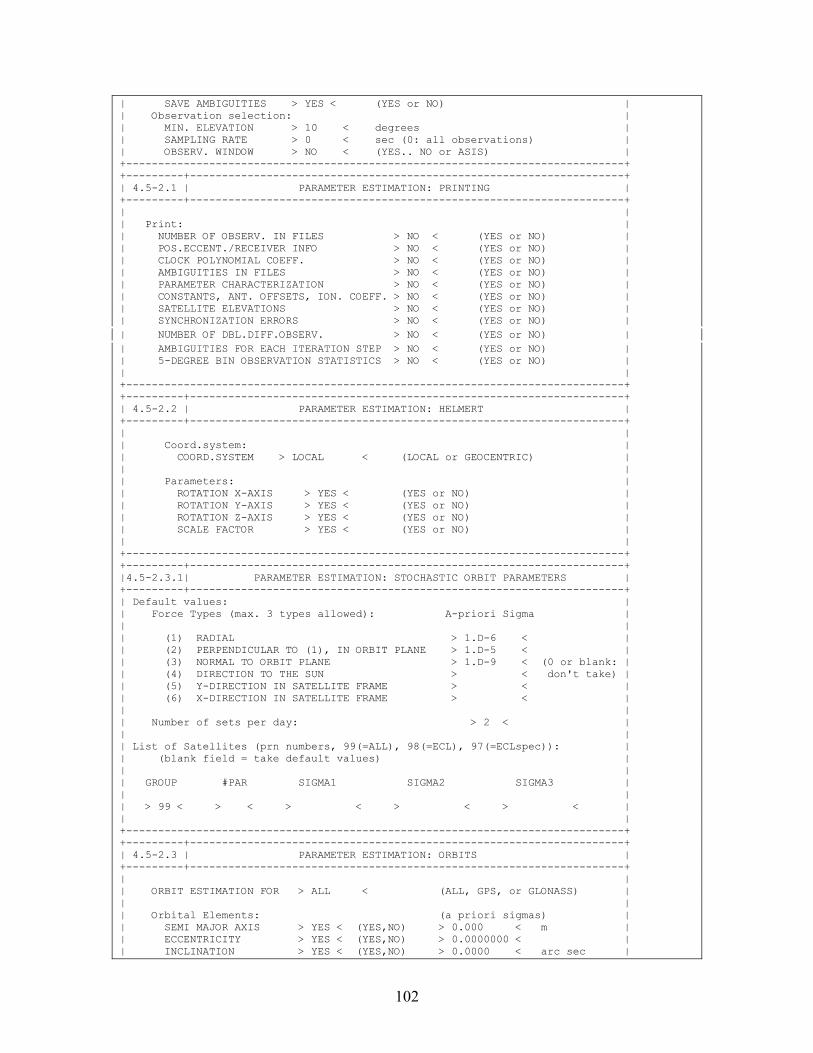
102
| SAVE AMBIGUITIES > YES < (YES or NO) | | Observation selection: | | MIN. ELEVATION > 10 < degrees | | SAMPLING RATE > 0 < sec (0: all observations) | | OBSERV. WINDOW > NO < (YES.. NO or ASIS) | +------------------------------------------------------------------------------+ +---------+--------------------------------------------------------------------+ | 4.5-2.1 | PARAMETER ESTIMATION: PRINTING | +---------+--------------------------------------------------------------------+ | | | Print: | | NUMBER OF OBSERV. IN FILES > NO < (YES or NO) | | POS.ECCENT./RECEIVER INFO > NO < (YES or NO) | | CLOCK POLYNOMIAL COEFF. > NO < (YES or NO) | | AMBIGUITIES IN FILES > NO < (YES or NO) | | PARAMETER CHARACTERIZATION > NO < (YES or NO) | | CONSTANTS, ANT. OFFSETS, ION. COEFF. > NO < (YES or NO) | | SATELLITE ELEVATIONS > NO < (YES or NO) | | SYNCHRONIZATION ERRORS > NO < (YES or NO) | | NUMBER OF DBL.DIFF.OBSERV. > NO < (YES or NO) | | AMBIGUITIES FOR EACH ITERATION STEP > NO < (YES or NO) | | 5-DEGREE BIN OBSERVATION STATISTICS > NO < (YES or NO) | | | +------------------------------------------------------------------------------+ +---------+--------------------------------------------------------------------+ | 4.5-2.2 | PARAMETER ESTIMATION: HELMERT | +---------+--------------------------------------------------------------------+ | | | Coord.system: | | COORD.SYSTEM > LOCAL < (LOCAL or GEOCENTRIC) | | | | Parameters: | | ROTATION X-AXIS > YES < (YES or NO) | | ROTATION Y-AXIS > YES < (YES or NO) | | ROTATION Z-AXIS > YES < (YES or NO) | | SCALE FACTOR > YES < (YES or NO) | | | +------------------------------------------------------------------------------+ +---------+--------------------------------------------------------------------+ |4.5-2.3.1| PARAMETER ESTIMATION: STOCHASTIC ORBIT PARAMETERS | +---------+--------------------------------------------------------------------+ | Default values: | | Force Types (max. 3 types allowed): A-priori Sigma | | | | (1) RADIAL > 1.D-6 < | | (2) PERPENDICULAR TO (1), IN ORBIT PLANE > 1.D-5 < | | (3) NORMAL TO ORBIT PLANE > 1.D-9 < (0 or blank: | | (4) DIRECTION TO THE SUN > < don't take) | | (5) Y-DIRECTION IN SATELLITE FRAME > < | | (6) X-DIRECTION IN SATELLITE FRAME > < | | | | Number of sets per day: > 2 < | | | | List of Satellites (prn numbers, 99(=ALL), 98(=ECL), 97(=ECLspec)): | | (blank field = take default values) | | | | GROUP #PAR SIGMA1 SIGMA2 SIGMA3 | | | | > 99 < > < > < > < > < | | | +------------------------------------------------------------------------------+ +---------+--------------------------------------------------------------------+ | 4.5-2.3 | PARAMETER ESTIMATION: ORBITS | +---------+--------------------------------------------------------------------+ | | | ORBIT ESTIMATION FOR > ALL < (ALL, GPS, or GLONASS) | | | | Orbital Elements: (a priori sigmas) | | SEMI MAJOR AXIS > YES < (YES,NO) > 0.000 < m | | ECCENTRICITY > YES < (YES,NO) > 0.0000000 < | | INCLINATION > YES < (YES,NO) > 0.0000 < arc sec |
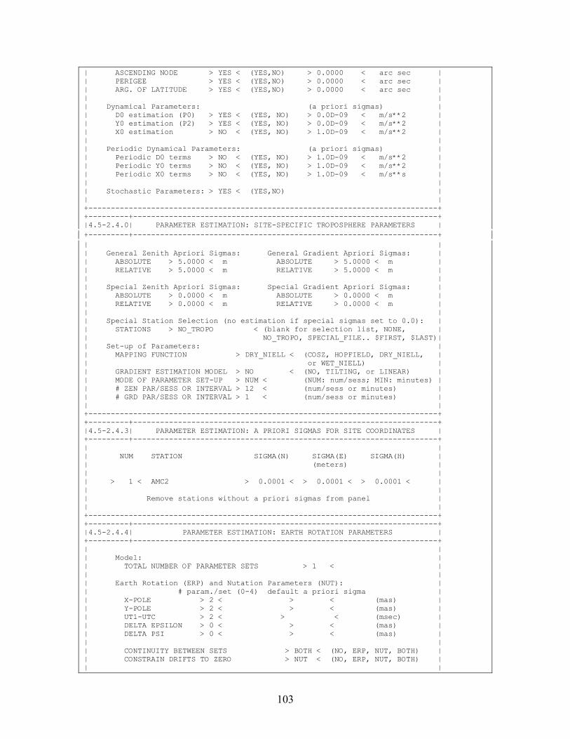
103
| ASCENDING NODE > YES < (YES,NO) > 0.0000 < arc sec | | PERIGEE > YES < (YES,NO) > 0.0000 < arc sec | | ARG. OF LATITUDE > YES < (YES,NO) > 0.0000 < arc sec | | | | Dynamical Parameters: (a priori sigmas) | | D0 estimation (P0) > YES < (YES, NO) > 0.0D-09 < m/s**2 | | Y0 estimation (P2) > YES < (YES, NO) > 0.0D-09 < m/s**2 | | X0 estimation > NO < (YES, NO) > 1.0D-09 < m/s**2 | | | | Periodic Dynamical Parameters: (a priori sigmas) | | Periodic D0 terms > NO < (YES, NO) > 1.0D-09 < m/s**2 | | Periodic Y0 terms > NO < (YES, NO) > 1.0D-09 < m/s**2 | | Periodic X0 terms > NO < (YES, NO) > 1.0D-09 < m/s**s | | | | Stochastic Parameters: > YES < (YES,NO) | | | +------------------------------------------------------------------------------+ +---------+--------------------------------------------------------------------+ |4.5-2.4.0| PARAMETER ESTIMATION: SITE-SPECIFIC TROPOSPHERE PARAMETERS | +---------+--------------------------------------------------------------------+ | | | General Zenith Apriori Sigmas: General Gradient Apriori Sigmas: | | ABSOLUTE > 5.0000 < m ABSOLUTE > 5.0000 < m | | RELATIVE > 5.0000 < m RELATIVE > 5.0000 < m | | | | Special Zenith Apriori Sigmas: Special Gradient Apriori Sigmas: | | ABSOLUTE > 0.0000 < m ABSOLUTE > 0.0000 < m | | RELATIVE > 0.0000 < m RELATIVE > 0.0000 < m | | | | Special Station Selection (no estimation if special sigmas set to 0.0): | | STATIONS > NO_TROPO < (blank for selection list, NONE, | | NO_TROPO, SPECIAL_FILE.. $FIRST, $LAST)| | Set-up of Parameters: | | MAPPING FUNCTION > DRY_NIELL < (COSZ, HOPFIELD, DRY_NIELL, | | or WET_NIELL) | | GRADIENT ESTIMATION MODEL > NO < (NO, TILTING, or LINEAR) | | MODE OF PARAMETER SET-UP > NUM < (NUM: num/sess; MIN: minutes) | | # ZEN PAR/SESS OR INTERVAL > 12 < (num/sess or minutes) | | # GRD PAR/SESS OR INTERVAL > 1 < (num/sess or minutes) | | | +------------------------------------------------------------------------------+ +---------+--------------------------------------------------------------------+ |4.5-2.4.3| PARAMETER ESTIMATION: A PRIORI SIGMAS FOR SITE COORDINATES | +---------+--------------------------------------------------------------------+ | | | NUM STATION SIGMA(N) SIGMA(E) SIGMA(H) | | (meters) | | | | > 1 < AMC2 > 0.0001 < > 0.0001 < > 0.0001 < | | | | Remove stations without a priori sigmas from panel | | | +------------------------------------------------------------------------------+ +---------+--------------------------------------------------------------------+ |4.5-2.4.4| PARAMETER ESTIMATION: EARTH ROTATION PARAMETERS | +---------+--------------------------------------------------------------------+ | | | Model: | | TOTAL NUMBER OF PARAMETER SETS > 1 < | | | | Earth Rotation (ERP) and Nutation Parameters (NUT): | | # param./set (0-4) default a priori sigma | | X-POLE > 2 < > < (mas) | | Y-POLE > 2 < > < (mas) | | UT1-UTC > 2 < > < (msec) | | DELTA EPSILON > 0 < > < (mas) | | DELTA PSI > 0 < > < (mas) | | | | CONTINUITY BETWEEN SETS > BOTH < (NO, ERP, NUT, BOTH) | | CONSTRAIN DRIFTS TO ZERO > NUT < (NO, ERP, NUT, BOTH) | | |
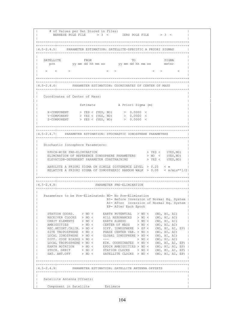
104
| # of Values per Set Stored in Files: | | BERNESE POLE FILE > 3 < IERS POLE FILE > 3 < | | | +------------------------------------------------------------------------------+ +---------+--------------------------------------------------------------------+ |4.5-2.4.5| PARAMETER ESTIMATION: SATELLITE-SPECIFIC A PRIORI SIGMAS | +---------+--------------------------------------------------------------------+ | | | SATELLITE FROM TO SIGMA | | prn yy mm dd hh mm ss yy mm dd hh mm ss meter | | | | > < > < > < > < | | | +------------------------------------------------------------------------------+ +---------+--------------------------------------------------------------------+ |4.5-2.4.6| PARAMETER ESTIMATION: COORDINATES OF CENTER OF MASS | +---------+--------------------------------------------------------------------+ | | | Coordinates of Center of Mass: | | | | Estimate A Priori Sigma (m) | | | | X-COMPONENT > YES < (YES, NO) > 0.0000 < | | Y-COMPONENT > YES < (YES, NO) > 0.0000 < | | Z-COMPONENT > YES < (YES, NO) > 0.0000 < | | | +------------------------------------------------------------------------------+ +---------+--------------------------------------------------------------------+ |4.5-2.4.7| PARAMETER ESTIMATION: STOCHASTIC IONOSPHERE PARAMETERS | +---------+--------------------------------------------------------------------+ | | | Stochastic Ionosphere Parameters: | | | | EPOCH-WISE PRE-ELIMINATION > YES < (YES,NO) | | ELIMINATION OF REFERENCE IONOSPHERE PARAMETERS > NO < (YES,NO) | | ELEVATION-DEPENDENT PARAMETER CONSTRAINING > YES < (YES,NO) | | | | ABSOLUTE A PRIORI SIGMA ON SINGLE DIFFERENCE LEVEL > 0.25 < m | | RELATIVE A PRIORI SIGMA OF IONOSPHERIC RANDOM WALK > 0.00 < m/min**1/2| | | +------------------------------------------------------------------------------+ +---------+--------------------------------------------------------------------+ |4.5-2.4.8| PARAMETER PRE-ELIMINATION | +---------+--------------------------------------------------------------------+ | | | Parameters to be Pre-Eliminated: NO= No Pre-Elimination | | BI= Before Inversion of Normal Eq. System | | AI= After Inversion of Normal Eq. System | | EP= After Each Epoch | | | | STATION COORD. > NO < EARTH POTENTIAL > NO < (NO, BI, AI) | | RECEIVER CLOCKS > NO < HILL RESONANCES > NO < (NO, BI, AI) | | ORBIT ELEMENTS > NO < EARTH ALBEDO > NO < (NO, BI, AI) | | AMBIGUITIES > NO < CENTER OF MASS > NO < (NO, BI, AI) | | REC.HEIGHT.CALIB. > NO < DIFF. IONOSPHERE > EP < (NO, BI, AI, EP) | | SITE TROPOSPHERE > NO < PHASE CENTER VAR. > NO < (NO, BI, AI) | | LOCAL IONOSPHERE > NO < GLOBAL IONOSPHERE > NO < (NO, BI, AI) | | DIFF. CODE BIASES > NO < --- > NO < (NO, BI, AI) | | LOCAL TROPOSPHERE > NO < KIN. COORDINATES > NO < (NO, BI, AI, EP) | | EARTH ROTATION > NO < EPOCH AMBIGUITIES > NO < (NO, BI, AI, EP) | | STOCH. ORBIT > NO < STATION CLOCKS > NO < (NO, BI, AI, EP) | | SAT. ANT.OFF > NO < SATELLITE CLOCKS > NO < (NO, BI, AI, EP) | | | +------------------------------------------------------------------------------+ +---------+--------------------------------------------------------------------+ |4.5-2.4.9| PARAMETER ESTIMATION: SATELLITE ANTENNA OFFSETS | +---------+--------------------------------------------------------------------+ | | | Satellite Antenna Offsets: | | | | Component in Satellite Estimate |
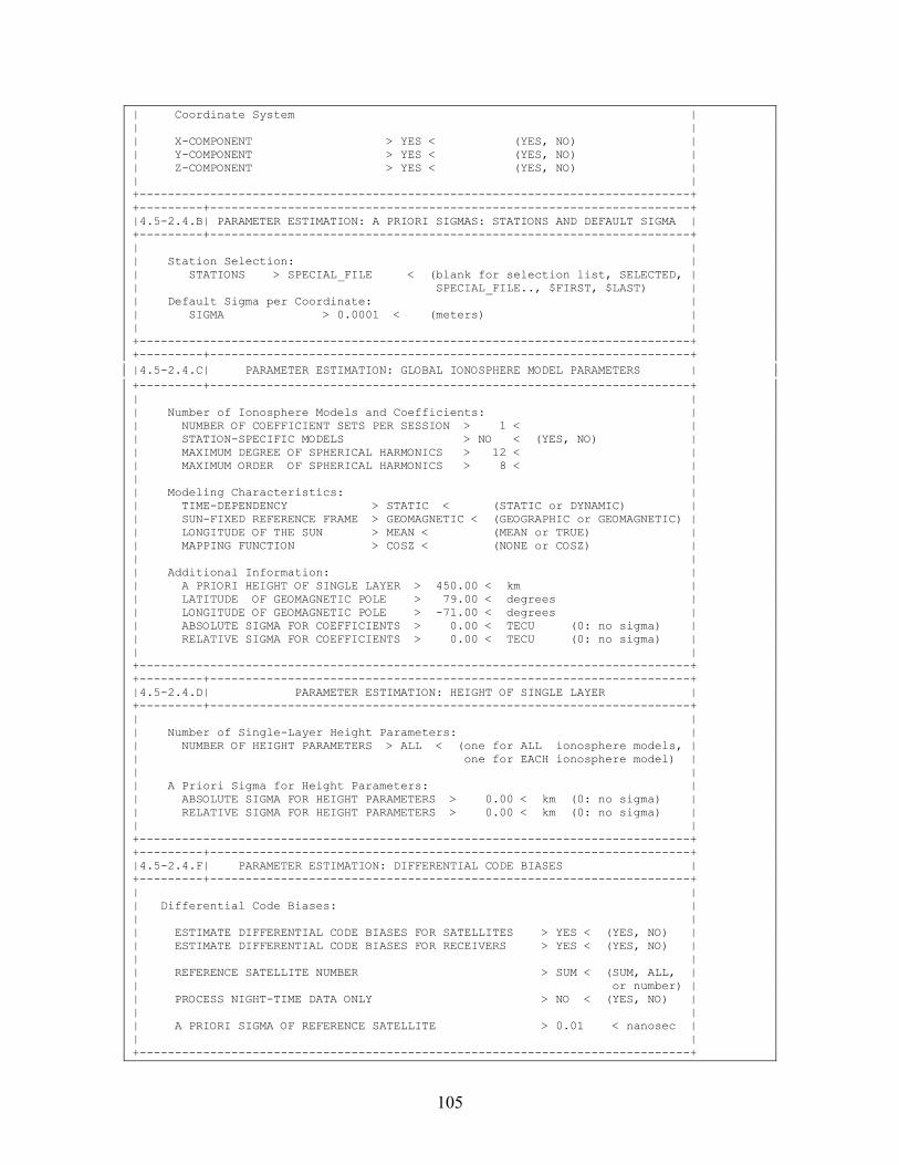
105
| Coordinate System | | | | X-COMPONENT > YES < (YES, NO) | | Y-COMPONENT > YES < (YES, NO) | | Z-COMPONENT > YES < (YES, NO) | | | +------------------------------------------------------------------------------+ +---------+--------------------------------------------------------------------+ |4.5-2.4.B| PARAMETER ESTIMATION: A PRIORI SIGMAS: STATIONS AND DEFAULT SIGMA | +---------+--------------------------------------------------------------------+ | | | Station Selection: | | STATIONS > SPECIAL_FILE < (blank for selection list, SELECTED, | | SPECIAL_FILE.., $FIRST, $LAST) | | Default Sigma per Coordinate: | | SIGMA > 0.0001 < (meters) | | | +------------------------------------------------------------------------------+ +---------+--------------------------------------------------------------------+ |4.5-2.4.C| PARAMETER ESTIMATION: GLOBAL IONOSPHERE MODEL PARAMETERS | +---------+--------------------------------------------------------------------+ | | | Number of Ionosphere Models and Coefficients: | | NUMBER OF COEFFICIENT SETS PER SESSION > 1 < | | STATION-SPECIFIC MODELS > NO < (YES, NO) | | MAXIMUM DEGREE OF SPHERICAL HARMONICS > 12 < | | MAXIMUM ORDER OF SPHERICAL HARMONICS > 8 < | | | | Modeling Characteristics: | | TIME-DEPENDENCY > STATIC < (STATIC or DYNAMIC) | | SUN-FIXED REFERENCE FRAME > GEOMAGNETIC < (GEOGRAPHIC or GEOMAGNETIC) | | LONGITUDE OF THE SUN > MEAN < (MEAN or TRUE) | | MAPPING FUNCTION > COSZ < (NONE or COSZ) | | | | Additional Information: | | A PRIORI HEIGHT OF SINGLE LAYER > 450.00 < km | | LATITUDE OF GEOMAGNETIC POLE > 79.00 < degrees | | LONGITUDE OF GEOMAGNETIC POLE > -71.00 < degrees | | ABSOLUTE SIGMA FOR COEFFICIENTS > 0.00 < TECU (0: no sigma) | | RELATIVE SIGMA FOR COEFFICIENTS > 0.00 < TECU (0: no sigma) | | | +------------------------------------------------------------------------------+ +---------+--------------------------------------------------------------------+ |4.5-2.4.D| PARAMETER ESTIMATION: HEIGHT OF SINGLE LAYER | +---------+--------------------------------------------------------------------+ | | | Number of Single-Layer Height Parameters: | | NUMBER OF HEIGHT PARAMETERS > ALL < (one for ALL ionosphere models, | | one for EACH ionosphere model) | | | | A Priori Sigma for Height Parameters: | | ABSOLUTE SIGMA FOR HEIGHT PARAMETERS > 0.00 < km (0: no sigma) | | RELATIVE SIGMA FOR HEIGHT PARAMETERS > 0.00 < km (0: no sigma) | | | +------------------------------------------------------------------------------+ +---------+--------------------------------------------------------------------+ |4.5-2.4.F| PARAMETER ESTIMATION: DIFFERENTIAL CODE BIASES | +---------+--------------------------------------------------------------------+ | | | Differential Code Biases: | | | | ESTIMATE DIFFERENTIAL CODE BIASES FOR SATELLITES > YES < (YES, NO) | | ESTIMATE DIFFERENTIAL CODE BIASES FOR RECEIVERS > YES < (YES, NO) | | | | REFERENCE SATELLITE NUMBER > SUM < (SUM, ALL, | | or number) | | PROCESS NIGHT-TIME DATA ONLY > NO < (YES, NO) | | | | A PRIORI SIGMA OF REFERENCE SATELLITE > 0.01 < nanosec | | | +------------------------------------------------------------------------------+
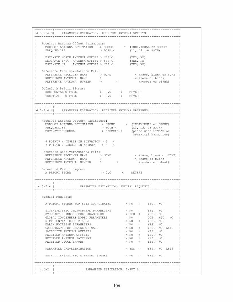
106
+---------+--------------------------------------------------------------------+ |4.5-2.4.G| PARAMETER ESTIMATION: RECEIVER ANTENNA OFFSETS | +---------+--------------------------------------------------------------------+ | | | Receiver Antenna Offset Parameters: | | MODE OF ANTENNA ESTIMATION > GROUP < (INDIVIDUAL or GROUP) | | FREQUENCIES > BOTH < (L1, L2, or BOTH) | | | | ESTIMATE NORTH ANTENNA OFFSET > YES < (YES, NO) | | ESTIMATE EAST ANTENNA OFFSET > YES < (YES, NO) | | ESTIMATE UP ANTENNA OFFSET > YES < (YES, NO) | | | | Reference Receiver/Antenna Pair: | | REFERENCE RECEIVER NAME > NONE < (name, blank or NONE) | | REFERENCE ANTENNA NAME > < (name or blank) | | REFERENCE ANTENNA NUMBER > < (number or blank) | | | | Default A Priori Sigmas: | | HORIZONTAL OFFSETS > 0.0 < METERS | | VERTICAL OFFSETS > 0.0 < METERS | | | +------------------------------------------------------------------------------+ +---------+--------------------------------------------------------------------+ |4.5-2.4.H| PARAMETER ESTIMATION: RECEIVER ANTENNA PATTERNS | +---------+--------------------------------------------------------------------+ | | | Receiver Antenna Pattern Parameters: | | MODE OF ANTENNA ESTIMATION > GROUP < (INDIVIDUAL or GROUP) | | FREQUENCIES > BOTH < (L1, L2, or BOTH) | | ESTIMATION MODEL > SPHERIC < (piece-wise LINEAR or | | SPHERICal harmonics) | | | | # POINTS / DEGREE IN ELEVATION > 8 < | | # POINTS / DEGREE IN AZIMUTH > 8 < | | | | Reference Receiver/Antenna Pair: | | REFERENCE RECEIVER NAME > NONE < (name, blank or NONE) | | REFERENCE ANTENNA NAME > < (name or blank) | | REFERENCE ANTENNA NUMBER > < (number or blank) | | | | Default A Priori Sigmas: | | A PRIORI SIGMA > 0.0 < METERS | | | +------------------------------------------------------------------------------+ +---------+--------------------------------------------------------------------+ | 4.5-2.4 | PARAMETER ESTIMATION: SPECIAL REQUESTS | +---------+--------------------------------------------------------------------+ | | | Special Requests: | | | | A PRIORI SIGMAS FOR SITE COORDINATES > NO < (YES.. NO) | | | | SITE-SPECIFIC TROPOSPHERE PARAMETERS > NO < (YES.. NO) | | STOCHASTIC IONOSPHERE PARAMETERS > YES < (YES.. NO) | | GLOBAL IONOSPHERE MODEL PARAMETERS > NO < (COE.. HGT.. NO) | | DIFFERENTIAL CODE BIASES > NO < (YES.. NO) | | EARTH ROTATION PARAMETERS > NO < (YES.. NO) | | COORDINATES OF CENTER OF MASS > NO < (YES.. NO, ASIS) | | SATELLITE ANTENNA OFFSETS > NO < (YES.. NO) | | RECEIVER ANTENNA OFFSETS > NO < (YES.. NO) | | RECEIVER ANTENNA PATTERNS > NO < (YES.. NO) | | RECEIVER CLOCK ERRORS > NO < (YES.. NO) | | | | PARAMETER PRE-ELIMINATION > YES < (YES.. NO, ASIS) | | | | SATELLITE-SPECIFIC A PRIORI SIGMAS > NO < (YES.. NO) | | | +------------------------------------------------------------------------------+ +---------+--------------------------------------------------------------------+ | 4.5-2 | PARAMETER ESTIMATION: INPUT 2 | +---------+--------------------------------------------------------------------+
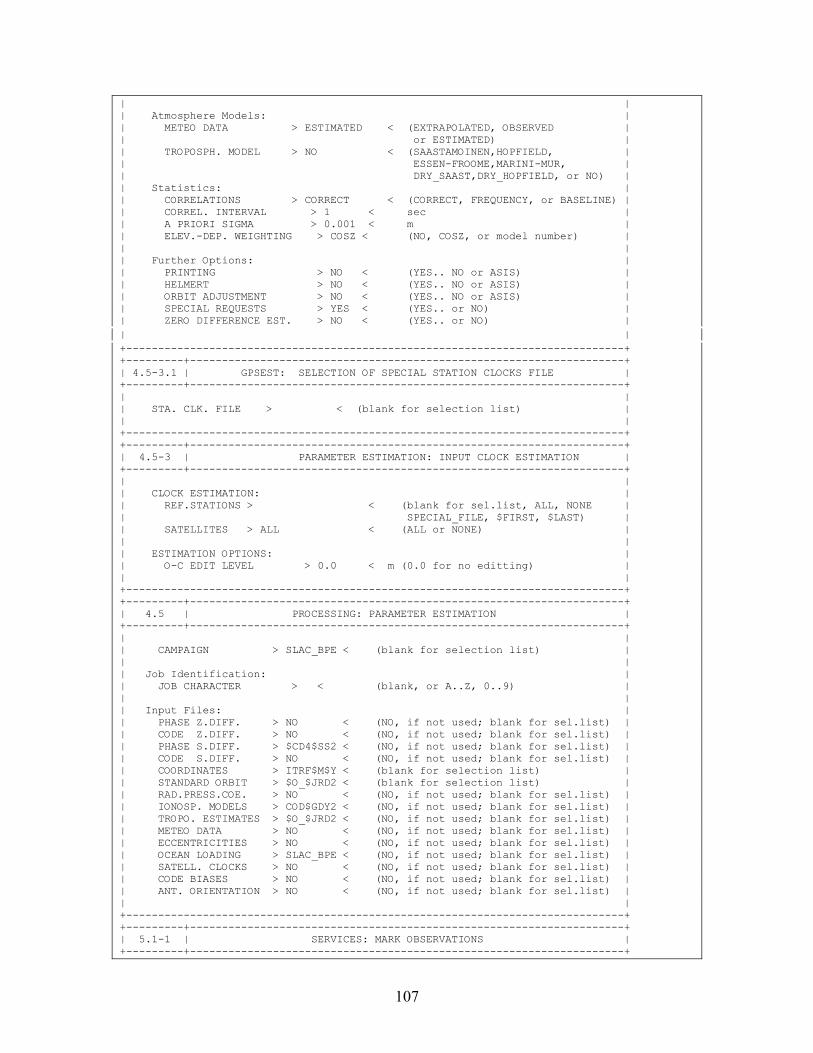
107
| | | Atmosphere Models: | | METEO DATA > ESTIMATED < (EXTRAPOLATED, OBSERVED | | or ESTIMATED) | | TROPOSPH. MODEL > NO < (SAASTAMOINEN,HOPFIELD, | | ESSEN-FROOME,MARINI-MUR, | | DRY_SAAST,DRY_HOPFIELD, or NO) | | Statistics: | | CORRELATIONS > CORRECT < (CORRECT, FREQUENCY, or BASELINE) | | CORREL. INTERVAL > 1 < sec | | A PRIORI SIGMA > 0.001 < m | | ELEV.-DEP. WEIGHTING > COSZ < (NO, COSZ, or model number) | | | | Further Options: | | PRINTING > NO < (YES.. NO or ASIS) | | HELMERT > NO < (YES.. NO or ASIS) | | ORBIT ADJUSTMENT > NO < (YES.. NO or ASIS) | | SPECIAL REQUESTS > YES < (YES.. or NO) | | ZERO DIFFERENCE EST. > NO < (YES.. or NO) | | | +------------------------------------------------------------------------------+ +---------+--------------------------------------------------------------------+ | 4.5-3.1 | GPSEST: SELECTION OF SPECIAL STATION CLOCKS FILE | +---------+--------------------------------------------------------------------+ | | | STA. CLK. FILE > < (blank for selection list) | | | +------------------------------------------------------------------------------+ +---------+--------------------------------------------------------------------+ | 4.5-3 | PARAMETER ESTIMATION: INPUT CLOCK ESTIMATION | +---------+--------------------------------------------------------------------+ | | | CLOCK ESTIMATION: | | REF.STATIONS > < (blank for sel.list, ALL, NONE | | SPECIAL_FILE, $FIRST, $LAST) | | SATELLITES > ALL < (ALL or NONE) | | | | ESTIMATION OPTIONS: | | O-C EDIT LEVEL > 0.0 < m (0.0 for no editting) | | | +------------------------------------------------------------------------------+ +---------+--------------------------------------------------------------------+ | 4.5 | PROCESSING: PARAMETER ESTIMATION | +---------+--------------------------------------------------------------------+ | | | CAMPAIGN > SLAC_BPE < (blank for selection list) | | | | Job Identification: | | JOB CHARACTER > < (blank, or A..Z, 0..9) | | | | Input Files: | | PHASE Z.DIFF. > NO < (NO, if not used; blank for sel.list) | | CODE Z.DIFF. > NO < (NO, if not used; blank for sel.list) | | PHASE S.DIFF. > $CD4$SS2 < (NO, if not used; blank for sel.list) | | CODE S.DIFF. > NO < (NO, if not used; blank for sel.list) | | COORDINATES > ITRF$M$Y < (blank for selection list) | | STANDARD ORBIT > $O_$JRD2 < (blank for selection list) | | RAD.PRESS.COE. > NO < (NO, if not used; blank for sel.list) | | IONOSP. MODELS > COD$GDY2 < (NO, if not used; blank for sel.list) | | TROPO. ESTIMATES > $O_$JRD2 < (NO, if not used; blank for sel.list) | | METEO DATA > NO < (NO, if not used; blank for sel.list) | | ECCENTRICITIES > NO < (NO, if not used; blank for sel.list) | | OCEAN LOADING > SLAC_BPE < (NO, if not used; blank for sel.list) | | SATELL. CLOCKS > NO < (NO, if not used; blank for sel.list) | | CODE BIASES > NO < (NO, if not used; blank for sel.list) | | ANT. ORIENTATION > NO < (NO, if not used; blank for sel.list) | | | +------------------------------------------------------------------------------+ +---------+--------------------------------------------------------------------+ | 5.1-1 | SERVICES: MARK OBSERVATIONS | +---------+--------------------------------------------------------------------+
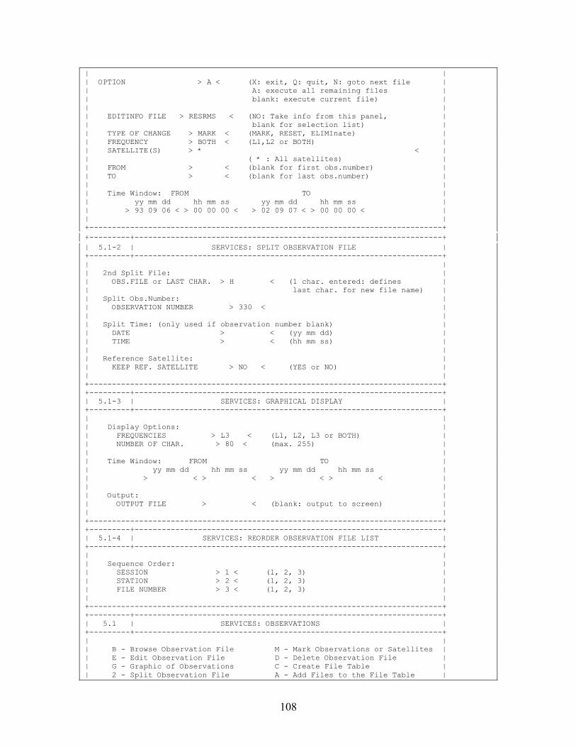
108
| | | OPTION > A < (X: exit, Q: quit, N: goto next file | | A: execute all remaining files | | blank: execute current file) | | | | EDITINFO FILE > RESRMS < (NO: Take info from this panel, | | blank for selection list) | | TYPE OF CHANGE > MARK < (MARK, RESET, ELIMInate) | | FREQUENCY > BOTH < (L1,L2 or BOTH) | | SATELLITE(S) > * < | | ( * : All satellites) | | FROM > < (blank for first obs.number) | | TO > < (blank for last obs.number) | | | | Time Window: FROM TO | | yy mm dd hh mm ss yy mm dd hh mm ss | | > 93 09 06 < > 00 00 00 < > 02 09 07 < > 00 00 00 < | | | +------------------------------------------------------------------------------+ +---------+--------------------------------------------------------------------+ | 5.1-2 | SERVICES: SPLIT OBSERVATION FILE | +---------+--------------------------------------------------------------------+ | | | 2nd Split File: | | OBS.FILE or LAST CHAR. > H < (1 char. entered: defines | | last char. for new file name) | | Split Obs.Number: | | OBSERVATION NUMBER > 330 < | | | | Split Time: (only used if observation number blank) | | DATE > < (yy mm dd) | | TIME > < (hh mm ss) | | | | Reference Satellite: | | KEEP REF. SATELLITE > NO < (YES or NO) | | | +------------------------------------------------------------------------------+ +---------+--------------------------------------------------------------------+ | 5.1-3 | SERVICES: GRAPHICAL DISPLAY | +---------+--------------------------------------------------------------------+ | | | Display Options: | | FREQUENCIES > L3 < (L1, L2, L3 or BOTH) | | NUMBER OF CHAR. > 80 < (max. 255) | | | | Time Window: FROM TO | | yy mm dd hh mm ss yy mm dd hh mm ss | | > < > < > < > < | | | | Output: | | OUTPUT FILE > < (blank: output to screen) | | | +------------------------------------------------------------------------------+ +---------+--------------------------------------------------------------------+ | 5.1-4 | SERVICES: REORDER OBSERVATION FILE LIST | +---------+--------------------------------------------------------------------+ | | | Sequence Order: | | SESSION > 1 < (1, 2, 3) | | STATION > 2 < (1, 2, 3) | | FILE NUMBER > 3 < (1, 2, 3) | | | +------------------------------------------------------------------------------+ +---------+--------------------------------------------------------------------+ | 5.1 | SERVICES: OBSERVATIONS | +---------+--------------------------------------------------------------------+ | | | B - Browse Observation File M - Mark Observations or Satellites | | E - Edit Observation File D - Delete Observation File | | G - Graphic of Observations C - Create File Table | | 2 - Split Observation File A - Add Files to the File Table |
109
| H - Edit Header File only R - Reorder Files in File Table | | X - Exit | | | | Option: > M < (blank: Select option in file list) | | | | CAMPAIGN > MAR_2002 < (blank for selection list) | | | | Input File: | | MEASUREMENT TYPE > PHASE < (CODE, PHASE, BOTH /options C,A,R/) | | DIFFERENCES > SINGLE < (ZERO or SINGLE) | | OBSERVATION FILE > ????0770 < (blank for selection list) | | | +------------------------------------------------------------------------------+ +---------+--------------------------------------------------------------------+ | 5.6.5-1 | EXTRACTIONS: GPSEST/ADDNEQ SUMMARY OPTIONS | +---------+--------------------------------------------------------------------+ | | | Pole Option: | | POLE VALUES FOR WHICH DAY > 1 < (1,2,3 or 0 for all) | | | +------------------------------------------------------------------------------+ +---------+--------------------------------------------------------------------+ | 5.6.5 | EXTRACTIONS: GPSEST/ADDNEQ GENERAL SUMMARY | +---------+--------------------------------------------------------------------+ | | | CAMPAIGN > < (blank for selection list) | | | | Input Files: | | GPSEST OUTPUT NUMBER > NO < (NO, or blank for selection list) | | ADDNEQ OUTPUT NUMBER > NO < (NO, or blank for selection list) | | GENERAL OUTPUT FILE > ????$SS2 < (NO, or blank for selection list) | | | | Output Files: | | OUTPUT SUMMARY > NO < (NO, if not to be created) | | COORDINATE SUMMARY > NO < (NO, if not to be created) | | KINEMATIC SUMMARY > NO < (NO, if not to be created) | | GIM SUMMARY > NO < (NO, if not to be created) | | AMB RES SUMMARY > QIFXTR < (NO, if not to be created) | | AMBIGUITY FRACTIONALS > AMBXTR < (NO, if not to be created) | | CAMPAIGN SUMMARY > NO < (NO, if not to be created) | | WEEKLY SUMMARY > NO < (NO, if not to be created) | | POLE OUTPUT > NO < (NO, if not to be created) | | | +------------------------------------------------------------------------------+ +---------+--------------------------------------------------------------------+ | 5.9 | JOB OUTPUT UTILITIES | +---------+--------------------------------------------------------------------+ | | | B - Display Output F - Create Output File | | E - Edit Job Output D - Delete Job Output | | P - Print Job Output C - Execute Command With Job Listing | | X - Exit N - Set Next Job Output Number | | | | Option: > < | | | | Job: | | CAMPAIGN > SLAC_BPE < (blank for selection list) | | PROGRAM NAME > GPSEST < (blank for selection list, *: all) | | OUTPUT NUMBER > 04 < (L:Last, NO, or blank for sel. list) | | GENERAL OUTPUT > NO < (NO, or blank for selection list) | | | | Output File: | | JOB OUTPUT > < (Option "F") | | COMMAND TO EXECUTE > < (Option "C") | | | +------------------------------------------------------------------------------+
110
Data Panels in $U/OPT/SLAC_FIN +---------+--------------------------------------------------------------------+ | 4.5-0.1 | PARAMETER ESTIMATION: COMPUTATION OF RESIDUALS | +---------+--------------------------------------------------------------------+ | | | Computation of Residuals: | | TYPE OF RESIDUALS > REAL < (REAL or NORMALIZED) | | | +------------------------------------------------------------------------------+ +---------+--------------------------------------------------------------------+ | 4.5-0 | PAR. ESTIMATION: OUTPUT FILES | +---------+--------------------------------------------------------------------+ | | | Output Files: | | COORDINATES > $W_$JRD2 < (NO, if not to be saved) | | ORBITAL ELEMENTS > NO < (NO, if not to be saved) | | TROPOSPHERE PARAM. > $W_$JRD2 < (NO, if not to be saved) | | TROPOSPHERE GRADI. > NO < (NO, if not to be saved) | | TROPOSPHERE SINEX > NO < (NO, if not to be saved) | | IONOSPHERE MODELS > NO < (NO, if not to be saved) | | IONOSPHERE MAPS > NO < (NO, if not to be saved) | | RESIDUALS > NO < (NO, if not to be saved) | | COVARIANCES (COORD) > $W_$JRD2 < (NO, if not to be saved) | | COVARIANCES (ALL) > NO < (NO, if not to be saved) | | NORMAL EQUATIONS > $W_$JRD2 < (NO, if not to be saved) | | EARTH ROTATION PARA. > NO < (NO, if not to be saved) | | POLE IN IERS FORMAT > NO < (NO, if not to be saved) | | SATELLITE CLOCK FILE > NO < (NO, if not to be saved) | | CLOCK RINEX FILE > NO < (NO, if not to be saved) | | CODE BIASES > NO < (NO, if not to be saved) | | ANTENNA PCV (GRID) > NO < (NO, if not to be saved) | | ANTENNA PCV (HARM) > NO < (NO, if not to be saved) | | GENERAL OUTPUT > $W_$JRD2 < (NO, if standard name to be used) | | | +------------------------------------------------------------------------------+ +---------+--------------------------------------------------------------------+ | 4.5-1.1 | PARAMETER ESTIMATION: AMBIGUITY RESOLUTION (SIGMA) | +---------+--------------------------------------------------------------------+ | | | Sigma-Dependent Ambiguity Resolution: | | MAX. NUMBER OF AMB. SOLVED IN ONE ITERATION STEP > 10 < (0:All) | | AMBIGUITY RESOLVABLE IF EXACTLY 1 INTEGER WITHIN > 3.0 < sigma | | MAXIMAL SIGMA OF A RESOLVABLE AMBIGUITY > 0.07 < cycles | | MINIMAL SIGMA OF AMBIGUITY USED FOR TESTS > 0.05 < cycles | | | +------------------------------------------------------------------------------+ +---------+--------------------------------------------------------------------+ | 4.5-1.2 | PARAMETER ESTIMATION: OBSERVATION WINDOWS | +---------+--------------------------------------------------------------------+ | | | START DATE END DATE | | | | yy mm dd hh mm ss yy mm dd hh mm ss | | | | > < > < > < > < | | | | | +------------------------------------------------------------------------------+ +---------+--------------------------------------------------------------------+ | 4.5-1.3 | PARAMETER ESTIMATION: AMBIGUITY RESOLUTION (SEARCH) | +---------+--------------------------------------------------------------------+ | | | General Search Strategy: | | BASELINE-WISE AMBIGUITY RESOLUTION > YES < (YES,NO) | | | | SEARCH WIDTH IN UNIT OF STD. DEV. > 5.0 < | | MAXIMUM ALLOWED RMS(FIXED)/RMS(FLOAT) > 2.0 < | | MINIMUM ALLOWED RMS(2-ND AMB)/RMS(1-ST BEST AMB) > 1.4 < |
111
| SEARCH WIDTH FOR GEOMETRY-FREE LC (L1 CYCLES) > 0.1 < | | | +------------------------------------------------------------------------------+ +---------+--------------------------------------------------------------------+ | 4.5-1.4 | PARAMETER ESTIMATION: AMBIGUITY RESOLUTION (QIF) | +---------+--------------------------------------------------------------------+ | | | Quasi-Ionosphere-Free Ambiguity Resolution: | | MAX. NUMBER OF AMB. SOLVED IN ONE ITERATION STEP > 10 < (0:All) | | SEARCH WIDTH IN WIDE-LANE CYCLES > 0.50 < cycles | | MAX. RMS OF RESOLVABLE NARROW-LANE AMBIGUITY > 0.03 < cycles | | MAX. FRACT. PART OF RESOLVABLE NL AMBIGUITY > 0.10 < cycles | | | +------------------------------------------------------------------------------+ +---------+--------------------------------------------------------------------+ | 4.5-1.5 | GPSEST: SELECTION OF SPECIAL FIXED STATION FILE | +---------+--------------------------------------------------------------------+ | | | STATIONS FILE > SLAC_FIN < (blank for selection list) | | | +------------------------------------------------------------------------------+ +---------+--------------------------------------------------------------------+ | 4.5-1.6 | GPSEST: SELECTION OF SPECIAL TROPOSPHERE SIGMA FILE | +---------+--------------------------------------------------------------------+ | | | TROPOSPHERE SIGMAS > < (blank for selection list) | | | +------------------------------------------------------------------------------+ +---------+--------------------------------------------------------------------+ | 4.5-1.7 | GPSEST: SELECTION OF KINEMATIC STATION FILE | +---------+--------------------------------------------------------------------+ | | | STATIONS FILE > < (blank for selection list) | | | +------------------------------------------------------------------------------+ +---------+--------------------------------------------------------------------+ | 4.5-1.8 | PARAMETER ESTIMATION: AMBIGUITY PRE-ELIMINATION | +---------+--------------------------------------------------------------------+ | | | Ambiguity Pre-Elimination: | | EXECUTION > SESSION < (once per SESSION, every EPOCH, every n seconds) | | | +------------------------------------------------------------------------------+ +---------+--------------------------------------------------------------------+ | 4.5-1 | PARAMETER ESTIMATION: INPUT 1 | +---------+--------------------------------------------------------------------+ | TITLE > SLAC BPE < | | | | Frequency: | | FREQUENCY > L3 < (L1,L2,L3,L4,L5,L1&L2,L3&L4,MIXED, | | WUEBBena/Melbourne, or DTEC) | | Fixed Station(s): | | STATION > NONE < (blank for sel.list, ALL or NONE, | | Kin. Station(s): SPECIAL_FILE.. $FIRST, $LAST) | | STATION > NONE < (blank for sel.list, ALL or NONE, | | SPECIAL_FILE.. $FIRST, $LAST) | | Ambiguities: | | RESOLUTION STRATEGY > ELIMIN < (ELIMIN..NO,ROUND,SEARCH..SIGMA..QIF..)| | INTRODUCE WIDELANE > NO < (YES or NO) | | INTRODUCE L1 AND L2 > YES < (YES or NO) | | SAVE AMBIGUITIES > NO < (YES or NO) | | Observation selection: | | MIN. ELEVATION > 10 < degrees | | SAMPLING RATE > 300 < sec (0: all observations) | | OBSERV. WINDOW > NO < (YES.. NO or ASIS) | +------------------------------------------------------------------------------+ +---------+--------------------------------------------------------------------+ | 4.5-2.1 | PARAMETER ESTIMATION: PRINTING | +---------+--------------------------------------------------------------------+ | | | Print: |
112
| NUMBER OF OBSERV. IN FILES > NO < (YES or NO) | | POS.ECCENT./RECEIVER INFO > NO < (YES or NO) | | CLOCK POLYNOMIAL COEFF. > NO < (YES or NO) | | AMBIGUITIES IN FILES > NO < (YES or NO) | | PARAMETER CHARACTERIZATION > NO < (YES or NO) | | CONSTANTS, ANT. OFFSETS, ION. COEFF. > NO < (YES or NO) | | SATELLITE ELEVATIONS > NO < (YES or NO) | | SYNCHRONIZATION ERRORS > NO < (YES or NO) | | NUMBER OF DBL.DIFF.OBSERV. > NO < (YES or NO) | | AMBIGUITIES FOR EACH ITERATION STEP > NO < (YES or NO) | | 5-DEGREE BIN OBSERVATION STATISTICS > NO < (YES or NO) | | | +------------------------------------------------------------------------------+ +---------+--------------------------------------------------------------------+ | 4.5-2.2 | PARAMETER ESTIMATION: HELMERT | +---------+--------------------------------------------------------------------+ | | | Coord.system: | | COORD.SYSTEM > LOCAL < (LOCAL or GEOCENTRIC) | | | | Parameters: | | ROTATION X-AXIS > YES < (YES or NO) | | ROTATION Y-AXIS > YES < (YES or NO) | | ROTATION Z-AXIS > YES < (YES or NO) | | SCALE FACTOR > YES < (YES or NO) | | | +------------------------------------------------------------------------------+ +---------+--------------------------------------------------------------------+ |4.5-2.3.1| PARAMETER ESTIMATION: STOCHASTIC ORBIT PARAMETERS | +---------+--------------------------------------------------------------------+ | Default values: | | Force Types (max. 3 types allowed): A-priori Sigma | | | | (1) RADIAL > 1.D-6 < | | (2) PERPENDICULAR TO (1), IN ORBIT PLANE > 1.D-5 < | | (3) NORMAL TO ORBIT PLANE > 1.D-9 < (0 or blank: | | (4) DIRECTION TO THE SUN > < don't take) | | (5) Y-DIRECTION IN SATELLITE FRAME > < | | (6) X-DIRECTION IN SATELLITE FRAME > < | | | | Number of sets per day: > 2 < | | | | List of Satellites (prn numbers, 99(=ALL), 98(=ECL), 97(=ECLspec)): | | (blank field = take default values) | | | | GROUP #PAR SIGMA1 SIGMA2 SIGMA3 | | | | > 99 < > < > < > < > < | | | +------------------------------------------------------------------------------+ +---------+--------------------------------------------------------------------+ | 4.5-2.3 | PARAMETER ESTIMATION: ORBITS | +---------+--------------------------------------------------------------------+ | | | ORBIT ESTIMATION FOR > ALL < (ALL, GPS, or GLONASS) | | | | Orbital Elements: (a priori sigmas) | | SEMI MAJOR AXIS > YES < (YES,NO) > 0.000 < m | | ECCENTRICITY > YES < (YES,NO) > 0.0000000 < | | INCLINATION > YES < (YES,NO) > 0.0000 < arc sec | | ASCENDING NODE > YES < (YES,NO) > 0.0000 < arc sec | | PERIGEE > YES < (YES,NO) > 0.0000 < arc sec | | ARG. OF LATITUDE > YES < (YES,NO) > 0.0000 < arc sec | | | | Dynamical Parameters: (a priori sigmas) | | D0 estimation (P0) > YES < (YES, NO) > 0.0D-09 < m/s**2 | | Y0 estimation (P2) > YES < (YES, NO) > 0.0D-09 < m/s**2 | | X0 estimation > NO < (YES, NO) > 1.0D-09 < m/s**2 | | | | Periodic Dynamical Parameters: (a priori sigmas) | | Periodic D0 terms > NO < (YES, NO) > 1.0D-09 < m/s**2 |
113
| Periodic Y0 terms > NO < (YES, NO) > 1.0D-09 < m/s**2 | | Periodic X0 terms > NO < (YES, NO) > 1.0D-09 < m/s**s | | | | Stochastic Parameters: > YES < (YES,NO) | | | +------------------------------------------------------------------------------+ +---------+--------------------------------------------------------------------+ |4.5-2.4.0| PARAMETER ESTIMATION: SITE-SPECIFIC TROPOSPHERE PARAMETERS | +---------+--------------------------------------------------------------------+ | | | General Zenith Apriori Sigmas: General Gradient Apriori Sigmas: | | ABSOLUTE > 5.0000 < m ABSOLUTE > 5.0000 < m | | RELATIVE > 5.0000 < m RELATIVE > 5.0000 < m | | | | Special Zenith Apriori Sigmas: Special Gradient Apriori Sigmas: | | ABSOLUTE > 0.0000 < m ABSOLUTE > 0.0000 < m | | RELATIVE > 0.0000 < m RELATIVE > 0.0000 < m | | | | Special Station Selection (no estimation if special sigmas set to 0.0): | | STATIONS > NONE < (blank for selection list, NONE, | | NO_TROPO, SPECIAL_FILE.. $FIRST, $LAST)| | Set-up of Parameters: | | MAPPING FUNCTION > DRY_NIELL < (COSZ, HOPFIELD, DRY_NIELL, | | or WET_NIELL) | | GRADIENT ESTIMATION MODEL > TILTING < (NO, TILTING, or LINEAR) | | MODE OF PARAMETER SET-UP > NUM < (NUM: num/sess; MIN: minutes) | | # ZEN PAR/SESS OR INTERVAL > 12 < (num/sess or minutes) | | # GRD PAR/SESS OR INTERVAL > 1 < (num/sess or minutes) | | | +------------------------------------------------------------------------------+ +---------+--------------------------------------------------------------------+ |4.5-2.4.3| PARAMETER ESTIMATION: A PRIORI SIGMAS FOR SITE COORDINATES | +---------+--------------------------------------------------------------------+ | | | NUM STATION SIGMA(N) SIGMA(E) SIGMA(H) | | (meters) | | | | > 1 < AMC2 40472S004 > 0.0001 < > 0.0001 < > 0.0001 < | | | | Remove stations without a priori sigmas from panel | | | +------------------------------------------------------------------------------+ +---------+--------------------------------------------------------------------+ |4.5-2.4.4| PARAMETER ESTIMATION: EARTH ROTATION PARAMETERS | +---------+--------------------------------------------------------------------+ | | | Model: | | TOTAL NUMBER OF PARAMETER SETS > 1 < | | | | Earth Rotation (ERP) and Nutation Parameters (NUT): | | # param./set (0-4) default a priori sigma | | X-POLE > 2 < > < (mas) | | Y-POLE > 2 < > < (mas) | | UT1-UTC > 2 < > < (msec) | | DELTA EPSILON > 0 < > < (mas) | | DELTA PSI > 0 < > < (mas) | | | | CONTINUITY BETWEEN SETS > BOTH < (NO, ERP, NUT, BOTH) | | CONSTRAIN DRIFTS TO ZERO > NUT < (NO, ERP, NUT, BOTH) | | | | # of Values per Set Stored in Files: | | BERNESE POLE FILE > 3 < IERS POLE FILE > 3 < | | | +------------------------------------------------------------------------------+ +---------+--------------------------------------------------------------------+ |4.5-2.4.5| PARAMETER ESTIMATION: SATELLITE-SPECIFIC A PRIORI SIGMAS | +---------+--------------------------------------------------------------------+ | | | SATELLITE FROM TO SIGMA | | prn yy mm dd hh mm ss yy mm dd hh mm ss meter | | |
114
| > < > < > < > < | | | +------------------------------------------------------------------------------+ +---------+--------------------------------------------------------------------+ |4.5-2.4.6| PARAMETER ESTIMATION: COORDINATES OF CENTER OF MASS | +---------+--------------------------------------------------------------------+ | | | Coordinates of Center of Mass: | | | | Estimate A Priori Sigma (m) | | | | X-COMPONENT > YES < (YES, NO) > 0.0000 < | | Y-COMPONENT > YES < (YES, NO) > 0.0000 < | | Z-COMPONENT > YES < (YES, NO) > 0.0000 < | | | +------------------------------------------------------------------------------+ +---------+--------------------------------------------------------------------+ |4.5-2.4.7| PARAMETER ESTIMATION: STOCHASTIC IONOSPHERE PARAMETERS | +---------+--------------------------------------------------------------------+ | | | Stochastic Ionosphere Parameters: | | | | EPOCH-WISE PRE-ELIMINATION > YES < (YES,NO) | | ELIMINATION OF REFERENCE IONOSPHERE PARAMETERS > NO < (YES,NO) | | ELEVATION-DEPENDENT PARAMETER CONSTRAINING > YES < (YES,NO) | | | | ABSOLUTE A PRIORI SIGMA ON SINGLE DIFFERENCE LEVEL > 0.25 < m | | RELATIVE A PRIORI SIGMA OF IONOSPHERIC RANDOM WALK > 0.00 < m/min**1/2| | | +------------------------------------------------------------------------------+ +---------+--------------------------------------------------------------------+ |4.5-2.4.8| PARAMETER PRE-ELIMINATION | +---------+--------------------------------------------------------------------+ | | | Parameters to be Pre-Eliminated: NO= No Pre-Elimination | | BI= Before Inversion of Normal Eq. System | | AI= After Inversion of Normal Eq. System | | EP= After Each Epoch | | | | STATION COORD. > NO < EARTH POTENTIAL > NO < (NO, BI, AI) | | RECEIVER CLOCKS > NO < HILL RESONANCES > NO < (NO, BI, AI) | | ORBIT ELEMENTS > NO < EARTH ALBEDO > NO < (NO, BI, AI) | | AMBIGUITIES > NO < CENTER OF MASS > NO < (NO, BI, AI) | | REC.HEIGHT.CALIB. > NO < DIFF. IONOSPHERE > EP < (NO, BI, AI, EP) | | SITE TROPOSPHERE > NO < PHASE CENTER VAR. > NO < (NO, BI, AI) | | LOCAL IONOSPHERE > NO < GLOBAL IONOSPHERE > NO < (NO, BI, AI) | | DIFF. CODE BIASES > NO < --- > NO < (NO, BI, AI) | | LOCAL TROPOSPHERE > NO < KIN. COORDINATES > NO < (NO, BI, AI, EP) | | EARTH ROTATION > NO < EPOCH AMBIGUITIES > NO < (NO, BI, AI, EP) | | STOCH. ORBIT > NO < STATION CLOCKS > NO < (NO, BI, AI, EP) | | SAT. ANT.OFF > NO < SATELLITE CLOCKS > NO < (NO, BI, AI, EP) | | | +------------------------------------------------------------------------------+ +---------+--------------------------------------------------------------------+ |4.5-2.4.9| PARAMETER ESTIMATION: SATELLITE ANTENNA OFFSETS | +---------+--------------------------------------------------------------------+ | | | Satellite Antenna Offsets: | | | | Component in Satellite Estimate | | Coordinate System | | | | X-COMPONENT > YES < (YES, NO) | | Y-COMPONENT > YES < (YES, NO) | | Z-COMPONENT > YES < (YES, NO) | | | +------------------------------------------------------------------------------+ +---------+--------------------------------------------------------------------+ |4.5-2.4.B| PARAMETER ESTIMATION: A PRIORI SIGMAS: STATIONS AND DEFAULT SIGMA | +---------+--------------------------------------------------------------------+ | |
115
| Station Selection: | | STATIONS > SPECIAL_FILE < (blank for selection list, SELECTED, | | SPECIAL_FILE.., $FIRST, $LAST) | | Default Sigma per Coordinate: | | SIGMA > 0.0001 < (meters) | | | +------------------------------------------------------------------------------+ +---------+--------------------------------------------------------------------+ |4.5-2.4.C| PARAMETER ESTIMATION: GLOBAL IONOSPHERE MODEL PARAMETERS | +---------+--------------------------------------------------------------------+ | | | Number of Ionosphere Models and Coefficients: | | NUMBER OF COEFFICIENT SETS PER SESSION > 1 < | | STATION-SPECIFIC MODELS > NO < (YES, NO) | | MAXIMUM DEGREE OF SPHERICAL HARMONICS > 12 < | | MAXIMUM ORDER OF SPHERICAL HARMONICS > 8 < | | | | Modeling Characteristics: | | TIME-DEPENDENCY > STATIC < (STATIC or DYNAMIC) | | SUN-FIXED REFERENCE FRAME > GEOMAGNETIC < (GEOGRAPHIC or GEOMAGNETIC) | | LONGITUDE OF THE SUN > MEAN < (MEAN or TRUE) | | MAPPING FUNCTION > COSZ < (NONE or COSZ) | | | | Additional Information: | | A PRIORI HEIGHT OF SINGLE LAYER > 450.00 < km | | LATITUDE OF GEOMAGNETIC POLE > 79.00 < degrees | | LONGITUDE OF GEOMAGNETIC POLE > -71.00 < degrees | | ABSOLUTE SIGMA FOR COEFFICIENTS > 0.00 < TECU (0: no sigma) | | RELATIVE SIGMA FOR COEFFICIENTS > 0.00 < TECU (0: no sigma) | | | +------------------------------------------------------------------------------+ +---------+--------------------------------------------------------------------+ |4.5-2.4.D| PARAMETER ESTIMATION: HEIGHT OF SINGLE LAYER | +---------+--------------------------------------------------------------------+ | | | Number of Single-Layer Height Parameters: | | NUMBER OF HEIGHT PARAMETERS > ALL < (one for ALL ionosphere models, | | one for EACH ionosphere model) | | | | A Priori Sigma for Height Parameters: | | ABSOLUTE SIGMA FOR HEIGHT PARAMETERS > 0.00 < km (0: no sigma) | | RELATIVE SIGMA FOR HEIGHT PARAMETERS > 0.00 < km (0: no sigma) | | | +------------------------------------------------------------------------------+ +---------+--------------------------------------------------------------------+ |4.5-2.4.F| PARAMETER ESTIMATION: DIFFERENTIAL CODE BIASES | +---------+--------------------------------------------------------------------+ | | | Differential Code Biases: | | | | ESTIMATE DIFFERENTIAL CODE BIASES FOR SATELLITES > YES < (YES, NO) | | ESTIMATE DIFFERENTIAL CODE BIASES FOR RECEIVERS > YES < (YES, NO) | | | | REFERENCE SATELLITE NUMBER > SUM < (SUM, ALL, | | or number) | | PROCESS NIGHT-TIME DATA ONLY > NO < (YES, NO) | | | | A PRIORI SIGMA OF REFERENCE SATELLITE > 0.01 < nanosec | | | +------------------------------------------------------------------------------+ +---------+--------------------------------------------------------------------+ |4.5-2.4.G| PARAMETER ESTIMATION: RECEIVER ANTENNA OFFSETS | +---------+--------------------------------------------------------------------+ | | | Receiver Antenna Offset Parameters: | | MODE OF ANTENNA ESTIMATION > GROUP < (INDIVIDUAL or GROUP) | | FREQUENCIES > BOTH < (L1, L2, or BOTH) | | | | ESTIMATE NORTH ANTENNA OFFSET > YES < (YES, NO) | | ESTIMATE EAST ANTENNA OFFSET > YES < (YES, NO) | | ESTIMATE UP ANTENNA OFFSET > YES < (YES, NO) |
116
| | | Reference Receiver/Antenna Pair: | | REFERENCE RECEIVER NAME > NONE < (name, blank or NONE) | | REFERENCE ANTENNA NAME > < (name or blank) | | REFERENCE ANTENNA NUMBER > < (number or blank) | | | | Default A Priori Sigmas: | | HORIZONTAL OFFSETS > 0.0 < METERS | | VERTICAL OFFSETS > 0.0 < METERS | | | +------------------------------------------------------------------------------+ +---------+--------------------------------------------------------------------+ |4.5-2.4.H| PARAMETER ESTIMATION: RECEIVER ANTENNA PATTERNS | +---------+--------------------------------------------------------------------+ | | | Receiver Antenna Pattern Parameters: | | MODE OF ANTENNA ESTIMATION > GROUP < (INDIVIDUAL or GROUP) | | FREQUENCIES > BOTH < (L1, L2, or BOTH) | | ESTIMATION MODEL > SPHERIC < (piece-wise LINEAR or | | SPHERICal harmonics) | | | | # POINTS / DEGREE IN ELEVATION > 8 < | | # POINTS / DEGREE IN AZIMUTH > 8 < | | | | Reference Receiver/Antenna Pair: | | REFERENCE RECEIVER NAME > NONE < (name, blank or NONE) | | REFERENCE ANTENNA NAME > < (name or blank) | | REFERENCE ANTENNA NUMBER > < (number or blank) | | | | Default A Priori Sigmas: | | A PRIORI SIGMA > 0.0 < METERS | | | +------------------------------------------------------------------------------+ +---------+--------------------------------------------------------------------+ | 4.5-2.4 | PARAMETER ESTIMATION: SPECIAL REQUESTS | +---------+--------------------------------------------------------------------+ | | | Special Requests: | | | | A PRIORI SIGMAS FOR SITE COORDINATES > YES < (YES.. NO) | | | | SITE-SPECIFIC TROPOSPHERE PARAMETERS > YES < (YES.. NO) | | STOCHASTIC IONOSPHERE PARAMETERS > NO < (YES.. NO) | | GLOBAL IONOSPHERE MODEL PARAMETERS > NO < (COE.. HGT.. NO) | | DIFFERENTIAL CODE BIASES > NO < (YES.. NO) | | EARTH ROTATION PARAMETERS > NO < (YES.. NO) | | COORDINATES OF CENTER OF MASS > NO < (YES.. NO, ASIS) | | SATELLITE ANTENNA OFFSETS > NO < (YES.. NO) | | RECEIVER ANTENNA OFFSETS > NO < (YES.. NO) | | RECEIVER ANTENNA PATTERNS > NO < (YES.. NO) | | RECEIVER CLOCK ERRORS > NO < (YES.. NO) | | | | PARAMETER PRE-ELIMINATION > NO < (YES.. NO, ASIS) | | | | SATELLITE-SPECIFIC A PRIORI SIGMAS > NO < (YES.. NO) | | | +------------------------------------------------------------------------------+ +---------+--------------------------------------------------------------------+ | 4.5-2 | PARAMETER ESTIMATION: INPUT 2 | +---------+--------------------------------------------------------------------+ | | | Atmosphere Models: | | METEO DATA > EXTRAPOLATED < (EXTRAPOLATED, OBSERVED | | or ESTIMATED) | | TROPOSPH. MODEL > NO < (SAASTAMOINEN,HOPFIELD, | | ESSEN-FROOME,MARINI-MUR, | | DRY_SAAST,DRY_HOPFIELD, or NO) | | Statistics: | | CORRELATIONS > CORRECT < (CORRECT, FREQUENCY, or BASELINE) | | CORREL. INTERVAL > 1 < sec | | A PRIORI SIGMA > 0.001 < m |
117
| ELEV.-DEP. WEIGHTING > COSZ < (NO, COSZ, or model number) | | | | Further Options: | | PRINTING > NO < (YES.. NO or ASIS) | | HELMERT > NO < (YES.. NO or ASIS) | | ORBIT ADJUSTMENT > NO < (YES.. NO or ASIS) | | SPECIAL REQUESTS > YES < (YES.. or NO) | | ZERO DIFFERENCE EST. > NO < (YES.. or NO) | | | +------------------------------------------------------------------------------+ +---------+--------------------------------------------------------------------+ | 4.5-3.1 | GPSEST: SELECTION OF SPECIAL STATION CLOCKS FILE | +---------+--------------------------------------------------------------------+ | | | STA. CLK. FILE > < (blank for selection list) | | | +------------------------------------------------------------------------------+ +---------+--------------------------------------------------------------------+ | 4.5-3 | PARAMETER ESTIMATION: INPUT CLOCK ESTIMATION | +---------+--------------------------------------------------------------------+ | | | CLOCK ESTIMATION: | | REF.STATIONS > < (blank for sel.list, ALL, NONE | | SPECIAL_FILE, $FIRST, $LAST) | | SATELLITES > ALL < (ALL or NONE) | | | | ESTIMATION OPTIONS: | | O-C EDIT LEVEL > 0.0 < m (0.0 for no editting) | | | +------------------------------------------------------------------------------+ +---------+--------------------------------------------------------------------+ | 4.5 | PROCESSING: PARAMETER ESTIMATION | +---------+--------------------------------------------------------------------+ | | | CAMPAIGN > SLAC_BPE < (blank for selection list) | | | | Job Identification: | | JOB CHARACTER > < (blank, or A..Z, 0..9) | | | | Input Files: | | PHASE Z.DIFF. > NO < (NO, if not used; blank for sel.list) | | CODE Z.DIFF. > NO < (NO, if not used; blank for sel.list) | | PHASE S.DIFF. > ????$SS2 < (NO, if not used; blank for sel.list) | | CODE S.DIFF. > NO < (NO, if not used; blank for sel.list) | | COORDINATES > ITRF$M$Y < (blank for selection list) | | STANDARD ORBIT > $O_$JRD2 < (blank for selection list) | | RAD.PRESS.COE. > NO < (NO, if not used; blank for sel.list) | | IONOSP. MODELS > COD$GDY2 < (NO, if not used; blank for sel.list) | | TROPO. ESTIMATES > NO < (NO, if not used; blank for sel.list) | | METEO DATA > NO < (NO, if not used; blank for sel.list) | | ECCENTRICITIES > NO < (NO, if not used; blank for sel.list) | | OCEAN LOADING > SLAC_BPE < (NO, if not used; blank for sel.list) | | SATELL. CLOCKS > NO < (NO, if not used; blank for sel.list) | | CODE BIASES > NO < (NO, if not used; blank for sel.list) | | ANT. ORIENTATION > NO < (NO, if not used; blank for sel.list) | | | +------------------------------------------------------------------------------+ +---------+--------------------------------------------------------------------+ | 4.8.1-0 | ADD NORMAL EQUATION SYSTEMS: OUTPUT FILES | +---------+--------------------------------------------------------------------+ | | | Output Files: | | COORDINATES > $X_$JRD2 < (NO, if not to be saved) | | VELOCITIES > NO < (NO, if not to be saved) | | SINEX (CRD+VEL+ERP) > NO < (NO, if not to be saved) | | ORBITAL ELEMENTS > NO < (NO, file name) | | TROPOSPHERE PARAM. > NO < (NO, if not to be saved) | | TROPOSPHERE SINEX > NO < (NO, if not to be saved) | | IONOSPHERE MODELS > NO < (NO, if not to be saved) | | COVARIANCES (COORD) > NO < (NO, if not to be saved) | | COVARIANCES (ALL) > NO < (NO, if not to be saved) |
118
| COVARIANCE COMPON. > NO < (NO, if not to be saved) | | NORMAL EQUATIONS > $X_$JRD2 < (NO, if not to be saved) | | EARTH ROTATION PARA. > NO < (NO, if not to be saved) | | POLE IN IERS FORMAT > NO < (NO, if not to be saved) | | PLOT FILE > NO < (NO, if not to be saved) | | REPORT FILE (SUMMARY)> NO < (NO, if not to be saved) | | GENERAL OUTPUT > $X_$JRD2 < (NO, if standard name to be used) | | | +------------------------------------------------------------------------------+ +---------+--------------------------------------------------------------------+ |4.8.1-1.1| ADD NORMAL EQUATION SYSTEMS: FREE COORDINATE SOLUTION | +---------+--------------------------------------------------------------------+ | | | | | Free Coordinate Parameters: | | TRANSLATION X > YES < (YES, NO) | | TRANSLATION Y > YES < (YES, NO) | | TRANSLATION Z > YES < (YES, NO) | | ROTATION X-AXIS > YES < (YES, NO) | | ROTATION Y-AXIS > YES < (YES, NO) | | ROTATION Z-AXIS > YES < (YES, NO) | | SCALE FACTOR > YES < (YES, NO) | | | +------------------------------------------------------------------------------+ +---------+--------------------------------------------------------------------+ |4.8.1-1.2| ADD NORMAL EQUATION SYSTEMS: FREE VELOCITY SOLUTION | +---------+--------------------------------------------------------------------+ | | | | | Free Velocity Parameters: | | TRANSLATION X > YES < (YES, NO) | | TRANSLATION Y > YES < (YES, NO) | | TRANSLATION Z > YES < (YES, NO) | | ROTATION X-AXIS > YES < (YES, NO) | | ROTATION Y-AXIS > YES < (YES, NO) | | ROTATION Z-AXIS > YES < (YES, NO) | | SCALE FACTOR > YES < (YES, NO) | | | +------------------------------------------------------------------------------+ +---------+--------------------------------------------------------------------+ |4.8.1-1.5| ADDNEQ: SELECTION OF SPECIAL FIXED STATION FILE | +---------+--------------------------------------------------------------------+ | | | STATIONS FILE > EUROCLUS < (blank for selection list) | | | +------------------------------------------------------------------------------+ +---------+--------------------------------------------------------------------+ |4.8.1-1.6| ADDNEQ: SELECTION OF SPECIAL FIXED VELOCITIES FILE | +---------+--------------------------------------------------------------------+ | | | STATIONS FILE > < (blank for selection list) | | | +------------------------------------------------------------------------------+ +---------+--------------------------------------------------------------------+ |4.8-1.1.7| ADD NORMAL EQUATIONS: A PRIORI SIGMAS: STATIONS AND DEFAULT SIGMA | +---------+--------------------------------------------------------------------+ | | | Station Selection: | | STATIONS > SPECIAL_FILE < (blank for selection list, SELECTED, | | SPECIAL_FILE, $FIRST, $LAST) | | Default Sigma per Coordinate: | | SIGMA > 0.0001 < (meters) | | | +------------------------------------------------------------------------------+ +---------+--------------------------------------------------------------------+ |4.8-1.1.8| ADD NORMAL EQUATIONS: A PRIORI SIGMAS: STATIONS, DEF. VELO. SIGMA | +---------+--------------------------------------------------------------------+ | | | Station Selection: | | STATIONS > SPECIAL_FILE < (blank for selection list, SELECTED, | | SPECIAL_FILE, $FIRST, $LAST) |
119
| Default Sigma per Coordinate: | | SIGMA > 0.05 < (mm/year) | | | +------------------------------------------------------------------------------+ +---------+--------------------------------------------------------------------+ | 4.8.1-1 | ADD NORMAL EQUATION SYSTEMS: INPUT 1 | +---------+--------------------------------------------------------------------+ | | | TITLE > $X_:DAY $D1, BASELINE, AMB.FREE., 10DEG WGT < | | | | Coordinates: | | FIXED STATIONS > NONE < (blank: sel.list, ALL, NONE, | | SPECIAL_FILE, $FIRST, $LAST)| | A PRIORI SIGMAS > YES < (YES, NO) | | FREE SOLUTION COND. > NO < (YES, NO) | | | | Velocities: | | FIXED STATIONS > NONE < (blank: sel.list, ALL, NONE, | | SPECIAL_FILE, $FIRST, $LAST)| | A PRIORI SIGMAS > NO < (YES, NO) | | FREE SOLUTION COND. > NO < (YES, NO) | | INTRODUCE VELOC. > NO < (YES, NO) | | | +------------------------------------------------------------------------------+ +---------+--------------------------------------------------------------------+ |4.8.1-2.0| ADD NORMAL EQUATION SYSTEMS: ORBITS | +---------+--------------------------------------------------------------------+ | | | Orbital Elements: (a priori sigmas) | | SEMI MAJOR AXIS > YES < (YES,NO) > 0.0 < m | | ECCENTRICITY > YES < (YES,NO) > 0.0 < | | INCLINATION > YES < (YES,NO) > 0.0 < arc sec | | ASCENDING NODE > YES < (YES,NO) > 0.0 < arc sec | | PERIGEE > YES < (YES,NO) > 0.0 < arc sec | | ARG. OF LATITUDE > YES < (YES,NO) > 0.0 < arc sec | | | | Dynamical Parameters: (a priori sigmas) | | D0 estimation (P0) > YES < (YES, NO) > 0.0D-09 < m/s**2 | | Y0 estimation (P2) > YES < (YES, NO) > 0.0D-09 < m/s**2 | | X0 estimation > NO < (YES, NO) > 1.0D-09 < m/s**2 | | | | Periodic Dynamical Parameters: (a priori sigmas) | | Periodic D0 terms > NO < (YES, NO) > 1.0D-09 < m/s**2 | | Periodic Y0 terms > NO < (YES, NO) > 1.0D-09 < m/s**2 | | Periodic X0 term > NO < (YES, NO) > 1.0D-09 < m/s**2 | | | | Orbit combination: | | LONG ARCS > NO < (YES,NO) | | INDIVIDUAL DYN. PAR. > NO < (YES,NO) | | | | Stochastic Parameters: > YES < (YES,NO) | | | | Block rotation of orbital planes: | | X-AXIS > NO < (YES,NO) | | Y-AXIS > NO < (YES,NO) | | Z-AXIS > NO < (YES,NO) | | | | | +------------------------------------------------------------------------------+ +---------+--------------------------------------------------------------------+ |4.8.1-2.1| ADD NORMAL EQUATION SYSTEMS: STOCHASTIC ORBIT PARAMETERS | +---------+--------------------------------------------------------------------+ | Default values: | | Force Types (max. 3 types allowed): A-priori Sigma | | | | (1) RADIAL > 1.D-6 < | | (2) PERPENDICULAR TO (1), IN ORBIT PLANE > 1.D-5 < | | (3) NORMAL TO ORBIT PLANE > 1.D-10 < (0 or blank: | | (4) DIRECTION TO THE SUN > < don't take) | | (5) Y-DIRECTION IN SATELLITE FRAME > < | | (6) X-DIRECTION IN SATELLITE FRAME > < |
120
| | | List of Satellites (prn numbers, 99(=ALL), 98(=ECL)): | | (blank field = take default values) | | | | GROUP SIGMA1 SIGMA2 SIGMA3 | | | | > 99 < > < > < > < | | | +------------------------------------------------------------------------------+ +---------+--------------------------------------------------------------------+ |4.8.1-2.2| ADD NORMAL EQUATION SYSTEMS: SITE-SPECIFIC TROPOSPHERE | +---------+--------------------------------------------------------------------+ | | | A priori Sigma: | | ABSOLUTE > 5.00 < (meters) | | RELATIVE > 5.00 < (meters) | | | | Modelling: | | CONTINUITY BETWEEN NEQS > NO < (YES, NO) | | NUMBER OF PARAMETERS PER DAY > 000 < (0: AS IN NEQ) | | | +------------------------------------------------------------------------------+ +---------+--------------------------------------------------------------------+ |4.8.1-2.3| ADD NORMAL EQUATION SYSTEMS: EARTH ROTATION PARAMETERS | +---------+--------------------------------------------------------------------+ | | | Earth Rotation (ERP) and Nutation Parameters (NUT): | | # of parameters a priori sigma | | per set (0-4) 1st request following requests | | X-POLE > 2 < > 0. < > 0. < (mas) | | Y-POLE > 2 < > 0. < > 0. < (mas) | | UT1-UTC > 2 < > 0.0000001 < > 0. < (msec) | | DELTA EPSILON > 2 < > 0.0001 < > 0. < (mas) | | DELTA PSI > 2 < > 0.0001 < > 0. < (mas) | | | | CONTINUITY BETWEEN SETS > BOTH < (NO, ERP, NUT, BOTH) | | CONSTRAIN DRIFTS TO ZERO > NUT < (NO, ERP, NUT, BOTH) | | | | # PARAM. WITH EQUAL DRIFT (ERP) > 1 < (1: CONTINUITY BETW. DAYS) | | # PARAM. WITH EQUAL DRIFT (NUT) > 1 < (1: CONTINUITY BETW. DAYS) | | CONSTRAIN DAILY RETROGRADE X-Y FREQUENCY TO ZERO (0/1) > 0 < | | | | # of Values per Set Stored in Files: | | BERNESE POLE FILE > 3 < IERS POLE FILE > 3 < | +------------------------------------------------------------------------------+ +---------+--------------------------------------------------------------------+ |4.8.1-2.4| ADD NORMAL EQUATION SYSTEMS: COORDINATES OF CENTER OF MASS | +---------+--------------------------------------------------------------------+ | | | Coordinates of Center of Mass: | | | | Estimate a priori Sigma | | | | X-COMPONENT > YES < (YES, NO) > 0.0001 < | | Y-COMPONENT > YES < (YES, NO) > 0.0001 < | | Z-COMPONENT > YES < (YES, NO) > 0.0001 < | | | +------------------------------------------------------------------------------+ +---------+--------------------------------------------------------------------+ |4.8.1-2.5| PARAMETER PRE-ELIMINATION | +---------+--------------------------------------------------------------------+ | | | Parameters to be Pre-Eliminated: NO= No Pre-Elimination | | BI= Before Inversion of Normal Eq. System | | AI= After Inversion of Normal Eq. System | | EP= After Each Epoch | | | | STATION COORD. > NO < EARTH POTENTIAL > NO < (NO, BI, AI) | | RECEIVER CLOCKS > NO < HILL RESONANCES > NO < (NO, BI, AI) | | ORBIT ELEMENTS > NO < EARTH ALBEDO > NO < (NO, BI, AI) | | AMBIGUITIES > BI < CENTER OF MASS > NO < (NO, BI, AI) |
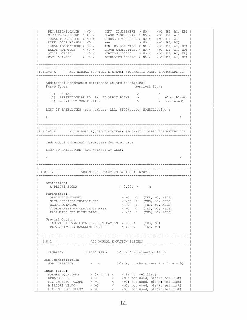
121
| REC.HEIGHT.CALIB. > NO < DIFF. IONOSPHERE > NO < (NO, BI, AI, EP) | | SITE TROPOSPHERE > AI < PHASE CENTER VAR. > NO < (NO, BI, AI) | | LOCAL IONOSPHERE > NO < GLOBAL IONOSPHERE > NO < (NO, BI, AI) | | DIFF. CODE BIASES > NO < --- > NO < (NO, BI, AI) | | LOCAL TROPOSPHERE > NO < KIN. COORDINATES > NO < (NO, BI, AI, EP) | | EARTH ROTATION > NO < EPOCH AMBIGUITIES > NO < (NO, BI, AI, EP) | | STOCH. ORBIT > NO < STATION CLOCKS > NO < (NO, BI, AI, EP) | | SAT. ANT.OFF > NO < SATELLITE CLOCKS > NO < (NO, BI, AI, EP) | | | +------------------------------------------------------------------------------+ +---------+--------------------------------------------------------------------+ |4.8.1-2.A| ADD NORMAL EQUATION SYSTEMS: STOCHASTIC ORBIT PARAMETERS II | +---------+--------------------------------------------------------------------+ | | | Additional stochastic parameters at arc boundaries: | | Force Types A-priori Sigma | | | | (1) RADIAL > < | | (2) PERPENDICULAR TO (1), IN ORBIT PLANE > < (0 or blank: | | (3) NORMAL TO ORBIT PLANE > < not used) | | | | LIST OF SATELLITES (svn numbers, ALL, STOCHastic, NONECLipsing): | | | | > < | | | +------------------------------------------------------------------------------+ +---------+--------------------------------------------------------------------+ |4.8.1-2.B| ADD NORMAL EQUATION SYSTEMS: STOCHASTIC ORBIT PARAMETERS III | +---------+--------------------------------------------------------------------+ | | | Individual dynamical parameters for each arc: | | | | LIST OF SATELLITES (svn numbers or ALL): | | | | > < | | | +------------------------------------------------------------------------------+ +---------+--------------------------------------------------------------------+ | 4.8.1-2 | ADD NORMAL EQUATION SYSTEMS: INPUT 2 | +---------+--------------------------------------------------------------------+ | | | Statistics: | | A PRIORI SIGMA > 0.001 < m | | | | Parameters: | | ORBIT ADJUSTMENT > NO < (YES, NO, ASIS) | | SITE-SPECIFIC TROPOSPHERE > YES < (YES, NO, ASIS) | | EARTH ROTATION > NO < (YES, NO, ASIS) | | COORDINATES OF CENTER OF MASS > NO < (YES, NO, ASIS) | | PARAMETER PRE-ELIMINATION > YES < (YES, NO, ASIS) | | | | Special Options : | | INDIVIDUAL VAR-COVAR RMS ESTIMATION > NO < (YES, NO) | | PROCESSING IN BASELINE MODE > YES < (YES, NO) | | | +------------------------------------------------------------------------------+ +---------+--------------------------------------------------------------------+ | 4.8.1 | ADD NORMAL EQUATION SYSTEMS | +---------+--------------------------------------------------------------------+ | | | CAMPAIGN > SLAC_BPE < (blank for selection list) | | | | Job Identification: | | JOB CHARACTER > < (blank, or characters A - Z, 0 - 9) | | | | Input Files: | | NORMAL EQUATIONS > $X_????? < (blank: sel.list) | | UPDATE CRD. > NO < (NO: not used, blank: sel.list) | | FIX ON SPEC. COORD. > NO < (NO: not used, blank: sel.list) | | A PRIORI VELOC. > NO < (NO: not used, blank: sel.list) | | FIX ON SPEC. VELOC. > NO < (NO: not used, blank: sel.list) |
122
| PLATE TABLE NUVEL1 > NO < (NO: not used, blank: sel.list) | | COV. COMPONENT INTRO > NO < (NO: not used, blank: sel.list) | | PRE-DEFINED BASELINES > NO < (NO: not used, blank: sel.list) | | SITES FOR REPEATABIL. > NO < (NO: not used, blank: sel.list) | | | +------------------------------------------------------------------------------+ +---------+--------------------------------------------------------------------+ | 5.1-1 | SERVICES: MARK OBSERVATIONS | +---------+--------------------------------------------------------------------+ | | | OPTION > A < (X: exit, Q: quit, N: goto next file | | A: execute all remaining files | | blank: execute current file) | | | | EDITINFO FILE > RESRMS < (NO: Take info from this panel, | | blank for selection list) | | TYPE OF CHANGE > MARK < (MARK, RESET, ELIMInate) | | FREQUENCY > BOTH < (L1,L2 or BOTH) | | SATELLITE(S) > < | | ( * : All satellites) | | FROM > < (blank for first obs.number) | | TO > < (blank for last obs.number) | | | | Time Window: FROM TO | | yy mm dd hh mm ss yy mm dd hh mm ss | | > < > < > < > < | | | +------------------------------------------------------------------------------+ +---------+--------------------------------------------------------------------+ | 5.1-2 | SERVICES: SPLIT OBSERVATION FILE | +---------+--------------------------------------------------------------------+ | | | 2nd Split File: | | OBS.FILE or LAST CHAR. > H < (1 char. entered: defines | | last char. for new file name) | | Split Obs.Number: | | OBSERVATION NUMBER > 330 < | | | | Split Time: (only used if observation number blank) | | DATE > < (yy mm dd) | | TIME > < (hh mm ss) | | | | Reference Satellite: | | KEEP REF. SATELLITE > NO < (YES or NO) | | | +------------------------------------------------------------------------------+ +---------+--------------------------------------------------------------------+ | 5.1-3 | SERVICES: GRAPHICAL DISPLAY | +---------+--------------------------------------------------------------------+ | | | Display Options: | | FREQUENCIES > L1 < (L1, L2, L3 or BOTH) | | NUMBER OF CHAR. > 80 < (max. 255) | | | | Time Window: FROM TO | | yy mm dd hh mm ss yy mm dd hh mm ss | | > < > < > < > < | | | | Output: | | OUTPUT FILE > < (blank: output to screen) | | | +------------------------------------------------------------------------------+ +---------+--------------------------------------------------------------------+ | 5.1-4 | SERVICES: REORDER OBSERVATION FILE LIST | +---------+--------------------------------------------------------------------+ | | | Sequence Order: | | SESSION > 1 < (1, 2, 3) | | STATION > 2 < (1, 2, 3) | | FILE NUMBER > 3 < (1, 2, 3) | | |
123
+------------------------------------------------------------------------------+ +---------+--------------------------------------------------------------------+ | 5.1 | SERVICES: OBSERVATIONS | +---------+--------------------------------------------------------------------+ | | | B - Browse Observation File M - Mark Observations or Satellites | | E - Edit Observation File D - Delete Observation File | | G - Graphic of Observations C - Create File Table | | 2 - Split Observation File A - Add Files to the File Table | | H - Edit Header File only R - Reorder Files in File Table | | X - Exit | | | | Option: > M < (blank: Select option in file list) | | | | CAMPAIGN > DOCU42_1 < (blank for selection list) | | | | Input File: | | MEASUREMENT TYPE > PHASE < (CODE, PHASE, BOTH /options C,A,R/) | | DIFFERENCES > SINGLE < (ZERO or SINGLE) | | OBSERVATION FILE > %%%%$SS2 < (blank for selection list) | | | +------------------------------------------------------------------------------+ +---------+--------------------------------------------------------------------+ | 5.6.5-1 | EXTRACTIONS: GPSEST/ADDNEQ SUMMARY OPTIONS | +---------+--------------------------------------------------------------------+ | | | Pole Option: | | POLE VALUES FOR WHICH DAY > 1 < (1,2,3 or 0 for all) | | | +------------------------------------------------------------------------------+ +---------+--------------------------------------------------------------------+ | 5.6.5 | EXTRACTIONS: GPSEST/ADDNEQ GENERAL SUMMARY | +---------+--------------------------------------------------------------------+ | | | CAMPAIGN > SLAC_BPE < (blank for selection list) | | | | Input Files: | | GPSEST OUTPUT NUMBER > NO < (NO, or blank for selection list) | | ADDNEQ OUTPUT NUMBER > NO < (NO, or blank for selection list) | | GENERAL OUTPUT FILE > $W_$JRD2 < (NO, or blank for selection list) | | | | Output Files: | | OUTPUT SUMMARY > GPSXTR < (NO, if not to be created) | | COORDINATE SUMMARY > NO < (NO, if not to be created) | | KINEMATIC SUMMARY > NO < (NO, if not to be created) | | GIM SUMMARY > NO < (NO, if not to be created) | | AMB RES SUMMARY > NO < (NO, if not to be created) | | AMBIGUITY FRACTIONALS > NO < (NO, if not to be created) | | CAMPAIGN SUMMARY > NO < (NO, if not to be created) | | WEEKLY SUMMARY > NO < (NO, if not to be created) | | POLE OUTPUT > NO < (NO, if not to be created) | | | +------------------------------------------------------------------------------+ +---------+--------------------------------------------------------------------+ | 5.9 | JOB OUTPUT UTILITIES | +---------+--------------------------------------------------------------------+ | | | B - Display Output F - Create Output File | | E - Edit Job Output D - Delete Job Output | | P - Print Job Output C - Execute Command With Job Listing | | X - Exit N - Set Next Job Output Number | | | | Option: > B < | | | | Job: | | CAMPAIGN > DOCU42_1 < (blank for selection list) | | PROGRAM NAME > DEFSTD < (blank for selection list, *: all) | | OUTPUT NUMBER > 2 < (L:Last, NO, or blank for sel. list) | | GENERAL OUTPUT > NO < (NO, or blank for selection list) | | | | Output File: |

124
| JOB OUTPUT > < (Option "F") | | COMMAND TO EXECUTE > < (Option "C") | | | +------------------------------------------------------------------------------+