Embed Size (px)
Citation preview

Upper Columbia Regional Application 2017
Sleepy Hollow Side Channel Feasibility Study
Chelan County Natural Resource Department
411 Washington Street, Suite 201
Wenatchee, WA 98826
Erin McKay (509)630-5303
PRISM # 17-1202
HWS # Not Created
Anticipated Request - SRFB: $ 53,125
Anticipated Request – Source Pending: $ 9,375
Anticipated Request for Proposal: $ 62,500
Anticipated Other Funding/Contributions/Matches: $ 0
(Name Source, if applicable)
Anticipated TOTAL Project Budget: $ 62,500

Sleepy Hollow Side Channel Feasibility Study: Responses to RTT and Review Panel Questions
1. Will you include the entire floodplain in the study to gather more information?
While originally focused on just the side channel, the scope of data collection has expanded to include
the floodplain and associated floodplain channels. This would include piezometers in the floodplain and
monitoring of high flows within the 37 acre floodplain protected by the CDLT conservation acquisition
(including the northern portion of the floodplain containing a small side channel and barn). Updated map
showing additional piezometer locations is included.
2. Is funding for the acquisition in place?
Funding for the acquisition is pending the State Legislative Budget Agreement, which unfortunately
will not be available by the time of this submission (June 30). Availability of funds will be known shortly
thereafter, in time for review and selection of SRFB proposals. Indications are favorable for the
acquisition of the property, and we are moving forward with the project on the premise that CDLT will be
able to purchase the land. If the funding for the acquisition is not made available in the Legislative
Budget, we will withdraw this application for SRFB funding. CCNRD will update UCSRB and SRFB of
updates to availability of funds as soon as we have a definitive answer.
3. How will this side channel act in high flows? If high flows come through at high velocity, it could
be hard to get anything to stay put. How many project alternatives will be identified?
This proposal was formulated with some ideas of what appropriate side-channel improvement actions
might look like. With input from the RTT, and further consideration of the channel dynamics, we
understand that consideration of a greater range of alternatives will be necessary. Alternatives could
range from placement of apex jams at the inlet, as generally mentioned in the Lower Wenatchee River
Reach Assessment project identification of this site, to structures to collect wood that is naturally moving
down river, to in-channel placement of wood structures to promote scour-pool formation and increase
channel complexity in the upper side channel. Alternatives will also include restoration potential for the
smaller floodplain side channel located north of the main side channel. Rather than collecting data and
running models to support any preconceived alternatives, the focus of this project will be on letting the
information gathered guide the development of realistic alternatives.
4. What is the most limiting life stage for species you are targeting? When would they be most likely
to be present, and at what size/life stage?
This project targets all three listed species, which are present in the juvenile life stage year round in
the project area. While the side channel functions as a high-flow channel, opportunities to improve low
flow over-winter habitat could benefit all three target species in the juvenile rearing stage. See periodicity
chart below from the Lower Wenatchee River Reach Assessment illustrating the use of this area by spring
Chinook, steelhead, and bull trout.

Changes to original proposal include:
Expand scope of data collection to include entire floodplain and floodplain channels.
Consider broader range of alternatives based on input from RTT. Let data and site analysis drive
alternatives rather than approaching with alternatives already in mind.
15% match funding will not come from Tributary Committee; alternative match funding sources
are being identified.

Questions
Answers
Information
Resource
REGIONAL INFORMATION 1 What Upper Columbia
subbasin is the project
in?
Wenatchee Wenatchee
Entiat
Methow
Okanogan
2 What project category
is your project?
Design Only Restoration
Design Only
Restoration/Protection
Protection
Assessment
Monitoring
3 What Assessment Unit
is the project in? Wenatchee River 04: Lower Wenatchee
Click Here for
Assessment Unit
names
4 What rank restoration
and/or protection
priority is the
assessment unit the
project is located in?
3
Click Here for table of
Assessment Unit ranks
5 What is the primary
species the project will
target?
Steelhead
Steelhead
Spring Chinook
Bull trout
6 What secondary
species will the project
will target?
Spring Chinook
Bull trout
Steelhead
Spring Chinook
Bull trout
Other (please name)
7 What regional PCSRF
Metrics will be
implemented with this
project?
The side channel connects 37 acres of floodplain and
increases access to 2,700 ft. of side channel.
The total length of instream habitat treated will be about
2,700 ft., or approximately .5 miles.
Click Here for regional
PCSRF Metric
definitions
8 What Primary
Ecological Concern
does the Project
Address? (not required
for protection projects)
Side channel and floodplain connection is the #1 ranking
ecological concern in the Lower Wenatchee, and is the
primary concern the project addresses.
Click here for
Ecological Concern
definitions
9 What other Ecological
Concerns does the
Project Address (not
required for protection
projects?
The project also addresses riparian condition, which is the
#2 ecological concern in the lower Wenatchee
See above
10 What is the rank
priority of the primary
ecological concern this
project addresses in
the assessment unit it
occurs (not required for
protection projects)
#1
Click here for table of
Ecological Concern
ranks by assessment
unit
11 Where is the project? 47.469772 Lat. -120.368908 Long.
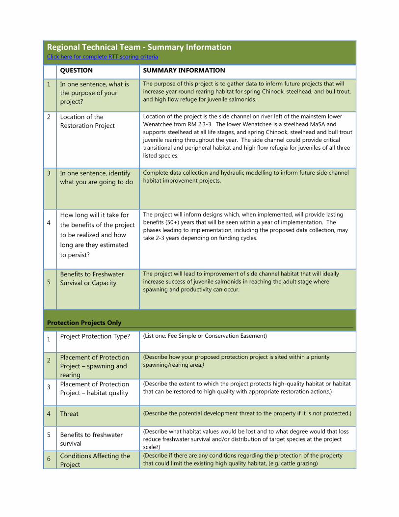
Regional Technical Team - Summary Information Click here for complete RTT scoring criteria
QUESTION SUMMARY INFORMATION
1 In one sentence, what is
the purpose of your
project?
The purpose of this project is to gather data to inform future projects that will
increase year round rearing habitat for spring Chinook, steelhead, and bull trout,
and high flow refuge for juvenile salmonids.
2 Location of the
Restoration Project
Location of the project is the side channel on river left of the mainstem lower
Wenatchee from RM 2.3-3. The lower Wenatchee is a steelhead MaSA and
supports steelhead at all life stages, and spring Chinook, steelhead and bull trout
juvenile rearing throughout the year. The side channel could provide critical
transitional and peripheral habitat and high flow refugia for juveniles of all three
listed species.
3 In one sentence, identify
what you are going to do
Complete data collection and hydraulic modelling to inform future side channel
habitat improvement projects.
4
How long will it take for
the benefits of the project
to be realized and how
long are they estimated
to persist?
The project will inform designs which, when implemented, will provide lasting
benefits (50+) years that will be seen within a year of implementation. The
phases leading to implementation, including the proposed data collection, may
take 2-3 years depending on funding cycles.
5
Benefits to Freshwater
Survival or Capacity
The project will lead to improvement of side channel habitat that will ideally
increase success of juvenile salmonids in reaching the adult stage where
spawning and productivity can occur.
Protection Projects Only
1 Project Protection Type? (List one: Fee Simple or Conservation Easement)
2 Placement of Protection
Project – spawning and
rearing
(Describe how your proposed protection project is sited within a priority
spawning/rearing area.)
3 Placement of Protection
Project – habitat quality
(Describe the extent to which the project protects high-quality habitat or habitat
that can be restored to high quality with appropriate restoration actions.)
4 Threat (Describe the potential development threat to the property if it is not protected.)
5 Benefits to freshwater
survival
(Describe what habitat values would be lost and to what degree would that loss
reduce freshwater survival and/or distribution of target species at the project
scale?)
6 Conditions Affecting the
Project
(Describe if there are any conditions regarding the protection of the property
that could limit the existing high quality habitat, (e.g. cattle grazing)

Citizens Advisory Committee – Ranking Criteria and Summary Information For complete CAC ranking criteria click here
CRITERIA SUMMARY INFORMATION
Criterion 1: Benefits to Fish and Certainty of Success (60 pts. as a weighted percentage based upon
RTT score)
Is the project consistent with
the Recovery Plan
Implementation Strategy?
This project is consistent with the Recovery Plan Implementation Strategy in
that it addresses the primary ecological concern in the Lower Wenatchee
Assessment Unit of peripheral and transitional habitat.
Is the project/assessment based
on proven scientific methods
that will meet objectives?
This project will utilize standard and scientifically proven monitoring and
modeling techniques to learn more about groundwater, hydraulics through the
side channel and the floodplain, and inundation frequency and potential. This
collection and analysis of data by professional scientists will inform restoration
potential for the Sleepy Hollow side channel and floodplain.
Are there any obstacles that
could delay the implementation
of this project or study (e.g.
permitting, design)?
The only obstacle that could delay implementation is if the Legislative Budget
does not approve the funding that was originally dedicated for the
conservation acquisition of this property by Chelan Douglas Land Trust (CDLT).
This will be determined by the time this proposal goes through SRFB review,
and the SRFB panel will be notified of approval as soon as
Criterion 2: Project Longevity (30 points)
Who has the responsibility to
manage and maintain the
project? What is the
responsibility of current or
future landowners?
Chelan County Natural Resource Department (CCNRD) will manage and
maintain the project. CDLT, the landowner, is partnering with CCNRD on this
project and may play a role in outreach and assistance with research and data
collection, but is not responsible for carrying out the project. CDLT will also be
a partner on any future restoration actions on this property.
Has the sponsor successfully
implemented projects in the
past?
Yes. CCNRD has successfully implemented multiple large scale side channel
projects in the past including 7 side channel connection projects on the
mainstem Wenatchee and the Lower White Pine project on Nason Creek (to
name a few). CCNRD has implemented over 60 habitat projects in the
Wenatchee and Entiat subbasins.
Are the benefits associated with
the project in perpetuity?
*Will the project last only a few
years?
The benefits associated with this project will last in perpetuity as the
information collected and the alternatives identified will provide a foundation
with which to approach floodplain restoration/habitat improvement in an area
that will be protected in perpetuity. Careful consideration and selection of
alternatives developed through this project will ideally provide long-lasting
benefits in the Sleepy Hollow side channel/floodplain, as the alternatives will be
designed to promote natural processes.
Is there a high risk of failure
associated with this project?
This project does not have a high risk of failure as it is a data collection and
modeling project in an area where more information is needed to identify
restoration potential.
Criterion 3: Project Scope (15 points)
How much habitat is being
protected or gained?
This project will analyze and eventually contribute to potential habitat
improvement in 2,700 linear feet of side channel and 37 acres of undeveloped
floodplain with additional side channel potential.
Are threats imminent? Threats are not imminent.
Is the scale of the proposed
action appropriate?
The scale of the data collection, modeling, and development of alternatives is
appropriate for this area. Identified as the highest priority project area in the
2016 Lower Wenatchee River Reach Assessment, this area deserves this level of
analysis to identify the best options for habitat improvement.
Criterion 4: Community Support (25 points)

*Has there been public outreach about this project to assess the level of community support? *Does the project build community support for salmon recovery efforts? *Is there any community outreach planned during and/or after implementation?
The acquisition and protection of this rare piece of undeveloped floodplain in
the Lower Wenatchee reach was a result of outreach by CDLT and community
support for protection of the floodplain. The proposed project will build on
this momentum to explore further options for enhancing the floodplain habitat
potential, which will help reinforce community support for future protection
and acquisition projects that benefit salmon.
Has the project sponsor
secured landowner
participation or acceptance?
Yes, CDLT is supportive of investigating restoration/habitat improvement
potential on this property.
Will there be public access?
Public fishing access will be established through a WDFW easement once the
acquisition has been completed.
Will the project create benefits
or raise concerns for particular
groups or the community at
large?
The project could benefit the fishery local fishery and in combination with
shoreline access for fishing, could greatly benefit recreational fishing
opportunity. The project also benefits the greater community at large, by
protecting and improving the natural resources that lend residents of the
Wenatchee Valley a high quality of life. The project should not raise concerns
for any particular group or the greater community.
What is the breadth and
strength of the partnership
supporting the project
(technical support, financial,
and in-kind contributions,
labor)?
This project will be building on the work of CDLT, who went through the SRFB
process to secure funding for the floodplain acquisition. This represents a
great investment by SRFB and other state funding sources, and these
contributions will be even more effective with the exploration of habitat
improvement potential on this property. CCNRD will have the support and
institutional knowledge of CDLT as well additional financial contributions from
entities providing match for this grant.
Criterion 5: Economics (20 points)
Does the project represent an
opportunity for economic
benefit?
Potential habitat improvements in this area will contribute to the draw of the
Wenatchee Valley and its opportunities for nature-based recreation.
Additionally, any contract restoration work would likely be undertaken by local
contractors, contributing to the local economy. This work builds on
investments already made by RCO and other funders, increasing the economic
efficiency of the project.
Will this project help the region
move closer to delisting or
reduce regulatory intervention?
Because it addresses the highest priority project for habitat improvement in the
Lower Wenatchee, undertaking this project is a necessary step to improve
reproductive success and move all listed species closer to recovery. All listed
species are present in most life stages in this area, and the project represents a
good opportunity to provide habitat benefits for these species.
Is the project budget clearly
defined and reasonable?
The project scope is clearly reflected in the proposal budget, and is a
reasonable ask for a project designed to provide the information necessary to
move forward into a well-planned design project.
How much benefit does the
project create for the dollars
invested?
The project provides the benefit of completing a necessary step in addressing
restoration priorities in the Lower Wenatchee, and is a relatively small
investment compared to the investment of acquiring and protecting the
floodplain. Completing this step will allow the next phase of project design to
be completed at a lower cost (design would only require selection of a
preferred alternative), but with greater likelihood of success due to the careful
analysis completed in this step.

Appendix C-2: Planning Project Proposal
Page 1
Manual 18, Salmon Recovery Grants March 2017
Appendix C-2:
Planning Project Proposal
List all related projects previously funded or reviewed by RCO:
Project # or
Name Status
Status of Prior Phase Deliverables and
Relationship to Current Proposal?
#16-1790 In progress CDLT conservation acquisition of the property
pending
Choose a status
Choose a status
Submit this proposal as a PRISM attachment titled “Project Proposal.”
Project brief. 1.
Chelan County Natural Resource Department is proposing a data collection and
hydraulic modelling project for the Sleepy Hollow side channel on the Lower
Wenatchee River. Baseline data is needed for effective habitat project development
for this 2,700 linear foot side channel accessing 37 acres of unconfined and protected
floodplain.
Project location. 2.
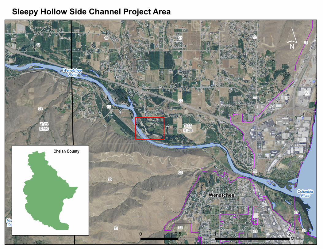
The Sleepy Hollow side channel is located on the Lower Wenatchee River at RM 2.2-
3. The site is on river left, just west of the city of Wenatchee.
Problem statement. 3.
The lower Wenatchee River has experienced widespread fish habitat degradation
over the years due to channel modification, private land development, road and
Project Number 17-1202
Project Name Sleepy Hollow Side Channel Feasibility Study
Sponsor Chelan County Natural Resource Department
Planning Type Conceptual Design/Feasibility Study

Appendix C-2: Planning Project Proposal
Page 2
Manual 18, Salmon Recovery Grants March 2017
railway construction, and intensive agricultural practices. According to the 2016
Lower Wenatchee Reach Assessment (Tetra Tech 2016), approximately 35% of the
lower Wenatchee River is confined by the railroad, 31% of the channel banks are
entirely cleared of vegetation, 19% is riprapped, and 16% is in a natural vegetated
state. Additionally, as of 2006, 62% of the floodplain has been developed for either
agriculture or urban development.
Several limiting factors resulting from these historic and current conditions
contribute to the limited productivity of ESA listed salmonids. The primary limiting
factors in the lower Wenatchee are a reduction of off-channel habitat and
disconnection of floodplains, and degradation of riparian habitat (UCRTT 2014).
These limiting factors are reach based, and directly impact listed fish species by
limiting peripheral and transitional habitat needed for refugia during high flow and
denying cover and channel complexity needed for juvenile rearing. Secondary
limiting factors in the lower Wenatchee are watershed based, and include reduced
instream flows and high summer water temperatures. The focus of this project is to
address the primary limiting factor and the highest priority ecological concern in the
lower Wenatchee, with a feasibility study to determine potential actions to increase
peripheral and transitional habitat in the Sleepy Hollow side channel.
List the fish resources present at the site and targeted by the project. 4.
Species
Life History Present (egg,
juvenile, adult)
Current Population Trend
(decline, stable, rising)
Endangered
Species Act
Coverage (Y/N)
Spring
Chinook
Juvenile, adult Stable Yes
Steelhead Egg, juvenile, adult Rising Yes
Bull trout Juvenile, adult Declining/Stable Yes
Describe the limiting factors, and limiting life stages (by fish species) that 5.
the project expects to address.
As described above, much of the lower Wenatchee has been disconnected from
floodplain and side channel habitat. This has limited rearing (summer and winter) and
high-flow refugia habitat for juvenile spring Chinook, steelhead, and bull trout in a reach
that all three species pass through twice in their lifetime. Warm summer water
temperatures are also a limiting factor in the lower Wenatchee, and recognizing the
importance of groundwater and hyporheic inputs contributing to cold water refugia in
side channels is an important consideration for biological success.
The lower Wenatchee is a MaSA for steelhead, and is known to support all life stages.
Steelhead are present at all life stages in the lower Wenatchee in April and May, when
high-flow refugia is critical during spring run-off events that create hazardous conditions

Appendix C-2: Planning Project Proposal
Page 3
Manual 18, Salmon Recovery Grants March 2017
in the main channel. Juvenile spring Chinook and bull trout are also present in this reach
during spring high-water events and similarly need the protection of off channel refugia.
Juveniles of all three species are present year round in the reach, and rely on the cover,
food availability, and cooler water temperatures provided by groundwater feeds in side
channel habitat. Juvenile spring Chinook rear over winter in the lower Wenatchee, and
out-migrate in the spring, while steelhead and bull trout rear here year-round (Tetra
Tech 2016). Improved habitat in the Sleepy Hollow side channel would benefit all three
listed species in the juvenile rearing stage, especially as over-wintering habitat. As the
lower Wenatchee has significant loss of or degraded riparian habitat and off channel
habitat, protecting and improving this type of off-channel habitat is critical for successful
life cycles in this reach and in reaches and tributaries upstream.
Project goals and objectives. 6.
A. What are the project’s goals?
The goal of this project is to collect baseline data that will inform future habitat
restoration actions and lead to conceptual project designs to enhance year round
peripheral and transitional habitat for juvenile and adult spring Chinook, steelhead,
and bull trout in a rare stretch of the lower Wenatchee that still has connected
floodplain and will be protected against development. The project outcome will be
improved side channel habitat for successful rearing of the three targeted species, as
well as increased quantity of the high-flow and over-wintering refugia required by
juvenile salmonids present in the lower Wenatchee.
B. What are the project’s objectives?
Objectives of the project are:
1. Identify project alternatives to benefit juvenile spring Chinook, steelhead,
and bull trout through improvement of side channel and floodplain
habitats.
2. Collect data on groundwater levels through the existing side channel and
the floodplain side channel area to better understand if groundwater can
be incorporated into future restoration actions to provide cooler summer
water sources and warmer winter augmentation.
3. Quantify the timing and extent of inundation of the main side channel
and the floodplain, and sediment distribution to improve understanding
of side channel/floodplain hydraulics, hydrology, and sediment transport.
4. Complete base flow, 2 year, 10 year, and 100 year hydraulic modelling
using 2016 LiDAR, to assess existing flow connectivity, identify
impairments, and inform the drafting of restoration alternatives.

Appendix C-2: Planning Project Proposal
Page 4
Manual 18, Salmon Recovery Grants March 2017
5. Continue landowner and stakeholder outreach to gain support for future
side channel improvement projects and possibly expand the scope of
acceptable actions.
What are the assumptions and constraints that could impact whether the 7.
sponsor achieves the objectives?
This project assumes that CDLT will be able to purchase fee ownership of the 37
acres of floodplain with the funding awarded by RCO and WWRP. In 2016, CCNRD
worked with CDLT and adjacent landowners to gain access to the side channel and
install two game cameras and staff gages to monitor water levels in the channel as
the river rises. CCNRD expects this cooperation with CDLT and landowners to
continue throughout the data collection process.
Project details. 8.
A. Provide a narrative description of the proposed project.
The Lower Wenatchee Reach Assessment identifies Reach 3 (RM ) as one of the
reaches on the lower Wenatchee with a considerable amount of historic floodplain
that is now disconnected, and gives this reach the greatest potential for restoration
in the lower Wentachee (Tetra Tech 2016). The project ranks #1 in the prioritized list
of habitat projects in the assessment. The primary restoration action types for the
reach are listed in the Assessment as protecting and maintaining habitat, riparian
restoration, floodplain reconnection, and placement of habitat structures. In 2016,
Chelan-Douglas Land Trust secured funding from RCO for a conservation acquisition
of a 37 acres of the Sleepy Hollow floodplain, and is working toward accomplishing
the first of the restoration actions of protecting and maintaining habitat against
future development. Chelan County Natural Resource Department is working with
CDLT to assess possible restoration actions to improve floodplain processes in the
newly acquired parcel.
The Sleepy Hollow side channel is a 2,700 ft. long side channel with two inlets and
access to 37 acres of protected floodplain, all within the 100 year flood elevation. As
an intact side channel with connected floodplain, the site has potential to be an
important refuge and rearing site for anadromous fish as they pass through this spot
twice during their lifetime. Protection of the area for perpetuity is pending, and as
noted in the Lower Wenatchee Reach Assessment, this area provides a unique
opportunity for improvement of peripheral and transitional habitat. The assessment
notes that “existing side channels are cut off from main channel”, and “reconnecting
side channels and installing large wood structures will increase available rearing
habitat” (Tetra Tech 2016). Data collection to identify the extect to which the side
channels are cut off from main channel, the feasibility of reconnecting them, and the

Appendix C-2: Planning Project Proposal
Page 5
Manual 18, Salmon Recovery Grants March 2017
potential for incorporating important groundwater sources into restoration actions is
needed. CCNRD has already begun collaboration with CDLT to initiate monitoring in
the side channel, specifically through installation of game cameras to monitor
seasonal flood flows to inform future hydrologic assessment.
CCNRD is seeking funding to implement a robust ground and surface water data
collection effort along with hydraulic modeling of the project site, to inform the
development of project alternatives in this area of high potential and importance to
listed juvenile salmonids.
Data collection will include:
Piezometer array to document groundwater levels, both in the main side channel
and in the floodplain and smaller floodplain side channel.
Additional game cameras and staff gage data to continuously record site
hydrology. This data will be used to directly calibrate hydraulic modelling efforts.
Collection of sediment conditions within the side channel to perform an analysis
of sediment dynamics. This analysis will inform the ability to scour and maintain
potential side channel inlets and habitat features.
2-Dimensional hydraulic modelling using existing 2016 LiDAR topography to
evaluate site hydraulics, floodplain connectivity, and the potential to create and
maintain side channel features.
A draft alternatives document will be produced describing at least 2-4 project
alternatives with graphics and a brief technical memo. Project alternatives will take
into account the high-flow dynamics in the main side channel, floodplain connection
potential, and fish use potential at different flows. Project elements also include
landowner outreach to ensure continued support of possible side channel
improvement projects and coordination with CDLT to ensure the project is in keeping
with the goals of the conservation acquisition. Deliverables of this project will lead
directly to the next phase of Preliminary Design for habitat improvement in the
Sleepy Hollow side channel.
B. Provide a scope of work and detailed list of project deliverables.
Table 1. Scope of Work
Project Element Deliverables Timeline Entity
Initial research and
information gathering
Creation of database Feburary
2018
CCNRD
Installation/monitoring of
data collection equipment
Data logs from game
camera, piezometers,
and staff gages
November
2018
CCNRD
Appendix C-2: Planning Project Proposal
Page 6
Manual 18, Salmon Recovery Grants March 2017
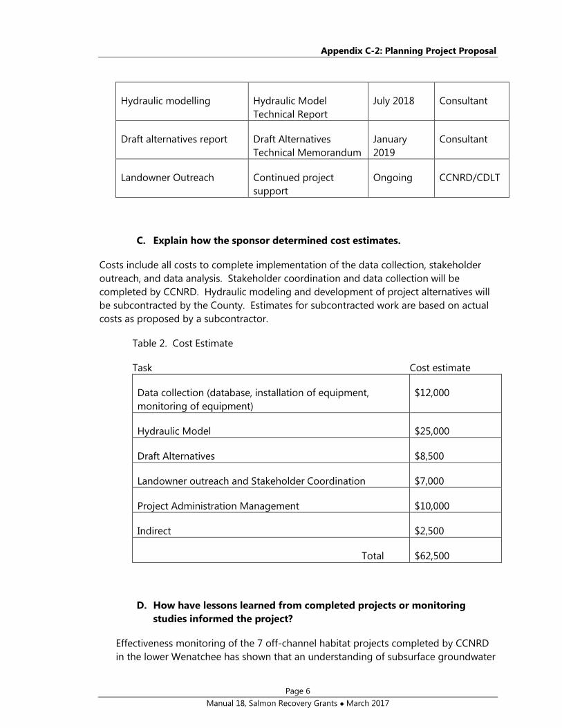
Hydraulic modelling Hydraulic Model
Technical Report
July 2018 Consultant
Draft alternatives report Draft Alternatives
Technical Memorandum
January
2019
Consultant
Landowner Outreach Continued project
support
Ongoing CCNRD/CDLT
C. Explain how the sponsor determined cost estimates.
Costs include all costs to complete implementation of the data collection, stakeholder
outreach, and data analysis. Stakeholder coordination and data collection will be
completed by CCNRD. Hydraulic modeling and development of project alternatives will
be subcontracted by the County. Estimates for subcontracted work are based on actual
costs as proposed by a subcontractor.
Table 2. Cost Estimate
Task Cost estimate
Data collection (database, installation of equipment,
monitoring of equipment)
$12,000
Hydraulic Model $25,000
Draft Alternatives $8,500
Landowner outreach and Stakeholder Coordination $7,000
Project Administration Management $10,000
Indirect $2,500
Total $62,500
D. How have lessons learned from completed projects or monitoring
studies informed the project?
Effectiveness monitoring of the 7 off-channel habitat projects completed by CCNRD
in the lower Wenatchee has shown that an understanding of subsurface groundwater

Appendix C-2: Planning Project Proposal
Page 7
Manual 18, Salmon Recovery Grants March 2017
conditions is essential for gaging the potential benefits of groundwater and
hyporheic flows in extending the “usable period” for juvenile fish in both summer and
winter. For example, piezometer data at the Cashmere Pond project (2009) provided
valuable data to assess seasonal pond levels and potential side channel discharge.
Regionally, similar piezometer data has also been used to inform design at the Tyee
off-channel project in the Entiat River (2012), and is currently being collected at large
side-channel projects proposed by the Bureau of Reclamation also on the Entiat
River.
Monitoring has also shown that an understanding of local sediment and bed mobility
dynamics is important to informing side channel inlet geometry, wood placement,
and scour potential. In large and powerful rivers like the mainstem Wenatchee, large
depositions of sand and gravels within recently constructed side channels can limit
the lifespan and function. Promoting scour and mobility of materials through the
site will be key to improving overall project function.
Finally, the development of 2D hydraulic modelling has become a critical tool in
evaluating river and floodplain flow interaction in designing side channel and
floodplain connections. Real-world data (staff gage, game cameras, spot survey) are
important data sources for the accurate calibration of these models. As +/- 1 foot of
water can make the difference between connected habitats and stranded fish, it is
important to have the best data possible to ensure model accuracy and subsequent
design.
If the project includes an assessment or inventory (NOTE: project may extend 9.
across a wide area and cover multiple properties).
A. Describe any previous or ongoing assessment or inventory work in your
project’s geographic area and how this project will build upon, rather
than duplicate, the completed work.
B. If a design is NOT a deliverable of this grant, please describe how this
project meets all of the required criteria for filling a data gap that are
list in Section 2 of Manual 18.
If the project includes developing a design or a feasibility study: 10.
A. Will a licensed professional engineer design the project?
Yes
A licensed professional engineer will provide the hydraulic modelling
results and draft alternatives. CCNRD will carry out other data
collection activities in consultation with CDLT and the consultant
doing the modelling. CCNRD has carried out this type of data
collection for many past and current projects.

Appendix C-2: Planning Project Proposal
Page 8
Manual 18, Salmon Recovery Grants March 2017
B. If the project includes a fish passage or screening design, has the
project received a Priority Index (PI) or Screening Priority Index (SPI)
number? N/A

Appendix C-2: Planning Project Proposal
Page 9
Manual 18, Salmon Recovery Grants March 2017
C. Will you apply for permits as part of this project’s scope?
No
Permits will be sought upon development of premliminary designs,
which is not in the scope of this proposal.
For fish passage design projects: N/A
i. If you are proposing a culvert or arch, will you use stream
simulation, no slope, hydrologic, or other design method?
Please describe.
ii. Describe the amount and quality of habitat made accessible if
the barrier is corrected.
iii. List additional upstream or downstream fish passage barriers, if
any.
Explain why it is important to do this project now instead of later. 11.
It is essential to collect data to inform the development of effective habitat projects.
As each stage of developing, designing, and implementing successful, process-based
restoration projects takes time, it’s important to begin with the baseline data needs
as soon as possible in order to prepare for the project design and implementation
that will tangibly benefit fish.
The Sleepy Hollow side channel and floodplain presents an opportunity to address
the highest priority for protecting biological productivity, which is allowing natural
floodplain processes such as stream channel migration, instream complexity, and
floodplain function to occur (UCRTT 2014). With the pending conservation
acquisition by CDLT, this area also presents an opportunity to address the highest
priority for habitat restoration, which is to improve off channel habitat and floodplain
process to provide juvenile rearing and refuge habitat. This project is necessary to
determine the extent to which these strategies can be applied in this area to address
these two priorities.
If the project is a part of a larger overall project or strategy, describe the 12.
goal of the overall strategy, explain individual sequencing steps, and which
of these steps is included in this application for funding.
The data collection and modelling undertaken in this project will be used to inform
the next phase of habitat improvement at the site, which is selection of the preferred
alternative and preliminary permit ready design. Final design and implementation
will follow, as per SRFB Manual 18.

Appendix C-2: Planning Project Proposal
Page 10
Manual 18, Salmon Recovery Grants March 2017
Describe the sponsors experience managing this type of project. 13.
Through implementation of over 60 salmon habitat restoration projects in the the
Wenatchee and Entiat subbasins, CCNRD staff has gained many years of combined
experience collecting field data, working with consultants, coordinating with
landowners, stakeholders, and regulatory agencies, and conducting pre- and post-
construction monitoring.
CCNRD has recently engaged in a similar data collection project to inform project
feasibility on the Nason 2.3 oxbow re-connection project. Background data was
collected, a piezometer array installed and monitored, and a database assembled.
This project was subsequestly submitted as a SRFB proposal in 2016 for design and
permitting. Additionally, CCNRD recently contracted with a consultant firm to
produce the 2017 Lower Icicle Creek Geomorphic and Hydraulic Assessment for the
Identification of Protection and Restoration Actions. This report included hydraulic
modeling and draft project alternatives, elements which will also be included in this
proposal.
List all landowner names. 14.
-9th Street Waterfront Investment LLC (purchase by CDLT pending).
-Lurie Burgoon (adjacent landowner downstream)
List project partners and their roles and contributions to the project. 15.
CDLT is a project partner. As previously mentioned, CDLT is in the process of
acquiring the land. CDLT staff will likely assist with landowner outreach and project
development.
Stakeholder outreach. 16.
Extensive public outreach was undertaken by CDLT in preparation for the
conservation acquisition of floodplain property. CDLT has continued working with
landowners to ensure access to the site for intial placement of game cameras to
monitor channel inundation. Landowners are supportive of data collection activities
and potential habitat improvement projects. Downstream landowner outreach will
be important in the design phase, when outcomes of channel connection actions
become clear.
References

Appendix C-2: Planning Project Proposal
Page 11
Manual 18, Salmon Recovery Grants March 2017
Tetra Tech. 2016. Lower Wenatchee River Reach Assessment. Prepared for Confederated
Tribes and Bands of the Yakima Nation.
Upper Columbia Regional Technical Team (UCRTT). 2014. Revised Biological Strategy to
Protect and Restore Salmon Habitat in the Upper Columbia Region.
Supplemental Questions
For acquisition and planning combination projects, applicants will need to answer the
acquisition supplemental questions found in the “Restoration, Acquisition, and
Combination Proposal.”
Comments
Use this section to respond to the comments received after the initial site visits and after
submitting the final application.
Response to Site Visit Comments
Please describe how the sponsor responded to the review panel’s initial site visit
comments. RCO recommends that the sponsor list each of the review panel’s comments
and questions and identify the response. The sponsor may use this space to respond
directly to the comments.
Response to Post-Application Comments
Please describe how the sponsor responded to the review panel’s post-application
comments. RCO recommends that the sponsor list each of the review panel’s comments
and questions and identify the response. The sponsor may use this space to respond
directly to the comments.

!.
!.
!.
!.
!.
!.
!.
!.!.
T:23R:20
19 20
Sleepy Hollow Side Channel Project Area
´
0 0.1 0.20.05Miles
Proposed Data Collection Placements!. EC Staff Gage!. Piezometer!. Staff Gage w Camera
9th Street LLC
9th Street LLC
BurgoonHarris
T:23R:19 T:23
R:20
ColumbiaRiver
WenatcheeRiver
HorseLake
Wenatchee
3233 34
27
15
22
36
16
25
24
30
19
29
20
28
21
18 17
27
13
31
Sleepy Hollow Side Channel Project Area
´
0 1 20.5Miles
Chelan County

Sleepy Hollow Low Flow Photos (April 2017)
High Flow Photos (from CDLT acquisition proposal)

Channel and pools 400’ from mainstem

Upper Side Channel at 6,500 cfs (just watering up on 5/4/17)
Lower Side Channel at low flow (~4,000cfs on 5/2/17)

Inlet of side channel, water receding after a high-water event in March 2017 (pictured at ~4,200cfs).
Staff gage and game-cam placed by CCNRD and CDLT in fall 2016. Note broad, shallow and homogenous
character of upper side channel.