Embed Size (px)
Citation preview

Slocan Wetlands Monitoring and Assessment Project
Bonanza Marsh Wetland Complex
Prepared by:
Ryan Durand, RPBio, Marcy Mahr, MSc., and Tyson Ehlers, RPBio
November 10, 2015

Bonanza Marsh Wetland Complex
2
Table of Contents
TABLE OF CONTENTS .............................................................................................................................................. 2 LIST OF FIGURES ..................................................................................................................................................... 2 LIST OF TABLES ...................................................................................................................................................... 3 1.0 INTRODUCTION ......................................................................................................................................... 5 2.0 ECOSYSTEM MAPPING .............................................................................................................................. 6
2.1 ECOSYSTEM MAPPING METHODOLOGY ................................................................................................................. 6 2.2 ECOSYSTEM MAPPING RESULTS ........................................................................................................................... 9
2.2.1 Swamp ....................................................................................................................................................... 11 2.2.2 Marsh ......................................................................................................................................................... 15 2.2.3 Fen.............................................................................................................................................................. 18
3.0 SPECIES AT RISK ....................................................................................................................................... 19
3.1 GIANT HELLEBORINE ........................................................................................................................................ 21 3.2 BEAKED SPIKE-RUSH ........................................................................................................................................ 22 3.3 COEUR D’ALENE OREGONIAN ............................................................................................................................ 22 3.4 CAT-TAIL MUSHROOM ..................................................................................................................................... 23
4.0 INVENTORY DATA ................................................................................................................................... 24 5.0 CONSERVATION EVALUATION ................................................................................................................. 28 6.0 REFERENCES ............................................................................................................................................ 29
List of Figures
Fig. 1. Location of Bonanza Marsh Wetland Complex (Adapted from Google Maps). .................................................. 5 Fig. 2. Satellite map of Bonanza Marsh Wetland Complex (Adapted from Google Maps). ........................................... 6 Fig. 3. Ecosystem mapping of Bonanza Marsh (imagery supplied by Province of BC). ............................................... 10 Fig. 4. Ws10 western redcedar – spruce – skunk cabbage forested swamp (R. Durand Photo). ................................ 12 Fig. 5. Ws01 mountain alder – skunk cabbage – lady fern swamp (R. Durand Photo). ............................................... 13 Fig. 6. Ws06 Sitka willow – Sitka sedge swamp (R. Durand Photo). ............................................................................ 14 Fig. 7. Hard-stemmed bulrush deep marsh (R. Durand Photo). .................................................................................. 16 Fig. 8. Cusick’s sedge marsh (R. Durand Photo). .......................................................................................................... 17 Fig. 9. Cattail marsh (R. Durand Photo). ...................................................................................................................... 18 Fig. 10. Unclassified fen (R. Durand Photo). ................................................................................................................ 19 Fig. 11. Map of sample locations and species-at-risk occurrences (imagery supplied by Province of BC). ................. 20 Fig. 12. Giant Helleborine (R. Durand photo). ............................................................................................................. 21 Fig. 13. Beaked Spike-Rush (R. Durand photo). ........................................................................................................... 22 Fig. 14. Coeur D’Alene Oregonian (R. Durand photo). ................................................................................................. 23

Bonanza Marsh Wetland Complex
3
Fig. 15. Cat-tail Mushroom (T. Ehlers photo). .............................................................................................................. 24
List of Tables
Table 1. SEI Classes and Subclasses (from Durand, 2013). ............................................................................................ 7 Table 2. Species-at-Risk found in the Bonanza Marsh Wetland Complex. .................................................................. 21

Bonanza Marsh Wetland Complex
4
Slocan Wetlands Assessment and Monitoring Project (SWAMP)
The Slocan Wetlands Assessment and Monitoring Project (SWAMP) is a collaboration of three societies, Slocan Solutions, Slocan River Streamkeepers and Slocan Lake Stewardship, working with the BC Wildlife
Federation, Fish and Wildlife Compensation Program, BC Ministry of Forests Lands and Natural Resource Operations, Selkirk College, Central Kootenay Invasive Species Society, and Regional District of Central
Kootenay, to provide an integrated watershed approach to wetland understanding and management. Slocan Solutions Society is the fiscal manager of the program.
SWAMP is a multi-year initiative to establish a community based monitoring program to assess the
abundance, distribution, and ecological integrity/function of wetlands and riparian habitat throughout the Slocan watershed. The long-term goal of SWAMP is to utilize existing mapping and inventory data as
base layers and to develop a detailed and comprehensive habitat assessment of flora and fauna of the watershed.
Funding is provided by the Columbia Basin Trust, BC Wildlife Federation, Slocan Lake Stewardship Society, and Slocan River Streamkeepers.

Bonanza Marsh Wetland Complex
5
1.0 Introduction
The Slocan Wetland Assessment and Monitoring Project (SWAMP) collects field data in order to classify
and map wetlands in the Slocan Valley watershed in the West Kootenay region of British Columbia. One objective of our analysis is to identify and prioritize sensitive ecosystems for enhancement, restoration and/or protection. In 2015, SWAMP’s field research team conducted ecological sampling of a portion of
the Bonanza Creek corridor located at the north end of Slocan Lake (Fig. 1). The purpose of this paper is to provide a summary of field observations and data collected at the Bonanza Marsh Wetland Complex
(Bonanza Complex) located at the confluence of Bonanza Creek and Slocan Lake. The Bonanza Complex is approximately 16 hectares in size containing high biological diversity including several rare
species, and a variety of sensitive wetland ecosystems (Fig. 2).
Given the on-going conversations about the future condition of the Bonanza Marsh Wetland Complex among local residents, stewardship groups, land conservancies, biologists and resource managers,
SWAMP has prepared this paper to further inform conservation objectives and actions towards protecting Bonanza’s exceptional ecological values.
Fig. 1. Location of Bonanza Marsh Wetland Complex in the Slocan Valley (Adapted from Google Maps).

Bonanza Marsh Wetland Complex
6
Fig. 2. Satellite map of Bonanza Marsh Wetland Complex at the north end of Slocan Lake (Adapted from Google
Maps).
2.0 Ecosystem Mapping
2.1 Ecosystem Mapping Methodology
The Bonanza Complex was mapped as per the Standard for Mapping Ecosystems At Risk in British
Columbia (RISC, 2006) using Sensitive Ecosystems Inventory (SEI) classifications created for the lower Slocan River watershed. (Durand, 2013)
SEI mapping was created in 1993 by the Canadian Wildlife Service and the BC Conservation Data Centre.
It was created in ‘response to a need for inventory of at-risk and ecologically fragile ecosystems, and critical wildlife habitat areas on the east side of Vancouver Island.’ Since then, numerous projects have
been completed on the Sunshine Coast, Bowen Island, and throughout the Okanagan, and portions of the Fraser Valley. In 2006 a Standard for Mapping Ecosystems At Risk in British Columbia was created by
the Resource Inventory Standards Committee (RISC) to promote a standardized process province wide. (Durand, 2013)

Bonanza Marsh Wetland Complex
7
The main purpose of SEI mapping is to describe the ecological diversity of a given area, and determine the type and extent of vulnerable and rare elements (RISC, 2006). The SEI standard describes an
overview of the assessment process as follows:
‘The SEI classification uses two primary groupings of ecosystems: Sensitive Ecosystems and
Other Important Ecosystems. Within each of these groups a series of classes and subclasses is defined that provides a general level of ecosystem description that is appropriate for public
education and local planning exercises. Sensitive Ecosystem categories are generalised groupings of ecosystems that share many characteristics, particularly ecological sensitivities,
ecosystem processes, at-risk status, and wildlife habitat values. Criteria for ecological sensitivity include: environmental specificity, susceptibility to hydrological changes, soil erosion, especially
on shallow soils, spread of invasive alien plants, and sensitivity to human disturbance. Other Important Ecosystems have significant ecological and biological values associated with them that can be identified and mapped, although they are not defined as Sensitive Ecosystems
because they have been substantially altered by human use. Consideration of Other Important Ecosystems is critical to capturing key elements of biodiversity of some project areas; they
sometimes provide recruitment sites for ecosystems at risk or important wildlife habitat requiring recovery or restoration.’
SEI classes and subclasses from the Slocan River SEI project (Durand, 2013) were used to map Bonanza Complex. Table 1 contains a summary of the available SEI classes and subclasses.
Table 1. SEI Classes and Subclasses (from Durand, 2013).
SEI Class SEI Subclass Brief Description
Sensitive Ecosystems
OF: Old Forest* Forests > 140 yrs
OF co: coniferous Conifer > 75% of stand
OF mx: mixed Stand composition > 25% conifer and > 25% broadleaf
RI: Riparian Ecosystems associated with and influenced by freshwater
RI fh: high bench High bench floodplain terraces
RI fm: medium bench Medium bench floodplain terraces
RI fl: low bench Low bench floodplain terraces
RI ff: fringe Narrow, linear community along watercourses that generally lack
floodplains and floodplain communities
RI ri: river River and creeks, including gravel bars
WN: Wetland Terrestrial – freshwater transitional areas.
WN ms: marsh Graminoid or forb-dominated nutrient-rich wetlands
WN sp: swamp Shrub or tree-dominated wetlands
WN ow: shallow water Permanently flooded, water less than 2m deep at mid-summer

Bonanza Marsh Wetland Complex
8
FW: Freshwater
FW pd: pond Open water > 2 m deep and generally < 50 ha.
FW La: lake Open water > 2 m deep and generally > 50 ha.
SV: Sparsely Vegetated Areas with 5 – 10% vascular vegetation.
SV cl: cliff Steep slopes, often with exposed bedrock.
SV ro: rock outcrop Rock outcrops – areas of bedrock exposure.
SV ta: talus Dominated by rubbly blocks of rock.
SV es: exposed soil Any area of exposed soil that is not in other definitions.
Other Important Ecosystems (OIE)
MF: Mature Forest Forests > 80 yrs, < 140 yrs
MF co: coniferous Conifer-dominated (> 75% of stand composition)
MF mx: mixed Stand composition > 25% conifer and > 25% broadleaf
MF bd: broadleaf Broad-leaf dominated (> 75% of stand composition) WD: Woodland Dry site, open stands with between 10 and 25% tree cover
WD co: coniferous Conifer > 75% of stand
WD mx: mixed Conifer > 25% and broadleaf > 25% of composition
Not Sensitive (NS)
NS: Not Sensitive Disturbed and permanently developed/modified areas.
YF: Young Forest Patches of forest – stands > 30 yrs, < 80 yrs
YF co: coniferous Conifer-dominated (> 75% of stand composition)
YF mx: mixed Stand composition > 25% conifer and > 25% broadleaf
YF bd: broadleaf Broad-leaf dominated (> 75% of stand composition) PS: Pole Sapling Trees > 10 m tall, usually 10 - 15 yrs
PS co: coniferous Conifer-dominated (> 75% of stand composition) PS mx: mixed Stand composition > 25% conifer and > 25% broadleaf PS bd: broadleaf Broad-leaf dominated (> 75% of stand composition)
HB: Herbaceous Non-forested ecosystems; usually shallow soils, often with bedrock
outcrops.
HB hb: herbaceous Non-forested, often shallow soils, lichens, moss, or grass/herb
dominated.
HB sh: shrub Dominated by shrubby vegetation (<10m in height)
FS: Seasonally Flooded
Fields
Annually flooded cultivated fields, hay fields, range land, or old fields.
OD: Old Field Large, old field ecosystems.
Ecosystem mapping was performed using 2004 orthophotos provided by the Province of BC for SWAMP. Mapping was completed in ESRI ArcMap 10.3 using heads up delineation. Given that SWAMP’s goal was
to identify all ecosystem types, a minimum polygon size or mapping scale was not used, rather they were adjusted to fit natural features. Mapping procedures generally followed the protocol for Terrestrial Ecosystem Mapping (RISC, 1998) and Standard for Mapping Ecosystems At Risk in British Columbia (RISC,
2006), but was limited by the lack of stereo imagery. (Durand, 2013)

Bonanza Marsh Wetland Complex
9
Each ecosystem polygon included attributes describing the type of ecosystem (SEI class and if applicable subclass) that occurred (up to 3 types per polygon) and the approximate area of each ecosystem type.
For example, a polygon code may appear as follows:
5MF:co - 3YF:co - 2WN:sp
which can be broken down to describe the polygon as containing:
50% mature coniferous forest, 30% young coniferous forest, and 20% swamp.
Ecosystem mapping was verified during the 2015 SWAMP field work with a combination of ecological sample plots and visual plots.
2.2 Ecosystem Mapping Results
This section describes the ecosystem types sampled in the study area (Fig. 3). These ecosystems are
described to a greater detail (i.e. provincial biogeoclimatic site series) than the SEI level. This is a limitation of the SEI mapping in that the orthophoto imagery used was not in 3D or of sufficient quality
to map to a level beyond the simplified SEI classes and sublasses.
Wetland classification was completed as per provincial methodology, primarily using procedures from the Field Manual for Describing Terrestrial Ecosystems; Second Edition (BC MOF, 2010). Additional
information was collected to classify ecosystems to the site association level as per Wetlands of BC: A Guide to Identification (MacKenzie & Moran, 2004). For wetlands that could not be classified to a site
association or site series level, generic federal wetland classes were used.

Bonanza Marsh Wetland Complex
10
Fig. 3. Ecosystem mapping of Bonanza Marsh Wetland Complex (imagery supplied by Province of BC).
Bonanza Marsh Wetland Complex
11
2.2.1 Swamp
A swamp is a nutrient-rich wetland ecosystem where significant groundwater inflow, periodic surface
aeration, and/or elevated microsites allow growth of large trees or tall shrubs under subhydric conditions (MacKenzie & Moran, 2003). Swamps are dominated by conifer or broadleaf trees (often on mounded microsites), or tall shrubs. Herbaceous species are variable, and can range from thick to sparse
covers, while bryophytes are generally limited. Tree dominated swamps typically occur as transitional areas between water or other wetlands and upland terrestrial communities, while shrub dominated
swamps occur in a wide variety of conditions. Swamps range from moderate to rich communities that have significant groundwater flow and water tables that remain near or above the surface throughout
the growing season. They typically occur on mineral soils that have a surface layer of well decomposed organic material. (MacKenzie & Moran, 2003)
Four types of swamps were identified in the Bonanza Complex, including mature forested swamps,
young broadleaf swamps, and shrubby swamps. All are represented on the ecosystem map (Fig. 3) as WN:sp.

Bonanza Marsh Wetland Complex
12
Forested swamp. A mature mixed forested swamp occurs on the western edge of the complex (Fig. 4). It is classified as a Ws10 (western redcedar – spruce – skunk cabbage) swamp which is considered
regionally rare (not tracked by the CDC1) by the local MFLRO Forest Ecologist, especially mature stands. In the Slocan Watershed, mature Ws10 swamps were only found north of Slocan Lake and were limited
to small fragments. The Ws10 swamp that occurs in the Bonanza Complex is one of the larger and more intact examples of this wetland type in the watershed.
Fig. 4. Ws10 western redcedar – spruce – skunk cabbage forested swamp (R. Durand Photo).
1 Ecosystems-at-risk are assessed by the CDC on a regular basis. They use a variety of mapping projects (Terrestrial Ecosystem Mapping, Sensitive Ecosystem Inventories) and submitted observations to determine the provincial rarity of an ecosystem type, as well relative condition and fragmentation. Ecosystems that are found to be uncommon, declining in number or extent, or under threat (mainly from human disturbance) are tracked, as in assigned a yellow, blue or red status and trends are assessed on a regular basis. As the CDC has little or no submitted wetland data from the Slocan Valley, they do not currently track any wetland ecosystem types. Recent discussions with CDC staff indicate that a submission of SWAMP data may allow them to start assessing and tracking wetlands in the SWAMP area and rank them as ecosystems-at-risk (pers. com. Jo-Anne Stacey, 2015).

Bonanza Marsh Wetland Complex
13
Alder skunk cabbage swamp. The wetter portion of the treed swamps (west side of the complex) contains a Ws01 (mountain alder – skunk cabbage – lady fern) swamp (Fig. 5). This wetland type is one
of the most common swamp types in the interior of BC, and is found extensively throughout the Slocan Watershed. Based on the occurrence of dead or stressed western redcedar that occur in this swamp,
water levels have likely been modified in the last 10 – 20 years resulting in what may be a seral (or temporary) state that may progress towards a cedar dominated Ws10 swamp in the future.
Fig. 5. Ws01 mountain alder – skunk cabbage – lady fern swamp (R. Durand Photo).

Bonanza Marsh Wetland Complex
14
Willow swamp. Sitka willow dominated Ws06 (Sitka willow – Sitka sedge) swamps occur along the outlet of Bonanza Creek where it drains into Slocan Lake (Fig. 6). It is in excellent condition, with no
recent disturbances or invasive species present. This wetland type is blue-listed in many portions of the province, but is not currently tracked as an ecosystem-at-risk in the Interior Cedar Hemlock subzone
where it occurs in the Slocan Watershed. It is uncommon in the Slocan Watershed, currently identified in only three locations, and is often highly modified or degraded.
Fig. 6. Ws06 Sitka willow – Sitka sedge swamp (R. Durand Photo).

Bonanza Marsh Wetland Complex
15
2.2.2 Marsh
A marsh is a permanently to seasonally flooded non-tidal mineral wetland dominated by emergent
grass-like vegetation (MacKenzie & Moran, 2003). Marshes typically contain simplistic vegetation communities that are dominated by a small number of species, often in response to specific water regimes or other favourable conditions. Shrubs, trees and bryophytes (moss) are generally absent or
very sparse, while aquatic plants often occur. Marshes occur in dynamic hydrological systems, where there are significant fluctuations in water levels through the year. They are generally nutrient rich and
more frequently occur in warmer climates. Marshes occur in a variety of landscape positions, but most often as pond and lake margins and river backwaters as a component of a larger wetland complex. Peat
accumulation is generally limited due to the occurrence in warmer climates and the dynamic water levels, both of which promote decomposition of organic material, resulting in most marshes being
comprised mainly of mineral soils. Marshes are generally flooded in the spring, while drier months may see a persistent high water table, or substantial drying and substrate exposure.
Three types of marsh were identified in the study area; bulrush marsh, cattail marsh and Cusick’s sedge
marsh. All are represented on the ecosystem map (Fig. 3) as WN:ms.

Bonanza Marsh Wetland Complex
16
Bulrush marsh. Small areas in wetter portion of the complex contain a Wm06 (hard-stemmed bulrush Deep Marsh) marsh (Fig. 7). This ecosystem type is considered to be blue-listed in most of the province, but is not currently tracked in the Interior Cedar Hemlock subzone in which is occurs (ICH dw1). The Bonanza Complex was the only place in the Slocan Watershed where it was observed. It occurs as small patches in the wettest portions of the wetland complex, where it is permanently flooded by deep waters.
Fig. 7. Hard-stemmed bulrush deep marsh (R. Durand Photo).
Cusick’s Sedge marsh. This marsh occupied a large area along the western side of the complex. It is an unclassified sedge dominated marsh that is not a provincially recognized ecosystem type (Fig. 8). The Bonanza Complex was the only place it was observed in the Slocan Watershed.

Bonanza Marsh Wetland Complex
17
Fig. 8. Cusick’s sedge marsh (R. Durand Photo).
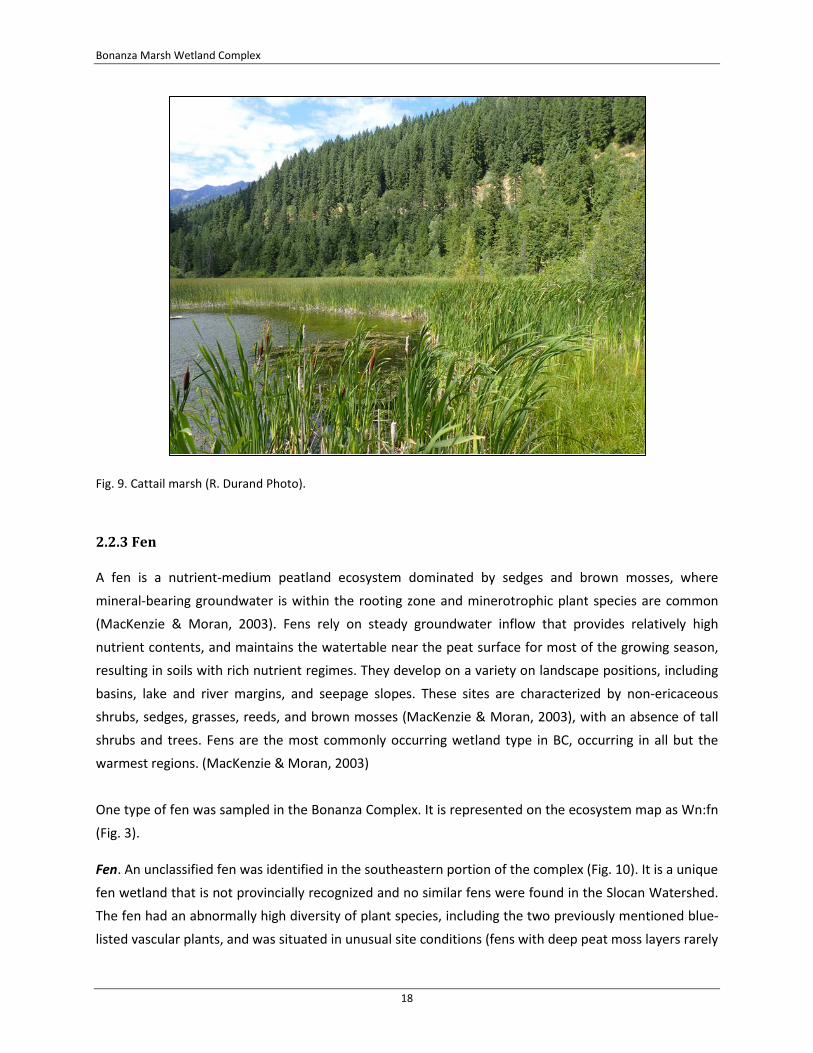
Cattail marsh. The Wm06 (Cattail) marsh occurs as a fringe along disturbed portions of the complex, and as large expanses in mid to deeper water areas (Fig. 9). This ecosystem type is considered to be blue-
listed in most of the province, but is not currently tracked in the Interior Cedar Hemlock subzone in which is occurs (ICH dw1). This type of marsh is regionally uncommon, with only six mapped in the Slocan Watershed to date. It typically occurs in highly modified areas (such as old fields, dug out ponds,
and modified areas).
Bonanza Marsh Wetland Complex
18
Fig. 9. Cattail marsh (R. Durand Photo).
2.2.3 Fen
A fen is a nutrient-medium peatland ecosystem dominated by sedges and brown mosses, where
mineral-bearing groundwater is within the rooting zone and minerotrophic plant species are common (MacKenzie & Moran, 2003). Fens rely on steady groundwater inflow that provides relatively high
nutrient contents, and maintains the watertable near the peat surface for most of the growing season, resulting in soils with rich nutrient regimes. They develop on a variety on landscape positions, including
basins, lake and river margins, and seepage slopes. These sites are characterized by non-ericaceous shrubs, sedges, grasses, reeds, and brown mosses (MacKenzie & Moran, 2003), with an absence of tall
shrubs and trees. Fens are the most commonly occurring wetland type in BC, occurring in all but the warmest regions. (MacKenzie & Moran, 2003)
One type of fen was sampled in the Bonanza Complex. It is represented on the ecosystem map as Wn:fn
(Fig. 3).
Fen. An unclassified fen was identified in the southeastern portion of the complex (Fig. 10). It is a unique
fen wetland that is not provincially recognized and no similar fens were found in the Slocan Watershed. The fen had an abnormally high diversity of plant species, including the two previously mentioned blue-
listed vascular plants, and was situated in unusual site conditions (fens with deep peat moss layers rarely

Bonanza Marsh Wetland Complex
19
occur in direct proximity to deep water marshes). While some of the transitional areas to the south and east of the fen were historically modified (old roads, ditches and logging), and marsh species are
encroaching from the west and north, the fen in in good condition and appeared to be stable.
Fig. 10. Unclassified fen (R. Durand Photo).
3.0 Species at Risk
Incidental species-at-risk were identified in the Bonanza Complex during the SWAMP field work (Fig. 11).
Three species-at-risk were observed (Table 2) including two blue-listed vascular plants and one blue-listed snail. While the two vascular plants are expected to be restricted to the mapped locations (due to
very specific habitat requirements), there is potential for the terrestrial snail to occur throughout the forested areas adjacent to the wetland complex. There is a high potential for other species-at-risk to
occur in the Bonanza Complex based on the size and type of habitat in the area, and the species observed in other similar habitats in the Slocan watershed.
In addition to the species-at-risk, a rare mushroom was also identified in the Bonanza Complex. While fungal species are not currently tracked by the CDC, provincial experts have confirmed that it is a new
species for BC and is considered to be very rare.

Bonanza Marsh Wetland Complex
20
Fig. 11. Map of sample locations and species-at-risk occurrences (imagery supplied by Province of BC).

Bonanza Marsh Wetland Complex
21
Table 2. Species-at-Risk found in the Bonanza Marsh Wetland Complex.
Common Name Scientific Name Status Habitat Vascular Plants giant helleborine Epipactis gigantea Blue Fen in Bonanza Marsh beaked spike-rush Eleocharis rostellata Blue Fen in Bonanza Marsh Molluscs Coeur D’Alene Oregonian Cryptomastix mullani Blue Conifer forests near Bonanza Marsh
3.1 Giant Helleborine
A sizeable population (several hundred individuals) of giant helleborine (Epipactis gigantea) was found
by Tyson Ehlers in the Bonanza Complex in July, 2015 (Fig. 12). The population covered an area of roughly 0.25 hectares with regularly spaced flowering individuals. The population is considered to be
viable and stable with no immediate threats. It is restricted to a fen in the southeast corner of the complex. No other similar habitat is known in the complex, or in the larger watershed, therefore it is expected that this is the only element occurrence of this species. This species is known from several
element occurrences on the Kootenay Lake, the closest of which is over 60km away. There are 34 known occurrences of the species in the province, including many historic records that are likely extirpated (BC
CDC, 2015).
Fig. 12. Giant Helleborine (R. Durand photo).

Bonanza Marsh Wetland Complex
22
3.2 Beaked Spike-Rush
A sizeable population of beaked spike-rush (Eleocharis rostellata) was found by Ryan Durand in the
Bonanza Complex in July, 2015 (Fig. 13). The population covered an area of roughly 0.25 hectares with roughly 50% cover of the species. The population is considered to be viable and stable with no immediate threats. It is restricted to a fen in the southeast corner of the complex. No other similar
habitat (it requires water with elevated salinity and/or calcium) is known in the complex, or in the larger watershed, therefore it is expected that this is the only element occurrence of this species. The Bonanza
occurrence is the 10th known element occurrence of this species in the province (BC CDC, 2015).
Fig. 13. Beaked Spike-Rush (R. Durand photo).
3.3 Coeur D’Alene Oregonian
This terrestrial snail was observed by Ryan Durand in June, 2015 (Fig. 14) in the mature conifer forests to
the immediate west of the Bonanza Complex. A single live adult was found after several minutes of searching the leaf litter. It is assumed that the population is viable based on the location, availability of
connected habitat, and lack of any known threats. Based on snail surveys completed in other areas of the watershed, it is expected to be widespread in the conifer forests in the Bonanza area, and may occur
with another blue-listed terrestrial snail, the Banded Tigersnail (Anguispira kochi). This snail has only been found in the Kootenay and Columbia watersheds in all of Canada, with less than 15 known records.

Bonanza Marsh Wetland Complex
23
It is likely more widespread than current records indicate, as 9 new locations were found in 2015 during SWAMP field work.
Fig. 14. Coeur D’Alene Oregonian (R. Durand photo).
3.4 Cat-tail Mushroom
Cat-tail Mushroom (Psathyrella typhae) is a little brown mushroom that lives on decomposing old fronds of cat-tail (Typha latifolia) and sedges (Carex spp.). It was identified in the Bonanza Complex by Rhia MacKenzie and Tyson Ehlers in June, 2015. It fruits in the spring at the water level. It has been found in
three wetlands in the Slocan valley, Bonanza Marsh and two sites near Winlaw. This is the first record for the species in BC, and it is considered to be a very rare species (pers. comm. Paul Kroeger).

Bonanza Marsh Wetland Complex
24
Fig. 15. Cat-tail Mushroom (T. Ehlers photo).
4.0 Inventory Data
The following list includes over 100 plant species identified in the Bonanza Complex to date. It is a
combination of the 2015 SWAMP field data and an inventory completed by Evan McKenzie, RPBio, for the 2013 BC Wildlife Federation’s BioBlitz in Bonanza Complex.
Herbs
Agrostis stolonifera (Creeping bentgrass)
Anaphalis margaritacea (Pearly everlasting) Athyrium filix-femina (Lady fern)
Berula erecta (Cut-leaved water parsnip) Cardamine breweri var. breweri (Brewer’s bitter-cress) Carex aperta (Columbia sedge)
Carex aquatilis (Water sedge) Carex arcta (Northern clustered sedge)
Carex crawfordii (Crawford's sedge) Carex cusickii (Cusick’s sedge)

Bonanza Marsh Wetland Complex
25
Carex lasiocarpa (slender sedge) Carex retrosa (Long-bracted sedge)
Carex sitchensis? (Sitka sedge) Carex sp. (Sedge)
Carex stipata var. stipata (Awl-fruited sedge) Carex tenuiflora (sparse-flowered sedge)
Carex utriculata (Beaked sedge) Centaurea bieberstienii (Spotted knapweed – Exotic species)
Cirsium arvense var. horridum (Canada thistle – Exotic species) Cirsium vulgare (Bull thistle – Exotic species)
Comarum palustre (Marsh cinquefoil) Drosera anglica (great sundew)
Drosera rotundifolia (round-leaved sundew) Dryopteris expansa (spiny wood fern)
Elodea canadensis (Canadian waterweed) Eleocharis palustris (Common spike-rush) Eleocharis rostellata (beaked spike-rush)
Equisetum arvense (Common horsetail) Equisetum fluviatile (Swamp horsetail)
Equisetum hyemale (Scouring-rush) Equisetum palustre (Marsh horsetail)
Galium palustre (Marsh bedstraw) Galium trifidum (Small bedstraw)
Galium triflorum (Sweet-scented bedstraw) Geum macrophyllum (Large-leaved avens)
Geum triflorum (Old man’s whiskers) Glyceria elata (Tall mannagrass)
Glyceria striata (Fowl mannagrass) Hieracium sp. (Hawkweed – Exotic species)
Hippuris vulgaris (Common mare’s-tail) Juncus ensifolius (Dagger-leaf rush) Juncus nodosus (tuberous rush)
Juncus tenuis (Slender rush) Juncus sp. (Rush)
Lemna minor (Common duckweed) Leucanthemum vulgare (Oxeye daisy – Exotic species)
Lobelia kalmia (Kalm's lobelia)

Bonanza Marsh Wetland Complex
26
Lysichiton americanus (Skunk cabbage) Medicago lupulina (Black medic – Exotic species)
Mentha arvensis (Field mint) Menyanthes trifoliata (buckbean)
Mimulus guttatus (yellow monkey-flower) Myosotis laxa (Small-flowered forget-me-not)
Myriophyllum sibiricum (Siberian water-milfoil) Packera paupercula (Canadian butterweed)
Parnassia fimbriata (fringed grass-of-Parnassus) Persicaria amphibian (Water smartweed)
Perasites sagitattus (Arrow-leaved coltsfoot) Phalaris arundinacea (Reed canary grass – Exotic species)
Plantago lanceolata (Ribwort plantain – Exotic species) Platanthera dilatata (Fragrant white rein-orchid)
Poa palustris (Fowl bluegrass) Poa pratensis (Kentucky bluegrass) Prunella vulgaris ssp. lanceolata (Self-heal)
Ranunculus acris (Meadow buttercup – Exotic species) Ranunculus gmelinii (Small yellow water-buttercup)
Rhizomnium sp. (Leafy moss) Rumex acetosella (Sheep sorrell – Exotic species)
Rumex crispus (Curled dock – Exotic species) Scirpus microcarpus (Small-flowered bulrush)
Schoenoplectus sp. (Bulrush) Solidago canadensis (Canada goldenrod)
Sparganium emersum (Emersed bur-reed) Spiranthes romanzoffiana (Hooded ladies' tresses)
Stellaria longifolia (Long-leaved starwort ) Stuckenia sp. (Pondweed)
Symphyotrichum subspicatum (Douglas' aster) Triflorum sp. (Clover – Exotic species) Typha latifolia (Common cattail)
Utricularia macrohiza (Greater bladderwort) Veronica beccabunga (American speedwell)
Viola spp. (Violets)

Bonanza Marsh Wetland Complex
27
Shrubs
Acer douglasii (Douglas maple) Alnus incana ssp. tenuifolia (Mountain alder)
Amelanchier alnifolia (Saskatoon) Comus stolonifera (Red-osier dogwood)
Crataegus douglasii (Black hawthorn) Lonicera involucrata (Black twinberry)
Rosa nutkana var. hispida (Nootka rose) Rubus idaeus (Red raspberry)
Rubus pubescens (trailing raspberry) Salix sitchensis (Sitka willow)
Sorbus sitchensis (mountain ash) Symphoricarpos albus (Common snowberry)
Vaccinium myrtilloides (velvet-leaved blueberry) Vaccinium oxycoccos (bog cranberry) Vibernum edule (Highbush-cranberry)
Trees
Beulta papyrifera (paper birch)
Populus balsamifera (black cottonwood) Thuja plicata (western red-cedar)
Tsuga heterophylla (western hemlock)
Mosses
Brachythecium sp. (Ragged-moss) Climacium dendroides (Tree-moss)
Drepanocladus sp. (hook-moss) Sphagnum spp. (peat-moss)
Algae
Chara sp. (stonewort)

Bonanza Marsh Wetland Complex
28
5.0 Conservation Evaluation
The Bonanza Marsh Wetland Complex is an ecologically significant feature in the Slocan Watershed.
Situated at the confluence of Bonanza Creek and Slocan Lake, it provides unique habitat and hydrological processes to support six uncommon wetland types (e.g. Western redcedar – spruce – skunk cabbage swamp; Sitka willow – Sitka sedge swamp; Bulrush marsh; Cusick’s sedge marsh; Cattail marsh;
and a unique fen) and three species-at-risk (per Section 3.0). The juxtaposition of such diverse and uncommon wetland types is in itself a rare and notable occurrence in the West Kootenays.
The Bonanza Complex is also important because it is the only sizable wetland on Slocan Lake, and is one
of the most intact large wetlands in the entire Slocan Watershed. The Bonanza Complex is also uncommon in that as a valley bottom wetland it is dominated by native species and naturally
functioning; whereas the vast majority of large valley bottom wetlands south of Slocan Lake have been extensively modified, or are highly impacted by invasive species. In comparison to other large wetland
complexes in the Slocan Watershed (e.g. Little Slocan Lakes, Beaver Lake, Seaton Creek, and unnamed complexes above Pass Creek and Silverton Creek), the Bonanza Complex is the only one that occurs
entirely on private property.
In summary, the Bonanza Complex provides an important opportunity for conservation of private land. Purchase by a land trust or local government of the parcels that make up the Bonanza Complex would result in the protection of an ecologically significant area of the Slocan Watershed. It would protect high
value wetland types that are uncommon or unique in the Slocan Watershed, and the outlet of Bonanza Creek. It would also protect two blue-listed vascular plants that are very unlikely to occur anywhere else
in the West Kootenays, as well as a blue-listed snail and one of only three known locations in the province for the cat-tail mushroom. It is expected that additional inventory work in this wetland
complex will result in the identification of more species-at-risk.

Bonanza Marsh Wetland Complex
29
6.0 References
Conservation Data Centre. 2015. Accessed October 17, 2015. URL: http://www.env.gov.bc.ca/cdc
Durand, R. 2013. Slocan River Sensitive Ecosystems Inventory Mapping. Prepared for the Slocan River Streamkeepers.
Kroeger, Paul. 2015. Personal Communications.
MacKenzie, W. and J. Moran. 2004. Wetlands of British Columbia; A guide to identification. BC Ministry
of Forests. Land Management Handbook No. 52.
RISC. 2006. Standard for Mapping Ecosystems at Risk in British Columbia. Prepared by the BC Ministry of Environment. URL:
http://www.for.gov.bc.ca/hts/risc/pubs/teecolo/habitat/assets/standards_for_mapping_ear_version1.pdf
Stacey, Jo-Anne. 2015. Personal Communications. BC Conservation Data Centre.