Embed Size (px)
Citation preview

www.esa.intwww.esa.int esa bulletin 128 - november 2006esa bulletin 128 - november 2006 9392
In Brief
In Brief
SMART-1: Crash Scene Investigation
Measurements from ESA’s Envisatsatellite have revealed a recordloss of ozone over Antarctica: the40 million tonnes by 2 October2006 exceeded the previousrecord of about 39 Mt in 2000.The size of this year’s ozone holeis 28 million km2, nearly as largeas the record hole of 2000; itsdepth rivals 1998’s record low.
“Such significant ozone lossrequires very low temperatures inthe stratosphere combined withsunlight. This year’s extreme losscan be explained by thetemperatures above Antarcticareaching the lowest recordedsince 1979,” said ESAatmospheric engineer ClausZehner. The ozone layer, foundabout 25 km above us, shields lifeon Earth from the Sun’s harmfulultraviolet rays. Over the lastdecade, the ozone has thinned byabout 0.3% per year globally,increasing the risk of skin cancer,cataracts and harm to marine life.The reduction is caused bypollutants such as man-madechlorofluorocarbons, which havestill not vanished despite beingbanned under the MontrealProtocol of 1987. A singlemolecule of chlorine can breakdown thousands of molecules ofozone.
The ozone hole, first recognisedin 1985, typically persists untilNovember or December, whenthe weakening polar vortex windsallow in ozone-rich air. ESA is backing the TroposphericEmission Monitoring InternetService (TEMIS) to provideoperational ozone and UVradiation monitoring based onEnvisat SCIAMACHY and ERS-2GOME-1 data. The ozone datafrom these instruments, spanning11 years, will be extended by theMetOp satellite series and itsnext-generation GOME-2 foryears to come.
“Long-term measurements ofozone levels are of keyimportance for being able tomonitor the ozone’s predictedrecovery, which is currentlyestimated to take place by around2060,” Zehner said. e
Envisat Finds Record Ozone Hole
structure and mineralcomposition of the surface invisible, infrared and X-ray.
Professional and amateurobservers from South Africa, theCanary Islands, South America,the continental USA, Hawaii andmany other locations werewatching, hoping to spot the faintflash for information about theimpact dynamics and the lunarsurface excavated by thespacecraft.
The final days of SMART-1 sawintense activity as controllersshepherded it towards its destiny.Based on estimates that includedlocal topography, impact was dueduring orbit 2890, at 05:41 UTsomewhere at mid-southernlatitudes on the near-side. Then,with only a few days to go, thedata suggested that, in theabsence of any furthermanoeuvres, impact would verylikely occur one orbit earlier, at00:38 UT during orbit 2889, ifSMART-1 clipped the 1600 m-high rim of Clausius crater.
During the night of1–2 September, ESOC controllersplanned to use the thrusters to
Early on 3 September, observersaround the world saw a smallflash illuminate the surface of theMoon. They had witnessed thefinal moments of ESA’s tinySMART-1 spacecraft as itimpacted the lunar soil.
SMART-1 scientists andengineers at the European SpaceOperations Centre (ESOC), inDarmstadt (D), confirmed theimpact at 05:42:22 UT, when theNew Norcia ground station inAustralia suddenly lost radiocontact. SMART-1 ended itsremarkable journey in the Lake ofExcellence, at 34.4ºS/46.2ºW.
The 2 km/s impact occurred in adark area near the terminator (theday-night line) at a grazing angleof 5–10º. The time and locationwere planned via a series ofcorrections during the summer– the last on 1 September – tofavour observations bytelescopes on Earth.
The impact concluded aspectacularly successful missionthat, in addition to testinginnovative space technology, hadbeen exploring the Moon for16 months, gathering data on the
News
boost the perilune of thepenultimate orbit, whilemaintaining the intended impacttime and location. Suddenly, toadd to the tension, SMART-1unexpectedly placed itself into‘safe mode’, at 13:09 UT on1 September with themanoeuvres pending. Mostspacecraft functions and payloadoperations were suspended.
After a tense 6 hours, SpacecraftOperations Manager OctavioCamino happily reported fullrecovery at 17:15 UT. Themanoeuvres were successful,boosting perilune by 592 m andshifting impact to 05:42 UT.
The impact took place on orbit2890. SMART-1 sent its lastsignals at 05:42:21:759 UT, andthe Mount Pleasant Observatoryradio telescope of the Universityof Tasmania in Hobart, lost thesignal at 05:42:22.394 UT. Thesetimes are remarkable agreementwith the final predictions and thecoordinates derived from theposition of the infrared impactflash observed by the Canada-France-Hawaii Telescope (CFHT)on Hawaii.
“From the various observationsand models, we are trying to
reconstruct the ‘movie’ of whathappened to the spacecraft andthe Moon’s surface. For this lunar‘Crash Scene Investigation’, weneed all possible Earth witnessesand observational facts,” saidBernard Foing, SMART-1 ProjectScientist.
Extensive data processing is nowunder way to define the site’stopography. From a preliminaryanalysis of the stereo data andearlier maps built with SMART-1data, it should have hit the Moonon the ascending slope of amountain about 1.5 km high,above the Lake of Excellenceplain.
In the CFHT infrared movie, acloud of ejected material anddebris was seen moving about80 km in 130 sec by ChristianVeillet, Principal Investigator forthe observations at CFHT. Todetermine which part of the flashcame from heated lunar rock orfrom the probe’s remainingpropellant, it was important toobtain measurements in severaloptical and infrared wavelengths,in addition to the CFHTobservations at 2.12 micron.
“Our decision to extend thescientific mission by a further
year (it was initially planned tolast only 6 months) allowedscientists to use a number ofinnovative observing methods atthe Moon. This was tough workfor the mission planners, but thelunar data archive we are nowbuilding is truly impressive,” saidGerhard Schwehm, SMART-1Mission Manager.
“For ESA’s Science Programme,SMART-1 represents a greatsuccess and a very good returnon investment, both from thetechnological and the scientificpoint of view. Future scientificmissions will greatly benefit fromthe technological and operationalexperience gained thanks to thissmall spacecraft, while thescientific data gathered bySMART-1 are already helping toupdate our current picture of theMoon,” said David Southwood,Director of ScientificProgrammes.
“The legacy left by the hugewealth of SMART-1 data, to beanalysed in the months and yearsto come, is a preciouscontribution to lunar science at atime when the exploration of theMoon is once again catching theworld’s interest,” said BernardFoing. e
Infrared images from the Canada-France-Hawaii Telescope show the flash (firstframe) and the dust cloud that followed the SMART-1 impact
The ozone hole of 27 September as measured byEnvisat’s SCIAMACHY instrument (KNMI/TEMIS)
Space Colloquium
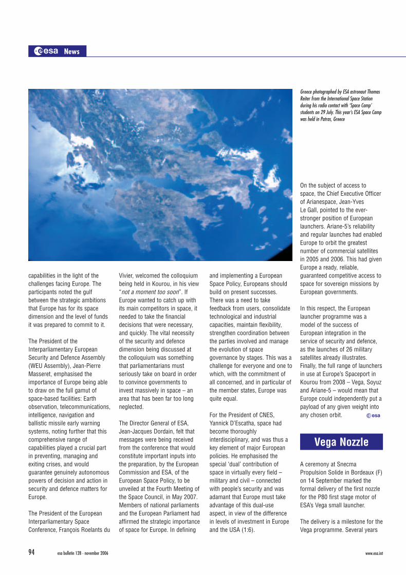
During 19–22 September, theWestern European Union (WEU)Assembly and the EuropeanInterparliamentary SpaceConference joined forces to holda colloquium on ‘Space, Defenceand European Security’ in Kourou,French Guiana, in associationwith ESA, CNES and Arianespace.
The event brought together morethan 100 Members of Parliamentfrom European nations along withMembers of the EuropeanParliament and senior executivesfrom ESA, CNES, Arianespaceand the space industry. The mainaim of the discussions was toexamine the space sector in itsapplication to security anddefence and assess industrial
InBriefB128 11/9/06 3:37 PM Page 92

www.esa.intwww.esa.int esa bulletin 128 - november 2006esa bulletin 128 - november 2006 9392
In Brief
In Brief
SMART-1: Crash Scene Investigation
Measurements from ESA’s Envisatsatellite have revealed a recordloss of ozone over Antarctica: the40 million tonnes by 2 October2006 exceeded the previousrecord of about 39 Mt in 2000.The size of this year’s ozone holeis 28 million km2, nearly as largeas the record hole of 2000; itsdepth rivals 1998’s record low.
“Such significant ozone lossrequires very low temperatures inthe stratosphere combined withsunlight. This year’s extreme losscan be explained by thetemperatures above Antarcticareaching the lowest recordedsince 1979,” said ESAatmospheric engineer ClausZehner. The ozone layer, foundabout 25 km above us, shields lifeon Earth from the Sun’s harmfulultraviolet rays. Over the lastdecade, the ozone has thinned byabout 0.3% per year globally,increasing the risk of skin cancer,cataracts and harm to marine life.The reduction is caused bypollutants such as man-madechlorofluorocarbons, which havestill not vanished despite beingbanned under the MontrealProtocol of 1987. A singlemolecule of chlorine can breakdown thousands of molecules ofozone.
The ozone hole, first recognisedin 1985, typically persists untilNovember or December, whenthe weakening polar vortex windsallow in ozone-rich air. ESA is backing the TroposphericEmission Monitoring InternetService (TEMIS) to provideoperational ozone and UVradiation monitoring based onEnvisat SCIAMACHY and ERS-2GOME-1 data. The ozone datafrom these instruments, spanning11 years, will be extended by theMetOp satellite series and itsnext-generation GOME-2 foryears to come.
“Long-term measurements ofozone levels are of keyimportance for being able tomonitor the ozone’s predictedrecovery, which is currentlyestimated to take place by around2060,” Zehner said. e
Envisat Finds Record Ozone Hole
structure and mineralcomposition of the surface invisible, infrared and X-ray.
Professional and amateurobservers from South Africa, theCanary Islands, South America,the continental USA, Hawaii andmany other locations werewatching, hoping to spot the faintflash for information about theimpact dynamics and the lunarsurface excavated by thespacecraft.
The final days of SMART-1 sawintense activity as controllersshepherded it towards its destiny.Based on estimates that includedlocal topography, impact was dueduring orbit 2890, at 05:41 UTsomewhere at mid-southernlatitudes on the near-side. Then,with only a few days to go, thedata suggested that, in theabsence of any furthermanoeuvres, impact would verylikely occur one orbit earlier, at00:38 UT during orbit 2889, ifSMART-1 clipped the 1600 m-high rim of Clausius crater.
During the night of1–2 September, ESOC controllersplanned to use the thrusters to
Early on 3 September, observersaround the world saw a smallflash illuminate the surface of theMoon. They had witnessed thefinal moments of ESA’s tinySMART-1 spacecraft as itimpacted the lunar soil.
SMART-1 scientists andengineers at the European SpaceOperations Centre (ESOC), inDarmstadt (D), confirmed theimpact at 05:42:22 UT, when theNew Norcia ground station inAustralia suddenly lost radiocontact. SMART-1 ended itsremarkable journey in the Lake ofExcellence, at 34.4ºS/46.2ºW.
The 2 km/s impact occurred in adark area near the terminator (theday-night line) at a grazing angleof 5–10º. The time and locationwere planned via a series ofcorrections during the summer– the last on 1 September – tofavour observations bytelescopes on Earth.
The impact concluded aspectacularly successful missionthat, in addition to testinginnovative space technology, hadbeen exploring the Moon for16 months, gathering data on the
News
boost the perilune of thepenultimate orbit, whilemaintaining the intended impacttime and location. Suddenly, toadd to the tension, SMART-1unexpectedly placed itself into‘safe mode’, at 13:09 UT on1 September with themanoeuvres pending. Mostspacecraft functions and payloadoperations were suspended.
After a tense 6 hours, SpacecraftOperations Manager OctavioCamino happily reported fullrecovery at 17:15 UT. Themanoeuvres were successful,boosting perilune by 592 m andshifting impact to 05:42 UT.
The impact took place on orbit2890. SMART-1 sent its lastsignals at 05:42:21:759 UT, andthe Mount Pleasant Observatoryradio telescope of the Universityof Tasmania in Hobart, lost thesignal at 05:42:22.394 UT. Thesetimes are remarkable agreementwith the final predictions and thecoordinates derived from theposition of the infrared impactflash observed by the Canada-France-Hawaii Telescope (CFHT)on Hawaii.
“From the various observationsand models, we are trying to
reconstruct the ‘movie’ of whathappened to the spacecraft andthe Moon’s surface. For this lunar‘Crash Scene Investigation’, weneed all possible Earth witnessesand observational facts,” saidBernard Foing, SMART-1 ProjectScientist.
Extensive data processing is nowunder way to define the site’stopography. From a preliminaryanalysis of the stereo data andearlier maps built with SMART-1data, it should have hit the Moonon the ascending slope of amountain about 1.5 km high,above the Lake of Excellenceplain.
In the CFHT infrared movie, acloud of ejected material anddebris was seen moving about80 km in 130 sec by ChristianVeillet, Principal Investigator forthe observations at CFHT. Todetermine which part of the flashcame from heated lunar rock orfrom the probe’s remainingpropellant, it was important toobtain measurements in severaloptical and infrared wavelengths,in addition to the CFHTobservations at 2.12 micron.
“Our decision to extend thescientific mission by a further
year (it was initially planned tolast only 6 months) allowedscientists to use a number ofinnovative observing methods atthe Moon. This was tough workfor the mission planners, but thelunar data archive we are nowbuilding is truly impressive,” saidGerhard Schwehm, SMART-1Mission Manager.
“For ESA’s Science Programme,SMART-1 represents a greatsuccess and a very good returnon investment, both from thetechnological and the scientificpoint of view. Future scientificmissions will greatly benefit fromthe technological and operationalexperience gained thanks to thissmall spacecraft, while thescientific data gathered bySMART-1 are already helping toupdate our current picture of theMoon,” said David Southwood,Director of ScientificProgrammes.
“The legacy left by the hugewealth of SMART-1 data, to beanalysed in the months and yearsto come, is a preciouscontribution to lunar science at atime when the exploration of theMoon is once again catching theworld’s interest,” said BernardFoing. e
Infrared images from the Canada-France-Hawaii Telescope show the flash (firstframe) and the dust cloud that followed the SMART-1 impact
The ozone hole of 27 September as measured byEnvisat’s SCIAMACHY instrument (KNMI/TEMIS)
Space Colloquium
During 19–22 September, theWestern European Union (WEU)Assembly and the EuropeanInterparliamentary SpaceConference joined forces to holda colloquium on ‘Space, Defenceand European Security’ in Kourou,French Guiana, in associationwith ESA, CNES and Arianespace.
The event brought together morethan 100 Members of Parliamentfrom European nations along withMembers of the EuropeanParliament and senior executivesfrom ESA, CNES, Arianespaceand the space industry. The mainaim of the discussions was toexamine the space sector in itsapplication to security anddefence and assess industrial
InBriefB128 11/9/06 3:37 PM Page 92
www.esa.intwww.esa.int esa bulletin 128 - november 2006esa bulletin 128 - november 2006 9594
News In Brief
– provide an infrastructure toallow satellite data to bequickly and efficiently exploitedfor research and applications;
– provide a unique contributionto global Earth observationcapabilities, complementingsatellites operated by otheragencies and in situ observingsystems;
– provide an efficient and cost-effective process for sciencepriorities to be rapidlytranslated into space missions,adequately resourced withassociated ground support;
– support the development ofinnovative approaches toinstrumentation. e
The Minor PlanetCenter at theSmithsonianAstrophysicalObservatory(Harvard, USA),under the auspices of theInternational Astronomical Union,has designated minor planetnumber 10969 as ‘Perryman’,named for Michael Perryman ofESA’s Science directorate.Previously project scientist of theHipparcos and Gaia missions,and professor at LeidenUniversity, Michael Perryman wascited for his leadership in thedevelopment of space astronomy.The minor planet was discoveredin May 1971 by C.J. van Houtenand I. van Houten-Groeneveld onPalomar Schmidt telescope platestaken by T. Gehrels. e
Asteroid Honour
It is with regretthat ESA notesthe death ofMichel Bignier,on 12 October.A leading figurein the space world and DirectorGeneral of CNES 1972–1976, hewas Director of ESA’s Spacelabprogramme 1976–1980, andthen Director of Space TransportSystems until 1986. “He hasbeen one of the main players inthe long struggle to adopt abalanced European SpaceProgramme,” said ESA DirectorGeneral Jean-Jacques Dordain,echoing the deep regret of allthose at ESA who had theopportunity to know Bignier andappreciate his work andcommitment to a true Europeanspace policy. e
Leader Passes
capabilities in the light of thechallenges facing Europe. Theparticipants noted the gulfbetween the strategic ambitionsthat Europe has for its spacedimension and the level of fundsit was prepared to commit to it.
The President of theInterparliamentary EuropeanSecurity and Defence Assembly(WEU Assembly), Jean-PierreMasseret, emphasised theimportance of Europe being ableto draw on the full gamut ofspace-based facilities: Earthobservation, telecommunications,intelligence, navigation andballistic missile early warningsystems, noting further that thiscomprehensive range ofcapabilities played a crucial partin preventing, managing andexiting crises, and wouldguarantee genuinely autonomouspowers of decision and action insecurity and defence matters forEurope.
The President of the EuropeanInterparliamentary SpaceConference, François Roelants du
Vivier, welcomed the colloquiumbeing held in Kourou, in his view“not a moment too soon”. IfEurope wanted to catch up withits main competitors in space, itneeded to take the financialdecisions that were necessary,and quickly. The vital necessityof the security and defencedimension being discussed atthe colloquium was somethingthat parliamentarians mustseriously take on board in orderto convince governments toinvest massively in space – anarea that has been far too longneglected.
The Director General of ESA,Jean-Jacques Dordain, felt thatmessages were being receivedfrom the conference that wouldconstitute important inputs intothe preparation, by the EuropeanCommission and ESA, of theEuropean Space Policy, to beunveiled at the Fourth Meeting ofthe Space Council, in May 2007.Members of national parliamentsand the European Parliament hadaffirmed the strategic importanceof space for Europe. In defining
and implementing a EuropeanSpace Policy, Europeans shouldbuild on present successes.There was a need to takefeedback from users, consolidatetechnological and industrialcapacities, maintain flexibility,strengthen coordination betweenthe parties involved and managethe evolution of spacegovernance by stages. This was achallenge for everyone and one towhich, with the commitment ofall concerned, and in particular ofthe member states, Europe wasquite equal.
For the President of CNES,Yannick D’Escatha, space hadbecome thoroughlyinterdisciplinary, and was thus akey element of major Europeanpolicies. He emphasised thespecial ‘dual’ contribution ofspace in virtually every field –military and civil – connectedwith people’s security and wasadamant that Europe must takeadvantage of this dual-useaspect, in view of the differencein levels of investment in Europeand the USA (1:6).
Greece photographed by ESA astronaut ThomasReiter from the International Space Stationduring his radio contact with ‘Space Camp’students on 29 July. This year’s ESA Space Campwas held in Patras, Greece
On the subject of access tospace, the Chief Executive Officerof Arianespace, Jean-YvesLe Gall, pointed to the ever-stronger position of Europeanlaunchers. Ariane-5’s reliabilityand regular launches had enabledEurope to orbit the greatestnumber of commercial satellitesin 2005 and 2006. This had givenEurope a ready, reliable,guaranteed competitive access tospace for sovereign missions byEuropean governments.
In this respect, the Europeanlauncher programme was amodel of the success ofEuropean integration in theservice of security and defence,as the launches of 26 militarysatellites already illustrates.Finally, the full range of launchersin use at Europe’s Spaceport inKourou from 2008 – Vega, Soyuzand Ariane-5 – would mean thatEurope could independently put apayload of any given weight intoany chosen orbit. e
Vega Nozzle
A ceremony at SnecmaPropulsion Solide in Bordeaux (F)on 14 September marked theformal delivery of the first nozzlefor the P80 first stage motor ofESA’s Vega small launcher.
The delivery is a milestone for theVega programme. Several years
of intensive development haveachieved a major step forward inreducing costs. Not only a majorevent for Vega, it also bodes wellfor future updates to the Ariane-5boosters.
Now in Kourou, the nozzle isbeing integrated with the P80motor for the first firing test,planned for end-November.Vega’s maiden flight is plannedfor late 2007. e
New Goals for Earth Science
ESA announced in September anew science strategy for thefuture direction of its LivingPlanet Programme, addressingthe continuing need to further ourunderstanding of the EarthSystem and the impact thathuman activity is having.
The Changing Earth: NewScientific Challenges for ESA'sLiving Planet Programme focuseson the most fundamentalchallenge facing humanity at thebeginning of the 21st century:global change. A betterknowledge of the Earth Systemand the impact of increasinghuman activity is of crucialimportance in providing the basisfor managing a sustainableenvironment.
The new strategy aims to assessthe most important Earth-sciencequestions to be addressed in theyears to come. It outlines theobservational challenges thatthese raise, and the contributionthat the Agency can make.Underpinning the strategy is a setof ambitious objectives,including:– launch a steady flow of
missions addressing keyissues in Earth science;
The Changing Earth (SP-1304; €20, 83pp) can beordered using the form at the back of this issue
MetOp-A in Orbit!
MetOp-A, the first of threemeteorological satellitesdeveloped jointly by ESA andEumetsat, was successfullylaunched from BaikonurCosmodrome, Kazakhstan at16:28:13 UT on 19 Octoberaboard a Russian Soyuz-2/Fregatrocket. Some 69 minutes later,the Fregat upper stage releasedthe 4093 kg MetOp over theKerguelen archipelago in theSouth Indian Ocean into a circularorbit at an altitude of 837 km.
With a slightly retrograde 98.7ºinclination, this orbit enablesMetOp-A to circle the globe frompole to pole while alwayscrossing the equator at the samelocal time – 9:30 am. This Sun-synchronous orbit allows revisitsto almost each point of the
Earth’s surface under similarillumination conditions almost ona daily basis. MetOp will providea closer view of the atmospherefrom low orbit, delivering datathat will improve global weatherprediction and enhance ourunderstanding of climate change.
Following release, the satellitecame under the control of ESA’sEuropean Space OperationsCentre (ESOC) in Darmstadt,Germany, and automaticallydeployed its solar array. It thenunderwent the first checkouts ofits systems and deployed itsantennas. Handover to Eumetsatwas on 22 October for fullsatellite commissioning androutine operations. Bulletin 127(August 2006) includes detailedarticles on MetOp. e
InBriefB128 11/9/06 3:37 PM Page 94

These spectacular images of the Cydonia region of the RedPlanet were captured by the High Resolution Stereo Cameraof Mars Express. Obtained on 22 July and released inSeptember, they include the famous ‘face’ on Mars inunprecedented detail (inset and arrowed).
Cydonia sits in the transition zone between the planet’ssouthern highlands and the northern plains, a regioncharacterised by wide, debris-filled valleys and isolatedremnant mounds of various shapes and sizes. One of thesemassifs became famous as the ‘Face on Mars’ in an imagetaken in 1976 by NASA’s Viking-1 orbiter. It was an illusioncaused by the angle of the Sun and the shadows giving theimpression of eyes, nose and mouth. Other formations seenhere in the top left quadrant resembled ‘pyramids’. While thefeatures are not artificial, they are nevertheless of greatinterest to planetary geologists. Image resolution is about13.7 m per pixel. (ESA/DLR/FU Berlin; G. Neukum) 10 km N
esa bulletin 128 - november 2006 97www.esa.intwww.esa.intesa bulletin 128 - november 200696
News In Brief
InBriefB128 11/9/06 3:38 PM Page 96
The current configuration of the International Space Station, after asecond pair of 73 m-long solar wings (in shadow) was attached inSeptember by Shuttle mission STS-115. The new wings will doublethe Station’s power when they are brought online during the nextShuttle flight, STS-116, planned for launch in December. Part of thejob will be done by ESA astronaut Christer Fuglesang during his twospacewalks on that mission. STS-116 will also return ESA astronaut
Thomas Reiter, who has been working aboard the Station since 6 July,to Earth. Next year will be a busy time for ESA and its astronauts atthe Station: Paolo Nespoli will accompany Node-2 aboard STS-120 inAugust, Hans Schlegel is scheduled to fly with the Columbus moduleon STS-122 in October, and the Agency’s Automated Transfer Vehicle(ATV) will begin its delivery service some time during May–Julyfollowing launch by Ariane-5 from Kourou.
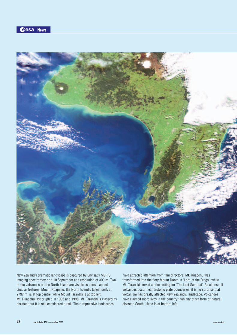
New Zealand’s dramatic landscape is captured by Envisat’s MERISimaging spectrometer on 10 September at a resolution of 300 m. Twoof the volcanoes on the North Island are visible as snow-cappedcircular features. Mount Ruapehu, the North Island’s tallest peak at2797 m, is at top centre, while Mount Taranaki is at top left.Mt. Ruapehu last erupted in 1995 and 1996; Mt. Taranaki is classed asdormant but it is still considered a risk. Their impressive landscapes
have attracted attention from film directors: Mt. Ruapehu wastransformed into the fiery Mount Doom in ‘Lord of the Rings’, whileMt. Taranaki served as the setting for ‘The Last Samurai’. As almost allvolcanoes occur near tectonic plate boundaries, it is no surprise thatvolcanism has greatly affected New Zealand’s landscape. Volcanoeshave claimed more lives in the country than any other form of naturaldisaster. South Island is at bottom left.
News In Brief
www.esa.intwww.esa.int esa bulletin 128 - november 2006esa bulletin 128 - november 2006 9998
InBriefB128 11/9/06 3:38 PM Page 98

The current configuration of the International Space Station, after asecond pair of 73 m-long solar wings (in shadow) was attached inSeptember by Shuttle mission STS-115. The new wings will doublethe Station’s power when they are brought online during the nextShuttle flight, STS-116, planned for launch in December. Part of thejob will be done by ESA astronaut Christer Fuglesang during his twospacewalks on that mission. STS-116 will also return ESA astronaut
Thomas Reiter, who has been working aboard the Station since 6 July,to Earth. Next year will be a busy time for ESA and its astronauts atthe Station: Paolo Nespoli will accompany Node-2 aboard STS-120 inAugust, Hans Schlegel is scheduled to fly with the Columbus moduleon STS-122 in October, and the Agency’s Automated Transfer Vehicle(ATV) will begin its delivery service some time during May–Julyfollowing launch by Ariane-5 from Kourou.
New Zealand’s dramatic landscape is captured by Envisat’s MERISimaging spectrometer on 10 September at a resolution of 300 m. Twoof the volcanoes on the North Island are visible as snow-cappedcircular features. Mount Ruapehu, the North Island’s tallest peak at2797 m, is at top centre, while Mount Taranaki is at top left.Mt. Ruapehu last erupted in 1995 and 1996; Mt. Taranaki is classed asdormant but it is still considered a risk. Their impressive landscapes
have attracted attention from film directors: Mt. Ruapehu wastransformed into the fiery Mount Doom in ‘Lord of the Rings’, whileMt. Taranaki served as the setting for ‘The Last Samurai’. As almost allvolcanoes occur near tectonic plate boundaries, it is no surprise thatvolcanism has greatly affected New Zealand’s landscape. Volcanoeshave claimed more lives in the country than any other form of naturaldisaster. South Island is at bottom left.
News In Brief
www.esa.intwww.esa.int esa bulletin 128 - november 2006esa bulletin 128 - november 2006 9998
InBriefB128 11/9/06 3:38 PM Page 98

The fourth Ariane-5 success of the year. On 13 October, flight V173from Kourou, French Guiana, delivered two commercialtelecommunications satellites safely into geostationary transfer orbit.DirectTV-9S will broadcast TV services to the USA, while Optus-D1will provide communications and TV services over Australia and NewZealand. The mission also carried Japan’s LDREX-2 to demonstratethe deployment of a lightweight antenna planned for the ETS-8
engineering test satellite. The fifth and final Ariane-5 launch of the yearis planned for December. As with the others in 2006, it will use the‘ECA’ version to carry two main passengers: the AMC-18 TV-distribution satellite for SES Americom, and WildBlue-1 to handle Ka-band Internet traffic. Ariane-5 ECA, with its large cryogenic upperstage, is the most powerful of the world’s commercial launchers. (ESA-CNES-Arianespace/Photo Optique Video CSG)
A new Hubble image of the ‘Antennae’ galaxies is the sharpest yet ofthis merging pair of spiral galaxies. As they smash together, thousandof millions of stars are born, mostly in groups and clusters. Thegalaxies started to fuse about 500 million years ago, making them thenearest and youngest example of a pair of colliding galaxies. Nearlyhalf of the faint objects are young clusters containing tens ofthousands of stars. The orange blobs to the left and right of centre are
the two cores of the original galaxies, and consist mainly of old starscriss-crossed by filaments of dust. The two galaxies are dotted withbrilliant blue star-forming regions surrounded by pink hydrogen gas.Only about 10% of the new super star clusters will live to see their tenmillionth birthday – most will disperse into individual stars but about100 of the largest will survive to become globular clusters as we seein our Galaxy today. (NASA/ESA/B. Whitmore, STScI)
News In Brief
esa bulletin 128 - november 2006100 www.esa.int esa bulletin 128 - november 2006 101www.esa.int
InBriefB128 11/9/06 3:38 PM Page 100