Embed Size (px)
Citation preview
Smart Growth and Transit Oriented Development Does it Exist in Georgia?
Tashieka Tucker, Jeremy Wilhelm, Chad Wingate, Joe Winters, and Luke Wilkinson
GROWTH MANAGEMENT LAW
April 21, 2008 Prepared for Dr. Julian Jurgensmeyer and Dan Reuter
Chapter 1
Wilhelm 1
Table of Contents
SMART GROWTH DEFINED by Jeremy Wilhelm 1
TRANSIT ORIENTED DEVELOPMENT by Joe Winters 2
LEGAL ANALYSIS by Chad Wingate 3
CURRENT CASES by Tashieka Tucker 4
POTENTIAL DEVELOPMENT by Luke Wilkinson 5

Chapter 1
Wilhelm 2
Smart Growth and Transit Oriented Development: Does it exist in Georgia?
One might look at the state of the sprawling suburbs of the Atlanta region and emphatically
conclude that Smart Growth is nowhere to be found in Georgia. It is certainly not
immediately evident. However, a scratch below the surface reveals that there are indeed a
good number of initiatives and efforts underway to both promote and create smarter
growth in our region. While these initiatives are imperfect, they are certainly steps in the
right direction. We shall endeavor to inform you about the various organizations and
developments currently incorporating Smart Growth principles, as well as providing our
opinions about how the efforts might be more effective through changes in zoning, a focus
on Transit Oriented developments, and through region-wide initiatives.
Background: What is Smart Growth?
The term has become ubiquitous in planning discussion over the last decade and a half, yet
there seems to be only a hazy understanding of what exactly Smart Growth is. A natural
first reaction might be to say: Not dumb growth. It’s clearly more complex than that. In
fact, the Smart Growth Network has defined ten principles that provide a framework for
how development and growth can be executed in a superior way to the status quo.1
These principles are:
1. Mix Land Uses – This is viewed as a vital component in the creation of vital, sustainable
communities where transit options beyond the automobile are possible due to the
proximity of a variety of day-to-day living needs.
1 Retrieved from http://www.smartgrowth.org/library/prinlist.asp?res=1280 on April 18, 2008.
Chapter 1
Wilhelm 3
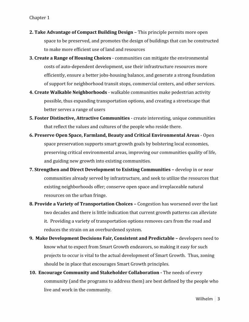
2. Take Advantage of Compact Building Design – This principle permits more open
space to be preserved, and promotes the design of buildings that can be constructed
to make more efficient use of land and resources
3. Create a Range of Housing Choices - communities can mitigate the environmental
costs of auto-dependent development, use their infrastructure resources more
efficiently, ensure a better jobs-housing balance, and generate a strong foundation
of support for neighborhood transit stops, commercial centers, and other services.
4. Create Walkable Neighborhoods - walkable communities make pedestrian activity
possible, thus expanding transportation options, and creating a streetscape that
better serves a range of users
5. Foster Distinctive, Attractive Communities - create interesting, unique communities
that reflect the values and cultures of the people who reside there.
6. Preserve Open Space, Farmland, Beauty and Critical Environmental Areas - Open
space preservation supports smart growth goals by bolstering local economies,
preserving critical environmental areas, improving our communities quality of life,
and guiding new growth into existing communities.
7. Strengthen and Direct Development to Existing Communities – develop in or near
communities already served by infrastructure, and seek to utilize the resources that
existing neighborhoods offer; conserve open space and irreplaceable natural
resources on the urban fringe.
8. Provide a Variety of Transportation Choices – Congestion has worsened over the last
two decades and there is little indication that current growth patterns can alleviate
it. Providing a variety of transportation options removes cars from the road and
reduces the strain on an overburdened system.
9. Make Development Decisions Fair, Consistent and Predictable – developers need to
know what to expect from Smart Growth endeavors, so making it easy for such
projects to occur is vital to the actual development of Smart Growth. Thus, zoning
should be in place that encourages Smart Growth principles.
10. Encourage Community and Stakeholder Collaboration - The needs of every
community (and the programs to address them) are best defined by the people who
live and work in the community.
Chapter 1
Wilhelm 4
How Are These Principles Promoted in Georgia?
There are a variety of organizations either 100%, or largely dedicated to the promotion of
Smart Growth in our state. Some of the organizations have a national presence like The
Smart Growth Network, Smart Growth America, and the Congress for the New Urbanism.
Others are purely local, Georgia groups. For the purpose of brevity, we will confine our
discussion to those organizations that are working more directly on local problems.
The Atlanta Regional Commission’s (ARC) Livable Centers Initiative is a program
with the mission of supporting and encouraging local municipalities in planning and
implementing Smart Growth principles.2 The 2007 LCI Implementation report cited 86
completed LCI areas. The latest addition of 4 study areas brings the total to 90
communities that have received $140 million dollars in grants.3 A recent survey of those
areas conducted by the ARC returned 68 responses. Of those 68 respondents, it is
interesting to note that 39 of them either had no response (9) or said that no zoning had
been changed or implemented since the LCI study (30). Most responses indicated that they
either strongly or agreed or agreed that the LCI had improved their community.
The Livable Communities Coalition is a coalition of 40 organizations ranging from
public entities like MARTA to private developers like John Weiland, all of whom want to
promote Smart Growth in Georgia, and aid communities in the implementation of Smart
Growth principles. Recently, the Coalition developed a scorecard system that helps guide
in the analysis of new and proposed developments.
2 Retrieved from http://www.atlantaregional.com/html/308.aspx on April 18, 2008. 3 Retrieved from http://www.atlantaregional.com/documents/LCI_Studies_2008_press_release.pdf on April 18, 2008.
Chapter 1
Wilhelm 5
The Georgia Conservancy is a non-profit organization established in 1967 with the
goal of serving as a catalyst for maintenance and stewardship of Georgia’s natural
environment. As such, the Conservancy has a vested interest in the promotion of Smart
Growth principles, especially those that pertain to green field preservation, and infill
development. The Conservancy also runs the educational and technical assistance
program, Blueprints for Successful Communities. This program has aided 16 Georgia
communities in development and planning with these points in mind:
1. Maintain and enhance quality of life for residents of the community 2. Employ regional strategies for transportation, land use, and economic growth 3. Consider the effect of the built environment on the natural environment as well as
history and culture 4. Employ efficient land uses
The Results:
The ARC regional Snapshot for November of 2007 reveals that regional land conversion has
declined over the 4 year period of 2003-2007. The two-year period from 2003-2005 saw
the conversion of forested lands reach 112,000 acres, whereas the 2005-2007 figures
declined dramatically to 31,000 acres, or a decline of 70%.4 This might be explained in
several ways, but it certainly seems evident that sprawling, Greenfield development is on
the decline.
There are of course instances where communities fail to adopt plans recommended
in the studies funded by LCI grant money, but on the whole, the numbers indicate that over
50% of LCI communities have modified zoning, and many more have realized Smart
Growth changes without changing the zoning codes. There is clear evidence that the rate of
4 Retrieved from http://www.atlantaregional.com/html/81_3673.aspx on April 18, 2008.
Chapter 1
Wilhelm 6
development has responded positively to the advancement of Smart Growth principles.
Now the question is ‘could it be better?’
Transit Oriented Development
Many of the current LCI areas have shortcomings in light of the 10 principles of Smart
Growth. One of the main problems for these developments is that many of them do not
actively incorporate a mix of transit options. Having Smart Growth spread in areas not
served by transit may be only marginally better than the status quo. We believe that the
focus of future development should be on key areas of the region as represented by MARTA
rail stations. Building a comprehensive TOD development plan that focuses on these
MARTA stations would allow us to utilize the infrastructure already in place to create
vibrant, attractive communities within Atlanta that can be accessed by MARTA for the
purposes of true living, working and playing.
Chapter 2
Winters 1
TODs: A tool for Smart Growth
Defining the phrase:
The term “Transit-oriented design” has become the catch phrase of the planning world. TODs
are only one tool that can be used to achieve “Smart Growth” principles, but they have become
one of the most popular ones. As a result, “Transit-oriented design,” or TODs have been used to
describe a variety initiatives and mixed-use ideas. David Salvesen deployed the clearest and most
concise definition of the term in the July 1996 issue of Urban Land. He defines TODs as,
“Development within a specified geographical area around a transit station with a variety of land
used and a multiplicity of landowners. 1” Most people make the mistake of thinking a TOD can
be created through the design and development of one project, but in actuality, it usually takes
multiple projects working together to create an urban fabric that seamlessly blends the ideals of
Smart Growth. A better way of thinking about TODs is as a “transit zone” instead of as a single
project. This change in thinking is particularly important for city officials’ responsible for
zoning and transportation regulations. Another way to think about TODs is as a tool for
achieving three goals: walkable streets, building intensity and concentration, and the careful
integration of transit. TODs cannot accomplish these goals alone. Walkable streets are
important because the places where people take transit are also places where people walk. To
achieve walkable streets, there must be some coordination and interplay between TODs and
standards for street design, transit-stop design, and other contributing relevant elements of the
public realm.2 Improving building intensity and concentration takes on a entirely different
aspect when its done to support transit. The intensity of individual sites and the cumulative
activities surrounding the “transit zone” must be configured correctly to allow the various modes
of transportation (i.e.: pedestrians, bikers, and cars, and transit) to flourish. The integration of
1 FTA, 5
2 APA, 6
Chapter 2
Winters 2
transit into a zone is perhaps the most difficult of the three goals because it must juggle
designing for place-making with designing for easy access to transit. These two strategies need
to work together for a “transit zone” to live up to its potential.3
Obstacles
The unique nature of TODs is that a large part of their success is predicated on the creation of
opportunities around public transit. This reliance on public transportation usually creates the
need for public-private partnerships between developers and the local jurisdiction. In many
cases, the key to developing a successful TOD is being able to move past the political obstacles.
Some of the common obstacles that must be negotiated are location liability, the real estate
market cycle, non-supportive government policies, institutional barriers, and a dependence on
automobile-oriented design. These obstacles can manifest themselves as exclusionary zoning
polices that limit densities and lot sizes, as cross-jurisdictional struggles because of the inter-
jurisdictional nature of transit lines, and as the prioritization of park and ride lots verse
passenger-generated land use surrounding a station.4 The more aware the planning and zoning
bodies are about these potential obstacles before designing Smart Growth-friendly policies, the
better chance they have at generating real change.
Types of TODs
Another major considerations that planning agencies need to consider when attempting to create
policies that promote Smart Growth and TOD development is the various types of TODs that can
be developed. Depending on the context of the site (downtown, suburb, regional center), the
ideal form a TOD takes on should differ. TOD types can be categorized as Urban Downtown,
Urban Neighborhood, Suburban Center, Suburban Neighborhood, or Commuter Town Center.
3 APA, 7
4 FTA, 10
Chapter 2
Winters 3
Depending on where a TOD is located, its level of connectivity, housing density, and mix of uses
will all vary. For example, in an Urban Downtown setting, the mix of uses would include office,
entertainment, multifamily housing, and retail. The preferred density for this type of TOD is 60-
units/ acre and ideally should have a hub-radial system to accommodate a high level of
connectivity. On the other hand, a Suburban Neighborhood should ideally mix residential,
neighborhood retail, and local offices, with a housing density of about 12-units/ acres. This type
of TOD would provide access to the Suburban Centers and downtown with trains running every
20-30 minutes. See the Attachment 1 for a complete breakdown of TOD types and
characteristics.5
TOD vs. TJD
TOD ordinances usually cover three main topics: the amount and type of development, the
spatial characteristics of the development, and the relational characteristics of the development.6
When beginning to think about designing a Smart Growth policy, the first decision that needs to
be made is, “What type of Public-Private interaction is desired?” Answering this question will
help decide whether a Smart Growth policy of TJD, “Transit-Joint development” policy, or TOD
policy is the best plan of action. While the differences between these two are not always clear,
the choice between the two will dramatically influence the type of policy that is developed. The
main distinguishing difference between the two types of Smart Growth design is scale. TODs
usually cover a group of city blocks, and typically represents a neighborhood in size and scale.
Conversely, TJDs are usually project specific and tied to a single real estate development within
a city block. Another major difference between the two approaches is the level of Public-Private
5 APA, 5
6 TCRP, 4
Chapter 2
Winters 4
cooperation. A TOD is usually designed and spearheaded by the public agency alone, usually
manifesting itself in zoning regulations, while a TJD usually develops as a partnership between
public and private interests trying to achieve a win-win situation for both.7 TJDs can be
separated into two groups: revenue-sharing agreements and cost-sharing agreements. Examples
of cost-sharing agreements are incentive programs like density bonuses, the sharing of
construction expenses, and the joint use of equipment, like HVAC units. Examples of revenue-
sharing agreements include land leases, air-rights development, concession leases, and
connection-fee programs.8 In many cases multiple types of TJD agreements and a TOD
supportive zoning are necessary to create an environment that helps to breed Smart Growth
ideals.
Cases
A TOD Example
Metropolitan Gardens is a brownfield redevelopment project that takes on the characteristics of a
TOD in Denver. The project will tie into the new light rail system, and when it is built out over
15 years, it is expected to offer 800,000 SF of office space, 500,000 SF of retail, and two hotels,
3,000 apartments, and a cinema. The project is made possible through the creation of a new
zoning category in Denver called TMU-30. This zoning category allows for higher FARs and
height limits, as well as reduces parking limits by up to 50%.9 The goal of the zoning is to create
a mixed-use district that will provide substantial ridership for the new light rail and provide
economic vitality to a forgotten part of Denver. This is a great example of a TOD, as opposed to
a TJD, because Smart Growth ideals are being promoted through zoning instead of collaboration.
7 TCRP, 2
8 TCRP, 8
9 Planning March 2008, 44
Chapter 2
Winters 5
While there will obviously be some public funding opportunities (TIFs) that the private
developers will benefit from, there is not sharing of costs or revenues between the two entities.
The role of the public sector is to facilitate an easier development process for the private sector,
not to partner with them.
TJD Example
A different approach to encouraging “Smart Growth” is through the TJD approach. Portland,
Oregon and their planning body, Metro, have been able to use transportation improvement funds
to purchase land and easement rights around their transit stations. The agency then turns around
and resells the land to private developers at reduced rates, rewarding “highest and best use of
transit.” The proceeds Metro received from the resale of land then were used to fund other
projects. To date, 26 projects have been developed through this process, which amount to 2,500
homes and 1.2 million SF of office space. Studies have shown that the program has helped
create 3,139 “induced riders per day.” The program cost Metro $6.3 million in transportation
funds to date. This is a great example of how a governmental agency can encourage Smart
Growth development through a public-private partnership, not just through zoning code.
Chapter 2
Winters 6
Bibliography:
Lowry, S. (2008). Delivering on TOD. Planning: The magazine of the American Planning
Association. April 2008 (pgs. 18-20).
Moses, V. (2008). Major Denver TOD Project Breaks Ground. Planning: The magazine of the
American Planning Association. March 2008 (pgs. 44-45).
(APA) Practice Transit Oriented Design. (2004, August). Zoning Practice: American Planning
Association. Issue 8.
(TCRP) Transit-Oriented Development and Joint Development in the United States: A Literature
Review. (2002, October). Transit Cooperative Research Program, Number 52.
(FTA) Zoning and Real Estate Implication of Transit-Oriented Development. (1999, January).
Transit Cooperative Research Program, Number 12

Chapter 2
Winters 7
Attachment 1
QuickTime™ and a decompressor
are needed to see this picture.

Chapter 2
Winters 8
Chapter 3
Wingate 1
Growth Management: Smart Growth in Atlanta
Introduction
Atlanta drivers each experienced 60 hours of delay in 2005, giving the city the dubious honor of
placing second in the Texas A&M University study for metropolitan congestion.1 Urban sprawl,
which makes the automobile a necessity to get about, is what many blame for the continually
increasing traffic and time spent in daily commute. The Christian Science Monitor ranked
Atlanta fourth among America’s cities with the worst sprawl.2 In addition, the American Lung
Association ranked Atlanta seventh in year round air particle pollution.3 And the Trust for Pubic
Land found that Atlanta only has 4.5% of its total land acreage devoted to parks and greenspace,
while the average for other major metropolitan areas was more than twice that amount.4
Together, these statistics do not illustrate the quality of life that attracts new residents and
industry. However, there are many wonderful things about Atlanta, such as it temperate weather,
proximity to the ocean and mountains, beautiful landscape and friendly people that offset many
of those unpleasant sounding statistics. In fact, the Atlanta metropolitan area added more people
than any other in the country from 2000 to 2006.5
Atlanta needs a plan that will accommodate the kind of growth it has experienced, and
that will improve the quality of life factors mentioned above. If the city fails to address these
issues, the trend will reverse itself; people and business will leave the city and seek new places
that offer a better quality of life.
1 See Texas Transportation Institute Study,
http://mobility.tamu.edu/ums/congestion_data/tables/national/table_4.pdf. 2 See http://www.csmonitor.com/2002/1204/p15s01-lihc.html.
3 See http://www.lungusa.org/site/pp.asp?c=dvLUK9O0E&b=50752#graph1.
4 See http://www.tpl.org/content_documents/ccpe_TotalAcres_asPercentofLandArea.pdf.
5 See http://www.census.gov/Press-Release/www/releases/archives/population/009865.html.
Chapter 3
Wingate 2
The following sections will provide a general overview of planning and zoning law in
Georgia; examine the role transit oriented development can play in addressing Atlanta’s
problems; describe the Atlanta BeltLine project and how it incorporates transit oriented
development; and discuss legal hurdles the BeltLine has faced and how some of these hurdles
can be eliminated.
Legal Principles: Overview
Georgia, like the majority of states in the union,6 is a home rule state.
7 This means that local
governments have the bulk of the control over their own planning and zoning decisions.
While home rule empowers local governments, the Georgia General Assembly still plays
a role in the decisions a local government can make. Certain legislation can have a dramatic
affect on the ability of local governments to implement new city planning proposals, especially
where revitalization efforts are sought. There are examples of legislation which has enabled
local governments by granting them more tools, such as tax increment financing,8 and examples
that have made it more difficult for comprehensive planning, such as Georgia’s recently
amended eminent domain law.9
Local governments around the state, and particularly in the Atlanta metro area, are taking
note of Smart Growth principles. Smart growth planning is different from zoning in the
traditional sense. Because Smart growth incorporates work/play/live, or “mixed use”
characteristics into the overall schematic, it does not fit a traditional Euclidian zoning design,
6 Forty-four states have home rule provisions either incorporated into their State Constitutions or created by statute.
For a list, see, http://www.celdf.org/HomeRule/DoesmyStatehaveHomeRule/tabid/115/Default.aspx. 7 Georgia Constitution, Art. 9, § 2.
8 See O.C.G.A. § 36-44-8.
9 See O.C.G.A. § 22-1-1, et. seq.
Chapter 3
Wingate 3
which delineates zones by use. Instead, local governments that have allowed for smart growth
have usually done so via enabling statutes or resolutions approving of such development.
Legislation such as this indicates to the developer that there will be greater cooperation in
moving a project forward because the local government has taken care of getting approval from
the residents in the suggested project area. This might be seen as a great advantage to some, and
a disadvantage to others in the development community. As greater density tends to increase
land values, the authorization of such increased density prior to its purchase by the developer
could make it a less profitable investment, as the developer would have to pay more to acquire
the land.
How can Smart Growth principles help alleviate some of the issues facing Atlanta? How
are Smart Growth projects funded? What are some of the legal issues to be mindful of when
planning a Smart Growth project? Through the context of the Atlanta BeltLine project, answers
to these questions will be provided infra.
Transit Oriented Development
Transit Oriented Development (TOD) is smart growth’s solution to controlling the demand side
of traffic congestion and urban sprawl.10
It situates compact, mixed use development around
railway and other mass-transit systems, encouraging residents to drive less and ride mass transit
more.11
TOD ordinances often feature maximum setbacks rather than minimum setbacks,
distinguishing them from conventional zoning regulations.12
This is designed to generate
pedestrian activity and force parking to the back of the buildings. Additionally, frontage and lot
10
Robert H. Freilich, The Land Use Implications of Transit-Oriented Development: Controlling the Demand Side of
Transportation Congestion & Urban Sprawl, 30 Urb.Law. 547 (1998). 11
Juergensmeyer & Roberts, Land Use Planning and Development Regulation Law, 386 (2d Ed. 2007). 12
Freilich supra at 555.
Chapter 3
Wingate 4
size requirements in TODs are reduced and often coupled with zero lot line provisions to create
higher densities.13
Sometimes density bonuses are offered to developers or minimum density
requirements are imposed.14
TOD concepts should be consistent with the local government’s
comprehensive plan to avoid legal stumbling blocks.15
The Atlanta BeltLine
Perhaps the epitome of TOD is the Atlanta BeltLine.16
The project will combine greenspace,
trails, transit, and new development along 22 miles of historic rail segments that encircle the
urban core of Atlanta.17
The 22 mile loop will host light rail transit that will connect with the
existing MARTA system and the proposed Peachtree Streetcar.18
Multi-use trails will follow the
22 mile loop, and 11 miles of additional trails will extend into surrounding neighborhoods to
increase access to the Beltline.19
The BeltLine also has the goal of creating a more cohesive
urban street grid.20
Over 1,200 acres of new greenspace will be part of the trail system of the
BeltLine, including a linear park along the trails, the creation of several new parks and the
expansion of existing ones. An estimated 5,600 affordable housing units are part of the project.21
And, over its 25 year project span, the BeltLine is expected to generate more than $20 billion of
new economic development and create approximately 30,000 new full-time jobs and 48,000 year
long construction jobs.22
It is the most ambitious smart growth redevelopment project in the
13
Id. 14
Juergensmeyer supra at 388. 15
Id. 16
See http://beltline.org. 17
See http://beltline.org/BeltLineBasics/BeltLineBasicsOverview/tabid/1691/Default.aspx. 18
Id. 19
Id. 20
Id. 21
Id. 22
Id.
Chapter 3
Wingate 5
United States, which will create a new urban core of Atlanta with an enhanced quality of life,
and will help to change the perception of urban livability that can moderate the pattern of
regional sprawl in coming decades.
Legal Road Blocks to the BeltLine Project
The constitutionality of comprehensive zoning was first approved by the U.S. Supreme Court in
1926 in Village of Euclid v. Amber Realty Co.23
In Euclid, the Supreme Court held that if all that
could be said of the zoning law was that it was “fairly debatable, the legislative judgment must
be allowed to control.”24
While zoning has been generally accepted as proper since Euclid, there
are still some limitations. As TOD requires a rezoning, one potential challenge it may face
comes under the theory of spot-zoning. Spot zoning is the reclassification of a small area in a
manner inconsistent with the surrounding area, solely to benefit the private interests of the
landowner.25
The court determines whether a rezoning is illegal spot zoning by evaluating
relevant factors, including the size of the tract being rezoned, whether the rezoning fits with the
comprehensive plan, whether the tract is being treated differently from similar surrounding land,
and whether the property owner is conferred a special benefit by the rezoning at the detriment of
the community as a whole.26
The implementation of a TOD is often times accomplished through a PUD because it
releases developers from the rigidity of straight zoning.27
While PUDs involve the
23
272 U.S. 365 (1926). 24
Juergensmeyer supra at 46 (quoting Euclid, 272 U.S. at 388). 25
Mueller v. Hoffmeister Undertaking and Livery Co., 121 S.W. 2d 775 (Mo 1939). 26
Annotation, Spot Zoning, 73 A.L.R. 5th
223 (1999). 27
Transit Cooperative Research Program (TCRP), Annotation, The Zoning and Real Estate Implications of Transit-
Oriented Development, Legal Research Digest, No. 12, 24 (Jan. 1999).
Chapter 3
Wingate 6
reclassification of specific parcels of land, courts have routinely rejected challenges that the PUD
constitutes “spot zoning,” citing the large size of PUDs28
and the fact that finding spot zoning in
such cases would paralyze urban planners.29
Accordingly, TODs should be safe from a spot
zoning challenge for the same reasons.
Rezoning Options
There are really two ways to go about accomplishing the necessary rezoning for a TOD project.
The land can either be preemptively rezoned by the governing body, or the developer can go
through the rezoning or variance process, a multi-step and often time-consuming process
involving public notice, administrative review of the rezoning application, public hearing, and
legislative action.30
There are advantages and disadvantages to both approaches.
Advantages to Preemptive Rezoning
Preemptive rezoning by the local government could offer several advantages, including time
saved by the developer in starting construction; this in turn is a cost savings. If the land is
approved and ready to be developed as mixed use, the developer does not have to involve
himself in the rezoning process, described supra, and can save months of making payments on
the land purchase when it would be sitting idle. Additionally, the preemptive rezoning
conducted by the local legislative body may encounter fewer legal challenges than the developer
initiated rezoning, as the legislative body should represent the views of the people in the
28
See Kawaoka v. City of Arroyo Grande, 17 F.3d 1227 (9th
Cir. 1994) (finding 17 acre parcel too large to be
considered spot zoning). 29
TCRP supra at 24. 30
See, e.g.,DeKalb County, GA Rezoning Process, http://www.dekalbzoning.com/process.html.
Chapter 3
Wingate 7
community.31
The judiciary of most states treat all zoning changes, whether general or site-
specific, as legislative acts and accord them a presumption of validity.32
According to the
Supreme Court, “if the validity of the legislative classification for zoning purposes be fairly
debatable, the legislative judgment must be allowed to control.”33
Fewer legal challenges means
less project delay to the developer and less expense, both legal and delay expense.
The TOD around the Lindbergh MARTA station was collaborated in by MARTA and the
City of Atlanta.34
However, there was no preemptive rezoning by the city ahead of the project.35
The rezoning, and later a variance, were applied for after the players were in place to begin
working on the project.36
Work was supposed to begin in 1999.37
However, challenges by two
different neighborhood groups opposing the project tied up development in legal battles for over
two and a half years.38
While the groups could have brought claims to halt the development even
if preemptive zoning had taken place, it would have been less likely those attempts would have
made, as the deferential “fairly debatable” judicial standard would have made the probability of
success more remote.
Disadvantages to Preemptive Rezoning
The primary disadvantage to allowing mixed use through preemptive rezoning by the local
legislative body is that the land value increases through this action. As the value increases, it
cuts into the profitability of the project, thus dissuading investment and willingness on the part of
31
See, e.g., Jeremy Wilhelm, Annotation, Lindbergh City Center (2007) (describing difficulties faced in the
development of the Lindbergh TOD) (on file with the author). 32
Jeurgensmeyer supra at 145. 33
Village of Euclid v. Ambler Realty Co., 272 U.S. 365, 388 (1926). 34
Wilhelm supra. 35
Id. 36
Id. 37
Id. 38
Id.
Chapter 3
Wingate 8
developers to take on the project. However, as mentioned before, the hidden costs of developer
initiated rezoning or obtaining a variance are arguably more than the amount of lost profit from
purchasing the land at inflated prices.
Acquiring the Land and Right of Ways
The transit portion of the Beltline project, as with any TOD, will require the acquisition of right
of ways.39
The BeltLine seeks to provide Light Rail transit along its 22 mile path in both
directions through regularly spaced stops at approximately ten minute intervals.40
The Light Rail
system would connect to four existing MARTA stops, allowing convenient access to the entire
city. Since the entire backbone of the BeltLine TOD is built around the Light Rail component,
the most critical step in the plan is to first secure the transit line right of way.41
This process was
once easy enough for governments through the exercise of their eminent domain power. Other
methods may have to be employed in Georgia and many other states across the country due to
some recent changes to eminent domain laws.
Eminent Domain
As sovereigns, the federal and state governments possess the inherent power to condemn
property for public use. Through the home rule provision in many state constitutions, including
the Georgia Constitution, this power of eminent domain is delegated to the local governments.
The Fifth Amendment of the U.S. Constitution, however, limits the government’s power to
condemn property by providing, “nor shall private property be taken for public use, without just
39
See http://beltline.org/BeltLineBasics/TransitTrailsandTransportation/tabid/1738/Default.aspx. 40
See http://beltline.org/Implementation/TransitandTrails/tabid/1805/Default.aspx. 41
Id.
Chapter 3
Wingate 9
compensation.”42
Public use has been broadly construed by the court to include any conceivable
public purpose.43
Prior to 2006, local governments commonly utilized eminent domain as a
redevelopment tool.44
This use was justified through reliance on the Supreme Court’s decisions
in both Berman v. Parker45
and Hawaii Housing Authority v. Midkiff,46
where in each case it
allowed condemnation, even though it resulted in the transfer of property from one private owner
to another. However, public tolerance of governments using eminent domain in this way came
to an end when the Supreme Court announced its decision to the Kelo v. City of New London47
case. In a close five to four decision, the court upheld the use of eminent domain by the city to
transfer land from one private party to another for the purpose of economic development.48
Though this was not a new concept, Kelo was somewhat unique because the property being taken
was not run-down or “blighted,” it just happened to be prime real estate that the city needed for
its project. There was a nation-wide backlash to the decision. The general public and many
public officials viewed the decision as an affront to private property rights. State legislatures
across the country, including the Georgia General Assembly, went to work recrafting their
respective states’ eminent domain law so as to provide greater protection for private property
rights. The measures were widely popular in all the states where they were revised. In Georgia,
the voters passed overwhelmingly a constitutional amendment, which accompanied the new
42
U.S. Const., 5th
Am., Cl. 4. 43
Hawaii Housing Authority v. Midkiff, 467 U.S. 229, 241 (1984). 44
See, e.g., http://en.wikipedia.org/wiki/Stockbridge,_Georgia (City of Stockbridge engaged in highly controversial
preemptive use of eminent domain). 45
Berman v. Parker, 348 U.S. 26 (1954). 46
Hawaii Housing Authority v. Midkiff, 467 U.S. 229 (1984). 47
545 U.S. 469 (2005). 48
Id.
Chapter 3
Wingate 10
eminent domain statute.49
In all, some thirty-five states have restricted eminent domain since
Kelo.50
Georgia’s New Eminent Domain Law
The new Georgia law makes it much more difficult for local governments to condemn private
property. It expressly provides that economic development is not a public use.51
Additionally,
the new law requires a finding of blight in order for a property to be eligible for condemnation,
and provides a list of six conditions,52
two of which are required, in addition to the finding that
the property “is conducive to ill health, transmission of disease, infant mortality, or crime in the
immediate proximity of the property.”53
With this substantially higher standard in place and the
inability to use eminent domain for economic development, the General Assembly has fairly
effectively taken this tool away from Georgia’s local governments.
Funding
The greatest obstacle for any TOD redevelopment project will be funding. The public transit
system portion of the project, at the very least, will manifest from public funds. As public funds
are generally scarce and difficult to redirect from previous allocations, a tool employed by local
governments is tax increment financing (TIF). The state legislatures of 49 states and the District
49
Georgia voters passed the resolution restricting the use of eminent domain 82.7% to 17.3%. To view results from
the office of the GA Secretary of State, see, http://sos.georgia.gov/elections/election_results/2006_1107/swqa.htm. 50
Jergensmeyer supra at 642 (referencing National Conference of State Legislatures,
http://www.ncsl.org/programs/natres/EMINDOMAIN.htm). 51
O.C.G.A. § 22-1-1 (9)(B). 52
O.C.G.A. § 22-1-1 (1)(A)(i) et seq. 53
O.C.G.A. § 22-1-1 (1)(B).
Chapter 3
Wingate 11
of Columbia have enacted enabling statutes authorizing the use of TIF as a redevelopment tool.54
The use of TIF does not directly impact assessments or the tax rate of the affected area. It works
by freezing the base ad valorem tax level of the tax allocation district (the affected area) for a
specified number of years, or until the project is paid off. Due to the redevelopment, the value of
the property increases. The ad valorem tax assessed against this increased value (i.e. everything
above the base rate) is allocated to the project fund for the redevelopment. This money is used
either to finance the direct public costs of the redevelopment or to retire bonds previously issued
to raise revenue for the redevelopment.55
TIF is an attractive tool because of its independence
from local general funds, fee-based methods, and grants. Local governments making
assessments about whether or not to utilize the TIF should reasonably be able to find that (1) the
desired improvements would not occur absent the implementation of the TIF; and (2) that the
redevelopment is the source of stimulus to the tax base. These findings justify the freezing of the
assessed values to pay for the project.56
Once revenue bonds have been approved by the local governing body through the
passage of a resolution, a rather fascinating procedure must take place in the State of Georgia to
validate them.57
In code sections 36-82-74 through 36-82-83, the steps are laid out as follows:
first, the governing body must serve notice to the district attorney; the district attorney must then
file petition for the State against the governing body in Superior Court; the judge will give the
district attorney an order requiring the governing body to show cause within 20 days from the
54
See http://www.cdfa.net/cdfa/cdfaweb.nsf/pages/tifstatestatutes.html. 55
See generally Juergensmeyer supra at 88. 56
See generally Arden H. Rathkopf ET AL., Annotation, Rathkopf’s The Law of Zoning and Planning, RLZPN §
15.59 (2008). 57
See O.C.G.A. §§ 36-82-74 through 36-82-83.
Chapter 3
Wingate 12
filing of the petition; the clerk of the court then shall publish notice of the hearing in the official
county organ for two consecutive weeks; any resident of the governing body issuing the bonds
may become a party to the proceedings, and if the resident is dissatisfied with the judgment of
the court, she can appeal such judgment.58
The procedure is a mechanism to ensure all residents
have a right to have their objections to a project heard.
The BeltLine Project TIF
These steps were followed for the issuance of TIF revenue bonds for the BeltLine project. In
accordance with O.C.G.A. § 36-82-77(a) as described supra, John Woodham, a resident of the
City of Atlanta, intervened in the suit filed by the State against the City of Atlanta for the
validation of the BeltLine TIF bonds, and filed objections to the issuance of the bonds. After a
series of hearings, the Fulton Superior Court overruled Woodham’s objections and validated the
bonds. Woodham appealed the decision on Constitutional grounds, which went to the Georgia
Supreme Court.59
Woodham argued that the allocation of the school portion of the ad valorem
tax to fund the BeltLine project violates Art. VIII, § VI, Par. I(a) and (b) of the Georgia
Constitution because the BeltLine project is a non-educational purpose.60
Under Art. VIII, § VI,
Par. I(b), the expenditure of school tax funds is limited, as follows:
School tax funds shall be expended only for the support and maintenance of public
schools, public vocational-technical schools, public education, and activities necessary or
incidental thereto, including school lunch purposes.61
As the BeltLine obviously was not an educational purpose, the court’s only issue was whether or
not the BeltLine project was “necessary or incidental” to public schools or public education.62
58
Id. 59
Woodham v. City of Atlanta, 283 Ga. 95 (2008). 60
Id. at 96. 61
Georgia Const., Art. VIII, § VI, Par. I(b).
Chapter 3
Wingate 13
Following its precedent in DeKalb County School District v. KeKalb County,63
the court
eventually answered in the negative.64
In 1994, the court held in DeKalb County Sch. Dist. that the expenditure of school funds
to improve a county road adjacent to a DeKalb County school was not necessary or incidental to
education, and thus violated the Educational Purpose Clause because it “would stray too far from
the District’s principle task of educating young people in favor of providing a benefit to all
citizens . . . .”65
Likewise, the court found that the BeltLine project provided a benefit to all
citizens and had little nexus to the actual operation of public schools.66
It therefore found the
allocation of the school portion of the ad valorem tax to the BeltLine project to be
unconstitutional.67
How does the TIF compare to the Floating Homestead Exemption?
The “floating” homestead exemption has been enacted by 32 counties68
in Georgia through the
local legislation process.69
The practical consequence of these laws is no different than that of
the TIF. That is, the floating homestead exemption deprives the county and school district of any
increase in property tax due to improved assessment values.70
It does this by establishing a base
assessment value when home is initially purchased and allowing the homestead exemption to
“float” upward in the amount equal to the increase in the assessed value of the property every
62
Woodham, 283 Ga. at 97. 63
263 Ga. 879 (1994). 64
Woodham, 283 Ga. at 97. 65
DeKalb County, 263 Ga. at 880. 66
Woodham, 283 Ga. at 97. 67
Id. 68
See http://www.etax.dor.ga.gov/ptd/adm/taxguide/exempt/homestead.aspx. 69
See, e.g., HB 595, Ga. Laws, 4336 (2006). 70
See http://www.etax.dor.ga.gov/ptd/adm/taxguide/exempt/homestead.aspx.

Chapter 3
Wingate 14
year thereafter in which the property owner continues to own and live in the home.71
Although
this exemption has the same effect of depriving the county school district of funds in essentially
the same way the TIF does, the homestead exemption is presumed to be constitutional,72
while
the TIF has been found unconstitutional. The difference that might make a difference is in the
case of the floating homestead exemption, the property owner is simply saving on his tax bill as
the exemption “float” creates what is essentially a freeze in the assessment of his property.
Whereas with the TIF, the property owner is actually paying the higher taxes all along, but the
amount over the “frozen” assessment is redirected to a project fund. This redirection of funds,
while plainly form over substance, could be the element that makes the TIF unconstitutional in
contrast to the floating homestead exemption.
Where does the TIF stand after Woodham?
The Woodham decision is quite a devastating blow to the BeltLine, as well as to smart growth
advocates and local governments that had redevelopment plans on the horizon. TIF is still
available; however, as the school portion of the ad valorem tax makes up on average 50 to 70
percent of the total, the financing power of the TIF is significantly reduced. All future TIFs in
Georgia will be affected by the decision. A number of projects that were relying on Tax
Allocation Districts73
have been put on hold pending new funding assessments.74
Hope has been restored, however, by the Georgia General Assembly. The General
Assembly was in session when the Woodham decision was announced in February and acted
71
Id. 72
There have been no challenges to the constitutionality of the floating homestead exemption to this point, but it is
not a new concept, and up until now its validity has never been questioned. 73
In Georgia, TIF is referred to as a Tax Allocation District, or “TAD.” 74
See http://blogs.creativeloafing.com/freshloaf/tag/development/.

Chapter 3
Wingate 15
swiftly to draft Senate Resolution 996, which would amend the Constitution in a way to overrule
the Woodham decision.75
Senator Dan Weber of DeKalb County authored the legislation
permitting local school boards to use tax funds for redevelopment purposes.76
This amendment
proposal will be on the ballot in November for Georgians to either approve or disapprove. All
local governments that wish to have this tool available in the future should make an effort to
educate their residents as to the importance and value of the provision.
Conclusion
Great metropolitan cities provide high quality of life components. Transit Oriented
Development using Smart Growth principles seeks to incorporate the highest quality of life
values into a system that maximizes both efficiency and convenience by reducing time spent in
transit, and providing outlets to entertainment, employment and retail, all within walking
distance of home. Laws that seek to make innovative Smart Growth projects like the BeltLine
easier to implement in Georgia will be found to serve the public well and to be emulated by other
states across the country.
75
For the full text of SR 996, see, http://www.legis.ga.gov/legis/2007_08/fulltext/sr996.htm. 76
Id.
Chapter 4
Tucker 1
Lindbergh Transit Oriented Development
Transit Oriented Development (TOD) was implemented across the United States essentially to
undo what has become ingrained in the American way of life—areas that are oriented around the
automobile. TODs are to encourage more pedestrian access and less reliance on the automobile.
Major U.S. cities’ transit systems are central to area with businesses, residences, and retail
located in close proximity to stations. Atlanta is one of the few cities that have not adopted this
measure. Since the city has experienced exponential growth since the 1990s that has led to
sprawl and more dependence on the car transit oriented development has become more and more
in the forefront when thinking about urban design. In the late 1990’s, MARTA started to think
about ways in which it could incorporate transit and development while making communities
more densely populated while providing pedestrian friendly and alleviating Atlanta’s reliance on
automobiles.
In 1999, MARTA partnered with BellSouth in developing a transit station that would
allow residents the ability to get around with ease, in a built environment in which people could
live, work and play. Cooper Carry, Inc. was hired as the lead architecture firm to develop the
Lindbergh City Center. The site was strategically located along Piedmont Avenue nestled
between the Midtown and Buckhead districts. This also included the Perimeter Center which is a
major employment hub.1 The Lindbergh project was also the first development selected as a
pilot for the Federal Transit Administration’s (FTA) 1997 Policy on Transit Joint Development.
FTA’s policy assisted MARTA in the purchase of three acres of land for the Lindbergh project.2
1 Dumbaugh, Eric. “Overcoming Financial and Institutional Barriers to Transit-Oriented Development.” Journal of
Public Transportation 7(3): 43-69 (2004).
2 Id.
Chapter 4
Tucker 2
The Lindbergh City Center’s main objective was to develop an urban area in which retail, office
space, condominiums, and entertainment where within close proximity. The project responded
to the high levels of traffic, and congestion that Atlanta faces o a daily basis. The Lindbergh
TOD provided an alternative to using vehicles as the sole mode of transportation. At the time,
Lindbergh was the largest multi-use development in the United States. The Lindbergh City
Center was built with the Lindbergh station as the focal point. The station is the second busiest
station in the MARTA system.3 It is 51-acres of mixed-use development that surrounds
Lindbergh’s subway and bus stations in Buckhead. The development comprises of 4.8 million
square feet of development; 2.7 million square feet of office space, 330,000 square feet of retail
space, 566 apartments, 388 condominiums, and a hotel with 190 rooms. The development has
the feel of a miniature city with medium- and high-rises and a parking deck centered near the
MARTA station.
Before the implementation of the project, the areas surrounding the Lindbergh station were
zoned for low-density uses and were littered with parking lots. Much of surrounding areas were
run down with pawn shops, fast food restaurants and venues for adult entertainment.4 In order to
achieve the end result, the zoning around the Lindbergh station had to be changed.
In order to implement these changes the Transit Oriented Ordinance was set in place to
encourage development that would help foster MARTA’s goal of mixed-use high density
development near public transportation. The language in the ordinance altered the zoning code
in order to encourage that transit be in walking distance of a station as well as integrate public 3 Georgia Quality Growth Plan. Retrieved April 15, 2008, from
http://www.dca.state.ga.us/toolkit/ToolDetail.asp?GetTool=157.
4 Carrns, Ann. “Transit Agency Brings Rail-Oriented Look to Highway-Crazy Atlanta Land Around Stations will be
Leased for Development Shops, Apartments and Offices.” Wall Street Journal. B13. (1999)
Chapter 4
Tucker 3
transportation with land uses either within the same development or adjacent to one another.
Another critical dimension to making TODs function well is the need for high density areas near
transit stations.5
This caused friction between the residents and MARTA and other associated parties. Residents
were reluctant to see their neighborhoods be rezoned for high-density mixed-use developments.
They feared the increase of transit in their neighborhoods would increase noise pollution and
opportunities for crime. The Buckhead Business Association initially suggested that there be
height limitations and a reduction of the floor ratio area. They discouraged high-rise office
buildings that were highly automobile dependent. It was also suggested that zoning categories
be modified to require additional controls, primarily C-1, community business, C-2, commercial
service, RG-3, general multi-family residential with a floor area ratio of 0.162, RG-4, general
multi-family residential with a floor area ratio of 1.49 and RG-5, general multi-family with a
ratio of 3.2. Like most TODs the Buckhead Business Association requested the development of
Special Public Interest Districts (SPI) with overlay requirements for urban design, mixed-use and
height and density restrictions. Lastly neighborhood residents requested that the impact fees that
MARTA received would offset the costs associated with the increase in traffic and not the
residents.
Many have praised Lindbergh City Center as a successful transit oriented development project,
others disagree. Opponents believe that the Lindbergh City Center is not a transit oriented
development at all, that it is in fact a transit adjacent development. According to an article by
Tim Halbur, TOD’s Evil Twin: Transit Adjacent Development, he stated that one resident felt
5 Atlanta Regional Commission. Retrieved April 15, 2008. From http://www.atlantaregional.com/arc/html/.
Chapter 4
Tucker 4
that Lindbergh was nothing more than an office park for BellSouth. It has also been criticized to
be segregate retail, residential and commercial uses in separate quadrants of the development.
Another criticism of TODs is that their success is tangential to development trends of the area.
Atlantic Station Transit Oriented Development
Though Atlantic Station is deemed a tax allocation district it can also be considered a transit
oriented development. Atlantic Station the former Atlantic Steel Manufacturing Site was
established as a tax allocation district in 1999. The Atlantic Station, LLC did a joint-venture
between Jacoby Development, Inc. and AIG Global Real Estate Investment Corporation.6 The
years of industrial use of the site had contaminated the land.7 Atlantic Station resembled the
Lindbergh City Center in many ways. The Atlantic Station TOD was also developed to
maximize the use of public transit. The development’s main objective was to have retail, living
quarters, and businesses in close proximity to each other in order to decrease congestion,
improve air quality and connect activity center. Atlantic Station incorporated Smart Growth
practices while making the development transit oriented. The development provided 6 million
square feet of mid- and high-rise office space and entertainment space; 4,000 residential units,
300 hundred of which are two-story loft apartments that are above retail and restaurants; and
1,150 hotel rooms.
Though the Lindbergh City Center TOD and Atlantic Station are not without flaws, it still offers
an environment that is pedestrian friendly and oriented around transit. With gas prices steadily
6 Atlanta Regional Commission. Retrieved April 15, 2008. From http://www.atlantaregional.com/arc/html/.
7 Id.
Chapter 4
Tucker 5
on the rise, increased traffic congestion, substandard air quality, transit oriented development is a
useful tool. The City of Atlanta along with the Atlanta Regional Commission have many
projects in the pipeline, to get Atlanta to become a city that is less reliant on the automobile and
utilizing the infrastructure such as the rails and bus services that it already has in place.
North Line Corridor
MARTA conducted a feasibility study of the North Line (GA 400) Corridor. MARTA would
like to encourage high density, mixed-use development in this area as well.8 The development
would stretch from McGinnis Ferry Road to the North Springs Rail Station. The analysis
examined seven clusters: Northridge, Holcomb Bridge, North Point, Old Milton, Windward
North and South, and McGinnis Ferry, along the corridor because of their strong potential for
growth.9 MARTA set up numerous variables to help them choose which site would be the
optimal location. The study looked at the areas density, diversity, and future land uses to
determine which location would be able to handle new development patterns and complementary
transit services.10
After the feasibility study was run, it was found that the North Point area
would best meet MARTA’s needs. This cluster would be ideal for potential shops, restaurants,
outlets, and residential development that could be easily integrated with sidewalks and trails that
could be connected to the transit system.11
8 MARTA. Retrieved April 17, 2008. From http://www.itsmarta.com/newsroom/northline.htm
9 Id.
10 Id.
11 Id.
Chapter 4
Tucker 6
West End Livable Center Initiatives
Transit oriented development has also been undertaken under the Livable Cities Initiatives. The
West End LCI is one of Atlanta’s TOD Small Area Plans.12
The ARC will invest about 5 million
over the next four years to conduct smart growth studies around the city. The study for the
West End LCI was initiated in 2003. The ARC study will assess the West End’s opportunity for
transit oriented development. The West End is currently a mixed-use area and MARTA currently
has a transit station located in the neighborhood and would make the transition to a transit
oriented community virtually seamless.
As gas prices continue to rise and issues of congestion and air quality become ever more pressing
the use of mass transit will become more significant to Atlanta residents. TODs will become the
norm in an area whose population is steadily increasing and roads become flooded with
automobiles. Transit oriented development will be the next phase in Atlanta’s history. The
benefits to implementing TOD’s will have positive external benefits to everyone.
12
See GQGP supra note 3.
Chapter 5
Wilkinson 1
Brookhaven LCI: A Case Study
The Brookhaven-Oglethorpe MARTA station is located immediately north of the Lenox station.
Contrary to the Lenox station, Brookhaven is surrounded by a very large expanse of MARTA-
owned and operated surface parking. The entire stretch of Peachtree Street along the west side
of the MARTA property is in first-generation, low-density use as a strip mall with surface
parking, completely disengaging the public realm. To this end, the Brookhaven Marta station
and Peachtree corridor provided great opportunity for the rezoning of the surrounding parcels to
increase density, create public and private boundaries engaging the public, and encourage
alternative modes of transportation, both public transit and pedestrian.1
The Brookhaven-Oglethorpe MARTA station rezoning began with a planning process,
which resulted in the creation and adoption of an overlay district. Such ordinance must then be
adopted by the county commission, or governing body, in this case, the DeKalb County
Commission. The Brookhaven-Peachtree Overlay District was intended to amend the code of
Dekalb County, Georgia, Chapter 27, Article III, to add division 10. The overlay-zoning
ordinance was adopted by the board of commissioners, providing for the regulation of land use
and zoning in the Brookhaven-Peachtree area, specifically the parcels adjacent to and
surrounding the Brookhaven MARTA station. The development of the overlay district was the
result of a Livable Centers Initiative (LCI) study and was in accordance with, and actively
sought, public input in developing the plans and guidelines2. The LCI study was funded through
a grant awarded by the Atlanta Regional Commission (ARC).
1 An Ordinance to Amend the Code of DeKalb County, Georgia
Chapter 5
Wilkinson 2
The Brookhaven Livable Centers Initiative (LCI) plan included the establishment of
standards and procedures that will apply to any development that lies, within, or in part within,
the Brookhaven-Peachtree Overlay District. The overlay district was based upon the urban
design and development guidelines developed as part of the LCI planning process. The purpose
was to create a community vision for ensuing development in the area with a focus on more
dynamic, mixed-use areas surrounding the Brookhaven-Oglethorpe MARTA station and flanking
the Peachtree Corridor north of the station. Section 27-728.15.2. reveals the statement of
purpose and intent of the guidelines as follows:
(a) To implement the policies and objectives of the comprehensive plan and the
Zoning Ordinance of DeKalb County within the Overlay District;
(b) To promote the development of a more dynamic, mixed-use district of appropriate
scale and magnitude surrounding the Brookhaven-Oglethorpe University
MARTA transit station;
(c) To ensure that new structures and developments are consistent with the vision and recommendations of
the Brookhaven-Peachtree LCI Plan completed in 2005 with significant community involvement and input;
(d) To provide for a variety of housing types and promote mixed-income residential opportunities;
(e) To facilitate access to the Brookhaven-Oglethorpe University MARTA transit
station and to compatible and neighboring commercial, civic, recreational and
institutional uses and residential areas;
(f) To design and arrange structures, buildings, streets and open spaces to create an inviting, walkable, mid-
rise, human-scale environment;
(g) To provide for the efficient and effective use of land surrounding the Brookhaven-Oglethorpe
University MARTA transit station and along Peachtree Road;
(h) To provide for connectivity of streets and communities and reduce the
dependence on automobile use by increasing the ease of movement and
2 Id.
Chapter 5
Wilkinson 3
opportunities for alternative modes of travel; and
(i) To ensure a proportional relationship of surrounding buildings with respect to the general spacing of
structures, building mass and scale, and street frontage by
using techniques to achieve compatibility, such as:
(1) Use of additional façade detail; proportion of façade elements, doorways,
projections and insets; window scale and pattern; and creation of strong
shadow lines as decorative elements;
(2) Use of consistent setbacks from property lines;
(3) Development of consistent sidewalks and a more active, interesting
pedestrian environment;
(4) Use of landscaping, lighting and street furniture to unify district buildings
and define space; and
(5) Use of compatible building materials to promote a design and building
aesthetic compatible with Oglethorpe University and the desired urban
village character3.
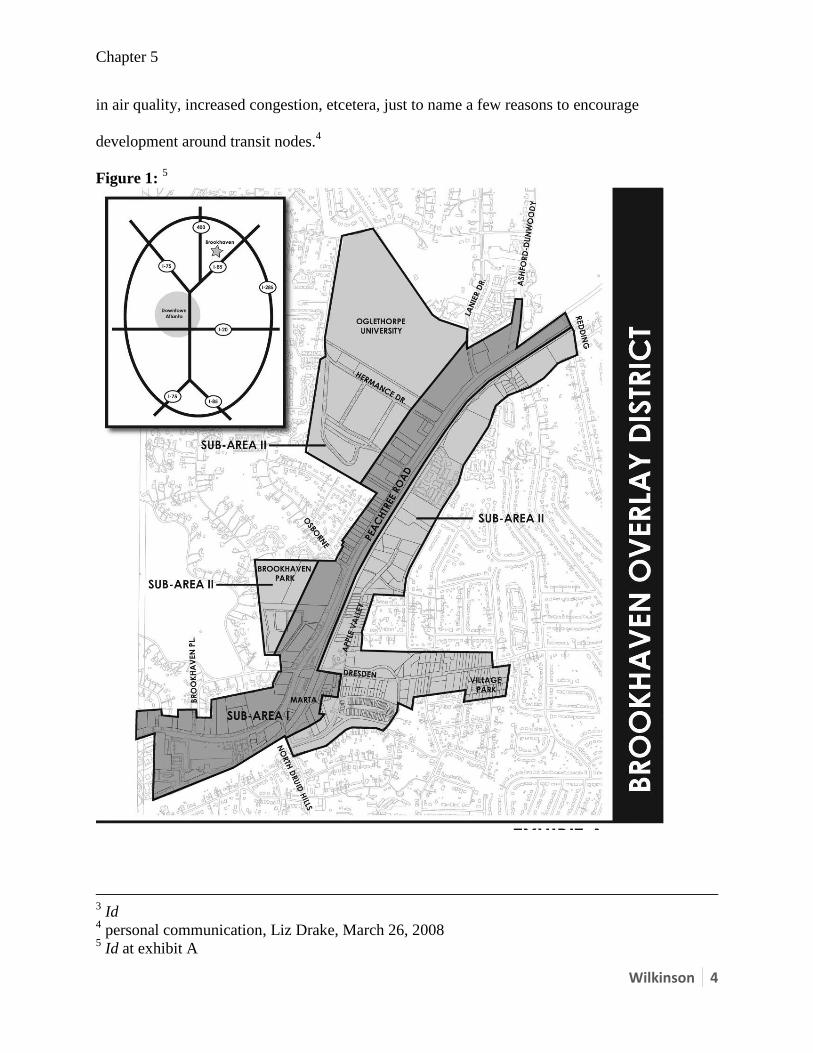
The Brookhaven LCI study and eventual adoption of the overlay district (see figure 1) by the
DeKalb County Commission is an example of “up-zoning” as opposed to incentive based
guidelines, adopted by a county commission or city council, that a developer may or may not
choose to utilize in the development of her site. To this end, when said governing body chooses
to adopt an overlay district, they are essentially re-zoning the respective property to promote site
specific and appropriate development rather than rezoning at the developers request or parcel by
parcel. This method of zoning facilitates responsible development and “smart growth”, a type of
development inherent in transit-oriented developments (TODs). If the governing body does not
choose to adopt an overlay district or “up-zone” property, it may be choosing to encourage
growth that is, in fact, not “smart”, resulting in increased dependence on automobiles, a decrease
Chapter 5
Wilkinson 4
in air quality, increased congestion, etcetera, just to name a few reasons to encourage
development around transit nodes.4
Figure 1: 5
3 Id
4 personal communication, Liz Drake, March 26, 2008
5 Id at exhibit A
Chapter 5
Wilkinson 5
Recommendations for Other MARTA Stations: A Work Scope
The Brookhaven-Peachtree Overlay district is an example of how property can be re-zoned (“up-
zoned”). However, other MARTA stations should be planned for as well, to facilitate the
adoption of similar ordinances that promote transit-oriented developments (TODs). MARTA
can be involved in the process and development of TOD guidelines for two purposes, which are
not mutually exclusive, and are the production of a “MARTA document for use in shaping joint
development plans and in commenting, as a stakeholder, in significant station area development
proposals by others. This document would be published, and would be based on input by other
parties, but would be MARTA-generated and require no other approvals.” This document would
function as a multi-jurisdictional document, for use by MARTA, the City of Atlanta, Fulton
County, and other MARTA host municipalities. Because this type of document would require
much more extensive negotiation, approvals by other jurisdictions, and eventual changes in
zoning, it would likely be a future, optional step, following the initial development of a MARTA
product6.”
This is happening, in fact. MARTA is making considerable efforts to plan for transit
oriented development at other MARTA station locations by seeking consultant assistance for the
planning process. MARTA’s work scope is detailed and includes a review of best practices that
are taking place in other parts of the United States as well as a survey of current conditions
surrounding MARTA stations. Additionally, TOD guidelines must be developed and include the
typology, density, land-use, and parking of the development areas. These specifics are necessary
when considering this type of new construction, infill development and reuse projects relevant to
existing MARTA stations.
6 MARTA General Planning Consultant Services Contract, March 25, 2008
Chapter 5
Wilkinson 6
The strategy most effective in achieving transit-oriented development is the development
and planning of an overlay district, similar to that which DeKalb County adopted for the
Brookhaven-Peachtree area in 2007. In the planning stages, the development of each overlay
district, respectively, does not include the full length or regulatory text of the overlay, but an
easily readable draft of such. As before stated, these model overlay district provisions will
include TOD guidelines and best practices of jurisdictions that have implemented such
ordinances. Of course, the overlay districts are specific to where the MARTA stations fall on the
urban transect, e.g. urban, ex-urban, suburban, etc. This is important to note in developing
appropriate guidelines for density, parking, and typology.7
The final step in the development of a TOD overlay district will be a comprehensive
review by MARTA once the overlay has been drafted. These working sessions will be the final
step toward compiling guidelines and best practices that can be finalized. Again, the final
document may or may not be adopted as an ordinance by the DeKalb or Fulton County
Commission as a zoning overlay district.
7 Id