Embed Size (px)
Citation preview
8/6/2019 Social Science History Civics and Geography
http://slidepdf.com/reader/full/social-science-history-civics-and-geography 1/280
8/6/2019 Social Science History Civics and Geography
http://slidepdf.com/reader/full/social-science-history-civics-and-geography 2/280
UNIT - IV
9. Rajput Kingdoms in North India –
Arab and Turkish Invasions ... 83
10. Delhi Sultanate A.D.1206 to A.D.1526 ... 93
11. Bhakti Movement in Medieval India ... 107
12. Bahmani and Vijayanagar Kingdoms ... 117
UNIT - V
13. Mughal Invasion and Their Rule ... 125
14. Social, Economic, Religious and
Cultural Life of People under the Mughals ... 141
http://sreemediaeducation.blogspot.com Study Material
8/6/2019 Social Science History Civics and Geography
http://slidepdf.com/reader/full/social-science-history-civics-and-geography 3/280
GEOGRAPHY
1. The World We Live in ... 197
2. Our World : The First and the Third ... 209
3. Natural Regions ... 219
4. India : An Introduction ... 231
5. Tamil Nadu : An Introduction ... 237
6. Tamil Nadu : Climate ... 255
7. Soils, Vegetation and Animals ... 265
8. Human Resources Development ... 275
9. Industries ... 287
10. Services and Infrastructures ... 301
11. Geography Practical ... 315
http://sreemediaeducation.blogspot.com Study Material
8/6/2019 Social Science History Civics and Geography
http://slidepdf.com/reader/full/social-science-history-civics-and-geography 4/280
HISTORY
(Ancient, Medieval Indian History)
TIME LINE
1 cm = 500 Years
B.C. 4000
B.C. 3500
B.C. 3250
B.C. 2750
B.C. 2000
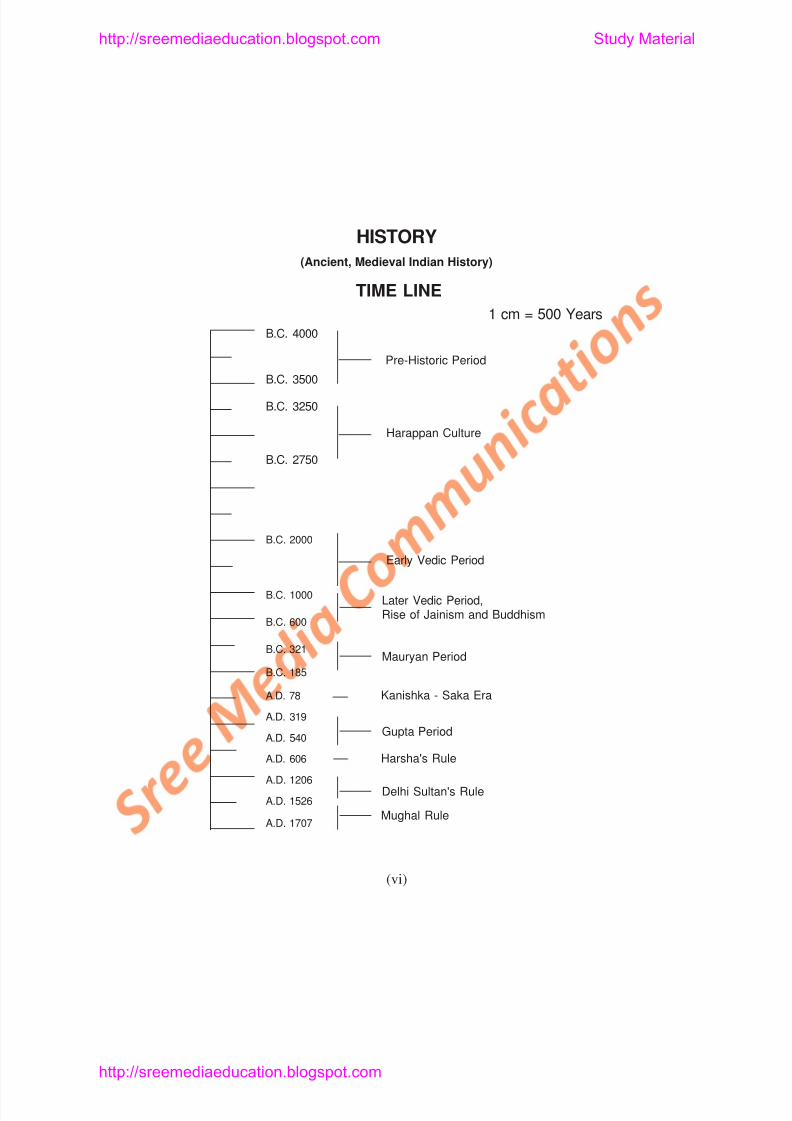
Pre-Historic Period
Harappan Culture
E l V di P i d
http://sreemediaeducation.blogspot.com Study Material
8/6/2019 Social Science History Civics and Geography
http://slidepdf.com/reader/full/social-science-history-civics-and-geography 5/280
UNIT - I
Lesson 1
THE HARAPPAN CULTURE
Learning Objectives
1. Pupil understands that the two cities of Harappa and Mohenjo -
daro belonged to one single civilisation - the Indus Valley
civilisation or Harappan Civilisation.
2. Pupil knows that the river valleys were responsible for the growth
of civilisations.
3 Pupil acquires knowledge about the nature and date of Harappan
http://sreemediaeducation.blogspot.com Study Material
8/6/2019 Social Science History Civics and Geography
http://slidepdf.com/reader/full/social-science-history-civics-and-geography 6/280
The most important feature of Indian Geography is theHimalayas. A number of perennial rivers have their origin in theHimalayas. It is broken by two passes namely Khyber and Bolan.
These passes enabled the foreigners to invade India. Three famouscivilisations flourished in ancient India. They are: Indus Valley orHarappan Civilisation, Gangetic Valley Civilisation and the SangamCivilisation.
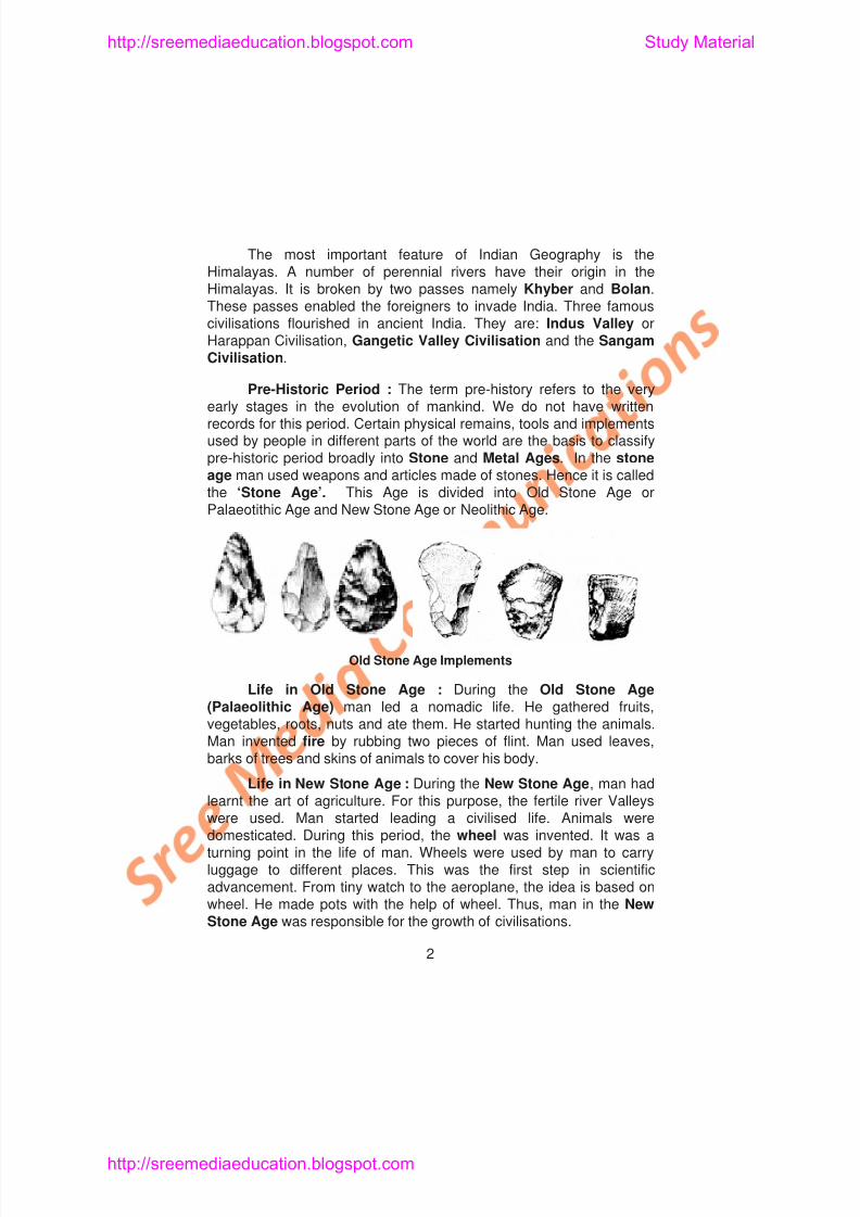
Pre-Historic Period : The term pre-history refers to the veryearly stages in the evolution of mankind. We do not have writtenrecords for this period. Certain physical remains, tools and implementsused by people in different parts of the world are the basis to classifypre-historic period broadly into Stone and Metal Ages. In the stoneage man used weapons and articles made of stones. Hence it is calledthe ‘Stone Age’. This Age is divided into Old Stone Age orPalaeotithic Age and New Stone Age or Neolithic Age.
http://sreemediaeducation.blogspot.com Study Material
8/6/2019 Social Science History Civics and Geography
http://slidepdf.com/reader/full/social-science-history-civics-and-geography 7/280
Life in Metal Age: The discovery of metals was another
achievement made by man. Metals were used for making weapons.
During this period, people mostly lived near the river beds. So, the river
Valley Civilisations developed. The Metal Age is divided into Copper
Age, Bronze Age and Iron Age. In the Iron Age, ploughs and daggers
were made of iron. It led to the overall development of mankind.
THE HARAPPAN CULTURE
Sources of Harappan Culture : The archaeological
excavations carried out at Mohenjo-daro and Harappa are useful to
know about Harappan culture. Sir John Marshall and his team workedin the sites of Mohenjo-daro. The excavation work was continued by
J.H Mackay. G.F.Dales and M.S.Wats. They have brought to light a
highly advanced civilisation that flourished in India in the pre-Aryan
period. Their discoveries are the basic source materials of Harappan
culture.
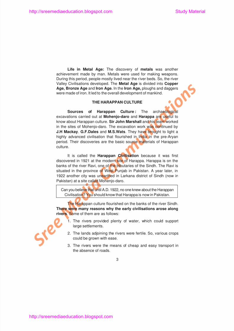
It is called the Harappan Civilisation because it was first
discovered in 1921 at the modern site of Harappa. Harappa is on the
S
http://sreemediaeducation.blogspot.com Study Material
8/6/2019 Social Science History Civics and Geography
http://slidepdf.com/reader/full/social-science-history-civics-and-geography 8/280
Environment: During this period, the climate of the region wasmoist with humid land. Dense forests grew where animals like tigers,elephants and rhinoceros roamed. The forests provided timber for
brick kilns, which supplied bricks to the cities.
Date of Harappan Culture : This civilisation belonged to theChalcolithic period. In this age, a new metal called bronze by mixingtin and copper came to be produced. It was harder and better suited tomeet the needs of the people. The better tools led to intensivecultivation. Iron was not known to the Indus Valley people. Accordingto Sir John Marshall, the Indus Valley Civilisation may be datedbetween 3250 B.C. and 2750 B.C.
Extent : The Harappan culture spread to Sindh, Gujarat,undivided Punjab (including Harayana), Jammu, Western parts of UttarPradesh and Northern parts of Rajasthan (Kalibangan). The remainsfound in these places are similar to those found in Harappa andMohenjo-daro.
Contacts with other civilisations : The Indus Valley peoplehad overseas trade contacts with Sumeria, Babylonia and Egypt. ThusIndia ranks with the ancient Western cultures of Sumer, Akkad,
B b l E t d A i
http://sreemediaeducation.blogspot.com Study Material
8/6/2019 Social Science History Civics and Geography
http://slidepdf.com/reader/full/social-science-history-civics-and-geography 9/280
of Mohenjo-dato could be divided into three parts-the Citadel, thelower town and the small huts on the outer limits of the city.
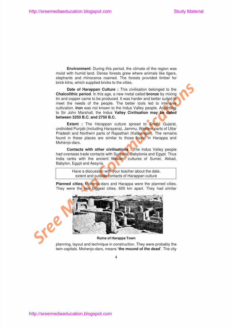
The Citadel: It was the raised part of the city. It has often beendescribed as a fort or administrative block. People might have livedhere. The ruling classes included priests and wealthy merchants. Thecitadel had massive walls. Those walls provided protection against thefloods of the Indus river. The citadel consisted of important buildingslike the Granary and the Assembly or Town Halls. We also comeacross the Great Bath here.
http://sreemediaeducation.blogspot.com Study Material
8/6/2019 Social Science History Civics and Geography
http://slidepdf.com/reader/full/social-science-history-civics-and-geography 10/280
Lower Town: Below the citadel lay a lower town. It was inhabited bypetty merchants and craftsmen. This town was divided into rectangularblocks by wide roads. The roads run from north to south and east to
west. These roads cut each other at right angles. Here, the remains ofbrick houses can be seen. The drainage system is praiseworthy.Provision was made for street lighting.
Houses: The houses were one or two storeys high. All thehouses were made of baked bricks of uniform size. Every house hadtwo or more rooms, a bath-room , a kitchen and a courtyard. Thehouses were also provided with doors and small windows. Thegrinding stones were found close to the hearth.
Drainage System: The kitchen and the bathroom had drainsleading out. The main drain was running alongside the main roads.
The drains were lined with bricks. Most of them were covered. There
were flights of steps leading to drains. The drains were cleaned
periodically.
Occupations of the people: The Indus people were farmers,
weavers, potters, metal workers, toy makers, jewellers, stone cutters
d t d A i lt th t i t t ti I th
http://sreemediaeducation.blogspot.com Study Material
8/6/2019 Social Science History Civics and Geography
http://slidepdf.com/reader/full/social-science-history-civics-and-geography 11/280
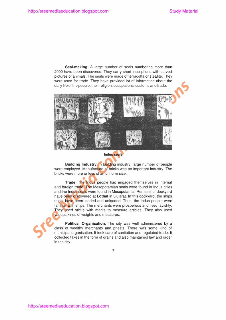
Seal-making: A large number of seals numbering more than
2000 have been discovered. They carry short inscriptions with carved
pictures of animals. The seals were made of terracotta or stealite. They
were used for trade. They have provided lot of information about thedaily life of the people, their religion, occupations, customs and trade.
Indus seals
http://sreemediaeducation.blogspot.com Study Material
8/6/2019 Social Science History Civics and Geography
http://slidepdf.com/reader/full/social-science-history-civics-and-geography 12/280
SOCIAL LIFE
Social Life: There were three social groups. The first group or
the ruling class lived in the citadel. It comprised of wealthy merchantsand the high priests. They second group consisted of pettymerchants, artisans and craftsmen. The labourers belonged to thethird group and lived in small huts. Generally speaking, the socialorganisation was more definite.
Life of the People: The Indus people led prosperous life. Theyhad more time for leisure. There was a very big improvement in theirfood habits, dress and amusements.
Food: Wheat and barley were the staple food of the people.Besides these, they consumed milk, meat, fish, fruits and dates.
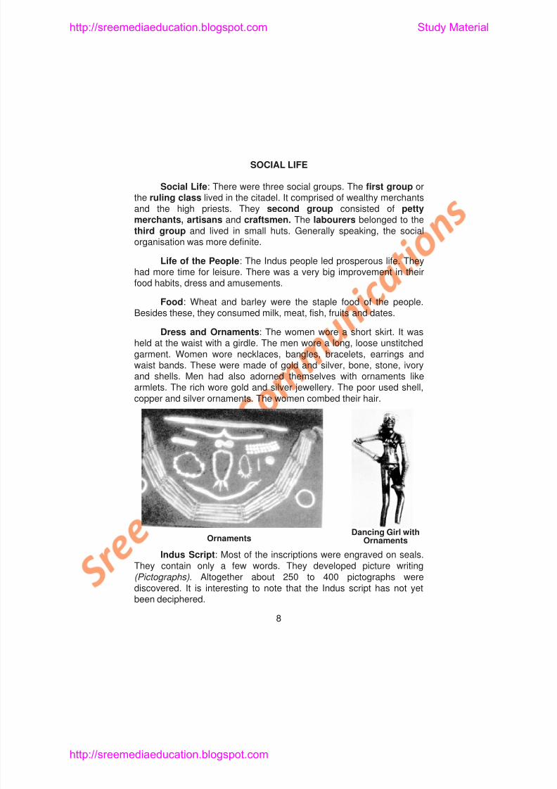
Dress and Ornaments: The women wore a short skirt. It washeld at the waist with a girdle. The men wore a long, loose unstitchedgarment. Women wore necklaces, bangles, bracelets, earrings andwaist bands. These were made of gold and silver, bone, stone, ivoryand shells. Men had also adorned themselves with ornaments like
l Th i h ld d il j ll Th d h ll
http://sreemediaeducation.blogspot.com Study Material
8/6/2019 Social Science History Civics and Geography
http://slidepdf.com/reader/full/social-science-history-civics-and-geography 13/280
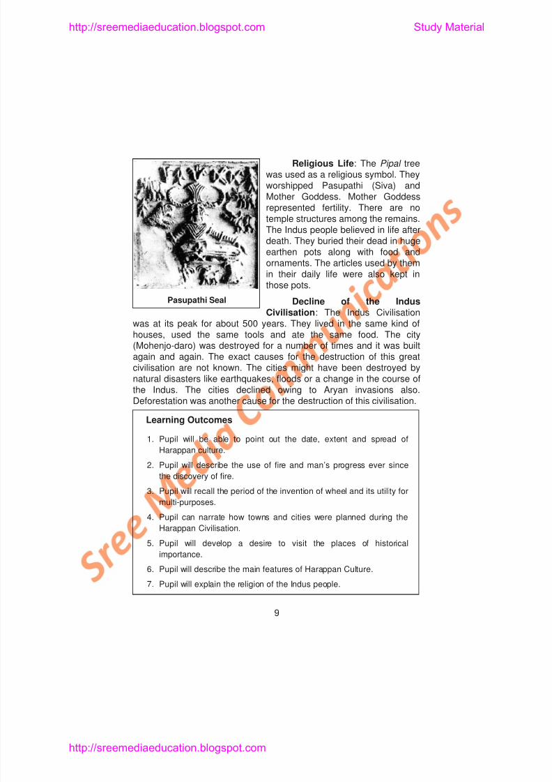
Religious Life: The Pipal treewas used as a religious symbol. Theyworshipped Pasupathi (Siva) and
Mother Goddess. Mother Goddessrepresented fertility. There are notemple structures among the remains.The Indus people believed in life afterdeath. They buried their dead in hugeearthen pots along with food andornaments. The articles used by themin their daily life were also kept inthose pots.
Decline of the IndusCivilisation: The Indus Civilisation
was at its peak for about 500 years. They lived in the same kind ofhouses, used the same tools and ate the same food. The city(Mohenjo-daro) was destroyed for a number of times and it was builtagain and again. The exact causes for the destruction of this greatcivilisation are not known. The cities might have been destroyed bynatural disasters like earthquakes, floods or a change in the course of
Pasupathi Seal
http://sreemediaeducation.blogspot.com Study Material
8/6/2019 Social Science History Civics and Geography
http://slidepdf.com/reader/full/social-science-history-civics-and-geography 14/280
Self-Evaluation
I. Choose the Correct Answer
1. The Harappan Culture flourished between
a) 3250 B.C - 2750 B.C b) A.D. 100 - A.D. 200
c) 1000 B.C. - 500 B.C. d) A.D. 500 - A.D. 1000
2. The Indus Valley Civilisation had overseas trade contacts with
a) Russia b) China
c) Spain d) Egypt
3. Mohenjo-daro is in
a) Sindh b) The Punjab
c) Gujarat d) Rajasthan
4. The Indus seals were used for
a) Playing b) Trading
c) Worshipping d) None of the above
http://sreemediaeducation.blogspot.com Study Material
8/6/2019 Social Science History Civics and Geography
http://slidepdf.com/reader/full/social-science-history-civics-and-geography 15/280
6. In Mohenjo-daro, the largest building is the_______________
7. The drains of Harappan culture were lined with______________
8. The Indus seals carry short inscriptions with carved pictures of ___________
9. The Indus people developed picture___________
10. Pasupathi and Mother Goddess were worshipped by ___________ people.
III. Match the Following
1. Chalcolithic Age - Fort
2. Sir John Marshall - Rajasthan
3. Larkana District - Indus women
4. Kalibangan - Gujarat
5. Citadel - Terracotta
6. Lothal - Religious symbol
http://sreemediaeducation.blogspot.com Study Material
8/6/2019 Social Science History Civics and Geography
http://slidepdf.com/reader/full/social-science-history-civics-and-geography 16/280
8. What were the staple food items of the Harappan people?
9. Briefly write on the religious life of the Indus people.
10. Write a note on the drainage system of Mohenjo-daro.
V. Answer in Detail
1. Discuss the date, extent and spread of Harappan Culture.
2. Describe the Great Bath and the granaries.
3. Examine the salient features of the Indus Valley Civilisation.
4. Explain the causes for the decline of the Indus Valley Civilisation.
http://sreemediaeducation.blogspot.com Study Material
8/6/2019 Social Science History Civics and Geography
http://slidepdf.com/reader/full/social-science-history-civics-and-geography 17/280
Lesson 2
THE VEDIC PERIOD
Learning Objectives
1. Pupil acquires knowledge about the Aryan Civilisation
2. Pupil knows the sources of information for the Vedic period
3. Pupil understands the differences in the life of the people of Early
and Later Vedic periods.
4. Pupil knows the political, social, economic and religious life of the
people of early and later Vedic periods.
After the ruin of the Indus and Harappan cities, a new culture
http://sreemediaeducation.blogspot.com Study Material
8/6/2019 Social Science History Civics and Geography
http://slidepdf.com/reader/full/social-science-history-civics-and-geography 18/280
We are able to understand from these literary works the political,social, economic, religious and cultural life of the people of the Vedicperiod.
The Vedic Age: The Vedic age is divided into two. The EarlyVedic period from B.C. 2000 to B.C. 1000 and the Later Vedicperiod from B.C. 1000 to B.C. 600. We see some differences in thelife of the people during these two stages.
EARLY VEDIC OR RIG VEDIC AGE
Political Life: The Early Vedic period is known from the Rig
Veda. During this period, the kingdom was tribal in character. Eachtribe formed a separate kingdom. The basic unit of the political
organisation was family (kula) . A number of families formed a Village
(Grama) . Its head was the Gramani. A group of villages constituted a
large unit called clan (vis). Several clans formed the tribe (Jana) . Their
leader was Rajan, the Vedic king. He protected his people from
enemies. He was assisted by the purohita or priest, the senani or
commandant, the Sabha and the Samithi in administration.
http://sreemediaeducation.blogspot.com Study Material
8/6/2019 Social Science History Civics and Geography
http://slidepdf.com/reader/full/social-science-history-civics-and-geography 19/280
sandalwood and ivory were the export items. Horses and dates were
imported.
Food and Entertainments: The food of the people consisted of
barley cakes, milk, ghee, fruits, vegetables and meat. Intoxicating
drinks were produced from soma plant and sura from barley were
offered to Gods and consumed. Chariot racing, hunting, horse racing,
dicing, music and dance were the favourite pastimes. Boxing was also
known to them. They knew playing veena .
Dress and Ornaments: Men wore a garment like Dhoti. The
upper garment was like a shawl. They wore turbans and grew beards.
Women wore vasas (under garments), nivi (dress worn at the waist)
and Athivasas (the upper cover). Dresses were made up of cotton
and wool. Both men and women wore different kinds of ornaments.
Ear rings, necklaces, bangles and hair bands were used. Chappals
made of leather were also used.
Religion: During the early Vedic period religion was in the form
of nature worship. Fire, sun, wind, sky and trees were worshipped.
Prayers were offered to Agni, Vayu and Surya. Agni and Varuna
were the most favourite Gods. Yagas and Yajnas were the most
http://sreemediaeducation.blogspot.com Study Material
8/6/2019 Social Science History Civics and Geography
http://slidepdf.com/reader/full/social-science-history-civics-and-geography 20/280
Magadha, Kasi, Avanti and Panchala came into existence. Theposition of the king was considerably high. Sabha and Samiti did notstand in his way. Kingship became hereditary. The kings were
incharge of defence and maintaining law and order of their kingdoms.They built vast empires. They tried to extend their territories. Thereforefrequent wars were fought. Rituals and sacrifices such as Rajasuya Ashvamedha, Vajapeya and Yagas were performed by the kings.
Rajasuya - Gave supreme power to the king.
Ashvamedha - The king claimed control over all thekingdoms visited by his Ashva (horse)
Vajapeya - A chariot race in which the king’schariot always won.
Kings assumed titles like Ekrat, Samrat and Sarvabauma .Village administration was looked after by the village councils. Taxeslike Pali, Sulk and Bhaga were collected from the people. Therevenue was spent for the benefit of the subjects.
http://sreemediaeducation.blogspot.com Study Material
8/6/2019 Social Science History Civics and Geography
http://slidepdf.com/reader/full/social-science-history-civics-and-geography 21/280
was not allowed. Though monogamy was the rule, polygamy waspractised. Women degradation started from the later Vedic period.
Education: Education was limited to the three upper castes.Pupils stayed with their teachers at the Gurukula . Women were notsent to the Gurukula. However, women like Gargi and Maitreyi wereeducated. Students were taught philosophy, logic, religion, grammar,astronomy, medicine, ethics and arithmetic. Dhanur Veda or wartactics was taught to princes. Pupils observed strict discipline,obedience and respect for the teachers.
Gargi was one of the learned persons summoned by kingJanaka; the Upanishads refer to the conversation betweenMaitreyi and her husband Yajnavalkaya.
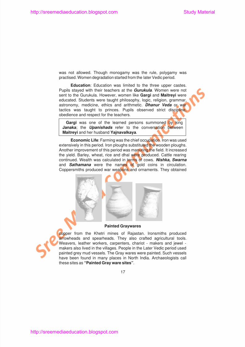
Economic Life: Farming was the chief occupation. Iron was usedextensively in this period. Iron ploughs substituted the wooden ploughs.Another improvement of this period was manuring the field. It increasedthe yield. Barley, wheat, rice and dhal were produced. Cattle rearingcontinued. Wealth was calculated in terms of cows. Nishka, Swarna and Sathamana were the names of gold coins in circulation.Coppersmiths produced war weapons and ornaments. They obtained
http://sreemediaeducation.blogspot.com Study Material
8/6/2019 Social Science History Civics and Geography
http://slidepdf.com/reader/full/social-science-history-civics-and-geography 22/280
Both internal and foreign trade flourished. Medicinal plants,medicine, clothings and leather products were exported to countries likeBabylonia.
Food and Entertainments: Rice, wheat, barley, milk and milkproducts, vegetables and fruits were their diet. Fish was also eaten.The flesh of oxen, sheep and goats were eaten. Soma and Sura weretheir common drinks. Indoor and outdoor games were played duringthis period. Gambling, dicing, chariot racing and horse racing weresome of their pastimes. The people were fond of music and dance.
Dress and Ornaments: Woollen and Cotton dresses were usedby the people. Ornaments made of gold and silver were worn. The
other metals used by the Later Vedic period were iron, copper and tin.Religion: Many changes occurred in the field of religion. The
Gods of early Vedic age lost their significance. In the Later Vedicperiod, people worshipped new Gods like Prajapathi, Pasupathi,Vishnu and Krishna. Prayers and scarifices became important waysof worshipping God. Animals were killed during sacrifice. The religionbecame complex affair. The theory of Karma and the theory ofincarnation were accepted. People believed that the God is thesupreme head and he was not only a creator but also a destroyer.
http://sreemediaeducation.blogspot.com Study Material
8/6/2019 Social Science History Civics and Geography
http://slidepdf.com/reader/full/social-science-history-civics-and-geography 23/280
2. The Early Vedic period is known from
a) The Epics b) Upanishadsc) The Rig Veda d) The Aranyakas
3. The Later Vedic period is generally dated between
a) B.C. 2000 and B.C. 1000 b) B.C. 3000 and B.C. 2000c) B.C. 1000 and B.C. 600 d) B.C. 500 and B.C. 200
4. Nivi was a kind of dress worn
a) At the waist b) Around the headc) To cover the entire body d) None of the above
5. The king claimed control over all the kingdoms visited by hisAshva. Here Ashva means
a) Elephant b) Horsec) Chariot d) Cow
6. During the Later Vedic age, copper was obtained from
a) Kasi b) Malwac) Rajastan d) Kuru
http://sreemediaeducation.blogspot.com Study Material
8/6/2019 Social Science History Civics and Geography
http://slidepdf.com/reader/full/social-science-history-civics-and-geography 24/280
III. Match the Following
1. Veda – Exchange of goods
2. Dhanur Veda – Coins
3. Senani – King
4. Barter System – Knowledge
5. Rajan – Student life
6. Nisha – Woman Scholar
7. Gargi – Commandant
8. Brahmacharya – War tactics
IV. Answer Briefly
1. Which portion of India was known as Sapta Sindhu?
2. Mention the names of the four Vedas.
3. What are the Sub Vedas?
4. Who had helped the Aryan kings in their administration?
5. What were the occupations of the Early Vedic people?
6. Mention the favourite pastimes of the Vedic period.
http://sreemediaeducation.blogspot.com Study Material
8/6/2019 Social Science History Civics and Geography
http://slidepdf.com/reader/full/social-science-history-civics-and-geography 25/280
Lesson 3
RISE OF JAINISM AND BUDDHISM
Learning Objectives
1. Pupil knows the religious condition in India during the 6th Century
B.C.
2. Pupil understands the causes for the rise of new religions.
3. Pupil learns the life history of Mahavira and Buddha.
4. Pupil gains knowledge about the teachings of Jainism and
Buddhism.
5. Pupil understands the reasons for the spread of Janism and
Buddhism.
6 Pupil knows the contribution made by Jainism and Buddhism for the
http://sreemediaeducation.blogspot.com Study Material
htt // di d ti bl t St d M t i l
8/6/2019 Social Science History Civics and Geography
http://slidepdf.com/reader/full/social-science-history-civics-and-geography 26/280
3. Caste system became rigid and it created inequality in thesociety.
4. Religious literature was in Sanskrit. The common people spoke
in Prakrit and Pali : They could not understand Sanskrit.
5. The priestly class took advantage of it. They interpreted religionaccording to their convenience.
6. They considered themselves superior and others as inferiors.
7. Animal sacrifice became common. People did not like it.
8. People wanted a simple religion which would remove the evils inthe society.
JAINISM (C. 539 - 467 B.C.)
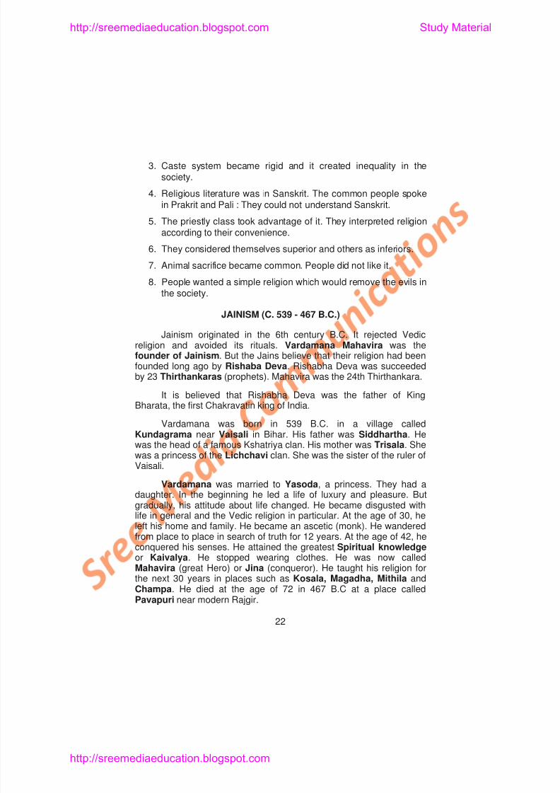
Jainism originated in the 6th century B.C. It rejected Vedicreligion and avoided its rituals. Vardamana Mahavira was thefounder of Jainism. But the Jains believe that their religion had beenfounded long ago by Rishaba Deva. Rishabha Deva was succeededby 23 Thirthankaras (prophets). Mahavira was the 24th Thirthankara.
http://sreemediaeducation.blogspot.com Study Material
htt // di d ti bl t St d M t i l
8/6/2019 Social Science History Civics and Geography
http://slidepdf.com/reader/full/social-science-history-civics-and-geography 27/280
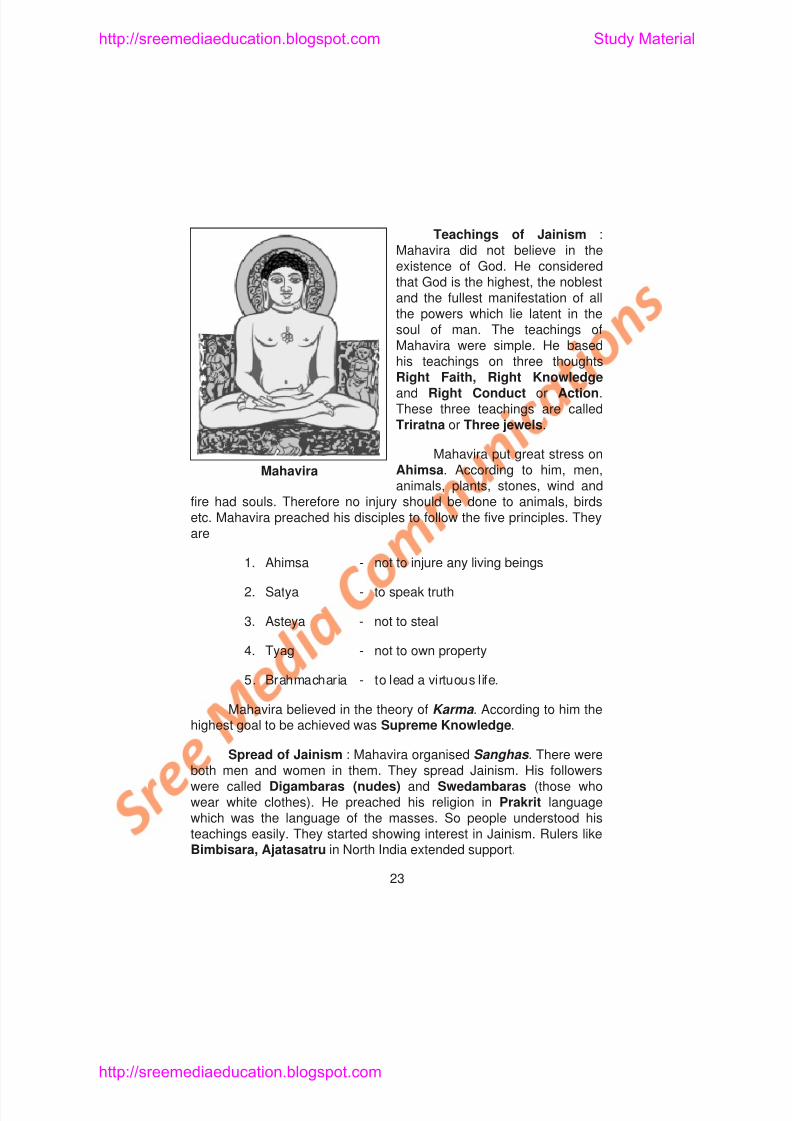
Teachings of Jainism :Mahavira did not believe in theexistence of God. He considered
that God is the highest, the noblestand the fullest manifestation of allthe powers which lie latent in thesoul of man. The teachings ofMahavira were simple. He basedhis teachings on three thoughtsRight Faith, Right Knowledgeand Right Conduct or Action.These three teachings are called
Triratna or Three jewels.
Mahavira put great stress onAhimsa. According to him, men,animals, plants, stones, wind and
fire had souls. Therefore no injury should be done to animals, birdsetc. Mahavira preached his disciples to follow the five principles. Theyare
Mahavira
http://sreemediaeducation.blogspot.com Study Material
http://sreemediaeducation blogspot com Study Material
8/6/2019 Social Science History Civics and Geography
http://slidepdf.com/reader/full/social-science-history-civics-and-geography 28/280
In South India, Kun Pandian, Mahendravarma I and
Kharavela of Kalinga showed interest in Jainism.
THE CONTRIBUTION OF JAINISMThe jains contributed much to the growth of literature in Pali,
Prakrit and Tamil. In Tamil Seevaka Shinthamani by Thiruthakka
Thevar, Nannool , a Tamil grammar by Pavanandhi Munivar are rich
literary works by the Jains. Even Thiruvalluvar is considered to be a
Jain. Hemachandra was probably the greatest Jain historian. He
wrote A History of Gujarat . He compiled two lexicons (dictionaries)
and wrote his famous Prakrit grammar. He also wrote the Yoga Sutra.
The Holy books of Jains are Angas and Purvas.
The contribution of the Jains to art and architecture are note
worthy. The Jain temple, called Dilwara temple, at Mount Abu in
Rajastan is famous for its art and architecture. The Jain temples at
Khajuraho, Chittor and Ranakpur are also famous for their
architecture. Ranakpur is one of the main holy places of the Jains. The
carvings at Udayagiri, Hathigumpha, Ellora and Girnar are good
examples of Jain Art. The huge Gomateswara statue at Sravana
http://sreemediaeducation.blogspot.com Study Material
http://sreemediaeducation blogspot com Study Material
8/6/2019 Social Science History Civics and Geography
http://slidepdf.com/reader/full/social-science-history-civics-and-geography 29/280
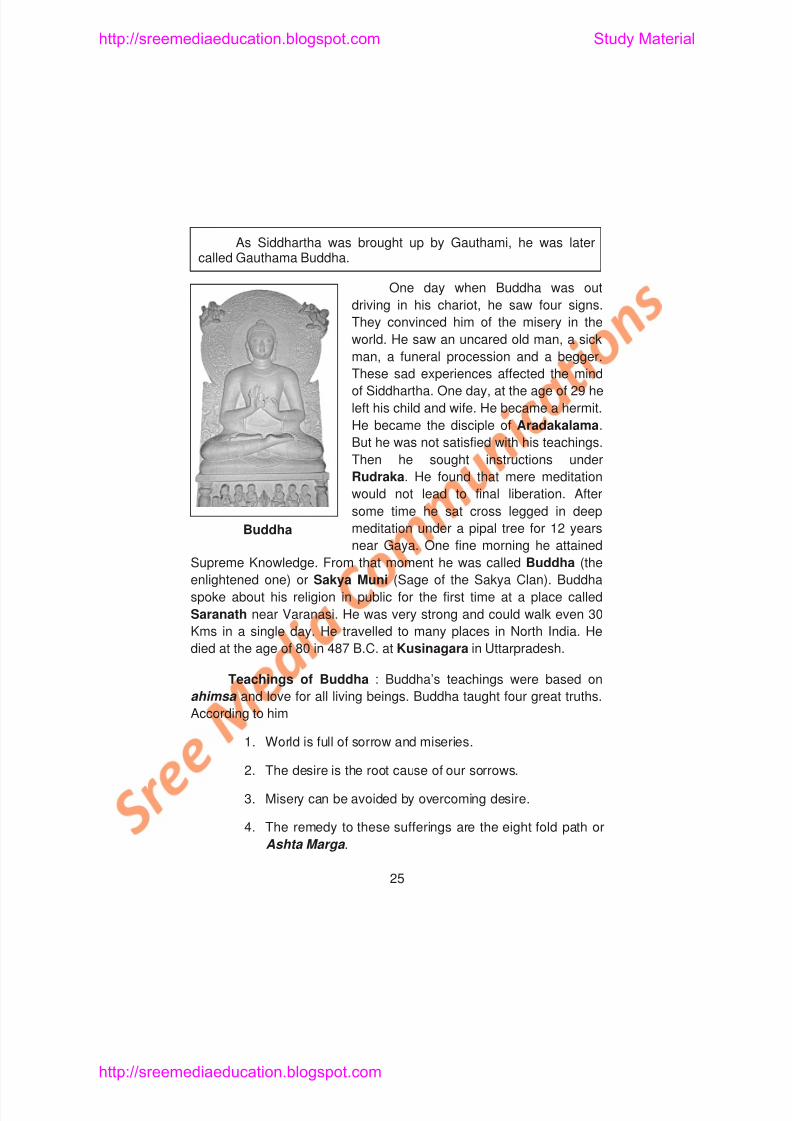
As Siddhartha was brought up by Gauthami, he was latercalled Gauthama Buddha.
One day when Buddha was outdriving in his chariot, he saw four signs.
They convinced him of the misery in the
world. He saw an uncared old man, a sick
man, a funeral procession and a begger.
These sad experiences affected the mind
of Siddhartha. One day, at the age of 29 he
left his child and wife. He became a hermit.
He became the disciple of Aradakalama.But he was not satisfied with his teachings.
Then he sought instructions under
Rudraka. He found that mere meditation
would not lead to final liberation. After
some time he sat cross legged in deep
meditation under a pipal tree for 12 years
near Gaya. One fine morning he attainedBuddha
http://sreemediaeducation.blogspot.com Study Material
http://sreemediaeducation blogspot com Study Material
8/6/2019 Social Science History Civics and Geography
http://slidepdf.com/reader/full/social-science-history-civics-and-geography 30/280
The following constitute the Eight Fold Path :
1. Right Thought 5. Right Living
2. Right Belief 6. Right Efforts
3. Right Speech 7. Right Knowledge
4. Right Action 8. Right Meditation.
The teachings of Buddha have been compiled into three bookscalled Tripitakas . (Three baskets). The three volumes are Sutta Pitaka , Vinaya Pitaka and Abidhamma Pitaka . Gauthama Buddha
had faith in the theory of Karma . Buddha neither accepted nor rejectedthe existence of God. He condemned violence against others in anyform. He tried to remove caste distinctions. Attaining Nirvana orenlightment is the basic principle of Buddhism. The successors ofBuddha were called Bodhisathvas .
The Spread of Buddhism : There are various reasons for thespread of Buddhism.
http://sreemediaeducation.blogspot.com Study Material
http://sreemediaeducation blogspot com Study Material
8/6/2019 Social Science History Civics and Geography
http://slidepdf.com/reader/full/social-science-history-civics-and-geography 31/280
Kanishka helped the spread of Buddhism. During Asoka’s timeBuddhist monks and missionaries went to Egypt, Syria, andMacedonia. Asoka sent his son Mahendra and daughter
Sangamitra to Ceylon to spread Buddhism. Kanishkha’smissionaries went to Burma, Japan, Tibet and Central Asiathrough China. China came under the influence of Buddhism.Thus Buddhism became a world religion. In South India, someChera rulers embraced Buddhism and supported it.
During the period of Kanishka, Buddhism was split into twobranches, namely Mahayana Buddhism (The Greater Vehicle) andHinayana Buddhism (The Lesser Vehicle).
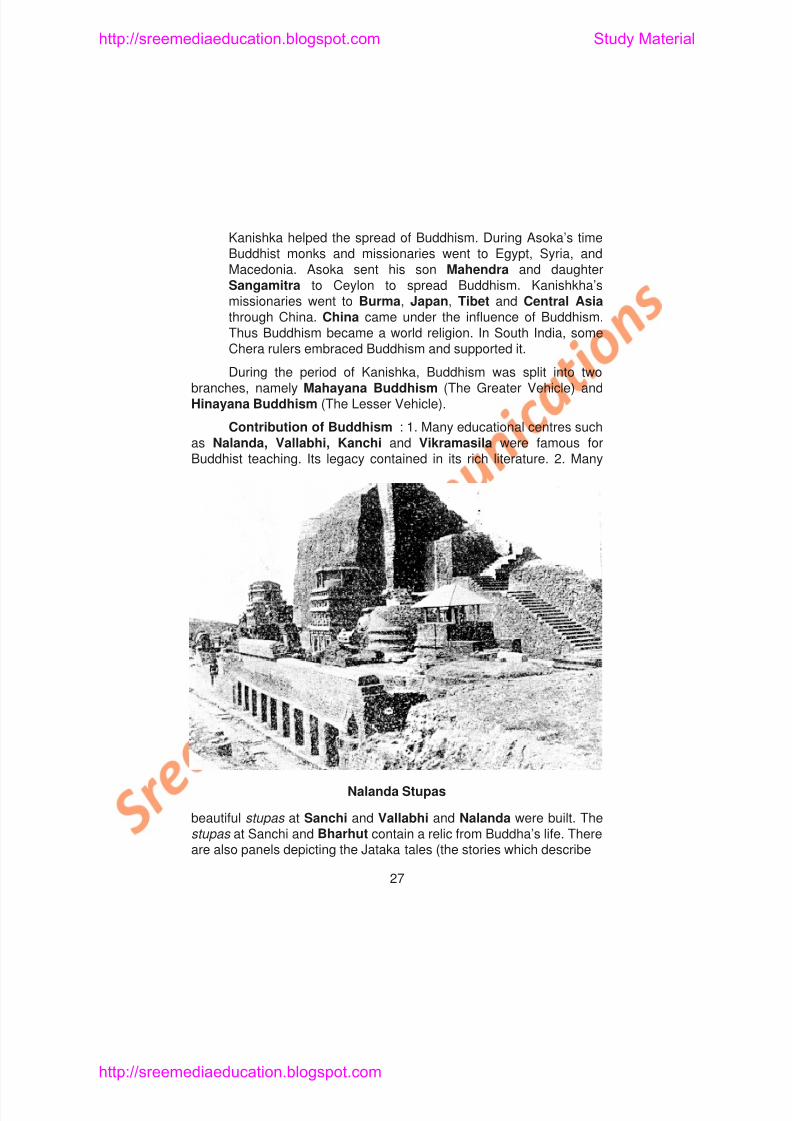
Contribution of Buddhism : 1. Many educational centres suchas Nalanda, Vallabhi, Kanchi and Vikramasila were famous forBuddhist teaching. Its legacy contained in its rich literature. 2. Many
http://sreemediaeducation.blogspot.com Study Material
http://sreemediaeducation blogspot com Study Material
8/6/2019 Social Science History Civics and Geography
http://slidepdf.com/reader/full/social-science-history-civics-and-geography 32/280
the previous births of Buddha). They are found at Gaya in Biharand Sanchi and Bharhut in Madhya Pradesh. 3. The Gandharasculptures and the paintings at Ellora and Ajanta are the gifts of
Buddhism. 4. The Buddhists built many rock cut structures calledChaityas which were prayer halls and viharas, which weremonasteries. Modern Bihar derived its name from Viharas . 5. Vinaya pitaka, Sutta pitaka and Abidhamma pitaka are the earliest literaryworks on Buddhism.
Causes for the Decline of Buddhism : The lack of royalpatronage, revival of Hinduism under the Guptas, corruption in theSanghas and the introduction of idol worship were the main causes for
the decline of Buddhism.
Similarities and Dissimilarities between Jainism andBuddhism
Similarities Dissimilarities
1. Jainism stressed chastityand nudity but not
1. Both accepted Karma
http://sreemediaeducation.blogspot.com Study Material
http://sreemediaeducation.blogspot.com Study Material
8/6/2019 Social Science History Civics and Geography
http://slidepdf.com/reader/full/social-science-history-civics-and-geography 33/280
Learning Outcomes
1. Pupil will be able to explain the causes that led to the rise of
Jainism and Buddhism.
2. Pupil will be able to describe the religious teachings of Mahavira
and Buddha.
3. Pupil will be able to point out the value of Ahimsa and try to
practice the same in his/her life.
4. Pupil will explain how these religions made people to lead a simple
and good life.
5. Pupil will recollect the measures taken by Asoka and Kanishka to
spread Buddhism.
6. Pupil will be able to narrate the contribution made by these
religions to literature and architecture.
SELF-EVALUATION
http://sreemediaeducation.blogspot.com Study Material
http://sreemediaeducation.blogspot.com Study Material
8/6/2019 Social Science History Civics and Geography
http://slidepdf.com/reader/full/social-science-history-civics-and-geography 34/280
5. Nannool was written by
a) Thirukthakka Devar b) Pavanandi Munivar
c) Thiruvalluvar d) Hemachandra6. Hemachandra wrote the history of
a) Gujarat b) Kasi
c) Kuru d) Gaya
7. Siddhartha’s father, Shuddhodana belonged to the clan
a) Sakya b) Lichchavi
c) Mauryan d) Kushan8. Rahul was the son of
a) Vardhamana b) Buddha
c) Mayadevi d) Asoka
9. Buddha spoke about his religion in public for the first time at aplace called
a) Sanchi b) Saranath
p g p y
http://sreemediaeducation.blogspot.com Study Material
8/6/2019 Social Science History Civics and Geography
http://slidepdf.com/reader/full/social-science-history-civics-and-geography 35/280
6. Seevaka Sintamani was written by____________
7. The holy books of Jains are ____________and ____________
8. The________________ statue at Sravana Belagola is a Jainmonument.
9. Siddhartha’s mother was____________and step mother was ____________
10. Siddhartha became the disciple of ____________ and ____________
11. Siddhartha sat in deep meditation under a ____________tree
near Gaya.12. Buddha died at____________in Uttar pradesh.
13. The basic principle of Buddhism is attaining ____________
14. The successors of Buddha were called ____________
III. Match the Following
1. Thirthankaras – Jain temple
p g p y
http://sreemediaeducation.blogspot.com Study Material

8/6/2019 Social Science History Civics and Geography
http://slidepdf.com/reader/full/social-science-history-civics-and-geography 36/280
IV. Answer Briefly
1. Name the important religions that arose in India during the 6th
Century B.C.
2. Give a short note on Thirthankaras.
3. What do you know about the early years of Mahavira?
4. What is meant by Triratna?
5. What were the five principles taught by Mahavira to his
disciples?
6. Name the two sects of Jainism.
7. Write the name of the kings who extended their support to
Jainism.
8. What do you know about Hemachandra?
9. Where was Buddha born?
10. What were the four signs that convinced Buddha of the misery in
the world?
http://sreemediaeducation.blogspot.com Study Material
8/6/2019 Social Science History Civics and Geography
http://slidepdf.com/reader/full/social-science-history-civics-and-geography 37/280
Lesson 4
INVASION OF ALEXANDER ON INDIA
Learning Objectives
1. Pupil knows the political condition of North India on the eve of
Alexander’s invasion.
2. Pupil learns the personality of Alexander.
3. Pupil understands the Greek influence on India.
4. Pupil knows the circumstances leading to the establishment of
Mauryan rule.
POLITICAL CONDITION OF INDIA IN THE 6th CENTURY B.C.
http://sreemediaeducation.blogspot.com Study Material
8/6/2019 Social Science History Civics and Geography
http://slidepdf.com/reader/full/social-science-history-civics-and-geography 38/280
Ajatasatru (C. 500 - 475 B.C.): Ajatasatru imprisoned hisfather Bimbisara. He fought against Kosala, Malla and Vaisali.Magadha reached to glory under him. The first Buddhist Councilwas convened by Ajatasatru at Rajagriha. His successors were weak.The Sisunaga dynasty came to power in Magadha. Sisunaga was thefounder of this dynasty. After them the Nandas captured power inMagadha.
The Nandas (C. 425 - 325 B.C.): Mahapadmananda was thefounder of Nanda rule in Magadha. He conquered Panchala, Kasi,Asumaga, Kuru, Mithila and Surasena kingdoms. He brought thewhole of North India under Magahdan rule. He invaded Kalinga in theSouth. After him, his successors were not powerful. Dhana Nandha
was the last ruler of this dynasty. Alexander invaded India during hisrule.
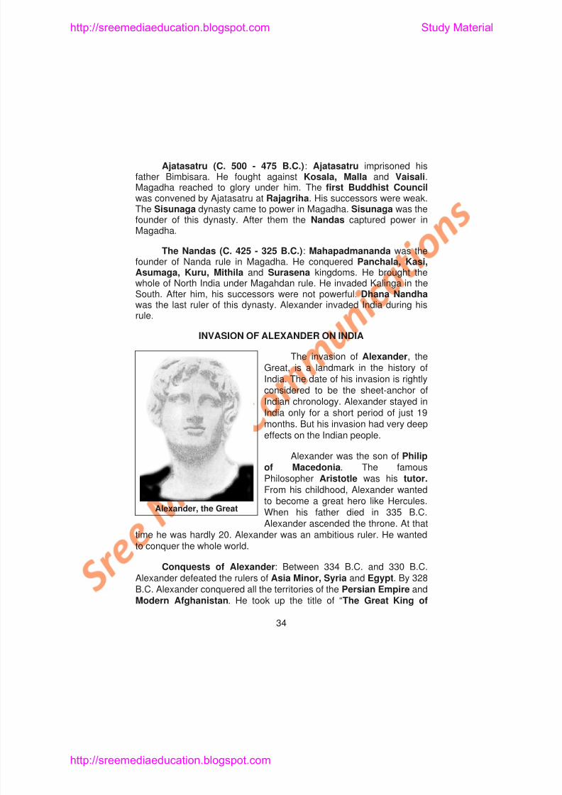
INVASION OF ALEXANDER ON INDIA
The invasion of Alexander, theGreat, is a landmark in the history ofIndia. The date of his invasion is rightlyconsidered to be the sheet-anchor of
http://sreemediaeducation.blogspot.com Study Material
8/6/2019 Social Science History Civics and Geography
http://slidepdf.com/reader/full/social-science-history-civics-and-geography 39/280
Persia.” But Alexander was not satisfied with those victories. His
desire was to become the Master of India, the land of milk and
honey. After consolidating his position in the hilly regions of Hindukush
Mountains, he crossed the river Indus with a huge army. Ambi, theruler of Taxila made his submission to Alexander. He recognised
Alexander as his overlord without waging a war.
Defeat of King Porus: Porus was the king of Jhelum territory.
He refused to surrender to Alexander. He opposed him. The armies of
Porus and Alexander met at Hydaspes on the banks of the river
Jhelum in 326 B.C. Alexander found that it was practically impossible
to cross the river Jhelum in the face of opposition from Porus. After
long delays, Alexander hit upon a plan. His soldiers, who stood in thefront rows, created a lot of noise. It made Porus and his soldiers
believe that the Greek soldiers were going to cross the river. But the
Greek soldiers who stood at the back crossed the river Jhelum at
another point at about 16 miles away from the camp spot at night.
Alexander’s army made a sudden and unexpected attack on the army
of Porus. Porus was taken by surprise. In spite of his bravery, he was
defeated. He was taken as a prisoner. When he was brought before
http://sreemediaeducation.blogspot.com Study Material
8/6/2019 Social Science History Civics and Geography
http://slidepdf.com/reader/full/social-science-history-civics-and-geography 40/280
for Chandragupta Maurya who shortly founded an Indian empire.2. The voyage and expeditions planned by Alexander paved new linesof communications with Western Asia. New routes of trade wereopened. Maritime activities also increased. 3. Although the Empirefounded by Alexander in India did not last long, the Greek settlementsin Bacteria and Parthia influenced India in many ways. Kanishkainvited many Graeco Bactrian sculptors to Gandhara for makingimages of Buddha and Bodhisatvas. There was a blending of Greekand Indian art in image making. This new type was called GandharaSchool of Art. It was greatly influenced by the Greeks. 4. Greekinfluence on Indian astronomy is noteworthy. Alexander’s friendNearchus and some others travelled along the coast of Western India.They wrote about what they saw in these regions. They also wrote theGeography, History and Culture of India. They had even described theclimate, plants, religions and customs of India. These writings help thehistorians to learn about Alexander’s invasion and the condition ofIndia at that time.
End of Nandha Rule in Magadha: The last Nanda ruler DhanaNanda was disliked by his people. Nandas generally did not believe inGod. They were atheists. Chanakya, a great Brahmin scholar, was theminister of Dhana Nanda When he was dining in a Dhana sala
http://sreemediaeducation.blogspot.com Study Material
8/6/2019 Social Science History Civics and Geography
http://slidepdf.com/reader/full/social-science-history-civics-and-geography 41/280
SELF-EVALUATION
I. Choose the Correct Answer
1. Bimbisara wasa) A Buddhist b) A Jain
c) A Hindu d) None of the three
2. The first Buddhist council was convened by
a) Ajatasatru b) Bimbisara
c) Asoka d) Dhana Nanda
3. Alexander was the son of
a) Philip of Macedonia b) Aristotle
c) Porus d) Hercules
4. Alexander’s desire was to become the master of
a) India b) Persia
c) Afghanistan d) Macedonia
5. The first ruler who made his submission to Alexander in India was
a) Porus b) Ambi
c) Chandragupta d) Chanakya
http://sreemediaeducation.blogspot.com Study Material
8/6/2019 Social Science History Civics and Geography
http://slidepdf.com/reader/full/social-science-history-civics-and-geography 42/280
4. In 323 B.C. Alexander died when he reached ____________ near Baghdad.
5. The Indian territories conquered by Alexander were given to
____________.6. The voyage planned by Alexander paved new lines of
communication with____________.
7. Greek influence on Indian ____________is noteworthy.
8. The last ruler of Nanda dynasty was____________.
9. With the help of Chanakya_______founded the Mauryan Empire.
III. Match the Following
1. Aristotle – Greek General
2. Ambi – Alexander’s Tutor
3. Alexander – Alexander’s Friend
4. Seleukos Nikator – Mauryan dynasty
5. Nearchus – Taxila
6. Chandragupta – Macedonia
http://sreemediaeducation.blogspot.com Study Material
8/6/2019 Social Science History Civics and Geography
http://slidepdf.com/reader/full/social-science-history-civics-and-geography 43/280
UNIT - II
Lesson 5
MAURYAN EMPIRE
Learning Objectives
1. Pupil knows the sources for the history of Mauryan period.
2. Pupils learns about the founder of the Mauryan empire
3. Pupil gains knowledge about Asoka’s religious policy and the
services rendered by Asoka for the welfare of his people.
4. Pupil understands the administrative system of the Mauryans.
5. Pupil knows the causes for the decline of the Mauryan Empire.
http://sreemediaeducation.blogspot.com Study Material
8/6/2019 Social Science History Civics and Geography
http://slidepdf.com/reader/full/social-science-history-civics-and-geography 44/280
views about his ancestry. According to Visakadatta, Chandragupta iscalled Maurya Putra, i.e., son of Maurya. The name of Maurya is thecorrupted form of Mura, the mother of Chandragupta Maurya. Somewriters view that Chandragupta came from the Moriya clan near
Pataliputra. Some consider that he was the son of Peacock (Mura)rearer.
As soon as Chandragupta captured power, he had to face twomain problems. He had to (1) liberate North West India from foreignrule and (2) put an end to the disorder caused due to the misrule ofDhana Nanda. He killed Dhana Nanda and took Pataliputra. It becamethe Mauryan capital. Chanakya helped him in his tasks.
Chanakya : Chanakya was a kingmaker. He was otherwiseknown as Kautilya. He was the root cause for the establishment of theMauryan rule in India. He has written the Arthasastra. It is a book onStatecraft. He is compared to Machiavelli of Italy, a great politicalthinker. Chanakya served as prime minister during the reigns ofChandragupta and Bindusara.
Conquests of Chandragupta : Chandragupta checked thefurther advance of the Greeks in the North west. He defeated
http://sreemediaeducation.blogspot.com Study Material
8/6/2019 Social Science History Civics and Geography
http://slidepdf.com/reader/full/social-science-history-civics-and-geography 45/280
called Chandra Basti built in memory of Chandragupta Maurya. Hedied in 298 B.C.
Bindusara : Chandragupta Maurya was succeeded by his son
Bindusara. He had the title Amitrakhada or slayer of foes.Bindusara appointed his eldest son Sumana as the Viceroy of Taxilaand younger son Asoka as the Viceroy of Ujjain. During his rule tworevolts took place in Taxila. His elder son Sumana could not suppressthem. So Asoka was sent to suppress them. The rebellions were putdown. Though Bindusara did not make any conquests, he consolidatedthe Empire that he inherited from his father. He maintained goodrelationship with foreign rulers. The Greek and Egyptian rulers senttheir ambassadors to Bindusara’s court.
Asoka (273 B.C. - 232 B.C) : Asoka was the most famous rulerof the Mauryan dynasty. He was also the first National ruler. Hecommanded universal respect and regard. He started his career as agreat conqueror.
The Kalinga War (261 B.C.) : Asoka’s empire extended fromKashmir in the North to Godavari - Krishna basin in the South.Kalinga (modern Orissa) was not included in his kingdom. So he
http://sreemediaeducation.blogspot.com Study Material
8/6/2019 Social Science History Civics and Geography
http://slidepdf.com/reader/full/social-science-history-civics-and-geography 46/280
means religious or moral duty. The chief features of Asoka dhammaare tolerance, non-violence, love and compassion. It also insiststhat masters should be kind to their servants and slaves; the youngpeople should obey the elders.
How Asoka is remembered? It is said that, “Amidst thetens of thousands of names of monarchs.... the name of Asokashines and shines almost alone, a star”. - H.G. Wells.
Asoka did not impose his Dhamma on his people. His Dhammawas mostly drawn from Buddhism. But he made a clear distinctionbetween his personal belief in Buddhism and his duty as an emperor.He stopped animal sacrifices. He himself gave up hunting and meat
eating. He had constructed rest houses for travellers. He planted treeson either side of the roads to give shade. He established hospitals forhuman beings and animals alike. He convened the third Buddhistcouncil at Pataliputra.
Asoka practised what he preached. He proved hisgreatness by being kind to all living beings. That is why he iscalled Asoka, the Great.
http://sreemediaeducation.blogspot.com Study Material
8/6/2019 Social Science History Civics and Geography
http://slidepdf.com/reader/full/social-science-history-civics-and-geography 47/280
2. He built stupas and viharas in memory of Buddha. Theseviharas in later ages became monasteries of the Buddhistmonks.
3. He built several monasteries where the monks could study theBuddhist scriptures and lead a life of quiet meditation.
4. Asoka visited all the holy places in our country associated withthe life of Buddha. He also introduced the system of royaltours.
5. He sent monks to preach Buddha’s doctrines and spread histeachings in far off countries like Mesopotamia, Syria, Egypt,Tibet, China and Burma.
6. He also appointed officials called Dharmayukthas andDharma Mahamatras who supervised and encouraged peopleto lead a pure and moral life.
7. He sent his son Mahendra and his daughter Sangamitra to SriLanka to preach Buddhism.
8. From the edicts we know that Asoka named himself asD i (b l d f h G d) d P i d h
http://sreemediaeducation.blogspot.com Study Material
8/6/2019 Social Science History Civics and Geography
http://slidepdf.com/reader/full/social-science-history-civics-and-geography 48/280
Sthanikas were in charge of districts. The Gramanis acted asheads of the villages.
Administration of Pataliputra: Pataliputra was the Capital of
the Mauryan Empire. Six boards or departments looked after theMunicipal administration of the city of Pataliputra. Every board hadfive members. These boards looked after the subjects like Industries,Census, Trade, Manufactures and their sale, Collection of taxes andWelfare of foreigners living in the city.
Army: The Mauryans had a huge army. They had six divisions -the Infantry, the Cavalry, Elephants, Chariots, Navy and the sixthsection which looked after the movement of goods and weapons for
the soldiers and the animals.According to Pliny, a Roman writer, the Mauryans had
600,000 foot soldiers 3,00,000 horses and 9000 elephants.
Spy System: The Mauryan kings had spies in all parts of theempire. These spies secretly brought news about officials, ministersand people to the king. So the king would always get news about themood and attitudes of the people. Women were also appointed asspies.
http://sreemediaeducation.blogspot.com Study Material
8/6/2019 Social Science History Civics and Geography
http://slidepdf.com/reader/full/social-science-history-civics-and-geography 49/280
http://sreemediaeducation.blogspot.com Study Material
8/6/2019 Social Science History Civics and Geography
http://slidepdf.com/reader/full/social-science-history-civics-and-geography 50/280
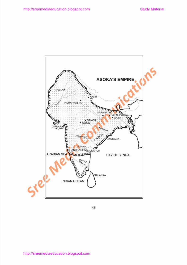
Relation with the Extreme South: The Mauryan Empire
included almost the whole of India except the extreme South. (Present
day Kerala and Tamilnadu) Asoka’s inscriptions refer to the Cheras as
Keralaputras. The Mauryans traded with the Southern kingdoms.
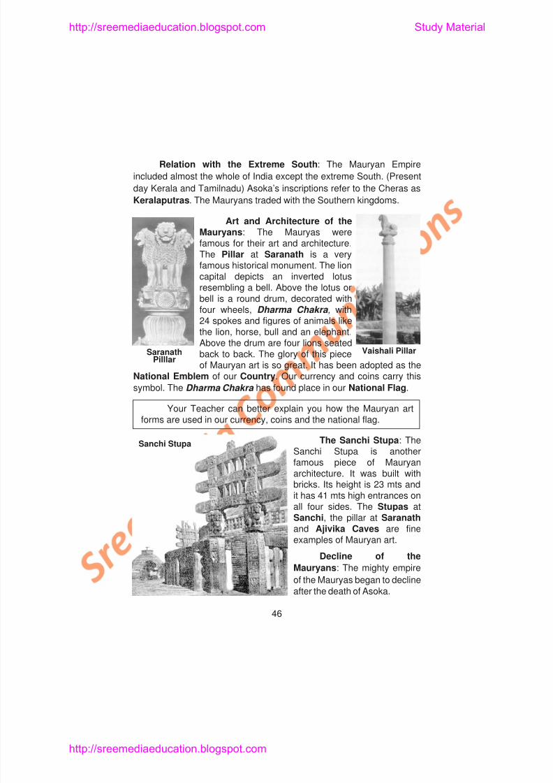
Art and Architecture of theMauryans: The Mauryas werefamous for their art and architecture.The Pillar at Saranath is a veryfamous historical monument. The lioncapital depicts an inverted lotusresembling a bell. Above the lotus or
bell is a round drum, decorated withfour wheels, Dharma Chakra , with24 spokes and figures of animals likethe lion, horse, bull and an elephant.Above the drum are four lions seatedback to back. The glory of this pieceof Mauryan art is so great. It has been adopted as the
National Emblem of our Country. Our currency and coins carry this
symbol The Dharma Chakra has found place in our National Flag
SaranathPilllar
Vaishali Pillar
http://sreemediaeducation.blogspot.com Study Material
8/6/2019 Social Science History Civics and Geography
http://slidepdf.com/reader/full/social-science-history-civics-and-geography 51/280
The causes for the Mauryan downfall are:
1. After the Kalinga war, Asoka gave up war. Therefore training infighting and military system became neglected. The Mauryan
army became weak and inefficient.2. Ashoka’s successors were not strong enough to protect and
maintain the large empire.
3. Pataliputra lost its central position due to the vastness of theEmpire.It encouraged revolts by various governors.
4. Lack of quick transport made it impossible to hold the vastempire united.
5. The last Mauryan king, Brahadratha was killed by his ministerPushyamitra Sunga. It put an end to the Mauryan Empire.
Learning Outcome
1. Pupil will be able to mention the various sources for the history of
the Mauryas.
2. Pupil will be able to recall the role of Chanakya in establishing
M l i I di
http://sreemediaeducation.blogspot.com Study Material
8/6/2019 Social Science History Civics and Geography
http://slidepdf.com/reader/full/social-science-history-civics-and-geography 52/280
2. Some people view that Chandragupta Maurya was the son of
a) A shepherd b) A peacock rearer
c) A general d) Chanakya
3. Helen was the daughter of
a) Chanakya b) Seleukos Nikatorc) Alexander d) Chandragupta Maurya
4. Initially Asoka worshipped
a) Lord Siva b) Lord Vishnu
c) Buddha d) None of these
5. Kalinga is in modern
a) Orissa b) The Punjabc) Bengal d) Rajastan
6. Asoka’s wife was
a) Devi b) Helenc) Mura d) A Persian woman
7. Dhamma is a
a) Pali word b) Sanskrit word
http://sreemediaeducation.blogspot.com Study Material
8/6/2019 Social Science History Civics and Geography
http://slidepdf.com/reader/full/social-science-history-civics-and-geography 53/280
4. _______________ of Italy was a political thinker.
5. Chanakya served as Prime Minister during the reign of ___________ and _______________
6. Seleukos received _______________ as royal gift fromChandragupta.
7. _______________ was an ambassador sent by Seleukos toMauryan court.
8. Chandragupta Maurya was a follower of _______________
9. The ancient temple built in memory of Chandragupta Mauryawas called_______________
10. _______________ was the elder son of Bindusara
11. Asoka embraced Buddhism by the influence of _______________ a Buddhist monk.
12. Asoka undertook a tour with the Buddhist monk_____________
13. The edicts of Asoka were placed in_______________wherepeople gathered.
http://sreemediaeducation.blogspot.com Study Material
8/6/2019 Social Science History Civics and Geography
http://slidepdf.com/reader/full/social-science-history-civics-and-geography 54/280
5. Sasanga – District incharge
6. Dhamma – Magasthenes
7. National Emblem – Karshapanas
8. Mantrins – Jain monk9. Coins – Visakadatta
10. Sthanika – Slayer of foes
11. Judicial officer – Cheras
12. Kerala Putras – Rajukas
IV. Answer Briefly
1. Who were controlling North West India when Chandragupta
Maurya established his authority in Magadha?2. Mention a few sources for the history of the Mauryas.
3. What were the twin tasks Chandragupta had to face?
4. Who was Seleukos Nikator?
5. Name the places surrendered by Seleukos to Chandragupta.
6. Name the boundaries of Chandragupta Maurya’s empire.
7. What do you know about the last days of Chandragupta
http://sreemediaeducation.blogspot.com Study Material
8/6/2019 Social Science History Civics and Geography
http://slidepdf.com/reader/full/social-science-history-civics-and-geography 55/280
Lesson 6
SUNGAS - KUSHANAS - SATAVAHANAS -SANGAM AGE IN TAMILNADU
Learning Objectives
1. Pupil learns about the Sungas.2. Pupil knows about the Kushanas and the greatness of Kanishka.
3. Pupil understands Hinayanism and Mahayanism.
4. Pupil knows about the Satavahanas.
5. Pupil learns about the ancient Tamil rulers and their patronage to
Tamil language and literature.
http://sreemediaeducation.blogspot.com Study Material
8/6/2019 Social Science History Civics and Geography
http://slidepdf.com/reader/full/social-science-history-civics-and-geography 56/280
Foreign Invasions : After the decline of the Maryan empire, thewhole of North Western India fell into the hands of foreigners betweenthe years 200 B.C. and 100 B.C. Except the Indo-Greeks or BactrianGreeks, the Parthians, the Sakas and the Kushanas came from
Central Asia. They settled in North India and made their contribution toIndian culture.
The Kushanas : The Kushanas came to India in the firstcentury A.D. They belonged to Yuch-chi tribe in China. They movedtowards the west. Kujula Kadphises, a Yuch-Chi chief, hadestablished himself in Kabul and Kashmir. He founded the Kushanadynasty. His son Vima Kadphises was also famous and issued goldcoins. They resembled Indian coins.
The greatest Kushana ruler was Kanishka. He ruled from A.D.78 to A.D. 120. He started the Saka Era which commenced in A.D. 78.His capital was Purushapura or Peshawar. He constructed a citycalled Kanishkapuram.
Kanishka’s Conquests: Kanishka conquered Kashmir. Hismost important campaign was against China. He crossed the Pamirsand defeated the Chinese. He conquered Khotan, Yarkhand and
http://sreemediaeducation.blogspot.com Study Material
8/6/2019 Social Science History Civics and Geography
http://slidepdf.com/reader/full/social-science-history-civics-and-geography 57/280
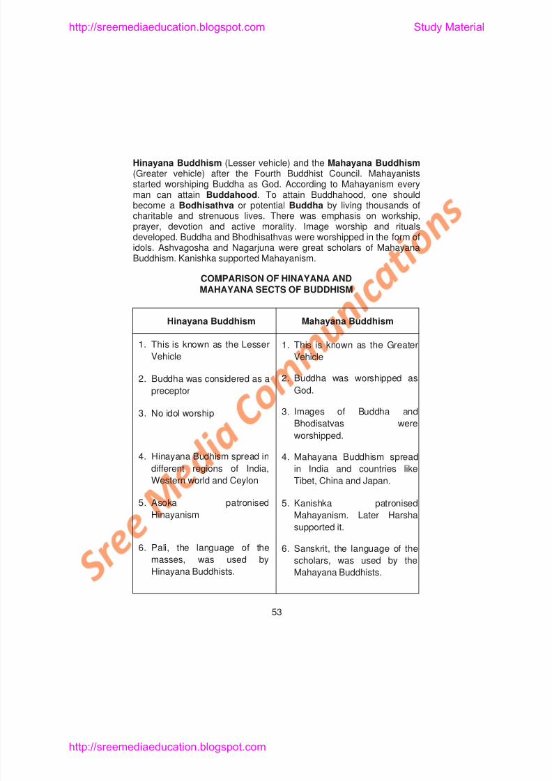
Hinayana Buddhism (Lesser vehicle) and the Mahayana Buddhism(Greater vehicle) after the Fourth Buddhist Council. Mahayanistsstarted worshiping Buddha as God. According to Mahayanism everyman can attain Buddahood. To attain Buddhahood, one should
become a Bodhisathva or potential Buddha by living thousands ofcharitable and strenuous lives. There was emphasis on workship,prayer, devotion and active morality. Image worship and ritualsdeveloped. Buddha and Bhodhisathvas were worshipped in the form ofidols. Ashvagosha and Nagarjuna were great scholars of MahayanaBuddhism. Kanishka supported Mahayanism.
COMPARISON OF HINAYANA ANDMAHAYANA SECTS OF BUDDHISM
Hinayana Buddhism Mahayana Buddhism
1. This is known as the Lesser
Vehicle
2. Buddha was considered as a
1. This is known as the Greater
Vehicle
2. Buddha was worshipped as
G d
http://sreemediaeducation.blogspot.com Study Material
8/6/2019 Social Science History Civics and Geography
http://slidepdf.com/reader/full/social-science-history-civics-and-geography 58/280
Kanishka’s Support to Medicine: Kanishka patronised Charaka. Hewas a doctor. He was also a scholar well versed in many Sastras . Hewrote the Charaka Samhita . It deals with medicine. His works becamepopular later in Persia and Arabia. Another medical scholar Susruta
also belonged to Kanishka’s time. He has written the Susruta Samhita . It is devoted to surgery. It mentions a large variety ofsurgical instruments. It became famous in Arabia and Cambodia.
The Gandhara Art and Kanishka’s Contribution to Art: Anew school of sculpture developed during Kanishka’s time. It is calledGandhara Sculpture. This sculpture is Buddhist, and thecharacteristic works are statues and reliefs. The sculpture bears Greekinfluence, but the subject is Indian. It is also called as the Gandhara
School of Indian art.
During Kanishka’s rule, he built many monuments. They werebuilt at Kanishkapura, Peshawar, Mathura and Taxila.
After the death of Kanishka, the distant provinces in the bordersrevolted. They became independent under the local chiefs. TheKushnana Empire declined by about A.D. 180.
http://sreemediaeducation.blogspot.com Study Material
8/6/2019 Social Science History Civics and Geography
http://slidepdf.com/reader/full/social-science-history-civics-and-geography 59/280
Prakrit language improved. The Saptasataka, Brihatkatha and the
Katantra, a book on Sanskrit grammar, are the important literary
works of the Satavahana period. The fine painting at Amaravathi and
Nagarjunakonda caves belong to this period. The Satavahana rulers
built beautiful temples, monasteries, rock cut caves, stupas and prayerhalls.
SANGAM AGE IN TAMILNADU (300 B.C TO A.D.300)
There existed the Chera, the Chola and the Pandya Kingdoms
in ancient Tamilnadu. The rulers of these Kingdoms were greatpatrons of art and literature. They developed the Tamil language and
literature through an assembly of poets or Sangams.
Sources: The Sangam literary works constitute main source ofinformation for the history of ancient Tamilnadu. A large number of
Tamil poems composed during this period are highly helpful. The
Sangam poems are divided into three main groups. They are thePathu Pattu (Ten Idylls), the Ettuthogai (Eight Anthologies) and the
Padinenkilkanakku (Eighteen Minor works).
http://sreemediaeducation.blogspot.com Study Material
8/6/2019 Social Science History Civics and Geography
http://slidepdf.com/reader/full/social-science-history-civics-and-geography 60/280
The Cholas: The kingdom of Cholas mainly consisted ofTiruchi and Thanjavur regions in Tamilnadu. Karikala was thegreatest ruler of the ancient Cholas. Uraiyur was their capital andKaveripoompattinam served as their port. The tiger was the emblem
of the Cholas. Karikala built Kallanai across the river Kaveri nearTiruchirappalli.
The Pandyas: The Pandyan Kingdom comprised the regions ofMadurai, Ramanathapuram and Tirunelveli in Southern Tamilnadu.
Madurai was the capital of the Pandyas. Korkai was theirport. The fish was the emblem of the Pandyas. The greatest Pandyaking was Nedunchezhian. He defeated the Chera, Chola and a
number of Minor Chieftains at Thalayalanganam. So he was knownas Thalayalanganathu Seruvendra (victor of Thalayalanganam)Nedunchezhian. The Maduraikanchi gives a full description ofMadurai and the Pandyan country under Neduchezhian’s rule.
SOCIAL LIFE
The Sangam Age in Tamilnadu witnessed prosperity in allh f lif Th l d di id d i t K i ji M ll i M d
http://sreemediaeducation.blogspot.com Study Material
8/6/2019 Social Science History Civics and Geography
http://slidepdf.com/reader/full/social-science-history-civics-and-geography 61/280
Chivalry : The Tamil people had observed certain social,
religious and moral customs. They possessed the qualities of courage,
honour, courtesy and loyalty. The Chera king Neduncheralathan went
up to the Himalayas and returned victoriously. He assumed the title of
Himayavaramban. A Chola king hoisted the tiger flag on theHimalayas. The ancient Tamils also had the practice of raising hero
stones called Virakkals in honour of the heroes who died while fighting
for the king. Receiving wounds in the battlefields at the back was
considered as a shameful deed.
The Purananooru speaks about the chivalry of the
ancient Tamils.
Position of Women : The women of the Sangam Age enjoyed
respectable position. However, male chauvinism prevailed. Some
women were educated. We come across women poets like Kaakkai
Paadiniyar, Pon Mudiyar and Avvaiyar. Some of them had
knowledge in politics. At times they used to advise the kings. Chastity
was the most important virtue of Tamil women. They considered Karpu
much more important for them than life itself. They were highly
d t d t d th i h b d Ch t tl
http://sreemediaeducation.blogspot.com Study Material
8/6/2019 Social Science History Civics and Geography
http://slidepdf.com/reader/full/social-science-history-civics-and-geography 62/280
Religion: The ancient Tamils were religious minded. Theyworshipped Mother Goddess. They also worshipped Siva, Vishnu,Brahma, Indra and Varuna. Festivals were organised periodically.
Justice: The Sangam monarchs gave importance to justice.Hence their rule was benevolent.
Know about Pandian Nedunchezhian and ManuneethiCholan who were the embodiments of justice.
Learning Outcome
1. Pupil will be able to explain the work of Pushyamitra Sunga.
2. Pupil will be able to describe how Kanishka is considered as
second Asoka.3. Pupil will be able to recall the services of Kanishka to Buddhism.
4. Pupil will be able to differentiate between Hinayana and Mahayana
Sects.
5 Pupil will be able to mention the features of Gandhara art.
6. Pupil will be able to explain about the Satavahanas who ruled
Andhra for about 450 years.
7 P il ill b bl d ib h lif f l i h S
http://sreemediaeducation.blogspot.com Study Material
8/6/2019 Social Science History Civics and Geography
http://slidepdf.com/reader/full/social-science-history-civics-and-geography 63/280
5. Sangams helped for the development of
a) Tamil language b) Hindi languagec) Urdu language d) Sanskrit language
6. Manimekalai was written by
a) Ilango Adigal b) Sattanarc) Thiruvalluvar d) Kabilar
7. The capital of the Cheras was
a) Vanchi b) Thondic) Madurai d) Tanjore
8. Kallanai across the river Cauvery was built by
a) Karikala b) Nedunchezhiyanc) Senguttuvan d) None of the above
9. Nedunchezhian’s rule is described in
a) Maduraikanchi b) Silappathikaramc) Pattupattu d) Tirukkural
II. Fill in the Blanks
http://sreemediaeducation.blogspot.com Study Material
8/6/2019 Social Science History Civics and Geography
http://slidepdf.com/reader/full/social-science-history-civics-and-geography 64/280
III. Match the Following
1. Pathanjali – Philosopher
2. Peshawar – Mahavibhasha
3. Ashvagosha – Surgery
4. Vasumitra – Founder of Satavahana dynasty
5. Susrutha – Ports
6. Simukha – Sanskrit grammarian
7. Silappadikaram – Capital city
8. Tondi – Chola king
9. Karikala – Ilango Adigal
10. Auvaiyar – Pandian Kingdom
11. Pearls – Political adviser
IV. Answer Briefly
1. How did the Sunga dynasty come to an end?
2. Name the foreigners who settled in India between B.C. 200 toA.D.100.
3 What do you know about Saga Era?
http://sreemediaeducation.blogspot.com Study Material
8/6/2019 Social Science History Civics and Geography
http://slidepdf.com/reader/full/social-science-history-civics-and-geography 65/280
UNIT - III
Lesson 7
THE GUPTA EMPIRE
Learning Objectives
1. Pupil knows the sources of the history of the Guptas.
2. Pupil learns about the achievement of the Gupta rulers
Samudragupta and Chandragupta II.
3. Pupil acquires knowledge about the social, economic, religious
and cultural condition of India under the Guptas.
4. Pupil understands the Gupta administration.
8/6/2019 Social Science History Civics and Geography
http://slidepdf.com/reader/full/social-science-history-civics-and-geography 66/280
http://sreemediaeducation.blogspot.com Study Material
8/6/2019 Social Science History Civics and Geography
http://slidepdf.com/reader/full/social-science-history-civics-and-geography 67/280
http://sreemediaeducation.blogspot.com Study Material
8/6/2019 Social Science History Civics and Geography
http://slidepdf.com/reader/full/social-science-history-civics-and-geography 68/280
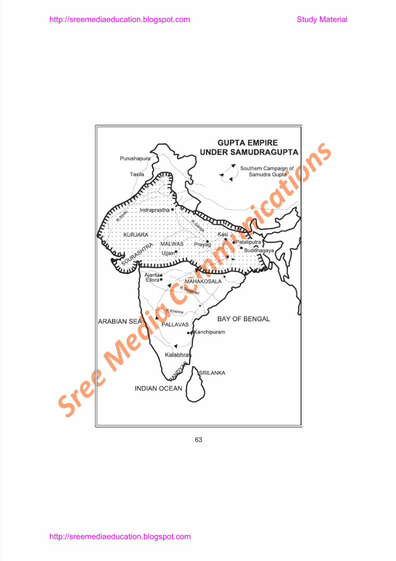
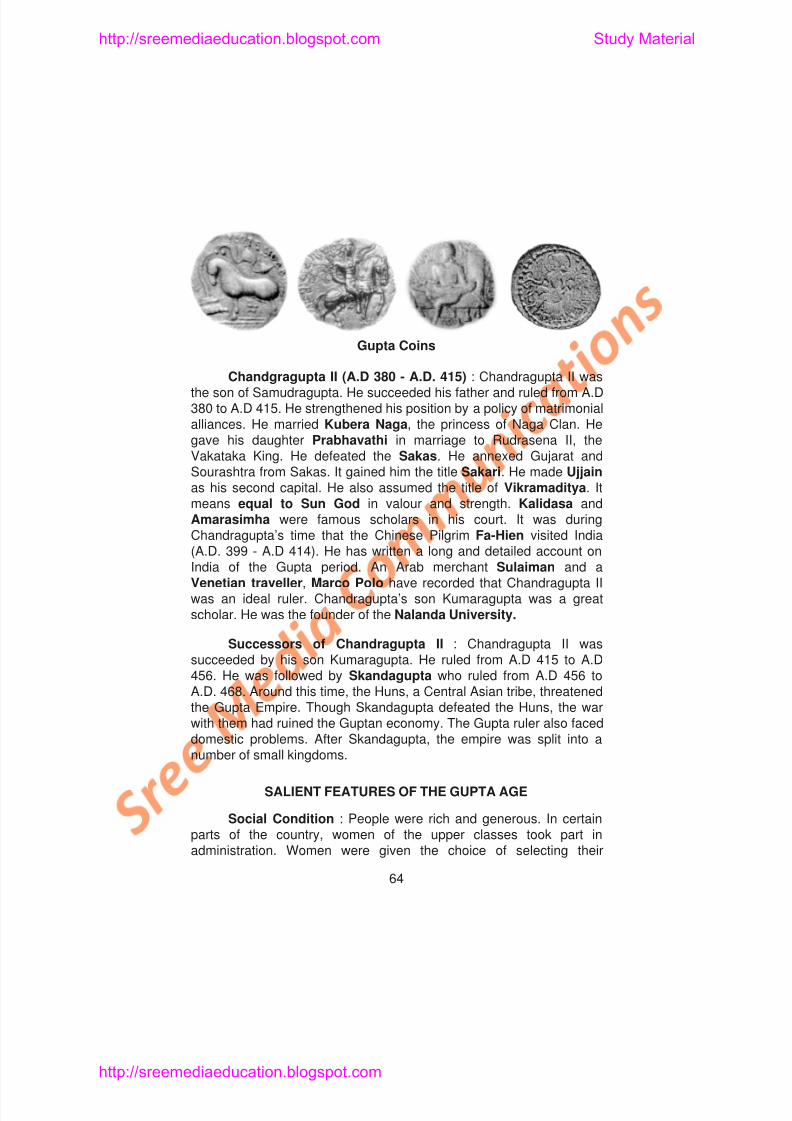
Chandgragupta II (A.D 380 - A.D. 415) : Chandragupta II wasthe son of Samudragupta. He succeeded his father and ruled from A.D380 to A.D 415. He strengthened his position by a policy of matrimonialalliances. He married Kubera Naga, the princess of Naga Clan. He
gave his daughter Prabhavathi in marriage to Rudrasena II, theVakataka King. He defeated the Sakas. He annexed Gujarat andSourashtra from Sakas. It gained him the title Sakari. He made Ujjainas his second capital. He also assumed the title of Vikramaditya. Itmeans equal to Sun God in valour and strength. Kalidasa andAmarasimha were famous scholars in his court. It was duringChandragupta’s time that the Chinese Pilgrim Fa-Hien visited India(A.D. 399 - A.D 414). He has written a long and detailed account on
Gupta Coins
http://sreemediaeducation.blogspot.com Study Material
8/6/2019 Social Science History Civics and Geography
http://slidepdf.com/reader/full/social-science-history-civics-and-geography 69/280
husbands through Swayamvara . At the same time they also sufferedfrom certain drawbacks. Their position was only subordinate. They hadno equality. Family was the lowest unit of the society. The practice ofSati was rare. Slavery was known, but it was mild.
Economic Condition : There are ample evidences to show thatthe country was prosperous. People enjoyed a high standard of living.Agriculture and industry made considerable progress. The Guildscontrolled the industries and Crafts. Trade flourished. Foreign tradewas carried on with countries like China, Indonesia and Sri Lanka.
Religious Condition : The Gupta rulers patronised Hinduism.Hinduism re-emerged as the dominant religion of the State. Sanskritbecame the Court language. Vishnu and Siva were worshipped as themain deities. Temples were built for Sun God also. Importance wasgiven to Bhakti and love of fellow beings. The ancient Epics and thePuranas were revived and read during this period. Though Hinduismreceived importance religious tolerance prevailed. But, the spread ofHinduism led to the decline of Buddhism under the Guptas.
Cultural Condition : Education received importance under theGuptas. Scholars and learned men were patronised by the Kings.
http://sreemediaeducation.blogspot.com Study Material
8/6/2019 Social Science History Civics and Geography
http://slidepdf.com/reader/full/social-science-history-civics-and-geography 70/280
Science and Technology : Aryabhatta was the famousastronomer and mathematician. He proved that the Earth is round andit goes around the Sun. He also explained the causes for the Solar andthe lunar eclipses. He wrote a book called Aryabhatiyam. In this book,
he describes the principles of decimal system, place value, the use ofzero, square and cube roots and the value of p is equal to 3.1416...Varahamihira, a master of astronomy and astrology, authored thebook Jyothishasastra. His another book Brihatsamhita deals withastronomy, astrology, geography and architecture. Another scholarBrahmagupta explained the theory of gravitation even beforeNewton and composed Brahma Siddhanta . The technology ofmetallurgy was well developed under the Guptas. The iron pillar foundnear Mehrauli in Delhi is a good example. Though it has been
exposed to the inclement weather from the 4th century A.D. it has notgathered rust so far. The huge Copper statue of Buddha fromSultanganj (now kept in British Museum) is another proof of themetallurgical skill of the Gupta period.
Contribution towards Medicine : In the field of medicineNagarjuna discovered many new medicines. Inoculation for small poxwas known. Dhanvantri was the most famous Ayur Veda physician.
http://sreemediaeducation.blogspot.com Study Material
8/6/2019 Social Science History Civics and Geography
http://slidepdf.com/reader/full/social-science-history-civics-and-geography 71/280
The Guptan monarchs maintained a standing army. The use of
cavalry and horse archery became important in the army. Special
attention was paid to the safety of the border areas. Land tax and
Excise duties were collected. The judicial system was developed and
several law books were written. For the first time civil and criminalLaws were differentiated.
Try to understand the difference between civil and criminal Laws.
Fa-hien’s Account : During the reign of Chandragupta II,
Fa-hien, the Chinese traveller visited his court. He came to India to see
the important Buddhist Centres. He stayed a few years in
Chandragupta’s Court. His accounts contain information about thevictories and other achievements of Chandragupta. According to him,
kings were tolerant, people were prosperous and of charitable
disposition. People dared not to kill living things. Punishments were
mild. India had traded with China, Ceylon, East Indian Islands and
many countries of Europe.
The Golden Age of the Guptas : The Gupta period is
http://sreemediaeducation.blogspot.com Study Material
8/6/2019 Social Science History Civics and Geography
http://slidepdf.com/reader/full/social-science-history-civics-and-geography 72/280
Leaning Outcome
1. Pupil will be able to list out the main sources for the history of the
Guptas.
2. Pupil able to point out the achievements of Samudragupta and
Chandragupta II.
3. Pupil will be able to describe the salient features of the Gupta Age.
4. Pupil will be able to explain the Cultural development under the
Guptas.
5. Pupil will be able to outline the Gupta administration
6. Pupil will be able to explain why the Gupta period is considered as
the Golden Age.
SELF-EVALUATION
I. Choose the Correct Answer
1. The founder of Gupta dynasty was
a) Chandragupta I b) Chandragupta II
http://sreemediaeducation.blogspot.com Study Material
8/6/2019 Social Science History Civics and Geography
http://slidepdf.com/reader/full/social-science-history-civics-and-geography 73/280
7. It was he who proved that the earth is round was
a) Varahamihira b) Aryabhatta
c) Brahmagupta d) Vagahbhata
8. The most famous physician of Ayurveda was
a) Charaka b) Sushruta
c) Dhanvantri d) Nagarjuna.
II. Fill in the Blanks
1. Chandragupta I married Lichchavi Princess ____________
2. Samudragupta captured the Pallava ruler ____________
3. Vikramadiyta means ____________
4. ____________ defeated the Sakas and gained title Sakari.
5. The most famous scholars of Chandragupta’s court were ____________and ____________
6. The Chinese traveller who visited the Gupta court was ____________
http://sreemediaeducation.blogspot.com Study Material
8/6/2019 Social Science History Civics and Geography
http://slidepdf.com/reader/full/social-science-history-civics-and-geography 74/280
III. Match the Following
1. Mudra Rakshasa – Varahamihira
2. Forest kingdom – Amarasimha
3. Allahabad pillar – Shudraka4. Prabhavathi – Deogarh
5. Marco Polo – Venetian traveller
6. Astronomer – Rudrasena II
7. Lexicographer – Harisena
8. Mrichha Katika – atavika rajya
9. Temple of Vishnu – Visakadatta
10. Mehrauli – Chinese traveller11. Dhanvantri – Iron pillar
12. Fa-hien – Ayurveda
13. Ujjain – Hun leader
14. Toramana – University.
IV. Answer Briefly
1 What are the sources for the study of the Guptas?
http://sreemediaeducation.blogspot.com Study Material
8/6/2019 Social Science History Civics and Geography
http://slidepdf.com/reader/full/social-science-history-civics-and-geography 75/280
Lesson 8
EMPIRE OF HARSHA - THE CHALUKYAS,PALLAVAS, RASHTRAKUTAS AND CHOLAS
Learning Objectives
1. Pupil acquires knowledge about Harsha.
2. Pupil understands the contribution of Harsha to Buddism.
3. Pupil recognises the contribution of Chalukyas, Pallavas,
Rashtrakutas and Cholas to art and architecture.
4. Pupil knows the kingdoms of India after Harsha.
After the decline of the Gupta Empire, there appeared a numberf ll i d d t ki d i N th I di O f th t
http://sreemediaeducation.blogspot.com Study Material
8/6/2019 Social Science History Civics and Geography
http://slidepdf.com/reader/full/social-science-history-civics-and-geography 76/280
Administration : Harsha shifted his capital from Thaneswar toKanauj. He was not only a successful warrior, but also a capableadministrator. He looked after the welfare of his people. He closelywatched the activities of his officials and ministers. He frequently
visited the different parts of his kingdom in disguise to get first handinformation from his subjects. The farmers paid one sixth of theirproduce as taxes to the Government. There was no forced labour.Punishments were light and there was no death penalty. Hospitalswere well maintained. Excellent roads were provided with rest houses.The needy travellers were given food and medical care. Harsha wasalso generous. He gave all his personal wealth and belongings incharity during the Prayag Assembly which was held once in fiveyears.
Try to know more about Prayag Assembly and Mahamela
During Harsha’s reign, Hiuen Tsang, the Chinese pilgrim,visited India. He stayed for about fourteen years in India. He travelledalmost all parts of North India. He also visited Kanchipuram in theSouth. He visited the courts of Harsha, the Chalukya rulers and thePallava kings. He was called as the ‘Prince of Pilgrims’. Hiuen Tsangwrote a book called Siyuki which means My Experiences . It is also
http://sreemediaeducation.blogspot.com Study Material

8/6/2019 Social Science History Civics and Geography
http://slidepdf.com/reader/full/social-science-history-civics-and-geography 77/280
http://sreemediaeducation.blogspot.com Study Material
8/6/2019 Social Science History Civics and Geography
http://slidepdf.com/reader/full/social-science-history-civics-and-geography 78/280
some time. As a result, this universityassumed international character. A number ofsubjects like Vedas, Philosophy, Grammar, Logic,Law, Science, Medicine and Fine Arts were taught inthis university. Darmapala served as Vice-
Chancellor of this university during Harsha’s time. Hebelonged to Kanchipuram in Tamilnadu. A colossalcopper statue of Buddha, 80 feet height was erectedat Nalanda.
Collect more information about Nalanda University
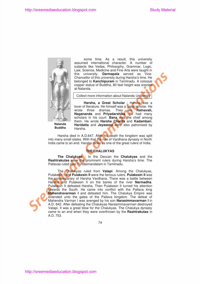
Harsha, a Great Scholar : Harsha was alover of literature. He himself was a great scholar. He
wrote three dramas. They are Ratnavali,Nagananda and Priyadarshika. He had manyscholars in his court. Bana was the chief amongthem. He wrote Harsha Charita and Kadambari.Haridatta and Jayasena were also patronised byHarsha.
Harsha died in A.D.647. After his death the kingdom was splitinto many small states. With that the rule of Vardhana dynasty in North
Nalanda
Buddha
http://sreemediaeducation.blogspot.com Study Material
8/6/2019 Social Science History Civics and Geography
http://slidepdf.com/reader/full/social-science-history-civics-and-geography 79/280
Hiuen Tsang also visited the country of Pulakesin II. He has leftus a pen picture about the reign of Pulakesin II. According to him,Pulakesin II was a patron of art and literature. His people and thenobles were the loyal and devoted subjects. By religion he was aHindu but was tolerant towards Buddhism and Jainism. There weremore than hundred Buddhist monasteries in his kingdom. In thesemonasteries 5,000 monks were living.
http://sreemediaeducation.blogspot.com Study Material
8/6/2019 Social Science History Civics and Geography
http://slidepdf.com/reader/full/social-science-history-civics-and-geography 80/280
dynasty. He was succeeded by Krishna I. He was not only a greatconqueror, but also a great builder. He had built many temples.Govinda III was the most renowned ruler among the Rashtrakutas.
Art and Architecture : The Rashtrakutas made a splendidcontribution to art and architecture. The rock cut shrines at Ellora andElephanta are unique in their own way. The sculptured panels ofDasavatara, Bhairava, Ravana shaking the mount Kailash, dancingSiva, Vishnu and Lakshmi listening to music are superb. The Sivatemple at Ellora was built by Krishna I. This temple is made up of solidrocks. It is considered to be an architectural marvel.
Find out where Ajanta, Ellora and Elephanta caves are located
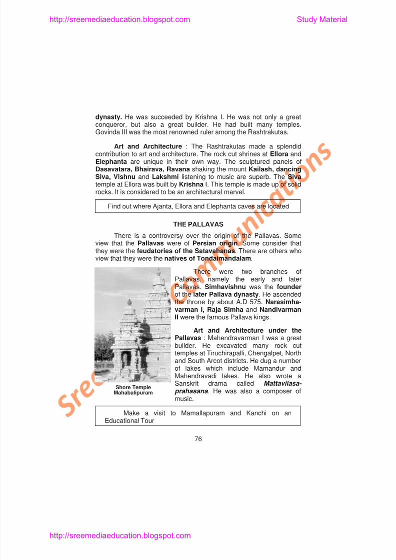
THE PALLAVAS
There is a controversy over the origin of the Pallavas. Someview that the Pallavas were of Persian origin. Some consider thatthey were the feudatories of the Satavahanas. There are others whoview that they were the natives of Tondaimandalam.
There were two branches ofP ll l th l d l t
http://sreemediaeducation.blogspot.com Study Material
8/6/2019 Social Science History Civics and Geography
http://slidepdf.com/reader/full/social-science-history-civics-and-geography 81/280
Narasimhavarman I : Narasimhavarman I was responsible forrock cut temples and cut out shrines. (Vimanas and Rathas). AtMamallapuram, the Varaha, Trimurti and Mahishasuramardhinimandapams and the Panchapandava Rathas are the best examples.The depiction of Arjuna’s Penance or the Descent of the Ganges is aremarkable artifact at Mamallapuram. During Rajasimha’s period, thefamous Kailasanathar Temple at Kanchipuram was built.Nandivarman II built the famous Vaikundaperumal temple atKanchipuram. These temples were the cultural centres for towns andvillages. The kings and the public had their assemblies in thesetemples. Fine arts like music and dance performances were held inthese temples. These temples were also centres of learning.
In the field of literature the Nayanmars and the Alwars made a
great contribution. The Nayanmars wrote Tevaram and Tiruvasagam and the Alwars wrote the Nalayira Divya Prabandham .
Read Sivakamiyin Sabatham , a famous Historical novel,written by Kalki, during your holidays. This novel containsreferences to the Pallavas and the Chalukyas
IMPERIAL CHOLAS
http://sreemediaeducation.blogspot.com Study Material
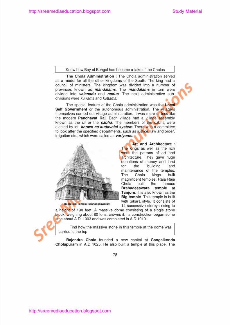
8/6/2019 Social Science History Civics and Geography
http://slidepdf.com/reader/full/social-science-history-civics-and-geography 82/280
Know how Bay of Bengal had become a lake of the Cholas
The Chola Administration : The Chola administration servedas a model for all the other kingdoms of the South. The king had acouncil of ministers. The kingdom was divided into a number ofprovinces known as mandalams . The mandalams in turn weredivided into valanadu and nadus . The next administrative sub-divisions were kurrams and kottams .
The special feature of the Chola administration was the LocalSelf Government or the autonomous administration. The villagersthemselves carried out village administration. It was more or less likethe modern Panchayat Raj. Each village had a village assemblyknown as the ur or the sabha . The members of the sabha were
elected by lot, known as kudavolai system . There was a committeeto look after the specified departments, such as justice, law and order,irrigation etc., which were called as variyams .
Art and Architecture :The kings as well as the richwere the patrons of art andarchitecture. They gave hugedonations of money and land
http://sreemediaeducation.blogspot.com Study Material
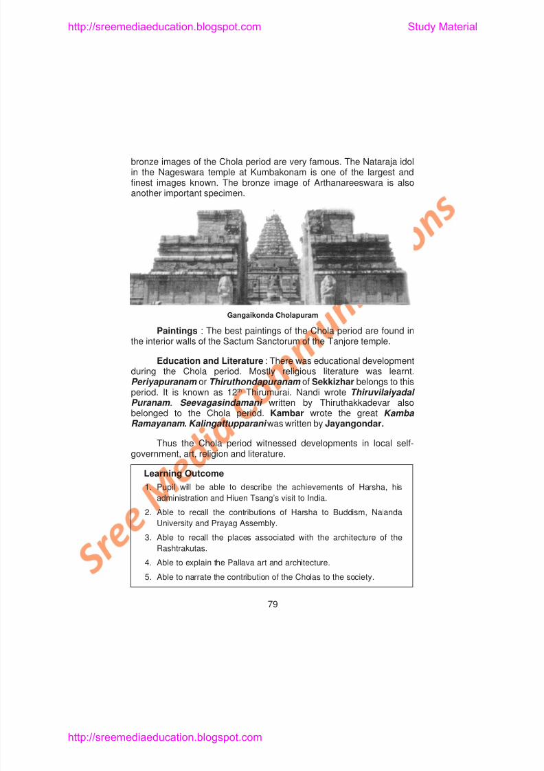
8/6/2019 Social Science History Civics and Geography
http://slidepdf.com/reader/full/social-science-history-civics-and-geography 83/280
bronze images of the Chola period are very famous. The Nataraja idolin the Nageswara temple at Kumbakonam is one of the largest andfinest images known. The bronze image of Arthanareeswara is alsoanother important specimen.
Paintings : The best paintings of the Chola period are found inthe interior walls of the Sactum Sanctorum of the Tanjore temple.
Education and Literature : There was educational developmentduring the Chola period. Mostly religious literature was learnt.Periyapuranam or Thiruthondapuranam of Sekkizhar belongs to this
Gangaikonda Cholapuram
http://sreemediaeducation.blogspot.com Study Material
8/6/2019 Social Science History Civics and Geography
http://slidepdf.com/reader/full/social-science-history-civics-and-geography 84/280
SELF - EVALUATION
I. Choose the Correct Answer
1. The capital of Harsha was
a) Kanauj b) Pataliputrac) Kanchi d) Malwa
2. Harsha patronised
a) Kalidasa b) Kambarc) Jayasena d) Thiruvalluvar
3. Mahendravarman I was defeated by
a) Pulakesin I b) Pulakesin II
c) Harsha d) Kumara Gupta.
4. Chalukyas built great temples at
a) Aihole b) Tanjore
c) Kanchi d) Kanauj
5. Narasimhavarman I sent a naval expedition to
a) Ceylon b) Bengal
c) Kadaram d) Andaman Islands
http://sreemediaeducation.blogspot.com Study Material
8/6/2019 Social Science History Civics and Geography
http://slidepdf.com/reader/full/social-science-history-civics-and-geography 85/280
6. Bana’s works are___________and ___________
7. The Chalukyas had their capital at ___________
8. The big lakes near ___________was dug by
Mahendravarman I are___________.9. __________was the capital of the Pallavas.
10. Kailasanathar temple was built by__________
11. Kalingathup Parani was written by__________
III. Match the Following
1. Nalanda – Prince of pilgrims
2. Hiuen Tsang – Harsha Charita3. Bana – Prayag Assembly
4. Harsha – Centre of learning
5. Mattavilasa Prahasana – Alwars
6. Vatapi – 12th Thirumurai
7 Nalayira Divya
http://sreemediaeducation.blogspot.com Study Material
8/6/2019 Social Science History Civics and Geography
http://slidepdf.com/reader/full/social-science-history-civics-and-geography 86/280
7. Mention the places of Chalukya architecture.
8. Where do you find the rock cut temples of Mahendravarman?
9. Who was Hiuen Tsang? What do you know about him?
10. Write a note on Nalanda University
11. Mention the contribution of Rashtrakutas to art and architecture.
V. Answer in Detail
1. Describe the administration of Harsha.
2. Explain the Pallava art and architecture.
3. Bring out the special features of the Chola administration.
4. Discuss the educational and literary progress made under theCholas.
Map Work
Indicate the extent of Harsha’s empire and mark the placesruled by the Chalukyas, the Rastrakutas, the Pallavas and the Cholas.
http://sreemediaeducation.blogspot.com Study Material
8/6/2019 Social Science History Civics and Geography
http://slidepdf.com/reader/full/social-science-history-civics-and-geography 87/280
UNIT - IV
Lesson 9
RAJPUT KINGDOMS IN NORTH INDIA -ARAB AND TURKISH INVASIONS
Learning Objectives
1. Pupil knows about the North Indian Kingdoms such as the
Prathiharas, the Chauhans, the Paramaras, the Chandelas and the
Palas of Bengal.
2. Pupil understands the political condition of India during the Arab
Invasions.
3 Pupil acquires knowledge about the Muslim invasions
http://sreemediaeducation.blogspot.com Study Material
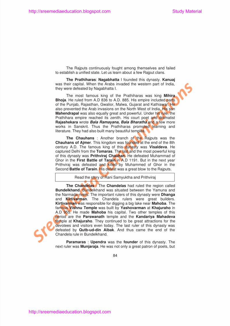
8/6/2019 Social Science History Civics and Geography
http://slidepdf.com/reader/full/social-science-history-civics-and-geography 88/280
The Rajputs continuously fought among themselves and failedto establish a unified state. Let us learn about a few Rajput clans.
The Prathiharas: Nagabhatta I founded this dynasty. Kanuajwas their capital. When the Arabs invaded the western part of India,
they were defeated by Nagabhatta I.
The most famous king of the Prathiharas was king MihiraBhoja. He ruled from A.D 836 to A.D. 885. His empire included partsof the Punjab, Rajasthan, Gwalior, Malwa, Gujarat and Kathiawar. Healso prevented the Arab invasions on the North West of India. His sonMahendrapal was also equally great and powerful. Under his rule, thePrathihara empire reached its zenith. His court poet and dramatistRajashekara wrote Bala Ramayana, Bala Bharatha and a few moreworks in Sanskrit. Thus the Prathiharas promoted learning andliterature. They had also built many beautiful temples.
The Chauhans : Another branch of the Rajputs was theChauhans of Ajmer. This kingdom was founded at the end of the 8thcentury A.D. The famous king of this dynasty was Visaldeva. Hecaptured Delhi from the Tomaras. The last and the most powerful kingof this dynasty was Prithviraj Chauhan. He defeated Muhammad ofGhor in the First Battle of Tarain in A.D 1191. But in the next year
http://sreemediaeducation.blogspot.com Study Material
8/6/2019 Social Science History Civics and Geography
http://slidepdf.com/reader/full/social-science-history-civics-and-geography 89/280
also himself a famous writer. The most important king of this dynastywas Bhoja (A.D. 1010- A.D. 1055). He dug a very big lake (more than250 square miles). It is situated to the South East of Bhopal. Hestarted a Sanskrit College at Dhara.
The Palas of Bengal : Gopala (C.A.D. 765-C.A.D.769) was thefirst ruler of the Pala Dynasty of Bengal. He annexed Magadha andbrought peace to his country. He was succeeded by Dharmapala(C.A.D.769-C.A.D.815). He ruled Bengal for nearly four decades. Hewas a follower of Buddhism. He founded the University ofVikramasila. His son Devapala was a worthy son of a worthy father.He had many victories to his credit. He was also an efficient ruler. Buthis successors were not very strong. After a passage of a decade KingMahipala once again regained the glory of the Palas. However,
Mahipala had to face a defeat at the hands of Rajendra Chola whomarched as far as the Ganges. The Palas were great patrons of art,painting, and sculpture. Casting in bronze and the metals made greatprogress. The Statue of Surya is a remarkable and outstandingmasterpiece.
Administration of the Rajputs : The Rajput political system wasmainly based on feudalism. Specific territories were given to various
http://sreemediaeducation.blogspot.com Study Material
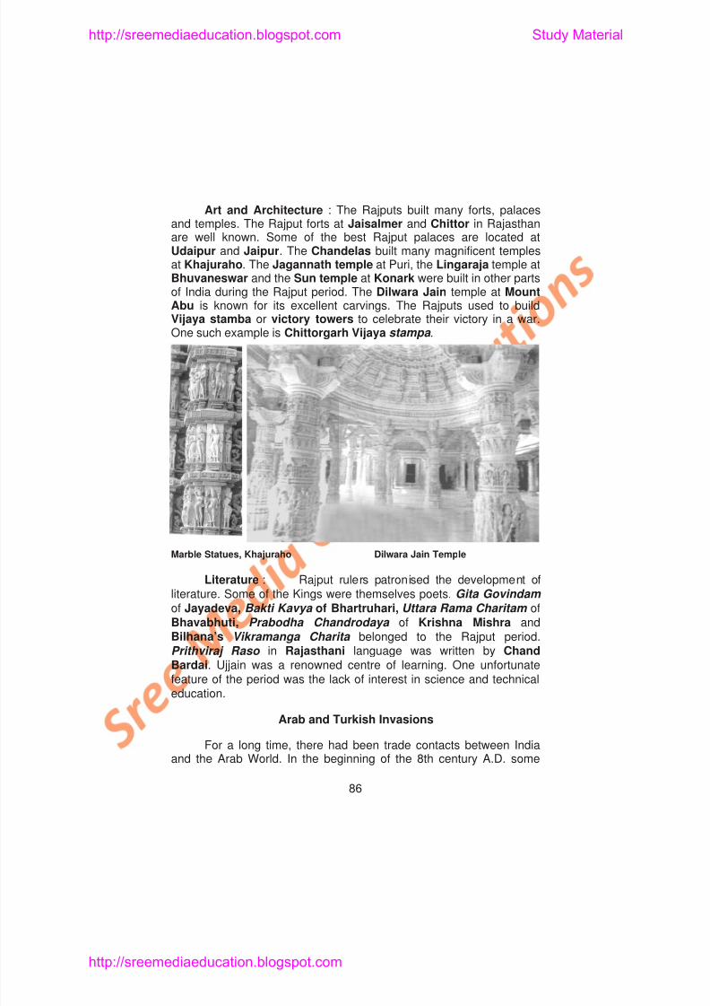
8/6/2019 Social Science History Civics and Geography
http://slidepdf.com/reader/full/social-science-history-civics-and-geography 90/280
Art and Architecture : The Rajputs built many forts, palacesand temples. The Rajput forts at Jaisalmer and Chittor in Rajasthanare well known. Some of the best Rajput palaces are located atUdaipur and Jaipur. The Chandelas built many magnificent templesat Khajuraho. The Jagannath temple at Puri, the Lingaraja temple at
Bhuvaneswar and the Sun temple at Konark were built in other partsof India during the Rajput period. The Dilwara Jain temple at MountAbu is known for its excellent carvings. The Rajputs used to buildVijaya stamba or victory towers to celebrate their victory in a war.One such example is Chittorgarh Vijaya stampa .
http://sreemediaeducation.blogspot.com Study Material
8/6/2019 Social Science History Civics and Geography
http://slidepdf.com/reader/full/social-science-history-civics-and-geography 91/280
problems arose between the Indian and Arab merchants. At that time,Muhammad-bin-Quasim, an Arab General, attacked Sind andoccupied it. Since there was no unity among the Hindu rulers in Sindarea, the Arab occupation in this part lasted for a century. As a result,Islam found its way into India through Sind.
The Turkish invasions of India took place three centuries afterthe Arab occupation of Sind. Alaptigin of Turkish origin set up anindependent Kingdom at Ghazni in the 10th century A.D. His son-in-law, Sabuktigin, succeeded him in A.D. 977. He was a brave warrior.He conquered many places. After a reign of 20 years Sabuktigin died.His son Mahmud succeeded him.
Mahmud of Ghazni (A.D. 997-1030) : In A.D. 997 Mahmud
occupied the throne of Ghazni. He was a brilliant general and a mightyconqueror. Besides, he had a great love for his religion. He wanted tomake Ghazni a powerful Kingdom. Mahmud decided to pursue a policyof aggressive warfare against the Hindu rulers of India. He invadedIndia 17 times. His aim was to plunder the enormous wealth of India.This was the reason why some of his attacks were made on thetemples which were the repositories of rich treasure. It was not his aimto conquer and occupy India.
http://sreemediaeducation.blogspot.com Study Material
8/6/2019 Social Science History Civics and Geography
http://slidepdf.com/reader/full/social-science-history-civics-and-geography 92/280
Governor of Ghor. He strengthened his position in Ghazni and thenmarched towards India. He conquered Multan in A.D. 1175 and thenSind and the Punjab. His object was to establish Muslim power inIndia. He was successful in his attempt. It was this Muhammad ofGhor who was responsible for founding the Muslim power in India.
Muhammad of Ghor’s Campaigns : Muhammad of Ghor’scampaigns against India were well planned and skillfully organised. Hefirst defeated the Muslim rulers of Sind and the Punjab. When heattacked Gujarat, the Gujarat ruler defeated him.
The First Battle of Tarain : In A.D. 1191 Muhammad of Ghoradvanced towards Delhi. Many brave Rajputs of Northern India, underthe leadership of Prithviraj Chauhan of Delhi, opposed him at the
battlefield of Tarain near Thaneswar. The ruler of Kanauj,Jayachandra, kept aloof on this occasion. It was due to Prithviraj’smarriage with Samyukta, daughter of Jayachandra. This marriage tookplace against the wishes of Jayachandra. In this battle the army ofMuhammad of Ghor was utterly defeated. Muhammad was severelywounded in his arm. However, a young Khilji soldier saved him.Prithviraj had stopped with his victory and he did not make any attemptto capture the Punjab.
http://sreemediaeducation.blogspot.com Study Material
8/6/2019 Social Science History Civics and Geography
http://slidepdf.com/reader/full/social-science-history-civics-and-geography 93/280
This was one of the main causes for the growth of Buddhism inNepal and Tibet.
After the death of Muhammad of Ghor in A.D. 1206 Qutb-ud-din Aibak became the Sultan of Delhi. He was the founder of the
Slave dynasty in India.Effects of Arab and Turkish Invasions : The Arab scholars
visited Sind and studied many Indian literary works. They translatedmany Sanskrit books on astronomy, philosophy, mathematics andmedicine into Arabic. They learnt the numerals 0 to 9 from India. Untilthen the people in the West did not know the zero. Through the ArabsEurope got more knowledge about mathematics, especially theimportance of zero from India. The Western countries and the Arabslearnt the game of chess from the Indians.
Learning Outcome
1. Pupil will be able to recall the names of important Rajput kingdoms
and kings.
2. Pupil will be able to describe the contribution of the Rajputs to
Indian art and architecture.
http://sreemediaeducation.blogspot.com Study Material
8/6/2019 Social Science History Civics and Geography
http://slidepdf.com/reader/full/social-science-history-civics-and-geography 94/280
3. The lake near Mahoba was dug by
a) Yashovarman b) Kirtivarman
c) Vishnu Varman d) Rajavarman
4. The last ruler of the Chandela dynasty was defeated by
a) Mahmud of Ghazni b) Muhammad of Ghor
c) Qutb-ud-din-Aibak d) Sabuktigin
5. Bhoja I started a Sanskrit college at
a) Kanuaj b) Dhara
c) Malwa d) Jaipur.
6. Devapala was the son of
a) Gopala b) Dharmapala
c) Mahendrapala d) Mahipala
7. The Dilwara Jain Temples are found in
a) Agra b) Delhi
c) Mount Abu d) Khajuraho
8. The author of Vikramanga Charita is
a) Chand Bardai b) Bilhana
http://sreemediaeducation.blogspot.com Study Material
8/6/2019 Social Science History Civics and Geography
http://slidepdf.com/reader/full/social-science-history-civics-and-geography 95/280
II. Fill in the Blanks
1. Prathihara dynasty was founded by _____________
2. The Chauhan King Visaldeva captured Delhi from___________
3. During the reign of _____________ the Prathihara Kingdomreached its zenith.
4. The important rulers of Chandela dynasty were _____________ and _____________
5. The famous Vishnu temple at Khajuraho was built by _____________
6. _____________was the founder of Paramara dynasty.
7. The first ruler of the Pala dynasty of Bengal was_____________
8. The Rajput political system was mainly based on____________
9. The Chandelas built many magnificent temples at ___________
10. The famous poets_____________and _____________livedin the court of Mahmud of Ghazni.
11. Muhammad-bin-Qasim, the Arab General attacked __________
12. Shah Nama was written by
http://sreemediaeducation.blogspot.com Study Material
8/6/2019 Social Science History Civics and Geography
http://slidepdf.com/reader/full/social-science-history-civics-and-geography 96/280
IV. Answer Briefly
1. What do you know about the origin of the Rajputs?
2. What do you know about Prithviraj Chauhan?
3. Explain the architectural contribution of the Chandelas.
4. Who founded the University of Vikramasila? What do you knowabout that University?
5. Write a note on the position of the Rajput women.
6. Mention some of the literary works of the Rajput period.
7. What was the aim of Mahmud of Ghazni’s invasions on India?
8. Mention the main aim of Muhammad of Ghor’s invasion onIndia.
9. Who was Qutb-ud-din Aibak? What do you know about him?
10. Bring out the difference between Mahmud of Ghazni’s andMuhammad of Ghor’s invasions of India.
V. Answer in Detail
http://sreemediaeducation.blogspot.com Study Material
8/6/2019 Social Science History Civics and Geography
http://slidepdf.com/reader/full/social-science-history-civics-and-geography 97/280
Lesson 10
DELHI SULTANATE A.D. 1206 TO A.D. 1526
Learning Objectives
1. Pupil knows about the Sultans who ruled Delhi.
2. Pupil understands the different dynasties that ruled Delhi from
1206 to 1526.
3. Pupil acquires knowledge about the administration of the Delhi
Sultans.
4. Pupil understands the political and economic condition of this
period.
5. Pupil knows the impact of Islam on Hinduism.
http://sreemediaeducation.blogspot.com Study Material
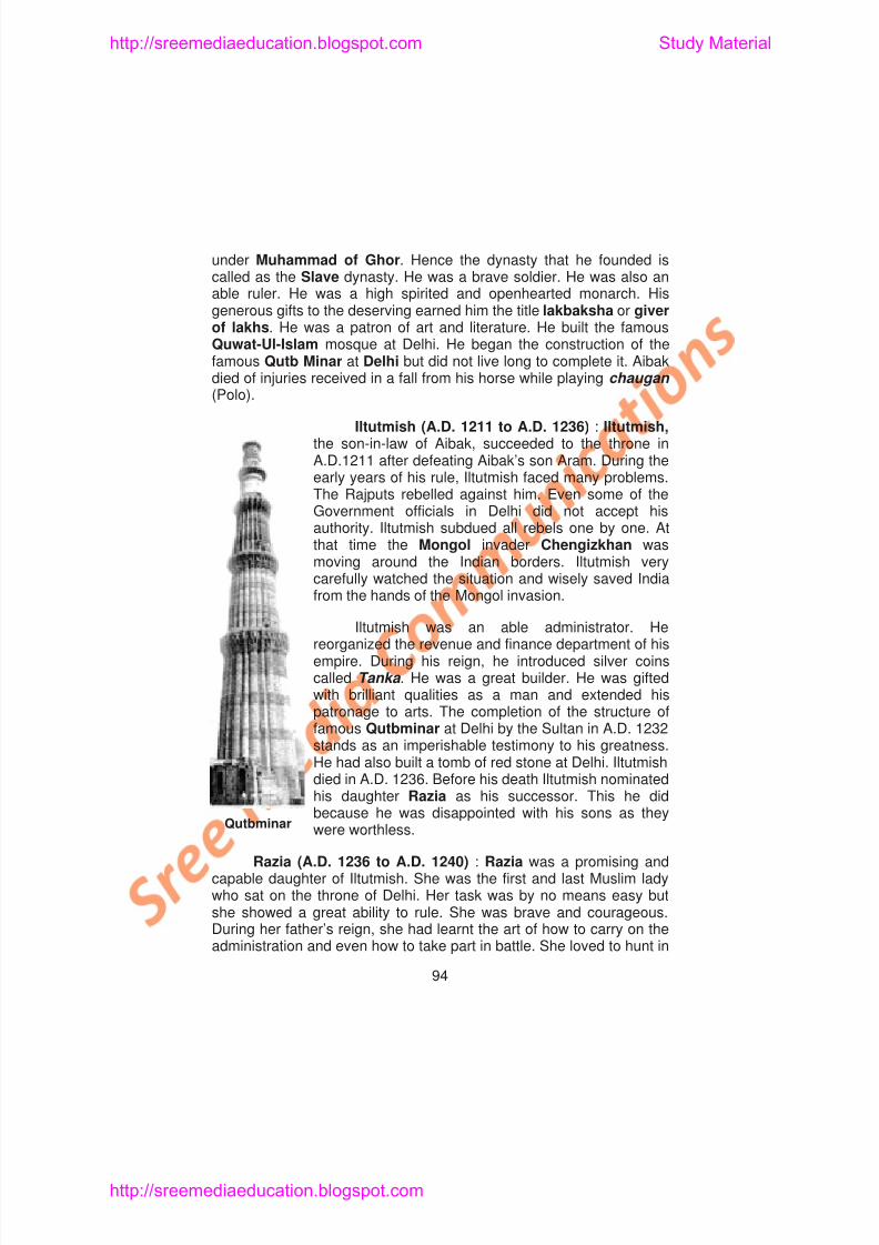
8/6/2019 Social Science History Civics and Geography
http://slidepdf.com/reader/full/social-science-history-civics-and-geography 98/280
under Muhammad of Ghor. Hence the dynasty that he founded iscalled as the Slave dynasty. He was a brave soldier. He was also anable ruler. He was a high spirited and openhearted monarch. Hisgenerous gifts to the deserving earned him the title lakbaksha or giverof lakhs. He was a patron of art and literature. He built the famous
Quwat-Ul-Islam mosque at Delhi. He began the construction of thefamous Qutb Minar at Delhi but did not live long to complete it. Aibakdied of injuries received in a fall from his horse while playing chaugan (Polo).
Iltutmish (A.D. 1211 to A.D. 1236) : Iltutmish,the son-in-law of Aibak, succeeded to the throne inA.D.1211 after defeating Aibak’s son Aram. During theearly years of his rule, Iltutmish faced many problems.
The Rajputs rebelled against him. Even some of theGovernment officials in Delhi did not accept hisauthority. Iltutmish subdued all rebels one by one. Atthat time the Mongol invader Chengizkhan wasmoving around the Indian borders. Iltutmish verycarefully watched the situation and wisely saved Indiafrom the hands of the Mongol invasion.
http://sreemediaeducation.blogspot.com Study Material
8/6/2019 Social Science History Civics and Geography
http://slidepdf.com/reader/full/social-science-history-civics-and-geography 99/280
the forests and even led her army in war. She was a wise and kindqueen. She looked after her subjects with love and affection. But hergenerals did not like the idea of being ruled by a woman. They did notco-operate with her. So she had to face their serious opposition.Altuniya, the Governor of Sarhind, rebelled and defeated her. Later she
married Altuniya and raised an army to recover the throne. Her noblesrevolted against her. She and her husband Altuniya could not defeatthe nobles. She was captured and put to death in A.D. 1240. Thusended the short rule of a talented Queen.
Read the story of Razia who was a symbol of bravery
Nasir-ud-din (A.D. 1246 to A.D. 1266) : After six years ofinternal strife, Nasir-ud-din Mohammed, the youngest son of
Iltutmish, ascended the throne with the help of Balban. He was a weakand inexperienced ruler. Balban soon became his chief advisor andheld the position of deputy to the ruler. He made his position strong bygetting his daughter married to Nasiruddin. Nasiruddin died in the yearA.D. 1266 and Balban ascended the throne.
Ghiyas-ud-din Balban (A.D. 1266 to A.D. 1286) : Balban wasthe strongest of the Slave rulers. He was a capable administrator anda brave general He had to re establish the authority of the Sultan A
http://sreemediaeducation.blogspot.com Study Material
8/6/2019 Social Science History Civics and Geography
http://slidepdf.com/reader/full/social-science-history-civics-and-geography 100/280
man of seventy. He was very kind and lenient. The important event ofhis reign was the attack on Devagiri in the Deccan. His nephew andson-in-law Ala-ud-din Khilji plundered Devagiri and defeated its rulerRamachandra Deva. He returned with fabulous wealth. The ambitiousnephew got the Sultan killed and declared himself the Sultan in A.D.
1296. The nobles, the army and the common public in Delhi weresilenced by rich gifts. Rebellious members of his own family wereseverely punished.
Ala-ud-din Khilji (A.D. 1296 to A.D. 1316) : Ala-ud-din Khiljiwas the greatest ruler of the Khilji Dynasty. He was the first Muslimruler to extend his empire right upto Rameshwaram in the South.
Conquest of the North in A.D. 1297: The Sultan sent a strong
army to Gujarat against Raja Karna Baghela. The king ran away fromthe battlefield in fright. The cities of Anhilwara and Cambay werelooted. Among the loot was a slave, Malik Kafur by name. Later hebecame the General of Ala-ud-din’s army.
In A.D. 1301 Ranthambhor was captured. Alauddin attackedMewar and defeated its ruler Raja Bhimsingh. Bhimsingh was killedand the strong fortress of Chittor was captured. Rani Padmini, wife of
http://sreemediaeducation.blogspot.com Study Material
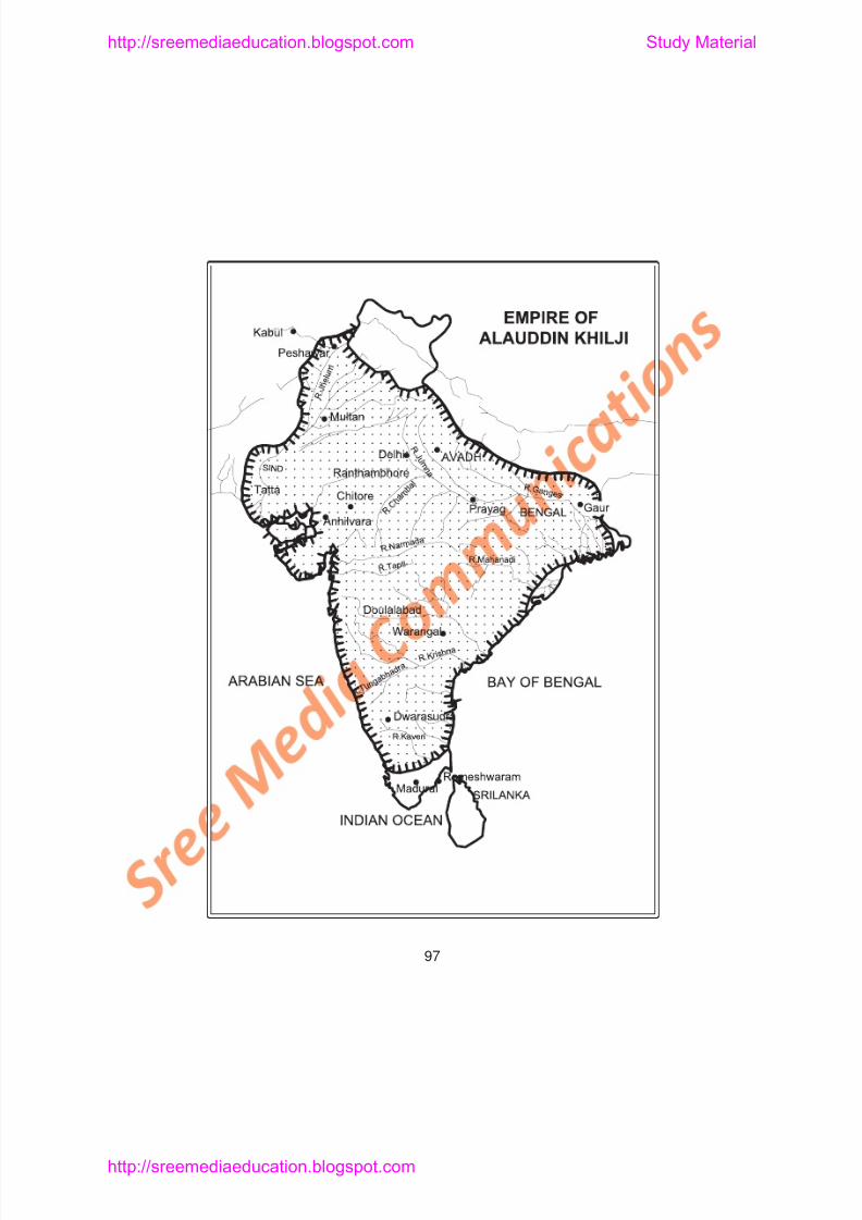
8/6/2019 Social Science History Civics and Geography
http://slidepdf.com/reader/full/social-science-history-civics-and-geography 101/280
http://sreemediaeducation.blogspot.com Study Material
8/6/2019 Social Science History Civics and Geography
http://slidepdf.com/reader/full/social-science-history-civics-and-geography 102/280
prohibited not only wine selling but also wine drinking and the use ofother intoxicating drinks. Social gatherings of the nobles were allowedonly on special permission. Revenue system was revised. The pricesof all commodities of day-to-day use were fixed.
The Sultan had built a new city called Siri near Delhi. AmirKhusru the great Persian poet, patronised by Balban, continued to livein Alauddin Khilji’s court also. The last days of the Sultan were nothappy. His trustworthy generals rose against him to capture power.The Sultan died in A.D. 1316. The next ruler Qutb-ud-din Mubarakwas murdered and the Khilji Dynasty came to an end.
TUGHLAQ DYNASTY (A.D. 1320 TO A.D. 1414)
Ghiyas-ud-din Tughlaq : Ghiyas-ud-din Tughlaq was thefounder of the Tughlaq dynasty. His father was a Turk and mother wasa Jat woman of the Punjab. He introduced some reforms. Agriculturewas improved and a number of forts were built. His ambitious sonMuhammad-bin-Tughlaq killed him to become sultan.
Muhammad-bin-Tughlaq (A.D. 1325 to A.D. 1351) :Muhammad bin Tughlaq occupied the throne around the year A D
http://sreemediaeducation.blogspot.com Study Material
8/6/2019 Social Science History Civics and Geography
http://slidepdf.com/reader/full/social-science-history-civics-and-geography 103/280
law strictly and the people were harassed. Therefore most of thepeasants abandoned their land and took to highway robbery. Tughlaqrealised his mistake. He distributed agricultural loans and other help tothe people of Doab, but all this help came too late. It affected theeconomy of the country.
Find out some of the Doab Regions in India
Transfer of Capital: To have the capital at the centre of theempire and safe from the Mongol raids, Tughlaq chose Devagiri as hisnew capital in A.D. 1327. The transfer of the capital took place duringthe terrible heat of the summer. Instead of moving the Governmentalone from Delhi, the Sultan had ordered that all the people of Delhishould shift to Devagiri. Even the old, lame and blind people of Delhi
had to move to the new capital, nearly 700 miles away. For thispurpose a road was built from Delhi to Devagiri. Rest houses were setup all along this road. The journey from Delhi to Devagiri took nearly40 days. Many people died on the way. Others became sick afterreaching Devagiri. The Sultan renamed the new capital Daulatabad.Delhi became deserted. So the Mongols invaded Delhi from the NorthWest. The Sultan had to stay at Delhi. He realised his mistake andordered the people to go back to Delhi. The experiment failed and
http://sreemediaeducation.blogspot.com Study Material
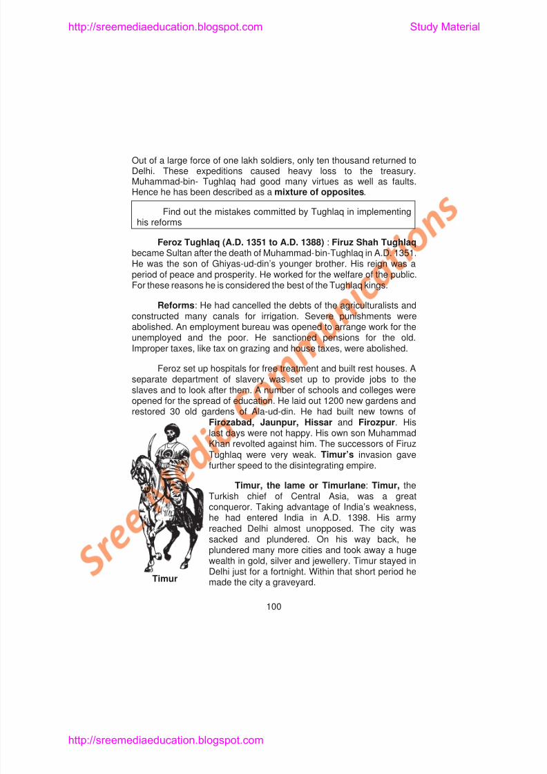
8/6/2019 Social Science History Civics and Geography
http://slidepdf.com/reader/full/social-science-history-civics-and-geography 104/280
Out of a large force of one lakh soldiers, only ten thousand returned toDelhi. These expeditions caused heavy loss to the treasury.Muhammad-bin- Tughlaq had good many virtues as well as faults.Hence he has been described as a mixture of opposites.
Find out the mistakes committed by Tughlaq in implementinghis reforms
Feroz Tughlaq (A.D. 1351 to A.D. 1388) : Firuz Shah Tughlaqbecame Sultan after the death of Muhammad-bin-Tughlaq in A.D. 1351.He was the son of Ghiyas-ud-din’s younger brother. His reign was aperiod of peace and prosperity. He worked for the welfare of the public.For these reasons he is considered the best of the Tughlaq kings.
Reforms: He had cancelled the debts of the agriculturalists andconstructed many canals for irrigation. Severe punishments wereabolished. An employment bureau was opened to arrange work for theunemployed and the poor. He sanctioned pensions for the old.Improper taxes, like tax on grazing and house taxes, were abolished.
Feroz set up hospitals for free treatment and built rest houses. Aseparate department of slavery was set up to provide jobs to the
http://sreemediaeducation.blogspot.com Study Material
8/6/2019 Social Science History Civics and Geography
http://slidepdf.com/reader/full/social-science-history-civics-and-geography 105/280
Collect more information on Timur’s invasion
For years, people in North India lived in poverty and misery. TheTughlaq Dynasty came to an end in A.D. 1413.
THE SAYYID DYNASTY (A.D. 1414 - A.D. 1451)
Khizir Khan, a former Governor of the Punjab appointed byTimur, initiated the Sayyid Dynasty. He came to the throne in A.D.1414. He was a Sayyid and for this reason the dynasty was calledSayyid dynasty. Mubarak Shah, Mohammed Shah and Alam Shahwere some of the other important noteworthy rulers of Sayyid Dynasty.
THE LODI DYNASTY (A.D. 1451 - A.D. 1526)
Bahlol Lodi: He was an Afghan Governor of the Punjab. Heraised himself to the throne of Delhi. He treated the nobles as hisequals and ruled with their full support. He had conquered territoriesaround Delhi. His son Sikander Lodi succeeded him.
Sikander Lodi: Like his father, Sikander Lodi was an able andf l ki H f d hi i l f D lhi A H h d
http://sreemediaeducation.blogspot.com Study Material
8/6/2019 Social Science History Civics and Geography
http://slidepdf.com/reader/full/social-science-history-civics-and-geography 106/280
successors were unable to check the provincial governors becomingindependent. The invasion of Timur and his atrocities led to thedownfall of the Delhi Sultananate. In the beginning the Turkish Muslimsand their armies were brave and hardworking. In course of time theywere after pleasure and became immoral and lazy. Ibrahim Lodi’s
unpopularity among the nobles was also a cause for the downfall.
Administration under the Sultanate: The Sultan was thepolitical as well religious head. Islam was the state religion. TheSultanate followed a mixture of Persian, Turkish and Indian systems inthe administration. The Sultan held the supreme power in the army andthe judiciary. The ministers were appointed and dismissed by theSultan at his will. There was no fixed law of succession.
Army: The army consisted of infantry, cavalry and elephants.Afghan and Turkish horses were used in the cavalry. Ala-ud-din Khiljiintroduced the practice of branding the horses (marking with a hot ironrod) to prevent corrupt practice of exchanging good horses for uselessones.
Land revenue: The chief source of income was land revenue.The Sultan also collected house tax, grazing tax and Jizya from the
8/6/2019 Social Science History Civics and Geography
http://slidepdf.com/reader/full/social-science-history-civics-and-geography 107/280
http://sreemediaeducation.blogspot.com Study Material
8/6/2019 Social Science History Civics and Geography
http://slidepdf.com/reader/full/social-science-history-civics-and-geography 108/280
4. Iltutmish was succeeded by
a) Sultana Razia b) Nasir-ud-din
c) Ramachandra Deva d) Sikander Lodi.
5. Nasir-ud-din ascended the throne with the help of
a) Balban b) Aibakc) Ibrahim Lodi d) Razia
6. Ala-ud-din Khilj captured Ranthambhor in
a) A.D. 1351 b) A.D. 1301
c) A.D. 1321 d) A.D. 1311
7. Rani Padmini of Chittor was the wife of
a) Bhim Singh b) Rana Ramdev
c) Balvir Singh d) Ram Singh
8. The founder of Tughlaq Dynasty was
a) Muhammad-bin-Tughlaq b) Ghiyas-ud-din Tughlaq
c) Feroz Tughlaq d) Ferozkhan
http://sreemediaeducation.blogspot.com Study Material
8/6/2019 Social Science History Civics and Geography
http://slidepdf.com/reader/full/social-science-history-civics-and-geography 109/280
5. __________ was called Parrot of Hindustan.
6. The king of Devagiri __________ was defeated by Ala-ud-dinKhilji.
7. Malik Kafur attacked _______ and _______ in extreme South.
8. On facing the defeat, Rani Padmini committed _______.
9. An efficient system of _______ was established by Ala-ud-dinKhilji.
10. A new city near Delhi built by Ala-ud-din Khilji was_______
11. The last ruler of Khilji dynasty was _______
12. The founder of the Tughlaq Dynasty was_______
13. Muhammad-bin-Tughlaq transferred his capital from_________
to ___________
14. Feroz Tughlaq built new towns of ___________,_____________ and ___________
15. Textile goods and cotton were exported to ___________ and ___________
16. The influence of ___________, ___________and ___________
http://sreemediaeducation.blogspot.com Study Material
8/6/2019 Social Science History Civics and Geography
http://slidepdf.com/reader/full/social-science-history-civics-and-geography 110/280
IV. Answer Briefly
1. How did Aibak meet his death?
2. Write a short note on Qutb-ud-din Aibak.
3. Bring out the problems faced by Iltutmish?
4. Mention a few lines about Iltutmish’s administration.
5. Who was the only lady ruler of Delhi? Write a few sentencesabout her rule.
6. How did Balban ascend the throne?
7. Who was Balban? What were the measures taken by him tosuppress his enemies?
8. Who was Jalal-ud-din Khilji?9. Mention the conquests of Ala-ud-din Khilji.
10. Write a few sentences about the character of Muhammad-Bin-Tughlaq.
11. Explain the term Doab with an example.
12 Mention the reforms introduced by Feroz Tughlaq
http://sreemediaeducation.blogspot.com Study Material
8/6/2019 Social Science History Civics and Geography
http://slidepdf.com/reader/full/social-science-history-civics-and-geography 111/280
Lesson 11
BHAKTI MOVEMENT IN MEDIEVAL INDIA
Learning Objectives
1. To make the pupil acquire knowledge about Bhakti Movement in
medieval India.
2. To enable the pupil understand the aims and services of the
leaders of the movement.
3. To motivate the pupil appreciate the work of the leaders of the
Bhakti Movement.
4. To make the pupil compare the Bhakti cult in South India with the
spread of Bhakti Movement in North India.
http://sreemediaeducation.blogspot.com Study Material
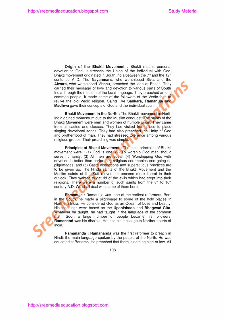
8/6/2019 Social Science History Civics and Geography
http://slidepdf.com/reader/full/social-science-history-civics-and-geography 112/280
Origin of the Bhakti Movement : Bhakti means personaldevotion to God. It stresses the Union of the individual with God.Bhakti movement originated in South India between the 7th and the 12th
centuries A..D. The Nayanmars, who worshipped Siva, and theAlwars, who worshipped Vishnu, preached the idea of Bhakti. They
carried their message of love and devotion to various parts of SouthIndia through the medium of the local language. They preached amongcommon people. It made some of the followers of the Vedic faith torevive the old Vedic religion. Saints like Sankara, Ramanuja andMadhwa gave their concepts of God and the individual soul.
Bhakti Movement in the North : The Bhakti movement in NorthIndia gained momentum due to the Muslim conquest. The saints of theBhakti Movement were men and women of humble origin. They camefrom all castes and classes. They had visited from place to placesinging devotional songs. They had also preached the Unity of Godand brotherhood of man. They had stressed tolerance among variousreligious groups. Their preaching was simple.
Principles of Bhakti Movement : The main principles of Bhaktimovement were : (1) God is one, (2) To worship God man shouldserve humanity, (3) All men are equal, (4) Worshipping God with
http://sreemediaeducation.blogspot.com Study Material
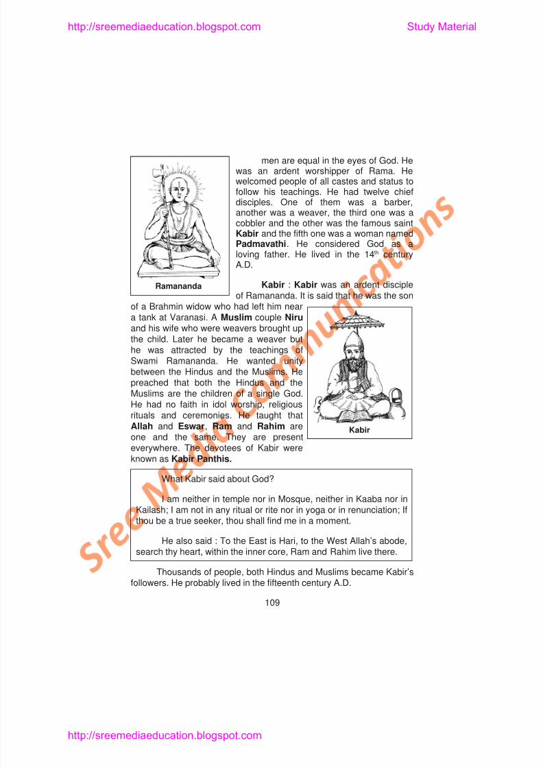
8/6/2019 Social Science History Civics and Geography
http://slidepdf.com/reader/full/social-science-history-civics-and-geography 113/280
men are equal in the eyes of God. Hewas an ardent worshipper of Rama. Hewelcomed people of all castes and status tofollow his teachings. He had twelve chiefdisciples. One of them was a barber,
another was a weaver, the third one was acobbler and the other was the famous saintKabir and the fifth one was a woman namedPadmavathi. He considered God as aloving father. He lived in the 14th centuryA.D.
Kabir : Kabir was an ardent discipleof Ramananda. It is said that he was the son
of a Brahmin widow who had left him neara tank at Varanasi. A Muslim couple Niruand his wife who were weavers brought upthe child. Later he became a weaver buthe was attracted by the teachings ofSwami Ramananda. He wanted unitybetween the Hindus and the Muslims. Hepreached that both the Hindus and the
Ramananda
http://sreemediaeducation.blogspot.com Study Material
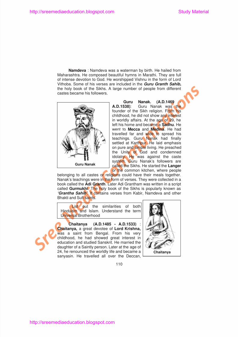
8/6/2019 Social Science History Civics and Geography
http://slidepdf.com/reader/full/social-science-history-civics-and-geography 114/280
Namdeva : Namdeva was a waterman by birth. He hailed fromMaharashtra. He composed beautiful hymns in Marathi. They are fullof intense devotion to God. He worshipped Vishnu in the form of LordVithoba. Some of his verses are included in the Guru Granth Sahib,the holy book of the Sikhs. A large number of people from different
castes became his followers.
Guru Nanak. (A.D.1469 -A.D.1538): Guru Nanak was thefounder of the Sikh religion. From hischildhood, he did not show any interestin worldly affairs. At the age of 29, heleft his home and became a Sadhu. Hewent to Mecca and Medina. He hadtravelled far and wide to spread histeachings. Guru Nanak had finallysettled at Karthpur. He laid emphasison pure and simple living. He preachedthe Unity of God and condemnedidolatry. He was against the castesystem. Guru Nanak’s followers arecalled the Sikhs. He started the LangerGuru Nanak
http://sreemediaeducation.blogspot.com Study Material
8/6/2019 Social Science History Civics and Geography
http://slidepdf.com/reader/full/social-science-history-civics-and-geography 115/280
Bihar, Bengal and Orissa. His followers regarded him as an incarnationof Lord Vishnu. He helped the old and the needy. He was opposed tothe inequalities of the caste system. He emphasised the need fortolerance, humanity and love. He spread the message of Bhakti inBengal. He popularised ‘Sankritan’or public singing of God’s name.
His songs are still very popular in Bengal. He was addressed`Mahaprabhu’ by his followers.
Tulsi Das : Goswamy Tulsidas was a devotee of Rama. Hiswork gives the story of Rama in Hindi. He was the foremost inpopularising Rama cult. His other works in Hindi are Janaki Mangal and Parvathi Mangal . In his writtings he insists the duty of a son to hisparent, duty of a student to his teacher and duty of a king to hispeople.
Rama was a dear son to his parents, devoted student to histeacher and a desirable king to his subjects.
Meerabai : Meerabai was a Rajput princess. She married theRana of Mewar. She was a pious devotee of Lord Krishna. She haswritten many songs in praise of Krishna, her favourite God, inRajastani. Her songs or hymns are even today sung all over India. Herpalace was kept open to people of all castes to join her Bhajans of
http://sreemediaeducation.blogspot.com Study Material
8/6/2019 Social Science History Civics and Geography
http://slidepdf.com/reader/full/social-science-history-civics-and-geography 116/280
fourteen, he translated the Bhagawad Gita into the Marathi language.This book is called Jnaneshwari .
BHAKTI MOVEMENT IN SOUTH INDIA
Nayanmars : In South India, the Nayanmars and Alwars werethe noted saints of the Bhakti movement. The Nayanmars, thedevotees of Siva, were sixty three in number. The most famousamong them were Appar, Sundarar, Thirugnana Sambandar andManickavachakar. These saints composed many verses in praise ofLord Siva. A saint named Nambiandar Nambi collected the devotionalsongs of Nayanmars. Appar, Sundarar and Thirugnana Sambandarcomposed the Thevaram hymns. Manickvachakar’s songs are knownas Tiruvachakam. Periyapuranam, written by Sekhizhar, tells us the
life stories of the Nayanmars.
Alwars : The Alwars were the worshippers of Lord Vishnu whowere twelve in number. Among them Nammalwar, Tirumangai Alwar,Andal and Perialwar were famous. The songs of the Alwars werecompiled in a book called Nalayira Divya Prabandham by Nadamuni.The devotional songs of Andal is called Thiruppavai .
http://sreemediaeducation.blogspot.com Study Material
8/6/2019 Social Science History Civics and Geography
http://slidepdf.com/reader/full/social-science-history-civics-and-geography 117/280
Sufis were the Chishti and the Suharwardi. Khwaja MuinuddinChishti started the Chishti group in India. Baba Farid and NizamuddinAuliya were other great Sufi saints. Shaikh Shihabuddin Suharwardiand Hamiduddin Nagori were Sufi saints of Suharwardi groups.
Effects of Bhakti Movement: The Bhakti movement hadbrought the Hindus and the Muslims closer to each other. The equalityconcept preached by the leaders reduced the rigidity of the castesystem to a certain extent. The suppressed people gained a feeling ofself-respect.
The reformers preached in local languages. It led to thedevelopment of Vernacular literature. They composed hymns andsongs in the languages spoken by the people. Therefore there was aremarkable growth of literature in all the languages. A new language
Urdu, a mixture of Persian and Hindi, was developed. The Bhaktimovement freed the common people from the tyranny of the priests. Itchecked the excesses of polytheism. It encouraged the spirit oftoleration. The gap between the Hindus and the Muslims was reduced.They began to live amicably together. It emphasised the value of apure life of charity and devotion. Finally, it improved the moral andspiritual ways of life of the medieval society. It provided an example for
http://sreemediaeducation.blogspot.com Study Material
8/6/2019 Social Science History Civics and Geography
http://slidepdf.com/reader/full/social-science-history-civics-and-geography 118/280
2. The disciple of Ramanuja was
a) Kabir b) Meerabai
c) Ramananda d) Tulsidas
3. The first reformer to preach in Hindi was
a) Ramanuja b) Ramanandac) Gurunanak d) Tukaram
4. The one who considered God as a loving father was
a) Basava b) Jnaneswara
c) Chaitanya d) Kabir
5. The founder of the Sikh religion was
a) Kabir b) Ramananda
c) Tukaram d) Guru Nanak
6. Namdeva’s hymns are written in
a) Bengali b) Marathi
c) Telugu d) Tamil
7. Holy book of the Sikhs is
a) Grantha Sahib b) Gita
) R d) M h bh h
http://sreemediaeducation.blogspot.com Study Material
8/6/2019 Social Science History Civics and Geography
http://slidepdf.com/reader/full/social-science-history-civics-and-geography 119/280
13. The number of Nayanamars is
a) 63 b) 62c) 64 d) 65
14. The songs of Alwars were compiled by
a) Nadhamuni b) Nambiandar Nambic) Kamban d) Andal
15. The language, Urdu is a mixture of
a) Hindi and Bengali b) Persian and Hindic) Persian and Marathi d) Hindi and Rajastani
II. Fill in the Blanks
1. Personal devotion to God is meant ______________
2. ______________ preached the oneness of God.
3. ______________ was one of the earliest reformers.
4. Ramanuja’s teachings were based on_________________ and ___________
5. Ramananda was educated at___________
6. The chief disciple of Ramananda was___________
http://sreemediaeducation.blogspot.com Study Material
8/6/2019 Social Science History Civics and Geography
http://slidepdf.com/reader/full/social-science-history-civics-and-geography 120/280
3. Meerabai – Rana of Mewar
4. Guru Granth – Nation builder
5. Namdeva – Worshipped Vishnu
6. Guru Ramadas – Mahaprabhu
7. Langer – Holybook8. Chaitanya – Public singing of God’s name
9. Jnaneswara – Tukaram
10. Abhangas – Bhagavad Gita
11. Periapuranam – Lingayat Sect
12. Woman Alwar – Sekkizhar
13. Basava – Andal
IV. Answer Briefly1. Name the different sects of Hinduism.
2. What do you understand by Bhakti Movement?
3. Mention the principles of Bhakti Movement.
4. What are the preachings of Ramananda?
5 What do you know about the preachings of Kabir?
http://sreemediaeducation.blogspot.com Study Material
8/6/2019 Social Science History Civics and Geography
http://slidepdf.com/reader/full/social-science-history-civics-and-geography 121/280
Lesson 12
BAHMANI AND VIJAYANAGAR KINGDOMS
Learning Objectives
1. Pupil will know the origin of the Bahmani and Vijayanagar
Kingdoms.
2. Pupil will acquire knowledge about Bahmani and Vijayanagar
Kingdoms.
3. Pupil will understand the contribution of Vijaynagar rulers to art and
architecture.
The break up of the Delhi Sultanate provided an opportunity forthe rise of a number of kingdoms in the Deccan. After the decline ofthe Tughlaqs, there arose two important kingdoms in the Deccan. They
http://sreemediaeducation.blogspot.com Study Material
8/6/2019 Social Science History Civics and Geography
http://slidepdf.com/reader/full/social-science-history-civics-and-geography 122/280
was an enlightened ruler. He was the greatest ruler of this dynasty.During his reign Bahmani kingdom had reached the height of its gloryand prosperity. Firoz Shah was succeeded by his brother AhmadShah. He transferred his capital from Gulbarga to Bidar. Hepatronised scholars.
Mahammad III (1463-1482): Mahammad III was an importantruler of the Bahmani kingdom. He was the last of the great Bahmanirulers. It was during his rule the kingdom had reached its zenith. Hehad the good fortune of having Mahmud Gawan as Prime Minister.Gawan was a brilliant man in political affairs. He was also a skilledgeneral. The kingdom was expanded under his leadership. Gawancaptured Goa, the most important port in the Vijayanagar kingdom. Heplundered Kanchipuram. He strengthened the power of the Sultansand curbed the power of the nobles. He improved the land revenue
system. He encouraged education. Mahmud Gawan spent the wholeof his vast wealth in building a college at Bidar.
The building, with its lofty halls and lecture rooms, still stands,though greatly damaged. He presented his library of 3000 volumes tothe college. He also provided endowments for poor students. Soonmany nobles in the Bahmani kingdom became jealous of Mahmud
http://sreemediaeducation.blogspot.com Study Material
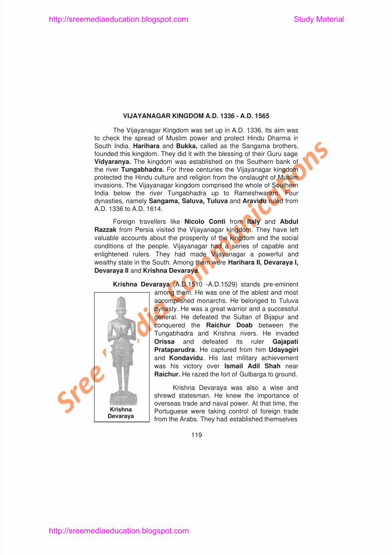
8/6/2019 Social Science History Civics and Geography
http://slidepdf.com/reader/full/social-science-history-civics-and-geography 123/280
VIJAYANAGAR KINGDOM A.D. 1336 - A.D. 1565
The Vijayanagar Kingdom was set up in A.D. 1336. Its aim wasto check the spread of Muslim power and protect Hindu Dharma inSouth India. Harihara and Bukka, called as the Sangama brothers,founded this kingdom. They did it with the blessing of their Guru sageVidyaranya. The kingdom was established on the Southern bank ofthe river Tungabhadra. For three centuries the Vijayanagar kingdomprotected the Hindu culture and religion from the onslaught of Musliminvasions. The Vijayanagar kingdom comprised the whole of SouthernIndia below the river Tungabhadra up to Rameshwaram. Fourdynasties, namely Sangama, Saluva, Tuluva and Aravidu ruled fromA.D. 1336 to A.D. 1614.
Foreign travellers like Nicolo Conti from Italy and Abdul
Razzak from Persia visited the Vijayanagar kingdom. They have left
valuable accounts about the prosperity of the kingdom and the social
conditions of the people. Vijayanagar had a series of capable and
enlightened rulers. They had made Vijayanagar a powerful and
wealthy state in the South. Among them were Harihara II, Devaraya I,
Devaraya II and Krishna Devaraya.
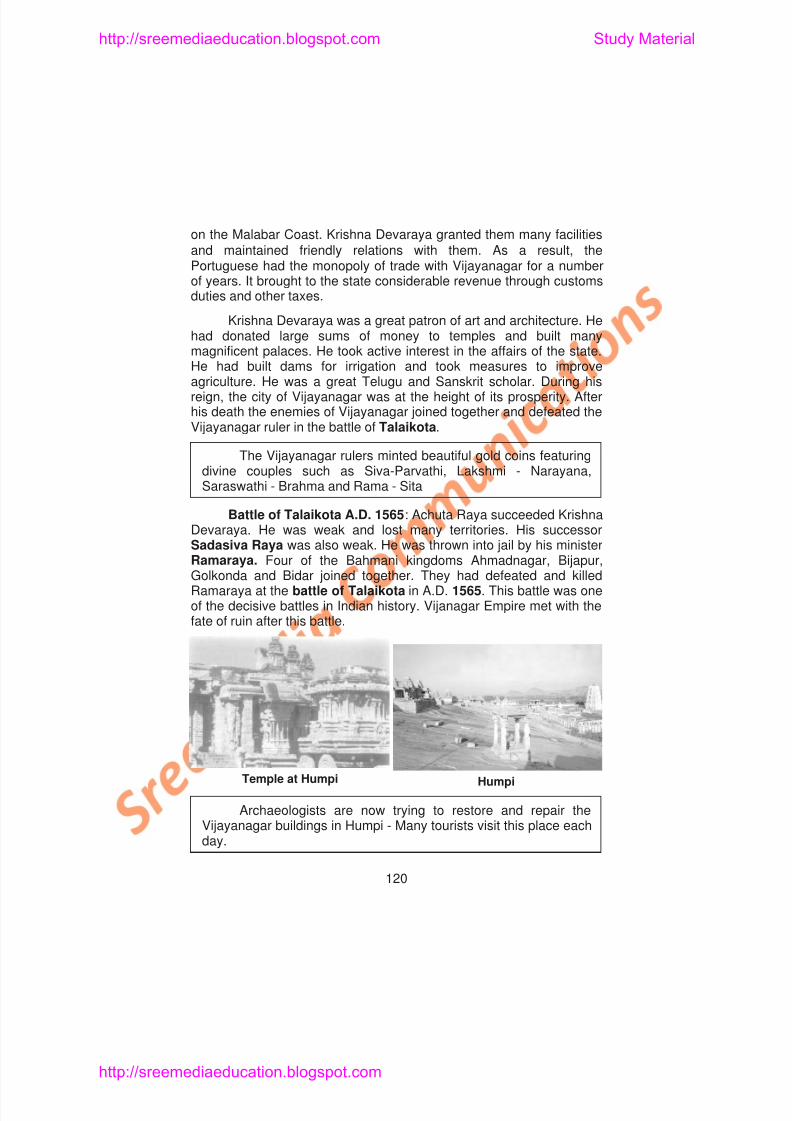
8/6/2019 Social Science History Civics and Geography
http://slidepdf.com/reader/full/social-science-history-civics-and-geography 124/280
http://sreemediaeducation.blogspot.com Study Material
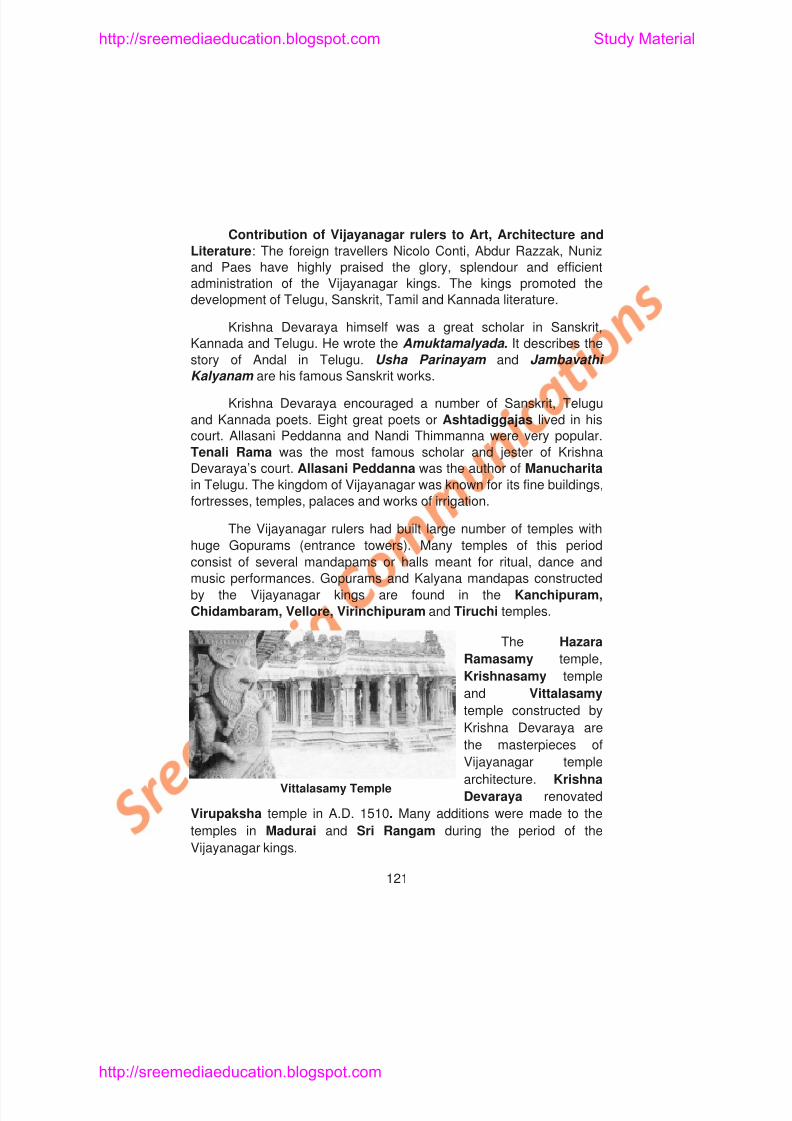
8/6/2019 Social Science History Civics and Geography
http://slidepdf.com/reader/full/social-science-history-civics-and-geography 125/280
Contribution of Vijayanagar rulers to Art, Architecture and
Literature: The foreign travellers Nicolo Conti, Abdur Razzak, Nuniz
and Paes have highly praised the glory, splendour and efficient
administration of the Vijayanagar kings. The kings promoted the
development of Telugu, Sanskrit, Tamil and Kannada literature.
Krishna Devaraya himself was a great scholar in Sanskrit,
Kannada and Telugu. He wrote the Amuktamalyada . It describes the
story of Andal in Telugu. Usha Parinayam and Jambavathi
Kalyanam are his famous Sanskrit works.
Krishna Devaraya encouraged a number of Sanskrit, Telugu
and Kannada poets. Eight great poets or Ashtadiggajas lived in his
court. Allasani Peddanna and Nandi Thimmanna were very popular.
Tenali Rama was the most famous scholar and jester of KrishnaDevaraya’s court. Allasani Peddanna was the author of Manucharita
in Telugu. The kingdom of Vijayanagar was known for its fine buildings,
fortresses, temples, palaces and works of irrigation.
The Vijayanagar rulers had built large number of temples with
huge Gopurams (entrance towers). Many temples of this period
http://sreemediaeducation.blogspot.com Study Material
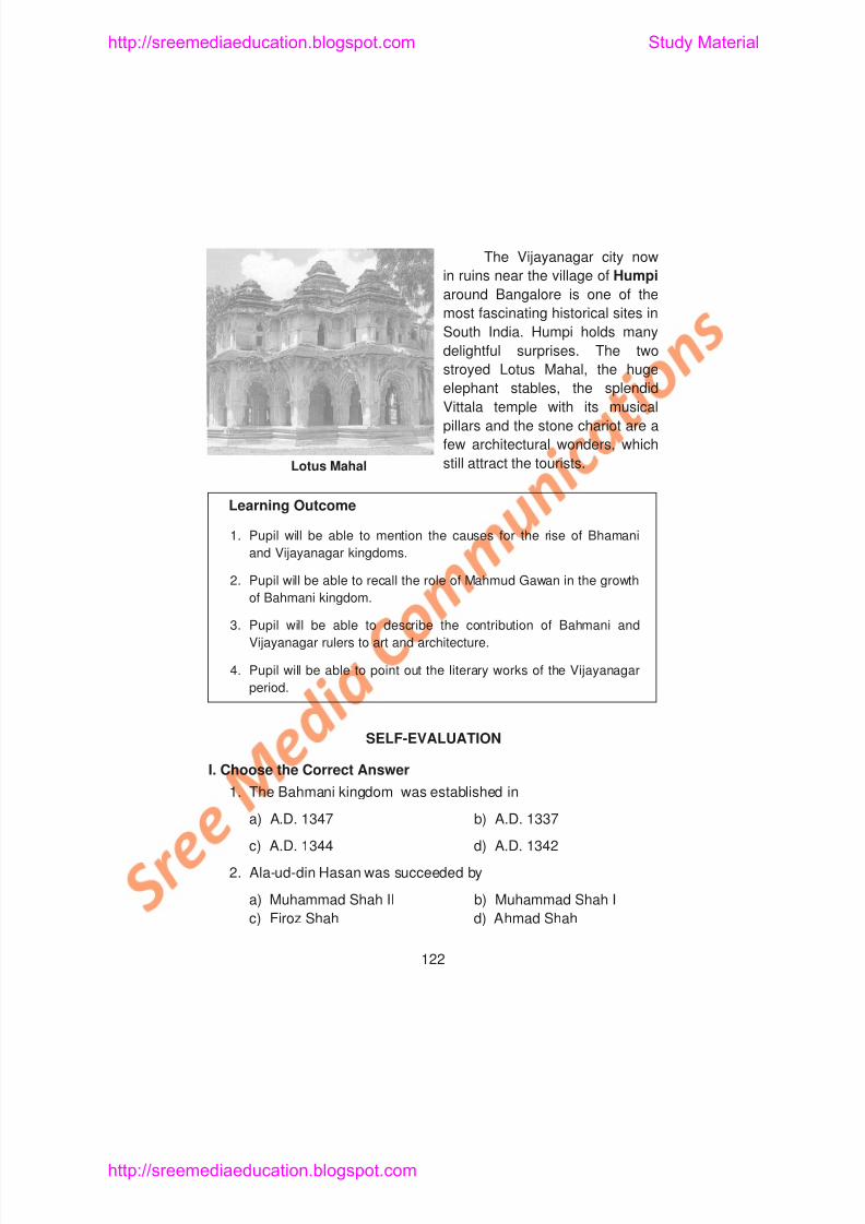
8/6/2019 Social Science History Civics and Geography
http://slidepdf.com/reader/full/social-science-history-civics-and-geography 126/280
The Vijayanagar city now
in ruins near the village of Humpi
around Bangalore is one of the
most fascinating historical sites in
South India. Humpi holds many
delightful surprises. The twostroyed Lotus Mahal, the huge
elephant stables, the splendid
Vittala temple with its musical
pillars and the stone chariot are a
few architectural wonders, which
still attract the tourists.
Learning Outcome
1. Pupil will be able to mention the causes for the rise of Bhamani
and Vijayanagar kingdoms.
2. Pupil will be able to recall the role of Mahmud Gawan in the growth
of Bahmani kingdom.
Lotus Mahal
http://sreemediaeducation.blogspot.com Study Material
8/6/2019 Social Science History Civics and Geography
http://slidepdf.com/reader/full/social-science-history-civics-and-geography 127/280
3. The great person who spent the whole of his vast wealth in
building a college at Bidar was
a) Ala-ud-din Hasan b) Muhammad Shah I
c) Feroz Shah d) Mahmud Gawan
4. The Bahmani Sultans patroniseda) Hindi language b) Urdu language
c) Telugu language d) Kannada language
5. Krishna Devaraya belongs to
a) Sangama dynasty b) Saluva dynastyc) Tuluva dynasty d) Aravidu dynasty
6. The Vijayanagar ruler who jailed by his minister was
a) Krishna Devaraya b) Sadasiva Rayac) Achuta Raya d) None of these
II. Fill in the Blanks
1. The founder of Bahmani kingdom was _________
2. Mahammad Shah captured the famous fort of from
http://sreemediaeducation.blogspot.com Study Material
8/6/2019 Social Science History Civics and Geography
http://slidepdf.com/reader/full/social-science-history-civics-and-geography 128/280
III. Match the Following
1. Gulbarga – Prime Minister
2. Muhammad Shah – Guru
3. Chand Minar – Allasani Peddanna
4. Mahmud Gawan – Lover of Peace and Philosophy
5. Vidyaranya – Daulatabad
6. Foreign traveller – Capital of Ala-ud-din Bahman Shah
7. Gajapathi Prataparudra – Nicolo Conti
8. Amukta Malyada – Ruler of Orissa
9. Tenali Rama – Jester
10. Manu Charita – Story of Andal
IV. Answer Briefly
1. Name the two important kingdoms that arose after the decline ofthe Tughlaqs in the Deccan.
http://sreemediaeducation.blogspot.com Study Material
8/6/2019 Social Science History Civics and Geography
http://slidepdf.com/reader/full/social-science-history-civics-and-geography 129/280
UNIT - V
Lesson 13
MUGHAL INVASION AND THEIR RULE
Learning Objectives
1. Pupil acquires knowledge about the condition of India during
Mughal Invasion.
2. Pupil understands the circumstances leading to the establishment
of the Mughal empire in India.
3. Pupil gains knowledge about the Mughal rulers.
4 Pupil recognises the importance of Akbar’s Policy of Religious
http://sreemediaeducation.blogspot.com Study Material
8/6/2019 Social Science History Civics and Geography
http://slidepdf.com/reader/full/social-science-history-civics-and-geography 130/280
the Governor of Lahore, wanted to strengthen his power. Both ofthem invited Babur, the king of Kabul, to invade India. Babur, whowas anxious to conquer India, readily availed that opportunity.
Babur (A.D. 1526 - A.D. 1530): Zahir-ud-din MuhammadBabur or Tiger, born in A.D. 1483, was the eldest son of Umar
Shaikh Mirza. Umar was the king of Farghana in Central Asia. Baburwas a descendant from his father’s side of Timur, the Turk, andmother’s side of Chengiz Khan, the Mongol. Babur had occupied thethrone of Farghana in A.D. 1494. He had tried to conquerSamarkhand twice but lost it on both the occasions. He also lost hisancestral seat Farghana and became a wanderer. At last, heconquered Kabul and occupied it in A.D.1504. His failure to reconquerSamarkhand made him to turn to India.
First Battle of Panipat A.D.1526: Daulat Khan Lodi, theGovernor of Lahore, openly invited Babur to invade India. The armiesof Babur and Ibrahim Lodi met at Panipat near Delhi in A.D. 1526.Babur defeated Ibrahim Lodi and killed him. Artillery was used for thefirst time in the battle of Panipat. When fire was opened, the elephantsof Ibrahim Lodi got frightened. They ran helter-skelter and trampledupon their soldiers. Babur won an easy victory. The first battle of
8/6/2019 Social Science History Civics and Geography
http://slidepdf.com/reader/full/social-science-history-civics-and-geography 131/280
http://sreemediaeducation.blogspot.com Study Material
8/6/2019 Social Science History Civics and Geography
http://slidepdf.com/reader/full/social-science-history-civics-and-geography 132/280
Delhi and Agra from the Mughals. Bairam Khan, along with Akbar metHemu in the battlefield in A.D.1556 at Panipat. Hemu was initiallysuccessful, but lost his consciousness after an arrow hit him. Akbarkilled him. The victory of Akbar led to the re-establishment of theMughal rule strongly in India. Akbar became successful when heoccupied Delhi and Agra.
Bairam Khan was dismissed from service in A.D. 1560. Akbar’sfoster mother Maham Anaga controlled the affairs of administration tillA.D. 1562. This is known as the Petticoat government. Akbar freedhimself soon from her control and began his reign.
Akbar’s Conquests and Annexations : Akbar extended hiskingdom by conquests. He annexed Malwa and Chunar. Bihari Mallof Amber (Jaipur) accepted his overlordship. He gave his daughter in
marriage to Akbar. Jahangir was born out of this wedlock. Then Akbarannexed the Rajput state of Gondwana, ruled by Rani Durgavathi.Mewar, Ranthambhor and Kalinjar were also annexed. Then fellBikaner, Jaisalmer and Jodhpur. Bengal and Bihar in the east andKabul, Kashmir, Sind and Kandahar in the west were also annexed.Akbar’s empire extended from Bengal in the east to Afghanistan inthe west and from the Himalayas in the North to Golkonda in the
http://sreemediaeducation.blogspot.com Study Material
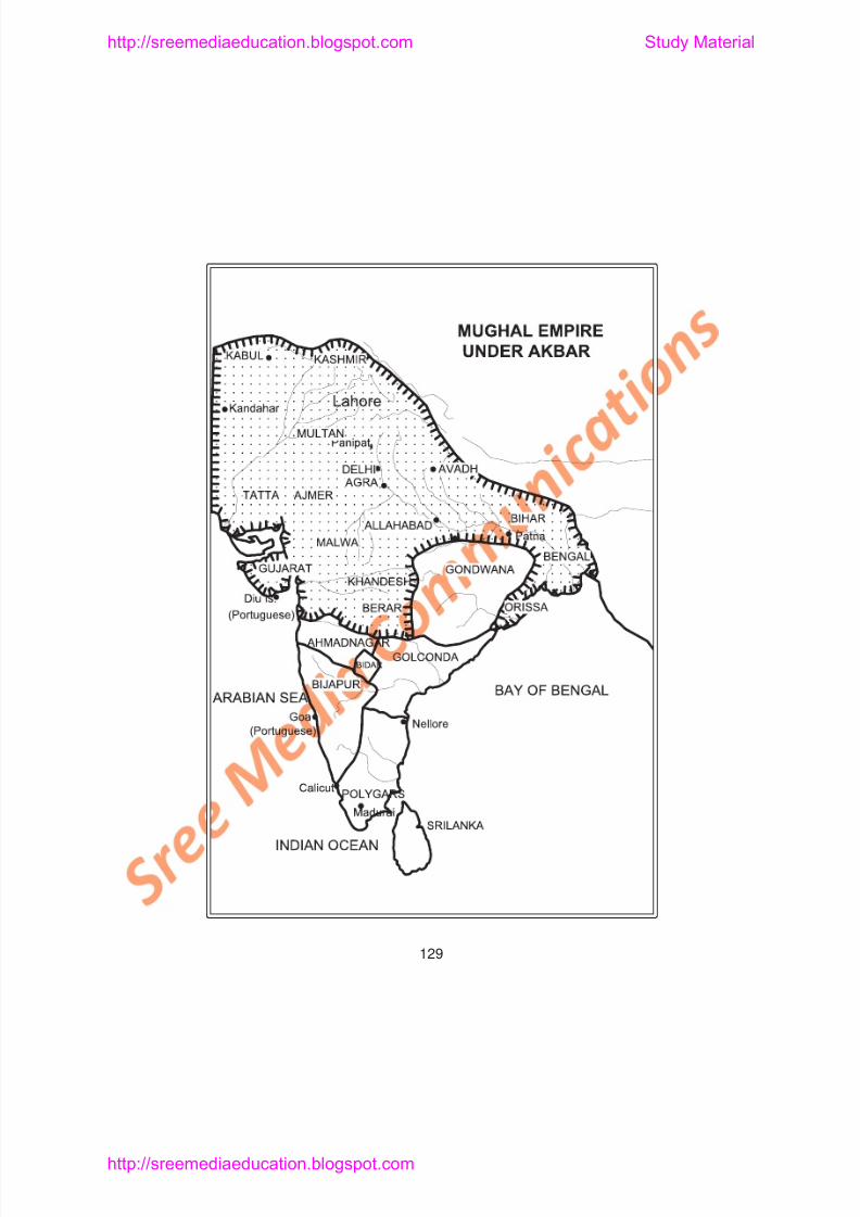
8/6/2019 Social Science History Civics and Geography
http://slidepdf.com/reader/full/social-science-history-civics-and-geography 133/280
http://sreemediaeducation.blogspot.com Study Material
8/6/2019 Social Science History Civics and Geography
http://slidepdf.com/reader/full/social-science-history-civics-and-geography 134/280
fought against Ahmadnagar. It was ruled by Chand Bibi, the guardianof a young ruler. She was defeated. She gave Berar to Akbar.
Akbar’s Religious Policy: Akbar’s father was a Sunni Muslimwhile his mother was a Shia. He lived in a Hindu family for some timeduring his childhood. He was greatly influenced by a liberal thinker
named Sheik Mubarak. All these things made him tolerant towards allreligions later. Akbar evolved a new faith called Din-i-Illahi or DivineFaith. It contained the best principles of all religions.
Akbar made an attempt to bring Unity in Diversity throughhis own religion.
Akbar’s Encouragement to Literature : Akbar patronisedwriters like Abul Faizi and Abul Fazl. The great historians Badauni,
Ferishta and Nizamuddin lived during this period. Abul Fazl is theauthor of Akbar Nama. Ain-i-Akbari is a part of Akbar Nama. Akbarwas a great patron of Sanskrit. Tulsidas wrote Ramayana in Hindi.Tansen, the famous musician and Birbal, the master of wits, werealso patronised by Akbar.
Although intelligent, Akbar never learnt to read or write
http://sreemediaeducation.blogspot.com Study Material
8/6/2019 Social Science History Civics and Geography
http://slidepdf.com/reader/full/social-science-history-civics-and-geography 135/280
Jahangir’s eldest son, Khusrau, rebelled against him. He wasarrested and put into prison. Guru Arjun Dev, the fifth Sikh Guru,who assisted him was killed for refusal to pay a fine. It made the Sikhsturn against the Mughals.
Conquests of Jahangir: Jahangir put down a revolt in Bengal
in A.D. 1612. He defeated Raja Amar Singh of Mewar in A.D. 1614.In the Deccan, the war with Ahmadnagar was continued.
English Travellers (Visitors): During Jahangir’s reign CaptainWilliam Hawkins and Sir Thomas Roe visited his court. Sir ThomasRoe secured permission from Jahangir in A.D. 1615 to trade at Surat.
Nur Jahan: Nur Jahan was the daughter of Ghias Beg, aPersian noble. Her original name was Mehr-un-Nisa. She wasextremely beautiful. First, she was married to Sher Afghan who was
put to death in a war. Jahangir married her in A.D. 1611. She was anintelligent woman. She was educated and cultured. She wrote poemsin Persian. Although Jahangir was the king, she exercised the realpower. Her influence on the emperor affected the prestige of theempire in later days. Jahangir died in A.D. 1627.
Shah Jahan - (A.D. 1628 - A.D. 1658): A war of succession
http://sreemediaeducation.blogspot.com Study Material
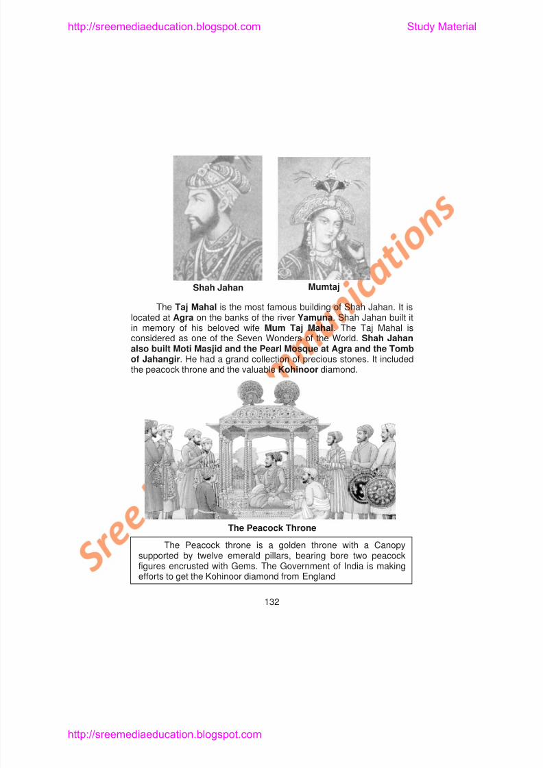
8/6/2019 Social Science History Civics and Geography
http://slidepdf.com/reader/full/social-science-history-civics-and-geography 136/280
The Taj Mahal is the most famous building of Shah Jahan. It is
located at Agra on the banks of the river Yamuna. Shah Jahan built itin memory of his beloved wife Mum Taj Mahal. The Taj Mahal isconsidered as one of the Seven Wonders of the World. Shah Jahanalso built Moti Masjid and the Pearl Mosque at Agra and the Tombof Jahangir. He had a grand collection of precious stones. It includedthe peacock throne and the valuable Kohinoor diamond.
Shah Jahan Mumtaj
http://sreemediaeducation.blogspot.com Study Material
8/6/2019 Social Science History Civics and Geography
http://slidepdf.com/reader/full/social-science-history-civics-and-geography 137/280
Fine arts like painting, music and literature reached high level ofdevelopment during Shah Jahan’s time. He was a great patron of artand letters. The Mughal empire attained its highest strength under him.
Art and architecture had developed when there prevailedeconomic prosperity and political stability.
Shah Jahan fell ill in A.D. 1657. A war of succession startedamong his four sons for the throne. Aurangazeb imprisoned ShahJahan in A.D. 1658. The Emperor remained in prison during his lastdays. He died in A.D. 1666.
Aurangazeb (A.D. 1658-A.D.1707): Aurangazeb was the lastgreat Mughal ruler. He ascended the throne after killing his threebrothers Dara, Shuja and Murad in a fratricidal war.
Aurangazeb proved “Kingship knows no kinship”.
He not only hated the non-Muslims, Hindus and Sikhs, but alsothe Shia Muslims. Aurangazeb was a staunch Sunni Muslim. He waspious and simple in his life. He regularly read the Koran . He had to
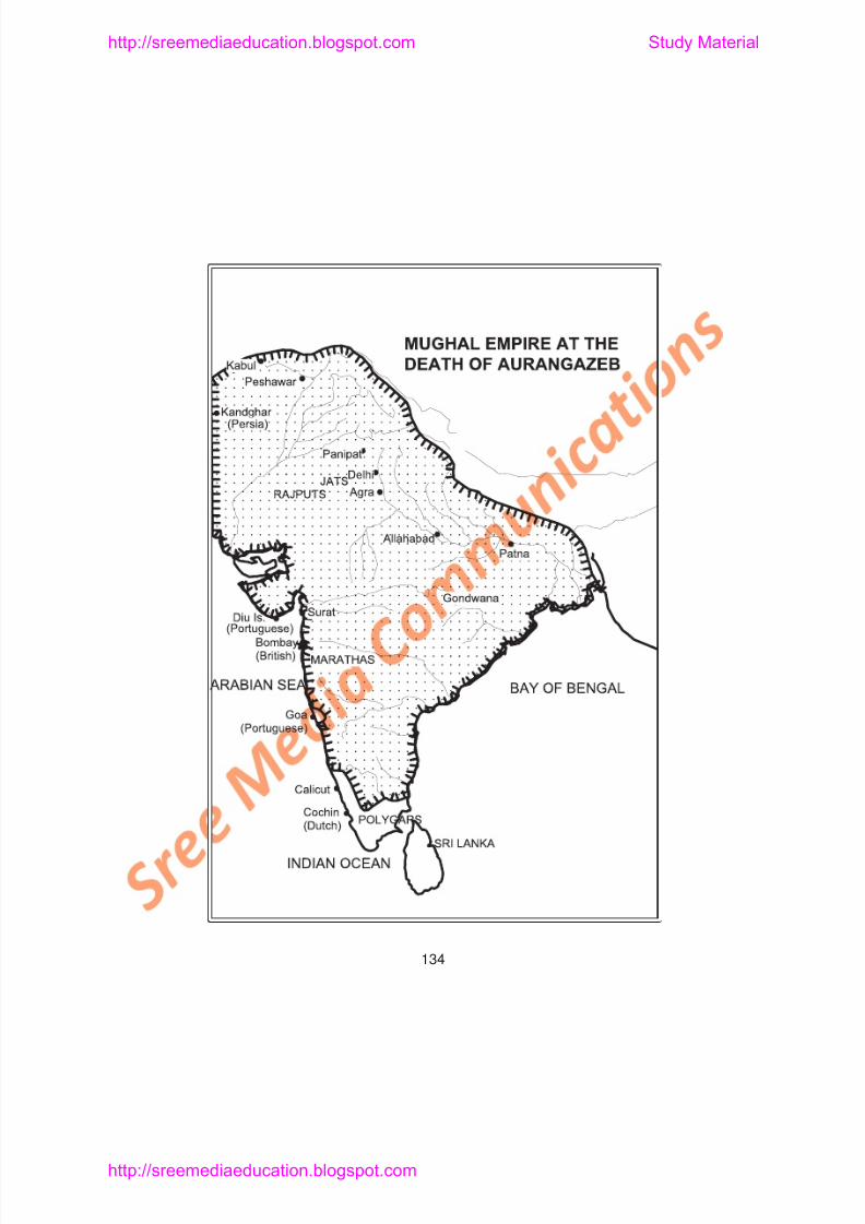
8/6/2019 Social Science History Civics and Geography
http://slidepdf.com/reader/full/social-science-history-civics-and-geography 138/280
http://sreemediaeducation.blogspot.com Study Material
8/6/2019 Social Science History Civics and Geography
http://slidepdf.com/reader/full/social-science-history-civics-and-geography 139/280
MUGHAL ADMINISTRATION
Akbar borrowed Sher Shah’s administrative features. So SherShah is regarded as the forerunner of Akbar’s administration. Akbarmostly evolved the Mughal administration. He was a greatadministrator. The Mughal administration later served as the basis for
the super imposition of British administrative set up in India.
Central Government: The Emperor or Padshah had allpowers in his hands. He was an absolute ruler. A council of four to sixministers helped him.
Provincial Administration: The empire was divided into 15provinces during Akbar’s rule. They were called Subas . The head of aSuba was called Subedar. He was responsible for the civil and militaryduties. The Diwan was in charge of Subas’ finance. The provinceswere further sub-divided into Sarkars or districts. Faujdar was the civiland military head of the district. Each Sarkar was administered by anumber of officers. The Sarkar was further divided into Parganas .Shiqdar, Amil and Fotadar were the officers who were in-charge ofthe Parganas .
The lowest unit in Mughal administration was the village The
http://sreemediaeducation.blogspot.com Study Material
8/6/2019 Social Science History Civics and Geography
http://slidepdf.com/reader/full/social-science-history-civics-and-geography 140/280
Revenue Administration: Raja Todar Mal, the famous
revenue minister, worked under Akbar. He also worked under Sher
Shah, the forerunner of Akbar. Akbar had introduced effective revenue
reforms. He introduced the Zabti system. All lands in the Empire were
measured with a uniform standard of measurement.
Lands were classified into three categories on the basis of the
fertility and yield of the soil. One third of the average yield of the three
classes was fixed as the land tax. The farmers could pay the tax either
in cash or in kind. During times of famine or floods, the land tax was
not collected. The emperor asked the officers to act kindly with the
peasants.
Judicial Administration: The king was the highest judge. The
next judicial authority was the Chief Qazi. There were city courts also.Causes for the Decline of the Mughal Empire : The Mughal
empire declined due to several reasons. The main causes were:
1. Aurangazeb treated the Hindus, Rajputs and the Sikhs very
badly.
8/6/2019 Social Science History Civics and Geography
http://slidepdf.com/reader/full/social-science-history-civics-and-geography 141/280
8/6/2019 Social Science History Civics and Geography
http://slidepdf.com/reader/full/social-science-history-civics-and-geography 142/280
8/6/2019 Social Science History Civics and Geography
http://slidepdf.com/reader/full/social-science-history-civics-and-geography 143/280
http://sreemediaeducation.blogspot.com Study Material
8/6/2019 Social Science History Civics and Geography
http://slidepdf.com/reader/full/social-science-history-civics-and-geography 144/280
3. Briefly mention the character of Babur.
4. Write a few sentences about the personal defects of Humayun.
5. What were the problems faced by Humayun?
6. When and where was Akbar born?
7. How did Humayun regain his Kingdom?
8. How did Farid Khan earn his name Sher Khan?
9. When and between whom was the Second Battle of Panipatfought? What was the outcome?
10. Who was Bairam Khan? What do you know about him?
11. Mention the boundaries of Akbar’s empire.
12. Name the Rajputs who held high positions in Akbar’sadministration.
13. Explain briefly the religious policy of Akbar.14. Name the historians who lived during Akbar’s period.
15. What arrangement did Jahangir make for rendering Justice?
16. Why did the Sikhs turn against Jahangir?
17. What do you know about the last days of Shah Jahan?
18 F h h K l b il ?
8/6/2019 Social Science History Civics and Geography
http://slidepdf.com/reader/full/social-science-history-civics-and-geography 145/280
http://sreemediaeducation.blogspot.com Study Material
8/6/2019 Social Science History Civics and Geography
http://slidepdf.com/reader/full/social-science-history-civics-and-geography 146/280
lower classes was miserable. People in the countryside led a very poorlife. Women were subordinated. Their participation in public life wasvery minimum. Muslim women wore purdah . Hindu women practisedsati . Inequality in social life was common. It was not viewed seriously.People accepted it as fate. The traditional Hindu and Muslim familysystem with the eldest person controlling the family continued.
Economy: The majority of the people lived in the villages. Theywere mostly farmers. Rice, wheat, barley and maize were grown inmany parts of the country. Cotton, indigo, sugarcane and oilseedswere also cultivated. During the Mughal period, several new cropswere introduced in India. For example, tobacco was introduced by thePortuguese during Jahangir’s period.
Cotton and silk textiles were manufactured. Silk weaving
flourished at Lahore, Agra and Gujarat. The famous muslin cloth wasproduced at Sonargaon in the Dacca district. Woollen shawls andcarpets, jewels, decorative swords and jade bowls were alsoproduced. Agra, Fatehpur Sikri and Lahore were the notable tradingcentres. Lahore was considered as one of the largest businesscentres.
http://sreemediaeducation.blogspot.com Study Material
8/6/2019 Social Science History Civics and Geography
http://slidepdf.com/reader/full/social-science-history-civics-and-geography 147/280
by each other’s customs and traditions. This helped in thedevelopment of a common culture in the country. The Bakti Movementwent a step further during the Mughal period. Akbar himself was areformer. Many great reformers like Eknath, Tukaram and Ram Daswere the great saints of the time. The Muslims were equally influencedby the Hindu culture.
Cultural Life: Many buildings of the Mughal period beartestimony to the blending of the Hindu and Muslim culture under theMughals. The mosque at Jaunpur is the best example. It is purely ofHindu origin as far as the art is concerned and it was a place ofworship for the Muslims. The Mughal rulers did not hesitate topatronize the Hindu artists. For instance, in Abul Fazal’s cataloguethere is a reference to 17 artists. Out of them only 4 were Muslims and13 were Hindus. Men like Bhagavan Das, Mansingh, Todar Mal, Birbal
and Jaswant Singh had played important role in the Mughaladministration. Birbal and TodarMal learnt Persian. Important Sanskritbooks were translated into Persian language. Even the Mughal PrinceDara Shukoh studied Sanskrit with pleasure and love. Thus theHindus and the Muslims sank their differences and gave birth to asociety, which was highly integrated religiously, culturally, socially andemotionally. The society was a mixture and adoption of the Hindu and
http://sreemediaeducation.blogspot.com Study Material
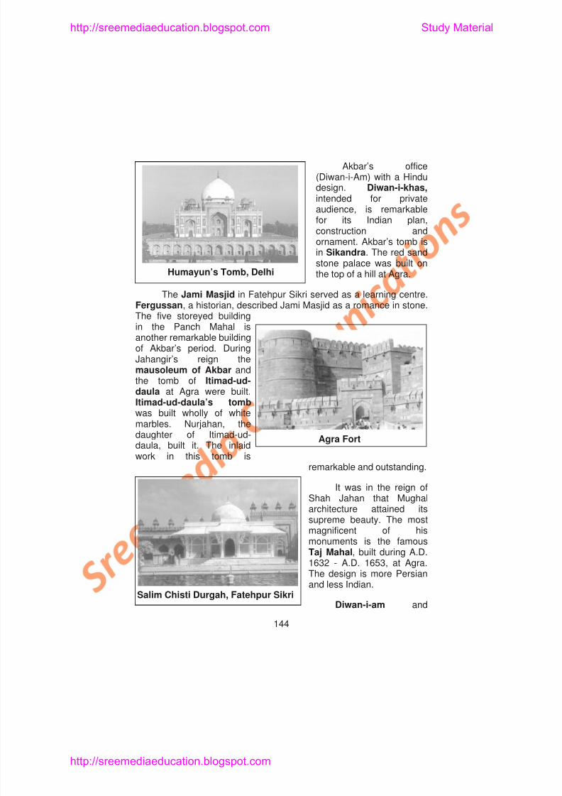
8/6/2019 Social Science History Civics and Geography
http://slidepdf.com/reader/full/social-science-history-civics-and-geography 148/280
Akbar’s office(Diwan-i-Am) with a Hindudesign. Diwan-i-khas,intended for privateaudience, is remarkablefor its Indian plan,
construction andornament. Akbar’s tomb isin Sikandra. The red sandstone palace was built onthe top of a hill at Agra.
The Jami Masjid in Fatehpur Sikri served as a learning centre.Fergussan, a historian, described Jami Masjid as a romance in stone.The five storeyed building
in the Panch Mahal isanother remarkable buildingof Akbar’s period. DuringJahangir’s reign themausoleum of Akbar andthe tomb of Itimad-ud-daula at Agra were built.
Humayun’s Tomb, Delhi
http://sreemediaeducation.blogspot.com Study Material
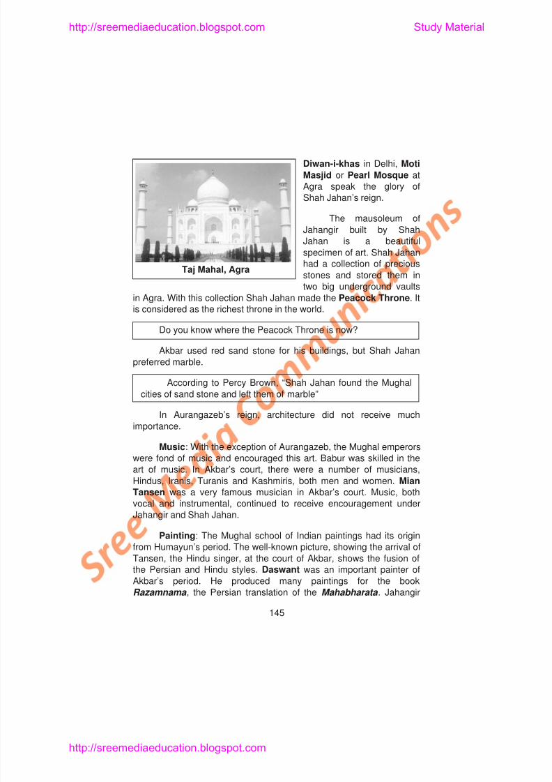
8/6/2019 Social Science History Civics and Geography
http://slidepdf.com/reader/full/social-science-history-civics-and-geography 149/280
Diwan-i-khas in Delhi, Moti
Masjid or Pearl Mosque at
Agra speak the glory of
Shah Jahan’s reign.
The mausoleum of
Jahangir built by ShahJahan is a beautiful
specimen of art. Shah Jahan
had a collection of precious
stones and stored them in
two big underground vaults
in Agra. With this collection Shah Jahan made the Peacock Throne. It
is considered as the richest throne in the world.
Do you know where the Peacock Throne is now?
Akbar used red sand stone for his buildings, but Shah Jahan
preferred marble.
According to Percy Brown, “Shah Jahan found the Mughal
Taj Mahal, Agra
http://sreemediaeducation.blogspot.com Study Material
8/6/2019 Social Science History Civics and Geography
http://slidepdf.com/reader/full/social-science-history-civics-and-geography 150/280
an excellent critic, and proud of his court painters. He paid heavyprices for pictures that possessed artistic merits. Dara Shukoh wasalso a patron of paintings.
Learning Outcome
1. Pupil will be able to describe the social, economic, religious andcultural life of people under the Mughals.
2. Pupil will be able to recall the places of historical importance of the
Mughal period.
3. Pupil will be able to make an estimation of the contribution of
Akbar, Jahangir and Shah Jahan to art and architecture.
4. Pupil will appreciate the development of music during Mughal
period.
5. Pupil will be able to point out the places of painting during the
Mughal period.
SELF-EVALUATION
http://sreemediaeducation.blogspot.com Study Material
8/6/2019 Social Science History Civics and Geography
http://slidepdf.com/reader/full/social-science-history-civics-and-geography 151/280
II. Fill in the Blanks
1. In Mughal period___________formed the bulk of the population.
2 Prince Dara Shukoh studied ___________with pleasure andlove.
3. The Mughal emperors considered ___________horses verydear.
4. ___________, the new religion of Akbar, was based onsecularism.
5. An important painting of Akbar’s period was ___________
6. The hall or private audience ___________is in the palace ofFatehpur Sikri.
III. Match the Following1. Agra – Saint
2. Surat – Singer
3. Tukaram – Muslin cloth
4 S P t
http://sreemediaeducation.blogspot.com Study Material
8/6/2019 Social Science History Civics and Geography
http://slidepdf.com/reader/full/social-science-history-civics-and-geography 152/280
4. What were the imports and exports during the period of theMughals?
5. Name a few reformers of Mughal Age.
6. Write a short note on Daswant.
7. Mention the importance of Buland Darwaza.
V. Answer in Detail
1. Explain the social, economic, religious and cultural life of thepeople during the Mughal Period.
2. Write in detail about Art and Architecture of the Mughals.

8/6/2019 Social Science History Civics and Geography
http://slidepdf.com/reader/full/social-science-history-civics-and-geography 153/280
http://sreemediaeducation.blogspot.com Study Material
8/6/2019 Social Science History Civics and Geography
http://slidepdf.com/reader/full/social-science-history-civics-and-geography 154/280
into 28 States and 6 Union Territories. Her population, according to2001 census, stood at 1,027,015,247. The States of India are dividedon the basis of the languages spoken by the people.
Ask your teacher to elaborate the physical diversity of Indiaand find your- self from the Geography lessons
India-An Ethnological Museum: India has been oftendescribed as an ethnological museum from the human point of view.Her pre-history tells us about the Harappan people who lived in theIndus River areas prior to the coming of the Aryans. The Vedas speakabout the Aryans and their spread in the Indo-Gangetic regions. TheSangam classics bear testimony to a well developed culture amongthe Tamils, even during the pre-Christian Era, in the extreme south ofIndia. Apart from these early settlers, the Persians entered India in theNorth West. The Greeks, the Sakas, the Huns, and the Kushansfollowed them. The Arabs, the Turks, the Mongols and the Mughalscame to India during the medieval times. These people belonged tomany races. The Europeans, such as the Portuguese, the Dutch, theFrench and the English, came in the modern period. Excepting theEuropeans, all others have been absorbed into the stream of Indianlife. It is due to this fact that many consider India as an ethnological
http://sreemediaeducation.blogspot.com Study Material
8/6/2019 Social Science History Civics and Geography
http://slidepdf.com/reader/full/social-science-history-civics-and-geography 155/280
Languages in India: People in India speak different languages.
There are more than 1652 mother tongues in India. 33 languages are
spoken by people numbering over a lakh. In ancient times Prakrit and
Sanskrit were used in most parts of India. Sanskrit is considered as
the mother of all North Indian languages. Devanagiri is the script used
to write Sanskrit and other north Indian languages. Hindi, Marathi,
Gujarathi, Punjabi, Kashmiri, Urdu and Bengali are the majorlanguages spoken in North India. Assamese is the language spoken
in the North East. Tamil, Telugu, Oriya, Kannada and Malayalam are
the major languages spoken in South India. Many Tribal languages do
not have script. English became the common and link language
after 200 years of British rule in India. Out of the many Indian
languages 18 are recognised as the official languages.
Language has never been a hurdle for India’s religious andcultural unity. Even before the improvement of roads, communication,
printing, the Mahabharata and Ramayana stories were popular
throughout the length and breadth of India. English language had
cemented the already existing geographical, religious and cultural
unity of India. It made political unity possible.
8/6/2019 Social Science History Civics and Geography
http://slidepdf.com/reader/full/social-science-history-civics-and-geography 156/280
8/6/2019 Social Science History Civics and Geography
http://slidepdf.com/reader/full/social-science-history-civics-and-geography 157/280
http://sreemediaeducation.blogspot.com Study Material
8/6/2019 Social Science History Civics and Geography
http://slidepdf.com/reader/full/social-science-history-civics-and-geography 158/280
3. Religious Tolerance and Catholicity
4. The Secular Character of Indian Constitution
5. Our national symbols, flag and national anthem and
6. Common economic interest for the well being of all Indians.
7. Observance of National Integration Day on 19 November every
year, Independence Day, Republic Day, and National Cultural
and Sports Events.
Ask pupil to speak on the need for national integration
Learning Outcome
1. Pupil will be able to describe the physical diversity and unity ofIndia.
2. Pupil will be able to list out the people of various races in India.
3. Pupil will be able to recall how literature acts as a unifying force.
http://sreemediaeducation.blogspot.com Study Material
8/6/2019 Social Science History Civics and Geography
http://slidepdf.com/reader/full/social-science-history-civics-and-geography 159/280
3. The Buddhists celebrate
a) Mahavir Jayanthi b) Guru Nanak Jayanthi
c) Rama Navami d) Buddha Poornima
4. The States of India are divided on the basis of
a) Literature b) Architecture
c) Language d) Heritage
II. Fill in the Blanks
1. India is a ______________ racial society.
2. Indian society is a ______________ cultural society.
3. Hinduism is practised by______________per cent of people inIndia.
4. The important festival of the Jains is ______________
5. ______________is celebrated by the Sikhs.
http://sreemediaeducation.blogspot.com Study Material
8/6/2019 Social Science History Civics and Geography
http://slidepdf.com/reader/full/social-science-history-civics-and-geography 160/280
V. Answer in Detail
1. “India is an ethnological museum of many races” - Explain.
2. “India is a land of Unity in Diversity” - Explain.
3. Mention the factors that lead to National Integration.
Teaching and Learning Activities
1. Prepare an Album about our National Symbols.
2. List out the Holy places of North and South India.
3. Conduct a workshop on National Unity in Diversity.
http://sreemediaeducation.blogspot.com Study Material
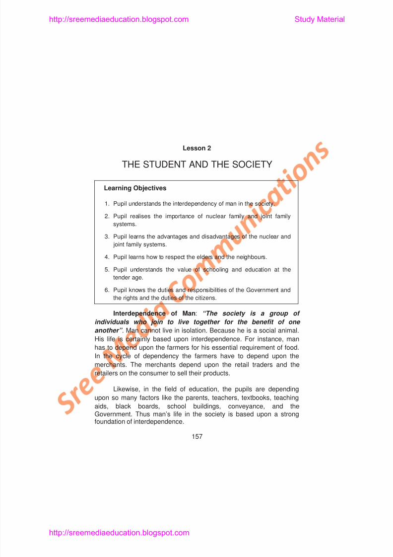
8/6/2019 Social Science History Civics and Geography
http://slidepdf.com/reader/full/social-science-history-civics-and-geography 161/280
Lesson 2
THE STUDENT AND THE SOCIETY
Learning Objectives
1. Pupil understands the interdependency of man in the society.
2. Pupil realises the importance of nuclear family and joint family
systems.
3. Pupil learns the advantages and disadvantages of the nuclear and
joint family systems.
4. Pupil learns how to respect the elders and the neighbours.
5. Pupil understands the value of schooling and education at the
t d g
http://sreemediaeducation.blogspot.com Study Material
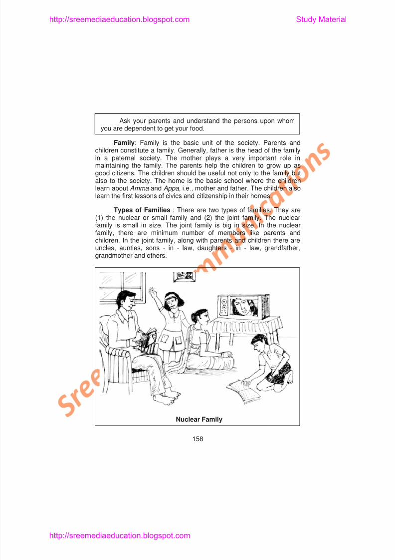
8/6/2019 Social Science History Civics and Geography
http://slidepdf.com/reader/full/social-science-history-civics-and-geography 162/280
Ask your parents and understand the persons upon whomyou are dependent to get your food.
Family: Family is the basic unit of the society. Parents andchildren constitute a family. Generally, father is the head of the familyin a paternal society. The mother plays a very important role in
maintaining the family. The parents help the children to grow up asgood citizens. The children should be useful not only to the family butalso to the society. The home is the basic school where the childrenlearn about Amma and Appa, i.e., mother and father. The children alsolearn the first lessons of civics and citizenship in their homes.
Types of Families : There are two types of families. They are(1) the nuclear or small family and (2) the joint family. The nuclearfamily is small in size. The joint family is big in size. In the nuclear
family, there are minimum number of members like parents andchildren. In the joint family, along with parents and children there areuncles, aunties, sons - in - law, daughters - in - law, grandfather,grandmother and others.
http://sreemediaeducation.blogspot.com Study Material
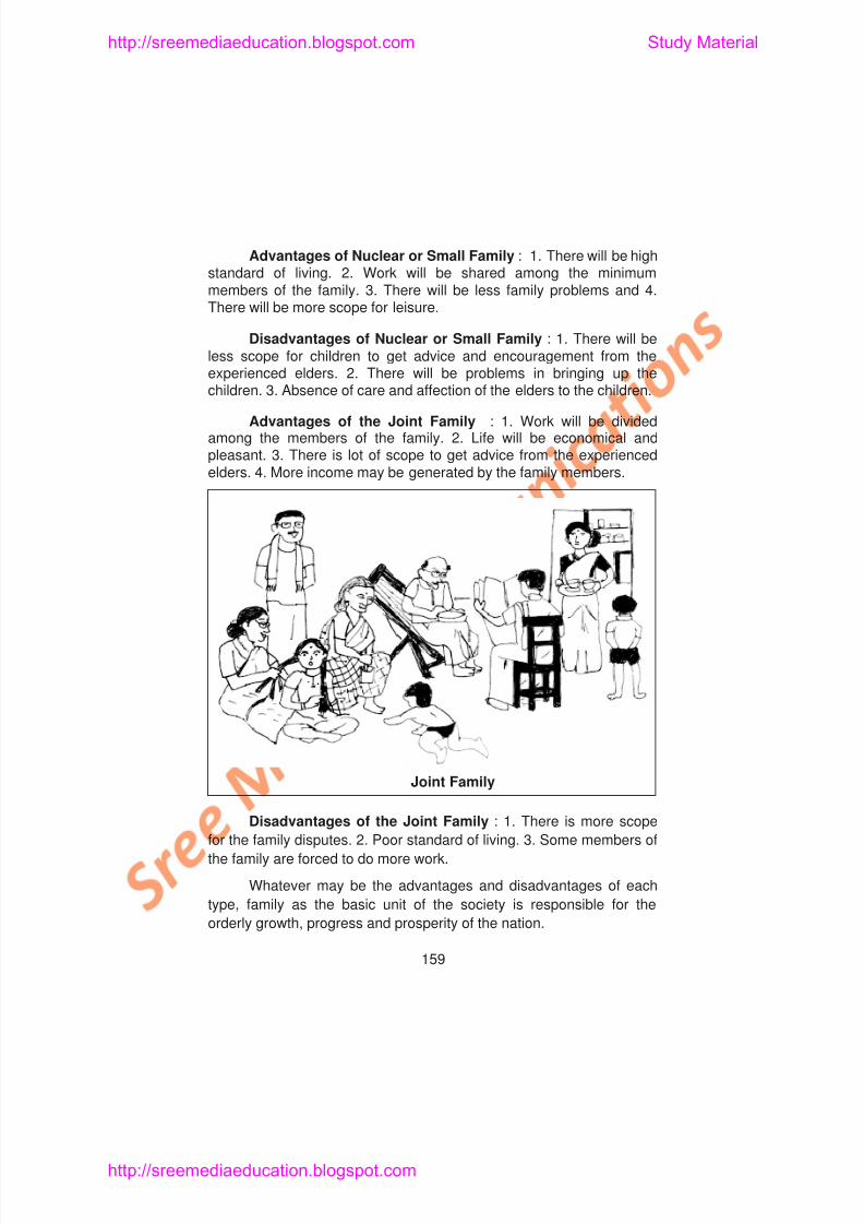
8/6/2019 Social Science History Civics and Geography
http://slidepdf.com/reader/full/social-science-history-civics-and-geography 163/280
Advantages of Nuclear or Small Family : 1. There will be highstandard of living. 2. Work will be shared among the minimummembers of the family. 3. There will be less family problems and 4.There will be more scope for leisure.
Disadvantages of Nuclear or Small Family : 1. There will be
less scope for children to get advice and encouragement from theexperienced elders. 2. There will be problems in bringing up thechildren. 3. Absence of care and affection of the elders to the children.
Advantages of the Joint Family : 1. Work will be dividedamong the members of the family. 2. Life will be economical andpleasant. 3. There is lot of scope to get advice from the experiencedelders. 4. More income may be generated by the family members.
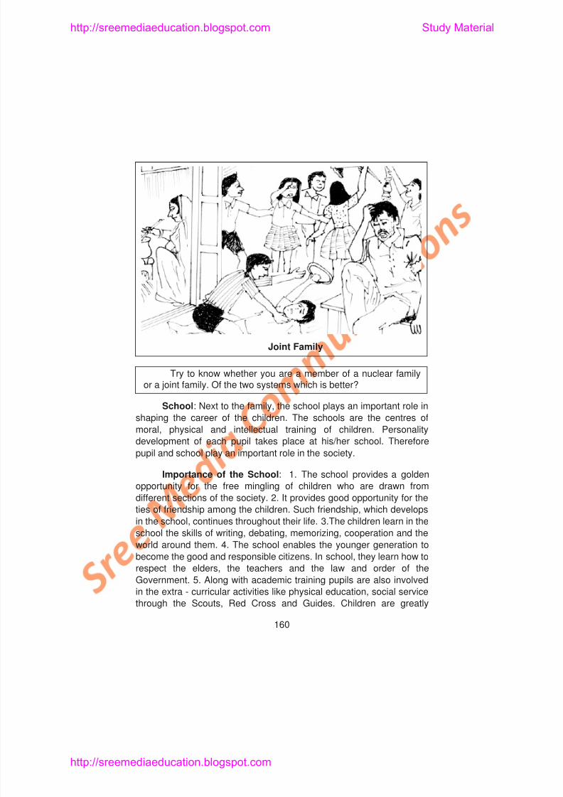
8/6/2019 Social Science History Civics and Geography
http://slidepdf.com/reader/full/social-science-history-civics-and-geography 164/280
f
http://sreemediaeducation.blogspot.com Study Material
8/6/2019 Social Science History Civics and Geography
http://slidepdf.com/reader/full/social-science-history-civics-and-geography 165/280
benefitted by these extra - curricular activities. They are able to serve
the community better. 6. Good training is imparted to the children to
learn morals and ethics. 7. The school acts as a powerful social
organisation in moulding the character of the children. The children
enter the school as children and leave it in their teenage as
adolescence. 8. The school enables the overall development of the
boys and the girls.
The experience gained by the students at the school help them
to do some service to the society. After the completion of school
education, students go for higher education according to their desire
and talent. Even in that stage they render service to the society.
1. Know the important personalities of your school who are
placed in top positions.
2. Have a concrete thinking about your future after finishing your
school education.
Role of Students in Villages : India is a land of villages.
India’s development is based upon the improvement of her villages.
Villages are the backbone of the Indian econom Most of the st dents
t d t h i hibiti i ki f i d hi ith th i h H /
http://sreemediaeducation.blogspot.com Study Material
8/6/2019 Social Science History Civics and Geography
http://slidepdf.com/reader/full/social-science-history-civics-and-geography 166/280
student has no inhibition in making friendship with the neighours. He/
she should act as a bridge between his/her parents and their
neighbours.
A cultured man is always well disposed towards his neighbours.
The following things are to be borne in mind while making friendship
with our neighbours.
1. To take part in the happiness and sorrow of our neighbours.
2. To participate in each other’s religious and family functions.
3. To treat the neighbours with greater amount of kindness.
4. Having involvement in the problems of our neighbours and
helping them to tide over from the same.
5. We should not develop jealousy in the progress made by ourneighbours.
6. We should enjoy our rights without disturbing others. This may
be done by reducing the volume of radio and television. If this is
done, the patients and the students in the neighbourhood will
feel happy
t ’ f t iti Th h ld th d i bl d
http://sreemediaeducation.blogspot.com Study Material
8/6/2019 Social Science History Civics and Geography
http://slidepdf.com/reader/full/social-science-history-civics-and-geography 167/280
tomorrow’s future citizens. They should possess the desirable good
qualities of citizens. The following are some of the good qualities of
citizens. They should
1. have patriotic feelings.
2. try to have good education.
3. exercise the franchise in periodical elections.
4. be capable of doing hard work.
5. should be tolerant.
6. should have the tendency to help others.
7. sincerely love the neighbours.
8. keep the surroundings neat and clean.9. should have knowledge of the country, particularly the current
affairs.
10. not evading the tax payments, which are due to the government.
Students can show their patriotism by sincerely participating in
It is the right of the citizens to get infrastructure facilities from the
http://sreemediaeducation.blogspot.com Study Material
8/6/2019 Social Science History Civics and Geography
http://slidepdf.com/reader/full/social-science-history-civics-and-geography 168/280
It is the right of the citizens to get infrastructure facilities from the
government. At the same time it is the duty of the citizens to safeguard
the facilities provided by the Government. Thus the rights and duties of
the Government and the citizens are the two sides of a coin. Certainly
they are complementary to each other. Once again, it is the duty of the
citizens to protect the public properties and co-operate with the
government to implement the economic, social and welfareprogrammes.
Do you have the above qualities of good citizen? Ask yourself.
Learning Outcome
1. Pupil will recall the Interdependence of man.
2. Pupil will explain the types of families and their advantages anddisadvantages.
3. Pupil describes the value of school life.
4. Pupil narrates the role of students in villages.
5 P il l i h t t k i i d hil ki f i d hi ith
4 The Nuclear family is
http://sreemediaeducation.blogspot.com Study Material
8/6/2019 Social Science History Civics and Geography
http://slidepdf.com/reader/full/social-science-history-civics-and-geography 169/280
4. The Nuclear family is
a) Large in size b) Small in size
c) Medium in size d) None of these
5. A good citizen must have
a) Patriotism b) Good education
c) Tolerance d) All the above
II. Fill in the Blanks
1. The nuclear family is known as ______________
2. Next to family, the______________ plays an important role.
3. Villages are the backbone of the Indian______________
4. Cultured man is always well disposed towards his___________
5. Citizen means a______________of the country.
III. Match the Following
1. Home – Centre of moral, physical andintellectual education
2 How school education develops the moral physical and
http://sreemediaeducation.blogspot.com Study Material
8/6/2019 Social Science History Civics and Geography
http://slidepdf.com/reader/full/social-science-history-civics-and-geography 170/280
2. How school education develops the moral, physical andintellectual growth of a child?
3. What are the things one has to bear in mind while makingfriendship with neighbours?
4. What are the qualities of a good citizen?
Teaching and Learning Activities
1. Organise for a group discussion about the advantages and
disadvantages of nuclear family and joint family.
2. Participate in extra-curricular activities and learn how to serve the
society.
3. Prepare an Album on nuclear family (individual family) and joint
family.
http://sreemediaeducation.blogspot.com Study Material
8/6/2019 Social Science History Civics and Geography
http://slidepdf.com/reader/full/social-science-history-civics-and-geography 171/280
Lesson 3
THE CONSTITUTION OF INDIA - ITSSALIENT FEATURES
Learning Objectives
1. Pupil acquires knowledge about the Constitution of India.
2. Pupil understands the meaning of the Preamble
3. Pupil knows what are Fundamental Rights
4. Pupil recognises what are the Directive Principles of State Policy
5. Pupil comprehends the Fundamental Duties.
6. Pupil knows about the Union and State Governments
A Constitution Drafting Committee was formed to draft a
http://sreemediaeducation.blogspot.com Study Material
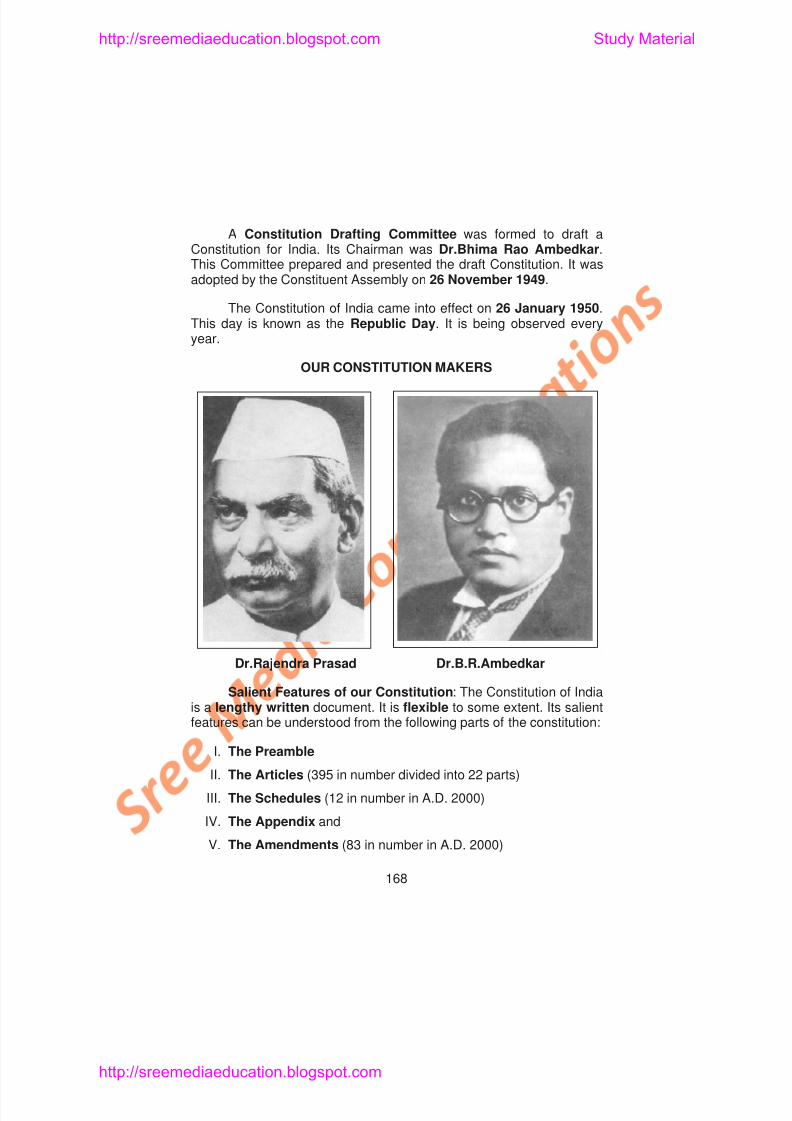
8/6/2019 Social Science History Civics and Geography
http://slidepdf.com/reader/full/social-science-history-civics-and-geography 172/280
gConstitution for India. Its Chairman was Dr.Bhima Rao Ambedkar.This Committee prepared and presented the draft Constitution. It wasadopted by the Constituent Assembly on 26 November 1949.
The Constitution of India came into effect on 26 January 1950.This day is known as the Republic Day. It is being observed every
year.
OUR CONSTITUTION MAKERS
The Central, State Governments, Union Territories, their
http://sreemediaeducation.blogspot.com Study Material
8/6/2019 Social Science History Civics and Geography
http://slidepdf.com/reader/full/social-science-history-civics-and-geography 173/280
, , ,
offices, the Supreme Court, High Courts, other Courts, the Election
Commission of India and all other Government bodies function on
the basis of the broad guidelines found in the above parts of the
constitution.
The Preamble: The Preamble of our Constitution states thatIndia is a Sovereign Socialist Secular Democratic Republic. Its aim
is to secure to all Indian Citizens Social, economic and political
justice. The Constitution guarantees Liberty of thought, expression,
belief, faith and worship to all. It gives Equality of status and of
opportunity to all. It wants to promote Fraternity among all Indians. It
assures the individual dignity of all. It aims to promote the Unity and
Integrity of the Nation. Thus the Preamble consists of the foremost
noble ideals of the Constitution. The sovereignty of the people of India
is found expressed in the beginning part itself. People of India are
powerful. They make Indian democracy a success. India is the largest
democratic country in the world.
Liberty, Equality and Fraternity were the important
l d i th F h R l ti i 1789 Th i
Fundamental Rights: All Indian citizens are guaranteed of the
http://sreemediaeducation.blogspot.com Study Material
8/6/2019 Social Science History Civics and Geography
http://slidepdf.com/reader/full/social-science-history-civics-and-geography 174/280
following important six Fundamental Rights. They are mentioned in theArticles of the Constitution from 12 to 35.
1. Right to Equality
2. Right to Freedom
3. Right Against Exploitation
4. Right to Freedom of Religion
5. Cultural and Educational Rights
6. Right to Constitutional Remedies
When the individuals’ fundamental rights are affected, she/hecan go the court. The courts can protect these rights of the individuals.
Thus they are enforceable by the courts of law. These Fundamentalrights tell about the democratic character of our Constitution. They alsoprotect the individual Human Rights of every citizen of India.
The Directive Principles of State Policy : Mere laws and actscan not rule a country. The Government should also work for the
lf f th l A ti l 36 t 51 f th C tit ti t t b t
However, these are fundamental to the governance of the country. The
http://sreemediaeducation.blogspot.com Study Material
8/6/2019 Social Science History Civics and Geography
http://slidepdf.com/reader/full/social-science-history-civics-and-geography 175/280
Government can not neglect these while administering the country.
Are you benefitted by the Governments’ Welfare measures?Find out from your teacher how you are benefitted
Fundamental Duties: The Indian citizens are expected to
discharge certain fundamental duties. They are stipulated in Article51A. The 42nd Amendment Act incorporated it in 1976. They are:
1. Obeying the Constitution and respecting the National Flag andNational Anthem.
2. Following the noble ideals of our Freedom Struggle.
3. Protecting the sovereignty, unity and integrity of India.
4. Rendering National Service when required.5. Promoting harmony and the spirit of common brotherhood
among all the people of India.
6. Preserving our rich cultural heritage.
7 Protecting and preserving our natural environment
http://sreemediaeducation.blogspot.com Study Material
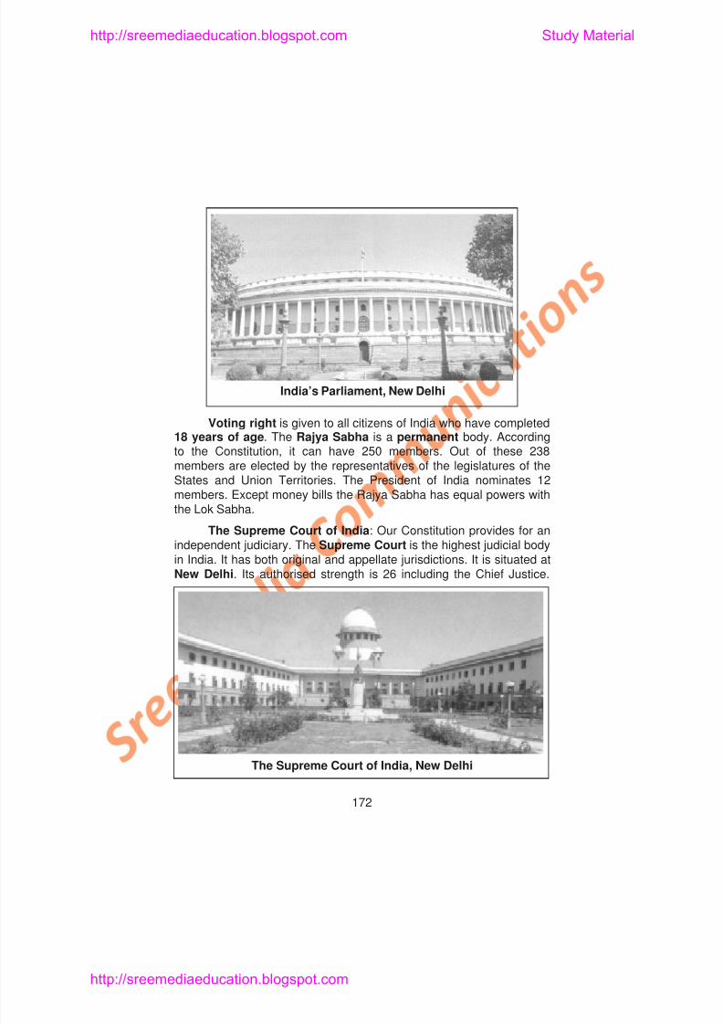
8/6/2019 Social Science History Civics and Geography
http://slidepdf.com/reader/full/social-science-history-civics-and-geography 176/280
Voting right is given to all citizens of India who have completed
18 years of age. The Rajya Sabha is a permanent body. Accordingto the Constitution, it can have 250 members. Out of these 238members are elected by the representatives of the legislatures of theStates and Union Territories. The President of India nominates 12members. Except money bills the Rajya Sabha has equal powers withthe Lok Sabha
India’s Parliament, New Delhi
However, the Parliament can increase the number of judges in it. Thej d h ld ffi till th f 65
http://sreemediaeducation.blogspot.com Study Material
8/6/2019 Social Science History Civics and Geography
http://slidepdf.com/reader/full/social-science-history-civics-and-geography 177/280
judges hold office till the age of 65.
To audit the Government accounts there is a Comptroller andAuditor - General of India. The President appoints him. She/heprepares the audit reports on the Union and States’ accounts.
The States: Articles 152 to 237 deal about the administration ofthe States. The Governor is at the top of the State Executive. TheChief Minister and her/his Council of Ministers discharge the realexecutive functions.
Who is the Governor of Tamil Nadu now?
Answer:
Who is the Chief Minister of Tamil Nadu now?
Answer:
Some states have bicameral legislatures, i.e., two bodies suchas the Legislative Assembly and Council. Tamilnadu hasUnicameral legislature i.e., only the Legislative Assembly. EachSt t i I di h High Co rt Th P id t f I di i t th
Learning Outcome
http://sreemediaeducation.blogspot.com Study Material
8/6/2019 Social Science History Civics and Geography
http://slidepdf.com/reader/full/social-science-history-civics-and-geography 178/280
Learning Outcome
1. Pupil will be able to recall the services of Dr.B.R.Ambedkar.
2. Pupil will be able to define the Preamble.
3. Pupil will be able to reason out why India is called a federal state.
4. Pupil will be able to list out the Fundamental Rights.
5. Pupil will be able to point out the Directive Principles of State
Policy.
6. Pupil will be able to explain the Fundamental Duties.
7. Pupil will be able to describe briefly about the Union and State
Governments.
8. Pupil will be able to explain the division of powers between the
Union and the States.
SELF - EVALUATION
I. Choose the Correct Answer
1. The President of the Constituent Assembly after 1947 was
6. Fundamental Duties are stipulated in Article
http://sreemediaeducation.blogspot.com Study Material
8/6/2019 Social Science History Civics and Geography
http://slidepdf.com/reader/full/social-science-history-civics-and-geography 179/280
a) 50A b) 52Ac) 51A d) 53A
7. The present strength of the Lok Sabha is
a) 545 b) 550c) 500 d) 454
8. Voting age is
a) 20 b) 21c) 19 d) 18
9. The highest judicial body in India is
a) The High Court b) The Supreme Courtc) The District Court d) The Tribunal
10. At the top of the State Executive is
a) The President b) The Chief Ministerc) The Governor d) The Chief Justice
11. The Union List consists of
a) 97 subjects b) 96 subjects
12. The_____________of India appoints the judges of the HighCourts
http://sreemediaeducation.blogspot.com Study Material
8/6/2019 Social Science History Civics and Geography
http://slidepdf.com/reader/full/social-science-history-civics-and-geography 180/280
Courts.
III. Match the Following
1. Dr.Rajendra Prasad – 1955
2. Dr.B.R.Ambedkar – 26 January
3. Republic Day – 1976
4. Citizenship Act – President ofConstituent Assembly
5. 42nd Amendment Act – Chairman, Drafting Committee
IV. Answer Briefly
1. When did the Constitution come into effect?
2. Which Articles contain the Fundamental Rights?
3. Which is the Central Legislature?
4. Who elect the members of the Lok Sabha?
5. Who appoints the judges of the High Courts?
V Answer in Detail
8/6/2019 Social Science History Civics and Geography
http://slidepdf.com/reader/full/social-science-history-civics-and-geography 181/280
Equality of opportunity is guaranteed to all in matters of publicemployment. However, there are certain laws, which protect the
http://sreemediaeducation.blogspot.com Study Material
8/6/2019 Social Science History Civics and Geography
http://slidepdf.com/reader/full/social-science-history-civics-and-geography 182/280
employment. However, there are certain laws, which protect theinterests of certain weaker sections of the society. For example, theSocially and Economically Backward Classes, the Scheduled Castesand Scheduled Tribes are given reservation in employment, Schooland College admissions, etc.
Article 17 of the constitution deals with the Abolition ofUntouchability. It forbids untouchability and declares its practice byanybody as a punishable offence.
2. Right to Freedom : Freedom of the individual is the essenceof Democracy. Therefore our Constitution guarantees every citizen theright to freedom. According to this all have freedom of thought. Allcitizens have equal rights to freedom of speech and expression. Theycan assemble peacefully and without arms. They can formassociations or unions. They can move freely to any part of India. They
can live in any part of India. They can practice any trade or occupation.No body can be punished except for the violation of law. Everyindividual’s life and personal liberty is protected. The constitution layscertain norms for arrest and custody. Every individual’s human right issafeguarded in the Constitution.
have the right to conserve their culture. They have the right toestablish and administer educational institutions of their choice. The
http://sreemediaeducation.blogspot.com Study Material
8/6/2019 Social Science History Civics and Geography
http://slidepdf.com/reader/full/social-science-history-civics-and-geography 183/280
Constitution provides protection for the cultural and educational rightsof all groups of people in India.
6. Right to Constitutional Remedies : The Right toConstitutional Remedies enables the citizens to go the Supreme Court
directly when there is any violation of the Fundamental Rights.
Fundamental Duties: According to the 42nd Amendmentpassed in 1976 a set of Ten Fundamental Duties of citizens wasincluded in the Constitution of India. They are :1. To abide by theConstitution and respect the ideals and Institutions.2. To respectNational Flag and National Anthem, 2. To realise and follow theessential ideals of Non-violence, Democracy and Secularism, 4. It isthe duty of every citizen to preserve the rich heritage of our Culture, 5.
To protect the Sovereignty, Unity and Integrity of our Nation, 6. Tosafeguard public property, 7. To defend our Country even at the cost ofour life, 8. To protect Natural Resources, 9. To avoid Dowry, Gamblingand other Social evils. 10. To strive towards excellence in theirrespective spheres of activity.
age, (13) promote the education and economic condition of thescheduled caste, scheduled tribes and other weaker sections, (14)
http://sreemediaeducation.blogspot.com Study Material
8/6/2019 Social Science History Civics and Geography
http://slidepdf.com/reader/full/social-science-history-civics-and-geography 184/280
( )raise the standard of living and improve public health, (15) organiseagriculture and animal husbandry, (16) protect and improve theenvironment, (17) safeguard forests and wildlife, (18) protectmonuments of historical interest, (19) separate judiciary from executiveand (20) promote international peace and security.
Differences between Fundamental Rights and DirectivePrinciples of State Policy
Fundamental Rights Directive Principles
1. Even the Government cannot
take away or abridge these
rights.
2. These are enforceable in law
courts.
3. The Government cannot take
policy decisions on these rights
These are mere instructions to
the Government.
These are not enforceable inany court.
The Government has powers to
make policy decisions on these
principles
SELF-EVALUATION
I Ch h C A
http://sreemediaeducation.blogspot.com Study Material
8/6/2019 Social Science History Civics and Geography
http://slidepdf.com/reader/full/social-science-history-civics-and-geography 185/280
I. Choose the Correct Answer
1. Fundamental Rights help the people to live
a) Without freedom b) Get benefits
c) With prosperity d) Freely and happily
2. Fundamental Rights are
a) enforceable by courts of law b) not enforceableby the courts of law c)
Instructions d) mere laws.
3. Untouchability has been abolished by
a) Articles 14 b) Articles 13
c) Article 17 d) Article 18
4. Right against exploitation is
a) A fundamental right b) Directive Principle
c) Order of the Court d) State Law
II. Fill in the Blanks
IV. Answer Briefly
1 What is meant by Fundamental Rights?
http://sreemediaeducation.blogspot.com Study Material
8/6/2019 Social Science History Civics and Geography
http://slidepdf.com/reader/full/social-science-history-civics-and-geography 186/280
1. What is meant by Fundamental Rights?
2. Write down one or two Fundamental Rights guaranteed in ourConstitution?
3. What Right enables you to express your thoughts freely?
4. What Right prevents the employment of children below 14 yearsof age in dangerous works?
5. List out a few fundamental duties.
6. Are the Directive Principles of State Policy enforceable by thecourts of law?
IV. Answer in Detail
1. Explain the Fundamental Rights guaranteed by yourConstitution.
2. Write down the duties of a citizen.
3. Explain the Directive Principles of State Policy.
8/6/2019 Social Science History Civics and Geography
http://slidepdf.com/reader/full/social-science-history-civics-and-geography 187/280
Apartheid led to gross violation of the basic or human rights ofmankind. They proved that Governments of some countries alone
ld ’t t t th h i ht f ki d Th f th
http://sreemediaeducation.blogspot.com Study Material
8/6/2019 Social Science History Civics and Geography
http://slidepdf.com/reader/full/social-science-history-civics-and-geography 188/280
couldn’t protect the human rights of mankind. Therefore theInternational Body namely the United Nations Organisations took upthe matter.
The U.N. Declaration on Human Rights, 1948: The United
Nations Organisation was established on 24 October 1945.Immediately after its establishment a Commission was set up to drawthe Human Rights under the Economic and Social Council. It is calledas the Commission on Human Rights. This Commission drafted theInternational Bill of Human Rights. It was adopted by the UnitedNations General Assembly on 10 December 1948. It is known as theUniversal Declaration of Human Rights. It is considered as a‘Common standard of achievement for all peoples and nations ;.There are 30 Articles in this Declaration. Its preamble recognizes the
‘inherent dignity and the equal and inalienable rights of allmembers of the human family’. The Articles describe the HumanRights.
The Declaration expresses the Universality of Rights of Man.It recognizes the equality of human dignity All human beings are
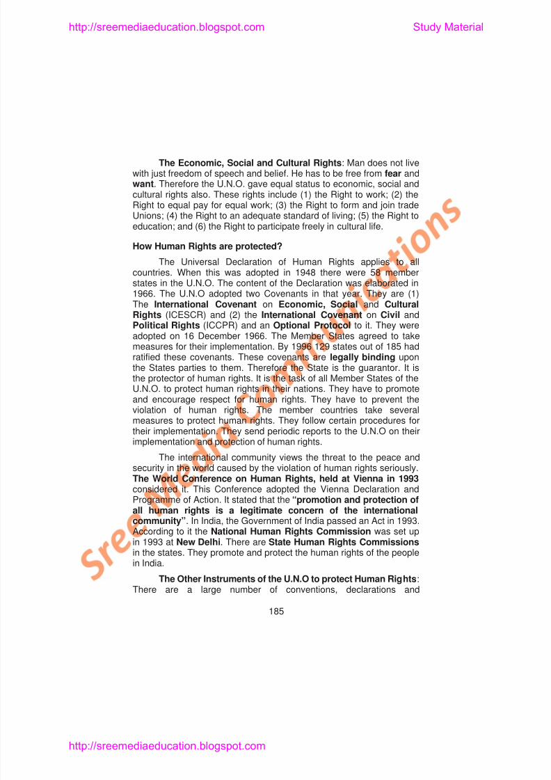
8/6/2019 Social Science History Civics and Geography
http://slidepdf.com/reader/full/social-science-history-civics-and-geography 189/280
recommendations adopted by the U.N. General Assembly on humanrights. They elaborate the rights set out in the Universal Declaration.They apply to all member states But they do not have the same legal
http://sreemediaeducation.blogspot.com Study Material
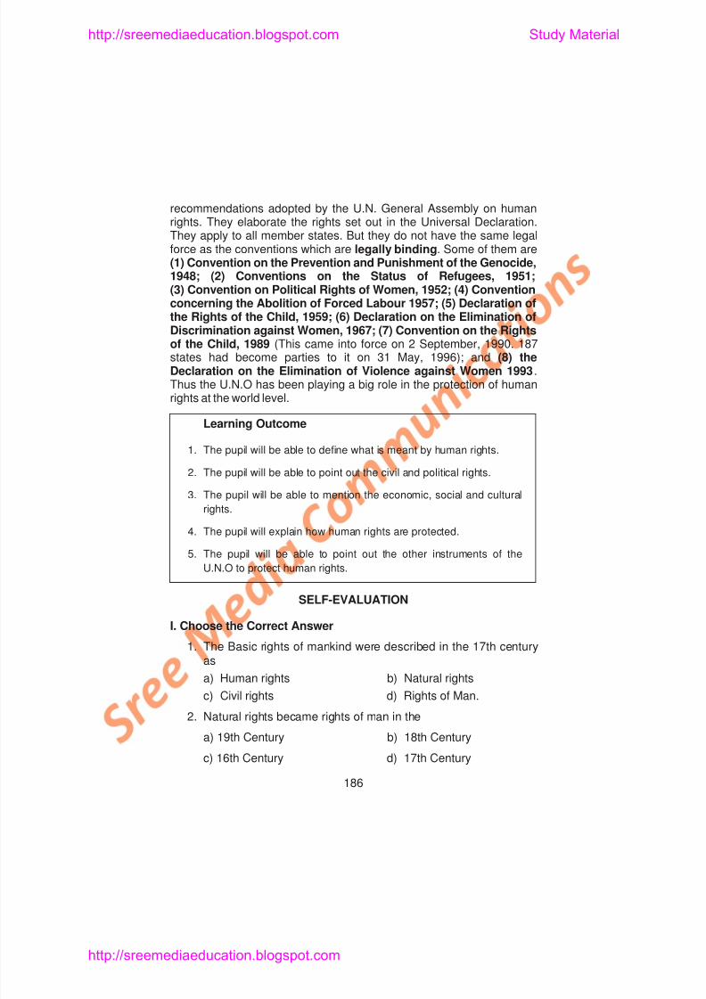
8/6/2019 Social Science History Civics and Geography
http://slidepdf.com/reader/full/social-science-history-civics-and-geography 190/280
They apply to all member states. But they do not have the same legalforce as the conventions which are legally binding. Some of them are(1) Convention on the Prevention and Punishment of the Genocide,1948; (2) Conventions on the Status of Refugees, 1951;(3) Convention on Political Rights of Women, 1952; (4) Convention
concerning the Abolition of Forced Labour 1957; (5) Declaration ofthe Rights of the Child, 1959; (6) Declaration on the Elimination ofDiscrimination against Women, 1967; (7) Convention on the Rightsof the Child, 1989 (This came into force on 2 September, 1990. 187states had become parties to it on 31 May, 1996); and (8) theDeclaration on the Elimination of Violence against Women 1993.Thus the U.N.O has been playing a big role in the protection of humanrights at the world level.
Learning Outcome
1. The pupil will be able to define what is meant by human rights.
2. The pupil will be able to point out the civil and political rights.
3 The pupil will be able to mention the economic social and cultural
3. The U.N. Declaration of Human Rights was adopted on
a) 24 October 1944 b) 24 October 1945
http://sreemediaeducation.blogspot.com Study Material
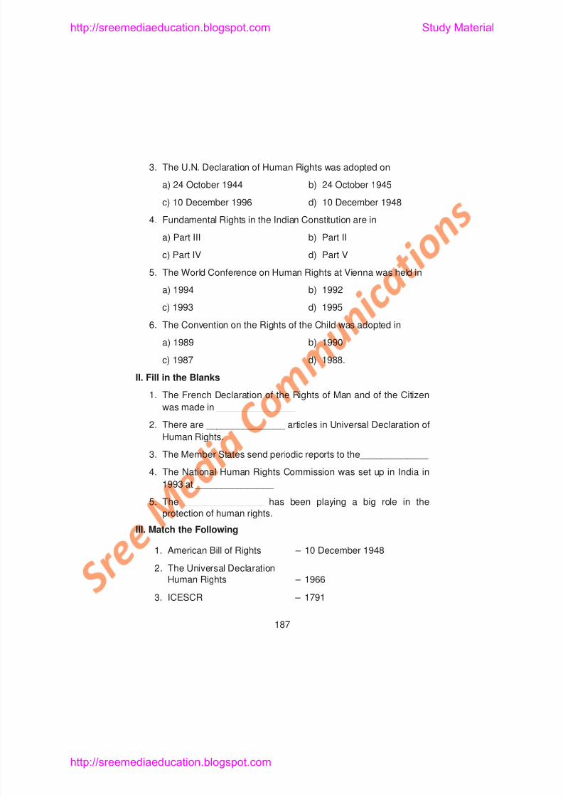
8/6/2019 Social Science History Civics and Geography
http://slidepdf.com/reader/full/social-science-history-civics-and-geography 191/280
) )
c) 10 December 1996 d) 10 December 1948
4. Fundamental Rights in the Indian Constitution are in
a) Part III b) Part II
c) Part IV d) Part V
5. The World Conference on Human Rights at Vienna was held in
a) 1994 b) 1992
c) 1993 d) 1995
6. The Convention on the Rights of the Child was adopted in
a) 1989 b) 1990
c) 1987 d) 1988.
II. Fill in the Blanks
1 The French Declaration of the Rights of Man and of the Citizen
IV. Answer Briefly
1. How the basic rights of mankind described in the 17th century?
http://sreemediaeducation.blogspot.com Study Material
8/6/2019 Social Science History Civics and Geography
http://slidepdf.com/reader/full/social-science-history-civics-and-geography 192/280
1. How the basic rights of mankind described in the 17th century?
2. What led to the gross violation of human rights?
3. When did the U.N. General Assembly adopt the Declaration ofHuman Rights?
4. What are two broad kinds of rights in the Declaration of HumanRights?
5. Point out a few civil and political rights.
6. Mention few economic, social and cultural rights.
7. Mention briefly how human rights are protected.
V. Answer in Detail
1. Write about the Universal Declaration of Human Rights.
2. Explain how human rights are protected?
3. List out the Civil and Political rights.
4 List out the Economic Social and Cultural rights
http://sreemediaeducation.blogspot.com Study Material
8/6/2019 Social Science History Civics and Geography
http://slidepdf.com/reader/full/social-science-history-civics-and-geography 193/280
Lesson 6
NATIONAL AND STATE
HUMAN RIGHTS COMMISSIONS
Learning Objectives
1. Pupil acquires knowledge about National Human Rights
Commission.
2. Pupil acquires knowledge about State Human Rights Commissions
3. Pupil understands the method of approaching these Commissions
4. Pupil knows about the composition of these Commissions.
5. Pupil understands the functions of these Commissions.
8/6/2019 Social Science History Civics and Geography
http://slidepdf.com/reader/full/social-science-history-civics-and-geography 194/280
the State government to study the living conditions of the inmates andmake recommendations thereon and (9) to probe into the complaintsthoroughly and provide help to the victims.
http://sreemediaeducation.blogspot.com Study Material
8/6/2019 Social Science History Civics and Geography
http://slidepdf.com/reader/full/social-science-history-civics-and-geography 195/280
The National Human Rights Commission has given priority to :
1. Protection of Civil Liberties
2. Review the legislations, which are against to human rightsprinciple.
3. Reforms in Civil and Police administration to usher in humanrights culture.
4. Eliminating custodial violence and rapes.
5. Redressal of human rights grievances of Scheduled Castesand Scheduled Tribes.
6. Concentration on rights of Women and Children.
Powers: The Commission enjoys all the powers of Civil Courtunder the code of Civil procedure. It sends summons to theconcerned. It enforces the attendance of witnesses and examinesh h I h h f i i id ffid i I
8/6/2019 Social Science History Civics and Geography
http://slidepdf.com/reader/full/social-science-history-civics-and-geography 196/280
8/6/2019 Social Science History Civics and Geography
http://slidepdf.com/reader/full/social-science-history-civics-and-geography 197/280
Learning Outcome
1. Pupil will be able to describe the composition of the National and
http://sreemediaeducation.blogspot.com Study Material
8/6/2019 Social Science History Civics and Geography
http://slidepdf.com/reader/full/social-science-history-civics-and-geography 198/280
p p
State Human Rights Commissions.
2. Pupil will be able to explain the functions of these Commissions.
3. Pupil will be able to point out the methods of approaching these
Commissions.
4. Pupil will be able to explain how the grievances of the affected
people are redressed through these Commissions.
SELF - EVALUATION
I. Choose the Correct Answer
1. The National Human Rights Commission was constituted in
a) 1883 b) 1947
c) 1993 d) 2001
2. Including the Chairperson the National Human Rights
6. After inquiry, the Commission shall send the report to theconcerned authorities in
a) 6 months b) 1 month
http://sreemediaeducation.blogspot.com Study Material
8/6/2019 Social Science History Civics and Geography
http://slidepdf.com/reader/full/social-science-history-civics-and-geography 199/280
a) 6 months b) 1 month
c) 2 months d) 5 months
7. The Chairperson of State Human Rights Commission isappointed by
a) President of India b) Prime Minister of India
c) Governor d) Home Minister
8. The term of office of each member of State Human RightsCommission is
a) 5 years b) 3 years
c) 2 years d) 10 years
9. The State Commission shall submit its annual report to
a) The Chief Justice of India b) The President of India
c) State Government d) The Chief Justice of High Court
III. Match the Following
1. Protection of Human Rights Act – New Delhi
http://sreemediaeducation.blogspot.com Study Material
8/6/2019 Social Science History Civics and Geography
http://slidepdf.com/reader/full/social-science-history-civics-and-geography 200/280
2. Secretary General – 1993
3. The National Human Rights – Situated in theCommission Headquarters State concerned.
4. State Human Rights – The Chief ExecutiveCommission Officer of NHRC
IV. Answer Briefly
1. Who are the members of the National Human RightsCommission?
2. Mention three important functions of the National Human RightsCommission.
3. Examine three important priority areas of National HumanRights Commission.
4. Mention the important regulations of National Human RightsCommission.
8/6/2019 Social Science History Civics and Geography
http://slidepdf.com/reader/full/social-science-history-civics-and-geography 201/280
Just as we see diversity in landscapes, so do we see varietyamongst us, human beings; there are differences among human
beings. ‘Wherever they may be the humans show up similarities intheir nature and characteristics’ is one idea. ‘There are as manydifferences as there are human beings’ is yet another conception.Even if all humans are fundamentally the same, they are different interms of their social, cultural and economic characteristics.
There are humans who are diverse in colour, in facial andbodily appearances, in their attitudes, habits and social behaviours.Hence, we are different in our economies and in our economicideologies as well. There are those who believe in the capitalistideology. There are also those who owe allegiance to socialistideology. Many people think of them as their own ambitions. There arethose of the middle point of view and even those who do not see these
ideologies as anything worthwhile. Therefore, there are those who aredivided by their ideologies and political aspirations amidst us; andthere are those who live harmoniously with that ideology as well.
Nationalism and regionalism are the two forces that unite us ordivide us. People take pride in their nationalism. Even those whospeak of regionalism are also in search of nationalism is an acceptableidea in the country
Our world is comprised of 193 countries. When we look at thesize of the countries, Russia with 17.08 million km 2 (6.593 million
square miles) occupies the first position while Vatican City with 0.44km2 comes last among the countries. The countries that areconsidered big in the world are Canada, the United States of America,China, Brazil, Australia, India, Argentina, Kazakhstan and the Sudan.Conversely, the countries that are considered tiny or small areMonaco, Nauru, Tuvalu, San Marino, Liegtenstein, Marshall Islands,St. Kitts and Novis, Maldives and Malta.
In population numbers, China (1.273 billion) and India(1.03 billion) occupy the first and the second positions, respectively.With 890 people, Vatican city is the smallest of the countries in theworld. It is a fact that countries, which have large populations are notnecessarily large countries, in geographical area. On the other hand
the countries with small population numbers are either small islands orlandlocked.
The world population (number) is growing fast. Estimate has itthat by 2050 there will be eleven times more people than those in 1750A.D. Of the top ten countries with fast growing population, Yemenranks first. The growth rate of population here is 4.07 per cent. Theth f t i l ti i Af h i t (3 68 t)
http://sreemediaeducation.blogspot.com Study Material
8/6/2019 Social Science History Civics and Geography
http://slidepdf.com/reader/full/social-science-history-civics-and-geography 202/280
idea in the country.
The world countries are classified depending on the ideologiesthey owe allegiance to. Or they operate in an integrated fashion. Theinternational alliances manifest this integration. Those who are similarin their outlook in politics, policies, social welfare, and economic
cooperation come together and thus make progress in their lives. Inthis sense then the world we live in may be differentiated as well asintegrated. In the following pages, we look at how our world isdifferentiated on the basis of continents and countries.
OUR WORLD: PEOPLE AND NATIONS
About a century ago, our world was colonised by severalimperial powers. But today, every country in the world is free,independent and autonomous. The geographical area of the world is148 million square kilometres (57 million square miles). The vastexpanse of our world - our Earth - is home to about 6 billion people.This is thrice the size of the population at the turn of the century (in
1900) and twice as much as it was in 1960.
other, fast growing populations are in Afghanistan (3.68 per cent),Congo (3.34 per cent), Uganda (3.19 per cent), Saudi Arabia (3.11 percent), Madagascar (2.83 per cent), Iraq (2.75 per cent), Nigeria (2.61per cent), Syria (2.55 per cent) and Pakistan (2.54 per cent). Mostcountries of the world have fast growing populations.
The countries that we believe to have slow growth are but afew. Of these countries, those with less than 0.0 rates of growth areUkraine (-0.94 per cent), Russia (-0.64 per cent), Kazakhstan (-0.37per cent), Romania (-0.26 per cent), Italy (-0.13 per cent), Poland (-0.09 per cent), Germany (-0.04 per cent), and Spain (-0.02 per cent).Japan and United Kingdom are growing at the rate of 0.14 per centand 0.18 per cent, respectively. In some countries the very high growthof population, without doubt, may be due to their rich resources or dueto high levels of deprivation.
The top three countries with very high density are Monaco,Singapore and Vatican city. Malta, Maldives, Bahrain, Bangladesh,Barbados, Taiwan, and Mauritius are of high densities of population
and in that order. The countries that follow them are Namibia,
198 199
http://sreemediaeducation.blogspot.com
Australia, Surinam, Mauritania, Iceland, Botswana, Libya, Canada andGuyana, in that order as well.
The Indian city of Mumbai is the top metropolitan city amongthe world’s largest cities. Twelve million people live in here. Thesecond largest metropolitan city is Buenos Aires, the ArgentinianCapital. Its population is 11.7 million. Seoul (11,2 million), Djakarta(10.8 million), Karachi (10.3 million), Manila (10.1 million), Sao Paolo(10.1 million), Delhi (10 million), Istanbul (9,2 million) and Shanghai (9million) are cities with big populations.
OUR WORLD: THE ECONOMY
For some years now there has been an economic recessionthroughout the world. But ever since the September 9/11, 2001, therehas not only been an economic recession but also an unstableeconomic situation everywhere. Only now there is a return to the oldstate.
Now, the first among the world’s richest countries is the UnitedStates of America, while Japan occupies the second position.
u r e 1 . 1
o r l d
http://sreemediaeducation.blogspot.com Study Material

8/6/2019 Social Science History Civics and Geography
http://slidepdf.com/reader/full/social-science-history-civics-and-geography 203/280
Germany, France, Italy, China, Canada, Spain and Brazil occupypositions in that order. Similarly we could order those countries whichare poor as follows: Tuvalu, Vatican city, Sao Tome and Principe,Grenade, Marshall Islands, Paolo, Samoa, Guinea-Bissau, Macao andDominica.
But the countries growing at a fast pace are China (10.7 percent), Vietnam (8.1 per cent), Singapore (8 per cent), Malaysia (7.3 percent), Chile (7.2 per cent), Uganda (7.2 per cent), Ireland (6.9 percent), Laos (6.6 per cent), Mozambique (6 per cent), and India (6 percent). It is evident that the developing economies are growing fasterthan the developed economies. Estimates for 1998 indicate that theUnited States of America has a growth rate of 3.3 per cent, NewZealand 3.1 per cent, and the United Kingdom 2.5 per cent. There arealso countries with a shrinking economy and they are: Sierra Leone(-4.7 per cent), Russia (-6.1 per cent), and Ukraine (10.7 per cent).
Among the wealthy countries, the countries with high per capita
incomes are: Luxembourg ($ 45,348), Japan ($ 34,556), Norway
200 201
F i g u
W o
http://sreemediaeducation.blogspot.com
($ 34,356), United States of America ($ 33,922), and Sweden ($27,536). The very poor countries of the world include Congo ($ 18),
Ethiopia ($ 94), Myanmar ($ 122), and Bhutan ($ 147). It is easy tounderstand the levels of inequality among the rich and the poorcountries of the world. In many poor countries, people live on less thana dollar (US $ 1.0 = Indian Rupees 48) a day. In India, such people arebelieved to be in the region of a third of the total population.
OUR CULTURE: OUR LANGUAGES
There is diversity in our cultures. Our cultures differ from placeto place, society to society, and community to community. Culture maybe defined as the learnt behaviour. It, and its images, is passed onfrom one generation to another. And this exchange has three importantcharacteristics: first, this is not transferred through the genes; second,if a child born in one culture will profess another when bred in thatculture; and third, in exchanges of culture and its traits, symbolicfeatures and languages will play a vital role.
The diversities seen in human cultures and their meanings areawesome. There are simply no simple cultures. Even in those small
The languages spoken by a large number of people become brandedas ‘global languages’ whereas those spoken by a small number of
people get called as ‘local languages’.
Historically connected languages are classified as families. Thelanguages that belong to one specific family must, in all probability,have come from a common root. Such languages have commonphonetics as well as pronunciations and meanings of the key words.
At the end of the glacial period, about 12,000 years ago, sealevel rise divided humans as separate groups. This has helped in theformation of several languages, language families. Migrations helpedwith several changes that have occurred even as some people haveadapted some languages for their work and living.
Indo-European languages are spoken by a large number ofpeople. People in Europe and Asia speak the languages of the Indo-European family. Four of the Indo-European languages - French,Portugese, Spanish and English - are spoken in several regions as thelink languages.
The Indo-European languages are spoken by 47 per cent of theworld population The languages considered as significant are English
http://sreemediaeducation.blogspot.com Study Material
8/6/2019 Social Science History Civics and Geography
http://slidepdf.com/reader/full/social-science-history-civics-and-geography 204/280
p y pand primitive cultures there are several strands to be learned. Thechild that grows in a simple, primitive society gathers slowly millions ofculture-related bits of information. Such exchanges (a) happen awayfrom the educational contexts, and (b) are an unending process. It isbecause of this the culture of a group appears several times larger
than that of an individual.
In human cultures language is a connecting tool. It is languagethat helps one to exchange his / her ideas with others. Excepting theregional dialects spoken by a small number of people, there are about3,000 spoken languages in the world. There is evidence to show thatthere were 4,000 languages in the past and nearly 1,000 of them havebeen lost to the humanity, as they are not currently spoken byanybody. If we consider that every science takes on a language formtypical of its requirements, then there are numerous languages in use.When languages use scientific words, what is most commonly knownas the scientific jargons, the languages spoken are numerous. On the
basis of number of speakers, languages may be classified variously.
world population. The languages considered as significant are English,German and Hindustani. These are spoken largely in India, Europe,North America, Australia and Africa.
Although 6,000 languages, including those spoken by a fewpeople, are spoken in the world, more than a million people each
speak 200 languages alone. Only 23 languages are spoken by 50million people each. Among the spoken languages, mandarin has thelargest following with 850 million. The truly international language isEnglish (330 million), while Indians (300 million) speak Hindi widely inIndia. This language helps people to take up jobs in the north of India.There are besides several other languages spoken in India. There arefour languages in the Dravidian family: Tamil is the oldest. The others -Telugu, Kannada and Malayalam - are considered the offshoots fromthe Tamil. Whatever the dispute over the languages, Tamil is a richlanguage with well-established literature and grammar. About 200million people, in India and abroad, speak the Dravidian languages.About 5 per cent of the people of the world speak the Dravidian
languages.
202 203
http://sreemediaeducation.blogspot.com
Know the Facts!
Timeline for Indian migrations
1839 Migration to Mauri tius.
1845 Migrations to Trinidad, Jamaica and British Guyana
1851 Migration to Reunion Islands
1855 Migration to St. Lucia and Grenada
1860 Natal m igrations
1872 Migration to Surinam
1876 Migration to Myanmar
1879 Migration to F iji is lands
1890 The Hindus of the East India were found in America
The World: Where is it going?
The United States of America and the Soviet Union, which laterdisintegrated to several countries, became the two superpowers, after
It was in the 1980s that the two countries had ushered in somereforms. In 1983, the United States of America announced the ‘Star
Wars’ programme of satellite based security plan. In 1986, thereformist minded Mikhail Garbachev became the ruler of the SovietUnion. By 1989 the communist block of the East Europe disintegrated.The Berlin Wall was broken and the two Germanys - the West and theEast - became unified into one. In 1991, the Soviet Union fell and wasdivided into many countries. It was during this year that the cold war ofseveral decades came to a definite end.
In the closing years of the twentieth century, the end of the coldwar paved the way for ‘glasnost ’ and ‘perestroika ’, in the Soviet Union.The anger and aggression between the superpowers turned into a newera of cooperation and friendship. But, before the dust settled down,new problems cropped up. As the Islamic countries became a political
force to be reckoned with, the United States of America found itselfwith a role and a mission. And the events of September 9 and 11 of2001 shook the world and created the potential for destruction of theworld.
Globalisation and liberalisation processes emerged as theforces of integration of the divided world but they showed that onlycapitalism could survive and other forms of governance could not. The
http://sreemediaeducation.blogspot.com Study Material
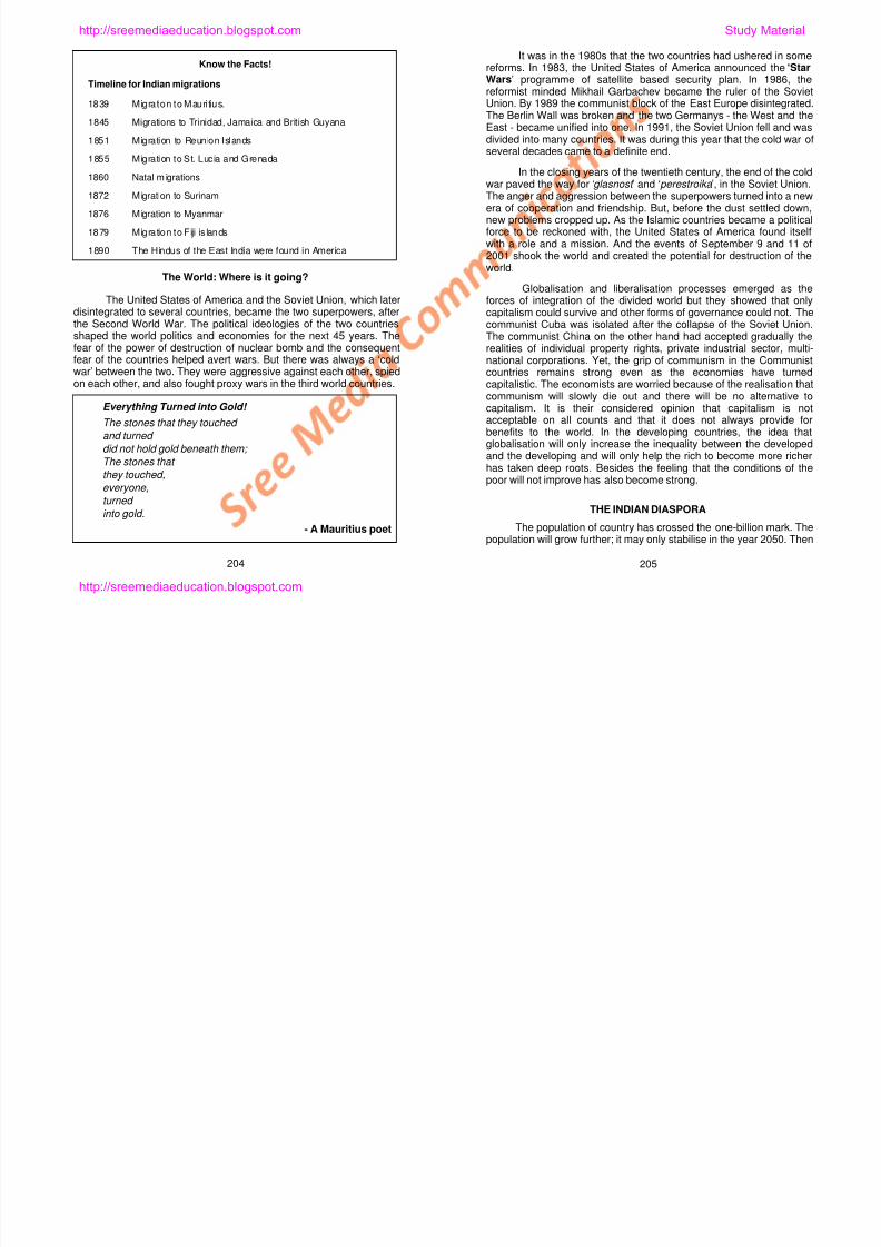
8/6/2019 Social Science History Civics and Geography
http://slidepdf.com/reader/full/social-science-history-civics-and-geography 205/280
the Second World War. The political ideologies of the two countriesshaped the world politics and economies for the next 45 years. Thefear of the power of destruction of nuclear bomb and the consequentfear of the countries helped avert wars. But there was always a ‘coldwar’ between the two. They were aggressive against each other, spied
on each other, and also fought proxy wars in the third world countries.
Everything Turned into Gold!
The stones that they touched
and turned
did not hold gold beneath them;
The stones that
they touched,
everyone,
turned
into gold.
- A Mauritius poet
p gcommunist Cuba was isolated after the collapse of the Soviet Union.The communist China on the other hand had accepted gradually therealities of individual property rights, private industrial sector, multi-national corporations. Yet, the grip of communism in the Communistcountries remains strong even as the economies have turned
capitalistic. The economists are worried because of the realisation thatcommunism will slowly die out and there will be no alternative tocapitalism. It is their considered opinion that capitalism is notacceptable on all counts and that it does not always provide forbenefits to the world. In the developing countries, the idea thatglobalisation will only increase the inequality between the developedand the developing and will only help the rich to become more richerhas taken deep roots. Besides the feeling that the conditions of thepoor will not improve has also become strong.
THE INDIAN DIASPORA
The population of country has crossed the one-billion mark. The
population will grow further; it may only stabilise in the year 2050. Then
204 205
http://sreemediaeducation.blogspot.com
the population of India will grow at a slower rate than now. It will begood for us, and our country.
Indians live in 110 other countries besides India. In 2003, theirnumber stood at 20 million. In comparison Indians live moreexpansively in our world than any other communities. Theachievements of the Non-Resident Indians (NRIs) living abroad havecome to the notice of the Indian Government primarily due toglobalisation, internet development and information technology.
Know the Facts!
East Asia’s Tiger Economies
In the 1980s some Southeast and East Asian countries
achieved tremendous economic growth. Yet they faced financialand market failures in the mid 1990s. The countries that greweconomically were Thailand, Malaysia, Taiwan and SouthKorea. They were in the first stage of economic development inthe 1970s. Hong Kong and Singapore joined them later. It wasthese countries, which became later known as the ‘Tiger Economies ’.
quickly. The currency of Malaysia was devalued. The value of land
also fell drastically. With concerted effort in the last decade,however, the economy has once again looked up.
The Indian Government has now turned its attention into the factas to how the NRIs may be involved in the socio-economicdevelopment of the country. Likewise the Government has alsobegun to think as to how they may be suitably appreciated fortheir achievements. As a first step, the Government hasannounced the ninth of January as the ‘Pravasi Bharathiya Divas ’, a celebration of the return of the Mahatma Gandhi fromSouth Africa to India.
Indians have emigrated to several countries for a long time.
When India was a colony most people of the Diaspora migratedas labour. They emigrated then principally to countries under therule of the British, French and the Dutch. The people whomigrated to Mauritius, Trinidad, Guyana, Surinam and Myanmar(Burma) by the end of the 19 th century numbered 1.6 million. Itwas only in the 1970s that the migration to the Gulf or thecountries of the West Asia began. The Indians are nowmigrating abroad with their expertise in information technology,
http://sreemediaeducation.blogspot.com Study Material
8/6/2019 Social Science History Civics and Geography
http://slidepdf.com/reader/full/social-science-history-civics-and-geography 206/280
For example, there was a 10 per cent growth of the GrossDomestic Product (GDP). Singapore has become a clean andmodern city besides turning itself into a financial centre. It is nextto Japan in the quality of life as well. Behind them was China,
which could beat all of them, as well. According to economicexperts, the reason behind the growth of the tiger economies isthe ‘Asian value’. This value is said to be an embodiment of hardwork, careful investment and strong political leadership. Withsavings and good investments the Governments have createdstrong markets for themselves.
The tigers have not only reduced the gap between the rich andthe poor but also improved greatly and quickly the standard ofliving of the people. In 30 years (1960-1990), the people belowpoverty line in Malaysia were reduced from a high of 37 per centto a low of 5 per cent. During the same period, the lifeexpectancy rose from 56 to 71. But the economy fell very
software development. Such people are in constant contact withthe country and are interested in doing good to the country andits people.
SELF-EVALUATION
I. Fill in the Blanks
1. There are no people who do not take pride in their ___________.
2. Our world is divided into _______ countries.
3. ________ is the country of lowest population density.
4. The wealthiest among the countries of the world is the ______________ ___________ ________.
5. There are ________ languages in the world.
206 207
http://sreemediaeducation.blogspot.com
II. Match the Following
1. Very high density – English2. Pravasi Bharathiya Divas – Mongolia
3. Low population growth – Mumbai
4. Global language – Monaco
5. World’s largest city – January 9
III. Answer Briefly
1. Our world is diverse - How?
2. Write a few sentences about the countries with largepopulations.
3. Write briefly about the economic development of the developingcountries.
4. How we do we understand the cultural diversity of mankind?
5. Speak of language diversity.
IV. Answer in Detail
1 Write elaborately about the Indo-European Languages
http://sreemediaeducation.blogspot.com Study Material
8/6/2019 Social Science History Civics and Geography
http://slidepdf.com/reader/full/social-science-history-civics-and-geography 207/280
1. Write elaborately about the Indo European Languages.
2. Write about the location of India.
3. Write in detail about the technical capabilities of Indians.
V. Practical Exercises
1. Using a World Atlas, learn about the populated countries of theworld.
208
http://sreemediaeducation.blogspot.com
Lesson 2
OUR WORLD: THE FIRST AND THE THIRD
Learning Outcomes
1. Learning that the equator divides the world into two halves.
2. Learning and understanding why only the First and the Third
Worlds alone are in existence.
3. Learning what happened to the Second World.
We cannot stop looking for good things in life. If we couldever come to a stage when we could stop looking for good thingsin life, then we would be at where we started. Only then would weknow better about the place we have reached.
Y 1968 M i L h Ki i h id f i i
http://sreemediaeducation.blogspot.com Study Material
8/6/2019 Social Science History Civics and Geography
http://slidepdf.com/reader/full/social-science-history-civics-and-geography 208/280
Year 1968. Martin Luther King was in the midst of organising a
‘rally of the poor’. You know why? He wants to demonstrate to his
people and his country how in the United States of America poverty
has become a painful reality. There is poverty in America, the richest
country in the world? Unbelievable it is, indeed. That is the country that
tops the world countries in economic development. If there is poverty
and hunger in America, what about countries like ours? In the world
and in our own country, there is so much inequality. Affluence and
deprivation divide us.
There are several indicators used in the understanding the
economic realities of a country. Some very important ones are:
1. Wealth;
2. Standard of Living; and
3. Economic Development.
209
http://sreemediaeducation.blogspot.com
The wealth of a country is measured in terms of its GrossDomestic Product (GDP). The GDP is actually the market values of
goods and services produced in that country. Ten economically strongcountries of the world control the world trade. Therefore they are therichest countries, among the countries of the world.
Method of Assessing Wealth of a Country : The expendituresof the country (Government, private sectors), capital goods (machines,industries, housing) and net export (export minus import) are thefactors used in the measure of the wealth of a country.
Every Government accounts for the national income and itsdistribution among its constituent units. The Government borrowsmoney from other, foreign countries and invests it in the industries inthe country towards improving the national income.
The GDP of a country divided by the number of its populationgives rise to ‘standard of living’. In reality, it is the value of goods andservices produced by an individual, economically active. If the GDPgrows at a rate higher, faster than the growth of the populationnumbers, then not only the per capita income increases but also thestandard of living of the people.
Know the Facts!
country or the Government administers the capital, investment and
industries. Examples: France and Sweden.
Planned Economy. All economic resources - land, property, capital -
are the property of the Government. The Government decides as to
how the resources and labour are to be distributed or shared.
Similarly, it also decides on what to produce and who to be provided
with what. This is what is also called ‘Communism’. Examples: China
and North Korea.
Source: Readers’ Digest: Facts at your Finger Tips 2002, Sydney.
Seventy-five per cent of the world’s population lives in thedeveloping countries (These countries are engaged in improving the
standards of living of the people and improving the economy throughindustrial manufacturing and production). The internationalorganisations such as the United Nations and the World Bank helpinduce economic development of the developing countries. Theytransfer capital investments from the developed to the developingthrough two principal means: investments in (a) technological andmedical assistance, and (b) health, education and other services(roads, airports) sectors.
http://sreemediaeducation.blogspot.com Study Material
8/6/2019 Social Science History Civics and Geography
http://slidepdf.com/reader/full/social-science-history-civics-and-geography 209/280
Know the Facts!
Economic System
World economies are classified on the basis of how a country’s
economy, market and interventions work.
Market Economy: This depends on how government regulations
operate and resources of a country are distributed among the people
of that country on the basis of demand - supply. This is what is called
Capitalism as well, as it is possible in such economy to keep the
capital as one’s own and it can be controlled the individual. Example:
Singapore.
Mixed Economy: There is centralised planning in which private
sector is able to function. The producers produce in response to
demand - supply situations in the country. Many are the investors of
their capital and they are capable of employing a work force. The
But such programmes are limited in their success. It is becausethe monies received for infrastructural improvements are tied to theplanning and infrastructure building companies of the developedcountries. As a result, these programmes are in fact in the way of
internal employment opportunities and hinder the training of the peopleof these countries. Besides such loans are invested in populistprogrammes and in buying weapons and luxuries from third countriesand thus spent in wasteful expenditures. Yet countries like China, Indiaand South Korea have invested these loans into successful projectsand have, in the last few years, changed for the better. As a result,their international trade has also expanded, appropriately.
Rich countries such as the United States of America, Canada,Japan, Australia, and the West European countries such as the UnitedKingdom, France, Germany, Norway and Sweden have grown suchthat the per capita GDP is, in these countries, in excess of US $10,000. On the contrary, however, most countries of Africa have grown
to have a per capita GDP of less than US $ 1,000, while India, China,
210 211
http://sreemediaeducation.blogspot.com
and Indonesia have attained a level of per capita GDP of US $ 1,000 -
4,000. In so far as the economic development is concerned all
continents, excepting the North America and Australia, have shownvery high inequalities.
The United Nations calculates Human Development Index (HDI)
every year. This measures the levels of economic development using
the standards of living, GDP, life expectancy, education, and adult
literacy. Using the index raging from 1 to 100, three levels of human
development are contrasted, namely, high levels (80-100), medium
levels (60-80) and low levels (less than 50).
According to the HDI measured by the United Nations, countries
such as Norway (93.9), Australia (93.6), Canada (93.6), Sweden
(93.6), Belgium (93.5), the United States of America (93.5) and Japan
(92.8) are in the forefront of HDI. The countries of medium levels are
Ecuador (72.6), Albania (72.5), Dominican Republic (72.2) and China
(71.8). Those with very low levels of HDI are Burkina Faso (32),
Burundi (30.9), Niger (27.4) and Sierra Leone (25.8).
WEALTH / POVERTY
WE COULD SURVIVE IF ONLY
WE DECIDE BEFORE WE ARE BORN!
I tried deciding
Who my parents will be;
But I was not born!
I tried deciding
My place of birth;
But I was not even born!
If I had had the community,
the place, and
the country
I preferred,
My life would have been, ….
well, excellent and
steeped in wealth!
Tell me,
Is there a way,
To decide
Your life,
Before you were born?
Show me the way,
I will find a better world!
Electronic Commerce: With the advent of e-commerce, it hasnow become easy and inexpensive to sell and send commodity and
http://sreemediaeducation.blogspot.com Study Material
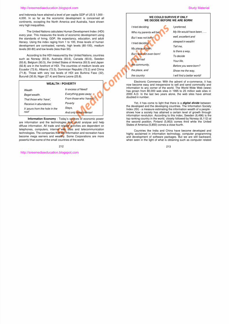
8/6/2019 Social Science History Civics and Geography
http://slidepdf.com/reader/full/social-science-history-civics-and-geography 210/280
WEALTH / POVERTY
Wealth
Beget wealth.
That those who ‘have’,Receive in abundance;
It ‘pours from the hole in the roof’
In excess of Need!
Everything goes away
From those who ‘haven’t’;
Poverty
Stays,
And only more intense!
Information Economy : Today’s sources of economic power
are information and the technologies that could analyse and help
diffuse information. All trade and related activities are dependent on
telephones, computers, internet web sites and telecommunication
technologies. The companies that sell information and recreation have
become mega earners and wealthy. Some Corporations are more
powerful than some of the small countries of the world.
now become easy and inexpensive to sell and send commodity andinformation to any corner of the world. The World Wide Web (www)has grown from 80,000 web sites in 1995 to 25 million web sites in2000 A.D. In the last two years alone, the web sites have almostdoubled in number.
Yet, it has come to light that there is a digital divide betweenthe developed and the developing countries. The Information SocietyIndex (ISI) - a measure estimating the information wealth of a people -shows how a society has attained a certain level of growth throughinformation revolution. According to this index, Sweden (6,496) is thetop ranking country in the world, closely followed by Norway (6,112) atthe second position, Finland (5,953) comes third while the UnitedStates of America (5,850) comes a close fourth.
Countries like India and China have become developed andhighly acclaimed in information technology, computer programmingand development of software packages. But we are still backward,
when seen in the light of what is obtaining such as computer related
212 213
http://sreemediaeducation.blogspot.com
infrastructures (number of computers in homes, schools andcommercial establishments), access to information (television, radio,
fax and postal services), internet uses (e-commerce, for example) andsocial indicators (enrolment of students at the schools, human andpress freedom). Only a few cities, such as Bangalore, Chennai,Hyderabad, Hong Kong and Shanghai are in the forefront ofinformation technology, computer programming and othertechnologies. And most of the rural areas, on the other hand, are stilltechnologically poor and hence poor in information technology andwealth as well.
Know the Facts!
ECONOMIC ACTIVITIES
People gather wealth through selling goods and services.Economists have classed the economic activities into threeindustrial sectors. Developing countries depend on one of these,agriculture, to accumulate wealth. Contrarily, the developedcountries depend on all three of them for their wealth:
q Primary Sector: Agriculture, fishing, mining and quarrying.Agriculture has now become agribusiness.
In economic parlance, the idea of North-South is deeplyembedded. ‘This differentiation of the North and South countries are
done based on wealth, standard of living, and economic development’has to be understood clearly. The poor countries, wherever they are,even if they are in the North, they are also considered South countries.
India, China, Nepal, Bhutan, Bangladesh, Myanmar, Thailandand Vietnam, even though they are in the northern hemisphere, areknown as South countries based on their economic growthcharacteristics. Similarly, Australia and New Zealand are the Northcountries in terms of economic progress in them. Of the Northcountries, developed and wealthy countries, a majority are in the WestEuropean continent. Particularly, the United Kingdom, France,Germany, Scandinavian countries, Italy and other small countries are
all the developed countries because they have grown economicallywealthy. Canada and the United States of America of the NorthAmerican continent also belong to this category of North countries.
Hence, using the characteristics of the economy, we come tothe conclusion that the North countries are economically well-off whilethe South countries are trying to extricate themselves from theclutches of poverty.
http://sreemediaeducation.blogspot.com Study Material
8/6/2019 Social Science History Civics and Geography
http://slidepdf.com/reader/full/social-science-history-civics-and-geography 211/280
q Secondary Sector: Industrial production, infrastructures, powerand water.
q Tertiary Sector: Services (insurance, distribution, transport,
education and health care).
NORTH-SOUTH COUNTRIES
‘North lives; South decays’ is a saying in our land. In respectof the world, it is certainly true to an extent. When we divide the worldby looking into the World Atlas, the equator is seen to divide the worldinto two equal halves.
The countries north of the equator are generally referred to asthe North Countries and those to the south of the equator are referredto as the South Countries. What is the use of this division? It is not ofuse in understanding the North-South countries, which is an economic
classification.
RICH AND THE POOR COUNTRIES
We have already looked some information about the rich and
the poor countries. Ninety per cent of the people of the world live in thenorthern parts. About 60 per cent of the people live between 10o N and40o N latitudes. There are 193 countries in the world. Using the levelsof economic growth in them, the countries may be classified as highlydeveloped countries, developed countries and developing countries.
Among the highly developed countries are the United States ofAmerica, Canada, West European countries, Australia and Japan.Spain, Poland, Romania, Argentina, Malaysia, and Singapore are inthe category of developed countries. There are numerous countries inthe category of the developing. About 150 countries are estimated tobe in this category. India, China, Zambia, South Africa and Brazil are
some of the prominent countries of the developing world now.
214 215
http://sreemediaeducation.blogspot.com
THE FIRST AND THE THIRD COUNTRIES
The division of the world into three categories was in practice fora long time. This division spoke of the world countries as the First, theSecond and the Third countries.
The countries of capitalistic economic development wereconsidered the First World countries. They were, and are,economically developed and have high standards of living. Thosecountries known as the communist or socialist countries, but equallydeveloped were categorised as the Second World countries. Theformer Soviet Union was among the foremost Second World countries,with nearly equal economic development, political and weapons power.But it broke down in 1991. Cuba, one of the communist countries, hasbecome isolated. But China and other communist countries in
existence gave way to capitalistic ideologies and still largely survive ascommunist and socialist countries. It is for this reason that there are noSecond World countries right now.
All economically backward countries, trying hard for developingtheir societies, were called the Third World countries. They are eithermixed economies or non-aligned. However, they are economicallyweak. Only the First and the Third World countries are therefore inexistence The First World countries are the economically developed
SELF-EVALUATION
I. Fill in the Blanks1. World Trade is under the control of ______________ countries.
2. ________ _________ is a multi-national institution.
3. ___________ in their fast paced growth have reached the 25
million mark.
4. The North countries are ____________ countries.
5. The South countries are ____________ countries.
II. Match the Following
1. Human Development Index – Central planning
2. Primary activity – Resources are
public property
3. Market economy – Agriculture
4. Planned economy – the United Nations
5 Mixed economy – Low government control
http://sreemediaeducation.blogspot.com Study Material
8/6/2019 Social Science History Civics and Geography
http://slidepdf.com/reader/full/social-science-history-civics-and-geography 212/280
existence. The First World countries are the economically developedwhile the Third World countries are the economically developing.
What is more painful now is that those countries which were inthe Second World category and those that became divided into several
countries have now joined the category of the Third World. Even themoderately well developed South Africa is now categorised as theThird World after the collapse of the Apartheid regime and theascendance of the Blacks of the country.
5. Mixed economy – Low government control
III. Answer Briefly
1. What indicators help us understand the true economic situation
of a country?2. Name the institutions/organisations that induce world economic
development.
3. What is meant by information economy?
4. Write a few sentences about the technological growth of India.
5. What are the categories of economic activities?
IV. Answer in Detail
1. Digital divide between the countries - Elaborate.
2. Write a short essay on North-South countries.
216 217
http://sreemediaeducation.blogspot.com
3. Write an essay not exceeding a paragraph about the Rich andthe Poor countries.
V. Practical Exercises
1. Using a world atlas identify the North-South countries and learnabout their locations.
2. Write a list of small and island countries and learning about theirlocations using an atlas.
http://sreemediaeducation.blogspot.com Study Material
8/6/2019 Social Science History Civics and Geography
http://slidepdf.com/reader/full/social-science-history-civics-and-geography 213/280
218
http://sreemediaeducation.blogspot.com
Lesson 3
NATURAL REGIONS
Learning Outcomes
1. Learning and understanding the idea of a ‘region’.
2. Learning about the criteria for defining and delineating natural and
cultural regions.
3. Understanding how this world is multi-cultural.
The term ‘region’ has been coined to, briefly and effectively,
explain the changing characteristics of an area. Region is also one
among the strong ideas of geography. Keeping this operational
concept in mind, the geographers divide an area of interest into
several regions. The factor that defines a region is normally one of
those factors that characterize the region
http://sreemediaeducation.blogspot.com Study Material
8/6/2019 Social Science History Civics and Geography
http://slidepdf.com/reader/full/social-science-history-civics-and-geography 214/280
those factors that characterize the region.
Geographers raise three important questions in their research
towards making decisions:
1. Questions about the location of a region or an area.
2. Questions about man-environment relations in the region or the
area.
3. Questions about ‘regions’ that are delineated using one single
factor such as the criterion to create such regions.
These questions emerged so as to bring out the specific feature
of a place. Hence, using the concept of region, we learn about how we
could divide the world into natural regions and cultural regions in
geography and understand how varyingly the nature and culture
interest us by their characteristics.
219
http://sreemediaeducation.blogspot.com
NATURAL REGIONS
When we look around us, environmental differences are seen inlarge scale. The earth has several different environments. The
diversity in environments helps us divide the world into several regionsand understand their characteristic features. Some people divided theworld using the diversity in landscapes, while others did so using the
climate as the basis. Still others used climate and vegetation anddivided the world into natural regions.
REGIONS BASED ON HOT AND COLD
Tropical region is that land area lying between the Tropic ofCancer and the Tropic of Capricorn. Tropical region is that region
where the Sun is overhead over some area and heats the earth fromthat position in a particular season. When dividing the world intoregions using temperature, we come to understand that there are two
regions of opposite characteristics. Polar regions are beyond the ArcticCircle and the Antarctic Circle. The subsoil here is frozen throughoutthe year. Likewise, there are sea surfaces, which are covered with ice
throughout.
America are included in this region. Yet, in extent, it is limited. Thereare regions with indices ranging from 3.01 to 10.0, which are indeed
the intermediate regions of the world. It is here that the density ofpopulation is high. This region, called ‘C’, includes the Eastern Boardof the United States, Western Europe, the almost entire India, andsouth China.
The land areas with the highest productivity and indices rangingfrom 10.01 to 50.0 are found only in the tropical regions. This is knownas the ‘B’ region. The largest portions of this region are found in SouthAmerica. The region of ‘A’ consists of lands more productive than the‘B’ region above. Here the productivity indices are more than 50.0. TheAmazon basin of South America, the Congo basin of Africa,Indonesian Islands and the South Asian region are included in thisregion.
REGIONS BASED ON VEGETATION
On the basis of vegetation, the geographers have divided theworld into three major natural regions. They are:
1. Dense, forested lands.
2 Intermediate vegetative lands
http://sreemediaeducation.blogspot.com Study Material
8/6/2019 Social Science History Civics and Geography
http://slidepdf.com/reader/full/social-science-history-civics-and-geography 215/280
REGIONS BASED ON WORLD PRODUCTIVITY
Among the criteria used in dividing the world into regions isproductivity. A geographer by the name Patterson has divided the
world into six regions using productivity. The regions beginning with ‘A’and ending with ‘F’ show up varying levels of productivity. The regiondesignated ‘F’ has an index of productivity equal to 0.25. This regionincludes the deserts, the snow covered poles and the mountain
summits. The expansive areas of the Sahara, the West Asian Arabiandeserts, the Himalayan peaks, and other desert areas are included inthis region. Region ‘E’ is found within the ‘F’ region and has an index of
productivity of 0.26 to 1.0. This is a narrow strip of land bounded by theboundaries of the ‘F’ region and the edges of the deserts. This regionincludes North America and most parts of Russia. The region ‘D’
covers the temperate lands where land gets copious rainfall insummer. The index of productivity has a value ranging from 1.01 to
3.0. East European parts of the world and the Great Plains of North
2. Intermediate vegetative lands.
3. Lands without vegetation.
In each of these, three smaller regions have been delineated.
Forested lands have been divided into equatorial region, middlelatitude edges, and polar region. Intermediate vegetative lands havebeen divided into the Savannas, the Mediterranean and mid-latitudegrasslands. The regions devoid of vegetation are the arid, semi-arid,and tundra and polar areas.
Keeping simplicity and need, the world has been divided into sixvegetational regions. They are:
1. Deserts. 4. Tropical forests.
2. Coniferous forests. 5. Grasslands.
3. Temperate forests. 6. Tundra and Polar areas.
220 221
http://sreemediaeducation.blogspot.com
DESERTS
Evaporation is more than the rainfall, here. The deserts arefound in both the hemispheres between 15o and 35o of latitudes. Theyoccupy a fourth of the geographical area of the landmass. Desertsinclude semi-deserts (there are shrubs as vegetation) as well. Theyshow great variations in temperatures between the day and night. Inthe Sahara desert the mercury touches 55o C during the day. In thenight, it will go down below the freezing point. In the deserts bothvegetation and animals are rare. If they were there, they would adaptthemselves to the prevailing conditions there.
Know the Facts!
WORLD’S LARGEST DESERTS
1. Sahara, North Africa, 9.0 million km2.
2. Australian desert, Australia, 3.8 million km2.
3. Arabian, Southwestern Asia, 1.3 million km2.
4. Thakla Makan, China, 1.245 million km2.
5. Gobi desert, Central Asia, 1.04 km2.
S 2
here. Birds and mammals are rather rare. Pine and spruce are the
green trees. They do not shed their leaves.
TEMPERATE FORESTS
They are found between 30o and 60o latitudes. They are found
on either side of the equator. In the Northern Hemisphere the leaf-
shedding trees such as oak, ash and peaches and hickory are found.
In the Southern Hemisphere, they are the evergreen forests. There is a
mild seasonal climate. The range of temperature is small. A variety of
flora and fauna are found here.
TROPICAL FORESTS
These are found between the Tropic of Cancer and the Tropic of
Capricorn. Seasonal variations are small. Conditions for the growth of
plants are conducive. It is here most flora and fauna of the world are
found. Tropical rainforests become significant because of them. There
is rain everyday here. Trees bear fruits throughout the year. Tropical
cloud forests are at great heights, monsoon forests, high latitude and
temperate forests are less diverse in their fauna But these forests
http://sreemediaeducation.blogspot.com Study Material
8/6/2019 Social Science History Civics and Geography
http://slidepdf.com/reader/full/social-science-history-civics-and-geography 216/280
6. Kalahari, South Africa, 520,000 km2.
7. Turkestan, .Central Asia, 450,000 km2.
8. Namib, Southwest Africa, 310,000 km2.
9. Somali, Somalia, 310,000 km2.
10. Sonoran, United States of America / Mexico, 260,000 km2.
11. Thar, India / Pakistan, 260,000 km2.
CONIFEROUS FORESTS
Taiga, polar forests and northern evergreen forests are some ofthe names for these forests. These are found in the NorthernHemisphere and in such countries as Canada, Scandinavian countriesand Russia. In winter, the temperature much below freezing; but insome it will rise to a mild, pleasant level. A variety of insects are found
temperate forests are less diverse in their fauna. But these forests
have more diverse flora and fauna than the temperate forests.
GRASSLANDS
In the tropical areas, these are the Savannas. In middle
latitudes, these are temperate grasslands. Savannas are found in
Africa, India, Australia and in the north of the South America. Even as
they are found in tropical latitudes, they show up semi-arid
characteristics. Temperatures are high; 27o C is quite normal. Rainfall
is about 50 cm to 150 cm. Most of the rains fall during a short period.
Lowlands are flooded. The plants grow very fast during the rainy
season. A period of drought follows the rains. The temperate
grasslands are found on the continental interiors. Winters are colder,
while summers are warmer and dry. There is moderate rain of 250 to
500 cm. It is cold.
222 223
http://sreemediaeducation.blogspot.com
TUNDRA AND POLES
Tundra is found between Arctic ice cap and the northernboundaries of the coniferous forests. Tundras are found in the South,especially amidst higher altitude. In Tundra lands, the subsurface soilis frozen all the time. Only those plants and trees that could grow lowon the ground due primarily to can be seen. Tundras are found on one-fifth of the land area. Tundras allow the coniferous forests to intrudewhere temperature in hot months exceed 10o C.
Know the Facts!
DEFORESTATION
Everywhere, cutting trees is done for the purpose of timber
and agricultural lands. In hot climates, deforestation is enormousbecause of the fast growing population and commercially veryvaluable trees. At one time, the tropical forests occupied 16 percent of the geographical area of the land. But this is only 6 per centtoday. The immediate impact of deforestation is in the destructionof ecosystems, loss of several species of plants, soil erosion andfloods where rains occur. The long term impact is the increase incarbon-di-oxide, which is normally absorbed by vegetal cover, andpollution.
1,350), Persians (B.C. 850), Babylonians (B.C. 1,800) and Sumerians(B.C. 5,000) became civilised and helped in the growth and
development civilisations and cultures. Our Indus Valley civilisationbegan sometime in B.C. 3,000. It is as the contribution of the Greeksthat we had received the most useful aspects of human life:democracy, philosophy and science, sports, drama, arts andarchitecture, and medicine.
There is a wonderful diversity of human cultures. There isnothing like a simple culture. There are possibilities to gathernumerous pieces of information from ancient and primitive cultures.What a child learns from its own culture - behaviour, value, idea,technology - are all things that the child learn gradually and over aperiod of time. These are then passed on to future generation. It ismodified and refined by every period.
Know the Facts!
MANIFESTATIONS OF CIVILISATIONS
Those that we compare with the Western Civilisation originated infact in the Fertile Crescent after B.C. 10,000.
q Cities World’s ancient cities are all found in the Middle East
http://sreemediaeducation.blogspot.com Study Material
8/6/2019 Social Science History Civics and Geography
http://slidepdf.com/reader/full/social-science-history-civics-and-geography 217/280
pollution.
CULTURAL REGIONS
Cultures emerged from the town growth. When people whodepended on agriculture, artisans, merchants, government, religionand land were beginning to receive services, the towns began theirevolution and growth. Even before 10,000 B.C. the early beginning ofagriculture evolved in the Fertile Crescent. Around 3,000 B.C. townsbegan to grow in the Mesapotamian areas. However, Jericho wasalready a city of 2,000 inhabitants in 9,000 B.C. It was during 8,500B.C. the sheep became domesticated in Mesapotamia. In 6,000 B.C.,the developments in irrigation had made possible cultivation muchbeyond the banks of rivers and canals.
Civilisations originated mostly in the Middle East, India andChina. Even in Middle America, there was the beginning of many
civilisations. Phoenicians (B.C. 3,000 onwards), Assyrians (B.C.
q Cities. World s ancient cities are all found in the Middle East.
Jericho was founded in B.C. 8,350.Anatolia’s Gadal Hyukthan(?) was the world’s largest city. This was a city that flourishedduring B.C. 6,250 - B.C. 5,400.
q Wheel. Potter’s wheel began its work in Mesapotamia in B.C.3,500. Wheels began to be used in vehicles after B.C. 3,200.
q Law. Hammurabi (B.C. 1,792-1,750), the king of Babylon wasthe first one to promulgate ancient laws. Tora of the Jewish
community was in use since fourth century B.C.
q Writing. It was Sumerians who first introduced writing to the
world during B.C. 3,000. Cuneiform writings came into use onlythen. They were written on clay tablet around B.C. 1,100.
q Astronomy. ‘Ur’ is the place of origin of astronomy. At around
B.C. 1,000 Babylonians knew how to forecast eclipses andtrack planets in space.
224 225
http://sreemediaeducation.blogspot.com
q Mathematics. It is Mesapotamia’s number system that gave us60-minute hour and 360-degree wheel.
q Belief in one God. Jewish people believed in one supremeGod. Later even the Christians and the Muslims believed in oneGod.
LANGUAGES THAT SHOW CULTURAL DIVERSITY
In human cultures, the bridge that unites people is the language.Language is also a hindrance in the way of people speaking differentlanguages becoming united.
About 3,000 languages are in use today. Around 4,000 were
spoken before. The languages that Indians speak also show upcultural variations in the Indian cultures. Although there are severallanguages spoken in North India, Hindi is spoken and understood bymost people of the region. On the contrary, although the languagesspoken in South India are considered Dravidian, the people of theregion do not speak or understand those that are not their mothertongues. As such, English is the link language in these States.
The English language and because a very large number speaksh Chi id d h l b l l F h i l i
conflicts have not disappeared as yet. Even while the Chinese
Government state that they are all equals, they are certainlydiscriminated against. As the ethnic people living in the Western
provinces profess the religions of this region, they are generally
discriminated against. There have therefore been internal conflicts
and struggles in China.
Thirty-one per cent of the Chinese are involved in one or
other religions. The rest are categorised as the ‘non-believers’.
Five per cent of them profess Buddhism while 20 per cent of them
Confucianism.
RELIGIONS THAT SHOW CULTURAL DIVERSITY
Every religion of the world has a special geography. The core of
the Old World was the place of origin of world’s important religions:
Judaism, Christianity, Islam and Hinduism. Buddhism and Jainism
originated in India. Confucianism and Taoism originated in China.
Judaism is still the most important religious faith in the place of its
origin. But Christianity has spread far and wide in the world. Hinduism
is mostly confined to India even as Buddhism has spread to the East
A i t i I l h d i t Af i C t l A i I di
http://sreemediaeducation.blogspot.com Study Material
8/6/2019 Social Science History Civics and Geography
http://slidepdf.com/reader/full/social-science-history-civics-and-geography 218/280
the Chinese are considered the global languages. French is also inuse in the global arena.
Know the Facts!
CHINA’S ETHNIC DIVERSITY
Of the 100-odd ethnic groups living in China, only 56 have
been recognised by the Chinese Government. Huns account for 91
per cent of the people of China. Mongols, Manjus, Thathars,
Tibetans, Koreans, Salars, Russians, Kazhaks and Klangs are the
other ethnic groups. They live in all provinces and constitute 108
million of the 1.3 billion people of China.
This ethnic diversity has been in China ever since the Qin
dynasty of B.C. 221. But the competitions, jealousies, quarrels and
Asian countries. Islam has spread into Africa, Central Asia, India,
Indonesia and other countries. In Middle East, it is most concentrated.
Religions generally propagate benevolent philosophies, brotherhood
and love among the world peoples. All religions spread love as the
gospel. Unity is also propagated by religions.
Religious beliefs greatly affect the practices in agriculture. They
have already created regulatory food habits amidst their followers.
Buddhists are generally vegetarians. Other religions have taboos in
food intake. In regard to non-violence, the slaughter of cows are
abolished.
Religions imbibe continuity, tradition and good behaviour. Even
in change they exert a stabilising influence. In our country, for
example, religious injunctions are against the family planning. They are
also a hindrance in the way of modernity.
226 227
http://sreemediaeducation.blogspot.com
Know the Facts!
NOMADS OF THE ‘MIDNIGHT SUN’ COUNTRIES
There has been a welcome change in the life of Lapps wholive in the countries of the ‘Midnight Sun’ namely: Norway,Sweden, Finland and Russia. More than half the Lapps who were
on the move all the time with their reindeer herds have nowbecome settlers of permanent settlements. They are now engagedin agriculture, fishing, hunting, bird trapping and afforestation of the
area they are living in.
The Lapps (or Lapplanders) call themselves as ‘Samis’.They are indeed the ancient people of Europe. After the last ice
age, they have migrated in large numbers from Asia to Europe.About 60,000 people are now in an area of 388,500 km2 and withinthe Arctic Circle. Half the people are also living in Norway. Even as
the Governments of these countries want them brought under theircontrol, the Lapps live an independent life of their own. They havetheir own parliaments operating in Norway, Finland and Sweden.
Thus religions are the decisive forces in respect of humancultures, their behaviour and characteristics. Yet secularism is animportant aspect of our national ethos
SELF-EVALUATION
I. Fill in the Blanks1. ____________ are a criterion for dividing the world into several
regions.
2. ____________ have demarcated the world into regions based
on vegetation.
3. Environments devoid of vegetation are called as
_____________.
4. Cultures are the patterns of ___________ ______________.
5. Cities are a manifestation of _______________.
II. Match the Following
1. Deserts – 50o C
2. Gobi – 30o - 60o
3. Temperate forests – Productivity based regions
4. Patterson – 15o - 35o
5 Sahara – Central Asia
http://sreemediaeducation.blogspot.com Study Material
8/6/2019 Social Science History Civics and Geography
http://slidepdf.com/reader/full/social-science-history-civics-and-geography 219/280
important aspect of our national ethos. 5. Sahara Central Asia
III. Answer Briefly
1. What are the three questions that geographers raise?
2. What is meant by ‘region’?
3. Name the regions classified on the basis of hot-cold.
4. Give three of the regions based on productivity.
5. What are the six vegetational region of the world?
IV. Answer in Detail
1. Write a note on the ‘Deserts’.
2. Write a note on the ‘Tropical Forests’.
3. Write an essay on the languages that show cultural diversity.
228 229
http://sreemediaeducation.blogspot.com
V Practical Exercises
1. Collect pictures of people from various cultures and write notes
on each of them.
2. Write about the life and action of people based on naturalregions for a discussion in the classroom.
http://sreemediaeducation.blogspot.com Study Material
8/6/2019 Social Science History Civics and Geography
http://slidepdf.com/reader/full/social-science-history-civics-and-geography 220/280
230
http://sreemediaeducation.blogspot.com
Lesson 4
INDIA: AN INTRODUCTION
Learning Outcomes
1. Learning to appreciate the salient features of our country.
2. Learning the position of India amidst the countries of the world.
Our world consists of one part of land and three parts of water.You have already learned that there are seven continents on the land.India is in the south of Asia, which is one of the seven continents of theworld. The Greeks were the first to call our country ‘India’. ‘Indoi’ inGreek means the people who live on the banks of the Indus River.
INDIA IS A SPECIAL PLACE
The population of our India has already crossed the 1.0 billion
http://sreemediaeducation.blogspot.com Study Material
8/6/2019 Social Science History Civics and Geography
http://slidepdf.com/reader/full/social-science-history-civics-and-geography 221/280
p p ymark. Besides there are non-resident Indians in 110 countries of theworld. The Indian diaspora is 20 million strong in the year 2003. WhenIndia was under the rule of the colonisers, Indian labour migrated to
countries such as England, France, the Netherlands, Mauritius,Trinidad, Guyana, Surinam and Myanmar (then Burma). At the end ofthe nineteenth century the labour migrants to these countriesnumbered 1.8 million. After Independence, Indians emigrated in largenumbers to the United States of America and the United Kingdom. Inthe 1970s, emigration began towards the West Asian countries.
As for science and technology related human resourcesdevelopment, India has occupied the third place behind the UnitedStates and the European countries. It is not an exaggeration if we saythat India leads the world in Information Technology and developmentof Software Programs and Packages. It is precisely because of thisability of the population, countries such as Australia, Germany, and
Canada welcome Indians to immigrate into their territories.
231
http://sreemediaeducation.blogspot.com
The location of India in Asia is also special. There is the ArabianPeninsula on the west of India and Indo-China Peninsula on the east of
India. Also India is at the head of the Indian Ocean and this makespossible the communications with the world countries. The long coastsare conducive for sea trades. A large share of the world trade throughthe seas occurs via the Indian Ocean.
India is north of the Equator (0o). The Tropic of Cancer - 23 ½o
N - runs across the country. In fact, this latitude divides the country intotwo halves:
1. The Indian Peninsula south of the Tropic of Cancer,
2. The Extra-Peninsular region of the country north of the Tropic ofCancer.
India has 28 states. Tamil Nadu is one of the States of theIndian Union, located in the Peninsular India. We shall learn in detailabout India in the next Class (Standard X). Hence we shall learn brieflyhere about India.
Latitudinal, Longitudinal Extent
India extends between 8o 4' N and 37o 6' N latitudes andbetween 68o 7' E and 97o 2' E longitudes.
In the south, the Nicobar islands stretch to 6o 45' N towards theEquator. The country stretches north-south for a distance of 3,214 kmand west-east for 2,933 km. It has a geographical area of 3.3 millionkm2. India has a boundary of 15,200 km and a coast of 6,100 km. Indiahas Pakistan and Afghanistan on the Northwest; China on the north,and Myanmar in the east. The sea boundaries are the Arabian Sea onthe west, the Indian Ocean on the south and the Bay of Bengal on theeast.
Location. India is in the middle of the Far Eastern and MiddleEastern countries. The Indian Sea route connects the developed WestEuropean countries with the not-so-well developed East Asiancountries. As India is centrally located in the Indian Ocean, it is able tocommunicate with all the countries of the world. Its natural boundaries,the Himalayas on the north and the seas on the other three sides of
the country, provide the country a security.
India’s location, particularly the sea routes of the Indian Ocean,helps India to keep contacts with the other countries. The location isconducive also for the spread of India’s cultures beyond the seas andthe arrival of the special features of other countries into India. Forinstance, in the temples of Thailand, there are scenes from theRamayana carved on the rocks. There are evidences of the ancienttrade relations with Egypt, Babylon, Persia and Rome. There areseveral evidences also for the fact that India was a land of cultures and
http://sreemediaeducation.blogspot.com Study Material
8/6/2019 Social Science History Civics and Geography
http://slidepdf.com/reader/full/social-science-history-civics-and-geography 222/280
The Persians and the Greeks named the Indian territory they
knew as ‘Indus’. The Mohammadans on the other hand called it
‘Hindustan’. This territory is actually today’s North India. They named
the country south of the Narmada and Chottanagpur forests ‘DakshinaBharat’ or ‘South Country’. At that time, in the South, but south of the
Krishna River, Tamil Nadu existed with a distinct culture of its own.
The Hindu literature suggests that this vast country was ruled by a
king, by the name ‘Bharathan’, and he brought it under a single entity.
And there were several smaller countries within India, with their ethnic,
linguistic, and cultural characteristics, even as Hinduism was found in
the entire country. It was primarily the railways laid by the East India
Company, the English language, and the freedom struggle integrated a
divided India. At the end of it all, India became a sub-continent. The
India of today was the result of unification of all the principalities under
one nation and it became a Republic on January 26, 1950.
232 233
traditions. It is probably because of these that several foreigners hadmade India their home.
In today’s India, there are people who are from different ethnicgroups, religions and languages. Not only the differential landscapesare the reasons for this diversity, but also the cultural variations of thepeople who settled in India. Despite the differences, India is a secular,democratic and united republic. It is not an exaggeration, if we say thatIndia alone qualifies for such a country. Approximately 27 languagesare in use as the Official Languages. It is for this reason that we maycall our country a sub-continent.
POLITICAL STRUCTURE
There are 28 States in the Indian Union, divided usinglanguages as the basis of division. There are also 7 Union Territories.
http://sreemediaeducation.blogspot.com
SELF-EVALUATION
I. Fill in the Blanks
1. There are _________ continents.
2. The Greeks were the first people to call our country by the name
___________.
3. Once upon a time, India was divided into ___________.
4. India became a Republic on ____________.
5. The Himalayan boundary acts as a natural _____________.
II. Match the Following
1. Persians – Indian integration
2. Narmada – Hindustan
3. Mohammadans – India
4. Railways – Indian River
5. Greeks – Indus
States of Indian Union. There are 28 States. They are: Kerala,Tamil Nadu, Karnataka, Andhra Pradesh, Maharashtra, Gujarat,Madhya Pradesh, Orissa, West Bengal, Sikkim, Assam, ArunachalPradesh, Nagaland, Bihar, Uttar Pradesh, Jharkhund, Uttranchal,Satishgarh, Rajasthan, Punjab, Haryana, Himachal Pradesh, Jammuand Kashmir, Meghalaya, Manipur, Tripura, Goa and Misoram.
Union Territories. There are 7 Union Territories, which go bythe names Chandigarh, Dadra Nagar-Haveli, Diu-Daman, Delhi,Andaman-Nicobar Islands, Lakshadweeps and Pondicherry.
TAMIL NADU
It is located on the south-eastern region of India. It goes by thename Tamil Nadu, because Tamil is the language spoken here. It is a
land of culture and tradition. The cultural history of Tamil Nadu goes asfar back as the period of Greek and Mesapotamian civilisations. TheTamil culture has spread also across the seas. In Sri Lanka,Philippines, Singapore and Malaysia, Tamil is an official language. Thestate has the Bay of Bengal on the east, Indian Ocean on the south,Kerala on the west and Karnataka and Andhra Pradesh on the northas its boundaries. The coasts are on an average 86 km in width. TheEastern Ghats and the Western Ghats meet at the Nilgiris. There arelow plateaus in the state. Although there are the rivers such as theCauvery, Then Pennai, Palar, Vaigai and Tamiravaruni, they depend
http://sreemediaeducation.blogspot.com Study Material
8/6/2019 Social Science History Civics and Geography
http://slidepdf.com/reader/full/social-science-history-civics-and-geography 223/280
III. Answer Briefly
1. Give one or two special features of India.
2. What names did others of the world give our country?
3. What brought the divided India together?
4. What are the boundaries of Tamil Nadu?
5. Name some south Indian rivers.
IV. Answer in Detail
1. Write an essay on the location of India, not exceeding oneparagraph.
234 235
y g y pon the seasonal rainfall. If the rains fail, there is shortage of water inthe rivers.
The state of Tamil Nadu is one of the best states of the IndianUnion. Its geography, people and history determine the personality ofTamil Nadu. The long political stability in the state has helped in itsdevelopment. The traditional cultures hold sway even today in the ruralareas of the state. Sociologists believe that rural traditions havecontinued to be manifested in the towns of the state as well. That iswhy we are able to see a unity amidst diversity. Tamil Nadu is anexample of this unity among diversity in the country.
The state is almost a triangle of a landmass at the southeasternend of the main continent. The total geographical area of the state is130,068 km2. Tamil Nadu ranks eleventh in size among the states ofthe Indian Union. But its geographical area is actually 4 per cent of thetotal area of the country.
http://sreemediaeducation.blogspot.com
2. Give the States and Union Territories.
3. Write a note on the state of Tamil Nadu.
V. Practical Exercises
1. Conduct a quiz on India and Tamil Nadu with boys and girls of theClass taking interests in organising one.
2. Using a wall map, find the states and union territories of thecountry.
http://sreemediaeducation.blogspot.com Study Material
8/6/2019 Social Science History Civics and Geography
http://slidepdf.com/reader/full/social-science-history-civics-and-geography 224/280
236
http://sreemediaeducation.blogspot.com
Lesson 5
TAMIL NADU: AN INTRODUCTION
Learning Outcomes
Learning the position of Tamil Nadu in India
TAMIL NADU: STATE’S EVOLUTION
You have studied, and are aware from your history books, thatIndia was under the rule of the British. For reasons of military andpolitics, they divided the country into three provinces, namely, Madras,Calcutta and Bombay Presidencies. The three provinces came intobeing as a result of an Agreement reached with the Princely States inIndia in 1799. In Madras Presidency, there were 26 districts in the year1881. When India became independent in 1947, the province thatincluded Tamil Nadu, Andhra Pradesh and Kerala came to be knownas the ‘Madras Presidency’. With the agitation of the people of AndhraPradesh, the states based on languages of the people were organised.
http://sreemediaeducation.blogspot.com Study Material
8/6/2019 Social Science History Civics and Geography
http://slidepdf.com/reader/full/social-science-history-civics-and-geography 225/280
Madras Presidency was bifurcated into Telugu speaking AndhraPradesh and Tamil speaking Madras State. Then there were 13districts in Madras Presidency. On January 14, 1969, Madras State
was renamed as ‘Tamil Nadu’
THE GEOGRAPHICAL EXTENT OF TAMIL NADU
Tamil Nadu stretches between 8o 5' N and 13o 35' N latitudesand between 78o 18' E and 80o 20' E longitudes.
Districts of the Madras State
Madras, Chengalpattu, North Arcot, South Arcot, Nilgiris,Coimbatore, Salem, Thanjavur, Tiruchirappalli, Madurai,Ramanathapuram, Tirunelveli and Kanyakumari were the then districtsof Madras State.
237
http://sreemediaeducation.blogspot.com
C h e n n a i
REORGANISATION OF DISTRICTS
The State (Figure 5.1) has, in the period from 1965 to 1996,
reorganised the 13 districts several times and finally into 29 districts.Thus there are 29 districts in the State as the administrative units(Figure 5.2).
GEOGRAPHY OF THE SANGAM PERIOD
The Earth has vast area. The first of the essential aspects of theearth is space. The geography and history of the world depend on it.The space is bound to time. The geological era and the time periodsreferred to as the ‘Before Christ’ and ‘After Christ’ relate to timeperiods. The environments of the earth become the nuclei of the livingthings. The nuclei also determine activities. It is these space and time
(mudal porul ), environments (nuclei) and activities are all written aboutin the Sangam literature. We learn from the Tamil literature that theTamil Society has devised the thinais (cultural landscapes) and livedwith a spatial organisation of society as well.
This they have embodied in the three-fold classification ofmudal, karu and uri, which literally mean the prime or the source, theembryo or the nucleus and the belonging or the possession,respectively. In their conception, each of the five regions has this trioas the basis for its literature.
T
A M I L N A D U
F i g u r e 5 . 1
http://sreemediaeducation.blogspot.com Study Material
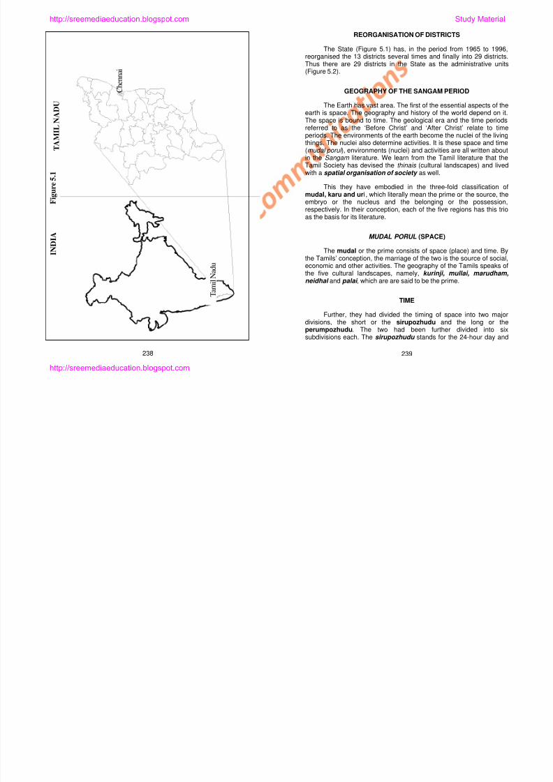
8/6/2019 Social Science History Civics and Geography
http://slidepdf.com/reader/full/social-science-history-civics-and-geography 226/280
T a m i l N a d u
MUDAL PORUL (SPACE)
The mudal or the prime consists of space (place) and time. Bythe Tamils’ conception, the marriage of the two is the source of social,economic and other activities. The geography of the Tamils speaks ofthe five cultural landscapes, namely, kurinji, mullai, marudham,neidhal and palai , which are are said to be the prime.
TIME
Further, they had divided the timing of space into two majordivisions, the short or the sirupozhudu and the long or theperumpozhudu. The two had been further divided into sixsubdivisions each. The sirupozhudu stands for the 24-hour day and
238 239
I N D I A
http://sreemediaeducation.blogspot.com
can be divided into six parts, namely, vaigarai (the dawn), kalai (themorning), nanpagal (the noon), aerpadu (the early evening), malai (the evening), and yamam (the midnight), with each have a time spanof 10 Naligais . The perumpozhudu stands for the year and the yearis divided into six seasons: kar or winter or early rainy season, kuthir or autumn or late rainy season, munpani or early winter or early dewyseason, pinpani or late winter or late dewy season, ilaveni l or earlyspring and muduvenil or late spring. Each of the seasons is of twomonths’ duration.
KARUPPORUL (NUCLEUS)
The karu or the regional features consists of the flora and faunaand religion. The ancient Tamils in fact put in under this division floraand fauna as the produce of the mudal and also included man with all
his activities and even God as mudal’s yields. This is perhapsbecause God’s glory is in the conception of man about Him. It must bementioned that in Tholkappiyam, the list of things under karu (theproduce or factors of environment can be yet another expansion)begins with God and ends with music. It is in the third that the Tamilsfounded the excellence of their pragmatic spiritualism.
URIPPORUL (POSSESSION)
Th i i t f l d h t F th T il it i th
Figure 5.2
Tamil Nadu
Administrative Divisions
1 Ch i16 P d k i
http://sreemediaeducation.blogspot.com Study Material

8/6/2019 Social Science History Civics and Geography
http://slidepdf.com/reader/full/social-science-history-civics-and-geography 227/280
The uri consists of love and character. For the Tamils, it is thecharacter of the human soul, which is its real belonging or possession.It is indeed based on their understanding of the concept of uri , the
Tamils have spoken of behaviour. Thus in the three-fold classificationof space-time, activity and behaviour, the Tamils have provided for aspatial organisation of the early Tamil society . It is interesting alsoto note that the Tamils were deeply conscious of the fundamentalfactors of geography- land, time and produce, which according to themmoulded the very character of the human soul.
The early Tamil poets have divided the Tamil country intofive-fold features. These five-fold features can be considered as thefive-fold regions the poets have devised for literary treatment of Tamilculture and life. These have been fused with the rules or conventionsof classical Tamil poetry. However, the Tamils of the earlier years usedthinais as the word meaning regions. The thinais were a reflection of
240 241
District Head Quarters
District Boundary
1. Chennai
2. Thiruvallur
3. Kancheepuram
4. Vellore5. Thiruvannamalai
6. Villupuram
7. Cuddalore
8. Nagapattinam
9. Dharmapuri
10. Salem
11. Perambalur
12. Thiruvbarur
13. Thanjavur
14. Namakkal
15. Trichy
16. Pudukottai
17. Erode
18. Karur
19. Dindugal20. Madurai
21. Sivagangai
22. Ramanatha
puram
23. Tuthookkudi
24. Virudhunagar
25. Theni
26. Coimbatore
27. Nilgiris
28. Tirunelveli29. Kanniyakumari
http://sreemediaeducation.blogspot.com
the life in the respective landscapes and they were named after the
most significant flora.
Every thinai has the three aspects of mudal , karu , and uri .
These five regions were deliberately sung as the ulagam or the worldby Tholkappiyar.
KURINJI THINAI
(OR LAWSONIA SPINOSA FOR MONTANE)
The space of kurinji is of the hills or montane. Yamam is its
sirupozhudu whereas kulirkalam and munpanikalam are its
perumpozhudu . Waterfall and spring are the waterbodies, while agil
and vengai are the typical trees. These together with tiger, lion, bear
and elephant are the regional features. Gypsies, known locally as the
kuravars , were the hill people. They were engaged in honey collection
and digging edible roots. The land they lived in was called the
sirugudi. Hill paddy and thinai (millets) are their staple food.
MULLAI
(OR JASMIUM TRICHOTOMUM FOR PASTORAL)
Pastoral in character, mullai is characterised by forests and
forested lands Evening is its sirupozhudu while karkalam is its
and fauna and the regional features. Peasants and farmers lived in the
riverine tracts and they were engaged in agriculture and livestock/dairyfarming. The lands they lived in were called perur and moodhur . Redand white paddies were their staples.
NEIDHAL
(OR NYMPHAE ALBA FOR LITTORAL FEATURES)
The littoral areas are the coasts and the coastal lands. Aerpadu is its sirupozhudhu , while the six seasons are its perumpozhudhu .Sand wells and lagoons are the water bodies. Punnai and gnazhal
are the flora and crocodiles and shark are the fauna. Paradhars livedin the littoral tracts and were engaged in fishing and salt production.
The settlements they lived in were called Pakkam and Pattinam . Their
staple was what they bartered for fish and salt.
PALAI (OR MINUSOPS HEXANDRUS FOR ARID)
Of the five, the early Tamils did not recognise palai as aseparate entity, since it is only the result of reduction of both themountainous and the forest or the pastoral regions. While its
sirupozhudhu included nanpagal (noon), perumpozhudhu includedilavenil, mudhuvenil and pinpanikalam . Dry water bodies, Iluppai and palai trees and weak animals are its characteristic features The
http://sreemediaeducation.blogspot.com Study Material
8/6/2019 Social Science History Civics and Geography
http://slidepdf.com/reader/full/social-science-history-civics-and-geography 228/280
forested lands. Evening is its sirupozhudu , while karkalam is itsperumpozhudu . Wild jungle streams are its characteristic waterbody,
while kondrai and gaya trees and hare and deer are also the flora and
fauna of the region. Shepherds lived in the pastoral regions and wereengaged in grazing, weeding and harvest related activities. Their land
was called padi and cheri . Millets, of varagu and samai , were their
staples.
MARUDHAM
(OR TERMINALIA ALATA FOR RIVERINE)
Riverine tracts are the fields and fields spaces. Vaigarai is its
sirupozhudu and all the six seasons are characteristic of the riverine.
Wells on the hills and waterbodies surrounded by lush trees (or topes),kanchi and marudham trees, buffaloes and waterdogs are the flora
and palai trees and weak animals are its characteristic features. The
people who lived here were called Einers and they were engaged inhighway robberies and robbery of greens. The land they lived in was
called kurumbu . The commodities they acquire from robbery weretheir staple food.
Is it possible to identify the cultural landscapes of theyesteryears in today’s Tamil Nadu? Most natural landscapes remain
stable landscapes for long periods. The Western and the EasternGhats are the landscapes of the kurinji . A large part of the WesternGhats is now in Kerala. In the Sangam period, it was part of the Chera
Kingdom. Anaimalai, Nilgiris, and Palanimalai of the Western Ghatsand Javadhu, Kalrayan, Sherveroy, Kollimalai, Pachaimalai andPalamalai are within the boundaries of Tamil Nadu. The flora and
fauna typical of the kurinji are still found in these hills. For example, inMundanthurai, Anaimalai and Mudumalai, there are elephant and tiger
242 243
http://sreemediaeducation.blogspot.com
sanctuaries. Masinakkudi, Kunnakkudi, and Perungudi are the typicalnames of places in this landscape.
The land of the forests is typical of Mullai landscape. There arethick forests on the foothills and in the valleys. The forests have almostbeen destroyed. Such forests existed in the districts of North andSouth Arcot. Arcot signified six forests. It is said that there were sixforests in the north and six forests in the south, at one time. Katpadi,Vaniampadi, Asuram Cheri and Guduvancheri are some of the typicalplace names of this particular landscape. In the remaining forests,there are animals, typical of the landscape.
Riverine tracts abound in the state. The basins such as theCauvery, Bhavani, and Tamiravaruni are rich in fields. Perur, Mudoorare typical village names and Thanjavur, Thiruvarur, Karur andMudaloor are some of the typical names of places today. In the plains,
agriculture is the primary occupation today.
In the neidhal of Tamil Nadu today there are littoral areas,swamps and lagoons. The entire Coromandel coast may beconsidered as this very landscape of the past. Nagapattinam,Sathurangapattinam, Devipattinam, Pattinapakkam and Enjambakkamare the typical place names. Even today, people of these places areengaged in fishing, salt production and coast related activities.
Deserts were rare in the Sangam period. But today,
these facts that the Tamils have had their geographical thoughts astheir lives’ principles.
Know the Facts!
DISTRICTS OF TAMIL NADU
As of today, there are 29 districts in the State of Tamil Nadu.As Ariyalur has been merged with Perambalur, the districts havenow been reduced to 29 from the early 30. They all havenamesake capitals. The 29 districts of the state are listedhereunder.
Chennai – Salem
Coimbatore – Sivaganga
Cuddalore – Thanjavur
Dharmapuri – Nilgiris
Dindigul – Theni
Erode – Thiruchirappalli
Kanchipuram – Thirunelveli
Kanyakumari – Thiruvannamalai
Karur – Thiruvallur
Madurai – Thiruvarur
Nagapattinam Thoothukudi
http://sreemediaeducation.blogspot.com Study Material
8/6/2019 Social Science History Civics and Geography
http://slidepdf.com/reader/full/social-science-history-civics-and-geography 229/280
desertification is on the increase in the foothills of Tamil Nadu (Theni,Rajapalayam) and coastal regions (Pudukkottai). The forests of thefoothills of the Western Ghats are almost completely destroyed. In the
monsoon seasons, dry winds of gale force blow over the rain shadow.As the shelterbelts erected across the winds to slow down their speedand the kuduvals (community forests) were cut down, sand dunes ofgreat heights are being formed at 4 km to 4.5 km from the foothills.These dunes are locally called ‘theri dunes ’. As a consequence ofdesertification in these lands, the lands of the kurinji and mullai areturning into deserts.
The Tamils of the early periods recognised such regionalclasses as these not just for Tamil Nadu but also for the world.Conversely, Tholkappiyar may have meant that each of the fiveregions is as compact as the world in itself. Hence, he likened theselandscapes to ‘ulagam ’, which means the world. It is evident from
Nagapattinam – Thoothukudi
Namakkal – Vellore
Perambalur – Villupuram
Pudukottai – Virudhunagar
Ramanathapuram
Know the Facts!
Reorganisation of Districts
For reasons of administration, the districts of the State havebeen bi- and tri-furcated over the years, giving rise to as many as29 districts today. Erode (1976) was carved out of Coimbatore;Dharmapuri (1965) and Namakkal (1997) came from Salem; andPudukkottai (1974), Karur (1996), Nagapattinam (1991), Thiruvarur
244 245
http://sreemediaeducation.blogspot.com
(1997) and Perambalur (1996) were delineated from the erstwhile
Thanjavur and Thiruchirappalli districts. Sivagangai and
Virudhunagar (1984) were carved out of Ramanathapuram, whileDindigul (1985) and Theni (1997) were carved out from Madurai.
Thirunelveli was bifurcated into Thirunelveli and Thoothukudi
(1986), while North Arcot was bifurcated into Thiruvannamalai
(1989) and Vellore (1989) and South Arcot into Cuddalore and
Villupuram (1993). Chengalpattu district was bifurcated into
Kanchipuram and Thiruvallur (1996).
PHYSIOGRAPHY OF TAMIL NADU
Tamil Nadu is in the southeastern portion of the Deccan whichextends from the Vindhya mountains in the north to Kanyakumari in the
south. Our Tamil Nadu, as seen earlier is bounded on the north byAndhra Pradesh and Karnataka, on the east by the Bay of Bengal, on thesouth by the Indian Ocean and on the west by the state of Kerala. It is anarea where you find the Western and the Eastern Ghats, vast and yetuneroded highlands, floodplains and coastal plains. There are rivers thatmake the land fertile such as the Cauvery, Palar, Then Pennai,Cheyyaru, Tamiravaruni, Vaigai, Manimutharu, Bhavani and Noyil.
THE LANDSCAPES FOUND HERE
Figure 5.3
TamilnaduPhysiography
http://sreemediaeducation.blogspot.com Study Material
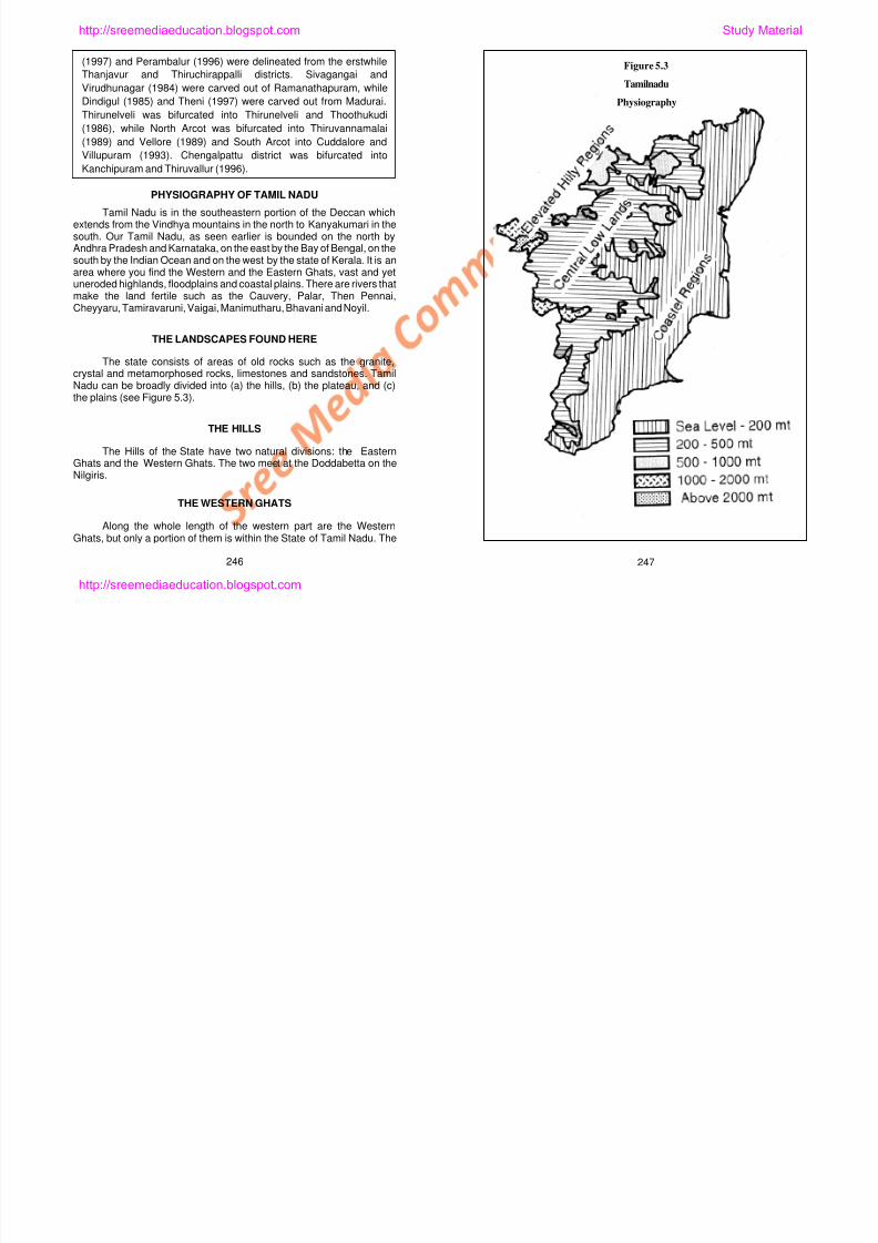
8/6/2019 Social Science History Civics and Geography
http://slidepdf.com/reader/full/social-science-history-civics-and-geography 230/280
The state consists of areas of old rocks such as the granite,crystal and metamorphosed rocks, limestones and sandstones. TamilNadu can be broadly divided into (a) the hills, (b) the plateau, and (c)
the plains (see Figure 5.3).
THE HILLS
The Hills of the State have two natural divisions: the EasternGhats and the Western Ghats. The two meet at the Doddabetta on theNilgiris.
THE WESTERN GHATS
Along the whole length of the western part are the WesternGhats, but only a portion of them is within the State of Tamil Nadu. The
246 247
http://sreemediaeducation.blogspot.com
hills that are found in the State of Tamil Nadu are the Nilgiris, the
Anaimalai, the Palani hills, the Kodaikanal hills, the Kutralam hills, theMahendragiri or the Agathiar hills.
THE NILGIRIS
The Nilgiris rises abruptly to over 1,600 metres to 2,400 metres.Its highest peak is the Doddabetta (2,673 m) and it is on the east of
Udhamandalam. It is very steep and the distance between 2,673metres to 1,800 metres is just about 4 km. The Nilgiris dips downtowards the Coimbatore plateau. Udhagamandalam, Coonoor and
Kotagiri are the summer resorts. There are a number of short traverseranges of which the Anaimalai and the Palani hills are the highest.
These two meet at Anaimudi (2,695 m), the highest peak in southIndia. Their flat and undulating summits are innumerable waterfallsbelow the summit level and reveal that they are undergoing the second
cycle of normal erosion. The Palghat gap is the only break in the greatmountain wall of the Western Ghats. This is the only gateway toKerala.
The Palani hills are low hills. Its height is between 1,500 metres
to 2,000 metres. South of the Palani hills are the cardamom hills.Thekkadi sanctuary is near the Periyar lake on these hills. TheKodaikanal hills are the continuation of the Palani hills. This is in
Dindigul district This is a summer hill resort It is here the kurinji flower
Figure 5.4
Tamil Nadu
Hills
Nilgiris
Hills
http://sreemediaeducation.blogspot.com Study Material
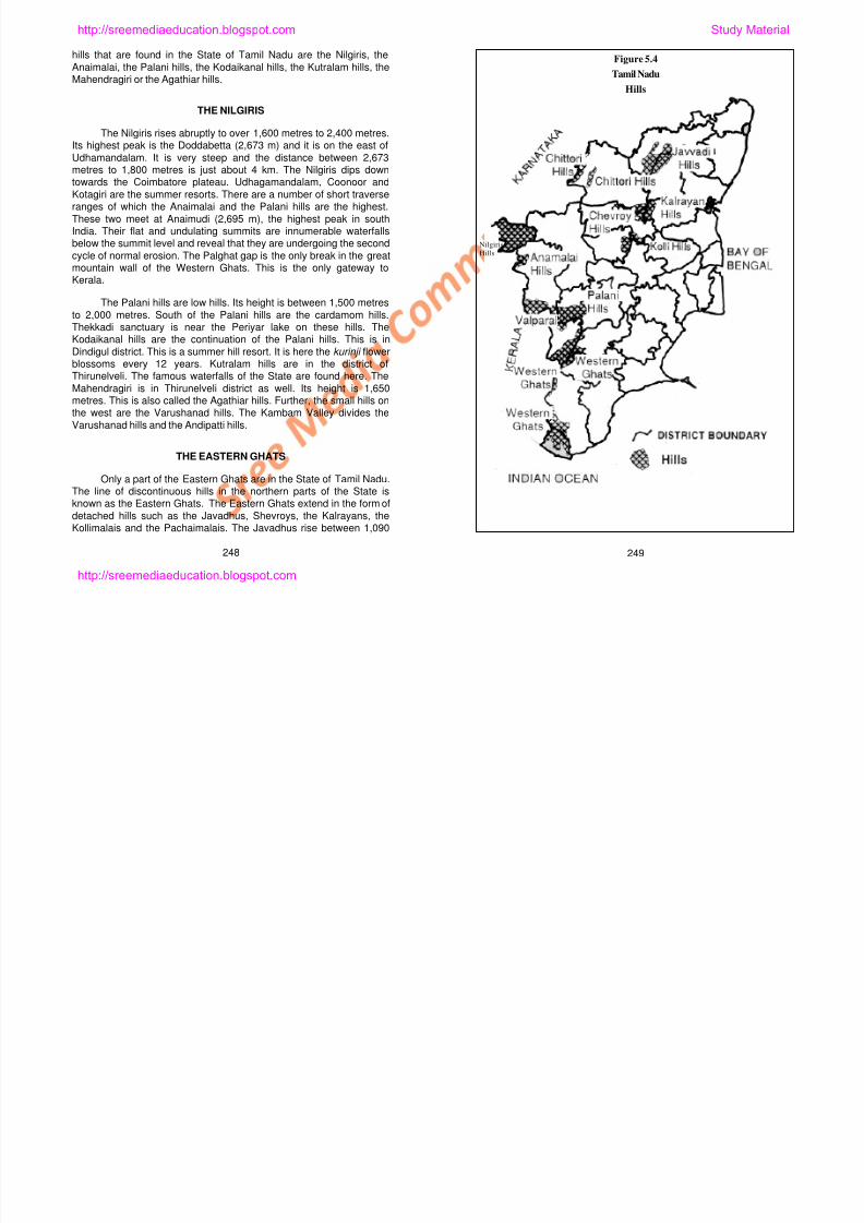
8/6/2019 Social Science History Civics and Geography
http://slidepdf.com/reader/full/social-science-history-civics-and-geography 231/280
Dindigul district. This is a summer hill resort. It is here the kurinji flowerblossoms every 12 years. Kutralam hills are in the district ofThirunelveli. The famous waterfalls of the State are found here. The
Mahendragiri is in Thirunelveli district as well. Its height is 1,650metres. This is also called the Agathiar hills. Further, the small hills onthe west are the Varushanad hills. The Kambam Valley divides the
Varushanad hills and the Andipatti hills.
THE EASTERN GHATS
Only a part of the Eastern Ghats are in the State of Tamil Nadu.The line of discontinuous hills in the northern parts of the State isknown as the Eastern Ghats. The Eastern Ghats extend in the form of
detached hills such as the Javadhus, Shevroys, the Kalrayans, theKollimalais and the Pachaimalais. The Javadhus rise between 1,090
248 249
http://sreemediaeducation.blogspot.com
metres and 1,160 metres. It is here that we find the hill resort better
known as Elagiri. The Kalrayans are in the district of Villupuram. Thetributaries of the Vellar originate in these hills. There are the tribalsettlements on the hills. The Shevroys are in the district of Salem. Its
area is 160 km2. Its height is 1,500 to 1,600 metres. Yercaud on thehills is the summer resort. The highest peak here is Solaikadu (1,640metres). Bauxite is found in abundance here.
The Pachaimalais are in Perambalur district. Here, black granite
is mined. It is of very high quality and has no match in the world. TheKollihills are in the district of Namakkal. Bauxite is found here as well.To the east of the Kollihills and the Pachaimalai are the Palamalai hills.
Granites and debris are found here as well. The Kanchamalai and theChalk hills are in Salem district. These have iron ores and magnesite.
THE PLATEAUS
Between the Eastern and the Western Ghats lie the plateau.The elevations are between 45 m in the west to 150 m in the east. Theland slopes towards east. It is an extensive belevelled landscape with
low relief. There is a sharp break in gradient all around its edges,except where the Cauvery breaks through it, and a fairly steep debrisslope rises to the surrounding hills. The topography is however
undulating. In the west of this region lies the Baramahal Plateau,which is the continuation of the Mysore Plateau. Its height varies from350 m to 710 m
The Coromandel coastal plains slope towards the east. There
are the Palar, the Cheyyar, Pennaiar and Velar basins in these plains.In the south there are several hill ranges that cut across the plains.The Manimuthar rising from the Kalrayans has its own sub-basins
here. The valley of the Vellar has artesian wells. The plateau and theplains are separated by the Chengam Canal in the north and AthurCanal in the south. The northern or the Coromandel plains are in the
districts of Thiruvarur, Kanchipuram, Vellore and Thiruvannamalai.
The Cauvery Plains. The Cauvery and its distributaries drainthese plains. The maximum height is less than 300 m. The plainsextends over the districts of Dharmapuri, Salem, Thanjavur,
Tiruchirappalli, Thiruvarur, Pudukottai, Karur, and Nagapattinam. In thenorth are the Pachaimalai and the Kollihills, while Viralimalai is in thesouth. This is a fertile plains with alluvium.
The Dry Southern Plains. At the foothills, these are seen ashighlands. The districts of Madurai, Sivaganga, Ramanathapuram,Virudhunagar, Thoothukudi and Dindigul are included in these plains.
These plains are covered with alluvial and aeolian deposits betweenthe rivers Palar and the Cauvery. The plains are confined mainlybetween the coastline and 150 m contour. Typical coral reefs on the
east coast occur at about 3 metre above the sea level in the Pambanisland at the head of the Gulf of Mannar. Along the coast, there is anarrow belt of sand dunes, which rise to about 10 m on the Tuticorin
http://sreemediaeducation.blogspot.com Study Material
8/6/2019 Social Science History Civics and Geography
http://slidepdf.com/reader/full/social-science-history-civics-and-geography 232/280
350 m to 710 m.
The landscape lying between the Nilgiris and Dharmapuri is
called the Coimbatore Plateau. Its height varies from 150 m to 450 m.It is rocky. This region consists of Salem, Coimbatore, and Erodedistricts. The Nilgiris plateau has 2,560 km2. Its height is between
1,800 m and 2,900 m. This is separated from the Mysore plateau bythe Moyar river in the north.
THE PLAINS
The plains of the State of Tamil Nadu may be divided into (a) theCormandel coastal plains; (b) the Cauvery Alluvial Plains and (c) the
dry southern Coromandel coastal plains. The coastal plain stretchesfor 992 km from Pulicat lake to Cape Comorin.
250 251
coast. Further south, in Tirunelveli district, the red sand hills, locallyknown as ‘teris’, rise to over 50 m behind the sands. The rest of theplains are mainly alluvial, formed by the fast-flowing rivers, of which
the Cauvery in the north and the Tamiravaruni in the south deservemention. These rivers have wide deltaic formations at their mouths.
THE DRAINAGE SYSTEMS
All river systems of the State (Figure 5.4) flow eastward from the
Western Ghats and are rain fed. The Palar, the Ponnaiyar and theCheyyar are the three important river systems in the north. None is
perennial. Cutting across the centre of the State is the Cauvery. Fedby both monsoons, it is practically perennial, although in recent yearsthis has become more dry owing mainly to the impounding of the
waters in the dams in Karnataka. There is a long standing water
http://sreemediaeducation.blogspot.com
dispute, waiting to be redressed, between the State of Tamil Nadu and
Karnataka. Yet, along with its tributaries, the Bhavani and theAmaravathi, its is the most important source of canal irrigation. South
of the Cauvery are three important rivers, namely, the Vaippar, theVaigai and the Tamiravaruni. Of these, Tamiravaruni is perennial anda source of canal irrigation. Besides these, there are several othersmaller and less important rivers in the State. The rivers of the State
flow in broad but shallow valleys, naturally graded almost to theirheads with only slight interruptions of profiles when they pass throughthe Eastern Ghats. Though these rivers are not long by Indian
standard, the deltas present extremely distinctive features and powerand irrigational developments are outstanding.
SELF-EVALUATION
I. Fill in the Blanks
1. Madras Presidency was renamed in January of 1969 as
______________.
2. The Tamils believed that the Five Cultural Landscapes were not
only true of Tamil Nadu but also of the ___________.
3. In Tholkappiyam _____________ and _____________ were
considered spaces.
Figure 5.5
Tamil NaduRivers
http://sreemediaeducation.blogspot.com Study Material
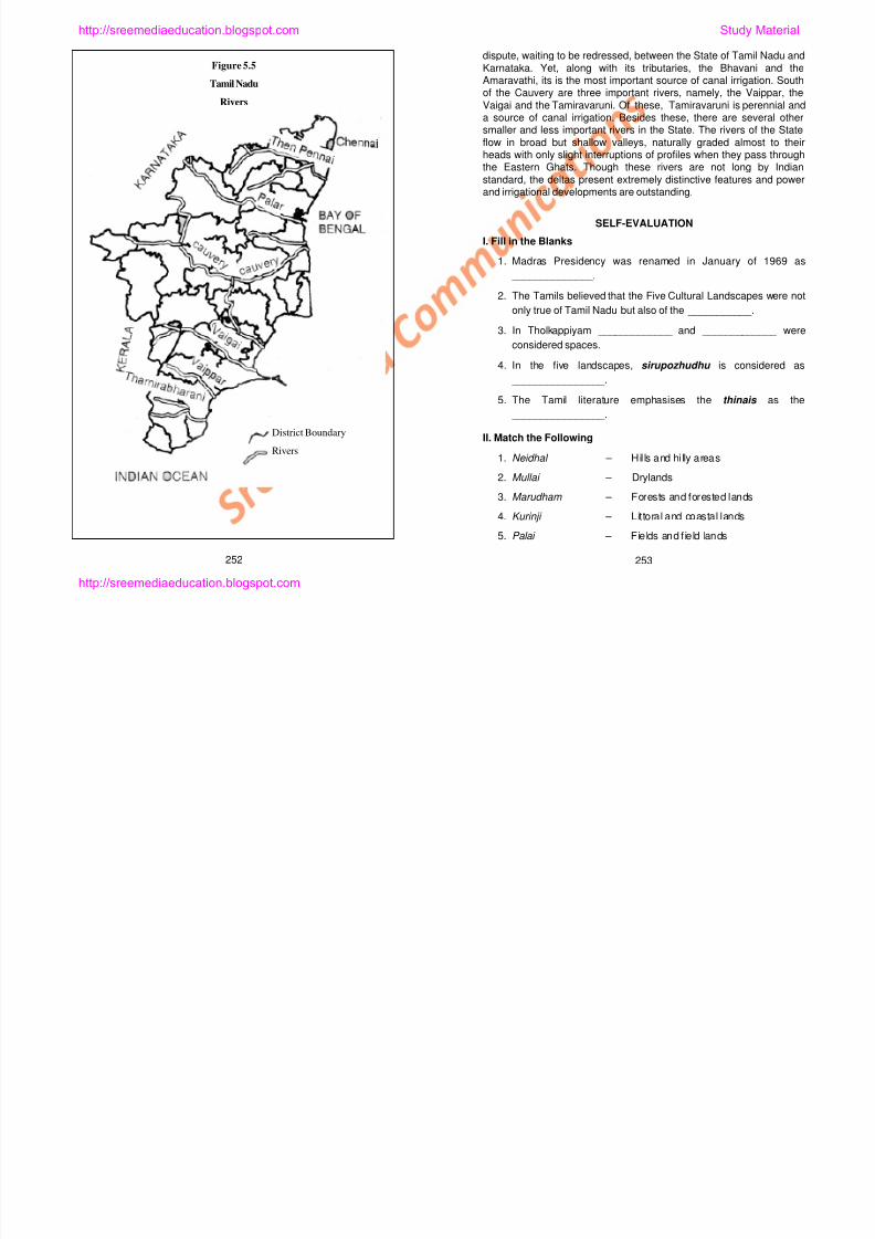
8/6/2019 Social Science History Civics and Geography
http://slidepdf.com/reader/full/social-science-history-civics-and-geography 233/280
4. In the five landscapes, sirupozhudhu is considered as
________________.
5. The Tamil literature emphasises the thinais as the
________________.
II. Match the Following
1. Neidhal – Hil ls and hi lly areas
2. Mullai – Drylands
3. Marudham – Forests and forested lands
4. Kurinji – Littoral and coastal lands
5. Palai – Fields and f ield lands
252 253
District Boundary
Rivers
http://sreemediaeducation.blogspot.com
III. Answer Briefly
1. What is meant by ‘karuporul ’ (nucleus)?
2. What were the areas under Madras Presidency?
3. Why did the States based on languages emerge?
4. What are the five cultural landscapes?
5. Write a few lines about the reorganisation of the districts.
IV. Answer in Detail
1. Write elaborately about the evolution of Tamil Nadu.
2. Write an essay about the Geography of the Sangam Period.
3. List the districts of Tamil Nadu and write a few words about eachof them.
V. Practical Exercises
1. The students share their experiences of travels.
2. Using a map of the State, identify the districts by names.
http://sreemediaeducation.blogspot.com Study Material
8/6/2019 Social Science History Civics and Geography
http://slidepdf.com/reader/full/social-science-history-civics-and-geography 234/280
254
http://sreemediaeducation.blogspot.com
Lesson 6
TAMIL NADU: CLIMATE
Learning Outcomes
1. Learning as to how climate works.
2. Learning to delineate climatic regions using criteria for
classification.
Everyday, at the time of News, weather bulletins are read on the
television and radio. Reports are also published in the newspapers.
What are the weather reports? They are indeed the prevalent
temperature and other weather details of a place on a particular day.
Temperature, pressure, humidity and quantity of rainfall are some of
the details these reports carry. The average weather conditions of a
place from anywhere between 30 years to 150 years become the
climate of that place.
The temperature and other conditions prevalent at a place on a
http://sreemediaeducation.blogspot.com Study Material
8/6/2019 Social Science History Civics and Geography
http://slidepdf.com/reader/full/social-science-history-civics-and-geography 235/280
The temperature and other conditions prevalent at a place on a
given day is known as the weather, whereas long term, that is, the
average conditions of a place over 30 to 150 years is considered asthe climate of that place.
The Earth receives its heat from the Sun. The amount of heat
emanating from the Sun is the same every year. Yet the temperature is
high at some places and low at other places. Also, the temperatures of
a place are not the same all through the year. For the whole of May,
your schools are closed for the summer (venirkalam ), isn’t it? The
summer temperatures are not only high in Tamil Nadu but also in the
whole of India as well. Likewise, December is rather cold. Therefore, it
is clear that the temperatures vary from place to place and season to
season.
255
http://sreemediaeducation.blogspot.com
Know the Facts!
SEASONS
Using the calender, the year may be divided into fourseasons, namely:
January to March : Dry Weather
April and May : Hot Weather
June to September : Southwest Monsoon
October to December : Northeast Monsoon
RAINFALL REGIMES IN TAMIL NADU
There are two earlier classifications of rainfall regimes of Tamil
Nadu. The rainfall regimes were devised in 1948 and 1953, with rainfall
data at half-monthly intervals for the whole year of 44 provincial
rainguage stations and with rainfall data of northeast monsoon monthly
totals for October-December. No other classification was ever
attempted. The two classifications are comprehensive enough. The
northeast monsoon rainfall is about 60 per cent of the annual total in
the coastal districts and about 40 per cent in the interior districts. There
is more rain in October in the interior districts whereas there is more
i i N b i h l di i W l k fi di i i
4. The Submontane Districts: Salem, Namakkal, Erode,Dharmapuri and Coimbatore with a rainfall of about 280 mm.
5. The Hilly Nilgiris with a mean rainfall 507 mm.What are the reasons for summer of high temperatures and
winter of cold period? We all know that the Earth rotates on its axis at23.5o. Further that the Sun’s rays fall overhead over the equator inMarch and September, over the Tropic of Cancer in June and over theTropic of Capricorn in December. Therefore, between March andSeptember, the Sun is in the Northern Hemisphere. The NorthernHemisphere becomes hot while the Sun is overhead over the northernhalf of the Earth. Hence, there is hot weather and summer seasonduring March to September in the Northern Hemisphere.
Tamil Nadu is between 8o 5' N and 13o 55' N. As such it is in the
Northern Hemisphere. Hence, the Sun is overhead over most of thecountry during the months of March to September. That is, for sevenmonths the Sun’s rays fall directly over the State. Therefore, thesummer for Tamil Nadu is slightly longer. In the Sangam age, theTamils called the period between Chithirai (April) and Purattasi (September) as the Venirkalam . Venirkalam means that it is a period ofscorching sun.
After September, the Sun moves south and shines over theSouthern Hemisphere. During this period, the Sun’s rays fall at anangle on the Tamil Nadu and as such it is a period of low
http://sreemediaeducation.blogspot.com Study Material
8/6/2019 Social Science History Civics and Geography
http://slidepdf.com/reader/full/social-science-history-civics-and-geography 236/280
rain in November in the coastal districts. We may look at five divisions
as the rainfall based regions. They are:
1. The North Coastal Districts : Chennai, Vellore, Kanchipuram,
Villupuram, Thiruvannamalai, Cuddalore, Thanjavur,
Nagapattinam, Thiruvarur and Pudukottai with a mean rainfall of
635 mm.
2. The South Coastal Districts : Kanyakumari, Sivaganga,
Ramanathapuram, Thoothukudi and Tirunelveli with a mean
rainfall of 457 mm.
3. The Interior Districts : Madurai, Theni, Virudhunagar, Dindigul,
Tiruchirappalli, Karur, and Perambalur with a mean rainfall of
381 mm.
g ptemperatures. Therefore the period between October and February thetemperature goes down and there is mild cold as well. The Tamils
called this period of cold as Panikalam . Panikalam extends betweenAipasi (October) and Panguni (March).
In Tamil Nadu there is high temperatures for a period of sevenmonths, between March and September. Between October andFebruary, the temperature declines and begins to be cold at the end ofthe season.
In both summer and winter, there are changes in the pressure,winds, cloud cover, and precipitation in accordance with thetemperatures. Besides these, location, landscapes and nearness tosea influence climatic conditions. Therefore, on the basis of thischange the climate of Tamil Nadu may be divided as follows.
256 257
http://sreemediaeducation.blogspot.com
SUMMER (VENIRKALAM )
The Indian Summer stretches between March and September.
As the Earth revolves around the Sun, there is an apparent movementof the Sun towards the north. The Sun that shines overhead over theTropic of Capricorn in December moves north to reach the equator inthe month of March and the Tropic of Cancer in the month of June. AsIndia is in the Northern Hemisphere, the Sun’s rays fall overhead overthe country during these months. And, particularly, as Tamil Nadu isbetween the Tropic of Cancer and at close quarters to the Equator, thetemperatures increase from the month of March. In May, thetemperature in Tamil Nadu reaches beyond 40o C. The Indianlandmass is also experiencing the gradual increase in temperature andreaches the peak temperature in May. The distribution of temperatureis therefore increasing as we move towards north from the State ofTamil Nadu.
Know the Facts!
RAMAMURTHY’S CLASSIFICATION
Dr. Ramamurthy was a faculty of the Puna UniversityGeography Department. In 1948, he wrote his thesis on the climateand rainfall of Tamil Nadu. According to his classification:
Hot weather season - Masi-Vaikasi (Mid-February to Mid-June)
has shown that the State has more number of deficit rainfall years thanexcess and flood is thus a rare phenomenon with occurrences in about8-12 years. It is also seen from the long term data that there was no
periodicity in the occurrence of floods, although the floods do recur.But such recurrences are random.
Drought is generally understood as a period of dryness due tolack of rain. The drought is a rainless situation for an extended periodduring which some precipitation should have normally been receivedbut not. Pamban experienced the worst decade during 1911-20 with asmany as 7 droughts - 1 disastrous, 1 severe and 5 moderate- andagain during the last five years of the period. Interestingly, however,Salem experienced 5 moderate droughts in the entire 75-year period,during which time a total of 37 droughts had occurred here, with 15severe and 17 large ones.
The Tamil Calendar shows that the Sun moves towards northfrom the Tropic of Cancer during January 14-15 of the year and theseare celebrated as the Pongal (harvest festival) in Tamil Nadu andSankaranthi in India.
THE SIX SEASONS OF THE TAMILS
According to the rules of ‘inner space’ of the Tamils, the timewas divided into two classes: Perumpozhudhu and Sirupozhudhu . Aswe have seen before, the six seasons of a year are theperumpozhudhugal , whereas the six periods of a day are the
http://sreemediaeducation.blogspot.com Study Material
8/6/2019 Social Science History Civics and Geography
http://slidepdf.com/reader/full/social-science-history-civics-and-geography 237/280
Southwest monsoon - Aani-Purattasi (Mid-June to Mid-October)
Retreating monsoon - Aipasi-Karthigai (Mid-October to Mid-December)
Cold weather season - Markazhi-Thai (Mid-December to Mid-February)
FLOODS AND DROUGHTS
The State suffers from the twin scourge of floods and droughts.Abnormal rainfall during the northeast monsoon happens to be thecause for floods in the State. The Meteorological Department, indefining the term flood, takes the view that a flood is said to haveoccurred when the rainfall during a given period is in excess of 50 percent. The long term percentage departure in excess of normal rainfall
p p g , p ysirupozhudhugal . The seasons of year and the periods are shownbelow:
1. Karkalam - Aavani, Purattasi (August-October)
2. Kulirkalam (Koothir) - Aipasi, Karthigai (October-December)
3. Munpanikalam - Margazhi, Thai (December-February)
4. Pinpanikalam - Masi, Panguni (February-April)
5. Ilavenirkalam - Chithirai, Vaikasi (April-June)
6. Mudhuvenirkalam - Aani, Aadi (June-August)
258 259
http://sreemediaeducation.blogspot.com
Although the summer temperatures are high in most of TamilNadu, it is rather mild in the coastal areas and on the hills. You havealready learned that the land gets heated quickly and the water gets
heated slowly. Therefore, the land is very hot during summer while thewater is relatively less hot. This also results in pressure differencesbetween the land and water. There is a low pressure on the land whilethere is a high pressure on the water. This causes the air to blow fromthe sea. This air reduces the temperature of the land. The breeze thatblows from the sea towards the land is known as the sea breeze. Forexample, you are aware of our capital Chennai on the east coast. Thesea breeze that blows from the sea reduces the temperature of the citya little bit. Likewise, the temperatures along the coast of the State willalso be slightly low.
The places in the interior and away from the seacoast will havehigher summer temperatures. But as the cool / cold air crosses the hot
landmasses, it loses its heat and becomes relatively dry and hot. Thisis the reason why interior places such as Madurai and Tiruchirappalliare hotter than the coastal Chennai.
The impact of summer temperature is not felt on the hills. It isbecause, as you have learnt in your lower classes, the temperaturedecreases as we go higher and higher. The temperature of a placedepends on the height at which it is found. In the Himalayas, theWestern Ghats and even the Eastern Ghats record low temperaturesaccording to their heights. It is for this reason that the places such asOoty, Conoor and Kodaikanal on the Western Ghats are summerresorts and touristic spots.
there is a long coast . The sea surface is slightly warmer than that of
the land surface. Therefore, places such as Thanjavur, Nagapattinamand Chennai will have relatively mild temperatures. It is summer for the
Southern Hemisphere during this period.
KARKALAM
The pressure differs in accordance with the temperatures. Youhave already learnt in earlier classes that the pressure is low whentemperature is high and vice versa. In summer, there is a low pressureformed at the northwestern India because of the high temperaturesthere. At the same time, there is high pressure in the SouthernHemisphere but it is on the sea surface. Hence, the air blows from thehigh to the low. It is this that reaches the Indian subcontinent as thesouthwest monsoon. This is blocked by the Western Ghats andtherefore it gives copious rainfall on the western slopes of the Western
Ghats. Tamil Nadu is in the rain shadow and hence received lowrainfall.
CYCLONES
Tamil Nadu suffers as well as benefits from the cyclones. Theyare a vicious offspring of ocean and atmosphere, powered by heatfrom the sea. They are an intense low pressure system in which thewind speeds exceed 65 kmph. Their size may be as small as 150 kmacross and as large as 1000 km in diameter. The height often extendsupto 14 to 15 km. The spiralling wind speeds near the ground levelcould be as high as 200 kmph The cyclonic storm may move about
http://sreemediaeducation.blogspot.com Study Material
8/6/2019 Social Science History Civics and Geography
http://slidepdf.com/reader/full/social-science-history-civics-and-geography 238/280
resorts and touristic spots.
Although the summer and high temperatures are widespread in
Tamil Nadu, they are relatively low along the coasts and the hills.
KULIRKALAM (WINTER)
The Sun overhead over the Tropic of Cancer in June begins tomove towards the south slowly. It crosses the equator in Septemberand reaches the Tropic of Capricorn in December. As the Sun’s raysfall on a slant in the Northern Hemisphere, the temperatures arebeginning to fall. It is winter for the Northern Hemisphere from themonth of September to February.
It is winter also for the Indian subcontinent. Tamil Nadu is not as
cold as North India, because it is close to the equator (8o C). Besides,
could be as high as 200 kmph. The cyclonic storm may move about500 km a day.
The cyclones generally form in the Bay of Bengal and ArabianSea during the pre-monsoon (April-May) and post-monsoon seasons(October-December). They are commonly known as monsoondepressions. These disturbances are often referred to as depressions.Normally, the pressure departure at the centre of the depression is 2 to6 mb and the wind speed below 40 kmph. If the pressure departure is6 to 10 mb and wind speed 40 to 60 kmph, at the centre, then they areclassified as cyclones. The average annual frequency of depressionsof all intensities is 13 over the Bay of Bengal. Of these, 7 occur duringthe four monsoon months - June through September.
It is the Bay of Bengal depressions, rather than those of theArabian Sea, that adversely affect the State. They are also benevolent
260 261
http://sreemediaeducation.blogspot.com
sometimes giving copious rains to the coastal tracts. As long as thesystem lies over warm waters, its intensity goes on building and onlywhen it moves over a region of cold water or land its decay starts.
The decaying is however very rapid and the whole system maycollapse in a few hours to a day. Fortunately because of this, thedamage caused by the depressions confines only to extreme coastalareas. The destruction due to cyclonic storms is caused by threefactors, the heavy rains, the high winds and the storm surges. Thetorrential rains are cause for local flooding and inundate lowlyingareas. They can cause flood in rivers causing breaches. The very highwind speeds can blow off the roofs and cause severe damage totelecommunication and they can even smash glass panes of windowsand doors. They cause high waves well out at sea which are highlydangerous for ships and smaller crafts. Fishermen often get caught ina storm and are carried away far out to the sea. The most destructive
factor associated with the cyclones are the storm surges or tidalwaves. Past records show that 75 per cent of the loss of lives causedby the cyclones are due to storm surges.
Know the Facts!
MARCHING DESERTS
We have already learnt that there was no desert at all in Tamil Nadu.
But today, they are marching forward in many areas. The deforestation
that has been on for several years has converted much of the Western
Ghats into bald mountains Besides the rains that fell aplenty and the
And with the cutting down of the shelter belts carefully and meticulously
erected during 1968-88 in just four short months, the winds have
become vigorous in the last 10-15 years. With the march of the deserts,the people here have become relented and mourn the fact that they
have been instrumental for the process of desertification.
The dunes are not only here but are also found in Rajapalayam area as
well. It is also important to note that the winds blowing inward from the
sea has moved sand from the coast and piled up dunes in the interior of
the district of Pudukottai. If we do not contain the marching deserts, they
may one day become a problem we could never really resolve. This
must be borne in mind while engaged in economic activities.
URBAN HEAT ISLANDS
The impact of anthropogenic (human) activities on the climate
has increased tremendously with the building of big cities. This is notan intentional activity, but is a side effect. The cities make newclimates by destroying the micro climates existing in them. This is
possible because of three processes: generation of heat, change in thelandforms, and changes that occur in the atmosphere.
The fuels burnt in big cities increase the temperatures. The heatabsorbed during the day is released in the night from the stone wallsand concrete buildings. Therefore, urban heat islands are formed in
the big cities during the nights. For example, in cities such as Chennaiand Madurai, it is natural to have such heat islands where buildings
http://sreemediaeducation.blogspot.com Study Material
8/6/2019 Social Science History Civics and Geography
http://slidepdf.com/reader/full/social-science-history-civics-and-geography 239/280
Ghats into bald mountains. Besides the rains that fell aplenty and the
drizzle that followed in the rain shadow have now become rare and
drought exists for one or two years. The sand that has been piling onthe foothills of the Western Ghats in Theni district and the villages at
the foothills have now sand dunes, sand drifts and encroachments
occupying an area of 12,000 hectares and the land under the sand
has become semi-arid. The rains became rare primarily due to
deforestation of the western, windward slopes. This has now resulted
in the southwest monsoon winds, climbing up the windward slopes,
climb down the leeward and scoop up soil from the ploughed fields of
the foothills on the rain shadow and pile up as sand dunes. The small
and big hill passes allow the winds to gush through with great speed
and carry the sand particles 4 to 4.5 km from the foothills and deposit
them as dunes.
and Madurai, it is natural to have such heat islands where buildingsand population are dense. The Anna Salai is a long road and there are
several hundred high rise buildings. There is an acrid smell in the airas the vehicles burn the fuels. As the wind circulation is not good,there is a smoke screen which pollutes the air and spoils the buildings.
As such there is a long heat island along the Anna Salai.
During the periods of dew and cold seasons, the outskirts arerather cold while the city centres are rather humid and hot. It isbecause of the heat island created by the situation here. Sometimes,the temperatures recorded in the heat islands are higher than theaverage temperatures as well as the temperatures of the surroundings.The heat islands are therefore seen only in cities. In fact the smokeand heat emanating from the fossil fuels burnt by the vehicles and thehouseholds create them.
262 263
http://sreemediaeducation.blogspot.com
SELF-EVALUATION
I. Fill in the Blanks
1. The long term average weather becomes the ___________.
2. Temperature ________ from place to place.
3. After September the sun shines _______ ________ over the
south.
4. The cyclones and ___________ have relationships.
5. The impact of the sun of Venirkalam is not felt in _________.
II. Match the Following
1. Cold weather season – June-September
2. Retreating monsoon – Masi-Vaikasi
3. Southwest monsoon – October-December
4. Hot weather season – Margazhi-Thai
5. Northeast monsoon – Aipasi-Karthigai
III. Answer Briefly
1. What is meant by weather?
2. What do weather charts give?
3. Weather and Climate - Differentiate.
4 Define Venirkalam
http://sreemediaeducation.blogspot.com Study Material
8/6/2019 Social Science History Civics and Geography
http://slidepdf.com/reader/full/social-science-history-civics-and-geography 240/280
264
4. Define Venirkalam .
5. What are urban heat islands?
IV. Answer in Detail
1. Give details about the period known as the Panikalam .
2. Write explanations about the droughts and spreading deserts.
3. Write about cyclones in about ten sentences.
V. Practical Exercises
1. Collect proverbs about climate and weather and learn their
meanings.
2. Visit the sand dunes and the mountains nearby and learn aboutthe weather and climate of the regions.
http://sreemediaeducation.blogspot.com
Lesson 7
SOILS, VEGETATION AND ANIMALS
Learning Outcomes
1. Learning to appreciate the role of plants and animals in human life.
2. Understanding how we feel the responsibility towards our animals.
3. Learning about the positive and negative impacts of human
activities.
Soils, plants and animals are the fundamental resources forhuman and cultural development. There are historical evidences thatshow the destruction of soil is indeed the destruction of a community,even government. Vegetation is indeed the function of soils and water,together with the climate. Forests give asylum to the animals. It iscommon parlance that, with the destruction of forests, several hundredecosystems have been destroyed. If we conserve and protect soils,the vegetation will flourish. If the vegetation flourishes, then the humanand animal lives will prosper. Animals are indeed the life-blood ofhuman life. Above all, if the diversity of plants and animals aredestroyed then there is a real danger of human life becoming extinct
http://sreemediaeducation.blogspot.com Study Material
8/6/2019 Social Science History Civics and Geography
http://slidepdf.com/reader/full/social-science-history-civics-and-geography 241/280
265
destroyed, then there is a real danger of human life becoming extinctas well. Therefore there is a great role for soils, natural vegetation, and
animals in human development. In this lesson, we will assess the soils,vegetation and animal resources of the State of Tamil Nadu.
SOILS OF TAMIL NADU
The soils of Tamil Nadu may be classified as those of thefollowing five types:
1. Alluvial soils
2. Regur or the black soils
3. Red soils
http://sreemediaeducation.blogspot.com
4. Laterite soils
5. Saline soils
The alluvial soils are the best soils. For it is in these soils thatthe crops grow well and give good yields. Of the other soils, all soilsare good for cropping, except of course for saline soils. Because thesesoils are distributed widely in the State, the people are dependent onall soils. In several places, agriculture is poor primarily because ofpopulation growth and loss of nutrients in the soils. Water scarcitiesincrease the problem further. It is for this reason, there is need for thepeople to engage in improving and consolidating water resources.Growing trees and rainwater harvesting are the two important activitiestowards such objectives. Therefore it is important to prevent forestsfrom being destroyed.
ALLUVIAL SOILS
The alluvial soils are found in both the coastal and deltaicareas. They are found in the deltaic tracts of the rivers of Tamil Nadu,more especially the Cauvery in Thanjavur, Thiruvarur, andNagapattinam districts and also in Villupuram, Cuddalore, Thirunelveliand Kanyakumari districts.
The alluvial soils are generally fertile. It is rich in lime,potassium and magnesium but nitrogen and phosphoric acid are aminimum Paddy sugarcane banana and turmeric are the main crops
southern districts. In regard to chemical composition, the black soilshave a high per cent of potassium, lime and magnesium but nitrogencontent is low as is common in Indian soils.
RED SOILS
The red soil areas are particularly confined to the centraldistricts. They are deficient in organic matter and poor in plantnutrients. They absorb rains readily but do not retain the moisture long.They get fit for sowing earlier than the black soils. Almost all crops aregrown where irrigation is available. The amount of lime is small,magnesium is not high and phosphoric acid is uniformly low.
LATERITE SOILS
The laterite soils are not very extensive, with only certainpockets. These are found in Kanchipuram, Thiruvallur and inThanjavur districts. The red colour of laterite soil is due primarily to itsiron oxide content. The laterites are formed in regions which aresubjected to alternate heavy precipitation and a dry hot period. The lowlevel laterites under cultivation are rich in nitrogen content. Theycontain fair amounts of total phosphoric acid. Laterite soils are heavybut well drained. They are of low fertilities and are subject to leachingunder heavy rainfall conditions. Paddy is the chief crop grown in thesesoils. Other crops are ginger, pepper and plantains.
http://sreemediaeducation.blogspot.com Study Material

8/6/2019 Social Science History Civics and Geography
http://slidepdf.com/reader/full/social-science-history-civics-and-geography 242/280
266 267
minimum. Paddy, sugarcane, banana and turmeric are the main cropsgrown here.
BLACK SOILS
The black cotton soils are found extensively in the districts ofCoimbatore, Ramanathapuram, Tiruchirappalli, Pudukkottai andThanjavur in the State. They crack very deeply in summer and as aresult of having a high clay content they possess low permeability andhigh moisture holding capacity, often 65 to 85 per cent. In Palladam,Pollachi and Udumalpet taluks, gypsum is found associated with theblack soils. These soils are composed of clayey material high inalumina, lime and magnesia. But nitrogen is low. Cotton and sorghumare the important crops of the black soils with fodder and cumbu in the
SALINE SOILS
A minor soil is that of saline soils, considered interzonalformation, and is found in the coastal environment. They are found inplaces where drainage facilities are scarce and evaporation is high.For example, these soils are found in a small pocket in Vedaranyam.
VEGETATION
By a 1984 survey, the total forest area in Tamil Nadu was 2.2million ha. The percentage of forest cover to land area was nearly 17per cent. The value of forests as Nature’s means of soil and waterconservation, wild life preservation and sustaining the ecologicalbalance is well recognised. They make the climates mild. They also
http://sreemediaeducation.blogspot.com
provide for employment. It is also recognised that the forests haveimportant productive and protective functions. The forests continue togive us forest products both for industrial and domestic purposes.
Forests are a renewable resource. Yet there is not much activity inrenewing the forests.
The differences in precipitation and landscapes determine thetypes of forests. The forests of Tamil Nadu may be classified as thoseof (1) the Subtropical hill forests; (2) Temperate hill forests; (3)Tropical, dry evergreen forests; (4) Thorny shrub forests; and (5)Mangrove forests.
1. Subtropical Hill Forests
These wet hill forests are found at a height of 1000 - 1500metres on the Nilgiris and Palani hills. Below them are the
stunted rainforests.
2. Temperate Hill Forests
These forests are found at heights above 1500 metres onthe Nilgiris, Anaimalai and Palani hills. These are low, densebut small growth forests. These forests abound in epiphytes,
mosses and ferns.
3. Tropical Dry Evergreen Forests
These are found mostly on the coastal areas of Tamil Nadu.
There are also short but dense bushes and grasslands.
are being used for environmental biological researches. That
‘sustaining these will be part of our sustainable development efforts’
must be recognised.
4. Thorny Shrub Forests
The thorny shrub forests are found in areas of long, dry
periods and low rainfall.
5. Mangrove Forests
These are found in the Vedaranyan and Pichavaram regions
of the east coast. Sundari trees are found in these forests.
Distribution of Forests. The distribution of forests among
different districts of the State is very uneven. Concentration of forests
is to be found mostly in the hills of the western districts and in theJavadhu groups of hills in Vellore district and there are also dense
forests in Salem district. The Nilgiris has most of its area under forests,
a little more than half its area. Many of the districts have less than 5
per cent and the district of Thanjavur the least, less than 1 per cent.
Know the Facts!
TREE WORSHIP
Like in other cultures, the Tamil culture also practised tree worship. It
http://sreemediaeducation.blogspot.com Study Material
8/6/2019 Social Science History Civics and Geography
http://slidepdf.com/reader/full/social-science-history-civics-and-geography 243/280
Know the Facts!
OUR TREES
Sacred trees (thala vrikshas ) are found in our sacred groves and in the
tank or lake areas of the country. Every temple, temple town has a
sacred tree. In some places, the trees are in the sanctum of temples
and are worshipped along with the gods. Some cities are even named
after the thala vrikshas .
In 1988, some 60 sacred trees of Tamil Nadu were discovered. It is
also come to our knowledge that the Western and the Eastern Ghats
hold within them more than 100 sacred groves. They have a great role
in preserving the bio-diversity. It is also heartening to note that they
268 269
is also actively practised now. It is learnt from the Tamil literature that
during the Third Sangam praying to the trees was in vogue.
It was well-entrenched that the gods lived in trees. The Sangam
literature such as the Agananuru, Kalithogai, Purananuru, Natrinai,
Thirumurgatrupadai and Kurnthogai bear evidence for the practice of
tree worship by the Tamils. Vembu, vengai and kondrai are some of
the trees appropriate for deities worshipped by the Tamils.
Because we cut these sacred trees that our forests have become
wiped out. Because they give us rains, they are all sacred to us. If we
act in that faith, then the forests will flourish and we will get plenty of
rains. We and our country will prosper.
http://sreemediaeducation.blogspot.com
TREES ARE BECOMING FUELS
Because we use trees as fuelwood, our forests are fast
destroyed is an assessment. In every village, trees are being used asfuelwood. Collecting twigs and cutting wood from the trees grown on
poramboke are done for making income for livelihood in the poor
households.
As the practice of growing trees and cultivating betel vine is on
the wane, the forests are getting quickly destroyed. Therefore, we
should create awareness among the people about the need to revive
the practice of growing trees and betel vine gardens for meetig the
increasing fuelwood needs. Casuarina plantations must be
encouraged and incentives may be given for such activities.
Most trees in the State shed their leaves to save water fromevaporation. Such forests are known as the deciduous forests. Tamil
Nadu is one of the fortunate States to possess sandalwood plantation
with nearly 588,000 ha. Hard wood is useful for construction purposes.
Such trees are available in the forests of Coimbatore, Nilgiris and
Kanyakumari. The trees that are used as fuelwood are densely found
in Madurai, Coimbatore and Thirunelveli districts. Kanyakumari district
has rubber plantations. In the Nilgiris, camphor and eucalyptus trees
are grown in afforested areas. In the foothills of the Western Ghats
near about Thirunelveli and Virudhunagar districts the trees used in
making match sticks are luxuriating. The trees such as peepul
the slopes of the hills, they prevent soil erosion and land slides. As
students, it is your duty to inform your parents and the public about the
importance of developing forests. It is appropriate to begin this activity
in your school.
WILD ANIMALS
The animals and birds living in the forests are indeed the wild
animals. In Tamil Nadu, the Western Ghats and the hills of the Eastern
Ghats abound in wild life. Black bear, several different deer varieties
(forests of Chennai), wild hog, leopard, fox, jackal, tiger, elephant, hare
and python as well as other varieties of snakes are all found in the
forests of Tamil Nadu. Crocodiles live in rivers as well. There are also
several different kinds of birds in our State. Peacock and peahen, lark
(kuil ), crow, mynah, parrots, cranes, stork and eagle are found
everywhere. Birds of several species come to Vedanthangal Sanctuary
from far off places. The sanctuaries - elephant sanctuaries of
Anaimalai, tiger sanctuary at Mundanthurai, and bir sanctuaries at
Vedanthangal and Kodikarai - attract tourists from all over the world.
Tamil Nadu receives foreign exchange and income from the tourists.
Know the Facts!
WILD AND DOMESTICATED ANIMALS ARE OUR LEGACY
Just as the trees were, and are, worshipped, the wild animals were,
http://sreemediaeducation.blogspot.com Study Material
8/6/2019 Social Science History Civics and Geography
http://slidepdf.com/reader/full/social-science-history-civics-and-geography 244/280
(arasamaram ), blue apples (naval ), goose berries (nellikkai ) and jack
(pala ) grow very well in the State and also help preserve groundwater.So the people must be encouraged to grow such trees. Besides, it is
good to grow trees everywhere, in the villages, towns and cities, and
wherever possible. Forests must be protected. Needless to say that
growing forests, increasing and improving them will help improve our
own lives. Remember that it is conclusively proved that the forests
provide for rains.
The forests improve the natural beauty of a place. They also
prevent air pollution. In the cities they are useful in bringing down the
heat and preventing air pollution. If grown along the highways, in
dense patches, they will be useful in muffing noise as well. Growing on
pp
and are, also worshipped in our culture. It is perhaps because of this
that our people made animals the vehicles for gods and appropriatelypreserved them. In our mythology, bull (Nandi ) is the vehicle of Siva,
blind mouse (moonchuru ) is the vehicle of Vinayaka, peacock (mayil )
is the vehicle of Lord Muruga, and eagle (garudan) is the vehicle of
Lord Vishnu. Kamadhenu (cow) is sacred and is considered the god
that gives food for the people of the world.
But in recent times, wild animals were hunted and decimated. There
are tiger projects in many places to preserve these wonderful animals.
Even the cattle, because of the loss of their use in agriculture, are
being sold for meat. The cattle are driven in big herds from the
agriculturally prosperous areas such as the deltas to Kerala and are
270 271
http://sreemediaeducation.blogspot.com
slaughtered for export of meat to the Gulf countries. Dung is no more a
preferred farm yard manure and the tanning industries demand hides
and skins of the livestock. Hence, the number of cattle including smallstock has declined drastically.
Therefore, wild and domesticated animals must be protected. It must
be understood that without animals our life will be dull and this we
must realise and focus our attention on protecting and rearing them for
our own good.
But yet, it is this living mantle that is being jeopardised by the
destruction of the forests. It is not confined only to the Western Ghats
although it is here there is great destruction, but is also widely
prevalent in other forest areas as well. To save the forests, there is
need to combine a number of different approaches. It is important also
to keep in view the need to conserve the biological diversity of theforests, to provide fuelwood, fodder, leaf manure and small timber for
the people of the area, to generate employment in the process of
ecorestoration and to continue to supply raw materials to the
industries. Revegetation is only one of the facets of the complex task
of ecorestoration. But this has to go hand in hand with conservation of
soil, good use of water, a switchover to stall feeding of cattle and many
other activities.
The efforts of the government are not adequate in regard to
protection of the animals. People’s participation is limited. It is our
ibilit t t t th f t d ild i l Th
SELF-EVALUATION
I. Fill in the Blanks
1. Vegetation is a function of __________ and __________
together with climate.
2. The power of retention of moisture is low in ___________.
3. The _____________ forests are found on the Nilgiris, Anaimalai
and Palani Hills above 1,500 metres.
4. In Tamil culture, worship of ___________ and ___________,
was in vogue.
5. Vedanthangal sanctuary is known for migratory __________.
II. Match the Following
1. Chithirai – Palasu
2. Vaigasi – Vanni
3. Aani – Maa
4. Aadi – Punnai
5. Thai – Athi
III. Answer Briefly
1 Where do e find all ial soils?
http://sreemediaeducation.blogspot.com Study Material
8/6/2019 Social Science History Civics and Geography
http://slidepdf.com/reader/full/social-science-history-civics-and-geography 245/280
responsibility to protect the forests and wild animals. There are
programmes on-going in an effort to increase and improve forests, andincrease the area under them. Social forestry has been encouraged in
order to improve the availability of fuelwood as well. Soil erosion has
been averted in many areas because of the growing forests.
1. Where do we find alluvial soils?
2. Classify the forests of Tamil Nadu.
3. What are the ill-effects of deforestation?
4. Write about the wild animals of Tamil Nadu.
5. What was the status of trees in Tamil culture?
IV. Answer in Detail
1. Write an essay on the forests of Tamil Nadu.
2. Write about the soils and crops of Tamil Nadu.
3. Write an essay on the animals of Tamil Nadu.
272 273
http://sreemediaeducation.blogspot.com
V. Practical Exercises
1. Teachers take their students on a visit to a nearby forest andexplain the storey vegetation, classification of plants, animals
and birds.
2. Students debate in the class on topics such as Bio-diversity,National Parks, and Sanctuaries.
http://sreemediaeducation.blogspot.com Study Material
8/6/2019 Social Science History Civics and Geography
http://slidepdf.com/reader/full/social-science-history-civics-and-geography 246/280
274
http://sreemediaeducation.blogspot.com
Lesson 8
HUMAN RESOURCES DEVELOPMENT
Learning Outcomes
1. Learning about the importance of human resources development
in socio-economic development.
2. Learning as to what we expect in the future.
The principal factors responsible for the development of a country
are the natural and human resources. By using the natural resources
properly and in appropriate ways individual’s income and the country’s
economy can be improved. The reason for considering the humans as a
resource is primarily because of their number and quality, which are
indeed the causes of the country’s development.
India is no doubt a country of very large human resource,
both in number and in quality. It has 1.03 billion people and
occupies the second position in population among the countries
of the world. There is no denying the fact that the knowledge of
I di h t ib t d h t th i d t h l f th
http://sreemediaeducation.blogspot.com Study Material
8/6/2019 Social Science History Civics and Geography
http://slidepdf.com/reader/full/social-science-history-civics-and-geography 247/280
275
Indians has contributed much to the science and technology of the
world. It is in recognition of this ability that the Indians findemployment opportunities abroad. There is also a world belief that
Indians are skilled and they are also good workers. Despite
adequate natural and human resources, our development is hindered
primarily by the high growth of population. India’s population is its
strength as well as its weakness. According to the current
estimates that India doubles every 29 years, adding an India to the
population. Some 40 years ago, however, women and children were
dependent on men and as such the per capita income as well as
productivity were very low. But the situation has rapidly been changing.
http://sreemediaeducation.blogspot.com
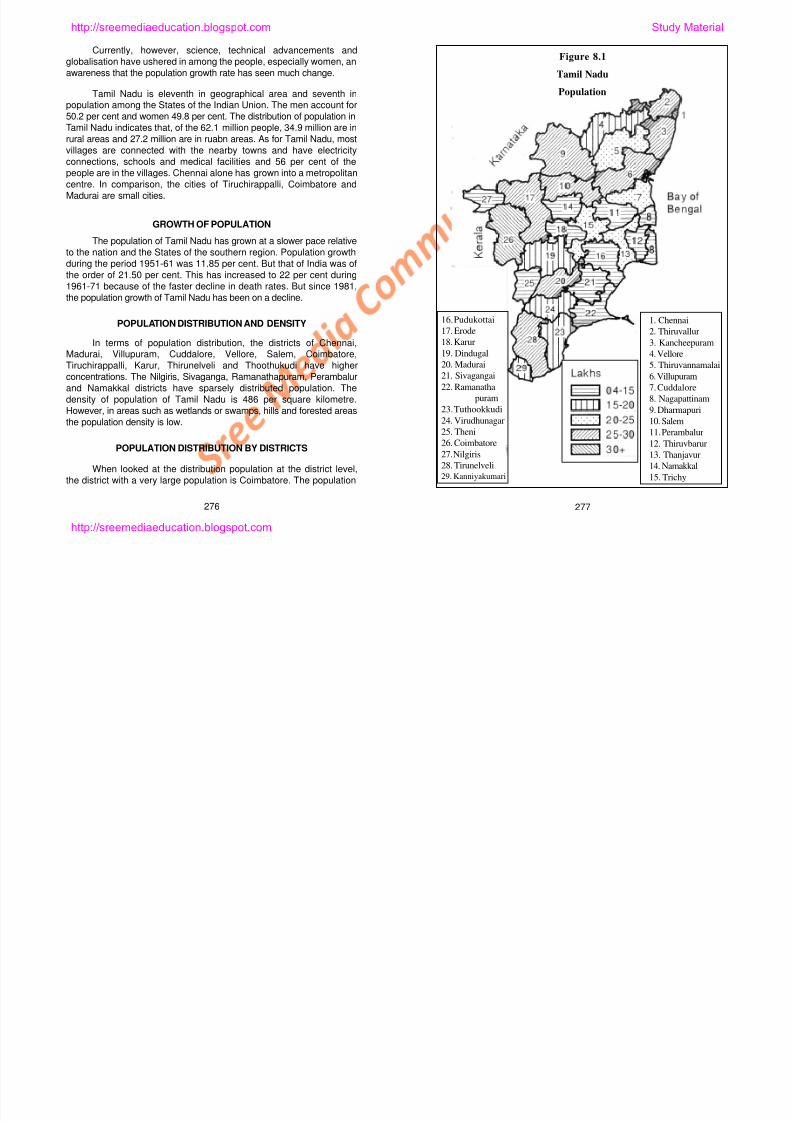
8/6/2019 Social Science History Civics and Geography
http://slidepdf.com/reader/full/social-science-history-civics-and-geography 248/280
of the district in 2001 was 4.224 million. Even Chennai occupied the
second position. The population in the city was 4.216 million. But the
entire population was urban in Chennai, the urban population of
Coimbatore amounted to 2.8 million only. As such the rural populationof this district was 1.44 million (see Figure 8.1 for population distribution
for 2001)..
Salem was the third most populated district (population 2.993
million), while Kanchipuram was the fourth largest (population 2.871
million). Thirunelveli district with a population of 2.801 million occupies
the fifth place. Dharmapuri (2.833 million), Thiruvallur (2.74 million),
Villupuram (2.944 million), Erode (2.57 million), Thanjavur (2.21 million)
and Cuddalore (2.281 million) districts had more than 2 million
population. All other districts have had populations less than 2 million in
2001. The smallest of the districts Nilgiris (764,826 people) and Ariyalur(694,058) were the only two districts with less than 1 million population.
Note that Ariyalur district has been integrated with Perambalur district.
URBAN POPULATION BY DISTRICTS
As we look at the urban population distribution by districts, the
districts that hold more than 40 per cent of people in the cities and
towns are Chennai (100 per cent), Kancipuram, Thiruvallur, Madurai,
Theni, Thoothukudi, Coimbatore and Nilgiris. In other districts, those
that have 25-40 per cent of the people as the urban population are
1. Chennai
2. Thiruvallur
3. Kancheepuram
4 Vellore
16. Pudukottai
17. Erode
18. Karur
19 Dindugal
Figure 8.2
Tamil NaduUrban Population
http://sreemediaeducation.blogspot.com Study Material
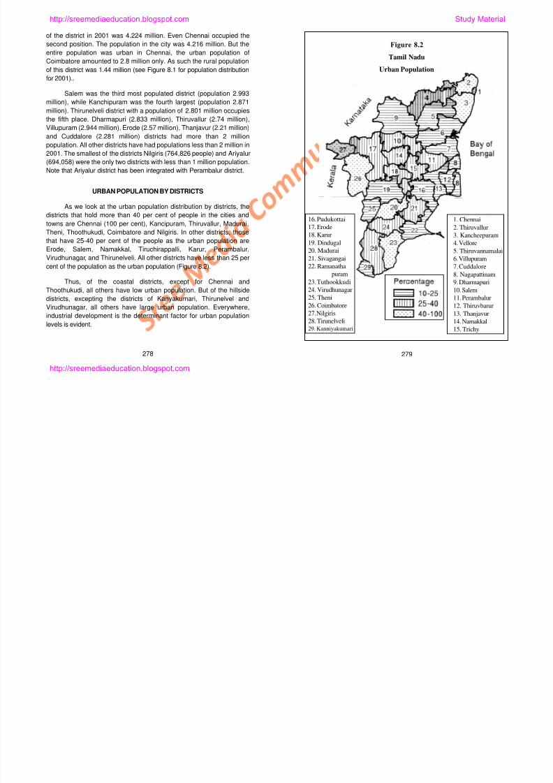
8/6/2019 Social Science History Civics and Geography
http://slidepdf.com/reader/full/social-science-history-civics-and-geography 249/280
that have 25 40 per cent of the people as the urban population are
Erode, Salem, Namakkal, Tiruchirappalli, Karur, Perambalur,
Virudhunagar, and Thirunelveli. All other districts have less than 25 per
cent of the population as the urban population (Figure 8.2).
Thus, of the coastal districts, except for Chennai and
Thoothukudi, all others have low urban population. But of the hillside
districts, excepting the districts of Kanyakumari, Thirunelvel and
Virudhunagar, all others have large urban population. Everywhere,
industrial development is the determinant factor for urban population
levels is evident.
278 279
4. Vellore
5. Thiruvannamalai6. Villupuram
7. Cuddalore
8. Nagapattinam
9. Dharmapuri
10. Salem
11. Perambalur
12. Thiruvbarur
13. Thanjavur
14. Namakkal
15. Trichy
19. Dindugal
20. Madurai21. Sivagangai
22. Ramanatha
puram
23. Tuthookkudi
24. Virudhunagar
25. Theni
26. Coimbatore
27. Nilgiris
28. Tirunelveli29. Kanniyakumari
http://sreemediaeducation.blogspot.com
Know the Facts!
Population Growth in our Tamil Nadu
In the beginning of the last century, the population of Tamil Nadu wasabout 18 million. In the next fifty years, it touched the 30 million mark.In the next 50 years, it doubled and is at 62.1 million (2001).
In comparison with India, the growth rate of population in the firstyears of the 20th century was slower than the country, but then for 30years it was higher than the country’s growth rate. It was only after1941-51 that the growth rates declined and remained entirely belowthe country’s growth rates, However, it was only after 1961-71, a
clearcut and decisive decline started.
If this condition continued, then in the next 20-30 years the growth
rate would become much smaller and a stability would be reached inthe population totals as well. After 2020, the growth rate of Tamil
Nadu’s population will decline decisively and the population itself will
stabilise. Only after these, there are possibilities for a rising standard
of living and an improving quality of life.
SEX RATIO
In 1901 there were 1044 women for every 1000 men in TamilNadu. This ratio began to decline slowly. In 1911 it was 1042, anddeclined further to 1029 in 1921. In the next ten years it was 1027. Itbegan to decline faster since 1931 and reached 1007 women for every1000 men in 1951 and further declined in 1961 to 992 women for every1000 men. As the decline after this year was rapid, this ratio stood at978/1000 in 1971, 977/1000 in 1981 and 974/1000 in 1999. In 2001, ithas now changed to 986/1000. The fact that the ratio has in the lastdecade begun to rise is a sure indication of a development level. It is
numerous than the other tribes. They account for nearly 40 per cent ofthe total tribal population of the State.
In terms of districts, both the scheduled castes and the
scheduled tribes are found in all the districts. As the scheduled castesare engaged in agricultural labour, they are found in large numberswherever there are important and significant agricultural activities. The
districts where the scheduled castes and scheduled tribes areconcentrated at the level of 20-30 per cent are Chennai, Kanchipuram,Thiruvallur, vellore, Thiruvannamalai, Villupuram, Thanjavur, Thiruvarur,
Nagapattinam, Coimbatore, Dindigul, and Virudhunagar. Except forNilgiris, in all others their distribution is to the tune of 3-20 per cent ofthe total scheduled caste and scheduled tribe population. Although they
are found in good number in the southern districts, their distribution isnot widespread. It is in the central districts that their distribution is
small.
Just as there are several special development programmes in theStates of the Indian Union, there are special programmes in place forthem in the State as well. As these people are downtrodden anddepressed it is our responsibility to give them a helping hand.
MIGRATION
The reason for a large scale migration of people from rural areas
to towns and cities during 1941-51 and 1971-81 was primarily due to the
movement of people to the cities and towns for education, medical
assistance and for employment. This was much lower during the
decade 1981-91 primarily because of the fact (1) there was a gradual
decline in the migr tion to rds the cities nd to ns nd (2) ll f cilities
http://sreemediaeducation.blogspot.com Study Material
8/6/2019 Social Science History Civics and Geography
http://slidepdf.com/reader/full/social-science-history-civics-and-geography 250/280
because wherever this ratio is almost equal, there the levels of
development high and good.
SCHEDULED CASTES, SCHEDULED
TRIBE POPULATION DISTRIBUTION
As for as Tamil Nadu is concerned, all hill areas are occupied bytribes. In the Nilgiris district alone the population of tribes is 30-40 of thetotal tribal population. It is here the tribes such as the Todas, the Kotasand the Kurumbas live. Javadhu hills, Pachaimalai, Kollimalai andYercaud hills are the places where Malayali tribes live in very largenumbers. Only the Irulas are found everywhere in the State and are alsoon the plains. In Tamil Nadu alone, there are more than 500,000 tribes.There are 36 different tribes in the State. The Malayalis are the most
decline in the migration towards the cities and towns and (2) all facilities
are now being found in the rural areas as well. The increased flow ofpeople in migration towards urban areas during 1991-2001 is attributable
to the scarcity of water in Cauvery and the resultant migration of people,
especially labourers, in search of jobs to the urban areas. Also due to
industrialisation, employment opportunities have now gone up and
hence migration as well.
As agriculture is not profitable, in terms of employment
opportunity, the dependence on agriculture has come down to 50 per
cent from the earlier 75 per cent. At the same time, industries have
begun to grow fast. In the whole of Tamil Nadu, the industrial cities are
280 281
http://sreemediaeducation.blogspot.com
making much change and progress. It is because of the industrialisation
that Chennai is called the ‘Detroit of India’ and Coimbatore is called the
‘Manchester of India’.
At the instance of globalisation and foreign investments, there areindustries that are engaged in computer hardware, softwaredevelopment and consumer products amidst the multinationalcorporations in operation here. Thus, industries are growing very fast.
Know the Facts!
URBANISATION
According to the expert predictions, the urbanisation and growth of
urban centres in the 21st century will be far more spectacular than
ever before. It is also expected that owing to population growth,
globalisation, and liberalisation of the economy there will be a fastpaced growth of urbasnisation bringing about an economic impact
on the economy.
Although Tamil Nadu is a State, it is not exceptional. Even here,
urbanisation has begun with great earnest. At the beginning of the
last century, there was almost no growth in the urban population
(yearly rate of growth 0.0); but in 1911 it reached 1.6 per cent. In 1921
there was a fall (0.8 per cent) only to rise again. In the year 1931, this
annual exponential growth rate increased to 2.1 per cent. In 1941, it
slightly declined (2.0 per cent). But in the next few years it touched a
hi h f I i lid d l l i
million in the next 20 years. But as the population of the State has the
potential of growing very slowly indeed in the next few decades, this
may touch 35-38 million and stabilise at that level. Whateverhappens, it is not difficult to predict an urban population of about 50
per cent in the next few years.
LITERACY
According to the Census estimate of 2001, the rate of literacy in
Tamil Nadu was at 73.5 per cent. Of these people, 82.07 per cent of the
urban population and 66.7 per cent of the rurasl population are literates.
In all the States, the literates among the males are larger in number
than among the females. According to 2001 census, the literacy among
the males is 82.33 per cent. But among them 88.4 per cent are literatesin the urban areas and 77.5 per cent literates in the rural areas. As for
female litearcy, there are 64.6 per cent of them in all. Among them
however 75.5 per cent are from the urban areas and 55.84 per cent of
them from the rural areas.
Today the telecommunication technologies - telephones,
televisions, radios and newspapers - available in both the urban and
rural areas not only enrich the levels of literacy but also make possible
a greater understanding of the world. The village and the town have
started moving in the same director because of the information
http://sreemediaeducation.blogspot.com Study Material
8/6/2019 Social Science History Civics and Geography
http://slidepdf.com/reader/full/social-science-history-civics-and-geography 251/280
high of 3.5 per cent. In 1961 it slid down to 2.0 per cent only to leap in
the next decade. Afterwards, urbanisation has reached 2.5 per cent in
1981 and 1.8 in the year 1991, thus showing a drastic decline.
Things improved latter and the urbanisation levels has now reached
3.5 per cent.
In the last century alone, due to the process of urbanisation, urban
population has touched 5 million in 1941 from a low of 3 million in
1901. In 1971, it reached 13 million whereas in 1991 it was at 19
million and in 2001 it culminated in 27 million. If the urbanisation
takes place at this pace, the population would reach a figure of 40
g
revolution. At the same there is a fear lifting its head amongst us inregard to the destruction of our culture by the media influence. But there
is this unshakable belief that our culture can withstand any tests,
however strong they may be in their influence and imapct.
It is important to mention the new programmes for
education and industries ushered in by the Government in the belief that
the people are indeed our wealth and it is important therefore to help
them accomplish.
282 283
http://sreemediaeducation.blogspot.com
DISTRIBUTION OF LITERATES BY DISTRICTS
Kanyakumari is undoubtedly the leader in education among the
districts. Here, more than 80 per cent of the people are literates and are
well educated. The other districts where literates are large in number
are: Nilgiris, Coimbatore, Madurai, Theni, Thirunelveli, Thoothukudi,
Thanjavur, Kanchipuram, Thiruvallur and Chennai. The literacy is
between 65-80 per cent in these districts. In all others, the rate of
literacy is between 45 and 65. These are generally the central districts
in the State.
Teacher-Students ratio captures the status of the districts in
terms of the educated and the literates. There is one teacher for every
45 students in the districts of Kanyakumari, Thirunelveli, Thoothukudi,
Ramanathapuram, Thanjavur, Thiruvarur, Nagapattinam, Tiruchirappalli,
Karur, Perambalur, Ariyalur, Salem, Namakkal and Erode. In all otherdistricts, this ratio is between 45 and 55 students to a teacher.
HUMAN RESOURCES DEVELOPMENT
In growth and development, Tamil Nadu is next only to Kerala
among the States of the Indian Union. We are in the second rank in
both population growth and in literacy levels. The people who
understood the need for family planning - especially small family norm
and family welfare - have, unlike the other backward States of the
country, controlled the growth of population to a great extent. At the
better that the State is now in the forefront in industrialisation as well.
Standard of living, quality of education, health and all other development
sectors have shown growth and improvement and they will be useful
also in the near future in improving the standard of living as well.
There is absolutely no doubt about gender and development aswell in the State. Yet, the fact that the people suffering from poverty andhunger constitute 25 per cent of the population is painful indeed. Wemust plan for the reduction and elimination of poverty and hunger. Thereis desire for that amidst us and in the government.
SELF - EVALUATION
I Fill in the Blanks
1. India occupies the ________ position in the world in population.
2. Tamil Nadu occupies the ________ position in population amongthe States in India.
3. Tamil Nadu ranks __________ in area in India.
4. The rise in sex ratio must be taken as an indicator of ___________.
5. No agriculture is ____________.
http://sreemediaeducation.blogspot.com Study Material
8/6/2019 Social Science History Civics and Geography
http://slidepdf.com/reader/full/social-science-history-civics-and-geography 252/280
same time, using the modern practices we have achieved highproductivity through green revolution. We have also become self -reliant.
Although we suffer because of shortage of water, we are still in the
forefront of agricultural production when compared to other States.
But industrialisation was mostly low in the middle of the last
century. In a research paper written in 1988, it is said that the State of
Tamil Nadu experienced a stagnation in industrial development during
the years 1960-80, but in all others there was considerable
achievement. In the last 15 years, there has been a change for the
284 285
II. Match the Following
1. Sex ratio – 35 million
2. Literacy – 82.07 per cent
3. Urban population – 986/1000
4. Urban literacy – 73.5 per cent
5. Rural population – 27 million
http://sreemediaeducation.blogspot.com
III. Answer Briefly
1. What are the development indicators?
2. What is the image of India around the world?
3. What is meant by sex ratio?
4. What is the doubling time for Tamil Nadu’s population?
5. What changes are brought about by migration?
IV. Answer in Detail
1. Write an essay on the urbanisation.
2. Write an essay on the literacy.
3. Write about development in Tamil Nadu in about ten sentences.
http://sreemediaeducation.blogspot.com Study Material
8/6/2019 Social Science History Civics and Geography
http://slidepdf.com/reader/full/social-science-history-civics-and-geography 253/280
286
http://sreemediaeducation.blogspot.com
Lesson 9
INDUSTRIES
Learning Outcomes
1. Learning how industries get established.
2. Understanding how industries help with the economic
development.
3. Learning how industries are causes for pollution and affect human
life.
4. Learning what remedial actions are taken towards industrial
impacts such as pollution.
Industries are the sources that help us to live. In their absence,life will not be easy. It is only with the help of the industries that we
could satisfy the needs of the human beings. There were severalrevolutions, which paved the way for several developments. Of these,agricultural and industrial revolutions are the two important ones.
Humans have learnt the art of cultivation some 10,000 years ago andwere able to satisfy their food and clothing needs. But only afteragriculture became stabilized as an activity that humans began to
http://sreemediaeducation.blogspot.com Study Material
8/6/2019 Social Science History Civics and Geography
http://slidepdf.com/reader/full/social-science-history-civics-and-geography 254/280
agriculture became stabilized as an activity that humans began to
learn of the other activities, especially secondary activities. With thediscovery of the wheel came the industrial revolution. Yet we may saythat the real industrial development occurred in the last 200 years only.
It because only then there was great strides made in production.Several different commodities were produced by several differentindustrial activities.
In the course of time, agriculture emerged as an industry as
well. New technologies, equipment and inputs were used in agriculturalproduction. Agriculture came to be managed just as the industries
were being managed. Agro-based industries (cotton and textile mills,sugar and paper mills) came into being to drastically change the
287
http://sreemediaeducation.blogspot.com
characteristics of agriculture. In this lesson, we shall learn about
agriculture and the sector that aids agriculture, namely, irrigation, andindustrial production using Tamil Nadu as a case study.
AGRICULTURE AS AN INDUSTRY
Agriculture is an important activity of our country. In Tamil Nadu,70 per cent of the people are engaged in agricultural activities. Weobtain from agriculture our basic needs such as food and clothing.Cattle feed is also obtained. Besides, this sector fetches half theincome of the country. In Tamil Nadu, however, agriculture fetches 40of the State income. Irrigation becomes important in the process ofgetting agriculture to yield good.
Irrigation. In Tamil Nadu, there is rainfall only during someseasons. It is also uncertain. There is much evaporation as well.
Therefore, to grow crops properly and to give water to the crops,irrigation is needed. The extent of irrigation is at 50 per cent of thegross sown area. O this, two-thirds of the area is under surface watersources such as the rivers, tanks and ponds and a third is dependenton groundwater for irrigation. Several methods of irrigation are used inthe state for very long time. In the second century A.D., Karikal Cholanbuilt the Grant Anicut (Kallanai) across the river Cauvery for facilitatingirrigation. It still exists and serves the people very well.
Canal Irrigation. Canal irrigation is predominant in the Cauverydelta and in the basins of Palar, Pennaiar, Amaravathi, Vaigai,Tamiravaruni and Aliyar. Canals are built on either side of the riversand irrigation is carried on using these canals. Dams are built across
absorbed by the ground, there is less water for crops in the dry
season. The Public Works Department and the Agricultural
Engineering Department personnel have been involved in efforts
towards finding solutions for the problems. Canals are also being built.
Tank Irrigation. Natural depressions or depressions created by
digging are used for storing water. These are generally called tanks.
Crops are irrigated with the water from them. This type of irrigation has
been followed since the ancient times by the Tamils. There are 39,000
tanks in the State alone. Tanks irrigate an area equivalent to 22 per
cent of the irrigated area. Tank irrigation is followed in the northern and
southeastern parts of the State. Kanchipuram, Thiruvallur and Vellore
are the districts of the northern parts and Ramanathapuram,
Virudhunagar and Thirunelveli are the districts of the southeastern
parts. Chemparambakkam, Veeranam, Mamandoor, Mathuranthagam,
Kaveripakkam, and Rajasingamangalam are some of the very bigtanks in the State.
One of the shortcomings of the tank irrigation is that the tanks
occupy an area, which could otherwise be used for cultivation. In
course of time, the area under water is also reduced due to silting. The
tank becomes dry in summers because of excessive evaporation of
water. Evaporation can be prevented from the tanks by growing trees
all around the tanks. The more luxurious the vegetation around the
tank the more better will be the protection for water.
Well Irrigation. This type of irrigation uses groundwater from
http://sreemediaeducation.blogspot.com Study Material
8/6/2019 Social Science History Civics and Geography
http://slidepdf.com/reader/full/social-science-history-civics-and-geography 255/280
a d gat o s ca ed o us g t ese ca a s a s a e bu t ac oss
the rivers to store water and irrigate lands through the canals. Canalirrigation accounts for 33 per cent of the total irrigated area of theState. Thanjavur and Nagapattinam areas account for nearly half theirrigated area. But for some years now there has been a scarcityaffecting the irrigation and agriculture of the area. Canal irrigation ispractised also in Cuddalore, Tiruchirappalli, Coimbatore, Erode andMadurai districts. The dams that provide for irrigation are theKrishnagiri, Sathanur, Mettur, Bhavani, Parambikulam-Aliyar,Amaravathi, Vaigai and Periyar.
Large capital is needed to build the dams and construct canals
for canal irrigation. But as a part of the water that flows in the canals is
g yp g g
the wells and the tube wells. Where canal and tank irrigation cannot becarried on, well irrigation is in use. Farmers dig wells in their own
lands. This type of irrigation caters to 44 per cent of the cropped area.
It is often used in conjunction with other forms of irrigation as well. Well
irrigation is dominantly practised in the districts of Vellore, Madurai,
Virudhunagar and Thirunelveli. Only a small area can be irrigated by
well irrigation. The water level in the wells vary with seasons. In
summer as well as in seasons of good use, the wells may become dry.
When electricity is used in pumping water from the wells the
expenditure for irrigation increases as well. As such in some areas well
irrigation is good while in others it is not.
288 289
http://sreemediaeducation.blogspot.com
Overall, the increase in area under irrigation in the earlier years
is a result of an increase in canal and tank irrigation whereas the latterdevelopment is primarily due to the groundwater (well) development of
the recent years. There are of course variations, inter se , in terms ofregional pattern of irrigation.
CROPS
The environmental conditions such as the land size, quality,irrigation and climates provide for a clue to the nature and the patternagricultural economy prevailing in the State. It is obvious that because
of varying landscape, slope, climatic, water resources and soilconditions, the agricultural pattern would vary considerably from district
to district. The total geographical area of the State is 13 millionhectares. Of this area, 45 per cent is good for agriculture. About 15 per
cent is under fallow. Forests occupy 18 per cent of the geographicalarea of the State. About 15 per cent is under non-agricultural uses.Paddy, millets, sugarcane, cotton and groundnut are some of theimportant crops of the State.
PADDY
The cropping in the State is largely mono-cultural, dominated bythe staple paddy. It is cultivated in a third of the cropped area of the
State. Paddy requires fertile land, plenty of water resources, hightemperatures and labourers. Where there are good water resources,paddy is cultivated for three seasons. Paddy is predominant in areas of
in the districts of Thirunelveli and Thoothukudi are rice areas. Tamil
Nadu is the third ranking state in the production of paddy after AndhraPeadesh and West Bengal. Paddy is cultivated in 3 million hectares
and the production is nearly 5 million tonnes.
MILLETS
Dry crops are grown alone or in combination with other crops
where the land is dry and is characterised by low rainfall and devoid ofirrigation facilities. These crops do not indeed demand water or fertileland. They are grown even in the central region of Tamil Nadu where
rainfall is very low. The drier interior parts are marked for cultivation ofsorghum (cholam ) and bajra (cumbu ) is important mostly in the
southern dry belt. Cholam , cumbu and ragi are the cereals. In mostplaces, these crops are grown as dry and very occassionally as
irrigated crops. The acreage under cumbu is in Ramanathapuram,Thirunelveli, Perambalur, Karur and Salem districts. Cholam is grownin Coimbatore plateau and in Kambam Valley. Ragi is grown in thedistricts of Coimbatore, Dharmapuri, Vellore and Cuddalore.
PULSES
Pulses are grown in all of the State. Yet it is not adequate tosatisfy the needs of the State. They are grown either as individual
crops or as inter-crops. Thanjavur and Dharmapuri districts areimportant pulse areas.
http://sreemediaeducation.blogspot.com Study Material
8/6/2019 Social Science History Civics and Geography
http://slidepdf.com/reader/full/social-science-history-civics-and-geography 256/280
the river valleys, coastal plains and delta regions. It appears then thatthe area under paddy is the maximum everywhere and it is also in this
food grain the irrigated agriculture accounts for most areas, with drypaddy grown also in certain parts of the State, especially hill areas,occupying a small proportion of the area.
In general, the coastal areas, the extreme southern parts and
areas with irrigation facilities are dominated by rice. The delta regionconsisting of the districts of Thanjavur and Thiruvarur, the river basinsof Palar and Pennaiar in the districts of Thiruvallur and Kanchipuram,
the riverine tracts of Vaigai-Vaippar consisting of Madurai,Virudhunagar and Ramanathapuram, and the Tamiravaruni command
COMMERCIAL CROPS: FIBRE CROPS: COTTON
Cotton is the much needed fibre crop. It is a commercial crop.
and is grown in large tracts. Irrigation is prominent in cotton. As theconditions favouring its growth are found in Tamil Nadu, it is grown
here. Black soil, rainfall in the growing season, and dry conditions andhigh temperature when the fruits mature are some of theenvironmental conditions that favour the growth of cotton. Cotton is
grown in about 300,000 ha. It is grown in large areas in Coimbatoreplateau and in the Vaigai-Vaippar basin areas. Cotton is also grown inlarge tracts in Coimbatore, Thirunelveli, Thoothukudi,
Ramanathapuram, Virudhunagar and Madurai districts.
290 291
http://sreemediaeducation.blogspot.com
SUGARCANE
Sugar is manufactured from sugarcane. Sugarcane is mostly
cultivated in areas of good irrigation, fertile soils and near the sugar
mills. In Tamil Nadu, however, it is grown everywhere. Thiruvallur,
Kanchipuram, Vellore, Cuddalore, Thiruchirappalli, Coimbatore and
Erode districts are dominant in the cultivation of sugarcane. Among the
sugarcane growing States, Tamil Nadu gives the most yield. It is twice
as much as that for India. Sugar is in great demand in industries
engaged in fruit processing, soft drinks and pharmaceuticals. As
demand for sugar is increasing, so is the area under sugarcane
cultivation.
OILSEEDS
Groundnut, gingelly, castor, coconut, sunflower and mustard are
some of the oilseeds grown in Tamil Nadu. Oil is used in foodpreparations, health of the body, and in industries. Varnish, lubricants,
soaps, candles, cosmetics, and pharmaceuticals are some of the
areas where oils are much used. The remnants after the extraction of
oils from the oilseeds are used as feed for the cattle.
Groundnut, which is an important oilseed of the State is grown in
1 million hectare of land whereas the other oilseeds are grown in 0.1
million hectares. In Vellore, Thiruvannamalai, Villupuram, Salem and
Pudukottai districts, groundnut is cultivated widely. On the other hand,
gingelly is grown in the districts of Dharmapuri, Cuddalore,
Perambalur, and Madurai. It is also cultivated in Erode,
hills. Although area under these crops is not gone up, the production
has increased.
INDUSTRIES
In the last years of the twentieth century, industrial developmentwas given much importance and the industries flourished. In the lasttwo decades or so, there has indeed been a silent industrial revolution
in the State. This has transformed a predominantly agricultural Stateinto an important industrial economy, too. The State has madeimpressive progress in all types of industries, large, medium and small.
With water for irrigation in short supply, there has been a slow shiftfrom agriculture to industry. With the arrival of globalisation, severalindustries have attracted foreign capital, especially in automobile and
electronics industries, and also have shown rapid growth.
The industries of Tamil Nadu may be classified as those of agro-based, mineral, engineering and work oriented industries.
AGRO-INDUSTRIES
The Pugalur sugar mills came into existence towards the end of
the nineteenth century. This was under the control of the house ofBinny, but the management switched hands to Parry & Co. in thebeginning of this century. Nellikuppam plant was also owned by Parry
& Co. and thus there was a virtual monopoly of the sugar industry. Thismonopoly however lasted only until the 1930s, when many mills cameup in the State. After sugar and cotton textiles, the third important
http://sreemediaeducation.blogspot.com Study Material
8/6/2019 Social Science History Civics and Geography
http://slidepdf.com/reader/full/social-science-history-civics-and-geography 257/280
Ramanathapuram, Sivaganga and Virudhunagar districts to a certainextent. Coconut is grown in Thanjavur, Kanyakumari and Coimbatore
districts whereas castor is grown in Dharmapuri and Salem districts.
Sunflower is now grown everywhere and over a large area. Yet the
area under oilseeds and the oilseeds production have not grown at all.
PLANTATION CROPS
Coffee and tea are the crops cultivated in the plantations of
Tamil Nadu. As climatic conditions for growing the crops are found on
the slopes of the hills, they are grown much there. These crops aregrown on the slopes of the Nilgiris, Anaimalai, Kodaikanal and Yercaud
industry of the State is leather, curing the leather being a traditional artof Tamil Nadu. North Arcot region is where the leather industry was
concentrated, owing mainly to the availability of avaram, konam andmyrobalan and skilled labour. The leather units, mostly small, werethe producers of what was then known as the East India Tanned
Leather, semi-finished exported to finishing units abroad.
Cotton Textiles. Cotton textile mills are those that are engagedin manufacturing threads from the cotton picked from the fields, indyeing and weaving the cloth by designs and sending the products to
the markets for sale. The industries for convenience may bedesignated as the cotton textile units, spinning, weaving (handlooms
292 293
http://sreemediaeducation.blogspot.com
and power-driven looms) and dyeing mills. The cotton textile units
operating in Tamil Nadu are either any one of the above or a
combination of two or more activities. Of the industries, 25 per cent of
them account for cotton textiles. About 27 per cent of the people areeither directly or indirectly engaged. Madurai, Kumbakonam, Arcot,
Arani, and Kanchipuram are the places where some families which are
traditionally involved in cotton textiles. There are 808 cotton mills and
834 spinning mills. Some 26 units are cooperatives engaged in
producing spindles of thread. They together produce 107,000 spindles
a day and there are more than 15,000 small weaving units. The
spinning mills are important industries in districts such as Salem,
Erode, Coimbatore, Karur, Ramanathapuram, Madurai, and
Kanyakumari. There are 8,620 spinning mills in Salem while the
concentration in Erode is about 5,000 mills. Coimbatore and Thiruppur
are known for banians and inner garments while Chennai,
Tiruchirappalli, and Thanjavur are famous for ready-made garments.
There is government support and incentives for cotton textiles
through cooperatives and Sarvodaya Societies. Cities such as Salem,
Dharmapuri, Erode, Coimbatore, Vellore, Thanjavur, Madurai and
Virudhunagar are important cotton textiles centres.
Silk Weaving. Silk weaving is the most ancient of the industrial
activity. There is a community of people who go by their caste name
weavers. This industry buys the silk from Karnataka and processes it
before dyeing and using in weaving. It mixes the zari in a good blend
and weaves then the silk products. Salem, Dharmapuri, Kanchipuram,
Arani, Thirubhuvanam, Kumbakonam and Madurai are some of the
immediately after harvest, there is the prevention of reduction in juice
in the cane. Sugarcane is cultivated in 260,000 ha of land in TamilNadu. There are 37 sugar mills in the State. Of these 20 are publicindustrial units while 17 are with the private industrial sector. The total
production of sugar from these units is 1.73 million kilograms.Thanjavur, Thiruvannamalai, Cuddalore, Pugalur, Villupuram, Velloreand Mohanur are the important places for the sugar mills.
Food Processing Industries include rice mills, flour mills and
food preservation industries. Also beverage and soft drinks producingunits, appalam , pickles, pappads , jam, and mangomat producing unitsare found throughout the State.
Forest-Based Industries include timber sawmills, wood and
wood products producing industries, and industries engaged in theproduction of scent, paper from softwoods and match boxes. They are
found throughout the State. Timber products (for housing and homeuses) are also produced widely in the State. Match industries areconcentrated in places such as Virudhunagar, Vellore and Sivakasi.
Paper Mills use soft wood and sugarcane waste known as the
bagasse. Kakithapuram, Sivaganga, Theni, and Thirunelveli are theplaces where such mills are found. Printing industries are howeverwidespread in the State.
METAL INDUSTRIES
Industries that produce iron and steel, sheets, heavy machines
http://sreemediaeducation.blogspot.com Study Material
8/6/2019 Social Science History Civics and Geography
http://slidepdf.com/reader/full/social-science-history-civics-and-geography 258/280
important centres of silk weaving.
SUGAR MILLS
The sugar mills are the large scale agro-industrial units after the
cotton textile mills. Sugar from the sugarcane and spirit from the
molasses are manufactured in the mills. Paper is also produced
nowadays from the bagasse of the sugarcane. Sugar mills are
generally located near the sugarcane growing areas. The most
important reason for this is that when sugarcane is used in the
manufacture of sugar, there is loss of weight. This reduces the cost oftransport. Further as the sugar is extracted from the sugarcane
and tools, automobiles and electronic goods are essentially metalbased industries. Iron and steel industries are found in Salem and
Vellore regions, The Salem Steel Plants have used the high grade orefrom Salem and progressed very well. The industries producing ironsheets are concentrated in Palani and Thanjavur. There are also
industries involved in the manufacture of stainless steel utensilsscattered throughout the State. Brass vessels are produced inKaraikudi and in Thanjavur district. Heavy machine and tools
producing industrial units are found in Chennai and Salem.
Automobile Industry. These include industries thatmanufacture two wheelers, cars, buses, lorries or trucks and railway
294 295
http://sreemediaeducation.blogspot.com
coaches. The coach factory is in Perambur, Chennai and this is owned
by the Centre. The industrial units manufacturing two wheelers,bicycles and cycle rickshaws are concentrated in Chennai andCimbatore. Those manufacturing petrol or diesel based two-, three-,
and four wheelers are in Chennai, Tiruchirappalli, Coimbatore andVellore. Chennai is the Detroit of Tamil Nadu as automobile industriesare concentrated here. Enfield India Limited, Ashok Leyland, the TVS
group, the Bajaj and the Tata as well as the multinational carmanufacturing companies such as the Hyundai, Mahendra-Ford arealso in the outskirts of Chennai. The Enfield produces spare parts in
Vellore. There are also spare parts manufacturing units in bothCoimbatore and Tiruchirappalli. The power industries of the Stateinclude those of the petroleum refineries, natural gas production units,
coal and thermal plants, hydropower plants and nuclear energyindustries. The petroleum refineries are in Manali, Chennai. There arealso the units producing sulphur products. Neyveli has the Lignite
Corporation. The electricity produced here is distributed to Tamil Naduand Karnataka. There are thermal power stations in operation in
Chennai and Cuddalore, while there is a hydroelectric power station inMettur. There are hydroelectric power plants also at Kunda and Pykarain the Nilgiris. The Nuclear Power Station at Kalpakkam is functioning
very well. Efforts are afoot to install a nuclear power plant inKudankulam with assistance from Russia.
CHEMICAL INDUSTRIES
These are mostly found in cities and towns. They manufacturefertilisers and pesticides. Urea, Nitrogen, Phosphate, Potassium
in the State of Tamil Nadu. The tanneries are located in a few districtsof the State. High concentration is found in Chennai, Kanchipuram,Erode, Vellore, Ranipet, Pallavaram, Wallajahpet, Ambur,Vaniyambadi and Dindigul.
INDUSTRIES OF CONSTRUCTION MATERIALS
These industries include units manufacturing granite stones forbuilding purposes, cement, asbestos, wood planks and PVC pipes.Granite mining areas are located in Salem, Yercaud, Dharmapuri andTiruchirappalli where the granites abound.
CEMENT INDUSTRY
Cement is manufactured at locations such as Tiruchirappalli,
Thirunelveli, Virudhunagar and Karur where limestone rich areas arefound. This is an industry that assists greatly in the construction ofhousing. The industries that manufacture cement as well as otherproducts are Sankar Cement at Thazhayuthu, Madukkarai Cement,Chettinad Cement, Dalmia Cement, and Alakulam Asbestos Unit.These are well known industries as well.
The State has basic infrastructures for the production of glasses,rubber and tyres, consumer goods, computers, softwares, dyeing units,home appliances and they are distributed widely throughout the State.Likewise industries producing medicines and television units arewidespread in the State.
http://sreemediaeducation.blogspot.com Study Material
8/6/2019 Social Science History Civics and Geography
http://slidepdf.com/reader/full/social-science-history-civics-and-geography 259/280
p , g , p ,
amounting to 2,700 tonnes and mixed fertilisers amounting to 8,200tonnes are being produced every year in the State. The best among
them are the TVS, NSP and FCI units. The industrial locations ofRanipet, Thiruvallur, and Thoothukudi are some of the very importantcentres producing 950 thousand litres of pesticides.
LEATHER INDUSTRY
These industries use salt and chemicals preserved hides andskins of animals and tan them for producing fancy goods to be sold in
the country as well as abroad. There are 10,022 leather tanning units
Tamil Nadu ranks fifth among the industrially developed States ofthe India Union. This has been possible because of the incentives andassistance from the Government. Further the Government runorganisations such as the Tamil Nadu Industrial DevelopmentCorporation (TIDCO), the State Industries Promotion Corporationof Tamil Nadu (SIPCOT), and the Tamil Nadu State SmallIndustries Development Corporation (SIDCO) help with the settingup of industries. There are industrial estates operating successfully inplaces such as Guindy, Ambathur, Manali, Ennore, Ranipet andThoothukudi. Industries in Thiruvallur manufacture military equipmentwhile those in the Nilgiris manufacture films, tea and gunpowder. Smallscale industries are encouraged in the State.
296 297
http://sreemediaeducation.blogspot.com
The Government is taking all round efforts at preventing the
pollution of air and the environment. Industrial development is an
important economic necessity. Similarly, agricultural development and
protection from pollution and pollution control are equally important.
INDUSTRIES AND ENVIRONMENTAL POLLUTION
For sometime now, environmental pollution has upset all of us.
In the period after green revolution, chemical fertilisers, pesticides and
weedicides have been used in very large quantities. They have
reached the water bodies through irrigation, drainage canals and
rainfall washing them down into the water bodies. Thus the water
bodies have become much polluted. As the chemicals have been in
use for long, they have now come to affect all resources such as the
land, water and air. Hence, the environmental scientists say that their
continued use is not good. In their opinion, if organic farming practicescould be used in agriculture, then the pollution can be slowly brought
down. Instead of chemical fertilisers, it is possible to use farm yard
manure and vermi-compost. Oil cakes (punnakku ) could also be used.
Likewise, plant based medicines can be used in place of chemical
pesticides and weedicides. These will not harm the environment in
anyway. By following older cultivation practices and traditional
knowledge, pollution due to agriculture can be completely eliminated.
Just as agriculture is the cause of environmental pollution,
industries are also responsible for such pollution. The smoke from the
industries (for example, cement industry) pollutes the air. The
wastewaters from them pollute the water bodies. Chemicals used in
inadequate. Besides the small industrialists are not coming forward to
participate in the effluent treatment as well. As such pollution is on thego. Even the industrial units operated by the Government do not haveeffluent treatment facilities and hence pollution continues unabated.
Therefore we must realise that if we do not prevent the environmentaldamage, our lives may be greatly affected one day as well.
SELF-EVALUATION
I. Fill in the Blanks
1. About ________ per cent of the people of Tamil Nadu areengaged in agriculture.
2. It is because of _____________ , ___________ that irrigationand agriculture are affected.
3. There are ___________ tanks in our State alone.
4. In paddy production, Tamil Nadu occupies the ________ rank inIndia.
5. There are ________ sugar mills in Tamil Nadu.
II. Match the Following
1. Pesticides – siltation in tanks
2. Smoke – water pollution, reduction
in quality
http://sreemediaeducation.blogspot.com Study Material
8/6/2019 Social Science History Civics and Geography
http://slidepdf.com/reader/full/social-science-history-civics-and-geography 260/280
wastewaters from them pollute the water bodies. Chemicals used in
the industries and the dye (for example, in leather tanning and textile
dyeing units) pollute land and water. In fact all industries, because they
do not practice effluent treatment, are responsible for pollution. So, it is
important to understand how the waste can be disposed of. It is
important to know that industrial smoke and wastewater cannot be let
into the environment without being treated. Waste or effluent treatment
is not a simple activity. It is a complex and an expensive activity. It is
primarily because of the expenditure in treatment that the small unit
operators dispose of their wastes into the open. Even though the
waste treatment plants are being established on a cooperative basis,
especially for these people, their number is now small and they are
3. Reduction in water volume – Reuse after removal ofpollutants
4. Waste treatment – air pollution
5. Wastewater – water and air pollution
III. Answer Briefly
1. Write about the importance of agriculture.
2. Why is irrigation important?
298 299
http://sreemediaeducation.blogspot.com
3. Write about the importance of tank irrigation.
4. Write a short note on paddy.
5. What are the causes of industrial establishment?
IV. Answer in Detail
1. Write an essay on irrigation.
2. Write about the problems of agriculture in an essay.
3. Choose any one of the industries and write an essay on it.
V. Practical Exercises
1. Students debate about industrial categories, industrial revolution,
industrial uses with guidance from the teacher.
2. Learning about irrigation, agriculture and industries by
undertaking a field visit of the nearest places.
http://sreemediaeducation.blogspot.com Study Material
8/6/2019 Social Science History Civics and Geography
http://slidepdf.com/reader/full/social-science-history-civics-and-geography 261/280
300
http://sreemediaeducation.blogspot.com
Lesson 10
SERVICES AND INFRASTRUCTURES
Learning Outcomes
Learning the importance of services and infrastructures.
Culture helps us to understand how we can handle everyday life. It is
human’s social characteristics that help continue cultures. Yet, as we
face a new tryst everyday we wish to adapt a desirable behaviour. In a
developing society such as ours we understand the inadequacies of
social characteristics.
This is why individuals have a preference for changes.Traditions become inadequate either for an individual environment or
for society’s needs. New traditions come into force. The good stays,and the useless disappears.
Culture and traditions apart, some of the services andinfrastructures are created for us. Those services and infrastructures
we build for ourselves satisfy our needs. The important among themare : education, health/ sanitation and banking services. However in allof these there is an inadequacy. We carry on several activities towards
eliminating that inadequacy. Yet increasing population numbers,
http://sreemediaeducation.blogspot.com Study Material

8/6/2019 Social Science History Civics and Geography
http://slidepdf.com/reader/full/social-science-history-civics-and-geography 262/280
g q y g p ppoverty and economic conditions make them inaccessible to many. Asa result, people consume services of low quality for the sake of the low
prices.
Hence, plans are formulated in the public and private sectors soas to overcome these inadequacies. It is not enough if we could only
provide for the basic needs such as the food, shelter and clothing. Andto use the natural resources in order to live a comfortable life,agriculture and industries are not enough. Some basic services and
essential activities are very necessary. Let us look at some of themhere.
301
http://sreemediaeducation.blogspot.com
A town or a village must provide the basic needs the people
demand. Services must be rendered. Of these, the most important onesare: education, banking facilities, medical services, transport services,information and communication services and recreational facilities.
EDUCATION
The building block for individuals, families, communities,
societies and countries are the educational institutions. Once upon a
time, literature and history were prominent among the institutions of
education in Tamil Nadu. Vedic schools and gurukuls became
converted into modern educational institutions with the arrival and rule
of the British. Today the schools, colleges, technological and medical
colleges adapt the English system of education and teach a variety of
subjects with English as the medium of instruction. Because of
planned development Tamil Nadu can boast of a primary school within
five kilometres, a higher secondary within ten kilometres and a collegewithin twenty five to thirty five kilometres from any settlement. It is for
this reason educational literacy is considerably high. There are 2.998
million students in the primary schools, 562,000 in middle and high
schools and 514,000 in colleges and professional institutions. With the
introduction of the noon-meal scheme the enrolment in primary
schools has looked up. The universities such as Madras and Anna and
Indian Institute of Technology in Chennai, Regional Engineering
College at Tiruchirappalli and colleges connected with industries and
medical schools at Coimbatore serve not only the students from Tamil
Nadu but also students from other parts of India. In Annamalai Nagar,
there is the Annamalai University serving the cause of education.
Ed i i j i li l l (Fi 10 1) I i
Figure 10.1
Tamil Nadu
Literacy Rate
1. Chennai
2. Thiruvallur
3. Kancheepuram
4. Vellore
5 Thi l i
16. Pudukottai
17. Erode
18. Karur
19. Dindugal
20 M d i
http://sreemediaeducation.blogspot.com Study Material
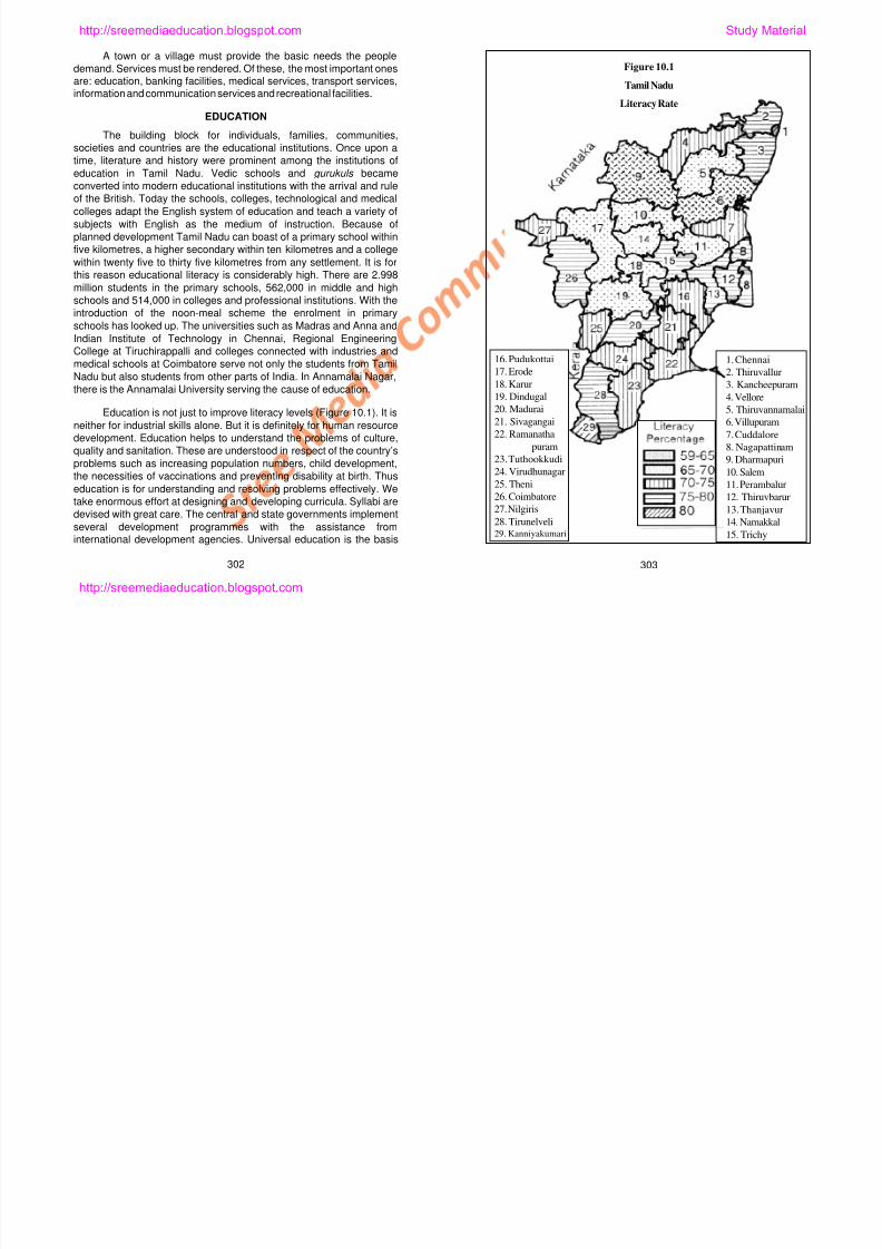
8/6/2019 Social Science History Civics and Geography
http://slidepdf.com/reader/full/social-science-history-civics-and-geography 263/280
Education is not just to improve literacy levels (Figure 10.1). It isneither for industrial skills alone. But it is definitely for human resource
development. Education helps to understand the problems of culture,
quality and sanitation. These are understood in respect of the country’s
problems such as increasing population numbers, child development,
the necessities of vaccinations and preventing disability at birth. Thus
education is for understanding and resolving problems effectively. We
take enormous effort at designing and developing curricula. Syllabi are
devised with great care. The central and state governments implement
several development programmes with the assistance frominternational development agencies. Universal education is the basis
302 303
5. Thiruvannamalai6. Villupuram
7. Cuddalore
8. Nagapattinam
9. Dharmapuri
10. Salem
11. Perambalur
12. Thiruvbarur
13. Thanjavur
14. Namakkal
15. Trichy
20. Madurai21. Sivagangai
22. Ramanatha
puram
23. Tuthookkudi
24. Virudhunagar
25. Theni
26. Coimbatore
27. Nilgiris
28. Tirunelveli29. Kanniyakumari
http://sreemediaeducation.blogspot.com
for the new programme of ‘sarva shiksha abhiyaan’. The National
Cadet Corp and the National Service Scheme in the educationalinstitution imbibe bravery and services in the midst of students.
MEDICAL SERVICES
Tamil Nadu is a socially developed state. Primary health care
services are available within five kilometres of most settlements. Thebirth rate is 20.7 %; the death rate is 8.8% and life expectancy averagesat 60.8 years. The primary health centres and medical services are
generally integrated. The directorates of medical services, familywelfare, primary health centres and medical educational servicesadminister the hospitals. There are 227 government hospitals and 275
dispensaries in the state. For every 30,000 population there is a primaryhealth centre. For every primary health centre there are six sub-centres.
There are micro medical centres and mobile medical units, which cater
to the needs of the villages. Besides curative services, they also offerpreventive, rehabilitative, health and sanitation services. And besides
the Government doctors, the registered practitioners serve the peoplethrough private hospitals and nursing homes and clinics. The allopathicsystem of medicine is widespread and is integrated with siddha,
homeopathic and ayurvedic systems of medicines.
BANKING SERVICES
We do know how important is the capital for economicdevelopment. For investing capitals in economic ventures, the bankingservices in Tamil Nadu render great service. The banks offer financial
assistance to agriculture and cattle farming through governmental
th l ff h i t f i d t i l
for home-work journeys. Transport has fully developed as far as Tamil
Nadu is concerned. Also the transport charges are much smaller when
compared to the rates of other states of the Indian Union.
RAILWAYS
There is rail connection even today between Kashmir and
Kanyakumari, which was first of all laid by the East India Company.In
Tamil Nadu, the rail transport is administered by the Southern
Railways. The trains, which were once operated using steam engines,
are now being operated using diesel and electricity and there are nowvery fast and express trains. Furthermore there are suburban trains
connecting various places in the city. In Tamil Nadu today there are
trains operated using broad, metre and narrow gauges. Metre gauge
tracks are being converted into broad gauge lines. Rail travel is the
cheapest travel for long distances with much comfort.
ROAD TRANSPORT
Road transport in Tamil Nadu connects all big villages with one
another. The roads of the State may be classified as the National
Highways, State Highways, District Roads, rural roads and taluk roads
(Figure 10.2). The National Highways connect the states while the
district roads connect important towns in the state. Roads are being
laid connecting the villages and towns under the Integrated Road
Development Project. The traffic jams are prevented by the
construction of flyovers. Both the Government Transport Corporations
d i t t t ti t d t t ffi i tl
http://sreemediaeducation.blogspot.com Study Material

8/6/2019 Social Science History Civics and Geography
http://slidepdf.com/reader/full/social-science-history-civics-and-geography 264/280
programmes; they also offer such assistance for industrialdevelopment. While co-operative banks are engaged in financial
assistance to the poor, the private and international banking servicesoffer assistance for infrastructures. They are found almost in all big
villages promoting savings and offering financial assistance. Thenational banks and the private and international banks are serving thepeople in a healthy competition among themselves.
TRANSPORT
Transport is an important service. It is important for the growthand development of agriculture, industry, particularly trade, and also
and private transport corporations operate road transport efficiently.And because of the automobile industrial development in the country,the two-wheeler motorbikes and scooters, three-wheeler auto-
rickshaws and four-wheeler cars have increased in numbers.
WATER TRANSPORT
Sea transport is an important service among the water
transports of the State. Commodity and people are transported throughthe ports of Chennai, Nagapattinam and Thoothukudi. And these are
considered as important ports.
304 305
http://sreemediaeducation.blogspot.com
AIR TRANSPORT
The internal and international airlines operate national as well as
international air transport through the airport at Chennai. There are
internal flights to places such as Tiruchirappalli, Coimbatore andMadurai. The one reason for the slow growth of air transport in Tamil
Nadu is primarily due to the expensive seats in the planes.
INFORMATION AND COMMUNICATION SERVICES
Besides transport, information and telecommunications are alsoinvolved in serving the people. Postal and telegraph offices andtelephone exchanges are now serving the nook and corner of Tamil
Nadu. E-mail and internet based telecommunications have growntremendously because of the use of computers on a large scale.
TOURISM AND RECREATION
In Tamil Nadu, centres of tourism, cinema, drama and theatreas well as National Parks are found in good number. It appears thatthe services are also well-developed just as agricultural and industrial
development. Services provide employment for 30 per cent of theworkers.
‘Change’ is the only Constant!
There is
nothing
constant in the world
Figure 10.2
Tamil Nadu
Doctors - Population Ratio
1. Chennai
2. Thiruvallur
3. Kancheepuram
4. Vellore
5 Thiruvannamalai
16. Pudukottai
17. Erode
18. Karur
19. Dindugal
20 Madurai
http://sreemediaeducation.blogspot.com Study Material
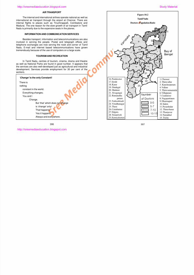
8/6/2019 Social Science History Civics and Geography
http://slidepdf.com/reader/full/social-science-history-civics-and-geography 265/280
constant in the world.Everything changes;
You and I
Change.
But ‘that’ which does not change
is ‘change’ only!
That happens,
Yes it happens,
Always and everywhere.
306 307
5. Thiruvannamalai6. Villupuram
7. Cuddalore
8. Nagapattinam
9. Dharmapuri
10. Salem
11. Perambalur
12. Thiruvbarur
13. Thanjavur
14. Namakkal
15. Trichy
20. Madurai21. Sivagangai
22. Ramanatha
puram
23. Tuthookkudi
24. Virudhunagar
25. Theni
26. Coimbatore
27. Nilgiris
28. Tirunelveli29. Kanniyakumari
http://sreemediaeducation.blogspot.com
DOCTOR-PEOPLE RATIO
Doctor-People ratio is one of the indicators of development in
medical and health services. The smaller the ratio, that is, a smaller
population for every doctor, the better it is. There are possibilities forbetter and proper services, if each doctor serves a small number of
patients. Otherwise, it would be construed as a scarcity of doctors.
A measure of medical services is the number of doctors for
every 100,000 population. In Vellore district there are less than five
doctors to a 100,000 population (Figure 10.3). Yet it is here we have
the world famous Christian Medical College Hospital. It is a private
hospital where people from all over the world, particularly from East
and Southeast Asia come for medical treatment. Dharmapuri,
Villupuram and Kanyakumari districts come next with 5 to 7 doctors
per 100,000 population. In all other districts, this ratio is 7 to 10 doctors
per 100,000, particularly in Erode, Coimbatore, Salem, Namakkal,Dindigul, Theni, Madurai, Virudhunagar, Thirunelveli, Pudukottai,
Tiruchirappalli, Karur, Perambalur, Thanjavur and Thiruvallur districts.
This ratio is very high in the Nilgiris, Thiruvannaamalai,
Ramanathapuram and Thoothukudi districts, at 10 to 15 per 100,000
population.
Know the Facts!
DEVELOPMENT IN TAMIL NADU
When compared with other States, Tamil Nadu occupied the fourth
iti th St t f th I di U i Y t th bi
Figure 10.3
Tamil Nadu
Couple Protection
1. Chennai
2. Thiruvallur
3. Kancheepuram
4. Vellore
5 Thiruvannamalai
16. Pudukottai
17. Erode
18. Karur
19. Dindugal
20 Madurai
http://sreemediaeducation.blogspot.com Study Material
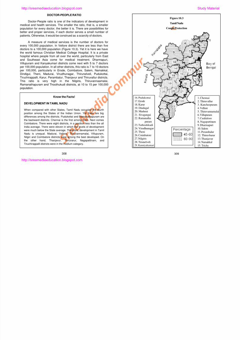
8/6/2019 Social Science History Civics and Geography
http://slidepdf.com/reader/full/social-science-history-civics-and-geography 266/280
position among the States of the Indian Union. Yet there are big
differences among the districts. Pudukottai and Ramanathapuram are
the backward districts. Chennai is the first among them. Next comes
Coimbatore. There were eight districts, in a position less than the all
India average. There were eleven in which the levels of development
were much below the State average. Therefore, development in Tamil
Nadu is unequal. Madurai, Vellore, Thiruvannamalai, Villupuram,
Nilgiri and Coimbatore districts were among the best developed. On
the other hand, Thanjavur, Thiruvarur, Nagapattinam, and
Tiruchirappalli districts were in the medium category.
309308
5. Thiruvannamalai6. Villupuram
7. Cuddalore
8. Nagapattinam
9. Dharmapuri
10. Salem
11. Perambalur
12. Thiruvbarur
13. Thanjavur
14. Namakkal
15. Trichy
20. Madurai21. Sivagangai
22. Ramanatha
puram
23. Tuthookkudi
24. Virudhunagar
25. Theni
26. Coimbatore
27. Nilgiris
28. Tirunelveli29. Kanniyakumari
http://sreemediaeducation.blogspot.com
It is apparent that there are shortages of doctors in several
places. The large number of patients they have to attend to heavilyburdens them. Most doctors are found in towns and cities leaving thevillages with a thin distribution of doctors. This shortage is also felt in
nurses and paramedical personnel as well. It is for this reason there isneed to create an awareness of traditional medical practices in themidst of rural people
FAMILY WELFARE AND COUPLE PROTECTION
Tamil Nadu is next only to Kerala in population growth rate.
Family Welfare has taken root in all places. Yet there was a slide infamily welfare efforts since 1977. Family planning methods are in greatdemand in all districts. Mostly, permanent methods are adopted by the
couples. Families with 3 or 4 children have given way to families with 1or 2 children. Recent estimates indicate as to how many couples are
protected. There are several districts where the protection rate is 45 to60 families per 1000 families. Dindigul, Theni, Madurai,Thiruchirappalli, Karur, Perambalur, Thoothukudi and Vellore aredistricts where this protection is given to 60 to 90 families per 1000
families (Figure 10.4). Yet there are many more couples who areburdened by a big family, even as they are aware of family planningand birth control methods.
It is expected that Tamil Nadu will reach the level of Kerala in a
few years. By 2025, there is every possibility for containing populationgrowth.
ECONOMIC WELFARE
Figure 10.4
Tamil Nadu
Roads
http://sreemediaeducation.blogspot.com Study Material
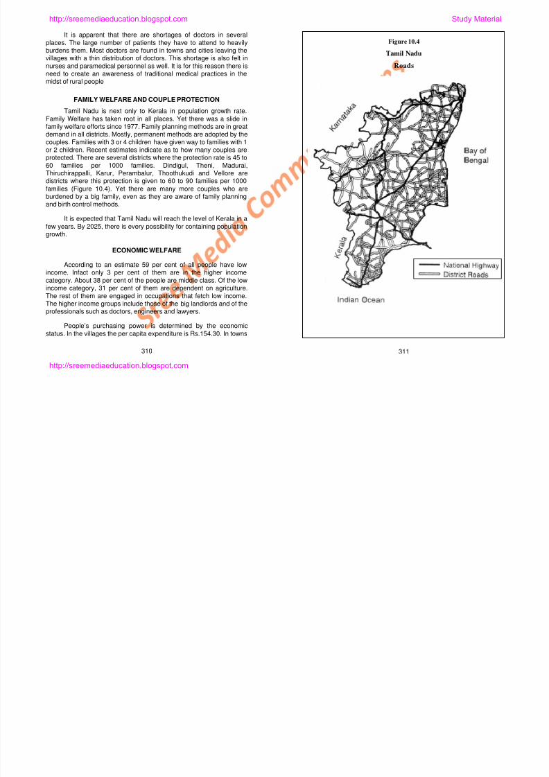
8/6/2019 Social Science History Civics and Geography
http://slidepdf.com/reader/full/social-science-history-civics-and-geography 267/280
310 311
According to an estimate 59 per cent of all people have lowincome. Infact only 3 per cent of them are in the higher income
category. About 38 per cent of the people are middle class. Of the lowincome category, 31 per cent of them are dependent on agriculture.
The rest of them are engaged in occupations that fetch low income.The higher income groups include those of the big landlords and of theprofessionals such as doctors, engineers and lawyers.
People’s purchasing power is determined by the economic
status. In the villages the per capita expenditure is Rs.154.30. In towns
http://sreemediaeducation.blogspot.com
it is Rs.248 per person. Estimates have it that 25 per cent of the
people consume 14 per cent of the consumer products, 25 per cent ofthe people consume 50 per cent of the consumer products and 50 percent of the people consume 36 per cent of the consumer products.
Considered in terms of development Ramanathapuram and
Pudukkottai districts show low levels of development, while Chennaiand Coimbatore show very high levels of development. The per capitaincome is Rs.2,359. This is slightly higher than the average Indian per
capita.
The Tamil Nadu government has enabled the people tounderstand health awareness and family welfare plan through informaleducation. As a consequence, the birth rate in Tamil Nadu has been
reduced considerably. Nearly 98 per cent of the mothers have realisedthe importance of vaccination. Polio drops have been administered to
all children.
Most schools are within 1 to 2 km to any settlement. Medicalfacilities are available within 5 km. But the school teachers and
medical doctors are in short supply. Therefore, it is difficult to say thateconomic welfare in Tamil Nadu is good. Yet Tamil Nadu maybe amodel state for many other states in the country. There is every hope
that a good growth rate will be registered in the not- too distant future.
SELF-EVALUATION
I. Fill in the Blanks
1. A primary health centre is set up at ______________ km to asettlement.
2. Services provide employment for ______________ per cent of
people in Tamil Nadu.
3. About ____________ per cent of the people live below poverty
line in the urban areas.
4. The people with very low income constitute _____________ per
cent in Tamil Nadu.
5. Everyone must have education by the year ______________ is
the priority of the Government.
II. Match the Following
1. Rail Transport – Buckingham Canal
2. National Parks – Financial Assistance
3. Banks – Birds/Animals
4. Water Transport – Chennai
5. Airport – Broad gauge
http://sreemediaeducation.blogspot.com Study Material
8/6/2019 Social Science History Civics and Geography
http://slidepdf.com/reader/full/social-science-history-civics-and-geography 268/280
III. Answer Briefly
1. What are the basic needs of human life?
2. The sources of educational institutional growth – Discuss.
3. Write briefly about health traditions.
4. What is meant by recreation?
5. Write about air transport.
312 313
http://sreemediaeducation.blogspot.com
IV. Answer in Detail
1. Write an essay on economic welfare.
2. Write an essay on the different classes of roads.
3. Write an essay either on banking services or on medicalservices.
V. Practical Exercises
1. Take boys and girls on a trip to the neighbourhood servicecentres and make them take notes to be discussed in theclassroom later.
2. Invite an expert to discuss the salient features of the serviceswith the students.
http://sreemediaeducation.blogspot.com Study Material
8/6/2019 Social Science History Civics and Geography
http://slidepdf.com/reader/full/social-science-history-civics-and-geography 269/280
314
http://sreemediaeducation.blogspot.com
Lesson 11
GEOGRAPHY PRACTICAL
Learning Outcomes
1. Learning skills to identify landscape features from contour
diagrams.
2. Learning skills to draw diagrammatic representations.
Practical geography is introduced for the first time in your
geography syllabus. As practical geography will be dealt withelaborately in the next class, it is now being introduced. This lesson is
written, with a view to demonstrate how practical exercises can be
accomplished. There are ten exercises, with 6 in contour diagrams and
4 diagrammatic representations. If it is done as an exercise each for a
month, they will all be completed in the course of the academic year. It
is not enough to learn how to draw them. Why are they drawn must
also be understood. It is important also to learn the skills and methods
to draw them.
Cartography is both a science and art of drawing maps and
diagrams. In fact, drawing diagrams is an art. Even though everyone
could draw them, it should be drawn with care, patience and
http://sreemediaeducation.blogspot.com Study Material
8/6/2019 Social Science History Civics and Geography
http://slidepdf.com/reader/full/social-science-history-civics-and-geography 270/280
, , paesthetics. As only a few simple instruments are used in drawing them,
it is necessary to pay greater attention to the drawing.
Drawing diagrams is a skill. Students of geography must acquire
skills in the art of drawing. Unlike in other subjects, maps and
diagrams are important in the study of geography. There are
professionals in other disciplines who now use maps and diagrams
taking geographers as their inspiration. So it is important for us to
know the usefulness of the maps and diagrams and learn the
necessary skills.
315
http://sreemediaeducation.blogspot.com
CONTOUR DIAGRAMS
You have of course seen maps. You may have seen the Survey
of India toposheets or topographical maps. These maps show our
country accurately. All maps are drawn after careful and propersurveys. They are also updated from time to time to show changes
and to represent new landscapes that may have appeared.
Earlier on, it was often difficult and time consuming to draw
maps. Today, because of the technological advancements -
improvements in drawing methods, information sources and computer
and other instrumental uses - it has now become easy to draw maps.
In addition, there are opportunities to draw them in colour and with
aesthetic appeals.
You have learnt geomorphology last year, in your eighth
standard. You have therefore learnt how landforms appear due toerosion of land. In this Class, you shall learn how those features are
shown on the maps.
Those of you who have already seen topographical maps would
know that contours are used to show landforms. The brown winding
lines that are drawn on the maps are indeed the contour lines.
What is meant by contour? The meaning of it that it is a line
connecting all places having equal height. An important feature of this
line is that all heights are with reference to the mean sea level.
Landforms have some significant characteristics. One such is their
height. Slope, direction and distance are other special features of the
landforms. It is possible for us to know and measure all of these from
3. Importantly, it is good know how a cross section of the
contours may be drawn to understand the feature they show.
If we take examples to elaborate on the drawing, it would be
easy to understand. Six important contour diagrams are given belowand they are:
1. Steep slope.
2. Gentle slope.
3. V-shaped Valley.
4. Knoll.
5. Ridge and the saddle.
6. Plateau.
STEEP AND GENTLE SLOPES
Slopes of the landscapes are varied. Particularly two such
slopes are easy to understand. Steep slope is a vertical climb whereas
gentle slope is a gradual climb. If you were a person who climbed a
mountain or hill, you would immediately know what is steep slope and
what is gentle slope. If it is difficult or hindered then it may be a steep
slope. But if it is easy to clime then it may be construed as a gentle
slope.
Figures 11.1 and 11.2 are drawn to show steep and gentle
slopes. It is easy to draw their cross sections using the line A and B as
the base. The contours in the accompanying figures are not complete
http://sreemediaeducation.blogspot.com Study Material
8/6/2019 Social Science History Civics and Geography
http://slidepdf.com/reader/full/social-science-history-civics-and-geography 271/280
pthe contour lines on the maps. In drawing contour diagrams, there is
need to understand some points.
1. The contour lines are normally shown in brown on colour
maps.
2. It is not possible for all of us to straightaway imagine the land
features. It is important to know at what intervals they are
drawn, in what direction they bend and how closely and
farther apart they are drawn.
p y g g p
contours. They are just a part of the contours. The contours for gentle
slope are drawn with greater intervals between them.
Contours drawn close to each other show the quick climb of the
heights while contours drawn farther apart show the slow climb of
heights. The cross sections show them very well.
Drawing cross sections of contours is indeed easy. If we draw
them step by step, they would have good appearance. To draw a
cross section, we must draw a graph (horizontal lines limited by two
316 317
http://sreemediaeducation.blogspot.com
Figure 11.1
Contour Diagram
a b
M e t e r
Figure 11.2
Gentle Slope
a b
M e t e r
Steep Slope
Steep Slope
Gentle Slope
http://sreemediaeducation.blogspot.com Study Material
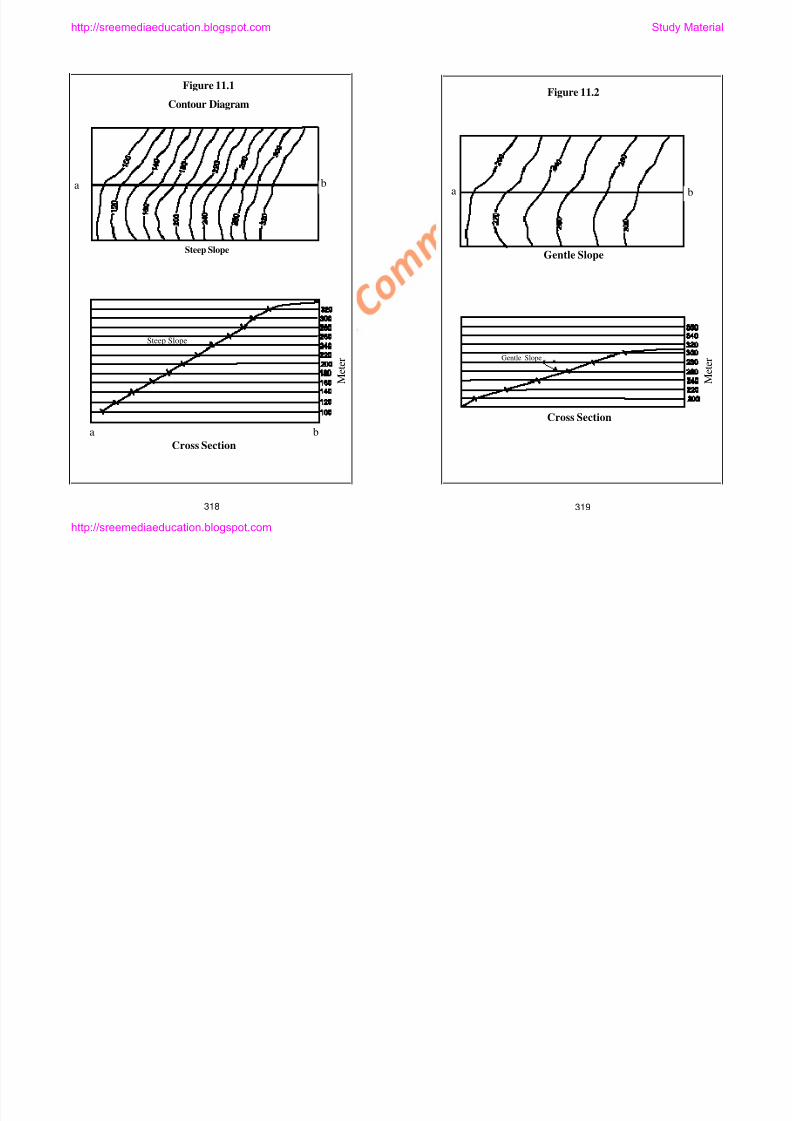
8/6/2019 Social Science History Civics and Geography
http://slidepdf.com/reader/full/social-science-history-civics-and-geography 272/280
318 319
a b
Cross Section
M
Cross Section
M
http://sreemediaeducation.blogspot.com
vertical lines on either side). Horizontal lines could be as many as
there are contours in the diagram. It is important to draw horizontallines to help exaggerate the heights. The interval between thehorizontal line may depend on the nature of the landscape the
contours represent. If the height of the feature is small, the intervalcould be small and vice versa. But to exaggerate the heights highly willnot be appropriate nor will it be aesthetic.
If we draw the contour diagrams as shown below it would be goodto look at and understand the features better.
On having drawn the graph, place the edge of a paper along theline AB and mark all the contours cutting the line AB on the contour
diagram, marking without fail the value of the contour crossings on thepaper.
Then, the paper with the contour markings may be used to mark
the heights on appropriate horizontal lines on the graph. It is importantto see that heights are marked such that they are increasingprogressively from below. Remember that while marking the contour
values on the graph, place the edge of the marked paper on the lasthorizontal line and then move the paper slowly upward even as youmark the contour crossings. Once the contour crossings are marked
on the graph, take away the paper and then draw the cross sectioncarefully so as to be appropriate for the feature represented. This isthe simple procedure that may be adhered to in the drawing of the
cross sections and in the checking for the appropriateness of the crosssection to the feature represented by the contour diagram.
Your teacher will not only demonstratively draw some contours
on the board or even show entire diagrams on the board for you. It isibili l h kill f ll I i i h
a
b
Figure 11.3
V - Shaped Valley
Valley
http://sreemediaeducation.blogspot.com Study Material
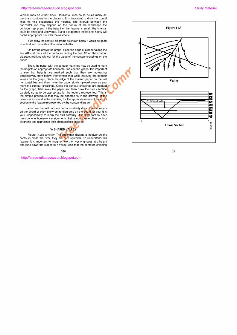
8/6/2019 Social Science History Civics and Geography
http://slidepdf.com/reader/full/social-science-history-civics-and-geography 273/280
your responsibility to learn the skill carefully. It is important to havethem done as homework assignments. Let us now turn to other contour
diagrams and appreciate their characteristic features.
V- SHAPED VALLEY
Figure 11.3 is a valley. The arrow that zigzags is the river. As thecontours cross the river, they are bent upwards. To understand this
feature, it is important to imagine how the river originates at a heightand runs down the slopes to a valley. And that the contours crossing
320 321
M e t e ra b
Cross Section
http://sreemediaeducation.blogspot.com
the valley goes up on one side and comes down on the other side. That
is, the contours representing the valley are shown as bending upwards
along the river. The cross section of the river valley could be drawn using
the same step-by-step procedure given above. The cross section will
show the valley as a V-shaped valley. That is what you also see in thefigure. It is important to keep in mind the fact that V-shaped valleys are
normally found in the youth stage of the river erosion.
KNOLL
Figure 11.4 is a special feature. It is something that the people
who had travelled in a mountain country had seen. When there is a
small hillock by the side of a high hill, how would the contours look? As
you see in the accompanying diagram, there will be a few circular
contours for the hillock and more contours for the high hill. Normally,
the contours are elliptical rather than circular for such features. Note
the cross section showing the knoll, with a small hillock at the side of a
high hill.
RIDGE WITH SADDLE
Figure 11.5 show contours that are slightly different from those
of the knoll. In this landform, there is gap between two hills of almost
same height. The two hills have almost the same appearance but they
have a small difference in heights. The cross section looks like the
saddle of a horse. Hence this feature is said to be a ridge with a
saddle.
PLATEAU
a b
Figure 11.4
Knoll
http://sreemediaeducation.blogspot.com Study Material
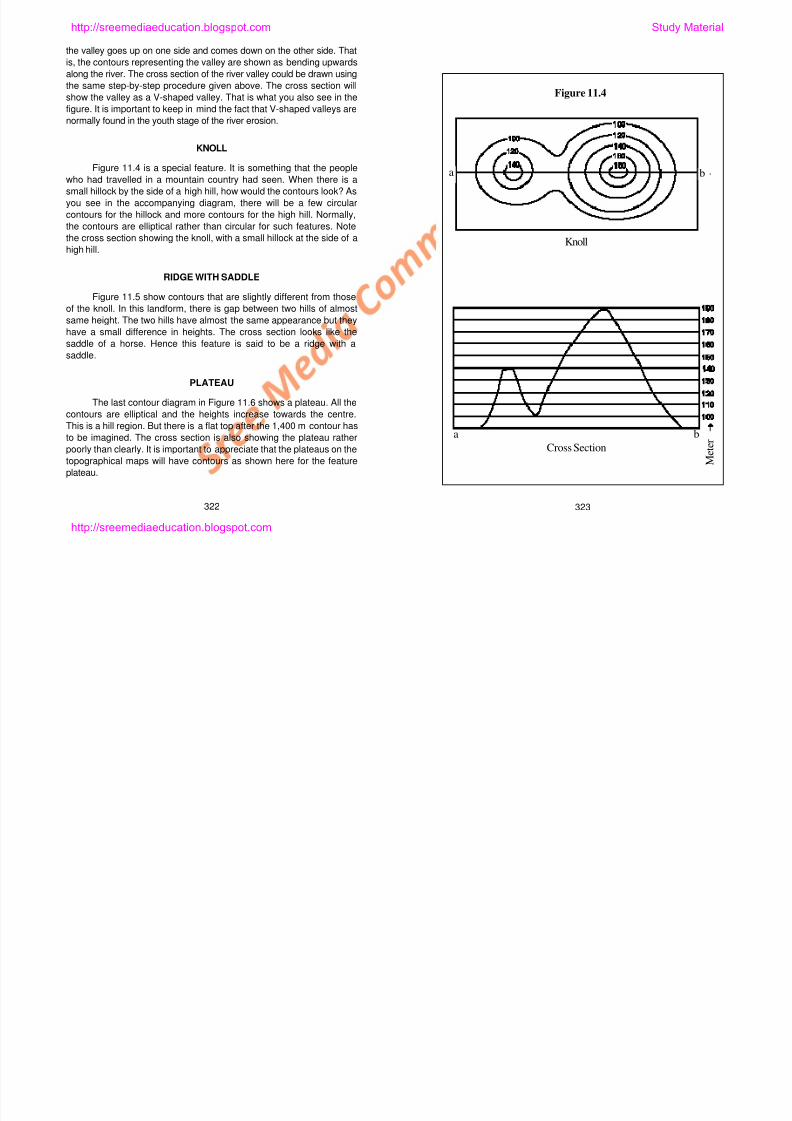
8/6/2019 Social Science History Civics and Geography
http://slidepdf.com/reader/full/social-science-history-civics-and-geography 274/280
PLATEAU
The last contour diagram in Figure 11.6 shows a plateau. All the
contours are elliptical and the heights increase towards the centre.
This is a hill region. But there is a flat top after the 1,400 m contour has
to be imagined. The cross section is also showing the plateau rather
poorly than clearly. It is important to appreciate that the plateaus on the
topographical maps will have contours as shown here for the feature
plateau.
322 323
M e t e r
a b
Cross Section
http://sreemediaeducation.blogspot.com
It is good to practice contour diagrams. It is also necessary to
look at the maps and draw various other features and understand howthey look when drawn in cross sections. This will give you a skill thatyou could use sometime later.
DIAGRAMMATIC REPRESENTATIONS
The diagrammatic representations are drawn in a way the
statistical data can be understood easily. These diagrams are in muchuse in geography, statistics and economics. The diagrams are chosenon the basis of their appropriateness to the data. Although there are
several diagrammatic representations that can be shown, the onesshown may be learned to draw and use in interpretations.
LINE GRAPHS
To draw line graphs we need to sets of data. They are mostlytime series data. In this method, time is represented on the horizontal
axis while attribute data are represented along the vertical axis; andthe line may be drawn using points along the horizontal and verticalaxes and joining the two values. Time series data such as those of
average monthly or annual temperature, rainfall, population growth andproduction of crops or commodities over the years can be representedby line graphs. This diagram can be drawn easily and without any
mistake. Figure 11.7 shows the density of population (populationnumbers / area in km2) as a line graph.
BAR DIAGRAM
This is also draw to show some data. The bars are of certain
a b
Figure 11.5
Ridge and Saddle
Ridge
Saddle
http://sreemediaeducation.blogspot.com Study Material
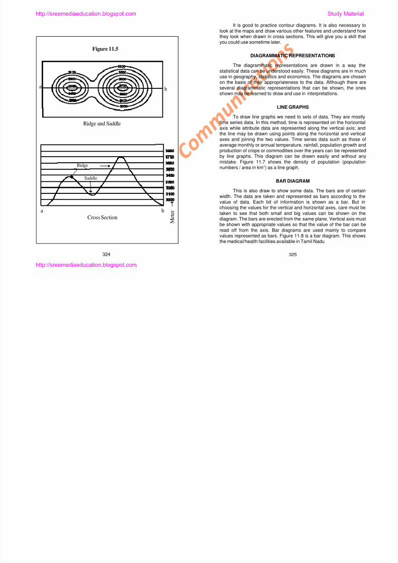
8/6/2019 Social Science History Civics and Geography
http://slidepdf.com/reader/full/social-science-history-civics-and-geography 275/280
width. The data are taken and represented as bars according to thevalue of data. Each bit of information is shown as a bar. But inchoosing the values for the vertical and horizontal axes, care must be
taken to see that both small and big values can be shown on thediagram. The bars are erected from the same plane. Vertical axis mustbe shown with appropriate values so that the value of the bar can be
read off from the axis. Bar diagrams are used mainly to comparevalues represented as bars. Figure 11.8 is a bar diagram. This showsthe medical/health facilities available in Tamil Nadu.
324 325
M e t e ra b
Cross Section
http://sreemediaeducation.blogspot.com
PIE DIAGRAM
In this method, a circle may be drawn on a sheet of paperconsidering the length and breadth of the paper. The data given in the
array must be totalled. As the circle represents 360o
, the total must betaken to represent the entire circle. If the total equals 360o, then whateach of the data represents must be computed. Then using thedegrees computed, the circle may be divided appropriately to
represent each of the values. This digram is called a pie diagram. It isappropriate to show the land uses data and also data that representproduction levels of commodities.
Figure 11.9 is however drawn using a computer graphical
software. It is good to try drawing the pie chart manually. This diagramis drawn to compare the production of certain crops.
PICTORIAL DIAGRAMS
Statistical data can be shown as pictorial diagrams. It is possibleto assume picture such as a gunny bag to show certain quantity of
grain production and draw as many gunny bags as necessary toindicate total production of grains. We may even draw half or quarter ofa gunny bag to show appropriate productions. Human pictures may be
used to show population data. Likewise the vehicular production maybe shown using the pictures of vehicles and production levelscompared. It is good to have the skills of an artist. These diagrams are
easily understood.
When drawing manually it is possible to use appropriate pictorial
forms. Figure 11.10 has been drawn using a computer software andhence a picture available from the software has been used. Fish
Plateau
Plateau
a b
Figure 11.6
http://sreemediaeducation.blogspot.com Study Material
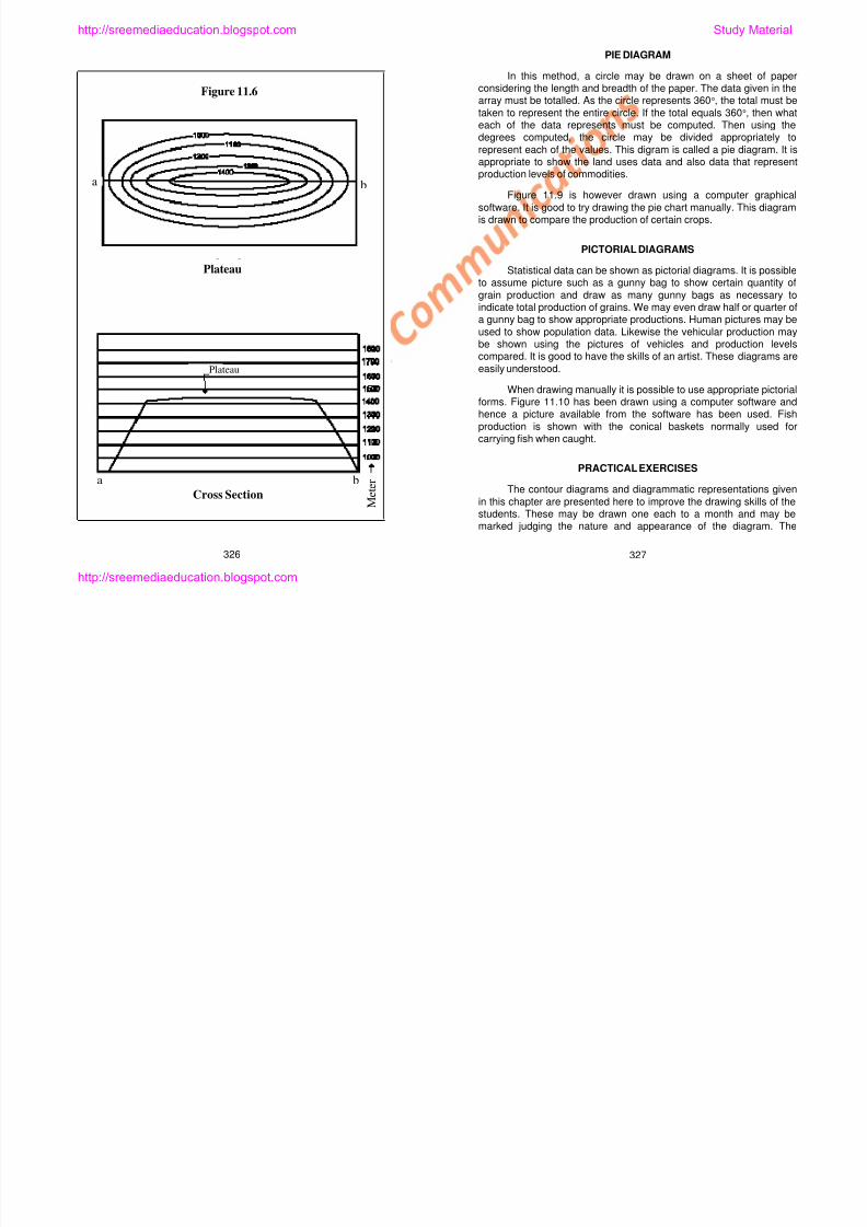
8/6/2019 Social Science History Civics and Geography
http://slidepdf.com/reader/full/social-science-history-civics-and-geography 276/280
production is shown with the conical baskets normally used forcarrying fish when caught.
PRACTICAL EXERCISES
The contour diagrams and diagrammatic representations given
in this chapter are presented here to improve the drawing skills of thestudents. These may be drawn one each to a month and may bemarked judging the nature and appearance of the diagram. The
326 327
M e t e ra b
Cross Section
http://sreemediaeducation.blogspot.com
3 2 8
Figure 11.7 Population Density 1901 - 2001
Year
Number /
sq.km
http://sreemediaeducation.blogspot.com Study Material
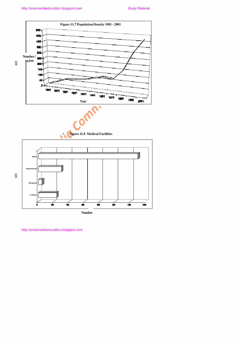
8/6/2019 Social Science History Civics and Geography
http://slidepdf.com/reader/full/social-science-history-civics-and-geography 277/280
Figure 11.8 Medical Facilities
PHCs
Dispensaries
3 3 0
Figure 11.9 Crop Production
12%
54%
34%
Pulses Paddy Other Grains
http://sreemediaeducation.blogspot.com Study Material
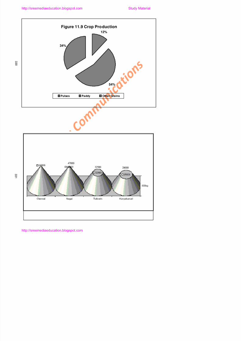
8/6/2019 Social Science History Civics and Geography
http://slidepdf.com/reader/full/social-science-history-civics-and-geography 278/280
Figure 11.10 Fish Production
47000
32500 28000
teachers may also introduce to students other diagrams and
representations so that the students are able to acquire and improvetheir skills. Practical exercises require that care and thinking is given toexecute them with aesthetics. If the girls and boys realise the need to
learn these, they can acquire and improve their skills in drawing.
SELF-EVALUATION
I. Fill in the Blanks
1. The lines that join places of same height is called the
___________ lines.
2. The ___________ ____________ of the contour diagrams willhelp us appreciate the landscapes.
3. Graphical representations relate generally to _____ series data.
4. Pie charts are good for understanding ____________.
5. Pictorial diagrams requires skills such as __________.
II. Match the Following
1. Gentle slope – Time series data
2. Pie charts – Contours are closer together
3. Bar diagrams – Space series data
4. Steep slope – Rainfall data
5. Line graphs – Contours are farther apart
III. Answer Briefly
1. What are meant by contours?
2. What is the usefulness of the contours?
3. Draw contours to show any land feature.
http://sreemediaeducation.blogspot.com Study Material

8/6/2019 Social Science History Civics and Geography
http://slidepdf.com/reader/full/social-science-history-civics-and-geography 279/280
4. What are the uses of diagrammatic representations?
5. Write about the usefulness of bar diagrams.
IV. Answer in Detail
1. Describe the importance of line graphs by drawing one.
2. Draw the contour diagram for the ridge and saddle and describe.
333332
http://sreemediaeducation.blogspot.com
3. Using the central theme of your lesson, describe the importance
of practical geography.
V. Practical Exercises
1. Taking advice and guidance from the teachers, students drawwall hangs of contour diagrams and their cross sections.
2. Visit the nearest hills / hill area to learn how to draw the features
found their into contour diagrams.
http://sreemediaeducation.blogspot.com Study Material
8/6/2019 Social Science History Civics and Geography
http://slidepdf.com/reader/full/social-science-history-civics-and-geography 280/280
334
http://sreemediaeducation.blogspot.com