Embed Size (px)
Citation preview
This article was downloaded by: [University of Western Ontario]On: 08 October 2014, At: 02:38Publisher: Taylor & FrancisInforma Ltd Registered in England and Wales Registered Number: 1072954 Registeredoffice: Mortimer House, 37-41 Mortimer Street, London W1T 3JH, UK
Australasian Journal of EnvironmentalManagementPublication details, including instructions for authors andsubscription information:http://www.tandfonline.com/loi/tjem20
Socio-ecological value of wetlands:the dilemma of balancing human andecological water needsM.L.M. Graymore a & D. McBride ba Horsham Campus Research Precinct , University of Ballarat ,Horsham , Australiab Water in Drylands Collaborative Research Program (WIDCORP)University of Ballarat , Horsham , AustraliaPublished online: 01 Aug 2013.
To cite this article: M.L.M. Graymore & D. McBride (2013) Socio-ecological value of wetlands: thedilemma of balancing human and ecological water needs, Australasian Journal of EnvironmentalManagement, 20:3, 225-241, DOI: 10.1080/14486563.2013.816252
To link to this article: http://dx.doi.org/10.1080/14486563.2013.816252
PLEASE SCROLL DOWN FOR ARTICLE
Taylor & Francis makes every effort to ensure the accuracy of all the information (the“Content”) contained in the publications on our platform. However, Taylor & Francis,our agents, and our licensors make no representations or warranties whatsoever as tothe accuracy, completeness, or suitability for any purpose of the Content. Any opinionsand views expressed in this publication are the opinions and views of the authors,and are not the views of or endorsed by Taylor & Francis. The accuracy of the Contentshould not be relied upon and should be independently verified with primary sourcesof information. Taylor and Francis shall not be liable for any losses, actions, claims,proceedings, demands, costs, expenses, damages, and other liabilities whatsoever orhowsoever caused arising directly or indirectly in connection with, in relation to or arisingout of the use of the Content.
This article may be used for research, teaching, and private study purposes. Anysubstantial or systematic reproduction, redistribution, reselling, loan, sub-licensing,systematic supply, or distribution in any form to anyone is expressly forbidden. Terms &

Conditions of access and use can be found at http://www.tandfonline.com/page/terms-and-conditions
Dow
nloa
ded
by [
Uni
vers
ity o
f W
este
rn O
ntar
io]
at 0
2:38
08
Oct
ober
201
4
Socio-ecological value of wetlands: the dilemma of balancing human andecological water needs
M.L.M. Graymorea* and D. McBrideb
aHorsham Campus Research Precinct, University of Ballarat, Horsham, Australia; bWater inDrylands Collaborative Research Program (WIDCORP)University of Ballarat, Horsham,Australia
Humans’ need for water has changed flow regimes, degraded ecosystems anddepleted water resources. In the Wimmera Mallee in Victoria, the dilemmabetween human and ecological water requirements began in the colonial era whena channel and dam system was built to transport water. Prolonged droughtprompted government to replace this with the Wimmera Mallee Pipeline. Thispipeline produced a closed system, reducing water available for the environment,including on-farm wetlands. This study identifies the socio-ecological values ofon-farm wetlands and the impact the changed water regime had on these. Aninterpretative landscape approach was used to integrate geophysical, ecologicaland social information on nine on-farm wetlands. This identified a range of socio-ecological values on-farm wetlands provide, including aesthetic, amenity,production and biodiversity, that are impacted by the pipeline system. A rangeof implications for on-farm wetland management were also identified.
Keywords: floodplain wetlands; on-farm wetland management; changing waterregime; interpretative landscape approach
Introduction
In Australia, from the first European settlement, the need for water has led to the
engineering of waterways. Over time, this has changed the landscape and degraded
natural waterways, particularly in floodplains. Most Australian inland wetlands are
located on floodplains in arid or semi-arid areas subject to intermittent rainfall
punctuated by episodic flood events. Accordingly, these wetlands are unique in that
their biota and ecological processes rely on the ‘boom and bust’ regime of alternating
flood and drought (Jenkins et al. 2005). The life-cycles of arid-zone wetland biota are
linked to flood pulses with the breeding of fish, waterbirds, frogs and other species, as
well as seed production of fringing vegetation triggered by flood inundation (Junk
et al. 1989; Reid & Brooks 2000). However, the majority of these ephemeral
floodplain wetlands have been impacted by modified water regimes through river
regulation, extraction for irrigation and domestic supply that have altered the flood-
drought cycle (Bunn et al. 1996; Kingsford, 2000; Jenkins et al. 2005). Furthermore,
they have been heavily impacted by agriculture, through cropping, grazing, draining
or filling, and through pollution from catchment runoff (Jenkins et al. 2005).
*Corresponding author. Email: [email protected]
Australasian Journal of Environmental Management, 2013
Vol. 20, No. 3, 225�241, http://dx.doi.org/10.1080/14486563.2013.816252
# 2013 Environment Institute of Australia and New Zealand Inc.
Dow
nloa
ded
by [
Uni
vers
ity o
f W
este
rn O
ntar
io]
at 0
2:38
08
Oct
ober
201
4
Serious concerns for the loss and degradation of wetlands worldwide are well-
documented, as this has resulted in a range of impacts on ecosystem health and
functioning (Finlayson & Rea 1999; Bren & Sandall 2004; Swanepoel & Barnard
2007). Yet wetlands play important roles in the ecological and social systems, providinga range of ecosystem functions (such as habitat for migratory birds and frogs, seed
banks, watering holes for fauna and nutrient cycling) and social and recreational
opportunities (including swimming, fishing, a place for contemplation and bird
watching; Finlayson et al. 2005). The value of wetlands, that is the range of functions
and benefits they provide for both ecosystem and human wellbeing (Daily 1997), has
not been well-documented. This applies particularly to floodplain wetlands which are
vulnerable to changes in flow regimes (Bunn & Arthington 2002). Decision makers
have not taken into account the impact of changes in flow regimes on wetlands(De Groot et al. 2006). This article aims to answer the questions: 1) What are the social
and ecological values of on-farm floodplain wetlands? and 2) How do these values
change with a change in flow regime? The Wimmera Mallee, in western Victoria, was
chosen as a case study to answer these questions, as this region was undergoing a
major change in water regimes.
In the Wimmera Mallee, the dilemma of balancing human and ecological water
requirements began in the colonial era with the development of the Wimmera Mallee
Stock and Domestic Supply System (WMSDSS), a regulated channel and dam waterdelivery system (called channel system here) to supply farms and towns from
headwater storages. For over a century, this network of channels and dams was an
integrated feature of the Wimmera Mallee landscape. Although this changed the
natural landscape, this system provided a water source for people, flora and fauna.
Prolonged drought prompted the government to build the Wimmera Mallee
Pipeline (WMP) between 2006 and 2010 to replace the channel system, minimising
the loss of water from seepage and evaporation which occurred with the WMSDSS.
As the pipeline is a closed system, it significantly reduced water in the environment,including for on-farm wetlands. Yet, on-farm wetlands play a vital role in the lives of
farmers, their families and communities, providing a space for recreational and social
activity, such as family gatherings, boating, barbeques, fishing and yabbying
(McManamey 2009), as well as habitats for birds, frogs and flora (Reid & Brooks
2000; Jenkins et al. 2005). The piped water delivery system is therefore likely to have
many impacts on the social and ecological condition of the region. Thus, this article
aims to identify the social and ecological values of on-farm wetlands in the Wimmera
Mallee, and how these values are affected by a changed water regime to understandthe impact that changing water regimes has on social and ecological values of on-
farm floodplain wetlands.
Water reform in the Wimmera Mallee
In Australia, the National Water Initiative (NWI) instigated major water reforms
that are driving significant surface water distribution changes across the landscape
(National Water Commission 2007). Victorian water policy advocates integratedwater management strategies and water regime developments, like the WMP, as
innovative water saving measures to secure future water supplies for people and the
environment (DSE 2004a). Based on the water savings produced by the pipeline
(estimated to be 103,000 ML; SKM 2001; DSE 2004a), the Victorian government
226 M.L.M. Graymore and D. McBride
Dow
nloa
ded
by [
Uni
vers
ity o
f W
este
rn O
ntar
io]
at 0
2:38
08
Oct
ober
201
4
established a bulk water entitlement specifically to provide healthy aquatic
ecosystems. In the Wimmera region this water entitlement specifies that the
Wimmera and Glenelg Rivers receive an Environmental Water Allocation (EWA)
from the proposed pipeline savings to be managed by local Catchment ManagementAuthorities (CMA).
The amount of water available for EWA is determined by GWMWater (the local
water corporation). However, in Victoria the waterways which receive an EWA are
prioritised based on the size and location of waterways, with major rivers receiving
an EWA over minor waterways and large public wetlands before small on-farm
floodplain wetlands. Further, wetlands listed as significant by Ramsar or similar lists
also have priority access to EWAs. Thus, small rivers, floodplains and wetlands are
not provided with an allocation. This is likely to reduce biodiversity within naturalfloodplain areas (Bunn & Arthington 2002) once a channel system is decommis-
sioned, with potential consequences for the socio-ecological values of waterways
such as on-farm floodplain wetlands.
Further, water harvesting practices in the higher rainfall regions of the Pyrenees,
Grampians and Black Ranges reduce rainfall runoff into the Wimmera region that
previously replenished ephemeral wetlands in this lower annual rainfall area,
particularly during episodic flood events. Thus, although the WMP system will
ensure water security for people living in the Wimmera Mallee, it will continue toreduce water availability for floodplain wetlands in the region.
Changing water regimes in the Wimmera
The WMP and channel system represent large-scale landscape hydrological changes.
Prior to the construction of the WMSDSS at the turn of the century, the ephemeral
floodplain wetlands consisted of small freshwater lakes, meadows, swamps, gilgais
(small ephemeral lakes formed in depressions), sinks and water holes situated innatural drainage lines and depression areas that captured runoff during episodic
rainfall events.
The WMSDSS was the first regional hydrological change in the Wimmera. The
WMSDSS consisted of an extensive network of headwater storages, gravity-fed
channels and dams that distributed water across the floodplain. Consequently, the
WMSDSS altered natural floodplain hydrology, reducing floodplain runoff and
altered timing and volume of flow events through the ecosystem.
The Yarriambiack Creek floodplain wetlands, the case study area for this article,are located in the low-lying or depression areas where runoff collects, making them
ideal locations for on-farm dams. Surface water in these wetlands increased by the
filling and sometimes the overflowing of the channels or farm dams. Seepage derived
from the channels and dams also contributed to soil moisture. For over a century,
associated wetland floristic communities, fauna and seasonal migratory waterbirds
have adapted to the channel system surface water sources and high seepage rates in
this highly modified regional water regime.
With the introduction of a reticulated piped water delivery system, headwaterharvesting and regulation of the natural watercourses will continue. The decom-
missioning of the channels means the end of regular annual floodplain seepage and
surface water sources that came with annual channel runs. During the public
consultation phase for the WMP, farmers expressed concern regarding future water
Australasian Journal of Environmental Management 227
Dow
nloa
ded
by [
Uni
vers
ity o
f W
este
rn O
ntar
io]
at 0
2:38
08
Oct
ober
201
4

sources for flora and fauna and for recreation. Whilst most agreed that the
evaporation and seepage loss of water from the system was unsustainable, the loss
of free water for floodplain ecosystems and recreation when the channels and dams
are decommissioned was recognised as an issue for the socio-ecological landscape of
the region. The main issues raised were about the loss of biodiversity and habitat,
and the loss of dams on farm for recreation and amenity (Letts 2003; Arthur 2004;
Barber 2004). Understanding the impact of this changed water regime is therefore
vital for developing management strategies to reduce the socio-ecological impacts on
floodplain wetlands and their associated communities.This story is one that continues to be replicated in many arid to semi-arid areas in
Australia, where water scarcity is driving similar water reforms to ensure water for
communities. Therefore, this case study will provide some insight into the impact
water reforms can have on the values of on-farm wetlands to help decision makers
consider the full impact of water reform decisions and water management policies.
Thus, the aim of this study was to identify the social and ecological values of on-
farm wetlands and investigate the impact the changed water regime had on these
values for the Yarriambiack Creek floodplain in the Wimmera Mallee. To do this, an
interpretative landscape approach was used which synthesises, integrates and
spatially analyses geophysical, ecological and social information from maps, farmer
interviews, field observations and secondary data.
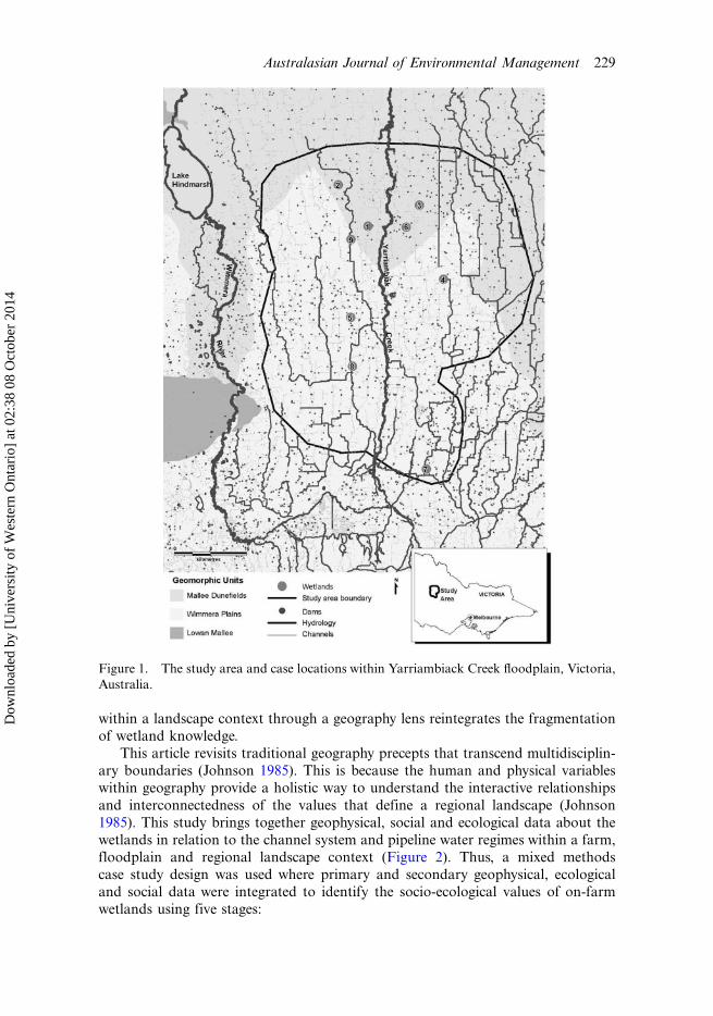
The study area
The study area is located on the Yarriambiack Creek floodplain (Figure 1) in the
Wimmera River Basin in Victoria. The Yarriambiack Creek floodplain wetland
system is within the management jurisdiction of both the Wimmera CMA (WCMA)
and GWMWater. The floodplain is a sparsely populated broadacre agrarian
landscape, characterised by small wetland areas with remnant Eucalyptus largiflorens
(Black Box) woodlands. These wetlands have varying degrees of connectivity to the
channel system.
Within the study area, nine wetland areas on freehold agricultural land wereselected as cases for this study. These wetlands are examples of the smallest landscape
scale within an ecosystem (Kratochwil 1999). In this article, a wetland is considered
as a small fragmented topographic low-lying, or depression floodplain area, subject
to inundation.
The method used for this study was holistic, examining the geophysical, social
and ecological operations within, and interactions between, the landscape scales
within a regional system. The wetland, farm, floodplain and region scales were
selected, as each of these scales have geophysical, social and ecological degrees of
conformity within the regional water management context.
Method
Adopting a geophysical, social and ecological regional interpretative landscape
approach provides a holistic context for understanding wetland socio-ecological
values and water regime influences within a floodplain and regional context. As
current knowledge of wetlands is diverse and fragmented, understanding wetlands
228 M.L.M. Graymore and D. McBride
Dow
nloa
ded
by [
Uni
vers
ity o
f W
este
rn O
ntar
io]
at 0
2:38
08
Oct
ober
201
4
within a landscape context through a geography lens reintegrates the fragmentation
of wetland knowledge.
This article revisits traditional geography precepts that transcend multidisciplin-
ary boundaries (Johnson 1985). This is because the human and physical variables
within geography provide a holistic way to understand the interactive relationships
and interconnectedness of the values that define a regional landscape (Johnson
1985). This study brings together geophysical, social and ecological data about the
wetlands in relation to the channel system and pipeline water regimes within a farm,
floodplain and regional landscape context (Figure 2). Thus, a mixed methods
case study design was used where primary and secondary geophysical, ecological
and social data were integrated to identify the socio-ecological values of on-farm
wetlands using five stages:
Figure 1. The study area and case locations within Yarriambiack Creek floodplain, Victoria,
Australia.
Australasian Journal of Environmental Management 229
Dow
nloa
ded
by [
Uni
vers
ity o
f W
este
rn O
ntar
io]
at 0
2:38
08
Oct
ober
201
4
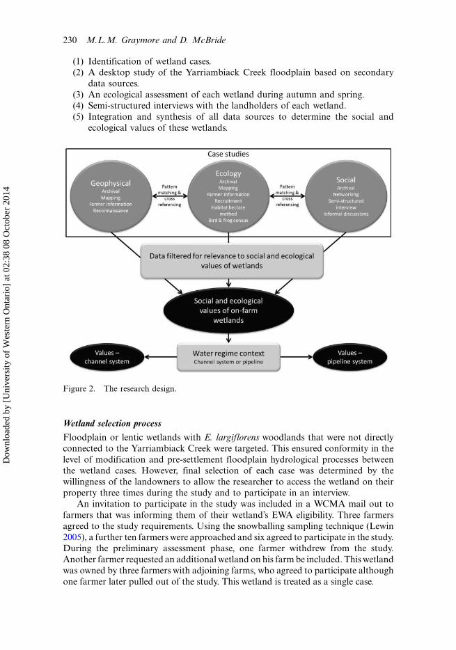
(1) Identification of wetland cases.
(2) A desktop study of the Yarriambiack Creek floodplain based on secondary
data sources.
(3) An ecological assessment of each wetland during autumn and spring.(4) Semi-structured interviews with the landholders of each wetland.
(5) Integration and synthesis of all data sources to determine the social and
ecological values of these wetlands.
Wetland selection process
Floodplain or lentic wetlands with E. largiflorens woodlands that were not directly
connected to the Yarriambiack Creek were targeted. This ensured conformity in the
level of modification and pre-settlement floodplain hydrological processes between
the wetland cases. However, final selection of each case was determined by the
willingness of the landowners to allow the researcher to access the wetland on their
property three times during the study and to participate in an interview.
An invitation to participate in the study was included in a WCMA mail out to
farmers that was informing them of their wetland’s EWA eligibility. Three farmers
agreed to the study requirements. Using the snowballing sampling technique (Lewin
2005), a further ten farmers were approached and six agreed to participate in the study.
During the preliminary assessment phase, one farmer withdrew from the study.
Another farmer requested an additional wetland on his farm be included. This wetland
was owned by three farmers with adjoining farms, who agreed to participate although
one farmer later pulled out of the study. This wetland is treated as a single case.
Figure 2. The research design.
230 M.L.M. Graymore and D. McBride
Dow
nloa
ded
by [
Uni
vers
ity o
f W
este
rn O
ntar
io]
at 0
2:38
08
Oct
ober
201
4
This process of selecting wetlands could have led to some bias in the types of
farmers involved with the study. However, the participants had a range of attitudes
towards their wetlands and also used the wetland in a variety of ways with some
using them for production and others managing them for conservation purposes.A total of nine wetland cases were selected (Figure 1 for locations). Each case is
an on-farm ephemeral lentic (intermittent off-stream) wetland with an inundation
area and associated E. largiflorens woodland. Each wetland had a range of locational
variations such as distance to home site and connectivity to the channel system.
Further, each of the farmers manages their wetland in a variety of ways, from fencing
off areas of remnant vegetation to allowing livestock to graze in them. The following
section describes the desktop and primary data collection methods used for this
study.
The desktop study
The desktop study was a regional synthesis and integration of secondary data
according to the landscape layers, spatial and temporal units and any external factors
that may influence the value of on-farm wetlands. The desktop study compiled data
as follows:
� A geophysical analysis study focused on the floodplain, farm and wetland
scales using topographical maps, digital elevation models and aerial photo-
graphs.
� The ecological study synthesised the flora and fauna information sourced from
Ecological Vegetation Class (EVCs), ecological reports and floodplain species
lists that relate to species’ presence or absence, locational requirements,
habitats, distribution and classifications (common, vulnerable or endangered)
within the case study area. Introduced weeds and feral animals were alsoconsidered.
� The social study focused on community information and management reports
relating to wetland and water regime management, conservation organisations’
and farmers’ incentives, issues, values and attitudes.
The desktop study informed the primary data collection methods.
Primary data collection
Primary data collection principally focused on each wetland case based on sequential
data collection for the mixed methods design (Creswell & Piano Clarke 2007).
This included an onsite reconnaissance (in April 2007), a semi-structured farmer
interview, and an autumn (in May 2007) and a spring (in September�October 2007)
ecological appraisal. For each of the three fieldwork trips, the researcher spent a full
day at each wetland. The data collection methods for each domain are described below.
Geophysical
Geophysical primary data collection relied on observation. The focus was the
topography, hydrology and infrastructure spatial relationships and distribution
Australasian Journal of Environmental Management 231
Dow
nloa
ded
by [
Uni
vers
ity o
f W
este
rn O
ntar
io]
at 0
2:38
08
Oct
ober
201
4
patterns (Thorn 2006) in relation to soil-type, elevation, runoff patterns, flora and
human occupation identified through aerial imagery and secondary data. All
observations were recorded in a notebook.
The preliminary site investigation familiarised the researcher with the wetland’sgeophysical characteristics and ensured site suitability. The autumn fieldwork
verified information obtained from the desktop study and, where possible, these
observations were cross-referenced with farmer information from the interview and
questionnaire. The spring fieldwork included natural or human modifications to the
drainage patterns, the impacts of drought and the autumn rainfall events on runoff,
changes in land-use (cropping and stock movements) and other changes that may
have impacted on the wetland. It also provided the opportunity to cross-check the
accuracy of the integrated autumn field observations, farmer information andsecondary sources.
Ecological
The ecological component was not a scientific biodiversity study. Instead, the
ecological appraisal indicated ecological values using methods that could be applied
by lay assessors, such as farmers, without formal ecology training. Biodiversity
indicators were based on Krebs (2001) and DSE (2004b), which included the
presence of flora, bird and frog species, quality of the seed bank, distribution of
species, numbers of hollows, canopy and tree health, regeneration and invasive
weeds. The researcher randomly walked through each wetland area, stopping at
intervals to observe, identify and record flora, birds and frogs. Sightings of otherfauna species, weeds and feral animals were also recorded. This has been confirmed
as a valid way of obtaining or confirming the biodiversity and health of a particular
area (Jansen & Robertson 2001; Watson 2003). For birds, Watson’s (2003) bird
survey method was used, with three one hour random walks through each wetland
area at 9.00, 12.00 and 15.00. Upon arrival and before leaving the wetland the
researcher sat and listened for frog calls. Frog calls were identified using the WCMA
CD of Wimmera frog calls. Also, waterpools were checked for frog eggs and tadpoles,
with any presence being recorded.Autumn fieldwork recorded observations including flora community, presence of
habitats like tree hollows, density of leaf litter and logs, and presence of birds and
frogs.
Spring fieldwork focused on determining wetland ecological values using the
Habitat Hectare vegetation quality assessment (DSE 2004b), to provide an indication
of ecological condition, and diameter breast height (DBH) measurements (Brower
et al. 1997) of E. largiflorens were taken to determine recruitment events. Further, the
presence or absence of waterbirds, woodland birds and frogs as the indicator specieswere recorded.
Semi-structured farmer interviews
To understand the social values, and confirm ecological values, of on-farm wetlands,
and the impact of changing water regimes on these, in-depth semi-structured
interviews were conducted with farmers. These interviews took place at the farmer’s
residence or at the wetland. Conducting the interview in the ‘natural setting’ makes
232 M.L.M. Graymore and D. McBride
Dow
nloa
ded
by [
Uni
vers
ity o
f W
este
rn O
ntar
io]
at 0
2:38
08
Oct
ober
201
4
people more comfortable and reflective of the issues being discussed (Norris &
Walker 2005), and allows the farmer to convey their values through their
understanding of the geophysical features, ecology and management practices
(Creswell & Piano Clark 2007). The study methods were approved and managedin accordance with the University of Ballarat Human Research Ethics Committee
guidelines.
Sample
The nine farmers who managed the wetland cases were interviewed. These farmershad a range of social and demographic variables not dissimilar to those of farmers in
the wider Yarriambiack Creek floodplain (Table 1). They also had a range of
attitudes towards their wetland from a production to conservation focus.
Interview questions
The interview was designed to determine how farmers use their wetlands and how
they feel about them. The interview was divided into three sections: geophysical,
ecological and social. The geophysical section asked about the farm-scale and
wetland topographic features, soil types, gypsum use, landscape modifications,
agricultural land use and hydrological characteristics. The ecological section included
floral and faunal knowledge, the channels’ and dams’ influence on the ecology, and
farm and conservation management practices. The social section included farmers’
generational information, succession planning and current farm ownership, the useand value of the wetland to the farmer and the farming business. Farmer views on
the impact of decommissioning the channel system on the wetland were also sought.
Data collection and analysis
Data was collected between April and October 2007. This was influenced by autumnrainfall limiting access to some sites and the cropping season limiting access to
farmers. The interview took two hours. Notes were taken during the interviews and
were used to identify the social and ecological values of on-farm wetlands from each
interview using a thematic analysis.
Data interpretation
Integration of the geophysical, social and ecological research domains requires the
interpretation and synthesis of diverse data using a range of methods including
spatial synthesis (Daniels 1985), pattern matching logic (Trochim 1985; Yin 2003)
and cross referencing between data sources. Spatial synthesis, which is the synthesis
of a range of data connected to a specific location, was used to integrate the
secondary and primary data collected for each case study to begin to identify the
socio-ecological value of each wetland. Pattern matching logic is a method wherethemes from one case study or source are compared to other cases to determine if
they fit, providing validation for the original themes (Trochim 1985; Yin 2003). This
method was used to validate the socio-ecological values identified from each case.
Fieldwork observations and secondary data including geophysical, ecological and
Australasian Journal of Environmental Management 233
Dow
nloa
ded
by [
Uni
vers
ity o
f W
este
rn O
ntar
io]
at 0
2:38
08
Oct
ober
201
4
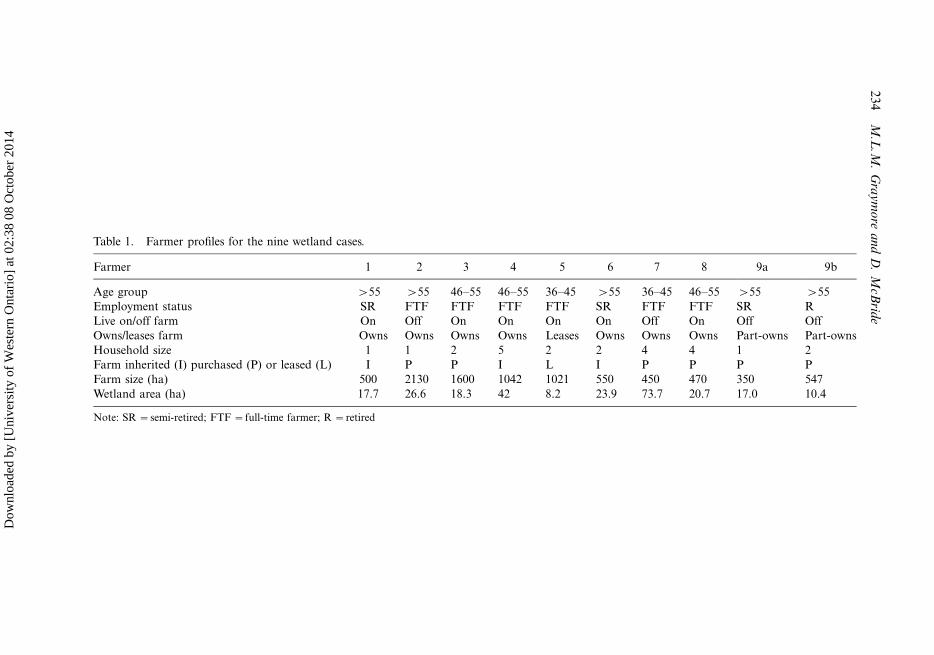
Table 1. Farmer profiles for the nine wetland cases.
Farmer 1 2 3 4 5 6 7 8 9a 9b
Age group �55 �55 46�55 46�55 36�45 �55 36�45 46�55 �55 �55
Employment status SR FTF FTF FTF FTF SR FTF FTF SR R
Live on/off farm On Off On On On On Off On Off Off
Owns/leases farm Owns Owns Owns Owns Leases Owns Owns Owns Part-owns Part-owns
Household size 1 1 2 5 2 2 4 4 1 2
Farm inherited (I) purchased (P) or leased (L) I P P I L I P P P P
Farm size (ha) 500 2130 1600 1042 1021 550 450 470 350 547
Wetland area (ha) 17.7 26.6 18.3 42 8.2 23.9 73.7 20.7 17.0 10.4
Note: SR �semi-retired; FTF �full-time farmer; R �retired
23
4M
.L.M
.G
ray
mo
rea
nd
D.
McB
ride
Dow
nloa
ded
by [
Uni
vers
ity o
f W
este
rn O
ntar
io]
at 0
2:38
08
Oct
ober
201
4
spatial imagery were then used to cross-reference the values identified to further
strengthen the validity of the findings. The socio-ecological values were considered
both in the context of the channel system and the pipeline system to determine if the
value of the on-farm wetlands changed with the water regime change. The aim was to
identify the range of socio-ecological values of on-farm wetlands and the change in
these values due to the water regime change. Hence, no attempt was made to discover
whether any groups of farmers had different values attached to their wetland.
Results
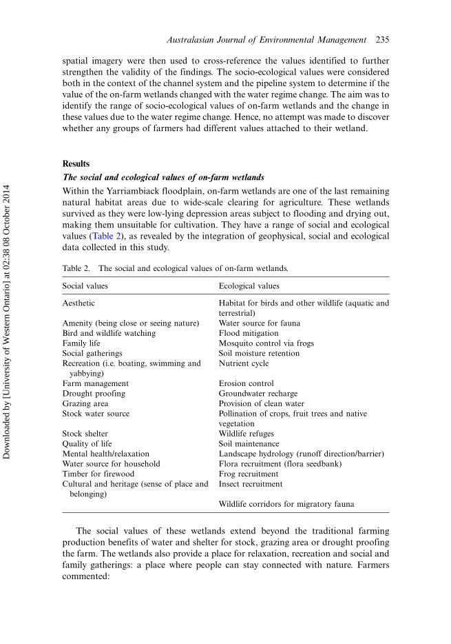
The social and ecological values of on-farm wetlands
Within the Yarriambiack floodplain, on-farm wetlands are one of the last remaining
natural habitat areas due to wide-scale clearing for agriculture. These wetlands
survived as they were low-lying depression areas subject to flooding and drying out,
making them unsuitable for cultivation. They have a range of social and ecological
values (Table 2), as revealed by the integration of geophysical, social and ecological
data collected in this study.
The social values of these wetlands extend beyond the traditional farming
production benefits of water and shelter for stock, grazing area or drought proofing
the farm. The wetlands also provide a place for relaxation, recreation and social and
family gatherings: a place where people can stay connected with nature. Farmers
commented:
Table 2. The social and ecological values of on-farm wetlands.
Social values Ecological values
Aesthetic Habitat for birds and other wildlife (aquatic and
terrestrial)
Amenity (being close or seeing nature) Water source for fauna
Bird and wildlife watching Flood mitigation
Family life Mosquito control via frogs
Social gatherings Soil moisture retention
Recreation (i.e. boating, swimming and
yabbying)
Nutrient cycle
Farm management Erosion control
Drought proofing Groundwater recharge
Grazing area Provision of clean water
Stock water source Pollination of crops, fruit trees and native
vegetation
Stock shelter Wildlife refuges
Quality of life Soil maintenance
Mental health/relaxation Landscape hydrology (runoff direction/barrier)
Water source for household Flora recruitment (flora seedbank)
Timber for firewood Frog recruitment
Cultural and heritage (sense of place and
belonging)
Insect recruitment
Wildlife corridors for migratory fauna
Australasian Journal of Environmental Management 235
Dow
nloa
ded
by [
Uni
vers
ity o
f W
este
rn O
ntar
io]
at 0
2:38
08
Oct
ober
201
4
It is important to have trees around as trees give us pleasure and have a deep seatedvalue for humans.Water came down the channel . . .and so did the kookaburras. We were delighted . . . they‘laugh’ every morning at 5.30am!!The timber paddock [wetland] was kept for recreation, walks and to study nature suchas birds and wildflowers.
On-farm wetlands also provide a sense of place and help enhance farmer and
farm family mental health and quality of life, as demonstrated by this farmer’s
comment:
I would love to look out the window once again and see the lake full of water and thequality of life it brings.
The ecological values of on-farm wetlands include regional and local biodiversity,
wildlife habitat, refuges and corridors, landscape hydrology, soil maintenance, seed
banks for flora, insect and frog recruitment, and groundwater recharge. For example,
the large to small hollows in E. largiflorens provide valuable habitats for many
wetland species.
Many of these ecological values provide ecosystem services which also aid farm
production, such as pollination, flood mitigation, nutrient cycling, soil moisture
retention and erosion control. They also contribute to the aesthetic, cultural and
heritage, recreational and other social values described by the farmers, such as bird
and wildlife watching, clean water for the farm and household, and insect control.
Thus, the ecological values of wetlands are intertwined with the social values, as
demonstrated by these farmers’ comments:
Native bees pollinate crops, fruit trees [on-farm] and native plants.Frogs take care of the mosquitos breeding in the stagnant waterpools [on-farm].
Furthermore, farmers who highly value the ecological benefits they receive from
their wetland tend to implement conservation measures to preserve and enhance
their wetland’s ecological value. As the ecological values of the wetland increase, so
do the social benefits the farmer receives from the wetland; hence, ecological values
contribute directly to social values of wetlands, demonstrating the reciprocity
between people and nature.
Although not the main focus of this article, a number of sequent occupance
(Leighly 1967) factors, that is factors related to human occupation, were identified
that influence farmers’ values, their sense of place and connection to the on-farm
wetland. These include the location of the wetland in relation to their residence,
type and amount of wetland use, farm management practices, length of time on
farm, farmer values (i.e. environmental versus production) and owner versus
lessee. Farmers are more likely to identify a wide range of social and ecological
values when the wetland is near the house, they have been on the farm for a long
time and have a connection to the wetland though history of use for recreation,
family and social gatherings, and even farm production. In comparison, farmers
who do not own the property, do not live near the wetland, have no historical
connection to the wetland or are more production focused are less likely to
identify a wide range of social and ecological wetland values. This difference in
236 M.L.M. Graymore and D. McBride
Dow
nloa
ded
by [
Uni
vers
ity o
f W
este
rn O
ntar
io]
at 0
2:38
08
Oct
ober
201
4
values has implications for how the wetland is managed by the farmer; as already
noted, if the farmer places more value on the wetland they are more likely to be
using conservation measures.
Changes in social and ecological values due to water regime change
The change in water regime in the Wimmera Mallee will reduce the amount of water
flowing to many on-farm wetlands in the region as they are not eligible for
environmental water allocations as they are not ‘wetlands of significance’. This
means that many on-farm wetlands, including the majority in this study, will become
dry, changing their social and ecological value. Some of these changes provide
benefits to farmers, their communities and the ecosystem; others have a negative
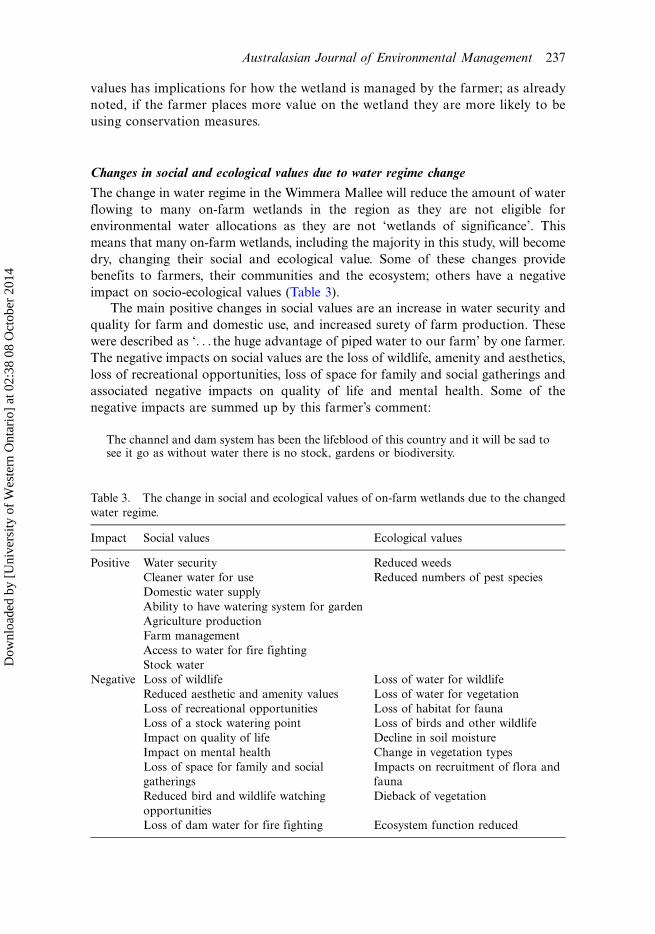
impact on socio-ecological values (Table 3).
The main positive changes in social values are an increase in water security and
quality for farm and domestic use, and increased surety of farm production. These
were described as ‘. . . the huge advantage of piped water to our farm’ by one farmer.
The negative impacts on social values are the loss of wildlife, amenity and aesthetics,
loss of recreational opportunities, loss of space for family and social gatherings and
associated negative impacts on quality of life and mental health. Some of the
negative impacts are summed up by this farmer’s comment:
The channel and dam system has been the lifeblood of this country and it will be sad tosee it go as without water there is no stock, gardens or biodiversity.
Table 3. The change in social and ecological values of on-farm wetlands due to the changed
water regime.
Impact Social values Ecological values
Positive Water security Reduced weeds
Cleaner water for use Reduced numbers of pest species
Domestic water supply
Ability to have watering system for garden
Agriculture production
Farm management
Access to water for fire fighting
Stock water
Negative Loss of wildlife Loss of water for wildlife
Reduced aesthetic and amenity values Loss of water for vegetation
Loss of recreational opportunities Loss of habitat for fauna
Loss of a stock watering point Loss of birds and other wildlife
Impact on quality of life Decline in soil moisture
Impact on mental health Change in vegetation types
Loss of space for family and social
gatherings
Impacts on recruitment of flora and
fauna
Reduced bird and wildlife watching
opportunities
Dieback of vegetation
Loss of dam water for fire fighting Ecosystem function reduced
Australasian Journal of Environmental Management 237
Dow
nloa
ded
by [
Uni
vers
ity o
f W
este
rn O
ntar
io]
at 0
2:38
08
Oct
ober
201
4
Ecological values will be heavily impacted with the ‘loss of ‘‘free’’ water for
wildlife’ and vegetation, decline in soil moisture, loss of birds and other wildlife,
change in vegetation structure and reduced ecosystem function. The loss of water in
the system will cause dieback of large trees from water deprivation, causing a loss ofstructural flora. This will reduce habitats for birds and other fauna placing further
pressure on habitat availability within the floodplain system. Fauna are more closely
linked to the channel systems and, therefore, biodiversity is likely to decline with the
introduction of the pipeline, in particular frog and waterbird species who have
adapted to the annual channel and dam water sources that coincided with their
breeding cycles. One positive ecological change identified was a reduction in the
spread of pests and weeds transported by the channel system.
Implications for wetland management under changed water regimes
The socio-ecological values of on-farm wetlands identified in this study highlight the
wide range of benefits farmers, their community and the ecosystem receive from
wetlands in arid and semi-arid areas. The social values include a place for social
gatherings, finding solace in nature, recreation, drought proofing the farm, stock
watering and flood mitigation. The ecological values include a water source and
provision of habitats for birds, frogs and other fauna, soil moisture and seed banksfor flora recruitment. These socio-ecological values are often intertwined, with many
of the social values reliant on high ecological values, and the protection of ecological
values being related to high social values attached to the wetland by the farmer
managing the wetland. The range of values identified here is comparable to that of
Finlayson et al. (2005) for inland wetlands, indicating that these values are indicative
of the socio-ecological values of on-farm floodplain wetlands in arid areas. Thus, this
article provides decision makers insight into the value of these wetlands to farmers,
farm families and their associated communities for consideration in future waterregime decisions.
The dilemma of finding the balance between human and ecological water has
become apparent in the Wimmera, with the decommissioning of the channel system
and replacement with the pipeline. This change in water regime is likely to ensure
human water needs will be met into the future in the region and prevent flooding.
However, it reduces the water available for floodplain on-farm wetlands, changing
both the social and ecological values of these wetlands. The social values related to
farming will increase, reflecting the fact that the Wimmera Mallee Pipeline will helpmeet human water needs, yet the majority of ecological values and social values
related to quality of life, cultural, recreation and amenity will all be negatively
impacted.
The negative impacts on socio-ecological values of on-farm wetlands were not
fully understood or considered during the decision-making process for the pipeline.
However, with many on-farm wetlands in the region not listed as significant, they are
not eligible for an EWA and will only receive water from localised rainfall or if the
farmer pays for water for the wetland, because water flows through the region’s riversare largely restricted to prevent flooding. This study shows that on-farm floodplain
wetlands have many socio-ecological values for farmers, their families and commu-
nities and, thus, they are ‘significant’ to these communities. Thus, the impact of this
pipeline on ecosystem and community health and wellbeing in this region may be
238 M.L.M. Graymore and D. McBride
Dow
nloa
ded
by [
Uni
vers
ity o
f W
este
rn O
ntar
io]
at 0
2:38
08
Oct
ober
201
4
significant, with flow-on effects to the local economy. This is not a situation unique
to the Wimmera, as similar water supply decisions are being made in many arid and
semi-arid regions in Australia. Consequently this article calls for a revision of the
criteria that determine which wetlands receive EWAs, and how EWAs are determined
each year, to reduce the impact that the pipeline has on ecological and community
health and wellbeing in the region.
The findings of this study have implications for wetland management on freehold
agricultural land subject to a modified water regime in arid and semi-arid climates.
To reduce the impact of a change in water regime on on-farm wetlands, natural
resource managers need to work closely with farmers to identify and maintain the
socio-ecological values of on-farm wetlands, as much of the knowledge about
wetland management is held by farmers who currently manage the wetlands.
There need to be greater levels of community collaboration in decisions on water
management to ensure that any change in water regime and environmental water
allocation decisions consider the impact on the socio-ecological values of on-farm
wetlands.
A closer collaboration will also help farmers and natural resource managers to
work together to preserve and enhance the socio-ecological value of on-farm
wetlands, even in the face of changing water regimes. Without this change to wetland
management, we can expect to see many more floodplain wetlands become degraded,
which will have far-reaching landscape, biodiversity, community health and wellbeing
and economic impacts at the farm, community and regional scales. Thus, it is
important for natural resource managers to develop inclusive communication
pathways and adaptive management strategies that recognise farmers’ wetland
conservation management knowledge and practices. This would help current
knowledge gaps to be bridged and appropriate conservation management strategies
to be developed for on-farm wetlands, and make steps to address the dilemma
between human and ecological water needs.
Acknowledgements
The authors would like to acknowledge the contributions of each of the farmers to this study.
References
Arthur, M 2004, ‘Piping and wildlife’ Letters to the editor, Wimmera Mail Times, 23 January2004.
Barber, K 2004, ‘Water and wildlife’, Letters to the editor, Wimmera Mail Times, 12 January2004.
Bren, L & Sandall, P 2004, ‘Ecohydrology and environmental change to Lake Albacutya andWyperfield Park in north-western Victoria, Australia’, Australian Geographical Studies,vol. 42, pp. 307�324.
Brower, JE, Zar, JH & von Ende, CN 1997, Field and laboratory methods for general ecology,4th edn, McCraw-Hill, Boston, MA.
Bunn, SE & Arthington, AH 2002, ‘Basic principles and ecological consequences of alteredflow regimes for aquatic biodiversity’, Environmental Management, vol. 30, pp. 492�507.
Bunn, SE, Boon, PI, Brock, MA & Schofield, NJ (eds.) 1996, National wetlands R&D program:scoping review, Land & Water Resources Research and Development Corporation,Canberra.
Australasian Journal of Environmental Management 239
Dow
nloa
ded
by [
Uni
vers
ity o
f W
este
rn O
ntar
io]
at 0
2:38
08
Oct
ober
201
4
Creswell, JW & Piano Clark, VL 2007, Designing and conducting mixed methods research, SagePublications, London.
Daily, GC 1997, Nature’s services: societal dependence on natural ecosystems, Island Press,Washington, DC.
Daniels, S 1985, ‘Arguments for a humanistic geography’, in RJ Johnson (ed.), The future ofgeography, Methuen, London, pp. 143�158.
De Groot, R, Stuip, M, Finlayson, M & Davidson, N 2006, Valuing wetlands: guidance forvaluing the benefits derived from wetlands ecosystem services, Ramsar Technical Report No.3, CBD Technical Series No. 27. Ramsar Convention Secretariat, Gland, Switzerland.
DSE (Department of Sustainability and Environment) 2004a, Securing our water futuretogether, Victorian Government Green Paper, DSE, Melbourne.
DSE (Department of Sustainability and Environment) 2004b, Native vegetative: sustaining aliving landscape: vegetation quality assessment manual*guidelines for applying the habitathectares scoring method, version 1.3, DSE, Melbourne.
Finlayson, CM & Rea, N 1999, ‘Reason for the loss and degradation of Australian wetlands’,Wetlands Ecology and Management, vol. 7, pp. 1�11.
Finlayson, CM, D’Cruz, R & Davidson, NC 2005, Ecosystems and human well-being: wetlandsand water. Synthesis. Millennium ecosystem assessment, World Resources Institute,Washington, DC.
Jansen, A & Robertson, AI 2001, ‘Riparian bird communities in relation to land managementpractices in floodplain woodlands of south-eastern Australia’, Biological Conservation,vol. 100, pp. 173�185.
Jenkins, KM, Boulton, AJ & Ryder, DS 2005, ‘A common parched future? Research andmanagement of Australian arid-zone floodplain wetlands’, Hydrobiologia, vol. 552, pp. 57�73.
Johnson, RJ 1985, ‘To the ends of the Earth’, in R Johnson (ed.), The future of geography,Methuen, London, pp. 326�338.
Junk, WJ, Bayley, PB & Sparks, RE 1989, ‘The flood pulse concept in river-floodplainsystems’, Canadian Special Public Fisheries and Aquatic Science, vol. 106, pp. 110�127.
Kingsford, RT 2000, ‘Ecological impacts of dams, water diversions and river management onfloodplain wetlands in Australia’, Austral Ecology, vol. 25, pp. 109�127. doi: 10.1046/j.1442-9993.2000.01036.x.
Kratochwil, A (ed.) 1999, Biodiversity in ecosystems: principles and case studies of differentcomplexity levels, Springer, Dordrecht, The Netherlands.
Krebs, CJ 2001, Ecology: the experimental analysis of distribution and abundance, 5th edn,Benjamin Cummings, San Francisco, CA.
Leighly, J 1967, Land and life: a selection from the writings of Carl Ortwin Sauer, University ofCalifornia Press, Berkeley, CA.
Letts, G 2003, ‘Evaluating piping’, Letters to the editor, Wimmera Mail Times, 17 December2003.
Lewin, C 2005, ‘Elementary quantitative methods’, in B Somekh & C Lewin (eds.), Researchmethods in the social sciences, Sage Publications, London, pp. 215�225.
McManamey, RM 2009, ‘Arts, health, community resilience and healing: the importance ofthe story’, 10th National Rural Health Conference, 17�20 May, Cairns, Australia.
National Water Commission 2007, Natural resource and water management review 2007,Australian Publishing Resource Service, Adelaide.
Norris, N & Walker, R 2005, ‘Naturalistic inquiry’, in B Somekh & C Lewin (eds.), Researchmethods in the social sciences, Sage Publications, London, pp. 131�145.
Reid, MA & Brooks, JJ 2000, ‘Detecting effects of environmental water allocations in wetlandsof the Murray�Darling Basin, Australia’, Regulated Rivers: Research & Management,vol. 16, pp. 479�496.
SKM 2001, Piping the system: a sustainable water management strategy for the WimmeraMallee region, GWMWater, Victorian Department of Employment, Workplace Relationsand Small Business, Melbourne.
Swanepoel, CM & Barnard, RO 2007, Discussion paper: wetlands in agriculture, Report to theResearch Commission, Pretoria, South Africa.
240 M.L.M. Graymore and D. McBride
Dow
nloa
ded
by [
Uni
vers
ity o
f W
este
rn O
ntar
io]
at 0
2:38
08
Oct
ober
201
4
Thorn, CE 2006, ‘The critical role of ‘‘qualitative thought’’ in physical geography andgeomorphological research’, in NJ Clifford & G Valentine (eds.), Key methods ingeography, Sage Publications, London, pp. 249�262.
Trochim, WMK 1985, ‘Pattern matching, validity, and conceptualization in programevaluation’, Evaluation Review, vol. 9, pp. 575�604.
Watson, DM 2003, ‘The ‘‘standardised search’’: an improved way to conduct bird surveys’,Austral Ecology, vol. 28, pp. 515�525.
Yin, RK 2003, Case study research: design and methods, 3rd edn, Sage Publications, London.
Australasian Journal of Environmental Management 241
Dow
nloa
ded
by [
Uni
vers
ity o
f W
este
rn O
ntar
io]
at 0
2:38
08
Oct
ober
201
4