Embed Size (px)
Citation preview
IVU Umwelt GmbH
Environmental Planning - Information Systems
Emmy-Noether-Str. 2D-79110 Freiburg
Tel: +49 (0)761 / 888512-0Fax: 761 / 888512-12
+49 (0)
Wilhelm-Brand-Str. 7D - 44141 Dortmund
Tel: +49 (0)231 / 42711 71Fax: +49 (0)231 / 42711 73
Software:
Hardware:
�
�
�
�
�
�
Windows XP / 2000 Professional SP4
ArcView 9.x
ArcGIS 9 Spatial Analyst extension for raster data and GRID-FormatArcGIS 9 3DAnalyst extension for 3D-display purposes
PC-Intel, 1.6 GHz1 GB RAMOpenGLVGA-Card for 3DAnalyst
If you are interested in acquiring ArcGIS -Products or need support,please do not hesitate to contact us.
Program System LimA
.net framework
Additionally recommended:
�
�
�
®
®
®
®
System Requirements
STAPELFELDTIngenieurgesellschaft mbH
Softwareentwicklung für Bauphysik
arc
Copyright 2006 IVU Umwelt GmbH. ArcGIS and ArcV ew are registered trademarks of ESRI.Other companies and products mentioned are trademarks or registered trademarks of their respective trademark ownders.
© i
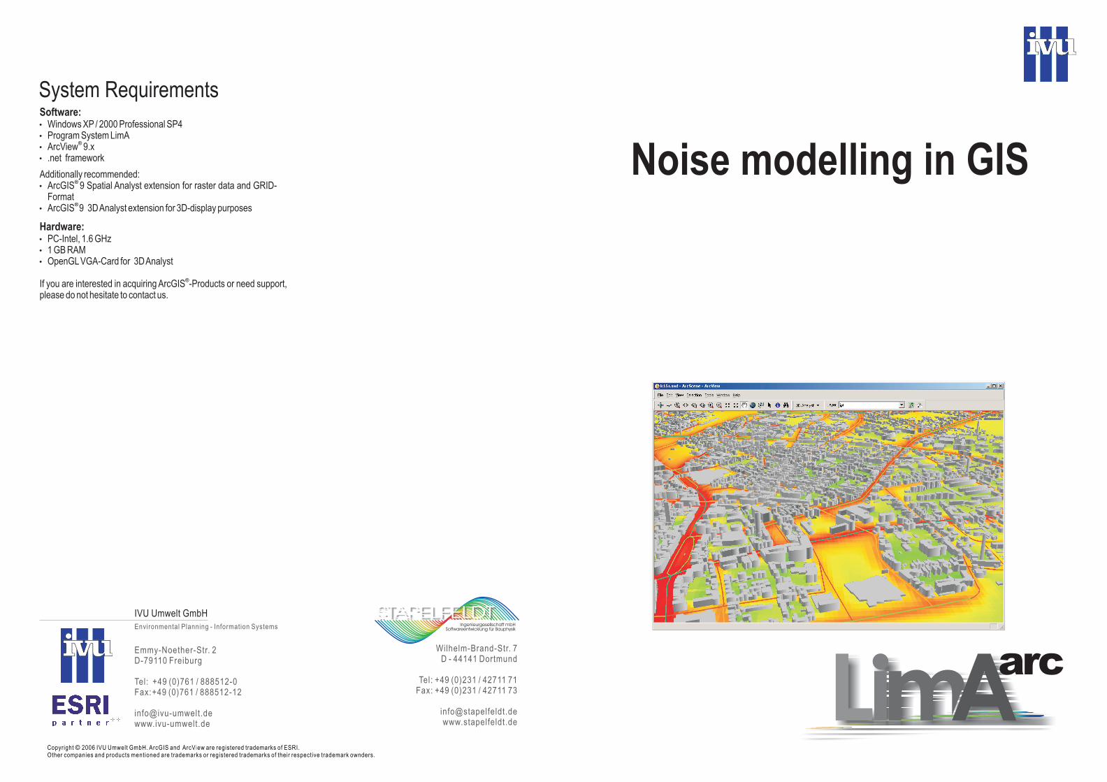
Noise modelling in GIS
LimA is a joint development of IVU Umwelt and StapelfeldtIngenieurgesellschaft. LimA integrates the LimA Program-System for calculation of noise distributions into the ArcGISgeographic information system (GIS) from ESRI.
arc
arc
Models for calculation of environmental noise are getting moreand more complex and the requirements for the range and degreeof detail of noise rating studies increase. Range and quality ofdigital geo-data for GIS-Systems are growing simultaneously.These trends of development require new arrangements for
programming and data-handling of environmental models. WithArcGIS, ESRI offers a modern, scalable GIS, that can integratemodels and create, data forenvironmental projects effectively and comfortably. Within LimAall data for noise modelling are supplied and maintained
. The noise model is handled by the GIS and has directaccess to the GIS data.
lets you administrate and maintain
inArcGIS
arc
For further information on ArcGIS, visit www.esri.com or thewebsite of your local distributor.
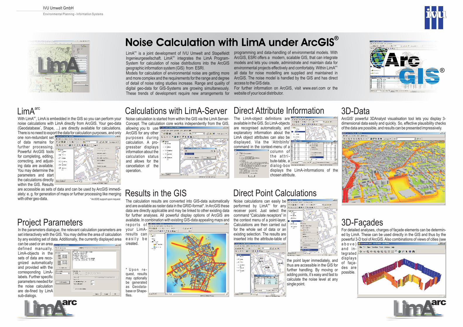
LimAarc Calculations with LimA-Server Direct Attribute Information
Direct Point Calculations
3D-Data
Results in the GIS
With LimA , LimA is embedded in the GIS so you can perform yournoise calculations with LimA directly from ArcGIS. Your geo-data(Geodatabase Shape, ...) are directly available for calculations.There is no need to export the data for calculation purposes, and onlyone non-redundant setof data remains forfurther processing.Powerful ArcGIS toolsfor completing, editing,correcting, and adjust-ing data are available.You may determine theparameters and startthe calculations directlywithin the GIS. Resultsare accessible as sets of data and can be used by ArcGIS immedi-ately: e. g. for generation of maps or further processing like mergingwith other geo-data.
arc
*
*ArcSDE support upon request
,
Project ParametersIn the parameters dialogue, the relevant calculation parameters areset interactively with the GIS. You may define the area of calculationby any existing set of data. Additionally, the currently displayed areacan be used or an areadef ined manual ly.LimA-objects in thesets of data are reco-gnized automaticallyand provided with thecorresponding LimA-labels. Further specificparameters needed forthe noise calculationare de-fined by LimAsub-dialogs.
3D-Façades
Noise calculation is started from within the GIS via the LimA Server-Concept. The calculation core works independently from the GIS,allowing you to useArcGIS for any otherpurposes dur ingcalculation. A pro-gressbar displaysinformation about the
and allows for thecancellation of theoperation.
calculation status
The calculation results are converted into GIS-data automaticallyand are available as raster data in the GRID-format*. InArcGIS thesedata are directly applicable and may be linked to other existing datafor further analyses. All powerful display options of ArcGIS areavailable. In combination with
cane a s i l y b ecreated.
existing GIS-data appealing maps andr e p o r t s o fyour LimA-results
* U p o n r e -quest, resultsmay optionallybe generatedas Geodata-base or Shape-files.
The LimA-object definitions areavailable in the GIS. So LimA-objectsare recognised automatically, andexplanatory information about theLimA object attributes can also bedisplayed. Via the ‘AttribInfo’
in the context-menu of acolumn oft h e a t t r i -bute-table, ad ia log-boxdisplays the LimA-informations of thechosen attribute.
command
Noise calculations can easily beperformed by for anyreceiver point. Just select thecommand “Calculate receptors” inthe context menu of a point-layer.Calculations are then carried outfor the whole set of data or anexisting selection. The results areinserted into the attribute-table of
the point layer immediately, andthus are accessible in the GIS forfurther handling. By moving oradding points, it’s easy and fast tocalculate the noise level at anysingle point.
LimAarc
IVU Umwelt GmbH
Environmental Planning - Information Systems
Noise Calculation with LimA under ArcGIS®
For detailed analyses, charges of fa ade elements can be determin-ed by LimA. These can be used directly in the GIS and thus by thepowerful 3-D tool of ArcGIS. Also combinations of views of cities (seea b o v e )and in -tegrateddisplaysof fa a-des arepossible.
ç
ç
ArcGIS’ powerful 3DAnalyst visualisation tool lets you display 3-dimensional data easily and quickly. So, effective plausibility checksof the data are possible, and results can be presented impressively.
arcarc
®