Embed Size (px)
Citation preview

Vimy Resources Limited
Soil Monitoring and Management Plan
(Outcome-Based Condition Environmental Management
Plan)
Mulga Rock Uranium Project
EMP-EHS-004
Version 1.4 Revised 17 July 2020
Document Control:
Version Date Prepared by Reviewed by Authorization
Name Signature
0 26/02/2018 Paula Arthur Adam Pratt Julian Tapp
0 (Rev1) 31/07/2018 Paula Arthur Julian Tapp Julian Tapp
1 3/12/2019 Julian Tapp
1.1 27/02/2020 Julian Tapp
1.2 22/05/2020 Julian Tapp
1.3 16/07/2020 Julian Tapp
1.4 17/07/2020 Julian Tapp

Soil Monitoring and Management Plan (Outcome-based)
Mulga Rock Uranium Project
Page i
Table of Contents
Summary ................................................................................................................................................ 1
1. Context, Scope and Rationale ................................................................................................... 3
1.1 Proposal .............................................................................................................................. 3
1.2 Key environmental factor .................................................................................................... 3
1.3 Condition requirements ....................................................................................................... 3
1.4 Rationale and approach ...................................................................................................... 4
1.4.1 Survey and study findings ................................................................................... 4
1.4.2 Key assumptions and uncertainties ..................................................................... 6
1.4.3 Management approach ........................................................................................ 6
1.4.4 Rationale for choice of provisions ....................................................................... 7
2. Condition EMP Provisions ......................................................................................................... 8
2.1 Outcome .............................................................................................................................. 8
2.2 Performance indicators (environmental criteria) ................................................................. 9
2.3 Response actions.............................................................................................................. 10
2.4 Monitoring ......................................................................................................................... 11
2.5 Reporting ........................................................................................................................... 12
3. Adaptive Management and Review of the Condition EMP.................................................... 13
3.1 Review and revision of performance indicators and response actions ............................. 13
3.2 Corrective Actions ............................................................................................................. 13
4. Stakeholder consultation ......................................................................................................... 15
5. References ................................................................................................................................. 19
List of Tables
Table 1: CEMP Provisions (outcome-based) table .......................................................................... 16

Soil Monitoring and Management Plan (Outcome-based)
Mulga Rock Uranium Project
Page 1
Summary
Title of the proposal Mulga Rock Uranium Project (MRUP)
Proponent name Vimy Resources Limited (Vimy)
Ministerial Statement Number 1046
Purpose of this Condition EMP The Soil Monitoring and Management Plan is submitted to fulfil the requirements of Conditions 6 and 13 of the above Statement
EPA’s environmental objective for the key environmental factor/s
Terrestrial Environmental Quality
To maintain the quality of land and soils so that the environmental values, both ecological and social, are protected.
Condition environmental outcome or proposed measurable outcome
(1) Maintain soil quality within background concentrations established during baseline studies 10 metres from areas where dewater has been used for dust suppression in Sandhill Dunnart Habitat (i.e. E3 and S6 vegetation communities).
Key provisions Trigger Criteria 1:
Soil salinity (as measured by Electrical Conductivity; EC1:5) in Sandhill Dunnart Habitat (E3 and S6 vegetation communities) in samples taken 5m from areas where dust suppression activities occurred ≥ 60mS/m.
Acidity (as measured by pH) in Sandhill Dunnart Habitat (E3 and S6 vegetation communities) in samples taken 5m from areas where dust suppression activities occurred ≥ 2 standard deviations above the mean (i.e. pH lower) established during baseline studies. Data will be adjusted for skew and kurtosis or whatever transformation is required to create a standard normal distribution.
Concentration of key metals (Zinc, Nickel, Copper, Cobalt and Uranium; mg/kg) in Sandhill Dunnart Habitat (E3 and S6 vegetation communities), in samples taken 5m from areas where dust suppression activities occurred ≥
• Zinc – 160 mg/kg dry weight
• Nickel – 38 mg/kg dry weight
• Copper – 70 mg/kg dry weight
• Cobalt – 13 mg/kg dry weight
• Uranium – 23 mg/kg dry weight
Threshold Criteria 1:
Soil salinity (as measured by Electrical Conductivity; EC1:5) in Sandhill Dunnart Habitat (E3 and S6 vegetation communities) in samples taken 5m from areas where dust suppression activities occurred ≥ 80mS/m.

Soil Monitoring and Management Plan (Outcome-based)
Mulga Rock Uranium Project
Page 2
Acidity (pH) in Sandhill Dunnart Habitat (E3 and S6 vegetation communities), in samples taken 10m from areas where dust suppression activities occurred ≥ 2 standard deviations above mean (i.e. pH lower) established during baseline studies. Data will be adjusted for skew and kurtosis or whatever transformation is required to create a standard normal distribution.
Concentration of key metals (Zinc, Nickel, Copper, Cobalt and Uranium; mg/kg) in Sandhill Dunnart Habitat (E3 and S6 vegetation communities), in samples taken 10m from areas where dust suppression activities occurred ≥
• Zinc – 160 mg/kg dry weight
• Nickel – 38 mg/kg dry weight
• Copper – 70 mg/kg dry weight
• Cobalt – 13 mg/kg dry weight
• Uranium – 23 mg/kg dry weight

Soil Monitoring and Management Plan (Outcome-based)
Mulga Rock Uranium Project
Page 3
1. Context, Scope and Rationale
1.1 Proposal
Vimy Resources Limited (Vimy) proposes to develop the Mulga Rock Uranium Project (MRUP or the
Project) which lies approximately 240km east-north-east of Kalgoorlie-Boulder in the Shire of Menzies.
The area is remote, located on the western flank of the Great Victoria Desert (GVD), comprising of a
series of large, generally parallel sand dunes, with inter-dunal swales and broad flat plains.
The MRUP covers approximately 102,000 hectares on granted mining tenure (primarily M39/1104 and
M39/1105) within Unallocated Crown Land (UCL). It includes two distinct mining centres, Mulga Rock
East (MRE) comprising the Princess and Ambassador resources and Mulga Rock West (MRW)
comprising the Emperor and Shogun resources, which are approximately 20km apart. The deposits will
be mined using large-scale open pits to produce an annualised peak capacity of 2,180 t/a (4.8 Mlbs)
U3O8.
The anticipated Life-of-Mine (LOM) is up to 16 years, based on the currently identified resource.
This Condition Environment Management Plan (CEMP) has been written in accordance with the
Instructions on how to prepare Environmental Protection Act 1986 Part IV Environmental Management
Plans (EPA, 2016).
1.2 Key environmental factor
This Soil Monitoring and Management Plan specifically addresses the Terrestrial Environmental Quality
environmental factor which is part of the overall Land Theme.
Soil quality is a key environmental factor for supporting vegetation and fauna communities, including
Sandhill Dunnart (SHD) habitat E3 and S6. Altering the soil quality in these key habitat types has the
potential to impact on the movement and distribution of Sandhill Dunnart, and thus maintaining the
baseline soil quality is important to minimise the impact on this endangered species listed under the
EPBC Act (Matters of National Environmental Significance; MNES) and Department of Parks and
Wildlife (DPaW), and classified as Schedule 1 under the Wildlife Conservation Act 1950. The Sandhill
Dunnart has been both sighted and its ‘prime habitat’ identified (S6 and E3 vegetation communities)
within the MRUP.
Potential impacts of using saline dewater for dust suppression on soil quality include:
• Increased erosion and altered soil physical properties
• Change in soil (geo)chemical properties
1.3 Condition requirements
Condition Section in Condition EMP
13-1 The proponent shall manage the implementation of the Proposal to meet the following environmental outcome:
1) Maintain soil quality within background concentrations established during baseline studies 10 metres from areas where dewater has been used for dust suppression in Sandhill Dunnart Habitat (i.e. E3 and S6 vegetation communities).
Whole document

Soil Monitoring and Management Plan (Outcome-based)
Mulga Rock Uranium Project
Page 4
Condition Section in Condition EMP
13-2 The proponent shall consult with the Department of Mines and Petroleum and prepare and submit a Soil Monitoring and Management Plan required by condition 6-1 that satisfies the requirements of condition 6-2, to meet the outcome of condition 13-1.
Section 4
13-3 The proponent shall continue to implement the version of the Soil Monitoring and Management Plan most recently approved by the CEO until the CEO has confirmed by notice in writing that the Soil Monitoring and Management Plan required by condition 6-1 satisfies the requirements of condition 6-2 to meet the outcome required by condition 13-1.
Whole document
In addition to Condition 13-1 protecting soil quality within E3 and S6 habitat areas from saline dewater
used in dust suppression activities, Condition 14-1 protects soil quality, and overall Terrestrial
Environmental Quality, from Acid and Metalliferous Drainage (AMD) from lignite oxidation in stockpiles,
and overall soil quality from dewater used in dust suppression.
1.4 Rationale and approach
1.4.1 Survey and study findings
Soils
The soils throughout the project area have been mapped both at a regional scale and at a local scale.
At a regional scale the project occurs within the Southern Great Victorian Desert Zone (Zone 124;
ASRIS; CSIRO, 2014), with the majority of the MRUP occurring within soil-landscape unit AB47, which
consists of plains and longitudinal and ring dunes, with interdunal corridors and plains and occasional
salt pans. There is a minor occurrence of soil-landscape unit My99, comprising plains of extensive gravel
pavements and small tracts of longitudinal dunes.
At the local scale, a detailed soil survey has been undertaken by SWC (2015) that identified that all soils
within the MRUP have a depositional origin, either by colluvial, alluvial or Aeolian process. The
uppermost layers (surficial Quaternary sediments) are principally comprised of just two soil materials,
these being either dunal sand or reddish brown sandy loam in the interdunal zones. The surficial soils
generally exhibit optimal physical (non-hardsetting, non-dispersive) and chemical (slightly acidic pH,
non-saline) soil properties.
Based on the distribution of the above two dominant soil materials (i.e. dunal sand and sandy loam),
only three morphologically distinct soil types or soil mapping units occur across the entire project area,
these are:
• SMU1: Deep Dunal Sand
• SMU2: Sandy Duplex Soil
• SMU3: Calcareous Loamy Soil
Flora and Vegetation
A defined Soil-Vegetation Association exists within the MRUP. The distribution of vegetation is strongly
controlled by the thickness of the surficial dunal sand, such that as the thickness of the dunal sand
increases, the accessibility to readily available water stored in the profile decreases, and thus there is a
distinct change from taller, denser Eucalypt woodland, E3 and E5 vegetation, to shorter more sparse
shrub vegetation characterised by S6 and S8.

Soil Monitoring and Management Plan (Outcome-based)
Mulga Rock Uranium Project
Page 5
Within the MRUP a total of 26 vegetation communities have been identified and mapped (MCPL, 2015).
Of these communities the E3 and S6 vegetation types represent prime Sandhill Dunnart habitat:
• E3 – Low open woodland of Eucalyptus gongylocarpa over Eucalyptus youngiana, Eucalyptus
ceratocorys, Grevillea jucicolia, Hakea francisiana and Callitris Preissii over Acacia helmsiana,
Cryptandra distigma and mixed low shrubs over Triodia desertorum, Chrysitrix distigmatosa and
Lepidobolus deserti. This community occurs on yellow and yellow-orange sands of flats, slopes
and between dunes.
• S6 – Low Shrubland of Thryptomene biseriata, Allocasuarina spinosissima, Allocasuarina
acutivalvis susp. acutivalvis, Jacksonia arida, Calothamnus gilesii, Acacia fragilis, Conospermum
toddii, Pityrodia lepidota, Lomandra leucocephala, Anthotroche pannosa and mixed low shrubs
over Triodia desertorum with Lepidobolus deserti with emergent Eucalyptus gongylocarpa,
Eucalyptus youngiana, Eucalyptus ceratocorys and Eucalyptus mannensis subsp. mannensis.
This community occurs on yellow sand dunes.
Groundwater
Numerous groundwater related studies and modelling investigations have been undertaken to assess
aspects of the environment relevant to the management of groundwater.
The area intended to be mined is located within a remnant oxbow paleochannel, which was active and
subsequently filled during the Eocene Period, and subsequently covered by Miocene and Quaternary
sediments. The water table in the palaeochannel occurs at an elevation of about 285 to 290m Australian
Height Datum (AHD). Groundwater throughout the project area is around 29 to 49m below ground level
(bgl), and generally lies within fine-grained carbonaceous sediments of Eocene age, which represents
the orebody to be mined. The water table is flat (i.e. low hydraulic gradient), and there is negligible
recharge (by infiltrating rainfall) or discharge out of the channel. The low hydraulic gradient that does
exist indicates minor flow from the north to south. The initial mining area (Mulga Rock East - MRE) sits
in a tributary area where the water level is somewhat higher, at up to 300m AHD – still between 29 and
49m bgl. Mining in the latter years (Mulga Rock West - MRW) will take place in an area with a flat-water
table within the main palaeodrainage (basin).
Dust suppression requirements for the MRUP are generally around 0.2GL/a (or around 440kL/day;
Rockwater, 2015; Advisian, 2017), with all water sourced from dewatering of the paleodrainage channel
to access the orebody. The groundwater within the active mine areas of the paleodrainage channel has
an average pH of 4.4 and a TDS range from 6,067mg/L to 146,900mg/L. The groundwater is best
described as saline to hypersaline, acidic, reducing and with some elevated metal concentrations.
Trigger and threshold levels
The outcome required by Ministerial Condition 13-1(1) is that soil quality must be maintained within background concentrations, established during baseline studies, 10 metres from areas where dewater has been used for dust suppression in E3 and S6 vegetation community areas. Vimy proposes to undertake baseline studies to determine the average surface soil (top 10cm) quality (salinity, acidity and metals content) in the approximate areas where roads are due to be built, where they will be disturbing Sandhill Dunnart Habitat (E3 and S6 vegetation communities). A total of 20 samples will be taken from randomly selected appropriate locations along the line of proposed roads within the correct vegetation community areas that will establish average salinity and acidity in those soils and an assessment of normal variation (the standard deviation from the mean) and similarly for metal content of the soil in relation to key metals that might be in dewater that will subsequently be used for dust suppression activity, namely Zinc, Nickel, Copper, Cobalt and Uranium. The trigger level for salinity will be set at 60 mS/m EC1:5. In order to provide advanced warning of excessive overspray leading to a deterioration in soil quality at 10m from where dewater has been

Soil Monitoring and Management Plan (Outcome-based)
Mulga Rock Uranium Project
Page 6
applied, the sampling for monitoring purposes will be undertaken at a distance of 5m from the area where dewater has been applied and will initially only involve a test for salinity every six months and a test for acidity and metals every two years. In the event that the trigger level for salinity was exceeded for a sample taken 5m from where dust suppression activity had taken place the soil sample would be taken for acidity and metals testing and a further sample would be undertaken at 10m for salinity to check whether the threshold might also be being exceeded. The threshold level for salinity will be set at set at 80 mS/m EC1:5. The threshold level will relate to samples taken from a location 5m from where dewater has been applied – testing for threshold level exceedance will initially involve only salinity testing at six monthly intervals and only if the salinity testing suggests that overspray has reached the area (because salinity was above 80 mS/m) would samples be sent for analysis for acidity and metals. Samples will also be sent for analysis for acidity and metals every two years.
1.4.2 Key assumptions and uncertainties
It is assumed that the desktop investigations and surveys undertaken for MRUP have sufficiently
identified the species and mapped the vegetation within and surrounding the Project area. However,
due to natural disturbances such as fire, it is possible that species may not have been recorded during
the survey effort.
It is assumed that the desktop and field investigations and surveys undertaken for the MRUP have
sufficiently identified the groundwater and soil characteristics of the project and surrounding areas.
It is assumed that the desktop investigations and surveys undertaken for MRUP have sufficiently
identified the fauna species within and surrounding the Project area. However, with transient and
migratory species, it is possible that some species have not been recorded during the survey effort.
Although there are the above assumptions and uncertainties, it is considered that the work undertaken
to date to characterise the environment is sufficient to assess risk and to monitor and confirm impact, if
it occurs.
1.4.3 Management approach
The management approach to be applied is based on sound scientific and technical understanding of
the distribution of the soils throughout the MRUP of their properties, such that the impact on Terrestrial
Environmental Quality can be established. Performance indicators and response actions have therefore
been developed on these principles to ensure that they are realistic, attainable and effectively reduce
the risks.
In addition, Vimy has developed a Ground Disturbance Activity Permit (GDAP) system that will prevent
any unauthorised dust suppression activities from occurring. All proposed dust suppression activities
will be assessed for potential impacts on soil quality, and must be internally authorised before
commencing. This process will therefore ensure that impacts on Terrestrial Environmental Quality, and
in particular E3 and S6 habitats, are minimised.
Furthermore, the management approach will rely on:
• Environmental Inductions – to ensure that all new personnel entering the MRUP are aware of the
environmental qualities within the MRUP and how their actions may impact on these qualities.
• Environmental Training – this will ensure that all personnel involved in dust suppression activities,
are properly trained, are competent to perform the task, and that fit-for-purpose equipment is used
to minimise the environmental impacts.
• Engineering – The use of appropriately designed dribble bars that reduce likelihood of overspray
during dust suppression.

Soil Monitoring and Management Plan (Outcome-based)
Mulga Rock Uranium Project
Page 7
• Contributing Factors – identification and implementation of management actions to minimise and
prevent the contributing factors that may cause an impact on soil quality.
In the unlikely event that, despite Environmental Inductions and Training and the use of fit for purpose
equipment, dust suppression activities result in soil contamination of adjacent areas then the following
management approach will be implemented:
• Substitution – the highly saline water, used for dust suppression activities, derived from mine
dewatering, would be diluted with the fresh-brackish water from Kakarook North Borefield for use
on roads adjacent to E3 and S6 habitats to the extent necessary to ensure that soil salinity
remained below the Trigger Criteria 1.
1.4.4 Rationale for choice of provisions
As defined in Section 1.4.1 the groundwater to be utilised in dust suppression activities is saline-
hypersaline, with a salinity (Electrical Conductivity, EC) of around 12,000mS/m and a Total Dissolved
Solids (TDS) of around 75,000mg/L. In addition, the groundwater is considered highly acidic (average
pH of 4.4) and may contain elevated metals and metalloids. The application of this water has the
potential to impact on soil quality and vegetation health at a local scale. Given the surficial soils are
inherently non-saline, the application of the saline-hypersaline groundwater will likely result in a
measurable change in the salinity of the surface soils and indicate that the local area was subjected to
overspray during dust suppression activities; hence salinity (EC) will be used as the primary
performance indicator to identify areas of saline water overspray and requiring further investigation to
assess potential impacts.
A ‘Trigger Level’ of 60mS/m at a distance of 5m from where dust suppression activity has been occurring
has been chosen, as this would indicate that the sample was above what would be expected for samples
taken at normal background levels and is occurring at a distance ‘halfway between where dust
suppression activities have been occurring and the distance required to be compliant by Ministerial
Condition 13-1(1)’ and therefore it would act as a good early warning signal that overspray might be
occurring.
A ‘Threshold Level’ of 80mS/m and at a distance of 5m from where dust suppression activity has been
occurring has been chosen, as this would indicate that the salinity was approaching levels which could
adversely affect the vegetation at a location half way between where dust suppression activity was
taking place and where the Ministerial condition requires there to be no adverse effect. Note that a
sample that breached the ‘Threshold Level’ would be highly unlikely to be a breach of the Ministerial
Condition 13-1(1) in isolation as it would require excessive overspray to have continued undetected
(despite sampling ‘closer in’ for trigger criteria purposes) for a long period of time and at a distance that
‘overspray would have been highly unlikely to travel’. It would be far more likely to be a ‘natural outlier’
than evidence of persistent overspray at a distance further than such spray would be expected to carry.
Although it is acknowledged that the acidic and metal-laden nature of the groundwater may impact on
soil quality and have an adverse impact on both SHDs and their habitat, it is recognised that salinity will
be the primary contributing factor to any impact, and thus it is the primary Trigger and Threshold Criteria
used in this CEMP.
Despite the fact that salinity will be the primary contributing factor to any impact, soils will also be
sampled for acidity and metals at the same sites and depths as those proposed for salinity sampling.
The trigger levels for acidity (pH) will be determined by evaluation of the initial soil samples which will
be analysed to determine mean acidity levels in the soil and the associated standard deviation. The data
will be normalised to adjust for the logarithmic nature of pH readings and for any skew or kurtosis
demonstrated by the distribution of the samples around the mean. A pH value will be calculated that
represents 2 standard deviations below the mean (i.e. more acidic than) after normalising the

Soil Monitoring and Management Plan (Outcome-based)
Mulga Rock Uranium Project
Page 8
distribution. The threshold levels for acidity will be the same values as for the trigger levels but at 10m
as opposed to 5m from where dust suppression activities had taken place.
The trigger and threshold levels for key metals were derived from Ecological Soil Screening Levels (Eco-
SSL) determined by the United States Environmental Protection Agency for various metals for their
potential impact upon Terrestrial Plants. The trigger values are for samples taken at 5m and the
threshold values are for samples taken at 10m. The Eco-SSL levels were as follows:
• Zinc – 160 mg/kg dry weight
• Nickel – 38 mg/kg dry weight
• Copper – 70 mg/kg dry weight
• Cobalt – 13 mg/kg dry weight
In addition, a trigger and threshold value for Uranium was set at 23 mg/kg dry weight (at 5m and 10m respectively) being the level of uranium in soil recommended by the ‘Canadian Council of Ministers of the Environment’ (CCME) in Canadian Soil Quality Guidelines for the Protection of Environmental and Human Health (CCME, 2007) as it related to the protection of human health in agricultural or residential/parkland use. This is a very conservative value as it is designed to protect human health in the context of direct exposure to the contaminated soil or ingestion of food grown in the soil. That conservatism also involved assuming the human being that was exposed to the soil was a preschool toddler that also directly ingested some of the soil and was therefore subject to a large exposure per unit of mass; it also included the assumption of 100% uptake of uranium in the soil. The same CCME recommendations as they related to protection of the environment (as opposed to human health) in residential/parkland uses (i.e. excluding Agricultural land where the risk is food ingestion by domestic animals and wildlife), the soil quality guideline was a much higher value of 500 mg/kg.
Baseline levels will be established immediately prior to the construction of roads (or any other
infrastructure where dust suppression activities are intended to occur) and thereafter sampling for
salinity will take place every six months. Acidity (pH) and metals (Zinc, Nickel, Copper, Cobalt and
Uranium) will be included in the initial sampling and then only sampled for every two years, or earlier in
the event that salinity monitoring indicates that there has been an adverse impact on soils (an adverse
impact being that there has been sufficient overspray so as to cause salinity levels to exceed Trigger
Levels). Once the results from the acidity and metals sampling have been assessed, the CEMP will be
reviewed to consider whether there remains any reason to continue acidity and metals sampling other
than after a salinity reading above the Trigger Level and to ascertain whether the trigger and threshold
levels are appropriate.
2. Condition EMP Provisions
This section of the EMP identifies the legal provisions that Vimy proposes to implement to ensure that
the soil quality within SHD habitats, 10m from areas where dewater has been used for dust suppression,
is maintained within background concentrations. It identifies the performance indicators that Vimy will
implement and how they will be monitored and reported, to achieve the environmental outcome of
Condition 13-1. Table 1 provides a detailed list of these provisions.
This section also identifies how Vimy will review and revise the performance indicators and the
corresponding response actions if the performance indicators are exceeded.
2.1 Outcome
The environmental outcome of Condition 13-1 of Ministerial Statement 1046 is:

Soil Monitoring and Management Plan (Outcome-based)
Mulga Rock Uranium Project
Page 9
• Condition 13-1(1): Maintain soil quality within background concentrations established during
baseline studies 10 metres from areas where dewater has been used for dust suppression in
Sandhill Dunnart Habitat (i.e. E3 and S6 vegetation communities).
2.2 Performance indicators (environmental criteria)
The following performance indicators (Trigger and Threshold criteria) have been identified to ensure that
the above environmental outcome is achieved:
Trigger Criteria 1:
Trigger Criteria 1b:
Samples will be taken at locations 5m from the edge of where dust suppression activities have taken place within Sandhill Dunnart habitat areas (E3 and S6 vegetation communities).
The Trigger Value for soil salinity (as measured by Electrical Conductivity using w/v method; EC1:5) is >60mS/m.
The Trigger Value for acidity (pH) is ≥ 2 standard deviations above the mean for soil acidity established during baseline studies (i.e. a lower pH value). The sample data will be adjusted for skew and kurtosis or whatever transformation is required to create a standard normal distribution.
The Trigger Values for key metals expressed as mg/kg (ppm) dry weight are as follows:
• Zinc – 160
• Nickel – 38
• Copper – 70
• Cobalt – 13
• Uranium – 23
Threshold Criteria 1:
The Threshold Value for soil salinity (as measured by Electrical Conductivity using w/v method; EC1:5) taken at a location 5m from the edge of where dust suppression activities have taken place within Sandhill Dunnart habitat areas (E3 and S6 vegetation communities) is >80mS/m .
The Threshold Value for acidity (pH) in Sandhill Dunnart Habitat (E3 and S6 vegetation communities), 10m from areas where dust suppression activities occurred is ≥ 2 standard deviations above mean established during baseline studies. Data will be adjusted for skew and kurtosis or whatever transformation is required to create a standard normal distribution.
The Threshold Values for key metals expressed in mg/kg dry weight in Sandhill Dunnart Habitat (E3 and S6 vegetation communities), 10m from areas where dust suppression activities occurred are as follows:
• Zinc – 160
• Nickel – 38
• Copper – 70

Soil Monitoring and Management Plan (Outcome-based)
Mulga Rock Uranium Project
Page 10
• Cobalt – 13
• Uranium – 23
2.3 Response actions
The following specific response actions will be implemented if monitoring identifies that the above
performance indicators are exceeded.
Trigger Criteria 1: Trigger level actions
• Investigation of affected areas, involving soil sampling (0-10cm) and laboratory testing for pH, EC and metals (Zn, Ni, Cu, Co & U) both at 5m distance and at 10m distance and possibly closer to dust suppression activity area to establish whether the cause is overspray and how far it has carried.
• If the initial investigation establishes that there is a likelihood that overspray has been occurring – then there would be an investigation into the causes of the overspray and measures introduced to ensure that the cause was rectified.
• Any Environmental Incident would be reported.
• A check would be made on the health of the local vegetation and if it was deemed that there had been some adverse health implications rectification measures would be implemented – most likely the application of a small amount of fresh water to areas where salinity was considered to be high enough to affect vegetation health and sufficient to dilute the effect down to levels that would not adversely impact the vegetation.
Threshold Criteria 1: Threshold contingency actions
• Investigation of affected areas, involving soil sampling (0-10cm) and laboratory testing for pH, EC and metals (Zn, Ni, Cu, Co & U) of area between dust suppression activity and monitoring site location and laterally for as far as elevated readings were still being recorded to establish whether the cause is overspray and how far it has carried.
• If the initial investigation establishes that there is a likelihood that overspray has been occurring – then there would be an investigation into the causes of the overspray and measures introduced to ensure that the cause was rectified. Dust suppression measures would be suspended until rectification measures designed to decrease overspray were introduced.
• Any Environmental Incident would be reported.
• A check would be made on the health of the local vegetation and if it was deemed that there had been some adverse health implications rectification measures would be implemented – most likely the application of a small amount of fresh water to areas where salinity was considered to be high enough to affect vegetation health and sufficient to dilute the effect down to levels that would not adversely impact the vegetation.

Soil Monitoring and Management Plan (Outcome-based)
Mulga Rock Uranium Project
Page 11
2.4 Monitoring
For each performance indicator (environmental criteria) listed in Section 2.2, a specific monitoring
program or task will be undertaken to measure performance against the environmental outcome and
whether the ‘Trigger level actions’ or ‘Threshold contingency actions’ listed in Section 2.3 need to be
implemented. If monitoring identifies that the performance indicators have not been met, then there is
a risk that the environmental outcome will also not be achieved.
The specific monitoring tasks to be undertaken for each performance indicator are outlined below.
Monitoring parameter Response actions
Frequency of sampling: Initial sampling of EC, pH and metals to take place in vegetation community E3 and S6 areas in close proximity to where infrastructure (roads) will be built just prior to their construction.
Biannual (six monthly) soil sampling for EC at 5m from where dust suppression activities have taken place (but also at 10m if trigger exceed and expanded to include pH and metals).
Biennial (every 2 years) soil sampling for pH levels and metal concentration of Zinc, Nickel, Copper, Cobalt and Uranium (or earlier if EC sampling indicates that there is a potential problem). Frequency of acidity and metal sampling to be reviewed in light of results.
Number of sampling sites: 20 samples taken each time sampling occurs from locations approximately 5m from where dust suppression activity has taken place in E3 and S6 vegetation communities adjacent to roads and tracks where dust suppression is applied. Exact locations to be randomly selected from within suitable areas but weighted towards areas where overspray was most likely to have occurred (if any).
Duration of sampling program: Length of dust suppression activity.
Sampling method: Surface soil sampling (0-10cm).
Sampling approach: Six monthly sampling will take place adjacent to areas where dust suppression spray has most frequently been utilised. Any further sampling contingent upon outcomes of initial sampling.
As specified in Condition 6-4, if the above monitoring indicates exceedance of ‘trigger criteria’ and / or
‘threshold criteria’, then:
1) report the exceedance to the CEO of DWER in writing within seven (7) days of the exceedance
being identified;
2) immediately implement the trigger level actions and / or threshold contingency actions specified
in the Condition Environmental Management Plan(s) and continue implementation of those
actions until the trigger criteria and / or threshold criteria are being met and implementation of
the trigger level actions and / or threshold contingency actions are no longer required;
3) investigate to determine the cause of the trigger criteria and / or threshold criteria being
exceeded;
4) identify additional measures required to prevent the trigger and / or threshold criteria being
exceeded in the future;

Soil Monitoring and Management Plan (Outcome-based)
Mulga Rock Uranium Project
Page 12
5) investigate to determine potential environment harm or alteration of the environmental that
occurred due to threshold criteria being exceeded; and
6) provide a report to the CEO of DWER within ninety (90) days of the exceedance being reported.
The report will include:
a) details of trigger level actions or threshold contingency actions implemented;
b) the effectiveness of the trigger level actions, or threshold contingency actions
implemented, monitored and measured against trigger criteria and threshold criteria;
c) the findings of the investigations required by Condition 6-4(3) and 6-4(5);
d) additional measures to prevent the trigger or threshold criteria being exceeded in the
future; and
e) measures to prevent, control or abate the environmental harm which may have
occurred.
2.5 Reporting
Reporting of the above monitoring results, and achievement of the performance indicators that satisfy
the environmental outcome, will occur in the Compliance Assessment Report (CAR) to be submitted
annually (in March; starting in 2018) to the CEO of DWER.
In accordance with Condition 4-6, the CAR shall:
1) be endorsed by Vimy’s CEO or other person delegated to sign on the CEO’s behalf;
2) include a statement as to whether Vimy has complied with the conditions;
3) identify all potential non-compliances and describe corrective and preventative actions taken;
4) be made publicly available in accordance with the approved Compliance Assessment Plan
(CAP); and
5) indicate any proposed changes to the CAP required by Condition 4-1.
The CAR will also include:
• Monitoring results and trends against performance indicators;
• Any exceedance of trigger criteria and / or threshold criteria;
• A review of the response actions and their appropriateness in achieving the performance
indicators and the overall environmental outcome; and
• Proposed revision of the performance indicators, and corresponding response actions, if required,
to obtain formal approval from DWER to amend the CEMP.
In addition to the CAR, all results from specific monitoring programs (e.g. dust monitoring, vegetation
health monitoring) and details of any environmental discharges (e.g. saline water spills) will be presented
in the Annual Environmental Report (AER). Furthermore, results of rehabilitation performance will be
reported in the annual Mine Rehabilitation Fund (MRF) document.

Soil Monitoring and Management Plan (Outcome-based)
Mulga Rock Uranium Project
Page 13
3. Adaptive Management and Review of the Condition EMP
3.1 Review and revision of performance indicators and response actions
In the event that a performance indicator (trigger or threshold) is exceeded, or the identified response
actions do not result in the performance indicator(s) being met, then Vimy will review and revise the risk
assessment, review and revise performance indicator(s) and response actions and identify additional
response actions where necessary.
Risks and key impacts associated with response actions and priorities will be reviewed and revised and,
if necessary, implement the following adaptive management procedure:
• Investigate the potential cause for the performance indicator exceedance and identify any impacts
to soil quality resulting from this exceedance.
• If the causes of the exceedance or the efficacy of the response actions are found to be deficient,
then the risk assessment will be reviewed and revised risk based response actions will be
implemented, following formal approval from DWER, so that the environmental outcome is met.
Vimy will also implement adaptive management to learn from the implementation of mitigation
measures, monitoring and evaluation against performance indicators, to more effectively meet the
environmental outcome. The following approach will be followed:
• Monitoring data will be systematically evaluated and compared to baseline and reference site
data in a process of adaptive management to verify whether responses to the impact are the
same or similar to predictions.
• Re-evaluate the risk assessment and revision of risk-based priorities on the basis of monitored
information.
• Increased understanding of the local and regional ecological regime.
• Revision when response actions are not as effective as predicted.
• External changes during the life of the proposal (e.g. changes to the sensitivity of the key
environmental factor, implementation of other activities in the area, etc.).
• Review of CEMP – changes to CEMP provisions required by a condition, timeframe, etc.
3.2 Corrective Actions
If the results of monitoring show that the management targets are not being met (or more likely are on
track to not being met in the near future), then the corrective actions outlined in the table below will be
implemented.
Performance Indicator Corrective Action Responsibility
Soil salinity (as measured by
Electrical Conductivity; EC1:5) in Sandhill Dunnart Habitat (E3 and S6 vegetation communities) 5m from areas where dust suppression activities occurred ≥ 60mS/m.
Acidity (pH) in Sandhill Dunnart Habitat (E3 and S6 vegetation
• Undertake further sampling to determine
whether the occurrence is more widespread and
whether it is likely to be caused by overspray.
• If overspray implicated undertake an
investigation to determine the causes of the
overspray having occurred and implement
rectification measures to prevent overspray from
occurring. For example:
Mine Manager and Environmental Manager

Soil Monitoring and Management Plan (Outcome-based)
Mulga Rock Uranium Project
Page 14
Performance Indicator Corrective Action Responsibility
communities) 5m from areas where dust suppression activities occurred ≥ 2 standard deviations above mean established during baseline studies. Data will be adjusted for skew and kurtosis or whatever transformation is required to create a standard normal distribution.
Concentration of key metals (Zinc, Nickel, Copper, Cobalt and Uranium; mg/kg) in Sandhill Dunnart Habitat (E3 and S6 vegetation communities), 5m from areas where dust suppression activities occurred ≥
• Zinc – 160 mg/kg dry weight
• Nickel – 38 mg/kg dry weight
• Copper – 70 mg/kg dry weight
• Cobalt – 13 mg/kg dry weight
• Uranium – 23 mg/kg dry weight
o If caused by spraying in high winds, ensure
that measures designed to prevent spraying
in high winds are properly enforced.
o If caused by faulty equipment – ensure
equipment fault is rectified and better checks
implemented to prevent faulty equipment
being utilise.
o If caused by improper containment of run-off
from roads after spraying – improve
containment measures.
• Whilst investigation into causes is being
undertaken either cease dust suppression or use
clean water for dust suppression until remedy
effected.
• Investigate impact upon local vegetation if any
and apply appropriate remedial measures if local
vegetation health appears to have deteriorated.
• Most likely remedial action would be to dilute
area of increased salinity by application of
freshwater sufficient to restore health to local
vegetation.
Soil salinity (as measured by Electrical Conductivity; EC), in Sandhill Dunnart Habitat (E3 and S6 vegetation communities), 5m from areas where dust suppression activities occurred ≥ 80 mS/m.
Acidity (pH) in Sandhill Dunnart Habitat (E3 and S6 vegetation communities) 10m from areas where dust suppression activities occurred ≥ 2 standard deviations above mean established during baseline studies. Data will be adjusted for skew and kurtosis or whatever transformation is required to create a standard normal distribution.
Concentration of key metals (Zinc, Nickel, Copper, Cobalt and Uranium; mg/kg) in Sandhill Dunnart Habitat (E3 and S6 vegetation communities), 10m from areas where dust suppression activities occurred ≥
• Zinc – 160 mg/kg dry weight
• Undertake further sampling to determine
whether the occurrence is more widespread and
whether it is likely to be caused by overspray.
• If overspray implicated undertake an
investigation to determine the causes of the
overspray having occurred and implement
rectification measures to prevent overspray from
occurring. For example:
o If caused by spraying in high winds, ensure
that measures designed to prevent spraying
in high winds are properly enforced.
o If caused by faulty equipment – ensure
equipment fault is rectified and better checks
implemented to prevent faulty equipment
being utilise.
o If caused by improper containment of run-off
from roads after spraying – improve
containment measures.
• Whilst investigation into causes is being
undertaken either cease dust suppression or use
clean water for dust suppression until remedy
effected.
• Investigate impact upon local vegetation, if any,
and apply appropriate remedial measures if local
vegetation health appears to have deteriorated.
Mine Manager and Environmental Manager

Soil Monitoring and Management Plan (Outcome-based)
Mulga Rock Uranium Project
Page 15
Performance Indicator Corrective Action Responsibility
• Nickel – 38 mg/kg dry weight
• Copper – 70 mg/kg dry weight
• Cobalt – 13 mg/kg dry weight
• Uranium – 23 mg/kg dry weight
• Most likely remedial action would be to dilute
area of increased salinity by application of
freshwater sufficient to restore health to local
vegetation.
4. Stakeholder consultation
Extensive consultation regarding the potential environmental impacts that may result from the MRUP
occurred during the Public Environmental Review (PER; Section 3). Specific consultation with regards
to this CEMP with the Department of Mines, Industry Regulation and Safety (DMIRS; formerly the
Department of Mines and Petroleum - DMP) is outlined below.
Date Decision Making Authority
Comment Response
29/12/2016 DMP Met with Ian Mitchell and Emily Safe to discuss MRUP and the requirements under Condition 13 and 14 regarding potential impacts on soil quality.
No response needed
22/02/2017 DMP Met with DMP Environmental Officers to discuss the Draft CEMP and its fulfilment of Ministerial Statement 1046
Vimy to ensure that this CEMP is prepared in accordance with MS 1046
24/05/2017 DMP Met with Ian Mitchell, Damien Montague and Emily Safe to discuss specific management of AMD and other aspects that may impact soil quality.
No response needed

Soil Monitoring and Management Plan (Outcome-based)
Mulga Rock Uranium Project
Page 16
Table 1: CEMP Provisions (outcome-based) table
Purpose of EMP To meet the legal requirements of Condition 13 of Ministerial Statement 1046
EPA Factor Terrestrial Environmental Quality
EPA Objective To maintain the quality of land and soils so that environmental values are protected
MS 1046 Condition 13-1 Environmental Outcome:
(1) Maintain soil quality within background concentrations established during baseline studies 10 metres from areas where dewater has been used for dust suppression in Sandhill Dunnart Habitat (i.e. E3 and S6 vegetation communities).
Outcome-based provisions
Risk / Impact Environmental Criteria Response Actions Monitoring Reporting
Soil Quality Trigger Criteria 1:
Samples will be taken at locations 5m from the edge of where dust suppression activities have taken place within Sandhill Dunnart habitat areas (E3 and S6 vegetation communities).
The trigger value for soil salinity (as measured by Electrical Conductivity using w/v method; EC1:5) is >60mS/m.
The trigger value for acidity (pH) is ≥ 2 standard deviations above the mean for soil acidity established during baseline studies. The sample data will be adjusted for skew and kurtosis or whatever transformation is required to create a standard normal distribution.
Trigger level actions
• Investigation of affected areas, involving soil sampling (0-10cm) and laboratory testing for pH, EC and metals (Zn, Ni, Cu, Co & U) both at 5m distance and at 10m distance and possibly closer to dust suppression activity area to establish whether the cause is overspray and how far it has carried.
• If the initial investigation establishes that there is a likelihood that overspray has been occurring – then there would be an investigation into the causes of the overspray and measures introduced to ensure that the cause was rectified.
• Any Environmental Incident would be reported.
• A check would be made on the health of the local vegetation and if it was deemed
Initial sampling of EC, pH and metals to take place immediately prior to the construction of infrastructure (roads) where they will be being built in vegetation community E3 and S6 areas. Biannual (six monthly) soil sampling for EC. Biennial (every 2 years) soil sampling for pH levels and metal concentration of Zinc, Nickel, Copper, Cobalt and Uranium (or earlier if EC sampling indicates that there is a potential problem). Frequency of acidity and metal sampling to be reviewed in light of results.
CAR AER
Soil Monitoring and Management Plan (Outcome-based)
Mulga Rock Uranium Project
Page 17
Risk / Impact Environmental Criteria Response Actions Monitoring Reporting
The trigger values for key metals expressed as mg/kg (ppm) dry weight are as follows:
• Zinc – 160
• Nickel – 38
• Copper – 70
• Cobalt – 13
• Uranium – 23
that there had been some adverse health implications rectification measures would be implemented – most likely the application of a small amount of fresh water to areas where salinity was considered to be high enough to affect vegetation health and sufficient to dilute the effect down to levels that would not adversely impact the vegetation.
20 samples taken each time salinity sampling occurs from locations approximately 5m from where dust suppression activity has taken place in E3 and S6 vegetation communities adjacent to roads and tracks where dust suppression is applied. Exact locations to be randomly selected from within suitable areas but weighted towards areas where overspray was most likely to have occurred (if any). Additional sampling of EC and pH and metal concentrations if trigger levels exceeded – number being sufficient to establish extent. Monitoring lasts as long as dust suppression activity is enduring. Surface soil sampling (0-10cm).
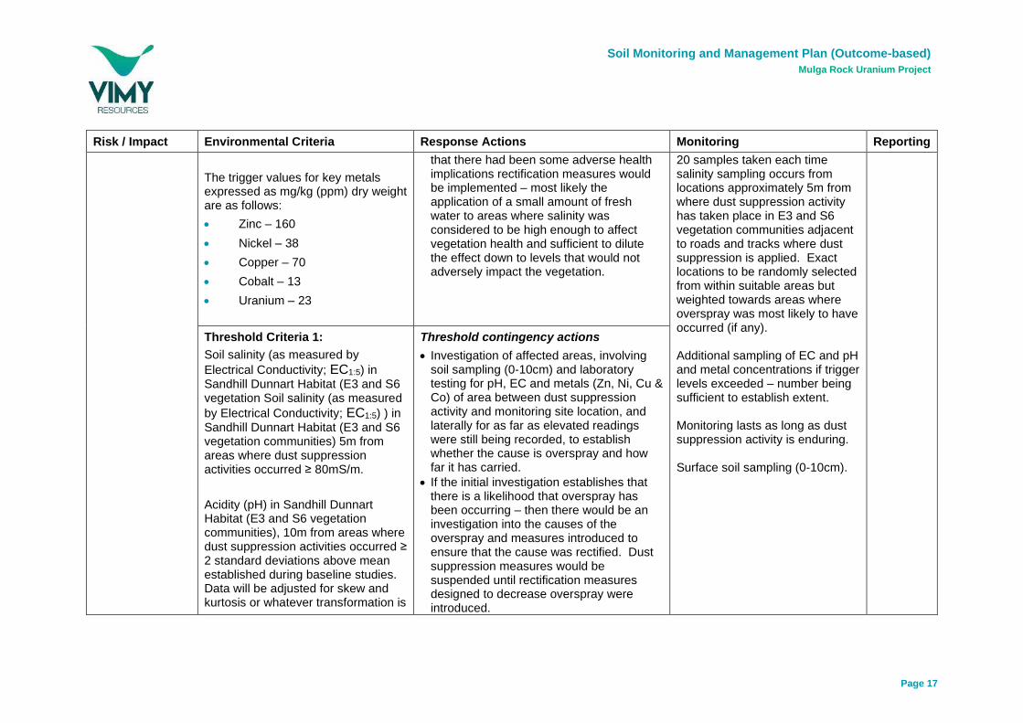
Threshold Criteria 1:
Soil salinity (as measured by
Electrical Conductivity; EC1:5) in Sandhill Dunnart Habitat (E3 and S6 vegetation Soil salinity (as measured
by Electrical Conductivity; EC1:5) ) in Sandhill Dunnart Habitat (E3 and S6 vegetation communities) 5m from areas where dust suppression activities occurred ≥ 80mS/m.
Acidity (pH) in Sandhill Dunnart Habitat (E3 and S6 vegetation communities), 10m from areas where dust suppression activities occurred ≥ 2 standard deviations above mean established during baseline studies. Data will be adjusted for skew and kurtosis or whatever transformation is
Threshold contingency actions
• Investigation of affected areas, involving soil sampling (0-10cm) and laboratory testing for pH, EC and metals (Zn, Ni, Cu & Co) of area between dust suppression activity and monitoring site location, and laterally for as far as elevated readings were still being recorded, to establish whether the cause is overspray and how far it has carried.
• If the initial investigation establishes that there is a likelihood that overspray has been occurring – then there would be an investigation into the causes of the overspray and measures introduced to ensure that the cause was rectified. Dust suppression measures would be suspended until rectification measures designed to decrease overspray were introduced.

Soil Monitoring and Management Plan (Outcome-based)
Mulga Rock Uranium Project
Page 18
Risk / Impact Environmental Criteria Response Actions Monitoring Reporting
required to create a standard normal distribution.
Concentration of key metals (Zinc, Nickel, Copper, Cobalt and Uranium; mg/kg) in Sandhill Dunnart Habitat (E3 and S6 vegetation communities), 10m from areas where dust suppression activities occurred ≥
• Zinc – 160 mg/kg dry weight
• Nickel – 38 mg/kg dry weight
• Copper – 70 mg/kg dry weight
• Cobalt – 13 mg/kg dry weight
• Uranium – 23 mg/kg dry weight
• Any Environmental Incident would be reported.
• A check would be made on the health of the local vegetation and if it was deemed that there had been some adverse health implications rectification measures would be implemented – most likely the application of a small amount of fresh water to areas where salinity was considered to be high enough to affect vegetation health and sufficient to dilute the effect down to levels that would not adversely impact the vegetation.

Soil Monitoring and Management Plan (Outcome-based)
Mulga Rock Uranium Project
Page 19
5. References
DER (2015). Identification and investigation of acid sulphate soils and acidic landscapes, Department
of Environment Regulation (DER), Perth, Western Australia.
MCPL (2015). Assessment of Flora and Vegetation Surveys conducted for the Mulga Rock Uranium
Project, Great Victoria Desert, WA. Unpublished report by Mattiske Consulting Pty Ltd for Vimy
Resources, October, 2015.
National Committee on Soil and Terrain (2009). Australian Soil and Land Survey Field Handbook,
CSIRO Publishing, Collingwood, Australia.
SWC (2015). Terrain Analysis and Materials Characterisation for the Mulga Rock Uranium Project.
Unpublished report prepared for Vimy Resources Limited, October 2015.
Rockwater (2015). Results of Hydrogeological Investigations and Numerical Modelling, Mulga Rock
Uranium Project. Unpublished report prepared for Vimy Resources Limited, October 2015


![Cost Function Market Makers for Measurable Spacesyiling.seas.harvard.edu/wp-content/uploads/measures.pdf · nite outcome spaces satisfying the properties of Abernethy et al. [2013]](https://img.pdfslide.net/doc/110x75/5fc75bd3c3ea6a344d7094d7/cost-function-market-makers-for-measurable-nite-outcome-spaces-satisfying-the-properties.jpg)