Embed Size (px)
Citation preview

Islam International Journal on Emerging Technologies 10(4): 444-453(2019) 444
International Journal on Emerging Technologies 10(4): 444-453(2019)
ISSN No. (Print): 0975-8364
ISSN No. (Online): 2249-3255
Soil Quarrying for Brick Kiln and Its Impact on Environment: A Study in Tufanganj Block-I, Koch Bihar, West Bengal
Nazrul Islam Assistant Professor, Department of Geography,
Sitalkuchi College, Sitalkuchi, Cooch Behar, West Bengal, India.
(Corresponding author: Nazrul Islam)
(Received 18 September 2019, Revised 13 November 2019, Accepted 21 November 2019)
(Published by Research Trend, Website: www.researchtrend.net)
ABSTRACT: Civilization began with agriculture. Agriculture has played a key role in the development of human civilization. Agricultural activities fully depend on the fertility of the land. But nowadays, agricultural land is decaying at the faster rate. Agricultural land degradation is one of the world's major socio-economic and environmental problems which has been a major global issue since the late 20
th century and has
remained important in the 21st
century because of its adverse impact on land productivity, on the environment, on food security and quality of life. The Study area is lies between Ghargharia-Kaljani-Raidhak-Sankaosh interfluves. The Geographical area is 320.75 sq km which occupies 14 Gram Panchayats with 73 Mouzas. The study area has a special significance in agricultural activities where 64.2% of area Tufanganj Community Development Block-I has been covered by agricultural land and near about 80% people are engaged in agricultural activities of the area. The soil of Tufanganj is alluvial formation, the productivity and soil fertility is healthy in nature. But nowadays the degradation of agricultural land is rapidly increasing. It covers the various forms of soil degradation including erosion and fertility decline, adverse impact on water resources, lowering the productive capacity of agricultural land. The prime objectives of the study are to find out the causes and consequences of soil/land quarrying of the study area and to find out the relationship between soil quarrying on agricultural land and related environmental concern. The analysis will be done by applying various statistical methods and various cartographic techniques.
Keywords: Soil productivity, Land degradation, Soil Quarrying, Decay of agricultural land, Environmental Concern.
I. INTRODUCTION
Agriculture has played a key role in the development of human civilization [1]. When our nomadic ancestors began to settle and grow their own food, human society was forever changed. Agricultural activities fully depend on the fertility of the land [2]. But nowadays agricultural land is decaying at a faster rate. Soil quarrying causes the temporary or permanent decline in the productive capacity of the land [2]. Soil quarrying causes agricultural land degradation. It is a serious environmental issue [3]. The soil of Tufanganj is alluvial formation, the productivity and fertility soil is healthy in nature. About 64.2% land of Tufanganj Subdivision is covered by agricultural land and about 80% of people are engaged in agricultural activities [5].
II. LOCATION OF THE STUDY AREA
Tufanganj Block-1 has been chosen as the study area which is located in the North Eastern Part of Koch Bihar District. The latitudinal and longitudinal extension of the study area approximately is 26°17’50″N to 26°20′N and
89° 33′E to 89°37′30″E respectively. The Study area is
lies between Ghargharia-Kaljani-Raidhak-Sankaosh interfluves. The Geographical area is 320.75 sq km which occupies 14 Gram Panchayats with 73 Mouzas. The western, southwestern and eastern boundary of the study area is bounded by Koch Bihar, Dinhata and Tufanganj Block-2 subdivision of the same district respectively, while the northern boundary is bounded
with Jalpaiguri District. In a small stretch in the South-East, its boundary is shared with Bangladesh. Maradanga Mouza is located along the NH-31 and it is located in between Koch Bihar and Tufanganj. Location
of Maradanga mouza is about 26°16/30″N to 26°18′30″N
latitude and 89°35′45″E to 89°38′30″E. Longitude.
III. OBJECTIVES OF THE STUDY
The objectives of the study are: (a) To find out the causes and consequences of soil/land quarrying of the study area. (b) To find out the relationship between soil quarrying on agricultural land and related environmental concern.
IV. MATERIALS AND METHODS
The present study has been conducted with the aim to describe the causes and consequences of soil quarrying in the study area. For this purpose a conceptual framework for describing the possible causes of land degradation. A field survey has also been conducted to explore the effect of soil quarrying on agricultural land, loss of topsoil as well as decrease of production of crops. Further, primary data of various quarrying sites are collected through GPS and processed to establish the above fact. Estimation has been made to assess the loss of topsoil and the degradation of agricultural land. The Central Building Research Institutes, Roorkee (CBRI) estimates that one single brick consumes 0.002 - 0.003 cubic metre of good quality of soil.
et
Islam International Journal on Emerging Technologies 10(4): 444-453(2019) 445
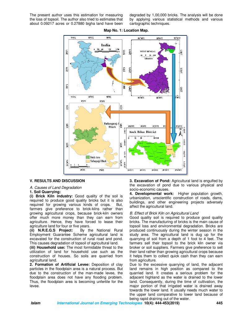
The present author uses this estimation for measuring the loss of topsoil. The author also tried to estimates that about 0.09217 acres or 0.27880 bigha land have been
degraded by 1,00,000 bricks. The analysis will be done by applying various statistical methods and various cartographic techniques.
Map No. 1: Location Map.
V. RESULTS AND DISCUSSION
A. Causes of Land Degradation 1. Soil Quarrying: (i) Brick Kiln industry: Good quality of the soil is required to produce good quality bricks but it is also required for growing various kinds of crops. But, farmers give preference to brick-kilns rather than growing agricultural crops, because brick-kiln owners offer much more money than they can earn from agriculture. Hence, they have forced to lease their agriculture land for four or five years. (ii) N.R.E.G.S Project: By the National Rural Employment Guarantee Scheme agricultural land is excavated for the construction of rural road and pond. This causes degradation of topsoil of agricultural land. (iii) Household use: The most formidable threat to the utilization of land for household use such as the construction of houses. So soils are quarried from agricultural land. 2. Formation of Artificial Levee: Deposition of clay particles in the floodplain area is a natural process. But due to the construction of the man-made levee, the floodplain area does not have any flooding problem. Thus, the floodplain area is becoming unfertile for the levee.
3. Excavation of Pond: Agricultural land is engulfed by the excavation of pond due to various physical and socio-economic causes. 4. Developmental work: Higher population growth, urbanization, unscientific construction of roads, dams, buildings, and other engineering projects adversely affect the agricultural land.
B. Effect of Brick Kiln on Agricultural Land Good quality soil is required to produce good quality bricks. The manufacturing of bricks is the main cause of topsoil loss and environmental degradation. Bricks are produced continuously during the winter season in the study area. The agricultural land is dug up for the quarrying of soil from a depth of 1 foot to 4 feet. The farmers sell their topsoil to the brick kiln owner via broker or soil suppliers. Farmers give preference to sell their land rather than growing agricultural crops because it helps them to collect quick cash than they can earn from agriculture. Due to the excessive quarrying of land, the adjacent land remains in high position as compared to the quarried land. It creates a serious problem for the adjacent highland as the water is drained to the lower land. Consequently, during the time of cultivation, the major portion of that irrigated water is drained away towards the lower land. It usually needs much water to the upper land comparative to lower land because of being rapid draining out of the water.
Islam International Journal on Emerging Technologies 10(4): 444-453(2019) 446
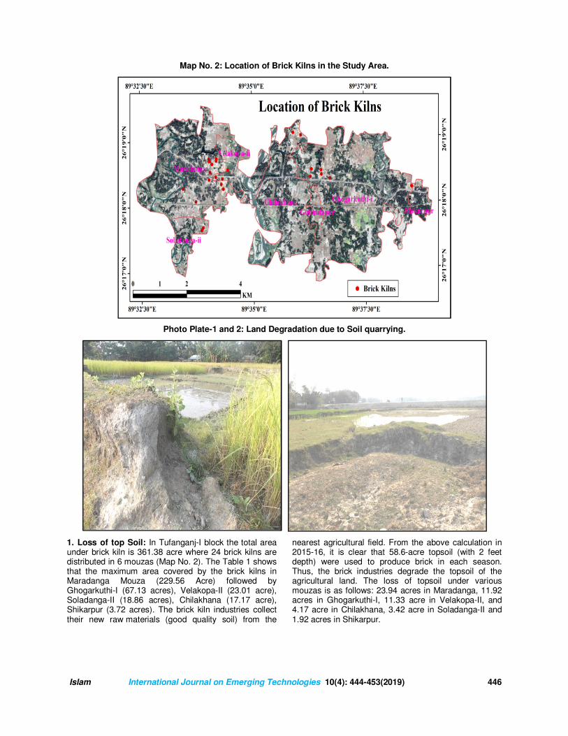
Map No. 2: Location of Brick Kilns in the Study Area.
Photo Plate-1 and 2: Land Degradation due to Soil quarrying.
1. Loss of top Soil: In Tufanganj-I block the total area under brick kiln is 361.38 acre where 24 brick kilns are distributed in 6 mouzas (Map No. 2). The Table 1 shows that the maximum area covered by the brick kilns in Maradanga Mouza (229.56 Acre) followed by Ghogarkuthi-I (67.13 acres), Velakopa-II (23.01 acre), Soladanga-II (18.86 acres), Chilakhana (17.17 acre), Shikarpur (3.72 acres). The brick kiln industries collect their new raw materials (good quality soil) from the
nearest agricultural field. From the above calculation in 2015-16, it is clear that 58.6-acre topsoil (with 2 feet depth) were used to produce brick in each season. Thus, the brick industries degrade the topsoil of the agricultural land. The loss of topsoil under various mouzas is as follows: 23.94 acres in Maradanga, 11.92 acres in Ghogarkuthi-I, 11.33 acre in Velakopa-II, and 4.17 acre in Chilakhana, 3.42 acre in Soladanga-II and 1.92 acres in Shikarpur.

Islam International Journal on Emerging Technologies 10(4): 444-453(2019) 447
Table 1: Details of Land and Land Degradation in Different Mouzas.
Name of the Mouza Total Area of the mouza
(Acre)
Net sown Area (Acre)
Total Area Under
Brick Kiln (Acre)
Others Area (Acre)
Area Degraded
by Brick Kiln
(Acre)
Percentage of
degraded of
Agricultural land
Actual Area under
Kiln(Acre)
Change of Area under
Kilns in %
Maradanga 1810.00 1198.46 208.28 381.98 21.46 1.19 233.44 89.22
Soladanga-II 285.53 172.97 18.86 93.70 3.42 1.20 19.78 95.34
Velakopa-II 1108.56 716.60 44.29 368.95 2.91 0.26 56.64 78.20
Ghogarkuthi-I 2757.20 1924.95 67.13 765.12 9.46 0.34 105.98 63.34
Chilakhana 1475.07 1030.43 17.17 425.15 4.14 0.28 50.18 34.22
Shikarpur 290.03 227.58 5.65 58.72 2.05 0.71 16.18 34.92
Total 7726.39 5270.99 361.38 2093.62 43.44 0.56 482.20 74.94 Source: DL and DLRO Office, 2016 and Field Survey, 2015-16.
Map No. 3: Location of Degraded Land and Brick Kiln Industry.
Fig. 1. Registered and Actual Area under Brick Kilns.
Maradanga and Shikarpur mouzas having 1198.46 acres and 290.03-acre net sown area (NSA) in which 21.46 acre and 3.42 acre (with 2 feet depth) are quarried or degraded. 27.78-acre land is being removed in every year in two mouzas. In other Mouzas, topsoil has been degraded in the same way. In Soladanga-II (1.20%), Velakopa-II (1.02%), Ghogarkuthi-I (0.43%) and Chilakhana (0.28%) have also been degraded. It is evident from Table 1 and Fig. 1 that the total area registered under different kilns in different mouzas of the study area has changed over time. The owners
submitted the documents in the DL & DLRO office, Koch Bihar under brick kilns records lower than the actual land. The actual land found by the researcher has been measured by GPS Oregon eTrex 550. The average rate of change is about 75%. The rate of change is maximum in Soladanga-II mouza (95.34%) followed by Maradanga mouza (89.22%). The minimum change is noticed in the study area in Chilakhana mouza. Table 2 shows that the total area covered by the brick kilns is 359.45 acre and 58.61-acre land has been degraded in different mouzas in the year 2015-16. (Fig. 2 and 3).
208.2
8
18.8
6
44.2
9
67.1
3
17.1
7
5.6
5
233.4
4
19.7
8
56.6
4
105.9
8
50.1
8
16.1
8
0
50
100
150
200
250
Maradanga Soladanga-II Velakopa-II Ghogarkuthi-I Chilakhana Shikarpur
Are
a in
Acre
Registered and Actual Area Under Brick Kilns
Registered Area under kiln ( Acre) Actual Area under Kiln( Acre)

Islam International Journal on Emerging Technologies 10(4): 444-453(2019) 448
The total number of brick kilns is 24 which are located in the above-mentioned 6 mouzas. The total consumption of the topsoil during the session 2015-16 was 117.22 Cubic feet (cft) and they will keep on consuming this amount soil in every year. Fig. 2 shows that the highest
consumption of soil was observed in Maradanga mouza (47.87 cubic feet), followed by Ghogarkuthi-I (23.85 cubic feet), Velakopa-II (22.65 cubic feet), Chilakhana (8.33 cubic feet), and Soladanga consumes 6.84 cubic feet in 2015-16.
Table 2: Annual Loss of Top Soil and Degradation of Land.
Name of the Mouza No. of Brick
Kiln Total Area Under Brick
Kiln (Acre) Area Degraded by Brick Kiln (Acre)
The annual loss of topsoil (in Cubic
(feet)
Maradanga 12 208.28 21.46 47.87
Soladanga-II 2 18.86 3.42 6.84
Velakopa-II 2 44.29 2.91 22.65
Ghogarkuthi-I 5 67.13 9.46 23.85
Chilakhana 2 17.17 4.14 8.33
Shikar Pur 1 5.65 2.05 7.68
Total 24 361.38 43.44 117.22
Source: Field Survey, 2015-16.
Fig. 2. Land Degradation.
Fig. 3. Annual Loss of Top Soil.
0 5 10 15 20 25
Maradanga
Soladanga-II
Velakopa-II
Ghogarkuthi-I
Chilakhana
Shikarpur
23.94
3.42
11.33
11.92
4.17
3.84
Area in Acre
Land Degradation by Brick Kiln, 2015-16.
0 20 40 60
Maradanga
Soladanga-II
Velakopa-II
Ghogarkuthi-I
Chilakhana
Shikarpur
47.87
6.84
22.65
23.85
8.33
7.68
Volumn in Cubic Feet.
Annual Loss of Top Soil, 2015-16.
Islam International Journal on Emerging Technologies 10(4): 444-453(2019) 449
Table 3: Agricultural Land Degradation by Individual Brick Kiln.
S.No. Name of the Kilns Total Production (No of
Bricks)
Area Degraded by Brick Kiln (Acre)
(10 inch × 5 inch × 3 inch) Size of a Brick
1. SARADA 21,14,344 1.95
2. VELAKOPA 18,71,550 1.72
3. NEW MARADANGA 13,81,896 1.27
4. SURJA(SJBF) 21,16,088 1.95
5. SONA 21,08,687 1.94
6. VIVEKANANDA 17,79,971 1.64
7. GOPINATH 21,83,475 2.01
8. BENGAL 15,25,689 1.41
9. NOTH BENGAL I 21,83,475 2.01
10. NORTH BENGAL II 16,20,378 1.49
11. INDIA I 18,88,596 1.74
12. INDIA II 12,67,522 1.17
13. COOCH BEHAR 21,83,475 2.01
14. SARAN(HBMC) 15,85,758 1.46
15. MADAN/ MOHAN I 21,83,475 2.01
16. MADAN/ MOHAN II 21,83,475 2.01
17. SAHA I 23,36,229 2.15
18. SAHA II 21,51,895 1.98
19. DELUX 20,18,212 1.86
20. SUMANA I 30,63,983 2.82
21. SUMANA II 20,77,976 1.92
22. SUN (JYOTI) 22,20,688 2.05
23. RRS I 14,03,103 1.29
24. RRS II 16,84,275 1.55
Total 471,34,213 43.44
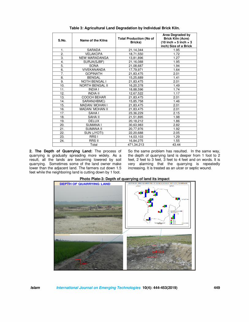
2. The Depth of Quarrying Land: The process of quarrying is gradually spreading more widely. As a result, all the lands are becoming lowered by soil quarrying. Sometimes some of the land owner make lower than the adjacent land. The farmers cut down 1.5 feet while the neighboring land is cutting down by 1 foot.
So the same problem has resulted. In the same way, the depth of quarrying land is deeper from 1 foot to 2 feet, 2 feet to 3 feet, 3 feet to 4 feet and on words. It is very alarming that the quarrying is repeatedly increasing. It is treated as an ulcer or septic wound.
Photo Plate-3: Depth of quarrying of land its impact
Thus the process of quarrying is gradually
spreading more widely. As a result all the
lands are made lowered by soil quarrying.
Sometimes some of them make lower than
the adjacent land. The farmers cut down 1.5
feet while the neighboring land is cutting
down by 1 feet. So the same problem is
resulted . In the same way the depth of
quarrying land is deeper from 1 feet to 2
feet, 2 feet to 3 feet, 3 feet to 4 feet and on
words. It is very alarming that the quarrying
is repeatedly increasing. It is treated as an
ulcer or septic wound.
3 FEET
10
DEPTH OF QUARRYING LAND

Islam International Journal on Emerging Technologies 10(4): 444-453(2019) 450
Photo Plate 4: Quarrying of land in different years.
3. Soil becomes unfertile: Agricultural land becomes barren and unfertile due to soil quarrying [4]. These factors changed the fertility status of the soils in the areas where quarrying is going on. The topsoil layers (9-12 inches) have all the tangible nutrient like organic compounds phosphorous, potash and innumerable intangible macro and micronutrients. These are decayed due to soil quarrying. The cultivation on un-quarried land requires a small amount of chemical
fertilizer and productivity is higher whereas in the quarried land the consumption of fertilizers is higher and the productivity is low. 4. The decrease of productivity of crops: The cultivation on un-quarried land requires less fertilizer and productivity is higher whereas, on quarried land, the consumption of fertilizers is higher and the yield of the crop is low.
Table 4: Changing Scenario of Crop Production in Tufanganj Block-1.
Year
Aus Aman Boro Jute Wheat Potato Oil Seed Total
2010 Area in Hectare 62.7 165.6 46.1 70.5 18 12.8 38.4 414.1
Production (Ton) 106.1 244 137.1 880.3 18 238.2 17.8 1641.5
2012
Area in Hectare 7.71 190.62 57.77 62.59 9.3 16.36 33.4 377.75
Production (Ton) 7.9 391.42 163.56 490.08 16.4 316.07 11.44 1396.87
2015
Area in Hectare 21.94 166.92 64.51 46.23 8.91 17.89 11.04 337.44
Production (Ton) 28.25 232.47 161.09 419.77 21.51 393.64 2.93 1259.66
Source: Field Survey, 2015-16.
Fig. 4. Changing Scenario of Crop Production in Tufanganj Block-1.
0
20
40
60
80
100
120
140
160
180
200
Aus Aman Boro Jute Wheat Potato Oil Seed
Area in
Hecta
re
2010 2012 2015

Islam International Journal on Emerging Technologies 10(4): 444-453(2019) 451
Fig. 5. Production of Crops in Different Years.
Table 5: Yield Rate (Kg/Bigha) among different types of Crops.
Crops Un-quarried land Adjacent of quarried land Quarried land
Mustard 300 250 200
Maize 1000 850 800
Boro 850 700 650
Amon 700 600 500
Fig. 6. Yield Rate of Crops.
Photo Plate-5: Shifting of Crops.
0
200
400
600
800
1000
Aus Aman Boro Jute Wheat Potato Oil Seed
Production (Ton)
Prod
ucti
on
in
Ton
s
2010 2012 2015
0
500
1000
Musta
rd
Maiz
e
Boro
Am
on
KG
/BIG
HA
Yield Rate of Crops
Un-quairred landAdjucent of quairred landQuairred land

Islam International Journal on Emerging Technologies 10(4): 444-453(2019) 452
Photo Plate-6: Production of Boro Rice.
PRODUCTION OF BORO IN
QUARRIED LAND
Survey
point
Location Depth of
Quarrying
Production kg/Bigha
2011 2012 2013Latitude Longitude
P13 26⁰⁰⁰⁰17.987' 89⁰⁰⁰⁰36.881' 1 foot 700 600 650
P3 26⁰⁰⁰⁰17.738' 89⁰⁰⁰⁰36.648' 2 feet 650 600 600
P6 26⁰⁰⁰⁰17.790' 89⁰⁰⁰⁰36.840' 3 feet 600 650 650
P2 26⁰⁰⁰⁰17.538' 89⁰⁰⁰⁰36.756' 4 feet 600 550 550
PRODUCTION OF BORO UNDER UN-
QUARRIED LAND
Year KG/BIGHA
2011 900
2012 900
2013 850
PRODUCTION OF BORO RICE
17
5. The problem of Irrigation: The un-quarried land becomes higher in elevation and hence, difficult for irrigation. During the time of cultivation, the major portion
of that irrigated water is being drained away towards the lower land. So the requirement of water in the higher land becomes much more than the quarried low land.
Photo Plate-7: Problem of Irrigation on the higher land. Photo Plate-8: Irrigation Canal.
6. Problem of Water Logging: From the field survey, it reveals that water logging in the quarried land is a common problem in the brick kiln area. Water logging is defined as the flooding of land by rainwater [4]. It occurs through water accumulation in the low-lying lands. Water logging is not only in the rainy season but also occasionally take place in the other season. If the land is cultivated, the crop can be spoiled when drowned by the excessive water. Consequently, cultivation of the quarried lands can be the much more risky enterprise.
In many cases, the risk of water logging prevents the land from being cultivated. Inundation of agricultural land is common during the rainy season. Thus, it is difficult to practice the crops because of water logging. After studying the area it is found that Amon is not suitable in the area where the depth of quarried land > 4-5 feet. Moreover, the water logging throughout the year creates some environmental problems as these are the breeding place of mosquitoes and the ecology of the area has been disrupted [7]. The long-term water logging contaminates the underground water.

Islam International Journal on Emerging Technologies 10(4): 444-453(2019) 453
Photo Plate-9 & 10: Problem of Water Logging.
VI. CONCLUSION
In Conclusion, it may be said that land degradation remains an important global agenda in the 21st century because of its adverse impact on agronomic productivity the environment, and its effect on food security and the quality of life. It is fact that in India quarried and mined should be reclaimed for agriculture by suitably excavating, replacing the topsoil and subsoil. From the study it is observed that the quarrying of topsoil creates several environmental issues which include (a) Quarrying of the topsoil from the agricultural field leads to the loss of major soil nutrients and land becomes infertile [8]. (b) The productivity of the soil has decreased and the production of crops diminished [9]. (c) Decreased agricultural production in the study area compels the farmer to migrate to the brick kiln and they shift their occupation. (d) Continuous excavation of the agricultural land degrades the un-quarried land as the famer of the unquarried land tries to level their land as compared to the quarried land. (e) Quarrying of silt and sand from the nearby riverbed leads to erosion of embankments of the river [10]. The river engulfs the agricultural land. The excessive and rampant topsoil quarry should be banned. For this purpose technology transfer should be the urgent need for making the bricks. Fertile topsoil should be replaced by Fly-Ash-Lime-Gypsum (FALG) bricks for making the bricks. It serves two basic purposes – it helps to preserve the topsoil on one hand and manage the ash to protect the environment on the other.
REFERENCES
[1]. Islam, N. (2018). Socio-Economic and Environmental Impact of Brick Kiln Industry in Tufanganj
Block–I of Koch Bihar District, West Bengal –A Geographical Analysis. Unpublished Thesis, pp-2. [2]. Nusrath, A., & Mahadev P. D. (1991). Environmental impact of brick loam quarrying on Agricultural Soil. Indian Geographical Journal, 65(2), 12-19 [3]. Barrow, C. J. (1991). Land Degradation: Development and Breakdown of Terrestrial Environments. Cambridge University Press, pp. 1-295. [4]. Basu, R. (2002). Land Degradation and Its Impact: The Case of Burdwan District; Ed. Basu S. R.: Changing Environmental Scenario of the Indian Subcontinent, acb Publications, Kolkata; pp. 429-439. [5]. District Statistical Hand Book, Koch Bihar (2010-2015). Bureau of Economics & Statistics Govt. of W.B. [6]. Langdale, G. W., & Shrader, W. D. (1982). Soil Erosion Effects on Soil Productivity of Cultivated Cropland1. In: B.L. Schmidt, editor, Determinants of Soil Loss Tolerance, ASA Spec. Publ. 45. ASA and SSSA, Madison, WI. pp 41-51. doi:10.2134/asaspecpub45.c4. [7]. Islam, N., & Roy, R. (2017). Problem of Water Logging through Soil Quarrying in Brick Kiln Industry: A Study of Tufanganj Block-I, Koch Bihar, West Bengal, International Journal of Theoretical & Applied Sciences, 9(2), 199. [8]. Rajonee, A. A. & Uddin, Md. J. (2018). Changes in Soil Properties with Distance in Brick Kiln Areas around Barisal. Open Journal of Soil Science, 8, 118-128. [9]. Lamey, F. J., Olson, B. M., Janzen, H. H., & Lindwall, C. W. (2000). Early Impact of Topsoil Removal and Soil Amendments on Crop Productivity. American Society of Agronomy, Agronomy Journal, 92(5), 948-956. [10]. Rana, N., Kumar, R., & Kumar, D. (2009). Nature of channel Shifting of foot hills fed river in Thealluvial setting-A Case study of River Rapti, India. Indian Journal of Geomorphology, 13(1, 2), 83-98.
How to cite this article: Islam, Nazrul (2019). Soil Quarrying for Brick Kiln and Its Impact on Environment: A Study in Tufanganj Block-I, Koch Bihar, West Bengal. International Journal on Emerging Technologies, 10(4): 444–453.


![[XLS] · Web viewICICI BANK LTD., MODI ASSOCIATES, MAYA TALKIES RD., NEAR CHOWPATHY, ALIPURDUAR - 736121, DIST. - JALPAIGURI, WB 736121 MALAY MUKHERJEE 03564-275202 462. JALPAIGURI](https://img.pdfslide.net/doc/110x75/5ad1bee67f8b9a86158c5623/xls-viewicici-bank-ltd-modi-associates-maya-talkies-rd-near-chowpathy-alipurduar.jpg)