Embed Size (px)
Citation preview
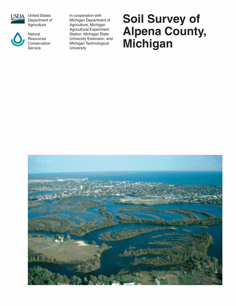
United StatesDepartment ofAgriculture
NaturalResourcesConservationService
In cooperation withMichigan Department ofAgriculture, MichiganAgricultural ExperimentStation, Michigan StateUniversity Extension, andMichigan TechnologicalUniversity
Soil Survey ofAlpena County,Michigan
General Soil Map
The general soil map, which is a color map, shows the survey area divided into groups of associated soils calledgeneral soil map units. This map is useful in planning the use and management of large areas.
To find information about your area of interest, locate that area on the map, identify the name of the map unit in thearea on the color-coded map legend, then refer to the section General Soil Map Units for a general description ofthe soils in your area.
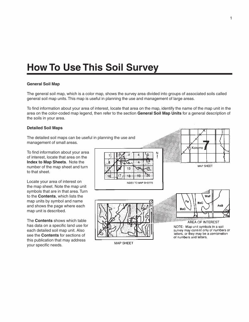
Detailed Soil Maps
The detailed soil maps can be useful in planning the use andmanagement of small areas.
To find information about your areaof interest, locate that area on theIndex to Map Sheets. Note thenumber of the map sheet and turnto that sheet.
Locate your area of interest onthe map sheet. Note the map unitsymbols that are in that area. Turnto the Contents, which lists themap units by symbol and nameand shows the page where eachmap unit is described.
The Contents shows which tablehas data on a specific land use foreach detailed soil map unit. Alsosee the Contents for sections ofthis publication that may addressyour specific needs.
1
How To Use This Soil Survey

2
Additional information about the Nation’s natural resources is available on theNatural Resources Conservation Service homepage on the World Wide Web. Theaddress is http://www.nrcs.usda.gov.
This soil survey is a publication of the National Cooperative Soil Survey, a joint effortof the United States Department of Agriculture and other Federal agencies, Stateagencies including the Agricultural Experiment Stations, and local agencies. TheNatural Resources Conservation Service has leadership for the Federal part of theNational Cooperative Soil Survey.
Major fieldwork for this soil survey was completed in 1997. Soil names anddescriptions were approved in 1998. Unless otherwise indicated, statements in thispublication refer to conditions in the survey area in 1998. This survey was madecooperatively by the Natural Resources Conservation Service, the MichiganDepartment of Agriculture, the Michigan Agricultural Experiment Station, MichiganState University Extension, and Michigan Technological University. The survey is part ofthe technical assistance furnished to the Alpena County Conservation District. Financialassistance was provided by the Alpena County Board of Commissioners.
Soil maps in this survey may be copied without permission. Enlargement of thesemaps, however, could cause misunderstanding of the detail of mapping. If enlarged,maps do not show the small areas of contrasting soils that could have been shown at alarger scale.
The United States Department of Agriculture (USDA) prohibits discrimination in all ofits programs on the basis of race, color, national origin, gender, religion, age, disability,political beliefs, sexual orientation, and marital or family status. (Not all prohibited basesapply to all programs.) Persons with disabilities who require alternative means forcommunication of program information (Braille, large print, audiotape, etc.) shouldcontact the USDA’s TARGET Center at 202-720-2600 (voice or TDD).
To file a complaint of discrimination, write USDA, Director, Office of Civil Rights,Room 326W, Whitten Building, 14th and Independence Avenue SW, Washington, DC20250-9410, or call 202-720-5964 (voice or TDD). USDA is an equal opportunityprovider and employer.
Cover: Trees growing on the channel bars in the impoundment of the Thunder Bay River inAlpena. Most of the area shown in the picture is in the map unit Histosols and Aquents, ponded. Thecleared area in the left foreground, however, is a Rousseau soil on a sand dune.

3
Contents
How To Use This Soil Survey ................................. 1Foreword ................................................................. 9General Nature of the County ................................. 11
History and Development ................................... 11Climate ............................................................... 12Physiography ...................................................... 12Karst Geology .................................................... 13Lakes and Streams ............................................ 14
How This Survey Was Made ................................... 14Survey Procedures ............................................. 15
General Soil Map Units ........................................ 17Very Deep, Level to Undulating Soils That Are
Very Poorly Drained, Somewhat PoorlyDrained, and Moderately Well Drained ......... 171. Deford-Au Gres-Croswell Association .... 172. Tacoda-Tawas Association ..................... 183. Lupton-Tawas-Cathro Association ......... 18
Very Deep and Deep, Level to Rolling SoilsThat Are Well Drained to Poorly Drained ...... 194. Algonquin-Negwegon-Springport
Association ............................................ 195. Negwegon, Till Substratum-Ossineke-
Algonquin, Till Substratum,Association ............................................ 19
6. McGinn-Hoist-Klacking Association ....... 207. Ossineke-Slade Association .................. 218. Morganlake-Hoist-Iosco Association ...... 21
Very Deep, Level to Very Steep Soils ThatAre Excessively Drained, Well Drained,Moderately Well Drained, and VeryPoorly Drained ............................................. 229. McGinn-Klacking Association ................ 22
10. Proper-Deford-Rousseau Association ... 2211. Zimmerman-Annalake Association ........ 23
Very Shallow, Moderately Deep, and VeryDeep, Level to Undulating Soils That AreWell Drained, Very Poorly Drained, andExcessively Drained..................................... 23
12. Namur-Chippeny-Alpena Association .... 23Detailed Soil Map Units ........................................ 25
11B—Eastport sand, 0 to 6 percent slopes ........ 2612B—Tawas-Au Gres complex, 0 to 4 percent
slopes .......................................................... 2713—Tawas-Lupton mucks .................................. 28
14—Dawson-Loxley peats .................................. 2916B—Graycalm sand, 0 to 6 percent slopes ...... 3016C—Graycalm sand, 6 to 12 percent slopes .... 3116D—Graycalm sand, 12 to 18 percent
slopes .......................................................... 3216E—Graycalm sand, 18 to 35 percent
slopes .......................................................... 3217A—Croswell sand, 0 to 3 percent slopes ........ 3317B—Croswell sand, 0 to 6 percent slopes ........ 3518A—Au Gres sand, 0 to 3 percent slopes......... 3619—Leafriver muck ............................................ 3727A—Tacoda sand, 0 to 3 percent slopes .......... 3828B—East Lake sand, 0 to 6 percent slopes ...... 3928C—East Lake sand, 6 to 12 percent slopes.... 4029A—Battlefield sand, 0 to 3 percent slopes ...... 4130—Wheatley muck ........................................... 4231B—Klacking loamy sand, 0 to 6 percent
slopes .......................................................... 4331C—Klacking loamy sand, 6 to 12 percent
slopes .......................................................... 4431D—Klacking loamy sand, 12 to 18 percent
slopes .......................................................... 4531E—Klacking loamy sand, 18 to 35 percent
slopes .......................................................... 4635—Kinross muck .............................................. 4736B—Annalake loamy very fine sand, 0 to 6
percent slopes ............................................. 4836C—Annalake loamy very fine sand, 6 to 12
percent slopes ............................................. 4937A—Richter loamy fine sand, 0 to 3 percent
slopes .......................................................... 5037B—Richter loamy fine sand, 0 to 6 percent
slopes .......................................................... 5138—Tonkey silt loam .......................................... 5341B—McGinn loamy sand, 0 to 6 percent
slopes .......................................................... 5441C—McGinn loamy sand, 6 to 12 percent
slopes .......................................................... 5541D—McGinn loamy sand, 12 to 18 percent
slopes .......................................................... 5641E—McGinn loamy sand, 18 to 35 percent
slopes .......................................................... 5742A—Killmaster sandy loam, 0 to 3 percent
slopes .......................................................... 58
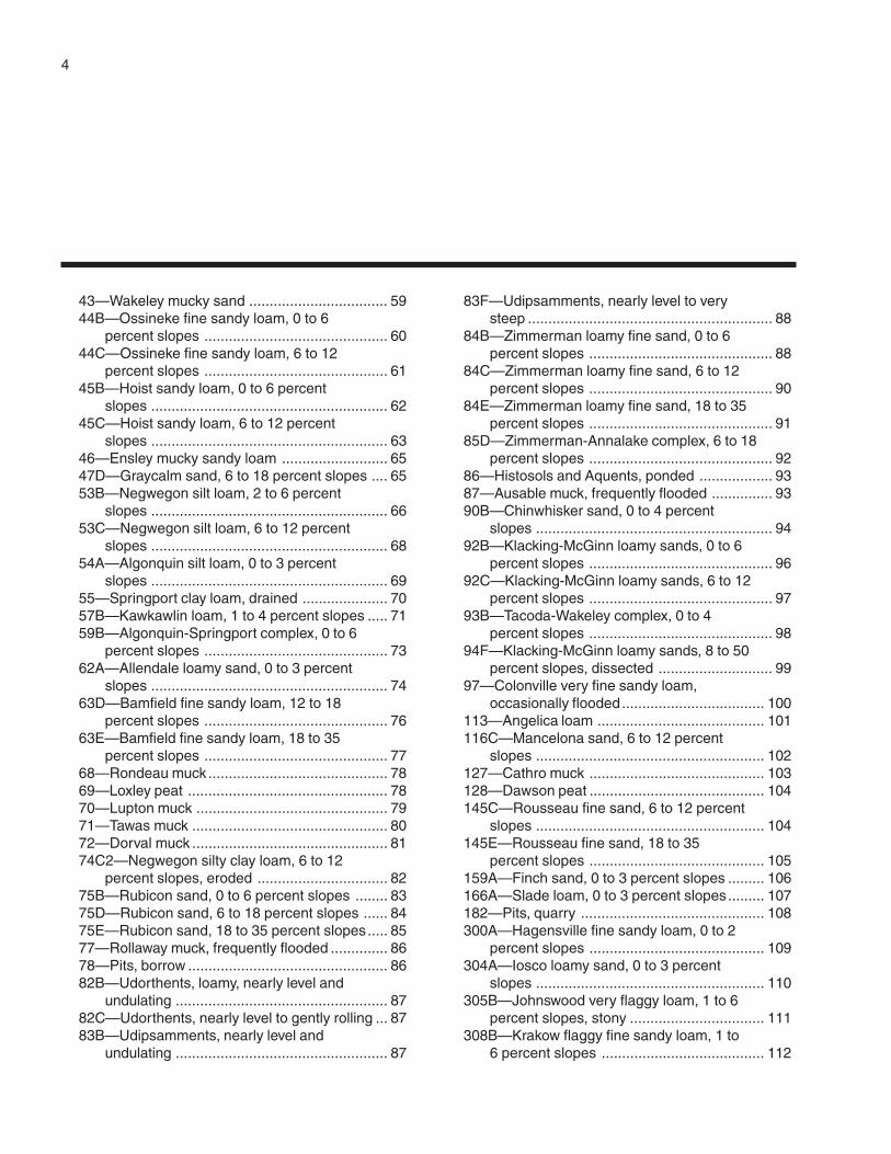
4
43—Wakeley mucky sand .................................. 5944B—Ossineke fine sandy loam, 0 to 6
percent slopes ............................................. 6044C—Ossineke fine sandy loam, 6 to 12
percent slopes ............................................. 6145B—Hoist sandy loam, 0 to 6 percent
slopes .......................................................... 6245C—Hoist sandy loam, 6 to 12 percent
slopes .......................................................... 6346—Ensley mucky sandy loam .......................... 6547D—Graycalm sand, 6 to 18 percent slopes .... 6553B—Negwegon silt loam, 2 to 6 percent
slopes .......................................................... 6653C—Negwegon silt loam, 6 to 12 percent
slopes .......................................................... 6854A—Algonquin silt loam, 0 to 3 percent
slopes .......................................................... 6955—Springport clay loam, drained ..................... 7057B—Kawkawlin loam, 1 to 4 percent slopes ..... 7159B—Algonquin-Springport complex, 0 to 6
percent slopes ............................................. 7362A—Allendale loamy sand, 0 to 3 percent
slopes .......................................................... 7463D—Bamfield fine sandy loam, 12 to 18
percent slopes ............................................. 7663E—Bamfield fine sandy loam, 18 to 35
percent slopes ............................................. 7768—Rondeau muck ............................................ 7869—Loxley peat ................................................. 7870—Lupton muck ............................................... 7971—Tawas muck ................................................ 8072—Dorval muck ................................................ 8174C2—Negwegon silty clay loam, 6 to 12
percent slopes, eroded ................................ 8275B—Rubicon sand, 0 to 6 percent slopes ........ 8375D—Rubicon sand, 6 to 18 percent slopes ...... 8475E—Rubicon sand, 18 to 35 percent slopes..... 8577—Rollaway muck, frequently flooded .............. 8678—Pits, borrow ................................................. 8682B—Udorthents, loamy, nearly level and
undulating .................................................... 8782C—Udorthents, nearly level to gently rolling ... 8783B—Udipsamments, nearly level and
undulating .................................................... 87
83F—Udipsamments, nearly level to verysteep ............................................................ 88
84B—Zimmerman loamy fine sand, 0 to 6percent slopes ............................................. 88
84C—Zimmerman loamy fine sand, 6 to 12percent slopes ............................................. 90
84E—Zimmerman loamy fine sand, 18 to 35percent slopes ............................................. 91
85D—Zimmerman-Annalake complex, 6 to 18percent slopes ............................................. 92
86—Histosols and Aquents, ponded .................. 9387—Ausable muck, frequently flooded ............... 9390B—Chinwhisker sand, 0 to 4 percent
slopes .......................................................... 9492B—Klacking-McGinn loamy sands, 0 to 6
percent slopes ............................................. 9692C—Klacking-McGinn loamy sands, 6 to 12
percent slopes ............................................. 9793B—Tacoda-Wakeley complex, 0 to 4
percent slopes ............................................. 9894F—Klacking-McGinn loamy sands, 8 to 50
percent slopes, dissected ............................ 9997—Colonville very fine sandy loam,
occasionally flooded................................... 100113—Angelica loam ......................................... 101116C—Mancelona sand, 6 to 12 percent
slopes ........................................................ 102127—Cathro muck ........................................... 103128—Dawson peat ........................................... 104145C—Rousseau fine sand, 6 to 12 percent
slopes ........................................................ 104145E—Rousseau fine sand, 18 to 35
percent slopes ........................................... 105159A—Finch sand, 0 to 3 percent slopes ......... 106166A—Slade loam, 0 to 3 percent slopes......... 107182—Pits, quarry ............................................. 108300A—Hagensville fine sandy loam, 0 to 2
percent slopes ........................................... 109304A—Iosco loamy sand, 0 to 3 percent
slopes ........................................................ 110305B—Johnswood very flaggy loam, 1 to 6
percent slopes, stony ................................. 111308B—Krakow flaggy fine sandy loam, 1 to
6 percent slopes ........................................ 112
5
308C—Krakow flaggy fine sandy loam, 6 to12 percent slopes ...................................... 113
308D—Krakow flaggy fine sandy loam, 12to 18 percent slopes .................................. 114
316—Ruse loam .............................................. 115350E—Blue Lake sand, 18 to 35 percent
slopes ........................................................ 116359C—Algonquin-Negwegon-Dorval
complex, 0 to 12 percent slopes ................ 117361B—Allendale-Dorval-Blue Lake complex,
0 to 6 percent slopes.................................. 120362D—Millersburg loamy sand, 6 to 18
percent slopes ........................................... 122362E—Millersburg loamy sand, 18 to 35
percent slopes ........................................... 123368A—Au Gres-Deford complex, 0 to 3
percent slopes ........................................... 124369—Deford muck ........................................... 125371—Springport silt loam ................................. 126373B—Grayling sand, very deep water table,
0 to 6 percent slopes.................................. 127374—Thunderbay very fine sandy loam,
frequently flooded ...................................... 128376A—Urban land-Udipsamments, deep
water table, complex, 0 to 3 percentslopes ........................................................ 129
380—Access denied ........................................ 130392—Caffey mucky sand ................................. 130393B—Morganlake loamy sand, 0 to 6
percent slopes ........................................... 131393C—Morganlake loamy sand, 6 to 12
percent slopes ........................................... 132396F—Proper-Deford-Rousseau complex, 0
to 40 percent slopes .................................. 133397—Spot peat ................................................ 135414B—Namur channery silt loam, 0 to 6
percent slopes ........................................... 135415A—Potagannissing silt loam, 0 to 3
percent slopes ........................................... 136416B—Negwegon silt loam, till substratum,
2 to 6 percent slopes.................................. 137417B—Alpena gravelly sandy loam, 0 to 6
percent slopes ........................................... 138417C—Alpena gravelly sandy loam, 6 to 12
percent slopes ........................................... 139
418E—Alpena gravelly sandy loam, esker,18 to 35 percent slopes .............................. 140
419—Chippeny muck ....................................... 141420A—Otisco mucky sand, 0 to 3 percent
slopes ........................................................ 142424B—Morganlake-Ossineke, sandy
substratum-Blue Lake complex, 0 to 6percent slopes ........................................... 143
424C—Morganlake-Ossineke, sandysubstratum-Blue Lake complex, 6 to 12percent slopes ........................................... 145
426B—Coppler loamy sand, 0 to 6 percentslopes ........................................................ 147
426C—Coppler loamy sand, 6 to 12 percentslopes ........................................................ 148
426D—Coppler loamy sand, 12 to 18percent slopes ........................................... 150
451C—Annalake loamy fine sand, 6 to 12percent slopes ........................................... 151
477B—Algonquin, till substratum-Springport,till substratum, complex, 0 to 4 percentslopes ........................................................ 152
478—Springport silty clay loam, tillsubstratum ................................................. 154
479A—Algonquin silt loam, till substratum, 0to 3 percent slopes .................................... 155
480B—Negwegon-Algonquin-Luptoncomplex, 0 to 6 percent slopes .................. 156
481C—Negwegon-Lupton complex, 0 to 12percent slopes ........................................... 158
482B—Summerville fine sandy loam, 0 to 6percent slopes ........................................... 160
482C—Summerville fine sandy loam, 6 to12 percent slopes ...................................... 162
483A—Lachine loam, 0 to 3 percentslopes ........................................................ 163
484A—Elcajon loam, 0 to 3 percent slopes ...... 164485A—Bowers silt loam, 0 to 3 percent
slopes ........................................................ 165486B—Tonkey-Bowers silt loams, 0 to 4
percent slopes ........................................... 167487B—Slade-Angelica loams, 0 to 4 percent
slopes ........................................................ 168489F—Crowell-Proper fine sands, 3 to 40
percent slopes ........................................... 170
6
Use and Management of the Soils .................... 173Crops and Pasture ........................................... 173
Yields per Acre ............................................. 175Land Capability Classification ...................... 175Prime Farmland ........................................... 176
Forestland Management and Productivity ........ 176Equipment Limitations on Forestland ........... 179
Plant Communities on Selected Soils ............... 179Windbreaks and Environmental Plantings ........ 180Recreation ........................................................ 180Wildlife Habitat ................................................. 181Engineering ...................................................... 182
Building Site Development ........................... 183Sanitary Facilities ......................................... 184Construction Materials ................................. 185Water Management ...................................... 186
Soil Properties .................................................... 189Engineering Index Properties ........................... 189Physical Properties .......................................... 190Chemical Properties ......................................... 191Soil Features .................................................... 191Water Features ................................................. 192Hydric Soils ...................................................... 193
Classification of the Soils .................................. 195Soil Series and Their Morphology ......................... 195
Algonquin Series .............................................. 195Allendale Series ............................................... 196Alpena Series ................................................... 197Angelica Series ................................................ 198Annalake Series ............................................... 198Aquents ............................................................ 199Au Gres Series ................................................. 199Ausable Series ................................................. 200Bamfield Series ................................................ 200Battlefield Series .............................................. 201Blue Lake Series .............................................. 202Bowers Series .................................................. 202Caffey Series .................................................... 203Cathro Series ................................................... 204Chinwhisker Series .......................................... 204Chippeny Series ............................................... 205Colonville Series............................................... 206Coppler Series ................................................. 206Croswell Series ................................................ 207Crowell Series .................................................. 208
Dawson Series ................................................. 208Deford Series ................................................... 209Dorval Series ................................................... 209East Lake Series .............................................. 210Eastport Series ................................................ 210Elcajon Series .................................................. 211Ensley Series ................................................... 211Finch Series ..................................................... 212Graycalm Series ............................................... 213Grayling Series ................................................. 213Hagensville Series ........................................... 214Histosols .......................................................... 214Hoist Series ...................................................... 215Iosco Series ..................................................... 215Johnswood Series ............................................ 216Kawkawlin Series ............................................. 221Killmaster Series .............................................. 221Kinross Series .................................................. 222Klacking Series ................................................ 223Krakow Series .................................................. 224Lachine Series ................................................. 224Leafriver Series ................................................ 225Loxley Series .................................................... 225Lupton Series ................................................... 226Mancelona Series ............................................ 226McGinn Series.................................................. 227Millersburg Series............................................. 228Morganlake Series ........................................... 229Namur Series ................................................... 229Negwegon Series ............................................. 230Ossineke Series ............................................... 231Otisco Series .................................................... 232Potagannissing Series ...................................... 232Proper Series ................................................... 233Richter Series................................................... 233Rollaway Series ................................................ 234Rondeau Series ............................................... 235Rousseau Series .............................................. 235Rubicon Series ................................................. 236Ruse Series ..................................................... 236Slade Series ..................................................... 237Spot Series ...................................................... 238Springport Series ............................................. 238Summerville Series .......................................... 239Tacoda Series .................................................. 239
7
Tawas Series .................................................... 240Thunderbay Series ........................................... 241Tonkey Series ................................................... 241Udipsamments ................................................. 242Udorthents ....................................................... 242Wakeley Series ................................................ 242Wheatley Series ............................................... 243Zimmerman Series ........................................... 243
Formation of the Soils ........................................ 245Factors of Soil Formation ................................. 245
Parent Material ............................................. 245Plant and Animal life ..................................... 246Climate ......................................................... 246Relief ............................................................ 246Time ............................................................. 246
Processes of Soil Formation............................. 246References .......................................................... 249Glossary .............................................................. 251Tables .................................................................. 265
Table 1.—Temperature and Precipitation .......... 266Table 2.—Freeze Dates in Spring and Fall ........ 267Table 3.—Growing Season ............................... 267Table 4.—Acreage and Proportionate Extent
of the Soils ................................................. 268Table 5.—Land Capability and Yields per
Acre of Crops ............................................. 271
Table 6.—Yields per Acre of Hay andPasture ...................................................... 278
Table 7.—Prime Farmland ................................ 281Table 8.—Forestland Management and
Productivity ................................................ 282Table 9.—Equipment Limitations on
Forestland .................................................. 300Table 10.—Plant Communities on Selected
Soils ........................................................... 310Table 11.—Windbreaks and Environmental
Plantings .................................................... 336Table 12.—Recreational Development .............. 348Table 13.—Wildlife Habitat ................................ 361Table 14.—Building Site Development .............. 371Table 15.—Sanitary Facilities ........................... 384Table 16.—Construction Materials .................... 398Table 17.—Water Management ........................ 411Table 18.—Engineering Index Properties ......... 427Table 19.—Physical Properties of the
Soils ........................................................... 458Table 20.—Chemical Properties of the
Soils ........................................................... 476Table 21.—Soil Features .................................. 494Table 22.—Water Features ............................... 502Table 23.—Soil Moisture Status by Depth ........ 518Table 24.—Classification of the Soils ................ 542
Issued 2004


9
This soil survey contains information that affects land use planning in this surveyarea. It contains predictions of soil behavior for selected land uses. The survey alsohighlights soil limitations, improvements needed to overcome the limitations, and theimpact of selected land uses on the environment.
This soil survey is designed for many different users. Farmers, foresters, andagronomists can use it to evaluate the potential of the soil and the management neededfor maximum food and fiber production. Planners, community officials, engineers,developers, builders, and home buyers can use the survey to plan land use, select sitesfor construction, and identify special practices needed to ensure proper performance.Conservationists, teachers, students, and specialists in recreation, wildlifemanagement, waste disposal, and pollution control can use the survey to help themunderstand, protect, and enhance the environment.
Various land use regulations of Federal, State, and local governments may imposespecial restrictions on land use or land treatment. The information in this report isintended to identify soil properties that are used in making various land use or landtreatment decisions. Statements made in this report are intended to help the land usersidentify and reduce the effects of soil limitations that affect various land uses. Thelandowner or user is responsible for identifying and complying with existing laws andregulations.
Great differences in soil properties can occur within short distances. Some soils areseasonally wet or subject to flooding. Some are shallow to bedrock. Some are toounstable to be used as a foundation for buildings or roads. Clayey or wet soils arepoorly suited to use as septic tank absorption fields. A high water table makes a soilpoorly suited to basements or underground installations.
These and many other soil properties that affect land use are described in this soilsurvey. Broad areas of soils are shown on the general soil map. The location of eachsoil is shown on the detailed soil maps. Each soil in the survey area is described.Information on specific uses is given for each soil. Help in using this publication andadditional information are available at the local office of the Natural ResourcesConservation Service or the Cooperative Extension Service.
Ronald C. WilliamsState ConservationistNatural Resources Conservation Service
Foreword

11
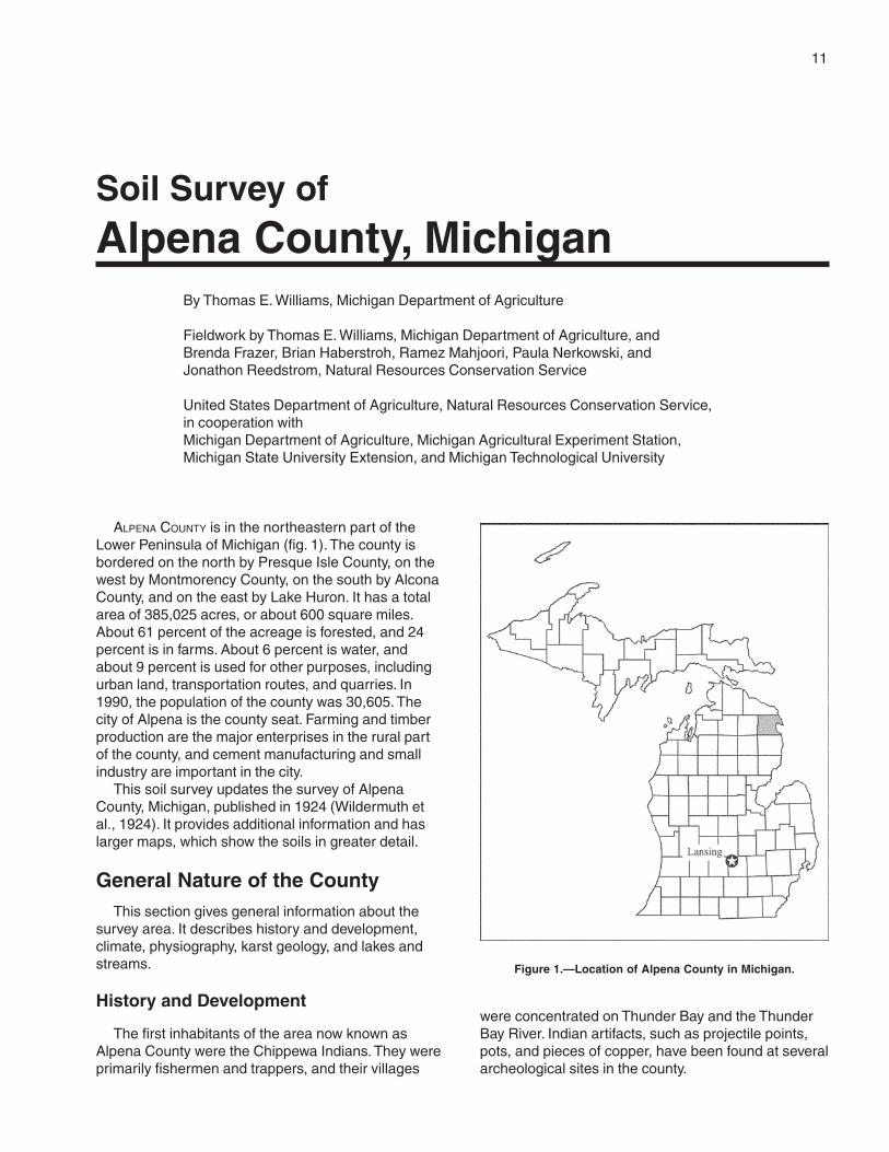
ALPENA COUNTY is in the northeastern part of theLower Peninsula of Michigan (fig. 1). The county isbordered on the north by Presque Isle County, on thewest by Montmorency County, on the south by AlconaCounty, and on the east by Lake Huron. It has a totalarea of 385,025 acres, or about 600 square miles.About 61 percent of the acreage is forested, and 24percent is in farms. About 6 percent is water, andabout 9 percent is used for other purposes, includingurban land, transportation routes, and quarries. In1990, the population of the county was 30,605. Thecity of Alpena is the county seat. Farming and timberproduction are the major enterprises in the rural partof the county, and cement manufacturing and smallindustry are important in the city.
This soil survey updates the survey of AlpenaCounty, Michigan, published in 1924 (Wildermuth etal., 1924). It provides additional information and haslarger maps, which show the soils in greater detail.
General Nature of the CountyThis section gives general information about the
survey area. It describes history and development,climate, physiography, karst geology, and lakes andstreams.
History and Development
The first inhabitants of the area now known asAlpena County were the Chippewa Indians. They wereprimarily fishermen and trappers, and their villages
were concentrated on Thunder Bay and the ThunderBay River. Indian artifacts, such as projectile points,pots, and pieces of copper, have been found at severalarcheological sites in the county.
Soil Survey of
Alpena County, MichiganBy Thomas E. Williams, Michigan Department of Agriculture
Fieldwork by Thomas E. Williams, Michigan Department of Agriculture, andBrenda Frazer, Brian Haberstroh, Ramez Mahjoori, Paula Nerkowski, andJonathon Reedstrom, Natural Resources Conservation Service
United States Department of Agriculture, Natural Resources Conservation Service,in cooperation withMichigan Department of Agriculture, Michigan Agricultural Experiment Station,Michigan State University Extension, and Michigan Technological University
Figure 1.—Location of Alpena County in Michigan.
12 Soil Survey of
In 1787, the Northwest Ordinance was enacted.The survey area became part of Wayne County,Indiana, Territory in 1796. In 1818, after establishmentof the Michigan Territory in 1805, it became part ofMichilimackinac County. In 1819, the Chippewa Nationof Indians, through the Treaty of Saginaw, ceded theland south of the Thunder Bay River to the UnitedStates. This part of the county became part ofOakland County in 1822. The land north of theThunder Bay River was ceded by the Treaty ofWashington in 1836. The county was namedAnomickee in 1840. In 1843, the name changed toAlpena, which is an Indian word meaning “a goodpartridge country.” A land survey was conducted in thecounty in 1873.
European settlement of the county began in themid-1800s, when several people moved into thesurvey area and began logging the great stands oftimber. Daniel Carter is considered to be the firstpermanent European settler in Alpena County (Lawand Law, 1975).
Alpena County was officially organized in 1857. Atthat time, the population was 290, and the county seatwas Fremont. The name “Fremont” was later changedto “Alpena.”
Logging was the dominant industry at the time ofsettlement and remained so for many years. It stilloccurs in the county. As the countryside was cleared,agriculture made it’s way into the county. It remains avery important industry in the county. Heavy industryin Alpena plays a very important role in the economyof the county.
Climate
Prepared by the Water and Climate Center, Natural ResourcesConservation Service, Portland, Oregon. Climate tables werecreated from data collected at Phelps Collins Airport.
Table 1 gives data on temperature and precipitationfor the survey area as recorded at Alpena in the period1961 to 1990. Table 2 shows probable dates of the firstfreeze in fall and the last freeze in spring. Table 3provides data on length of the growing season.
In winter, the average temperature is 19.9 degreesF and the average daily minimum temperature is 11.2degrees. The lowest temperature on record, whichoccurred on February 17, 1979, is -37 degrees. Insummer, the average temperature is 64.3 degrees andthe average daily maximum temperature is 77.0degrees. The highest recorded temperature, whichoccurred on June 19, 1995, is 103 degrees.
Growing degree days are shown in table 1. Theyare equivalent to “heat units.” During the month,growing degree days accumulate by the amount that
the average temperature each day exceeds a basetemperature (40 degrees F). The normal monthlyaccumulation is used to schedule single or successiveplantings of a crop between the last freeze in springand the first freeze in fall.
The total annual precipitation is 28.97 inches. Ofthis, about 9.36 inches, or about 32 percent, usuallyfalls in June through August. The growing season formost crops falls within this period. The heaviest 1-dayrainfall during the period of record was 3.02 inches onSeptember 10, 1968. Thunderstorms occur on about32 days each year, and most occur in July.
The average seasonal snowfall is about 87.0inches. The greatest snow depth at any one timeduring the period of record was 37 inches, recordedon February 19, 1985. On the average, 111 days ofthe year have at least 1 inch of snow on the ground.The heaviest 1-day snowfall on record was 17.3inches, recorded on March 4, 1985.
The average relative humidity in midafternoon isabout 61 percent. Humidity is higher at night, and theaverage at dawn is about 83 percent. The sun shines63 percent of the time possible in summer and 37percent in winter. The prevailing wind is from thesouthwest. Average windspeed is highest, 9.2 milesper hour, in April.
Physiography
Alpena County is in the northeast upland division ofthe State. This division is covered dominantly by thickdeposits of glacial drift. The major topographicdivisions are level and undulating plains and rolling tohilly morainic areas. Four distinct kinds of surfacefeatures occur in Alpena County. These features aremoraines, lake plains, karst plains, and flood plains.
The morainic areas are divided into dissectedmoraines and ground moraines. The dissectedmoraines were deposited by the action of glaciersand subsequently were partly eroded or dissected bymeltwater and precipitation. These moraines are at thehigher elevations and characteristically have steepsides and numerous valleys. The largest dissectedmoraine in the county is in most of the western part ofOssineke Township. The ground moraines arecomposed of glacial till that was deposited and shapedat the base of the glaciers. These moraines arecharacterized by elongated hills and ridges orientedin the direction of the movement of the glacial ice. Thelargest ground moraines in the county are in theeastern part of Ossineke Township and in LongRapids Township.
The lake plains are associated with the formerGreat Lakes Warren, Algonquin, and Nipissing. These
Alpena County, Michigan 13
plains are characterized by nearly level to undulatingareas separated in places by steep scarps that reflectchanges in lake elevation. The largest lake plains arein the northern part of Wilson Township and thewestern part of Wellington Township.
The karst plains are areas that are shallow tolimestone bedrock. These areas have thin layers oflacustrine deposits, glacial till, or wind-depositedmaterial or exposed rock. The rock is partiallydissolved, resulting in widened fractures and zonesthat are subject to collapse. The largest karst plainsare in Alpena Township, north of Alpena, and in MapleRidge Township.
The flood plains are associated with the largerrivers—Thunder Bay River and Wolf Creek. Theseplains are characterized by nearly level and levelareas of waterborne sediment usually depositedduring annual spring flooding. The largest flood plainfollows the main branch of the Thunder Bay River fromthe center of the west side of the county to the river’soutlet in Alpena.
The highest elevation in the county, 1,105 feetabove mean sea level, is about a mile east of TurtleLake. The lowest elevation, 577 feet above mean sealevel, is at the shoreline of Lake Huron, which formsthe eastern boundary of the county
Karst Geology
By Tyrone J. Black, Michigan Department of Natural Resources,Geological Survey Division.
The Alpena County area is well known for its karstfeatures. The term “karst” is used for the manyexpressions of ground-water action upon limestonebedrock. Sinkholes, swallows, and caves are the karstfeatures that can have a substantial impact on farmingand construction. Sinkholes are of two general types—solution and collapse. Pits dissolved into bedrock bynaturally occurring acids in ground water are calledsolution sinkholes. The solution sinkholes in AlpenaCounty are evidenced by the swallowing of soil orwater into bedrock cavities. These features are a fewinches to a few feet in size and act as feeders to adeeper system or as a separate shallow karst system.
In northern Michigan, the sinkholes larger than afew feet are collapse sinks. Collapse sinks are causedby the collapse of bedrock into large cavities orcaverns. Collapse may be accelerated by solutionenlargement of the cavity or fractures in the roof of thecollapsing cavern.
The fault trend of Presque Isle and Alpena Countiesis an area of natural fissures and faults. It can be
traced on the surface from Trap Lake, Mindack Lake,and Fitzgerald Lake to southern Long Lake and DevilsLake. These fractures have provided a path for groundwater to enter the formation and dissolve theevaporites of the Detroit River Group. This group is abedrock formation made up of a sequence oflimestones, shales, and evaporite minerals. Evaporitesinclude halite (salt), gypsum, and anhydrite. Once theevaporites are removed, the formation settles. Some ofthe settling occurs unevenly and results in localcollapses. Sinkholes occur where the collapsereaches the surface.
Sinkholes allow greater potential loss ofoverburden, by soil piping, into the cavities. The soilssettle in the cavities and caverns while water deep inthe system flows underground to Lake Huron.
Collapse of the sinkholes generally occurred 1,000to 10,000 years ago, after the last glacier retreatedfrom the survey area. The sinkholes are a few feet tomore than 2,000 feet across, commonly 50 to 400 feetacross, and are 2 to 120 feet deep. They have distincttop edges, are normally circular, and have steep tovertical walls. Their vertical rock walls are revealed inareas of thin glacial drift. Only the sinkholes that havebeen “active” since the retreat of the glacier about10,000 years ago have become visible at the surface.All of the major rock-quarrying operations in northernMichigan, except for those at Alpena and Rockport,have encountered drift-covered “stagnant” collapsesinkholes, indicating that the range of the sinkholescovers much of the northern tip of the LowerPeninsula.
Thick drift and rubble have created plugs over mostswallows and some sinkholes. This condition preventsthe active flow or erosion of rock or soil material intoany voids. If there is no movement of soil or rock intothe lower voids, then there is no slumping or collapseof overburden.
Karst-related subsidence features have recentlycaused damage in the county. Most features of thistype are on soils that are moderately deep to veryshallow over bedrock. The smaller features arenuisances; the larger features have caused loss oflivestock or equipment damage. Farmers have usedmany as locations for stone piles. They haveattempted to bridge some with logs and stone. Thelogs eventually rot out. Stone bridges delay the loss ofsoil.
Sinks act as funnels, focusing a greater volume ofwater and surface materials into the underlying rockformation. If the sinkhole has swallowed enoughoverburden or occurred in the right location, it maycapture all or part of a stream. The water may thenfind its way to the bedrock without being acid-buffered
14 Soil Survey of
by the glacial drift. Then, active chemical erosion of thelimestone bedrock occurs.
Tracing or capturing contaminated water lost to thekarst systems in Alpena County can be extremelydifficult. A fracture or cavern system immediatelyconfines any waterflow entering the system. Thesechannels may zigzag along fracture patterns or filter inand out of the surrounding host rock. These paths alsomay join others to become larger passages. Groundwater may flow in a direction completely unexpectedwhen only surface topography is considered. The dipof an aquitard (confining layer) and points of aquiferdrainage dramatically affect the flow direction. A karstsystem adds to this complexity.
The shallow karst system in the area from theAlpena golf course to Alpena Community Collegedischarges its water to the Thunder Bay River near thecollege campus. Discharge points of the deep karstsystem include El Cajon Bay, off the northeast side ofMiddle Island, and undiscovered locations in LakeHuron, offshore of northeastern Alpena County.
Ground water emerges where surface topographycuts below the surface of the ground-water level. Thewater also may be drawn off into areas of lowerground water. These areas can be layers of coarsematerials, or they can be open fissures and voids inthe bedrock that discharge the water efficientlyelsewhere.
Lakes and Streams
Alpena County has about 17 lakes and 3 majorrivers. These water areas differ in size, shape, andshoreline characteristics. Bodies of water more than40 acres in size make up about 21,824 acres of thesurvey area.
Among the larger lakes are Fletcher Pond and LongLake. Small ponds and lakes are in some limestonesinkholes. Jacobs Lake, Denton Lake, and CoombsLake occupy three sinkholes in Alpena County.
The rivers and streams in Alpena County eventuallydrain into Lake Huron. The largest river, the ThunderBay River, has three large tributaries. The NorthBranch Thunder Bay River flows through a large lakeplain and drains part of Montmorency County to thewest and part of Presque Isle County to the north. Itswatershed is comprised of sandy material in thehigher areas and loamy and silty materials on the lakeplain. A portion of this tributary flows through a karstplain. Some water is captured by fractures in thelimestone. Sunken Lake, in Presque Isle, is an areawhere dams have been built to prevent diversion of theflow underground. The Upper South Branch ThunderBay River runs for about 4 miles and connects
Fletcher Pond to the main branch. The Lower SouthBranch Thunder Bay River connects Hubbard Lake inAlcona County to Lake Winyah. It drains a largeground moraine that is dominantly farmland.
How This Survey Was MadeThis survey was made to provide information about
the soils and miscellaneous areas in the survey area.The information includes a description of the soils andmiscellaneous areas and their location and adiscussion of their suitability, limitations, andmanagement for specified uses. Soil scientistsobserved the steepness, length, and shape of theslopes; the general pattern of drainage; the kinds ofcrops and native plants; and the kinds of bedrock.They dug many holes to study the soil profile, which isthe sequence of natural layers, or horizons, in a soil.The profile extends from the surface down into theunconsolidated material in which the soil formed. Theunconsolidated material is devoid of roots and otherliving organisms and has not been changed by otherbiological activity.
The soils and miscellaneous areas in the surveyarea are in an orderly pattern that is related to thegeology, landforms, relief, climate, and naturalvegetation of the area. Each kind of soil andmiscellaneous area is associated with a particular kindof landform or with a segment of the landform. Byobserving the soils and miscellaneous areas in thesurvey area and relating their position to specificsegments of the landform, a soil scientist develops aconcept or model of how they were formed. Thus,during mapping, this model enables the soil scientistto predict with a considerable degree of accuracy thekind of soil or miscellaneous area at a specific locationon the landscape.
Commonly, individual soils on the landscape mergeinto one another as their characteristics graduallychange. To construct an accurate soil map, however,soil scientists must determine the boundaries betweenthe soils. They can observe only a limited number ofsoil profiles. Nevertheless, these observations,supplemented by an understanding of the soil-vegetation-landscape relationship, are sufficient toverify predictions of the kinds of soil in an area and todetermine the boundaries.
Soil scientists recorded the characteristics of thesoil profiles that they studied. They noted color,texture, size and shape of soil aggregates, kind andamount of rock fragments, distribution of plant roots,reaction, and other features that enable them toidentify soils. After describing the soils in the surveyarea and determining their properties, the soil
Alpena County, Michigan 15
scientists assigned the soils to taxonomic classes(units). Taxonomic classes are concepts. Eachtaxonomic class has a set of soil characteristics withprecisely defined limits. The classes are used as abasis for comparison to classify soils systematically.Soil taxonomy, the system of taxonomic classificationused in the United States, is based mainly on the kindand character of soil properties and the arrangementof horizons within the profile. After the soil scientistsclassified and named the soils in the survey area, theycompared the individual soils with similar soils in thesame taxonomic class in other areas so that theycould confirm data and assemble additional databased on experience and research.
While a soil survey is in progress, samples of someof the soils in the area generally are collected forlaboratory analyses and for engineering tests. Soilscientists interpret the data from these analyses andtests as well as the field-observed characteristics andthe soil properties to determine the expected behaviorof the soils under different uses. Interpretations for allof the soils are field tested through observation of thesoils in different uses and under different levels ofmanagement. Some interpretations are modified to fitlocal conditions, and some new interpretations aredeveloped to meet local needs. Data are assembledfrom other sources, such as research information,production records, and field experience of specialists.For example, data on crop yields under defined levelsof management are assembled from farm records andfrom field or plot experiments on the same kinds ofsoil.
Predictions about soil behavior are based not onlyon soil properties but also on such variables asclimate and biological activity. Soil conditions arepredictable over long periods of time, but they are notpredictable from year to year. For example, soilscientists can predict with a fairly high degree ofaccuracy that a given soil will have a high water tablewithin certain depths in most years, but they cannotpredict that a high water table will always be at aspecific level in the soil on a specific date.
After soil scientists located and identified thesignificant natural bodies of soil in the survey area,they drew the boundaries of these bodies on aerialphotographs and identified each as a specific mapunit. Aerial photographs show trees, buildings, fields,
roads, and rivers, all of which help in locatingboundaries accurately.
The descriptions and names of the soils in thissurvey area do not fully agree with those of the soils inadjacent survey areas. Differences are the result of abetter knowledge of soils, modifications in seriesconcepts, or variations in the intensity of mapping or inthe extent of the soils in the survey areas.
In some areas of Alpena County, the soil scientistswere denied access. No information is about the soilsin these areas is currently available. These areas arein map unit 380.
Survey Procedures
The general procedures followed in making thissurvey are described in the “National Soil SurveyHandbook” and the Soil Survey Manual of the NaturalResources Conservation Service (USDA, 2002; SoilSurvey Division Staff, 1993).
Before traversing the landscape, the soil scientistscompared each map sheet to the USGS topographicmap for the area and stereoscopically plottedpreliminary boundaries of slopes and landforms onaerial photographs. Traverses were made on foot. Mostwere made at intervals of about one-eighth mile.Traverses or random observations were made atcloser intervals in areas of high variability.
Soil examinations along traverses were made eachone-eighth mile, or wherever obvious soil boundarieswere crossed. Observations of such items aslandforms, blown-down trees, vegetation, androadbanks were made continuously without regard tospacing. Soil boundaries were determined on thebasis of soil examination, observations, and photointerpretation. The soil material was examined with theaid of a hand auger or a spade to a depth of about 6feet. The pedons described as typical were observedand studied in pits.
Samples for chemical and physical analysis weretaken from the site of the typical pedon for some of themajor soils in the survey area. The analyses weremade by the National Soil Survey Laboratory inLincoln, Nebraska (USDA, 1996). The results of theanalyses are stored in a computerized data file at thelaboratory. The results and the laboratory procedurescan be obtained by request from the laboratory.

17
The general soil map in this publication showsbroad areas that have a distinctive pattern of soils,relief, and drainage. Each association on the generalsoil map is a unique natural landscape. Typically, itconsists of one or more major soils or miscellaneousareas and some minor soils or miscellaneous areas. Itis named for the major soils or miscellaneous areas.The components of one association can occur inanother but in a different pattern.
The general soil map can be used to compare thesuitability of large areas for general land uses. Areasof suitable soils can be identified on the map. Likewise,areas where the soils are not suitable can be identified.
Because of its small scale, the map is not suitablefor planning the management of a farm or field or forselecting a site for a road or building or other structure.The soils in any one association differ from place toplace in slope, depth, drainage, and othercharacteristics that affect management.
Very Deep, Level to Undulating Soils ThatAre Very Poorly Drained, SomewhatPoorly Drained, and Moderately WellDrained
1. Deford-Au Gres-Croswell Association
Very deep, level to undulating, very poorly drained,somewhat poorly drained, and moderately welldrained, mucky and sandy soils in areas ofdepressions, beaches, and bars on lake terraces
Setting
Landform: Lake terracesSlope range: 0 to 6 percent
Composition
Extent of the association:6 percent of the survey area
Extent of the soils in the association:Deford soils—43 percentAu Gres soils—22 percentCroswell soils—20 percent
Minor soils—15 percent
Soil Properties and Qualities
Deford
Depth class: Very deepDrainage class: Very poorly drainedPosition on the landform: DepressionsParent material: Organic and sandy lacustrine
sedimentsTexture of the surface layer: MuckSlope: Level and nearly level
Au Gres
Depth class: Very deepDrainage class: Somewhat poorly drainedPosition on the landform: The slightly higher areas on
beaches and barsParent material: Sandy lacustrine sedimentsTexture of the surface layer: SandSlope: Level and nearly level
Croswell
Depth class: Very deepDrainage class: Moderately well drainedPosition on the landform: The slightly higher areas on
beaches and barsParent material: Sandy lacustrine sedimentsTexture of the surface layer: SandSlope: Nearly level to undulating
Minor Soils
• Tawas and Lupton soils in level areas• Finch soils on low beach ridges
Use and Management
Major uses: Woodland, building site developmentManagement concerns: Wetness, ponding, equipment
limitationsManagement measures on woodland: Harvesting in
the driest season or in winter, when the ground isfrozen, and using harvest methods that help toprevent windthrow by leaving the remaining treesproperly spaced
General Soil Map Units
18 Soil Survey of
Management measures in areas used for building sitedevelopment: Drainage systems around buildingsites and mounding of septic tank absorptionfields
2. Tacoda-Tawas Association
Very deep, level to gently undulating, somewhat poorlydrained and very poorly drained, sandy and muckysoils that formed in sandy or organic materialunderlain by sandy or sandy and clayey material; onlake terraces
Setting
Landform: Lake terracesSlope range: 0 to 4 percent
Composition
Extent of the association:14 percent of the survey area
Extent of the soils in the association:Tacoda soils—46 percentTawas soils—35 percentMinor soils—19 percent
Soil Properties and Qualities
Tacoda
Depth class: Very DeepDrainage class: Somewhat poorly drainedPosition on the landform: The sides and summits of
beaches and barsParent material: Sandy and sandy over clayey
lacustrine sedimentsTexture of the surface layer: SandSlope: Nearly level and gently undulating
Tawas
Depth class: Very DeepDrainage class: Very poorly drainedPosition on the landform: SwalesParent material: Organic and sandy lacustrine
sedimentsTexture of the surface layer: MuckSlope: Level
Minor Soils
• Udipsamments and Grayling soils on ridges• Springport soils in depressions• Ausable soils on flood plains• Battlefield soils on low beach ridges
Use and Management
Major uses: Woodland, building site development
Management concerns: Wetness, ponding, equipmentlimitations
Management measures on woodland: Harvesting inthe driest season or in winter, when the ground isfrozen, and using harvest methods that help toprevent windthrow by leaving the remaining treesproperly spaced
Management measures in areas used for building sitedevelopment: Drainage systems around buildingsites and mounding of septic tank absorptionfields
3. Lupton-Tawas-Cathro Association
Very deep, level and nearly level, very poorly drained,mucky soils that formed in organic material or inorganic material over sandy or loamy material; on lakeplains and ground moraines
Setting
Landform: Lake plains and ground morainesSlope range: 0 to 2 percent
Composition
Extent of the association:14 percent of the survey area
Extent of the soils in the association:Lupton soils—40 percentTawas soils—35 percentCathro soils—17 percentMinor soils—8 percent
Soil Properties and Qualities
Lupton
Depth class: Very deepDrainage class: Very poorly drainedPosition on the landform: DepressionsParent material: Organic materialTexture of the surface layer: MuckSlope: Level and nearly level
Tawas
Depth class: Very DeepDrainage class: Very poorly drainedPosition on the landform: DepressionsParent material: Organic and sandy lacustrine
sedimentsTexture of the surface layer: MuckSlope: Level and nearly level
Cathro
Depth class: Very deepDrainage class: Very poorly drained
Alpena County, Michigan 19
Position on the landform: DepressionsParent material: Organic material and loamy glacial till
or lacustrine sedimentsTexture of the surface layer: MuckSlope: Level and nearly level
Minor Soils
• Deford soils in level areas
Use and Management
Major uses: Wildlife habitat, woodlandManagement concerns: Wetness, pondingManagement measures: Using harvest methods that
help to prevent windthrow by leaving the remainingtrees properly spaced and harvesting in winter,when the ground is frozen, which helps to preventthe damage caused by low strength
Very Deep and Deep, Level to RollingSoils That Are Well Drained to PoorlyDrained
4. Algonquin-Negwegon-SpringportAssociation
Very deep, level to gently rolling, moderately welldrained to poorly drained, silty and clayey soils on lakeplains
Setting
Landform: Lake plainsSlope range: 0 to 12 percent
Composition
Extent of the association:5 percent of the survey area
Extent of the soils in the association:Algonquin soils—30 percentNegwegon soils—29 percentSpringport soils—28 percentMinor soils—13 percent
Soil Properties and Qualities
Algonquin
Depth class: Very deepDrainage class: Somewhat poorly drainedPosition on the landform: Low ridges and flatsParent material: Clayey lacustrine sedimentsTexture of the surface layer: Silt loamSlope: Level to gently undulating
Negwegon
Depth class: Very deepDrainage class: Moderately well drainedPosition on the landform: Low ridgesParent material: Clayey lacustrine sedimentsTexture of the surface layer: Silt loamSlope: Undulating and gently rolling
Springport
Depth class: Very deepDrainage class: Poorly drainedPosition on the landform: Flats and swalesParent material: Clayey lacustrine sedimentsTexture of the surface layer: Clay loamSlope: Level and nearly level
Minor Soils
• Hoist soils on low drumlins• Tonkey soils in swales and depressions
Use and Management
Major uses: Cropland, pastureManagement concerns: Wetness, erosion, soil
compactionManagement measures: Drainage systems, cover
crops, crop residue management, and rotationalgrazing
5. Negwegon, Till Substratum-Ossineke-Algonquin, Till Substratum,Association
Very deep, level to gently rolling, moderately welldrained and somewhat poorly drained, loamy andclayey soils on till-floored lake plains and on drumlinsand ground moraines
Setting
Landform: On till-floored lake plains and on drumlinsand ground moraines
Slope range: 0 to 12 percent
Composition
Extent of the association:6 percent of the survey area
Extent of the soils in the association:Negwegon, till substratum—35 percentOssineke soils—30 percentAlgonquin, till substratum—20 percentMinor soils—15 percent
20 Soil Survey of
Soil Properties and Qualities
Negwegon, till substratum
Depth class: Very deepDrainage class: Moderately well drainedPosition on the landform: The summits and side slopes
of ridgesParent material: Clayey lacustrine sediments over
loamy glacial tillTexture of the surface layer: Silt loamSlope: Undulating
Ossineke
Depth class: Very deepDrainage class: Moderately well drainedPosition on the landform: The summits and side slopes
of drumlins and ground morainesParent material: Loamy glacial tillTexture of the surface layer: Fine sandy loamSlope: Level to gently rolling
Algonquin, till substratum
Depth class: Very deepDrainage class: Somewhat poorly drainedPosition on the landform: Flats between low ridges and
drumlinsParent material: Clayey lacustrine sediments over
loamy glacial tillTexture of the surface layer: Silt loamSlope: Level and nearly level
Minor Soils
• Klacking soils on narrow ridges• Hoist and Killmaster soils in the same landscapeposition as the major soils
Use and Management
Major uses: Cropland, pastureManagement concerns: Wetness, erosion, soil
compactionManagement measures: Drainage systems, cover
crops, crop residue management, and rotationalgrazing
6. McGinn-Hoist-Klacking Association
Very deep and deep, level to rolling, well drained andmoderately well drained, sandy and loamy soils ondrumlins and ground moraines
Setting
Landform: Drumlins and ground moraines
Slope range: 0 to 18 percent
Composition
Extent of the association:1 percent of the survey area
Extent of the soils in the association:McGinn soils—30 percentHoist soils—14 percentKlacking soils—11 percentMinor soils—45 percent
Soil Properties and Qualities
McGinn
Depth class: Very deepDrainage class: Well drainedPosition on the landform: Knolls and ridgesParent material: Loamy glacial tillTexture of the surface layer: Loamy sandSlope: Level to rolling
Hoist
Depth class: DeepDrainage class: Moderately well drainedPosition on the landform: The summits and side slopes
of ridgesParent material: Dense loamy glacial tillTexture of the surface layer: Sandy loamSlope: Level to gently rolling
Klacking
Depth class: Very deepDrainage class: Well drainedPosition on the landform: The side slopes of ridgesParent material: Sandy glacial outwashTexture of the surface layer: Loamy sandSlope: Level to rolling
Minor Soils
• East Lake soils in the same landscape position asthe major soils• Killmaster soils on the level tops of ridges and on thelower side slopes• Ensley soils in depressions
Use and Management
Major uses: Cropland, pasture, woodlandManagement concerns: Erosion, equipment
limitations, slopeManagement measures on cropland and pasture:
Cover crops, crop residue management, androtational grazing
Alpena County, Michigan 21
7. Ossineke-Slade Association
Very deep, level to gently rolling, moderately welldrained and somewhat poorly drained soils ondrumlins and ground moraines
Setting
Landform: Drumlins and ground morainesSlope range: 0 to 12 percent
Composition
Extent of the association:24 percent of the survey area
Extent of the soils in the association:Ossineke soils—40 percentSlade soils—35 percentMinor soils—25 percent
Soil Properties and Qualities
Ossineke
Depth class: Very deepDrainage class: Moderately well drainedPosition on the landform: The summits and side slopes
of drumlins and ground morainesParent material: Loamy glacial tillTexture of the surface layer: Fine sandy loamSlope: Level to gently rolling
Slade
Depth class: Very deepDrainage class: Somewhat poorly drainedPosition on the landform: Flats between drumlins and
on the sides of drainagewaysParent material: Loamy glacial tillTexture of the surface layer: LoamSlope: Level and nearly level
Minor Soils
• Morganlake soils in the same landscape position asthe Ossineke soils• Angelica and Cathro soils in swales anddepressions
Use and Management
Major uses: Cropland, pasture, woodlandManagement concerns: Erosion, wetness,
soil compactionManagement measures on cropland and pasture:
Cover crops, crop residue management, androtational grazing
8. Morganlake-Hoist-Iosco Association
Very deep and deep, level to gently rolling, moderatelywell drained and somewhat poorly drained, sandy andloamy soils that formed in loamy glacial till on groundmoraines and drumlins
Setting
Landform: Ground moraines and drumlinsSlope range: 0 to 12 percent
Composition
Extent of the association:9 percent of the survey area
Extent of the soils in the association:Morganlake soils—44 percentHoist soils—20 percentIosco soils—16 percentMinor soils—20 percent
Soil Properties and Qualities
Morganlake
Depth class: Very deepDrainage class: Moderately well drainedPosition on the landform: The side slopes and summits
of knolls and ridgesParent material: Sandy material over loamy glacial tillTexture of the surface layer: Loamy sandSlope: Level to gently rolling
Hoist
Depth class: DeepDrainage class: Moderately well drainedPosition on the landform: The side slopes of drumlinsParent material: Dense loamy glacial tillTexture of the surface layer: Sandy loamSlope: Level to gently rolling
Iosco
Depth class: Very deepDrainage class: Somewhat poorly drainedPosition on the landform: Toe slopes and the flat
summits of ridgesParent material: Sandy material over loamy glacial tillTexture of the surface layer: Loamy sandSlope: Level and nearly level
Minor Soils
• Killmaster soils on the lower side slopes of drumlins• Ossineke soils on side slopes
22 Soil Survey of
• Slade soils in the lower areas
Use and Management
Major uses: Cropland, pasture, woodlandManagement concerns: Erosion, wetness, soil
compaction, equipment limitationsManagement measures on cropland and pasture:
Cover crops, crop residue management, androtational grazing
Management measures on woodland: Harvesting inthe driest season or in winter, when the ground isfrozen, and using harvest methods that help toprevent windthrow by leaving the remaining treesproperly spaced
Very Deep, Level to Very Steep Soils ThatAre Excessively Drained, Well Drained,Moderately Well Drained, and Very PoorlyDrained
9. McGinn-Klacking Association
Very deep, moderately sloping to very steep, welldrained, sandy soils that formed in sandy and loamymaterial on dissected moraines
Setting
Landform: Dissected morainesSlope range: 8 to 50 percent
Composition
Extent of the association:3 percent of the survey area
Extent of the soils in the association:McGinn soils—60 percentKlacking soils—29 percentMinor soils—11 percent
Soil Properties and Qualities
McGinn
Depth class: Very deepDrainage class: Well drainedPosition on the landform: Summits and shoulder
slopesParent material: Loamy glacial tillTexture of the surface layer: Loamy sandSlope: Moderately sloping to very steep
Klacking
Depth class: Very deepDrainage class: Well drainedPosition on the landform: Side slopes
Parent material: Sandy glaciofluvial materialTexture of the surface layer: Loamy sandSlope: Moderately sloping to very steep
Minor Soils
• Coppler soils in the same landscape position as themajor soils• Chinwhisker and Hoist soils in the slightly lowerareas
Use and Management
Major uses: WoodlandManagement concerns: Erosion, equipment limitationsManagement measures: Keeping the grade of logging
roads low and using the less hilly soils as sites forroads and landing areas
10. Proper-Deford-RousseauAssociation
Very deep, level to very steep, moderately welldrained, very poorly drained, and well drained, sandyand mucky soils on dunes and lake terraces
Setting
Landform: Dunes and lake terracesSlope range: 0 to 40 percent
Composition
Extent of the association:3 percent of the survey area
Extent of the soils in the association:Proper soils—27 percentDeford soils—27 percentRousseau soils—27 percentMinor soils—19 percent
Soil Properties and Qualities
Proper
Depth class: Very deepDrainage class: Moderately well drainedPosition on the landform: Toeslopes of dunes and
slight rises on lake terracesParent material: Sandy lacustrine sedimentsTexture of the surface layer: SandSlope: Level to undulating
Deford
Depth class: Very deepDrainage class: Very poorly drainedPosition on the landform: DepressionsParent material: Organic and sandy lacustrine
sediments
Alpena County, Michigan 23
Texture of the surface layer: MuckSlope: Level and nearly level
Rousseau
Depth class: Very deepDrainage class: Well drainedPosition on the landform: The summits and steep side
slopes of dunesParent material: Sandy eolian depositsTexture of the surface layer: Fine sandSlope: Hilly to very steep
Minor Soils
• Crowell soils in the same landscape position as theProper soils• Tawas soils in mucky depressions• Finch soils on sand bars around depressions
Use and Management
Major uses: WoodlandManagement concerns: Erosion, equipment
limitations, wetnessManagement measures: Keeping the grade of logging
roads low, using the less hilly soils as sites forroads and landing areas, harvesting in the driestseason or in winter, when the ground is frozen,and using harvest methods that help to preventwindthrow by leaving the remaining trees properlyspaced on the wetter soils
11. Zimmerman-Annalake Association
Very deep, undulating to steep, excessively drainedand moderately well drained, sandy soils that formedin stratified sandy and loamy material on morainesand lake plains
Setting
Landform: Moraines and lake plainsSlope range: 6 to 35 percent
Composition
Extent of the association:1 percent of the survey area
Extent of the soils in the association:Zimmerman soils—57 percentAnnalake soils—31 percentMinor soils—12 percent
Soil Properties and Qualities
Zimmerman
Depth class: Very deep
Drainage class: Excessively drainedPosition on the landform: The steep side slopes of
ridgesParent material: Sandy glaciofluvial materialTexture of the surface layer: Loamy fine sandSlope: Undulating to steep
Annalake
Depth class: Very deepDrainage class: Moderately well drainedPosition on the landform: The lower toe slopes of
steep ridgesParent material: Loamy glaciofluvial materialTexture of the surface layer: Loamy very fine sandSlope: Undulating to rolling
Minor Soils
• Hoist soils on the tops of ridges• Morganlake soils in level areas on uplands
Use and Management
Major uses: WoodlandManagement concerns: Erosion, equipment limitationsManagement measures: Keeping the grade of logging
roads low and using the less hilly soils as sites forroads and landing areas
Very Shallow, Moderately Deep, and VeryDeep, Level to Undulating Soils That AreWell Drained, Very Poorly Drained, andExcessively Drained
12. Namur-Chippeny-Alpena Association
Very shallow, moderately deep, and very deep, level toundulating, well drained, very poorly drained, andexcessively drained soils that are silty or mucky inareas of limestone bedrock and are gravelly on glaciallake beach ridges
Setting
Landform: Wave-worked karst plainsSlope range: 0 to 6 percent
Composition
Extent of the association:14 percent of the survey area
Extent of the soils in the association:Namur and similar soils—35 percentChippeny and similar soils—27 percentAlpena soils—15 percent
24
Minor soils—23 percent
Soil Properties and Qualities
Namur
Depth class: Very shallowDrainage class: Well drainedPosition on the landform: The slightly higher bedrock
ridgesParent material: Material weathered from limestone
bedrockTexture of the surface layer: Silt loamSlope: Level to undulating
Chippeny
Depth class: Moderately deepDrainage class: Very poorly drainedPosition on the landform: DepressionsParent material: Organic material overlying limestone
bedrockTexture of the surface layer: MuckSlope: Level and nearly level
Alpena
Depth class: Very deepDrainage class: Excessively drainedPosition on the landform: Beach ridgesParent material: Gravelly and sandy beach depositsTexture of the surface layer: Gravelly sandy loamSlope: Level to undulating
Minor Soils
• Lachine, Elcajon, and Potagannissing soils in thelower areas
Use and Management
Major uses: WoodlandManagement concerns: Very shallow depth to
bedrock, wetnessManagement measures: Using harvest methods that
help to prevent windthrow by leaving the remainingtrees properly spaced and harvesting in winter,when the ground is frozen, in areas of the wettersoils
25
The map units delineated on the detailed maps inthis survey represent the soils or miscellaneous areasin the survey area. The map unit descriptions in thissection, along with the maps, can be used todetermine the suitability and potential of a unit forspecific uses. They also can be used to plan themanagement needed for those uses. More informationabout each map unit is given under the heading “Useand Management of the Soils.”
A map unit delineation on a map represents an areadominated by one or more major kinds of soil ormiscellaneous areas. A map unit is identified andnamed according to the taxonomic classification of thedominant soils or miscellaneous areas. Within ataxonomic class there are precisely defined limits forthe properties of the soils. On the landscape, however,the soils and miscellaneous areas are naturalphenomena, and they have the characteristicvariability of all natural phenomena. Thus, the range ofsome observed properties may extend beyond thelimits defined for a taxonomic class. Areas of soils of asingle taxonomic class rarely, if ever, can be mappedwithout including areas of other taxonomic classes.Consequently, every map unit is made up of the soilsor miscellaneous areas for which it is named andsome “included” areas that belong to other taxonomicclasses.
Most included soils have properties similar to thoseof the dominant soil or soils in the map unit, and thusthey do not affect use and management. These arecalled noncontrasting, or similar, inclusions. They mayor may not be mentioned in the map unit description.Other included soils and miscellaneous areas,however, have properties and behavioralcharacteristics divergent enough to affect use or torequire different management. These are calledcontrasting, or dissimilar, inclusions. They generallyare in small areas and could not be mappedseparately because of the scale used. Some smallareas of strongly contrasting soils or miscellaneousareas are identified by a special symbol on the maps.The included areas of contrasting soils ormiscellaneous areas are mentioned in the map unit
descriptions. A few included areas may not have beenobserved, and consequently they are not mentioned inthe descriptions, especially where the pattern was socomplex that it was impractical to make enoughobservations to identify all the soils and miscellaneousareas on the landscape.
The presence of included areas in a map unit in noway diminishes the usefulness or accuracy of the data.The objective of mapping is not to delineate puretaxonomic classes but rather to separate thelandscape into landforms or landform segments thathave similar use and management requirements. Thedelineation of such segments on the map providessufficient information for the development of resourceplans, but if intensive use of small areas is planned,onsite investigation is needed to define and locate thesoils and miscellaneous areas.
An identifying symbol precedes the map unit namein the map unit descriptions. Each description includesgeneral facts about the unit and gives the principalhazards and limitations to be considered in planningfor specific uses.
Soils that have profiles that are almost alike makeup a soil series. Except for differences in texture of thesurface layer, all the soils of a series have majorhorizons that are similar in composition, thickness,and arrangement.
Soils of one series can differ in texture of thesurface layer, slope, stoniness, degree of erosion, andother characteristics that affect their use. On the basisof such differences, a soil series is divided into soilphases. Most of the areas shown on the detailed soilmaps are phases of soil series. The name of a soilphase commonly indicates a feature that affects useor management. For example, Thunderbay very finesandy loam, frequently flooded, is a phase of theThunderbay series.
Some map units are made up of two or more majorsoils or miscellaneous areas. These map units arecomplexes or undifferentiated groups.
A complex consists of two or more soils ormiscellaneous areas in such an intricate pattern or insuch small areas that they cannot be shown
Detailed Soil Map Units
26 Soil Survey of
separately on the maps. The pattern and proportion ofthe soils or miscellaneous areas are somewhat similarin all areas. Proper-Deford-Rousseau complex, 0 to 40percent slopes, is an example.
An undifferentiated group is made up of two ormore soils or miscellaneous areas that could bemapped individually but are mapped as one unitbecause similar interpretations can be made for useand management. The pattern and proportion of thesoils or miscellaneous areas in a mapped area are notuniform. An area can be made up of only one of themajor soils or miscellaneous areas, or it can be madeup of all of them. Histosols and Aquents, ponded, is anundifferentiated group in this survey area.
This survey includes miscellaneous areas. Suchareas have little or no soil material and support little orno vegetation. Pits, quarry, is an example.
Table 4 gives the acreage and proportionate extentof each map unit. Other tables give properties of thesoils and the limitations, capabilities, and potentials formany uses. The Glossary defines many of the termsused in describing the soils or miscellaneous areas.
11B—Eastport sand, 0 to 6 percent slopes
Setting
Landform: Beach ridgesShape of areas: ElongatedSize of areas: 50 to 100 acres
Typical Profile
Surface layer:0 to 1 inch—black sand
Subsurface layer:1 to 8 inches—grayish brown sand
Subsoil:8 to 14 inches—strong brown sand14 to 23 inches—yellowish brown sand23 to 29 inches—very pale brown sand
Substratum:29 to 80 inches—very pale brown sand
Soil Properties and Qualities
Depth class: Very deepPermeability: RapidAvailable water capacity: LowDrainage class: Excessively drainedDepth to a seasonal high water table: More than 6 feetSurface runoff: NegligibleFlooding: NoneHazard of water erosion: Slight
Hazard of soil blowing: SevereShrink-swell potential: LowPotential for frost action: Low
Composition
Eastport soil and similar soils: 90 to 95 percentContrasting inclusions: 5 to 10 percent
Inclusions
Contrasting inclusions:• The somewhat poorly drained Au Gres soils• The moderately well drained Croswell soils
Similar inclusions:• Sandy soils that are somewhat excessively drained
Use and Management
Land use: Dominant use—woodland; other use—building site development
Woodland
Major management concerns: Equipment limitations,seedling mortality
Management considerations:• Because loose sand can interfere with the traction ofwheeled equipment, logging roads should bestabilized.• Planting when the soil is moist and planting specialnursery stock or containerized seedlings can reducethe seedling mortality rate.• Planting seedlings that can withstand droughtyconditions lowers the seedling mortality rate.Replanting is needed in some areas.
Buildings
Major management concern: Caving of cutbanksManagement considerations:• Because cutbanks are not stable and are subject tocaving, trench walls should be reinforced.
Septic tank absorption fields
Major management concern: Poor filtering capacityManagement considerations:• The poor filtering capacity of this soil can result inthe pollution of ground water. On large lots anabsorption system with shallow trenches, shrubberyplanted around the perimeter, and low, uniformapplication rates minimizes the risk of ground-waterpollution.
Interpretive Groups
Land capability classification: VIsWoodland ordination symbol: 5SMichigan soil management group: 5.3a
Alpena County, Michigan 27
12B—Tawas-Au Gres complex, 0 to 4percent slopes
Setting
Landform: Tawas—swales; Au Gres—ridges; both onlake plains
Shape of areas: ElongatedSize of areas: 10 to 1,000 acres
Typical Profile
Tawas
Surface layer:0 to 3 inches—black muck
Subsoil:3 to 26 inches—black muck26 to 28 inches—very dark gray muck
Substratum:28 to 80 inches—grayish brown sand
Au Gres
Organic mat:0 to 1 inch—partially decomposed leaf litter
Surface layer:1 to 2 inches—black sand
Subsurface layer:2 to 10 inches—reddish gray sand
Subsoil:10 to 14 inches—brown, mottled sand14 to 28 inches—strong brown, mottled sand28 to 32 inches—yellowish brown, mottled sand
Substratum:32 to 80 inches—pale brown, mottled sand
Soil Properties and Qualities
Depth class: Very deepPermeability: Tawas—moderately slow to moderately
rapid in the mucky part, rapid in the sandy part;Au Gres—rapid
Available water capacity: Tawas—high; Au Gres—low
Drainage class: Tawas—very poorly drained; AuGres—somewhat poorly drained
Seasonal high water table: Tawas—apparent, 1.0 footabove to 1.0 foot below the surface at some timefrom January to December; Au Gres—apparent,0.5 foot to 1.5 feet below the surface at some timefrom October to June
Surface runoff: NegligibleFlooding: NoneHazard of water erosion: Slight
Hazard of soil blowing: Tawas—moderate; Au Gres—severe
Shrink-swell potential: LowPotential for frost action: Tawas—high; Au Gres—
moderate
Composition
Tawas soil and similar soils: 60 to 70 percentAu Gres soil and similar soils: 25 to 40 percentContrasting inclusions: 5 to 15 percent
Inclusions
Contrasting inclusions:• The very poorly drained Lupton soils in deepdepressions between ridges
Similar inclusions:• Soils that have organic layers less than 15 inchesthick• Sandy soils that have fine sand in the surface layer
Use and Management
Land use: Woodland
Woodland
Major management concerns: Tawas—excessivewetness, equipment limitations, windthrow hazard,plant competition, seedling mortality; Au Gres—equipment limitations, windthrow hazard, plantcompetition
Management considerations:• Equipment should be used only when the soil isrelatively dry or has an adequate snow cover.• After the trees are cut, competition from brush candelay or prevent natural regeneration of desiredspecies.• If trees are planted, site preparation is needed tocontrol competing vegetation. Subsequent control ofthe invasion and growth of hardwoods may be needed.• Trees that can withstand seasonal wetness shouldbe selected for planting.• Windthrow can be minimized by harvest methodsthat do not leave the remaining trees widely spacedand by such harvest methods as selective cutting andstrip cutting.• Because of wetness, seedling mortality, and plantcompetition, trees are generally not planted on theTawas soil.
Buildings
Major management concerns: Au Gres—seasonalwetness, caving of cutbanks; Tawas—ponding
Management considerations:• Because of ponding, the Tawas soil is generallyunsuited to building site development.
28 Soil Survey of
• A surface or subsurface drainage system lowers thewater table.• Buildings can be constructed on well compacted fillmaterial, which raises the site a sufficient distanceabove the water table.• Wetness can be reduced by a drainage systemaround structures with basements and crawl spaces.• Because cutbanks are not stable and are subject tocaving, trench walls should be reinforced.• Properly designing and strengthening footings andfoundations can help to prevent the structural damagecaused by frost action.
Septic tank absorption fields
Major management concerns: Au Gres—poor filteringcapacity, seasonal wetness; Tawas—ponding
Management considerations:• Because of ponding, the Tawas soil is generallyunsuited to septic tank absorption fields.• The poor filtering capacity of the Au Gres soil canresult in the pollution of ground water.• Filling or mounding with suitable material helps toraise the absorption field above the water table.
Interpretive Groups
Land capability classification: Tawas—VIw; Au Gres—IVw
Woodland ordination symbol: Tawas—5W; Au Gres—6W
Michigan soil management group: Tawas—M/4c;Au Gres—5b
13—Tawas-Lupton mucks
Setting
Landform: Low flats, depressions, and drainagewayson moraines, outwash plains, and lake plains
Slope: 0 to 2 percentShape of areas: Irregular, linear, or ovalSize of areas: 3 to 10 acres
Typical Profile
Tawas
Surface layer:0 to 3 inches—black muck
Subsoil:3 to 26 inches—black muck26 to 28 inches—very dark gray muck
Substratum:28 to 80 inches—grayish brown sand
Lupton
Surface layer:0 to 4 inches—black muck
Substratum:4 to 24 inches—black muck24 to 80 inches—very dark grayish brown muck
Soil Properties and Qualities
Depth class: Very deepPermeability: Tawas—moderately slow to moderately
rapid in the mucky part, rapid in the sandy part;Lupton—moderately slow to moderately rapid
Available water capacity: Tawas—high; Lupton—veryhigh
Drainage class: Very poorly drainedSeasonal high water table: Apparent, 1 foot above to 1
foot below the surface at some time from Januaryto December
Surface runoff: NegligibleFlooding: NoneHazard of water erosion: SlightHazard of soil blowing: ModerateShrink-swell potential: Low in the substratumPotential for frost action: High
Composition
Tawas soil and similar soils: 10 to 95 percentLupton soil and similar soils: 10 to 85 percentContrasting inclusions: 0 to 15 percent
Inclusions
Contrasting inclusions:• The very poorly drained Deford soils, which haveless than 8 inches of muck on the surface; near edgesof the map unit• The somewhat poorly drained Au Gres soils on lowridges
Similar inclusions:• Soils that have organic layers in the lower part of thesubstratum that are less decomposed
Use and Management
Land use: Woodland
Woodland
Major management concerns: Equipment limitations,plant competition, seasonal wetness, seedlingmortality, windthrow hazard
Management considerations:• Because of wetness and low strength, specialharvesting equipment is needed. The equipment can
Alpena County, Michigan 29
be used only during periods in winter when skid roadsand access roads are frozen.• Windthrow can be minimized by harvest methodsthat do not leave the remaining trees widely spacedand by such harvest methods as selective cutting andstrip cutting.• Because of wetness, seedling mortality, and plantcompetition, trees are generally not planted on thesesoils.• After the trees are cut, competition from brushcan delay or prevent natural regeneration of desiredspecies.
Buildings
Major management concerns: Ponding, low strengthManagement considerations:• Because of ponding and low strength, these soilsare generally unsuited to building site development.
Septic tank absorption fields
Major management concerns: Ponding, low strengthManagement considerations:• Because of ponding and low strength, these soilsare generally unsuited to septic tank absorption fields.
Interpretive Groups
Land capability classification: VIwWoodland ordination symbol: Tawas—5W; Lupton—
2WMichigan soil management group: Tawas—M/4c;
Lupton—Mc
14—Dawson-Loxley peats
Setting
Landform: Low flats and closed depressions onoutwash plains and lake plains
Slope: 0 to 2 percentShape of areas: Irregular or ovalSize of areas: 3 to 10 acres
Typical Profile
Dawson
Surface layer:0 to 6 inches—dark reddish brown peat
Subsoil:6 to 16 inches—black muck16 to 31 inches—dark reddish brown muck31 to 34 inches—dark brown fine sand
Substratum:34 to 80 inches—olive brown fine sand
Loxley
Surface layer:0 to 4 inches—dark yellowish brown peat
Substratum:4 to 76 inches—dark reddish brown muck76 to 80 inches—black muck
Soil Properties and Qualities
Depth class: Very deepPermeability: Dawson—moderately slow to moderately
rapid in the organic material, rapid in the sandymaterial; Loxley—moderately slow to moderatelyrapid
Available water capacity: Tawas—high, Loxley—veryhigh
Drainage class: Very poorly drainedSeasonal high water table: Apparent, 1 foot above to 1
foot below the surface at some time from Januaryto December
Surface runoff: NegligibleFlooding: NoneHazard of water erosion: SlightHazard of soil blowing: SlightShrink-swell potential: LowPotential for frost action: High
Composition
Dawson soil and similar soils: 10 to 95 percentLoxley soil and similar soils: 10 to 95 percentContrasting inclusions: 0 to 5 percent
Inclusions
Contrasting inclusions:• The somewhat poorly drained Au Gres soils on lowridges• Small areas of open water
Similar inclusions:• Soils that have less than 16 inches of organicmaterial
Use and Management
Land use: Woodland
Woodland
Major management concerns: Equipment limitations,plant competition, seasonal wetness, seedlingmortality, windthrow hazard
Management considerations:• These soils are generally unsuited to woodlandbecause of extreme acidity, the low strength of theorganic material, and the wetness. The tree cover issparse, with some spruce and tamarack around the
30 Soil Survey of
edges of the map unit. Shrubs and mosses are themost common vegetation.
Buildings
Major management concerns: Ponding, low strengthManagement considerations:• Because of ponding and low strength, these soilsare generally unsuited to building site development.
Septic tank absorption fields
Major management concerns: Ponding, low strengthManagement considerations:• Because of ponding and low strength, thesesoils are generally unsuited to septic tank absorptionfields.
Interpretive Groups
Land capability classification: VIIwWoodland ordination symbol: 2WMichigan soil management group: Mc-a
16B—Graycalm sand, 0 to 6 percentslopes
Setting
Landform: Outwash plains and stream terracesShape of areas: IrregularSize of areas: 3 to 200 acres
Typical Profile
Surface layer:0 to 1 inch—black sand
Subsurface layer:1 to 5 inches—grayish brown sand
Subsoil:5 to 24 inches—yellowish brown sand24 to 80 inches—light yellowish brown sand with
bands of brown loamy sand
Soil Properties and Qualities
Depth class: Very deepPermeability: RapidAvailable water capacity: LowDrainage class: Somewhat excessively drainedDepth to a seasonal high water table: More than 6 feetSurface runoff: NegligibleFlooding: NoneHazard of water erosion: SlightHazard of soil blowing: SevereShrink-swell potential: LowPotential for frost action: Low
Composition
Graycalm soil and similar soils: 85 to 90 percentContrasting inclusions: 10 to 15 percent
Inclusions
Contrasting inclusions:• The somewhat excessively drained Coppler soils,which have very gravelly sand in the substratum; inlandscape positions similar to those of the Graycalmsoil
Similar inclusions:• Sandy soils that do not have bands of loamy sand inthe substratum
Use and Management
Land use: Dominant use—woodland; other uses—building site development, pasture
Pasture
Major management concerns: Droughtiness, soilblowing
Management considerations:• Proper stocking rates, controlled grazing, andrestricted use during dry periods help to keep thepasture in good condition.• Applying lime and fertilizer according to the resultsof soil tests helps to ensure the maximum growth ofplants, especially legumes.
Woodland
Major management concerns: Equipment limitations,seedling mortality
Management considerations:• Because loose sand can interfere with the traction ofwheeled equipment, logging roads should bestabilized.• Planting when the soil is moist and planting specialnursery stock or containerized seedlings can reducethe seedling mortality rate.
Buildings
Major management concern: Caving of cutbanksManagement considerations:• Because cutbanks are unstable and are subject tocaving, trench walls should be reinforced.
Septic tank absorption fields
Major management concern: Poor filtering capacityManagement considerations:• The poor filtering capacity of this soil can result inthe pollution of ground water. On large lots anabsorption system with shallow trenches, shrubbery
Alpena County, Michigan 31
planted around the perimeter, and low, uniformapplication rates minimizes the risk of ground-waterpollution.
Interpretive Groups
Land capability classification: IVsWoodland ordination symbol: 6SMichigan soil management group: 5a
16C—Graycalm sand, 6 to 12 percentslopes
Setting
Landform: Outwash plains and stream terracesShape of areas: IrregularSize of areas: 3 to 50 acres
Typical Profile
Surface layer:0 to 1 inch—black sand
Subsurface layer:1 to 5 inches—grayish brown sand
Subsoil:5 to 24 inches—yellowish brown sand24 to 80 inches—light yellowish brown sand with
bands of brown loamy sand
Soil Properties and Qualities
Depth class: Very deepPermeability: RapidAvailable water capacity: LowDrainage class: Somewhat excessively drainedDepth to a seasonal high water table: More than 6
feetSurface runoff rate: Very lowFlooding: NoneHazard of water erosion: SlightHazard of soil blowing: SevereShrink-swell potential: LowPotential for frost action: Low
Composition
Graycalm soil and similar soils: 85 to 90 percentContrasting inclusions: 10 to 15 percent
Inclusions
Contrasting inclusions:• The somewhat excessively drained Coppler soils,which have very gravelly sand in the substratum; inlandscape positions similar to those of the Graycalmsoil
Similar inclusions:• Sandy soils that do not have bands of loamy sand inthe substratum
Use and Management
Land use: Dominant use—woodland; other uses—building site development, pasture
Pasture
Major management concerns: Droughtiness, soilblowing
Management considerations:• Proper stocking rates, controlled grazing, andrestricted use during dry periods help to keep thepasture in good condition.• Applying lime and fertilizer according to the resultsof soil tests helps to ensure the maximum growth ofplants, especially legumes.
Woodland
Major management concerns: Equipment limitations,seedling mortality
Management considerations:• Because loose sand can interfere with the traction ofwheeled equipment, logging roads should bestabilized.• Planting when the soil is moist and planting specialnursery stock or containerized seedlings can reducethe seedling mortality rate.
Buildings
Major management concern: Caving of cutbanksManagement considerations:• Because cutbanks are unstable and are subject tocaving, trench walls should be reinforced.
Septic tank absorption fields
Major management concerns: Poor filtering capacity,slope
Management considerations:• The poor filtering capacity of this soil can result inthe pollution of ground water. On large lots anabsorption system with shallow trenches, shrubberyplanted around the perimeter, and low, uniformapplication rates minimizes the risk of ground-waterpollution.• Land shaping and installing the distribution lines onthe contour help to overcome the slope.
Interpretive Groups
Land capability classification: VIsWoodland ordination symbol: 6SMichigan soil management group: 5a
32 Soil Survey of
16D—Graycalm sand, 12 to 18 percentslopes
Setting
Landform: Knolls and ridges on outwash plains andstream terraces
Shape of areas: IrregularSize of areas: 3 to 50 acres
Typical Profile
Surface layer:0 to 1 inch—black sand
Subsurface layer:1 to 5 inches—grayish brown sand
Subsoil:5 to 24 inches—yellowish brown sand24 to 80 inches—light yellowish brown sand with
bands of brown loamy sand
Soil Properties and Qualities
Depth class: Very deepPermeability: RapidAvailable water capacity: LowDrainage class: Somewhat excessively drainedDepth to a seasonal high water table: More than 6
feetSurface runoff rate: Very lowFlooding: NoneHazard of water erosion: ModerateHazard of soil blowing: SevereShrink-swell potential: LowPotential for frost action: Low
Composition
Graycalm soil and similar soils: 85 to 90 percentContrasting inclusions: 10 to 15 percent
Inclusions
Contrasting inclusions:• The somewhat excessively drained Coppler soils,which have very gravelly sand in the substratum; inlandscape positions similar to those of the Graycalmsoil
Similar inclusions:• Sandy soils that do not have bands of loamy sand inthe substratum
Use and Management
Land use: Dominant use—woodland; other use—building site development
Woodland
Major management concerns: Equipment limitations,seedling mortality
Management considerations:• Because loose sand can interfere with the traction ofwheeled equipment, logging roads should bestabilized.• Planting when the soil is moist and planting specialnursery stock or containerized seedlings can reducethe seedling mortality rate.
Buildings
Major management concern: Caving of cutbanks,slope
Management considerations:• Because cutbanks are unstable and are subject tocaving, trench walls should be reinforced.• Buildings should be designed so that they conformto the natural slope of the land. Land shaping isnecessary in some areas.
Septic tank absorption fields
Major management concerns: Poor filtering capacity,slope
Management considerations:• The poor filtering capacity of this soil can result inthe pollution of ground water. On large lots anabsorption system with shallow trenches, shrubberyplanted around the perimeter, and low, uniformapplication rates minimizes the risk of ground-waterpollution.• Land shaping and installing the distribution lines onthe contour help to overcome the slope.
Interpretive Groups
Land capability classification: VIsWoodland ordination symbol: 6SMichigan soil management group: 5a
16E—Graycalm sand, 18 to 35 percentslopes
Setting
Landform: Escarpments on stream terracesShape of areas: ElongatedSize of areas: 3 to 30 acres
Typical Profile
Surface layer:0 to 1 inch—black sand
Alpena County, Michigan 33
Subsurface layer:1 to 5 inches—grayish brown sand
Subsoil:5 to 24 inches—yellowish brown sand24 to 80 inches—light yellowish brown sand with
bands of brown loamy sand
Soil Properties and Qualities
Depth class: Very deepPermeability: RapidAvailable water capacity: LowDrainage class: Somewhat excessively drainedDepth to a seasonal high water table: More than 6 feetSurface runoff rate: LowFlooding: NoneHazard of water erosion: ModerateHazard of soil blowing: SevereShrink-swell potential: LowPotential for frost action: Low
Composition
Graycalm soil and similar soils: 95 to 100 percentContrasting inclusions: 0 to 5 percent
Inclusions
Contrasting inclusions:• The somewhat excessively drained Coppler soils,which have very gravelly sand in the substratum; inlandscape positions similar to those of the Graycalmsoil
Similar inclusions:• Sandy soils that do not have bands of loamy sand inthe substratum
Use and Management
Land use: Woodland
Woodland
Major management concerns: Equipment limitations,erosion hazard, seedling mortality
Management considerations:• Because loose sand and the slope can hinder thetraction of wheeled equipment, skid roads should bebuilt on the contour or on the gentler slopes.• Because of the slope, special care is needed inlaying out logging roads and landings and in operatinglogging equipment. Logging roads should be designedso that they conform to the topography.• Small areas of nearly level included soils, if any areavailable, and suitable nearly level adjacent areasshould be selected as sites for landings.• Because of the erosion hazard, water should beremoved from logging roads by water bars, out-sloping
or in-sloping road surfaces, culverts, and dropstructures. Building logging roads on the contour or onthe gentler slopes and seeding logging roads, skidroads, and landings after the trees are logged alsohelp to prevent excessive soil loss.• Seeding skid roads, logging roads, and landingsafter the trees are logged helps to control erosion.Some areas may require mulch.• Planting special nursery stock or containerizedseedlings and planting when the soil is moist canreduce the seedling mortality rate.
Buildings
Major management concern: SlopeManagement considerations:• Because of the slope, this soil is generally unsuitedto building site development.
Septic tank absorption fields
Major management concern: SlopeManagement considerations:• Because of the slope, this soil is generally unsuitedto septic tank absorption fields.
Interpretive Groups
Land capability classification: VIIsWoodland ordination symbol: 6SMichigan soil management group: 5a
17A—Croswell sand, 0 to 3 percentslopes
Setting
Landform: Stream terraces and lake terracesShape of areas: Elongated or irregularSize of areas: 3 to 300 acres
Typical Profile
Surface layer:0 to 2 inches—black sand
Subsurface layer:2 to 3 inches—brown sand
Subsoil:3 to 6 inches—dark brown sand6 to 11 inches—strong brown sand11 to 24 inches—yellowish brown sand
Substratum:24 to 80 inches—pale brown, mottled sand
Soil Properties and Qualities
Depth class: Very deep
34 Soil Survey of
Permeability: RapidAvailable water capacity: LowDrainage class: Moderately well drainedSeasonal high water table: Apparent, 2 to 3 feet below
the surface at some time in October, November, orDecember or in March, April, or May
Surface runoff: NegligibleFlooding: NoneHazard of water erosion: SlightHazard of soil blowing: SevereShrink-swell potential: LowPotential for frost action: Low
Composition
Croswell soil and similar soils: 85 to 95 percentContrasting inclusions: 5 to 15 percent
Inclusions
Contrasting inclusions:• The somewhat poorly drained Au Gres and Finchsoils• The very poorly drained Deford soils in depressions
Similar inclusions:• Soils that have a surface layer of fine sand
Use and Management
Land use: Dominant use—woodland; other uses—cropland, pasture, building site development
Cropland
Major management concerns: A limited available watercapacity, a low content of organic matter, soilblowing, seasonal droughtiness, nutrient loss
Management considerations:• Conservation tillage, crop residue management,stripcropping, vegetative barriers, cover crops, andcrop rotations that include small grain and hay help tocontrol soil blowing.• Inclusion of green manure crops in the croppingsequence, conservation tillage, and crop residuemanagement increase the content of organic matter.• Increasing the content of organic matter in the rootzone may improve the ability of the soil to hold water,nutrients, and pesticides and thus reduce the risk ofground-water pollution.• Because of the need for protection of ground water,nutrients in manure and fertilizer applications shouldnot exceed the plant nutrient requirements.• A system of conservation tillage that leaves cropresidue on the surface is effective in conservingmoisture and in reducing the hazard of soil blowing.• Conservation tillage, crop residue management,
windbreaks, and cover crops help to control soilblowing.
Pasture
Major management concerns: Droughtiness, soilblowing
Management considerations:• Proper stocking rates and short-duration grazingduring the summer help to control soil blowing,maintain plant density and hardiness, and keep thepasture in good condition.• Applying lime and fertilizer according to the resultsof soil tests helps to ensure the maximum growth ofplants, especially legumes.
Woodland
Major management concerns: Equipment limitations,seedling mortality, windthrow hazard, plantcompetition
Management considerations:• Because loose sand can interfere with the traction ofwheeled equipment, logging roads should bestabilized.• Planting when the soil is moist and planting specialnursery stock or containerized seedlings can reducethe seedling mortality rate.• Windthrow can be minimized by harvest methodsthat do not leave the remaining trees widely spaced.• Species preference can be managed by selectivecutting.• Competing vegetation generally can be controlled bymechanical means.• Carefully managed reforestation helps to controlundesirable understory plants.
Buildings
Major management concerns: Caving of cutbanks,wetness
Management considerations:• Because cutbanks are not stable and are subject tocaving, trench walls should be reinforced.• Wetness can be reduced by a drainage systemaround structures with basements and crawl spaces.• Buildings can be constructed on well compacted fillmaterial, which raises the site a sufficient distanceabove the water table.
Septic tank absorption fields
Major management concerns: Poor filtering capacity,wetness
Management considerations:• The poor filtering capacity of this soil can result inthe pollution of ground water.
Alpena County, Michigan 35
• Filling or mounding with suitable material helps toraise the absorption field above the water table.
Interpretive Groups
Land capability classification: IVsWoodland ordination symbol: 5SMichigan soil management group: 5a
17B—Croswell sand, 0 to 6 percentslopes
Setting
Landform: Stream terraces and lake terracesShape of areas: Elongated or irregularSize of areas: 3 to 50 acres
Typical Profile
Surface layer:0 to 2 inches—black sand
Subsurface layer:2 to 3 inches—brown sand
Subsoil:3 to 6 inches—dark brown sand6 to 11 inches—strong brown sand11 to 24 inches—yellowish brown sand
Substratum:24 to 80 inches—pale brown, mottled sand
Soil Properties and Qualities
Depth class: Very deepPermeability: RapidAvailable water capacity: LowDrainage class: Moderately well drainedSeasonal high water table: Apparent, 2 to 3 feet below
the surface at some time in October, November, orDecember or in March, April, or May
Surface runoff: NegligibleFlooding: NoneHazard of water erosion: SlightHazard of soil blowing: SevereShrink-swell potential: LowPotential for frost action: Low
Composition
Croswell soil and similar soils: 85 to 95 percentContrasting inclusions: 5 to 15 percent
Inclusions
Contrasting inclusions:• The somewhat poorly drained Au Gres and Finchsoils• The very poorly drained Deford soils in depressions
Similar inclusions:• Soils that have a surface layer of fine sand
Use and Management
Land use: Dominant use—woodland; other uses—cropland, pasture, building site development
Cropland
Major management concerns: A limited availablewater capacity, a low content of organic matter,soil blowing, seasonal droughtiness, nutrientloss
Management considerations:• Conservation tillage, crop residue management,stripcropping, vegetative barriers, cover crops, andcrop rotations that include small grain and hay help tocontrol soil blowing.• Inclusion of green manure crops in the croppingsequence, conservation tillage, and crop residuemanagement increase the content of organic matter.• Increasing the content of organic matter in the rootzone may improve the ability of the soil to hold water,nutrients, and pesticides and thus reduce the risk ofground-water pollution.• Because of the need for protection of ground water,nutrients in manure and fertilizer applications shouldnot exceed the plant nutrient requirements.• A system of conservation tillage that leaves cropresidue on the surface is effective in conservingmoisture and in reducing the hazard of soil blowing.• Conservation tillage, crop residue management,windbreaks, and cover crops help to control soilblowing.
Pasture
Major management concerns: Droughtiness, soilblowing
Management considerations:• Proper stocking rates and short-duration grazingduring the summer help to control soil blowing,maintain plant density and hardiness, and keep thepasture in good condition.• Applying lime and fertilizer according to the resultsof soil tests helps to ensure the maximum growth ofplants, especially legumes.
Woodland
Major management concerns: Equipment limitations,seedling mortality, windthrow hazard, plantcompetition
Management considerations:• Because loose sand can interfere with the traction ofwheeled equipment, logging roads should bestabilized.
36 Soil Survey of
• Planting when the soil is moist can reduce theseedling mortality rate.• Windthrow can be minimized by harvest methodsthat do not leave the remaining trees widely spaced.• Planting special nursery stock or containerizedseedlings can reduce the seedling mortality rate• Species preference can be managed by selectivecutting.• Competing vegetation generally can be controlled bymechanical means.• Carefully managed reforestation helps to controlundesirable understory plants.
Buildings
Major management concerns: Caving of cutbanks,wetness
Management considerations:• Because cutbanks are not stable and are subject tocaving, trench walls should be reinforced.• Wetness can be reduced by a drainage systemaround structures with basements and crawl spaces.• Buildings can be constructed on well compacted fillmaterial, which raises the site a sufficient distanceabove the water table.
Septic tank absorption fields
Major management concerns: Poor filtering capacity,wetness
Management considerations:• The poor filtering capacity of this soil can result inthe pollution of ground water.• Filling or mounding with suitable material helps toraise the absorption field above the water table.
Interpretive Groups
Land capability classification: IVsWoodland ordination symbol: 5SMichigan soil management group: 5a
18A—Au Gres sand, 0 to 3 percent slopes
Setting
Landform: Stream terraces, lake terraces, andoutwash plains
Shape of areas: Elongated or irregularSize of areas: 3 to 200 acres
Typical Profile
Organic mat:0 to 1 inch—partially decomposed leaf litter
Surface layer:1 to 2 inches—black sand
Subsurface layer:2 to 10 inches—reddish gray sand
Subsoil:10 to 14 inches—brown, mottled sand14 to 28 inches—strong brown, mottled sand28 to 32 inches—yellowish brown, mottled sand
Substratum:32 to 80 inches—pale brown, mottled sand
Soil Properties and Qualities
Depth class: Very deepPermeability: RapidAvailable water capacity: LowDrainage class: Somewhat poorly drainedSeasonal high water table: Apparent, 0.5 foot to 1.5
feet below the surface at some time from Octoberto June
Surface runoff: NegligibleFlooding: NoneHazard of water erosion: SlightHazard of soil blowing: SevereShrink-swell potential: LowPotential for frost action: Moderate
Composition
Au Gres soil and similar soils: 90 to 95 percentContrasting inclusions: 5 to 10 percent
Inclusions
Contrasting inclusions:• The very poorly drained Deford soils in depressions
Similar inclusions:• Sandy soils that are moderately well drained• Soils that have a dark reddish brown, cementedsubsoil
Use and Management
Land use: Dominant use—woodland; other uses—cropland, pasture, building site development
Cropland
Major management concerns: A limited available watercapacity, seasonal wetness, soil blowing, nutrientloss
Management considerations:• A system of conservation tillage that leaves cropresidue on the surface is effective in conservingmoisture and in reducing the hazard of soil blowing.• Conservation tillage, crop residue management,stripcropping, vegetative barriers, cover crops, andcrop rotations that include small grain and hay help tocontrol soil blowing.
Alpena County, Michigan 37
• Increasing the content of organic matter in the rootzone may improve the ability of the soil to hold water,nutrients, and pesticides and thus reduce the risk ofground-water pollution.• Subsurface drains can reduce the wetness if asuitable outlet is available.
Pasture
Major management concerns: Droughtiness, soilblowing, seasonal wetness
Management considerations:• Proper stocking rates and short-duration grazingduring the summer help to control soil blowing,maintain plant density and hardiness, and keep thepasture in good condition.• Proper stocking rates, a planned grazing system,and deferred grazing during wet periods help to keepthe pasture in good condition.
Woodland
Major management concerns: Equipment limitations,windthrow hazard, plant competition
Management considerations:• Equipment can be used only during dry summermonths and during periods in winter when the snowcover is adequate or the soil is frozen.• Windthrow can be minimized by harvest methodsthat do not leave the remaining trees widely spaced.• After the trees are cut, competition from brush candelay or prevent natural regeneration of desiredspecies.• Special harvest methods may be needed to controlundesirable plants.• If trees are planted, site preparation is needed tocontrol competing vegetation. Subsequent control ofthe invasion and growth of hardwoods may be needed.
Buildings
Major management concerns: Caving of cutbanks,seasonal wetness
Management considerations:• Because cutbanks are not stable and are subject tocaving, trench walls should be reinforced.• A surface or subsurface drainage system lowers thewater table.• Properly designing and strengthening footings andfoundations can help to prevent the structural damagecaused by frost action.
Septic tank absorption fields
Major management concerns: Poor filtering capacity,seasonal wetness
Management considerations:• The poor filtering capacity of this soil can result inthe pollution of ground water.• Mounding or adding suitable fill material helps toraise the absorption field above the water table.
Interpretive Groups
Land capability classification: IVwWoodland ordination symbol: 6WMichigan soil management group: 5b
19—Leafriver muck
Setting
Landform: Depressions on lake plains and outwashplains
Slope: 0 to 1 percentShape of areas: Elongated or irregularSize of areas: 5 to 10 acres
Typical Profile
Surface layer:0 to 9 inches—black muck
Subsoil:9 to 21 inches—brown, mottled sand
Substratum:21 to 27 inches—grayish brown sand27 to 80 inches—dark grayish brown sand
Soil Properties and Qualities
Permeability: RapidAvailable water capacity: ModerateDrainage class: Very poorly drainedSeasonal high water table: Apparent, 1 foot above to 1
foot below the surface at some time from Januaryto December
Surface runoff: NegligibleFlooding: NoneHazard of water erosion: SlightHazard of soil blowing: ModerateShrink-swell potential: LowPotential for frost action: High
Composition
Leafriver soil and similar soils: 95 to 100 percentContrasting inclusions: 0 to 5 percent
Inclusions
Contrasting inclusions:• The somewhat poorly drained Au Gres soils
38 Soil Survey of
Similar inclusions:• Soils that have a thicker organic surface layer• Sandy soils that are poorly drained
Use and Management
Land use: Dominant use—woodland; other use—abandoned cropland
Woodland
Major management concerns: Equipment limitations,seedling mortality, windthrow hazard, plantcompetition, excessive wetness
Management considerations:• Because of wetness and low strength, specialharvesting equipment is needed. The equipment canbe used only during periods in winter when skid roadsand access roads are frozen.• Year-round logging roads require roadfill and gravel.Culverts are needed to maintain the natural drainagesystem.• Landing sites generally can be used only during thedriest part of the year.• Special harvest methods may be needed to controlundesirable plants.• Because of wetness, severe seedling mortality, andplant competition, trees are generally not planted onthis soil.
Buildings
Major management concern: Ponding• Because of ponding, this soil is generally unsuited tobuilding site development.
Septic tank absorption fields
Major management concern: PondingManagement considerations:• Because of ponding, this soil is generally unsuited toseptic tank absorption fields.
Interpretive Groups
Land capability classification: VIwWoodland ordination symbol: 2WMichigan soil management group: 5c
27A—Tacoda sand, 0 to 3 percent slopes
Setting
Landform: Lake terracesShape of areas: IrregularSize of areas: 5 to 100 acres
Typical Profile
Surface layer:0 to 3 inches—black sand
Subsurface layer:3 to 14 inches—grayish brown sand
Subsoil:14 to 18 inches—brown, mottled sand18 to 27 inches—strong brown, mottled sand27 to 36 inches—light yellowish brown, mottled sand
Substratum:36 to 44 inches—pale brown, mottled sand44 to 80 inches—reddish brown, mottled silty clay
Soil Properties and Qualities
Permeability: Rapid in the sandy part of the soil, veryslow in the silty clay part of the substratum
Available water capacity: LowDrainage class: Somewhat poorly drainedSeasonal high water table: Perched, 0.5 foot to 1.5 feet
below the surface at some time from September toJune
Surface runoff rate: Very lowFlooding: NoneHazard of water erosion: SlightHazard of soil blowing: SevereShrink-swell potential: Low in the upper part of the soil,
high in the silty clay part of the substratumPotential for frost action: Moderate
Composition
Tacoda soil and similar soils: 90 to 95 percentContrasting inclusions: 5 to 10 percent
Inclusions
Contrasting inclusions:• The very poorly drained Wakeley soils indepressions
Similar inclusions:• Soils that are moderately well drained• Soils that have less clay in the substratum
Use and Management
Land use: Dominant use—woodland; other uses—pasture, building site development
Pasture
Major management concerns: Droughtiness, soilblowing, seasonal wetness
Alpena County, Michigan 39
Management considerations:• Proper stocking rates, a planned grazing system,and deferred grazing during wet periods help to keepthe pasture in good condition.• The hay and pasture plants that can withstandperiodic inundation and seasonal wetness should beselected for seeding.• Applying lime and fertilizer according to the resultsof soil tests helps to ensure the maximum growth ofplants.
Woodland
Major management concerns: Equipment limitations,plant competition
Management considerations:• Skidders should not be used during wet periods,when ruts form easily.• Landing sites generally can be used only during thedriest part of the year.• After the trees are cut, competition from brush candelay or prevent natural regeneration of desiredspecies.
Buildings
Major management concerns: Caving of cutbanks,seasonal wetness, frost action
Management considerations:• Because cutbanks are not stable and are subject tocaving, trench walls should be reinforced.• Buildings can be constructed on well compacted fillmaterial, which raises the site a sufficient distanceabove the water table.• Wetness can be reduced by a drainage systemaround structures with basements and crawl spaces.• Properly designing and strengthening footings andfoundations can help to prevent the structural damagecaused by frost action.
Septic tank absorption fields
Major management concerns: Poor filtering capacity,very slow permeability, seasonal wetness
Management considerations:• The poor filtering capacity of this soil can result inthe pollution of ground water. On large lots anabsorption system with shallow trenches, shrubberyplanted around the perimeter, and low, uniformapplication rates minimizes the risk of ground-waterpollution.• Filling or mounding with suitable material helps toraise the absorption field above the water table.• A subsurface drainage system lowers the water table.
Interpretive Groups
Land capability classification: IVw
Woodland ordination symbol: 4WMichigan soil management group: 4/1b
28B—East Lake sand, 0 to 6 percentslopes
Setting
Landform: Outwash plains and lake terracesShape of areas: IrregularSize of areas: 3 to 300 acres
Typical Profile
Surface layer:0 to 1 inch—black sand
Subsurface layer:1 to 2 inches—brown sand
Subsoil:2 to 4 inches—dark brown sand4 to 11 inches—brown sand11 to 34 inches—strong brown sand
Substratum:34 to 80 inches—brown, stratified gravelly sand and
very gravelly sand
Soil Properties and Qualities
Depth class: Very deepPermeability: Rapid in the upper part of the soil, very
rapid in the substratumAvailable water capacity: LowDrainage class: Somewhat excessively drainedDepth to a seasonal high water table: More than 6 feetSurface runoff: NegligibleFlooding: NoneHazard of water erosion: SlightHazard of soil blowing: SevereShrink-swell potential: LowPotential for frost action: Low
Composition
East Lake soil and similar soils: 90 to 95 percentContrasting inclusions: 5 to 10 percent
Inclusions
Contrasting inclusions:• The somewhat poorly drained Battlefield soils
Similar inclusions:• Soils that have less gravel in the substratum
Use and Management
Land use: Dominant use—woodland; other uses—pasture, building site development
40 Soil Survey of
Pasture
Major management concerns: Droughtiness, soilblowing
Management considerations:• Proper stocking rates, controlled grazing, andrestricted use during dry periods help to keep thepasture in good condition.
Woodland
Major management concerns: Equipment limitations,seedling mortality
Management considerations:• Because loose sand can interfere with the traction ofwheeled equipment, logging roads should be stabilized.• Planting when the soil is moist and planting specialnursery stock or containerized seedlings can reducethe seedling mortality rate.• Planting seedlings that can withstand droughtyconditions lowers the seedling mortality rate.Replanting is needed in some areas.
Buildings
Major management concern: Caving of cutbanksManagement considerations:• Because cutbanks are not stable and are subject tocaving, trench walls should be reinforced.
Septic tank absorption fields
Major management concern: Poor filtering capacityManagement considerations:• The poor filtering capacity of this soil can result inthe pollution of ground water. On large lots an absorptionsystem with shallow trenches, shrubbery plantedaround the perimeter, and low, uniform applicationrates minimizes the risk of ground-water pollution.
Interpretive Groups
Land capability classification: IVsWoodland ordination symbol: 2SMichigan soil management group: 5a
28C—East Lake sand, 6 to 12 percentslopes
Setting
Landform: Ridges and knolls on outwash plains andlake terraces
Shape of areas: IrregularSize of areas: 5 to 50 acres
Typical Profile
Surface layer:0 to 1 inch—black sand
Subsurface layer:1 to 2 inches—brown sand
Subsoil:2 to 4 inches—dark brown sand4 to 11 inches—brown sand11 to 34 inches—strong brown sand
Substratum:34 to 80 inches—brown, stratified gravelly sand and
very gravelly sand
Soil Properties and Qualities
Permeability: Rapid in the upper part of the soil, veryrapid in the substratum
Available water capacity: LowDrainage class: Somewhat excessively drainedDepth to a seasonal high water table: More than 6 feetSurface runoff rate: Very lowFlooding: NoneHazard of water erosion: SlightHazard of soil blowing: SevereShrink-swell potential: LowPotential for frost action: Low
Composition
East Lake soil and similar soils: 85 to 95 percentContrasting inclusions: 5 to 15 percent
Inclusions
Contrasting inclusions:• The somewhat poorly drained Battlefield soils
Similar inclusions:• Soils that have less gravel in the substratum
Use and Management
Land use: Dominant use—woodland; other uses—pasture, building site development
Pasture
Major management concerns: Droughtiness, soilblowing
Management considerations:• Proper stocking rates, controlled grazing, andrestricted use during dry periods help to keep thepasture in good condition.
Woodland
Major management concerns: Equipment limitations,seedling mortality
Management considerations:• Because loose sand can interfere with the traction ofwheeled equipment, logging roads should bestabilized.• Planting when the soil is moist and planting special
Alpena County, Michigan 41
nursery stock or containerized seedlings can reducethe seedling mortality rate.• Planting seedlings that can withstand droughtyconditions lowers the seedling mortality rate.Replanting is needed in some areas.
Buildings
Major management concerns: Caving of cutbanks,slope
Management considerations:• Because cutbanks are not stable and are subject tocaving, trench walls should be reinforced.• Buildings should be designed so that they conformto the natural slope of the land. Land shaping isnecessary in some areas.
Septic tank absorption fields
Major management concern: Poor filtering capacityManagement considerations:• The poor filtering capacity of this soil can result inthe pollution of ground water. On large lots anabsorption system with shallow trenches, shrubberyplanted around the perimeter, and low, uniformapplication rates minimizes the risk of ground-waterpollution.
Interpretive Groups
Land capability classification: VIsWoodland ordination symbol: 2SMichigan soil management group: 5a
29A—Battlefield sand, 0 to 3 percentslopes
Setting
Landform: Lake terraces and outwash plainsShape of areas: ElongatedSize of areas: 3 to 200 acres
Typical Profile
Surface layer:0 to 5 inches—dark brown sand
Subsurface layer:5 to 7 inches—brown, mottled sand
Subsoil:7 to 11 inches—dark brown, mottled gravelly sand11 to 15 inches—strong brown, mottled gravelly sand15 to 23 inches—yellowish brown gravelly sand
Substratum:23 to 80 inches—pale brown, stratified gravelly sand,
gravelly coarse sand, and sand
Soil Properties and Qualities
Depth class: Very deepPermeability: Rapid in the sandy upper part of the soil,
very rapid in the substratumAvailable water capacity: LowDrainage class: Somewhat poorly drainedSeasonal high water table: Apparent, 0.5 foot to 1.5
feet below the surface at some time from Octoberto June
Surface runoff: NegligibleFlooding: NoneHazard of water erosion: SlightHazard of soil blowing: SevereShrink-swell potential: LowPotential for frost action: Moderate
Composition
Battlefield soil and similar soils: 85 to 90 percentContrasting inclusions: 10 to 15 percent
Inclusions
Contrasting inclusions:• The moderately well drained Croswell soils on lowknolls or ridges• The very poorly drained Deford soils in depressionsand swales
Similar inclusions:• Soils that have a loamy layer in the subsoil
Use and Management
Land use: Dominant use—woodland; other uses—pasture, building site development
Pasture
Major management concerns: Droughtiness, seasonalwetness
Management considerations:• Proper stocking rates, a planned grazing system,and deferred grazing during wet periods help to keepthe pasture in good condition.• Applying lime and fertilizer according to the resultsof soil tests helps to ensure the maximum growth ofplants.
Woodland
Major management concerns: Equipment limitations,windthrow hazard, plant competition
Management considerations:• Landing sites generally can be used only during thedriest part of the year.• Windthrow can be minimized by harvest methodsthat do not leave the remaining trees widely spaced.
42 Soil Survey of
• Special harvest methods may be needed to controlundesirable plants.• If trees are planted, site preparation is needed tocontrol competing vegetation. Subsequent control ofthe invasion and growth of hardwoods may be needed.
Buildings
Major management concerns: Caving of cutbanks,seasonal wetness, frost action
Management considerations:• Because cutbanks are not stable and are subject tocaving, trench walls should be reinforced.• Wetness can be reduced by a drainage systemaround structures with basements and crawl spaces.• Buildings can be constructed on well compacted fillmaterial, which raises the site a sufficient distanceabove the water table.• Properly designing and strengthening footings andfoundations can help to prevent the structural damagecaused by frost action.
Septic tank absorption fields
Major management concerns: Poor filtering capacity,seasonal wetness
Management considerations:• Mounding or adding suitable fill material helps toraise the absorption field above the water table.• The poor filtering capacity of this soil can result inthe pollution of ground water. On large lots anabsorption system with shallow trenches, shrubberyplanted around the perimeter, and low, uniformapplication rates minimizes the risk of ground-waterpollution.
Interpretive Groups
Land capability classification: IVwWoodland ordination symbol: 5WMichigan soil management group: 5b
30—Wheatley muck
Setting
Landform: Depressions on lake terraces and in glacialdrainageways
Slope: 0 to 1 percentShape of areas: Elongated or irregularSize of areas: 3 to 100 acres
Typical Profile
Surface layer:0 to 5 inches—black muck
Substratum:5 to 9 inches—gray, mottled sand
9 to 34 inches—brown, mottled sand34 to 80 inches—greenish gray gravelly sand
Soil Properties and Qualities
Depth class: Very deepPermeability: Rapid in the sandy upper part of the
substratum, very rapid in the gravelly sandAvailable water capacity: LowDrainage class: Very poorly drainedSeasonal high water table: Apparent, 1 foot above to 1
foot below the surface at some time from Januaryto December
Surface runoff: NegligibleFlooding: NoneHazard of water erosion: SlightHazard of soil blowing: ModerateShrink-swell potential: LowPotential for frost action: Moderate
Composition
Wheatley soil and similar soils: 85 to 90 percentContrasting inclusions: 10 to 15 percent
Inclusions
Contrasting inclusions:• The very poorly drained Leafriver soils, which aresandy throughout; in landscape positions similar tothose of the Wheatley soil• The somewhat poorly drained Battlefield soils on lowridges
Similar inclusions:• Soils that have a loamy layer in the subsoil
Use and Management
Land use: Woodland
Woodland
Major management concerns: Equipment limitations,windthrow hazard, seedling mortality, plantcompetition
Management considerations:• Access is easiest during periods in winter whenaccess roads are frozen.• Windthrow can be minimized by harvest methodsthat do not leave the remaining trees widely spacedand by such harvest methods as selective cutting andstrip cutting.• Special harvest methods may be needed to controlundesirable plants.• Because of wetness, seedling mortality, and plantcompetition, trees are generally not planted on this soil.
Buildings
Major management concern: Ponding
Alpena County, Michigan 43
Management considerations:• Because of ponding, this soil is generally unsuited tobuilding site development.
Septic tank absorption fields
Major management concern: PondingManagement considerations:• Because of ponding, this soil is generally unsuited toseptic tank absorption fields.
Interpretive Groups
Land capability classification: VwWoodland ordination symbol: 2WMichigan soil management group: 5c
31B—Klacking loamy sand, 0 to 6 percentslopes
Setting
Landform: Outwash plains and morainesShape of areas: IrregularSize of areas: 3 to 300 acres
Typical Profile
Surface layer:0 to 4 inches—very dark gray loamy sand
Subsurface layer:4 to 12 inches—pinkish gray loamy sand
Subsoil:12 to 25 inches—brown loamy sand25 to 33 inches—pale brown sand with bands of
reddish brown loamy sand33 to 64 inches—reddish brown sandy loam and light
brown sand
Substratum:64 to 80 inches—pale brown sand
Soil Properties and Qualities
Depth class: Very deepPermeability: Moderately rapidAvailable water capacity: LowDrainage class: Well drainedDepth to a seasonal high water table: More than 6 feetSurface runoff: NegligibleFlooding: NoneHazard of water erosion: SlightHazard of soil blowing: ModerateShrink-swell potential: LowPotential for frost action: Low
Composition
Klacking soil and similar soils: 85 to 90 percent
Contrasting inclusions: 10 to 15 percent
Inclusions
Contrasting inclusions:• The well drained McGinn soils, which have moreclay in the subsoil than the Klacking soil; on knolls• The somewhat excessively drained Coppler soils,which have very gravelly sand in the substratum; inlandscape positions similar to those of the Klackingsoil
Similar inclusions:• Soils that have thinner bands of sandy loam in thesubstratum
Use and Management
Land use: Dominant use—woodland; other uses—cropland, pasture, building site development
Cropland
Major management concerns: Seasonal droughtiness,soil blowing, a low content of organic matter
Management considerations:• Conservation tillage, crop residue management,windbreaks, and cover crops help to control soilblowing.• Drought-tolerant crops should be selected forplanting, or the soil should be irrigated.• Inclusion of green manure crops in the croppingsequence, conservation tillage, and crop residuemanagement increase the content of organic matter.
Pasture
Major management concerns: Seasonal droughtiness,soil blowing, overgrazing
Management considerations:• Proper stocking rates, a uniform distribution ofgrazing, and a planned grazing system help to keepthe pasture in good condition.• Applying lime and fertilizer according to the resultsof soil tests helps to ensure the maximum growth ofplants, especially legumes.
Woodland
Major management concern: Seedling mortalityManagement considerations:• Planting when the soil is moist and planting specialnursery stock or containerized seedlings can reducethe seedling mortality rate.
Buildings
Major management concern: Caving of cutbanksManagement considerations:• Because cutbanks are unstable and are subject tocaving, trench walls should be reinforced.
44 Soil Survey of
Septic tank absorption fields
Major management concerns: None
Interpretive Groups
Land capability classification: IIIsWoodland ordination symbol: 6SMichigan soil management group: 4a
31C—Klacking loamy sand, 6 to 12percent slopes
Setting
Landform: Outwash plains and morainesShape of areas: IrregularSize of areas: 3 to 50 acres
Typical Profile
Surface layer:0 to 4 inches—very dark gray loamy sand
Subsurface layer:4 to 12 inches—pinkish gray loamy sand
Subsoil:12 to 25 inches—brown loamy sand25 to 33 inches—pale brown sand with bands of
reddish brown loamy sand33 to 64 inches—reddish brown sandy loam and light
brown sand
Substratum:64 to 80 inches—pale brown sand
Soil Properties and Qualities
Depth class: Very deepPermeability: Moderately rapidAvailable water capacity: LowDrainage class: Well drainedDepth to a seasonal high water table: More than 6 feetSurface runoff rate: Very lowFlooding: NoneHazard of water erosion: SlightHazard of soil blowing: ModerateShrink-swell potential: LowPotential for frost action: Low
Composition
Klacking soil and similar soils: 85 to 90 percentContrasting inclusions: 10 to 15 percent
Inclusions
Contrasting inclusions:• The well drained McGinn soils, which have moreclay in the subsoil than the Klacking soil; on knolls
• The somewhat excessively drained Coppler soils,which have very gravelly sand in the substratum; inlandscape positions similar to those of the Klackingsoil
Similar inclusions:• Soils that have thinner bands of sandy loam in thesubstratum
Use and Management
Land use: Dominant use—woodland; other uses—cropland, pasture, building site development
Cropland
Major management concerns: Seasonal droughtiness,soil blowing, a low content of organic matter
Management considerations:• Conservation tillage, crop residue management,windbreaks, and cover crops help to control soilblowing.• Drought-tolerant crops should be selected forplanting, or the soil should be irrigated.• Inclusion of green manure crops in the croppingsequence, conservation tillage, and crop residuemanagement increase the content of organic matter.
Pasture
Major management concerns: Seasonal droughtiness,soil blowing, overgrazing
Management considerations:• Proper stocking rates, a uniform distribution ofgrazing, and a planned grazing system help to keepthe pasture in good condition.• Applying lime and fertilizer according to the resultsof soil tests helps to ensure the maximum growth ofplants, especially legumes.
Woodland
Major management concern: Seedling mortalityManagement considerations:• Planting when the soil is moist and planting specialnursery stock or containerized seedlings can reducethe seedling mortality rate.
Buildings
Major management concern: Caving of cutbanksManagement considerations:• Because cutbanks are unstable and are subject tocaving, trench walls should be reinforced.
Septic tank absorption fields
Major management concern: SlopeManagement considerations:• Land shaping and installing the distribution lines onthe contour help to overcome the slope.
Alpena County, Michigan 45
Interpretive Groups
Land capability classification: IIIeWoodland ordination symbol: 6SMichigan soil management group: 4a
31D—Klacking loamy sand, 12 to 18percent slopes
Setting
Landform: Outwash plains, kames, and morainesShape of areas: IrregularSize of areas: 3 to 50 acres
Typical Profile
Surface layer:0 to 4 inches—very dark gray loamy sand
Subsurface layer:4 to 12 inches—pinkish gray loamy sand
Subsoil:12 to 25 inches—brown loamy sand25 to 33 inches—pale brown sand with bands of
reddish brown loamy sand33 to 64 inches—reddish brown sandy loam and light
brown sand
Substratum:64 to 80 inches—pale brown sand
Soil Properties and Qualities
Depth class: Very deepPermeability: Moderately rapidAvailable water capacity: LowDrainage class: Well drainedDepth to a seasonal high water table: More than 6 feetSurface runoff rate: Very lowFlooding: NoneHazard of water erosion: ModerateHazard of soil blowing: ModerateShrink-swell potential: LowPotential for frost action: Low
Composition
Klacking soil and similar soils: 85 to 90 percentContrasting inclusions: 10 to 15 percent
Inclusions
Contrasting inclusions:• The well drained McGinn soils, which have moreclay in the subsoil than the Klacking soil; on knolls• The somewhat excessively drained Coppler soils,which have very gravelly sand in the substratum; inlandscape positions similar to those of the Klacking soil
Similar inclusions:• Soils that have thinner bands of sandy loam in thesubstratum
Use and Management
Land use: Dominant use—woodland; other uses—pasture, building site development
Cropland
Major management concern: SlopeManagement considerations:• Because of the slope, this soil is generally unsuitedto cultivation.
Pasture
Major management concerns: Seasonal droughtiness,soil blowing, overgrazing
Management considerations:• Proper stocking rates, a uniform distribution ofgrazing, and a planned grazing system help to keepthe pasture in good condition.• Applying lime and fertilizer according to the resultsof soil tests helps to ensure the maximum growth ofplants, especially legumes.
Woodland
Major management concerns: Seedling mortality,equipment limitations, erosion
Management considerations:• Planting when the soil is moist and planting specialnursery stock or containerized seedlings can reducethe seedling mortality rate.• Because of the erosion hazard, water should beremoved from logging roads by water bars, out-slopingor in-sloping road surfaces, culverts, and dropstructures. Building logging roads on the contour or onthe gentler slopes and seeding logging roads, skidroads, and landings after the trees are logged alsohelp to prevent excessive soil loss.
Buildings
Major management concerns: Slope, caving of cutbanksManagement considerations:• Because of the slope, this soil is poorly suited tobuilding site development without extensive landshaping.• Because cutbanks are not stable and are subject tocaving, trench walls should be reinforced.
Septic tank absorption fields
Major management concern: SlopeManagement considerations:• Land shaping and installing the distribution lines onthe contour help to overcome the slope.
46 Soil Survey of
Interpretive Groups
Land capability classification: IVeWoodland ordination symbol: 6SMichigan soil management group: 4a
31E—Klacking loamy sand, 18 to 35percent slopes
Setting
Landform: Kames and morainesShape of areas: IrregularSize of areas: 3 to 50 acres
Typical Profile
Surface layer:0 to 4 inches—very dark gray loamy sand
Subsurface layer:4 to 12 inches—pinkish gray loamy sand
Subsoil:12 to 25 inches—brown loamy sand25 to 33 inches—pale brown sand with bands of
reddish brown loamy sand33 to 64 inches—reddish brown sandy loam and light
brown sand
Substratum:64 to 80 inches—pale brown sand
Soil Properties and Qualities
Depth class: Very deepPermeability: Moderately rapidAvailable water capacity: LowDrainage class: Well drainedDepth to a seasonal high water table: More than 6 feetSurface runoff rate: LowFlooding: NoneHazard of water erosion: ModerateHazard of soil blowing: ModerateShrink-swell potential: LowPotential for frost action: Low
Composition
Klacking soil and similar soils: 85 to 90 percentContrasting inclusions: 10 to 15 percent
Inclusions
Contrasting inclusions:• The well drained McGinn soils, which have moreclay in the subsoil than the Klacking soil; on knolls• The somewhat excessively drained Coppler soils,which have very gravelly sand in the substratum; in
landscape positions similar to those of the Klackingsoil
Similar inclusions:• Soils that have thinner bands of sandy loam in thesubstratum
Use and Management
Land use: Dominant use—woodland; other use—pasture
Cropland
Major management concern: SlopeManagement considerations:• Because of the slope, this soil is generally unsuitedto cultivation.
Pasture
Major management concerns: Seasonal droughtiness,soil blowing, overgrazing
Management considerations:• Proper stocking rates, a uniform distribution ofgrazing, and a planned grazing system help to keepthe pasture in good condition.• Applying lime and fertilizer according to the resultsof soil tests helps to ensure the maximum growth ofplants, especially legumes.
Woodland
Major management concerns: Slope, equipmentlimitations, erosion hazard, droughtiness
Management considerations:• Because of the slope, special care is needed inlaying out logging roads and landings and in operatinglogging equipment. Logging roads should be designedso that they conform to the topography. The gradeshould be kept as low as possible.• Because of the erosion hazard, water should beremoved from logging roads by water bars, out-slopingor in-sloping road surfaces, culverts, and dropstructures. Building logging roads on the contour or onthe gentler slopes and seeding logging roads, skidroads, and landings after the trees are logged alsohelp to prevent excessive soil loss.• Planting when the soil is moist and planting specialnursery stock or containerized seedlings can reducethe seedling mortality rate.
Buildings
Major management concern: SlopeManagement considerations:• Because of the slope, this soil is generally unsuitedto building site development.
Alpena County, Michigan 47
Septic tank absorption fields
Major management concern: SlopeManagement considerations:• Because of the slope, this soil is generally unsuitedto septic tank absorption fields.
Interpretive Groups
Land capability classification: VIIeWoodland ordination symbol: 6SMichigan soil management group: 4a
35—Kinross muck
Setting
Landform: Depressions on lake plains and outwashplains
Slope: 0 to 1 percentShape of areas: IrregularSize of areas: 5 to 150 acres
Typical Profile
Surface layer:0 to 5 inches—dark reddish brown and black muck
Subsurface layer:5 to 9 inches—dark gray and gray, mottled fine sand
Subsoil:9 to 13 inches—dark reddish brown, mottled fine sand13 to 19 inches—brown, mottled fine sand19 to 27 inches—brownish yellow, mottled fine sand
Substratum:27 to 51 inches—pale brown, mottled fine sand51 to 80 inches—grayish brown fine sand
Soil Properties and Qualities
Depth class: Very deepPermeability: RapidAvailable water capacity: LowDrainage class: Very poorly drainedSeasonal high water table: Apparent, 1 foot above to 1
foot below the surface at some time from Januaryto December
Surface runoff: NegligibleFlooding: NoneHazard of water erosion: SlightHazard of soil blowing: ModerateShrink-swell potential: LowPotential for frost action: Moderate
Composition
Kinross soil and similar soils: 95 to 100 percent
Contrasting inclusions: 0 to 5 percent
Inclusions
Contrasting inclusions:• The somewhat poorly drained Au Gres soils onridges• The very poorly drained Loxley soils, which havethick organic layers
Similar inclusions:• Soils with medium sand in the subsoil andsubstratum
Use and Management
Land use: Woodland
Woodland
Major management concerns: Equipment limitations,seedling mortality, windthrow hazard, plantcompetition
Management considerations:• Because of wetness and low strength, specialharvesting equipment is needed. The equipment canbe used only during periods in winter when skid roadsand access roads are frozen.• Year-round logging roads require roadfill and gravel.Culverts are needed to maintain the natural drainagesystem.• Landing sites generally can be used only during thedriest part of the year.• Windthrow can be minimized by harvest methodsthat do not leave the remaining trees widely spacedand by such harvest methods as selective cutting andstrip cutting.• Because of wetness, severe seedling mortality, andplant competition, trees are generally not planted onthis soil.
Buildings
Major management concern: PondingManagement considerations:• Because of ponding, this soil is generally unsuited tobuilding site development.
Septic tank absorption fields
Major management concern: PondingManagement considerations:• Because of ponding, this soil is generally unsuited toseptic tank absorption fields.
Interpretive Groups
Land capability classification: VIwWoodland ordination symbol: 2WMichigan soil management group: 5c-a
48 Soil Survey of
36B—Annalake loamy very fine sand, 0 to6 percent slopes
Setting
Landform: Lake plains and deltasShape of areas: IrregularSize of areas: 3 to 200 acres
Typical Profile
Surface layer:0 to 4 inches—very dark grayish brown loamy very
fine sand
Subsurface layer:4 to 6 inches—brown loamy very fine sand
Subsoil:6 to 12 inches—brown loamy very fine sand12 to 16 inches—brown loamy fine sand16 to 33 inches—brown loamy fine sand and reddish
brown loam33 to 42 inches—reddish brown, mottled loam and
brown, mottled loamy sand
Substratum:42 to 80 inches—light brown, stratified fine sandy loam
and very fine sandy loam
Soil Properties and Qualities
Depth class: Very deepPermeability: ModerateAvailable water capacity: ModerateDrainage class: Moderately well drainedSeasonal high water table: Perched, 2.5 to 6.0 feet
below the surface at some time in September,October, or November or in March, April, or May
Surface runoff rate: LowFlooding: NoneHazard of water erosion: SlightHazard of soil blowing: ModerateShrink-swell potential: LowPotential for frost action: Moderate
Composition
Annalake soil and similar soils: 85 to 95 percentContrasting inclusions: 5 to 15 percent
Inclusions
Contrasting inclusions:• The excessively drained Zimmerman soils inlandscape positions similar to those of the Annalakesoil• The poorly drained Tonkey soils in depressions
Similar inclusions:• Soils that have more silt in the substratum
Use and Management
Land use: Dominant uses—woodland, pasture; otheruses—cropland, building site development
Cropland
Major management concerns: Water erosion, soilblowing, seasonal wetness
Management considerations:• Crop residue management and a croppingsequence that includes close-growing crops help tocontrol water erosion.• Conservation tillage, crop residue management,stripcropping, vegetative barriers, cover crops, andcrop rotations that include small grain and hay help tocontrol soil blowing.• Most climatically adapted crops can be grown if anadequate drainage system is installed.• Subsurface drainage systems should be designedso that the rate of flowing water helps to keep finesand and silt from plugging the tile lines. Also, suitablefiltering material may be needed to keep the silt andfine sand from flowing into the tile lines.
Pasture
Major management concerns: Overgrazing, seasonalwetness, seasonal droughtiness
Management considerations:• Proper stocking rates, controlled grazing, andrestricted use during dry periods help to keep thepasture in good condition.• Restricted grazing during wet periods helps toprevent compaction and deterioration of tilth.• Applying lime and fertilizer according to the resultsof soil tests helps to ensure the maximum growth ofplants.
Woodland
Major management concerns: Equipment limitations,plant competition
Management considerations:• Year-round logging roads require roadfill and gravel.Culverts are needed to maintain the natural drainagesystem.• Skidders should not be used during wet periods,when ruts form easily.• Competing vegetation generally can be controlled bymechanical means.• Special harvest methods may be needed to controlundesirable plants.
Alpena County, Michigan 49
Buildings
Major management concerns: Caving of cutbanks,seasonal wetness, frost action
Management considerations:• Because cutbanks are unstable and are subject tocaving, trench walls should be reinforced.• Wetness can be reduced by a drainage systemaround structures with basements and crawl spaces.• Properly designing and strengthening footings andfoundations can help to prevent the structural damagecaused by frost action.
Septic tank absorption fields
Major management concern: Seasonal wetnessManagement considerations:• Filling or mounding with suitable material helps toraise the absorption field above the water table.
Interpretive Groups
Land capability classification: IIeWoodland ordination symbol: 3Michigan soil management group: 3a-s
36C—Annalake loamy very fine sand, 6 to12 percent slopes
Setting
Landform: Lake terraces and deltasShape of areas: IrregularSize of areas: 3 to 50 acres
Typical Profile
Surface layer:0 to 4 inches—very dark grayish brown loamy very
fine sand
Subsurface layer:4 to 6 inches—brown loamy very fine sand
Subsoil:6 to 12 inches—brown loamy very fine sand12 to 16 inches—brown loamy fine sand16 to 33 inches—brown loamy fine sand and reddish
brown loam33 to 42 inches—reddish brown, mottled loam and
brown, mottled loamy sand
Substratum:42 to 80 inches—light brown, stratified fine sandy loam
and very fine sandy loam
Soil Properties and Qualities
Depth class: Very deepPermeability: Moderate
Available water capacity: ModerateDrainage class: Moderately well drainedSeasonal high water table: Perched, 2.5 to 6.0 feet
below the surface at some time in September,October, or November or in March, April, or May
Surface runoff rate: MediumFlooding: NoneHazard of water erosion: ModerateHazard of soil blowing: ModerateShrink-swell potential: LowPotential for frost action: Moderate
Composition
Annalake soil and similar soils: 85 to 95 percentContrasting inclusions: 5 to 15 percent
Inclusions
Contrasting inclusions:• The excessively drained Zimmerman soils inlandscape positions similar to those of the Annalakesoil• The moderately well drained Negwegon soils inlandscape positions similar to those of the Annalakesoil
Similar inclusions:• Soils that have more silt in the substratum
Use and Management
Land use: Dominant uses—woodland, pasture; otheruses—cropland, building site development
Cropland
Major management concerns: Water erosion, soilblowing, seasonal wetness
Management considerations:• Crop rotations that include close-growing crops,conservation tillage, grassed waterways, cover crops,and crop residue management help to control runoffand water erosion.• Conservation tillage, crop residue management,stripcropping, vegetative barriers, cover crops, andcrop rotations that include small grain and hay help tocontrol soil blowing.• Most climatically adapted crops can be grown if anadequate drainage system is installed.• Subsurface drainage systems should be designedso that the rate of flowing water helps to keep finesand and silt from plugging the tile lines. Also, suitablefiltering material may be needed to keep the silt andfine sand from flowing into the tile lines.
Pasture
Major management concerns: Overgrazing, seasonalwetness, seasonal droughtiness
50 Soil Survey of
Management considerations:• Proper stocking rates, controlled grazing, andrestricted use during dry periods help to keep thepasture in good condition.• Restricted grazing during wet periods helps toprevent compaction and deterioration of tilth.• Applying lime and fertilizer according to the resultsof soil tests helps to ensure the maximum growth ofplants.
Woodland
Major management concerns: Equipment limitations,plant competition
Management considerations:• Year-round logging roads require roadfill and gravel.Culverts are needed to maintain the natural drainagesystem.• Skidders should not be used during wet periods,when ruts form easily.• Competing vegetation generally can be controlled bymechanical means.• Special harvest methods may be needed to controlundesirable plants.
Buildings
Major management concerns: Slope, caving ofcutbanks, seasonal wetness, frost action
Management considerations:• Buildings should be designed so that they conformto the natural slope of the land. Land shaping isnecessary in some areas.• Because cutbanks are unstable and are subject tocaving, trench walls should be reinforced.• Wetness can be reduced by a drainage systemaround structures with basements and crawl spaces.• Properly designing and strengthening footings andfoundations can help to prevent the structural damagecaused by frost action.
Septic tank absorption fields
Major management concerns: Seasonal wetness,slope
Management considerations:• Filling or mounding with suitable material helps toraise the absorption field above the water table.• Land shaping and installing the distribution lines onthe contour help to overcome the slope.
Interpretive Groups
Land capability classification: IIIeWoodland ordination symbol: 3Michigan soil management group: 3a-s
37A—Richter loamy fine sand, 0 to 3percent slopes
Setting
Landform: Lake plains and glacial drainagewaysShape of areas: IrregularSize of areas: 3 to 30 acres
Typical Profile
Surface layer:0 to 8 inches—black loamy fine sand
Subsurface layer:8 to 12 inches—light gray loamy sand
Subsoil:12 to 18 inches—brown, mottled loamy sand18 to 26 inches—brown, mottled sandy loam and pale
brown, mottled loamy sand26 to 37 inches—stratified, mottled, brown fine sandy
loam and reddish brown clay loam
Substratum:37 to 80 inches—stratified, mottled, pinkish gray loamy
sand and reddish brown silt loam
Soil Properties and Qualities
Depth class: Very deepPermeability: ModerateAvailable water capacity: ModerateDrainage class: Somewhat poorly drainedSeasonal high water table: Apparent, 0.5 foot to 1.5
feet below the surface at some time from Octoberto June
Surface runoff rate: LowFlooding: NoneHazard of water erosion: SlightHazard of soil blowing: ModerateShrink-swell potential: LowPotential for frost action: High
Composition
Richter soil and similar soils: 85 to 90 percentContrasting inclusions: 10 to 15 percent
Inclusions
Contrasting inclusions:• The excessively drained Zimmerman soils in thehigher areas• The moderately well drained Hoist soils in the higherareas
Similar inclusions:• Soils that are moderately well drained
Alpena County, Michigan 51
• Soils that have more sand throughout• Soils that have more clay throughout
Use and Management
Land use: Dominant use—woodland; other uses—cropland, pasture, building site development
Cropland
Major management concerns: Seasonal wetness, soilblowing
Management considerations:• Most climatically adapted crops can be grown if anadequate drainage system is installed.• Subsurface drains can reduce the wetness if asuitable outlet is available.• Subsurface drainage systems should be designedso that the rate of flowing water helps to keep finesand and silt from plugging the tile lines. Also, suitablefiltering material may be needed to keep the silt andfine sand from flowing into the tile lines.• Conservation tillage, windbreaks, vegetativebarriers, cover crops, stripcropping, and croppingsystems that include close-growing crops help tocontrol soil blowing.
Pasture
Major management concerns: Seasonal wetness,overgrazing
Management considerations:• Proper stocking rates, a planned grazing system,and deferred grazing during wet periods help to keepthe pasture in good condition.• Applying lime and fertilizer according to the resultsof soil tests helps to ensure the maximum growth ofplants.
Woodland
Major management concerns: Equipment limitations,seedling mortality, windthrow hazard, plantcompetition
Management considerations:• Landing sites generally can be used only during thedriest part of the year.• Special site preparation, such as bedding beforeplanting, can reduce the seedling mortality rate.• Trees that can withstand seasonal wetness shouldbe selected for planting.• Windthrow can be minimized by harvest methodsthat do not leave the remaining trees widely spaced.• Carefully managed reforestation helps to controlundesirable understory plants.
Buildings
Major management concerns: Seasonal wetness,caving of cutbanks, frost action
Management considerations:• Buildings can be constructed on well compacted fillmaterial, which raises the site a sufficient distanceabove the water table.• Wetness can be reduced by a drainage systemaround structures with basements and crawl spaces.• Because cutbanks are not stable and are subject tocaving, trench walls should be reinforced.• Properly designing and strengthening footings andfoundations can help to prevent the structural damagecaused by frost action.
Septic tank absorption fields
Major management concern: Seasonal wetnessManagement considerations:• Filling or mounding with suitable material helps toraise the absorption field above the water table.
Interpretive Groups
Land capability classification: IIwWoodland ordination symbol: 3WMichigan soil management group: 3b-s
37B—Richter loamy fine sand, 0 to 6percent slopes
Setting
Landform: Lake plains and glacial drainagewaysShape of areas: IrregularSize of areas: 3 to 10 acres
Typical Profile
Surface layer:0 to 8 inches—black loamy fine sand
Subsurface layer:8 to 12 inches—light gray loamy sand
Subsoil:12 to 18 inches—brown, mottled loamy sand18 to 26 inches—brown, mottled sandy loam and pale
brown, mottled loamy sand26 to 37 inches—stratified, mottled, brown fine sandy
loam and reddish brown clay loam
Substratum:37 to 80 inches—stratified, mottled, pinkish gray loamy
sand and reddish brown silt loam
52 Soil Survey of
Soil Properties and Qualities
Depth class: Very deepPermeability: ModerateAvailable water capacity: ModerateDrainage class: Somewhat poorly drainedSeasonal high water table: Apparent, 0.5 foot to 1.5
feet below the surface at some time from Octoberto June
Surface runoff rate: LowFlooding: NoneHazard of water erosion: SlightHazard of soil blowing: ModerateShrink-swell potential: LowPotential for frost action: High
Composition
Richter soil and similar soils: 85 to 90 percentContrasting inclusions: 10 to 15 percent
Inclusions
Contrasting inclusions:• The excessively drained Zimmerman soils in thehigher areas• The moderately well drained Hoist soils in the higherareas
Similar inclusions:• Soils that are moderately well drained• Soils that have more sand throughout• Soils that have more clay throughout
Use and Management
Land use: Dominant use—woodland; other uses—cropland, pasture, building site development
Cropland
Major management concerns: Seasonal wetness, soilblowing
Management considerations:• Most climatically adapted crops can be grown if anadequate drainage system is installed.• Subsurface drains can reduce the wetness if asuitable outlet is available.• Subsurface drainage systems should be designedso that the rate of flowing water helps to keep finesand and silt from plugging the tile lines. Also, suitablefiltering material may be needed to keep the silt andfine sand from flowing into the tile lines.• Conservation tillage, windbreaks, vegetativebarriers, cover crops, stripcropping, and croppingsystems that include close-growing crops help tocontrol soil blowing.
Pasture
Major management concerns: Seasonal wetness,overgrazing
Management considerations:• Proper stocking rates, a planned grazing system,and deferred grazing during wet periods help to keepthe pasture in good condition.• Applying lime and fertilizer according to the resultsof soil tests helps to ensure the maximum growth ofplants.
Woodland
Major management concerns: Equipment limitations,seedling mortality, windthrow hazard, plantcompetition
Management considerations:• Landing sites generally can be used only during thedriest part of the year.• Special site preparation, such as bedding beforeplanting, can reduce the seedling mortality rate.• Trees that can withstand seasonal wetness shouldbe selected for planting.• Windthrow can be minimized by harvest methodsthat do not leave the remaining trees widely spaced.• Carefully managed reforestation helps to controlundesirable understory plants.
Buildings
Major management concerns: Seasonal wetness,caving of cutbanks, frost action
Management considerations:• Buildings can be constructed on well compacted fillmaterial, which raises the site a sufficient distanceabove the water table.• Wetness can be reduced by a drainage systemaround structures with basements and crawl spaces.• Because cutbanks are not stable and are subject tocaving, trench walls should be reinforced.• Properly designing and strengthening footings andfoundations can help to prevent the structural damagecaused by frost action.
Septic tank absorption fields
Major management concern: Seasonal wetnessManagement considerations:• Filling or mounding with suitable material helps toraise the absorption field above the water table.
Interpretive Groups
Land capability classification: IIeWoodland ordination symbol: 3WMichigan soil management group: 3b-s
Alpena County, Michigan 53
38—Tonkey silt loam
Setting
Landform: Depressions on lake plains outwash plainsand in glacial drainageways
Slope: 0 to 2 percentShape of areas: IrregularSize of areas: 5 to 50 acres
Typical Profile
Surface layer:0 to 7 inches—black silt loam
Subsoil:7 to 15 inches—greenish gray, mottled, stratified
sandy loam and sand15 to 22 inches—greenish gray, mottled, stratified silt
loam and sandy loam
Substratum:22 to 80 inches—brown, mottled, stratified silt loam,
sandy loam, and sand
Soil Properties and Qualities
Depth class: Very deepPermeability: ModerateAvailable water capacity: ModerateDrainage class: Poorly drainedSeasonal high water table: Apparent, 1 foot above to 1
foot below the surface at some time fromSeptember to June
Surface runoff: NegligibleFlooding: NoneHazard of water erosion: SlightHazard of soil blowing: SlightShrink-swell potential: LowPotential for frost action: High
Composition
Tonkey soil and similar soils: 90 to 95 percentContrasting inclusions: 5 to 10 percent
Inclusions
Contrasting inclusions:• The very poorly drained Cathro soils, which have athick organic surface layer• The moderately well drained Annalake soils in thehigher areas
Similar inclusions:• Soils that are somewhat poorly drained• Soils that have more clay throughout
Use and Management
Land use: Dominant use—woodland; other use—pasture
Pasture
Major management concerns: Seasonal wetness,overgrazing
Management considerations:• Proper stocking rates, a planned grazing system,and deferred grazing during wet periods help to keepthe pasture in good condition.• Restricted grazing during wet periods helps toprevent compaction and deterioration of tilth.• The hay and pasture plants that can withstandperiodic inundation and seasonal wetness should beselected for seeding.
Woodland
Major management concerns: Equipment limitations,seedling mortality, windthrow hazard, plantcompetition
Management considerations:• Equipment should be used only when the soil isrelatively dry or has an adequate snow cover.• Year-round logging roads require roadfill and gravel.Culverts are needed to maintain the natural drainagesystem.• Access is easiest during periods in winter whenaccess roads are frozen.• Skidders should not be used during wet periods,when ruts form easily.• Windthrow can be minimized by harvest methodsthat do not leave the remaining trees widely spacedand by such harvest methods as selective cutting andstrip cutting.• Because of wetness, seedling mortality, andplant competition, trees are generally not planted onthis soil.
Buildings
Major management concern: PondingManagement considerations:• Because of ponding, this soil is generally unsuited tobuilding site development.
Septic tank absorption fields
Major management concern: PondingManagement considerations:• Because of ponding, this soil is generally unsuited toseptic tank absorption fields.
54 Soil Survey of
Interpretive Groups
Land capability classification: VwWoodland ordination symbol: 5WMichigan soil management group: 3c-s
41B—McGinn loamy sand, 0 to 6 percentslopes
Setting
Landform: Ground morainesShape of areas: IrregularSize of areas: 3 to 200 acres
Typical Profile
Surface layer:0 to 2 inches—black loamy sand
Subsurface layer:2 to 3 inches—grayish brown loamy sand
Subsoil:3 to 12 inches—yellowish brown loamy sand12 to 18 inches—grayish brown loamy sand18 to 22 inches—reddish brown loam and grayish
brown loamy sand22 to 26 inches—reddish brown loam
Substratum:26 to 80 inches—reddish brown sandy loam
Soil Properties and Qualities
Depth class: Very deepPermeability: Moderately rapid in the sandy part of the
profile, moderate in the loamy partAvailable water capacity: ModerateDrainage class: Well drainedDepth to a seasonal high water table: More than 6
feetSurface runoff rate: LowFlooding: NoneHazard of water erosion: SlightHazard of soil blowing: ModerateShrink-swell potential: LowPotential for frost action: Moderate
Composition
McGinn soil and similar soils: 85 to 90 percentContrasting inclusions: 10 to 15 percent
Inclusions
Contrasting inclusions:• The well drained Klacking soils, which contain lessclay in the subsoil than the McGinn soil; in landscapepositions similar to those of the McGinn soil
Similar inclusions:• Soils that are moderately well drained• Soils that have a surface layer of sandy loam
Use and Management
Land use: Dominant use—woodland; other uses—cropland, pasture, building site development
Cropland
Major management concerns: Soil blowing, a lowcontent of organic matter, nutrient loss
Management considerations:• Conservation tillage, windbreaks, crop residuemanagement, stripcropping, vegetative barriers, andcover crops help to control soil blowing.• Inclusion of green manure crops in the croppingsequence, conservation tillage, and crop residuemanagement increase the content of organic matter.• Increasing the content of organic matter in the rootzone may improve the ability of the soil to hold water,nutrients, and pesticides and thus reduce the risk ofground-water pollution.• Integrated pest management, such as scouting andbio-control methods, can help to prevent the leachingof pesticides.
Pasture
Major management concern: OvergrazingManagement considerations:• Proper stocking rates, a uniform distribution ofgrazing, and a planned grazing system help to keepthe pasture in good condition.• Applying lime and fertilizer according to the resultsof soil tests helps to ensure the maximum growth ofplants, especially legumes.
Woodland
Major management concerns: None
Buildings
Major management concerns: Caving of cutbanks,frost action
Management considerations:• Because cutbanks are unstable and are subject tocaving, trench walls should be reinforced.• Properly designing and strengthening footings andfoundations can help to prevent the structural damagecaused by frost action.
Septic tank absorption fields
Major management concerns: None
Interpretive Groups
Land capability classification: IIIs
Alpena County, Michigan 55
Woodland ordination symbol: 4SMichigan soil management group: 3a
41C—McGinn loamy sand, 6 to 12 percentslopes
Setting
Landform: Ground morainesShape of areas: IrregularSize of areas: 3 to 100 acres
Typical Profile
Surface layer:0 to 2 inches—black loamy sand
Subsurface layer:2 to 3 inches—grayish brown loamy sand
Subsoil:3 to 12 inches—yellowish brown loamy sand12 to 18 inches—grayish brown loamy sand18 to 22 inches—reddish brown loam and grayish
brown loamy sand22 to 26 inches—reddish brown loam
Substratum:26 to 80 inches—reddish brown sandy loam
Soil Properties and Qualities
Depth class: Very deepPermeability: Moderately rapid in the sandy part of the
profile, moderate in the loamy partAvailable water capacity: ModerateDrainage class: Well drainedDepth to a seasonal high water table: More than 6 feetSurface runoff rate: MediumFlooding: NoneHazard of water erosion: SlightHazard of soil blowing: ModerateShrink-swell potential: LowPotential for frost action: Moderate
Composition
McGinn soil and similar soils: 85 to 90 percentContrasting inclusions: 10 to 15 percent
Inclusions
Contrasting inclusions:• The well drained Klacking soils, which contain lessclay in the subsoil than the McGinn soil; in landscapepositions similar to those of the McGinn soil
Similar inclusions:• Soils that are moderately well drained• Soils that have a surface layer of sandy loam
Use and Management
Land use: Dominant use—woodland; other uses—cropland, pasture, building site development
Cropland
Major management concerns: Soil blowing, a lowcontent of organic matter, nutrient loss
Management considerations:• Conservation tillage, windbreaks, crop residuemanagement, stripcropping, vegetative barriers, andcover crops help to control soil blowing.• Keeping crop residue on the surface, regularlyadding other organic material, and applying a systemof no-till planting increase the content of organicmatter.• Conservation tillage systems, contour farming, covercrops, and sod-based rotations minimize thedetachment and loss of nutrients associated withsediment, thus reducing the losses of solid-phasenitrogen and phosphorus.• Integrated pest management, such as scouting andbio-control methods, can help to prevent the leachingof pesticides.
Pasture
Major management concern: OvergrazingManagement considerations:• Proper stocking rates, a uniform distribution ofgrazing, and a planned grazing system help to keepthe pasture in good condition.• Applying lime and fertilizer according to the resultsof soil tests helps to ensure the maximum growth ofplants, especially legumes.
Woodland
Major management concern: Equipment limitationsManagement considerations:• Small areas of nearly level included soils, if any areavailable, and suitable nearly level adjacent areasshould be selected as sites for landings.
Buildings
Major management concerns: Caving of cutbanks,frost action
Management considerations:• Because cutbanks are unstable and are subject tocaving, trench walls should be reinforced.• Properly designing and strengthening footings andfoundations can help to prevent the structural damagecaused by frost action.
Septic tank absorption fields
Major management concern: Slope
56 Soil Survey of
Management considerations:• Land shaping and installing the distribution lines onthe contour help to overcome the slope.
Interpretive Groups
Land capability classification: IIIeWoodland ordination symbol: 4SMichigan soil management group: 3a
41D—McGinn loamy sand, 12 to 18percent slopes
Setting
Landform: Ground morainesShape of areas: IrregularSize of areas: 3 to 50 acres
Typical Profile
Surface layer:0 to 2 inches—black loamy sand
Subsurface layer:2 to 3 inches—grayish brown loamy sand
Subsoil:3 to 12 inches—yellowish brown loamy sand12 to 18 inches—grayish brown loamy sand18 to 22 inches—reddish brown loam and grayish
brown loamy sand22 to 26 inches—reddish brown loam
Substratum:26 to 80 inches—reddish brown sandy loam
Soil Properties and Qualities
Depth class: Very deepPermeability: Moderately rapid in the sandy part of the
profile, moderate in the loamy partAvailable water capacity: ModerateDrainage class: Well drainedDepth to a seasonal high water table: More than 6 feetSurface runoff rate: MediumFlooding: NoneHazard of water erosion: SlightHazard of soil blowing: ModerateShrink-swell potential: LowPotential for frost action: Moderate
Composition
McGinn soil and similar soils: 85 to 90 percentContrasting inclusions: 10 to 15 percent
Inclusions
Contrasting inclusions:• The well drained Klacking soils, which contain less
clay in the subsoil than the McGinn soil; in landscapepositions similar to those of the McGinn soil
Similar inclusions:• Soils that are moderately well drained• Soils that have a surface layer of sandy loam
Use and Management
Land use: Dominant use—woodland; other uses—cropland, pasture, building site development
Cropland
Major management concerns: Soil blowing, a lowcontent of organic matter, nutrient loss
Management considerations:• Conservation tillage, windbreaks, crop residuemanagement, stripcropping, vegetative barriers, andcover crops help to control soil blowing.• Keeping crop residue on the surface, regularlyadding other organic material, and applying a systemof no-till planting increase the content of organicmatter.• Conservation tillage systems, contour farming, covercrops, and sod-based rotations minimize thedetachment and loss of nutrients associated withsediment, thus reducing the losses of solid-phasenitrogen and phosphorus.• Integrated pest management, such as scouting andbio-control methods, can help to prevent the leachingof pesticides.
Pasture
Major management concern: OvergrazingManagement considerations:• Proper stocking rates, a uniform distribution ofgrazing, and a planned grazing system help to keepthe pasture in good condition.• Applying lime and fertilizer according to the resultsof soil tests helps to ensure the maximum growth ofplants, especially legumes.
Woodland
Major management concern: Equipment limitationsManagement considerations:• The grade of logging roads should be kept as low aspossible.• Small areas of nearly level included soils, if any areavailable, and suitable nearly level adjacent areasshould be selected as sites for landings.
Buildings
Major management concerns: Slope, caving ofcutbanks, frost action
Management considerations:• Buildings should be designed so that they conform
Alpena County, Michigan 57
to the natural slope of the land. Land shaping isnecessary in some areas.• Because cutbanks are unstable and are subject tocaving, trench walls should be reinforced.• Properly designing and strengthening footings andfoundations can help to prevent the structural damagecaused by frost action.
Septic tank absorption fields
Major management concern: Slope• Land shaping and installing the distribution lines onthe contour help to overcome the slope.
Interpretive Groups
Land capability classification: IVeWoodland ordination symbol: 4SMichigan soil management group: 3a
41E—McGinn loamy sand, 18 to 35percent slopes
Setting
Landform: Ground morainesShape of areas: IrregularSize of areas: 3 to 50 acres
Typical Profile
Surface layer:0 to 2 inches—black loamy sand
Subsurface layer:2 to 3 inches—grayish brown loamy sand
Subsoil:3 to 12 inches—yellowish brown loamy sand12 to 18 inches—grayish brown loamy sand18 to 22 inches—reddish brown loam and grayish
brown loamy sand22 to 26 inches—reddish brown loam
Substratum:26 to 80 inches—reddish brown sandy loam
Soil Properties and Qualities
Depth class: Very deepPermeability: Moderately rapid in the sandy part of the
profile, moderate in the loamy partAvailable water capacity: ModerateDrainage class: Well drainedDepth to a seasonal high water table: More than 6 feetSurface runoff rate: HighFlooding: NoneHazard of water erosion: SlightHazard of soil blowing: ModerateShrink-swell potential: Low
Potential for frost action: Moderate
Composition
McGinn soil and similar soils: 85 to 90 percentContrasting inclusions: 10 to 15 percent
Inclusions
Contrasting inclusions:• The well drained Klacking soils which contain lessclay in the subsoil than the McGinn soil; in landscapepositions similar to those of the McGinn soil
Similar inclusions:• Soils that are moderately well drained• Soils that have a surface layer of sandy loam
Use and Management
Land use: Dominant use—woodland; other uses—pasture, building site development
Cropland
Major management concern: SlopeManagement considerations:• Because of the slope, this soil is generally unsuitedto cultivation.
Pasture
Major management concern: OvergrazingManagement considerations:• Proper stocking rates, a uniform distribution ofgrazing, and a planned grazing system help to keepthe pasture in good condition.• Applying lime and fertilizer according to the resultsof soil tests helps to ensure the maximum growth ofplants, especially legumes.
Woodland
Major management concern: Equipment limitationsManagement considerations:• The grade of logging roads should be kept as low aspossible.• Skid roads and skid trails should be located in theless sloping areas between ravines.• Ordinary crawler tractors and rubber-tired skidderscannot be operated safely on the very steep sideslopes of the ravines.
Buildings
Major management concern: SlopeManagement considerations:• Because of the slope, this soil is generally unsuitedto building site development.
Septic tank absorption fields
Major management concern: Slope
58 Soil Survey of
Management considerations:• Because of the slope, this soil is generally unsuitedto building site development.
Interpretive Groups
Land capability classification: VIeWoodland ordination symbol: 4SMichigan soil management group: 3a
42A—Killmaster sandy loam, 0 to 3percent slopes
Setting
Landform: Ground moraines and drumlinsShape of areas: IrregularSize of areas: 3 to 100 acres
Typical Profile
Surface layer:0 to 11 inches—very dark grayish brown sandy loam
Subsurface layer:11 to 12 inches—grayish brown, mottled sandy loam
Subsoil:12 to 17 inches—grayish brown and brown, mottled
sandy loam17 to 22 inches—brown, mottled sandy loam
Substratum:22 to 80 inches—brown, dense sandy loam
Soil Properties and Qualities
Depth class: Very deepPermeability: Moderate in the upper part of the profile,
very slow in the substratumAvailable water capacity: LowDrainage class: Somewhat poorly drainedSeasonal high water table: Perched, 1 to 3 feet below
the surface at some time from October to MaySurface runoff rate: MediumFlooding: NoneHazard of water erosion: SlightHazard of soil blowing: ModerateShrink-swell potential: LowPotential for frost action: High
Composition
Killmaster soil and similar soils: 90 to 95 percentContrasting inclusions: 5 to 10 percent
Inclusions
Contrasting inclusions:• The moderately well drained Hoist soils in the higherareas
• The very poorly drained Lupton soils in the lowerareas
Similar inclusions:• Soils that have a surface layer of loamy sand
Use and Management
Land use: Dominant use—pasture; other uses—woodland, cropland, building site development
Cropland
Major management concerns: Seasonal wetness, veryslow permeability, a low content of organic matter,soil blowing
Management considerations:• Subsurface drains can reduce the wetness if asuitable outlet is available.• Because of the very slow permeability, subsurfacedrains should be narrowly spaced.• Inclusion of green manure crops in the croppingsequence, conservation tillage, and crop residuemanagement increase the content of organicmatter.• Conservation tillage, crop residue management,windbreaks, and cover crops help to control soilblowing.
Pasture
Major management concerns: Seasonal wetness,overgrazing
Management considerations:• Proper stocking rates, a planned grazing system,and deferred grazing during wet periods help to keepthe pasture in good condition.• Applying lime and fertilizer according to the resultsof soil tests helps to ensure the maximum growth ofplants.
Woodland
Major management concerns: Equipment limitations,seasonal wetness, windthrow hazard
Management considerations:• Skidders should not be used during wet periods,when ruts form easily.• Landing sites generally can be used only during thedriest part of the year.• Special site preparation, such as beddingbefore planting, can reduce the seedling mortalityrate.• Trees that can withstand seasonal wetness shouldbe selected for planting.• Windthrow can be minimized by harvest methodsthat do not leave the remaining trees widely spacedand by such harvest methods as selective cutting andstrip cutting.
Alpena County, Michigan 59
Buildings
Major management concerns: Wetness, caving ofcutbanks, frost action
Management considerations:• Buildings can be constructed on well compacted fillmaterial, which raises the site a sufficient distanceabove the water table.• Wetness can be reduced by a drainage systemaround structures with basements and crawl spaces.• Because cutbanks are not stable and are subject tocaving, trench walls should be reinforced.• Properly designing and strengthening footings andfoundations can help to prevent the structural damagecaused by frost action.
Septic tank absorption fields
Major management concerns: Wetness, very slowpermeability
Management considerations:• Filling or mounding with suitable material helps toraise the absorption field above the water table.• Backfilling the trenches with porous material helps tocompensate for the restricted permeability.
Interpretive Groups
Land capability classification: IIwWoodland ordination symbol: 4WMichigan soil management group: 3b
43—Wakeley mucky sand
Setting
Landform: Lake terracesSlope: 0 to 2 percentShape of areas: IrregularSize of areas: 5 to 50 acres
Typical Profile
Surface layer:0 to 3 inches—black mucky sand
Substratum:3 to 6 inches—gray sand6 to 16 inches—brown, mottled sand16 to 21 inches—grayish brown, mottled loamy sand21 to 80 inches—reddish brown, mottled silty clay
Soil Properties and Qualities
Depth class: Very deepPermeability: Rapid in the sandy part of the profile,
very slow in the clayey partAvailable water capacity: LowDrainage class: Very poorly drained
Seasonal high water table: Perched, 1 foot above to 1foot below the surface at some time fromSeptember to June
Surface runoff rate: Very lowFlooding: NoneHazard of water erosion: SlightHazard of soil blowing: SevereShrink-swell potential: Low in the upper part of the
profile, high in the lower partPotential for frost action: Moderate
Composition
Wakeley soil and similar soils: 85 to 95 percentContrasting inclusions: 5 to 15 percent
Inclusions
Contrasting inclusions:• The somewhat poorly drained Tacoda soils in thehigher areas
Similar inclusions:• Soils that have a surface layer of muck
Use and Management
Land use: Dominant use—woodland; other uses—pasture, building site development
Pasture
Major management concerns: Seasonal wetness,overgrazing
Management considerations:• The hay and pasture plants that can withstandperiodic inundation and seasonal wetness should beselected for seeding.• Restricted grazing during wet periods helps toprevent compaction and deterioration of tilth.
Woodland
Major management concerns: Equipment limitations,seedling mortality, windthrow hazard, plantcompetition
Management considerations:• Skidders should not be used during wet periods,when ruts form easily.• Year-round logging roads require roadfill and gravel.Culverts are needed to maintain the natural drainagesystem.• Landing sites generally can be used only during thedriest part of the year.• Because of wetness, severe seedling mortality, andplant competition, trees are generally not planted onthis soil.
Buildings
Major management concern: Ponding
60 Soil Survey of
Management considerations:• Because of ponding, this soil is generally unsuited tobuilding site development.
Septic tank absorption fields
Major management concern: PondingManagement considerations:• Because of ponding, this soil is generally unsuited toseptic tank absorption fields.
Interpretive Groups
Land capability classification: VwWoodland ordination symbol: 3WMichigan soil management group: 4/1c
44B—Ossineke fine sandy loam, 0 to 6percent slopes
Setting
Landform: Ground moraines and drumlinsShape of areas: IrregularSize of areas: 3 to 300 acres
Typical Profile
Surface layer:0 to 10 inches—dark brown fine sandy loam
Subsoil:10 to 15 inches—yellowish brown fine sandy loam15 to 22 inches—light brown, mottled fine sandy loam
and reddish brown clay loam22 to 35 inches—reddish brown, mottled clay loam35 to 41 inches—reddish brown, mottled loam
Substratum:41 to 80 inches—brown fine sandy loam
Soil Properties and Qualities
Depth class: Very deepPermeability: Moderately rapid in the part of the soil
that is fine sandy loam, moderately slow or slow inthe underlying layers
Available water capacity: ModerateDrainage class: Moderately well drainedSeasonal high water table: Perched, 1.5 to 3.5 feet
below the surface at some time in October orNovember or in March, April, or May
Surface runoff rate: MediumFlooding: NoneHazard of water erosion: ModerateHazard of soil blowing: ModerateShrink-swell potential: Low in the part of the soil that is
fine sandy loam, moderate in the part that is clayloam
Potential for frost action: Moderate
Composition
Ossineke soil and similar soils: 85 to 95 percentContrasting inclusions: 5 to 15 percent
Inclusions
Contrasting inclusions:• The somewhat poorly drained Slade soils indrainageways and in the lower areas
Similar inclusions:• Soils that have a surface layer of sandy loam• Soils that have thin layers of loamy sand in thesubstratum
Use and Management
Land use: Dominant uses—cropland, woodland; otheruses—pasture, building site development
Cropland
Major management concerns: Water erosion,seasonal wetness, soil blowing, soil compaction
Management considerations:• Crop rotations that include grasses or legumes,conservation tillage, grassed waterways, and covercrops help to control water erosion.• Subsurface drains can reduce the wetness if asuitable outlet is available.• Conservation tillage, crop residue management,windbreaks, and cover crops help to control soilblowing.• Minimizing tillage and tilling and harvesting at theproper soil moisture content help to prevent excessivecompaction and deterioration of tilth.
Pasture
Major management concerns: Seasonal wetness,compaction
Management considerations:• Proper stocking rates, a planned grazing system,and deferred grazing during wet periods help to keepthe pasture in good condition.• Applying lime and fertilizer according to the resultsof soil tests helps to ensure the maximum growth ofplants, especially legumes.
Woodland
Major management concerns: Equipment limitations,seasonal wetness, plant competition, windthrowhazard
Management considerations:• Because of low strength, suitable surfacingmaterial is needed on year-round logging roads andlandings.
Alpena County, Michigan 61
• Culverts are needed to maintain the natural drainagesystem.• If trees are planted, site preparation is needed tocontrol competing vegetation. Subsequent control ofthe invasion and growth of hardwoods may be needed.• Species preference can be managed by selectivecutting.• Windthrow can be minimized by harvest methodsthat do not leave the remaining trees widely spacedand by such harvest methods as selective cutting andstrip cutting.
Buildings
Major management concerns: Seasonal wetness, amoderate shrink-swell potential, a moderatepotential for frost action
Management considerations:• Buildings can be constructed on well compacted fillmaterial, which raises the site a sufficient distanceabove the water table.• Wetness can be reduced by a drainage systemaround structures with basements and crawl spaces.• Properly designing and strengthening footings andfoundations can help to prevent the structural damagecaused by shrinking and swelling or by frost action.
Septic tank absorption fields
Major management concerns: Restricted permeability,seasonal wetness
Management considerations:• Backfilling the trenches with porous material helps tocompensate for the restricted permeability.• Filling or mounding with suitable material helps toraise the absorption field above the water table.
Interpretive Groups
Land capability classification: IIIeWoodland ordination symbol: 4Michigan soil management group: 3a
44C—Ossineke fine sandy loam, 6 to 12percent slopes
Setting
Landform: Ground moraines and drumlinsShape of areas: IrregularSize of areas: 3 to 50 acres
Typical Profile
Surface layer:0 to 10 inches—dark brown fine sandy loam
Subsoil:10 to 15 inches—yellowish brown fine sandy loam
15 to 22 inches—light brown, mottled fine sandy loamand reddish brown clay loam
22 to 35 inches—reddish brown, mottled clay loam35 to 41 inches—reddish brown, mottled loam
Substratum:41 to 80 inches—brown fine sandy loam
Soil Properties and Qualities
Depth class: Very deepPermeability: Moderately rapid in the part of the soil
that is fine sandy loam, moderately slow or slow inthe underlying layers
Available water capacity: ModerateDrainage class: Moderately well drainedSeasonal high water table: Perched, 1.5 to 3.5 feet
below the surface at some time in October orNovember or in March, April, or May
Surface runoff rate: HighFlooding: NoneHazard of water erosion: ModerateHazard of soil blowing: ModerateShrink-swell potential: Low in the part of the soil that is
fine sandy loam, moderate in the part that is clayloam
Potential for frost action: Moderate
Composition
Ossineke soil and similar soils: 85 to 95 percentContrasting inclusions: 5 to 15 percent
Inclusions
Contrasting inclusions:• The somewhat poorly drained Slade soils indrainageways and in the lower areas
Similar inclusions:• Soils that have a surface layer of sandy loam• Soils that have thin layers of loamy sand in thesubstratum
Use and Management
Land use: Dominant uses—cropland, woodland; otheruses—pasture, building site development
Cropland
Major management concerns: Water erosion,seasonal wetness, soil blowing, soil compaction
Management considerations:• Crop rotations that include grasses or legumes,conservation tillage, grassed waterways, and covercrops help to control water erosion.• Subsurface drains can reduce the wetness if asuitable outlet is available.• Conservation tillage, crop residue management,
62 Soil Survey of
windbreaks, and cover crops help to control soilblowing.• Minimizing tillage and tilling and harvesting at theproper soil moisture content help to prevent excessivecompaction and deterioration of tilth.
Pasture
Major management concerns: Seasonal wetness,compaction
Management considerations:• Proper stocking rates, a planned grazing system,and deferred grazing during wet periods help to keepthe pasture in good condition.• Applying lime and fertilizer according to the resultsof soil tests helps to ensure the maximum growth ofplants, especially legumes.
Woodland
Major management concerns: Equipment limitations,seasonal wetness, plant competition, windthrowhazard
Management considerations:• Because of low strength, suitable surfacing materialis needed on year-round logging roads and landings.• Culverts are needed to maintain the natural drainagesystem.• If trees are planted, site preparation is needed tocontrol competing vegetation. Subsequent control ofthe invasion and growth of hardwoods may be needed.• Species preference can be managed by selectivecutting.• Windthrow can be minimized by harvest methodsthat do not leave the remaining trees widely spacedand by such harvest methods as selective cutting andstrip cutting.
Buildings
Major management concerns: Seasonal wetness,slope, a moderate shrink-swell potential, amoderate potential for frost action
Management considerations:• Buildings can be constructed on well compacted fillmaterial, which raises the site a sufficient distanceabove the water table.• Wetness can be reduced by a drainage systemaround structures with basements and crawl spaces.• Buildings should be designed so that they conformto the natural slope of the land. Land shaping isnecessary in some areas.• Properly designing and strengthening footings andfoundations can help to prevent the structuraldamage caused by shrinking and swelling or by frostaction.
Septic tank absorption fields
Major management concerns: Slope, restrictedpermeability, seasonal wetness
Management considerations:• Land shaping and installing the distribution lines onthe contour help to overcome the slope.• Backfilling the trenches with porous material helps tocompensate for the restricted permeability.• Filling or mounding with suitable material helps toraise the absorption field above the water table.
Interpretive Groups
Land capability classification: IIIeWoodland ordination symbol: 4Michigan soil management group: 3a
45B—Hoist sandy loam, 0 to 6 percentslopes
Setting
Landform: Ground moraines and drumlinsShape of areas: IrregularSize of areas: 3 to 300 acres
Typical Profile
Surface layer:0 to 9 inches—very dark grayish brown sandy loam
Subsurface layer:9 to 10 inches—gray sandy loam
Subsoil:10 to 15 inches—brown sandy loam15 to 21 inches—grayish brown and brown sandy
loam21 to 28 inches—brown, mottled loam28 to 47 inches—light brown sandy loam
Substratum:47 to 80 inches—light brown, dense sandy loam
Soil Properties and Qualities
Depth class: Very deepPermeability: Moderately rapid in the upper part of the
subsoil, moderately slow in the lower part of thesubsoil, very slow in the substratum
Available water capacity: ModerateDrainage class: Moderately well drainedSeasonal high water table: Perched, 2.5 to 3.5 feet
below the surface at some time in October orNovember or in March, April, or May
Surface runoff rate: MediumFlooding: None
Alpena County, Michigan 63
Hazard of water erosion: ModerateHazard of soil blowing: ModerateShrink-swell potential: LowPotential for frost action: Moderate
Composition
Hoist soil and similar soils: 85 to 95 percentContrasting inclusions: 5 to 15 percent
Inclusions
Contrasting inclusions:• The somewhat poorly drained Killmaster soils in thelower areas• The very poorly drained Lupton soils in depressions
Similar inclusions:• Soils that have a surface layer of loam
Use and Management
Land use: Dominant uses—woodland, cropland; otheruses—pasture, building site development
Cropland
Major management concerns: Water erosion, soilblowing, seasonal wetness
Management considerations:• A system of conservation tillage that leaves cropresidue on the surface helps to control water erosion,helps to prevent crusting during periods of heavyrainfall, and increases the rate of water infiltration.• Conservation tillage, crop residue management,stripcropping, vegetative barriers, cover crops, andcrop rotations that include small grain and hay help tocontrol soil blowing.• Subsurface drains can reduce the wetness if asuitable outlet is available.
Pasture
Major management concerns: Overgrazing, seasonalwetness
Management considerations:• Proper stocking rates, pasture rotation, timelydeferment of grazing, and restricted use during wetperiods help to keep the pasture in good condition.• Applying lime and fertilizer according to the resultsof soil tests helps to ensure the maximum growth ofplants, especially legumes.
Woodland
Major management concerns: Equipment limitations,plant competition
Management considerations:• Year-round logging roads require roadfill and gravel.Culverts are needed to maintain the natural drainagesystem.
• Skidders should not be used during wet periods,when ruts form easily.• After the trees are cut, competition from brush candelay or prevent natural regeneration of desiredspecies.• Special harvest methods may be needed to controlundesirable plants.
Buildings
Major management concerns: Caving of cutbanks,seasonal wetness, frost action
Management considerations:• Because cutbanks are unstable and are subject tocaving, trench walls should be reinforced.• Wetness can be reduced by a drainage systemaround structures with basements and crawl spaces.• Properly designing and strengthening footings andfoundations can help to prevent the structural damagecaused by frost action.
Septic tank absorption fields
Major management concerns: Seasonal wetness, veryslow permeability
Management considerations:• Filling or mounding with suitable material helps toraise the absorption field above the water table.• Enlarging or pressurizing the absorption field orinstalling alternating drain fields helps to overcome therestricted permeability.
Interpretive Groups
Land capability classification: IIeWoodland ordination symbol: 3Michigan soil management group: 3a-d
45C—Hoist sandy loam, 6 to 12 percentslopes
Setting
Landform: Ground moraines and drumlinsShape of areas: IrregularSize of areas: 3 to 150 acres
Typical Profile
Surface layer:0 to 9 inches—very dark grayish brown sandy loam
Subsurface layer:9 to 10 inches—gray sandy loam
Subsoil:10 to 15 inches—brown sandy loam15 to 21 inches—grayish brown and brown sandy
loam
64 Soil Survey of
21 to 28 inches—brown, mottled loam28 to 47 inches—light brown sandy loam
Substratum:47 to 80 inches—light brown, dense sandy loam
Soil Properties and Qualities
Depth class: Very deepPermeability: Moderately rapid in the upper part of the
subsoil, moderately slow in the lower part of thesubsoil, very slow in the substratum
Available water capacity: ModerateDrainage class: Moderately well drainedSeasonal high water table: Perched, 2.5 to 3.5 feet
below the surface at some time in October orNovember or in March, April, or May
Surface runoff rate: HighFlooding: NoneHazard of water erosion: ModerateHazard of soil blowing: ModerateShrink-swell potential: LowPotential for frost action: Moderate
Composition
Hoist soil and similar soils: 85 to 95 percentContrasting inclusions: 5 to 15 percent
Inclusions
Contrasting inclusions:• The somewhat poorly drained Killmaster soils in thelower areas• The poorly drained Ensley soils in the lower areas
Similar inclusions:• Soils that have a surface layer of loam
Use and Management
Land use: Dominant uses—woodland, cropland; otheruses—pasture, building site development
Cropland
Major management concerns: Water erosion, soilblowing, seasonal wetness
Management considerations:• A system of conservation tillage that leaves cropresidue on the surface helps to control water erosion,helps to prevent crusting during periods of heavyrainfall, and increases the rate of water infiltration.• Conservation tillage, crop residue management,stripcropping, vegetative barriers, cover crops, andcrop rotations that include small grain and hay help tocontrol soil blowing.• Subsurface drains can reduce the wetness if asuitable outlet is available.
Pasture
Major management concerns: Overgrazing, seasonalwetness
Management considerations:• Proper stocking rates, pasture rotation, timelydeferment of grazing, and restricted use during wetperiods help to keep the pasture in good condition.• Applying lime and fertilizer according to the resultsof soil tests helps to ensure the maximum growth ofplants, especially legumes.
Woodland
Major management concerns: Equipment limitations,plant competition
Management considerations:• Year-round logging roads require roadfill and gravel.Culverts are needed to maintain the natural drainagesystem.• Skidders should not be used during wet periods,when ruts form easily.• After the trees are cut, competition from brush candelay or prevent natural regeneration of desiredspecies.• Special harvest methods may be needed to controlundesirable plants.
Buildings
Major management concerns: Caving of cutbanks,seasonal wetness, frost action
Management considerations:• Because cutbanks are unstable and are subject tocaving, trench walls should be reinforced.• Wetness can be reduced by a drainage systemaround structures with basements and crawl spaces.• Properly designing and strengthening footings andfoundations can help to prevent the structural damagecaused by frost action.
Septic tank absorption fields
Major management concerns: Seasonal wetness, veryslow permeability
Management considerations:• Filling or mounding with suitable material helps toraise the absorption field above the water table.• Enlarging or pressurizing the absorption field orinstalling alternating drain fields helps to overcome therestricted permeability.
Interpretive Groups
Land capability classification: IIIeWoodland ordination symbol: 3Michigan soil management group: 3a-d
Alpena County, Michigan 65
46—Ensley mucky sandy loam
Setting
Landform: Depressions on ground morainesSlope: 0 to 2 percentShape of areas: IrregularSize of areas: 3 to 80 acres
Typical Profile
Surface layer:0 to 8 inches—black mucky sandy loam
Subsoil:8 to 15 inches—grayish brown, mottled sandy loam15 to 29 inches—light reddish brown, mottled sandy
loam
Substratum:29 to 42 inches—pinkish gray, mottled sandy loam42 to 80 inches—gray sandy loam
Soil Properties and Qualities
Depth class: Very deepPermeability: ModerateAvailable water capacity: ModerateDrainage class: Poorly drainedSeasonal high water table: Apparent, 1 foot above to 1
foot below the surface at some time fromSeptember to June
Surface runoff rate: LowFlooding: NoneHazard of water erosion: SlightHazard of soil blowing: ModerateShrink-swell potential: LowPotential for frost action: High
Composition
Ensley soil and similar soils: 95 to 98 percentContrasting inclusions: 2 to 5 percent
Inclusions
Contrasting inclusions:• The very poorly drained Leafriver soils, which have asandy profile; in landscape positions similar to those ofthe Ensley soil
Similar inclusions:• Soils that have a surface layer of muck
Use and Management
Land use: Woodland
Woodland
Major management concerns: Equipment limitations,
windthrow hazard, seedling mortality, plantcompetition
Management considerations:• The seasonal high water table restricts the use ofequipment to midsummer, when the soil is dry, ormidwinter, when the soil is frozen or has an adequatesnow cover.• Year-round logging roads require roadfill and gravel.Culverts are needed to maintain the natural drainagesystem.• Landing sites generally can be used only during thedriest part of the year.• Windthrow can be minimized by harvest methodsthat do not leave the remaining trees widely spacedand by such harvest methods as selective cutting andstrip cutting.• Special harvest methods may be needed to controlundesirable plants.• Because of wetness, seedling mortality, and plantcompetition, trees are generally not planted on this soil.
Buildings
Major management concern: PondingManagement considerations:• Because of ponding, this soil is generally unsuited tobuilding site development.
Septic tank absorption fields
Major management concern: PondingManagement considerations:• Because of ponding, this soil is generally unsuited toseptic tank absorption fields.
Interpretive Groups
Land capability classification: VwWoodland ordination symbol: 3WMichigan soil management group: 3c
47D—Graycalm sand, 6 to 18 percentslopes
Setting
Landform: Knolls and ridges on outwash plains andstream terraces
Shape of areas: IrregularSize of areas: 3 to 10 acres
Typical Profile
Surface layer:0 to 1 inch—black sand
Subsurface layer:1 to 5 inches—grayish brown sand
66 Soil Survey of
Subsoil:5 to 24 inches—yellowish brown sand24 to 80 inches—light yellowish brown sand with
bands of brown loamy sand
Soil Properties and Qualities
Depth class: Very deepPermeability: RapidAvailable water capacity: LowDrainage class: Somewhat excessively drainedDepth to a seasonal high water table: More than 6 feetSurface runoff rate: Very lowFlooding: NoneHazard of water erosion: ModerateHazard of soil blowing: SevereShrink-swell potential: LowPotential for frost action: Low
Composition
Graycalm soil and similar soils: 85 to 90 percentContrasting inclusions: 10 to 15 percent
Inclusions
Contrasting inclusions:• The somewhat excessively drained Coppler soils,which have very gravelly sand in the substratum; inlandscape positions similar to those of the Graycalmsoil
Similar inclusions:• Sandy soils that do not have bands of loamy sand inthe substratum
Use and Management
Land use: Dominant use—woodland; other use—building site development
Woodland
Major management concerns: Equipment limitations,seedling mortality
Management considerations:• Because loose sand can interfere with the traction ofwheeled equipment, logging roads should bestabilized.• Planting when the soil is moist and planting specialnursery stock or containerized seedlings can reducethe seedling mortality rate.
Buildings
Major management concerns: Caving of cutbanks,slope
Management considerations:• Because cutbanks are unstable and are subject tocaving, trench walls should be reinforced.• Buildings should be designed so that they conform
to the natural slope of the land. Land shaping isnecessary in some areas.
Septic tank absorption fields
Major management concerns: Poor filtering capacity,slope
Management considerations:• The poor filtering capacity of this soil can result inthe pollution of ground water. On large lots anabsorption system with shallow trenches, shrubberyplanted around the perimeter, and low, uniformapplication rates minimizes the risk of ground-waterpollution.• Land shaping and installing the distribution lines onthe contour help to overcome the slope.
Interpretive Groups
Land capability classification: VIsWoodland ordination symbol: 6SMichigan soil management group: 5a
53B—Negwegon silt loam, 2 to 6 percentslopes
Setting
Landform: Lake plainsShape of areas: IrregularSize of areas: 3 to 150 acres
Typical Profile
Surface layer:0 to 9 inches—brown silt loam
Subsurface layer:9 to 12 inches—brown silt loam
Subsoil:12 to 14 inches—reddish brown silty clay and brown
silt loam14 to 21 inches—reddish brown, mottled silty clay21 to 51 inches—reddish brown silty clay
Substratum:51 to 80 inches—reddish brown silty clay loam
stratified with brown silt loam
Soil Properties and Qualities
Depth class: Very deepPermeability: Very slowAvailable water capacity: HighDrainage class: Moderately well drainedSeasonal high water table: Perched, 2.5 to 3.5 feet
below the surface at some time in October orNovember or in March, April, or May
Surface runoff rate: Very high
Alpena County, Michigan 67
Flooding: NoneHazard of water erosion: ModerateHazard of soil blowing: SlightShrink-swell potential: HighPotential for frost action: Moderate
Composition
Negwegon soil and similar soils: 85 to 95 percentContrasting inclusions: 5 to 15 percent
Inclusions
Contrasting inclusions:• The poorly drained Springport soils in depressionsand drainageways
Similar inclusions:• Soils that are somewhat poorly drained
Use and Management
Land use: Dominant uses—cropland, pasture; otheruses—woodland, building site development
Cropland
Major management concerns: Erosion hazard,seasonal wetness, tilth of the surface layer, soilcompaction, nutrient loss
Management considerations:• Crop rotations that include close-growing crops,conservation tillage, grassed waterways, cover crops,and crop residue management help to preventexcessive soil loss.• Water erosion can be controlled by diversions, cropresidue management, contour stripcropping, fieldstripcropping, cover crops, grassed waterways,conservation tillage, crop rotations that includegrasses and legumes, grade-stabilization structures,or a combination of these.• Growing grasses and legumes for pasture or hay iseffective in controlling erosion.• Most climatically adapted crops can be grown if anadequate drainage system is installed.• Returning crop residue to the soil, adding otherorganic material, and including grasses and legumesin the cropping sequence improve soil structure, waterinfiltration, and permeability.• Minimizing tillage and tilling and harvesting at theproper soil moisture content help to prevent excessivecompaction and deterioration of tilth.• Including grasses and legumes in the crop rotationcan reduce nutrient losses, improve soil structure, andprovide nitrogen for use by succeeding crops.
Pasture
Major management concerns: Erosion hazard,seasonal wetness, compaction
Management considerations:• Restricted grazing during wet periods helps toprevent compaction and deterioration of tilth.• Applying lime and fertilizer according to the resultsof soil tests helps to ensure the maximum growth ofplants.
Woodland
Major management concerns: Equipment limitations,windthrow hazard, plant competition
Management considerations:• Because of the restricted permeability and a stickyand plastic subsoil, logging roads should be graveledand in some areas landings should be stabilized.• Windthrow can be minimized by harvest methodsthat do not leave the remaining trees widely spacedand by such harvest methods as selective cutting andstrip cutting.• Special harvest methods may be needed to controlundesirable plants.• Exposing the soil just prior to the production of aseed crop, or prior to artificial seeding, can helpdesirable tree seedlings to become established quicklyand to compete better with undesirable vegetation.• Carefully managed reforestation helps to controlundesirable understory plants.
Buildings
Major management concerns: Shrink-swell potential,seasonal wetness, frost action
Management considerations:• Properly designing and strengthening footings andfoundations can help to prevent the structural damagecaused by shrinking and swelling and by frost action.• Buildings can be constructed on well compacted fillmaterial, which raises the site a sufficient distanceabove the water table.• Wetness can be reduced by a drainage systemaround structures with basements and crawl spaces.
Septic tank absorption fields
Major management concerns: Very slow permeability,seasonal wetness
Management considerations:• Backfilling the trenches with porous material helps tocompensate for the restricted permeability.• Enlarging or pressurizing the absorption field orinstalling alternating drain fields helps to overcome therestricted permeability.• Filling or mounding with suitable material helps toraise the absorption field above the water table.
Interpretive Groups
Land capability classification: IIIe
68 Soil Survey of
Woodland ordination symbol: 3CMichigan soil management group: 1.5a
53C—Negwegon silt loam, 6 to 12 percentslopes
Setting
Landform: Ridges and knolls on lake plainsShape of areas: IrregularSize of areas: 3 to 50 acres
Typical Profile
Surface layer:0 to 9 inches—brown silt loam
Subsurface layer:9 to 12 inches—brown silt loam
Subsoil:12 to 14 inches—reddish brown silty clay and brown
silt loam14 to 21 inches—reddish brown, mottled silty clay21 to 51 inches—reddish brown silty clay
Substratum:51 to 80 inches—reddish brown silty clay loam
stratified with brown silt loam
Soil Properties and Qualities
Depth class: Very deepPermeability: Very slowAvailable water capacity: HighDrainage class: Moderately well drainedSeasonal high water table: Perched, 2.5 to 3.5 feet
below the surface at some time in October orNovember or in March, April, or May
Surface runoff rate: Very highFlooding: NoneHazard of water erosion: ModerateHazard of soil blowing: SlightShrink-swell potential: HighPotential for frost action: Moderate
Composition
Negwegon soil and similar soils: 85 to 95 percentContrasting inclusions: 5 to 15 percent
Inclusions
Contrasting inclusions:• The poorly drained Springport soils in depressionsand drainageways
Similar inclusions:• Soils that are somewhat poorly drained
Use and Management
Land use: Dominant uses—cropland, pasture; otheruses—woodland, building site development
Cropland
Major management concerns: Erosion hazard,seasonal wetness, tilth of the surface layer, soilcompaction, nutrient loss
Management considerations:• Crop rotations that include close-growing crops,conservation tillage, grassed waterways, cover crops,and crop residue management help to preventexcessive soil loss.• Water erosion can be controlled by diversions, cropresidue management, contour stripcropping, fieldstripcropping, cover crops, grassed waterways,conservation tillage, crop rotations that includegrasses and legumes, grade-stabilization structures,or a combination of these.• Growing grasses and legumes for pasture or hay iseffective in controlling erosion.• Most climatically adapted crops can be grown if anadequate drainage system is installed.• Returning crop residue to the soil, adding otherorganic material, and including grasses and legumesin the cropping sequence improve soil structure, waterinfiltration, and permeability.• Minimizing tillage and tilling and harvesting at theproper soil moisture content help to prevent excessivecompaction and deterioration of tilth.• Including grasses and legumes in the crop rotationcan reduce nutrient losses, improve soil structure, andprovide nitrogen for use by succeeding crops.
Pasture
Major management concerns: Erosion hazard,seasonal wetness, compaction
Management considerations:• Restricted grazing during wet periods helps toprevent compaction and deterioration of tilth.• Applying lime and fertilizer according to the resultsof soil tests helps to ensure the maximum growth ofplants.
Woodland
Major management concerns: Equipment limitations,windthrow hazard, plant competition
Management considerations:• Because of the restricted permeability and a stickyand plastic subsoil, logging roads should be graveledand in some areas landings should be stabilized.• Windthrow can be minimized by harvest methodsthat do not leave the remaining trees widely spaced
Alpena County, Michigan 69
and by such harvest methods as selective cutting andstrip cutting.• Special harvest methods may be needed to controlundesirable plants.• Exposing the soil just prior to the production of aseed crop, or prior to artificial seeding, can helpdesirable tree seedlings to become established quicklyand to compete better with undesirable vegetation.• Carefully managed reforestation helps to controlundesirable understory plants.
Buildings
Major management concerns: Shrink-swell potential,seasonal wetness, frost action, slope
Management considerations:• Properly designing and strengthening footings andfoundations can help to prevent the structural damagecaused by shrinking and swelling or by frost action.• Buildings can be constructed on well compacted fillmaterial, which raises the site a sufficient distanceabove the water table.• Wetness can be reduced by a drainage systemaround structures with basements and crawl spaces.• Buildings should be designed so that they conformto the natural slope of the land. Land shaping isnecessary in some areas.
Septic tank absorption fields
Major management concerns: Very slow permeability,seasonal wetness, slope
Management considerations:• Backfilling the trenches with porous material helps tocompensate for the restricted permeability.• Enlarging or pressurizing the absorption field orinstalling alternating drain fields helps to overcome therestricted permeability.• Filling or mounding with suitable material helps toraise the absorption field above the water table.• Land shaping and installing the distribution lines onthe contour help to overcome the slope.
Interpretive Groups
Land capability classification: IIIeWoodland ordination symbol: 3CMichigan soil management group: 1.5a
54A—Algonquin silt loam, 0 to 3 percentslopes
Setting
Landform: Lake plainsShape of areas: IrregularSize of areas: 3 to 100 acres
Typical Profile
Surface layer:0 to 5 inches—very dark gray silt loam
Subsurface layer:5 to 7 inches—brown silt loam
Subsoil:7 to 13 inches—reddish brown, mottled clay13 to 19 inches—reddish brown, mottled silty clay
loam19 to 55 inches—light reddish brown, mottled,
stratified silty clay loam and loam
Substratum:55 to 80 inches—light reddish brown, mottled,
stratified silty clay loam and loam
Soil Properties and Qualities
Depth class: Very deepPermeability: Very slowAvailable water capacity: HighDrainage class: Somewhat poorly drainedSeasonal high water table: Perched, 0.5 foot to 1.5 feet
below the surface at some time from October toMay
Surface runoff rate: HighFlooding: NoneHazard of water erosion: SlightHazard of soil blowing: SlightShrink-swell potential: HighPotential for frost action: High
Composition
Algonguin soil and similar soils: 85 to 95 percentContrasting inclusions: 5 to 15 percent
Inclusions
Contrasting inclusions:• The moderately well drained Negwegon soils in thehigher areas• The moderately well drained Annalake soils in thehigher areas
Similar inclusions:• Soils that have a thin surface layer of sandy loam
Use and Management
Land use: Dominant uses—cropland, pasture; otheruses—woodland, building site development
Cropland
Major management concerns: Seasonal wetness, veryslow permeability, soil compaction, tilth of thesurface layer
70 Soil Survey of
Management considerations:• Subsurface drains can reduce the wetness if asuitable outlet is available.• Because of the very slow permeability, subsurfacedrains should be narrowly spaced.• Returning crop residue to the soil, adding otherorganic material, and including grasses and legumesin the cropping sequence improve soil structure, waterinfiltration, and permeability.• Minimizing tillage and tilling and harvesting at theproper soil moisture content help to prevent excessivecompaction and deterioration of tilth.
Pasture
Major management concerns: Compaction, seasonalwetness
Management considerations:• Restricted grazing during wet periods helps toprevent compaction and deterioration of tilth.• Proper stocking rates, a planned grazing system,and deferred grazing during wet periods help to keepthe pasture in good condition.• Applying lime and fertilizer according to the resultsof soil tests helps to ensure the maximum growth ofplants.
Woodland
Major management concerns: Equipment limitations,windthrow hazard, plant competition, seedlingmortality
Management considerations:• The seasonal high water table restricts the use ofequipment to midsummer, when the soil is dry, ormidwinter, when the soil is frozen or has an adequatesnow cover.• Because of the restricted permeability and asticky and plastic subsoil, logging roads should begraveled and in some areas landings should bestabilized.• Skidders should not be used during wet periods,when ruts form easily.• Windthrow can be minimized by harvest methodsthat do not leave the remaining trees widely spacedand by such harvest methods as selective cutting andstrip cutting.• Trees that can withstand seasonal wetness shouldbe selected for planting.• If trees are planted, site preparation is needed tocontrol competing vegetation. Subsequent controlof the invasion and growth of hardwoods may beneeded.• Carefully managed reforestation helps to controlundesirable understory plants.
Buildings
Major management concerns: Shrink-swell potential,seasonal wetness, frost action
Management considerations:• Properly designing and strengthening footings andfoundations can help to prevent the structural damagecaused by shrinking and swelling or by frost action.• Buildings can be constructed on well compacted fillmaterial, which raises the site a sufficient distanceabove the water table.• A surface or subsurface drainage system lowers thewater table.
Septic tank absorption fields
Major management concerns: Seasonal wetness, veryslow permeability
Management considerations:• Filling or mounding with suitable material helps toraise the absorption field above the water table.• A subsurface drainage system lowers the water table.• Enlarging or pressurizing the absorption field orinstalling alternating drain fields helps to overcome therestricted permeability.• Increasing the size of the absorption area helps tocompensate for the restricted permeability.
Interpretive Groups
Land capability classification: IIIwWoodland ordination symbol: 6WMichigan soil management group: 1.5b
55—Springport clay loam, drained
Setting
Landform: Depressions on lake plainsSlope: 0 to 2 percentShape of areas: IrregularSize of areas: 3 to 150 acres
Typical Profile
Surface layer:0 to 9 inches—black, mottled clay loam
Subsoil:9 to 16 inches—greenish gray, mottled silty clay loam16 to 23 inches—reddish brown, mottled silty clay
Substratum:23 to 80 inches—reddish brown, mottled silty clay
Soil Properties and Qualities
Depth class: Very deep
Alpena County, Michigan 71
Permeability: Very slowAvailable water capacity: HighDrainage class: Poorly drainedSeasonal high water table: Perched, 1.0 foot above to
1.5 feet below the surface at some time fromSeptember to May
Surface runoff rate: HighFlooding: NoneHazard of water erosion: SlightHazard of soil blowing: SlightShrink-swell potential: HighPotential for frost action: High
Composition
Springport soil and similar soils: 85 to 95 percentContrasting inclusions: 5 to 15 percent
Inclusions
Contrasting inclusions:• The moderately well drained Negwegon soils in thehigher areas• The somewhat poorly drained Algonquin soils in theslightly higher areas
Similar inclusions:• Soils that have a mucky surface layer
Use and Management
Land use: Dominant uses—woodland, pasture; otheruses—cropland, building site development
Cropland
Major management concerns: Seasonal wetness, tilthof the surface layer, soil compaction, very slowpermeability, ponding
Management considerations:• Excess water can be removed by open ditches,subsurface drains, pumps, or a combination of these.• Subsurface drains can reduce the wetness if asuitable outlet is available.• Shallow surface ditches help to remove surfacewater after heavy rains.• Because of the very slow permeability, subsurfacedrains should be narrowly spaced.• Returning crop residue to the soil, adding otherorganic material, and including grasses and legumesin the cropping sequence improve soil structure, waterinfiltration, and permeability.
Pasture
Major management concerns: Seasonal wetness,compaction
Management considerations:• The hay and pasture plants that can withstand
periodic inundation and seasonal wetness should beselected for seeding.• Restricted grazing during wet periods helps toprevent compaction and deterioration of tilth.• Proper stocking rates, a planned grazing system,and deferred grazing during wet periods help to keepthe pasture in good condition.
Woodland
Major management concerns: Equipment limitations,seedling mortality, windthrow hazard, plantcompetition
Management considerations:• Because of the restricted permeability and a stickyand plastic subsoil, logging roads should be graveledand in some areas landings should be stabilized.• The seasonal high water table restricts the use ofequipment to midsummer, when the soil is dry, ormidwinter, when the soil is frozen or has an adequatesnow cover.• Skidders should not be used during wet periods,when ruts form easily.• Windthrow can be minimized by harvest methodsthat do not leave the remaining trees widely spacedand by such harvest methods as selective cutting andstrip cutting.• Because of wetness, seedling mortality, and plantcompetition, trees are generally not planted on thissoil.
Buildings
Major management concern: PondingManagement considerations:• Because of ponding, this soil is generally unsuited tobuilding site development.
Septic tank absorption fields
Major management concern: PondingManagement considerations:• Because of ponding, this soil is generally unsuited toseptic tank absorption fields.
Interpretive Groups
Land capability classification: IIIwWoodland ordination symbol: 6WMichigan soil management group: 1.5c
57B—Kawkawlin loam, 1 to 4 percentslopes
Setting
Landform: Till plainsShape of areas: Irregular
72 Soil Survey of
Size of areas: 3 to 50 acres
Typical Profile
Surface layer:0 to 10 inches—very dark grayish brown loam
Subsoil:10 to 13 inches—brown, mottled clay loam and brown,
mottled loam13 to 16 inches—strong brown, mottled clay loam16 to 30 inches—strong brown, mottled loam
Substratum:30 to 80 inches—reddish brown, mottled clay loam
Soil Properties and Qualities
Depth class: Very deepPermeability: SlowAvailable water capacity: HighDrainage class: Somewhat poorly drainedSeasonal high water table: Perched, 1.0 to 1.5 feet
below the surface at some time from October toMay
Surface runoff rate: HighFlooding: NoneHazard of water erosion: ModerateHazard of soil blowing: SlightShrink-swell potential: ModeratePotential for frost action: High
Composition
Kawkawlin soil and similar soils: 95 to 100 percentContrasting inclusions: 0 to 5 percent
Inclusions
Contrasting inclusions:• The poorly drained Tonkey soils in depressions
Similar inclusions:• Soils that have a surface layer of loamy sand
Use and Management
Land use: Dominant use—cropland; other uses—woodland, pasture, building site development
Cropland
Major management concerns: Erosion hazard,seasonal wetness, tilth of the surface layer,nutrient loss
Management considerations:• Crop rotations that include close-growing crops,conservation tillage, grassed waterways, cover crops,and crop residue management help to control runoffand water erosion.
• Subsurface drains can reduce the wetness if asuitable outlet is available.• Shallow surface ditches help to remove surfacewater after heavy rains.• Conservation tillage systems, contour farming, covercrops, and sod-based rotations minimize thedetachment and loss of nutrients associated withsediment, thus reducing the losses of solid-phasenitrogen and phosphorus.
Pasture
Major management concerns: Seasonal wetness,overgrazing, compaction
Management considerations:• Proper stocking rates, a planned grazing system,and deferred grazing during wet periods help to keepthe pasture in good condition.• Applying lime and fertilizer according to the resultsof soil tests helps to ensure the maximum growth ofplants.
Woodland
Major management concerns: Equipment limitations,windthrow hazard, plant competition
Management considerations:• Landing sites generally can be used only during thedriest part of the year.• Skidders should not be used during wet periods,when ruts form easily.• Year-round logging roads require roadfill and gravel.Culverts are needed to maintain the natural drainagesystem.• Windthrow can be minimized by harvest methodsthat do not leave the remaining trees widely spacedand by such harvest methods as selective cutting andstrip cutting.• Competing vegetation generally can be controlled bymechanical means.• Carefully managed reforestation helps to controlundesirable understory plants.
Buildings
Major management concerns: Seasonal wetness, frostaction
Management considerations:• Buildings can be constructed on well compacted fillmaterial, which raises the site a sufficient distanceabove the water table.• Wetness can be reduced by a drainage systemaround structures with basements and crawl spaces.• Properly designing and strengthening footings andfoundations can help to prevent the structural damagecaused by frost action.
Alpena County, Michigan 73
Septic tank absorption fields
Major management concerns: Seasonal wetness, slowpermeability
Management considerations:• Filling or mounding with suitable material helps toraise the absorption field above the water table.• Enlarging or pressurizing the absorption field orinstalling alternating drain fields helps to overcome therestricted permeability.
Interpretive Groups
Land capability classification: IIeWoodland ordination symbol: 3WMichigan soil management group: 1.5b
59B—Algonquin-Springport complex, 0 to6 percent slopes
Setting
Landform: Algonquin—low knolls; Springport—depressions; both on lake plains
Shape of areas: IrregularSize of areas: 10 to 300 acres
Typical Profile
Algonquin
Surface layer:0 to 5 inches—very dark gray silt loam
Subsurface layer:5 to 7 inches—brown silt loam
Subsoil:7 to 13 inches—reddish brown, mottled clay13 to 19 inches—reddish brown, mottled silty clay
loam19 to 55 inches—light reddish brown, mottled,
stratified silty clay loam and loam
Substratum:55 to 80 inches—light reddish brown, mottled,
stratified silty clay loam and loam
Springport
Surface layer:0 to 9 inches—black, mottled silty clay loam
Subsoil:9 to 16 inches—greenish gray, mottled silty clay loam16 to 23 inches—reddish brown, mottled silty clay
Substratum:23 to 80 inches—reddish brown, mottled silty clay
Soil Properties and Qualities
Depth class: Very deepPermeability: Very slowAvailable water capacity: HighDrainage class: Algonquin—somewhat poorly drained;
Springport—poorly drainedDepth to a seasonal high water table: Algonquin—
perched, 0.5 foot to 1.5 feet below the surface atsome time from October to May; Springport—perched, 1.0 foot above to 1.5 feet below thesurface at some time from September to May
Surface runoff rate: HighFlooding: NoneHazard of water erosion: Algonquin—moderate;
Springport—slightHazard of soil blowing: SlightShrink-swell potential: HighPotential for frost action: High
Composition
Algonquin soil and similar soils: 60 to 70 percentSpringport soil and similar soils: 30 to 40 percentContrasting inclusions: 5 to 10 percent
Inclusions
Contrasting inclusions:• The somewhat poorly drained Tacoda soils, whichhave a sandy surface soil and subsoil; in landscapepositions similar to those of the Algonquin soil• The very poorly drained Wakeley soils, which aresandy in the surface layer and in the upper part of thesubstratum; in landscape positions similar to those ofthe Springport soil
Similar inclusions:• Soils that have a mucky surface layer; indepressions
Use and Management
Land use: Dominant uses—woodland, pasture; otheruses—cropland, building site development
Cropland
Major management concerns: Both soils—seasonalwetness, tilth of the surface layer; Algonquin—erosion hazard; Springport—ponding
Management considerations:• Crop rotations that include close-growing crops,conservation tillage, grassed waterways, cover crops,and crop residue management help to control runoffand water erosion.• Both surface and subsurface drainage systems areneeded to reduce the wetness.
74 Soil Survey of
• Returning crop residue to the soil, adding otherorganic material, and including grasses and legumesin the cropping sequence improve soil structure, waterinfiltration, and permeability.• Shallow surface ditches help to remove surfacewater after heavy rains.
Pasture
Major management concerns: Seasonal wetness,compaction
Management considerations:• Proper stocking rates, pasture rotation, timelydeferment of grazing, and restricted use during wetperiods help to keep the pasture in good condition.• The hay and pasture plants that can withstandperiodic inundation and seasonal wetness should beselected for seeding.• Applying lime and fertilizer according to the resultsof soil tests helps to ensure the maximum growth ofplants.
Woodland
Major management concerns: Equipment limitations,windthrow hazard, seedling mortality, plantcompetition
Management considerations:• The seasonal high water table restricts the use ofequipment to midsummer, when the soil is dry, ormidwinter, when the soil is frozen or has an adequatesnow cover.• Because of the restricted permeability and asticky and plastic subsoil, logging roads should begraveled and in some areas landings should bestabilized.• Skidders should not be used during wet periods,when ruts form easily.• Windthrow can be minimized by harvest methodsthat do not leave the remaining trees widely spaced.• After the trees are cut, competition from brush candelay or prevent natural regeneration of desiredspecies.
Buildings
Major management concerns: Algonquin—shrink-swellpotential, seasonal wetness, frost action;Springport—ponding
Management considerations:• Properly designing and strengthening footings andfoundations can help to prevent the structural damagecaused by shrinking and swelling.• Buildings can be constructed on well compacted fillmaterial, which raises the site a sufficient distanceabove the water table.• Properly designing and strengthening footings and
foundations can help to prevent the structural damagecaused by frost action.• Because of ponding, the Springport soil is generallyunsuited to building site development.
Septic tank absorption fields
Major management concerns: Algonquin—seasonalwetness, very slow permeability; Springport—ponding
Management considerations:• Filling or mounding with suitable material helps toraise the absorption field above the water table.• Enlarging or pressurizing the absorption field orinstalling alternating drain fields helps to overcome therestricted permeability.• Backfilling the trenches with porous material helps tocompensate for the restricted permeability.• Because of ponding, the Springport soil is generallyunsuited to septic tank absorption fields.
Interpretive Groups
Land capability classification: Algonquin—IIIe;Springport—Vw
Woodland ordination symbol: 6WMichigan soil management group: Algonquin—1.5b;
Springport—1.5c
62A—Allendale loamy sand, 0 to 3percent slopes
Setting
Landform: Lake terracesShape of areas: IrregularSize of areas: 3 to 50 acres
Typical Profile
Surface layer:0 to 11 inches—very dark grayish brown loamy sand
Subsurface layer:11 to 13 inches—pale brown, mottled sand
Subsoil:13 to 20 inches—brown, mottled sand20 to 22 inches—yellowish brown, mottled sand22 to 25 inches—reddish brown, mottled sandy loam25 to 44 inches—reddish brown, mottled silty clay
Substratum:44 to 80 inches—reddish brown, mottled silty clay
Soil Properties and Qualities
Depth class: Very deepPermeability: Rapid in the sandy part of the profile,
very slow in the clayey part
Alpena County, Michigan 75
Available water capacity: LowDrainage class: Somewhat poorly drainedSeasonal high water table: Perched, 0.5 foot to 2.5 feet
below the surface at some time from September toMay
Surface runoff rate: Very lowFlooding: NoneHazard of water erosion: SlightHazard of soil blowing: ModerateShrink-swell potential: Low in the sandy part of the
profile, high in the clayey partPotential for frost action: Moderate
Composition
Allendale soil and similar soils: 85 to 90 percentContrasting inclusions: 10 to 15 percent
Inclusions
Contrasting inclusions:• The somewhat poorly drained Algonquin soils, whichcontain more clay in the surface layer and subsoil thanthe Allendale soil; in landscape positions similar tothose of the Allendale soil• The very poorly drained Wakeley soils indrainageways
Similar inclusions:• Soils that have a silty or loamy substratum
Use and Management
Land use: Dominant uses—woodland, cropland; otheruses—pasture, building site development
Cropland
Major management concerns: Seasonal wetness, soilblowing, nutrient loss, a low content of organicmatter
Management considerations:• Subsurface drains can reduce the wetness if asuitable outlet is available.• Conservation tillage, crop residue management,stripcropping, vegetative barriers, cover crops, andcrop rotations that include small grain and hay help tocontrol soil blowing.• Because of the need for protection of ground water,nutrients in manure and fertilizer applications shouldnot exceed the plant nutrient requirements.• Inclusion of green manure crops in the croppingsequence, no-till planting, and crop residuemanagement increase the content of organic matter.
Pasture
Major management concerns: Overgrazing, seasonalwetness
Management considerations:• Proper stocking rates, a planned grazing system,and deferred grazing during wet periods help to keepthe pasture in good condition.• Applying lime and fertilizer according to the resultsof soil tests helps to ensure the maximum growth ofplants.
Woodland
Major management concerns: Equipment limitations,windthrow hazard, plant competition
Management considerations:• Landing sites generally can be used only during thedriest part of the year.• Windthrow can be minimized by harvest methodsthat do not leave the remaining trees widely spacedand by such harvest methods as selective cutting andstrip cutting.• Special harvest methods may be needed to controlundesirable plants.• If trees are planted, site preparation is needed tocontrol competing vegetation. Subsequent control ofthe invasion and growth of hardwoods may be needed.• Trees that can withstand seasonal wetness shouldbe selected for planting.
Buildings
Major management concerns: Seasonal wetness,shrink-swell potential, caving of cutbanks, frostaction
Management considerations:• Wetness can be reduced by a drainage systemaround structures with basements and crawl spaces.• Buildings can be constructed on well compacted fillmaterial, which raises the site a sufficient distanceabove the water table.• Properly designing and strengthening footings andfoundations can help to prevent the structuraldamage caused by shrinking and swelling or by frostaction.• Because cutbanks are not stable and are subject tocaving, trench walls should be reinforced.
Septic tank absorption fields
Major management concerns: Seasonal wetness, veryslow permeability, poor filtering capacity
Management considerations:• The poor filtering capacity of this soil can result inthe pollution of ground water.• Filling or mounding with suitable material helps toraise the absorption field above the water table.• Backfilling the trenches with porous material helps tocompensate for the restricted permeability.
76 Soil Survey of
Interpretive Groups
Land capability classification: IIIwWoodland ordination symbol: 4WMichigan soil management group: 4/1b
63D—Bamfield fine sandy loam, 12 to 18percent slopes
Setting
Landform: Ridges and knolls on ground moraines anddisintegration moraines
Shape of areas: IrregularSize of areas: 3 to 75 acres
Typical Profile
Surface layer:0 to 6 inches—black fine sandy loam
Subsurface layer:6 to 8 inches—gray fine sandy loam
Subsoil:8 to 11 inches—dark yellowish brown fine sandy loam11 to 14 inches—brown loamy fine sand and reddish
brown clay loam14 to 42 inches—reddish brown clay loam
Substratum:42 to 80 inches—reddish brown loam
Soil Properties and Qualities
Depth class: Very deepPermeability: Moderately rapid in the upper part of the
profile, moderately slow to very slow in the lowerpart
Available water capacity: ModerateDrainage class: Well drainedDepth to a seasonal high water table: More than 6
feetSurface runoff rate: HighFlooding: NoneHazard of water erosion: ModerateHazard of soil blowing: ModerateShrink-swell potential: ModeratePotential for frost action: Moderate
Composition
Bamfield soil and similar soils: 85 to 95 percentContrasting inclusions: 5 to 15 percent
Inclusions
Contrasting inclusions:• The moderately well drained Ossineke soils in theless sloping areas
• The very poorly drained Lupton soils in closeddepressions
Similar inclusions:• Soils that have a surface layer of loam
Use and Management
Land use: Dominant use—woodland; other uses—pasture, cropland
Cropland
Major management concerns: Water erosion, soilcompaction, soil blowing
Management considerations:• Grassed waterways, water- and sediment-controlbasins, diversions, and grade-stabilization structureshelp to prevent gully erosion.• Growing grasses and legumes for pasture or hay iseffective in controlling erosion.• Minimizing tillage and tilling and harvesting at theproper soil moisture content help to prevent excessivecompaction and deterioration of tilth.• Conservation tillage, crop residue management,windbreaks, and cover crops help to control soil blowing.
Pasture
Major management concern: CompactionManagement considerations:• Proper stocking rates, a uniform distribution ofgrazing, and a planned grazing system help to keepthe pasture in good condition.• Applying lime and fertilizer according to the resultsof soil tests helps to ensure the maximum growth ofplants, especially legumes.
Woodland
Major management concerns: Equipment limitations,plant competition
Management considerations:• Because of the slope, special care is needed inlaying out logging roads and landings and in operatinglogging equipment. Logging roads should be designedso that they conform to the topography.• Small areas of nearly level included soils, if any areavailable, and suitable nearly level adjacent areasshould be selected as sites for landings.• After the trees are cut, competition from brush candelay or prevent natural regeneration of desiredspecies.• Special harvest methods may be needed to controlundesirable plants.
Buildings
Major management concerns: Slope, shrink-swellpotential, frost action
Alpena County, Michigan 77
Management considerations:• Land shaping may be necessary to develop asuitable building site.• Properly designing and strengthening footings andfoundations can help to prevent the structural damagecaused by shrinking and swelling.• Properly designing and strengthening footings andfoundations can help to prevent the structural damagecaused by frost action.
Septic tank absorption fields
Major management concerns: Slope, very slowpermeability
Management considerations:• Land shaping, pressurizing the absorption field, andinstalling the distribution lines on the contour help toovercome the slope.• Increasing the size of the absorption area andbackfilling the trenches with porous material help tocompensate for the very slow permeability.
Interpretive Groups
Land capability classification: IVeWoodland ordination symbol: 3RMichigan soil management group: 3/2a
63E—Bamfield fine sandy loam, 18 to 35percent slopes
Setting
Landform: Ground morainesShape of areas: IrregularSize of areas: 3 to 50 acres
Typical Profile
Surface layer:0 to 6 inches—black fine sandy loam
Subsurface layer:6 to 8 inches—gray fine sandy loam
Subsoil:8 to 11 inches—dark yellowish brown fine sandy loam11 to 14 inches—brown loamy fine sand and reddish
brown clay loam14 to 42 inches—reddish brown clay loam
Substratum:42 to 80 inches—reddish brown loam
Soil Properties and Qualities
Depth class: Very deepPermeability: Moderately rapid in the upper part of the
profile, moderately slow to very slow in the lowerpart
Available water capacity: ModerateDrainage class: Well drainedDepth to a seasonal high water table: More than 6 feetSurface runoff rate: Very highFlooding: NoneHazard of water erosion: ModerateHazard of soil blowing: ModerateShrink-swell potential: ModeratePotential for frost action: Moderate
Composition
Bamfield soil and similar soils: 85 to 95 percentContrasting inclusions: 5 to 15 percent
Inclusions
Contrasting inclusions:• The moderately well drained Ossineke soils in theless sloping areas
Similar inclusions:• Soils that have a surface layer of loam
Use and Management
Land use: Dominant use—woodland; other use—pasture
Cropland
Major management concern: SlopeManagement considerations:• Because of the slope, this soil is generally unsuitedto cultivation.
Pasture
Major management concern: CompactionManagement considerations:• Proper stocking rates, a uniform distribution ofgrazing, and a planned grazing system help to keepthe pasture in good condition.• Applying lime and fertilizer according to the resultsof soil tests helps to ensure the maximum growth ofplants, especially legumes.
Woodland
Major management concerns: Equipment limitations,plant competition
Management considerations:• Because of the slope, special care is needed inlaying out logging roads and landings and in operatinglogging equipment. Logging roads should be designedso that they conform to the topography. The gradeshould be kept as low as possible.• Small areas of nearly level included soils, if any areavailable, and suitable nearly level adjacent areasshould be selected as sites for landings.• Because of the erosion hazard, water should be
78 Soil Survey of
removed from logging roads by water bars, out-slopingor in-sloping road surfaces, culverts, and dropstructures. Building logging roads on the contour or onthe gentler slopes and seeding logging roads, skidroads, and landings after the trees are logged alsohelp to prevent excessive soil loss.• Areas that are sensitive to erosion and droughtyconditions may require mulch, such as straw, bark, orwood chips.• Carefully managed reforestation helps to controlundesirable understory plants.
Buildings
Major management concern: SlopeManagement considerations:• Because of the slope, this soil is poorly suited tobuilding site development without extensive landshaping.
Septic tank absorption fields
Major management concerns: Slope, very slowpermeability
Management considerations:• Because of the slope, this soil is generally unsuitedto septic tank absorption fields.
Interpretive Groups
Land capability classification: VIIeWoodland ordination symbol: 3RMichigan soil management group: 3/2a
68—Rondeau muck
Setting
Landform: Depressions on lake plainsSlope: 0 to 2 percent slopesShape of areas: IrregularSize of areas: 5 to 25 acres
Typical Profile
Surface layer:0 to 10 inches—black muck
Subsoil:10 to 27 inches—black muck
Substratum:27 to 80 inches—light gray marl
Soil Properties and Qualities
Depth class: Very deepPermeability: Moderately slow to moderately rapid in
the muck, slow in the marlAvailable water capacity: Very high
Drainage class: Very poorly drainedSeasonal high water table: Apparent, 1 foot above to 1
foot below the surface at some time from Januaryto December
Surface runoff: NegligibleFlooding: NoneHazard of water erosion: SlightHazard of soil blowing: ModeratePotential for frost action: High
Composition
Rondeau soil and similar soils: 100 percent
Similar Inclusions
• Soils that have a mucky surface layer less than 16inches thick
Use and Management
Land use: Wetland wildlife habitat
Buildings
Major management concerns: Ponding, low strengthManagement considerations:• Because of ponding and low strength, this soil isgenerally unsuited to building site development.
Septic tank absorption fields
Major management concerns: Ponding, low strengthManagement considerations:• Because of ponding and low strength, this soil isgenerally unsuited to septic tank absorption fields.
Interpretive Groups
Land capability classification: VIwWoodland ordination symbol: None assignedMichigan soil management group: M/mc
69—Loxley peat
Setting
Landform: Closed depressions on lake plains andoutwash plains
Slope: 0 to 2 percent slopesShape of areas: OvalSize of areas: 3 to 50 acres
Typical Profile
Surface layer:0 to 4 inches—dark yellowish brown peat
Substratum:4 to 76 inches—dark reddish brown muck76 to 80 inches—black muck
Alpena County, Michigan 79
Soil Properties and Qualities
Depth class: Very deepPermeability: Moderately slow to moderately rapidAvailable water capacity: Very highDrainage class: Very poorly drainedSeasonal high water table: Apparent, 1 foot above to 1
foot below the surface at some time from Januaryto December
Surface runoff: NegligibleFlooding: NoneHazard of water erosion: SlightHazard of soil blowing: SlightPotential for frost action: High
Composition
Loxley soil and similar soils: 95 to 100 percentContrasting inclusions: 0 to 5 percent
Inclusions
Contrasting inclusions:• The very poorly drained Kinross soils, which have athin organic surface layer
Similar inclusions:• Soils that have a sandy substratum
Use and Management
Land use: Dominant uses—woodland, wetland wildlifehabitat
Woodland
Major management concerns: Equipment limitations,plant competition, seasonal wetness, seedlingmortality, windthrow hazard
Management considerations:• Because of wetness and low strength, specialharvesting equipment is needed. The equipment canbe used only during periods in winter when skid roadsand access roads are frozen.• Windthrow can be minimized by harvest methodsthat do not leave the remaining trees widely spacedand by such harvest methods as selective cutting andstrip cutting.• Because of wetness, seedling mortality, and plantcompetition, trees are generally not planted on this soil.• After the trees are cut, competition from brush candelay or prevent natural regeneration of desired species.
Buildings
Major management concerns: Ponding, low strengthManagement considerations:• Because of ponding and low strength, this soil isgenerally unsuited to building site development.
Septic tank absorption fields
Major management concerns: Ponding, low strengthManagement considerations:• Because of ponding and low strength, this soil isgenerally unsuited to septic tank absorption fields.
Interpretive Groups
Land capability classification: VIIwWoodland ordination symbol: 2WMichigan soil management group: Mc-a
70—Lupton muck
Setting
Landform: Depressions on lake plains, outwash plains,and moraines
Slope: 0 to 2 percentShape of areas: Irregular or ovalSize of areas: 3 to 200 acres
Typical Profile
Surface layer:0 to 4 inches—black muck
Substratum:4 to 24 inches—black muck24 to 80 inches—very dark grayish brown muck
Soil Properties and Qualities
Depth class: Very deepPermeability: Moderately slow to moderately rapidAvailable water capacity: Very highDrainage class: Very poorly drainedSeasonal high water table: Apparent, 1 foot above to 1
foot below the surface at some time from Januaryto December
Surface runoff: NegligibleFlooding: NoneHazard of water erosion: SlightHazard of soil blowing: ModeratePotential for frost action: High
Composition
Lupton soil and similar soils: 95 to 100 percentContrasting inclusions: 0 to 5 percent
Inclusions
Contrasting inclusions:• The very poorly drained Deford soils, which haveless than 8 inches of muck on the surface; near theedges of the map unit
80 Soil Survey of
Similar inclusions:• Soils that have organic layers in the lower part of thesubstratum that are less decomposed
Use and Management
Land use: Woodland
Woodland
Major management concerns: Equipment limitations,plant competition, seasonal wetness, seedlingmortality, windthrow hazard
Management considerations:• Because of wetness and low strength, specialharvesting equipment is needed. The equipment canbe used only during periods in winter when skid roadsand access roads are frozen.• Windthrow can be minimized by harvest methodsthat do not leave the remaining trees widely spacedand by such harvest methods as selective cutting andstrip cutting.• Because of wetness, seedling mortality, and plantcompetition, trees are generally not planted on this soil.• After the trees are cut, competition from brush candelay or prevent natural regeneration of desired species.
Buildings
Major management concerns: Ponding, low strengthManagement considerations:• Because of ponding and low strength, this soil isgenerally unsuited to building site development.
Septic tank absorption fields
Major management concerns: Ponding, low strengthManagement considerations:• Because of ponding and low strength, this soil isgenerally unsuited to septic tank absorption fields.
Interpretive Groups
Land capability classification: VIwWoodland ordination symbol: 2WMichigan soil management group: Mc
71—Tawas muck
Setting
Landform: Depressions on lake plainsSlope: 0 to 2 percentShape of areas: Irregular or elongatedSize of areas: 3 to 300 acres
Typical Profile
Surface layer:0 to 3 inches—black muck
Subsoil:3 to 26 inches—black muck26 to 28 inches—very dark gray muck
Substratum:28 to 80 inches—grayish brown sand
Soil Properties and Qualities
Depth class: Very deepPermeability: Moderately slow to moderately rapid in
the muck, rapid in the underlying sandAvailable water capacity: HighDrainage class: Very poorly drainedSeasonal high water table: Apparent, 1 foot above to 1
foot below the surface at some time from Januaryto December
Surface runoff: NegligibleFlooding: NoneHazard of water erosion: SlightHazard of soil blowing: ModerateShrink-swell potential: Low in the substratumPotential for frost action: High
Composition
Tawas soil and similar soils: 90 to 100 percentContrasting inclusions: 0 to 10 percent
Inclusions
Contrasting inclusions:• The very poorly drained Deford soils, which haveless than 8 inches of muck on the surface; near theedges of the map unit• The somewhat poorly drained Au Gres soils on lowridges
Similar inclusions:• Soils that have thin layers of sand in the substratum
Use and Management
Land use: Woodland
Woodland
Major management concerns: Equipment limitations,plant competition, seasonal wetness, seedlingmortality, windthrow hazard
Management considerations:• Because of wetness and low strength, specialharvesting equipment is needed. The equipment canbe used only during periods in winter when skid roadsand access roads are frozen.• Windthrow can be minimized by harvest methodsthat do not leave the remaining trees widely spacedand by such harvest methods as selective cutting andstrip cutting.• After the trees are cut, competition from brush can
Alpena County, Michigan 81
delay or prevent natural regeneration of desiredspecies.• Because of wetness, severe seedling mortality, andplant competition, trees are generally not planted onthis soil.
Buildings
Major management concerns: Ponding, low strengthManagement considerations:• Because of ponding, this soil is generally unsuited tobuilding site development.
Septic tank absorption fields
Major management concerns: Ponding, low strengthManagement considerations:• Because of ponding and low strength, this soil isgenerally unsuited to septic tank absorption fields.
Interpretive Groups
Land capability classification: VIwWoodland ordination symbol: 5WMichigan soil management group: M/4c
72—Dorval muck
Setting
Landform: Depressions on lake plainsSlope: 0 to 2 percentShape of areas: IrregularSize of areas: 5 to 20 acres
Typical Profile
Surface layer:0 to 6 inches—black muck
Subsoil:6 to 27 inches—black muck
Substratum:27 to 60 inches—brown, mottled silty clay
Soil Properties and Qualities
Depth class: Very deepPermeability: Moderately slow to moderately rapid in
the muck, very slow in the underlying silty clayAvailable water capacity: HighDrainage class: Very poorly drainedSeasonal high water table: Perched, 1 foot above to 1
foot below the surface at some time from Januaryto December
Surface runoff: NegligibleFlooding: NoneHazard of water erosion: SlightHazard of soil blowing: Moderate
Shrink-swell potential: High in the substratumPotential for frost action: High
Composition
Dorval soil and similar soils: 95 to 100 percentContrasting inclusions: 0 to 5 percent
Inclusions
Contrasting inclusions:• The somewhat poorly drained Algonquin soils in thehigher areas• The very poorly drained Lupton soils, which havemore than 51 inches of muck
Similar inclusions:• Soils that have a thin layer of sand above the clayeysubstratum
Use and Management
Land use: Woodland
Woodland
Major management concerns: Equipment limitations,windthrow hazard, seedling mortality, plantcompetition
Management considerations:• Because of wetness and low strength, specialharvesting equipment is needed. The equipment canbe used only during periods in winter when skid roadsand access roads are frozen.• Windthrow can be minimized by harvest methodsthat do not leave the remaining trees widely spacedand by such harvest methods as selective cutting andstrip cutting.• After the trees are cut, competition from brush candelay or prevent natural regeneration of desiredspecies.• Because of wetness, seedling mortality, and plantcompetition, trees are generally not planted on thissoil.
Buildings
Major management concerns: Ponding, low strengthManagement considerations:• Because of ponding and low strength, this soil isgenerally unsuited to building site development.
Septic tank absorption fields
Major management concerns: Ponding, low strengthManagement considerations:• Because of ponding and low strength, this soil isgenerally unsuited to septic tank absorption fields.
Interpretive Groups
Land capability classification: Vw
82 Soil Survey of
Woodland ordination symbol: 2WMichigan soil management group: M/1c
74C2—Negwegon silty clay loam, 6 to 12percent slopes, eroded
Setting
Landform: Ridges and knolls on lake plainsDistinctive landscape feature: Eroded surfaceShape of areas: IrregularSize of areas: 3 to 15 acres
Typical Profile
Surface layer:0 to 9 inches—brown silty clay loam
Subsoil:9 to 15 inches—reddish brown silty clay15 to 21 inches—reddish brown, mottled silty clay21 to 51 inches—reddish brown silty clay
Substratum:51 to 80 inches—reddish brown silty clay loam
stratified with brown silt loam
Soil Properties and Qualities
Depth class: Very deepPermeability: Very slowAvailable water capacity: HighDrainage class: Moderately well drainedSeasonal high water table: Perched, 2.5 to 3.5 feet
below the surface at some time in October orNovember or in March, April, or May
Surface runoff rate: Very highFlooding: NoneHazard of water erosion: ModerateHazard of soil blowing: SlightShrink-swell potential: HighPotential for frost action: Moderate
Composition
Negwegon soil and similar soils: 85 to 95 percentContrasting inclusions: 5 to 15 percent
Inclusions
Contrasting inclusions:• The somewhat poorly drained Algonquin soils in thelower areas
Similar inclusions:• Soils that are well drained• Soils that have a darker surface layer
Use and Management
Land use: Dominant uses—cropland, pasture; otheruses—woodland, building site development
Cropland
Major management concerns: Erosion hazard,seasonal wetness, tilth of the surface layer, soilcompaction, nutrient loss
Management considerations:• Crop rotations that include close-growing crops,conservation tillage, grassed waterways, cover crops,and crop residue management help to preventexcessive soil loss.• Growing grasses and legumes for pasture or hay iseffective in controlling erosion.• Subsurface drains can reduce the wetness if asuitable outlet is available.• Because of the very slow permeability, subsurfacedrains should be narrowly spaced.• Returning crop residue to the soil, adding otherorganic material, and including grasses and legumesin the cropping sequence improve soil structure, waterinfiltration, and permeability.• Minimizing tillage and tilling and harvesting at theproper soil moisture content help to prevent excessivecompaction and deterioration of tilth.• Conservation tillage systems, contour farming, covercrops, and sod-based rotations minimize thedetachment and loss of nutrients associated withsediment, thus reducing the losses of solid-phasenitrogen and phosphorus.
Pasture
Major management concerns: Erosion hazard,seasonal wetness, compaction
Management considerations:• Restricted grazing during wet periods helps toprevent compaction and deterioration of tilth.• Proper stocking rates and short-duration grazingduring the summer help to control soil blowing andwater erosion, maintain plant density and hardiness,and keep the pasture in good condition.
Woodland
Major management concerns: Equipment limitations,windthrow hazard, plant competition
Management considerations:• Because of the restricted permeability and a stickyand plastic subsoil, logging roads should be graveledand in some areas landings should be stabilized.• Windthrow can be minimized by harvest methodsthat do not leave the remaining trees widely spaced.
Alpena County, Michigan 83
• Species preference can be managed by selectivecutting.• Carefully managed reforestation helps to controlundesirable understory plants.
Buildings
Major management concerns: Shrink-swell potential,seasonal wetness
Management considerations:• Properly designing and strengthening footings andfoundations can help to prevent the structural damagecaused by shrinking and swelling.• Wetness can be reduced by a drainage systemaround structures with basements and crawl spaces.
Septic tank absorption fields
Major management concerns: Very slow permeability,seasonal wetness
Management considerations:• Backfilling the trenches with porous material helps tocompensate for the restricted permeability.• Enlarging or pressurizing the absorption field orinstalling alternating drain fields helps to overcome therestricted permeability.• Filling or mounding with suitable material helps toraise the absorption field above the water table.
Interpretive Groups
Land capability classification: IIIeWoodland ordination symbol: 3Michigan soil management group: 1.5a
75B—Rubicon sand, 0 to 6 percent slopes
Setting
Landform: Flats or low knolls on outwash plains andlake terraces
Shape of areas: IrregularSize of areas: 3 to 500 acres
Typical Profile
Surface layer:0 to 2 inches—black sand
Subsurface layer:2 to 4 inches—grayish brown sand
Subsoil:4 to 11 inches—brown sand11 to 15 inches—strong brown sand15 to 43 inches—yellowish brown sand
Substratum:43 to 80 inches—brown sand
Soil Properties and Qualities
Depth class: Very deepPermeability: RapidAvailable water capacity: LowDrainage class: Excessively drainedDepth to a seasonal high water table: More than 6
feetSurface runoff: NegligibleFlooding: NoneHazard of water erosion: SlightHazard of soil blowing: SevereShrink-swell potential: LowPotential for frost action: Low
Composition
Rubicon soil and similar soils: 85 to 95 percentContrasting inclusions: 5 to 15 percent
Inclusions
Contrasting inclusions:• The moderately well drained Croswell soils inlandscape positions similar to or slightly lower thanthose of the Rubicon soil
Similar inclusions:• Soils that have a lighter colored substratum• Soils thst have a darker subsoil• Soils that have thin bands of loamy sand in thesubstratum
Use and Management
Land use: Dominant use—woodland; other uses—pasture, building site development
Woodland
Major management concerns: Equipment limitations,seedling mortality
Management considerations:• Because loose sand can interfere with the traction ofwheeled equipment, logging roads should bestabilized.• Planting when the soil is moist and planting specialnursery stock or containerized seedlings can reducethe seedling mortality rate.
Pasture
Major management concerns: Seasonal droughtiness,overgrazing
Management considerations:• Proper stocking rates, controlled grazing, andrestricted use during dry periods help to keep thepasture in good condition.• Applying lime and fertilizer according to the results
84 Soil Survey of
of soil tests helps to ensure the maximum growth ofplants, especially legumes.
Buildings
Major management concern: Caving of cutbanksManagement considerations:• Because cutbanks are not stable and are subject tocaving, trench walls should be reinforced.
Septic tank absorption fields
Major management concern: Poor filtering capacityManagement considerations:• The poor filtering capacity of this soil can result inthe pollution of ground water. On large lots anabsorption system with shallow trenches, shrubberyplanted around the perimeter, and low uniformapplication rates minimize the risk of ground-waterpollution.
Interpretive Groups
Land capability classification: VIsWoodland ordination symbol: 4RMichigan soil management group: 5.3a
75D—Rubicon sand, 6 to 18 percentslopes
Setting
Landform: Knolls and low ridges on lake terraces andoutwash planes
Shape of areas: Irregular or linearSize of areas: 3 to 25 acres
Typical Profile
Surface layer:0 to 2 inches—black sand
Subsurface layer:2 to 4 inches—grayish brown sand
Subsoil:4 to 11 inches—brown sand11 to 15 inches—strong brown sand15 to 43 inches—yellowish brown sand
Substratum:43 to 80 inches—brown sand
Soil Properties and Qualities
Depth class: Very deepPermeability: RapidAvailable water capacity: LowDrainage class: Excessively drainedDepth to a seasonal high water table: More than 6 feetSurface runoff rate: Very low
Flooding: NoneHazard of water erosion: SlightHazard of soil blowing: SevereShrink-swell potential: LowPotential for frost action: Low
Composition
Rubicon soil and similar soils: 85 to 95 percentContrasting inclusions: 5 to 15 percent
Inclusions
Contrasting inclusions:• The moderately well drained Croswell soils inshallow depressions
Similar inclusions:• Soils that have a lighter colored substratum• Soils that have a darker subsoil• Soils that have thin bands of loamy sand in thesubstratum
Use and Management
Land use: Dominant use—woodland; other uses—pasture, building site development
Woodland
Major management concerns: Equipment limitations,seedling mortality
Management considerations:• Because loose sand can interfere with the traction ofwheeled equipment, logging roads should bestabilized.• Planting when the soil is moist and planting specialnursery stock or containerized seedlings can reducethe seedling mortality rate.
Pasture
Major management concerns: Seasonal droughtiness,overgrazing
Management considerations:• Proper stocking rates, controlled grazing, andrestricted use during dry periods help to keep thepasture in good condition.• Applying lime and fertilizer according to the resultsof soil tests helps to ensure the maximum growth ofplants, especially legumes.
Buildings
Major management concerns: Caving of cutbanks,slope
Management considerations:• Because cutbanks are not stable and are subject tocaving, trench walls should be reinforced.• Buildings should be designed so that they conform
Alpena County, Michigan 85
to the natural slope of the land. Land shaping isnecessary in some areas.
Septic tank absorption fields
Major management concerns: Poor filtering capacity,slope
Management considerations:• The poor filtering capacity of this soil can result inthe pollution of ground water. On large lots anabsorption system with shallow trenches, shrubberyplanted around the perimeter, and low uniformapplication rates minimize the risk of ground-waterpollution.• Land shaping and installing the distribution lines onthe contour help to overcome the slope.
Interpretive Groups
Land capability classification: VIIsWoodland ordination symbol: 4RMichigan soil management group: 5.3a
75E—Rubicon sand, 18 to 35 percentslopes
Setting
Landform: Ridges on lake terraces and outwash plainsShape of areas: Irregular or linearSize of areas: 3 to 25 acres
Typical Profile
Surface layer:0 to 2 inches—black sand
Subsurface layer:2 to 4 inches—grayish brown sand
Subsoil:4 to 11 inches—brown sand11 to 15 inches—strong brown sand15 to 43 inches—yellowish brown sand
Substratum:43 to 80 inches—brown sand
Soil Properties and Qualities
Depth class: Very deepPermeability: RapidAvailable water capacity: LowDrainage class: Excessively drainedDepth to a seasonal high water table: More than 6 feetSurface runoff rate: LowFlooding: NoneHazard of water erosion: ModerateHazard of soil blowing: SevereShrink-swell potential: Low
Potential for frost action: Low
Composition
Rubicon soil and similar soils: 85 to 95 percentContrasting inclusions: 5 to 15 percent
Inclusions
Contrasting inclusions:• The moderately well drained Croswell soils inshallow depressions
Similar inclusions:• Soils that have a lighter colored substratum• Soils that have a darker subsoil• Soils that have thin bands of loamy sand in thesubstratum
Use and Management
Land use: Dominant use—woodland; other uses—pasture, building site development
Woodland
Major management concerns: Erosion hazard,equipment limitations, seedling mortality
Management considerations:• The risk of erosion can be reduced by seedinglogging roads, landings, and areas that have been cutand filled and by installing water bars and culverts.• Because loose sand and the slope can hinder thetraction of wheeled equipment, skid roads should bebuilt on the contour or on the gentler slopes andlogging roads should be stabilized.• Small areas of nearly level included soils, if any areavailable, and suitable nearly level adjacent areasshould be selected as sites for landings.• Planting when the soil is moist and planting specialnursery stock or containerized seedlings can reducethe seedling mortality rate.
Buildings
Major management concerns: Caving of cutbanks,slope
Management considerations:• Because of the slope, this soil is generally unsuitedto building site development.
Septic tank absorption fields
Major management concern: SlopeManagement considerations:• Because of the slope, this soil is generally unsuitedto septic tank absorption fields.
Interpretive Groups
Land capability classification: VIIsWoodland ordination symbol: 4R
86 Soil Survey of
Michigan soil management group: 5.3a
77—Rollaway muck, frequently flooded
Setting
Landform: Flood plainsSlope: 0 to 2 percentShape of areas: Long and narrowSize of areas: 60 to 200 acres
Typical Profile
Surface layer:0 to 10 inches—very dark gray muck
Substratum:10 to 20 inches—gray, mottled fine sandy loam
stratified with very dark gray silt loam20 to 33 inches—gray, mottled silt loam33 to 42 inches—light brownish gray loamy fine
sand42 to 80 inches—grayish brown, mottled silty clay
Soil Properties and Qualities
Depth class: Very deepPermeability: ModerateAvailable water capacity: HighDrainage class: Very poorly drainedSeasonal high water table: Apparent, 1 foot above to 1
foot below the surface at some time from Januaryto December
Surface runoff: NegligibleFlooding: FrequentHazard of water erosion: SlightHazard of soil blowing: ModerateShrink-swell potential: Low in the upper part of the
profile, high in the lower partPotential for frost action: High
Composition
Rollway soil and similar soils: 95 to 100 percentContrasting inclusions: 0 to 5 percent
Inclusions
Contrasting inclusions:• The poorly drained Thunderbay soils
Similar inclusions:• Soils that have a thinner surface layer of muck
Use and Management
Land use: Woodland
Woodland
Major management concerns: Equipment limitations,
plant competition, seasonal wetness, seedlingmortality, windthrow hazard
Management considerations:• Equipment can be used only during dry summermonths and during periods in winter when the snowcover is adequate or the soil is frozen.• Windthrow can be minimized by harvest methodsthat do not leave the remaining trees widely spacedand by such harvest methods as selective cutting andstrip cutting.• Carefully managed reforestation helps to controlundesirable understory plants.• Because of wetness, seedling mortality, and plantcompetition, trees are generally not planted on thissoil.
Buildings
Major management concern: Seasonal floodingManagement considerations:• Because of flooding, this soil is generally unsuited tobuilding site development.
Septic tank absorption fields
Major management concern: Seasonal floodingManagement considerations:• Because of flooding, this soil is generally unsuited toseptic tank absorption fields.
Interpretive Groups
Land capability classification: VwWoodland ordination symbol: 3WMichigan soil management group: 3/1c
78—Pits, borrow
Setting
Shape of areas: IrregularSize of areas: 3 to 150 acres
Composition
Pits: 100 percent
Use and Management
Land use: Source of gravel, sand, or fill materialManagement considerations:• Some areas have been excavated below theseasonal high water table and are ponded.• A few pits have small deposits of rubbish.• Onsite investigation is needed to determine thesuitability for specific uses.
Interpretive Groups
Land capability classification: None assigned
Alpena County, Michigan 87
Woodland ordination symbol: None assignedMichigan soil management group: None assigned
82B—Udorthents, loamy, nearly level andundulating
Setting
Landform: Ridges and knollsSlope: 0 to 6 percentShape of areas: IrregularSize of areas: 5 to 15 acres
Typical Profile
Surface layer:0 to 3 inches—reddish brown loam
Substratum:3 to 80 inches—reddish brown loam
Soil Properties and Qualities
Depth class: Very deepPermeability: VariableAvailable water capacity: VariableDrainage class: Well drainedDepth to a seasonal high water table: More than 6
feetSurface runoff rate: Low to highFlooding: NoneHazard of water erosion: Slight to severeHazard of soil blowing: VariableShrink-swell potential: VariablePotential for frost action: Variable
Composition
Udorthents and similar soils: About 100 percent
Similar Inclusions
• Soils that have more clay in the substratum
Use and Management
Land use: Former use—source of borrow material;current use—none
Management considerations:• Onsite investigation is needed to determine thesuitability for specific uses.
Interpretive Groups
Land capability classification: None assignedWoodland ordination symbol: None assignedMichigan soil management group: None assigned
82C—Udorthents, nearly level to gentlyrolling
Setting
Landform: Ridges and knollsSlope: 0 to 12 percentShape of areas: IrregularSize of areas: 5 to 25 acres
Typical Profile
Surface layer:0 to 3 inches—reddish brown loam
Substratum:3 to 80 inches—reddish brown loam
Soil Properties and Qualities
Depth class: Very deepPermeability: VariableAvailable water capacity: VariableDrainage class: Well drainedDepth to a seasonal high water table: More than 6 feetSurface runoff rate: Low to highFlooding: NoneHazard of water erosion: Slight to severeHazard of soil blowing: VariableShrink-swell potential: VariablePotential for frost action: Variable
Composition
Udorthents and similar soils: About 100 percent
Similar Inclusions
• Soils that have more clay in the substratum
Use and Management
Land use: Former use—source of borrow material;current use—none
Management considerations:• Onsite investigation is needed to determine thesuitability for specific uses.
Interpretive Groups
Land capability classification: None assignedWoodland ordination symbol: None assignedMichigan soil management group: None assigned
83B—Udipsamments, nearly level andundulating
Setting
Landform: Ridges and knolls
88 Soil Survey of
Slope: 0 to 6 percentShape of areas: IrregularSize of areas: 5 to 25 acres
Typical Profile
Surface layer:0 to 6 inches—yellowish brown fine sand
Substratum:6 to 60 inches—light yellowish brown fine sand
Soil Properties and Qualities
Depth class: Very deepPermeability: RapidAvailable water capacity: LowDrainage class: Excessively drainedDepth to a seasonal high water table: More than 6 feetSurface runoff: Negligible to mediumFlooding: NoneHazard of water erosion: SlightHazard of soil blowing: SevereShrink-swell potential: LowPotential for frost action: Low
Composition
Udipsamments and similar soils: 95 to 100 percentContrasting inclusions: 0 to 5 percent
Inclusions
Contrasting inclusions:• The very poorly drained Aquents in depressions
Similar inclusions:• Soils that have loamy bands in the substratum
Use and Management
Land use: Former use—source of borrow material;current use—idle land
Management considerations:• Onsite investigation is needed to determine thesuitability for specific uses.
Interpretive Groups
Land capability classification: None assignedWoodland ordination symbol: None assignedMichigan soil management group: None assigned
83F—Udipsamments, nearly level to verysteep
Setting
Landform: Ridges and knollsSlope: 0 to 40 percent
Shape of areas: IrregularSize of areas: 3 to 25 acres
Typical Profile
Surface layer:0 to 6 inches—yellowish brown fine sand
Substratum:6 to 80 inches—light yellowish brown fine sand
Soil Properties and Qualities
Depth class: Very deepPermeability: RapidAvailable water capacity: LowDrainage class: Excessively drainedDepth to a seasonal high water table: More than 6 feetSurface runoff: Negligible to mediumFlooding: NoneHazard of water erosion: SlightHazard of soil blowing: SevereShrink-swell potential: LowPotential for frost action: Low
Composition
Udipsamments and similar soils: 95 to 100 percentContrasting inclusions: 0 to 5 percent
Inclusions
Contrasting inclusions:• The very poorly drained Aquents in depressions
Similar inclusions:• Soils that have loamy bands in the substratum
Use and Management
Land use: Former use—source of borrow material;current use—idle land
Management considerations:• Onsite investigation is needed to determine thesuitability for specific uses.
Interpretive Groups
Land capability classification: None assignedWoodland ordination symbol: None assignedMichigan soil management group: None assigned
84B—Zimmerman loamy fine sand, 0 to 6percent slopes
Setting
Landform: Lake terracesShape of areas: IrregularSize of areas: 10 to 200 acres
Alpena County, Michigan 89
Typical Profile
Surface layer:0 to 1 inch—black loamy fine sand
Subsurface layer:1 to 3 inches—dark grayish brown fine sand
Subsoil:3 to 6 inches—dark yellowish brown fine sand6 to 24 inches—yellowish brown fine sand24 to 46 inches—pale brown fine sand46 to 80 inches—pale brown fine sand with bands of
brown loamy fine sand
Soil Properties and Qualities
Depth class: Very deepPermeability: RapidAvailable water capacity: LowDrainage class: Excessively drainedDepth to a seasonal high water table: More than 6 feetSurface runoff: NegligibleFlooding: NoneHazard of water erosion: SlightHazard of soil blowing: ModerateShrink-swell potential: LowPotential for frost action: Low
Composition
Zimmerman soil and similar soils: 85 to 95 percentContrasting inclusions: 5 to 15 percent
Inclusions
Contrasting inclusions:• The moderately well drained Annalake soils, whichcontain more clay than the Zimmerman soil
Similar inclusions:• Soils that have coarser sand
Use and Management
Land use: Dominant use—woodland; other uses—cropland, pasture, building site development
Cropland
Major management concerns: Nutrient and pesticideloss, seasonal drougthiness, soil blowing
Management considerations:• Timing fertilizer applications so that they meet cropnutrient needs, using split fertilizer applications, andapplying fertilizer in bands can reduce the risk ofnutrient leaching.• Increasing the content of organic matter in the rootzone may improve the ability of the soil to hold water,
nutrients, and pesticides and thus reduce the risk ofground-water pollution.• Inclusion of green manure crops in the croppingsequence, conservation tillage, and crop residuemanagement increase the content of organic matter.• Because of the need for protection of ground water,nutrients in manure and fertilizer applications shouldnot exceed the plant nutrient requirements.• Including grasses and legumes in the crop rotationcan reduce nutrient losses, improve soil structure, andprovide nitrogen for use by succeeding crops.• Irrigation water management is effective in reducingthe amount of nitrogen leached from irrigated fields.• Integrated pest management, such as scouting andbio-control methods, can help to prevent the leachingof pesticides.• Drought-tolerant crops should be selected forplanting, or the soil should be irrigated.• Conservation tillage, crop residue management,windbreaks, and cover crops help to control soilblowing.
Pasture
Major management concern: Seasonal drougthinessManagement considerations:• Proper stocking rates, controlled grazing, andrestricted use during dry periods help to keep thepasture in good condition.
Woodland
Major management concerns: Equipment limitations,seasonal drougthiness
Management considerations:• Planting when the soil is moist and planting specialnursery stock or containerized seedlings can reducethe seedling mortality rate.• Planting seedlings that can withstand droughtyconditions lowers the seedling mortality rate.Replanting is needed in some areas.
Buildings
Major management concern: Caving of cutbanksManagement considerations:• Because cutbanks are not stable and are subject tocaving, trench walls should be reinforced.
Septic tank absorption fields
Major management concern: Poor filtering capacityManagement considerations:• The poor filtering capacity of this soil can result inthe pollution of ground water. On large lots anabsorption system with shallow trenches, shrubbery
90 Soil Survey of
planted around the perimeter, and low, uniformapplication rates minimizes the risk of ground-waterpollution.
Interpretive Groups
Land capability classification: IVsWoodland ordination symbol: 8SMichigan soil management group: 4a
84C—Zimmerman loamy fine sand, 6 to12 percent slopes
Setting
Landform: Lake terracesShape of areas: IrregularSize of areas: 3 to 50 acres
Typical Profile
Surface layer:0 to 1 inch—black loamy fine sand
Subsurface layer:1 to 3 inches—dark grayish brown fine sand
Subsoil:3 to 6 inches—dark yellowish brown fine sand6 to 24 inches—yellowish brown fine sand24 to 46 inches—pale brown fine sand46 to 80 inches—pale brown fine sand with bands of
brown loamy fine sand
Soil Properties and Qualities
Depth class: Very deepPermeability: RapidAvailable water capacity: LowDrainage class: Excessively drainedDepth to a seasonal high water table: More than 6 feetSurface runoff rate: Very lowFlooding: NoneHazard of water erosion: SlightHazard of soil blowing: ModerateShrink-swell potential: LowPotential for frost action: Low
Composition
Zimmerman soil and similar soils: 85 to 95 percentContrasting inclusions: 5 to 15 percent
Inclusions
Contrasting inclusions:• The moderately well drained Annalake soils, whichcontain more clay than the Zimmerman soil
Similar inclusions:• Soils that have coarser sand
Use and Management
Land use: Dominant use—woodland; other uses—cropland, pasture, building site development
Cropland
Major management concerns: Nutrient and pesticideloss, seasonal drougthiness, soil blowing
Management considerations:• Timing fertilizer applications so that they meet cropnutrient needs, using split fertilizer applications, andapplying fertilizer in bands can reduce the risk ofnutrient leaching.• Increasing the content of organic matter in the rootzone may improve the ability of the soil to hold water,nutrients, and pesticides and thus reduce the risk ofground-water pollution.• Inclusion of green manure crops in the croppingsequence, conservation tillage, and crop residuemanagement increase the content of organic matter.• Because of the need for protection of ground water,nutrients in manure and fertilizer applications shouldnot exceed the plant nutrient requirements.• Including grasses and legumes in the crop rotationcan reduce nutrient losses, improve soil structure, andprovide nitrogen for use by succeeding crops.• Irrigation water management is effective inreducing the amount of nitrogen leached fromirrigated fields.• Integrated pest management, such as scouting andbio-control methods, can help to prevent the leachingof pesticides.• Drought-tolerant crops should be selected forplanting, or the soil should be irrigated.• Conservation tillage, crop residue management,windbreaks, and cover crops help to control soilblowing.
Pasture
Major management concern: Seasonal drougthinessManagement considerations:• Proper stocking rates, controlled grazing, andrestricted use during dry periods help to keep thepasture in good condition.
Woodland
Major management concerns: Equipment limitations,seasonal drougthiness
Management considerations:• Planting when the soil is moist and planting specialnursery stock or containerized seedlings can reducethe seedling mortality rate.• Planting seedlings that can withstand droughtyconditions lowers the seedling mortality rate.Replanting is needed in some areas.
Alpena County, Michigan 91
Buildings
Major management concern: Caving of cutbanksManagement considerations:• Because cutbanks are unstable and are subject tocaving, trench walls should be reinforced.
Septic tank absorption fields
Major management concerns: Poor filtering capacity,slope
Management considerations:• The poor filtering capacity of this soil can result inthe pollution of ground water. On large lots anabsorption system with shallow trenches, shrubberyplanted around the perimeter, and low, uniformapplication rates minimizes the risk of ground-waterpollution.• Land shaping and installing the distribution lines onthe contour help to overcome the slope.
Interpretive Groups
Land capability classification: VIsWoodland ordination symbol: 8SMichigan soil management group: 4a
84E—Zimmerman loamy fine sand, 18 to35 percent slopes
Setting
Landform: Dissected lake plainsShape of areas: IrregularSize of areas: 3 to 50 acres
Typical Profile
Surface layer:0 to 1 inch—black loamy fine sand
Subsurface layer:1 to 3 inches—dark grayish brown fine sand
Subsoil:3 to 6 inches—dark yellowish brown fine sand6 to 24 inches—yellowish brown fine sand24 to 46 inches—pale brown fine sand46 to 80 inches—pale brown fine sand with bands of
brown loamy fine sand
Soil Properties and Qualities
Depth class: Very deepPermeability: RapidAvailable water capacity: LowDrainage class: Excessively drainedDepth to a seasonal high water table: More than 6 feetSurface runoff rate: LowFlooding: None
Hazard of water erosion: ModerateHazard of soil blowing: ModerateShrink-swell potential: LowPotential for frost action: Low
Composition
Zimmerman soil and similar soils: 85 to 95 percentContrasting inclusions: 5 to 15 percent
Inclusions
Contrasting inclusions:• The moderately well drained Annalake soils, whichcontain more clay than the Zimmerman soil; in the lesssloping areas
Similar inclusions:• Soils that have coarser sand
Use and Management
Land use: Woodland
Woodland
Major management concerns: Equipment limitations,erosion hazard, seedling mortality
Management considerations:• Because loose sand and the slope can hinder thetraction of wheeled equipment, skid roads should bebuilt on the contour or on the gentler slopes.• Because of the slope, special care is needed inlaying out logging roads and landings and in operatinglogging equipment. Logging roads should be designedso that they conform to the topography.• Small areas of nearly level included soils, if any areavailable, and suitable nearly level adjacent areasshould be selected as sites for landings.• Because of the erosion hazard, water should beremoved from logging roads by water bars, out-slopingor in-sloping road surfaces, culverts, and dropstructures. Building logging roads on the contour or onthe gentler slopes and seeding logging roads, skidroads, and landings after the trees are logged alsohelp to prevent excessive soil loss. Some areas mayrequire mulch.• Planting special nursery stock or containerizedseedlings and planting when the soil is moist canreduce the seedling mortality rate.
Buildings
Major management concern: SlopeManagement considerations:• Because of the slope, this soil is generally unsuitedto building site development.
Septic tank absorption fields
Major management concern: Slope
92 Soil Survey of
Management considerations:• Because of the slope, this soil is generally unsuitedto septic tank absorption fields.
Interpretive Groups
Land capability classification: VIIsWoodland ordination symbol: 8SMichigan soil management group: 4a
85D—Zimmerman-Annalake complex, 6 to18 percent slopes
Setting
Landform: Ridges on dissected lake plainsShape of areas: IrregularSize of areas: 10 to 300 acres
Typical Profile
Zimmerman
Surface layer:0 to 1 inch—black loamy fine sand
Subsurface layer:1 to 3 inches—dark grayish brown fine sand
Subsoil:3 to 6 inches—dark yellowish brown fine sand6 to 24 inches—yellowish brown fine sand24 to 46 inches—pale brown fine sand46 to 80 inches—pale brown fine sand with bands of
brown loamy fine sand
Annalake
Surface layer:0 to 4 inches—very dark grayish brown loamy very
fine sand
Subsurface layer:4 to 6 inches—brown loamy very fine sand
Subsoil:6 to 16 inches—brown loamy very fine sand16 to 33 inches—brown loamy fine sand and reddish
brown loam33 to 42 inches—reddish brown, mottled loam and
brown, mottled loamy sand
Substratum:42 to 80 inches—light brown, stratified fine sandy loam
and very fine sandy loam
Soil Properties and Qualities
Depth class: Very deep
Permeability: Zimmerman—rapid; Annalake—moderateAvailable water capacity: Zimmerman—low;
Annalake—moderateDrainage class: Zimmerman—excessively drained;
Annalake—moderately well drainedDepth to a seasonal high water table: Zimmerman—
more than 6.0 feet; Annalake—perched, 2.5 to6.0 feet below the surface at some time inSeptember, October, or November or in March,April, or May
Surface runoff rate: Zimmerman—very low;Annalake—medium
Flooding: NoneHazard of water erosion: ModerateHazard of soil blowing: ModerateShrink-swell potential: LowPotential for frost action: Zimmerman—low;
Annalake—moderate
Composition
Zimmerman soil and similar soils: 50 to 60 percentAnnalake soil and similar soils: 40 to 50 percentContrasting inclusions: 5 to 10 percent
Inclusions
Contrasting inclusions:• The moderately well drained Hoist soils in landscapepositions similar to those of the Zimmerman andAnnalake soils
Similar inclusions:• Soils that are medium sand
Use and Management
Land use: Dominant use—woodland; other use—building site development
Woodland
Major management concerns: Both soils—equipmentlimitations; Zimmerman—seedling mortality;Annalake—plant competition, erosion hazard
Management considerations:• Year-round logging roads require roadfill and gravel.Culverts are needed to maintain the natural drainagesystem.• Because of the erosion hazard, water should beremoved from logging roads by water bars, out-slopingor in-sloping road surfaces, culverts, and dropstructures. Building logging roads on the contour or onthe gentler slopes and seeding logging roads, skidroads, and landings after the trees are logged alsohelp to prevent excessive soil loss.• Planting special nursery stock or containerized
Alpena County, Michigan 93
seedlings can reduce the seedling mortality rate onthe Zimmerman soil.• Planting seedlings that can withstand droughtyconditions lowers the seedling mortality rate.Replanting is needed in some areas of theZimmerman soil.• If trees are planted, site preparation is needed tocontrol competing vegetation. Subsequent control ofthe invasion and growth of hardwoods may be neededon the Annalake soil.
Buildings
Major management concerns: Both soils—caving ofcutbanks, slope; Annalake—seasonal wetness,frost action
Management considerations:• Because cutbanks are unstable and are subject tocaving, trench walls should be reinforced.• Buildings should be designed so that they conformto the natural slope of the land. Land shaping isnecessary in some areas.• Buildings can be constructed on well compacted fillmaterial, which raises the site a sufficient distanceabove the water table.• Properly designing and strengthening footings andfoundations can help to prevent the structural damagecaused by frost action.
Septic tank absorption fields
Major management concern: Both soils—slope;Zimmerman—poor filtering capacity; Annalake—seasonal wetness
Management considerations:• The poor filtering capacity of the Zimmerman soilcan result in the pollution of ground water. On largelots an absorption system with shallow trenches,shrubbery planted around the perimeter, and low,uniform application rates minimizes the risk of ground-water pollution.• Filling or mounding with suitable material helps toraise the absorption field above the water table in theAnnalake soil.• Land shaping and installing the distribution linesacross the slope help to ensure that the absorptionfield functions properly on both soils.
Interpretive Groups
Land capability classification: Zimmerman—VIs;Annalake—IVe
Woodland ordination symbol: Zimmerman—8S;Annalake—3
Michigan soil management group: Zimmerman—4a;Annalake—3a-s
86—Histosols and Aquents, ponded
Setting
Landform: Depressions on lake terraces, outwashplains, and flood plains
Slope: 0 percentShape of areas: Oval, elongated, or irregularSize of areas: 3 to 100 acres
Soil Properties and Qualities
Depth class: Very deepTexture: Aquents—sandy or loamy; Histosols—muckPermeability: Rapid to slowAvailable water capacity: Low to highDrainage class: Very poorly drainedSeasonal high water table: Apparent, at the surface to
1 foot above the surface throughout the yearSurface runoff: NegligibleFlooding: None to frequentHazard of water erosion: SlightHazard of soil blowing: SlightPotential for frost action: High
Composition
Aquents: 0 to 100 percentHistosols: 0 to 100 percentContrasting inclusions: 0 to 5 percent
Contrasting Inclusions
• Small areas of poorly drained or somewhat poorlydrained soils on islands
Use and Management
Land use: Wetland wildlife habitatManagement considerations:• Onsite investigation is needed to determine thesuitability for specific uses.
Interpretive Groups
Land capability classification: None assignedWoodland ordination symbol: None assignedMichigan soil management group: None assigned
87—Ausable muck, frequently flooded
Setting
Landform: Flood plainsSlope: 0 to 2 percentShape of areas: Long and narrowSize of areas: 3 to 100 acres
94 Soil Survey of
Typical Profile
Surface layer:0 to 11 inches—black muck
Substratum:11 to 24 inches—brown, mottled sand24 to 80 inches—gray, mottled sand
Soil Properties and Qualities
Depth class: Very deepPermeability: Moderate or moderately rapid in the
surface layer, rapid in the substratumAvailable water capacity: ModerateDrainage class: Very poorly drainedSeasonal high water table: Apparent, 1 foot above to 1
foot below the surface at some time from Januaryto December
Surface runoff: NegligibleFlooding: FrequentHazard of water erosion: SlightHazard of soil blowing: ModerateShrink-swell potential: LowPotential for frost action: Moderate
Composition
Ausable soil and similar soils: 95 to 100 percentContrasting inclusions: 0 to 5 percent
Inclusions
Contrasting inclusions:• Aquents, which are ponded all year
Similar inclusions:• Soils that have thicker layers of muck
Use and Management
Land use: Woodland
Woodland
Major management concerns: Equipment limitations,seedling mortality, plant competition, windthrow,excessive wetness
Management considerations:• Year-round logging roads require roadfill and gravel.Culverts are needed to maintain the natural drainagesystem.• Because of wetness and low strength, specialharvesting equipment is needed. The equipment canbe used only during periods in winter when skid roadsand access roads are frozen.• Carefully managed reforestation helps to controlundesirable understory plants.• Because of wetness, seedling mortality, and plantcompetition, trees are generally not planted on thissoil.
• Windthrow can be minimized by harvest methodsthat do not leave the remaining trees widely spacedand by such harvest methods as selective cutting andstrip cutting.
Buildings
Major management concern: Seasonal floodingManagement considerations:• Because of flooding, this soil is generally unsuited tobuilding site development.
Septic tank absorption fields
Major management concern: Seasonal floodingManagement considerations:• Because of flooding, this soil is generally unsuited toseptic tank absorption fields.
Interpretive Groups
Land capability classification: VIIwWoodland ordination symbol: 2WMichigan soil management group: L-4c
90B—Chinwhisker sand, 0 to 4 percentslopes
Setting
Landform: Stream terraces, outwash plains, and laketerraces
Shape of areas: Irregular or elongatedSize of areas: 3 to 100 acres
Typical Profile
Surface layer:0 to 3 inches—black sand
Subsurface layer:3 to 4 inches—brown sand
Subsoil:4 to 11 inches—brown sand11 to 18 inches—strong brown sand18 to 34 inches—light yellowish brown sand34 to 48 inches—light yellowish brown, mottled sand48 to 80 inches—light yellowish brown, mottled sand
with thin bands of brown loamy sand
Soil Properties and Qualities
Depth class: Very deepPermeability: RapidAvailable water capacity: LowDrainage class: Moderately well drainedSeasonal high water table: Apparent, 2.0 to 4.5 feet
below the surface at some time from October toJune
Alpena County, Michigan 95
Surface runoff: NegligibleFlooding: NoneHazard of water erosion: SlightHazard of soil blowing: SevereShrink-swell potential: LowPotential for frost action: Low
Composition
Chinwhisker soil and similar soils: 90 to 100 percentContrasting inclusions: 0 to 10 percent
Inclusions
Contrasting inclusions:• The somewhat poorly drained Au Gres soils in thelower areas• The very poorly drained Deford soils in depressions
Similar inclusions:• Soils that have a calcareous substratum• Soils that have thin layers of gravelly sand in thesubstratum• Soils that are lighter colored in the upper part of thesubsoil
Use and Management
Land use: Dominant use—woodland; other uses—pasture, building site development, cropland
Cropland
Major management concerns: A low content of organicmatter, nutrient and pesticide loss, seasonaldroughtiness, soil blowing
Management considerations:• Inclusion of green manure crops in the croppingsequence, conservation tillage, and crop residuemanagement increase the content of organic matter.• Timing fertilizer applications so that they meet cropnutrient needs, using split fertilizer applications, andapplying fertilizer in bands can reduce the risk ofnutrient leaching.• Because of the need for protection of ground water,nutrients in manure and fertilizer applications shouldnot exceed the plant nutrient requirements.• Integrated pest management, such as scouting andbio-control methods, can help to prevent the leachingof pesticides.• Adjusting the rate of water application to theavailable water capacity, the rate of water intake, andthe needs of the crop helps to prevent excessiveirrigation of the soil and excessive leaching of plantnutrients and pesticides.• Drought-tolerant crops should be selected forplanting, or the soil should be irrigated.• Conservation tillage, windbreaks, crop residuemanagement, stripcropping, vegetative barriers, cover
crops, and crop rotations that include small grain andhay help to control soil blowing. A permanent plantcover also helps to control soil blowing.
Pasture
Major management concerns: Seasonal droughtiness,soil blowing
Management considerations:• Proper stocking rates and short-duration grazingduring the summer help to control soil blowing,maintain plant density and hardiness, and keep thepasture in good condition.• Applying lime and fertilizer according to the resultsof soil tests helps to ensure the maximum growth ofplants, especially legumes.
Woodland
Major management concerns: Equipment limitations,seedling mortality, plant competition
Management considerations:• Because loose sand can interfere with the traction ofwheeled equipment, logging roads should bestabilized.• Planting seedlings that can withstand droughtyconditions lowers the seedling mortality rate.Replanting is needed in some areas.
Buildings
Major management concerns: Caving of cutbanks,seasonal wetness
Management considerations:• Because cutbanks are unstable and are subject tocaving, trench walls should be reinforced.• Buildings can be constructed on well compacted fillmaterial, which raises the site a sufficient distanceabove the water table.• Wetness can be reduced by a drainage systemaround structures with basements and crawl spaces.
Septic tank absorption fields
Major management concerns: Seasonal wetness, poorfiltering capacity
Management considerations:• The poor filtering capacity of this soil can result inthe pollution of ground water. On large lots anabsorption system with shallow trenches, shrubberyplanted around the perimeter, and low, uniformapplication rates minimizes the risk of ground-waterpollution.• Mounding or adding suitable fill material helps toraise the absorption field above the water table.
Interpretive Groups
Land capability classification: IVs
96 Soil Survey of
Woodland ordination symbol: 6SMichigan soil management group: 5a
92B—Klacking-McGinn loamy sands, 0 to6 percent slopes
Setting
Landform: Ground morainesShape of areas: IrregularSize of areas: 3 to 50 acres
Typical Profile
Klacking
Surface layer:0 to 4 inches—very dark gray loamy sand
Subsurface layer:4 to 12 inches—pinkish gray loamy sand
Subsoil:12 to 25 inches—brown loamy sand25 to 33 inches—pale brown sand with bands of
reddish brown loamy sand33 to 64 inches—reddish brown sandy loam and light
brown sand
Substratum:64 to 80 inches—pale brown sand
McGinn
Surface layer:0 to 2 inches—black loamy sand
Subsurface layer:2 to 3 inches—grayish brown loamy sand
Subsoil:3 to 12 inches—yellowish brown loamy sand12 to 18 inches—grayish brown loamy sand18 to 22 inches—reddish brown loam and grayish
brown loamy sand22 to 26 inches—reddish brown loam
Substratum:26 to 80 inches—reddish brown sandy loam
Soil Properties and Qualities
Depth class: Very deepPermeability: Klacking—moderately rapid; McGinn—
moderately rapid in the sandy part, moderate inthe loamy part
Available water capacity: Klacking—low; McGinn—moderate
Drainage class: Well drained
Depth to a seasonal high water table: More than 6feet
Surface runoff: Klacking—negligible; McGinn—lowFlooding: NoneHazard of water erosion: SlightHazard of soil blowing: ModerateShrink-swell potential: LowPotential for frost action: Klacking—low; McGinn—
moderate
Composition
Klacking soil and similar soils: 60 to 70 percentMcGinn soil and similar soils: 30 to 40 percentContrasting inclusions: 5 to 10 percent
Inclusions
Contrasting inclusions:• The somewhat excessively drained Coppler soils inlandscape positions similar to those of the Klackingand McGinn soils• The very poorly drained Lupton soils indepressions
Similar inclusions:• Soils that are moderately well drained• Soils that have a surface layer of sandy loam
Use and Management
Land use: Dominant use—woodland; other use—building site development
Woodland
Major management concern: Seedling mortalityManagement considerations:• Planting when the soil is moist and planting specialnursery stock or containerized seedlings can reducethe seedling mortality rate.
Buildings
Major management concern: Caving of cutbanksManagement considerations:• Because cutbanks are unstable and are subject tocaving, trench walls should be reinforced.
Septic tank absorption fields
Major management concerns: None
Interpretive Groups
Land capability classification: IIIsWoodland ordination symbol: Klacking—6S; McGinn—
4SMichigan soil management group: Klacking—4a;
McGinn—3a
Alpena County, Michigan 97
92C—Klacking-McGinn loamy sands, 6 to12 percent slopes
Setting
Landform: Ground morainesShape of areas: IrregularSize of areas: 3 to 100 acres
Typical Profile
Klacking
Surface layer:0 to 4 inches—very dark gray loamy sand
Subsurface layer:4 to 12 inches—pinkish gray loamy sand
Subsoil:12 to 25 inches—brown loamy sand25 to 33 inches—pale brown sand with bands of
reddish brown loamy sand33 to 64 inches—reddish brown sandy loam and light
brown sand
Substratum:64 to 80 inches—pale brown sand
McGinn
Surface layer:0 to 2 inches—black loamy sand
Subsurface layer:2 to 3 inches—grayish brown loamy sand
Subsoil:3 to 12 inches—yellowish brown loamy sand12 to 18 inches—grayish brown loamy sand18 to 22 inches—reddish brown loam and grayish
brown loamy sand22 to 26 inches—reddish brown loam
Substratum:26 to 80 inches—reddish brown sandy loam
Soil Properties and Qualities
Depth class: Very deepPermeability: Klacking—moderately rapid; McGinn—
moderately rapid in the sandy part, moderate inthe loamy part
Available water capacity: Klacking—low; McGinn—moderate
Drainage class: Well drainedDepth to a seasonal high water table: More than 6 feetSurface runoff rate: Klacking—very low; McGinn—
mediumFlooding: NoneHazard of water erosion: Slight
Hazard of soil blowing: ModerateShrink-swell potential: LowPotential for frost action: Klacking—low; McGinn—
moderate
Composition
Klacking soil and similar soils: 60 to 70 percentMcGinn soil and similar soils: 30 to 40 percentContrasting inclusions: 5 to 10 percent
Inclusions
Contrasting inclusions:• The somewhat excessively drained Coppler soils inlandscape positions similar to those of the Klackingand McGinn soils• The very poorly drained Lupton soils indepressions
Similar inclusions:• Soils that are moderately well drained• Soils that have a surface layer of sandy loam
Use and Management
Land use: Dominant use—woodland; other use—building site development
Woodland
Major management concern: Seedling mortality,equipment limitations
Management considerations:• Planting when the soil is moist and planting specialnursery stock or containerized seedlings can reducethe seedling mortality rate.• Small areas of nearly level included soils, if any areavailable, and suitable nearly level adjacent areasshould be selected as sites for landings.
Buildings
Major management concern: Caving of cutbanks, frostaction
Management considerations:• Because cutbanks are unstable and are subject tocaving, trench walls should be reinforced.• Properly designing and strengthening footings andfoundations can help to prevent the structural damagecaused by frost action.
Septic tank absorption fields
Major management concern: SlopeManagement considerations:• Land shaping and installing the distribution lines onthe contour help to overcome the slope.
Interpretive Groups
Land capability classification: IIIe
98 Soil Survey of
Woodland ordination symbol: Klacking—6S; McGinn—4S
Michigan soil management group: Klacking—4a;McGinn—3a
93B—Tacoda-Wakeley complex, 0 to 4percent slopes
Setting
Landform: Lake plains and lake terracesPosition on the landform: Tacoda—ridges; Wakeley—
swalesShape of areas: irregularSize of areas: 5 to 200 acres
Typical Profile
Tacoda
Surface layer:0 to 3 inches—black sand
Subsurface layer:3 to 14 inches—grayish brown sand
Subsoil:14 to 18 inches—brown, mottled sand18 to 27 inches—strong brown, mottled sand27 to 36 inches—light yellowish brown, mottled
sand
Substratum:36 to 44 inches—pale brown, mottled sand44 to 80 inches—reddish brown, mottled silty clay
Wakeley
Surface layer:0 to 3 inches—black mucky sand
Substratum:3 to 6 inches—gray sand6 to 16 inches—brown, mottled sand16 to 21 inches—grayish brown, mottled loamy
sand21 to 80 inches—reddish brown, mottled silty clay
Soil Properties and Qualities
Depth class: Very deepPermeability: Rapid in the sandy part of both soils,
very slow in the clayey partAvailable water capacity: LowDrainage class: Wakeley—very poorly drained;
Tacoda—somewhat poorly drainedDepth to a seasonal high water table: Wakeley—
perched, 1.0 foot above to 1.0 foot below thesurface at some time from January to December;
Tacoda—perched, 0.5 foot to 1.5 feet belowthe surface at some time from September toJune
Surface runoff: Tacoda—very low; Wakeley—negligible
Flooding: NoneHazard of water erosion: SlightHazard of soil blowing: SevereShrink-swell potential: Low in the sandy part, high in
the clayey partPotential for frost action: Moderate
Composition
Tacoda soil and similar soils: 45 to 55 percentWakeley soil and similar soils: 45 to 50 percentContrasting inclusions: 5 to 10 percent
Inclusions
Contrasting inclusions:• The very poorly drained Dorval soils in depressions
Similar inclusions:• Soils that have a surface layer of loamy sand• Soils that have a surface layer of fine sand• Soils that are somewhat poorly drained and have aclayey substratum between depths of 20 and 40inches
Use and Management
Land use: Woodland
Woodland
Major management concerns: Seasonal wetness,windthrow hazard, plant competition
Management considerations:• Skidders should not be used during wet periods,when ruts form easily.• Landing sites generally can be used only during thedriest part of the year.• Equipment should be used only when the soil isrelatively dry or has an adequate snow cover.• Because of wetness, seedling mortality, and plantcompetition, trees are generally not planted on thesesoils.• Windthrow can be minimized by harvest methodsthat do not leave the remaining trees widely spacedand by such harvest methods as selective cutting andstrip cutting.• Carefully managed reforestation helps to controlundesirable understory plants.
Buildings
Major management concerns: Both soils—caving ofcutbanks; Wakeley—ponding
Alpena County, Michigan 99
Management considerations:• Because cutbanks are not stable and are subject tocaving, trench walls should be reinforced.• Because of ponding, the Wakeley soil is generallyunsuited to building site development.
Septic tank absorption fields
Major management concern: Wakeley—pondingManagement considerations:• Because of ponding, the Wakeley soil is generallyunsuited to septic tank absorption fields.
Interpretive Groups
Land capability classification: Tacoda—IVw; Wakeley—Vw
Woodland ordination symbol: Tacoda—4W; Wakeley—3W
Michigan soil management group: Tacoda—4/1b;Wakeley—4/1c
94F—Klacking-McGinn loamy sands, 8 to50 percent slopes, dissected
Setting
Landform: Ground morainesPosition on the landform: McGinn—the summit between
deeply dissected valleys; Klacking—the lowerbackslopes and toeslopes of the dissected valleys
Shape of areas: IrregularSize of areas: 5 to 100 acres
Typical Profile
Klacking
Surface layer:0 to 4 inches—very dark gray loamy sand
Subsurface layer:4 to 12 inches—pinkish gray loamy sand
Subsoil:12 to 25 inches—brown loamy sand25 to 33 inches—pale brown sand with bands of
reddish brown loamy sand33 to 64 inches—reddish brown sandy loam and light
brown sand
Substratum:64 to 80 inches—pale brown sand
McGinn
Surface layer:0 to 2 inches—black loamy sand
Subsurface layer:2 to 3 inches—grayish brown loamy sand
Subsoil:3 to 12 inches—yellowish brown loamy sand12 to 18 inches—grayish brown loamy sand18 to 22 inches—reddish brown loam and grayish
brown loamy sand22 to 26 inches—reddish brown loam
Substratum:26 to 80 inches—reddish brown sandy loam
Soil Properties and Qualities
Depth class: very deepPermeability: Klacking—moderately rapid; McGinn—
moderately rapid in the sandy part, moderate inthe loamy part
Available water capacity: Klacking—low; McGinn—moderate
Drainage class: Well drainedDepth to a seasonal high water table: More than 6
feetSurface runoff rate: Klacking—very low; McGinn—
highFlooding: NoneHazard of water erosion: SevereHazard of soil blowing: ModerateShrink-swell potential: LowPotential for frost action: Klacking—low; McGinn—
moderate
Composition
Klacking soil and similar soils: 50 to 60 percentMcGinn soil and similar soils: 30 to 40 percentContrasting inclusions: 5 to 15 percent
Inclusions
Contrasting inclusions:• The somewhat excessively drained Coppler soils onbackslopes and toeslopes in dissected areas
Similar inclusions:• Soils that have a surface layer of loamy fine sand• Soils that have a surface layer of fine sandy loam
Use and Management
Land use: Woodland
Woodland
Major management concerns: Equipment limitations,erosion hazard, slope
Management considerations:• Ordinary crawler tractors and rubber-tired skidderscannot be operated safely on the very steep sideslopes of the ravines.• Skid roads and skid trails should be located in theless sloping areas between ravines.
100 Soil Survey of
• Nearly level areas should be selected as sites forlandings.• Because of the erosion hazard, water should beremoved from logging roads by water bars, out-slopingor in-sloping road surfaces, culverts, and dropstructures. Building logging roads on the contour or onthe gentler slopes and seeding logging roads, skidroads, and landings after the trees are logged alsohelp to prevent excessive soil loss.• Cable yarding systems are generally safer thanother logging methods and result in less surfacedisturbance.• Areas that are sensitive to erosion and droughtyconditions may require mulch, such as straw, bark, orwood chips.
Buildings
Major management concern: SlopeManagement considerations:• Because of the slope, these soils are generallyunsuited to building site development.
Septic tank absorption fields
Major management concern: SlopeManagement considerations:• Because of the slope, these soils are generallyunsuited to septic tank absorption fields.
Interpretive Groups
Land capability classification: VIIeWoodland ordination symbol: Klacking—6S; McGinn—
4SMichigan soil management group: Klacking—4a;
McGinn—3a
97—Colonville very fine sandy loam,occasionally flooded
Setting
Landform: Flood plainsSlope: 0 to 2 percentShape of areas: Long and narrowSize of areas: 10 to 20 acres
Typical Profile
Surface layer:0 to 19 inches—dark brown, mottled very fine sandy
loam
Subsoil:19 to 35 inches—light brown, mottled fine sandy loam
and very fine sandy loam
Substratum:35 to 65 inches—light brown, mottled fine sandy loam65 to 80 inches—light brownish gray, mottled very fine
sandy loam
Soil Properties and Qualities
Permeability: Moderately rapidAvailable water capacity: HighDrainage class: Somewhat poorly drainedDepth to a seasonal high water table: 1 to 2 feet below
the surface from September to MaySurface runoff rate: Very lowFlooding: OccasionalContent of organic matter: HighHazard of water erosion: SlightHazard of soil blowing: ModerateShrink-swell potential: LowPotential for frost action: High
Composition
Colonville soil and similar soils: 85 to 90 percentContrasting inclusions: 10 to 15 percent
Inclusions
Contrasting inclusions:• The very poorly drained Rollaway soils
Similar inclusions:• Soils that have a surface layer of mucky very finesandy loam
Use and Management
Land use: Woodland
Woodland
Major management concerns: Equipment limitations,plant competition, windthrow hazard
Management considerations:• Equipment should be used only when the soil isrelatively dry or has an adequate snow cover.• Skidders should not be used during wet periods,when ruts form easily.• After the trees are cut, competition from brush candelay or prevent natural regeneration of desiredspecies.• Carefully managed reforestation helps to controlundesirable understory plants.• Windthrow can be minimized by harvest methodsthat do not leave the remaining trees widely spacedand by such harvest methods as selective cutting andstrip cutting.
Buildings
Major management concern: Seasonal flooding
Alpena County, Michigan 101
Management considerations:• Because of flooding, this soil is generally unsuited tobuilding site development.
Septic tank absorption fields
Major management concern: Seasonal floodingManagement considerations:• Because of flooding, this soil is generally unsuited toseptic tank absorption fields.
Interpretive Groups
Land capability classification: VwWoodland ordination symbol: 3WMichigan soil management group: L-2c-c
113—Angelica loam
Setting
Landform: Ground morainesSlope: 0 to 2 percentShape of areas: IrregularSize of areas: 5 to 100 acres
Typical Profile
Surface layer:0 to 8 inches—very dark gray, mottled loam
Subsoil:8 to 17 inches—gray, mottled loam17 to 29 inches—pale brown, mottled loam
Substratum:29 to 80 inches—reddish gray, mottled loam
Soil Properties and Qualities
Depth class: Very deepPermeability: Moderately slowAvailable water capacity: HighDrainage class: Poorly drainedSeasonal high water table: Apparent, 1 foot above to 1
foot below the surface at some time fromSeptember to June
Surface runoff rate: MediumFlooding: NoneHazard of water erosion: SlightHazard of soil blowing: SlightShrink-swell potential: ModeratePotential for frost action: High
Composition
Angelica soil and similar soils: 85 to 95 percentContrasting inclusions: 5 to 15 percent
Inclusions
Contrasting inclusions:• The somewhat poorly drained Slade soils in thehigher areas
Similar inclusions:• Soils that have a surface layer of fine sandy loam
Use and Management
Land use: Dominant uses—woodland, cropland,pasture
Cropland
Major management concerns: Seasonal wetness, tilthof surface layer
Management considerations:• Both surface and subsurface drainage systems areneeded to reduce the wetness.• Minimizing tillage and tilling and harvesting at theproper soil moisture content help to prevent excessivecompaction and deterioration of tilth.• Returning crop residue to the soil, adding otherorganic material, and including grasses and legumesin the cropping sequence improve soil structure, waterinfiltration, and permeability.
Pasture
Major management concerns: Seasonal wetness,compaction
Management considerations:• Restricted grazing during wet periods helps toprevent compaction and deterioration of tilth.
Woodland
Major management concerns: Seasonal wetness,equipment limitations, windthrow hazard
Management considerations:• Year-round logging roads require roadfill and gravel.Culverts are needed to maintain the natural drainagesystem.• Access is easiest during periods in winter whenaccess roads are frozen.• Equipment should be used only when the soil isrelatively dry or has an adequate snow cover.• Because of wetness, seedling mortality, and plantcompetition, trees are generally not planted on thissoil.• Windthrow can be minimized by harvest methodsthat do not leave the remaining trees widely spacedand by such harvest methods as selective cutting andstrip cutting.
102 Soil Survey of
Buildings
Major management concern: PondingManagement considerations:• Because of ponding, this soil is generally unsuited tobuilding site development.
Septic tank absorption fields
Major management concern: PondingManagement considerations:• Because of ponding, this soil is generally unsuited toseptic tank absorption fields.
Interpretive Groups
Land capability classification: VwWoodland ordination symbol: 7WMichigan soil management group: 2.5c
116C—Mancelona sand, 6 to 12 percentslopes
Setting
Landform: Stream terraces and glacial drainagewaysShape of areas: IrregularSize of areas: 3 to 10 acres
Typical Profile
Surface layer:0 to 3 inches—black sand
Subsurface layer:3 to 6 inches—pinkish gray sand
Subsoil:6 to 16 inches—brown sand16 to 20 inches—yellowish brown sand20 to 29 inches—light yellowish brown sand29 to 35 inches—reddish brown gravelly sandy loam
Substratum:35 to 80 inches—yellowish brown very gravelly sand
Soil Properties and Qualities
Depth class: Very deepPermeability: Moderately rapid in the surface layer and
subsoil, very rapid in the substratumAvailable water capacity: LowDrainage class: Somewhat excessively drainedDepth to a seasonal high water table: More than 6 feetSurface runoff rate: Very lowFlooding: NoneHazard of water erosion: SlightHazard of soil blowing: SevereShrink-swell potential: LowPotential for frost action: Low
Composition
Mancelona soil and similar soils: 85 to 95 percentContrasting inclusions: 5 to 15 percent
Inclusions
Contrasting inclusions:• The somewhat excessively drained Graycalm andwell drained Klacking soils, which do not have asubstratum of very gravelly sand; in landscapepositions similar to those of the Mancelona soil• The well drained McGinn soils, which have a loamysubstratum; in landscape positions similar to those ofthe Mancelona soil
Similar inclusions:• Soils that are moderately well drained• Soils that do not have a loamy layer in the subsoil
Use and Management
Land use: Dominant use—woodland; other uses—cropland, pasture, building site development
Cropland
Major management concerns: Seasonal droughtiness,soil blowing, a low content of organic matter, alimited available water capacity, nutrient loss
Management considerations:• Conservation tillage, crop residue management,windbreaks, and cover crops help to control soilblowing.• Inclusion of green manure crops in thecropping sequence, conservation tillage, andcrop residue management increase the contentof organic matter.• Drought-tolerant crops should be selected forplanting, or the soil should be irrigated.• Increasing the content of organic matter in the rootzone may improve the ability of the soil to hold water,nutrients, and pesticides and thus reduce the risk ofground-water pollution.
Pasture
Major management concerns: Seasonal droughtiness,soil blowing, overgrazing
Management considerations:• Proper stocking rates, controlled grazing, andrestricted use during dry periods help to keep thepasture in good condition.• Applying lime and fertilizer according to the resultsof soil tests helps to ensure the maximum growth ofplants, especially legumes.
Woodland
Major management concerns: None
Alpena County, Michigan 103
Buildings
Major management concern: Caving of cutbanksManagement considerations:• Because cutbanks are unstable and are subject tocaving, trench walls should be reinforced.
Septic tank absorption fields
Major management concern: Poor filtering capacityManagement considerations:• The poor filtering capacity of this soil can result inthe pollution of ground water. On large lots anabsorption system with shallow trenches, shrubberyplanted around the perimeter, and low, uniformapplication rates minimizes the risk of ground-waterpollution.
Interpretive Groups
Land capability classification: IIIeWoodland ordination symbol: 3SMichigan soil management group: 4a
127—Cathro muck
Setting
Landform: Depressions on lake plains and morainesSlope: 0 to 2 percentShape of areas: IrregularSize of areas: 3 to 150 acres
Typical Profile
Surface layer:0 to 6 inches—black muck
Subsoil:6 to 14 inches—black muck14 to 28 inches—dark reddish brown muck28 to 30 inches—black silt loam
Substratum:30 to 33 inches—greenish gray silty clay loam33 to 80 inches—greenish gray silt loam
Soil Properties and Qualities
Depth class: Very deepPermeability: Moderately slow to moderately rapid in
the mucky part, moderately slow in the part that issilty clay loam
Available water capacity: Very highDrainage class: Very poorly drainedSeasonal high water table: Perched, 1 foot above to 1
foot below the surface at some time from Januaryto December
Surface runoff: NegligibleFlooding: None
Hazard of water erosion: SlightHazard of soil blowing: ModerateShrink-swell potential: Low in the substratumPotential for frost action: High
Composition
Cathro soil and similar soils: 95 to 100 percentContrasting inclusions: 0 to 5 percent
Inclusions
Contrasting inclusions:• The somewhat poorly drained Slade soils in thehigher areas• The very poorly drained Lupton soils, which havemore than 51 inches of muck
Similar inclusions:• Soils that have a thin layer of sand above the clayeysubstratum
Use and Management
Land use: Woodland
Woodland
Major management concerns: Equipment limitations,windthrow hazard, seedling mortality, plantcompetition
Management considerations:• Because of wetness and low strength, specialharvesting equipment is needed. The equipment canbe used only during periods in winter when skid roadsand access roads are frozen.• Windthrow can be minimized by harvest methodsthat do not leave the remaining trees widely spacedand by such harvest methods as selective cutting andstrip cutting.• After the trees are cut, competition from brush candelay or prevent natural regeneration of desiredspecies.• Because of wetness, seedling mortality, and plantcompetition, trees are generally not planted on thissoil.
Buildings
Major management concerns: Ponding, low strengthManagement considerations:• Because of ponding and low strength, this soil isgenerally unsuited to building site development.
Septic tank absorption fields
Major management concerns: Ponding, low strengthManagement considerations:• Because of ponding and low strength, this soil isgenerally unsuited to septic tank absorption fields.
104 Soil Survey of
Interpretive Groups
Land capability classification: VIwWoodland ordination symbol: 5WMichigan soil management group: M/3c
128—Dawson peat
Setting
Landform: Depressions on lake plainsSlope: 0 to 2 percentShape of areas: Irregular or elongatedSize of areas: 3 to 50 acres
Typical Profile
Surface layer:0 to 6 inches—dark reddish brown peat
Subsoil:6 to 16 inches—black muck16 to 31 inches—dark reddish brown muck31 to 34 inches—dark brown fine sand
Substratum:34 to 80 inches—olive brown fine sand
Soil Properties and Qualities
Depth class: Very deepPermeability: Moderately slow to moderately rapid in
the mucky part, rapid in the sandy partAvailable water capacity: HighDrainage class: Very poorly drainedSeasonal high water table: Apparent, 1 foot above to 1
foot below the surface at some time from Januaryto December
Surface runoff: NegligibleFlooding: NoneHazard of water erosion: SlightHazard of soil blowing: SlightShrink-swell potential: Low in the substratumPotential for frost action: High
Composition
Dawson soil and similar soils: 90 to 100 percentContrasting inclusions: 0 to 10 percent
Inclusions
Contrasting inclusions:• The very poorly drained Kinross soils, which haveless than 8 inches of muck on the surface; near theedges of the map unit• The somewhat poorly drained Au Gres soils on lowridges
Similar inclusions:• Soils that have thin layers of sand in the substratum
Use and Management
Land use: Woodland
Woodland
Major management concerns: Equipment limitations,plant competition, seasonal wetness, seedlingmortality, windthrow hazard
Management considerations:• Because of wetness and low strength, specialharvesting equipment is needed. The equipment canbe used only during periods in winter when skid roadsand access roads are frozen.• Windthrow can be minimized by harvest methodsthat do not leave the remaining trees widely spacedand by such harvest methods as selective cutting andstrip cutting.• After the trees are cut, competition from brush candelay or prevent natural regeneration of desiredspecies.• Because of wetness, severe seedling mortality, andplant competition, trees are generally not planted onthis soil.
Buildings
Major management concerns: Ponding, low strengthManagement considerations:• Because of ponding and low strength, this soil isgenerally unsuited to building site development.
Septic tank absorption fields
Major management concerns: Ponding, low strengthManagement considerations:• Because of ponding and low strength, this soil isgenerally unsuited to septic tank absorption fields.
Interpretive Groups
Land capability classification: VIIwWoodland ordination symbol: 2WMichigan soil management group: Mc-a
145C—Rousseau fine sand, 6 to 12percent slopes
Setting
Landform: DunesShape of areas: IrregularSize of areas: 3 to 50 acres
Alpena County, Michigan 105
Typical Profile
Organic mat:0 to 1 inch—dark reddish brown, undecomposed leaf
litter
Surface layer:1 to 3 inches—very dark gray fine sand
Subsurface layer:3 to 6 inches—grayish brown fine sand
Subsoil:6 to 10 inches—brown fine sand10 to 23 inches—strong brown fine sand23 to 37 inches—yellowish brown fine sand
Substratum:37 to 80 inches—yellowish brown fine sand
Soil Properties and Qualities
Depth class: Very deepPermeability: RapidAvailable water capacity: LowDrainage class: Well drainedDepth to a seasonal high water table: More than 6 feetSurface runoff rate: Very lowFlooding: NoneHazard of water erosion: SlightHazard of soil blowing: SevereShrink-swell potential: LowPotential for frost action: Low
Composition
Rousseau soil and similar soils: 90 to 100 percentContrasting inclusions: 0 to 10 percent
Inclusions
Contrasting inclusions:• The moderately well drained Croswell soils on lowknolls
Similar inclusions:• Soils that are medium sand
Use and Management
Land use: Dominant use—woodland; other use—building site development
Woodland
Major management concerns: Equipment limitations,seedling mortality, droughtiness
Management considerations:• Because loose sand can interfere with the traction ofwheeled equipment, logging roads should bestabilized.• Planting seedlings that can withstand droughty
conditions lowers the seedling mortality rate.Replanting is needed in some areas.
Buildings
Major management concerns: Caving of cutbanks,slope
Management considerations:• Because cutbanks are not stable and are subject tocaving, trench walls should be reinforced.• Buildings should be designed so that they conformto the natural slope of the land. Land shaping isnecessary in some areas.
Septic tank absorption fields
Major management concerns: Poor filtering capacity,slope
Management considerations:• The poor filtering capacity of this soil can result inthe pollution of ground water. On large lots anabsorption system with shallow trenches, shrubberyplanted around the perimeter, and low, uniformapplication rates minimizes the risk of ground-waterpollution.• Land shaping and installing the distribution lines onthe contour help to overcome the slope.
Interpretive Groups
Land capability classification: IIIeWoodland ordination symbol: 5SMichigan soil management group: 4a
145E—Rousseau fine sand, 18 to 35percent slopes
Setting
Landform: DunesShape of areas: IrregularSize of areas: 3 to 50 acres
Typical Profile
Organic mat:
0 to 1 inch—dark reddish brown, undecomposed leaflitter
Surface layer:1 to 3 inches—very dark gray fine sand
Subsurface layer:3 to 6 inches—grayish brown fine sand
Subsoil:6 to 10 inches—brown fine sand10 to 23 inches—strong brown fine sand23 to 37 inches—yellowish brown fine sand
106 Soil Survey of
Substratum:37 to 80 inches—yellowish brown fine sand
Soil Properties and Qualities
Depth class: Very deepPermeability: RapidAvailable water capacity: LowDrainage class: Well drainedDepth to a seasonal high water table: More than 6
feetSurface runoff rate: LowFlooding: NoneHazard of water erosion: ModerateHazard of soil blowing: SevereShrink-swell potential: LowPotential for frost action: Low
Composition
Rousseau soil and similar soils: 90 to 100 percentContrasting inclusions: 0 to 10 percent
Inclusions
Contrasting inclusions:• The moderately well drained Croswell soils on lowknolls
Similar inclusions:• Soils that are medium sand
Use and Management
Land use: Dominant use—woodland; other use—building site development
Woodland
Major management concerns: Slope, equipmentlimitations, seedling mortality, erosion hazard
Management considerations:• The grade of logging roads should be kept as low aspossible.• Because loose sand and the slope can hinder thetraction of wheeled equipment, skid roads should bebuilt on the contour or on the gentler slopes.• The risk of erosion can be reduced by seedinglogging roads, landings, and areas that have been cutand filled and by installing water bars and culverts.• Planting seedlings that can withstand droughtyconditions lowers the seedling mortality rate.Replanting is needed in some areas.
Buildings
Major management concerns: Caving of cutbanks,slope
Management considerations:• Because cutbanks are not stable and are subject tocaving, trench walls should be reinforced.
• Because of the slope, this soil is generally unsuitedto building site development.
Septic tank absorption fields
Major management concern: SlopeManagement considerations:• Because of the slope, this soil is generally unsuitedto septic tank absorption fields.
Interpretive Groups
Land capability classification: VIIeWoodland ordination symbol: 5SMichigan soil management group: 4a
159A—Finch sand, 0 to 3 percent slopes
Setting
Landform: Nearly level lake plainsShape of areas: IrregularSize of areas: 3 to 300 acres
Typical Profile
Organic mat:0 to 1 inch—black, well decomposed organic matter
Surface layer:1 to 11 inches—light brownish gray sand
Subsoil:11 to 16 inches—dark reddish brown, mottled sand16 to 23 inches—strong brown and dark reddish
brown, mottled, cemented sand
Substratum:23 to 80 inches—pale brown, mottled sand
Soil Properties and Qualities
Depth class: Very deepPermeability: Rapid in most of the sandy layers, but
moderately rapid in the cemented part of thesubsoil
Available water capacity: LowDrainage class: Somewhat poorly drainedSeasonal high water table: Apparent, 0.5 foot to 1.5
feet below the surface at some time from Octoberto June
Surface runoff: NegligibleFlooding: NoneHazard of water erosion: SlightHazard of soil blowing: SevereShrink-swell potential: LowPotential for frost action: Moderate
Composition
Finch soil and similar soils: 90 to 95 percent
Alpena County, Michigan 107
Contrasting inclusions: 5 to 10 percent
Inclusions
Contrasting inclusions:• The very poorly drained Deford soils
Similar inclusions:• Soils that have fine sand in the substratum• Soils that have less than 50 percent orstein in thecontrol section
Use and Management
Land use: Dominant use—woodland; other uses—pasture, building site development
Pasture
Major management concern: Seasonal wetnessManagement considerations:• Proper stocking rates, a planned grazing system,and deferred grazing during wet periods help to keepthe pasture in good condition.• Applying lime and fertilizer according to the resultsof soil tests helps to ensure the maximum growth ofplants.
Woodland
Major management concerns: Equipment limitations,plant competition, seasonal wetness, seedlingmortality, windthrow hazard
Management considerations:• Year-round logging roads require roadfill and gravel.Culverts are needed to maintain the natural drainagesystem.• Skidders should not be used during wet periods,when ruts form easily.• Special site preparation, such as bedding beforeplanting, can reduce the seedling mortality rate.Planting special nursery stock or containerizedseedlings also reduces the seedling mortality rate.• Carefully managed reforestation helps to controlundesirable understory plants.• Windthrow can be minimized by harvest methodsthat do not leave the remaining trees widely spacedand by such harvest methods as selective cutting andstrip cutting.
Buildings
Major management concerns: Seasonal wetness,caving of cutbanks, frost action
Management considerations:• Buildings can be constructed on well compacted fillmaterial, which raises the site a sufficient distanceabove the water table.• Wetness can be reduced by a drainage systemaround structures with basements and crawl spaces.
• Because cutbanks are not stable and are subject tocaving, trench walls should be reinforced.• Properly designing and strengthening footings andfoundations can help to prevent the structural damagecaused by frost action.
Septic tank absorption fields
Major management concerns: Poor filtering capacity,seasonal wetness
Management considerations:• The poor filtering capacity of this soil can result inthe pollution of ground water.• Mounding or adding suitable fill material helps toraise the absorption field above the water table.
Interpretive Groups
Land capability classification: IVwWoodland ordination symbol: 4WMichigan soil management group: 5b-h
166A—Slade loam, 0 to 3 percent slopes
Setting
Landform: Ground morainesShape of areas: IrregularSize of areas: 3 to 1,000 acres
Typical Profile
Surface layer:0 to 5 inches—very dark gray loam
Subsurface layer:5 to 7 inches—pinkish gray, mottled fine sandy loam
Subsoil:7 to 9 inches—reddish brown, mottled clay loam and
pinkish gray, mottled fine sandy loam9 to 23 inches—reddish brown, mottled clay loam23 to 26 inches—brown, mottled loam
Substratum:26 to 60 inches—reddish brown, mottled loam60 to 80 inches—brown loam
Soil Properties and Qualities
Depth class: Very deepPermeability: Moderate in the upper part of the profile,
moderately slow in the lower partAvailable water capacity: ModerateDrainage class: Somewhat poorly drainedSeasonal high water table: Perched, 0.5 foot to 1.5 feet
below the surface at some time from September toMay
Surface runoff rate: MediumFlooding: None
108 Soil Survey of
Hazard of water erosion: SlightHazard of soil blowing: SlightShrink-swell potential: ModeratePotential for frost action: High
Composition
Slade soil and similar soils: 90 to 95 percentContrasting inclusions: 5 to 10 percent
Inclusions
Contrasting inclusions:• The moderately well drained Ossineke soils in thehigher areas• The poorly drained Angelica soils in the lower areas
Similar inclusions:• Soils that have a surface layer of sandy loam
Use and Management
Land use: Dominant use—cropland; other uses—woodland, pasture, building site development
Cropland
Major management concerns: Seasonal wetness, tilthof surface layer
Management considerations:• Subsurface drains can reduce the wetness if asuitable outlet is available.• Minimizing tillage and tilling and harvesting at theproper soil moisture content help to prevent excessivecompaction and deterioration of tilth.
Pasture
Major management concerns: Compaction, seasonalwetness
Management considerations:• Restricted grazing during wet periods helps toprevent compaction and deterioration of tilth.• Proper stocking rates, a planned grazing system,and deferred grazing during wet periods help to keepthe pasture in good condition.
Woodland
Major management concerns: Equipment limitations,seasonal wetness, plant competition, windthrowhazard
Management considerations:• Skidders should not be used during wet periods,when ruts form easily.• Landing sites generally can be used only during thedriest part of the year.• If trees are planted, site preparation by mechanicalmeans is needed to control competing vegetation.Subsequent control of the invasion and growth ofhardwoods may be needed.
• Windthrow can be minimized by harvest methodsthat do not leave the remaining trees widely spacedand by such harvest methods as selective cutting andstrip cutting.
Buildings
Major management concerns: Seasonal wetness, frostaction, shrink-swell potential
Management considerations:• Wetness can be reduced by a drainage systemaround structures with basements and crawl spaces.• Properly designing and strengthening footings andfoundations can help to prevent the structural damagecaused by shrinking and swelling or by frost action.
Septic tank absorption fields
Major management concerns: Moderately slowpermeability, seasonal wetness
Management considerations:• Enlarging or pressurizing the absorption field orinstalling alternating drain fields helps to overcome therestricted permeability.• Filling or mounding with suitable material helps toraise the absorption field above the water table.
Interpretive Groups
Land capability classification: IIwWoodland ordination symbol: 3WMichigan soil management group: 2.5b
182—Pits, quarry
Setting
Landform: Limestone or shale bedrock plainsShape of areas: Irregular or rectangularSize of areas: 10 to 640 acres
Composition
Pits: 90 to 100 percentContrasting inclusions: 0 to 10 percent
Contrasting Inclusions
• Udorthents, loamy, in waste piles
Use and Management
Land use: Source of limestone or shaleManagement considerations:• Onsite investigation is needed to determine thesuitability for specific uses.
Interpretive Groups
Land capability classification: None assignedWoodland ordination symbol: None assigned
Alpena County, Michigan 109
Michigan soil management group: None assigned
300A—Hagensville fine sandy loam, 0 to 2percent slopes
Setting
Landform: Ground morainesShape of areas: IrregularSize of areas: 3 to 100 acres
Typical Profile
Surface layer:0 to 7 inches—black fine sandy loam
Subsoil:7 to 16 inches—yellowish brown, mottled fine sandy
loam16 to 18 inches—dark yellowish brown, mottled fine
sandy loam
Substratum:18 to 80 inches—brown, mottled gravelly fine sandy
loam
Soil Properties and Qualities
Depth class: Very deepPermeability: ModerateAvailable water capacity: ModerateDrainage class: Somewhat poorly drainedSeasonal high water table: Perched, 0.5 foot to 2.0 feet
below the surface at some time from October toMay
Surface runoff rate: LowFlooding: NoneHazard of water erosion: SlightHazard of soil blowing: ModerateShrink-swell potential: LowPotential for frost action: High
Composition
Hagensville soil and similar soils: 85 to 95 percentContrasting inclusions: 5 to 15 percent
Inclusions
Contrasting inclusions:• The moderately well drained Ossineke soils in thehigher areas
Similar inclusions:• Soils that have a surface layer of very fine sandyloam
Use and Management
Land use: Dominant use—woodland; other uses—cropland, pasture, building site development
Cropland
Major management concerns: Seasonal wetness, soilblowing
Management considerations:• Most climatically adapted crops can be grown if anadequate drainage system is installed.• Subsurface drains can reduce the wetness if asuitable outlet is available.• Subsurface drainage systems should be designedso that the rate of flowing water helps to keep finesand and silt from plugging the tile lines. Also, suitablefiltering material may be needed to keep the silt andfine sand from flowing into the tile lines.• Conservation tillage, windbreaks, vegetativebarriers, cover crops, stripcropping, and croppingsystems that include close-growing crops help tocontrol soil blowing.
Pasture
Major management concerns: Seasonal wetness,overgrazing
Management considerations:• Proper stocking rates, a planned grazing system,and deferred grazing during wet periods help to keepthe pasture in good condition.• Applying lime and fertilizer according to the resultsof soil tests helps to ensure the maximum growth ofplants.
Woodland
Major management concerns: Equipment limitations,seedling mortality, windthrow hazard, plantcompetition
Management considerations:• Landing sites generally can be used only during thedriest part of the year.• Special site preparation, such as bedding beforeplanting, can reduce the seedling mortality rate.• Trees that can withstand seasonal wetness shouldbe selected for planting.• Windthrow can be minimized by harvest methodsthat do not leave the remaining trees widely spaced.• Carefully managed reforestation helps to controlundesirable understory plants.
Buildings
Major management concerns: Seasonal wetness,caving of cutbanks, frost action
Management considerations:• Buildings can be constructed on well compacted fillmaterial, which raises the site a sufficient distanceabove the water table.• Wetness can be reduced by a drainage systemaround structures with basements and crawl spaces.
110 Soil Survey of
• Because cutbanks are not stable and are subject tocaving, trench walls should be reinforced.• Properly designing and strengthening footings andfoundations can help to prevent the structural damagecaused by frost action.
Septic tank absorption fields
Major management concern: Seasonal wetnessManagement considerations:• Filling or mounding with suitable material helps toraise the absorption field above the water table.
Interpretive Groups
Land capability classification: IIwWoodland ordination symbol: 3WMichigan soil management group: 3b
304A—Iosco loamy sand, 0 to 3 percentslopes
Setting
Landform: Lake terraces, moraines, and till-flooredlake plains
Shape of areas: IrregularSize of areas: 3 to 100 acres
Typical Profile
Surface layer:0 to 10 inches—brown loamy sand
Subsoil:10 to 19 inches—reddish brown, mottled loamy
sand19 to 24 inches—brown, mottled loamy sand24 to 27 inches—brown, mottled sandy loam27 to 37 inches—reddish brown, mottled clay loam37 to 52 inches—brown, mottled loam
Substratum:52 to 80 inches—brown, mottled sandy loam
Soil Properties and Qualities
Depth class: Very deepPermeability: Rapid in the sandy part of the profile,
moderate in the loamy partAvailable water capacity: ModerateDrainage class: Somewhat poorly drainedSeasonal high water table: Apparent, 0.5 foot to 1.5
feet below the surface at some time fromSeptember to June
Surface runoff rate: Very lowFlooding: NoneHazard of water erosion: SlightHazard of soil blowing: Moderate
Shrink-swell potential: Low in the upper part of theprofile, moderate in the lower part
Potential for frost action: Moderate
Composition
Iosco soil and similar soils: 85 to 90 percentContrasting inclusions: 10 to 15 percent
Inclusions
Contrasting inclusions:• The somewhat poorly drained Algonquin soils, whichcontain more clay in the surface layer and subsoil thanthe Iosco soil• The very poorly drained Wakeley soils indrainageways• The somewhat poorly drained Finch on low ridges
Similar inclusions:• Soils that have a darker surface layer• Soils that have sand in the upper part of the subsoil• Soils that have a silty substratum
Use and Management
Land use: Dominant uses—woodland, cropland; otheruses—pasture, building site development
Cropland
Major management concerns: Nutrient loss, a lowcontent of organic matter, seasonal wetness, soilblowing
Management considerations:• Because of the need for protection of ground water,nutrients in manure and fertilizer applications shouldnot exceed the plant nutrient requirements.• Crop residue management, green manure crops,applications of manure, cover crops, and conservationtillage help to maintain or improve tilth and increasethe available water capacity and the content of organicmatter.• Subsurface drains can reduce the wetness if asuitable outlet is available.• Conservation tillage, crop residue management,windbreaks, and cover crops help to control soilblowing.
Pasture
Major management concerns: Overgrazing, seasonalwetness
Management considerations:• Proper stocking rates, a planned grazing system,and deferred grazing during wet periods help to keepthe pasture in good condition.• The hay and pasture plants that can withstandperiodic inundation and seasonal wetness should beselected for seeding.
Alpena County, Michigan 111
• Applying lime and fertilizer according to the resultsof soil tests helps to ensure the maximum growth ofplants.
Woodland
Major management concerns: Seasonal wetness,seasonal droughtiness, equipment limitations,windthrow hazard, plant competition
Management considerations:• Planting when the soil is moist and planting specialnursery stock or containerized seedlings can reducethe seedling mortality rate.• Planting seedlings that can withstand droughtyconditions lowers the seedling mortality rate.Replanting is needed in some areas.• Trees that can withstand seasonal wetness shouldbe selected for planting.• Year-round logging roads require roadfill and gravel.Culverts are needed to maintain the natural drainagesystem.• Landing sites generally can be used only during thedriest part of the year.• Skidders should not be used during wet periods,when ruts form easily.• Windthrow can be minimized by harvest methodsthat do not leave the remaining trees widely spacedand by such harvest methods as selective cutting andstrip cutting.• Exposing the soil just prior to the production of aseed crop, or prior to artificial seeding, can helpdesirable tree seedlings to become established quicklyand to compete better with undesirable vegetation.• Carefully managed reforestation helps to controlundesirable understory plants.• Selective cutting or cutting in strips and leaving seedtrees along the edge of the openings, where they cannaturally regenerate the area, are desirable measures.
Buildings
Major management concerns: Seasonal wetness,shrink-swell potential, caving of cutbanks, frostaction
Management considerations:• Wetness can be reduced by a drainage systemaround structures with basements and crawl spaces.• Buildings can be constructed on well compacted fillmaterial, which raises the site a sufficient distanceabove the water table.• Properly designing and strengthening footings andfoundations can help to prevent the structural damagecaused by shrinking and swelling or by frost action.• Because cutbanks are not stable and are subject tocaving, trench walls should be reinforced.
Septic tank absorption fields
Major management concerns: Seasonal wetness, poorfiltering capacity
Management considerations:• The poor filtering capacity of this soil can result inthe pollution of ground water.• A subsurface drainage system lowers the watertable.• Filling or mounding with suitable material helps toraise the absorption field above the water table.
Interpretive Groups
Land capability classification: IIIwWoodland ordination symbol: 4WMichigan soil management group: 4/2b
305B—Johnswood very flaggy loam, 1 to6 percent slopes, stony
Setting
Landform: Low knolls on ground morainesShape of areas: IrregularSize of areas: 3 to 60 acres
Typical Profile
Surface layer:0 to 5 inches—black very flaggy loam
Subsoil:5 to 12 inches—yellowish brown, mottled very gravelly
clay loam
Substratum:12 to 80 inches—pale brown, mottled very gravelly
sandy loam
Soil Properties and Qualities
Depth class: Very deepRock fragments on the surface: Kind—stones;
percentage of surface covered—0.05Permeability: SlowAvailable water capacity: LowDrainage class: Moderately well drainedSeasonal high water table: Perched, 1 to 3 feet below
the surface at some time in September, October,or November or in March, April, or May
Surface runoff rate: HighFlooding: NoneHazard of water erosion: ModerateHazard of soil blowing: ModerateShrink-swell potential: LowPotential for frost action: Moderate
112 Soil Survey of
Composition
Johnswood soil and similar soils: 85 to 95 percentContrasting inclusions: 5 to 15 percent
Inclusions
Contrasting inclusions:• The well drained Alpena soils in the higher areas• The somewhat poorly drained Elcajon soils in thelower areas
Similar inclusions:• Areas that are very stony• Soils that have a lighter colored surface layer
Use and Management
Land use: Dominant use—woodland; other uses—pasture, building site development
Cropland
Major management concern: StoninessManagement considerations:• Because of the content of rock fragments, this soil isgenerally unsuited to cropland.
Woodland
Major management concerns: Equipment limitations,windthrow hazard, seedling mortality, plantcompetition
Management considerations:• Because of stones on the surface, wheeled skidderswith high clearance should be operated at a reducedspeed over carefully chosen routes.• Because of the content of cobbles, machine plantingis not practical on this soil.• Windthrow can be minimized by harvest methodsthat do not leave the remaining trees widely spacedand by such harvest methods as selective cutting andstrip cutting.• Trees that can withstand seasonal wetness shouldbe selected for planting.
Buildings
Major management concerns: Wetness, large stones,slow permeability
Management considerations:• Buildings can be constructed on well compacted fillmaterial, which raises the site a sufficient distanceabove the water table.• Because of the content of flagstones and stones,excavation is difficult and cutbanks are unstable.Trench walls should be reinforced.
Septic tank absorption fields
Major management concern: Seasonal wetness
Management considerations:• Filling or mounding with suitable material helps toraise the absorption field above the water table.
Interpretive Groups
Land capability classification: VIsWoodland ordination symbol: 3FMichigan soil management group: Ga
308B—Krakow flaggy fine sandy loam, 1to 6 percent slopes
Setting
Landform: Gently undulating ground moraines andglacial lake benches
Shape of areas: IrregularSize of areas: 3 to 100 acres
Typical Profile
Surface layer:0 to 3 inches—dark grayish brown flaggy fine sandy
loam
Subsurface layer:3 to 8 inches—brown flaggy fine sandy loam
Subsoil:8 to 15 inches—dark brown very flaggy clay loam
Substratum:15 to 80 inches—light yellowish brown very flaggy
loam
Soil Properties and Qualities
Depth class: Very deepRock fragments on the surface: Kind—flagstones;
percentage of surface covered—20Permeability: ModerateAvailable water capacity: ModerateDrainage class: Well drainedDepth to a seasonal high water table: More than 6 feetSurface runoff rate: LowFlooding: NoneHazard of water erosion: SlightHazard of soil blowing: SlightShrink-swell potential: LowPotential for frost action: Moderate
Composition
Krakow soil and similar soils: 85 to 100 percentContrasting inclusions: 0 to 15 percent
Inclusions
Contrasting inclusions:• The very poorly drained Cathro soils in depressions
Alpena County, Michigan 113
• The somewhat poorly drained Hagensville soils inthe lower areas
Similar inclusions:• Soils that have coarser sand• Soils that have stones in the substratum
Use and Management
Land use: Dominant use—woodland; other uses—cropland, pasture, building site development
Cropland
Major management concerns: Rock fragments,droughtiness, water erosion
Management considerations:• Because of flagstones in the surface layer, seedbedpreparation and harvesting may be difficult. Removalof the flagstones can reduce equipment wear.• The rate of water intake can be increased bygrowing cover crops, leaving crop residue on thesurface, and regularly adding other organic material.• Crop rotations that include grasses or legumes,conservation tillage, grassed waterways, and covercrops help to control water erosion.
Pasture
Major management concern: Seasonal droughtinessManagement considerations:• Proper stocking rates, controlled grazing, andrestricted use during dry periods help to keep thepasture in good condition.
Woodland
Major management concerns: Equipment limitations,plant competition
Management considerations:• Because of the content of flagstones, machineplanting is not practical on this soil.• Special harvest methods may be needed to controlundesirable plants.• If trees are planted, site preparation is needed tocontrol competing vegetation. Subsequent control ofthe invasion and growth of hardwoods may be needed.
Buildings
Major management concerns: Caving of cutbanks,frost action
Management considerations:• Because of the content of cobbles, excavation isdifficult and cutbanks are unstable. Trench wallsshould be reinforced.• Properly designing and strengthening footings andfoundations can help to prevent the structural damagecaused by frost action.
Septic tank absorption fields
Major management concern: Large stonesManagement considerations:• Backfilling the trenches with suitable material helpsovercome the high content of rock fragments.
Interpretive Groups
Land capability classification: IIIsWoodland ordination symbol: 3FMichigan soil management group: Ga
308C—Krakow flaggy fine sandy loam, 6to 12 percent slopes
Setting
Landform: Ridges and knolls on ground morainesShape of areas: IrregularSize of areas: 3 to 50 acres
Typical Profile
Surface layer:0 to 3 inches—dark grayish brown flaggy fine sandy
loam
Subsurface layer:3 to 8 inches—brown flaggy fine sandy loam
Subsoil:8 to 15 inches—dark brown very flaggy clay loam
Substratum:15 to 80 inches—light yellowish brown very flaggy
loam
Soil Properties and Qualities
Depth class: Very deepRock fragments on the surface: Kind—flagstones;
percentage of surface covered—20Permeability: ModerateAvailable water capacity: ModerateDrainage class: Well drainedDepth to a seasonal high water table: More than 6
feetSurface runoff rate: MediumFlooding: NoneHazard of water erosion: ModerateHazard of soil blowing: SlightShrink-swell potential: LowPotential for frost action: Moderate
Composition
Krakow soil and similar soils: 85 to 100 percentContrasting inclusions: 0 to 15 percent
114 Soil Survey of
Inclusions
Contrasting inclusions:• The very poorly drained Cathro soils in depressions• The somewhat poorly drained Hagensville soils inthe lower areas
Similar inclusions:• Soils that have coarser sand• Soils that have stones in the substratum
Use and Management
Land use: Dominant use—woodland; other uses—cropland, pasture, building site development
Cropland
Major management concerns: Rock fragments,droughtiness, water erosion
Management considerations:• Because of flagstones in the surface layer, seedbedpreparation and harvesting may be difficult. Removalof the flagstones can reduce equipment wear.• The rate of water intake can be increased bygrowing cover crops, leaving crop residue on thesurface, and regularly adding other organic material.• Crop rotations that include grasses or legumes,conservation tillage, grassed waterways, and covercrops help to control water erosion.
Pasture
Major management concern: Seasonal droughtinessManagement considerations:• Proper stocking rates, controlled grazing, andrestricted use during dry periods help to keep thepasture in good condition.
Woodland
Major management concerns: Equipment limitations,plant competition
Management considerations:• Because of the content of flagstones, machineplanting is not practical on this soil.• Nearly level areas should be selected as sites forlandings.• Special harvest methods may be needed to controlundesirable plants.• If trees are planted, site preparation is needed tocontrol competing vegetation. Subsequent control ofthe invasion and growth of hardwoods may be needed.
Buildings
Major management concerns: Caving of cutbanks,frost action, slope
Management considerations:• Because of the content of cobbles, excavation is
difficult and cutbanks are unstable. Trench wallsshould be reinforced.• Properly designing and strengthening footings andfoundations can help to prevent the structural damagecaused by frost action.• Buildings should be designed so that they conformto the natural slope of the land. Land shaping isnecessary in some areas.
Septic tank absorption fields
Major management concerns: Large stones, slopeManagement considerations:• Backfilling the trenches with suitable material helpsovercome the high content of rock fragments• Land shaping and installing the distribution lines onthe contour help to overcome the slope.
Interpretive Groups
Land capability classification: VIsWoodland ordination symbol: 3FMichigan soil management group: Ga
308D—Krakow flaggy fine sandy loam, 12to 18 percent slopes
Setting
Landform: Ridges and knolls on ground morainesShape of areas: IrregularSize of areas: 3 to 50 acres
Typical Profile
Surface layer:0 to 3 inches—dark grayish brown flaggy fine sandy
loam
Subsurface layer:3 to 8 inches—brown flaggy fine sandy loam
Subsoil:8 to 15 inches—dark brown very flaggy clay loam
Substratum:15 to 80 inches—light yellowish brown very flaggy
loam
Soil Properties and Qualities
Depth class: Very deepRock fragments on the surface: Kind—flagstones;
percentage of surface covered—20Permeability: ModerateAvailable water capacity: ModerateDrainage class: Well drainedDepth to a seasonal high water table: More than 6 feetSurface runoff rate: Medium
Alpena County, Michigan 115
Flooding: NoneHazard of water erosion: ModerateHazard of soil blowing: SlightShrink-swell potential: LowPotential for frost action: Moderate
Composition
Krakow soil and similar soils: 85 to 100 percentContrasting inclusions: 0 to 15 percent
Inclusions
Contrasting inclusions:• The very poorly drained Cathro soils in depressions• The somewhat poorly drained Hagensville soils inthe lower areas
Similar inclusions:• Soils that have coarser sand• Soils that have stones in the substratum
Use and Management
Land use: Dominant use—woodland; other uses—cropland, pasture, building site development
Cropland
Major management concerns: Rock fragments,droughtiness, water erosion
Management considerations:• Because of flagstones in the surface layer, seedbedpreparation and harvesting may be difficult. Removalof the flagstones can reduce equipment wear.• The rate of water intake can be increased bygrowing cover crops, leaving crop residue on thesurface, and regularly adding other organic material.• Crop rotations that include grasses or legumes,conservation tillage, grassed waterways, and covercrops help to control water erosion.
Pasture
Major management concern: Seasonal droughtinessManagement considerations:• Proper stocking rates, controlled grazing, andrestricted use during dry periods help to keep thepasture in good condition.
Woodland
Major management concerns: Equipment limitations,plant competition
Management considerations:• Because of the content of flagstones, machineplanting is not practical on this soil.• Nearly level areas should be selected as sites forlandings.• Because of the slope, special care is needed in
laying out logging roads and landings and in operatinglogging equipment. Logging roads should be designedso that they conform to the topography. The gradeshould be kept as low as possible.• Special harvest methods may be needed to controlundesirable plants.• If trees are planted, site preparation is needed tocontrol competing vegetation. Subsequent controlof the invasion and growth of hardwoods may beneeded.
Buildings
Major management concerns: Caving of cutbanks,frost action, slope
Management considerations:• Because of the content of cobbles, excavation isdifficult and cutbanks are unstable. Trench wallsshould be reinforced.• Properly designing and strengthening footings andfoundations can help to prevent the structural damagecaused by frost action.• Buildings should be designed so that they conformto the natural slope of the land. Land shaping isnecessary in some areas.
Septic tank absorption fields
Major management concerns: Large stones, slopeManagement considerations:• Backfilling the trenches with suitable material helpsovercome the high content of rock fragments• Land shaping and installing the distribution lines onthe contour help to overcome the slope.
Interpretive Groups
Land capability classification: VIsWoodland ordination symbol: 3FMichigan soil management group: Ga
316—Ruse loam
Setting
Landform: Level and nearly level bedrock benchesSlope: 0 to 2 percentShape of areas: IrregularSize of areas: 3 to 50 acres
Typical Profile
Surface layer:0 to 8 inches—black, mottled loam
Subsoil:8 to 13 inches—dark grayish brown, mottled flaggy
sandy loam
116 Soil Survey of
Bedrock:13 to 17 inches—limestone
Soil Properties and Qualities
Depth class: ShallowPermeability: ModerateAvailable water capacity: LowDrainage class: Poorly drainedSeasonal high water table: Apparent, 1 foot above to 1
foot below the surface at some time fromSeptember to June
Surface runoff rate: LowFlooding: NoneHazard of water erosion: SlightHazard of soil blowing: SlightShrink-swell potential: LowPotential for frost action: High
Composition
Ruse soil and similar soils: 90 to 100 percentContrasting inclusions: 0 to 10 percent
Inclusions
Contrasting inclusions:• The very poorly drained Chippeny soils in the lowerareas• The somewhat poorly drained Potagannissing soilsin the higher areas
Similar inclusions:• Bedrock outcrops on slight rises• Soils that have an organic surface layer
Use and Management
Land use: Woodland
Cropland
Major management concerns: Wetness, ponding,shallow depth to bedrock
Management considerations:• Because of the shallow depth to bedrock, wetness,and ponding, this soil is generally unsuited tocropland.
Woodland
Major management concerns: Equipment limitations,shallow depth to bedrock, windthrow hazard, plantcompetition
Management considerations:• Year-round logging roads require roadfill and gravel.Culverts are needed to maintain the natural drainagesystem.• The seasonal high water table restricts the use ofequipment to midsummer, when the soil is dry, or
midwinter, when the soil is frozen or has an adequatesnow cover.• Because of the shallow depth to bedrock, planting isnot practical on this soil.• Windthrow can be minimized by harvest methodsthat do not leave the remaining trees widely spacedand by such harvest methods as selective cutting andstrip cutting.• Because of wetness, seedling mortality, and plantcompetition, trees are generally not planted on thissoil.
Buildings
Major management concern: PondingManagement considerations:• Because of ponding, this soil is generally unsuited tobuilding site development.
Septic tank absorption fields
Major management concern: PondingManagement considerations:• Because of ponding, this soil is generally unsuited toseptic tank absorption fields.
Interpretive Groups
Land capability classification: VIIwWoodland ordination symbol: 5WMichigan soil management group: Rbc
350E—Blue Lake sand, 18 to 35 percentslopes
Setting
Landform: Outwash plains and morainesShape of areas: IrregularSize of areas: 3 to 10 acres
Typical Profile
Surface layer:0 to 3 inches—black sand
Subsurface layer:3 to 6 inches—brown sand
Subsoil:6 to 15 inches—brown sand15 to 25 inches—yellowish brown sand25 to 80 inches—light yellowish brown sand with
bands of strong brown sandy loam
Soil Properties and Qualities
Permeability: Moderately rapidAvailable water capacity: Low
Alpena County, Michigan 117
Drainage class: Well drainedDepth to a seasonal high water table: More than 6 feetSurface runoff rate: LowFlooding: NoneHazard of water erosion: SevereHazard of soil blowing: SevereShrink-swell potential: LowPotential for frost action: Low
Composition
Blue Lake soil and similar soils: 85 to 95 percentContrasting inclusions: 5 to 15 percent
Inclusions
Contrasting inclusions:• The excessively drained Rubicon soils, which haveless clay in the subsoil than the Blue Lake soil; inlandscape positions similar to those of the Blue Lake soil
Similar inclusions:• Excessively drained soils that have less than 6inches of loamy sand bands in the subsoil• Soils that have a surface layer of loamy sand
Use and Management
Land use: Dominant use—woodland; other use—building site development
Woodland
Major management concerns: Erosion hazard,equipment limitations, seedling mortality, plantcompetition
Management considerations:• Because of the slope, special care is needed inlaying out logging roads and landings and in operatinglogging equipment. Logging roads should be designedso that they conform to the topography. The gradeshould be kept as low as possible.• Because loose sand and the slope can hinder thetraction of wheeled equipment, skid roads should bebuilt on the contour or on the gentler slopes.• Small areas of nearly level included soils, if any areavailable, and suitable nearly level adjacent areasshould be selected as sites for landings.• Because of the erosion hazard, water should beremoved from logging roads by water bars, out-slopingor in-sloping road surfaces, culverts, and dropstructures. Building logging roads on the contour or onthe gentler slopes and seeding logging roads, skidroads, and landings after the trees are logged alsohelp to prevent excessive soil loss.• Planting when the soil is moist can reduce theseedling mortality rate.• Planting seedlings that can withstand droughty
conditions lowers the seedling mortality rate.Replanting is needed in some areas.• Special harvest methods may be needed to controlundesirable plants.• Carefully managed reforestation helps to controlundesirable understory plants.• Selective cutting or cutting in strips and leaving seedtrees along the edge of the openings, where they cannaturally regenerate the area, are desirable measures.
Buildings
Major management concerns: Slope, caving ofcutbanks
Management considerations:• Because cutbanks are not stable and are subject tocaving, trench walls should be reinforced.• Because of the slope, this soil is poorly suited tobuilding site development without extensive landshaping.
Septic tank absorption fields
Major management concern: SlopeManagement considerations:• Because of the slope, this soil is generally unsuitedto septic tank absorption fields.
Interpretive Groups
Land capability classification: VIIeWoodland ordination symbol: 3SMichigan soil management group: 4a
359C—Algonquin-Negwegon-Dorvalcomplex, 0 to 12 percent slopes
Setting
Landform: Lake plainsPosition on the landform: Negwegon—the summit and
shoulder slopes of low knolls; Algonquin—thebackslopes and toeslopes of low knolls; Dorval—depressions and swales between the low knolls
Shape of areas: IrregularSize of areas: 5 to 50 acres
Typical Profile
Algonquin
Surface layer:0 to 5 inches—very dark gray silt loam
Subsurface layer:5 to 7 inches—brown silt loam
Subsoil:7 to 13 inches—reddish brown, mottled clay
118 Soil Survey of
13 to 19 inches—reddish brown, mottled silty clayloam
19 to 80 inches—light reddish brown, mottled,stratified silty clay loam and loam
Negwegon
Surface layer:0 to 9 inches—brown silt loam
Subsurface layer:9 to 12 inches—brown silt loam
Subsoil:12 to 14 inches—reddish brown silty clay14 to 21 inches—reddish brown, mottled silty clay21 to 51 inches—reddish brown silty clay
Substratum:51 to 80 inches—reddish brown silty clay loam
stratified with brown silt loam
Dorval
Surface layer:0 to 18 inches—black muck
Substratum:18 to 80 inches—light gray clay
Soil Properties and Qualities
Permeability: Algonquin and Negwegon—very slow;Dorval—moderately slow to moderately rapid inthe organic layers, very slow in the underlyingclay
Available water capacity: HighDrainage class: Algonquin—somewhat poorly drained;
Negwegon—moderately well drained; Dorval—very poorly drained
Seasonal high water table: Algonquin—perched, 0.5foot to 1.5 feet below the surface at some timefrom October to May; Negwegon—perched, 2.5to 3.5 feet below the surface at some time inOctober or November or in March, April, or May;Dorval—perched, 1.0 foot above to 1.0 foot belowthe surface at some time from January toDecember
Surface runoff: Algonquin—high; Negwegon—veryhigh; Dorval—negligible
Flooding: NoneHazard of water erosion: Algonquin and Negwegon—
moderate; Dorval—slightHazard of soil blowing: Algonquin and Negwegon—
slight; Dorval—moderateShrink-swell potential: HighPotential for frost action: Algonquin and Dorval—high;
Negwegon—moderate
Composition
Negwegon soil and similar soils: 35 to 45 percentAlgonquin soil and similar soils: 25 to 35 percentDorval soil and similar soils: 20 to 30 percentContrasting inclusions: 10 to 15 percent
Inclusions
Contrasting inclusions:• The somewhat poorly drained Allendale soils, whichare sandy in the upper part; in landscape positionssimilar to those of the Algonquin soil• The poorly drained Wakeley soils, which are sandyin the upper part; in landscape positions similar tothose of the Dorval soil• The poorly drained Springport soils, which do nothave an organic surface layer; in landscape positionssimilar to those of the Dorval soil• The very poorly drained Lupton soils, which havemore than 50 inches of organic material; in landscapepositions similar to those of the Dorval soil
Similar inclusions:• Soils that have more than 50 inches of muck over aclay substratum• Soils that are well drained• Soils that have a thin sand cap over clayeylacustrine sediments• Soils that have 16 to 50 inches of muck over a sandysubstratum
Use and Management
Land use: Dominant uses—pasture, cropland; otheruses—woodland, building site development
Cropland
Major management concerns: Negwegon andAlgonquin—water erosion, tilth of surface layer,very slow permeability, seasonal wetness,compaction; Dorval—ponding
Management considerations:• Water erosion can be controlled by diversions, cropresidue management, contour stripcropping, fieldstripcropping, cover crops, grassed waterways,conservation tillage, crop rotations that includegrasses and legumes, grade-stabilization structures,or a combination of these.• Growing grasses and legumes for pasture or hay iseffective in controlling erosion.• Crop residue management, green manure crops,applications of manure, cover crops, and conservationtillage help to maintain or improve tilth and increasethe available water capacity and the content of organicmatter.
Alpena County, Michigan 119
• Returning crop residue to the soil, adding otherorganic material, and including grasses and legumesin the cropping sequence improve soil structure, waterinfiltration, and permeability.• Minimizing tillage and tilling and harvesting at theproper soil moisture content help to prevent excessivecompaction and deterioration of tilth.• Both surface and subsurface drainage systems areneeded to reduce the wetness of the Algonquin andDorval soils.• Lift pumps are needed in areas where adequatedrainage outlets are not available.• Because of the very slow permeability, subsurfacedrains should be narrowly spaced.• Because of ponding, the Dorval soil is generallyunsuited to cultivated crops.
Pasture
Major management concerns: Negwegon andAlgonquin—compaction; Algonquin—seasonalwetness; Dorval—ponding, seasonal wetness
Management considerations:• Restricted grazing during wet periods helps toprevent compaction and deterioration of tilth.• The hay and pasture plants that can withstandperiodic inundation and seasonal wetness should beselected for seeding in areas of the Algonquin soil.• Because of ponding and year-round wetness, theDorval soil is generally unsuited to pasture.
Woodland
Major management concerns: All three soils—equipment limitations, windthrow hazard, plantcompetition; Algonquin and Dorval—seedlingmortality
Management considerations:• Equipment should be used only when the soil isrelatively dry or has an adequate snow cover.• Skidders should not be used during wet periods,when ruts form easily.• Because of the restricted permeability and a stickyand plastic subsoil, logging roads should be graveledand in some areas landings should be stabilized.• Because of low strength, suitable surfacing materialis needed on year-round logging roads and landings.• Access is easiest during periods in winter whenaccess roads are frozen.• Windthrow can be minimized by harvest methodsthat do not leave the remaining trees widely spacedand by such harvest methods as selective cutting andstrip cutting.• Special harvest methods may be needed to controlundesirable plants.• Selective cutting or cutting in strips and leaving seed
trees along the edge of the openings, where they cannaturally regenerate the area, are desirable measures.• Special site preparation, such as bedding beforeplanting, can reduce the seedling mortality rate on theAlgonquin soil.• Because of wetness, seedling mortality, and plantcompetition, trees are generally not planted on theDorval soil.
Buildings
Major management concerns: All three soils—shrink-swell potential, frost action; Algonquin andNegwegon—seasonal wetness; Negwegon—slope; Dorval—ponding, subsidence
Management considerations:• Properly designing and strengthening footings andfoundations can help to prevent the structural damagecaused by shrinking and swelling or by frost action.• Wetness can be reduced by a drainage systemaround structures with basements and crawl spaces.• Buildings can be constructed on well compacted fillmaterial, which raises the site a sufficient distanceabove the water table.• Buildings should be designed so that they conformto the natural slope of the land. Land shaping isnecessary in some areas.• Because of ponding, the Dorval soil is generallyunsuited to building site development.
Septic tank absorption fields
Major management concerns: All three soils—veryslow permeability; Algonquin and Negwegon—seasonal wetness; Negwegon—slope; Dorval—ponding
Management considerations:• Because of ponding, the Dorval soil is generallyunsuited to septic tank absorption fields.• Enlarging or pressurizing the absorption field orinstalling alternating drain fields helps to overcome therestricted permeability.• Land shaping and installing the distribution lines onthe contour help to overcome the slope.• Filling or mounding with suitable material helps toraise the absorption field above the water table.• A subsurface drainage system lowers the watertable.
Interpretive Groups
Land capability classification: Algonquin—IIIw;Negwegon—IIIe; Dorval—Vw
Woodland ordination symbol: Algonquin—6W;Negwegon—3C; Dorval—2W
Michigan soil management group: Algonquin—1.5b;Negwegon—1.5a; Dorval—M/1c
120 Soil Survey of
361B—Allendale-Dorval-Blue Lakecomplex, 0 to 6 percent slopes
Setting
Landform: Lake plains and till plainsPosition on the landform: Allendale—the backslopes
and toeslopes of low knolls; Dorval—depressionsand swales between the low knolls; Blue Lake—the summit and shoulder slopes of the low knolls
Shape of areas: IrregularSize of areas: 5 to 10 acres
Typical Profile
Allendale
Surface layer:0 to 11 inches—very dark grayish brown loamy sand
Subsurface layer:11 to 13 inches—pale brown, mottled sand
Subsoil:13 to 20 inches—brown, mottled sand20 to 22 inches—yellowish brown, mottled sand22 to 25 inches—reddish brown, mottled sandy
loam25 to 44 inches—reddish brown, mottled silty clay
Substratum:44 to 80 inches—reddish brown, mottled silty clay
Dorval
Surface layer:0 to 18 inches—black muck
Substratum:18 to 80 inches—light gray clay
Blue Lake
Surface layer:0 to 3 inches—black sand
Subsurface layer:3 to 6 inches—brown sand
Subsoil:6 to 15 inches—brown sand15 to 25 inches—yellowish brown sand25 to 80 inches—light yellowish brown sand with
bands of strong brown sandy loam
Soil Properties and Qualities
Permeability: Allendale—rapid in the sandy upper part,very slow in the clayey lower part; Dorval—moderately slow to moderately rapid in organiclayers, very slow in the underlying clay; BlueLake—moderately rapid
Available water capacity: Allendale—moderate;Dorval—high; Blue Lake—low
Drainage class: Allendale—somewhat poorly drained;Dorval—very poorly drained; Blue Lake—welldrained
Seasonal high water table: Allendale—perched, 0.5foot to 2.5 feet below the surface at some timefrom September to May; Dorval—perched 1.0 footabove to 1.0 foot below the surface at some timefrom January to December; Blue Lake—at a depthof more than 6 feet
Surface runoff: Allendale—very low; Dorval and BlueLake—negligible
Flooding: NoneHazard of water erosion: SlightHazard of soil blowing: Allendale and Dorval—
moderate; Blue Lake—severeShrink-swell potential: Allendale—high in the subsoil
and substratum; Dorval—high in the clayeysubstratum; Blue Lake—low
Potential for frost action: Allendale—moderate;Dorval—high; Blue Lake—low
Composition
Allendale soil and similar soils: 35 to 45 percentDorval soil and similar soils: 25 to 35 percentBlue Lake and similar soils: 20 to 35 percentContrasting inclusions: 5 to 15 percent
Inclusions
Contrasting inclusions:• The moderately well drained Chinwhisker soils,which are sandy throughout; in landscape positionssimilar to or slightly lower than those of the Blue Lakesoil• The poorly drained Wakeley soils, which are sandyin the upper part; in landscape positions similar tothose of the Dorval soil• The poorly drained Springport soils, which have amineral surface layer; in landscape positions similar tothose of the Dorval soil
Similar inclusions:• Soils that have no bands of loamy sand in thesubsoil• Soils that have a lighter colored subsoil• Soils that have more than 50 inches of muck over aclayey substratum
Use and Management
Land use: Dominant uses—woodland, pasture; otheruses—cropland, building site development
Woodland
Major management concerns: All three soils—
Alpena County, Michigan 121
equipment limitations, plant competition; Dorvaland Blue Lake—seedling mortality; Allendale andDorval—windthrow hazard
Management considerations:• Equipment should be used only when the Allendaleand Dorval soils are relatively dry or have an adequatesnow cover.• Because loose sand can interfere with the traction ofwheeled equipment, logging roads in areas of the BlueLake soil should be stabilized.• Special site preparation, such as bedding beforeplanting, can reduce the seedling mortality rate on theAllendale soil.• Trees that can withstand seasonal wetness shouldbe selected for planting.• In areas of the Blue Lake soil, planting seedlingsthat can withstand droughty conditions can lower theseedling mortality rate. Replanting is needed in someareas.• In areas of Allendale and Dorval soils, windthrowcan be minimized by harvest methods that do notleave the remaining trees widely spaced and by suchharvest methods as selective cutting and strip cutting.• Special harvest methods may be needed to controlundesirable plants.• Selective cutting or cutting in strips and leaving seedtrees along the edge of the openings, where they cannaturally regenerate the area, are desirable measures.
Cropland
Major management concerns: Allendale—seasonalwetness, very slow permeability in the subsoil andsubstratum, soil blowing, tilth of the surface layer;Dorval—ponding, very slow permeability; BlueLake—soil blowing, seasonal droughtiness, a lowcontent of organic matter in the surface layer
Management considerations:• Subsurface drains can reduce the wetness of theAllendale and Dorval soils if a suitable outlet isavailable.• Because of very slow permeability in the Allendaleand Dorval soils, subsurface drains should benarrowly spaced.• Both surface and subsurface drainage systems areneeded to reduce the wetness of Dorval soil. Liftpumps are needed in areas where adequate drainageoutlets are not available.• Conservation tillage, windbreaks, crop residuemanagement, stripcropping, vegetative barriers, covercrops, and crop rotations that include small grain andhay help to control soil blowing on the Allendale andBlue Lake soils. A permanent plant cover also helps tocontrol soil blowing.• In areas of the Allendale and Blue lake soils, crop
residue management, green manure crops,applications of manure, cover crops, and conservationtillage help to maintain or improve tilth and increasethe available water capacity and the content of organicmatter.• Drought-tolerant crops should be selected forplanting on the Blue lake soil.
Pasture
Major management concerns: Allendale and Dorval—seasonal wetness; Allendale and Blue Lake—seasonal droughtiness
Management considerations:• Because of ponding and year-round wetness, theDorval soil is generally unsuited to pasture• Proper stocking rates, a planned grazing system,and deferred grazing during wet periods help to keepthe pasture in good condition.• Proper stocking rates, controlled grazing, andrestricted use during dry periods help to keep thepasture in good condition.• Applying lime and fertilizer according to the resultsof soil tests helps to ensure the maximum growth ofplants, especially legumes.
Buildings
Major management concerns: Allendale—caving ofcutbanks, seasonal wetness, shrink-swellpotential, frost action; Dorval—ponding, shrink-swell potential, frost action; Blue Lake—caving ofcutbanks
Management considerations:• Because of ponding, the Dorval soil is generallyunsuited to building site development.• Buildings can be constructed on well compacted fillmaterial, which raises the site a sufficient distanceabove the water table.• Wetness can be reduced by a drainage systemaround structures with basements and crawl spaces.• In areas of the Allendale and Blue Lake soils,cutbanks are not stable and are subject to caving,trench walls should be reinforced.• Properly designing and strengthening footings andfoundations can help to prevent damage caused byshrinking or by frost action.
Septic tank absorption fields
Major management concerns: Allendale—very slowpermeability, wetness, poor filtering capacity;Dorval—ponding, wetness, low strength, very slowpermeability
Management considerations:• Because of ponding and low strength, the Dorval soilis generally unsuited to septic tank absorption fields.
122 Soil Survey of
• Filling or mounding with suitable material helps toraise the absorption field above the water table in theAllendale soil.• A subsurface drainage system lowers the watertable in the Allendale soil.• Enlarging or pressurizing the absorption field orinstalling alternating drain fields helps to overcome therestricted permeability of the Allendale soil.• The poor filtering capacity of the Allendale soil canresult in the pollution of ground water. On large lots anabsorption system with shallow trenches, shrubberyplanted around the perimeter, and low, uniformapplication rates minimizes the risk of ground-waterpollution.
Interpretive Groups
Land capability classification: Allendale—IIIw; Dorval—Vw; Blue Lake—IIIs
Woodland ordination symbol: Allendale—4W; Dorval—2W; Blue Lake—3S
Michigan soil management group: Allendale—4/1b;Dorval—M/1c; Blue Lake—4a
362D—Millersburg loamy sand, 6 to 18percent slopes
Setting
Landform: Ground moraines and drumlinsShape of areas: IrregularSize of areas: 3 to 100 acres
Typical Profile
Surface layer:0 to 3 inches—black loamy sand
Subsurface layer:3 to 5 inches—grayish brown loamy sand
Subsoil:5 to 11 inches—strong brown loamy sand11 to 16 inches—dark yellowish brown loamy sand16 to 18 inches—grayish brown loamy sand18 to 27 inches—strong brown sandy clay loam and
grayish brown loamy sand27 to 33 inches—strong brown sandy clay loam
Substratum:33 to 80 inches—light yellowish brown sandy loam
Soil Properties and Qualities
Depth class: Very deepPermeability: Moderately rapid or moderateAvailable water capacity: ModerateDrainage class: Well drained
Depth to a seasonal high water table: More than 6feet
Surface runoff rate: LowFlooding: NoneHazard of water erosion: ModerateHazard of soil blowing: ModerateShrink-swell potential: LowPotential for frost action: Moderate
Composition
Millersburg soil and similar soils: 85 to 95 percentContrasting inclusions: 5 to 15 percent
Inclusions
Contrasting inclusions:• The somewhat excessively drained Graycalm andwell drained Klacking soils, which have less clay in thesubsoil and substratum than the Millersburg soil; inpositions on the landscape similar to those of theMillersburg soil
Similar inclusions:• Soils that have darker colors in the upper part of thesubsoil• Soils that are moderately well drained; in the lowerareas
Use and Management
Land use: Dominant use—woodland; other uses—pasture, building site development
Pasture
Major management concerns: Seasonal droughtiness,overgrazing
Management considerations:• Proper stocking rates, a uniform distribution ofgrazing, and a planned grazing system help to keepthe pasture in good condition.• Applying lime and fertilizer according to the resultsof soil tests helps to ensure the maximum growth ofplants, especially legumes.
Woodland
Major management concern: Plant competitionManagement considerations:• If trees are planted, site preparation is needed tocontrol competing vegetation. Subsequent control ofthe invasion and growth of hardwoods may be needed.• Carefully managed reforestation helps to controlundesirable understory plants.
Buildings
Major management concerns: Caving of cutbanks,frost action, slope
Alpena County, Michigan 123
Management considerations:• Because cutbanks are not stable and are subject tocaving, trench walls should be reinforced.• Properly designing and strengthening footings andfoundations can help to prevent the structural damagecaused by frost action.• Buildings should be designed so that they conformto the natural slope of the land. Land shaping isnecessary in some areas.
Septic tank absorption fields
Major management concern: SlopeManagement considerations:• Land shaping and installing the distribution lines onthe contour help to overcome the slope.
Interpretive Groups
Land capability classification: IVeWoodland ordination symbol: 3AMichigan soil management group: 3a
362E—Millersburg loamy sand, 18 to 35percent slopes
Setting
Landform: Ground moraines and drumlinsShape of areas: IrregularSize of areas: 3 to 100 acres
Typical Profile
Surface layer:0 to 3 inches—black loamy sand
Subsurface layer:3 to 5 inches—grayish brown loamy sand
Subsoil:5 to 11 inches—strong brown loamy sand11 to 16 inches—dark yellowish brown loamy sand16 to 18 inches—grayish brown loamy sand18 to 27 inches—strong brown sandy clay loam and
grayish brown loamy sand27 to 33 inches—strong brown sandy clay loam
Substratum:33 to 80 inches—light yellowish brown sandy loam
Soil Properties and Qualities
Depth class: Very deepPermeability: ModerateAvailable water capacity: Moderately rapid or
moderateDrainage class: Well drainedDepth to a seasonal high water table: More than 6 feetSurface runoff rate: Medium
Flooding: NoneHazard of water erosion: SevereHazard of soil blowing: ModerateShrink-swell potential: LowPotential for frost action: Moderate
Composition
Millersburg soil and similar soils: 85 to 95 percentContrasting inclusions: 5 to 15 percent
Inclusions
Contrasting inclusions:• The somewhat excessively drained Graycalm andwell drained Klacking soils, which have less clay in thesubsoil and substratum than the Millersburg soil; inpositions on the landscape similar to those of theMillersburg soil
Similar inclusions:• Soils that have darker colors in the upper part of thesubsoil• Soils that are moderately well drained; in the lowerareas
Use and Management
Land use: Dominant use—woodland; other use—building site development
Woodland
Major management concerns: Erosion hazard,equipment limitations, plant competition
Management considerations:• Because of the slope, special care is needed inlaying out logging roads and landings and in operatinglogging equipment. Logging roads should be designedso that they conform to the topography. The gradeshould be kept as low as possible.• Because loose sand and the slope can hinder thetraction of wheeled equipment, skid roads should bebuilt on the contour or on the gentler slopes.• Because of the erosion hazard, water should beremoved from logging roads by water bars, out-slopingor in-sloping road surfaces, culverts, and dropstructures. Building logging roads on the contour or onthe gentler slopes and seeding logging roads, skidroads, and landings after the trees are logged alsohelp to prevent excessive soil loss.• Small areas of nearly level included soils, if any areavailable, and suitable nearly level adjacent areasshould be selected as sites for landings.• Special harvest methods may be needed to controlundesirable plants.• If trees are planted, site preparation is needed tocontrol competing vegetation. Subsequent control ofthe invasion and growth of hardwoods may be needed.
124 Soil Survey of
• Carefully managed reforestation helps to controlundesirable understory plants.
Buildings
Major management concerns: Caving of cutbanks,frost action, slope
Management considerations:• Because of the slope, this soil is generally unsuitedto building site development.• Because cutbanks are not stable and are subject tocaving, trench walls should be reinforced.• Properly designing and strengthening footings andfoundations can help to prevent the structural damagecaused by frost action.
Septic tank absorption fields
Major management concern: SlopeManagement considerations:• Because of the slope, this soil is generally unsuitedto septic tank absorption fields.
Interpretive Groups
Land capability classification: VIIeWoodland ordination symbol: 3RMichigan soil management group: 3a
368A—Au Gres-Deford complex, 0 to 3percent slopes
Setting
Landform: Lake terraces and outwash plainsPosition on the landform: Au Gres—low ridges;
Deford—depressions and swalesShape of areas: Elongated or irregularSize of areas: 10 to 100 acres
Typical Profile
Au Gres
Organic mat:0 to 1 inch—partially decomposed leaf litter
Surface layer:1 to 2 inches—black sand
Subsurface layer:2 to 10 inches—reddish gray sand
Subsoil:10 to 14 inches—brown, mottled sand14 to 28 inches—strong brown, mottled sand28 to 32 inches—yellowish brown, mottled sand
Substratum:32 to 80 inches—pale brown, mottled sand
Deford
Surface layer:0 to 4 inches—black muck4 to 5 inches—very dark gray sand
Substratum:5 to 9 inches—gray sand9 to 40 inches—dark grayish brown sand40 to 80 inches—grayish brown sand
Soil Properties and Qualities
Depth class: Very deepPermeability: RapidAvailable water capacity: LowDrainage class: Au Gres—somewhat poorly drained;
Deford—very poorly drainedDepth to a seasonal high water table: Au Gres—
apparent, 0.5 foot to 1.5 feet below the surface atsome time from October to June; Deford—apparent, 1.0 foot above to 1.0 foot below thesurface at some time from September to June
Surface runoff: NegligibleFlooding: NoneHazard of water erosion: SlightHazard of soil blowing: Au Gres—severe; Deford—
moderateShrink-swell potential: LowPotential for frost action: Moderate
Composition
Au Gres soil and similar soils: 50 to 70 percentDeford soil and similar soils: 30 to 50 percentContrasting inclusions: 0 to 15 percent
Inclusions
Contrasting inclusions:• The moderately well drained Croswell soils in thehigher areas on ridges• The very poorly drained Tawas soils in landscapepositions similar to those of the Deford soil
Similar inclusions:• Soils that have gravel in the substratum• Soils that have a dark reddish brown, cementedsubsoil
Use and Management
Land use: Dominant use—woodland; other use—building site development
Woodland
Major management concerns: Au Gres and Deford—equipment limitations, windthrow hazard, plantcompetition; Deford—seedling mortality, wetness
Alpena County, Michigan 125
Management considerations:• Equipment can be used only during dry summermonths and during periods in winter when the snowcover is adequate or the soil is frozen.• Year-round logging roads require roadfill and gravel.Culverts are needed to maintain the natural drainagesystem.• Landing sites generally can be used only during thedriest part of the year.• Windthrow can be minimized by harvest methodsthat do not leave the remaining trees widely spaced.• After the trees are cut, competition from brushcan delay or prevent natural regeneration of desiredspecies.• Special harvest methods may be needed to controlundesirable plants.• If trees are planted on the Au Gres soil, sitepreparation is needed to control competing vegetation.Subsequent control of the invasion and growth ofhardwoods may be needed.• Because of wetness, severe seedling mortality, andplant competition, trees are generally not planted onthe Deford soil.
Buildings
Major management concerns: Au Gres—seasonalwetness, caving of cutbanks; Deford—ponding
Management considerations:• Because of ponding, the Deford soil is generallyunsuited to building site development.• A surface or subsurface drainage system lowers thewater table.• Buildings can be constructed on well compacted fillmaterial, which raises the site a sufficient distanceabove the water table.• Wetness can be reduced by a drainage systemaround structures with basements and crawl spaces.• Because cutbanks are not stable and are subject tocaving, trench walls should be reinforced.• Properly designing and strengthening footings andfoundations can help to prevent the structural damagecaused by frost action.
Septic tank absorption fields
Major management concerns: Au Gres—poor filteringcapacity, seasonal wetness; Deford—ponding
Management considerations:• Because of ponding, the Deford soil is generallyunsuited to septic tank absorption fields.• The poor filtering capacity of the Au Gres soil canresult in the pollution of ground water.• Filling or mounding with suitable material helps toraise the absorption field above the water table.
Interpretive Groups
Land capability classification: Au Gres—IVw; Deford—Vw
Woodland ordination symbol: Au Gres—6W; Deford—4W
Michigan soil management group: Au Gres—5b;Deford—4c
369—Deford muck
Setting
Landform: Lake plains and outwash plainsSlope: 0 to 2 percentShape of areas: Elongated or irregularSize of areas: 3 to 1,000 acres
Typical Profile
Surface layer:0 to 4 inches—black muck4 to 5 inches—very dark gray sand
Substratum:5 to 9 inches—gray sand9 to 40 inches—dark grayish brown sand40 to 80 inches—grayish brown sand
Soil Properties and Qualities
Depth class: Very deepPermeability: RapidAvailable water capacity: LowDrainage class: Very poorly drainedSeasonal high water table: Apparent, 1 foot above to 1
foot below the surface at some time fromSeptember to June
Surface runoff: NegligibleFlooding: NoneHazard of water erosion: SlightHazard of soil blowing: ModerateShrink-swell potential: LowPotential for frost action: Moderate
Composition
Deford soil and similar soils: 90 to 100 percentContrasting inclusions: 0 to 10 percent
Inclusions
Contrasting inclusions:• The somewhat poorly drained Au Gres soils• The very poorly drained Tawas soils
Similar inclusions:• Soils that have a surface layer of mucky sand
126 Soil Survey of
Use and Management
Land use: Woodland
Woodland
Major management concerns: Equipment limitations,seedling mortality, windthrow hazard, plantcompetition, excessive wetness
Management considerations:• Equipment can be used only during dry summermonths and during periods in winter when the snowcover is adequate or the soil is frozen.• Year-round logging roads require roadfill and gravel.Culverts are needed to maintain the natural drainagesystem.• Landing sites generally can be used only during thedriest part of the year.• After the trees are cut, competition from brush candelay or prevent natural regeneration of desiredspecies.• Special harvest methods may be needed to controlundesirable plants.• Because of wetness, severe seedling mortality, andplant competition, trees are generally not planted onthis soil.
Buildings
Major management concern: PondingManagement considerations:• Because of ponding, this soil is generally unsuited tobuilding site development.
Septic tank absorption fields
Major management concern: PondingManagement considerations:• Because of ponding, this soil is generally unsuited toseptic tank absorption fields.
Interpretive Groups
Land capability classification: VwWoodland ordination symbol: 4WMichigan soil management group: 4c
371—Springport silt loam
Setting
Landform: Depressions on lake plainsSlope: 0 to 2 percentShape of areas: IrregularSize of areas: 3 to 15 acres
Typical Profile
Surface layer:0 to 9 inches—very dark gray, mottled silt loam
Subsurface layer:9 to 13 inches—light brownish gray, mottled silty clay
loam
Subsoil:13 to 35 inches—reddish brown, mottled silty clay
Substratum:35 to 60 inches—light reddish brown, mottled silty clay60 to 80 inches—reddish brown, mottled silty clay loam
Soil Properties and Qualities
Depth class: Very deepPermeability: Very slowAvailable water capacity: HighDrainage class: Poorly drainedSeasonal high water table: Perched, 1.0 foot above to
1.5 feet below the surface at some time fromSeptember to May
Surface runoff rate: HighFlooding: NoneHazard of water erosion: SlightHazard of soil blowing: SlightShrink-swell potential: HighPotential for frost action: High
Composition
Springport soil and similar soils: 85 to 95 percentContrasting inclusions: 5 to 15 percent
Inclusions
Contrasting inclusions:• The moderately well drained Negwegon soils in thehigher areas• The somewhat poorly drained Algonquin soils in theslightly higher areas
Similar inclusions:• Soils that have a mucky surface layer
Use and Management
Land use: Dominant uses—woodland, pasture; otheruses—cropland, building site development
Cropland
Major management concerns: Seasonal wetness, tilthof the surface layer, soil compaction, very slowpermeability, ponding
Management considerations:• Excess water can be removed by open ditches,subsurface drains, pumps, or a combination of these.• Subsurface drains can reduce the wetness if asuitable outlet is available.• Because of the very slow permeability, subsurfacedrains should be narrowly spaced.
Alpena County, Michigan 127
• Shallow surface ditches help to remove surfacewater after heavy rains.• Returning crop residue to the soil, adding otherorganic material, and including grasses and legumesin the cropping sequence improve soil structure, waterinfiltration, and permeability.
Pasture
Major management concerns: Seasonal wetness,compaction
Management considerations:• The hay and pasture plants that can withstandperiodic inundation and seasonal wetness should beselected for seeding.• Restricted grazing during wet periods helps toprevent compaction and deterioration of tilth.• Proper stocking rates, a planned grazing system,and deferred grazing during wet periods help to keepthe pasture in good condition.
Woodland
Major management concerns: Equipment limitations,seedling mortality, windthrow hazard, plantcompetition
Management considerations:• Because of the restricted permeability and a stickyand plastic subsoil, logging roads should be graveledand in some areas landings should be stabilized.• The seasonal high water table restricts the use ofequipment to midsummer, when the soil is dry, ormidwinter, when the soil is frozen or has an adequatesnow cover.• Skidders should not be used during wet periods,when ruts form easily.• Windthrow can be minimized by harvest methodsthat do not leave the remaining trees widely spacedand by such harvest methods as selective cutting andstrip cutting.• Because of wetness, seedling mortality, and plantcompetition, trees are generally not planted on thissoil.
Buildings
Major management concern: PondingManagement considerations:• Because of ponding, this soil is generally unsuited tobuilding site development.
Septic tank absorption fields
Major management concern: PondingManagement considerations:• Because of ponding, this soil is generally unsuited toseptic tank absorption fields.
Interpretive Groups
Land capability classification: VwWoodland ordination symbol: 6WMichigan soil management group: 1.5c
373B—Grayling sand, very deep watertable, 0 to 6 percent slopes
Setting
Landform: Ridges on lake plainsShape of areas: ElongatedSize of areas: 50 to 1,000 acres
Typical Profile
Surface layer:0 to 2 inches—black sand
Subsurface layer:2 to 3 inches—brown sand
Subsoil:3 to 8 inches—strong brown sand8 to 15 inches—yellowish brown sand
Substratum:15 to 80 inches—light yellowish brown sand
Soil Properties and Qualities
Depth class: Very deepPermeability: RapidAvailable water capacity: LowDrainage class: Excessively drainedSeasonal high water table: Apparent, 6 to 15 feet
below the surface all yearSurface runoff: NegligibleFlooding: NoneHazard of water erosion: SlightHazard of soil blowing: SevereShrink-swell potential: LowPotential for frost action: Low
Composition
Grayling soil and similar soils: 90 to 95 percentContrasting inclusions: 5 to 10 percent
Inclusions
Contrasting inclusions:• The somewhat poorly drained Au Gres soils• The moderately well drained Croswell soils
Similar inclusions:• Soils that have a surface layer of fine sand
128 Soil Survey of
Use and Management
Land use: Dominant use—woodland; other use—building site development
Woodland
Major management concerns: Seedling mortality,seasonal droughtiness, equipment limitations
Management considerations:• Planting when the soil is moist and planting specialnursery stock or containerized seedlings can reducethe seedling mortality rate.• Planting seedlings that can withstand droughtyconditions lowers the seedling mortality rate.Replanting is needed in some areas.• Because loose sand can interfere with the traction ofwheeled equipment, logging roads should bestabilized.
Buildings
Major management concern: Caving of cutbanksManagement considerations:• Because cutbanks are not stable and are subject tocaving, trench walls should be reinforced.
Septic tank absorption fields
Major management concern: Poor filtering capacityManagement considerations:• The poor filtering capacity of this soil can result inthe pollution of ground water. On large lots anabsorption system with shallow trenches, shrubberyplanted around the perimeter, and low, uniformapplication rates minimizes the risk of ground-waterpollution.
Interpretive Groups
Land capability classification: VIsWoodland ordination symbol: 4SMichigan soil management group: 5.7a
374—Thunderbay very fine sandy loam,frequently flooded
Setting
Landform: Flood plainsSlope: 0 to 2 percentShape of areas: Long and narrowSize of areas: 10 to 200 acres
Typical Profile
Surface layer:0 to 7 inches—black very fine sandy loam7 to 14 inches—very dark grayish brown, mottled very
fine sandy loam
Substratum:14 to 19 inches—dark gray, mottled loam19 to 24 inches—very dark gray, mottled silt loam
stratified with brown, mottled sand24 to 31 inches—grayish brown, mottled sand31 to 80 inches—greenish gray, mottled sand
Soil Properties and Qualities
Depth class: Very deepPermeability: Moderately rapidAvailable water capacity: ModerateDrainage class: Poorly drainedSeasonal high water table: Apparent, within a depth of
1.5 feet at some time from January to DecemberSurface runoff: NegligibleFlooding: FrequentHazard of water erosion: SlightHazard of soil blowing: ModerateShrink-swell potential: LowPotential for frost action: High
Composition
Thunderbay soil and similar soils: 85 to 95 percentContrasting inclusions: 5 to 15 percent
Inclusions
Contrasting inclusions:• The very poorly drained Tawas soils in swales
Similar inclusions:• Soils that have a surface layer of loamy fine sand• Soils that have a surface layer of silt loam
Use and Management
Land use: Woodland
Woodland
Major management concerns: Equipment limitations,seasonal wetness, seedling mortality, plantcompetition, windthrow hazard
Management considerations:• Equipment should be used only when the soil isrelatively dry or has an adequate snow cover.• Because of wetness, seedling mortality, and plantcompetition, trees are generally not planted on thissoil.• After the trees are cut, competition from brush candelay or prevent natural regeneration of desiredspecies.• Carefully managed reforestation helps to controlundesirable understory plants.• Windthrow can be minimized by harvest methodsthat do not leave the remaining trees widely spacedand by such harvest methods as selective cutting andstrip cutting.
Alpena County, Michigan 129
Buildings
Major management concern: Seasonal floodingManagement considerations:• Because of flooding, this soil is generally unsuited tobuilding site development.
Septic tank absorption fields
Major management concern: Seasonal floodingManagement considerations:• Because of flooding, this soil is generally unsuited toseptic tank absorption fields.
Interpretive Groups
Land capability classification: VIIwWoodland ordination symbol: 2WMichigan soil management group: L-2c
376A—Urban land-Udipsamments, deepwater table, complex, 0 to 3 percentslopes
Setting
Landform: Level and nearly level lake plainsShape of areas: IrregularSize of areas: 20 to 600 acres
Typical Profile
Udipsamments
Surface layer:0 to 4 inches—very dark gray sand
Substratum:4 to 42 inches—brownish yellow fine sand and sand42 to 80 inches—pale brown, mottled fine sand and
sand
Soil Properties and Qualities
Udipsamments
Depth class: Very deepPermeability: RapidAvailable water capacity: LowDrainage class: Well drainedSeasonal high water table: Apparent, 3.5 to 6.0 feet
from the surface all yearSurface runoff: NegligibleFlooding: NoneHazard of water erosion: SlightHazard of soil blowing: SevereShrink-swell potential: Low
Potential for frost action: Low
Composition
Urban land: 60 to 80 percentUdipsamments and similar soils: 20 to 40 percentContrasting inclusions: 0 to 5 percent
Inclusions
Contrasting inclusions:• The somewhat poorly drained Au Gres soils indepressions• The very poorly drained Tawas soils in depressions
Similar inclusions:• Soils that have a surface layer of fine sand• Soils that have a surface layer of loamy sand
Use and Management
Land use: Urban land—streets, parking lots,buildings, and other structures; Udipsamments—yards
Gardens, lawns, and environmental plantings
Major management concerns: Udipsamments—seasonal droughtiness, soil blowing
Management considerations:• The perennial plants that can withstand thedroughtiness should be selected for planting.• A good plant cover and mulch can help to controlsoil blowing.
Buildings
Major management concerns: Udipsamments—cavingof cutbanks, seasonal wetness
Management considerations:• Because cutbanks are not stable and are subject tocaving, trench walls should be reinforced.• Wetness can be reduced by a drainage systemaround structures with basements and crawl spaces.
Septic tank absorption fields
Major management concerns: Udipsamments—poorfiltering capacity, seasonal high water table
Management considerations:• Sanitary facilities should be connected to publicsewers and sewage-treatment facilities.
Interpretive Groups
Land capability classification: None assignedWoodland ordination symbol: None assignedMichigan soil management group: None assigned
130 Soil Survey of
380—Access denied
Shape of areas: RectangularSize of areas: 10 to 320 acres
Composition
Unknown
Use and Management
Management considerations:• Access was denied; therefore no interpretations aregiven for these areas. Onsite investigation is needed.
Interpretive Groups
Land capability classification: None assignedWoodland ordination symbol: None assignedMichigan soil management group: None assigned
392—Caffey mucky sand
Setting
Landform: Lake plains, outwash plains, and deltasShape of areas: IrregularSize of areas: 5 to 10 acres
Typical Profile
Surface layer:0 to 9 inches—black mucky sand
Subsoil:9 to 14 inches—dark grayish brown sand14 to 21 inches—light yellowish brown, mottled sand
Substratum:21 to 50 inches—pale brown, mottled, calcareous,
stratified very fine sand to silty clay loam50 to 80 inches—light brownish gray, mottled,
calcareous very fine sand and silt
Soil Properties and Qualities
Permeability: Rapid or moderately rapid in the sandyupper part of the profile, moderately slow in theloamy lower part
Available water capacity: ModerateDrainage class: Poorly drainedSeasonal high water table: Apparent, 1 foot above to
1 foot below the surface at some time fromSeptember to June
Surface runoff: NegligibleFlooding: NoneHazard of water erosion: SlightHazard of soil blowing: SevereShrink-swell potential: Low
Potential for frost action: Moderate
Composition
Caffey soil and similar soils: 85 to 95 percentContrasting inclusions: 5 to 15 percent
Inclusions
Contrasting inclusions:• The poorly drained Deford and Wakeley soils, whichhave a sandy substratum; in landscape positionssimilar to those of the Caffey soil
Similar inclusions:• Soils that have a thick, dark mineral surface layer• Soils that have a loamy, stratified subsoil
Use and Management
Land use: Dominant use—woodland; other use—pasture
Pasture
Major management concerns: Overgrazing, seasonalwetness
Management considerations:• Proper stocking rates, a planned grazing system,and deferred grazing during wet periods help to keepthe pasture in good condition.• The hay and pasture plants that can withstandperiodic inundation and seasonal wetness should beselected for seeding.• Applying lime and fertilizer according to the resultsof soil tests helps to ensure the maximum growth ofplants.
Woodland
Major management concerns: Seasonal wetness,equipment limitations, seedling mortality,windthrow hazard, plant competition
Management considerations:• Year-round logging roads require roadfill and gravel.Culverts are needed to maintain the natural drainagesystem.• Skidders should not be used during wet periods,when ruts form easily.• The seasonal high water table restricts the use ofequipment to midsummer, when the soil is dry, ormidwinter, when the soil is frozen or has an adequatesnow cover.• Because of wetness, seedling mortality, and plantcompetition, trees are generally not planted on thissoil.• Windthrow can be minimized by harvest methodsthat do not leave the remaining trees widely spaced
Alpena County, Michigan 131
and by such harvest methods as selective cutting andstrip cutting.• Special harvest methods may be needed to controlundesirable plants.• Selective cutting or cutting in strips and leaving seedtrees along the edge of the openings, where they cannaturally regenerate the area, are desirable measures.
Interpretive Groups
Land capability classification: VwWoodland ordination symbol: 2WMichigan soil management group: 4/2c
393B—Morganlake loamy sand, 0 to 6percent slopes
Setting
Landform: Ground morainesShape of areas: IrregularSize of areas: 3 to 200 acres
Typical Profile
Surface layer:0 to 2 inches—black loamy sand
Subsurface layer:2 to 6 inches—reddish gray loamy sand
Subsoil:6 to 19 inches—brown loamy sand19 to 34 inches—yellowish brown sand34 to 37 inches—pinkish gray fine sandy loam and
reddish brown, mottled loam37 to 43 inches—reddish brown, mottled loam
Substratum:43 to 80 inches—reddish brown, mottled fine sandy
loam
Soil Properties and Qualities
Depth class: Very deepPermeability: Rapid in the sandy material, moderately
slow in the underlying loamy materialAvailable water capacity: ModerateDrainage class: Moderately well drainedSeasonal high water table: Perched, 2.5 to 3.0 feet
below the surface at some time in September,October, or November or in March, April, or May
Surface runoff: NegligibleFlooding: NoneHazard of water erosion: SlightHazard of soil blowing: ModerateShrink-swell potential: ModeratePotential for frost action: Low
Composition
Morganlake soil and similar soils: 85 to 100 percentContrasting inclusions: 0 to 15 percent
Inclusions
Contrasting inclusions:• The moderately well drained Ossineke soils; inpositions on the landscape similar to those of theMorganlake soil
Similar inclusions:• Soils that are well drained• Soils that have more clay in the subsoil
Use and Management
Land use: Dominant use—woodland; other uses—cropland, pasture, building site development
Cropland
Major management concerns: A low content of organicmatter, soil blowing
Management considerations:• Inclusion of green manure crops in the croppingsequence, conservation tillage, and crop residuemanagement increase the content of organic matter.• Conservation tillage, crop residue management,windbreaks, and cover crops help to control soilblowing.• Drought-tolerant crops should be selected forplanting, or the soil should be irrigated.
Pasture
Major management concerns: Overgrazing, seasonaldroughtiness
Management considerations:• Proper stocking rates, controlled grazing, andrestricted use during dry periods help to keep thepasture in good condition.• Applying lime and fertilizer according to the resultsof soil tests helps to ensure the maximum growth ofplants, especially legumes.
Woodland
Major management concern: Plant competitionManagement considerations:• Exposing the soil just prior to the production of aseed crop, or prior to artificial seeding, can helpdesirable tree seedlings to become established quicklyand to compete better with undesirable vegetation.• Carefully managed reforestation helps to controlundesirable understory plants.• Species preference can be managed by selectivecutting.
132 Soil Survey of
Buildings
Major management concerns: Caving of cutbanks,seasonal wetness, shrink-swell potential
Management considerations:• Because cutbanks are not stable and are subject tocaving, trench walls should be reinforced.• Buildings can be constructed on well compacted fillmaterial, which raises the site a sufficient distanceabove the water table.• Wetness can be reduced by a drainage systemaround structures with basements and crawl spaces.• Properly designing and strengthening footings andfoundations can help to prevent the structural damagecaused by shrinking and swelling.
Septic tank absorption fields
Major management concerns: Moderately slowpermeability, seasonal wetness
Management considerations:• Enlarging or pressurizing the absorption field orinstalling alternating drain fields helps to overcome therestricted permeability.• Filling or mounding with suitable material helps toraise the absorption field above the water table.
Interpretive Groups
Land capability classification: IIIsWoodland ordination symbol: 6SMichigan soil management group: 4/2a
393C—Morganlake loamy sand, 6 to 12percent slopes
Setting
Landform: Ground morainesShape of areas: IrregularSize of areas: 3 to 200 acres
Typical Profile
Surface layer:0 to 2 inches—black loamy sand
Subsurface layer:2 to 6 inches—reddish gray loamy sand
Subsoil:6 to 19 inches—brown loamy sand19 to 34 inches—yellowish brown sand34 to 37 inches—pinkish gray fine sandy loam and
reddish brown, mottled loam37 to 43 inches—reddish brown, mottled loam
Substratum:43 to 80 inches—reddish brown, mottled fine sandy
loam
Soil Properties and Qualities
Depth class: Very deepPermeability: Rapid in the sandy material, moderately
slow in the underlying loamy materialAvailable water capacity: ModerateDrainage class: Moderately well drainedSeasonal high water table: Perched, 2.5 to 3.0 feet
below the surface at some time in September,October, or November or in March, April, or May
Surface runoff rate: Very lowFlooding: NoneHazard of water erosion: ModerateHazard of soil blowing: ModerateShrink-swell potential: ModeratePotential for frost action: Low
Composition
Morganlake soil and similar soils: 85 to 100 percentContrasting inclusions: 0 to 15 percent
Inclusions
Contrasting inclusions:• The moderately well drained Ossineke soils; inpositions on the landscape similar to those of theMorganlake soil
Similar inclusions:• Soils that are well drained• Soils that have more clay in the subsoil
Use and Management
Land use: Dominant use—woodland; other uses—cropland, pasture, building site development
Cropland
Major management concerns: A low content of organicmatter, soil blowing, water erosion
Management considerations:• Inclusion of green manure crops in the croppingsequence, conservation tillage, and crop residuemanagement increase the content of organic matter.• Conservation tillage, crop residue management,windbreaks, and cover crops help to control soilblowing.• Crop residue management and a croppingsequence that includes close-growing crops help tocontrol water erosion.
Alpena County, Michigan 133
Pasture
Major management concerns: Overgrazing, seasonaldroughtiness
Management considerations:• Proper stocking rates, controlled grazing, andrestricted use during dry periods help to keep thepasture in good condition.• Applying lime and fertilizer according to the resultsof soil tests helps to ensure the maximum growth ofplants, especially legumes.
Woodland
Major management concern: Plant competitionManagement considerations:• Exposing the soil just prior to the production of aseed crop, or prior to artificial seeding, can helpdesirable tree seedlings to become establishedquickly and to compete better with undesirablevegetation.• Carefully managed reforestation helps to controlundesirable understory plants.• Species preference can be managed by selectivecutting.
Buildings
Major management concerns: Caving of cutbanks,seasonal wetness, shrink-swell potential, slope
Management considerations:• Because cutbanks are not stable and are subject tocaving, trench walls should be reinforced.• Buildings can be constructed on well compacted fillmaterial, which raises the site a sufficient distanceabove the water table.• Wetness can be reduced by a drainage systemaround structures with basements and crawl spaces.• Properly designing and strengthening footings andfoundations can help to prevent the structural damagecaused by shrinking and swelling.• Buildings should be designed so that they conformto the natural slope of the land. Land shaping isnecessary in some areas.
Septic tank absorption fields
Major management concerns: Moderately slowpermeability, seasonal wetness, slope
Management considerations:• Enlarging or pressurizing the absorption field orinstalling alternating drain fields helps to overcome therestricted permeability.• Filling or mounding with suitable material helps toraise the absorption field above the water table.• Land shaping and installing the distribution lines onthe contour help to overcome the slope.
Interpretive Groups
Land capability classification: IIIeWoodland ordination symbol: 6SMichigan soil management group: 4/2a
396F—Proper-Deford-Rousseau complex,0 to 40 percent slopes
Setting
Landform: Dunes on lake terracesPosition on the landform: Proper—the gently
undulating, lower side slopes of dunes; Deford—level areas between dunes; Rousseau—the rollingto very steep side slopes of dunes
Shape of areas: IrregularSize of areas: 5 to 1,000 acres
Typical Profile
Proper
Surface layer:0 to 3 inches—very dark gray fine sand
Subsurface layer:3 to 11 inches—pinkish gray fine sand
Subsoil:11 to 14 inches—dark brown fine sand14 to 19 inches—strong brown fine sand19 to 24 inches—reddish yellow fine sand24 to 41 inches—brown, mottled fine sand
Substratum:41 to 80 inches—light yellowish brown, mottled fine
sand
Deford
Surface layer:0 to 4 inches—black muck
Subsurface layer:4 to 5 inches—very dark gray sand
Substratum:5 to 9 inches—gray sand9 to 40 inches—dark grayish brown sand40 to 80 inches—grayish brown sand
Rousseau
Organic mat:0 to 1 inch—dark reddish brown, undecomposed leaf
litter
Surface layer:1 to 3 inches—very dark gray fine sand
134 Soil Survey of
Subsurface layer:3 to 6 inches—grayish brown fine sand
Subsoil:6 to 10 inches—brown fine sand10 to 23 inches—strong brown fine sand23 to 37 inches—yellowish brown fine sand
Substratum:37 to 80 inches—yellowish brown fine sand
Soil Properties and Qualities
Depth class: Very deepPermeability: Proper—moderately rapid in the
cemented layer, rapid in the rest of the profile;Deford and Rousseau—rapid
Available water capacity: LowDrainage class: Proper—moderately well drained;
Deford—very poorly drained; Rousseau—welldrained
Depth to a seasonal high water table: Proper—apparent, 2 to 4 feet below the surface at sometime in October, November, or December or fromMarch to June; Deford—apparent, 1 foot aboveto 1 below the surface at some time fromSeptember to June; Rousseau—at a depth ofmore than 6 feet
Surface runoff: Proper and Deford—negligible;Rousseau—low
Flooding: NoneHazard of water erosion: Proper and Deford—slight;
Rousseau—severeHazard of soil blowing: Proper and Rousseau—severe;
Deford—moderateShrink-swell potential: LowPotential for frost action: Proper and Rousseau—low;
Deford—moderate
Composition
Proper soil and similar soils: 40 to 60 percentDeford soil and similar soils: 15 to 20 percentRousseau soil and similar soils: 15 to 20 percentContrasting inclusions: 5 to 10 percent
Inclusions
Contrasting inclusions:• The somewhat poorly drained Finch soils on thesides of depressions• The very poorly drained Tawas soils in deepdepressions
Similar inclusions:• Moderately well drained soils that have less than 50percent ortstein• Well drained soils that have medium sand
Use and Management
Land use: Dominant use—woodland; other use—building site development
Woodland
Major management concerns: Proper and Deford—seasonal wetness, windthrow hazard; Proper andRousseau—seasonal droughtiness, equipmentlimitations, seedling mortality; Rousseau—slope,erosion hazard
Management considerations:• Because of the slope of the Rousseau soil, specialcare is needed in laying out logging roads andlandings and in operating logging equipment. Loggingroads should be designed so that they conform to thetopography. The grade should be kept as low aspossible on the Proper soil.• Constructing logging roads at midslope results inexcessive cutting and filling, which increase the risk oferosion on the Rousseau soil.• Because loose sand can interfere with the traction ofwheeled equipment, logging roads should be stabilized.• Planting seedlings that can withstand droughtyconditions lowers the seedling mortality rate.Replanting is needed in some areas.• Southern exposures may have a higher seedlingmortality rate than northern exposures.• Year-round logging roads require roadfill and gravel.Culverts are needed to maintain the natural drainagesystem on the Proper and Deford soils.• Trees that can withstand seasonal wetness shouldbe selected for planting on the Proper and Defordsoils.
Buildings
Major management concerns: Proper—caving ofcutbanks, seasonal wetness; Deford—ponding;Rousseau—slope, caving of cutbanks
Management considerations:• Buildings can be constructed on well compacted fillmaterial, which raises the site a sufficient distanceabove the water table in the Proper soil.• Because cutbanks are not stable and are subject tocaving, trench walls in areas of the Proper andRousseau soils should be reinforced.• Because of ponding, the Deford soil is generallyunsuited to building site development.• Because of the slope, the Rousseau soil is poorlysuited to building site development without extensiveland shaping.
Septic tank absorption fields
Major management concerns: All three soils—poor
Alpena County, Michigan 135
filtering capacity; Proper—seasonal wetness;Deford—ponding; Rousseau—slope
Management considerations:• Filling or mounding with suitable material helps toraise the absorption field above the water table in theProper soil.• The poor filtering capacity of all three soils can resultin the pollution of ground water. On large lots anabsorption system with shallow trenches, shrubberyplanted around the perimeter, and low, uniformapplication rates minimizes the risk of ground-waterpollution.• Because of ponding, the Deford soil is generallyunsuited to septic tank absorption fields.• Because of the slope, the Rousseau soil is generallyunsuited to septic tank absorption fields.
Interpretive Groups
Land capability classification: Proper—IVs; Deford—Vw; Rousseau—VIe
Woodland ordination symbol: Proper—5W; Deford—4W; Rousseau—5S
Michigan soil management group: Proper—5b-h;Deford—4c; Rousseau—4a
397—Spot peat
Setting
Landform: Depressions on lake plainsShape of areas: IrregularSlope: 0 to 2 percentSize of areas: 3 to 10 acres
Typical Profile
Surface layer:0 to 3 inches—dark reddish brown peat
Subsurface layer:3 to 6 inches—black muck6 to 13 inches—gray and light brownish gray, mottled
sand
Subsoil:13 to 15 inches—brown sand15 to 21 inches—dark brown, cemented sand21 to 28 inches—brown sand
Substratum:28 to 80 inches—brown sand
Soil Properties and Qualities
Depth class: Very deepPermeability: Rapid in the sandy part of the
subsurface layer and in the substratum, moderate
or moderately rapid in the cemented part of thesubsoil
Available water capacity: LowDrainage class: Poorly drainedSeasonal high water table: Apparent, 1 foot above to 1
foot below the surface at some time fromSeptember to June
Surface runoff: NegligibleFlooding: NoneHazard of water erosion: SlightHazard of soil blowing: ModerateShrink-swell potential: LowPotential for frost action: Moderate
Composition
Spot soil and similar soils: 85 to 95 percentContrasting inclusions: 5 to 15 percent
Inclusions
Contrasting inclusions:• The somewhat poorly drained Finch soils on lowridges and at the edges of the map unit• The somewhat poorly drained Au Gres soils on lowridges
Similar inclusions:• Soils that are very poorly drained
Use and Management
Land use: Wetland wildlife habitatManagement considerations:• Onsite investigation is needed to determine thesuitability for specific uses.
Interpretive Groups
Land capability classification: VwWoodland ordination symbol: 2WMichigan soil management group: 5c-h
414B—Namur channery silt loam, 0 to 6percent slopes
Setting
Landform: Karst plains and bedrock benchesShape of areas: IrregularSize of areas: 3 to 1,000 acres
Typical Profile
Surface layer:0 to 5 inches—dark brown channery silt loam
Bedrock:5 to 9 inches—gray karst limestone
136 Soil Survey of
Soil Properties and Qualities
Depth class: Very shallowPermeability: Moderate in the surface layer, slow to
very rapid in the limestone bedrockAvailable water capacity: LowDrainage class: Well drainedDepth to a seasonal high water table: More than 6 feetSurface runoff rate: LowFlooding: NoneHazard of water erosion: SlightHazard of soil blowing: SlightShrink-swell potential: LowPotential for frost action: Moderate
Composition
Namur soil and similar soils: 90 to 95 percentContrasting inclusions: 5 to 10 percent
Inclusions
Contrasting inclusions:• Rock outcrop on slight rises and narrow ridges• The well drained Summerville soils on the lower sideslopes
Similar inclusions:• Soils that have a thin, light colored substratum• Soils that have more than 35 percent channers inthe surface layer
Use and Management
Land use: Dominant use—idle cropland; other uses—woodland, building site development
Cropland
Major management concerns: Very shallow depth tobedrock, nutrient and pesticide loss, seasonaldroughtiness
Management considerations:• Because of the need for protection of ground water,nutrients in manure and fertilizer applications shouldnot exceed the plant nutrient requirements.• Including grasses and legumes in the crop rotationcan reduce nutrient losses, improve soil structure, andprovide nitrogen for use by succeeding crops.• Integrated pest management, such as scouting andbio-control methods, can help to prevent the leachingof pesticides.• The rate of water intake can be increased bygrowing cover crops, leaving crop residue on thesurface, and regularly adding other organic material.
Pasture
Major management concern: Seasonal droughtiness
Management considerations:• Proper stocking rates, controlled grazing, andrestricted use during dry periods help to keep thepasture in good condition.
Woodland
Major management concerns: Rooting depth,equipment limitations, seasonal droughtiness,windthrow hazard
Management considerations:• Because of the very shallow depth to bedrock,planting is not practical on this soil.• Windthrow can be minimized by harvest methodsthat do not leave the remaining trees widely spacedand by such harvest methods as selective cutting andstrip cutting.• Nearly level areas should be selected as sites forlandings.
Buildings
Major management concern: Very shallow depth tobedrock
Management considerations:• Excavation is hampered by the depth to bedrock.• Buildings can be constructed on well compacted fillmaterial, which raises the site a sufficient distanceabove the bedrock.
Septic tank absorption fields
Major management concern: Very shallow depth tobedrock
Management considerations:• Filling or mounding with suitable material helps toraise the absorption field above the bedrock.
Interpretive Groups
Land capability classification: VIsWoodland ordination symbol: 2DMichigan soil management group: Ra
415A—Potagannissing silt loam, 0 to 3percent slopes
Setting
Landform: Karst plains and glacial lake benchesShape of areas: IrregularSize of areas: 3 to 500 acres
Typical Profile
Surface layer:0 to 6 inches—dark brown silt loam
Alpena County, Michigan 137
Subsurface layer:6 to 9 inches—brown, mottled very flaggy silt loam
Bedrock:9 to 11 inches—limestone
Soil Properties and Qualities
Depth class: Very shallowPermeability: Moderate in the surface layer and
subsurface layer, very slow in the limestonebedrock
Available water capacity: LowDrainage class: Somewhat poorly drainedSeasonal high water table: Perched, within a depth of
0.7 foot at some time in October or November orin March, April, or May
Surface runoff rate: LowFlooding: NoneHazard of water erosion: ModerateHazard of soil blowing: SlightShrink-swell potential: LowPotential for frost action: High
Composition
Potagannissing soil and similar soils: 90 to 100percent
Contrasting inclusions: 0 to 10 percent
Inclusions
Contrasting inclusions:• The well drained Namur soils in the higher areas
Similar inclusions:• Soils that have a sandy surface layer
Use and Management
Land use: Dominant use—woodland; other use—building site development
Woodland
Major management concerns: Very shallow depth tobedrock, seasonal wetness, windthrow hazard
Management considerations:• Because of the very shallow depth to bedrock,planting is not practical on this soil.• The depth to bedrock should be considered whensites for logging roads and landings are selected.• Skidders should not be used during wet periods,when ruts form easily.• Landing sites generally can be used only during thedriest part of the year.• Windthrow can be minimized by harvest methodsthat do not leave the remaining trees widely spacedand by such harvest methods as selective cutting andstrip cutting.
Buildings
Major management concerns: Very shallow depth tobedrock, seasonal wetness
Management considerations:• Excavation is hampered by the very shallow depth tobedrock.• Buildings can be constructed on well compacted fillmaterial, which raises the site a sufficient distanceabove the water table.• Wetness can be reduced by a drainage systemaround structures with basements and crawl spaces.
Septic tank absorption fields
Major management concerns: Very slow permeability,seasonal wetness
Management considerations:• Enlarging or pressurizing the absorption field orinstalling alternating drain fields helps to overcome therestricted permeability.• Filling or mounding with suitable material helps toraise the absorption field above the water table.
Interpretive Groups
Land capability classification: VIIsWoodland ordination symbol: 3WMichigan soil management group: Rbc
416B—Negwegon silt loam, tillsubstratum, 2 to 6 percent slopes
Setting
Landform: Nearly level and gently sloping lake plains,some of which are till floored
Shape of areas: IrregularSize of areas: 3 to 150 acres
Typical Profile
Surface layer:0 to 9 inches—brown silt loam
Subsurface layer:9 to 12 inches—brown silt loam
Subsoil:12 to 14 inches—reddish brown silty clay and brown
silt loam14 to 21 inches—reddish brown, mottled silty clay21 to 62 inches—reddish brown silty clay
Substratum:62 to 80 inches—brown loam
Soil Properties and Qualities
Depth class: Very deep
138 Soil Survey of
Permeability: Moderate in the surface layer,subsurface layer, and substratum, very slow in thesubsoil
Available water capacity: HighDrainage class: Moderately well drainedSeasonal high water table: Perched, 2.5 to 3.5 feet
below the surface at some time in October orNovember or in March, April, or May
Surface runoff rate: Very highFlooding: NoneHazard of water erosion: ModerateHazard of soil blowing: SlightShrink-swell potential: HighPotential for frost action: Moderate
Composition
Negwegon, till substratum, and similar soils: 90 to 100percent
Contrasting inclusions: 0 to 10 percent
Inclusions
Contrasting inclusions:• The somewhat poorly drained Algonquin soils thathave a till substratum; in the lower areas
Similar inclusions:• Soils that have thinner clayey layers over glacial till
Use and Management
Land use: Dominant use—cropland; other uses—pasture, woodland, building site development
Cropland
Major management concerns: Slow permeability,seasonal wetness, erosion
Management considerations:• Most climatically adapted crops can be grown if anadequate drainage system is installed.• Subsurface drains can reduce the wetness if asuitable outlet is available.• Because of the very slow permeability, subsurfacedrains should be narrowly spaced.• Crop rotations that include close-growing crops,conservation tillage, grassed waterways, cover crops,and crop residue management help to preventexcessive soil loss.
Pasture
Major management concerns: Overgrazing, seasonalwetness
Management considerations:• Proper stocking rates, a planned grazing system,and deferred grazing during wet periods help to keepthe pasture in good condition.• Applying lime and fertilizer according to the results
of soil tests helps to ensure the maximum growth ofplants.
Woodland
Major management concerns: Equipment limitations,windthrow hazard
Management considerations:• Year-round logging roads require roadfill and gravel.Culverts are needed to maintain the natural drainagesystem.• Skidders should not be used during wet periods,when ruts form easily.• Windthrow can be minimized by harvest methodsthat do not leave the remaining trees widely spacedand by such harvest methods as selective cutting andstrip cutting.
Buildings
Major management concerns: Seasonal wetness,shrink-swell potential, frost action
Management considerations:• Buildings can be constructed on well compacted fillmaterial, which raises the site a sufficient distanceabove the water table.• Properly designing and strengthening footingsand foundations can help to prevent the structuraldamage caused by shrinking and swelling or by frostaction.
Septic tank absorption fields
Major management concerns: Seasonal wetness, veryslow permeability
Management considerations:• Filling or mounding with suitable material helps toraise the absorption field above the water table.• Enlarging or pressurizing the absorption field orinstalling alternating drain fields helps to overcome therestricted permeability.• Backfilling the trenches with porous material helps tocompensate for the restricted permeability.
Interpretive Groups
Land capability classification: IIIeWoodland ordination symbol: 3CMichigan soil management group: 1.5a
417B—Alpena gravelly sandy loam, 0 to 6percent slopes
Setting
Landform: Lake terraces and beach ridgesShape of areas: IrregularSize of areas: 3 to 50 acres
Alpena County, Michigan 139
Typical Profile
Surface layer:0 to 6 inches—black gravelly sandy loam
Substratum:6 to 80 inches—brown extremely gravelly coarse sand
Soil Properties and Qualities
Depth class: Very deepPermeability: Very rapidAvailable water capacity: LowDrainage class: Excessively drainedDepth to a seasonal high water table: More than 6 feetSurface runoff rate: Very lowFlooding: NoneHazard of water erosion: SlightHazard of soil blowing: SlightShrink-swell potential: LowPotential for frost action: Low
Composition
Alpena soil and similar soils: 90 to 100 percentContrasting inclusions: 0 to 10 percent
Inclusions
Contrasting inclusions:• The moderately well drained Croswell soils in thelower areas
Similar inclusions:• Soils that do not have a dark surface layer
Use and Management
Land use: Dominant use—woodland; other uses—pasture, building site development
Pasture
Major management concern: Seasonal droughtinessManagement considerations:• Proper stocking rates, controlled grazing, andrestricted use during dry periods help to keep thepasture in good condition.• Applying fertilizer according to the results of soiltests helps to ensure the maximum growth of plants.
Woodland
Major management concerns: Gravel in the surfacelayer, seasonal droughtiness
Management considerations:• Because of the content of gravel, machine plantingis not practical on this soil.• Planting when the soil is moist can reduce theseedling mortality rate.
Buildings
Major management concern: Caving of cutbanksManagement considerations:• Because cutbanks are not stable and are subject tocaving, trench walls should be reinforced.
Septic tank absorption fields
Major management concern: Poor filtering capacityManagement considerations:• The poor filtering capacity of this soil can result inthe pollution of ground water. On large lots anabsorption system with shallow trenches, shrubberyplanted around the perimeter, and low, uniformapplication rates minimizes the risk of ground-waterpollution.
Interpretive Groups
Land capability classification: VIsWoodland ordination symbol: 3FMichigan soil management group: Ga
417C—Alpena gravelly sandy loam, 6 to12 percent slopes
Setting
Landform: Lake terraces and beach ridgesShape of areas: IrregularSize of areas: 3 to 50 acres
Typical Profile
Surface layer:0 to 6 inches—black gravelly sandy loam
Substratum:6 to 80 inches—brown extremely gravelly coarse sand
Soil Properties and Qualities
Depth class: Very deepPermeability: Very rapidAvailable water capacity: LowDrainage class: Excessively drainedDepth to a seasonal high water table: More than 6 feetSurface runoff rate: LowFlooding: NoneHazard of water erosion: SlightHazard of soil blowing: SlightShrink-swell potential: LowPotential for frost action: Low
Composition
Alpena soil and similar soils: 90 to 100 percentContrasting inclusions: 0 to 10 percent
140 Soil Survey of
Inclusions
Contrasting inclusions:• The moderately well drained Croswell soils in thelower areas
Similar inclusions:• Soils that do not have a dark surface layer
Use and Management
Land use: Dominant use—woodland; other uses—pasture, building site development
Pasture
Major management concern: Seasonal droughtinessManagement considerations:• Proper stocking rates, controlled grazing, andrestricted use during dry periods help to keep thepasture in good condition.• Applying fertilizer according to the results ofsoil tests helps to ensure the maximum growth ofplants.
Woodland
Major management concerns: Gravel in the surfacelayer, seasonal droughtiness
Management considerations:• Because of the content of gravel, machine plantingis not practical on this soil.• Planting when the soil is moist can reduce theseedling mortality rate.
Buildings
Major management concerns: Caving of cutbanks,slope
Management considerations:• Because cutbanks are not stable and are subject tocaving, trench walls should be reinforced.• Buildings should be designed so that they conformto the natural slope of the land. Land shaping isnecessary in some areas.
Septic tank absorption fields
Major management concerns: Poor filtering capacity,slope
Management considerations:• The poor filtering capacity of this soil can result inthe pollution of ground water. On large lots anabsorption system with shallow trenches, shrubberyplanted around the perimeter, and low, uniformapplication rates minimizes the risk of ground-waterpollution.• Land shaping and installing the distribution lines onthe contour help to overcome the slope.
Interpretive Groups
Land capability classification: VIsWoodland ordination symbol: 3FMichigan soil management group: Ga
418E—Alpena gravelly sandy loam, esker,18 to 35 percent slopes
Setting
Landform: EskersShape of areas: IrregularSize of areas: 3 to 50 acres
Typical Profile
Surface layer:0 to 6 inches—black gravelly sandy loam
Substratum:6 to 80 inches—brown extremely gravelly coarse sand
Soil Properties and Qualities
Depth class: Very deepPermeability: Very rapidAvailable water capacity: LowDrainage class: Excessively drainedDepth to a seasonal high water table: More than 6 feetSurface runoff rate: MediumFlooding: NoneHazard of water erosion: ModerateHazard of soil blowing: SlightShrink-swell potential: LowPotential for frost action: Low
Composition
Alpena soil and similar soils: 90 to 100 percentContrasting inclusions: 0 to 10 percent
Inclusions
Contrasting inclusions:• The somewhat excessively drained Coppler soils inlandscape positions similar to those of the Alpena soil
Similar inclusions:• Soils that do not have a dark surface layer
Use and Management
Land use: Woodland
Woodland
Major management concerns: Slope, equipmentlimitations, erosion hazard, gravel in the surfacelayer, seasonal droughtiness
Alpena County, Michigan 141
Management considerations:• Because of the slope, special care is needed inlaying out logging roads and landings and in operatinglogging equipment. Logging roads should be designedso that they conform to the topography. The gradeshould be kept as low as possible.• Small areas of nearly level included soils, if any areavailable, and suitable nearly level adjacent areasshould be selected as sites for landings.• Because of the erosion hazard, water should beremoved from logging roads by water bars, out-slopingor in-sloping road surfaces, culverts, and dropstructures. Building logging roads on the contour or onthe gentler slopes and seeding logging roads, skidroads, and landings after the trees are logged alsohelp to prevent excessive soil loss.• Because of the content of gravel, machine plantingis not practical on this soil.• Planting when the soil is moist can reduce theseedling mortality rate.
Buildings
Major management concern: SlopeManagement considerations:• Because of the slope, this soil is generally unsuitedto building site development.
Septic tank absorption fields
Major management concern: SlopeManagement considerations:• Because of the slope, this soil is generally unsuitedto septic tank absorption fields.
Interpretive Groups
Land capability classification: VIIsWoodland ordination symbol: 3FMichigan soil management group: Ga
419—Chippeny muck
Setting
Landform: Depressions on karst plains and glacial lakebenches
Slope: 0 to 2 percentShape of areas: IrregularSize of areas: 3 to 200 acres
Typical Profile
Surface layer:0 to 4 inches—black muck
Subsurface layer:4 to 19 inches—black muck
Substratum:19 to 24 inches—light olive brown, mottled very
channery silt loam
Bedrock:24 to 26 inches—gray, fractured limestone
Soil Properties and Qualities
Depth class: Moderately deepPermeability: Moderately slow in the muck, moderate
in the very channery silt loam, moderately slow inthe limestone bedrock
Available water capacity: HighDrainage class: Very poorly drainedSeasonal high water table: Apparent, 1 foot above to 1
foot below the surface at some time from Januaryto December
Surface runoff: NegligibleFlooding: NoneHazard of water erosion: SlightHazard of soil blowing: ModerateShrink-swell potential: Low in the substratumPotential for frost action: High
Composition
Chippeny soil and similar soils: 90 to 100 percentContrasting inclusions: 0 to 10 percent
Inclusions
Contrasting inclusions:• The very poorly drained Lupton soils in landscapepositions similar to those of the Chippeny soil
Similar inclusions:• Soils that have sand in the substratum• Soils that have marl in the substratum
Use and Management
Land use: Woodland
Woodland
Major management concerns: Equipment limitations,seasonal wetness, windthrow hazard, seedlingmortality, plant competition
Management considerations:• The seasonal high water table restricts the use ofequipment to midsummer, when the soil is dry, ormidwinter, when the soil is frozen or has an adequatesnow cover.• Windthrow can be minimized by harvest methodsthat do not leave the remaining trees widely spacedand by such harvest methods as selective cutting andstrip cutting.• Because of wetness, seedling mortality, and plant
142 Soil Survey of
competition, trees are generally not planted on thissoil.
Buildings
Major management concern: PondingManagement considerations:• Because of ponding, this soil is generally unsuited tobuilding site development.
Septic tank absorption fields
Major management concern: PondingManagement considerations:• Because of ponding, this soil is generally unsuited toseptic tank absorption fields.
Interpretive Groups
Land capability classification: VIIwWoodland ordination symbol: 4WMichigan soil management group: M/Rc
420A—Otisco mucky sand, 0 to 3 percentslopes
Setting
Landform: Outwash plains, lake plains, and morainesShape of areas: Linear or irregularSize of areas: 5 to 10 acres
Typical Profile
Surface layer:0 to 5 inches—black mucky sand
Subsurface layer:5 to 10 inches—light brownish gray, mottled sand
Subsoil:10 to 25 inches—dark brown, mottled sand25 to 38 inches—light yellowish brown, mottled sand38 to 45 inches—light yellowish brown, mottled sand
with bands of brown, mottled loamy sand45 to 60 inches—brown, mottled loamy sand
Substratum:60 to 80 inches—light brown, calcareous sand
Soil Properties and Qualities
Permeability: RapidAvailable water capacity: LowDrainage class: Somewhat poorly drainedSeasonal high water table: Apparent, 0.5 foot to 1.5
feet below the surface at some time from Octoberto June
Surface runoff rate: Very lowFlooding: NoneHazard of water erosion: Slight
Hazard of soil blowing: SevereShrink-swell potential: LowPotential for frost action: Moderate
Composition
Otisco soil and similar soils: 85 to 95 percentContrasting inclusions: 5 to 15 percent
Inclusions
Contrasting inclusions:• The very poorly drained Deford and Tawas soils,which have less clay in the substratum than the Otiscosoil; in depressions and drainageways• The moderately well drained Chinwhisker andCroswell soils on slight rises and low knolls
Similar inclusions:• Soils that have less clay in the subsoil andsubstratum• Soils that have a surface layer of loamy sand ormucky loamy sand• Soils that have bands of gravelly loamy sand andgravelly sand in the substratum
Use and Management
Land use: Dominant use—woodland; other use—building site development
Woodland
Major management concerns: Seasonal wetness,equipment limitations, seedling mortality,windthrow hazard, plant competition
Management considerations:• Year-round logging roads require roadfill and gravel.Culverts are needed to maintain the natural drainagesystem.• Skidders should not be used during wet periods,when ruts form easily.• The seasonal high water table restricts the use ofequipment to midsummer, when the soil is dry, ormidwinter, when the soil is frozen or has an adequatesnow cover.• Trees that can withstand seasonal wetness shouldbe selected for planting.• Windthrow can be minimized by harvest methodsthat do not leave the remaining trees widely spacedand by such harvest methods as selective cutting andstrip cutting.• Special harvest methods may be needed to controlundesirable plants.• Carefully managed reforestation helps to controlundesirable understory plants.• Selective cutting or cutting in strips and leaving seedtrees along the edge of the openings, where they
Alpena County, Michigan 143
can naturally regenerate the area, are desirablemeasures.
Buildings
Major management concerns: Seasonal wetness, frostaction, caving of cutbanks
Management considerations:• Buildings can be constructed on well compacted fillmaterial, which raises the site a sufficient distanceabove the water table.• Wetness can be reduced by a drainage systemaround structures with basements and crawl spaces.• Because cutbanks are not stable and are subject tocaving, trench walls should be reinforced.• Properly designing and strengthening footings andfoundations can help to prevent the structural damagecaused by frost action.
Septic tank absorption fields
Major management concerns: Poor filtering capacity,seasonal wetness
Management considerations:• The poor filtering capacity of this soil can result inthe pollution of ground water.• On large lots an absorption system with shallowtrenches, shrubbery planted around the perimeter, andlow, uniform application rates minimizes the risk ofground-water pollution.• Filling or mounding with suitable material helps toraise the absorption field above the water table.• A subsurface drainage system lowers the watertable.
Interpretive Groups
Land capability classification: IIIwWoodland ordination symbol: None assignedMichigan soil management group: 4b
424B—Morganlake-Ossineke, sandysubstratum-Blue Lake complex, 0 to 6percent slopes
Setting
Landform: Moraines, some of which are disintegrationmoraines
Shape of areas: IrregularSize of areas: 5 to 10 acres
Typical Profile
Morganlake
Organic mat:0 to 4 inches—well decomposed forest litter
Surface layer:4 to 8 inches—brown loamy sand
Subsoil:8 to 17 inches—dark brown and dark reddish brown
loamy sand17 to 32 inches—pinkish gray, mottled loamy sand and
yellowish red, mottled sandy clay loam32 to 36 inches—yellowish red clay loam and pinkish
gray loamy sand36 to 43 inches—yellowish red sandy clay loam43 to 46 inches—reddish brown silty clay loam46 to 66 inches—reddish brown, calcareous sandy
loam
Substratum:66 to 80 inches—light reddish brown, calcareous
loam
Ossineke, sandy substratum
Surface layer:0 to 8 inches—very dark grayish brown fine sandy
loam
Subsoil:8 to 13 inches—dark brown sandy loam13 to 21 inches—dark reddish brown sandy clay loam
and brown sandy loam21 to 38 inches—dark reddish brown, mottled sandy
clay loam38 to 51 inches—brown sandy loam
Substratum:51 to 77 inches—brown, calcareous sandy loam77 to 80 inches—yellowish brown, calcareous sand
Blue Lake
Surface layer:0 to 3 inches—black sand
Subsurface layer:3 to 6 inches—brown sand
Subsoil:6 to 15 inches—brown sand15 to 25 inches—yellowish brown sand25 to 80 inches—light yellowish brown sand that has
bands of strong brown sandy loam
Soil Properties and Qualities
Permeability: Morganlake—rapid in the sandy material,moderately slow in the loamy underlying material;Ossineke, sandy substratum—slow; Blue Lake—moderately rapid
Available water capacity: Morganlake—moderate;Ossineke, sandy substratum—high; Blue Lake—low
144 Soil Survey of
Drainage class: Morganlake and Ossineke, sandysubstratum—moderately well drained; BlueLake—well drained
Depth to a seasonal high water table: Morganlake—perched, 2.5 to 3.0 feet below the surface at sometime in September, October, or November or inMarch, April, or May; Ossineke, sandysubstratum—perched, 1.5 to 3.5 feet below thesurface at some time in October or November orin March, April, or May; Blue Lake—at a depth ofmore than 6.0 feet
Surface runoff: Morganlake and Blue Lake—negligible;Ossineke, sandy substratum—medium
Flooding: NoneHazard of water erosion: Morganlake and Blue
Lake—slight; Ossineke, sandy substratum—moderate
Hazard of soil blowing: Morganlake—moderate;Ossineke, sandy substratum—slight; BlueLake—severe
Shrink-swell potential: Morganlake—moderate;Ossineke, sandy substratum—low in the upperpart of the profile, moderate in the lower part;Blue Lake—low
Potential for frost action: Morganlake and BlueLake—low; Ossineke, sandy substratum—moderate
Composition
Morganlake soil and similar soils: 30 to 45 percentOssineke, sandy substratum, and similar soils: 25 to
35 percentBlue Lake soil and similar soils: 20 to 30 percentContrasting inclusions: 5 to 15 percent
Inclusions
Contrasting inclusions:• The somewhat excessively drained Coppler soils,which have gravel in the subsoil and substratum; inlandscape positions similar to those of the majorsoils• The excessively drained Rubicon soils, which aresandy throughout; in landscape positions similar tothose of the major soils• The poorly drained Lupton and Tawas soils in closeddepressions
Similar inclusions:• Soils that have a lighter colored subsoil• Soils in which the total thickness of the loamy sandbands is less than 6 inches
Use and Management
Land use: Dominant use—woodland; other uses—cropland, pasture, building site development
Woodland
Major management concerns: All three soils—plantcompetition; Blue Lake—equipment limitations,seedling mortality; Ossineke, sandy substratum—equipment limitations, windthrow hazard
Management considerations:• Because of low strength in the Ossineke soil,suitable surfacing material is needed on year-roundlogging roads and landings.• Windthrow can be minimized by harvest methodsthat do not leave the remaining trees widely spacedand by such harvest methods as selective cutting andstrip cutting.• Because loose sand in the Blue Lake soil caninterfere with the traction of wheeled equipment,logging roads should be stabilized.• Planting when the Blue Lake soil is moist can reducethe seedling mortality rate.• Planting seedlings that can withstand droughtyconditions in the Blue Lake soil can lower the seedlingmortality rate. Replanting is needed in some areas.• Special harvest methods may be needed to controlundesirable plants.• Competing vegetation generally can be controlled bymechanical means.• If trees are planted, site preparation by mechanicalor chemical means is needed to control competingvegetation. Subsequent control of the invasion andgrowth of hardwoods may be needed.• Carefully managed reforestation helps to controlundesirable understory plants.• Selective cutting or cutting in strips and leaving seedtrees along the edge of the openings, where they cannaturally regenerate the area, are desirable measures.
Cropland
Major management concerns: Water erosion, soilcompaction, a low content of organic matter,seasonal droughtiness, soil blowing
Management considerations:• Crop rotations that include close-growing crops,conservation tillage, grassed waterways, cover crops,and crop residue management help to preventexcessive soil loss.• A system of conservation tillage that leaves cropresidue on the surface helps to control water erosion,helps to prevent crusting during periods of heavyrainfall, and increases the rate of water infiltration.• Minimizing tillage and tilling and harvesting at theproper soil moisture content help to prevent excessivecompaction and deterioration of tilth.• Inclusion of green manure crops in the croppingsequence, conservation tillage, and crop residuemanagement increase the content of organic matter.
Alpena County, Michigan 145
• Conservation tillage, crop residue management,windbreaks, and cover crops help to control soil blowing.• A system of conservation tillage that leaves cropresidue on the surface is effective in conservingmoisture and in reducing the hazard of soil blowing.• Inclusion of green manure crops in the croppingsequence, conservation tillage, and crop residuemanagement increase the content of organic matter.
Pasture
Major management concerns: Compaction, seasonaldroughtiness, overgrazing
Management considerations:• Proper stocking rates, a planned grazing system,and deferred grazing during wet periods help to keepthe pasture in good condition.• Proper stocking rates, controlled grazing, andrestricted use during dry periods help to keep thepasture in good condition.• Applying lime and fertilizer according to the resultsof soil tests helps to ensure the maximum growth ofplants, especially legumes.
Buildings
Major management concerns: Morganlake and BlueLake—caving of cutbanks; Morganlake andOssineke, sandy substratum—seasonal wetness;Ossineke, sandy substratum—shrink-swellpotential
Management considerations:• Because cutbanks in areas of the Morganlake andBlue Lake soils are not stable and are subject tocaving, trench walls should be reinforced.• Buildings can be constructed on well compacted fillmaterial, which raises the site a sufficient distanceabove the water table.• Properly designing and strengthening footings andfoundations can help to prevent the structural damagecaused by shrinking and swelling.
Septic tank absorption fields
Major management concern: Morganlake andOssineke, sandy substratum—restrictedpermeability
Management considerations:• Enlarging or pressurizing the absorption field orinstalling alternating drain fields helps to overcome therestricted permeability.• Backfilling the trenches with porous material helps tocompensate for the restricted permeability.
Interpretive Groups
Land capability classification: Morganlake and BlueLake—IIIs; Ossineke, sandy substratum—IIIe
Woodland ordination symbol: Morganlake—6S;Ossineke, sandy substratum—4; Blue Lake—3S
Michigan soil management group: Morganlake—4/2a;Ossineke, sandy substratum—3a; Blue Lake—4a
424C—Morganlake-Ossineke, sandysubstratum-Blue Lake complex, 6 to12 percent slopes
Setting
Landform: Moraines, some of which are disintegrationmoraines
Shape of areas: IrregularSize of areas: 5 to 650 acres
Typical Profile
Morganlake
Organic mat:0 to 4 inches—well decomposed forest litter
Surface layer:4 to 8 inches—brown loamy sand
Subsoil:8 to 17 inches—dark brown and dark reddish brown
loamy sand17 to 32 inches—pinkish gray, mottled loamy sand and
yellowish red, mottled sandy clay loam32 to 36 inches—yellowish red clay loam and pinkish
gray loamy sand36 to 43 inches—yellowish red sandy clay loam43 to 46 inches—reddish brown silty clay loam46 to 66 inches—reddish brown, calcareous sandy
loam
Substratum:66 to 80 inches—light reddish brown, calcareous loam
Ossineke, sandy substratum
Surface layer:0 to 8 inches—very dark grayish brown fine sandy
loam
Subsoil:8 to 13 inches—dark brown sandy loam13 to 21 inches—dark reddish brown sandy clay loam
and brown sandy loam21 to 38 inches—dark reddish brown, mottled sandy
clay loam38 to 51 inches—brown sandy loam
Substratum:51 to 77 inches—brown, calcareous sandy loam77 to 80 inches—yellowish brown, calcareous
sand
146 Soil Survey of
Blue Lake
Surface layer:0 to 3 inches—black sand
Subsurface layer:3 to 6 inches—brown sand
Subsoil:6 to 15 inches—brown sand15 to 25 inches—yellowish brown sand25 to 80 inches—light yellowish brown sand that has
bands of strong brown sandy loam
Soil Properties and Qualities
Permeability: Morganlake—rapid in the sandy material,moderately slow in the loamy underlying material;Ossineke, sandy substratum—slow; Blue Lake—moderately rapid
Available water capacity: Morganlake—moderate;Ossineke, sandy substratum—high; Blue Lake—low
Drainage class: Morganlake and Ossineke, sandysubstratum—moderately well drained; BlueLake—well drained
Depth to a seasonal high water table: Morganlake—perched, 2.5 to 3.0 feet below the surface at sometime in September, October, or November or inMarch, April, or May; Ossineke, sandysubstratum—perched, 1.5 to 3.5 feet below thesurface at some time in October or November orin March, April, or May; Blue Lake—at a depth ofmore than 6.0 feet
Surface runoff rate: Morganlake and Blue Lake—verylow; Ossineke, sandy substratum—high
Flooding: NoneHazard of water erosion: ModerateHazard of soil blowing: Morganlake—moderate;
Ossineke, sandy substratum—slight; Blue Lake—severe
Shrink-swell potential: Morganlake—moderate;Ossineke, sandy substratum—low in the upperpart of the profile, moderate in the lower part; BlueLake—low
Potential for frost action: Morganlake and Blue Lake—low; Ossineke, sandy substratum—moderate
Composition
Morganlake soil and similar soils: 30 to 45 percentOssineke, sandy substratum, and similar soils: 25 to
35 percentBlue Lake soil and similar soils: 20 to 30 percentContrasting inclusions: 5 to 15 percent
Inclusions
Contrasting inclusions:• The somewhat excessively drained Coppler soils,which have gravel in the subsoil and substratum; inlandscape positions similar to those of the major soils• The excessively drained Rubicon soils, which aresandy throughout; in landscape positions similar tothose of the major soils• The poorly drained Lupton and Tawas soils in closeddepressions
Similar inclusions:• Soils that have a lighter colored subsoil• Soils in which the total thickness of the loamy sandbands is less than 6 inches
Use and Management
Land use: Dominant use—woodland; other uses—cropland, pasture, building site development
Woodland
Major management concerns: All three soils—plantcompetition; Blue Lake—equipment limitations,seedling mortality; Ossineke, sandy substratum—equipment limitations, windthrow hazard
Management considerations:• Because of low strength in the Ossineke, sandysubstratum, suitable surfacing material is needed onyear-round logging roads and landings.• Windthrow can be minimized by harvest methodsthat do not leave the remaining trees widely spacedand by such harvest methods as selective cutting andstrip cutting.• Because loose sand in the Blue Lake soil caninterfere with the traction of wheeled equipment,logging roads should be stabilized.• Planting when the Blue Lake soil is moist can reducethe seedling mortality rate.• Planting seedlings that can withstand droughtyconditions in the Blue Lake soil can lower the seedlingmortality rate. Replanting is needed in some areas.• Special harvest methods may be needed to controlundesirable plants.• Competing vegetation generally can be controlled bymechanical means.• If trees are planted, site preparation by mechanicalor chemical means is needed to control competingvegetation. Subsequent control of the invasion andgrowth of hardwoods may be needed.• Carefully managed reforestation helps to controlundesirable understory plants.• Selective cutting or cutting in strips and leaving seed
Alpena County, Michigan 147
trees along the edge of the openings, where theycan naturally regenerate the area, are desirablemeasures.
Cropland
Major management concerns: Water erosion, soilcompaction, a low content of organic matter,seasonal droughtiness, soil blowing
Management considerations:• Crop rotations that include close-growing crops,conservation tillage, grassed waterways, cover crops,and crop residue management help to preventexcessive soil loss.• A system of conservation tillage that leaves cropresidue on the surface helps to control water erosion,helps to prevent crusting during periods of heavyrainfall, and increases the rate of water infiltration.• Minimizing tillage and tilling and harvesting at theproper soil moisture content help to prevent excessivecompaction and deterioration of tilth.• Inclusion of green manure crops in the croppingsequence, conservation tillage, and crop residuemanagement increase the content of organic matter.• Conservation tillage, crop residue management,windbreaks, and cover crops help to control soilblowing.• A system of conservation tillage that leaves cropresidue on the surface is effective in conservingmoisture and in reducing the hazard of soil blowing.• Inclusion of green manure crops in the croppingsequence, conservation tillage, and crop residuemanagement increase the content of organic matter.
Pasture
Major management concerns: Compaction, seasonaldroughtiness, overgrazing
Management considerations:• Proper stocking rates, a planned grazing system,and deferred grazing during wet periods help to keepthe pasture in good condition.• Proper stocking rates, controlled grazing, andrestricted use during dry periods help to keep thepasture in good condition.• Applying lime and fertilizer according to the resultsof soil tests helps to ensure the maximum growth ofplants, especially legumes.
Buildings
Major management concerns: All three soils—slope;Morganlake and Blue Lake—caving of cutbanks;Morganlake and Ossineke, sandy substratum—seasonal wetness; Ossineke, sandy substratum—shrink-swell potential
Management considerations:• Because cutbanks in areas of the Morganlake andBlue Lake soils are not stable and are subject tocaving, trench walls should be reinforced.• Buildings can be constructed on well compacted fillmaterial, which raises the site a sufficient distanceabove the water table.• Properly designing and strengthening footings andfoundations can help to prevent the structural damagecaused by shrinking and swelling.• Buildings should be designed so that they conformto the natural slope of the land. Land shaping isnecessary in some areas.
Septic tank absorption fields
Major management concerns: All three soils—slope;Morganlake and Blue Lake—restricted permeability
Management considerations:• Enlarging or pressurizing the absorption field orinstalling alternating drain fields helps to overcome therestricted permeability.• Backfilling the trenches with porous material helps tocompensate for the restricted permeability.• Land shaping and installing the distribution lines onthe contour help to overcome the slope.
Interpretive Groups
Land capability classification: IIIeWoodland ordination symbol: Morganlake—6S;
Ossineke, sandy substratum—4; Blue Lake—3SMichigan soil management group: Morganlake—4/2a;
Ossineke, sandy substratum—3a; Blue Lake—4a
426B—Coppler loamy sand, 0 to 6 percentslopes
Setting
Landform: Stream terraces and glacial drainagewaysShape of areas: IrregularSize of areas: 3 to 500 acres
Typical Profile
Surface layer:0 to 3 inches—black loamy sand
Subsurface layer:3 to 4 inches—brown loamy sand
Subsoil:4 to 14 inches—brown loamy sand14 to 21 inches—brown gravelly loamy sand21 to 26 inches—reddish brown very gravelly sandy
loam
148 Soil Survey of
Substratum:26 to 80 inches—yellowish brown, stratified gravelly
sand and very gravelly coarse sand
Soil Properties and Qualities
Depth class: Very deepPermeability: Moderately rapid in the surface layer and
subsoil, very rapid in the substratumAvailable water capacity: LowDrainage class: Somewhat excessively drainedDepth to a seasonal high water table: More than 6 feetSurface runoff rate: Very lowFlooding: NoneHazard of water erosion: SlightHazard of soil blowing: ModerateShrink-swell potential: LowPotential for frost action: Low
Composition
Coppler soil and similar soils: 85 to 95 percentContrasting inclusions: 5 to 15 percent
Inclusions
Contrasting inclusions:• The somewhat excessively drained Graycalm andwell drained Klacking soils, which do not have verygravelly sand in the substratum; in landscape positionssimilar to those of the Coppler soil• The well drained McGinn soils, which have a loamysubstratum; in landscape positions similar to those ofthe Coppler soil
Similar inclusions:• Soils that are moderately well drained• Soils that do not have a loamy layer in the subsoil
Use and Management
Land use: Dominant use—woodland; other uses—cropland, pasture, building site development
Cropland
Major management concerns: Seasonal droughtiness,soil blowing, a low content of organic matter, alimited available water capacity, nutrient loss
Management considerations:• Conservation tillage, crop residue management,windbreaks, and cover crops help to control soilblowing.• Inclusion of green manure crops in the croppingsequence, conservation tillage, and crop residuemanagement increase the content of organic matter.• Drought-tolerant crops should be selected forplanting, or the soil should be irrigated.• Increasing the content of organic matter in the root
zone may improve the ability of the soil to hold water,nutrients, and pesticides and thus reduce the risk ofground-water pollution.
Pasture
Major management concerns: Seasonal droughtiness,soil blowing, overgrazing
Management considerations:• Proper stocking rates, controlled grazing, andrestricted use during dry periods help to keep thepasture in good condition.• Applying lime and fertilizer according to the resultsof soil tests helps to ensure the maximum growth ofplants, especially legumes.
Woodland
Major management concerns: None
Buildings
Major management concern: Caving of cutbanksManagement considerations:• Because cutbanks are unstable and are subject tocaving, trench walls should be reinforced.
Septic tank absorption fields
Major management concern: Poor filtering capacityManagement considerations:• The poor filtering capacity of this soil can result inthe pollution of ground water. On large lots anabsorption system with shallow trenches, shrubberyplanted around the perimeter, and low, uniformapplication rates minimizes the risk of ground-waterpollution.
Interpretive Groups
Land capability classification: IIIsWoodland ordination symbol: 3AMichigan soil management group: 4a
426C—Coppler loamy sand, 6 to 12percent slopes
Setting
Landform: Stream terraces and glacial drainagewaysShape of areas: IrregularSize of areas: 3 to 500 acres
Typical Profile
Surface layer:0 to 3 inches—black loamy sand
Subsurface layer:3 to 4 inches—brown loamy sand
Alpena County, Michigan 149
Subsoil:4 to 14 inches—brown loamy sand14 to 21 inches—brown gravelly loamy sand21 to 26 inches—reddish brown very gravelly sandy
loam
Substratum:26 to 80 inches—yellowish brown, stratified gravelly
sand and very gravelly coarse sand
Soil Properties and Qualities
Depth class: Very deepPermeability: Moderately rapid in the surface layer and
subsoil, very rapid in the substratumAvailable water capacity: LowDrainage class: Somewhat excessively drainedDepth to a seasonal high water table: More than 6 feetSurface runoff rate: LowFlooding: NoneHazard of water erosion: ModerateHazard of soil blowing: ModerateShrink-swell potential: LowPotential for frost action: Low
Composition
Coppler soil and similar soils: 85 to 95 percentContrasting inclusions: 5 to 15 percent
Inclusions
Contrasting inclusions:• The somewhat excessively drained Graycalm andwell drained Klacking soils, which do not have verygravelly sand in the substratum; in landscape positionssimilar to those of the Coppler soil• The well drained McGinn soils, which have a loamysubstratum; in landscape positions similar to those ofthe Coppler soil
Similar inclusions:• Soils that are moderately well drained• Soils that do not have a loamy layer in the subsoil
Use and Management
Land use: Dominant use—woodland; other uses—cropland, pasture, building site development
Cropland
Major management concerns: Seasonal droughtiness,soil blowing, a low content of organic matter, watererosion, a limited available water capacity, nutrientloss
Management considerations:• Conservation tillage, crop residue management,windbreaks, and cover crops help to control soilblowing.
• Inclusion of green manure crops in the croppingsequence, conservation tillage, and crop residuemanagement increase the content of organic matter.• Crop residue management and a croppingsequence that includes close-growing crops help tocontrol water erosion.• Drought-tolerant crops should be selected forplanting, or the soil should be irrigated.• Increasing the content of organic matter in the rootzone may improve the ability of the soil to hold water,nutrients, and pesticides and thus reduce the risk ofground-water pollution.
Pasture
Major management concerns: Seasonal droughtiness,soil blowing, overgrazing
Management considerations:• Proper stocking rates, controlled grazing, andrestricted use during dry periods help to keep thepasture in good condition.• Applying lime and fertilizer according to the resultsof soil tests helps to ensure the maximum growth ofplants, especially legumes.
Woodland
Major management concerns: None
Buildings
Major management concerns: Caving of cutbanks,slope
Management considerations:• Because cutbanks are unstable and are subject tocaving, trench walls should be reinforced.• Buildings should be designed so that they conformto the natural slope of the land. Land shaping isnecessary in some areas.
Septic tank absorption fields
Major management concerns: Poor filtering capacity,slope
Management considerations:• The poor filtering capacity of this soil can result inthe pollution of ground water. On large lots anabsorption system with shallow trenches, shrubberyplanted around the perimeter, and low, uniformapplication rates minimizes the risk of ground-waterpollution.• Land shaping and installing the distribution lines onthe contour help to overcome the slope.
Interpretive Groups
Land capability classification: IIIeWoodland ordination symbol: 3AMichigan soil management group: 4a
150 Soil Survey of
426D—Coppler loamy sand, 12 to 18percent slopes
Setting
Landform: Stream terraces and glacial drainagewaysShape of areas: IrregularSize of areas: 3 to 50 acres
Typical Profile
Surface layer:0 to 3 inches—black loamy sand
Subsurface layer:3 to 4 inches—brown loamy sand
Subsoil:4 to 14 inches—brown loamy sand14 to 21 inches—brown gravelly loamy sand21 to 26 inches—reddish brown very gravelly sandy
loam
Substratum:26 to 80 inches—yellowish brown, stratified gravelly
sand and very gravelly coarse sand
Soil Properties and Qualities
Depth class: Very deepPermeability: Moderately rapid in the surface layer and
subsoil, very rapid in the substratumAvailable water capacity: LowDrainage class: Somewhat excessively drainedDepth to a seasonal high water table: More than 6 feetSurface runoff rate: LowFlooding: NoneHazard of water erosion: ModerateHazard of soil blowing: ModerateShrink-swell potential: LowPotential for frost action: Low
Composition
Coppler soil and similar soils: 85 to 95 percentContrasting inclusions: 5 to 15 percent
Inclusions
Contrasting inclusions:• The somewhat excessively drained Graycalm andwell drained Klacking soils, which do not have verygravelly sand in the substratum; in landscape positionssimilar to those of the Coppler soil• The well drained McGinn soils, which have a loamysubstratum; in landscape positions similar to those ofthe Coppler soil
Similar inclusions:• Soils that are moderately well drained
• Soils that do not have a loamy layer in the subsoil
Use and Management
Land use: Dominant use—woodland; other uses—pasture, building site development
Pasture
Major management concerns: Seasonal droughtiness,soil blowing, overgrazing
Management considerations:• Proper stocking rates, controlled grazing, andrestricted use during dry periods help to keep thepasture in good condition.• Applying lime and fertilizer according to the resultsof soil tests helps to ensure the maximum growth ofplants, especially legumes.
Woodland
Major management concern: Equipment limitationsManagement considerations:• The grade of logging roads should be kept as low aspossible.• Small areas of nearly level included soils, if any areavailable, and suitable nearly level adjacent areasshould be selected as sites for landings.
Buildings
Major management concerns: Caving of cutbanks,slope
Management considerations:• Because cutbanks are unstable and are subject tocaving, trench walls should be reinforced.• Buildings should be designed so that they conformto the natural slope of the land. Land shaping isnecessary in some areas.
Septic tank absorption fields
Major management concerns: Poor filtering capacity,slope
Management considerations:• The poor filtering capacity of this soil can result inthe pollution of ground water. On large lots anabsorption system with shallow trenches, shrubberyplanted around the perimeter, and low, uniformapplication rates minimizes the risk of ground-waterpollution.• Land shaping and installing the distribution lines onthe contour help to overcome the slope.
Interpretive Groups
Land capability classification: IVeWoodland ordination symbol: 3AMichigan soil management group: 4a
Alpena County, Michigan 151
451C—Annalake loamy fine sand, 6 to 12percent slopes
Setting
Landform: Lake plains, deltas, outwash plains, andmoraines
Shape of areas: IrregularSize of areas: 3 to 10 acres
Typical Profile
Surface layer:0 to 9 inches—very dark grayish brown loamy fine
sand
Subsurface layer:9 to 11 inches—pinkish gray fine sand
Subsoil:11 to 16 inches—brown loamy fine sand16 to 30 inches—light brown loamy sand and reddish
brown sandy loam30 to 37 inches—reddish brown, mottled sandy loam37 to 46 inches—reddish brown, mottled sandy loam
Substratum:46 to 80 inches—stratified, light brown and light
brownish gray, mottled sandy loam, fine sandyloam, silt loam, silt, loamy sand, sand, and finesand
Soil Properties and Qualities
Permeability: ModerateAvailable water capacity: ModerateDrainage class: Moderately well drainedSeasonal high water table: Perched, 2.5 to 3.5 feet
below the surface in September, October, orNovember or in March, April, or May
Surface runoff rate: MediumFlooding: NoneHazard of water erosion: ModerateHazard of soil blowing: ModerateShrink-swell potential: LowPotential for frost action: Moderate
Composition
Annalake soil and similar soils: 85 to 95 percentContrasting inclusions: 5 to 15 percent
Inclusions
Contrasting inclusions:• The poorly drained Caffey soils, which have moresand in the upper 20 to 40 inches than the Annalakesoil; in depressions and drainageways• The somewhat poorly drained Otisco soils, which
have more sand throughout than the Annalake soil; inslight depressions and drainageways
Similar inclusions:• Soils that are well drained• Soils that have a lighter colored subsoil
Use and Management
Land use: Dominant use—cropland; other uses—pasture, woodland, building site development
Cropland
Major management concerns: Seasonal droughtiness,soil blowing, water erosion
Management considerations:• A system of conservation tillage that leaves cropresidue on the surface is effective in conservingmoisture and in reducing the hazard of soil blowing.• Conservation tillage, crop residue management,windbreaks, and cover crops help to control soilblowing.• Crop rotations that include grasses and legumesand small grain help to control runoff and watererosion.
Pasture
Major management concerns: Seasonal droughtiness,overgrazing
Management considerations:• Proper stocking rates, a uniform distribution ofgrazing, and a planned grazing system help to keepthe pasture in good condition.• Applying lime and fertilizer according to the resultsof soil tests helps to ensure the maximum growth ofplants, especially legumes.
Woodland
Major management concerns: Equipment limitations,plant competition
Management considerations:• Because loose sand can interfere with the traction ofwheeled equipment, logging roads should bestabilized.• Because of low strength, suitable surfacing materialis needed on year-round logging roads and landings.• Access is easiest during periods in winter whenaccess roads are frozen.• Special harvest methods may be needed to controlundesirable plants.• Competing vegetation generally can be controlled bymechanical means.• Species preference can be managed by selectivecutting.
152 Soil Survey of
Buildings
Major management concerns: Caving of cutbanks,seasonal wetness, slope, frost action
Management considerations:• Because cutbanks are not stable and are subject tocaving, trench walls should be reinforced.• Buildings can be constructed on well compacted fillmaterial, which raises the site a sufficient distanceabove the water table.• Buildings should be designed so that they conformto the natural slope of the land. Land shaping isnecessary in some areas.• Properly designing and strengthening footings andfoundations can help to prevent the structural damagecaused by frost action.
Septic tank absorption fields
Major management concerns: Slow permeability,slope, seasonal wetness
Management considerations:• Enlarging or pressurizing the absorption field orinstalling alternating drain fields helps to overcome therestricted permeability.• Backfilling the trenches with porous material helps tocompensate for the restricted permeability.• Land shaping and installing the distribution lines onthe contour help to overcome the slope.• Filling or mounding with suitable material helps toraise the absorption field above the water table.
Interpretive Groups
Land capability classification: IIIeWoodland ordination symbol: 3Michigan soil management group: 3a-s
477B—Algonquin, till substratum-Springport, till substratum, complex, 0to 4 percent slopes
Setting
Landform: Algonquin, till substratum—low knolls;Springport, till substratum—depressions; both ontill-floored lake plains
Shape of areas: IrregularSize of areas: 10 to 300 acres
Typical Profile
Algonquin, till substratum
Surface layer:0 to 5 inches—very dark gray silt loam
Subsurface layer:5 to 7 inches—brown silt loam
Subsoil:7 to 13 inches—reddish brown, mottled clay13 to 19 inches—reddish brown, mottled silty clay
loam19 to 55 inches—light reddish brown, mottled,
stratified silty clay loam and loam
Substratum:55 to 65 inches—light reddish brown, mottled,
stratified silty clay loam and loam65 to 80 inches—reddish brown, mottled loam
Springport, till substratum
Surface layer:0 to 9 inches—black, mottled silty clay loam
Subsoil:9 to 16 inches—greenish gray, mottled silty clay
loam16 to 23 inches—reddish brown, mottled silty clay
Substratum:23 to 67 inches—reddish brown, mottled silty clay67 to 80 inches—reddish brown, mottled loam
Soil Properties and Qualities
Depth class: Very deepPermeability: Very slowAvailable water capacity: HighDrainage class: Algonquin, till substratum—somewhat
poorly drained; Springport, till substratum—poorlydrained
Seasonal high water table: Algonquin, till substratum—perched, 0.5 foot to 1.5 feet below the surface atsome time from October to May; Springport, tillsubstratum—perched, 1.0 foot above to 1.5 feetbelow the surface at some time from September toMay
Surface runoff rate: HighFlooding: NoneHazard of water erosion: Algonquin, till substratum—
moderate; Springport, till substratum—slightHazard of soil blowing: SlightShrink-swell potential: HighPotential for frost action: High
Composition
Algonquin, till substratum, and similar soils: 60 to 70percent
Springport, till substratum, and similar soils: 30 to 40percent
Contrasting inclusions: 5 to 10 percent
Inclusions
Contrasting inclusions:• The somewhat poorly drained Tacoda soils, which
Alpena County, Michigan 153
have a sandy surface layer and subsoil; in landscapepositions similar to those of the Algonquin soil• The moderately well drained Ossineke soils in thehigher areas• The very poorly drained Wakeley soils, which have asandy surface layer and subsoil; in landscapepositions similar to those of the Springport soil
Similar inclusions:• Soils that have a mucky surface layer; indepressions• Soils that are deeper to loamy material
Use and Management
Land use: Dominant uses—woodland, pasture; otheruses—cropland, building site development
Cropland
Major management concerns: Both soils—seasonalwetness, tilth of the surface layer; Algonquin, tillsubstratum—erosion hazard; Springport, tillsubstratum—ponding
Management considerations:• Crop rotations that include close-growing crops,conservation tillage, grassed waterways, cover crops,and crop residue management help to control runoffand water erosion.• Both surface and subsurface drainage systems areneeded to reduce the wetness.• Returning crop residue to the soil, adding otherorganic material, and including grasses and legumesin the cropping sequence improve soil structure, waterinfiltration, and permeability.• Shallow surface ditches help to remove surfacewater after heavy rains.
Pasture
Major management concerns: Seasonal wetness,compaction
Management considerations:• Proper stocking rates, pasture rotation, timelydeferment of grazing, and restricted use during wetperiods help to keep the pasture in good condition.• The hay and pasture plants that can withstandperiodic inundation and seasonal wetness should beselected for seeding.• Applying lime and fertilizer according to the resultsof soil tests helps to ensure the maximum growth ofplants.
Woodland
Major management concerns: Equipment limitations,windthrow hazard, seedling mortality, plantcompetition.
Management considerations:• The seasonal high water table restricts the use ofequipment to midsummer, when the soil is dry, ormidwinter, when the soil is frozen or has an adequatesnow cover.• Because of the restricted permeability and a stickyand plastic subsoil, logging roads should be graveledand in some areas landings should be stabilized.• Skidders should not be used during wet periods,when ruts form easily.• Windthrow can be minimized by harvest methodsthat do not leave the remaining trees widely spaced.• After the trees are cut, competition from brush candelay or prevent natural regeneration of desiredspecies.
Buildings
Major management concerns: Algonquin, tillsubstratum—shrink-swell potential, seasonalwetness, frost action; Springport, till substratum—ponding
Management considerations:• Properly designing and strengthening footings andfoundations can help to prevent the structural damagecaused by shrinking and swelling.• Buildings can be constructed on well compacted fillmaterial, which raises the site a sufficient distanceabove the water table.• Properly designing and strengthening footings andfoundations can help to prevent the structural damagecaused by frost action.• Because of ponding, the Springport soil is generallyunsuited to building site development.
Septic tank absorption fields
Major management concerns: Algonquin, tillsubstratum—seasonal wetness, very slowpermeability; Springport, till substratum—ponding
Management considerations:• Filling or mounding with suitable material helps toraise the absorption field above the water table.• Enlarging or pressurizing the absorption field orinstalling alternating drain fields helps to overcome therestricted permeability.• Backfilling the trenches with porous material helps tocompensate for the restricted permeability.• Because of ponding, the Springport soil is generallyunsuited to septic tank absorption fields.
Interpretive Groups
Land capability classification: Algonquin, tillsubstratum—IIIe; Springport, till substratum—Vw
Woodland ordination symbol: 6W
154 Soil Survey of
Michigan soil management group: Algonquin, tillsubstratum—1.5b; Springport, till substratum—1.5c
478—Springport silty clay loam, tillsubstratum
Setting
Landform: Depressions on till-floored lake plainsSlope: 0 to 2 percentShape of areas: IrregularSize of areas: 3 to 150 acres
Typical Profile
Surface layer:0 to 9 inches—black, mottled silty clay loam
Subsoil:9 to 16 inches—greenish gray, mottled silty clay
loam16 to 23 inches—reddish brown, mottled silty clay
Substratum:23 to 67 inches—reddish brown, mottled silty clay67 to 80 inches—reddish brown, mottled loam
Soil Properties and Qualities
Depth class: Very deepPermeability: Very slowAvailable water capacity: HighDrainage class: Poorly drainedSeasonal high water table: Perched, 1.0 foot above to
1.5 feet below the surface at some time fromSeptember to May
Surface runoff rate: HighFlooding: NoneHazard of water erosion: SlightHazard of soil blowing: SlightShrink-swell potential: HighPotential for frost action: High
Composition
Springport, till substratum, and similar soils: 85 to 95percent
Contrasting inclusions: 5 to 15 percent
Inclusions
Contrasting inclusions:• The moderately well drained Negwegon soils thathave a till substratum; in the higher areas• The somewhat poorly drained Algonquin soils thathave a till substratum; in the slightly higher areas
Similar inclusions:• Soils that have a mucky surface layer
Use and Management
Land use: Dominant uses—woodland, pasture; otheruses—cropland, building site development
Cropland
Major management concerns: Seasonal wetness, tilthof the surface layer, soil compaction, very slowpermeability, ponding
Management considerations:• Excess water can be removed by open ditches,subsurface drains, pumps, or a combination of these.• Subsurface drains can reduce the wetness if asuitable outlet is available.• Shallow surface ditches help to remove surfacewater after heavy rains.• Because of the very slow permeability, subsurfacedrains should be narrowly spaced.• Returning crop residue to the soil, adding otherorganic material, and including grasses and legumesin the cropping sequence improve soil structure, waterinfiltration, and permeability.
Pasture
Major management concerns: Seasonal wetness,compaction
Management considerations:• The hay and pasture plants that can withstandperiodic inundation and seasonal wetness should beselected for seeding.• Restricted grazing during wet periods helps toprevent compaction and deterioration of tilth.• Proper stocking rates, a planned grazing system,and deferred grazing during wet periods help to keepthe pasture in good condition.
Woodland
Major management concerns: Equipment limitations,seedling mortality, windthrow hazard, plantcompetition
Management considerations:• Because of the restricted permeability and asticky and plastic subsoil, logging roads should begraveled and in some areas landings should bestabilized.• The seasonal high water table restricts the use ofequipment to midsummer, when the soil is dry, ormidwinter, when the soil is frozen or has an adequatesnow cover.• Skidders should not be used during wet periods,when ruts form easily.• Windthrow can be minimized by harvest methodsthat do not leave the remaining trees widely spacedand by such harvest methods as selective cutting andstrip cutting.
Alpena County, Michigan 155
• Because of wetness, seedling mortality, and plantcompetition, trees are generally not planted on thissoil.
Buildings
Major management concern: PondingManagement considerations:• Because of ponding, this soil is generally unsuited tobuilding site development.
Septic tank absorption fields
Major management concern: PondingManagement considerations:• Because of ponding, this soil is generally unsuited toseptic tank absorption fields.
Interpretive Groups
Land capability classification: VwWoodland ordination symbol: 6WMichigan soil management group: 1.5c
479A—Algonquin silt loam, tillsubstratum, 0 to 3 percent slopes
Setting
Landform: Lake plainsShape of areas: IrregularSize of areas: 3 to 100 acres
Typical Profile
Surface layer:0 to 5 inches—very dark gray silt loam
Subsurface layer:5 to 7 inches—brown silt loam
Subsoil:7 to 13 inches—reddish brown, mottled clay13 to 19 inches—reddish brown, mottled silty clay
loam19 to 55 inches—light reddish brown, mottled,
stratified silty clay loam and loam
Substratum:55 to 65 inches—light reddish brown, mottled,
stratified silty clay loam and loam65 to 80 inches—reddish brown, mottled loam
Soil Properties and Qualities
Depth class: Very deepPermeability: Very slowAvailable water capacity: HighDrainage class: Somewhat poorly drainedSeasonal high water table: Perched, 0.5 foot to 1.5 feet
below the surface at some time from October toMay
Surface runoff rate: HighFlooding: NoneHazard of water erosion: SlightHazard of soil blowing: SlightShrink-swell potential: HighPotential for frost action: High
Composition
Algonguin, till substratum, and similar soils: 85 to 95percent
Contrasting inclusions: 5 to 15 percent
Inclusions
Contrasting inclusions:• The moderately well drained Ossineke soils in thehigher areas• The moderately well drained Negwegon soils thathave a till substratum; in the higher areas• The moderately well drained Annalake soils in thehigher areas
Similar inclusions:• Soils that have a thin surface layer of sandy loam
Use and Management
Land use: Dominant uses—cropland, pasture; otheruses—woodland, building site development
Cropland
Major management concerns: Seasonal wetness, veryslow permeability, soil compaction, tilth of thesurface layer
Management considerations:• Subsurface drains can reduce the wetness if asuitable outlet is available.• Because of the very slow permeability, subsurfacedrains should be narrowly spaced.• Returning crop residue to the soil, adding otherorganic material, and including grasses and legumesin the cropping sequence improve soil structure, waterinfiltration, and permeability.• Minimizing tillage and tilling and harvesting at theproper soil moisture content help to prevent excessivecompaction and deterioration of tilth.
Pasture
Major management concerns: Compaction, seasonalwetness
Management considerations:• Restricted grazing during wet periods helps toprevent compaction and deterioration of tilth.• Proper stocking rates, a planned grazing system,
156 Soil Survey of
and deferred grazing during wet periods help to keepthe pasture in good condition.• Applying lime and fertilizer according to the resultsof soil tests helps to ensure the maximum growth ofplants.
Woodland
Major management concerns: Equipment limitations,windthrow hazard, plant competition, seedlingmortality
Management considerations:• The seasonal high water table restricts the use ofequipment to midsummer, when the soil is dry, ormidwinter, when the soil is frozen or has an adequatesnow cover.• Because of the restricted permeability and a stickyand plastic subsoil, logging roads should be graveledand in some areas landings should be stabilized.• Skidders should not be used during wet periods,when ruts form easily.• Windthrow can be minimized by harvest methodsthat do not leave the remaining trees widely spacedand by such harvest methods as selective cutting andstrip cutting.• Trees that can withstand seasonal wetness shouldbe selected for planting.• If trees are planted, site preparation is needed tocontrol competing vegetation. Subsequent control ofthe invasion and growth of hardwoods may be needed.• Carefully managed reforestation helps to controlundesirable understory plants.
Buildings
Major management concerns: Shrink-swell potential,seasonal wetness, frost action
Management considerations:• Properly designing and strengthening footings andfoundations can help to prevent the structural damagecaused by shrinking and swelling or by frost action.• Buildings can be constructed on well compacted fillmaterial, which raises the site a sufficient distanceabove the water table.• A surface or subsurface drainage system lowers thewater table.
Septic tank absorption fields
Major management concerns: Seasonal wetness, veryslow permeability
Management considerations:• Filling or mounding with suitable material helps toraise the absorption field above the water table.• A subsurface drainage system lowers the watertable.
• Enlarging or pressurizing the absorption field orinstalling alternating drain fields helps to overcome therestricted permeability.• Increasing the size of the absorption area helps tocompensate for the restricted permeability.
Interpretive Groups
Land capability classification: IIIwWoodland ordination symbol: 6WMichigan soil management group: 1.5b
480B—Negwegon-Algonquin-Luptoncomplex, 0 to 6 percent slopes
Setting
Landform: Lake plainsPosition on the landform: Negwegon—the summit and
upper side slopes of ridges and knolls;Algonquin—the lower side slopes of ridges andknolls; Lupton—depressions
Shape of areas: IrregularSize of areas: 5 to 1,000 acres
Typical Profile
Negwegon
Surface layer:0 to 9 inches—brown silt loam
Subsurface layer:9 to 12 inches—brown silt loam
Subsoil:12 to 14 inches—reddish brown silty clay and brown
silt loam14 to 21 inches—reddish brown, mottled silty clay21 to 51 inches—reddish brown silty clay
Substratum:51 to 80 inches—reddish brown silty clay loam
stratified with brown silt loam
Algonquin
Surface layer:0 to 5 inches—very dark gray silt loam
Subsurface layer:5 to 7 inches—brown silt loam
Subsoil:7 to 13 inches—reddish brown, mottled clay13 to 19 inches—reddish brown, mottled silty clay
loam19 to 55 inches—light reddish brown, mottled,
stratified silty clay loam and loam
Alpena County, Michigan 157
Substratum:55 to 80 inches—light reddish brown, mottled,
stratified silty clay loam and loam
Lupton
Surface layer:0 to 4 inches—black muck
Substratum:4 to 24 inches—black muck24 to 80 inches—very dark grayish brown muck
Soil Properties and Qualities
Depth class: Very deepPermeability: Negwegon and Algonquin—very slow;
Lupton—moderately slow to moderately rapidAvailable water capacity: Negwegon and Algonquin—
high; Lupton—very highDrainage class: Negwegon—moderately well drained;
Algonquin—somewhat poorly drained; Lupton—very poorly drained
Seasonal high water table: Negwegon—perched, 2.5to 3.5 feet below the surface at some time inOctober or November or in March, April, or May;Algonquin—perched, 0.5 foot to 1.5 feet below thesurface at some time from October to May;Lupton—apparent, 1.0 foot above to 1.0 foot belowthe surface at some time from January toDecember
Surface runoff: Negwegon—very high; Algonquin—high; Lupton—negligible
Flooding: NoneHazard of water erosion: Negwegon—moderate;
Algonquin and Lupton—slightHazard of soil blowing: Negwegon and Algonquin—
slight; Lupton—moderateShrink-swell potential: Negwegon and Algonquin—
high; Lupton—lowPotential for frost action: Negwegon—moderate;
Algonquin and Lupton—high
Composition
Negwegon soil and similar soils: 25 to 45 percentAlgonquin soil and similar soils: 25 to 35 percentLupton soil and similar soils: 20 to 35 percentContrasting inclusions: 5 to 15 percent
Inclusions
Contrasting inclusions:• The somewhat poorly drained Tacoda soils near theedges of the map unit• The poorly drained Springport soils in depressions• The very poorly drained Dorval soils at the edges ofdepressions
Similar inclusions:• Soils that have a thin surface layer of sandymaterial• Soils that have thin layers of very fine sand in thesubstratum• Soils that have more silt and less clay in the subsoiland substratum
Use and Management
Land use: Dominant use—woodland; other uses—cropland, pasture, building site development
Cropland
Major management concerns: Negwegon—erosionhazard, seasonal wetness, tilth of the surfacelayer, soil compaction, nutrient loss; Algonquin—seasonal wetness, very slow permeability, soilcompaction, tilth of the surface layer; Lupton—ponding
Management considerations:• Crop rotations that include close-growing crops,conservation tillage, grassed waterways, cover crops,and crop residue management help to preventexcessive soil loss.• Water erosion can be controlled by diversions, cropresidue management, contour stripcropping, fieldstripcropping, cover crops, grassed waterways,conservation tillage, crop rotations that includegrasses and legumes, grade-stabilization structures,or a combination of these.• Growing grasses and legumes for pasture or hay iseffective in controlling erosion.• Most climatically adapted crops can be grown if anadequate drainage system is installed.• Returning crop residue to the soil, adding otherorganic material, and including grasses and legumesin the cropping sequence improve soil structure, waterinfiltration, and permeability.• Minimizing tillage and tilling and harvesting at theproper soil moisture content help to prevent excessivecompaction and deterioration of tilth.• Including grasses and legumes in the crop rotationcan reduce nutrient losses, improve soil structure, andprovide nitrogen for use by succeeding crops.• Subsurface drains can reduce the wetness if asuitable outlet is available.• Because of very slow permeability, subsurfacedrains should be narrowly spaced.• Minimizing tillage and tilling and harvesting at theproper soil moisture content help to prevent excessivecompaction and deterioration of tilth.• Because of ponding, the Lupton soil is generallyunsuited to cultivated crops.

158 Soil Survey of
Pasture
Major management concerns: Negwegon—erosionhazard; Negwegon and Algonquin—seasonalwetness, compaction; Lupton—ponding
Management considerations:• Restricted grazing during wet periods helps toprevent compaction and deterioration of tilth.• Proper stocking rates, a planned grazing system,and deferred grazing during wet periods help to keepthe pasture in good condition.• Applying lime and fertilizer according to the resultsof soil tests helps to ensure the maximum growth ofplants.
Woodland
Major management concerns: Equipment limitations,windthrow hazard, plant competition, seedlingmortality
Management considerations:• Because of the restricted permeability and a stickyand plastic subsoil, logging roads should be graveledand in some areas landings should be stabilized.• Windthrow can be minimized by harvest methodsthat do not leave the remaining trees widely spacedand by such harvest methods as selective cutting andstrip cutting.• Special harvest methods may be needed to controlundesirable plants.• Exposing the soil just prior to the production of aseed crop, or prior to artificial seeding, can helpdesirable tree seedlings to become established quicklyand to compete better with undesirable vegetation.• Carefully managed reforestation helps to controlundesirable understory plants.• The seasonal high water table restricts the use ofequipment to midsummer, when the soil is dry, ormidwinter, when the soil is frozen or has an adequatesnow cover.• Skidders should not be used during wet periods,when ruts form easily.• Trees that can withstand seasonal wetness shouldbe selected for planting.• Because of wetness and low strength in the Luptonsoil, special harvesting equipment is needed. Theequipment can be used only during periods in winterwhen skid roads and access roads are frozen.• Because of wetness, seedling mortality, and plantcompetition, trees are generally not planted on theLupton soil.
Buildings
Major management concerns: Negwegon andAlgonquin—shrink-swell potential, seasonal
wetness, frost action; Lupton—ponding, lowstrength
Management considerations:• Properly designing and strengthening footingsand foundations can help to prevent the structuraldamage caused by shrinking and swelling or byfrost action.• Buildings can be constructed on well compacted fillmaterial, which raises the site a sufficient distanceabove the water table.• Wetness can be reduced by a drainage systemaround structures with basements and crawl spaces.• A surface or subsurface drainage system lowers thewater table.• Because of ponding and low strength, the Luptonsoil is generally unsuited to building site development.
Septic tank absorption fields
Major management concerns: Negwegon andAlgonquin—very slow permeability, seasonalwetness; Lupton—ponding, low strength
Management considerations:• Backfilling the trenches with porous material helps tocompensate for the restricted permeability.• Enlarging or pressurizing the absorption field orinstalling alternating drain fields helps to overcome therestricted permeability.• Filling or mounding with suitable material helps toraise the absorption field above the water table.• A subsurface drainage system lowers the water table.• Because of ponding and low strength, the Luptonsoil is generally unsuited to septic tank absorptionfields.
Interpretive Groups
Land capability classification: Negwegon—IIIe;Algonquin—IIIw; Lupton—VIw
Woodland ordination symbol: Negwegon—3C;Algonquin—6W; Lupton—2W
Michigan soil management group: Negwegon—1.5a;Algonquin—1.5b; Lupton—Mc
481C—Negwegon-Lupton complex, 0 to12 percent slopes
Setting
Landform: Lake plainsPosition on the landform: Negwegon—the summit and
upper side slopes of ridges and knolls; Lupton—depressions
Shape of areas: IrregularSize of areas: 5 to 1,000 acres
Alpena County, Michigan 159
Typical Profile
Negwegon
Surface layer:0 to 9 inches—brown silt loam
Subsurface layer:9 to 12 inches—brown silt loam
Subsoil:12 to 14 inches—reddish brown silty clay and brown
silt loam14 to 21 inches—reddish brown, mottled silty clay21 to 51 inches—reddish brown silty clay
Substratum:51 to 80 inches—reddish brown silty clay loam
stratified with brown silt loam
Lupton
Surface layer:0 to 4 inches—black muck
Substratum:4 to 24 inches—black muck24 to 80 inches—very dark grayish brown muck
Soil Properties and Qualities
Depth class: Very deepPermeability: Negwegon—very slow; Lupton—
moderately slow to moderately rapidAvailable water capacity: Negwegon—high; Lupton—
very highDrainage class: Negwegon—moderately well drained;
Lupton—very poorly drainedDepth to a seasonal high water table: Negwegon—
perched, 2.5 to 3.5 feet below the surface at sometime in October or November or in March, April, orMay; Lupton—apparent, 1.0 foot above to 1.0 footbelow the surface at some time from January toDecember
Surface runoff: Negwegon—very high; Lupton—negligible
Flooding: NoneHazard of water erosion: Negwegon—moderate;
Lupton—slightHazard of soil blowing: Negwegon—slight; Lupton—
moderateShrink-swell potential: Negwegon—high; Lupton—lowPotential for frost action: Negwegon—moderate;
Lupton—high
Composition
Negwegon soil and similar soils: 45 to 65 percentLupton soil and similar soils: 20 to 35 percentContrasting inclusions: 5 to 15 percent
Inclusions
Contrasting inclusions:• The somewhat poorly drained Tacoda soils near theedges of the map unit• The somewhat poorly drained Algonquin soils on thelower side slopes• The poorly drained Springport soils in depressions• The very poorly drained Dorval soils at the edges ofdepressions
Similar inclusions:• Soils that have a thin surface layer of sandy material• Soils that have thin layers of very fine sand in thesubstratum• Soils that have more silt and less clay in the subsoiland substratum
Use and Management
Land use: Dominant use—woodland; other uses—cropland, pasture, building site development
Cropland
Major management concerns: Negwegon—erosionhazard, seasonal wetness, tilth of the surfacelayer, soil compaction, nutrient loss; Lupton—ponding
Management considerations:• Crop rotations that include close-growing crops,conservation tillage, grassed waterways, cover crops,and crop residue management help to preventexcessive soil loss.• Water erosion can be controlled by diversions, cropresidue management, contour stripcropping, fieldstripcropping, cover crops, grassed waterways,conservation tillage, crop rotations that includegrasses and legumes, grade-stabilization structures,or a combination of these.• Growing grasses and legumes for pasture or hay iseffective in controlling erosion.• Most climatically adapted crops can be grown if anadequate drainage system is installed.• Returning crop residue to the soil, adding otherorganic material, and including grasses and legumesin the cropping sequence improve soil structure, waterinfiltration, and permeability.• Minimizing tillage and tilling and harvesting at theproper soil moisture content help to prevent excessivecompaction and deterioration of tilth.• Including grasses and legumes in the crop rotationcan reduce nutrient losses, improve soil structure, andprovide nitrogen for use by succeeding crops.• Minimizing tillage and tilling and harvesting at theproper soil moisture content help to prevent excessivecompaction and deterioration of tilth.
160 Soil Survey of
• Because of ponding, the Lupton soil is generallyunsuited to cultivated crops.
Pasture
Major management concerns: Negwegon—erosionhazard, seasonal wetness, compaction; Lupton—ponding
Management considerations:• Restricted grazing during wet periods helps toprevent compaction and deterioration of tilth.• Proper stocking rates, a planned grazing system,and deferred grazing during wet periods help to keepthe pasture in good condition.• Applying lime and fertilizer according to the resultsof soil tests helps to ensure the maximum growth ofplants.
Woodland
Major management concerns: Equipment limitations,windthrow hazard, plant competition, seedlingmortality
Management considerations:• Because of the restricted permeability and asticky and plastic subsoil, logging roads should begraveled and in some areas landings should bestabilized.• Windthrow can be minimized by harvest methodsthat do not leave the remaining trees widely spacedand by such harvest methods as selective cutting andstrip cutting.• Special harvest methods may be needed to controlundesirable plants.• Exposing the soil just prior to the production of aseed crop, or prior to artificial seeding, can helpdesirable tree seedlings to become establishedquickly and to compete better with undesirablevegetation.• Carefully managed reforestation helps to controlundesirable understory plants.• Skidders should not be used during wet periods,when ruts form easily.• Small areas of nearly level included soils, if any areavailable, and suitable nearly level adjacent areasshould be selected as sites for landings.• Trees that can withstand seasonal wetness shouldbe selected for planting.• Because of wetness and low strength in the Luptonsoil, special harvesting equipment is needed. Theequipment can be used only during periods in winterwhen skid roads and access roads are frozen.• Because of wetness, seedling mortality, and plantcompetition, trees are generally not planted on theLupton soil.
Buildings
Major management concerns: Negwegon—shrink-swell potential, seasonal wetness, frost action,slope; Lupton—ponding, low strength
Management considerations:• Properly designing and strengthening footings andfoundations can help to prevent the structural damagecaused by shrinking and swelling or by frost action.• Buildings can be constructed on well compacted fillmaterial, which raises the site a sufficient distanceabove the water table.• Wetness can be reduced by a drainage systemaround structures with basements and crawl spaces.• Buildings should be designed so that they conformto the natural slope of the land. Land shaping isnecessary in some areas.• Because of ponding and low strength, the Luptonsoil is generally unsuited to building site development.
Septic tank absorption fields
Major management concerns: Negwegon—very slowpermeability, seasonal wetness, slope; Lupton—ponding, low strength
Management considerations:• Backfilling the trenches with porous material helps tocompensate for the restricted permeability.• Enlarging or pressurizing the absorption field orinstalling alternating drain fields helps to overcome therestricted permeability.• Filling or mounding with suitable material helps toraise the absorption field above the water table.• Land shaping and installing the distribution lines onthe contour help to overcome the slope.• Because of ponding and low strength, the Luptonsoil is generally unsuited to septic tank absorption fields.
Interpretive Groups
Land capability classification: Negwegon—IIIe;Lupton—VIw
Woodland ordination symbol: Negwegon—3C;Lupton—2W
Michigan soil management group: Negwegon—1.5a;Lupton—Mc
482B—Summerville fine sandy loam, 0 to6 percent slopes
Setting
Landform: Low ridges and knolls on karst plains,ground moraines, and glacial lake benches
Shape of areas: Irregular
Alpena County, Michigan 161
Size of areas: 3 to 200 acres
Typical Profile
Surface layer:0 to 5 inches—dark brown fine sandy loam
Subsoil:5 to 16 inches—brown fine sandy loam
Bedrock:16 to 18 inches—fractured limestone
Soil Properties and Qualities
Depth class: ShallowPermeability: Moderate in the soil layers, slow to rapid
in the bedrockAvailable water capacity: LowDrainage class: Well drainedDepth to a seasonal high water table: More than 6
feetSurface runoff rate: LowFlooding: NoneHazard of water erosion: SlightHazard of soil blowing: ModerateShrink-swell potential: LowPotential for frost action: Moderate
Composition
Summerville soil and similar soils: 85 to 95 percentContrasting inclusions: 5 to 15 percent
Inclusions
Contrasting inclusions:• The somewhat poorly drained Lachine andPotagannissing soils in the lower areas• The well drained Namur soils in the higher areas• The excessively drained Alpena soils on narrowridges
Similar inclusions:• Soils that have a lighter colored surface layer• Soils that are deeper to bedrock
Use and Management
Land use: Dominant uses—cropland, pasture; otheruses—woodland, building site development
Cropland
Major management concerns: Soil blowing, nutrientand pesticide loss, seasonal droughtiness, tilth ofthe surface layer
Management considerations:• Conservation tillage, crop residue management,windbreaks, and cover crops help to control soilblowing.
• Because of the need for protection of ground water,nutrients in manure and fertilizer applications shouldnot exceed the plant nutrient requirements.• Integrated pest management, such as scouting andbio-control methods, can help to prevent the leachingof pesticides.• Drought-tolerant crops should be selected forplanting, or the soil should be irrigated.• Minimizing tillage and tilling and harvesting at theproper soil moisture content help to prevent excessivecompaction and deterioration of tilth.
Pasture
Major management concerns: Overgrazing, seasonaldroughtiness
Management considerations:• Proper stocking rates, controlled grazing, andrestricted use during dry periods help to keep thepasture in good condition.• Applying lime and fertilizer according to the resultsof soil tests helps to ensure the maximum growth ofplants, especially legumes.
Woodland
Major management concerns: Restricted rootingdepth, windthrow hazard
Management considerations:• Because of the shallow depth to bedrock, planting isnot practical on this soil.• Windthrow can be minimized by harvest methodsthat do not leave the remaining trees widely spacedand by such harvest methods as selective cutting andstrip cutting.• Planting when the soil is moist can reduce theseedling mortality rate.
Buildings
Major management concerns: Depth to bedrock, frostaction
Management considerations:• Excavation is hampered by the shallow depth tobedrock.• Buildings can be constructed on well compacted fillmaterial, which raises the site a sufficient distanceabove the bedrock.• Properly designing and strengthening footings andfoundations can help to prevent the structural damagecaused by frost action.
Septic tank absorption fields
Major management concern: Depth to bedrockManagement considerations:• Filling or mounding with suitable material helps toraise the absorption field above the bedrock.
162 Soil Survey of
Interpretive Groups
Land capability classification: IIIsWoodland ordination symbol: 2DMichigan soil management group: Ra
482C—Summerville fine sandy loam, 6 to12 percent slopes
Setting
Landform: Ridges and knolls on karst plains andground moraines
Shape of areas: IrregularSize of areas: 3 to 200 acres
Typical Profile
Surface layer:0 to 5 inches—dark brown fine sandy loam
Subsoil:5 to 16 inches—brown fine sandy loam
Bedrock:16 to 18 inches—fractured limestone
Soil Properties and Qualities
Depth class: ShallowPermeability: Moderate in the soil layers, slow to rapid
in the bedrockAvailable water capacity: LowDrainage class: Well drainedDepth to a seasonal high water table: More than 6 feetSurface runoff rate: MediumFlooding: NoneHazard of water erosion: ModerateHazard of soil blowing: ModerateShrink-swell potential: LowPotential for frost action: Moderate
Composition
Summerville soil and similar soils: 85 to 95 percentContrasting inclusions: 5 to 15 percent
Inclusions
Contrasting inclusions:• The somewhat poorly drained Lachine soils in thelower areas• The well drained Namur soils in the higher areas• The excessively drained Alpena soils on narrowridges
Similar inclusions:• Soils that have a lighter colored surface layer• Soils that are deeper to bedrock
Use and Management
Land use: Dominant uses—cropland, pasture; otheruses—woodland, building site development
Cropland
Major management concerns: Soil blowing, watererosion, nutrient and pesticide loss, seasonaldroughtiness, tilth of the surface layer
Management considerations:• Conservation tillage, crop residue management,windbreaks, and cover crops help to control soilblowing.• Crop rotations that include grasses and legumesand small grain help to control runoff and watererosion.• Growing grasses and legumes for pasture or hay iseffective in controlling erosion.• Because of the need for protection of ground water,nutrients in manure and fertilizer applications shouldnot exceed the plant nutrient requirements.• Integrated pest management, such as scouting andbio-control methods, can help to prevent the leachingof pesticides.• Drought-tolerant crops should be selected forplanting, or the soil should be irrigated.• Minimizing tillage and tilling and harvesting at theproper soil moisture content help to prevent excessivecompaction and deterioration of tilth.
Pasture
Major management concerns: Overgrazing, seasonaldroughtiness
Management considerations:• Proper stocking rates, controlled grazing, andrestricted use during dry periods help to keep thepasture in good condition.• Applying lime and fertilizer according to the resultsof soil tests helps to ensure the maximum growth ofplants, especially legumes.
Woodland
Major management concerns: Restricted rootingdepth, windthrow hazard, equipment limitations
Management considerations:• Because of the shallow depth to bedrock, planting isnot practical on this soil.• Windthrow can be minimized by harvest methodsthat do not leave the remaining trees widely spacedand by such harvest methods as selective cutting andstrip cutting.• Planting when the soil is moist can reduce theseedling mortality rate.
Alpena County, Michigan 163
• Nearly level areas should be selected as sites forlandings.
Buildings
Major management concerns: Depth to bedrock, frostaction, slope
Management considerations:• Excavation is hampered by the shallow depth tobedrock.• Buildings can be constructed on well compacted fillmaterial, which raises the site a sufficient distanceabove the bedrock.• Properly designing and strengthening footings andfoundations can help to prevent the structural damagecaused by frost action.• Buildings should be designed so that they conformto the natural slope of the land. Land shaping isnecessary in some areas.
Septic tank absorption fields
Major management concerns: Depth to bedrock, slopeManagement considerations:• Filling or mounding with suitable material helps toraise the absorption field above the bedrock.• Land shaping and installing the distribution lines onthe contour help to overcome the slope.
Interpretive Groups
Land capability classification: IVeWoodland ordination symbol: 2DMichigan soil management group: Ra
483A—Lachine loam, 0 to 3 percentslopes
Setting
Landform: Nearly level ground moraines and glaciallake benches
Shape of areas: IrregularSize of areas: 3 to 100 acres
Typical Profile
Surface layer:0 to 9 inches—very dark grayish brown loam
Subsoil:9 to 13 inches—brown, mottled loam
Substratum:13 to 16 inches—brown, mottled gravelly fine sandy
loam
Bedrock:16 to 20 inches—fractured limestone
Soil Properties and Qualities
Depth class: ShallowPermeability: Moderate in the soil layers, slow to rapid
in the bedrockAvailable water capacity: LowDrainage class: Somewhat poorly drainedSeasonal high water table: Apparent, 1.0 to 1.5 feet
below the surface at some time from October toMay
Surface runoff rate: MediumFlooding: NoneHazard of water erosion: SlightHazard of soil blowing: SlightShrink-swell potential: LowPotential for frost action: High
Composition
Lachine soil and similar soils: 90 to 100 percentContrasting inclusions: 0 to 10 percent
Inclusions
Contrasting inclusions:• The very shallow Potagannissing soils in landscapepositions similar to those of the Lachine soil• The well drained Namur soils in the slightly higherareas• The well drained Summerville soils on slight rises
Similar inclusions:• Soils that have a lighter colored surface layer• Soils that are deeper to limestone bedrock
Use and Management
Land use: Dominant uses—cropland, pasture; otheruses—woodland, building site development
Cropland
Major management concerns: Seasonal wetness,seasonal droughtiness, tilth of the surface layer
Management considerations:• Most climatically adapted crops can be grown if anadequate drainage system is installed.• Because of the need for protection of ground water,nutrients in manure and fertilizer applications shouldnot exceed the plant nutrient requirements.• Integrated pest management, such as scouting andbio-control methods, can help to prevent the leachingof pesticides.• Drought-tolerant crops should be selected forplanting, or the soil should be irrigated.• Minimizing tillage and tilling and harvesting at theproper soil moisture content help to prevent excessivecompaction and deterioration of tilth.
164 Soil Survey of
Pasture
Major management concerns: Seasonal wetness,compaction
Management considerations:• The hay and pasture plants that can withstandperiodic inundation and seasonal wetness should beselected for seeding.• Restricted grazing during wet periods helps toprevent compaction and deterioration of tilth.
Woodland
Major management concerns: Equipment limitations,seasonal wetness, restricted rooting depth, plantcompetition, windthrow hazard
Management considerations:• Skidders should not be used during wet periods,when ruts form easily.• Landing sites generally can be used only during thedriest part of the year.• Because of the shallow depth to bedrock, planting isnot practical on this soil.• If trees are planted, site preparation by mechanicalmeans is needed to control competing vegetation.Subsequent control of the invasion and growth ofhardwoods may be needed.• Windthrow can be minimized by harvest methodsthat do not leave the remaining trees widely spacedand by such harvest methods as selective cutting andstrip cutting.
Buildings
Major management concerns: Seasonal wetness,depth to bedrock, frost action
Management considerations:• Buildings can be constructed on well compacted fillmaterial, which raises the site a sufficient distanceabove the water table.• Excavation is hampered by the shallow depth tobedrock.• Properly designing and strengthening footings andfoundations can help to prevent the structural damagecaused by frost action.
Septic tank absorption fields
Major management concerns: Depth to bedrock,seasonal wetness
Management considerations:• Filling or mounding with suitable material helps toraise the absorption field above the bedrock and thewater table.
Interpretive Groups
Land capability classification: IIIw
Woodland ordination symbol: 4WMichigan soil management group: Rbc
484A—Elcajon loam, 0 to 3 percentslopes
Setting
Landform: Nearly level ground moraines and glaciallake benches
Shape of areas: IrregularSize of areas: 3 to 100 acres
Typical Profile
Surface layer:0 to 6 inches—dark brown loam
Subsoil:6 to 12 inches—brown, mottled very fine sandy loam
and brown loam12 to 29 inches—brown, mottled clay loam
Substratum:29 to 37 inches—bluish gray very flaggy loam
Bedrock:37 to 41 inches—fractured limestone
Soil Properties and Qualities
Depth class: Moderately deepPermeability: Moderately slow in the soil layers, slow
to rapid in the bedrockAvailable water capacity: HighDrainage class: Somewhat poorly drainedSeasonal high water table: Apparent, 0.5 foot to 3.1
feet below the surface at some time from Octoberto May
Surface runoff rate: MediumFlooding: NoneHazard of water erosion: SlightHazard of soil blowing: SlightShrink-swell potential: LowPotential for frost action: High
Composition
Elcajon soil and similar soils: 90 to 100 percentContrasting inclusions: 0 to 10 percent
Inclusions
Contrasting inclusions:• The shallow Lachine soils in landscape positionssimilar to those of the Elcajon soil• The well drained Namur soils in the slightly higherareas• The well drained Summerville soils on slight rises
Alpena County, Michigan 165
Similar inclusions:• Soils that have a lighter colored surface layer• Soils that are deeper to limestone bedrock
Use and Management
Land use: Dominant uses—cropland, pasture; otheruses—woodland, building site development
Cropland
Major management concerns: Seasonal wetness,seasonal droughtiness, tilth of the surface layer
Management considerations:• Most climatically adapted crops can be grown if anadequate drainage system is installed.• Because of the need for protection of ground water,nutrients in manure and fertilizer applications shouldnot exceed the plant nutrient requirements.• Integrated pest management, such as scouting andbio-control methods, can help to prevent the leachingof pesticides.• Drought-tolerant crops should be selected forplanting, or the soil should be irrigated.• Minimizing tillage and tilling and harvesting at theproper soil moisture content help to prevent excessivecompaction and deterioration of tilth.
Pasture
Major management concerns: Seasonal wetness,compaction
Management considerations:• The hay and pasture plants that can withstandperiodic inundation and seasonal wetness should beselected for seeding.• Restricted grazing during wet periods helps toprevent compaction and deterioration of tilth.
Woodland
Major management concerns: Equipment limitations,seasonal wetness, plant competition, windthrowhazard
Management considerations:• Skidders should not be used during wet periods,when ruts form easily.• Landing sites generally can be used only during thedriest part of the year.• If trees are planted, site preparation by mechanicalmeans is needed to control competing vegetation.Subsequent control of the invasion and growth ofhardwoods may be needed.• Windthrow can be minimized by harvest methodsthat do not leave the remaining trees widely spacedand by such harvest methods as selective cutting andstrip cutting.
Buildings
Major management concerns: Seasonal wetness, frostaction
Management considerations:• Buildings can be constructed on well compacted fillmaterial, which raises the site a sufficient distanceabove the water table.• Properly designing and strengthening footings andfoundations can help to prevent the structural damagecaused by frost action.
Septic tank absorption fields
Major management concerns: Depth to bedrock,seasonal wetness
• Filling or mounding with suitable material helps toraise the absorption field above the bedrock and thewater table.
Interpretive Groups
Land capability classification: IIwWoodland ordination symbol: 4WMichigan soil management group: 2/Rbc
485A—Bowers silt loam, 0 to 3 percentslopes
Setting
Landform: Level and nearly level lake plainsShape of areas: IrregularSize of areas: 3 to 250 acres
Typical Profile
Surface layer:0 to 10 inches—very dark grayish brown silt loam
Subsoil:10 to 14 inches—brown silty clay loam and grayish
brown fine sandy loam14 to 20 inches—brown silty clay loam20 to 27 inches—brown clay loam
Substratum:27 to 80 inches—brown silty clay loam stratified with
very fine sand and silt loam
Soil Properties and Qualities
Depth class: Very deepPermeability: SlowAvailable water capacity: HighDrainage class: Somewhat poorly drainedSeasonal high water table: Perched, 1 to 2 feet below
the surface at some time from October to May

166 Soil Survey of
Surface runoff rate: HighFlooding: NoneHazard of water erosion: SlightHazard of soil blowing: SlightShrink-swell potential: ModeratePotential for frost action: High
Composition
Bowers soil and similar soils: 85 to 100 percentContrasting inclusions: 0 to 15 percent
Inclusions
Contrasting inclusions:• The moderately well drained Negwegon soils onsmall ridges• The poorly drained Tonkey soils in depressions• The somewhat poorly drained Tacoda soils on slightrises
Similar inclusions:• Soils that do not have thin layers of very fine sand inthe substratum• Soils that have loam in the substratum• Soils that have a darker surface layer
Use and Management
Land use: Dominant use—cropland; other uses—pasture, woodland
Cropland
Major management concerns: Seasonal wetness, soilcompaction, a low content of organic matter
Management considerations:• Most climatically adapted crops can be grown if anadequate drainage system is installed.• Subsurface drains can reduce the wetness if asuitable outlet is available.• Subsurface drainage systems should be designedso that the rate of flowing water helps to keep finesand and silt from plugging the tile lines. Also, suitablefiltering material may be needed to keep the silt andfine sand from flowing into the tile lines.• Minimizing tillage and tilling and harvesting at theproper soil moisture content help to prevent excessivecompaction and deterioration of tilth.• Inclusion of green manure crops in the croppingsequence, conservation tillage, and crop residuemanagement increase the content of organic matter.
Pasture
Major management concerns: Seasonal wetness,compaction
Management considerations:• Proper stocking rates, a planned grazing system,
and deferred grazing during wet periods help to keepthe pasture in good condition.• The hay and pasture plants that can withstandperiodic inundation and seasonal wetness should beselected for seeding.• Restricted grazing during wet periods helps toprevent compaction and deterioration of tilth.• Applying lime and fertilizer according to the resultsof soil tests helps to ensure the maximum growth ofplants.
Woodland
Major management concerns: Equipment limitations,seedling mortality, windthrow hazard, plantcompetition
Management considerations:• Skidders should not be used during wet periods,when ruts form easily.• Landing sites generally can be used only during thedriest part of the year.• Special site preparation, such as bedding beforeplanting, can reduce the seedling mortality rate.• Windthrow can be minimized by harvest methodsthat do not leave the remaining trees widely spacedand by such harvest methods as selective cutting andstrip cutting.• Carefully managed reforestation helps to controlundesirable understory plants.
Buildings
Major management concerns: Seasonal wetness,caving of cutbanks, shrink-swell potential, frostaction
Management considerations:• Buildings can be constructed on well compacted fillmaterial, which raises the site a sufficient distanceabove the water table.• Wetness can be reduced by a drainage systemaround structures with basements and crawl spaces.• Because cutbanks are not stable and are subject tocaving, trench walls should be reinforced.• Properly designing and strengthening footings andfoundations can help to prevent the structural damagecaused by shrinking and swelling or by frost action.
Septic tank absorption fields
Major management concerns: Seasonal wetness, slowpermeability
Management considerations:• Filling or mounding with suitable material helps toraise the absorption field above the water table.• A subsurface drainage system lowers the watertable.• Enlarging or pressurizing the absorption field or

Alpena County, Michigan 167
installing alternating drain fields helps to overcome therestricted permeability.• Backfilling the trenches with porous material helps tocompensate for the restricted permeability.
Interpretive Groups
Land capability classification: IIwWoodland ordination symbol: 7WMichigan soil management group: 1.5b
486B—Tonkey-Bowers silt loams, 0 to 4percent slopes
Setting
Landform: Gently sloping to level lake plainsPosition on the landform: Tonkey—depressions;
Bowers—the side slopes of low ridges and knollsShape of areas: IrregularSize of areas: 5 to 600 acres
Typical Profile
Tonkey
Surface layer:0 to 7 inches—black silt loam
Subsoil:7 to 15 inches—greenish gray, mottled, stratified
sandy loam and sand15 to 22 inches—greenish gray, mottled, stratified silt
loam and sandy loam
Substratum:22 to 80 inches—brown, mottled, stratified silt loam,
sandy loam, and sand
Bowers
Surface layer:0 to 10 inches—very dark grayish brown silt loam
Subsoil:10 to 14 inches—brown silty clay loam and grayish
brown fine sandy loam14 to 20 inches—brown silty clay loam20 to 27 inches—brown clay loam
Substratum:27 to 80 inches—brown silty clay loam stratified with
very fine sand and silt loam
Soil Properties and Qualities
Depth class: Very deepPermeability: Tonkey—moderate; Bowers—slowAvailable water capacity: Tonkey—moderate;
Bowers—high
Drainage class: Tonkey—poorly drained; Bowers—somewhat poorly drained
Depth to a seasonal high water table: Tonkey—apparent, 1 foot above to 1 foot below the surfaceat some time from September to June; Bowers—perched, 1 to 2 feet below the surface at sometime from October to May
Surface runoff: Tonkey—negligible; Bowers—highFlooding: NoneHazard of water erosion: SlightHazard of soil blowing: SlightShrink-swell potential: Tonkey—low; Bowers—
moderatePotential for frost action: High
Composition
Tonkey soil and similar soils: 55 to 75 percentBowers soil and similar soils: 25 to 45 percentContrasting inclusions: 0 to 15 percent
Inclusions
Contrasting inclusions:• The poorly drained Springport and Cathro soils indepressions• The somewhat poorly drained Algonquin soils onslight rises
Similar inclusions:• Soils that do not have thin layers of very fine sand inthe substratum• Soils that have loam in the substratum• Soils that are moderately well drained
Use and Management
Land use: Dominant use—woodland; other uses—pasture, building site development
Pasture
Major management concerns: Both soils—seasonalwetness; Tonkey—overgrazing; Bowers—compaction
Management considerations:• Proper stocking rates, a planned grazing system,and deferred grazing during wet periods help to keepthe pasture in good condition.• Restricted grazing during wet periods helps toprevent compaction and deterioration of tilth.• The hay and pasture plants that can withstandperiodic inundation and seasonal wetness should beselected for seeding.• Applying lime and fertilizer according to the resultsof soil tests helps to ensure the maximum growth ofplants.
168 Soil Survey of
Woodland
Major management concerns: Equipment limitations,seedling mortality, windthrow hazard, plantcompetition
Management considerations:• Equipment should be used only when the soil isrelatively dry or has an adequate snow cover.• Year-round logging roads require roadfill and gravel.Culverts are needed to maintain the natural drainagesystem.• Access is easiest during periods in winter whenaccess roads are frozen.• Skidders should not be used during wet periods,when ruts form easily.• Windthrow can be minimized by harvest methodsthat do not leave the remaining trees widely spacedand by such harvest methods as selective cutting andstrip cutting.• Because of wetness, seedling mortality, and plantcompetition, trees are generally not planted on theTonkey soil.• Landing sites generally can be used only during thedriest part of the year.• Special site preparation, such as bedding beforeplanting, can reduce the seedling mortality rate.
Buildings
Major management concerns: Tonkey—ponding;Bowers—seasonal wetness, caving of cutbanks,shrink-swell potential, frost action
Management considerations:• Because of ponding, the Tonkey soil is generallyunsuited to building site development.• Buildings can be constructed on well compacted fillmaterial, which raises the site a sufficient distanceabove the water table.• Wetness can be reduced by a drainage systemaround structures with basements and crawl spaces.• Because cutbanks are not stable and are subject tocaving, trench walls should be reinforced.• Properly designing and strengthening footings andfoundations can help to prevent the structural damagecaused by shrinking and swelling or by frost action.
Septic tank absorption fields
Major management concerns: Tonkey—ponding;Bowers—seasonal wetness, slow permeability
Management considerations:• Because of ponding, the Tonkey soil is generallyunsuited to septic tank absorption fields.• Filling or mounding with suitable material helps toraise the absorption field above the water table.
• A subsurface drainage system lowers the watertable.• Enlarging or pressurizing the absorption field orinstalling alternating drain fields helps to overcome therestricted permeability.• Backfilling the trenches with porous material helps tocompensate for the restricted permeability.
Interpretive Groups
Land capability classification: Tonkey—Vw; Bowers—IIw
Woodland ordination symbol: Tonkey—5W; Bowers—7W
Michigan soil management group: Tonkey—3c-s;Bowers—1.5b
487B—Slade-Angelica loams, 0 to 4percent slopes
Setting
Landform: Gently sloping to level ground morainesPosition on the landform: Tonkey—depressions;
Bowers—the side slopes of low ridges and knollsShape of areas: IrregularSize of areas: 5 to 500 acres
Typical Profile
Slade
Surface layer:0 to 5 inches—very dark gray loam
Subsurface layer:5 to 7 inches—pinkish gray, mottled fine sandy loam
Subsoil:7 to 9 inches—reddish brown, mottled clay loam and
pinkish gray, mottled fine sandy loam9 to 23 inches—reddish brown, mottled clay loam23 to 26 inches—brown, mottled loam
Substratum:26 to 60 inches—reddish brown, mottled loam60 to 80 inches—brown loam
Angelica
Surface layer:0 to 8 inches—very dark gray, mottled loam
Subsoil:8 to 17 inches—gray, mottled loam17 to 29 inches—pale brown, mottled loam
Substratum:29 to 80 inches—reddish gray, mottled loam
Alpena County, Michigan 169
Soil Properties and Qualities
Depth class: Very deepPermeability: Slade—moderate in the upper part,
moderately slow in the lower part; Angelica—moderately slow
Available water capacity: HighDrainage class: Slade—somewhat poorly drained;
Angelica—poorly drainedSeasonal high water table: Slade—perched, 0.5 foot to
3.0 feet below the surface at some time fromSeptember to May; Angelica—apparent, 1.0 footabove to 1.0 foot below the surface at some timefrom September to June
Surface runoff rate: MediumFlooding: NoneHazard of water erosion: SlightHazard of soil blowing: SlightShrink-swell potential: ModeratePotential for frost action: High
Composition
Slade soil and similar soils: 45 to 65 percentAngelica soil and similar soils: 35 to 55 percentContrasting inclusions: 0 to 15 percent
Inclusions
Contrasting inclusions:• The moderately well drained Ossineke soils in thehigher areas• The very poorly drained Cathro soils in the center ofdepressions
Similar inclusions:• Soils that have a surface layer of sandy loam or finesandy loam
Use and Management
Land use: Dominant use—cropland; other uses—pasture, woodland
Cropland
Major management concerns: Seasonal wetness, tilthof surface layer
Management considerations:• Subsurface drains can reduce the wetness if asuitable outlet is available.• Minimizing tillage and tilling and harvesting at theproper soil moisture content help to prevent excessivecompaction and deterioration of tilth.
Pasture
Major management concerns: Compaction, seasonalwetness
Management considerations:• Restricted grazing during wet periods helps toprevent compaction and deterioration of tilth.• Proper stocking rates, a planned grazing system,and deferred grazing during wet periods help to keepthe pasture in good condition.
Woodland
Major management concerns: Equipment limitations,seasonal wetness, plant competition, windthrowhazard
Management considerations:• Skidders should not be used during wet periods,when ruts form easily.• Landing sites generally can be used only during thedriest part of the year.• If trees are planted, site preparation by mechanicalmeans is needed to control competing vegetation.Subsequent control of the invasion and growth ofhardwoods may be needed.• Windthrow can be minimized by harvest methodsthat do not leave the remaining trees widely spacedand by such harvest methods as selective cutting andstrip cutting.• Because of wetness, seedling mortality, and plantcompetition, trees are generally not planted on theAngelica soil.
Buildings
Major management concerns: Slade—seasonalwetness, frost action, shrink-swell potential;Angelica—ponding
Management considerations:• Wetness can be reduced by a drainage systemaround structures with basements and crawl spaces.• Properly designing and strengthening footings andfoundations can help to prevent the structural damagecaused by shrinking and swelling or by frost action.• Because of ponding, the Angelica soil is generallyunsuited to building site development.
Septic tank absorption fields
Major management concerns: Slade—moderatelyslow permeability, seasonal wetness; Angelica—ponding
Management considerations:• Enlarging or pressurizing the absorption field orinstalling alternating drain fields helps to overcome therestricted permeability.• Filling or mounding with suitable material helps toraise the absorption field above the water table.• Because of ponding, the Angelica soil is generallyunsuited to septic tank absorption fields.
170 Soil Survey of
Interpretive Groups
Land capability classification: Slade—IIw; Angelica—Vw
Woodland ordination symbol: Slade—3W; Angelica—7W
Michigan soil management group: Slade—1.5b;Angelica—2.5c
489F—Crowell-Proper fine sands, 3 to 40percent slopes
Setting
Landform: Dunes on lake terracesPosition on the landform: Crowell—rolling to very
steep side slopes; Proper—level to gentlyundulating areas on the lower parts of thelandscape
Shape of areas: IrregularSize of areas: 5 to 20 acres
Typical Profile
Crowell
Surface layer:0 to 2 inches—very dark gray fine sand
Subsurface layer:2 to 5 inches—gray fine sand
Subsoil:5 to 10 inches—brown sand10 to 19 inches—strong brown, cemented sand19 to 29 inches—strong brown sand
Substratum:29 to 80 inches—light yellowish brown sand
Proper
Surface layer:0 to 3 inches—very dark gray fine sand
Subsurface layer:3 to 11 inches—pinkish gray fine sand
Subsoil:11 to 14 inches—dark brown fine sand14 to 19 inches—strong brown fine sand19 to 24 inches—reddish yellow, cemented fine sand24 to 41 inches—brown, mottled fine sand
Substratum:41 to 80 inches—light yellowish, mottled brown fine
sand
Soil Properties and Qualities
Depth class: Very deepPermeability: Crowell—rapid; Proper—moderately
rapid in the cemented layer, rapid in the rest of theprofile
Available water capacity: LowDrainage class: Crowell—somewhat excessively
drained; Proper—moderately well drainedSeasonal high water table: Crowell—at a depth of
more than 6 feet; Proper—apparent, 2 to 4 feetbelow the surface at some time in October,November, or December or from March to June
Surface runoff: Crowell—low; Proper—negligibleFlooding: NoneHazard of water erosion: Crowell—moderate; Proper—
slightHazard of soil blowing: SevereShrink-swell potential: LowPotential for frost action: Low
Composition
Crowell soil and similar soils: 65 to 80 percentProper soil and similar soils: 20 to 30 percentContrasting inclusions: 5 to 10 percent
Inclusions
Contrasting inclusions:• The very poorly drained Deford soils indepressions• The somewhat poorly drained Finch on the sides ofdepressions• The well drained Rousseau soils on very steep sideslopes
Similar inclusions:• Soils that are medium sand
Use and Management
Land use: Dominant use—woodland; other use—building site development
Woodland
Major management concerns: Crowell—equipmentlimitations, erosion hazard, seasonaldroughtiness, seedling mortality, slope; Proper—seasonal wetness
Management considerations:• In areas of the Crowell soil, southern exposures mayhave a higher seedling mortality rate than northernexposures.• Because loose sand in the Crowell soil can interfere
Alpena County, Michigan 171
with the traction of wheeled equipment, logging roadsshould be stabilized.• The risk of erosion on the Crowell soil can bereduced by seeding logging roads, landings, andareas that have been cut and filled and by installingwater bars and culverts.• Planting seedlings that can withstand droughtyconditions lowers the seedling mortality rate.Replanting is needed in some areas.• Because of the slope of the Crowell soil, specialcare is needed in laying out logging roads andlandings and in operating logging equipment. Loggingroads should be designed so that they conform to thetopography.• Year-round logging roads require roadfill and gravel.Culverts are needed to maintain the natural drainagesystem on the Proper soil.
Buildings
Major management concerns: Crowell—slope;Proper—seasonal wetness
Management considerations:• Because of the slope, the Crowell soil is generallyunsuited to building site development.• Buildings can be constructed on well compacted fillmaterial, which raises the site a sufficient distanceabove the water table in the Proper soil.
• Wetness can be reduced by a drainage systemaround structures with basements and crawl spaces.
Septic tank absorption fields
Major management concerns: Both soils—poorfiltering capacity; Crowell—slope; Proper—seasonal wetness
Management considerations:• Because of the slope, the Crowell soil is generallyunsuited to septic tank absorption fields.• The poor filtering capacity of these soils can result inthe pollution of ground water. On large lots anabsorption system with shallow trenches, shrubberyplanted around the perimeter, and low, uniformapplication rates minimizes the risk of ground-waterpollution.• Filling or mounding with suitable material helps toraise the absorption field above the water table in theProper soil.
Interpretive Groups
Land capability classification: Crowell—VIIs; Proper—IVs
Woodland ordination symbol: Crowell—7R; Proper—5W
Michigan soil management group: 5a-h

173
This soil survey is an inventory and evaluation ofthe soils in the survey area. It can be used to adjustland uses to the limitations and potentials of naturalresources and the environment. Also, it can help toprevent soil-related failures in land uses.
In preparing a soil survey, soil scientists,conservationists, engineers, and others collectextensive field data about the nature and behavioralcharacteristics of the soils. They collect data onerosion, droughtiness, flooding, and other factors thataffect soil uses and management. Field experienceand collected data on soil properties and performanceare used as a basis in predicting soil behavior.
Information in this section can be used to plan theuse and management of soils for crops and pasture;as woodland; as sites for buildings, sanitary facilities,highways and other transportation systems, and parksand other recreational areas; and for wildlife habitat. Itcan be used to identify the potentials and limitations ofeach soil for specific land uses and to help preventconstruction failures caused by unfavorable soilproperties.
Planners and others using soil survey informationcan evaluate the effect of specific land uses onproductivity and on the environment in all or part of thesurvey area. The survey can help planners to maintainor create a land use pattern in harmony with thenatural soil.
Contractors can use this survey to locate sourcesof sand and gravel, roadfill, and topsoil. They can useit to identify areas where bedrock, wetness, or veryfirm soil layers can cause difficulty in excavation.
Health officials, highway officials, engineers, andothers may also find this survey useful. The surveycan help them plan the safe disposal of wastes andlocate sites for pavements, sidewalks, campgrounds,playgrounds, lawns, and trees and shrubs.
Crops and Pasture
By Mary Dunckel, Michigan State University Extension, AlpenaCounty.
General management needed for crops and pastureis suggested in this section. The crops or pasture
plants best suited to the soils are identified in tables 5and 6, the estimated yields of the main crops and hayand pasture plants are listed for each soil, the systemof land capability classification used by the NaturalResources Conservation Service is explained, andprime farmland is defined.
Planners of management systems for individualfields or farms should consider the detailedinformation given in the description of each soil underthe heading “Detailed Soil Map Units.” Specificinformation can be obtained from the local office of theNatural Resources Conservation Service or theMichigan State University Extension.
According to the latest available estimates from theMichigan Department of Agriculture, 55,779 acres inAlpena County is used as cropland, pasture, orhayland (Michigan Department of Agriculture, 1997).The potential of the soils in the county for increasedcrop production is fair. Applying the latest crop-production technology to all of the cropland in thecounty can increase production. Alfalfa has thegreatest potential for increased production throughmeasures that enhance fertility.
Soil drainage is the major problem on much of thebetter cropland in Alpena County. In some areas thesomewhat poorly drained Algonquin soils have beendrained for use as cropland. Most of the poorly drainedand very poorly drained soils cannot be economicallydrained. Such soils are on low-lying plains and indepressions where ponding is frequent and suitabledrainage outlets are not readily available. These soilsare also subject to low soil temperatures, which hinderseed germination, and extended periods of frost. Adrainage system is needed in areas of the somewhatpoorly drained Algonquin, Killmaster, and Slade soils.If the excess water is not removed from these soils,tillage, seed germination, and growth are adverselyaffected.
Subsurface tile drainage systems generally areused to remove excess water. Proper spacing of tiledrains is needed to allow for differences in thepermeability of the soils. In some areas open ditchesare needed as outlets for the drains. Deeper openditches are needed to provide outlets for surface andsubsurface drainage systems. Negwegon and
Use and Management of the Soils
174 Soil Survey of
Ossineke soils are moderately well drained andbecome saturated with water for short periods afterspring snowmelt and during prolonged wet periods. Inareas of the well drained Coppler, Klacking, andZimmerman soils, droughtiness is a problem duringlong dry periods. Small areas of wet soils alongdrainageways and in swales commonly are farmedwith larger areas of the well drained soils. A drainagesystem may be needed in some of the wet areas toprevent a delay in fieldwork.
Water erosion is a major hazard on some of thesoils used for crops and pasture in Alpena County.Erosion reduces the productive capacity of the soils byremoving the surface layer, which contains most of theavailable plant nutrients and organic matter. Erosionon farmland can result in the pollution of lakes andstreams by sediment, nutrients, and pesticides.
The current surface layer of the eroded Negwegonsoils has a higher content of clay and a lower contentof organic matter than the original surface layer. Withan increase in clay content, the plow layer stays wetlonger after periods of rainfall, thus delaying fieldoperations. Also, the surface layer tends to be cloddyand provides a poor seedbed. Surface crusting ismore common, and plant emergence can be difficult.More energy is required to till eroded soils thanuneroded soils.
Erosion-control practices provide a protective cover,reduce the runoff rate, and increase the infiltrationrate. Conservation tillage, which leaves crop residueon the surface, increases the infiltration rate andreduces the hazards of runoff and erosion. No-tillcropping in areas used for corn also effectivelyreduces the hazard of erosion. No-till croppingrequires high levels of management and relies onherbicides and insecticides for weed and pest control.It is especially effective in minimizing erosion on thesandy, sloping soils in the county. Contour farming orcontour stripcropping can control erosion on longslopes, but these practices generally cannot be readilyapplied to the short, steep slopes in the county.
Grassed waterways are used on both undulatingand nearly level soils. Also, they are used to reducethe hazard of channel erosion on sloping soils.Grassed waterways can be used to stabilizepreviously eroded areas that have been reshaped andseeded. They are established on nearly level soils if alarge watershed drains across the land. Subsurfacedrains generally are installed below the waterway toremove excess water. The drains improve plant growthand result in drier soil conditions, which make theoperation of machinery easier.
Grade-stabilization structures help to controlerosion where surface water drains into channels.
These structures generally are used in conjunctionwith grassed waterways at both the outlet end and theinlet end. The structures move the water to a lowerelevation and at the same time prevent excessiveerosion on the sides and bottom of a channel.
Soil blowing is a hazard on soils that have a surfacelayer of sand, loamy sand, or sandy loam and on soilsthat have an unprotected surface. Maintaining a coverof mulch, planting small-grain buffer strips, leavingcrop residue on the surface, and maintaining a roughsurface through tillage help to minimize soil blowing.Vegetative barriers also are effective in controlling soilblowing. Field windbreaks of suitable trees and shrubsplanted at right angles to the prevailing wind providelong-term protection from soil blowing.
Soil fertility is naturally low in the sandy soils in thecounty and medium in most of the loamy soils. Hoist,Killmaster, Ossineke, and other soils on groundmoraines are moderately high in natural fertility. Soilfertility is quite variable because of differences in pastland use and management. Most of the soils in thecounty are moderately acid to neutral in the surfacelayer. Additions of lime and fertilizer should be basedon the results of soil tests, the needs of the crop, andthe expected level of yields. The Michigan StateUniversity Extension can help to determine the kindand amount of all nutrients to be applied (MichiganState University, 1992).
Soil tilth is an important factor affecting thegermination of seeds and the workability of the soil.Soils that have good tilth require a minimum ofworking for seed germination and plant growth. Manyof the soils that are used for crops in Alpena Countyhave a surface layer of silt loam, loam, or fine sandyloam. Soils that have good tilth have good granularstructure and contain a moderate to high amount oforganic matter. The use of machinery when the soilsare wet results in soil compaction and surfacecrusting, which reduce the rate of water infiltration andincrease the runoff rate. Soil compaction and the lossof good granular soil structure cause small individualsoil particles to form. Wind and water carry thesesmall particles away. Preparing a good seedbed onseverely eroded soils is difficult, mainly because of thesusceptibility of these soils to erosion. An adequatesurface and subsurface drainage system, timely fieldoperations, and forage production, which helps tomaintain the content of organic matter, improve soilstructure and tilth and minimize soil compaction anderosion.
Oats, barley, and wheat are the main field cropssuited to the climate and soils in Alpena County. Alfalfais the most commonly grown legume. The grassesgrown for hay and pasture are mainly bromegrass,
Alpena County, Michigan 175
orchardgrass, and timothy. The county has a numberof Christmas tree plantations. Top yields of the cropscommonly grown in the county can be obtained if thebest management practices are applied.
Specialty crops, such as strawberries andraspberries, are grown on a limited acreage in thecounty. The well drained soils that have a surface layerof loamy sand, sandy loam, or loam are suited tothese crops. The latest information about growingspecialty crops can be obtained from local offices ofthe Michigan State University Extension.
Much of the permanent pasture in the county is inareas where erosion is a hazard. Other pasturedareas are on wet soils. Control of erosion isparticularly important during seeding operations. Theneed for lime and fertilizer should be determined bysoil tests, and adequate amounts should be applied asrequired. Grazing when the soils are wet can result insoil compaction, which hinders the growth of pastureplants. Proper harvesting methods, such as thoseused for hay or silage, improve plant growth andminimize compaction.
The productivity of a pasture and its ability toprotect the surface of the soil are influenced by thenumber of livestock that the pasture supports, thelength of time that the livestock graze, and thedistribution of rainfall. Good pasture managementincludes proper stocking rates, which help to maintainthe key forage plants; pasture rotation; timelydeferment of grazing; applications of the proper kindsand amounts of fertilizer; and water developments atstrategic locations for the livestock.
Yields per Acre
The average yields per acre that can be expectedof the principal crops under a high level ofmanagement are shown in tables 5 and 6. In any givenyear, yields may be higher or lower than thoseindicated in the tables because of variations in rainfalland other climatic factors. The land capabilityclassification of map units in the survey area is shownin table 5.
The yields are based mainly on the experience andrecords of farmers, conservationists, and extensionagents. Available yield data from nearby counties andresults of field trials and demonstrations also areconsidered.
The management needed to obtain the indicatedyields of the various crops depends on the kind of soiland the crop. Management can include drainage,erosion control, and protection from flooding; theproper planting and seeding rates; suitable high-yielding crop varieties; appropriate and timely tillage;control of weeds, plant diseases, and harmful insects;
favorable soil reaction and optimum levels of nitrogen,phosphorus, potassium, and trace elements for eachcrop; effective use of crop residue, barnyard manure,and green manure crops; and harvesting that ensuresthe smallest possible loss.
The estimated yields reflect the productive capacityof each soil for each of the principal crops. Yields arelikely to increase as new production technology isdeveloped. The productivity of a given soil comparedwith that of other soils, however, is not likely tochange.
Crops other than those shown in tables 5 and 6 aregrown in the survey area, but estimated yields are notlisted because the acreage of such crops is small. Thelocal office of the Natural Resources ConservationService or of the Michigan State University Extensioncan provide information about the management andproductivity of the soils for those crops.
Land Capability Classification
Land capability classification shows, in a generalway, the suitability of soils for most kinds of field crops(USDA, 1961). Crops that require special managementare excluded. The soils are grouped according to theirlimitations for field crops, the risk of damage if they areused for crops, and the way they respond tomanagement. The criteria used in grouping the soilsdo not include major and generally expensivelandforming that would change slope, depth, or othercharacteristics of the soils, nor do they includepossible but unlikely major reclamation projects.Capability classification is not a substitute forinterpretations designed to show suitability andlimitations of groups of soils for woodland and forengineering purposes.
In the capability system, soils are generally groupedat three levels—capability class, subclass, and unit.Only class and subclass are used in this survey.
Capability classes, the broadest groups, aredesignated by numerals I through VIII. The numeralsindicate progressively greater limitations and narrowerchoices for practical use. The classes are defined asfollows:
Class I soils have few limitations that restrict theiruse.
Class II soils have moderate limitations or hazardsthat reduce the choice of plants or that requiremoderate conservation practices.
Class III soils have severe limitations or hazardsthat reduce the choice of plants or that require specialconservation practices, or both.
Class IV soils have very severe limitations orhazards that reduce the choice of plants or thatrequire very careful management, or both.
176 Soil Survey of
Class V soils are not likely to erode but have otherlimitations or hazards, impractical to remove, that limittheir use.
Class VI soils have severe limitations or hazardsthat make them generally unsuitable for cultivation.
Class VII soils have very severe limitations orhazards that make them unsuitable for cultivation.
Class VIII soils and miscellaneous areas havelimitations or hazards that nearly preclude their use forcommercial crop production.
Capability subclasses are soil groups within oneclass. They are designated by adding a small letter, e,w, s, or c, to the class numeral, for example, IIe. Theletter e shows that the main hazard is the risk oferosion unless close-growing plant cover ismaintained; w shows that water in or on the soilinterferes with plant growth or cultivation (in some soilsthe wetness can be partly corrected by artificialdrainage); s shows that the soil is limited mainlybecause it is shallow, droughty, or stony; and c, usedin only some parts of the United States, shows that thechief limitation is climate that is very cold or very dry.
In class I there are no subclasses because the soilsof this class have few limitations. Class V contains onlythe subclasses indicated by w, s, or c because thesoils in class V are subject to little or no erosion. Theyhave other limitations that restrict their use to pasture,woodland, wildlife habitat, or recreation.
The capability classification of each map unit isgiven in the section “Detailed Soil Map Units” and intable 5.
Also given at the end of each map unit descriptionis a Michigan soil management group. The soils areassigned to a group according to the dominant profiletexture, the natural drainage class, and the majormanagement concerns. For soils making up acomplex, the management groups are listed in thesame order as the soils named in the complex(Mokma, 1982).
Prime Farmland
Prime farmland is one of several kinds of importantfarmland defined by the U.S. Department ofAgriculture. It is of major importance in meeting theNation’s short- and long-range needs for food andfiber. Because the supply of high-quality farmland islimited, the U.S. Department of Agriculture recognizesthat responsible levels of government, as well asindividuals, should encourage and facilitate the wiseuse of our Nation’s prime farmland.
Prime farmland, as defined by the U.S. Departmentof Agriculture, is land that has the best combination ofphysical and chemical characteristics for producingfood, feed, forage, fiber, and oilseed crops and is
available for these uses. It could be cultivated land,pasture, forestland, or other land, but it is not urban orbuilt-up land or water areas. The soil qualities, growingseason, and moisture supply are those needed for thesoil to economically produce sustained high yields ofcrops when proper management, including watermanagement, and acceptable farming methods areapplied. In general, prime farmland has an adequateand dependable supply of moisture from precipitationor irrigation, a favorable temperature and growingseason, acceptable acidity or alkalinity, an acceptablesalt and sodium content, and few or no rocks. It ispermeable to water and air. It is not excessivelyerodible or saturated with water for long periods, and iteither is not frequently flooded during the growingseason or is protected from flooding. The slope rangesmainly from 0 to 6 percent. More detailed informationabout the criteria for prime farmland is available at thelocal office of the Natural Resources ConservationService.
About 100,733 acres in the survey area, or morethan 26 percent of the total acreage, meets the soilrequirements for prime farmland. Scattered areas ofthis land are throughout the county, but most are in thesouthern part, mainly in associations 4, 5, and 7,which are described under the heading “General SoilMap Units.”
A recent trend in land use in some parts of thesurvey area has been the loss of some primefarmland to industrial and urban uses. The loss ofprime farmland to other uses puts pressure onmarginal lands, which generally are more erodible,droughty, and less productive and cannot be easilycultivated.
The map units in the survey area that areconsidered prime farmland are listed in table 7. Thislist does not constitute a recommendation for aparticular land use. On some soils included in the list,measures that overcome wetness are needed. Onsiteevaluation is needed to determine whether or not thislimitation has been overcome by corrective measures.The extent of each listed map unit is shown in table 4.The location is shown on the detailed soil maps in thispublication. The soil qualities that affect use andmanagement are described under the heading“Detailed Soil Map Units.”
Forestland Management and Productivity
This section describes the major concernsassociated with the use and management of woodlandand the major types of forest cover and theirrelationship with the different kinds of soil in the county(USDA, National Forestry Manual).
Alpena County, Michigan 177
Originally, a dense forest covered all of the land inthe county, except for a few bogs and marshes. Withfew exceptions, the woodland was logged and theslash burned. Many areas were cleared. Many of thecleared areas have either reverted to natural forest orhave been planted to pine.
At present, the county has about 236,000 acres ofwoodland (Michigan Department of Agriculture, 1997).This acreage represents about 65 percent of the landarea in the county. Private forest tracts and huntingclubs have holdings of more than 156,000 acres in thecounty.
The county has five major types of natural forestcover. Each is distinctly different. Each has a differentpotential for forest use and for forest products. Thesoils in the areas of the different kinds of forest covergenerally are quite different. The types are describedin the following paragraphs.
Jack pine forest cover type.—This type makes upabout 7,400 acres in the county. Jack pine andnorthern pin oak predominate. Other commonassociated trees include eastern white pine, red pine,and aspen. This cover type is mainly in areas of thevery deep, sandy Graycalm and Grayling soils. Thesesoils are characterized by weak profile development.The more droughty and less fertile soils support onlynorthern pin oak and jack pine. Tree growth is slow,and reestablishing a tree cover in cutover areas isdifficult.
Oak forest cover type.—This type makes up about8,100 acres in the county. Northern red oakpredominates. Other common associated trees includebigtooth aspen, red pine, eastern white pine, andpaper birch. This cover type is mainly in areas of thevery deep, sandy and loamy Klacking and McGinnsoils. Tree growth is good on these soils. Plantations ofred pine and eastern white pine are common withinareas of this cover type.
Northern hardwoods forest cover type.—This typemakes up about 36,800 acres in the county. Sugarmaple is the most common tree and is dominant innearly all areas. American beech, yellow birch, andred maple are very common. Other commonassociated trees include black cherry, northern redoak, and aspen. There are varying numbers ofAmerican basswood, eastern hemlock, eastern whitepine, red pine, and white ash. This cover type is mainlyin areas of the moderately well drained, loamy andclayey Hoist, Negwegon, and Ossineke soils. Areas ofthis cover type have the most productive soils in thecounty. Tree growth is good or excellent, and thepotential for wood products is high.
Aspen-birch forest cover type.—This type makes upabout 87,000 acres in the county. Most stands are a
mixture of aspen, paper birch, red maple, and conifersand include a wide range of tree species. Paper birchand aspen predominate. Other common associatedtrees include eastern white pine, northern pin oak,eastern hemlock, white spruce, and balsam poplar.There are varying numbers of sugar maple, northernred oak, and American elm. The majority of theAmerican elm has died from Dutch elm disease. Thiscover type is mainly in areas of Au Gres, Croswell,and Tacoda soils. These soils are sandy throughout orare sandy in the upper part and clayey in the lowerpart. Tree growth is fair or good on these soils.
Northern whitecedar forest cover type.—This typemakes up about 36,800 acres in the county. Northernwhitecedar predominates. Other common associatedtrees include black spruce, black ash, red maple,eastern hemlock, balsam poplar, and tamarack. Thiscover type is mainly in areas of the very poorlydrained, organic or sandy Deford, Lupton, and Tawassoils. The water table is at or near the surface most ofthe time in these soils. Tree growth is slow, andreestablishing stands of desirable trees in cutoverareas is difficult. Windthrow is a serious hazard inareas that are opened up by cutting.
Management for wood crops varies on the differentkinds of soil in Alpena County. It is generally governedby the species in the stand. One managementalternative might be to favor northern hardwoods withan uneven-aged approach. Another managementalternative could be to favor aspen and white birchwith an even-aged approach. Management shouldinclude applying erosion-control strategies, plantingtrees where natural regeneration is undesirable orinsufficient, controlling the vegetation that competeswith natural or planted regeneration, improvingseedling survival, minimizing windthrow on the wettersites, timely harvesting, controlling the damagecaused by insects and diseases, removing cull treesand undesirable species, and maintaining an optimumbasal area.
Soil erosion may occur as a result of sitepreparation for planting and as a result of cuttingwhere the soil is exposed along logging roads, streamcrossings, and fire lanes and in landing areas. Foreststhat have been abused by fire may also be subject toerosion. Erosion is generally a hazard on forestland ifthe slope of the soil is 18 percent or more. Establishinglogging roads and skid roads on the contour helps tocontrol erosion.
Excessive wetness, or too much water, is the resultof a high water table, flooding, or ponding. It causesseedling mortality, limits the use of equipment,increases the invasion or growth of undesirable plantsfollowing harvest, and increases the likelihood of
178 Soil Survey of
windthrow by restricting the rooting depth of sometrees. Ruts form easily on some soils when wheeledskidders are used during wet periods. Deep ruts tendto restrict lateral drainage, damage tree roots, andalter soil structure and can result in a species changeand reduced yields. Wetness can be overcome byusing woodland equipment only when the soils are dryor frozen or have an adequate snow cover.
Droughtiness, or too little water, can cause seedlingmortality. Steep, south- and west-facing slopes may beespecially droughty because of high insolation andevaporation rates on these sites. Planting when thesoil is moist can reduce seedling losses. Seedlingsurvival during dry periods can be improved byplanting large, vigorous nursery stock or containerizedseedlings if natural regeneration is undesirable orinsufficient. Special site preparation, such as furrowingto conserve moisture, may also be needed.Containerized planting stock may be necessary onvery dry sites.
Slope may limit the use of forestry equipment. Also,it influences the location of landings and log-handlingareas. Slopes of 18 percent or more generally limit theuse of equipment in logging areas and on skid trailsand logging roads. Establishing the logging roads andskid trails on the contour helps to overcome the slope.Nearly level and undulating areas are the best sites forlandings and log-handling areas.
Table 8 can help woodland owners or forestmanagers plan the use of soils for wood crops. Onlythose soils suitable for wood crops are listed. The tablelists the ordination symbol for each soil. Soils assignedthe same ordination symbol require the same generalmanagement and have about the same potentialproductivity.
The first part of the ordination symbol, a number,indicates the potential productivity of the soils for anindicator tree species. The number indicates thevolume, in cubic meters per hectare per year, whichthe indicator species can produce in a pure standunder natural conditions. The number 1 indicates lowpotential productivity; 2 or 3, moderate; 4 or 5,moderately high; 6 to 8, high; 9 to 11, very high; and12 to 39, extremely high. The second part of thesymbol, a letter, indicates the major kind of soillimitation. The letter R indicates steep slopes; X,stoniness or rockiness; W, excess water in or on thesoil; T, toxic substances in the soil; D, restricted rootingdepth; C, clay in the upper part of the soil; S, sandytexture; F, a high content of rock fragments in the soil;L, low strength; and N, snowpack. The letter Aindicates that limitations or restrictions areinsignificant. If a soil has more than one limitation, thepriority is as follows: R, X, W, T, D, C, S, F, L, and N.
In table 8, slight, moderate, and severe indicate thedegree of the major soil limitations to be considered inmanagement.
Erosion hazard is the probability that damage willoccur as a result of site preparation and cutting wherethe soil is exposed along roads, skid trails, and firelanes and in log-handling areas. Forests that havebeen burned or overgrazed also are subject to erosion.Ratings of the erosion hazard are based on thepercent of the slope. A rating of slight indicates that noparticular prevention measures are needed underordinary conditions. A rating of moderate indicates thaterosion-control measures are needed in certainsilvicultural activities. A rating of severe indicates thatspecial precautions are needed to control erosion inmost silvicultural activities.
Equipment limitation reflects the characteristics andconditions of the soil that restrict use of the equipmentgenerally needed in woodland management orharvesting. The chief characteristics and conditionsconsidered in the ratings are slope, stones on thesurface, rock outcrops, soil wetness, and texture of thesurface layer. A rating of slight indicates that undernormal conditions the kind of equipment and seasonof use are not significantly restricted by soil factors.Soil wetness can restrict equipment use, but the wetperiod does not exceed 1 month. A rating of moderateindicates that equipment use is moderately restrictedbecause of one or more soil factors. If the soil is wet,the wetness restricts equipment use for a period of 1to 3 months. A rating of severe indicates thatequipment use is severely restricted either as to thekind of equipment that can be used or the season ofuse. If the soil is wet, the wetness restricts equipmentuse for more than 3 months.
Seedling mortality refers to the death of naturallyoccurring or planted tree seedlings, as influenced bythe kinds of soil, soil wetness, or topographicconditions. The factors used in rating the soils forseedling mortality are texture of the surface layer,depth to a seasonal high water table and the length ofthe period when the water table is high, rockfragments in the surface layer, effective rooting depth,and slope aspect. A rating of slight indicates thatseedling mortality is not likely to be a problem undernormal conditions. Expected mortality is less than 25percent. A rating of moderate indicates that someproblems from seedling mortality can be expected.Extra precautions are advisable. Expected mortality is25 to 50 percent. A rating of severe indicates thatseedling mortality is a serious problem. Extraprecautions are important. Replanting may benecessary. Expected mortality is more than 50percent.
Alpena County, Michigan 179
Windthrow hazard is the likelihood that trees will beuprooted by the wind because the soil is not deepenough for adequate root anchorage. The mainrestrictions that affect rooting are a seasonal highwater table and the depth to bedrock, a fragipan, orother limiting layers. A rating of slight indicates thatunder normal conditions no trees are blown down bythe wind. Strong winds may damage trees, but they donot uproot them. A rating of moderate indicates thatsome trees can be blown down during periods whenthe soil is wet and winds are moderate or strong. Arating of severe indicates that many trees can beblown down during these periods.
The potential productivity of merchantable orcommon trees on a soil is expressed as a site indexand as a volume number. The site index is the averageheight, in feet, that dominant and codominant trees ofa given species attain in a specified number of years.The site index applies to fully stocked, even-aged,unmanaged stands. Commonly grown trees are thosethat woodland managers generally favor inintermediate or improvement cuttings. They areselected on the basis of growth rate, quality, value,and marketability.
The volume, a number, is the yield likely to beproduced by the most important trees. This number,expressed as cubic feet per acre per year, indicatesthe amount of fiber produced in a fully stocked, even-aged, unmanaged stand.
The first species listed under common trees for asoil is the indicator species for that soil. It generally isthe most common species on the soil and is the onethat determines the ordination class.
Suggested trees to plant are those that are suitablefor commercial wood production.
Equipment Limitations on Forestland
Logging and harvesting of wood resources is animportant part of the economy of Alpena County. Table9 was designed to give expanded informationconcerning the operability of harvesting equipment onthe soils of the county, beyond the interpretationsgiven in table 8. Table 9 can show the woodlandmanager, owner, or logging operator how soilconditions may improve during the year and when maybe the best time to schedule harvesting or thinningoperations.
Table 9 shows the limitations that affect the use ofequipment in logging areas and on skid roads, onlandings, and on logging roads. A rating of slightindicates that equipment operability is not restricted fornormal logging equipment and procedures. A rating ofmoderate indicates that equipment operability ismoderately restricted because of one or more soil
factors. In the case of soil wetness, the use of highfloatation equipment or special procedures may berequired to overcome the effects of soil rutting. A ratingof severe indicates that the kind of equipment that canbe used is severely restricted.
Ratings are given for the most limiting season(s)and the preferred operating season(s ). The lattershow how soil conditions may improve if loggingoperations are conducted during the preferredoperating season.
Logging areas and skid roads include areas thatare being partially or completely cut. Generally, thefrequency of equipment use is at its lowest in thelogging area. Skid roads, which are generally locatedwithin the logging area, are roads or trails over whichlogs are dragged or hauled from the stump to a landing.
Log landings are areas where logs are assembledfor transportation in loads. The frequency of wheeledequipment use may be at its highest in these areas.
Haul roads are access roads, leading from primaryor surfaced roads into the logging area. These roadsserve as transportation routes for wheeled loggingequipment and logging trucks. Generally, these areunpaved roads. They may be graveled.
Plant Communities on Selected Soils
Table 10 lists plants that are typically associatedwith soils in Alpena County. Plants are listed in table10 on the basis of sample site information. Samplesites were selected for vegetative analysis afterdetailed soil maps and soil series descriptions werecompleted in an area. Once the soils were verified,representative vegetative communities were selected.The sample sites are in areas that are relatively free ofrecent disturbances, such as fire, tree harvesting, ornoticeable insect or disease infestations, and thatexhibit typical stocking densities (Pregitzer et al., 1987).
The sample sites were approximately 10,000square feet in size. Plant species were identified andrecorded, and an ocular estimate was made of thepercent coverage for each species. The percentage ofcanopy coverage was estimated for tree species, andthe percentage of ground coverage was estimated forother plants. Coverage values were grouped intoseven classes to facilitate compilation and to clarifyresults. The seven classes are:
Class 1—less than 1 percent coverageClass 2—1 to 5 percent coverageClass 3—5 to 25 percent coverageClass 4—25 to 50 percent coverageClass 5—50 to 75 percent coverageClass 6—75 to 95 percent coverageClass 7—95 to 100 percent coverage
180 Soil Survey of
The number after each plant species in table 10represents the mean coverage class for that speciesfor the map unit component listed. This number can becorrelated to the relative dominance of overstory andunderstory vegetation. Plants that have a high numbercover more of the canopy or ground than those with alow number.
The plants are listed in table 10 on the basis ofinformation from 2 to 10 sample sites. They are thetypical plants on the specified soil but are not the onlyplants (Voss, 1972, 1985, 1996). Only the commonplant names are shown in table 10. The commonnames are those on the national list of plant names(USDA, National List of Common Plant Names).
Windbreaks and Environmental Plantings
Windbreaks protect livestock, buildings, and yardsfrom wind and snow. They also protect fruit trees andgardens, and they furnish habitat for wildlife. Severalrows of low- and high-growing broadleaf andconiferous trees and shrubs provide the mostprotection.
Field windbreaks are narrow plantings made at rightangles to the prevailing wind and at specific intervalsacross the field. The interval depends on the erodibilityof the soil. Field windbreaks protect cropland andcrops from wind, help to keep snow on the fields, andprovide food and cover for wildlife.
Environmental plantings help to beautify and screenhouses and other buildings and to abate noise. Theplants, mostly evergreen shrubs and trees, are closelyspaced. To ensure plant survival, a healthy plantingstock of suitable species should be planted properlyon a well prepared site and maintained in goodcondition.
Table 11 shows the height that locally grown treesand shrubs are expected to reach in 20 years onvarious soils. The estimates in table 11 are based onmeasurements and observation of establishedplantings that have been given adequate care. Theycan be used as a guide in planning windbreaks andscreens. Additional information on planningwindbreaks and screens and planting and caring fortrees and shrubs can be obtained from the local officeof the Natural Resources Conservation Service, fromthe Michigan State University Extension, or from acommercial nursery.
Recreation
Recreation is a major land use in Alpena County.Many areas in the county are developed as sites forsecond homes or are used for extensive recreational
activities, such as fishing, hunting, sightseeing, andwildlife and plant observation. Winter recreationalactivities include cross-country skiing andsnowmobiling. Some areas are sites for intensiverecreational uses. These include campgrounds, aGreat Lakes harbor, picnic areas, playgrounds, hikingtrails, cross-country skiing areas, and golf courses.With the pressures of increasing population and landprices, land use will likely undergo changes in thefuture. These changes may include a demand for moreland for various types of recreation. The appeal ofwaterfront property is putting great developmentpressure on the riparian lands of Lake Huron andother water bodies.
The soils of the survey area are rated in table 12according to limitations that affect their suitability forrecreation. The ratings are based on restrictive soilfeatures, such as wetness, slope, and texture of thesurface layer. Susceptibility to flooding is considered.Not considered in the ratings, but important inevaluating a site, are the location and accessibility ofthe area, the size and shape of the area and its scenicquality, vegetation, access to water, potential waterimpoundment sites, and access to public sewer lines.The capacity of the soil to absorb septic tank effluentand the ability of the soil to support vegetation are alsoimportant. Soils that are subject to flooding are limitedfor recreational uses by the duration and intensity offlooding and the season when flooding occurs. Inplanning recreational facilities, onsite assessment ofthe height, duration, intensity, and frequency offlooding is essential.
In table 12, the degree of soil limitation is expressedas slight, moderate, or severe. Slight means that soilproperties are generally favorable and that limitationsare minor and easily overcome. Moderate means thatlimitations can be overcome or alleviated by planning,design, or special maintenance. Severe means thatsoil properties are unfavorable and that limitations canbe offset only by costly soil reclamation, specialdesign, intensive maintenance, limited use, or acombination of these measures.
The information in table 12 can be supplemented byother information in this survey, for example,interpretations for septic tank absorption fields in table15 and interpretations for dwellings without basementsand for local roads and streets in table 14.
Camp areas require site preparation, such asshaping and leveling the tent and parking areas,stabilizing roads and intensively used areas, andinstalling sanitary facilities and utility lines. Campareas are subject to heavy foot traffic and somevehicular traffic. The best soils have gentle slopes andare not wet or subject to flooding during the period of
Alpena County, Michigan 181
use. The surface has few or no stones or boulders,absorbs rainfall readily but remains firm, and is notdusty when dry. Strong slopes and stones or boulderscan greatly increase the cost of constructingcampsites.
Picnic areas are subject to heavy foot traffic. Mostvehicular traffic is confined to access roads andparking areas. The best soils for picnic areas are firmwhen wet, are not dusty when dry, are not subject toflooding during the period of use, and do not haveslopes or stones or boulders that increase the cost ofshaping sites or of building access roads and parkingareas.
Playgrounds require soils that can withstandintensive foot traffic. The best soils are almost leveland are not wet or subject to flooding during theseason of use. The surface is free of stones andboulders, is firm after rains, and is not dusty when dry.If grading is needed, the depth of the soil over bedrockor a hardpan should be considered.
Paths and trails for hiking and horseback ridingshould require little or no cutting and filling. The bestsoils are not wet, are firm after rains, are not dustywhen dry, and are not subject to flooding more thanonce a year during the period of use. They havemoderate slopes and few or no stones or boulders onthe surface.
Golf fairways are subject to heavy foot traffic andsome light vehicular traffic. Cutting or filling may berequired. The best soils for use as golf fairways arefirm when wet, are not dusty when dry, and are notsubject to prolonged flooding during the period of use.They have moderate slopes and no stones or boulderson the surface. The suitability of the soil for tees orgreens is not considered in rating the soils.
Wildlife Habitat
By Lynn Sampson, Biologist, Natural Resources ConservationService.
Alpena County has a large and diverse populationof wildlife. White-tailed deer, black bear, tree squirrels,snowshoe hare, raccoon, wild turkey, coyote, skunk,and porcupine are abundant. Other species includeruffed grouse, woodcock, hawks, and waterfowl. Thelakes and streams support sunfish, northern pike,largemouth bass, smallmouth bass, walleye, perch,and other game fish. The rivers and streams arepopular among fisherman for their trout, salmon,smelt, and steelhead populations.
The habitat for wildlife in Alpena County rangesfrom farmland to northern hardwood climax forests.
The county has many streams, inland lakes, anddiverse wetlands, which support diverse populations offish and wildlife.
Much of the habitat in the county can be improvedby increasing the amount of available food and coverand providing a diversity of habitats. Timbermanagement techniques can improve the habitat forwildlife that need a young or mature forest. Managingopenings in the forest helps to provide the diversity allwildlife species need. Grasses, herbs, and forbs havetheir place in forest and wildlife management.
Before European settlement, such wildlife speciesas black bear, mountain lion, bobcat, and timber wolfroamed Alpena County. The passenger pigeon andeastern wild turkey were abundant in the forests of thecounty. With logging and agricultural development inthe late 1800s, the wildlife species adapted to secondgrowth forest, brushy edges, and agriculture becameabundant. The population of white-tailed deer, red fox,cottontail rabbit, and raccoons increased.
The animal communities of Alpena County includemany wildlife species recognized as rare, threatened,or endangered by the State of Michigan. Thesespecies include the common loon, bald eagle, caspiantern, kirtland’s warbler, and channel darter.
Soils affect the kind and amount of vegetation thatis available to wildlife as food and cover. They alsoaffect the construction of water impoundments. Thekind and abundance of wildlife depend largely on theamount and distribution of food, cover, and water.Wildlife habitat can be created or improved by plantingappropriate vegetation, by maintaining the existingplant cover, or by promoting the natural establishmentof desirable plants.
In table 13, the soils in the survey area are ratedaccording to their potential for providing habitat forvarious kinds of wildlife. This information can be usedin planning parks, wildlife refuges, nature study areas,and other developments for wildlife; in selecting soilsthat are suitable for establishing, improving, ormaintaining specific elements of wildlife habitat; and indetermining the intensity of management needed foreach element of the habitat.
The potential of the soil is rated good, fair, poor, orvery poor. A rating of good indicates that the elementor kind of habitat is easily established, improved, ormaintained. Few or no limitations affect management,and satisfactory results can be expected. A rating offair indicates that the element or kind of habitat can beestablished, improved, or maintained in most places.Moderately intensive management is required forsatisfactory results. A rating of poor indicates thatlimitations are severe for the designated element or
182 Soil Survey of
kind of habitat. Habitat can be created, improved, ormaintained in most places, but management is difficultand must be intensive. A rating of very poor indicatesthat restrictions for the element or kind of habitat arevery severe and that unsatisfactory results can beexpected. Creating, improving, or maintaining habitatis impractical or impossible.
The elements of wildlife habitat are described in thefollowing paragraphs.
Grain and seed crops are domestic grains andseed-producing herbaceous plants. Soil propertiesand features that affect the growth of grain and seedcrops are depth of the root zone, texture of the surfacelayer, available water capacity, wetness, slope, surfacestoniness, and flooding. Soil temperature and soilmoisture are also considerations. Examples of grainand seed crops are buckwheat, corn, wheat, rye, oats,and barley.
Grasses and legumes are domestic perennialgrasses and herbaceous legumes. Soil properties andfeatures that affect the growth of grasses and legumesare depth of the root zone, texture of the surface layer,available water capacity, wetness, surface stoniness,flooding, and slope. Soil temperature and soil moistureare also considerations. Examples of grasses andlegumes are orchardgrass, lovegrass, bromegrass,red clover, and alfalfa.
Wild herbaceous plants are native or naturallyestablished grasses and forbs, including weeds. Soilproperties and features that affect the growth of theseplants are depth of the root zone, texture of thesurface layer, available water capacity, wetness,surface stoniness, and flooding. Soil temperature andsoil moisture are also considerations. Examples of wildherbaceous plants are little bluestem, goldenrod,aster, and wild carrot.
Hardwood trees and woody understory producenuts or other fruit, buds, catkins, twigs, bark, andfoliage. Soil properties and features that affect thegrowth of hardwood trees and shrubs are depth of theroot zone, available water capacity, and wetness.Examples of these plants are oak, aspen, cherry,apple, hawthorn, dogwood, blackberry, and blueberry.Examples of fruit-producing shrubs that are suitablefor planting on soils rated good are Russian-olive,autumn-olive, and crabapple.
Coniferous plants furnish browse and seeds. Soilproperties and features that affect the growth ofconiferous trees, shrubs, and ground cover are depthof the root zone, available water capacity, andwetness. Examples of coniferous plants are pine,spruce, fir, cedar, and juniper.
Wetland plants are annual and perennial wildherbaceous plants that grow on moist or wet sites.Submerged or floating aquatic plants are excluded.Soil properties and features affecting wetland plantsare texture of the surface layer, wetness, reaction,salinity, slope, and surface stoniness. Examples ofwetland plants are smartweed, marsh marigold, wildmillet, wildrice, rushes, sedges, and reeds.
Shallow water areas have an average water depthof less than 5 feet. Some are naturally wet areas.Others are created by dams, levees, or other water-control structures. Soil properties and featuresaffecting shallow water areas are depth to bedrock,wetness, surface stoniness, slope, and permeability.Examples of shallow water areas are marshes,waterfowl feeding areas, and ponds.
The habitat for various kinds of wildlife is describedin the following paragraphs.
Habitat for openland wildlife consists of cropland,pasture, meadows, and areas that are overgrown withgrasses, herbs, shrubs, and vines. These areasproduce grain and seed crops, grasses and legumes,and wild herbaceous plants. Wildlife attracted to theseareas include coyote, gray fox, red fox, woodchucks,opossum, cottontail rabbit, meadowlark, field sparrow,hawks, owls, and numerous songbirds.
Habitat for woodland wildlife consists of areas ofdeciduous plants and/or coniferous plants andassociated grasses, legumes, and wild herbaceousplants. Wildlife attracted to these areas include ruffedgrouse, woodcock, warblers, woodpeckers, cardinals,wrens, gray fox, black bear, white-tailed deer, easternwild turkey, raccoons, skunks, tree squirrels, and mice.
Habitat for wetland wildlife consists of open, marshyor swampy shallow water areas. Some of the wildlifeattracted to such areas are ducks, geese, blue herons,bald eagles, belted kingfishers, woodcock, marshhawks, shore birds, muskrat, mink, and beaver.
Engineering
This section provides information for planning landuses related to urban development and to watermanagement. Soils are rated for various uses, and themost limiting features are identified. Ratings are givenfor building site development, sanitary facilities,construction materials, and water management. Theratings are based on observed performance of thesoils and on the data in the tables described under theheading “Soil Properties.”
Information in this section is intended for land useplanning, for evaluating land use alternatives, and for
Alpena County, Michigan 183
planning site investigations prior to design andconstruction. The information, however, has limitations.For example, estimates and other data generally applyonly to that part of the soil within a depth of 6 or 7 feet.Because of the map scale, small areas of differentsoils may be included within the mapped areas of aspecific soil.
The information is not site specific and does noteliminate the need for onsite investigation of the soilsor for testing and analysis by personnel experienced inthe design and construction of engineering works.
Government ordinances and regulations thatrestrict certain land uses or impose specific designcriteria were not considered in preparing theinformation in this section. Local ordinances andregulations should be considered in planning, in siteselection, and in design.
Soil properties, site features, and observedperformance were considered in determining theratings in this section. During the fieldwork for this soilsurvey, determinations were made about grain-sizedistribution, liquid limit, plasticity index, soil reaction,depth to bedrock, hardness of bedrock within 5 or 6feet of the surface, soil wetness, depth to a seasonalhigh water table, slope, likelihood of flooding, naturalsoil structure aggregation, and soil density. Data werecollected about kinds of clay minerals, mineralogy ofthe sand and silt fractions, and the kinds of adsorbedcations. Estimates were made for erodibility,permeability, corrosivity, shrink-swell potential,available water capacity, and other behavioralcharacteristics affecting engineering uses.
This information can be used to evaluate thepotential of areas for residential, commercial,industrial, and recreational uses; make preliminaryestimates of construction conditions; evaluatealternative routes for roads, streets, highways,pipelines, and underground cables; evaluatealternative sites for sanitary landfills, septic tankabsorption fields, and sewage lagoons; plan detailedonsite investigations of soils and geology; locatepotential sources of gravel, sand, earthfill, and topsoil;plan drainage systems, irrigation systems, ponds,terraces, and other structures for soil and waterconservation; and predict performance of proposedsmall structures and pavements by comparing theperformance of existing similar structures on the sameor similar soils.
The information in the tables, along with the soilmaps, the soil descriptions, and other data provided inthis survey, can be used to make additionalinterpretations.
Some of the terms used in this soil survey have aspecial meaning in soil science and are defined in theGlossary.
Building Site Development
Table 14 shows the degree and kind of soillimitations that affect shallow excavations, dwellingswith and without basements, small commercialbuildings, local roads and streets, and lawns andlandscaping. The limitations are considered slight ifsoil properties and site features are generallyfavorable for the indicated use and limitations areminor and easily overcome; moderate if soil propertiesor site features are not favorable for the indicated useand special planning, design, or maintenance isneeded to overcome or minimize the limitations; andsevere if soil properties or site features are sounfavorable or so difficult to overcome that specialdesign, significant increases in construction costs, andpossibly increased maintenance are required. Specialfeasibility studies may be required where the soillimitations are severe.
Shallow excavations are trenches or holes dug to amaximum depth of 5 or 6 feet for basements, graves,utility lines, open ditches, and other purposes. Theratings are based on soil properties, site features, andobserved performance of the soils. The ease ofdigging, filling, and compacting is affected by thedepth to bedrock, a cemented pan, or a very firmdense layer; stone content; soil texture; and slope. Thetime of the year that excavations can be made isaffected by the depth to a seasonal high water tableand the susceptibility of the soil to flooding. Theresistance of the excavation walls or banks tosloughing or caving is affected by soil texture anddepth to the water table.
Dwellings and small commercial buildings arestructures built on shallow foundations on undisturbedsoil. The load limit is the same as that for single-familydwellings no higher than three stories. Ratings aremade for small commercial buildings withoutbasements, for dwellings with basements, and fordwellings without basements. The ratings are basedon soil properties, site features, and observedperformance of the soils. A high water table, flooding,shrinking and swelling, and organic layers can causethe movement of footings. A high water table, depth tobedrock or to a cemented pan, large stones, slope,and flooding affect the ease of excavation andconstruction. Landscaping and grading that requirecuts and fills of more than 5 or 6 feet are notconsidered.
184 Soil Survey of
Local roads and streets have an all-weather surfaceand carry automobile and light truck traffic all year.They have a subgrade of cut or fill soil material; a baseof gravel, crushed rock, or stabilized soil material; anda flexible or rigid surface. Cuts and fills are generallylimited to less than 6 feet. The ratings are based onsoil properties, site features, and observedperformance of the soils. Depth to bedrock or to acemented pan, a high water table, flooding, largestones, and slope affect the ease of excavating andgrading. Soil strength (as inferred from the engineeringclassification of the soil), shrink-swell potential, frostaction potential, and depth to a high water table affectthe traffic-supporting capacity.
Lawns and landscaping require soils on which turfand ornamental trees and shrubs can be establishedand maintained. The ratings are based on soilproperties, site features, and observed performance ofthe soils. Soil reaction, a high water table, depth tobedrock or to a cemented pan, the available watercapacity in the upper 40 inches, and the content ofsalts, sodium, and sulfidic materials affect plantgrowth. Flooding, wetness, slope, stoniness, and theamount of sand, clay, or organic matter in the surfacelayer affect trafficability after vegetation is established.
Sanitary Facilities
Table 15 shows the degree and kind of soillimitations that affect septic tank absorption fields,sewage lagoons, and sanitary landfills. The limitationsare considered slight if soil properties and site featuresare generally favorable for the indicated use andlimitations are minor and easily overcome; moderate ifsoil properties or site features are not favorable for theindicated use and special planning, design, ormaintenance is needed to overcome or minimize thelimitations; and severe if soil properties or site featuresare so unfavorable or so difficult to overcome thatspecial design, significant increases in constructioncosts, and possibly increased maintenance arerequired.
Table 15 also shows the suitability of the soils foruse as daily cover for landfill. A rating of goodindicates that soil properties and site features arefavorable for the use and good performance and lowmaintenance can be expected; fair indicates that soilproperties and site features are moderately favorablefor the use and one or more soil properties or sitefeatures make the soil less desirable than the soilsrated good; and poor indicates that one or more soilproperties or site features are unfavorable for the useand overcoming the unfavorable properties requiresspecial design, extra maintenance, or costly alteration.
Septic tank absorption fields are areas in which
effluent from a septic tank is distributed into the soilthrough subsurface tiles or perforated pipe. Only thatpart of the soil between depths of 24 and 72 inches isevaluated. The ratings are based on soil properties,site features, and observed performance of the soils.Permeability, a high water table, depth to bedrock or toa cemented pan, and flooding affect absorption of theeffluent. Large stones and bedrock or a cemented paninterfere with installation.
Unsatisfactory performance of septic tankabsorption fields, including excessively slowabsorption of effluent, surfacing of effluent, and hillsideseepage, can affect public health. Ground water canbe polluted if highly permeable sand and gravel orfractured bedrock is less than 4 feet below the base ofthe absorption field, if slope is excessive, or if thewater table is near the surface. There must beunsaturated soil material beneath the absorption fieldto filter the effluent effectively. Many local ordinancesrequire that this material be of a certain thickness.
Sewage lagoons are shallow ponds constructed tohold sewage while aerobic bacteria decompose thesolid and liquid wastes. Lagoons should have a nearlylevel floor surrounded by cut slopes or embankmentsof compacted soil. Lagoons generally are designed tohold the sewage within a depth of 2 to 5 feet. Nearlyimpervious soil material for the lagoon floor and sidesis required to minimize seepage and contamination ofground water.
Table 15 gives ratings for the natural soil that makesup the lagoon floor. The surface layer and, generally, 1or 2 feet of soil material below the surface layer areexcavated to provide material for the embankments.The ratings are based on soil properties, site features,and observed performance of the soils. Considered inthe ratings are slope, permeability, a high water table,depth to bedrock or to a cemented pan, flooding, largestones, and content of organic matter.
Excessive seepage resulting from rapidpermeability in the soil or a water table that is highenough to raise the level of sewage in the lagooncauses a lagoon to function unsatisfactorily. Pollutionresults if seepage is excessive or if floodwaterovertops the lagoon. A high content of organic matteris detrimental to proper functioning of the lagoonbecause it inhibits aerobic activity. Slope, bedrock, andcemented pans can cause construction problems, andlarge stones can hinder compaction of the lagoonfloor.
Sanitary landfills are areas where solid waste isdisposed of by burying it in soil. There are two types oflandfill—trench and area. In a trench landfill, the wasteis placed in a trench. It is spread, compacted, andcovered daily with a thin layer of soil excavated at the
Alpena County, Michigan 185
site. In an area landfill, the waste is placed insuccessive layers on the surface of the soil. The wasteis spread, compacted, and covered daily with a thinlayer of soil from a source away from the site.
Both types of landfill must be able to bear heavyvehicular traffic. Both types involve a risk of ground-water pollution. Ease of excavation and revegetationshould be considered.
The ratings in table 15 are based on soil properties,site features, and observed performance of the soils.Permeability, depth to bedrock or to a cemented pan, ahigh water table, slope, and flooding affect both typesof landfill. Texture, stones and boulders, highly organiclayers, and soil reaction affect trench landfills. Unlessotherwise stated, the ratings apply only to that part ofthe soil within a depth of about 6 feet. For deepertrenches, a limitation rated slight or moderate may notbe valid. Onsite investigation is needed.
Daily cover for landfill is the soil material that isused to cover compacted solid waste in an areasanitary landfill. The soil material is obtained offsite,transported to the landfill, and spread over the waste.
Soil texture, wetness, rock fragments, and slopeaffect the ease of removing and spreading the materialduring wet and dry periods. Loamy or silty soils thatare free of large stones or excess gravel are the bestcover for a landfill. Clayey soils are sticky or cloddyand are difficult to spread; sandy soils are subject towind erosion.
After soil material has been removed, the soilmaterial remaining in the borrow area must be thickenough over bedrock, a cemented pan, or the watertable to permit revegetation. The soil material used asthe final cover for a landfill should be suitable forplants. The surface layer generally has the bestworkability, more organic matter, and the best potentialfor plants. Material from the surface layer should bestockpiled for use as the final cover.
Construction Materials
Table 16 gives information about the soils as asource of roadfill, sand, gravel, and topsoil. The soilsare rated good, fair, or poor as a source of roadfill andtopsoil. They are rated as a probable or improbablesource of sand and gravel. The ratings are based onsoil properties and site features that affect the removalof the soil and its use as construction material. Normalcompaction, minor processing, and other standardconstruction practices are assumed. Each soil isevaluated to a depth of 6 or 7 feet.
Roadfill is soil material that is excavated in oneplace and used in road embankments in anotherplace. In this table, the soils are rated as a source ofroadfill for low embankments, generally less than 6
feet high and less exacting in design than higherembankments.
The ratings are for the soil material below thesurface layer to a depth of 6 or 7 feet. It is assumedthat soil layers will be mixed during excavating andspreading. Many soils have layers of contrastingsuitability within their profile. The table showingengineering index properties provides detailedinformation about each soil layer. This information canhelp to determine the suitability of each layer for useas roadfill. The performance of soil after it is stabilizedwith lime or cement is not considered in the ratings.
The ratings are based on soil properties, sitefeatures, and observed performance of the soils. Thethickness of suitable material is a major consideration.The ease of excavation is affected by large stones, ahigh water table, and slope. How well the soil performsin place after it has been compacted and drained isdetermined by its strength (as inferred from theengineering classification of the soil) and shrink-swellpotential.
Soils rated good contain significant amounts ofsand or gravel or both. They have at least 5 feet ofsuitable material, a low shrink-swell potential, fewcobbles and stones, and slopes of 15 percent or less.Depth to the water table is more than 3 feet. Soilsrated fair are more than 35 percent silt- and clay-sizedparticles and have a plasticity index of less than 10.They have a moderate shrink-swell potential, slopes of15 to 25 percent, or many stones. Depth to the watertable is 1 to 3 feet. Soils rated poor have a plasticityindex of more than 10, a high shrink-swell potential,many stones, or slopes of more than 25 percent. Theyare wet and have a water table at a depth of less than1 foot. They may have layers of suitable material, butthe material is less than 3 feet thick.
Sand and gravel are natural aggregates suitable forcommercial use with a minimum of processing. Theyare used in many kinds of construction. Specificationsfor each use vary widely. In table 16, only theprobability of finding material in suitable quantity isevaluated. The suitability of the material for specificpurposes is not evaluated, nor are factors that affectexcavation of the material.
The properties used to evaluate the soil as a sourceof sand or gravel are gradation of grain sizes (asindicated by the engineering classification of the soil),the thickness of suitable material, and the content ofrock fragments. Kinds of rock, acidity, and stratificationare given in the soil series descriptions. Gradation ofgrain sizes is given in the table on engineering indexproperties.
A soil rated as a probable source has a layer ofclean sand or gravel or a layer of sand or gravel that is
186 Soil Survey of
up to 12 percent silty fines. This material must be atleast 3 feet thick and less than 50 percent, by weight,large stones. All other soils are rated as an improbablesource. Coarse fragments of soft bedrock, such asshale and siltstone, are not considered to be sand andgravel.
Topsoil is used to cover an area so that vegetationcan be established and maintained. The upper 40inches of a soil is evaluated for use as topsoil. Alsoevaluated is the reclamation potential of the borrowarea.
Plant growth is affected by such properties as soilreaction, available water capacity, and fertility. Theease of excavating, loading, and spreading is affectedby rock fragments, slope, a water table, soil texture,and thickness of suitable material. Reclamation of theborrow area is affected by slope, a water table, rockfragments, and bedrock.
Soils rated good have friable, loamy material to adepth of at least 40 inches. They are free of stonesand cobbles, have little or no gravel, and have slopesof less than 8 percent. They are naturally fertile orrespond well to fertilizer, and are not so wet thatexcavation is difficult.
Soils rated fair are sandy soils, loamy soils thathave a relatively high content of clay, soils that haveonly 20 to 40 inches of suitable material, soils thathave an appreciable amount of gravel or stones, orsoils that have slopes of 8 to 15 percent. The soils arenot so wet that excavation is difficult.
Soils rated poor are very sandy or clayey, have lessthan 20 inches of suitable material, have a largeamount of gravel or stones, have slopes of more than15 percent, or have a seasonal high water table at ornear the surface.
The surface layer of most soils is generallypreferred for topsoil because of its organic mattercontent. Organic matter greatly increases theabsorption and retention of moisture and nutrients forplant growth.
Water Management
Table 17 gives information on the soil propertiesand site features that affect water management. Thedegree and kind of soil limitations are given for pondreservoir areas; embankments, dikes, and levees; andaquifer-fed excavated ponds. The limitations areconsidered slight if soil properties and site features aregenerally favorable for the indicated use andlimitations are minor and are easily overcome;moderate if soil properties or site features are notfavorable for the indicated use and special planning,design, or maintenance is needed to overcome or
minimize the limitations; and severe if soil properties orsite features are so unfavorable or so difficult toovercome that special design, significant increase inconstruction costs, and possibly increasedmaintenance are required.
This table also gives for each soil the restrictivefeatures that affect drainage, irrigation, terraces anddiversions, and grassed waterways.
Pond reservoir areas hold water behind a dam orembankment. Soils best suited to this use have lowseepage potential in the upper 60 inches. Theseepage potential is determined by the permeability ofthe soil and the depth to fractured bedrock or otherpermeable material. Excessive slope can affect thestorage capacity of the reservoir area.
Embankments, dikes, and levees are raisedstructures of soil material, generally less than 20 feethigh, constructed to impound water or to protect landagainst overflow. In this table, the soils are rated as asource of material for embankment fill. The ratingsapply to the soil material below the surface layer to adepth of about 5 feet. It is assumed that soil layers willbe uniformly mixed and compacted duringconstruction.
The ratings do not indicate the ability of the naturalsoil to support an embankment. Soil properties to adepth even greater than the height of the embankmentcan affect performance and safety of the embankment.Generally, deeper onsite investigation is needed todetermine these properties.
Soil material in embankments must be resistant toseepage, piping, and erosion and have favorablecompaction characteristics. Unfavorable featuresinclude less than 5 feet of suitable material and a highcontent of stones or boulders, or organic matter. Ahigh water table affects the amount of usable material.It also affects trafficability.
Aquifer-fed excavated ponds are pits or dugoutsthat extend to a ground-water aquifer or to a depthbelow a permanent water table. Excluded are pondsthat are fed only by surface runoff and embankmentponds that impound water 3 feet or more above theoriginal surface. Excavated ponds are affected bydepth to a permanent water table, and permeability ofthe aquifer. Depth to bedrock and the content of largestones affect the ease of excavation.
Drainage is the removal of excess surface andsubsurface water from the soil. How easily andeffectively the soil is drained depends on the depth tobedrock, to a cemented pan, or to other layers thataffect the rate of water movement; permeability; depthto a high water table or depth of standing water if thesoil is subject to ponding; slope; susceptibility to

Alpena County, Michigan 187
flooding; subsidence of organic layers; and thepotential for frost action. Excavating and grading andthe stability of ditchbanks are affected by depth tobedrock or to a cemented pan, large stones, slope,and the hazard of cutbanks caving. The productivity ofthe soil after drainage is adversely affected by extremeacidity or by toxic substances in the root zone such assulfur. Availability of drainage outlets is not consideredin the ratings.
Irrigation is the controlled application of water tosupplement rainfall and support plant growth. Thedesign and management of an irrigation system areaffected by depth to the water table, the need fordrainage, flooding, available water capacity, intakerate, permeability, erosion hazard, and slope. Theconstruction of a system is affected by large stonesand depth to bedrock or to a cemented pan. Theperformance of a system is affected by the depth ofthe root zone, the amount of salts or sodium, and soilreaction.
Terraces and diversions are embankments or acombination of channels and ridges constructedacross a slope to control erosion and conservemoisture by intercepting runoff. Slope, wetness, largestones, and depth to bedrock or to a cemented panaffect the construction of terraces and diversions. Arestricted rooting depth, a severe hazard of winderosion or water erosion, an excessively coarsetexture, and restricted permeability adversely affectmaintenance.
Grassed waterways are natural or constructedchannels, generally broad and shallow, that conductsurface water to outlets at a nonerosive velocity. Largestones, wetness, slope, and depth to bedrock or to acemented pan affect the construction of grassedwaterways. A hazard of soil blowing, low availablewater capacity, restricted rooting depth, and restrictedpermeability adversely affect the growth andmaintenance of the grass after construction.

189
Data relating to soil properties are collected duringthe course of the soil survey. The data and theestimates of soil and water features, listed in tables,are explained on the following pages.
Soil properties are determined by field examinationof the soils and by laboratory index testing of somebenchmark soils. Established standard procedures arefollowed. During the survey, many shallow borings aremade and examined to identify and classify the soilsand to delineate them on the soil maps. Samples aretaken from some typical profiles and tested in thelaboratory to determine grain-size distribution,plasticity, and compaction characteristics.
Estimates of soil properties are based on fieldexaminations, on laboratory tests of samples from thesurvey area, and on laboratory tests of samples ofsimilar soils in nearby areas. Tests verify fieldobservations, verify properties that cannot beestimated accurately by field observation, and help tocharacterize key soils.
The estimates of soil properties shown in the tablesinclude the range of grain-size distribution andAtterberg limits, the engineering classification, and thephysical and chemical properties of the major layers ofeach soil. Pertinent soil and water features also aregiven.
Engineering Index Properties
Table 18 gives estimates of the engineeringclassification and of the range of engineeringproperties for the major layers of each soil in thesurvey area. Most soils have layers of contrastingproperties within the upper 5 or 6 feet.
Depth to the upper and lower boundaries of eachlayer is indicated.
Texture is given in the standard terms used bythe U.S. Department of Agriculture. These termsare defined according to percentages of sand, silt,and clay in the fraction of the soil that is less than2 millimeters in diameter. “Loam,” for example, issoil that is 7 to 27 percent clay, 28 to 50 percent silt,and less than 52 percent sand. If the content ofparticles coarser than sand is as much as about 15percent, an appropriate modifier is added, for
example, “gravelly.” Textural terms are defined in theGlossary.
Classification of the soils is determined according tothe Unified soil classification system of the AmericanSociety for Testing and Materials (ASTM, 2001) andthe system adopted by the American Association ofState Highway and Transportation Officials (AASHTO,2000).
The Unified system classifies soils according toproperties that affect their use as constructionmaterial. Soils are classified according to grain-sizedistribution of the fraction less than 3 inches indiameter and according to plasticity index, liquid limit,and organic matter content. Sandy and gravelly soilsare identified as GW, GP, GM, GC, SW, SP, SM, andSC; silty and clayey soils as ML, CL, OL, MH, CH, andOH; and highly organic soils as PT. Soils exhibitingengineering properties of two groups can have a dualclassification, for example, CL-ML.
The AASHTO system classifies soils according tothose properties that affect roadway construction andmaintenance. In this system, the fraction of a mineralsoil that is less than 3 inches in diameter is classifiedin one of seven groups from A-1 through A-7 on thebasis of grain-size distribution, liquid limit, andplasticity index. Soils in group A-1 are coarse grainedand low in content of fines (silt and clay). At the otherextreme, soils in group A-7 are fine grained. Highlyorganic soils are classified in group A-8 on the basis ofvisual inspection.
If laboratory data are available, the A-1, A-2, andA-7 groups are further classified as A-1-a, A-1-b,A-2-4, A-2-5, A-2-6, A-2-7, A-7-5, or A-7-6. As anadditional refinement, the suitability of a soil assubgrade material can be indicated by a group indexnumber. Group index numbers range from 0 for thebest subgrade material to 20 or higher for the poorest.
Rock fragments larger than 10 inches in diameterand 3 to 10 inches in diameter are indicated as apercentage of the total soil on a dry-weight basis. Thepercentages are estimates determined mainly byconverting volume percentage in the field to weightpercentage.
Percentage (of soil particles) passing designatedsieves is the percentage of the soil fraction less than 3
Soil Properties
190 Soil Survey of
inches in diameter based on an ovendry weight. Thesieves, numbers 4, 10, 40, and 200 (USA StandardSeries), have openings of 4.76, 2.00, 0.420, and 0.074millimeters, respectively. Estimates are based onlaboratory tests of soils sampled in the survey areaand in nearby areas and on estimates made in thefield.
Liquid limit and plasticity index (Atterberg limits)indicate the plasticity characteristics of a soil. Theestimates are based on test data from the survey areaor from nearby areas and on field examination.
The estimates of grain-size distribution, liquid limit,and plasticity index are generally rounded to thenearest 5 percent. Thus, if the ranges of gradation andAtterberg limits extend a marginal amount (1 or 2percentage points) across classification boundaries,the classification in the marginal zone is omitted in thetable.
Physical Properties
Table 19 shows estimates of some characteristicsand features that affect soil behavior. These estimatesare given for the major layers of each soil in the surveyarea. The estimates are based on field observationsand on test data for these and similar soils.
Depth to the upper and lower boundaries of eachlayer is indicated.
Clay as a soil separate consists of mineral soilparticles that are less than 0.002 millimeter indiameter. In this table, the estimated clay content ofeach major soil layer is given as a percentage, byweight, of the soil material that is less than 2millimeters in diameter.
The amount and kind of clay greatly affect thefertility and physical condition of the soil. Theydetermine the ability of the soil to adsorb cations andto retain moisture. They influence shrink-swellpotential, permeability, plasticity, the ease of soildispersion, and other soil properties. The amount andkind of clay in a soil also affect tillage and earth-moving operations.
Moist bulk density is the weight of soil (ovendry) perunit volume. Volume is measured when the soil is atfield moisture capacity, that is, the moisture content at1/3-bar moisture tension. Weight is determined afterdrying the soil at 105 degrees C. In this table, theestimated moist bulk density of each major soilhorizon is expressed in grams per cubic centimeter ofsoil material that is less than 2 millimeters in diameter.Bulk density data are used to compute shrink-swellpotential, available water capacity, total pore space,and other soil properties. The moist bulk density of a
soil indicates the pore space available for water androots. Bulk densities of more than 1.6 can restrictwater storage and root penetration. Moist bulk densityis influenced by texture, kind of clay, content of organicmatter, and soil structure.
Permeability (Ksat
) refers to the ability of a soil totransmit water or air. The estimates indicate the rate ofdownward movement of water when the soil issaturated. They are based on soil characteristicsobserved in the field, particularly structure, porosity,and texture. Permeability is considered in the design ofsoil drainage systems and septic tank absorptionfields.
Available water capacity refers to the quantity ofwater that the soil is capable of storing for use byplants. The capacity for water storage is given ininches of water per inch of soil for each major soillayer. The capacity varies, depending on soilproperties that affect the retention of water and thedepth of the root zone. The most important propertiesare the content of organic matter, soil texture, bulkdensity, and soil structure. Available water capacity isan important factor in the choice of plants or crops tobe grown and in the design and management ofirrigation systems. Available water capacity is not anestimate of the quantity of water actually available toplants at any given time.
Linear extensibility (shrink-swell potential) is thepotential for volume change in a soil with a loss or gainin moisture. Volume change occurs mainly because ofthe interaction of clay minerals with water and varieswith the amount and type of clay minerals in the soil.The size of the load on the soil and the magnitude ofthe change in soil moisture content influence theamount of swelling of soils in place. Laboratorymeasurements of swelling of undisturbed clods weremade for many soils. For others, swelling wasestimated on the basis of the kind and amount of clayminerals in the soil and on measurements of similarsoils.
If the shrink-swell potential is rated moderate tovery high, shrinking and swelling can cause damageto buildings, roads, and other structures. Specialdesign is often needed.
Shrink-swell potential classes are based on thechange in length of an unconfined clod as moisturecontent is increased from air-dry to field capacity. Theclasses are low, a change of less than 3 percent;moderate, 3 to 6 percent; high, 6 to 9 percent; andvery high, greater than 9 percent.
Erosion factors are shown in table 19 as the Kfactor (Kw and Kf) and the T factor. Erosion factor Kindicates the susceptibility of a soil to sheet and rill
Alpena County, Michigan 191
erosion by water. Factor K is one of six factors used inthe Universal Soil Loss Equation (USLE) and theRevised Universal Soil Loss Equation (RUSLE) topredict the average annual rate of soil loss by sheetand rill erosion in tons per acre per year. Theestimates are based primarily on percentage of silt,sand, and organic matter and on soil structure andpermeability. Values of K range from 0.02 to 0.69.Other factors being equal, the higher the value, themore susceptible the soil is to sheet and rill erosion bywater.
Erosion factor Kw indicates the erodibility of thewhole soil. The estimates are modified by thepresence of rock fragments.
Erosion factor Kf indicates the erodibility of the fine-earth fraction, or the material less than 2 millimeters insize.
Erosion factor T is an estimate of the maximumaverage annual rate of soil erosion by wind or waterthat can occur without affecting crop productivity overa sustained period. The rate is in tons per acre per year.
Wind erodibility groups are made up of soils thathave similar properties affecting their resistance to soilblowing in cultivated areas. The groups indicate thesusceptibility of soil to soil blowing. The soils assignedto group 1 are the most susceptible to wind erosion,and those assigned to group 8 are the leastsusceptible. The groups are defined in the “NationalSoil Survey Handbook” (USDA, 2002).
Wind erodibility index is a numerical value indicatingthe susceptibility of soil to wind erosion, or the tonsper acre per year that can be expected to be lost towind erosion. There is a close correlation betweenwind erosion and the texture of the surface layer, thesize and durability of surface clods, rock fragments,organic matter, and a calcareous reaction. Soilmoisture and frozen soil layers also influence winderosion.
Chemical Properties
Table 20 shows estimates of some characteristicsand features that affect soil behavior. These estimatesare given for the major layers of each soil in the surveyarea. The estimates are based on field observationsand on test data for these and similar soils.
Depth to the upper and lower boundaries of eachlayer is indicated.
Soil reaction is a measure of acidity or alkalinity.The pH of each soil horizon is based on many fieldtests. For many soils, values have been verified bylaboratory analyses. Soil reaction is important inselecting crops and other plants, in evaluating soil
amendments for fertility and stabilization, and indetermining the risk of corrosion.
Organic matter is the plant and animal residue inthe soil at various stages of decomposition. In tableJ1a, the estimated content of organic matter isexpressed as a percentage, by weight, of the soilmaterial that is less than 2 millimeters in diameter.
The content of organic matter in a soil can bemaintained by returning crop residue to the soil.Organic matter has a positive effect on available watercapacity, water infiltration, soil organism activity, andtilth. It is a source of nitrogen and other nutrients forcrops and soil organisms.
Cation-exchange capacity is the total amount ofextractable bases that can be held by the soil,expressed in terms of milliequivalents per 100 gramsof soil at neutrality (pH 7.0) or at some other stated pHvalue. Soils having a low cation-exchange capacityhold fewer cations and may require more frequentapplications of fertilizer than soils having a high cation-exchange capacity. The ability to retain cationsreduces the hazard of ground-water pollution.
Effective cation-exchange capacity refers to thesum of extractable bases plus aluminum expressed interms of milliequivalents per 100 grams of soil. It isdetermined for soils that have pH of less than 5.5. Soilreaction is a measure of acidity or alkalinity. The pH ofeach soil horizon is based on many field tests. Formany soils, values have been verified by laboratoryanalyses. Soil reaction is important in selecting cropsand other plants, in evaluating soil amendments forfertility and stabilization, and in determining the risk ofcorrosion.
Calcium carbonate equivalent is the percent ofcarbonates, by weight, in the fraction of the soil lessthan 2 millimeters in size. The availability of plantnutrients is influenced by the amount of carbonates inthe soil. Incorporating nitrogen fertilizer into calcareoussoils helps to prevent nitrite accumulation andammonium-N volatilization.
Soil Features
Table 21 gives estimates of various soil features.The estimates are used in land use planning thatinvolves engineering considerations.
A restrictive layer is a nearly continuous layer thathas one or more physical, chemical, or thermalproperties that significantly impede the movement ofwater and air through the soil or that restrict roots orotherwise provide an unfavorable root environment.Examples are bedrock, cemented layers, denselayers, and frozen layers. The table indicates the
192 Soil Survey of
thickness of the restrictive layer, which significantlyaffects the ease of excavation. Depth to top is thevertical distance from the soil surface to the upperboundary of the restrictive layer.
Subsidence is the settlement of organic soils or ofsaturated mineral soils of very low density. Subsidencegenerally results from either desiccation andshrinkage or oxidation of organic material, or both,following drainage. Subsidence takes place gradually,usually over a period of several years. The table showsthe expected initial subsidence, which usually is aresult of drainage, and total subsidence, which resultsfrom a combination of factors.
Potential for frost action is the likelihood of upwardor lateral expansion of the soil caused by the formationof segregated ice lenses (frost heave) and thesubsequent collapse of the soil and loss of strength onthawing. Frost action occurs when moisture movesinto the freezing zone of the soil. Temperature, texture,density, permeability, content of organic matter, anddepth to the water table are the most important factorsconsidered in evaluating the potential for frost action. Itis assumed that the soil is not insulated by vegetationor snow and is not artificially drained. Silty and highlystructured, clayey soils that have a high water table inwinter are the most susceptible to frost action. Welldrained, very gravelly, or very sandy soils are the leastsusceptible. Frost heave and low soil strength duringthawing cause damage to pavements and other rigidstructures.
Risk of corrosion pertains to potential soil-inducedelectrochemical or chemical action that corrodes orweakens uncoated steel or concrete. The rate ofcorrosion of uncoated steel is related to such factorsas soil moisture, particle-size distribution, acidity, andelectrical conductivity of the soil. The rate of corrosionof concrete is based mainly on the sulfate and sodiumcontent, texture, moisture content, and acidity of thesoil. Special site examination and design may beneeded if the combination of factors results in a severehazard of corrosion. The steel or concrete ininstallations that intersect soil boundaries or soil layersis more susceptible to corrosion than the steel orconcrete in installations that are entirely within onekind of soil or within one soil layer.
For uncoated steel, the risk of corrosion, expressedas low, moderate, or high, is based on soil drainageclass, total acidity, electrical resistivity near fieldcapacity, and electrical conductivity of the saturationextract.
For concrete, the risk of corrosion also is expressedas low, moderate, or high. It is based on soil texture,acidity, and amount of sulfates in the saturationextract.
Water Features
Tables 22 and 23 give estimates of various waterfeatures. The estimates are used in land use planningthat involves engineering considerations.
Hydrologic soil groups, which are shown in tables22 and 23, are based on estimates of runoff potential.Soils are assigned to one of four groups according tothe rate of water infiltration when the soils are notprotected by vegetation, are thoroughly wet, andreceive precipitation from long-duration storms.
The four hydrologic soil groups are:Group A. Soils having a high infiltration rate (low
runoff potential) when thoroughly wet. These consistmainly of deep, well drained to excessively drainedsands or gravelly sands. These soils have a high rateof water transmission.
Group B. Soils having a moderate infiltration ratewhen thoroughly wet. These consist chiefly ofmoderately deep or deep, moderately well drained orwell drained soils that have moderately fine texture tomoderately coarse texture. These soils have amoderate rate of water transmission.
Group C. Soils having a slow infiltration ratewhen thoroughly wet. These consist chiefly of soilshaving a layer that impedes the downward movementof water or soils of moderately fine texture or finetexture. These soils have a slow rate of watertransmission.
Group D. Soils having a very slow infiltration rate(high runoff potential) when thoroughly wet. Theseconsist chiefly of clays that have a high shrink-swellpotential, soils that have a high water table, soils thathave a claypan or clay layer at or near the surface,and soils that are shallow over nearly imperviousmaterial. These soils have a very slow rate of watertransmission.
If a soil is assigned to a dual hydrologic group (A/D,B/D, or C/D), the first letter is for drained areas and thesecond is for undrained areas.
The months identified in table 22 indicate theportion of the year in which the feature is most likely tobe a concern.
Water table refers to a saturated zone in the soil.Table 22 indicates, by month, depth to the top (upperlimit) and base (lower limit) of the saturated zone inmost years. Estimates of the upper and lower limitsare based mainly on observations of the water table atselected sites and on evidence of a saturated zone,namely grayish colors or mottles (redoximorphicfeatures) in the soil. A saturated zone that lasts forless than a month is not considered a water table.
Ponding is standing water in a closed depression.Unless a drainage system is installed, the water is
Alpena County, Michigan 193
removed only by percolation, transpiration, orevaporation. Table 22 indicates surface water depthand the duration and frequency of ponding. Duration isexpressed as very brief if less than 2 days, brief if 2 to7 days, long if 7 to 30 days, and very long if more than30 days. Frequency is expressed as none, rare,occasional, and frequent. None means that ponding isnot probable; rare that it is unlikely but possible underunusual weather conditions (the chance of ponding isnearly 0 percent to 5 percent in any year); occasionalthat it occurs, on the average, once or less in 2 years(the chance of ponding is 5 to 50 percent in any year);and frequent that it occurs, on the average, more thanonce in 2 years (the chance of ponding is more than50 percent in any year).
Flooding is the temporary inundation of an areacaused by overflowing streams, by runoff fromadjacent slopes, or by tides. Water standing for shortperiods after rainfall or snowmelt is not consideredflooding, and water standing in swamps and marshesis considered ponding rather than flooding.
Duration and frequency are estimated. Duration isexpressed as extremely brief if 0.1 hour to 4 hours,very brief if 4 hours to 2 days, brief if 2 to 7 days, longif 7 to 30 days, and very long if more than 30 days.Frequency is expressed as none, very rare, rare,occasional, frequent, and very frequent. None meansthat flooding is not probable; very rare that it is veryunlikely but possible under extremely unusual weatherconditions (the chance of flooding is less than 1percent in any year); rare that it is unlikely but possibleunder unusual weather conditions (the chance offlooding is 1 to 5 percent in any year); occasional thatit occurs infrequently under normal weather conditions(the chance of flooding is 5 to 50 percent in any year);frequent that it is likely to occur often under normalweather conditions (the chance of flooding is morethan 50 percent in any year but is less than 50 percentin all months in any year); and very frequent that it islikely to occur very often under normal weatherconditions (the chance of flooding is more than 50percent in all months of any year).
The information is based on evidence in the soilprofile, namely thin strata of gravel, sand, silt, or claydeposited by floodwater; irregular decrease in organicmatter content with increasing depth; and little or nohorizon development.
Also considered are local information about theextent and levels of flooding and the relation of eachsoil on the landscape to historic floods. Information onthe extent of flooding based on soil data is lessspecific than that provided by detailed engineeringsurveys that delineate flood-prone areas at specificflood frequency levels.
Table 23 gives estimates of the fluctuating watercontent in the soils in Alpena County. Soil moisturestatus greatly influences the type of vegetation andplant growth; physical properties of soils, such aspermeability, workability, strength, linear extensibility,and frost action; and chemical interactions andtransport. Many other properties, qualities, andinterpretations also are affected. Soil moisture statusis important in the classification of soils, wetland, andhabitat.
Table 23 gives estimates of soil moisture for eachsoil in the county at various depths for every month ofthe year. The depths displayed are representativevalues that are indicative of conditions that occur mostof the time. Dry indicates a moisture condition underwhich most plants (especially crops) cannot extractwater for growth. Moist indicates a moisture conditionunder which soil water is most readily available forplant growth. Wet indicates a condition under whichwater will stand in an unlined hole or at least acondition under which the soil is too wet for the growthof most agricultural species. A rating of “0.0-6.5: Moist”indicates that, in a typical year, the soil is moist fromthe surface to a depth of 6.5 feet during the monthdesignated. Summer months may show the effects ofdrying plus intermittent light rains.
Hydric Soils
In this section, hydric soils are defined anddescribed and the hydric soils in the survey area arelisted.
The three essential characteristics of wetlands arehydrophytic vegetation, hydric soils, and wetlandhydrology (Cowardin et al., 1979; U.S. Army Corps ofEngineers, 1987; National Research Council, 1995;Tiner, 1985). Criteria for each of the characteristicsmust be met for areas to be identified as wetlands.Undrained hydric soils that have natural vegetationshould support a dominant population of ecologicalwetland plant species. Hydric soils that have beenconverted to other uses should be capable of beingrestored to wetlands.
Hydric soils are defined by the National TechnicalCommittee for Hydric Soils (NTCHS) as soils thatformed under conditions of saturation, flooding, orponding long enough during the growing season todevelop anaerobic conditions in the upper part(Federal Register, 1994). These soils are eithersaturated or inundated long enough during thegrowing season to support the growth andreproduction of hydrophytic vegetation.
The NTCHS definition identifies general soilproperties that are associated with wetness. In order
194
to determine whether a specific soil is a hydric soil ornonhydric soil, however, more specific information,such as information about the depth and duration ofthe water table, is needed. Thus, criteria that identifythose estimated soil properties unique to hydric soilshave been established (Federal Register, 1995). Thesecriteria are used to identify a phase of a soil seriesthat normally is associated with wetlands. The criteriaused are selected estimated soil properties that aredescribed in “Soil Taxonomy” (Soil Survey Staff, 1999)and “Keys to Soil Taxonomy” (Soil Survey Staff, 1996)and in the “Soil Survey Manual” (Soil Survey DivisionStaff, 1993).
If soils are wet enough for a long enough period tobe considered hydric, they should exhibit certainproperties that can be easily observed in the field.These visible properties are indicators of hydric soils.The indicators used to make onsite determinations ofhydric soils in this survey area are specified in “FieldIndicators of Hydric Soils in the United States” (Hurt etal,, 1998).
Hydric soils are identified by examining anddescribing the soil to a depth of about 20 inches. Thisdepth may be greater if determination of anappropriate indicator so requires. It is alwaysrecommended that soils be excavated and describedto the depth necessary for an understanding of theredoximorphic processes. Then, using the completedsoil descriptions, soil scientists can compare the soilfeatures required by each indicator and specify whichindicators have been matched with the conditionsobserved in the soil. The soil can be identified as ahydric soil if at least one of the approved indicators ispresent.
The following map units meet the definition of hydricsoils and, in addition, have at least one of the hydricsoil indicators. This list can help in planning land uses;however, onsite investigation is recommended todetermine the hydric soils on a specific site (NationalResearch Council, 1995; Hurt and others, 1998).
12B Tawas-Au Gres complex, 0 to 4 percentslopes
13 Tawas-Lupton mucks14 Dawson-Loxley peats19 Leafriver muck30 Wheatley muck35 Kinross muck38 Tonkey silt loam43 Wakeley mucky sand
46 Ensley mucky sandy loam55 Springport clay loam, drained59B Algonquin-Springport complex, 0 to 6 percent
slopes68 Rondeau muck69 Loxley peat70 Lupton muck71 Tawas muck72 Dorval muck77 Rollaway muck, frequently flooded86 Histosols and Aquents, ponded87 Ausable muck, frequently flooded93B Tacoda-Wakeley complex, 0 to 4 percent
slopes113 Angelica loam127 Cathro muck128 Dawson peat316 Ruse loam359C Algonquin-Negwegon-Dorval complex, 0 to 12
percent slopes361B Allendale-Dorval-Blue Lake complex, 0 to 6
percent slopes368A Au Gres-Deford complex, 0 to 3 percent
slopes369 Deford muck371 Springport silt loam374 Thunderbay very fine sandy loam, frequently
flooded392 Caffey mucky sand396F Proper-Deford-Rousseau complex, 0 to 40
percent slopes397 Spot peat419 Chippeny muck477B Algonquin, till substratum-Springport, till
substratum, complex, 0 to 4 percentslopes
478 Springport silty clay loam, till substratum480B Negwegon-Algonquin-Lupton complex, 0 to 6
percent slopes481C Negwegon-Lupton complex, 0 to 12 percent
slopes486B Tonkey-Bowers silt loams, 0 to 4 percent
slopes487B Slade-Angelica loams, 1 to 4 percent slopes
Map units that are made up of hydric soils mayhave small areas, or inclusions, of nonhydric soils inthe higher positions on the landform, and map unitsmade up of nonhydric soils may have inclusions ofhydric soils in the lower positions on the landform.
195
The system of soil classification used by theNational Cooperative Soil Survey has six categories(Soil Survey Staff, 1996 and 1999). Beginning with thebroadest, these categories are the order, suborder,great group, subgroup, family, and series.Classification is based on soil properties observed inthe field or inferred from those observations or fromlaboratory measurements. Table 24 shows theclassification of the soils in the survey area. Thecategories are defined in the following paragraphs.
ORDER. Twelve soil orders are recognized. Thedifferences among orders reflect the dominant soil-forming processes and the degree of soil formation.Each order is identified by a word ending in sol. Anexample is Spodosol.
SUBORDER. Each order is divided into subordersprimarily on the basis of properties that influence soilgenesis and are important to plant growth orproperties that reflect the most important variableswithin the orders. The last syllable in the name of asuborder indicates the order. An example is Orthod(Orth, meaning the common ones, plus od, fromSpodosol).
GREAT GROUP. Each suborder is divided intogreat groups on the basis of close similarities in kind,arrangement, and degree of development ofpedogenic horizons; soil moisture and temperatureregimes; type of saturation; and base status. Eachgreat group is identified by the name of a suborderand by a prefix that indicates a property of the soil. Anexample is Haplorthods (Hapl, meaning minimalhorizonation, plus orthod, the suborder of theSpodosols that has a horizon characterized by anaccumulation of aluminum, iron, and organic carbon inwhich no one of the elements dominates).
SUBGROUP. Each great group has a typicsubgroup. Other subgroups are intergrades orextragrades. The typic subgroup is the central conceptof the great group; it is not necessarily the mostextensive. Intergrades are transitions to other orders,suborders, or great groups. Extragrades have someproperties that are not representative of the greatgroup but do not indicate transitions to any othertaxonomic class. Each subgroup is identified by one ormore adjectives preceding the name of the great
group. The adjective Entic identifies the subgroup thatintergrades to the order Entisols. An example is EnticHaplorthods.
FAMILY. Families are established within asubgroup on the basis of physical and chemicalproperties and other characteristics that affectmanagement. Generally, the properties are those ofhorizons below plow depth where there is muchbiological activity. Among the properties andcharacteristics considered are particle-size class,mineralogy class, cation-exchange activity class, soiltemperature regime, soil depth, and reaction class. Afamily name consists of the name of a subgrouppreceded by terms that indicate soil properties. Anexample is sandy, mixed, frigid Entic Haplorthods.
SERIES. The series consists of soils within afamily that have horizons similar in color, texture,structure, reaction, consistence, mineral and chemicalcomposition, and arrangement in the profile. TheRubicon series is an example.
Soil Series and Their MorphologyIn this section, each soil series recognized in the
survey area is described. Characteristics of the soiland the material in which it formed are identified foreach series. A pedon, a small three-dimensional areaof soil, that is typical of the series in the survey area isdescribed. The detailed description of each soilhorizon follows standards in the “Soil Survey Manual”(Soil Survey Division Staff, 1993). Many of thetechnical terms used in the descriptions are defined in“Soil Taxonomy” and in “Keys to Soil Taxonomy” (SoilSurvey Staff, 1999 and 1996). Unless otherwiseindicated, colors in the descriptions are for moist soil.Following the pedon description is the range ofimportant characteristics of the soils in the series.
Algonquin Series
The Algonquin series consists of somewhat poorlydrained soils on lake plains, some of which are tillfloored. These soils formed in silty and clayeylacustrine deposits. Permeability is very slow. Slopesrange from 0 to 6 percent.
Classification of the Soils
196 Soil Survey of
Taxonomic class: Fine, mixed, semiactive, frigidAquic Hapludalfs
Typical pedon of Algonquin silt loam, in an area ofNegwegon-Algonquin-Lupton complex, 0 to 6 percentslopes, 230 feet south and 1,220 feet west of thenortheast corner of sec. 17, T. 31 N., R. 5 E. USGSJewett Creek topographic quadrangle; lat. 45 degrees5 minutes 13.65 seconds north and long. 83 degrees50 minutes 38.66 seconds west, NAD 27:
A—0 to 5 inches; very dark gray (7.5YR 3/1) silt loam,gray (7.5YR 5/1) dry; moderate medium granularstructure; friable; many fine roots; moderately acid;abrupt smooth boundary.
E—5 to 7 inches; brown (7.5YR 5/2) silt loam, pinkishgray (7.5YR 7/2) dry; moderate medium granularstructure; friable; few fine roots; many vesicularpores; moderately acid; abrupt wavy boundary.
Bt1—7 to 13 inches; reddish brown (5YR 4/3) clay;strong very coarse prismatic structure parting tostrong medium angular blocky; firm; few fine roots;many vesicular pores; common dark reddishbrown (5YR 3/3) clay films on faces of peds;common fine prominent strong brown (7.5YR 5/6)accumulations of iron and common fine prominentgray (10YR 6/1) iron depletions; slightly acid;abrupt smooth boundary.
Bt2—13 to 19 inches; reddish brown (5YR 5/3) siltyclay loam; strong very coarse prismatic structureparting to weak thick platy; firm; few fine roots;many vesicular pores; common dark brown(7.5YR 3/3) clay films on faces of peds andcommon dark brown (7.5YR 3/2) organic coatingson faces of peds; common medium prominentstrong brown (7.5YR 4/6) accumulations of ironand many medium prominent light gray (10YR 7/1)iron depletions; strongly effervescent; slightlyalkaline; abrupt smooth boundary.
BC—19 to 55 inches; light reddish brown (5YR 6/3),stratified silty clay loam and loam; strong verycoarse prismatic structure parting to weak thickplaty; firm; few fine roots between peds; manymedium prominent strong brown (7.5YR 5/6)accumulations of iron and many mediumprominent light greenish gray (10G 7/1) irondepletions; violently effervescent; moderatelyalkaline; abrupt smooth boundary.
C—55 to 80 inches; light reddish brown (5YR 6/3),stratified silty clay loam and loam; massive; firm;weakly expressed platiness derived fromdeposition; many medium prominent strong brown(7.5YR 5/6) accumulations of iron and manymedium prominent light greenish gray (10G 7/1)
iron depletions; violently effervescent; moderatelyalkaline.
The thickness of the solum ranges from 35 to 60inches. The depth to carbonates ranges from 11 to 15inches. The content of gravel is 0 to 1 percentthroughout the profile. Some pedons have asubstratum of loamy glacial till between depths of 60and 80 inches. In this substratum, the content of gravelis 2 to 5 percent and the content of cobbles is 0 to 5percent.
The A horizon has hue of 7.5YR, value of 2 or 3,and chroma of 1 or 2. Some pedons have an Aphorizon, which has value of 2 to 4 and chroma of 2 or 3.
The E horizon has hue of 7.5YR, value of 6 or 7,and chroma of 2 or 3.
The Bt1 and Bt2 horizons have hue of 5YR or7.5YR, value of 4 or 5, and chroma of 3 or 4. They areclay, silty clay, or silty clay loam.
The BC horizon has hue of 5YR or 7.5YR, value of5 or 6, and chroma of 3 or 4. It is stratified silty clay,silty clay loam, or loam
The C horizon has hue of 5YR or 7.5YR, value of 5or 6, and chroma of 3 or 4. It is stratified silty clay, siltyclay loam, or loam. Some pedons have a 2C horizon.This horizon has hue of 7.5YR, value of 4 to 6, andchroma of 3 or 4. It is loam or fine sandy loam.
Allendale Series
The Allendale series consists of very deep,somewhat poorly drained soils on lake terraces andlake plains. These soils formed in sandy and clayeylacustrine deposits. Permeability is rapid in the sandymaterials and very slow in the clayey deposits. Slopesrange from 0 to 3 percent.
Taxonomic class: Sandy over clayey, mixed,semiactive, frigid Alfic Epiaquods
Typical pedon of Allendale loamy sand, 0 to 3percent slopes, 675 feet north and 750 feet west of thesoutheast corner of sec. 7, T. 28 N., R. 8 E., AlconaCounty, Michigan; USGS Hubbard Lake topographicquadrangle; lat. 44 degrees 49 minutes 52.53 secondsnorth and long. 83 degrees 30 minutes 31.46 secondswest, NAD 27:
Ap—0 to 11 inches; very dark grayish brown (10YR3/2) loamy sand, light brownish gray (10YR 6/2)dry; weak coarse granular structure; friable; manyfine roots; moderately acid; abrupt smoothboundary.
E—11 to 13 inches; pale brown (10YR 6/3) sand;single grain; loose; few fine roots; common
Alpena County, Michigan 197
medium cylindrical wormcasts; common coarsedistinct dark yellowish brown (10YR 4/4)accumulations of iron; moderately acid; abruptbroken boundary.
Bs—13 to 20 inches; brown (7.5YR 4/4) sand; weakthick platy structure; friable; few fine roots; fewpatchy prominent black (N 2/0) manganese oriron-manganese coatings on rock fragments;many medium distinct strong brown (7.5YR 5/8)accumulations of iron and common mediumprominent grayish brown (10YR 5/2) irondepletions; about 2 percent gravel; moderatelyacid; abrupt smooth boundary.
E´—20 to 22 inches; yellowish brown (10YR 5/4) sand;massive; friable; few fine roots; common mediumdistinct dark yellowish brown (10YR 4/6)accumulations of iron and common medium faintbrown (10YR 5/3) iron depletions; moderately acid;abrupt smooth boundary.
Bt1—22 to 25 inches; reddish brown (5YR 4/4) sandyloam; massive; friable; few fine roots; many distinctbrown (7.5YR 4/4) clay bridges between sandgrains; common medium prominent strong brown(7.5YR 4/6) accumulations of iron; slightly acid;abrupt smooth boundary.
2Bt2—25 to 31 inches; reddish brown (5YR 4/3) siltyclay; strong medium angular blocky structure; firm;common faint reddish brown (5YR 4/3) clay filmson faces of peds; common fine prominent greenishgray (5G 6/1) and strong brown (7.5YR 5/6)accumulations of iron; strongly effervescent;moderately alkaline; abrupt smooth boundary.
2Bt3—31 to 44 inches; reddish brown (5YR 5/3) siltyclay; moderate medium subangular blockystructure; firm; common prominent white (5YR 8/1)carbonate coatings on faces of peds; commonprominent greenish gray (5GY 6/1) clay films onfaces of peds; common fine prominent strongbrown (7.5YR 5/6) accumulations of iron; stronglyeffervescent; moderately alkaline; clear smoothboundary.
2C—44 to 80 inches; reddish brown (5YR 5/3) siltyclay; weak fine angular blocky structure; firm;common prominent white (5YR 8/1) carbonatecoatings on faces of peds; common fine prominentstrong brown (7.5YR 5/6) and common fineprominent greenish gray (5GY 6/1) iron depletions;about percent 1 gravel; strongly effervescent;moderately alkaline.
The thickness of the solum is more than 60 inches.The depth to carbonates ranges from 20 to 45 inches.The thickness of the sandy material ranges from 20 to40 inches. The content of gravel ranges from 0 to 2percent throughout the profile.
The Ap horizon has hue of 10YR, value of 2 or 3,and chroma of 1 or 2. Some pedons have an Ahorizon. This horizon has hue of 10YR or is neutral inhue. It has value of 2 and chroma of 0 or 1.
The E horizon has hue of 10YR, value of 5 or 6,and chroma of 2 or 3. It is loamy sand or sand.
The Bs horizon has hue of 7.5YR or 10YR, value of3 to 5, and chroma of 4 to 6. It is loamy sand or sand.
The E´ horizon has hue of 10YR, value of 5 or 6,and chroma of 4.
The Bt1 horizon has hue of 5YR or 7.5YR, value of4 to 6, and chroma of 4. It is loamy sand or sandyloam.
The 2Bt horizon has hue of 5YR or 7.5YR, value of4 or 5, and chroma of 2 to 4. It is clay or silty clay.
The C horizon has hue of 5YR, value of 5, andchroma of 3. It is silty clay.
Alpena Series
The Alpena series consists of very deep,excessively drained soils on lake terraces, beachridges, and eskers. These soils formed in sandy andgravelly beach deposits or in gravelly areas on eskers.Permeability is very rapid. Slopes range from 0 to 35percent.
Taxonomic class: Sandy-skeletal, mixed, frigid EnticHapludolls
Typical pedon of Alpena gravelly sandy loam, 0 to 6percent slopes, 2,640 feet south and 3,860 feet westof the northeast corner of sec. 29, T. 31 N., R. 9 E;USGS North Point topographic quadrangle; lat. 45degrees 3 minutes 15.16 seconds north and long. 83degrees 21 minutes 38.27 seconds west, NAD 27:
A—0 to 6 inches; black (7.5YR 2.5/1) gravelly sandyloam, dark gray (7.5YR 4/1) crushed and dry;weak fine granular structure; friable; many fineroots; about 20 percent gravel; slightlyeffervescent; slightly alkaline; abrupt smoothboundary.
C—6 to 80 inches; brown (10YR 5/3) extremelygravelly coarse sand; single grain; loose; about 75percent gravel; strongly effervescent; moderatelyalkaline.
The thickness of the solum ranges from 6 to 10inches. The content of gravel ranges from 15 to 34percent in the solum and from 35 to 80 percent in theC horizon. The content of cobbles ranges from 0 to 7percent throughout the profile.
The A horizon has hue of 7.5YR, value of 2.5 or 3,and chroma of 1 or 2. The dry value is 5 or less. Thishorizon is slightly alkaline. It is gravelly sandy loam.
198 Soil Survey of
The C horizon has hue of 10YR, value of 5, andchroma of 3. It is moderately alkaline. It is very gravellysand to extremely gravelly coarse sand.
Angelica Series
The Angelica series consists of very deep, poorlydrained soils on ground moraines. These soils formedin loamy glacial till. Permeability is moderately slow.Slopes range from 0 to 2 percent.
Taxonomic class: Fine-loamy, mixed, active,nonacid, frigid Aeric Endoaquepts
Typical pedon of Angelica loam, 100 feet north and2,600 feet east of the southwest corner of sec. 26, T.30 N., R. 7 E. USGS Big Ravine Creek topographicquadrangle; lat. 44 degrees 57 minutes 41.88 secondsnorth and long. 83 degrees 33 minutes 27.11 secondswest, NAD 27:
Ap—0 to 8 inches; very dark gray (10YR 3/1) loam,dark gray (10YR 4/1) dry; weak medium granularstructure; friable; many fine and common mediumroots; many fine prominent brown (7.5YR 4/4)accumulations of iron around roots; about 5percent gravel and 2 percent cobbles; slightlyeffervescent; slightly alkaline; abrupt smoothboundary.
Bg—8 to 17 inches; gray (5Y 6/1) loam; weak mediumsubangular blocky structure; friable; common fineroots; common medium prominent yellowish red(7.5YR 5/8) accumulations of iron; about 5 percentgravel; strongly effervescent; moderately alkaline;abrupt smooth boundary.
Bw—17 to 29 inches; pale brown (7.5YR 6/3) loam;weak medium subangular blocky structure; friable;few fine roots; many medium prominent strongbrown (7.5YR 5/6) accumulations of iron andcommon fine prominent greenish gray (5GY 6/1)iron depletions; about 5 percent gravel; stronglyeffervescent; moderately alkaline; abrupt smoothboundary.
Cg—29 to 80 inches; reddish gray (5YR 5/2) loam;massive; friable; few fine roots; common mediumprominent strong brown (7.5YR 4/6)accumulations of iron along roots; about 10percent gravel; strongly effervescent; moderatelyalkaline.
The thickness of the solum ranges from 20 to 30inches. The content of gravel ranges from 5 to 14percent throughout the profile, and the content ofcobbles ranges from 0 to 5 percent.
The Ap horizon has hue of 10YR, value of 2 or 3,and chroma of 1 or 2.
The Bg horizon has hue of 7.5YR to 5Y, value of 5or 6, and chroma of 1 or 2. It is loam or sandy loam.
The Bw horizon has hue of 7.5YR or 10YR, value of5 or 6, and chroma of 3 or 4. It is loam or sandy loam.
The Cg horizon has hue of 5YR or 7.5YR, value of5 or 6, and chroma of 1 or 2. It is loam or sandy loam.
Annalake Series
The Annalake series consists of very deep,moderately well drained soils on lake plains, deltas,lake terraces, outwash plains, and moraines. Thesesoils formed in stratified sandy and loamy lacustrineand glaciofluvial deposits. Permeability is moderate.Slopes range from 0 to 18 percent.
Taxonomic class: Coarse-loamy, mixed,superactive, frigid Alfic Oxyaquic Haplorthods
Typical pedon of Annalake loamy very fine sand, ona 14 percent slope, in an area of Zimmerman-Annalake complex, 6 to 18 percent slopes, 200 feetnorth and 1,452 feet west of the southeast corner ofsec. 35, T. 29 N., R. 5 E. USGS Spruce topographicquadrangle; lat. 44 degrees 51 minutes 33.60 secondsnorth and long. 83 degrees 25 minutes 48.53 secondswest, NAD 27:
A—0 to 4 inches; very dark grayish brown (10YR 3/2)loamy very fine sand, grayish brown (10YR 5/2)dry; moderate medium granular structure; friable;many fine roots; about 3 percent gravel;moderately acid; abrupt smooth boundary.
E—4 to 6 inches; brown (7.5YR 5/2) loamy very finesand, pinkish gray (7.5YR 7/2) dry; weak mediumsubangular blocky structure; friable; common fineroots; about 3 percent gravel; strongly acid; abruptbroken boundary.
Bs1—6 to 12 inches; brown (7.5YR 4/4) loamy veryfine sand; moderate medium subangular blockystructure; friable; many fine and common mediumroots; about 3 percent gravel; strongly acid; clearwavy boundary.
Bs2—12 to 16 inches; brown (7.5YR 5/4) loamy finesand; weak medium subangular structure; friable;many fine and common medium roots; verystrongly acid; clear wavy boundary.
E/B—16 to 33 inches; about 60 percent brown (7.5YR5/3) loamy fine sand, pinkish gray (7.5YR 6/2) dry(E´); surrounding peds of reddish brown (5YR 4/4)loam (Bt); moderate medium platy structure;friable; few fine roots; few fine tubular pores;
Alpena County, Michigan 199
common distinct brown (7.5YR 4/3) clay films onfaces of peds and in root channels; about 3percent gravel; moderately acid; clear wavyboundary.
Bt and E´—33 to 42 inches; bands and pockets ofreddish brown (5YR 4/4) loam (Bt); also, brown(7.5YR 5/3) loamy sand; pinkish gray (7.5YR 6/2)dry (E´); moderate medium subangular blockystructure; friable; few fine medium roots; few finetubular pores; common distinct brown (7.5YR 4/3)clay films on faces of peds and in root channels;common medium prominent strong brown (7.5YR5/6) accumulations of iron; about 3 percent gravel;slightly acid; abrupt wavy boundary.
C—42 to 80 inches; light brown (7.5YR 6/4), stratifiedfine sandy loam and very fine sandy loam;massive; friable; about 3 percent gravel; stronglyeffervescent; moderately alkaline.
The thickness of the solum ranges from 40 to 60inches. The content of gravel ranges from 0 to 5percent throughout the profile.
The A horizon has hue of 7.5YR or 10YR, value of2 or 3, and chroma of 1 or 2. It is moderately acid orstrongly acid. It is dominantly loamy very fine sand butis loamy fine sand in some pedons.
The E horizon has hue of 7.5YR, value of 5 or 6,and chroma of 2. It is strongly acid or very stronglyacid. It is loamy very fine sand.
The Bs horizon has hue of 7.5YR, value of 3 to 5,and chroma of 4. It is strongly acid or very stronglyacid. It is loamy fine sand or loamy very fine sand.
The E´ part of the E/B horizon and of Bt and E´horizon has hue of 7.5YR, value of 5 or 6, and chromaof 2. It is moderately acid or slightly acid. It is loamyfine sand or loamy sand.
The Bt part of the E/B horizon and of the Bt and E´horizon has hue of 5YR or 7.5YR, value of 3 or 4, andchroma of 3 to 6. It is strongly acid to slightly acid. It isloam.
The C horizon has hue of 5YR or 7.5YR, value of 5or 6, and chroma of 3 or 4. It is moderately alkaline. Itis stratified fine sandy loam to silt loam.
Aquents
These very deep, very poorly drained soils are inponded depressions. They formed in sandy to clayeydeposits. Permeability is very slow to rapid. Slopes are0 percent.
Taxonomic class: Mixed, frigid Aquents
These soils have hue of 7.5YR or 10YR or areneutral in hue. They have value of 2 to 4 and chroma
of 0 to 2. The texture ranges mainly from sand to clay.In some areas the surface layer is muck.
Au Gres Series
The Au Gres series consists of very deep,somewhat poorly drained soils on lake terraces,stream terraces, and outwash plains. These soilsformed in sandy glaciofluvial and lacustrine deposits.Permeability is rapid. Slopes range from 0 to 4percent.
Taxonomic class: Sandy, mixed, frigid TypicEndoaquods
Typical pedon of Au Gres sand, 0 to 3 percentslopes, 1,360 feet north and 690 feet west of thesoutheast corner of sec. 25, T. 31 N., R. 7 E. USGSLake Winyah topographic quadrangle; lat. 45 degrees2 minutes 9.83 seconds north and long. 83 degrees 33minutes 19.84 seconds west, NAD 27:
Oe—0 to 1 inch; partially decomposed organicmaterial; many fine roots; very strongly acid;abrupt smooth boundary.
A—1 to 2 inch; black (N 2.5/0) sand, dark gray (N 4/0)dry; moderate fine granular structure; friable; manyfine roots; very strongly acid; abrupt smoothboundary.
E—2 to 10 inches; reddish gray (5YR 5/2) sand, lightgray (5YR 7/1) dry; single grain; loose; many fineand common medium roots; extremely acid;abrupt wavy boundary.
Bs1—10 to 14 inches; brown (7.5YR 4/4) sand; weakmedium subangular blocky structure; friable; manyfine roots; few fine prominent strong brown (7.5YR5/8) accumulations of iron; about 1 percent gravel;strongly acid; clear wavy boundary.
Bs2—14 to 28 inches; strong brown (7.5YR 5/6) sand;weak medium subangular blocky structure; friable;common fine roots; common fine distinct strongbrown (7.5YR 5/8) accumulations of iron; columnsof moderately cemented, dark reddish brown (5YR3/3) ortstein, 3 to 6 inches wide, extending into theBC horizon; ortstein columns are 15 to 20 inchesapart; ortstein makes up 25 percent of the horizon;about 1 percent gravel; strongly acid; clear wavyboundary.
BC—28 to 32 inches; yellowish brown (10YR 5/6)sand; single grain; loose; few fine roots; commonfine prominent strong brown (7.5YR 5/8)accumulations of iron; columns of moderatelycemented, dark reddish brown (5YR 3/3) ortstein,1 to 3 inches wide, extending into this horizonfrom the Bs2 horizon; ortstein columns are 20 tomore than 40 inches apart; ortstein makes up 10
200 Soil Survey of
percent of the horizon; about 1 percent gravel;strongly acid; clear smooth boundary.
C—32 to 80 inches; pale brown (10YR 6/3) sand;single grain; loose; common medium prominentstrong brown (7.5YR 5/8) accumulations of iron;strongly acid.
The thickness of the solum ranges from 20 to 40inches. The content of gravel ranges from 0 to 5percent. The depth to iron accumulations ranges from8 to 15 inches.
The A horizon has hue of 7.5YR or is neutral in hue.It has value of 2.5 and chroma of 0 or 1. It is verystrongly acid. It is sand.
The E horizon has hue of 7.5YR or 5YR, value of 5,and chroma of 2. It is extremely acid to strongly acid. Itis sand.
The Bs horizon has hue of 7.5YR, value of 3 to 5,and chroma of 4 to 6. The content of ortstein rangesfrom 0 to 25 percent. This horizon is strongly acid. It issand.
The BC horizon has hue of 10YR, value of 5, andchroma of 4 to 6. The content of ortstein ranges from 0to 10 percent. This horizon is strongly acid. It is sand.
The C horizon has hue of 10YR, value of 5 or 6,and chroma of 2 or 3. It is strongly acid. It is sand.
Ausable Series
The Ausable series consists of very deep, verypoorly drained soils on flood plains. These soilsformed in organic layers underlain by sandy alluvium.Permeability is moderate or moderately rapid in theorganic layers and rapid in the sandy deposits. Slopesrange from 0 to 2 percent.
Taxonomic class: Sandy, mixed, frigid HisticHumaquepts
Typical pedon of Ausable muck, frequently flooded,2,440 feet north and 280 feet east of the southwestcorner of sec. 14, T. 29 N., R. 5 E. USGS Beaver Laketopographic quadrangle; lat. 44 degrees 54 minutes25.26 seconds north and long. 83 degrees 48 minutes24.71 seconds west, NAD 27:
Oa—0 to 11 inches; black (N 2.5/0) (broken face andrubbed) muck; less than 5 percent fiber brokenface and rubbed; moderate medium granularstructure; friable; many fine roots; slightly acid;abrupt smooth boundary.
C—11 to 24 inches; brown (10YR 5/3) sand; singlegrain; loose; common fine roots; common mediumvery dark gray (N 3/0) organic stains; common fine
prominent strong brown (7.5YR 5/6)accumulations of iron and common medium faintgrayish brown (10YR 5/2) iron depletions; about 2percent wood fragments; slightly acid; abruptsmooth boundary.
Cg—24 to 80 inches; gray (5Y 6/1) sand; single grain;loose; bands of black (5YR 2.5/1) muck 1/2 inch to4 inches thick; common medium black (5YR 2.5/1)organic stains; about 2 percent wood fragments;neutral.
The thickness of the solum ranges from 8 to 15inches and corresponds to the thickness of theorganic surface layer. The content of coarse fragmentsranges from 1 to 10 percent. These fragments aremainly woody.
The Oa horizon has hue of 7.5YR or is neutral inhue. It has value of 2.5 and chroma of 0 to 2. It isslightly acid or neutral.
The C horizon has hue of 7.5YR or 10YR, value of4 to 6, and chroma of 3. It is slightly acid to slightlyalkaline. It is sand or loamy sand. Some pedons do nothave a C horizon.
The Cg horizon has hue of 10YR to 5Y, value of 5or 6, and chroma of 1 or 2. It is dominantly sand. Thinlayers of muck or dark-stained sand are evident.Reaction is slightly acid to slightly alkaline
Bamfield Series
The Bamfield series consists of very deep, welldrained soils on moraines. These soils formed inloamy glacial till. Permeability is moderately rapid inthe upper part of the profile and moderately slow tovery slow in the lower part. Slopes range from 12 to 35percent.
Taxonomic class: Fine-loamy, mixed, active, frigidHaplic Glossudalfs
Typical pedon of Bamfield fine sandy loam, 18 to 35percent slopes, 900 feet north and 200 feet west of thesoutheast corner of sec. 34, T. 30 N., R. 7 E. USGSBig Ravine Creek topographic quadrangle; lat. 44degrees 56 minutes 56.96 seconds north and long. 83degrees 34 minutes 5.56 seconds west, NAD 27:
A—0 to 6 inches; black (7.5YR 2.5/1) fine sandy loam,gray (7.5YR 5/1) dry; weak medium granularstructure; friable; common fine and few mediumroots; about 3 percent gravel; neutral; clear wavyboundary.
E—6 to 8 inches; gray (7.5YR 6/1) fine sandy loam,light gray (7.5YR 7/1) dry; weak medium
Alpena County, Michigan 201
subangular blocky structure; friable; few fine roots;common black (7.5YR 2.5/1) wormcasts; about 3percent gravel; slightly acid; abrupt wavyboundary.
Bw—8 to 11 inches; dark yellowish brown (10YR 4/4)fine sandy loam; weak medium subangular blockystructure; friable; few fine roots; about 2 percentgravel and 1 percent cobbles; moderately acid;clear wavy boundary.
E/B—11 to 14 inches; 80 percent brown (7.5YR 5/3)loamy fine sand (E´), pink (7.5YR 7/3) dry; weakmedium subangular blocky structure; friable;surrounds peds of reddish brown (5YR 4/4) clayloam (Bt); few faint reddish brown (5YR 4/3) clayfilms; few fine roots; about 2 percent gravel;slightly acid; abrupt wavy boundary.
Bt1—14 to 21 inches; reddish brown (5YR 4/4) clayloam; moderate coarse angular blocky structure;friable; many faint reddish brown (5YR 4/3) clayfilms; common fine roots; about 2 percent gravel;neutral; abrupt smooth boundary.
Bt2—21 to 42 inches; reddish brown (5YR 5/3) clayloam; moderate coarse angular blocky structure;friable; common faint reddish brown (5YR 4/3) clayfilms; few fine roots; about 5 percent gravel;slightly effervescent; slightly alkaline; clear wavyboundary.
C—42 to 80 inches; reddish brown (5YR 5/3) loam;massive; friable; weakly expressed platinessinherited from the parent material; about 5 percentgravel; strongly effervescent; moderately alkaline.
The thickness of the solum and the depth tocarbonates range from 40 to more than 80 inches. Thecontent of gravel ranges from 2 to 10 percent in thesolum and from 5 to 14 percent in the substratum. Thecontent of cobbles ranges from 0 to 3 percentthroughout the profile.
The A horizon has hue of 7.5YR, value of 2 or 3,and chroma of 1. The dry value is 5. This horizon isfine sandy loam or loamy fine sand.
The E horizon has hue of 7.5YR, value of 5 or 6,and chroma of 1 to 3. The dry value is 7. This horizonis fine sandy loam.
The Bw horizon has hue of 10YR and value andchroma of 4. It is fine sandy loam or loamy fine sand.
The E part of the E/B horizon has colors andtextures similar to those of the E horizon. The Bt partof the E/B horizon has colors and textures similar tothose of the Bt horizon.
The Bt horizon has hue of 5YR, value of 4, andchroma of 3 or 4. It is clay loam.
The C horizon has hue of 5YR, value of 5, andchroma of 3. It is loam.
Battlefield Series
The Battlefield series consists of very deep,somewhat poorly drained soils on lake terraces andoutwash plains. These soils formed in sandy andgravelly beach and outwash deposits. Permeability israpid in the upper part of the profile and very rapid inthe lower part. Slopes range from 0 to 3 percent.
Taxonomic class: Sandy, mixed, frigid TypicEndoaquods
Typical pedon of Battlefield sand, 0 to 3 percentslopes, 600 feet north and 100 feet east of thesouthwest corner of sec. 10, T. 29 N., R. 8 E. USGSOssineke topographic quadrangle; lat. 44 degrees 55minutes 7.62 seconds north and long. 83 degrees 27minutes 54.62 seconds west, NAD 27:
Ap—0 to 5 inches; dark brown (7.5YR 3/2) sand,brown (7.5YR 5/2) dry; weak medium granularstructure; friable; many fine roots; about 10percent gravel; moderately acid; abrupt smoothboundary.
E—5 to 7 inches; brown (7.5YR 5/2) sand, pinkishgray (7.5YR 7/2) dry; single grain; loose; commonfine roots; common medium prominent strongbrown (7.5YR 5/6) accumulations of iron; about 10percent gravel; moderately acid; abrupt brokenboundary.
2Bs1—7 to 11 inches; dark brown (7.5YR 3/4) gravellysand; weak medium subangular blocky structure;friable; common fine roots throughout; about 10percent dark brown (7.5YR 3/3) spheres of weaklycemented ortstein 1 inch in diameter; commonmedium prominent strong brown (7.5YR 5/6)accumulations of iron; about 30 percent gravel;moderately acid; abrupt wavy boundary.
2Bs2—11 to 15 inches; strong brown (7.5YR 4/6)gravelly sand; weak medium subangular blockystructure; very friable; common fine roots; about30 percent gravel; slightly acid; abrupt wavyboundary.
2BC—15 to 23 inches; yellowish brown (10YR 5/4)gravelly sand; single grain; loose; about 30 percentgravel; strongly effervescent; slightly alkaline;abrupt smooth boundary.
2C—23 to 80 inches; pale brown (10YR 6/3), stratifiedgravelly sand, gravelly coarse sand, and sand;single grain; loose; about 25 percent gravel;strongly effervescent; moderately alkaline.
The thickness of the solum and the depth tocarbonates range from 20 to 40 inches. The content ofgravel ranges from 5 to 14 percent in the A and Ehorizons and from 20 to 34 percent in the 2Bs, 2BC,
202 Soil Survey of
and 2C horizons. The content of cobbles ranges from0 to 3 percent throughout the profile.
The A horizon has hue of 7.5YR or 10YR, value of2 or 3, and chroma of 1 or 2. It has a dry value of 5. Itis sand.
The E horizon has hue of 7.5YR or 10YR, value of5 or 6, and chroma of 2 or 3. It has a dry value of 7. Itis sand or coarse sand.
The 2Bs horizon has hue of 5YR or 7.5YR, value of3 or 4, and chroma of 4 to 6. It gravelly sand orgravelly coarse sand.
The 2BC horizon has hue of 10YR, value of 5 or 6,and chroma of 4 or 5. It is gravelly sand or gravellycoarse sand.
The 2C horizon has hue of 10YR to 2.5Y, value of 5or 6, and chroma of 3 or 4. It is gravelly sand orgravelly coarse sand stratified with sand.
Blue Lake Series
The Blue Lake series consists of very deep, welldrained soils on outwash plains and moraines. Thesesoils formed in sandy deposits. Permeability ismoderately rapid. Slopes range from 0 to 35 percent.
Taxonomic class: Sandy, mixed, frigid LamellicHaplorthods
Typical pedon of Blue Lake sand, 0 to 6 percentslopes, 2,565 feet north and 66 feet east of thesouthwest corner of sec. 10, T. 31 N., R. 4 E. east partof Hillman Township, Montmorency County, Michigan;USGS Hillman Michigan 7.5 minute topographicquadrangle; lat. 45 degrees 5 minutes 41 secondsnorth and long. 83 degrees 56 minutes 30 secondswest, NAD 27:
A—0 to 3 inches; black (N 2.5/0) sand, very dark gray(N 3/0) dry; weak medium granular structure; veryfriable; many very fine and fine, common medium,and few coarse roots; slightly acid; abrupt wavyboundary.
E—3 to 6 inches; brown (7.5YR 5/2) sand, pinkishgray (7.5YR 7/2) dry; weak fine subangular blockystructure; very friable; many fine and commonmedium and coarse roots; strongly acid; clearwavy boundary.
Bs1—6 to 15 inches; brown (7.5YR 4/4) sand; weakmedium subangular blocky structure; very friable;common very fine and fine and few medium andcoarse roots; strongly acid; gradual wavyboundary.
Bs2—15 to 25 inches; yellowish brown (10YR 5/4)sand; weak coarse subangular blocky structure;
very friable; common very fine and fine and fewmedium and coarse roots; about 1 percent gravel;strongly acid; gradual wavy boundary.
E and Bt—25 to 80 inches; light yellowish brown(10YR 6/4) sand (E); single grain; loose; bands ofstrong brown (7.5YR 4/6) sandy loam (Bt) 1/8 inchto 3 inches thick, with a total thickness of 8 inches;weak coarse subangular blocky structure; friable;clay bridges connecting sand grains in the bands;moderately acid.
The thickness of the solum ranges from 60 to morethan 80 inches. The content of gravel ranges from 0 to4 percent throughout the profile.
The A horizon has hue of 7.5YR or 10YR or isneutral in hue. It has value of 2 or 3 and chroma of 0 to2. It is sand.
The E horizon has hue of 7.5YR or 10YR, value of5 or 6, and chroma of 2. It is sand.
The Bs horizon has hue of 7.5YR or 10YR, value of3 to 5, and chroma of 4 to 6. In some pedons it hasfew or common weakly to strongly cemented ortsteinfragments. It is sand.
The E part of the E and Bt horizon makes up 65 to75 percent of the horizon. It has hue of 7.5YR or10YR, value of 6 or 7, and chroma of 3 or 4. It is sand.
The Bt part of the E and Bt horizon has hue of7.5YR, value of 3 to 5, and chroma of 4 to 6. It isdominantly sandy loam or loamy sand, but somepedons have thin bands of sandy clay loam. Theindividual Bt bands range from 1/8 inch to 3 inches inthickness. The total thickness of the bands rangesfrom 6 to 12 inches.
Some pedons have a C horizon.
Bowers Series
The Bowers series consists of very deep,somewhat poorly drained soils on lake plains. Thesesoils formed in stratified loamy lacustrine deposits.Permeability is slow. Slopes range from 0 to 4 percent.
Taxonomic class: Fine, mixed, semiactive, frigidAquic Glossudalfs
Typical pedon of Bowers silt loam, 0 to 3 percentslopes, 790 feet north and 400 feet west of thesoutheast corner of sec. 9, T. 29 N., R. 6 E. USGSEvans Creek topographic quadrangle; lat. 44 degrees55 minutes 8.84 seconds north and long. 83 degrees42 minutes 37.15 seconds west, NAD 27:
Ap—0 to 10 inches; very dark grayish brown (10YR3/2) silt loam, light brownish gray (10YR 6/2) dry;moderate medium granular structure; friable; many
Alpena County, Michigan 203
fine and common medium roots; slightly acid;abrupt smooth boundary.
B/E—10 to 14 inches; about 70 percent brown (7.5YR4/4) silty clay loam (Bt); penetrated by tongues ofgrayish brown (10YR 5/2) fine sandy loam (E),light gray (10YR 7/2) dry; moderate mediumsubangular blocky structure; friable; many fineroots; common medium distinct strong brown(7.5YR 5/6) accumulations of iron; neutral; abruptsmooth boundary.
Bt1—14 to 20 inches; brown (7.5YR 4/4) silty clayloam; weak coarse prismatic structure parting tostrong medium angular blocky; friable; many fineroots; common very fine vesicular pores; commondistinct brown (7.5YR 4/3) clay films on faces ofpeds; common coatings of organic matter alongprism faces; common fine prominent gray (7.5YR6/1) iron depletions in ped interiors and commonfine prominent strong brown (7.5YR 5/6)accumulations of iron; neutral; clear smoothboundary.
Bt2—20 to 27 inches; brown (7.5YR 5/4) clay loam;weak coarse prismatic structure parting to strongmedium angular blocky; friable; many fine roots;common very fine vesicular pores; common brown(7.5YR 4/4) clay films on faces of peds; commonmedium prominent greenish gray (5GY 6/1) irondepletions on 30 percent of faces of peds andcommon medium prominent reddish yellow (7.5YR6/6) accumulations of iron; strongly effervescent;moderately alkaline; abrupt smooth boundary.
C—27 to 80 inches; brown (7.5YR 5/3) silty clay loamstratified with very fine sand and silt loam;massive; friable; few fine roots; many mediumprominent strong brown (7.5YR 5/8)accumulations of iron and common fine prominentgreenish gray (5GY 6/1) iron depletions; stronglyeffervescent; moderately alkaline.
The thickness of the solum and the depth tocarbonates range from 18 to 30 inches.
The Ap horizon has hue of 7.5YR or 10YR, value of3 or 4, and chroma of 1 or 2. The dry value is 6. Thishorizon is silt loam.
The E part of the B/E horizon has hue of 7.5YR or10YR, value of 5 or 6, and chroma of 2 or 3. It has dryvalue of 7. It is fine sandy loam, loam, or silt loam.
The Bt horizon and the Bt part of the B/E horizonhave hue of 5YR or 7.5YR, value of 4 or 5, andchroma of 3 or 4. They are clay loam or silty clay loam.
The C horizon has hue of 5YR or 7.5YR, value of 5or 6, and chroma of 2 or 3. It is stratified silty clay loamand silt loam.
Caffey Series
The Caffey series consists of very deep, poorlydrained and very poorly drained soils in depressionsand drainageways on lake plains, outwash plains, anddeltas. These soils formed in sandy material underlainby stratified loamy and sandy sediments. Permeabilityis rapid in the upper part of the profile and moderatelyslow in the lower part. Slopes range from 0 to 2percent.
Taxonomic class: Sandy over loamy, mixed,semiactive, nonacid, frigid Aeric Endoaquents
Typical pedon of Caffey mucky sand, on a 1 percentslope, 430 feet south and 1,070 feet east of thenorthwest corner of sec. 24, T. 32 N., R. 4 E., east partof Montmorency Township, Montmorency County,Michigan; USGS Royston Michigan 7.5 minutetopographic quadrangle; lat. 45 degrees 9 minutes 28seconds north and long. 83 degrees, 53 minutes, 58seconds west, NAD 27:
Ap—0 to 9 inches; black (5YR 2.5/1) mucky sand, verydark gray (5YR 3/1) dry; moderate fine andmedium granular structure; very friable; many veryfine and fine, common medium, and few coarseroots; slightly alkaline; abrupt wavy boundary.
Bg—9 to 14 inches; dark grayish brown (2.5Y 4/2)sand; weak fine subangular blocky structure; veryfriable; common very fine and fine roots; about 1percent fine and medium gravel; 15 percent Apmaterial in vertical and horizontal channels and 10percent pockets of grayish brown (2.5Y 5/2) sandyloam; slightly alkaline; abrupt wavy boundary.
Bw—14 to 21 inches; light yellowish brown (10YR 6/4)uncoated sand; weak fine and medium subangularblocky structure; very friable; few very fine and fineroots; common coarse distinct brown (10YR 5/3)and few fine prominent reddish brown (5YR 5/3)iron depletions, few fine and medium prominentlight olive brown (2.5Y 5/6) accumulations of iron,and few fine prominent grayish brown (2.5Y 5/2)iron depletions throughout; few lenses of lightbrown (7.5YR 6/4) loamy sand along the lowerboundary of the horizon along the contact with the2C horizon; slightly alkaline; clear smoothboundary.
2C—21 to 50 inches; pale brown (10YR 6/3), stratifiedvery fine sand to silty clay loam; weak thick andvery thick platy structure derived from deposition;friable; few very fine and fine roots; common fine,medium, and coarse distinct yellowish brown(10YR 5/6) and brownish yellow (10YR 6/6) and
204 Soil Survey of
common medium prominent light red (2.5YR 6/6)accumulations of iron and common fine andmedium prominent light gray (5Y 7/1) and manycoarse distinct light brownish gray (10YR 6/2) irondepletions throughout; common fine vertical rootchannels with light gray (5Y 7/1) coatings and fewroot channels filled with light yellowish brown(10YR 6/4) sand; violently effervescent;moderately alkaline; clear smooth boundary.
2Cg—50 to 80 inches; light brownish gray (10YR 6/2),stratified very fine sand and silt with a stratum ofgray (10YR 5/1) silty clay loam about 1/8 inch thick;massive; friable; common fine and coarseprominent brownish yellow (10YR 6/6)accumulations of iron throughout; violentlyeffervescent; moderately alkaline.
The content of gravel is 0 to 1 percent throughoutthe profile.
The Ap horizon has hue of 5YR or 7.5YR or isneutral in hue. It has value of 2 or 3 and chroma of 0 to2. It is dominantly mucky sand.
The Bw horizon has hue of 7.5YR, 10YR, or 2.5Y;value of 4 to 6; and chroma of 2 to 4. It is sand, finesand, loamy sand, or loamy fine sand.
The 2C horizon has hue of 10YR or 2.5Y, value of 4to 6, and chroma of 1 to 4. The 2Cg horizon has hue of10YR or 2.5Y, value of 4 to 6, and chroma of 1 or 2.The 2C and 2Cg horizons are stratified silt, silt loam,loam, very fine sandy loam, very fine sand, loamysand, fine sand, or silty clay loam. The strata varywidely in thickness and sequence of layers.
Cathro Series
The Cathro series consists of very deep, verypoorly drained soils on lake plains and groundmoraines. These soils formed in organic soil materialunderlain by loamy glacial or lacustrine deposits.Permeability is moderately slow to moderately rapid inthe organic material and moderately slow in the loamydeposits. Slopes range from 0 to 2 percent.
Taxonomic class: Loamy, mixed, euic, frigid TerricHaplosaprists
Typical pedon of Cathro muck, on a 0 percentslope, 70 feet south and 2,110 feet east of thenorthwest corner of sec. 21, T. 32 N., R. 5 E. USGSHillman NE topographic quadrangle; lat. 45 degrees 9minutes 38.51 seconds north and long. 83 degrees 50minutes 7.10 seconds west, NAD 27:
Oa1—0 to 6 inches; black (N 2/0) (broken face,pressed, and rubbed) muck; about 10 percentfiber, 5 percent rubbed; weak medium granular
structure; about 5 percent wood fragments; friable;slightly acid; abrupt smooth boundary.
Oa2—6 to 14 inches; black (5YR 2.5/1) (broken face,pressed, and rubbed) muck; about 10 percentfiber, 5 percent rubbed; massive; friable; about 5percent wood fragments; slightly acid; abruptsmooth boundary.
Oa3—14 to 28 inches; dark reddish brown (5YR 2.5/2)(broken face and rubbed) muck, dark reddishbrown (5YR 3/2) pressed; about 5 percent fiber;massive; friable; about 5 percent wood fragments;slightly acid; abrupt smooth boundary.
A—28 to 30 inches; black (10YR 2/1) silt loam;massive; friable; neutral; abrupt wavy boundary.
Cg1—30 to 33 inches; greenish gray (5GY 6/1) siltyclay loam; massive; friable; slightly alkaline; abruptsmooth boundary.
Cg2—33 to 80 inches; greenish gray (5GY 6/1) siltloam; massive; friable; moderately alkaline;strongly effervescent.
The thickness of the organic material ranges from16 to 50 inches. The content of woody fragments inthe organic layers ranges from 1 to 10 percent. In theunderlying mineral material, the content of gravelranges from 0 to 10 percent and the content ofcobbles ranges from 0 to 3 percent.
The Oa horizon has hue of 5YR, 7.5YR, or 10YR oris neutral in hue. It has value of 2 and chroma of 0 to2. It is muck.
The A horizon has hue of 10YR, value of 2, andchroma of 1. It is loam or silt loam.
The C horizon has hue of 5YR, 7.5YR, 10YR, or5GY; value of 5 or 6; and chroma of 1 or 2. It is loam,silt loam, or silty clay loam.
Chinwhisker Series
The Chinwhisker series consists of very deep,moderately well drained soils on stream terraces,outwash plains, and lake terraces. These soils formedin sandy outwash and lacustrine deposits. Permeabilityis rapid. Slopes range from 0 to 4 percent.
Taxonomic class: Sandy, mixed, frigid LamellicHaplorthods
Typical pedon of Chinwhisker sand, 0 to 4 percentslopes, 60 feet north and 1,050 feet west of thesoutheast corner of sec. 31, T. 29 N., R. 5 E. USGSMcGinn Creek topographic quadrangle; lat. 44 degrees51 minutes 25.99 seconds north and long. 83 degrees52 minutes 19.23 seconds west, NAD 27:
A—0 to 3 inches; black (7.5YR 2.5/1) sand, very darkgray (7.5YR 3/1) dry; weak medium granular
Alpena County, Michigan 205
structure; friable; many fine and common mediumroots; very strongly acid; abrupt smooth boundary.
E—3 to 4 inches; brown (7.5YR 5/2) sand, pinkishgray (7.5YR 6/2 dry; single grain; loose; few fineroots; very strongly acid; abrupt broken boundary.
Bs1—4 to 11 inches; brown (7.5YR 4/4) sand; weakmedium subangular blocky structure; friable;common fine and medium roots; strongly acid;clear smooth boundary.
Bs2—11 to 18 inches; strong brown (7.5YR 4/6) sand;weak medium subangular blocky structure; friable;common fine and medium roots; strongly acid;clear wavy boundary.
E´1—18 to 34 inches; light yellowish brown (10YR 6/4)sand, very pale brown (10YR 7/4) dry; singlegrain; loose; few fine roots; about 2 percentpebbles; very strongly acid; abrupt smoothboundary.
E´2—34 to 48 inches; light yellowish brown (10YR 6/4)sand, very pale brown (10YR 7/4) dry; singlegrain; loose; few fine roots; common mediumprominent strong brown (7.5YR 5/6)accumulations of iron; about 2 percent pebbles;very strongly acid; abrupt wavy boundary.
E and Bt—48 to 80 inches; light yellowish brown(10YR 6/4) sand (E), very pale brown (10YR 7/4)dry; single grain; loose; thin lamellae of brown(7.5YR 5/4) loamy sand (Bt) accumulating to atotal thickness of 4 inches; few fine roots; commonmedium prominent strong brown (7.5YR 5/6)accumulations of iron; about 2 percent pebbles;very strongly acid.
The thickness of the solum ranges from 60 to morethan 80 inches. The depth to redoximorphic featuresranges from 20 to 40 inches. The content of gravelranges from 0 to 14 percent.
The A horizon has hue of 7.5YR or 10YR, value of2 or 3, and chroma of 1 or 2. The dry value is 3. Thishorizon is sand.
The E horizon has hue of 7.5YR or 10YR, value of5 or 6, and chroma of 2. The dry value is 6 or 7. Thishorizon is sand.
The Bs1 horizon has hue of 7.5YR, value of 4 or 5,and chroma of 3 or 4. It is sand.
The Bs2 horizon has hue of 7.5YR or 10YR, valueof 4 or 5, and chroma of 5 or 6. It is sand.
The E´ horizon and the E part of the E and Bthorizon have hue of 10YR, value of 5 to 7, and chromaof 3 or 4. They have a dry value of 7. They are sand.
The Bt part of the E and Bt horizon has hue of7.5YR and value and chroma of 4 or 5. It is loamysand.
Chippeny Series
The Chippeny series consists of moderately deep,very poorly drained soils on karst plains and glaciallake benches. These soils formed in organic soilmaterial underlain by limestone bedrock. Permeabilityis moderately slow in the organic material, moderate inthe very channery silt loam below the organic material,and moderately slow in the limestone bedrock. Slopesrange from 0 to 2 percent.
Taxonomic class: Euic, frigid Lithic Haplosaprists
Typical pedon of Chippeny muck, on a 0 percentslope, 2,100 feet north and 1,360 feet east of thesouthwest corner of sec. 3, T. 31 N., R. 8 E. USGSAlpena topographic quadrangle; lat. 45 degrees 6minutes 41.54 seconds north and long. 83 degrees 26minutes 48.84 seconds west, NAD 27:
Oa1—0 to 4 inches; black (5YR 2.5/1) (broken faceand rubbed) muck; about 10 percent fiber, lessthan 5 percent rubbed; weak fine granularstructure; friable; many medium and fine roots;about 7 percent wood fragments; moderatelyalkaline; abrupt smooth boundary.
Oa2—4 to 18 inches; black (5YR 2.5/1) (broken faceand rubbed) muck; about 20 percent fiber, lessthan 5 percent rubbed; weak medium granularstructure; friable; many fine roots; about 5 percentwood fragments; moderately alkaline; abruptsmooth boundary.
Oa3—18 to 19 inches; black (N 2.5/0) (broken faceand rubbed) muck; about 10 percent fiber, lessthan 5 percent rubbed; weak fine granularstructure; friable; common fine roots; moderatelyalkaline; abrupt smooth boundary.
Cr—19 to 24 inches; light olive brown (2.5Y 5/4) verychannery silt loam; massive; friable; common fineroots; many medium prominent light olive brown(2.5Y 5/6) accumulations of iron and manymedium prominent gray (N 6/0) iron depletions;about 40 percent limestone channers; stronglyeffervescent; moderately alkaline; abrupt smoothboundary.
2R—24 to 26 inches; gray (N 5/0), fractured, hardlimestone.
The thickness of the solum ranges from 20 to 30inches. The depth to limestone bedrock ranges from24 to 35 inches. Reaction is moderately alkalinethroughout the profile.
The Oa horizon has hue of 5YR or is neutral in hue.It has value of 2 or 2.5 and chroma of 0 or 1. It ismuck.
206 Soil Survey of
The Cr horizon has hue of 2.5Y or 5Y, value of 5,and chroma of 3 or 4. It is very channery silt loam. Thecontent of channers ranges from 35 to 45 percent.
The 2R horizon is neutral in hue and has value of 5and chroma of 0. It is fractured, hard limestone.
Colonville Series
The Colonville series consists of very deep,somewhat poorly drained soils on flood plains. Thesesoils formed in loamy and sandy, calcareous alluvium.Permeability is moderately rapid. Slopes range from 0to 2 percent.
Taxonomic class: Coarse-loamy, mixed, calcareous,active, frigid Fluvaquentic Endoaquolls
Typical pedon of Colonville very fine sandy loam, 0to 2 percent slopes, 1,750 feet west and 2,600 feetnorth of the southeast corner of sec. 24, T. 31 N., R. 4E., east part of Hillman Township; USGS HillmanMichigan 7.5 minute topographic quadrangle; lat. 45degrees 3 minutes 59 seconds north and long. 83degrees 53 minutes 14 seconds west, NAD 27:
A1—0 to 12 inches; dark brown (7.5YR 3/2) very finesandy loam, brown (7.5YR 5/2) dry; moderatemedium subangular blocky structure parting tostrong fine granular; friable; many very fine, fine,medium, and coarse roots; few fine prominent lightbrownish gray (10YR 6/2) iron depletions; about 1percent gravel; strongly effervescent; slightlyalkaline; clear wavy boundary.
A2—12 to 19 inches; dark brown (7.5YR 3/2) very finesandy loam, brown (7.5YR 5/2) dry; moderatemedium subangular blocky structure parting tostrong fine granular; friable; many very fine, fine,medium, and coarse roots; many coarseprominent pinkish gray (5YR 6/2) iron depletionsand many medium prominent reddish brown (5YR5/4) accumulations of iron; about 1 percent gravel;strongly effervescent; slightly alkaline; clearirregular boundary.
Bw1—19 to 31 inches; light brown (7.5YR 6/4) finesandy loam; moderate medium subangular blockystructure; friable; common very fine, fine, medium,and coarse roots; common fine prominent lightgray (2.5YR 7/2) iron depletions and manymedium prominent strong brown (7.5YR 5/8)accumulations of iron; common medium prominentdark reddish brown (5YR 3/2) organic stains onfaces of peds; about 1 percent gravel; stronglyeffervescent; slightly alkaline; clear wavyboundary.
Bw2—31 to 35 inches; light brown (7.5YR 6/4) veryfine sandy loam; weak fine and mediumsubangular blocky structure; friable; common fine,medium, and coarse roots; many coarse distinctreddish yellow (7.5YR 6/8) accumulations of iron;about 1 percent gravel; strongly effervescent;moderately alkaline; clear wavy boundary.
C1—35 to 65 inches; light brown (7.5YR 6/4) finesandy loam; massive; friable; few medium andcoarse roots; common medium prominent lightgray (2.5Y 7/2) iron depletions and commoncoarse distinct reddish yellow (7.5YR 6/8)accumulations of iron; common medium prominentdark reddish brown (5YR 3/2) organic bands 1/8 to1/2 inch thick; about 1 percent gravel; stronglyeffervescent; moderately alkaline; clear wavyboundary.
C2—65 to 80 inches; light brownish gray (10YR 6/2)very fine sandy loam; massive; friable; about 1percent gravel; strongly effervescent; stronglyalkaline.
The thickness of the mollic epipedon ranges from12 to 19 inches. The content of gravel is 0 to 1 percentthroughout the profile.
The A horizon has hue of 7.5YR or 10YR, value of2 or 3, and chroma of 1 or 2. It is dominantly very finesandy loam but in some pedons is fine sandy loam orsilt loam. Distinct or prominent redoximorphic featuresare in the lower part of the mollic epipedon.
The Bw horizon has hue of 10YR or 7.5YR, value of3 to 6, and chroma of 2 to 4. It is very fine sandy loam,fine sandy loam, or sandy loam.
The C horizon has hue of 10YR or 7.5YR, value of3 to 6, and chroma of 2 to 4. It is very fine sandy loam,fine sandy loam, or sandy loam.
Coppler Series
The Coppler series consists of very deep, welldrained soils on stream terraces and in glacialdrainageways. These soils formed in sandy andgravelly outwash deposits. Permeability is moderatelyrapid in the surface layer and subsoil and very rapid inthe substratum. Slopes range from 0 to 18 percent.
Taxonomic class: Loamy-skeletal, mixed,semiactive, frigid Arenic Hapludalfs
Typical pedon of Coppler loamy sand, 6 to 12percent slopes, 1,180 feet south and 1,420 feet east ofthe northwest corner of sec. 20, T. 31 N., R. 6 E.USGS Lachine topographic quadrangle; lat. 45degrees 4 minutes 15.64 seconds north and long. 83degrees 43 minutes 51.69 seconds west, NAD 27:
Alpena County, Michigan 207
A—0 to 3 inches; black (7.5YR 2/1) loamy sand, darkgray (7.5YR 4/1) dry; weak medium granularstructure; friable; many fine roots; about 5 percentgravel and 1 percent cobbles; neutral; abrupt wavyboundary.
E—3 to 4 inches; brown (7.5YR 5/3) loamy sand,pinkish gray (7.5YR 7/2) dry; weak mediumsubangular blocky structure; very friable; few fineroots; about 5 percent gravel; neutral; abruptbroken boundary.
Bw1—4 to 14 inches; brown (7.5YR 4/4) loamy sand;weak medium subangular blocky structure; friable;few fine roots; about 5 percent gravel; neutral;abrupt wavy boundary.
2Bw2—14 to 21 inches; brown (7.5YR 4/4) gravellyloamy sand; moderate fine subangular blockystructure; friable; common fine roots; about20 percent gravel; neutral; abrupt irregularboundary.
2Bt—21 to 26 inches; reddish brown (5YR 4/3) verygravelly sandy loam; moderate fine subangularblocky structure; friable; common fine roots;reddish brown (5YR 4/3) clay bridging betweensand grains; about 40 percent gravel; slightlyalkaline; abrupt irregular boundary.
2C—26 to 80 inches; yellowish brown (10YR 5/4),stratified gravelly sand and very gravelly coarsesand; single grain; loose; about 40 percent gravel;strongly effervescent; slightly alkaline.
Depth to the argillic horizon ranges from 20 to 30inches. The depth to calcium carbonates ranges from25 to 35 inches. The content of gravel ranges from 5 to10 percent in the upper layers and from 20 to 45percent in the lower part of the profile. The content ofcobbles ranges from 0 to 10 percent throughout theprofile.
The A horizon has hue of 7.5YR or 10YR, value of2 or 3, and chroma of 1 or 2. It is loamy sand.
The E horizon has hue of 7.5YR, value of 5 or 6,and chroma of 2 or 3. It is loamy sand.
The Bw1 horizon has hue of 7.5YR, value of 4 or 5,and chroma of 4 to 6. It is loamy sand or sand.
The 2Bw2 horizon has hue of 7.5YR or 10YR, valueof 4 or 5, and chroma of 4 to 6. It is gravelly sand orgravelly loamy sand.
The 2Bt horizon has hue of 5YR or 7.5YR, value of4, and chroma of 3 or 4. It is very gravelly sandy loamor very gravelly sandy clay loam.
The 2C horizon has hue of 10YR, value of 5 or 6,and chroma of 3 or 4. It is very gravelly sand or verygravelly coarse sand with strata of gravelly sand orgravelly coarse sand.
Croswell Series
The Croswell series consists of very deep,moderately well drained soils on stream terraces andlake terraces. These soils formed in sandy glaciofluvialand lacustrine deposits. Permeability is rapid. Slopesrange from 0 to 6 percent.
Taxonomic class: Sandy, mixed, frigid OxyaquicHaplorthods
Typical pedon of Croswell sand, 0 to 3 percentslopes, 40 feet south and 1,000 feet east of the centerof sec. 34. T. 31 N., R. 7 E. USGS Lake Winyahtopographic quadrangle; lat. 45 degrees 2 minutes20.57 seconds north and long. 83 degrees 33 minutes32.58 seconds west, NAD 27:
A—0 to 2 inches; black (N 2.5/0) sand, very dark gray(N 3/0) dry; weak medium granular structure;friable; common fine roots; about 1 percent gravel;moderately acid; abrupt smooth boundary.
E—2 to 3 inches; brown (7.5YR 5/2) sand, gray (N6/0) dry; single grain; loose; common fine roots;about 1 percent gravel; very strongly acid; abruptsmooth boundary.
Bs1—3 to 6 inches; dark brown (7.5YR 3/4) sand;weak medium subangular blocky structure; friable;common fine and few medium roots; about 1percent gravel; very strongly acid; clear wavyboundary.
Bs2—6 to 11 inches; strong brown (7.5YR 4/6) sand;weak medium subangular blocky structure; friable;few fine roots; distinct cracked coatings on about30 percent of the sand grains; about 1 percentgravel; strongly acid; clear wavy boundary.
BC—11 to 24 inches; yellowish brown (10YR 5/6)sand; single grain; loose; few fine roots; about 1percent gravel; moderately acid; clear brokenboundary.
C—24 to 80 inches; pale brown (10YR 6/3) sand;single grain; loose; common fine and mediumprominent yellowish red (5YR 5/8) accumulationsof iron; about 1 percent gravel; moderately acid.
The thickness of the solum ranges from 20 to 35inches. The content of gravel is about 1 percentthroughout the profile. The depth to iron accumulationsranges from 20 to 30 inches.
The A horizon has hue of 10YR or is neutral in hue.It has value of 2.5 or 3 and chroma of 0 or 1. It ismoderately acid. It is sand.
The E horizon has hue of 7.5YR or 10YR, value of5 or 6, and chroma of 2. It is strongly acid or verystrongly acid. It is sand.
208 Soil Survey of
The Bs1 horizon has hue of 7.5YR and value andchroma of 3 or 4. Value and chroma of 3 do not occurtogether. This horizon is very strongly acid or stronglyacid. It is sand.
The Bs2 horizon has hue of 7.5YR or 10YR, valueof 4 or 5, and chroma of 4 to 6. It is strongly acid ormoderately acid. It is sand.
The BC horizon has hue of 10YR, value of 5 or 6,and chroma of 4 to 6. It is moderately acid to slightlyacid. It is sand.
The C horizon has hue of 10YR, value of 5 or 6,and chroma of 3 or 4. It is moderately acid to neutral. Itis sand.
Crowell Series
The Crowell series consists of very deep,somewhat excessively drained soils on dunes. Thesesoils formed in sandy eolian deposits (fig. 2).Permeability is rapid. Slopes range from 3 to 40percent.
Taxonomic class: Sandy, mixed, frigid, ortstein EnticHaplorthods
Typical pedon of Crowell fine sand, on an 8 percentslope, in an area of Crowell-Proper fine sands, 3 to 40percent slopes, 2,100 feet north and 400 feet west ofthe southeast corner of sec. 7, T. 30 N., R. 8 E. USGSLake Winyah topographic quadrangle; lat. 45 degrees0 minutes 37.42 seconds north and long. 83 degrees30 minutes 26.26 seconds west, NAD 27:
A—0 to 2 inches; very dark gray (10YR 3/1) fine sand,dark gray (10YR 4/1) dry; weak fine granularstructure; friable; many fine and common mediumroots; moderately acid; abrupt smooth boundary.
E—2 to 5 inches; gray (10YR 5/1) fine sand, light gray(10YR 7/1) dry; weak fine subangular blockystructure; friable; many fine and common mediumroots; strongly acid; abrupt smooth boundary.
Bs1—5 to 10 inches; brown (7.5YR 4/4) sand; weakfine subangular blocky structure; very friable;many fine roots; strongly acid; clear smoothboundary.
Bs2—10 to 19 inches; strong brown (7.5YR 4/6) sand;single grain; loose; common fine roots; about 70percent of horizon occupied by weakly cementedortstein; strongly acid; clear wavy boundary.
Bs3—19 to 29 inches; strong brown (7.5YR 4/6) sand;single grain; few fine roots; moderately acid;diffuse smooth boundary.
C—29 to 80 inches; light yellowish brown (10YR 6/4)
sand; single grain; loose; few fine roots;moderately acid.
The thickness of the solum ranges from 25 to 50inches. The depth to ortstein ranges from 10 to 20inches.
The A horizon has hue of 10YR or is neutral in hue.It has value of 2 or 3 and chroma of 0 or 1. It ismoderately acid.
The E horizon has hue of 7.5YR or 10YR, value of5 or 6, and chroma of 1 or 2. It is strongly acid. It isfine sand or sand.
The Bs1 horizon has hue of 5YR or 7.5YR, value of3 or 4, and chroma of 4. It is strongly acid ormoderately acid. It is sand.
The Bs2 and Bs3 horizons have hue of 7.5YR,value of 4, and chroma of 4 to 6. Reaction is stronglyacid or moderately acid. Ortstein makes up 50 to 80percent of the Bs2 horizon and 0 to 80 percent of theBs3 horizon. These horizons are sand.
The C horizon has hue of 10YR, value of 6, andchroma of 4. It is moderately acid or slightly acid. It issand.
Dawson Series
The Dawson series consists of very deep, verypoorly drained soils in depressions on outwash plains,lake plains, and moraines. These soils formed in 16 to51 inches of herbaceous organic material and in theunderlying sandy deposits. Permeability is moderatelyslow to moderately rapid in the organic material andrapid in the sandy material. Slopes range from 0 to 2percent.
Taxonomic class: Sandy or sandy-skeletal, mixed,dysic, frigid Terric Haplosaprists
Typical pedon of Dawson peat, on a 0 percentslope, 1,920 feet north and 100 feet west of thesoutheast corner of sec. 11, T. 32 N., R. 5 E. USGSHillman NE topographic quadrangle; lat. 45 degrees 10minutes 54.69 seconds north and long. 83 degrees 46minutes 53.95 seconds west, NAD 27:
Oi—0 to 6 inches; dark reddish brown (5YR 3/2)(broken face) peat, reddish brown (5YR 5/3)pressed, dark reddish brown (5YR 3/3) rubbed;about 100 percent fiber, 90 percent rubbed;moderate medium granular structure; friable;extremely acid; abrupt smooth boundary.
Oa1—6 to 16 inches; black (5YR 2.5/1) (broken face,pressed, and rubbed) muck; about 15 percent
Alpena County, Michigan 209
fiber, 5 percent rubbed; weak thick platy structure;friable; extremely acid; abrupt smooth boundary.
Oa2—16 to 31 inches; dark reddish brown (5YR 3/2)(broken face) muck, black (5YR 2.5/1) pressedand rubbed; about 10 percent fiber, 2 percentrubbed; weak thick platy structure; extremely acid;abrupt smooth boundary.
Bs—31 to 34 inches; dark brown (7.5YR 3/4) finesand; weak medium subangular blocky structure;friable; extremely acid; abrupt wavy boundary.
C—34 to 80 inches; olive brown (2.5Y 4/4) fine sand;single grain; loose; common medium prominentdark grayish brown (10YR 4/2) iron depletions;very strongly acid; abrupt wavy boundary.
Depth to the sandy material ranges from 16 to 40inches.
The Oi horizon has hue of 5YR, value of 3 to 5, andchroma of 2 or 3. It is peat.
The Oa horizon has hue of 5YR, value of 2.5 or 3,and chroma of 1 or 2. It is muck.
The Bs horizon has hue of 7.5YR, value of 3, andchroma of 4. It is fine sand or sand.
The C horizon has hue of 2.5Y, 7.5YR, or 10YR;value of 4 or 5; and chroma of 3 or 4. It is fine sand orsand.
Deford Series
The Deford series consists of very deep, verypoorly drained soils on lake plains, lake terraces, andoutwash plains. These soils formed in sandy outwashor lacustrine deposits. Permeability is rapid. Slopesrange from 0 to 2 percent.
Taxonomic class: Mixed, frigid Typic Psammaquents
Typical pedon of Deford muck, on a 0 percentslope, 2,500 feet north and 1,380 feet east of thesouthwest corner of sec. 35, T. 31 N., R. 7 E. USGSLake Winyah topographic quadrangle; lat. 45 degrees2 minutes 20.84 seconds north and long. 83 degrees32 minutes 51.80 seconds west, NAD 27:
Oa—0 to 4 inches; black (N 2.5/0) muck, black (N2.5/0) dry; moderate fine granular structure;friable; many fine roots; slightly acid; abruptsmooth boundary.
A—4 to 5 inches; very dark gray (N 3/0) sand, gray (N5/0) dry; single grain; loose; few fine roots; neutral;abrupt smooth boundary.
Cg1—5 to 9 inches; gray (5Y 6/1) sand; single grain;loose; few fine roots; neutral; abrupt smoothboundary.
Cg2—9 to 40 inches; dark grayish brown (2.5Y 4/2)sand; single grain; loose; neutral; abrupt smoothboundary.
Cg3—40 to 80 inches; grayish brown (2.5Y 5/2) sand;single grain; loose; neutral.
The thickness of the Oa horizon ranges from 0 to 7inches. The depth to carbonates is more than 60inches.
The Oa horizon is neutral in hue and has value of2.5 or 3 and chroma of 0.
The A horizon has hue of 10YR or is neutral in hue.It has value of 2 or 3 and chroma of 0 or 1. It is sandor fine sand.
The Cg horizon has hue of 2.5Y, 5Y, 5YR, or 10YR;value of 4 to 7; and chroma of 1 to 3. It is sand or finesand.
Dorval Series
The Dorval series consists of very deep, verypoorly drained soils in depressions on till plains andlake plains. These soils formed in well decomposedorganic material underlain by clayey deposits.Permeability is moderately slow to moderately rapid inthe organic layers and very slow in the underlyingclayey deposits. Slopes range from 0 to 2 percent.
Taxonomic class: Clayey, mixed, euic, frigid TerricHaplosaprists
Typical pedon of Dorval muck, 2,510 feet north and150 feet west of the southeast corner of sec. 35, T. 32N., R. 4 E. east part of Montmorency Township,Montmorency County, Michigan; USGS HillmanMichigan 7.5 minute topographic quadrangle; lat. 45degrees 7 minutes 20 seconds north and long. 83degrees 54 minutes 9 seconds west, NAD 27:
Oa1—0 to 10 inches; black (N 2.5/0) (broken face)muck; about 40 percent fiber, 7 percent rubbed;moderate medium subangular blocky structure;friable; common medium and coarse and few fineroots; neutral; clear wavy boundary.
Oa2—10 to 18 inches; black (N 2.5/0) (broken face)muck; about 35 percent fiber, 7 percent rubbed;moderate medium subangular blocky structure;friable; common fine, medium, and coarse roots;common thin sand lenses on faces of peds;neutral; clear wavy boundary.
Cg—18 to 80 inches; light gray (5Y 6/1) clay; massive;some cleavage planes; very firm; common fineand medium and few coarse roots in the upperpart of the horizon; common very fine and few fine
210 Soil Survey of
vertical pores; clay films on cleavage planes andin root channels; common shell fragments; slightlyeffervescent; slightly alkaline.
The organic material is 18 to 21 inches thick.The Oa horizon has hue of 7.5YR or is neutral in
hue. It has value of 2 or 3 and chroma of 0 to 2. It hasan unrubbed fiber content of 10 to 35 percent. Piecesof dead wood range in size from twigs to logs.
The Cg horizon has hue of 2.5Y or 5Y, value of 5 or6, and chroma of 1 or 2. It is clay or silty clay.
East Lake Series
The East Lake series consists of very deep,somewhat excessively drained soils on outwash plainsand lake terraces. These soils formed in sandy andgravelly beach deposits. Permeability is rapid in theupper part of the profile and very rapid in the lowerpart. Slopes range from 0 to 12 percent.
Taxonomic class: Sandy, mixed, frigid EnticHaplorthods
Typical pedon of East Lake sand, 0 to 6 percentslopes, 2,000 feet south and 340 feet east of thecenter of sec. 34, T. 31 N., R. 7 E. USGS Lake Winyahtopographic quadrangle; lat. 45 degrees 2 minutes8.83 seconds north and long. 83 degrees 33 minutes24.95 seconds west, NAD 27:
A—0 to 1 inch; black (N 2.5/0) sand, very dark gray (N3/0) dry; weak coarse granular structure; friable;many fine and common medium roots; about 10percent gravel; moderately acid; abrupt smoothboundary.
E—1 to 2 inches; brown (7.5YR 5/2) sand, pinkishgray (7.5YR 6/2) dry; single grain; loose; many fineand common medium roots; about 10 percentgravel; very strongly acid; abrupt broken boundary.
Bs1—2 to 4 inches; dark brown (7.5YR 3/4) sand;weak medium subangular blocky structure; friable;many fine and common medium roots; about 10percent gravel; strongly acid; clear wavy boundary.
Bs2—4 to 11 inches; brown (7.5YR 4/4) sand; weakmedium subangular blocky structure; very friable;few fine roots; about 10 percent gravel; stronglyacid; clear wavy boundary.
BC—11 to 34 inches; strong brown (7.5YR 5/6) sand;single grain; loose; few fine roots; about 15percent gravel; moderately acid; abrupt wavyboundary.
2C—34 to 80 inches; brown (10YR 5/3), stratifiedgravelly sand and very gravelly sand; single grain;loose; about 35 percent gravel; stronglyeffervescent; moderately alkaline.
The thickness of the solum and the depth tocarbonates range from 20 to 40 inches. The content ofgravel ranges from 5 to 14 percent in the solum andfrom 15 to 35 percent in the substratum. The contentof cobbles ranges from 0 to 10 percent throughout theprofile.
The A horizon has hue of 10YR or is neutral in hue.It has value of 2 or 3 and chroma of 0 to 2. It is sand.
The E horizon has hue of 7.5YR or 10YR, value of4 or 5, and chroma of 2 or 3. It is sand.
The Bs1 horizon has hue of 7.5YR and value andchroma of 3 or 4. Value and chroma of 3 do not occurtogether. This horizon is sand.
The Bs2 horizon has hue of 7.5YR and value andchroma of 4 or 5. It is sand.
The BC horizon has hue of 7.5YR, value of 5, andchroma of 5 or 6. It is sand.
The 2C horizon has hue of 7.5YR or 10YR, value of5 or 6, and chroma of 3 or 4. It is gravelly sand orstratified sand to very gravelly sand
Eastport Series
The Eastport series consists of very deep,excessively drained soils on beach ridges. These soilsformed in sandy beach deposits. Permeability is rapid.Slopes range from 0 to 6 percent.
Taxonomic class: Mixed, frigid SpodicUdipsamments
Typical pedon of Eastport sand, 0 to 6 percentslopes, 1,600 feet north and 550 feet west of thesoutheast corner of sec. 4, T. 28 N., R. 9 E. USGSBlack River topographic quadrangle; lat. 44 degrees 50minutes 56.32 seconds north and long. 83 degrees 20minutes 46.83 seconds west, NAD 27:
A—0 to 1 inch; black (10YR 2/1) sand, dark gray(10YR 4/1) dry; weak fine granular structure; veryfriable; common medium and fine roots;moderately acid; abrupt smooth boundary.
E—1 to 8 inches; grayish brown (10YR 5/2) sand;weak medium granular structure; very friable;common medium and fine roots; strongly acid;clear smooth boundary.
Bs1—8 to 14 inches; strong brown (7.5YR 4/6) sand;weak medium subangular blocky structure; veryfriable; common medium and fine roots; fewchunks of dark brown (7.5YR 3/4), weaklycemented ortstein; moderately acid; clear irregularboundary.
Bs2—14 to 23 inches; yellowish brown (10YR 5/6)sand; moderate medium subangular blockystructure; friable; few medium and few fine roots;moderately acid; gradual wavy boundary.
Alpena County, Michigan 211
BC—23 to 29 inches; very pale brown (10YR 7/4)sand; weak medium subangular blocky structure;friable; slightly acid; gradual wavy boundary.
C—29 to 80 inches; very pale brown (10YR 7/3) sand;single grain; loose; neutral.
The thickness of the solum ranges from 25 to 35inches. The content of gravel ranges from 0 to 5percent throughout the profile.
The A horizon has hue of 10YR, value of 2 or 3,and chroma of 1 or 2.
The E horizon has hue of 10YR, value of 5 or 6,and chroma of 2.
The Bs horizon has hue of 7.5YR or 10YR, value of4 to 6, and chroma of 5 or 6.
The C horizon has hue of 10YR, value of 5 to 7,and chroma of 3 or 4.
Elcajon Series
The Elcajon series consists of moderately deep,somewhat poorly drained soils on ground morainesand glacial lake benches. These soils formed in loamyglacial till underlain by karst limestone bedrock.Permeability is moderately slow in the loamy materialand very rapid in the limestone. Slopes range from 0 to3 percent.
Taxonomic class: Fine-loamy, mixed, active, frigidAquic Glossudalfs
Typical pedon of Elcajon loam, 0 to 3 percentslopes, 2,600 feet south and 430 feet west of thenortheast corner of sec. 18, T. 32 N., R. 8 E. USGSLong Lake East topographic quadrangle; lat. 45degrees 10 minutes 13.33 seconds north and long. 83degrees 29 minutes 47.47 seconds west, NAD 27:
Ap—0 to 6 inches; dark brown (7.5YR 3/2) loam,brown (7.5YR 5/2) dry; weak very fine and finegranular structure; friable; many very fine and fineroots; neutral; abrupt smooth boundary.
E/B—6 to 12 inches; brown (7.5YR 5/2) very finesandy loam, pale brown (10YR 6/3) dry (E); weakmedium and coarse subangular blocky structure;friable; common fine prominent yellowish red (5YR4/6) accumulations of iron and few fine prominentgreenish gray (5GY 5/1) iron depletions; Ematerial makes up about 60 percent of the horizonand surrounds peds of brown (7.5YR 4/3) loam(Bt); moderate medium and coarse subangularblocky structure; firm; common fine prominentyellowish red (5YR 4/6) accumulations of iron;common fine and very fine roots; common finevesicular pores; neutral; clear wavy boundary.
Bt—12 to 29 inches; brown (7.5YR 4/3) clay loam;moderate medium and coarse subangular blockystructure; firm; few fine and medium roots;common fine vesicular pores; common distinctfaint dark reddish brown (5YR 3/3) clay films onfaces of peds; many coarse distinct strong brown(7.5YR 4/6) accumulations of iron and few finefaint brown (7.5YR 4/2) iron depletions; about 14percent gravel and 1 percent cobbles; neutral;abrupt wavy boundary.
Cr—29 to 37 inches; bluish gray (5B 5/1) very flaggyloam; very few very fine and fine roots; 50 percentflagstones; strongly effervescent; moderatelyalkaline; abrupt smooth boundary.
R—37 to 41 inches; fractured karst limestone; slightlyeffervescent.
The thickness of the solum and the depth tobedrock range from 20 to 40 inches.
The Ap horizon has hue of 5YR, 7.5YR, or 10YR;value of 2 to 4; and chroma of 1 to 3. Undisturbedareas have an A horizon. This horizon is typically lessthan 5 inches thick. It has hue of 5YR, 7.5YR, or 10YRand value and chroma of 2 or 3. The Ap and Ahorizons are neutral or slightly alkaline. They are loam.
Some pedons have a thin E horizon. This horizonhas hue of 7.5YR or 10YR, value of 4 to 6, andchroma of 2 or 3. It is neutral or slightly alkaline. It isvery fine sandy loam or loam.
The E part of the E/B horizon has hue of 10YR or7.5YR, value of 5 or 6, and chroma of 2 or 3. It has adry color value of 7 or 8. It is very fine sandy loam.
The Bt part of the E/B horizon has hue of 5YR or7.5YR, value of 4 or 5, and chroma of 3 or 4. It isneutral or slightly alkaline. It is loam. The content ofgravel ranges from 0 to 5 percent.
The Bt horizon has hue of 10YR, 7.5YR, or 5YR;value of 4 or 5; and chroma of 3 or 4. It is clay loam.The control section averages 27 to 35 percent clay.Iron depletions with chroma of 2 or less are in theupper 10 inches of the argillic horizon. Reaction isneutral or slightly alkaline. The content of gravelranges from 5 to 14 percent.
The Cr horizon has hue of 7.5YR, 5YR, or 5B; valueof 4 to 6; and chroma of 1 to 3. It is moderatelyalkaline. It is the very flaggy analogs of loam, finesandy loam, or sandy loam. The content of flagstonesranges from 35 to 60 percent, and the content ofgravel ranges from 0 to 10 percent.
Ensley Series
The Ensley series consists of very deep, poorlydrained soils on ground moraines. These soils formed
212 Soil Survey of
in loamy glacial till. Permeability is moderate. Slopesrange from 0 to 2 percent.
Taxonomic class: Coarse-loamy, mixed, active,nonacid, frigid Aeric Endoaquents
Typical pedon of Ensley mucky sandy loam, 2,360feet north and 500 feet west of the southeast corner ofsec. 13, T. 28 N., R. 7 E. USGS Hubbard Laketopographic quadrangle; lat. 44 degrees 49 minutes16.81 seconds north and long. 83 degrees 31 minutes37.35 seconds west, NAD 27:
A—0 to 8 inches; black (N 2/0) mucky sandy loam,dark gray (N 4/0) dry; weak coarse granularstructure; friable; many fine and common mediumroots; about 2 percent gravel and 1 percentcobbles; neutral; abrupt smooth boundary.
Bw1—8 to 15 inches; grayish brown (10YR 5/2) sandyloam; weak very thick platy structure parting toweak medium subangular blocky; friable; manyfine and common medium roots; many distinctvery dark grayish brown (10YR 3/2) organiccoatings throughout; many medium prominentyellowish brown (10YR 5/8) accumulations of ironand few fine faint gray (10YR 5/1) iron depletions;about 7 percent gravel and 1 percent cobbles;neutral; abrupt smooth boundary.
Bw2—15 to 29 inches; light reddish brown (5YR 6/3)sandy loam; weak very thick platy structureparting to weak medium subangular blocky;friable; common fine and medium roots; few fineprominent strong brown (7.5YR 5/6)accumulations of iron and many mediumprominent light greenish gray (5GY 7/1) irondepletions; about 7 percent gravel and 1 percentcobbles; moderately alkaline; gradual wavyboundary.
Cg1—29 to 42 inches; pinkish gray (7.5YR 6/2)sandy loam; massive; friable; common mediumand fine roots; many coarse prominent yellowishbrown (10YR 5/6) accumulations of iron; about 5percent gravel and 1 percent cobbles; slightlyeffervescent; moderately alkaline; gradual wavyboundary.
Cg2—42 to 80 inches; gray (10YR 5/1) sandy loam;massive; friable; few fine roots; about 5 percentgravel and 3 percent cobbles; stronglyeffervescent; moderately alkaline.
The thickness of the solum ranges from 20 to 30inches. The content of gravel ranges from 1 to 10percent in the solum and from 5 to 14 percent in thesubstratum. The content of cobbles ranges from 0 to 7percent throughout the profile.
The A horizon has hue of 10YR or is neutral in hue.It has value of 2 and chroma of 0 or 1. It is muckysandy loam.
The Bw horizon has hue of 5YR or 10YR, value of 5or 6, and chroma of 2 or 3. It is sandy loam.
The Cg horizon has hue of 7.5YR or 10YR, value of5 or 6, and chroma of 1 or 2. It is sandy loam.
Finch Series
The Finch series consists of very deep, somewhatpoorly drained soils on lake plains. These soils formedin sandy lacustrine deposits. They have an ortsteinlayer. Permeability is moderately rapid in the ortsteinlayer and rapid in the rest of the profile. Slopes rangefrom 0 to 3 percent.
Taxonomic class: Sandy, mixed, frigid, shallow,ortstein Typic Duraquods
Typical pedon of Finch sand, 0 to 3 percent slopes,2,300 feet south and 2,430 feet west of the northeastcorner of sec. 35, T. 31 N., R. 7 E. USGS Lake Winyahtopographic quadrangle; lat. 45 degrees 2 minutes23.30 seconds north and long. 83 degrees 32 minutes29.45 seconds west, NAD 27:
Oa—0 to 1 inch; black (5YR 2.5/1), partiallydecomposed organic material, very dark gray(5YR 3/1) dry; moderate medium platy structure;friable; many fine and few medium roots; verystrongly acid; abrupt wavy boundary.
E—1 to 11 inches; light brownish gray (10YR 6/2)sand, light gray (10YR 7/2) dry; single grain; loose;common fine and few medium roots; very stronglyacid; abrupt irregular boundary.
Bs—11 to 16 inches; dark reddish brown (5YR 3/4)sand; weak medium subangular blocky structure;friable; few fine and medium roots; common fineprominent strong brown (7.5YR 5/6)accumulations of iron; tongues of E materialpenetrating about 10 percent of the horizon;strongly acid; abrupt wavy boundary.
Bsm—16 to 23 inches; strong brown (7.5YR 4/6) anddark reddish brown (5YR 3/3) sand; massive; veryfirm; few fine roots in a mat at the top of thehorizon; many medium prominent strong brown(7.5YR 5/8) accumulations of iron; stronglycemented ortstein making up about 90 percent ofthe horizon; tongues of E material penetratingabout 10 percent of the horizon; strongly acid;abrupt wavy boundary.
C—23 to 80 inches; pale brown (10YR 6/3) sand;single grain; loose; common medium prominent
Alpena County, Michigan 213
strong brown (7.5YR 4/6) accumulations of iron;moderately acid.
The thickness of the solum ranges from 20 to 23inches. The depth to iron accumulations ranges from11 to 14 inches.
The Oa horizon has hue of 5YR, value of 2 or 3,and chroma of 1. It is very strongly acid. It is sand.
The E horizon has hue of 7.5YR or 10YR, value of5 or 6, and chroma of 1 or 2. It is very strongly acid. Itis sand.
The Bs horizon has hue of 5YR or 7.5YR and valueand chroma of 3 or 4. Value and chroma of 3 do notoccur together. This horizon is strongly acid. It is sand.
The Bsm horizon has hue of 5YR or 7.5YR, valueof 4, and chroma of 6. It is strongly acid. It is sand. Thecontent of ortstein ranges from 90 to 95 percent.
The C horizon has hue of 10YR, value of 5 or 6,and chroma of 3 or 4. It is moderately acid. It is sandor fine sand.
Graycalm Series
The Graycalm series consists of very deep,somewhat excessively drained soils on outwash plainsand stream terraces. These soils formed in sandyoutwash deposits (fig. 3). Permeability is rapid. Slopesrange from 0 to 35 percent.
Taxonomic class: Mixed, frigid LamellicUdipsamments
Typical pedon of Graycalm sand, 18 to 35 percentslopes, 2,500 feet south and 2,640 feet west of thenortheast corner of sec. 15, T. 29 N., R. 5 E. USGSBeaver Lake topographic quadrangle; lat. 44 degrees54 minutes 28.16 seconds north and long. 83 degrees49 minutes 3.78 seconds west, NAD 27:
A—0 to 1 inch; black (N 2.5/0) sand, very dark gray (N3/0) dry; weak fine granular structure; friable;many fine roots; very strongly acid; abrupt smoothboundary.
E—1 to 5 inches; grayish brown (10YR 5/2) sand, lightgray (10YR 7/2) dry; single grain; loose; many fineroots; very strongly acid; abrupt wavy boundary.
Bw1—5 to 15 inches; yellowish brown (10YR 5/4)sand; weak medium subangular blocky structure;friable; common fine and few medium roots; about1 percent gravel; very strongly acid; clear wavyboundary.
Bw2—15 to 24 inches; yellowish brown (10YR 5/6)sand; weak medium subangular blocky structure;friable; common fine roots; about 1 percent gravel;strongly acid; clear wavy boundary.
E´—24 to 38 inches; light yellowish brown (10YR 6/4)sand, very pale brown (10YR 8/4) dry; singlegrain; loose; few fine roots; about 1 percent gravel;strongly acid; abrupt wavy boundary.
E and Bt—38 to 80 inches; light yellowish brown(10YR 6/4) sand (E), very pale brown (10YR 8/4)dry; thin lamellae of brown (7.5YR 4/4) loamysand (Bt) accumulating to a total thickness of 2inches; single grain; loose; clay bridging sandgrains; few fine roots; about 1 percent gravel;moderately acid.
The solum is more than 80 inches thick. Thecontent of gravel ranges from 0 to 5 percent.
The A horizon has hue of 10YR or is neutral in hue.It has value of 2 or 3 and chroma of 0 or 1. The dryvalue is 5. This horizon is sand.
The E horizon has hue of 10YR, value of 5 or 6,and chroma of 1 or 2. The dry value is 7. This horizonis sand.
The Bw horizon has hue of 10YR, value of 4 or 5,and chroma of 4 to 6. It is sand.
The E´ horizon has hue of 10YR, value of 5 or 6,and chroma of 3 or 4. The dry value is 8. This horizonis sand.
The E part of the E and Bt horizon has colors andtextures similar to those of the E´ horizon. The Bt parthas hue of 7.5YR, value of 3 or 4, and chroma of 4 or5. It is loamy sand.
Grayling Series
The Grayling series consists of very deep,somewhat excessively drained soils on lake plains.These soils formed in sandy lacustrine deposits.Permeability is rapid. Slopes range from 0 to 6percent.
Taxonomic class: Mixed, frigid Typic Udipsamments
Typical pedon of Grayling sand, very deep watertable, 0 to 6 percent slopes, 1,300 feet south and 360feet east of the northwest corner of sec. 16, T. 30 N.,R. 8 E. USGS Alpena topographic quadrangle; lat. 45degrees 0 minutes 8.08 seconds north and long. 83degrees 28 minutes 59.89 seconds west, NAD 27:
A—0 to 2 inches; black (N 2.5/0) sand, very dark gray(N 3/0) dry; weak medium granular structure;friable; many fine roots; strongly acid; abruptsmooth boundary.
E—2 to 3 inches; brown (7.5YR 5/2) sand, pinkishgray (7.5YR 6/2) dry; single grain; loose; commonfine and few medium roots; very strongly acid;abrupt broken boundary.
214 Soil Survey of
Bw1—3 to 8 inches; strong brown (7.5YR 5/6) sand;weak medium subangular blocky structure; veryfriable; common fine and few medium roots; about1 percent gravel; very strongly acid; clear smoothboundary.
Bw2—8 to 15 inches; yellowish brown (10YR 5/6)sand; single grain; loose; few fine roots; about 1percent gravel; strongly acid; clear smoothboundary.
C—15 to 80 inches; light yellowish brown (10YR 6/4)sand; single grain; loose; about 1 percent gravel;slightly acid.
The thickness of the solum ranges from 15 to 20inches. The content of gravel is 0 to 1 percent.
The A horizon has hue of 10YR or is neutral in hue.It has value of 2 or 3 and chroma of 1 or 0. It isstrongly acid. It is sand.
The E horizon has hue of 7.5YR or 10YR, value of5 or 6, and chroma of 2. It is very strongly acid. It issand.
The Bw horizon has hue of 7.5YR or 10YR, value of4 or 5, and chroma of 4 to 6. It is strongly acid. It issand.
The C horizon has hue of 7.5YR or 10YR, value of5 or 6, and chroma of 4 or 5. It is slightly acid. It issand.
Hagensville Series
The Hagensville series consists of very deep,somewhat poorly drained soils on ground moraines.These soils formed in loamy glacial till. Permeability ismoderate. Slopes range from 0 to 3 percent.
Taxonomic class: Coarse-loamy, mixed, semiactive,frigid Aquic Hapludolls
Typical pedon of Hagensville fine sandy loam, 0 to 3percent slopes, 300 feet south and 1,000 feet east ofthe northwest corner of sec. 6, T. 31 N., R. 7 E. USGSLachine topographic quadrangle; lat. 45 degrees 6minutes 58.91 seconds north and long. 83 degrees 37minutes 48.00 seconds west, NAD 27:
A—0 to 7 inches; black (7.5YR 2/1) fine sandy loam,dark brown (7.5YR 3/2) dry; moderate mediumgranular structure; friable; many fine and commonmedium roots; about 5 percent gravel and 2percent cobbles; slightly acid; abrupt smoothboundary.
Bw1—7 to 16 inches; yellowish brown (10YR 5/4) finesandy loam; moderate medium subangular blockystructure; friable; common fine and medium roots;common medium distinct (10YR 5/6)
accumulations of iron and few fine distinct (10YR5/2) iron depletions; about 10 percent gravel;neutral; clear wavy boundary.
Bw2—16 to 18 inches; dark yellowish brown (10YR4/6) fine sandy loam; moderate mediumsubangular blocky structure; friable; common fineand medium roots; many medium distinctbrownish yellow (10YR6/6) accumulations of ironand many medium prominent (2.5Y 6/2) irondepletions; about 10 percent gravel; slightlyeffervescent; slightly alkaline; clear wavyboundary.
C1—18 to 64 inches; brown (7.5YR 5/3) gravelly finesandy loam; massive; weakly expressed platesderived from deposition; friable but firm in place;common fine roots; many coarse prominentbrownish yellow (10YR 6/6) accumulations of ironand many coarse prominent light brownish gray(10YR 6/2) iron depletions; about 20 percentgravel and 1 percent cobbles; stronglyeffervescent; slightly alkaline; clear wavyboundary.
C2—64 to 80 inches; brown (7.5YR 5/4) gravelly finesandy loam; massive; weakly expressed platesderived from deposition; friable; few fine distinctstrong brown (7.5YR 5/6) accumulations of iron;about 20 percent gravel; strongly effervescent;moderately alkaline.
The thickness of the solum ranges from 13 to 20inches. The depth to calcium carbonates rangesfrom 10 to 17 inches. The content of gravel rangesfrom 5 to 10 percent throughout the solum and from10 to 20 percent in the substratum. The content ofcobbles ranges from 0 to 5 percent throughout theprofile.
The A horizon has hue of 7.5YR or 10YR, value of2.5 or 3, and chroma of 1 or 2. It is fine sandy loam.
The Bw horizon has hue of 7.5YR or 10YR, value of4 or 5, and chroma 4 to 6. It is fine sandy loam.
The C horizon has hue of 7.5YR or 10YR, value of5 or 6, and chroma of 3 or 4. It is fine sandy loam orgravelly fine sandy loam.
Histosols
These very deep, very poorly drained soils are indepressions. They formed in organic deposits.Permeability is moderately slow to moderately rapid.Slopes are 0 percent.
Taxonomic class: Mixed, frigid Histosols
These soils are in areas that are ponded. They havehue of 7.5YR or 10YR or are neutral in hue. They have
Alpena County, Michigan 215
value of 2 or 3 and chroma of 0 to 2. The texture isdominantly muck. In some areas, however, the surfacelayer is peat or mucky peat.
Hoist Series
The Hoist series consists of very deep, moderatelywell drained soils on ground moraines and drumlins.These soils formed in loamy glacial till. Permeability ismoderately rapid in the upper part of the profile,moderately slow in the middle part, and very slow inthe lower part. Slopes range from 0 to 12 percent.
Taxonomic class: Coarse-loamy, mixed, semiactive,frigid Oxyaquic Glossudalfs
Typical pedon of Hoist sandy loam, 0 to 6 percentslopes, 750 feet west and 380 feet north of thesoutheast corner of sec. 28, T. 29 N., R. 8 E. USGSSpruce topographic quadrangle; lat. 44 degrees 52minutes 27.44 seconds north and long. 83 degrees 28minutes 5.74 seconds west:
Ap—0 to 9 inches; very dark grayish brown (10YR 3/2)sandy loam, light brownish gray (10YR 6/2) dry;moderate medium granular structure; friable;common very fine roots throughout; about 5percent gravel and 1 percent cobbles; moderatelyacid; abrupt smooth boundary.
E—9 to 10 inches; gray (10YR 5/1) sandy loam, lightgray (10YR 7/1) dry; weak thin platy structure;friable; common very fine roots throughout; about5 percent gravel; slightly acid; abrupt brokenboundary.
Bw—10 to 15 inches; brown (10YR 4/3) sandy loam;weak coarse subangular blocky structure; friable;few fine roots throughout; about 5 percent gravel;neutral; abrupt smooth boundary.
E/B—15 to 21 inches; grayish brown (10YR 5/2) sandyloam (E), light gray (7.5YR 7/1) dry; massive; firm;few fine roots throughout; few medium tubular andcommon very fine vesicular pores; E materialmakes up about 80 percent of the horizon andsurrounds peds of brown (7.5YR 4/4) sandy loam(Bt); moderate medium subangular blockystructure; firm; common faint brown (7.5YR 4/3)clay films on the faces of peds; about 5 percentgravel; neutral; abrupt wavy boundary.
Bt1—21 to 28 inches; brown (7.5YR 4/4) loam; strongmedium subangular blocky structure; firm;common fine roots throughout; few mediumtubular pores; many distinct dark brown (7.5YR3/4) clay films on the faces of peds and in pores;common medium distinct strong brown (7.5YR4/6) accumulations of iron; about 5 percent gravel;neutral; abrupt wavy boundary.
Bt2—28 to 47 inches; light brown (7.5YR 6/3) sandyloam; weak thick platy structure; firm; few fineroots throughout; common distinct brown (7.5YR4/4) clay films on the vertical faces of peds; about5 percent gravel; strongly effervescent; moderatelyalkaline; clear wavy boundary.
Cd—47 to 80 inches; light brown (7.5YR 6/3) sandyloam; massive; weakly expressed plates derivedfrom deposition; very firm; about 7 percent gravel;strongly effervescent; moderately alkaline.
The thickness of the solum, the depth tocarbonates, and the depth to dense glacial till rangefrom 40 to 50 inches. The content of gravel rangesfrom 5 to 14 percent throughout the profile, and thecontent of cobbles ranges from 0 to 5 percent.
The Ap horizon has hue of 7.5YR or 10YR, value of3 or 4, and chroma of 1 or 2. The dry value is 6. Thishorizon is sandy loam.
The E horizon has hue of 7.5YR or 10YR, value of5 or 6, and chroma of 1 to 3. The dry value is 7. Thishorizon is sandy loam.
The Bw horizon has hue of 7.5YR or 10YR, value of4 or 5, and chroma of 3 or 4. It is sandy loam.
The E part of the E/B horizon has colors andtextures similar to those of the E horizon. The Btpart has colors and textures similar to the Bthorizon.
The Bt horizon has hue of 5YR or 7.5YR, value of 4to 6, and chroma of 3 or 4. It is sandy loam or loam.
The Cd horizon has hue of 7.5YR, value of 5 or 6,and chroma of 3 or 4. It is sandy loam.
Iosco Series
The Iosco series consists of very deep, somewhatpoorly drained soils on ground moraines, laketerraces, and till-floored lake plains. These soilsformed in sandy lacustrine deposits underlain byloamy glacial till (fig. 4). Permeability is rapid in thesandy material and moderate in the glacial till. Slopesrange from 0 to 3 percent.
Taxonomic class: Sandy over loamy, mixed, active,frigid Argic Endoaquods
Typical pedon of Iosco loamy sand, 0 to 2 percentslopes, 130 feet south and 390 feet east of thenorthwest corner of sec. 8, T. 29 N., R. 8 E. USGS BigRavine Creek topographic quadrangle; lat. 44 degrees55 minutes 42.91 seconds north and long. 83 degrees30 minutes 15.58 seconds west, NAD 27:
Ap—0 to 10 inches; brown (7.5YR 4/2) loamy sand,pinkish gray (7.5YR 6/2) dry; weak mediumgranular structure; very friable; many fine roots;
216 Soil Survey of
about 3 percent gravel; neutral; abrupt smoothboundary.
Bs—10 to 19 inches; reddish brown (5YR 4/4) loamysand; weak fine subangular blocky structure;friable; common fine and common medium roots;common medium distinct yellowish red (5YR 5/6)accumulations of iron; about 8 percent gravel;moderately acid; clear wavy boundary.
E—19 to 24 inches; brown (7.5YR 5/3) loamy sand,pink (7.5YR 7/3) dry; weak medium subangularblocky structure; friable; few fine roots; commonmedium distinct strong brown (7.5YR 5/6)accumulations of iron; about 4 percent gravel;slightly acid; abrupt wavy boundary.
Bt—24 to 27 inches; brown (7.5YR 4/3) sandy loam;moderate medium subangular blocky structure;friable; few fine roots; common fine distinctyellowish red (5YR 4/6) accumulations of iron;about 3 percent gravel; neutral; abrupt wavyboundary.
2Bt—27 to 37 inches; reddish brown (5YR 4/3) clayloam; moderate fine angular blocky structure;friable; few fine roots on faces of peds; many faintdark reddish gray (5YR 4/2) clay films on faces ofpeds; common medium prominent pinkish gray(7.5YR 6/2) iron depletions; about 3 percentgravel; slightly alkaline; clear wavy boundary.
2BC—37 to 52 inches; brown (7.5YR 5/3) loam;moderate coarse prismatic structure; friable;few fine roots on vertical prism faces; moderatemedium platiness inherited from the parentmaterial; few fine prominent reddish yellow(5YR 6/6) accumulations of iron and manymedium prominent light gray (10YR 7/2) irondepletions; about 5 percent gravel; stronglyeffervescent; moderately alkaline; clear smoothboundary.
2C—52 to 80 inches; brown (7.5YR 5/3) sandy loam;massive; friable; moderate medium platinessinherited from the parent material; common finedistinct strong brown (7.5YR 5/6) accumulations ofiron; about 5 percent gravel; violently effervescent;moderately alkaline.
The thickness of the solum and the depth tocarbonates range from 35 to 45 inches. The content ofgravel ranges from 2 to 10 percent throughout theprofile, and the content of cobbles ranges from 0 to 3percent.
The Ap horizon has hue of 7.5YR, value of 4, andchroma of 2. The dry value is 6. This horizon is loamysand.
The Bs horizon has hue of 5YR or 7.5YR, value of 3to 5, and chroma of 4. It is loamy sand.
The E horizon has hue of 7.5YR, value of 5, andchroma of 3. The dry value is 7. This horizon is loamysand.
The 2Bt horizon has hue of 5YR or 7.5YR, value of4, and chroma of 3. It is sandy loam, loam, or clay loam.
The 2C horizon has hue of 7.5YR, value of 5, andchroma of 3. It is loam, sandy loam, or fine sandyloam.
Johnswood Series
The Johnswood series consists of very deep,moderately well drained soils on ground moraines.These soils formed in loamy glacial till. They areshallow to dense glacial till. Permeability is slow.Slopes range from 1 to 6 percent.
Taxonomic class: Loamy-skeletal, mixed,semiactive, frigid Oxyaquic Argiudolls
Typical pedon of Johnswood very flaggy loam, 1 to6 percent slopes, stony, 980 feet south and 920 feeteast of the northwest corner of sec. 34, T. 32 N., R. 7E. USGS Long Lake West topographic quadrangle; lat.45 degrees 7 minutes 50.30 seconds north and long.83 degrees 34 minutes 14.80 seconds west, NAD 27:
A—0 to 5 inches; black (10YR 2/1) very flaggy loam,dark grayish brown (10YR 4/2) dry; moderatemedium granular structure; friable; common fineand medium roots; about 10 percent gravel and 20percent flagstones; slightly acid; clear wavyboundary.
Bt—5 to 12 inches; yellowish brown (10YR 5/4) verygravelly clay loam; moderate medium subangularblocky structure; firm; common fine roots; fewbrown (10YR 4/3) clay films; common mediumprominent brownish yellow (10YR 6/6)accumulations of iron; about 30 percent gravel and5 percent flagstones; neutral; clear wavyboundary.
Cd—12 to 80 inches; pale brown (10YR 6/3) verygravelly sandy loam; massive; moderatelyexpressed plates derived from deposition; firm;common medium prominent yellowish brown(10YR 5/6) accumulations of iron; about 40percent gravel; strongly effervescent; moderatelyalkaline.
The thickness of the solum ranges from 11 to 15inches. Reaction ranges from slightly acid to slightlyalkaline in the A horizon and is neutral or slightlyalkaline in the Bt horizon.
The A horizon has hue of 10YR, value of 2 or 3,and chroma of 1 or 2. The content of flagstones
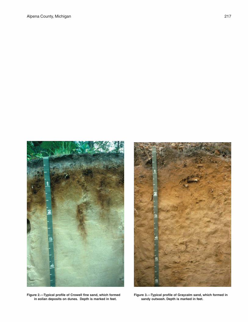
Alpena County, Michigan 217
Figure 2.—Typical profile of Crowell fine sand, which formedin eolian deposits on dunes. Depth is marked in feet.
Figure 3.—Typical profile of Graycalm sand, which formed insandy outwash. Depth is marked in feet.
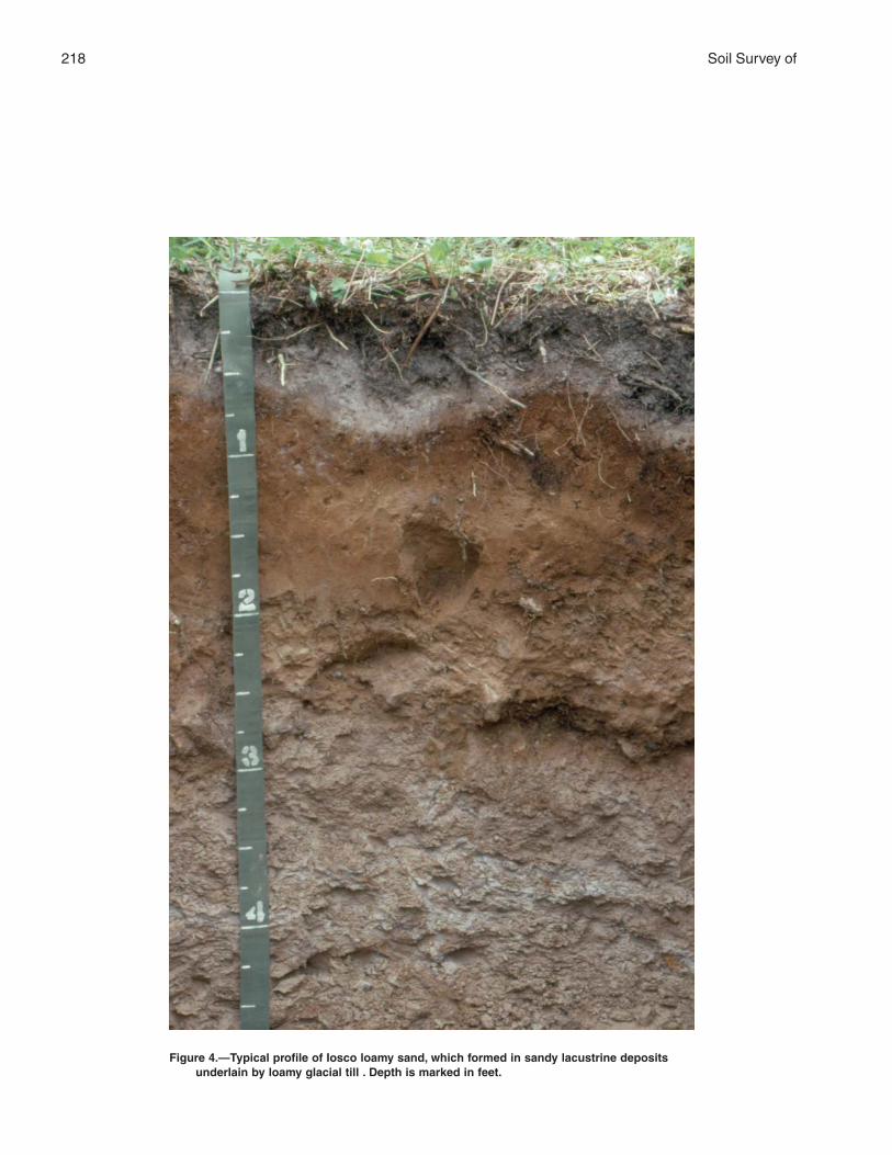
218 Soil Survey of
Figure 4.—Typical profile of Iosco loamy sand, which formed in sandy lacustrine depositsunderlain by loamy glacial till . Depth is marked in feet.
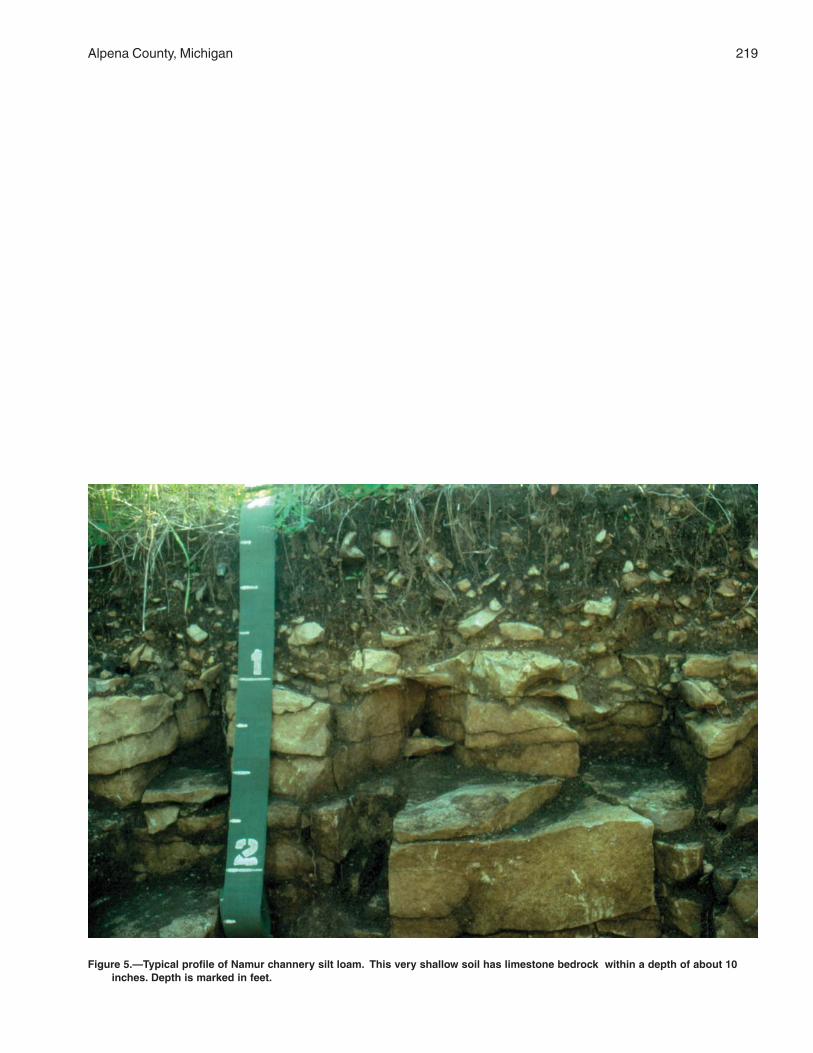
Alpena County, Michigan 219
Figure 5.—Typical profile of Namur channery silt loam. This very shallow soil has limestone bedrock within a depth of about 10inches. Depth is marked in feet.
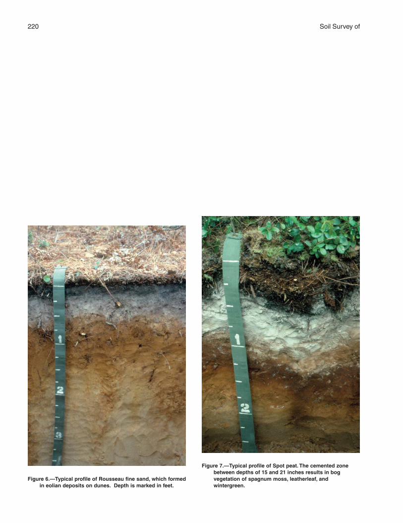
220 Soil Survey of
Figure 7.—Typical profile of Spot peat. The cemented zonebetween depths of 15 and 21 inches results in bogvegetation of spagnum moss, leatherleaf, andwintergreen.
Figure 6.—Typical profile of Rousseau fine sand, which formedin eolian deposits on dunes. Depth is marked in feet.
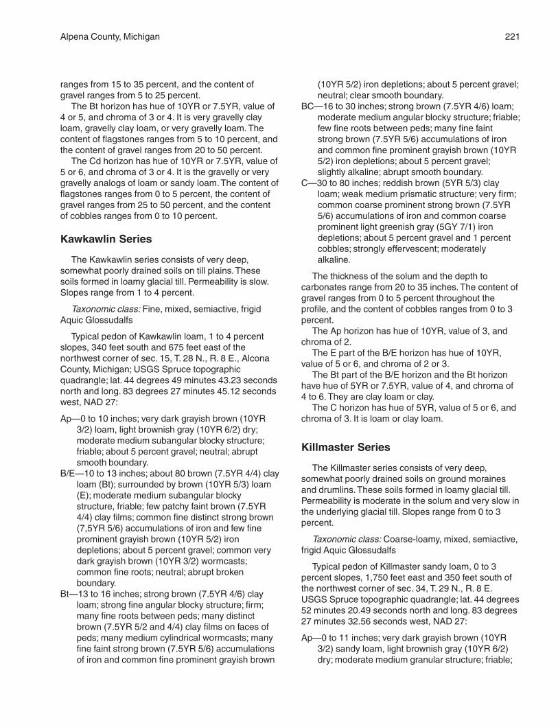
Alpena County, Michigan 221
ranges from 15 to 35 percent, and the content ofgravel ranges from 5 to 25 percent.
The Bt horizon has hue of 10YR or 7.5YR, value of4 or 5, and chroma of 3 or 4. It is very gravelly clayloam, gravelly clay loam, or very gravelly loam. Thecontent of flagstones ranges from 5 to 10 percent, andthe content of gravel ranges from 20 to 50 percent.
The Cd horizon has hue of 10YR or 7.5YR, value of5 or 6, and chroma of 3 or 4. It is the gravelly or verygravelly analogs of loam or sandy loam. The content offlagstones ranges from 0 to 5 percent, the content ofgravel ranges from 25 to 50 percent, and the contentof cobbles ranges from 0 to 10 percent.
Kawkawlin Series
The Kawkawlin series consists of very deep,somewhat poorly drained soils on till plains. Thesesoils formed in loamy glacial till. Permeability is slow.Slopes range from 1 to 4 percent.
Taxonomic class: Fine, mixed, semiactive, frigidAquic Glossudalfs
Typical pedon of Kawkawlin loam, 1 to 4 percentslopes, 340 feet south and 675 feet east of thenorthwest corner of sec. 15, T. 28 N., R. 8 E., AlconaCounty, Michigan; USGS Spruce topographicquadrangle; lat. 44 degrees 49 minutes 43.23 secondsnorth and long. 83 degrees 27 minutes 45.12 secondswest, NAD 27:
Ap—0 to 10 inches; very dark grayish brown (10YR3/2) loam, light brownish gray (10YR 6/2) dry;moderate medium subangular blocky structure;friable; about 5 percent gravel; neutral; abruptsmooth boundary.
B/E—10 to 13 inches; about 80 brown (7.5YR 4/4) clayloam (Bt); surrounded by brown (10YR 5/3) loam(E); moderate medium subangular blockystructure, friable; few patchy faint brown (7.5YR4/4) clay films; common fine distinct strong brown(7,5YR 5/6) accumulations of iron and few fineprominent grayish brown (10YR 5/2) irondepletions; about 5 percent gravel; common verydark grayish brown (10YR 3/2) wormcasts;common fine roots; neutral; abrupt brokenboundary.
Bt—13 to 16 inches; strong brown (7.5YR 4/6) clayloam; strong fine angular blocky structure; firm;many fine roots between peds; many distinctbrown (7.5YR 5/2 and 4/4) clay films on faces ofpeds; many medium cylindrical wormcasts; manyfine faint strong brown (7.5YR 5/6) accumulationsof iron and common fine prominent grayish brown
(10YR 5/2) iron depletions; about 5 percent gravel;neutral; clear smooth boundary.
BC—16 to 30 inches; strong brown (7.5YR 4/6) loam;moderate medium angular blocky structure; friable;few fine roots between peds; many fine faintstrong brown (7.5YR 5/6) accumulations of ironand common fine prominent grayish brown (10YR5/2) iron depletions; about 5 percent gravel;slightly alkaline; abrupt smooth boundary.
C—30 to 80 inches; reddish brown (5YR 5/3) clayloam; weak medium prismatic structure; very firm;common coarse prominent strong brown (7.5YR5/6) accumulations of iron and common coarseprominent light greenish gray (5GY 7/1) irondepletions; about 5 percent gravel and 1 percentcobbles; strongly effervescent; moderatelyalkaline.
The thickness of the solum and the depth tocarbonates range from 20 to 35 inches. The content ofgravel ranges from 0 to 5 percent throughout theprofile, and the content of cobbles ranges from 0 to 3percent.
The Ap horizon has hue of 10YR, value of 3, andchroma of 2.
The E part of the B/E horizon has hue of 10YR,value of 5 or 6, and chroma of 2 or 3.
The Bt part of the B/E horizon and the Bt horizonhave hue of 5YR or 7.5YR, value of 4, and chroma of4 to 6. They are clay loam or clay.
The C horizon has hue of 5YR, value of 5 or 6, andchroma of 3. It is loam or clay loam.
Killmaster Series
The Killmaster series consists of very deep,somewhat poorly drained soils on ground morainesand drumlins. These soils formed in loamy glacial till.Permeability is moderate in the solum and very slow inthe underlying glacial till. Slopes range from 0 to 3percent.
Taxonomic class: Coarse-loamy, mixed, semiactive,frigid Aquic Glossudalfs
Typical pedon of Killmaster sandy loam, 0 to 3percent slopes, 1,750 feet east and 350 feet south ofthe northwest corner of sec. 34, T. 29 N., R. 8 E.USGS Spruce topographic quadrangle; lat. 44 degrees52 minutes 20.49 seconds north and long. 83 degrees27 minutes 32.56 seconds west, NAD 27:
Ap—0 to 11 inches; very dark grayish brown (10YR3/2) sandy loam, light brownish gray (10YR 6/2)dry; moderate medium granular structure; friable;
222 Soil Survey of
many very fine and few medium roots; about 2percent gravel; slightly acid; abrupt smoothboundary.
E—11 to 12 inches; grayish brown (10YR 5/2) sandyloam, light gray (10YR 7/2) dry; weak thick platystructure; friable; common very fine roots; manyvery fine vesicular and few medium tubular pores;common fine prominent strong brown (7.5YR 4/6)accumulations of iron; about 2 percent gravel;neutral; abrupt broken boundary.
E/B—12 to 15 inches; grayish brown (10YR 5/2) sandyloam (E), light gray (7.5YR 7/2) dry; weak thickplaty structure; friable; common very fine roots;few medium tubular and many very fine vesicularpores; common fine prominent strong brown(7.5YR 4/6) accumulations of iron; E materialmakes up about 80 percent of the horizon andsurrounds peds of brown (7.5YR 4/4) sandyloam (Bt); common faint brown (7.5YR 4/4) claybridges between sand grains; common fineprominent greenish gray (5GY 5/1) irondepletions; about 2 percent gravel; neutral;clear wavy boundary.
B/E—15 to 17 inches; brown (7.5YR 4/3) sandy loam(Bt); moderate medium subangular blockystructure; firm; common very fine roots; many veryfine vesicular and few medium tubular pores;common distinct dark brown (7.5YR 3/4) clay filmson faces of peds; many medium distinct strongbrown (7.5YR 4/6) accumulations of iron andcommon fine prominent greenish gray (5GY 6/1)iron depletions; Bt material makes up about 70percent of the horizon and surrounds peds ofgrayish brown (10YR 5/2) sandy loam, light gray(10YR 7/2) dry; about 2 percent gravel; neutral;abrupt wavy boundary.
Bt—17 to 22 inches; brown (7.5YR 4/3) sandy loam;moderate medium subangular blocky structure;firm; common very fine roots; common distinctdark brown (7.5YR 3/4) clay films on faces ofpeds; many medium distinct strong brown (7.5YR4/6) accumulations of iron; about 2 percent gravel;neutral; abrupt wavy boundary.
Cd—22 to 80 inches; brown (7.5YR 5/3) sandy loam;massive; moderately expressed plates derivedfrom deposition; very firm; about 5 percent gravel;strongly effervescent; moderately alkaline.
The thickness of the solum, the depth tocarbonates, and the depth to dense glacial till rangefrom 20 to 40 inches. The content of gravel rangesfrom 2 to 10 percent in the solum and from 5 to 14percent in the underlying glacial till. The content ofcobbles ranges from 0 to 5 percent throughout theprofile.
The Ap horizon has hue of 7.5YR or 10YR, value of3 or 4, and chroma of 2. The dry value is 6. Thishorizon is sandy loam.
The E horizon has hue of 7.5YR or 10YR, value of5, and chroma of 2 or 3. The dry value is 7. Thishorizon is sandy loam.
The E part of the E/B and B/E horizons has colorsand textures similar to those of the E horizon, and theBt part has colors and textures similar to those of theBt horizon.
The Bt horizon has hue of 7.5YR, value of 4, andchroma of 3 or 4. It is loam or sandy loam.
The Cd horizon has hue of 5YR or 7.5YR, value of5 or 6, and chroma of 3 or 4. It is sandy loam.
Kinross Series
The Kinross series consists of very deep, verypoorly drained soils on lake plains and outwash plains.These soils formed in sandy deposits. Permeability israpid. Slopes are 0 to 1 percent.
Taxonomic class: Sandy, mixed, frigid TypicEndoaquods
Typical pedon of Kinross muck, on a 0 percentslope, 1,670 feet south and 2,200 feet east of thenorthwest corner of sec. 23, T. 31 N., R. 7 E. USGSLake Winyah topographic quadrangle; lat. 45 degrees4 minutes 15.39 seconds north and long. 83 degrees32 minutes 37.51 seconds west, NAD 27:
Oa1—0 to 3 inches; dark reddish brown (5YR 3/2)(broken face) muck, dark reddish brown (5YR2.5/2) rubbed; about 20 percent fiber, 5 percentrubbed; weak thick platy structure; friable; manyfine and common medium roots; sodiumpyrophosphate light brown (7.5YR 6/3); primarilyherbaceous fibers; extremely acid; abrupt smoothboundary.
Oa2—3 to 5 inches; black (5YR 2.5/1) (broken face)muck, dark reddish brown (5YR 2.5/2) rubbed;about 5 percent fiber, 1 percent rubbed; weakthick platy structure; friable; many fine roots;sodium pyrophosphate brown (7.5YR 4/3);primarily herbaceous fibers; extremely acid; abruptsmooth boundary.
Eg1—5 to 6 inches; dark gray (10YR 4/1) fine sand,light gray (10YR 7/1) dry; single grain; loose;few fine roots; extremely acid; abrupt smoothboundary.
Eg2—6 to 9 inches; gray (10YR 5/1) fine sand, white(10YR 8/1) dry; single grain; loose; few fine roots;common fine prominent reddish yellow (7.5YR6/6) accumulations of iron; extremely acid; abruptwavy boundary.
Alpena County, Michigan 223
Bhs—9 to 13 inches; dark reddish brown (5YR 3/3)fine sand; moderate, thick platy structure; friable;few fine roots; common fine distinct yellowish red(5YR 4/6) accumulations of iron; extremely acid;abrupt wavy boundary.
Bs—13 to 19 inches; brown (7.5YR 4/4) fine sand;weak medium subangular blocky structure; veryfriable; few fine roots; common fine prominentyellowish red (5YR 5/6) accumulations of iron andcommon medium prominent grayish brown (10YR5/2) iron depletions; extremely acid; clear smoothboundary.
BC—19 to 27 inches; brownish yellow (10YR 6/6) finesand; single grain; loose; few coarse distinctstrong brown (7.5YR 5/6) accumulations of iron;very strongly acid; gradual smooth boundary.
C—27 to 51 inches; pale brown (10YR 6/3) fine sand;single grain; loose; common medium prominentstrong brown (7.5YR 5/6) accumulations of iron;very strongly acid; abrupt smooth boundary.
Cg—51 to 80 inches; grayish brown (10YR 5/2) finesand; single grain; loose; slightly acid.
The thickness of the solum ranges from 20 to 27inches. The depth to iron accumulations ranges from 5to 9 inches.
The Oa horizon has hue of 5YR or is neutral in hue.It has value of 2.5 or 3 and chroma of 0 to 2. It isextremely acid or very strongly acid. It is muck.
The Eg horizon has hue of 7.5YR or 10YR, value of4 or 5, and chroma of 1 or 2. It is extremely acid orvery strongly acid. It is fine sand or sand.
The Bhs horizon has hue of 5YR or 7.5YR andvalue and chroma of 3. It is extremely acid or verystrongly acid. It is fine sand or sand.
The Bs horizon has hue of 7.5YR and value andchroma of 4. It is extremely acid or very strongly acid.It is fine sand or sand.
The BC horizon has hue of 10YR, value of 5 or 6,and chroma of 4 to 6. It is very strongly acid tomoderately acid. It is fine sand or sand.
The C horizon has hue of 10YR, value of 5 or 6,and chroma of 3 or 4. It is very strongly acid to neutral.It is fine sand or sand.
The Cg horizon has hue of 10YR, value of 5 or 6,and chroma of 2. It is slightly acid. It is fine sand.
Klacking Series
The Klacking series consists of very deep, welldrained soils on outwash plains, moraines, and kames.These soils formed in sandy and loamy glacial drift.Permeability is rapid. Slopes range from 0 to 50percent.
Taxonomic class: Loamy, mixed, semiactive, frigidArenic Glossudalfs
Typical pedon of Klacking loamy sand, on a 30percent slope, in an area of Klacking-McGinn loamysands, 8 to 50 percent, dissected, 2,920 feet north and1,540 feet east of the southwest corner of sec. 22, T.30 N., R. 5 E. USGS Beaver Lake topographicquadrangle; lat. 44 degrees 58 minutes 50.53 secondsnorth and long. 83 degrees 49 minutes 20.75 secondswest, NAD 27:
A—0 to 4 inches; very dark gray (7.5YR 3/1) loamysand, gray (7.5YR 5/1) dry; weak fine granularstructure; friable; many fine roots; about 2 percentgravel and 1 percent cobbles; very strongly acid;abrupt smooth boundary.
E—4 to 12 inches; pinkish gray (7.5YR 6/2) loamysand, pinkish gray (7.5YR 7/2) dry; weak finesubangular blocky structure; very friable; commonfine roots; about 2 percent gravel and 1 percentcobbles; strongly acid; abrupt wavy boundary.
Bw—12 to 25 inches; brown (7.5YR 5/4) loamy sand;weak medium subangular blocky structure; friable;common fine roots; about 2 percent gravel;strongly acid; clear wavy boundary.
E and Bt—25 to 33 inches; about 80 percent palebrown (10YR 6/3) sand (E), very pale brown(10YR 7/3) dry; single grain; loose; lamellae,1/4 inch thick, and pockets, 1 to 2 inches thick, ofreddish brown (5YR 4/4) loamy sand; weak finesubangular blocky structure; friable; clay bridgingand coating sand grains (Bt); few fine roots; about2 percent gravel; moderately acid; abrupt wavyboundary.
B/E—33 to 64 inches; about 70 percent reddishbrown (5YR 4/4) sandy loam (Bt); weak coarsesubangular blocky structure; friable; few patchyfaint reddish brown (5YR 4/3) clay films; claybridging and coating sand grains; tongues oflight brown (7.5YR 6/4) sand, pink (7.5YR 7/4)dry; single grain; loose (E); few fine roots; about2 percent gravel; neutral; abrupt irregularboundary.
C—64 to 80 inches; pale brown (10YR 6/3) sand;single grain; loose; about 2 percent gravel; stronglyeffervescent; slightly alkaline.
The thickness of the solum ranges from 60 to 80inches. The content of gravel ranges from 0 to 5percent throughout the profile, and the content ofcobbles is 0 to 1 percent.
The A horizon has hue of 7.5YR, value of 2 or 3,and chroma of 1 or 2. It is very strongly acid orstrongly acid. It is loamy sand.
224 Soil Survey of
The E horizon has hue of 7.5YR or 10YR, value of5 or 6, and chroma of 2 or 3. It is very strongly acid orstrongly acid. It is loamy sand or sand.
The Bw horizon has hue of 7.5YR or 10YR andvalue and chroma of 4 or 5. It is strongly acid ormoderately acid. It is loamy sand or sand.
The E part of the E and Bt horizon and of the B/Ehorizon has hue of 7.5YR or 10YR, value of 6 or 7,and chroma of 3 or 4. It is strongly acid or moderatelyacid. It is sand or loamy sand.
The Bt part of the E and B horizon and of the B/Ehorizon has hue of 5YR or 7.5YR, value of 4 or 5, andchroma of 4 to 6. It ranges from moderately acid toneutral. It is sandy loam or loamy sand.
The C horizon has hue of 10YR, value of 5 or 6,and chroma of 3 or 4. It is slightly alkaline. It is sand.
Krakow Series
The Krakow series consists of very deep, welldrained soils on ground moraines and glacial lakebenches. These soils formed in loamy glacial till.Permeability is moderate. Slopes range from 1 to 12percent.
Taxonomic class: Loamy-skeletal, mixed,semiactive, frigid Inceptic Hapludalfs
Typical pedon of Krakow flaggy fine sandy loam,1 to 6 percent slopes, 50 feet south and 2,640 feeteast of the northwest corner of sec. 19, T. 32 N., R.6 E. USGS Hillman NE topographic quadrangle; lat.45 degrees 9 minutes 42.25 seconds north andlong. 83 degrees 45 minutes 6.08 seconds west,NAD 27:
A—0 to 3 inches; dark grayish brown (10YR 4/3)flaggy fine sandy loam, light brownish gray(10YR 6/2) dry; weak medium granular structure;friable; many fine and very fine roots; about 20percent flagstones; neutral; abrupt smoothboundary.
E1—3 to 6 inches; brown (7.5YR 5/4) flaggy finesandy loam, light brown (7.5YR 6/3) dry; moderatecoarse subangular blocky structure; friable; manyvery fine roots; about 20 percent flagstones;neutral; abrupt broken boundary.
E2—6 to 8 inches; brown (7.5YR 5/3) flaggy finesandy loam, pinkish gray (7.5YR 7/2) moderatemedium subangular blocky structure; friable; manyvery fine roots; about 20 percent flagstones;neutral; clear wavy boundary.
Bt—8 to 15 inches; dark brown (7.5YR 3/4) very flaggyclay loam; moderate fine angular blocky structure;friable; many very fine roots; many faint darkbrown (7.5YR 3/3) clay films on faces of peds;
about 40 percent flagstones and 5 percent stones;slightly alkaline; abrupt irregular boundary.
C—15 to 80 inches; light yellowish brown (2.5YR 6/3)very flaggy loam; massive; about 40 percentflagstones and 5 percent stones; stronglyeffervescent; moderately alkaline.
The thickness of the solum and the depth tocarbonates range from 12 to 24 inches. The content offlagstones and channers ranges from 15 to 25 percentin the A and E horizons and from 35 to 55 percent inthe Bt and C horizons. The content of gravel rangesfrom 0 to 15 percent throughout the profile, and thecontent of stones ranges from 0 to 5 percent.
The A horizon has hue of 10YR, value of 3 or 4,and chroma of 2 or 3. It has a dry value of 5 or 6. It isflaggy fine sandy loam.
The E horizon has hue of 7.5YR, value of 5 or 6,and chroma of 3 or 4. It has a dry value of 6 or 7. It isflaggy fine sandy loam.
The Bt horizon has hue of 5YR or 7.5YR, value of 3or 4, and chroma of 4. It is very flaggy clay loam.
The C horizon has hue of 7.5YR or 10YR, value of4 to 6, and chroma of 3 or 4. It is very flaggy loam.
Lachine Series
The Lachine series consists of shallow, somewhatpoorly drained soils on ground moraines and glaciallake benches. These soils formed in loamy glacial tillunderlain by karst limestone. Permeability is moderatein the glacial till and slow to rapid in the limestonebedrock. Slopes range from 0 to 3 percent.
Taxonomic class: Loamy, mixed, superactive, frigidLithic Hapludolls
Typical pedon of Lachine loam, 0 to 3 percentslopes, 2,600 feet north and 750 feet east of thesouthwest corner of sec. 18, T. 32 N., R. 8 E. USGSLong Lake West topographic quadrangle; lat. 45degrees 10 minutes 4.44 seconds north and long. 83degrees 30 minutes 40.55 seconds west, NAD 27:
Ap—0 to 9 inches; very dark grayish brown (10YR 3/2)loam, grayish brown (10YR 5/2) dry; weak finegranular structure; friable; many very fine and fineroots; about 5 percent gravel; slightly effervescent;slightly alkaline; abrupt smooth boundary.
Bw—9 to 13 inches; brown (10YR 4/3) loam; moderatemedium subangular blocky structure; friable;common fine roots; common fine prominent strongbrown (7.5YR 5/6) accumulations of iron andcommon fine faint grayish brown (10YR 5/2) irondepletions; about 5 percent gravel and 1 percentcobbles; common fine vesicular pores; slightly
Alpena County, Michigan 225
effervescent; slightly alkaline; abrupt wavyboundary.
C—13 to 16 inches; brown (10YR 5/3) gravelly finesandy loam; massive; firm; few fine roots; commonfine vesicular pores; common fine prominentstrong brown (7.5YR 5/6) accumulations of ironand common fine faint grayish brown (10YR 5/2)iron depletions; about 20 percent gravel and 1percent cobbles; strongly effervescent; slightlyalkaline; abrupt smooth boundary.
R—16 to 20 inches; gray (10YR 5/1), fractured karstlimestone; fractures 1 to 4 inches wide and about24 inches apart, making up about 8 percent of thehorizon, and filled with brown (10YR 5/3) finesandy loam.
The thickness of the solum and the depth tobedrock range from 10 to 20 inches. The content ofgravel is 0 to 20 percent throughout the profile, thecontent of cobbles is 0 to 5 percent, and the content ofstones is 0 to 5 percent.
The Ap horizon has hue of 5YR, 7.5YR, or 10YR;value of 2 to 4; and chroma of 1 to 3. The A horizon inundisturbed areas typically is more than 7 inches thick.It has hue of 5YR, 7.5YR, or 10YR and value andchroma of 2 or 3. The Ap or A horizon is loam.Reaction is neutral to moderately alkaline.
The Bw horizon has hue of 5YR, 7.5YR, or 10YR;value of 3 to 5; and chroma of 3 to 6. It is loam, flaggyloam, flaggy sandy loam, or flaggy very fine sandyloam. The content of flagstones ranges from 0 to 15percent. Reaction is neutral to moderately alkaline.
The C horizon has hue of 10YR or 2.5Y, value of 5or 6, and chroma of 3 or 4. It is fine sandy loam, sandyloam, loam, or the gravelly or flaggy analogs of thosetextures. The content of flagstones ranges from 0 to 15percent. Reaction is slightly alkaline or moderatelyalkaline.
Leafriver Series
The Leafriver series consists of very deep, verypoorly drained soils on lake plains and outwash plains.These soils formed in sandy lacustrine and outwashdeposits. Permeability is rapid. Slopes are 0 to 1percent.
Taxonomic class: Sandy, mixed, frigid HisticHumaquepts
Typical pedon of Leafriver muck, 1,860 feet eastand 100 feet north of the southwest corner of sec. 14,T. 28 N., R. 9 E., Alcona County, Michigan; USGSBlack River topographic quadrangle; lat. 44 degrees 48minutes 57.40 seconds north and long. 83 degrees 19minutes 05.32 seconds west, NAD 27:
Oa—0 to 9 inches; black (N 2/0) (broken face,pressed, and rubbed) muck; about 15 percentfiber, less than 5 percent rubbed; weak mediumgranular structure; friable; many fine and fewmedium roots; slightly acid; abrupt smoothboundary.
Bw—9 to 21 inches; brown (10YR 5/3) sand; singlegrain; loose; few fine roots; common mediumdistinct yellowish brown (10YR 5/6) accumulationsof iron; neutral; clear smooth boundary.
Cg1—21 to 27 inches; grayish brown (10YR 5/2) sand;single grain; loose; common medium distinctyellowish brown (10YR 5/4) accumulations of iron;about 10 percent gravel and 5 percent cobbles;strongly effervescent; slightly alkaline; gradualwavy boundary.
Cg2—27 to 80 inches; dark grayish brown (10YR 4/2)sand; single grain; loose; strongly effervescent;slightly alkaline.
The thickness of the solum ranges from 10 to 25inches. The depth to carbonates is more than 20inches. The content of gravel ranges from 0 to 14percent throughout the mineral horizons, and thecontent of cobbles ranges from 0 to 5 percent.
The Oa horizon has hue of 10YR or is neutral inhue. It has chroma of 0 or 1.
The Bw horizon has hue of 10YR, value of 3 to 5,and chroma of 3. It is sand or loamy sand.
The Cg horizon has hue of 10YR, 5Y, 5GY, or 2.5Y;value of 4 to 6; and chroma of 1 or 2. It is sand.
Loxley Series
The Loxley series consists of very deep, verypoorly drained soils on lake plains and outwash plains.These soils formed in more than 51 inches of organicsoil material. Permeability is moderately slow tomoderately rapid. Slopes range from 0 to 2 percent.
Taxonomic class: Dysic, frigid Typic Haplosaprists
Typical pedon of Loxley peat, on a 0 percent slope,290 feet north and 1,810 feet east of the southwestcorner of sec. 31, T. 30 N., R. 8 E. USGS Big RavineCreek topographic quadrangle; lat. 44 degrees 56minutes 51.32 seconds north and long. 83 degrees 31minutes 9.40 seconds west, NAD 27:
Oi—0 to 4 inches; dark yellowish brown (10YR 3/4)(broken face) peat, light yellowish brown (10YR6/4) pressed, dark yellowish brown (10YR 4/4)rubbed; about 90 percent fiber, 90 percent rubbed;massive; very friable; about 5 percent woodfragments; extremely acid; abrupt smoothboundary.
226 Soil Survey of
Oa1—4 to 16 inches; dark reddish brown (5YR 3/3)(broken face) muck, dark reddish brown (5YR 3/2)pressed and rubbed, darkening to black (5YR2.5/1) after exposure to air; about 20 percent fiber,5 percent rubbed; weak thick platy structure; veryfriable; about 5 percent wood fragments; extremelyacid; abrupt smooth boundary.
Oa2—16 to 76 inches; dark reddish brown (5YR 3/3)(broken face) muck, dark reddish brown (5YR3/2) pressed and rubbed, darkening to black (5YR2.5/1) after exposure to air; about 20 percent fiber,5 percent rubbed; weak thick platy structure; veryfriable; extremely acid; abrupt smooth boundary.
Oa3—76 to 80 inches; black (N 2.5/0) (broken face,pressed, and rubbed) muck; about 2 percent fiber;weak thick platy structure; very friable; extremelyacid.
The organic material is more than 51 inches thick.Reaction is extremely acid or very strongly acidthroughout the solum.
The Oi horizon has hue of 10YR, value of 3 to 5,and chroma of 4. The content of fibers ranges from 85to 95 percent after rubbing.
The Oa horizon has hue of 5YR or is neutral in hue.It has value of 2 or 3 and chroma of 0 to 3. Thecontent of fibers ranges from 2 to 15 percent afterrubbing.
Lupton Series
The Lupton series consists of very deep, verypoorly drained soils on lake plains, outwash plains,and moraines. These soils formed in more than 51inches of organic soil material. Permeability ismoderately slow to moderately rapid. Slopes rangefrom 0 to 2 percent.
Taxonomic class: Euic, frigid Typic Haplosaprists
Typical pedon of Lupton muck, on a 0 percentslope, 260 feet south and 1,820 feet east of thenorthwest corner of sec. 17, T. 30 N., R. 8 E. USGSAlpena topographic quadrangle; lat. 45 degrees 0minutes 13.40 seconds north and long. 83 degrees 29minutes 54.85 seconds west, NAD 27:
Oa1—0 to 4 inches; black (N 2.5/0) (broken face andrubbed) muck; about 15 percent fiber, 5 percentrubbed; weak medium granular structure; friable;many fine roots; about 5 percent wood fragments;neutral; abrupt smooth boundary.
Oa2—4 to 24 inches; black (N 2.5/0) (broken face andrubbed) muck; about 20 percent fiber, 5 percentrubbed; weak very thick platy structure parting toweak medium subangular blocky; friable; about 5
percent wood fragments; neutral; abrupt smoothboundary.
Oa3—24 to 80 inches; very dark grayish brown (10YR3/2) (broken face) muck, very dark brown (10YR2/2) rubbed, darkening to black (10YR 2/1) afterexposure to air; about 60 percent fiber, 5 percentrubbed; moderate medium platy structure; friable;sodium pyrophosphate brown (10YR 5/3);primarily herbaceous fibers; neutral.
The organic material is more than 80 inches thick.The content of woody fragments ranges from 2 to 7percent. Reaction is slightly acid or neutral.
The O horizon has hue of 10YR or is neutral in hue.It value of 2 or 3 and chroma of 0 to 2. It is muck.
Mancelona Series
The Mancelona series consists of very deep,somewhat excessively drained soils on streamterraces and in glacial drainageways. These soilsformed in deposits of sand and gravel. Permeability ismoderately rapid in the upper part of the profile andvery rapid in the lower part. Slopes range from 0 to 50percent.
Taxonomic class: Sandy, mixed, frigid AlficHaplorthods
Typical pedon of Mancelona sand, 0 to 6 percentslopes, 2,100 feet west and 50 feet north of thesoutheast corner of sec. 34, T. 32 N., R. 2 E., west-central part of Montmorency Township, MontmorencyCounty, Michigan; USGS Atlanta Michigan 7.5 minutetopographic quadrangle; lat. 45 degrees 6 minutes 47seconds north and long. 84 degrees 10 minutes 21seconds west, NAD 27:
A—0 to 3 inches; black (N 2.5/) sand, very dark gray(10YR 3/1) dry; weak fine and medium granularstructure; very friable; common very fine and fineroots; about 1 percent gravel; very strongly acid;abrupt smooth boundary.
E—3 to 6 inches; pinkish gray (7.5YR 6/2) sand,pinkish white (10YR 8/2) dry; weak fine granularstructure; very friable; many very fine, fine,medium, and coarse roots; about 1 percent gravel;very strongly acid; abrupt wavy boundary.
Bs1—6 to 16 inches; brown (7.5YR 4/4) sand; weakmedium subangular blocky structure; very friable;common very fine and fine and many medium andcoarse roots; about 1 percent cobbles and 3percent gravel; moderately acid; clear wavyboundary.
Bs2—16 to 20 inches; yellowish brown (10YR 5/6)sand; weak fine subangular blocky structure; very
Alpena County, Michigan 227
friable; common fine and many medium andcoarse roots; about 2 percent cobbles and 3percent gravel; moderately acid; clear wavyboundary.
E´—20 to 29 inches; light yellowish brown (10YR 6/4)sand; weak medium subangular blocky structure;very friable; few medium and coarse roots; about 2percent cobbles and 5 percent gravel; lamellae ofyellowish red (5YR 5/6) loamy sand ranging from1/4 to 1/2 inch in thickness and making up less than10 percent of the horizon; moderately acid; abruptwavy boundary.
2Bt—29 to 35 inches; reddish brown (5YR 4/4)gravelly sandy loam; weak medium subangularblocky structure parting to weak very finesubangular blocky; very friable; many fine,medium, and coarse roots; about 1 percentstones, 5 percent cobbles, and 25 percent gravel;prominent reddish brown (5YR 4/4) clay bridgesbetween mineral grains and coating surfaces ofrock fragments; neutral; clear wavy boundary.
2C—35 to 80 inches; yellowish brown (10YR 5/4) verygravelly sand; single grain; loose; about 2 percentstones, 10 percent cobbles, and 40 percent gravel;slightly effervescent; slightly alkaline.
The thickness of the solum ranges from 26 to 40inches. The content of gravel ranges from 0 to 25percent in the solum and from 20 to 50 percent in thesubstratum. The content of cobbles ranges from 0 to10 percent throughout the profile, and the content ofstones is 0 to 2 percent.
The A horizon has hue of 7.5YR or 10YR or isneutral in hue. It has value of 2 or 3 and chroma of 0 to2. It is dominantly sand but in some pedons is loamysand.
The E horizon has hue of 5YR, 7.5YR, or 10YR;value of 4 to 6; and chroma of 2 to 4. It is sand, loamysand, or the gravelly analogs of those textures.
The Bs horizon has hue of 5YR, 7.5YR, or 10YR;value of 3 to 5; and chroma of 2 to 6. It is sand, loamysand, or the gravelly analogs of those textures.
The E´ horizon has hue of 7.5YR or 10YR, value of6, and chroma of 4. It is sand, loamy sand, or thegravelly analogs of those textures. Some pedons donot have an E´ horizon.
The 2Bt horizon has hue of 5YR, 7.5YR, or 10YR;value of 4 or 5; and chroma of 3 to 6. It is loamy sand,sandy loam, sandy clay loam, or the gravelly analogsof those textures.
The 2C horizon has hue of 7.5YR or 10YR, value of5 or 6, and chroma of 4 to 6. It is commonly stratifiedgravelly sand, gravelly coarse sand, very gravellysand, coarse sand, or sand.
McGinn Series
The McGinn series consists of very deep, welldrained soils on moraines. These soils formed inloamy glacial till. Permeability is moderately rapid inthe upper part of the profile and moderate in the lowerpart. Slopes range from 0 to 50 percent.
Taxonomic class: Coarse-loamy, mixed, semiactive,frigid Haplic Glossudalfs
Typical pedon of McGinn loamy sand, in an area ofKlacking-McGinn loamy sands, 8 to 50 percent slopes,dissected; 260 feet north and 2,630 feet west of thesoutheast corner of sec. 31, T. 29 N., R. 5 E. USGSMcGinn Creek topographic quadrangle; lat. 44 degrees51 minutes 27.55 seconds north and long. 83 degrees52 minutes 43.63 seconds west, NAD 27:
A—0 to 2 inches; black (N 2.5/0) loamy sand, verydark gray (N 3/0) dry; weak medium granularstructure; friable; many fine roots; about 10percent gravel; extremely acid; abrupt smoothboundary.
E—2 to 3 inches; grayish brown (10YR 5/2) loamysand, light gray (10YR 7/2) dry; weak finesubangular blocky structure; friable; common fineroots; about 10 percent gravel; very strongly acid;abrupt broken boundary.
Bw—3 to 12 inches; yellowish brown (10YR 5/4) loamysand; weak medium subangular blocky structure;friable; common fine roots; about 5 percent gravel;very strongly acid; clear wavy boundary.
E´—12 to 18 inches; grayish brown (10YR 5/2) loamysand, light gray (10YR 7/2) dry; weak mediumsubangular blocky structure; friable; few fine roots;about 5 percent gravel; very strongly acid; abruptwavy boundary.
2B/E—18 to 22 inches; about 70 percent reddishbrown (5YR 4/4) loam (Bt); weak mediumsubangular blocky structure; friable; tongues ofgrayish brown (10YR 5/2) loamy sand, light gray(10YR 7/2) dry (E); few fine roots; common patchyfaint dark reddish brown (5YR 3/4) clay films onfaces of peds; about 5 percent gravel; verystrongly acid; abrupt wavy boundary.
2Bt—22 to 26 inches; reddish brown (5YR 4/4) loam;moderate medium subangular blocky structure;friable; few fine roots; common patchy faint darkreddish brown (5YR 3/4) clay films on faces ofpeds; about 5 percent gravel; strongly acid; abruptwavy boundary.
2C—26 to 80 inches; reddish brown (5YR 5/4) sandyloam; massive; friable; about 5 percent gravel;strongly effervescent; moderately alkaline.
228 Soil Survey of
The thickness of the solum and the depth tocarbonates range from 24 to 40 inches. The content ofgravel is 0 to 10 percent throughout the profile, and thecontent of cobbles is 0 to 5 percent.
The A horizon has hue of 10YR or is neutral in hue.It has value of 2 or 3 and chroma of 1 or 2. It is loamysand.
The E horizon has hue of 7.5YR or 10YR, value of5 or 6, and chroma of 2. The dry value is 7. Thishorizon is loamy sand.
The Bw horizon has hue of 7.5YR or 10YR, value of4 or 5, and chroma of 4 to 6. It is loamy sand.
The E´ horizon has hue of 7.5YR or 10YR, value of5 or 6, and chroma of 2. It is loamy sand.
The E part of the 2B/E horizon has colors andtextures similar to those of the E´ horizon.
The 2Bt part of the 2B/E horizon and the 2Bthorizon have hue of 7.5YR or 5YR, value of 3 or 4,and chroma of 4. They are loam or sandy loam.
The 2C horizon has hue of 5YR or 7.5YR, value of5 or 6, and chroma of 3 or 4. It is sandy loam.
Millersburg Series
The Millersburg series consists of very deep, welldrained soils on ground moraines and drumlins. Thesesoils formed in sandy and loamy glacial till.Permeability is moderate or moderately rapid. Slopesrange from 6 to 35 percent.
Taxonomic class: Coarse-loamy, mixed, active,frigid Haplic Glossudalfs
Typical pedon of Millersburg loamy sand, 12 to18 percent slopes, 70 feet south and 2,200 feetwest of the northeast corner of sec. 24, T. 29 N.,R. 5 E. USGS Beaver Lake topographic quadrangle;lat. 44 degrees 54 minutes 0.7 second north andlong. 83 degrees 46 minutes 35.7 seconds west,NAD 27:
A—0 to 3 inches; black (10YR 2/1) loamy sand, darkgray (10YR 4/1) dry; moderate medium granularstructure; friable; many fine and medium andcommon coarse roots; about 2 percent gravel;very strongly acid; abrupt wavy boundary.
E—3 to 5 inches; grayish brown (10YR 5/2) loamysand, light brownish gray (10YR 6/2) dry; weakmedium subangular blocky structure; friable; manyfine and medium and common coarse roots; about2 percent gravel; very strongly acid; abrupt wavyboundary.
Bw1—5 to 11 inches; strong brown (7.5YR 4/6) loamysand; weak medium subangular blocky structure;friable; many medium and common fine roots;
about 2 percent gravel; strongly acid; clear wavyboundary.
Bw2—11 to 16 inches; dark yellowish brown (10YR4/6) loamy sand; moderate medium subangularblocky structure; friable; common fine and mediumroots; about 2 percent gravel; strongly acid; abruptwavy boundary.
E´—16 to 18 inches; grayish brown (10YR 5/2) loamysand, very pale brown (10YR 7/3) dry; weakmedium subangular blocky structure; friable;common fine roots; about 2 percent gravel;strongly acid; clear smooth boundary.
2B/E—18 to 27 inches; about 75 percent strongbrown (7.5YR 4/6) sandy clay loam (Bt);interfingered with grayish brown (10YR 5/2)loamy sand, very pale brown (10YR 7/3 dry (E);moderate medium subangular blocky structure;firm in the Bt part and friable in the E part;common fine roots; many fine vesicular pores;about 5 percent gravel; moderately acid; clearwavy boundary.
2Bt—27 to 33 inches; strong brown (7.5YR 4/6) sandyclay loam; moderate medium subangular blockystructure; firm; common fine roots; few dark brown(7.5YR 3/4) clay films on faces of peds; about 5percent gravel; moderately acid; abrupt wavyboundary.
2C—33 to 80 inches; light yellowish brown (10YR 6/4)sandy loam; massive; friable; about 5 percentgravel; strongly effervescent; slightly alkaline.
The thickness of the solum ranges from 30 to 45inches and corresponds to the depth to the base of theargillic horizon and the depth to calcium carbonates.The content of gravel ranges from 0 to 10 percentthroughout the profile, and the content of cobblesranges from 0 to 5 percent.
The A horizon has hue of 7.5YR or 10YR or isneutral in hue. It has value of 2 or 3 and chroma of 0 to2. It is loamy sand. Reaction is very strongly acid orstrongly acid.
The E horizon has hue of 7.5YR or 10YR, value of5 or 6, chroma of 2 or 3. It is loamy sand or sand.Reaction ranges from very strongly acid to moderatelyacid.
The Bw horizon has hue of 7.5YR or 10YR, value of4 or 5, and chroma of 5 or 6. It is loamy sand or sand.Reaction ranges from very strongly acid to moderatelyacid.
The E´ horizon and the E part of the B/E horizonhave hue of 10YR, value of 5 or 6 and, chroma of 2 or3. They are loamy sand or sand.
The 2Bt horizon and the B part of the B/E horizonhave hue of 5YR or 7.5YR, value of 4 or 5, and
Alpena County, Michigan 229
chroma of 4 to 6. They are loam or sandy clay loam.Reaction is moderately acid or slightly acid.
The 2C horizon has hue of 7.5YR or 10YR, value of5 or 6, and chroma of 3 or 4. It is sandy loam.Reaction is slightly alkaline or moderately alkaline.
Morganlake Series
The Morganlake series consists of very deep,moderately well drained soils on moraines. These soilsformed in sandy outwash underlain by loamy glacialtill. Permeability is rapid in the sandy deposits andmoderately slow in the glacial till. Slopes range from 0to 6 percent.
Taxonomic class: Sandy over loamy, mixed, active,frigid Alfic Oxyaquic Haplorthods
Typical pedon of Morganlake loamy sand, 0 to 6percent slopes, 2,320 feet north and 180 feet west ofthe southeast corner of sec. 3, T. 29 N., R. 6 E. USGSEvans Creek topographic quadrangle; lat. 44 degrees56 minutes 12.79 seconds north and long. 83 degrees41 minutes 19.19 seconds west, NAD 27:
A—0 to 2 inches; black (N 2.5/0) loamy sand, darkgray (N 4/0) dry; weak medium granular structure;friable; many fine roots; about 1 percent gravel;extremely acid; abrupt smooth boundary.
E—2 to 6 inches; reddish gray (5YR 5/2) loamy sand,pinkish gray (5YR 7/2) dry; weak fine subangularblocky structure; friable; common fine roots; about1 percent gravel; extremely acid; clear wavyboundary.
Bs1—6 to 11 inches; brown (7.5YR 4/3) loamy sand;weak medium subangular blocky structure; friable;common fine roots; about 1 percent gravel; verystrongly acid; clear wavy boundary.
Bs2—11 to 19 inches; brown (7.5YR 4/4) loamy sand;weak medium subangular blocky structure;common fine roots; about 1 percent gravel; verystrongly acid; clear smooth boundary.
Bs3—19 to 34 inches; yellowish brown (10YR 5/4)sand; single grain; loose; few fine roots; about 1percent gravel; very strongly acid; abrupt smoothboundary.
2E/B—34 to 37 inches; about 70 percent pinkish gray(7.5YR 6/2) fine sandy loam (E), pinkish gray(7.5YR 7/2) dry; E material surrounding peds ofreddish brown (5YR 4/4) loam (Bt); few faintreddish brown (5YR 4/4) clay films on faces ofpeds; weak thin platy structure; friable; few fineroots; common fine prominent strong brown(7.5YR 5/6) accumulations of iron; about 3percent gravel; very strongly acid; abrupt wavyboundary.
2Bt—37 to 43 inches; reddish brown (5YR 4/4) loam;weak medium subangular blocky structure; friable;common fine roots; common distinct dark reddishbrown (5YR 3/4) clay films on faces of peds;common fine roots; common fine prominent strongbrown (7.5YR 5/6) accumulations of iron; about 3percent gravel and 1 percent cobbles; slightly acid;abrupt wavy boundary.
2C—43 to 80 inches; reddish brown (5YR 5/4) finesandy loam; friable; weak thin platiness inheritedfrom the parent material; firm with moderatemedium platiness in about 20 percent of thehorizon; very few prominent pinkish gray (7.5YR7/2) carbonate coatings between plates; commonmedium distinct strong brown (7.5YR 5/6)accumulations of iron between plates; about 5percent gravel and 1 percent cobbles; stronglyeffervescent; moderately alkaline.
The thickness of the solum and the depth tocarbonates range from 40 to 60 inches. The content ofgravel ranges from 0 to 5 percent in the sandy upperpart of the profile and 5 to 14 percent in the loamylayers. The content of cobbles ranges from 0 to 5percent throughout the profile.
The A horizon has hue of 7.5YR or 10YR or isneutral in hue. It has value of 2 or 3 and chroma of 0 to2. It is loamy sand.
The E horizon has hue of 5YR, 7.5YR, or 10YR;value of 5 or 6; and chroma of 2 or 3. The dry value is7. This horizon is loamy sand or loamy fine sand.
The upper part of the Bs horizon has hue of 7.5YRand value and chroma of 3 or 4. Value and chroma of3 do not occur together. The lower part of the Bshorizon has hue of 7.5YR or 10YR, value of 4 or 5,and chroma of 4 to 6. The Bs horizon is loamy sand,sand, or loamy fine sand.
The E part of the 2B/E horizon has hue of 7.5YR or10YR, value of 5 or 6, and chroma of 2 or 3. It has adry value of 7. It is fine sandy loam or sandy loam.
The Bt part of the 2E/B horizon has hue of 5YR andvalue and chroma of 4. It is loam. Some pedons do nothave a 2E/B horizon.
The 2Bt horizon has colors and textures similar tothe those of the Bt part of the 2E/B horizon.
The C horizon has hue of 7.5YR or 5YR, value of 5or 6, and chroma of 3 or 4. It is fine sandy loam orloam.
Namur Series
The Namur series consists of very shallow, welldrained soils on karst plains and bedrock benches.These soils formed in loamy residuum underlain bykarst limestone (fig. 5). Permeability is moderate in the
230 Soil Survey of
loamy material and slow to rapid in the limestone.Slopes range from 0 to 6 percent.
Taxonomic class: Loamy, mixed, semiactive, frigidLithic Hapludolls
Typical pedon of Namur channery silt loam, 0 to 6percent slopes, 2,120 feet north and 2,600 feet west ofthe southeast corner of sec. 12, T. 31 N., R. 8 E.USGS Alpena topographic quadrangle; lat. 45 degrees5 minutes 48.63 seconds north and long. 83 degrees23 minutes 58.98 seconds west, NAD 27:
A—0 to 5 inches; dark brown (7.5YR 3/2) channery siltloam, dark gray (7.5YR 4/1) dry; moderatemedium granular structure; friable; common fineroots; about 30 percent limestone channers and 5percent limestone flagstones; stronglyeffervescent; moderately alkaline; abrupt smoothboundary
2R—5 to 9 inches; gray (N 5/0), thinly bedded karstlimestone; rectilinear pattern of vertical cracks, 1to 3 inches wide, partially filled with A materialfrom above.
The thickness of the solum ranges from 5 to 10inches and corresponds to the depth to limestonebedrock. The content of channers ranges from 20 to30 percent in the A horizon, and the content offlagstones ranges from 0 to 5 percent. Reactionranges from neutral to moderately alkaline.
The A horizon has hue of 7.5YR or 10YR, value of3, and chroma of 1 or 2. The dry value is 4 or 5. Thishorizon is channery silt loam.
The R horizon is neutral in hue and has value of 5and chroma of 0. The limestone is thinly bedded andvertically fractured at intervals of 2 to 6 feet.
Negwegon Series
The Negwegon series consists of very deep,moderately well drained soils on lake plains, some ofwhich are till floored. These soils formed in stratifiedsilty and clayey lacustrine deposits. Permeability isvery slow. Slopes range from 2 to 12 percent.
Taxonomic class: Fine, mixed, semiactive, frigidOxyaquic Glossudalfs
Typical pedon of Negwegon silt loam, tillsubstratum, 2 to 6 percent slopes, 1,050 feet southand 10 feet west of the northeast corner of sec. 27, T.30 N., R. 6 E. USGS Evans Creek topographicquadrangle; lat. 44 degrees 58 minutes 19.31 secondsnorth and long. 83 degrees 41 minutes 16.21 secondswest, NAD 27:
Ap—0 to 9 inches; brown (7.5YR 4/2) silt loam, pinkishgray (7.5YR 6/2) dry; moderate coarse subangularblocky structure parting to weak medium granular;friable; common fine roots; slightly acid; abruptsmooth boundary.
E—9 to 12 inches; brown (7.5YR 5/2) silt loam, pinkishgray (7.5YR 7/2) dry; weak medium subangularblocky structure; firm; few fine roots; moderatelyacid; abrupt smooth boundary.
B/E—12 to 14 inches; about 60 percent reddish brown(5YR 4/3) silty clay (Bt); surrounded by brown(7.5YR 5/2) silt loam (E), pinkish gray (7.5YR 7/2)dry; moderate medium angular blocky structureparting to weak medium subangular blocky;friable; few fine roots; few patchy distinct reddishbrown (5YR 4/4) clay films; slightly acid; abruptbroken boundary.
Bt1—14 to 21 inches; reddish brown (5YR 4/3) siltyclay; weak coarse prismatic structure parting tomoderate coarse angular blocky; firm; commonfaint dark reddish brown (5YR 3/3) clay films onfaces of peds; many fine prominent strong brown(7.5YR 5/6) accumulations of iron; slightly acid;abrupt smooth boundary.
Bt2—21 to 51 inches; reddish brown (5YR 5/3) siltyclay; moderate coarse prismatic structure partingto moderate medium angular blocky; firm; manyprominent dark reddish brown (5YR 3/4) clay filmson vertical faces of peds; about 1 percent pebbles;slightly effervescent; slightly alkaline; clear wavyboundary.
BC—51 to 62 inches; reddish brown (5YR 5/4) siltyclay; moderate coarse prismatic structure partingto moderate coarse angular blocky; firm; commonprominent pinkish gray (5YR 7/1) carbonatecoatings; about 1 percent pebbles; stronglyeffervescent; moderately alkaline; abrupt wavyboundary.
2C—62 to 80 inches; brown (7.5YR 5/4) loam; weakcoarse platiness inherited from the parentmaterial; firm; common medium prominentyellowish brown (10YR 5/6) accumulations of iron;about 5 percent pebbles; violently effervescent;moderately alkaline.
The thickness of the solum ranges from 20 to 65inches. The depth to carbonates ranges from 40 to 50inches. The content of gravel is 0 to 1 percent abovethe 2C horizon. The depth to redoximorphic featuresranges from 12 to 20 inches.
The Ap horizon has hue of 7.5YR or 10YR, value of3 or 4, and chroma of 2 or 3. The dry value is 6.Reaction is slightly acid or neutral. This horizon is siltloam.
Alpena County, Michigan 231
The E horizon has hue of 7.5YR or 10YR, value of5 or 6, and chroma of 2. It is moderately acid. It is siltloam.
The E part of the B/E horizon has colors similar tothose of the E horizon. The B part of the B/E horizonhas colors similar to those of the Bt horizon.
The Bt horizon has hue of 5YR or 7.5YR, value of 4or 5, and chroma of 3 or 4. Reaction is slightly acid toslightly alkaline. This horizon is silty clay.
The BC horizon has hue of 5YR, value of 5 or 6,and chroma of 3 or 4. It is moderately alkaline. It is siltyclay or silty clay loam stratified in some pedons withthin layers of silt loam.
The 2C horizon has hue of 7.5YR, value of 5 or 6,and chroma of 3 or 4. It is moderately alkaline. It isloam or fine sandy loam. The content of gravel is 0 to 7percent. Some pedons do not have a 2C horizon.
Ossineke Series
The Ossineke series consists of very deep,moderately well drained soils on moraines anddrumlins. These soils formed in loamy glacial till.Permeability is moderately rapid in the upper part ofthe profile and moderately slow or slow in the lowerpart. Slopes range from 0 to 12 percent.
Taxonomic class: Fine-loamy, mixed, semiactive,frigid Oxyaquic Glossudalfs
Typical pedon of Ossineke fine sandy loam, 0 to 6percent slopes, 1,780 feet north and 2,200 east of thesouthwest corner of sec. 19, T. 30 N., R. 6 E. USGSBeaver Lake topographic quadrangle; lat. 44 degrees58 minutes 42.67 seconds north and long. 83 degrees45 minutes 32.12 seconds west, NAD 27:
Ap—0 to 10 inches; dark brown (7.5YR 3/2) fine sandyloam, pinkish gray (7.5YR 6/2) dry; moderatemedium subangular blocky structure; friable;common fine roots; about 5 percent gravel;moderately acid; abrupt smooth boundary.
Bw—10 to 15 inches; yellowish brown (10YR 5/4) finesandy loam; weak medium platy structure; friable;common fine roots; about 5 percent gravel;strongly acid; abrupt broken boundary.
E/B—15 to 22 inches; about 60 percent light brown(7.5YR 6/3) fine sandy loam, pinkish gray (7.5YR7/2) dry (E); surrounding peds of reddish brown(5YR 4/3) clay loam (Bt); weak medium platystructure; friable; brittle in about 40 percent of thehorizon; few fine roots; few thin patchy faintreddish brown (5YR 4/4) clay films; common fineprominent strong brown (7.5YR 5/6)accumulations of iron; about 5 percent gravel;strongly acid; abrupt wavy boundary.
Bt1—22 to 35 inches; reddish brown (5YR 4/3) clayloam; weak very coarse prismatic structure partingto moderate medium angular blocky; firm;common fine roots; many medium distinct darkbrown (5YR 3/4) clay films on faces of peds;common fine prominent strong brown (7.5YR 5/6)accumulations of iron; about 5 percent gravel;slightly acid; clear wavy boundary.
Bt2—35 to 41 inches; reddish brown (5YR 4/4) loam;weak very coarse prismatic structure parting toweak medium subangular blocky; firm; commonfine roots on faces of peds; common mediumfaint reddish brown (5YR 4/3) clay films on facesof peds; common fine faint strong brown (7.5YR4/6) accumulations of iron; about 5 percent graveland 1 percent cobbles; neutral; clear wavyboundary.
C—41 to 80 inches; brown (7.5YR 5/3) fine sandyloam; weak medium platiness inherited from theparent material; firm in place, slight brittleness;about 5 percent gravel and 3 percent cobbles;strongly effervescent; moderately alkaline.
The thickness of the solum ranges from 35 to 60inches. The depth to carbonates ranges from 20 to 35inches. The solum ranges from strongly acid tomoderately alkaline. The content of gravel ranges from0 to 10 percent throughout the profile, and the contentof cobbles ranges from 0 to 3 percent. Ironaccumulations occur in the lower part of the E/Bhorizon and in the Bt horizon, on faces of peds.
The Ap horizon has hue of 7.5YR or 10YR, value of3, and chroma of 1 or 2. It is fine sandy loam. The Ahorizon in undisturbed areas is 2 to 6 inches thick. Ithas hue of 5YR or 7.5YR, value of 2 or 3, and chromaof 1.
The Bw horizon has hue of 7.5YR or 10YR, value of5, and chroma of 3 or 4. It is fine sandy loam or sandyloam.
The E part of the E/B horizon has hue of 10YR or7.5YR, value of 5 or 6, and chroma of 2 or 3. It has adry value of 7 or 8. It is fine sandy loam or sandy loam.The Bt part has hue of 5YR or 7.5YR, value of 4 or 5,and chroma of 3 or 4. It is clay loam or loam. Somepedons have a B/E horizon, which has colors andtextures similar to those of the E/B horizon.
The Bt horizon has hue of 5YR or 7.5YR, value of 4or 5, and chroma of 3 or 4. The Bt1 horizon is clayloam. The Bt2 horizon is clay loam, sandy clay loam,or loam.
The C horizon has hue of 5YR or 7.5YR, value of 5or 6, and chroma of 3 or 4. It is loam, fine sandy loam,or clay loam. The consistence of individual platesranges from firm to extremely firm. Where it isextremely firm, the C horizon is characterized by

232 Soil Survey of
strongly expressed medium platiness andredoximorphic features along fracture planes.
Some pedons have a 2C horizon. This horizon hashue of 7.5YR or 10YR, value of 5 or 6, and chroma of3 to 5. It is sand, loamy sand, or the gravelly analogsof those textures.
Otisco Series
The Otisco series consists of very deep, somewhatpoorly drained soils on outwash plains, lake plains,and moraines. These soils formed in sandy deposits.Permeability is rapid. Slopes range from 0 to 3percent.
Taxonomic class: Sandy, mixed, frigid ArgicEndoaquods
Typical pedon of Otisco mucky sand, 0 to 3 percentslopes, 875 feet west and 2,130 feet south of thenortheast corner of sec. 19, T. 31 N., R. 2 E., northpart of Briley Township, Montmorency County,Michigan; USGS Atlanta Michigan 7.5 minutetopographic quadrangle; lat. 45 degrees 3 minutes 54seconds north and long. 84 degrees 13 minutes 45seconds west, NAD 27:
A—0 to 5 inches; black (10YR 2/1) mucky sand, verydark gray (5YR 3/1) dry; moderate fine andmedium granular structure; very friable; many veryfine and fine and common medium and coarseroots; very strongly acid; clear wavy boundary.
E—5 to 10 inches; light brownish gray (10YR 6/2)sand, white (10YR 8/2) dry; weak mediumsubangular blocky structure; friable; common veryfine and fine and few medium roots; commonmedium prominent strong brown (7.5YR 5/8) andfew medium prominent brownish yellow (10YR6/6) accumulations of iron; about 3 percent gravel;strongly acid; clear wavy boundary.
Bs—10 to 25 inches; dark brown (7.5YR 3/4) sand;weak medium subangular blocky structure;friable; many medium and coarse prominentyellowish red (5YR 4/6) accumulations of iron;about 3 percent gravel; strongly acid; clear wavyboundary.
E´—25 to 38 inches; light yellowish brown (10YR 6/4)sand, very pale brown (10YR 7/4) dry; singlegrain; loose; common medium prominent strongbrown (7.5YR 5/8) accumulations of iron; about 3percent gravel; strongly acid; clear wavy boundary.
E and Bt—38 to 45 inches; light yellowish brown(10YR 6/4) sand (E); single grain; loose; bands ofbrown (7.5YR 5/4) loamy sand (Bt); weak finesubangular blocky structure; friable; commonmedium prominent strong brown (7.5YR 5/6 and
5/8) accumulations of iron; about 3 percent gravel;slightly acid; clear wavy boundary.
Bt—45 to 60 inches; brown (7.5YR 5/4) loamy sand;weak fine subangular blocky structure; friable; claybridging between sand grains; common mediumprominent strong brown (7.5YR 5/8)accumulations of iron; a thin lens of gravelly loamysand at a depth of 52 inches; about 5 percentgravel; neutral; clear wavy boundary.
C—60 to 80 inches; light brown (7.5YR 6/4) sand;single grain; loose; a lens of gravelly sand 1 to 2inches thick; about 7 percent gravel; stronglyeffervescent; moderately alkaline.
The thickness of the solum ranges from 25 to 65inches. The content of gravel ranges from 0 to 7percent. The solum ranges from very strongly acid toneutral.
The A horizon has hue of 10YR or 7.5YR, value of2 or 3, and chroma of 1 or 2. It is dominantly muckysand but in some pedons is sand or loamy sand.
The E horizon has hue of 10YR or 7.5YR, value of5 or 6, and chroma of 2.
The Bs horizon has hue of 10YR or 7.5YR, value of3 or 4, and chroma of 4. The content of ortstein in thishorizon commonly ranges from 0 to 10 percent.
The E´ horizon and the E part of the E and Bthorizon have hue of 10YR or 7.5YR, value of 5 or 6,and chroma of 4.
The Bt horizon and the Bt part of the E and Bthorizon have hue of 10YR, 7.5YR, or 5YR; value of 4or 5; and chroma of 4.
The C horizon has hue of 10YR or 7.5YR, value of5 to 7, and chroma of 3 to 6.
Potagannissing Series
The Potagannissing series consists of very shallow,somewhat poorly drained soils on karst plains andglacial lake benches. These soils formed in loamyresiduum underlain by limestone bedrock. Permeabilityis moderate in the loamy material and slow in thelimestone bedrock. Slopes range from 0 to 3 percent.
Taxonomic class: Loamy, mixed, superactive, frigidLithic Hapludolls
Typical pedon of Potagannissing silt loam, 0 to 3percent slopes, 2,070 feet north and 1,450 feet east ofthe southwest corner of sec. 12, T. 31 N., R. 7 E.USGS Lake Winyah topographic quadrangle; lat. 45degrees 5 minutes 45.73 seconds north and long. 83degrees 31 minutes 39.00 seconds west, NAD 27:
A1—0 to 6 inches; dark brown (10YR 3/2) silt loam,brown (7.5YR 5/2) dry; moderate fine granular
Alpena County, Michigan 233
structure; friable; common fine roots; about 5percent channers; slightly effervescent;moderately alkaline; abrupt wavy boundary.
A2—6 to 9 inches; brown (10YR 4/2) very flaggy siltloam, pinkish gray (7.5YR 6/2) dry; moderate finegranular structure; friable; common fine roots; fewfine prominent strong brown (7.5YR 5/6)accumulations of iron; about 40 percentflagstones; strongly effervescent; moderatelyalkaline; abrupt smooth boundary.
R—9 to 11 inches; gray (10YR 5/1) limestone bedrock;slightly fractured.
The depth to bedrock ranges from 7 to 10 inches.The A horizon has hue of 10YR, value of 3 or 4,
and chroma of 2. It is moderately alkaline. It is siltloam, flaggy silt loam, or very flaggy silt loam. Thecontent of channers is 0 to 5 percent, and the contentof flagstones is 0 to 45 percent.
The R horizon has hue of 10YR, value of 5, andchroma of 1. It is limestone bedrock.
Proper Series
The Proper series consists of very deep,moderately well drained soils on dunes. These soilsformed in sandy eolian deposits. They have an ortsteinlayer. Permeability is moderately rapid in the ortsteinlayer and rapid in the rest of the profile. Slopes rangefrom 0 to 6 percent.
Taxonomic class: Sandy, mixed, frigid, ortsteinOxyaquic Haplorthods
Typical pedon of Proper fine sand, on a 4 percentslope, in an area of Proper-Deford-Rousseaucomplex, 0 to 40 percent slopes, 420 feet south and2,560 feet west of the northeast corner of sec. 20, T.31 N., R. 7 E. USGS Lake Winyah topographicquadrangle; lat. 45 degrees 4 minutes 25.88 secondsnorth and long. 83 degrees 36 minutes 13.80 secondswest, NAD 27:
A—0 to 3 inches; very dark gray (N 3/0) fine sand,dark gray (N 4/0) dry; weak medium granularstructure; friable; many fine roots; extremely acid;abrupt smooth boundary.
E—3 to 11 inches; pinkish gray (5YR 6/2) fine sand,pinkish gray (5YR 7/2) dry; single grain; loose;many fine and common medium roots; extremelyacid; abrupt wavy boundary.
Bs1—11 to 14 inches; dark brown (7.5YR 3/4) finesand; weak medium subangular blocky structure;friable; many fine and few medium roots;extremely acid; abrupt wavy boundary.
Bs2—14 to 19 inches; strong brown (7.5YR 5/6) finesand; weak medium subangular blocky structure;very friable; common fine roots in mats on top ofthe ortstein; columns of brown (7.5YR 4/4),strongly cemented ortstein make 42 percent of thehorizon; extremely acid; clear irregular boundary.
Bs3—19 to 24 inches; reddish yellow (7.5YR 6/6) finesand; massive; brittle; columns of brown (7.5YR4/4), strongly cemented ortstein extending fromthe Bs2 horizon make up 78 percent of the Bs3horizon; extremely acid; clear smooth boundary.
BC—24 to 41 inches; brown (10YR 5/3) fine sand;single grain; loose; common coarse prominentstrong brown (7.5YR 5/8) accumulations of iron;very strongly acid; clear smooth boundary.
C—41 to 80 inches; light yellowish brown (10YR 6/4)fine sand; single grain; loose; common mediumprominent strong brown (7.5YR 5/6)accumulations of iron; very strongly acid.
The thickness of the solum ranges from 35 to 41inches. The depth to iron accumulations ranges from20 to 30 inches.
The A horizon has hue of 10YR or is neutral in hue.It has value of 2.5 or 3 and chroma of 0 to 2. It isextremely acid to strongly acid. It is fine sand.
The E horizon has hue of 5YR or 7.5YR, value of 5or 6, and chroma of 2. It is extremely acid to stronglyacid. It is fine sand.
The Bs horizon has hue of 7.5YR, value of 3 to 5,and chroma of 4 to 6. The content of ortstein rangesfrom 50 to 80 percent in some part of this horizon.Reaction is extremely acid to strongly acid. Thishorizon is fine sand.
The BC horizon has hue of 10YR, value of 5 or 6,and chroma of 3 or 4. It is very strongly acid to slightlyacid. It is fine sand.
The C horizon has hue of 10YR, value of 6, andchroma of 4. It is very strongly acid to slightly acid. It isfine sand.
Richter Series
The Richter series consists of very deep, somewhatpoorly drained soils on lake plains and in glacialdrainageways. These soils formed in stratified sandyand loamy lacustrine and glaciofluvial sediments.Permeability is moderate. Slopes range from 0 to 6percent.
Taxonomic class: Coarse-loamy, mixed, semiactive,frigid Argic Endoaquods
Typical pedon of Richter loamy fine sand, 0 to 3percent slopes, 30 feet south and 1,200 feet west of
234 Soil Survey of
the northeast corner of sec. 10, T. 26 N., R. 8 E.,Alcona County, Michigan; USGS Barton Citytopographic quadrangle; lat. 44 degrees 40 minutes12.62 seconds north and long. 83 degrees 26 minutes56.50 seconds west, NAD 27:
A—0 to 8 inches; black (10YR 2/1) loamy fine sand,grayish brown (10YR 5/2) dry; weak mediumsubangular blocky structure; very friable; manyfine and common medium roots; strongly acid;abrupt wavy boundary.
E—8 to 12 inches; light gray (10YR 7/2) loamy sand;weak medium subangular blocky structure; veryfriable; common fine roots; moderately acid; clearbroken boundary.
Bs—12 to 18 inches; brown (7.5YR 4/4) loamy sand;weak thick platy structure parting to weak finesubangular blocky; friable; common fine roots;common patchy distinct dark brown (10YR 4/3)organic coatings; many coarse distinct strongbrown (7.5YR 4/6) accumulations of iron and darkreddish brown (5YR 3/3) iron depletions;moderately acid; abrupt wavy boundary.
B/E—18 to 26 inches; about 80 percent brown (7.5YR5/4) sandy loam (Bt); surrounded by pale brown(10YR 6/3) loamy sand (E); moderate thick platystructure parting to moderate medium subangularblocky; friable; few fine roots; common mediumdistinct pinkish gray (7.5YR 6/2) and commonmedium distinct strong brown (7.5YR 5/8)accumulations of iron; moderately acid; clear wavyboundary.
Bt—26 to 37 inches; brown (7.5YR 5/4) and reddishbrown (5YR 5/4), stratified fine sandy loam andclay loam; weak thick platy structure parting tomoderate fine angular blocky; friable; few fineroots; common faint reddish brown (5YR 5/3) clayfilms on faces of peds; common fine prominentgreenish gray (5GY 5/1) and common mediumprominent strong brown (7.5YR 5/8)accumulations of iron; neutral; abrupt smoothboundary.
C—37 to 80 inches; pinkish gray (7.5YR 6/2) andreddish brown (5YR 5/3), stratified loamy sandand silt loam; massive; friable; few mediumprominent greenish gray (5GY 6/1) and fewmedium prominent strong brown (7.5YR 5/8)accumulations of iron; about 5 percent gravel;strongly effervescent; moderately alkaline.
The thickness of the solum ranges from 22 to 40inches. The content of gravel ranges from 0 to 5percent throughout the profile.
The A horizon has hue of 10YR, value of 2 or 3,and chroma of 1 or 2.
The E horizon has hue of 10YR or 7.5YR, value of6 or 7, and chroma of 1 or 2. It is loamy sand or veryfine sandy loam.
The Bs horizon has hue of 10YR or 7.5YR, value of4 or 5, and chroma of 3 or 4. It is loamy sand or sandyloam.
The E part of the B/E horizon has hue of 10YR,value of 6 or 7, and chroma of 2 to 4. It is loamy sand,fine sandy loam, or very fine sandy loam.
The Bt part of the B/E horizon and the Bt horizonhave hue of 7.5YR or 10YR, value of 4 or 5, andchroma of 3 or 4. They are stratified fine sandy loam toclay loam.
The C horizon has hue of 7.5YR or 10YR, value of5 or 6, and chroma of 2 or 3. It is stratified loamy sandto silt loam.
Rollaway Series
The Rollaway series consists of very deep, verypoorly drained soils on flood plains. These soilsformed in stratified sandy to silty alluvium underlain byclayey lacustrine deposits. Permeability is moderate inthe alluvial deposits and very slow in the clayeydeposits. Slopes range from 0 to 2 percent.
Taxonomic class: Coarse-loamy, mixed, semiactive,nonacid, frigid Histic Humaquepts
Typical pedon of Rollaway muck, frequently flooded,on a 0 percent slope, 1,480 feet east and 30 feet southof the center of sec. 5, T. 29 N., R. 6 E. USGS EvansCreek topographic quadrangle; lat. 44 degrees 56minutes 14.07 seconds north and long. 83 degrees 43minutes 58.73 seconds west, NAD 27:
Oa—0 to 10 inches; very dark gray (7.5YR 3/1)(broken face) muck, black (7.5YR 2.5/1) rubbed;about 15 percent fiber, 3 percent rubbed;moderate coarse and medium granular structure;friable; many fine and very fine and commoncoarse roots; moderately acid; abrupt smoothboundary.
Cg1—10 to 20 inches; gray (10YR 5/1) fine sandyloam stratified with very dark gray (10YR 3/1) siltloam; weak thick platy and moderate mediumsubangular blocky structure; many fine andcommon medium roots; common mediumprominent strong brown (7.5YR 5/6)accumulations of iron; slightly acid; abrupt smoothboundary.
Cg2—20 to 33 inches; gray (5Y 6/1) silt loam; weakcoarse subangular blocky structure; friable; fewfine roots; thin very dark gray (10YR 3/1) organicstains; few medium prominent strong brown(7.5YR 5/6) and common medium prominent
Alpena County, Michigan 235
yellowish brown (10YR 6/5) accumulations of iron;slightly effervescent; moderately alkaline; abruptsmooth boundary.
Cg3—33 to 42 inches; light brownish gray (10YR 6/2)loamy fine sand; massive; friable; weak mediumplatiness inherited from the parent material; fewfine and few medium roots; about 2 percent gravel;strongly effervescent; moderately alkaline; abruptsmooth boundary.
2Cg—42 to 80 inches; grayish brown (10YR 5/2) siltyclay; massive; firm; many medium prominentbrownish yellow (10YR 6/6) accumulations of iron;strongly effervescent; moderately alkaline.
Depth to the clayey substratum ranges from 40 to60 inches. The depth to carbonates ranges from 20 to40 inches. The content of gravel is 0 to 5 percent in theOa and Cg horizons and 0 to 2 percent in the 2Cghorizon.
The Oa horizon has hue of 7.5YR or is neutral inhue. It has value of 2 or 3 and chroma of 0 or 1. It ismuck.
The Cg horizon has hue of 5YR to 10YR, value of 5or 6, and chroma of 1 or 2. It is silt loam, fine sandyloam, or loamy fine sand.
The 2Cg horizon has hue of 10YR, value of 5, andchroma of 2. It is silty clay or clay.
Rondeau Series
The Rondeau series consists of very deep, verypoorly drained soils in depressional areas on lakeplains. These soils formed in organic soil materialunderlain by marly limnic material. Permeability ismoderately slow to moderately rapid in the organicmaterial and slow in the marl deposits. Slopes rangefrom 0 to 2 percent.
Taxonomic class: Marly, euic, frigid LimnicHaplosaprists
Typical pedon of Rondeau muck, on a 0 percentslope, 500 feet south and 400 feet west of thenortheast corner of sec. 18, T. 32 N., R. 6 E. USGSLong Rapids topographic quadrangle; lat. 45 degrees10 minutes 28.80 seconds north and long. 83 degrees44 minutes 34.62 seconds west, NAD 27:
Oa1—0 to 10 inches; black (10YR 2/1) (broken faceand rubbed) muck; about 5 percent fiber, 1percent rubbed; moderate fine granular structure;friable; many very fine to medium roots;moderately acid; abrupt wavy boundary.
Oa2—10 to 27 inches; black (10YR 2/1) (broken faceand rubbed) muck; about 5 percent fiber, 1percent rubbed; strong medium subangular blocky
structure; friable; common very fine and fine roots;slightly acid; abrupt smooth boundary.
Lca—27 to 80 inches; light gray (5Y 7/2) marl;massive; friable; about 5 percent snail and molluskshells; many coarse prominent pinkish gray(7.5YR 7/2) and common medium prominent gray(5Y 5/1) iron depletions; strongly effervescent;moderately alkaline.
The organic material ranges from 16 to 40 inches inthickness.
The Oa horizon has hue of 10YR, value of 2 or 3,and chroma of 1 or 2. Reaction ranges frommoderately acid to neutral.
The Lca horizon has hue of 5Y to 10YR, value of 7or 8, and chroma of 1 or 2.
Rousseau Series
The Rousseau series consists of very deep, welldrained soils on dunes. These soils formed in sandyeolian deposits (fig. 6). Permeability is rapid. Slopesrange from 6 to 40 percent.
Taxonomic class: Sandy, mixed, frigid EnticHaplorthods
Typical pedon of Rousseau fine sand, on an 18percent slope, in an area of Proper-Deford-Rousseaucomplex, 0 to 40 percent slopes, 660 feet south and1,320 feet west of the northeast corner of sec. 36, T.31 N., R. 7 E. USGS Lake Winyah topographicquadrangle; lat. 45 degrees 2 minutes 40.14 secondsnorth and long. 83 degrees 31 minutes 0.17 secondwest, NAD 27:
Oi—0 to 1 inch; dark reddish brown (5YR 2.5/2),undecomposed organic material; weak mediumplaty structure; friable; moderately acid; abruptsmooth boundary.
A—1 to 3 inches; very dark gray (10YR 3/1) finesand, gray (10YR 6/1) dry; weak mediumgranular structure; friable; many fine andcommon medium roots; strongly acid; clearsmooth boundary.
E—3 to 6 inches; grayish brown (10YR 5/2) fine sand,light gray (10YR 7/2) dry; weak mediumsubangular blocky structure; very friable; commonfine and few medium roots; strongly acid; abruptwavy boundary.
Bs1—6 to 10 inches; brown (7.5YR 4/4) fine sand;weak medium subangular blocky structure; veryfriable; common fine and few medium roots;strongly acid; clear smooth boundary.
Bs2—10 to 23 inches; strong brown (7.5YR 4/6) finesand; weak medium subangular blocky structure;
236 Soil Survey of
very friable; common fine roots; strongly acid;clear wavy boundary.
BC—23 to 37 inches; yellowish brown (10YR 5/6) finesand; single grain; loose; few fine roots;moderately acid; gradual smooth boundary.
C—37 to 80 inches; yellowish brown (10YR 5/4) finesand; single grain; loose; neutral.
The thickness of the solum ranges from 34 to 37inches. The texture is fine sand throughout the profile.
The Oi horizon has hue of 5YR and value andchroma of 2. It is moderately acid.
The A horizon has hue of 10YR or is neutral in hue.It has value of 2 or 3 and chroma of 0 or 1. Reactionranges from very strongly acid to moderately acid.
The E horizon has hue of 7.5YR or 10YR, value of5 or 6, and chroma of 2. Reaction ranges from verystrongly acid to moderately acid.
The Bs horizon has hue of 7.5YR, value of 3 or 4,and chroma of 4 to 6. Reaction ranges from stronglyacid to moderately acid.
The BC horizon has hue of 7.5YR or 10YR, value of5 or 6, and chroma of 6. Reaction is moderately acidor slightly acid.
The C horizon has hue of 10YR, value of 5 or 6,and chroma of 4 to 6. Reaction ranges frommoderately acid to neutral.
Rubicon Series
The Rubicon series consists of very deep,excessively drained soils on lake terraces andoutwash plains. These soils formed in sandy outwashand lacustrine deposits. Permeability is rapid. Slopesrange from 0 to 35 percent.
Taxonomic class: Sandy, mixed, frigid EnticHaplorthods
Typical pedon of Rubicon sand, 0 to 6 percentslopes, 370 feet north and 1,460 feet east of thesouthwest corner of sec. 27, T. 31 N., R. 7 E. USGStopographic quadrangle; lat. 45 degrees 2 minutes54.60 seconds north and long. 83 degrees 33 minutes58.73 seconds west, NAD 27:
A—0 to 2 inches; black (N 2.5/0) sand, dark gray (N4/0) dry; weak medium granular structure; friable;many fine roots; moderately acid; abrupt smoothboundary.
E—2 to 4 inches; grayish brown (10YR 5/2) sand, lightgray (10YR 7/2) dry; single grain; loose; commonfine roots; very strongly acid; abrupt smoothboundary.
Bs1—4 to 11 inches; brown (7.5YR 4/4) sand; weakmedium subangular blocky structure; very friable;
common fine and few medium roots; many (about40 percent) distinct cracked coatings on sandgrains; about 5 percent gravel; strongly acid; clearwavy boundary.
Bs2—11 to 15 inches; strong brown (7.5YR 4/6) sand;weak medium subangular blocky structure; veryfriable; common fine and few medium roots;common (about 20 percent) faint cracked coatingson sand grains; about 5 percent gravel; stronglyacid; clear wavy boundary.
Bs3—15 to 29 inches; yellowish brown (10YR 5/6)sand; weak coarse subangular blocky structure;very friable; few fine and medium roots; few (about10 percent) faint cracked coatings on sand grains;about 5 percent gravel; strongly acid; gradual wavyboundary.
BC—29 to 43 inches; yellowish brown (10YR 5/4)sand; single grain; loose; about 2 percent gravel;moderately acid; clear wavy boundary.
C—43 to 80 inches; brown (10YR 5/3) sand; singlegrain; loose; about 2 percent gravel; neutral.
The thickness of the solum ranges from 20 to 45inches. The content of gravel ranges from 0 to 5percent throughout the profile.
The A horizon has hue of 10YR or is neutral in hue.It has value of 2.5 or 3 and chroma of 0 or 1. It isstrongly acid or moderately acid. It is sand.
The E horizon has hue of 7.5YR or 10YR, value of5 or 6, and chroma of 1 or 2. It is very strongly acid orstrongly acid.
The Bs1 horizon has hue of 5YR or 7.5YR andvalue and chroma of 3 or 4. It is very strongly acid tomoderately acid.
The Bs2 and Bs3 horizons have hue of 5YR to10YR, value of 4 or 5, and chroma of 4 to 6. They arestrongly acid or moderately acid.
The BC horizon has hue of 10YR, value of 5 or 6,and chroma of 4 or 5. It is strongly acid or moderatelyacid.
The C horizon has hue of 10YR, value of 5 or 6,and chroma of 3 or 4. It is moderately acid to neutral.
Ruse Series
The Ruse series consists of shallow, poorly drainedsoils on bedrock benches. These soils formed in loamydeposits overlying limestone bedrock. Permeability ismoderate in the soil material and very slow in thebedrock. Slopes range from 0 to 2 percent.
Taxonomic class: Loamy, mixed, active, frigid LithicEndoaquolls
Typical pedon of Ruse loam, 980 feet north and 220feet east of the southwest corner of sec. 1, T. 31 N., R.
Alpena County, Michigan 237
8 E. USGS Alpena topographic quadrangle; lat. 45degrees 6 minutes 28.7 seconds north and long. 83degrees 24 minutes 40.3 seconds west, NAD 27:
A—0 to 8 inches; black (10YR 2/1) loam, dark gray(10YR 4/1) dry; moderate medium granularstructure; friable; many fine and medium roots;common fine dark yellowish brown (10YR 4/6)accumulations of iron; about 10 percent gravel;neutral; abrupt smooth boundary.
Bg—8 to 13 inches; dark grayish brown (10YR 4/2flaggy sandy loam; moderate medium granularstructure; friable; many fine roots; common faintvery dark grayish brown (10YR 3/2) organiccoatings on faces of peds; about 20 percentlimestone flagstones; strongly effervescent;slightly alkaline; abrupt smooth boundary
2R—13 to 17 inches; limestone bedrock.
The thickness of the solum ranges from 10 to 20inches and corresponds to the depth to limestonebedrock. The content of gravel ranges from 5 to 15percent throughout the profile. The content offlagstones ranges from 0 to 20 percent.
The A horizon has hue of 10YR, value of 2 or 3,and chroma of 1 or 2. It is neutral or slightly alkaline.
The Bg horizon has hue of 10YR to 2.5Y, value of 4or 5, and chroma of 1 or 2. It is neutral to moderatelyalkaline.
Slade Series
The Slade series consists of very deep, somewhatpoorly drained soils on ground moraines. These soilsformed in loamy glacial till. Permeability is moderate ormoderately slow. Slopes range from 0 to 3 percent.
Taxonomic class: Fine-loamy, mixed, active, frigidAquic Glossudalfs
Typical pedon of Slade loam, 0 to 3 percent slopes,2,000 feet south and 2,200 feet east of the northwestcorner of sec. 19, T. 30 N., R. 6 E. USGS Beaver Laketopographic quadrangle; lat. 44 degrees 58 minutes57.67 seconds north and long. 83 degrees 45 minutes32.43 seconds west, NAD 27:
A—0 to 5 inches; very dark gray (7.5YR 3/1) loam,gray (7.5YR 6/1) dry; moderate fine and mediumgranular structure; friable; many fine and fewmedium roots; slightly acid; abrupt wavy boundary.
E—5 to 7 inches; pinkish gray (7.5YR 6/2) fine sandyloam, white (10YR 8/1) dry; moderate fine andmedium subangular blocky structure; friable; fewfine roots; few fine distinct brownish yellow (10YR
6/6) accumulations of iron; slightly acid; abruptwavy boundary.
B/E—7 to 9 inches; about 60 percent reddish brown(5YR 4/3) clay loam (Bt); surrounded by pinkishgray (7.5YR 6/2) fine sandy loam, white (10YR8/1) dry (E); moderate medium subangular blockystructure; friable; common fine prominent red(2.5YR 5/8) accumulations of iron and few finedistinct brown (7.5YR 5/2) iron depletions; few fineroots; slightly acid; clear smooth boundary.
Bt1—9 to 23 inches; reddish brown (5YR 4/3) clayloam; moderate medium subangular blockystructure; friable; few fine roots; common distinctdark reddish gray (5YR 4/2) clay films on faces ofpeds; common fine prominent red (2.5YR 5/8)accumulations of iron and common fine distinctbrown (7.5YR 5/2) iron depletions; about 5 percentgravel; neutral; clear smooth boundary.
Bt2—23 to 26 inches; brown (7.5YR 5/3) loam;moderate medium subangular blocky structure;friable; few fine roots; few distinct dark reddishbrown (5YR 3/3) clay films on faces of peds;common fine prominent yellowish red (5YR 5/8)accumulations of iron and common mediumdistinct reddish gray (5YR 5/2) iron depletions;about 10 percent gravel; neutral; clear smoothboundary.
BC—26 to 60 inches; reddish brown (5YR 5/3) loam;moderate thick platy structure; very firm; commonprominent pinkish gray (5YR 7/1) lime coatingsbetween plates; common medium distinct strongbrown (7.5YR 5/6) accumulations of iron andcommon fine faint pinkish gray (5YR 6/2) irondepletions; about 10 percent gravel; stronglyeffervescent; moderately alkaline; clear smoothboundary.
C—60 to 80 inches; brown (7.5YR 5/3) loam;moderate thick platiness inherited from the parentmaterial; very firm; about 5 percent gravel;violently effervescent; moderately alkaline.
The thickness of the solum ranges from 40 to 80inches. The depth to carbonates ranges from 20 to 40inches. Iron depletions occur within the upper 10inches of the argillic horizon. The content of gravelranges from 0 to 14 percent throughout the profile, andthe content of cobbles ranges from 0 to 7 percent.
The A horizon has hue of 7.5YR, value of 2 or 3,and chroma of 1. It is moderately acid or slightly acid.It is loam. The Ap horizon in cultivated areas has hueof 10YR, value of 2 or 3, and chroma of 2.
The E horizon has hue of 7.5YR or 10YR, value of5 or 6, and chroma of 2. It is moderately acid orslightly acid. It is fine sandy loam or loam.
238 Soil Survey of
The E part of the B/E horizon has colors andtextures similar to those of the E horizon, and the Btpart has colors and textures similar to those of the Bthorizon. Reaction is moderately acid or slightly acid.Some pedons have an E/B horizon.
The Bt horizon has hue of 5YR or 7.5YR, value of 4or 5, and chroma of 3 or 4. It is neutral. It is clay loamor loam.
The BC horizon has hue of 5YR or 7.5YR, value of5 or 6, and chroma of 3 or 4. It is slightly alkaline ormoderately alkaline. It is loam.
The C horizon has hue of 5YR or 7.5YR, value of 5,and chroma of 3 or 4. It is moderately alkaline. It isloam.
Spot Series
The Spot series consists of very deep, poorlydrained soils on lake plains. These soils formed insandy lacustrine deposits. They have an ortstein layer(fig. 7). Permeability is moderately rapid in the ortsteinlayer and rapid in the rest of the profile. Slopes rangefrom 0 to 2 percent.
Taxonomic class: Sandy, mixed, frigid, ortstein TypicDuraquods
Typical pedon of Spot peat, on a 0 percent slope,2,110 feet south and 660 feet west of the northeastcorner of sec. 35, T. 31 N., R. 7 E. USGS Lake Winyahtopographic quadrangle; lat. 45 degrees 2 minutes29.84 seconds north and long. 83 degrees 32 minutes6.64 seconds west, NAD 27:
Oi—0 to 3 inches; dark reddish brown (5YR 2.5/2)peat, dark reddish brown (5YR 2.5/2) dry; about90 percent fiber broken face, about 80 percentrubbed; weak medium platy structure; friable;many fine roots; very strongly acid; abrupt wavyboundary.
Oa—3 to 6 inches; black (N 2.5/0) muck, dark gray (N4/0) dry; about 50 percent fiber broken face, about10 percent rubbed; weak medium granularstructure; friable; many fine roots; very stronglyacid; abrupt wavy boundary.
E1—6 to 10 inches; gray (10YR 6/1) sand, very palebrown (10YR 8/2) dry; single grain; loose; commonfine roots; strongly acid; abrupt smooth boundary.
E2—10 to 13 inches; light brownish gray (10YR 6/2)sand, very pale brown (10YR 8/2) dry; singlegrain; loose; few fine roots; common mediumprominent strong brown (7.5YR 5/8)accumulations of iron; strongly acid; abruptsmooth boundary.
Bs—13 to 15 inches; brown (7.5YR 4/4 and 5/4) sand;moderate medium subangular blocky structure;
friable; common fine roots; strongly acid; abruptsmooth boundary.
Bhsm—15 to 21 inches; dark brown (7.5YR 3/2 and3/4) sand; massive; firm, brittle; 100 percent of thehorizon made up of moderately cemented ortstein;strongly acid; abrupt smooth boundary.
B´s—21 to 28 inches; brown (7.5YR 4/4) and (7.5YR5/4) sand; weak medium subangular blockystructure; very friable; moderately acid; clearsmooth boundary.
C—28 to 80 inches; brown (10YR 5/3) sand; singlegrain; loose; moderately acid.
The thickness of the solum ranges from 20 to 28inches. The depth to ortstein typically is 15 inches. Thethickness of the ortstein typically is 6 inches.
The Oi horizon has hue of 5YR and value andchroma of 2. It is very strongly acid. It is peat.
The Oa horizon is neutral in hue and has value of 2and chroma of 0. It is very strongly acid. It is muck.
The E horizon has hue of 7.5YR or 10YR, value of6, and chroma of 1 or 2. It is very strongly acid orstrongly acid. It is sand.
The Bhsm horizon has hue of 7.5YR and value andchroma of 2 or 3. It is very strongly acid or stronglyacid. It is sand.
The Bs and B´s horizons have hue of 7.5YR, valueof 3 to 5, and chroma of 4 or 5. They are strongly acidor moderately acid. They are sand.
The C horizon has hue of 7.5YR or 10YR, value of5 or 6, and chroma of 2 or 3. It is moderately acid orslightly acid. It is sand.
Springport Series
The Springport series consists of very deep, poorlydrained soils on lake plains, some of which are tillfloored. These soils formed in stratified silty and clayeylacustrine deposits. A till substratum phase isunderlain by loamy glacial till. Permeability is veryslow. Slopes range from 0 to 2 percent.
Taxonomic class: Fine, mixed, semiactive, frigidTypic Epiaquolls
Typical pedon of Springport silty clay loam, tillsubstratum, on a 0 percent slope, 460 feet north and120 feet west of the southeast corner of sec. 28, T. 30N., R. 7 E. USGS Big Ravine topographic quadrangle;lat. 44 degrees 57 minutes 40.81 seconds north andlong. 83 degrees 35 minutes 18.96 seconds west,NAD 27:
Ap—0 to 9 inches; black (10YR 2/1) silty clay loam,dark gray (10YR 4/1) dry; moderate mediumgranular structure; friable; many fine roots
Alpena County, Michigan 239
throughout; few fine prominent yellowish brown(10YR 5/6) accumulations of iron; slightlyeffervescent; slightly alkaline; abrupt smoothboundary.
Bg—9 to 16 inches; greenish gray (5GY 6/1) silty clayloam; moderate medium subangular blockystructure; friable; few very fine roots; few very finevesicular pores; common medium prominentyellowish brown (10YR 5/6) accumulations of iron;strongly effervescent; moderately alkaline; abruptwavy boundary.
Bw—16 to 23 inches; reddish brown (5YR 5/3) siltyclay; moderate coarse prismatic structure partingto moderate medium angular blocky; firm; few veryfine roots; common very fine vesicular pores;common medium prominent greenish gray (5GY6/1) iron depletions and common mediumprominent strong brown (7.5YR 5/6)accumulations of iron on faces of peds andpenetrating the peds; about 1 percent pebbles;strongly effervescent; moderately alkaline; abruptsmooth boundary.
C1—23 to 67 inches; reddish brown (5YR 4/3) siltyclay; massive; firm; few fine prominent greenishgray (5GY 5/1) iron depletions and commonmedium prominent strong brown (7.5YR 5/6)accumulations of iron; violently effervescent;moderately alkaline; abrupt smooth boundary.
2C2—67 to 80 inches; reddish brown (5YR 5/3) loam;massive; firm; common medium prominent strongbrown (7.5YR 5/6) accumulations of iron; about 5percent pebbles; strongly effervescent; moderatelyalkaline.
The thickness of the solum ranges from 10 to 25inches. Carbonates are in the Ap horizon and in alllayers below that horizon. The depth to loamy glacialtill ranges from 60 to more than 80 inches. The contentof gravel is 0 to 2 percent in the clayey lacustrinematerial. In the loamy glacial till, the content of gravelranges from 2 to 10 percent and the content ofcobbles ranges from 0 to 5 percent.
The Ap horizon has hue of 10YR, value of 2 or 3,and chroma of 1 or 2. The dry value is 4 or 5. Thishorizon is silty clay loam or clay loam.
The Bg horizon has hue of 5GY or 10YR, value of 5or 6, and chroma of 1 or 2. It is silty clay loam or siltyclay.
The Bw horizon has hue of 5YR, value of 5 or 6,and chroma of 3 or 4. It is silty clay or clay.
The C horizon has hue of 5YR, value of 4 to 6, andchroma of 3 or 4. It is silty clay or clay.
The 2C horizon has hue of 5YR, value of 5, andchroma of 3. It is loam or fine sandy loam.
Summerville Series
The Summerville series consists of shallow, welldrained soils on karst plains, ground moraines, andglacial lake benches. These soils formed in loamyglacial till underlain by fractured limestone bedrock.Permeability is moderate in the loamy material andslow to rapid in the limestone bedrock. Slopes rangefrom 0 to 12 percent.
Taxonomic class: Loamy, mixed, active, frigid LithicEutrudepts
Typical pedon of Summerville fine sandy loam, 0 to6 percent slopes, 1,300 feet south and 1,200 feet eastof the northwest corner of sec. 21, T. 32 N., R. 8 E.USGS Long Lake East topographic quadrangle; lat. 45degrees 9 minutes 37.47 seconds north and long. 83degrees 28 minutes 22.31 seconds west, NAD 27:
A—0 to 5 inches; dark brown (7.5YR 3/2) fine sandyloam, brown (7.5YR 5/2) dry; weak fine andmedium granular structure; friable; few very fineand many fine and medium roots; slightly acid;clear smooth boundary.
Bw—5 to 16 inches; brown (7.5YR 4/4) fine sandyloam; moderate medium and coarse subangularblocky structure; friable; many fine and mediumroots; few fine vesicular pores; common mediumworm channels filled with dark brown (7.5YR 3/2)fine sandy loam; about 10 percent channers;neutral; abrupt smooth boundary.
R—16 to 18 inches; fractured karst limestone.
The thickness of the solum and the depth tobedrock range from 10 to 20 inches. The content ofchanners ranges from 0 to 14 percent throughout theprofile, and the content of gravel ranges from 0 to 5percent.
The A horizon has hue of 7.5YR, value of 3 or 4,and chroma of 2 or 3. It is fine sandy loam.
The Bw horizon has hue of 7.5YR or 10YR, value of4 or 5, and chroma of 3 or 4. It is fine sandy loam.
Some pedons have a C horizon. This horizon hashue of 10YR, value of 5, and chroma of 2. It is finesandy loam.
Tacoda Series
The Tacoda series consists of very deep, somewhatpoorly drained soils in glacial drainageways and onlake terraces. These soils formed in sandy outwash orlacustrine material and in clayey lacustrine deposits.Permeability is rapid in the sandy material and veryslow in the clayey deposits. Slopes range from 0 to 4percent.
240 Soil Survey of
Taxonomic class: Sandy, mixed, frigid TypicEpiaquods
Typical pedon of Tacoda sand, on a 1 percent slope,in an area of Tacoda-Wakeley complex, 0 to 4 percentslopes, 1,450 feet north and 70 feet west of thesoutheast corner of sec. 19, T. 31 N., R. 5 E. USGSJewett Creek topographic quadrangle; lat. 45 degrees3 minutes 48.34 seconds north and long. 83 degrees51 minutes 35.56 seconds west, NAD 27:
A—0 to 3 inches; black (N 2.5/0) sand, very dark gray(N 3/0) dry; weak fine granular structure; veryfriable; many fine roots; extremely acid; abruptsmooth boundary.
E—3 to 14 inches; grayish brown (10YR 5/2) sand;light gray (10YR 7/2) dry; single grain; loose;common fine roots; extremely acid; abruptirregular boundary.
Bs1—14 to 18 inches; brown (7.5YR 4/4) sand; weakmedium subangular blocky structure; friable; manyfine roots; layer of dark reddish brown (5YR 3/2),strongly cemented ortstein making up 37 percentof the horizon; common fine distinct strong brown(7.5YR 5/6) accumulations of iron; very stronglyacid; clear irregular boundary.
Bs2—18 to 27 inches; strong brown (7.5YR 5/6) sand;weak medium subangular blocky structure; friable;common fine roots; distinct cracked coatings onabout 30 percent of sand grains; commonmedium distinct yellowish brown (10YR 5/6)accumulations of iron; strongly acid; clear wavyboundary.
BC—27 to 36 inches; light yellowish brown (10YR 6/4)sand; single grain; loose; common medium distinctyellowish brown (10YR 5/6) accumulations of iron;neutral; clear wavy boundary.
C—36 to 44 inches; pale brown (10YR 6/3) sand;single grain; loose; common medium prominentgrayish brown (10YR 5/2) iron depletions; about 5percent gravel; neutral; clear wavy boundary.
2C—44 to 80 inches; reddish brown (5YR 5/4) siltyclay; massive; firm; few fine prominent yellowishred (7.5YR 5/6) accumulations of iron and fewfine prominent greenish gray (5GY 6/1) irondepletions; strongly effervescent; moderatelyalkaline.
The thickness of the solum, the depth to clayeydeposits, and the depth to carbonates range from 40to 60 inches. The content of gravel ranges from 0 to 10percent in the solum and from 0 to 2 percent in theclayey material.
The A horizon has hue of 10YR or is neutral in hue.It has value of 2 or 3 and chroma of 0 or 1. It is sand.
The E horizon has hue of 10YR, value of 5 or 6,
and chroma of 2 or 3. The dry value is 7. This horizonis sand.
The Bs horizon has hue of 7.5YR, value of 4 or 5,and chroma of 4 to 6. It is sand.
The BC and C horizons have hue of 10YR, value of5 or 6, and chroma of 4 or 5. They are sand.
The 2C horizon has hue of 5YR or 7.5YR, value of5, and chroma of 4. It is silty clay or clay.
Tawas Series
The Tawas series consists of very deep, very poorlydrained soils on lake plains, lake terraces, moraines,and outwash plains. These soils formed in organic soilmaterial that is 16 to 50 inches deep over sandylacustrine or outwash deposits. Permeability ismoderately slow to moderately rapid in the organicmaterial and rapid in the sandy deposits. Slopes rangefrom 0 to 2 percent.
Taxonomic class: Sandy or sandy-skeletal, mixed,euic, frigid Terric Haplosaprists
Typical pedon of Tawas muck, on a 0 percent slope,in an area of Tawas-Au Gres complex, 0 to 4 percentslopes, 200 feet south and 1,940 feet east of thenorthwest corner of sec. 16, T. 30 N., R. 8 E. USGSAlpena topographic quadrangle; lat. 45 degrees 0minutes 15.15 seconds north and long. 83 degrees 28minutes 40.25 seconds west, NAD 27:
Oa1—0 to 3 inches; black (N 2.5/0) (broken face andrubbed) muck; about 20 percent fiber, 5 percentrubbed; weak thick platy structure parting to weakfine granular; friable; common fine roots; about 10percent wood fragments; neutral; abrupt smoothboundary.
Oa2—3 to 26 inches; black (5YR 2.5/1) (broken faceand rubbed) muck; about 10 percent fiber, 2percent rubbed; massive; friable; about 15 percentwood fragments; neutral; abrupt smooth boundary.
Oa3—26 to 28 inches; very dark gray (N 3/0) (brokenface) muck, black (N 2.5/0) rubbed; about 10percent fiber, 2 percent rubbed; weak fine granularstructure; friable; about 30 percent sand; about 5percent wood fragments; neutral; abrupt smoothboundary.
Cg—28 to 80 inches; grayish brown (10YR 5/2)sand; single grain; loose; about 3 percent gravel;neutral.
The depth to sandy mineral layers is 18 to 28inches.
The Oa horizon has hue of 5YR or 7.5YR or isneutral in hue. It has value of 2 or 3 and chroma of 0or 1. It is slightly acid or neutral. It is muck.
Alpena County, Michigan 241
The Cg horizon has hue of 10YR, value of 4 or 5,and chroma of 1 or 2. Reaction is neutral or slightlyalkaline. The content of gravel ranges from 0 to 5percent. This horizon is sand.
Thunderbay Series
The Thunderbay series consists of very deep,poorly drained soils on flood plains. These soilsformed in loamy and sandy alluvial deposits.Permeability is rapid. Slopes range from 0 to 2percent.
Taxonomic class: Coarse-loamy, mixed, semiactive,frigid Fluvaquentic Endoaquolls
Typical pedon of Thunderbay very fine sandy loam,frequently flooded, on a 1 percent slope, 50 feet southand 2,400 feet west of the northeast corner of sec. 14,T. 30 N., R. 7 E. USGS Lake Winyah topographicquadrangle; lat. 45 degrees 0 minutes 15.28 secondsnorth and long. 83 degrees 33 minutes 18.66 secondswest, NAD 27:
A1—0 to 7 inches; black (10YR 2/1) (broken andcrushed) very fine sandy loam, very dark gray(10YR 3/1) dry; moderate medium granularstructure; friable; many fine and common mediumroots; very slightly effervescent; slightly alkaline;abrupt smooth boundary.
A2—7 to 14 inches; black (10YR 2/1) (broken) veryfine sandy loam, very dark grayish brown (10YR3/2) crushed, dark grayish brown (10YR 4/2) dry;moderate medium granular structure; friable; manyfine roots; many medium prominent strong brown(7.5YR 4/6) accumulations of iron; slightly alkaline;abrupt smooth boundary.
Cg1—14 to 19 inches; dark gray (5Y 4/1) loam; weakmedium subangular blocky structure; friable;common fine roots; many medium prominentstrong brown (7.5YR 4/6) accumulations of iron;about 5 percent of the horizon consists of thinstrata of brown (10YR 5/3) sand; slightly alkaline;abrupt smooth boundary.
Cg2—19 to 24 inches; very dark gray (10YR 3/1) siltloam stratified with brown (10YR 5/3) sand; weakmedium platy structure; friable; few fine roots;common fine prominent strong brown (7.5YR 4/6)accumulations of iron; slightly alkaline; abruptsmooth boundary.
Cg3—24 to 31 inches; grayish brown (10YR 5/2) sand;single grain; loose; few fine roots; commonmedium faint brown (10YR 5/3) and few mediumprominent strong brown (7.5YR 4/6)
accumulations of iron; moderately alkaline; abruptsmooth boundary.
Cg4—31 to 80 inches; greenish gray (5GY 5/1) sand;single grain; loose; few fine prominent strongbrown (7.5YR 4/6) accumulations of iron;moderately alkaline.
The thickness of the mollic epipedon ranges from10 to 21 inches. Depth to the sandy layers ranges from20 to 50 inches. The content of gravel is 0 to 2 percentin the loamy layers and 0 to 10 percent in the sandylayers.
The A horizon has hue of 10YR, value of 2 or 3,and chroma of 1 or 2. Prominent accumulations of ironare in the lower part of the mollic epipedon.
The Cg horizon has hue of 10YR, 5YR, 5GY or 5Y;value of 3 to 5; and chroma of 1 or 2. It is loamy sand,sand, silt loam, or loam.
Tonkey Series
The Tonkey series consists of very deep, poorlydrained soils on lake plains and outwash plains and inglacial drainageways. These soils formed in loamy andsilty lacustrine and outwash deposits. Permeability ismoderate. Slopes range from 0 to 2 percent.
Taxonomic class: Coarse-loamy, mixed, semiactive,nonacid, frigid Mollic Endoaquepts
Typical pedon of Tonkey silt loam, on a 0 percentslope, 1,190 feet north and 100 feet west of thesoutheast corner of sec. 20, T. 29 N., R. 8 E. USGSOssineke topographic quadrangle; lat. 45 degrees 53minutes 29.53 seconds north and long. 83 degrees 29minutes 9.28 seconds west, NAD 27:
Ap—0 to 7 inches; black (10YR 2/1) silt loam, darkgray (10YR 4/1) dry; moderate medium granularstructure; friable; many fine roots; about 1 percentgravel; neutral; abrupt smooth boundary.
Bg1—7 to 15 inches; greenish gray (5GY 5/1),stratified sandy loam and sand; weak mediumsubangular blocky structure; friable; common fineroots; common medium prominent yellowishbrown (10YR 5/6) accumulations of iron andcommon medium prominent dark gray (5Y 4/1)iron depletions; neutral; abrupt wavy boundary.
Bg2—15 to 22 inches; greenish gray (5G 5/1),stratified silt loam and sandy loam; weak mediumangular blocky structure; friable; common fineroots; many fine tubular pores; common mediumprominent yellowish brown (10YR 5/6)accumulations of iron; about 3 percent gravel;
242 Soil Survey of
slightly effervescent; slightly alkaline; abrupt wavyboundary.
Cg—22 to 45 inches; brown (7.5YR 5/2), stratified siltloam, sandy loam, and sand; massive; friable;many coarse prominent yellowish brown (10YR5/6) accumulations of iron and many fineprominent greenish gray (5G 5/1) iron depletions;strongly effervescent; moderately alkaline; abruptwavy boundary.
C—45 to 80 inches; brown (7.5YR 5/3), stratified siltloam, sandy loam, and sand; massive; friable;many coarse prominent yellowish brown (10YR5/6) accumulations of iron and many fineprominent greenish gray (5G 5/1) iron depletions;strongly effervescent; moderately alkaline.
The thickness of the solum ranges from 18 to 25inches. The depth to carbonates ranges from 15 to 20inches. The content of gravel ranges from 0 to 5percent throughout the profile.
The Ap horizon has hue of 10YR, value of 2 or 3,and chroma of 1 or 2. The dry value is 5. This horizonis silt loam.
The Bg horizon has hue of 5GY or 5G, value of 5 or6, and chroma of 1 or 2. It is dominantly silt loam orsandy loam but in some pedons has thin strata ofsand.
The Cg and C horizons have hue of 7.5YR, value of5 or 6, and chroma of 2 or 3. They are dominantly siltloam or sandy loam but in some pedons have strata ofsand.
Udipsamments
These very deep, excessively drained tomoderately well drained soils are on lake plains andoutwash plains. They formed in sandy deposits.Permeability is rapid. Slopes range from 0 to 40percent.
Taxonomic class: Mixed, frigid Udipsamments
These soils are in sandy areas that have been cutor filled. They have hue of 10YR, value of 5 or 6, andchroma of 4 to 6. They are sand, fine sand, or loamysand.
Udorthents
These very deep, well drained soils are on lakeplains and ground moraines. They formed in loamyglacial till or lacustrine deposits. Permeability ismoderate or moderately slow. Slopes range from 0 to12 percent.
Taxonomic class: Mixed, frigid Udorthents
These soils are in loamy areas that have been cutor filled. They have hue of 5YR, 7.5YR, or 10YR; valueof 4 to 6; and chroma of 3 or 4. They are sandy loam,loam, silt loam, or clay loam.
Wakeley Series
The Wakeley series consists of very deep, verypoorly drained soils on lake plains and lake terraces.These soils formed in sandy lacustrine depositsunderlain by clayey lacustrine deposits. Permeability israpid in the sandy material and very slow in the clayeydeposits. Slopes range from 0 to 2 percent.
Taxonomic class: Sandy over clayey, mixed,semiactive, nonacid, frigid Aeric Epiaquents
Typical pedon of Wakeley mucky sand, on a 0percent slope, in an area of Tacoda-Wakeley complex,0 to 4 percent slopes, 1,250 feet north and 45 feetwest of the southeast corner of sec. 19, T. 31 N., R. 5E. USGS Jewett Creek topographic quadrangle; lat. 45degrees 3 minutes 46.24 seconds north and long. 83degrees 51 minutes 35.48 seconds west, NAD 27:
A—0 to 3 inches; black (N 2.5/0) mucky sand, verydark gray (N 3/0) dry; weak medium granularstructure; friable; many fine roots; moderately acid;abrupt smooth boundary.
Cg—3 to 6 inches; gray (5Y 5/1) sand; single grain;loose; few very dark gray organic stains; few fineroots; moderately acid; abrupt wavy boundary.
C—6 to 16 inches; brown (10YR 5/3) sand; singlegrain; loose; common medium prominent gray (5Y5/1) iron depletions; slightly acid; abrupt smoothboundary.
C´g—16 to 21 inches; grayish brown (2.5Y 5/2) loamysand; single grain; loose; common medium distinctlight olive brown (2.5Y 5/4) accumulations of iron;about 5 percent gravel; neutral; abrupt smoothboundary.
2C1—21 to 24 inches; reddish brown (5YR 5/3) siltyclay; massive; firm; common fine roots; commonmedium prominent strong brown (7.5YR 5/6)accumulations of iron and many mediumprominent greenish gray (5GY 6/1) iron depletions;strongly effervescent; moderately alkaline; clearsmooth boundary.
2C2—24 to 80 inches; reddish brown (5YR 5/3) siltyclay; massive; firm; few medium prominent strongbrown (7.5YR 5/6) accumulations of iron and fewfine prominent greenish gray (5GY 6/1) iron

Alpena County, Michigan 243
depletions; strongly effervescent; moderatelyalkaline.
The depth to clayey material and the depth tocarbonates range from 20 to 35 inches. The content ofgravel is 0 to 10 percent in the sandy material and 0 to2 percent in the clayey material.
The A horizon has hue of 10YR or is neutral in hue.It has value of 2 or 3 and chroma of 0 or 1. It is muckysand.
The Cg and C´g horizons have hue of 5YR or 2.5Y,value of 5 or 6, and chroma of 1 or 2. They are sand orloamy sand.
The C horizon has hue of 7.5YR or 10YR, value of5 or 6, and chroma of 3 or 4. It is sand.
The 2C horizon has hue of 5YR or 7.5YR, value of5 or 6, and chroma of 3 or 4. It is silty clay or clay.
Wheatley Series
The Wheatley series consists of very deep, verypoorly drained soils on lake terraces and in glacialdrainageways. These soils formed in sandy andgravelly lacustrine and glaciofluvial deposits.Permeability is rapid in the upper part of the profileand very rapid in the lower part. Slopes are 0 to 1percent.
The Wheatley soils in Alpena County aretaxadjuncts to the series because they have higherchroma colors in the upper 20 inches and do not havethe dark mineral surface layer that is definitive for theseries. They classify as mixed, frigid AquicUdipsamments. These differences do not significantlyaffect the use and management of the soils.
Taxonomic class: Mixed, frigid MollicPsammaquents
Typical pedon of Wheatley muck, 1,210 feet southand 900 feet east of the northwest corner of sec. 15, T.25 N., R. 9 E. Alcona County, Michigan; USGSGreenbush topographic quadrangle; lat. 44 degrees 33minutes 59.87 seconds north and long. 83 degrees 20minutes 16.64 seconds west, NAD 27:
Oa—0 to 5 inches; black (N 2/0) muck; black (N 2/0)dry; weak fine granular structure; friable; about 20percent light gray (N 7/0) sand; many fine roots;slightly acid; abrupt smooth boundary.
Cg—5 to 9 inches; gray (5Y 5/1) sand; single grain;loose; common medium prominent very dark gray(N 3/0) iron depletions; about 10 percent gravel;neutral; abrupt smooth boundary.
C—9 to 34 inches; brown (10YR 5/3) sand; weakmedium subangular blocky structure; friable; fewfine prominent yellowish brown (10YR 5/8)
accumulations of iron; about 10 percent gravel;neutral; abrupt smooth boundary.
2Cg—34 to 80 inches; greenish gray (5GY 5/1)gravelly sand; single grain; nonsticky; about 30percent gravel; violently effervescent; moderatelyalkaline.
The depth to carbonates ranges from 20 to 40inches. The content of gravel ranges from 5 to 10percent in the upper part of the profile and from 15 to34 percent in the lower part.
The Oa horizon has hue of 10YR or is neutral inhue. It has value of 2 or 3 and chroma of 0 to 2.
The C horizon has hue of 5Y to 10YR, value of 4 to6, and chroma of 1 to 3. It is sand or loamy sand.
The 2Cg horizon has hue of 5GY to 10YR or isneutral in hue. It has value of 4 to 6 and chroma of 0 or1. It is gravelly sand or gravelly loamy sand.
Zimmerman Series
The Zimmerman series consists of very deep,excessively drained soils on lake terraces anddissected lake plains. These soils formed in sandylacustrine deposits. Permeability is rapid. Slopes rangefrom 0 to 35 percent.
Taxonomic class: Mixed, frigid LamellicUdipsamments
Typical pedon of Zimmerman loamy fine sand, on a34 percent slope, 150 feet south and 920 feet west ofthe northeast corner of sec. 16, T. 29 N., R. 8 E. USGSOssineke topographic quadrangle; lat. 44 degrees 54minutes 59.45 seconds north and long. 83 degrees 28minutes 8.41 seconds west, NAD 27:
A—0 to 1 inch; black (7.5YR 2.5/1) loamy fine sand,dark gray (7.5YR 4/1) dry; weak medium granularstructure; very friable; many fine roots; moderatelyacid; abrupt smooth boundary.
E—1 to 3 inches; dark grayish brown (10YR 4/2) finesand, light gray (10YR 7/1) dry; weak mediumsubangular blocky structure; very friable; manyfine roots; moderately acid; abrupt smoothboundary.
Bw1—3 to 6 inches; dark yellowish brown (10YR 4/4)fine sand; weak medium subangular blockystructure; friable; many fine and few medium roots;about 2 percent gravel; moderately acid; clearwavy boundary.
Bw2—6 to 24 inches; yellowish brown (10YR 5/6)fine sand; weak medium subangular blockystructure; friable; many fine and common mediumand coarse roots; slightly acid; clear wavyboundary.
244
E´—24 to 46 inches; pale brown (10YR 6/3) fine sand,very pale brown (10YR 7/3) dry; single grain;loose; few fine and medium roots; moderately acid;abrupt wavy boundary.
E and Bt—46 to 80 inches; pale brown (10YR 6/3) finesand, very pale brown (10YR 7/3) dry (E); singlegrain; loose; thin lamellae of brown (7.5YR 4/4)loamy fine sand (Bt) ranging from 1/8 to 1/4 inch inthickness and accumulating to a total thickness of2 inches; few fine roots; moderately acid.
The thickness of the solum and the depth tocarbonates range from 60 to more than 80 inches. Thecontent of gravel ranges from 0 to 5 percentthroughout the solum.
The A horizon has hue of 7.5YR or 10YR, value of2 or 3, and chroma of 1 or 2. It is loamy fine sand.
The E horizon has hue of 7.5YR or 10YR, value of4 to 6, and chroma of 2 or 3. The dry value is 7. Thishorizon is fine sand or loamy fine sand.
The Bw horizon has hue of 7.5YR or 10YR, value of4 or 5, and chroma of 4 to 6. It is fine sand or loamyfine sand.
The E´ horizon and the E part of the E and Bthorizon have hue of 10YR, value of 5 or 6, andchroma of 2 or 3. They have a dry value of 7. They arefine sand or loamy fine sand.
The Bt part of the E and Bt horizon has hue of7.5YR or 10YR, value of 4 or 5, and chroma of 3 or 4.It is loamy fine sand or fine sandy loam.
245
This section relates the factors of soil formation tothe soils in Alpena County and explains the processesof soil formation.
Factors of Soil Formation
Soil forms through the interaction of five majorfactors—the physical, chemical, and mineralcomposition of the parent material; the climate underwhich the soil material has accumulated and existedsince accumulation; the plant and animal life on and inthe soil; the relief, or lay of the land; and the length oftime that the processes of soil formation have acted onthe parent material (Jenny, 1941).
Climate and plant and animal life are the activeforces of soil formation. They slowly change the parentmaterial into a natural body of soil that has geneticallyrelated layers, called horizons. The effects of climateand plant and animal life are conditioned by relief. Thenature of the parent material also affects the kind ofsoil profile that forms and, in extreme cases,determines it almost entirely. Finally, time is needed forthe transformation of the parent material into a soil.
The factors of soil formation are so closelyinterrelated in their effects on the soil that fewgeneralizations can be made about the effect of anyone factor unless conditions are specified for the otherfour.
Parent Material
Parent material is the unconsolidated mass in whicha soil forms. The parent material of the soils in AlpenaCounty was deposited by glaciers or by meltwaterfrom the glaciers. Some of this material wassubsequently reworked by water or wind. The glacierscovered the county about 12,000 years ago. Parentmaterial determines the chemical and mineralogicalcomposition of the soil. Although the parent material isof common glacial origin, its properties vary greatly,sometimes within a small area, depending on how thematerial was deposited. The dominant parentmaterials in Alpena County were deposited as glacialtill, outwash material, lake sediment, alluvium, andorganic material (Burgis and Eschman, 1981).
Glacial till is material that was deposited directly byglaciers with a minimum of water action. It consists ofa mixture of particles of different sizes. The smallpebbles in glacial till have sharp corners, indicatingthat they have not been worn by water. The glacial tillin Alpena County generally is calcareous sandy loamand loam. Hoist soils are an example of soils thatformed in glacial till. Typically, they are loamy and havea moderately developed structure.
Outwash material was deposited by running waterfrom melting glaciers. The size of the particles thatmake up outwash material depends on the speed ofthe water that carried them. When the water sloweddown, the coarser particles were deposited. The finerparticles, such as very fine sand, silt, and clay, werecarried by slowly moving water. Outwash depositsgenerally consist of layers of particles of similar size,such as sand, coarse sand, and gravel. East Lakesoils are an example of soils that formed in outwashmaterial.
Lake sediment is material that settled from still orslowly moving, deep lake water and from shallow high-energy water near shorelines. Lake sediments are wellsorted. The size of their particles depends on thespeed of the water that suspended them. Au Gressoils are an example of sandy soils that formed inmaterial deposited in sand bars on a shallow lakebottom. Springport soils are an example of finetextured soils that formed in material deposited on adeep lake bottom.
Alluvium has been deposited by the floodwater ofpresent streams in recent time. The texture of thismaterial depends on the speed of the water thatdeposited the material. Thunderbay soils are anexample of alluvial soils.
Organic material is made up of plant remains. Afterthe glaciers receded from the area, water was leftstanding in depressions on outwash plains, floodplains, and till plains. The grasses and sedges thatgrew around the edge of these depressions died.Because of the wetness, the remains of the plants didnot decompose but accumulated around the edge ofthe depressions. Later, water-tolerant trees grew in theareas. As these trees died, their residue became part
Formation of the Soils
246 Soil Survey of
of the organic accumulation. Consequently, thedepressions were eventually filled with organicmaterial and developed into areas of muck. Luptonsoils are an example of soils that formed in organicmaterial.
Plant and Animal life
Green plants have been the principal organismsinfluencing the soils in Alpena County. Bacteria, fungi,earthworms, and humans also have been important.The chief contribution of plant and animal life is theaddition of organic matter and nitrogen to the soil. Thekind of organic matter on and in the soil depends onthe kinds of plants that grew on the soil. The residue ofthese plants accumulates on the surface of the soil,decays, and eventually becomes organic matter. Plantroots provide channels for the downward movement ofwater through the soil and add organic matter to thesoil as they decay. Bacteria in the soil help to breakdown the organic matter into a form that can be usedby plants.
The vegetation in Alpena County was a mixture ofconiferous and deciduous trees. Differences in naturalsoil drainage and in parent material affect thecomposition of forests. In general, the well drainedupland soils, such as Klacking and McGinn soils, werecovered with red oak and white pine. Grayling soilswere covered with northern pin oak and jack pine. Thevery poorly drained soils were covered with northernwhitecedar and black spruce. Deford and Kinrosssoils, which formed under wet conditions, contain aconsiderable amount of organic matter.
Climate
Climate is important in the formation of soils. Itdetermines the kind of plant and animal life on and inthe soil and the amount of water available for theweathering of minerals and the transportation of soilmaterial. Through its influence on soil temperature,climate determines the rate of chemical reaction in thesoil. The climatic influences generally affect areaslarger than a county.
The climate in Alpena County is cool and humid.Presumably, it is similar to the climate under which thesoils formed. The soils in the county differ from soilsthat formed in a dry, warm climate or from those thatformed in a moist, hot climate. Climate is uniformthroughout the county, but its effect is modified locallyby the proximity to large lakes. Minor differencesamong the soils in Alpena County are partially theresult of climatic differences.
Relief
Relief has had a marked influence on the formationof soils in Alpena County through its affect on naturaldrainage, erosion, plant cover, and soil temperature.Slopes range from 0 to 50 percent in the county.Natural drainage ranges from excessive to very poor.The excessively drained soils are on hilltops, and thevery poorly drained soils are in depressions and onbroad plains.
Relief influences the formation of soils by affectingrunoff and drainage. Drainage, in turn, through itseffect on aeration of the soil, determines the color ofthe soil. Runoff is most rapid on the steepest slopes.Water ponds temporarily in low areas. Water and airmove freely through excessively drained and welldrained soils but slowly through very poorly drainedsoils. In well aerated soils, the iron and aluminumcompounds that give most soils their color are brightlycolored and are oxidized. Poorly aerated soils are dullgray and mottled. Rubicon soils are example ofexcessively drained, well aerated soils; Deford soilsare examples of poorly drained, poorly aerated soils.Both of these soils formed in sandy outwash andlacustrine material.
Time
Generally, a long time is required for thedevelopment of distinct soil horizons from parentmaterial. The differences in the length of time that theparent material has been in place are commonlyreflected in the degree of profile development in thesoil. Some soils form rapidly; others form slowly.
The soils in Alpena County range from young tomature. The glacial deposits in which many of the soilsformed have been exposed to soil-forming factors longenough for the development of distinct horizons. Somesoils forming in recent alluvial sediment have not beenin place long enough for the development of distincthorizons and are considered young. Ausable soils arean example. Klacking soils are an example of maturesoils. They have been in place long enough for theleaching of lime.
Processes of Soil Formation
Several processes were involved in thedevelopment of soil horizons in Alpena County. Theseare the accumulation of organic matter, the leaching oflime (calcium carbonate) and other bases, theformation and translocation of clay minerals, and thereduction and transfer of iron. In most of the soils, two
Alpena County, Michigan 247
or more of these processes have been active in thedevelopment of horizons.
Organic matter accumulates at the surface andbecomes part of the A horizon. If the soil is plowed,the A horizon is mixed into a plow layer, or Ap horizon.In the surface layer of the soils in Alpena County, thecontent of organic matter ranges from high to low. Forexample, it is high in Deford soils and low in Graylingsoils.
The leaching of bases and the translocation of clayare among the more important processes of horizondifferentiation. The leaching of carbonates and otherbases has occurred in most of the soils in the county.Soil scientists generally agree that the leaching ofbases in soils precedes the translocation of clayminerals. Many of the soils in Alpena County aremoderately leached or strongly leached. For example,McGinn soils are leached of carbonates to a depth of20 to 40 inches, whereas Rubicon soils are leached toa depth of more than 60 inches. This difference in thedepth of leaching is a result of variations in time, relief,and parent material.
The translocation of clay minerals has contributed
to horizon development in Alpena County. Aneluviated, or leached, E horizon has a lower content ofclay than the underlying illuviated B horizon andtypically is lighter in color. The B horizon typically hasan accumulation of clay and clay films in pores and onthe faces of peds. Carbonates and soluble salts wereprobably leached to a considerable extent before thetranslocation of clay took place in the soils. Negwegonsoils are an example of soils that have translocatedclay in the form of clay films accumulated in the Bhorizon.
In some soils iron, aluminum, and humus havemoved from the surface layer to the B horizon. The Bhorizon in such soils commonly is dark brown or darkreddish brown. Au Gres and Kinross soils areexamples of soils in which translocated iron,aluminum, and humus have affected the B horizon.
Gleying, or the reduction and transfer of iron, isevident in somewhat poorly drained, poorly drained,and very poorly drained soils. A gray or dull color inthe subsoil indicates the reduction and loss of iron.The very poorly drained Wakeley soils are an exampleof gleyed soils.


249
American Association of State Highway and Transportation Officials (AASHTO). 2000.Standard specifications for transportation materials and methods of sampling andtesting. 20th edition, 2 volumes.
American Society for Testing and Materials (ASTM). 2001. Standard classification ofsoils for engineering purposes. ASTM Standard D 2487-00.
Burgis, W.A., and D.F. Eschman. 1981, Late-Wisconsinan history of northeastern lowerMichigan. Department of Geological Sciences, University of Michigan.
Cowardin, L.M., V. Carter, F.C. Golet, and E.T. LaRoe. 1979. Classification of wetlandsand deep-water habitats of the United States. U.S. Fish and Wildlife Service FWS/OBS-79/31.
Federal Register. July 13, 1994. Changes in hydric soils of the United States.
Federal Register. February 24, 1995. Hydric soils of the United States.
Hurt, G.W., P.M. Whited, and R.F. Pringle, editors. Version 4.0, 1998. Field indicators ofhydric soils in the United States.
Jenny, Hans. 1941. Factors of soil formation.
Law, John W., and Delores A. Law. 1975. Home was Alpena.
Michigan Department of Agriculture. 1997. Michigan agricultural statistics 1996-97.
Michigan State University, Departments of Crop and Soil Sciences and Horticulture.1992. Fertilizer recommendations for vegetables and field crops in Michigan. ExtensionBulletin E-550A, E-550B.
Mokma, D.L. 1982. Soil management units and land use planning. Michigan StateUniversity Extension Bulletin E-1262.
National Research Council. 1995. Wetlands: Characteristics and boundaries.
Pregitzer, K.S., G.E. Host, and P.J. Greaney. 1987 An ecological classification of thestate upland forests in northern lower Michigan. Department of Forestry, Michigan StateUniversity.
Soil Survey Division Staff. 1993. Soil survey manual. Soil Conservation Service. U.S.Department of Agriculture Handbook 18.
Soil Survey Staff. 1996. Keys to soil taxonomy. 7th edition. U.S. Department ofAgriculture, Natural Resources Conservation Service.
References
250
Soil Survey Staff. 1999. Soil taxonomy: A basic system of soil classification for makingand interpreting soil surveys. 2nd edition. Natural Resources Conservation Service.U.S. Department of Agriculture Handbook 436.
Tiner, R.W., Jr. 1985. Wetlands of Delaware. U.S. Fish and Wildlife Service andDelaware Department of Natural Resources and Environmental Control, WetlandsSection.
United States Army Corps of Engineers, Environmental Laboratory. 1987. Corps ofEngineers wetlands delineation manual. Waterways Experiment Station TechnicalReport Y-87-1.
United States Department of Agriculture, Natural Resources Conservation Service.National forestry manual. (http://nsscnt.nssc.nrcs.usda.gov/nfm/)
United States Department of Agriculture, Natural Resources Conservation Service.National list of common plant names. (Available in the State Office of the NaturalResources Conservation Service at East Lansing, Michigan)
United States Department of Agriculture, Natural Resources Conservation Service.2002. National soil survey handbook, title 430-VI. (http://www.statlab.iastate.edu/soils/nssh/)
United States Department of Agriculture, Natural Resources Conservation Service.1996. Soil survey laboratory methods manual. Soil Survey Investigations Report 42.
United States Department of Agriculture, Soil Conservation Service. 1961. Landcapability classification. U.S. Department of Agriculture Handbook 210.
Voss, Edward G. 1972, 1985, 1996. Michigan flora, parts I, II, III. Cranbrook Institute ofScience and University of Michigan Herbarium.
Wildermuth, Robert, J.W. Moon, L.R. Schoenmann, and J. O. Veach. 1924. Soil surveyof Alpena County, Michigan. U.S. Department of Agriculture, Bureau of Chemistry andSoils.
251
ABC soil. A soil having an A, a B, and a C horizon.Ablation till. Loose, permeable till deposited during
the final downwasting of glacial ice. Lenses ofcrudely sorted sand and gravel are common.
AC soil. A soil having only an A and a C horizon.Commonly, such soil formed in recent alluvium oron steep, rocky slopes.
Aeration, soil. The exchange of air in soil with air fromthe atmosphere. The air in a well aerated soil issimilar to that in the atmosphere; the air in apoorly aerated soil is considerably higher incarbon dioxide and lower in oxygen.
Aggregate, soil. Many fine particles held in a singlemass or cluster. Natural soil aggregates, such asgranules, blocks, or prisms, are called peds. Clodsare aggregates produced by tillage or logging.
Alluvial fan. The fanlike deposit of a stream where itissues from a gorge upon a plain or of a tributarystream near or at its junction with its main stream.
Alluvium. Material, such as sand, silt, or clay,deposited on land by streams.
Alpha,alpha-dipyridyl. A dye that when dissolved in1N ammonium acetate is used to detect thepresence of reduced iron (Fe II) in the soil. Apositive reaction indicates a type of redoximorphicfeature.
Animal unit month (AUM). The amount of foragerequired by one mature cow of approximately1,000 pounds weight, with or without a calf, for 1month.
Aquic conditions. Current soil wetness characterizedby saturation, reduction, and redoximorphicfeatures.
Area reclaim (in tables). An area difficult to reclaimafter the removal of soil for construction and otheruses. Revegetation and erosion control areextremely difficult.
Argillic horizon. A subsoil horizon characterized byan accumulation of illuvial clay.
Aspect. The direction in which a slope faces.Association, soil. A group of soils or miscellaneous
areas geographically associated in a characteristicrepeating pattern and defined and delineated as asingle map unit.
Available water capacity (available moisturecapacity). The capacity of soils to hold wateravailable for use by most plants. It is commonlydefined as the difference between the amount ofsoil water at field moisture capacity and theamount at wilting point. It is commonly expressedas inches of water per inch of soil. The capacity, ininches, in a 60-inch profile or to a limiting layer isexpressed as:
Very low ............................................................ 0 to 3Low ................................................................... 3 to 6Moderate .......................................................... 6 to 9High ................................................................ 9 to 12Very high .............................................. more than 12
Bar. A ridgelike accumulation of sand, gravel, or otheralluvial material that has formed in the channel,along the banks, or at the mouth of a streamwhere a decrease in velocity induces deposition.
Basal area. The area of a cross section of a tree,generally referring to the section at breast heightand measured outside the bark. It is a measure ofstand density, commonly expressed in squarefeet.
Basal till. Compact glacial till deposited beneath theice.
Base saturation. The degree to which material havingcation-exchange properties is saturated withexchangeable bases (sum of Ca, Mg, Na, and K),expressed as a percentage of the total cation-exchange capacity.
Beach ridge. A low, essentially continuous mound ofbeach or beach-and-dune material heaped up bythe action of waves and current on the backshoreof a beach, beyond the present limit of stormwaves or the reach of ordinary tides, andoccurring singly or as one of a series ofapproximately parallel deposits. The ridges areroughly parallel to the shoreline and representsuccessive positions of an advancing shoreline.
Bedding planes. Fine strata, less than 5 millimetersthick, in unconsolidated alluvial, eolian, lacustrine,or marine sediment.
Bedding system. A drainage system made by
Glossary
252 Soil Survey of
plowing, grading, or otherwise shaping the surfaceof a flat field. It consists of a series of low ridgesseparated by shallow, parallel dead furrows.
Bedrock. The solid rock that underlies the soil andother unconsolidated material or that is exposed atthe surface.
Bisequum. Two sequences of soil horizons, each ofwhich consists of an illuvial horizon and theoverlying eluvial horizons.
Blowout. A shallow depression from which all or mostof the soil material has been removed by the wind.A blowout has a flat or irregular floor formed by aresistant layer or by an accumulation of pebbles orcobbles. In some blowouts the water table isexposed.
Bottom land. The normal flood plain of a stream,subject to flooding.
Boulders. Rock fragments larger than 2 feet (60centimeters) in diameter.
Breast height. An average height of 4.5 feet abovethe ground surface; the point on a tree wherediameter measurements are ordinarily taken.
Brush management. Use of mechanical, chemical, orbiological methods to make conditions favorablefor reseeding or to reduce or eliminate competitionfrom woody vegetation and thus allow understorygrasses and forbs to recover. Brush managementincreases forage production and thus reduces thehazard of erosion. It can improve the habitat forsome species of wildlife.
Cable yarding. A method of moving felled trees to anearby central area for transport to a processingfacility. Most cable yarding systems involve use ofa drum, a pole, and wire cables in an arrangementsimilar to that of a rod and reel used for fishing. Toreduce friction and soil disturbance, felled treesgenerally are reeled in while one end is lifted orthe entire log is suspended.
Calcareous soil. A soil containing enough calciumcarbonate (commonly combined with magnesiumcarbonate) to effervesce visibly when treated withcold, dilute hydrochloric acid.
Canopy. The leafy crown of trees or shrubs. (SeeCrown.)
Capillary water. Water held as a film around soilparticles and in tiny spaces between particles.Surface tension is the adhesive force that holdscapillary water in the soil.
Catena. A sequence, or “chain,” of soils on alandscape that formed in similar kinds of parentmaterial but have different characteristics as aresult of differences in relief and drainage.
Cation. An ion carrying a positive charge of electricity.
The common soil cations are calcium, potassium,magnesium, sodium, and hydrogen.
Cation-exchange capacity. The total amount ofexchangeable cations that can be held by the soil,expressed in terms of milliequivalents per 100grams of soil at neutrality (pH 7.0) or at someother stated pH value. The term, as applied tosoils, is synonymous with base-exchange capacitybut is more precise in meaning.
Channel. The hollow bed where a natural body ofsurface water flows or may flow. The deepest orcentral part of the bed of a stream, containing themain current and occupied more or lesscontinuously by water.
Chemical treatment. Control of unwanted vegetationthrough the use of chemicals.
Chiseling. Tillage with an implement having one ormore soil-penetrating points that shatter or loosenhard, compacted layers to a depth below normalplow depth.
Clay. As a soil separate, the mineral soil particles lessthan 0.002 millimeter in diameter. As a soil texturalclass, soil material that is 40 percent or more clay,less than 45 percent sand, and less than 40percent silt.
Clay depletions. Low-chroma zones having a lowcontent of iron, manganese, and clay because ofthe chemical reduction of iron and manganeseand the removal of iron, manganese, and clay. Atype of redoximorphic depletion.
Clay film. A thin coating of oriented clay on thesurface of a soil aggregate or lining pores or rootchannels. Synonyms: clay coating, clay skin.
Clayey soil. Silty clay, sandy clay, or clay.Claypan. A slowly permeable soil horizon that
contains much more clay than the horizons aboveit. A claypan is commonly hard when dry andplastic or stiff when wet.
Clearcut. A method of forest harvesting that removesthe entire stand of trees in one cutting.Reproduction is achieved artificially or by naturalseeding from adjacent stands.
Climax plant community. The stabilized plantcommunity on a particular site. The plant coverreproduces itself and does not change so long asthe environment remains the same.
Closed depression. A low area completelysurrounded by higher ground and having nonatural outlet.
Coarse textured soil. Sand or loamy sand.Cobble (or cobblestone). A rounded or partly
rounded fragment of rock 3 to 10 inches (7.6 to 25centimeters) in diameter.
Alpena County, Michigan 253
Cobbly soil material. Material that has 15 to 35percent, by volume, rounded or partially roundedrock fragments 3 to 10 inches (7.6 to 25centimeters) in diameter. Very cobbly soil materialhas 35 to 60 percent of these rock fragments, andextremely cobbly soil material has more than 60percent.
Codominent trees. Trees with crowns that form thegeneral level of the forest canopy and that receivefull light from above but comparatively little fromthe sides.
Commerical forest. Forestland capable of producing20 cubic feet or more per acre per year at theculmination of mean annual increment.
Colluvium. Soil material or rock fragments, or both,moved by creep, slide, or local wash anddeposited at the base of steep slopes.
Complex slope. Irregular or variable slope. Planningor establishing terraces, diversions, and otherwater-control structures on a complex slope isdifficult.
Complex, soil. A map unit of two or more kinds of soilor miscellaneous areas in such an intricate patternor so small in area that it is not practical to mapthem separately at the selected scale of mapping.The pattern and proportion of the soils ormiscellaneous areas are somewhat similar in allareas.
Concretions. Cemented bodies with crude internalsymmetry organized around a point, a line, or aplane. They typically take the form of concentriclayers visible to the naked eye. Calcium carbonate,iron oxide, and manganese oxide are commoncompounds making up concretions. If formed inplace, concretions of iron oxide or manganeseoxide are generally considered a type ofredoximorphic concentration.
Congeliturbate. Soil material disturbed by frost action.Conservation cropping system. Growing crops in
combination with needed cultural andmanagement practices. In a good conservationcropping system, the soil-improving crops andpractices more than offset the effects of the soil-depleting crops and practices. Cropping systemsare needed on all tilled soils. Soil-improvingpractices in a conservation cropping systeminclude the use of rotations that contain grassesand legumes and the return of crop residue to thesoil. Other practices include the use of greenmanure crops of grasses and legumes, propertillage, adequate fertilization, and weed and pestcontrol.
Conservation tillage. A tillage system that does not
invert the soil and that leaves a protective amountof crop residue on the surface throughout the year.
Consistence, soil. Refers to the degree of cohesionand adhesion of soil material and its resistance todeformation when ruptured. Consistence includesresistance of soil material to rupture and topenetration; plasticity, toughness, and stickiness ofpuddled soil material; and the manner in which thesoil material behaves when subject tocompression. Terms describing consistence aredefined in the “Soil Survey Manual.”
Contour stripcropping. Growing crops in strips thatfollow the contour. Strips of grass or close-growingcrops are alternated with strips of clean-tilledcrops or summer fallow.
Control section. The part of the soil on whichclassification is based. The thickness variesamong different kinds of soil, but for many it is thatpart of the soil profile between depths of 10 inchesand 40 or 80 inches.
Coprogenous earth (sedimentary peat). Fecalmaterial deposited in water by aquatic organisms.
Corrosion. Soil-induced electrochemical or chemicalaction that dissolves or weakens concrete oruncoated steel.
Cover crop. A close-growing crop grown primarily toimprove and protect the soil between periods ofregular crop production, or a crop grown betweentrees and vines in orchards and vineyards.
Cropping system. Growing crops according to aplanned system of rotation and managementpractices.
Crop residue management. Returning crop residueto the soil, which helps to maintain soil structure,organic matter content, and fertility and helps tocontrol erosion.
Cross-slope farming. Deliberately conductingfarming operations on sloping farmland in such away that tillage is across the general slope.
Crown. The upper part of a tree or shrub, including theliving branches and their foliage.
Culmination of the mean annual increment (CMAI).The average annual increase per acre in thevolume of a stand. Computed by dividing the totalvolume of the stand by its age. As the standincreases in age, the mean annual incrementcontinues to increase until mortality begins toreduce the rate of increase. The point where thestand reaches its maximum annual rate of growthis called the culmination of the mean annualincrement.
Cutbanks cave (in tables). The walls of excavationstend to cave in or slough.
254 Soil Survey of
Deferred grazing. Postponing grazing or restinggrazing land for a prescribed period.
Delta. A body of alluvium having a surface that isnearly flat and fan shaped; deposited at or nearthe mouth of a river or stream where it enters abody of relatively quiet water, generally a sea orlake.
Dense layer. A very firm, massive layer that has abulk density of more than 1.8 grams per cubiccentimeter. Such a layer affects the ease ofdigging and can affect filling and compacting.
Depth, soil. Generally, the thickness of the soil overbedrock. Very deep soils are more than 60 inchesdeep over bedrock; deep soils, 40 to 60 inches;moderately deep, 20 to 40 inches; shallow, 10 to20 inches; and very shallow, less than 10 inches.
Depth to rock (in tables). Bedrock is too near thesurface for the specified use.
Disintegration moraine A drift topographycharacterized by randomly oriented mounds andpits, generally developed in supraglacial drift bycollapse and flow as the underlying stagnant icemelted. Slopes may be steep and unstable, andthere are used and unused stream courses andlake depressions interspersed with moranicridges. Consequently, there are rapid or abruptchanges between materials of differing lithology.
Diversion (or diversion terrace). A ridge of earth,generally a terrace, built to protect downslopeareas by diverting runoff from its natural course.
Divided-slope farming. A form of field stripcroppingin which crops are grown in a systematicarrangement of two strips, or bands, across theslope to reduce the hazard of water erosion. Onestrip is in a close-growing crop that providesprotection from erosion, and the other strip is in acrop that provides less protection from erosion.This practice is used where slopes are not longenough to permit a full stripcropping pattern to beused.
Dominent trees. Trees with crowns that form thegeneral level of the forest canopy and that receivefull light from above and from the sides.
Drainage class (natural). Refers to the frequency andduration of wet periods under conditions similar tothose under which the soil formed. Alterations ofthe water regime by human activities, eitherthrough drainage or irrigation, are not aconsideration unless they have significantlychanged the morphology of the soil. Sevenclasses of natural soil drainage are recognized-excessively drained, somewhat excessivelydrained, well drained, moderately well drained,somewhat poorly drained, poorly drained, and
very poorly drained. These classes are defined inthe “Soil Survey Manual.”
Drainage, surface. Runoff, or surface flow of water,from an area.
Drainageway. An area that is at a lower elevation thanthe surrounding areas, collects water, and isdrained to a closed depression or lake or to adrainageway at a lower elevation. A drainagewaymay or not have distinctly incised channels at itsupper reaches or throughout its course.
Draw. A small stream valley that generally is moreopen and has broader bottom land than a ravineor gulch.
Drumlin. A low, smooth, elongated oval hill, mound, orridge of compact glacial till. The longer axis isparallel to the path of the glacier and commonlyhas a blunt nose pointing in the direction fromwhich the ice approached.
Duff. A generally firm organic layer on the surface ofmineral soils. It consists of fallen plant materialthat is in the process of decomposition andincludes everything from the litter on the surface tounderlying pure humus.
Eluviation. The movement of material in true solutionor colloidal suspension from one place to anotherwithin the soil. Soil horizons that have lost materialthrough eluviation are eluvial; those that havereceived material are illuvial.
End moraine A ridgelike accumulation that is being orwas produced at the outer margin of an activelyflowing glacier at any given time.
Endosaturation. A type of saturation of the soil inwhich all horizons between the upper boundary ofsaturation and a depth of 2 meters are saturated.
Eolian soil material. Earthy parent materialaccumulated through wind action; commonlyrefers to sandy material in dunes or to loess inblankets on the surface.
Ephemeral stream. A stream, or reach of a stream,that flows only in direct response to precipitation. Itreceives no long-continued supply from meltingsnow or other source, and its channel is above thewater table at all times.
Episaturation. A type of saturation indicating aperched water table in a soil in which saturatedlayers are underlain by one or more unsaturatedlayers within 2 meters of the surface.
Erosion. The wearing away of the land surface bywater, wind, ice, or other geologic agents and bysuch processes as gravitational creep.Erosion (geologic). Erosion caused by geologicprocesses acting over long geologic periods andresulting in the wearing away of mountains andthe building up of such landscape features as
Alpena County, Michigan 255
flood plains and coastal plains. Synonym: naturalerosion.Erosion (accelerated). Erosion much more rapidthan geologic erosion, mainly as a result of humanor animal activities or of a catastrophe in nature,such as a fire, that exposes the surface.
Erosion pavement. A layer of gravel or stones thatremains on the surface after fine particles areremoved by sheet or rill erosion.
Escarpment. A relatively continuous and steep slopeor cliff breaking the general continuity of moregently sloping land surfaces and resulting fromerosion or faulting. Synonym: scarp.
Esker. A narrow, winding ridge of stratified gravellyand sandy drift deposited by a stream flowing in atunnel beneath a glacier.
Even aged. Refers to a stand of trees in which onlysmall differences in age occur between individualtrees. A range of 20 years is allowed.
Excess fines (in tables). Excess silt and clay in thesoil. The soil does not provide a source of gravelor sand for construction purposes.
Extrusive rock. Igneous rock derived from deep-seated molten matter (magma) emplaced on theearth’s surface.
Fast intake (in tables). The rapid movement of waterinto the soil.
Fertility, soil. The quality that enables a soil to provideplant nutrients, in adequate amounts and in properbalance, for the growth of specified plants whenlight, moisture, temperature, tilth, and other growthfactors are favorable.
Fibric soil material (peat). The least decomposed ofall organic soil material. Peat contains a largeamount of well preserved fiber that is readilyidentifiable according to botanical origin. Peat hasthe lowest bulk density and the highest watercontent at saturation of all organic soil material.
Field moisture capacity. The moisture content of asoil, expressed as a percentage of the ovendryweight, after the gravitational, or free, water hasdrained away; the field moisture content 2 or 3days after a soaking rain; also called normal fieldcapacity, normal moisture capacity, or capillarycapacity.
Fine textured soil. Sandy clay, silty clay, or clay.Firebreak. Area cleared of flammable material to stop
or help control creeping or running fires. It alsoserves as a line from which to work and tofacilitate the movement of firefighters andequipment. Designated roads also serve asfirebreaks.
First bottom. The normal flood plain of a stream,subject to frequent or occasional flooding.
Flat. A general term for a level or nearly level area or asmall area of land marked by little or no relief.
Flood plain. A nearly level alluvial plain that borders astream and is subject to flooding unless protectedartificially.
Fluvial. Of or pertaining to rivers; produced by riveraction, as a fluvial plain.
Footslope. The position that forms the inner, gentlyinclined surface at the base of a hillslope. Inprofile, footslopes are commonly concave. Afootslope is a transition zone between upslopesites of erosion and transport (shoulders andbackslopes) and downslope sites of deposition(toeslopes).
Forb. Any herbaceous plant not a grass or a sedge.Forest cover. All trees and other woody plants
(underbrush) covering the ground in a forest.Forest type. A stand of trees similar in composition
and development because of given physical andbiological factors by which it may be differentiatedfrom other stands.
Fragipan. A loamy, brittle subsurface horizon low inporosity and content of organic matter and low ormoderate in clay but high in silt or very fine sand.A fragipan appears cemented and restricts roots.When dry, it is hard or very hard and has a higherbulk density than the horizon or horizons above.When moist, it tends to rupture suddenly underpressure rather than to deform slowly.
Frost action (in tables). Freezing and thawing of soilmoisture. Frost action can damage roads,buildings and other structures, and plant roots.
Genesis, soil. The mode of origin of the soil. Refersespecially to the processes or soil-forming factorsresponsible for the formation of the solum, or truesoil, from the unconsolidated parent material.
Glacial outwash. Gravel, sand, and silt, commonlystratified, deposited by glacial meltwater.
Glacial till. Unsorted, nonstratified glacial driftconsisting of clay, silt, sand, and boulderstransported and deposited by glacial ice.
Glaciofluvial deposits. Material moved by glaciersand subsequently sorted and deposited bystreams flowing from the melting ice. The depositsare stratified and occur as kames, eskers, deltas,and outwash plains.
Glaciolacustrine deposits. Material ranging from fineclay to sand derived from glaciers and depositedin glacial lakes mainly by glacial meltwater. Manydeposits are interbedded or laminated.
Gleyed soil. Soil that formed under poor drainage,resulting in the reduction of iron and otherelements in the profile and in gray colors.
Grassed waterway. A natural or constructed
256 Soil Survey of
waterway, typically broad and shallow, seeded tograss as protection against erosion. Conductssurface water away from cropland.
Gravel. Rounded or angular fragments of rock asmuch as 3 inches (2 millimeters to 7.6centimeters) in diameter. An individual piece is apebble.
Gravelly soil material. Material that has 15 to 35percent, by volume, rounded or angular rockfragments, not prominently flattened, as much as3 inches (7.6 centimeters) in diameter.
Green manure crop (agronomy). A soil-improvingcrop grown to be plowed under in an early stageof maturity or soon after maturity.
Ground moraine. An extensive, fairly even layer of tillhaving an uneven or undulating surface; a depositof rock and mineral debris dragged along, in, orbeneath a glacier and emplaced by suchprocesses as basal lodgment and release fromdownwasting stagnant ice by ablation.
Ground water. Water filling all the unblocked pores ofthe material below the water table.
Gully. A miniature valley with steep sides cut byrunning water and through which water ordinarilyruns only after rainfall. The distinction between agully and a rill is one of depth. A gully generally isan obstacle to farm machinery and is too deep tobe obliterated by ordinary tillage; a rill is of lesserdepth and can be smoothed over by ordinarytillage.
Hard bedrock. Bedrock that cannot be excavatedexcept by blasting or by the use of specialequipment that is not commonly used inconstruction.
Hardpan. A hardened or cemented soil horizon, orlayer. The soil material is sandy, loamy, or clayeyand is cemented by iron oxide, silica, calciumcarbonate, or other substance.
Hemic soil material (mucky peat). Organic soilmaterial intermediate in degree of decompositionbetween the less decomposed fibric material andthe more decomposed sapric material.
High-residue crops. Such crops as small grain andcorn used for grain. If properly managed, residuefrom these crops can be used to control erosionuntil the next crop in the rotation is established.These crops return large amounts of organicmatter to the soil.
Hill. A natural elevation of the land surface, rising asmuch as 1,000 feet above surrounding lowlands,commonly of limited summit area and having awell defined outline; hillsides generally haveslopes of more than 15 percent. The distinction
between a hill and a mountain is arbitrary and isdependent on local usage.
Horizon, soil. A layer of soil, approximately parallel tothe surface, having distinct characteristicsproduced by soil-forming processes. In theidentification of soil horizons, an uppercase letterrepresents the major horizons. Numbers orlowercase letters that follow representsubdivisions of the major horizons. An explanationof the subdivisions is given in the “Soil SurveyManual.” The major horizons of mineral soil are asfollows:O horizon.-An organic layer of fresh and decayingplant residue.A horizon.-The mineral horizon at or near thesurface in which an accumulation of humifiedorganic matter is mixed with the mineral material.Also, a plowed surface horizon, most of which wasoriginally part of a B horizon.E horizon.-The mineral horizon in which the mainfeature is loss of silicate clay, iron, aluminum, orsome combination of these.B horizon.-The mineral horizon below an Ahorizon. The B horizon is in part a layer oftransition from the overlying A to the underlying Chorizon. The B horizon also has distinctivecharacteristics, such as (1) accumulation of clay,sesquioxides, humus, or a combination of these;(2) prismatic or blocky structure; (3) redder orbrowner colors than those in the A horizon; or (4)a combination of these.C horizon.-The mineral horizon or layer, excludingindurated bedrock, that is little affected by soil-forming processes and does not have theproperties typical of the overlying soil material.The material of a C horizon may be either like orunlike that in which the solum formed. If thematerial is known to differ from that in the solum,an Arabic numeral, commonly a 2, precedes theletter C.Cr horizon.-Soft, consolidated bedrock beneaththe soil.R layer.-Consolidated bedrock beneath the soil.The bedrock commonly underlies a C horizon, butit can be directly below an A or a B horizon.
Humus. The well decomposed, more or less stablepart of the organic matter in mineral soils.
Hydrologic soil groups. Refers to soils groupedaccording to their runoff potential. The soilproperties that influence this potential are thosethat affect the minimum rate of water infiltration ona bare soil during periods after prolonged wettingwhen the soil is not frozen. These properties are
Alpena County, Michigan 257
depth to a seasonal high water table, theinfiltration rate and permeability after prolongedwetting, and depth to a very slowly permeablelayer. The slope and the kind of plant cover are notconsidered but are separate factors in predictingrunoff.
Illuviation. The movement of soil material from onehorizon to another in the soil profile. Generally,material is removed from an upper horizon anddeposited in a lower horizon.
Impervious soil. A soil through which water, air,or roots penetrate slowly or not at all. No soil isabsolutely impervious to air and water all thetime.
Infiltration. The downward entry of water into theimmediate surface of soil or other material, ascontrasted with percolation, which is movement ofwater through soil layers or material.
Infiltration capacity. The maximum rate at whichwater can infiltrate into a soil under a given set ofconditions.
Infiltration rate. The rate at which water penetratesthe surface of the soil at any given instant, usuallyexpressed in inches per hour. The rate can belimited by the infiltration capacity of the soil or therate at which water is applied at the surface.
Intake rate. The average rate of water entering thesoil under irrigation. Most soils have a fast initialrate; the rate decreases with application time.Therefore, intake rate for design purposes is not aconstant but is a variable depending on the netirrigation application. The rate of water intake, ininches per hour, is expressed as follows:
Less than 0.2 ............................................... very low0.2 to 0.4 .............................................................. low0.4 to 0.75 ......................................... moderately low0.75 to 1.25 ................................................ moderate1.25 to 1.75 ..................................... moderately high1.75 to 2.5 .......................................................... highMore than 2.5 ............................................. very high
Interfluve. An elevated area between twodrainageways that sheds water to thosedrainageways.
Intermittent stream. A stream, or reach of a stream,that flows for prolonged periods only when itreceives ground-water discharge or long,continued contributions from melting snow or othersurface and shallow subsurface sources.
Iron depletions. Low-chroma zones having a lowcontent of iron and manganese oxide because ofchemical reduction and removal, but having a claycontent similar to that of the adjacent matrix. Atype of redoximorphic depletion.
Irrigation. Application of water to soils to assist inproduction of crops. Methods of irrigation are:Basin.-Water is applied rapidly to nearly levelplains surrounded by levees or dikes.Border.-Water is applied at the upper end of a stripin which the lateral flow of water is controlled bysmall earth ridges called border dikes, or borders.Controlled flooding.-Water is released at intervalsfrom closely spaced field ditches and distributeduniformly over the field.Corrugation.-Water is applied to small, closelyspaced furrows or ditches in fields of close-growing crops or in orchards so that it flows in onlyone direction.Drip (or trickle).-Water is applied slowly and underlow pressure to the surface of the soil or into thesoil through such applicators as emitters, poroustubing, or perforated pipe.Furrow.-Water is applied in small ditches made bycultivation implements. Furrows are used for treeand row crops.Sprinkler.-Water is sprayed over the soil surfacethrough pipes or nozzles from a pressure system.Subirrigation.-Water is applied in open ditches ortile lines until the water table is raised enough towet the soil.Wild flooding.-Water, released at high points, isallowed to flow onto an area without controlleddistribution.
Kame. An irregular, short ridge or hill of stratifiedglacial drift.
Kame terrace. A terracelike ridge consisting ofstratified sand and gravel that were deposited by ameltwater stream flowing between a meltingglacier and a higher valley wall or lateral moraineand that remained after the disappearance of theice. It is commonly pitted with kettles and has anirregular ice-contact slope.
Karst (topography). The relief of an area underlain bylimestone that dissolves in differing degrees, thusforming numerous depressions or small basins.
Kettle. A steep-sided, bowl-shaped depressionwithout surface drainage. It is in glacial driftdeposits and is believed to have formed by themelting of a large, detached block of stagnant iceburied in the glacial drift.
Knoll. A small, low, rounded hill rising above adjacentlandforms.
Ksat. Saturated hydraulic conductivity. (SeePermeability.)
Lacustrine deposit. Material deposited in lake waterand exposed when the water level is lowered orthe elevation of the land is raised.
258 Soil Survey of
Lake plain (geology). A nearly level surface markingthe floor of an extinct lake filled in by well sorted,coarse textured to fine textured, stratifiedsediments.
Lake terrace. A narrow shelf, partly cut and partlybuilt, produced along a lakeshore in front of ascarp line of low cliffs and later exposed when thewater level fell.
Lammela. A thin, discontinuous or continuous,generally horizontal layer of fine textured materialthat has been pedogenically concentrated within acoarser textured eluviated layer.
Landform. Any physical, recognizable form or featureon the earth’s surface having a characteristicshape and produced by natural causes. It includesmajor forms, such as a plain, plateau, ormountain, and minor forms, such as a hill, valley,slope, esker, or dune.
Landscape. The distinct association of landforms,especially as modified by geologic forces, that canbe seen in a single view.
Landslide. The rapid downhill movement of a mass ofsoil and loose rock, generally when wet orsaturated. The speed and distance of movement,as well as the amount of soil and rock material,vary greatly.
Large stones (in tables). Rock fragments 3 inches(7.6 centimeters) or more across. Large stonesadversely affect the specified use of the soil.
Leaching. The removal of soluble material from soil orother material by percolating water.
Linear extensibility. Refers to the change in length ofan unconfined clod as moisture content isdecreased from a moist to a dry state. Linearextensibility is used to determine the shrink-swellpotential of soils. It is an expression of the volumechange between the water content of the clod at 1/3- or 1/10-bar tension (33kPa or 10kPa tension) andoven dryness. Volume change is influenced by theamount and type of clay minerals in the soil. Thevolume change is the percent change for thewhole soil. If it is expressed as a fraction, theresulting value is COLE, coefficient of linearextensibility.
Liquid limit. The moisture content at which the soilpasses from a plastic to a liquid state.
Loam. Soil material that is 7 to 27 percent clayparticles, 28 to 50 percent silt particles, and lessthan 52 percent sand particles.
Loamy soils. Coarse sandy loam, sandy loam, finesandy loam, very fine sandy loam, loam, silt loam,silt, clay loam, sandy clay loam, or silty clay loam.
Lobe. A tonguelike projection from the main mass of acontinental glacier.
Low strength. The soil is not strong enough tosupport loads.
Low-residue crops. Such crops as corn used forsilage, peas, beans, and potatoes. Residue fromthese crops is not adequate to control erosion untilthe next crop in the rotation is established. Thesecrops return little organic matter to the soil.
Marl. An earthy, unconsolidated deposit consistingchiefly of calcium carbonate mixed with clay inapproximately equal amounts.
Marsh. Periodically wet or continually flooded areasthat do not have a deeply submerged surface andare covered dominantly with sedges, cattails,rushes, or other hydrophytic plants.
Masses. Concentrations of substances in the soilmatrix that do not have a clearly defined boundarywith the surrounding soil material and cannot beremoved as a discrete unit. Common compoundsmaking up masses are calcium carbonate,gypsum or other soluble salts, iron oxide, andmanganese oxide. Masses consisting of iron oxideor manganese oxide generally are considered atype of redoximorphic concentration.
Mean annual increment (MAI). The average annualincrease in volume of a tree during the entire life ofthe tree.
Mechanical treatment. Use of mechanical equipmentfor seeding, brush management, and othermanagement practices.
Medium textured soil. Very fine sandy loam, loam,silt loam, or silt.
Merchantable trees. Trees that are of sufficient sizeto be economically processed into wood products.
Mineral soil. Soil that is mainly mineral material andlow in organic material. Its bulk density is morethan that of organic soil.
Minimum tillage. Only the tillage essential to cropproduction and prevention of soil damage.
Miscellaneous area. An area that has little or nonatural soil and supports little or no vegetation.
Moderately coarse textured soil. Coarse sandyloam, sandy loam, or fine sandy loam.
Moderately fine textured soil. Clay loam, sandy clayloam, or silty clay loam.
Mollic epipedon. A thick, dark, humus-rich surfacehorizon (or horizons) that has high base saturationand pedogenic soil structure. It may include theupper part of the subsoil.
Moraine. An accumulation of earth, stones, and otherdebris deposited by a glacier. Some types areterminal, lateral, medial, and ground.
Morphology, soil. The physical makeup of the soil,including the texture, structure, porosity,consistence, color, and other physical, mineral,
Alpena County, Michigan 259
and biological properties of the various horizons,and the thickness and arrangement of thosehorizons in the soil profile.
Mottling, soil. Irregular spots of different colors thatvary in number and size. Descriptive terms are asfollows: abundance-few, common, and many; size-fine, medium, and coarse; and contrast-faint,distinct, and prominent. The size measurementsare of the diameter along the greatest dimension.Fine indicates less than 5 millimeters (about 0.2inch); medium, from 5 to 15 millimeters (about 0.2to 0.6 inch); and coarse, more than 15 millimeters(about 0.6 inch).
Muck. Dark, finely divided, well decomposed organicsoil material. (See Sapric soil material.)
Mucky peat. Organic soil material intermediate indegree of decomposition between the lessdecomposed peat and the more decomposedmuck. (See Hemic soil material.)
Munsell notation. A designation of color by degreesof three simple variables-hue, value, and chroma.For example, a notation of 10YR 6/4 is a color withhue of 10YR, value of 6, and chroma of 4.
Neutral soil. A soil having a pH value of 6.6 to 7.3.(See Reaction, soil.)
Nodules. Cemented bodies lacking visible internalstructure. Calcium carbonate, iron oxide, andmanganese oxide are common compoundsmaking up nodules. If formed in place, nodules ofiron oxide or manganese oxide are consideredtypes of redoximorphic concentrations.
Nutrient, plant. Any element taken in by a plantessential to its growth. Plant nutrients are mainlynitrogen, phosphorus, potassium, calcium,magnesium, sulfur, iron, manganese, copper,boron, and zinc obtained from the soil and carbon,hydrogen, and oxygen obtained from the air andwater.
Organic mat. A zone of accumulation of organicmatter, such as leaves, twigs, and grasses invarious stages of decomposition, that lies abovethe mineral soil. Often described in forestedregions and commonly called a duff layer.
Organic matter. Plant and animal residue in the soil invarious stages of decomposition. The content oforganic matter in the surface layer is described asfollows:
Very low ................................... less than 0.5 percentLow ................................................ 0.5 to 1.0 percentModerately low .............................. 1.0 to 2.0 percentModerate ....................................... 2.0 to 4.0 percentHigh ............................................... 4.0 to 8.0 percentVery high ............................... more than 8.0 percent
Ortstein A hardened mass or layer in the soil in which
the cementing material consists of illuviatedcompounds of iron and aluminum and organicmatter.
Outwash Stratified detritus removed or washed outfrom a glacier by meltwater streams and depositedin front of or beyond the end moraine or margin ofan active glacier. The coarser textured material isdeposited nearer to the ice.
Outwash channel A long, narrow body of outwashconfined within a valley beyond a glacier; it may ormay not emerge from the valley and join anoutwash plain.
Outwash plain. A landform of mainly sandy or coarsetextured material of glaciofluvial origin. Anoutwash plain is commonly smooth; where pitted,it generally is low in relief.
Outwash terrace. A valley train deposit extendingalong a valley downstream from an outwash plainor terminal moraine; a flat-topped bank of outwashwith an abrupt outer face.
Overstory. The trees in the forest that form the uppercrown cover.
Pan. A compact, dense layer in a soil that impedes themovement of water and the growth of roots. Forexample, hardpan, fragipan, claypan, plowpan,and traffic pan.
Parent material. The unconsolidated organic andmineral material in which soil forms.
Peat. Unconsolidated material, largely undecomposedorganic matter, that has accumulated underexcess moisture. (See Fibric soil material.)
Ped. An individual natural soil aggregate, such as agranule, a prism, or a block.
Pedon. The smallest volume that can be called “a soil.”A pedon is three dimensional and large enough topermit study of all horizons. Its area ranges fromabout 10 to 100 square feet (1 square meter to 10square meters), depending on the variability of thesoil.
Percolation. The movement of water through thesoil.
Percs slowly (in tables). The slow movement of waterthrough the soil adversely affects the specifieduse.
Permeability. The quality of the soil that enables wateror air to move downward through the profile. Therate at which a saturated soil transmits water isaccepted as a measure of this quality. In soilphysics, the rate is referred to as “saturatedhydraulic conductivity,” which is defined in the “SoilSurvey Manual.” In line with conventional usage inthe engineering profession and with traditionalusage in published soil surveys, this rate of flowcontinues to be expressed as “permeability.” Terms
260 Soil Survey of
describing permeability, measured in inches perhour, are as follows:
Extremely slow ................................. 0.0 to 0.01 inchVery slow ........................................ 0.01 to 0.06 inchSlow .................................................. 0.06 to 0.2 inchModerately slow ................................. 0.2 to 0.6 inchModerate ................................ 0.6 inch to 2.0 inchesModerately rapid ............................ 2.0 to 6.0 inchesRapid ............................................... 6.0 to 20 inchesVery rapid ................................. more than 20 inches
pH value. A numerical designation of acidity andalkalinity in soil. (See Reaction, soil.)
Phase, soil. A subdivision of a soil series based onfeatures that affect its use and management, suchas slope, stoniness, and flooding.
Piping (in tables). Formation of subsurface tunnels orpipelike cavities by water moving through the soil.
Pitted outwash Outwash with pits or kettles producedby the partial or complete burial of glacial ice byoutwash and the subsequent thaw of the ice andcollapse of the surficial materials.
Plain. An extensive lowland area that ranges fromlevel to gently sloping or undulating. A plain hasfew or no prominent hills or valleys and typicallyoccurs at low elevations relative to the surroundingareas. Where dissected, remnants of a plain canform the local uplands.
Plasticity index. The numerical difference betweenthe liquid limit and the plastic limit; the range ofmoisture content within which the soil remainsplastic.
Plastic limit. The moisture content at which a soilchanges from semisolid to plastic.
Plowpan. A compacted layer formed in the soildirectly below the plowed layer.
Ponding. Standing water on soils in closeddepressions. Unless the soils are artificiallydrained, the water can be removed only bypercolation or evapotranspiration.
Poor filter (in tables). Because of rapid or very rapidpermeability, the soil may not adequately filtereffluent from a waste disposal system.
Poor outlets (in tables). Refers to areas wheresurface or subsurface drainage outlets are difficultor expensive to install.
Poorly graded. Refers to a coarse grained soil or soilmaterial consisting mainly of particles of nearlythe same size. Because there is little difference insize of the particles, density can be increased onlyslightly by compaction.
Potential native plant community. See Climax plantcommunity.
Potential rooting depth (effective rooting depth).Depth to which roots could penetrate if the content
of moisture in the soil were adequate. The soil hasno properties restricting the penetration of roots tothis depth.
Productivity, soil. The capability of a soil forproducing a specified plant or sequence of plantsunder specific management.
Profile, soil. A vertical section of the soil extendingthrough all its horizons and into the parentmaterial.
Proper grazing use. Grazing at an intensity thatmaintains enough cover to protect the soil andmaintain or improve the quantity and quality of thedesirable vegetation. This practice increases thevigor and reproduction capacity of the key plantsand promotes the accumulation of litter and mulchnecessary to conserve soil and water.
Ravine. A small stream channel that is narrow, steepsided, and commonly V shaped in cross sectionand is larger than a gully.
Reaction, soil. A measure of acidity or alkalinity of asoil, expressed in pH values. A soil that tests to pH7.0 is described as precisely neutral in reactionbecause it is neither acid nor alkaline. Thedegrees of acidity or alkalinity, expressed as pHvalues, are:
Ultra acid .............................................. less than 3.5Extremely acid ........................................... 3.5 to 4.4Very strongly acid ...................................... 4.5 to 5.0Strongly acid .............................................. 5.1 to 5.5Moderately acid .......................................... 5.6 to 6.0Slightly acid ................................................ 6.1 to 6.5Neutral ........................................................ 6.6 to 7.3Slightly alkaline .......................................... 7.4 to 7.8Moderately alkaline .................................... 7.9 to 8.4Strongly alkaline ........................................ 8.5 to 9.0Very strongly alkaline ......................... 9.1 and higher
Recessional moraine. A moraine formed during atemporary but significant halt in the retreat of aglacier.
Redoximorphic concentrations. Nodules,concretions, soft masses, pore linings, and otherfeatures resulting from the accumulation of iron ormanganese oxide. An indication of chemicalreduction and oxidation resulting from saturation.
Redoximorphic depletions. Low-chroma zones fromwhich iron and manganese oxide or a combinationof iron and manganese oxide and clay has beenremoved. These zones are indications of thechemical reduction of iron resulting fromsaturation.
Redoximorphic features. Redoximorphicconcentrations, redoximorphic depletions, reducedmatrices, a positive reaction to alpha,alpha-dipyridyl, and other features indicating the
Alpena County, Michigan 261
chemical reduction and oxidation of iron andmanganese compounds resulting from saturation.
Reduced matrix. A soil matrix that has low chroma insitu because of chemically reduced iron (Fe II).The chemical reduction results from nearlycontinuous wetness. The matrix undergoes achange in hue or chroma within 30 minutes afterexposure to air as the iron is oxidized (Fe III). Atype of redoximorphic feature.
Regeneration. The new growth of a natural plantcommunity, developing from seed.
Regolith. The unconsolidated mantle of weatheredrock and soil material on the earth’s surface; theloose earth material above the solid rock.
Relief. The elevations or inequalities of a land surface,considered collectively.
Residuum (residual soil material). Unconsolidated,weathered or partly weathered mineral materialthat accumulated as consolidated rockdisintegrated in place.
Ridge. A long, narrow elevation of the land surface,generally sharp crested with steep sides andforming an extended upland between valleys.
Rill. A steep-sided channel resulting from acceleratederosion. A rill generally is a few inches deep andnot wide enough to be an obstacle to farmmachinery.
Road cut. A sloping surface produced by mechanicalmeans during road construction. It is commonly onthe uphill side of the road.
Rock fragments. Rock or mineral fragments having adiameter of 2 millimeters or more; for example,pebbles, cobbles, stones, and boulders.
Root zone. The part of the soil that can be penetratedby plant roots.
Rooting depth (in tables). Shallow root zone. The soilis shallow over a layer that greatly restricts roots.
Runoff. The precipitation discharged into streamchannels from an area. The water that flows off thesurface of the land without sinking into the soil iscalled surface runoff. Water that enters the soilbefore reaching surface streams is called ground-water runoff or seepage flow from ground water.
Sand. As a soil separate, individual rock or mineralfragments from 0.05 millimeter to 2.0 millimeters indiameter. Most sand grains consist of quartz. As asoil textural class, a soil that is 85 percent or moresand and not more than 10 percent clay.
Sandy soils. Sands or loamy sands.Sapric soil material (muck). The most highly
decomposed of all organic soil material. Muck hasthe least amount of plant fiber, the highest bulkdensity, and the lowest water content at saturationof all organic soil material.
Saturation. Wetness characterized by zero or positivepressure of the soil water. Under conditions ofsaturation, the water will flow from the soil matrixinto an unlined auger hole.
Scarification. The act of abrading, scratching,loosening, crushing, or modifying the surface toincrease water absorption or to provide a moretillable soil.
Scarp. An escarpment, cliff, or steep slope of someextent along the margin of a plateau, mesa,terrace, or bench. A scarp may be of any height.
Seepage (in tables). The movement of water throughthe soil. Seepage adversely affects the specifieduse.
Sequum. A sequence consisting of an illuvial horizonand the overlying eluvial horizon. (See Eluviation.)
Series, soil. A group of soils that have profiles that arealmost alike, except for differences in texture ofthe surface layer. All the soils of a series havehorizons that are similar in composition, thickness,and arrangement.
Sheet erosion. The removal of a fairly uniform layer ofsoil material from the land surface by the action ofrainfall and surface runoff.
Shrink-swell (in tables). The shrinking of soil whendry and the swelling when wet. Shrinking andswelling can damage roads, dams, buildingfoundations, and other structures. It can alsodamage plant roots.
Side slope. A geomorphic component of hillsconsisting of a laterally planar area of a hillside.The overland waterflow is predominantly parallel.
Silica. A combination of silicon and oxygen. Themineral form is called quartz.
Silica-sesquioxide ratio. The ratio of the number ofmolecules of silica to the number of molecules ofalumina and iron oxide. The more highlyweathered soils or their clay fractions in warm-temperate, humid regions, and especially those inthe tropics, generally have a low ratio.
Silt. As a soil separate, individual mineral particlesthat range in diameter from the upper limit of clay(0.002 millimeter) to the lower limit of very finesand (0.05 millimeter). As a soil textural class, soilthat is 80 percent or more silt and less than 12percent clay.
Similar soils. Soils that share limits of diagnosticcriteria, behave and perform in a similar manner,and have similar conservation needs ormanagement requirements for the major land usesin the survey area.
Sinkhole. A depression in the landscape wherelimestone has been dissolved.
Site index. A designation of the quality of a forest site
262 Soil Survey of
based on the height of the dominant stand at anarbitrarily chosen age. For example, if the averageheight attained by dominant and codominant treesin a fully stocked stand at the age of 50 years is75 feet, the site index is 75.
Skid trails. Pathways along which logs are dragged toa common site for loading unto a logging truck.
Slash. The branches, bark, treetops, reject logs, andbroken or uprooted trees left on the ground afterlogging.
Slope. The inclination of the land surface from thehorizontal. Percentage of slope is the verticaldistance divided by horizontal distance, thenmultiplied by 100. Thus, a slope of 20 percent is adrop of 20 feet in 100 feet of horizontal distance. Inthis survey, classes for simple slopes are asfollows:
Level .................................................... 0 to 1 percentNearly level ......................................... 0 to 3 percentGently sloping ..................................... 2 to 6 percentModerately sloping ............................ 6 to 12 percentStrongly sloping .............................. 12 to 18 percentModerately steep ............................ 18 to 25 percentSteep ............................................... 25 to 35 percentVery steep .............................. 35 percent and higher
Classes for complex slopes are as follows:
Nearly level ......................................... 0 to 3 percentUndulating ........................................... 2 to 6 percentGently rolling ..................................... 6 to 12 percentRolling ............................................. 12 to 18 percentHilly ................................................. 18 to 25 percentSteep ............................................... 25 to 35 percentVery steep .............................. 35 percent and higher
Slope (in tables). Slope is great enough that specialpractices are required to ensure satisfactoryperformance of the soil for a specific use.
Slow refill (in tables). The slow filling of ponds,resulting from restricted permeability in the soil.
Small stones (in tables). Rock fragments less than 3inches (7.6 centimeters) in diameter. Small stonesadversely affect the specified use of the soil.
Soft bedrock. Bedrock that can be excavated withtrenching machines, backhoes, small rippers, andother equipment commonly used in construction.
Soil. A natural, three-dimensional body at the earth’ssurface. It is capable of supporting plants and hasproperties resulting from the integrated effect ofclimate and living matter acting on earthy parentmaterial, as conditioned by relief over periods oftime.
Soil separates. Mineral particles less than 2millimeters in equivalent diameter and rangingbetween specified size limits. The names and
sizes, in millimeters, of separates recognized inthe United States are as follows:
Very coarse sand ....................................... 2.0 to 1.0Coarse sand ............................................... 1.0 to 0.5Medium sand ........................................... 0.5 to 0.25Fine sand ............................................... 0.25 to 0.10Very fine sand ........................................ 0.10 to 0.05Silt ........................................................ 0.05 to 0.002Clay .................................................. less than 0.002
Solum. The upper part of a soil profile, above the Chorizon, in which the processes of soil formationare active. The solum in soil consists of the A, E,and B horizons. Generally, the characteristics ofthe material in these horizons are unlike those ofthe material below the solum. The living roots andplant and animal activities are largely confined tothe solum.
Stone line. A concentration of coarse fragments in asoil. Generally, it is indicative of an old weatheredsurface. In a cross section, the line may be onefragment or more thick. It generally overliesmaterial that weathered in place and is overlain byrecent sediment of variable thickness.
Stones. Rock fragments 10 to 24 inches (25 to 60centimeters) in diameter if rounded or 15 to 24inches (38 to 60 centimeters) in length if flat.
Stony. Refers to a soil containing stones in numbersthat interfere with or prevent tillage.
Stratified. Formed, arranged, or laid down in layers.The term refers to geologic deposits. Layers insoils that result from the processes of soilformation are called horizons; those inherited fromthe parent material are called strata.
Stream channel. See Channel.Stream terrace. One of a series of platforms in a
stream valley, flanking and more or less parallel tothe stream channel. It originally formed near thelevel of the stream and consists of the dissectedremnants of an abandoned flood plain, streambed,or valley floor that where produced during a formerstage of erosion or deposition.
Stripcropping. Growing crops in a systematicarrangement of strips or bands that providevegetative barriers to wind erosion and watererosion.
Structure, soil. The arrangement of primary soilparticles into compound particles or aggregates.The principal forms of soil structure are-platy(laminated), prismatic (vertical axis of aggregateslonger than horizontal), columnar (prisms withrounded tops), blocky (angular or subangular),and granular. Structureless soils are either singlegrain (each grain by itself, as in dune sand) or
Alpena County, Michigan 263
massive (the particles adhering without anyregular cleavage, as in many hardpans).
Stubble mulch. Stubble or other crop residue left onthe soil or partly worked into the soil. It protectsthe soil from wind erosion and water erosion afterharvest, during preparation of a seedbed for thenext crop, and during the early growing period ofthe new crop.
Subsoil. Technically, the B horizon; roughly, the part ofthe solum below plow depth.
Subsoiling. Tilling a soil below normal plow depth,ordinarily to shatter a hardpan or claypan.
Substratum. The part of the soil below the solum.Subsurface layer. Any surface soil horizon (A, E, AB,
or EB) below the surface layer.Summer fallow. The tillage of uncropped land during
the summer to control weeds and allow storage ofmoisture in the soil for the growth of a later crop. Apractice common in semiarid regions, where theamount of annual precipitation is not enough toproduce a crop every year. Summer fallow isfrequently practiced before winter grain is planted.
Summit. The topographically highest position of ahillslope. It has a nearly level (planar or onlyslightly convex) surface.
Surface layer. The soil ordinarily moved in tillage, orits equivalent in uncultivated soil, ranging in depthfrom 4 to 10 inches (10 to 25 centimeters).Frequently designated as the “plow layer,” or the“Ap horizon.”
Surface soil. The A, E, AB, and EB horizons,considered collectively. It includes all subdivisionsof these horizons.
Swale. A slight depression, sometimes swampy, in themidst of generally level land or a shallowdepression in an undulating ground morainecaused by uneven glacial deposition. Also, a long,narrow, generally shallow, troughlike depressionbetween two beach ridges and aligned roughlyparallel to the coastline.
Taxadjuncts. Soils that cannot be classified in aseries recognized in the classification system.Such soils are named for a series they stronglyresemble and are designated as taxadjuncts tothat series because they differ in ways too small tobe of consequence in interpreting their use andbehavior. Soils are recognized as taxadjuncts onlywhen one or more of their characteristics areslightly outside the range defined for the family ofthe series for which the soils are named.
Terminal moraine. A belt of thick glacial drift thatgenerally marks the termination of importantglacial advances.
Terrace. An embankment, or ridge, constructedacross sloping soils on the contour or at a slightangle to the contour. The terrace interceptssurface runoff so that water soaks into the soil orflows slowly to a prepared outlet. A terrace in afield generally is built so that the field can befarmed. A terrace intended mainly for drainagehas a deep channel that is maintained inpermanent sod.
Terrace (geologic). An old alluvial plain, ordinarily flator undulating, bordering a river, a lake, or the sea.
Texture, soil. The relative proportions of sand, silt,and clay particles in a mass of soil. The basictextural classes, in order of increasing proportionof fine particles, are sand, loamy sand, sandyloam, loam, silt loam, silt, sandy clay loam, clayloam, silty clay loam, sandy clay, silty clay, andclay. The sand, loamy sand, and sandy loamclasses may be further divided by specifying“coarse,” “fine,” or “very fine.”
Thin layer (in tables). Otherwise suitable soil materialthat is too thin for the specified use.
Till plain. An extensive area of nearly level toundulating soils underlain by glacial till.
Tilth, soil. The physical condition of the soil as relatedto tillage, seedbed preparation, seedlingemergence, and root penetration.
Toeslope. The position that forms the gently inclinedsurface at the base of a hillslope. Toeslopes inprofile are commonly gentle and linear and areconstructional surfaces forming the lower part of ahillslope continuum that grades to valley or closed-depression floors.
Topsoil. The upper part of the soil, which is the mostfavorable material for plant growth. It is ordinarilyrich in organic matter and is used to topdressroadbanks, lawns, and land affected by mining.
Trace elements. Chemical elements, for example,zinc, cobalt, manganese, copper, and iron, in soilsin extremely small amounts. They are essential toplant growth.
Trafficability. The degree to which a soil is capable ofsupporting vehicular traffic across a wide range insoil moisture conditions.
Understory. The plants in a forest community thatgrow to a height of less than 5 feet.
Upland. Land at a higher elevation, in general, thanthe alluvial plain or stream terrace; land above thelowlands along streams.
Valley. An elongated depressional area primarilydeveloped by stream action.
Valley fill. In glaciated regions, material deposited instream valleys by glacial meltwater. In
264
nonglaciated regions, alluvium deposited byheavily loaded streams.
Valley train. A long, narrow body of outwashconfined within a valley beyond a glacier; it mayor may not emerge from the valley and join anoutwash plain.
Variegation. Refers to patterns of contrasting colorsassumed to be inherited from the parent materialrather than to be the result of poor drainage.
Varve. A sedimentary layer or a lamina or sequence oflaminae deposited in a body of still water within ayear. Specifically, a thin pair of gradedglaciolacustrine layers seasonally deposited,usually by meltwater streams, in a glacial lake orother body of still water in front of a glacier.
Water bars. Smooth, shallow ditches or depressionalareas that are excavated at an angle across asloping road. They are used to reduce thedownward velocity of water and divert it off andaway from the road surface. Water bars can easilybe driven over if constructed properly.
Wave-built terrace. A gently sloping coastal feature atthe seaward or lakeward edge of a wave-cutplatform, constructed by sediment brought byrivers or drifted along the shore or across the
platform and deposited in the deeper waterbeyond.
Wave-cut platform. A gently sloping surfaceproduced by wave erosion, extending into the seaor lake from the base of the wave-cut cliff. Itrepresents both the wave-cut bench and theabrasion platform.
Weathering. All physical and chemical changesproduced in rocks or other deposits at or near theearth’s surface by atmospheric agents. Thesechanges result in disintegration anddecomposition of the material.
Well graded. Refers to soil material consisting ofcoarse grained particles that are well distributedover a wide range in size or diameter. Such soilnormally can be easily increased in density andbearing properties by compaction. Contrasts withpoorly graded soil.
Wilting point (or permanent wilting point). Themoisture content of soil, on an ovendry basis, atwhich a plant (specifically a sunflower) wilts somuch that it does not recover when placed in ahumid, dark chamber.
Windthrow. The uprooting and tipping over of trees bythe wind.

265
Tables
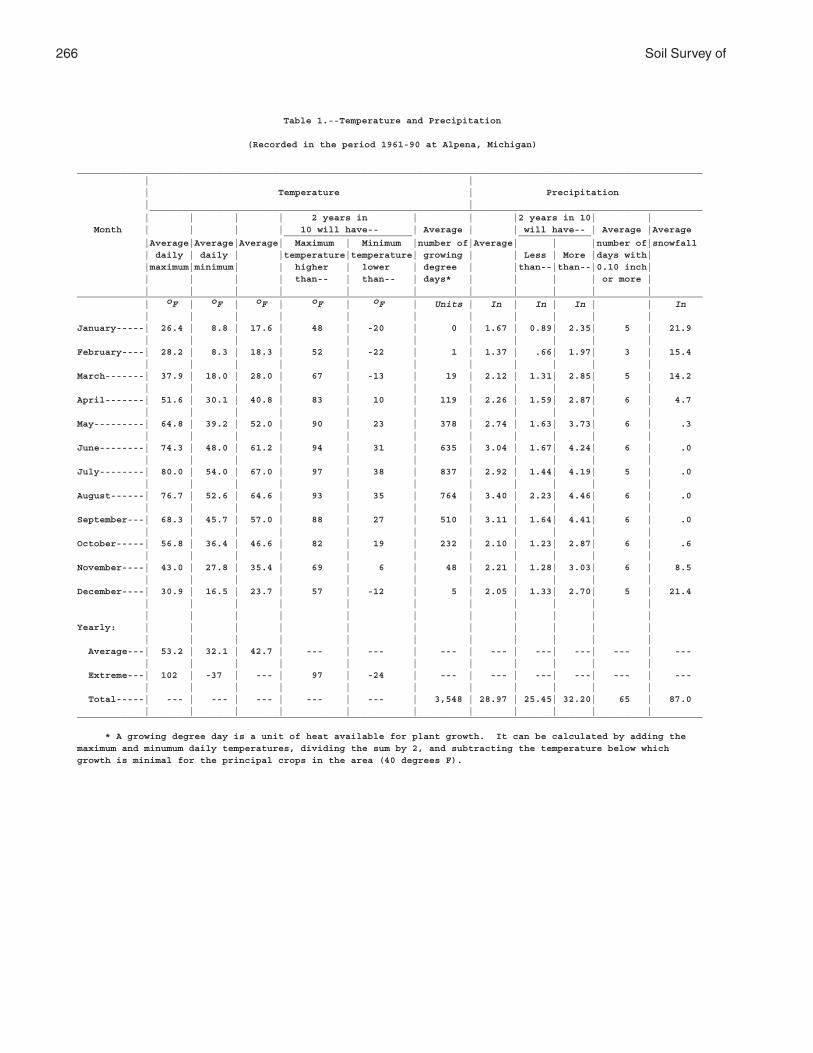
266 Soil Survey of
Table 1.--Temperature and Precipitation
(Recorded in the period 1961-90 at Alpena, Michigan)
________________________________________________________________________________________________________________ | | | Temperature | Precipitation | | ___________________________________________________________________________________________________ | | | | 2 years in | | |2 years in 10| | Month | | | | 10 will have-- | Average | | will have-- | Average |Average _______________________ _____________ |Average|Average|Average| Maximum | Minimum |number of|Average| | |number of|snowfall | daily | daily | |temperature|temperature| growing | | Less | More |days with| |maximum|minimum| | higher | lower | degree | |than--|than--|0.10 inch| | | | | than-- | than-- | days* | | | | or more | | | | | | | | | | | |________________________________________________________________________________________________________________ | oF | oF | oF | oF | oF | Units | In | In | In | | In | | | | | | | | | | |January-----| 26.4 | 8.8 | 17.6 | 48 | -20 | 0 | 1.67 | 0.89| 2.35| 5 | 21.9 | | | | | | | | | | |February----| 28.2 | 8.3 | 18.3 | 52 | -22 | 1 | 1.37 | .66| 1.97| 3 | 15.4 | | | | | | | | | | |March-------| 37.9 | 18.0 | 28.0 | 67 | -13 | 19 | 2.12 | 1.31| 2.85| 5 | 14.2 | | | | | | | | | | |April-------| 51.6 | 30.1 | 40.8 | 83 | 10 | 119 | 2.26 | 1.59| 2.87| 6 | 4.7 | | | | | | | | | | |May---------| 64.8 | 39.2 | 52.0 | 90 | 23 | 378 | 2.74 | 1.63| 3.73| 6 | .3 | | | | | | | | | | |June--------| 74.3 | 48.0 | 61.2 | 94 | 31 | 635 | 3.04 | 1.67| 4.24| 6 | .0 | | | | | | | | | | |July--------| 80.0 | 54.0 | 67.0 | 97 | 38 | 837 | 2.92 | 1.44| 4.19| 5 | .0 | | | | | | | | | | |August------| 76.7 | 52.6 | 64.6 | 93 | 35 | 764 | 3.40 | 2.23| 4.46| 6 | .0 | | | | | | | | | | |September---| 68.3 | 45.7 | 57.0 | 88 | 27 | 510 | 3.11 | 1.64| 4.41| 6 | .0 | | | | | | | | | | |October-----| 56.8 | 36.4 | 46.6 | 82 | 19 | 232 | 2.10 | 1.23| 2.87| 6 | .6 | | | | | | | | | | |November----| 43.0 | 27.8 | 35.4 | 69 | 6 | 48 | 2.21 | 1.28| 3.03| 6 | 8.5 | | | | | | | | | | |December----| 30.9 | 16.5 | 23.7 | 57 | -12 | 5 | 2.05 | 1.33| 2.70| 5 | 21.4 | | | | | | | | | | | | | | | | | | | | | |Yearly: | | | | | | | | | | | | | | | | | | | | | | Average---| 53.2 | 32.1 | 42.7 | --- | --- | --- | --- | ---| ---| --- | --- | | | | | | | | | | | Extreme---| 102 | -37 | --- | 97 | -24 | --- | --- | ---| ---| --- | --- | | | | | | | | | | | Total-----| --- | --- | --- | --- | --- | 3,548 | 28.97 | 25.45| 32.20| 65 | 87.0 | | | | | | | | | | |________________________________________________________________________________________________________________
* A growing degree day is a unit of heat available for plant growth. It can be calculated by adding themaximum and minumum daily temperatures, dividing the sum by 2, and subtracting the temperature below whichgrowth is minimal for the principal crops in the area (40 degrees F).

Alpena County, Michigan 267
Table 2.--Freeze Dates in Spring and Fall
(Recorded in the period 1961-90 at Alpena, Michigan)
_____________________________________________________________ | | Temperature | __________________________________________ Probability | | | | 24 oF | 28 oF | 32 oF | or lower | or lower | or lower | | |_____________________________________________________________ | | |Last freezing | | | temperature | | | in spring: | | | | | | 1 year in 10 | | | later than-----| May 10 | May 25 | June 13 | | | 2 years in 10 | | | later than-----| May 5 | May 20 | June 7 | | | 5 years in 10 | | | later than-----| April 26 | May 11 | May 27 | | |First freezing | | | temperature | | | in fall: | | | | | | 1 year in 10 | | | earlier than---| October 11 |September 21 | September 8 | | | 2 years in 10 | | | earlier than---| October 16 |September 27 | September 13 | | | 5 years in 10 | | | earlier than---| October 25 |October 8 | September 22 | | |_____________________________________________________________
Table 3.--Growing Season
(Recorded in the period 1961-90 at Alpena, Michigan)
____________________________________________________ | | Daily minimum temperature | during growing season | _____________________________________ Probability | | | | Higher | Higher | Higher | than | than | than | 24 oF | 28 oF | 32 oF | | |____________________________________________________ | Days | Days | Days | | |9 years in 10 | 159 | 126 | 94 | | |8 years in 10 | 167 | 133 | 102 | | |5 years in 10 | 181 | 148 | 117 | | |2 years in 10 | 196 | 163 | 133 | | |1 year in 10 | 203 | 171 | 141 | | |____________________________________________________
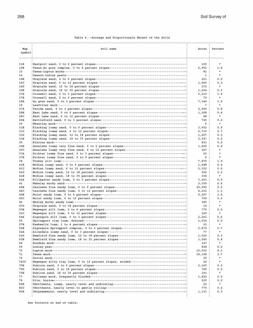
268 Soil Survey of
Table 4.--Acreage and Proportionate Extent of the Soils______________________________________________________________________________________________________________________ | | | Map | Soil name | Acres | Percent symbol| | | | | |______________________________________________________________________________________________________________________ | | |11B |Eastport sand, 0 to 6 percent slopes----------------------------------------------------| 109 | *12B |Tawas-Au gres complex, 0 to 4 percent slopes--------------------------------------------| 6,952 | 1.813 |Tawas-Lupton mucks---------------------------------------------------------------------—| 81 | *14 |Dawson-Loxley peats---------------------------------------------------------------------| 1 | *16B |Graycalm sand, 0 to 6 percent slopes----------------------------------------------------| 621 | 0.216C |Graycalm sand, 6 to 12 percent slopes------------------------------------------------—--| 1,066 | 0.316D |Graycalm sand, 12 to 18 percent slopes-------------------------------------------------—| 272 | *16E |Graycalm sand, 18 to 35 percent slopes-------------------------------------------------—| 1,264 | 0.317A |Croswell sand, 0 to 3 percent slopes----------------------------------------------------| 6,219 | 1.617B |Croswell sand, 0 to 6 percent slopes----------------------------------------------------| 79 | *18A |Au gres sand, 0 to 3 percent slopes-----------------------------------------------------| 7,344 | 1.919 |Leafriver muck-------------------------------------------------------------------------—| 7 | *27A |Tacoda sand, 0 to 3 percent slopes-----------------------------------------------------—| 2,995 | 0.828B |East Lake sand, 0 to 6 percent slopes-------------------------------------------------—-| 1,368 | 0.428C |East Lake sand, 6 to 12 percent slopes-------------------------------------------------—| 88 | *29A |Battlefield sand, 0 to 3 percent slopes-------------------------------------------------| 745 | 0.230 |Wheatley muck--------------------------------------------------------------------------—| 9 | *31B |Klacking loamy sand, 0 to 6 percent slopes---------------------------------------------—| 3,602 | 0.931C |Klacking loamy sand, 6 to 12 percent slopes---------------------------------------------| 2,739 | 0.731D |Klacking loamy sand, 12 to 18 percent slopes--------------------------------------------| 1,267 | 0.331E |Klacking loamy sand, 18 to 35 percent slopes--------------------------------------------| 2,347 | 0.635 |Kinross muck----------------------------------------------------------------------------| 831 | 0.236B |Annalake loamy very fine sand, 0 to 6 percent slopes------------------------------------| 1,456 | 0.436C |Annalake loamy very fine sand, 6 to 12 percent slopes----------------------------------—| 227 | *37A |Richter loamy fine sand, 0 to 3 percent slopes----------------------------------------—-| 60 | *37B |Richter loamy fine sand, 0 to 6 percent slopes----------------------------------------—-| 5 | *38 |Tonkey silt loam------------------------------------------------------------------------| 7,475 | 1.941B |McGinn loamy sand, 0 to 6 percent slopes------------------------------------------------| 1,688 | 0.441C |McGinn loamy sand, 6 to 12 percent slopes--------------------------------------------—--| 2,152 | 0.641D |McGinn loamy sand, 12 to 18 percent slopes---------------------------------------------—| 926 | 0.241E |McGinn loamy sand, 18 to 35 percent slopes---------------------------------------------—| 338 | *42A |Killmaster sandy loam, 0 to 3 percent slopes--------------------------------------------| 3,363 | 0.943 |Wakeley mucky sand---------------------------------------------------------------------—| 2,359 | 0.644B |Ossineke fine sandy loam, 0 to 6 percent slopes-----------------------------------------| 35,595 | 9.244C |Ossineke fine sandy loam, 6 to 12 percent slopes----------------------------------------| 4,232 | 1.145B |Hoist sandy loam, 0 to 6 percent slopes-------------------------------------------------| 6,257 | 1.645C |Hoist sandy loam, 6 to 12 percent slopes------------------------------------------------| 799 | 0.246 |Ensley mucky sandy loam-----------------------------------------------------------------| 385 | *47D |Graycalm sand, 6 to 18 percent slopes--------------------------------------------------—| 14 | *53B |Negwegon silt loam, 2 to 6 percent slopes----------------------------------------------—| 775 | 0.253C |Negwegon silt loam, 6 to 12 percent slopes---------------------------------------------—| 140 | *54A |Algonquin silt loam, 0 to 3 percent slopes---------------------------------------------—| 2,261 | 0.655 |Springport clay loam, drained----------------------------------------------------------—| 1,914 | 0.557B |Kawkawlin loam, 1 to 4 percent slopes--------------------------------------------------—| 91 | *59B |Algonquin-Springport complex, 0 to 6 percent slopes-------------------------------------| 2,875 | 0.762A |Allendale loamy sand, 0 to 3 percent slopes---------------------------------------------| 77 | *63D |Bamfield fine sandy loam, 12 to 18 percent slopes--------------------------------------—| 1,026 | 0.363E |Bamfield fine sandy loam, 18 to 35 percent slopes--------------------------------------—| 1,540 | 0.468 |Rondeau muck----------------------------------------------------------------------------| 147 | *69 |Loxley peat-----------------------------------------------------------------------------| 828 | 0.270 |Lupton muck-----------------------------------------------------------------------------| 15,936 | 4.171 |Tawas muck-----------------------------------------------------------------------------—| 14,198 | 3.772 |Dorval muck-----------------------------------------------------------------------------| 35 | *74C2 |Negwegon silty clay loam, 6 to 12 percent slopes, eroded--------------------------------| 24 | *75B |Rubicon sand, 0 to 6 percent slopes-----------------------------------------------------| 2,165 | 0.675D |Rubicon sand, 6 to 18 percent slopes----------------------------------------------------| 749 | 0.275E |Rubicon sand, 18 to 35 percent slopes--------------------------------------------------—| 191 | *77 |Rollaway muck, frequently flooded------------------------------------------------------—| 1,822 | 0.578 |Pits, borrow----------------------------------------------------------------------------| 925 | 0.282B |Udorthents, loamy, nearly level and undulating-----------------------------------------—| 22 | *82C |Udorthents, nearly level to gently rolling---------------------------------------------—| 775 | 0.283B |Udipsamments, nearly level and undulating----------------------------------------------—| 1,131 | 0.3 | | |
See footnote at end of table.
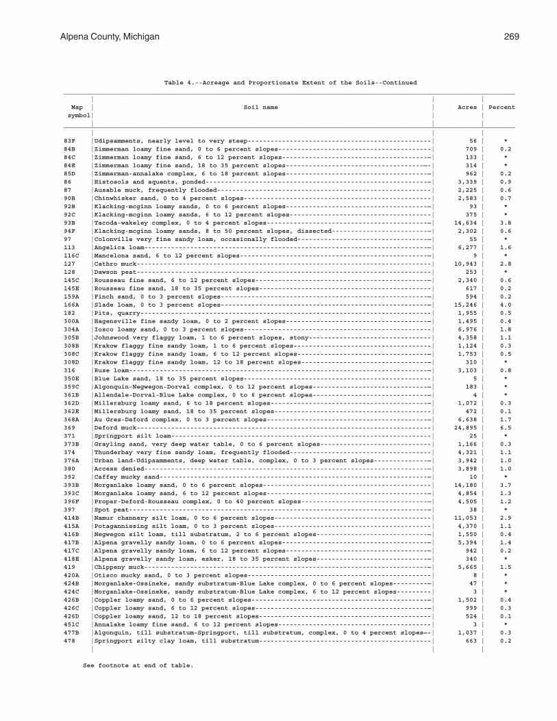
Alpena County, Michigan 269
Table 4.--Acreage and Proportionate Extent of the Soils--Continued______________________________________________________________________________________________________________________ | | | Map | Soil name | Acres | Percent symbol| | | | | |______________________________________________________________________________________________________________________ | | |83F |Udipsamments, nearly level to very steep------------------------------------------------| 56 | *84B |Zimmerman loamy fine sand, 0 to 6 percent slopes----------------------------------------| 709 | 0.284C |Zimmerman loamy fine sand, 6 to 12 percent slopes--------------------------------------—| 133 | *84E |Zimmerman loamy fine sand, 18 to 35 percent slopes------------------------------------—-| 314 | *85D |Zimmerman-annalake complex, 6 to 18 percent slopes-------------------------------------—| 962 | 0.286 |Histosols and aquents, ponded----------------------------------------------------------—| 3,339 | 0.987 |Ausable muck, frequently flooded--------------------------------------------------------| 2,225 | 0.690B |Chinwhisker sand, 0 to 4 percent slopes-------------------------------------------------| 2,583 | 0.792B |Klacking-mcginn loamy sands, 0 to 6 percent slopes-------------------------------------—| 93 | *92C |Klacking-mcginn loamy sands, 6 to 12 percent slopes-------------------------------------| 375 | *93B |Tacoda-wakeley complex, 0 to 4 percent slopes------------------------------------------—| 14,634 | 3.894F |Klacking-mcginn loamy sands, 8 to 50 percent slopes, dissected-------------------------—| 2,302 | 0.697 |Colonville very fine sandy loam, occasionally flooded----------------------------------—| 55 | *113 |Angelica loam--------------------------------------------------------------------------—| 6,277 | 1.6116C |Mancelona sand, 6 to 12 percent slopes-------------------------------------------------—| 9 | *127 |Cathro muck-----------------------------------------------------------------------------| 10,943 | 2.8128 |Dawson peat-----------------------------------------------------------------------------| 253 | *145C |Rousseau fine sand, 6 to 12 percent slopes---------------------------------------------—| 2,340 | 0.6145E |Rousseau fine sand, 18 to 35 percent slopes---------------------------------------------| 617 | 0.2159A |Finch sand, 0 to 3 percent slopes------------------------------------------------------—| 594 | 0.2166A |Slade loam, 0 to 3 percent slopes------------------------------------------------------—| 15,246 | 4.0182 |Pits, quarry----------------------------------------------------------------------------| 1,955 | 0.5300A |Hagensville fine sandy loam, 0 to 2 percent slopes-------------------------------------—| 1,495 | 0.4304A |Iosco loamy sand, 0 to 3 percent slopes-------------------------------------------------| 6,976 | 1.8305B |Johnswood very flaggy loam, 1 to 6 percent slopes, stony--------------------------------| 4,358 | 1.1308B |Krakow flaggy fine sandy loam, 1 to 6 percent slopes------------------------------------| 1,124 | 0.3308C |Krakow flaggy fine sandy loam, 6 to 12 percent slopes----------------------------------—| 1,753 | 0.5308D |Krakow flaggy fine sandy loam, 12 to 18 percent slopes---------------------------------—| 310 | *316 |Ruse loam------------------------------------------------------------------------------—| 3,103 | 0.8350E |Blue Lake sand, 18 to 35 percent slopes-------------------------------------------------| 5 | *359C |Algonquin-Negwegon-Dorval complex, 0 to 12 percent slopes------------------------------—| 183 | *361B |Allendale-Dorval-Blue Lake complex, 0 to 6 percent slopes------------------------------—| 4 | *362D |Millersburg loamy sand, 6 to 18 percent slopes-----------------------------------------—| 1,072 | 0.3362E |Millersburg loamy sand, 18 to 35 percent slopes-----------------------------------------| 472 | 0.1368A |Au Gres-Deford complex, 0 to 3 percent slopes------------------------------------------—| 6,638 | 1.7369 |Deford muck-----------------------------------------------------------------------------| 24,895 | 6.5371 |Springport silt loam--------------------------------------------------------------------| 25 | *373B |Grayling sand, very deep water table, 0 to 6 percent slopes-----------------------------| 1,166 | 0.3374 |Thunderbay very fine sandy loam, frequently flooded-------------------------------------| 4,321 | 1.1376A |Urban land-Udipsamments, deep water table, complex, 0 to 3 percent slopes--------------—| 3,942 | 1.0380 |Access denied--------------------------------------------------------------------------—| 3,898 | 1.0392 |Caffey mucky sand----------------------------------------------------------------------—| 10 | *393B |Morganlake loamy sand, 0 to 6 percent slopes--------------------------------------------| 14,180 | 3.7393C |Morganlake loamy sand, 6 to 12 percent slopes------------------------------------------—| 4,854 | 1.3396F |Proper-Deford-Rousseau complex, 0 to 40 percent slopes---------------------------------—| 4,505 | 1.2397 |Spot peat------------------------------------------------------------------------------—| 38 | *414B |Namur channery silt loam, 0 to 6 percent slopes-----------------------------------------| 11,053 | 2.9415A |Potagannissing silt loam, 0 to 3 percent slopes-----------------------------------------| 4,370 | 1.1416B |Negwegon silt loam, till substratum, 2 to 6 percent slopes-----------------------------—| 1,550 | 0.4417B |Alpena gravelly sandy loam, 0 to 6 percent slopes--------------------------------------—| 5,394 | 1.4417C |Alpena gravelly sandy loam, 6 to 12 percent slopes-------------------------------------—| 942 | 0.2418E |Alpena gravelly sandy loam, esker, 18 to 35 percent slopes-----------------------------—| 340 | *419 |Chippeny muck--------------------------------------------------------------------------—| 5,665 | 1.5420A |Otisco mucky sand, 0 to 3 percent slopes------------------------------------------------| 8 | *424B |Morganlake-Ossineke, sandy substratum-Blue Lake complex, 0 to 6 percent slopes---------—| 47 | *424C |Morganlake-Ossineke, sandy substratum-Blue Lake complex, 6 to 12 percent slopes---------| 3 | *426B |Coppler loamy sand, 0 to 6 percent slopes----------------------------------------------—| 1,502 | 0.4426C |Coppler loamy sand, 6 to 12 percent slopes---------------------------------------------—| 999 | 0.3426D |Coppler loamy sand, 12 to 18 percent slopes---------------------------------------------| 524 | 0.1451C |Annalake loamy fine sand, 6 to 12 percent slopes----------------------------------------| 3 | *477B |Algonquin, till substratum-Springport, till substratum, complex, 0 to 4 percent slopes—-| 1,037 | 0.3478 |Springport silty clay loam, till substratum---------------------------------------------| 663 | 0.2 | | |
See footnote at end of table.
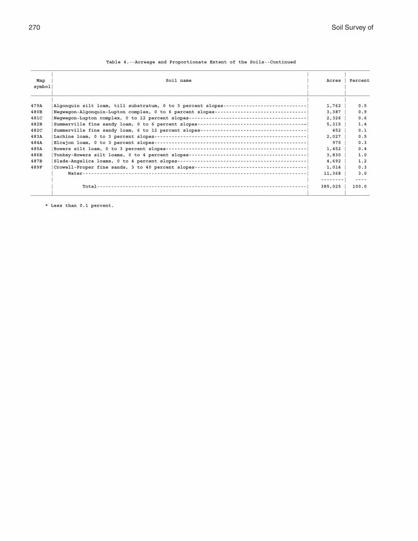
270 Soil Survey of
Table 4.--Acreage and Proportionate Extent of the Soils--Continued______________________________________________________________________________________________________________________ | | | Map | Soil name | Acres | Percent symbol| | | | | |______________________________________________________________________________________________________________________ | | |479A |Algonquin silt loam, till substratum, 0 to 3 percent slopes-----------------------------| 1,762 | 0.5480B |Negwegon-Algonquin-Lupton complex, 0 to 6 percent slopes--------------------------------| 3,387 | 0.9481C |Negwegon-Lupton complex, 0 to 12 percent slopes-----------------------------------------| 2,326 | 0.6482B |Summerville fine sandy loam, 0 to 6 percent slopes-------------------------------------—| 5,315 | 1.4482C |Summerville fine sandy loam, 6 to 12 percent slopes-------------------------------------| 452 | 0.1483A |Lachine loam, 0 to 3 percent slopes-----------------------------------------------------| 2,027 | 0.5484A |Elcajon loam, 0 to 3 percent slopes-----------------------------------------------------| 975 | 0.3485A |Bowers silt loam, 0 to 3 percent slopes-------------------------------------------------| 1,452 | 0.4486B |Tonkey-Bowers silt loams, 0 to 4 percent slopes-----------------------------------------| 3,830 | 1.0487B |Slade-Angelica loams, 0 to 4 percent slopes---------------------------------------------| 4,692 | 1.2489F |Crowell-Proper fine sands, 3 to 40 percent slopes---------------------------------------| 1,014 | 0.3 | Water------------------------------------------------------------------------------| 11,368 | 3.0 | | --------| ----
| Total-------------------------------------------------------------------------| 385,025 | 100.0 | | |______________________________________________________________________________________________________________________
* Less than 0.1 percent.
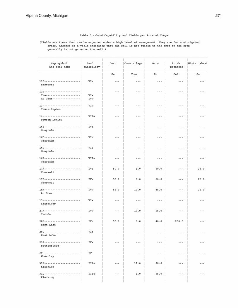
Alpena County, Michigan 271
Table 5.--Land Capability and Yields per Acre of Crops
(Yields are those that can be expected under a high level of management. They are for nonirrigated areas. Absence of a yield indicates that the soil is not suited to the crop or the crop generally is not grown on the soil.)
_______________________________________________________________________________________________________ | | | | | | Map symbol | Land | Corn |Corn silage | Oats | Irish |Winter wheat and soil name | capability | | | | potatoes | | | | | | |_______________________________________________________________________________________________________ | | Bu | Tons | Bu | Cwt | Bu | | | | | |11B----------------------| VIs | --- | --- | --- | --- | --- Eastport | | | | | | | | | | | |12B----------------------| | --- | --- | --- | --- | --- Tawas-------------------| VIw | | | | | Au Gres-----------------| IVw | | | | | | | | | | |13-----------------------| VIw | --- | --- | --- | --- | --- Tawas-Lupton | | | | | | | | | | | |14-----------------------| VIIw | --- | --- | --- | --- | --- Dawson-Loxley | | | | | | | | | | | |16B----------------------| IVs | --- | --- | --- | --- | --- Graycalm | | | | | | | | | | | |16C----------------------| VIs | --- | --- | --- | --- | --- Graycalm | | | | | | | | | | | |16D----------------------| VIs | --- | --- | --- | --- | --- Graycalm | | | | | | | | | | | |16E----------------------| VIIs | --- | --- | --- | --- | --- Graycalm | | | | | | | | | | | |17A----------------------| IVs | 50.0 | 9.0 | 50.0 | --- | 25.0 Croswell | | | | | | | | | | | |17B----------------------| IVs | 50.0 | 9.0 | 50.0 | --- | 25.0 Croswell | | | | | | | | | | | |18A----------------------| IVw | 55.0 | 10.0 | 45.0 | --- | 25.0 Au Gres | | | | | | | | | | | |19-----------------------| VIw | --- | --- | --- | --- | --- Leafriver | | | | | | | | | | | |27A----------------------| IVw | --- | 10.0 | 65.0 | --- | --- Tacoda | | | | | | | | | | | |28B----------------------| IVs | 50.0 | 9.0 | 40.0 | 250.0 | --- East Lake | | | | | | | | | | | |28C----------------------| VIs | --- | --- | --- | --- | --- East Lake | | | | | | | | | | | |29A----------------------| IVw | --- | --- | --- | --- | --- Battlefield | | | | | | | | | | | |30-----------------------| Vw | --- | --- | --- | --- | --- Wheatley | | | | | | | | | | | |31B----------------------| IIIs | --- | 11.0 | 60.0 | --- | --- Klacking | | | | | | | | | | | |31C----------------------| IIIe | --- | 9.0 | 55.0 | --- | --- Klacking | | | | | | | | | | | |
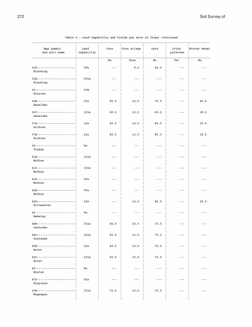
272 Soil Survey of
Table 5.--Land Capability and Yields per Acre of Crops--Continued_______________________________________________________________________________________________________ | | | | | | Map symbol | Land | Corn |Corn silage | Oats | Irish |Winter wheat and soil name | capability | | | | potatoes | | | | | | |_______________________________________________________________________________________________________ | | Bu | Tons | Bu | Cwt | Bu | | | | | |31D----------------------| IVe | --- | 8.0 | 45.0 | --- | --- Klacking | | | | | | | | | | | |31E----------------------| VIIe | --- | --- | --- | --- | --- Klacking | | | | | | | | | | | |35-----------------------| VIW | --- | --- | --- | --- | --- Kinross | | | | | | | | | | | |36B----------------------| IIe | 85.0 | 14.0 | 70.0 | --- | 40.0 Annalake | | | | | | | | | | | |36C----------------------| IIIe | 80.0 | 13.0 | 65.0 | --- | 38.0 Annalake | | | | | | | | | | | |37A----------------------| IIw | 85.0 | 14.0 | 80.0 | --- | 35.0 Richter | | | | | | | | | | | |37B----------------------| IIe | 80.0 | 13.0 | 80.0 | --- | 35.0 Richter | | | | | | | | | | | |38-----------------------| Vw | --- | --- | --- | --- | --- Tonkey | | | | | | | | | | | |41B----------------------| IIIs | --- | --- | --- | --- | --- McGinn | | | | | | | | | | | |41C----------------------| IIIe | --- | --- | --- | --- | --- McGinn | | | | | | | | | | | |41D----------------------| IVe | --- | --- | --- | --- | --- McGinn | | | | | | | | | | | |41E----------------------| VIe | --- | --- | --- | --- | --- McGinn | | | | | | | | | | | |42A----------------------| IIw | --- | 14.0 | 80.0 | --- | 35.0 Killmaster | | | | | | | | | | | |43-----------------------| Vw | --- | --- | --- | --- | --- Wakeley | | | | | | | | | | | |44B----------------------| IIIe | 85.0 | 14.0 | 76.0 | --- | --- Ossineke | | | | | | | | | | | |44C----------------------| IIIe | 80.0 | 13.0 | 75.0 | --- | --- Ossineke | | | | | | | | | | | |45B----------------------| IIe | 80.0 | 15.0 | 75.0 | --- | --- Hoist | | | | | | | | | | | |45C----------------------| IIIe | 80.0 | 15.0 | 75.0 | --- | --- Hoist | | | | | | | | | | | |46-----------------------| Vw | --- | --- | --- | --- | --- Ensley | | | | | | | | | | | |47D----------------------| VIs | --- | --- | --- | --- | --- Graycalm | | | | | | | | | | | |53B----------------------| IIIe | 75.0 | 12.0 | 70.0 | --- | --- Negwegon | | | | | | | | | | | |
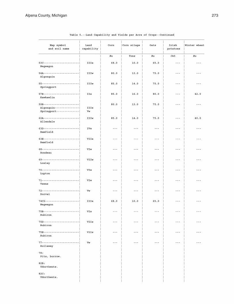
Alpena County, Michigan 273
Table 5.--Land Capability and Yields per Acre of Crops--Continued_______________________________________________________________________________________________________ | | | | | | Map symbol | Land | Corn |Corn silage | Oats | Irish |Winter wheat and soil name | capability | | | | potatoes | | | | | | |_______________________________________________________________________________________________________ | | Bu | Tons | Bu | Cwt | Bu | | | | | |53C----------------------| IIIe | 68.0 | 10.0 | 65.0 | --- | --- Negwegon | | | | | | | | | | | |54A----------------------| IIIw | 80.0 | 13.0 | 75.0 | --- | --- Algonquin | | | | | | | | | | | |55-----------------------| IIIw | 85.0 | 14.0 | 75.0 | --- | --- Springport | | | | | | | | | | | |57B----------------------| IIe | 85.0 | 16.0 | 80.0 | --- | 42.0 Kawkawlin | | | | | | | | | | | |59B----------------------| | 80.0 | 13.0 | 75.0 | --- | --- Algonquin---------------| IIIe | | | | | Springport--------------| Vw | | | | | | | | | | |62A----------------------| IIIw | 85.0 | 14.0 | 75.0 | --- | 40.0 Allendale | | | | | | | | | | | |63D----------------------| IVe | --- | --- | --- | --- | --- Bamfield | | | | | | | | | | | |63E----------------------| VIIe | --- | --- | --- | --- | --- Bamfield | | | | | | | | | | | |68-----------------------| VIw | --- | --- | --- | --- | --- Rondeau | | | | | | | | | | | |69-----------------------| VIIw | --- | --- | --- | --- | --- Loxley | | | | | | | | | | | |70-----------------------| VIw | --- | --- | --- | --- | --- Lupton | | | | | | | | | | | |71-----------------------| VIw | --- | --- | --- | --- | --- Tawas | | | | | | | | | | | |72-----------------------| Vw | --- | --- | --- | --- | --- Dorval | | | | | | | | | | | |74C2---------------------| IIIe | 68.0 | 10.0 | 65.0 | --- | --- Negwegon | | | | | | | | | | | |75B----------------------| VIs | --- | --- | --- | --- | --- Rubicon | | | | | | | | | | | |75D----------------------| VIIs | --- | --- | --- | --- | --- Rubicon | | | | | | | | | | | |75E----------------------| VIIs | --- | --- | --- | --- | --- Rubicon | | | | | | | | | | | |77-----------------------| Vw | --- | --- | --- | --- | --- Rollaway | | | | | | | | | | | |78: | | | | | | Pits, borrow. | | | | | | | | | | | |82B: | | | | | | Udorthents. | | | | | | | | | | | |82C: | | | | | | Udorthents. | | | | | | | | | | | |
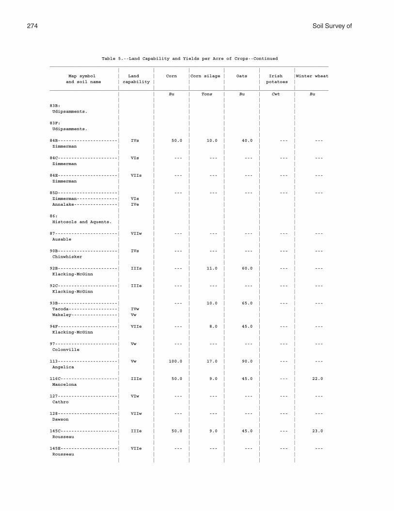
274 Soil Survey of
Table 5.--Land Capability and Yields per Acre of Crops--Continued_______________________________________________________________________________________________________ | | | | | | Map symbol | Land | Corn |Corn silage | Oats | Irish |Winter wheat and soil name | capability | | | | potatoes | | | | | | |_______________________________________________________________________________________________________ | | Bu | Tons | Bu | Cwt | Bu | | | | | |83B: | | | | | | Udipsamments. | | | | | | | | | | | |83F: | | | | | | Udipsamments. | | | | | | | | | | | |84B----------------------| IVs | 50.0 | 10.0 | 40.0 | --- | --- Zimmerman | | | | | | | | | | | |84C----------------------| VIs | --- | --- | --- | --- | --- Zimmerman | | | | | | | | | | | |84E----------------------| VIIs | --- | --- | --- | --- | --- Zimmerman | | | | | | | | | | | |85D----------------------| | --- | --- | --- | --- | --- Zimmerman---------------| VIs | | | | | Annalake----------------| IVe | | | | | | | | | | |86: | | | | | | Histosols and Aquents. | | | | | | | | | | | |87-----------------------| VIIw | --- | --- | --- | --- | --- Ausable | | | | | | | | | | | |90B----------------------| IVs | --- | --- | --- | --- | --- Chinwhisker | | | | | | | | | | | |92B----------------------| IIIs | --- | 11.0 | 60.0 | --- | --- Klacking-McGinn | | | | | | | | | | | |92C----------------------| IIIe | --- | --- | --- | --- | --- Klacking-McGinn | | | | | | | | | | | |93B----------------------| | --- | 10.0 | 65.0 | --- | --- Tacoda------------------| IVw | | | | | Wakeley-----------------| Vw | | | | | | | | | | |94F----------------------| VIIe | --- | 8.0 | 45.0 | --- | --- Klacking-McGinn | | | | | | | | | | | |97-----------------------| Vw | --- | --- | --- | --- | --- Colonville | | | | | | | | | | | |113----------------------| Vw | 100.0 | 17.0 | 90.0 | --- | --- Angelica | | | | | | | | | | | |116C---------------------| IIIe | 50.0 | 9.0 | 45.0 | --- | 22.0 Mancelona | | | | | | | | | | | |127----------------------| VIw | --- | --- | --- | --- | --- Cathro | | | | | | | | | | | |128----------------------| VIIw | --- | --- | --- | --- | --- Dawson | | | | | | | | | | | |145C---------------------| IIIe | 50.0 | 9.0 | 45.0 | --- | 23.0 Rousseau | | | | | | | | | | | |145E---------------------| VIIe | --- | --- | --- | --- | --- Rousseau | | | | | | | | | | | |
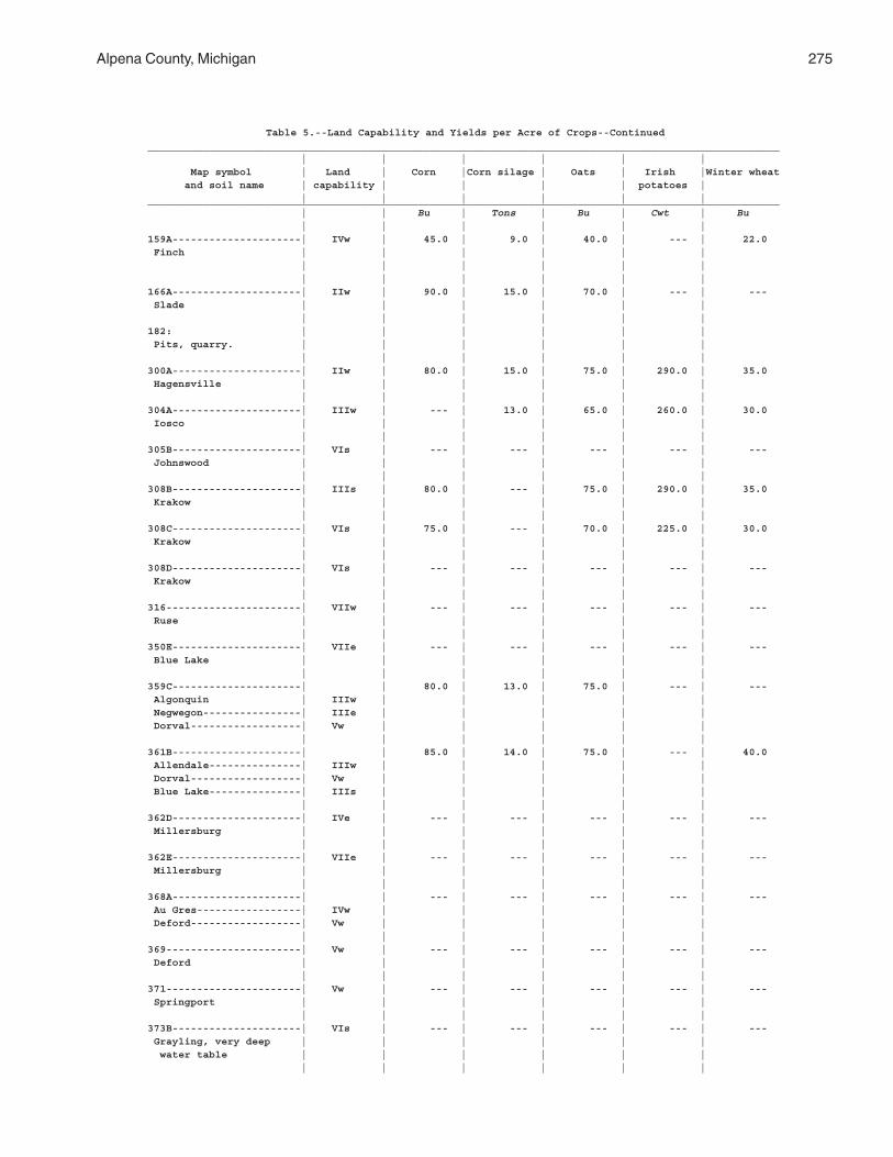
Alpena County, Michigan 275
Table 5.--Land Capability and Yields per Acre of Crops--Continued_______________________________________________________________________________________________________ | | | | | | Map symbol | Land | Corn |Corn silage | Oats | Irish |Winter wheat and soil name | capability | | | | potatoes | | | | | | |_______________________________________________________________________________________________________ | | Bu | Tons | Bu | Cwt | Bu | | | | | |159A---------------------| IVw | 45.0 | 9.0 | 40.0 | --- | 22.0 Finch | | | | | | | | | | | | | | | | | |166A---------------------| IIw | 90.0 | 15.0 | 70.0 | --- | --- Slade | | | | | | | | | | | |182: | | | | | | Pits, quarry. | | | | | | | | | | | |300A---------------------| IIw | 80.0 | 15.0 | 75.0 | 290.0 | 35.0 Hagensville | | | | | | | | | | | |304A---------------------| IIIw | --- | 13.0 | 65.0 | 260.0 | 30.0 Iosco | | | | | | | | | | | |305B---------------------| VIs | --- | --- | --- | --- | --- Johnswood | | | | | | | | | | | |308B---------------------| IIIs | 80.0 | --- | 75.0 | 290.0 | 35.0 Krakow | | | | | | | | | | | |308C---------------------| VIs | 75.0 | --- | 70.0 | 225.0 | 30.0 Krakow | | | | | | | | | | | |308D---------------------| VIs | --- | --- | --- | --- | --- Krakow | | | | | | | | | | | |316----------------------| VIIw | --- | --- | --- | --- | --- Ruse | | | | | | | | | | | |350E---------------------| VIIe | --- | --- | --- | --- | --- Blue Lake | | | | | | | | | | | |359C---------------------| | 80.0 | 13.0 | 75.0 | --- | --- Algonquin | IIIw | | | | | Negwegon----------------| IIIe | | | | | Dorval------------------| Vw | | | | | | | | | | |361B---------------------| | 85.0 | 14.0 | 75.0 | --- | 40.0 Allendale---------------| IIIw | | | | | Dorval------------------| Vw | | | | | Blue Lake---------------| IIIs | | | | | | | | | | |362D---------------------| IVe | --- | --- | --- | --- | --- Millersburg | | | | | | | | | | | |362E---------------------| VIIe | --- | --- | --- | --- | --- Millersburg | | | | | | | | | | | |368A---------------------| | --- | --- | --- | --- | --- Au Gres-----------------| IVw | | | | | Deford------------------| Vw | | | | | | | | | | |369----------------------| Vw | --- | --- | --- | --- | --- Deford | | | | | | | | | | | |371----------------------| Vw | --- | --- | --- | --- | --- Springport | | | | | | | | | | | |373B---------------------| VIs | --- | --- | --- | --- | --- Grayling, very deep | | | | | | water table | | | | | | | | | | | |
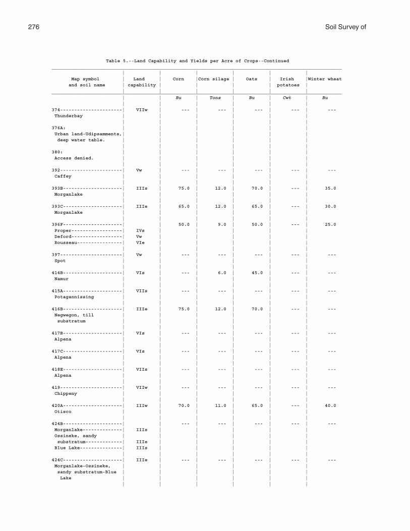
276 Soil Survey of
Table 5.--Land Capability and Yields per Acre of Crops--Continued_______________________________________________________________________________________________________ | | | | | | Map symbol | Land | Corn |Corn silage | Oats | Irish |Winter wheat and soil name | capability | | | | potatoes | | | | | | |_______________________________________________________________________________________________________ | | Bu | Tons | Bu | Cwt | Bu | | | | | |374----------------------| VIIw | --- | --- | --- | --- | --- Thunderbay | | | | | | | | | | | |376A: | | | | | | Urban land-Udipsamments,| | | | | | deep water table. | | | | | | | | | | | |380: | | | | | | Access denied. | | | | | | | | | | | |392----------------------| Vw | --- | --- | --- | --- | --- Caffey | | | | | | | | | | | |393B---------------------| IIIs | 75.0 | 12.0 | 70.0 | --- | 35.0 Morganlake | | | | | | | | | | | |393C---------------------| IIIe | 65.0 | 12.0 | 65.0 | --- | 30.0 Morganlake | | | | | | | | | | | |396F---------------------| | 50.0 | 9.0 | 50.0 | --- | 25.0 Proper------------------| IVs | | | | | Deford------------------| Vw | | | | | Rousseau----------------| VIe | | | | | | | | | | |397----------------------| Vw | --- | --- | --- | --- | --- Spot | | | | | | | | | | | |414B---------------------| VIs | --- | 6.0 | 45.0 | --- | --- Namur | | | | | | | | | | | |415A---------------------| VIIs | --- | --- | --- | --- | --- Potagannissing | | | | | | | | | | | |416B---------------------| IIIe | 75.0 | 12.0 | 70.0 | --- | --- Negwegon, till | | | | | | substratum | | | | | | | | | | | |417B---------------------| VIs | --- | --- | --- | --- | --- Alpena | | | | | | | | | | | |417C---------------------| VIs | --- | --- | --- | --- | --- Alpena | | | | | | | | | | | |418E---------------------| VIIs | --- | --- | --- | --- | --- Alpena | | | | | | | | | | | |419----------------------| VIIw | --- | --- | --- | --- | --- Chippeny | | | | | | | | | | | |420A---------------------| IIIw | 70.0 | 11.0 | 65.0 | --- | 40.0 Otisco | | | | | | | | | | | |424B---------------------| | --- | --- | --- | --- | --- Morganlake--------------| IIIs | | | | | Ossineke, sandy | | | | | | substratum-------------| IIIe | | | | | Blue Lake---------------| IIIs | | | | | | | | | | |424C---------------------| IIIe | --- | --- | --- | --- | --- Morganlake-Ossineke, | | | | | | sandy substratum-Blue | | | | | | Lake | | | | | | | | | | | |
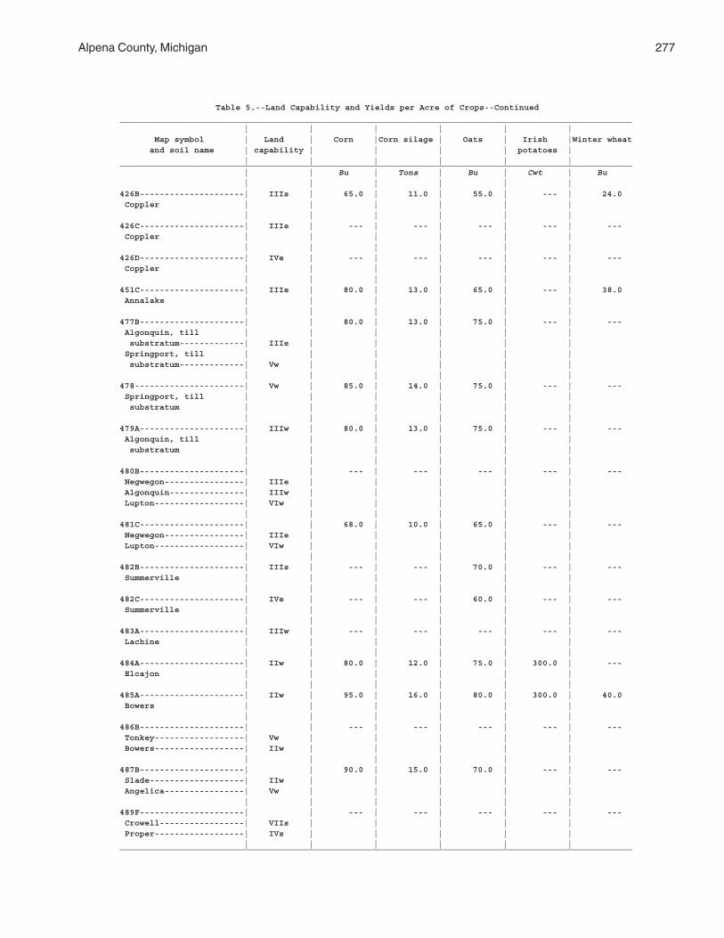
Alpena County, Michigan 277
Table 5.--Land Capability and Yields per Acre of Crops--Continued_______________________________________________________________________________________________________ | | | | | | Map symbol | Land | Corn |Corn silage | Oats | Irish |Winter wheat and soil name | capability | | | | potatoes | | | | | | |_______________________________________________________________________________________________________ | | Bu | Tons | Bu | Cwt | Bu | | | | | |426B---------------------| IIIs | 65.0 | 11.0 | 55.0 | --- | 24.0 Coppler | | | | | | | | | | | |426C---------------------| IIIe | --- | --- | --- | --- | --- Coppler | | | | | | | | | | | |426D---------------------| IVe | --- | --- | --- | --- | --- Coppler | | | | | | | | | | | |451C---------------------| IIIe | 80.0 | 13.0 | 65.0 | --- | 38.0 Annalake | | | | | | | | | | | |477B---------------------| | 80.0 | 13.0 | 75.0 | --- | --- Algonquin, till | | | | | | substratum-------------| IIIe | | | | | Springport, till | | | | | | substratum-------------| Vw | | | | | | | | | | |478----------------------| Vw | 85.0 | 14.0 | 75.0 | --- | --- Springport, till | | | | | | substratum | | | | | | | | | | | |479A---------------------| IIIw | 80.0 | 13.0 | 75.0 | --- | --- Algonquin, till | | | | | | substratum | | | | | | | | | | | |480B---------------------| | --- | --- | --- | --- | --- Negwegon----------------| IIIe | | | | | Algonquin---------------| IIIw | | | | | Lupton------------------| VIw | | | | | | | | | | |481C---------------------| | 68.0 | 10.0 | 65.0 | --- | --- Negwegon----------------| IIIe | | | | | Lupton------------------| VIw | | | | | | | | | | |482B---------------------| IIIs | --- | --- | 70.0 | --- | --- Summerville | | | | | | | | | | | |482C---------------------| IVe | --- | --- | 60.0 | --- | --- Summerville | | | | | | | | | | | |483A---------------------| IIIw | --- | --- | --- | --- | --- Lachine | | | | | | | | | | | |484A---------------------| IIw | 80.0 | 12.0 | 75.0 | 300.0 | --- Elcajon | | | | | | | | | | | |485A---------------------| IIw | 95.0 | 16.0 | 80.0 | 300.0 | 40.0 Bowers | | | | | | | | | | | |486B---------------------| | --- | --- | --- | --- | --- Tonkey------------------| Vw | | | | | Bowers------------------| IIw | | | | | | | | | | |487B---------------------| | 90.0 | 15.0 | 70.0 | --- | --- Slade-------------------| IIw | | | | | Angelica----------------| Vw | | | | | | | | | | |489F---------------------| | --- | --- | --- | --- | --- Crowell-----------------| VIIs | | | | | Proper------------------| IVs | | | | | | | | | | |_______________________________________________________________________________________________________
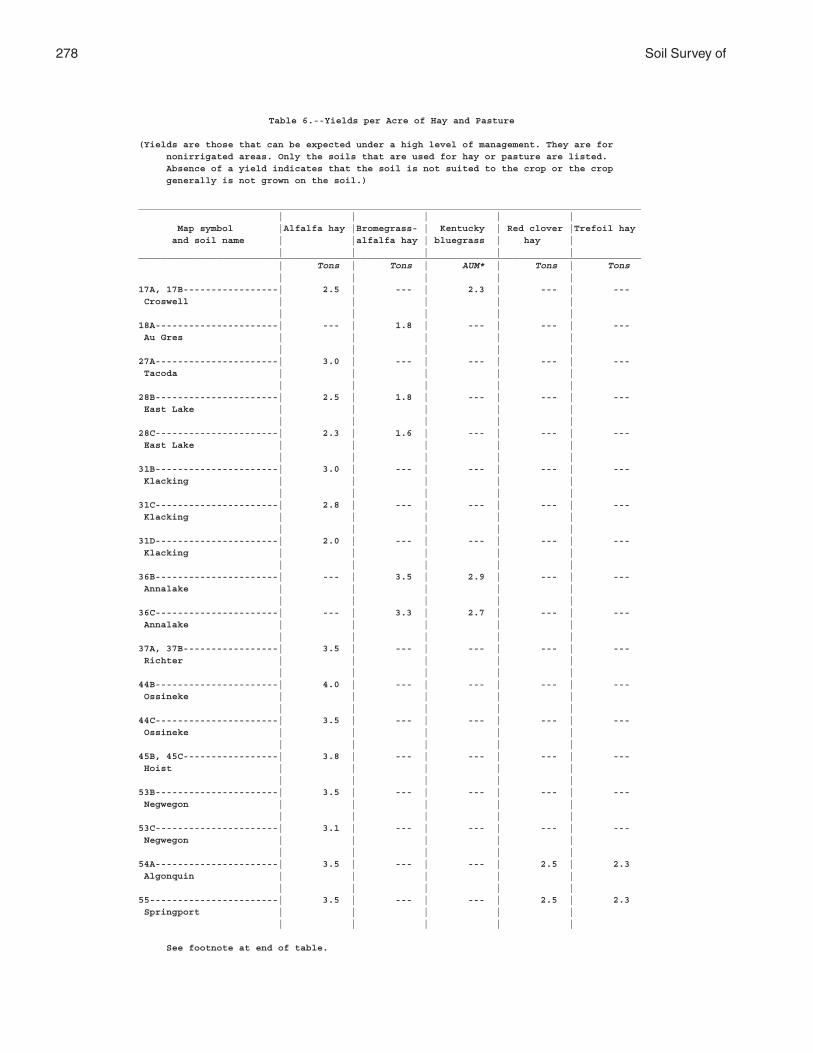
278 Soil Survey of
Table 6.--Yields per Acre of Hay and Pasture
(Yields are those that can be expected under a high level of management. They are for nonirrigated areas. Only the soils that are used for hay or pasture are listed. Absence of a yield indicates that the soil is not suited to the crop or the crop generally is not grown on the soil.)
__________________________________________________________________________________________ | | | | | Map symbol |Alfalfa hay |Bromegrass- | Kentucky | Red clover |Trefoil hay and soil name | |alfalfa hay | bluegrass | hay | | | | | |__________________________________________________________________________________________ | Tons | Tons | AUM* | Tons | Tons | | | | |17A, 17B-----------------| 2.5 | --- | 2.3 | --- | --- Croswell | | | | | | | | | |18A----------------------| --- | 1.8 | --- | --- | --- Au Gres | | | | | | | | | |27A----------------------| 3.0 | --- | --- | --- | --- Tacoda | | | | | | | | | |28B----------------------| 2.5 | 1.8 | --- | --- | --- East Lake | | | | | | | | | |28C----------------------| 2.3 | 1.6 | --- | --- | --- East Lake | | | | | | | | | |31B----------------------| 3.0 | --- | --- | --- | --- Klacking | | | | | | | | | |31C----------------------| 2.8 | --- | --- | --- | --- Klacking | | | | | | | | | |31D----------------------| 2.0 | --- | --- | --- | --- Klacking | | | | | | | | | |36B----------------------| --- | 3.5 | 2.9 | --- | --- Annalake | | | | | | | | | |36C----------------------| --- | 3.3 | 2.7 | --- | --- Annalake | | | | | | | | | |37A, 37B-----------------| 3.5 | --- | --- | --- | --- Richter | | | | | | | | | |44B----------------------| 4.0 | --- | --- | --- | --- Ossineke | | | | | | | | | |44C----------------------| 3.5 | --- | --- | --- | --- Ossineke | | | | | | | | | |45B, 45C-----------------| 3.8 | --- | --- | --- | --- Hoist | | | | | | | | | |53B----------------------| 3.5 | --- | --- | --- | --- Negwegon | | | | | | | | | |53C----------------------| 3.1 | --- | --- | --- | --- Negwegon | | | | | | | | | |54A----------------------| 3.5 | --- | --- | 2.5 | 2.3 Algonquin | | | | | | | | | |55-----------------------| 3.5 | --- | --- | 2.5 | 2.3 Springport | | | | | | | | | |
See footnote at end of table.
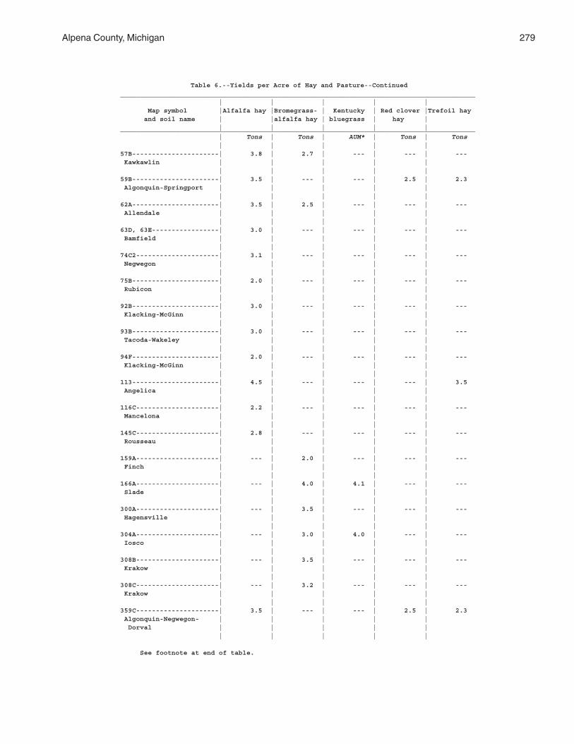
Alpena County, Michigan 279
Table 6.--Yields per Acre of Hay and Pasture--Continued__________________________________________________________________________________________ | | | | | Map symbol |Alfalfa hay |Bromegrass- | Kentucky | Red clover |Trefoil hay and soil name | |alfalfa hay | bluegrass | hay | | | | | |__________________________________________________________________________________________ | Tons | Tons | AUM* | Tons | Tons | | | | |57B----------------------| 3.8 | 2.7 | --- | --- | --- Kawkawlin | | | | | | | | | |59B----------------------| 3.5 | --- | --- | 2.5 | 2.3 Algonquin-Springport | | | | | | | | | |62A----------------------| 3.5 | 2.5 | --- | --- | --- Allendale | | | | | | | | | |63D, 63E-----------------| 3.0 | --- | --- | --- | --- Bamfield | | | | | | | | | |74C2---------------------| 3.1 | --- | --- | --- | --- Negwegon | | | | | | | | | |75B----------------------| 2.0 | --- | --- | --- | --- Rubicon | | | | | | | | | |92B----------------------| 3.0 | --- | --- | --- | --- Klacking-McGinn | | | | | | | | | |93B----------------------| 3.0 | --- | --- | --- | --- Tacoda-Wakeley | | | | | | | | | |94F----------------------| 2.0 | --- | --- | --- | --- Klacking-McGinn | | | | | | | | | |113----------------------| 4.5 | --- | --- | --- | 3.5 Angelica | | | | | | | | | |116C---------------------| 2.2 | --- | --- | --- | --- Mancelona | | | | | | | | | |145C---------------------| 2.8 | --- | --- | --- | --- Rousseau | | | | | | | | | |159A---------------------| --- | 2.0 | --- | --- | --- Finch | | | | | | | | | |166A---------------------| --- | 4.0 | 4.1 | --- | --- Slade | | | | | | | | | |300A---------------------| --- | 3.5 | --- | --- | --- Hagensville | | | | | | | | | |304A---------------------| --- | 3.0 | 4.0 | --- | --- Iosco | | | | | | | | | |308B---------------------| --- | 3.5 | --- | --- | --- Krakow | | | | | | | | | |308C---------------------| --- | 3.2 | --- | --- | --- Krakow | | | | | | | | | |359C---------------------| 3.5 | --- | --- | 2.5 | 2.3 Algonquin-Negwegon- | | | | | Dorval | | | | | | | | | |
See footnote at end of table.
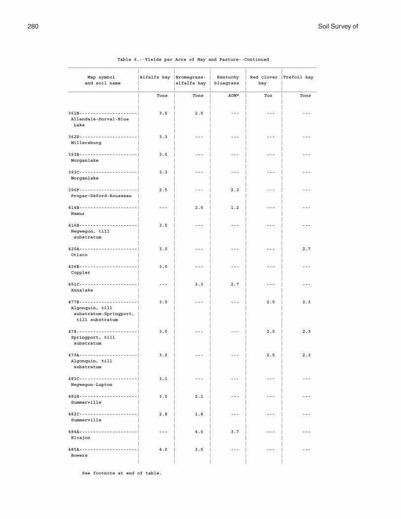
280 Soil Survey of
Table 6.--Yields per Acre of Hay and Pasture--Continued__________________________________________________________________________________________ | | | | | Map symbol |Alfalfa hay |Bromegrass- | Kentucky | Red clover |Trefoil hay and soil name | |alfalfa hay | bluegrass | hay | | | | | |__________________________________________________________________________________________ | Tons | Tons | AUM* | Ton | Tons | | | | | | | | | |361B---------------------| 3.5 | 2.5 | --- | --- | --- Allendale-Dorval-Blue | | | | | Lake | | | | | | | | | |362D---------------------| 3.3 | --- | --- | --- | --- Millersburg | | | | | | | | | |393B---------------------| 3.5 | --- | --- | --- | --- Morganlake | | | | | | | | | |393C---------------------| 3.3 | --- | --- | --- | --- Morganlake | | | | | | | | | |396F---------------------| 2.5 | --- | 2.3 | --- | --- Proper-Deford-Rousseau | | | | | | | | | |414B---------------------| --- | 2.0 | 1.2 | --- | --- Namur | | | | | | | | | |416B---------------------| 3.5 | --- | --- | --- | --- Negwegon, till | | | | | substratum | | | | | | | | | |420A---------------------| 3.0 | --- | --- | --- | 2.7 Otisco | | | | | | | | | |426B---------------------| 3.0 | --- | --- | --- | --- Coppler | | | | | | | | | |451C---------------------| --- | 3.3 | 2.7 | --- | --- Annalake | | | | | | | | | |477B---------------------| 3.5 | --- | --- | 2.5 | 2.3 Algonquin, till | | | | | substratum-Springport, | | | | | till substratum | | | | | | | | | |478----------------------| 3.5 | --- | --- | 2.5 | 2.3 Springport, till | | | | | substratum | | | | | | | | | |479A---------------------| 3.5 | --- | --- | 2.5 | 2.3 Algonquin, till | | | | | substratum | | | | | | | | | |481C---------------------| 3.1 | --- | --- | --- | --- Negwegon-Lupton | | | | | | | | | |482B---------------------| 3.0 | 2.1 | --- | --- | --- Summerville | | | | | | | | | |482C---------------------| 2.8 | 1.8 | --- | --- | --- Summerville | | | | | | | | | |484A---------------------| --- | 4.0 | 3.7 | --- | --- Elcajon | | | | | | | | | |485A---------------------| 4.0 | 3.5 | --- | --- | --- Bowers | | | | | | | | | |
See footnote at end of table.
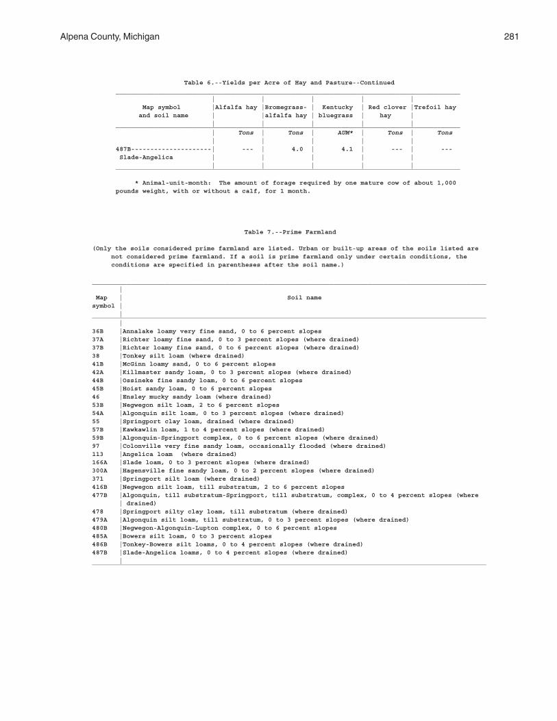
Alpena County, Michigan 281
Table 6.--Yields per Acre of Hay and Pasture--Continued__________________________________________________________________________________________ | | | | | Map symbol |Alfalfa hay |Bromegrass- | Kentucky | Red clover |Trefoil hay and soil name | |alfalfa hay | bluegrass | hay | | | | | |__________________________________________________________________________________________ | Tons | Tons | AUM* | Tons | Tons | | | | |487B---------------------| --- | 4.0 | 4.1 | --- | --- Slade-Angelica | | | | | | | | | |__________________________________________________________________________________________
* Animal-unit-month: The amount of forage required by one mature cow of about 1,000pounds weight, with or without a calf, for 1 month.
Table 7.--Prime Farmland
(Only the soils considered prime farmland are listed. Urban or built-up areas of the soils listed are not considered prime farmland. If a soil is prime farmland only under certain conditions, the conditions are specified in parentheses after the soil name.)
_______________________________________________________________________________________________________ | Map | Soil namesymbol | |_______________________________________________________________________________________________________ |36B |Annalake loamy very fine sand, 0 to 6 percent slopes37A |Richter loamy fine sand, 0 to 3 percent slopes (where drained)37B |Richter loamy fine sand, 0 to 6 percent slopes (where drained)38 |Tonkey silt loam (where drained)41B |McGinn loamy sand, 0 to 6 percent slopes42A |Killmaster sandy loam, 0 to 3 percent slopes (where drained)44B |Ossineke fine sandy loam, 0 to 6 percent slopes45B |Hoist sandy loam, 0 to 6 percent slopes46 |Ensley mucky sandy loam (where drained)53B |Negwegon silt loam, 2 to 6 percent slopes54A |Algonquin silt loam, 0 to 3 percent slopes (where drained)55 |Springport clay loam, drained (where drained)57B |Kawkawlin loam, 1 to 4 percent slopes (where drained)59B |Algonquin-Springport complex, 0 to 6 percent slopes (where drained)97 |Colonville very fine sandy loam, occasionally flooded (where drained)113 |Angelica loam (where drained)166A |Slade loam, 0 to 3 percent slopes (where drained)300A |Hagensville fine sandy loam, 0 to 2 percent slopes (where drained)371 |Springport silt loam (where drained)416B |Negwegon silt loam, till substratum, 2 to 6 percent slopes477B |Algonquin, till substratum-Springport, till substratum, complex, 0 to 4 percent slopes (where | drained)478 |Springport silty clay loam, till substratum (where drained)479A |Algonquin silt loam, till substratum, 0 to 3 percent slopes (where drained)480B |Negwegon-Algonquin-Lupton complex, 0 to 6 percent slopes485A |Bowers silt loam, 0 to 3 percent slopes486B |Tonkey-Bowers silt loams, 0 to 4 percent slopes (where drained)487B |Slade-Angelica loams, 0 to 4 percent slopes (where drained) |_______________________________________________________________________________________________________
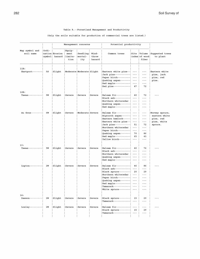
282 Soil Survey of
Table 8.--Forestland Management and Productivity
(Only the soils suitable for production of commercial trees are listed.)
_______________________________________________________________________________________________________________ | | Management concerns | Potential productivity | | | | | ___________________________________ __________________________________Map symbol and |Ordi- | |Equip- | | | | | | soil name |nation|Erosion | ment |Seedling| Wind- | Common trees |Site |Volume |Suggested trees |symbol| hazard |limita- |mortal- | throw | |index|of wood| to plant | | | tion | ity | hazard | | | fiber | | | | | | | | | |_______________________________________________________________________________________________________________ | | | | | | | | |11B: | | | | | | | | | Eastport-------| 5S |Slight |Moderate|Moderate|Slight |Eastern white pine--| --- | --- |Eastern white | | | | | |Jack pine-----------| --- | --- | pine, jack | | | | | |Paper birch---------| --- | --- | pine, red | | | | | |Quaking aspen-------| --- | --- | pine. | | | | | |Red maple-----------| --- | --- | | | | | | |Red pine------------| 47 | 72 | | | | | | | | | |12B: | | | | | | | | | Tawas----------| 5W |Slight |Severe |Severe |Severe |Balsam fir----------| 40 | 72 | --- | | | | | |Black ash-----------| --- | --- | | | | | | |Northern whitecedar | --- | --- | | | | | | |Quaking aspen-------| --- | --- | | | | | | |Red maple-----------| --- | --- | | | | | | | | | | Au Gres--------| 6W |Slight |Severe |Moderate|Severe |Balsam fir----------| --- | --- |Norway spruce, | | | | | |Bigtooth aspen------| --- | --- | eastern white | | | | | |Eastern hemlock-----| --- | --- | pine, red | | | | | |Eastern white pine--| --- | --- | pine, white | | | | | |Jack pine-----------| 51 | 72 | spruce. | | | | | |Northern whitecedar | --- | --- | | | | | | |Paper birch---------| --- | --- | | | | | | |Quaking aspen-------| 70 | 86 | | | | | | |Red maple-----------| 65 | 43 | | | | | | |Yellow birch--------| --- | --- | | | | | | | | | |13: | | | | | | | | | Tawas----------| 5W |Slight |Severe |Severe |Severe |Balsam fir----------| 40 | 76 | --- | | | | | |Black ash-----------| --- | --- | | | | | | |Northern whitecedar | --- | --- | | | | | | |Quaking aspen-------| --- | --- | | | | | | |Red maple-----------| --- | --- | | | | | | | | | | Lupton---------| 2W |Slight |Severe |Severe |Severe |Balsam fir----------| 46 | 86 | --- | | | | | |Black ash-----------| --- | --- | | | | | | |Black spruce--------| 20 | 29 | | | | | | |Northern whitecedar | --- | --- | | | | | | |Paper birch---------| --- | --- | | | | | | |Quaking aspen-------| --- | --- | | | | | | |Red maple-----------| --- | --- | | | | | | |Tamarack------------| --- | --- | | | | | | |White spruce--------| --- | --- | | | | | | | | | |14: | | | | | | | | | Dawson---------| 2W |Slight |Severe |Severe |Severe |Black spruce--------| 15 | 29 | --- | | | | | |Tamarack------------| --- | --- | | | | | | | | | | Loxley---------| 2W |Slight |Severe |Severe |Severe |Balsam fir----------| --- | --- | --- | | | | | |Black spruce--------| 15 | 29 | | | | | | |Tamarack------------| --- | --- | | | | | | | | | |
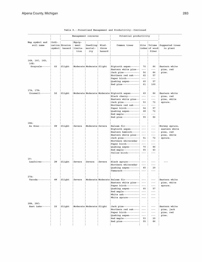
Alpena County, Michigan 283
Table 8.--Forestland Management and Productivity--Continued_______________________________________________________________________________________________________________ | | Management concerns | Potential productivity | | | | | ___________________________________ __________________________________Map symbol and |Ordi- | |Equip- | | | | | | soil name |nation|Erosion | ment |Seedling| Wind- | Common trees |Site |Volume |Suggested trees |symbol| hazard |limita- |mortal- | throw | |index|of wood| to plant | | | tion | ity | hazard | | | fiber | | | | | | | | | |_______________________________________________________________________________________________________________ | | | | | | | | |16B, 16C, 16D, | | | | | | | | | 16E: | | | | | | | | | Graycalm------| 6S |Slight |Moderate|Moderate|Slight |Bigtooth aspen------| 70 | 86 |Eastern white | | | | | |Eastern white pine--| --- | --- | pine, red | | | | | |Jack pine-----------| 56 | 86 | pine. | | | | | |Northern red oak----| 62 | 57 | | | | | | |Paper birch---------| --- | --- | | | | | | |Quaking aspen-------| 60 | 57 | | | | | | |Red pine------------| 61 | 100 | | | | | | | | | |17A, 17B: | | | | | | | | | Croswell-------| 5S |Slight |Moderate|Moderate|Moderate|Bigtooth aspen------| 69 | 86 |Eastern white | | | | | |Black cherry--------| --- | --- | pine, red | | | | | |Eastern white pine--| --- | --- | pine, white | | | | | |Jack pine-----------| 53 | 72 | spruce. | | | | | |Northern red oak----| --- | --- | | | | | | |Paper birch---------| 54 | 57 | | | | | | |Quaking aspen-------| 68 | 72 | | | | | | |Red maple-----------| --- | --- | | | | | | |Red pine------------| 55 | 86 | | | | | | | | | |18A: | | | | | | | | | Au Gres--------| 6W |Slight |Severe |Moderate|Severe |Balsam fir----------| --- | --- |Norway spruce, | | | | | |Bigtooth aspen------| --- | --- | eastern white | | | | | |Eastern hemlock-----| --- | --- | pine, red | | | | | |Eastern white pine--| --- | --- | pine, white | | | | | |Jack pine-----------| 51 | 72 | spruce. | | | | | |Northern whitecedar | --- | --- | | | | | | |Paper birch---------| --- | --- | | | | | | |Quaking aspen-------| 70 | 86 | | | | | | |Red maple-----------| 65 | 43 | | | | | | |Yellow birch--------| --- | --- | | | | | | | | | |19: | | | | | | | | | Leafriver------| 2W |Slight |Severe |Severe |Severe |Black spruce--------| --- | --- | --- | | | | | |Northern whitecedar | --- | --- | | | | | | |Quaking aspen-------| 45 | 29 | | | | | | |Tamarack------------| --- | --- | | | | | | | | | |27A: | | | | | | | | | Tacoda---------| 4W |Slight |Severe |Moderate|Moderate|Balsam fir----------| --- | --- |Eastern white | | | | | |Eastern white pine--| --- | --- | pine, white | | | | | |Paper birch---------| --- | --- | spruce. | | | | | |Quaking aspen-------| 60 | 57 | | | | | | |Red maple-----------| --- | --- | | | | | | |White ash-----------| --- | --- | | | | | | |White spruce--------| --- | --- | | | | | | | | | |28B, 28C: | | | | | | | | | East Lake------| 2S |Slight |Moderate|Moderate|Slight |Jack pine-----------| --- | --- |Eastern white | | | | | |Northern red oak----| --- | --- | pine, jack | | | | | |Paper birch---------| --- | --- | pine, red | | | | | |Quaking aspen-------| --- | --- | pine. | | | | | |Red maple-----------| 53 | 29 | | | | | | |Red pine------------| 55 | 86 | | | | | | | | | |
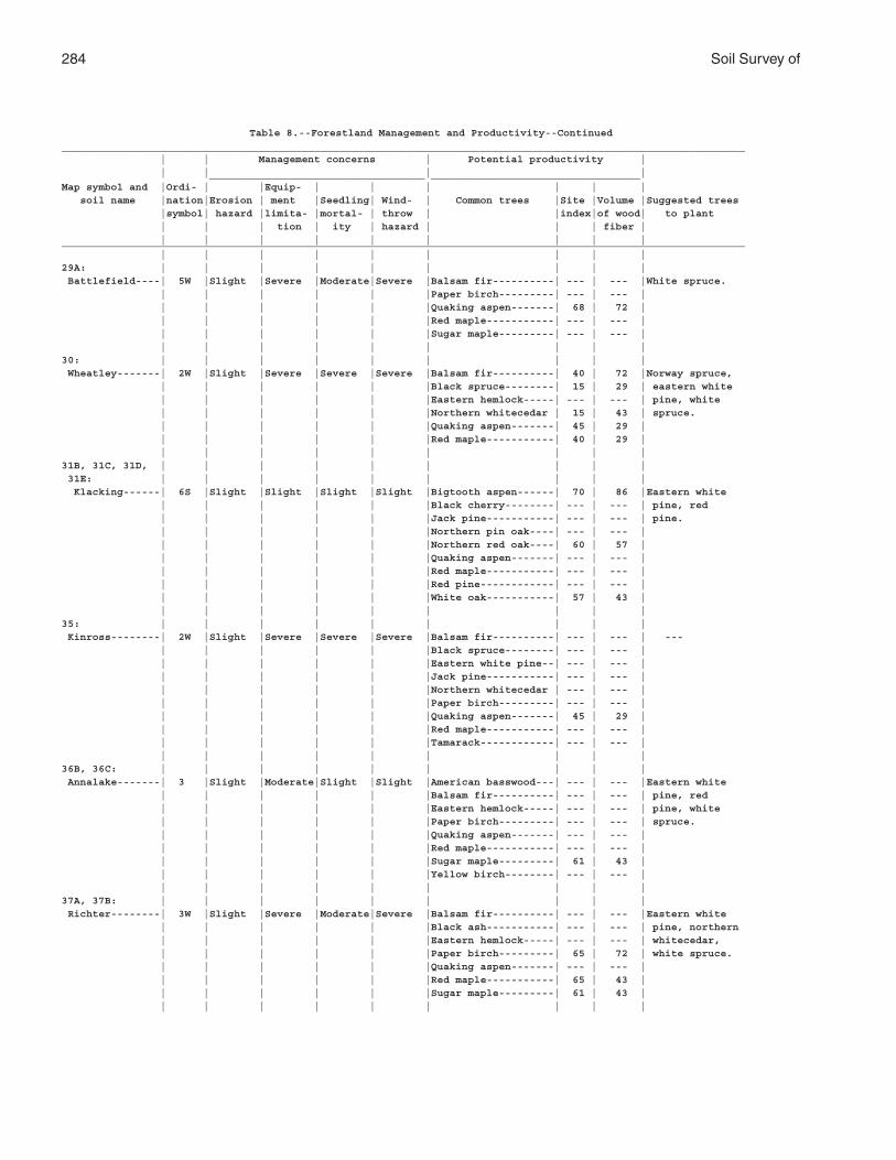
284 Soil Survey of
Table 8.--Forestland Management and Productivity--Continued_______________________________________________________________________________________________________________ | | Management concerns | Potential productivity | | | | | ___________________________________ __________________________________Map symbol and |Ordi- | |Equip- | | | | | | soil name |nation|Erosion | ment |Seedling| Wind- | Common trees |Site |Volume |Suggested trees |symbol| hazard |limita- |mortal- | throw | |index|of wood| to plant | | | tion | ity | hazard | | | fiber | | | | | | | | | |_______________________________________________________________________________________________________________ | | | | | | | | |29A: | | | | | | | | | Battlefield----| 5W |Slight |Severe |Moderate|Severe |Balsam fir----------| --- | --- |White spruce. | | | | | |Paper birch---------| --- | --- | | | | | | |Quaking aspen-------| 68 | 72 | | | | | | |Red maple-----------| --- | --- | | | | | | |Sugar maple---------| --- | --- | | | | | | | | | |30: | | | | | | | | | Wheatley-------| 2W |Slight |Severe |Severe |Severe |Balsam fir----------| 40 | 72 |Norway spruce, | | | | | |Black spruce--------| 15 | 29 | eastern white | | | | | |Eastern hemlock-----| --- | --- | pine, white | | | | | |Northern whitecedar | 15 | 43 | spruce. | | | | | |Quaking aspen-------| 45 | 29 | | | | | | |Red maple-----------| 40 | 29 | | | | | | | | | |31B, 31C, 31D, | | | | | | | | | 31E: | | | | | | | | | Klacking------| 6S |Slight |Slight |Slight |Slight |Bigtooth aspen------| 70 | 86 |Eastern white | | | | | |Black cherry--------| --- | --- | pine, red | | | | | |Jack pine-----------| --- | --- | pine. | | | | | |Northern pin oak----| --- | --- | | | | | | |Northern red oak----| 60 | 57 | | | | | | |Quaking aspen-------| --- | --- | | | | | | |Red maple-----------| --- | --- | | | | | | |Red pine------------| --- | --- | | | | | | |White oak-----------| 57 | 43 | | | | | | | | | |35: | | | | | | | | | Kinross--------| 2W |Slight |Severe |Severe |Severe |Balsam fir----------| --- | --- | --- | | | | | |Black spruce--------| --- | --- | | | | | | |Eastern white pine--| --- | --- | | | | | | |Jack pine-----------| --- | --- | | | | | | |Northern whitecedar | --- | --- | | | | | | |Paper birch---------| --- | --- | | | | | | |Quaking aspen-------| 45 | 29 | | | | | | |Red maple-----------| --- | --- | | | | | | |Tamarack------------| --- | --- | | | | | | | | | |36B, 36C: | | | | | | | | | Annalake-------| 3 |Slight |Moderate|Slight |Slight |American basswood---| --- | --- |Eastern white | | | | | |Balsam fir----------| --- | --- | pine, red | | | | | |Eastern hemlock-----| --- | --- | pine, white | | | | | |Paper birch---------| --- | --- | spruce. | | | | | |Quaking aspen-------| --- | --- | | | | | | |Red maple-----------| --- | --- | | | | | | |Sugar maple---------| 61 | 43 | | | | | | |Yellow birch--------| --- | --- | | | | | | | | | |37A, 37B: | | | | | | | | | Richter--------| 3W |Slight |Severe |Moderate|Severe |Balsam fir----------| --- | --- |Eastern white | | | | | |Black ash-----------| --- | --- | pine, northern | | | | | |Eastern hemlock-----| --- | --- | whitecedar, | | | | | |Paper birch---------| 65 | 72 | white spruce. | | | | | |Quaking aspen-------| --- | --- | | | | | | |Red maple-----------| 65 | 43 | | | | | | |Sugar maple---------| 61 | 43 | | | | | | | | | |
Alpena County, Michigan 285
Table 8.--Forestland Management and Productivity--Continued_______________________________________________________________________________________________________________ | | Management concerns | Potential productivity | | | | | ___________________________________ __________________________________Map symbol and |Ordi- | |Equip- | | | | | | soil name |nation|Erosion | ment |Seedling| Wind- | Common trees |Site |Volume |Suggested trees |symbol| hazard |limita- |mortal- | throw | |index|of wood| to plant | | | tion | ity | hazard | | | fiber | | | | | | | | | |_______________________________________________________________________________________________________________ | | | | | | | | |38: | | | | | | | | | Tonkey---------| 5W |Slight |Severe |Severe |Severe |American basswood---| 55 | 43 | --- | | | | | |American elm--------| --- | --- | | | | | | |Balsam fir----------| --- | --- | | | | | | |Northern whitecedar | --- | --- | | | | | | |Quaking aspen-------| 61 | 72 | | | | | | |Red maple-----------| --- | --- | | | | | | |Swamp white oak-----| --- | --- | | | | | | | | | |41B, 41C, 41D, | | | | | | | | | 41E: | | | | | | | | | McGinn--------| 4S |Slight |Slight |Slight |Slight |Bigtooth aspen------| --- | --- |Red pine, white | | | | | |Northern red oak----| 67 | 57 | spruce. | | | | | |Red pine------------| --- | --- | | | | | | |White oak-----------| 65 | 57 | | | | | | | | | |42A: | | | | | | | | | Killmaster-----| 4W |Slight |Severe |Slight |Moderate|American basswood---| --- | --- |Eastern white | | | | | |Balsam fir----------| --- | --- | pine, white | | | | | |Bigtooth aspen------| 60 | 57 | ash, white | | | | | |Northern red oak----| --- | --- | spruce. | | | | | |Paper birch---------| --- | --- | | | | | | |Red maple-----------| --- | --- | | | | | | |White ash-----------| --- | --- | | | | | | |White spruce--------| --- | --- | | | | | | | | | |43: | | | | | | | | | Wakeley--------| 3W |Slight |Severe |Severe |Severe |Balsam fir----------| --- | --- |Northern | | | | | |Black spruce--------| --- | --- | whitecedar. | | | | | |Northern whitecedar | --- | --- | | | | | | |Quaking aspen-------| 50 | 43 | | | | | | | | | |44B, 44C: | | | | | | | | | Ossineke-------| 4 |Slight |Moderate|Slight |Moderate|American basswood---| --- | --- |Norway spruce, | | | | | |Bigtooth aspen------| --- | --- | eastern white | | | | | |Eastern hemlock-----| --- | --- | pine, red | | | | | |Northern red oak----| 65 | 57 | pine, white | | | | | |Paper birch---------| --- | --- | spruce. | | | | | |Sugar maple---------| 63 | 43 | | | | | | |White ash-----------| --- | --- | | | | | | | | | |45B, 45C: | | | | | | | | | Hoist----------| 3 |Slight |Moderate|Slight |Slight |American basswood---| --- | --- |Eastern white | | | | | |Balsam fir----------| --- | --- | pine, red | | | | | |Eastern white pine--| --- | --- | pine, white | | | | | |Northern red oak----| 74 | 72 | spruce. | | | | | |Paper birch---------| --- | --- | | | | | | |Quaking aspen-------| --- | --- | | | | | | |Red pine------------| --- | --- | | | | | | |Sugar maple---------| 66 | 43 | | | | | | |White ash-----------| --- | --- | | | | | | | | | |46: | | | | | | | | | Ensley---------| 3W |Slight |Severe |Severe |Severe |Balsam fir----------| 60 | 114 |Green ash, | | | | | |Black ash-----------| --- | --- | white spruce. | | | | | |Red maple-----------| 62 | 43 | | | | | | |White ash-----------| --- | --- | | | | | | |White spruce--------| --- | --- | | | | | | |Yellow birch--------| --- | --- | | | | | | | | | |
286 Soil Survey of
Table 8.--Forestland Management and Productivity--Continued_______________________________________________________________________________________________________________ | | Management concerns | Potential productivity | | | | | ___________________________________ __________________________________Map symbol and |Ordi- | |Equip- | | | | | | soil name |nation|Erosion | ment |Seedling| Wind- | Common trees |Site |Volume |Suggested trees |symbol| hazard |limita- |mortal- | throw | |index|of wood| to plant | | | tion | ity | hazard | | | fiber | | | | | | | | | |_______________________________________________________________________________________________________________ | | | | | | | | |47D: | | | | | | | | | Graycalm-------| 6S |Slight |Moderate|Moderate|Slight |Bigtooth aspen------| 70 | 86 |Eastern white | | | | | |Eastern white pine--| --- | --- | pine, red | | | | | |Jack pine-----------| 56 | 86 | pine. | | | | | |Northern red oak----| 62 | 57 | | | | | | |Paper birch---------| --- | --- | | | | | | |Quaking aspen-------| 60 | 57 | | | | | | |Red pine------------| 61 | 100 | | | | | | | | | |53B, 53C: | | | | | | | | | Negwegon-------| 3C |Slight |Moderate|Slight |Moderate|American beech------| --- | --- |Eastern white | | | | | |Balsam fir----------| --- | --- | pine, white | | | | | |Bigtooth aspen------| --- | --- | spruce. | | | | | |Eastern hemlock-----| --- | --- | | | | | | |Northern red oak----| --- | --- | | | | | | |Sugar maple---------| 62 | 43 | | | | | | |White ash-----------| --- | --- | | | | | | | | | |54A: | | | | | | | | | Algonquin------| 6W |Slight |Severe |Moderate|Severe |Balsam fir----------| 45 | 86 |Eastern white | | | | | |Balsam poplar-------| --- | --- | pine, northern | | | | | |Black ash-----------| --- | --- | whitecedar, | | | | | |Northern whitecedar | --- | --- | white spruce. | | | | | |Paper birch---------| --- | --- | | | | | | |Quaking aspen-------| --- | --- | | | | | | |Red maple-----------| --- | --- | | | | | | | | | |55: | | | | | | | | | Springport-----| 6W |Slight |Severe |Severe |Severe |Balsam fir----------| 45 | 86 |Eastern white | | | | | |Black ash-----------| --- | --- | pine, northern | | | | | |Northern whitecedar | --- | --- | whitecedar, | | | | | |Paper birch---------| --- | --- | white spruce. | | | | | |Quaking aspen-------| --- | --- | | | | | | | | | |57B: | | | | | | | | | Kawkawlin------| 3W |Slight |Severe |Slight |Moderate|American basswood---| --- | --- |Norway spruce, | | | | | |Bigtooth aspen------| --- | --- | eastern white | | | | | |Northern red oak----| --- | --- | pine, red | | | | | |Quaking aspen-------| --- | --- | pine, white | | | | | |Red maple-----------| --- | --- | spruce. | | | | | |Sugar maple---------| 60 | 43 | | | | | | |Swamp white oak-----| --- | --- | | | | | | |White ash-----------| --- | --- | | | | | | | | | |59B: | | | | | | | | | Algonquin------| 6W |Slight |Severe |Moderate|Severe |Balsam fir----------| 45 | 86 |Eastern white | | | | | |Balsam poplar-------| --- | --- | pine, northern | | | | | |Black ash-----------| --- | --- | whitecedar, | | | | | |Northern whitecedar | --- | --- | white spruce. | | | | | |Paper birch---------| --- | --- | | | | | | |Quaking aspen-------| --- | --- | | | | | | |Red maple-----------| --- | --- | | | | | | | | | | Springport-----| 6W |Slight |Severe |Severe |Severe |Balsam fir----------| 45 | 86 |Eastern white | | | | | |Black ash-----------| --- | --- | pine, northern | | | | | |Northern whitecedar | --- | --- | whitecedar, | | | | | |Paper birch---------| --- | --- | white spruce. | | | | | |Quaking aspen-------| --- | --- | | | | | | | | | |
Alpena County, Michigan 287
Table 8.--Forestland Management and Productivity--Continued_______________________________________________________________________________________________________________ | | Management concerns | Potential productivity | | | | | ___________________________________ __________________________________Map symbol and |Ordi- | |Equip- | | | | | | soil name |nation|Erosion | ment |Seedling| Wind- | Common trees |Site |Volume |Suggested trees |symbol| hazard |limita- |mortal- | throw | |index|of wood| to plant | | | tion | ity | hazard | | | fiber | | | | | | | | | |_______________________________________________________________________________________________________________ | | | | | | | | |62A: | | | | | | | | | Allendale------| 4W |Slight |Severe |Slight |Moderate|Balsam fir----------| --- | --- |Eastern white | | | | | |Eastern white pine--| --- | --- | pine, white | | | | | |Paper birch---------| --- | --- | spruce. | | | | | |Quaking aspen-------| 60 | 57 | | | | | | |Red maple-----------| --- | --- | | | | | | |White ash-----------| --- | --- | | | | | | |White spruce--------| --- | --- | | | | | | | | | |63D, 63E: | | | | | | | | | Bamfield-------| 3R |Moderate|Moderate|Slight |Slight |American basswood---| --- | --- |Norway spruce, | | | | | |American beech------| --- | --- | eastern white | | | | | |Bigtooth aspen------| --- | --- | pine, red | | | | | |Eastern hemlock-----| --- | --- | pine, white | | | | | |Northern red oak----| --- | --- | spruce. | | | | | |Paper birch---------| --- | --- | | | | | | |Sugar maple---------| 61 | 43 | | | | | | |White ash-----------| --- | --- | | | | | | | | | |68: | | | | | | | | | Rondeau--------| --- |Slight |Severe |Severe |Severe |Balsam poplar-------| --- | --- | --- | | | | | |Northern whitecedar | --- | --- | ---69: | | | | | | | | | Loxley---------| 2W |Slight |Severe |Severe |Severe |Balsam fir----------| --- | --- | --- | | | | | |Black spruce--------| 15 | 29 | | | | | | |Tamarack------------| --- | --- | | | | | | | | | |70: | | | | | | | | | Lupton---------| 2W |Slight |Severe |Severe |Severe |Balsam fir----------| 46 | 86 | --- | | | | | |Black ash-----------| --- | --- | | | | | | |Black spruce--------| 20 | 29 | | | | | | |Northern whitecedar | --- | --- | | | | | | |Paper birch---------| --- | --- | | | | | | |Quaking aspen-------| --- | --- | | | | | | |Red maple-----------| --- | --- | | | | | | |Tamarack------------| --- | --- | | | | | | |White spruce--------| --- | --- | | | | | | | | | |71: | | | | | | | | | Tawas----------| 5W |Slight |Severe |Severe |Severe |Balsam fir----------| 40 | 72 | --- | | | | | |Black ash-----------| --- | --- | | | | | | |Northern whitecedar | --- | --- | | | | | | |Quaking aspen-------| --- | --- | | | | | | |Red maple-----------| --- | --- | | | | | | | | | |72: | | | | | | | | | Dorval---------| 2W |Slight |Severe |Severe |Severe |American elm--------| --- | --- |Northern | | | | | |Northern whitecedar | --- | --- | whitecedar, | | | | | |Red maple-----------| 50 | 29 | white spruce. | | | | | |White ash-----------| --- | --- | | | | | | | | | |74C2: | | | | | | | | | Negwegon-------| 3 |Slight |Moderate|Slight |Moderate|American beech------| --- | --- |Eastern white | | | | | |Balsam fir----------| --- | --- | pine, white | | | | | |Bigtooth aspen------| --- | --- | spruce. | | | | | |Eastern hemlock-----| --- | --- | | | | | | |Northern red oak----| --- | --- | | | | | | |Sugar maple---------| 62 | 43 | | | | | | |White ash-----------| --- | --- | | | | | | | | | |
288 Soil Survey of
Table 8.--Forestland Management and Productivity--Continued_______________________________________________________________________________________________________________ | | Management concerns | Potential productivity | | | | | ___________________________________ __________________________________Map symbol and |Ordi- | |Equip- | | | | | | soil name |nation|Erosion | ment |Seedling| Wind- | Common trees |Site |Volume |Suggested trees |symbol| hazard |limita- |mortal- | throw | |index|of wood| to plant | | | tion | ity | hazard | | | fiber | | | | | | | | | |_______________________________________________________________________________________________________________ | | | | | | | | |75B, 75D, 75E: | | | | | | | | | Rubicon--------| 4R |Moderate|Moderate|Moderate|Slight |Bigtooth aspen------| 66 | 72 |Eastern white | | | | | |Eastern white pine--| 45 | 72 | pine, jack | | | | | |Jack pine-----------| 53 | 72 | pine, red | | | | | |Northern red oak----| --- | --- | pine. | | | | | |Paper birch---------| --- | --- | | | | | | |Quaking aspen-------| 60 | 57 | | | | | | |Red maple-----------| 57 | 29 | | | | | | |Red pine------------| 53 | 86 | | | | | | |White oak-----------| --- | --- | | | | | | | | | |77: | | | | | | | | | Rollaway-------| 3W |Slight |Severe |Severe |Severe |Balsam fir----------| 40 | 72 | --- | | | | | |Black ash-----------| 35 | 29 | | | | | | |Black spruce--------| --- | --- | | | | | | |Northern whitecedar | 30 | 43 | | | | | | |Quaking aspen-------| 40 | 29 | | | | | | |Red maple-----------| --- | --- | | | | | | | | | |84B, 84C, 84E: | | | | | | | | | Zimmerman------| 8S |Slight |Moderate|Moderate|Slight |Jack pine-----------| 65 | 100 |Eastern white | | | | | |Paper birch---------| --- | --- | pine, jack | | | | | |Quaking aspen-------| 70 | 86 | pine, red | | | | | |Red maple-----------| --- | --- | pine, white | | | | | |Red pine------------| 64 | 114 | spruce. | | | | | | | | |85D: | | | | | | | | | Zimmerman------| 8S |Slight |Moderate|Moderate|Slight |Jack pine-----------| 65 | 100 |Eastern white | | | | | |Paper birch---------| --- | --- | pine, jack | | | | | |Quaking aspen-------| 70 | 86 | pine, red | | | | | |Red maple-----------| --- | --- | pine, white | | | | | |Red pine------------| 64 | 114 | spruce. | | | | | | | | | Annalake-------| 3 |Slight |Moderate|Slight |Slight |American basswood---| --- | --- |Eastern white | | | | | |Balsam fir----------| --- | --- | pine, red | | | | | |Eastern hemlock-----| --- | --- | pine, white | | | | | |Paper birch---------| --- | --- | spruce. | | | | | |Quaking aspen-------| --- | --- | | | | | | |Red maple-----------| --- | --- | | | | | | |Sugar maple---------| 61 | 43 | | | | | | |Yellow birch--------| --- | --- | | | | | | | | | |87: | | | | | | | | | Ausable--------| 2W |Slight |Severe |Severe |Severe |Balsam poplar-------| --- | --- | --- | | | | | |Black ash-----------| --- | --- | | | | | | |Northern whitecedar | 15 | 29 | | | | | | |Paper birch---------| --- | --- | | | | | | | | | |90B: | | | | | | | | | Chinwhisker----| 6S |Slight |Moderate|Moderate|Slight |Bigtooth aspen------| 70 | 86 |Eastern white | | | | | |Jack pine-----------| 56 | 86 | pine, jack | | | | | |Paper birch---------| --- | --- | pine, white | | | | | |Quaking aspen-------| --- | --- | spruce. | | | | | |Red maple-----------| --- | --- | | | | | | | | | |
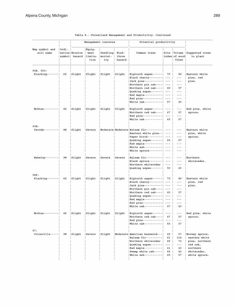
Alpena County, Michigan 289
Table 8.--Forestland Management and Productivity--Continued_______________________________________________________________________________________________________________ | | Management concerns | Potential productivity | | | | | ___________________________________ __________________________________Map symbol and |Ordi- | |Equip- | | | | | | soil name |nation|Erosion | ment |Seedling| Wind- | Common trees |Site |Volume |Suggested trees |symbol| hazard |limita- |mortal- | throw | |index|of wood| to plant | | | tion | ity | hazard | | | fiber | | | | | | | | | |_______________________________________________________________________________________________________________ | | | | | | | | |92B, 92C: | | | | | | | | | Klacking-------| 6S |Slight |Slight |Slight |Slight |Bigtooth aspen------| 70 | 86 |Eastern white | | | | | |Black cherry--------| --- | --- | pine, red | | | | | |Jack pine-----------| --- | --- | pine. | | | | | |Northern pin oak----| --- | --- | | | | | | |Northern red oak----| 60 | 57 | | | | | | |Quaking aspen-------| --- | --- | | | | | | |Red maple-----------| --- | --- | | | | | | |Red pine------------| --- | --- | | | | | | |White oak-----------| 57 | 43 | | | | | | | | | | McGinn---------| 4S |Slight |Slight |Slight |Slight |Bigtooth aspen------| --- | --- |Red pine, white | | | | | |Northern red oak----| 67 | 57 | spruce. | | | | | |Red pine------------| --- | --- | | | | | | |White oak-----------| 65 | 57 | | | | | | | | | |93B: | | | | | | | | | Tacoda---------| 4W |Slight |Severe |Moderate|Moderate|Balsam fir----------| --- | --- |Eastern white | | | | | |Eastern white pine--| --- | --- | pine, white | | | | | |Paper birch---------| --- | --- | spruce. | | | | | |Quaking aspen-------| 60 | 57 | | | | | | |Red maple-----------| --- | --- | | | | | | |White ash-----------| --- | --- | | | | | | |White spruce--------| --- | --- | | | | | | | | | | Wakeley--------| 3W |Slight |Severe |Severe |Severe |Balsam fir----------| --- | --- |Northern | | | | | |Black spruce--------| --- | --- | whitecedar. | | | | | |Northern whitecedar | --- | --- | | | | | | |Quaking aspen-------| 50 | 43 | | | | | | | | | |94F: | | | | | | | | | Klacking-------| 6S |Slight |Slight |Slight |Slight |Bigtooth aspen------| 70 | 86 |Eastern white | | | | | |Black cherry--------| --- | --- | pine, red | | | | | |Jack pine-----------| --- | --- | pine. | | | | | |Northern pin oak----| --- | --- | | | | | | |Northern red oak----| 60 | 57 | | | | | | |Quaking aspen-------| --- | --- | | | | | | |Red maple-----------| --- | --- | | | | | | |Red pine------------| --- | --- | | | | | | |White oak-----------| 57 | 43 | | | | | | | | | | McGinn---------| 4S |Slight |Slight |Slight |Slight |Bigtooth aspen------| --- | --- |Red pine, white | | | | | |Northern red oak----| 67 | 57 | spruce. | | | | | |Red pine------------| --- | --- | | | | | | |White oak-----------| 65 | 57 | | | | | | | | | |97: | | | | | | | | | Colonville-----| 3W |Slight |Severe |Slight |Moderate|American basswood---| 65 | 57 |Norway spruce, | | | | | |Balsam fir----------| 61 | 114 | eastern white | | | | | |Northern whitecedar | 45 | 72 | pine, northern | | | | | |Quaking aspen-------| --- | --- | red oak, | | | | | |Red maple-----------| 61 | 43 | northern | | | | | |Swamp white oak-----| 66 | 43 | whitecedar, | | | | | |White ash-----------| 65 | 57 | white spruce. | | | | | | | | |
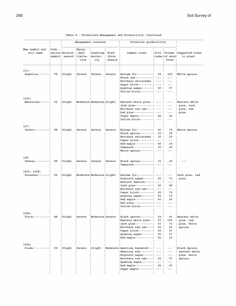
290 Soil Survey of
Table 8.--Forestland Management and Productivity--Continued_______________________________________________________________________________________________________________ | | Management concerns | Potential productivity | | | | | ___________________________________ __________________________________Map symbol and |Ordi- | |Equip- | | | | | | soil name |nation|Erosion | ment |Seedling| Wind- | Common trees |Site |Volume |Suggested trees |symbol| hazard |limita- |mortal- | throw | |index|of wood| to plant | | | tion | ity | hazard | | | fiber | | | | | | | | | |_______________________________________________________________________________________________________________ | | | | | | | | |113: | | | | | | | | | Angelica-------| 7W |Slight |Severe |Severe |Severe |Balsam fir----------| 54 | 100 |White spruce. | | | | | |Black ash-----------| --- | --- | | | | | | |Northern whitecedar | --- | --- | | | | | | |Paper birch---------| --- | --- | | | | | | |Quaking aspen-------| 60 | 57 | | | | | | |Yellow birch--------| --- | --- | | | | | | | | | |116C: | | | | | | | | | Mancelona------| 3S |Slight |Moderate|Moderate|Slight |Eastern white pine--| --- | --- |Eastern white | | | | | |Jack pine-----------| --- | --- | pine, jack | | | | | |Northern red oak----| --- | --- | pine, red | | | | | |Red pine------------| --- | --- | pine. | | | | | |Sugar maple---------| 58 | 43 | | | | | | |Yellow birch--------| --- | --- | | | | | | | | | |127: | | | | | | | | | Cathro---------| 5W |Slight |Severe |Severe |Severe |Balsam fir----------| 40 | 72 |White spruce. | | | | | |Black spruce--------| 15 | 29 | | | | | | |Northern whitecedar | 15 | 29 | | | | | | |Paper birch---------| --- | --- | | | | | | |Red maple-----------| 40 | 29 | | | | | | |Tamarack------------| 35 | 29 | | | | | | |White spruce--------| --- | --- | | | | | | | | | |128: | | | | | | | | | Dawson---------| 2W |Slight |Severe |Severe |Severe |Black spruce--------| 15 | 29 | --- | | | | | |Tamarack------------| --- | --- | | | | | | | | | |145C, 145E: | | | | | | | | | Rousseau-------| 5S |Slight |Moderate|Moderate|Slight |Balsam fir----------| --- | --- |Jack pine, red | | | | | |Bigtooth aspen------| 66 | 72 | pine. | | | | | |Eastern hemlock-----| --- | --- | | | | | | |Jack pine-----------| 62 | 86 | | | | | | |Northern red oak----| --- | --- | | | | | | |Paper birch---------| 65 | 72 | | | | | | |Quaking aspen-------| 65 | 72 | | | | | | |Red maple-----------| 60 | 43 | | | | | | |Red pine------------| --- | --- | | | | | | |Yellow birch--------| --- | --- | | | | | | | | | |159A: | | | | | | | | | Finch----------| 4W |Slight |Severe |Moderate|Severe |Black spruce--------| 38 | 43 |Eastern white | | | | | |Eastern white pine--| 53 | 100 | pine, red | | | | | |Jack pine-----------| 52 | 72 | pine, white | | | | | |Northern red oak----| 56 | 43 | spruce. | | | | | |Paper birch---------| 54 | 57 | | | | | | |Quaking aspen-------| 56 | 57 | | | | | | |Red maple-----------| 56 | 29 | | | | | | | | | |166A: | | | | | | | | | Slade----------| 3W |Slight |Severe |Slight |Moderate|American basswood---| --- | --- |Black spruce, | | | | | |American elm--------| --- | --- | eastern white | | | | | |Bigtooth aspen------| --- | --- | pine, white | | | | | |Northern red oak----| 64 | 57 | spruce. | | | | | |Quaking aspen-------| --- | --- | | | | | | |Red maple-----------| 65 | 43 | | | | | | |Sugar maple---------| --- | --- | | | | | | | | | |
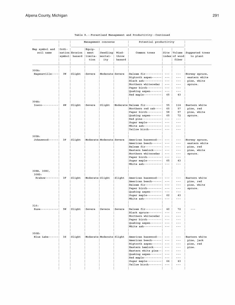
Alpena County, Michigan 291
Table 8.--Forestland Management and Productivity--Continued_______________________________________________________________________________________________________________ | | Management concerns | Potential productivity | | | | | ___________________________________ __________________________________Map symbol and |Ordi- | |Equip- | | | | | | soil name |nation|Erosion | ment |Seedling| Wind- | Common trees |Site |Volume |Suggested trees |symbol| hazard |limita- |mortal- | throw | |index|of wood| to plant | | | tion | ity | hazard | | | fiber | | | | | | | | | |_______________________________________________________________________________________________________________ | | | | | | | | |300A: | | | | | | | | | Hagensville----| 3W |Slight |Severe |Moderate|Severe |Balsam fir----------| --- | --- |Norway spruce, | | | | | |Bigtooth aspen------| --- | --- | eastern white | | | | | |Black ash-----------| --- | --- | pine, white | | | | | |Northern whitecedar | --- | --- | spruce. | | | | | |Paper birch---------| --- | --- | | | | | | |Quaking aspen-------| --- | --- | | | | | | |Red maple-----------| 65 | 43 | | | | | | | | | |304A: | | | | | | | | | Iosco----------| 4W |Slight |Severe |Slight |Moderate|Balsam fir----------| 55 | 114 |Eastern white | | | | | |Northern red oak----| 65 | 57 | pine, red | | | | | |Paper birch---------| 58 | 57 | pine, white | | | | | |Quaking aspen-------| 65 | 72 | spruce. | | | | | |Red pine------------| --- | --- | | | | | | |Sugar maple---------| --- | --- | | | | | | |White ash-----------| --- | --- | | | | | | |Yellow birch--------| --- | --- | | | | | | | | | |305B: | | | | | | | | | Johnswood------| 3F |Slight |Moderate|Moderate|Severe |American basswood---| --- | --- |Norway spruce, | | | | | |American beech------| --- | --- | eastern white | | | | | |Balsam fir----------| --- | --- | pine, red | | | | | |Eastern hemlock-----| --- | --- | pine, white | | | | | |Northern whitecedar | --- | --- | spruce. | | | | | |Paper birch---------| --- | --- | | | | | | |Sugar maple---------| 65 | 43 | | | | | | |White ash-----------| --- | --- | | | | | | | | | |308B, 308C, | | | | | | | | | 308D: | | | | | | | | | Krakow--------| 3F |Slight |Moderate|Slight |Slight |American basswood---| --- | --- |Eastern white | | | | | |American beech------| --- | --- | pine, red | | | | | |Balsam fir----------| --- | --- | pine, white | | | | | |Paper birch---------| --- | --- | spruce. | | | | | |Quaking aspen-------| --- | --- | | | | | | |Sugar maple---------| 62 | 43 | | | | | | |White ash-----------| --- | --- | | | | | | | | | |316: | | | | | | | | | Ruse-----------| 5W |Slight |Severe |Severe |Severe |Balsam fir----------| 40 | 72 | --- | | | | | |Black spruce--------| --- | --- | | | | | | |Northern whitecedar | --- | --- | | | | | | |Paper birch---------| --- | --- | | | | | | |Quaking aspen-------| --- | --- | | | | | | |White ash-----------| --- | --- | | | | | | | | | |350E: | | | | | | | | | Blue Lake------| 3S |Slight |Moderate|Moderate|Slight |American basswood---| --- | --- |Eastern white | | | | | |American beech------| --- | --- | pine, jack | | | | | |Bigtooth aspen------| --- | --- | pine, red | | | | | |Eastern hemlock-----| --- | --- | pine. | | | | | |Eastern white pine--| --- | --- | | | | | | |Quaking aspen-------| --- | --- | | | | | | |Red maple-----------| --- | --- | | | | | | |Sugar maple---------| 64 | 43 | | | | | | |Yellow birch--------| --- | --- | | | | | | | | | |
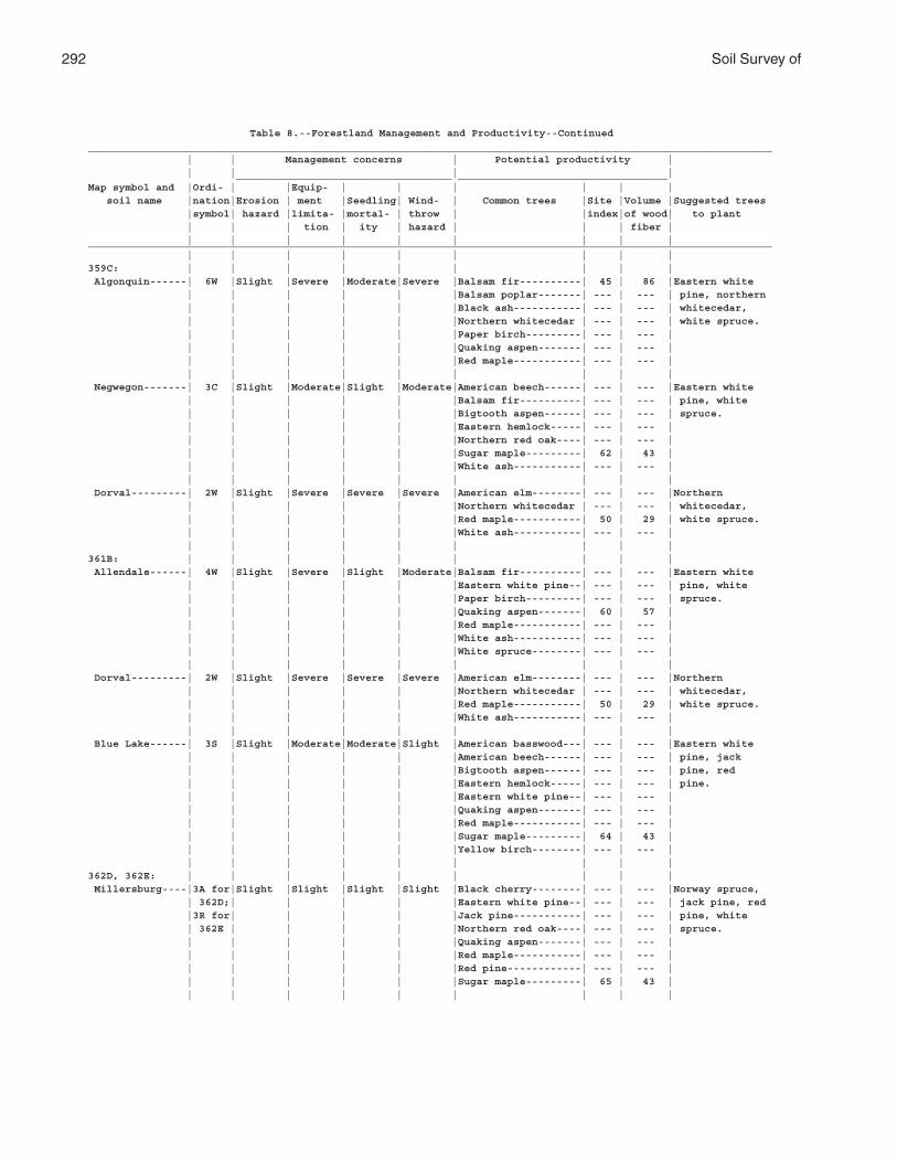
292 Soil Survey of
Table 8.--Forestland Management and Productivity--Continued_______________________________________________________________________________________________________________ | | Management concerns | Potential productivity | | | | | ___________________________________ __________________________________Map symbol and |Ordi- | |Equip- | | | | | | soil name |nation|Erosion | ment |Seedling| Wind- | Common trees |Site |Volume |Suggested trees |symbol| hazard |limita- |mortal- | throw | |index|of wood| to plant | | | tion | ity | hazard | | | fiber | | | | | | | | | |_______________________________________________________________________________________________________________ | | | | | | | | |359C: | | | | | | | | | Algonquin------| 6W |Slight |Severe |Moderate|Severe |Balsam fir----------| 45 | 86 |Eastern white | | | | | |Balsam poplar-------| --- | --- | pine, northern | | | | | |Black ash-----------| --- | --- | whitecedar, | | | | | |Northern whitecedar | --- | --- | white spruce. | | | | | |Paper birch---------| --- | --- | | | | | | |Quaking aspen-------| --- | --- | | | | | | |Red maple-----------| --- | --- | | | | | | | | | | Negwegon-------| 3C |Slight |Moderate|Slight |Moderate|American beech------| --- | --- |Eastern white | | | | | |Balsam fir----------| --- | --- | pine, white | | | | | |Bigtooth aspen------| --- | --- | spruce. | | | | | |Eastern hemlock-----| --- | --- | | | | | | |Northern red oak----| --- | --- | | | | | | |Sugar maple---------| 62 | 43 | | | | | | |White ash-----------| --- | --- | | | | | | | | | | Dorval---------| 2W |Slight |Severe |Severe |Severe |American elm--------| --- | --- |Northern | | | | | |Northern whitecedar | --- | --- | whitecedar, | | | | | |Red maple-----------| 50 | 29 | white spruce. | | | | | |White ash-----------| --- | --- | | | | | | | | | |361B: | | | | | | | | | Allendale------| 4W |Slight |Severe |Slight |Moderate|Balsam fir----------| --- | --- |Eastern white | | | | | |Eastern white pine--| --- | --- | pine, white | | | | | |Paper birch---------| --- | --- | spruce. | | | | | |Quaking aspen-------| 60 | 57 | | | | | | |Red maple-----------| --- | --- | | | | | | |White ash-----------| --- | --- | | | | | | |White spruce--------| --- | --- | | | | | | | | | | Dorval---------| 2W |Slight |Severe |Severe |Severe |American elm--------| --- | --- |Northern | | | | | |Northern whitecedar | --- | --- | whitecedar, | | | | | |Red maple-----------| 50 | 29 | white spruce. | | | | | |White ash-----------| --- | --- | | | | | | | | | | Blue Lake------| 3S |Slight |Moderate|Moderate|Slight |American basswood---| --- | --- |Eastern white | | | | | |American beech------| --- | --- | pine, jack | | | | | |Bigtooth aspen------| --- | --- | pine, red | | | | | |Eastern hemlock-----| --- | --- | pine. | | | | | |Eastern white pine--| --- | --- | | | | | | |Quaking aspen-------| --- | --- | | | | | | |Red maple-----------| --- | --- | | | | | | |Sugar maple---------| 64 | 43 | | | | | | |Yellow birch--------| --- | --- | | | | | | | | | |362D, 362E: | | | | | | | | | Millersburg----|3A for|Slight |Slight |Slight |Slight |Black cherry--------| --- | --- |Norway spruce, | 362D;| | | | |Eastern white pine--| --- | --- | jack pine, red |3R for| | | | |Jack pine-----------| --- | --- | pine, white | 362E | | | | |Northern red oak----| --- | --- | spruce. | | | | | |Quaking aspen-------| --- | --- | | | | | | |Red maple-----------| --- | --- | | | | | | |Red pine------------| --- | --- | | | | | | |Sugar maple---------| 65 | 43 | | | | | | | | | |
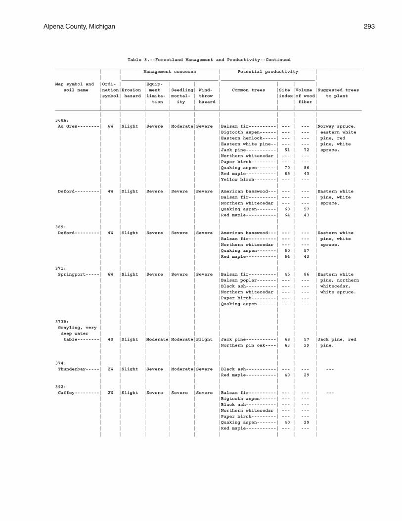
Alpena County, Michigan 293
Table 8.--Forestland Management and Productivity--Continued_______________________________________________________________________________________________________________ | | Management concerns | Potential productivity | | | | | ___________________________________ __________________________________Map symbol and |Ordi- | |Equip- | | | | | | soil name |nation|Erosion | ment |Seedling| Wind- | Common trees |Site |Volume |Suggested trees |symbol| hazard |limita- |mortal- | throw | |index|of wood| to plant | | | tion | ity | hazard | | | fiber | | | | | | | | | |_______________________________________________________________________________________________________________ | | | | | | | | |368A: | | | | | | | | | Au Gres--------| 6W |Slight |Severe |Moderate|Severe |Balsam fir----------| --- | --- |Norway spruce, | | | | | |Bigtooth aspen------| --- | --- | eastern white | | | | | |Eastern hemlock-----| --- | --- | pine, red | | | | | |Eastern white pine--| --- | --- | pine, white | | | | | |Jack pine-----------| 51 | 72 | spruce. | | | | | |Northern whitecedar | --- | --- | | | | | | |Paper birch---------| --- | --- | | | | | | |Quaking aspen-------| 70 | 86 | | | | | | |Red maple-----------| 65 | 43 | | | | | | |Yellow birch--------| --- | --- | | | | | | | | | | Deford---------| 4W |Slight |Severe |Severe |Severe |American basswood---| --- | --- |Eastern white | | | | | |Balsam fir----------| --- | --- | pine, white | | | | | |Northern whitecedar | --- | --- | spruce. | | | | | |Quaking aspen-------| 60 | 57 | | | | | | |Red maple-----------| 64 | 43 | | | | | | | | | |369: | | | | | | | | | Deford---------| 4W |Slight |Severe |Severe |Severe |American basswood---| --- | --- |Eastern white | | | | | |Balsam fir----------| --- | --- | pine, white | | | | | |Northern whitecedar | --- | --- | spruce. | | | | | |Quaking aspen-------| 60 | 57 | | | | | | |Red maple-----------| 64 | 43 | | | | | | | | | |371: | | | | | | | | | Springport-----| 6W |Slight |Severe |Severe |Severe |Balsam fir----------| 45 | 86 |Eastern white | | | | | |Balsam poplar-------| --- | --- | pine, northern | | | | | |Black ash-----------| --- | --- | whitecedar, | | | | | |Northern whitecedar | --- | --- | white spruce. | | | | | |Paper birch---------| --- | --- | | | | | | |Quaking aspen-------| --- | --- | | | | | | | | | | | | | | | | | | |373B: | | | | | | | | | Grayling, very | | | | | | | | | deep water | | | | | | | | | table--------| 4S |Slight |Moderate|Moderate|Slight |Jack pine-----------| 48 | 57 |Jack pine, red | | | | | |Northern pin oak----| 43 | 29 | pine. | | | | | | | | | | | | | | | | | |374: | | | | | | | | | Thunderbay-----| 2W |Slight |Severe |Moderate|Severe |Black ash-----------| --- | --- | --- | | | | | |Red maple-----------| 40 | 29 | | | | | | | | | |392: | | | | | | | | | Caffey---------| 2W |Slight |Severe |Severe |Severe |Balsam fir----------| --- | --- | --- | | | | | |Bigtooth aspen------| --- | --- | | | | | | |Black ash-----------| --- | --- | | | | | | |Northern whitecedar | --- | --- | | | | | | |Paper birch---------| --- | --- | | | | | | |Quaking aspen-------| 40 | 29 | | | | | | |Red maple-----------| --- | --- | | | | | | | | | |
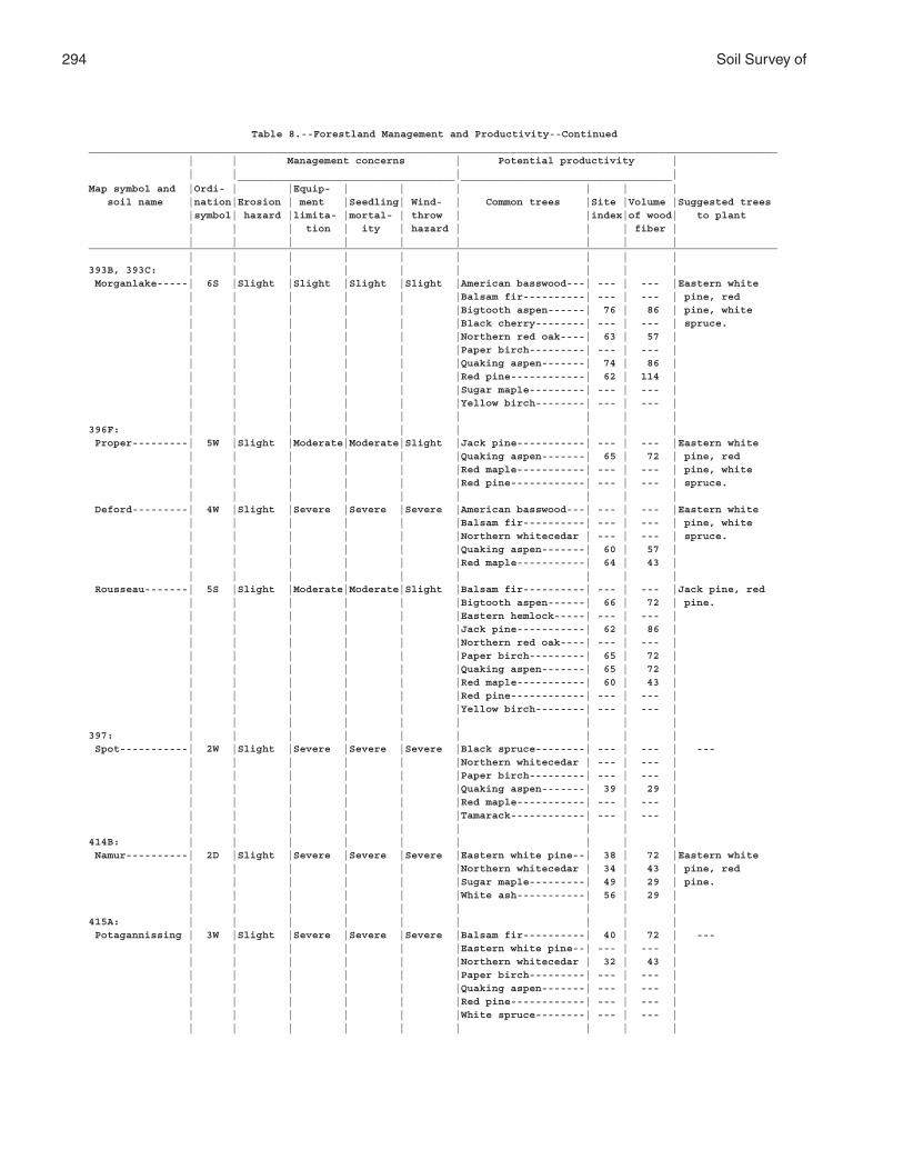
294 Soil Survey of
Table 8.--Forestland Management and Productivity--Continued_______________________________________________________________________________________________________________ | | Management concerns | Potential productivity | | | | | ___________________________________ __________________________________Map symbol and |Ordi- | |Equip- | | | | | | soil name |nation|Erosion | ment |Seedling| Wind- | Common trees |Site |Volume |Suggested trees |symbol| hazard |limita- |mortal- | throw | |index|of wood| to plant | | | tion | ity | hazard | | | fiber | | | | | | | | | |_______________________________________________________________________________________________________________ | | | | | | | | |393B, 393C: | | | | | | | | | Morganlake-----| 6S |Slight |Slight |Slight |Slight |American basswood---| --- | --- |Eastern white | | | | | |Balsam fir----------| --- | --- | pine, red | | | | | |Bigtooth aspen------| 76 | 86 | pine, white | | | | | |Black cherry--------| --- | --- | spruce. | | | | | |Northern red oak----| 63 | 57 | | | | | | |Paper birch---------| --- | --- | | | | | | |Quaking aspen-------| 74 | 86 | | | | | | |Red pine------------| 62 | 114 | | | | | | |Sugar maple---------| --- | --- | | | | | | |Yellow birch--------| --- | --- | | | | | | | | | |396F: | | | | | | | | | Proper---------| 5W |Slight |Moderate|Moderate|Slight |Jack pine-----------| --- | --- |Eastern white | | | | | |Quaking aspen-------| 65 | 72 | pine, red | | | | | |Red maple-----------| --- | --- | pine, white | | | | | |Red pine------------| --- | --- | spruce. | | | | | | | | | Deford---------| 4W |Slight |Severe |Severe |Severe |American basswood---| --- | --- |Eastern white | | | | | |Balsam fir----------| --- | --- | pine, white | | | | | |Northern whitecedar | --- | --- | spruce. | | | | | |Quaking aspen-------| 60 | 57 | | | | | | |Red maple-----------| 64 | 43 | | | | | | | | | | Rousseau-------| 5S |Slight |Moderate|Moderate|Slight |Balsam fir----------| --- | --- |Jack pine, red | | | | | |Bigtooth aspen------| 66 | 72 | pine. | | | | | |Eastern hemlock-----| --- | --- | | | | | | |Jack pine-----------| 62 | 86 | | | | | | |Northern red oak----| --- | --- | | | | | | |Paper birch---------| 65 | 72 | | | | | | |Quaking aspen-------| 65 | 72 | | | | | | |Red maple-----------| 60 | 43 | | | | | | |Red pine------------| --- | --- | | | | | | |Yellow birch--------| --- | --- | | | | | | | | | |397: | | | | | | | | | Spot-----------| 2W |Slight |Severe |Severe |Severe |Black spruce--------| --- | --- | --- | | | | | |Northern whitecedar | --- | --- | | | | | | |Paper birch---------| --- | --- | | | | | | |Quaking aspen-------| 39 | 29 | | | | | | |Red maple-----------| --- | --- | | | | | | |Tamarack------------| --- | --- | | | | | | | | | |414B: | | | | | | | | | Namur----------| 2D |Slight |Severe |Severe |Severe |Eastern white pine--| 38 | 72 |Eastern white | | | | | |Northern whitecedar | 34 | 43 | pine, red | | | | | |Sugar maple---------| 49 | 29 | pine. | | | | | |White ash-----------| 56 | 29 | | | | | | | | | |415A: | | | | | | | | | Potagannissing | 3W |Slight |Severe |Severe |Severe |Balsam fir----------| 40 | 72 | --- | | | | | |Eastern white pine--| --- | --- | | | | | | |Northern whitecedar | 32 | 43 | | | | | | |Paper birch---------| --- | --- | | | | | | |Quaking aspen-------| --- | --- | | | | | | |Red pine------------| --- | --- | | | | | | |White spruce--------| --- | --- | | | | | | | | | |

Alpena County, Michigan 295
Table 8.--Forestland Management and Productivity--Continued_______________________________________________________________________________________________________________ | | Management concerns | Potential productivity | | | | | ___________________________________ __________________________________Map symbol and |Ordi- | |Equip- | | | | | | soil name |nation|Erosion | ment |Seedling| Wind- | Common trees |Site |Volume |Suggested trees |symbol| hazard |limita- |mortal- | throw | |index|of wood| to plant | | | tion | ity | hazard | | | fiber | | | | | | | | | |_______________________________________________________________________________________________________________ | | | | | | | | |416B: | | | | | | | | | Negwegon, till | | | | | | | | | substratum----| 3C |Slight |Moderate|Slight |Moderate|American beech------| --- | --- |Eastern white | | | | | |Balsam fir----------| --- | --- | pine, white | | | | | |Bigtooth aspen------| --- | --- | spruce. | | | | | |Eastern hemlock-----| --- | --- | | | | | | |Northern red oak----| --- | --- | | | | | | |Sugar maple---------| 62 | 43 | | | | | | |White ash-----------| --- | --- | | | | | | | | | |417B, 417C, | | | | | | | | | 418E: | | | | | | | | | Alpena--------| 3F |Slight |Slight |Moderate|Slight |Balsam fir----------| --- | --- |Jack pine, red | | | | | |Northern whitecedar | --- | --- | pine. | | | | | |Paper birch---------| --- | --- | | | | | | |Quaking aspen-------| --- | --- | | | | | | |Sugar maple---------| 61 | 43 | | | | | | |White spruce--------| --- | --- | | | | | | |Yellow birch--------| --- | --- | | | | | | | | | |419: | | | | | | | | | Chippeny-------| 4W |Slight |Severe |Severe |Severe |Balsam fir----------| 35 | 57 | --- | | | | | |Black ash-----------| --- | --- | | | | | | |Black spruce--------| --- | --- | | | | | | |Eastern hemlock-----| --- | --- | | | | | | |Northern whitecedar | 35 | 57 | | | | | | |Paper birch---------| --- | --- | | | | | | |Quaking aspen-------| --- | --- | | | | | | |Red maple-----------| --- | --- | | | | | | |Yellow birch--------| --- | --- |420A: | | | | | | | | | Otisco---------| --- |Slight |Severe |Slight |Moderate|American elm--------| --- | --- | --- | | | | | |Balsam fir----------| --- | --- | | | | | | |Bigtooth aspen------| 65 | 72 | | | | | | |Jack pine-----------| 53 | 72 | | | | | | |Quaking aspen-------| 60 | 57 | | | | | | |Red maple-----------| --- | --- | | | | | | |White spruce--------| --- | --- | | | | | | |Yellow birch--------| --- | --- | | | | | | | | | |424B, 424C: | | | | | | | | | Morganlake-----| 6S |Slight |Slight |Slight |Slight |American basswood---| --- | --- |Eastern white | | | | | |Balsam fir----------| --- | --- | pine, red | | | | | |Bigtooth aspen------| 76 | 86 | pine, white | | | | | |Black cherry--------| --- | --- | spruce. | | | | | |Northern red oak----| 63 | 57 | | | | | | |Paper birch---------| --- | --- | | | | | | |Quaking aspen-------| 74 | 86 | | | | | | |Red pine------------| 62 | 114 | | | | | | |Sugar maple---------| --- | --- | | | | | | |Yellow birch--------| --- | --- | | | | | | | | | | Ossineke, sandy| | | | | | | | | substratum----| 4 |Slight |Moderate|Slight |Moderate|American basswood---| --- | --- |Norway spruce, | | | | | |Bigtooth aspen------| --- | --- | eastern white | | | | | |Eastern hemlock-----| --- | --- | pine, red | | | | | |Northern red oak----| 65 | 57 | pine, white | | | | | |Paper birch---------| --- | --- | spruce. | | | | | |Sugar maple---------| 63 | 43 | | | | | | |White ash-----------| --- | --- | | | | | | | | | |

296 Soil Survey of
Table 8.--Forestland Management and Productivity--Continued_______________________________________________________________________________________________________________ | | Management concerns | Potential productivity | | | | | ___________________________________ __________________________________Map symbol and |Ordi- | |Equip- | | | | | | soil name |nation|Erosion | ment |Seedling| Wind- | Common trees |Site |Volume |Suggested trees |symbol| hazard |limita- |mortal- | throw | |index|of wood| to plant | | | tion | ity | hazard | | | fiber | | | | | | | | | |_______________________________________________________________________________________________________________ | | | | | | | | |424B, 424C: | | | | | | | | | Blue Lake------| 3S |Slight |Moderate|Moderate|Slight |American basswood---| --- | --- |Eastern white | | | | | |American beech------| --- | --- | pine, jack | | | | | |Bigtooth aspen------| --- | --- | pine, red | | | | | |Eastern hemlock-----| --- | --- | pine. | | | | | |Eastern white pine--| --- | --- | | | | | | |Quaking aspen-------| --- | --- | | | | | | |Red maple-----------| --- | --- | | | | | | |Sugar maple---------| 64 | 43 | | | | | | |Yellow birch--------| --- | --- | | | | | | | | | |426B, 426C, | | | | | | | | | 426D: | | | | | | | | | Coppler-------| 3A |Slight |Slight |Slight |Slight |Eastern white pine--| --- | --- |Eastern white | | | | | |Northern red oak----| 55 | 43 | pine, red | | | | | |Paper birch---------| --- | --- | pine. | | | | | |Quaking aspen-------| 66 | 72 | | | | | | |Red maple-----------| --- | --- | | | | | | |Red pine------------| --- | --- | | | | | | | | | |451C: | | | | | | | | | Annalake-------| 3 |Slight |Moderate|Slight |Slight |American basswood---| --- | --- |Eastern white | | | | | |Balsam fir----------| --- | --- | pine, red | | | | | |Eastern hemlock-----| --- | --- | pine, white | | | | | |Paper birch---------| --- | --- | spruce. | | | | | |Quaking aspen-------| --- | --- | | | | | | |Red maple-----------| --- | --- | | | | | | |Sugar maple---------| 61 | 43 | | | | | | |Yellow birch--------| --- | --- | | | | | | | | | |477B: | | | | | | | | | Alginquin, till| | | | | | | | | substratum----| 6W |Slight |Severe |Moderate|Severe |Balsam fir----------| 45 | 86 |Eastern white | | | | | |Balsam poplar-------| --- | --- | pine, northern | | | | | |Black ash-----------| --- | --- | whitecedar, | | | | | |Northern whitecedar | --- | --- | white spruce. | | | | | |Paper birch---------| --- | --- | | | | | | |Quaking aspen-------| --- | --- | | | | | | |Red maple-----------| --- | --- | | | | | | | | | | Springport, | | | | | | | | | till | | | | | | | | | substratum---| 6W |Slight |Severe |Severe |Severe |Balsam fir----------| 45 | 86 |Eastern white | | | | | |Black ash-----------| --- | --- | pine, northern | | | | | |Northern whitecedar | --- | --- | whitecedar, | | | | | |Paper birch---------| --- | --- | white spruce. | | | | | |Quaking aspen-------| --- | --- | | | | | | | | | |478: | | | | | | | | | Springport, | | | | | | | | | till | | | | | | | | | substratum---| 6W |Slight |Severe |Severe |Severe |Balsam fir----------| 45 | 86 |Eastern white | | | | | |Black ash-----------| --- | --- | pine, northern | | | | | |Northern whitecedar | --- | --- | whitecedar, | | | | | |Paper birch---------| --- | --- | white spruce. | | | | | |Quaking aspen-------| --- | --- | | | | | | | | | |
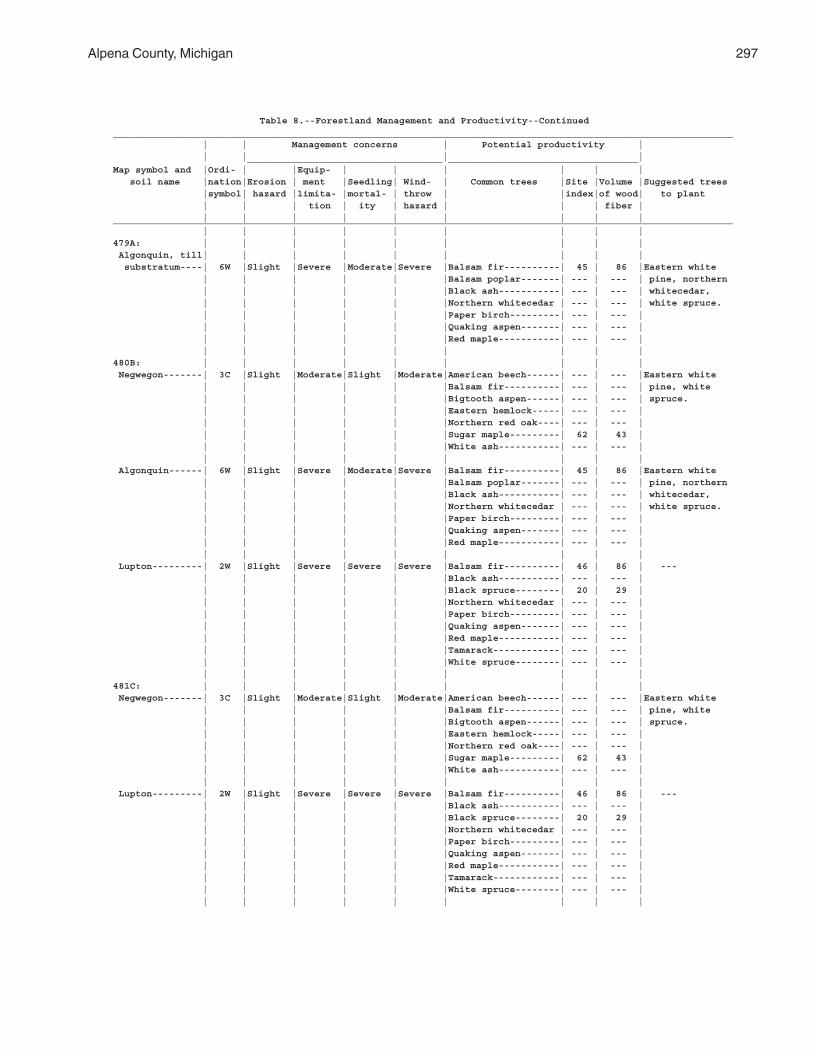
Alpena County, Michigan 297
Table 8.--Forestland Management and Productivity--Continued_______________________________________________________________________________________________________________ | | Management concerns | Potential productivity | | | | | ___________________________________ __________________________________Map symbol and |Ordi- | |Equip- | | | | | | soil name |nation|Erosion | ment |Seedling| Wind- | Common trees |Site |Volume |Suggested trees |symbol| hazard |limita- |mortal- | throw | |index|of wood| to plant | | | tion | ity | hazard | | | fiber | | | | | | | | | |_______________________________________________________________________________________________________________ | | | | | | | | |479A: | | | | | | | | | Algonquin, till| | | | | | | | | substratum----| 6W |Slight |Severe |Moderate|Severe |Balsam fir----------| 45 | 86 |Eastern white | | | | | |Balsam poplar-------| --- | --- | pine, northern | | | | | |Black ash-----------| --- | --- | whitecedar, | | | | | |Northern whitecedar | --- | --- | white spruce. | | | | | |Paper birch---------| --- | --- | | | | | | |Quaking aspen-------| --- | --- | | | | | | |Red maple-----------| --- | --- | | | | | | | | | |480B: | | | | | | | | | Negwegon-------| 3C |Slight |Moderate|Slight |Moderate|American beech------| --- | --- |Eastern white | | | | | |Balsam fir----------| --- | --- | pine, white | | | | | |Bigtooth aspen------| --- | --- | spruce. | | | | | |Eastern hemlock-----| --- | --- | | | | | | |Northern red oak----| --- | --- | | | | | | |Sugar maple---------| 62 | 43 | | | | | | |White ash-----------| --- | --- | | | | | | | | | | Algonquin------| 6W |Slight |Severe |Moderate|Severe |Balsam fir----------| 45 | 86 |Eastern white | | | | | |Balsam poplar-------| --- | --- | pine, northern | | | | | |Black ash-----------| --- | --- | whitecedar, | | | | | |Northern whitecedar | --- | --- | white spruce. | | | | | |Paper birch---------| --- | --- | | | | | | |Quaking aspen-------| --- | --- | | | | | | |Red maple-----------| --- | --- | | | | | | | | | | Lupton---------| 2W |Slight |Severe |Severe |Severe |Balsam fir----------| 46 | 86 | --- | | | | | |Black ash-----------| --- | --- | | | | | | |Black spruce--------| 20 | 29 | | | | | | |Northern whitecedar | --- | --- | | | | | | |Paper birch---------| --- | --- | | | | | | |Quaking aspen-------| --- | --- | | | | | | |Red maple-----------| --- | --- | | | | | | |Tamarack------------| --- | --- | | | | | | |White spruce--------| --- | --- | | | | | | | | | |481C: | | | | | | | | | Negwegon-------| 3C |Slight |Moderate|Slight |Moderate|American beech------| --- | --- |Eastern white | | | | | |Balsam fir----------| --- | --- | pine, white | | | | | |Bigtooth aspen------| --- | --- | spruce. | | | | | |Eastern hemlock-----| --- | --- | | | | | | |Northern red oak----| --- | --- | | | | | | |Sugar maple---------| 62 | 43 | | | | | | |White ash-----------| --- | --- | | | | | | | | | | Lupton---------| 2W |Slight |Severe |Severe |Severe |Balsam fir----------| 46 | 86 | --- | | | | | |Black ash-----------| --- | --- | | | | | | |Black spruce--------| 20 | 29 | | | | | | |Northern whitecedar | --- | --- | | | | | | |Paper birch---------| --- | --- | | | | | | |Quaking aspen-------| --- | --- | | | | | | |Red maple-----------| --- | --- | | | | | | |Tamarack------------| --- | --- | | | | | | |White spruce--------| --- | --- | | | | | | | | | |
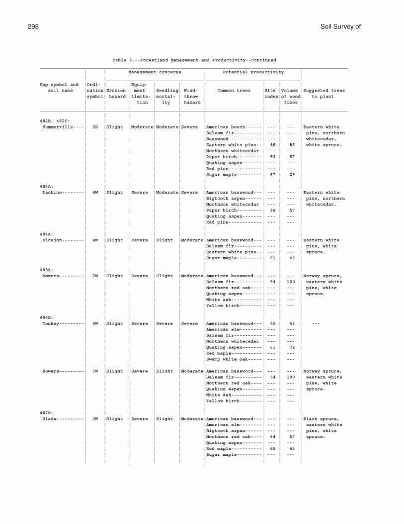
298 Soil Survey of
Table 8.--Forestland Management and Productivity--Continued_______________________________________________________________________________________________________________ | | Management concerns | Potential productivity | | | | | ___________________________________ __________________________________Map symbol and |Ordi- | |Equip- | | | | | | soil name |nation|Erosion | ment |Seedling| Wind- | Common trees |Site |Volume |Suggested trees |symbol| hazard |limita- |mortal- | throw | |index|of wood| to plant | | | tion | ity | hazard | | | fiber | | | | | | | | | |_______________________________________________________________________________________________________________ | | | | | | | | |482B, 482C: | | | | | | | | | Summerville----| 2D |Slight |Moderate|Moderate|Severe |American beech------| --- | --- |Eastern white | | | | | |Balsam fir----------| --- | --- | pine, northern | | | | | |Basswood------------| --- | --- | whitecedar, | | | | | |Eastern white pine--| 48 | 86 | white spruce. | | | | | |Northern whitecedar | --- | --- | | | | | | |Paper birch---------| 53 | 57 | | | | | | |Quaking aspen-------| --- | --- | | | | | | |Red pine------------| --- | --- | | | | | | |Sugar maple---------| 57 | 29 | | | | | | | | | |483A: | | | | | | | | | Lachine--------| 4W |Slight |Severe |Moderate|Severe |American basswood---| --- | --- |Eastern white | | | | | |Bigtooth aspen------| --- | --- | pine, northern | | | | | |Northern whitecedar | --- | --- | whitecedar. | | | | | |Paper birch---------| 36 | 57 | | | | | | |Quaking aspen-------| --- | --- | | | | | | |Red pine------------| --- | --- | | | | | | | | | |484A: | | | | | | | | | Elcajon--------| 4W |Slight |Severe |Slight |Moderate|American basswood---| --- | --- |Eastern white | | | | | |Balsam fir----------| --- | --- | pine, white | | | | | |Eastern white pine--| --- | --- | spruce. | | | | | |Sugar maple---------| 61 | 43 | | | | | | | | | |485A: | | | | | | | | | Bowers---------| 7W |Slight |Severe |Slight |Moderate|American basswood---| --- | --- |Norway spruce, | | | | | |Balsam fir----------| 54 | 100 | eastern white | | | | | |Northern red oak----| --- | --- | pine, white | | | | | |Quaking aspen-------| --- | --- | spruce. | | | | | |White ash-----------| --- | --- | | | | | | |Yellow birch--------| --- | --- | | | | | | | | | |486B: | | | | | | | | | Tonkey---------| 5W |Slight |Severe |Severe |Severe |American basswood---| 55 | 43 | --- | | | | | |American elm--------| --- | --- | | | | | | |Balsam fir----------| --- | --- | | | | | | |Northern whitecedar | --- | --- | | | | | | |Quaking aspen-------| 61 | 72 | | | | | | |Red maple-----------| --- | --- | | | | | | |Swamp white oak-----| --- | --- | | | | | | | | | | Bowers---------| 7W |Slight |Severe |Slight |Moderate|American basswood---| --- | --- |Norway spruce, | | | | | |Balsam fir----------| 54 | 100 | eastern white | | | | | |Northern red oak----| --- | --- | pine, white | | | | | |Quaking aspen-------| --- | --- | spruce. | | | | | |White ash-----------| --- | --- | | | | | | |Yellow birch--------| --- | --- | | | | | | | | | |487B: | | | | | | | | | Slade----------| 3W |Slight |Severe |Slight |Moderate|American basswood---| --- | --- |Black spruce, | | | | | |American elm--------| --- | --- | eastern white | | | | | |Bigtooth aspen------| --- | --- | pine, white | | | | | |Northern red oak----| 64 | 57 | spruce. | | | | | |Quaking aspen-------| --- | --- | | | | | | |Red maple-----------| 65 | 43 | | | | | | |Sugar maple---------| --- | --- | | | | | | | | | |
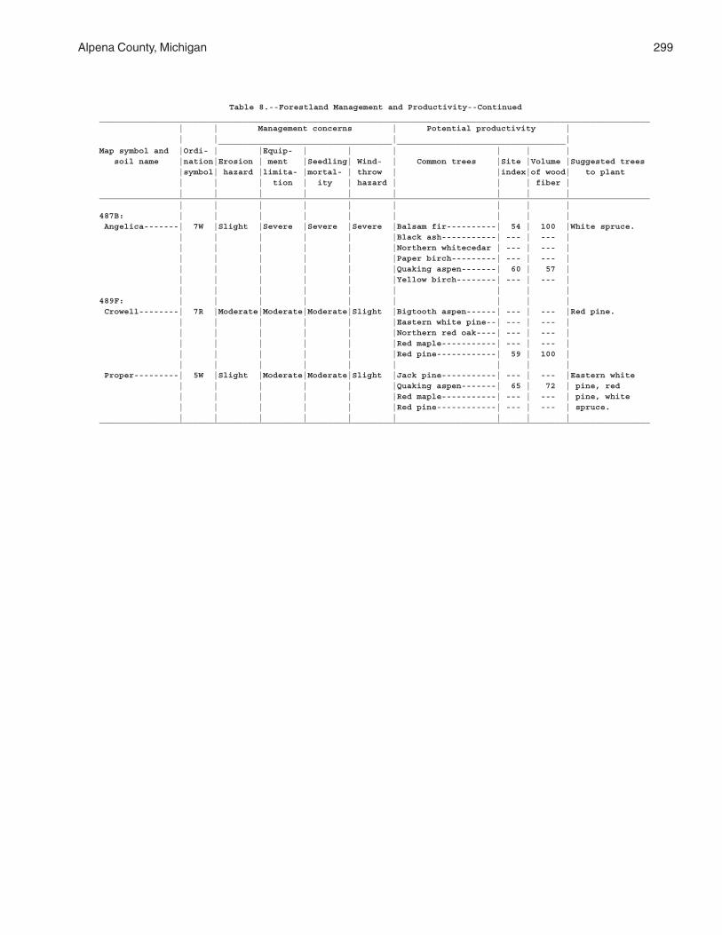
Alpena County, Michigan 299
Table 8.--Forestland Management and Productivity--Continued_______________________________________________________________________________________________________________ | | Management concerns | Potential productivity | | | | | ___________________________________ __________________________________Map symbol and |Ordi- | |Equip- | | | | | | soil name |nation|Erosion | ment |Seedling| Wind- | Common trees |Site |Volume |Suggested trees |symbol| hazard |limita- |mortal- | throw | |index|of wood| to plant | | | tion | ity | hazard | | | fiber | | | | | | | | | |_______________________________________________________________________________________________________________ | | | | | | | | |487B: | | | | | | | | | Angelica-------| 7W |Slight |Severe |Severe |Severe |Balsam fir----------| 54 | 100 |White spruce. | | | | | |Black ash-----------| --- | --- | | | | | | |Northern whitecedar | --- | --- | | | | | | |Paper birch---------| --- | --- | | | | | | |Quaking aspen-------| 60 | 57 | | | | | | |Yellow birch--------| --- | --- | | | | | | | | | |489F: | | | | | | | | | Crowell--------| 7R |Moderate|Moderate|Moderate|Slight |Bigtooth aspen------| --- | --- |Red pine. | | | | | |Eastern white pine--| --- | --- | | | | | | |Northern red oak----| --- | --- | | | | | | |Red maple-----------| --- | --- | | | | | | |Red pine------------| 59 | 100 | | | | | | | | | | Proper---------| 5W |Slight |Moderate|Moderate|Slight |Jack pine-----------| --- | --- |Eastern white | | | | | |Quaking aspen-------| 65 | 72 | pine, red | | | | | |Red maple-----------| --- | --- | pine, white | | | | | |Red pine------------| --- | --- | spruce. | | | | | | | | |_______________________________________________________________________________________________________________
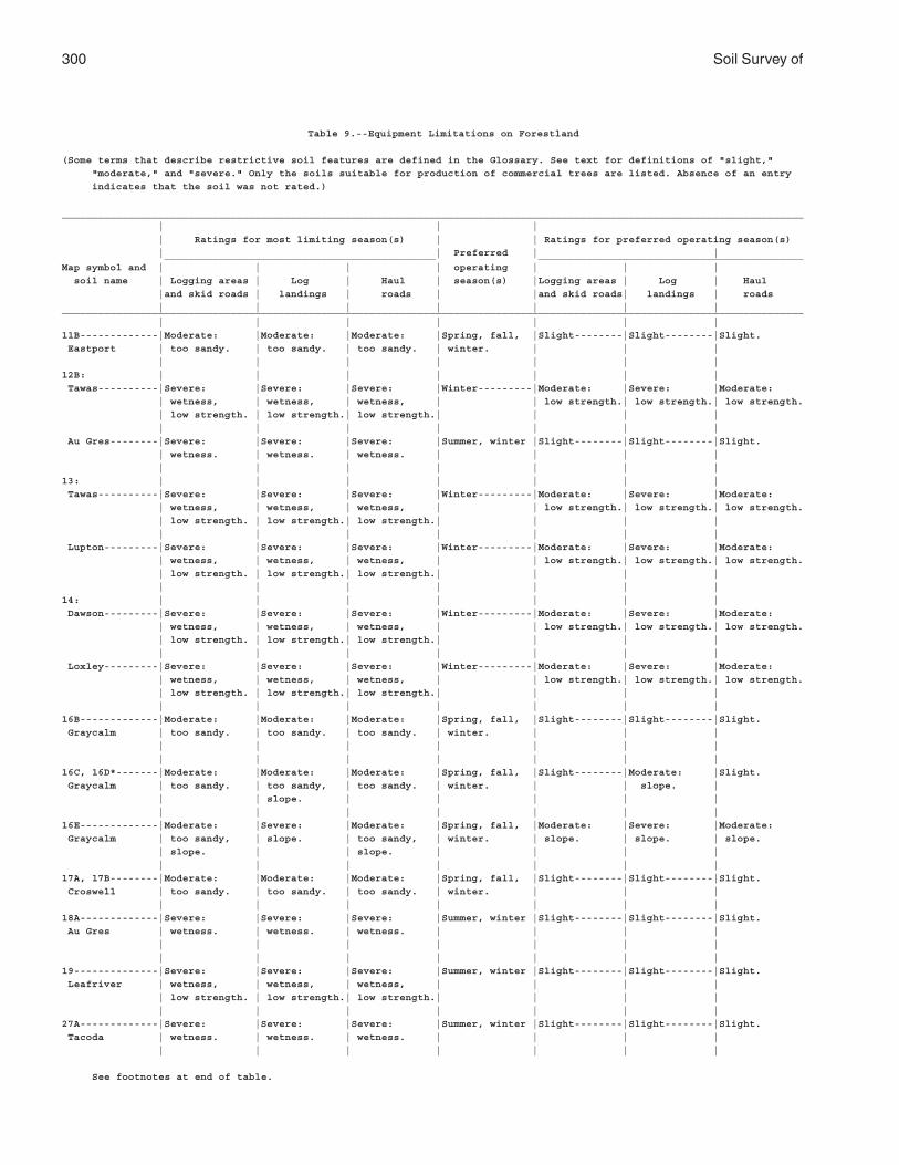
300 Soil Survey of
Table 9.--Equipment Limitations on Forestland
(Some terms that describe restrictive soil features are defined in the Glossary. See text for definitions of "slight,"
"moderate," and "severe." Only the soils suitable for production of commercial trees are listed. Absence of an entry
indicates that the soil was not rated.)
___________________________________________________________________________________________________________________________
| | |
| Ratings for most limiting season(s) | | Ratings for preferred operating season(s)
| | Preferred | | _____________________________________________ ____________________________________________
Map symbol and | | | | operating | | |
soil name | Logging areas | Log | Haul | season(s) |Logging areas | Log | Haul
|and skid roads | landings | roads | |and skid roads| landings | roads
| | | | | | |___________________________________________________________________________________________________________________________
| | | | | | |
11B-------------|Moderate: |Moderate: |Moderate: |Spring, fall, |Slight--------|Slight--------|Slight.
Eastport | too sandy. | too sandy. | too sandy. | winter. | | |
| | | | | | |
12B: | | | | | | |
Tawas----------|Severe: |Severe: |Severe: |Winter---------|Moderate: |Severe: |Moderate:
| wetness, | wetness, | wetness, | | low strength.| low strength.| low strength.
| low strength. | low strength.| low strength.| | | |
| | | | | | |
Au Gres--------|Severe: |Severe: |Severe: |Summer, winter |Slight--------|Slight--------|Slight.
| wetness. | wetness. | wetness. | | | |
| | | | | | |
13: | | | | | | |
Tawas----------|Severe: |Severe: |Severe: |Winter---------|Moderate: |Severe: |Moderate:
| wetness, | wetness, | wetness, | | low strength.| low strength.| low strength.
| low strength. | low strength.| low strength.| | | |
| | | | | | |
Lupton---------|Severe: |Severe: |Severe: |Winter---------|Moderate: |Severe: |Moderate:
| wetness, | wetness, | wetness, | | low strength.| low strength.| low strength.
| low strength. | low strength.| low strength.| | | |
| | | | | | |
14: | | | | | | |
Dawson---------|Severe: |Severe: |Severe: |Winter---------|Moderate: |Severe: |Moderate:
| wetness, | wetness, | wetness, | | low strength.| low strength.| low strength.
| low strength. | low strength.| low strength.| | | |
| | | | | | |
Loxley---------|Severe: |Severe: |Severe: |Winter---------|Moderate: |Severe: |Moderate:
| wetness, | wetness, | wetness, | | low strength.| low strength.| low strength.
| low strength. | low strength.| low strength.| | | |
| | | | | | |
16B-------------|Moderate: |Moderate: |Moderate: |Spring, fall, |Slight--------|Slight--------|Slight.
Graycalm | too sandy. | too sandy. | too sandy. | winter. | | |
| | | | | | |
| | | | | | |
16C, 16D*-------|Moderate: |Moderate: |Moderate: |Spring, fall, |Slight--------|Moderate: |Slight.
Graycalm | too sandy. | too sandy, | too sandy. | winter. | | slope. |
| | slope. | | | | |
| | | | | | |
16E-------------|Moderate: |Severe: |Moderate: |Spring, fall, |Moderate: |Severe: |Moderate:
Graycalm | too sandy, | slope. | too sandy, | winter. | slope. | slope. | slope.
| slope. | | slope. | | | |
| | | | | | |
17A, 17B--------|Moderate: |Moderate: |Moderate: |Spring, fall, |Slight--------|Slight--------|Slight.
Croswell | too sandy. | too sandy. | too sandy. | winter. | | |
| | | | | | |
18A-------------|Severe: |Severe: |Severe: |Summer, winter |Slight--------|Slight--------|Slight.
Au Gres | wetness. | wetness. | wetness. | | | |
| | | | | | |
| | | | | | |
19--------------|Severe: |Severe: |Severe: |Summer, winter |Slight--------|Slight--------|Slight.
Leafriver | wetness, | wetness, | wetness, | | | |
| low strength. | low strength.| low strength.| | | |
| | | | | | |
27A-------------|Severe: |Severe: |Severe: |Summer, winter |Slight--------|Slight--------|Slight.
Tacoda | wetness. | wetness. | wetness. | | | |
| | | | | | |
See footnotes at end of table.
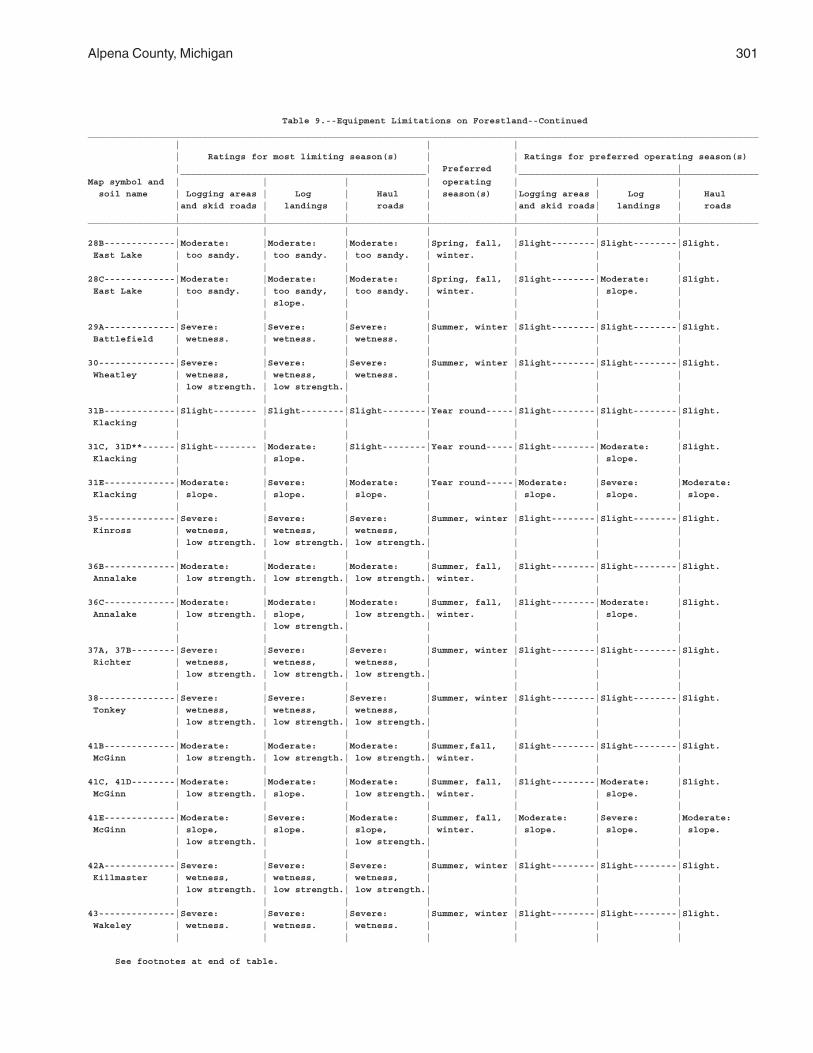
Alpena County, Michigan 301
Table 9.--Equipment Limitations on Forestland--Continued
___________________________________________________________________________________________________________________________
| | |
| Ratings for most limiting season(s) | | Ratings for preferred operating season(s)
| | Preferred | | _____________________________________________ ____________________________________________
Map symbol and | | | | operating | | |
soil name | Logging areas | Log | Haul | season(s) |Logging areas | Log | Haul
|and skid roads | landings | roads | |and skid roads| landings | roads
| | | | | | |___________________________________________________________________________________________________________________________
| | | | | | |
28B-------------|Moderate: |Moderate: |Moderate: |Spring, fall, |Slight--------|Slight--------|Slight.
East Lake | too sandy. | too sandy. | too sandy. | winter. | | |
| | | | | | |
28C-------------|Moderate: |Moderate: |Moderate: |Spring, fall, |Slight--------|Moderate: |Slight.
East Lake | too sandy. | too sandy, | too sandy. | winter. | | slope. |
| | slope. | | | | |
| | | | | | |
29A-------------|Severe: |Severe: |Severe: |Summer, winter |Slight--------|Slight--------|Slight.
Battlefield | wetness. | wetness. | wetness. | | | |
| | | | | | |
30--------------|Severe: |Severe: |Severe: |Summer, winter |Slight--------|Slight--------|Slight.
Wheatley | wetness, | wetness, | wetness. | | | |
| low strength. | low strength.| | | | |
| | | | | | |
31B-------------|Slight-------- |Slight--------|Slight--------|Year round-----|Slight--------|Slight--------|Slight.
Klacking | | | | | | |
| | | | | | |
31C, 31D**------|Slight-------- |Moderate: |Slight--------|Year round-----|Slight--------|Moderate: |Slight.
Klacking | | slope. | | | | slope. |
| | | | | | |
31E-------------|Moderate: |Severe: |Moderate: |Year round-----|Moderate: |Severe: |Moderate:
Klacking | slope. | slope. | slope. | | slope. | slope. | slope.
| | | | | | |
35--------------|Severe: |Severe: |Severe: |Summer, winter |Slight--------|Slight--------|Slight.
Kinross | wetness, | wetness, | wetness, | | | |
| low strength. | low strength.| low strength.| | | |
| | | | | | |
36B-------------|Moderate: |Moderate: |Moderate: |Summer, fall, |Slight--------|Slight--------|Slight.
Annalake | low strength. | low strength.| low strength.| winter. | | |
| | | | | | |
36C-------------|Moderate: |Moderate: |Moderate: |Summer, fall, |Slight--------|Moderate: |Slight.
Annalake | low strength. | slope, | low strength.| winter. | | slope. |
| | low strength.| | | | |
| | | | | | |
37A, 37B--------|Severe: |Severe: |Severe: |Summer, winter |Slight--------|Slight--------|Slight.
Richter | wetness, | wetness, | wetness, | | | |
| low strength. | low strength.| low strength.| | | |
| | | | | | |
38--------------|Severe: |Severe: |Severe: |Summer, winter |Slight--------|Slight--------|Slight.
Tonkey | wetness, | wetness, | wetness, | | | |
| low strength. | low strength.| low strength.| | | |
| | | | | | |
41B-------------|Moderate: |Moderate: |Moderate: |Summer,fall, |Slight--------|Slight--------|Slight.
McGinn | low strength. | low strength.| low strength.| winter. | | |
| | | | | | |
41C, 41D--------|Moderate: |Moderate: |Moderate: |Summer, fall, |Slight--------|Moderate: |Slight.
McGinn | low strength. | slope. | low strength.| winter. | | slope. |
| | | | | | |
41E-------------|Moderate: |Severe: |Moderate: |Summer, fall, |Moderate: |Severe: |Moderate:
McGinn | slope, | slope. | slope, | winter. | slope. | slope. | slope.
| low strength. | | low strength.| | | |
| | | | | | |
42A-------------|Severe: |Severe: |Severe: |Summer, winter |Slight--------|Slight--------|Slight.
Killmaster | wetness, | wetness, | wetness, | | | |
| low strength. | low strength.| low strength.| | | |
| | | | | | |
43--------------|Severe: |Severe: |Severe: |Summer, winter |Slight--------|Slight--------|Slight.
Wakeley | wetness. | wetness. | wetness. | | | |
| | | | | | |
See footnotes at end of table.
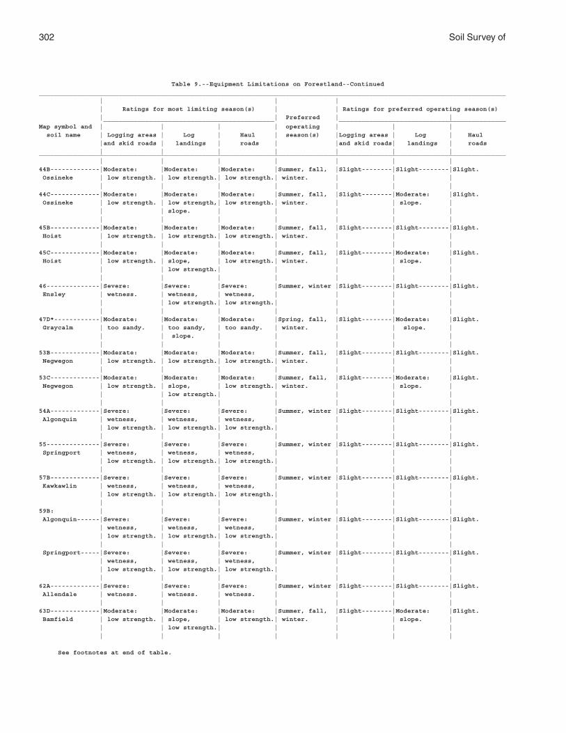
302 Soil Survey of
Table 9.--Equipment Limitations on Forestland--Continued
___________________________________________________________________________________________________________________________
| | |
| Ratings for most limiting season(s) | | Ratings for preferred operating season(s)
| | Preferred | | _____________________________________________ ____________________________________________
Map symbol and | | | | operating | | |
soil name | Logging areas | Log | Haul | season(s) |Logging areas | Log | Haul
|and skid roads | landings | roads | |and skid roads| landings | roads
| | | | | | |___________________________________________________________________________________________________________________________
| | | | | | |
44B-------------|Moderate: |Moderate: |Moderate: |Summer, fall, |Slight--------|Slight--------|Slight.
Ossineke | low strength. | low strength.| low strength.| winter. | | |
| | | | | | |
44C-------------|Moderate: |Moderate: |Moderate: |Summer, fall, |Slight--------|Moderate: |Slight.
Ossineke | low strength. | low strength,| low strength.| winter. | | slope. |
| | slope. | | | | |
| | | | | | |
45B-------------|Moderate: |Moderate: |Moderate: |Summer, fall, |Slight--------|Slight--------|Slight.
Hoist | low strength. | low strength.| low strength.| winter. | | |
| | | | | | |
45C-------------|Moderate: |Moderate: |Moderate: |Summer, fall, |Slight--------|Moderate: |Slight.
Hoist | low strength. | slope, | low strength.| winter. | | slope. |
| | low strength.| | | | |
| | | | | | |
46--------------|Severe: |Severe: |Severe: |Summer, winter |Slight--------|Slight--------|Slight.
Ensley | wetness. | wetness, | wetness, | | | |
| | low strength.| low strength.| | | |
| | | | | | |
47D*------------|Moderate: |Moderate: |Moderate: |Spring, fall, |Slight--------|Moderate: |Slight.
Graycalm | too sandy. | too sandy, | too sandy. | winter. | | slope. |
| | slope. | | | | |
| | | | | | |
53B-------------|Moderate: |Moderate: |Moderate: |Summer, fall, |Slight--------|Slight--------|Slight.
Negwegon | low strength. | low strength.| low strength.| winter. | | |
| | | | | | |
53C-------------|Moderate: |Moderate: |Moderate: |Summer, fall, |Slight--------|Moderate: |Slight.
Negwegon | low strength. | slope, | low strength.| winter. | | slope. |
| | low strength.| | | | |
| | | | | | |
54A-------------|Severe: |Severe: |Severe: |Summer, winter |Slight--------|Slight--------|Slight.
Algonquin | wetness, | wetness, | wetness, | | | |
| low strength. | low strength.| low strength.| | | |
| | | | | | |
55--------------|Severe: |Severe: |Severe: |Summer, winter |Slight--------|Slight--------|Slight.
Springport | wetness, | wetness, | wetness, | | | |
| low strength. | low strength.| low strength.| | | |
| | | | | | |
57B-------------|Severe: |Severe: |Severe: |Summer, winter |Slight--------|Slight--------|Slight.
Kawkawlin | wetness, | wetness, | wetness, | | | |
| low strength. | low strength.| low strength.| | | |
| | | | | | |
59B: | | | | | | |
Algonquin------|Severe: |Severe: |Severe: |Summer, winter |Slight--------|Slight--------|Slight.
| wetness, | wetness, | wetness, | | | |
| low strength. | low strength.| low strength.| | | |
| | | | | | |
Springport-----|Severe: |Severe: |Severe: |Summer, winter |Slight--------|Slight--------|Slight.
| wetness, | wetness, | wetness, | | | |
| low strength. | low strength.| low strength.| | | |
| | | | | | |
62A-------------|Severe: |Severe: |Severe: |Summer, winter |Slight--------|Slight--------|Slight.
Allendale | wetness. | wetness. | wetness. | | | |
| | | | | | |
63D-------------|Moderate: |Moderate: |Moderate: |Summer, fall, |Slight--------|Moderate: |Slight.
Bamfield | low strength. | slope, | low strength.| winter. | | slope. |
| | low strength.| | | | |
| | | | | | |
See footnotes at end of table.

Alpena County, Michigan 303
Table 9.--Equipment Limitations on Forestland--Continued
___________________________________________________________________________________________________________________________
| | |
| Ratings for most limiting season(s) | | Ratings for preferred operating season(s)
| | Preferred | | _____________________________________________ ____________________________________________
Map symbol and | | | | operating | | |
soil name | Logging areas | Log | Haul | season(s) |Logging areas | Log | Haul
|and skid roads | landings | roads | |and skid roads| landings | roads
| | | | | | |___________________________________________________________________________________________________________________________
| | | | | | |
63E-------------|Moderate: |Severe: |Moderate: |Summer, fall, |Moderate: |Severe: |Moderate:
Bamfield | low strength, | slope. | low strength,| winter. | slope. | slope. | slope.
| slope. | | slope. | | | |
| | | | | | |
68--------------|Severe: |Severe: |Severe: |Winter---------|Moderate: |Severe: |Moderate:
Rondeau | wetness, | wetness, | wetness, | | low strength.| low strength.| low strength.
| low strength. | low strength.| low strength.| | | |
| | | | | | |
69--------------|Severe: |Severe: |Severe: |Winter---------|Moderate: |Severe: |Moderate:
Loxley | wetness, | wetness, | wetness, | | low strength.| low strength.| low strength.
| low strength. | low strength.| low strength.| | | |
| | | | | | |
70--------------|Severe: |Severe: |Severe: |Winter---------|Moderate: |Severe: |Moderate:
Lupton | wetness, | wetness, | wetness, | | low strength.| low strength.| low strength.
| low strength. | low strength.| low strength.| | | |
| | | | | | |
71--------------|Severe: |Severe: |Severe: |Winter---------|Moderate: |Severe: |Moderate:
Tawas | wetness, | wetness, | wetness, | | low strength.| low strength.| low strength.
| low strength. | low strength.| low strength.| | | |
| | | | | | |
72--------------|Severe: |Severe: |Severe: |Winter---------|Moderate: |Severe: |Moderate:
Dorval | wetness, | wetness, | wetness, | | low strength.| low strength.| low strength.
| low strength. | low strength.| low strength.| | | |
| | | | | | |
74C2------------|Moderate: |Moderate: |Moderate: |Summer, fall, |Slight--------|Moderate: |Slight.
Negwegon | low strength. | slope, | low strength.| winter. | | slope. |
| | low strength.| | | | |
| | | | | | |
75B-------------|Moderate: |Moderate: |Moderate: |Spring, fall |Slight--------|Slight--------|Slight.
Rubicon | too sandy. | too sandy. | too sandy. | winter. | | |
| | | | | | |
75D*------------|Moderate: |Moderate: |Moderate: |Spring, fall |Slight--------|Moderate: |Slight.
Rubicon | too sandy. | too sandy, | too sandy. | winter. | | slope. |
| | slope. | | | | |
| | | | | | |
75E-------------|Moderate: |Severe: |Moderate: |Spring, fall, |Moderate: |Severe: |Moderate:
Rubicon | too sandy, | slope. | too sandy, | winter. | slope. | slope. | slope.
| slope. | | slope. | | | |
| | | | | | |
77--------------|Severe: |Severe: |Severe: |Winter---------|Slight--------|Slight--------|Slight.
Rollaway | wetness, | wetness, | wetness, | | | |
| low strength, | low strength,| low strength,| | | |
| flooding. | flooding. | flooding. | | | |
| | | | | | |
84B-------------|Slight-------- |Slight--------|Slight--------|Year round-----|Slight--------|Slight--------|Slight.
Zimmerman | | | | | | |
| | | | | | |
84C-------------|Slight-------- |Moderate: |Slight--------|Year round-----|Slight--------|Moderate: |Slight.
Zimmerman | | slope. | | | | slope. |
| | | | | | |
84E-------------|Moderate: |Severe: |Moderate: |Year round-----|Moderate: |Moderate: |Moderate:
Zimmerman | slope. | slope. | slope. | | slope. | slope. | Slope
| | | | | | |
85D: | | | | | | |
Zimmerman**----|Slight---------|Moderate: |Slight--------|Year round-----|Slight--------|Moderate: |Slight.
| | slope. | | | | slope. |
| | | | | | |
See footnotes at end of table.
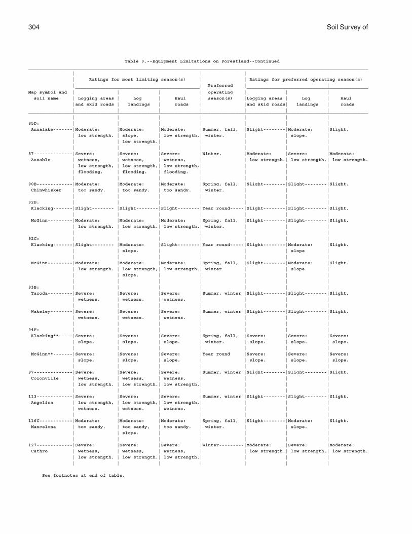
304 Soil Survey of
Table 9.--Equipment Limitations on Forestland--Continued
___________________________________________________________________________________________________________________________
| | |
| Ratings for most limiting season(s) | | Ratings for preferred operating season(s)
| | Preferred | | _____________________________________________ ____________________________________________
Map symbol and | | | | operating | | |
soil name | Logging areas | Log | Haul | season(s) |Logging areas | Log | Haul
|and skid roads | landings | roads | |and skid roads| landings | roads
| | | | | | |___________________________________________________________________________________________________________________________
| | | | | | |
85D: | | | | | | |
Annalake-------|Moderate: |Moderate: |Moderate: |Summer, fall, |Slight--------|Moderate: |Slight.
| low strength. | slope, | low strength.| winter. | | slope. |
| | low strength.| | | | |
| | | | | | |
87--------------|Severe: |Severe: |Severe: |Winter. |Moderate: |Severe: |Moderate:
Ausable | wetness, | wetness, | wetness, | | low strength.| low strength.| low strength.
| low strength, | low strength,| low strength,| | | |
| flooding. | flooding. | flooding. | | | |
| | | | | | |
90B-------------|Moderate: |Moderate: |Moderate: |Spring, fall, |Slight--------|Slight--------|Slight.
Chinwhisker | too sandy. | too sandy. | too sandy. | winter. | | |
| | | | | | |
92B: | | | | | | |
Klacking-------|Slight-------- |Slight--------|Slight--------|Year round-----|Slight--------|Slight--------|Slight.
| | | | | | |
McGinn---------|Moderate: |Moderate: |Moderate: |Spring, fall, |Slight--------|Slight--------|Slight.
| low strength. | low strength.| low strength.| winter. | | |
| | | | | | |
92C: | | | | | | |
Klacking-------|Slight-------- |Moderate: |Slight--------|Year round-----|Slight--------|Moderate: |Slight.
| | slope. | | | | slope |
| | | | | | |
McGinn---------|Moderate: |Moderate: |Moderate: |Spring, fall, |Slight--------|Moderate: |Slight.
| low strength. | low strength,| low strength.| winter | | slope |
| | slope. | | | | |
| | | | | | |
93B: | | | | | | |
Tacoda---------|Severe: |Severe: |Severe: |Summer, winter |Slight--------|Slight--------|Slight.
| wetness. | wetness. | wetness. | | | |
| | | | | | |
Wakeley--------|Severe: |Severe: |Severe: |Summer, winter |Slight--------|Slight--------|Slight.
| wetness. | wetness. | wetness. | | | |
| | | | | | |
94F: | | | | | | |
Klacking**-----|Severe: |Severe: |Severe: |Spring, fall, |Severe: |Severe: |Severe:
| slope. | slope. | slope. | winter. | slope. | slope. | slope.
| | | | | | |
McGinn**-------|Severe: |Severe: |Severe: |Year round |Severe: |Severe: |Severe:
| slope. | slope. | slope. | | slope. | slope. | slope.
| | | | | | |
97--------------|Severe: |Severe: |Severe: |Summer, winter |Slight--------|Slight--------|Slight.
Colonville | wetness, | wetness, | wetness, | | | |
| low strength. | low strength.| low strength.| | | |
| | | | | | |
113-------------|Severe: |Severe: |Severe: |Summer, winter |Slight--------|Slight--------|Slight.
Angelica | low strength, | low strength,| low strength,| | | |
| wetness. | wetness. | wetness. | | | |
| | | | | | |
116C------------|Moderate: |Moderate: |Moderate: |Spring, fall, |Slight--------|Moderate: |Slight.
Mancelona | too sandy. | too sandy, | too sandy. | winter. | | slope. |
| | slope. | | | | |
| | | | | | |
127-------------|Severe: |Severe: |Severe: |Winter---------|Moderate: |Severe: |Moderate:
Cathro | wetness, | wetness, | wetness, | | low strength.| low strength.| low strength.
| low strength. | low strength.| low strength.| | | |
| | | | | | |
See footnotes at end of table.

Alpena County, Michigan 305
Table 9.--Equipment Limitations on Forestland--Continued
___________________________________________________________________________________________________________________________
| | |
| Ratings for most limiting season(s) | | Ratings for preferred operating season(s)
| | Preferred | | _____________________________________________ ____________________________________________
Map symbol and | | | | operating | | |
soil name | Logging areas | Log | Haul | season(s) |Logging areas | Log | Haul
|and skid roads | landings | roads | |and skid roads| landings | roads
| | | | | | |___________________________________________________________________________________________________________________________
| | | | | | |
128-------------|Severe: |Severe: |Severe: |Winter---------|Moderate: |Severe: |Moderate:
Dawson | wetness, | wetness, | wetness, | | low strength.| low strength.| low strength.
| low strength. | low strength.| low strength.| | | |
| | | | | | |
145C------------|Moderate: |Moderate: |Moderate: |Spring, fall |Slight--------|Moderate: |Slight.
Rousseau | too sandy. | too sandy, | too sandy. | winter. | | slope. |
| | slope. | | | | |
| | | | | | |
145E------------|Moderate: |Severe: |Moderate: |Spring, fall, |Moderate: |Severe: |Moderate:
Rousseau | too sandy, | slope. | too sandy, | winter. | slope. | slope. | slope.
| slope. | | slope. | | | |
| | | | | | |
159A------------|Severe: |Severe: |Severe: |Summer, winter |Slight--------|Slight--------|Slight.
Finch | wetness. | wetness. | wetness. | | | |
| | | | | | |
166A------------|Severe: |Severe: |Severe |Summer, winter |Slight--------|Slight--------|Slight.
Slade | wetness, | wetness, | wetness, | | | |
| low strength. | low strength.| low strength.| | | |
| | | | | | |
300A------------|Severe: |Severe: |Severe |Summer, fall, |Slight--------|Slight--------|Slight.
Hagensville | wetness, | wetness, | wetness, | winter. | | |
| low strength. | low strength.| low strength.| | | |
| | | | | | |
304A------------|Severe: |Severe: |Severe: |Summer, winter |Slight--------|Slight--------|Slight.
Iosco | wetness. | wetness. | wetness. | | | |
| | | | | | |
305B------------|Moderate: |Moderate: |Moderate: |Summer, fall |Slight--------|Slight--------|Slight.
Johnswood | low strength. | low strength.| low strength.| winter. | | |
| | | | | | |
308B------------|Moderate: |Moderate: |Moderate: |Summer, fall, |Slight--------|Slight--------|Slight.
Krakow | low strength. | low strength.| low strength.| winter. | | |
| | | | | | |
308C, 308D*-----|Moderate: |Moderate: |Moderate: |Summer, fall, |Slight--------|Moderate: |Slight.
Krakow | low strength. | slope, | low strength.| winter. | | slope. |
| | low strength.| | | | |
| | | | | | |
316-------------|Severe: |Severe: |Severe |Summer, winter |Slight--------|Slight--------|Moderate:
Ruse | wetness, | wetness, | wetness, | | | | depth to
| low strength. | low strength.| low strength.| | | | rock.
| | | | | | |
350E------------|Moderate: |Severe: |Moderate: |Spring, fall, |Moderate: |Severe: |Moderate:
Blue Lake | too sandy, | slope. | too sandy, | winter. | slope. | slope. | slope.
| slope. | | slope. | | | |
| | | | | | |
359C: | | | | | | |
Algonquin------|Severe: |Severe: |Severe: |Summer, winter |Slight--------|Slight--------|Slight.
| wetness, | wetness, | wetness, | | | |
| low strength. | low strength.| low strength.| | | |
| | | | | | |
Negwegon-------|Moderate: |Moderate: |Moderate: |Summer, fall, |Slight--------|Moderate: |Slight.
| low strength. | low strength,| low strength.| winter. | | slope |
| | slope. | | | | |
| | | | | | |
Dorval---------|Severe: |Severe: |Severe: |Winter. |Moderate: |Severe: |Moderate:
| wetness, | wetness, | wetness, | | low strength.| low strength.| low strength.
| low strength. | low strength.| low strength.| | | |
| | | | | | |
See footnotes at end of table.
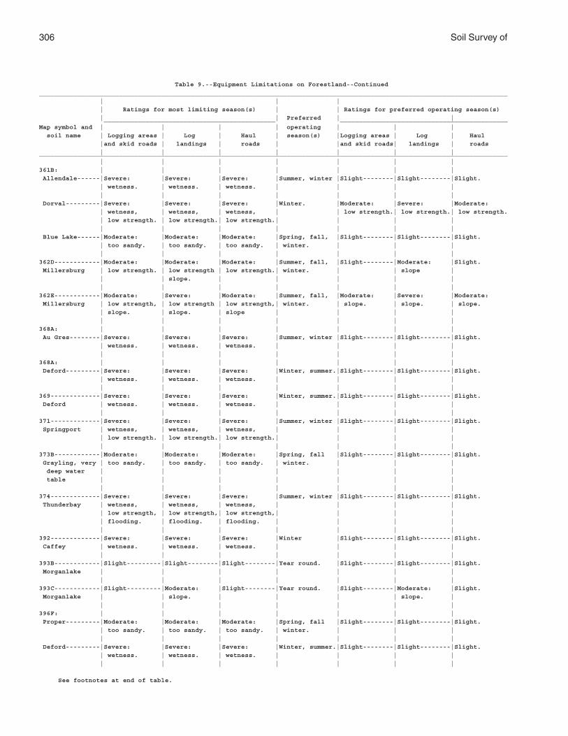
306 Soil Survey of
Table 9.--Equipment Limitations on Forestland--Continued
___________________________________________________________________________________________________________________________
| | |
| Ratings for most limiting season(s) | | Ratings for preferred operating season(s)
| | Preferred | | _____________________________________________ ____________________________________________
Map symbol and | | | | operating | | |
soil name | Logging areas | Log | Haul | season(s) |Logging areas | Log | Haul
|and skid roads | landings | roads | |and skid roads| landings | roads
| | | | | | |___________________________________________________________________________________________________________________________
| | | | | | |
361B: | | | | | | |
Allendale------|Severe: |Severe: |Severe: |Summer, winter |Slight--------|Slight--------|Slight.
| wetness. | wetness. | wetness. | | | |
| | | | | | |
Dorval---------|Severe: |Severe: |Severe: |Winter. |Moderate: |Severe: |Moderate:
| wetness, | wetness, | wetness, | | low strength.| low strength.| low strength.
| low strength. | low strength.| low strength.| | | |
| | | | | | |
Blue Lake------|Moderate: |Moderate: |Moderate: |Spring, fall, |Slight--------|Slight--------|Slight.
| too sandy. | too sandy. | too sandy. | winter. | | |
| | | | | | |
362D------------|Moderate: |Moderate: |Moderate: |Summer, fall, |Slight--------|Moderate: |Slight.
Millersburg | low strength. | low strength | low strength.| winter. | | slope |
| | slope. | | | | |
| | | | | | |
362E------------|Moderate: |Severe: |Moderate: |Summer, fall, |Moderate: |Severe: |Moderate:
Millersburg | low strength, | low strength | low strength,| winter. | slope. | slope. | slope.
| slope. | slope. | slope | | | |
| | | | | | |
368A: | | | | | | |
Au Gres--------|Severe: |Severe: |Severe: |Summer, winter |Slight--------|Slight--------|Slight.
| wetness. | wetness. | wetness. | | | |
| | | | | | |
368A: | | | | | | |
Deford---------|Severe: |Severe: |Severe: |Winter, summer.|Slight--------|Slight--------|Slight.
| wetness. | wetness. | wetness. | | | |
| | | | | | |
369-------------|Severe: |Severe: |Severe: |Winter, summer.|Slight--------|Slight--------|Slight.
Deford | wetness. | wetness. | wetness. | | | |
| | | | | | |
371-------------|Severe: |Severe: |Severe: |Summer, winter |Slight--------|Slight--------|Slight.
Springport | wetness, | wetness, | wetness, | | | |
| low strength. | low strength.| low strength.| | | |
| | | | | | |
373B------------|Moderate: |Moderate: |Moderate: |Spring, fall |Slight--------|Slight--------|Slight.
Grayling, very | too sandy. | too sandy. | too sandy. | winter. | | |
deep water | | | | | | |
table | | | | | | |
| | | | | | |
374-------------|Severe: |Severe: |Severe: |Summer, winter |Slight--------|Slight--------|Slight.
Thunderbay | wetness, | wetness, | wetness, | | | |
| low strength, | low strength,| low strength,| | | |
| flooding. | flooding. | flooding. | | | |
| | | | | | |
392-------------|Severe: |Severe: |Severe: |Winter |Slight--------|Slight--------|Slight.
Caffey | wetness. | wetness. | wetness. | | | |
| | | | | | |
393B------------|Slight---------|Slight--------|Slight--------|Year round. |Slight--------|Slight--------|Slight.
Morganlake | | | | | | |
| | | | | | |
393C------------|Slight---------|Moderate: |Slight--------|Year round. |Slight--------|Moderate: |Slight.
Morganlake | | slope. | | | | slope. |
| | | | | | |
396F: | | | | | | |
Proper---------|Moderate: |Moderate: |Moderate: |Spring, fall |Slight--------|Slight--------|Slight.
| too sandy. | too sandy. | too sandy. | winter. | | |
| | | | | | |
Deford---------|Severe: |Severe: |Severe: |Winter, summer.|Slight--------|Slight--------|Slight.
| wetness. | wetness. | wetness. | | | |
| | | | | | |
See footnotes at end of table.
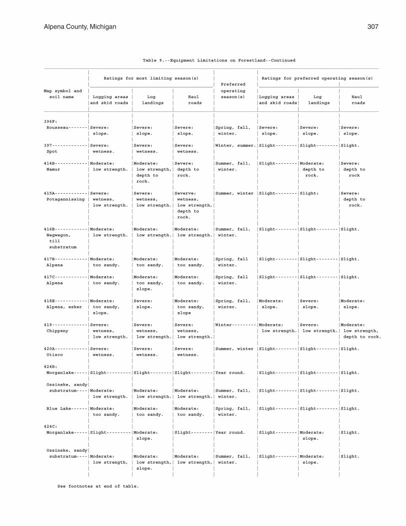
Alpena County, Michigan 307
Table 9.--Equipment Limitations on Forestland--Continued
___________________________________________________________________________________________________________________________
| | |
| Ratings for most limiting season(s) | | Ratings for preferred operating season(s)
| | Preferred | | _____________________________________________ ____________________________________________
Map symbol and | | | | operating | | |
soil name | Logging areas | Log | Haul | season(s) |Logging areas | Log | Haul
|and skid roads | landings | roads | |and skid roads| landings | roads
| | | | | | |___________________________________________________________________________________________________________________________
| | | | | | |
396F: | | | | | | |
Rousseau-------|Severe: |Severe: |Severe: |Spring, fall, |Severe: |Severe: |Severe:
| slope. | slope. | slope. | winter. | slope. | slope. | slope.
| | | | | | |
397-------------|Severe: |Severe: |Severe: |Winter, summer.|Slight--------|Slight--------|Slight.
Spot | wetness. | wetness. | wetness. | | | |
| | | | | | |
414B------------|Moderate: |Moderate: |Severe: |Summer, fall, |Slight--------|Moderate: |Severe:
Namur | low strength. | low strength,| depth to | winter. | | depth to | depth to
| | depth to | rock. | | | rock. | rock
| | rock. | | | | |
| | | | | | |
415A------------|Severe: |Severe: |Severve: |Summer, winter |Slight--------|Slight: |Severe:
Potagannissing | wetness, | wetness, | wetness, | | | | depth to
| low strength. | low strength.| low strength,| | | | rock.
| | | depth to | | | |
| | | rock. | | | |
| | | | | | |
416B------------|Moderate: |Moderate: |Moderate: |Summer, fall, |Slight--------|Slight--------|Slight.
Negwegon, | low strength. | low strength.| low strength.| winter. | | |
till | | | | | | |
substratum | | | | | | |
| | | | | | |
417B------------|Moderate: |Moderate: |Moderate: |Spring, fall |Slight--------|Slight--------|Slight.
Alpena | too sandy. | too sandy. | too sandy. | winter. | | |
| | | | | | |
417C------------|Moderate: |Moderate: |Moderate: |Spring, fall |Slight--------|Slight--------|Slight.
Alpena | too sandy. | too sandy, | too sandy. | winter. | | |
| | slope. | | | | |
| | | | | | |
418E------------|Moderate: |Severe: |Moderate: |Spring, fall, |Moderate: |Severe: |Moderate:
Alpena, esker | too sandy, | slope. | too sandy, | winter. | slope. | slope. | slope.
| slope. | | slope | | | |
| | | | | | |
419-------------|Severe: |Severe: |Severe: |Winter---------|Moderate: |Severe: |Moderate:
Chippeny | wetness, | wetness, | wetness, | | low strength.| low strength.| low strength,
| low strength. | low strength.| low strength.| | | | depth to rock.
| | | | | | |
420A------------|Severe: |Severe: |Severe: |Summer, winter |Slight--------|Slight--------|Slight.
Otisco | wetness. | wetness. | wetness. | | | |
| | | | | | |
424B: | | | | | | |
Morganlake-----|Slight---------|Slight--------|Slight--------|Year round. |Slight--------|Slight--------|Slight.
| | | | | | |
Ossineke, sandy| | | | | | |
substratum----|Moderate: |Moderate: |Moderate: |Summer, fall, |Slight--------|Slight--------|Slight.
| low strength. | low strength.| low strength.| winter. | | |
| | | | | | |
Blue Lake------|Moderate: |Moderate: |Moderate: |Spring, fall, |Slight--------|Slight--------|Slight.
| too sandy. | too sandy. | too sandy. | winter. | | |
| | | | | | |
424C: | | | | | | |
Morganlake-----|Slight---------|Moderate: |Slight--------|Year round. |Slight--------|Moderate: |Slight.
| | slope. | | | | slope. |
| | | | | | |
Ossineke, sandy| | | | | | |
substratum----|Moderate: |Moderate: |Moderate: |Summer, fall, |Slight--------|Moderate: |Slight.
| low strength, | low strength,| low strength,| winter. | | slope. |
| | slope. | | | | |
| | | | | | |
See footnotes at end of table.
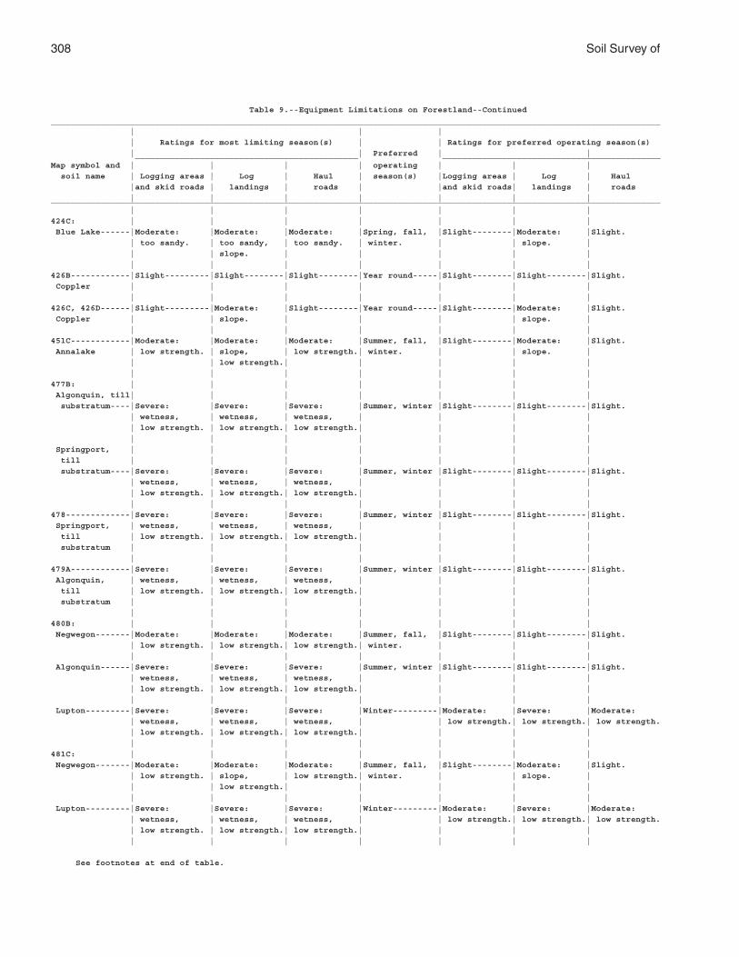
308 Soil Survey of
Table 9.--Equipment Limitations on Forestland--Continued
___________________________________________________________________________________________________________________________
| | |
| Ratings for most limiting season(s) | | Ratings for preferred operating season(s)
| | Preferred | | _____________________________________________ ____________________________________________
Map symbol and | | | | operating | | |
soil name | Logging areas | Log | Haul | season(s) |Logging areas | Log | Haul
|and skid roads | landings | roads | |and skid roads| landings | roads
| | | | | | |___________________________________________________________________________________________________________________________
| | | | | | |
424C: | | | | | | |
Blue Lake------|Moderate: |Moderate: |Moderate: |Spring, fall, |Slight--------|Moderate: |Slight.
| too sandy. | too sandy, | too sandy. | winter. | | slope. |
| | slope. | | | | |
| | | | | | |
426B------------|Slight---------|Slight--------|Slight--------|Year round-----|Slight--------|Slight--------|Slight.
Coppler | | | | | | |
| | | | | | |
426C, 426D------|Slight---------|Moderate: |Slight--------|Year round-----|Slight--------|Moderate: |Slight.
Coppler | | slope. | | | | slope. |
| | | | | | |
451C------------|Moderate: |Moderate: |Moderate: |Summer, fall, |Slight--------|Moderate: |Slight.
Annalake | low strength. | slope, | low strength.| winter. | | slope. |
| | low strength.| | | | |
| | | | | | |
477B: | | | | | | |
Algonquin, till| | | | | | |
substratum----|Severe: |Severe: |Severe: |Summer, winter |Slight--------|Slight--------|Slight.
| wetness, | wetness, | wetness, | | | |
| low strength. | low strength.| low strength.| | | |
| | | | | | |
Springport, | | | | | | |
till | | | | | | |
substratum----|Severe: |Severe: |Severe: |Summer, winter |Slight--------|Slight--------|Slight.
| wetness, | wetness, | wetness, | | | |
| low strength. | low strength.| low strength.| | | |
| | | | | | |
478-------------|Severe: |Severe: |Severe: |Summer, winter |Slight--------|Slight--------|Slight.
Springport, | wetness, | wetness, | wetness, | | | |
till | low strength. | low strength.| low strength.| | | |
substratum | | | | | | |
| | | | | | |
479A------------|Severe: |Severe: |Severe: |Summer, winter |Slight--------|Slight--------|Slight.
Algonquin, | wetness, | wetness, | wetness, | | | |
till | low strength. | low strength.| low strength.| | | |
substratum | | | | | | |
| | | | | | |
480B: | | | | | | |
Negwegon-------|Moderate: |Moderate: |Moderate: |Summer, fall, |Slight--------|Slight--------|Slight.
| low strength. | low strength.| low strength.| winter. | | |
| | | | | | |
Algonquin------|Severe: |Severe: |Severe: |Summer, winter |Slight--------|Slight--------|Slight.
| wetness, | wetness, | wetness, | | | |
| low strength. | low strength.| low strength.| | | |
| | | | | | |
Lupton---------|Severe: |Severe: |Severe: |Winter---------|Moderate: |Severe: |Moderate:
| wetness, | wetness, | wetness, | | low strength.| low strength.| low strength.
| low strength. | low strength.| low strength.| | | |
| | | | | | |
481C: | | | | | | |
Negwegon-------|Moderate: |Moderate: |Moderate: |Summer, fall, |Slight--------|Moderate: |Slight.
| low strength. | slope, | low strength.| winter. | | slope. |
| | low strength.| | | | |
| | | | | | |
Lupton---------|Severe: |Severe: |Severe: |Winter---------|Moderate: |Severe: |Moderate:
| wetness, | wetness, | wetness, | | low strength.| low strength.| low strength.
| low strength. | low strength.| low strength.| | | |
| | | | | | |
See footnotes at end of table.
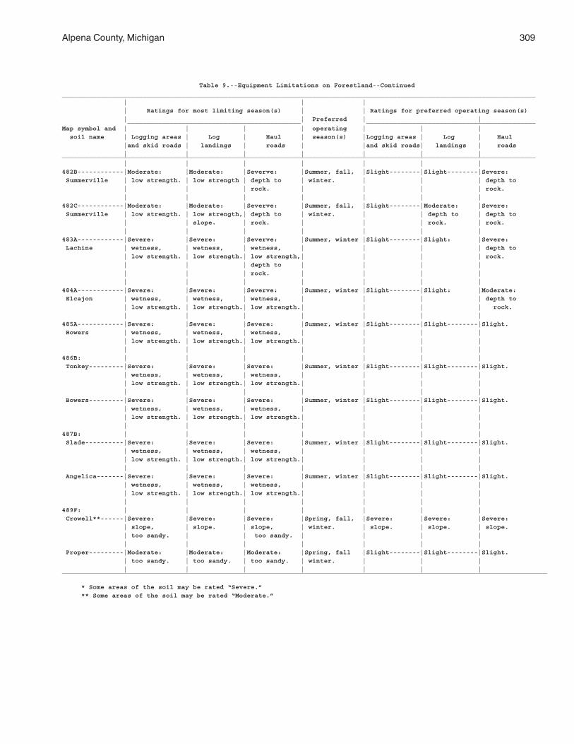
Alpena County, Michigan 309
Table 9.--Equipment Limitations on Forestland--Continued
___________________________________________________________________________________________________________________________
| | |
| Ratings for most limiting season(s) | | Ratings for preferred operating season(s)
| | Preferred | | _____________________________________________ ____________________________________________
Map symbol and | | | | operating | | |
soil name | Logging areas | Log | Haul | season(s) |Logging areas | Log | Haul
|and skid roads | landings | roads | |and skid roads| landings | roads
| | | | | | |___________________________________________________________________________________________________________________________
| | | | | | |
482B------------|Moderate: |Moderate: |Severve: |Summer, fall, |Slight--------|Slight--------|Severe:
Summerville | low strength. | low strength | depth to | winter. | | | depth to
| | | rock. | | | | rock.
| | | | | | |
482C------------|Moderate: |Moderate: |Severve: |Summer, fall, |Slight--------|Moderate: |Severe:
Summerville | low strength. | low strength,| depth to | winter. | | depth to | depth to
| | slope. | rock. | | | rock. | rock.
| | | | | | |
483A------------|Severe: |Severe: |Severve: |Summer, winter |Slight--------|Slight: |Severe:
Lachine | wetness, | wetness, | wetness, | | | | depth to
| low strength. | low strength.| low strength,| | | | rock.
| | | depth to | | | |
| | | rock. | | | |
| | | | | | |
484A------------|Severe: |Severe: |Severve: |Summer, winter |Slight--------|Slight: |Moderate:
Elcajon | wetness, | wetness, | wetness, | | | | depth to
| low strength. | low strength.| low strength.| | | | rock.
| | | | | | |
485A------------|Severe: |Severe: |Severe: |Summer, winter |Slight--------|Slight--------|Slight.
Bowers | wetness, | wetness, | wetness, | | | |
| low strength. | low strength.| low strength.| | | |
| | | | | | |
486B: | | | | | | |
Tonkey---------|Severe: |Severe: |Severe: |Summer, winter |Slight--------|Slight--------|Slight.
| wetness, | wetness, | wetness, | | | |
| low strength. | low strength.| low strength.| | | |
| | | | | | |
Bowers---------|Severe: |Severe: |Severe: |Summer, winter |Slight--------|Slight--------|Slight.
| wetness, | wetness, | wetness, | | | |
| low strength. | low strength.| low strength.| | | |
| | | | | | |
487B: | | | | | | |
Slade----------|Severe: |Severe: |Severe: |Summer, winter |Slight--------|Slight--------|Slight.
| wetness, | wetness, | wetness, | | | |
| low strength. | low strength.| low strength.| | | |
| | | | | | |
Angelica-------|Severe: |Severe: |Severe: |Summer, winter |Slight--------|Slight--------|Slight.
| wetness, | wetness, | wetness, | | | |
| low strength. | low strength.| low strength.| | | |
| | | | | | |
489F: | | | | | | |
Crowell**------|Severe: |Severe: |Severe: |Spring, fall, |Severe: |Severe: |Severe:
| slope, | slope. | slope, | winter. | slope. | slope. | slope.
| too sandy. | | too sandy. | | | |
| | | | | | |
Proper---------|Moderate: |Moderate: |Moderate: |Spring, fall |Slight--------|Slight--------|Slight.
| too sandy. | too sandy. | too sandy. | winter. | | |
| | | | | | |___________________________________________________________________________________________________________________________
* Some areas of the soil may be rated “Severe.”
** Some areas of the soil may be rated “Moderate.”
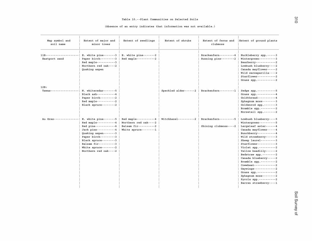
310S
oil Survey of
Table 10.--Plant Communities on Selected Soils
(Absence of an entry indicates that information was not available.)
________________________________________________________________________________________________________________________________________________ | | | | | Map symbol and | Extent of major and | Extent of seedlings | Extent of shrubs | Extent of ferns and |Extent of ground plants soil name | minor trees | | | clubmoss | | | | | |________________________________________________________________________________________________________________________________________________ | | | | |11B--------------------| E. white pine-------3 | E. white pine-------2 | | Brackenfern---------4 | Huckleberry spp.-----3 Eastport sand | Paper birch---------3 | Red maple-----------2 | | Running pine--------2 | Wintergreen----------3 | Red maple-----------3 | | | | Bearberry------------2 | Northern red oak----2 | | | | Lowbush blueberry----2 | Quaking aspen | | | | Canada mayflower-----2 | | | | | Wild sarsaparilla----2 | | | | | Starflower-----------2 | | | | | Grass spp.-----------2 | | | | |12B: | | | | | Tawas-----------------| N. whitecedar-------5 | | Speckled alder------2 | Brackenfern---------1 | Sedge spp.-----------5 | Black ash-----------4 | | | | Grass spp.-----------4 | Paper birch---------2 | | | | Goldthread-----------4 | Red maple-----------2 | | | | Sphagnum moss--------3 | Black spruce--------2 | | | | Goldenrod spp.-------3 | | | | | Bramble spp.---------2 | | | | | Horsetail spp.-------2 | | | | | Au Gres---------------| E. white pine-------5 | Red maple-----------4 | Witchhazel----------2 | Brackenfern---------5 | Lowbush blueberry----5 | Red maple-----------4 | Northern red oak----2 | | | Wintergreen----------5 | Red pine------------4 | Balsam fir----------2 | | Shining clubmoss----2 | Largeleaf aster------4 | Jack pine-----------4 | White spruce--------1 | | | Canada mayflower-----4 | Quaking aspen-------3 | | | | Bunchberry-----------4 | Paper birch---------3 | | | | Wild strawberry------3 | Black spruce--------3 | | | | Sheep laurel---------3 | Balsam fir----------3 | | | | Starflower-----------3 | White spruce--------2 | | | | Violet spp.----------2 | Northern red oak----2 | | | | Yellow beadlily------2 | | | | | Bedstraw spp.--------2 | | | | | Canada blueberry-----2 | | | | | Bramble spp.---------2 | | | | | Cowwheat-------------2 | | | | | Gaywings-------------2 | | | | | Grass spp.-----------2 | | | | | Sphagnum moss--------2 | | | | | Pyrola spp.----------2 | | | | | Barren strawberry----1 | | | | |
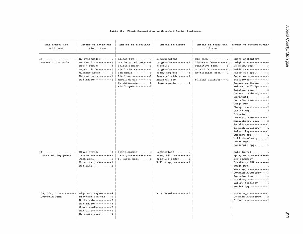
Alpena C
ounty, Michigan
311
Table 10.--Plant Communities on Selected Soils--Continued
________________________________________________________________________________________________________________________________________________ | | | | | Map symbol and | Extent of major and | Extent of seedlings | Extent of shrubs | Extent of ferns and |Extent of ground plants soil name | minor trees | | | clubmoss | | | | | |________________________________________________________________________________________________________________________________________________ | | | | |13---------------------| N. whitecedar-------5 | Balsam fir----------3 | Alternateleaf | Oak fern------------3 | Dwarf enchanters Tawas-Lupton mucks | Balsam fir----------3 | Northern red oak----2 | dogwood------------1 | Cinnamon fern-------2 | nightshade----------4 | Black spruce--------3 | Balsam poplar-------1 | Redosier | Sensitive fern------2 | Dewberry spp.--------3 | Paper birch---------2 | Black cherry--------1 | dogwood------------1 | Shield fern---------2 | Goldthread-----------3 | Quaking aspen-------1 | Red maple-----------1 | Silky dogwood-------1 | Rattlesnake fern----1 | Miterwort spp.-------3 | Balsam poplar-------1 | Black ash-----------1 | Speckled alder------1 | | Sphagnum moss--------3 | Red maple-----------1 | American elm--------1 | American fly | Shining clubmoss----1 | Starflower-----------3 | | N. whitecedar-------1 | honeysuckle--------1 | | Canada mayflower-----3 | | Black spruce--------1 | | | Yellow beadlily------3 | | | | | Bedstraw spp.--------2 | | | | | Canada blueberry-----2 | | | | | Jewelweed------------2 | | | | | Labrador tea---------2 | | | | | Sedge spp.-----------2 | | | | | Sheep laurel---------2 | | | | | Violet spp.----------2 | | | | | Creeping | | | | | wintergreen---------2 | | | | | Huckleberry spp.-----2 | | | | | Baneberry------------1 | | | | | Lowbush blueberry----1 | | | | | Poison ivy-----------1 | | | | | Currant spp.---------1 | | | | | Wild strawberry------1 | | | | | Grass spp.-----------1 | | | | | Horsetail spp.-------1 | | | | |14---------------------| Black spruce--------3 | Black spruce--------3 | Leatherleaf---------5 | | Pale laurel----------5 Dawson-Loxley peats | Tamarack------------3 | Jack pine-----------2 | Swamp birch---------3 | | Sphagnum moss--------4 | Jack pine-----------2 | E. white pine-------1 | Speckled alder------2 | | Bog rosemary---------4 | E. white pine-------1 | | Willow spp.---------1 | | Cranberry SSP.-------4 | Red pine------------1 | | | | Sedge spp.-----------4 | | | | | Moss spp.------------3 | | | | | Lowbush blueberry----3 | | | | | Labrador tea---------3 | | | | | Pitcherplant---------2 | | | | | Yellow beadlily------1 | | | | | Sundew spp.----------1 | | | | |16B, 16C, 16E----------| Bigtooth aspen------4 | | Witchhazel----------3 | | Grass spp.-----------2 Graycalm sand | Northern red oak----2 | | | | Lowbush blueberry----2 | White ash-----------2 | | | | Lichen spp.----------2 | Red maple-----------2 | | | | | Sugar maple---------2 | | | | | Red pine------------1 | | | | | E. white pine-------1 | | | | | | | | |
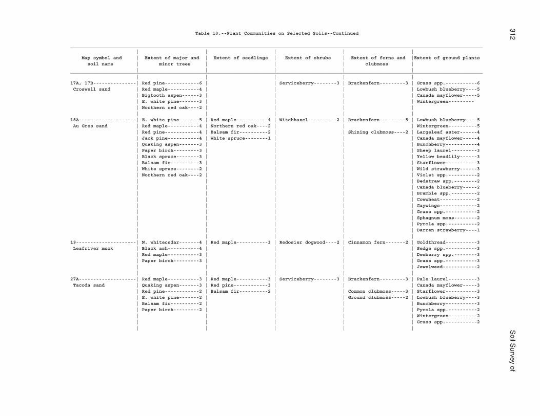
312S
oil Survey of
Table 10.--Plant Communities on Selected Soils--Continued
________________________________________________________________________________________________________________________________________________ | | | | | Map symbol and | Extent of major and | Extent of seedlings | Extent of shrubs | Extent of ferns and |Extent of ground plants soil name | minor trees | | | clubmoss | | | | | |________________________________________________________________________________________________________________________________________________ | | | | |17A, 17B---------------| Red pine------------6 | | Serviceberry--------3 | Brackenfern---------3 | Grass spp.-----------6 Croswell sand | Red maple-----------4 | | | | Lowbush blueberry----5 | Bigtooth aspen------3 | | | | Canada mayflower-----5 | E. white pine-------3 | | | | Wintergreen--------- | Northern red oak----2 | | | | | | | | |18A--------------------| E. white pine-------5 | Red maple-----------4 | Witchhazel----------2 | Brackenfern---------5 | Lowbush blueberry----5 Au Gres sand | Red maple-----------4 | Northern red oak----2 | | | Wintergreen----------5 | Red pine------------4 | Balsam fir----------2 | | Shining clubmoss----2 | Largeleaf aster------4 | Jack pine-----------4 | White spruce--------1 | | | Canada mayflower-----4 | Quaking aspen-------3 | | | | Bunchberry-----------4 | Paper birch---------3 | | | | Sheep laurel---------3 | Black spruce--------3 | | | | Yellow beadlily------3 | Balsam fir----------3 | | | | Starflower-----------3 | White spruce--------2 | | | | Wild strawberry------3 | Northern red oak----2 | | | | Violet spp.----------2 | | | | | Bedstraw spp.--------2 | | | | | Canada blueberry-----2 | | | | | Bramble spp.---------2 | | | | | Cowwheat-------------2 | | | | | Gaywings-------------2 | | | | | Grass spp.-----------2 | | | | | Sphagnum moss--------2 | | | | | Pyrola spp.----------2 | | | | | Barren strawberry----1 | | | | |19---------------------| N. whitecedar-------4 | Red maple-----------3 | Redosier dogwood----2 | Cinnamon fern-------2 | Goldthread-----------3 Leafriver muck | Black ash-----------4 | | | | Sedge spp.-----------3 | Red maple-----------3 | | | | Dewberry spp.--------3 | Paper birch---------3 | | | | Grass spp.-----------3 | | | | | Jewelweed------------2 | | | | |27A--------------------| Red maple-----------3 | Red maple-----------3 | Serviceberry--------3 | Brackenfern---------3 | Pale laurel----------3 Tacoda sand | Quaking aspen-------3 | Red pine------------3 | | | Canada mayflower-----3 | Red pine------------2 | Balsam fir----------2 | | Common clubmoss-----3 | Starflower-----------3 | E. white pine-------2 | | | Ground clubmoss-----2 | Lowbush blueberry----3 | Balsam fir----------2 | | | | Bunchberry-----------3 | Paper birch---------2 | | | | Pyrola spp.----------2 | | | | | Wintergreen----------2 | | | | | Grass spp.-----------2 | | | | |
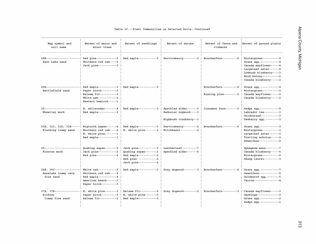
Alpena C
ounty, Michigan
313
Table 10.--Plant Communities on Selected Soils--Continued
________________________________________________________________________________________________________________________________________________ | | | | | Map symbol and | Extent of major and | Extent of seedlings | Extent of shrubs | Extent of ferns and |Extent of ground plants soil name | minor trees | | | clubmoss | | | | | |________________________________________________________________________________________________________________________________________________ | | | | |28B--------------------| Red pine------------5 | Red maple-----------3 | Serviceberry--------3 | Brackenfern---------6 | Wintergreen----------5 East Lake sand | Northern red oak----4 | | | | Grass spp.-----------4 | Jack pine-----------3 | | | | Canada mayflower-----4 | | | | | Largeleaf aster------4 | | | | | Lowbush blueberry----3 | | | | | Wood betony----------2 | | | | | Canada blueberry-----2 | | | | |29A--------------------| Red maple-----------3 | Red maple-----------3 | | Brackenfern---------4 | Grass spp.-----------4 Battlefield sand | Paper birch---------3 | | | | Wintergreen----------2 | Balsam fir----------3 | | | Running pine--------2 | Canada mayflower-----2 | White ash-----------2 | | | | Canada blueberry-----2 | Eastern hemlock-----1 | | | | | | | | |30---------------------| N. whitecedar-------4 | Red maple-----------3 | Speckled alder------3 | Cinnamon fern-------3 | Sedge spp.-----------5 Wheatley muck | Red maple-----------3 | | Redosier dogwood----3 | | Labrador tea---------3 | | | | | Goldthread-----------3 | | | Highbush cranberry--1 | | Dewberry spp.--------3 | | | | |31B, 31C, 31D, 31E-----| Bigtooth aspen------4 | Red maple-----------3 | Serviceberry--------2 | Brackenfern---------6 | Grass spp.-----------3 Klacking loamy sand | Northern red oak----4 | E. white pine-------1 | Witchhazel----------2 | | Wintergreen----------3 | E. white pine-------1 | | | | Largeleaf aster------3 | Red maple-----------1 | | | | Trailing arbutus-----2 | | | | | Sweetfern------------2 | | | | |35---------------------| Quaking aspen-------2 | Jack pine-----------3 | Leatherleaf---------7 | | Sphagnum moss--------7 Kinross muck | Jack pine-----------2 | Quaking aspen-------2 | Speckled alder------4 | | Canada blueberry-----6 | Red pine------------2 | Red maple-----------2 | | | Wintergreen----------6 | | Red pine------------2 | | | Sheep laurel---------3 | | Jack pine-----------2 | | | | | | | |36B, 36C---------------| White oak-----------5 | Red maple-----------3 | Gray dogwood--------3 | Brackenfern---------6 | Grass spp.-----------7 Annalake loamy very | Northern red oak----4 | | | | Sweetfern------------5 fine sand | Red maple-----------4 | | | | Goldenrod spp.-------5 | American beech------3 | | | | Yarrow---------------4 | Paper birch---------3 | | | | | | | | |37A, 37B---------------| E. white pine-------3 | Balsam fir----------4 | Gray dogwood--------2 | Brackenfern---------3 | Canada mayflower-----3 Richter | Paper birch---------3 | E. white pine-------3 | | | Gaywings-------------2 loamy fine sand | Balsam fir----------2 | Red maple-----------3 | | | Grass spp.-----------2 | | | | | Sedge spp.-----------1 | | | | |
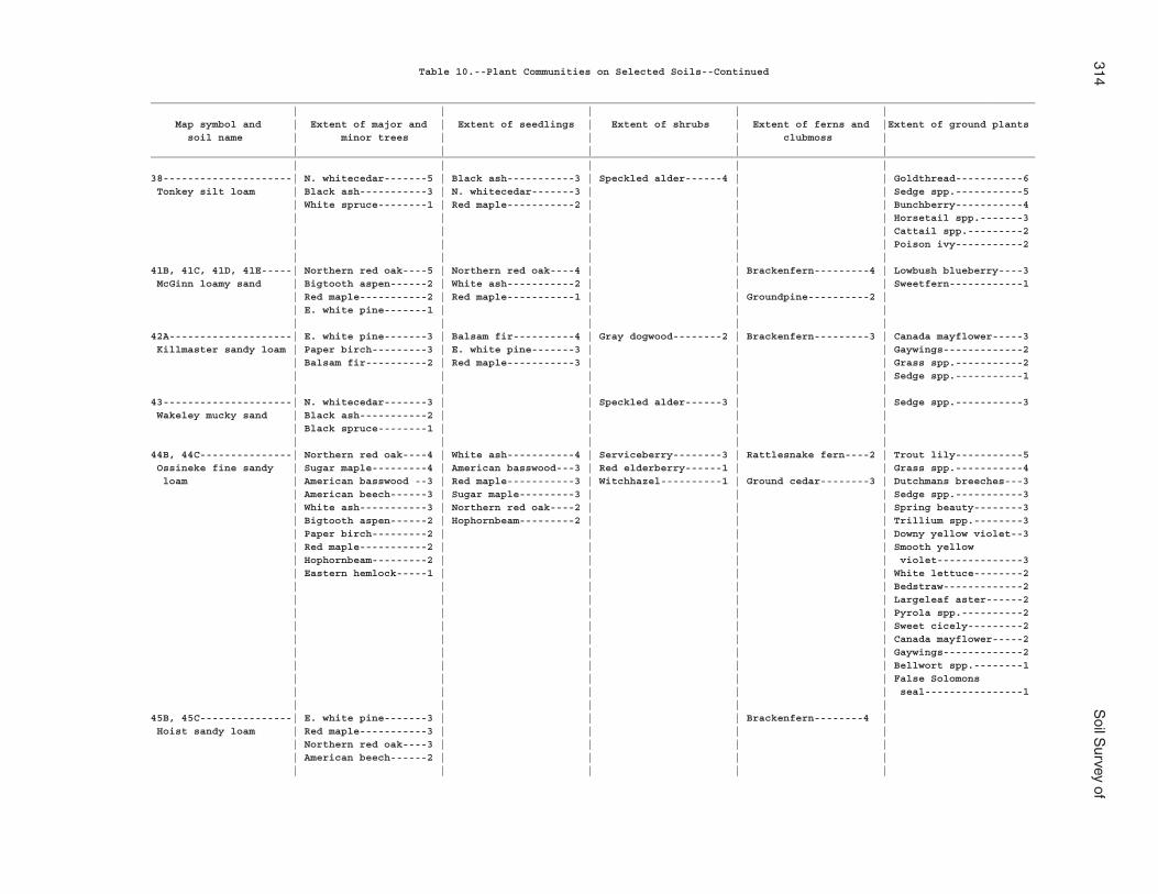
314S
oil Survey of
Table 10.--Plant Communities on Selected Soils--Continued
________________________________________________________________________________________________________________________________________________ | | | | | Map symbol and | Extent of major and | Extent of seedlings | Extent of shrubs | Extent of ferns and |Extent of ground plants soil name | minor trees | | | clubmoss | | | | | |________________________________________________________________________________________________________________________________________________ | | | | |38---------------------| N. whitecedar-------5 | Black ash-----------3 | Speckled alder------4 | | Goldthread-----------6 Tonkey silt loam | Black ash-----------3 | N. whitecedar-------3 | | | Sedge spp.-----------5 | White spruce--------1 | Red maple-----------2 | | | Bunchberry-----------4 | | | | | Horsetail spp.-------3 | | | | | Cattail spp.---------2 | | | | | Poison ivy-----------2 | | | | |41B, 41C, 41D, 41E-----| Northern red oak----5 | Northern red oak----4 | | Brackenfern---------4 | Lowbush blueberry----3 McGinn loamy sand | Bigtooth aspen------2 | White ash-----------2 | | | Sweetfern------------1 | Red maple-----------2 | Red maple-----------1 | | Groundpine----------2 | | E. white pine-------1 | | | | | | | | |42A--------------------| E. white pine-------3 | Balsam fir----------4 | Gray dogwood--------2 | Brackenfern---------3 | Canada mayflower-----3 Killmaster sandy loam | Paper birch---------3 | E. white pine-------3 | | | Gaywings-------------2 | Balsam fir----------2 | Red maple-----------3 | | | Grass spp.-----------2 | | | | | Sedge spp.-----------1 | | | | |43---------------------| N. whitecedar-------3 | | Speckled alder------3 | | Sedge spp.-----------3 Wakeley mucky sand | Black ash-----------2 | | | | | Black spruce--------1 | | | | | | | | |44B, 44C---------------| Northern red oak----4 | White ash-----------4 | Serviceberry--------3 | Rattlesnake fern----2 | Trout lily-----------5 Ossineke fine sandy | Sugar maple---------4 | American basswood---3 | Red elderberry------1 | | Grass spp.-----------4 loam | American basswood --3 | Red maple-----------3 | Witchhazel----------1 | Ground cedar--------3 | Dutchmans breeches---3 | American beech------3 | Sugar maple---------3 | | | Sedge spp.-----------3 | White ash-----------3 | Northern red oak----2 | | | Spring beauty--------3 | Bigtooth aspen------2 | Hophornbeam---------2 | | | Trillium spp.--------3 | Paper birch---------2 | | | | Downy yellow violet--3 | Red maple-----------2 | | | | Smooth yellow | Hophornbeam---------2 | | | | violet--------------3 | Eastern hemlock-----1 | | | | White lettuce--------2 | | | | | Bedstraw-------------2 | | | | | Largeleaf aster------2 | | | | | Pyrola spp.----------2 | | | | | Sweet cicely---------2 | | | | | Canada mayflower-----2 | | | | | Gaywings-------------2 | | | | | Bellwort spp.--------1 | | | | | False Solomons | | | | | seal----------------1 | | | | |45B, 45C---------------| E. white pine-------3 | | | Brackenfern--------4 | Hoist sandy loam | Red maple-----------3 | | | | | Northern red oak----3 | | | | | American beech------2 | | | | | | | | |
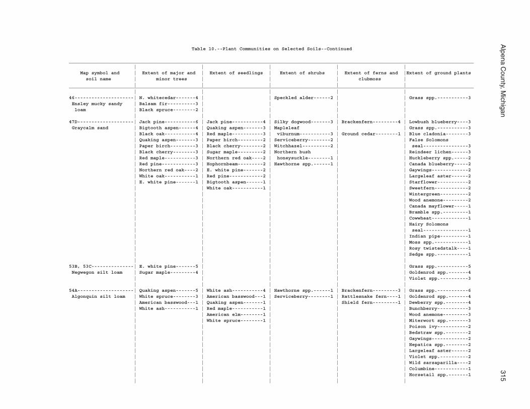
Alpena C
ounty, Michigan
315
Table 10.--Plant Communities on Selected Soils--Continued
________________________________________________________________________________________________________________________________________________ | | | | | Map symbol and | Extent of major and | Extent of seedlings | Extent of shrubs | Extent of ferns and |Extent of ground plants soil name | minor trees | | | clubmoss | | | | | |________________________________________________________________________________________________________________________________________________ | | | | |46---------------------| N. whitecedar-------4 | | Speckled alder------2 | | Grass spp.-----------3 Ensley mucky sandy | Balsam fir----------3 | | | | loam | Black spruce--------2 | | | | | | | | |47D--------------------| Jack pine-----------6 | Jack pine-----------4 | Silky dogwood-------3 | Brackenfern---------4 | Lowbush blueberry----3 Graycalm sand | Bigtooth aspen------4 | Quaking aspen-------3 | Mapleleaf | | Grass spp.-----------3 | Black oak-----------4 | Red maple-----------3 | viburnum-----------3 | Ground cedar--------1 | Blue cladonia--------3 | Quaking aspen-------3 | Paper birch---------2 | Serviceberry--------2 | | False Solomons | Paper birch---------3 | Black cherry--------2 | Witchhazel----------2 | | seal----------------3 | Black cherry--------3 | Sugar maple---------2 | Northern bush | | Reindeer lichen------3 | Red maple-----------3 | Northern red oak----2 | honeysuckle--------1 | | Huckleberry spp.-----2 | Red pine------------3 | Hophornbeam---------2 | Hawthorne spp.------1 | | Canada blueberry-----2 | Northern red oak----2 | E. white pine-------2 | | | Gaywings-------------2 | White oak-----------1 | Red pine------------2 | | | Largeleaf aster------2 | E. white pine-------1 | Bigtooth aspen------1 | | | Starflower-----------2 | | White oak-----------1 | | | Sweetfern------------2 | | | | | Wintergreen----------2 | | | | | Wood anemone---------2 | | | | | Canada mayflower-----1 | | | | | Bramble spp.---------1 | | | | | Cowwheat-------------1 | | | | | Hairy Solomons | | | | | seal----------------1 | | | | | Indian pipe----------1 | | | | | Moss spp.------------1 | | | | | Rosy twistedstalk----1 | | | | | Sedge spp.-----------1 | | | | |53B, 53C---------------| E. white pine-------5 | | | | Grass spp.-----------5 Negwegon silt loam | Sugar maple---------4 | | | | Goldenrod spp.-------4 | | | | | Violet spp.----------3 | | | | |54A--------------------| Quaking aspen-------5 | White ash-----------4 | Hawthorne spp.------1 | Brackenfern---------3 | Grass spp.-----------6 Algonquin silt loam | White spruce--------3 | American basswood---1 | Serviceberry--------1 | Rattlesnake fern----1 | Goldenrod spp.-------4 | American basswood---1 | Quaking aspen-------1 | | Shield fern---------1 | Dewberry spp.--------4 | White ash-----------1 | Red maple-----------1 | | | Bunchberry-----------3 | | American elm--------1 | | | Wood anemone---------3 | | White spruce--------1 | | | Miterwort spp.-------3 | | | | | Poison ivy-----------2 | | | | | Bedstraw spp.--------2 | | | | | Gaywings-------------2 | | | | | Hepatica spp.--------2 | | | | | Largeleaf aster------2 | | | | | Violet spp.----------2 | | | | | Wild sarsaparilla----2 | | | | | Columbine------------1 | | | | | Horsetail spp.-------1 | | | | |
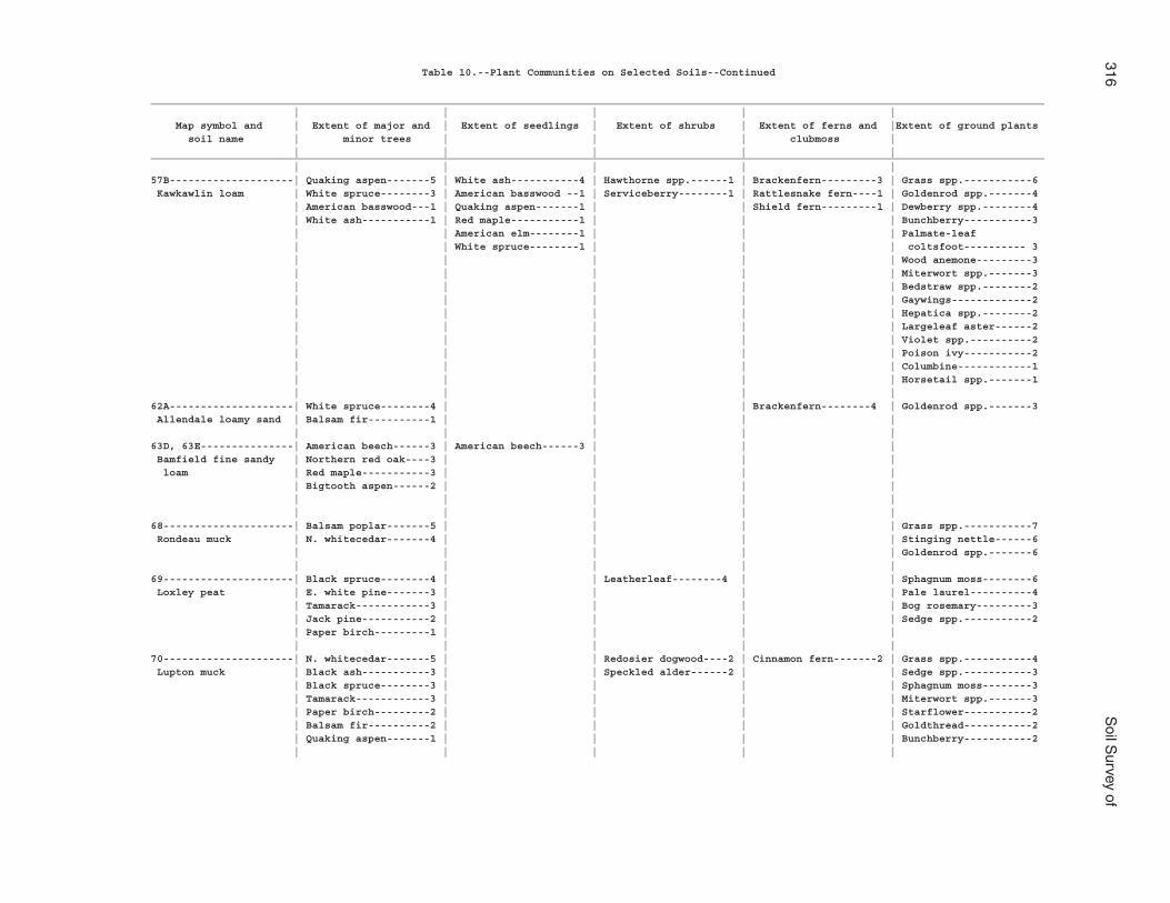
316S
oil Survey of
Table 10.--Plant Communities on Selected Soils--Continued
________________________________________________________________________________________________________________________________________________ | | | | | Map symbol and | Extent of major and | Extent of seedlings | Extent of shrubs | Extent of ferns and |Extent of ground plants soil name | minor trees | | | clubmoss | | | | | |________________________________________________________________________________________________________________________________________________ | | | | |57B--------------------| Quaking aspen-------5 | White ash-----------4 | Hawthorne spp.------1 | Brackenfern---------3 | Grass spp.-----------6 Kawkawlin loam | White spruce--------3 | American basswood --1 | Serviceberry--------1 | Rattlesnake fern----1 | Goldenrod spp.-------4 | American basswood---1 | Quaking aspen-------1 | | Shield fern---------1 | Dewberry spp.--------4 | White ash-----------1 | Red maple-----------1 | | | Bunchberry-----------3 | | American elm--------1 | | | Palmate-leaf | | White spruce--------1 | | | coltsfoot---------- 3 | | | | | Wood anemone---------3 | | | | | Miterwort spp.-------3 | | | | | Bedstraw spp.--------2 | | | | | Gaywings-------------2 | | | | | Hepatica spp.--------2 | | | | | Largeleaf aster------2 | | | | | Violet spp.----------2 | | | | | Poison ivy-----------2 | | | | | Columbine------------1 | | | | | Horsetail spp.-------1 | | | | |62A--------------------| White spruce--------4 | | | Brackenfern--------4 | Goldenrod spp.-------3 Allendale loamy sand | Balsam fir----------1 | | | | | | | | |63D, 63E---------------| American beech------3 | American beech------3 | | | Bamfield fine sandy | Northern red oak----3 | | | | loam | Red maple-----------3 | | | | | Bigtooth aspen------2 | | | | | | | | | | | | | |68---------------------| Balsam poplar-------5 | | | | Grass spp.-----------7 Rondeau muck | N. whitecedar-------4 | | | | Stinging nettle------6 | | | | | Goldenrod spp.-------6 | | | | |69---------------------| Black spruce--------4 | | Leatherleaf--------4 | | Sphagnum moss--------6 Loxley peat | E. white pine-------3 | | | | Pale laurel----------4 | Tamarack------------3 | | | | Bog rosemary---------3 | Jack pine-----------2 | | | | Sedge spp.-----------2 | Paper birch---------1 | | | | | | | | |70---------------------| N. whitecedar-------5 | | Redosier dogwood----2 | Cinnamon fern-------2 | Grass spp.-----------4 Lupton muck | Black ash-----------3 | | Speckled alder------2 | | Sedge spp.-----------3 | Black spruce--------3 | | | | Sphagnum moss--------3 | Tamarack------------3 | | | | Miterwort spp.-------3 | Paper birch---------2 | | | | Starflower-----------2 | Balsam fir----------2 | | | | Goldthread-----------2 | Quaking aspen-------1 | | | | Bunchberry-----------2 | | | | |
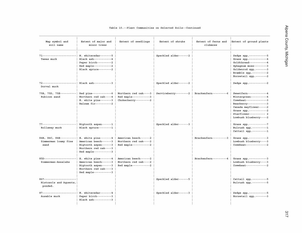
Alpena C
ounty, Michigan
317
Table 10.--Plant Communities on Selected Soils--Continued
________________________________________________________________________________________________________________________________________________ | | | | | Map symbol and | Extent of major and | Extent of seedlings | Extent of shrubs | Extent of ferns and |Extent of ground plants soil name | minor trees | | | clubmoss | | | | | |________________________________________________________________________________________________________________________________________________ | | | | |71---------------------| N. whitecedar-------5 | | Speckled alder------2 | | Sedge spp.-----------5 Tawas muck | Black ash-----------4 | | | | Grass spp.-----------4 | Paper birch---------2 | | | | Goldthread-----------4 | Red maple-----------2 | | | | Sphagnum moss--------3 | Black spruce--------2 | | | | Goldenrod spp.-------3 | | | | | Bramble spp.---------2 | | | | | Horsetail spp.-------2 | | | | |72---------------------| Black ash-----------3 | | Speckled alder------2 | | Sedge spp.-----------2 Dorval muck | | | | | | | | | |75B, 75D, 75E----------| Red pine------------6 | Northern red oak----3 | Serviceberry--------2 | Brackenfern---------6 | Sweetfern------------4 Rubicon sand | Northern red oak----4 | Red maple-----------3 | | | Wintergreen----------4 | E. white pine-------3 | Chokecherry---------2 | | | Cowwheat-------------3 | Balsam fir----------2 | | | | Bearberry------------3 | | | | | Canada mayflower-----2 | | | | | Grass spp.-----------2 | | | | | Starflower---------- 2 | | | | | Lowbush blueberry----2 | | | | |77---------------------| Bigtooth aspen------1 | | Speckled alder------3 | | Grass spp.-----------7 Rollaway muck | Black spruce--------1 | | | | Bulrush spp.---------1 | | | | | Cattail spp.---------1 | | | | |84B, 84C, 84E----------| E. white pine-------4 | American beech------2 | | Brackenfern---------3 | Grass spp.-----------3 Zimmerman loamy fine | American beech------3 | Northern red oak----2 | | | Lowbush blueberry----3 sand | Bigtooth aspen------3 | Red maple-----------2 | | | Cowwheat-------------2 | Northern red oak----3 | | | | | Red maple-----------3 | | | | | | | | |85D--------------------| E. white pine-------4 | American beech------2 | | Brackenfern---------4 | Grass spp.-----------3 Zimmerman-Annalake | American beech------3 | Northern red oak----2 | | | Lowbush blueberry----3 | Bigtooth aspen------3 | Red maple-----------2 | | | Cowwheat-------------2 | Northern red oak----3 | | | | | Red maple-----------3 | | | | | | | | |86*--------------------| | | Speckled alder------5 | | Cattail spp.---------5 Histosols and Aquents,| | | | | Bulrush spp.---------5 ponded. | | | | | | | | | |87---------------------| N. whitecedar-------4 | | Speckled alder------3 | | Sedge spp.-----------5 Ausable muck | Paper birch---------3 | | | | Horsetail spp.-------3 | Black ash-----------3 | | | | | | | | |
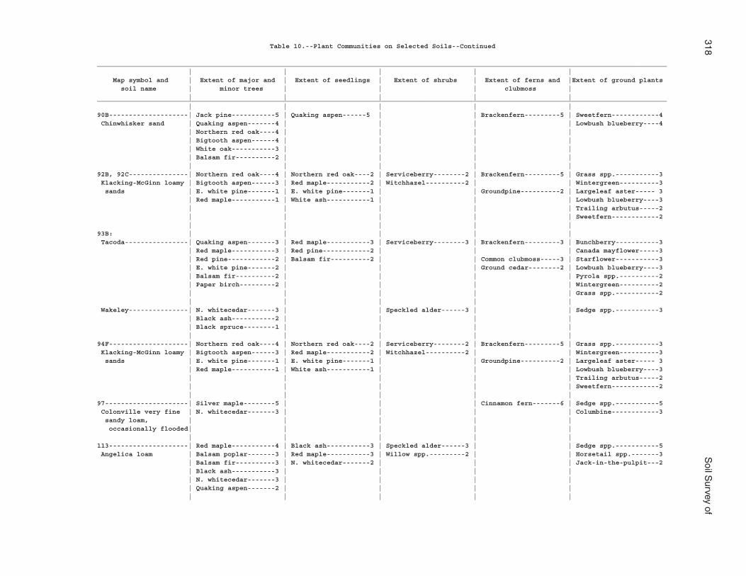
318S
oil Survey of
Table 10.--Plant Communities on Selected Soils--Continued
________________________________________________________________________________________________________________________________________________ | | | | | Map symbol and | Extent of major and | Extent of seedlings | Extent of shrubs | Extent of ferns and |Extent of ground plants soil name | minor trees | | | clubmoss | | | | | |________________________________________________________________________________________________________________________________________________ | | | | |90B--------------------| Jack pine-----------5 | Quaking aspen------5 | | Brackenfern---------5 | Sweetfern------------4 Chinwhisker sand | Quaking aspen-------4 | | | | Lowbush blueberry----4 | Northern red oak----4 | | | | | Bigtooth aspen------4 | | | | | White oak-----------3 | | | | | Balsam fir----------2 | | | | | | | | |92B, 92C---------------| Northern red oak----4 | Northern red oak----2 | Serviceberry--------2 | Brackenfern---------5 | Grass spp.-----------3 Klacking-McGinn loamy | Bigtooth aspen------3 | Red maple-----------2 | Witchhazel----------2 | | Wintergreen----------3 sands | E. white pine-------1 | E. white pine-------1 | | Groundpine----------2 | Largeleaf aster----- 3 | Red maple-----------1 | White ash-----------1 | | | Lowbush blueberry----3 | | | | | Trailing arbutus-----2 | | | | | Sweetfern------------2 | | | | |93B: | | | | | Tacoda----------------| Quaking aspen-------3 | Red maple-----------3 | Serviceberry--------3 | Brackenfern---------3 | Bunchberry-----------3 | Red maple-----------3 | Red pine------------2 | | | Canada mayflower-----3 | Red pine------------2 | Balsam fir----------2 | | Common clubmoss-----3 | Starflower-----------3 | E. white pine-------2 | | | Ground cedar--------2 | Lowbush blueberry----3 | Balsam fir----------2 | | | | Pyrola spp.----------2 | Paper birch---------2 | | | | Wintergreen----------2 | | | | | Grass spp.-----------2 | | | | | Wakeley---------------| N. whitecedar-------3 | | Speckled alder------3 | | Sedge spp.-----------3 | Black ash-----------2 | | | | | Black spruce--------1 | | | | | | | | |94F--------------------| Northern red oak----4 | Northern red oak----2 | Serviceberry--------2 | Brackenfern---------5 | Grass spp.-----------3 Klacking-McGinn loamy | Bigtooth aspen------3 | Red maple-----------2 | Witchhazel----------2 | | Wintergreen----------3 sands | E. white pine-------1 | E. white pine-------1 | | Groundpine----------2 | Largeleaf aster----- 3 | Red maple-----------1 | White ash-----------1 | | | Lowbush blueberry----3 | | | | | Trailing arbutus-----2 | | | | | Sweetfern------------2 | | | | |97---------------------| Silver maple--------5 | | | Cinnamon fern-------6 | Sedge spp.-----------5 Colonville very fine | N. whitecedar-------3 | | | | Columbine------------3 sandy loam, | | | | | occasionally flooded| | | | | | | | | |113--------------------| Red maple-----------4 | Black ash-----------3 | Speckled alder------3 | | Sedge spp.-----------5 Angelica loam | Balsam poplar-------3 | Red maple-----------3 | Willow spp.---------2 | | Horsetail spp.-------3 | Balsam fir----------3 | N. whitecedar-------2 | | | Jack-in-the-pulpit---2 | Black ash-----------3 | | | | | N. whitecedar-------3 | | | | | Quaking aspen-------2 | | | | | | | | |
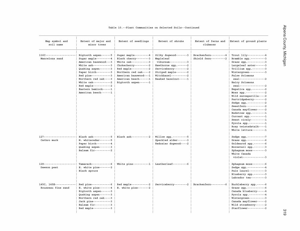
Alpena C
ounty, Michigan
319
Table 10.--Plant Communities on Selected Soils--Continued
________________________________________________________________________________________________________________________________________________ | | | | | Map symbol and | Extent of major and | Extent of seedlings | Extent of shrubs | Extent of ferns and |Extent of ground plants soil name | minor trees | | | clubmoss | | | | | |________________________________________________________________________________________________________________________________________________ | | | | |116C-------------------| Bigtooth aspen------5 | Sugar maple---------4 | Silky dogwood-------3 | Brackenfern---------4 | Trout lily-----------4 Mancelona sand | Sugar maple---------4 | Black cherry--------3 | Mapleleaf | Shield fern---------2 | Bramble spp.---------3 | American basswood---3 | White oak-----------3 | viburnum-----------3 | | Grass spp.-----------3 | White ash-----------3 | Chokecherry---------2 | Hawthorne spp.------2 | | Largeleaf aster------3 | Quaking aspen-------3 | Red maple-----------2 | Serviceberry--------2 | | Trillium spp.--------3 | Paper birch---------3 | Northern red oak----2 | Striped maple-------2 | | Wintergreen----------3 | Red pine------------3 | American basswood---1 | Witchhazel----------2 | | False Solomons | Northern red oak----3 | American beech------1 | Beaked hazelnut-----1 | | seal----------------2 | White oak-----------2 | Bigtooth aspen------1 | | | Hairy Solomons | Red maple-----------2 | | | | seal----------------2 | Eastern hemlock-----1 | | | | Hepatica spp.--------2 | American beech------1 | | | | Moss spp.------------2 | | | | | Wild sarsaparilla----2 | | | | | Partridgeberry-------2 | | | | | Sedge spp.-----------2 | | | | | Sweetfern------------2 | | | | | Canada mayflower-----2 | | | | | Bedstraw spp.--------1 | | | | | Currant spp.---------1 | | | | | Sweet cicely---------1 | | | | | Pyrola spp.----------1 | | | | | Rosy twistedstalk----1 | | | | | White lettuce--------1 | | | | |127--------------------| Black ash-----------5 | Black ash-----------2 | Willow spp.---------5 | | Sedge spp.-----------7 Cathro muck | N. whitecedar-------5 | | Speckled alder------3 | | Grass spp.-----------6 | Paper birch---------4 | | Redosier dogwood----2 | | Goldenrod spp.-------6 | Quaking aspen-------3 | | | | Horsetail spp.-------3 | Balsam fir----------2 | | | | Sphagnum moss--------3 | | | | | White Canada | | | | | violet--------------3 | | | | |128--------------------| Tamarack------------6 | White pine----------1 | Leatherleaf---------6 | | Sphagnum moss--------6 Dawson peat | E. white pine-------2 | | | | Sedge spp.-----------4 | Black spruce | | | | Pale laurel----------3 | | | | | Blueberry spp.-------3 | | | | | Labrador tea---------3 | | | | |145C, 145E-------------| Red pine------------6 | Red maple-----------2 | Serviceberry--------2 | Brackenfern---------6 | Huckleberry spp.-----6 Rousseau fine sand | E. white pine-------4 | E. white pine-------2 | | | Grass spp.-----------6 | Bigtooth aspen------3 | | | | Canada blueberry-----4 | Quaking aspen-------3 | | | | Pyrola spp.----------4 | Northern red oak----3 | | | | Wintergreen----------3 | Jack pine-----------3 | | | | Canada mayflower-----2 | Balsam fir----------3 | | | | Wild strawberry------2 | Red maple-----------3 | | | | Starflower-----------2 | | | | |
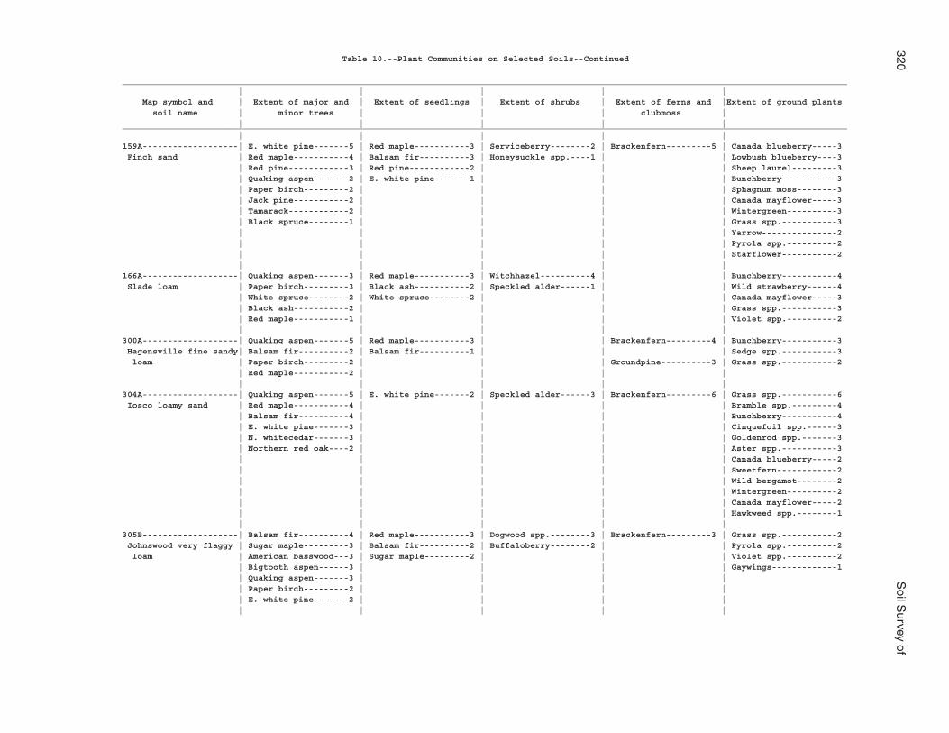
320S
oil Survey of
Table 10.--Plant Communities on Selected Soils--Continued
________________________________________________________________________________________________________________________________________________ | | | | | Map symbol and | Extent of major and | Extent of seedlings | Extent of shrubs | Extent of ferns and |Extent of ground plants soil name | minor trees | | | clubmoss | | | | | |________________________________________________________________________________________________________________________________________________ | | | | |159A-------------------| E. white pine-------5 | Red maple-----------3 | Serviceberry--------2 | Brackenfern---------5 | Canada blueberry-----3 Finch sand | Red maple-----------4 | Balsam fir----------3 | Honeysuckle spp.----1 | | Lowbush blueberry----3 | Red pine------------3 | Red pine------------2 | | | Sheep laurel---------3 | Quaking aspen-------2 | E. white pine-------1 | | | Bunchberry-----------3 | Paper birch---------2 | | | | Sphagnum moss--------3 | Jack pine-----------2 | | | | Canada mayflower-----3 | Tamarack------------2 | | | | Wintergreen----------3 | Black spruce--------1 | | | | Grass spp.-----------3 | | | | | Yarrow---------------2 | | | | | Pyrola spp.----------2 | | | | | Starflower-----------2 | | | | |166A-------------------| Quaking aspen-------3 | Red maple-----------3 | Witchhazel----------4 | | Bunchberry-----------4 Slade loam | Paper birch---------3 | Black ash-----------2 | Speckled alder------1 | | Wild strawberry------4 | White spruce--------2 | White spruce--------2 | | | Canada mayflower-----3 | Black ash-----------2 | | | | Grass spp.-----------3 | Red maple-----------1 | | | | Violet spp.----------2 | | | | |300A-------------------| Quaking aspen-------5 | Red maple-----------3 | | Brackenfern---------4 | Bunchberry-----------3 Hagensville fine sandy| Balsam fir----------2 | Balsam fir----------1 | | | Sedge spp.-----------3 loam | Paper birch---------2 | | | Groundpine----------3 | Grass spp.-----------2 | Red maple-----------2 | | | | | | | | |304A-------------------| Quaking aspen-------5 | E. white pine-------2 | Speckled alder------3 | Brackenfern---------6 | Grass spp.-----------6 Iosco loamy sand | Red maple-----------4 | | | | Bramble spp.---------4 | Balsam fir----------4 | | | | Bunchberry-----------4 | E. white pine-------3 | | | | Cinquefoil spp.------3 | N. whitecedar-------3 | | | | Goldenrod spp.-------3 | Northern red oak----2 | | | | Aster spp.-----------3 | | | | | Canada blueberry-----2 | | | | | Sweetfern------------2 | | | | | Wild bergamot--------2 | | | | | Wintergreen----------2 | | | | | Canada mayflower-----2 | | | | | Hawkweed spp.--------1 | | | | |305B-------------------| Balsam fir----------4 | Red maple-----------3 | Dogwood spp.--------3 | Brackenfern---------3 | Grass spp.-----------2 Johnswood very flaggy | Sugar maple---------3 | Balsam fir----------2 | Buffaloberry--------2 | | Pyrola spp.----------2 loam | American basswood---3 | Sugar maple---------2 | | | Violet spp.----------2 | Bigtooth aspen------3 | | | | Gaywings-------------1 | Quaking aspen-------3 | | | | | Paper birch---------2 | | | | | E. white pine-------2 | | | | | | | | |
Alpena C
ounty, Michigan
321
Table 10.--Plant Communities on Selected Soils--Continued
________________________________________________________________________________________________________________________________________________ | | | | | Map symbol and | Extent of major and | Extent of seedlings | Extent of shrubs | Extent of ferns and |Extent of ground plants soil name | minor trees | | | clubmoss | | | | | |________________________________________________________________________________________________________________________________________________ | | | | |308B, 308C, 308D-------| Sugar maple---------4 | Red maple-----------3 | Dogwood spp.--------2 | Brackenfern---------4 | Canada mayflower-----4 Krakow flaggy fine | Northern red oak----3 | White ash-----------3 | Witchhazel----------2 | Ladyfern------------2 | Grass spp.-----------3 sandy loam | Paper birch---------3 | Northern red oak----1 | Buffaloberry--------1 | | Violet spp.----------3 | White ash-----------3 | | Northern arrowwood--1 | | Solomons seal spp.---2 | American basswood---3 | | | | Baneberry spp.-------1 | American beech------3 | | | | | Balsam fir----------2 | | | | | | | | |316--------------------| Quaking aspen-------5 | Red maple-----------2 | Speckled alder------3 | Brackenfern---------3 | Sedge spp.-----------4 Ruse loam | N. whitecedar-------4 | Balsam fir----------2 | Redosier dogwood---3 | | Wintergreen----------1 | Black ash-----------3 | | | | | Paper birch---------2 | | | | | Balsam fir----------2 | | | | | N. whitecedar-------2 | | | | | | | | |350E-------------------| Quaking aspen-------5 | Sugar maple---------3 | Striped maple-------4 | Brackenfern---------4 | Largeleaf aster------4 Blue Lake sand | Sugar maple---------4 | Red maple-----------3 | Serviceberry spp.---2 | | Wintergreen----------4 | Paper birch---------4 | Hophornbeam---------3 | Rose spp.-----------2 | | Canada blueberry-----3 | American basswood---3 | White ash-----------2 | | | Lowbush blueberry----3 | American beech------3 | Northern red oak----2 | | | Grass spp.-----------3 | Red maple-----------3 | American beech------1 | | | Bramble spp.---------3 | Hophornbeam---------3 | Quaking aspen-------1 | | | Sedge spp.-----------3 | Northern red oak----2 | Paper birch---------1 | | | Canada mayflower-----3 | White ash-----------1 | Black cherry--------1 | | | Blue cohosh----------2 | Yellow birch--------1 | | | | Bearberry------------2 | | | | | Bedstraw spp.--------2 | | | | | Pyrola spp.----------2 | | | | | Wild strawberry------2 | | | | | Prince's pine--------1 | | | | | False Solomons | | | | | seal----------------1 | | | | | Violet spp.----------1 | | | | |
322S
oil Survey of
Table 10.--Plant Communities on Selected Soils--Continued
________________________________________________________________________________________________________________________________________________ | | | | | Map symbol and | Extent of major and | Extent of seedlings | Extent of shrubs | Extent of ferns and |Extent of ground plants soil name | minor trees | | | clubmoss | | | | | |________________________________________________________________________________________________________________________________________________ | | | | |359C: | | | | | Algonquin-------------| Quaking aspen-------5 | White ash-----------4 | Hawthorne spp.------1 | Brackenfern---------3 | Grass spp.-----------6 | White spruce--------3 | American basswood---1 | Serviceberry--------1 | Rattlesnake fern----1 | Goldenrod spp.-------4 | American basswood---1 | Quaking aspen-------1 | | Shield fern---------1 | Dewberry spp.--------4 | White ash-----------1 | Red maple-----------1 | | | Bunchberry-----------3 | | American elm--------1 | | | Wood anemone---------3 | | White spruce--------1 | | | Miterwort spp.-------3 | | | | | Poison ivy-----------2 | | | | | Bedstraw spp.--------2 | | | | | Gaywings-------------2 | | | | | Hepatica spp.--------2 | | | | | Largeleaf aster------2 | | | | | Violet spp.----------2 | | | | | Wild sarsaparilla----2 | | | | | Columbine------------1 | | | | | Horsetail spp.-------1 | | | | | Negwegon--------------| E. white pine-------5 | | | | Grass spp.-----------5 | Sugar maple---------4 | | | | Goldenrod spp.-------4 | | | | | Violet spp.----------3 | | | | | Dorval----------------| Black ash-----------5 | Black ash-----------2 | Willow spp.---------5 | | Sedge spp.-----------7 | N. whitecedar-------5 | | Speckled alder------3 | | Grass spp.-----------6 | Paper birch---------4 | | Redosier dogwood----2 | | Goldenrod spp.-------6 | Quaking aspen-------3 | | | | Horsetail spp.-------3 | Balsam fir----------2 | | | | Sphagnum moss--------3 | | | | | White Canada | | | | | violet--------------3 | | | | |361B: | | | | | Algonquin-------------| Quaking aspen-------5 | White ash-----------4 | Hawthorne spp.------1 | Brackenfern---------3 | Grass spp.-----------6 | White spruce--------3 | American basswood---1 | Serviceberry--------1 | Rattlesnake fern----1 | Goldenrod spp.-------4 | American basswood---1 | Quaking aspen-------1 | | Shield fern---------1 | Dewberry spp.--------4 | White ash-----------1 | Red maple-----------1 | | | Bunchberry-----------3 | | American elm--------1 | | | Wood anemone---------3 | | White spruce--------1 | | | Miterwort spp.-------3 | | | | | Poison ivy-----------2 | | | | | Bedstraw spp.--------2 | | | | | Gaywings-------------2 | | | | | Hepatica spp.--------2 | | | | | Largeleaf aster------2 | | | | | Violet spp.----------2 | | | | | Wild sarsaparilla----2 | | | | | Columbine------------1 | | | | | Horsetail spp.-------1 | | | | |
Alpena C
ounty, Michigan
323
Table 10.--Plant Communities on Selected Soils--Continued
________________________________________________________________________________________________________________________________________________ | | | | | Map symbol and | Extent of major and | Extent of seedlings | Extent of shrubs | Extent of ferns and |Extent of ground plants soil name | minor trees | | | clubmoss | | | | | |________________________________________________________________________________________________________________________________________________ | | | | |361B: | | | | | Dorval----------------| Black ash-----------5 | Black ash-----------2 | Willow spp.---------5 | | Sedge spp.-----------7 | N. whitecedar-------5 | | Speckled alder------3 | | Grass spp.-----------6 | Paper birch---------4 | | Redosier dogwood----2 | | Goldenrod spp.-------6 | Quaking aspen-------3 | | | | Horsetail spp.-------3 | Balsam fir----------2 | | | | Sphagnum moss--------3 | | | | | White Canada | | | | | violet--------------3 | | | | | Blue Lake-------------| Quaking aspen-------5 | Sugar maple---------3 | Striped maple-------4 | Brackenfern---------4 | Largeleaf aster------4 | Sugar maple---------4 | Red maple-----------3 | Serviceberry spp.---2 | | Wintergreen----------4 | Paper birch---------4 | Hophornbeam---------3 | Rose spp.-----------2 | | Canada blueberry-----3 | American basswood---3 | White ash-----------2 | | | Lowbush blueberry----3 | American beech------3 | Northern red oak----2 | | | Grass spp.-----------3 | Red maple-----------3 | American beech------1 | | | Bramble spp.---------3 | Hophornbeam---------3 | Quaking aspen-------1 | | | Sedge spp.-----------3 | Northern red oak----2 | Paper birch---------1 | | | Canada mayflower-----3 | White ash-----------1 | Black cherry--------1 | | | Blue cohosh----------2 | Yellow birch--------1 | | | | Bearberry------------2 | | | | | Bedstraw spp.--------2 | | | | | Pyrola spp.----------2 | | | | | Wild strawberry------2 | | | | | Prince's pine--------1 | | | | | False Solomons | | | | | seal----------------1 | | | | | Violet spp.----------1 | | | | |
324S
oil Survey of
Table 10.--Plant Communities on Selected Soils--Continued
________________________________________________________________________________________________________________________________________________ | | | | | Map symbol and | Extent of major and | Extent of seedlings | Extent of shrubs | Extent of ferns and |Extent of ground plants soil name | minor trees | | | clubmoss | | | | | |________________________________________________________________________________________________________________________________________________ | | | | |362D, 362E-------------| Sugar maple---------4 | Sugar maple---------4 | Beaked hazelnut-----3 | Brackenfern---------4 | Trout lily-----------4 Millersburg loamy sand| American basswood---3 | American beech------3 | Mapleleaf | Ladyfern------------1 | Squirrel corn--------3 | American beech------3 | White ash-----------3 | viburnum-----------2 | Long beechfern------1 | Lowbush blueberry----3 | Bigtooth aspen------3 | Red maple-----------3 | Serviceberry--------2 | Rattlesnake fern----1 | Grass spp.-----------3 | Northern red oak----3 | American basswood 2 | Striped maple-------2 | Shield fern---------1 | Dutchmans | Jack pine-----------3 | Bigtooth aspen------2 | Witchhazel----------2 | | breeches------------3 | Quaking aspen-------2 | Hophornbeam---------2 | Sand cherry spp.----2 | Running pine--------1 | Sweet cicely---------3 | Paper birch---------2 | Northern red oak----2 | Red elderberry------1 | Shining clubmoss----1 | Wood anemone---------3 | Red maple-----------2 | E. white pine-------2 | Hawthorne spp.------1 | Staghorn clubmoss---1 | Canada mayflower-----3 | White oak-----------2 | Quaking aspen-------1 | American fly | | Wood betony----------2 | White ash-----------2 | Paper birch---------1 | honeysuckle--------1 | | White lettuce--------2 | Hophornbeam---------1 | Black cherry--------1 | Silky dogwood-------1 | | Bedstraw spp.--------2 | E. white pine-------1 | Chokecherry---------1 | | | Canada blueberry-----2 | Red pine------------1 | American elm--------1 | | | Bramble spp.---------2 | | Red pine------------1 | | | Currant spp.---------2 | | | | | Jack-in-the-pulpit 2 | | | | | Largeleaf aster------2 | | | | | Canada white violet--2 | | | | | Downy yellow violet--2 | | | | | Moss spp.------------2 | | | | | Huckleberry spp.-----2 | | | | | Partridgeberry-------2 | | | | | Pyrola spp.----------2 | | | | | Sedge spp.-----------2 | | | | | Starflower-----------2 | | | | | Trailing arbutus-----2 | | | | | Violet spp.----------2 | | | | | Trillium spp.--------2 | | | | | Wild sarsaparilla----2 | | | | | Wintergreen----------2 | | | | | Prince's pine--------1 | | | | | Baneberry------------1 | | | | | Black snakeroot------1 | | | | | False Solomons | | | | | seal----------------1 | | | | | Hairy Solomons | | | | | seal----------------1 | | | | | Hawkweed spp.--------1 | | | | | Hepatica spp.--------1 | | | | | Indian cucumber | | | | | root----------------1 | | | | | Rosy twistedstalk----1 | | | | | Wild strawberry------1 | | | | |
Alpena C
ounty, Michigan
325
Table 10.--Plant Communities on Selected Soils--Continued
________________________________________________________________________________________________________________________________________________ | | | | | Map symbol and | Extent of major and | Extent of seedlings | Extent of shrubs | Extent of ferns and |Extent of ground plants soil name | minor trees | | | clubmoss | | | | | |________________________________________________________________________________________________________________________________________________ | | | | |368A: | | | | | Au Gres---------------| E. white pine-------5 | Red maple-----------4 | Witchhazel----------2 | Brackenfern---------5 | Lowbush blueberry----5 | Red maple-----------4 | Northern red oak----2 | | | Wintergreen----------5 | Red pine------------4 | Balsam fir----------2 | | Shining clubmoss----2 | Largeleaf aster------4 | Jack pine-----------4 | White spruce--------1 | | | Canada mayflower-----4 | Quaking aspen-------3 | | | | Bunchberry-----------4 | Paper birch---------3 | | | | Sheep laurel---------3 | Black spruce--------3 | | | | Yellow beadlily------3 | Balsam fir----------3 | | | | Starflower-----------3 | White spruce--------2 | | | | Wild strawberry------3 | Northern red oak----2 | | | | Violet spp.----------2 | | | | | Bedstraw spp.--------2 | | | | | Canada blueberry-----2 | | | | | Bramble spp.---------2 | | | | | Cowwheat-------------2 | | | | | Gaywings-------------2 | | | | | Grass spp.-----------2 | | | | | Sphagnum moss--------2 | | | | | Pyrola spp.----------2 | | | | | Barren strawberry----1 | | | | | Deford----------------| Black ash-----------5 | Black ash-----------3 | Speckled alder------6 | Cinnamon fern-------5 | Sedge spp.-----------5 | Red maple-----------4 | Balsam fir----------2 | Redosier dogwood----3 | Royal fern----------3 | Goldthread-----------5 | N. whitecedar-------4 | | Highbush | Brackenfern---------2 | Bunchberry-----------4 | Tamarack------------2 | | cranberry----------1 | Ladyfern------------2 | Poison ivy-----------3 | Black spruce--------2 | | | Sensitive fern------1 | Bramble spp.---------3 | Paper birch---------2 | | | | Dewberry spp.--------3 | | | | | Sweet coltsfoot------3 | | | | | Goldenrod spp.-------3 | | | | | Wild strawberry------2 | | | | | Bedstraw spp.--------2 | | | | | Buttercup spp.-------2 | | | | | Grass spp.-----------2 | | | | | Jewelweed------------2 | | | | | Marsh marigold-------2 | | | | | Mint spp.------------2 | | | | | Cattail spp.---------2 | | | | | Blue flag------------2 | | | | | Horsetail spp.-------2 | | | | |
326S
oil Survey of
Table 10.--Plant Communities on Selected Soils--Continued
________________________________________________________________________________________________________________________________________________ | | | | | Map symbol and | Extent of major and | Extent of seedlings | Extent of shrubs | Extent of ferns and |Extent of ground plants soil name | minor trees | | | clubmoss | | | | | |________________________________________________________________________________________________________________________________________________ | | | | |369--------------------| Black ash-----------5 | Black ash-----------3 | Speckled alder------6 | Cinnamon fern-------5 | Sedge spp.-----------5 Deford muck | Red maple-----------4 | Balsam fir----------2 | Redosier dogwood----3 | Royal fern----------3 | Goldthread-----------5 | N. whitecedar-------4 | | Highbush | Brackenfern---------2 | Bunchberry-----------4 | Tamarack------------2 | | cranberry----------1 | Ladyfern------------2 | Poison ivy-----------3 | Black spruce--------2 | | | Sensitive fern------1 | Bramble spp.---------3 | Paper birch---------2 | | | | Dewberry spp.--------3 | | | | | Sweet coltsfoot------3 | | | | | Goldenrod spp.-------3 | | | | | Wild strawberry------2 | | | | | Bedstraw spp.--------2 | | | | | Buttercup spp.-------2 | | | | | Grass spp.-----------2 | | | | | Jewelweed------------2 | | | | | Marsh marigold-------2 | | | | | Mint spp.------------2 | | | | | Cattail spp.---------2 | | | | | Blue flag------------2 | | | | | Horsetail spp.-------2 | | | | |371--------------------| Red maple-----------4 | Black ash-----------3 | Virginia creeper----4 | Shield fern---------2 | Dewberry spp.--------4 Springport silt loam | N. whitecedar-------4 | White ash-----------2 | Alternateleaf | Ladyfern------------1 | Poison ivy-----------4 | Black ash-----------3 | Quaking aspen-------2 | dogwood------------2 | | Virginia creeper-----4 | Quaking aspen-------3 | American elm--------1 | American fly | | Currant spp.---------3 | Balsam poplar-------3 | Balsam fir----------1 | honeysuckle--------2 | | Wild sarsaparilla----3 | American basswood---2 | N. whitecedar-------1 | | | Horsetail spp.-------3 | Paper birch---------2 | | | | Jewelweed------------3 | American elm--------2 | | | | Sedge spp.-----------3 | Chokecherry---------1 | | | | Bedstraw spp.--------3 | White spruce--------1 | | | | Goldenrod spp.-------2 | | | | | Grass spp.-----------2 | | | | | Jack-in-the-pulpit --2 | | | | | Violet spp.----------2 | | | | | White lettuce--------1 | | | | | Baneberry------------1 | | | | | Black snakeroot------1 | | | | | False Solomons | | | | | seal----------------1 | | | | | Avens spp.-----------1 | | | | |
Alpena C
ounty, Michigan
327
Table 10.--Plant Communities on Selected Soils--Continued
________________________________________________________________________________________________________________________________________________ | | | | | Map symbol and | Extent of major and | Extent of seedlings | Extent of shrubs | Extent of ferns and |Extent of ground plants soil name | minor trees | | | clubmoss | | | | | |________________________________________________________________________________________________________________________________________________ | | | | |373B-------------------| Jack pine-----------5 | | | Brackenfern---------1 | Bearberry------------4 Grayling sand, very | Bigtooth aspen------4 | | | | Lowbush blueberry----4 deep water table | Black oak-----------3 | | | Ground cedar--------3 | Huckleberry spp.-----4 | Balsam fir----------2 | | | | Wintergreen----------3 | | | | | Blue cladonia--------3 | | | | | Canada blueberry-----3 | | | | | Partridgeberry-------3 | | | | | Reindeer lichen------3 | | | | | Grass spp.-----------3 | | | | | Canada mayflower-----2 | | | | | Cowwheat-------------2 | | | | | Sweetfern------------2 | | | | | | | | | |374--------------------| Black ash-----------4 | Silver maple--------4 | Common prickly | Ostrich fern--------4 | Grass spp.-----------5 Thunderbay very fine | Silver maple--------4 | | ash----------------3 | New York fern-------4 | Goldenrod spp.-------5 sandy loam | | | | Sensitive fern------3 | Stinging nettle------4 | | | | | Sedge spp.-----------4 | | | | | Smooth yellow | | | | | violet--------------4 | | | | | Blue flag------------4 | | | | | Meadow rue spp.------2 | | | | |392--------------------| N. whitecedar-------4 | | Speckled alder------3 | | Sedge spp.-----------5 Caffey mucky sand | Paper birch---------3 | | | | Horsetail spp.-------3 | Black ash-----------3 | | | | | | | | |393B, 393C-------------| Northern red oak----5 | Red maple-----------3 | Beaked hazelnut-----3 | Brackenfern---------4 | Grass spp.-----------4 Morganlake loamy sand | American beech------4 | American beech------2 | Gray dogwood--------3 | | Canada blueberry-----3 | Paper birch---------3 | Quaking aspen-------2 | Serviceberry--------1 | | Starflower-----------3 | Red maple-----------3 | Sugar maple---------2 | | | Sweetfern------------3 | Sugar maple---------3 | | | | Gaywings-------------3 | Balsam fir----------3 | | | | Wintergreen----------3 | E. white pine-------3 | | | | Lowbush blueberry----2 | Quaking aspen-------2 | | | | Wood betony----------2 | White ash-----------2 | | | | Largeleaf aster------2 | Bigtooth aspen------2 | | | | Bramble spp.---------2 | Red pine------------1 | | | | Canada mayflower-----2 | | | | | St. Johnswort spp.---1 | | | | |
328S
oil Survey of
Table 10.--Plant Communities on Selected Soils--Continued
________________________________________________________________________________________________________________________________________________ | | | | | Map symbol and | Extent of major and | Extent of seedlings | Extent of shrubs | Extent of ferns and |Extent of ground plants soil name | minor trees | | | clubmoss | | | | | |________________________________________________________________________________________________________________________________________________ | | | | |396F: | | | | | Proper----------------| Northern red oak----4 | Red maple-----------3 | | Brackenfern---------6 | Wintergreen----------5 | E. white pine-------4 | | | | Sheep laurel---------4 | Red pine------------4 | | | | Lowbush blueberry----3 | Bigtooth aspen------3 | | | | | Quaking aspen-------3 | | | | | Paper birch---------3 | | | | | Jack pine-----------3 | | | | | Red maple-----------3 | | | | | | | | | Deford----------------| Black ash-----------5 | Black ash-----------3 | Speckled alder------6 | Cinnamon fern-------5 | Sedge spp.-----------5 | Red maple-----------4 | Balsam fir----------2 | Redosier dogwood----3 | Royal fern----------3 | Goldthread-----------5 | N. whitecedar-------4 | | Highbush | Brackenfern---------2 | Bunchberry-----------4 | Tamarack------------2 | | cranberry----------1 | Ladyfern------------2 | Poison ivy-----------3 | Black spruce--------2 | | | Sensitive fern------1 | Bramble spp.---------3 | | | | | Dewberry spp.--------3 | | | | | Sweet coltsfoot------3 | | | | | Goldenrod spp.-------3 | | | | | Wild strawberry------2 | | | | | Bedstraw spp.--------2 | | | | | Buttercup spp.-------2 | | | | | Grass spp.-----------2 | | | | | Jewelweed------------2 | | | | | Marsh marigold-------2 | | | | | Mint spp.------------2 | | | | | Cattail spp.---------2 | | | | | Blue flag------------2 | | | | | Rousseau--------------| Red pine------------6 | Red maple-----------2 | Serviceberry--------2 | Brackenfern---------6 | Huckleberry spp.-----6 | E. white pine-------4 | E. white pine-------2 | | | Grass spp.-----------6 | Bigtooth aspen------3 | | | | Canada blueberry-----4 | Quaking aspen-------3 | | | | Pyrola spp.----------4 | Northern red oak----3 | | | | Starflower-----------2 | Jack pine-----------3 | | | | Canada mayflower-----2 | Balsam fir----------3 | | | | Wild strawberry------2 | Red maple-----------3 | | | | | | | | |397--------------------| E. white pine-------3 | | Leatherleaf---------7 | | Sphagnum moss--------7 Spot peat | Red pine------------3 | | | | Wintergreen----------4 | Jack pine-----------3 | | | | Lowbush blueberry----3 | Black spruce--------2 | | | | Blue cladonia--------3 | | | | |

Alpena C
ounty, Michigan
329
Table 10.--Plant Communities on Selected Soils--Continued
________________________________________________________________________________________________________________________________________________ | | | | | Map symbol and | Extent of major and | Extent of seedlings | Extent of shrubs | Extent of ferns and |Extent of ground plants soil name | minor trees | | | clubmoss | | | | | |________________________________________________________________________________________________________________________________________________ | | | | |414B-------------------| Balsam fir----------4 | Balsam fir----------2 | Buffaloberry--------3 | | Poison ivy-----------3- Namur channery silt | White spruce--------3 | | Mapleleaf viburnum 3 | | Largeleaf aster------3 loam | N. whitecedar-------3 | | Juniper spp.--------3 | | Canada mayflower-----3 | Bigtooth aspen------3 | | Northern arrowwood--2 | | Trout lily---------- 3 | Quaking aspen-------3 | | Dogwood spp.--------2 | | Barren strawberry----2 | Paper birch---------3 | | Gray dogwood--------2 | | Hepatica spp.--------2 | Sugar maple---------3 | | Hawthorne spp.------1 | | Rosy twistedstalk----2 | American basswood---2 | | Shrubby cinquefoil--1 | | Trillium spp.--------2 | | | | |415A-------------------| N. whitecedar-------3 | | Redosier dogwood----2 | | Grass spp.-----------7 Potagannissing silt | E. white pine-------2 | | | | Wild carrot----------4 loam | Paper birch---------2 | | | | Sedge spp.-----------2 | | | | | Dwarf lake iris------2 | | | | | | | | | |416B-------------------| E. white pine-------5 | | | | Grass spp.-----------5 Negwegon silt loam, | Sugar maple---------4 | | | | Goldenrod spp.-------4 till substratum | | | | | Violet spp.----------3 | | | | |417B, 417C-------------| Quaking aspen-------4 | Balsam fir----------3 | Juniper-------------3 | Brackenfern---------2 | Gaywings-------------3 Alpena gravelly sandy | N. whitecedar-------4 | White ash-----------2 | Serviceberry--------2 | | Grass spp.-----------3 loam | E. white pine-------3 | | | | Canada mayflower-----2 | Red pine------------3 | | | | Wild sarsaparilla----2 | Balsam fir----------3 | | | | Twinflower-----------2 | Eastern hemlock-----3 | | | | Violet spp.----------2 | Northern red oak----2 | | | | Dwarf lake iris------1 | Sugar maple---------2 | | | | | | | | |418E-------------------| Bigtooth aspen------4 | White ash-----------4 | Buffaloberry--------3 | Brackenfern--------6 | Bramble spp.---------3 Alpena gravelly sandy | Paper birch---------3 | Black cherry--------3 | Striped maple-------3 | | Grass spp.-----------3 loam, esker | Black cherry--------3 | Red maple-----------3 | Mapleleaf viburnum--2 | | Wild strawberry------3 | Balsam fir----------3 | Paper birch---------2 | | | Columbine------------2 | | | | |419--------------------| N. whitecedar-------6 | N. whitecedar-------2 | Speckled alder------4 | Sensitive fern------2 | Horsetail spp.-------7 Chippeny muck | Tamarack------------3 | | Alternateleaf | Oak fern------------2 | Sedge spp.-----------5 | Paper birch---------3 | | dogwood------------3 | | Grass spp.-----------3 | Black ash-----------3 | | Dogwood spp.--------2 | | Sphagnum moss--------3 | | | | |
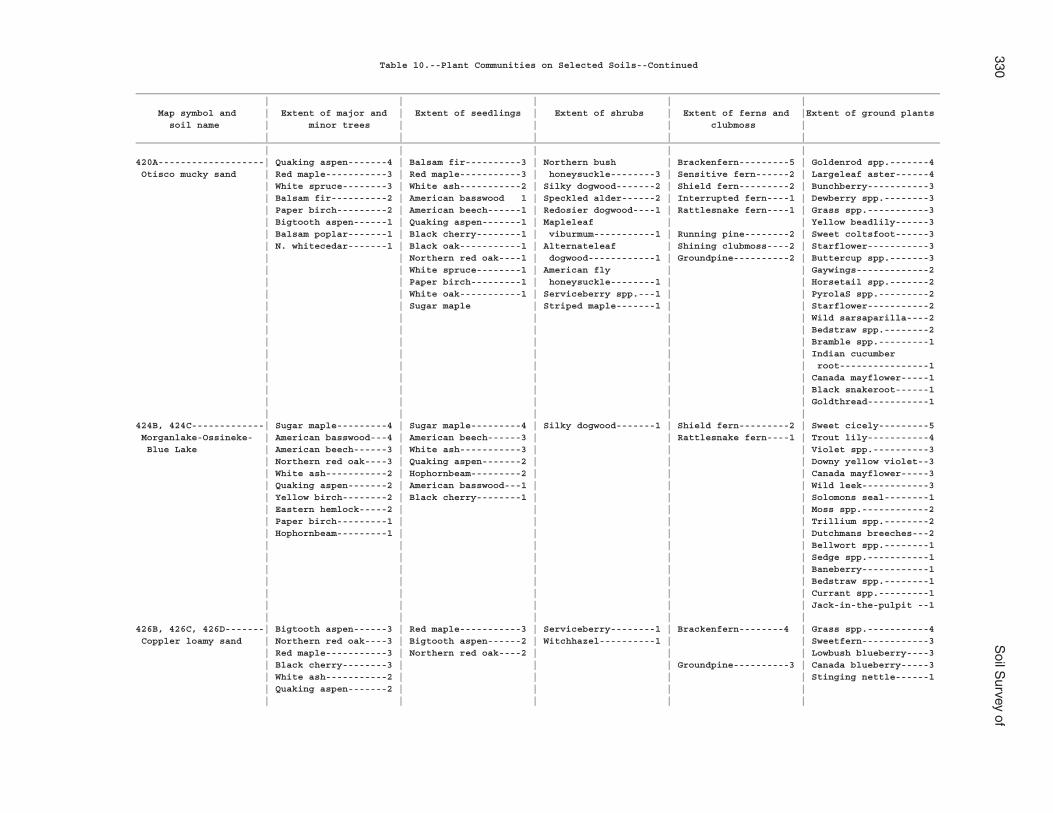
330S
oil Survey of
Table 10.--Plant Communities on Selected Soils--Continued
________________________________________________________________________________________________________________________________________________ | | | | | Map symbol and | Extent of major and | Extent of seedlings | Extent of shrubs | Extent of ferns and |Extent of ground plants soil name | minor trees | | | clubmoss | | | | | |________________________________________________________________________________________________________________________________________________ | | | | |420A-------------------| Quaking aspen-------4 | Balsam fir----------3 | Northern bush | Brackenfern---------5 | Goldenrod spp.-------4 Otisco mucky sand | Red maple-----------3 | Red maple-----------3 | honeysuckle--------3 | Sensitive fern------2 | Largeleaf aster------4 | White spruce--------3 | White ash-----------2 | Silky dogwood-------2 | Shield fern---------2 | Bunchberry-----------3 | Balsam fir----------2 | American basswood 1 | Speckled alder------2 | Interrupted fern----1 | Dewberry spp.--------3 | Paper birch---------2 | American beech------1 | Redosier dogwood----1 | Rattlesnake fern----1 | Grass spp.-----------3 | Bigtooth aspen------1 | Quaking aspen-------1 | Mapleleaf | | Yellow beadlily------3 | Balsam poplar-------1 | Black cherry--------1 | viburmum-----------1 | Running pine--------2 | Sweet coltsfoot------3 | N. whitecedar-------1 | Black oak-----------1 | Alternateleaf | Shining clubmoss----2 | Starflower-----------3 | | Northern red oak----1 | dogwood------------1 | Groundpine----------2 | Buttercup spp.-------3 | | White spruce--------1 | American fly | | Gaywings-------------2 | | Paper birch---------1 | honeysuckle--------1 | | Horsetail spp.-------2 | | White oak-----------1 | Serviceberry spp.---1 | | PyrolaS spp.---------2 | | Sugar maple | Striped maple-------1 | | Starflower-----------2 | | | | | Wild sarsaparilla----2 | | | | | Bedstraw spp.--------2 | | | | | Bramble spp.---------1 | | | | | Indian cucumber | | | | | root----------------1 | | | | | Canada mayflower-----1 | | | | | Black snakeroot------1 | | | | | Goldthread-----------1 | | | | |424B, 424C-------------| Sugar maple---------4 | Sugar maple---------4 | Silky dogwood-------1 | Shield fern---------2 | Sweet cicely---------5 Morganlake-Ossineke- | American basswood---4 | American beech------3 | | Rattlesnake fern----1 | Trout lily-----------4 Blue Lake | American beech------3 | White ash-----------3 | | | Violet spp.----------3 | Northern red oak----3 | Quaking aspen-------2 | | | Downy yellow violet--3 | White ash-----------2 | Hophornbeam---------2 | | | Canada mayflower-----3 | Quaking aspen-------2 | American basswood---1 | | | Wild leek------------3 | Yellow birch--------2 | Black cherry--------1 | | | Solomons seal--------1 | Eastern hemlock-----2 | | | | Moss spp.------------2 | Paper birch---------1 | | | | Trillium spp.--------2 | Hophornbeam---------1 | | | | Dutchmans breeches---2 | | | | | Bellwort spp.--------1 | | | | | Sedge spp.-----------1 | | | | | Baneberry------------1 | | | | | Bedstraw spp.--------1 | | | | | Currant spp.---------1 | | | | | Jack-in-the-pulpit --1 | | | | |426B, 426C, 426D-------| Bigtooth aspen------3 | Red maple-----------3 | Serviceberry--------1 | Brackenfern--------4 | Grass spp.-----------4 Coppler loamy sand | Northern red oak----3 | Bigtooth aspen------2 | Witchhazel----------1 | | Sweetfern------------3 | Red maple-----------3 | Northern red oak----2 | | | Lowbush blueberry----3 | Black cherry--------3 | | | Groundpine----------3 | Canada blueberry-----3 | White ash-----------2 | | | | Stinging nettle------1 | Quaking aspen-------2 | | | | | | | | |
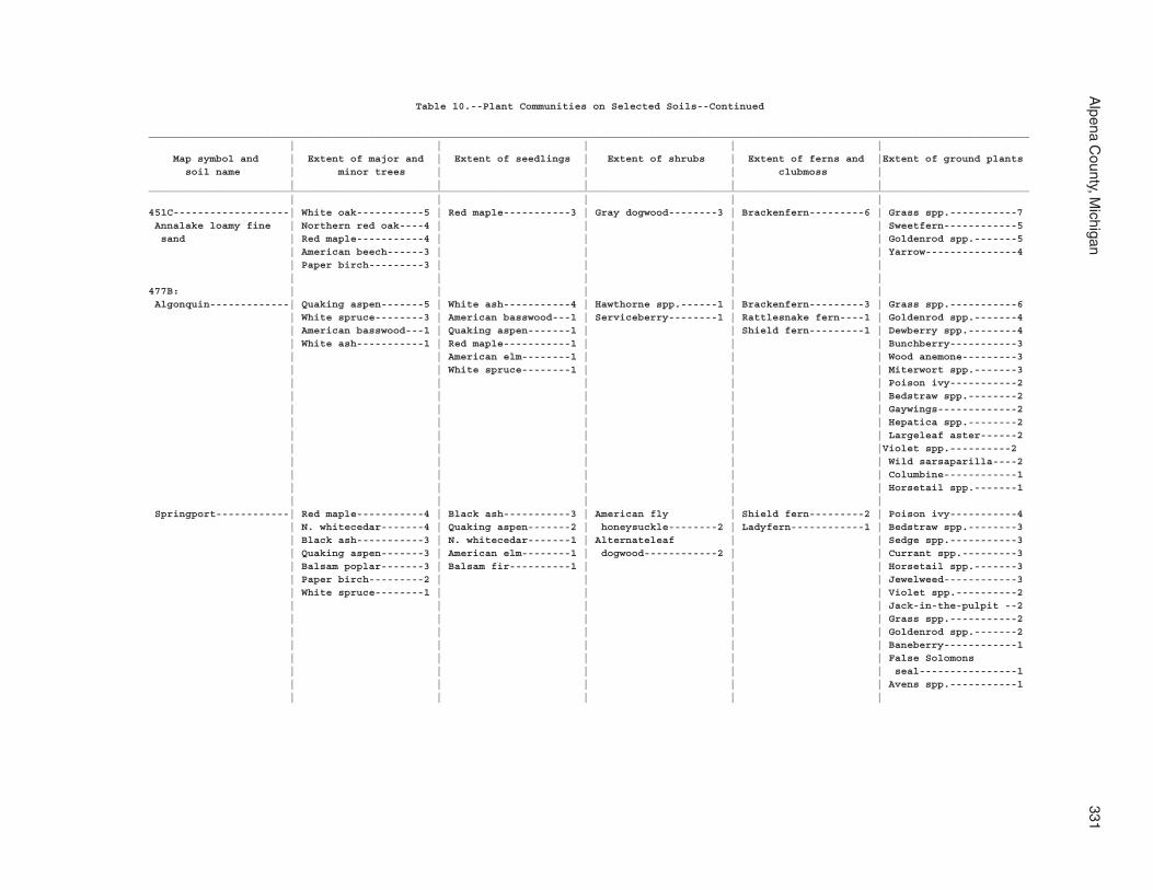
Alpena C
ounty, Michigan
331
Table 10.--Plant Communities on Selected Soils--Continued
________________________________________________________________________________________________________________________________________________ | | | | | Map symbol and | Extent of major and | Extent of seedlings | Extent of shrubs | Extent of ferns and |Extent of ground plants soil name | minor trees | | | clubmoss | | | | | |________________________________________________________________________________________________________________________________________________ | | | | |451C-------------------| White oak-----------5 | Red maple-----------3 | Gray dogwood--------3 | Brackenfern---------6 | Grass spp.-----------7 Annalake loamy fine | Northern red oak----4 | | | | Sweetfern------------5 sand | Red maple-----------4 | | | | Goldenrod spp.-------5 | American beech------3 | | | | Yarrow---------------4 | Paper birch---------3 | | | | | | | | |477B: | | | | | Algonquin-------------| Quaking aspen-------5 | White ash-----------4 | Hawthorne spp.------1 | Brackenfern---------3 | Grass spp.-----------6 | White spruce--------3 | American basswood---1 | Serviceberry--------1 | Rattlesnake fern----1 | Goldenrod spp.-------4 | American basswood---1 | Quaking aspen-------1 | | Shield fern---------1 | Dewberry spp.--------4 | White ash-----------1 | Red maple-----------1 | | | Bunchberry-----------3 | | American elm--------1 | | | Wood anemone---------3 | | White spruce--------1 | | | Miterwort spp.-------3 | | | | | Poison ivy-----------2 | | | | | Bedstraw spp.--------2 | | | | | Gaywings-------------2 | | | | | Hepatica spp.--------2 | | | | | Largeleaf aster------2 | | | | |Violet spp.----------2 | | | | | Wild sarsaparilla----2 | | | | | Columbine------------1 | | | | | Horsetail spp.-------1 | | | | | Springport------------| Red maple-----------4 | Black ash-----------3 | American fly | Shield fern---------2 | Poison ivy-----------4 | N. whitecedar-------4 | Quaking aspen-------2 | honeysuckle--------2 | Ladyfern------------1 | Bedstraw spp.--------3 | Black ash-----------3 | N. whitecedar-------1 | Alternateleaf | | Sedge spp.-----------3 | Quaking aspen-------3 | American elm--------1 | dogwood------------2 | | Currant spp.---------3 | Balsam poplar-------3 | Balsam fir----------1 | | | Horsetail spp.-------3 | Paper birch---------2 | | | | Jewelweed------------3 | White spruce--------1 | | | | Violet spp.----------2 | | | | | Jack-in-the-pulpit --2 | | | | | Grass spp.-----------2 | | | | | Goldenrod spp.-------2 | | | | | Baneberry------------1 | | | | | False Solomons | | | | | seal----------------1 | | | | | Avens spp.-----------1 | | | | |
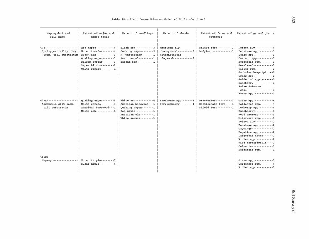
332S
oil Survey of
Table 10.--Plant Communities on Selected Soils--Continued
________________________________________________________________________________________________________________________________________________ | | | | | Map symbol and | Extent of major and | Extent of seedlings | Extent of shrubs | Extent of ferns and |Extent of ground plants soil name | minor trees | | | clubmoss | | | | | |________________________________________________________________________________________________________________________________________________ | | | | |478--------------------| Red maple-----------4 | Black ash-----------3 | American fly | Shield fern---------2 | Poison ivy-----------4 Springport silty clay | N. whitecedar-------4 | Quaking aspen-------2 | honeysuckle--------2 | Ladyfern------------1 | Bedstraw spp.--------3 loam, till substratum| Black ash-----------3 | N. whitecedar-------1 | Alternateleaf | | Sedge spp.-----------3 | Quaking aspen-------3 | American elm--------1 | dogwood------------2 | | Currant spp.---------3 | Balsam poplar-------3 | Balsam fir----------1 | | | Horsetail spp.-------3 | Paper birch---------2 | | | | Jewelweed------------3 | White spruce--------1 | | | | Violet spp.----------2 | | | | | Jack-in-the-pulpit --2 | | | | | Grass spp.-----------2 | | | | | Goldenrod spp.-------2 | | | | | Baneberry------------1 | | | | | False Solomons | | | | | seal----------------1 | | | | | Avens spp.-----------1 | | | | |479A-------------------| Quaking aspen-------5 | White ash-----------4 | Hawthorne spp.------1 | Brackenfern---------3 | Grass spp.-----------6 Algonquin silt loam, | White spruce--------3 | American basswood---1 | Serviceberry--------1 | Rattlesnake fern----1 | Goldenrod spp.-------4 till surstratum | American basswood---1 | Quaking aspen-------1 | | Shield fern---------1 | Dewberry spp.--------4 | White ash-----------1 | Red maple-----------1 | | | Bunchberry-----------3 | | American elm--------1 | | | Wood anemone---------3 | | White spruce--------1 | | | Miterwort spp.-------3 | | | | | Poison ivy-----------2 | | | | | Bedstraw spp.--------2 | | | | | Gaywings-------------2 | | | | | Hepatica spp.--------2 | | | | | Largeleaf aster------2 | | | | | Violet spp.----------2 | | | | | Wild sarsaparilla----2 | | | | | Columbine------------1 | | | | | Horsetail spp.-------1 | | | | |480B: | | | | | Negwegon--------------| E. white pine-------5 | | | | Grass spp.-----------5 | Sugar maple---------4 | | | | Goldenrod spp.-------4 | | | | | Violet spp.----------3 | | | | |
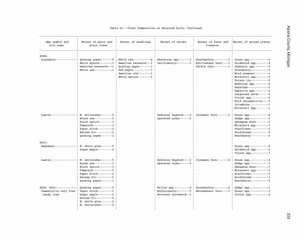
Alpena C
ounty, Michigan
333
Table 10.--Plant Communities on Selected Soils--Continued
________________________________________________________________________________________________________________________________________________ | | | | | Map symbol and | Extent of major and | Extent of seedlings | Extent of shrubs | Extent of ferns and |Extent of ground plants soil name | minor trees | | | clubmoss | | | | | |________________________________________________________________________________________________________________________________________________ | | | | |480B: | | | | | Algonquin-------------| Quaking aspen-------5 | White ash-----------4 | Hawthorne spp.------1 | Brackenfern---------3 | Grass spp.-----------6 | White spruce--------3 | American basswood---1 | Serviceberry--------1 | Rattlesnake fern----1 | Goldenrod spp.-------4 | American basswood---1 | Quaking aspen-------1 | | Shield fern---------1 | Dewberry spp.--------4 | White ash-----------1 | Red maple-----------1 | | | Bunchberry-----------3 | | American elm--------1 | | | Wood anemone---------3 | | White spruce--------1 | | | Miterwort spp.-------3 | | | | | Poison ivy-----------2 | | | | | Bedstraw spp.--------2 | | | | | Gaywings-------------2 | | | | | Hepatica spp.--------2 | | | | | Largeleaf aster------2 | | | | | Violet spp.----------2 | | | | | Wild sarsaparilla----2 | | | | | Columbine------------1 | | | | | Horsetail spp.-------1 | | | | | Lupton----------------| N. whitecedar-------5 | | Redosier dogwood----2 | Cinnamon fern-------2 | Grass spp.-----------4 | Black ash-----------3 | | Speckled alder------2 | | Sedge spp.-----------3 | Black spruce--------3 | | | | Sphagnum moss--------3 | Tamarack------------3 | | | | Miterwort spp.-------3 | Paper birch---------2 | | | | Starflower-----------2 | Balsam fir----------2 | | | | Goldthread-----------2 | Quaking aspen-------1 | | | | Bunchberry-----------2 | | | | |481C: | | | | | Negwegon--------------| E. white pine-------5 | | | | Grass spp.-----------5 | Sugar maple---------4 | | | | Goldenrod spp.-------4 | | | | | Violet spp.----------3 | | | | | Lupton----------------| N. whitecedar-------5 | | Redosier dogwood----2 | Cinnamon fern-------2 | Grass spp.-----------4 | Black ash-----------3 | | Speckled alder------2 | | Sedge spp.-----------3 | Black spruce--------3 | | | | Sphagnum moss--------3 | Tamarack------------3 | | | | Miterwort spp.-------3 | Paper birch---------2 | | | | Starflower-----------2 | Balsam fir----------2 | | | | Goldthread-----------2 | Quaking aspen-------1 | | | | Bunchberry-----------2 | | | | |482B, 482C-------------| Quaking aspen-------4 | | Willow spp.---------4 | Brackenfern---------4 | Sedge spp.-----------3 Summerville very fine | Paper birch---------3 | | Buffaloberry--------3 | Maindenhair fern----2 | Grass spp.-----------3 sandy loam | Sugar maple---------2 | | Northern arrowwood--3 | | Violet spp.----------2 | Balsam fir----------2 | | | | | E. white pine-------2 | | | | | N. whitecedar-------2 | | | | | | | | |
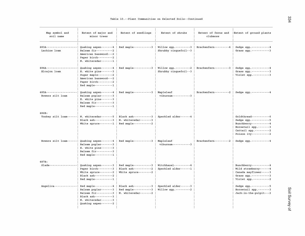
334S
oil Survey of
Table 10.--Plant Communities on Selected Soils--Continued
________________________________________________________________________________________________________________________________________________ | | | | | Map symbol and | Extent of major and | Extent of seedlings | Extent of shrubs | Extent of ferns and |Extent of ground plants soil name | minor trees | | | clubmoss | | | | | |________________________________________________________________________________________________________________________________________________ | | | | |483A-------------------| Quaking aspen-------4 | Red maple-----------3 | Willow spp.---------3 | Brackenfern---------4 | Sedge spp.-----------4 Lachine loam | Balsam fir----------2 | | Shrubby cinquefoil--3 | | Grass spp.-----------3 | American basswood---2 | | | | | Paper birch---------2 | | | | | N. whitecedar-------1 | | | | | | | | |484A-------------------| Quaking aspen-------4 | Red maple-----------3 | Willow spp.---------2 | Brackenfern---------3 | Sedge spp.-----------4 Elcajon loam | E. white pine-------3 | | Shrubby cinquefoil--3 | | Grass spp.-----------3 | Sugar maple---------2 | | | | Violet spp.----------3 | American basswood---2 | | | | | Paper birch---------2 | | | | | Red maple-----------1 | | | | | | | | |485A-------------------| Quaking aspen-------4 | Red maple-----------3 | Mapleleaf | Brackenfern---------2 | Sedge spp.-----------4 Bowers silt loam | Balsam poplar-------3 | | viburnum-----------3 | | | E. white pine-------3 | | | | | Balsam fir----------3 | | | | | Red maple-----------1 | | | | | | | | |486B: | | | | | Tonkey silt loam------| N. whitecedar-------5 | Black ash-----------3 | Speckled alder------4 | | Goldthread-----------6 | Black ash-----------3 | N. whitecedar-------3 | | | Sedge spp.-----------5 | White spruce--------1 | Red maple-----------2 | | | Bunchberry-----------4 | | | | | Horsetail spp.-------3 | | | | | Cattail spp.---------2 | | | | | Poison ivy-----------2 | | | | | Bowers silt loam------| Quaking aspen-------4 | Red maple-----------3 | Mapleleaf | Brackenfern---------2 | Sedge spp.-----------4 | Balsam poplar-------3 | | viburnum-----------3 | | | E. white pine-------3 | | | | | Balsam fir----------3 | | | | | Red maple-----------1 | | | | | | | | |487B: | | | | | Slade-----------------| Quaking aspen-------3 | Red maple-----------3 | Witchhazel----------4 | | Bunchberry-----------4 | Paper birch---------3 | Black ash-----------2 | Speckled alder------1 | | Wild strawberry------4 | White spruce--------2 | White spruce--------2 | | | Canada mayflower-----3 | Black ash-----------2 | | | | Grass spp.-----------3 | Red maple-----------1 | | | | Violet spp.----------2 | | | | | Angelica--------------| Red maple-----------4 | Black ash-----------3 | Speckled alder------3 | | Sedge spp.-----------5 | Balsam poplar-------3 | Red maple-----------3 | Willow spp.---------2 | | Horsetail spp.-------3 | Balsam fir----------3 | N. whitecedar-------2 | | | Jack-in-the-pulpit---2 | Black ash-----------3 | | | | | N. whitecedar-------3 | | | | | Quaking aspen-------2 | | | | | | | | |
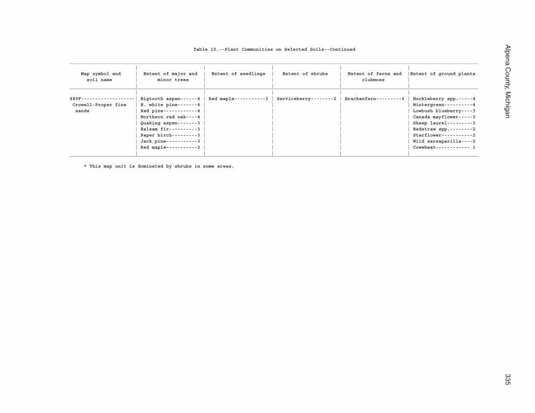
Alpena C
ounty, Michigan
335
Table 10.--Plant Communities on Selected Soils--Continued
________________________________________________________________________________________________________________________________________________ | | | | | Map symbol and | Extent of major and | Extent of seedlings | Extent of shrubs | Extent of ferns and |Extent of ground plants soil name | minor trees | | | clubmoss | | | | | |________________________________________________________________________________________________________________________________________________ | | | | |489F-------------------| Bigtooth aspen------4 | Red maple-----------3 | Serviceberry--------2 | Brackenfern---------6 | Huckleberry spp.-----4 Crowell-Proper fine | E. white pine-------4 | | | | Wintergreen----------4 sands | Red pine------------4 | | | | Lowbush blueberry----3 | Northern red oak----4 | | | | Canada mayflower-----3 | Quaking aspen-------3 | | | | Sheep laurel---------3 | Balsam fir----------3 | | | | Bedstraw spp.--------2 | Paper birch---------3 | | | | Starflower-----------2 | Jack pine-----------3 | | | | Wild sarsaparilla----2 | Red maple-----------3 | | | | Cowwheat------------ 1 | | | | |________________________________________________________________________________________________________________________________________________
* This map unit is dominated by shrubs in some areas.
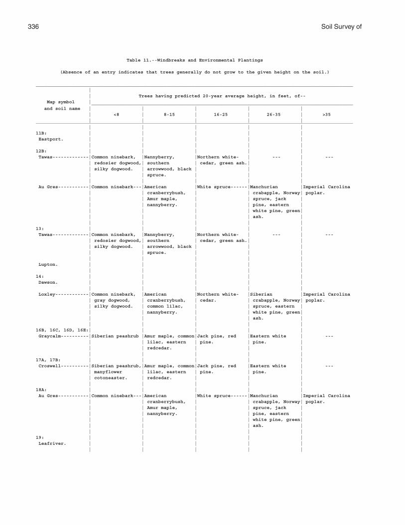
336 Soil Survey of
Table 11.--Windbreaks and Environmental Plantings
(Absence of an entry indicates that trees generally do not grow to the given height on the soil.)
__________________________________________________________________________________________________________________ | | Trees having predicted 20-year average height, in feet, of-- Map symbol | ______________________________________________________________________________________________ and soil name | | | | | | <8 | 8-15 | 16-25 | 26-35 | >35 | | | | |__________________________________________________________________________________________________________________ | | | | |11B: | | | | | Eastport. | | | | | | | | | |12B: | | | | | Tawas-------------|Common ninebark, |Nannyberry, |Northern white- | --- | --- | redosier dogwood,| southern | cedar, green ash.| | | silky dogwood. | arrowwood, black | | | | | spruce. | | | | | | | | Au Gres-----------|Common ninebark---|American |White spruce------|Manchurian |Imperial Carolina | | cranberrybush, | | crabapple, Norway| poplar. | | Amur maple, | | spruce, jack | | | nannyberry. | | pine, eastern | | | | | white pine, green| | | | | ash. | | | | | |13: | | | | | Tawas-------------|Common ninebark, |Nannyberry, |Northern white- | --- | --- | redosier dogwood,| southern | cedar, green ash.| | | silky dogwood. | arrowwood, black | | | | | spruce. | | | | | | | | Lupton. | | | | | | | | | |14: | | | | | Dawson. | | | | | | | | | | Loxley------------|Common ninebark, |American |Northern white- |Siberian |Imperial Carolina | gray dogwood, | cranberrybush, | cedar. | crabapple, Norway| poplar. | silky dogwood. | common lilac, | | spruce, eastern | | | nannyberry. | | white pine, green| | | | | ash. | | | | | |16B, 16C, 16D, 16E:| | | | | Graycalm----------|Siberian peashrub |Amur maple, common|Jack pine, red |Eastern white | --- | | lilac, eastern | pine. | pine. | | | redcedar. | | | | | | | |17A, 17B: | | | | | Croswell----------|Siberian peashrub,|Amur maple, common|Jack pine, red |Eastern white | --- | manyflower | lilac, eastern | pine. | pine. | | cotoneaster. | redcedar. | | | | | | | |18A: | | | | | Au Gres-----------|Common ninebark---|American |White spruce------|Manchurian |Imperial Carolina | | cranberrybush, | | crabapple, Norway| poplar. | | Amur maple, | | spruce, jack | | | nannyberry. | | pine, eastern | | | | | white pine, green| | | | | ash. | | | | | |19: | | | | | Leafriver. | | | | | | | | | |
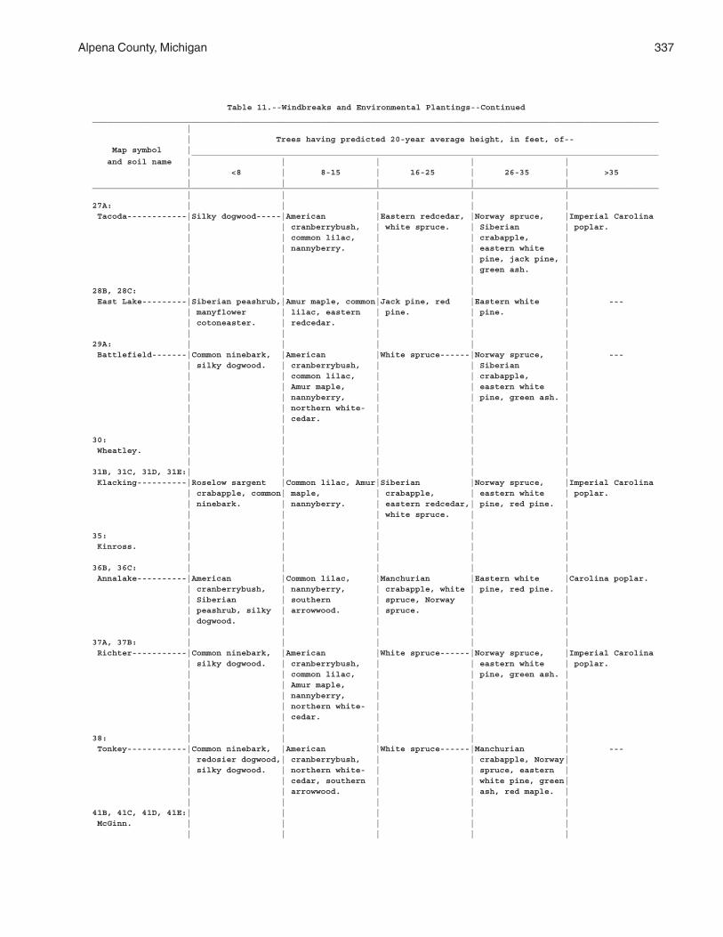
Alpena County, Michigan 337
Table 11.--Windbreaks and Environmental Plantings--Continued__________________________________________________________________________________________________________________ | | Trees having predicted 20-year average height, in feet, of-- Map symbol | ______________________________________________________________________________________________ and soil name | | | | | | <8 | 8-15 | 16-25 | 26-35 | >35 | | | | |__________________________________________________________________________________________________________________ | | | | |27A: | | | | | Tacoda------------|Silky dogwood-----|American |Eastern redcedar, |Norway spruce, |Imperial Carolina | | cranberrybush, | white spruce. | Siberian | poplar. | | common lilac, | | crabapple, | | | nannyberry. | | eastern white | | | | | pine, jack pine, | | | | | green ash. | | | | | |28B, 28C: | | | | | East Lake---------|Siberian peashrub,|Amur maple, common|Jack pine, red |Eastern white | --- | manyflower | lilac, eastern | pine. | pine. | | cotoneaster. | redcedar. | | | | | | | |29A: | | | | | Battlefield-------|Common ninebark, |American |White spruce------|Norway spruce, | --- | silky dogwood. | cranberrybush, | | Siberian | | | common lilac, | | crabapple, | | | Amur maple, | | eastern white | | | nannyberry, | | pine, green ash. | | | northern white- | | | | | cedar. | | | | | | | |30: | | | | | Wheatley. | | | | | | | | | |31B, 31C, 31D, 31E:| | | | | Klacking----------|Roselow sargent |Common lilac, Amur|Siberian |Norway spruce, |Imperial Carolina | crabapple, common| maple, | crabapple, | eastern white | poplar. | ninebark. | nannyberry. | eastern redcedar,| pine, red pine. | | | | white spruce. | | | | | | |35: | | | | | Kinross. | | | | | | | | | |36B, 36C: | | | | | Annalake----------|American |Common lilac, |Manchurian |Eastern white |Carolina poplar. | cranberrybush, | nannyberry, | crabapple, white | pine, red pine. | | Siberian | southern | spruce, Norway | | | peashrub, silky | arrowwood. | spruce. | | | dogwood. | | | | | | | | |37A, 37B: | | | | | Richter-----------|Common ninebark, |American |White spruce------|Norway spruce, |Imperial Carolina | silky dogwood. | cranberrybush, | | eastern white | poplar. | | common lilac, | | pine, green ash. | | | Amur maple, | | | | | nannyberry, | | | | | northern white- | | | | | cedar. | | | | | | | |38: | | | | | Tonkey------------|Common ninebark, |American |White spruce------|Manchurian | --- | redosier dogwood,| cranberrybush, | | crabapple, Norway| | silky dogwood. | northern white- | | spruce, eastern | | | cedar, southern | | white pine, green| | | arrowwood. | | ash, red maple. | | | | | |41B, 41C, 41D, 41E:| | | | | McGinn. | | | | | | | | | |
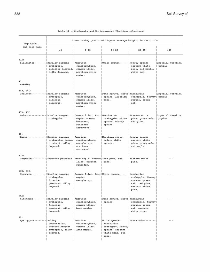
338 Soil Survey of
Table 11.--Windbreaks and Environmental Plantings--Continued__________________________________________________________________________________________________________________ | | Trees having predicted 20-year average height, in feet, of-- Map symbol | ______________________________________________________________________________________________ and soil name | | | | | | <8 | 8-15 | 16-25 | 26-35 | >35 | | | | |__________________________________________________________________________________________________________________ | | | | |42A: | | | | | Killmaster--------|Roselow sargent |American |White spruce------|Norway spruce, |Imperial Carolina | crabapple, | cranberrybush, | | eastern white | poplar. | redosier dogwood,| common lilac, | | pine, red maple, | | silky dogwood. | northern white- | | white ash. | | | cedar. | | | | | | | |43: | | | | | Wakeley. | | | | | | | | | |44B, 44C: | | | | | Ossineke----------|Roselow sargent |American |Blue spruce, white|Manchurian |Imperial Carolina | crabapple, | cranberrybush, | spruce, Austrian | crabapple, Norway| poplar. | Siberian | common lilac, | pine. | spruce, green | | peashrub. | northern white- | | ash. | | | cedar. | | | | | | | |45B, 45C: | | | | | Hoist-------------|Roselow sargent |Common lilac, Amur|Manchurian |Eastern white |Imperial Carolina | crabapple. | maple, common | crabapple, white | pine, green ash, | poplar. | | ninebark, | spruce, Norway | red pine. | | | southern | spruce. | | | | arrowwood. | | | | | | | |46: | | | | | Ensley------------|Roselow sargent |American |Northern white- |Norway spruce, | --- | crabapple, common| cranberrybush, | cedar, white | eastern white | | ninebark, silky | nannyberry, | spruce. | pine, green ash, | | dogwood. | southern | | red maple. | | | arrowwood. | | | | | | | |47D: | | | | | Graycalm----------|Siberian peashrub |Amur maple, common|Jack pine, red |Eastern white | --- | | lilac, eastern | pine. | pine. | | | redcedar. | | | | | | | |53B, 53C: | | | | | Negwegon----------|Roselow sargent |Common lilac, Amur|White spruce------|Manchurian | --- | crabapple, | maple, | | crabapple, Norway| | Siberian | nannyberry. | | spruce, green | | peashrub, silky | | | ash, red pine, | | dogwood. | | | eastern white | | | | | pine. | | | | | |54A: | | | | | Algonquin---------|Roselow sargent |American |Blue spruce, white|Manchurian | --- | crabapple, | cranberrybush, | spruce. | crabapple, Norway| | Siberian | common lilac, | | spruce, green | | peashrub, silky | Amur maple. | | ash, eastern | | dogwood. | | | white pine. | | | | | |55: | | | | | Springport--------|Peking |American |White spruce, |Green ash---------| --- | cotoneaster, | cranberrybush, | Manchurian | | | Roselow sargent | common lilac, | crabapple, Norway| | | crabapple, silky | Amur maple. | spruce, eastern | | | dogwood. | | white pine, red | | | | | pine. | | | | | | |
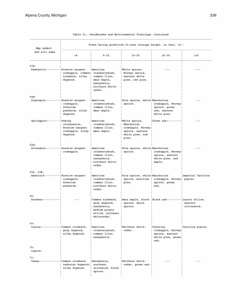
Alpena County, Michigan 339
Table 11.--Windbreaks and Environmental Plantings--Continued__________________________________________________________________________________________________________________ | | Trees having predicted 20-year average height, in feet, of-- Map symbol | ______________________________________________________________________________________________ and soil name | | | | | | <8 | 8-15 | 16-25 | 26-35 | >35 | | | | |__________________________________________________________________________________________________________________ | | | | |57B: | | | | | Kawkawlin---------|Roselow sargent |American |White spruce, | --- | --- | crabapple, common| cranberrybush, | Norway spruce, | | | ninebark, silky | common lilac, | eastern white | | | dogwood. | Amur maple, | pine, red pine. | | | | nannyberry, | | | | | northern white- | | | | | cedar. | | | | | | | |59B: | | | | | Algonquin---------|Roselow sargent |American |Blue spruce, white|Manchurian | --- | crabapple, | cranberrybush, | spruce. | crabapple, Norway| | Siberian | common lilac, | | spruce, green | | peashrub, silky | Amur maple. | | ash, eastern | | dogwood. | | | white pine. | | | | | | Springport--------|Peking |American |White spruce, |Green ash---------| --- | cotoneaster, | cranberrybush, | Manchurian | | | Roselow sargent | common lilac, | crabapple, Norway| | | crabapple, silky | Amur maple. | spruce, eastern | | | dogwood. | | white pine, red | | | | | pine. | | | | | | |62A: | | | | | Allendale---------|Roselow sargent |American |Blue spruce, white|Manchurian | --- | crabapple. | cranberrybush, | spruce. | crabapple, Norway| | | common lilac, | | spruce, eastern | | | nannyberry, | | white pine, red | | | northern white- | | maple. | | | cedar. | | | | | | | |63D, 63E: | | | | | Bamfield----------|Roselow sargent |American |Blue spruce, white|Manchurian |Imperial Carolina | crabapple, | cranberrybush, | spruce, Austrian | crabapple, Norway| poplar. | Siberian | common lilac, | pine. | spruce, green | | peashrub. | northern white- | | ash. | | | cedar. | | | | | | | |68: | | | | | Rondeau-----------| --- |Common ninebark, |Amur maple, black |Black ash---------|Laurel willow, | | gray dogwood, | spruce, white | | eastern | | nannyberry, | spruce. | | cottonwood. | | medium purple | | | | | willow, northern | | | | | whitecedar. | | | | | | | |69: | | | | | Loxley------------|Common ninebark, |American |Northern white- |Siberian |Carolina poplar. | gray dogwood, | cranberrybush, | cedar. | crabapple, Norway| | silky dogwood. | common lilac, | | spruce, eastern | | | nannyberry. | | white pine, green| | | | | ash. | | | | | |70: | | | | | Lupton. | | | | | | | | | |71: | | | | | Tawas-------------|Common ninebark, |Nannyberry, |Northern white- | --- | --- | redosier dogwood,| southern | cedar, green ash.| | | silky dogwood. | arrowwood, black | | | | | spruce. | | | | | | | |
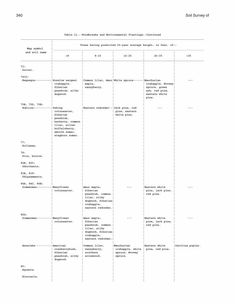
340 Soil Survey of
Table 11.--Windbreaks and Environmental Plantings--Continued__________________________________________________________________________________________________________________ | | Trees having predicted 20-year average height, in feet, of-- Map symbol | ______________________________________________________________________________________________ and soil name | | | | | | <8 | 8-15 | 16-25 | 26-35 | >35 | | | | |__________________________________________________________________________________________________________________ | | | | |72: | | | | | Dorval. | | | | | | | | | |74C2: | | | | | Negwegon----------|Roselow sargent |Common lilac, Amur|White spruce------|Manchurian | --- | crabapple, | maple, | | crabapple, Norway| | Siberian | nannyberry. | | spruce, green | | peashrub, silky | | | ash, red pine, | | dogwood. | | | eastern white | | | | | pine. | | | | | |75B, 75D, 75E: | | | | | Rubicon-----------|Peking |Eastern redcedar--|Jack pine, red | --- | --- | cotoneaster, | | pine, eastern | | | Siberian | | white pine. | | | peashrub, | | | | | barberry, common | | | | | lilac, silver | | | | | buffaloberry, | | | | | smooth sumac, | | | | | staghorn sumac. | | | | | | | | |77: | | | | | Rollaway. | | | | | | | | | |78: | | | | | Pits, borrow. | | | | | | | | | |82B, 82C: | | | | | Udorthents. | | | | | | | | | |83B, 83F: | | | | | Udipsamments. | | | | | | | | | |84B, 84C, 84E: | | | | | Zimmerman---------|Manyflower |Amur maple, | --- |Eastern white | --- | cotoneaster. | Siberian | | pine, jack pine, | | | peashrub, common | | red pine. | | | lilac, silky | | | | | dogwood, Siberian| | | | | crabapple, | | | | | eastern redcedar.| | | | | | | |85D: | | | | | Zimmerman---------|Manyflower |Amur maple, | --- |Eastern white | --- | cotoneaster. | Siberian | | pine, jack pine, | | | peashrub, common | | red pine. | | | lilac, silky | | | | | dogwood, Siberian| | | | | crabapple, | | | | | eastern redcedar.| | | | | | | | Annalake----------|American |Common lilac, |Manchurian |Eastern white |Carolina poplar. | cranberrybush, | nannyberry, | crabapple, white | pine, red pine. | | Siberian | southern | spruce, Norway | | | peashrub, silky | arrowwood. | spruce. | | | dogwood. | | | | | | | | |86: | | | | | Aquents. | | | | | | | | | | Histosols. | | | | | | | | | |
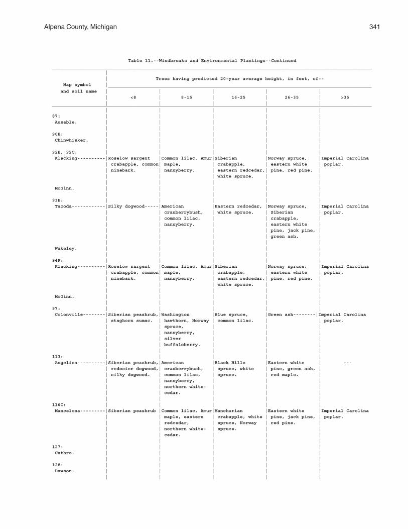
Alpena County, Michigan 341
Table 11.--Windbreaks and Environmental Plantings--Continued__________________________________________________________________________________________________________________ | | Trees having predicted 20-year average height, in feet, of-- Map symbol | ______________________________________________________________________________________________ and soil name | | | | | | <8 | 8-15 | 16-25 | 26-35 | >35 | | | | |__________________________________________________________________________________________________________________ | | | | |87: | | | | | Ausable. | | | | | | | | | |90B: | | | | | Chinwhisker. | | | | | | | | | |92B, 92C: | | | | | Klacking----------|Roselow sargent |Common lilac, Amur|Siberian |Norway spruce, |Imperial Carolina | crabapple, common| maple, | crabapple, | eastern white | poplar. | ninebark. | nannyberry. | eastern redcedar,| pine, red pine. | | | | white spruce. | | | | | | | McGinn. | | | | | | | | | |93B: | | | | | Tacoda------------|Silky dogwood-----|American |Eastern redcedar, |Norway spruce, |Imperial Carolina | | cranberrybush, | white spruce. | Siberian | poplar. | | common lilac, | | crabapple, | | | nannyberry. | | eastern white | | | | | pine, jack pine, | | | | | green ash. | | | | | | Wakeley. | | | | | | | | | |94F: | | | | | Klacking----------|Roselow sargent |Common lilac, Amur|Siberian |Norway spruce, |Imperial Carolina | crabapple, common| maple, | crabapple, | eastern white | poplar. | ninebark. | nannyberry. | eastern redcedar,| pine, red pine. | | | | white spruce. | | | | | | | McGinn. | | | | | | | | | |97: | | | | | Colonville--------|Siberian peashrub,|Washington |Blue spruce, |Green ash--------|Imperial Carolina | staghorn sumac. | hawthorn, Norway | common lilac. | | poplar. | | spruce, | | | | | nannyberry, | | | | | silver | | | | | buffaloberry. | | | | | | | |113: | | | | | Angelica----------|Siberian peashrub,|American |Black Hills |Eastern white | --- | redosier dogwood,| cranberrybush, | spruce, white | pine, green ash, | | silky dogwood. | common lilac, | spruce. | red maple. | | | nannyberry, | | | | | northern white- | | | | | cedar. | | | | | | | |116C: | | | | | Mancelona---------|Siberian peashrub |Common lilac, Amur|Manchurian |Eastern white |Imperial Carolina | | maple, eastern | crabapple, white | pine, jack pine, | poplar. | | redcedar, | spruce, Norway | red pine. | | | northern white- | spruce. | | | | cedar. | | | | | | | |127: | | | | | Cathro. | | | | | | | | | |128: | | | | | Dawson. | | | | | | | | | |
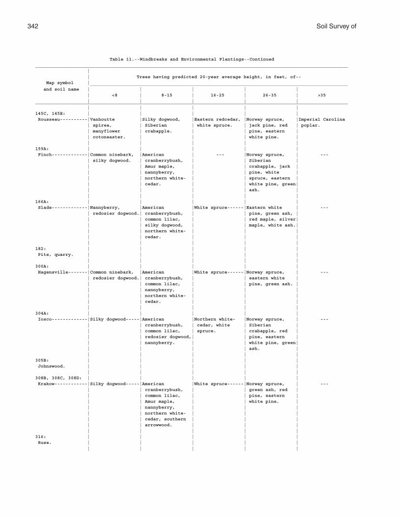
342 Soil Survey of
Table 11.--Windbreaks and Environmental Plantings--Continued__________________________________________________________________________________________________________________ | | Trees having predicted 20-year average height, in feet, of-- Map symbol | ______________________________________________________________________________________________ and soil name | | | | | | <8 | 8-15 | 16-25 | 26-35 | >35 | | | | |__________________________________________________________________________________________________________________ | | | | |145C, 145E: | | | | | Rousseau----------|Vanhoutte |Silky dogwood, |Eastern redcedar, |Norway spruce, |Imperial Carolina | spirea, | Siberian | white spruce. | jack pine, red | poplar. | manyflower | crabapple. | | pine, eastern | | cotoneaster. | | | white pine. | | | | | |159A: | | | | | Finch-------------|Common ninebark, |American | --- |Norway spruce, | --- | silky dogwood. | cranberrybush, | | Siberian | | | Amur maple, | | crabapple, jack | | | nannyberry, | | pine, white | | | northern white- | | spruce, eastern | | | cedar. | | white pine, green| | | | | ash. | | | | | |166A: | | | | | Slade-------------|Nannyberry, |American |White spruce------|Eastern white | --- | redosier dogwood.| cranberrybush, | | pine, green ash, | | | common lilac, | | red maple, silver| | | silky dogwood, | | maple, white ash.| | | northern white- | | | | | cedar. | | | | | | | |182: | | | | | Pits, quarry. | | | | | | | | | |300A: | | | | | Hagensville-------|Common ninebark, |American |White spruce------|Norway spruce, | --- | redosier dogwood.| cranberrybush, | | eastern white | | | common lilac, | | pine, green ash. | | | nannyberry, | | | | | northern white- | | | | | cedar. | | | | | | | |304A: | | | | | Iosco-------------|Silky dogwood-----|American |Northern white- |Norway spruce, | --- | | cranberrybush, | cedar, white | Siberian | | | common lilac, | spruce. | crabapple, red | | | redosier dogwood,| | pine, eastern | | | nannyberry. | | white pine, green| | | | | ash. | | | | | |305B: | | | | | Johnswood. | | | | | | | | | |308B, 308C, 308D: | | | | | Krakow------------|Silky dogwood-----|American |White spruce------|Norway spruce, | --- | | cranberrybush, | | green ash, red | | | common lilac, | | pine, eastern | | | Amur maple, | | white pine. | | | nannyberry, | | | | | northern white- | | | | | cedar, southern | | | | | arrowwood. | | | | | | | |316: | | | | | Ruse. | | | | | | | | | |
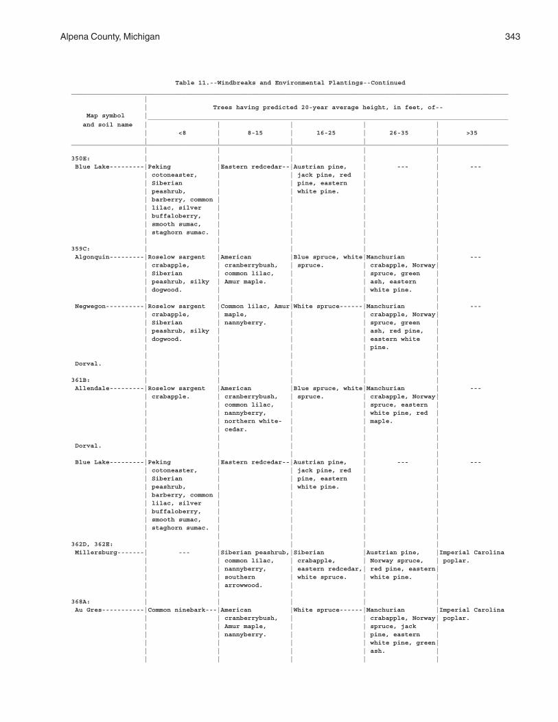
Alpena County, Michigan 343
Table 11.--Windbreaks and Environmental Plantings--Continued__________________________________________________________________________________________________________________ | | Trees having predicted 20-year average height, in feet, of-- Map symbol | ______________________________________________________________________________________________ and soil name | | | | | | <8 | 8-15 | 16-25 | 26-35 | >35 | | | | |__________________________________________________________________________________________________________________ | | | | |350E: | | | | | Blue Lake---------|Peking |Eastern redcedar--|Austrian pine, | --- | --- | cotoneaster, | | jack pine, red | | | Siberian | | pine, eastern | | | peashrub, | | white pine. | | | barberry, common | | | | | lilac, silver | | | | | buffaloberry, | | | | | smooth sumac, | | | | | staghorn sumac. | | | | | | | | |359C: | | | | | Algonquin---------|Roselow sargent |American |Blue spruce, white|Manchurian | --- | crabapple, | cranberrybush, | spruce. | crabapple, Norway| | Siberian | common lilac, | | spruce, green | | peashrub, silky | Amur maple. | | ash, eastern | | dogwood. | | | white pine. | | | | | | Negwegon----------|Roselow sargent |Common lilac, Amur|White spruce------|Manchurian | --- | crabapple, | maple, | | crabapple, Norway| | Siberian | nannyberry. | | spruce, green | | peashrub, silky | | | ash, red pine, | | dogwood. | | | eastern white | | | | | pine. | | | | | | Dorval. | | | | | | | | | |361B: | | | | | Allendale---------|Roselow sargent |American |Blue spruce, white|Manchurian | --- | crabapple. | cranberrybush, | spruce. | crabapple, Norway| | | common lilac, | | spruce, eastern | | | nannyberry, | | white pine, red | | | northern white- | | maple. | | | cedar. | | | | | | | | Dorval. | | | | | | | | | | Blue Lake---------|Peking |Eastern redcedar--|Austrian pine, | --- | --- | cotoneaster, | | jack pine, red | | | Siberian | | pine, eastern | | | peashrub, | | white pine. | | | barberry, common | | | | | lilac, silver | | | | | buffaloberry, | | | | | smooth sumac, | | | | | staghorn sumac. | | | | | | | | |362D, 362E: | | | | | Millersburg-------| --- |Siberian peashrub,|Siberian |Austrian pine, |Imperial Carolina | | common lilac, | crabapple, | Norway spruce, | poplar. | | nannyberry, | eastern redcedar,| red pine, eastern| | | southern | white spruce. | white pine. | | | arrowwood. | | | | | | | |368A: | | | | | Au Gres-----------|Common ninebark---|American |White spruce------|Manchurian |Imperial Carolina | | cranberrybush, | | crabapple, Norway| poplar. | | Amur maple, | | spruce, jack | | | nannyberry. | | pine, eastern | | | | | white pine, green| | | | | ash. | | | | | |
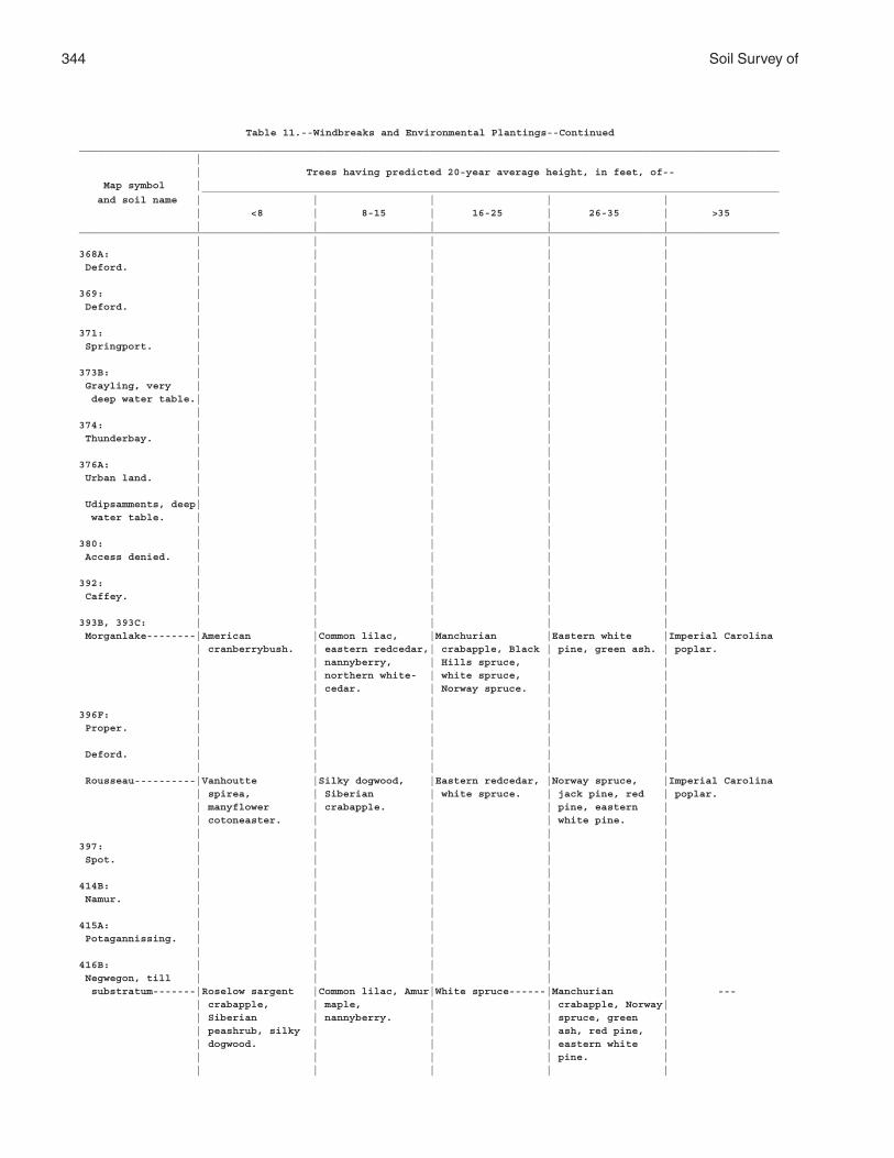
344 Soil Survey of
Table 11.--Windbreaks and Environmental Plantings--Continued__________________________________________________________________________________________________________________ | | Trees having predicted 20-year average height, in feet, of-- Map symbol | ______________________________________________________________________________________________ and soil name | | | | | | <8 | 8-15 | 16-25 | 26-35 | >35 | | | | |__________________________________________________________________________________________________________________ | | | | |368A: | | | | | Deford. | | | | | | | | | |369: | | | | | Deford. | | | | | | | | | |371: | | | | | Springport. | | | | | | | | | |373B: | | | | | Grayling, very | | | | | deep water table.| | | | | | | | | |374: | | | | | Thunderbay. | | | | | | | | | |376A: | | | | | Urban land. | | | | | | | | | | Udipsamments, deep| | | | | water table. | | | | | | | | | |380: | | | | | Access denied. | | | | | | | | | |392: | | | | | Caffey. | | | | | | | | | |393B, 393C: | | | | | Morganlake--------|American |Common lilac, |Manchurian |Eastern white |Imperial Carolina | cranberrybush. | eastern redcedar,| crabapple, Black | pine, green ash. | poplar. | | nannyberry, | Hills spruce, | | | | northern white- | white spruce, | | | | cedar. | Norway spruce. | | | | | | |396F: | | | | | Proper. | | | | | | | | | | Deford. | | | | | | | | | | Rousseau----------|Vanhoutte |Silky dogwood, |Eastern redcedar, |Norway spruce, |Imperial Carolina | spirea, | Siberian | white spruce. | jack pine, red | poplar. | manyflower | crabapple. | | pine, eastern | | cotoneaster. | | | white pine. | | | | | |397: | | | | | Spot. | | | | | | | | | |414B: | | | | | Namur. | | | | | | | | | |415A: | | | | | Potagannissing. | | | | | | | | | |416B: | | | | | Negwegon, till | | | | | substratum-------|Roselow sargent |Common lilac, Amur|White spruce------|Manchurian | --- | crabapple, | maple, | | crabapple, Norway| | Siberian | nannyberry. | | spruce, green | | peashrub, silky | | | ash, red pine, | | dogwood. | | | eastern white | | | | | pine. | | | | | |
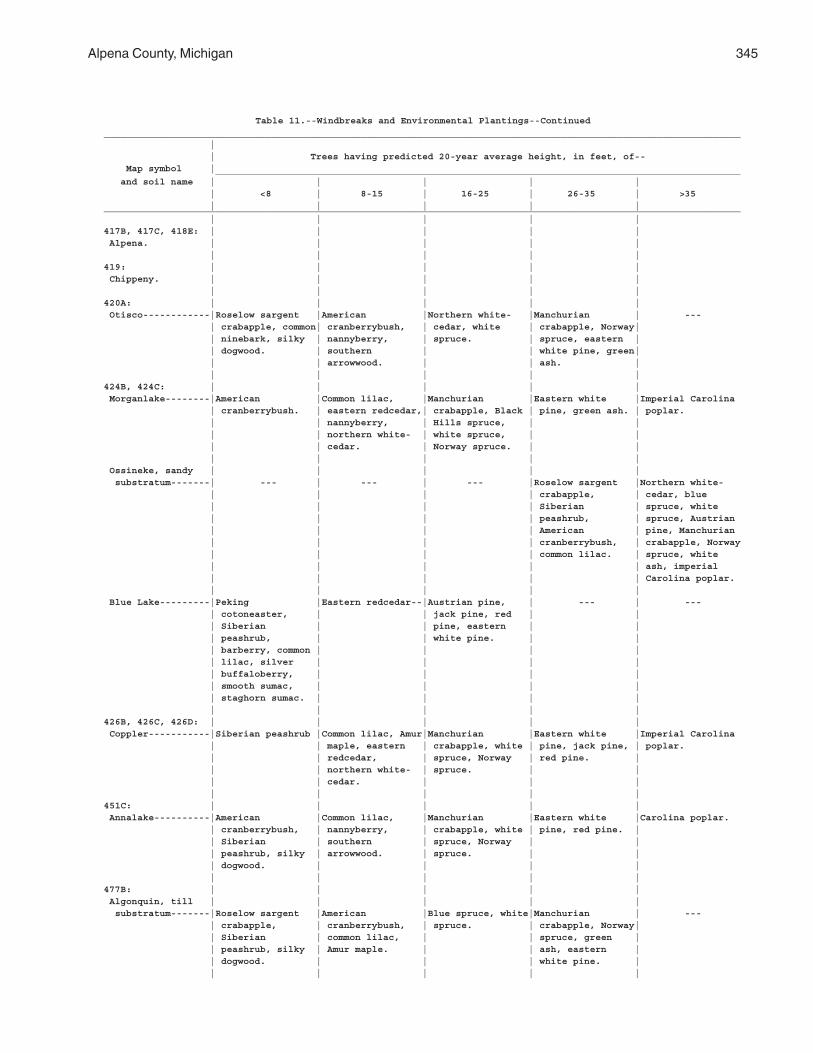
Alpena County, Michigan 345
Table 11.--Windbreaks and Environmental Plantings--Continued__________________________________________________________________________________________________________________ | | Trees having predicted 20-year average height, in feet, of-- Map symbol | ______________________________________________________________________________________________ and soil name | | | | | | <8 | 8-15 | 16-25 | 26-35 | >35 | | | | |__________________________________________________________________________________________________________________ | | | | |417B, 417C, 418E: | | | | | Alpena. | | | | | | | | | |419: | | | | | Chippeny. | | | | | | | | | |420A: | | | | | Otisco------------|Roselow sargent |American |Northern white- |Manchurian | --- | crabapple, common| cranberrybush, | cedar, white | crabapple, Norway| | ninebark, silky | nannyberry, | spruce. | spruce, eastern | | dogwood. | southern | | white pine, green| | | arrowwood. | | ash. | | | | | |424B, 424C: | | | | | Morganlake--------|American |Common lilac, |Manchurian |Eastern white |Imperial Carolina | cranberrybush. | eastern redcedar,| crabapple, Black | pine, green ash. | poplar. | | nannyberry, | Hills spruce, | | | | northern white- | white spruce, | | | | cedar. | Norway spruce. | | | | | | | Ossineke, sandy | | | | | substratum-------| --- | --- | --- |Roselow sargent |Northern white- | | | | crabapple, | cedar, blue | | | | Siberian | spruce, white | | | | peashrub, | spruce, Austrian | | | | American | pine, Manchurian | | | | cranberrybush, | crabapple, Norway | | | | common lilac. | spruce, white | | | | | ash, imperial | | | | | Carolina poplar. | | | | | Blue Lake---------|Peking |Eastern redcedar--|Austrian pine, | --- | --- | cotoneaster, | | jack pine, red | | | Siberian | | pine, eastern | | | peashrub, | | white pine. | | | barberry, common | | | | | lilac, silver | | | | | buffaloberry, | | | | | smooth sumac, | | | | | staghorn sumac. | | | | | | | | |426B, 426C, 426D: | | | | | Coppler-----------|Siberian peashrub |Common lilac, Amur|Manchurian |Eastern white |Imperial Carolina | | maple, eastern | crabapple, white | pine, jack pine, | poplar. | | redcedar, | spruce, Norway | red pine. | | | northern white- | spruce. | | | | cedar. | | | | | | | |451C: | | | | | Annalake----------|American |Common lilac, |Manchurian |Eastern white |Carolina poplar. | cranberrybush, | nannyberry, | crabapple, white | pine, red pine. | | Siberian | southern | spruce, Norway | | | peashrub, silky | arrowwood. | spruce. | | | dogwood. | | | | | | | | |477B: | | | | | Algonquin, till | | | | | substratum-------|Roselow sargent |American |Blue spruce, white|Manchurian | --- | crabapple, | cranberrybush, | spruce. | crabapple, Norway| | Siberian | common lilac, | | spruce, green | | peashrub, silky | Amur maple. | | ash, eastern | | dogwood. | | | white pine. | | | | | |
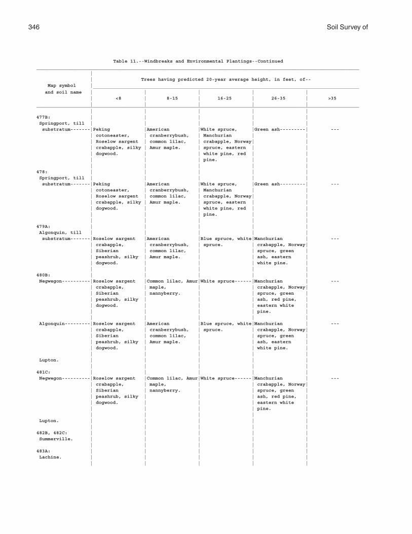
346 Soil Survey of
Table 11.--Windbreaks and Environmental Plantings--Continued__________________________________________________________________________________________________________________ | | Trees having predicted 20-year average height, in feet, of-- Map symbol | ______________________________________________________________________________________________ and soil name | | | | | | <8 | 8-15 | 16-25 | 26-35 | >35 | | | | |__________________________________________________________________________________________________________________ | | | | |477B: | | | | | Springport, till | | | | | substratum-------|Peking |American |White spruce, |Green ash---------| --- | cotoneaster, | cranberrybush, | Manchurian | | | Roselow sargent | common lilac, | crabapple, Norway| | | crabapple, silky | Amur maple. | spruce, eastern | | | dogwood. | | white pine, red | | | | | pine. | | | | | | |478: | | | | | Springport, till | | | | | substratum-------|Peking |American |White spruce, |Green ash---------| --- | cotoneaster, | cranberrybush, | Manchurian | | | Roselow sargent | common lilac, | crabapple, Norway| | | crabapple, silky | Amur maple. | spruce, eastern | | | dogwood. | | white pine, red | | | | | pine. | | | | | | |479A: | | | | | Algonquin, till | | | | | substratum-------|Roselow sargent |American |Blue spruce, white|Manchurian | --- | crabapple, | cranberrybush, | spruce. | crabapple, Norway| | Siberian | common lilac, | | spruce, green | | peashrub, silky | Amur maple. | | ash, eastern | | dogwood. | | | white pine. | | | | | |480B: | | | | | Negwegon----------|Roselow sargent |Common lilac, Amur|White spruce------|Manchurian | --- | crabapple, | maple, | | crabapple, Norway| | Siberian | nannyberry. | | spruce, green | | peashrub, silky | | | ash, red pine, | | dogwood. | | | eastern white | | | | | pine. | | | | | | Algonquin---------|Roselow sargent |American |Blue spruce, white|Manchurian | --- | crabapple, | cranberrybush, | spruce. | crabapple, Norway| | Siberian | common lilac, | | spruce, green | | peashrub, silky | Amur maple. | | ash, eastern | | dogwood. | | | white pine. | | | | | | Lupton. | | | | | | | | | |481C: | | | | | Negwegon----------|Roselow sargent |Common lilac, Amur|White spruce------|Manchurian | --- | crabapple, | maple, | | crabapple, Norway| | Siberian | nannyberry. | | spruce, green | | peashrub, silky | | | ash, red pine, | | dogwood. | | | eastern white | | | | | pine. | | | | | | Lupton. | | | | | | | | | |482B, 482C: | | | | | Summerville. | | | | | | | | | |483A: | | | | | Lachine. | | | | | | | | | |
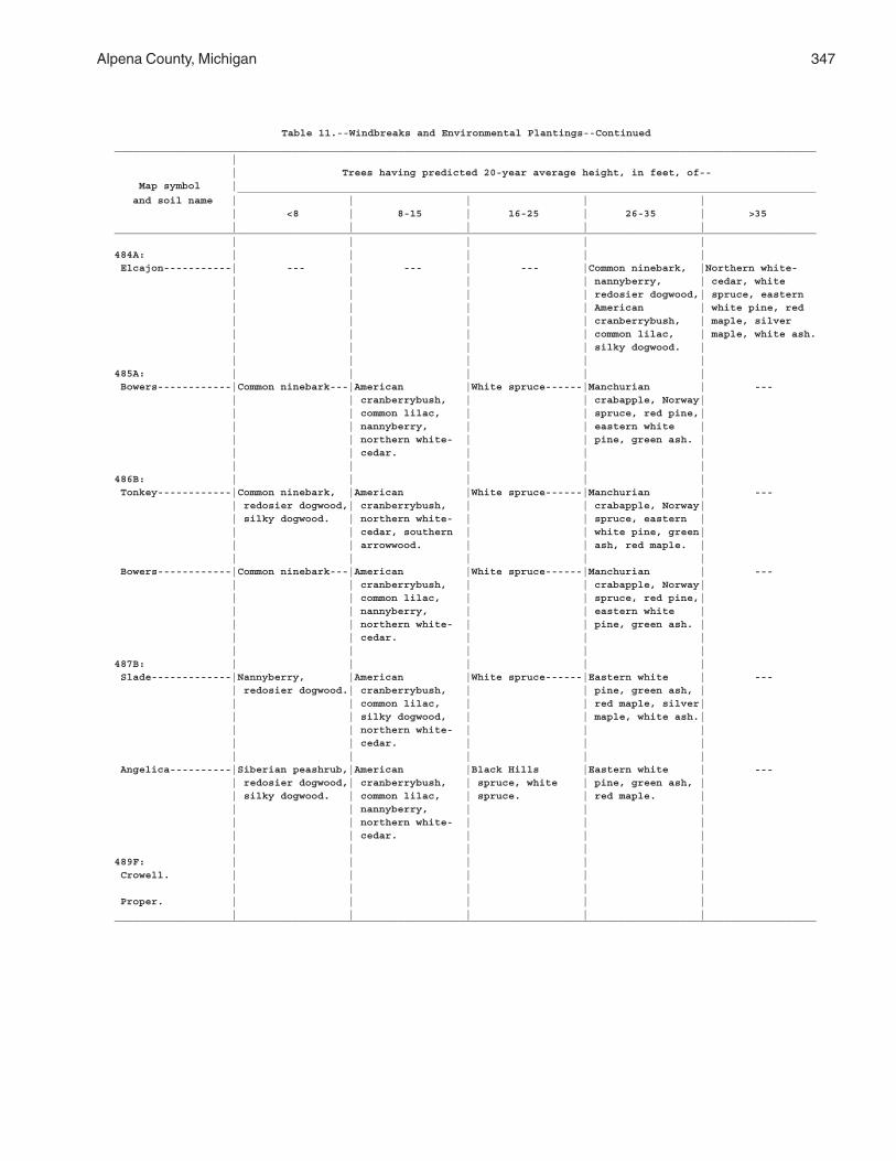
Alpena County, Michigan 347
Table 11.--Windbreaks and Environmental Plantings--Continued__________________________________________________________________________________________________________________ | | Trees having predicted 20-year average height, in feet, of-- Map symbol | ______________________________________________________________________________________________ and soil name | | | | | | <8 | 8-15 | 16-25 | 26-35 | >35 | | | | |__________________________________________________________________________________________________________________ | | | | |484A: | | | | | Elcajon-----------| --- | --- | --- |Common ninebark, |Northern white- | | | | nannyberry, | cedar, white | | | | redosier dogwood,| spruce, eastern | | | | American | white pine, red | | | | cranberrybush, | maple, silver | | | | common lilac, | maple, white ash. | | | | silky dogwood. | | | | | |485A: | | | | | Bowers------------|Common ninebark---|American |White spruce------|Manchurian | --- | | cranberrybush, | | crabapple, Norway| | | common lilac, | | spruce, red pine,| | | nannyberry, | | eastern white | | | northern white- | | pine, green ash. | | | cedar. | | | | | | | |486B: | | | | | Tonkey------------|Common ninebark, |American |White spruce------|Manchurian | --- | redosier dogwood,| cranberrybush, | | crabapple, Norway| | silky dogwood. | northern white- | | spruce, eastern | | | cedar, southern | | white pine, green| | | arrowwood. | | ash, red maple. | | | | | | Bowers------------|Common ninebark---|American |White spruce------|Manchurian | --- | | cranberrybush, | | crabapple, Norway| | | common lilac, | | spruce, red pine,| | | nannyberry, | | eastern white | | | northern white- | | pine, green ash. | | | cedar. | | | | | | | |487B: | | | | | Slade-------------|Nannyberry, |American |White spruce------|Eastern white | --- | redosier dogwood.| cranberrybush, | | pine, green ash, | | | common lilac, | | red maple, silver| | | silky dogwood, | | maple, white ash.| | | northern white- | | | | | cedar. | | | | | | | | Angelica----------|Siberian peashrub,|American |Black Hills |Eastern white | --- | redosier dogwood,| cranberrybush, | spruce, white | pine, green ash, | | silky dogwood. | common lilac, | spruce. | red maple. | | | nannyberry, | | | | | northern white- | | | | | cedar. | | | | | | | |489F: | | | | | Crowell. | | | | | | | | | | Proper. | | | | | | | | | |__________________________________________________________________________________________________________________
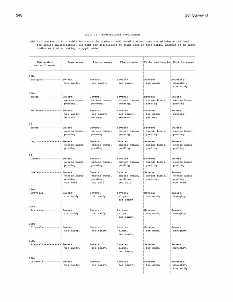
348 Soil Survey of
Table 12.--Recreational Development
(The information in this table indicates the dominant soil condition but does not eliminate the need for onsite investigation. See text for definitions of terms used in this table. Absence of an entry indicates that no rating is applicable.)
________________________________________________________________________________________________________ | | | | | Map symbol | Camp areas | Picnic areas | Playgrounds |Paths and trails| Golf fairways and soil name | | | | | | | | | |________________________________________________________________________________________________________ | | | | |11B: | | | | | Eastport-----------|Severe: |Severe: |Severe: |Severe: |Moderate: | too sandy. | too sandy. | too sandy. | too sandy. | droughty, | | | | | too sandy. | | | | |12B: | | | | | Tawas--------------|Severe: |Severe: |Severe: |Severe: |Severe: | excess humus, | excess humus, | excess humus, | excess humus, | excess humus, | ponding. | ponding. | ponding. | ponding. | ponding. | | | | | Au Gres------------|Severe: |Severe: |Severe: |Severe: |Severe: | too sandy, | too sandy, | too sandy, | too sandy, | wetness. | wetness. | wetness. | wetness. | wetness. | | | | | |13: | | | | | Tawas--------------|Severe: |Severe: |Severe: |Severe: |Severe: | excess humus, | excess humus, | excess humus, | excess humus, | excess humus, | ponding. | ponding. | ponding. | ponding. | ponding. | | | | | Lupton-------------|Severe: |Severe: |Severe: |Severe: |Severe: | excess humus, | excess humus, | excess humus, | excess humus, | excess humus, | ponding. | ponding. | ponding. | ponding. | ponding. | | | | |14: | | | | | Dawson-------------|Severe: |Severe: |Severe: |Severe: |Severe: | excess humus, | excess humus, | excess humus, | excess humus, | excess humus, | ponding. | ponding. | ponding. | ponding. | ponding. | | | | | Loxley-------------|Severe: |Severe: |Severe: |Severe: |Severe: | excess humus, | excess humus, | excess humus, | excess humus, | excess humus, | ponding, | ponding, | ponding, | ponding. | ponding, | too acid. | too acid. | too acid. | | too acid. | | | | |16B: | | | | | Graycalm-----------|Severe: |Severe: |Severe: |Severe: |Severe: | too sandy. | too sandy. | slope, | too sandy. | droughty. | | | too sandy. | | | | | | |16C: | | | | | Graycalm-----------|Severe: |Severe: |Severe: |Severe: |Severe: | too sandy. | too sandy. | slope, | too sandy. | droughty. | | | too sandy. | | | | | | |16D: | | | | | Graycalm-----------|Severe: |Severe: |Severe: |Severe: |Severe: | too sandy. | too sandy. | slope, | too sandy. | droughty. | | | too sandy. | | | | | | |16E: | | | | | Graycalm-----------|Severe: |Severe: |Severe: |Severe: |Severe: | too sandy. | too sandy. | slope, | too sandy. | droughty. | | | too sandy. | | | | | | |17A: | | | | | Croswell-----------|Severe: |Severe: |Severe: |Severe: |Moderate: | too sandy. | too sandy. | too sandy. | too sandy. | droughty, | | | | | too sandy. | | | | |
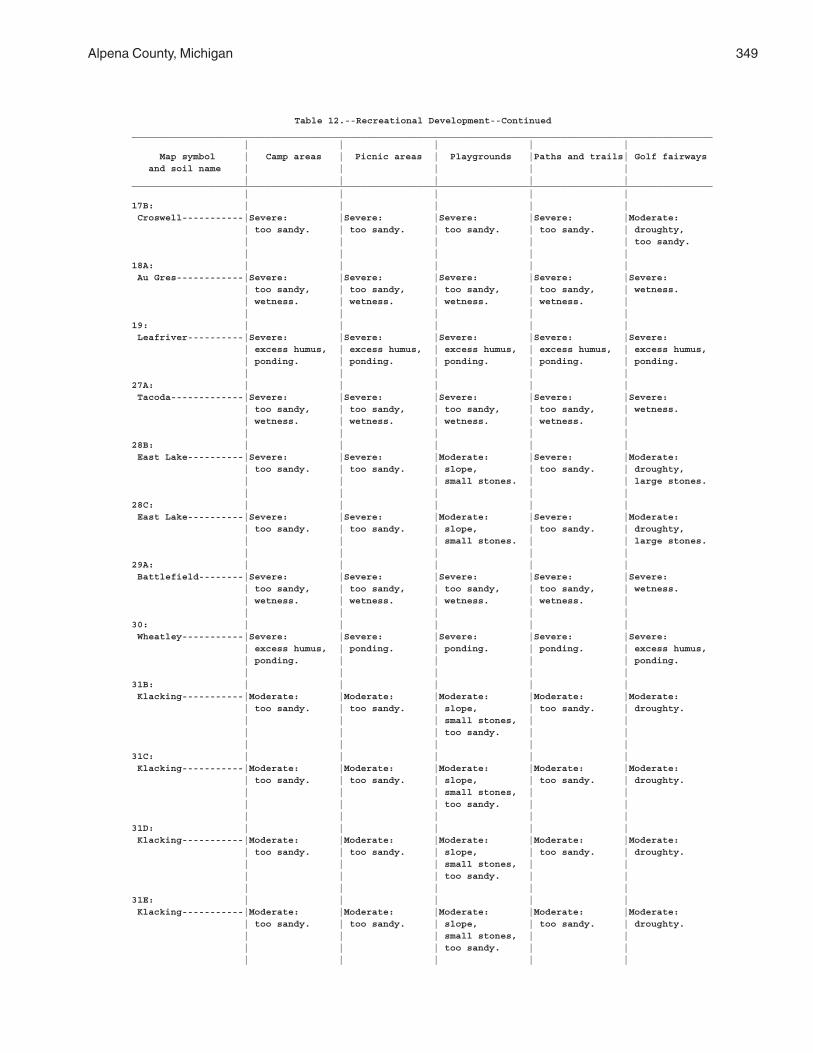
Alpena County, Michigan 349
Table 12.--Recreational Development--Continued________________________________________________________________________________________________________ | | | | | Map symbol | Camp areas | Picnic areas | Playgrounds |Paths and trails| Golf fairways and soil name | | | | | | | | | |________________________________________________________________________________________________________ | | | | |17B: | | | | | Croswell-----------|Severe: |Severe: |Severe: |Severe: |Moderate: | too sandy. | too sandy. | too sandy. | too sandy. | droughty, | | | | | too sandy. | | | | |18A: | | | | | Au Gres------------|Severe: |Severe: |Severe: |Severe: |Severe: | too sandy, | too sandy, | too sandy, | too sandy, | wetness. | wetness. | wetness. | wetness. | wetness. | | | | | |19: | | | | | Leafriver----------|Severe: |Severe: |Severe: |Severe: |Severe: | excess humus, | excess humus, | excess humus, | excess humus, | excess humus, | ponding. | ponding. | ponding. | ponding. | ponding. | | | | |27A: | | | | | Tacoda-------------|Severe: |Severe: |Severe: |Severe: |Severe: | too sandy, | too sandy, | too sandy, | too sandy, | wetness. | wetness. | wetness. | wetness. | wetness. | | | | | |28B: | | | | | East Lake----------|Severe: |Severe: |Moderate: |Severe: |Moderate: | too sandy. | too sandy. | slope, | too sandy. | droughty, | | | small stones. | | large stones. | | | | |28C: | | | | | East Lake----------|Severe: |Severe: |Moderate: |Severe: |Moderate: | too sandy. | too sandy. | slope, | too sandy. | droughty, | | | small stones. | | large stones. | | | | |29A: | | | | | Battlefield--------|Severe: |Severe: |Severe: |Severe: |Severe: | too sandy, | too sandy, | too sandy, | too sandy, | wetness. | wetness. | wetness. | wetness. | wetness. | | | | | |30: | | | | | Wheatley-----------|Severe: |Severe: |Severe: |Severe: |Severe: | excess humus, | ponding. | ponding. | ponding. | excess humus, | ponding. | | | | ponding. | | | | |31B: | | | | | Klacking-----------|Moderate: |Moderate: |Moderate: |Moderate: |Moderate: | too sandy. | too sandy. | slope, | too sandy. | droughty. | | | small stones, | | | | | too sandy. | | | | | | |31C: | | | | | Klacking-----------|Moderate: |Moderate: |Moderate: |Moderate: |Moderate: | too sandy. | too sandy. | slope, | too sandy. | droughty. | | | small stones, | | | | | too sandy. | | | | | | |31D: | | | | | Klacking-----------|Moderate: |Moderate: |Moderate: |Moderate: |Moderate: | too sandy. | too sandy. | slope, | too sandy. | droughty. | | | small stones, | | | | | too sandy. | | | | | | |31E: | | | | | Klacking-----------|Moderate: |Moderate: |Moderate: |Moderate: |Moderate: | too sandy. | too sandy. | slope, | too sandy. | droughty. | | | small stones, | | | | | too sandy. | | | | | | |
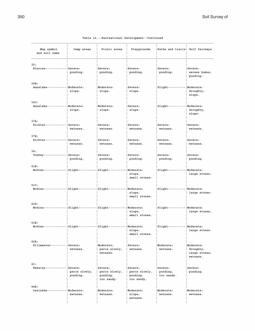
350 Soil Survey of
Table 12.--Recreational Development--Continued________________________________________________________________________________________________________ | | | | | Map symbol | Camp areas | Picnic areas | Playgrounds |Paths and trails| Golf fairways and soil name | | | | | | | | | |________________________________________________________________________________________________________ | | | | |35: | | | | | Kinross------------|Severe: |Severe: |Severe: |Severe: |Severe: | ponding. | ponding. | ponding. | ponding. | excess humus, | | | | | ponding. | | | | |36B: | | | | | Annalake-----------|Moderate: |Moderate: |Severe: |Slight----------|Moderate: | slope. | slope. | slope. | | droughty, | | | | | slope. | | | | |36C: | | | | | Annalake-----------|Moderate: |Moderate: |Severe: |Slight----------|Moderate: | slope. | slope. | slope. | | droughty, | | | | | slope. | | | | |37A: | | | | | Richter------------|Severe: |Severe: |Severe: |Severe: |Severe: | wetness. | wetness. | wetness. | wetness. | wetness. | | | | |37B: | | | | | Richter------------|Severe: |Severe: |Severe: |Severe: |Severe: | wetness. | wetness. | wetness. | wetness. | wetness. | | | | |38: | | | | | Tonkey-------------|Severe: |Severe: |Severe: |Severe: |Severe: | ponding. | ponding. | ponding. | ponding. | ponding. | | | | |41B: | | | | | McGinn-------------|Slight----------|Slight----------|Moderate: |Slight----------|Moderate: | | | slope, | | large stones. | | | small stones. | | | | | | |41C: | | | | | McGinn-------------|Slight----------|Slight----------|Moderate: |Slight----------|Moderate: | | | slope, | | large stones. | | | small stones. | | | | | | |41D: | | | | | McGinn-------------|Slight----------|Slight----------|Moderate: |Slight----------|Moderate: | | | slope, | | large stones. | | | small stones. | | | | | | |41E: | | | | | McGinn-------------|Slight----------|Slight----------|Moderate: |Slight----------|Moderate: | | | slope, | | large stones. | | | small stones. | | | | | | |42A: | | | | | Killmaster---------|Severe: |Moderate: |Severe: |Moderate: |Moderate: | wetness. | percs slowly, | wetness. | wetness. | droughty, | | wetness. | | | large stones, | | | | | wetness. | | | | |43: | | | | | Wakeley------------|Severe: |Severe: |Severe: |Severe: |Severe: | percs slowly, | percs slowly, | percs slowly, | ponding, | ponding. | ponding. | ponding, | ponding, | too sandy. | | | too sandy. | too sandy. | | | | | | |44B: | | | | | Ossineke-----------|Moderate: |Moderate: |Moderate: |Moderate: |Moderate: | wetness. | wetness. | slope, | wetness. | wetness. | | | wetness. | | | | | | |
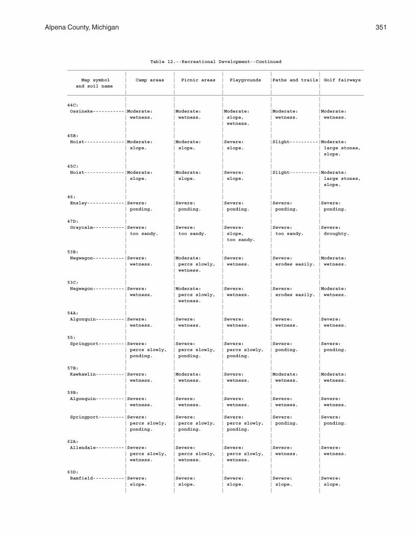
Alpena County, Michigan 351
Table 12.--Recreational Development--Continued________________________________________________________________________________________________________ | | | | | Map symbol | Camp areas | Picnic areas | Playgrounds |Paths and trails| Golf fairways and soil name | | | | | | | | | |________________________________________________________________________________________________________ | | | | |44C: | | | | | Ossineke-----------|Moderate: |Moderate: |Moderate: |Moderate: |Moderate: | wetness. | wetness. | slope, | wetness. | wetness. | | | wetness. | | | | | | |45B: | | | | | Hoist--------------|Moderate: |Moderate: |Severe: |Slight----------|Moderate: | slope. | slope. | slope. | | large stones, | | | | | slope. | | | | |45C: | | | | | Hoist--------------|Moderate: |Moderate: |Severe: |Slight----------|Moderate: | slope. | slope. | slope. | | large stones, | | | | | slope. | | | | |46: | | | | | Ensley-------------|Severe: |Severe: |Severe: |Severe: |Severe: | ponding. | ponding. | ponding. | ponding. | ponding. | | | | |47D: | | | | | Graycalm-----------|Severe: |Severe: |Severe: |Severe: |Severe: | too sandy. | too sandy. | slope, | too sandy. | droughty. | | | too sandy. | | | | | | |53B: | | | | | Negwegon-----------|Severe: |Moderate: |Severe: |Severe: |Moderate: | wetness. | percs slowly, | wetness. | erodes easily. | wetness. | | wetness. | | | | | | | |53C: | | | | | Negwegon-----------|Severe: |Moderate: |Severe: |Severe: |Moderate: | wetness. | percs slowly, | wetness. | erodes easily. | wetness. | | wetness. | | | | | | | |54A: | | | | | Algonquin----------|Severe: |Severe: |Severe: |Severe: |Severe: | wetness. | wetness. | wetness. | wetness. | wetness. | | | | |55: | | | | | Springport---------|Severe: |Severe: |Severe: |Severe: |Severe: | percs slowly, | percs slowly, | percs slowly, | ponding. | ponding. | ponding. | ponding. | ponding. | | | | | | |57B: | | | | | Kawkawlin----------|Severe: |Moderate: |Severe: |Moderate: |Moderate: | wetness. | wetness. | wetness. | wetness. | wetness. | | | | |59B: | | | | | Algonquin----------|Severe: |Severe: |Severe: |Severe: |Severe: | wetness. | wetness. | wetness. | wetness. | wetness. | | | | | Springport---------|Severe: |Severe: |Severe: |Severe: |Severe: | percs slowly, | percs slowly, | percs slowly, | ponding. | ponding. | ponding. | ponding. | ponding. | | | | | | |62A: | | | | | Allendale----------|Severe: |Severe: |Severe: |Severe: |Severe: | percs slowly, | percs slowly, | percs slowly, | wetness. | wetness. | wetness. | wetness. | wetness. | | | | | | |63D: | | | | | Bamfield-----------|Severe: |Severe: |Severe: |Severe: |Severe: | slope. | slope. | slope. | slope. | slope. | | | | |
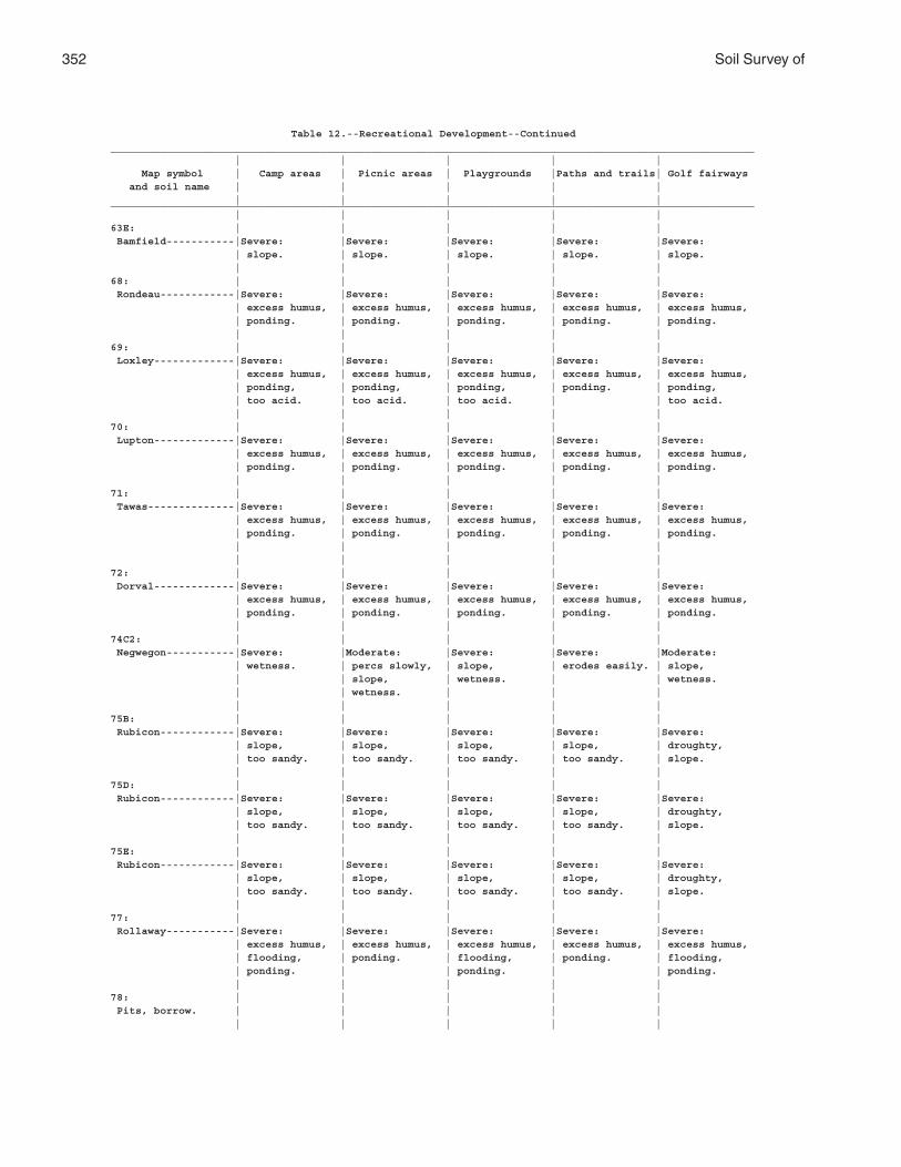
352 Soil Survey of
Table 12.--Recreational Development--Continued________________________________________________________________________________________________________ | | | | | Map symbol | Camp areas | Picnic areas | Playgrounds |Paths and trails| Golf fairways and soil name | | | | | | | | | |________________________________________________________________________________________________________ | | | | |63E: | | | | | Bamfield-----------|Severe: |Severe: |Severe: |Severe: |Severe: | slope. | slope. | slope. | slope. | slope. | | | | |68: | | | | | Rondeau------------|Severe: |Severe: |Severe: |Severe: |Severe: | excess humus, | excess humus, | excess humus, | excess humus, | excess humus, | ponding. | ponding. | ponding. | ponding. | ponding. | | | | |69: | | | | | Loxley-------------|Severe: |Severe: |Severe: |Severe: |Severe: | excess humus, | excess humus, | excess humus, | excess humus, | excess humus, | ponding, | ponding, | ponding, | ponding. | ponding, | too acid. | too acid. | too acid. | | too acid. | | | | |70: | | | | | Lupton-------------|Severe: |Severe: |Severe: |Severe: |Severe: | excess humus, | excess humus, | excess humus, | excess humus, | excess humus, | ponding. | ponding. | ponding. | ponding. | ponding. | | | | |71: | | | | | Tawas--------------|Severe: |Severe: |Severe: |Severe: |Severe: | excess humus, | excess humus, | excess humus, | excess humus, | excess humus, | ponding. | ponding. | ponding. | ponding. | ponding. | | | | | | | | | |72: | | | | | Dorval-------------|Severe: |Severe: |Severe: |Severe: |Severe: | excess humus, | excess humus, | excess humus, | excess humus, | excess humus, | ponding. | ponding. | ponding. | ponding. | ponding. | | | | |74C2: | | | | | Negwegon-----------|Severe: |Moderate: |Severe: |Severe: |Moderate: | wetness. | percs slowly, | slope, | erodes easily. | slope, | | slope, | wetness. | | wetness. | | wetness. | | | | | | | |75B: | | | | | Rubicon------------|Severe: |Severe: |Severe: |Severe: |Severe: | slope, | slope, | slope, | slope, | droughty, | too sandy. | too sandy. | too sandy. | too sandy. | slope. | | | | |75D: | | | | | Rubicon------------|Severe: |Severe: |Severe: |Severe: |Severe: | slope, | slope, | slope, | slope, | droughty, | too sandy. | too sandy. | too sandy. | too sandy. | slope. | | | | |75E: | | | | | Rubicon------------|Severe: |Severe: |Severe: |Severe: |Severe: | slope, | slope, | slope, | slope, | droughty, | too sandy. | too sandy. | too sandy. | too sandy. | slope. | | | | |77: | | | | | Rollaway-----------|Severe: |Severe: |Severe: |Severe: |Severe: | excess humus, | excess humus, | excess humus, | excess humus, | excess humus, | flooding, | ponding. | flooding, | ponding. | flooding, | ponding. | | ponding. | | ponding. | | | | |78: | | | | | Pits, borrow. | | | | | | | | | |
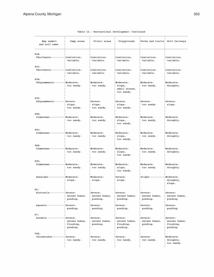
Alpena County, Michigan 353
Table 12.--Recreational Development--Continued________________________________________________________________________________________________________ | | | | | Map symbol | Camp areas | Picnic areas | Playgrounds |Paths and trails| Golf fairways and soil name | | | | | | | | | |________________________________________________________________________________________________________ | | | | |82B: | | | | | Udorthents---------|Limitation: |Limitation: |Limitation: |Limitation: |Limitation: | variable. | variable. | variable. | variable. | variable. | | | | |82C: | | | | | Udorthents---------|Limitation: |Limitation: |Limitation: |Limitation: |Limitation: | variable. | variable. | variable. | variable. | variable. | | | | |83B: | | | | | Udipsamments-------|Moderate: |Moderate: |Moderate: |Moderate: |Moderate: | too sandy. | too sandy. | slope, | too sandy. | droughty. | | | small stones, | | | | | too sandy. | | | | | | |83F: | | | | | Udipsamments-------|Severe: |Severe: |Severe: |Severe: |Severe: | slope, | slope, | slope, | too sandy. | slope. | too sandy. | too sandy. | too sandy. | | | | | | |84B: | | | | | Zimmerman----------|Moderate: |Moderate: |Moderate: |Moderate: |Moderate: | too sandy. | too sandy. | slope, | too sandy. | droughty. | | | too sandy. | | | | | | |84C: | | | | | Zimmerman----------|Moderate: |Moderate: |Moderate: |Moderate: |Moderate: | too sandy. | too sandy. | slope, | too sandy. | droughty. | | | too sandy. | | | | | | |84E: | | | | | Zimmerman----------|Moderate: |Moderate: |Moderate: |Moderate: |Moderate: | too sandy. | too sandy. | slope, | too sandy. | droughty. | | | too sandy. | | | | | | |85D: | | | | | Zimmerman----------|Moderate: |Moderate: |Moderate: |Moderate: |Moderate: | too sandy. | too sandy. | slope, | too sandy. | droughty. | | | too sandy. | | | | | | | Annalake-----------|Moderate: |Moderate: |Severe: |Slight----------|Moderate: | slope. | slope. | slope. | | droughty, | | | | | slope. | | | | |86: | | | | | Histosols----------|Severe: |Severe: |Severe: |Severe: |Severe: | excess humus, | excess humus, | excess humus, | excess humus, | excess humus, | ponding. | ponding. | ponding. | ponding. | ponding. | | | | | Aquents------------|Severe: |Severe: |Severe: |Severe: |Severe: | ponding. | ponding. | ponding. | ponding. | ponding. | | | | |87: | | | | | Ausable------------|Severe: |Severe: |Severe: |Severe: |Severe: | excess humus, | excess humus, | excess humus, | excess humus, | excess humus, | flooding, | ponding. | flooding, | ponding. | flooding, | ponding. | | ponding. | | ponding. | | | | |90B: | | | | | Chinwhisker--------|Severe: |Severe: |Severe: |Severe: |Moderate: | too sandy. | too sandy. | too sandy. | too sandy. | droughty, | | | | | too sandy. | | | | |
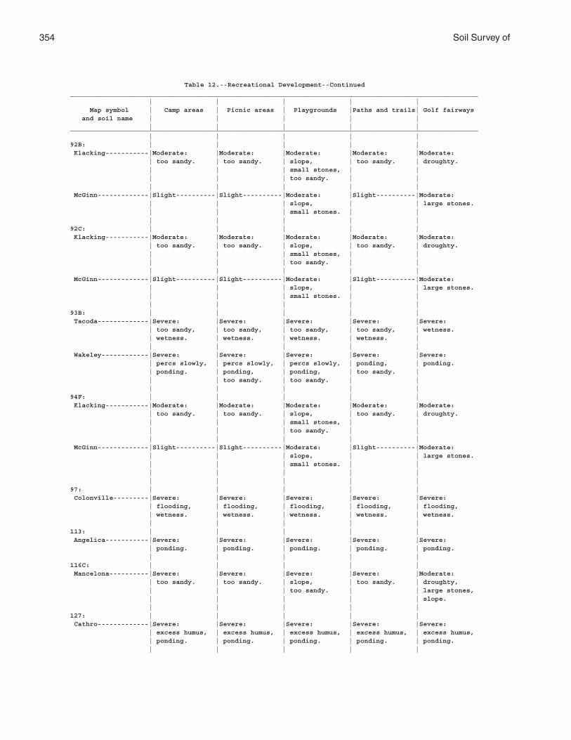
354 Soil Survey of
Table 12.--Recreational Development--Continued________________________________________________________________________________________________________ | | | | | Map symbol | Camp areas | Picnic areas | Playgrounds |Paths and trails| Golf fairways and soil name | | | | | | | | | |________________________________________________________________________________________________________ | | | | |92B: | | | | | Klacking-----------|Moderate: |Moderate: |Moderate: |Moderate: |Moderate: | too sandy. | too sandy. | slope, | too sandy. | droughty. | | | small stones, | | | | | too sandy. | | | | | | | McGinn-------------|Slight----------|Slight----------|Moderate: |Slight----------|Moderate: | | | slope, | | large stones. | | | small stones. | | | | | | |92C: | | | | | Klacking-----------|Moderate: |Moderate: |Moderate: |Moderate: |Moderate: | too sandy. | too sandy. | slope, | too sandy. | droughty. | | | small stones, | | | | | too sandy. | | | | | | | McGinn-------------|Slight----------|Slight----------|Moderate: |Slight----------|Moderate: | | | slope, | | large stones. | | | small stones. | | | | | | |93B: | | | | | Tacoda-------------|Severe: |Severe: |Severe: |Severe: |Severe: | too sandy, | too sandy, | too sandy, | too sandy, | wetness. | wetness. | wetness. | wetness. | wetness. | | | | | | Wakeley------------|Severe: |Severe: |Severe: |Severe: |Severe: | percs slowly, | percs slowly, | percs slowly, | ponding, | ponding. | ponding. | ponding, | ponding, | too sandy. | | | too sandy. | too sandy. | | | | | | |94F: | | | | | Klacking-----------|Moderate: |Moderate: |Moderate: |Moderate: |Moderate: | too sandy. | too sandy. | slope, | too sandy. | droughty. | | | small stones, | | | | | too sandy. | | | | | | | McGinn-------------|Slight----------|Slight----------|Moderate: |Slight----------|Moderate: | | | slope, | | large stones. | | | small stones. | | | | | | | | | | | |97: | | | | | Colonville---------|Severe: |Severe: |Severe: |Severe: |Severe: | flooding, | flooding, | flooding, | flooding, | flooding, | wetness. | wetness. | wetness. | wetness. | wetness. | | | | |113: | | | | | Angelica-----------|Severe: |Severe: |Severe: |Severe: |Severe: | ponding. | ponding. | ponding. | ponding. | ponding. | | | | |116C: | | | | | Mancelona----------|Severe: |Severe: |Severe: |Severe: |Moderate: | too sandy. | too sandy. | slope, | too sandy. | droughty, | | | too sandy. | | large stones, | | | | | slope. | | | | |127: | | | | | Cathro-------------|Severe: |Severe: |Severe: |Severe: |Severe: | excess humus, | excess humus, | excess humus, | excess humus, | excess humus, | ponding. | ponding. | ponding. | ponding. | ponding. | | | | |
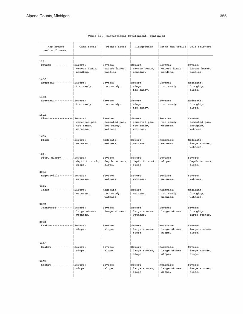
Alpena County, Michigan 355
Table 12.--Recreational Development--Continued________________________________________________________________________________________________________ | | | | | Map symbol | Camp areas | Picnic areas | Playgrounds |Paths and trails| Golf fairways and soil name | | | | | | | | | |________________________________________________________________________________________________________ | | | | |128: | | | | | Dawson-------------|Severe: |Severe: |Severe: |Severe: |Severe: | excess humus, | excess humus, | excess humus, | excess humus, | excess humus, | ponding. | ponding. | ponding. | ponding. | ponding. | | | | |145C: | | | | | Rousseau-----------|Severe: |Severe: |Severe: |Severe: |Moderate: | too sandy. | too sandy. | slope, | too sandy. | droughty, | | | too sandy. | | slope. | | | | |145E: | | | | | Rousseau-----------|Severe: |Severe: |Severe: |Severe: |Moderate: | too sandy. | too sandy. | slope, | too sandy. | droughty, | | | too sandy. | | slope. | | | | |159A: | | | | | Finch--------------|Severe: |Severe: |Severe: |Severe: |Severe: | cemented pan, | cemented pan, | cemented pan, | too sandy, | cemented pan, | too sandy, | too sandy, | too sandy, | wetness. | droughty, | wetness. | wetness. | wetness. | | wetness. | | | | |166A: | | | | | Slade--------------|Severe: |Moderate: |Severe: |Moderate: |Moderate: | wetness. | wetness. | wetness. | wetness. | large stones, | | | | | wetness. | | | | |182: | | | | | Pits, quarry-------|Severe: |Severe: |Severe: |Severe: |Severe: | depth to rock, | depth to rock, | depth to rock, | slope. | depth to rock, | slope. | slope. | slope. | | slope. | | | | |300A: | | | | | Hagensville--------|Severe: |Severe: |Severe: |Severe: |Severe: | wetness. | wetness. | wetness. | wetness. | wetness. | | | | |304A: | | | | | Iosco--------------|Severe: |Moderate: |Severe: |Moderate: |Moderate: | wetness. | too sandy, | wetness. | too sandy, | droughty, | | wetness. | | wetness. | wetness. | | | | |305B: | | | | | Johnswood----------|Severe: |Severe: |Severe: |Severe: |Severe: | large stones, | large stones. | large stones, | large stones. | droughty, | wetness. | | wetness. | | large stones. | | | | |308B: | | | | | Krakow-------------|Severe: |Severe: |Severe: |Moderate: |Severe: | slope. | slope. | large stones, | large stones, | large stones, | | | slope. | slope. | slope. | | | | | | | | | |308C: | | | | | Krakow-------------|Severe: |Severe: |Severe: |Moderate: |Severe: | slope. | slope. | large stones, | large stones, | large stones, | | | slope. | slope. | slope. | | | | |308D: | | | | | Krakow-------------|Severe: |Severe: |Severe: |Moderate: |Severe: | slope. | slope. | large stones, | large stones, | large stones, | | | slope. | slope. | slope. | | | | |
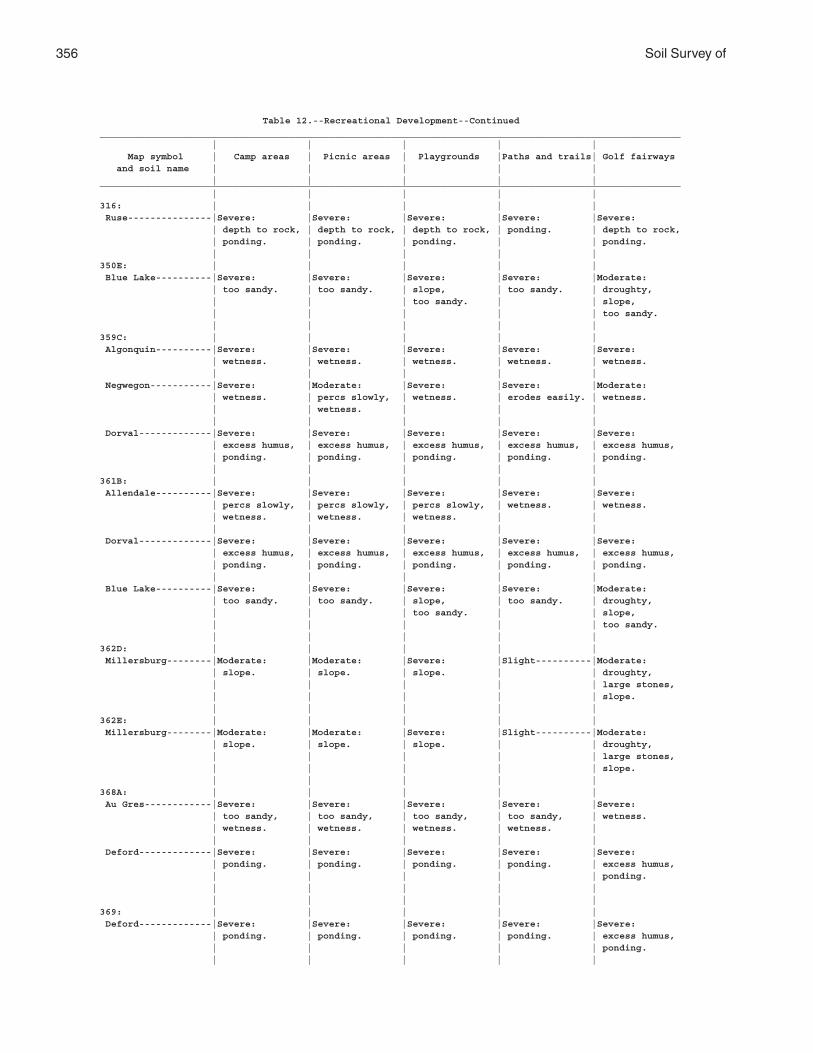
356 Soil Survey of
Table 12.--Recreational Development--Continued________________________________________________________________________________________________________ | | | | | Map symbol | Camp areas | Picnic areas | Playgrounds |Paths and trails| Golf fairways and soil name | | | | | | | | | |________________________________________________________________________________________________________ | | | | |316: | | | | | Ruse---------------|Severe: |Severe: |Severe: |Severe: |Severe: | depth to rock, | depth to rock, | depth to rock, | ponding. | depth to rock, | ponding. | ponding. | ponding. | | ponding. | | | | |350E: | | | | | Blue Lake----------|Severe: |Severe: |Severe: |Severe: |Moderate: | too sandy. | too sandy. | slope, | too sandy. | droughty, | | | too sandy. | | slope, | | | | | too sandy. | | | | |359C: | | | | | Algonquin----------|Severe: |Severe: |Severe: |Severe: |Severe: | wetness. | wetness. | wetness. | wetness. | wetness. | | | | | Negwegon-----------|Severe: |Moderate: |Severe: |Severe: |Moderate: | wetness. | percs slowly, | wetness. | erodes easily. | wetness. | | wetness. | | | | | | | | Dorval-------------|Severe: |Severe: |Severe: |Severe: |Severe: | excess humus, | excess humus, | excess humus, | excess humus, | excess humus, | ponding. | ponding. | ponding. | ponding. | ponding. | | | | |361B: | | | | | Allendale----------|Severe: |Severe: |Severe: |Severe: |Severe: | percs slowly, | percs slowly, | percs slowly, | wetness. | wetness. | wetness. | wetness. | wetness. | | | | | | | Dorval-------------|Severe: |Severe: |Severe: |Severe: |Severe: | excess humus, | excess humus, | excess humus, | excess humus, | excess humus, | ponding. | ponding. | ponding. | ponding. | ponding. | | | | | Blue Lake----------|Severe: |Severe: |Severe: |Severe: |Moderate: | too sandy. | too sandy. | slope, | too sandy. | droughty, | | | too sandy. | | slope, | | | | | too sandy. | | | | |362D: | | | | | Millersburg--------|Moderate: |Moderate: |Severe: |Slight----------|Moderate: | slope. | slope. | slope. | | droughty, | | | | | large stones, | | | | | slope. | | | | |362E: | | | | | Millersburg--------|Moderate: |Moderate: |Severe: |Slight----------|Moderate: | slope. | slope. | slope. | | droughty, | | | | | large stones, | | | | | slope. | | | | |368A: | | | | | Au Gres------------|Severe: |Severe: |Severe: |Severe: |Severe: | too sandy, | too sandy, | too sandy, | too sandy, | wetness. | wetness. | wetness. | wetness. | wetness. | | | | | | Deford-------------|Severe: |Severe: |Severe: |Severe: |Severe: | ponding. | ponding. | ponding. | ponding. | excess humus, | | | | | ponding. | | | | | | | | | |369: | | | | | Deford-------------|Severe: |Severe: |Severe: |Severe: |Severe: | ponding. | ponding. | ponding. | ponding. | excess humus, | | | | | ponding. | | | | |
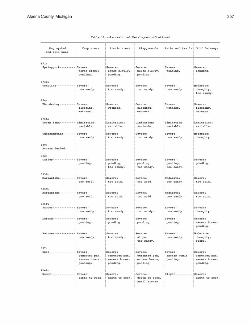
Alpena County, Michigan 357
Table 12.--Recreational Development--Continued________________________________________________________________________________________________________ | | | | | Map symbol | Camp areas | Picnic areas | Playgrounds |Paths and trails| Golf fairways and soil name | | | | | | | | | |________________________________________________________________________________________________________ | | | | |371: | | | | | Springport---------|Severe: |Severe: |Severe: |Severe: |Severe: | percs slowly, | percs slowly, | percs slowly, | ponding. | ponding. | ponding. | ponding. | ponding. | | | | | | |373B: | | | | | Grayling-----------|Severe: |Severe: |Severe: |Severe: |Moderate: | too sandy. | too sandy. | too sandy. | too sandy. | droughty, | | | | | too sandy. | | | | |374: | | | | | Thunderbay---------|Severe: |Severe: |Severe: |Severe: |Severe: | flooding, | wetness. | flooding, | wetness. | flooding, | wetness. | | wetness. | | wetness. | | | | |376A: | | | | | Urban land---------|Limitation: |Limitation: |Limitation: |Limitation: |Limitation: | variable. | variable. | variable. | variable. | variable. | | | | | Udipsamments-------|Severe: |Severe: |Severe: |Severe: |Moderate: | too sandy. | too sandy. | too sandy. | too sandy. | droughty. | | | | |380: | | | | | Access denied. | | | | | | | | | |392: | | | | | Caffey-------------|Severe: |Severe: |Severe: |Severe: |Severe: | ponding. | ponding, | ponding, | ponding, | ponding. | | too sandy. | too sandy. | too sandy. | | | | | |393B: | | | | | Morganlake---------|Severe: |Severe: |Severe: |Moderate: |Severe: | too acid. | too acid. | too acid. | too sandy. | too acid. | | | | |393C: | | | | | Morganlake---------|Severe: |Severe: |Severe: |Moderate: |Severe: | too acid. | too acid. | too acid. | too sandy. | too acid. | | | | |396F: | | | | | Proper-------------|Severe: |Severe: |Severe: |Severe: |Severe: | too sandy. | too sandy. | too sandy. | too sandy. | droughty. | | | | | Deford-------------|Severe: |Severe: |Severe: |Severe: |Severe: | ponding. | ponding. | ponding. | ponding. | excess humus, | | | | | ponding. | | | | | Rousseau-----------|Severe: |Severe: |Severe: |Severe: |Moderate: | too sandy. | too sandy. | slope, | too sandy. | droughty, | | | too sandy. | | slope. | | | | |397: | | | | | Spot---------------|Severe: |Severe: |Severe: |Severe: |Severe: | cemented pan, | cemented pan, | cemented pan, | excess humus, | cemented pan, | excess humus, | excess humus, | excess humus, | ponding. | excess humus, | ponding. | ponding. | ponding. | | ponding. | | | | |414B: | | | | | Namur--------------|Severe: |Severe: |Severe: |Slight----------|Severe: | depth to rock. | depth to rock. | depth to rock, | | depth to rock. | | | small stones. | | | | | | |
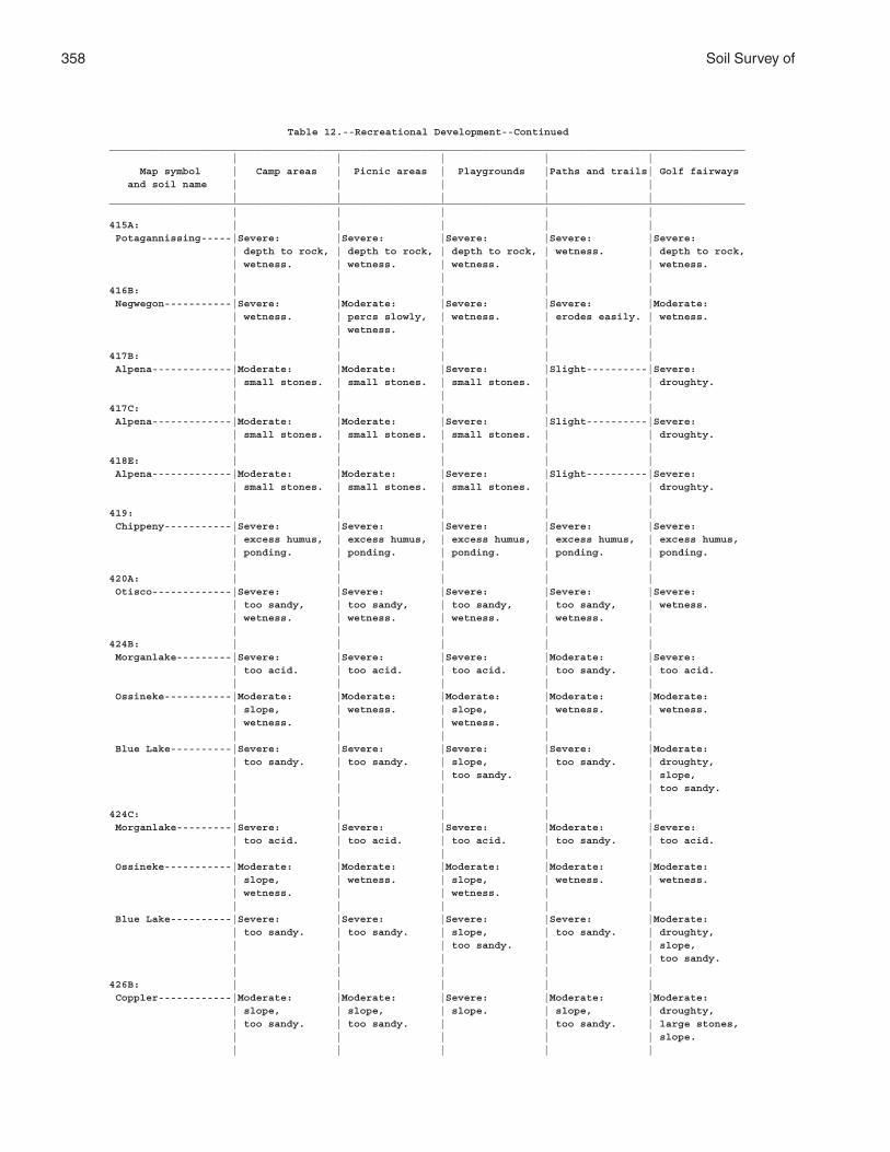
358 Soil Survey of
Table 12.--Recreational Development--Continued________________________________________________________________________________________________________ | | | | | Map symbol | Camp areas | Picnic areas | Playgrounds |Paths and trails| Golf fairways and soil name | | | | | | | | | |________________________________________________________________________________________________________ | | | | |415A: | | | | | Potagannissing-----|Severe: |Severe: |Severe: |Severe: |Severe: | depth to rock, | depth to rock, | depth to rock, | wetness. | depth to rock, | wetness. | wetness. | wetness. | | wetness. | | | | |416B: | | | | | Negwegon-----------|Severe: |Moderate: |Severe: |Severe: |Moderate: | wetness. | percs slowly, | wetness. | erodes easily. | wetness. | | wetness. | | | | | | | |417B: | | | | | Alpena-------------|Moderate: |Moderate: |Severe: |Slight----------|Severe: | small stones. | small stones. | small stones. | | droughty. | | | | |417C: | | | | | Alpena-------------|Moderate: |Moderate: |Severe: |Slight----------|Severe: | small stones. | small stones. | small stones. | | droughty. | | | | |418E: | | | | | Alpena-------------|Moderate: |Moderate: |Severe: |Slight----------|Severe: | small stones. | small stones. | small stones. | | droughty. | | | | |419: | | | | | Chippeny-----------|Severe: |Severe: |Severe: |Severe: |Severe: | excess humus, | excess humus, | excess humus, | excess humus, | excess humus, | ponding. | ponding. | ponding. | ponding. | ponding. | | | | |420A: | | | | | Otisco-------------|Severe: |Severe: |Severe: |Severe: |Severe: | too sandy, | too sandy, | too sandy, | too sandy, | wetness. | wetness. | wetness. | wetness. | wetness. | | | | | |424B: | | | | | Morganlake---------|Severe: |Severe: |Severe: |Moderate: |Severe: | too acid. | too acid. | too acid. | too sandy. | too acid. | | | | | Ossineke-----------|Moderate: |Moderate: |Moderate: |Moderate: |Moderate: | slope, | wetness. | slope, | wetness. | wetness. | wetness. | | wetness. | | | | | | | Blue Lake----------|Severe: |Severe: |Severe: |Severe: |Moderate: | too sandy. | too sandy. | slope, | too sandy. | droughty, | | | too sandy. | | slope, | | | | | too sandy. | | | | |424C: | | | | | Morganlake---------|Severe: |Severe: |Severe: |Moderate: |Severe: | too acid. | too acid. | too acid. | too sandy. | too acid. | | | | | Ossineke-----------|Moderate: |Moderate: |Moderate: |Moderate: |Moderate: | slope, | wetness. | slope, | wetness. | wetness. | wetness. | | wetness. | | | | | | | Blue Lake----------|Severe: |Severe: |Severe: |Severe: |Moderate: | too sandy. | too sandy. | slope, | too sandy. | droughty, | | | too sandy. | | slope, | | | | | too sandy. | | | | |426B: | | | | | Coppler------------|Moderate: |Moderate: |Severe: |Moderate: |Moderate: | slope, | slope, | slope. | slope, | droughty, | too sandy. | too sandy. | | too sandy. | large stones, | | | | | slope. | | | | |
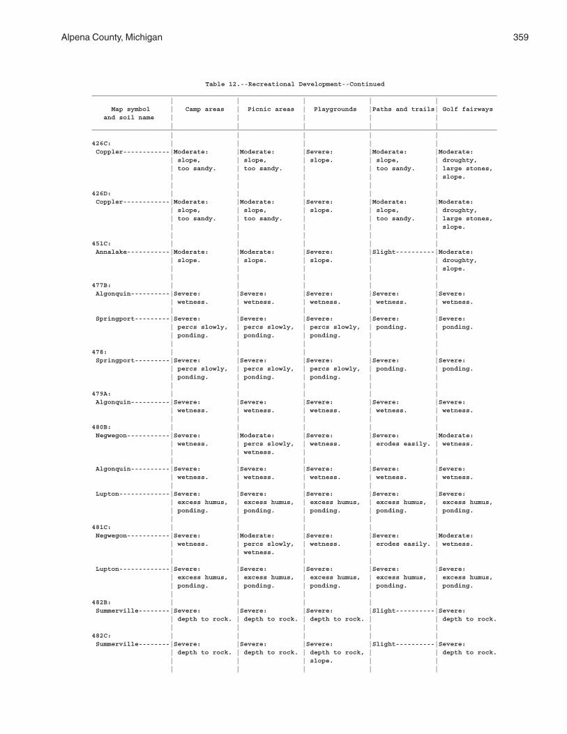
Alpena County, Michigan 359
Table 12.--Recreational Development--Continued________________________________________________________________________________________________________ | | | | | Map symbol | Camp areas | Picnic areas | Playgrounds |Paths and trails| Golf fairways and soil name | | | | | | | | | |________________________________________________________________________________________________________ | | | | |426C: | | | | | Coppler------------|Moderate: |Moderate: |Severe: |Moderate: |Moderate: | slope, | slope, | slope. | slope, | droughty, | too sandy. | too sandy. | | too sandy. | large stones, | | | | | slope. | | | | |426D: | | | | | Coppler------------|Moderate: |Moderate: |Severe: |Moderate: |Moderate: | slope, | slope, | slope. | slope, | droughty, | too sandy. | too sandy. | | too sandy. | large stones, | | | | | slope. | | | | |451C: | | | | | Annalake-----------|Moderate: |Moderate: |Severe: |Slight----------|Moderate: | slope. | slope. | slope. | | droughty, | | | | | slope. | | | | |477B: | | | | | Algonquin----------|Severe: |Severe: |Severe: |Severe: |Severe: | wetness. | wetness. | wetness. | wetness. | wetness. | | | | | Springport---------|Severe: |Severe: |Severe: |Severe: |Severe: | percs slowly, | percs slowly, | percs slowly, | ponding. | ponding. | ponding. | ponding. | ponding. | | | | | | |478: | | | | | Springport---------|Severe: |Severe: |Severe: |Severe: |Severe: | percs slowly, | percs slowly, | percs slowly, | ponding. | ponding. | ponding. | ponding. | ponding. | | | | | | |479A: | | | | | Algonquin----------|Severe: |Severe: |Severe: |Severe: |Severe: | wetness. | wetness. | wetness. | wetness. | wetness. | | | | |480B: | | | | | Negwegon-----------|Severe: |Moderate: |Severe: |Severe: |Moderate: | wetness. | percs slowly, | wetness. | erodes easily. | wetness. | | wetness. | | | | | | | | Algonquin----------|Severe: |Severe: |Severe: |Severe: |Severe: | wetness. | wetness. | wetness. | wetness. | wetness. | | | | | Lupton-------------|Severe: |Severe: |Severe: |Severe: |Severe: | excess humus, | excess humus, | excess humus, | excess humus, | excess humus, | ponding. | ponding. | ponding. | ponding. | ponding. | | | | |481C: | | | | | Negwegon-----------|Severe: |Moderate: |Severe: |Severe: |Moderate: | wetness. | percs slowly, | wetness. | erodes easily. | wetness. | | wetness. | | | | | | | | Lupton-------------|Severe: |Severe: |Severe: |Severe: |Severe: | excess humus, | excess humus, | excess humus, | excess humus, | excess humus, | ponding. | ponding. | ponding. | ponding. | ponding. | | | | |482B: | | | | | Summerville--------|Severe: |Severe: |Severe: |Slight----------|Severe: | depth to rock. | depth to rock. | depth to rock. | | depth to rock. | | | | |482C: | | | | | Summerville--------|Severe: |Severe: |Severe: |Slight----------|Severe: | depth to rock. | depth to rock. | depth to rock, | | depth to rock. | | | slope. | | | | | | |
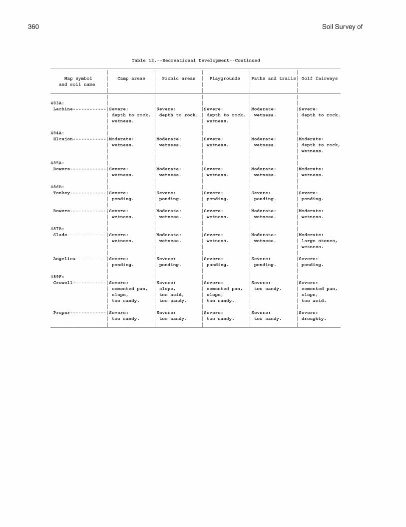
360 Soil Survey of
Table 12.--Recreational Development--Continued________________________________________________________________________________________________________ | | | | | Map symbol | Camp areas | Picnic areas | Playgrounds |Paths and trails| Golf fairways and soil name | | | | | | | | | |________________________________________________________________________________________________________ | | | | |483A: | | | | | Lachine------------|Severe: |Severe: |Severe: |Moderate: |Severe: | depth to rock, | depth to rock. | depth to rock, | wetness. | depth to rock. | wetness. | | wetness. | | | | | | |484A: | | | | | Elcajon------------|Moderate: |Moderate: |Severe: |Moderate: |Moderate: | wetness. | wetness. | wetness. | wetness. | depth to rock, | | | | | wetness. | | | | |485A: | | | | | Bowers-------------|Severe: |Moderate: |Severe: |Moderate: |Moderate: | wetness. | wetness. | wetness. | wetness. | wetness. | | | | |486B: | | | | | Tonkey-------------|Severe: |Severe: |Severe: |Severe: |Severe: | ponding. | ponding. | ponding. | ponding. | ponding. | | | | | Bowers-------------|Severe: |Moderate: |Severe: |Moderate: |Moderate: | wetness. | wetness. | wetness. | wetness. | wetness. | | | | |487B: | | | | | Slade--------------|Severe: |Moderate: |Severe: |Moderate: |Moderate: | wetness. | wetness. | wetness. | wetness. | large stones, | | | | | wetness. | | | | | Angelica-----------|Severe: |Severe: |Severe: |Severe: |Severe: | ponding. | ponding. | ponding. | ponding. | ponding. | | | | |489F: | | | | | Crowell------------|Severe: |Severe: |Severe: |Severe: |Severe: | cemented pan, | slope, | cemented pan, | too sandy. | cemented pan, | slope, | too acid, | slope, | | slope, | too sandy. | too sandy. | too sandy. | | too acid. | | | | | Proper-------------|Severe: |Severe: |Severe: |Severe: |Severe: | too sandy. | too sandy. | too sandy. | too sandy. | droughty. | | | | |________________________________________________________________________________________________________
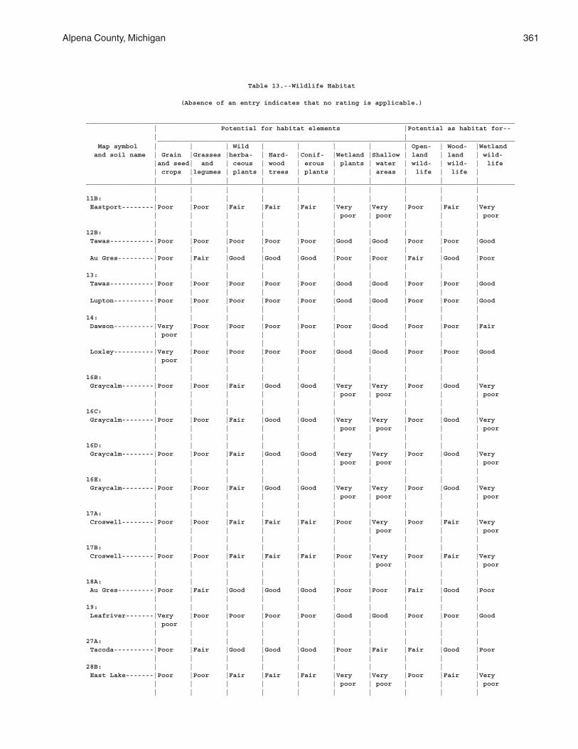
Alpena County, Michigan 361
Table 13.--Wildlife Habitat
(Absence of an entry indicates that no rating is applicable.)
____________________________________________________________________________________________________________ | Potential for habitat elements |Potential as habitat for-- | | __________________________________________________________________________________________ Map symbol | | | Wild | | | | | Open- | Wood- |Wetland and soil name | Grain |Grasses |herba- | Hard- |Conif- |Wetland |Shallow | land | land | wild- |and seed| and | ceous | wood | erous | plants | water | wild- | wild- | life | crops |legumes | plants | trees | plants | | areas | life | life | | | | | | | | | | |____________________________________________________________________________________________________________ | | | | | | | | | |11B: | | | | | | | | | | Eastport--------|Poor |Poor |Fair |Fair |Fair |Very |Very |Poor |Fair |Very | | | | | | poor | poor | | | poor | | | | | | | | | |12B: | | | | | | | | | | Tawas-----------|Poor |Poor |Poor |Poor |Poor |Good |Good |Poor |Poor |Good | | | | | | | | | | Au Gres---------|Poor |Fair |Good |Good |Good |Poor |Poor |Fair |Good |Poor | | | | | | | | | |13: | | | | | | | | | | Tawas-----------|Poor |Poor |Poor |Poor |Poor |Good |Good |Poor |Poor |Good | | | | | | | | | | Lupton----------|Poor |Poor |Poor |Poor |Poor |Good |Good |Poor |Poor |Good | | | | | | | | | |14: | | | | | | | | | | Dawson----------|Very |Poor |Poor |Poor |Poor |Poor |Good |Poor |Poor |Fair | poor | | | | | | | | | | | | | | | | | | | Loxley----------|Very |Poor |Poor |Poor |Poor |Good |Good |Poor |Poor |Good | poor | | | | | | | | | | | | | | | | | | |16B: | | | | | | | | | | Graycalm--------|Poor |Poor |Fair |Good |Good |Very |Very |Poor |Good |Very | | | | | | poor | poor | | | poor | | | | | | | | | |16C: | | | | | | | | | | Graycalm--------|Poor |Poor |Fair |Good |Good |Very |Very |Poor |Good |Very | | | | | | poor | poor | | | poor | | | | | | | | | |16D: | | | | | | | | | | Graycalm--------|Poor |Poor |Fair |Good |Good |Very |Very |Poor |Good |Very | | | | | | poor | poor | | | poor | | | | | | | | | |16E: | | | | | | | | | | Graycalm--------|Poor |Poor |Fair |Good |Good |Very |Very |Poor |Good |Very | | | | | | poor | poor | | | poor | | | | | | | | | |17A: | | | | | | | | | | Croswell--------|Poor |Poor |Fair |Fair |Fair |Poor |Very |Poor |Fair |Very | | | | | | | poor | | | poor | | | | | | | | | |17B: | | | | | | | | | | Croswell--------|Poor |Poor |Fair |Fair |Fair |Poor |Very |Poor |Fair |Very | | | | | | | poor | | | poor | | | | | | | | | |18A: | | | | | | | | | | Au Gres---------|Poor |Fair |Good |Good |Good |Poor |Poor |Fair |Good |Poor | | | | | | | | | |19: | | | | | | | | | | Leafriver-------|Very |Poor |Poor |Poor |Poor |Good |Good |Poor |Poor |Good | poor | | | | | | | | | | | | | | | | | | |27A: | | | | | | | | | | Tacoda----------|Poor |Fair |Good |Good |Good |Poor |Fair |Fair |Good |Poor | | | | | | | | | |28B: | | | | | | | | | | East Lake-------|Poor |Poor |Fair |Fair |Fair |Very |Very |Poor |Fair |Very | | | | | | poor | poor | | | poor | | | | | | | | | |
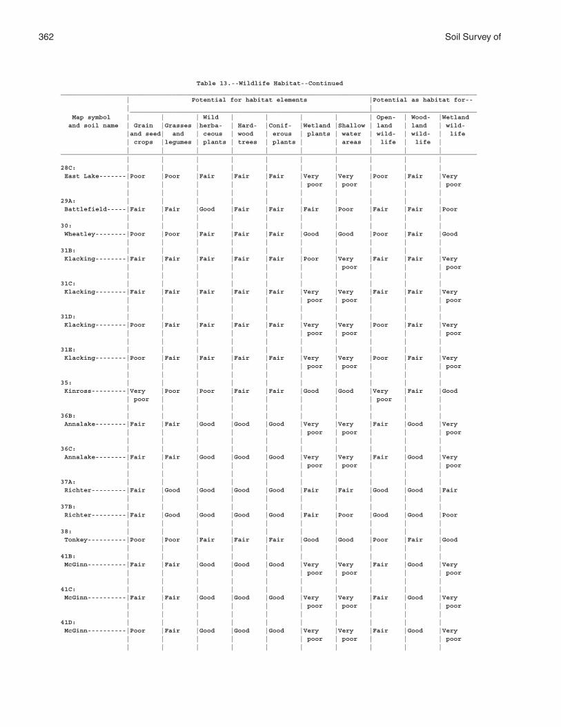
362 Soil Survey of
Table 13.--Wildlife Habitat--Continued____________________________________________________________________________________________________________ | Potential for habitat elements |Potential as habitat for-- | | __________________________________________________________________________________________ Map symbol | | | Wild | | | | | Open- | Wood- |Wetland and soil name | Grain |Grasses |herba- | Hard- |Conif- |Wetland |Shallow | land | land | wild- |and seed| and | ceous | wood | erous | plants | water | wild- | wild- | life | crops |legumes | plants | trees | plants | | areas | life | life | | | | | | | | | | |____________________________________________________________________________________________________________ | | | | | | | | | |28C: | | | | | | | | | | East Lake-------|Poor |Poor |Fair |Fair |Fair |Very |Very |Poor |Fair |Very | | | | | | poor | poor | | | poor | | | | | | | | | |29A: | | | | | | | | | | Battlefield-----|Fair |Fair |Good |Fair |Fair |Fair |Poor |Fair |Fair |Poor | | | | | | | | | |30: | | | | | | | | | | Wheatley--------|Poor |Poor |Fair |Fair |Fair |Good |Good |Poor |Fair |Good | | | | | | | | | |31B: | | | | | | | | | | Klacking--------|Fair |Fair |Fair |Fair |Fair |Poor |Very |Fair |Fair |Very | | | | | | | poor | | | poor | | | | | | | | | |31C: | | | | | | | | | | Klacking--------|Fair |Fair |Fair |Fair |Fair |Very |Very |Fair |Fair |Very | | | | | | poor | poor | | | poor | | | | | | | | | |31D: | | | | | | | | | | Klacking--------|Poor |Fair |Fair |Fair |Fair |Very |Very |Poor |Fair |Very | | | | | | poor | poor | | | poor | | | | | | | | | |31E: | | | | | | | | | | Klacking--------|Poor |Fair |Fair |Fair |Fair |Very |Very |Poor |Fair |Very | | | | | | poor | poor | | | poor | | | | | | | | | |35: | | | | | | | | | | Kinross---------|Very |Poor |Poor |Fair |Fair |Good |Good |Very |Fair |Good | poor | | | | | | | poor | | | | | | | | | | | |36B: | | | | | | | | | | Annalake--------|Fair |Fair |Good |Good |Good |Very |Very |Fair |Good |Very | | | | | | poor | poor | | | poor | | | | | | | | | |36C: | | | | | | | | | | Annalake--------|Fair |Fair |Good |Good |Good |Very |Very |Fair |Good |Very | | | | | | poor | poor | | | poor | | | | | | | | | |37A: | | | | | | | | | | Richter---------|Fair |Good |Good |Good |Good |Fair |Fair |Good |Good |Fair | | | | | | | | | |37B: | | | | | | | | | | Richter---------|Fair |Good |Good |Good |Good |Fair |Poor |Good |Good |Poor | | | | | | | | | |38: | | | | | | | | | | Tonkey----------|Poor |Poor |Fair |Fair |Fair |Good |Good |Poor |Fair |Good | | | | | | | | | |41B: | | | | | | | | | | McGinn----------|Fair |Fair |Good |Good |Good |Very |Very |Fair |Good |Very | | | | | | poor | poor | | | poor | | | | | | | | | |41C: | | | | | | | | | | McGinn----------|Fair |Fair |Good |Good |Good |Very |Very |Fair |Good |Very | | | | | | poor | poor | | | poor | | | | | | | | | |41D: | | | | | | | | | | McGinn----------|Poor |Fair |Good |Good |Good |Very |Very |Fair |Good |Very | | | | | | poor | poor | | | poor | | | | | | | | | |
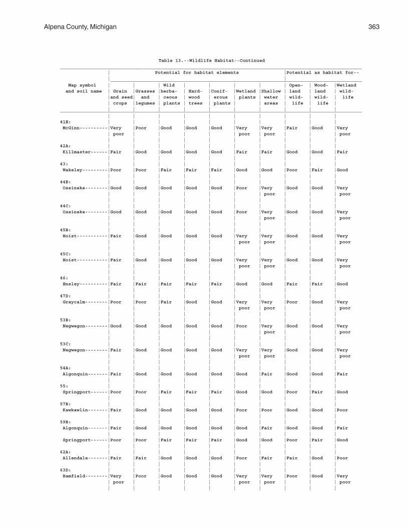
Alpena County, Michigan 363
Table 13.--Wildlife Habitat--Continued____________________________________________________________________________________________________________ | Potential for habitat elements |Potential as habitat for-- | | __________________________________________________________________________________________ Map symbol | | | Wild | | | | | Open- | Wood- |Wetland and soil name | Grain |Grasses |herba- | Hard- |Conif- |Wetland |Shallow | land | land | wild- |and seed| and | ceous | wood | erous | plants | water | wild- | wild- | life | crops |legumes | plants | trees | plants | | areas | life | life | | | | | | | | | | |____________________________________________________________________________________________________________ | | | | | | | | | |41E: | | | | | | | | | | McGinn----------|Very |Poor |Good |Good |Good |Very |Very |Fair |Good |Very | poor | | | | | poor | poor | | | poor | | | | | | | | | |42A: | | | | | | | | | | Killmaster------|Fair |Good |Good |Good |Good |Fair |Fair |Good |Good |Fair | | | | | | | | | |43: | | | | | | | | | | Wakeley---------|Poor |Poor |Fair |Fair |Fair |Good |Good |Poor |Fair |Good | | | | | | | | | |44B: | | | | | | | | | | Ossineke--------|Good |Good |Good |Good |Good |Poor |Very |Good |Good |Very | | | | | | | poor | | | poor | | | | | | | | | |44C: | | | | | | | | | | Ossineke--------|Good |Good |Good |Good |Good |Poor |Very |Good |Good |Very | | | | | | | poor | | | poor | | | | | | | | | |45B: | | | | | | | | | | Hoist-----------|Fair |Good |Good |Good |Good |Very |Very |Good |Good |Very | | | | | | poor | poor | | | poor | | | | | | | | | |45C: | | | | | | | | | | Hoist-----------|Fair |Good |Good |Good |Good |Very |Very |Good |Good |Very | | | | | | poor | poor | | | poor | | | | | | | | | |46: | | | | | | | | | | Ensley----------|Fair |Fair |Fair |Fair |Fair |Good |Good |Fair |Fair |Good | | | | | | | | | |47D: | | | | | | | | | | Graycalm--------|Poor |Poor |Fair |Good |Good |Very |Very |Poor |Good |Very | | | | | | poor | poor | | | poor | | | | | | | | | |53B: | | | | | | | | | | Negwegon--------|Good |Good |Good |Good |Good |Poor |Very |Good |Good |Very | | | | | | | poor | | | poor | | | | | | | | | |53C: | | | | | | | | | | Negwegon--------|Fair |Good |Good |Good |Good |Very |Very |Good |Good |Very | | | | | | poor | poor | | | poor | | | | | | | | | |54A: | | | | | | | | | | Algonquin-------|Fair |Good |Good |Good |Good |Good |Fair |Good |Good |Fair | | | | | | | | | |55: | | | | | | | | | | Springport------|Poor |Poor |Fair |Fair |Fair |Good |Good |Poor |Fair |Good | | | | | | | | | |57B: | | | | | | | | | | Kawkawlin-------|Fair |Good |Good |Good |Good |Poor |Poor |Good |Good |Poor | | | | | | | | | |59B: | | | | | | | | | | Algonquin-------|Fair |Good |Good |Good |Good |Good |Fair |Good |Good |Fair | | | | | | | | | | Springport------|Poor |Poor |Fair |Fair |Fair |Good |Good |Poor |Fair |Good | | | | | | | | | |62A: | | | | | | | | | | Allendale-------|Fair |Fair |Good |Good |Good |Poor |Fair |Fair |Good |Poor | | | | | | | | | |63D: | | | | | | | | | | Bamfield--------|Very |Poor |Good |Good |Good |Very |Very |Poor |Good |Very | poor | | | | | poor | poor | | | poor | | | | | | | | | |
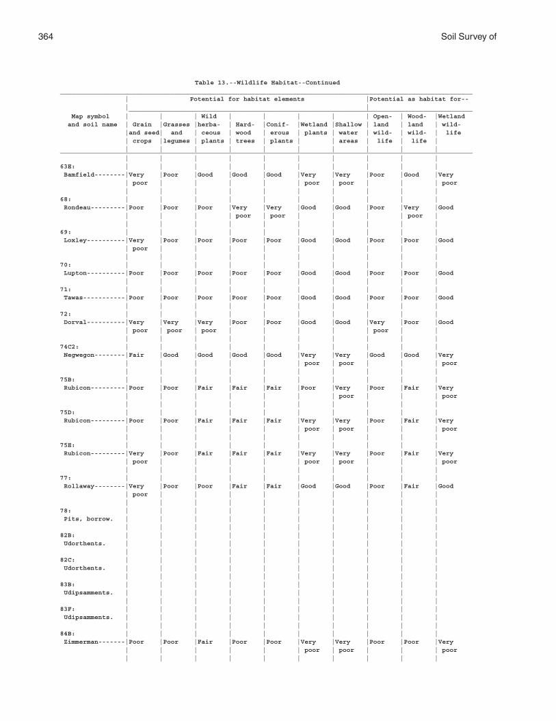
364 Soil Survey of
Table 13.--Wildlife Habitat--Continued____________________________________________________________________________________________________________ | Potential for habitat elements |Potential as habitat for-- | | __________________________________________________________________________________________ Map symbol | | | Wild | | | | | Open- | Wood- |Wetland and soil name | Grain |Grasses |herba- | Hard- |Conif- |Wetland |Shallow | land | land | wild- |and seed| and | ceous | wood | erous | plants | water | wild- | wild- | life | crops |legumes | plants | trees | plants | | areas | life | life | | | | | | | | | | |____________________________________________________________________________________________________________ | | | | | | | | | |63E: | | | | | | | | | | Bamfield--------|Very |Poor |Good |Good |Good |Very |Very |Poor |Good |Very | poor | | | | | poor | poor | | | poor | | | | | | | | | |68: | | | | | | | | | | Rondeau---------|Poor |Poor |Poor |Very |Very |Good |Good |Poor |Very |Good | | | | poor | poor | | | | poor | | | | | | | | | | |69: | | | | | | | | | | Loxley----------|Very |Poor |Poor |Poor |Poor |Good |Good |Poor |Poor |Good | poor | | | | | | | | | | | | | | | | | | |70: | | | | | | | | | | Lupton----------|Poor |Poor |Poor |Poor |Poor |Good |Good |Poor |Poor |Good | | | | | | | | | |71: | | | | | | | | | | Tawas-----------|Poor |Poor |Poor |Poor |Poor |Good |Good |Poor |Poor |Good | | | | | | | | | |72: | | | | | | | | | | Dorval----------|Very |Very |Very |Poor |Poor |Good |Good |Very |Poor |Good | poor | poor | poor | | | | | poor | | | | | | | | | | | |74C2: | | | | | | | | | | Negwegon--------|Fair |Good |Good |Good |Good |Very |Very |Good |Good |Very | | | | | | poor | poor | | | poor | | | | | | | | | |75B: | | | | | | | | | | Rubicon---------|Poor |Poor |Fair |Fair |Fair |Poor |Very |Poor |Fair |Very | | | | | | | poor | | | poor | | | | | | | | | |75D: | | | | | | | | | | Rubicon---------|Poor |Poor |Fair |Fair |Fair |Very |Very |Poor |Fair |Very | | | | | | poor | poor | | | poor | | | | | | | | | |75E: | | | | | | | | | | Rubicon---------|Very |Poor |Fair |Fair |Fair |Very |Very |Poor |Fair |Very | poor | | | | | poor | poor | | | poor | | | | | | | | | |77: | | | | | | | | | | Rollaway--------|Very |Poor |Poor |Fair |Fair |Good |Good |Poor |Fair |Good | poor | | | | | | | | | | | | | | | | | | |78: | | | | | | | | | | Pits, borrow. | | | | | | | | | | | | | | | | | | | |82B: | | | | | | | | | | Udorthents. | | | | | | | | | | | | | | | | | | | |82C: | | | | | | | | | | Udorthents. | | | | | | | | | | | | | | | | | | | |83B: | | | | | | | | | | Udipsamments. | | | | | | | | | | | | | | | | | | | |83F: | | | | | | | | | | Udipsamments. | | | | | | | | | | | | | | | | | | | |84B: | | | | | | | | | | Zimmerman-------|Poor |Poor |Fair |Poor |Poor |Very |Very |Poor |Poor |Very | | | | | | poor | poor | | | poor | | | | | | | | | |
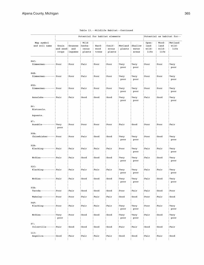
Alpena County, Michigan 365
Table 13.--Wildlife Habitat--Continued____________________________________________________________________________________________________________ | Potential for habitat elements |Potential as habitat for-- | | __________________________________________________________________________________________ Map symbol | | | Wild | | | | | Open- | Wood- |Wetland and soil name | Grain |Grasses |herba- | Hard- |Conif- |Wetland |Shallow | land | land | wild- |and seed| and | ceous | wood | erous | plants | water | wild- | wild- | life | crops |legumes | plants | trees | plants | | areas | life | life | | | | | | | | | | |____________________________________________________________________________________________________________ | | | | | | | | | |84C: | | | | | | | | | | Zimmerman-------|Poor |Poor |Fair |Poor |Poor |Very |Very |Poor |Poor |Very | | | | | | poor | poor | | | poor | | | | | | | | | |84E: | | | | | | | | | | Zimmerman-------|Poor |Poor |Fair |Poor |Poor |Very |Very |Poor |Poor |Very | | | | | | poor | poor | | | poor | | | | | | | | | |85D: | | | | | | | | | | Zimmerman-------|Poor |Poor |Fair |Poor |Poor |Very |Very |Poor |Poor |Very | | | | | | poor | poor | | | poor | | | | | | | | | | Annalake--------|Fair |Fair |Good |Good |Good |Very |Very |Fair |Good |Very | | | | | | poor | poor | | | poor | | | | | | | | | |86: | | | | | | | | | | Histosols. | | | | | | | | | | | | | | | | | | | | Aquents. | | | | | | | | | | | | | | | | | | | |87: | | | | | | | | | | Ausable---------|Very |Poor |Poor |Poor |Poor |Fair |Good |Poor |Poor |Fair | poor | | | | | | | | | | | | | | | | | | |90B: | | | | | | | | | | Chinwhisker-----|Poor |Poor |Fair |Good |Good |Very |Very |Poor |Good |Very | | | | | | poor | poor | | | poor | | | | | | | | | |92B: | | | | | | | | | | Klacking--------|Fair |Fair |Fair |Fair |Fair |Poor |Very |Fair |Fair |Very | | | | | | | poor | | | poor | | | | | | | | | | McGinn----------|Fair |Fair |Good |Good |Good |Very |Very |Fair |Good |Very | | | | | | poor | poor | | | poor | | | | | | | | | |92C: | | | | | | | | | | Klacking--------|Fair |Fair |Fair |Fair |Fair |Very |Very |Fair |Fair |Very | | | | | | poor | poor | | | poor | | | | | | | | | | McGinn----------|Fair |Fair |Good |Good |Good |Very |Very |Fair |Good |Very | | | | | | poor | poor | | | poor | | | | | | | | | |93B: | | | | | | | | | | Tacoda----------|Poor |Fair |Good |Good |Good |Poor |Fair |Fair |Good |Poor | | | | | | | | | | Wakeley---------|Poor |Poor |Fair |Fair |Fair |Good |Good |Poor |Fair |Good | | | | | | | | | |94F: | | | | | | | | | | Klacking--------|Poor |Fair |Fair |Fair |Fair |Very |Very |Poor |Fair |Very | | | | | | poor | poor | | | poor | | | | | | | | | | McGinn----------|Very |Poor |Good |Good |Good |Very |Very |Fair |Good |Very | poor | | | | | poor | poor | | | poor | | | | | | | | | |97: | | | | | | | | | | Colonville------|Fair |Good |Good |Good |Good |Fair |Fair |Good |Good |Fair | | | | | | | | | |113: | | | | | | | | | | Angelica--------|Good |Fair |Fair |Fair |Fair |Good |Good |Fair |Fair |Good | | | | | | | | | |
366 Soil Survey of
Table 13.--Wildlife Habitat--Continued____________________________________________________________________________________________________________ | Potential for habitat elements |Potential as habitat for-- | | __________________________________________________________________________________________ Map symbol | | | Wild | | | | | Open- | Wood- |Wetland and soil name | Grain |Grasses |herba- | Hard- |Conif- |Wetland |Shallow | land | land | wild- |and seed| and | ceous | wood | erous | plants | water | wild- | wild- | life | crops |legumes | plants | trees | plants | | areas | life | life | | | | | | | | | | |____________________________________________________________________________________________________________ | | | | | | | | | |116C: | | | | | | | | | | Mancelona-------|Fair |Fair |Good |Good |Good |Very |Very |Fair |Good |Very | | | | | | poor | poor | | | poor | | | | | | | | | |127: | | | | | | | | | | Cathro----------|Poor |Poor |Poor |Poor |Poor |Good |Good |Poor |Poor |Good | | | | | | | | | |128: | | | | | | | | | | Dawson----------|Very |Poor |Poor |Poor |Poor |Poor |Good |Poor |Poor |Fair | poor | | | | | | | | | | | | | | | | | | |145C: | | | | | | | | | | Rousseau--------|Fair |Fair |Good |Good |Good |Very |Very |Fair |Good |Very | | | | | | poor | poor | | | poor | | | | | | | | | |145E: | | | | | | | | | | Rousseau--------|Very |Poor |Good |Good |Good |Very |Very |Fair |Good |Very | poor | | | | | poor | poor | | | poor | | | | | | | | | |159A: | | | | | | | | | | Finch-----------|Poor |Poor |Fair |Fair |Fair |Poor |Poor |Poor |Fair |Poor | | | | | | | | | |166A: | | | | | | | | | | Slade-----------|Good |Good |Good |Good |Good |Fair |Fair |Good |Good |Fair | | | | | | | | | |182: | | | | | | | | | | Pits, quarry----|Very |Very |Very |Very |Very |Very |Very |Very |Very |Very | poor | poor | poor | poor | poor | poor | poor | poor | poor | poor | | | | | | | | | |300A: | | | | | | | | | | Hagensville-----|Fair |Good |Good |Good |Good |Fair |Fair |Good |Good |Fair | | | | | | | | | |304A: | | | | | | | | | | Iosco-----------|Fair |Fair |Good |Good |Good |Fair |Fair |Fair |Good |Fair | | | | | | | | | |305B: | | | | | | | | | | Johnswood-------|Poor |Fair |Fair |Good |Good |Poor |Very |Fair |Good |Very | | | | | | | poor | | | poor | | | | | | | | | |308B: | | | | | | | | | | Krakow----------|Fair |Fair |Good |Good |Good |Poor |Very |Fair |Good |Very | | | | | | | poor | | | poor | | | | | | | | | |308C: | | | | | | | | | | Krakow----------|Poor |Poor |Fair |Good |Good |Very |Very |Poor |Good |Very | | | | | | poor | poor | | | poor | | | | | | | | | |308D: | | | | | | | | | | Krakow----------|Poor |Poor |Fair |Good |Good |Very |Very |Poor |Good |Very | | | | | | poor | poor | | | poor | | | | | | | | | |316: | | | | | | | | | | Ruse------------|Poor |Poor |Fair |Poor |Fair |Good |Poor |Poor |Fair |Fair | | | | | | | | | |350E: | | | | | | | | | | Blue Lake-------|Fair |Fair |Good |Good |Good |Very |Very |Fair |Good |Very | | | | | | poor | poor | | | poor | | | | | | | | | |
Alpena County, Michigan 367
Table 13.--Wildlife Habitat--Continued____________________________________________________________________________________________________________ | Potential for habitat elements |Potential as habitat for-- | | __________________________________________________________________________________________ Map symbol | | | Wild | | | | | Open- | Wood- |Wetland and soil name | Grain |Grasses |herba- | Hard- |Conif- |Wetland |Shallow | land | land | wild- |and seed| and | ceous | wood | erous | plants | water | wild- | wild- | life | crops |legumes | plants | trees | plants | | areas | life | life | | | | | | | | | | |____________________________________________________________________________________________________________ | | | | | | | | | |359C: | | | | | | | | | | Algonquin-------|Fair |Good |Good |Good |Good |Good |Fair |Good |Good |Fair | | | | | | | | | | Negwegon--------|Fair |Good |Good |Good |Good |Very |Very |Good |Good |Very | | | | | | poor | poor | | | poor | | | | | | | | | | Dorval----------|Very |Very |Very |Poor |Poor |Good |Good |Very |Poor |Good | poor | poor | poor | | | | | poor | | | | | | | | | | | |361B: | | | | | | | | | | Allendale-------|Fair |Fair |Good |Good |Good |Poor |Fair |Fair |Good |Poor | | | | | | | | | | Dorval----------|Very |Very |Very |Poor |Poor |Good |Good |Very |Poor |Good | poor | poor | poor | | | | | poor | | | | | | | | | | | | Blue Lake-------|Fair |Fair |Good |Good |Good |Very |Very |Fair |Good |Very | | | | | | poor | poor | | | poor | | | | | | | | | |362D: | | | | | | | | | | Millersburg-----|Fair |Good |Good |Good |Good |Very |Very |Good |Good |Very | | | | | | poor | poor | | | poor | | | | | | | | | |362E: | | | | | | | | | | Millersburg-----|Very |Fair |Good |Good |Good |Very |Very |Fair |Good |Very | poor | | | | | poor | poor | | | poor | | | | | | | | | |368A: | | | | | | | | | | Au Gres---------|Poor |Fair |Good |Good |Good |Poor |Poor |Fair |Good |Poor | | | | | | | | | | Deford----------|Fair |Fair |Fair |Fair |Fair |Good |Good |Fair |Fair |Good | | | | | | | | | |369: | | | | | | | | | | Deford----------|Fair |Fair |Fair |Fair |Fair |Good |Good |Fair |Fair |Good | | | | | | | | | |371: | | | | | | | | | | Springport------|Poor |Poor |Fair |Fair |Fair |Good |Good |Poor |Fair |Good | | | | | | | | | |373B: | | | | | | | | | | Grayling--------|Poor |Poor |Fair |Poor |Poor |Poor |Very |Poor |Poor |Very | | | | | | | poor | | | poor | | | | | | | | | |374: | | | | | | | | | | Thunderbay------|Poor |Fair |Fair |Fair |Poor |Good |Good |Fair |Fair |Good | | | | | | | | | |376A: | | | | | | | | | | Urban land. | | | | | | | | | | | | | | | | | | | | Udipsamments. | | | | | | | | | | | | | | | | | | | |380: | | | | | | | | | | Access denied. | | | | | | | | | | | | | | | | | | | |392: | | | | | | | | | | Caffey----------|Poor |Fair |Fair |Fair |Fair |Good |Good |Fair |Fair |Good | | | | | | | | | |393B: | | | | | | | | | | Morganlake------|Fair |Fair |Good |Good |Good |Very |Very |Fair |Good |Very | | | | | | poor | poor | | | poor | | | | | | | | | |
368 Soil Survey of
Table 13.--Wildlife Habitat--Continued____________________________________________________________________________________________________________ | Potential for habitat elements |Potential as habitat for-- | | __________________________________________________________________________________________ Map symbol | | | Wild | | | | | Open- | Wood- |Wetland and soil name | Grain |Grasses |herba- | Hard- |Conif- |Wetland |Shallow | land | land | wild- |and seed| and | ceous | wood | erous | plants | water | wild- | wild- | life | crops |legumes | plants | trees | plants | | areas | life | life | | | | | | | | | | |____________________________________________________________________________________________________________ | | | | | | | | | |393C: | | | | | | | | | | Morganlake------|Fair |Fair |Good |Good |Good |Very |Very |Fair |Good |Very | | | | | | poor | poor | | | poor | | | | | | | | | |396F: | | | | | | | | | | Proper----------|Poor |Poor |Fair |Fair |Fair |Poor |Very |Poor |Fair |Very | | | | | | | poor | | | poor | | | | | | | | | | Deford----------|Fair |Fair |Fair |Fair |Fair |Good |Good |Fair |Fair |Good | | | | | | | | | | Rousseau--------|Poor |Fair |Good |Good |Good |Very |Very |Fair |Good |Very | | | | | | poor | poor | | | poor | | | | | | | | | |397: | | | | | | | | | | Spot------------|Poor |Poor |Fair |Fair |Fair |Good |Good |Poor |Fair |Good | | | | | | | | | |414B: | | | | | | | | | | Namur-----------|Very |Very |Poor |Poor |Poor |Very |Very |Very |Poor |Very | poor | poor | | | | poor | poor | poor | | poor | | | | | | | | | |415A: | | | | | | | | | | Potagannissing--|Very |Very |Poor |Very |Very |Fair |Very |Poor |Very |Very | poor | poor | | poor | poor | | poor | | poor | poor | | | | | | | | | |416B: | | | | | | | | | | Negwegon--------|Good |Good |Good |Good |Good |Poor |Very |Good |Good |Very | | | | | | | poor | | | poor | | | | | | | | | |417B: | | | | | | | | | | Alpena----------|Poor |Poor |Poor |Fair |Fair |Very |Very |Poor |Fair |Very | | | | | | poor | poor | | | poor | | | | | | | | | |417C: | | | | | | | | | | Alpena----------|Poor |Poor |Poor |Fair |Fair |Very |Very |Poor |Fair |Very | | | | | | poor | poor | | | poor | | | | | | | | | |418E: | | | | | | | | | | Alpena----------|Poor |Poor |Poor |Fair |Fair |Very |Very |Poor |Fair |Very | | | | | | poor | poor | | | poor | | | | | | | | | |419: | | | | | | | | | | Chippeny--------|Very |Poor |Poor |Poor |Poor |Good |Fair |Poor |Poor |Fair | poor | | | | | | | | | | | | | | | | | | |420A: | | | | | | | | | | Otisco----------|Fair |Good |Good |Fair |Good |Fair |Very |Good |Fair |Very | | | | | | | poor | | | poor | | | | | | | | | |424B: | | | | | | | | | | Morganlake------|Fair |Fair |Good |Good |Good |Very |Very |Fair |Good |Very | | | | | | poor | poor | | | poor | | | | | | | | | | Ossineke--------|Good |Good |Good |Good |Good |Poor |Very |Good |Good |Very | | | | | | | poor | | | poor | | | | | | | | | | Blue Lake-------|Fair |Fair |Good |Good |Good |Very |Very |Fair |Good |Very | | | | | | poor | poor | | | poor | | | | | | | | | |
Alpena County, Michigan 369
Table 13.--Wildlife Habitat--Continued____________________________________________________________________________________________________________ | Potential for habitat elements |Potential as habitat for-- | | __________________________________________________________________________________________ Map symbol | | | Wild | | | | | Open- | Wood- |Wetland and soil name | Grain |Grasses |herba- | Hard- |Conif- |Wetland |Shallow | land | land | wild- |and seed| and | ceous | wood | erous | plants | water | wild- | wild- | life | crops |legumes | plants | trees | plants | | areas | life | life | | | | | | | | | | |____________________________________________________________________________________________________________ | | | | | | | | | |424C: | | | | | | | | | | Morganlake------|Fair |Fair |Good |Good |Good |Very |Very |Fair |Good |Very | | | | | | poor | poor | | | poor | | | | | | | | | | Ossineke--------|Good |Good |Good |Good |Good |Poor |Very |Good |Good |Very | | | | | | | poor | | | poor | | | | | | | | | | Blue Lake-------|Fair |Fair |Good |Good |Good |Very |Very |Fair |Good |Very | | | | | | poor | poor | | | poor | | | | | | | | | |426B: | | | | | | | | | | Coppler---------|Poor |Fair |Good |Good |Good |Very |Very |Fair |Good |Very | | | | | | poor | poor | | | poor | | | | | | | | | |426C: | | | | | | | | | | Coppler---------|Poor |Fair |Good |Good |Good |Very |Very |Fair |Good |Very | | | | | | poor | poor | | | poor | | | | | | | | | |426D: | | | | | | | | | | Coppler---------|Poor |Fair |Good |Good |Good |Very |Very |Fair |Good |Very | | | | | | poor | poor | | | poor | | | | | | | | | |451C: | | | | | | | | | | Annalake--------|Fair |Fair |Good |Good |Good |Very |Very |Fair |Good |Very | | | | | | poor | poor | | | poor | | | | | | | | | |477B: | | | | | | | | | | Algonquin-------|Fair |Good |Good |Good |Good |Good |Fair |Good |Good |Fair | | | | | | | | | | Springport------|Poor |Poor |Fair |Fair |Fair |Good |Good |Poor |Fair |Good | | | | | | | | | |478: | | | | | | | | | | Springport------|Poor |Poor |Fair |Fair |Fair |Good |Good |Poor |Fair |Good | | | | | | | | | |479A: | | | | | | | | | | Algonquin-------|Fair |Good |Good |Good |Good |Good |Fair |Good |Good |Fair | | | | | | | | | |480B: | | | | | | | | | | Negwegon--------|Good |Good |Good |Good |Good |Poor |Very |Good |Good |Very | | | | | | | poor | | | poor | | | | | | | | | | Algonquin-------|Fair |Good |Good |Good |Good |Good |Fair |Good |Good |Fair | | | | | | | | | | Lupton----------|Poor |Poor |Poor |Poor |Poor |Good |Good |Poor |Poor |Good | | | | | | | | | |481C: | | | | | | | | | | Negwegon--------|Fair |Good |Good |Good |Good |Very |Very |Good |Good |Very | | | | | | poor | poor | | | poor | | | | | | | | | | Lupton----------|Poor |Poor |Poor |Poor |Poor |Good |Good |Poor |Poor |Good | | | | | | | | | |482B: | | | | | | | | | | Summerville-----|Fair |Fair |Fair |Good |Good |Poor |Very |Fair |Good |Very | | | | | | | poor | | | poor | | | | | | | | | |482C: | | | | | | | | | | Summerville-----|Poor |Fair |Fair |Good |Good |Very |Very |Fair |Good |Very | | | | | | poor | poor | | | poor | | | | | | | | | |483A: | | | | | | | | | | Lachine---------|Poor |Poor |Fair |Fair |Fair |Fair |Poor |Poor |Fair |Poor | | | | | | | | | |
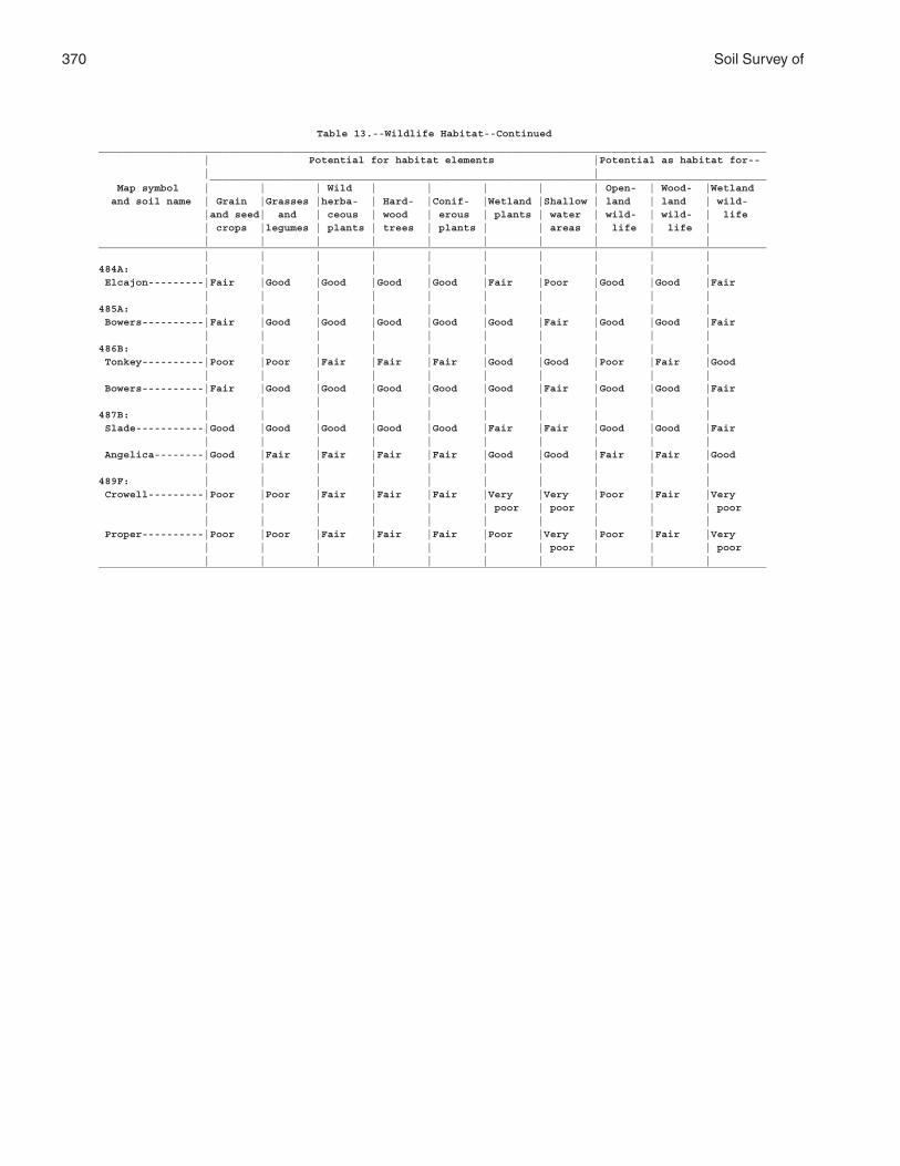
370 Soil Survey of
Table 13.--Wildlife Habitat--Continued____________________________________________________________________________________________________________ | Potential for habitat elements |Potential as habitat for-- | | __________________________________________________________________________________________ Map symbol | | | Wild | | | | | Open- | Wood- |Wetland and soil name | Grain |Grasses |herba- | Hard- |Conif- |Wetland |Shallow | land | land | wild- |and seed| and | ceous | wood | erous | plants | water | wild- | wild- | life | crops |legumes | plants | trees | plants | | areas | life | life | | | | | | | | | | |____________________________________________________________________________________________________________ | | | | | | | | | |484A: | | | | | | | | | | Elcajon---------|Fair |Good |Good |Good |Good |Fair |Poor |Good |Good |Fair | | | | | | | | | |485A: | | | | | | | | | | Bowers----------|Fair |Good |Good |Good |Good |Good |Fair |Good |Good |Fair | | | | | | | | | |486B: | | | | | | | | | | Tonkey----------|Poor |Poor |Fair |Fair |Fair |Good |Good |Poor |Fair |Good | | | | | | | | | | Bowers----------|Fair |Good |Good |Good |Good |Good |Fair |Good |Good |Fair | | | | | | | | | |487B: | | | | | | | | | | Slade-----------|Good |Good |Good |Good |Good |Fair |Fair |Good |Good |Fair | | | | | | | | | | Angelica--------|Good |Fair |Fair |Fair |Fair |Good |Good |Fair |Fair |Good | | | | | | | | | |489F: | | | | | | | | | | Crowell---------|Poor |Poor |Fair |Fair |Fair |Very |Very |Poor |Fair |Very | | | | | | poor | poor | | | poor | | | | | | | | | | Proper----------|Poor |Poor |Fair |Fair |Fair |Poor |Very |Poor |Fair |Very | | | | | | | poor | | | poor | | | | | | | | | |____________________________________________________________________________________________________________
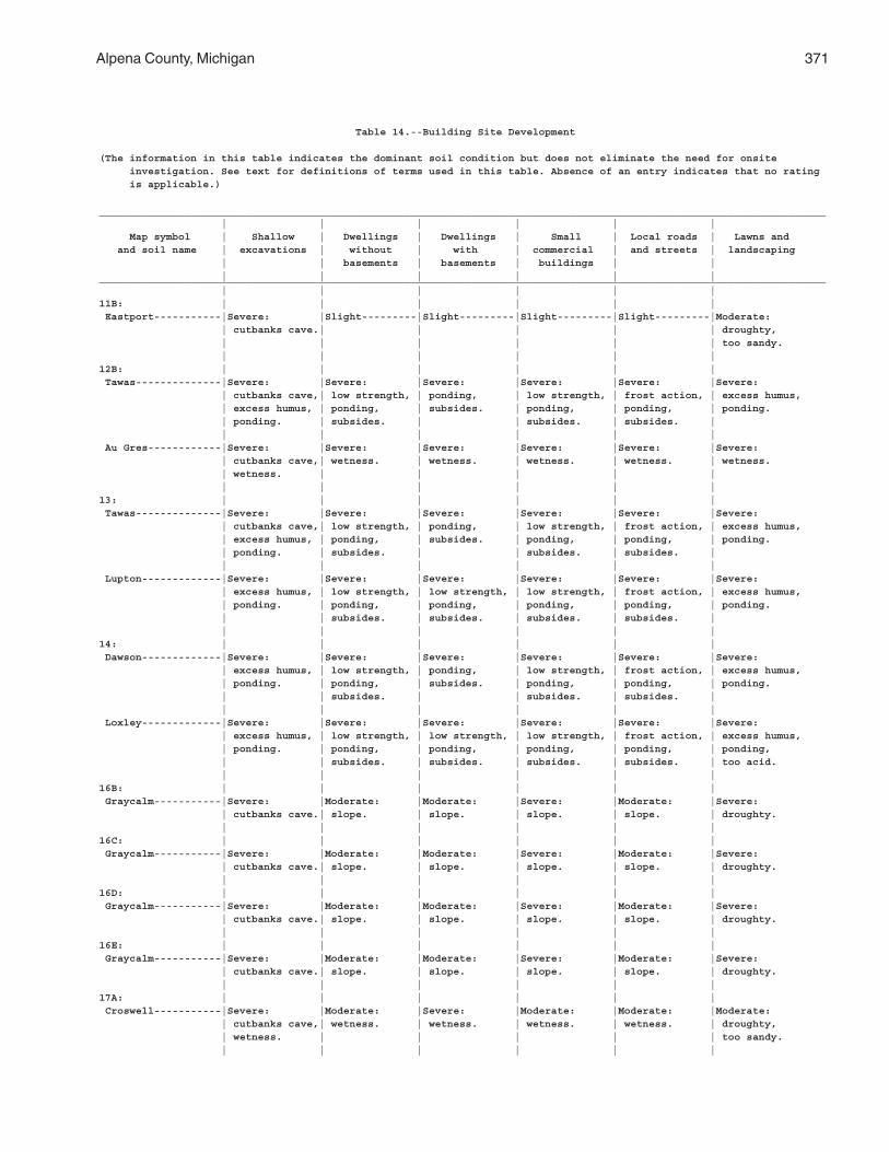
Alpena County, Michigan 371
Table 14.--Building Site Development
(The information in this table indicates the dominant soil condition but does not eliminate the need for onsite investigation. See text for definitions of terms used in this table. Absence of an entry indicates that no rating is applicable.)
_______________________________________________________________________________________________________________________ | | | | | | Map symbol | Shallow | Dwellings | Dwellings | Small | Local roads | Lawns and and soil name | excavations | without | with | commercial | and streets | landscaping | | basements | basements | buildings | | | | | | | |_______________________________________________________________________________________________________________________ | | | | | |11B: | | | | | | Eastport-----------|Severe: |Slight---------|Slight---------|Slight---------|Slight---------|Moderate: | cutbanks cave.| | | | | droughty, | | | | | | too sandy. | | | | | |12B: | | | | | | Tawas--------------|Severe: |Severe: |Severe: |Severe: |Severe: |Severe: | cutbanks cave,| low strength, | ponding, | low strength, | frost action, | excess humus, | excess humus, | ponding, | subsides. | ponding, | ponding, | ponding. | ponding. | subsides. | | subsides. | subsides. | | | | | | | Au Gres------------|Severe: |Severe: |Severe: |Severe: |Severe: |Severe: | cutbanks cave,| wetness. | wetness. | wetness. | wetness. | wetness. | wetness. | | | | | | | | | | |13: | | | | | | Tawas--------------|Severe: |Severe: |Severe: |Severe: |Severe: |Severe: | cutbanks cave,| low strength, | ponding, | low strength, | frost action, | excess humus, | excess humus, | ponding, | subsides. | ponding, | ponding, | ponding. | ponding. | subsides. | | subsides. | subsides. | | | | | | | Lupton-------------|Severe: |Severe: |Severe: |Severe: |Severe: |Severe: | excess humus, | low strength, | low strength, | low strength, | frost action, | excess humus, | ponding. | ponding, | ponding, | ponding, | ponding, | ponding. | | subsides. | subsides. | subsides. | subsides. | | | | | | |14: | | | | | | Dawson-------------|Severe: |Severe: |Severe: |Severe: |Severe: |Severe: | excess humus, | low strength, | ponding, | low strength, | frost action, | excess humus, | ponding. | ponding, | subsides. | ponding, | ponding, | ponding. | | subsides. | | subsides. | subsides. | | | | | | | Loxley-------------|Severe: |Severe: |Severe: |Severe: |Severe: |Severe: | excess humus, | low strength, | low strength, | low strength, | frost action, | excess humus, | ponding. | ponding, | ponding, | ponding, | ponding, | ponding, | | subsides. | subsides. | subsides. | subsides. | too acid. | | | | | |16B: | | | | | | Graycalm-----------|Severe: |Moderate: |Moderate: |Severe: |Moderate: |Severe: | cutbanks cave.| slope. | slope. | slope. | slope. | droughty. | | | | | |16C: | | | | | | Graycalm-----------|Severe: |Moderate: |Moderate: |Severe: |Moderate: |Severe: | cutbanks cave.| slope. | slope. | slope. | slope. | droughty. | | | | | |16D: | | | | | | Graycalm-----------|Severe: |Moderate: |Moderate: |Severe: |Moderate: |Severe: | cutbanks cave.| slope. | slope. | slope. | slope. | droughty. | | | | | |16E: | | | | | | Graycalm-----------|Severe: |Moderate: |Moderate: |Severe: |Moderate: |Severe: | cutbanks cave.| slope. | slope. | slope. | slope. | droughty. | | | | | |17A: | | | | | | Croswell-----------|Severe: |Moderate: |Severe: |Moderate: |Moderate: |Moderate: | cutbanks cave,| wetness. | wetness. | wetness. | wetness. | droughty, | wetness. | | | | | too sandy. | | | | | |
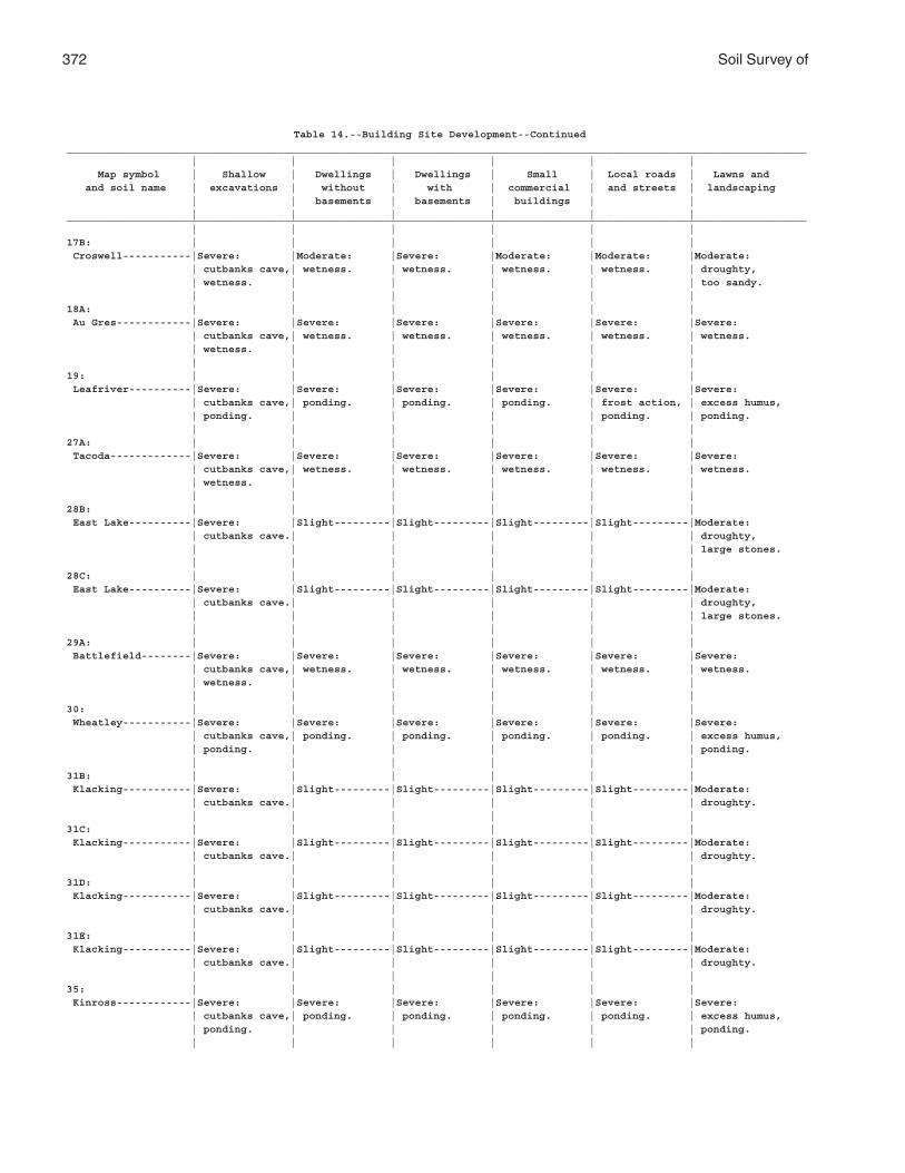
372 Soil Survey of
Table 14.--Building Site Development--Continued_______________________________________________________________________________________________________________________ | | | | | | Map symbol | Shallow | Dwellings | Dwellings | Small | Local roads | Lawns and and soil name | excavations | without | with | commercial | and streets | landscaping | | basements | basements | buildings | | | | | | | |_______________________________________________________________________________________________________________________ | | | | | |17B: | | | | | | Croswell-----------|Severe: |Moderate: |Severe: |Moderate: |Moderate: |Moderate: | cutbanks cave,| wetness. | wetness. | wetness. | wetness. | droughty, | wetness. | | | | | too sandy. | | | | | |18A: | | | | | | Au Gres------------|Severe: |Severe: |Severe: |Severe: |Severe: |Severe: | cutbanks cave,| wetness. | wetness. | wetness. | wetness. | wetness. | wetness. | | | | | | | | | | |19: | | | | | | Leafriver----------|Severe: |Severe: |Severe: |Severe: |Severe: |Severe: | cutbanks cave,| ponding. | ponding. | ponding. | frost action, | excess humus, | ponding. | | | | ponding. | ponding. | | | | | |27A: | | | | | | Tacoda-------------|Severe: |Severe: |Severe: |Severe: |Severe: |Severe: | cutbanks cave,| wetness. | wetness. | wetness. | wetness. | wetness. | wetness. | | | | | | | | | | |28B: | | | | | | East Lake----------|Severe: |Slight---------|Slight---------|Slight---------|Slight---------|Moderate: | cutbanks cave.| | | | | droughty, | | | | | | large stones. | | | | | |28C: | | | | | | East Lake----------|Severe: |Slight---------|Slight---------|Slight---------|Slight---------|Moderate: | cutbanks cave.| | | | | droughty, | | | | | | large stones. | | | | | |29A: | | | | | | Battlefield--------|Severe: |Severe: |Severe: |Severe: |Severe: |Severe: | cutbanks cave,| wetness. | wetness. | wetness. | wetness. | wetness. | wetness. | | | | | | | | | | |30: | | | | | | Wheatley-----------|Severe: |Severe: |Severe: |Severe: |Severe: |Severe: | cutbanks cave,| ponding. | ponding. | ponding. | ponding. | excess humus, | ponding. | | | | | ponding. | | | | | |31B: | | | | | | Klacking-----------|Severe: |Slight---------|Slight---------|Slight---------|Slight---------|Moderate: | cutbanks cave.| | | | | droughty. | | | | | |31C: | | | | | | Klacking-----------|Severe: |Slight---------|Slight---------|Slight---------|Slight---------|Moderate: | cutbanks cave.| | | | | droughty. | | | | | |31D: | | | | | | Klacking-----------|Severe: |Slight---------|Slight---------|Slight---------|Slight---------|Moderate: | cutbanks cave.| | | | | droughty. | | | | | |31E: | | | | | | Klacking-----------|Severe: |Slight---------|Slight---------|Slight---------|Slight---------|Moderate: | cutbanks cave.| | | | | droughty. | | | | | |35: | | | | | | Kinross------------|Severe: |Severe: |Severe: |Severe: |Severe: |Severe: | cutbanks cave,| ponding. | ponding. | ponding. | ponding. | excess humus, | ponding. | | | | | ponding. | | | | | |
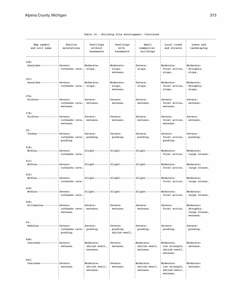
Alpena County, Michigan 373
Table 14.--Building Site Development--Continued_______________________________________________________________________________________________________________________ | | | | | | Map symbol | Shallow | Dwellings | Dwellings | Small | Local roads | Lawns and and soil name | excavations | without | with | commercial | and streets | landscaping | | basements | basements | buildings | | | | | | | |_______________________________________________________________________________________________________________________ | | | | | |36B: | | | | | | Annalake-----------|Severe: |Moderate: |Moderate: |Severe: |Moderate: |Moderate: | cutbanks cave.| slope. | slope, | slope. | frost action, | droughty, | | | wetness. | | slope. | slope. | | | | | |36C: | | | | | | Annalake-----------|Severe: |Moderate: |Moderate: |Severe: |Moderate: |Moderate: | cutbanks cave.| slope. | slope, | slope. | frost action, | droughty, | | | wetness. | | slope. | slope. | | | | | |37A: | | | | | | Richter------------|Severe: |Severe: |Severe: |Severe: |Severe: |Severe: | cutbanks cave,| wetness. | wetness. | wetness. | frost action, | wetness. | wetness. | | | | wetness. | | | | | | |37B: | | | | | | Richter------------|Severe: |Severe: |Severe: |Severe: |Severe: |Severe: | cutbanks cave,| wetness. | wetness. | wetness. | frost action, | wetness. | wetness. | | | | wetness. | | | | | | |38: | | | | | | Tonkey-------------|Severe: |Severe: |Severe: |Severe: |Severe: |Severe: | cutbanks cave,| ponding. | ponding. | ponding. | frost action, | ponding. | ponding. | | | | ponding. | | | | | | |41B: | | | | | | McGinn-------------|Severe: |Slight---------|Slight---------|Slight---------|Moderate: |Moderate: | cutbanks cave.| | | | frost action. | large stones. | | | | | |41C: | | | | | | McGinn-------------|Severe: |Slight---------|Slight---------|Slight---------|Moderate: |Moderate: | cutbanks cave.| | | | frost action. | large stones. | | | | | |41D: | | | | | | McGinn-------------|Severe: |Slight---------|Slight---------|Slight---------|Moderate: |Moderate: | cutbanks cave.| | | | frost action. | large stones. | | | | | |41E: | | | | | | McGinn-------------|Severe: |Slight---------|Slight---------|Slight---------|Moderate: |Moderate: | cutbanks cave.| | | | frost action. | large stones. | | | | | |42A: | | | | | | Killmaster---------|Severe: |Severe: |Severe: |Severe: |Severe: |Moderate: | cutbanks cave,| wetness. | wetness. | wetness. | frost action. | droughty, | wetness. | | | | | large stones, | | | | | | wetness. | | | | | |43: | | | | | | Wakeley------------|Severe: |Severe: |Severe: |Severe: |Severe: |Severe: | cutbanks cave,| ponding. | ponding, | ponding. | ponding. | ponding. | ponding. | | shrink-swell. | | | | | | | | |44B: | | | | | | Ossineke-----------|Severe: |Moderate: |Severe: |Moderate: |Moderate: |Moderate: | wetness. | shrink-swell, | wetness. | shrink-swell, | low strength, | wetness. | | wetness. | | wetness. | shrink-swell, | | | | | | wetness. | | | | | | |44C: | | | | | | Ossineke-----------|Severe: |Moderate: |Severe: |Moderate: |Moderate: |Moderate: | wetness. | shrink-swell, | wetness. | shrink-swell, | low strength, | wetness. | | wetness. | | wetness. | shrink-swell, | | | | | | wetness. | | | | | | |
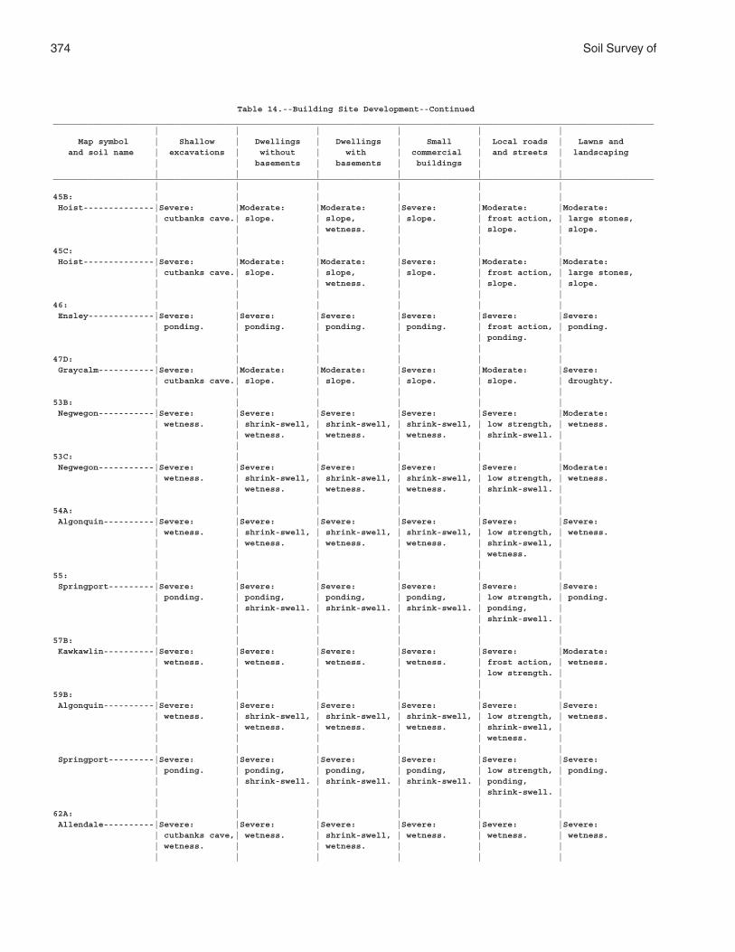
374 Soil Survey of
Table 14.--Building Site Development--Continued_______________________________________________________________________________________________________________________ | | | | | | Map symbol | Shallow | Dwellings | Dwellings | Small | Local roads | Lawns and and soil name | excavations | without | with | commercial | and streets | landscaping | | basements | basements | buildings | | | | | | | |_______________________________________________________________________________________________________________________ | | | | | |45B: | | | | | | Hoist--------------|Severe: |Moderate: |Moderate: |Severe: |Moderate: |Moderate: | cutbanks cave.| slope. | slope, | slope. | frost action, | large stones, | | | wetness. | | slope. | slope. | | | | | |45C: | | | | | | Hoist--------------|Severe: |Moderate: |Moderate: |Severe: |Moderate: |Moderate: | cutbanks cave.| slope. | slope, | slope. | frost action, | large stones, | | | wetness. | | slope. | slope. | | | | | |46: | | | | | | Ensley-------------|Severe: |Severe: |Severe: |Severe: |Severe: |Severe: | ponding. | ponding. | ponding. | ponding. | frost action, | ponding. | | | | | ponding. | | | | | | |47D: | | | | | | Graycalm-----------|Severe: |Moderate: |Moderate: |Severe: |Moderate: |Severe: | cutbanks cave.| slope. | slope. | slope. | slope. | droughty. | | | | | |53B: | | | | | | Negwegon-----------|Severe: |Severe: |Severe: |Severe: |Severe: |Moderate: | wetness. | shrink-swell, | shrink-swell, | shrink-swell, | low strength, | wetness. | | wetness. | wetness. | wetness. | shrink-swell. | | | | | | |53C: | | | | | | Negwegon-----------|Severe: |Severe: |Severe: |Severe: |Severe: |Moderate: | wetness. | shrink-swell, | shrink-swell, | shrink-swell, | low strength, | wetness. | | wetness. | wetness. | wetness. | shrink-swell. | | | | | | |54A: | | | | | | Algonquin----------|Severe: |Severe: |Severe: |Severe: |Severe: |Severe: | wetness. | shrink-swell, | shrink-swell, | shrink-swell, | low strength, | wetness. | | wetness. | wetness. | wetness. | shrink-swell, | | | | | | wetness. | | | | | | |55: | | | | | | Springport---------|Severe: |Severe: |Severe: |Severe: |Severe: |Severe: | ponding. | ponding, | ponding, | ponding, | low strength, | ponding. | | shrink-swell. | shrink-swell. | shrink-swell. | ponding, | | | | | | shrink-swell. | | | | | | |57B: | | | | | | Kawkawlin----------|Severe: |Severe: |Severe: |Severe: |Severe: |Moderate: | wetness. | wetness. | wetness. | wetness. | frost action, | wetness. | | | | | low strength. | | | | | | |59B: | | | | | | Algonquin----------|Severe: |Severe: |Severe: |Severe: |Severe: |Severe: | wetness. | shrink-swell, | shrink-swell, | shrink-swell, | low strength, | wetness. | | wetness. | wetness. | wetness. | shrink-swell, | | | | | | wetness. | | | | | | | Springport---------|Severe: |Severe: |Severe: |Severe: |Severe: |Severe: | ponding. | ponding, | ponding, | ponding, | low strength, | ponding. | | shrink-swell. | shrink-swell. | shrink-swell. | ponding, | | | | | | shrink-swell. | | | | | | |62A: | | | | | | Allendale----------|Severe: |Severe: |Severe: |Severe: |Severe: |Severe: | cutbanks cave,| wetness. | shrink-swell, | wetness. | wetness. | wetness. | wetness. | | wetness. | | | | | | | | |
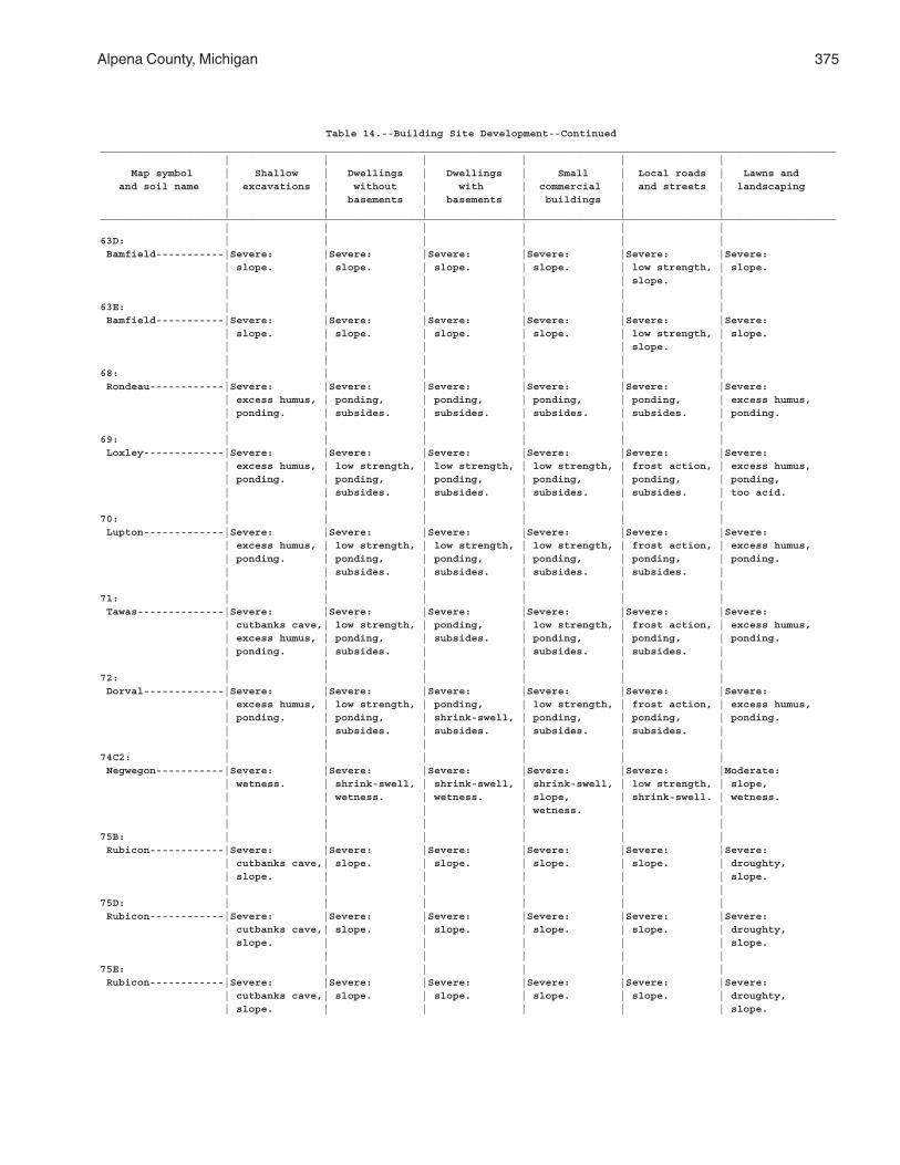
Alpena County, Michigan 375
Table 14.--Building Site Development--Continued_______________________________________________________________________________________________________________________ | | | | | | Map symbol | Shallow | Dwellings | Dwellings | Small | Local roads | Lawns and and soil name | excavations | without | with | commercial | and streets | landscaping | | basements | basements | buildings | | | | | | | |_______________________________________________________________________________________________________________________ | | | | | |63D: | | | | | | Bamfield-----------|Severe: |Severe: |Severe: |Severe: |Severe: |Severe: | slope. | slope. | slope. | slope. | low strength, | slope. | | | | | slope. | | | | | | |63E: | | | | | | Bamfield-----------|Severe: |Severe: |Severe: |Severe: |Severe: |Severe: | slope. | slope. | slope. | slope. | low strength, | slope. | | | | | slope. | | | | | | |68: | | | | | | Rondeau------------|Severe: |Severe: |Severe: |Severe: |Severe: |Severe: | excess humus, | ponding, | ponding, | ponding, | ponding, | excess humus, | ponding. | subsides. | subsides. | subsides. | subsides. | ponding. | | | | | |69: | | | | | | Loxley-------------|Severe: |Severe: |Severe: |Severe: |Severe: |Severe: | excess humus, | low strength, | low strength, | low strength, | frost action, | excess humus, | ponding. | ponding, | ponding, | ponding, | ponding, | ponding, | | subsides. | subsides. | subsides. | subsides. | too acid. | | | | | |70: | | | | | | Lupton-------------|Severe: |Severe: |Severe: |Severe: |Severe: |Severe: | excess humus, | low strength, | low strength, | low strength, | frost action, | excess humus, | ponding. | ponding, | ponding, | ponding, | ponding, | ponding. | | subsides. | subsides. | subsides. | subsides. | | | | | | |71: | | | | | | Tawas--------------|Severe: |Severe: |Severe: |Severe: |Severe: |Severe: | cutbanks cave,| low strength, | ponding, | low strength, | frost action, | excess humus, | excess humus, | ponding, | subsides. | ponding, | ponding, | ponding. | ponding. | subsides. | | subsides. | subsides. | | | | | | |72: | | | | | | Dorval-------------|Severe: |Severe: |Severe: |Severe: |Severe: |Severe: | excess humus, | low strength, | ponding, | low strength, | frost action, | excess humus, | ponding. | ponding, | shrink-swell, | ponding, | ponding, | ponding. | | subsides. | subsides. | subsides. | subsides. | | | | | | |74C2: | | | | | | Negwegon-----------|Severe: |Severe: |Severe: |Severe: |Severe: |Moderate: | wetness. | shrink-swell, | shrink-swell, | shrink-swell, | low strength, | slope, | | wetness. | wetness. | slope, | shrink-swell. | wetness. | | | | wetness. | | | | | | | |75B: | | | | | | Rubicon------------|Severe: |Severe: |Severe: |Severe: |Severe: |Severe: | cutbanks cave,| slope. | slope. | slope. | slope. | droughty, | slope. | | | | | slope. | | | | | |75D: | | | | | | Rubicon------------|Severe: |Severe: |Severe: |Severe: |Severe: |Severe: | cutbanks cave,| slope. | slope. | slope. | slope. | droughty, | slope. | | | | | slope. | | | | | |75E: | | | | | | Rubicon------------|Severe: |Severe: |Severe: |Severe: |Severe: |Severe: | cutbanks cave,| slope. | slope. | slope. | slope. | droughty, | slope. | | | | | slope.
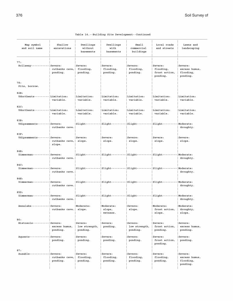
376 Soil Survey of
Table 14.--Building Site Development--Continued_______________________________________________________________________________________________________________________ | | | | | | Map symbol | Shallow | Dwellings | Dwellings | Small | Local roads | Lawns and and soil name | excavations | without | with | commercial | and streets | landscaping | | basements | basements | buildings | | | | | | | |_______________________________________________________________________________________________________________________ | | | | | |77: | | | | | | Rollaway-----------|Severe: |Severe: |Severe: |Severe: |Severe: |Severe: | cutbanks cave,| flooding, | flooding, | flooding, | flooding, | excess humus, | ponding. | ponding. | ponding. | ponding. | frost action, | flooding, | | | | | ponding. | ponding. | | | | | |78: | | | | | | Pits, borrow. | | | | | | | | | | | |82B: | | | | | | Udorthents---------|Limitation: |Limitation: |Limitation: |Limitation: |Limitation: |Limitation: | variable. | variable. | variable. | variable. | variable. | variable. | | | | | |82C: | | | | | | Udorthents---------|Limitation: |Limitation: |Limitation: |Limitation: |Limitation: |Limitation: | variable. | variable. | variable. | variable. | variable. | variable. | | | | | |83B: | | | | | | Udipsamments-------|Severe: |Slight---------|Slight---------|Slight---------|Slight---------|Moderate: | cutbanks cave.| | | | | droughty. | | | | | |83F: | | | | | | Udipsamments-------|Severe: |Severe: |Severe: |Severe: |Severe: |Severe: | cutbanks cave,| slope. | slope. | slope. | slope. | slope. | slope. | | | | | | | | | | |84B: | | | | | | Zimmerman----------|Severe: |Slight---------|Slight---------|Slight---------|Slight---------|Moderate: | cutbanks cave.| | | | | droughty. | | | | | |84C: | | | | | | Zimmerman----------|Severe: |Slight---------|Slight---------|Slight---------|Slight---------|Moderate: | cutbanks cave.| | | | | droughty. | | | | | |84E: | | | | | | Zimmerman----------|Severe: |Slight---------|Slight---------|Slight---------|Slight---------|Moderate: | cutbanks cave.| | | | | droughty. | | | | | |85D: | | | | | | Zimmerman----------|Severe: |Slight---------|Slight---------|Slight---------|Slight---------|Moderate: | cutbanks cave.| | | | | droughty. | | | | | | Annalake-----------|Severe: |Moderate: |Moderate: |Severe: |Moderate: |Moderate: | cutbanks cave.| slope. | slope, | slope. | frost action, | droughty, | | | wetness. | | slope. | slope. | | | | | |86: | | | | | | Histosols----------|Severe: |Severe: |Severe: |Severe: |Severe: |Severe: | excess humus, | low strength, | ponding. | low strength, | frost action, | excess humus, | ponding. | ponding. | | ponding. | ponding. | ponding. | | | | | | Aquents------------|Severe: |Severe: |Severe: |Severe: |Severe: |Severe: | ponding. | ponding. | ponding. | ponding. | frost action, | ponding. | | | | | ponding. | | | | | | |87: | | | | | | Ausable------------|Severe: |Severe: |Severe: |Severe: |Severe: |Severe: | cutbanks cave,| flooding, | flooding, | flooding, | flooding, | excess humus, | ponding. | ponding. | ponding. | ponding. | ponding. | flooding, | | | | | | ponding. | | | | | |
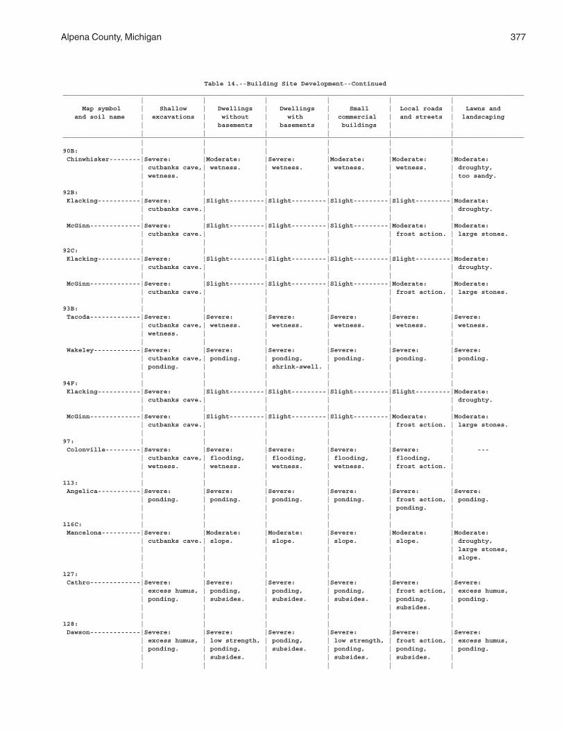
Alpena County, Michigan 377
Table 14.--Building Site Development--Continued_______________________________________________________________________________________________________________________ | | | | | | Map symbol | Shallow | Dwellings | Dwellings | Small | Local roads | Lawns and and soil name | excavations | without | with | commercial | and streets | landscaping | | basements | basements | buildings | | | | | | | |_______________________________________________________________________________________________________________________ | | | | | |90B: | | | | | | Chinwhisker--------|Severe: |Moderate: |Severe: |Moderate: |Moderate: |Moderate: | cutbanks cave,| wetness. | wetness. | wetness. | wetness. | droughty, | wetness. | | | | | too sandy. | | | | | |92B: | | | | | | Klacking-----------|Severe: |Slight---------|Slight---------|Slight---------|Slight---------|Moderate: | cutbanks cave.| | | | | droughty. | | | | | | McGinn-------------|Severe: |Slight---------|Slight---------|Slight---------|Moderate: |Moderate: | cutbanks cave.| | | | frost action. | large stones. | | | | | |92C: | | | | | | Klacking-----------|Severe: |Slight---------|Slight---------|Slight---------|Slight---------|Moderate: | cutbanks cave.| | | | | droughty. | | | | | | McGinn-------------|Severe: |Slight---------|Slight---------|Slight---------|Moderate: |Moderate: | cutbanks cave.| | | | frost action. | large stones. | | | | | |93B: | | | | | | Tacoda-------------|Severe: |Severe: |Severe: |Severe: |Severe: |Severe: | cutbanks cave,| wetness. | wetness. | wetness. | wetness. | wetness. | wetness. | | | | | | | | | | | Wakeley------------|Severe: |Severe: |Severe: |Severe: |Severe: |Severe: | cutbanks cave,| ponding. | ponding, | ponding. | ponding. | ponding. | ponding. | | shrink-swell. | | | | | | | | |94F: | | | | | | Klacking-----------|Severe: |Slight---------|Slight---------|Slight---------|Slight---------|Moderate: | cutbanks cave.| | | | | droughty. | | | | | | McGinn-------------|Severe: |Slight---------|Slight---------|Slight---------|Moderate: |Moderate: | cutbanks cave.| | | | frost action. | large stones. | | | | | |97: | | | | | | Colonville---------|Severe: |Severe: |Severe: |Severe: |Severe: | --- | cutbanks cave,| flooding, | flooding, | flooding, | flooding, | | wetness. | wetness. | wetness. | wetness. | frost action. | | | | | | |113: | | | | | | Angelica-----------|Severe: |Severe: |Severe: |Severe: |Severe: |Severe: | ponding. | ponding. | ponding. | ponding. | frost action, | ponding. | | | | | ponding. | | | | | | |116C: | | | | | | Mancelona----------|Severe: |Moderate: |Moderate: |Severe: |Moderate: |Moderate: | cutbanks cave.| slope. | slope. | slope. | slope. | droughty, | | | | | | large stones, | | | | | | slope. | | | | | |127: | | | | | | Cathro-------------|Severe: |Severe: |Severe: |Severe: |Severe: |Severe: | excess humus, | ponding, | ponding, | ponding, | frost action, | excess humus, | ponding. | subsides. | subsides. | subsides. | ponding, | ponding. | | | | | subsides. | | | | | | |128: | | | | | | Dawson-------------|Severe: |Severe: |Severe: |Severe: |Severe: |Severe: | excess humus, | low strength, | ponding, | low strength, | frost action, | excess humus, | ponding. | ponding, | subsides. | ponding, | ponding, | ponding. | | subsides. | | subsides. | subsides. | | | | | | |
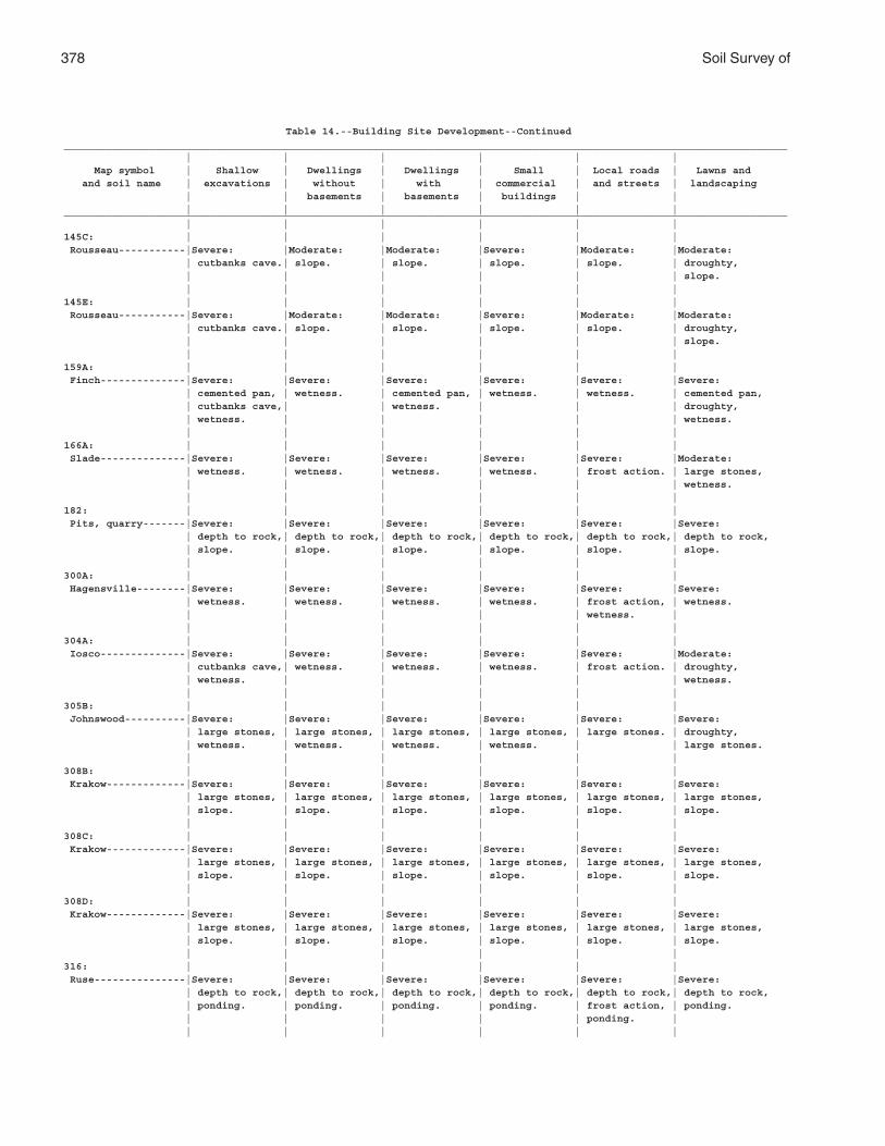
378 Soil Survey of
Table 14.--Building Site Development--Continued_______________________________________________________________________________________________________________________ | | | | | | Map symbol | Shallow | Dwellings | Dwellings | Small | Local roads | Lawns and and soil name | excavations | without | with | commercial | and streets | landscaping | | basements | basements | buildings | | | | | | | |_______________________________________________________________________________________________________________________ | | | | | |145C: | | | | | | Rousseau-----------|Severe: |Moderate: |Moderate: |Severe: |Moderate: |Moderate: | cutbanks cave.| slope. | slope. | slope. | slope. | droughty, | | | | | | slope. | | | | | |145E: | | | | | | Rousseau-----------|Severe: |Moderate: |Moderate: |Severe: |Moderate: |Moderate: | cutbanks cave.| slope. | slope. | slope. | slope. | droughty, | | | | | | slope. | | | | | |159A: | | | | | | Finch--------------|Severe: |Severe: |Severe: |Severe: |Severe: |Severe: | cemented pan, | wetness. | cemented pan, | wetness. | wetness. | cemented pan, | cutbanks cave,| | wetness. | | | droughty, | wetness. | | | | | wetness. | | | | | |166A: | | | | | | Slade--------------|Severe: |Severe: |Severe: |Severe: |Severe: |Moderate: | wetness. | wetness. | wetness. | wetness. | frost action. | large stones, | | | | | | wetness. | | | | | |182: | | | | | | Pits, quarry-------|Severe: |Severe: |Severe: |Severe: |Severe: |Severe: | depth to rock,| depth to rock,| depth to rock,| depth to rock,| depth to rock,| depth to rock, | slope. | slope. | slope. | slope. | slope. | slope. | | | | | |300A: | | | | | | Hagensville--------|Severe: |Severe: |Severe: |Severe: |Severe: |Severe: | wetness. | wetness. | wetness. | wetness. | frost action, | wetness. | | | | | wetness. | | | | | | |304A: | | | | | | Iosco--------------|Severe: |Severe: |Severe: |Severe: |Severe: |Moderate: | cutbanks cave,| wetness. | wetness. | wetness. | frost action. | droughty, | wetness. | | | | | wetness. | | | | | |305B: | | | | | | Johnswood----------|Severe: |Severe: |Severe: |Severe: |Severe: |Severe: | large stones, | large stones, | large stones, | large stones, | large stones. | droughty, | wetness. | wetness. | wetness. | wetness. | | large stones. | | | | | |308B: | | | | | | Krakow-------------|Severe: |Severe: |Severe: |Severe: |Severe: |Severe: | large stones, | large stones, | large stones, | large stones, | large stones, | large stones, | slope. | slope. | slope. | slope. | slope. | slope. | | | | | |308C: | | | | | | Krakow-------------|Severe: |Severe: |Severe: |Severe: |Severe: |Severe: | large stones, | large stones, | large stones, | large stones, | large stones, | large stones, | slope. | slope. | slope. | slope. | slope. | slope. | | | | | |308D: | | | | | | Krakow-------------|Severe: |Severe: |Severe: |Severe: |Severe: |Severe: | large stones, | large stones, | large stones, | large stones, | large stones, | large stones, | slope. | slope. | slope. | slope. | slope. | slope. | | | | | |316: | | | | | | Ruse---------------|Severe: |Severe: |Severe: |Severe: |Severe: |Severe: | depth to rock,| depth to rock,| depth to rock,| depth to rock,| depth to rock,| depth to rock, | ponding. | ponding. | ponding. | ponding. | frost action, | ponding. | | | | | ponding. | | | | | | |
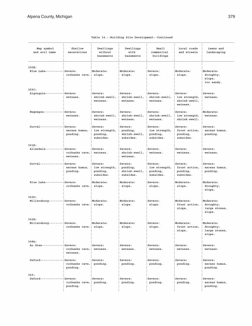
Alpena County, Michigan 379
Table 14.--Building Site Development--Continued_______________________________________________________________________________________________________________________ | | | | | | Map symbol | Shallow | Dwellings | Dwellings | Small | Local roads | Lawns and and soil name | excavations | without | with | commercial | and streets | landscaping | | basements | basements | buildings | | | | | | | |_______________________________________________________________________________________________________________________ | | | | | |350E: | | | | | | Blue Lake----------|Severe: |Moderate: |Moderate: |Severe: |Moderate: |Moderate: | cutbanks cave.| slope. | slope. | slope. | slope. | droughty, | | | | | | slope, | | | | | | too sandy. | | | | | |359C: | | | | | | Algonquin----------|Severe: |Severe: |Severe: |Severe: |Severe: |Severe: | wetness. | shrink-swell, | shrink-swell, | shrink-swell, | low strength, | wetness. | | wetness. | wetness. | wetness. | shrink-swell, | | | | | | wetness. | | | | | | | Negwegon-----------|Severe: |Severe: |Severe: |Severe: |Severe: |Moderate: | wetness. | shrink-swell, | shrink-swell, | shrink-swell, | low strength, | wetness. | | wetness. | wetness. | wetness. | shrink-swell. | | | | | | | Dorval-------------|Severe: |Severe: |Severe: |Severe: |Severe: |Severe: | excess humus, | low strength, | ponding, | low strength, | frost action, | excess humus, | ponding. | ponding, | shrink-swell, | ponding, | ponding, | ponding. | | subsides. | subsides. | subsides. | subsides. | | | | | | |361B: | | | | | | Allendale----------|Severe: |Severe: |Severe: |Severe: |Severe: |Severe: | cutbanks cave,| wetness. | shrink-swell, | wetness. | wetness. | wetness. | wetness. | | wetness. | | | | | | | | | Dorval-------------|Severe: |Severe: |Severe: |Severe: |Severe: |Severe: | excess humus, | low strength, | ponding, | low strength, | frost action, | excess humus, | ponding. | ponding, | shrink-swell, | ponding, | ponding, | ponding. | | subsides. | subsides. | subsides. | subsides. | | | | | | | Blue Lake----------|Severe: |Moderate: |Moderate: |Severe: |Moderate: |Moderate: | cutbanks cave.| slope. | slope. | slope. | slope. | droughty, | | | | | | slope, | | | | | |362D: | | | | | | Millersburg--------|Severe: |Moderate: |Moderate: |Severe: |Moderate: |Moderate: | cutbanks cave.| slope. | slope. | slope. | frost action, | droughty, | | | | | slope. | large stones, | | | | | | slope. | | | | | |362E: | | | | | | Millersburg--------|Severe: |Moderate: |Moderate: |Severe: |Moderate: |Moderate: | cutbanks cave.| slope. | slope. | slope. | frost action, | droughty, | | | | | slope. | large stones, | | | | | | slope. | | | | | |368A: | | | | | | Au Gres------------|Severe: |Severe: |Severe: |Severe: |Severe: |Severe: | cutbanks cave,| wetness. | wetness. | wetness. | wetness. | wetness. | wetness. | | | | | | | | | | | Deford-------------|Severe: |Severe: |Severe: |Severe: |Severe: |Severe: | cutbanks cave,| ponding. | ponding. | ponding. | ponding. | excess humus, | ponding. | | | | | ponding. | | | | | |369: | | | | | | Deford-------------|Severe: |Severe: |Severe: |Severe: |Severe: |Severe: | cutbanks cave,| ponding. | ponding. | ponding. | ponding. | excess humus, | ponding. | | | | | ponding. | | | | | |
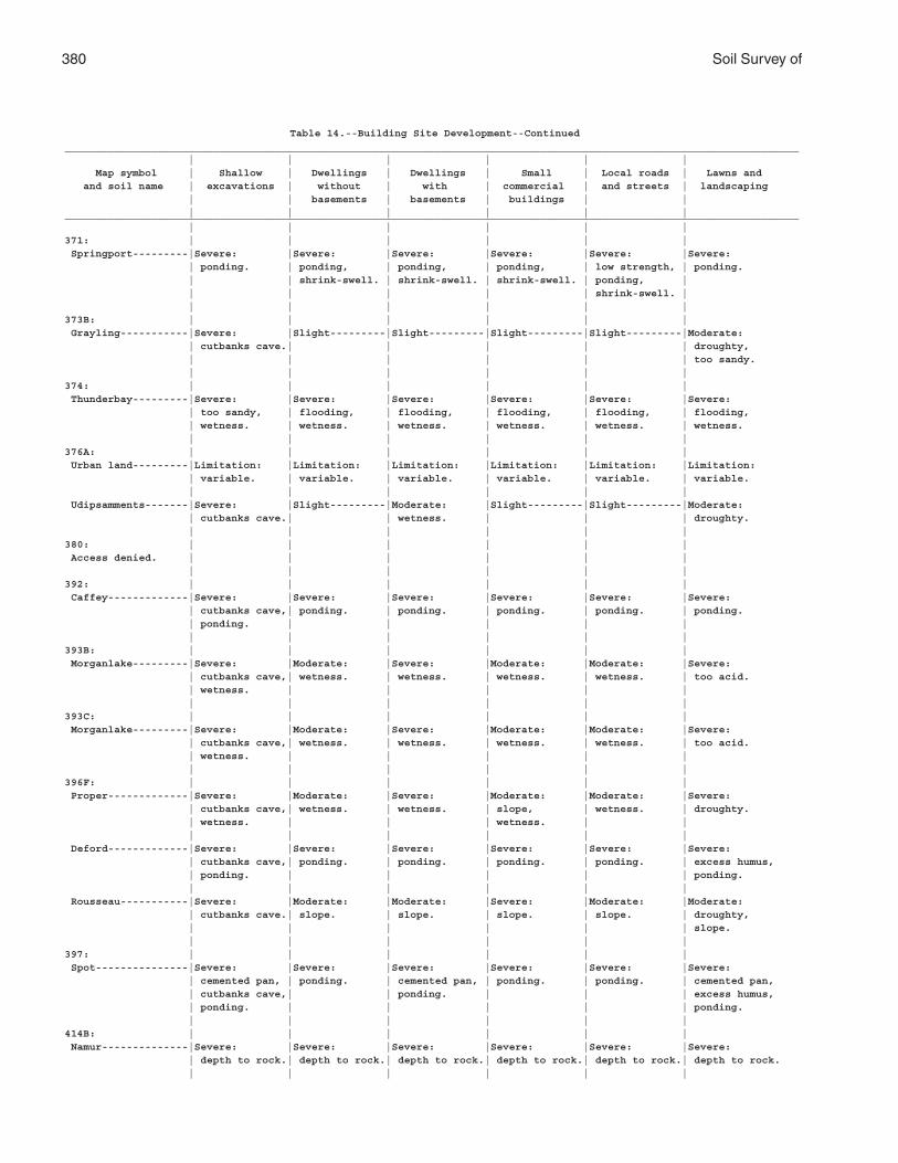
380 Soil Survey of
Table 14.--Building Site Development--Continued_______________________________________________________________________________________________________________________ | | | | | | Map symbol | Shallow | Dwellings | Dwellings | Small | Local roads | Lawns and and soil name | excavations | without | with | commercial | and streets | landscaping | | basements | basements | buildings | | | | | | | |_______________________________________________________________________________________________________________________ | | | | | |371: | | | | | | Springport---------|Severe: |Severe: |Severe: |Severe: |Severe: |Severe: | ponding. | ponding, | ponding, | ponding, | low strength, | ponding. | | shrink-swell. | shrink-swell. | shrink-swell. | ponding, | | | | | | shrink-swell. | | | | | | |373B: | | | | | | Grayling-----------|Severe: |Slight---------|Slight---------|Slight---------|Slight---------|Moderate: | cutbanks cave.| | | | | droughty, | | | | | | too sandy. | | | | | |374: | | | | | | Thunderbay---------|Severe: |Severe: |Severe: |Severe: |Severe: |Severe: | too sandy, | flooding, | flooding, | flooding, | flooding, | flooding, | wetness. | wetness. | wetness. | wetness. | wetness. | wetness. | | | | | |376A: | | | | | | Urban land---------|Limitation: |Limitation: |Limitation: |Limitation: |Limitation: |Limitation: | variable. | variable. | variable. | variable. | variable. | variable. | | | | | | Udipsamments-------|Severe: |Slight---------|Moderate: |Slight---------|Slight---------|Moderate: | cutbanks cave.| | wetness. | | | droughty. | | | | | |380: | | | | | | Access denied. | | | | | | | | | | | |392: | | | | | | Caffey-------------|Severe: |Severe: |Severe: |Severe: |Severe: |Severe: | cutbanks cave,| ponding. | ponding. | ponding. | ponding. | ponding. | ponding. | | | | | | | | | | |393B: | | | | | | Morganlake---------|Severe: |Moderate: |Severe: |Moderate: |Moderate: |Severe: | cutbanks cave,| wetness. | wetness. | wetness. | wetness. | too acid. | wetness. | | | | | | | | | | |393C: | | | | | | Morganlake---------|Severe: |Moderate: |Severe: |Moderate: |Moderate: |Severe: | cutbanks cave,| wetness. | wetness. | wetness. | wetness. | too acid. | wetness. | | | | | | | | | | |396F: | | | | | | Proper-------------|Severe: |Moderate: |Severe: |Moderate: |Moderate: |Severe: | cutbanks cave,| wetness. | wetness. | slope, | wetness. | droughty. | wetness. | | | wetness. | | | | | | | | Deford-------------|Severe: |Severe: |Severe: |Severe: |Severe: |Severe: | cutbanks cave,| ponding. | ponding. | ponding. | ponding. | excess humus, | ponding. | | | | | ponding. | | | | | | Rousseau-----------|Severe: |Moderate: |Moderate: |Severe: |Moderate: |Moderate: | cutbanks cave.| slope. | slope. | slope. | slope. | droughty, | | | | | | slope. | | | | | |397: | | | | | | Spot---------------|Severe: |Severe: |Severe: |Severe: |Severe: |Severe: | cemented pan, | ponding. | cemented pan, | ponding. | ponding. | cemented pan, | cutbanks cave,| | ponding. | | | excess humus, | ponding. | | | | | ponding. | | | | | |414B: | | | | | | Namur--------------|Severe: |Severe: |Severe: |Severe: |Severe: |Severe: | depth to rock.| depth to rock.| depth to rock.| depth to rock.| depth to rock.| depth to rock. | | | | | |
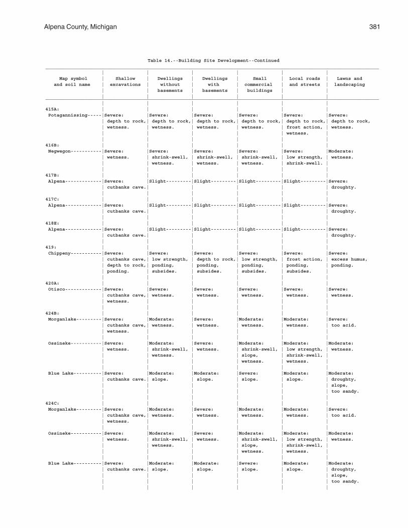
Alpena County, Michigan 381
Table 14.--Building Site Development--Continued_______________________________________________________________________________________________________________________ | | | | | | Map symbol | Shallow | Dwellings | Dwellings | Small | Local roads | Lawns and and soil name | excavations | without | with | commercial | and streets | landscaping | | basements | basements | buildings | | | | | | | |_______________________________________________________________________________________________________________________ | | | | | |415A: | | | | | | Potagannissing-----|Severe: |Severe: |Severe: |Severe: |Severe: |Severe: | depth to rock,| depth to rock,| depth to rock,| depth to rock,| depth to rock,| depth to rock, | wetness. | wetness. | wetness. | wetness. | frost action, | wetness. | | | | | wetness. | | | | | | |416B: | | | | | | Negwegon-----------|Severe: |Severe: |Severe: |Severe: |Severe: |Moderate: | wetness. | shrink-swell, | shrink-swell, | shrink-swell, | low strength, | wetness. | | wetness. | wetness. | wetness. | shrink-swell. | | | | | | |417B: | | | | | | Alpena-------------|Severe: |Slight---------|Slight---------|Slight---------|Slight---------|Severe: | cutbanks cave.| | | | | droughty. | | | | | |417C: | | | | | | Alpena-------------|Severe: |Slight---------|Slight---------|Slight---------|Slight---------|Severe: | cutbanks cave.| | | | | droughty. | | | | | |418E: | | | | | | Alpena-------------|Severe: |Slight---------|Slight---------|Slight---------|Slight---------|Severe: | cutbanks cave.| | | | | droughty. | | | | | |419: | | | | | | Chippeny-----------|Severe: |Severe: |Severe: |Severe: |Severe: |Severe: | cutbanks cave,| low strength, | depth to rock,| low strength, | frost action, | excess humus, | depth to rock,| ponding, | ponding, | ponding, | ponding, | ponding. | ponding. | subsides. | subsides. | subsides. | subsides. | | | | | | |420A: | | | | | | Otisco-------------|Severe: |Severe: |Severe: |Severe: |Severe: |Severe: | cutbanks cave,| wetness. | wetness. | wetness. | wetness. | wetness. | wetness. | | | | | | | | | | |424B: | | | | | | Morganlake---------|Severe: |Moderate: |Severe: |Moderate: |Moderate: |Severe: | cutbanks cave,| wetness. | wetness. | wetness. | wetness. | too acid. | wetness. | | | | | | | | | | | Ossineke-----------|Severe: |Moderate: |Severe: |Moderate: |Moderate: |Moderate: | wetness. | shrink-swell, | wetness. | shrink-swell, | low strength, | wetness. | | wetness. | | slope, | shrink-swell, | | | | | wetness. | wetness. | | | | | | | Blue Lake----------|Severe: |Moderate: |Moderate: |Severe: |Moderate: |Moderate: | cutbanks cave.| slope. | slope. | slope. | slope. | droughty, | | | | | | slope, | | | | | | too sandy. | | | | | |424C: | | | | | | Morganlake---------|Severe: |Moderate: |Severe: |Moderate: |Moderate: |Severe: | cutbanks cave,| wetness. | wetness. | wetness. | wetness. | too acid. | wetness. | | | | | | | | | | | Ossineke-----------|Severe: |Moderate: |Severe: |Moderate: |Moderate: |Moderate: | wetness. | shrink-swell, | wetness. | shrink-swell, | low strength, | wetness. | | wetness. | | slope, | shrink-swell, | | | | | wetness. | wetness. | | | | | | | Blue Lake----------|Severe: |Moderate: |Moderate: |Severe: |Moderate: |Moderate: | cutbanks cave.| slope. | slope. | slope. | slope. | droughty, | | | | | | slope, | | | | | | too sandy. | | | | | |
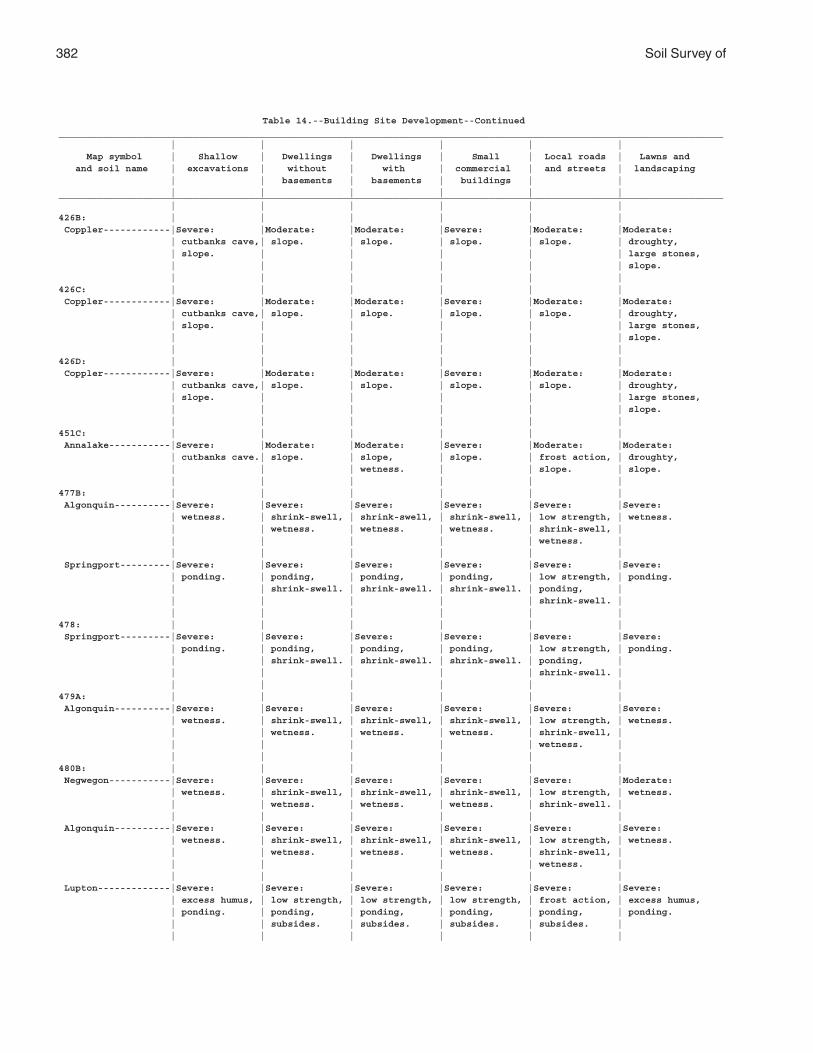
382 Soil Survey of
Table 14.--Building Site Development--Continued_______________________________________________________________________________________________________________________ | | | | | | Map symbol | Shallow | Dwellings | Dwellings | Small | Local roads | Lawns and and soil name | excavations | without | with | commercial | and streets | landscaping | | basements | basements | buildings | | | | | | | |_______________________________________________________________________________________________________________________ | | | | | |426B: | | | | | | Coppler------------|Severe: |Moderate: |Moderate: |Severe: |Moderate: |Moderate: | cutbanks cave,| slope. | slope. | slope. | slope. | droughty, | slope. | | | | | large stones, | | | | | | slope. | | | | | |426C: | | | | | | Coppler------------|Severe: |Moderate: |Moderate: |Severe: |Moderate: |Moderate: | cutbanks cave,| slope. | slope. | slope. | slope. | droughty, | slope. | | | | | large stones, | | | | | | slope. | | | | | |426D: | | | | | | Coppler------------|Severe: |Moderate: |Moderate: |Severe: |Moderate: |Moderate: | cutbanks cave,| slope. | slope. | slope. | slope. | droughty, | slope. | | | | | large stones, | | | | | | slope. | | | | | |451C: | | | | | | Annalake-----------|Severe: |Moderate: |Moderate: |Severe: |Moderate: |Moderate: | cutbanks cave.| slope. | slope, | slope. | frost action, | droughty, | | | wetness. | | slope. | slope. | | | | | |477B: | | | | | | Algonquin----------|Severe: |Severe: |Severe: |Severe: |Severe: |Severe: | wetness. | shrink-swell, | shrink-swell, | shrink-swell, | low strength, | wetness. | | wetness. | wetness. | wetness. | shrink-swell, | | | | | | wetness. | | | | | | | Springport---------|Severe: |Severe: |Severe: |Severe: |Severe: |Severe: | ponding. | ponding, | ponding, | ponding, | low strength, | ponding. | | shrink-swell. | shrink-swell. | shrink-swell. | ponding, | | | | | | shrink-swell. | | | | | | |478: | | | | | | Springport---------|Severe: |Severe: |Severe: |Severe: |Severe: |Severe: | ponding. | ponding, | ponding, | ponding, | low strength, | ponding. | | shrink-swell. | shrink-swell. | shrink-swell. | ponding, | | | | | | shrink-swell. | | | | | | |479A: | | | | | | Algonquin----------|Severe: |Severe: |Severe: |Severe: |Severe: |Severe: | wetness. | shrink-swell, | shrink-swell, | shrink-swell, | low strength, | wetness. | | wetness. | wetness. | wetness. | shrink-swell, | | | | | | wetness. | | | | | | |480B: | | | | | | Negwegon-----------|Severe: |Severe: |Severe: |Severe: |Severe: |Moderate: | wetness. | shrink-swell, | shrink-swell, | shrink-swell, | low strength, | wetness. | | wetness. | wetness. | wetness. | shrink-swell. | | | | | | | Algonquin----------|Severe: |Severe: |Severe: |Severe: |Severe: |Severe: | wetness. | shrink-swell, | shrink-swell, | shrink-swell, | low strength, | wetness. | | wetness. | wetness. | wetness. | shrink-swell, | | | | | | wetness. | | | | | | | Lupton-------------|Severe: |Severe: |Severe: |Severe: |Severe: |Severe: | excess humus, | low strength, | low strength, | low strength, | frost action, | excess humus, | ponding. | ponding, | ponding, | ponding, | ponding, | ponding. | | subsides. | subsides. | subsides. | subsides. | | | | | | |
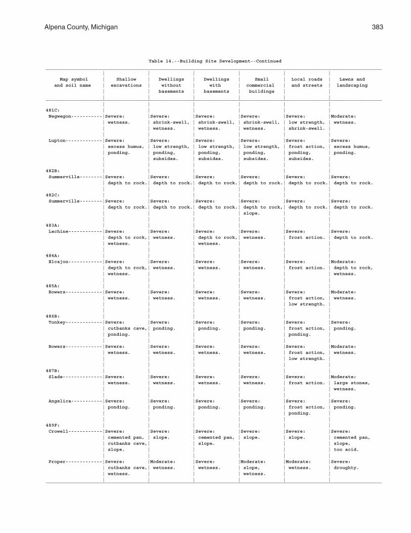
Alpena County, Michigan 383
Table 14.--Building Site Development--Continued_______________________________________________________________________________________________________________________ | | | | | | Map symbol | Shallow | Dwellings | Dwellings | Small | Local roads | Lawns and and soil name | excavations | without | with | commercial | and streets | landscaping | | basements | basements | buildings | | | | | | | |_______________________________________________________________________________________________________________________ | | | | | |481C: | | | | | | Negwegon-----------|Severe: |Severe: |Severe: |Severe: |Severe: |Moderate: | wetness. | shrink-swell, | shrink-swell, | shrink-swell, | low strength, | wetness. | | wetness. | wetness. | wetness. | shrink-swell. | | | | | | | Lupton-------------|Severe: |Severe: |Severe: |Severe: |Severe: |Severe: | excess humus, | low strength, | low strength, | low strength, | frost action, | excess humus, | ponding. | ponding, | ponding, | ponding, | ponding, | ponding. | | subsides. | subsides. | subsides. | subsides. | | | | | | |482B: | | | | | | Summerville--------|Severe: |Severe: |Severe: |Severe: |Severe: |Severe: | depth to rock.| depth to rock.| depth to rock.| depth to rock.| depth to rock.| depth to rock. | | | | | |482C: | | | | | | Summerville--------|Severe: |Severe: |Severe: |Severe: |Severe: |Severe: | depth to rock.| depth to rock.| depth to rock.| depth to rock,| depth to rock.| depth to rock. | | | | slope. | | | | | | | |483A: | | | | | | Lachine------------|Severe: |Severe: |Severe: |Severe: |Severe: |Severe: | depth to rock,| wetness. | depth to rock,| wetness. | frost action. | depth to rock. | wetness. | | wetness. | | | | | | | | |484A: | | | | | | Elcajon------------|Severe: |Severe: |Severe: |Severe: |Severe: |Moderate: | depth to rock,| wetness. | wetness. | wetness. | frost action. | depth to rock, | wetness. | | | | | wetness. | | | | | |485A: | | | | | | Bowers-------------|Severe: |Severe: |Severe: |Severe: |Severe: |Moderate: | wetness. | wetness. | wetness. | wetness. | frost action, | wetness. | | | | | low strength. | | | | | | |486B: | | | | | | Tonkey-------------|Severe: |Severe: |Severe: |Severe: |Severe: |Severe: | cutbanks cave,| ponding. | ponding. | ponding. | frost action, | ponding. | ponding. | | | | ponding. | | | | | | | Bowers-------------|Severe: |Severe: |Severe: |Severe: |Severe: |Moderate: | wetness. | wetness. | wetness. | wetness. | frost action, | wetness. | | | | | low strength. | | | | | | |487B: | | | | | | Slade--------------|Severe: |Severe: |Severe: |Severe: |Severe: |Moderate: | wetness. | wetness. | wetness. | wetness. | frost action. | large stones, | | | | | | wetness. | | | | | | Angelica-----------|Severe: |Severe: |Severe: |Severe: |Severe: |Severe: | ponding. | ponding. | ponding. | ponding. | frost action, | ponding. | | | | | ponding. | | | | | | |489F: | | | | | | Crowell------------|Severe: |Severe: |Severe: |Severe: |Severe: |Severe: | cemented pan, | slope. | cemented pan, | slope. | slope. | cemented pan, | cutbanks cave,| | slope. | | | slope, | slope. | | | | | too acid. | | | | | | Proper-------------|Severe: |Moderate: |Severe: |Moderate: |Moderate: |Severe: | cutbanks cave,| wetness. | wetness. | slope, | wetness. | droughty. | wetness. | | | wetness. | | | | | | | |_______________________________________________________________________________________________________________________
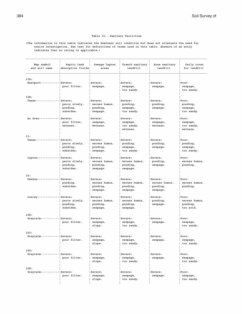
384 Soil Survey of
Table 15.--Sanitary Facilities
(The information in this table indicates the dominant soil condition but does not eliminate the need for onsite investigation. See text for definitions of terms used in this table. Absence of an entry indicates that no rating is applicable.)
_____________________________________________________________________________________________________________ | | | | | Map symbol | Septic tank | Sewage lagoon | Trench sanitary | Area sanitary | Daily cover and soil name |absorption fields| areas | landfill | landfill | for landfill | | | | |_____________________________________________________________________________________________________________ | | | | |11B: | | | | | Eastport-----------|Severe: |Severe: |Severe: |Severe: |Poor: | poor filter. | seepage. | seepage, | seepage. | seepage, | | | too sandy. | | too sandy. | | | | |12B: | | | | | Tawas--------------|Severe: |Severe: |Severe: |Severe: |Poor: | percs slowly, | excess humus, | ponding, | ponding, | ponding, | ponding, | ponding, | seepage, | seepage. | seepage, | subsides. | seepage. | too sandy. | | too sandy. | | | | | Au Gres------------|Severe: |Severe: |Severe: |Severe: |Poor: | poor filter, | seepage, | seepage, | seepage, | seepage, | wetness. | wetness. | too sandy, | wetness. | too sandy, | | | wetness. | | wetness. | | | | |13: | | | | | Tawas--------------|Severe: |Severe: |Severe: |Severe: |Poor: | percs slowly, | excess humus, | ponding, | ponding, | ponding, | ponding, | ponding, | seepage, | seepage. | seepage, | subsides. | seepage. | too sandy. | | too sandy. | | | | | Lupton-------------|Severe: |Severe: |Severe: |Severe: |Poor: | percs slowly, | excess humus, | excess humus, | ponding, | excess humus, | ponding, | ponding, | ponding, | seepage. | ponding. | subsides. | seepage. | seepage. | | | | | | |14: | | | | | Dawson-------------|Severe: |Severe: |Severe: |Severe: |Poor: | ponding, | excess humus, | excess humus, | excess humus, | excess humus, | subsides. | ponding, | ponding, | ponding, | ponding. | | seepage. | seepage. | seepage. | | | | | | Loxley-------------|Severe: |Severe: |Severe: |Severe: |Poor: | percs slowly, | excess humus, | excess humus, | ponding, | excess humus, | ponding, | ponding, | ponding, | seepage. | ponding, | subsides. | seepage. | seepage. | | too acid. | | | | |16B: | | | | | Graycalm-----------|Severe: |Severe: |Severe: |Severe: |Poor: | poor filter. | seepage, | seepage, | seepage. | seepage, | | slope. | too sandy. | | too sandy. | | | | |16C: | | | | | Graycalm-----------|Severe: |Severe: |Severe: |Severe: |Poor: | poor filter. | seepage, | seepage, | seepage. | seepage, | | slope. | too sandy. | | too sandy. | | | | |16D: | | | | | Graycalm-----------|Severe: |Severe: |Severe: |Severe: |Poor: | poor filter. | seepage, | seepage, | seepage. | seepage, | | slope. | too sandy. | | too sandy. | | | | |16E: | | | | | Graycalm-----------|Severe: |Severe: |Severe: |Severe: |Poor: | poor filter. | seepage, | seepage, | seepage. | seepage, | | slope. | too sandy. | | too sandy. | | | | |
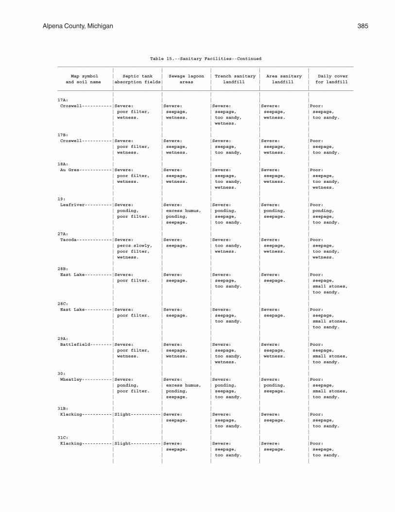
Alpena County, Michigan 385
Table 15.--Sanitary Facilities--Continued_____________________________________________________________________________________________________________ | | | | | Map symbol | Septic tank | Sewage lagoon | Trench sanitary | Area sanitary | Daily cover and soil name |absorption fields| areas | landfill | landfill | for landfill | | | | |_____________________________________________________________________________________________________________ | | | | |17A: | | | | | Croswell-----------|Severe: |Severe: |Severe: |Severe: |Poor: | poor filter, | seepage, | seepage, | seepage, | seepage, | wetness. | wetness. | too sandy, | wetness. | too sandy. | | | wetness. | | | | | | |17B: | | | | | Croswell-----------|Severe: |Severe: |Severe: |Severe: |Poor: | poor filter, | seepage, | seepage, | seepage, | seepage, | wetness. | wetness. | too sandy, | wetness. | too sandy. | | | | |18A: | | | | | Au Gres------------|Severe: |Severe: |Severe: |Severe: |Poor: | poor filter, | seepage, | seepage, | seepage, | seepage, | wetness. | wetness. | too sandy, | wetness. | too sandy, | | | wetness. | | wetness. | | | | |19: | | | | | Leafriver----------|Severe: |Severe: |Severe: |Severe: |Poor: | ponding, | excess humus, | ponding, | ponding, | ponding, | poor filter. | ponding, | seepage, | seepage. | seepage, | | seepage. | too sandy. | | too sandy. | | | | |27A: | | | | | Tacoda-------------|Severe: |Severe: |Severe: |Severe: |Poor: | percs slowly, | seepage. | too sandy, | seepage, | seepage, | poor filter, | | wetness. | wetness. | too sandy, | wetness. | | | | wetness. | | | | |28B: | | | | | East Lake----------|Severe: |Severe: |Severe: |Severe: |Poor: | poor filter. | seepage. | seepage, | seepage. | seepage, | | | too sandy. | | small stones, | | | | | too sandy. | | | | |28C: | | | | | East Lake----------|Severe: |Severe: |Severe: |Severe: |Poor: | poor filter. | seepage. | seepage, | seepage. | seepage, | | | too sandy. | | small stones, | | | | | too sandy. | | | | |29A: | | | | | Battlefield--------|Severe: |Severe: |Severe: |Severe: |Poor: | poor filter, | seepage, | seepage, | seepage, | seepage, | wetness. | wetness. | too sandy, | wetness. | small stones, | | | wetness. | | too sandy. | | | | |30: | | | | | Wheatley-----------|Severe: |Severe: |Severe: |Severe: |Poor: | ponding, | excess humus, | ponding, | ponding, | seepage, | poor filter. | ponding, | seepage, | seepage. | small stones, | | seepage. | too sandy. | | too sandy. | | | | |31B: | | | | | Klacking-----------|Slight-----------|Severe: |Severe: |Severe: |Poor: | | seepage. | seepage, | seepage. | seepage, | | | too sandy. | | too sandy. | | | | |31C: | | | | | Klacking-----------|Slight-----------|Severe: |Severe: |Severe: |Poor: | | seepage. | seepage, | seepage. | seepage, | | | too sandy. | | too sandy. | | | | |

386 Soil Survey of
Table 15.--Sanitary Facilities--Continued_____________________________________________________________________________________________________________ | | | | | Map symbol | Septic tank | Sewage lagoon | Trench sanitary | Area sanitary | Daily cover and soil name |absorption fields| areas | landfill | landfill | for landfill | | | | |_____________________________________________________________________________________________________________ | | | | |31D: | | | | | Klacking-----------|Slight-----------|Severe: |Severe: |Severe: |Poor: | | seepage. | seepage, | seepage. | seepage, | | | too sandy. | | too sandy. | | | | |31E: | | | | | Klacking-----------|Slight-----------|Severe: |Severe: |Severe: |Poor: | | seepage. | seepage, | seepage. | seepage, | | | too sandy. | | too sandy. | | | | |35: | | | | | Kinross------------|Severe: |Severe: |Severe: |Severe: |Poor: | ponding, | excess humus, | ponding, | ponding, | ponding, | poor filter. | ponding, | seepage, | seepage. | seepage, | | seepage. | too sandy. | | too sandy. | | | | |36B: | | | | | Annalake-----------|Severe: |Severe: |Severe: |Moderate: |Poor: | wetness. | slope, | too sandy. | slope, | too sandy. | | wetness. | | wetness. | | | | | |36C: | | | | | Annalake-----------|Severe: |Severe: |Severe: |Moderate: |Poor: | wetness. | slope, | too sandy. | slope, | too sandy. | | wetness. | | wetness. | | | | | |37A: | | | | | Richter------------|Severe: |Severe: |Severe: |Severe: |Poor: | wetness. | seepage, | seepage, | seepage, | wetness. | | wetness. | wetness. | wetness. | | | | | |37B: | | | | | Richter------------|Severe: |Severe: |Severe: |Severe: |Poor: | wetness. | seepage, | seepage, | seepage, | wetness. | | wetness. | wetness. | wetness. | | | | | |38: | | | | | Tonkey-------------|Severe: |Severe: |Severe: |Severe: |Poor: | ponding, | ponding, | ponding, | ponding, | ponding, | poor filter. | seepage. | seepage, | seepage. | seepage, | | | too sandy. | | too sandy. | | | | |41B: | | | | | McGinn-------------|Moderate: |Severe: |Slight-----------|Severe: |Good. | percs slowly. | seepage. | | seepage. | | | | | |41C: | | | | | McGinn-------------|Moderate: |Severe: |Slight-----------|Severe: |Good. | percs slowly. | seepage. | | seepage. | | | | | |41D: | | | | | McGinn-------------|Moderate: |Severe: |Slight-----------|Severe: |Good. | percs slowly. | seepage. | | seepage. | | | | | |41E: | | | | | McGinn-------------|Moderate: |Severe: |Slight-----------|Severe: |Good. | percs slowly. | seepage. | | seepage. | | | | | |42A: | | | | | Killmaster---------|Severe: |Severe: |Severe: |Severe: |Poor: | percs slowly, | seepage. | wetness. | seepage, | wetness. | wetness. | | | wetness. | | | | | |
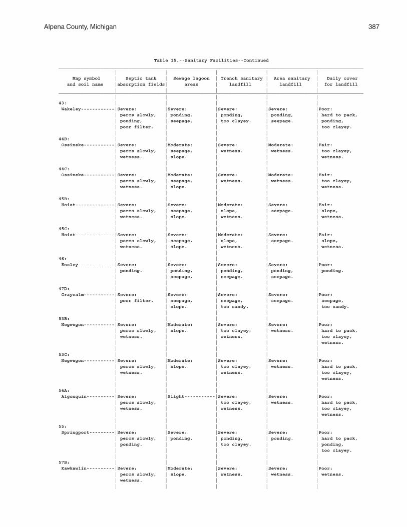
Alpena County, Michigan 387
Table 15.--Sanitary Facilities--Continued_____________________________________________________________________________________________________________ | | | | | Map symbol | Septic tank | Sewage lagoon | Trench sanitary | Area sanitary | Daily cover and soil name |absorption fields| areas | landfill | landfill | for landfill | | | | |_____________________________________________________________________________________________________________ | | | | |43: | | | | | Wakeley------------|Severe: |Severe: |Severe: |Severe: |Poor: | percs slowly, | ponding, | ponding, | ponding, | hard to pack, | ponding, | seepage. | too clayey. | seepage. | ponding, | poor filter. | | | | too clayey. | | | | |44B: | | | | | Ossineke-----------|Severe: |Moderate: |Severe: |Moderate: |Fair: | percs slowly, | seepage, | wetness. | wetness. | too clayey, | wetness. | slope. | | | wetness. | | | | |44C: | | | | | Ossineke-----------|Severe: |Moderate: |Severe: |Moderate: |Fair: | percs slowly, | seepage, | wetness. | wetness. | too clayey, | wetness. | slope. | | | wetness. | | | | |45B: | | | | | Hoist--------------|Severe: |Severe: |Moderate: |Severe: |Fair: | percs slowly, | seepage, | slope, | seepage. | slope, | wetness. | slope. | wetness. | | wetness. | | | | |45C: | | | | | Hoist--------------|Severe: |Severe: |Moderate: |Severe: |Fair: | percs slowly, | seepage, | slope, | seepage. | slope, | wetness. | slope. | wetness. | | wetness. | | | | |46: | | | | | Ensley-------------|Severe: |Severe: |Severe: |Severe: |Poor: | ponding. | ponding, | ponding, | ponding, | ponding. | | seepage. | seepage. | seepage. | | | | | |47D: | | | | | Graycalm-----------|Severe: |Severe: |Severe: |Severe: |Poor: | poor filter. | seepage, | seepage, | seepage. | seepage, | | slope. | too sandy. | | too sandy. | | | | |53B: | | | | | Negwegon-----------|Severe: |Moderate: |Severe: |Severe: |Poor: | percs slowly, | slope. | too clayey, | wetness. | hard to pack, | wetness. | | wetness. | | too clayey, | | | | | wetness. | | | | |53C: | | | | | Negwegon-----------|Severe: |Moderate: |Severe: |Severe: |Poor: | percs slowly, | slope. | too clayey, | wetness. | hard to pack, | wetness. | | wetness. | | too clayey, | | | | | wetness. | | | | |54A: | | | | | Algonquin----------|Severe: |Slight-----------|Severe: |Severe: |Poor: | percs slowly, | | too clayey, | wetness. | hard to pack, | wetness. | | wetness. | | too clayey, | | | | | wetness. | | | | |55: | | | | | Springport---------|Severe: |Severe: |Severe: |Severe: |Poor: | percs slowly, | ponding. | ponding, | ponding. | hard to pack, | ponding. | | too clayey. | | ponding, | | | | | too clayey. | | | | |57B: | | | | | Kawkawlin----------|Severe: |Moderate: |Severe: |Severe: |Poor: | percs slowly, | slope. | wetness. | wetness. | wetness. | wetness. | | | | | | | | |
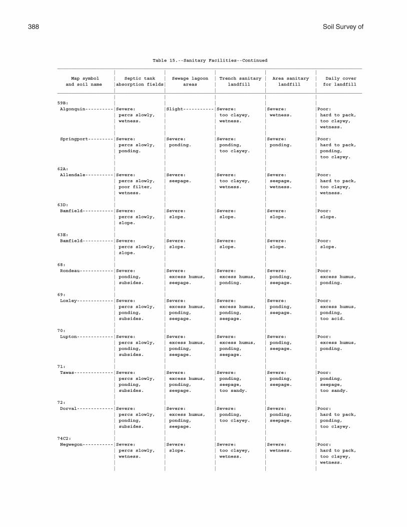
388 Soil Survey of
Table 15.--Sanitary Facilities--Continued_____________________________________________________________________________________________________________ | | | | | Map symbol | Septic tank | Sewage lagoon | Trench sanitary | Area sanitary | Daily cover and soil name |absorption fields| areas | landfill | landfill | for landfill | | | | |_____________________________________________________________________________________________________________ | | | | |59B: | | | | | Algonquin----------|Severe: |Slight-----------|Severe: |Severe: |Poor: | percs slowly, | | too clayey, | wetness. | hard to pack, | wetness. | | wetness. | | too clayey, | | | | | wetness. | | | | | Springport---------|Severe: |Severe: |Severe: |Severe: |Poor: | percs slowly, | ponding. | ponding, | ponding. | hard to pack, | ponding. | | too clayey. | | ponding, | | | | | too clayey. | | | | |62A: | | | | | Allendale----------|Severe: |Severe: |Severe: |Severe: |Poor: | percs slowly, | seepage. | too clayey, | seepage, | hard to pack, | poor filter, | | wetness. | wetness. | too clayey, | wetness. | | | | wetness. | | | | |63D: | | | | | Bamfield-----------|Severe: |Severe: |Severe: |Severe: |Poor: | percs slowly, | slope. | slope. | slope. | slope. | slope. | | | | | | | | |63E: | | | | | Bamfield-----------|Severe: |Severe: |Severe: |Severe: |Poor: | percs slowly, | slope. | slope. | slope. | slope. | slope. | | | | | | | | |68: | | | | | Rondeau------------|Severe: |Severe: |Severe: |Severe: |Poor: | ponding, | excess humus, | excess humus, | ponding, | excess humus, | subsides. | seepage. | ponding. | seepage. | ponding. | | | | |69: | | | | | Loxley-------------|Severe: |Severe: |Severe: |Severe: |Poor: | percs slowly, | excess humus, | excess humus, | ponding, | excess humus, | ponding, | ponding, | ponding, | seepage. | ponding, | subsides. | seepage. | seepage. | | too acid. | | | | |70: | | | | | Lupton-------------|Severe: |Severe: |Severe: |Severe: |Poor: | percs slowly, | excess humus, | excess humus, | ponding, | excess humus, | ponding, | ponding, | ponding, | seepage. | ponding. | subsides. | seepage. | seepage. | | | | | | |71: | | | | | Tawas--------------|Severe: |Severe: |Severe: |Severe: |Poor: | percs slowly, | excess humus, | ponding, | ponding, | ponding, | ponding, | ponding, | seepage, | seepage. | seepage, | subsides. | seepage. | too sandy. | | too sandy. | | | | |72: | | | | | Dorval-------------|Severe: |Severe: |Severe: |Severe: |Poor: | percs slowly, | excess humus, | ponding, | ponding, | hard to pack, | ponding, | ponding, | too clayey. | seepage. | ponding, | subsides. | seepage. | | | too clayey. | | | | |74C2: | | | | | Negwegon-----------|Severe: |Severe: |Severe: |Severe: |Poor: | percs slowly, | slope. | too clayey, | wetness. | hard to pack, | wetness. | | wetness. | | too clayey, | | | | | wetness. | | | | |
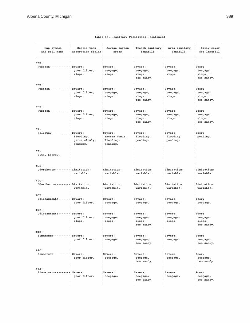
Alpena County, Michigan 389
Table 15.--Sanitary Facilities--Continued_____________________________________________________________________________________________________________ | | | | | Map symbol | Septic tank | Sewage lagoon | Trench sanitary | Area sanitary | Daily cover and soil name |absorption fields| areas | landfill | landfill | for landfill | | | | |_____________________________________________________________________________________________________________ | | | | |75B: | | | | | Rubicon------------|Severe: |Severe: |Severe: |Severe: |Poor: | poor filter, | seepage, | seepage, | seepage, | seepage, | slope. | slope. | slope, | slope. | slope, | | | too sandy. | | too sandy. | | | | |75D: | | | | | Rubicon------------|Severe: |Severe: |Severe: |Severe: |Poor: | poor filter, | seepage, | seepage, | seepage, | seepage, | slope. | slope. | slope, | slope. | slope, | | | too sandy. | | too sandy. | | | | |75E: | | | | | Rubicon------------|Severe: |Severe: |Severe: |Severe: |Poor: | poor filter, | seepage, | seepage, | seepage, | seepage, | slope. | slope. | slope, | slope. | slope, | | | too sandy. | | too sandy. | | | | |77: | | | | | Rollaway-----------|Severe: |Severe: |Severe: |Severe: |Poor: | flooding, | excess humus, | flooding, | flooding, | ponding. | percs slowly, | flooding, | ponding. | ponding. | | ponding. | ponding. | | | | | | | |78: | | | | | Pits, borrow. | | | | | | | | | | | | | | |82B: | | | | | Udorthents---------|Limitation: |Limitation: |Limitation: |Limitation: |Limitation: | variable. | variable. | variable. | variable. | variable. | | | | |82C: | | | | | Udorthents---------|Limitation: |Limitation: |Limitation: |Limitation: |Limitation: | variable. | variable. | variable. | variable. | variable. | | | | |83B: | | | | | Udipsamments-------|Severe: |Severe: |Severe: |Severe: |Poor: | poor filter. | seepage. | seepage. | seepage. | seepage. | | | | |83F: | | | | | Udipsamments-------|Severe: |Severe: |Severe: |Severe: |Poor: | poor filter, | seepage, | seepage, | seepage, | seepage, | slope. | slope. | slope, | slope. | slope, | | | too sandy. | | too sandy. | | | | |84B: | | | | | Zimmerman----------|Severe: |Severe: |Severe: |Severe: |Poor: | poor filter. | seepage. | seepage, | seepage. | seepage, | | | too sandy. | | too sandy. | | | | |84C: | | | | | Zimmerman----------|Severe: |Severe: |Severe: |Severe: |Poor: | poor filter. | seepage. | seepage, | seepage. | seepage, | | | too sandy. | | too sandy. | | | | |84E: | | | | | Zimmerman----------|Severe: |Severe: |Severe: |Severe: |Poor: | poor filter. | seepage. | seepage, | seepage. | seepage, | | | too sandy. | | too sandy. | | | | |
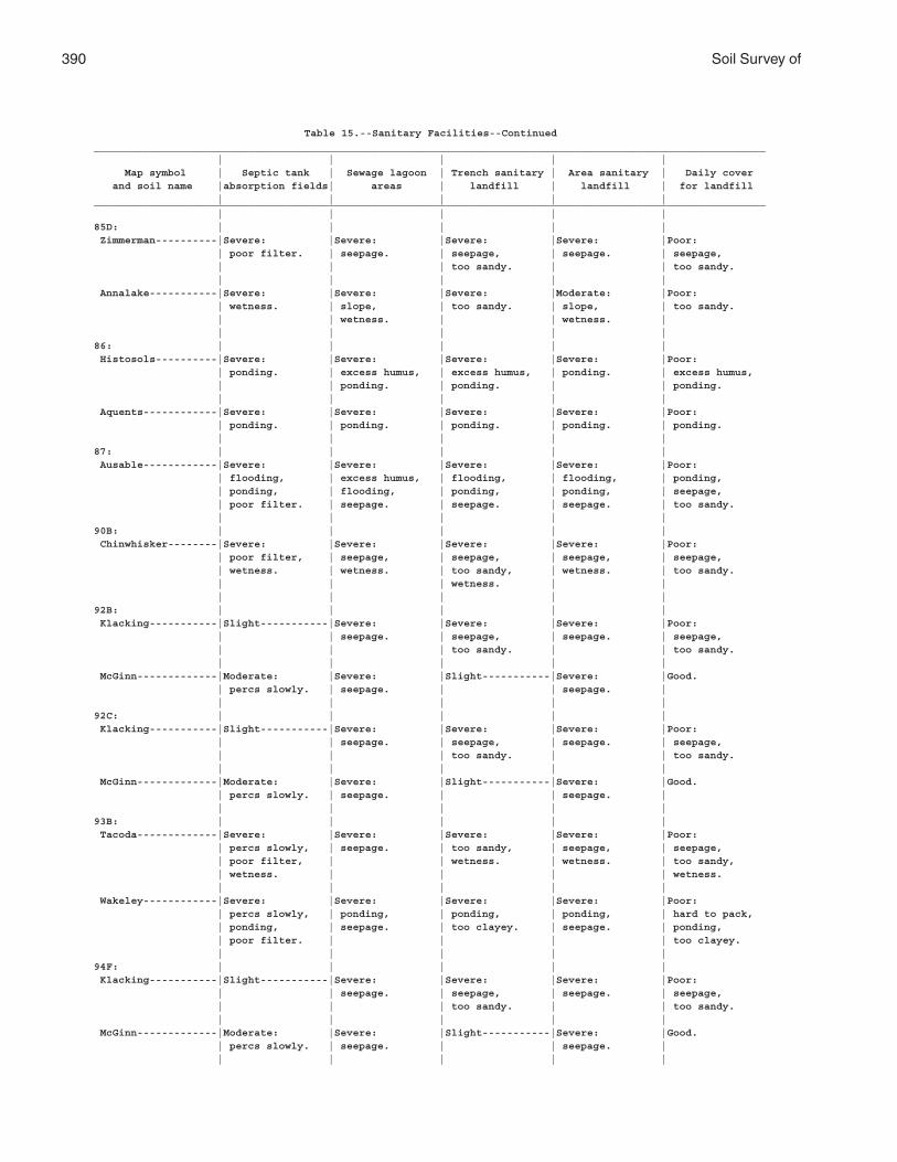
390 Soil Survey of
Table 15.--Sanitary Facilities--Continued_____________________________________________________________________________________________________________ | | | | | Map symbol | Septic tank | Sewage lagoon | Trench sanitary | Area sanitary | Daily cover and soil name |absorption fields| areas | landfill | landfill | for landfill | | | | |_____________________________________________________________________________________________________________ | | | | |85D: | | | | | Zimmerman----------|Severe: |Severe: |Severe: |Severe: |Poor: | poor filter. | seepage. | seepage, | seepage. | seepage, | | | too sandy. | | too sandy. | | | | | Annalake-----------|Severe: |Severe: |Severe: |Moderate: |Poor: | wetness. | slope, | too sandy. | slope, | too sandy. | | wetness. | | wetness. | | | | | |86: | | | | | Histosols----------|Severe: |Severe: |Severe: |Severe: |Poor: | ponding. | excess humus, | excess humus, | ponding. | excess humus, | | ponding. | ponding. | | ponding. | | | | | Aquents------------|Severe: |Severe: |Severe: |Severe: |Poor: | ponding. | ponding. | ponding. | ponding. | ponding. | | | | |87: | | | | | Ausable------------|Severe: |Severe: |Severe: |Severe: |Poor: | flooding, | excess humus, | flooding, | flooding, | ponding, | ponding, | flooding, | ponding, | ponding, | seepage, | poor filter. | seepage. | seepage. | seepage. | too sandy. | | | | |90B: | | | | | Chinwhisker--------|Severe: |Severe: |Severe: |Severe: |Poor: | poor filter, | seepage, | seepage, | seepage, | seepage, | wetness. | wetness. | too sandy, | wetness. | too sandy. | | | wetness. | | | | | | |92B: | | | | | Klacking-----------|Slight-----------|Severe: |Severe: |Severe: |Poor: | | seepage. | seepage, | seepage. | seepage, | | | too sandy. | | too sandy. | | | | | McGinn-------------|Moderate: |Severe: |Slight-----------|Severe: |Good. | percs slowly. | seepage. | | seepage. | | | | | |92C: | | | | | Klacking-----------|Slight-----------|Severe: |Severe: |Severe: |Poor: | | seepage. | seepage, | seepage. | seepage, | | | too sandy. | | too sandy. | | | | | McGinn-------------|Moderate: |Severe: |Slight-----------|Severe: |Good. | percs slowly. | seepage. | | seepage. | | | | | |93B: | | | | | Tacoda-------------|Severe: |Severe: |Severe: |Severe: |Poor: | percs slowly, | seepage. | too sandy, | seepage, | seepage, | poor filter, | | wetness. | wetness. | too sandy, | wetness. | | | | wetness. | | | | | Wakeley------------|Severe: |Severe: |Severe: |Severe: |Poor: | percs slowly, | ponding, | ponding, | ponding, | hard to pack, | ponding, | seepage. | too clayey. | seepage. | ponding, | poor filter. | | | | too clayey. | | | | |94F: | | | | | Klacking-----------|Slight-----------|Severe: |Severe: |Severe: |Poor: | | seepage. | seepage, | seepage. | seepage, | | | too sandy. | | too sandy. | | | | | McGinn-------------|Moderate: |Severe: |Slight-----------|Severe: |Good. | percs slowly. | seepage. | | seepage. | | | | | |
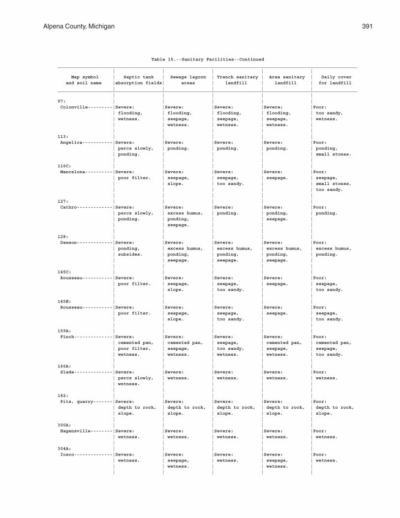
Alpena County, Michigan 391
Table 15.--Sanitary Facilities--Continued_____________________________________________________________________________________________________________ | | | | | Map symbol | Septic tank | Sewage lagoon | Trench sanitary | Area sanitary | Daily cover and soil name |absorption fields| areas | landfill | landfill | for landfill | | | | |_____________________________________________________________________________________________________________ | | | | |97: | | | | | Colonville---------|Severe: |Severe: |Severe: |Severe: |Poor: | flooding, | flooding, | flooding, | flooding, | too sandy, | wetness. | seepage, | seepage, | seepage, | wetness. | | wetness. | wetness. | wetness. | | | | | |113: | | | | | Angelica-----------|Severe: |Severe: |Severe: |Severe: |Poor: | percs slowly, | ponding. | ponding. | ponding. | ponding, | ponding. | | | | small stones. | | | | |116C: | | | | | Mancelona----------|Severe: |Severe: |Severe: |Severe: |Poor: | poor filter. | seepage, | seepage, | seepage. | seepage, | | slope. | too sandy. | | small stones, | | | | | too sandy. | | | | |127: | | | | | Cathro-------------|Severe: |Severe: |Severe: |Severe: |Poor: | percs slowly, | excess humus, | ponding. | ponding, | ponding. | ponding. | ponding, | | seepage. | | | seepage. | | | | | | | |128: | | | | | Dawson-------------|Severe: |Severe: |Severe: |Severe: |Poor: | ponding, | excess humus, | excess humus, | excess humus, | excess humus, | subsides. | ponding, | ponding, | ponding, | ponding. | | seepage. | seepage. | seepage. | | | | | |145C: | | | | | Rousseau-----------|Severe: |Severe: |Severe: |Severe: |Poor: | poor filter. | seepage, | seepage, | seepage. | seepage, | | slope. | too sandy. | | too sandy. | | | | |145E: | | | | | Rousseau-----------|Severe: |Severe: |Severe: |Severe: |Poor: | poor filter. | seepage, | seepage, | seepage. | seepage, | | slope. | too sandy. | | too sandy. | | | | |159A: | | | | | Finch--------------|Severe: |Severe: |Severe: |Severe: |Poor: | cemented pan, | cemented pan, | seepage, | cemented pan, | cemented pan, | poor filter, | seepage, | too sandy, | seepage, | seepage, | wetness. | wetness. | wetness. | wetness. | too sandy. | | | | |166A: | | | | | Slade--------------|Severe: |Severe: |Severe: |Severe: |Poor: | percs slowly, | wetness. | wetness. | wetness. | wetness. | wetness. | | | | | | | | |182: | | | | | Pits, quarry-------|Severe: |Severe: |Severe: |Severe: |Poor: | depth to rock, | depth to rock, | depth to rock, | depth to rock, | depth to rock, | slope. | slope. | slope. | slope. | slope. | | | | |300A: | | | | | Hagensville--------|Severe: |Severe: |Severe: |Severe: |Poor: | wetness. | wetness. | wetness. | wetness. | wetness. | | | | |304A: | | | | | Iosco--------------|Severe: |Severe: |Severe: |Severe: |Poor: | wetness. | seepage, | wetness. | seepage, | wetness. | | wetness. | | wetness. | | | | | |
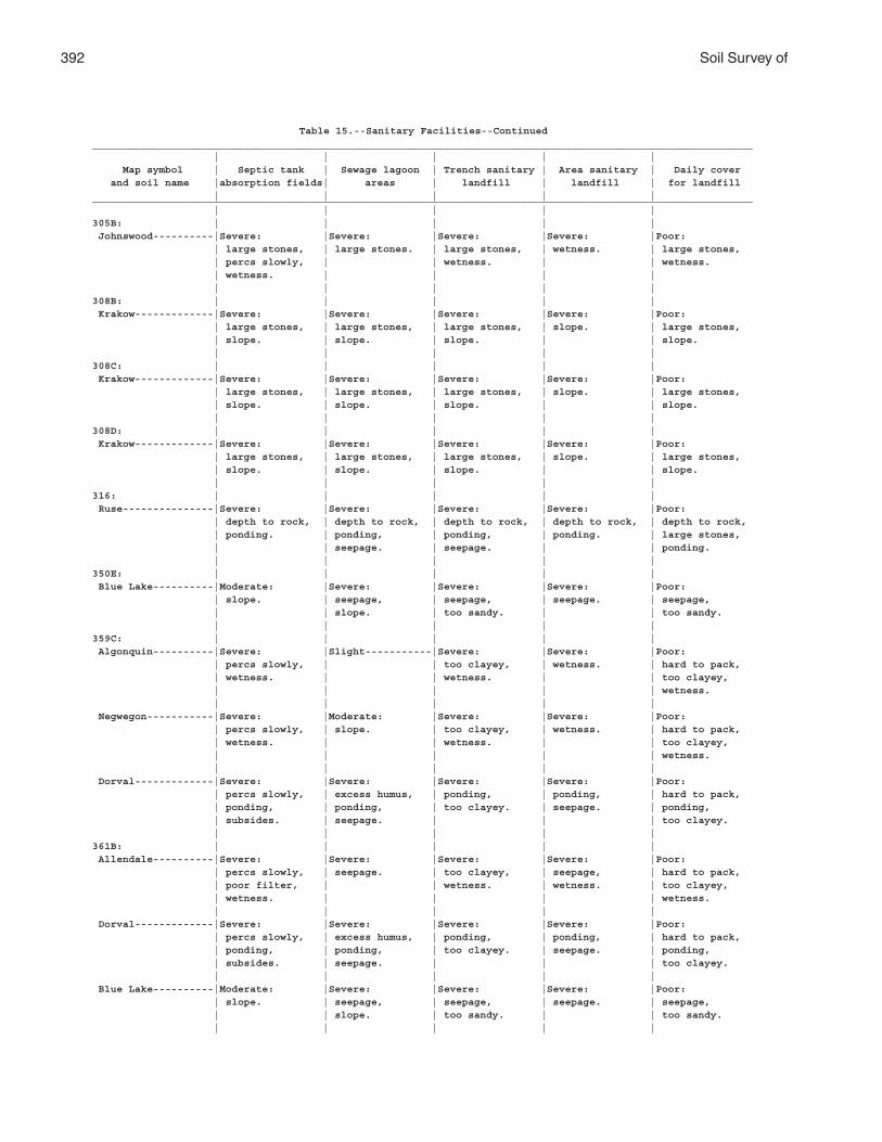
392 Soil Survey of
Table 15.--Sanitary Facilities--Continued_____________________________________________________________________________________________________________ | | | | | Map symbol | Septic tank | Sewage lagoon | Trench sanitary | Area sanitary | Daily cover and soil name |absorption fields| areas | landfill | landfill | for landfill | | | | |_____________________________________________________________________________________________________________ | | | | |305B: | | | | | Johnswood----------|Severe: |Severe: |Severe: |Severe: |Poor: | large stones, | large stones. | large stones, | wetness. | large stones, | percs slowly, | | wetness. | | wetness. | wetness. | | | | | | | | |308B: | | | | | Krakow-------------|Severe: |Severe: |Severe: |Severe: |Poor: | large stones, | large stones, | large stones, | slope. | large stones, | slope. | slope. | slope. | | slope. | | | | |308C: | | | | | Krakow-------------|Severe: |Severe: |Severe: |Severe: |Poor: | large stones, | large stones, | large stones, | slope. | large stones, | slope. | slope. | slope. | | slope. | | | | |308D: | | | | | Krakow-------------|Severe: |Severe: |Severe: |Severe: |Poor: | large stones, | large stones, | large stones, | slope. | large stones, | slope. | slope. | slope. | | slope. | | | | |316: | | | | | Ruse---------------|Severe: |Severe: |Severe: |Severe: |Poor: | depth to rock, | depth to rock, | depth to rock, | depth to rock, | depth to rock, | ponding. | ponding, | ponding, | ponding. | large stones, | | seepage. | seepage. | | ponding. | | | | |350E: | | | | | Blue Lake----------|Moderate: |Severe: |Severe: |Severe: |Poor: | slope. | seepage, | seepage, | seepage. | seepage, | | slope. | too sandy. | | too sandy. | | | | |359C: | | | | | Algonquin----------|Severe: |Slight-----------|Severe: |Severe: |Poor: | percs slowly, | | too clayey, | wetness. | hard to pack, | wetness. | | wetness. | | too clayey, | | | | | wetness. | | | | | Negwegon-----------|Severe: |Moderate: |Severe: |Severe: |Poor: | percs slowly, | slope. | too clayey, | wetness. | hard to pack, | wetness. | | wetness. | | too clayey, | | | | | wetness. | | | | | Dorval-------------|Severe: |Severe: |Severe: |Severe: |Poor: | percs slowly, | excess humus, | ponding, | ponding, | hard to pack, | ponding, | ponding, | too clayey. | seepage. | ponding, | subsides. | seepage. | | | too clayey. | | | | |361B: | | | | | Allendale----------|Severe: |Severe: |Severe: |Severe: |Poor: | percs slowly, | seepage. | too clayey, | seepage, | hard to pack, | poor filter, | | wetness. | wetness. | too clayey, | wetness. | | | | wetness. | | | | | Dorval-------------|Severe: |Severe: |Severe: |Severe: |Poor: | percs slowly, | excess humus, | ponding, | ponding, | hard to pack, | ponding, | ponding, | too clayey. | seepage. | ponding, | subsides. | seepage. | | | too clayey. | | | | | Blue Lake----------|Moderate: |Severe: |Severe: |Severe: |Poor: | slope. | seepage, | seepage, | seepage. | seepage, | | slope. | too sandy. | | too sandy. | | | | |
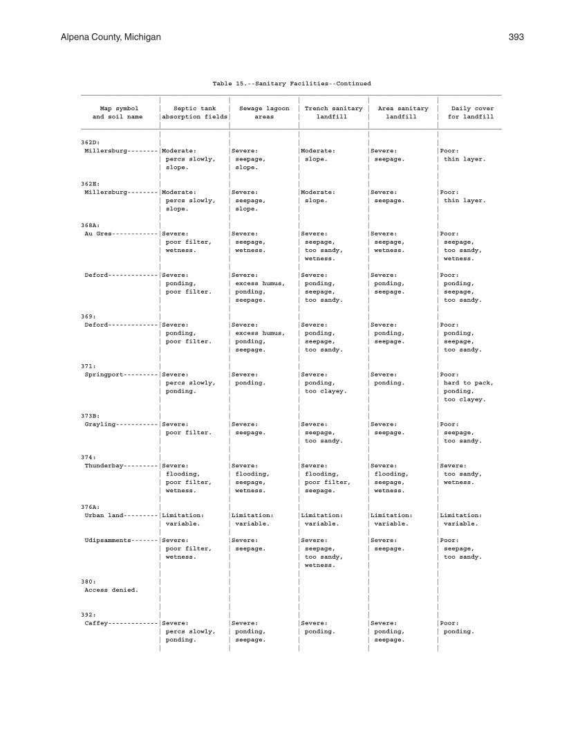
Alpena County, Michigan 393
Table 15.--Sanitary Facilities--Continued_____________________________________________________________________________________________________________ | | | | | Map symbol | Septic tank | Sewage lagoon | Trench sanitary | Area sanitary | Daily cover and soil name |absorption fields| areas | landfill | landfill | for landfill | | | | |_____________________________________________________________________________________________________________ | | | | |362D: | | | | | Millersburg--------|Moderate: |Severe: |Moderate: |Severe: |Poor: | percs slowly, | seepage, | slope. | seepage. | thin layer. | slope. | slope. | | | | | | | |362E: | | | | | Millersburg--------|Moderate: |Severe: |Moderate: |Severe: |Poor: | percs slowly, | seepage, | slope. | seepage. | thin layer. | slope. | slope. | | | | | | | |368A: | | | | | Au Gres------------|Severe: |Severe: |Severe: |Severe: |Poor: | poor filter, | seepage, | seepage, | seepage, | seepage, | wetness. | wetness. | too sandy, | wetness. | too sandy, | | | wetness. | | wetness. | | | | | Deford-------------|Severe: |Severe: |Severe: |Severe: |Poor: | ponding, | excess humus, | ponding, | ponding, | ponding, | poor filter. | ponding, | seepage, | seepage. | seepage, | | seepage. | too sandy. | | too sandy. | | | | |369: | | | | | Deford-------------|Severe: |Severe: |Severe: |Severe: |Poor: | ponding, | excess humus, | ponding, | ponding, | ponding, | poor filter. | ponding, | seepage, | seepage. | seepage, | | seepage. | too sandy. | | too sandy. | | | | |371: | | | | | Springport---------|Severe: |Severe: |Severe: |Severe: |Poor: | percs slowly, | ponding. | ponding, | ponding. | hard to pack, | ponding. | | too clayey. | | ponding, | | | | | too clayey. | | | | |373B: | | | | | Grayling-----------|Severe: |Severe: |Severe: |Severe: |Poor: | poor filter. | seepage. | seepage, | seepage. | seepage, | | | too sandy. | | too sandy. | | | | |374: | | | | | Thunderbay---------|Severe: |Severe: |Severe: |Severe: |Severe: | flooding, | flooding, | flooding, | flooding, | too sandy, | poor filter, | seepage, | poor filter, | seepage, | wetness. | wetness. | wetness. | seepage. | wetness. | | | | | |376A: | | | | | Urban land---------|Limitation: |Limitation: |Limitation: |Limitation: |Limitation: | variable. | variable. | variable. | variable. | variable. | | | | | Udipsamments-------|Severe: |Severe: |Severe: |Severe: |Poor: | poor filter, | seepage. | seepage, | seepage. | seepage, | wetness. | | too sandy, | | too sandy. | | | wetness. | | | | | | |380: | | | | | Access denied. | | | | | | | | | | | | | | |392: | | | | | Caffey-------------|Severe: |Severe: |Severe: |Severe: |Poor: | percs slowly, | ponding, | ponding. | ponding, | ponding. | ponding. | seepage. | | seepage. | | | | | |
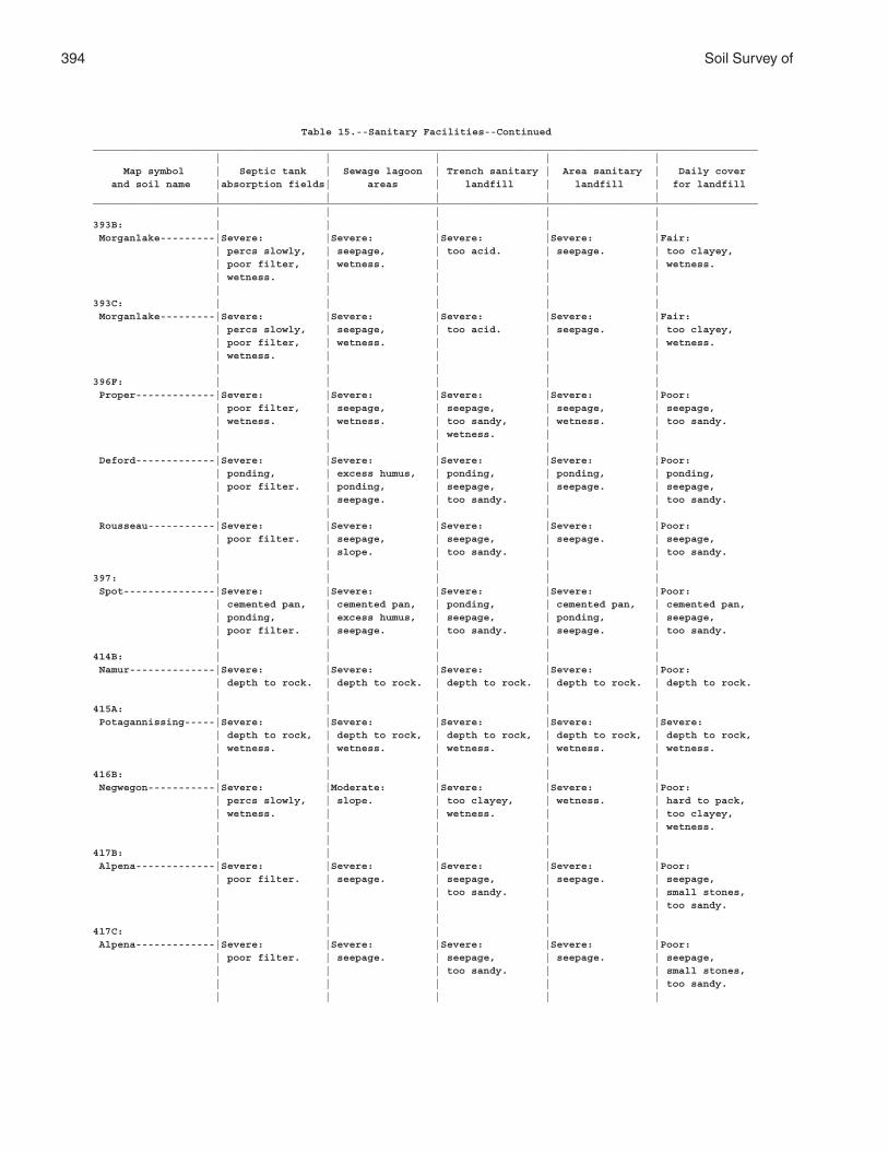
394 Soil Survey of
Table 15.--Sanitary Facilities--Continued_____________________________________________________________________________________________________________ | | | | | Map symbol | Septic tank | Sewage lagoon | Trench sanitary | Area sanitary | Daily cover and soil name |absorption fields| areas | landfill | landfill | for landfill | | | | |_____________________________________________________________________________________________________________ | | | | |393B: | | | | | Morganlake---------|Severe: |Severe: |Severe: |Severe: |Fair: | percs slowly, | seepage, | too acid. | seepage. | too clayey, | poor filter, | wetness. | | | wetness. | wetness. | | | | | | | | |393C: | | | | | Morganlake---------|Severe: |Severe: |Severe: |Severe: |Fair: | percs slowly, | seepage, | too acid. | seepage. | too clayey, | poor filter, | wetness. | | | wetness. | wetness. | | | | | | | | |396F: | | | | | Proper-------------|Severe: |Severe: |Severe: |Severe: |Poor: | poor filter, | seepage, | seepage, | seepage, | seepage, | wetness. | wetness. | too sandy, | wetness. | too sandy. | | | wetness. | | | | | | | Deford-------------|Severe: |Severe: |Severe: |Severe: |Poor: | ponding, | excess humus, | ponding, | ponding, | ponding, | poor filter. | ponding, | seepage, | seepage. | seepage, | | seepage. | too sandy. | | too sandy. | | | | | Rousseau-----------|Severe: |Severe: |Severe: |Severe: |Poor: | poor filter. | seepage, | seepage, | seepage. | seepage, | | slope. | too sandy. | | too sandy. | | | | |397: | | | | | Spot---------------|Severe: |Severe: |Severe: |Severe: |Poor: | cemented pan, | cemented pan, | ponding, | cemented pan, | cemented pan, | ponding, | excess humus, | seepage, | ponding, | seepage, | poor filter. | seepage. | too sandy. | seepage. | too sandy. | | | | |414B: | | | | | Namur--------------|Severe: |Severe: |Severe: |Severe: |Poor: | depth to rock. | depth to rock. | depth to rock. | depth to rock. | depth to rock. | | | | |415A: | | | | | Potagannissing-----|Severe: |Severe: |Severe: |Severe: |Severe: | depth to rock, | depth to rock, | depth to rock, | depth to rock, | depth to rock, | wetness. | wetness. | wetness. | wetness. | wetness. | | | | |416B: | | | | | Negwegon-----------|Severe: |Moderate: |Severe: |Severe: |Poor: | percs slowly, | slope. | too clayey, | wetness. | hard to pack, | wetness. | | wetness. | | too clayey, | | | | | wetness. | | | | |417B: | | | | | Alpena-------------|Severe: |Severe: |Severe: |Severe: |Poor: | poor filter. | seepage. | seepage, | seepage. | seepage, | | | too sandy. | | small stones, | | | | | too sandy. | | | | |417C: | | | | | Alpena-------------|Severe: |Severe: |Severe: |Severe: |Poor: | poor filter. | seepage. | seepage, | seepage. | seepage, | | | too sandy. | | small stones, | | | | | too sandy. | | | | |
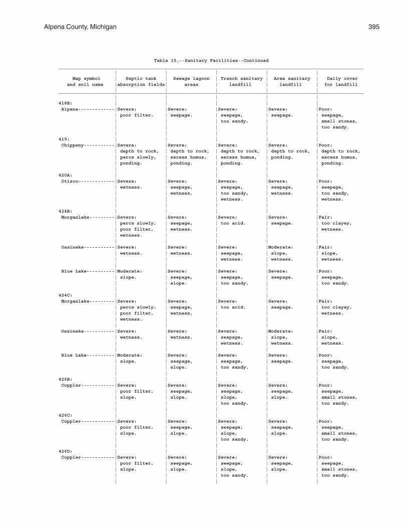
Alpena County, Michigan 395
Table 15.--Sanitary Facilities--Continued_____________________________________________________________________________________________________________ | | | | | Map symbol | Septic tank | Sewage lagoon | Trench sanitary | Area sanitary | Daily cover and soil name |absorption fields| areas | landfill | landfill | for landfill | | | | |_____________________________________________________________________________________________________________ | | | | |418E: | | | | | Alpena-------------|Severe: |Severe: |Severe: |Severe: |Poor: | poor filter. | seepage. | seepage, | seepage. | seepage, | | | too sandy. | | small stones, | | | | | too sandy. | | | | |419: | | | | | Chippeny-----------|Severe: |Severe: |Severe: |Severe: |Poor: | depth to rock, | depth to rock, | depth to rock, | depth to rock, | depth to rock, | percs slowly, | excess humus, | excess humus, | ponding. | excess humus, | ponding. | ponding. | ponding. | | ponding. | | | | |420A: | | | | | Otisco-------------|Severe: |Severe: |Severe: |Severe: |Poor: | wetness. | seepage, | seepage, | seepage, | seepage, | | wetness. | too sandy, | wetness. | too sandy, | | | wetness. | | wetness. | | | | |424B: | | | | | Morganlake---------|Severe: |Severe: |Severe: |Severe: |Fair: | percs slowly, | seepage, | too acid. | seepage. | too clayey, | poor filter, | wetness. | | | wetness. | wetness. | | | | | | | | | Ossineke-----------|Severe: |Severe: |Severe: |Moderate: |Fair: | wetness. | wetness. | seepage, | slope, | slope, | | | wetness. | wetness. | wetness. | | | | | Blue Lake----------|Moderate: |Severe: |Severe: |Severe: |Poor: | slope. | seepage, | seepage, | seepage. | seepage, | | slope. | too sandy. | | too sandy. | | | | |424C: | | | | | Morganlake---------|Severe: |Severe: |Severe: |Severe: |Fair: | percs slowly, | seepage, | too acid. | seepage. | too clayey, | poor filter, | wetness. | | | wetness. | wetness. | | | | | | | | | Ossineke-----------|Severe: |Severe: |Severe: |Moderate: |Fair: | wetness. | wetness. | seepage, | slope, | slope, | | | wetness. | wetness. | wetness. | | | | | Blue Lake----------|Moderate: |Severe: |Severe: |Severe: |Poor: | slope. | seepage, | seepage, | seepage. | seepage, | | slope. | too sandy. | | too sandy. | | | | |426B: | | | | | Coppler------------|Severe: |Severe: |Severe: |Severe: |Poor: | poor filter, | seepage, | seepage, | seepage, | seepage, | slope. | slope. | slope, | slope. | small stones, | | | too sandy. | | too sandy. | | | | |426C: | | | | | Coppler------------|Severe: |Severe: |Severe: |Severe: |Poor: | poor filter, | seepage, | seepage, | seepage, | seepage, | slope. | slope. | slope, | slope. | small stones, | | | too sandy. | | too sandy. | | | | |426D: | | | | | Coppler------------|Severe: |Severe: |Severe: |Severe: |Poor: | poor filter, | seepage, | seepage, | seepage, | seepage, | slope. | slope. | slope, | slope. | small stones, | | | too sandy. | | too sandy. | | | | |
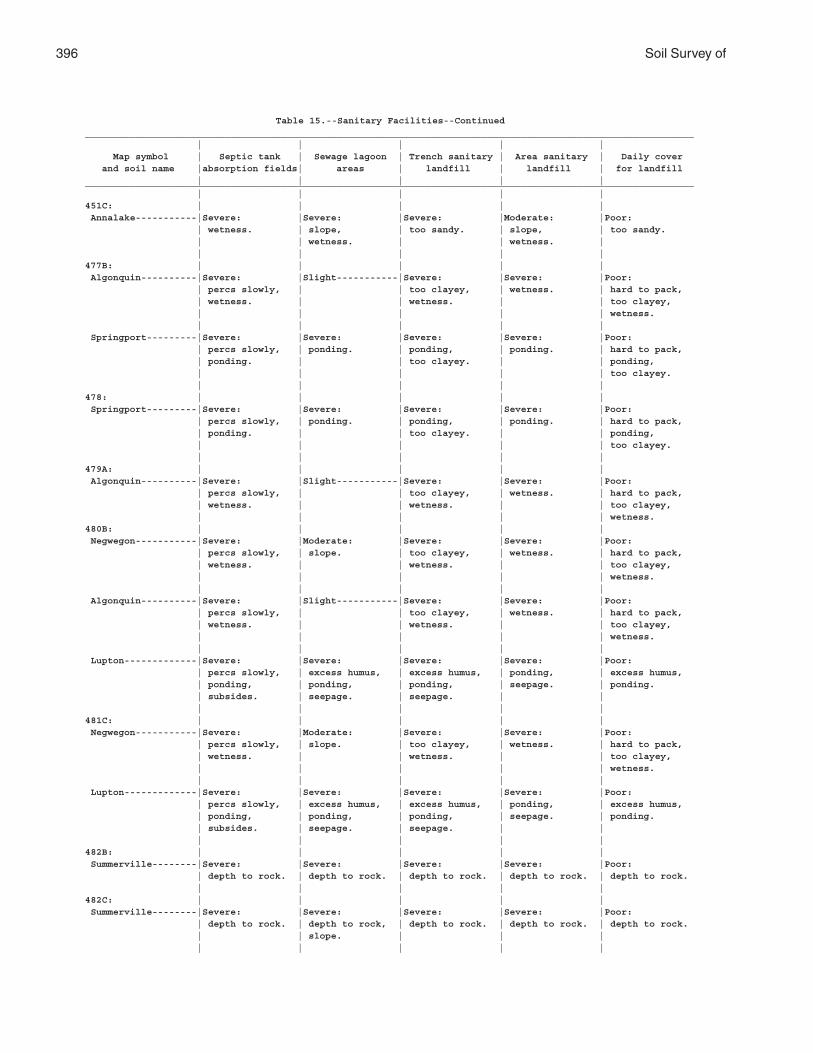
396 Soil Survey of
Table 15.--Sanitary Facilities--Continued_____________________________________________________________________________________________________________ | | | | | Map symbol | Septic tank | Sewage lagoon | Trench sanitary | Area sanitary | Daily cover and soil name |absorption fields| areas | landfill | landfill | for landfill | | | | |_____________________________________________________________________________________________________________ | | | | |451C: | | | | | Annalake-----------|Severe: |Severe: |Severe: |Moderate: |Poor: | wetness. | slope, | too sandy. | slope, | too sandy. | | wetness. | | wetness. | | | | | |477B: | | | | | Algonquin----------|Severe: |Slight-----------|Severe: |Severe: |Poor: | percs slowly, | | too clayey, | wetness. | hard to pack, | wetness. | | wetness. | | too clayey, | | | | | wetness. | | | | | Springport---------|Severe: |Severe: |Severe: |Severe: |Poor: | percs slowly, | ponding. | ponding, | ponding. | hard to pack, | ponding. | | too clayey. | | ponding, | | | | | too clayey. | | | | |478: | | | | | Springport---------|Severe: |Severe: |Severe: |Severe: |Poor: | percs slowly, | ponding. | ponding, | ponding. | hard to pack, | ponding. | | too clayey. | | ponding, | | | | | too clayey. | | | | |479A: | | | | | Algonquin----------|Severe: |Slight-----------|Severe: |Severe: |Poor: | percs slowly, | | too clayey, | wetness. | hard to pack, | wetness. | | wetness. | | too clayey, | | | | | wetness.480B: | | | | | Negwegon-----------|Severe: |Moderate: |Severe: |Severe: |Poor: | percs slowly, | slope. | too clayey, | wetness. | hard to pack, | wetness. | | wetness. | | too clayey, | | | | | wetness. | | | | | Algonquin----------|Severe: |Slight-----------|Severe: |Severe: |Poor: | percs slowly, | | too clayey, | wetness. | hard to pack, | wetness. | | wetness. | | too clayey, | | | | | wetness. | | | | | Lupton-------------|Severe: |Severe: |Severe: |Severe: |Poor: | percs slowly, | excess humus, | excess humus, | ponding, | excess humus, | ponding, | ponding, | ponding, | seepage. | ponding. | subsides. | seepage. | seepage. | | | | | | |481C: | | | | | Negwegon-----------|Severe: |Moderate: |Severe: |Severe: |Poor: | percs slowly, | slope. | too clayey, | wetness. | hard to pack, | wetness. | | wetness. | | too clayey, | | | | | wetness. | | | | | Lupton-------------|Severe: |Severe: |Severe: |Severe: |Poor: | percs slowly, | excess humus, | excess humus, | ponding, | excess humus, | ponding, | ponding, | ponding, | seepage. | ponding. | subsides. | seepage. | seepage. | | | | | | |482B: | | | | | Summerville--------|Severe: |Severe: |Severe: |Severe: |Poor: | depth to rock. | depth to rock. | depth to rock. | depth to rock. | depth to rock. | | | | |482C: | | | | | Summerville--------|Severe: |Severe: |Severe: |Severe: |Poor: | depth to rock. | depth to rock, | depth to rock. | depth to rock. | depth to rock. | | slope. | | | | | | | |
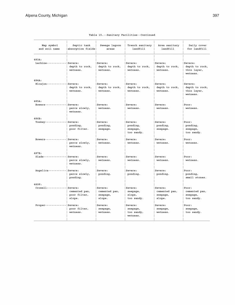
Alpena County, Michigan 397
Table 15.--Sanitary Facilities--Continued_____________________________________________________________________________________________________________ | | | | | Map symbol | Septic tank | Sewage lagoon | Trench sanitary | Area sanitary | Daily cover and soil name |absorption fields| areas | landfill | landfill | for landfill | | | | |_____________________________________________________________________________________________________________ | | | | |483A: | | | | | Lachine------------|Severe: |Severe: |Severe: |Severe: |Severe: | depth to rock, | depth to rock, | depth to rock, | depth to rock, | depth to rock, | wetness. | wetness. | wetness. | wetness. | thin layer, | | | | | wetness. | | | | |484A: | | | | | Elcajon------------|Severe: |Severe: |Severe: |Severe: |Severe: | depth to rock, | depth to rock, | depth to rock, | depth to rock, | depth to rock, | wetness. | wetness. | wetness. | wetness. | thin layer, | | | | | wetness. | | | | |485A: | | | | | Bowers-------------|Severe: |Severe: |Severe: |Severe: |Poor: | percs slowly, | wetness. | wetness. | wetness. | wetness. | wetness. | | | | | | | | |486B: | | | | | Tonkey-------------|Severe: |Severe: |Severe: |Severe: |Poor: | ponding, | ponding, | ponding, | ponding, | ponding, | poor filter. | seepage. | seepage, | seepage. | seepage, | | | too sandy. | | too sandy. | | | | | Bowers-------------|Severe: |Severe: |Severe: |Severe: |Poor: | percs slowly, | wetness. | wetness. | wetness. | wetness. | wetness. | | | | | | | | |487B: | | | | | Slade--------------|Severe: |Severe: |Severe: |Severe: |Poor: | percs slowly, | wetness. | wetness. | wetness. | wetness. | wetness. | | | | | | | | | Angelica-----------|Severe: |Severe: |Severe: |Severe: |Poor: | percs slowly, | ponding. | ponding. | ponding. | ponding, | ponding. | | | | small stones. | | | | |489F: | | | | | Crowell------------|Severe: |Severe: |Severe: |Severe: |Poor: | cemented pan, | cemented pan, | seepage, | cemented pan, | cemented pan, | poor filter, | seepage, | slope, | seepage, | seepage, | slope. | slope. | too sandy. | slope. | too sandy. | | | | | Proper-------------|Severe: |Severe: |Severe: |Severe: |Poor: | poor filter, | seepage, | seepage, | seepage, | seepage, | wetness. | wetness. | too sandy, | wetness. | too sandy. | | | wetness. | | | | | | |_____________________________________________________________________________________________________________
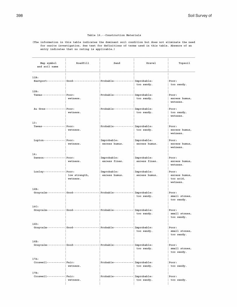
398 Soil Survey of
Table 16.--Construction Materials
(The information in this table indicates the dominant soil condition but does not eliminate the need for onsite investigation. See text for definitions of terms used in this table. Absence of an entry indicates that no rating is applicable.)
____________________________________________________________________________________________________ | | | | Map symbol | Roadfill | Sand | Gravel | Topsoil and soil name | | | | | | | |____________________________________________________________________________________________________ | | | |11B: | | | | Eastport-----------|Good----------------|Probable------------|Improbable: |Poor: | | | too sandy. | too sandy. | | | |12B: | | | | Tawas--------------|Poor: |Probable------------|Improbable: |Poor: | wetness. | | too sandy. | excess humus, | | | | wetness. | | | | Au Gres------------|Poor: |Probable------------|Improbable: |Poor: | wetness. | | too sandy. | too sandy, | | | | wetness. | | | |13: | | | | Tawas--------------|Poor: |Probable------------|Improbable: |Poor: | wetness. | | too sandy. | excess humus, | | | | wetness. | | | | Lupton-------------|Poor: |Improbable: |Improbable: |Poor: | wetness. | excess humus. | excess humus. | excess humus, | | | | wetness. | | | |14: | | | | Dawson-------------|Poor: |Improbable: |Improbable: |Poor: | wetness. | excess fines. | excess fines. | excess humus, | | | | wetness. | | | | Loxley-------------|Poor: |Improbable: |Improbable: |Poor: | low strength, | excess humus. | excess humus. | excess humus, | wetness. | | | too acid, | | | | wetness. | | | |16B: | | | | Graycalm-----------|Good----------------|Probable------------|Improbable: |Poor: | | | too sandy. | small stones, | | | | too sandy. | | | |16C: | | | | Graycalm-----------|Good----------------|Probable------------|Improbable: |Poor: | | | too sandy. | small stones, | | | | too sandy. | | | |16D: | | | | Graycalm-----------|Good----------------|Probable------------|Improbable: |Poor: | | | too sandy. | small stones, | | | | too sandy. | | | |16E: | | | | Graycalm-----------|Good----------------|Probable------------|Improbable: |Poor: | | | too sandy. | small stones, | | | | too sandy. | | | |17A: | | | | Croswell-----------|Fair: |Probable------------|Improbable: |Poor: | wetness. | | too sandy. | too sandy. | | | |17B: | | | | Croswell-----------|Fair: |Probable------------|Improbable: |Poor: | wetness. | | too sandy. | too sandy. | | | |
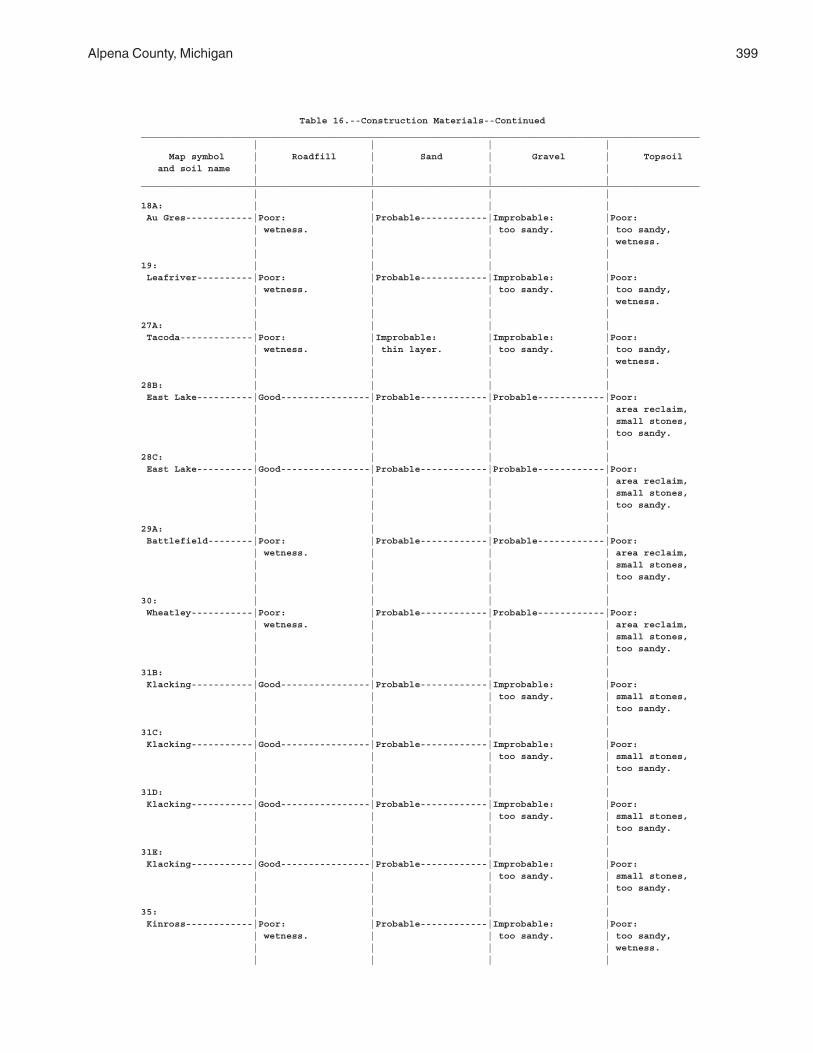
Alpena County, Michigan 399
Table 16.--Construction Materials--Continued____________________________________________________________________________________________________ | | | | Map symbol | Roadfill | Sand | Gravel | Topsoil and soil name | | | | | | | |____________________________________________________________________________________________________ | | | |18A: | | | | Au Gres------------|Poor: |Probable------------|Improbable: |Poor: | wetness. | | too sandy. | too sandy, | | | | wetness. | | | |19: | | | | Leafriver----------|Poor: |Probable------------|Improbable: |Poor: | wetness. | | too sandy. | too sandy, | | | | wetness. | | | |27A: | | | | Tacoda-------------|Poor: |Improbable: |Improbable: |Poor: | wetness. | thin layer. | too sandy. | too sandy, | | | | wetness. | | | |28B: | | | | East Lake----------|Good----------------|Probable------------|Probable------------|Poor: | | | | area reclaim, | | | | small stones, | | | | too sandy. | | | |28C: | | | | East Lake----------|Good----------------|Probable------------|Probable------------|Poor: | | | | area reclaim, | | | | small stones, | | | | too sandy. | | | |29A: | | | | Battlefield--------|Poor: |Probable------------|Probable------------|Poor: | wetness. | | | area reclaim, | | | | small stones, | | | | too sandy. | | | |30: | | | | Wheatley-----------|Poor: |Probable------------|Probable------------|Poor: | wetness. | | | area reclaim, | | | | small stones, | | | | too sandy. | | | |31B: | | | | Klacking-----------|Good----------------|Probable------------|Improbable: |Poor: | | | too sandy. | small stones, | | | | too sandy. | | | |31C: | | | | Klacking-----------|Good----------------|Probable------------|Improbable: |Poor: | | | too sandy. | small stones, | | | | too sandy. | | | |31D: | | | | Klacking-----------|Good----------------|Probable------------|Improbable: |Poor: | | | too sandy. | small stones, | | | | too sandy. | | | |31E: | | | | Klacking-----------|Good----------------|Probable------------|Improbable: |Poor: | | | too sandy. | small stones, | | | | too sandy. | | | |35: | | | | Kinross------------|Poor: |Probable------------|Improbable: |Poor: | wetness. | | too sandy. | too sandy, | | | | wetness. | | | |
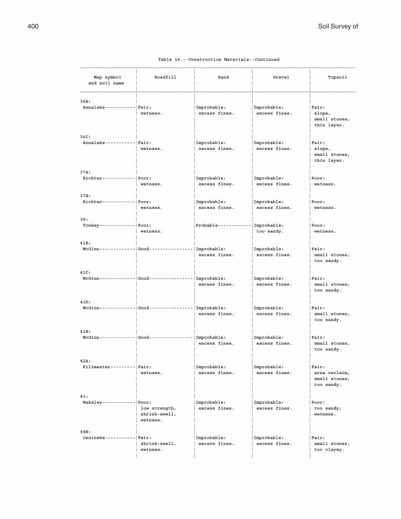
400 Soil Survey of
Table 16.--Construction Materials--Continued____________________________________________________________________________________________________ | | | | Map symbol | Roadfill | Sand | Gravel | Topsoil and soil name | | | | | | | |____________________________________________________________________________________________________ | | | |36B: | | | | Annalake-----------|Fair: |Improbable: |Improbable: |Fair: | wetness. | excess fines. | excess fines. | slope, | | | | small stones, | | | | thin layer. | | | |36C: | | | | Annalake-----------|Fair: |Improbable: |Improbable: |Fair: | wetness. | excess fines. | excess fines. | slope, | | | | small stones, | | | | thin layer. | | | |37A: | | | | Richter------------|Poor: |Improbable: |Improbable: |Poor: | wetness. | excess fines. | excess fines. | wetness. | | | |37B: | | | | Richter------------|Poor: |Improbable: |Improbable: |Poor: | wetness. | excess fines. | excess fines. | wetness. | | | |38: | | | | Tonkey-------------|Poor: |Probable------------|Improbable: |Poor: | wetness. | | too sandy. | wetness. | | | |41B: | | | | McGinn-------------|Good----------------|Improbable: |Improbable: |Fair: | | excess fines. | excess fines. | small stones, | | | | too sandy. | | | |41C: | | | | McGinn-------------|Good----------------|Improbable: |Improbable: |Fair: | | excess fines. | excess fines. | small stones, | | | | too sandy. | | | |41D: | | | | McGinn-------------|Good----------------|Improbable: |Improbable: |Fair: | | excess fines. | excess fines. | small stones, | | | | too sandy. | | | |41E: | | | | McGinn-------------|Good----------------|Improbable: |Improbable: |Fair: | | excess fines. | excess fines. | small stones, | | | | too sandy. | | | |42A: | | | | Killmaster---------|Fair: |Improbable: |Improbable: |Fair: | wetness. | excess fines. | excess fines. | area reclaim, | | | | small stones, | | | | too sandy. | | | |43: | | | | Wakeley------------|Poor: |Improbable: |Improbable: |Poor: | low strength, | excess fines. | excess fines. | too sandy, | shrink-swell, | | | wetness. | wetness. | | | | | | |44B: | | | | Ossineke-----------|Fair: |Improbable: |Improbable: |Fair: | shrink-swell, | excess fines. | excess fines. | small stones, | wetness. | | | too clayey. | | | |
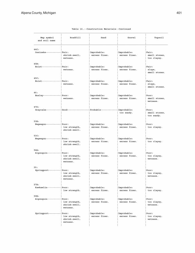
Alpena County, Michigan 401
Table 16.--Construction Materials--Continued____________________________________________________________________________________________________ | | | | Map symbol | Roadfill | Sand | Gravel | Topsoil and soil name | | | | | | | |____________________________________________________________________________________________________ | | | |44C: | | | | Ossineke-----------|Fair: |Improbable: |Improbable: |Fair: | shrink-swell, | excess fines. | excess fines. | small stones, | wetness. | | | too clayey. | | | |45B: | | | | Hoist--------------|Fair: |Improbable: |Improbable: |Fair: | wetness. | excess fines. | excess fines. | slope, | | | | small stones. | | | |45C: | | | | Hoist--------------|Fair: |Improbable: |Improbable: |Fair: | wetness. | excess fines. | excess fines. | slope, | | | | small stones. | | | |46: | | | | Ensley-------------|Poor: |Improbable: |Improbable: |Poor: | wetness. | excess fines. | excess fines. | small stones, | | | | wetness. | | | |47D: | | | | Graycalm-----------|Good----------------|Probable------------|Improbable: |Poor: | | | too sandy. | small stones, | | | | too sandy. | | | |53B: | | | | Negwegon-----------|Poor: |Improbable: |Improbable: |Poor: | low strength, | excess fines. | excess fines. | too clayey. | shrink-swell. | | | | | | |53C: | | | | Negwegon-----------|Poor: |Improbable: |Improbable: |Poor: | low strength, | excess fines. | excess fines. | too clayey. | shrink-swell. | | | | | | |54A: | | | | Algonquin----------|Poor: |Improbable: |Improbable: |Poor: | low strength, | excess fines. | excess fines. | too clayey, | shrink-swell, | | | wetness. | wetness. | | | | | | |55: | | | | Springport---------|Poor: |Improbable: |Improbable: |Poor: | low strength, | excess fines. | excess fines. | too clayey, | shrink-swell, | | | wetness. | wetness. | | | | | | |57B: | | | | Kawkawlin----------|Poor: |Improbable: |Improbable: |Poor: | low strength. | excess fines. | excess fines. | too clayey. | | | |59B: | | | | Algonquin----------|Poor: |Improbable: |Improbable: |Poor: | low strength, | excess fines. | excess fines. | too clayey, | shrink-swell, | | | wetness. | wetness. | | | | | | | Springport---------|Poor: |Improbable: |Improbable: |Poor: | low strength, | excess fines. | excess fines. | too clayey, | shrink-swell, | | | wetness. | wetness. | | | | | | |
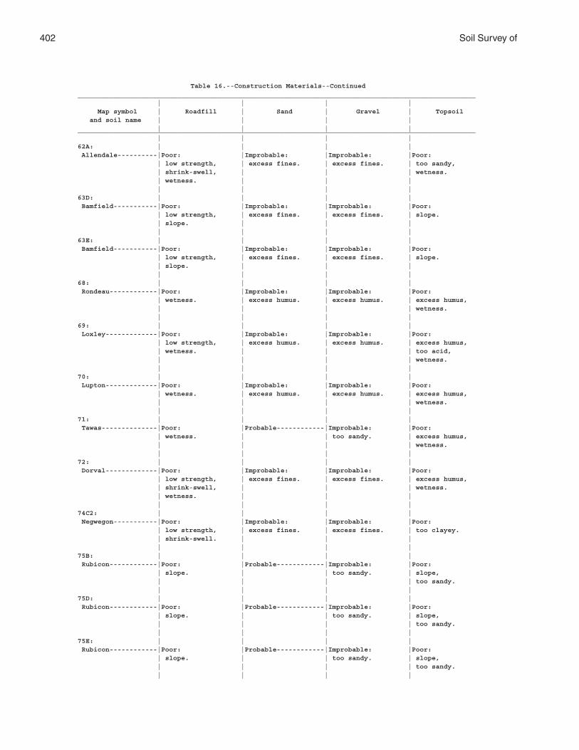
402 Soil Survey of
Table 16.--Construction Materials--Continued____________________________________________________________________________________________________ | | | | Map symbol | Roadfill | Sand | Gravel | Topsoil and soil name | | | | | | | |____________________________________________________________________________________________________ | | | |62A: | | | | Allendale----------|Poor: |Improbable: |Improbable: |Poor: | low strength, | excess fines. | excess fines. | too sandy, | shrink-swell, | | | wetness. | wetness. | | | | | | |63D: | | | | Bamfield-----------|Poor: |Improbable: |Improbable: |Poor: | low strength, | excess fines. | excess fines. | slope. | slope. | | | | | | |63E: | | | | Bamfield-----------|Poor: |Improbable: |Improbable: |Poor: | low strength, | excess fines. | excess fines. | slope. | slope. | | | | | | |68: | | | | Rondeau------------|Poor: |Improbable: |Improbable: |Poor: | wetness. | excess humus. | excess humus. | excess humus, | | | | wetness. | | | |69: | | | | Loxley-------------|Poor: |Improbable: |Improbable: |Poor: | low strength, | excess humus. | excess humus. | excess humus, | wetness. | | | too acid, | | | | wetness. | | | |70: | | | | Lupton-------------|Poor: |Improbable: |Improbable: |Poor: | wetness. | excess humus. | excess humus. | excess humus, | | | | wetness. | | | |71: | | | | Tawas--------------|Poor: |Probable------------|Improbable: |Poor: | wetness. | | too sandy. | excess humus, | | | | wetness. | | | |72: | | | | Dorval-------------|Poor: |Improbable: |Improbable: |Poor: | low strength, | excess fines. | excess fines. | excess humus, | shrink-swell, | | | wetness. | wetness. | | | | | | |74C2: | | | | Negwegon-----------|Poor: |Improbable: |Improbable: |Poor: | low strength, | excess fines. | excess fines. | too clayey. | shrink-swell. | | | | | | |75B: | | | | Rubicon------------|Poor: |Probable------------|Improbable: |Poor: | slope. | | too sandy. | slope, | | | | too sandy. | | | |75D: | | | | Rubicon------------|Poor: |Probable------------|Improbable: |Poor: | slope. | | too sandy. | slope, | | | | too sandy. | | | |75E: | | | | Rubicon------------|Poor: |Probable------------|Improbable: |Poor: | slope. | | too sandy. | slope, | | | | too sandy. | | | |
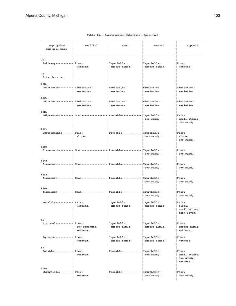
Alpena County, Michigan 403
Table 16.--Construction Materials--Continued____________________________________________________________________________________________________ | | | | Map symbol | Roadfill | Sand | Gravel | Topsoil and soil name | | | | | | | |____________________________________________________________________________________________________ | | | |77: | | | | Rollaway-----------|Poor: |Improbable: |Improbable: |Poor: | wetness. | excess fines. | excess fines. | wetness. | | | |78: | | | | Pits, borrow. | | | | | | | |82B: | | | | Udorthents---------|Limitation: |Limitation: |Limitation: |Limitation: | variable. | variable. | variable. | variable. | | | |82C: | | | | Udorthents---------|Limitation: |Limitation: |Limitation: |Limitation: | variable. | variable. | variable. | variable. | | | |83B: | | | | Udipsamments-------|Good----------------|Probable------------|Improbable: |Fair: | | | too sandy. | small stones, | | | | too sandy. | | | |83F: | | | | Udipsamments-------|Fair: |Probable------------|Improbable: |Poor: | slope. | | too sandy. | slope, | | | | too sandy. | | | |84B: | | | | Zimmerman----------|Good----------------|Probable------------|Improbable: |Poor: | | | too sandy. | too sandy. | | | |84C: | | | | Zimmerman----------|Good----------------|Probable------------|Improbable: |Poor: | | | too sandy. | too sandy. | | | |84E: | | | | Zimmerman----------|Good----------------|Probable------------|Improbable: |Poor: | | | too sandy. | too sandy. | | | |85D: | | | | Zimmerman----------|Good----------------|Probable------------|Improbable: |Poor: | | | too sandy. | too sandy. | | | | Annalake-----------|Fair: |Improbable: |Improbable: |Fair: | wetness. | excess fines. | excess fines. | slope, | | | | small stones, | | | | thin layer. | | | |86: | | | | Histosols----------|Poor: |Improbable: |Improbable: |Poor: | low strength, | excess humus. | excess humus. | excess humus, | wetness. | | | wetness. | | | | Aquents------------|Poor: |Improbable: |Improbable: |Poor: | wetness. | excess fines. | excess fines. | wetness. | | | |87: | | | | Ausable------------|Poor: |Probable------------|Improbable: |Poor: | wetness. | | too sandy. | small stones, | | | | too sandy, | | | | wetness. | | | |90B: | | | | Chinwhisker--------|Fair: |Probable------------|Improbable: |Poor: | wetness. | | too sandy. | too sandy. | | | |
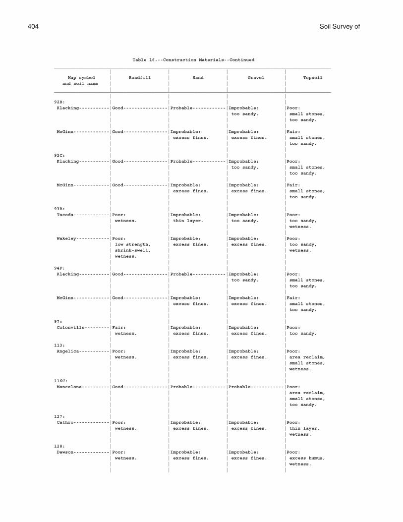
404 Soil Survey of
Table 16.--Construction Materials--Continued____________________________________________________________________________________________________ | | | | Map symbol | Roadfill | Sand | Gravel | Topsoil and soil name | | | | | | | |____________________________________________________________________________________________________ | | | |92B: | | | | Klacking-----------|Good----------------|Probable------------|Improbable: |Poor: | | | too sandy. | small stones, | | | | too sandy. | | | | McGinn-------------|Good----------------|Improbable: |Improbable: |Fair: | | excess fines. | excess fines. | small stones, | | | | too sandy. | | | |92C: | | | | Klacking-----------|Good----------------|Probable------------|Improbable: |Poor: | | | too sandy. | small stones, | | | | too sandy. | | | | McGinn-------------|Good----------------|Improbable: |Improbable: |Fair: | | excess fines. | excess fines. | small stones, | | | | too sandy. | | | |93B: | | | | Tacoda-------------|Poor: |Improbable: |Improbable: |Poor: | wetness. | thin layer. | too sandy. | too sandy, | | | | wetness. | | | | Wakeley------------|Poor: |Improbable: |Improbable: |Poor: | low strength, | excess fines. | excess fines. | too sandy, | shrink-swell, | | | wetness. | wetness. | | | | | | |94F: | | | | Klacking-----------|Good----------------|Probable------------|Improbable: |Poor: | | | too sandy. | small stones, | | | | too sandy. | | | | McGinn-------------|Good----------------|Improbable: |Improbable: |Fair: | | excess fines. | excess fines. | small stones, | | | | too sandy. | | | |97: | | | | Colonville---------|Fair: |Improbable: |Improbable: |Poor: | wetness. | excess fines. | excess fines. | too sandy. | | | |113: | | | | Angelica-----------|Poor: |Improbable: |Improbable: |Poor: | wetness. | excess fines. | excess fines. | area reclaim, | | | | small stones, | | | | wetness. | | | |116C: | | | | Mancelona----------|Good----------------|Probable------------|Probable------------|Poor: | | | | area reclaim, | | | | small stones, | | | | too sandy. | | | |127: | | | | Cathro-------------|Poor: |Improbable: |Improbable: |Poor: | wetness. | excess fines. | excess fines. | thin layer, | | | | wetness. | | | |128: | | | | Dawson-------------|Poor: |Improbable: |Improbable: |Poor: | wetness. | excess fines. | excess fines. | excess humus, | | | | wetness. | | | |
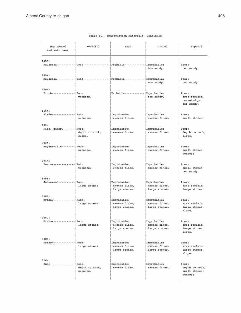
Alpena County, Michigan 405
Table 16.--Construction Materials--Continued____________________________________________________________________________________________________ | | | | Map symbol | Roadfill | Sand | Gravel | Topsoil and soil name | | | | | | | |____________________________________________________________________________________________________ | | | |145C: | | | | Rousseau-----------|Good----------------|Probable------------|Improbable: |Poor: | | | too sandy. | too sandy. | | | |145E: | | | | Rousseau-----------|Good----------------|Probable------------|Improbable: |Poor: | | | too sandy. | too sandy. | | | |159A: | | | | Finch--------------|Poor: |Probable------------|Improbable: |Poor: | wetness. | | too sandy. | area reclaim, | | | | cemented pan, | | | | too sandy. | | | |166A: | | | | Slade--------------|Fair: |Improbable: |Improbable: |Poor: | wetness. | excess fines. | excess fines. | small stones. | | | |182: | | | | Pits, quarry-------|Poor: |Improbable: |Improbable: |Poor: | depth to rock, | excess fines. | excess fines. | depth to rock, | slope. | | | slope. | | | |300A: | | | | Hagensville--------|Poor: |Improbable: |Improbable: |Poor: | wetness. | excess fines. | excess fines. | small stones, | | | | wetness. | | | |304A: | | | | Iosco--------------|Fair: |Improbable: |Improbable: |Poor: | wetness. | excess fines. | excess fines. | small stones, | | | | too sandy. | | | |305B: | | | | Johnswood----------|Poor: |Improbable: |Improbable: |Poor: | large stones. | excess fines, | excess fines, | area reclaim, | | large stones. | large stones. | large stones. | | | |308B: | | | | Krakow-------------|Poor: |Improbable: |Improbable: |Poor: | large stones. | excess fines, | excess fines, | area reclaim, | | large stones. | large stones. | large stones, | | | | slope. | | | |308C: | | | | Krakow-------------|Poor: |Improbable: |Improbable: |Poor: | large stones. | excess fines, | excess fines, | area reclaim, | | large stones. | large stones. | large stones, | | | | slope. | | | |308D: | | | | Krakow-------------|Poor: |Improbable: |Improbable: |Poor: | large stones. | excess fines, | excess fines, | area reclaim, | | large stones. | large stones. | large stones, | | | | slope. | | | |316: | | | | Ruse---------------|Poor: |Improbable: |Improbable: |Poor: | depth to rock, | excess fines. | excess fines. | depth to rock, | wetness. | | | small stones, | | | | wetness. | | | |
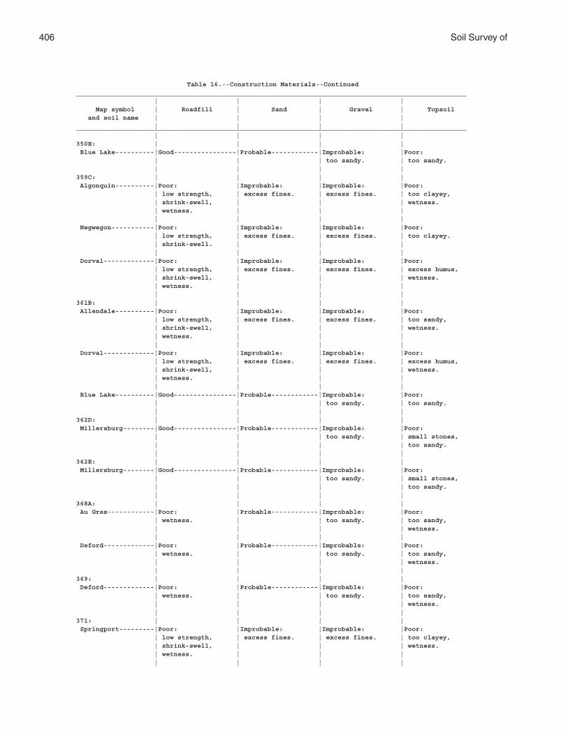
406 Soil Survey of
Table 16.--Construction Materials--Continued____________________________________________________________________________________________________ | | | | Map symbol | Roadfill | Sand | Gravel | Topsoil and soil name | | | | | | | |____________________________________________________________________________________________________ | | | |350E: | | | | Blue Lake----------|Good----------------|Probable------------|Improbable: |Poor: | | | too sandy. | too sandy. | | | |359C: | | | | Algonquin----------|Poor: |Improbable: |Improbable: |Poor: | low strength, | excess fines. | excess fines. | too clayey, | shrink-swell, | | | wetness. | wetness. | | | | | | | Negwegon-----------|Poor: |Improbable: |Improbable: |Poor: | low strength, | excess fines. | excess fines. | too clayey. | shrink-swell. | | | | | | | Dorval-------------|Poor: |Improbable: |Improbable: |Poor: | low strength, | excess fines. | excess fines. | excess humus, | shrink-swell, | | | wetness. | wetness. | | | | | | |361B: | | | | Allendale----------|Poor: |Improbable: |Improbable: |Poor: | low strength, | excess fines. | excess fines. | too sandy, | shrink-swell, | | | wetness. | wetness. | | | | | | | Dorval-------------|Poor: |Improbable: |Improbable: |Poor: | low strength, | excess fines. | excess fines. | excess humus, | shrink-swell, | | | wetness. | wetness. | | | | | | | Blue Lake----------|Good----------------|Probable------------|Improbable: |Poor: | | | too sandy. | too sandy. | | | |362D: | | | | Millersburg--------|Good----------------|Probable------------|Improbable: |Poor: | | | too sandy. | small stones, | | | | too sandy. | | | |362E: | | | | Millersburg--------|Good----------------|Probable------------|Improbable: |Poor: | | | too sandy. | small stones, | | | | too sandy. | | | |368A: | | | | Au Gres------------|Poor: |Probable------------|Improbable: |Poor: | wetness. | | too sandy. | too sandy, | | | | wetness. | | | | Deford-------------|Poor: |Probable------------|Improbable: |Poor: | wetness. | | too sandy. | too sandy, | | | | wetness. | | | |369: | | | | Deford-------------|Poor: |Probable------------|Improbable: |Poor: | wetness. | | too sandy. | too sandy, | | | | wetness. | | | |371: | | | | Springport---------|Poor: |Improbable: |Improbable: |Poor: | low strength, | excess fines. | excess fines. | too clayey, | shrink-swell, | | | wetness. | wetness. | | | | | | |
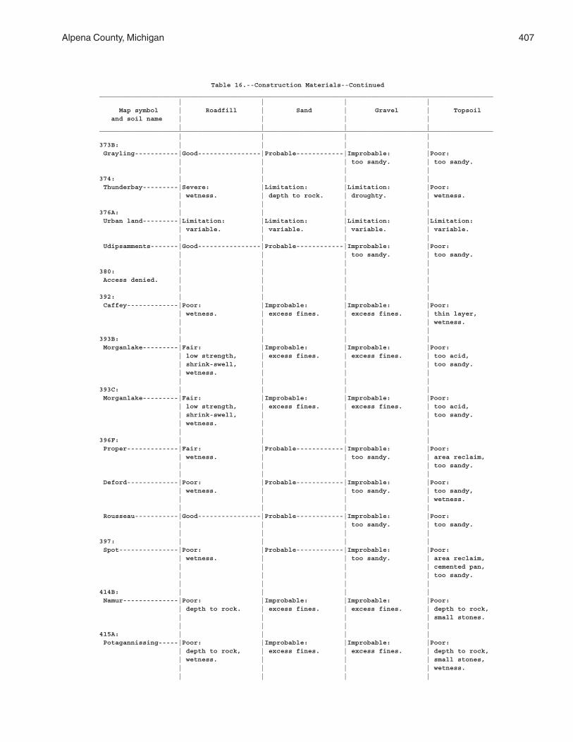
Alpena County, Michigan 407
Table 16.--Construction Materials--Continued____________________________________________________________________________________________________ | | | | Map symbol | Roadfill | Sand | Gravel | Topsoil and soil name | | | | | | | |____________________________________________________________________________________________________ | | | |373B: | | | | Grayling-----------|Good----------------|Probable------------|Improbable: |Poor: | | | too sandy. | too sandy. | | | |374: | | | | Thunderbay---------|Severe: |Limitation: |Limitation: |Poor: | wetness. | depth to rock. | droughty. | wetness. | | | |376A: | | | | Urban land---------|Limitation: |Limitation: |Limitation: |Limitation: | variable. | variable. | variable. | variable. | | | | Udipsamments-------|Good----------------|Probable------------|Improbable: |Poor: | | | too sandy. | too sandy. | | | |380: | | | | Access denied. | | | | | | | |392: | | | | Caffey-------------|Poor: |Improbable: |Improbable: |Poor: | wetness. | excess fines. | excess fines. | thin layer, | | | | wetness. | | | |393B: | | | | Morganlake---------|Fair: |Improbable: |Improbable: |Poor: | low strength, | excess fines. | excess fines. | too acid, | shrink-swell, | | | too sandy. | wetness. | | | | | | |393C: | | | | Morganlake---------|Fair: |Improbable: |Improbable: |Poor: | low strength, | excess fines. | excess fines. | too acid, | shrink-swell, | | | too sandy. | wetness. | | | | | | |396F: | | | | Proper-------------|Fair: |Probable------------|Improbable: |Poor: | wetness. | | too sandy. | area reclaim, | | | | too sandy. | | | | Deford-------------|Poor: |Probable------------|Improbable: |Poor: | wetness. | | too sandy. | too sandy, | | | | wetness. | | | | Rousseau-----------|Good----------------|Probable------------|Improbable: |Poor: | | | too sandy. | too sandy. | | | |397: | | | | Spot---------------|Poor: |Probable------------|Improbable: |Poor: | wetness. | | too sandy. | area reclaim, | | | | cemented pan, | | | | too sandy. | | | |414B: | | | | Namur--------------|Poor: |Improbable: |Improbable: |Poor: | depth to rock. | excess fines. | excess fines. | depth to rock, | | | | small stones. | | | |415A: | | | | Potagannissing-----|Poor: |Improbable: |Improbable: |Poor: | depth to rock, | excess fines. | excess fines. | depth to rock, | wetness. | | | small stones, | | | | wetness. | | | |
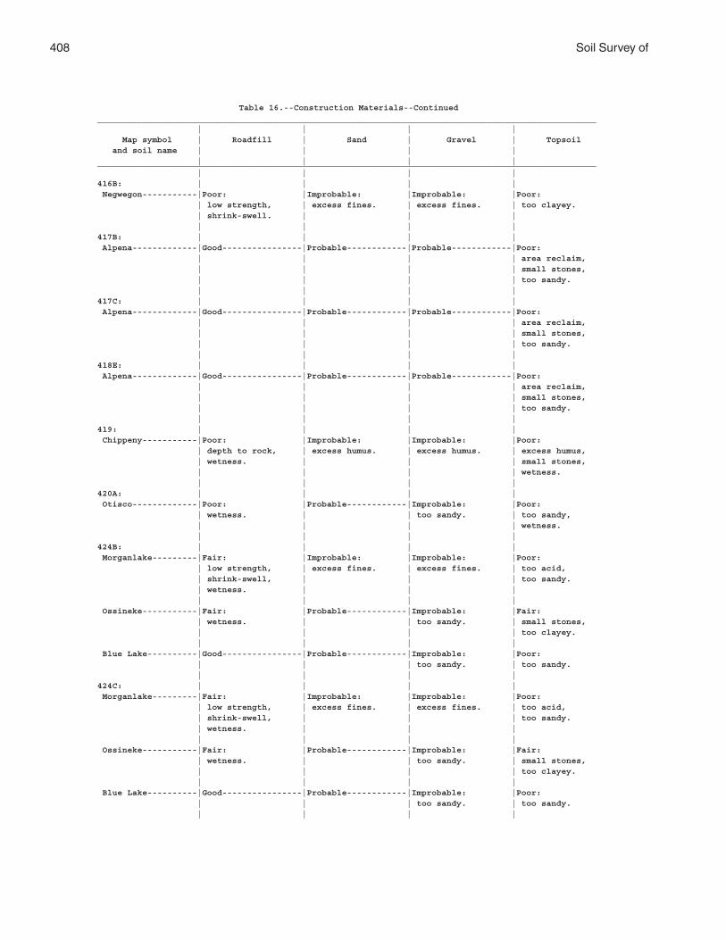
408 Soil Survey of
Table 16.--Construction Materials--Continued____________________________________________________________________________________________________ | | | | Map symbol | Roadfill | Sand | Gravel | Topsoil and soil name | | | | | | | |____________________________________________________________________________________________________ | | | |416B: | | | | Negwegon-----------|Poor: |Improbable: |Improbable: |Poor: | low strength, | excess fines. | excess fines. | too clayey. | shrink-swell. | | | | | | |417B: | | | | Alpena-------------|Good----------------|Probable------------|Probable------------|Poor: | | | | area reclaim, | | | | small stones, | | | | too sandy. | | | |417C: | | | | Alpena-------------|Good----------------|Probable------------|Probable------------|Poor: | | | | area reclaim, | | | | small stones, | | | | too sandy. | | | |418E: | | | | Alpena-------------|Good----------------|Probable------------|Probable------------|Poor: | | | | area reclaim, | | | | small stones, | | | | too sandy. | | | |419: | | | | Chippeny-----------|Poor: |Improbable: |Improbable: |Poor: | depth to rock, | excess humus. | excess humus. | excess humus, | wetness. | | | small stones, | | | | wetness. | | | |420A: | | | | Otisco-------------|Poor: |Probable------------|Improbable: |Poor: | wetness. | | too sandy. | too sandy, | | | | wetness. | | | |424B: | | | | Morganlake---------|Fair: |Improbable: |Improbable: |Poor: | low strength, | excess fines. | excess fines. | too acid, | shrink-swell, | | | too sandy. | wetness. | | | | | | | Ossineke-----------|Fair: |Probable------------|Improbable: |Fair: | wetness. | | too sandy. | small stones, | | | | too clayey. | | | | Blue Lake----------|Good----------------|Probable------------|Improbable: |Poor: | | | too sandy. | too sandy. | | | |424C: | | | | Morganlake---------|Fair: |Improbable: |Improbable: |Poor: | low strength, | excess fines. | excess fines. | too acid, | shrink-swell, | | | too sandy. | wetness. | | | | | | | Ossineke-----------|Fair: |Probable------------|Improbable: |Fair: | wetness. | | too sandy. | small stones, | | | | too clayey. | | | | Blue Lake----------|Good----------------|Probable------------|Improbable: |Poor: | | | too sandy. | too sandy. | | | |
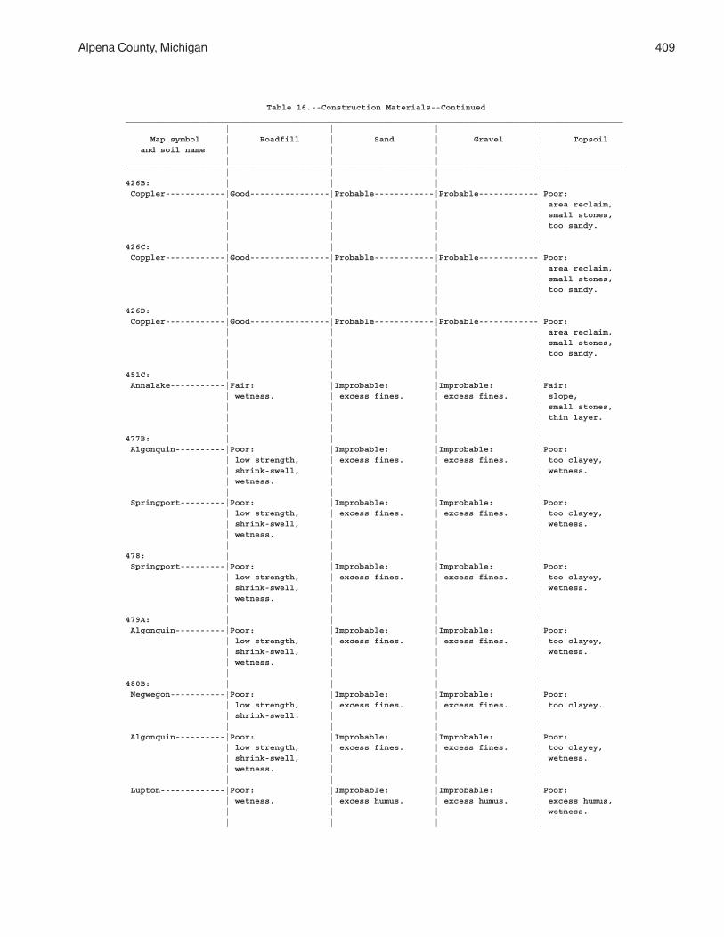
Alpena County, Michigan 409
Table 16.--Construction Materials--Continued____________________________________________________________________________________________________ | | | | Map symbol | Roadfill | Sand | Gravel | Topsoil and soil name | | | | | | | |____________________________________________________________________________________________________ | | | |426B: | | | | Coppler------------|Good----------------|Probable------------|Probable------------|Poor: | | | | area reclaim, | | | | small stones, | | | | too sandy. | | | |426C: | | | | Coppler------------|Good----------------|Probable------------|Probable------------|Poor: | | | | area reclaim, | | | | small stones, | | | | too sandy. | | | |426D: | | | | Coppler------------|Good----------------|Probable------------|Probable------------|Poor: | | | | area reclaim, | | | | small stones, | | | | too sandy. | | | |451C: | | | | Annalake-----------|Fair: |Improbable: |Improbable: |Fair: | wetness. | excess fines. | excess fines. | slope, | | | | small stones, | | | | thin layer. | | | |477B: | | | | Algonquin----------|Poor: |Improbable: |Improbable: |Poor: | low strength, | excess fines. | excess fines. | too clayey, | shrink-swell, | | | wetness. | wetness. | | | | | | | Springport---------|Poor: |Improbable: |Improbable: |Poor: | low strength, | excess fines. | excess fines. | too clayey, | shrink-swell, | | | wetness. | wetness. | | | | | | |478: | | | | Springport---------|Poor: |Improbable: |Improbable: |Poor: | low strength, | excess fines. | excess fines. | too clayey, | shrink-swell, | | | wetness. | wetness. | | | | | | |479A: | | | | Algonquin----------|Poor: |Improbable: |Improbable: |Poor: | low strength, | excess fines. | excess fines. | too clayey, | shrink-swell, | | | wetness. | wetness. | | | | | | |480B: | | | | Negwegon-----------|Poor: |Improbable: |Improbable: |Poor: | low strength, | excess fines. | excess fines. | too clayey. | shrink-swell. | | | | | | | Algonquin----------|Poor: |Improbable: |Improbable: |Poor: | low strength, | excess fines. | excess fines. | too clayey, | shrink-swell, | | | wetness. | wetness. | | | | | | | Lupton-------------|Poor: |Improbable: |Improbable: |Poor: | wetness. | excess humus. | excess humus. | excess humus, | | | | wetness. | | | |
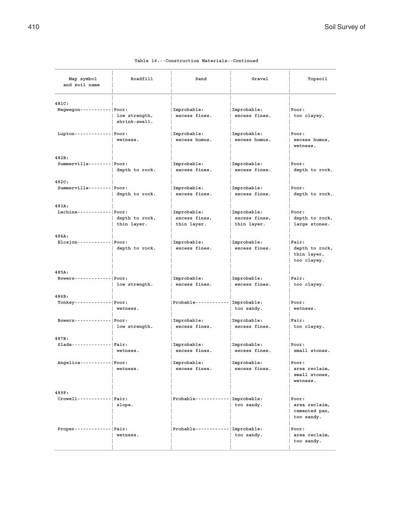
410 Soil Survey of
Table 16.--Construction Materials--Continued____________________________________________________________________________________________________ | | | | Map symbol | Roadfill | Sand | Gravel | Topsoil and soil name | | | | | | | |____________________________________________________________________________________________________ | | | |481C: | | | | Negwegon-----------|Poor: |Improbable: |Improbable: |Poor: | low strength, | excess fines. | excess fines. | too clayey. | shrink-swell. | | | | | | | Lupton-------------|Poor: |Improbable: |Improbable: |Poor: | wetness. | excess humus. | excess humus. | excess humus, | | | | wetness. | | | |482B: | | | | Summerville--------|Poor: |Improbable: |Improbable: |Poor: | depth to rock. | excess fines. | excess fines. | depth to rock. | | | |482C: | | | | Summerville--------|Poor: |Improbable: |Improbable: |Poor: | depth to rock. | excess fines. | excess fines. | depth to rock. | | | |483A: | | | | Lachine------------|Poor: |Improbable: |Improbable: |Poor: | depth to rock, | excess fines, | excess fines, | depth to rock, | thin layer. | thin layer. | thin layer. | large stones. | | | |484A: | | | | Elcajon------------|Poor: |Improbable: |Improbable: |Fair: | depth to rock. | excess fines. | excess fines. | depth to rock, | | | | thin layer, | | | | too clayey. | | | |485A: | | | | Bowers-------------|Poor: |Improbable: |Improbable: |Fair: | low strength. | excess fines. | excess fines. | too clayey. | | | |486B: | | | | Tonkey-------------|Poor: |Probable------------|Improbable: |Poor: | wetness. | | too sandy. | wetness. | | | | Bowers-------------|Poor: |Improbable: |Improbable: |Fair: | low strength. | excess fines. | excess fines. | too clayey. | | | |487B: | | | | Slade--------------|Fair: |Improbable: |Improbable: |Poor: | wetness. | excess fines. | excess fines. | small stones. | | | | Angelica-----------|Poor: |Improbable: |Improbable: |Poor: | wetness. | excess fines. | excess fines. | area reclaim, | | | | small stones, | | | | wetness. | | | |489F: | | | | Crowell------------|Fair: |Probable------------|Improbable: |Poor: | slope. | | too sandy. | area reclaim, | | | | cemented pan, | | | | too sandy. | | | | Proper-------------|Fair: |Probable------------|Improbable: |Poor: | wetness. | | too sandy. | area reclaim, | | | | too sandy. | | | |____________________________________________________________________________________________________
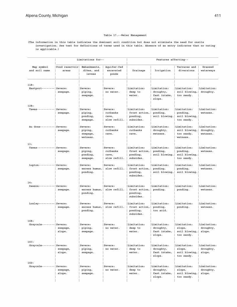
Alpena County, Michigan 411
Table 17.--Water Management
(The information in this table indicates the dominant soil condition but does not eliminate the need for onsite investigation. See text for definitions of terms used in this table. Absence of an entry indicates that no rating is applicable.)
________________________________________________________________________________________________________________________ | Limitations for-- | Features affecting-- | | ______________________________________________________________________________________________________ Map symbol |Pond reservoir| Embankments, | Aquifer-fed | | | Terraces and | Grassed and soil name | areas | dikes, and | excavated | Drainage | Irrigation | diversions | waterways | | levees | ponds | | | | | | | | | | |________________________________________________________________________________________________________________________ | | | | | | |11B: | | | | | | | Eastport--------|Severe: |Severe: |Severe: |Limitation: |Limitation: |Limitation: |Limitation: | seepage. | piping, | no water. | deep to | droughty, | soil blowing,| droughty. | | seepage. | | water. | fast intake, | too sandy. | | | | | | slope. | | | | | | | | |12B: | | | | | | | Tawas-----------|Severe: |Severe: |Severe: |Limitation: |Limitation: |Limitation: |Limitation: | seepage. | piping, | cutbanks | frost action,| ponding, | ponding, | wetness. | | ponding, | cave, | ponding, | soil blowing.| soil blowing,| | | seepage. | slow refill. | subsides. | | too sandy. | | | | | | | | Au Gres---------|Severe: |Severe: |Severe: |Limitation: |Limitation: |Limitation: |Limitation: | seepage. | piping, | cutbanks | cutbanks | droughty, | soil blowing,| droughty, | | seepage, | cave. | cave. | wetness. | too sandy, | wetness. | | wetness. | | | | wetness. | | | | | | | |13: | | | | | | | Tawas-----------|Severe: |Severe: |Severe: |Limitation: |Limitation: |Limitation: |Limitation: | seepage. | piping, | cutbanks | frost action,| ponding, | ponding, | wetness. | | ponding, | cave, | ponding, | soil blowing.| soil blowing,| | | seepage. | slow refill. | subsides. | | too sandy. | | | | | | | | Lupton----------|Severe: |Severe: |Severe: |Limitation: |Limitation: |Limitation: |Limitation: | seepage. | excess humus,| slow refill. | frost action,| ponding, | ponding, | wetness. | | ponding. | | ponding, | soil blowing.| soil blowing.| | | | | subsides. | | | | | | | | | |14: | | | | | | | Dawson----------|Severe: |Severe: |Severe: |Limitation: |Limitation: |Limitation: |Limitation: | seepage. | excess humus,| slow refill. | frost action,| ponding. | ponding. | wetness. | | ponding. | | ponding, | | | | | | | subsides. | | | | | | | | | | Loxley----------|Severe: |Severe: |Severe: |Limitation: |Limitation: |Limitation: |Limitation: | seepage. | excess humus,| slow refill. | frost action,| ponding, | ponding. | wetness. | | ponding. | | ponding, | too acid. | | | | | | subsides. | | | | | | | | | |16B: | | | | | | | Graycalm--------|Severe: |Severe: |Severe: |Limitation: |Limitation: |Limitation: |Limitation: | seepage, | piping, | no water. | deep to | droughty, | slope, | droughty, | slope. | seepage. | | water. | fast intake, | soil blowing,| slope. | | | | | slope. | too sandy. | | | | | | | |16C: | | | | | | | Graycalm--------|Severe: |Severe: |Severe: |Limitation: |Limitation: |Limitation: |Limitation: | seepage, | piping, | no water. | deep to | droughty, | slope, | droughty, | slope. | seepage. | | water. | fast intake, | soil blowing,| slope. | | | | | slope. | too sandy. | | | | | | | |16D: | | | | | | | Graycalm--------|Severe: |Severe: |Severe: |Limitation: |Limitation: |Limitation: |Limitation: | seepage, | piping, | no water. | deep to | droughty, | slope, | droughty, | slope. | seepage. | | water. | fast intake, | soil blowing,| slope. | | | | | slope. | too sandy. | | | | | | | |
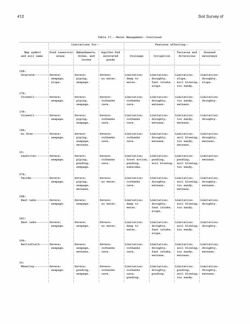
412 Soil Survey of
Table 17.--Water Management--Continued________________________________________________________________________________________________________________________ | Limitations for-- | Features affecting-- | | ______________________________________________________________________________________________________ Map symbol |Pond reservoir| Embankments, | Aquifer-fed | | | Terraces and | Grassed and soil name | areas | dikes, and | excavated | Drainage | Irrigation | diversions | waterways | | levees | ponds | | | | | | | | | | |________________________________________________________________________________________________________________________ | | | | | | |16E: | | | | | | | Graycalm--------|Severe: |Severe: |Severe: |Limitation: |Limitation: |Limitation: |Limitation: | seepage, | piping, | no water. | deep to | droughty, | slope, | droughty, | slope. | seepage. | | water. | fast intake, | soil blowing,| slope. | | | | | slope. | too sandy. | | | | | | | |17A: | | | | | | | Croswell--------|Severe: |Severe: |Severe: |Limitation: |Limitation: |Limitation: |Limitation: | seepage. | piping, | cutbanks | cutbanks | droughty, | too sandy, | droughty. | | seepage. | cave. | cave. | wetness. | wetness. | | | | | | | |17B: | | | | | | | Croswell--------|Severe: |Severe: |Severe: |Limitation: |Limitation: |Limitation: |Limitation: | seepage. | piping, | cutbanks | cutbanks | droughty, | too sandy, | droughty. | | seepage. | cave. | cave. | wetness. | wetness. | | | | | | | |18A: | | | | | | | Au Gres---------|Severe: |Severe: |Severe: |Limitation: |Limitation: |Limitation: |Limitation: | seepage. | piping, | cutbanks | cutbanks | droughty, | soil blowing,| droughty, | | seepage, | cave. | cave. | wetness. | too sandy, | wetness. | | wetness. | | | | wetness. | | | | | | | |19: | | | | | | | Leafriver-------|Severe: |Severe: |Severe: |Limitation: |Limitation: |Limitation: |Limitation: | seepage. | piping, | cutbanks | frost action,| ponding, | ponding, | wetness. | | ponding, | cave. | ponding, | soil blowing.| soil blowing,| | | seepage. | | subsides. | | too sandy. | | | | | | | |27A: | | | | | | | Tacoda----------|Severe: |Severe: |Severe: |Limitation: |Limitation: |Limitation: |Limitation: | seepage. | piping, | no water. | cutbanks | droughty, | soil blowing,| droughty, | | seepage, | | cave. | wetness. | too sandy, | wetness. | | wetness. | | | | wetness. | | | | | | | |28B: | | | | | | | East Lake-------|Severe: |Severe: |Severe: |Limitation: |Limitation: |Limitation: |Limitation: | seepage. | seepage. | no water. | deep to | droughty, | soil blowing,| droughty. | | | | water. | fast intake, | too sandy. | | | | | | slope. | | | | | | | | |28C: | | | | | | | East Lake-------|Severe: |Severe: |Severe: |Limitation: |Limitation: |Limitation: |Limitation: | seepage. | seepage. | no water. | deep to | droughty, | soil blowing,| droughty. | | | | water. | fast intake, | too sandy. | | | | | | slope. | | | | | | | | |29A: | | | | | | | Battlefield-----|Severe: |Severe: |Severe: |Limitation: |Limitation: |Limitation: |Limitation: | seepage. | seepage, | cutbanks | cutbanks | droughty, | soil blowing,| droughty, | | wetness. | cave. | cave. | fast intake, | too sandy, | wetness. | | | | | wetness. | wetness. | | | | | | | |30: | | | | | | | Wheatley--------|Severe: |Severe: |Severe: |Limitation: |Limitation: |Limitation: |Limitation: | seepage. | ponding, | cutbanks | cutbanks | droughty, | ponding, | droughty, | | seepage. | cave. | cave, | ponding. | soil blowing,| wetness. | | | | ponding. | | too sandy. | | | | | | | |
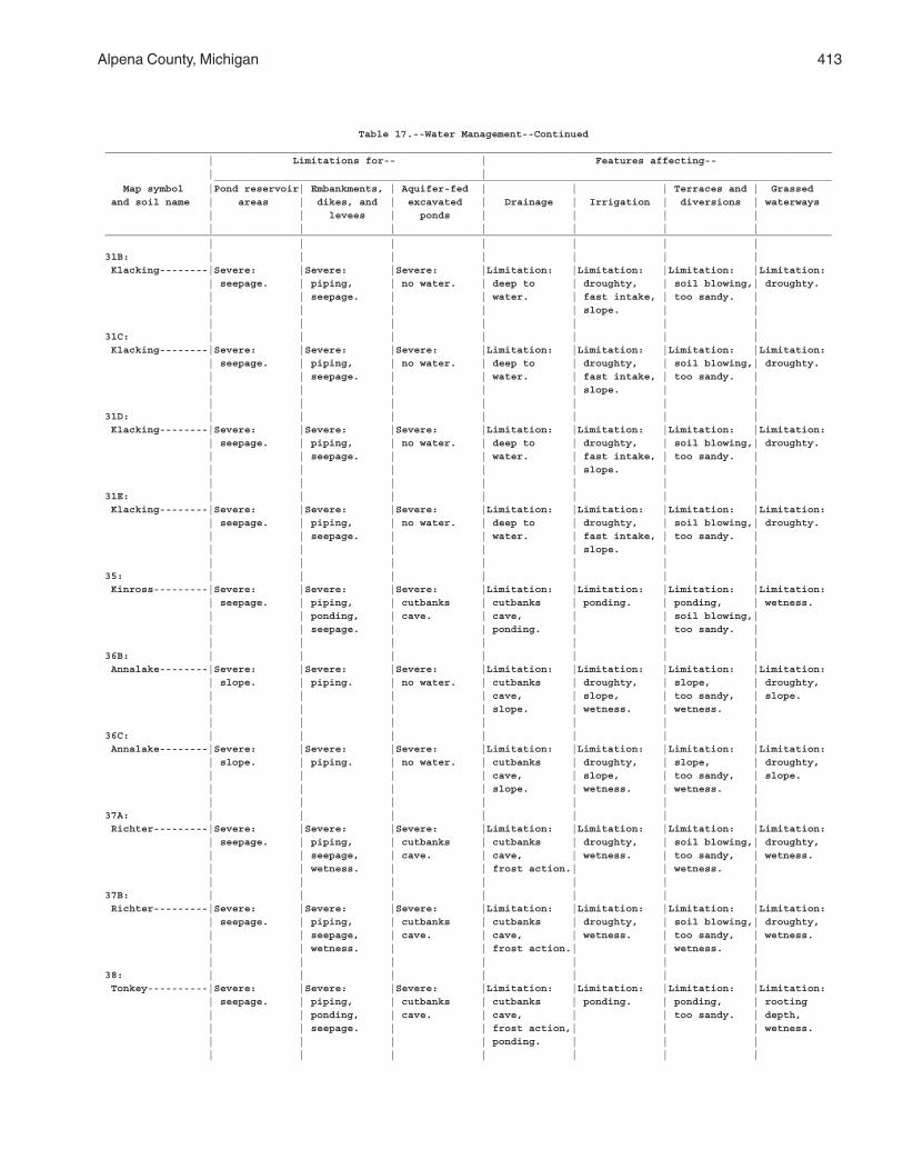
Alpena County, Michigan 413
Table 17.--Water Management--Continued________________________________________________________________________________________________________________________ | Limitations for-- | Features affecting-- | | ______________________________________________________________________________________________________ Map symbol |Pond reservoir| Embankments, | Aquifer-fed | | | Terraces and | Grassed and soil name | areas | dikes, and | excavated | Drainage | Irrigation | diversions | waterways | | levees | ponds | | | | | | | | | | |________________________________________________________________________________________________________________________ | | | | | | |31B: | | | | | | | Klacking--------|Severe: |Severe: |Severe: |Limitation: |Limitation: |Limitation: |Limitation: | seepage. | piping, | no water. | deep to | droughty, | soil blowing,| droughty. | | seepage. | | water. | fast intake, | too sandy. | | | | | | slope. | | | | | | | | |31C: | | | | | | | Klacking--------|Severe: |Severe: |Severe: |Limitation: |Limitation: |Limitation: |Limitation: | seepage. | piping, | no water. | deep to | droughty, | soil blowing,| droughty. | | seepage. | | water. | fast intake, | too sandy. | | | | | | slope. | | | | | | | | |31D: | | | | | | | Klacking--------|Severe: |Severe: |Severe: |Limitation: |Limitation: |Limitation: |Limitation: | seepage. | piping, | no water. | deep to | droughty, | soil blowing,| droughty. | | seepage. | | water. | fast intake, | too sandy. | | | | | | slope. | | | | | | | | |31E: | | | | | | | Klacking--------|Severe: |Severe: |Severe: |Limitation: |Limitation: |Limitation: |Limitation: | seepage. | piping, | no water. | deep to | droughty, | soil blowing,| droughty. | | seepage. | | water. | fast intake, | too sandy. | | | | | | slope. | | | | | | | | |35: | | | | | | | Kinross---------|Severe: |Severe: |Severe: |Limitation: |Limitation: |Limitation: |Limitation: | seepage. | piping, | cutbanks | cutbanks | ponding. | ponding, | wetness. | | ponding, | cave. | cave, | | soil blowing,| | | seepage. | | ponding. | | too sandy. | | | | | | | |36B: | | | | | | | Annalake--------|Severe: |Severe: |Severe: |Limitation: |Limitation: |Limitation: |Limitation: | slope. | piping. | no water. | cutbanks | droughty, | slope, | droughty, | | | | cave, | slope, | too sandy, | slope. | | | | slope. | wetness. | wetness. | | | | | | | |36C: | | | | | | | Annalake--------|Severe: |Severe: |Severe: |Limitation: |Limitation: |Limitation: |Limitation: | slope. | piping. | no water. | cutbanks | droughty, | slope, | droughty, | | | | cave, | slope, | too sandy, | slope. | | | | slope. | wetness. | wetness. | | | | | | | |37A: | | | | | | | Richter---------|Severe: |Severe: |Severe: |Limitation: |Limitation: |Limitation: |Limitation: | seepage. | piping, | cutbanks | cutbanks | droughty, | soil blowing,| droughty, | | seepage, | cave. | cave, | wetness. | too sandy, | wetness. | | wetness. | | frost action.| | wetness. | | | | | | | |37B: | | | | | | | Richter---------|Severe: |Severe: |Severe: |Limitation: |Limitation: |Limitation: |Limitation: | seepage. | piping, | cutbanks | cutbanks | droughty, | soil blowing,| droughty, | | seepage, | cave. | cave, | wetness. | too sandy, | wetness. | | wetness. | | frost action.| | wetness. | | | | | | | |38: | | | | | | | Tonkey----------|Severe: |Severe: |Severe: |Limitation: |Limitation: |Limitation: |Limitation: | seepage. | piping, | cutbanks | cutbanks | ponding. | ponding, | rooting | | ponding, | cave. | cave, | | too sandy. | depth, | | seepage. | | frost action,| | | wetness. | | | | ponding. | | | | | | | | | |
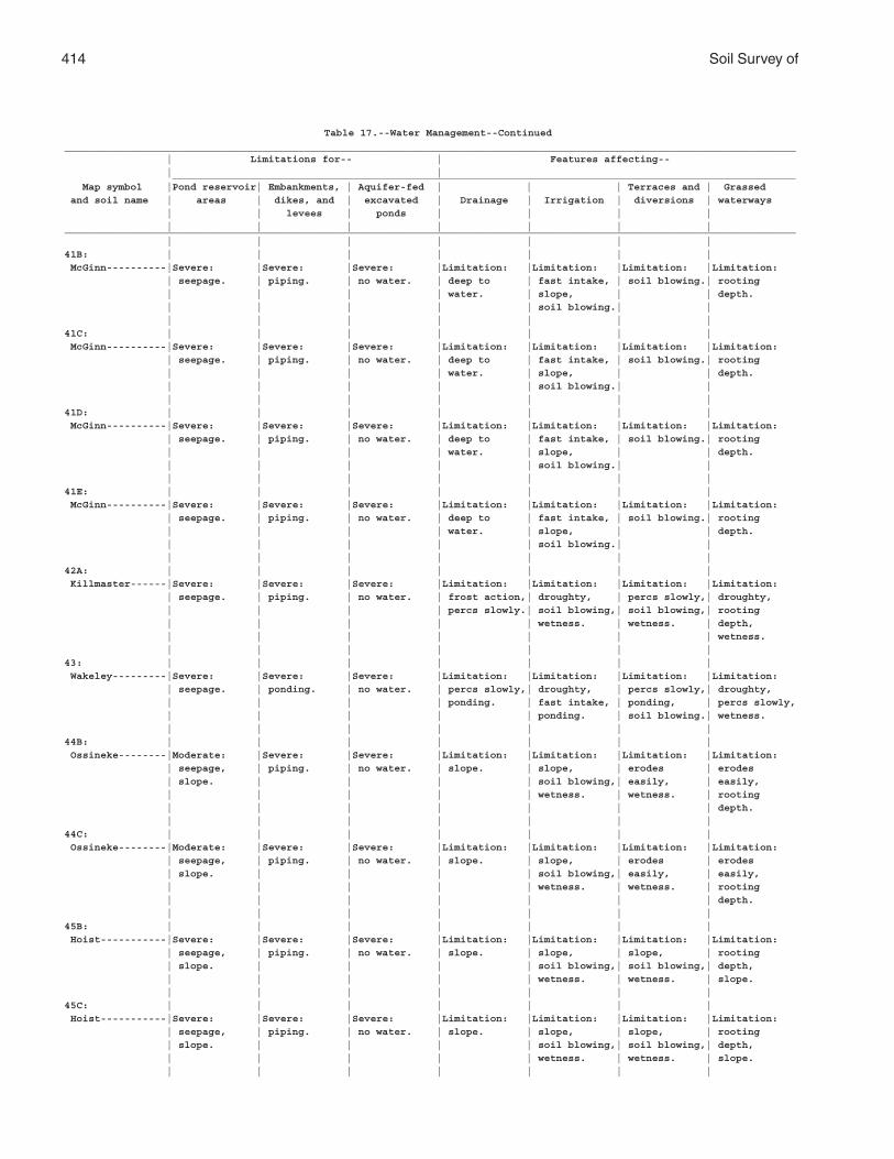
414 Soil Survey of
Table 17.--Water Management--Continued__________________________________________________________________________________________________________________________ | Limitations for-- | Features affecting-- | | ________________________________________________________________________________________________________ Map symbol |Pond reservoir| Embankments, | Aquifer-fed | | | Terraces and | Grassed and soil name | areas | dikes, and | excavated | Drainage | Irrigation | diversions | waterways | | levees | ponds | | | | | | | | | | |__________________________________________________________________________________________________________________________ | | | | | | |41B: | | | | | | | McGinn----------|Severe: |Severe: |Severe: |Limitation: |Limitation: |Limitation: |Limitation: | seepage. | piping. | no water. | deep to | fast intake, | soil blowing.| rooting | | | | water. | slope, | | depth. | | | | | soil blowing.| | | | | | | | |41C: | | | | | | | McGinn----------|Severe: |Severe: |Severe: |Limitation: |Limitation: |Limitation: |Limitation: | seepage. | piping. | no water. | deep to | fast intake, | soil blowing.| rooting | | | | water. | slope, | | depth. | | | | | soil blowing.| | | | | | | | |41D: | | | | | | | McGinn----------|Severe: |Severe: |Severe: |Limitation: |Limitation: |Limitation: |Limitation: | seepage. | piping. | no water. | deep to | fast intake, | soil blowing.| rooting | | | | water. | slope, | | depth. | | | | | soil blowing.| | | | | | | | |41E: | | | | | | | McGinn----------|Severe: |Severe: |Severe: |Limitation: |Limitation: |Limitation: |Limitation: | seepage. | piping. | no water. | deep to | fast intake, | soil blowing.| rooting | | | | water. | slope, | | depth. | | | | | soil blowing.| | | | | | | | |42A: | | | | | | | Killmaster------|Severe: |Severe: |Severe: |Limitation: |Limitation: |Limitation: |Limitation: | seepage. | piping. | no water. | frost action,| droughty, | percs slowly,| droughty, | | | | percs slowly.| soil blowing,| soil blowing,| rooting | | | | | wetness. | wetness. | depth, | | | | | | | wetness. | | | | | | |43: | | | | | | | Wakeley---------|Severe: |Severe: |Severe: |Limitation: |Limitation: |Limitation: |Limitation: | seepage. | ponding. | no water. | percs slowly,| droughty, | percs slowly,| droughty, | | | | ponding. | fast intake, | ponding, | percs slowly, | | | | | ponding. | soil blowing.| wetness. | | | | | | |44B: | | | | | | | Ossineke--------|Moderate: |Severe: |Severe: |Limitation: |Limitation: |Limitation: |Limitation: | seepage, | piping. | no water. | slope. | slope, | erodes | erodes | slope. | | | | soil blowing,| easily, | easily, | | | | | wetness. | wetness. | rooting | | | | | | | depth. | | | | | | |44C: | | | | | | | Ossineke--------|Moderate: |Severe: |Severe: |Limitation: |Limitation: |Limitation: |Limitation: | seepage, | piping. | no water. | slope. | slope, | erodes | erodes | slope. | | | | soil blowing,| easily, | easily, | | | | | wetness. | wetness. | rooting | | | | | | | depth. | | | | | | |45B: | | | | | | | Hoist-----------|Severe: |Severe: |Severe: |Limitation: |Limitation: |Limitation: |Limitation: | seepage, | piping. | no water. | slope. | slope, | slope, | rooting | slope. | | | | soil blowing,| soil blowing,| depth, | | | | | wetness. | wetness. | slope. | | | | | | |45C: | | | | | | | Hoist-----------|Severe: |Severe: |Severe: |Limitation: |Limitation: |Limitation: |Limitation: | seepage, | piping. | no water. | slope. | slope, | slope, | rooting | slope. | | | | soil blowing,| soil blowing,| depth, | | | | | wetness. | wetness. | slope. | | | | | | |
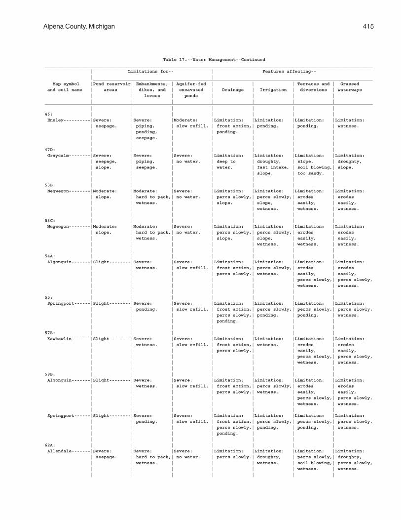
Alpena County, Michigan 415
Table 17.--Water Management--Continued__________________________________________________________________________________________________________________________ | Limitations for-- | Features affecting-- | | ________________________________________________________________________________________________________ Map symbol |Pond reservoir| Embankments, | Aquifer-fed | | | Terraces and | Grassed and soil name | areas | dikes, and | excavated | Drainage | Irrigation | diversions | waterways | | levees | ponds | | | | | | | | | | |__________________________________________________________________________________________________________________________ | | | | | | |46: | | | | | | | Ensley----------|Severe: |Severe: |Moderate: |Limitation: |Limitation: |Limitation: |Limitation: | seepage. | piping, | slow refill. | frost action,| ponding. | ponding. | wetness. | | ponding, | | ponding. | | | | | seepage. | | | | | | | | | | | |47D: | | | | | | | Graycalm--------|Severe: |Severe: |Severe: |Limitation: |Limitation: |Limitation: |Limitation: | seepage, | piping, | no water. | deep to | droughty, | slope, | droughty, | slope. | seepage. | | water. | fast intake, | soil blowing,| slope. | | | | | slope. | too sandy. | | | | | | | |53B: | | | | | | | Negwegon--------|Moderate: |Moderate: |Severe: |Limitation: |Limitation: |Limitation: |Limitation: | slope. | hard to pack,| no water. | percs slowly,| percs slowly,| erodes | erodes | | wetness. | | slope. | slope, | easily, | easily, | | | | | wetness. | wetness. | wetness. | | | | | | |53C: | | | | | | | Negwegon--------|Moderate: |Moderate: |Severe: |Limitation: |Limitation: |Limitation: |Limitation: | slope. | hard to pack,| no water. | percs slowly,| percs slowly,| erodes | erodes | | wetness. | | slope. | slope, | easily, | easily, | | | | | wetness. | wetness. | wetness. | | | | | | |54A: | | | | | | | Algonquin-------|Slight--------|Severe: |Severe: |Limitation: |Limitation: |Limitation: |Limitation: | | wetness. | slow refill. | frost action,| percs slowly,| erodes | erodes | | | | percs slowly.| wetness. | easily, | easily, | | | | | | percs slowly,| percs slowly, | | | | | | wetness. | wetness. | | | | | | |55: | | | | | | | Springport------|Slight--------|Severe: |Severe: |Limitation: |Limitation: |Limitation: |Limitation: | | ponding. | slow refill. | frost action,| percs slowly,| percs slowly,| percs slowly, | | | | percs slowly,| ponding. | ponding. | wetness. | | | | ponding. | | | | | | | | | |57B: | | | | | | | Kawkawlin-------|Slight--------|Severe: |Severe: |Limitation: |Limitation: |Limitation: |Limitation: | | wetness. | slow refill. | frost action,| wetness. | erodes | erodes | | | | percs slowly.| | easily, | easily, | | | | | | percs slowly,| percs slowly, | | | | | | wetness. | wetness. | | | | | | |59B: | | | | | | | Algonquin-------|Slight--------|Severe: |Severe: |Limitation: |Limitation: |Limitation: |Limitation: | | wetness. | slow refill. | frost action,| percs slowly,| erodes | erodes | | | | percs slowly.| wetness. | easily, | easily, | | | | | | percs slowly,| percs slowly, | | | | | | wetness. | wetness. | | | | | | | Springport------|Slight--------|Severe: |Severe: |Limitation: |Limitation: |Limitation: |Limitation: | | ponding. | slow refill. | frost action,| percs slowly,| percs slowly,| percs slowly, | | | | percs slowly,| ponding. | ponding. | wetness. | | | | ponding. | | | | | | | | | |62A: | | | | | | | Allendale-------|Severe: |Severe: |Severe: |Limitation: |Limitation: |Limitation: |Limitation: | seepage. | hard to pack,| no water. | percs slowly.| droughty, | percs slowly,| droughty, | | wetness. | | | wetness. | soil blowing,| percs slowly, | | | | | | wetness. | wetness. | | | | | | |
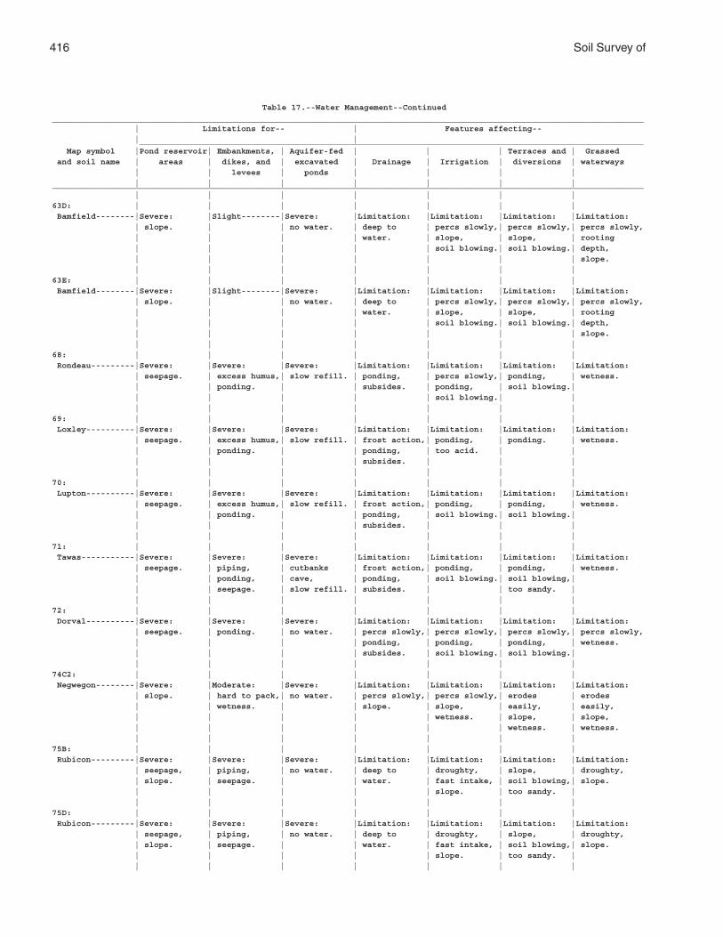
416 Soil Survey of
Table 17.--Water Management--Continued__________________________________________________________________________________________________________________________ | Limitations for-- | Features affecting-- | | ________________________________________________________________________________________________________ Map symbol |Pond reservoir| Embankments, | Aquifer-fed | | | Terraces and | Grassed and soil name | areas | dikes, and | excavated | Drainage | Irrigation | diversions | waterways | | levees | ponds | | | | | | | | | | |__________________________________________________________________________________________________________________________ | | | | | | |63D: | | | | | | | Bamfield--------|Severe: |Slight--------|Severe: |Limitation: |Limitation: |Limitation: |Limitation: | slope. | | no water. | deep to | percs slowly,| percs slowly,| percs slowly, | | | | water. | slope, | slope, | rooting | | | | | soil blowing.| soil blowing.| depth, | | | | | | | slope. | | | | | | |63E: | | | | | | | Bamfield--------|Severe: |Slight--------|Severe: |Limitation: |Limitation: |Limitation: |Limitation: | slope. | | no water. | deep to | percs slowly,| percs slowly,| percs slowly, | | | | water. | slope, | slope, | rooting | | | | | soil blowing.| soil blowing.| depth, | | | | | | | slope. | | | | | | |68: | | | | | | | Rondeau---------|Severe: |Severe: |Severe: |Limitation: |Limitation: |Limitation: |Limitation: | seepage. | excess humus,| slow refill. | ponding, | percs slowly,| ponding, | wetness. | | ponding. | | subsides. | ponding, | soil blowing.| | | | | | soil blowing.| | | | | | | | |69: | | | | | | | Loxley----------|Severe: |Severe: |Severe: |Limitation: |Limitation: |Limitation: |Limitation: | seepage. | excess humus,| slow refill. | frost action,| ponding, | ponding. | wetness. | | ponding. | | ponding, | too acid. | | | | | | subsides. | | | | | | | | | |70: | | | | | | | Lupton----------|Severe: |Severe: |Severe: |Limitation: |Limitation: |Limitation: |Limitation: | seepage. | excess humus,| slow refill. | frost action,| ponding, | ponding, | wetness. | | ponding. | | ponding, | soil blowing.| soil blowing.| | | | | subsides. | | | | | | | | | |71: | | | | | | | Tawas-----------|Severe: |Severe: |Severe: |Limitation: |Limitation: |Limitation: |Limitation: | seepage. | piping, | cutbanks | frost action,| ponding, | ponding, | wetness. | | ponding, | cave, | ponding, | soil blowing.| soil blowing,| | | seepage. | slow refill. | subsides. | | too sandy. | | | | | | | |72: | | | | | | | Dorval----------|Severe: |Severe: |Severe: |Limitation: |Limitation: |Limitation: |Limitation: | seepage. | ponding. | no water. | percs slowly,| percs slowly,| percs slowly,| percs slowly, | | | | ponding, | ponding, | ponding, | wetness. | | | | subsides. | soil blowing.| soil blowing.| | | | | | | |74C2: | | | | | | | Negwegon--------|Severe: |Moderate: |Severe: |Limitation: |Limitation: |Limitation: |Limitation: | slope. | hard to pack,| no water. | percs slowly,| percs slowly,| erodes | erodes | | wetness. | | slope. | slope, | easily, | easily, | | | | | wetness. | slope, | slope, | | | | | | wetness. | wetness. | | | | | | |75B: | | | | | | | Rubicon---------|Severe: |Severe: |Severe: |Limitation: |Limitation: |Limitation: |Limitation: | seepage, | piping, | no water. | deep to | droughty, | slope, | droughty, | slope. | seepage. | | water. | fast intake, | soil blowing,| slope. | | | | | slope. | too sandy. | | | | | | | |75D: | | | | | | | Rubicon---------|Severe: |Severe: |Severe: |Limitation: |Limitation: |Limitation: |Limitation: | seepage, | piping, | no water. | deep to | droughty, | slope, | droughty, | slope. | seepage. | | water. | fast intake, | soil blowing,| slope. | | | | | slope. | too sandy. | | | | | | | |
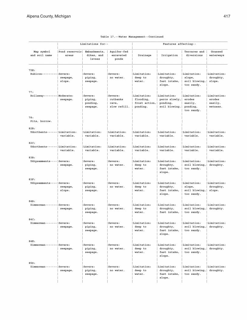
Alpena County, Michigan 417
Table 17.--Water Management--Continued________________________________________________________________________________________________________________________ | Limitations for-- | Features affecting-- | | ______________________________________________________________________________________________________ Map symbol |Pond reservoir| Embankments, | Aquifer-fed | | | Terraces and | Grassed and soil name | areas | dikes, and | excavated | Drainage | Irrigation | diversions | waterways | | levees | ponds | | | | | | | | | | |________________________________________________________________________________________________________________________ | | | | | | |75E: | | | | | | | Rubicon---------|Severe: |Severe: |Severe: |Limitation: |Limitation: |Limitation: |Limitation: | seepage, | piping, | no water. | deep to | droughty, | slope, | droughty, | slope. | seepage. | | water. | fast intake, | soil blowing,| slope. | | | | | slope. | too sandy. | | | | | | | |77: | | | | | | | Rollaway--------|Moderate: |Severe: |Severe: |Limitation: |Limitation: |Limitation: |Limitation: | seepage. | piping, | cutbanks | flooding, | percs slowly,| erodes | erodes | | ponding, | cave, | frost action,| ponding, | easily, | easily, | | seepage. | slow refill. | ponding. | soil blowing.| ponding, | wetness. | | | | | | too sandy. | | | | | | | |78: | | | | | | | Pits, borrow. | | | | | | | | | | | | | |82B: | | | | | | | Udorthents------|Limitation: |Limitation: |Limitation: |Limitation: |Limitation: |Limitation: |Limitation: | variable. | variable. | variable. | variable. | variable. | variable. | variable. | | | | | | |82C: | | | | | | | Udorthents------|Limitation: |Limitation: |Limitation: |Limitation: |Limitation: |Limitation: |Limitation: | variable. | variable. | variable. | variable. | variable. | variable. | variable. | | | | | | |83B: | | | | | | | Udipsamments----|Severe: |Severe: |Severe: |Limitation: |Limitation: |Limitation: |Limitation: | seepage. | piping, | no water. | deep to | droughty, | soil blowing,| droughty. | | seepage. | | water. | fast intake, | too sandy. | | | | | | slope. | | | | | | | | |83F: | | | | | | | Udipsamments----|Severe: |Severe: |Severe: |Limitation: |Limitation: |Limitation: |Limitation: | seepage, | piping, | no water. | deep to | droughty, | slope, | droughty, | slope. | seepage. | | water. | fast intake, | soil blowing,| slope. | | | | | slope. | too sandy. | | | | | | | |84B: | | | | | | | Zimmerman-------|Severe: |Severe: |Severe: |Limitation: |Limitation: |Limitation: |Limitation: | seepage. | piping, | no water. | deep to | droughty, | soil blowing,| droughty. | | seepage. | | water. | fast intake, | too sandy. | | | | | | | |84C: | | | | | | | Zimmerman-------|Severe: |Severe: |Severe: |Limitation: |Limitation: |Limitation: |Limitation: | seepage. | piping, | no water. | deep to | droughty, | soil blowing,| droughty. | | seepage. | | water. | fast intake, | too sandy. | | | | | | slope. | | | | | | | | |84E: | | | | | | | Zimmerman-------|Severe: |Severe: |Severe: |Limitation: |Limitation: |Limitation: |Limitation: | seepage. | piping, | no water. | deep to | droughty, | soil blowing,| droughty. | | seepage. | | water. | fast intake, | too sandy. | | | | | | slope. | | | | | | | | |85D: | | | | | | | Zimmerman-------|Severe: |Severe: |Severe: |Limitation: |Limitation: |Limitation: |Limitation: | seepage. | piping, | no water. | deep to | droughty, | soil blowing,| droughty. | | seepage. | | water. | fast intake, | too sandy. | | | | | | slope. | | | | | | | | |
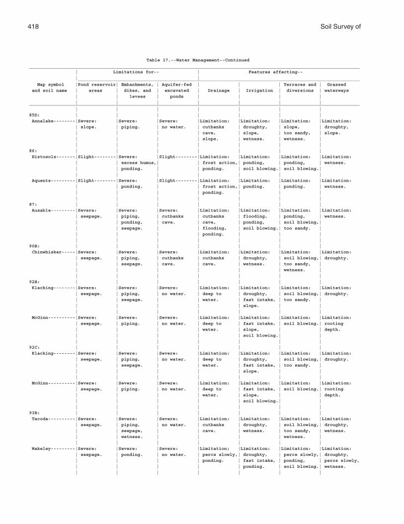
418 Soil Survey of
Table 17.--Water Management--Continued__________________________________________________________________________________________________________________________ | Limitations for-- | Features affecting-- | | ________________________________________________________________________________________________________ Map symbol |Pond reservoir| Embankments, | Aquifer-fed | | | Terraces and | Grassed and soil name | areas | dikes, and | excavated | Drainage | Irrigation | diversions | waterways | | levees | ponds | | | | | | | | | | |__________________________________________________________________________________________________________________________ | | | | | | |85D: | | | | | | | Annalake--------|Severe: |Severe: |Severe: |Limitation: |Limitation: |Limitation: |Limitation: | slope. | piping. | no water. | cutbanks | droughty, | slope, | droughty, | | | | cave, | slope, | too sandy, | slope. | | | | slope. | wetness. | wetness. | | | | | | | |86: | | | | | | | Histosols-------|Slight--------|Severe: |Slight--------|Limitation: |Limitation: |Limitation: |Limitation: | | excess humus,| | frost action,| ponding, | ponding, | wetness. | | ponding. | | ponding. | soil blowing.| soil blowing.| | | | | | | | Aquents---------|Slight--------|Severe: |Slight--------|Limitation: |Limitation: |Limitation: |Limitation: | | ponding. | | frost action,| ponding. | ponding. | wetness. | | | | ponding. | | | | | | | | | |87: | | | | | | | Ausable---------|Severe: |Severe: |Severe: |Limitation: |Limitation: |Limitation: |Limitation: | seepage. | piping, | cutbanks | cutbanks | flooding, | ponding, | wetness. | | ponding, | cave. | cave, | ponding, | soil blowing,| | | seepage. | | flooding, | soil blowing.| too sandy. | | | | | ponding. | | | | | | | | | |90B: | | | | | | | Chinwhisker-----|Severe: |Severe: |Severe: |Limitation: |Limitation: |Limitation: |Limitation: | seepage. | piping, | cutbanks | cutbanks | droughty, | soil blowing,| droughty. | | seepage. | cave. | cave. | wetness. | too sandy, | | | | | | | wetness. | | | | | | | |92B: | | | | | | | Klacking--------|Severe: |Severe: |Severe: |Limitation: |Limitation: |Limitation: |Limitation: | seepage. | piping, | no water. | deep to | droughty, | soil blowing,| droughty. | | seepage. | | water. | fast intake, | too sandy. | | | | | | slope. | | | | | | | | | McGinn----------|Severe: |Severe: |Severe: |Limitation: |Limitation: |Limitation: |Limitation: | seepage. | piping. | no water. | deep to | fast intake, | soil blowing.| rooting | | | | water. | slope, | | depth. | | | | | soil blowing.| | | | | | | | |92C: | | | | | | | Klacking--------|Severe: |Severe: |Severe: |Limitation: |Limitation: |Limitation: |Limitation: | seepage. | piping, | no water. | deep to | droughty, | soil blowing,| droughty. | | seepage. | | water. | fast intake, | too sandy. | | | | | | slope. | | | | | | | | | McGinn----------|Severe: |Severe: |Severe: |Limitation: |Limitation: |Limitation: |Limitation: | seepage. | piping. | no water. | deep to | fast intake, | soil blowing.| rooting | | | | water. | slope, | | depth. | | | | | soil blowing.| | | | | | | | |93B: | | | | | | | Tacoda----------|Severe: |Severe: |Severe: |Limitation: |Limitation: |Limitation: |Limitation: | seepage. | piping, | no water. | cutbanks | droughty, | soil blowing,| droughty, | | seepage, | | cave. | wetness. | too sandy, | wetness. | | wetness. | | | | wetness. | | | | | | | | Wakeley---------|Severe: |Severe: |Severe: |Limitation: |Limitation: |Limitation: |Limitation: | seepage. | ponding. | no water. | percs slowly,| droughty, | percs slowly,| droughty, | | | | ponding. | fast intake, | ponding, | percs slowly, | | | | | ponding. | soil blowing.| wetness. | | | | | | |
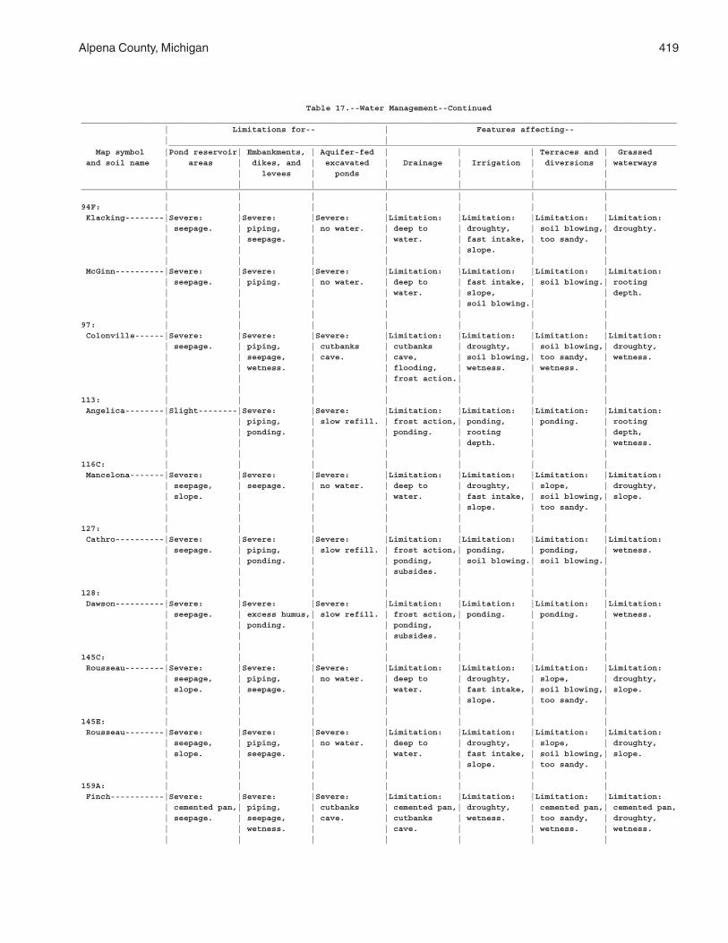
Alpena County, Michigan 419
Table 17.--Water Management--Continued__________________________________________________________________________________________________________________________ | Limitations for-- | Features affecting-- | | ________________________________________________________________________________________________________ Map symbol |Pond reservoir| Embankments, | Aquifer-fed | | | Terraces and | Grassed and soil name | areas | dikes, and | excavated | Drainage | Irrigation | diversions | waterways | | levees | ponds | | | | | | | | | | |__________________________________________________________________________________________________________________________ | | | | | | |94F: | | | | | | | Klacking--------|Severe: |Severe: |Severe: |Limitation: |Limitation: |Limitation: |Limitation: | seepage. | piping, | no water. | deep to | droughty, | soil blowing,| droughty. | | seepage. | | water. | fast intake, | too sandy. | | | | | | slope. | | | | | | | | | McGinn----------|Severe: |Severe: |Severe: |Limitation: |Limitation: |Limitation: |Limitation: | seepage. | piping. | no water. | deep to | fast intake, | soil blowing.| rooting | | | | water. | slope, | | depth. | | | | | soil blowing.| | | | | | | | |97: | | | | | | | Colonville------|Severe: |Severe: |Severe: |Limitation: |Limitation: |Limitation: |Limitation: | seepage. | piping, | cutbanks | cutbanks | droughty, | soil blowing,| droughty, | | seepage, | cave. | cave, | soil blowing,| too sandy, | wetness. | | wetness. | | flooding, | wetness. | wetness. | | | | | frost action.| | | | | | | | | |113: | | | | | | | Angelica--------|Slight--------|Severe: |Severe: |Limitation: |Limitation: |Limitation: |Limitation: | | piping, | slow refill. | frost action,| ponding, | ponding. | rooting | | ponding. | | ponding. | rooting | | depth, | | | | | depth. | | wetness. | | | | | | |116C: | | | | | | | Mancelona-------|Severe: |Severe: |Severe: |Limitation: |Limitation: |Limitation: |Limitation: | seepage, | seepage. | no water. | deep to | droughty, | slope, | droughty, | slope. | | | water. | fast intake, | soil blowing,| slope. | | | | | slope. | too sandy. | | | | | | | |127: | | | | | | | Cathro----------|Severe: |Severe: |Severe: |Limitation: |Limitation: |Limitation: |Limitation: | seepage. | piping, | slow refill. | frost action,| ponding, | ponding, | wetness. | | ponding. | | ponding, | soil blowing.| soil blowing.| | | | | subsides. | | | | | | | | | |128: | | | | | | | Dawson----------|Severe: |Severe: |Severe: |Limitation: |Limitation: |Limitation: |Limitation: | seepage. | excess humus,| slow refill. | frost action,| ponding. | ponding. | wetness. | | ponding. | | ponding, | | | | | | | subsides. | | | | | | | | | |145C: | | | | | | | Rousseau--------|Severe: |Severe: |Severe: |Limitation: |Limitation: |Limitation: |Limitation: | seepage, | piping, | no water. | deep to | droughty, | slope, | droughty, | slope. | seepage. | | water. | fast intake, | soil blowing,| slope. | | | | | slope. | too sandy. | | | | | | | |145E: | | | | | | | Rousseau--------|Severe: |Severe: |Severe: |Limitation: |Limitation: |Limitation: |Limitation: | seepage, | piping, | no water. | deep to | droughty, | slope, | droughty, | slope. | seepage. | | water. | fast intake, | soil blowing,| slope. | | | | | slope. | too sandy. | | | | | | | |159A: | | | | | | | Finch-----------|Severe: |Severe: |Severe: |Limitation: |Limitation: |Limitation: |Limitation: | cemented pan,| piping, | cutbanks | cemented pan,| droughty, | cemented pan,| cemented pan, | seepage. | seepage, | cave. | cutbanks | wetness. | too sandy, | droughty, | | wetness. | | cave. | | wetness. | wetness. | | | | | | |
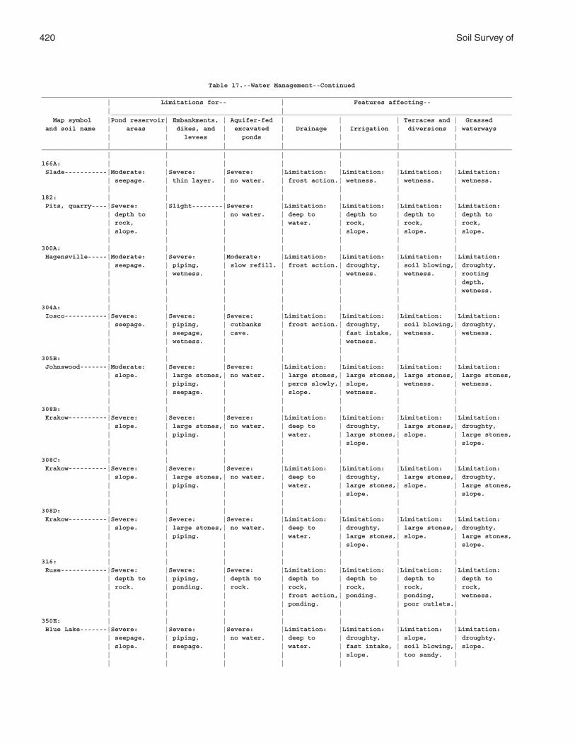
420 Soil Survey of
Table 17.--Water Management--Continued__________________________________________________________________________________________________________________________ | Limitations for-- | Features affecting-- | | ________________________________________________________________________________________________________ Map symbol |Pond reservoir| Embankments, | Aquifer-fed | | | Terraces and | Grassed and soil name | areas | dikes, and | excavated | Drainage | Irrigation | diversions | waterways | | levees | ponds | | | | | | | | | | |__________________________________________________________________________________________________________________________ | | | | | | |166A: | | | | | | | Slade-----------|Moderate: |Severe: |Severe: |Limitation: |Limitation: |Limitation: |Limitation: | seepage. | thin layer. | no water. | frost action.| wetness. | wetness. | wetness. | | | | | | |182: | | | | | | | Pits, quarry----|Severe: |Slight--------|Severe: |Limitation: |Limitation: |Limitation: |Limitation: | depth to | | no water. | deep to | depth to | depth to | depth to | rock, | | | water. | rock, | rock, | rock, | slope. | | | | slope. | slope. | slope. | | | | | | |300A: | | | | | | | Hagensville-----|Moderate: |Severe: |Moderate: |Limitation: |Limitation: |Limitation: |Limitation: | seepage. | piping, | slow refill. | frost action.| droughty, | soil blowing,| droughty, | | wetness. | | | wetness. | wetness. | rooting | | | | | | | depth, | | | | | | | wetness. | | | | | | |304A: | | | | | | | Iosco-----------|Severe: |Severe: |Severe: |Limitation: |Limitation: |Limitation: |Limitation: | seepage. | piping, | cutbanks | frost action.| droughty, | soil blowing,| droughty, | | seepage, | cave. | | fast intake, | wetness. | wetness. | | wetness. | | | wetness. | | | | | | | | |305B: | | | | | | | Johnswood-------|Moderate: |Severe: |Severe: |Limitation: |Limitation: |Limitation: |Limitation: | slope. | large stones,| no water. | large stones,| large stones,| large stones,| large stones, | | piping, | | percs slowly,| slope, | wetness. | wetness. | | seepage. | | slope. | wetness. | | | | | | | | |308B: | | | | | | | Krakow----------|Severe: |Severe: |Severe: |Limitation: |Limitation: |Limitation: |Limitation: | slope. | large stones,| no water. | deep to | droughty, | large stones,| droughty, | | piping. | | water. | large stones,| slope. | large stones, | | | | | slope. | | slope. | | | | | | |308C: | | | | | | | Krakow----------|Severe: |Severe: |Severe: |Limitation: |Limitation: |Limitation: |Limitation: | slope. | large stones,| no water. | deep to | droughty, | large stones,| droughty, | | piping. | | water. | large stones,| slope. | large stones, | | | | | slope. | | slope. | | | | | | |308D: | | | | | | | Krakow----------|Severe: |Severe: |Severe: |Limitation: |Limitation: |Limitation: |Limitation: | slope. | large stones,| no water. | deep to | droughty, | large stones,| droughty, | | piping. | | water. | large stones,| slope. | large stones, | | | | | slope. | | slope. | | | | | | |316: | | | | | | | Ruse------------|Severe: |Severe: |Severe: |Limitation: |Limitation: |Limitation: |Limitation: | depth to | piping, | depth to | depth to | depth to | depth to | depth to | rock. | ponding. | rock. | rock, | rock, | rock, | rock, | | | | frost action,| ponding. | ponding, | wetness. | | | | ponding. | | poor outlets.| | | | | | | |350E: | | | | | | | Blue Lake-------|Severe: |Severe: |Severe: |Limitation: |Limitation: |Limitation: |Limitation: | seepage, | piping, | no water. | deep to | droughty, | slope, | droughty, | slope. | seepage. | | water. | fast intake, | soil blowing,| slope. | | | | | slope. | too sandy. | | | | | | | |
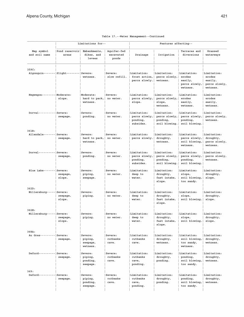
Alpena County, Michigan 421
Table 17.--Water Management--Continued__________________________________________________________________________________________________________________________ | Limitations for-- | Features affecting-- | | ________________________________________________________________________________________________________ Map symbol |Pond reservoir| Embankments, | Aquifer-fed | | | Terraces and | Grassed and soil name | areas | dikes, and | excavated | Drainage | Irrigation | diversions | waterways | | levees | ponds | | | | | | | | | | |__________________________________________________________________________________________________________________________ | | | | | | |359C: | | | | | | | Algonquin-------|Slight--------|Severe: |Severe: |Limitation: |Limitation: |Limitation: |Limitation: | | wetness. | slow refill. | frost action,| percs slowly,| erodes | erodes | | | | percs slowly.| wetness. | easily, | easily, | | | | | | percs slowly,| percs slowly, | | | | | | wetness. | wetness. | | | | | | | Negwegon--------|Moderate: |Moderate: |Severe: |Limitation: |Limitation: |Limitation: |Limitation: | slope. | hard to pack,| no water. | percs slowly,| percs slowly,| erodes | erodes | | wetness. | | slope. | slope, | easily, | easily, | | | | | wetness. | wetness. | wetness. | | | | | | | Dorval----------|Severe: |Severe: |Severe: |Limitation: |Limitation: |Limitation: |Limitation: | seepage. | ponding. | no water. | percs slowly,| percs slowly,| percs slowly,| percs slowly, | | | | ponding, | ponding, | ponding, | wetness. | | | | subsides. | soil blowing.| soil blowing.| | | | | | | |361B: | | | | | | | Allendale-------|Severe: |Severe: |Severe: |Limitation: |Limitation: |Limitation: |Limitation: | seepage. | hard to pack,| no water. | percs slowly.| droughty, | percs slowly,| droughty, | | wetness. | | | wetness. | soil blowing,| percs slowly, | | | | | | wetness. | wetness. | | | | | | | Dorval----------|Severe: |Severe: |Severe: |Limitation: |Limitation: |Limitation: |Limitation: | seepage. | ponding. | no water. | percs slowly,| percs slowly,| percs slowly,| percs slowly, | | | | ponding, | ponding, | ponding, | wetness. | | | | subsides. | soil blowing.| soil blowing.| | | | | | | | Blue Lake-------|Severe: |Severe: |Severe: |Limitation: |Limitation: |Limitation: |Limitation: | seepage, | piping, | no water. | deep to | droughty, | slope, | droughty, | slope. | seepage. | | water. | fast intake, | soil blowing,| slope. | | | | | slope. | too sandy. | | | | | | | |362D: | | | | | | | Millersburg-----|Severe: |Severe: |Severe: |Limitation: |Limitation: |Limitation: |Limitation: | seepage, | piping. | no water. | deep to | droughty, | slope, | droughty, | slope. | | | water. | fast intake, | soil blowing.| slope. | | | | | slope. | | | | | | | | |362E: | | | | | | | Millersburg-----|Severe: |Severe: |Severe: |Limitation: |Limitation: |Limitation: |Limitation: | seepage, | piping. | no water. | deep to | droughty, | slope, | droughty, | slope. | | | water. | fast intake, | soil blowing.| slope. | | | | | slope. | | | | | | | | |368A: | | | | | | | Au Gres---------|Severe: |Severe: |Severe: |Limitation: |Limitation: |Limitation: |Limitation: | seepage. | piping, | cutbanks | cutbanks | droughty, | soil blowing,| droughty, | | seepage, | cave. | cave. | wetness. | too sandy, | wetness. | | wetness. | | | | wetness. | | | | | | | | Deford----------|Severe: |Severe: |Severe: |Limitation: |Limitation: |Limitation: |Limitation: | seepage. | piping, | cutbanks | cutbanks | droughty, | ponding, | droughty, | | ponding, | cave. | cave, | ponding. | soil blowing,| wetness. | | seepage. | | ponding. | | too sandy. | | | | | | | |369: | | | | | | | Deford----------|Severe: |Severe: |Severe: |Limitation: |Limitation: |Limitation: |Limitation: | seepage. | piping, | cutbanks | cutbanks | droughty, | ponding, | droughty, | | ponding, | cave. | cave, | ponding. | soil blowing,| wetness. | | seepage. | | ponding. | | too sandy. | | | | | | | |
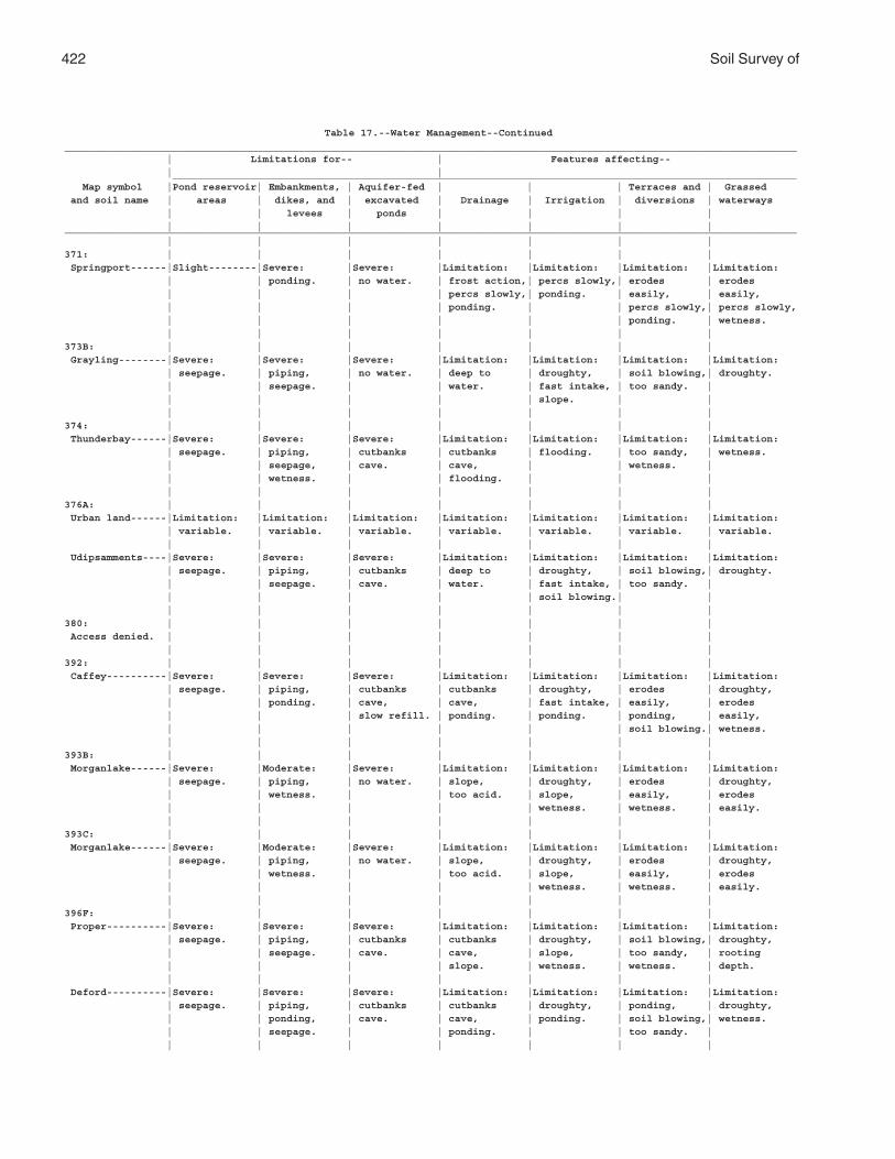
422 Soil Survey of
Table 17.--Water Management--Continued__________________________________________________________________________________________________________________________ | Limitations for-- | Features affecting-- | | ________________________________________________________________________________________________________ Map symbol |Pond reservoir| Embankments, | Aquifer-fed | | | Terraces and | Grassed and soil name | areas | dikes, and | excavated | Drainage | Irrigation | diversions | waterways | | levees | ponds | | | | | | | | | | |__________________________________________________________________________________________________________________________ | | | | | | |371: | | | | | | | Springport------|Slight--------|Severe: |Severe: |Limitation: |Limitation: |Limitation: |Limitation: | | ponding. | no water. | frost action,| percs slowly,| erodes | erodes | | | | percs slowly,| ponding. | easily, | easily, | | | | ponding. | | percs slowly,| percs slowly, | | | | | | ponding. | wetness. | | | | | | |373B: | | | | | | | Grayling--------|Severe: |Severe: |Severe: |Limitation: |Limitation: |Limitation: |Limitation: | seepage. | piping, | no water. | deep to | droughty, | soil blowing,| droughty. | | seepage. | | water. | fast intake, | too sandy. | | | | | | slope. | | | | | | | | |374: | | | | | | | Thunderbay------|Severe: |Severe: |Severe: |Limitation: |Limitation: |Limitation: |Limitation: | seepage. | piping, | cutbanks | cutbanks | flooding. | too sandy, | wetness. | | seepage, | cave. | cave, | | wetness. | | | wetness. | | flooding. | | | | | | | | | |376A: | | | | | | | Urban land------|Limitation: |Limitation: |Limitation: |Limitation: |Limitation: |Limitation: |Limitation: | variable. | variable. | variable. | variable. | variable. | variable. | variable. | | | | | | | Udipsamments----|Severe: |Severe: |Severe: |Limitation: |Limitation: |Limitation: |Limitation: | seepage. | piping, | cutbanks | deep to | droughty, | soil blowing,| droughty. | | seepage. | cave. | water. | fast intake, | too sandy. | | | | | | soil blowing.| | | | | | | | |380: | | | | | | | Access denied. | | | | | | | | | | | | | |392: | | | | | | | Caffey----------|Severe: |Severe: |Severe: |Limitation: |Limitation: |Limitation: |Limitation: | seepage. | piping, | cutbanks | cutbanks | droughty, | erodes | droughty, | | ponding. | cave, | cave, | fast intake, | easily, | erodes | | | slow refill. | ponding. | ponding. | ponding, | easily, | | | | | | soil blowing.| wetness. | | | | | | |393B: | | | | | | | Morganlake------|Severe: |Moderate: |Severe: |Limitation: |Limitation: |Limitation: |Limitation: | seepage. | piping, | no water. | slope, | droughty, | erodes | droughty, | | wetness. | | too acid. | slope, | easily, | erodes | | | | | wetness. | wetness. | easily. | | | | | | |393C: | | | | | | | Morganlake------|Severe: |Moderate: |Severe: |Limitation: |Limitation: |Limitation: |Limitation: | seepage. | piping, | no water. | slope, | droughty, | erodes | droughty, | | wetness. | | too acid. | slope, | easily, | erodes | | | | | wetness. | wetness. | easily. | | | | | | |396F: | | | | | | | Proper----------|Severe: |Severe: |Severe: |Limitation: |Limitation: |Limitation: |Limitation: | seepage. | piping, | cutbanks | cutbanks | droughty, | soil blowing,| droughty, | | seepage. | cave. | cave, | slope, | too sandy, | rooting | | | | slope. | wetness. | wetness. | depth. | | | | | | | Deford----------|Severe: |Severe: |Severe: |Limitation: |Limitation: |Limitation: |Limitation: | seepage. | piping, | cutbanks | cutbanks | droughty, | ponding, | droughty, | | ponding, | cave. | cave, | ponding. | soil blowing,| wetness. | | seepage. | | ponding. | | too sandy. | | | | | | | |
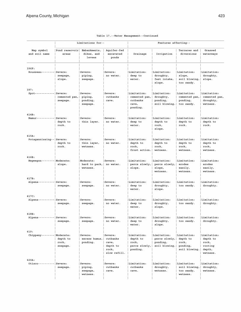
Alpena County, Michigan 423
Table 17.--Water Management--Continued__________________________________________________________________________________________________________________________ | Limitations for-- | Features affecting-- | | ________________________________________________________________________________________________________ Map symbol |Pond reservoir| Embankments, | Aquifer-fed | | | Terraces and | Grassed and soil name | areas | dikes, and | excavated | Drainage | Irrigation | diversions | waterways | | levees | ponds | | | | | | | | | | |__________________________________________________________________________________________________________________________ | | | | | | |396F: | | | | | | | Rousseau--------|Severe: |Severe: |Severe: |Limitation: |Limitation: |Limitation: |Limitation: | seepage, | piping, | no water. | deep to | droughty, | slope, | droughty, | slope. | seepage. | | water. | fast intake, | soil blowing,| slope. | | | | | slope. | too sandy. | | | | | | | |397: | | | | | | | Spot------------|Severe: |Severe: |Severe: |Limitation: |Limitation: |Limitation: |Limitation: | cemented pan,| piping, | cutbanks | cemented pan,| droughty, | cemented pan,| cemented pan, | seepage. | ponding, | cave. | cutbanks | ponding, | ponding, | droughty, | | seepage. | | cave, | soil blowing.| too sandy. | wetness. | | | | ponding. | | | | | | | | | |414B: | | | | | | | Namur-----------|Severe: |Severe: |Severe: |Limitation: |Limitation: |Limitation: |Limitation: | depth to | thin layer. | no water. | deep to | depth to | depth to | depth to | rock. | | | water. | rock, | rock. | rock. | | | | | slope. | | | | | | | | |415A: | | | | | | | Potagannissing--|Severe: |Severe: |Severe: |Limitation: |Limitation: |Limitation: |Limitation: | depth to | thin layer, | no water. | depth to | depth to | depth to | depth to | rock. | wetness. | | rock, | rock, | rock, | rock, | | | | frost action.| wetness. | wetness. | wetness. | | | | | | |416B: | | | | | | | Negwegon--------|Moderate: |Moderate: |Severe: |Limitation: |Limitation: |Limitation: |Limitation: | slope. | hard to pack,| no water. | percs slowly,| percs slowly,| erodes | erodes | | wetness. | | slope. | slope, | easily, | easily, | | | | | wetness. | wetness. | wetness. | | | | | | |417B: | | | | | | | Alpena----------|Severe: |Severe: |Severe: |Limitation: |Limitation: |Limitation: |Limitation: | seepage. | seepage. | no water. | deep to | droughty, | too sandy. | droughty. | | | | water. | slope. | | | | | | | | |417C: | | | | | | | Alpena----------|Severe: |Severe: |Severe: |Limitation: |Limitation: |Limitation: |Limitation: | seepage. | seepage. | no water. | deep to | droughty, | too sandy. | droughty. | | | | water. | slope. | | | | | | | | |418E: | | | | | | | Alpena----------|Severe: |Severe: |Severe: |Limitation: |Limitation: |Limitation: |Limitation: | seepage. | seepage. | no water. | deep to | droughty, | too sandy. | droughty. | | | | water. | slope. | | | | | | | | |419: | | | | | | | Chippeny--------|Moderate: |Severe: |Severe: |Limitation: |Limitation: |Limitation: |Limitation: | depth to | excess humus,| cutbanks | depth to | percs slowly,| depth to | depth to | rock, | ponding. | cave, | rock, | ponding, | rock, | rock, | seepage. | | depth to | percs slowly,| soil blowing.| ponding, | rooting | | | rock, | ponding. | | soil blowing.| depth, | | | slow refill. | | | | wetness. | | | | | | |420A: | | | | | | | Otisco----------|Severe: |Severe: |Severe: |Limitation: |Limitation: |Limitation: |Limitation: | seepage. | piping, | cutbanks | cutbanks | droughty, | soil blowing,| droughty, | | seepage, | cave. | cave. | wetness. | too sandy, | wetness. | | wetness. | | | | wetness. | | | | | | | |
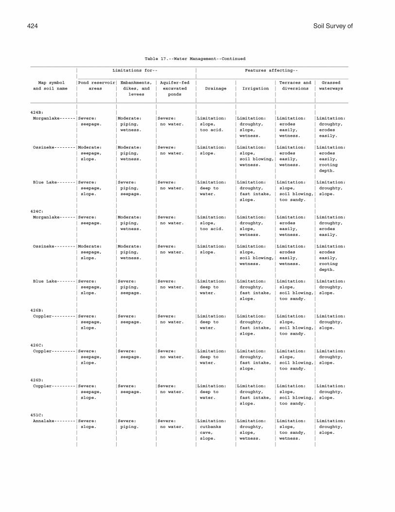
424 Soil Survey of
Table 17.--Water Management--Continued________________________________________________________________________________________________________________________ | Limitations for-- | Features affecting-- | | ______________________________________________________________________________________________________ Map symbol |Pond reservoir| Embankments, | Aquifer-fed | | | Terraces and | Grassed and soil name | areas | dikes, and | excavated | Drainage | Irrigation | diversions | waterways | | levees | ponds | | | | | | | | | | |________________________________________________________________________________________________________________________ | | | | | | |424B: | | | | | | | Morganlake------|Severe: |Moderate: |Severe: |Limitation: |Limitation: |Limitation: |Limitation: | seepage. | piping, | no water. | slope, | droughty, | erodes | droughty, | | wetness. | | too acid. | slope, | easily, | erodes | | | | | wetness. | wetness. | easily. | | | | | | | Ossineke--------|Moderate: |Moderate: |Severe: |Limitation: |Limitation: |Limitation: |Limitation: | seepage, | piping, | no water. | slope. | slope, | erodes | erodes | slope. | wetness. | | | soil blowing,| easily, | easily, | | | | | wetness. | wetness. | rooting | | | | | | | depth. | | | | | | | Blue Lake-------|Severe: |Severe: |Severe: |Limitation: |Limitation: |Limitation: |Limitation: | seepage, | piping, | no water. | deep to | droughty, | slope, | droughty, | slope. | seepage. | | water. | fast intake, | soil blowing,| slope. | | | | | slope. | too sandy. | | | | | | | |424C: | | | | | | | Morganlake------|Severe: |Moderate: |Severe: |Limitation: |Limitation: |Limitation: |Limitation: | seepage. | piping, | no water. | slope, | droughty, | erodes | droughty, | | wetness. | | too acid. | slope, | easily, | erodes | | | | | wetness. | wetness. | easily. | | | | | | | Ossineke--------|Moderate: |Moderate: |Severe: |Limitation: |Limitation: |Limitation: |Limitation: | seepage, | piping, | no water. | slope. | slope, | erodes | erodes | slope. | wetness. | | | soil blowing,| easily, | easily, | | | | | wetness. | wetness. | rooting | | | | | | | depth. | | | | | | | Blue Lake-------|Severe: |Severe: |Severe: |Limitation: |Limitation: |Limitation: |Limitation: | seepage, | piping, | no water. | deep to | droughty, | slope, | droughty, | slope. | seepage. | | water. | fast intake, | soil blowing,| slope. | | | | | slope. | too sandy. | | | | | | | |426B: | | | | | | | Coppler---------|Severe: |Severe: |Severe: |Limitation: |Limitation: |Limitation: |Limitation: | seepage, | seepage. | no water. | deep to | droughty, | slope, | droughty, | slope. | | | water. | fast intake, | soil blowing,| slope. | | | | | slope. | too sandy. | | | | | | | |426C: | | | | | | | Coppler---------|Severe: |Severe: |Severe: |Limitation: |Limitation: |Limitation: |Limitation: | seepage, | seepage. | no water. | deep to | droughty, | slope, | droughty, | slope. | | | water. | fast intake, | soil blowing,| slope. | | | | | slope. | too sandy. | | | | | | | |426D: | | | | | | | Coppler---------|Severe: |Severe: |Severe: |Limitation: |Limitation: |Limitation: |Limitation: | seepage, | seepage. | no water. | deep to | droughty, | slope, | droughty, | slope. | | | water. | fast intake, | soil blowing,| slope. | | | | | slope. | too sandy. | | | | | | | |451C: | | | | | | | Annalake--------|Severe: |Severe: |Severe: |Limitation: |Limitation: |Limitation: |Limitation: | slope. | piping. | no water. | cutbanks | droughty, | slope, | droughty, | | | | cave, | slope, | too sandy, | slope. | | | | slope. | wetness. | wetness. | | | | | | | |
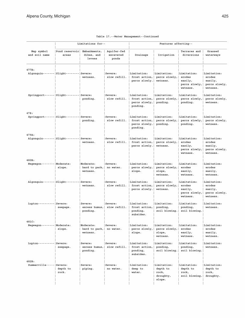
Alpena County, Michigan 425
Table 17.--Water Management--Continued__________________________________________________________________________________________________________________________ | Limitations for-- | Features affecting-- | | ________________________________________________________________________________________________________ Map symbol |Pond reservoir| Embankments, | Aquifer-fed | | | Terraces and | Grassed and soil name | areas | dikes, and | excavated | Drainage | Irrigation | diversions | waterways | | levees | ponds | | | | | | | | | | |__________________________________________________________________________________________________________________________ | | | | | | |477B: | | | | | | | Algonquin-------|Slight--------|Severe: |Severe: |Limitation: |Limitation: |Limitation: |Limitation: | | wetness. | slow refill. | frost action,| percs slowly,| erodes | erodes | | | | percs slowly.| wetness. | easily, | easily, | | | | | | percs slowly,| percs slowly, | | | | | | wetness. | wetness. | | | | | | | Springport------|Slight--------|Severe: |Severe: |Limitation: |Limitation: |Limitation: |Limitation: | | ponding. | slow refill. | frost action,| percs slowly,| percs slowly,| percs slowly, | | | | percs slowly,| ponding. | ponding. | wetness. | | | | ponding. | | | | | | | | | |478: | | | | | | | Springport------|Slight--------|Severe: |Severe: |Limitation: |Limitation: |Limitation: |Limitation: | | ponding. | slow refill. | frost action,| percs slowly,| percs slowly,| percs slowly, | | | | percs slowly,| ponding. | ponding. | wetness. | | | | ponding. | | | | | | | | | |479A: | | | | | | | Algonquin-------|Slight--------|Severe: |Severe: |Limitation: |Limitation: |Limitation: |Limitation: | | wetness. | slow refill. | frost action,| percs slowly,| erodes | erodes | | | | percs slowly.| wetness. | easily, | easily, | | | | | | percs slowly,| percs slowly, | | | | | | wetness. | wetness. | | | | | | |480B: | | | | | | | Negwegon--------|Moderate: |Moderate: |Severe: |Limitation: |Limitation: |Limitation: |Limitation: | slope. | hard to pack,| no water. | percs slowly,| percs slowly,| erodes | erodes | | wetness. | | slope. | slope, | easily, | easily, | | | | | wetness. | wetness. | wetness. | | | | | | | Algonquin-------|Slight--------|Severe: |Severe: |Limitation: |Limitation: |Limitation: |Limitation: | | wetness. | slow refill. | frost action,| percs slowly,| erodes | erodes | | | | percs slowly.| wetness. | easily, | easily, | | | | | | percs slowly,| percs slowly, | | | | | | wetness. | wetness. | | | | | | | Lupton----------|Severe: |Severe: |Severe: |Limitation: |Limitation: |Limitation: |Limitation: | seepage. | excess humus,| slow refill. | frost action,| ponding, | ponding, | wetness. | | ponding. | | ponding, | soil blowing.| soil blowing.| | | | | subsides. | | | | | | | | | |481C: | | | | | | | Negwegon--------|Moderate: |Moderate: |Severe: |Limitation: |Limitation: |Limitation: |Limitation: | slope. | hard to pack,| no water. | percs slowly,| percs slowly,| erodes | erodes | | wetness. | | slope. | slope, | easily, | easily, | | | | | wetness. | wetness. | wetness. | | | | | | | Lupton----------|Severe: |Severe: |Severe: |Limitation: |Limitation: |Limitation: |Limitation: | seepage. | excess humus,| slow refill. | frost action,| ponding, | ponding, | wetness. | | ponding. | | ponding, | soil blowing.| soil blowing.| | | | | subsides. | | | | | | | | | |482B: | | | | | | | Summerville-----|Severe: |Severe: |Severe: |Limitation: |Limitation: |Limitation: |Limitation: | depth to | piping. | no water. | deep to | depth to | depth to | depth to | rock. | | | water. | rock, | rock, | rock, | | | | | droughty, | soil blowing.| droughty. | | | | | slope. | | | | | | | | |
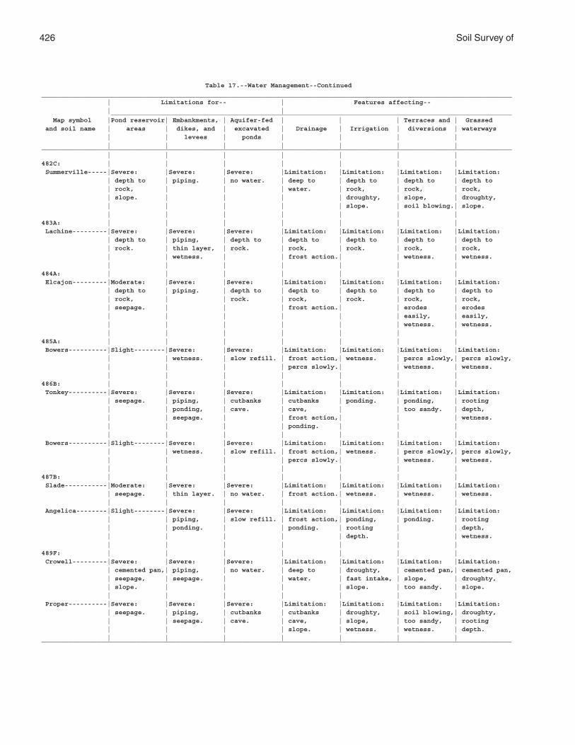
426 Soil Survey of
Table 17.--Water Management--Continued__________________________________________________________________________________________________________________________ | Limitations for-- | Features affecting-- | | ________________________________________________________________________________________________________ Map symbol |Pond reservoir| Embankments, | Aquifer-fed | | | Terraces and | Grassed and soil name | areas | dikes, and | excavated | Drainage | Irrigation | diversions | waterways | | levees | ponds | | | | | | | | | | |__________________________________________________________________________________________________________________________ | | | | | | |482C: | | | | | | | Summerville-----|Severe: |Severe: |Severe: |Limitation: |Limitation: |Limitation: |Limitation: | depth to | piping. | no water. | deep to | depth to | depth to | depth to | rock, | | | water. | rock, | rock, | rock, | slope. | | | | droughty, | slope, | droughty, | | | | | slope. | soil blowing.| slope. | | | | | | |483A: | | | | | | | Lachine---------|Severe: |Severe: |Severe: |Limitation: |Limitation: |Limitation: |Limitation: | depth to | piping, | depth to | depth to | depth to | depth to | depth to | rock. | thin layer, | rock. | rock, | rock. | rock, | rock, | | wetness. | | frost action.| | wetness. | wetness. | | | | | | |484A: | | | | | | | Elcajon---------|Moderate: |Severe: |Severe: |Limitation: |Limitation: |Limitation: |Limitation: | depth to | piping. | depth to | depth to | depth to | depth to | depth to | rock, | | rock. | rock, | rock. | rock, | rock, | seepage. | | | frost action.| | erodes | erodes | | | | | | easily, | easily, | | | | | | wetness. | wetness. | | | | | | |485A: | | | | | | | Bowers----------|Slight--------|Severe: |Severe: |Limitation: |Limitation: |Limitation: |Limitation: | | wetness. | slow refill. | frost action,| wetness. | percs slowly,| percs slowly, | | | | percs slowly.| | wetness. | wetness. | | | | | | |486B: | | | | | | | Tonkey----------|Severe: |Severe: |Severe: |Limitation: |Limitation: |Limitation: |Limitation: | seepage. | piping, | cutbanks | cutbanks | ponding. | ponding, | rooting | | ponding, | cave. | cave, | | too sandy. | depth, | | seepage. | | frost action,| | | wetness. | | | | ponding. | | | | | | | | | | Bowers----------|Slight--------|Severe: |Severe: |Limitation: |Limitation: |Limitation: |Limitation: | | wetness. | slow refill. | frost action,| wetness. | percs slowly,| percs slowly, | | | | percs slowly.| | wetness. | wetness. | | | | | | |487B: | | | | | | | Slade-----------|Moderate: |Severe: |Severe: |Limitation: |Limitation: |Limitation: |Limitation: | seepage. | thin layer. | no water. | frost action.| wetness. | wetness. | wetness. | | | | | | | Angelica--------|Slight--------|Severe: |Severe: |Limitation: |Limitation: |Limitation: |Limitation: | | piping, | slow refill. | frost action,| ponding, | ponding. | rooting | | ponding. | | ponding. | rooting | | depth, | | | | | depth. | | wetness. | | | | | | |489F: | | | | | | | Crowell---------|Severe: |Severe: |Severe: |Limitation: |Limitation: |Limitation: |Limitation: | cemented pan,| piping, | no water. | deep to | droughty, | cemented pan,| cemented pan, | seepage, | seepage. | | water. | fast intake, | slope, | droughty, | slope. | | | | slope. | too sandy. | slope. | | | | | | | Proper----------|Severe: |Severe: |Severe: |Limitation: |Limitation: |Limitation: |Limitation: | seepage. | piping, | cutbanks | cutbanks | droughty, | soil blowing,| droughty, | | seepage. | cave. | cave, | slope, | too sandy, | rooting | | | | slope. | wetness. | wetness. | depth. | | | | | | |_______________________________________________________________________________________________________________________
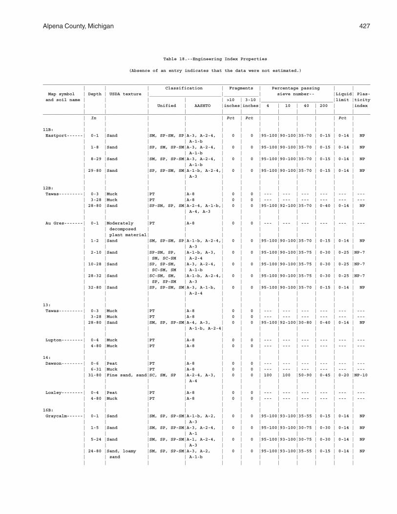
Alpena County, Michigan 427
Table 18.--Engineering Index Properties
(Absence of an entry indicates that the data were not estimated.)
___________________________________________________________________________________________________________________________ | | | Classification | Fragments | Percentage passing | | Map symbol | Depth | USDA texture |___________________________|_____________| sieve number-- |Liquid| Plas- and soil name | | | | | >10 | 3-10 |___________________________|limit |ticity | | | Unified | AASHTO |inches|inches| 4 | 10 | 40 | 200 | |index | | | | | | | | | | | |___________________________________________________________________________________________________________________________ | In | | | | Pct | Pct | | | | | Pct | | | | | | | | | | | | |11B: | | | | | | | | | | | | Eastport------| 0-1 |Sand |SM, SP-SM, SP|A-3, A-2-4, | 0 | 0 |95-100|90-100|35-70 | 0-15 | 0-14 | NP | | | | A-1-b | | | | | | | | | 1-8 |Sand |SP, SM, SP-SM|A-3, A-2-4, | 0 | 0 |95-100|90-100|35-70 | 0-15 | 0-14 | NP | | | | A-1-b | | | | | | | | | 8-29 |Sand |SM, SP, SP-SM|A-3, A-2-4, | 0 | 0 |95-100|90-100|35-70 | 0-15 | 0-14 | NP | | | | A-1-b | | | | | | | | | 29-80 |Sand |SP, SP-SM, SM|A-1-b, A-2-4,| 0 | 0 |95-100|90-100|35-70 | 0-15 | 0-14 | NP | | | | A-3 | | | | | | | | | | | | | | | | | | | |12B: | | | | | | | | | | | | Tawas---------| 0-3 |Muck |PT |A-8 | 0 | 0 | --- | --- | --- | --- | --- | --- | 3-28 |Muck |PT |A-8 | 0 | 0 | --- | --- | --- | --- | --- | --- | 28-80 |Sand |SP-SM, SP, SM|A-2-4, A-1-b,| 0 | 0 |95-100|92-100|35-70 | 0-40 | 0-14 | NP | | | | A-4, A-3 | | | | | | | | | | | | | | | | | | | | Au Gres-------| 0-1 |Moderately |PT |A-8 | 0 | 0 | --- | --- | --- | --- | --- | --- | | decomposed | | | | | | | | | | | | plant material| | | | | | | | | | | 1-2 |Sand |SM, SP-SM, SP|A-1-b, A-2-4,| 0 | 0 |95-100|90-100|35-70 | 0-15 | 0-14 | NP | | | | A-3 | | | | | | | | | 2-10 |Sand |SP-SM, SP, |A-1-b, A-3, | 0 | 0 |95-100|90-100|35-75 | 0-30 | 0-25 |NP-7 | | | SM, SC-SM | A-2-4 | | | | | | | | | 10-28 |Sand |SP, SP-SM, |A-3, A-2-4, | 0 | 0 |95-100|90-100|35-75 | 0-30 | 0-25 |NP-7 | | | SC-SM, SM | A-1-b | | | | | | | | | 28-32 |Sand |SC-SM, SM, |A-1-b, A-2-4,| 0 | 0 |95-100|90-100|35-75 | 0-30 | 0-25 |NP-7 | | | SP, SP-SM | A-3 | | | | | | | | | 32-80 |Sand |SP, SP-SM, SM|A-3, A-1-b, | 0 | 0 |95-100|90-100|35-70 | 0-15 | 0-14 | NP | | | | A-2-4 | | | | | | | | | | | | | | | | | | | |13: | | | | | | | | | | | | Tawas---------| 0-3 |Muck |PT |A-8 | 0 | 0 | --- | --- | --- | --- | --- | --- | 3-28 |Muck |PT |A-8 | 0 | 0 | --- | --- | --- | --- | --- | --- | 28-80 |Sand |SM, SP, SP-SM|A-4, A-3, | 0 | 0 |95-100|92-100|30-80 | 0-40 | 0-14 | NP | | | | A-1-b, A-2-4| | | | | | | | | | | | | | | | | | | | Lupton--------| 0-4 |Muck |PT |A-8 | 0 | 0 | --- | --- | --- | --- | --- | --- | 4-80 |Muck |PT |A-8 | 0 | 0 | --- | --- | --- | --- | --- | --- | | | | | | | | | | | |14: | | | | | | | | | | | | Dawson--------| 0-6 |Peat |PT |A-8 | 0 | 0 | --- | --- | --- | --- | --- | --- | 6-31 |Muck |PT |A-8 | 0 | 0 | --- | --- | --- | --- | --- | --- | 31-80 |Fine sand, sand|SC, SM, SP |A-2-4, A-3, | 0 | 0 | 100 | 100 |50-90 | 0-45 | 0-20 |NP-10 | | | | A-4 | | | | | | | | | | | | | | | | | | | | Loxley--------| 0-4 |Peat |PT |A-8 | 0 | 0 | --- | --- | --- | --- | --- | --- | 4-80 |Muck |PT |A-8 | 0 | 0 | --- | --- | --- | --- | --- | --- | | | | | | | | | | | |16B: | | | | | | | | | | | | Graycalm------| 0-1 |Sand |SM, SP, SP-SM|A-1-b, A-2, | 0 | 0 |95-100|93-100|35-55 | 0-15 | 0-14 | NP | | | | A-3 | | | | | | | | | 1-5 |Sand |SM, SP, SP-SM|A-3, A-2-4, | 0 | 0 |95-100|93-100|30-75 | 0-30 | 0-14 | NP | | | | A-1 | | | | | | | | | 5-24 |Sand |SM, SP, SP-SM|A-1, A-2-4, | 0 | 0 |95-100|93-100|30-75 | 0-30 | 0-14 | NP | | | | A-3 | | | | | | | | | 24-80 |Sand, loamy |SM, SP, SP-SM|A-3, A-2, | 0 | 0 |95-100|93-100|35-55 | 0-15 | 0-14 | NP | | sand | | A-1-b | | | | | | | | | | | | | | | | | | | |
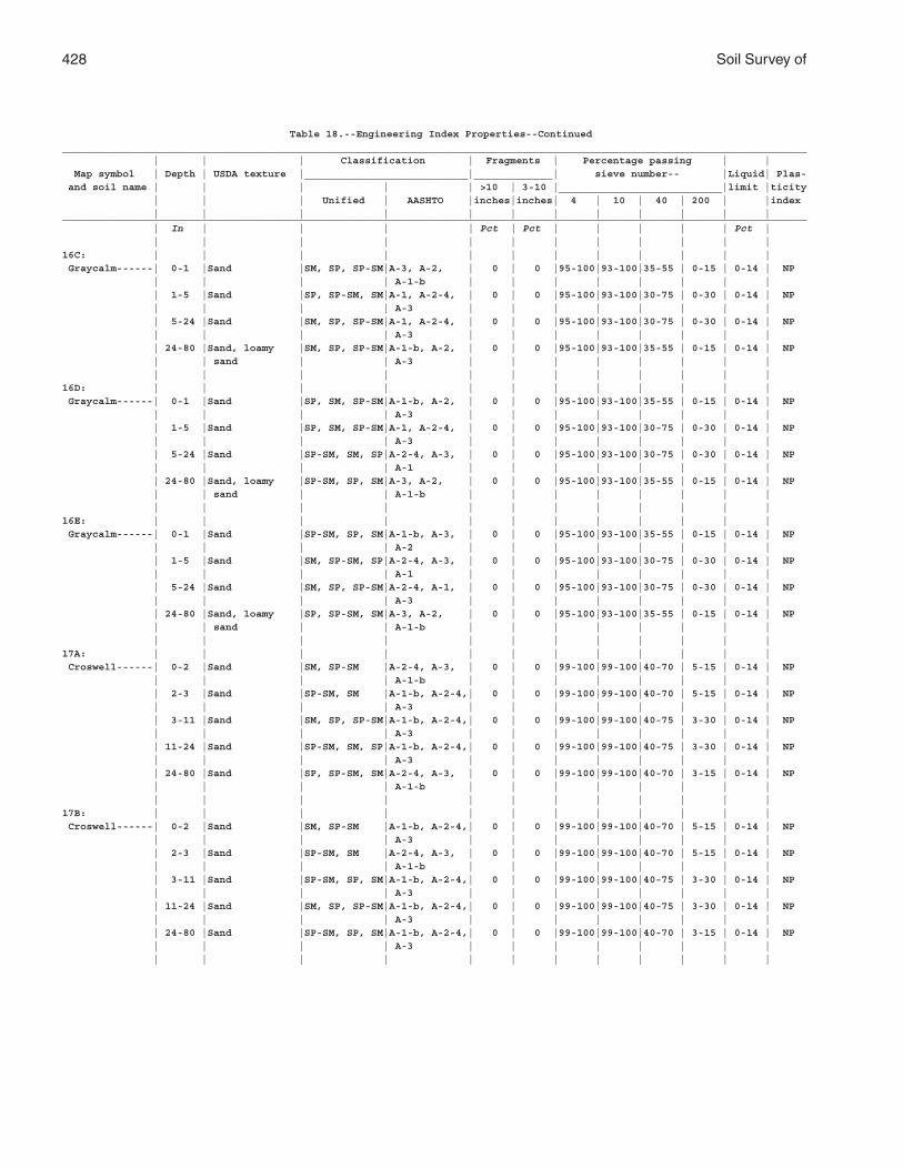
428 Soil Survey of
Table 18.--Engineering Index Properties--Continued___________________________________________________________________________________________________________________________ | | | Classification | Fragments | Percentage passing | | Map symbol | Depth | USDA texture |___________________________|_____________| sieve number-- |Liquid| Plas- and soil name | | | | | >10 | 3-10 |___________________________|limit |ticity | | | Unified | AASHTO |inches|inches| 4 | 10 | 40 | 200 | |index | | | | | | | | | | | |___________________________________________________________________________________________________________________________ | In | | | | Pct | Pct | | | | | Pct | | | | | | | | | | | | |16C: | | | | | | | | | | | | Graycalm------| 0-1 |Sand |SM, SP, SP-SM|A-3, A-2, | 0 | 0 |95-100|93-100|35-55 | 0-15 | 0-14 | NP | | | | A-1-b | | | | | | | | | 1-5 |Sand |SP, SP-SM, SM|A-1, A-2-4, | 0 | 0 |95-100|93-100|30-75 | 0-30 | 0-14 | NP | | | | A-3 | | | | | | | | | 5-24 |Sand |SM, SP, SP-SM|A-1, A-2-4, | 0 | 0 |95-100|93-100|30-75 | 0-30 | 0-14 | NP | | | | A-3 | | | | | | | | | 24-80 |Sand, loamy |SM, SP, SP-SM|A-1-b, A-2, | 0 | 0 |95-100|93-100|35-55 | 0-15 | 0-14 | NP | | sand | | A-3 | | | | | | | | | | | | | | | | | | | |16D: | | | | | | | | | | | | Graycalm------| 0-1 |Sand |SP, SM, SP-SM|A-1-b, A-2, | 0 | 0 |95-100|93-100|35-55 | 0-15 | 0-14 | NP | | | | A-3 | | | | | | | | | 1-5 |Sand |SP, SM, SP-SM|A-1, A-2-4, | 0 | 0 |95-100|93-100|30-75 | 0-30 | 0-14 | NP | | | | A-3 | | | | | | | | | 5-24 |Sand |SP-SM, SM, SP|A-2-4, A-3, | 0 | 0 |95-100|93-100|30-75 | 0-30 | 0-14 | NP | | | | A-1 | | | | | | | | | 24-80 |Sand, loamy |SP-SM, SP, SM|A-3, A-2, | 0 | 0 |95-100|93-100|35-55 | 0-15 | 0-14 | NP | | sand | | A-1-b | | | | | | | | | | | | | | | | | | | |16E: | | | | | | | | | | | | Graycalm------| 0-1 |Sand |SP-SM, SP, SM|A-1-b, A-3, | 0 | 0 |95-100|93-100|35-55 | 0-15 | 0-14 | NP | | | | A-2 | | | | | | | | | 1-5 |Sand |SM, SP-SM, SP|A-2-4, A-3, | 0 | 0 |95-100|93-100|30-75 | 0-30 | 0-14 | NP | | | | A-1 | | | | | | | | | 5-24 |Sand |SM, SP, SP-SM|A-2-4, A-1, | 0 | 0 |95-100|93-100|30-75 | 0-30 | 0-14 | NP | | | | A-3 | | | | | | | | | 24-80 |Sand, loamy |SP, SP-SM, SM|A-3, A-2, | 0 | 0 |95-100|93-100|35-55 | 0-15 | 0-14 | NP | | sand | | A-1-b | | | | | | | | | | | | | | | | | | | |17A: | | | | | | | | | | | | Croswell------| 0-2 |Sand |SM, SP-SM |A-2-4, A-3, | 0 | 0 |99-100|99-100|40-70 | 5-15 | 0-14 | NP | | | | A-1-b | | | | | | | | | 2-3 |Sand |SP-SM, SM |A-1-b, A-2-4,| 0 | 0 |99-100|99-100|40-70 | 5-15 | 0-14 | NP | | | | A-3 | | | | | | | | | 3-11 |Sand |SM, SP, SP-SM|A-1-b, A-2-4,| 0 | 0 |99-100|99-100|40-75 | 3-30 | 0-14 | NP | | | | A-3 | | | | | | | | | 11-24 |Sand |SP-SM, SM, SP|A-1-b, A-2-4,| 0 | 0 |99-100|99-100|40-75 | 3-30 | 0-14 | NP | | | | A-3 | | | | | | | | | 24-80 |Sand |SP, SP-SM, SM|A-2-4, A-3, | 0 | 0 |99-100|99-100|40-70 | 3-15 | 0-14 | NP | | | | A-1-b | | | | | | | | | | | | | | | | | | | |17B: | | | | | | | | | | | | Croswell------| 0-2 |Sand |SM, SP-SM |A-1-b, A-2-4,| 0 | 0 |99-100|99-100|40-70 | 5-15 | 0-14 | NP | | | | A-3 | | | | | | | | | 2-3 |Sand |SP-SM, SM |A-2-4, A-3, | 0 | 0 |99-100|99-100|40-70 | 5-15 | 0-14 | NP | | | | A-1-b | | | | | | | | | 3-11 |Sand |SP-SM, SP, SM|A-1-b, A-2-4,| 0 | 0 |99-100|99-100|40-75 | 3-30 | 0-14 | NP | | | | A-3 | | | | | | | | | 11-24 |Sand |SM, SP, SP-SM|A-1-b, A-2-4,| 0 | 0 |99-100|99-100|40-75 | 3-30 | 0-14 | NP | | | | A-3 | | | | | | | | | 24-80 |Sand |SP-SM, SP, SM|A-1-b, A-2-4,| 0 | 0 |99-100|99-100|40-70 | 3-15 | 0-14 | NP | | | | A-3 | | | | | | | | | | | | | | | | | | | |
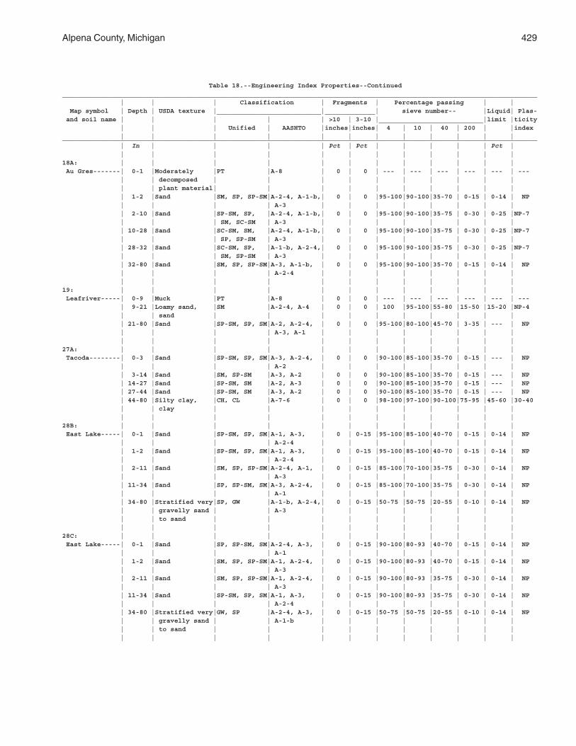
Alpena County, Michigan 429
Table 18.--Engineering Index Properties--Continued___________________________________________________________________________________________________________________________ | | | Classification | Fragments | Percentage passing | | Map symbol | Depth | USDA texture |___________________________|_____________| sieve number-- |Liquid| Plas- and soil name | | | | | >10 | 3-10 |___________________________|limit |ticity | | | Unified | AASHTO |inches|inches| 4 | 10 | 40 | 200 | |index | | | | | | | | | | | |___________________________________________________________________________________________________________________________ | In | | | | Pct | Pct | | | | | Pct | | | | | | | | | | | | |18A: | | | | | | | | | | | | Au Gres-------| 0-1 |Moderately |PT |A-8 | 0 | 0 | --- | --- | --- | --- | --- | --- | | decomposed | | | | | | | | | | | | plant material| | | | | | | | | | | 1-2 |Sand |SM, SP, SP-SM|A-2-4, A-1-b,| 0 | 0 |95-100|90-100|35-70 | 0-15 | 0-14 | NP | | | | A-3 | | | | | | | | | 2-10 |Sand |SP-SM, SP, |A-2-4, A-1-b,| 0 | 0 |95-100|90-100|35-75 | 0-30 | 0-25 |NP-7 | | | SM, SC-SM | A-3 | | | | | | | | | 10-28 |Sand |SC-SM, SM, |A-2-4, A-1-b,| 0 | 0 |95-100|90-100|35-75 | 0-30 | 0-25 |NP-7 | | | SP, SP-SM | A-3 | | | | | | | | | 28-32 |Sand |SC-SM, SP, |A-1-b, A-2-4,| 0 | 0 |95-100|90-100|35-75 | 0-30 | 0-25 |NP-7 | | | SM, SP-SM | A-3 | | | | | | | | | 32-80 |Sand |SM, SP, SP-SM|A-3, A-1-b, | 0 | 0 |95-100|90-100|35-70 | 0-15 | 0-14 | NP | | | | A-2-4 | | | | | | | | | | | | | | | | | | | |19: | | | | | | | | | | | | Leafriver-----| 0-9 |Muck |PT |A-8 | 0 | 0 | --- | --- | --- | --- | --- | --- | 9-21 |Loamy sand, |SM |A-2-4, A-4 | 0 | 0 | 100 |95-100|55-80 |15-50 |15-20 |NP-4 | | sand | | | | | | | | | | | 21-80 |Sand |SP-SM, SP, SM|A-2, A-2-4, | 0 | 0 |95-100|80-100|45-70 | 3-35 | --- | NP | | | | A-3, A-1 | | | | | | | | | | | | | | | | | | | |27A: | | | | | | | | | | | | Tacoda--------| 0-3 |Sand |SP-SM, SP, SM|A-3, A-2-4, | 0 | 0 |90-100|85-100|35-70 | 0-15 | --- | NP | | | | A-2 | | | | | | | | | 3-14 |Sand |SM, SP-SM |A-3, A-2 | 0 | 0 |90-100|85-100|35-70 | 0-15 | --- | NP | 14-27 |Sand |SP-SM, SM |A-2, A-3 | 0 | 0 |90-100|85-100|35-70 | 0-15 | --- | NP | 27-44 |Sand |SP-SM, SM |A-3, A-2 | 0 | 0 |90-100|85-100|35-70 | 0-15 | --- | NP | 44-80 |Silty clay, |CH, CL |A-7-6 | 0 | 0 |98-100|97-100|90-100|75-95 |45-60 |30-40 | | clay | | | | | | | | | | | | | | | | | | | | | |28B: | | | | | | | | | | | | East Lake-----| 0-1 |Sand |SP-SM, SP, SM|A-1, A-3, | 0 | 0-15 |95-100|85-100|40-70 | 0-15 | 0-14 | NP | | | | A-2-4 | | | | | | | | | 1-2 |Sand |SP-SM, SP, SM|A-1, A-3, | 0 | 0-15 |95-100|85-100|40-70 | 0-15 | 0-14 | NP | | | | A-2-4 | | | | | | | | | 2-11 |Sand |SM, SP, SP-SM|A-2-4, A-1, | 0 | 0-15 |85-100|70-100|35-75 | 0-30 | 0-14 | NP | | | | A-3 | | | | | | | | | 11-34 |Sand |SP, SP-SM, SM|A-3, A-2-4, | 0 | 0-15 |85-100|70-100|35-75 | 0-30 | 0-14 | NP | | | | A-1 | | | | | | | | | 34-80 |Stratified very|SP, GW |A-1-b, A-2-4,| 0 | 0-15 |50-75 |50-75 |20-55 | 0-10 | 0-14 | NP | | gravelly sand | | A-3 | | | | | | | | | | to sand | | | | | | | | | | | | | | | | | | | | | |28C: | | | | | | | | | | | | East Lake-----| 0-1 |Sand |SP, SP-SM, SM|A-2-4, A-3, | 0 | 0-15 |90-100|80-93 |40-70 | 0-15 | 0-14 | NP | | | | A-1 | | | | | | | | | 1-2 |Sand |SM, SP, SP-SM|A-1, A-2-4, | 0 | 0-15 |90-100|80-93 |40-70 | 0-15 | 0-14 | NP | | | | A-3 | | | | | | | | | 2-11 |Sand |SM, SP, SP-SM|A-1, A-2-4, | 0 | 0-15 |90-100|80-93 |35-75 | 0-30 | 0-14 | NP | | | | A-3 | | | | | | | | | 11-34 |Sand |SP-SM, SP, SM|A-1, A-3, | 0 | 0-15 |90-100|80-93 |35-75 | 0-30 | 0-14 | NP | | | | A-2-4 | | | | | | | | | 34-80 |Stratified very|GW, SP |A-2-4, A-3, | 0 | 0-15 |50-75 |50-75 |20-55 | 0-10 | 0-14 | NP | | gravelly sand | | A-1-b | | | | | | | | | | to sand | | | | | | | | | | | | | | | | | | | | | |
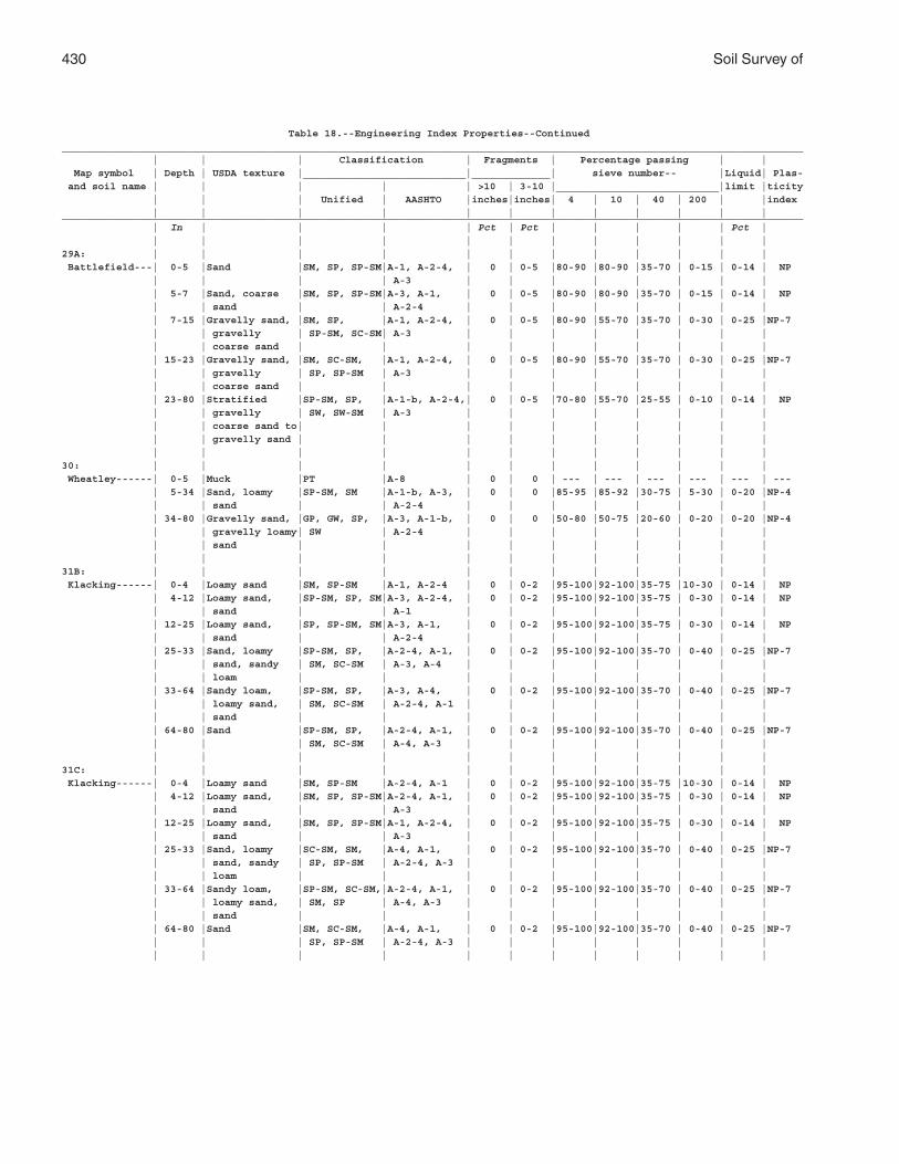
430 Soil Survey of
Table 18.--Engineering Index Properties--Continued___________________________________________________________________________________________________________________________ | | | Classification | Fragments | Percentage passing | | Map symbol | Depth | USDA texture |___________________________|_____________| sieve number-- |Liquid| Plas- and soil name | | | | | >10 | 3-10 |___________________________|limit |ticity | | | Unified | AASHTO |inches|inches| 4 | 10 | 40 | 200 | |index | | | | | | | | | | | |___________________________________________________________________________________________________________________________ | In | | | | Pct | Pct | | | | | Pct | | | | | | | | | | | | |29A: | | | | | | | | | | | | Battlefield---| 0-5 |Sand |SM, SP, SP-SM|A-1, A-2-4, | 0 | 0-5 |80-90 |80-90 |35-70 | 0-15 | 0-14 | NP | | | | A-3 | | | | | | | | | 5-7 |Sand, coarse |SM, SP, SP-SM|A-3, A-1, | 0 | 0-5 |80-90 |80-90 |35-70 | 0-15 | 0-14 | NP | | sand | | A-2-4 | | | | | | | | | 7-15 |Gravelly sand, |SM, SP, |A-1, A-2-4, | 0 | 0-5 |80-90 |55-70 |35-70 | 0-30 | 0-25 |NP-7 | | gravelly | SP-SM, SC-SM| A-3 | | | | | | | | | | coarse sand | | | | | | | | | | | 15-23 |Gravelly sand, |SM, SC-SM, |A-1, A-2-4, | 0 | 0-5 |80-90 |55-70 |35-70 | 0-30 | 0-25 |NP-7 | | gravelly | SP, SP-SM | A-3 | | | | | | | | | | coarse sand | | | | | | | | | | | 23-80 |Stratified |SP-SM, SP, |A-1-b, A-2-4,| 0 | 0-5 |70-80 |55-70 |25-55 | 0-10 | 0-14 | NP | | gravelly | SW, SW-SM | A-3 | | | | | | | | | | coarse sand to| | | | | | | | | | | | gravelly sand | | | | | | | | | | | | | | | | | | | | | |30: | | | | | | | | | | | | Wheatley------| 0-5 |Muck |PT |A-8 | 0 | 0 | --- | --- | --- | --- | --- | --- | 5-34 |Sand, loamy |SP-SM, SM |A-1-b, A-3, | 0 | 0 |85-95 |85-92 |30-75 | 5-30 | 0-20 |NP-4 | | sand | | A-2-4 | | | | | | | | | 34-80 |Gravelly sand, |GP, GW, SP, |A-3, A-1-b, | 0 | 0 |50-80 |50-75 |20-60 | 0-20 | 0-20 |NP-4 | | gravelly loamy| SW | A-2-4 | | | | | | | | | | sand | | | | | | | | | | | | | | | | | | | | | |31B: | | | | | | | | | | | | Klacking------| 0-4 |Loamy sand |SM, SP-SM |A-1, A-2-4 | 0 | 0-2 |95-100|92-100|35-75 |10-30 | 0-14 | NP | 4-12 |Loamy sand, |SP-SM, SP, SM|A-3, A-2-4, | 0 | 0-2 |95-100|92-100|35-75 | 0-30 | 0-14 | NP | | sand | | A-1 | | | | | | | | | 12-25 |Loamy sand, |SP, SP-SM, SM|A-3, A-1, | 0 | 0-2 |95-100|92-100|35-75 | 0-30 | 0-14 | NP | | sand | | A-2-4 | | | | | | | | | 25-33 |Sand, loamy |SP-SM, SP, |A-2-4, A-1, | 0 | 0-2 |95-100|92-100|35-70 | 0-40 | 0-25 |NP-7 | | sand, sandy | SM, SC-SM | A-3, A-4 | | | | | | | | | | loam | | | | | | | | | | | 33-64 |Sandy loam, |SP-SM, SP, |A-3, A-4, | 0 | 0-2 |95-100|92-100|35-70 | 0-40 | 0-25 |NP-7 | | loamy sand, | SM, SC-SM | A-2-4, A-1 | | | | | | | | | | sand | | | | | | | | | | | 64-80 |Sand |SP-SM, SP, |A-2-4, A-1, | 0 | 0-2 |95-100|92-100|35-70 | 0-40 | 0-25 |NP-7 | | | SM, SC-SM | A-4, A-3 | | | | | | | | | | | | | | | | | | | |31C: | | | | | | | | | | | | Klacking------| 0-4 |Loamy sand |SM, SP-SM |A-2-4, A-1 | 0 | 0-2 |95-100|92-100|35-75 |10-30 | 0-14 | NP | 4-12 |Loamy sand, |SM, SP, SP-SM|A-2-4, A-1, | 0 | 0-2 |95-100|92-100|35-75 | 0-30 | 0-14 | NP | | sand | | A-3 | | | | | | | | | 12-25 |Loamy sand, |SM, SP, SP-SM|A-1, A-2-4, | 0 | 0-2 |95-100|92-100|35-75 | 0-30 | 0-14 | NP | | sand | | A-3 | | | | | | | | | 25-33 |Sand, loamy |SC-SM, SM, |A-4, A-1, | 0 | 0-2 |95-100|92-100|35-70 | 0-40 | 0-25 |NP-7 | | sand, sandy | SP, SP-SM | A-2-4, A-3 | | | | | | | | | | loam | | | | | | | | | | | 33-64 |Sandy loam, |SP-SM, SC-SM,|A-2-4, A-1, | 0 | 0-2 |95-100|92-100|35-70 | 0-40 | 0-25 |NP-7 | | loamy sand, | SM, SP | A-4, A-3 | | | | | | | | | | sand | | | | | | | | | | | 64-80 |Sand |SM, SC-SM, |A-4, A-1, | 0 | 0-2 |95-100|92-100|35-70 | 0-40 | 0-25 |NP-7 | | | SP, SP-SM | A-2-4, A-3 | | | | | | | | | | | | | | | | | | | |
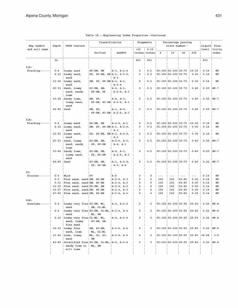
Alpena County, Michigan 431
Table 18.--Engineering Index Properties--Continued___________________________________________________________________________________________________________________________ | | | Classification | Fragments | Percentage passing | | Map symbol | Depth | USDA texture |___________________________|_____________| sieve number-- |Liquid| Plas- and soil name | | | | | >10 | 3-10 |___________________________|limit |ticity | | | Unified | AASHTO |inches|inches| 4 | 10 | 40 | 200 | |index | | | | | | | | | | | |___________________________________________________________________________________________________________________________ | In | | | | Pct | Pct | | | | | Pct | | | | | | | | | | | | |31D: | | | | | | | | | | | | Klacking------| 0-4 |Loamy sand |SP-SM, SM |A-1, A-2-4 | 0 | 0-2 |95-100|92-100|35-75 |10-30 | 0-14 | NP | 4-12 |Loamy sand, |SP, SP-SM, SM|A-1, A-2-4, | 0 | 0-2 |95-100|92-100|35-75 | 0-30 | 0-14 | NP | | sand | | A-3 | | | | | | | | | 12-25 |Loamy sand, |SM, SP, SP-SM|A-3, A-1, | 0 | 0-2 |95-100|92-100|35-75 | 0-30 | 0-14 | NP | | sand | | A-2-4 | | | | | | | | | 25-33 |Sand, loamy |SC-SM, SM, |A-4, A-1, | 0 | 0-2 |95-100|92-100|35-70 | 0-40 | 0-25 |NP-7 | | sand, sandy | SP-SM, SP | A-2-4, A-3 | | | | | | | | | | loam | | | | | | | | | | | 33-64 |Sandy loam, |SM, SP, |A-4, A-3, | 0 | 0-2 |95-100|92-100|35-70 | 0-40 | 0-25 |NP-7 | | loamy sand, | SP-SM, SC-SM| A-2-4, A-1 | | | | | | | | | | sand | | | | | | | | | | | 64-80 |Sand |SM, SP, |A-1, A-4, | 0 | 0-2 |95-100|92-100|35-70 | 0-40 | 0-25 |NP-7 | | | SP-SM, SC-SM| A-2-4, A-3 | | | | | | | | | | | | | | | | | | | |31E: | | | | | | | | | | | | Klacking------| 0-4 |Loamy sand |SP-SM, SM |A-2-4, A-1 | 0 | 0-2 |95-100|92-100|35-75 |10-30 | 0-14 | NP | 4-12 |Loamy sand, |SM, SP, SP-SM|A-1, A-2-4, | 0 | 0-2 |95-100|92-100|35-75 | 0-30 | 0-14 | NP | | sand | | A-3 | | | | | | | | | 12-25 |Loamy sand, |SP, SP-SM, SM|A-1, A-2-4, | 0 | 0-2 |95-100|92-100|35-75 | 0-30 | 0-14 | NP | | sand | | A-3 | | | | | | | | | 25-33 |Sand, loamy |SC-SM, SM, |A-2-4, A-3, | 0 | 0-2 |95-100|92-100|35-70 | 0-40 | 0-25 |NP-7 | | sand, sandy | SP, SP-SM | A-4, A-1 | | | | | | | | | | loam | | | | | | | | | | | 33-64 |Sandy loam, |SC-SM, SM, |A-4, A-1, | 0 | 0-2 |95-100|92-100|35-70 | 0-40 | 0-25 |NP-7 | | loamy sand, | SP, SP-SM | A-2-4, A-3 | | | | | | | | | | sand | | | | | | | | | | | 64-80 |Sand |SC-SM, SM, |A-1, A-2-4, | 0 | 0-2 |95-100|92-100|35-70 | 0-40 | 0-25 |NP-7 | | | SP, SP-SM | A-3, A-4 | | | | | | | | | | | | | | | | | | | |35: | | | | | | | | | | | | Kinross-------| 0-5 |Muck |PT |A-8 | 0 | 0 | --- | --- | --- | --- | 0-14 | NP | 5-9 |Fine sand, sand|SM, SP-SM |A-2-4, A-3 | 0 | 0 | 100 | 100 |50-80 | 5-30 | 0-14 | NP | 9-13 |Fine sand, sand|SM, SP-SM |A-2-4, A-3 | 0 | 0 | 100 | 100 |50-80 | 5-30 | 0-14 | NP | 13-19 |Fine sand, sand|SP-SM, SM |A-2-4, A-3 | 0 | 0 | 100 | 100 |50-80 | 5-30 | 0-14 | NP | 19-27 |Fine sand, sand|SM, SP-SM |A-2-4, A-3 | 0 | 0 | 100 | 100 |50-80 | 5-30 | 0-14 | NP | 27-80 |Fine sand, sand|SM, SP-SM |A-2-4, A-3 | 0 | 0 | 100 | 100 |50-80 | 5-30 | 0-14 | NP | | | | | | | | | | | |36B: | | | | | | | | | | | | Annalake------| 0-4 |Loamy very fine|SC-SM, ML, |A-4, A-2-4 | 0 | 0 |95-100|90-100|50-95 |25-60 | 0-26 |NP-8 | | sand | SM, CL-ML | | | | | | | | | | 4-6 |Loamy very fine|SC-SM, CL-ML,|A-2-4, A-4 | 0 | 0 |95-100|90-100|50-95 |25-80 | 0-26 |NP-8 | | sand | ML, SM | | | | | | | | | | 6-16 |Loamy very fine|CL-ML, ML, |A-4, A-2-4 | 0 | 0 |95-100|90-100|50-95 |25-65 | 0-26 |NP-8 | | sand, loamy | SC-SM, SM | | | | | | | | | | | fine sand | | | | | | | | | | | 16-33 |Loamy fine |SM, SC-SM, |A-2-4, A-4 | 0 | 0 |95-100|90-100|50-95 |25-80 | 0-26 |NP-8 | | sand, loam | ML, CL-ML | | | | | | | | | | 33-42 |Loam, loamy |ML, CL, SC, |A-2-4, A-4 | 0 | 0 |95-100|90-100|50-95 |25-80 |18-28 | 3-9 | | sand | SM | | | | | | | | | | 42-80 |Stratified fine|SC-SM, CL-ML,|A-4, A-2-4 | 0 | 0 |95-100|90-100|50-95 |25-80 | 0-26 |NP-8 | | sandy loam to | ML, SM | | | | | | | | | | | silt loam | | | | | | | | | | | | | | | | | | | | | |
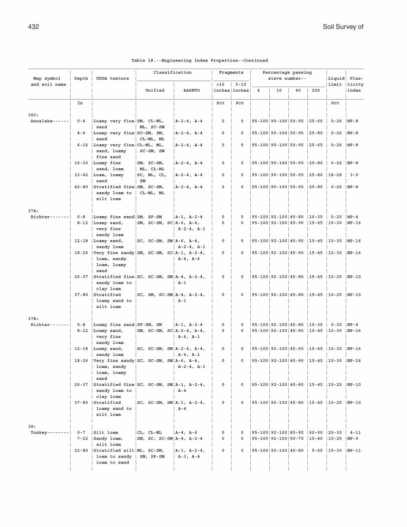
432 Soil Survey of
Table 18.--Engineering Index Properties--Continued___________________________________________________________________________________________________________________________ | | | Classification | Fragments | Percentage passing | | Map symbol | Depth | USDA texture |___________________________|_____________| sieve number-- |Liquid| Plas- and soil name | | | | | >10 | 3-10 |___________________________|limit |ticity | | | Unified | AASHTO |inches|inches| 4 | 10 | 40 | 200 | |index | | | | | | | | | | | |___________________________________________________________________________________________________________________________ | In | | | | Pct | Pct | | | | | Pct | | | | | | | | | | | | |36C: | | | | | | | | | | | | Annalake------| 0-4 |Loamy very fine|SM, CL-ML, |A-2-4, A-4 | 0 | 0 |95-100|90-100|50-95 |25-60 | 0-26 |NP-8 | | sand | ML, SC-SM | | | | | | | | | | 4-6 |Loamy very fine|SC-SM, SM, |A-2-4, A-4 | 0 | 0 |95-100|90-100|50-95 |25-80 | 0-26 |NP-8 | | sand | CL-ML, ML | | | | | | | | | | 6-16 |Loamy very fine|CL-ML, ML, |A-2-4, A-4 | 0 | 0 |95-100|90-100|50-95 |25-65 | 0-26 |NP-8 | | sand, loamy | SC-SM, SM | | | | | | | | | | | fine sand | | | | | | | | | | | 16-33 |Loamy fine |SM, SC-SM, |A-2-4, A-4 | 0 | 0 |95-100|90-100|50-95 |25-80 | 0-26 |NP-8 | | sand, loam | ML, CL-ML | | | | | | | | | | 33-42 |Loam, loamy |SC, ML, CL, |A-2-4, A-4 | 0 | 0 |95-100|90-100|50-95 |25-80 |18-28 | 3-9 | | sand | SM | | | | | | | | | | 42-80 |Stratified fine|SM, SC-SM, |A-2-4, A-4 | 0 | 0 |95-100|90-100|50-95 |25-80 | 0-26 |NP-8 | | sandy loam to | CL-ML, ML | | | | | | | | | | | silt loam | | | | | | | | | | | | | | | | | | | | | |37A: | | | | | | | | | | | | Richter-------| 0-8 |Loamy fine sand|SM, SP-SM |A-1, A-2-4 | 0 | 0 |95-100|92-100|45-80 |10-35 | 0-20 |NP-4 | 8-12 |Loamy sand, |SM, SC-SM, SC|A-6, A-4, | 0 | 0 |95-100|92-100|45-90 |15-45 |10-30 |NP-16 | | very fine | | A-2-4, A-1 | | | | | | | | | | sandy loam | | | | | | | | | | | 12-18 |Loamy sand, |SC, SC-SM, SM|A-6, A-4, | 0 | 0 |95-100|92-100|45-90 |15-45 |10-30 |NP-16 | | sandy loam | | A-2-4, A-1 | | | | | | | | | 18-26 |Very fine sandy|SM, SC-SM, SC|A-1, A-2-4, | 0 | 0 |95-100|92-100|45-90 |15-45 |10-30 |NP-16 | | loam, sandy | | A-4, A-6 | | | | | | | | | | loam, loamy | | | | | | | | | | | | sand | | | | | | | | | | | 26-37 |Stratified fine|SC, SC-SM, SM|A-4, A-2-4, | 0 | 0 |95-100|92-100|45-80 |15-45 |10-25 |NP-10 | | sandy loam to | | A-1 | | | | | | | | | | clay loam | | | | | | | | | | | 37-80 |Stratified |SC, SM, SC-SM|A-4, A-2-4, | 0 | 0 |95-100|92-100|45-80 |15-45 |10-25 |NP-10 | | loamy sand to | | A-1 | | | | | | | | | | silt loam | | | | | | | | | | | | | | | | | | | | | |37B: | | | | | | | | | | | | Richter-------| 0-8 |Loamy fine sand|SP-SM, SM |A-1, A-2-4 | 0 | 0 |95-100|92-100|45-80 |10-35 | 0-20 |NP-4 | 8-12 |Loamy sand, |SM, SC-SM, SC|A-2-4, A-4, | 0 | 0 |95-100|92-100|45-90 |15-45 |10-30 |NP-16 | | very fine | | A-6, A-1 | | | | | | | | | | sandy loam | | | | | | | | | | | 12-18 |Loamy sand, |SC, SC-SM, SM|A-2-4, A-4, | 0 | 0 |95-100|92-100|45-90 |15-45 |10-30 |NP-16 | | sandy loam | | A-6, A-1 | | | | | | | | | 18-26 |Very fine sandy|SC, SC-SM, SM|A-6, A-4, | 0 | 0 |95-100|92-100|45-90 |15-45 |10-30 |NP-16 | | loam, sandy | | A-2-4, A-1 | | | | | | | | | | loam, loamy | | | | | | | | | | | | sand | | | | | | | | | | | 26-37 |Stratified fine|SC, SC-SM, SM|A-1, A-2-4, | 0 | 0 |95-100|92-100|45-80 |15-45 |10-25 |NP-10 | | sandy loam to | | A-4 | | | | | | | | | | clay loam | | | | | | | | | | | 37-80 |Stratified |SC, SC-SM, SM|A-1, A-2-4, | 0 | 0 |95-100|92-100|45-80 |15-45 |10-25 |NP-10 | | loamy sand to | | A-4 | | | | | | | | | | silt loam | | | | | | | | | | | | | | | | | | | | | |38: | | | | | | | | | | | | Tonkey--------| 0-7 |Silt loam |CL, CL-ML |A-4, A-6 | 0 | 0 |95-100|92-100|85-95 |60-90 |20-30 | 4-11 | 7-22 |Sandy loam, |SM, SC, SC-SM|A-4, A-2-4 | 0 | 0 |95-100|92-100|50-75 |15-40 |15-25 |NP-9 | | silt loam | | | | | | | | | | | 22-80 |Stratified silt|ML, SC-SM, |A-1, A-2-4, | 0 | 0 |95-100|92-100|40-80 | 5-65 |15-30 |NP-11 | | loam to sandy | SM, SP-SM | A-3, A-4 | | | | | | | | | | loam to sand | | | | | | | | | | | | | | | | | | | | | |
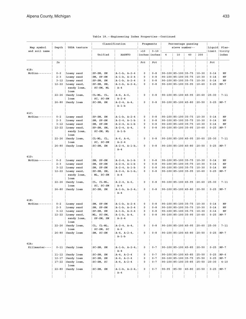
Alpena County, Michigan 433
Table 18.--Engineering Index Properties--Continued___________________________________________________________________________________________________________________________ | | | Classification | Fragments | Percentage passing | | Map symbol | Depth | USDA texture |___________________________|_____________| sieve number-- |Liquid| Plas- and soil name | | | | | >10 | 3-10 |___________________________|limit |ticity | | | Unified | AASHTO |inches|inches| 4 | 10 | 40 | 200 | |index | | | | | | | | | | | |___________________________________________________________________________________________________________________________ | In | | | | Pct | Pct | | | | | Pct | | | | | | | | | | | | |41B: | | | | | | | | | | | | McGinn--------| 0-2 |Loamy sand |SP-SM, SM |A-1-b, A-2-4 | 0 | 0-8 |90-100|85-100|35-75 |10-30 | 0-14 | NP | 2-3 |Loamy sand |SM, SP-SM |A-1-b, A-2-4 | 0 | 0-8 |90-100|85-100|35-75 |10-30 | 0-14 | NP | 3-12 |Loamy sand |SP-SM, SM |A-1-b, A-2-4 | 0 | 0-8 |90-100|85-100|35-75 |10-30 | 0-14 | NP | 12-22 |Loamy sand, |SP-SM, SM, |A-1-b, A-2-4,| 0 | 0-8 |90-100|85-100|35-95 |10-60 | 0-25 |NP-7 | | sandy loam, | SC-SM, ML | A-4 | | | | | | | | | | loam | | | | | | | | | | | 22-26 |Sandy loam, |CL-ML, CL, |A-4, A-6, | 0 | 0-8 |90-100|85-100|45-95 |20-60 |25-30 | 7-11 | | loam | SC, SC-SM | A-2-4 | | | | | | | | | 26-80 |Sandy loam |SC-SM, SM |A-2-4, A-4, | 0 | 0-8 |90-100|85-100|45-80 |20-50 | 0-25 |NP-7 | | | | A-1-b | | | | | | | | | | | | | | | | | | | |41C: | | | | | | | | | | | | McGinn--------| 0-2 |Loamy sand |SP-SM, SM |A-1-b, A-2-4 | 0 | 0-8 |90-100|85-100|35-75 |10-30 | 0-14 | NP | 2-3 |Loamy sand |SM, SP-SM |A-2-4, A-1-b | 0 | 0-8 |90-100|85-100|35-75 |10-30 | 0-14 | NP | 3-12 |Loamy sand |SM, SP-SM |A-2-4, A-1-b | 0 | 0-8 |90-100|85-100|35-75 |10-30 | 0-14 | NP | 12-22 |Loamy sand, |SP-SM, SM, |A-2-4, A-4, | 0 | 0-8 |90-100|85-100|35-95 |10-60 | 0-25 |NP-7 | | sandy loam, | SC-SM, ML | A-1-b | | | | | | | | | | loam | | | | | | | | | | | 22-26 |Sandy loam, |CL-ML, CL, |A-6, A-4, | 0 | 0-8 |90-100|85-100|45-95 |20-60 |25-30 | 7-11 | | loam | SC, SC-SM | A-2-4 | | | | | | | | | 26-80 |Sandy loam |SC-SM, SM |A-2-4, A-1-b,| 0 | 0-8 |90-100|85-100|45-80 |20-50 | 0-25 |NP-7 | | | | A-4 | | | | | | | | | | | | | | | | | | | |41D: | | | | | | | | | | | | McGinn--------| 0-2 |Loamy sand |SM, SP-SM |A-2-4, A-1-b | 0 | 0-8 |90-100|85-100|35-75 |10-30 | 0-14 | NP | 2-3 |Loamy sand |SM, SP-SM |A-2-4, A-1-b | 0 | 0-8 |90-100|85-100|35-75 |10-30 | 0-14 | NP | 3-12 |Loamy sand |SM, SP-SM |A-2-4, A-1-b | 0 | 0-8 |90-100|85-100|35-75 |10-30 | 0-14 | NP | 12-22 |Loamy sand, |SP-SM, SM, |A-2-4, A-1-b,| 0 | 0-8 |90-100|85-100|35-95 |10-60 | 0-25 |NP-7 | | sandy loam, | ML, SC-SM | A-4 | | | | | | | | | | loam | | | | | | | | | | | 22-26 |Sandy loam, |CL, CL-ML, |A-2-4, A-6, | 0 | 0-8 |90-100|85-100|45-95 |20-60 |25-30 | 7-11 | | loam | SC, SC-SM | A-4 | | | | | | | | | 26-80 |Sandy loam |SC-SM, SM |A-1-b, A-2-4,| 0 | 0-8 |90-100|85-100|45-80 |20-50 | 0-25 |NP-7 | | | | A-4 | | | | | | | | | | | | | | | | | | | |41E: | | | | | | | | | | | | McGinn--------| 0-2 |Loamy sand |SM, SP-SM |A-1-b, A-2-4 | 0 | 0-8 |90-100|85-100|35-75 |10-30 | 0-14 | NP | 2-3 |Loamy sand |SM, SP-SM |A-1-b, A-2-4 | 0 | 0-8 |90-100|85-100|35-75 |10-30 | 0-14 | NP | 3-12 |Loamy sand |SP-SM, SM |A-1-b, A-2-4 | 0 | 0-8 |90-100|85-100|35-75 |10-30 | 0-14 | NP | 12-22 |Loamy sand, |ML, SC-SM, |A-1-b, A-4, | 0 | 0-8 |90-100|85-100|35-95 |10-60 | 0-25 |NP-7 | | sandy loam, | SP-SM, SM | A-2-4 | | | | | | | | | | loam | | | | | | | | | | | 22-26 |Sandy loam, |CL, CL-ML, |A-2-4, A-4, | 0 | 0-8 |90-100|85-100|45-95 |20-60 |25-30 | 7-11 | | loam | SC-SM, SC | A-6 | | | | | | | | | 26-80 |Sandy loam |SM, SC-SM |A-4, A-2-4, | 0 | 0-8 |90-100|85-100|45-80 |20-50 | 0-25 |NP-7 | | | | A-1-b | | | | | | | | | | | | | | | | | | | |42A: | | | | | | | | | | | | Killmaster----| 0-11 |Sandy loam |SC-SM, SM |A-1-b, A-2-4,| 0 | 0-7 |90-100|85-100|45-85 |20-50 | 0-25 |NP-7 | | | | A-4 | | | | | | | | | 11-12 |Sandy loam |SC-SM, SM |A-4, A-2-4 | 0 | 0-7 |90-100|85-100|45-85 |25-50 | 0-25 |NP-6 | 12-17 |Sandy loam |SC-SM, SM |A-4, A-2-4 | 0 | 0-7 |90-100|85-100|35-75 |25-50 | 0-25 |NP-7 | 17-22 |Sandy loam, |SC-SM, SC |A-4, A-2-4 | 0 | 0-7 |90-100|85-100|35-85 |25-50 |20-30 | 4-10 | | loam | | | | | | | | | | | 22-80 |Sandy loam |SC-SM, SM |A-1-b, A-2-4,| 0 | 0-7 |90-95 |85-90 |45-80 |20-50 | 0-25 |NP-7 | | | | A-4 | | | | | | | | | | | | | | | | | | | |
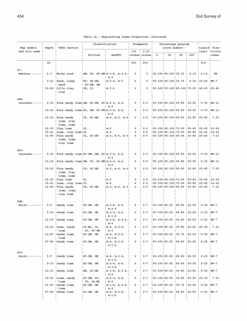
434 Soil Survey of
Table 18.--Engineering Index Properties--Continued___________________________________________________________________________________________________________________________ | | | Classification | Fragments | Percentage passing | | Map symbol | Depth | USDA texture |___________________________|_____________| sieve number-- |Liquid| Plas- and soil name | | | | | >10 | 3-10 |___________________________|limit |ticity | | | Unified | AASHTO |inches|inches| 4 | 10 | 40 | 200 | |index | | | | | | | | | | | |___________________________________________________________________________________________________________________________ | In | | | | Pct | Pct | | | | | Pct | | | | | | | | | | | | |43: | | | | | | | | | | | | Wakeley-------| 0-3 |Mucky sand |SM, SP, SP-SM|A-1-b, A-2-4,| 0 | 0 |95-100|85-100|35-70 | 0-15 | 0-14 | NP | | | | A-3 | | | | | | | | | 3-21 |Sand, loamy |SP, SP-SM, |A-2-4, A-3 | 0 | 0 |95-100|85-100|35-75 | 0-30 |15-25 |NP-7 | | sand | SC-SM, SM | | | | | | | | | | 21-80 |Silty clay, |CH, CL |A-7-6 | 0 | 0 |95-100|90-100|85-100|75-95 |40-65 |20-40 | | clay | | | | | | | | | | | | | | | | | | | | | |44B: | | | | | | | | | | | | Ossineke------| 0-10 |Fine sandy loam|SM, SC-SM, SC|A-2-4, A-4, | 0 | 0-5 |95-100|85-100|55-85 |30-50 | 0-30 |NP-11 | | | | A-6 | | | | | | | | | 10-15 |Fine sandy loam|SC, SM, SC-SM|A-2-4, A-4, | 0 | 0-5 |95-100|85-100|55-85 |30-50 | 0-30 |NP-11 | | | | A-6 | | | | | | | | | 15-22 |Fine sandy |CL, SC-SM |A-6, A-2, A-4| 0 | 0-5 |95-100|85-100|55-95 |30-80 |25-40 | 7-15 | | loam, clay | | | | | | | | | | | | loam, loam | | | | | | | | | | | 22-35 |Clay loam |CL |A-6 | 0 | 0-5 |95-100|85-100|70-95 |50-80 |25-45 |10-20 | 35-41 |Loam, clay loam|CL |A-6 | 0 | 0-5 |95-100|85-100|70-95 |50-80 |25-45 |10-20 | 41-80 |Fine sandy |CL, SC-SM |A-2, A-4, A-6| 0 | 0-5 |95-100|85-100|45-95 |30-80 |25-40 | 7-15 | | loam, loam, | | | | | | | | | | | | clay loam | | | | | | | | | | | | | | | | | | | | | |44C: | | | | | | | | | | | | Ossineke------| 0-10 |Fine sandy loam|SC-SM, SM, SC|A-2-4, A-4, | 0 | 0-5 |95-100|85-100|55-85 |30-50 | 0-30 |NP-11 | | | | A-6 | | | | | | | | | 10-15 |Fine sandy loam|SM, SC, SC-SM|A-2-4, A-4, | 0 | 0-5 |95-100|85-100|55-85 |30-50 | 0-30 |NP-11 | | | | A-6 | | | | | | | | | 15-22 |Fine sandy |CL, SC-SM |A-2, A-4, A-6| 0 | 0-5 |95-100|85-100|55-95 |30-80 |25-40 | 7-15 | | loam, clay | | | | | | | | | | | | loam, loam | | | | | | | | | | | 22-35 |Clay loam |CL |A-6 | 0 | 0-5 |95-100|85-100|70-95 |50-80 |25-45 |10-20 | 35-41 |Loam, clay loam|CL |A-6 | 0 | 0-5 |95-100|85-100|70-95 |50-80 |25-45 |10-20 | 41-80 |Fine sandy |CL, SC-SM |A-2, A-4, A-6| 0 | 0-5 |95-100|85-100|45-95 |30-80 |25-40 | 7-15 | | loam, loam, | | | | | | | | | | | | clay loam | | | | | | | | | | | | | | | | | | | | | |45B: | | | | | | | | | | | | Hoist---------| 0-9 |Sandy loam |SC-SM, SM |A-1-b, A-4, | 0 | 0-7 |90-100|85-92 |45-85 |20-50 | 0-25 |NP-7 | | | | A-2-4 | | | | | | | | | 9-10 |Sandy loam |SC-SM, SM |A-2-4, A-4, | 0 | 0-7 |90-100|85-92 |45-85 |20-50 | 0-25 |NP-7 | | | | A-1-b | | | | | | | | | 10-15 |Sandy loam |SC-SM, SM |A-1-b, A-2-4,| 0 | 0-7 |90-100|85-92 |35-85 |20-60 | 0-25 |NP-7 | | | | A-4 | | | | | | | | | 15-21 |Loam, sandy |CL-ML, CL, |A-4, A-2-4, | 0 | 0-7 |90-100|85-92 |35-85 |20-60 |25-30 | 7-11 | | loam | SC, SC-SM | A-6 | | | | | | | | | 21-47 |Sandy loam, |SC-SM, SM |A-4, A-2-4, | 0 | 0-7 |90-100|85-92 |35-75 |20-50 | 0-25 |NP-7 | | loam | | A-1-b | | | | | | | | | 47-80 |Sandy loam |SC-SM, SM |A-4, A-2-4, | 0 | 0-7 |90-100|80-92 |45-80 |20-50 | 0-25 |NP-7 | | | | A-1-b | | | | | | | | | | | | | | | | | | | |45C: | | | | | | | | | | | | Hoist---------| 0-9 |Sandy loam |SC-SM, SM |A-4, A-2-4, | 0 | 0-7 |90-100|85-92 |45-85 |20-50 | 0-25 |NP-7 | | | | A-1-b | | | | | | | | | 9-10 |Sandy loam |SC-SM, SM |A-2-4, A-4, | 0 | 0-7 |90-100|85-92 |45-85 |20-50 | 0-25 |NP-7 | | | | A-1-b | | | | | | | | | 10-15 |Sandy loam |SM, SC-SM |A-1-b, A-2-4,| 0 | 0-7 |90-100|85-92 |35-85 |20-60 | 0-25 |NP-7 | | | | A-4 | | | | | | | | | 15-21 |Loam, sandy |SC-SM, SC, |A-2-4, A-4, | 0 | 0-7 |90-100|85-92 |35-85 |20-60 |25-30 | 7-11 | | loam | CL, CL-ML | A-6 | | | | | | | | | 21-47 |Sandy loam, |SC-SM, SM |A-1-b, A-2-4,| 0 | 0-7 |90-100|85-92 |35-75 |20-50 | 0-25 |NP-7 | | loam | | A-4 | | | | | | | | | 47-80 |Sandy loam |SC-SM, SM |A-4, A-2-4, | 0 | 0-7 |90-100|80-92 |45-80 |20-50 | 0-25 |NP-7 | | | | A-1-b | | | | | | | | | | | | | | | | | | | |
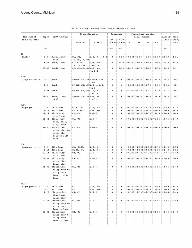
Alpena County, Michigan 435
Table 18.--Engineering Index Properties--Continued___________________________________________________________________________________________________________________________ | | | Classification | Fragments | Percentage passing | | Map symbol | Depth | USDA texture |___________________________|_____________| sieve number-- |Liquid| Plas- and soil name | | | | | >10 | 3-10 |___________________________|limit |ticity | | | Unified | AASHTO |inches|inches| 4 | 10 | 40 | 200 | |index | | | | | | | | | | | |___________________________________________________________________________________________________________________________ | In | | | | Pct | Pct | | | | | Pct | | | | | | | | | | | | |46: | | | | | | | | | | | | Ensley--------| 0-8 |Mucky sandy |CL, SC, |A-6, A-4, A-2| 0 | 0-10 |90-100|85-99 |45-95 |25-80 |20-30 | 4-11 | | loam | CL-ML, SC-SM| | | | | | | | | | 8-29 |Sandy loam |CL, CL-ML, |A-6, A-4, | 0 | 0-10 |90-100|85-99 |45-90 |20-55 |20-35 | 4-15 | | | SC, SC-SM | A-2, A-1 | | | | | | | | | 29-80 |Sandy loam |SC, SC-SM, SM|A-1, A-4, | 0 | 0-10 |85-95 |80-95 |35-80 |15-50 | 0-30 | 2-9 | | | | A-2-4 | | | | | | | | | | | | | | | | | | | |47D: | | | | | | | | | | | | Graycalm------| 0-1 |Sand |SP-SM, SM, SP|A-1-b, A-3, | 0 | 0 |95-100|93-100|35-55 | 0-15 | 0-14 | NP | | | | A-2 | | | | | | | | | 1-5 |Sand |SP-SM, SM, SP|A-2-4, A-1, | 0 | 0 |95-100|93-100|30-75 | 0-30 | 0-14 | NP | | | | A-3 | | | | | | | | | 5-24 |Sand |SP-SM, SP, SM|A-1, A-3, | 0 | 0 |95-100|93-100|30-75 | 0-30 | 0-14 | NP | | | | A-2-4 | | | | | | | | | 24-80 |Sand, loamy |SP-SM, SP, SM|A-2, A-3, | 0 | 0 |95-100|93-100|35-55 | 0-15 | 0-14 | NP | | sand | | A-1-b | | | | | | | | | | | | | | | | | | | |53B: | | | | | | | | | | | | Negwegon------| 0-9 |Silt loam |CL-ML, CL |A-6, A-4 | 0 | 0 |99-100|98-100|80-100|65-90 |20-40 | 5-15 | 9-12 |Silt loam |CL, CL-ML |A-4, A-6 | 0 | 0 |99-100|98-100|80-100|65-90 |20-40 | 5-15 | 12-14 |Silty clay, |CL, CH |A-7-6 | 0 | 0 |99-100|98-100|85-100|75-95 |40-65 |20-40 | | silt loam | | | | | | | | | | | 14-51 |Silty clay |CL, CH |A-7-6 | 0 | 0 |99-100|98-100|85-100|75-95 |40-65 |20-40 | | loam, silty | | | | | | | | | | | | clay, clay | | | | | | | | | | | 51-80 |Stratified |CL, CH |A-7-6 | 0 | 0 |99-100|98-100|80-100|65-95 |40-65 |20-40 | | silty clay to | | | | | | | | | | | | silty clay | | | | | | | | | | | | loam to silt | | | | | | | | | | | | loam | | | | | | | | | | | | | | | | | | | | | |53C: | | | | | | | | | | | | Negwegon------| 0-9 |Silt loam |CL, CL-ML |A-6, A-4 | 0 | 0 |99-100|98-100|80-100|65-90 |20-40 | 5-15 | 9-12 |Silt loam |CL-ML, CL |A-4, A-6 | 0 | 0 |99-100|98-100|80-100|65-90 |20-40 | 5-15 | 12-14 |Silty clay, |CH, CL |A-7-6 | 0 | 0 |99-100|98-100|85-100|75-95 |40-65 |20-40 | | silt loam | | | | | | | | | | | 14-51 |Silty clay, |CH, CL |A-7-6 | 0 | 0 |99-100|98-100|85-100|75-95 |40-65 |20-40 | | silty clay | | | | | | | | | | | | loam, clay | | | | | | | | | | | 51-80 |Stratified |CL, CH |A-7-6 | 0 | 0 |99-100|98-100|80-100|65-95 |40-65 |20-40 | | silty clay to | | | | | | | | | | | | silty clay | | | | | | | | | | | | loam to silt | | | | | | | | | | | | loam | | | | | | | | | | | | | | | | | | | | | |54A: | | | | | | | | | | | | Algonquin-----| 0-5 |Silt loam |CL |A-4, A-6 | 0 | 0 |99-100|95-100|80-100|70-90 |25-40 | 7-15 | 5-7 |Silt loam |CL |A-6, A-4 | 0 | 0 |99-100|95-100|80-100|70-90 |25-40 | 7-15 | 7-19 |Clay, silty |CH, CL |A-7-6 | 0 | 0 |99-100|95-100|85-100|80-95 |40-65 |20-40 | | clay loam, | | | | | | | | | | | | silty clay | | | | | | | | | | | 19-55 |Stratified |CL, CH |A-7-6 | 0 | 0 |99-100|95-100|85-100|80-95 |40-65 |20-40 | | silty clay to | | | | | | | | | | | | silty clay | | | | | | | | | | | | loam to loam | | | | | | | | | | | 55-80 |Stratified |CH, CL |A-7-6 | 0 | 0 |99-100|95-100|85-100|80-95 |40-65 |20-40 | | silty clay to | | | | | | | | | | | | silty clay | | | | | | | | | | | | loam to loam | | | | | | | | | | | | | | | | | | | | | |
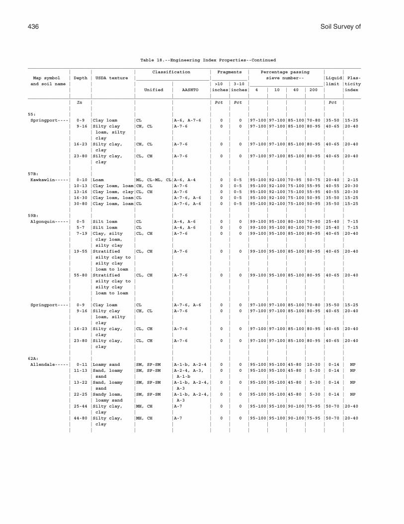
436 Soil Survey of
Table 18.--Engineering Index Properties--Continued___________________________________________________________________________________________________________________________ | | | Classification | Fragments | Percentage passing | | Map symbol | Depth | USDA texture |___________________________|_____________| sieve number-- |Liquid| Plas- and soil name | | | | | >10 | 3-10 |___________________________|limit |ticity | | | Unified | AASHTO |inches|inches| 4 | 10 | 40 | 200 | |index | | | | | | | | | | | |___________________________________________________________________________________________________________________________ | In | | | | Pct | Pct | | | | | Pct | | | | | | | | | | | | |55: | | | | | | | | | | | | Springport----| 0-9 |Clay loam |CL |A-6, A-7-6 | 0 | 0 |97-100|97-100|85-100|70-80 |35-50 |15-25 | 9-16 |Silty clay |CH, CL |A-7-6 | 0 | 0 |97-100|97-100|85-100|80-95 |40-65 |20-40 | | loam, silty | | | | | | | | | | | | clay | | | | | | | | | | | 16-23 |Silty clay, |CH, CL |A-7-6 | 0 | 0 |97-100|97-100|85-100|80-95 |40-65 |20-40 | | clay | | | | | | | | | | | 23-80 |Silty clay, |CL, CH |A-7-6 | 0 | 0 |97-100|97-100|85-100|80-95 |40-65 |20-40 | | clay | | | | | | | | | | | | | | | | | | | | | |57B: | | | | | | | | | | | | Kawkawlin-----| 0-10 |Loam |ML, CL-ML, CL|A-6, A-4 | 0 | 0-5 |95-100|92-100|70-95 |50-75 |20-40 | 2-15 | 10-13 |Clay loam, loam|CH, CL |A-7-6 | 0 | 0-5 |95-100|92-100|75-100|55-95 |40-55 |20-30 | 13-16 |Clay loam, clay|CL, CH |A-7-6 | 0 | 0-5 |95-100|92-100|75-100|55-95 |40-55 |20-30 | 16-30 |Clay loam, loam|CL |A-7-6, A-6 | 0 | 0-5 |95-100|92-100|75-100|50-95 |35-50 |15-25 | 30-80 |Clay loam, loam|CL |A-7-6, A-6 | 0 | 0-5 |95-100|92-100|75-100|50-95 |35-50 |15-25 | | | | | | | | | | | |59B: | | | | | | | | | | | | Algonquin-----| 0-5 |Silt loam |CL |A-4, A-6 | 0 | 0 |99-100|95-100|80-100|70-90 |25-40 | 7-15 | 5-7 |Silt loam |CL |A-4, A-6 | 0 | 0 |99-100|95-100|80-100|70-90 |25-40 | 7-15 | 7-19 |Clay, silty |CL, CH |A-7-6 | 0 | 0 |99-100|95-100|85-100|80-95 |40-65 |20-40 | | clay loam, | | | | | | | | | | | | silty clay | | | | | | | | | | | 19-55 |Stratified |CL, CH |A-7-6 | 0 | 0 |99-100|95-100|85-100|80-95 |40-65 |20-40 | | silty clay to | | | | | | | | | | | | silty clay | | | | | | | | | | | | loam to loam | | | | | | | | | | | 55-80 |Stratified |CL, CH |A-7-6 | 0 | 0 |99-100|95-100|85-100|80-95 |40-65 |20-40 | | silty clay to | | | | | | | | | | | | silty clay | | | | | | | | | | | | loam to loam | | | | | | | | | | | | | | | | | | | | | | Springport----| 0-9 |Clay loam |CL |A-7-6, A-6 | 0 | 0 |97-100|97-100|85-100|70-80 |35-50 |15-25 | 9-16 |Silty clay |CH, CL |A-7-6 | 0 | 0 |97-100|97-100|85-100|80-95 |40-65 |20-40 | | loam, silty | | | | | | | | | | | | clay | | | | | | | | | | | 16-23 |Silty clay, |CL, CH |A-7-6 | 0 | 0 |97-100|97-100|85-100|80-95 |40-65 |20-40 | | clay | | | | | | | | | | | 23-80 |Silty clay, |CL, CH |A-7-6 | 0 | 0 |97-100|97-100|85-100|80-95 |40-65 |20-40 | | clay | | | | | | | | | | | | | | | | | | | | | |62A: | | | | | | | | | | | | Allendale-----| 0-11 |Loamy sand |SM, SP-SM |A-1-b, A-2-4 | 0 | 0 |95-100|95-100|45-80 |10-30 | 0-14 | NP | 11-13 |Sand, loamy |SM, SP-SM |A-2-4, A-3, | 0 | 0 |95-100|95-100|45-80 | 5-30 | 0-14 | NP | | sand | | A-1-b | | | | | | | | | 13-22 |Sand, loamy |SM, SP-SM |A-1-b, A-2-4,| 0 | 0 |95-100|95-100|45-80 | 5-30 | 0-14 | NP | | sand | | A-3 | | | | | | | | | 22-25 |Sandy loam, |SM, SP-SM |A-1-b, A-2-4,| 0 | 0 |95-100|95-100|45-80 | 5-30 | 0-14 | NP | | loamy sand | | A-3 | | | | | | | | | 25-44 |Silty clay, |MH, CH |A-7 | 0 | 0 |95-100|95-100|90-100|75-95 |50-70 |20-40 | | clay | | | | | | | | | | | 44-80 |Silty clay, |MH, CH |A-7 | 0 | 0 |95-100|95-100|90-100|75-95 |50-70 |20-40 | | clay | | | | | | | | | | | | | | | | | | | | | |
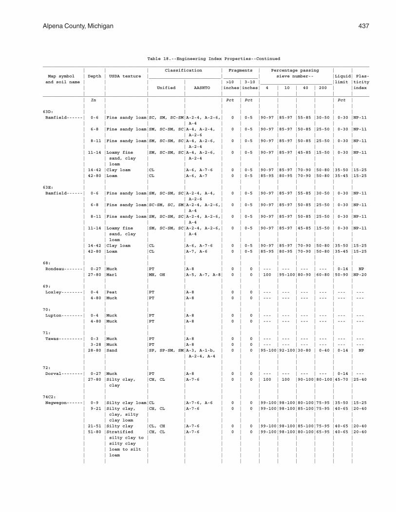
Alpena County, Michigan 437
Table 18.--Engineering Index Properties--Continued___________________________________________________________________________________________________________________________ | | | Classification | Fragments | Percentage passing | | Map symbol | Depth | USDA texture |___________________________|_____________| sieve number-- |Liquid| Plas- and soil name | | | | | >10 | 3-10 |___________________________|limit |ticity | | | Unified | AASHTO |inches|inches| 4 | 10 | 40 | 200 | |index | | | | | | | | | | | |___________________________________________________________________________________________________________________________ | In | | | | Pct | Pct | | | | | Pct | | | | | | | | | | | | |63D: | | | | | | | | | | | | Bamfield------| 0-6 |Fine sandy loam|SC, SM, SC-SM|A-2-4, A-2-6,| 0 | 0-5 |90-97 |85-97 |55-85 |30-50 | 0-30 |NP-11 | | | | A-4 | | | | | | | | | 6-8 |Fine sandy loam|SM, SC-SM, SC|A-4, A-2-4, | 0 | 0-5 |90-97 |85-97 |50-85 |25-50 | 0-30 |NP-11 | | | | A-2-6 | | | | | | | | | 8-11 |Fine sandy loam|SM, SC-SM, SC|A-4, A-2-6, | 0 | 0-5 |90-97 |85-97 |50-85 |25-50 | 0-30 |NP-11 | | | | A-2-4 | | | | | | | | | 11-14 |Loamy fine |SM, SC-SM, SC|A-4, A-2-6, | 0 | 0-5 |90-97 |85-97 |45-85 |15-50 | 0-30 |NP-11 | | sand, clay | | A-2-4 | | | | | | | | | | loam | | | | | | | | | | | 14-42 |Clay loam |CL |A-6, A-7-6 | 0 | 0-5 |90-97 |85-97 |70-90 |50-80 |35-50 |15-25 | 42-80 |Loam |CL |A-6, A-7 | 0 | 0-5 |85-95 |80-95 |70-90 |50-80 |35-45 |15-25 | | | | | | | | | | | |63E: | | | | | | | | | | | | Bamfield------| 0-6 |Fine sandy loam|SM, SC-SM, SC|A-2-4, A-4, | 0 | 0-5 |90-97 |85-97 |55-85 |30-50 | 0-30 |NP-11 | | | | A-2-6 | | | | | | | | | 6-8 |Fine sandy loam|SC-SM, SC, SM|A-2-4, A-2-6,| 0 | 0-5 |90-97 |85-97 |50-85 |25-50 | 0-30 |NP-11 | | | | A-4 | | | | | | | | | 8-11 |Fine sandy loam|SM, SC-SM, SC|A-2-4, A-2-6,| 0 | 0-5 |90-97 |85-97 |50-85 |25-50 | 0-30 |NP-11 | | | | A-4 | | | | | | | | | 11-14 |Loamy fine |SM, SC-SM, SC|A-2-4, A-2-6,| 0 | 0-5 |90-97 |85-97 |45-85 |15-50 | 0-30 |NP-11 | | sand, clay | | A-4 | | | | | | | | | | loam | | | | | | | | | | | 14-42 |Clay loam |CL |A-6, A-7-6 | 0 | 0-5 |90-97 |85-97 |70-90 |50-80 |35-50 |15-25 | 42-80 |Loam |CL |A-7, A-6 | 0 | 0-5 |85-95 |80-95 |70-90 |50-80 |35-45 |15-25 | | | | | | | | | | | |68: | | | | | | | | | | | | Rondeau-------| 0-27 |Muck |PT |A-8 | 0 | 0 | --- | --- | --- | --- | 0-14 | NP | 27-80 |Marl |MH, OH |A-5, A-7, A-8| 0 | 0 | 100 |95-100|80-90 |60-80 |50-90 |NP-20 | | | | | | | | | | | |69: | | | | | | | | | | | | Loxley--------| 0-4 |Peat |PT |A-8 | 0 | 0 | --- | --- | --- | --- | --- | --- | 4-80 |Muck |PT |A-8 | 0 | 0 | --- | --- | --- | --- | --- | --- | | | | | | | | | | | |70: | | | | | | | | | | | | Lupton--------| 0-4 |Muck |PT |A-8 | 0 | 0 | --- | --- | --- | --- | --- | --- | 4-80 |Muck |PT |A-8 | 0 | 0 | --- | --- | --- | --- | --- | --- | | | | | | | | | | | |71: | | | | | | | | | | | | Tawas---------| 0-3 |Muck |PT |A-8 | 0 | 0 | --- | --- | --- | --- | --- | --- | 3-28 |Muck |PT |A-8 | 0 | 0 | --- | --- | --- | --- | --- | --- | 28-80 |Sand |SP, SP-SM, SM|A-3, A-1-b, | 0 | 0 |95-100|92-100|30-80 | 0-40 | 0-14 | NP | | | | A-2-4, A-4 | | | | | | | | | | | | | | | | | | | |72: | | | | | | | | | | | | Dorval--------| 0-27 |Muck |PT |A-8 | 0 | 0 | --- | --- | --- | --- | 0-14 | --- | 27-80 |Silty clay, |CH, CL |A-7-6 | 0 | 0 | 100 | 100 |90-100|80-100|45-70 |25-40 | | clay | | | | | | | | | | | | | | | | | | | | | |74C2: | | | | | | | | | | | | Negwegon------| 0-9 |Silty clay loam|CL |A-7-6, A-6 | 0 | 0 |99-100|98-100|80-100|75-95 |35-50 |15-25 | 9-21 |Silty clay, |CH, CL |A-7-6 | 0 | 0 |99-100|98-100|85-100|75-95 |40-65 |20-40 | | clay, silty | | | | | | | | | | | | clay loam | | | | | | | | | | | 21-51 |Silty clay |CL, CH |A-7-6 | 0 | 0 |99-100|98-100|85-100|75-95 |40-65 |20-40 | 51-80 |Stratified |CH, CL |A-7-6 | 0 | 0 |99-100|98-100|80-100|65-95 |40-65 |20-40 | | silty clay to | | | | | | | | | | | | silty clay | | | | | | | | | | | | loam to silt | | | | | | | | | | | | loam | | | | | | | | | | | | | | | | | | | | | |
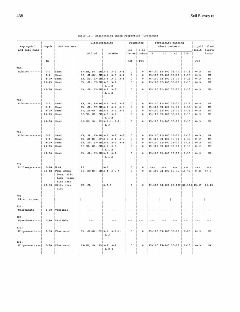
438 Soil Survey of
Table 18.--Engineering Index Properties--Continued___________________________________________________________________________________________________________________________ | | | Classification | Fragments | Percentage passing | | Map symbol | Depth | USDA texture |___________________________|_____________| sieve number-- |Liquid| Plas- and soil name | | | | | >10 | 3-10 |___________________________|limit |ticity | | | Unified | AASHTO |inches|inches| 4 | 10 | 40 | 200 | |index | | | | | | | | | | | |___________________________________________________________________________________________________________________________ | In | | | | Pct | Pct | | | | | Pct | | | | | | | | | | | | |75B: | | | | | | | | | | | | Rubicon-------| 0-2 |Sand |SP-SM, SP, SM|A-1, A-2, A-3| 0 | 0 |95-100|92-100|35-70 | 0-15 | 0-14 | NP | 2-4 |Sand |SP, SP-SM, SM|A-1, A-3, A-2| 0 | 0 |95-100|92-100|35-70 | 0-15 | 0-14 | NP | 4-29 |Sand |SM, SP, SP-SM|A-3, A-2, A-1| 0 | 0 |95-100|92-100|35-70 | 0-15 | 0-14 | NP | 29-43 |Sand |SM, SP, SP-SM|A-3, A-2, | 0 | 0 |95-100|92-100|30-70 | 0-15 | 0-14 | NP | | | | A-1-b | | | | | | | | | 43-80 |Sand |SM, SP, SP-SM|A-2, A-3, | 0 | 0 |95-100|92-100|30-70 | 0-15 | 0-14 | NP | | | | A-1-b | | | | | | | | | | | | | | | | | | | |75D: | | | | | | | | | | | | Rubicon-------| 0-2 |Sand |SM, SP, SP-SM|A-1, A-2, A-3| 0 | 0 |95-100|92-100|35-70 | 0-15 | 0-14 | NP | 2-4 |Sand |SM, SP, SP-SM|A-1, A-2, A-3| 0 | 0 |95-100|92-100|35-70 | 0-15 | 0-14 | NP | 4-29 |Sand |SP, SP-SM, SM|A-1, A-2, A-3| 0 | 0 |95-100|92-100|35-70 | 0-15 | 0-14 | NP | 29-43 |Sand |SP-SM, SP, SM|A-3, A-2, | 0 | 0 |95-100|92-100|30-70 | 0-15 | 0-14 | NP | | | | A-1-b | | | | | | | | | 43-80 |Sand |SP-SM, SM, SP|A-1-b, A-2, | 0 | 0 |95-100|92-100|30-70 | 0-15 | 0-14 | NP | | | | A-3 | | | | | | | | | | | | | | | | | | | |75E: | | | | | | | | | | | | Rubicon-------| 0-2 |Sand |SM, SP, SP-SM|A-1, A-2, A-3| 0 | 0 |95-100|92-100|35-70 | 0-15 | 0-14 | NP | 2-4 |Sand |SM, SP-SM, SP|A-2, A-1, A-3| 0 | 0 |95-100|92-100|35-70 | 0-15 | 0-14 | NP | 4-29 |Sand |SM, SP, SP-SM|A-3, A-2, A-1| 0 | 0 |95-100|92-100|35-70 | 0-15 | 0-14 | NP | 29-43 |Sand |SP-SM, SP, SM|A-2, A-3, | 0 | 0 |95-100|92-100|30-70 | 0-15 | 0-14 | NP | | | | A-1-b | | | | | | | | | 43-80 |Sand |SM, SP, SP-SM|A-3, A-2, | 0 | 0 |95-100|92-100|30-70 | 0-15 | 0-14 | NP | | | | A-1-b | | | | | | | | | | | | | | | | | | | |77: | | | | | | | | | | | | Rollaway------| 0-10 |Muck |PT |A-8 | 0 | 0 | --- | --- | --- | --- | --- | --- | 10-42 |Fine sandy |SC, SC-SM, SM|A-4, A-2-4 | 0 | 0 |95-100|92-100|50-75 |15-40 | 0-25 |NP-8 | | loam, silt | | | | | | | | | | | | loam, loamy | | | | | | | | | | | | fine sand | | | | | | | | | | | 42-80 |Silty clay, |CH, CL |A-7-6 | 0 | 0 |99-100|98-100|80-100|80-100|45-65 |25-40 | | clay | | | | | | | | | | | | | | | | | | | | | |78: | | | | | | | | | | | | Pits, borrow. | | | | | | | | | | | | | | | | | | | | | | | |82B: | | | | | | | | | | | | Udorthents----| 0-80 |Variable | --- | --- | --- | --- | --- | --- | --- | --- | --- | --- | | | | | | | | | | | |82C: | | | | | | | | | | | | Udorthents----| 0-80 |Variable | --- | --- | --- | --- | --- | --- | --- | --- | --- | --- | | | | | | | | | | | |83B: | | | | | | | | | | | | Udipsamments--| 0-80 |Fine sand |SM, SP-SM, SP|A-1, A-2-4, | 0 | 0 |85-100|85-100|30-75 | 0-25 | 0-14 | NP | | | | A-3 | | | | | | | | | | | | | | | | | | | |83F: | | | | | | | | | | | | Udipsamments--| 0-80 |Fine sand |SP-SM, SM, SP|A-3, A-1, | 0 | 0 |85-100|85-100|30-75 | 0-25 | 0-14 | NP | | | | A-2-4 | | | | | | | | | | | | | | | | | | | |
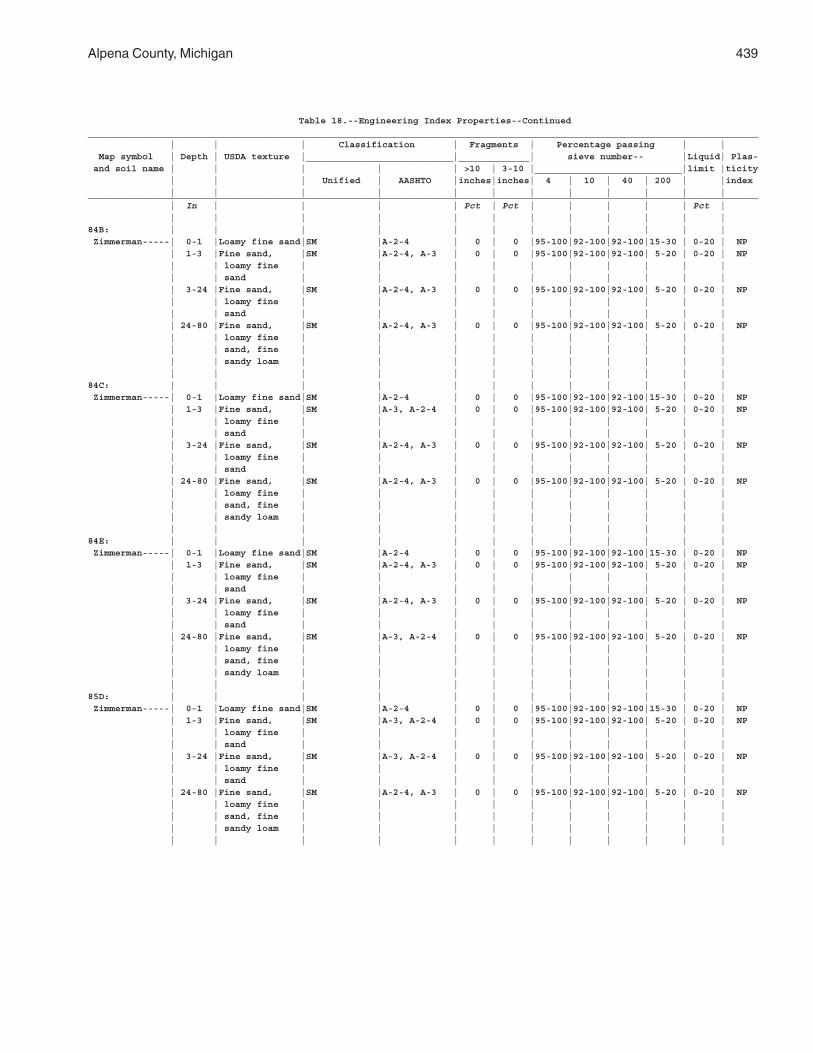
Alpena County, Michigan 439
Table 18.--Engineering Index Properties--Continued___________________________________________________________________________________________________________________________ | | | Classification | Fragments | Percentage passing | | Map symbol | Depth | USDA texture |___________________________|_____________| sieve number-- |Liquid| Plas- and soil name | | | | | >10 | 3-10 |___________________________|limit |ticity | | | Unified | AASHTO |inches|inches| 4 | 10 | 40 | 200 | |index | | | | | | | | | | | |___________________________________________________________________________________________________________________________ | In | | | | Pct | Pct | | | | | Pct | | | | | | | | | | | | |84B: | | | | | | | | | | | | Zimmerman-----| 0-1 |Loamy fine sand|SM |A-2-4 | 0 | 0 |95-100|92-100|92-100|15-30 | 0-20 | NP | 1-3 |Fine sand, |SM |A-2-4, A-3 | 0 | 0 |95-100|92-100|92-100| 5-20 | 0-20 | NP | | loamy fine | | | | | | | | | | | | sand | | | | | | | | | | | 3-24 |Fine sand, |SM |A-2-4, A-3 | 0 | 0 |95-100|92-100|92-100| 5-20 | 0-20 | NP | | loamy fine | | | | | | | | | | | | sand | | | | | | | | | | | 24-80 |Fine sand, |SM |A-2-4, A-3 | 0 | 0 |95-100|92-100|92-100| 5-20 | 0-20 | NP | | loamy fine | | | | | | | | | | | | sand, fine | | | | | | | | | | | | sandy loam | | | | | | | | | | | | | | | | | | | | | |84C: | | | | | | | | | | | | Zimmerman-----| 0-1 |Loamy fine sand|SM |A-2-4 | 0 | 0 |95-100|92-100|92-100|15-30 | 0-20 | NP | 1-3 |Fine sand, |SM |A-3, A-2-4 | 0 | 0 |95-100|92-100|92-100| 5-20 | 0-20 | NP | | loamy fine | | | | | | | | | | | | sand | | | | | | | | | | | 3-24 |Fine sand, |SM |A-2-4, A-3 | 0 | 0 |95-100|92-100|92-100| 5-20 | 0-20 | NP | | loamy fine | | | | | | | | | | | | sand | | | | | | | | | | | 24-80 |Fine sand, |SM |A-2-4, A-3 | 0 | 0 |95-100|92-100|92-100| 5-20 | 0-20 | NP | | loamy fine | | | | | | | | | | | | sand, fine | | | | | | | | | | | | sandy loam | | | | | | | | | | | | | | | | | | | | | |84E: | | | | | | | | | | | | Zimmerman-----| 0-1 |Loamy fine sand|SM |A-2-4 | 0 | 0 |95-100|92-100|92-100|15-30 | 0-20 | NP | 1-3 |Fine sand, |SM |A-2-4, A-3 | 0 | 0 |95-100|92-100|92-100| 5-20 | 0-20 | NP | | loamy fine | | | | | | | | | | | | sand | | | | | | | | | | | 3-24 |Fine sand, |SM |A-2-4, A-3 | 0 | 0 |95-100|92-100|92-100| 5-20 | 0-20 | NP | | loamy fine | | | | | | | | | | | | sand | | | | | | | | | | | 24-80 |Fine sand, |SM |A-3, A-2-4 | 0 | 0 |95-100|92-100|92-100| 5-20 | 0-20 | NP | | loamy fine | | | | | | | | | | | | sand, fine | | | | | | | | | | | | sandy loam | | | | | | | | | | | | | | | | | | | | | |85D: | | | | | | | | | | | | Zimmerman-----| 0-1 |Loamy fine sand|SM |A-2-4 | 0 | 0 |95-100|92-100|92-100|15-30 | 0-20 | NP | 1-3 |Fine sand, |SM |A-3, A-2-4 | 0 | 0 |95-100|92-100|92-100| 5-20 | 0-20 | NP | | loamy fine | | | | | | | | | | | | sand | | | | | | | | | | | 3-24 |Fine sand, |SM |A-3, A-2-4 | 0 | 0 |95-100|92-100|92-100| 5-20 | 0-20 | NP | | loamy fine | | | | | | | | | | | | sand | | | | | | | | | | | 24-80 |Fine sand, |SM |A-2-4, A-3 | 0 | 0 |95-100|92-100|92-100| 5-20 | 0-20 | NP | | loamy fine | | | | | | | | | | | | sand, fine | | | | | | | | | | | | sandy loam | | | | | | | | | | | | | | | | | | | | | |
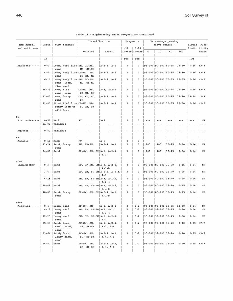
440 Soil Survey of
Table 18.--Engineering Index Properties--Continued___________________________________________________________________________________________________________________________ | | | Classification | Fragments | Percentage passing | | Map symbol | Depth | USDA texture |___________________________|_____________| sieve number-- |Liquid| Plas- and soil name | | | | | >10 | 3-10 |___________________________|limit |ticity | | | Unified | AASHTO |inches|inches| 4 | 10 | 40 | 200 | |index | | | | | | | | | | | |___________________________________________________________________________________________________________________________ | In | | | | Pct | Pct | | | | | Pct | | | | | | | | | | | | | Annalake------| 0-4 |Loamy very fine|SM, CL-ML, |A-2-4, A-4 | 0 | 0 |95-100|90-100|50-95 |25-60 | 0-26 |NP-8 | | sand | ML, SC-SM | | | | | | | | | | 4-6 |Loamy very fine|CL-ML, SM, |A-2-4, A-4 | 0 | 0 |95-100|90-100|50-95 |25-80 | 0-26 |NP-8 | | sand | SC-SM, ML | | | | | | | | | | 6-16 |Loamy very fine|SM, SC-SM, |A-2-4, A-4 | 0 | 0 |95-100|90-100|50-95 |25-65 | 0-26 |NP-8 | | sand, loamy | ML, CL-ML | | | | | | | | | | | fine sand | | | | | | | | | | | 16-33 |Loamy fine |CL-ML, ML, |A-4, A-2-4 | 0 | 0 |95-100|90-100|50-95 |25-80 | 0-26 |NP-8 | | sand, loam | SC-SM, SM | | | | | | | | | | 33-42 |Loam, loamy |CL, ML, SC, |A-2-4, A-4 | 0 | 0 |95-100|90-100|50-95 |25-80 |18-28 | 3-9 | | sand | SM | | | | | | | | | | 42-80 |Stratified fine|CL-ML, ML, |A-2-4, A-4 | 0 | 0 |95-100|90-100|50-95 |25-80 | 0-26 |NP-8 | | sandy loam to | SC-SM, SM | | | | | | | | | | | silt loam | | | | | | | | | | | | | | | | | | | | | |86: | | | | | | | | | | | | Histosols-----| 0-51 |Muck |PT |A-8 | 0 | 0 | --- | --- | --- | --- | --- | NP | 51-80 |Variable | --- | --- | --- | --- | --- | --- | --- | --- | --- | --- | | | | | | | | | | | | Aquents-------| 0-80 |Variable | --- | --- | --- | --- | --- | --- | --- | --- | --- | --- | | | | | | | | | | | |87: | | | | | | | | | | | | Ausable-------| 0-11 |Muck |PT |A-8 | 0 | 0 | --- | --- | --- | --- | --- | --- | 11-24 |Sand, loamy |SM, SP-SM |A-2-4, A-3 | 0 | 0 | 100 | 100 |50-75 | 5-30 | 0-14 | NP | | sand | | | | | | | | | | | 24-80 |Sand |SP-SM, SM, SP|A-1, A-2-4, | 0 | 0 | 100 | 100 |35-75 | 0-30 | 0-14 | NP | | | | A-3 | | | | | | | | | | | | | | | | | | | |90B: | | | | | | | | | | | | Chinwhisker---| 0-3 |Sand |SP, SP-SM, SM|A-3, A-2-4, | 0 | 0 |95-100|80-100|35-70 | 0-15 | 0-14 | NP | | | | A-1-b | | | | | | | | | 3-4 |Sand |SP, SM, SP-SM|A-1-b, A-2-4,| 0 | 0 |95-100|80-100|35-70 | 0-25 | 0-14 | NP | | | | A-3 | | | | | | | | | 4-18 |Sand |SM, SP, SP-SM|A-3, A-1-b, | 0 | 0 |95-100|80-100|35-70 | 0-25 | 0-14 | NP | | | | A-2-4 | | | | | | | | | 18-48 |Sand |SM, SP, SP-SM|A-3, A-2-4, | 0 | 0 |95-100|80-100|35-70 | 0-15 | 0-14 | NP | | | | A-1-b | | | | | | | | | 48-80 |Sand, loamy |SP-SM, SM, SP|A-2-4, A-3, | 0 | 0 |95-100|80-100|35-75 | 0-25 | 0-14 | NP | | sand | | A-1-b | | | | | | | | | | | | | | | | | | | |92B: | | | | | | | | | | | | Klacking------| 0-4 |Loamy sand |SP-SM, SM |A-1, A-2-4 | 0 | 0-2 |95-100|92-100|35-75 |10-30 | 0-14 | NP | 4-12 |Loamy sand, |SM, SP, SP-SM|A-3, A-1, | 0 | 0-2 |95-100|92-100|35-75 | 0-30 | 0-14 | NP | | sand | | A-2-4 | | | | | | | | | 12-25 |Loamy sand, |SM, SP, SP-SM|A-1, A-2-4, | 0 | 0-2 |95-100|92-100|35-75 | 0-30 | 0-14 | NP | | sand | | A-3 | | | | | | | | | 25-33 |Sand, loamy |SC-SM, SM, |A-1, A-2-4, | 0 | 0-2 |95-100|92-100|35-70 | 0-40 | 0-25 |NP-7 | | sand, sandy | SP, SP-SM | A-3, A-4 | | | | | | | | | | loam | | | | | | | | | | | 33-64 |Sandy loam, |SC-SM, SM, |A-2-4, A-3, | 0 | 0-2 |95-100|92-100|35-70 | 0-40 | 0-25 |NP-7 | | loamy sand, | SP, SP-SM | A-4, A-1 | | | | | | | | | | sand | | | | | | | | | | | 64-80 |Sand |SC-SM, SM, |A-2-4, A-3, | 0 | 0-2 |95-100|92-100|35-70 | 0-40 | 0-25 |NP-7 | | | SP, SP-SM | A-4, A-1 | | | | | | | | | | | | | | | | | | | |
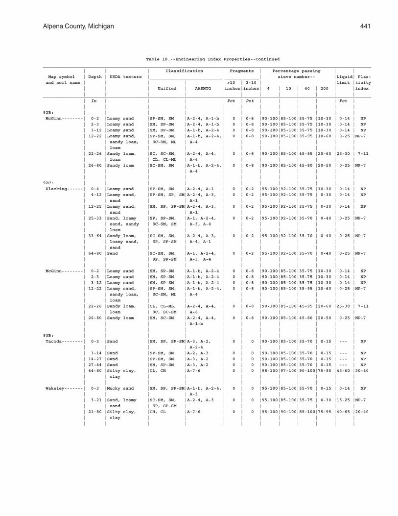
Alpena County, Michigan 441
Table 18.--Engineering Index Properties--Continued___________________________________________________________________________________________________________________________ | | | Classification | Fragments | Percentage passing | | Map symbol | Depth | USDA texture |___________________________|_____________| sieve number-- |Liquid| Plas- and soil name | | | | | >10 | 3-10 |___________________________|limit |ticity | | | Unified | AASHTO |inches|inches| 4 | 10 | 40 | 200 | |index | | | | | | | | | | | |___________________________________________________________________________________________________________________________ | In | | | | Pct | Pct | | | | | Pct | | | | | | | | | | | | |92B: | | | | | | | | | | | | McGinn--------| 0-2 |Loamy sand |SP-SM, SM |A-2-4, A-1-b | 0 | 0-8 |90-100|85-100|35-75 |10-30 | 0-14 | NP | 2-3 |Loamy sand |SM, SP-SM |A-2-4, A-1-b | 0 | 0-8 |90-100|85-100|35-75 |10-30 | 0-14 | NP | 3-12 |Loamy sand |SM, SP-SM |A-1-b, A-2-4 | 0 | 0-8 |90-100|85-100|35-75 |10-30 | 0-14 | NP | 12-22 |Loamy sand, |SP-SM, SM, |A-1-b, A-2-4,| 0 | 0-8 |90-100|85-100|35-95 |10-60 | 0-25 |NP-7 | | sandy loam, | SC-SM, ML | A-4 | | | | | | | | | | loam | | | | | | | | | | | 22-26 |Sandy loam, |SC, SC-SM, |A-2-4, A-4, | 0 | 0-8 |90-100|85-100|45-95 |20-60 |25-30 | 7-11 | | loam | CL, CL-ML | A-6 | | | | | | | | | 26-80 |Sandy loam |SC-SM, SM |A-1-b, A-2-4,| 0 | 0-8 |90-100|85-100|45-80 |20-50 | 0-25 |NP-7 | | | | A-4 | | | | | | | | | | | | | | | | | | | |92C: | | | | | | | | | | | | Klacking------| 0-4 |Loamy sand |SP-SM, SM |A-2-4, A-1 | 0 | 0-2 |95-100|92-100|35-75 |10-30 | 0-14 | NP | 4-12 |Loamy sand, |SP-SM, SP, SM|A-2-4, A-3, | 0 | 0-2 |95-100|92-100|35-75 | 0-30 | 0-14 | NP | | sand | | A-1 | | | | | | | | | 12-25 |Loamy sand, |SM, SP, SP-SM|A-2-4, A-3, | 0 | 0-2 |95-100|92-100|35-75 | 0-30 | 0-14 | NP | | sand | | A-1 | | | | | | | | | 25-33 |Sand, loamy |SP, SP-SM, |A-1, A-2-4, | 0 | 0-2 |95-100|92-100|35-70 | 0-40 | 0-25 |NP-7 | | sand, sandy | SC-SM, SM | A-3, A-4 | | | | | | | | | | loam | | | | | | | | | | | 33-64 |Sandy loam, |SC-SM, SM, |A-2-4, A-3, | 0 | 0-2 |95-100|92-100|35-70 | 0-40 | 0-25 |NP-7 | | loamy sand, | SP, SP-SM | A-4, A-1 | | | | | | | | | | sand | | | | | | | | | | | 64-80 |Sand |SC-SM, SM, |A-1, A-2-4, | 0 | 0-2 |95-100|92-100|35-70 | 0-40 | 0-25 |NP-7 | | | SP, SP-SM | A-3, A-4 | | | | | | | | | | | | | | | | | | | | McGinn--------| 0-2 |Loamy sand |SM, SP-SM |A-1-b, A-2-4 | 0 | 0-8 |90-100|85-100|35-75 |10-30 | 0-14 | NP | 2-3 |Loamy sand |SM, SP-SM |A-1-b, A-2-4 | 0 | 0-8 |90-100|85-100|35-75 |10-30 | 0-14 | NP | 3-12 |Loamy sand |SM, SP-SM |A-1-b, A-2-4 | 0 | 0-8 |90-100|85-100|35-75 |10-30 | 0-14 | NP | 12-22 |Loamy sand, |SP-SM, SM, |A-1-b, A-2-4,| 0 | 0-8 |90-100|85-100|35-95 |10-60 | 0-25 |NP-7 | | sandy loam, | SC-SM, ML | A-4 | | | | | | | | | | loam | | | | | | | | | | | 22-26 |Sandy loam, |CL, CL-ML, |A-2-4, A-4, | 0 | 0-8 |90-100|85-100|45-95 |20-60 |25-30 | 7-11 | | loam | SC, SC-SM | A-6 | | | | | | | | | 26-80 |Sandy loam |SM, SC-SM |A-2-4, A-4, | 0 | 0-8 |90-100|85-100|45-80 |20-50 | 0-25 |NP-7 | | | | A-1-b | | | | | | | | | | | | | | | | | | | |93B: | | | | | | | | | | | | Tacoda--------| 0-3 |Sand |SM, SP, SP-SM|A-3, A-2, | 0 | 0 |90-100|85-100|35-70 | 0-15 | --- | NP | | | | A-2-4 | | | | | | | | | 3-14 |Sand |SP-SM, SM |A-2, A-3 | 0 | 0 |90-100|85-100|35-70 | 0-15 | --- | NP | 14-27 |Sand |SP-SM, SM |A-3, A-2 | 0 | 0 |90-100|85-100|35-70 | 0-15 | --- | NP | 27-44 |Sand |SM, SP-SM |A-3, A-2 | 0 | 0 |90-100|85-100|35-70 | 0-15 | --- | NP | 44-80 |Silty clay, |CL, CH |A-7-6 | 0 | 0 |98-100|97-100|90-100|75-95 |45-60 |30-40 | | clay | | | | | | | | | | | | | | | | | | | | | | Wakeley-------| 0-3 |Mucky sand |SM, SP, SP-SM|A-1-b, A-2-4,| 0 | 0 |95-100|85-100|35-70 | 0-15 | 0-14 | NP | | | | A-3 | | | | | | | | | 3-21 |Sand, loamy |SC-SM, SM, |A-2-4, A-3 | 0 | 0 |95-100|85-100|35-75 | 0-30 |15-25 |NP-7 | | sand | SP, SP-SM | | | | | | | | | | 21-80 |Silty clay, |CH, CL |A-7-6 | 0 | 0 |95-100|90-100|85-100|75-95 |40-65 |20-40 | | clay | | | | | | | | | | | | | | | | | | | | | |
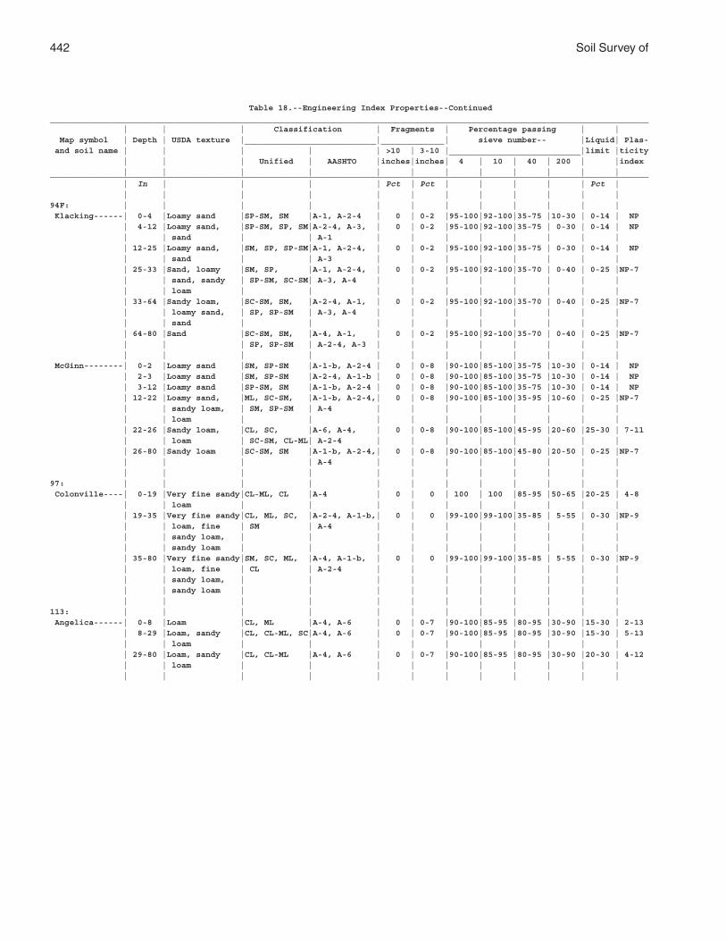
442 Soil Survey of
Table 18.--Engineering Index Properties--Continued___________________________________________________________________________________________________________________________ | | | Classification | Fragments | Percentage passing | | Map symbol | Depth | USDA texture |___________________________|_____________| sieve number-- |Liquid| Plas- and soil name | | | | | >10 | 3-10 |___________________________|limit |ticity | | | Unified | AASHTO |inches|inches| 4 | 10 | 40 | 200 | |index | | | | | | | | | | | |___________________________________________________________________________________________________________________________ | In | | | | Pct | Pct | | | | | Pct | | | | | | | | | | | | |94F: | | | | | | | | | | | | Klacking------| 0-4 |Loamy sand |SP-SM, SM |A-1, A-2-4 | 0 | 0-2 |95-100|92-100|35-75 |10-30 | 0-14 | NP | 4-12 |Loamy sand, |SP-SM, SP, SM|A-2-4, A-3, | 0 | 0-2 |95-100|92-100|35-75 | 0-30 | 0-14 | NP | | sand | | A-1 | | | | | | | | | 12-25 |Loamy sand, |SM, SP, SP-SM|A-1, A-2-4, | 0 | 0-2 |95-100|92-100|35-75 | 0-30 | 0-14 | NP | | sand | | A-3 | | | | | | | | | 25-33 |Sand, loamy |SM, SP, |A-1, A-2-4, | 0 | 0-2 |95-100|92-100|35-70 | 0-40 | 0-25 |NP-7 | | sand, sandy | SP-SM, SC-SM| A-3, A-4 | | | | | | | | | | loam | | | | | | | | | | | 33-64 |Sandy loam, |SC-SM, SM, |A-2-4, A-1, | 0 | 0-2 |95-100|92-100|35-70 | 0-40 | 0-25 |NP-7 | | loamy sand, | SP, SP-SM | A-3, A-4 | | | | | | | | | | sand | | | | | | | | | | | 64-80 |Sand |SC-SM, SM, |A-4, A-1, | 0 | 0-2 |95-100|92-100|35-70 | 0-40 | 0-25 |NP-7 | | | SP, SP-SM | A-2-4, A-3 | | | | | | | | | | | | | | | | | | | | McGinn--------| 0-2 |Loamy sand |SM, SP-SM |A-1-b, A-2-4 | 0 | 0-8 |90-100|85-100|35-75 |10-30 | 0-14 | NP | 2-3 |Loamy sand |SM, SP-SM |A-2-4, A-1-b | 0 | 0-8 |90-100|85-100|35-75 |10-30 | 0-14 | NP | 3-12 |Loamy sand |SP-SM, SM |A-1-b, A-2-4 | 0 | 0-8 |90-100|85-100|35-75 |10-30 | 0-14 | NP | 12-22 |Loamy sand, |ML, SC-SM, |A-1-b, A-2-4,| 0 | 0-8 |90-100|85-100|35-95 |10-60 | 0-25 |NP-7 | | sandy loam, | SM, SP-SM | A-4 | | | | | | | | | | loam | | | | | | | | | | | 22-26 |Sandy loam, |CL, SC, |A-6, A-4, | 0 | 0-8 |90-100|85-100|45-95 |20-60 |25-30 | 7-11 | | loam | SC-SM, CL-ML| A-2-4 | | | | | | | | | 26-80 |Sandy loam |SC-SM, SM |A-1-b, A-2-4,| 0 | 0-8 |90-100|85-100|45-80 |20-50 | 0-25 |NP-7 | | | | A-4 | | | | | | | | | | | | | | | | | | | |97: | | | | | | | | | | | | Colonville----| 0-19 |Very fine sandy|CL-ML, CL |A-4 | 0 | 0 | 100 | 100 |85-95 |50-65 |20-25 | 4-8 | | loam | | | | | | | | | | | 19-35 |Very fine sandy|CL, ML, SC, |A-2-4, A-1-b,| 0 | 0 |99-100|99-100|35-85 | 5-55 | 0-30 |NP-9 | | loam, fine | SM | A-4 | | | | | | | | | | sandy loam, | | | | | | | | | | | | sandy loam | | | | | | | | | | | 35-80 |Very fine sandy|SM, SC, ML, |A-4, A-1-b, | 0 | 0 |99-100|99-100|35-85 | 5-55 | 0-30 |NP-9 | | loam, fine | CL | A-2-4 | | | | | | | | | | sandy loam, | | | | | | | | | | | | sandy loam | | | | | | | | | | | | | | | | | | | | | |113: | | | | | | | | | | | | Angelica------| 0-8 |Loam |CL, ML |A-4, A-6 | 0 | 0-7 |90-100|85-95 |80-95 |30-90 |15-30 | 2-13 | 8-29 |Loam, sandy |CL, CL-ML, SC|A-4, A-6 | 0 | 0-7 |90-100|85-95 |80-95 |30-90 |15-30 | 5-13 | | loam | | | | | | | | | | | 29-80 |Loam, sandy |CL, CL-ML |A-4, A-6 | 0 | 0-7 |90-100|85-95 |80-95 |30-90 |20-30 | 4-12 | | loam | | | | | | | | | | | | | | | | | | | | | |
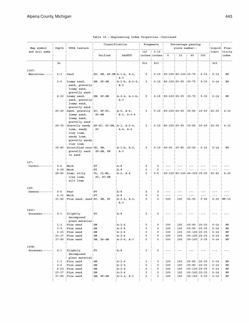
Alpena County, Michigan 443
Table 18.--Engineering Index Properties--Continued___________________________________________________________________________________________________________________________ | | | Classification | Fragments | Percentage passing | | Map symbol | Depth | USDA texture |___________________________|_____________| sieve number-- |Liquid| Plas- and soil name | | | | | >10 | 3-10 |___________________________|limit |ticity | | | Unified | AASHTO |inches|inches| 4 | 10 | 40 | 200 | |index | | | | | | | | | | | |___________________________________________________________________________________________________________________________ | In | | | | Pct | Pct | | | | | Pct | | | | | | | | | | | | |116C: | | | | | | | | | | | | Mancelona-----| 0-3 |Sand |SP, SM, SP-SM|A-1-b, A-2, | 0 | 0-15 |90-100|85-100|35-70 | 0-15 | 0-14 | NP | | | | A-3 | | | | | | | | | 3-6 |Loamy sand, |SM, SP-SM |A-1-b, A-2-4,| 0 | 0-15 |80-100|65-95 |30-75 | 5-30 | 0-14 | NP | | sand, gravelly| | A-3 | | | | | | | | | | loamy sand, | | | | | | | | | | | | gravelly sand | | | | | | | | | | | 6-20 |Loamy sand, |SM, SP-SM |A-2-4, A-1-b,| 0 | 0-15 |80-100|65-95 |30-75 | 5-30 | 0-14 | NP | | sand, gravelly| | A-3 | | | | | | | | | | loamy sand, | | | | | | | | | | | | gravelly sand | | | | | | | | | | | 20-29 |Sand, gravelly |SC, SP-SC, |A-6, A-4, | 0 | 0-15 |80-100|65-95 |35-80 |10-50 |20-35 | 4-15 | | loamy sand, | SC-SM | A-1, A-2-4 | | | | | | | | | | loamy sand, | | | | | | | | | | | | gravelly sand | | | | | | | | | | | 29-35 |Gravelly sandy |SP-SC, SC-SM,|A-1, A-2-4, | 0 | 0-15 |80-100|65-95 |35-80 |10-50 |20-35 | 4-15 | | loam, sandy | SC | A-4, A-6 | | | | | | | | | | clay loam, | | | | | | | | | | | | sandy loam, | | | | | | | | | | | | gravelly sandy| | | | | | | | | | | | clay loam | | | | | | | | | | | 35-80 |Stratified very|GP, GW, |A-1-b, A-2, | 0 | 0-15 |40-90 |30-85 |20-60 | 0-15 | 0-14 | NP | | gravelly sand | SP-SM, SW | A-3 | | | | | | | | | | to sand | | | | | | | | | | | | | | | | | | | | | |127: | | | | | | | | | | | | Cathro--------| 0-6 |Muck |PT |A-8 | 0 | 0 | --- | --- | --- | --- | --- | --- | 6-28 |Muck |PT |A-8 | 0 | 0 | --- | --- | --- | --- | --- | --- | 28-80 |Loam, silty |CL, CL-ML, |A-6, A-4 | 0 | 0-5 |90-100|85-100|60-100|35-90 |20-40 | 4-20 | | clay loam, | SC, SC-SM | | | | | | | | | | | silt loam | | | | | | | | | | | | | | | | | | | | | |128: | | | | | | | | | | | | Dawson--------| 0-6 |Peat |PT |A-8 | 0 | 0 | --- | --- | --- | --- | --- | --- | 6-31 |Muck |PT |A-8 | 0 | 0 | --- | --- | --- | --- | --- | --- | 31-80 |Fine sand, sand|SC, SM, SP |A-2-4, A-4, | 0 | 0 | 100 | 100 |50-90 | 0-45 | 0-20 |NP-10 | | | | A-3 | | | | | | | | | | | | | | | | | | | |145C: | | | | | | | | | | | | Rousseau------| 0-1 |Slightly |PT |A-8 | 0 | 0 | --- | --- | --- | --- | --- | --- | | decomposed | | | | | | | | | | | | plant material| | | | | | | | | | | 1-3 |Fine sand |SM |A-2-4 | 0 | 0 | 100 | 100 |65-80 |20-35 | 0-14 | NP | 3-6 |Fine sand |SM |A-2-4 | 0 | 0 | 100 | 100 |65-80 |20-35 | 0-14 | NP | 6-23 |Fine sand |SM |A-2-4 | 0 | 0 | 100 | 100 |65-100|20-35 | 0-14 | NP | 23-37 |Fine sand |SM |A-2-4 | 0 | 0 | 100 | 100 |65-100|20-35 | 0-14 | NP | 37-80 |Fine sand |SM, SP-SM |A-2-4, A-3 | 0 | 0 | 100 | 100 |50-100| 5-35 | 0-14 | NP | | | | | | | | | | | |145E: | | | | | | | | | | | | Rousseau------| 0-1 |Slightly |PT |A-8 | 0 | 0 | --- | --- | --- | --- | --- | --- | | decomposed | | | | | | | | | | | | plant material| | | | | | | | | | | 1-3 |Fine sand |SM |A-2-4 | 0 | 0 | 100 | 100 |65-80 |20-35 | 0-14 | NP | 3-6 |Fine sand |SM |A-2-4 | 0 | 0 | 100 | 100 |65-80 |20-35 | 0-14 | NP | 6-23 |Fine sand |SM |A-2-4 | 0 | 0 | 100 | 100 |65-100|20-35 | 0-14 | NP | 23-37 |Fine sand |SM |A-2-4 | 0 | 0 | 100 | 100 |65-100|20-35 | 0-14 | NP | 37-80 |Fine sand |SM, SP-SM |A-2-4, A-3 | 0 | 0 | 100 | 100 |50-100| 5-35 | 0-14 | NP | | | | | | | | | | | |
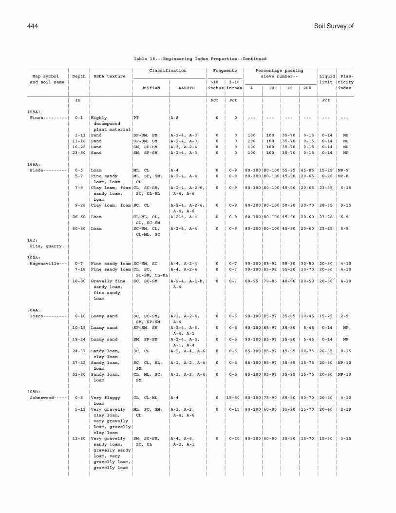
444 Soil Survey of
Table 18.--Engineering Index Properties--Continued___________________________________________________________________________________________________________________________ | | | Classification | Fragments | Percentage passing | | Map symbol | Depth | USDA texture |___________________________|_____________| sieve number-- |Liquid| Plas- and soil name | | | | | >10 | 3-10 |___________________________|limit |ticity | | | Unified | AASHTO |inches|inches| 4 | 10 | 40 | 200 | |index | | | | | | | | | | | |___________________________________________________________________________________________________________________________ | In | | | | Pct | Pct | | | | | Pct | | | | | | | | | | | | |159A: | | | | | | | | | | | | Finch---------| 0-1 |Highly |PT |A-8 | 0 | 0 | --- | --- | --- | --- | --- | --- | | decomposed | | | | | | | | | | | | plant material| | | | | | | | | | | 1-11 |Sand |SP-SM, SM |A-2-4, A-3 | 0 | 0 | 100 | 100 |35-70 | 0-15 | 0-14 | NP | 11-16 |Sand |SP-SM, SM |A-2-4, A-3 | 0 | 0 | 100 | 100 |35-70 | 0-15 | 0-14 | NP | 16-23 |Sand |SM, SP-SM |A-3, A-2-4 | 0 | 0 | 100 | 100 |35-70 | 0-15 | 0-14 | NP | 23-80 |Sand |SM, SP-SM |A-2-4, A-3 | 0 | 0 | 100 | 100 |35-70 | 0-15 | 0-14 | NP | | | | | | | | | | | |166A: | | | | | | | | | | | | Slade---------| 0-5 |Loam |ML, CL |A-4 | 0 | 0-9 |80-100|80-100|55-95 |45-85 |15-28 |NP-9 | 5-7 |Fine sandy |ML, SC, SM, |A-2-4, A-4 | 0 | 0-9 |80-100|80-100|45-90 |20-65 | 0-26 |NP-8 | | loam, loam | CL | | | | | | | | | | 7-9 |Clay loam, fine|CL, SC-SM, |A-2-4, A-2-6,| 0 | 0-9 |80-100|80-100|45-90 |20-65 |23-35 | 6-15 | | sandy loam, | SC, CL-ML | A-4, A-6 | | | | | | | | | | loam | | | | | | | | | | | 9-26 |Clay loam, loam|SC, CL |A-2-4, A-2-6,| 0 | 0-9 |80-100|80-100|50-90 |30-70 |28-35 | 9-15 | | | | A-4, A-6 | | | | | | | | | 26-60 |Loam |CL-ML, CL, |A-2-4, A-4 | 0 | 0-9 |80-100|80-100|45-90 |20-60 |23-28 | 6-9 | | | SC, SC-SM | | | | | | | | | | 60-80 |Loam |SC-SM, CL, |A-2-4, A-4 | 0 | 0-9 |80-100|80-100|45-90 |20-60 |23-28 | 6-9 | | | CL-ML, SC | | | | | | | | |182: | | | | | | | | | | | | Pits, quarry. | | | | | | | | | | | | | | | | | | | | | | | |300A: | | | | | | | | | | | | Hagensville---| 0-7 |Fine sandy loam|SC-SM, SC |A-4, A-2-4 | 0 | 0-7 |90-100|85-92 |55-80 |30-50 |20-30 | 4-10 | 7-18 |Fine sandy loam|CL, SC, |A-4, A-2-4 | 0 | 0-7 |90-100|85-92 |55-90 |30-70 |20-30 | 4-10 | | | SC-SM, CL-ML| | | | | | | | | | 18-80 |Gravelly fine |SC, SC-SM |A-2-4, A-1-b,| 0 | 0-7 |80-95 |70-85 |40-80 |20-50 |20-30 | 4-10 | | sandy loam, | | A-4 | | | | | | | | | | fine sandy | | | | | | | | | | | | loam | | | | | | | | | | | | | | | | | | | | | |304A: | | | | | | | | | | | | Iosco---------| 0-10 |Loamy sand |SC, SC-SM, |A-1, A-2-4, | 0 | 0-5 |90-100|85-97 |35-85 |10-45 |15-25 | 2-9 | | | SM, SP-SM | A-4 | | | | | | | | | 10-19 |Loamy sand |SP-SM, SM |A-2-4, A-3, | 0 | 0-5 |90-100|85-97 |35-80 | 5-45 | 0-14 | NP | | | | A-4, A-1 | | | | | | | | | 19-24 |Loamy sand |SM, SP-SM |A-2-4, A-3, | 0 | 0-5 |90-100|85-97 |35-80 | 5-45 | 0-14 | NP | | | | A-1, A-4 | | | | | | | | | 24-37 |Sandy loam, |SC, CL |A-2, A-4, A-6| 0 | 0-5 |85-100|85-97 |45-95 |20-75 |26-35 | 8-15 | | clay loam | | | | | | | | | | | 37-52 |Sandy loam, |SC, CL, ML, |A-1, A-2, A-4| 0 | 0-5 |85-100|85-97 |35-95 |15-75 |20-30 |NP-10 | | loam | SM | | | | | | | | | | 52-80 |Sandy loam, |CL, ML, SC, |A-1, A-2, A-4| 0 | 0-5 |85-100|85-97 |35-95 |15-75 |20-30 |NP-10 | | loam | SM | | | | | | | | | | | | | | | | | | | | |305B: | | | | | | | | | | | | Johnswood-----| 0-5 |Very flaggy |CL, CL-ML |A-4 | 0 |15-50 |80-100|75-90 |65-90 |50-70 |20-30 | 4-10 | | loam | | | | | | | | | | | 5-12 |Very gravelly |ML, SC, SM, |A-1, A-2, | 0 | 0-15 |80-100|60-90 |35-90 |15-70 |20-40 | 2-19 | | clay loam, | CL | A-4, A-6 | | | | | | | | | | very gravelly | | | | | | | | | | | | loam, gravelly| | | | | | | | | | | | clay loam | | | | | | | | | | | 12-80 |Very gravelly |SM, SC-SM, |A-4, A-6, | 0 | 0-20 |80-100|60-90 |35-90 |15-70 |15-30 | 3-15 | | sandy loam, | SC, CL | A-2, A-1 | | | | | | | | | | gravelly sandy| | | | | | | | | | | | loam, very | | | | | | | | | | | | gravelly loam,| | | | | | | | | | | | gravelly loam | | | | | | | | | | | | | | | | | | | | | |
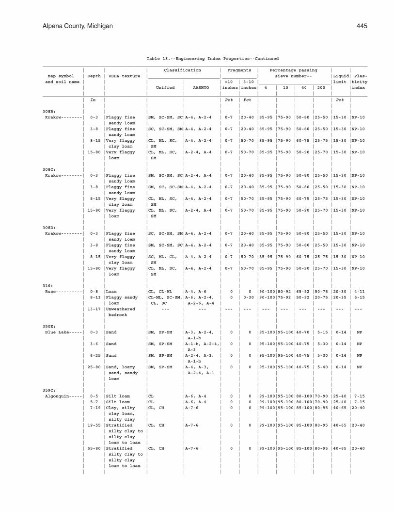
Alpena County, Michigan 445
Table 18.--Engineering Index Properties--Continued___________________________________________________________________________________________________________________________ | | | Classification | Fragments | Percentage passing | | Map symbol | Depth | USDA texture |___________________________|_____________| sieve number-- |Liquid| Plas- and soil name | | | | | >10 | 3-10 |___________________________|limit |ticity | | | Unified | AASHTO |inches|inches| 4 | 10 | 40 | 200 | |index | | | | | | | | | | | |___________________________________________________________________________________________________________________________ | In | | | | Pct | Pct | | | | | Pct | | | | | | | | | | | | |308B: | | | | | | | | | | | | Krakow--------| 0-3 |Flaggy fine |SM, SC-SM, SC|A-4, A-2-4 | 0-7 |20-40 |85-95 |75-90 |50-80 |25-50 |15-30 |NP-10 | | sandy loam | | | | | | | | | | | 3-8 |Flaggy fine |SC, SC-SM, SM|A-4, A-2-4 | 0-7 |20-40 |85-95 |75-90 |50-80 |25-50 |15-30 |NP-10 | | sandy loam | | | | | | | | | | | 8-15 |Very flaggy |CL, ML, SC, |A-4, A-2-4 | 0-7 |50-70 |85-95 |75-90 |60-75 |25-75 |15-30 |NP-10 | | clay loam | SM | | | | | | | | | | 15-80 |Very flaggy |CL, ML, SC, |A-2-4, A-4 | 0-7 |50-70 |85-95 |75-90 |50-90 |25-70 |15-30 |NP-10 | | loam | SM | | | | | | | | | | | | | | | | | | | | |308C: | | | | | | | | | | | | Krakow--------| 0-3 |Flaggy fine |SM, SC-SM, SC|A-2-4, A-4 | 0-7 |20-40 |85-95 |75-90 |50-80 |25-50 |15-30 |NP-10 | | sandy loam | | | | | | | | | | | 3-8 |Flaggy fine |SM, SC, SC-SM|A-4, A-2-4 | 0-7 |20-40 |85-95 |75-90 |50-80 |25-50 |15-30 |NP-10 | | sandy loam | | | | | | | | | | | 8-15 |Very flaggy |CL, ML, SC, |A-4, A-2-4 | 0-7 |50-70 |85-95 |75-90 |60-75 |25-75 |15-30 |NP-10 | | clay loam | SM | | | | | | | | | | 15-80 |Very flaggy |CL, ML, SC, |A-2-4, A-4 | 0-7 |50-70 |85-95 |75-90 |50-90 |25-70 |15-30 |NP-10 | | loam | SM | | | | | | | | | | | | | | | | | | | | |308D: | | | | | | | | | | | | Krakow--------| 0-3 |Flaggy fine |SC, SC-SM, SM|A-4, A-2-4 | 0-7 |20-40 |85-95 |75-90 |50-80 |25-50 |15-30 |NP-10 | | sandy loam | | | | | | | | | | | 3-8 |Flaggy fine |SM, SC-SM, SC|A-4, A-2-4 | 0-7 |20-40 |85-95 |75-90 |50-80 |25-50 |15-30 |NP-10 | | sandy loam | | | | | | | | | | | 8-15 |Very flaggy |SC, ML, CL, |A-4, A-2-4 | 0-7 |50-70 |85-95 |75-90 |60-75 |25-75 |15-30 |NP-10 | | clay loam | SM | | | | | | | | | | 15-80 |Very flaggy |CL, ML, SC, |A-4, A-2-4 | 0-7 |50-70 |85-95 |75-90 |50-90 |25-70 |15-30 |NP-10 | | loam | SM | | | | | | | | | | | | | | | | | | | | |316: | | | | | | | | | | | | Ruse----------| 0-8 |Loam |CL, CL-ML |A-4, A-6 | 0 | 0 |90-100|80-92 |65-92 |50-75 |20-30 | 4-11 | 8-13 |Flaggy sandy |CL-ML, SC-SM,|A-6, A-2-4, | 0 | 0-30 |90-100|75-92 |50-92 |20-75 |20-35 | 5-15 | | loam | CL, SC | A-2-6, A-4 | | | | | | | | | 13-17 |Unweathered | --- | --- | --- | --- | --- | --- | --- | --- | --- | --- | | bedrock | | | | | | | | | | | | | | | | | | | | | |350E: | | | | | | | | | | | | Blue Lake-----| 0-3 |Sand |SM, SP-SM |A-3, A-2-4, | 0 | 0 |95-100|95-100|40-70 | 5-15 | 0-14 | NP | | | | A-1-b | | | | | | | | | 3-6 |Sand |SM, SP-SM |A-1-b, A-2-4,| 0 | 0 |95-100|95-100|40-75 | 5-30 | 0-14 | NP | | | | A-3 | | | | | | | | | 6-25 |Sand |SM, SP-SM |A-2-4, A-3, | 0 | 0 |95-100|95-100|40-75 | 5-30 | 0-14 | NP | | | | A-1-b | | | | | | | | | 25-80 |Sand, loamy |SM, SP-SM |A-4, A-3, | 0 | 0 |95-100|95-100|40-75 | 5-40 | 0-14 | NP | | sand, sandy | | A-2-4, A-1 | | | | | | | | | | loam | | | | | | | | | | | | | | | | | | | | | |359C: | | | | | | | | | | | | Algonquin-----| 0-5 |Silt loam |CL |A-6, A-4 | 0 | 0 |99-100|95-100|80-100|70-90 |25-40 | 7-15 | 5-7 |Silt loam |CL |A-6, A-4 | 0 | 0 |99-100|95-100|80-100|70-90 |25-40 | 7-15 | 7-19 |Clay, silty |CL, CH |A-7-6 | 0 | 0 |99-100|95-100|85-100|80-95 |40-65 |20-40 | | clay loam, | | | | | | | | | | | | silty clay | | | | | | | | | | | 19-55 |Stratified |CL, CH |A-7-6 | 0 | 0 |99-100|95-100|85-100|80-95 |40-65 |20-40 | | silty clay to | | | | | | | | | | | | silty clay | | | | | | | | | | | | loam to loam | | | | | | | | | | | 55-80 |Stratified |CL, CH |A-7-6 | 0 | 0 |99-100|95-100|85-100|80-95 |40-65 |20-40 | | silty clay to | | | | | | | | | | | | silty clay | | | | | | | | | | | | loam to loam | | | | | | | | | | | | | | | | | | | | | |
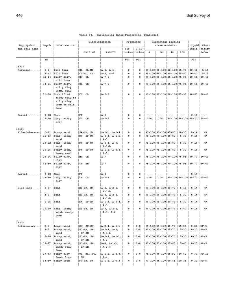
446 Soil Survey of
Table 18.--Engineering Index Properties--Continued___________________________________________________________________________________________________________________________ | | | Classification | Fragments | Percentage passing | | Map symbol | Depth | USDA texture |___________________________|_____________| sieve number-- |Liquid| Plas- and soil name | | | | | >10 | 3-10 |___________________________|limit |ticity | | | Unified | AASHTO |inches|inches| 4 | 10 | 40 | 200 | |index | | | | | | | | | | | |___________________________________________________________________________________________________________________________ | In | | | | Pct | Pct | | | | | Pct | | | | | | | | | | | | |359C: | | | | | | | | | | | | Negwegon------| 0-9 |Silt loam |CL, CL-ML |A-4, A-6 | 0 | 0 |99-100|98-100|80-100|65-90 |20-40 | 5-15 | 9-12 |Silt loam |CL-ML, CL |A-4, A-6 | 0 | 0 |99-100|98-100|80-100|65-90 |20-40 | 5-15 | 12-14 |Silty clay, |CH, CL |A-7-6 | 0 | 0 |99-100|98-100|85-100|75-95 |40-65 |20-40 | | silt loam | | | | | | | | | | | 14-51 |Silty clay, |CL, CH |A-7-6 | 0 | 0 |99-100|98-100|85-100|75-95 |40-65 |20-40 | | silty clay | | | | | | | | | | | | loam, clay | | | | | | | | | | | 51-80 |Stratified |CH, CL |A-7-6 | 0 | 0 |99-100|98-100|80-100|65-95 |40-65 |20-40 | | silty clay to | | | | | | | | | | | | silty clay | | | | | | | | | | | | loam to silt | | | | | | | | | | | | loam | | | | | | | | | | | | | | | | | | | | | | Dorval--------| 0-18 |Muck |PT |A-8 | 0 | 0 | --- | --- | --- | --- | 0-14 | --- | 18-80 |Clay, silty |CL, CH |A-7-6 | 0 | 0 | 100 | 100 |90-100|80-100|45-70 |25-40 | | clay | | | | | | | | | | | | | | | | | | | | | |361B: | | | | | | | | | | | | Allendale-----| 0-11 |Loamy sand |SP-SM, SM |A-1-b, A-2-4 | 0 | 0 |95-100|95-100|45-80 |10-30 | 0-14 | NP | 11-13 |Sand, loamy |SM, SP-SM |A-2-4, A-1-b,| 0 | 0 |95-100|95-100|45-80 | 5-30 | 0-14 | NP | | sand | | A-3 | | | | | | | | | 13-22 |Sand, loamy |SM, SP-SM |A-2-4, A-3, | 0 | 0 |95-100|95-100|45-80 | 5-30 | 0-14 | NP | | sand | | A-1-b | | | | | | | | | 22-25 |Sandy loam, |SM, SP-SM |A-1-b, A-2-4,| 0 | 0 |95-100|95-100|45-80 | 5-30 | 0-14 | NP | | loamy sand | | A-3 | | | | | | | | | 25-44 |Silty clay, |MH, CH |A-7 | 0 | 0 |95-100|95-100|90-100|75-95 |50-70 |20-40 | | clay | | | | | | | | | | | 44-80 |Silty clay, |CH, MH |A-7 | 0 | 0 |95-100|95-100|90-100|75-95 |50-70 |20-40 | | clay | | | | | | | | | | | | | | | | | | | | | | Dorval--------| 0-18 |Muck |PT |A-8 | 0 | 0 | --- | --- | --- | --- | 0-14 | --- | 18-80 |Clay, silty |CH, CL |A-7-6 | 0 | 0 | 100 | 100 |90-100|80-100|45-70 |25-40 | | clay | | | | | | | | | | | | | | | | | | | | | | Blue Lake-----| 0-3 |Sand |SP-SM, SM |A-3, A-2-4, | 0 | 0 |95-100|95-100|40-70 | 5-15 | 0-14 | NP | | | | A-1-b | | | | | | | | | 3-6 |Sand |SP-SM, SM |A-3, A-2-4, | 0 | 0 |95-100|95-100|40-75 | 5-30 | 0-14 | NP | | | | A-1-b | | | | | | | | | 6-25 |Sand |SM, SP-SM |A-1-b, A-2-4,| 0 | 0 |95-100|95-100|40-75 | 5-30 | 0-14 | NP | | | | A-3 | | | | | | | | | 25-80 |Sand, loamy |SP-SM, SM |A-3, A-2-4, | 0 | 0 |95-100|95-100|40-75 | 5-40 | 0-14 | NP | | sand, sandy | | A-1, A-4 | | | | | | | | | | loam | | | | | | | | | | | | | | | | | | | | | |362D: | | | | | | | | | | | | Millersburg---| 0-3 |Loamy sand |SM, SC-SM |A-2-4, A-1-b | 0 | 0-8 |95-100|85-100|40-75 |15-25 | 0-20 |NP-5 | 3-5 |Loamy sand, |SC-SM, SM, |A-2-4, A-3, | 0 | 0-8 |95-100|85-100|35-70 | 5-20 | 0-20 |NP-5 | | sand | SP-SM | A-1-b | | | | | | | | | 5-18 |Loamy sand, |SC-SM, SM, |A-2-4, A-1-b,| 0 | 0-8 |95-100|85-100|35-70 | 5-20 | 0-20 |NP-5 | | sand | SP-SM | A-3 | | | | | | | | | 18-27 |Loamy sand, |SC-SM, SM, |A-4, A-1-b, | 0 | 0-8 |95-100|85-100|35-65 | 5-40 | 0-20 |NP-5 | | sandy clay | SP-SM | A-2-4 | | | | | | | | | | loam | | | | | | | | | | | 27-33 |Sandy clay |CL, ML, SC, |A-1-b, A-2-4,| 0 | 0-8 |95-100|85-100|45-90 |20-60 | 0-30 |NP-10 | | loam, loam | SM | A-4 | | | | | | | | | 33-80 |Sandy loam |SP-SM, SM |A-1-b, A-2-4 | 0 | 0-8 |90-100|85-100|40-65 |10-35 | 0-30 |NP-5 | | | | | | | | | | | |
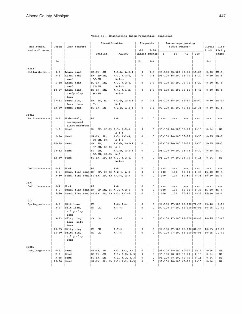
Alpena County, Michigan 447
Table 18.--Engineering Index Properties--Continued___________________________________________________________________________________________________________________________ | | | Classification | Fragments | Percentage passing | | Map symbol | Depth | USDA texture |___________________________|_____________| sieve number-- |Liquid| Plas- and soil name | | | | | >10 | 3-10 |___________________________|limit |ticity | | | Unified | AASHTO |inches|inches| 4 | 10 | 40 | 200 | |index | | | | | | | | | | | |___________________________________________________________________________________________________________________________ | In | | | | Pct | Pct | | | | | Pct | | | | | | | | | | | | |362E: | | | | | | | | | | | | Millersburg---| 0-3 |Loamy sand |SC-SM, SM |A-1-b, A-2-4 | 0 | 0-8 |95-100|85-100|40-75 |15-25 | 0-20 |NP-5 | 3-5 |Loamy sand, |SM, SP-SM, |A-3, A-2-4, | 0 | 0-8 |95-100|85-100|35-70 | 5-20 | 0-20 |NP-5 | | sand | SC-SM | A-1-b | | | | | | | | | 5-18 |Loamy sand, |SC-SM, SM, |A-3, A-2-4, | 0 | 0-8 |95-100|85-100|35-70 | 5-20 | 0-20 |NP-5 | | sand | SP-SM | A-1-b | | | | | | | | | 18-27 |Loamy sand, |SP-SM, SM, |A-4, A-1-b, | 0 | 0-8 |95-100|85-100|35-65 | 5-40 | 0-20 |NP-5 | | sandy clay | SC-SM | A-2-4 | | | | | | | | | | loam | | | | | | | | | | | 27-33 |Sandy clay |SM, SC, ML, |A-1-b, A-2-4,| 0 | 0-8 |95-100|85-100|45-90 |20-60 | 0-30 |NP-10 | | loam, loam | CL | A-4 | | | | | | | | | 33-80 |Sandy loam |SP-SM, SM |A-1-b, A-2-4 | 0 | 0-8 |90-100|85-100|40-65 |10-35 | 0-30 |NP-5 | | | | | | | | | | | |368A: | | | | | | | | | | | | Au Gres-------| 0-1 |Moderately |PT |A-8 | 0 | 0 | --- | --- | --- | --- | --- | --- | | decomposed | | | | | | | | | | | | plant material| | | | | | | | | | | 1-2 |Sand |SM, SP, SP-SM|A-3, A-2-4, | 0 | 0 |95-100|90-100|35-70 | 0-15 | 0-14 | NP | | | | A-1-b | | | | | | | | | 2-10 |Sand |SP-SM, SP, |A-3, A-2-4, | 0 | 0 |95-100|90-100|35-75 | 0-30 | 0-25 |NP-7 | | | SC-SM, SM | A-1-b | | | | | | | | | 10-28 |Sand |SM, SP, |A-1-b, A-2-4,| 0 | 0 |95-100|90-100|35-75 | 0-30 | 0-25 |NP-7 | | | SP-SM, SC-SM| A-3 | | | | | | | | | 28-32 |Sand |SP, SM, |A-1-b, A-2-4,| 0 | 0 |95-100|90-100|35-75 | 0-30 | 0-25 |NP-7 | | | SC-SM, SP-SM| A-3 | | | | | | | | | 32-80 |Sand |SP-SM, SP, SM|A-3, A-2-4, | 0 | 0 |95-100|90-100|35-70 | 0-15 | 0-14 | NP | | | | A-1-b | | | | | | | | | | | | | | | | | | | | Deford--------| 0-4 |Muck |PT |A-8 | 0 | 0 | --- | --- | --- | --- | --- | --- | 4-5 |Sand, fine sand|SM, SP, SP-SM|A-2-4, A-3 | 0 | 0 | 100 | 100 |50-80 | 0-35 |15-20 |NP-4 | 5-80 |Sand, fine sand|SP-SM, SP, SM|A-2-4, A-3 | 0 | 0 | 100 | 100 |50-80 | 0-35 |15-20 |NP-4 | | | | | | | | | | | |369: | | | | | | | | | | | | Deford--------| 0-4 |Muck |PT |A-8 | 0 | 0 | --- | --- | --- | --- | --- | --- | 4-5 |Sand, fine sand|SM, SP-SM, SP|A-3, A-2-4 | 0 | 0 | 100 | 100 |50-80 | 0-35 |15-20 |NP-4 | 5-80 |Sand, fine sand|SP-SM, SP, SM|A-3, A-2-4 | 0 | 0 | 100 | 100 |50-80 | 0-35 |15-20 |NP-4 | | | | | | | | | | | |371: | | | | | | | | | | | | Springport----| 0-3 |Silt loam |CL |A-6, A-4 | 0 | 0 |97-100|97-100|80-100|70-90 |25-40 | 7-15 | 3-9 |Silt loam, |CH, CL |A-7-6 | 0 | 0 |97-100|97-100|85-100|80-95 |40-65 |20-40 | | silty clay | | | | | | | | | | | | loam | | | | | | | | | | | 9-13 |Silty clay |CH, CL |A-7-6 | 0 | 0 |97-100|97-100|85-100|80-95 |40-65 |20-40 | | loam, silt | | | | | | | | | | | | loam | | | | | | | | | | | 13-35 |Silty clay |CL, CH |A-7-6 | 0 | 0 |97-100|97-100|85-100|80-95 |40-65 |20-40 | 35-80 |Silty clay, |CH, CL |A-7-6 | 0 | 0 |97-100|97-100|85-100|80-95 |40-65 |20-40 | | silty clay | | | | | | | | | | | | loam | | | | | | | | | | | | | | | | | | | | | |373B: | | | | | | | | | | | | Grayling------| 0-2 |Sand |SP-SM, SM |A-3, A-2, A-1| 0 | 0 |99-100|98-100|40-70 | 0-15 | 0-14 | NP | 2-3 |Sand |SP-SM, SM |A-1, A-2, A-3| 0 | 0 |99-100|98-100|40-70 | 0-15 | 0-14 | NP | 3-15 |Sand |SP-SM, SM |A-1, A-2, A-3| 0 | 0 |99-100|98-100|40-70 | 0-15 | 0-14 | NP | 15-80 |Sand |SP-SM, SP, SM|A-1, A-2, A-3| 0 | 0 |99-100|98-100|40-70 | 0-15 | 0-14 | NP | | | | | | | | | | | |
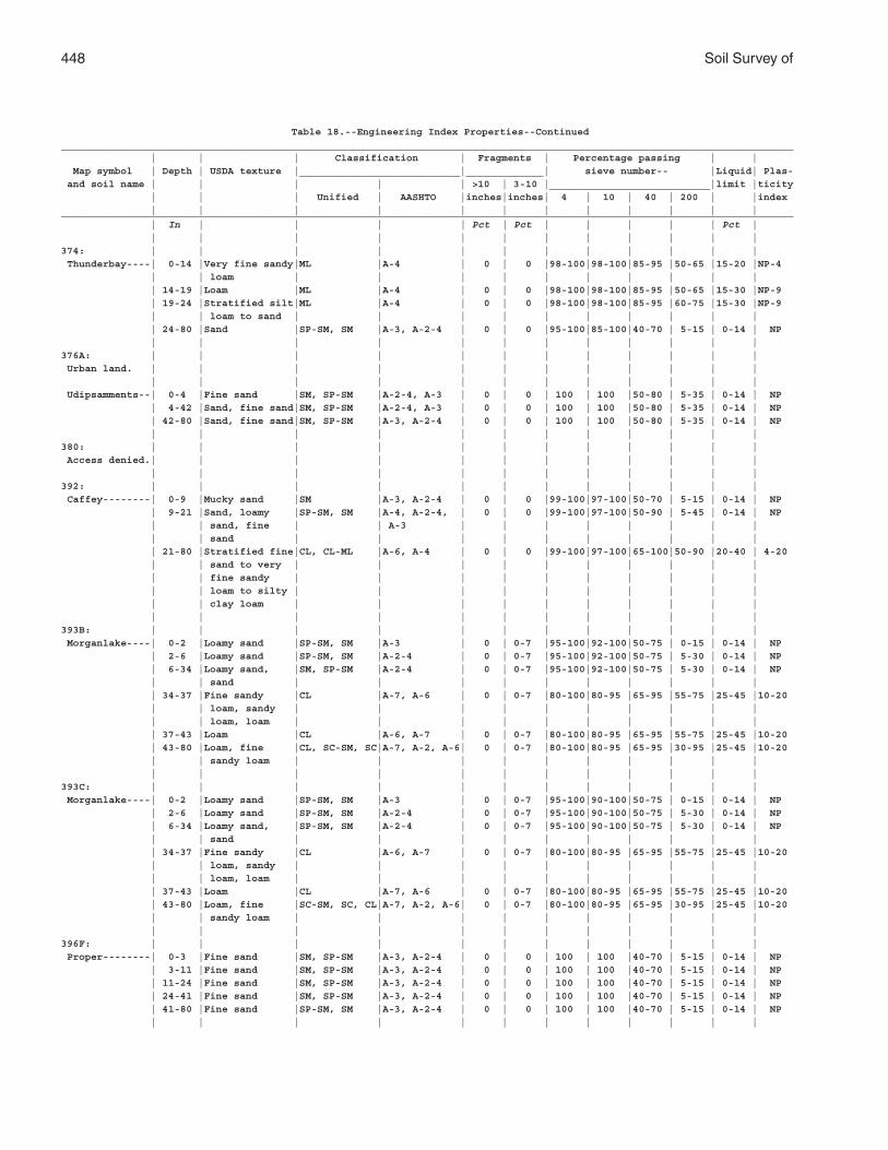
448 Soil Survey of
Table 18.--Engineering Index Properties--Continued___________________________________________________________________________________________________________________________ | | | Classification | Fragments | Percentage passing | | Map symbol | Depth | USDA texture |___________________________|_____________| sieve number-- |Liquid| Plas- and soil name | | | | | >10 | 3-10 |___________________________|limit |ticity | | | Unified | AASHTO |inches|inches| 4 | 10 | 40 | 200 | |index | | | | | | | | | | | |___________________________________________________________________________________________________________________________ | In | | | | Pct | Pct | | | | | Pct | | | | | | | | | | | | |374: | | | | | | | | | | | | Thunderbay----| 0-14 |Very fine sandy|ML |A-4 | 0 | 0 |98-100|98-100|85-95 |50-65 |15-20 |NP-4 | | loam | | | | | | | | | | | 14-19 |Loam |ML |A-4 | 0 | 0 |98-100|98-100|85-95 |50-65 |15-30 |NP-9 | 19-24 |Stratified silt|ML |A-4 | 0 | 0 |98-100|98-100|85-95 |60-75 |15-30 |NP-9 | | loam to sand | | | | | | | | | | | 24-80 |Sand |SP-SM, SM |A-3, A-2-4 | 0 | 0 |95-100|85-100|40-70 | 5-15 | 0-14 | NP | | | | | | | | | | | |376A: | | | | | | | | | | | | Urban land. | | | | | | | | | | | | | | | | | | | | | | | | Udipsamments--| 0-4 |Fine sand |SM, SP-SM |A-2-4, A-3 | 0 | 0 | 100 | 100 |50-80 | 5-35 | 0-14 | NP | 4-42 |Sand, fine sand|SM, SP-SM |A-2-4, A-3 | 0 | 0 | 100 | 100 |50-80 | 5-35 | 0-14 | NP | 42-80 |Sand, fine sand|SM, SP-SM |A-3, A-2-4 | 0 | 0 | 100 | 100 |50-80 | 5-35 | 0-14 | NP | | | | | | | | | | | |380: | | | | | | | | | | | | Access denied.| | | | | | | | | | | | | | | | | | | | | | | |392: | | | | | | | | | | | | Caffey--------| 0-9 |Mucky sand |SM |A-3, A-2-4 | 0 | 0 |99-100|97-100|50-70 | 5-15 | 0-14 | NP | 9-21 |Sand, loamy |SP-SM, SM |A-4, A-2-4, | 0 | 0 |99-100|97-100|50-90 | 5-45 | 0-14 | NP | | sand, fine | | A-3 | | | | | | | | | | sand | | | | | | | | | | | 21-80 |Stratified fine|CL, CL-ML |A-6, A-4 | 0 | 0 |99-100|97-100|65-100|50-90 |20-40 | 4-20 | | sand to very | | | | | | | | | | | | fine sandy | | | | | | | | | | | | loam to silty | | | | | | | | | | | | clay loam | | | | | | | | | | | | | | | | | | | | | |393B: | | | | | | | | | | | | Morganlake----| 0-2 |Loamy sand |SP-SM, SM |A-3 | 0 | 0-7 |95-100|92-100|50-75 | 0-15 | 0-14 | NP | 2-6 |Loamy sand |SP-SM, SM |A-2-4 | 0 | 0-7 |95-100|92-100|50-75 | 5-30 | 0-14 | NP | 6-34 |Loamy sand, |SM, SP-SM |A-2-4 | 0 | 0-7 |95-100|92-100|50-75 | 5-30 | 0-14 | NP | | sand | | | | | | | | | | | 34-37 |Fine sandy |CL |A-7, A-6 | 0 | 0-7 |80-100|80-95 |65-95 |55-75 |25-45 |10-20 | | loam, sandy | | | | | | | | | | | | loam, loam | | | | | | | | | | | 37-43 |Loam |CL |A-6, A-7 | 0 | 0-7 |80-100|80-95 |65-95 |55-75 |25-45 |10-20 | 43-80 |Loam, fine |CL, SC-SM, SC|A-7, A-2, A-6| 0 | 0-7 |80-100|80-95 |65-95 |30-95 |25-45 |10-20 | | sandy loam | | | | | | | | | | | | | | | | | | | | | |393C: | | | | | | | | | | | | Morganlake----| 0-2 |Loamy sand |SP-SM, SM |A-3 | 0 | 0-7 |95-100|90-100|50-75 | 0-15 | 0-14 | NP | 2-6 |Loamy sand |SP-SM, SM |A-2-4 | 0 | 0-7 |95-100|90-100|50-75 | 5-30 | 0-14 | NP | 6-34 |Loamy sand, |SP-SM, SM |A-2-4 | 0 | 0-7 |95-100|90-100|50-75 | 5-30 | 0-14 | NP | | sand | | | | | | | | | | | 34-37 |Fine sandy |CL |A-6, A-7 | 0 | 0-7 |80-100|80-95 |65-95 |55-75 |25-45 |10-20 | | loam, sandy | | | | | | | | | | | | loam, loam | | | | | | | | | | | 37-43 |Loam |CL |A-7, A-6 | 0 | 0-7 |80-100|80-95 |65-95 |55-75 |25-45 |10-20 | 43-80 |Loam, fine |SC-SM, SC, CL|A-7, A-2, A-6| 0 | 0-7 |80-100|80-95 |65-95 |30-95 |25-45 |10-20 | | sandy loam | | | | | | | | | | | | | | | | | | | | | |396F: | | | | | | | | | | | | Proper--------| 0-3 |Fine sand |SM, SP-SM |A-3, A-2-4 | 0 | 0 | 100 | 100 |40-70 | 5-15 | 0-14 | NP | 3-11 |Fine sand |SM, SP-SM |A-3, A-2-4 | 0 | 0 | 100 | 100 |40-70 | 5-15 | 0-14 | NP | 11-24 |Fine sand |SM, SP-SM |A-3, A-2-4 | 0 | 0 | 100 | 100 |40-70 | 5-15 | 0-14 | NP | 24-41 |Fine sand |SM, SP-SM |A-3, A-2-4 | 0 | 0 | 100 | 100 |40-70 | 5-15 | 0-14 | NP | 41-80 |Fine sand |SP-SM, SM |A-3, A-2-4 | 0 | 0 | 100 | 100 |40-70 | 5-15 | 0-14 | NP | | | | | | | | | | | |
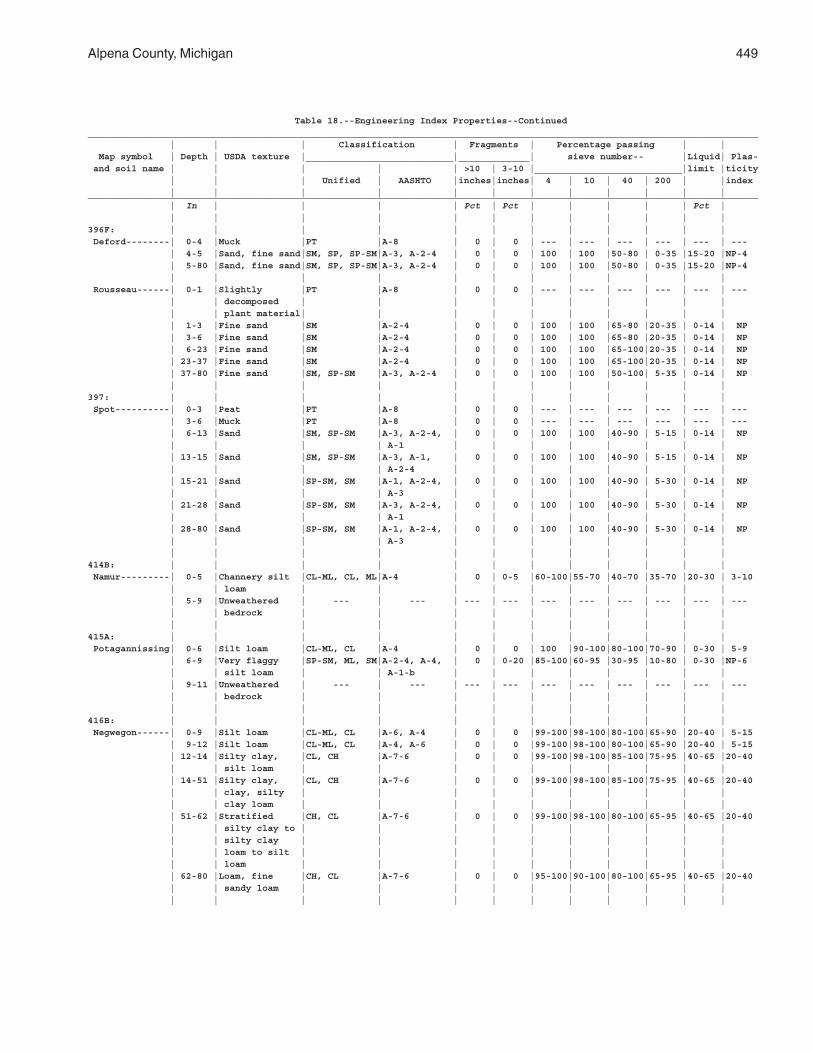
Alpena County, Michigan 449
Table 18.--Engineering Index Properties--Continued___________________________________________________________________________________________________________________________ | | | Classification | Fragments | Percentage passing | | Map symbol | Depth | USDA texture |___________________________|_____________| sieve number-- |Liquid| Plas- and soil name | | | | | >10 | 3-10 |___________________________|limit |ticity | | | Unified | AASHTO |inches|inches| 4 | 10 | 40 | 200 | |index | | | | | | | | | | | |___________________________________________________________________________________________________________________________ | In | | | | Pct | Pct | | | | | Pct | | | | | | | | | | | | |396F: | | | | | | | | | | | | Deford--------| 0-4 |Muck |PT |A-8 | 0 | 0 | --- | --- | --- | --- | --- | --- | 4-5 |Sand, fine sand|SM, SP, SP-SM|A-3, A-2-4 | 0 | 0 | 100 | 100 |50-80 | 0-35 |15-20 |NP-4 | 5-80 |Sand, fine sand|SM, SP, SP-SM|A-3, A-2-4 | 0 | 0 | 100 | 100 |50-80 | 0-35 |15-20 |NP-4 | | | | | | | | | | | | Rousseau------| 0-1 |Slightly |PT |A-8 | 0 | 0 | --- | --- | --- | --- | --- | --- | | decomposed | | | | | | | | | | | | plant material| | | | | | | | | | | 1-3 |Fine sand |SM |A-2-4 | 0 | 0 | 100 | 100 |65-80 |20-35 | 0-14 | NP | 3-6 |Fine sand |SM |A-2-4 | 0 | 0 | 100 | 100 |65-80 |20-35 | 0-14 | NP | 6-23 |Fine sand |SM |A-2-4 | 0 | 0 | 100 | 100 |65-100|20-35 | 0-14 | NP | 23-37 |Fine sand |SM |A-2-4 | 0 | 0 | 100 | 100 |65-100|20-35 | 0-14 | NP | 37-80 |Fine sand |SM, SP-SM |A-3, A-2-4 | 0 | 0 | 100 | 100 |50-100| 5-35 | 0-14 | NP | | | | | | | | | | | |397: | | | | | | | | | | | | Spot----------| 0-3 |Peat |PT |A-8 | 0 | 0 | --- | --- | --- | --- | --- | --- | 3-6 |Muck |PT |A-8 | 0 | 0 | --- | --- | --- | --- | --- | --- | 6-13 |Sand |SM, SP-SM |A-3, A-2-4, | 0 | 0 | 100 | 100 |40-90 | 5-15 | 0-14 | NP | | | | A-1 | | | | | | | | | 13-15 |Sand |SM, SP-SM |A-3, A-1, | 0 | 0 | 100 | 100 |40-90 | 5-15 | 0-14 | NP | | | | A-2-4 | | | | | | | | | 15-21 |Sand |SP-SM, SM |A-1, A-2-4, | 0 | 0 | 100 | 100 |40-90 | 5-30 | 0-14 | NP | | | | A-3 | | | | | | | | | 21-28 |Sand |SP-SM, SM |A-3, A-2-4, | 0 | 0 | 100 | 100 |40-90 | 5-30 | 0-14 | NP | | | | A-1 | | | | | | | | | 28-80 |Sand |SP-SM, SM |A-1, A-2-4, | 0 | 0 | 100 | 100 |40-90 | 5-30 | 0-14 | NP | | | | A-3 | | | | | | | | | | | | | | | | | | | |414B: | | | | | | | | | | | | Namur---------| 0-5 |Channery silt |CL-ML, CL, ML|A-4 | 0 | 0-5 |60-100|55-70 |40-70 |35-70 |20-30 | 3-10 | | loam | | | | | | | | | | | 5-9 |Unweathered | --- | --- | --- | --- | --- | --- | --- | --- | --- | --- | | bedrock | | | | | | | | | | | | | | | | | | | | | |415A: | | | | | | | | | | | | Potagannissing| 0-6 |Silt loam |CL-ML, CL |A-4 | 0 | 0 | 100 |90-100|80-100|70-90 | 0-30 | 5-9 | 6-9 |Very flaggy |SP-SM, ML, SM|A-2-4, A-4, | 0 | 0-20 |85-100|60-95 |30-95 |10-80 | 0-30 |NP-6 | | silt loam | | A-1-b | | | | | | | | | 9-11 |Unweathered | --- | --- | --- | --- | --- | --- | --- | --- | --- | --- | | bedrock | | | | | | | | | | | | | | | | | | | | | |416B: | | | | | | | | | | | | Negwegon------| 0-9 |Silt loam |CL-ML, CL |A-6, A-4 | 0 | 0 |99-100|98-100|80-100|65-90 |20-40 | 5-15 | 9-12 |Silt loam |CL-ML, CL |A-4, A-6 | 0 | 0 |99-100|98-100|80-100|65-90 |20-40 | 5-15 | 12-14 |Silty clay, |CL, CH |A-7-6 | 0 | 0 |99-100|98-100|85-100|75-95 |40-65 |20-40 | | silt loam | | | | | | | | | | | 14-51 |Silty clay, |CL, CH |A-7-6 | 0 | 0 |99-100|98-100|85-100|75-95 |40-65 |20-40 | | clay, silty | | | | | | | | | | | | clay loam | | | | | | | | | | | 51-62 |Stratified |CH, CL |A-7-6 | 0 | 0 |99-100|98-100|80-100|65-95 |40-65 |20-40 | | silty clay to | | | | | | | | | | | | silty clay | | | | | | | | | | | | loam to silt | | | | | | | | | | | | loam | | | | | | | | | | | 62-80 |Loam, fine |CH, CL |A-7-6 | 0 | 0 |95-100|90-100|80-100|65-95 |40-65 |20-40 | | sandy loam | | | | | | | | | | | | | | | | | | | | | |
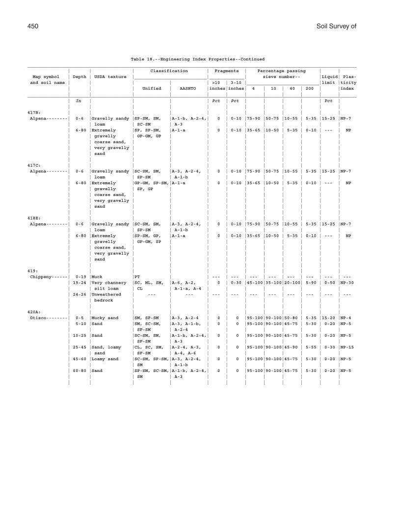
450 Soil Survey of
Table 18.--Engineering Index Properties--Continued___________________________________________________________________________________________________________________________ | | | Classification | Fragments | Percentage passing | | Map symbol | Depth | USDA texture |___________________________|_____________| sieve number-- |Liquid| Plas- and soil name | | | | | >10 | 3-10 |___________________________|limit |ticity | | | Unified | AASHTO |inches|inches| 4 | 10 | 40 | 200 | |index | | | | | | | | | | | |___________________________________________________________________________________________________________________________ | In | | | | Pct | Pct | | | | | Pct | | | | | | | | | | | | |417B: | | | | | | | | | | | | Alpena--------| 0-6 |Gravelly sandy |SP-SM, SM, |A-1-b, A-2-4,| 0 | 0-10 |75-90 |50-75 |10-55 | 5-35 |15-25 |NP-7 | | loam | SC-SM | A-3 | | | | | | | | | 6-80 |Extremely |SP, SP-SM, |A-1-a | 0 | 0-10 |35-65 |10-50 | 5-35 | 0-10 | --- | NP | | gravelly | GP-GM, GP | | | | | | | | | | | coarse sand, | | | | | | | | | | | | very gravelly | | | | | | | | | | | | sand | | | | | | | | | | | | | | | | | | | | | |417C: | | | | | | | | | | | | Alpena--------| 0-6 |Gravelly sandy |SC-SM, SM, |A-3, A-2-4, | 0 | 0-10 |75-90 |50-75 |10-55 | 5-35 |15-25 |NP-7 | | loam | SP-SM | A-1-b | | | | | | | | | 6-80 |Extremely |GP-GM, SP-SM,|A-1-a | 0 | 0-10 |35-65 |10-50 | 5-35 | 0-10 | --- | NP | | gravelly | SP, GP | | | | | | | | | | | coarse sand, | | | | | | | | | | | | very gravelly | | | | | | | | | | | | sand | | | | | | | | | | | | | | | | | | | | | |418E: | | | | | | | | | | | | Alpena--------| 0-6 |Gravelly sandy |SC-SM, SM, |A-3, A-2-4, | 0 | 0-10 |75-90 |50-75 |10-55 | 5-35 |15-25 |NP-7 | | loam | SP-SM | A-1-b | | | | | | | | | 6-80 |Extremely |SP-SM, GP, |A-1-a | 0 | 0-10 |35-65 |10-50 | 5-35 | 0-10 | --- | NP | | gravelly | GP-GM, SP | | | | | | | | | | | coarse sand, | | | | | | | | | | | | very gravelly | | | | | | | | | | | | sand | | | | | | | | | | | | | | | | | | | | | |419: | | | | | | | | | | | | Chippeny------| 0-19 |Muck |PT | | --- | --- | --- | --- | --- | --- | --- | --- | 19-24 |Very channery |SC, ML, SM, |A-6, A-2, | 0 | 0-30 |45-100|35-100|20-100| 5-90 | 0-50 |NP-30 | | silt loam | CL | A-1-a, A-4 | | | | | | | | | 24-26 |Unweathered | --- | --- | --- | --- | --- | --- | --- | --- | --- | --- | | bedrock | | | | | | | | | | | | | | | | | | | | | |420A: | | | | | | | | | | | | Otisco--------| 0-5 |Mucky sand |SM, SP-SM |A-3, A-2-4 | 0 | 0 |95-100|90-100|50-80 | 5-35 |15-20 |NP-4 | 5-10 |Sand |SM, SC-SM, |A-3, A-1-b, | 0 | 0 |95-100|90-100|45-75 | 5-30 | 0-20 |NP-5 | | | SP-SM | A-2-4 | | | | | | | | | 10-25 |Sand |SC-SM, SM, |A-1-b, A-2-4,| 0 | 0 |95-100|90-100|45-75 | 5-30 | 0-20 |NP-5 | | | SP-SM | A-3 | | | | | | | | | 25-45 |Sand, loamy |CL, SC, SM, |A-2-4, A-3, | 0 | 0 |95-100|90-100|45-90 | 5-55 | 0-30 |NP-15 | | sand | SP-SM | A-4, A-6 | | | | | | | | | 45-60 |Loamy sand |SC-SM, SP-SM,|A-3, A-2-4, | 0 | 0 |95-100|90-100|45-75 | 5-30 | 0-20 |NP-5 | | | SM | A-1-b | | | | | | | | | 60-80 |Sand |SP-SM, SC-SM,|A-1-b, A-2-4,| 0 | 0 |95-100|90-100|45-75 | 5-30 | 0-20 |NP-5 | | | SM | A-3 | | | | | | | | | | | | | | | | | | | |
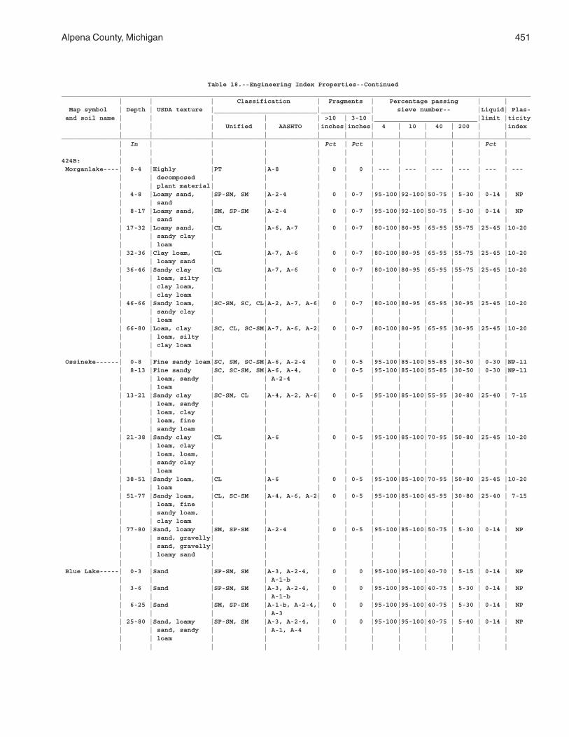
Alpena County, Michigan 451
Table 18.--Engineering Index Properties--Continued___________________________________________________________________________________________________________________________ | | | Classification | Fragments | Percentage passing | | Map symbol | Depth | USDA texture |___________________________|_____________| sieve number-- |Liquid| Plas- and soil name | | | | | >10 | 3-10 |___________________________|limit |ticity | | | Unified | AASHTO |inches|inches| 4 | 10 | 40 | 200 | |index | | | | | | | | | | | |___________________________________________________________________________________________________________________________ | In | | | | Pct | Pct | | | | | Pct | | | | | | | | | | | | |424B: | | | | | | | | | | | | Morganlake----| 0-4 |Highly |PT |A-8 | 0 | 0 | --- | --- | --- | --- | --- | --- | | decomposed | | | | | | | | | | | | plant material| | | | | | | | | | | 4-8 |Loamy sand, |SP-SM, SM |A-2-4 | 0 | 0-7 |95-100|92-100|50-75 | 5-30 | 0-14 | NP | | sand | | | | | | | | | | | 8-17 |Loamy sand, |SM, SP-SM |A-2-4 | 0 | 0-7 |95-100|92-100|50-75 | 5-30 | 0-14 | NP | | sand | | | | | | | | | | | 17-32 |Loamy sand, |CL |A-6, A-7 | 0 | 0-7 |80-100|80-95 |65-95 |55-75 |25-45 |10-20 | | sandy clay | | | | | | | | | | | | loam | | | | | | | | | | | 32-36 |Clay loam, |CL |A-7, A-6 | 0 | 0-7 |80-100|80-95 |65-95 |55-75 |25-45 |10-20 | | loamy sand | | | | | | | | | | | 36-46 |Sandy clay |CL |A-7, A-6 | 0 | 0-7 |80-100|80-95 |65-95 |55-75 |25-45 |10-20 | | loam, silty | | | | | | | | | | | | clay loam, | | | | | | | | | | | | clay loam | | | | | | | | | | | 46-66 |Sandy loam, |SC-SM, SC, CL|A-2, A-7, A-6| 0 | 0-7 |80-100|80-95 |65-95 |30-95 |25-45 |10-20 | | sandy clay | | | | | | | | | | | | loam | | | | | | | | | | | 66-80 |Loam, clay |SC, CL, SC-SM|A-7, A-6, A-2| 0 | 0-7 |80-100|80-95 |65-95 |30-95 |25-45 |10-20 | | loam, silty | | | | | | | | | | | | clay loam | | | | | | | | | | | | | | | | | | | | | | Ossineke------| 0-8 |Fine sandy loam|SC, SM, SC-SM|A-6, A-2-4 | 0 | 0-5 |95-100|85-100|55-85 |30-50 | 0-30 |NP-11 | 8-13 |Fine sandy |SC, SC-SM, SM|A-6, A-4, | 0 | 0-5 |95-100|85-100|55-85 |30-50 | 0-30 |NP-11 | | loam, sandy | | A-2-4 | | | | | | | | | | loam | | | | | | | | | | | 13-21 |Sandy clay |SC-SM, CL |A-4, A-2, A-6| 0 | 0-5 |95-100|85-100|55-95 |30-80 |25-40 | 7-15 | | loam, sandy | | | | | | | | | | | | loam, clay | | | | | | | | | | | | loam, fine | | | | | | | | | | | | sandy loam | | | | | | | | | | | 21-38 |Sandy clay |CL |A-6 | 0 | 0-5 |95-100|85-100|70-95 |50-80 |25-45 |10-20 | | loam, clay | | | | | | | | | | | | loam, loam, | | | | | | | | | | | | sandy clay | | | | | | | | | | | | loam | | | | | | | | | | | 38-51 |Sandy loam, |CL |A-6 | 0 | 0-5 |95-100|85-100|70-95 |50-80 |25-45 |10-20 | | loam | | | | | | | | | | | 51-77 |Sandy loam, |CL, SC-SM |A-4, A-6, A-2| 0 | 0-5 |95-100|85-100|45-95 |30-80 |25-40 | 7-15 | | loam, fine | | | | | | | | | | | | sandy loam, | | | | | | | | | | | | clay loam | | | | | | | | | | | 77-80 |Sand, loamy |SM, SP-SM |A-2-4 | 0 | 0-5 |95-100|85-100|50-75 | 5-30 | 0-14 | NP | | sand, gravelly| | | | | | | | | | | | sand, gravelly| | | | | | | | | | | | loamy sand | | | | | | | | | | | | | | | | | | | | | | Blue Lake-----| 0-3 |Sand |SP-SM, SM |A-3, A-2-4, | 0 | 0 |95-100|95-100|40-70 | 5-15 | 0-14 | NP | | | | A-1-b | | | | | | | | | 3-6 |Sand |SP-SM, SM |A-3, A-2-4, | 0 | 0 |95-100|95-100|40-75 | 5-30 | 0-14 | NP | | | | A-1-b | | | | | | | | | 6-25 |Sand |SM, SP-SM |A-1-b, A-2-4,| 0 | 0 |95-100|95-100|40-75 | 5-30 | 0-14 | NP | | | | A-3 | | | | | | | | | 25-80 |Sand, loamy |SP-SM, SM |A-3, A-2-4, | 0 | 0 |95-100|95-100|40-75 | 5-40 | 0-14 | NP | | sand, sandy | | A-1, A-4 | | | | | | | | | | loam | | | | | | | | | | | | | | | | | | | | | |
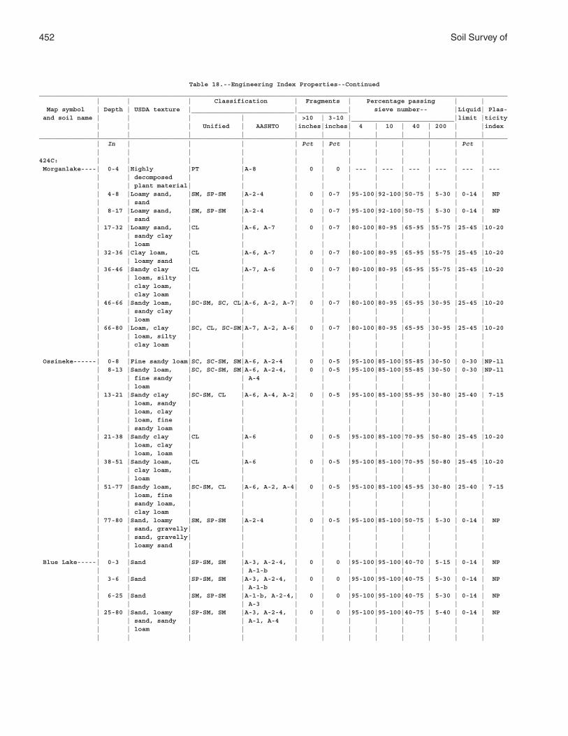
452 Soil Survey of
Table 18.--Engineering Index Properties--Continued___________________________________________________________________________________________________________________________ | | | Classification | Fragments | Percentage passing | | Map symbol | Depth | USDA texture |___________________________|_____________| sieve number-- |Liquid| Plas- and soil name | | | | | >10 | 3-10 |___________________________|limit |ticity | | | Unified | AASHTO |inches|inches| 4 | 10 | 40 | 200 | |index | | | | | | | | | | | |___________________________________________________________________________________________________________________________ | In | | | | Pct | Pct | | | | | Pct | | | | | | | | | | | | |424C: | | | | | | | | | | | | Morganlake----| 0-4 |Highly |PT |A-8 | 0 | 0 | --- | --- | --- | --- | --- | --- | | decomposed | | | | | | | | | | | | plant material| | | | | | | | | | | 4-8 |Loamy sand, |SM, SP-SM |A-2-4 | 0 | 0-7 |95-100|92-100|50-75 | 5-30 | 0-14 | NP | | sand | | | | | | | | | | | 8-17 |Loamy sand, |SM, SP-SM |A-2-4 | 0 | 0-7 |95-100|92-100|50-75 | 5-30 | 0-14 | NP | | sand | | | | | | | | | | | 17-32 |Loamy sand, |CL |A-6, A-7 | 0 | 0-7 |80-100|80-95 |65-95 |55-75 |25-45 |10-20 | | sandy clay | | | | | | | | | | | | loam | | | | | | | | | | | 32-36 |Clay loam, |CL |A-6, A-7 | 0 | 0-7 |80-100|80-95 |65-95 |55-75 |25-45 |10-20 | | loamy sand | | | | | | | | | | | 36-46 |Sandy clay |CL |A-7, A-6 | 0 | 0-7 |80-100|80-95 |65-95 |55-75 |25-45 |10-20 | | loam, silty | | | | | | | | | | | | clay loam, | | | | | | | | | | | | clay loam | | | | | | | | | | | 46-66 |Sandy loam, |SC-SM, SC, CL|A-6, A-2, A-7| 0 | 0-7 |80-100|80-95 |65-95 |30-95 |25-45 |10-20 | | sandy clay | | | | | | | | | | | | loam | | | | | | | | | | | 66-80 |Loam, clay |SC, CL, SC-SM|A-7, A-2, A-6| 0 | 0-7 |80-100|80-95 |65-95 |30-95 |25-45 |10-20 | | loam, silty | | | | | | | | | | | | clay loam | | | | | | | | | | | | | | | | | | | | | | Ossineke------| 0-8 |Fine sandy loam|SC, SC-SM, SM|A-6, A-2-4 | 0 | 0-5 |95-100|85-100|55-85 |30-50 | 0-30 |NP-11 | 8-13 |Sandy loam, |SC, SC-SM, SM|A-6, A-2-4, | 0 | 0-5 |95-100|85-100|55-85 |30-50 | 0-30 |NP-11 | | fine sandy | | A-4 | | | | | | | | | | loam | | | | | | | | | | | 13-21 |Sandy clay |SC-SM, CL |A-6, A-4, A-2| 0 | 0-5 |95-100|85-100|55-95 |30-80 |25-40 | 7-15 | | loam, sandy | | | | | | | | | | | | loam, clay | | | | | | | | | | | | loam, fine | | | | | | | | | | | | sandy loam | | | | | | | | | | | 21-38 |Sandy clay |CL |A-6 | 0 | 0-5 |95-100|85-100|70-95 |50-80 |25-45 |10-20 | | loam, clay | | | | | | | | | | | | loam, loam | | | | | | | | | | | 38-51 |Sandy loam, |CL |A-6 | 0 | 0-5 |95-100|85-100|70-95 |50-80 |25-45 |10-20 | | clay loam, | | | | | | | | | | | | loam | | | | | | | | | | | 51-77 |Sandy loam, |SC-SM, CL |A-6, A-2, A-4| 0 | 0-5 |95-100|85-100|45-95 |30-80 |25-40 | 7-15 | | loam, fine | | | | | | | | | | | | sandy loam, | | | | | | | | | | | | clay loam | | | | | | | | | | | 77-80 |Sand, loamy |SM, SP-SM |A-2-4 | 0 | 0-5 |95-100|85-100|50-75 | 5-30 | 0-14 | NP | | sand, gravelly| | | | | | | | | | | | sand, gravelly| | | | | | | | | | | | loamy sand | | | | | | | | | | | | | | | | | | | | | | Blue Lake-----| 0-3 |Sand |SP-SM, SM |A-3, A-2-4, | 0 | 0 |95-100|95-100|40-70 | 5-15 | 0-14 | NP | | | | A-1-b | | | | | | | | | 3-6 |Sand |SP-SM, SM |A-3, A-2-4, | 0 | 0 |95-100|95-100|40-75 | 5-30 | 0-14 | NP | | | | A-1-b | | | | | | | | | 6-25 |Sand |SM, SP-SM |A-1-b, A-2-4,| 0 | 0 |95-100|95-100|40-75 | 5-30 | 0-14 | NP | | | | A-3 | | | | | | | | | 25-80 |Sand, loamy |SP-SM, SM |A-3, A-2-4, | 0 | 0 |95-100|95-100|40-75 | 5-40 | 0-14 | NP | | sand, sandy | | A-1, A-4 | | | | | | | | | | loam | | | | | | | | | | | | | | | | | | | | | |
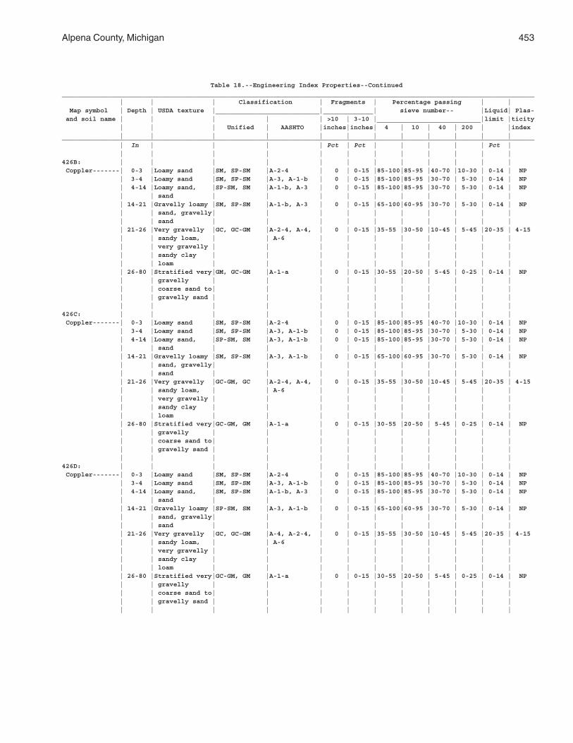
Alpena County, Michigan 453
Table 18.--Engineering Index Properties--Continued___________________________________________________________________________________________________________________________ | | | Classification | Fragments | Percentage passing | | Map symbol | Depth | USDA texture |___________________________|_____________| sieve number-- |Liquid| Plas- and soil name | | | | | >10 | 3-10 |___________________________|limit |ticity | | | Unified | AASHTO |inches|inches| 4 | 10 | 40 | 200 | |index | | | | | | | | | | | |___________________________________________________________________________________________________________________________ | In | | | | Pct | Pct | | | | | Pct | | | | | | | | | | | | |426B: | | | | | | | | | | | | Coppler-------| 0-3 |Loamy sand |SM, SP-SM |A-2-4 | 0 | 0-15 |85-100|85-95 |40-70 |10-30 | 0-14 | NP | 3-4 |Loamy sand |SM, SP-SM |A-3, A-1-b | 0 | 0-15 |85-100|85-95 |30-70 | 5-30 | 0-14 | NP | 4-14 |Loamy sand, |SP-SM, SM |A-1-b, A-3 | 0 | 0-15 |85-100|85-95 |30-70 | 5-30 | 0-14 | NP | | sand | | | | | | | | | | | 14-21 |Gravelly loamy |SM, SP-SM |A-1-b, A-3 | 0 | 0-15 |65-100|60-95 |30-70 | 5-30 | 0-14 | NP | | sand, gravelly| | | | | | | | | | | | sand | | | | | | | | | | | 21-26 |Very gravelly |GC, GC-GM |A-2-4, A-4, | 0 | 0-15 |35-55 |30-50 |10-45 | 5-45 |20-35 | 4-15 | | sandy loam, | | A-6 | | | | | | | | | | very gravelly | | | | | | | | | | | | sandy clay | | | | | | | | | | | | loam | | | | | | | | | | | 26-80 |Stratified very|GM, GC-GM |A-1-a | 0 | 0-15 |30-55 |20-50 | 5-45 | 0-25 | 0-14 | NP | | gravelly | | | | | | | | | | | | coarse sand to| | | | | | | | | | | | gravelly sand | | | | | | | | | | | | | | | | | | | | | |426C: | | | | | | | | | | | | Coppler-------| 0-3 |Loamy sand |SM, SP-SM |A-2-4 | 0 | 0-15 |85-100|85-95 |40-70 |10-30 | 0-14 | NP | 3-4 |Loamy sand |SM, SP-SM |A-3, A-1-b | 0 | 0-15 |85-100|85-95 |30-70 | 5-30 | 0-14 | NP | 4-14 |Loamy sand, |SP-SM, SM |A-3, A-1-b | 0 | 0-15 |85-100|85-95 |30-70 | 5-30 | 0-14 | NP | | sand | | | | | | | | | | | 14-21 |Gravelly loamy |SM, SP-SM |A-3, A-1-b | 0 | 0-15 |65-100|60-95 |30-70 | 5-30 | 0-14 | NP | | sand, gravelly| | | | | | | | | | | | sand | | | | | | | | | | | 21-26 |Very gravelly |GC-GM, GC |A-2-4, A-4, | 0 | 0-15 |35-55 |30-50 |10-45 | 5-45 |20-35 | 4-15 | | sandy loam, | | A-6 | | | | | | | | | | very gravelly | | | | | | | | | | | | sandy clay | | | | | | | | | | | | loam | | | | | | | | | | | 26-80 |Stratified very|GC-GM, GM |A-1-a | 0 | 0-15 |30-55 |20-50 | 5-45 | 0-25 | 0-14 | NP | | gravelly | | | | | | | | | | | | coarse sand to| | | | | | | | | | | | gravelly sand | | | | | | | | | | | | | | | | | | | | | |426D: | | | | | | | | | | | | Coppler-------| 0-3 |Loamy sand |SM, SP-SM |A-2-4 | 0 | 0-15 |85-100|85-95 |40-70 |10-30 | 0-14 | NP | 3-4 |Loamy sand |SM, SP-SM |A-3, A-1-b | 0 | 0-15 |85-100|85-95 |30-70 | 5-30 | 0-14 | NP | 4-14 |Loamy sand, |SM, SP-SM |A-1-b, A-3 | 0 | 0-15 |85-100|85-95 |30-70 | 5-30 | 0-14 | NP | | sand | | | | | | | | | | | 14-21 |Gravelly loamy |SP-SM, SM |A-3, A-1-b | 0 | 0-15 |65-100|60-95 |30-70 | 5-30 | 0-14 | NP | | sand, gravelly| | | | | | | | | | | | sand | | | | | | | | | | | 21-26 |Very gravelly |GC, GC-GM |A-4, A-2-4, | 0 | 0-15 |35-55 |30-50 |10-45 | 5-45 |20-35 | 4-15 | | sandy loam, | | A-6 | | | | | | | | | | very gravelly | | | | | | | | | | | | sandy clay | | | | | | | | | | | | loam | | | | | | | | | | | 26-80 |Stratified very|GC-GM, GM |A-1-a | 0 | 0-15 |30-55 |20-50 | 5-45 | 0-25 | 0-14 | NP | | gravelly | | | | | | | | | | | | coarse sand to| | | | | | | | | | | | gravelly sand | | | | | | | | | | | | | | | | | | | | | |
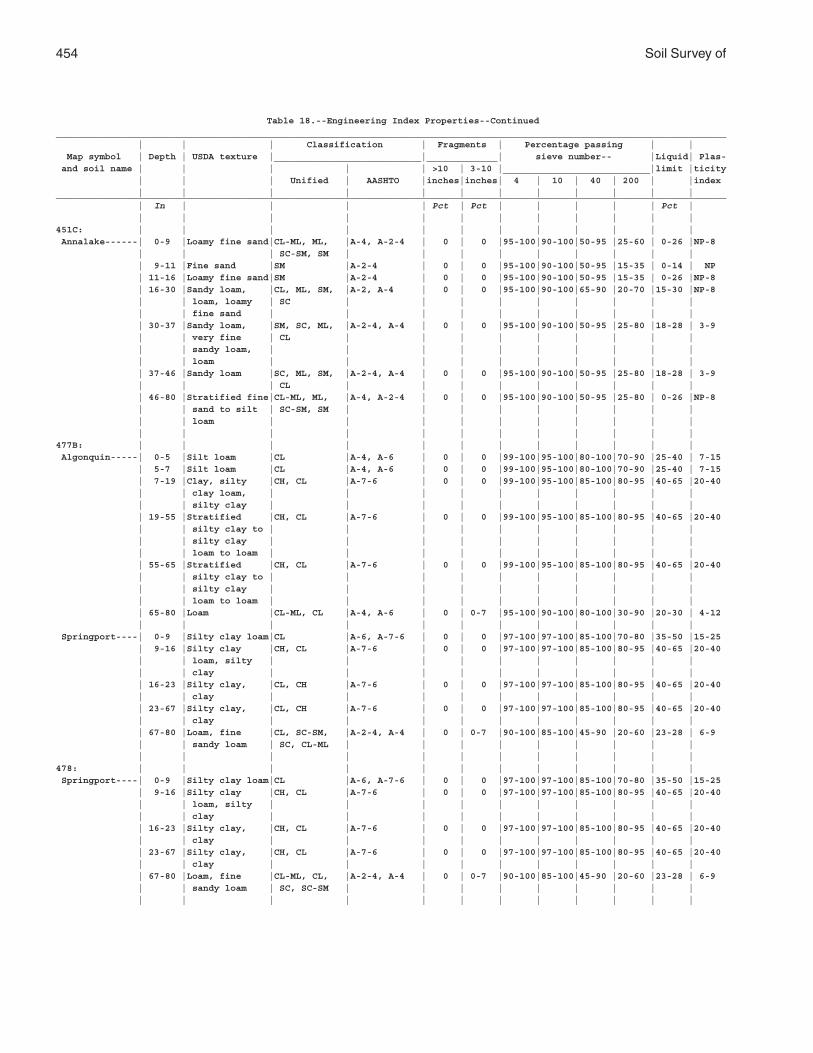
454 Soil Survey of
Table 18.--Engineering Index Properties--Continued___________________________________________________________________________________________________________________________ | | | Classification | Fragments | Percentage passing | | Map symbol | Depth | USDA texture |___________________________|_____________| sieve number-- |Liquid| Plas- and soil name | | | | | >10 | 3-10 |___________________________|limit |ticity | | | Unified | AASHTO |inches|inches| 4 | 10 | 40 | 200 | |index | | | | | | | | | | | |___________________________________________________________________________________________________________________________ | In | | | | Pct | Pct | | | | | Pct | | | | | | | | | | | | |451C: | | | | | | | | | | | | Annalake------| 0-9 |Loamy fine sand|CL-ML, ML, |A-4, A-2-4 | 0 | 0 |95-100|90-100|50-95 |25-60 | 0-26 |NP-8 | | | SC-SM, SM | | | | | | | | | | 9-11 |Fine sand |SM |A-2-4 | 0 | 0 |95-100|90-100|50-95 |15-35 | 0-14 | NP | 11-16 |Loamy fine sand|SM |A-2-4 | 0 | 0 |95-100|90-100|50-95 |15-35 | 0-26 |NP-8 | 16-30 |Sandy loam, |CL, ML, SM, |A-2, A-4 | 0 | 0 |95-100|90-100|65-90 |20-70 |15-30 |NP-8 | | loam, loamy | SC | | | | | | | | | | | fine sand | | | | | | | | | | | 30-37 |Sandy loam, |SM, SC, ML, |A-2-4, A-4 | 0 | 0 |95-100|90-100|50-95 |25-80 |18-28 | 3-9 | | very fine | CL | | | | | | | | | | | sandy loam, | | | | | | | | | | | | loam | | | | | | | | | | | 37-46 |Sandy loam |SC, ML, SM, |A-2-4, A-4 | 0 | 0 |95-100|90-100|50-95 |25-80 |18-28 | 3-9 | | | CL | | | | | | | | | | 46-80 |Stratified fine|CL-ML, ML, |A-4, A-2-4 | 0 | 0 |95-100|90-100|50-95 |25-80 | 0-26 |NP-8 | | sand to silt | SC-SM, SM | | | | | | | | | | | loam | | | | | | | | | | | | | | | | | | | | | |477B: | | | | | | | | | | | | Algonquin-----| 0-5 |Silt loam |CL |A-4, A-6 | 0 | 0 |99-100|95-100|80-100|70-90 |25-40 | 7-15 | 5-7 |Silt loam |CL |A-4, A-6 | 0 | 0 |99-100|95-100|80-100|70-90 |25-40 | 7-15 | 7-19 |Clay, silty |CH, CL |A-7-6 | 0 | 0 |99-100|95-100|85-100|80-95 |40-65 |20-40 | | clay loam, | | | | | | | | | | | | silty clay | | | | | | | | | | | 19-55 |Stratified |CH, CL |A-7-6 | 0 | 0 |99-100|95-100|85-100|80-95 |40-65 |20-40 | | silty clay to | | | | | | | | | | | | silty clay | | | | | | | | | | | | loam to loam | | | | | | | | | | | 55-65 |Stratified |CH, CL |A-7-6 | 0 | 0 |99-100|95-100|85-100|80-95 |40-65 |20-40 | | silty clay to | | | | | | | | | | | | silty clay | | | | | | | | | | | | loam to loam | | | | | | | | | | | 65-80 |Loam |CL-ML, CL |A-4, A-6 | 0 | 0-7 |95-100|90-100|80-100|30-90 |20-30 | 4-12 | | | | | | | | | | | | Springport----| 0-9 |Silty clay loam|CL |A-6, A-7-6 | 0 | 0 |97-100|97-100|85-100|70-80 |35-50 |15-25 | 9-16 |Silty clay |CH, CL |A-7-6 | 0 | 0 |97-100|97-100|85-100|80-95 |40-65 |20-40 | | loam, silty | | | | | | | | | | | | clay | | | | | | | | | | | 16-23 |Silty clay, |CL, CH |A-7-6 | 0 | 0 |97-100|97-100|85-100|80-95 |40-65 |20-40 | | clay | | | | | | | | | | | 23-67 |Silty clay, |CL, CH |A-7-6 | 0 | 0 |97-100|97-100|85-100|80-95 |40-65 |20-40 | | clay | | | | | | | | | | | 67-80 |Loam, fine |CL, SC-SM, |A-2-4, A-4 | 0 | 0-7 |90-100|85-100|45-90 |20-60 |23-28 | 6-9 | | sandy loam | SC, CL-ML | | | | | | | | | | | | | | | | | | | | |478: | | | | | | | | | | | | Springport----| 0-9 |Silty clay loam|CL |A-6, A-7-6 | 0 | 0 |97-100|97-100|85-100|70-80 |35-50 |15-25 | 9-16 |Silty clay |CH, CL |A-7-6 | 0 | 0 |97-100|97-100|85-100|80-95 |40-65 |20-40 | | loam, silty | | | | | | | | | | | | clay | | | | | | | | | | | 16-23 |Silty clay, |CH, CL |A-7-6 | 0 | 0 |97-100|97-100|85-100|80-95 |40-65 |20-40 | | clay | | | | | | | | | | | 23-67 |Silty clay, |CH, CL |A-7-6 | 0 | 0 |97-100|97-100|85-100|80-95 |40-65 |20-40 | | clay | | | | | | | | | | | 67-80 |Loam, fine |CL-ML, CL, |A-2-4, A-4 | 0 | 0-7 |90-100|85-100|45-90 |20-60 |23-28 | 6-9 | | sandy loam | SC, SC-SM | | | | | | | | | | | | | | | | | | | | |
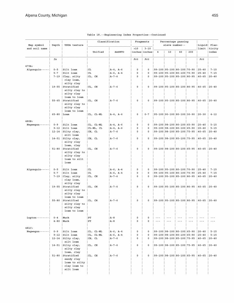
Alpena County, Michigan 455
Table 18.--Engineering Index Properties--Continued___________________________________________________________________________________________________________________________ | | | Classification | Fragments | Percentage passing | | Map symbol | Depth | USDA texture |___________________________|_____________| sieve number-- |Liquid| Plas- and soil name | | | | | >10 | 3-10 |___________________________|limit |ticity | | | Unified | AASHTO |inches|inches| 4 | 10 | 40 | 200 | |index | | | | | | | | | | | |___________________________________________________________________________________________________________________________ | In | | | | Pct | Pct | | | | | Pct | | | | | | | | | | | | |479A: | | | | | | | | | | | | Algonquin-----| 0-5 |Silt loam |CL |A-4, A-6 | 0 | 0 |99-100|95-100|80-100|70-90 |25-40 | 7-15 | 5-7 |Silt loam |CL |A-6, A-4 | 0 | 0 |99-100|95-100|80-100|70-90 |25-40 | 7-15 | 7-19 |Clay, silty |CL, CH |A-7-6 | 0 | 0 |99-100|95-100|85-100|80-95 |40-65 |20-40 | | clay loam, | | | | | | | | | | | | silty clay | | | | | | | | | | | 19-55 |Stratified |CL, CH |A-7-6 | 0 | 0 |99-100|95-100|85-100|80-95 |40-65 |20-40 | | silty clay to | | | | | | | | | | | | silty clay | | | | | | | | | | | | loam to loam | | | | | | | | | | | 55-65 |Stratified |CL, CH |A-7-6 | 0 | 0 |99-100|95-100|85-100|80-95 |40-65 |20-40 | | silty clay to | | | | | | | | | | | | silty clay | | | | | | | | | | | | loam to loam | | | | | | | | | | | 65-80 |Loam |CL, CL-ML |A-4, A-6 | 0 | 0-7 |95-100|90-100|80-100|30-90 |20-30 | 4-12 | | | | | | | | | | | |480B: | | | | | | | | | | | | Negwegon------| 0-9 |Silt loam |CL, CL-ML |A-4, A-6 | 0 | 0 |99-100|98-100|80-100|65-90 |20-40 | 5-15 | 9-12 |Silt loam |CL-ML, CL |A-4, A-6 | 0 | 0 |99-100|98-100|80-100|65-90 |20-40 | 5-15 | 12-14 |Silty clay, |CH, CL |A-7-6 | 0 | 0 |99-100|98-100|85-100|75-95 |40-65 |20-40 | | silt loam | | | | | | | | | | | 14-51 |Silty clay, |CH, CL |A-7-6 | 0 | 0 |99-100|98-100|85-100|75-95 |40-65 |20-40 | | silty clay | | | | | | | | | | | | loam, clay | | | | | | | | | | | 51-80 |Stratified |CL, CH |A-7-6 | 0 | 0 |99-100|98-100|80-100|65-95 |40-65 |20-40 | | silty clay to | | | | | | | | | | | | silty clay | | | | | | | | | | | | loam to silt | | | | | | | | | | | | loam | | | | | | | | | | | | | | | | | | | | | | Algonquin-----| 0-5 |Silt loam |CL |A-6, A-4 | 0 | 0 |99-100|95-100|80-100|70-90 |25-40 | 7-15 | 5-7 |Silt loam |CL |A-6, A-4 | 0 | 0 |99-100|95-100|80-100|70-90 |25-40 | 7-15 | 7-19 |Clay, silty |CL, CH |A-7-6 | 0 | 0 |99-100|95-100|85-100|80-95 |40-65 |20-40 | | clay loam, | | | | | | | | | | | | silty clay | | | | | | | | | | | 19-55 |Stratified |CL, CH |A-7-6 | 0 | 0 |99-100|95-100|85-100|80-95 |40-65 |20-40 | | silty clay to | | | | | | | | | | | | silty clay | | | | | | | | | | | | loam to loam | | | | | | | | | | | 55-80 |Stratified |CL, CH |A-7-6 | 0 | 0 |99-100|95-100|85-100|80-95 |40-65 |20-40 | | silty clay to | | | | | | | | | | | | silty clay | | | | | | | | | | | | loam to loam | | | | | | | | | | | | | | | | | | | | | | Lupton--------| 0-4 |Muck |PT |A-8 | 0 | 0 | --- | --- | --- | --- | --- | --- | 4-80 |Muck |PT |A-8 | 0 | 0 | --- | --- | --- | --- | --- | --- | | | | | | | | | | | |481C: | | | | | | | | | | | | Negwegon------| 0-9 |Silt loam |CL, CL-ML |A-6, A-4 | 0 | 0 |99-100|98-100|80-100|65-90 |20-40 | 5-15 | 9-12 |Silt loam |CL, CL-ML |A-6, A-4 | 0 | 0 |99-100|98-100|80-100|65-90 |20-40 | 5-15 | 12-14 |Silty clay, |CH, CL |A-7-6 | 0 | 0 |99-100|98-100|85-100|75-95 |40-65 |20-40 | | silt loam | | | | | | | | | | | 14-51 |Silty clay, |CL, CH |A-7-6 | 0 | 0 |99-100|98-100|85-100|75-95 |40-65 |20-40 | | silty clay | | | | | | | | | | | | loam, clay | | | | | | | | | | | 51-80 |Stratified |CL, CH |A-7-6 | 0 | 0 |99-100|98-100|80-100|65-95 |40-65 |20-40 | | sandy clay | | | | | | | | | | | | loam to silty | | | | | | | | | | | | clay loam to | | | | | | | | | | | | silt loam | | | | | | | | | | | | | | | | | | | | | |
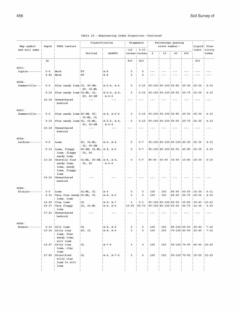
456 Soil Survey of
Table 18.--Engineering Index Properties--Continued___________________________________________________________________________________________________________________________ | | | Classification | Fragments | Percentage passing | | Map symbol | Depth | USDA texture |___________________________|_____________| sieve number-- |Liquid| Plas- and soil name | | | | | >10 | 3-10 |___________________________|limit |ticity | | | Unified | AASHTO |inches|inches| 4 | 10 | 40 | 200 | |index | | | | | | | | | | | |___________________________________________________________________________________________________________________________ | In | | | | Pct | Pct | | | | | Pct | | | | | | | | | | | | |481C: | | | | | | | | | | | | Lupton--------| 0-4 |Muck |PT |A-8 | 0 | 0 | --- | --- | --- | --- | --- | --- | 4-80 |Muck |PT |A-8 | 0 | 0 | --- | --- | --- | --- | --- | --- | | | | | | | | | | | |482B: | | | | | | | | | | | | Summerville---| 0-5 |Fine sandy loam|CL, SC-SM, |A-2-4, A-4 | 0 | 0-15 |95-100|90-100|55-85 |25-55 |20-30 | 4-10 | | | SC, CL-ML | | | | | | | | | | 5-16 |Fine sandy loam|CL-ML, CL, |A-2-4, A-4, | 0 | 0-15 |95-100|90-100|55-95 |25-75 |20-35 | 4-15 | | | SC, SC-SM | A-2-6 | | | | | | | | | 16-18 |Unweathered | --- | --- | --- | --- | --- | --- | --- | --- | --- | --- | | bedrock | | | | | | | | | | | | | | | | | | | | | |482C: | | | | | | | | | | | | Summerville---| 0-5 |Fine sandy loam|SC-SM, SC, |A-4, A-2-4 | 0 | 0-15 |95-100|90-100|55-85 |25-55 |20-30 | 4-10 | | | CL-ML, CL | | | | | | | | | | 5-16 |Fine sandy loam|CL, CL-ML, |A-2-6, A-4, | 0 | 0-15 |95-100|90-100|55-95 |25-75 |20-35 | 4-15 | | | SC, SC-SM | A-2-4 | | | | | | | | | 16-18 |Unweathered | --- | --- | --- | --- | --- | --- | --- | --- | --- | --- | | bedrock | | | | | | | | | | | | | | | | | | | | | |483A: | | | | | | | | | | | | Lachine-------| 0-9 |Loam |SC, CL-ML, |A-6, A-4 | 0 | 0-7 |95-100|80-100|40-100|40-90 |20-35 | 4-15 | | | CL, SC-SM | | | | | | | | | | 9-13 |Loam, flaggy |SC-SM, CL-ML,|A-4, A-6 | 0 | 0-7 |95-100|80-100|40-90 |40-80 |20-35 | 4-15 | | loam, flaggy | CL, SC | | | | | | | | | | | sandy loam | | | | | | | | | | | 13-16 |Gravelly fine |CL-ML, SC-SM,|A-4, A-6, | 0 | 0-7 |85-90 |60-90 |30-90 |10-80 |20-35 | 4-15 | | sandy loam, | CL, SC | A-2-4 | | | | | | | | | | loam, sandy | | | | | | | | | | | | loam, flaggy | | | | | | | | | | | | loam | | | | | | | | | | | 16-20 |Unweathered | --- | --- | --- | --- | --- | --- | --- | --- | --- | --- | | bedrock | | | | | | | | | | | | | | | | | | | | | |484A: | | | | | | | | | | | | Elcajon-------| 0-6 |Loam |CL-ML, CL |A-4 | 0 | 0 | 100 | 100 |85-95 |50-65 |16-30 | 4-11 | 6-12 |Very fine sandy|CL-ML, CL |A-4, A-6 | 0 | 0 | 100 | 100 |85-95 |50-75 |20-36 | 4-15 | | loam, loam | | | | | | | | | | | 12-29 |Clay loam |CL |A-6, A-7 | 0 | 0-1 |90-100|80-100|80-90 |55-85 |36-43 |15-21 | 29-37 |Very flaggy |CL, CL-ML |A-4, A-6 |10-50 |50-70 |90-100|80-100|65-95 |50-75 |16-36 | 4-15 | | loam | | | | | | | | | | | 37-41 |Unweathered | --- | --- | --- | --- | --- | --- | --- | --- | --- | --- | | bedrock | | | | | | | | | | | | | | | | | | | | | |485A: | | | | | | | | | | | | Bowers--------| 0-10 |Silt loam |CL |A-4, A-6 | 0 | 0 | 100 | 100 |85-100|60-90 |25-40 | 7-16 | 10-14 |Silty clay |SC, CL |A-4, A-6 | 0 | 0 | 100 | 100 |70-100|40-90 |25-40 | 7-16 | | loam, fine | | | | | | | | | | | | sandy loam, | | | | | | | | | | | | silt loam | | | | | | | | | | | 14-27 |Silty clay |CL |A-7-6 | 0 | 0 | 100 | 100 |90-100|70-95 |40-50 |20-25 | | loam, clay | | | | | | | | | | | | loam | | | | | | | | | | | 27-80 |Stratified |CL |A-6, A-7-6 | 0 | 0 | 100 | 100 |90-100|70-95 |35-50 |15-25 | | silty clay | | | | | | | | | | | | loam to silt | | | | | | | | | | | | loam | | | | | | | | | | | | | | | | | | | | | |
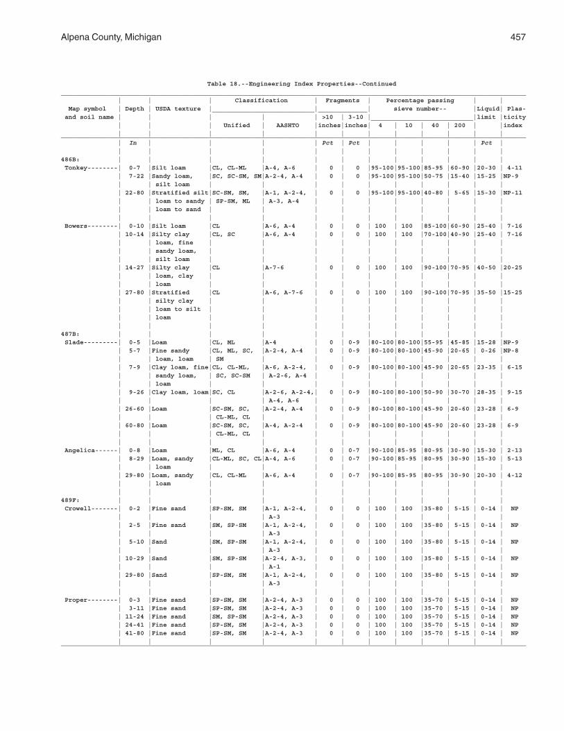
Alpena County, Michigan 457
Table 18.--Engineering Index Properties--Continued___________________________________________________________________________________________________________________________ | | | Classification | Fragments | Percentage passing | | Map symbol | Depth | USDA texture |___________________________|_____________| sieve number-- |Liquid| Plas- and soil name | | | | | >10 | 3-10 |___________________________|limit |ticity | | | Unified | AASHTO |inches|inches| 4 | 10 | 40 | 200 | |index | | | | | | | | | | | |___________________________________________________________________________________________________________________________ | In | | | | Pct | Pct | | | | | Pct | | | | | | | | | | | | |486B: | | | | | | | | | | | | Tonkey--------| 0-7 |Silt loam |CL, CL-ML |A-4, A-6 | 0 | 0 |95-100|95-100|85-95 |60-90 |20-30 | 4-11 | 7-22 |Sandy loam, |SC, SC-SM, SM|A-2-4, A-4 | 0 | 0 |95-100|95-100|50-75 |15-40 |15-25 |NP-9 | | silt loam | | | | | | | | | | | 22-80 |Stratified silt|SC-SM, SM, |A-1, A-2-4, | 0 | 0 |95-100|95-100|40-80 | 5-65 |15-30 |NP-11 | | loam to sandy | SP-SM, ML | A-3, A-4 | | | | | | | | | | loam to sand | | | | | | | | | | | | | | | | | | | | | | Bowers--------| 0-10 |Silt loam |CL |A-6, A-4 | 0 | 0 | 100 | 100 |85-100|60-90 |25-40 | 7-16 | 10-14 |Silty clay |CL, SC |A-6, A-4 | 0 | 0 | 100 | 100 |70-100|40-90 |25-40 | 7-16 | | loam, fine | | | | | | | | | | | | sandy loam, | | | | | | | | | | | | silt loam | | | | | | | | | | | 14-27 |Silty clay |CL |A-7-6 | 0 | 0 | 100 | 100 |90-100|70-95 |40-50 |20-25 | | loam, clay | | | | | | | | | | | | loam | | | | | | | | | | | 27-80 |Stratified |CL |A-6, A-7-6 | 0 | 0 | 100 | 100 |90-100|70-95 |35-50 |15-25 | | silty clay | | | | | | | | | | | | loam to silt | | | | | | | | | | | | loam | | | | | | | | | | | | | | | | | | | | | |487B: | | | | | | | | | | | | Slade---------| 0-5 |Loam |CL, ML |A-4 | 0 | 0-9 |80-100|80-100|55-95 |45-85 |15-28 |NP-9 | 5-7 |Fine sandy |CL, ML, SC, |A-2-4, A-4 | 0 | 0-9 |80-100|80-100|45-90 |20-65 | 0-26 |NP-8 | | loam, loam | SM | | | | | | | | | | 7-9 |Clay loam, fine|CL, CL-ML, |A-6, A-2-4, | 0 | 0-9 |80-100|80-100|45-90 |20-65 |23-35 | 6-15 | | sandy loam, | SC, SC-SM | A-2-6, A-4 | | | | | | | | | | loam | | | | | | | | | | | 9-26 |Clay loam, loam|SC, CL |A-2-6, A-2-4,| 0 | 0-9 |80-100|80-100|50-90 |30-70 |28-35 | 9-15 | | | | A-4, A-6 | | | | | | | | | 26-60 |Loam |SC-SM, SC, |A-2-4, A-4 | 0 | 0-9 |80-100|80-100|45-90 |20-60 |23-28 | 6-9 | | | CL-ML, CL | | | | | | | | | | 60-80 |Loam |SC-SM, SC, |A-4, A-2-4 | 0 | 0-9 |80-100|80-100|45-90 |20-60 |23-28 | 6-9 | | | CL-ML, CL | | | | | | | | | | | | | | | | | | | | | Angelica------| 0-8 |Loam |ML, CL |A-6, A-4 | 0 | 0-7 |90-100|85-95 |80-95 |30-90 |15-30 | 2-13 | 8-29 |Loam, sandy |CL-ML, SC, CL|A-4, A-6 | 0 | 0-7 |90-100|85-95 |80-95 |30-90 |15-30 | 5-13 | | loam | | | | | | | | | | | 29-80 |Loam, sandy |CL, CL-ML |A-6, A-4 | 0 | 0-7 |90-100|85-95 |80-95 |30-90 |20-30 | 4-12 | | loam | | | | | | | | | | | | | | | | | | | | | |489F: | | | | | | | | | | | | Crowell-------| 0-2 |Fine sand |SP-SM, SM |A-1, A-2-4, | 0 | 0 | 100 | 100 |35-80 | 5-15 | 0-14 | NP | | | | A-3 | | | | | | | | | 2-5 |Fine sand |SM, SP-SM |A-1, A-2-4, | 0 | 0 | 100 | 100 |35-80 | 5-15 | 0-14 | NP | | | | A-3 | | | | | | | | | 5-10 |Sand |SM, SP-SM |A-1, A-2-4, | 0 | 0 | 100 | 100 |35-80 | 5-15 | 0-14 | NP | | | | A-3 | | | | | | | | | 10-29 |Sand |SM, SP-SM |A-2-4, A-3, | 0 | 0 | 100 | 100 |35-80 | 5-15 | 0-14 | NP | | | | A-1 | | | | | | | | | 29-80 |Sand |SP-SM, SM |A-1, A-2-4, | 0 | 0 | 100 | 100 |35-80 | 5-15 | 0-14 | NP | | | | A-3 | | | | | | | | | | | | | | | | | | | | Proper--------| 0-3 |Fine sand |SP-SM, SM |A-2-4, A-3 | 0 | 0 | 100 | 100 |35-70 | 5-15 | 0-14 | NP | 3-11 |Fine sand |SP-SM, SM |A-2-4, A-3 | 0 | 0 | 100 | 100 |35-70 | 5-15 | 0-14 | NP | 11-24 |Fine sand |SM, SP-SM |A-2-4, A-3 | 0 | 0 | 100 | 100 |35-70 | 5-15 | 0-14 | NP | 24-41 |Fine sand |SP-SM, SM |A-2-4, A-3 | 0 | 0 | 100 | 100 |35-70 | 5-15 | 0-14 | NP | 41-80 |Fine sand |SP-SM, SM |A-2-4, A-3 | 0 | 0 | 100 | 100 |35-70 | 5-15 | 0-14 | NP | | | | | | | | | | | |___________________________________________________________________________________________________________________________
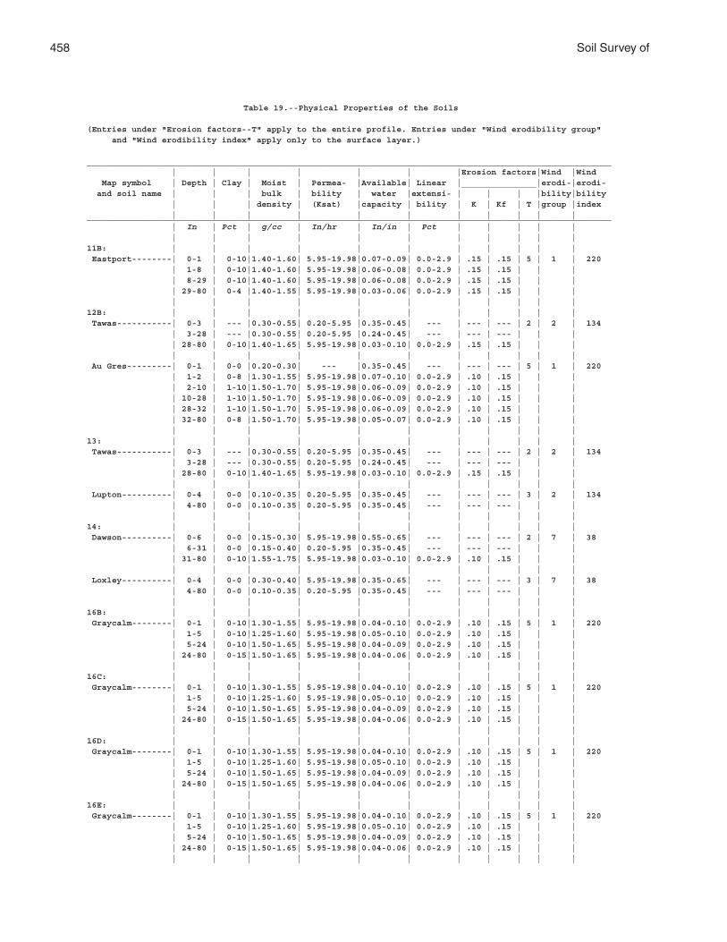
458 Soil Survey of
Table 19.--Physical Properties of the Soils
(Entries under "Erosion factors--T" apply to the entire profile. Entries under "Wind erodibility group" and "Wind erodibility index" apply only to the surface layer.)
_________________________________________________________________________________________________________ | | | | | | |Erosion factors|Wind |Wind Map symbol | Depth | Clay | Moist | Permea- |Available| Linear |_______________|erodi-|erodi- and soil name | | | bulk | bility | water |extensi- | | | |bility|bility | | | density | (Ksat) |capacity | bility | K | Kf | T |group |index | | | | | | | | | | |_________________________________________________________________________________________________________ | In | Pct | g/cc | In/hr | In/in | Pct | | | | | | | | | | | | | | | |11B: | | | | | | | | | | | Eastport--------| 0-1 | 0-10|1.40-1.60| 5.95-19.98|0.07-0.09| 0.0-2.9 | .15 | .15 | 5 | 1 | 220 | 1-8 | 0-10|1.40-1.60| 5.95-19.98|0.06-0.08| 0.0-2.9 | .15 | .15 | | | | 8-29 | 0-10|1.40-1.60| 5.95-19.98|0.06-0.08| 0.0-2.9 | .15 | .15 | | | | 29-80 | 0-4 |1.40-1.55| 5.95-19.98|0.03-0.06| 0.0-2.9 | .15 | .15 | | | | | | | | | | | | | |12B: | | | | | | | | | | | Tawas-----------| 0-3 | --- |0.30-0.55| 0.20-5.95 |0.35-0.45| --- | --- | --- | 2 | 2 | 134 | 3-28 | --- |0.30-0.55| 0.20-5.95 |0.24-0.45| --- | --- | --- | | | | 28-80 | 0-10|1.40-1.65| 5.95-19.98|0.03-0.10| 0.0-2.9 | .15 | .15 | | | | | | | | | | | | | | Au Gres---------| 0-1 | 0-0 |0.20-0.30| --- |0.35-0.45| --- | --- | --- | 5 | 1 | 220 | 1-2 | 0-8 |1.30-1.55| 5.95-19.98|0.07-0.10| 0.0-2.9 | .10 | .15 | | | | 2-10 | 1-10|1.50-1.70| 5.95-19.98|0.06-0.09| 0.0-2.9 | .10 | .15 | | | | 10-28 | 1-10|1.50-1.70| 5.95-19.98|0.06-0.09| 0.0-2.9 | .10 | .15 | | | | 28-32 | 1-10|1.50-1.70| 5.95-19.98|0.06-0.09| 0.0-2.9 | .10 | .15 | | | | 32-80 | 0-8 |1.50-1.70| 5.95-19.98|0.05-0.07| 0.0-2.9 | .10 | .15 | | | | | | | | | | | | | |13: | | | | | | | | | | | Tawas-----------| 0-3 | --- |0.30-0.55| 0.20-5.95 |0.35-0.45| --- | --- | --- | 2 | 2 | 134 | 3-28 | --- |0.30-0.55| 0.20-5.95 |0.24-0.45| --- | --- | --- | | | | 28-80 | 0-10|1.40-1.65| 5.95-19.98|0.03-0.10| 0.0-2.9 | .15 | .15 | | | | | | | | | | | | | | Lupton----------| 0-4 | 0-0 |0.10-0.35| 0.20-5.95 |0.35-0.45| --- | --- | --- | 3 | 2 | 134 | 4-80 | 0-0 |0.10-0.35| 0.20-5.95 |0.35-0.45| --- | --- | --- | | | | | | | | | | | | | |14: | | | | | | | | | | | Dawson----------| 0-6 | 0-0 |0.15-0.30| 5.95-19.98|0.55-0.65| --- | --- | --- | 2 | 7 | 38 | 6-31 | 0-0 |0.15-0.40| 0.20-5.95 |0.35-0.45| --- | --- | --- | | | | 31-80 | 0-10|1.55-1.75| 5.95-19.98|0.03-0.10| 0.0-2.9 | .10 | .15 | | | | | | | | | | | | | | Loxley----------| 0-4 | 0-0 |0.30-0.40| 5.95-19.98|0.35-0.65| --- | --- | --- | 3 | 7 | 38 | 4-80 | 0-0 |0.10-0.35| 0.20-5.95 |0.35-0.45| --- | --- | --- | | | | | | | | | | | | | |16B: | | | | | | | | | | | Graycalm--------| 0-1 | 0-10|1.30-1.55| 5.95-19.98|0.04-0.10| 0.0-2.9 | .10 | .15 | 5 | 1 | 220 | 1-5 | 0-10|1.25-1.60| 5.95-19.98|0.05-0.10| 0.0-2.9 | .10 | .15 | | | | 5-24 | 0-10|1.50-1.65| 5.95-19.98|0.04-0.09| 0.0-2.9 | .10 | .15 | | | | 24-80 | 0-15|1.50-1.65| 5.95-19.98|0.04-0.06| 0.0-2.9 | .10 | .15 | | | | | | | | | | | | | |16C: | | | | | | | | | | | Graycalm--------| 0-1 | 0-10|1.30-1.55| 5.95-19.98|0.04-0.10| 0.0-2.9 | .10 | .15 | 5 | 1 | 220 | 1-5 | 0-10|1.25-1.60| 5.95-19.98|0.05-0.10| 0.0-2.9 | .10 | .15 | | | | 5-24 | 0-10|1.50-1.65| 5.95-19.98|0.04-0.09| 0.0-2.9 | .10 | .15 | | | | 24-80 | 0-15|1.50-1.65| 5.95-19.98|0.04-0.06| 0.0-2.9 | .10 | .15 | | | | | | | | | | | | | |16D: | | | | | | | | | | | Graycalm--------| 0-1 | 0-10|1.30-1.55| 5.95-19.98|0.04-0.10| 0.0-2.9 | .10 | .15 | 5 | 1 | 220 | 1-5 | 0-10|1.25-1.60| 5.95-19.98|0.05-0.10| 0.0-2.9 | .10 | .15 | | | | 5-24 | 0-10|1.50-1.65| 5.95-19.98|0.04-0.09| 0.0-2.9 | .10 | .15 | | | | 24-80 | 0-15|1.50-1.65| 5.95-19.98|0.04-0.06| 0.0-2.9 | .10 | .15 | | | | | | | | | | | | | |16E: | | | | | | | | | | | Graycalm--------| 0-1 | 0-10|1.30-1.55| 5.95-19.98|0.04-0.10| 0.0-2.9 | .10 | .15 | 5 | 1 | 220 | 1-5 | 0-10|1.25-1.60| 5.95-19.98|0.05-0.10| 0.0-2.9 | .10 | .15 | | | | 5-24 | 0-10|1.50-1.65| 5.95-19.98|0.04-0.09| 0.0-2.9 | .10 | .15 | | | | 24-80 | 0-15|1.50-1.65| 5.95-19.98|0.04-0.06| 0.0-2.9 | .10 | .15 | | | | | | | | | | | | | |
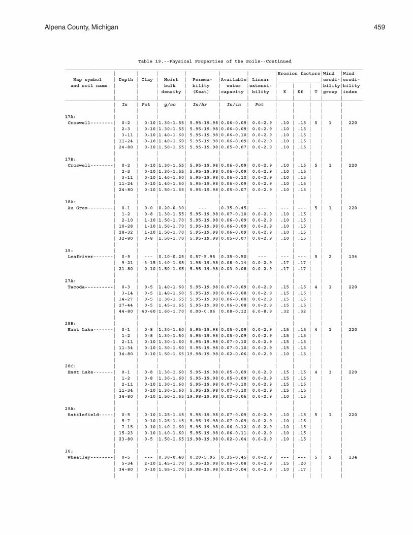
Alpena County, Michigan 459
Table 19.--Physical Properties of the Soils--Continued_________________________________________________________________________________________________________ | | | | | | |Erosion factors|Wind |Wind Map symbol | Depth | Clay | Moist | Permea- |Available| Linear |_______________|erodi-|erodi- and soil name | | | bulk | bility | water |extensi- | | | |bility|bility | | | density | (Ksat) |capacity | bility | K | Kf | T |group |index | | | | | | | | | | |_________________________________________________________________________________________________________ | In | Pct | g/cc | In/hr | In/in | Pct | | | | | | | | | | | | | | | |17A: | | | | | | | | | | | Croswell--------| 0-2 | 0-10|1.30-1.55| 5.95-19.98|0.06-0.09| 0.0-2.9 | .10 | .15 | 5 | 1 | 220 | 2-3 | 0-10|1.30-1.55| 5.95-19.98|0.06-0.09| 0.0-2.9 | .10 | .15 | | | | 3-11 | 0-10|1.40-1.60| 5.95-19.98|0.06-0.10| 0.0-2.9 | .10 | .15 | | | | 11-24 | 0-10|1.40-1.60| 5.95-19.98|0.06-0.09| 0.0-2.9 | .10 | .15 | | | | 24-80 | 0-10|1.50-1.65| 5.95-19.98|0.05-0.07| 0.0-2.9 | .10 | .15 | | | | | | | | | | | | | |17B: | | | | | | | | | | | Croswell--------| 0-2 | 0-10|1.30-1.55| 5.95-19.98|0.06-0.09| 0.0-2.9 | .10 | .15 | 5 | 1 | 220 | 2-3 | 0-10|1.30-1.55| 5.95-19.98|0.06-0.09| 0.0-2.9 | .10 | .15 | | | | 3-11 | 0-10|1.40-1.60| 5.95-19.98|0.06-0.10| 0.0-2.9 | .10 | .15 | | | | 11-24 | 0-10|1.40-1.60| 5.95-19.98|0.06-0.09| 0.0-2.9 | .10 | .15 | | | | 24-80 | 0-10|1.50-1.65| 5.95-19.98|0.05-0.07| 0.0-2.9 | .10 | .15 | | | | | | | | | | | | | |18A: | | | | | | | | | | | Au Gres---------| 0-1 | 0-0 |0.20-0.30| --- |0.35-0.45| --- | --- | --- | 5 | 1 | 220 | 1-2 | 0-8 |1.30-1.55| 5.95-19.98|0.07-0.10| 0.0-2.9 | .10 | .15 | | | | 2-10 | 1-10|1.50-1.70| 5.95-19.98|0.06-0.09| 0.0-2.9 | .10 | .15 | | | | 10-28 | 1-10|1.50-1.70| 5.95-19.98|0.06-0.09| 0.0-2.9 | .10 | .15 | | | | 28-32 | 1-10|1.50-1.70| 5.95-19.98|0.06-0.09| 0.0-2.9 | .10 | .15 | | | | 32-80 | 0-8 |1.50-1.70| 5.95-19.98|0.05-0.07| 0.0-2.9 | .10 | .15 | | | | | | | | | | | | | |19: | | | | | | | | | | | Leafriver-------| 0-9 | --- |0.10-0.25| 0.57-5.95 |0.35-0.50| --- | --- | --- | 5 | 2 | 134 | 9-21 | 3-15|1.40-1.65| 1.98-19.98|0.08-0.14| 0.0-2.9 | .17 | .17 | | | | 21-80 | 0-10|1.50-1.65| 5.95-19.98|0.03-0.08| 0.0-2.9 | .17 | .17 | | | | | | | | | | | | | |27A: | | | | | | | | | | | Tacoda----------| 0-3 | 0-5 |1.40-1.60| 5.95-19.98|0.07-0.09| 0.0-2.9 | .15 | .15 | 4 | 1 | 220 | 3-14 | 0-5 |1.40-1.60| 5.95-19.98|0.06-0.08| 0.0-2.9 | .15 | .15 | | | | 14-27 | 0-5 |1.30-1.65| 5.95-19.98|0.06-0.08| 0.0-2.9 | .15 | .15 | | | | 27-44 | 0-5 |1.45-1.65| 5.95-19.98|0.06-0.08| 0.0-2.9 | .15 | .15 | | | | 44-80 | 40-60|1.60-1.70| 0.00-0.06 |0.08-0.12| 6.0-8.9 | .32 | .32 | | | | | | | | | | | | | |28B: | | | | | | | | | | | East Lake-------| 0-1 | 0-8 |1.30-1.60| 5.95-19.98|0.05-0.09| 0.0-2.9 | .15 | .15 | 4 | 1 | 220 | 1-2 | 0-8 |1.30-1.60| 5.95-19.98|0.05-0.09| 0.0-2.9 | .15 | .15 | | | | 2-11 | 0-10|1.30-1.60| 5.95-19.98|0.07-0.10| 0.0-2.9 | .15 | .15 | | | | 11-34 | 0-10|1.30-1.60| 5.95-19.98|0.07-0.10| 0.0-2.9 | .15 | .15 | | | | 34-80 | 0-10|1.50-1.65|19.98-19.98|0.02-0.06| 0.0-2.9 | .10 | .15 | | | | | | | | | | | | | |28C: | | | | | | | | | | | East Lake-------| 0-1 | 0-8 |1.30-1.60| 5.95-19.98|0.05-0.09| 0.0-2.9 | .15 | .15 | 4 | 1 | 220 | 1-2 | 0-8 |1.30-1.60| 5.95-19.98|0.05-0.09| 0.0-2.9 | .15 | .15 | | | | 2-11 | 0-10|1.30-1.60| 5.95-19.98|0.07-0.10| 0.0-2.9 | .15 | .15 | | | | 11-34 | 0-10|1.30-1.60| 5.95-19.98|0.07-0.10| 0.0-2.9 | .15 | .15 | | | | 34-80 | 0-10|1.50-1.65|19.98-19.98|0.02-0.06| 0.0-2.9 | .10 | .15 | | | | | | | | | | | | | |29A: | | | | | | | | | | | Battlefield-----| 0-5 | 0-10|1.25-1.45| 5.95-19.98|0.07-0.09| 0.0-2.9 | .10 | .15 | 5 | 1 | 220 | 5-7 | 0-10|1.25-1.45| 5.95-19.98|0.07-0.09| 0.0-2.9 | .10 | .15 | | | | 7-15 | 0-10|1.40-1.60| 5.95-19.98|0.06-0.12| 0.0-2.9 | .10 | .15 | | | | 15-23 | 0-10|1.40-1.60| 5.95-19.98|0.06-0.11| 0.0-2.9 | .10 | .15 | | | | 23-80 | 0-5 |1.50-1.65|19.98-19.98|0.02-0.04| 0.0-2.9 | .10 | .15 | | | | | | | | | | | | | |30: | | | | | | | | | | | Wheatley--------| 0-5 | --- |0.30-0.40| 0.20-5.95 |0.35-0.45| 0.0-2.9 | --- | --- | 5 | 2 | 134 | 5-34 | 2-10|1.45-1.70| 5.95-19.98|0.06-0.08| 0.0-2.9 | .15 | .20 | | | | 34-80 | 0-10|1.55-1.70|19.98-19.98|0.02-0.04| 0.0-2.9 | .10 | .17 | | | | | | | | | | | | | |

460 Soil Survey of
Table 19.--Physical Properties of the Soils--Continued_________________________________________________________________________________________________________ | | | | | | |Erosion factors|Wind |Wind Map symbol | Depth | Clay | Moist | Permea- |Available| Linear |_______________|erodi-|erodi- and soil name | | | bulk | bility | water |extensi- | | | |bility|bility | | | density | (Ksat) |capacity | bility | K | Kf | T |group |index | | | | | | | | | | |_________________________________________________________________________________________________________ | In | Pct | g/cc | In/hr | In/in | Pct | | | | | | | | | | | | | | | |31B: | | | | | | | | | | | Klacking--------| 0-4 | 2-12|1.35-1.65| 5.95-19.98|0.08-0.11| 0.0-2.9 | .15 | .17 | 5 | 2 | 134 | 4-12 | 0-10|1.35-1.65| 5.95-19.98|0.05-0.08| 0.0-2.9 | .10 | .15 | | | | 12-25 | 0-10|1.35-1.65| 5.95-19.98|0.05-0.08| 0.0-2.9 | .10 | .15 | | | | 25-33 | 2-15|1.55-1.70| 1.98-5.95 |0.05-0.11| 0.0-2.9 | .15 | .17 | | | | 33-64 | 2-15|1.55-1.70| 1.98-5.95 |0.05-0.11| 0.0-2.9 | .15 | .17 | | | | 64-80 | 0-10|1.55-1.70| 1.98-5.95 |0.05-0.11| 0.0-2.9 | .15 | .17 | | | | | | | | | | | | | |31C: | | | | | | | | | | | Klacking--------| 0-4 | 2-12|1.35-1.65| 5.95-19.98|0.08-0.11| 0.0-2.9 | .15 | .17 | 5 | 2 | 134 | 4-12 | 0-10|1.35-1.65| 5.95-19.98|0.05-0.08| 0.0-2.9 | .10 | .15 | | | | 12-25 | 0-10|1.35-1.65| 5.95-19.98|0.05-0.08| 0.0-2.9 | .10 | .15 | | | | 25-33 | 2-15|1.55-1.70| 1.98-5.95 |0.05-0.11| 0.0-2.9 | .15 | .17 | | | | 33-64 | 2-15|1.55-1.70| 1.98-5.95 |0.05-0.11| 0.0-2.9 | .15 | .17 | | | | 64-80 | 0-10|1.55-1.70| 1.98-5.95 |0.05-0.11| 0.0-2.9 | .15 | .17 | | | | | | | | | | | | | |31D: | | | | | | | | | | | Klacking--------| 0-4 | 2-12|1.35-1.65| 5.95-19.98|0.08-0.11| 0.0-2.9 | .15 | .17 | 5 | 2 | 134 | 4-12 | 0-10|1.35-1.65| 5.95-19.98|0.05-0.08| 0.0-2.9 | .10 | .15 | | | | 12-25 | 0-10|1.35-1.65| 5.95-19.98|0.05-0.08| 0.0-2.9 | .10 | .15 | | | | 25-33 | 2-15|1.55-1.70| 1.98-5.95 |0.05-0.11| 0.0-2.9 | .15 | .17 | | | | 33-64 | 2-15|1.55-1.70| 1.98-5.95 |0.05-0.11| 0.0-2.9 | .15 | .17 | | | | 64-80 | 0-10|1.55-1.70| 1.98-5.95 |0.05-0.11| 0.0-2.9 | .15 | .17 | | | | | | | | | | | | | |31E: | | | | | | | | | | | Klacking--------| 0-4 | 2-12|1.35-1.65| 5.95-19.98|0.08-0.11| 0.0-2.9 | .15 | .17 | 5 | 2 | 134 | 4-12 | 0-10|1.35-1.65| 5.95-19.98|0.05-0.08| 0.0-2.9 | .10 | .15 | | | | 12-25 | 0-10|1.35-1.65| 5.95-19.98|0.05-0.08| 0.0-2.9 | .10 | .15 | | | | 25-33 | 2-15|1.55-1.70| 1.98-5.95 |0.05-0.11| 0.0-2.9 | .15 | .17 | | | | 33-64 | 2-15|1.55-1.70| 1.98-5.95 |0.05-0.11| 0.0-2.9 | .15 | .17 | | | | 64-80 | 0-10|1.55-1.70| 1.98-5.95 |0.05-0.11| 0.0-2.9 | .15 | .17 | | | | | | | | | | | | | |35: | | | | | | | | | | | Kinross---------| 0-5 | 0-0 |0.10-0.35| 1.98-19.98|0.35-0.45| --- | --- | --- | 3 | 2 | 134 | 5-9 | 0-10|1.40-1.70| 5.95-19.98|0.04-0.09| 0.0-2.9 | .15 | .15 | | | | 9-13 | 0-10|1.40-1.70| 5.95-19.98|0.04-0.09| 0.0-2.9 | .15 | .15 | | | | 13-19 | 0-10|1.40-1.70| 5.95-19.98|0.04-0.09| 0.0-2.9 | .15 | .15 | | | | 19-27 | 0-10|1.40-1.70| 5.95-19.98|0.04-0.06| 0.0-2.9 | .15 | .15 | | | | 27-80 | 0-10|1.40-1.70| 5.95-19.98|0.04-0.06| 0.0-2.9 | .15 | .15 | | | | | | | | | | | | | |36B: | | | | | | | | | | | Annalake--------| 0-4 | 5-15|1.25-1.55| 0.57-1.98 |0.08-0.18| 0.0-2.9 | .24 | .24 | 5 | 3 | 86 | 4-6 | 2-15|1.30-1.60| 0.57-1.98 |0.11-0.22| 0.0-2.9 | .24 | .24 | | | | 6-16 | 5-15|1.40-1.70| 0.57-1.98 |0.10-0.14| 0.0-2.9 | .24 | .24 | | | | 16-33 | 5-15|1.40-1.70| 0.57-1.98 |0.10-0.14| 0.0-2.9 | .24 | .24 | | | | 33-42 | 8-18|1.40-1.70| 0.57-1.98 |0.10-0.19| 0.0-2.9 | .24 | .24 | | | | 42-80 | 5-15|1.45-1.70| 0.57-1.98 |0.10-0.15| 0.0-2.9 | .24 | .24 | | | | | | | | | | | | | |36C: | | | | | | | | | | | Annalake--------| 0-4 | 5-15|1.25-1.55| 0.57-1.98 |0.08-0.18| 0.0-2.9 | .24 | .24 | 5 | 3 | 86 | 4-6 | 2-15|1.30-1.60| 0.57-1.98 |0.11-0.22| 0.0-2.9 | .24 | .24 | | | | 6-16 | 5-15|1.40-1.70| 0.57-1.98 |0.10-0.14| 0.0-2.9 | .24 | .24 | | | | 16-33 | 5-15|1.40-1.70| 0.57-1.98 |0.10-0.14| 0.0-2.9 | .24 | .24 | | | | 33-42 | 8-18|1.40-1.70| 0.57-1.98 |0.10-0.19| 0.0-2.9 | .24 | .24 | | | | 42-80 | 5-15|1.45-1.70| 0.57-1.98 |0.10-0.15| 0.0-2.9 | .24 | .24 | | | | | | | | | | | | | |
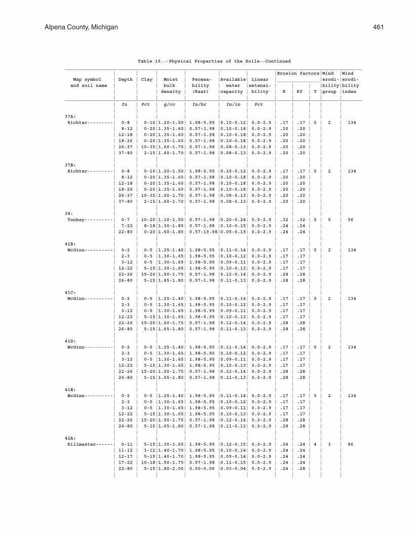
Alpena County, Michigan 461
Table 19.--Physical Properties of the Soils--Continued_________________________________________________________________________________________________________ | | | | | | |Erosion factors|Wind |Wind Map symbol | Depth | Clay | Moist | Permea- |Available| Linear |_______________|erodi-|erodi- and soil name | | | bulk | bility | water |extensi- | | | |bility|bility | | | density | (Ksat) |capacity | bility | K | Kf | T |group |index | | | | | | | | | | |_________________________________________________________________________________________________________ | In | Pct | g/cc | In/hr | In/in | Pct | | | | | | | | | | | | | | | |37A: | | | | | | | | | | | Richter---------| 0-8 | 0-10|1.20-1.50| 1.98-5.95 |0.10-0.12| 0.0-2.9 | .17 | .17 | 5 | 2 | 134 | 8-12 | 0-20|1.35-1.60| 0.57-1.98 |0.10-0.18| 0.0-2.9 | .20 | .20 | | | | 12-18 | 0-20|1.35-1.60| 0.57-1.98 |0.10-0.18| 0.0-2.9 | .20 | .20 | | | | 18-26 | 0-20|1.35-1.60| 0.57-1.98 |0.10-0.18| 0.0-2.9 | .20 | .20 | | | | 26-37 | 10-35|1.60-1.70| 0.57-1.98 |0.08-0.13| 0.0-2.9 | .20 | .20 | | | | 37-80 | 2-15|1.60-1.70| 0.57-1.98 |0.08-0.13| 0.0-2.9 | .20 | .20 | | | | | | | | | | | | | |37B: | | | | | | | | | | | Richter---------| 0-8 | 0-10|1.20-1.50| 1.98-5.95 |0.10-0.12| 0.0-2.9 | .17 | .17 | 5 | 2 | 134 | 8-12 | 0-20|1.35-1.60| 0.57-1.98 |0.10-0.18| 0.0-2.9 | .20 | .20 | | | | 12-18 | 0-20|1.35-1.60| 0.57-1.98 |0.10-0.18| 0.0-2.9 | .20 | .20 | | | | 18-26 | 0-20|1.35-1.60| 0.57-1.98 |0.10-0.18| 0.0-2.9 | .20 | .20 | | | | 26-37 | 10-35|1.60-1.70| 0.57-1.98 |0.08-0.13| 0.0-2.9 | .20 | .20 | | | | 37-80 | 2-15|1.60-1.70| 0.57-1.98 |0.08-0.13| 0.0-2.9 | .20 | .20 | | | | | | | | | | | | | |38: | | | | | | | | | | | Tonkey----------| 0-7 | 10-20|1.10-1.50| 0.57-1.98 |0.20-0.24| 0.0-2.9 | .32 | .32 | 5 | 5 | 56 | 7-22 | 8-18|1.30-1.80| 0.57-1.98 |0.10-0.15| 0.0-2.9 | .24 | .24 | | | | 22-80 | 0-20|1.60-1.80| 0.57-19.98|0.05-0.19| 0.0-2.9 | .24 | .24 | | | | | | | | | | | | | |41B: | | | | | | | | | | | McGinn----------| 0-2 | 0-5 |1.25-1.40| 1.98-5.95 |0.11-0.14| 0.0-2.9 | .17 | .17 | 5 | 2 | 134 | 2-3 | 0-5 |1.30-1.65| 1.98-5.95 |0.10-0.12| 0.0-2.9 | .17 | .17 | | | | 3-12 | 0-5 |1.30-1.65| 1.98-5.95 |0.09-0.11| 0.0-2.9 | .17 | .17 | | | | 12-22 | 5-15|1.30-1.65| 1.98-5.95 |0.10-0.13| 0.0-2.9 | .17 | .17 | | | | 22-26 | 15-20|1.50-1.75| 0.57-1.98 |0.12-0.14| 0.0-2.9 | .28 | .28 | | | | 26-80 | 5-15|1.65-1.80| 0.57-1.98 |0.11-0.13| 0.0-2.9 | .28 | .28 | | | | | | | | | | | | | |41C: | | | | | | | | | | | McGinn----------| 0-2 | 0-5 |1.25-1.40| 1.98-5.95 |0.11-0.14| 0.0-2.9 | .17 | .17 | 5 | 2 | 134 | 2-3 | 0-5 |1.30-1.65| 1.98-5.95 |0.10-0.12| 0.0-2.9 | .17 | .17 | | | | 3-12 | 0-5 |1.30-1.65| 1.98-5.95 |0.09-0.11| 0.0-2.9 | .17 | .17 | | | | 12-22 | 5-15|1.30-1.65| 1.98-5.95 |0.10-0.13| 0.0-2.9 | .17 | .17 | | | | 22-26 | 15-20|1.50-1.75| 0.57-1.98 |0.12-0.14| 0.0-2.9 | .28 | .28 | | | | 26-80 | 5-15|1.65-1.80| 0.57-1.98 |0.11-0.13| 0.0-2.9 | .28 | .28 | | | | | | | | | | | | | |41D: | | | | | | | | | | | McGinn----------| 0-2 | 0-5 |1.25-1.40| 1.98-5.95 |0.11-0.14| 0.0-2.9 | .17 | .17 | 5 | 2 | 134 | 2-3 | 0-5 |1.30-1.65| 1.98-5.95 |0.10-0.12| 0.0-2.9 | .17 | .17 | | | | 3-12 | 0-5 |1.30-1.65| 1.98-5.95 |0.09-0.11| 0.0-2.9 | .17 | .17 | | | | 12-22 | 5-15|1.30-1.65| 1.98-5.95 |0.10-0.13| 0.0-2.9 | .17 | .17 | | | | 22-26 | 15-20|1.50-1.75| 0.57-1.98 |0.12-0.14| 0.0-2.9 | .28 | .28 | | | | 26-80 | 5-15|1.65-1.80| 0.57-1.98 |0.11-0.13| 0.0-2.9 | .28 | .28 | | | | | | | | | | | | | |41E: | | | | | | | | | | | McGinn----------| 0-2 | 0-5 |1.25-1.40| 1.98-5.95 |0.11-0.14| 0.0-2.9 | .17 | .17 | 5 | 2 | 134 | 2-3 | 0-5 |1.30-1.65| 1.98-5.95 |0.10-0.12| 0.0-2.9 | .17 | .17 | | | | 3-12 | 0-5 |1.30-1.65| 1.98-5.95 |0.09-0.11| 0.0-2.9 | .17 | .17 | | | | 12-22 | 5-15|1.30-1.65| 1.98-5.95 |0.10-0.13| 0.0-2.9 | .17 | .17 | | | | 22-26 | 15-20|1.50-1.75| 0.57-1.98 |0.12-0.14| 0.0-2.9 | .28 | .28 | | | | 26-80 | 5-15|1.65-1.80| 0.57-1.98 |0.11-0.13| 0.0-2.9 | .28 | .28 | | | | | | | | | | | | | |42A: | | | | | | | | | | | Killmaster------| 0-11 | 5-15|1.30-1.65| 1.98-5.95 |0.12-0.15| 0.0-2.9 | .24 | .24 | 4 | 3 | 86 | 11-12 | 3-12|1.40-1.70| 1.98-5.95 |0.10-0.14| 0.0-2.9 | .24 | .24 | | | | 12-17 | 5-15|1.40-1.70| 1.98-5.95 |0.09-0.14| 0.0-2.9 | .24 | .24 | | | | 17-22 | 10-18|1.50-1.75| 0.57-1.98 |0.11-0.15| 0.0-2.9 | .24 | .24 | | | | 22-80 | 5-15|1.80-2.00| 0.00-0.06 |0.03-0.04| 0.0-2.9 | .24 | .28 | | | | | | | | | | | | | |
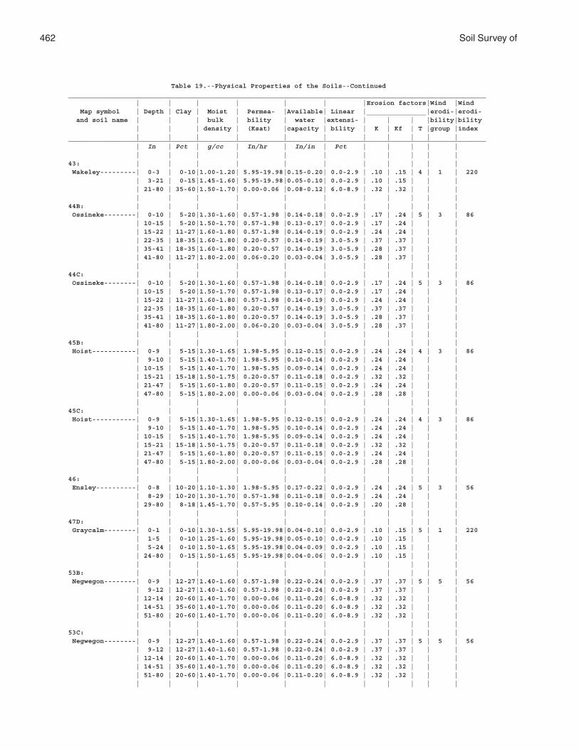
462 Soil Survey of
Table 19.--Physical Properties of the Soils--Continued_________________________________________________________________________________________________________ | | | | | | |Erosion factors|Wind |Wind Map symbol | Depth | Clay | Moist | Permea- |Available| Linear |_______________|erodi-|erodi- and soil name | | | bulk | bility | water |extensi- | | | |bility|bility | | | density | (Ksat) |capacity | bility | K | Kf | T |group |index | | | | | | | | | | |_________________________________________________________________________________________________________ | In | Pct | g/cc | In/hr | In/in | Pct | | | | | | | | | | | | | | | |43: | | | | | | | | | | | Wakeley---------| 0-3 | 0-10|1.00-1.20| 5.95-19.98|0.15-0.20| 0.0-2.9 | .10 | .15 | 4 | 1 | 220 | 3-21 | 0-15|1.45-1.60| 5.95-19.98|0.05-0.10| 0.0-2.9 | .10 | .15 | | | | 21-80 | 35-60|1.50-1.70| 0.00-0.06 |0.08-0.12| 6.0-8.9 | .32 | .32 | | | | | | | | | | | | | |44B: | | | | | | | | | | | Ossineke--------| 0-10 | 5-20|1.30-1.60| 0.57-1.98 |0.14-0.18| 0.0-2.9 | .17 | .24 | 5 | 3 | 86 | 10-15 | 5-20|1.50-1.70| 0.57-1.98 |0.13-0.17| 0.0-2.9 | .17 | .24 | | | | 15-22 | 11-27|1.60-1.80| 0.57-1.98 |0.14-0.19| 0.0-2.9 | .24 | .24 | | | | 22-35 | 18-35|1.60-1.80| 0.20-0.57 |0.14-0.19| 3.0-5.9 | .37 | .37 | | | | 35-41 | 18-35|1.60-1.80| 0.20-0.57 |0.14-0.19| 3.0-5.9 | .28 | .37 | | | | 41-80 | 11-27|1.80-2.00| 0.06-0.20 |0.03-0.04| 3.0-5.9 | .28 | .37 | | | | | | | | | | | | | |44C: | | | | | | | | | | | Ossineke--------| 0-10 | 5-20|1.30-1.60| 0.57-1.98 |0.14-0.18| 0.0-2.9 | .17 | .24 | 5 | 3 | 86 | 10-15 | 5-20|1.50-1.70| 0.57-1.98 |0.13-0.17| 0.0-2.9 | .17 | .24 | | | | 15-22 | 11-27|1.60-1.80| 0.57-1.98 |0.14-0.19| 0.0-2.9 | .24 | .24 | | | | 22-35 | 18-35|1.60-1.80| 0.20-0.57 |0.14-0.19| 3.0-5.9 | .37 | .37 | | | | 35-41 | 18-35|1.60-1.80| 0.20-0.57 |0.14-0.19| 3.0-5.9 | .28 | .37 | | | | 41-80 | 11-27|1.80-2.00| 0.06-0.20 |0.03-0.04| 3.0-5.9 | .28 | .37 | | | | | | | | | | | | | |45B: | | | | | | | | | | | Hoist-----------| 0-9 | 5-15|1.30-1.65| 1.98-5.95 |0.12-0.15| 0.0-2.9 | .24 | .24 | 4 | 3 | 86 | 9-10 | 5-15|1.40-1.70| 1.98-5.95 |0.10-0.14| 0.0-2.9 | .24 | .24 | | | | 10-15 | 5-15|1.40-1.70| 1.98-5.95 |0.09-0.14| 0.0-2.9 | .24 | .24 | | | | 15-21 | 15-18|1.50-1.75| 0.20-0.57 |0.11-0.18| 0.0-2.9 | .32 | .32 | | | | 21-47 | 5-15|1.60-1.80| 0.20-0.57 |0.11-0.15| 0.0-2.9 | .24 | .24 | | | | 47-80 | 5-15|1.80-2.00| 0.00-0.06 |0.03-0.04| 0.0-2.9 | .28 | .28 | | | | | | | | | | | | | |45C: | | | | | | | | | | | Hoist-----------| 0-9 | 5-15|1.30-1.65| 1.98-5.95 |0.12-0.15| 0.0-2.9 | .24 | .24 | 4 | 3 | 86 | 9-10 | 5-15|1.40-1.70| 1.98-5.95 |0.10-0.14| 0.0-2.9 | .24 | .24 | | | | 10-15 | 5-15|1.40-1.70| 1.98-5.95 |0.09-0.14| 0.0-2.9 | .24 | .24 | | | | 15-21 | 15-18|1.50-1.75| 0.20-0.57 |0.11-0.18| 0.0-2.9 | .32 | .32 | | | | 21-47 | 5-15|1.60-1.80| 0.20-0.57 |0.11-0.15| 0.0-2.9 | .24 | .24 | | | | 47-80 | 5-15|1.80-2.00| 0.00-0.06 |0.03-0.04| 0.0-2.9 | .28 | .28 | | | | | | | | | | | | | |46: | | | | | | | | | | | Ensley----------| 0-8 | 10-20|1.10-1.30| 1.98-5.95 |0.17-0.22| 0.0-2.9 | .24 | .24 | 5 | 3 | 56 | 8-29 | 10-20|1.30-1.70| 0.57-1.98 |0.11-0.18| 0.0-2.9 | .24 | .24 | | | | 29-80 | 8-18|1.45-1.70| 0.57-5.95 |0.10-0.14| 0.0-2.9 | .20 | .28 | | | | | | | | | | | | | |47D: | | | | | | | | | | | Graycalm--------| 0-1 | 0-10|1.30-1.55| 5.95-19.98|0.04-0.10| 0.0-2.9 | .10 | .15 | 5 | 1 | 220 | 1-5 | 0-10|1.25-1.60| 5.95-19.98|0.05-0.10| 0.0-2.9 | .10 | .15 | | | | 5-24 | 0-10|1.50-1.65| 5.95-19.98|0.04-0.09| 0.0-2.9 | .10 | .15 | | | | 24-80 | 0-15|1.50-1.65| 5.95-19.98|0.04-0.06| 0.0-2.9 | .10 | .15 | | | | | | | | | | | | | |53B: | | | | | | | | | | | Negwegon--------| 0-9 | 12-27|1.40-1.60| 0.57-1.98 |0.22-0.24| 0.0-2.9 | .37 | .37 | 5 | 5 | 56 | 9-12 | 12-27|1.40-1.60| 0.57-1.98 |0.22-0.24| 0.0-2.9 | .37 | .37 | | | | 12-14 | 20-60|1.40-1.70| 0.00-0.06 |0.11-0.20| 6.0-8.9 | .32 | .32 | | | | 14-51 | 35-60|1.40-1.70| 0.00-0.06 |0.11-0.20| 6.0-8.9 | .32 | .32 | | | | 51-80 | 20-60|1.40-1.70| 0.00-0.06 |0.11-0.20| 6.0-8.9 | .32 | .32 | | | | | | | | | | | | | |53C: | | | | | | | | | | | Negwegon--------| 0-9 | 12-27|1.40-1.60| 0.57-1.98 |0.22-0.24| 0.0-2.9 | .37 | .37 | 5 | 5 | 56 | 9-12 | 12-27|1.40-1.60| 0.57-1.98 |0.22-0.24| 0.0-2.9 | .37 | .37 | | | | 12-14 | 20-60|1.40-1.70| 0.00-0.06 |0.11-0.20| 6.0-8.9 | .32 | .32 | | | | 14-51 | 35-60|1.40-1.70| 0.00-0.06 |0.11-0.20| 6.0-8.9 | .32 | .32 | | | | 51-80 | 20-60|1.40-1.70| 0.00-0.06 |0.11-0.20| 6.0-8.9 | .32 | .32 | | | | | | | | | | | | | |
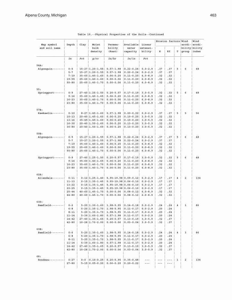
Alpena County, Michigan 463
Table 19.--Physical Properties of the Soils--Continued_________________________________________________________________________________________________________ | | | | | | |Erosion factors|Wind |Wind Map symbol | Depth | Clay | Moist | Permea- |Available| Linear |_______________|erodi-|erodi- and soil name | | | bulk | bility | water |extensi- | | | |bility|bility | | | density | (Ksat) |capacity | bility | K | Kf | T |group |index | | | | | | | | | | |_________________________________________________________________________________________________________ | In | Pct | g/cc | In/hr | In/in | Pct | | | | | | | | | | | | | | | |54A: | | | | | | | | | | | Algonquin-------| 0-5 | 15-27|1.20-1.55| 0.57-1.98 |0.22-0.24| 0.0-2.9 | .37 | .37 | 5 | 6 | 48 | 5-7 | 15-27|1.20-1.55| 0.57-1.98 |0.22-0.24| 0.0-2.9 | .37 | .37 | | | | 7-19 | 35-60|1.40-1.60| 0.06-0.20 |0.11-0.20| 6.0-8.9 | .32 | .32 | | | | 19-55 | 25-60|1.40-1.60| 0.00-0.06 |0.11-0.20| 6.0-8.9 | .32 | .32 | | | | 55-80 | 25-60|1.40-1.70| 0.00-0.06 |0.11-0.20| 6.0-8.9 | .32 | .32 | | | | | | | | | | | | | |55: | | | | | | | | | | | Springport------| 0-9 | 27-40|1.25-1.50| 0.20-0.57 |0.17-0.19| 3.0-5.9 | .32 | .32 | 5 | 6 | 48 | 9-16 | 35-60|1.40-1.65| 0.06-0.20 |0.11-0.20| 6.0-8.9 | .32 | .32 | | | | 16-23 | 35-60|1.40-1.70| 0.00-0.06 |0.11-0.20| 6.0-8.9 | .32 | .32 | | | | 23-80 | 35-60|1.40-1.70| 0.00-0.06 |0.11-0.20| 6.0-8.9 | .32 | .32 | | | | | | | | | | | | | |57B: | | | | | | | | | | | Kawkawlin-------| 0-10 | 8-27|1.45-1.60| 0.57-1.98 |0.20-0.22| 0.0-2.9 | .37 | .37 | 5 | 5 | 56 | 10-13 | 20-40|1.45-1.60| 0.06-0.20 |0.10-0.20| 3.0-5.9 | .32 | .32 | | | | 13-16 | 35-45|1.45-1.60| 0.06-0.20 |0.10-0.20| 3.0-5.9 | .32 | .32 | | | | 16-30 | 20-40|1.50-1.60| 0.06-0.20 |0.13-0.20| 3.0-5.9 | .32 | .32 | | | | 30-80 | 20-40|1.50-1.60| 0.06-0.20 |0.13-0.20| 3.0-5.9 | .32 | .32 | | | | | | | | | | | | | |59B: | | | | | | | | | | | Algonquin-------| 0-5 | 15-27|1.20-1.55| 0.57-1.98 |0.22-0.24| 0.0-2.9 | .37 | .37 | 5 | 6 | 48 | 5-7 | 15-27|1.20-1.55| 0.57-1.98 |0.22-0.24| 0.0-2.9 | .37 | .37 | | | | 7-19 | 35-60|1.40-1.60| 0.06-0.20 |0.11-0.20| 6.0-8.9 | .32 | .32 | | | | 19-55 | 25-60|1.40-1.60| 0.00-0.06 |0.11-0.20| 6.0-8.9 | .32 | .32 | | | | 55-80 | 25-60|1.40-1.70| 0.00-0.06 |0.11-0.20| 6.0-8.9 | .32 | .32 | | | | | | | | | | | | | | Springport------| 0-9 | 27-40|1.25-1.50| 0.20-0.57 |0.17-0.19| 3.0-5.9 | .32 | .32 | 5 | 6 | 48 | 9-16 | 35-60|1.40-1.65| 0.06-0.20 |0.11-0.20| 6.0-8.9 | .32 | .32 | | | | 16-23 | 35-60|1.40-1.70| 0.00-0.06 |0.11-0.20| 6.0-8.9 | .32 | .32 | | | | 23-80 | 35-60|1.40-1.70| 0.00-0.06 |0.11-0.20| 6.0-8.9 | .32 | .32 | | | | | | | | | | | | | |62A: | | | | | | | | | | | Allendale-------| 0-11 | 0-12|1.25-1.40| 5.95-19.98|0.09-0.12| 0.0-2.9 | .17 | .17 | 4 | 2 | 134 | 11-13 | 0-15|1.35-1.45| 5.95-19.98|0.06-0.10| 0.0-2.9 | .17 | .17 | | | | 13-22 | 0-15|1.35-1.45| 5.95-19.98|0.06-0.10| 0.0-2.9 | .17 | .17 | | | | 22-25 | 0-15|1.35-1.45| 5.95-19.98|0.06-0.10| 0.0-2.9 | .17 | .17 | | | | 25-44 | 40-60|1.45-1.70| 0.00-0.06 |0.08-0.12| 6.0-8.9 | .32 | .32 | | | | 44-80 | 40-60|1.45-1.70| 0.00-0.06 |0.08-0.12| 6.0-8.9 | .32 | .32 | | | | | | | | | | | | | |63D: | | | | | | | | | | | Bamfield--------| 0-6 | 5-20|1.30-1.60| 1.98-5.95 |0.14-0.18| 0.0-2.9 | .24 | .24 | 4 | 3 | 86 | 6-8 | 5-20|1.35-1.70| 1.98-5.95 |0.11-0.17| 0.0-2.9 | .20 | .24 | | | | 8-11 | 5-20|1.35-1.70| 1.98-5.95 |0.11-0.17| 0.0-2.9 | .20 | .24 | | | | 11-14 | 5-39|1.60-1.80| 0.57-1.98 |0.11-0.17| 0.0-2.9 | .20 | .24 | | | | 14-42 | 27-40|1.35-1.65| 0.20-0.57 |0.13-0.19| 3.0-5.9 | .32 | .37 | | | | 42-80 | 10-28|1.70-2.00| 0.00-0.06 |0.03-0.04| 3.0-5.9 | .32 | .37 | | | | | | | | | | | | | |63E: | | | | | | | | | | | Bamfield--------| 0-6 | 5-20|1.30-1.60| 1.98-5.95 |0.14-0.18| 0.0-2.9 | .24 | .24 | 4 | 3 | 86 | 6-8 | 5-20|1.35-1.70| 1.98-5.95 |0.11-0.17| 0.0-2.9 | .20 | .24 | | | | 8-11 | 5-20|1.35-1.70| 1.98-5.95 |0.11-0.17| 0.0-2.9 | .20 | .24 | | | | 11-14 | 5-39|1.60-1.80| 0.57-1.98 |0.11-0.17| 0.0-2.9 | .20 | .24 | | | | 14-42 | 27-40|1.35-1.65| 0.20-0.57 |0.13-0.19| 3.0-5.9 | .32 | .37 | | | | 42-80 | 10-28|1.70-2.00| 0.00-0.06 |0.03-0.04| 3.0-5.9 | .32 | .37 | | | | | | | | | | | | | |68: | | | | | | | | | | | Rondeau---------| 0-27 | 0-0 |0.10-0.25| 0.20-5.95 |0.35-0.48| --- | --- | --- | 1 | 2 | 134 | 27-80 | 5-15|0.05-0.20| 0.06-0.20 |0.20-0.22| --- | --- | --- | | | | | | | | | | | | | |
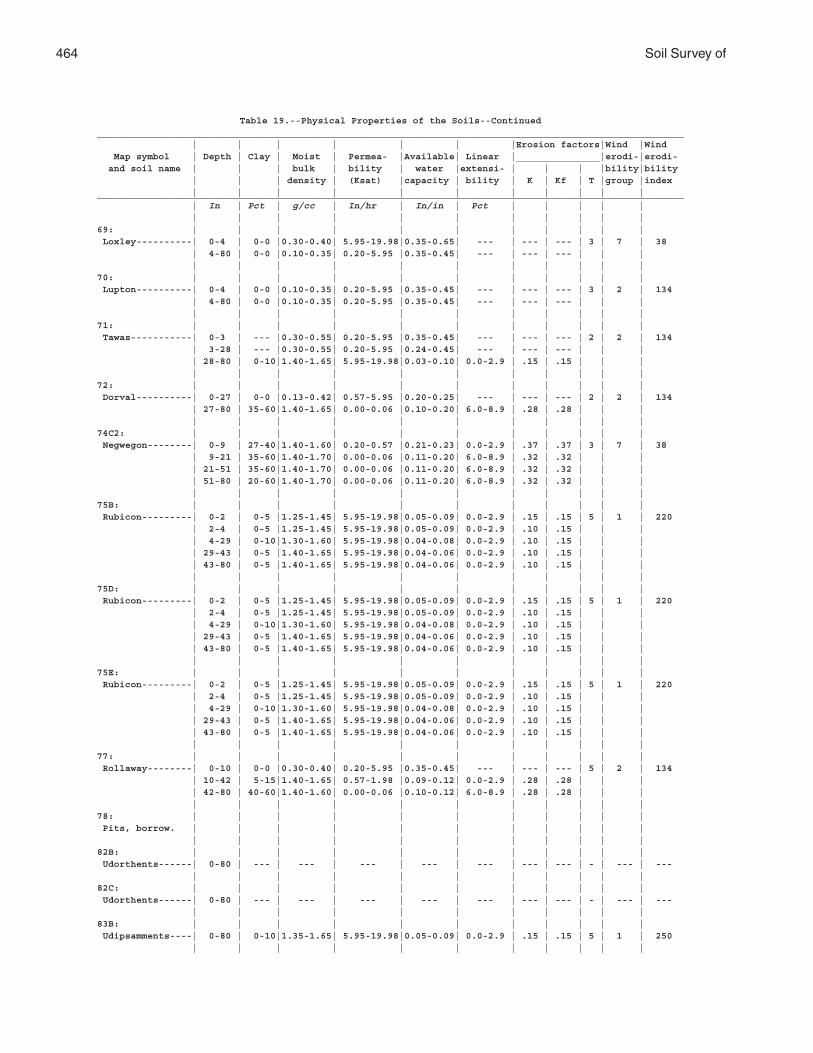
464 Soil Survey of
Table 19.--Physical Properties of the Soils--Continued_________________________________________________________________________________________________________ | | | | | | |Erosion factors|Wind |Wind Map symbol | Depth | Clay | Moist | Permea- |Available| Linear |_______________|erodi-|erodi- and soil name | | | bulk | bility | water |extensi- | | | |bility|bility | | | density | (Ksat) |capacity | bility | K | Kf | T |group |index | | | | | | | | | | |_________________________________________________________________________________________________________ | In | Pct | g/cc | In/hr | In/in | Pct | | | | | | | | | | | | | | | |69: | | | | | | | | | | | Loxley----------| 0-4 | 0-0 |0.30-0.40| 5.95-19.98|0.35-0.65| --- | --- | --- | 3 | 7 | 38 | 4-80 | 0-0 |0.10-0.35| 0.20-5.95 |0.35-0.45| --- | --- | --- | | | | | | | | | | | | | |70: | | | | | | | | | | | Lupton----------| 0-4 | 0-0 |0.10-0.35| 0.20-5.95 |0.35-0.45| --- | --- | --- | 3 | 2 | 134 | 4-80 | 0-0 |0.10-0.35| 0.20-5.95 |0.35-0.45| --- | --- | --- | | | | | | | | | | | | | |71: | | | | | | | | | | | Tawas-----------| 0-3 | --- |0.30-0.55| 0.20-5.95 |0.35-0.45| --- | --- | --- | 2 | 2 | 134 | 3-28 | --- |0.30-0.55| 0.20-5.95 |0.24-0.45| --- | --- | --- | | | | 28-80 | 0-10|1.40-1.65| 5.95-19.98|0.03-0.10| 0.0-2.9 | .15 | .15 | | | | | | | | | | | | | |72: | | | | | | | | | | | Dorval----------| 0-27 | 0-0 |0.13-0.42| 0.57-5.95 |0.20-0.25| --- | --- | --- | 2 | 2 | 134 | 27-80 | 35-60|1.40-1.65| 0.00-0.06 |0.10-0.20| 6.0-8.9 | .28 | .28 | | | | | | | | | | | | | |74C2: | | | | | | | | | | | Negwegon--------| 0-9 | 27-40|1.40-1.60| 0.20-0.57 |0.21-0.23| 0.0-2.9 | .37 | .37 | 3 | 7 | 38 | 9-21 | 35-60|1.40-1.70| 0.00-0.06 |0.11-0.20| 6.0-8.9 | .32 | .32 | | | | 21-51 | 35-60|1.40-1.70| 0.00-0.06 |0.11-0.20| 6.0-8.9 | .32 | .32 | | | | 51-80 | 20-60|1.40-1.70| 0.00-0.06 |0.11-0.20| 6.0-8.9 | .32 | .32 | | | | | | | | | | | | | |75B: | | | | | | | | | | | Rubicon---------| 0-2 | 0-5 |1.25-1.45| 5.95-19.98|0.05-0.09| 0.0-2.9 | .15 | .15 | 5 | 1 | 220 | 2-4 | 0-5 |1.25-1.45| 5.95-19.98|0.05-0.09| 0.0-2.9 | .10 | .15 | | | | 4-29 | 0-10|1.30-1.60| 5.95-19.98|0.04-0.08| 0.0-2.9 | .10 | .15 | | | | 29-43 | 0-5 |1.40-1.65| 5.95-19.98|0.04-0.06| 0.0-2.9 | .10 | .15 | | | | 43-80 | 0-5 |1.40-1.65| 5.95-19.98|0.04-0.06| 0.0-2.9 | .10 | .15 | | | | | | | | | | | | | |75D: | | | | | | | | | | | Rubicon---------| 0-2 | 0-5 |1.25-1.45| 5.95-19.98|0.05-0.09| 0.0-2.9 | .15 | .15 | 5 | 1 | 220 | 2-4 | 0-5 |1.25-1.45| 5.95-19.98|0.05-0.09| 0.0-2.9 | .10 | .15 | | | | 4-29 | 0-10|1.30-1.60| 5.95-19.98|0.04-0.08| 0.0-2.9 | .10 | .15 | | | | 29-43 | 0-5 |1.40-1.65| 5.95-19.98|0.04-0.06| 0.0-2.9 | .10 | .15 | | | | 43-80 | 0-5 |1.40-1.65| 5.95-19.98|0.04-0.06| 0.0-2.9 | .10 | .15 | | | | | | | | | | | | | |75E: | | | | | | | | | | | Rubicon---------| 0-2 | 0-5 |1.25-1.45| 5.95-19.98|0.05-0.09| 0.0-2.9 | .15 | .15 | 5 | 1 | 220 | 2-4 | 0-5 |1.25-1.45| 5.95-19.98|0.05-0.09| 0.0-2.9 | .10 | .15 | | | | 4-29 | 0-10|1.30-1.60| 5.95-19.98|0.04-0.08| 0.0-2.9 | .10 | .15 | | | | 29-43 | 0-5 |1.40-1.65| 5.95-19.98|0.04-0.06| 0.0-2.9 | .10 | .15 | | | | 43-80 | 0-5 |1.40-1.65| 5.95-19.98|0.04-0.06| 0.0-2.9 | .10 | .15 | | | | | | | | | | | | | |77: | | | | | | | | | | | Rollaway--------| 0-10 | 0-0 |0.30-0.40| 0.20-5.95 |0.35-0.45| --- | --- | --- | 5 | 2 | 134 | 10-42 | 5-15|1.40-1.65| 0.57-1.98 |0.09-0.12| 0.0-2.9 | .28 | .28 | | | | 42-80 | 40-60|1.40-1.60| 0.00-0.06 |0.10-0.12| 6.0-8.9 | .28 | .28 | | | | | | | | | | | | | |78: | | | | | | | | | | | Pits, borrow. | | | | | | | | | | | | | | | | | | | | | |82B: | | | | | | | | | | | Udorthents------| 0-80 | --- | --- | --- | --- | --- | --- | --- | - | --- | --- | | | | | | | | | | |82C: | | | | | | | | | | | Udorthents------| 0-80 | --- | --- | --- | --- | --- | --- | --- | - | --- | --- | | | | | | | | | | |83B: | | | | | | | | | | | Udipsamments----| 0-80 | 0-10|1.35-1.65| 5.95-19.98|0.05-0.09| 0.0-2.9 | .15 | .15 | 5 | 1 | 250 | | | | | | | | | | |
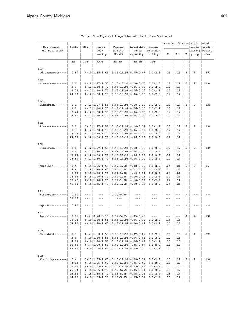
Alpena County, Michigan 465
Table 19.--Physical Properties of the Soils--Continued_________________________________________________________________________________________________________ | | | | | | |Erosion factors|Wind |Wind Map symbol | Depth | Clay | Moist | Permea- |Available| Linear |_______________|erodi-|erodi- and soil name | | | bulk | bility | water |extensi- | | | |bility|bility | | | density | (Ksat) |capacity | bility | K | Kf | T |group |index | | | | | | | | | | |_________________________________________________________________________________________________________ | In | Pct | g/cc | In/hr | In/in | Pct | | | | | | | | | | | | | | | |83F: | | | | | | | | | | | Udipsamments----| 0-80 | 0-10|1.35-1.65| 5.95-19.98|0.05-0.09| 0.0-2.9 | .15 | .15 | 5 | 1 | 250 | | | | | | | | | | |84B: | | | | | | | | | | | Zimmerman-------| 0-1 | 2-12|1.27-1.56| 5.95-19.98|0.10-0.12| 0.0-2.9 | .17 | .17 | 5 | 2 | 134 | 1-3 | 0-12|1.60-1.70| 5.95-19.98|0.06-0.10| 0.0-2.9 | .17 | .17 | | | | 3-24 | 0-12|1.60-1.70| 5.95-19.98|0.06-0.10| 0.0-2.9 | .17 | .17 | | | | 24-80 | 0-12|1.60-1.70| 5.95-19.98|0.06-0.10| 0.0-2.9 | .17 | .17 | | | | | | | | | | | | | |84C: | | | | | | | | | | | Zimmerman-------| 0-1 | 2-12|1.27-1.56| 5.95-19.98|0.10-0.12| 0.0-2.9 | .17 | .17 | 5 | 2 | 134 | 1-3 | 0-12|1.60-1.70| 5.95-19.98|0.06-0.10| 0.0-2.9 | .17 | .17 | | | | 3-24 | 0-12|1.60-1.70| 5.95-19.98|0.06-0.10| 0.0-2.9 | .17 | .17 | | | | 24-80 | 0-12|1.60-1.70| 5.95-19.98|0.06-0.10| 0.0-2.9 | .17 | .17 | | | | | | | | | | | | | |84E: | | | | | | | | | | | Zimmerman-------| 0-1 | 2-12|1.27-1.56| 5.95-19.98|0.10-0.12| 0.0-2.9 | .17 | .17 | 5 | 2 | 134 | 1-3 | 0-12|1.60-1.70| 5.95-19.98|0.06-0.10| 0.0-2.9 | .17 | .17 | | | | 3-24 | 0-12|1.60-1.70| 5.95-19.98|0.06-0.10| 0.0-2.9 | .17 | .17 | | | | 24-80 | 0-12|1.60-1.70| 5.95-19.98|0.06-0.10| 0.0-2.9 | .17 | .17 | | | | | | | | | | | | | |85D: | | | | | | | | | | | Zimmerman-------| 0-1 | 2-12|1.27-1.56| 5.95-19.98|0.10-0.12| 0.0-2.9 | .17 | .17 | 5 | 2 | 134 | 1-3 | 0-12|1.60-1.70| 5.95-19.98|0.06-0.10| 0.0-2.9 | .17 | .17 | | | | 3-24 | 0-12|1.60-1.70| 5.95-19.98|0.06-0.10| 0.0-2.9 | .17 | .17 | | | | 24-80 | 0-12|1.60-1.70| 5.95-19.98|0.06-0.10| 0.0-2.9 | .17 | .17 | | | | | | | | | | | | | | Annalake--------| 0-4 | 5-15|1.25-1.55| 0.57-1.98 |0.08-0.18| 0.0-2.9 | .24 | .24 | 5 | 3 | 86 | 4-6 | 2-15|1.30-1.60| 0.57-1.98 |0.11-0.22| 0.0-2.9 | .24 | .24 | | | | 6-16 | 5-15|1.40-1.70| 0.57-1.98 |0.10-0.14| 0.0-2.9 | .24 | .24 | | | | 16-33 | 5-15|1.40-1.70| 0.57-1.98 |0.10-0.14| 0.0-2.9 | .24 | .24 | | | | 33-42 | 8-18|1.40-1.70| 0.57-1.98 |0.10-0.19| 0.0-2.9 | .24 | .24 | | | | 42-80 | 5-15|1.45-1.70| 0.57-1.98 |0.10-0.15| 0.0-2.9 | .24 | .24 | | | | | | | | | | | | | |86: | | | | | | | | | | | Histosols-------| 0-51 | --- | --- | 0.20-5.95 | --- | --- | --- | --- | - | --- | --- | 51-80 | --- | --- | --- | --- | --- | --- | --- | | | | | | | | | | | | | | Aquents---------| 0-80 | --- | --- | --- | --- | --- | --- | --- | - | --- | --- | | | | | | | | | | |87: | | | | | | | | | | | Ausable---------| 0-11 | 0-0 |0.20-0.30| 0.57-5.95 |0.35-0.45| --- | --- | --- | 3 | 2 | 134 | 11-24 | 0-10|1.40-1.65| 5.95-19.98|0.06-0.10| 0.0-2.9 | .15 | .15 | | | | 24-80 | 0-10|1.30-1.60| 5.95-19.98|0.04-0.08| 0.0-2.9 | .10 | .15 | | | | | | | | | | | | | |90B: | | | | | | | | | | | Chinwhisker-----| 0-3 | 0-5 |1.30-1.55| 5.95-19.98|0.07-0.09| 0.0-2.9 | .10 | .15 | 5 | 1 | 220 | 3-4 | 0-10|1.30-1.55| 5.95-19.98|0.06-0.08| 0.0-2.9 | .10 | .15 | | | | 4-18 | 0-10|1.30-1.55| 5.95-19.98|0.06-0.08| 0.0-2.9 | .10 | .15 | | | | 18-48 | 0-5 |1.30-1.55| 5.95-19.98|0.05-0.07| 0.0-2.9 | .10 | .15 | | | | 48-80 | 3-10|1.50-1.65| 5.95-19.98|0.05-0.10| 0.0-2.9 | .10 | .15 | | | | | | | | | | | | | |92B: | | | | | | | | | | | Klacking--------| 0-4 | 2-12|1.35-1.65| 5.95-19.98|0.08-0.11| 0.0-2.9 | .15 | .17 | 5 | 2 | 134 | 4-12 | 0-10|1.35-1.65| 5.95-19.98|0.05-0.08| 0.0-2.9 | .10 | .15 | | | | 12-25 | 0-10|1.35-1.65| 5.95-19.98|0.05-0.08| 0.0-2.9 | .10 | .15 | | | | 25-33 | 2-15|1.55-1.70| 1.98-5.95 |0.05-0.11| 0.0-2.9 | .15 | .17 | | | | 33-64 | 2-15|1.55-1.70| 1.98-5.95 |0.05-0.11| 0.0-2.9 | .15 | .17 | | | | 64-80 | 0-10|1.55-1.70| 1.98-5.95 |0.05-0.11| 0.0-2.9 | .15 | .17 | | | | | | | | | | | | | |
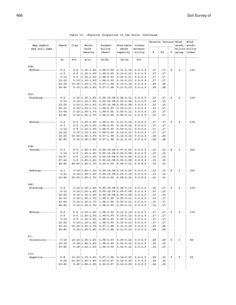
466 Soil Survey of
Table 19.--Physical Properties of the Soils--Continued_________________________________________________________________________________________________________ | | | | | | |Erosion factors|Wind |Wind Map symbol | Depth | Clay | Moist | Permea- |Available| Linear |_______________|erodi-|erodi- and soil name | | | bulk | bility | water |extensi- | | | |bility|bility | | | density | (Ksat) |capacity | bility | K | Kf | T |group |index | | | | | | | | | | |_________________________________________________________________________________________________________ | In | Pct | g/cc | In/hr | In/in | Pct | | | | | | | | | | | | | | | |92B: | | | | | | | | | | | McGinn----------| 0-2 | 0-5 |1.25-1.40| 1.98-5.95 |0.11-0.14| 0.0-2.9 | .17 | .17 | 5 | 2 | 134 | 2-3 | 0-5 |1.30-1.65| 1.98-5.95 |0.10-0.12| 0.0-2.9 | .17 | .17 | | | | 3-12 | 0-5 |1.30-1.65| 1.98-5.95 |0.09-0.11| 0.0-2.9 | .17 | .17 | | | | 12-22 | 5-15|1.30-1.65| 1.98-5.95 |0.10-0.13| 0.0-2.9 | .17 | .17 | | | | 22-26 | 15-20|1.50-1.75| 0.57-1.98 |0.12-0.14| 0.0-2.9 | .28 | .28 | | | | 26-80 | 5-15|1.65-1.80| 0.57-1.98 |0.11-0.13| 0.0-2.9 | .28 | .28 | | | | | | | | | | | | | |92C: | | | | | | | | | | | Klacking--------| 0-4 | 2-12|1.35-1.65| 5.95-19.98|0.08-0.11| 0.0-2.9 | .15 | .17 | 5 | 2 | 134 | 4-12 | 0-10|1.35-1.65| 5.95-19.98|0.05-0.08| 0.0-2.9 | .10 | .15 | | | | 12-25 | 0-10|1.35-1.65| 5.95-19.98|0.05-0.08| 0.0-2.9 | .10 | .15 | | | | 25-33 | 2-15|1.55-1.70| 1.98-5.95 |0.05-0.11| 0.0-2.9 | .15 | .17 | | | | 33-64 | 2-15|1.55-1.70| 1.98-5.95 |0.05-0.11| 0.0-2.9 | .15 | .17 | | | | 64-80 | 0-10|1.55-1.70| 1.98-5.95 |0.05-0.11| 0.0-2.9 | .15 | .17 | | | | | | | | | | | | | | McGinn----------| 0-2 | 0-5 |1.25-1.40| 1.98-5.95 |0.11-0.14| 0.0-2.9 | .17 | .17 | 5 | 2 | 134 | 2-3 | 0-5 |1.30-1.65| 1.98-5.95 |0.10-0.12| 0.0-2.9 | .17 | .17 | | | | 3-12 | 0-5 |1.30-1.65| 1.98-5.95 |0.09-0.11| 0.0-2.9 | .17 | .17 | | | | 12-22 | 5-15|1.30-1.65| 1.98-5.95 |0.10-0.13| 0.0-2.9 | .17 | .17 | | | | 22-26 | 15-20|1.50-1.75| 0.57-1.98 |0.12-0.14| 0.0-2.9 | .28 | .28 | | | | 26-80 | 5-15|1.65-1.80| 0.57-1.98 |0.11-0.13| 0.0-2.9 | .28 | .28 | | | | | | | | | | | | | |93B: | | | | | | | | | | | Tacoda----------| 0-3 | 0-5 |1.40-1.60| 5.95-19.98|0.07-0.09| 0.0-2.9 | .15 | .15 | 4 | 1 | 220 | 3-14 | 0-5 |1.40-1.60| 5.95-19.98|0.06-0.08| 0.0-2.9 | .15 | .15 | | | | 14-27 | 0-5 |1.30-1.65| 5.95-19.98|0.06-0.08| 0.0-2.9 | .15 | .15 | | | | 27-44 | 0-5 |1.45-1.65| 5.95-19.98|0.06-0.08| 0.0-2.9 | .15 | .15 | | | | 44-80 | 40-60|1.60-1.70| 0.00-0.06 |0.08-0.12| 6.0-8.9 | .32 | .32 | | | | | | | | | | | | | | Wakeley---------| 0-3 | 0-10|1.00-1.20| 5.95-19.98|0.15-0.20| 0.0-2.9 | .10 | .15 | 4 | 1 | 220 | 3-21 | 0-15|1.45-1.60| 5.95-19.98|0.05-0.10| 0.0-2.9 | .10 | .15 | | | | 21-80 | 35-60|1.50-1.70| 0.00-0.06 |0.08-0.12| 6.0-8.9 | .32 | .32 | | | | | | | | | | | | | |94F: | | | | | | | | | | | Klacking--------| 0-4 | 2-12|1.35-1.65| 5.95-19.98|0.08-0.11| 0.0-2.9 | .15 | .17 | 5 | 2 | 134 | 4-12 | 0-10|1.35-1.65| 5.95-19.98|0.05-0.08| 0.0-2.9 | .10 | .15 | | | | 12-25 | 0-10|1.35-1.65| 5.95-19.98|0.05-0.08| 0.0-2.9 | .10 | .15 | | | | 25-33 | 2-15|1.55-1.70| 1.98-5.95 |0.05-0.11| 0.0-2.9 | .15 | .17 | | | | 33-64 | 2-15|1.55-1.70| 1.98-5.95 |0.05-0.11| 0.0-2.9 | .15 | .17 | | | | 64-80 | 0-10|1.55-1.70| 1.98-5.95 |0.05-0.11| 0.0-2.9 | .15 | .17 | | | | | | | | | | | | | | McGinn----------| 0-2 | 0-5 |1.25-1.40| 1.98-5.95 |0.11-0.14| 0.0-2.9 | .17 | .17 | 5 | 2 | 134 | 2-3 | 0-5 |1.30-1.65| 1.98-5.95 |0.10-0.12| 0.0-2.9 | .17 | .17 | | | | 3-12 | 0-5 |1.30-1.65| 1.98-5.95 |0.09-0.11| 0.0-2.9 | .17 | .17 | | | | 12-22 | 5-15|1.30-1.65| 1.98-5.95 |0.10-0.13| 0.0-2.9 | .17 | .17 | | | | 22-26 | 15-20|1.50-1.75| 0.57-1.98 |0.12-0.14| 0.0-2.9 | .28 | .28 | | | | 26-80 | 5-15|1.65-1.80| 0.57-1.98 |0.11-0.13| 0.0-2.9 | .28 | .28 | | | | | | | | | | | | | |97: | | | | | | | | | | | Colonville------| 0-19 | 10-15|1.35-1.45| 1.98-5.95 |0.20-0.22| 0.0-2.9 | .28 | .28 | 5 | 3 | 86 | 19-35 | 0-18|1.40-1.65| 1.98-5.95 |0.02-0.12| 0.0-2.9 | .15 | .15 | | | | 35-80 | 0-18|1.40-1.65| 1.98-5.95 |0.02-0.12| 0.0-2.9 | .15 | .15 | | | | | | | | | | | | | |113: | | | | | | | | | | | Angelica--------| 0-8 | 10-20|1.15-1.60| 0.57-1.98 |0.18-0.22| 0.0-2.9 | .28 | .32 | 5 | 5 | 56 | 8-29 | 10-20|1.50-1.80| 0.20-0.57 |0.10-0.20| 3.0-5.9 | .28 | .32 | | | | 29-80 | 5-20|1.45-1.95| 0.20-0.57 |0.10-0.20| 0.0-2.9 | .24 | .32 | | | | | | | | | | | | | |
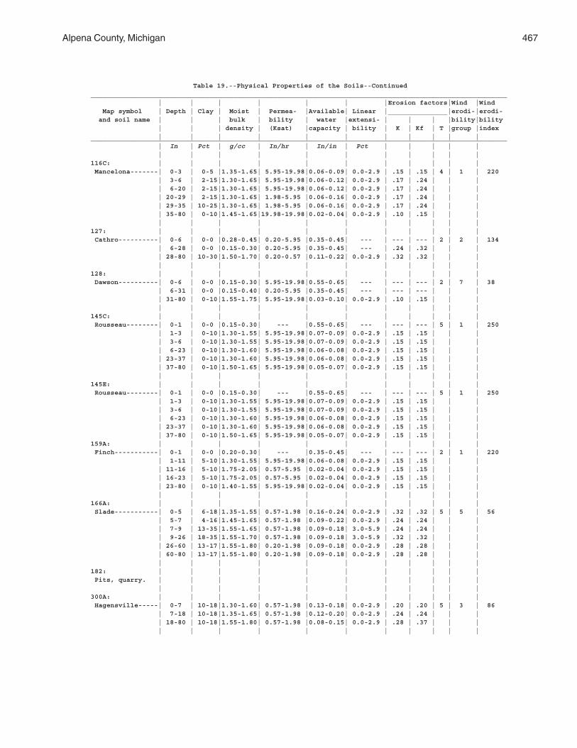
Alpena County, Michigan 467
Table 19.--Physical Properties of the Soils--Continued_________________________________________________________________________________________________________ | | | | | | |Erosion factors|Wind |Wind Map symbol | Depth | Clay | Moist | Permea- |Available| Linear |_______________|erodi-|erodi- and soil name | | | bulk | bility | water |extensi- | | | |bility|bility | | | density | (Ksat) |capacity | bility | K | Kf | T |group |index | | | | | | | | | | |_________________________________________________________________________________________________________ | In | Pct | g/cc | In/hr | In/in | Pct | | | | | | | | | | | | | | | |116C: | | | | | | | | | | | Mancelona-------| 0-3 | 0-5 |1.35-1.65| 5.95-19.98|0.06-0.09| 0.0-2.9 | .15 | .15 | 4 | 1 | 220 | 3-6 | 2-15|1.30-1.65| 5.95-19.98|0.06-0.12| 0.0-2.9 | .17 | .24 | | | | 6-20 | 2-15|1.30-1.65| 5.95-19.98|0.06-0.12| 0.0-2.9 | .17 | .24 | | | | 20-29 | 2-15|1.30-1.65| 1.98-5.95 |0.06-0.16| 0.0-2.9 | .17 | .24 | | | | 29-35 | 10-25|1.30-1.65| 1.98-5.95 |0.06-0.16| 0.0-2.9 | .17 | .24 | | | | 35-80 | 0-10|1.45-1.65|19.98-19.98|0.02-0.04| 0.0-2.9 | .10 | .15 | | | | | | | | | | | | | |127: | | | | | | | | | | | Cathro----------| 0-6 | 0-0 |0.28-0.45| 0.20-5.95 |0.35-0.45| --- | --- | --- | 2 | 2 | 134 | 6-28 | 0-0 |0.15-0.30| 0.20-5.95 |0.35-0.45| --- | .24 | .32 | | | | 28-80 | 10-30|1.50-1.70| 0.20-0.57 |0.11-0.22| 0.0-2.9 | .32 | .32 | | | | | | | | | | | | | |128: | | | | | | | | | | | Dawson----------| 0-6 | 0-0 |0.15-0.30| 5.95-19.98|0.55-0.65| --- | --- | --- | 2 | 7 | 38 | 6-31 | 0-0 |0.15-0.40| 0.20-5.95 |0.35-0.45| --- | --- | --- | | | | 31-80 | 0-10|1.55-1.75| 5.95-19.98|0.03-0.10| 0.0-2.9 | .10 | .15 | | | | | | | | | | | | | |145C: | | | | | | | | | | | Rousseau--------| 0-1 | 0-0 |0.15-0.30| --- |0.55-0.65| --- | --- | --- | 5 | 1 | 250 | 1-3 | 0-10|1.30-1.55| 5.95-19.98|0.07-0.09| 0.0-2.9 | .15 | .15 | | | | 3-6 | 0-10|1.30-1.55| 5.95-19.98|0.07-0.09| 0.0-2.9 | .15 | .15 | | | | 6-23 | 0-10|1.30-1.60| 5.95-19.98|0.06-0.08| 0.0-2.9 | .15 | .15 | | | | 23-37 | 0-10|1.30-1.60| 5.95-19.98|0.06-0.08| 0.0-2.9 | .15 | .15 | | | | 37-80 | 0-10|1.50-1.65| 5.95-19.98|0.05-0.07| 0.0-2.9 | .15 | .15 | | | | | | | | | | | | | |145E: | | | | | | | | | | | Rousseau--------| 0-1 | 0-0 |0.15-0.30| --- |0.55-0.65| --- | --- | --- | 5 | 1 | 250 | 1-3 | 0-10|1.30-1.55| 5.95-19.98|0.07-0.09| 0.0-2.9 | .15 | .15 | | | | 3-6 | 0-10|1.30-1.55| 5.95-19.98|0.07-0.09| 0.0-2.9 | .15 | .15 | | | | 6-23 | 0-10|1.30-1.60| 5.95-19.98|0.06-0.08| 0.0-2.9 | .15 | .15 | | | | 23-37 | 0-10|1.30-1.60| 5.95-19.98|0.06-0.08| 0.0-2.9 | .15 | .15 | | | | 37-80 | 0-10|1.50-1.65| 5.95-19.98|0.05-0.07| 0.0-2.9 | .15 | .15 | | |159A: | | | | | | | | | | | Finch-----------| 0-1 | 0-0 |0.20-0.30| --- |0.35-0.45| --- | --- | --- | 2 | 1 | 220 | 1-11 | 5-10|1.30-1.55| 5.95-19.98|0.06-0.08| 0.0-2.9 | .15 | .15 | | | | 11-16 | 5-10|1.75-2.05| 0.57-5.95 |0.02-0.04| 0.0-2.9 | .15 | .15 | | | | 16-23 | 5-10|1.75-2.05| 0.57-5.95 |0.02-0.04| 0.0-2.9 | .15 | .15 | | | | 23-80 | 0-10|1.40-1.55| 5.95-19.98|0.02-0.04| 0.0-2.9 | .15 | .15 | | | | | | | | | | | | | |166A: | | | | | | | | | | | Slade-----------| 0-5 | 6-18|1.35-1.55| 0.57-1.98 |0.16-0.24| 0.0-2.9 | .32 | .32 | 5 | 5 | 56 | 5-7 | 4-16|1.45-1.65| 0.57-1.98 |0.09-0.22| 0.0-2.9 | .24 | .24 | | | | 7-9 | 13-35|1.55-1.65| 0.57-1.98 |0.09-0.18| 3.0-5.9 | .24 | .24 | | | | 9-26 | 18-35|1.55-1.70| 0.57-1.98 |0.09-0.18| 3.0-5.9 | .32 | .32 | | | | 26-60 | 13-17|1.55-1.80| 0.20-1.98 |0.09-0.18| 0.0-2.9 | .28 | .28 | | | | 60-80 | 13-17|1.55-1.80| 0.20-1.98 |0.09-0.18| 0.0-2.9 | .28 | .28 | | | | | | | | | | | | | |182: | | | | | | | | | | | Pits, quarry. | | | | | | | | | | | | | | | | | | | | | |300A: | | | | | | | | | | | Hagensville-----| 0-7 | 10-18|1.30-1.60| 0.57-1.98 |0.13-0.18| 0.0-2.9 | .20 | .20 | 5 | 3 | 86 | 7-18 | 10-18|1.35-1.65| 0.57-1.98 |0.12-0.20| 0.0-2.9 | .24 | .24 | | | | 18-80 | 10-18|1.55-1.80| 0.57-1.98 |0.08-0.15| 0.0-2.9 | .28 | .37 | | | | | | | | | | | | | |
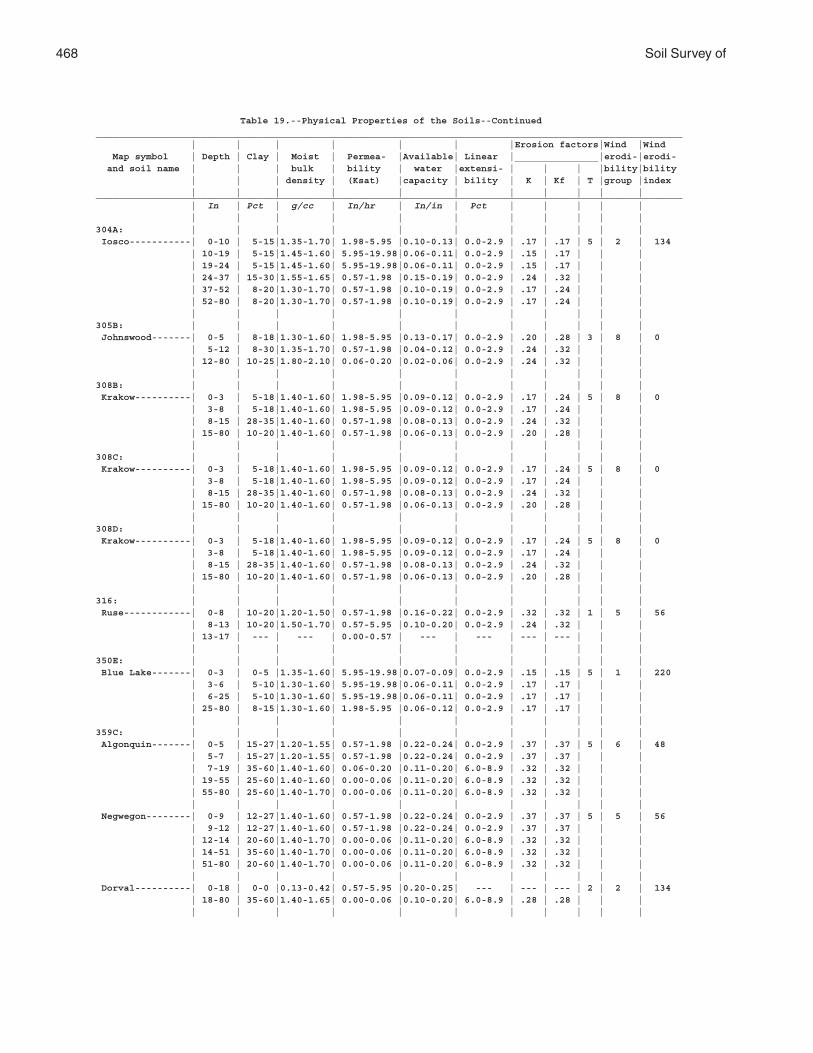
468 Soil Survey of
Table 19.--Physical Properties of the Soils--Continued_________________________________________________________________________________________________________ | | | | | | |Erosion factors|Wind |Wind Map symbol | Depth | Clay | Moist | Permea- |Available| Linear |_______________|erodi-|erodi- and soil name | | | bulk | bility | water |extensi- | | | |bility|bility | | | density | (Ksat) |capacity | bility | K | Kf | T |group |index | | | | | | | | | | |_________________________________________________________________________________________________________ | In | Pct | g/cc | In/hr | In/in | Pct | | | | | | | | | | | | | | | |304A: | | | | | | | | | | | Iosco-----------| 0-10 | 5-15|1.35-1.70| 1.98-5.95 |0.10-0.13| 0.0-2.9 | .17 | .17 | 5 | 2 | 134 | 10-19 | 5-15|1.45-1.60| 5.95-19.98|0.06-0.11| 0.0-2.9 | .15 | .17 | | | | 19-24 | 5-15|1.45-1.60| 5.95-19.98|0.06-0.11| 0.0-2.9 | .15 | .17 | | | | 24-37 | 15-30|1.55-1.65| 0.57-1.98 |0.15-0.19| 0.0-2.9 | .24 | .32 | | | | 37-52 | 8-20|1.30-1.70| 0.57-1.98 |0.10-0.19| 0.0-2.9 | .17 | .24 | | | | 52-80 | 8-20|1.30-1.70| 0.57-1.98 |0.10-0.19| 0.0-2.9 | .17 | .24 | | | | | | | | | | | | | |305B: | | | | | | | | | | | Johnswood-------| 0-5 | 8-18|1.30-1.60| 1.98-5.95 |0.13-0.17| 0.0-2.9 | .20 | .28 | 3 | 8 | 0 | 5-12 | 8-30|1.35-1.70| 0.57-1.98 |0.04-0.12| 0.0-2.9 | .24 | .32 | | | | 12-80 | 10-25|1.80-2.10| 0.06-0.20 |0.02-0.06| 0.0-2.9 | .24 | .32 | | | | | | | | | | | | | |308B: | | | | | | | | | | | Krakow----------| 0-3 | 5-18|1.40-1.60| 1.98-5.95 |0.09-0.12| 0.0-2.9 | .17 | .24 | 5 | 8 | 0 | 3-8 | 5-18|1.40-1.60| 1.98-5.95 |0.09-0.12| 0.0-2.9 | .17 | .24 | | | | 8-15 | 28-35|1.40-1.60| 0.57-1.98 |0.08-0.13| 0.0-2.9 | .24 | .32 | | | | 15-80 | 10-20|1.40-1.60| 0.57-1.98 |0.06-0.13| 0.0-2.9 | .20 | .28 | | | | | | | | | | | | | |308C: | | | | | | | | | | | Krakow----------| 0-3 | 5-18|1.40-1.60| 1.98-5.95 |0.09-0.12| 0.0-2.9 | .17 | .24 | 5 | 8 | 0 | 3-8 | 5-18|1.40-1.60| 1.98-5.95 |0.09-0.12| 0.0-2.9 | .17 | .24 | | | | 8-15 | 28-35|1.40-1.60| 0.57-1.98 |0.08-0.13| 0.0-2.9 | .24 | .32 | | | | 15-80 | 10-20|1.40-1.60| 0.57-1.98 |0.06-0.13| 0.0-2.9 | .20 | .28 | | | | | | | | | | | | | |308D: | | | | | | | | | | | Krakow----------| 0-3 | 5-18|1.40-1.60| 1.98-5.95 |0.09-0.12| 0.0-2.9 | .17 | .24 | 5 | 8 | 0 | 3-8 | 5-18|1.40-1.60| 1.98-5.95 |0.09-0.12| 0.0-2.9 | .17 | .24 | | | | 8-15 | 28-35|1.40-1.60| 0.57-1.98 |0.08-0.13| 0.0-2.9 | .24 | .32 | | | | 15-80 | 10-20|1.40-1.60| 0.57-1.98 |0.06-0.13| 0.0-2.9 | .20 | .28 | | | | | | | | | | | | | |316: | | | | | | | | | | | Ruse------------| 0-8 | 10-20|1.20-1.50| 0.57-1.98 |0.16-0.22| 0.0-2.9 | .32 | .32 | 1 | 5 | 56 | 8-13 | 10-20|1.50-1.70| 0.57-5.95 |0.10-0.20| 0.0-2.9 | .24 | .32 | | | | 13-17 | --- | --- | 0.00-0.57 | --- | --- | --- | --- | | | | | | | | | | | | | |350E: | | | | | | | | | | | Blue Lake-------| 0-3 | 0-5 |1.35-1.60| 5.95-19.98|0.07-0.09| 0.0-2.9 | .15 | .15 | 5 | 1 | 220 | 3-6 | 5-10|1.30-1.60| 5.95-19.98|0.06-0.11| 0.0-2.9 | .17 | .17 | | | | 6-25 | 5-10|1.30-1.60| 5.95-19.98|0.06-0.11| 0.0-2.9 | .17 | .17 | | | | 25-80 | 8-15|1.30-1.60| 1.98-5.95 |0.06-0.12| 0.0-2.9 | .17 | .17 | | | | | | | | | | | | | |359C: | | | | | | | | | | | Algonquin-------| 0-5 | 15-27|1.20-1.55| 0.57-1.98 |0.22-0.24| 0.0-2.9 | .37 | .37 | 5 | 6 | 48 | 5-7 | 15-27|1.20-1.55| 0.57-1.98 |0.22-0.24| 0.0-2.9 | .37 | .37 | | | | 7-19 | 35-60|1.40-1.60| 0.06-0.20 |0.11-0.20| 6.0-8.9 | .32 | .32 | | | | 19-55 | 25-60|1.40-1.60| 0.00-0.06 |0.11-0.20| 6.0-8.9 | .32 | .32 | | | | 55-80 | 25-60|1.40-1.70| 0.00-0.06 |0.11-0.20| 6.0-8.9 | .32 | .32 | | | | | | | | | | | | | | Negwegon--------| 0-9 | 12-27|1.40-1.60| 0.57-1.98 |0.22-0.24| 0.0-2.9 | .37 | .37 | 5 | 5 | 56 | 9-12 | 12-27|1.40-1.60| 0.57-1.98 |0.22-0.24| 0.0-2.9 | .37 | .37 | | | | 12-14 | 20-60|1.40-1.70| 0.00-0.06 |0.11-0.20| 6.0-8.9 | .32 | .32 | | | | 14-51 | 35-60|1.40-1.70| 0.00-0.06 |0.11-0.20| 6.0-8.9 | .32 | .32 | | | | 51-80 | 20-60|1.40-1.70| 0.00-0.06 |0.11-0.20| 6.0-8.9 | .32 | .32 | | | | | | | | | | | | | | Dorval----------| 0-18 | 0-0 |0.13-0.42| 0.57-5.95 |0.20-0.25| --- | --- | --- | 2 | 2 | 134 | 18-80 | 35-60|1.40-1.65| 0.00-0.06 |0.10-0.20| 6.0-8.9 | .28 | .28 | | | | | | | | | | | | | |
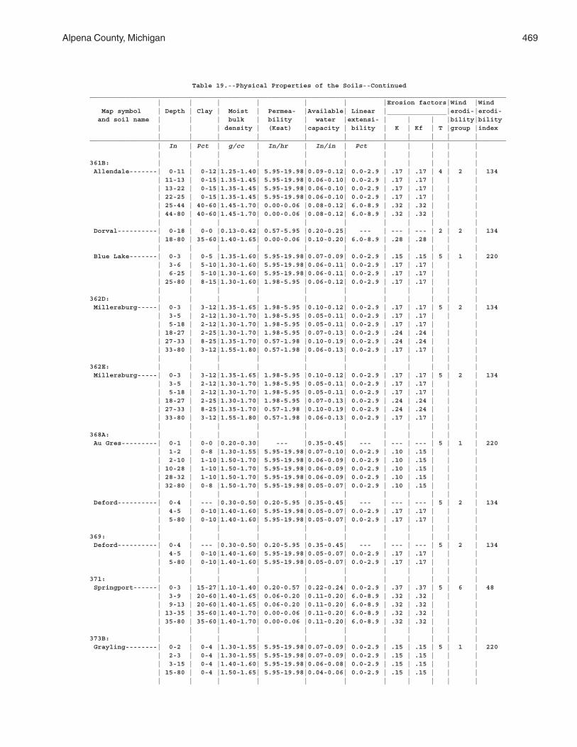
Alpena County, Michigan 469
Table 19.--Physical Properties of the Soils--Continued_________________________________________________________________________________________________________ | | | | | | |Erosion factors|Wind |Wind Map symbol | Depth | Clay | Moist | Permea- |Available| Linear |_______________|erodi-|erodi- and soil name | | | bulk | bility | water |extensi- | | | |bility|bility | | | density | (Ksat) |capacity | bility | K | Kf | T |group |index | | | | | | | | | | |_________________________________________________________________________________________________________ | In | Pct | g/cc | In/hr | In/in | Pct | | | | | | | | | | | | | | | |361B: | | | | | | | | | | | Allendale-------| 0-11 | 0-12|1.25-1.40| 5.95-19.98|0.09-0.12| 0.0-2.9 | .17 | .17 | 4 | 2 | 134 | 11-13 | 0-15|1.35-1.45| 5.95-19.98|0.06-0.10| 0.0-2.9 | .17 | .17 | | | | 13-22 | 0-15|1.35-1.45| 5.95-19.98|0.06-0.10| 0.0-2.9 | .17 | .17 | | | | 22-25 | 0-15|1.35-1.45| 5.95-19.98|0.06-0.10| 0.0-2.9 | .17 | .17 | | | | 25-44 | 40-60|1.45-1.70| 0.00-0.06 |0.08-0.12| 6.0-8.9 | .32 | .32 | | | | 44-80 | 40-60|1.45-1.70| 0.00-0.06 |0.08-0.12| 6.0-8.9 | .32 | .32 | | | | | | | | | | | | | | Dorval----------| 0-18 | 0-0 |0.13-0.42| 0.57-5.95 |0.20-0.25| --- | --- | --- | 2 | 2 | 134 | 18-80 | 35-60|1.40-1.65| 0.00-0.06 |0.10-0.20| 6.0-8.9 | .28 | .28 | | | | | | | | | | | | | | Blue Lake-------| 0-3 | 0-5 |1.35-1.60| 5.95-19.98|0.07-0.09| 0.0-2.9 | .15 | .15 | 5 | 1 | 220 | 3-6 | 5-10|1.30-1.60| 5.95-19.98|0.06-0.11| 0.0-2.9 | .17 | .17 | | | | 6-25 | 5-10|1.30-1.60| 5.95-19.98|0.06-0.11| 0.0-2.9 | .17 | .17 | | | | 25-80 | 8-15|1.30-1.60| 1.98-5.95 |0.06-0.12| 0.0-2.9 | .17 | .17 | | | | | | | | | | | | | |362D: | | | | | | | | | | | Millersburg-----| 0-3 | 3-12|1.35-1.65| 1.98-5.95 |0.10-0.12| 0.0-2.9 | .17 | .17 | 5 | 2 | 134 | 3-5 | 2-12|1.30-1.70| 1.98-5.95 |0.05-0.11| 0.0-2.9 | .17 | .17 | | | | 5-18 | 2-12|1.30-1.70| 1.98-5.95 |0.05-0.11| 0.0-2.9 | .17 | .17 | | | | 18-27 | 2-25|1.30-1.70| 1.98-5.95 |0.07-0.13| 0.0-2.9 | .24 | .24 | | | | 27-33 | 8-25|1.35-1.70| 0.57-1.98 |0.10-0.19| 0.0-2.9 | .24 | .24 | | | | 33-80 | 3-12|1.55-1.80| 0.57-1.98 |0.06-0.13| 0.0-2.9 | .17 | .17 | | | | | | | | | | | | | |362E: | | | | | | | | | | | Millersburg-----| 0-3 | 3-12|1.35-1.65| 1.98-5.95 |0.10-0.12| 0.0-2.9 | .17 | .17 | 5 | 2 | 134 | 3-5 | 2-12|1.30-1.70| 1.98-5.95 |0.05-0.11| 0.0-2.9 | .17 | .17 | | | | 5-18 | 2-12|1.30-1.70| 1.98-5.95 |0.05-0.11| 0.0-2.9 | .17 | .17 | | | | 18-27 | 2-25|1.30-1.70| 1.98-5.95 |0.07-0.13| 0.0-2.9 | .24 | .24 | | | | 27-33 | 8-25|1.35-1.70| 0.57-1.98 |0.10-0.19| 0.0-2.9 | .24 | .24 | | | | 33-80 | 3-12|1.55-1.80| 0.57-1.98 |0.06-0.13| 0.0-2.9 | .17 | .17 | | | | | | | | | | | | | |368A: | | | | | | | | | | | Au Gres---------| 0-1 | 0-0 |0.20-0.30| --- |0.35-0.45| --- | --- | --- | 5 | 1 | 220 | 1-2 | 0-8 |1.30-1.55| 5.95-19.98|0.07-0.10| 0.0-2.9 | .10 | .15 | | | | 2-10 | 1-10|1.50-1.70| 5.95-19.98|0.06-0.09| 0.0-2.9 | .10 | .15 | | | | 10-28 | 1-10|1.50-1.70| 5.95-19.98|0.06-0.09| 0.0-2.9 | .10 | .15 | | | | 28-32 | 1-10|1.50-1.70| 5.95-19.98|0.06-0.09| 0.0-2.9 | .10 | .15 | | | | 32-80 | 0-8 |1.50-1.70| 5.95-19.98|0.05-0.07| 0.0-2.9 | .10 | .15 | | | | | | | | | | | | | | Deford----------| 0-4 | --- |0.30-0.50| 0.20-5.95 |0.35-0.45| --- | --- | --- | 5 | 2 | 134 | 4-5 | 0-10|1.40-1.60| 5.95-19.98|0.05-0.07| 0.0-2.9 | .17 | .17 | | | | 5-80 | 0-10|1.40-1.60| 5.95-19.98|0.05-0.07| 0.0-2.9 | .17 | .17 | | | | | | | | | | | | | |369: | | | | | | | | | | | Deford----------| 0-4 | --- |0.30-0.50| 0.20-5.95 |0.35-0.45| --- | --- | --- | 5 | 2 | 134 | 4-5 | 0-10|1.40-1.60| 5.95-19.98|0.05-0.07| 0.0-2.9 | .17 | .17 | | | | 5-80 | 0-10|1.40-1.60| 5.95-19.98|0.05-0.07| 0.0-2.9 | .17 | .17 | | | | | | | | | | | | | |371: | | | | | | | | | | | Springport------| 0-3 | 15-27|1.10-1.40| 0.20-0.57 |0.22-0.24| 0.0-2.9 | .37 | .37 | 5 | 6 | 48 | 3-9 | 20-60|1.40-1.65| 0.06-0.20 |0.11-0.20| 6.0-8.9 | .32 | .32 | | | | 9-13 | 20-60|1.40-1.65| 0.06-0.20 |0.11-0.20| 6.0-8.9 | .32 | .32 | | | | 13-35 | 35-60|1.40-1.70| 0.00-0.06 |0.11-0.20| 6.0-8.9 | .32 | .32 | | | | 35-80 | 35-60|1.40-1.70| 0.00-0.06 |0.11-0.20| 6.0-8.9 | .32 | .32 | | | | | | | | | | | | | |373B: | | | | | | | | | | | Grayling--------| 0-2 | 0-4 |1.30-1.55| 5.95-19.98|0.07-0.09| 0.0-2.9 | .15 | .15 | 5 | 1 | 220 | 2-3 | 0-4 |1.30-1.55| 5.95-19.98|0.07-0.09| 0.0-2.9 | .15 | .15 | | | | 3-15 | 0-4 |1.40-1.60| 5.95-19.98|0.06-0.08| 0.0-2.9 | .15 | .15 | | | | 15-80 | 0-4 |1.50-1.65| 5.95-19.98|0.04-0.06| 0.0-2.9 | .15 | .15 | | | | | | | | | | | | | |
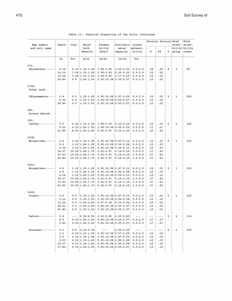
470 Soil Survey of
Table 19.--Physical Properties of the Soils--Continued_________________________________________________________________________________________________________ | | | | | | |Erosion factors|Wind |Wind Map symbol | Depth | Clay | Moist | Permea- |Available| Linear |_______________|erodi-|erodi- and soil name | | | bulk | bility | water |extensi- | | | |bility|bility | | | density | (Ksat) |capacity | bility | K | Kf | T |group |index | | | | | | | | | | |_________________________________________________________________________________________________________ | In | Pct | g/cc | In/hr | In/in | Pct | | | | | | | | | | | | | | | |374: | | | | | | | | | | | Thunderbay------| 0-14 | 5-10|1.35-1.45| 1.98-5.95 |0.20-0.22| 0.0-2.9 | .28 | .28 | 4 | 3 | 86 | 14-19 | 7-18|1.35-1.45| 1.98-5.95 |0.20-0.22| 0.0-2.9 | .32 | .32 | | | | 19-24 | 7-18|1.35-1.50| 1.98-5.95 |0.17-0.19| 0.0-2.9 | .32 | .32 | | | | 24-80 | 0-8 |1.40-1.60| 5.95-19.98|0.05-0.07| 0.0-2.9 | .15 | .15 | | | | | | | | | | | | | |376A: | | | | | | | | | | | Urban land. | | | | | | | | | | | | | | | | | | | | | | Udipsamments----| 0-4 | 0-3 |1.25-1.65| 5.95-19.98|0.07-0.09| 0.0-2.9 | .15 | .15 | 5 | 1 | 250 | 4-42 | 0-3 |1.30-1.65| 5.95-19.98|0.05-0.07| 0.0-2.9 | .15 | .15 | | | | 42-80 | 0-3 |1.30-1.65| 5.95-19.98|0.05-0.07| 0.0-2.9 | .15 | .15 | | | | | | | | | | | | | |380: | | | | | | | | | | | Access denied. | | | | | | | | | | | | | | | | | | | | | |392: | | | | | | | | | | | Caffey----------| 0-9 | 2-10|1.10-1.30| 1.98-5.95 |0.10-0.15| 0.0-2.9 | .15 | .15 | 5 | 1 | 220 | 9-21 | 2-10|1.40-1.55| 1.98-19.98|0.06-0.09| 0.0-2.9 | .17 | .17 | | | | 21-80 | 8-30|1.50-1.80| 0.20-0.57 |0.10-0.20| 0.0-2.9 | .43 | .43 | | | | | | | | | | | | | |393B: | | | | | | | | | | | Morganlake------| 0-2 | 1-10|1.30-1.55| 5.95-19.98|0.07-0.12| 0.0-2.9 | .15 | .15 | 5 | 1 | 220 | 2-6 | 1-10|1.40-1.65| 5.95-19.98|0.06-0.08| 0.0-2.9 | .15 | .15 | | | | 6-34 | 1-10|1.40-1.65| 5.95-19.98|0.09-0.11| 0.0-2.9 | .15 | .15 | | | | 34-37 | 10-25|1.45-1.70| 0.20-0.57 |0.14-0.16| 3.0-5.9 | .37 | .43 | | | | 37-43 | 10-25|1.45-1.70| 0.20-0.57 |0.14-0.16| 3.0-5.9 | .37 | .43 | | | | 43-80 | 10-25|1.45-1.70| 0.20-0.57 |0.14-0.16| 3.0-5.9 | .37 | .43 | | | | | | | | | | | | | |393C: | | | | | | | | | | | Morganlake------| 0-2 | 1-10|1.30-1.55| 5.95-19.98|0.07-0.12| 0.0-2.9 | .15 | .15 | 5 | 1 | 220 | 2-6 | 1-10|1.40-1.65| 5.95-19.98|0.06-0.08| 0.0-2.9 | .15 | .15 | | | | 6-34 | 1-10|1.40-1.65| 5.95-19.98|0.09-0.11| 0.0-2.9 | .15 | .15 | | | | 34-37 | 10-25|1.45-1.70| 0.20-0.57 |0.14-0.16| 3.0-5.9 | .37 | .43 | | | | 37-43 | 10-25|1.45-1.70| 0.20-0.57 |0.14-0.16| 3.0-5.9 | .37 | .43 | | | | 43-80 | 10-25|1.45-1.70| 0.20-0.57 |0.14-0.16| 3.0-5.9 | .37 | .43 | | | | | | | | | | | | | |396F: | | | | | | | | | | | Proper----------| 0-3 | 0-5 |1.30-1.55| 5.95-19.98|0.07-0.10| 0.0-2.9 | .15 | .15 | 5 | 1 | 220 | 3-11 | 0-5 |1.30-1.55| 5.95-19.98|0.06-0.08| 0.0-2.9 | .15 | .15 | | | | 11-24 | 0-5 |1.65-2.00| 0.57-5.95 |0.03-0.04| 0.0-2.9 | .15 | .15 | | | | 24-41 | 0-5 |1.50-1.60| 5.95-19.98|0.05-0.07| 0.0-2.9 | .15 | .15 | | | | 41-80 | 0-5 |1.50-1.60| 5.95-19.98|0.05-0.07| 0.0-2.9 | .15 | .15 | | | | | | | | | | | | | | Deford----------| 0-4 | --- |0.30-0.50| 0.20-5.95 |0.35-0.45| --- | --- | --- | 5 | 2 | 134 | 4-5 | 0-10|1.40-1.60| 5.95-19.98|0.05-0.07| 0.0-2.9 | .17 | .17 | | | | 5-80 | 0-10|1.40-1.60| 5.95-19.98|0.05-0.07| 0.0-2.9 | .17 | .17 | | | | | | | | | | | | | | Rousseau--------| 0-1 | 0-0 |0.15-0.30| --- |0.55-0.65| --- | --- | --- | 5 | 1 | 250 | 1-3 | 0-10|1.30-1.55| 5.95-19.98|0.07-0.09| 0.0-2.9 | .15 | .15 | | | | 3-6 | 0-10|1.30-1.55| 5.95-19.98|0.07-0.09| 0.0-2.9 | .15 | .15 | | | | 6-23 | 0-10|1.30-1.60| 5.95-19.98|0.06-0.08| 0.0-2.9 | .15 | .15 | | | | 23-37 | 0-10|1.30-1.60| 5.95-19.98|0.06-0.08| 0.0-2.9 | .15 | .15 | | | | 37-80 | 0-10|1.50-1.65| 5.95-19.98|0.05-0.07| 0.0-2.9 | .15 | .15 | | | | | | | | | | | | | |
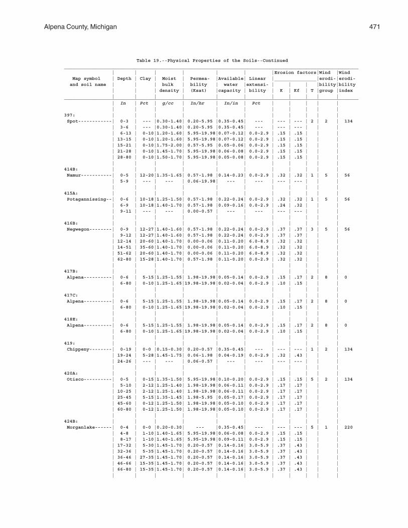
Alpena County, Michigan 471
Table 19.--Physical Properties of the Soils--Continued_________________________________________________________________________________________________________ | | | | | | |Erosion factors|Wind |Wind Map symbol | Depth | Clay | Moist | Permea- |Available| Linear |_______________|erodi-|erodi- and soil name | | | bulk | bility | water |extensi- | | | |bility|bility | | | density | (Ksat) |capacity | bility | K | Kf | T |group |index | | | | | | | | | | |_________________________________________________________________________________________________________ | In | Pct | g/cc | In/hr | In/in | Pct | | | | | | | | | | | | | | | |397: | | | | | | | | | | | Spot------------| 0-3 | --- |0.30-1.40| 0.20-5.95 |0.35-0.45| --- | --- | --- | 2 | 2 | 134 | 3-6 | --- |0.30-1.40| 0.20-5.95 |0.35-0.45| --- | --- | --- | | | | 6-13 | 0-10|1.20-1.60| 5.95-19.98|0.07-0.12| 0.0-2.9 | .15 | .15 | | | | 13-15 | 0-10|1.20-1.60| 5.95-19.98|0.07-0.12| 0.0-2.9 | .15 | .15 | | | | 15-21 | 0-10|1.75-2.00| 0.57-5.95 |0.05-0.06| 0.0-2.9 | .15 | .15 | | | | 21-28 | 0-10|1.45-1.70| 5.95-19.98|0.06-0.08| 0.0-2.9 | .15 | .15 | | | | 28-80 | 0-10|1.50-1.70| 5.95-19.98|0.05-0.08| 0.0-2.9 | .15 | .15 | | | | | | | | | | | | | |414B: | | | | | | | | | | | Namur-----------| 0-5 | 12-20|1.35-1.65| 0.57-1.98 |0.14-0.23| 0.0-2.9 | .32 | .32 | 1 | 5 | 56 | 5-9 | --- | --- | 0.06-19.98| --- | --- | --- | --- | | | | | | | | | | | | | |415A: | | | | | | | | | | | Potagannissing--| 0-6 | 10-18|1.25-1.50| 0.57-1.98 |0.22-0.24| 0.0-2.9 | .32 | .32 | 1 | 5 | 56 | 6-9 | 10-18|1.40-1.70| 0.57-1.98 |0.09-0.16| 0.0-2.9 | .24 | .32 | | | | 9-11 | --- | --- | 0.00-0.57 | --- | --- | --- | --- | | | | | | | | | | | | | |416B: | | | | | | | | | | | Negwegon--------| 0-9 | 12-27|1.40-1.60| 0.57-1.98 |0.22-0.24| 0.0-2.9 | .37 | .37 | 3 | 5 | 56 | 9-12 | 12-27|1.40-1.60| 0.57-1.98 |0.22-0.24| 0.0-2.9 | .37 | .37 | | | | 12-14 | 20-60|1.40-1.70| 0.00-0.06 |0.11-0.20| 6.0-8.9 | .32 | .32 | | | | 14-51 | 35-60|1.40-1.70| 0.00-0.06 |0.11-0.20| 6.0-8.9 | .32 | .32 | | | | 51-62 | 20-60|1.40-1.70| 0.00-0.06 |0.11-0.20| 6.0-8.9 | .32 | .32 | | | | 62-80 | 15-28|1.40-1.70| 0.57-1.98 |0.11-0.20| 0.0-2.9 | .32 | .32 | | | | | | | | | | | | | |417B: | | | | | | | | | | | Alpena----------| 0-6 | 5-15|1.25-1.55| 1.98-19.98|0.05-0.14| 0.0-2.9 | .15 | .17 | 2 | 8 | 0 | 6-80 | 0-10|1.25-1.65|19.98-19.98|0.02-0.04| 0.0-2.9 | .10 | .15 | | | | | | | | | | | | | |417C: | | | | | | | | | | | Alpena----------| 0-6 | 5-15|1.25-1.55| 1.98-19.98|0.05-0.14| 0.0-2.9 | .15 | .17 | 2 | 8 | 0 | 6-80 | 0-10|1.25-1.65|19.98-19.98|0.02-0.04| 0.0-2.9 | .10 | .15 | | | | | | | | | | | | | |418E: | | | | | | | | | | | Alpena----------| 0-6 | 5-15|1.25-1.55| 1.98-19.98|0.05-0.14| 0.0-2.9 | .15 | .17 | 2 | 8 | 0 | 6-80 | 0-10|1.25-1.65|19.98-19.98|0.02-0.04| 0.0-2.9 | .10 | .15 | | | | | | | | | | | | | |419: | | | | | | | | | | | Chippeny--------| 0-19 | 0-0 |0.15-0.30| 0.20-0.57 |0.35-0.45| --- | --- | --- | 1 | 2 | 134 | 19-24 | 5-28|1.45-1.75| 0.06-1.98 |0.04-0.19| 0.0-2.9 | .32 | .43 | | | | 24-26 | --- | --- | 0.06-0.57 | --- | --- | --- | --- | | | | | | | | | | | | | |420A: | | | | | | | | | | | Otisco----------| 0-5 | 0-15|1.35-1.50| 5.95-19.98|0.10-0.20| 0.0-2.9 | .15 | .15 | 5 | 2 | 134 | 5-10 | 2-12|1.25-1.40| 1.98-19.98|0.06-0.11| 0.0-2.9 | .17 | .17 | | | | 10-25 | 2-12|1.25-1.40| 1.98-19.98|0.06-0.11| 0.0-2.9 | .17 | .17 | | | | 25-45 | 5-15|1.35-1.45| 1.98-5.95 |0.05-0.17| 0.0-2.9 | .17 | .17 | | | | 45-60 | 0-12|1.25-1.50| 1.98-19.98|0.05-0.10| 0.0-2.9 | .17 | .17 | | | | 60-80 | 0-12|1.25-1.50| 1.98-19.98|0.05-0.10| 0.0-2.9 | .17 | .17 | | | | | | | | | | | | | |424B: | | | | | | | | | | | Morganlake------| 0-4 | 0-0 |0.20-0.30| --- |0.35-0.45| --- | --- | --- | 5 | 1 | 220 | 4-8 | 1-10|1.40-1.65| 5.95-19.98|0.06-0.08| 0.0-2.9 | .15 | .15 | | | | 8-17 | 1-10|1.40-1.65| 5.95-19.98|0.09-0.11| 0.0-2.9 | .15 | .15 | | | | 17-32 | 5-30|1.45-1.70| 0.20-0.57 |0.14-0.16| 3.0-5.9 | .37 | .43 | | | | 32-36 | 5-35|1.45-1.70| 0.20-0.57 |0.14-0.16| 3.0-5.9 | .37 | .43 | | | | 36-46 | 27-35|1.45-1.70| 0.20-0.57 |0.14-0.16| 3.0-5.9 | .37 | .43 | | | | 46-66 | 15-35|1.45-1.70| 0.20-0.57 |0.14-0.16| 3.0-5.9 | .37 | .43 | | | | 66-80 | 15-35|1.45-1.70| 0.20-0.57 |0.14-0.16| 3.0-5.9 | .37 | .43 | | | | | | | | | | | | | |
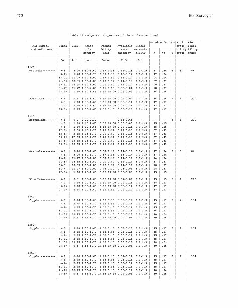
472 Soil Survey of
Table 19.--Physical Properties of the Soils--Continued_________________________________________________________________________________________________________ | | | | | | |Erosion factors|Wind |Wind Map symbol | Depth | Clay | Moist | Permea- |Available| Linear |_______________|erodi-|erodi- and soil name | | | bulk | bility | water |extensi- | | | |bility|bility | | | density | (Ksat) |capacity | bility | K | Kf | T |group |index | | | | | | | | | | |_________________________________________________________________________________________________________ | In | Pct | g/cc | In/hr | In/in | Pct | | | | | | | | | | | | | | | |424B: | | | | | | | | | | | Ossineke--------| 0-8 | 5-20|1.30-1.60| 0.57-1.98 |0.14-0.18| 0.0-2.9 | .17 | .24 | 5 | 3 | 86 | 8-13 | 5-20|1.50-1.70| 0.57-1.98 |0.13-0.17| 0.0-2.9 | .17 | .24 | | | | 13-21 | 11-27|1.60-1.80| 0.57-1.98 |0.14-0.19| 0.0-2.9 | .24 | .24 | | | | 21-38 | 18-35|1.60-1.80| 0.20-0.57 |0.14-0.19| 3.0-5.9 | .37 | .37 | | | | 38-51 | 18-35|1.60-1.80| 0.20-0.57 |0.14-0.19| 3.0-5.9 | .28 | .37 | | | | 51-77 | 11-27|1.80-2.00| 0.06-0.20 |0.03-0.04| 3.0-5.9 | .28 | .37 | | | | 77-80 | 1-10|1.40-1.65| 5.95-19.98|0.06-0.08| 0.0-2.9 | .15 | .15 | | | | | | | | | | | | | | Blue Lake-------| 0-3 | 0-5 |1.35-1.60| 5.95-19.98|0.07-0.09| 0.0-2.9 | .15 | .15 | 5 | 1 | 220 | 3-6 | 5-10|1.30-1.60| 5.95-19.98|0.06-0.11| 0.0-2.9 | .17 | .17 | | | | 6-25 | 5-10|1.30-1.60| 5.95-19.98|0.06-0.11| 0.0-2.9 | .17 | .17 | | | | 25-80 | 8-15|1.30-1.60| 1.98-5.95 |0.06-0.12| 0.0-2.9 | .17 | .17 | | | | | | | | | | | | | |424C: | | | | | | | | | | | Morganlake------| 0-4 | 0-0 |0.20-0.30| --- |0.35-0.45| --- | --- | --- | 5 | 1 | 220 | 4-8 | 1-10|1.40-1.65| 5.95-19.98|0.06-0.08| 0.0-2.9 | .15 | .15 | | | | 8-17 | 1-10|1.40-1.65| 5.95-19.98|0.09-0.11| 0.0-2.9 | .15 | .15 | | | | 17-32 | 5-30|1.45-1.70| 0.20-0.57 |0.14-0.16| 3.0-5.9 | .37 | .43 | | | | 32-36 | 5-35|1.45-1.70| 0.20-0.57 |0.14-0.16| 3.0-5.9 | .37 | .43 | | | | 36-46 | 27-35|1.45-1.70| 0.20-0.57 |0.14-0.16| 3.0-5.9 | .37 | .43 | | | | 46-66 | 15-35|1.45-1.70| 0.20-0.57 |0.14-0.16| 3.0-5.9 | .37 | .43 | | | | 66-80 | 15-35|1.45-1.70| 0.20-0.57 |0.14-0.16| 3.0-5.9 | .37 | .43 | | | | | | | | | | | | | | Ossineke--------| 0-8 | 5-20|1.30-1.60| 0.57-1.98 |0.14-0.18| 0.0-2.9 | .17 | .24 | 5 | 3 | 86 | 8-13 | 5-20|1.50-1.70| 0.57-1.98 |0.13-0.17| 0.0-2.9 | .17 | .24 | | | | 13-21 | 11-27|1.60-1.80| 0.57-1.98 |0.14-0.19| 0.0-2.9 | .24 | .24 | | | | 21-38 | 18-35|1.60-1.80| 0.20-0.57 |0.14-0.19| 3.0-5.9 | .37 | .37 | | | | 38-51 | 18-35|1.60-1.80| 0.20-0.57 |0.14-0.19| 3.0-5.9 | .28 | .37 | | | | 51-77 | 11-27|1.80-2.00| 0.06-0.20 |0.03-0.04| 3.0-5.9 | .28 | .37 | | | | 77-80 | 1-10|1.40-1.65| 5.95-19.98|0.06-0.08| 0.0-2.9 | .15 | .15 | | | | | | | | | | | | | | Blue Lake-------| 0-3 | 0-5 |1.35-1.60| 5.95-19.98|0.07-0.09| 0.0-2.9 | .15 | .15 | 5 | 1 | 220 | 3-6 | 5-10|1.30-1.60| 5.95-19.98|0.06-0.11| 0.0-2.9 | .17 | .17 | | | | 6-25 | 5-10|1.30-1.60| 5.95-19.98|0.06-0.11| 0.0-2.9 | .17 | .17 | | | | 25-80 | 8-15|1.30-1.60| 1.98-5.95 |0.06-0.12| 0.0-2.9 | .17 | .17 | | | | | | | | | | | | | |426B: | | | | | | | | | | | Coppler---------| 0-3 | 0-10|1.35-1.65| 1.98-5.95 |0.09-0.12| 0.0-2.9 | .15 | .17 | 5 | 2 | 134 | 3-4 | 2-15|1.30-1.70| 1.98-5.95 |0.06-0.11| 0.0-2.9 | .15 | .17 | | | | 4-14 | 2-15|1.30-1.70| 1.98-5.95 |0.06-0.11| 0.0-2.9 | .15 | .17 | | | | 14-21 | 2-15|1.30-1.70| 1.98-5.95 |0.06-0.11| 0.0-2.9 | .15 | .17 | | | | 21-26 | 10-25|1.30-1.70| 1.98-5.95 |0.06-0.12| 0.0-2.9 | .10 | .24 | | | | 26-80 | 0-5 |1.55-1.70|19.98-19.98|0.02-0.04| 0.0-2.9 | .10 | .15 | | | | | | | | | | | | | |426C: | | | | | | | | | | | Coppler---------| 0-3 | 0-10|1.35-1.65| 1.98-5.95 |0.09-0.12| 0.0-2.9 | .15 | .17 | 5 | 2 | 134 | 3-4 | 2-15|1.30-1.70| 1.98-5.95 |0.06-0.11| 0.0-2.9 | .15 | .17 | | | | 4-14 | 2-15|1.30-1.70| 1.98-5.95 |0.06-0.11| 0.0-2.9 | .15 | .17 | | | | 14-21 | 2-15|1.30-1.70| 1.98-5.95 |0.06-0.11| 0.0-2.9 | .15 | .17 | | | | 21-26 | 10-25|1.30-1.70| 1.98-5.95 |0.06-0.12| 0.0-2.9 | .10 | .24 | | | | 26-80 | 0-5 |1.55-1.70|19.98-19.98|0.02-0.04| 0.0-2.9 | .10 | .15 | | | | | | | | | | | | | |426D: | | | | | | | | | | | Coppler---------| 0-3 | 0-10|1.35-1.65| 1.98-5.95 |0.09-0.12| 0.0-2.9 | .15 | .17 | 5 | 2 | 134 | 3-4 | 2-15|1.30-1.70| 1.98-5.95 |0.06-0.11| 0.0-2.9 | .15 | .17 | | | | 4-14 | 2-15|1.30-1.70| 1.98-5.95 |0.06-0.11| 0.0-2.9 | .15 | .17 | | | | 14-21 | 2-15|1.30-1.70| 1.98-5.95 |0.06-0.11| 0.0-2.9 | .15 | .17 | | | | 21-26 | 10-25|1.30-1.70| 1.98-5.95 |0.06-0.12| 0.0-2.9 | .10 | .24 | | | | 26-80 | 0-5 |1.55-1.70|19.98-19.98|0.02-0.04| 0.0-2.9 | .10 | .15 | | | | | | | | | | | | | |
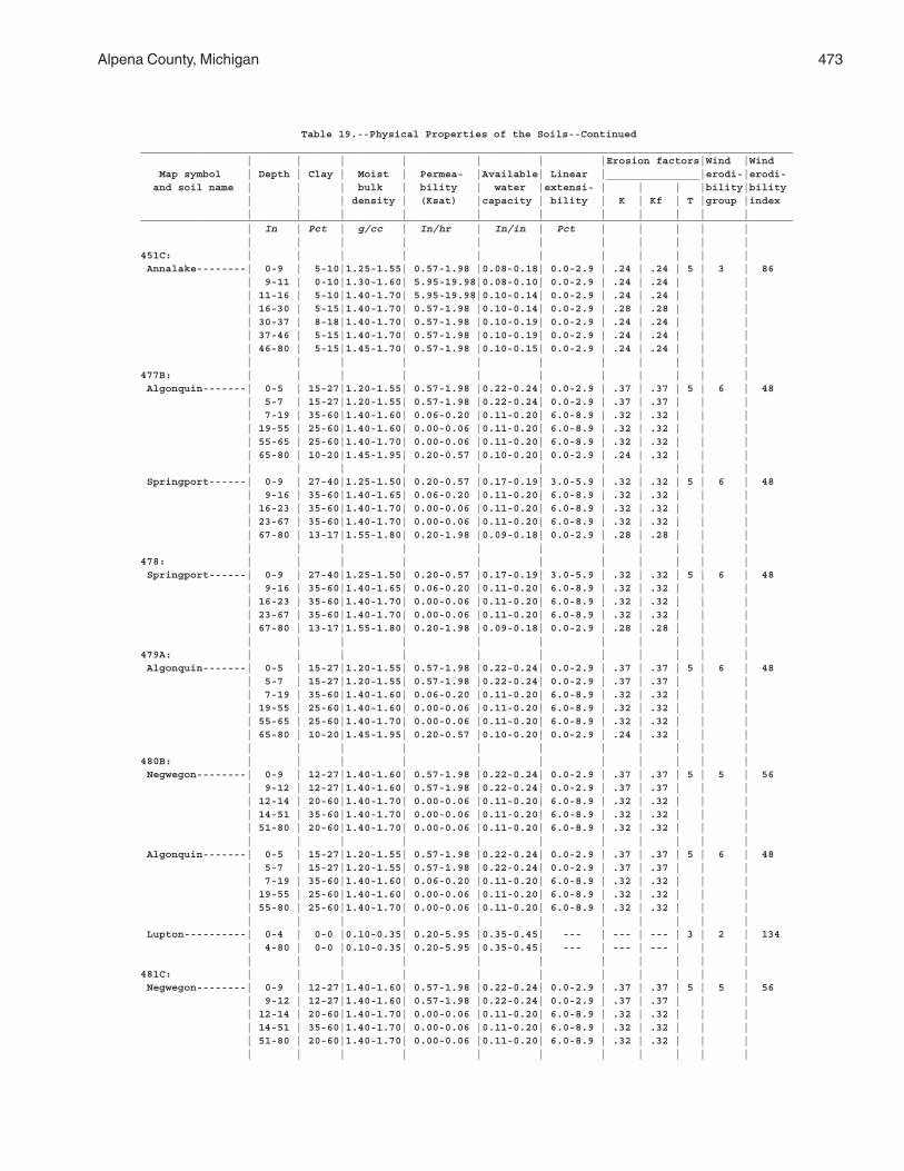
Alpena County, Michigan 473
Table 19.--Physical Properties of the Soils--Continued_________________________________________________________________________________________________________ | | | | | | |Erosion factors|Wind |Wind Map symbol | Depth | Clay | Moist | Permea- |Available| Linear |_______________|erodi-|erodi- and soil name | | | bulk | bility | water |extensi- | | | |bility|bility | | | density | (Ksat) |capacity | bility | K | Kf | T |group |index | | | | | | | | | | |_________________________________________________________________________________________________________ | In | Pct | g/cc | In/hr | In/in | Pct | | | | | | | | | | | | | | | |451C: | | | | | | | | | | | Annalake--------| 0-9 | 5-10|1.25-1.55| 0.57-1.98 |0.08-0.18| 0.0-2.9 | .24 | .24 | 5 | 3 | 86 | 9-11 | 0-10|1.30-1.60| 5.95-19.98|0.08-0.10| 0.0-2.9 | .24 | .24 | | | | 11-16 | 5-10|1.40-1.70| 5.95-19.98|0.10-0.14| 0.0-2.9 | .24 | .24 | | | | 16-30 | 5-15|1.40-1.70| 0.57-1.98 |0.10-0.14| 0.0-2.9 | .28 | .28 | | | | 30-37 | 8-18|1.40-1.70| 0.57-1.98 |0.10-0.19| 0.0-2.9 | .24 | .24 | | | | 37-46 | 5-15|1.40-1.70| 0.57-1.98 |0.10-0.19| 0.0-2.9 | .24 | .24 | | | | 46-80 | 5-15|1.45-1.70| 0.57-1.98 |0.10-0.15| 0.0-2.9 | .24 | .24 | | | | | | | | | | | | | |477B: | | | | | | | | | | | Algonquin-------| 0-5 | 15-27|1.20-1.55| 0.57-1.98 |0.22-0.24| 0.0-2.9 | .37 | .37 | 5 | 6 | 48 | 5-7 | 15-27|1.20-1.55| 0.57-1.98 |0.22-0.24| 0.0-2.9 | .37 | .37 | | | | 7-19 | 35-60|1.40-1.60| 0.06-0.20 |0.11-0.20| 6.0-8.9 | .32 | .32 | | | | 19-55 | 25-60|1.40-1.60| 0.00-0.06 |0.11-0.20| 6.0-8.9 | .32 | .32 | | | | 55-65 | 25-60|1.40-1.70| 0.00-0.06 |0.11-0.20| 6.0-8.9 | .32 | .32 | | | | 65-80 | 10-20|1.45-1.95| 0.20-0.57 |0.10-0.20| 0.0-2.9 | .24 | .32 | | | | | | | | | | | | | | Springport------| 0-9 | 27-40|1.25-1.50| 0.20-0.57 |0.17-0.19| 3.0-5.9 | .32 | .32 | 5 | 6 | 48 | 9-16 | 35-60|1.40-1.65| 0.06-0.20 |0.11-0.20| 6.0-8.9 | .32 | .32 | | | | 16-23 | 35-60|1.40-1.70| 0.00-0.06 |0.11-0.20| 6.0-8.9 | .32 | .32 | | | | 23-67 | 35-60|1.40-1.70| 0.00-0.06 |0.11-0.20| 6.0-8.9 | .32 | .32 | | | | 67-80 | 13-17|1.55-1.80| 0.20-1.98 |0.09-0.18| 0.0-2.9 | .28 | .28 | | | | | | | | | | | | | |478: | | | | | | | | | | | Springport------| 0-9 | 27-40|1.25-1.50| 0.20-0.57 |0.17-0.19| 3.0-5.9 | .32 | .32 | 5 | 6 | 48 | 9-16 | 35-60|1.40-1.65| 0.06-0.20 |0.11-0.20| 6.0-8.9 | .32 | .32 | | | | 16-23 | 35-60|1.40-1.70| 0.00-0.06 |0.11-0.20| 6.0-8.9 | .32 | .32 | | | | 23-67 | 35-60|1.40-1.70| 0.00-0.06 |0.11-0.20| 6.0-8.9 | .32 | .32 | | | | 67-80 | 13-17|1.55-1.80| 0.20-1.98 |0.09-0.18| 0.0-2.9 | .28 | .28 | | | | | | | | | | | | | |479A: | | | | | | | | | | | Algonquin-------| 0-5 | 15-27|1.20-1.55| 0.57-1.98 |0.22-0.24| 0.0-2.9 | .37 | .37 | 5 | 6 | 48 | 5-7 | 15-27|1.20-1.55| 0.57-1.98 |0.22-0.24| 0.0-2.9 | .37 | .37 | | | | 7-19 | 35-60|1.40-1.60| 0.06-0.20 |0.11-0.20| 6.0-8.9 | .32 | .32 | | | | 19-55 | 25-60|1.40-1.60| 0.00-0.06 |0.11-0.20| 6.0-8.9 | .32 | .32 | | | | 55-65 | 25-60|1.40-1.70| 0.00-0.06 |0.11-0.20| 6.0-8.9 | .32 | .32 | | | | 65-80 | 10-20|1.45-1.95| 0.20-0.57 |0.10-0.20| 0.0-2.9 | .24 | .32 | | | | | | | | | | | | | |480B: | | | | | | | | | | | Negwegon--------| 0-9 | 12-27|1.40-1.60| 0.57-1.98 |0.22-0.24| 0.0-2.9 | .37 | .37 | 5 | 5 | 56 | 9-12 | 12-27|1.40-1.60| 0.57-1.98 |0.22-0.24| 0.0-2.9 | .37 | .37 | | | | 12-14 | 20-60|1.40-1.70| 0.00-0.06 |0.11-0.20| 6.0-8.9 | .32 | .32 | | | | 14-51 | 35-60|1.40-1.70| 0.00-0.06 |0.11-0.20| 6.0-8.9 | .32 | .32 | | | | 51-80 | 20-60|1.40-1.70| 0.00-0.06 |0.11-0.20| 6.0-8.9 | .32 | .32 | | | | | | | | | | | | | | Algonquin-------| 0-5 | 15-27|1.20-1.55| 0.57-1.98 |0.22-0.24| 0.0-2.9 | .37 | .37 | 5 | 6 | 48 | 5-7 | 15-27|1.20-1.55| 0.57-1.98 |0.22-0.24| 0.0-2.9 | .37 | .37 | | | | 7-19 | 35-60|1.40-1.60| 0.06-0.20 |0.11-0.20| 6.0-8.9 | .32 | .32 | | | | 19-55 | 25-60|1.40-1.60| 0.00-0.06 |0.11-0.20| 6.0-8.9 | .32 | .32 | | | | 55-80 | 25-60|1.40-1.70| 0.00-0.06 |0.11-0.20| 6.0-8.9 | .32 | .32 | | | | | | | | | | | | | | Lupton----------| 0-4 | 0-0 |0.10-0.35| 0.20-5.95 |0.35-0.45| --- | --- | --- | 3 | 2 | 134 | 4-80 | 0-0 |0.10-0.35| 0.20-5.95 |0.35-0.45| --- | --- | --- | | | | | | | | | | | | | |481C: | | | | | | | | | | | Negwegon--------| 0-9 | 12-27|1.40-1.60| 0.57-1.98 |0.22-0.24| 0.0-2.9 | .37 | .37 | 5 | 5 | 56 | 9-12 | 12-27|1.40-1.60| 0.57-1.98 |0.22-0.24| 0.0-2.9 | .37 | .37 | | | | 12-14 | 20-60|1.40-1.70| 0.00-0.06 |0.11-0.20| 6.0-8.9 | .32 | .32 | | | | 14-51 | 35-60|1.40-1.70| 0.00-0.06 |0.11-0.20| 6.0-8.9 | .32 | .32 | | | | 51-80 | 20-60|1.40-1.70| 0.00-0.06 |0.11-0.20| 6.0-8.9 | .32 | .32 | | | | | | | | | | | | | |
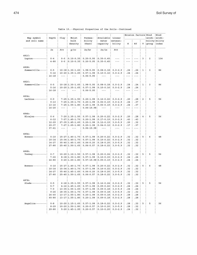
474 Soil Survey of
Table 19.--Physical Properties of the Soils--Continued_________________________________________________________________________________________________________ | | | | | | |Erosion factors|Wind |Wind Map symbol | Depth | Clay | Moist | Permea- |Available| Linear |_______________|erodi-|erodi- and soil name | | | bulk | bility | water |extensi- | | | |bility|bility | | | density | (Ksat) |capacity | bility | K | Kf | T |group |index | | | | | | | | | | |_________________________________________________________________________________________________________ | In | Pct | g/cc | In/hr | In/in | Pct | | | | | | | | | | | | | | | |481C: | | | | | | | | | | | Lupton----------| 0-4 | 0-0 |0.10-0.35| 0.20-5.95 |0.35-0.45| --- | --- | --- | 3 | 2 | 134 | 4-80 | 0-0 |0.10-0.35| 0.20-5.95 |0.35-0.45| --- | --- | --- | | | | | | | | | | | | | |482B: | | | | | | | | | | | Summerville-----| 0-5 | 10-18|1.30-1.60| 1.98-5.95 |0.08-0.18| 0.0-2.9 | .24 | .24 | 1 | 3 | 86 | 5-16 | 10-20|1.35-1.65| 0.57-1.98 |0.10-0.16| 0.0-2.9 | .24 | .24 | | | | 16-18 | --- | --- | 0.06-5.95 | --- | --- | --- | --- | | | | | | | | | | | | | |482C: | | | | | | | | | | | Summerville-----| 0-5 | 10-18|1.30-1.60| 1.98-5.95 |0.08-0.18| 0.0-2.9 | .24 | .24 | 1 | 3 | 86 | 5-16 | 10-20|1.35-1.65| 0.57-1.98 |0.10-0.16| 0.0-2.9 | .24 | .24 | | | | 16-18 | --- | --- | 0.06-5.95 | --- | --- | --- | --- | | | | | | | | | | | | | |483A: | | | | | | | | | | | Lachine---------| 0-9 | 7-25|1.35-1.50| 0.20-1.98 |0.16-0.22| 0.0-2.9 | .20 | .28 | 2 | 5 | 56 | 9-13 | 7-25|1.35-1.70| 0.20-1.98 |0.06-0.19| 0.0-2.9 | .24 | .37 | | | | 13-16 | 7-25|1.55-1.80| 0.20-1.98 |0.06-0.19| 0.0-2.9 | .24 | .37 | | | | 16-20 | --- | --- | 0.06-19.98| --- | --- | --- | --- | | | | | | | | | | | | | |484A: | | | | | | | | | | | Elcajon---------| 0-6 | 7-20|1.35-1.50| 0.57-1.98 |0.20-0.22| 0.0-2.9 | .20 | .28 | 4 | 5 | 56 | 6-12 | 7-27|1.45-1.70| 0.20-1.98 |0.17-0.19| 0.0-2.9 | .43 | .43 | | | | 12-29 | 27-35|1.45-1.60| 0.20-1.98 |0.12-0.19| 3.0-5.9 | .20 | .32 | | | | 29-37 | 7-27|1.65-1.80| 0.20-1.98 |0.04-0.12| 0.0-2.9 | .17 | .37 | | | | 37-41 | --- | --- | 0.06-19.98| --- | --- | --- | --- | | | | | | | | | | | | | |485A: | | | | | | | | | | | Bowers----------| 0-10 | 15-27|1.40-1.70| 0.57-1.98 |0.20-0.22| 0.0-2.9 | .32 | .32 | 5 | 6 | 48 | 10-14 | 15-34|1.40-1.70| 0.57-1.98 |0.16-0.22| 0.0-2.9 | .32 | .32 | | | | 14-27 | 35-40|1.45-1.60| 0.06-0.20 |0.18-0.20| 3.0-5.9 | .32 | .32 | | | | 27-80 | 25-40|1.50-1.65| 0.06-0.57 |0.18-0.22| 3.0-5.9 | .32 | .32 | | | | | | | | | | | | | |486B: | | | | | | | | | | | Tonkey----------| 0-7 | 10-20|1.10-1.50| 0.57-1.98 |0.20-0.24| 0.0-2.9 | .32 | .32 | 5 | 5 | 56 | 7-22 | 8-18|1.30-1.80| 0.57-1.98 |0.10-0.15| 0.0-2.9 | .24 | .24 | | | | 22-80 | 0-20|1.60-1.80| 0.57-19.98|0.05-0.19| 0.0-2.9 | .24 | .24 | | | | | | | | | | | | | | Bowers----------| 0-10 | 15-27|1.40-1.70| 0.57-1.98 |0.20-0.22| 0.0-2.9 | .32 | .32 | 5 | 6 | 48 | 10-14 | 15-34|1.40-1.70| 0.57-1.98 |0.16-0.22| 0.0-2.9 | .32 | .32 | | | | 14-27 | 35-40|1.45-1.60| 0.06-0.20 |0.18-0.20| 3.0-5.9 | .32 | .32 | | | | 27-80 | 25-40|1.50-1.65| 0.06-0.57 |0.18-0.22| 3.0-5.9 | .32 | .32 | | | | | | | | | | | | | |487B: | | | | | | | | | | | Slade-----------| 0-5 | 6-18|1.35-1.55| 0.57-1.98 |0.16-0.24| 0.0-2.9 | .32 | .32 | 5 | 5 | 56 | 5-7 | 4-16|1.45-1.65| 0.57-1.98 |0.09-0.22| 0.0-2.9 | .24 | .24 | | | | 7-9 | 13-35|1.55-1.65| 0.57-1.98 |0.09-0.18| 3.0-5.9 | .24 | .24 | | | | 9-26 | 18-35|1.55-1.70| 0.57-1.98 |0.09-0.18| 3.0-5.9 | .32 | .32 | | | | 26-60 | 13-17|1.55-1.80| 0.20-1.98 |0.09-0.18| 0.0-2.9 | .28 | .28 | | | | 60-80 | 13-17|1.55-1.80| 0.20-1.98 |0.09-0.18| 0.0-2.9 | .28 | .28 | | | | | | | | | | | | | | Angelica--------| 0-8 | 10-20|1.15-1.60| 0.57-1.98 |0.18-0.22| 0.0-2.9 | .28 | .32 | 5 | 5 | 56 | 8-29 | 10-20|1.50-1.80| 0.20-0.57 |0.10-0.20| 3.0-5.9 | .28 | .32 | | | | 29-80 | 5-20|1.45-1.95| 0.20-0.57 |0.10-0.20| 0.0-2.9 | .24 | .32 | | | | | | | | | | | | | |
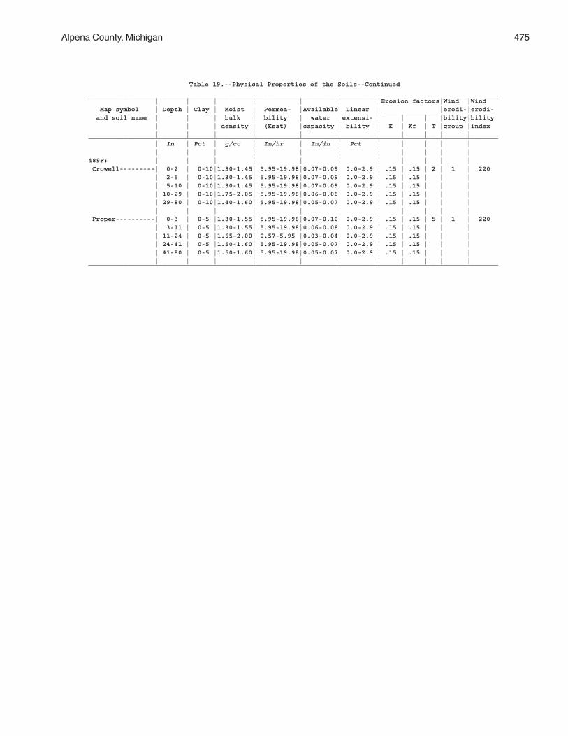
Alpena County, Michigan 475
Table 19.--Physical Properties of the Soils--Continued_________________________________________________________________________________________________________ | | | | | | |Erosion factors|Wind |Wind Map symbol | Depth | Clay | Moist | Permea- |Available| Linear |_______________|erodi-|erodi- and soil name | | | bulk | bility | water |extensi- | | | |bility|bility | | | density | (Ksat) |capacity | bility | K | Kf | T |group |index | | | | | | | | | | |_________________________________________________________________________________________________________ | In | Pct | g/cc | In/hr | In/in | Pct | | | | | | | | | | | | | | | |489F: | | | | | | | | | | | Crowell---------| 0-2 | 0-10|1.30-1.45| 5.95-19.98|0.07-0.09| 0.0-2.9 | .15 | .15 | 2 | 1 | 220 | 2-5 | 0-10|1.30-1.45| 5.95-19.98|0.07-0.09| 0.0-2.9 | .15 | .15 | | | | 5-10 | 0-10|1.30-1.45| 5.95-19.98|0.07-0.09| 0.0-2.9 | .15 | .15 | | | | 10-29 | 0-10|1.75-2.05| 5.95-19.98|0.06-0.08| 0.0-2.9 | .15 | .15 | | | | 29-80 | 0-10|1.40-1.60| 5.95-19.98|0.05-0.07| 0.0-2.9 | .15 | .15 | | | | | | | | | | | | | | Proper----------| 0-3 | 0-5 |1.30-1.55| 5.95-19.98|0.07-0.10| 0.0-2.9 | .15 | .15 | 5 | 1 | 220 | 3-11 | 0-5 |1.30-1.55| 5.95-19.98|0.06-0.08| 0.0-2.9 | .15 | .15 | | | | 11-24 | 0-5 |1.65-2.00| 0.57-5.95 |0.03-0.04| 0.0-2.9 | .15 | .15 | | | | 24-41 | 0-5 |1.50-1.60| 5.95-19.98|0.05-0.07| 0.0-2.9 | .15 | .15 | | | | 41-80 | 0-5 |1.50-1.60| 5.95-19.98|0.05-0.07| 0.0-2.9 | .15 | .15 | | | | | | | | | | | | | |_________________________________________________________________________________________________________
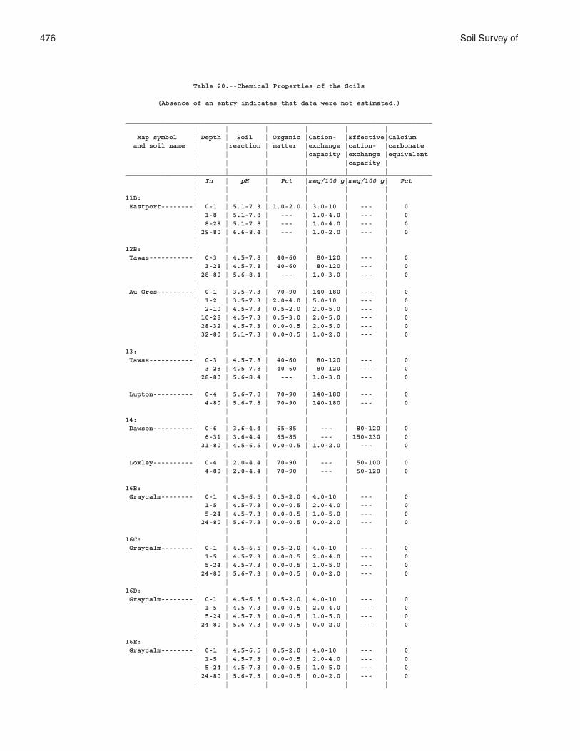
476 Soil Survey of
Table 20.--Chemical Properties of the Soils
(Absence of an entry indicates that data were not estimated.)
_____________________________________________________________________________ | | | | | | Map symbol | Depth | Soil | Organic |Cation- |Effective|Calcium and soil name | |reaction | matter |exchange |cation- |carbonate | | | |capacity |exchange |equivalent | | | | |capacity | | | | | | |_____________________________________________________________________________ | In | pH | Pct |meq/100 g|meq/100 g| Pct | | | | | |11B: | | | | | | Eastport--------| 0-1 | 5.1-7.3 | 1.0-2.0 | 3.0-10 | --- | 0 | 1-8 | 5.1-7.8 | --- | 1.0-4.0 | --- | 0 | 8-29 | 5.1-7.8 | --- | 1.0-4.0 | --- | 0 | 29-80 | 6.6-8.4 | --- | 1.0-2.0 | --- | 0 | | | | | |12B: | | | | | | Tawas-----------| 0-3 | 4.5-7.8 | 40-60 | 80-120 | --- | 0 | 3-28 | 4.5-7.8 | 40-60 | 80-120 | --- | 0 | 28-80 | 5.6-8.4 | --- | 1.0-3.0 | --- | 0 | | | | | | Au Gres---------| 0-1 | 3.5-7.3 | 70-90 | 140-180 | --- | 0 | 1-2 | 3.5-7.3 | 2.0-4.0 | 5.0-10 | --- | 0 | 2-10 | 4.5-7.3 | 0.5-2.0 | 2.0-5.0 | --- | 0 | 10-28 | 4.5-7.3 | 0.5-3.0 | 2.0-5.0 | --- | 0 | 28-32 | 4.5-7.3 | 0.0-0.5 | 2.0-5.0 | --- | 0 | 32-80 | 5.1-7.3 | 0.0-0.5 | 1.0-2.0 | --- | 0 | | | | | |13: | | | | | | Tawas-----------| 0-3 | 4.5-7.8 | 40-60 | 80-120 | --- | 0 | 3-28 | 4.5-7.8 | 40-60 | 80-120 | --- | 0 | 28-80 | 5.6-8.4 | --- | 1.0-3.0 | --- | 0 | | | | | | Lupton----------| 0-4 | 5.6-7.8 | 70-90 | 140-180 | --- | 0 | 4-80 | 5.6-7.8 | 70-90 | 140-180 | --- | 0 | | | | | |14: | | | | | | Dawson----------| 0-6 | 3.6-4.4 | 65-85 | --- | 80-120 | 0 | 6-31 | 3.6-4.4 | 65-85 | --- | 150-230 | 0 | 31-80 | 4.5-6.5 | 0.0-0.5 | 1.0-2.0 | --- | 0 | | | | | | Loxley----------| 0-4 | 2.0-4.4 | 70-90 | --- | 50-100 | 0 | 4-80 | 2.0-4.4 | 70-90 | --- | 50-120 | 0 | | | | | |16B: | | | | | | Graycalm--------| 0-1 | 4.5-6.5 | 0.5-2.0 | 4.0-10 | --- | 0 | 1-5 | 4.5-7.3 | 0.0-0.5 | 2.0-4.0 | --- | 0 | 5-24 | 4.5-7.3 | 0.0-0.5 | 1.0-5.0 | --- | 0 | 24-80 | 5.6-7.3 | 0.0-0.5 | 0.0-2.0 | --- | 0 | | | | | |16C: | | | | | | Graycalm--------| 0-1 | 4.5-6.5 | 0.5-2.0 | 4.0-10 | --- | 0 | 1-5 | 4.5-7.3 | 0.0-0.5 | 2.0-4.0 | --- | 0 | 5-24 | 4.5-7.3 | 0.0-0.5 | 1.0-5.0 | --- | 0 | 24-80 | 5.6-7.3 | 0.0-0.5 | 0.0-2.0 | --- | 0 | | | | | |16D: | | | | | | Graycalm--------| 0-1 | 4.5-6.5 | 0.5-2.0 | 4.0-10 | --- | 0 | 1-5 | 4.5-7.3 | 0.0-0.5 | 2.0-4.0 | --- | 0 | 5-24 | 4.5-7.3 | 0.0-0.5 | 1.0-5.0 | --- | 0 | 24-80 | 5.6-7.3 | 0.0-0.5 | 0.0-2.0 | --- | 0 | | | | | |16E: | | | | | | Graycalm--------| 0-1 | 4.5-6.5 | 0.5-2.0 | 4.0-10 | --- | 0 | 1-5 | 4.5-7.3 | 0.0-0.5 | 2.0-4.0 | --- | 0 | 5-24 | 4.5-7.3 | 0.0-0.5 | 1.0-5.0 | --- | 0 | 24-80 | 5.6-7.3 | 0.0-0.5 | 0.0-2.0 | --- | 0 | | | | | |
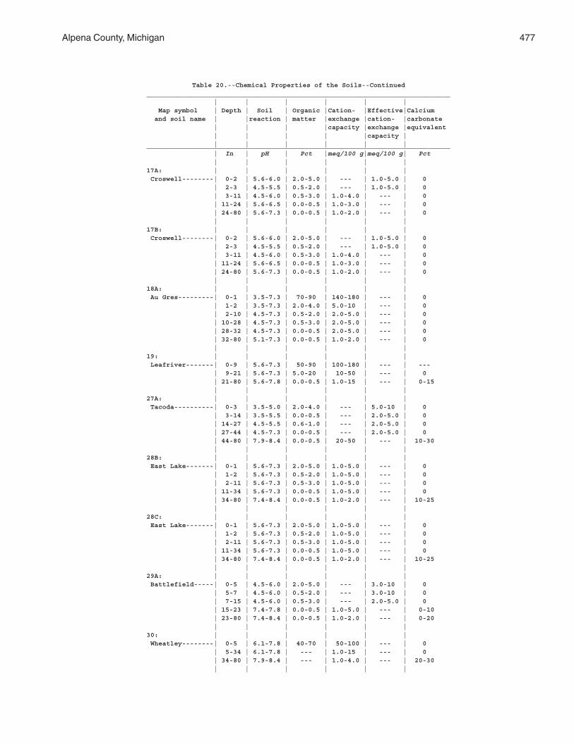
Alpena County, Michigan 477
Table 20.--Chemical Properties of the Soils--Continued_____________________________________________________________________________ | | | | | | Map symbol | Depth | Soil | Organic |Cation- |Effective|Calcium and soil name | |reaction | matter |exchange |cation- |carbonate | | | |capacity |exchange |equivalent | | | | |capacity | | | | | | |_____________________________________________________________________________ | In | pH | Pct |meq/100 g|meq/100 g| Pct | | | | | |17A: | | | | | | Croswell--------| 0-2 | 5.6-6.0 | 2.0-5.0 | --- | 1.0-5.0 | 0 | 2-3 | 4.5-5.5 | 0.5-2.0 | --- | 1.0-5.0 | 0 | 3-11 | 4.5-6.0 | 0.5-3.0 | 1.0-4.0 | --- | 0 | 11-24 | 5.6-6.5 | 0.0-0.5 | 1.0-3.0 | --- | 0 | 24-80 | 5.6-7.3 | 0.0-0.5 | 1.0-2.0 | --- | 0 | | | | | |17B: | | | | | | Croswell--------| 0-2 | 5.6-6.0 | 2.0-5.0 | --- | 1.0-5.0 | 0 | 2-3 | 4.5-5.5 | 0.5-2.0 | --- | 1.0-5.0 | 0 | 3-11 | 4.5-6.0 | 0.5-3.0 | 1.0-4.0 | --- | 0 | 11-24 | 5.6-6.5 | 0.0-0.5 | 1.0-3.0 | --- | 0 | 24-80 | 5.6-7.3 | 0.0-0.5 | 1.0-2.0 | --- | 0 | | | | | |18A: | | | | | | Au Gres---------| 0-1 | 3.5-7.3 | 70-90 | 140-180 | --- | 0 | 1-2 | 3.5-7.3 | 2.0-4.0 | 5.0-10 | --- | 0 | 2-10 | 4.5-7.3 | 0.5-2.0 | 2.0-5.0 | --- | 0 | 10-28 | 4.5-7.3 | 0.5-3.0 | 2.0-5.0 | --- | 0 | 28-32 | 4.5-7.3 | 0.0-0.5 | 2.0-5.0 | --- | 0 | 32-80 | 5.1-7.3 | 0.0-0.5 | 1.0-2.0 | --- | 0 | | | | | |19: | | | | | | Leafriver-------| 0-9 | 5.6-7.3 | 50-90 | 100-180 | --- | --- | 9-21 | 5.6-7.3 | 5.0-20 | 10-50 | --- | 0 | 21-80 | 5.6-7.8 | 0.0-0.5 | 1.0-15 | --- | 0-15 | | | | | |27A: | | | | | | Tacoda----------| 0-3 | 3.5-5.0 | 2.0-4.0 | --- | 5.0-10 | 0 | 3-14 | 3.5-5.5 | 0.0-0.5 | --- | 2.0-5.0 | 0 | 14-27 | 4.5-5.5 | 0.6-1.0 | --- | 2.0-5.0 | 0 | 27-44 | 4.5-7.3 | 0.0-0.5 | --- | 2.0-5.0 | 0 | 44-80 | 7.9-8.4 | 0.0-0.5 | 20-50 | --- | 10-30 | | | | | |28B: | | | | | | East Lake-------| 0-1 | 5.6-7.3 | 2.0-5.0 | 1.0-5.0 | --- | 0 | 1-2 | 5.6-7.3 | 0.5-2.0 | 1.0-5.0 | --- | 0 | 2-11 | 5.6-7.3 | 0.5-3.0 | 1.0-5.0 | --- | 0 | 11-34 | 5.6-7.3 | 0.0-0.5 | 1.0-5.0 | --- | 0 | 34-80 | 7.4-8.4 | 0.0-0.5 | 1.0-2.0 | --- | 10-25 | | | | | |28C: | | | | | | East Lake-------| 0-1 | 5.6-7.3 | 2.0-5.0 | 1.0-5.0 | --- | 0 | 1-2 | 5.6-7.3 | 0.5-2.0 | 1.0-5.0 | --- | 0 | 2-11 | 5.6-7.3 | 0.5-3.0 | 1.0-5.0 | --- | 0 | 11-34 | 5.6-7.3 | 0.0-0.5 | 1.0-5.0 | --- | 0 | 34-80 | 7.4-8.4 | 0.0-0.5 | 1.0-2.0 | --- | 10-25 | | | | | |29A: | | | | | | Battlefield-----| 0-5 | 4.5-6.0 | 2.0-5.0 | --- | 3.0-10 | 0 | 5-7 | 4.5-6.0 | 0.5-2.0 | --- | 3.0-10 | 0 | 7-15 | 4.5-6.0 | 0.5-3.0 | --- | 2.0-5.0 | 0 | 15-23 | 7.4-7.8 | 0.0-0.5 | 1.0-5.0 | --- | 0-10 | 23-80 | 7.4-8.4 | 0.0-0.5 | 1.0-2.0 | --- | 0-20 | | | | | |30: | | | | | | Wheatley--------| 0-5 | 6.1-7.8 | 40-70 | 50-100 | --- | 0 | 5-34 | 6.1-7.8 | --- | 1.0-15 | --- | 0 | 34-80 | 7.9-8.4 | --- | 1.0-4.0 | --- | 20-30 | | | | | |
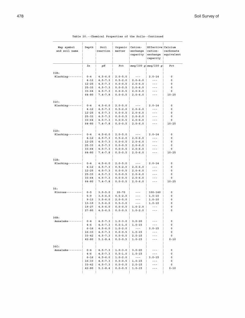
478 Soil Survey of
Table 20.--Chemical Properties of the Soils--Continued_____________________________________________________________________________ | | | | | | Map symbol | Depth | Soil | Organic |Cation- |Effective|Calcium and soil name | |reaction | matter |exchange |cation- |carbonate | | | |capacity |exchange |equivalent | | | | |capacity | | | | | | |_____________________________________________________________________________ | In | pH | Pct |meq/100 g|meq/100 g| Pct | | | | | |31B: | | | | | | Klacking--------| 0-4 | 4.5-6.0 | 2.0-5.0 | --- | 2.0-14 | 0 | 4-12 | 4.5-7.3 | 0.5-2.0 | 2.0-6.0 | --- | 0 | 12-25 | 4.5-7.3 | 0.0-0.5 | 2.0-6.0 | --- | 0 | 25-33 | 4.5-7.3 | 0.0-0.5 | 2.0-6.0 | --- | 0 | 33-64 | 4.5-7.3 | 0.0-0.5 | 2.0-6.0 | --- | 0 | 64-80 | 7.4-7.8 | 0.0-0.5 | 2.0-6.0 | --- | 10-25 | | | | | |31C: | | | | | | Klacking--------| 0-4 | 4.5-6.0 | 2.0-5.0 | --- | 2.0-14 | 0 | 4-12 | 4.5-7.3 | 0.5-2.0 | 2.0-6.0 | --- | 0 | 12-25 | 4.5-7.3 | 0.0-0.5 | 2.0-6.0 | --- | 0 | 25-33 | 4.5-7.3 | 0.0-0.5 | 2.0-6.0 | --- | 0 | 33-64 | 4.5-7.3 | 0.0-0.5 | 2.0-6.0 | --- | 0 | 64-80 | 7.4-7.8 | 0.0-0.5 | 2.0-6.0 | --- | 10-25 | | | | | |31D: | | | | | | Klacking--------| 0-4 | 4.5-6.0 | 2.0-5.0 | --- | 2.0-14 | 0 | 4-12 | 4.5-7.3 | 0.5-2.0 | 2.0-6.0 | --- | 0 | 12-25 | 4.5-7.3 | 0.0-0.5 | 2.0-6.0 | --- | 0 | 25-33 | 4.5-7.3 | 0.0-0.5 | 2.0-6.0 | --- | 0 | 33-64 | 4.5-7.3 | 0.0-0.5 | 2.0-6.0 | --- | 0 | 64-80 | 7.4-7.8 | 0.0-0.5 | 2.0-6.0 | --- | 10-25 | | | | | |31E: | | | | | | Klacking--------| 0-4 | 4.5-6.0 | 2.0-5.0 | --- | 2.0-14 | 0 | 4-12 | 4.5-7.3 | 0.5-2.0 | 2.0-6.0 | --- | 0 | 12-25 | 4.5-7.3 | 0.0-0.5 | 2.0-6.0 | --- | 0 | 25-33 | 4.5-7.3 | 0.0-0.5 | 2.0-6.0 | --- | 0 | 33-64 | 4.5-7.3 | 0.0-0.5 | 2.0-6.0 | --- | 0 | 64-80 | 7.4-7.8 | 0.0-0.5 | 2.0-6.0 | --- | 10-25 | | | | | |35: | | | | | | Kinross---------| 0-5 | 3.5-5.0 | 20-70 | --- | 100-140 | 0 | 5-9 | 3.5-6.0 | 0.5-2.0 | --- | 1.0-10 | 0 | 9-13 | 3.5-6.0 | 2.0-5.0 | --- | 1.0-10 | 0 | 13-19 | 3.5-6.0 | 0.5-3.0 | --- | 1.0-10 | 0 | 19-27 | 4.5-6.0 | 0.0-0.5 | 1.0-2.0 | --- | 0 | 27-80 | 4.5-6.5 | 0.0-0.5 | 1.0-2.0 | --- | 0 | | | | | |36B: | | | | | | Annalake--------| 0-4 | 4.5-7.3 | 1.0-3.0 | 3.0-20 | --- | 0 | 4-6 | 4.5-7.3 | 0.5-1.0 | 1.0-15 | --- | 0 | 6-16 | 4.5-6.0 | 1.0-2.0 | --- | 3.0-15 | 0 | 16-33 | 4.5-7.3 | 0.0-0.5 | 1.0-15 | --- | 0 | 33-42 | 4.5-7.3 | 0.0-0.5 | 2.0-15 | --- | 0 | 42-80 | 5.1-8.4 | 0.0-0.5 | 1.0-15 | --- | 0-10 | | | | | |36C: | | | | | | Annalake--------| 0-4 | 4.5-7.3 | 1.0-3.0 | 3.0-20 | --- | 0 | 4-6 | 4.5-7.3 | 0.5-1.0 | 1.0-15 | --- | 0 | 6-16 | 4.5-6.0 | 1.0-2.0 | --- | 3.0-15 | 0 | 16-33 | 4.5-7.3 | 0.0-0.5 | 1.0-15 | --- | 0 | 33-42 | 4.5-7.3 | 0.0-0.5 | 2.0-15 | --- | 0 | 42-80 | 5.1-8.4 | 0.0-0.5 | 1.0-15 | --- | 0-10 | | | | | |
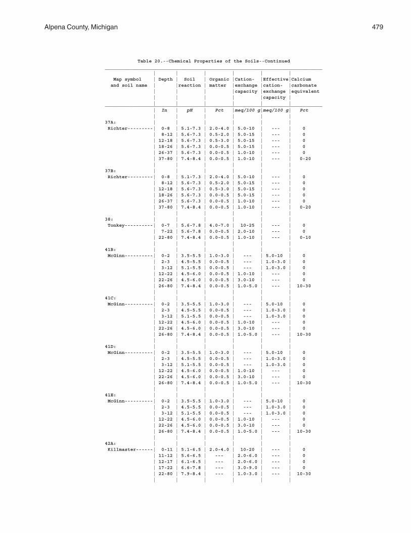
Alpena County, Michigan 479
Table 20.--Chemical Properties of the Soils--Continued_____________________________________________________________________________ | | | | | | Map symbol | Depth | Soil | Organic |Cation- |Effective|Calcium and soil name | |reaction | matter |exchange |cation- |carbonate | | | |capacity |exchange |equivalent | | | | |capacity | | | | | | |_____________________________________________________________________________ | In | pH | Pct |meq/100 g|meq/100 g| Pct | | | | | |37A: | | | | | | Richter---------| 0-8 | 5.1-7.3 | 2.0-4.0 | 5.0-10 | --- | 0 | 8-12 | 5.6-7.3 | 0.5-2.0 | 5.0-15 | --- | 0 | 12-18 | 5.6-7.3 | 0.5-3.0 | 5.0-15 | --- | 0 | 18-26 | 5.6-7.3 | 0.0-0.5 | 5.0-15 | --- | 0 | 26-37 | 5.6-7.3 | 0.0-0.5 | 1.0-10 | --- | 0 | 37-80 | 7.4-8.4 | 0.0-0.5 | 1.0-10 | --- | 0-20 | | | | | |37B: | | | | | | Richter---------| 0-8 | 5.1-7.3 | 2.0-4.0 | 5.0-10 | --- | 0 | 8-12 | 5.6-7.3 | 0.5-2.0 | 5.0-15 | --- | 0 | 12-18 | 5.6-7.3 | 0.5-3.0 | 5.0-15 | --- | 0 | 18-26 | 5.6-7.3 | 0.0-0.5 | 5.0-15 | --- | 0 | 26-37 | 5.6-7.3 | 0.0-0.5 | 1.0-10 | --- | 0 | 37-80 | 7.4-8.4 | 0.0-0.5 | 1.0-10 | --- | 0-20 | | | | | |38: | | | | | | Tonkey----------| 0-7 | 5.6-7.8 | 4.0-7.0 | 10-25 | --- | 0 | 7-22 | 5.6-7.8 | 0.0-0.5 | 2.0-10 | --- | 0 | 22-80 | 7.4-8.4 | 0.0-0.5 | 1.0-10 | --- | 0-10 | | | | | |41B: | | | | | | McGinn----------| 0-2 | 3.5-5.5 | 1.0-3.0 | --- | 5.0-10 | 0 | 2-3 | 4.5-5.5 | 0.0-0.5 | --- | 1.0-3.0 | 0 | 3-12 | 5.1-5.5 | 0.0-0.5 | --- | 1.0-3.0 | 0 | 12-22 | 4.5-6.0 | 0.0-0.5 | 1.0-10 | --- | 0 | 22-26 | 4.5-6.0 | 0.0-0.5 | 3.0-10 | --- | 0 | 26-80 | 7.4-8.4 | 0.0-0.5 | 1.0-5.0 | --- | 10-30 | | | | | |41C: | | | | | | McGinn----------| 0-2 | 3.5-5.5 | 1.0-3.0 | --- | 5.0-10 | 0 | 2-3 | 4.5-5.5 | 0.0-0.5 | --- | 1.0-3.0 | 0 | 3-12 | 5.1-5.5 | 0.0-0.5 | --- | 1.0-3.0 | 0 | 12-22 | 4.5-6.0 | 0.0-0.5 | 1.0-10 | --- | 0 | 22-26 | 4.5-6.0 | 0.0-0.5 | 3.0-10 | --- | 0 | 26-80 | 7.4-8.4 | 0.0-0.5 | 1.0-5.0 | --- | 10-30 | | | | | |41D: | | | | | | McGinn----------| 0-2 | 3.5-5.5 | 1.0-3.0 | --- | 5.0-10 | 0 | 2-3 | 4.5-5.5 | 0.0-0.5 | --- | 1.0-3.0 | 0 | 3-12 | 5.1-5.5 | 0.0-0.5 | --- | 1.0-3.0 | 0 | 12-22 | 4.5-6.0 | 0.0-0.5 | 1.0-10 | --- | 0 | 22-26 | 4.5-6.0 | 0.0-0.5 | 3.0-10 | --- | 0 | 26-80 | 7.4-8.4 | 0.0-0.5 | 1.0-5.0 | --- | 10-30 | | | | | |41E: | | | | | | McGinn----------| 0-2 | 3.5-5.5 | 1.0-3.0 | --- | 5.0-10 | 0 | 2-3 | 4.5-5.5 | 0.0-0.5 | --- | 1.0-3.0 | 0 | 3-12 | 5.1-5.5 | 0.0-0.5 | --- | 1.0-3.0 | 0 | 12-22 | 4.5-6.0 | 0.0-0.5 | 1.0-10 | --- | 0 | 22-26 | 4.5-6.0 | 0.0-0.5 | 3.0-10 | --- | 0 | 26-80 | 7.4-8.4 | 0.0-0.5 | 1.0-5.0 | --- | 10-30 | | | | | |42A: | | | | | | Killmaster------| 0-11 | 5.1-6.5 | 2.0-4.0 | 10-20 | --- | 0 | 11-12 | 5.6-6.5 | --- | 2.0-6.0 | --- | 0 | 12-17 | 6.1-6.5 | --- | 2.0-6.0 | --- | 0 | 17-22 | 6.6-7.8 | --- | 3.0-9.0 | --- | 0 | 22-80 | 7.9-8.4 | --- | 1.0-3.0 | --- | 10-30 | | | | | |
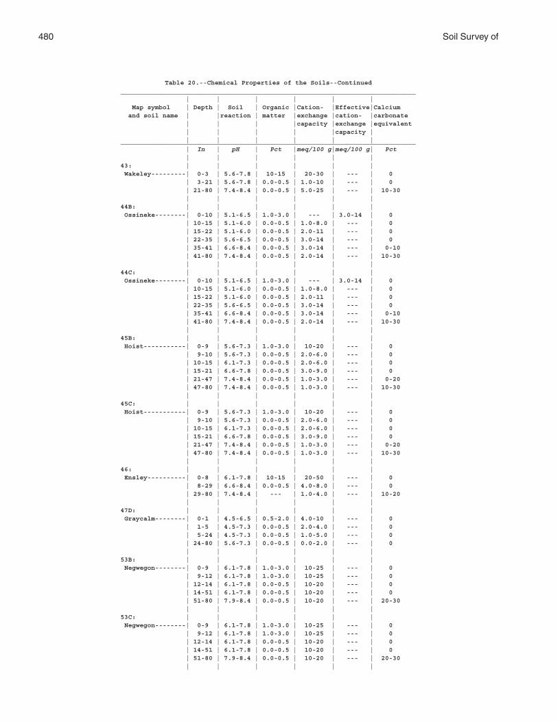
480 Soil Survey of
Table 20.--Chemical Properties of the Soils--Continued_____________________________________________________________________________ | | | | | | Map symbol | Depth | Soil | Organic |Cation- |Effective|Calcium and soil name | |reaction | matter |exchange |cation- |carbonate | | | |capacity |exchange |equivalent | | | | |capacity | | | | | | |_____________________________________________________________________________ | In | pH | Pct |meq/100 g|meq/100 g| Pct | | | | | |43: | | | | | | Wakeley---------| 0-3 | 5.6-7.8 | 10-15 | 20-30 | --- | 0 | 3-21 | 5.6-7.8 | 0.0-0.5 | 1.0-10 | --- | 0 | 21-80 | 7.4-8.4 | 0.0-0.5 | 5.0-25 | --- | 10-30 | | | | | |44B: | | | | | | Ossineke--------| 0-10 | 5.1-6.5 | 1.0-3.0 | --- | 3.0-14 | 0 | 10-15 | 5.1-6.0 | 0.0-0.5 | 1.0-8.0 | --- | 0 | 15-22 | 5.1-6.0 | 0.0-0.5 | 2.0-11 | --- | 0 | 22-35 | 5.6-6.5 | 0.0-0.5 | 3.0-14 | --- | 0 | 35-41 | 6.6-8.4 | 0.0-0.5 | 3.0-14 | --- | 0-10 | 41-80 | 7.4-8.4 | 0.0-0.5 | 2.0-14 | --- | 10-30 | | | | | |44C: | | | | | | Ossineke--------| 0-10 | 5.1-6.5 | 1.0-3.0 | --- | 3.0-14 | 0 | 10-15 | 5.1-6.0 | 0.0-0.5 | 1.0-8.0 | --- | 0 | 15-22 | 5.1-6.0 | 0.0-0.5 | 2.0-11 | --- | 0 | 22-35 | 5.6-6.5 | 0.0-0.5 | 3.0-14 | --- | 0 | 35-41 | 6.6-8.4 | 0.0-0.5 | 3.0-14 | --- | 0-10 | 41-80 | 7.4-8.4 | 0.0-0.5 | 2.0-14 | --- | 10-30 | | | | | |45B: | | | | | | Hoist-----------| 0-9 | 5.6-7.3 | 1.0-3.0 | 10-20 | --- | 0 | 9-10 | 5.6-7.3 | 0.0-0.5 | 2.0-6.0 | --- | 0 | 10-15 | 6.1-7.3 | 0.0-0.5 | 2.0-6.0 | --- | 0 | 15-21 | 6.6-7.8 | 0.0-0.5 | 3.0-9.0 | --- | 0 | 21-47 | 7.4-8.4 | 0.0-0.5 | 1.0-3.0 | --- | 0-20 | 47-80 | 7.4-8.4 | 0.0-0.5 | 1.0-3.0 | --- | 10-30 | | | | | |45C: | | | | | | Hoist-----------| 0-9 | 5.6-7.3 | 1.0-3.0 | 10-20 | --- | 0 | 9-10 | 5.6-7.3 | 0.0-0.5 | 2.0-6.0 | --- | 0 | 10-15 | 6.1-7.3 | 0.0-0.5 | 2.0-6.0 | --- | 0 | 15-21 | 6.6-7.8 | 0.0-0.5 | 3.0-9.0 | --- | 0 | 21-47 | 7.4-8.4 | 0.0-0.5 | 1.0-3.0 | --- | 0-20 | 47-80 | 7.4-8.4 | 0.0-0.5 | 1.0-3.0 | --- | 10-30 | | | | | |46: | | | | | | Ensley----------| 0-8 | 6.1-7.8 | 10-15 | 20-50 | --- | 0 | 8-29 | 6.6-8.4 | 0.0-0.5 | 4.0-8.0 | --- | 0 | 29-80 | 7.4-8.4 | --- | 1.0-4.0 | --- | 10-20 | | | | | |47D: | | | | | | Graycalm--------| 0-1 | 4.5-6.5 | 0.5-2.0 | 4.0-10 | --- | 0 | 1-5 | 4.5-7.3 | 0.0-0.5 | 2.0-4.0 | --- | 0 | 5-24 | 4.5-7.3 | 0.0-0.5 | 1.0-5.0 | --- | 0 | 24-80 | 5.6-7.3 | 0.0-0.5 | 0.0-2.0 | --- | 0 | | | | | |53B: | | | | | | Negwegon--------| 0-9 | 6.1-7.8 | 1.0-3.0 | 10-25 | --- | 0 | 9-12 | 6.1-7.8 | 1.0-3.0 | 10-25 | --- | 0 | 12-14 | 6.1-7.8 | 0.0-0.5 | 10-20 | --- | 0 | 14-51 | 6.1-7.8 | 0.0-0.5 | 10-20 | --- | 0 | 51-80 | 7.9-8.4 | 0.0-0.5 | 10-20 | --- | 20-30 | | | | | |53C: | | | | | | Negwegon--------| 0-9 | 6.1-7.8 | 1.0-3.0 | 10-25 | --- | 0 | 9-12 | 6.1-7.8 | 1.0-3.0 | 10-25 | --- | 0 | 12-14 | 6.1-7.8 | 0.0-0.5 | 10-20 | --- | 0 | 14-51 | 6.1-7.8 | 0.0-0.5 | 10-20 | --- | 0 | 51-80 | 7.9-8.4 | 0.0-0.5 | 10-20 | --- | 20-30 | | | | | |
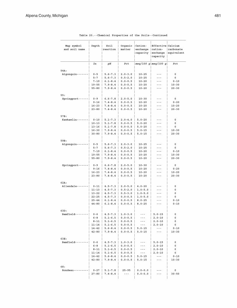
Alpena County, Michigan 481
Table 20.--Chemical Properties of the Soils--Continued_____________________________________________________________________________ | | | | | | Map symbol | Depth | Soil | Organic |Cation- |Effective|Calcium and soil name | |reaction | matter |exchange |cation- |carbonate | | | |capacity |exchange |equivalent | | | | |capacity | | | | | | |_____________________________________________________________________________ | In | pH | Pct |meq/100 g|meq/100 g| Pct | | | | | |54A: | | | | | | Algonquin-------| 0-5 | 5.6-7.3 | 2.0-3.0 | 10-25 | --- | 0 | 5-7 | 5.6-7.3 | 0.5-2.0 | 10-25 | --- | 0 | 7-19 | 6.1-8.4 | 0.0-0.5 | 10-20 | --- | 0-10 | 19-55 | 7.9-8.4 | 0.0-0.5 | 10-20 | --- | 10-30 | 55-80 | 7.9-8.4 | 0.0-0.5 | 10-20 | --- | 20-30 | | | | | |55: | | | | | | Springport------| 0-9 | 6.6-7.8 | 2.0-5.0 | 10-30 | --- | 0 | 9-16 | 7.4-8.4 | 0.0-0.5 | 10-20 | --- | 0-20 | 16-23 | 7.4-8.4 | 0.0-0.5 | 10-20 | --- | 10-20 | 23-80 | 7.4-8.4 | 0.0-0.5 | 10-20 | --- | 20-30 | | | | | |57B: | | | | | | Kawkawlin-------| 0-10 | 5.1-7.3 | 2.0-4.0 | 5.0-20 | --- | 0 | 10-13 | 5.1-7.8 | 0.0-0.5 | 5.0-20 | --- | 0 | 13-16 | 5.1-7.8 | 0.0-0.5 | 5.0-20 | --- | 0 | 16-30 | 7.9-8.4 | 0.0-0.5 | 5.0-15 | --- | 10-30 | 30-80 | 7.9-8.4 | 0.0-0.5 | 5.0-15 | --- | 20-30 | | | | | |59B: | | | | | | Algonquin-------| 0-5 | 5.6-7.3 | 2.0-3.0 | 10-25 | --- | 0 | 5-7 | 5.6-7.3 | 0.5-2.0 | 10-25 | --- | 0 | 7-19 | 6.1-8.4 | 0.0-0.5 | 10-20 | --- | 0-10 | 19-55 | 7.9-8.4 | 0.0-0.5 | 10-20 | --- | 10-30 | 55-80 | 7.9-8.4 | 0.0-0.5 | 10-20 | --- | 20-30 | | | | | | Springport------| 0-9 | 6.6-7.8 | 2.0-5.0 | 10-30 | --- | 0 | 9-16 | 7.4-8.4 | 0.0-0.5 | 10-20 | --- | 0-20 | 16-23 | 7.4-8.4 | 0.0-0.5 | 10-20 | --- | 10-20 | 23-80 | 7.4-8.4 | 0.0-0.5 | 10-20 | --- | 20-30 | | | | | |62A: | | | | | | Allendale-------| 0-11 | 4.5-7.3 | 2.0-5.0 | 4.0-20 | --- | 0 | 11-13 | 4.5-7.3 | 0.5-2.0 | 1.0-5.0 | --- | 0 | 13-22 | 4.5-7.3 | 0.5-3.0 | 1.0-5.0 | --- | 0 | 22-25 | 4.5-7.3 | 0.0-0.5 | 1.0-5.0 | --- | 0 | 25-44 | 6.1-8.4 | 0.0-0.5 | 8.0-25 | --- | 0-10 | 44-80 | 6.1-8.4 | 0.0-0.5 | 8.0-25 | --- | 0-10 | | | | | |63D: | | | | | | Bamfield--------| 0-6 | 4.5-7.3 | 1.0-3.0 | --- | 5.0-15 | 0 | 6-8 | 5.1-6.5 | 0.0-0.5 | --- | 2.0-10 | 0 | 8-11 | 5.1-6.5 | 0.0-0.5 | --- | 2.0-10 | 0 | 11-14 | 5.1-6.5 | 0.0-0.5 | --- | 2.0-10 | 0 | 14-42 | 5.6-8.4 | 0.0-0.5 | 5.0-15 | --- | 0-10 | 42-80 | 7.9-8.4 | 0.0-0.5 | 5.0-15 | --- | 10-30 | | | | | |63E: | | | | | | Bamfield--------| 0-6 | 4.5-7.3 | 1.0-3.0 | --- | 5.0-15 | 0 | 6-8 | 5.1-6.5 | 0.0-0.5 | --- | 2.0-10 | 0 | 8-11 | 5.1-6.5 | 0.0-0.5 | --- | 2.0-10 | 0 | 11-14 | 5.1-6.5 | 0.0-0.5 | --- | 2.0-10 | 0 | 14-42 | 5.6-8.4 | 0.0-0.5 | 5.0-15 | --- | 0-10 | 42-80 | 7.9-8.4 | 0.0-0.5 | 5.0-15 | --- | 10-30 | | | | | |68: | | | | | | Rondeau---------| 0-27 | 5.1-7.8 | 25-95 | 0.0-0.0 | --- | 0 | 27-80 | 7.4-8.4 | --- | 0.0-0.0 | --- | 30-50 | | | | | |
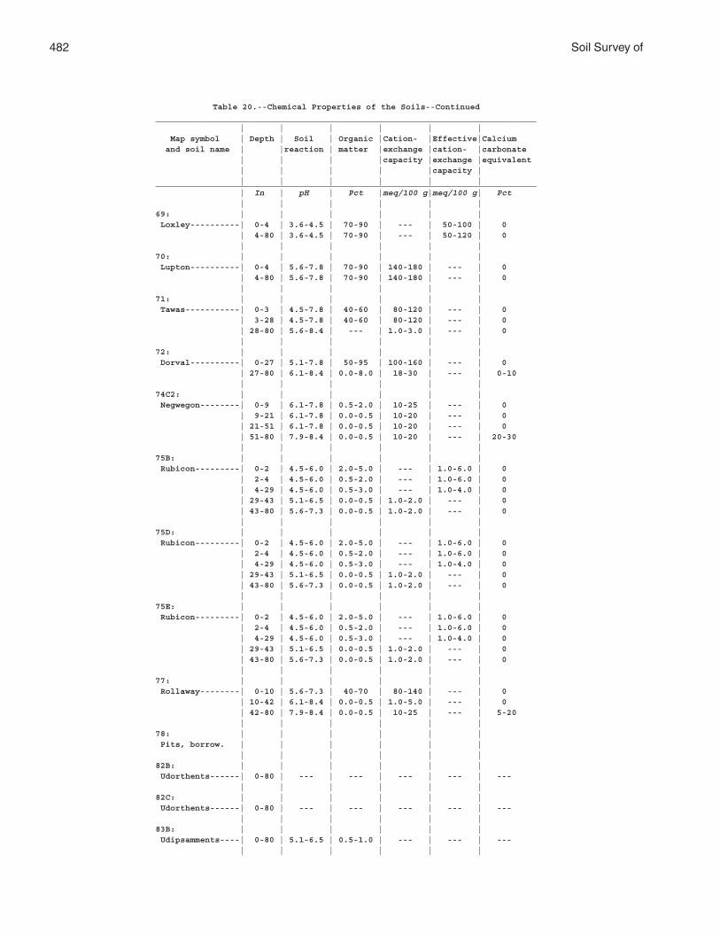
482 Soil Survey of
Table 20.--Chemical Properties of the Soils--Continued_____________________________________________________________________________ | | | | | | Map symbol | Depth | Soil | Organic |Cation- |Effective|Calcium and soil name | |reaction | matter |exchange |cation- |carbonate | | | |capacity |exchange |equivalent | | | | |capacity | | | | | | |_____________________________________________________________________________ | In | pH | Pct |meq/100 g|meq/100 g| Pct | | | | | |69: | | | | | | Loxley----------| 0-4 | 3.6-4.5 | 70-90 | --- | 50-100 | 0 | 4-80 | 3.6-4.5 | 70-90 | --- | 50-120 | 0 | | | | | |70: | | | | | | Lupton----------| 0-4 | 5.6-7.8 | 70-90 | 140-180 | --- | 0 | 4-80 | 5.6-7.8 | 70-90 | 140-180 | --- | 0 | | | | | |71: | | | | | | Tawas-----------| 0-3 | 4.5-7.8 | 40-60 | 80-120 | --- | 0 | 3-28 | 4.5-7.8 | 40-60 | 80-120 | --- | 0 | 28-80 | 5.6-8.4 | --- | 1.0-3.0 | --- | 0 | | | | | |72: | | | | | | Dorval----------| 0-27 | 5.1-7.8 | 50-95 | 100-160 | --- | 0 | 27-80 | 6.1-8.4 | 0.0-8.0 | 18-30 | --- | 0-10 | | | | | |74C2: | | | | | | Negwegon--------| 0-9 | 6.1-7.8 | 0.5-2.0 | 10-25 | --- | 0 | 9-21 | 6.1-7.8 | 0.0-0.5 | 10-20 | --- | 0 | 21-51 | 6.1-7.8 | 0.0-0.5 | 10-20 | --- | 0 | 51-80 | 7.9-8.4 | 0.0-0.5 | 10-20 | --- | 20-30 | | | | | |75B: | | | | | | Rubicon---------| 0-2 | 4.5-6.0 | 2.0-5.0 | --- | 1.0-6.0 | 0 | 2-4 | 4.5-6.0 | 0.5-2.0 | --- | 1.0-6.0 | 0 | 4-29 | 4.5-6.0 | 0.5-3.0 | --- | 1.0-4.0 | 0 | 29-43 | 5.1-6.5 | 0.0-0.5 | 1.0-2.0 | --- | 0 | 43-80 | 5.6-7.3 | 0.0-0.5 | 1.0-2.0 | --- | 0 | | | | | |75D: | | | | | | Rubicon---------| 0-2 | 4.5-6.0 | 2.0-5.0 | --- | 1.0-6.0 | 0 | 2-4 | 4.5-6.0 | 0.5-2.0 | --- | 1.0-6.0 | 0 | 4-29 | 4.5-6.0 | 0.5-3.0 | --- | 1.0-4.0 | 0 | 29-43 | 5.1-6.5 | 0.0-0.5 | 1.0-2.0 | --- | 0 | 43-80 | 5.6-7.3 | 0.0-0.5 | 1.0-2.0 | --- | 0 | | | | | |75E: | | | | | | Rubicon---------| 0-2 | 4.5-6.0 | 2.0-5.0 | --- | 1.0-6.0 | 0 | 2-4 | 4.5-6.0 | 0.5-2.0 | --- | 1.0-6.0 | 0 | 4-29 | 4.5-6.0 | 0.5-3.0 | --- | 1.0-4.0 | 0 | 29-43 | 5.1-6.5 | 0.0-0.5 | 1.0-2.0 | --- | 0 | 43-80 | 5.6-7.3 | 0.0-0.5 | 1.0-2.0 | --- | 0 | | | | | |77: | | | | | | Rollaway--------| 0-10 | 5.6-7.3 | 40-70 | 80-140 | --- | 0 | 10-42 | 6.1-8.4 | 0.0-0.5 | 1.0-5.0 | --- | 0 | 42-80 | 7.9-8.4 | 0.0-0.5 | 10-25 | --- | 5-20 | | | | | |78: | | | | | | Pits, borrow. | | | | | | | | | | | |82B: | | | | | | Udorthents------| 0-80 | --- | --- | --- | --- | --- | | | | | |82C: | | | | | | Udorthents------| 0-80 | --- | --- | --- | --- | --- | | | | | |83B: | | | | | | Udipsamments----| 0-80 | 5.1-6.5 | 0.5-1.0 | --- | --- | --- | | | | | |
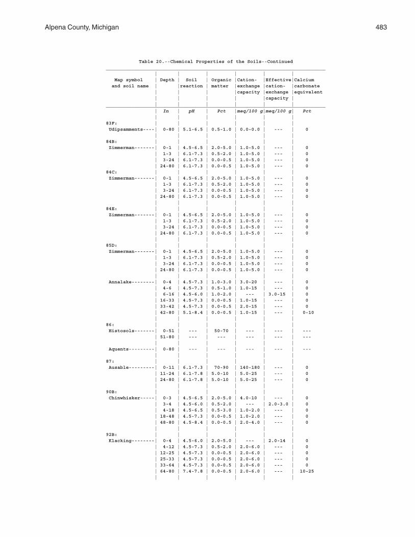
Alpena County, Michigan 483
Table 20.--Chemical Properties of the Soils--Continued_____________________________________________________________________________ | | | | | | Map symbol | Depth | Soil | Organic |Cation- |Effective|Calcium and soil name | |reaction | matter |exchange |cation- |carbonate | | | |capacity |exchange |equivalent | | | | |capacity | | | | | | |_____________________________________________________________________________ | In | pH | Pct |meq/100 g|meq/100 g| Pct | | | | | |83F: | | | | | | Udipsamments----| 0-80 | 5.1-6.5 | 0.5-1.0 | 0.0-0.0 | --- | 0 | | | | | |84B: | | | | | | Zimmerman-------| 0-1 | 4.5-6.5 | 2.0-5.0 | 1.0-5.0 | --- | 0 | 1-3 | 6.1-7.3 | 0.5-2.0 | 1.0-5.0 | --- | 0 | 3-24 | 6.1-7.3 | 0.0-0.5 | 1.0-5.0 | --- | 0 | 24-80 | 6.1-7.3 | 0.0-0.5 | 1.0-5.0 | --- | 084C: | | | | | | Zimmerman-------| 0-1 | 4.5-6.5 | 2.0-5.0 | 1.0-5.0 | --- | 0 | 1-3 | 6.1-7.3 | 0.5-2.0 | 1.0-5.0 | --- | 0 | 3-24 | 6.1-7.3 | 0.0-0.5 | 1.0-5.0 | --- | 0 | 24-80 | 6.1-7.3 | 0.0-0.5 | 1.0-5.0 | --- | 0 | | | | | |84E: | | | | | | Zimmerman-------| 0-1 | 4.5-6.5 | 2.0-5.0 | 1.0-5.0 | --- | 0 | 1-3 | 6.1-7.3 | 0.5-2.0 | 1.0-5.0 | --- | 0 | 3-24 | 6.1-7.3 | 0.0-0.5 | 1.0-5.0 | --- | 0 | 24-80 | 6.1-7.3 | 0.0-0.5 | 1.0-5.0 | --- | 0 | | | | | |85D: | | | | | | Zimmerman-------| 0-1 | 4.5-6.5 | 2.0-5.0 | 1.0-5.0 | --- | 0 | 1-3 | 6.1-7.3 | 0.5-2.0 | 1.0-5.0 | --- | 0 | 3-24 | 6.1-7.3 | 0.0-0.5 | 1.0-5.0 | --- | 0 | 24-80 | 6.1-7.3 | 0.0-0.5 | 1.0-5.0 | --- | 0 | | | | | | Annalake--------| 0-4 | 4.5-7.3 | 1.0-3.0 | 3.0-20 | --- | 0 | 4-6 | 4.5-7.3 | 0.5-1.0 | 1.0-15 | --- | 0 | 6-16 | 4.5-6.0 | 1.0-2.0 | --- | 3.0-15 | 0 | 16-33 | 4.5-7.3 | 0.0-0.5 | 1.0-15 | --- | 0 | 33-42 | 4.5-7.3 | 0.0-0.5 | 2.0-15 | --- | 0 | 42-80 | 5.1-8.4 | 0.0-0.5 | 1.0-15 | --- | 0-10 | | | | | |86: | | | | | | Histosols-------| 0-51 | --- | 50-70 | --- | --- | --- | 51-80 | --- | --- | --- | --- | --- | | | | | | Aquents---------| 0-80 | --- | --- | --- | --- | --- | | | | | |87: | | | | | | Ausable---------| 0-11 | 6.1-7.3 | 70-90 | 140-180 | --- | 0 | 11-24 | 6.1-7.8 | 5.0-10 | 5.0-25 | --- | 0 | 24-80 | 6.1-7.8 | 5.0-10 | 5.0-25 | --- | 0 | | | | | |90B: | | | | | | Chinwhisker-----| 0-3 | 4.5-6.5 | 2.0-5.0 | 4.0-10 | --- | 0 | 3-4 | 4.5-6.0 | 0.5-2.0 | --- | 2.0-3.0 | 0 | 4-18 | 4.5-6.5 | 0.5-3.0 | 1.0-2.0 | --- | 0 | 18-48 | 4.5-7.3 | 0.0-0.5 | 1.0-2.0 | --- | 0 | 48-80 | 4.5-8.4 | 0.0-0.5 | 2.0-4.0 | --- | 0 | | | | | |92B: | | | | | | Klacking--------| 0-4 | 4.5-6.0 | 2.0-5.0 | --- | 2.0-14 | 0 | 4-12 | 4.5-7.3 | 0.5-2.0 | 2.0-6.0 | --- | 0 | 12-25 | 4.5-7.3 | 0.0-0.5 | 2.0-6.0 | --- | 0 | 25-33 | 4.5-7.3 | 0.0-0.5 | 2.0-6.0 | --- | 0 | 33-64 | 4.5-7.3 | 0.0-0.5 | 2.0-6.0 | --- | 0 | 64-80 | 7.4-7.8 | 0.0-0.5 | 2.0-6.0 | --- | 10-25 | | | | | |
484 Soil Survey of
Table 20.--Chemical Properties of the Soils--Continued_____________________________________________________________________________ | | | | | | Map symbol | Depth | Soil | Organic |Cation- |Effective|Calcium and soil name | |reaction | matter |exchange |cation- |carbonate | | | |capacity |exchange |equivalent | | | | |capacity | | | | | | |_____________________________________________________________________________ | In | pH | Pct |meq/100 g|meq/100 g| Pct | | | | | |92B: | | | | | | McGinn----------| 0-2 | 3.5-5.5 | 1.0-3.0 | --- | 5.0-10 | 0 | 2-3 | 4.5-5.5 | 0.0-0.5 | --- | 1.0-3.0 | 0 | 3-12 | 5.1-5.5 | 0.0-0.5 | --- | 1.0-3.0 | 0 | 12-22 | 4.5-6.0 | 0.0-0.5 | 1.0-10 | --- | 0 | 22-26 | 4.5-6.0 | 0.0-0.5 | 3.0-10 | --- | 0 | 26-80 | 7.4-8.4 | 0.0-0.5 | 1.0-5.0 | --- | 10-30 | | | | | |92C: | | | | | | Klacking--------| 0-4 | 4.5-6.0 | 2.0-5.0 | --- | 2.0-14 | 0 | 4-12 | 4.5-7.3 | 0.5-2.0 | 2.0-6.0 | --- | 0 | 12-25 | 4.5-7.3 | 0.0-0.5 | 2.0-6.0 | --- | 0 | 25-33 | 4.5-7.3 | 0.0-0.5 | 2.0-6.0 | --- | 0 | 33-64 | 4.5-7.3 | 0.0-0.5 | 2.0-6.0 | --- | 0 | 64-80 | 7.4-7.8 | 0.0-0.5 | 2.0-6.0 | --- | 10-25 | | | | | | McGinn----------| 0-2 | 3.5-5.5 | 1.0-3.0 | --- | 5.0-10 | 0 | 2-3 | 4.5-5.5 | 0.0-0.5 | --- | 1.0-3.0 | 0 | 3-12 | 5.1-5.5 | 0.0-0.5 | --- | 1.0-3.0 | 0 | 12-22 | 4.5-6.0 | 0.0-0.5 | 1.0-10 | --- | 0 | 22-26 | 4.5-6.0 | 0.0-0.5 | 3.0-10 | --- | 0 | 26-80 | 7.4-8.4 | 0.0-0.5 | 1.0-5.0 | --- | 10-30 | | | | | |93B: | | | | | | Tacoda----------| 0-3 | 3.5-5.0 | 2.0-4.0 | --- | 5.0-10 | 0 | 3-14 | 3.5-5.5 | 0.0-0.5 | --- | 2.0-5.0 | 0 | 14-27 | 4.5-5.5 | 0.6-1.0 | --- | 2.0-5.0 | 0 | 27-44 | 4.5-7.3 | 0.0-0.5 | --- | 2.0-5.0 | 0 | 44-80 | 7.9-8.4 | 0.0-0.5 | 20-50 | --- | 10-30 | | | | | | Wakeley---------| 0-3 | 5.6-7.8 | 10-15 | 20-30 | --- | 0 | 3-21 | 5.6-7.8 | 0.0-0.5 | 1.0-10 | --- | 0 | 21-80 | 7.4-8.4 | 0.0-0.5 | 5.0-25 | --- | 10-30 | | | | | |94F: | | | | | | Klacking--------| 0-4 | 4.5-6.0 | 2.0-5.0 | --- | 2.0-14 | 0 | 4-12 | 4.5-7.3 | 0.5-2.0 | 2.0-6.0 | --- | 0 | 12-25 | 4.5-7.3 | 0.0-0.5 | 2.0-6.0 | --- | 0 | 25-33 | 4.5-7.3 | 0.0-0.5 | 2.0-6.0 | --- | 0 | 33-64 | 4.5-7.3 | 0.0-0.5 | 2.0-6.0 | --- | 0 | 64-80 | 7.4-7.8 | 0.0-0.5 | 2.0-6.0 | --- | 10-25 | | | | | | McGinn----------| 0-2 | 3.5-5.5 | 1.0-3.0 | --- | 5.0-10 | 0 | 2-3 | 4.5-5.5 | 0.0-0.5 | --- | 1.0-3.0 | 0 | 3-12 | 5.1-5.5 | 0.0-0.5 | --- | 1.0-3.0 | 0 | 12-22 | 4.5-6.0 | 0.0-0.5 | 1.0-10 | --- | 0 | 22-26 | 4.5-6.0 | 0.0-0.5 | 3.0-10 | --- | 0 | 26-80 | 7.4-8.4 | 0.0-0.5 | 1.0-5.0 | --- | 10-30 | | | | | |97: | | | | | | Colonville------| 0-19 | 6.6-8.4 | 2.0-4.0 | 5.0-15 | --- | 0 | 19-35 | 7.9-8.4 | 0.0-1.0 | 1.0-10 | --- | 0 | 35-80 | 7.9-8.4 | 0.0-1.0 | 1.0-10 | --- | 0 | | | | | |113: | | | | | | Angelica--------| 0-8 | 6.1-7.8 | 2.0-12 | 5.0-30 | --- | 0 | 8-29 | 6.1-8.4 | 0.0-0.5 | 3.0-15 | --- | 0-15 | 29-80 | 7.9-8.4 | 0.0-0.5 | 2.0-10 | --- | 15-30 | | | | | |
Alpena County, Michigan 485
Table 20.--Chemical Properties of the Soils--Continued_____________________________________________________________________________ | | | | | | Map symbol | Depth | Soil | Organic |Cation- |Effective|Calcium and soil name | |reaction | matter |exchange |cation- |carbonate | | | |capacity |exchange |equivalent | | | | |capacity | | | | | | |_____________________________________________________________________________ | In | pH | Pct |meq/100 g|meq/100 g| Pct | | | | | |116C: | | | | | | Mancelona-------| 0-3 | 4.5-7.3 | 2.0-5.0 | 2.0-10 | --- | 0 | 3-6 | 4.5-7.8 | 0.5-2.0 | 1.0-10 | --- | 0 | 6-20 | 5.6-7.8 | 0.5-3.0 | 1.0-10 | --- | 0 | 20-29 | 6.1-7.8 | 0.0-0.5 | 4.0-15 | --- | 0 | 29-35 | 6.1-7.8 | 0.0-0.5 | 4.0-15 | --- | 0 | 35-80 | 7.4-8.4 | 0.0-0.5 | 1.0-4.0 | --- | 10-25 | | | | | |127: | | | | | | Cathro----------| 0-6 | 4.5-7.8 | 60-85 | 150-230 | --- | 0 | 6-28 | 4.5-7.8 | 60-85 | 150-230 | --- | 0 | 28-80 | 5.6-8.4 | 0.0-0.5 | 2.0-20 | --- | 5-25 | | | | | |128: | | | | | | Dawson----------| 0-6 | 3.6-4.4 | 65-85 | --- | 80-120 | 0 | 6-31 | 3.6-4.4 | 65-85 | --- | 150-230 | 0 | 31-80 | 4.5-6.5 | 0.0-0.5 | 1.0-2.0 | --- | 0 | | | | | |145C: | | | | | | Rousseau--------| 0-1 | 4.5-6.0 | 65-85 | --- | 80-120 | 0 | 1-3 | 4.5-6.0 | 1.0-2.0 | --- | 3.0-10 | 0 | 3-6 | 4.5-6.0 | 1.0-2.0 | --- | 3.0-10 | 0 | 6-23 | 4.5-6.5 | 0.6-1.0 | 1.0-5.0 | --- | 0 | 23-37 | 4.5-6.5 | 0.6-1.0 | 1.0-5.0 | --- | 0 | 37-80 | 5.1-7.3 | 0.0-0.5 | 1.0-2.0 | --- | 0 | | | | | |145E: | | | | | | Rousseau--------| 0-1 | 4.5-6.0 | 65-85 | --- | 80-120 | 0 | 1-3 | 4.5-6.0 | 1.0-2.0 | --- | 3.0-10 | 0 | 3-6 | 4.5-6.0 | 1.0-2.0 | --- | 3.0-10 | 0 | 6-23 | 4.5-6.5 | 0.6-1.0 | 1.0-5.0 | --- | 0 | 23-37 | 4.5-6.5 | 0.6-1.0 | 1.0-5.0 | --- | 0 | 37-80 | 5.1-7.3 | 0.0-0.5 | 1.0-2.0 | --- | 0 | | | | | |159A: | | | | | | Finch-----------| 0-1 | 4.5-5.0 | 70-90 | 140-180 | --- | 0 | 1-11 | 4.5-5.0 | 0.5-2.0 | --- | 1.0-4.0 | 0 | 11-16 | 5.1-5.5 | 0.5-3.0 | 1.0-4.0 | --- | 0 | 16-23 | 5.1-5.5 | 0.5-3.0 | 1.0-4.0 | --- | 0 | 23-80 | 5.6-6.0 | 0.0-0.5 | 1.0-4.0 | --- | 0 | | | | | |166A: | | | | | | Slade-----------| 0-5 | 5.6-6.5 | 2.0-5.0 | 5.0-25 | --- | 0 | 5-7 | 5.6-6.5 | 0.5-1.0 | 1.0-15 | --- | 0 | 7-9 | 5.6-7.3 | 0.1-0.8 | 2.0-20 | --- | 0 | 9-26 | 6.6-7.3 | 0.0-0.5 | 4.0-25 | --- | 0 | 26-60 | 7.9-8.4 | 0.0-0.5 | 2.0-15 | --- | 1-10 | 60-80 | 7.9-8.4 | 0.0-0.5 | 2.0-15 | --- | 1-10 | | | | | |182: | | | | | | Pits, quarry. | | | | | | | | | | | |300A: | | | | | | Hagensville-----| 0-7 | 6.1-7.8 | 2.0-3.0 | 5.0-15 | --- | 0 | 7-18 | 6.6-7.8 | 0.0-0.5 | 2.0-8.0 | --- | 0-5 | 18-80 | 7.4-8.4 | 0.0-0.5 | 2.0-8.0 | --- | 15-25 | | | | | |
486 Soil Survey of
Table 20.--Chemical Properties of the Soils--Continued_____________________________________________________________________________ | | | | | | Map symbol | Depth | Soil | Organic |Cation- |Effective|Calcium and soil name | |reaction | matter |exchange |cation- |carbonate | | | |capacity |exchange |equivalent | | | | |capacity | | | | | | |_____________________________________________________________________________ | In | pH | Pct |meq/100 g|meq/100 g| Pct | | | | | |304A: | | | | | | Iosco-----------| 0-10 | 5.1-7.3 | 2.0-5.0 | 4.0-10 | --- | 0 | 10-19 | 5.1-6.5 | 0.5-3.0 | 2.0-10 | --- | 0 | 19-24 | 5.1-6.5 | 0.5-2.0 | 2.0-10 | --- | 0 | 24-37 | 6.6-8.4 | 0.0-0.5 | 4.0-10 | --- | 3-6 | 37-52 | 7.9-8.4 | 0.0-0.5 | 8.0-20 | --- | 15-30 | 52-80 | 7.9-8.4 | 0.0-0.5 | 8.0-20 | --- | 15-30305B: | | | | | | Johnswood-------| 0-5 | 6.1-7.8 | 1.0-3.0 | 5.0-15 | --- | 0 | 5-12 | 6.1-7.8 | 0.0-0.5 | 2.0-10 | --- | 0 | 12-80 | 7.9-8.4 | 0.0-0.5 | 2.0-10 | --- | 10-25 | | | | | |308B: | | | | | | Krakow----------| 0-3 | 6.6-7.8 | 2.0-5.0 | 3.0-15 | --- | 0 | 3-8 | 6.6-7.8 | 0.5-2.0 | 3.0-15 | --- | 0 | 8-15 | 6.6-7.8 | 0.0-0.5 | 2.0-10 | --- | 0-10 | 15-80 | 7.4-8.4 | 0.0-0.5 | 2.0-10 | --- | 10-40 | | | | | |308C: | | | | | | Krakow----------| 0-3 | 6.6-7.8 | 2.0-5.0 | 3.0-15 | --- | 0 | 3-8 | 6.6-7.8 | 0.5-2.0 | 3.0-15 | --- | 0 | 8-15 | 6.6-7.8 | 0.0-0.5 | 2.0-10 | --- | 0-10 | 15-80 | 7.4-8.4 | 0.0-0.5 | 2.0-10 | --- | 10-40 | | | | | |308D: | | | | | | Krakow----------| 0-3 | 6.6-7.8 | 2.0-5.0 | 3.0-15 | --- | 0 | 3-8 | 6.6-7.8 | 0.5-2.0 | 3.0-15 | --- | 0 | 8-15 | 6.6-7.8 | 0.0-0.5 | 2.0-10 | --- | 0-10 | 15-80 | 7.4-8.4 | 0.0-0.5 | 2.0-10 | --- | 10-40 | | | | | |316: | | | | | | Ruse------------| 0-8 | 6.1-7.3 | 4.0-8.0 | 8.0-20 | --- | 0 | 8-13 | 6.6-8.4 | 0.0-0.5 | 5.0-15 | --- | 10-20 | 13-17 | --- | --- | --- | --- | --- | | | | | |350E: | | | | | | Blue Lake-------| 0-3 | 5.1-6.5 | 2.0-5.0 | 1.0-5.0 | --- | 0 | 3-6 | 5.1-6.5 | 0.5-2.0 | 2.0-6.0 | --- | 0 | 6-25 | 5.1-6.5 | 0.5-3.0 | 2.0-6.0 | --- | 0 | 25-80 | 5.1-6.5 | 0.0-0.5 | 1.0-8.0 | --- | 0 | | | | | |359C: | | | | | | Algonquin-------| 0-5 | 6.6-7.3 | 2.0-3.0 | 10-25 | --- | 0 | 5-7 | 6.6-7.3 | 0.5-2.0 | 10-25 | --- | 0 | 7-19 | 7.4-8.4 | 0.0-0.5 | 10-20 | --- | 0-10 | 19-55 | 7.9-8.4 | 0.0-0.5 | 10-20 | --- | 10-30 | 55-80 | 7.9-8.4 | 0.0-0.5 | 10-20 | --- | 20-30 | | | | | | Negwegon--------| 0-9 | 6.1-7.8 | 1.0-3.0 | 10-25 | --- | 0 | 9-12 | 6.1-7.8 | 1.0-3.0 | 10-25 | --- | 0 | 12-14 | 6.1-7.8 | 0.0-0.5 | 10-20 | --- | 0 | 14-51 | 6.1-7.8 | 0.0-0.5 | 10-20 | --- | 0 | 51-80 | 7.9-8.4 | 0.0-0.5 | 10-20 | --- | 20-30 | | | | | | Dorval----------| 0-18 | 5.1-7.8 | 50-95 | 100-160 | --- | 0 | 18-80 | 6.1-8.4 | 0.0-8.0 | 18-30 | --- | 0-10 | | | | | |
Alpena County, Michigan 487
Table 20.--Chemical Properties of the Soils--Continued_____________________________________________________________________________ | | | | | | Map symbol | Depth | Soil | Organic |Cation- |Effective|Calcium and soil name | |reaction | matter |exchange |cation- |carbonate | | | |capacity |exchange |equivalent | | | | |capacity | | | | | | |_____________________________________________________________________________ | In | pH | Pct |meq/100 g|meq/100 g| Pct | | | | | |361B: | | | | | | Allendale-------| 0-11 | 4.5-7.3 | 2.0-5.0 | 4.0-20 | --- | 0 | 11-13 | 4.5-7.3 | 0.5-2.0 | 1.0-5.0 | --- | 0 | 13-22 | 4.5-7.3 | 0.5-3.0 | 1.0-5.0 | --- | 0 | 22-25 | 4.5-7.3 | 0.0-0.5 | 1.0-5.0 | --- | 0 | 25-44 | 6.1-8.4 | 0.0-0.5 | 8.0-25 | --- | 0-10 | 44-80 | 6.1-8.4 | 0.0-0.5 | 8.0-25 | --- | 0-10 | | | | | | Dorval----------| 0-18 | 5.1-7.8 | 50-95 | 100-160 | --- | 0 | 18-80 | 6.1-8.4 | 0.0-8.0 | 18-30 | --- | 0-10 | | | | | | Blue Lake-------| 0-3 | 5.1-6.5 | 2.0-5.0 | 1.0-5.0 | --- | 0 | 3-6 | 5.1-6.5 | 0.5-2.0 | 2.0-6.0 | --- | 0 | 6-25 | 5.1-6.5 | 0.5-3.0 | 2.0-6.0 | --- | 0 | 25-80 | 5.1-6.5 | 0.0-0.5 | 1.0-8.0 | --- | 0 | | | | | |362D: | | | | | | Millersburg-----| 0-3 | 3.5-6.5 | 2.0-5.0 | --- | 5.0-20 | 0 | 3-5 | 4.5-7.3 | 0.5-2.0 | 1.0-5.0 | --- | 0 | 5-18 | 4.5-7.3 | 0.0-0.5 | 1.0-5.0 | --- | 0 | 18-27 | 4.5-7.3 | 0.0-0.5 | 1.0-5.0 | --- | 0 | 27-33 | 6.1-7.8 | 0.0-0.5 | 2.0-5.0 | --- | 0-10 | 33-80 | 7.4-8.4 | 0.0-0.5 | 2.0-5.0 | --- | 10-30 | | | | | |362E: | | | | | | Millersburg-----| 0-3 | 3.5-6.5 | 2.0-5.0 | --- | 5.0-20 | 0 | 3-5 | 4.5-7.3 | 0.5-2.0 | 1.0-5.0 | --- | 0 | 5-18 | 4.5-7.3 | 0.0-0.5 | 1.0-5.0 | --- | 0 | 18-27 | 4.5-7.3 | 0.0-0.5 | 1.0-5.0 | --- | 0 | 27-33 | 6.1-7.8 | 0.0-0.5 | 2.0-5.0 | --- | 0-10 | 33-80 | 7.4-8.4 | 0.0-0.5 | 2.0-5.0 | --- | 10-30 | | | | | |368A: | | | | | | Au Gres---------| 0-1 | 3.5-7.3 | 70-90 | 140-180 | --- | 0 | 1-2 | 3.5-7.3 | 2.0-4.0 | 5.0-10 | --- | 0 | 2-10 | 4.5-7.3 | 0.5-2.0 | 2.0-5.0 | --- | 0 | 10-28 | 4.5-7.3 | 0.5-3.0 | 2.0-5.0 | --- | 0 | 28-32 | 4.5-7.3 | 0.0-0.5 | 2.0-5.0 | --- | 0 | 32-80 | 5.1-7.3 | 0.0-0.5 | 1.0-2.0 | --- | 0 | | | | | | Deford----------| 0-4 | 5.6-7.8 | 40-60 | 80-120 | --- | --- | 4-5 | 5.6-7.8 | 2.0-5.0 | 1.0-5.0 | --- | 0 | 5-80 | 5.6-7.8 | 0.0-0.5 | 1.0-5.0 | --- | 0 | | | | | |369: | | | | | | Deford----------| 0-4 | 5.6-7.8 | 40-60 | 80-120 | --- | --- | 4-5 | 5.6-7.8 | 2.0-5.0 | 1.0-5.0 | --- | 0 | 5-80 | 5.6-7.8 | 0.0-0.5 | 1.0-5.0 | --- | 0 | | | | | |371: | | | | | | Springport------| 0-3 | 6.6-7.8 | 2.0-5.0 | 15-30 | --- | 0 | 3-9 | 7.4-8.4 | 0.0-0.5 | 10-20 | --- | 0-20 | 9-13 | 7.4-8.4 | 0.0-0.5 | 10-20 | --- | 0-20 | 13-35 | 7.4-8.4 | 0.0-0.5 | 10-20 | --- | 10-20 | 35-80 | 7.4-8.4 | 0.0-0.5 | 10-20 | --- | 20-30 | | | | | |373B: | | | | | | Grayling--------| 0-2 | 3.6-5.5 | 2.0-5.0 | --- | 2.0-10 | 0 | 2-3 | 3.6-5.5 | 0.5-2.0 | --- | 2.0-10 | 0 | 3-15 | 4.5-6.5 | 0.5-1.0 | 1.0-2.0 | --- | 0 | 15-80 | 4.5-6.5 | 0.0-0.5 | 1.0-2.0 | --- | 0 | | | | | |
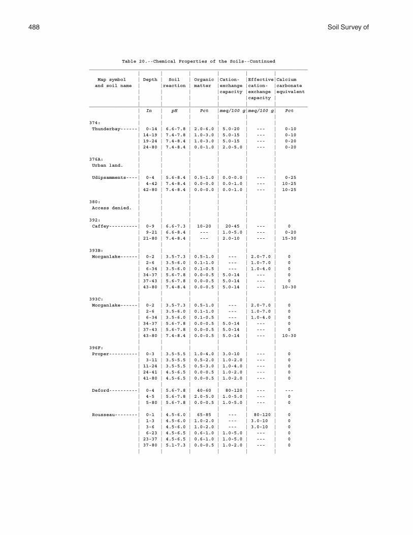
488 Soil Survey of
Table 20.--Chemical Properties of the Soils--Continued_____________________________________________________________________________ | | | | | | Map symbol | Depth | Soil | Organic |Cation- |Effective|Calcium and soil name | |reaction | matter |exchange |cation- |carbonate | | | |capacity |exchange |equivalent | | | | |capacity | | | | | | |_____________________________________________________________________________ | In | pH | Pct |meq/100 g|meq/100 g| Pct | | | | | |374: | | | | | | Thunderbay------| 0-14 | 6.6-7.8 | 2.0-6.0 | 5.0-20 | --- | 0-10 | 14-19 | 7.4-7.8 | 1.0-3.0 | 5.0-15 | --- | 0-10 | 19-24 | 7.4-8.4 | 1.0-3.0 | 5.0-15 | --- | 0-20 | 24-80 | 7.4-8.4 | 0.0-1.0 | 2.0-5.0 | --- | 0-20 | | | | | |376A: | | | | | | Urban land. | | | | | | | | | | | | Udipsamments----| 0-4 | 5.6-8.4 | 0.5-1.0 | 0.0-0.0 | --- | 0-25 | 4-42 | 7.4-8.4 | 0.0-0.0 | 0.0-1.0 | --- | 10-25 | 42-80 | 7.4-8.4 | 0.0-0.0 | 0.0-1.0 | --- | 10-25 | | | | | |380: | | | | | | Access denied. | | | | | | | | | | | |392: | | | | | | Caffey----------| 0-9 | 6.6-7.3 | 10-20 | 20-45 | --- | 0 | 9-21 | 6.6-8.4 | --- | 1.0-5.0 | --- | 0-20 | 21-80 | 7.4-8.4 | --- | 2.0-10 | --- | 15-30 | | | | | |393B: | | | | | | Morganlake------| 0-2 | 3.5-7.3 | 0.5-1.0 | --- | 2.0-7.0 | 0 | 2-6 | 3.5-6.0 | 0.1-1.0 | --- | 1.0-7.0 | 0 | 6-34 | 3.5-6.0 | 0.1-0.5 | --- | 1.0-4.0 | 0 | 34-37 | 5.6-7.8 | 0.0-0.5 | 5.0-14 | --- | 0 | 37-43 | 5.6-7.8 | 0.0-0.5 | 5.0-14 | --- | 0 | 43-80 | 7.4-8.4 | 0.0-0.5 | 5.0-14 | --- | 10-30 | | | | | |393C: | | | | | | Morganlake------| 0-2 | 3.5-7.3 | 0.5-1.0 | --- | 2.0-7.0 | 0 | 2-6 | 3.5-6.0 | 0.1-1.0 | --- | 1.0-7.0 | 0 | 6-34 | 3.5-6.0 | 0.1-0.5 | --- | 1.0-4.0 | 0 | 34-37 | 5.6-7.8 | 0.0-0.5 | 5.0-14 | --- | 0 | 37-43 | 5.6-7.8 | 0.0-0.5 | 5.0-14 | --- | 0 | 43-80 | 7.4-8.4 | 0.0-0.5 | 5.0-14 | --- | 10-30 | | | | | |396F: | | | | | | Proper----------| 0-3 | 3.5-5.5 | 1.0-4.0 | 3.0-10 | --- | 0 | 3-11 | 3.5-5.5 | 0.5-2.0 | 1.0-2.0 | --- | 0 | 11-24 | 3.5-5.5 | 0.5-3.0 | 1.0-4.0 | --- | 0 | 24-41 | 4.5-6.5 | 0.0-0.5 | 1.0-2.0 | --- | 0 | 41-80 | 4.5-6.5 | 0.0-0.5 | 1.0-2.0 | --- | 0 | | | | | | Deford----------| 0-4 | 5.6-7.8 | 40-60 | 80-120 | --- | --- | 4-5 | 5.6-7.8 | 2.0-5.0 | 1.0-5.0 | --- | 0 | 5-80 | 5.6-7.8 | 0.0-0.5 | 1.0-5.0 | --- | 0 | | | | | | Rousseau--------| 0-1 | 4.5-6.0 | 65-85 | --- | 80-120 | 0 | 1-3 | 4.5-6.0 | 1.0-2.0 | --- | 3.0-10 | 0 | 3-6 | 4.5-6.0 | 1.0-2.0 | --- | 3.0-10 | 0 | 6-23 | 4.5-6.5 | 0.6-1.0 | 1.0-5.0 | --- | 0 | 23-37 | 4.5-6.5 | 0.6-1.0 | 1.0-5.0 | --- | 0 | 37-80 | 5.1-7.3 | 0.0-0.5 | 1.0-2.0 | --- | 0 | | | | | |
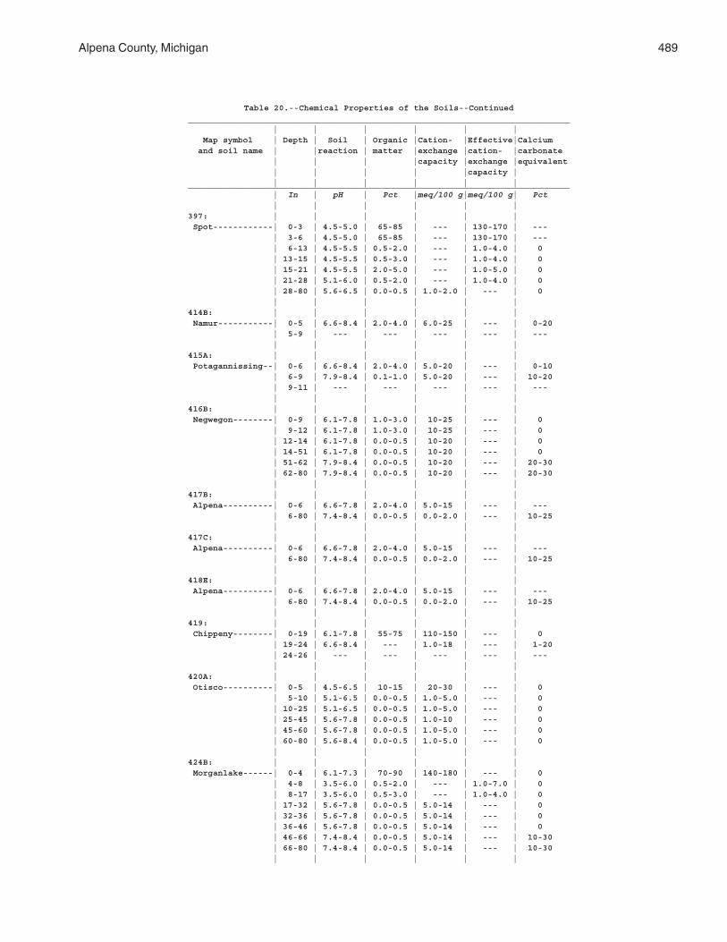
Alpena County, Michigan 489
Table 20.--Chemical Properties of the Soils--Continued_____________________________________________________________________________ | | | | | | Map symbol | Depth | Soil | Organic |Cation- |Effective|Calcium and soil name | |reaction | matter |exchange |cation- |carbonate | | | |capacity |exchange |equivalent | | | | |capacity | | | | | | |_____________________________________________________________________________ | In | pH | Pct |meq/100 g|meq/100 g| Pct | | | | | |397: | | | | | | Spot------------| 0-3 | 4.5-5.0 | 65-85 | --- | 130-170 | --- | 3-6 | 4.5-5.0 | 65-85 | --- | 130-170 | --- | 6-13 | 4.5-5.5 | 0.5-2.0 | --- | 1.0-4.0 | 0 | 13-15 | 4.5-5.5 | 0.5-3.0 | --- | 1.0-4.0 | 0 | 15-21 | 4.5-5.5 | 2.0-5.0 | --- | 1.0-5.0 | 0 | 21-28 | 5.1-6.0 | 0.5-2.0 | --- | 1.0-4.0 | 0 | 28-80 | 5.6-6.5 | 0.0-0.5 | 1.0-2.0 | --- | 0 | | | | | |414B: | | | | | | Namur-----------| 0-5 | 6.6-8.4 | 2.0-4.0 | 6.0-25 | --- | 0-20 | 5-9 | --- | --- | --- | --- | --- | | | | | |415A: | | | | | | Potagannissing--| 0-6 | 6.6-8.4 | 2.0-4.0 | 5.0-20 | --- | 0-10 | 6-9 | 7.9-8.4 | 0.1-1.0 | 5.0-20 | --- | 10-20 | 9-11 | --- | --- | --- | --- | --- | | | | | |416B: | | | | | | Negwegon--------| 0-9 | 6.1-7.8 | 1.0-3.0 | 10-25 | --- | 0 | 9-12 | 6.1-7.8 | 1.0-3.0 | 10-25 | --- | 0 | 12-14 | 6.1-7.8 | 0.0-0.5 | 10-20 | --- | 0 | 14-51 | 6.1-7.8 | 0.0-0.5 | 10-20 | --- | 0 | 51-62 | 7.9-8.4 | 0.0-0.5 | 10-20 | --- | 20-30 | 62-80 | 7.9-8.4 | 0.0-0.5 | 10-20 | --- | 20-30 | | | | | |417B: | | | | | | Alpena----------| 0-6 | 6.6-7.8 | 2.0-4.0 | 5.0-15 | --- | --- | 6-80 | 7.4-8.4 | 0.0-0.5 | 0.0-2.0 | --- | 10-25 | | | | | |417C: | | | | | | Alpena----------| 0-6 | 6.6-7.8 | 2.0-4.0 | 5.0-15 | --- | --- | 6-80 | 7.4-8.4 | 0.0-0.5 | 0.0-2.0 | --- | 10-25 | | | | | |418E: | | | | | | Alpena----------| 0-6 | 6.6-7.8 | 2.0-4.0 | 5.0-15 | --- | --- | 6-80 | 7.4-8.4 | 0.0-0.5 | 0.0-2.0 | --- | 10-25 | | | | | |419: | | | | | | Chippeny--------| 0-19 | 6.1-7.8 | 55-75 | 110-150 | --- | 0 | 19-24 | 6.6-8.4 | --- | 1.0-18 | --- | 1-20 | 24-26 | --- | --- | --- | --- | --- | | | | | |420A: | | | | | | Otisco----------| 0-5 | 4.5-6.5 | 10-15 | 20-30 | --- | 0 | 5-10 | 5.1-6.5 | 0.0-0.5 | 1.0-5.0 | --- | 0 | 10-25 | 5.1-6.5 | 0.0-0.5 | 1.0-5.0 | --- | 0 | 25-45 | 5.6-7.8 | 0.0-0.5 | 1.0-10 | --- | 0 | 45-60 | 5.6-7.8 | 0.0-0.5 | 1.0-5.0 | --- | 0 | 60-80 | 5.6-8.4 | 0.0-0.5 | 1.0-5.0 | --- | 0 | | | | | |424B: | | | | | | Morganlake------| 0-4 | 6.1-7.3 | 70-90 | 140-180 | --- | 0 | 4-8 | 3.5-6.0 | 0.5-2.0 | --- | 1.0-7.0 | 0 | 8-17 | 3.5-6.0 | 0.5-3.0 | --- | 1.0-4.0 | 0 | 17-32 | 5.6-7.8 | 0.0-0.5 | 5.0-14 | --- | 0 | 32-36 | 5.6-7.8 | 0.0-0.5 | 5.0-14 | --- | 0 | 36-46 | 5.6-7.8 | 0.0-0.5 | 5.0-14 | --- | 0 | 46-66 | 7.4-8.4 | 0.0-0.5 | 5.0-14 | --- | 10-30 | 66-80 | 7.4-8.4 | 0.0-0.5 | 5.0-14 | --- | 10-30 | | | | | |
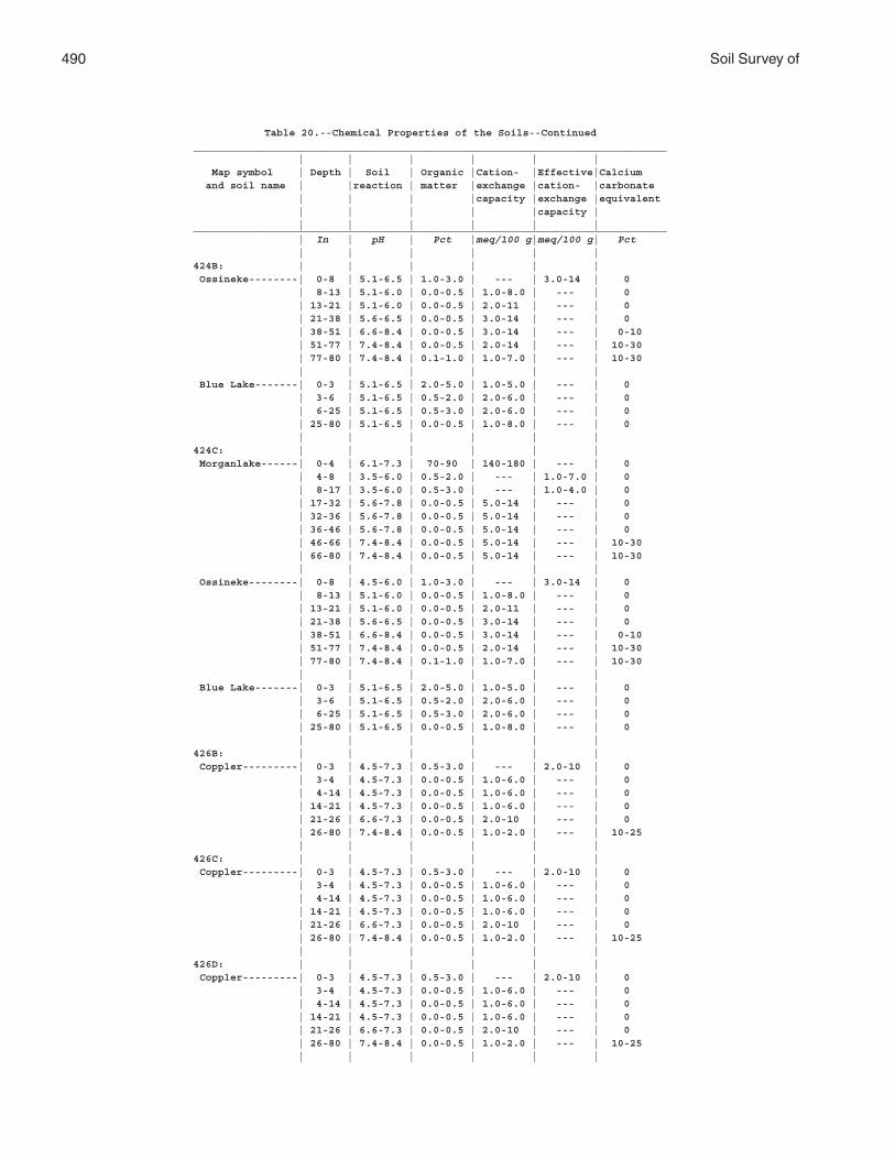
490 Soil Survey of
Table 20.--Chemical Properties of the Soils--Continued_____________________________________________________________________________ | | | | | | Map symbol | Depth | Soil | Organic |Cation- |Effective|Calcium and soil name | |reaction | matter |exchange |cation- |carbonate | | | |capacity |exchange |equivalent | | | | |capacity | | | | | | |_____________________________________________________________________________ | In | pH | Pct |meq/100 g|meq/100 g| Pct | | | | | |424B: | | | | | | Ossineke--------| 0-8 | 5.1-6.5 | 1.0-3.0 | --- | 3.0-14 | 0 | 8-13 | 5.1-6.0 | 0.0-0.5 | 1.0-8.0 | --- | 0 | 13-21 | 5.1-6.0 | 0.0-0.5 | 2.0-11 | --- | 0 | 21-38 | 5.6-6.5 | 0.0-0.5 | 3.0-14 | --- | 0 | 38-51 | 6.6-8.4 | 0.0-0.5 | 3.0-14 | --- | 0-10 | 51-77 | 7.4-8.4 | 0.0-0.5 | 2.0-14 | --- | 10-30 | 77-80 | 7.4-8.4 | 0.1-1.0 | 1.0-7.0 | --- | 10-30 | | | | | | Blue Lake-------| 0-3 | 5.1-6.5 | 2.0-5.0 | 1.0-5.0 | --- | 0 | 3-6 | 5.1-6.5 | 0.5-2.0 | 2.0-6.0 | --- | 0 | 6-25 | 5.1-6.5 | 0.5-3.0 | 2.0-6.0 | --- | 0 | 25-80 | 5.1-6.5 | 0.0-0.5 | 1.0-8.0 | --- | 0 | | | | | |424C: | | | | | | Morganlake------| 0-4 | 6.1-7.3 | 70-90 | 140-180 | --- | 0 | 4-8 | 3.5-6.0 | 0.5-2.0 | --- | 1.0-7.0 | 0 | 8-17 | 3.5-6.0 | 0.5-3.0 | --- | 1.0-4.0 | 0 | 17-32 | 5.6-7.8 | 0.0-0.5 | 5.0-14 | --- | 0 | 32-36 | 5.6-7.8 | 0.0-0.5 | 5.0-14 | --- | 0 | 36-46 | 5.6-7.8 | 0.0-0.5 | 5.0-14 | --- | 0 | 46-66 | 7.4-8.4 | 0.0-0.5 | 5.0-14 | --- | 10-30 | 66-80 | 7.4-8.4 | 0.0-0.5 | 5.0-14 | --- | 10-30 | | | | | | Ossineke--------| 0-8 | 4.5-6.0 | 1.0-3.0 | --- | 3.0-14 | 0 | 8-13 | 5.1-6.0 | 0.0-0.5 | 1.0-8.0 | --- | 0 | 13-21 | 5.1-6.0 | 0.0-0.5 | 2.0-11 | --- | 0 | 21-38 | 5.6-6.5 | 0.0-0.5 | 3.0-14 | --- | 0 | 38-51 | 6.6-8.4 | 0.0-0.5 | 3.0-14 | --- | 0-10 | 51-77 | 7.4-8.4 | 0.0-0.5 | 2.0-14 | --- | 10-30 | 77-80 | 7.4-8.4 | 0.1-1.0 | 1.0-7.0 | --- | 10-30 | | | | | | Blue Lake-------| 0-3 | 5.1-6.5 | 2.0-5.0 | 1.0-5.0 | --- | 0 | 3-6 | 5.1-6.5 | 0.5-2.0 | 2.0-6.0 | --- | 0 | 6-25 | 5.1-6.5 | 0.5-3.0 | 2.0-6.0 | --- | 0 | 25-80 | 5.1-6.5 | 0.0-0.5 | 1.0-8.0 | --- | 0 | | | | | |426B: | | | | | | Coppler---------| 0-3 | 4.5-7.3 | 0.5-3.0 | --- | 2.0-10 | 0 | 3-4 | 4.5-7.3 | 0.0-0.5 | 1.0-6.0 | --- | 0 | 4-14 | 4.5-7.3 | 0.0-0.5 | 1.0-6.0 | --- | 0 | 14-21 | 4.5-7.3 | 0.0-0.5 | 1.0-6.0 | --- | 0 | 21-26 | 6.6-7.3 | 0.0-0.5 | 2.0-10 | --- | 0 | 26-80 | 7.4-8.4 | 0.0-0.5 | 1.0-2.0 | --- | 10-25 | | | | | |426C: | | | | | | Coppler---------| 0-3 | 4.5-7.3 | 0.5-3.0 | --- | 2.0-10 | 0 | 3-4 | 4.5-7.3 | 0.0-0.5 | 1.0-6.0 | --- | 0 | 4-14 | 4.5-7.3 | 0.0-0.5 | 1.0-6.0 | --- | 0 | 14-21 | 4.5-7.3 | 0.0-0.5 | 1.0-6.0 | --- | 0 | 21-26 | 6.6-7.3 | 0.0-0.5 | 2.0-10 | --- | 0 | 26-80 | 7.4-8.4 | 0.0-0.5 | 1.0-2.0 | --- | 10-25 | | | | | |426D: | | | | | | Coppler---------| 0-3 | 4.5-7.3 | 0.5-3.0 | --- | 2.0-10 | 0 | 3-4 | 4.5-7.3 | 0.0-0.5 | 1.0-6.0 | --- | 0 | 4-14 | 4.5-7.3 | 0.0-0.5 | 1.0-6.0 | --- | 0 | 14-21 | 4.5-7.3 | 0.0-0.5 | 1.0-6.0 | --- | 0 | 21-26 | 6.6-7.3 | 0.0-0.5 | 2.0-10 | --- | 0 | 26-80 | 7.4-8.4 | 0.0-0.5 | 1.0-2.0 | --- | 10-25 | | | | | |
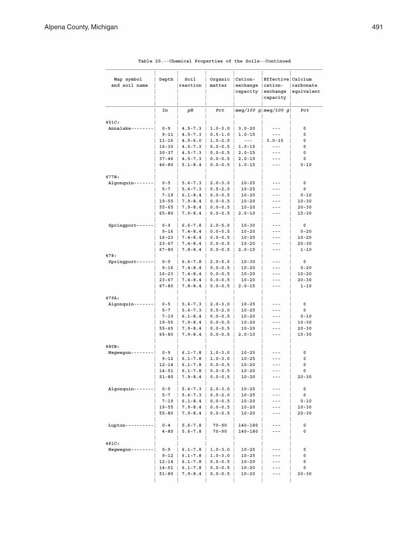
Alpena County, Michigan 491
Table 20.--Chemical Properties of the Soils--Continued_____________________________________________________________________________ | | | | | | Map symbol | Depth | Soil | Organic |Cation- |Effective|Calcium and soil name | |reaction | matter |exchange |cation- |carbonate | | | |capacity |exchange |equivalent | | | | |capacity | | | | | | |_____________________________________________________________________________ | In | pH | Pct |meq/100 g|meq/100 g| Pct | | | | | |451C: | | | | | | Annalake--------| 0-9 | 4.5-7.3 | 1.0-3.0 | 3.0-20 | --- | 0 | 9-11 | 4.5-7.3 | 0.5-1.0 | 1.0-15 | --- | 0 | 11-16 | 4.5-6.0 | 1.0-2.0 | --- | 3.0-15 | 0 | 16-30 | 4.5-7.3 | 0.0-0.5 | 1.0-15 | --- | 0 | 30-37 | 4.5-7.3 | 0.0-0.5 | 2.0-15 | --- | 0 | 37-46 | 4.5-7.3 | 0.0-0.5 | 2.0-15 | --- | 0 | 46-80 | 5.1-8.4 | 0.0-0.5 | 1.0-15 | --- | 0-10 | | | | | |477B: | | | | | | Algonquin-------| 0-5 | 5.6-7.3 | 2.0-3.0 | 10-25 | --- | 0 | 5-7 | 5.6-7.3 | 0.5-2.0 | 10-25 | --- | 0 | 7-19 | 6.1-8.4 | 0.0-0.5 | 10-20 | --- | 0-10 | 19-55 | 7.9-8.4 | 0.0-0.5 | 10-20 | --- | 10-30 | 55-65 | 7.9-8.4 | 0.0-0.5 | 10-20 | --- | 20-30 | 65-80 | 7.9-8.4 | 0.0-0.5 | 2.0-10 | --- | 15-30 | | | | | | Springport------| 0-9 | 6.6-7.8 | 2.0-5.0 | 10-30 | --- | 0 | 9-16 | 7.4-8.4 | 0.0-0.5 | 10-20 | --- | 0-20 | 16-23 | 7.4-8.4 | 0.0-0.5 | 10-20 | --- | 10-20 | 23-67 | 7.4-8.4 | 0.0-0.5 | 10-20 | --- | 20-30 | 67-80 | 7.8-8.4 | 0.0-0.5 | 2.0-15 | --- | 1-10478: | | | | | | Springport------| 0-9 | 6.6-7.8 | 2.0-5.0 | 10-30 | --- | 0 | 9-16 | 7.4-8.4 | 0.0-0.5 | 10-20 | --- | 0-20 | 16-23 | 7.4-8.4 | 0.0-0.5 | 10-20 | --- | 10-20 | 23-67 | 7.4-8.4 | 0.0-0.5 | 10-20 | --- | 20-30 | 67-80 | 7.8-8.4 | 0.0-0.5 | 2.0-15 | --- | 1-10 | | | | | |479A: | | | | | | Algonquin-------| 0-5 | 5.6-7.3 | 2.0-3.0 | 10-25 | --- | 0 | 5-7 | 5.6-7.3 | 0.5-2.0 | 10-25 | --- | 0 | 7-19 | 6.1-8.4 | 0.0-0.5 | 10-20 | --- | 0-10 | 19-55 | 7.9-8.4 | 0.0-0.5 | 10-20 | --- | 10-30 | 55-65 | 7.9-8.4 | 0.0-0.5 | 10-20 | --- | 20-30 | 65-80 | 7.9-8.4 | 0.0-0.5 | 2.0-10 | --- | 15-30 | | | | | |480B: | | | | | | Negwegon--------| 0-9 | 6.1-7.8 | 1.0-3.0 | 10-25 | --- | 0 | 9-12 | 6.1-7.8 | 1.0-3.0 | 10-25 | --- | 0 | 12-14 | 6.1-7.8 | 0.0-0.5 | 10-20 | --- | 0 | 14-51 | 6.1-7.8 | 0.0-0.5 | 10-20 | --- | 0 | 51-80 | 7.9-8.4 | 0.0-0.5 | 10-20 | --- | 20-30 | | | | | | Algonquin-------| 0-5 | 5.6-7.3 | 2.0-3.0 | 10-25 | --- | 0 | 5-7 | 5.6-7.3 | 0.5-2.0 | 10-25 | --- | 0 | 7-19 | 6.1-8.4 | 0.0-0.5 | 10-20 | --- | 0-10 | 19-55 | 7.9-8.4 | 0.0-0.5 | 10-20 | --- | 10-30 | 55-80 | 7.9-8.4 | 0.0-0.5 | 10-20 | --- | 20-30 | | | | | | Lupton----------| 0-4 | 5.6-7.8 | 70-90 | 140-180 | --- | 0 | 4-80 | 5.6-7.8 | 70-90 | 140-180 | --- | 0 | | | | | |481C: | | | | | | Negwegon--------| 0-9 | 6.1-7.8 | 1.0-3.0 | 10-25 | --- | 0 | 9-12 | 6.1-7.8 | 1.0-3.0 | 10-25 | --- | 0 | 12-14 | 6.1-7.8 | 0.0-0.5 | 10-20 | --- | 0 | 14-51 | 6.1-7.8 | 0.0-0.5 | 10-20 | --- | 0 | 51-80 | 7.9-8.4 | 0.0-0.5 | 10-20 | --- | 20-30 | | | | | |
492 Soil Survey of
Table 20.--Chemical Properties of the Soils--Continued_____________________________________________________________________________ | | | | | | Map symbol | Depth | Soil | Organic |Cation- |Effective|Calcium and soil name | |reaction | matter |exchange |cation- |carbonate | | | |capacity |exchange |equivalent | | | | |capacity | | | | | | |_____________________________________________________________________________ | In | pH | Pct |meq/100 g|meq/100 g| Pct | | | | | |481C: | | | | | | Lupton----------| 0-4 | 5.6-7.8 | 70-90 | 140-180 | --- | 0 | 4-80 | 5.6-7.8 | 70-90 | 140-180 | --- | 0 | | | | | |482B: | | | | | | Summerville-----| 0-5 | 6.1-7.8 | 1.0-2.0 | 5.0-15 | --- | 0 | 5-16 | 6.1-8.4 | 0.0-0.5 | 2.0-15 | --- | 0-30 | 16-18 | --- | --- | --- | --- | --- | | | | | |482C: | | | | | | Summerville-----| 0-5 | 6.1-7.8 | 1.0-2.0 | 5.0-15 | --- | 0 | 5-16 | 6.1-8.4 | 0.0-0.5 | 2.0-15 | --- | 0-30 | 16-18 | --- | --- | --- | --- | --- | | | | | |483A: | | | | | | Lachine---------| 0-9 | 7.4-7.8 | 1.0-3.0 | 4.0-15 | --- | 0-15 | 9-13 | 7.4-7.8 | 0.0-0.5 | 2.0-10 | --- | 0-15 | 13-16 | 7.4-7.8 | 0.0-0.0 | 2.0-10 | --- | 10-30 | 16-20 | --- | --- | --- | --- | --- | | | | | |484A: | | | | | | Elcajon---------| 0-6 | 6.6-7.8 | 1.0-3.0 | 3.0-15 | --- | 0 | 6-12 | 6.6-7.8 | 0.0-0.5 | 1.0-10 | --- | 0 | 12-29 | 6.6-7.8 | 0.0-0.0 | 5.0-15 | --- | 0 | 29-37 | 7.3-8.4 | 0.0-0.0 | 1.0-10 | --- | 10-30 | 37-41 | --- | --- | --- | --- | --- | | | | | |485A: | | | | | | Bowers----------| 0-10 | 5.6-7.3 | 1.0-3.0 | 5.0-20 | --- | 0 | 10-14 | 5.6-7.3 | 0.0-0.5 | 5.0-15 | --- | 0 | 14-27 | 6.1-7.3 | 0.0-0.5 | 5.0-20 | --- | 0-20 | 27-80 | 7.4-8.4 | 0.0-0.5 | 5.0-20 | --- | 20-40 | | | | | |486B: | | | | | | Tonkey----------| 0-7 | 5.6-7.8 | 4.0-7.0 | 10-25 | --- | 0 | 7-22 | 5.6-7.8 | 0.0-0.5 | 2.0-10 | --- | 0 | 22-80 | 7.4-8.4 | 0.0-0.5 | 1.0-10 | --- | 0-10 | | | | | | Bowers----------| 0-10 | 5.6-7.3 | 1.0-3.0 | 5.0-20 | --- | 0 | 10-14 | 5.6-7.3 | 0.0-0.5 | 5.0-15 | --- | 0 | 14-27 | 6.1-7.3 | 0.0-0.5 | 5.0-20 | --- | 0-20 | 27-80 | 7.4-8.4 | 0.0-0.5 | 5.0-20 | --- | 20-40 | | | | | |487B: | | | | | | Slade-----------| 0-5 | 5.6-6.5 | 2.0-5.0 | 5.0-25 | --- | 0 | 5-7 | 5.6-6.5 | 0.5-1.0 | 1.0-15 | --- | 0 | 7-9 | 5.6-7.3 | 0.1-0.8 | 2.0-20 | --- | 0 | 9-26 | 6.6-7.3 | 0.0-0.5 | 4.0-25 | --- | 0 | 26-60 | 7.9-8.4 | 0.0-0.5 | 2.0-15 | --- | 1-10 | 60-80 | 7.9-8.4 | 0.0-0.5 | 2.0-15 | --- | 1-10 | | | | | | Angelica--------| 0-8 | 6.1-7.8 | 2.0-12 | 5.0-30 | --- | 0 | 8-29 | 6.1-8.4 | 0.0-0.5 | 3.0-15 | --- | 0-15 | 29-80 | 7.9-8.4 | 0.0-0.5 | 2.0-10 | --- | 15-30 | | | | | |
Alpena County, Michigan 493
Table 20.--Chemical Properties of the Soils--Continued_____________________________________________________________________________ | | | | | | Map symbol | Depth | Soil | Organic |Cation- |Effective|Calcium and soil name | |reaction | matter |exchange |cation- |carbonate | | | |capacity |exchange |equivalent | | | | |capacity | | | | | | |_____________________________________________________________________________ | In | pH | Pct |meq/100 g|meq/100 g| Pct | | | | | |489F: | | | | | | Crowell---------| 0-2 | 5.6-6.0 | 2.0-5.0 | --- | 2.0-5.0 | 0 | 2-5 | 5.1-5.5 | 0.5-2.0 | --- | 2.0-5.0 | 0 | 5-10 | 5.1-6.0 | 0.5-3.0 | --- | 1.0-4.0 | 0 | 10-29 | 5.1-6.0 | 0.5-3.0 | --- | 1.0-2.0 | 0 | 29-80 | 5.6-6.5 | 0.0-0.5 | 1.0-2.0 | --- | 0 | | | | | | Proper----------| 0-3 | 3.5-5.5 | 1.0-4.0 | 3.0-10 | --- | 0 | 3-11 | 3.5-5.5 | 0.5-2.0 | 1.0-2.0 | --- | 0 | 11-24 | 3.5-5.5 | 0.5-3.0 | 1.0-4.0 | --- | 0 | 24-41 | 4.5-6.5 | 0.0-0.5 | 1.0-2.0 | --- | 0 | 41-80 | 4.5-6.5 | 0.0-0.5 | 1.0-2.0 | --- | 0 | | | | | |_____________________________________________________________________________
494 Soil Survey of
Table 21.--Soil Features
(See text for definitions of terms used in this table. Absence of an entry indicates that the feature is not a concern or that data were not estimated.)
__________________________________________________________________________________________________________ | Restrictive layer | Subsidence | | Risk of corrosion Map symbol |___________________________________|_______________| Potential |_________________________ and soil name | | Depth | | | | for | Uncoated | | Kind |to top |Thickness|Initial| Total |frost action| steel | Concrete | | | | | | | |__________________________________________________________________________________________________________ | | In | In | In | In | | | | | | | | | | |11B: | | | | | | | | Eastport------| --- | --- | --- | 0 | --- |Low |Low |Moderate | | | | | | | |12B: | | | | | | | | Tawas---------| --- | --- | --- | 4-15 | 25-30 |High |High |Moderate | | | | | | | | Au Gres-------| --- | --- | --- | 0 | --- |Moderate |Low |Moderate | | | | | | | |13: | | | | | | | | Tawas---------| --- | --- | --- | 4-15 | 25-30 |High |High |Moderate | | | | | | | | Lupton--------| --- | --- | --- | 6-18 | 50-55 |High |High |Low | | | | | | | |14: | | | | | | | | Dawson--------| --- | --- | --- | 0 | 30-36 |High |High |High | | | | | | | | Loxley--------| --- | --- | --- | 6-18 | 50-55 |High |High |High | | | | | | | |16B: | | | | | | | | Graycalm------| --- | --- | --- | 0 | --- |Low |Low |Moderate | | | | | | | |16C: | | | | | | | | Graycalm------| --- | --- | --- | 0 | --- |Low |Low |Moderate | | | | | | | |16D: | | | | | | | | Graycalm------| --- | --- | --- | 0 | --- |Low |Low |Moderate | | | | | | | |16E: | | | | | | | | Graycalm------| --- | --- | --- | 0 | --- |Low |Low |Moderate | | | | | | | |17A: | | | | | | | | Croswell------| --- | --- | --- | 0 | --- |Low |Low |Moderate | | | | | | | |17B: | | | | | | | | Croswell------| --- | --- | --- | 0 | --- |Low |Low |Moderate | | | | | | | |18A: | | | | | | | | Au Gres-------| --- | --- | --- | 0 | --- |Moderate |Low |Moderate | | | | | | | |19: | | | | | | | | Leafriver-----| --- | --- | --- | 0 | 5-10 |High |High |High | | | | | | | |27A: | | | | | | | | Tacoda--------| --- | --- | --- | 0 | --- |Moderate |Low |Moderate | | | | | | | |28B: | | | | | | | | East Lake-----| --- | --- | --- | 0 | --- |Low |Low |Moderate | | | | | | | |28C: | | | | | | | | East Lake-----| --- | --- | --- | 0 | --- |Low |Low |Moderate | | | | | | | |29A: | | | | | | | | Battlefield---| --- | --- | --- | 0 | --- |Moderate |High |High | | | | | | | |30: | | | | | | | | Wheatley------| --- | --- | --- | 0 | --- |Moderate |High |Low | | | | | | | |
Alpena County, Michigan 495
Table 21.--Soil Features--Continued__________________________________________________________________________________________________________ | Restrictive layer | Subsidence | | Risk of corrosion Map symbol |___________________________________|_______________| Potential |_________________________ and soil name | | Depth | | | | for | Uncoated | | Kind |to top |Thickness|Initial| Total |frost action| steel | Concrete | | | | | | | |__________________________________________________________________________________________________________ | | In | In | In | In | | | | | | | | | | |31B: | | | | | | | | Klacking------| --- | --- | --- | 0 | --- |Low |Low |Moderate | | | | | | | |31C: | | | | | | | | Klacking------| --- | --- | --- | 0 | --- |Low |Low |Moderate | | | | | | | |31D: | | | | | | | | Klacking------| --- | --- | --- | 0 | --- |Low |Low |Moderate | | | | | | | |31E: | | | | | | | | Klacking------| --- | --- | --- | 0 | --- |Low |Low |Moderate | | | | | | | |35: | | | | | | | | Kinross-------| --- | --- | --- | 0 | --- |Moderate |High |Moderate | | | | | | | |36B: | | | | | | | | Annalake------| --- | --- | --- | 0 | --- |Moderate |Moderate |Low | | | | | | | |36C: | | | | | | | | Annalake------| --- | --- | --- | 0 | --- |Moderate |Moderate |Low | | | | | | | |37A: | | | | | | | | Richter-------| --- | --- | --- | 0 | --- |High |High |Moderate | | | | | | | |37B: | | | | | | | | Richter-------| --- | --- | --- | 0 | --- |High |High |Moderate | | | | | | | |38: | | | | | | | | Tonkey--------| --- | --- | --- | 0 | --- |High |High |Low | | | | | | | |41B: | | | | | | | | McGinn--------| --- | --- | --- | 0 | --- |Moderate |Low |Moderate | | | | | | | |41C: | | | | | | | | McGinn--------| --- | --- | --- | 0 | --- |Moderate |Low |Moderate | | | | | | | |41D: | | | | | | | | McGinn--------| --- | --- | --- | 0 | --- |Moderate |Low |Moderate | | | | | | | |41E: | | | | | | | | McGinn--------| --- | --- | --- | 0 | --- |Moderate |Low |Moderate | | | | | | | |42A: | | | | | | | | Killmaster----| --- | --- | --- | 0 | --- |High |Low |Low | | | | | | | |43: | | | | | | | | Wakeley-------| --- | --- | --- | 0 | --- |Moderate |High |Moderate | | | | | | | |44B: | | | | | | | | Ossineke------| --- | --- | --- | 0 | --- |Moderate |Moderate |Moderate | | | | | | | |44C: | | | | | | | | Ossineke------| --- | --- | --- | 0 | --- |Moderate |Moderate |Moderate | | | | | | | |45B: | | | | | | | | Hoist---------| --- | --- | --- | 0 | --- |Moderate |Low |Low | | | | | | | |45C: | | | | | | | | Hoist---------| --- | --- | --- | 0 | --- |Moderate |Low |Low | | | | | | | |46: | | | | | | | | Ensley--------| --- | --- | --- | 0 | --- |High |High |Low | | | | | | | |
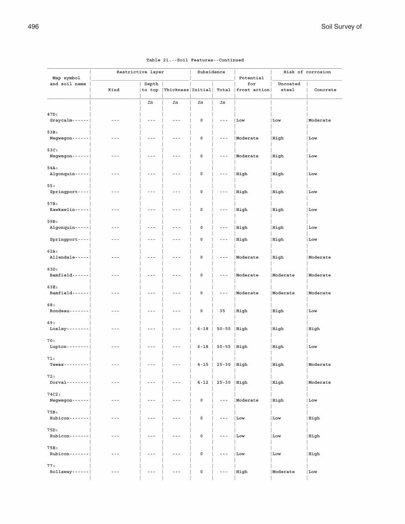
496 Soil Survey of
Table 21.--Soil Features--Continued__________________________________________________________________________________________________________ | Restrictive layer | Subsidence | | Risk of corrosion Map symbol |___________________________________|_______________| Potential |_________________________ and soil name | | Depth | | | | for | Uncoated | | Kind |to top |Thickness|Initial| Total |frost action| steel | Concrete | | | | | | | |__________________________________________________________________________________________________________ | | In | In | In | In | | | | | | | | | | |47D: | | | | | | | | Graycalm------| --- | --- | --- | 0 | --- |Low |Low |Moderate | | | | | | | |53B: | | | | | | | | Negwegon------| --- | --- | --- | 0 | --- |Moderate |High |Low | | | | | | | |53C: | | | | | | | | Negwegon------| --- | --- | --- | 0 | --- |Moderate |High |Low | | | | | | | |54A: | | | | | | | | Algonquin-----| --- | --- | --- | 0 | --- |High |High |Low | | | | | | | |55: | | | | | | | | Springport----| --- | --- | --- | 0 | --- |High |High |Low | | | | | | | |57B: | | | | | | | | Kawkawlin-----| --- | --- | --- | 0 | --- |High |High |Low | | | | | | | |59B: | | | | | | | | Algonquin-----| --- | --- | --- | 0 | --- |High |High |Low | | | | | | | | Springport----| --- | --- | --- | 0 | --- |High |High |Low | | | | | | | |62A: | | | | | | | | Allendale-----| --- | --- | --- | 0 | --- |Moderate |High |Moderate | | | | | | | |63D: | | | | | | | | Bamfield------| --- | --- | --- | 0 | --- |Moderate |Moderate |Moderate | | | | | | | |63E: | | | | | | | | Bamfield------| --- | --- | --- | 0 | --- |Moderate |Moderate |Moderate | | | | | | | |68: | | | | | | | | Rondeau-------| --- | --- | --- | 0 | 35 |High |High |Low | | | | | | | |69: | | | | | | | | Loxley--------| --- | --- | --- | 6-18 | 50-55 |High |High |High | | | | | | | |70: | | | | | | | | Lupton--------| --- | --- | --- | 6-18 | 50-55 |High |High |Low | | | | | | | |71: | | | | | | | | Tawas---------| --- | --- | --- | 4-15 | 25-30 |High |High |Moderate | | | | | | | |72: | | | | | | | | Dorval--------| --- | --- | --- | 4-12 | 25-30 |High |High |Moderate | | | | | | | |74C2: | | | | | | | | Negwegon------| --- | --- | --- | 0 | --- |Moderate |High |Low | | | | | | | |75B: | | | | | | | | Rubicon-------| --- | --- | --- | 0 | --- |Low |Low |High | | | | | | | |75D: | | | | | | | | Rubicon-------| --- | --- | --- | 0 | --- |Low |Low |High | | | | | | | |75E: | | | | | | | | Rubicon-------| --- | --- | --- | 0 | --- |Low |Low |High | | | | | | | |77: | | | | | | | | Rollaway------| --- | --- | --- | 0 | --- |High |Moderate |Low | | | | | | | |
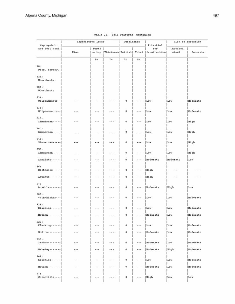
Alpena County, Michigan 497
Table 21.--Soil Features--Continued__________________________________________________________________________________________________________ | Restrictive layer | Subsidence | | Risk of corrosion Map symbol |___________________________________|_______________| Potential |_________________________ and soil name | | Depth | | | | for | Uncoated | | Kind |to top |Thickness|Initial| Total |frost action| steel | Concrete | | | | | | | |__________________________________________________________________________________________________________ | | In | In | In | In | | | | | | | | | | |78: | | | | | | | | Pits, borrow. | | | | | | | | | | | | | | | |82B: | | | | | | | | Udorthents. | | | | | | | | | | | | | | | |82C: | | | | | | | | Udorthents. | | | | | | | | | | | | | | | |83B: | | | | | | | | Udipsamments--| --- | --- | --- | 0 | --- |Low |Low |Moderate | | | | | | | |83F: | | | | | | | | Udipsamments--| --- | --- | --- | 0 | --- |Low |Low |Moderate | | | | | | | |84B: | | | | | | | | Zimmerman-----| --- | --- | --- | 0 | --- |Low |Low |High | | | | | | | |84C: | | | | | | | | Zimmerman-----| --- | --- | --- | 0 | --- |Low |Low |High | | | | | | | |84E: | | | | | | | | Zimmerman-----| --- | --- | --- | 0 | --- |Low |Low |High | | | | | | | |85D: | | | | | | | | Zimmerman-----| --- | --- | --- | 0 | --- |Low |Low |High | | | | | | | | Annalake------| --- | --- | --- | 0 | --- |Moderate |Moderate |Low | | | | | | | |86: | | | | | | | | Histosols-----| --- | --- | --- | 0 | --- |High | --- | --- | | | | | | | | Aquents-------| --- | --- | --- | 0 | --- |High | --- | --- | | | | | | | |87: | | | | | | | | Ausable-------| --- | --- | --- | 0 | --- |Moderate |High |Low | | | | | | | |90B: | | | | | | | | Chinwhisker---| --- | --- | --- | 0 | --- |Low |Low |Moderate | | | | | | | |92B: | | | | | | | | Klacking------| --- | --- | --- | 0 | --- |Low |Low |Moderate | | | | | | | | McGinn--------| --- | --- | --- | 0 | --- |Moderate |Low |Moderate | | | | | | | |92C: | | | | | | | | Klacking------| --- | --- | --- | 0 | --- |Low |Low |Moderate | | | | | | | | McGinn--------| --- | --- | --- | 0 | --- |Moderate |Low |Moderate | | | | | | | |93B: | | | | | | | | Tacoda--------| --- | --- | --- | 0 | --- |Moderate |Low |Moderate | | | | | | | | Wakeley-------| --- | --- | --- | 0 | --- |Moderate |High |Moderate | | | | | | | |94F: | | | | | | | | Klacking------| --- | --- | --- | 0 | --- |Low |Low |Moderate | | | | | | | | McGinn--------| --- | --- | --- | 0 | --- |Moderate |Low |Moderate | | | | | | | |97: | | | | | | | | Colonville----| --- | --- | --- | 0 | --- |High |Low |Low | | | | | | | |
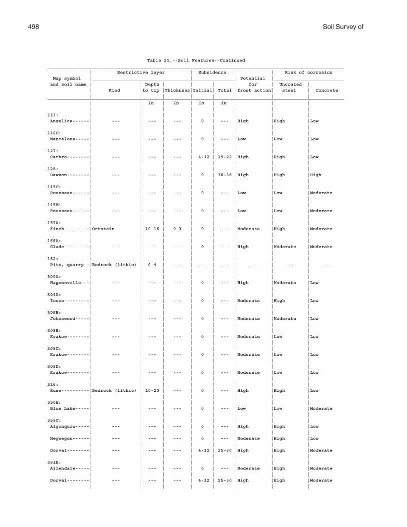
498 Soil Survey of
Table 21.--Soil Features--Continued__________________________________________________________________________________________________________ | Restrictive layer | Subsidence | | Risk of corrosion Map symbol |___________________________________|_______________| Potential |_________________________ and soil name | | Depth | | | | for | Uncoated | | Kind |to top |Thickness|Initial| Total |frost action| steel | Concrete | | | | | | | |__________________________________________________________________________________________________________ | | In | In | In | In | | | | | | | | | | |113: | | | | | | | | Angelica------| --- | --- | --- | 0 | --- |High |High |Low | | | | | | | |116C: | | | | | | | | Mancelona-----| --- | --- | --- | 0 | --- |Low |Low |Low | | | | | | | |127: | | | | | | | | Cathro--------| --- | --- | --- | 4-12 | 19-22 |High |High |Low | | | | | | | |128: | | | | | | | | Dawson--------| --- | --- | --- | 0 | 30-36 |High |High |High | | | | | | | |145C: | | | | | | | | Rousseau------| --- | --- | --- | 0 | --- |Low |Low |Moderate | | | | | | | |145E: | | | | | | | | Rousseau------| --- | --- | --- | 0 | --- |Low |Low |Moderate | | | | | | | |159A: | | | | | | | | Finch---------|Ortstein | 10-16 | 0-3 | 0 | --- |Moderate |High |Moderate | | | | | | | |166A: | | | | | | | | Slade---------| --- | --- | --- | 0 | --- |High |Moderate |Moderate | | | | | | | |182: | | | | | | | | Pits, quarry--|Bedrock (lithic) | 0-4 | --- | --- | --- | --- | --- | --- | | | | | | | |300A: | | | | | | | | Hagensville---| --- | --- | --- | 0 | --- |High |Moderate |Low | | | | | | | |304A: | | | | | | | | Iosco---------| --- | --- | --- | 0 | --- |Moderate |High |Low | | | | | | | |305B: | | | | | | | | Johnswood-----| --- | --- | --- | 0 | --- |Moderate |Moderate |Low | | | | | | | |308B: | | | | | | | | Krakow--------| --- | --- | --- | 0 | --- |Moderate |Low |Low | | | | | | | |308C: | | | | | | | | Krakow--------| --- | --- | --- | 0 | --- |Moderate |Low |Low | | | | | | | |308D: | | | | | | | | Krakow--------| --- | --- | --- | 0 | --- |Moderate |Low |Low | | | | | | | |316: | | | | | | | | Ruse----------|Bedrock (lithic) | 10-20 | --- | 0 | --- |High |High |Low | | | | | | | |350E: | | | | | | | | Blue Lake-----| --- | --- | --- | 0 | --- |Low |Low |Moderate | | | | | | | |359C: | | | | | | | | Algonquin-----| --- | --- | --- | 0 | --- |High |High |Low | | | | | | | | Negwegon------| --- | --- | --- | 0 | --- |Moderate |High |Low | | | | | | | | Dorval--------| --- | --- | --- | 4-12 | 25-30 |High |High |Moderate | | | | | | | |361B: | | | | | | | | Allendale-----| --- | --- | --- | 0 | --- |Moderate |High |Moderate | | | | | | | | Dorval--------| --- | --- | --- | 4-12 | 25-30 |High |High |Moderate | | | | | | | |
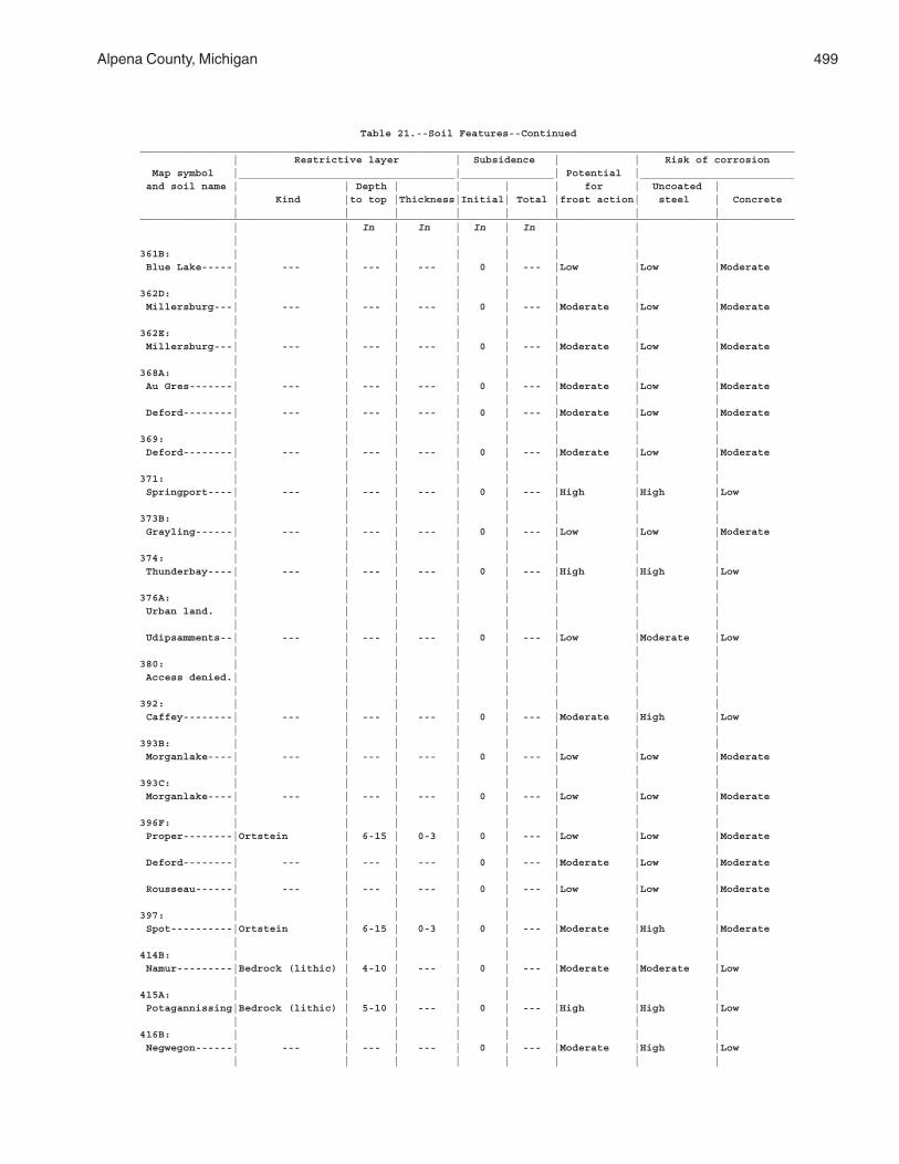
Alpena County, Michigan 499
Table 21.--Soil Features--Continued__________________________________________________________________________________________________________ | Restrictive layer | Subsidence | | Risk of corrosion Map symbol |___________________________________|_______________| Potential |_________________________ and soil name | | Depth | | | | for | Uncoated | | Kind |to top |Thickness|Initial| Total |frost action| steel | Concrete | | | | | | | |__________________________________________________________________________________________________________ | | In | In | In | In | | | | | | | | | | |361B: | | | | | | | | Blue Lake-----| --- | --- | --- | 0 | --- |Low |Low |Moderate | | | | | | | |362D: | | | | | | | | Millersburg---| --- | --- | --- | 0 | --- |Moderate |Low |Moderate | | | | | | | |362E: | | | | | | | | Millersburg---| --- | --- | --- | 0 | --- |Moderate |Low |Moderate | | | | | | | |368A: | | | | | | | | Au Gres-------| --- | --- | --- | 0 | --- |Moderate |Low |Moderate | | | | | | | | Deford--------| --- | --- | --- | 0 | --- |Moderate |Low |Moderate | | | | | | | |369: | | | | | | | | Deford--------| --- | --- | --- | 0 | --- |Moderate |Low |Moderate | | | | | | | |371: | | | | | | | | Springport----| --- | --- | --- | 0 | --- |High |High |Low | | | | | | | |373B: | | | | | | | | Grayling------| --- | --- | --- | 0 | --- |Low |Low |Moderate | | | | | | | |374: | | | | | | | | Thunderbay----| --- | --- | --- | 0 | --- |High |High |Low | | | | | | | |376A: | | | | | | | | Urban land. | | | | | | | | | | | | | | | | Udipsamments--| --- | --- | --- | 0 | --- |Low |Moderate |Low | | | | | | | |380: | | | | | | | | Access denied.| | | | | | | | | | | | | | | |392: | | | | | | | | Caffey--------| --- | --- | --- | 0 | --- |Moderate |High |Low | | | | | | | |393B: | | | | | | | | Morganlake----| --- | --- | --- | 0 | --- |Low |Low |Moderate | | | | | | | |393C: | | | | | | | | Morganlake----| --- | --- | --- | 0 | --- |Low |Low |Moderate | | | | | | | |396F: | | | | | | | | Proper--------|Ortstein | 6-15 | 0-3 | 0 | --- |Low |Low |Moderate | | | | | | | | Deford--------| --- | --- | --- | 0 | --- |Moderate |Low |Moderate | | | | | | | | Rousseau------| --- | --- | --- | 0 | --- |Low |Low |Moderate | | | | | | | |397: | | | | | | | | Spot----------|Ortstein | 6-15 | 0-3 | 0 | --- |Moderate |High |Moderate | | | | | | | |414B: | | | | | | | | Namur---------|Bedrock (lithic) | 4-10 | --- | 0 | --- |Moderate |Moderate |Low | | | | | | | |415A: | | | | | | | | Potagannissing|Bedrock (lithic) | 5-10 | --- | 0 | --- |High |High |Low | | | | | | | |416B: | | | | | | | | Negwegon------| --- | --- | --- | 0 | --- |Moderate |High |Low | | | | | | | |
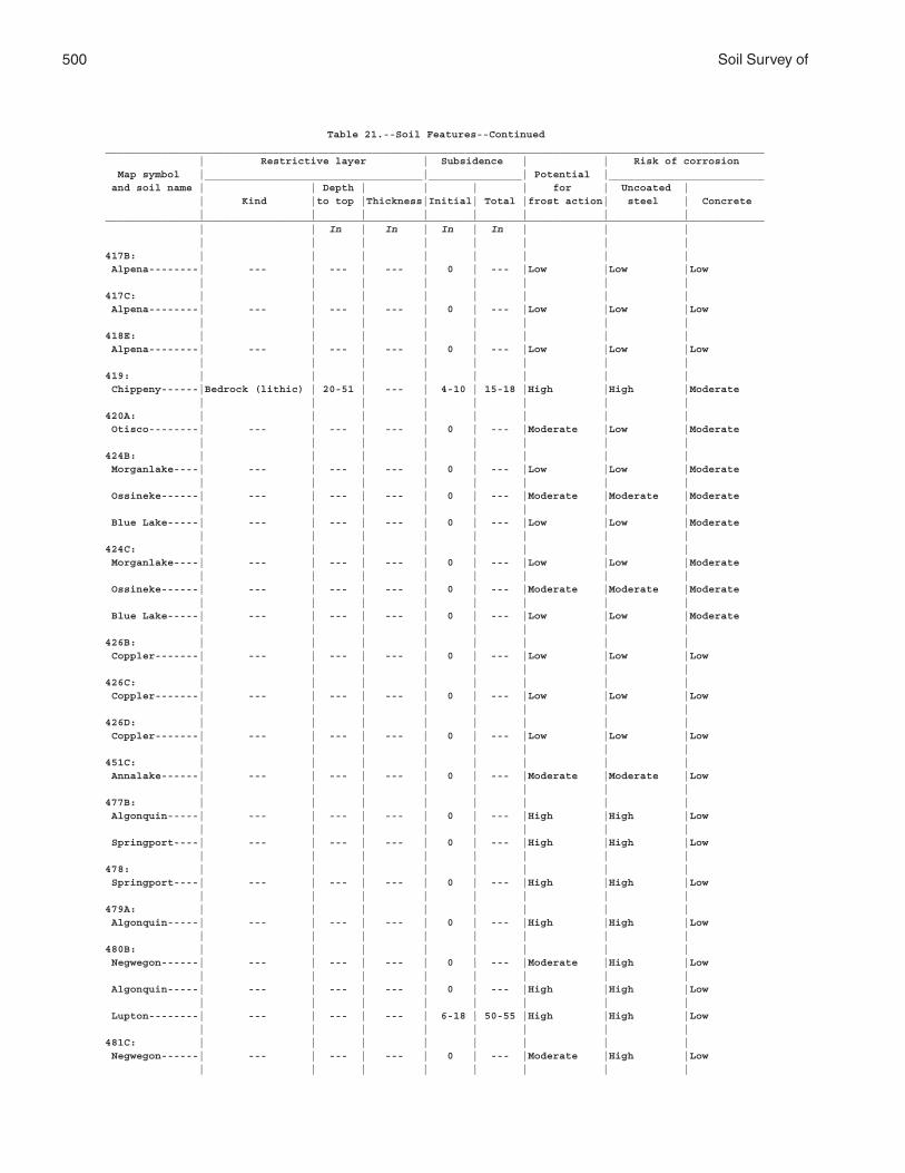
500 Soil Survey of
Table 21.--Soil Features--Continued__________________________________________________________________________________________________________ | Restrictive layer | Subsidence | | Risk of corrosion Map symbol |___________________________________|_______________| Potential |_________________________ and soil name | | Depth | | | | for | Uncoated | | Kind |to top |Thickness|Initial| Total |frost action| steel | Concrete | | | | | | | |__________________________________________________________________________________________________________ | | In | In | In | In | | | | | | | | | | |417B: | | | | | | | | Alpena--------| --- | --- | --- | 0 | --- |Low |Low |Low | | | | | | | |417C: | | | | | | | | Alpena--------| --- | --- | --- | 0 | --- |Low |Low |Low | | | | | | | |418E: | | | | | | | | Alpena--------| --- | --- | --- | 0 | --- |Low |Low |Low | | | | | | | |419: | | | | | | | | Chippeny------|Bedrock (lithic) | 20-51 | --- | 4-10 | 15-18 |High |High |Moderate | | | | | | | |420A: | | | | | | | | Otisco--------| --- | --- | --- | 0 | --- |Moderate |Low |Moderate | | | | | | | |424B: | | | | | | | | Morganlake----| --- | --- | --- | 0 | --- |Low |Low |Moderate | | | | | | | | Ossineke------| --- | --- | --- | 0 | --- |Moderate |Moderate |Moderate | | | | | | | | Blue Lake-----| --- | --- | --- | 0 | --- |Low |Low |Moderate | | | | | | | |424C: | | | | | | | | Morganlake----| --- | --- | --- | 0 | --- |Low |Low |Moderate | | | | | | | | Ossineke------| --- | --- | --- | 0 | --- |Moderate |Moderate |Moderate | | | | | | | | Blue Lake-----| --- | --- | --- | 0 | --- |Low |Low |Moderate | | | | | | | |426B: | | | | | | | | Coppler-------| --- | --- | --- | 0 | --- |Low |Low |Low | | | | | | | |426C: | | | | | | | | Coppler-------| --- | --- | --- | 0 | --- |Low |Low |Low | | | | | | | |426D: | | | | | | | | Coppler-------| --- | --- | --- | 0 | --- |Low |Low |Low | | | | | | | |451C: | | | | | | | | Annalake------| --- | --- | --- | 0 | --- |Moderate |Moderate |Low | | | | | | | |477B: | | | | | | | | Algonquin-----| --- | --- | --- | 0 | --- |High |High |Low | | | | | | | | Springport----| --- | --- | --- | 0 | --- |High |High |Low | | | | | | | |478: | | | | | | | | Springport----| --- | --- | --- | 0 | --- |High |High |Low | | | | | | | |479A: | | | | | | | | Algonquin-----| --- | --- | --- | 0 | --- |High |High |Low | | | | | | | |480B: | | | | | | | | Negwegon------| --- | --- | --- | 0 | --- |Moderate |High |Low | | | | | | | | Algonquin-----| --- | --- | --- | 0 | --- |High |High |Low | | | | | | | | Lupton--------| --- | --- | --- | 6-18 | 50-55 |High |High |Low | | | | | | | |481C: | | | | | | | | Negwegon------| --- | --- | --- | 0 | --- |Moderate |High |Low | | | | | | | |
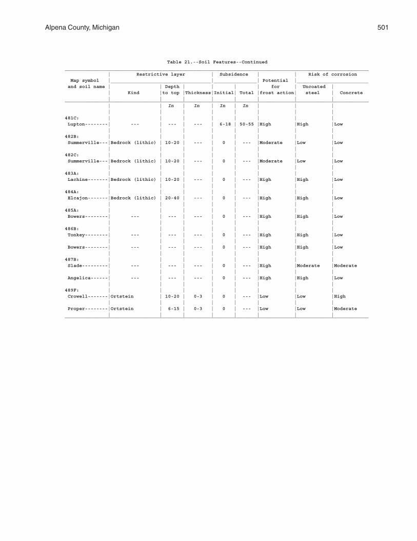
Alpena County, Michigan 501
Table 21.--Soil Features--Continued__________________________________________________________________________________________________________ | Restrictive layer | Subsidence | | Risk of corrosion Map symbol |___________________________________|_______________| Potential |_________________________ and soil name | | Depth | | | | for | Uncoated | | Kind |to top |Thickness|Initial| Total |frost action| steel | Concrete | | | | | | | |__________________________________________________________________________________________________________ | | In | In | In | In | | | | | | | | | | |481C: | | | | | | | | Lupton--------| --- | --- | --- | 6-18 | 50-55 |High |High |Low | | | | | | | |482B: | | | | | | | | Summerville---|Bedrock (lithic) | 10-20 | --- | 0 | --- |Moderate |Low |Low | | | | | | | |482C: | | | | | | | | Summerville---|Bedrock (lithic) | 10-20 | --- | 0 | --- |Moderate |Low |Low | | | | | | | |483A: | | | | | | | | Lachine-------|Bedrock (lithic) | 10-20 | --- | 0 | --- |High |High |Low | | | | | | | |484A: | | | | | | | | Elcajon-------|Bedrock (lithic) | 20-40 | --- | 0 | --- |High |High |Low | | | | | | | |485A: | | | | | | | | Bowers--------| --- | --- | --- | 0 | --- |High |High |Low | | | | | | | |486B: | | | | | | | | Tonkey--------| --- | --- | --- | 0 | --- |High |High |Low | | | | | | | | Bowers--------| --- | --- | --- | 0 | --- |High |High |Low | | | | | | | |487B: | | | | | | | | Slade---------| --- | --- | --- | 0 | --- |High |Moderate |Moderate | | | | | | | | Angelica------| --- | --- | --- | 0 | --- |High |High |Low | | | | | | | |489F: | | | | | | | | Crowell-------|Ortstein | 10-20 | 0-3 | 0 | --- |Low |Low |High | | | | | | | | Proper--------|Ortstein | 6-15 | 0-3 | 0 | --- |Low |Low |Moderate | | | | | | | |__________________________________________________________________________________________________________
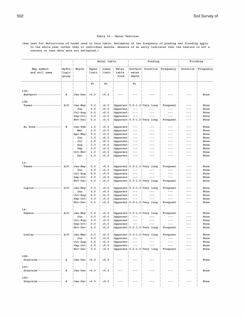
502 Soil Survey of
Table 22.--Water Features
(See text for definitions of terms used in this table. Estimates of the frequency of ponding and flooding apply to the whole year rather than to individual months. Absence of an entry indicates that the feature is not a concern or that data were not estimated.)
__________________________________________________________________________________________________________________ | | | Water table | Ponding | Flooding | | | | | ___________________________________________________________________________ Map symbol |Hydro-| Month | Upper | Lower | Water |Surface| Duration |Frequency | Duration |Frequency and soil name |logic | | limit | limit | table | water | | | | |group | | | | kind | depth | | | | | | | | | | | | | |__________________________________________________________________________________________________________________ | | | Ft | Ft | | Ft | | | | | | | | | | | | | |11B: | | | | | | | | | | Eastport--------------| A |Jan-Dec| >6.0 | >6.0 | --- | --- | --- | --- | --- | None | | | | | | | | | |12B: | | | | | | | | | | Tawas-----------------| A/D |Jan-May| 0.0 | >6.0 |Apparent|0.0-1.0|Very long | Frequent | --- | None | | Jun | 0.0 | >6.0 |Apparent| --- | --- | --- | --- | None | |Jul-Aug| 0.5 | >6.0 |Apparent| --- | --- | --- | --- | None | |Sep-Oct| 0.0 | >6.0 |Apparent| --- | --- | --- | --- | None | |Nov-Dec| 0.0 | >6.0 |Apparent|0.0-1.0|Very long | Frequent | --- | None | | | | | | | | | | Au Gres---------------| B |Jan-Feb| 1.5 | >6.0 |Apparent| --- | --- | --- | --- | None | | Mar | 1.0 | >6.0 |Apparent| --- | --- | --- | --- | None | |Apr-May| 0.5 | >6.0 |Apparent| --- | --- | --- | --- | None | | Jun | 1.0 | >6.0 |Apparent| --- | --- | --- | --- | None | | Jul | 2.0 | >6.0 |Apparent| --- | --- | --- | --- | None | | Aug | 3.0 | >6.0 |Apparent| --- | --- | --- | --- | None | | Sep | 2.0 | >6.0 |Apparent| --- | --- | --- | --- | None | |Oct-Nov| 1.0 | >6.0 |Apparent| --- | --- | --- | --- | None | | Dec | 1.5 | >6.0 |Apparent| --- | --- | --- | --- | None | | | | | | | | | |13: | | | | | | | | | | Tawas-----------------| A/D |Jan-May| 0.0 | >6.0 |Apparent|0.0-1.0|Very long | Frequent | --- | None | | Jun | 0.0 | >6.0 |Apparent| --- | --- | --- | --- | None | |Jul-Aug| 0.5 | >6.0 |Apparent| --- | --- | --- | --- | None | |Sep-Oct| 0.0 | >6.0 |Apparent| --- | --- | --- | --- | None | |Nov-Dec| 0.0 | >6.0 |Apparent|0.0-1.0|Very long | Frequent | --- | None | | | | | | | | | | Lupton----------------| A/D |Jan-May| 0.0 | >6.0 |Apparent|0.0-1.0|Very long | Frequent | --- | None | | Jun | 0.0 | >6.0 |Apparent| --- | --- | --- | --- | None | |Jul-Aug| 0.5 | >6.0 |Apparent| --- | --- | --- | --- | None | |Sep-Oct| 0.0 | >6.0 |Apparent| --- | --- | --- | --- | None | |Nov-Dec| 0.0 | >6.0 |Apparent|0.0-1.0|Very long | Frequent | --- | None | | | | | | | | | |14: | | | | | | | | | | Dawson----------------| A/D |Jan-May| 0.0 | >6.0 |Apparent|0.0-1.0|Very long | Frequent | --- | None | | Jun | 0.0 | >6.0 |Apparent| --- | --- | --- | --- | None | |Jul-Aug| 0.5 | >6.0 |Apparent| --- | --- | --- | --- | None | |Sep-Oct| 0.0 | >6.0 |Apparent| --- | --- | --- | --- | None | |Nov-Dec| 0.0 | >6.0 |Apparent|0.0-1.0|Very long | Frequent | --- | None | | | | | | | | | | Loxley----------------| A/D |Jan-May| 0.0 | >6.0 |Apparent|0.0-1.0|Very long | Frequent | --- | None | | Jun | 0.0 | >6.0 |Apparent| --- | --- | --- | --- | None | |Jul-Aug| 0.5 | >6.0 |Apparent| --- | --- | --- | --- | None | |Sep-Oct| 0.0 | >6.0 |Apparent| --- | --- | --- | --- | None | |Nov-Dec| 0.0 | >6.0 |Apparent|0.0-1.0|Very long | Frequent | --- | None | | | | | | | | | |16B: | | | | | | | | | | Graycalm--------------| A |Jan-Dec| >6.0 | >6.0 | --- | --- | --- | --- | --- | None | | | | | | | | | |16C: | | | | | | | | | | Graycalm--------------| A |Jan-Dec| >6.0 | >6.0 | --- | --- | --- | --- | --- | None | | | | | | | | | |16D: | | | | | | | | | | Graycalm--------------| A |Jan-Dec| >6.0 | >6.0 | --- | --- | --- | --- | --- | None | | | | | | | | | |
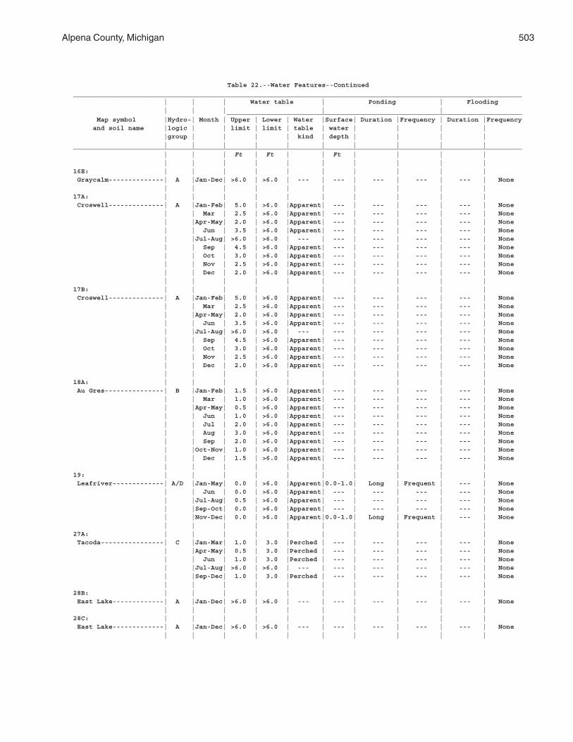
Alpena County, Michigan 503
Table 22.--Water Features--Continued__________________________________________________________________________________________________________________ | | | Water table | Ponding | Flooding | | | | | ___________________________________________________________________________ Map symbol |Hydro-| Month | Upper | Lower | Water |Surface| Duration |Frequency | Duration |Frequency and soil name |logic | | limit | limit | table | water | | | | |group | | | | kind | depth | | | | | | | | | | | | | |__________________________________________________________________________________________________________________ | | | Ft | Ft | | Ft | | | | | | | | | | | | | |16E: | | | | | | | | | | Graycalm--------------| A |Jan-Dec| >6.0 | >6.0 | --- | --- | --- | --- | --- | None | | | | | | | | | |17A: | | | | | | | | | | Croswell--------------| A |Jan-Feb| 5.0 | >6.0 |Apparent| --- | --- | --- | --- | None | | Mar | 2.5 | >6.0 |Apparent| --- | --- | --- | --- | None | |Apr-May| 2.0 | >6.0 |Apparent| --- | --- | --- | --- | None | | Jun | 3.5 | >6.0 |Apparent| --- | --- | --- | --- | None | |Jul-Aug| >6.0 | >6.0 | --- | --- | --- | --- | --- | None | | Sep | 4.5 | >6.0 |Apparent| --- | --- | --- | --- | None | | Oct | 3.0 | >6.0 |Apparent| --- | --- | --- | --- | None | | Nov | 2.5 | >6.0 |Apparent| --- | --- | --- | --- | None | | Dec | 2.0 | >6.0 |Apparent| --- | --- | --- | --- | None | | | | | | | | | |17B: | | | | | | | | | | Croswell--------------| A |Jan-Feb| 5.0 | >6.0 |Apparent| --- | --- | --- | --- | None | | Mar | 2.5 | >6.0 |Apparent| --- | --- | --- | --- | None | |Apr-May| 2.0 | >6.0 |Apparent| --- | --- | --- | --- | None | | Jun | 3.5 | >6.0 |Apparent| --- | --- | --- | --- | None | |Jul-Aug| >6.0 | >6.0 | --- | --- | --- | --- | --- | None | | Sep | 4.5 | >6.0 |Apparent| --- | --- | --- | --- | None | | Oct | 3.0 | >6.0 |Apparent| --- | --- | --- | --- | None | | Nov | 2.5 | >6.0 |Apparent| --- | --- | --- | --- | None | | Dec | 2.0 | >6.0 |Apparent| --- | --- | --- | --- | None | | | | | | | | | |18A: | | | | | | | | | | Au Gres---------------| B |Jan-Feb| 1.5 | >6.0 |Apparent| --- | --- | --- | --- | None | | Mar | 1.0 | >6.0 |Apparent| --- | --- | --- | --- | None | |Apr-May| 0.5 | >6.0 |Apparent| --- | --- | --- | --- | None | | Jun | 1.0 | >6.0 |Apparent| --- | --- | --- | --- | None | | Jul | 2.0 | >6.0 |Apparent| --- | --- | --- | --- | None | | Aug | 3.0 | >6.0 |Apparent| --- | --- | --- | --- | None | | Sep | 2.0 | >6.0 |Apparent| --- | --- | --- | --- | None | |Oct-Nov| 1.0 | >6.0 |Apparent| --- | --- | --- | --- | None | | Dec | 1.5 | >6.0 |Apparent| --- | --- | --- | --- | None | | | | | | | | | |19: | | | | | | | | | | Leafriver-------------| A/D |Jan-May| 0.0 | >6.0 |Apparent|0.0-1.0| Long | Frequent | --- | None | | Jun | 0.0 | >6.0 |Apparent| --- | --- | --- | --- | None | |Jul-Aug| 0.5 | >6.0 |Apparent| --- | --- | --- | --- | None | |Sep-Oct| 0.0 | >6.0 |Apparent| --- | --- | --- | --- | None | |Nov-Dec| 0.0 | >6.0 |Apparent|0.0-1.0| Long | Frequent | --- | None | | | | | | | | | |27A: | | | | | | | | | | Tacoda----------------| C |Jan-Mar| 1.0 | 3.0 |Perched | --- | --- | --- | --- | None | |Apr-May| 0.5 | 3.0 |Perched | --- | --- | --- | --- | None | | Jun | 1.0 | 3.0 |Perched | --- | --- | --- | --- | None | |Jul-Aug| >6.0 | >6.0 | --- | --- | --- | --- | --- | None | |Sep-Dec| 1.0 | 3.0 |Perched | --- | --- | --- | --- | None | | | | | | | | | |28B: | | | | | | | | | | East Lake-------------| A |Jan-Dec| >6.0 | >6.0 | --- | --- | --- | --- | --- | None | | | | | | | | | |28C: | | | | | | | | | | East Lake-------------| A |Jan-Dec| >6.0 | >6.0 | --- | --- | --- | --- | --- | None | | | | | | | | | |
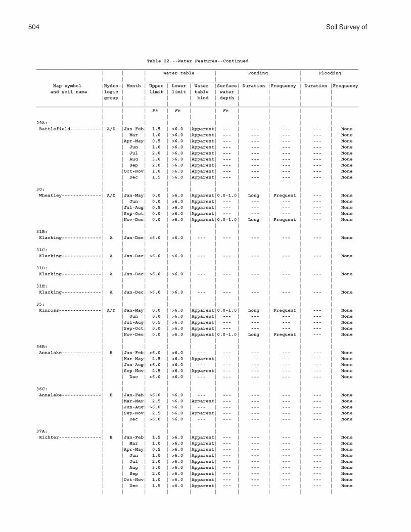
504 Soil Survey of
Table 22.--Water Features--Continued__________________________________________________________________________________________________________________ | | | Water table | Ponding | Flooding | | | | | ___________________________________________________________________________ Map symbol |Hydro-| Month | Upper | Lower | Water |Surface| Duration |Frequency | Duration |Frequency and soil name |logic | | limit | limit | table | water | | | | |group | | | | kind | depth | | | | | | | | | | | | | |__________________________________________________________________________________________________________________ | | | Ft | Ft | | Ft | | | | | | | | | | | | | |29A: | | | | | | | | | | Battlefield-----------| A/D |Jan-Feb| 1.5 | >6.0 |Apparent| --- | --- | --- | --- | None | | Mar | 1.0 | >6.0 |Apparent| --- | --- | --- | --- | None | |Apr-May| 0.5 | >6.0 |Apparent| --- | --- | --- | --- | None | | Jun | 1.0 | >6.0 |Apparent| --- | --- | --- | --- | None | | Jul | 2.0 | >6.0 |Apparent| --- | --- | --- | --- | None | | Aug | 3.0 | >6.0 |Apparent| --- | --- | --- | --- | None | | Sep | 2.0 | >6.0 |Apparent| --- | --- | --- | --- | None | |Oct-Nov| 1.0 | >6.0 |Apparent| --- | --- | --- | --- | None | | Dec | 1.5 | >6.0 |Apparent| --- | --- | --- | --- | None | | | | | | | | | |30: | | | | | | | | | | Wheatley--------------| A/D |Jan-May| 0.0 | >6.0 |Apparent|0.0-1.0| Long | Frequent | --- | None | | Jun | 0.0 | >6.0 |Apparent| --- | --- | --- | --- | None | |Jul-Aug| 0.5 | >6.0 |Apparent| --- | --- | --- | --- | None | |Sep-Oct| 0.0 | >6.0 |Apparent| --- | --- | --- | --- | None | |Nov-Dec| 0.0 | >6.0 |Apparent|0.0-1.0| Long | Frequent | --- | None | | | | | | | | | |31B: | | | | | | | | | | Klacking--------------| A |Jan-Dec| >6.0 | >6.0 | --- | --- | --- | --- | --- | None | | | | | | | | | |31C: | | | | | | | | | | Klacking--------------| A |Jan-Dec| >6.0 | >6.0 | --- | --- | --- | --- | --- | None | | | | | | | | | |31D: | | | | | | | | | | Klacking--------------| A |Jan-Dec| >6.0 | >6.0 | --- | --- | --- | --- | --- | None | | | | | | | | | |31E: | | | | | | | | | | Klacking--------------| A |Jan-Dec| >6.0 | >6.0 | --- | --- | --- | --- | --- | None | | | | | | | | | |35: | | | | | | | | | | Kinross---------------| A/D |Jan-May| 0.0 | >6.0 |Apparent|0.0-1.0| Long | Frequent | --- | None | | Jun | 0.0 | >6.0 |Apparent| --- | --- | --- | --- | None | |Jul-Aug| 0.5 | >6.0 |Apparent| --- | --- | --- | --- | None | |Sep-Oct| 0.0 | >6.0 |Apparent| --- | --- | --- | --- | None | |Nov-Dec| 0.0 | >6.0 |Apparent|0.0-1.0| Long | Frequent | --- | None | | | | | | | | | |36B: | | | | | | | | | | Annalake--------------| B |Jan-Feb| >6.0 | >6.0 | --- | --- | --- | --- | --- | None | |Mar-May| 2.5 | >6.0 |Apparent| --- | --- | --- | --- | None | |Jun-Aug| >6.0 | >6.0 | --- | --- | --- | --- | --- | None | |Sep-Nov| 2.5 | >6.0 |Apparent| --- | --- | --- | --- | None | | Dec | >6.0 | >6.0 | --- | --- | --- | --- | --- | None | | | | | | | | | |36C: | | | | | | | | | | Annalake--------------| B |Jan-Feb| >6.0 | >6.0 | --- | --- | --- | --- | --- | None | |Mar-May| 2.5 | >6.0 |Apparent| --- | --- | --- | --- | None | |Jun-Aug| >6.0 | >6.0 | --- | --- | --- | --- | --- | None | |Sep-Nov| 2.5 | >6.0 |Apparent| --- | --- | --- | --- | None | | Dec | >6.0 | >6.0 | --- | --- | --- | --- | --- | None | | | | | | | | | |37A: | | | | | | | | | | Richter---------------| B |Jan-Feb| 1.5 | >6.0 |Apparent| --- | --- | --- | --- | None | | Mar | 1.0 | >6.0 |Apparent| --- | --- | --- | --- | None | |Apr-May| 0.5 | >6.0 |Apparent| --- | --- | --- | --- | None | | Jun | 1.0 | >6.0 |Apparent| --- | --- | --- | --- | None | | Jul | 2.0 | >6.0 |Apparent| --- | --- | --- | --- | None | | Aug | 3.0 | >6.0 |Apparent| --- | --- | --- | --- | None | | Sep | 2.0 | >6.0 |Apparent| --- | --- | --- | --- | None | |Oct-Nov| 1.0 | >6.0 |Apparent| --- | --- | --- | --- | None | | Dec | 1.5 | >6.0 |Apparent| --- | --- | --- | --- | None | | | | | | | | | |
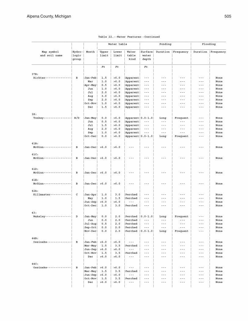
Alpena County, Michigan 505
Table 22.--Water Features--Continued__________________________________________________________________________________________________________________ | | | Water table | Ponding | Flooding | | | | | ___________________________________________________________________________ Map symbol |Hydro-| Month | Upper | Lower | Water |Surface| Duration |Frequency | Duration |Frequency and soil name |logic | | limit | limit | table | water | | | | |group | | | | kind | depth | | | | | | | | | | | | | |__________________________________________________________________________________________________________________ | | | Ft | Ft | | Ft | | | | | | | | | | | | | |37B: | | | | | | | | | | Richter---------------| B |Jan-Feb| 1.5 | >6.0 |Apparent| --- | --- | --- | --- | None | | Mar | 1.0 | >6.0 |Apparent| --- | --- | --- | --- | None | |Apr-May| 0.5 | >6.0 |Apparent| --- | --- | --- | --- | None | | Jun | 1.0 | >6.0 |Apparent| --- | --- | --- | --- | None | | Jul | 2.0 | >6.0 |Apparent| --- | --- | --- | --- | None | | Aug | 3.0 | >6.0 |Apparent| --- | --- | --- | --- | None | | Sep | 2.0 | >6.0 |Apparent| --- | --- | --- | --- | None | |Oct-Nov| 1.0 | >6.0 |Apparent| --- | --- | --- | --- | None | | Dec | 1.5 | >6.0 |Apparent| --- | --- | --- | --- | None | | | | | | | | | |38: | | | | | | | | | | Tonkey----------------| B/D |Jan-May| 0.0 | >6.0 |Apparent|0.0-1.0| Long | Frequent | --- | None | | Jun | 0.5 | >6.0 |Apparent| --- | --- | --- | --- | None | | Jul | 1.5 | >6.0 |Apparent| --- | --- | --- | --- | None | | Aug | 2.0 | >6.0 |Apparent| --- | --- | --- | --- | None | | Sep | 1.0 | >6.0 |Apparent| --- | --- | --- | --- | None | |Oct-Dec| 0.0 | >6.0 |Apparent|0.0-1.0| Long | Frequent | --- | None | | | | | | | | | |41B: | | | | | | | | | | McGinn----------------| B |Jan-Dec| >6.0 | >6.0 | --- | --- | --- | --- | --- | None | | | | | | | | | |41C: | | | | | | | | | | McGinn----------------| B |Jan-Dec| >6.0 | >6.0 | --- | --- | --- | --- | --- | None | | | | | | | | | | | | | | | | | | | |41D: | | | | | | | | | | McGinn----------------| B |Jan-Dec| >6.0 | >6.0 | --- | --- | --- | --- | --- | None | | | | | | | | | |41E: | | | | | | | | | | McGinn----------------| B |Jan-Dec| >6.0 | >6.0 | --- | --- | --- | --- | --- | None | | | | | | | | | |42A: | | | | | | | | | | Killmaster------------| C |Jan-Apr| 1.0 | 3.0 |Perched | --- | --- | --- | --- | None | | May | 1.0 | 1.5 |Perched | --- | --- | --- | --- | None | |Jun-Sep| >6.0 | >6.0 | --- | --- | --- | --- | --- | None | |Oct-Dec| 1.0 | 3.0 |Perched | --- | --- | --- | --- | None | | | | | | | | | |43: | | | | | | | | | | Wakeley---------------| D |Jan-May| 0.0 | 2.0 |Perched |0.0-1.0| Long | Frequent | --- | None | | Jun | 0.0 | 2.0 |Perched | --- | --- | --- | --- | None | |Jul-Aug| 0.5 | 2.0 |Perched | --- | --- | --- | --- | None | |Sep-Oct| 0.0 | 2.0 |Perched | --- | --- | --- | --- | None | |Nov-Dec| 0.0 | 2.0 |Perched |0.0-1.0| Long | Frequent | --- | None | | | | | | | | | |44B: | | | | | | | | | | Ossineke--------------| B |Jan-Feb| >6.0 | >6.0 | --- | --- | --- | --- | --- | None | |Mar-May| 1.5 | 3.5 |Perched | --- | --- | --- | --- | None | |Jun-Sep| >6.0 | >6.0 | --- | --- | --- | --- | --- | None | |Oct-Nov| 1.5 | 3.5 |Perched | --- | --- | --- | --- | None | | Dec | >6.0 | >6.0 | --- | --- | --- | --- | --- | None | | | | | | | | | |44C: | | | | | | | | | | Ossineke--------------| B |Jan-Feb| >6.0 | >6.0 | --- | --- | --- | --- | --- | None | |Mar-May| 1.5 | 3.5 |Perched | --- | --- | --- | --- | None | |Jun-Sep| >6.0 | >6.0 | --- | --- | --- | --- | --- | None | |Oct-Nov| 1.5 | 3.5 |Perched | --- | --- | --- | --- | None | | Dec | >6.0 | >6.0 | --- | --- | --- | --- | --- | None | | | | | | | | | |
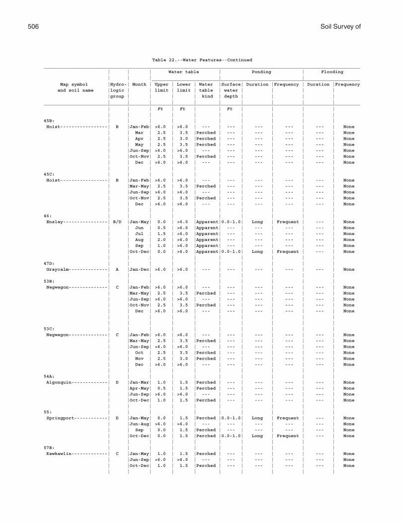
506 Soil Survey of
Table 22.--Water Features--Continued__________________________________________________________________________________________________________________ | | | Water table | Ponding | Flooding | | | | | ___________________________________________________________________________ Map symbol |Hydro-| Month | Upper | Lower | Water |Surface| Duration |Frequency | Duration |Frequency and soil name |logic | | limit | limit | table | water | | | | |group | | | | kind | depth | | | | | | | | | | | | | |__________________________________________________________________________________________________________________ | | | Ft | Ft | | Ft | | | | | | | | | | | | | |45B: | | | | | | | | | | Hoist-----------------| B |Jan-Feb| >6.0 | >6.0 | --- | --- | --- | --- | --- | None | | Mar | 2.5 | 3.5 |Perched | --- | --- | --- | --- | None | | Apr | 2.5 | 3.0 |Perched | --- | --- | --- | --- | None | | May | 2.5 | 3.5 |Perched | --- | --- | --- | --- | None | |Jun-Sep| >6.0 | >6.0 | --- | --- | --- | --- | --- | None | |Oct-Nov| 2.5 | 3.5 |Perched | --- | --- | --- | --- | None | | Dec | >6.0 | >6.0 | --- | --- | --- | --- | --- | None | | | | | | | | | |45C: | | | | | | | | | | Hoist-----------------| B |Jan-Feb| >6.0 | >6.0 | --- | --- | --- | --- | --- | None | |Mar-May| 2.5 | 3.5 |Perched | --- | --- | --- | --- | None | |Jun-Sep| >6.0 | >6.0 | --- | --- | --- | --- | --- | None | |Oct-Nov| 2.5 | 3.5 |Perched | --- | --- | --- | --- | None | | Dec | >6.0 | >6.0 | --- | --- | --- | --- | --- | None | | | | | | | | | |46: | | | | | | | | | | Ensley----------------| B/D |Jan-May| 0.0 | >6.0 |Apparent|0.0-1.0| Long | Frequent | --- | None | | Jun | 0.5 | >6.0 |Apparent| --- | --- | --- | --- | None | | Jul | 1.5 | >6.0 |Apparent| --- | --- | --- | --- | None | | Aug | 2.0 | >6.0 |Apparent| --- | --- | --- | --- | None | | Sep | 1.0 | >6.0 |Apparent| --- | --- | --- | --- | None | |Oct-Dec| 0.0 | >6.0 |Apparent|0.0-1.0| Long | Frequent | --- | None | | | | | | | | | |47D: | | | | | | | | | | Graycalm--------------| A |Jan-Dec| >6.0 | >6.0 | --- | --- | --- | --- | --- | None | | | | | | | | | |53B: | | | | | | | | | | Negwegon--------------| C |Jan-Feb| >6.0 | >6.0 | --- | --- | --- | --- | --- | None | |Mar-May| 2.5 | 3.5 |Perched | --- | --- | --- | --- | None | |Jun-Sep| >6.0 | >6.0 | --- | --- | --- | --- | --- | None | |Oct-Nov| 2.5 | 3.5 |Perched | --- | --- | --- | --- | None | | Dec | >6.0 | >6.0 | --- | --- | --- | --- | --- | None | | | | | | | | | | | | | | | | | | | |53C: | | | | | | | | | | Negwegon--------------| C |Jan-Feb| >6.0 | >6.0 | --- | --- | --- | --- | --- | None | |Mar-May| 2.5 | 3.5 |Perched | --- | --- | --- | --- | None | |Jun-Sep| >6.0 | >6.0 | --- | --- | --- | --- | --- | None | | Oct | 2.5 | 3.5 |Perched | --- | --- | --- | --- | None | | Nov | 2.5 | 3.0 |Perched | --- | --- | --- | --- | None | | Dec | >6.0 | >6.0 | --- | --- | --- | --- | --- | None | | | | | | | | | |54A: | | | | | | | | | | Algonquin-------------| D |Jan-Mar| 1.0 | 1.5 |Perched | --- | --- | --- | --- | None | |Apr-May| 0.5 | 1.5 |Perched | --- | --- | --- | --- | None | |Jun-Sep| >6.0 | >6.0 | --- | --- | --- | --- | --- | None | |Oct-Dec| 1.0 | 1.5 |Perched | --- | --- | --- | --- | None | | | | | | | | | |55: | | | | | | | | | | Springport------------| D |Jan-May| 0.0 | 1.5 |Perched |0.0-1.0| Long | Frequent | --- | None | |Jun-Aug| >6.0 | >6.0 | --- | --- | --- | --- | --- | None | | Sep | 0.0 | 1.5 |Perched | --- | --- | --- | --- | None | |Oct-Dec| 0.0 | 1.5 |Perched |0.0-1.0| Long | Frequent | --- | None | | | | | | | | | |57B: | | | | | | | | | | Kawkawlin-------------| C |Jan-May| 1.0 | 1.5 |Perched | --- | --- | --- | --- | None | |Jun-Sep| >6.0 | >6.0 | --- | --- | --- | --- | --- | None | |Oct-Dec| 1.0 | 1.5 |Perched | --- | --- | --- | --- | None | | | | | | | | | |
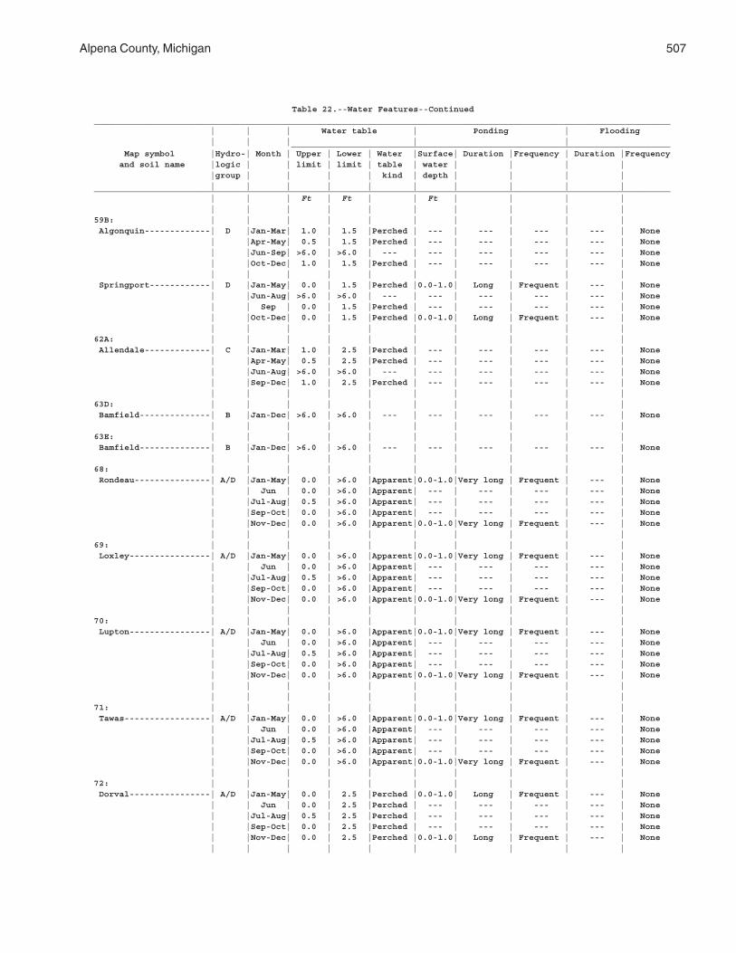
Alpena County, Michigan 507
Table 22.--Water Features--Continued__________________________________________________________________________________________________________________ | | | Water table | Ponding | Flooding | | | | | ___________________________________________________________________________ Map symbol |Hydro-| Month | Upper | Lower | Water |Surface| Duration |Frequency | Duration |Frequency and soil name |logic | | limit | limit | table | water | | | | |group | | | | kind | depth | | | | | | | | | | | | | |__________________________________________________________________________________________________________________ | | | Ft | Ft | | Ft | | | | | | | | | | | | | |59B: | | | | | | | | | | Algonquin-------------| D |Jan-Mar| 1.0 | 1.5 |Perched | --- | --- | --- | --- | None | |Apr-May| 0.5 | 1.5 |Perched | --- | --- | --- | --- | None | |Jun-Sep| >6.0 | >6.0 | --- | --- | --- | --- | --- | None | |Oct-Dec| 1.0 | 1.5 |Perched | --- | --- | --- | --- | None | | | | | | | | | | Springport------------| D |Jan-May| 0.0 | 1.5 |Perched |0.0-1.0| Long | Frequent | --- | None | |Jun-Aug| >6.0 | >6.0 | --- | --- | --- | --- | --- | None | | Sep | 0.0 | 1.5 |Perched | --- | --- | --- | --- | None | |Oct-Dec| 0.0 | 1.5 |Perched |0.0-1.0| Long | Frequent | --- | None | | | | | | | | | |62A: | | | | | | | | | | Allendale-------------| C |Jan-Mar| 1.0 | 2.5 |Perched | --- | --- | --- | --- | None | |Apr-May| 0.5 | 2.5 |Perched | --- | --- | --- | --- | None | |Jun-Aug| >6.0 | >6.0 | --- | --- | --- | --- | --- | None | |Sep-Dec| 1.0 | 2.5 |Perched | --- | --- | --- | --- | None | | | | | | | | | |63D: | | | | | | | | | | Bamfield--------------| B |Jan-Dec| >6.0 | >6.0 | --- | --- | --- | --- | --- | None | | | | | | | | | |63E: | | | | | | | | | | Bamfield--------------| B |Jan-Dec| >6.0 | >6.0 | --- | --- | --- | --- | --- | None | | | | | | | | | |68: | | | | | | | | | | Rondeau---------------| A/D |Jan-May| 0.0 | >6.0 |Apparent|0.0-1.0|Very long | Frequent | --- | None | | Jun | 0.0 | >6.0 |Apparent| --- | --- | --- | --- | None | |Jul-Aug| 0.5 | >6.0 |Apparent| --- | --- | --- | --- | None | |Sep-Oct| 0.0 | >6.0 |Apparent| --- | --- | --- | --- | None | |Nov-Dec| 0.0 | >6.0 |Apparent|0.0-1.0|Very long | Frequent | --- | None | | | | | | | | | |69: | | | | | | | | | | Loxley----------------| A/D |Jan-May| 0.0 | >6.0 |Apparent|0.0-1.0|Very long | Frequent | --- | None | | Jun | 0.0 | >6.0 |Apparent| --- | --- | --- | --- | None | |Jul-Aug| 0.5 | >6.0 |Apparent| --- | --- | --- | --- | None | |Sep-Oct| 0.0 | >6.0 |Apparent| --- | --- | --- | --- | None | |Nov-Dec| 0.0 | >6.0 |Apparent|0.0-1.0|Very long | Frequent | --- | None | | | | | | | | | |70: | | | | | | | | | | Lupton----------------| A/D |Jan-May| 0.0 | >6.0 |Apparent|0.0-1.0|Very long | Frequent | --- | None | | Jun | 0.0 | >6.0 |Apparent| --- | --- | --- | --- | None | |Jul-Aug| 0.5 | >6.0 |Apparent| --- | --- | --- | --- | None | |Sep-Oct| 0.0 | >6.0 |Apparent| --- | --- | --- | --- | None | |Nov-Dec| 0.0 | >6.0 |Apparent|0.0-1.0|Very long | Frequent | --- | None | | | | | | | | | | | | | | | | | | | |71: | | | | | | | | | | Tawas-----------------| A/D |Jan-May| 0.0 | >6.0 |Apparent|0.0-1.0|Very long | Frequent | --- | None | | Jun | 0.0 | >6.0 |Apparent| --- | --- | --- | --- | None | |Jul-Aug| 0.5 | >6.0 |Apparent| --- | --- | --- | --- | None | |Sep-Oct| 0.0 | >6.0 |Apparent| --- | --- | --- | --- | None | |Nov-Dec| 0.0 | >6.0 |Apparent|0.0-1.0|Very long | Frequent | --- | None | | | | | | | | | |72: | | | | | | | | | | Dorval----------------| A/D |Jan-May| 0.0 | 2.5 |Perched |0.0-1.0| Long | Frequent | --- | None | | Jun | 0.0 | 2.5 |Perched | --- | --- | --- | --- | None | |Jul-Aug| 0.5 | 2.5 |Perched | --- | --- | --- | --- | None | |Sep-Oct| 0.0 | 2.5 |Perched | --- | --- | --- | --- | None | |Nov-Dec| 0.0 | 2.5 |Perched |0.0-1.0| Long | Frequent | --- | None | | | | | | | | | |
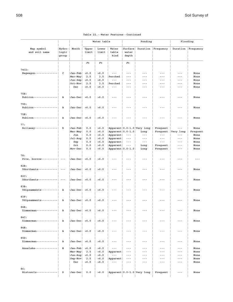
508 Soil Survey of
Table 22.--Water Features--Continued__________________________________________________________________________________________________________________ | | | Water table | Ponding | Flooding | | | | | ___________________________________________________________________________ Map symbol |Hydro-| Month | Upper | Lower | Water |Surface| Duration |Frequency | Duration |Frequency and soil name |logic | | limit | limit | table | water | | | | |group | | | | kind | depth | | | | | | | | | | | | | |__________________________________________________________________________________________________________________ | | | Ft | Ft | | Ft | | | | | | | | | | | | | |74C2: | | | | | | | | | | Negwegon--------------| C |Jan-Feb| >6.0 | >6.0 | --- | --- | --- | --- | --- | None | |Mar-May| 2.5 | 3.5 |Perched | --- | --- | --- | --- | None | |Jun-Sep| >6.0 | >6.0 | --- | --- | --- | --- | --- | None | |Oct-Nov| 2.5 | 3.5 |Perched | --- | --- | --- | --- | None | | Dec | >6.0 | >6.0 | --- | --- | --- | --- | --- | None | | | | | | | | | |75B: | | | | | | | | | | Rubicon---------------| A |Jan-Dec| >6.0 | >6.0 | --- | --- | --- | --- | --- | None | | | | | | | | | |75D: | | | | | | | | | | Rubicon---------------| A |Jan-Dec| >6.0 | >6.0 | --- | --- | --- | --- | --- | None | | | | | | | | | |75E: | | | | | | | | | | Rubicon---------------| A |Jan-Dec| >6.0 | >6.0 | --- | --- | --- | --- | --- | None | | | | | | | | | |77: | | | | | | | | | | Rollaway--------------| D |Jan-Feb| 0.0 | >6.0 |Apparent|0.0-1.0|Very long | Frequent | --- | None | |Mar-May| 0.0 | >6.0 |Apparent|0.0-1.0| Long | Frequent |Very long | Frequent | | Jun | 0.0 | >6.0 |Apparent| --- | --- | --- | --- | None | |Jul-Aug| 0.5 | >6.0 |Apparent| --- | --- | --- | --- | None | | Sep | 0.0 | >6.0 |Apparent| --- | --- | --- | --- | None | | Oct | 0.0 | >6.0 |Apparent| --- | Long | Frequent | --- | None | |Nov-Dec| 0.0 | >6.0 |Apparent|0.0-1.0| Long | Frequent | --- | None | | | | | | | | | |78: | | | | | | | | | | Pits, borrow----------| --- |Jan-Dec| >6.0 | >6.0 | --- | --- | --- | --- | --- | --- | | | | | | | | | |82B: | | | | | | | | | | Udorthents------------| --- |Jan-Dec| >6.0 | >6.0 | --- | --- | --- | --- | --- | None | | | | | | | | | |82C: | | | | | | | | | | Udorthents------------| --- |Jan-Dec| >6.0 | >6.0 | --- | --- | --- | --- | --- | None | | | | | | | | | |83B: | | | | | | | | | | Udipsamments----------| A |Jan-Dec| >6.0 | >6.0 | --- | --- | --- | --- | --- | None | | | | | | | | | |83F: | | | | | | | | | | Udipsamments----------| A |Jan-Dec| >6.0 | >6.0 | --- | --- | --- | --- | --- | None | | | | | | | | | |84B: | | | | | | | | | | Zimmerman-------------| A |Jan-Dec| >6.0 | >6.0 | --- | --- | --- | --- | --- | None | | | | | | | | | |84C: | | | | | | | | | | Zimmerman-------------| A |Jan-Dec| >6.0 | >6.0 | --- | --- | --- | --- | --- | None | | | | | | | | | |84E: | | | | | | | | | | Zimmerman-------------| A |Jan-Dec| >6.0 | >6.0 | --- | --- | --- | --- | --- | None | | | | | | | | | |85D: | | | | | | | | | | Zimmerman-------------| A |Jan-Dec| >6.0 | >6.0 | --- | --- | --- | --- | --- | None | | | | | | | | | | Annalake--------------| B |Jan-Feb| >6.0 | >6.0 | --- | --- | --- | --- | --- | None | |Mar-May| 2.5 | >6.0 |Apparent| --- | --- | --- | --- | None | |Jun-Aug| >6.0 | >6.0 | --- | --- | --- | --- | --- | None | |Sep-Nov| 2.5 | >6.0 |Apparent| --- | --- | --- | --- | None | | Dec | >6.0 | >6.0 | --- | --- | --- | --- | --- | None | | | | | | | | | |86: | | | | | | | | | | Histosols-------------| D |Jan-Dec| 0.0 | >6.0 |Apparent|0.0-1.0|Very long | Frequent | --- | None | | | | | | | | | |
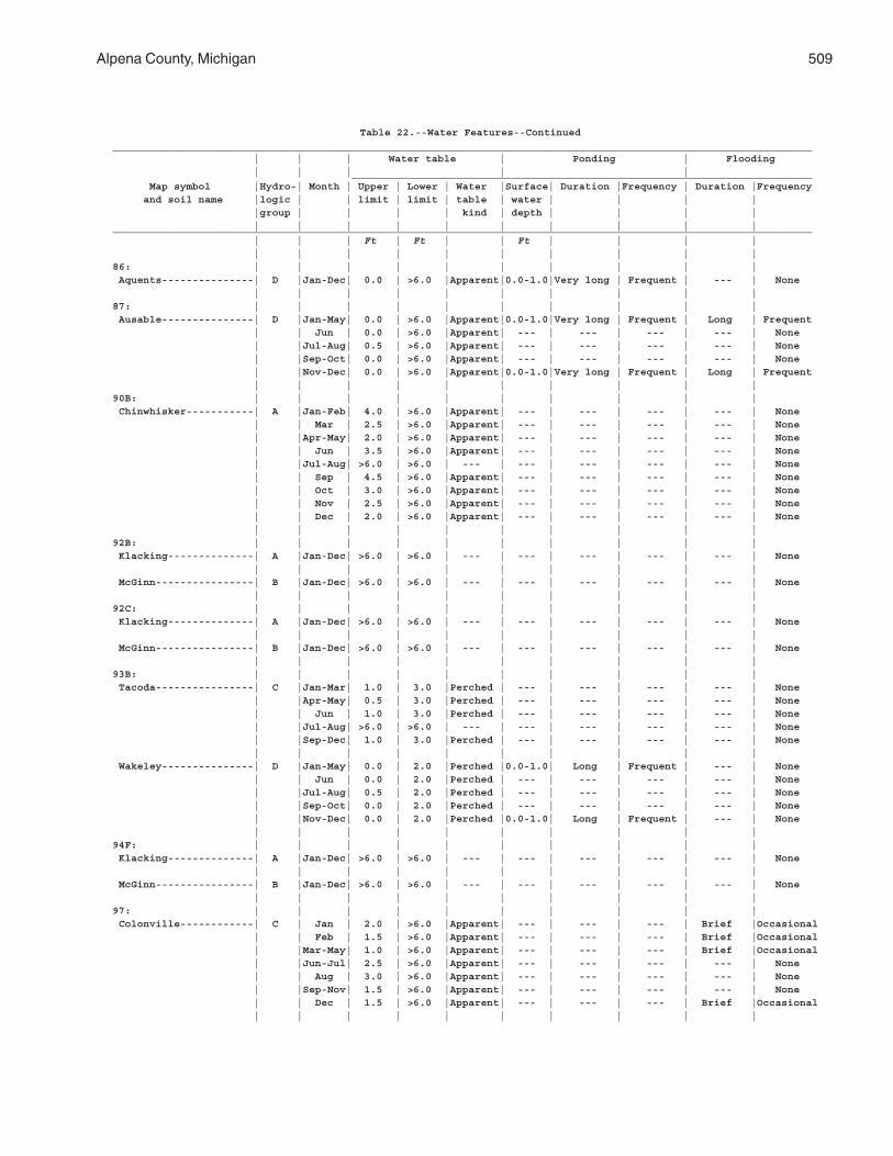
Alpena County, Michigan 509
Table 22.--Water Features--Continued__________________________________________________________________________________________________________________ | | | Water table | Ponding | Flooding | | | | | ___________________________________________________________________________ Map symbol |Hydro-| Month | Upper | Lower | Water |Surface| Duration |Frequency | Duration |Frequency and soil name |logic | | limit | limit | table | water | | | | |group | | | | kind | depth | | | | | | | | | | | | | |__________________________________________________________________________________________________________________ | | | Ft | Ft | | Ft | | | | | | | | | | | | | |86: | | | | | | | | | | Aquents---------------| D |Jan-Dec| 0.0 | >6.0 |Apparent|0.0-1.0|Very long | Frequent | --- | None | | | | | | | | | |87: | | | | | | | | | | Ausable---------------| D |Jan-May| 0.0 | >6.0 |Apparent|0.0-1.0|Very long | Frequent | Long | Frequent | | Jun | 0.0 | >6.0 |Apparent| --- | --- | --- | --- | None | |Jul-Aug| 0.5 | >6.0 |Apparent| --- | --- | --- | --- | None | |Sep-Oct| 0.0 | >6.0 |Apparent| --- | --- | --- | --- | None | |Nov-Dec| 0.0 | >6.0 |Apparent|0.0-1.0|Very long | Frequent | Long | Frequent | | | | | | | | | |90B: | | | | | | | | | | Chinwhisker-----------| A |Jan-Feb| 4.0 | >6.0 |Apparent| --- | --- | --- | --- | None | | Mar | 2.5 | >6.0 |Apparent| --- | --- | --- | --- | None | |Apr-May| 2.0 | >6.0 |Apparent| --- | --- | --- | --- | None | | Jun | 3.5 | >6.0 |Apparent| --- | --- | --- | --- | None | |Jul-Aug| >6.0 | >6.0 | --- | --- | --- | --- | --- | None | | Sep | 4.5 | >6.0 |Apparent| --- | --- | --- | --- | None | | Oct | 3.0 | >6.0 |Apparent| --- | --- | --- | --- | None | | Nov | 2.5 | >6.0 |Apparent| --- | --- | --- | --- | None | | Dec | 2.0 | >6.0 |Apparent| --- | --- | --- | --- | None | | | | | | | | | |92B: | | | | | | | | | | Klacking--------------| A |Jan-Dec| >6.0 | >6.0 | --- | --- | --- | --- | --- | None | | | | | | | | | | McGinn----------------| B |Jan-Dec| >6.0 | >6.0 | --- | --- | --- | --- | --- | None | | | | | | | | | |92C: | | | | | | | | | | Klacking--------------| A |Jan-Dec| >6.0 | >6.0 | --- | --- | --- | --- | --- | None | | | | | | | | | | McGinn----------------| B |Jan-Dec| >6.0 | >6.0 | --- | --- | --- | --- | --- | None | | | | | | | | | |93B: | | | | | | | | | | Tacoda----------------| C |Jan-Mar| 1.0 | 3.0 |Perched | --- | --- | --- | --- | None | |Apr-May| 0.5 | 3.0 |Perched | --- | --- | --- | --- | None | | Jun | 1.0 | 3.0 |Perched | --- | --- | --- | --- | None | |Jul-Aug| >6.0 | >6.0 | --- | --- | --- | --- | --- | None | |Sep-Dec| 1.0 | 3.0 |Perched | --- | --- | --- | --- | None | | | | | | | | | | Wakeley---------------| D |Jan-May| 0.0 | 2.0 |Perched |0.0-1.0| Long | Frequent | --- | None | | Jun | 0.0 | 2.0 |Perched | --- | --- | --- | --- | None | |Jul-Aug| 0.5 | 2.0 |Perched | --- | --- | --- | --- | None | |Sep-Oct| 0.0 | 2.0 |Perched | --- | --- | --- | --- | None | |Nov-Dec| 0.0 | 2.0 |Perched |0.0-1.0| Long | Frequent | --- | None | | | | | | | | | |94F: | | | | | | | | | | Klacking--------------| A |Jan-Dec| >6.0 | >6.0 | --- | --- | --- | --- | --- | None | | | | | | | | | | McGinn----------------| B |Jan-Dec| >6.0 | >6.0 | --- | --- | --- | --- | --- | None | | | | | | | | | |97: | | | | | | | | | | Colonville------------| C | Jan | 2.0 | >6.0 |Apparent| --- | --- | --- | Brief |Occasional | | Feb | 1.5 | >6.0 |Apparent| --- | --- | --- | Brief |Occasional | |Mar-May| 1.0 | >6.0 |Apparent| --- | --- | --- | Brief |Occasional | |Jun-Jul| 2.5 | >6.0 |Apparent| --- | --- | --- | --- | None | | Aug | 3.0 | >6.0 |Apparent| --- | --- | --- | --- | None | |Sep-Nov| 1.5 | >6.0 |Apparent| --- | --- | --- | --- | None | | Dec | 1.5 | >6.0 |Apparent| --- | --- | --- | Brief |Occasional | | | | | | | | | |
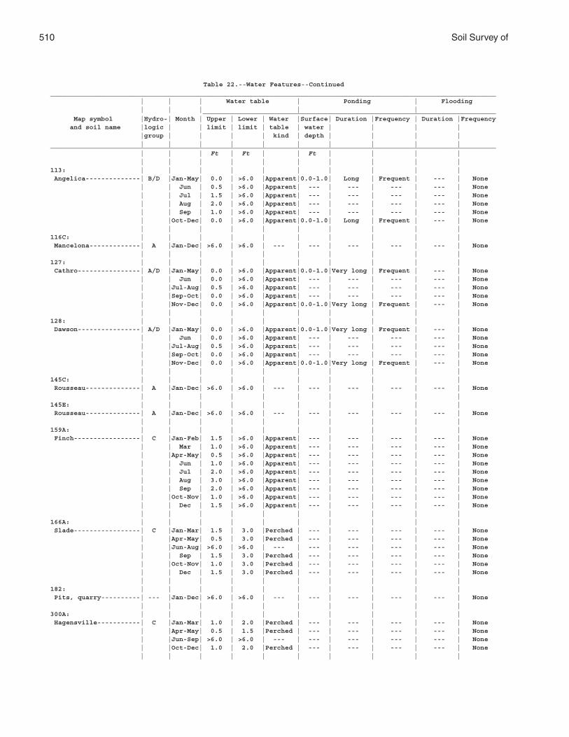
510 Soil Survey of
Table 22.--Water Features--Continued__________________________________________________________________________________________________________________ | | | Water table | Ponding | Flooding | | | | | ___________________________________________________________________________ Map symbol |Hydro-| Month | Upper | Lower | Water |Surface| Duration |Frequency | Duration |Frequency and soil name |logic | | limit | limit | table | water | | | | |group | | | | kind | depth | | | | | | | | | | | | | |__________________________________________________________________________________________________________________ | | | Ft | Ft | | Ft | | | | | | | | | | | | | |113: | | | | | | | | | | Angelica--------------| B/D |Jan-May| 0.0 | >6.0 |Apparent|0.0-1.0| Long | Frequent | --- | None | | Jun | 0.5 | >6.0 |Apparent| --- | --- | --- | --- | None | | Jul | 1.5 | >6.0 |Apparent| --- | --- | --- | --- | None | | Aug | 2.0 | >6.0 |Apparent| --- | --- | --- | --- | None | | Sep | 1.0 | >6.0 |Apparent| --- | --- | --- | --- | None | |Oct-Dec| 0.0 | >6.0 |Apparent|0.0-1.0| Long | Frequent | --- | None | | | | | | | | | |116C: | | | | | | | | | | Mancelona-------------| A |Jan-Dec| >6.0 | >6.0 | --- | --- | --- | --- | --- | None | | | | | | | | | |127: | | | | | | | | | | Cathro----------------| A/D |Jan-May| 0.0 | >6.0 |Apparent|0.0-1.0|Very long | Frequent | --- | None | | Jun | 0.0 | >6.0 |Apparent| --- | --- | --- | --- | None | |Jul-Aug| 0.5 | >6.0 |Apparent| --- | --- | --- | --- | None | |Sep-Oct| 0.0 | >6.0 |Apparent| --- | --- | --- | --- | None | |Nov-Dec| 0.0 | >6.0 |Apparent|0.0-1.0|Very long | Frequent | --- | None | | | | | | | | | |128: | | | | | | | | | | Dawson----------------| A/D |Jan-May| 0.0 | >6.0 |Apparent|0.0-1.0|Very long | Frequent | --- | None | | Jun | 0.0 | >6.0 |Apparent| --- | --- | --- | --- | None | |Jul-Aug| 0.5 | >6.0 |Apparent| --- | --- | --- | --- | None | |Sep-Oct| 0.0 | >6.0 |Apparent| --- | --- | --- | --- | None | |Nov-Dec| 0.0 | >6.0 |Apparent|0.0-1.0|Very long | Frequent | --- | None | | | | | | | | | |145C: | | | | | | | | | | Rousseau--------------| A |Jan-Dec| >6.0 | >6.0 | --- | --- | --- | --- | --- | None | | | | | | | | | |145E: | | | | | | | | | | Rousseau--------------| A |Jan-Dec| >6.0 | >6.0 | --- | --- | --- | --- | --- | None | | | | | | | | | |159A: | | | | | | | | | | Finch-----------------| C |Jan-Feb| 1.5 | >6.0 |Apparent| --- | --- | --- | --- | None | | Mar | 1.0 | >6.0 |Apparent| --- | --- | --- | --- | None | |Apr-May| 0.5 | >6.0 |Apparent| --- | --- | --- | --- | None | | Jun | 1.0 | >6.0 |Apparent| --- | --- | --- | --- | None | | Jul | 2.0 | >6.0 |Apparent| --- | --- | --- | --- | None | | Aug | 3.0 | >6.0 |Apparent| --- | --- | --- | --- | None | | Sep | 2.0 | >6.0 |Apparent| --- | --- | --- | --- | None | |Oct-Nov| 1.0 | >6.0 |Apparent| --- | --- | --- | --- | None | | Dec | 1.5 | >6.0 |Apparent| --- | --- | --- | --- | None | | | | | | | | | |166A: | | | | | | | | | | Slade-----------------| C |Jan-Mar| 1.5 | 3.0 |Perched | --- | --- | --- | --- | None | |Apr-May| 0.5 | 3.0 |Perched | --- | --- | --- | --- | None | |Jun-Aug| >6.0 | >6.0 | --- | --- | --- | --- | --- | None | | Sep | 1.5 | 3.0 |Perched | --- | --- | --- | --- | None | |Oct-Nov| 1.0 | 3.0 |Perched | --- | --- | --- | --- | None | | Dec | 1.5 | 3.0 |Perched | --- | --- | --- | --- | None | | | | | | | | | |182: | | | | | | | | | | Pits, quarry----------| --- |Jan-Dec| >6.0 | >6.0 | --- | --- | --- | --- | --- | None | | | | | | | | | |300A: | | | | | | | | | | Hagensville-----------| C |Jan-Mar| 1.0 | 2.0 |Perched | --- | --- | --- | --- | None | |Apr-May| 0.5 | 1.5 |Perched | --- | --- | --- | --- | None | |Jun-Sep| >6.0 | >6.0 | --- | --- | --- | --- | --- | None | |Oct-Dec| 1.0 | 2.0 |Perched | --- | --- | --- | --- | None | | | | | | | | | |
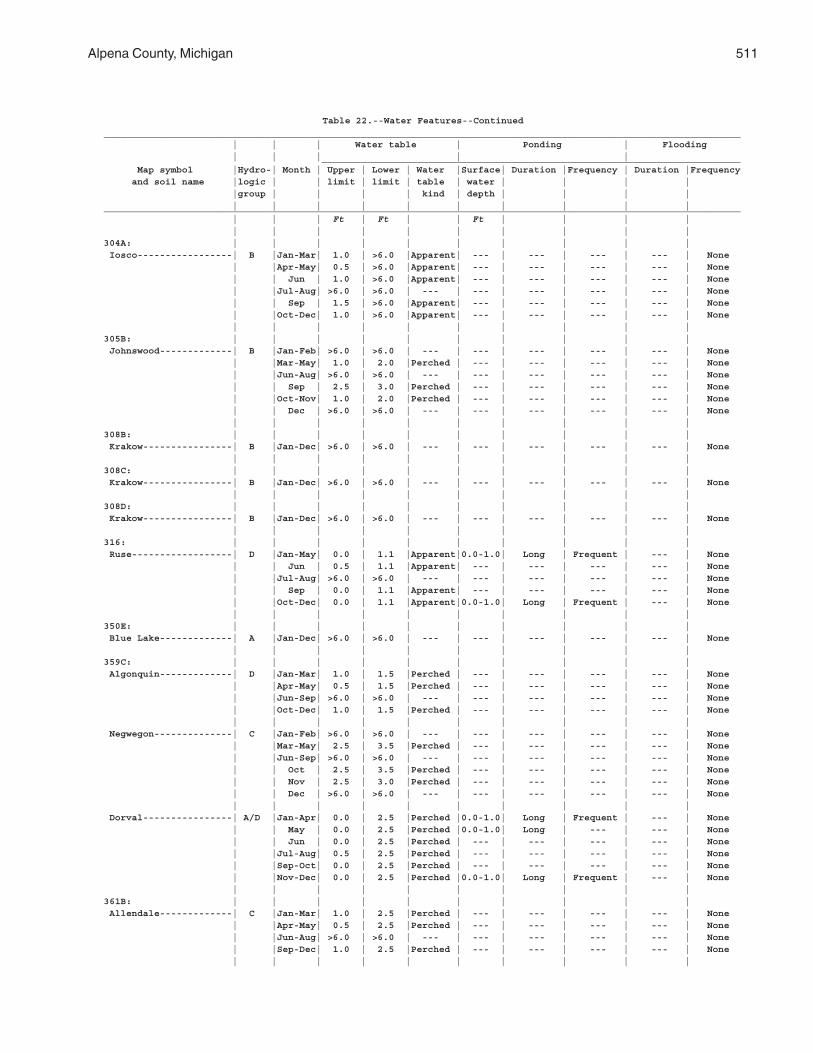
Alpena County, Michigan 511
Table 22.--Water Features--Continued__________________________________________________________________________________________________________________ | | | Water table | Ponding | Flooding | | | | | ___________________________________________________________________________ Map symbol |Hydro-| Month | Upper | Lower | Water |Surface| Duration |Frequency | Duration |Frequency and soil name |logic | | limit | limit | table | water | | | | |group | | | | kind | depth | | | | | | | | | | | | | |__________________________________________________________________________________________________________________ | | | Ft | Ft | | Ft | | | | | | | | | | | | | |304A: | | | | | | | | | | Iosco-----------------| B |Jan-Mar| 1.0 | >6.0 |Apparent| --- | --- | --- | --- | None | |Apr-May| 0.5 | >6.0 |Apparent| --- | --- | --- | --- | None | | Jun | 1.0 | >6.0 |Apparent| --- | --- | --- | --- | None | |Jul-Aug| >6.0 | >6.0 | --- | --- | --- | --- | --- | None | | Sep | 1.5 | >6.0 |Apparent| --- | --- | --- | --- | None | |Oct-Dec| 1.0 | >6.0 |Apparent| --- | --- | --- | --- | None | | | | | | | | | |305B: | | | | | | | | | | Johnswood-------------| B |Jan-Feb| >6.0 | >6.0 | --- | --- | --- | --- | --- | None | |Mar-May| 1.0 | 2.0 |Perched | --- | --- | --- | --- | None | |Jun-Aug| >6.0 | >6.0 | --- | --- | --- | --- | --- | None | | Sep | 2.5 | 3.0 |Perched | --- | --- | --- | --- | None | |Oct-Nov| 1.0 | 2.0 |Perched | --- | --- | --- | --- | None | | Dec | >6.0 | >6.0 | --- | --- | --- | --- | --- | None | | | | | | | | | |308B: | | | | | | | | | | Krakow----------------| B |Jan-Dec| >6.0 | >6.0 | --- | --- | --- | --- | --- | None | | | | | | | | | |308C: | | | | | | | | | | Krakow----------------| B |Jan-Dec| >6.0 | >6.0 | --- | --- | --- | --- | --- | None | | | | | | | | | |308D: | | | | | | | | | | Krakow----------------| B |Jan-Dec| >6.0 | >6.0 | --- | --- | --- | --- | --- | None | | | | | | | | | |316: | | | | | | | | | | Ruse------------------| D |Jan-May| 0.0 | 1.1 |Apparent|0.0-1.0| Long | Frequent | --- | None | | Jun | 0.5 | 1.1 |Apparent| --- | --- | --- | --- | None | |Jul-Aug| >6.0 | >6.0 | --- | --- | --- | --- | --- | None | | Sep | 0.0 | 1.1 |Apparent| --- | --- | --- | --- | None | |Oct-Dec| 0.0 | 1.1 |Apparent|0.0-1.0| Long | Frequent | --- | None | | | | | | | | | |350E: | | | | | | | | | | Blue Lake-------------| A |Jan-Dec| >6.0 | >6.0 | --- | --- | --- | --- | --- | None | | | | | | | | | |359C: | | | | | | | | | | Algonquin-------------| D |Jan-Mar| 1.0 | 1.5 |Perched | --- | --- | --- | --- | None | |Apr-May| 0.5 | 1.5 |Perched | --- | --- | --- | --- | None | |Jun-Sep| >6.0 | >6.0 | --- | --- | --- | --- | --- | None | |Oct-Dec| 1.0 | 1.5 |Perched | --- | --- | --- | --- | None | | | | | | | | | | Negwegon--------------| C |Jan-Feb| >6.0 | >6.0 | --- | --- | --- | --- | --- | None | |Mar-May| 2.5 | 3.5 |Perched | --- | --- | --- | --- | None | |Jun-Sep| >6.0 | >6.0 | --- | --- | --- | --- | --- | None | | Oct | 2.5 | 3.5 |Perched | --- | --- | --- | --- | None | | Nov | 2.5 | 3.0 |Perched | --- | --- | --- | --- | None | | Dec | >6.0 | >6.0 | --- | --- | --- | --- | --- | None | | | | | | | | | | Dorval----------------| A/D |Jan-Apr| 0.0 | 2.5 |Perched |0.0-1.0| Long | Frequent | --- | None | | May | 0.0 | 2.5 |Perched |0.0-1.0| Long | --- | --- | None | | Jun | 0.0 | 2.5 |Perched | --- | --- | --- | --- | None | |Jul-Aug| 0.5 | 2.5 |Perched | --- | --- | --- | --- | None | |Sep-Oct| 0.0 | 2.5 |Perched | --- | --- | --- | --- | None | |Nov-Dec| 0.0 | 2.5 |Perched |0.0-1.0| Long | Frequent | --- | None | | | | | | | | | |361B: | | | | | | | | | | Allendale-------------| C |Jan-Mar| 1.0 | 2.5 |Perched | --- | --- | --- | --- | None | |Apr-May| 0.5 | 2.5 |Perched | --- | --- | --- | --- | None | |Jun-Aug| >6.0 | >6.0 | --- | --- | --- | --- | --- | None | |Sep-Dec| 1.0 | 2.5 |Perched | --- | --- | --- | --- | None | | | | | | | | | |
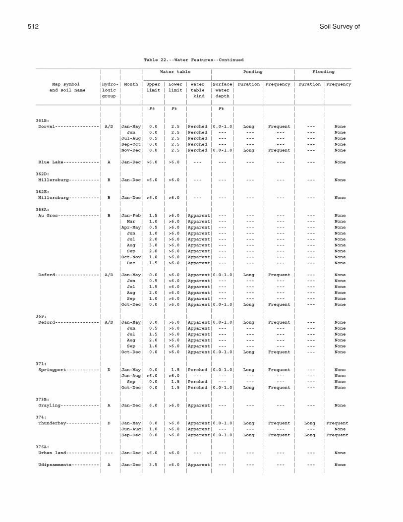
512 Soil Survey of
Table 22.--Water Features--Continued__________________________________________________________________________________________________________________ | | | Water table | Ponding | Flooding | | | | | ___________________________________________________________________________ Map symbol |Hydro-| Month | Upper | Lower | Water |Surface| Duration |Frequency | Duration |Frequency and soil name |logic | | limit | limit | table | water | | | | |group | | | | kind | depth | | | | | | | | | | | | | |__________________________________________________________________________________________________________________ | | | Ft | Ft | | Ft | | | | | | | | | | | | | |361B: | | | | | | | | | | Dorval----------------| A/D |Jan-May| 0.0 | 2.5 |Perched |0.0-1.0| Long | Frequent | --- | None | | Jun | 0.0 | 2.5 |Perched | --- | --- | --- | --- | None | |Jul-Aug| 0.5 | 2.5 |Perched | --- | --- | --- | --- | None | |Sep-Oct| 0.0 | 2.5 |Perched | --- | --- | --- | --- | None | |Nov-Dec| 0.0 | 2.5 |Perched |0.0-1.0| Long | Frequent | --- | None | | | | | | | | | | Blue Lake-------------| A |Jan-Dec| >6.0 | >6.0 | --- | --- | --- | --- | --- | None | | | | | | | | | |362D: | | | | | | | | | | Millersburg-----------| B |Jan-Dec| >6.0 | >6.0 | --- | --- | --- | --- | --- | None | | | | | | | | | |362E: | | | | | | | | | | Millersburg-----------| B |Jan-Dec| >6.0 | >6.0 | --- | --- | --- | --- | --- | None | | | | | | | | | |368A: | | | | | | | | | | Au Gres---------------| B |Jan-Feb| 1.5 | >6.0 |Apparent| --- | --- | --- | --- | None | | Mar | 1.0 | >6.0 |Apparent| --- | --- | --- | --- | None | |Apr-May| 0.5 | >6.0 |Apparent| --- | --- | --- | --- | None | | Jun | 1.0 | >6.0 |Apparent| --- | --- | --- | --- | None | | Jul | 2.0 | >6.0 |Apparent| --- | --- | --- | --- | None | | Aug | 3.0 | >6.0 |Apparent| --- | --- | --- | --- | None | | Sep | 2.0 | >6.0 |Apparent| --- | --- | --- | --- | None | |Oct-Nov| 1.0 | >6.0 |Apparent| --- | --- | --- | --- | None | | Dec | 1.5 | >6.0 |Apparent| --- | --- | --- | --- | None | | | | | | | | | | Deford----------------| A/D |Jan-May| 0.0 | >6.0 |Apparent|0.0-1.0| Long | Frequent | --- | None | | Jun | 0.5 | >6.0 |Apparent| --- | --- | --- | --- | None | | Jul | 1.5 | >6.0 |Apparent| --- | --- | --- | --- | None | | Aug | 2.0 | >6.0 |Apparent| --- | --- | --- | --- | None | | Sep | 1.0 | >6.0 |Apparent| --- | --- | --- | --- | None | |Oct-Dec| 0.0 | >6.0 |Apparent|0.0-1.0| Long | Frequent | --- | None | | | | | | | | | |369: | | | | | | | | | | Deford----------------| A/D |Jan-May| 0.0 | >6.0 |Apparent|0.0-1.0| Long | Frequent | --- | None | | Jun | 0.5 | >6.0 |Apparent| --- | --- | --- | --- | None | | Jul | 1.5 | >6.0 |Apparent| --- | --- | --- | --- | None | | Aug | 2.0 | >6.0 |Apparent| --- | --- | --- | --- | None | | Sep | 1.0 | >6.0 |Apparent| --- | --- | --- | --- | None | |Oct-Dec| 0.0 | >6.0 |Apparent|0.0-1.0| Long | Frequent | --- | None | | | | | | | | | |371: | | | | | | | | | | Springport------------| D |Jan-May| 0.0 | 1.5 |Perched |0.0-1.0| Long | Frequent | --- | None | |Jun-Aug| >6.0 | >6.0 | --- | --- | --- | --- | --- | None | | Sep | 0.0 | 1.5 |Perched | --- | --- | --- | --- | None | |Oct-Dec| 0.0 | 1.5 |Perched |0.0-1.0| Long | Frequent | --- | None | | | | | | | | | |373B: | | | | | | | | | | Grayling--------------| A |Jan-Dec| 6.0 | >6.0 |Apparent| --- | --- | --- | --- | None | | | | | | | | | |374: | | | | | | | | | | Thunderbay------------| D |Jan-May| 0.0 | >6.0 |Apparent|0.0-1.0| Long | Frequent | Long |Frequent | |Jun-Aug| 1.0 | >6.0 |Apparent| --- | --- | --- | --- | None | |Sep-Dec| 0.0 | >6.0 |Apparent|0.0-1.0| Long | Frequent | Long |Frequent | | | | | | | | | |376A: | | | | | | | | | | Urban land------------| --- |Jan-Dec| >6.0 | >6.0 | --- | --- | --- | --- | --- | None | | | | | | | | | | Udipsamments----------| A |Jan-Dec| 3.5 | >6.0 |Apparent| --- | --- | --- | --- | None | | | | | | | | | |
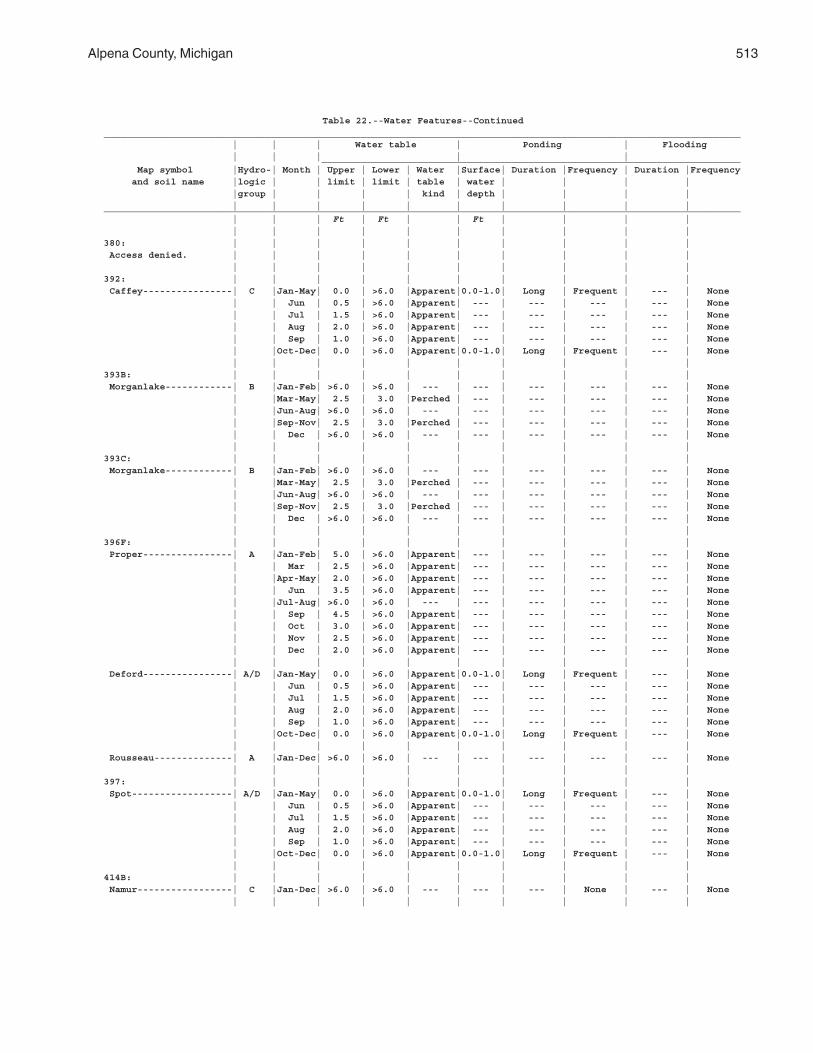
Alpena County, Michigan 513
Table 22.--Water Features--Continued__________________________________________________________________________________________________________________ | | | Water table | Ponding | Flooding | | | | | ___________________________________________________________________________ Map symbol |Hydro-| Month | Upper | Lower | Water |Surface| Duration |Frequency | Duration |Frequency and soil name |logic | | limit | limit | table | water | | | | |group | | | | kind | depth | | | | | | | | | | | | | |__________________________________________________________________________________________________________________ | | | Ft | Ft | | Ft | | | | | | | | | | | | | |380: | | | | | | | | | | Access denied. | | | | | | | | | | | | | | | | | | | |392: | | | | | | | | | | Caffey----------------| C |Jan-May| 0.0 | >6.0 |Apparent|0.0-1.0| Long | Frequent | --- | None | | Jun | 0.5 | >6.0 |Apparent| --- | --- | --- | --- | None | | Jul | 1.5 | >6.0 |Apparent| --- | --- | --- | --- | None | | Aug | 2.0 | >6.0 |Apparent| --- | --- | --- | --- | None | | Sep | 1.0 | >6.0 |Apparent| --- | --- | --- | --- | None | |Oct-Dec| 0.0 | >6.0 |Apparent|0.0-1.0| Long | Frequent | --- | None | | | | | | | | | |393B: | | | | | | | | | | Morganlake------------| B |Jan-Feb| >6.0 | >6.0 | --- | --- | --- | --- | --- | None | |Mar-May| 2.5 | 3.0 |Perched | --- | --- | --- | --- | None | |Jun-Aug| >6.0 | >6.0 | --- | --- | --- | --- | --- | None | |Sep-Nov| 2.5 | 3.0 |Perched | --- | --- | --- | --- | None | | Dec | >6.0 | >6.0 | --- | --- | --- | --- | --- | None | | | | | | | | | |393C: | | | | | | | | | | Morganlake------------| B |Jan-Feb| >6.0 | >6.0 | --- | --- | --- | --- | --- | None | |Mar-May| 2.5 | 3.0 |Perched | --- | --- | --- | --- | None | |Jun-Aug| >6.0 | >6.0 | --- | --- | --- | --- | --- | None | |Sep-Nov| 2.5 | 3.0 |Perched | --- | --- | --- | --- | None | | Dec | >6.0 | >6.0 | --- | --- | --- | --- | --- | None | | | | | | | | | |396F: | | | | | | | | | | Proper----------------| A |Jan-Feb| 5.0 | >6.0 |Apparent| --- | --- | --- | --- | None | | Mar | 2.5 | >6.0 |Apparent| --- | --- | --- | --- | None | |Apr-May| 2.0 | >6.0 |Apparent| --- | --- | --- | --- | None | | Jun | 3.5 | >6.0 |Apparent| --- | --- | --- | --- | None | |Jul-Aug| >6.0 | >6.0 | --- | --- | --- | --- | --- | None | | Sep | 4.5 | >6.0 |Apparent| --- | --- | --- | --- | None | | Oct | 3.0 | >6.0 |Apparent| --- | --- | --- | --- | None | | Nov | 2.5 | >6.0 |Apparent| --- | --- | --- | --- | None | | Dec | 2.0 | >6.0 |Apparent| --- | --- | --- | --- | None | | | | | | | | | | Deford----------------| A/D |Jan-May| 0.0 | >6.0 |Apparent|0.0-1.0| Long | Frequent | --- | None | | Jun | 0.5 | >6.0 |Apparent| --- | --- | --- | --- | None | | Jul | 1.5 | >6.0 |Apparent| --- | --- | --- | --- | None | | Aug | 2.0 | >6.0 |Apparent| --- | --- | --- | --- | None | | Sep | 1.0 | >6.0 |Apparent| --- | --- | --- | --- | None | |Oct-Dec| 0.0 | >6.0 |Apparent|0.0-1.0| Long | Frequent | --- | None | | | | | | | | | | Rousseau--------------| A |Jan-Dec| >6.0 | >6.0 | --- | --- | --- | --- | --- | None | | | | | | | | | |397: | | | | | | | | | | Spot------------------| A/D |Jan-May| 0.0 | >6.0 |Apparent|0.0-1.0| Long | Frequent | --- | None | | Jun | 0.5 | >6.0 |Apparent| --- | --- | --- | --- | None | | Jul | 1.5 | >6.0 |Apparent| --- | --- | --- | --- | None | | Aug | 2.0 | >6.0 |Apparent| --- | --- | --- | --- | None | | Sep | 1.0 | >6.0 |Apparent| --- | --- | --- | --- | None | |Oct-Dec| 0.0 | >6.0 |Apparent|0.0-1.0| Long | Frequent | --- | None | | | | | | | | | |414B: | | | | | | | | | | Namur-----------------| C |Jan-Dec| >6.0 | >6.0 | --- | --- | --- | None | --- | None | | | | | | | | | |
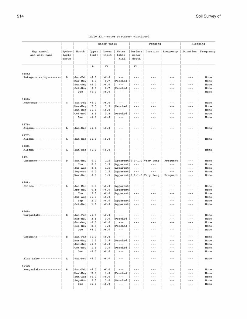
514 Soil Survey of
Table 22.--Water Features--Continued__________________________________________________________________________________________________________________ | | | Water table | Ponding | Flooding | | | | | ___________________________________________________________________________ Map symbol |Hydro-| Month | Upper | Lower | Water |Surface| Duration |Frequency | Duration |Frequency and soil name |logic | | limit | limit | table | water | | | | |group | | | | kind | depth | | | | | | | | | | | | | |__________________________________________________________________________________________________________________ | | | Ft | Ft | | Ft | | | | | | | | | | | | | |415A: | | | | | | | | | | Potagannissing--------| D |Jan-Feb| >6.0 | >6.0 | --- | --- | --- | --- | --- | None | |Mar-May| 0.0 | 0.7 |Perched | --- | --- | --- | --- | None | |Jun-Sep| >6.0 | >6.0 | --- | --- | --- | --- | --- | None | |Oct-Nov| 0.0 | 0.7 |Perched | --- | --- | --- | --- | None | | Dec | >6.0 | >6.0 | --- | --- | --- | --- | --- | None | | | | | | | | | |416B: | | | | | | | | | | Negwegon--------------| C |Jan-Feb| >6.0 | >6.0 | --- | --- | --- | --- | --- | None | |Mar-May| 2.5 | 3.5 |Perched | --- | --- | --- | --- | None | |Jun-Sep| >6.0 | >6.0 | --- | --- | --- | --- | --- | None | |Oct-Nov| 2.5 | 3.5 |Perched | --- | --- | --- | --- | None | | Dec | >6.0 | >6.0 | --- | --- | --- | --- | --- | None | | | | | | | | | |417B: | | | | | | | | | | Alpena----------------| A |Jan-Dec| >6.0 | >6.0 | --- | --- | --- | --- | --- | None | | | | | | | | | |417C: | | | | | | | | | | Alpena----------------| A |Jan-Dec| >6.0 | >6.0 | --- | --- | --- | --- | --- | None | | | | | | | | | |418E: | | | | | | | | | | Alpena----------------| A |Jan-Dec| >6.0 | >6.0 | --- | --- | --- | --- | --- | None | | | | | | | | | |419: | | | | | | | | | | Chippeny--------------| D |Jan-May| 0.0 | 1.5 |Apparent|0.0-1.0|Very long | Frequent | --- | None | | Jun | 0.0 | 1.5 |Apparent| --- | --- | --- | --- | None | |Jul-Aug| 0.5 | 1.5 |Apparent| --- | --- | --- | --- | None | |Sep-Oct| 0.0 | 1.5 |Apparent| --- | --- | --- | --- | None | |Nov-Dec| 0.0 | 1.5 |Apparent|0.0-1.0|Very long | Frequent | --- | None | | | | | | | | | |420A: | | | | | | | | | | Otisco----------------| A |Jan-Mar| 1.0 | >6.0 |Apparent| --- | --- | --- | --- | None | |Apr-May| 0.5 | >6.0 |Apparent| --- | --- | --- | --- | None | | Jun | 2.0 | >6.0 |Apparent| --- | --- | --- | --- | None | |Jul-Aug| >6.0 | >6.0 | --- | --- | --- | --- | --- | None | | Sep | 2.0 | >6.0 |Apparent| --- | --- | --- | --- | None | |Oct-Dec| 1.0 | >6.0 |Apparent| --- | --- | --- | --- | None | | | | | | | | | |424B: | | | | | | | | | | Morganlake------------| B |Jan-Feb| >6.0 | >6.0 | --- | --- | --- | --- | --- | None | |Mar-May| 2.5 | 3.0 |Perched | --- | --- | --- | --- | None | |Jun-Aug| >6.0 | >6.0 | --- | --- | --- | --- | --- | None | |Sep-Nov| 2.5 | 3.0 |Perched | --- | --- | --- | --- | None | | Dec | >6.0 | >6.0 | --- | --- | --- | --- | --- | None | | | | | | | | | | Ossineke--------------| B |Jan-Feb| >6.0 | >6.0 | --- | --- | --- | --- | --- | None | |Mar-May| 1.5 | 3.5 |Perched | --- | --- | --- | --- | None | |Jun-Sep| >6.0 | >6.0 | --- | --- | --- | --- | --- | None | |Oct-Nov| 1.5 | 3.5 |Perched | --- | --- | --- | --- | None | | Dec | >6.0 | >6.0 | --- | --- | --- | --- | --- | None | | | | | | | | | | Blue Lake-------------| A |Jan-Dec| >6.0 | >6.0 | --- | --- | --- | --- | --- | None | | | | | | | | | |424C: | | | | | | | | | | Morganlake------------| B |Jan-Feb| >6.0 | >6.0 | --- | --- | --- | --- | --- | None | |Mar-May| 2.5 | 3.0 |Perched | --- | --- | --- | --- | None | |Jun-Aug| >6.0 | >6.0 | --- | --- | --- | --- | --- | None | |Sep-Nov| 2.5 | 3.0 |Perched | --- | --- | --- | --- | None | | Dec | >6.0 | >6.0 | --- | --- | --- | --- | --- | None | | | | | | | | | |
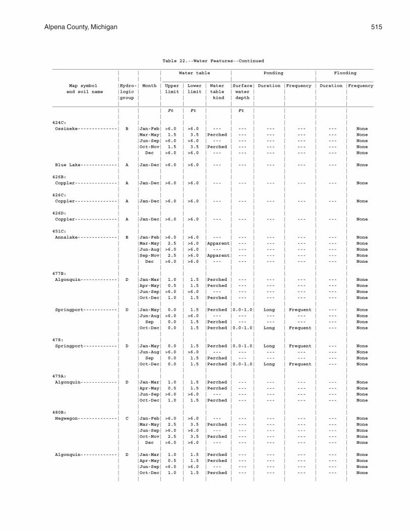
Alpena County, Michigan 515
Table 22.--Water Features--Continued__________________________________________________________________________________________________________________ | | | Water table | Ponding | Flooding | | | | | ___________________________________________________________________________ Map symbol |Hydro-| Month | Upper | Lower | Water |Surface| Duration |Frequency | Duration |Frequency and soil name |logic | | limit | limit | table | water | | | | |group | | | | kind | depth | | | | | | | | | | | | | |__________________________________________________________________________________________________________________ | | | Ft | Ft | | Ft | | | | | | | | | | | | | |424C: | | | | | | | | | | Ossineke--------------| B |Jan-Feb| >6.0 | >6.0 | --- | --- | --- | --- | --- | None | |Mar-May| 1.5 | 3.5 |Perched | --- | --- | --- | --- | None | |Jun-Sep| >6.0 | >6.0 | --- | --- | --- | --- | --- | None | |Oct-Nov| 1.5 | 3.5 |Perched | --- | --- | --- | --- | None | | Dec | >6.0 | >6.0 | --- | --- | --- | --- | --- | None | | | | | | | | | | Blue Lake-------------| A |Jan-Dec| >6.0 | >6.0 | --- | --- | --- | --- | --- | None | | | | | | | | | |426B: | | | | | | | | | | Coppler---------------| A |Jan-Dec| >6.0 | >6.0 | --- | --- | --- | --- | --- | None | | | | | | | | | |426C: | | | | | | | | | | Coppler---------------| A |Jan-Dec| >6.0 | >6.0 | --- | --- | --- | --- | --- | None | | | | | | | | | |426D: | | | | | | | | | | Coppler---------------| A |Jan-Dec| >6.0 | >6.0 | --- | --- | --- | --- | --- | None | | | | | | | | | |451C: | | | | | | | | | | Annalake--------------| B |Jan-Feb| >6.0 | >6.0 | --- | --- | --- | --- | --- | None | |Mar-May| 2.5 | >6.0 |Apparent| --- | --- | --- | --- | None | |Jun-Aug| >6.0 | >6.0 | --- | --- | --- | --- | --- | None | |Sep-Nov| 2.5 | >6.0 |Apparent| --- | --- | --- | --- | None | | Dec | >6.0 | >6.0 | --- | --- | --- | --- | --- | None | | | | | | | | | |477B: | | | | | | | | | | Algonquin-------------| D |Jan-Mar| 1.0 | 1.5 |Perched | --- | --- | --- | --- | None | |Apr-May| 0.5 | 1.5 |Perched | --- | --- | --- | --- | None | |Jun-Sep| >6.0 | >6.0 | --- | --- | --- | --- | --- | None | |Oct-Dec| 1.0 | 1.5 |Perched | --- | --- | --- | --- | None | | | | | | | | | | Springport------------| D |Jan-May| 0.0 | 1.5 |Perched |0.0-1.0| Long | Frequent | --- | None | |Jun-Aug| >6.0 | >6.0 | --- | --- | --- | --- | --- | None | | Sep | 0.0 | 1.5 |Perched | --- | --- | --- | --- | None | |Oct-Dec| 0.0 | 1.5 |Perched |0.0-1.0| Long | Frequent | --- | None | | | | | | | | | |478: | | | | | | | | | | Springport------------| D |Jan-May| 0.0 | 1.5 |Perched |0.0-1.0| Long | Frequent | --- | None | |Jun-Aug| >6.0 | >6.0 | --- | --- | --- | --- | --- | None | | Sep | 0.0 | 1.5 |Perched | --- | --- | --- | --- | None | |Oct-Dec| 0.0 | 1.5 |Perched |0.0-1.0| Long | Frequent | --- | None | | | | | | | | | |479A: | | | | | | | | | | Algonquin-------------| D |Jan-Mar| 1.0 | 1.5 |Perched | --- | --- | --- | --- | None | |Apr-May| 0.5 | 1.5 |Perched | --- | --- | --- | --- | None | |Jun-Sep| >6.0 | >6.0 | --- | --- | --- | --- | --- | None | |Oct-Dec| 1.0 | 1.5 |Perched | --- | --- | --- | --- | None | | | | | | | | | |480B: | | | | | | | | | | Negwegon--------------| C |Jan-Feb| >6.0 | >6.0 | --- | --- | --- | --- | --- | None | |Mar-May| 2.5 | 3.5 |Perched | --- | --- | --- | --- | None | |Jun-Sep| >6.0 | >6.0 | --- | --- | --- | --- | --- | None | |Oct-Nov| 2.5 | 3.5 |Perched | --- | --- | --- | --- | None | | Dec | >6.0 | >6.0 | --- | --- | --- | --- | --- | None | | | | | | | | | | Algonquin-------------| D |Jan-Mar| 1.0 | 1.5 |Perched | --- | --- | --- | --- | None | |Apr-May| 0.5 | 1.5 |Perched | --- | --- | --- | --- | None | |Jun-Sep| >6.0 | >6.0 | --- | --- | --- | --- | --- | None | |Oct-Dec| 1.0 | 1.5 |Perched | --- | --- | --- | --- | None | | | | | | | | | |
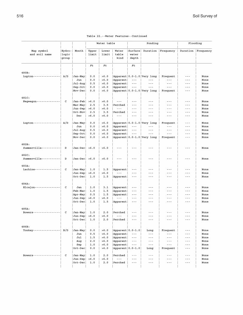
516 Soil Survey of
Table 22.--Water Features--Continued__________________________________________________________________________________________________________________ | | | Water table | Ponding | Flooding | | | | | ___________________________________________________________________________ Map symbol |Hydro-| Month | Upper | Lower | Water |Surface| Duration |Frequency | Duration |Frequency and soil name |logic | | limit | limit | table | water | | | | |group | | | | kind | depth | | | | | | | | | | | | | |__________________________________________________________________________________________________________________ | | | Ft | Ft | | Ft | | | | | | | | | | | | | |480B: | | | | | | | | | | Lupton----------------| A/D |Jan-May| 0.0 | >6.0 |Apparent|0.0-1.0|Very long | Frequent | --- | None | | Jun | 0.0 | >6.0 |Apparent| --- | --- | --- | --- | None | |Jul-Aug| 0.5 | >6.0 |Apparent| --- | --- | --- | --- | None | |Sep-Oct| 0.0 | >6.0 |Apparent| --- | --- | --- | --- | None | |Nov-Dec| 0.0 | >6.0 |Apparent|0.0-1.0|Very long | Frequent | --- | None | | | | | | | | | |481C: | | | | | | | | | | Negwegon--------------| C |Jan-Feb| >6.0 | >6.0 | --- | --- | --- | --- | --- | None | |Mar-May| 2.5 | 3.5 |Perched | --- | --- | --- | --- | None | |Jun-Sep| >6.0 | >6.0 | --- | --- | --- | --- | --- | None | |Oct-Nov| 2.5 | 3.5 |Perched | --- | --- | --- | --- | None | | Dec | >6.0 | >6.0 | --- | --- | --- | --- | --- | None | | | | | | | | | | Lupton----------------| A/D |Jan-May| 0.0 | >6.0 |Apparent|0.0-1.0|Very long | Frequent | --- | None | | Jun | 0.0 | >6.0 |Apparent| --- | --- | --- | --- | None | |Jul-Aug| 0.5 | >6.0 |Apparent| --- | --- | --- | --- | None | |Sep-Oct| 0.0 | >6.0 |Apparent| --- | --- | --- | --- | None | |Nov-Dec| 0.0 | >6.0 |Apparent|0.0-1.0|Very long | Frequent | --- | None | | | | | | | | | |482B: | | | | | | | | | | Summerville-----------| D |Jan-Dec| >6.0 | >6.0 | --- | --- | --- | --- | --- | None | | | | | | | | | |482C: | | | | | | | | | | Summerville-----------| D |Jan-Dec| >6.0 | >6.0 | --- | --- | --- | --- | --- | None | | | | | | | | | |483A: | | | | | | | | | | Lachine---------------| C |Jan-May| 1.0 | 1.5 |Apparent| --- | --- | --- | --- | None | |Jun-Sep| >6.0 | >6.0 | --- | --- | --- | --- | --- | None | |Oct-Dec| 1.0 | 1.5 |Apparent| --- | --- | --- | --- | None | | | | | | | | | |484A: | | | | | | | | | | Elcajon---------------| C | Jan | 1.0 | 3.1 |Apparent| --- | --- | --- | --- | None | |Feb-Mar| 1.0 | 1.5 |Apparent| --- | --- | --- | --- | None | |Apr-May| 0.5 | 1.5 |Apparent| --- | --- | --- | --- | None | |Jun-Sep| >6.0 | >6.0 | --- | --- | --- | --- | --- | None | |Oct-Dec| 1.0 | 1.5 |Apparent| --- | --- | --- | --- | None | | | | | | | | | |485A: | | | | | | | | | | Bowers----------------| C |Jan-May| 1.0 | 2.0 |Perched | --- | --- | --- | --- | None | |Jun-Sep| >6.0 | >6.0 | --- | --- | --- | --- | --- | None | |Oct-Dec| 1.0 | 2.0 |Perched | --- | --- | --- | --- | None | | | | | | | | | |486B: | | | | | | | | | | Tonkey----------------| B/D |Jan-May| 0.0 | >6.0 |Apparent|0.0-1.0| Long | Frequent | --- | None | | Jun | 0.5 | >6.0 |Apparent| --- | --- | --- | --- | None | | Jul | 1.5 | >6.0 |Apparent| --- | --- | --- | --- | None | | Aug | 2.0 | >6.0 |Apparent| --- | --- | --- | --- | None | | Sep | 1.0 | >6.0 |Apparent| --- | --- | --- | --- | None | |Oct-Dec| 0.0 | >6.0 |Apparent|0.0-1.0| Long | Frequent | --- | None | | | | | | | | | | Bowers----------------| C |Jan-May| 1.0 | 2.0 |Perched | --- | --- | --- | --- | None | |Jun-Sep| >6.0 | >6.0 | --- | --- | --- | --- | --- | None | |Oct-Dec| 1.0 | 2.0 |Perched | --- | --- | --- | --- | None | | | | | | | | | |
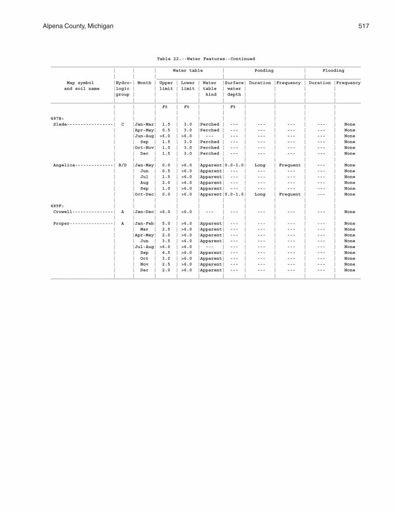
Alpena County, Michigan 517
Table 22.--Water Features--Continued__________________________________________________________________________________________________________________ | | | Water table | Ponding | Flooding | | | | | ___________________________________________________________________________ Map symbol |Hydro-| Month | Upper | Lower | Water |Surface| Duration |Frequency | Duration |Frequency and soil name |logic | | limit | limit | table | water | | | | |group | | | | kind | depth | | | | | | | | | | | | | |__________________________________________________________________________________________________________________ | | | Ft | Ft | | Ft | | | | | | | | | | | | | |487B: | | | | | | | | | | Slade-----------------| C |Jan-Mar| 1.5 | 3.0 |Perched | --- | --- | --- | --- | None | |Apr-May| 0.5 | 3.0 |Perched | --- | --- | --- | --- | None | |Jun-Aug| >6.0 | >6.0 | --- | --- | --- | --- | --- | None | | Sep | 1.5 | 3.0 |Perched | --- | --- | --- | --- | None | |Oct-Nov| 1.0 | 3.0 |Perched | --- | --- | --- | --- | None | | Dec | 1.5 | 3.0 |Perched | --- | --- | --- | --- | None | | | | | | | | | | Angelica--------------| B/D |Jan-May| 0.0 | >6.0 |Apparent|0.0-1.0| Long | Frequent | --- | None | | Jun | 0.5 | >6.0 |Apparent| --- | --- | --- | --- | None | | Jul | 1.5 | >6.0 |Apparent| --- | --- | --- | --- | None | | Aug | 2.0 | >6.0 |Apparent| --- | --- | --- | --- | None | | Sep | 1.0 | >6.0 |Apparent| --- | --- | --- | --- | None | |Oct-Dec| 0.0 | >6.0 |Apparent|0.0-1.0| Long | Frequent | --- | None | | | | | | | | | |489F: | | | | | | | | | | Crowell---------------| A |Jan-Dec| >6.0 | >6.0 | --- | --- | --- | --- | --- | None | | | | | | | | | | Proper----------------| A |Jan-Feb| 5.0 | >6.0 |Apparent| --- | --- | --- | --- | None | | Mar | 2.5 | >6.0 |Apparent| --- | --- | --- | --- | None | |Apr-May| 2.0 | >6.0 |Apparent| --- | --- | --- | --- | None | | Jun | 3.5 | >6.0 |Apparent| --- | --- | --- | --- | None | |Jul-Aug| >6.0 | >6.0 | --- | --- | --- | --- | --- | None | | Sep | 4.5 | >6.0 |Apparent| --- | --- | --- | --- | None | | Oct | 3.0 | >6.0 |Apparent| --- | --- | --- | --- | None | | Nov | 2.5 | >6.0 |Apparent| --- | --- | --- | --- | None | | Dec | 2.0 | >6.0 |Apparent| --- | --- | --- | --- | None | | | | | | | | | |__________________________________________________________________________________________________________________
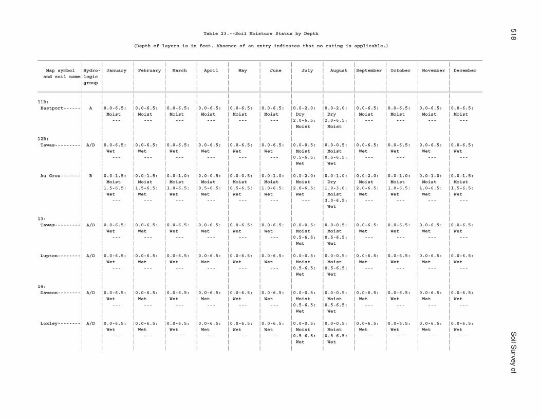
518S
oil Survey of
Table 23.--Soil Moisture Status by Depth
(Depth of layers is in feet. Absence of an entry indicates that no rating is applicable.)
___________________________________________________________________________________________________________________________________________________________ | | | | | | | | | | | | | Map symbol |Hydro-| January | February | March | April | May | June | July | August |September | October | November | December and soil name|logic | | | | | | | | | | | | |group | | | | | | | | | | | | | | | | | | | | | | | | |___________________________________________________________________________________________________________________________________________________________ | | | | | | | | | | | | |11B: | | | | | | | | | | | | | Eastport------| A |0.0-6.5: |0.0-6.5: |0.0-6.5: |0.0-6.5: |0.0-6.5: |0.0-6.5: |0.0-2.0: |0.0-2.0: |0.0-6.5: |0.0-6.5: |0.0-6.5: |0.0-6.5: | | Moist | Moist | Moist | Moist | Moist | Moist | Dry | Dry | Moist | Moist | Moist | Moist | | --- | --- | --- | --- | --- | --- |2.0-6.5: |2.0-6.5: | --- | --- | --- | --- | | | | | | | | Moist | Moist | | | | | | | | | | | | | | | | |12B: | | | | | | | | | | | | | Tawas---------| A/D |0.0-6.5: |0.0-6.5: |0.0-6.5: |0.0-6.5: |0.0-6.5: |0.0-6.5: |0.0-0.5: |0.0-0.5: |0.0-6.5: |0.0-6.5: |0.0-6.5: |0.0-6.5: | | Wet | Wet | Wet | Wet | Wet | Wet | Moist | Moist | Wet | Wet | Wet | Wet | | --- | --- | --- | --- | --- | --- |0.5-6.5: |0.5-6.5: | --- | --- | --- | --- | | | | | | | | Wet | Wet | | | | | | | | | | | | | | | | | Au Gres-------| B |0.0-1.5: |0.0-1.5: |0.0-1.0: |0.0-0.5: |0.0-0.5: |0.0-1.0: |0.0-2.0: |0.0-1.0: |0.0-2.0: |0.0-1.0: |0.0-1.0: |0.0-1.5: | | Moist | Moist | Moist | Moist | Moist | Moist | Moist | Dry | Moist | Moist | Moist | Moist | |1.5-6.5: |1.5-6.5: |1.0-6.5: |0.5-6.5: |0.5-6.5: |1.0-6.5: |2.0-6.5: |1.0-3.0: |2.0-6.5: |1.0-6.5: |1.0-6.5: |1.5-6.5: | | Wet | Wet | Wet | Wet | Wet | Wet | Wet | Moist | Wet | Wet | Wet | Wet | | --- | --- | --- | --- | --- | --- | --- |3.0-6.5: | --- | --- | --- | --- | | | | | | | | | Wet | | | | | | | | | | | | | | | | |13: | | | | | | | | | | | | | Tawas---------| A/D |0.0-6.5: |0.0-6.5: |0.0-6.5: |0.0-6.5: |0.0-6.5: |0.0-6.5: |0.0-0.5: |0.0-0.5: |0.0-6.5: |0.0-6.5: |0.0-6.5: |0.0-6.5: | | Wet | Wet | Wet | Wet | Wet | Wet | Moist | Moist | Wet | Wet | Wet | Wet | | --- | --- | --- | --- | --- | --- |0.5-6.5: |0.5-6.5: | --- | --- | --- | --- | | | | | | | | Wet | Wet | | | | | | | | | | | | | | | | | Lupton--------| A/D |0.0-6.5: |0.0-6.5: |0.0-6.5: |0.0-6.5: |0.0-6.5: |0.0-6.5: |0.0-0.5: |0.0-0.5: |0.0-6.5: |0.0-6.5: |0.0-6.5: |0.0-6.5: | | Wet | Wet | Wet | Wet | Wet | Wet | Moist | Moist | Wet | Wet | Wet | Wet | | --- | --- | --- | --- | --- | --- |0.5-6.5: |0.5-6.5: | --- | --- | --- | --- | | | | | | | | Wet | Wet | | | | | | | | | | | | | | | | |14: | | | | | | | | | | | | | Dawson--------| A/D |0.0-6.5: |0.0-6.5: |0.0-6.5: |0.0-6.5: |0.0-6.5: |0.0-6.5: |0.0-0.5: |0.0-0.5: |0.0-6.5: |0.0-6.5: |0.0-6.5: |0.0-6.5: | | Wet | Wet | Wet | Wet | Wet | Wet | Moist | Moist | Wet | Wet | Wet | Wet | | --- | --- | --- | --- | --- | --- |0.5-6.5: |0.5-6.5: | --- | --- | --- | --- | | | | | | | | Wet | Wet | | | | | | | | | | | | | | | | | Loxley--------| A/D |0.0-6.5: |0.0-6.5: |0.0-6.5: |0.0-6.5: |0.0-6.5: |0.0-6.5: |0.0-0.5: |0.0-0.5: |0.0-6.5: |0.0-6.5: |0.0-6.5: |0.0-6.5: | | Wet | Wet | Wet | Wet | Wet | Wet | Moist | Moist | Wet | Wet | Wet | Wet | | --- | --- | --- | --- | --- | --- |0.5-6.5: |0.5-6.5: | --- | --- | --- | --- | | | | | | | | Wet | Wet | | | | | | | | | | | | | | | | |
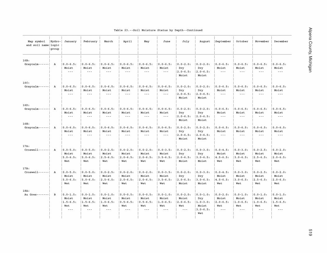
Alpena C
ounty, Michigan
519
Table 23.--Soil Moisture Status by Depth--Continued___________________________________________________________________________________________________________________________________________________________ | | | | | | | | | | | | | Map symbol |Hydro-| January | February | March | April | May | June | July | August |September | October | November | December and soil name|logic | | | | | | | | | | | | |group | | | | | | | | | | | | | | | | | | | | | | | | |___________________________________________________________________________________________________________________________________________________________ | | | | | | | | | | | | |16B: | | | | | | | | | | | | | Graycalm------| A |0.0-6.5: |0.0-6.5: |0.0-6.5: |0.0-6.5: |0.0-6.5: |0.0-6.5: |0.0-2.0: |0.0-2.0: |0.0-6.5: |0.0-6.5: |0.0-6.5: |0.0-6.5: | | Moist | Moist | Moist | Moist | Moist | Moist | Dry | Dry | Moist | Moist | Moist | Moist | | --- | --- | --- | --- | --- | --- |2.0-6.5: |2.0-6.5: | --- | --- | --- | --- | | | | | | | | Moist | Moist | | | | | | | | | | | | | | | | |16C: | | | | | | | | | | | | | Graycalm------| A |0.0-6.5: |0.0-6.5: |0.0-6.5: |0.0-6.5: |0.0-6.5: |0.0-6.5: |0.0-2.0: |0.0-2.0: |0.0-6.5: |0.0-6.5: |0.0-6.5: |0.0-6.5: | | Moist | Moist | Moist | Moist | Moist | Moist | Dry | Dry | Moist | Moist | Moist | Moist | | --- | --- | --- | --- | --- | --- |2.0-6.5: |2.0-6.5: | --- | --- | --- | --- | | | | | | | | Moist | Moist | | | | | | | | | | | | | | | | |16D: | | | | | | | | | | | | | Graycalm------| A |0.0-6.5: |0.0-6.5: |0.0-6.5: |0.0-6.5: |0.0-6.5: |0.0-6.5: |0.0-2.0: |0.0-2.0: |0.0-6.5: |0.0-6.5: |0.0-6.5: |0.0-6.5: | | Moist | Moist | Moist | Moist | Moist | Moist | Dry | Dry | Moist | Moist | Moist | Moist | | --- | --- | --- | --- | --- | --- |2.0-6.5: |2.0-6.5: | --- | --- | --- | --- | | | | | | | | Moist | Moist | | | |16E: | | | | | | | | | | | | | Graycalm------| A |0.0-6.5: |0.0-6.5: |0.0-6.5: |0.0-6.5: |0.0-6.5: |0.0-6.5: |0.0-2.0: |0.0-2.0: |0.0-6.5: |0.0-6.5: |0.0-6.5: |0.0-6.5: | | Moist | Moist | Moist | Moist | Moist | Moist | Dry | Dry | Moist | Moist | Moist | Moist | | --- | --- | --- | --- | --- | --- |2.0-6.5: |2.0-6.5: | --- | --- | --- | --- | | | | | | | | Moist | Moist | | | | | | | | | | | | | | | | |17A: | | | | | | | | | | | | | Croswell------| A |0.0-5.0: |0.0-5.0: |0.0-2.5: |0.0-2.0: |0.0-2.0: |0.0-3.5: |0.0-2.0: |0.0-3.0: |0.0-4.5: |0.0-3.0: |0.0-2.5: |0.0-2.0: | | Moist | Moist | Moist | Moist | Moist | Moist | Dry | Dry | Moist | Moist | Moist | Moist | |5.0-6.5: |5.0-6.5: |2.5-6.5: |2.0-6.5: |2.0-6.5: |3.5-6.5: |2.0-6.5: |3.0-6.5: |4.5-6.5: |3.0-6.5: |2.5-6.5: |2.0-6.5: | | Wet | Wet | Wet | Wet | Wet | Wet | Moist | Moist | Wet | Wet | Wet | Wet | | | | | | | | | | | | |17B: | | | | | | | | | | | | | Croswell------| A |0.0-5.0: |0.0-5.0: |0.0-2.5: |0.0-2.0: |0.0-2.0: |0.0-3.5: |0.0-2.0: |0.0-3.0: |0.0-4.5: |0.0-3.0: |0.0-2.5: |0.0-2.0: | | Moist | Moist | Moist | Moist | Moist | Moist | Dry | Dry | Moist | Moist | Moist | Moist | |5.0-6.5: |5.0-6.5: |2.5-6.5: |2.0-6.5: |2.0-6.5: |3.5-6.5: |2.0-6.5: |3.0-6.5: |4.5-6.5: |3.0-6.5: |2.5-6.5: |2.0-6.5: | | Wet | Wet | Wet | Wet | Wet | Wet | Moist | Moist | Wet | Wet | Wet | Wet | | | | | | | | | | | | |18A: | | | | | | | | | | | | | Au Gres-------| B |0.0-1.5: |0.0-1.5: |0.0-1.0: |0.0-0.5: |0.0-0.5: |0.0-1.0: |0.0-2.0: |0.0-1.0: |0.0-2.0: |0.0-1.0: |0.0-1.0: |0.0-1.5: | | Moist | Moist | Moist | Moist | Moist | Moist | Moist | Dry | Moist | Moist | Moist | Moist | |1.5-6.5: |1.5-6.5: |1.0-6.5: |0.5-6.5: |0.5-6.5: |1.0-6.5: |2.0-6.5: |1.0-3.0: |2.0-6.5: |1.0-6.5: |1.0-6.5: |1.5-6.5: | | Wet | Wet | Wet | Wet | Wet | Wet | Wet | Moist | Wet | Wet | Wet | Wet | | --- | --- | --- | --- | --- | --- | --- |3.0-6.5: | --- | --- | --- | --- | | | | | | | | | Wet | | | | | | | | | | | | | | | | |
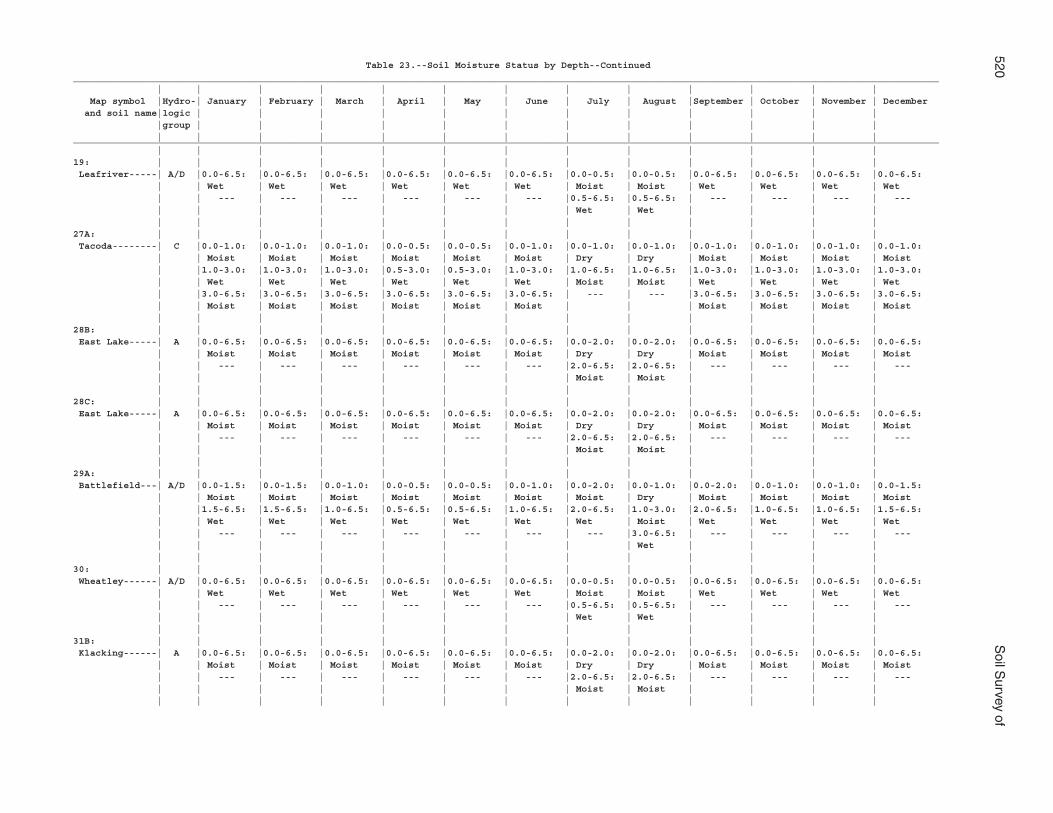
520S
oil Survey of
Table 23.--Soil Moisture Status by Depth--Continued___________________________________________________________________________________________________________________________________________________________ | | | | | | | | | | | | | Map symbol |Hydro-| January | February | March | April | May | June | July | August |September | October | November | December and soil name|logic | | | | | | | | | | | | |group | | | | | | | | | | | | | | | | | | | | | | | | |___________________________________________________________________________________________________________________________________________________________ | | | | | | | | | | | | |19: | | | | | | | | | | | | | Leafriver-----| A/D |0.0-6.5: |0.0-6.5: |0.0-6.5: |0.0-6.5: |0.0-6.5: |0.0-6.5: |0.0-0.5: |0.0-0.5: |0.0-6.5: |0.0-6.5: |0.0-6.5: |0.0-6.5: | | Wet | Wet | Wet | Wet | Wet | Wet | Moist | Moist | Wet | Wet | Wet | Wet | | --- | --- | --- | --- | --- | --- |0.5-6.5: |0.5-6.5: | --- | --- | --- | --- | | | | | | | | Wet | Wet | | | | | | | | | | | | | | | | |27A: | | | | | | | | | | | | | Tacoda--------| C |0.0-1.0: |0.0-1.0: |0.0-1.0: |0.0-0.5: |0.0-0.5: |0.0-1.0: |0.0-1.0: |0.0-1.0: |0.0-1.0: |0.0-1.0: |0.0-1.0: |0.0-1.0: | | Moist | Moist | Moist | Moist | Moist | Moist | Dry | Dry | Moist | Moist | Moist | Moist | |1.0-3.0: |1.0-3.0: |1.0-3.0: |0.5-3.0: |0.5-3.0: |1.0-3.0: |1.0-6.5: |1.0-6.5: |1.0-3.0: |1.0-3.0: |1.0-3.0: |1.0-3.0: | | Wet | Wet | Wet | Wet | Wet | Wet | Moist | Moist | Wet | Wet | Wet | Wet | |3.0-6.5: |3.0-6.5: |3.0-6.5: |3.0-6.5: |3.0-6.5: |3.0-6.5: | --- | --- |3.0-6.5: |3.0-6.5: |3.0-6.5: |3.0-6.5: | | Moist | Moist | Moist | Moist | Moist | Moist | | | Moist | Moist | Moist | Moist | | | | | | | | | | | | |28B: | | | | | | | | | | | | | East Lake-----| A |0.0-6.5: |0.0-6.5: |0.0-6.5: |0.0-6.5: |0.0-6.5: |0.0-6.5: |0.0-2.0: |0.0-2.0: |0.0-6.5: |0.0-6.5: |0.0-6.5: |0.0-6.5: | | Moist | Moist | Moist | Moist | Moist | Moist | Dry | Dry | Moist | Moist | Moist | Moist | | --- | --- | --- | --- | --- | --- |2.0-6.5: |2.0-6.5: | --- | --- | --- | --- | | | | | | | | Moist | Moist | | | | | | | | | | | | | | | | |28C: | | | | | | | | | | | | | East Lake-----| A |0.0-6.5: |0.0-6.5: |0.0-6.5: |0.0-6.5: |0.0-6.5: |0.0-6.5: |0.0-2.0: |0.0-2.0: |0.0-6.5: |0.0-6.5: |0.0-6.5: |0.0-6.5: | | Moist | Moist | Moist | Moist | Moist | Moist | Dry | Dry | Moist | Moist | Moist | Moist | | --- | --- | --- | --- | --- | --- |2.0-6.5: |2.0-6.5: | --- | --- | --- | --- | | | | | | | | Moist | Moist | | | | | | | | | | | | | | | | |29A: | | | | | | | | | | | | | Battlefield---| A/D |0.0-1.5: |0.0-1.5: |0.0-1.0: |0.0-0.5: |0.0-0.5: |0.0-1.0: |0.0-2.0: |0.0-1.0: |0.0-2.0: |0.0-1.0: |0.0-1.0: |0.0-1.5: | | Moist | Moist | Moist | Moist | Moist | Moist | Moist | Dry | Moist | Moist | Moist | Moist | |1.5-6.5: |1.5-6.5: |1.0-6.5: |0.5-6.5: |0.5-6.5: |1.0-6.5: |2.0-6.5: |1.0-3.0: |2.0-6.5: |1.0-6.5: |1.0-6.5: |1.5-6.5: | | Wet | Wet | Wet | Wet | Wet | Wet | Wet | Moist | Wet | Wet | Wet | Wet | | --- | --- | --- | --- | --- | --- | --- |3.0-6.5: | --- | --- | --- | --- | | | | | | | | | Wet | | | | | | | | | | | | | | | | |30: | | | | | | | | | | | | | Wheatley------| A/D |0.0-6.5: |0.0-6.5: |0.0-6.5: |0.0-6.5: |0.0-6.5: |0.0-6.5: |0.0-0.5: |0.0-0.5: |0.0-6.5: |0.0-6.5: |0.0-6.5: |0.0-6.5: | | Wet | Wet | Wet | Wet | Wet | Wet | Moist | Moist | Wet | Wet | Wet | Wet | | --- | --- | --- | --- | --- | --- |0.5-6.5: |0.5-6.5: | --- | --- | --- | --- | | | | | | | | Wet | Wet | | | | | | | | | | | | | | | | |31B: | | | | | | | | | | | | | Klacking------| A |0.0-6.5: |0.0-6.5: |0.0-6.5: |0.0-6.5: |0.0-6.5: |0.0-6.5: |0.0-2.0: |0.0-2.0: |0.0-6.5: |0.0-6.5: |0.0-6.5: |0.0-6.5: | | Moist | Moist | Moist | Moist | Moist | Moist | Dry | Dry | Moist | Moist | Moist | Moist | | --- | --- | --- | --- | --- | --- |2.0-6.5: |2.0-6.5: | --- | --- | --- | --- | | | | | | | | Moist | Moist | | | | | | | | | | | | | | | | |
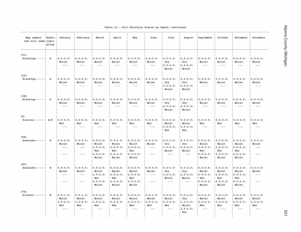
Alpena C
ounty, Michigan
521
Table 23.--Soil Moisture Status by Depth--Continued___________________________________________________________________________________________________________________________________________________________ | | | | | | | | | | | | | Map symbol |Hydro-| January | February | March | April | May | June | July | August |September | October | November | December and soil name|logic | | | | | | | | | | | | |group | | | | | | | | | | | | | | | | | | | | | | | | |___________________________________________________________________________________________________________________________________________________________ | | | | | | | | | | | | |31C: | | | | | | | | | | | | | Klacking------| A |0.0-6.5: |0.0-6.5: |0.0-6.5: |0.0-6.5: |0.0-6.5: |0.0-6.5: |0.0-2.0: |0.0-2.0: |0.0-6.5: |0.0-6.5: |0.0-6.5: |0.0-6.5: | | Moist | Moist | Moist | Moist | Moist | Moist | Dry | Dry | Moist | Moist | Moist | Moist | | --- | --- | --- | --- | --- | --- |2.0-6.5: |2.0-6.5: | --- | --- | --- | --- | | | | | | | | Moist | Moist | | | | | | | | | | | | | | | | |31D: | | | | | | | | | | | | | Klacking------| A |0.0-6.5: |0.0-6.5: |0.0-6.5: |0.0-6.5: |0.0-6.5: |0.0-6.5: |0.0-2.0: |0.0-2.0: |0.0-6.5: |0.0-6.5: |0.0-6.5: |0.0-6.5: | | Moist | Moist | Moist | Moist | Moist | Moist | Dry | Dry | Moist | Moist | Moist | Moist | | --- | --- | --- | --- | --- | --- |2.0-6.5: |2.0-6.5: | --- | --- | --- | --- | | | | | | | | Moist | Moist | | | | | | | | | | | | | | | | |31E: | | | | | | | | | | | | | Klacking------| A |0.0-6.5: |0.0-6.5: |0.0-6.5: |0.0-6.5: |0.0-6.5: |0.0-6.5: |0.0-2.0: |0.0-2.0: |0.0-6.5: |0.0-6.5: |0.0-6.5: |0.0-6.5: | | Moist | Moist | Moist | Moist | Moist | Moist | Dry | Dry | Moist | Moist | Moist | Moist | | --- | --- | --- | --- | --- | --- |2.0-6.5: |2.0-6.5: | --- | --- | --- | --- | | | | | | | | Moist | Moist | | | | | | | | | | | | | | | | |35: | | | | | | | | | | | | | Kinross-------| A/D |0.0-6.5: |0.0-6.5: |0.0-6.5: |0.0-6.5: |0.0-6.5: |0.0-6.5: |0.0-0.5: |0.0-0.5: |0.0-6.5: |0.0-6.5: |0.0-6.5: |0.0-6.5: | | Wet | Wet | Wet | Wet | Wet | Wet | Moist | Moist | Wet | Wet | Wet | Wet | | --- | --- | --- | --- | --- | --- |0.5-6.5: |0.5-6.5: | --- | --- | --- | --- | | | | | | | | Wet | Wet | | | | | | | | | | | | | | | | |36B: | | | | | | | | | | | | | Annalake------| B |0.0-6.5: |0.0-6.5: |0.0-2.5: |0.0-2.5: |0.0-2.5: |0.0-6.5: |0.0-1.0: |0.0-2.0: |0.0-2.5: |0.0-2.5: |0.0-2.5: |0.0-6.5: | | Moist | Moist | Moist | Moist | Moist | Moist | Dry | Dry | Moist | Moist | Moist | Moist | | --- | --- |2.5-6.0: |2.5-6.0: |2.5-6.0: | --- |1.0-6.5: |2.0-6.5: |2.5-6.0: |2.5-6.0: |2.5-6.0: | --- | | | | Wet | Wet | Wet | | Moist | Moist | Wet | Wet | Wet | | | --- | --- |6.0-6.5: |6.0-6.5: |6.0-6.5: | --- | --- | --- |6.0-6.5: |6.0-6.5: |6.0-6.5: | --- | | | | Moist | Moist | Moist | | | | Moist | Moist | Moist | | | | | | | | | | | | | |36C: | | | | | | | | | | | | | Annalake------| B |0.0-6.5: |0.0-6.5: |0.0-2.5: |0.0-2.5: |0.0-2.5: |0.0-6.5: |0.0-1.0: |0.0-2.0: |0.0-2.5: |0.0-2.5: |0.0-2.5: |0.0-6.5: | | Moist | Moist | Moist | Moist | Moist | Moist | Dry | Dry | Moist | Moist | Moist | Moist | | --- | --- |2.5-6.0: |2.5-6.0: |2.5-6.0: | --- |1.0-6.5: |2.0-6.5: |2.5-6.0: |2.5-6.0: |2.5-6.0: | --- | | | | Wet | Wet | Wet | | Moist | Moist | Wet | Wet | Wet | | | --- | --- |6.0-6.5: |6.0-6.5: |6.0-6.5: | --- | --- | --- |6.0-6.5: |6.0-6.5: |6.0-6.5: | --- | | | | Moist | Moist | Moist | | | | Moist | Moist | Moist | | | | | | | | | | | | | |37A: | | | | | | | | | | | | | Richter-------| B |0.0-1.5: |0.0-1.5: |0.0-1.0: |0.0-0.5: |0.0-0.5: |0.0-1.0: |0.0-2.0: |0.0-1.0: |0.0-2.0: |0.0-1.0: |0.0-1.0: |0.0-1.5: | | Moist | Moist | Moist | Moist | Moist | Moist | Moist | Dry | Moist | Moist | Moist | Moist | |1.5-6.5: |1.5-6.5: |1.0-6.5: |0.5-6.5: |0.5-6.5: |1.0-6.5: |2.0-6.5: |1.0-3.0: |2.0-6.5: |1.0-6.5: |1.0-6.5: |1.5-6.5: | | Wet | Wet | Wet | Wet | Wet | Wet | Wet | Moist | Wet | Wet | Wet | Wet | | --- | --- | --- | --- | --- | --- | --- |3.0-6.5: | --- | --- | --- | --- | | | | | | | | | Wet | | | | | | | | | | | | | | | | |
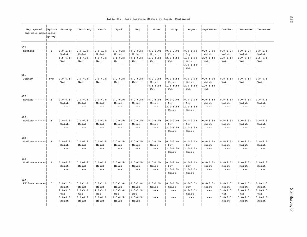
522S
oil Survey of
Table 23.--Soil Moisture Status by Depth--Continued___________________________________________________________________________________________________________________________________________________________ | | | | | | | | | | | | | Map symbol |Hydro-| January | February | March | April | May | June | July | August |September | October | November | December and soil name|logic | | | | | | | | | | | | |group | | | | | | | | | | | | | | | | | | | | | | | | |___________________________________________________________________________________________________________________________________________________________ | | | | | | | | | | | | |37B: | | | | | | | | | | | | | Richter-------| B |0.0-1.5: |0.0-1.5: |0.0-1.0: |0.0-0.5: |0.0-0.5: |0.0-1.0: |0.0-2.0: |0.0-1.0: |0.0-2.0: |0.0-1.0: |0.0-1.0: |0.0-1.5: | | Moist | Moist | Moist | Moist | Moist | Moist | Moist | Dry | Moist | Moist | Moist | Moist | |1.5-6.5: |1.5-6.5: |1.0-6.5: |0.5-6.5: |0.5-6.5: |1.0-6.5: |2.0-6.5: |1.0-3.0: |2.0-6.5: |1.0-6.5: |1.0-6.5: |1.5-6.5: | | Wet | Wet | Wet | Wet | Wet | Wet | Wet | Moist | Wet | Wet | Wet | Wet | | --- | --- | --- | --- | --- | --- | --- |3.0-6.5: | --- | --- | --- | --- | | | | | | | | | Wet | | | | | | | | | | | | | | | | |38: | | | | | | | | | | | | | Tonkey--------| B/D |0.0-6.5: |0.0-6.5: |0.0-6.5: |0.0-6.5: |0.0-6.5: |0.0-0.5: |0.0-1.5: |0.0-2.0: |0.0-1.0: |0.0-6.5: |0.0-6.5: |0.0-6.5: | | Wet | Wet | Wet | Wet | Wet | Moist | Moist | Moist | Moist | Wet | Wet | Wet | | --- | --- | --- | --- | --- |0.5-6.5: |1.5-6.5: |2.0-6.5: |1.0-6.5: | --- | --- | --- | | | | | | | Wet | Wet | Wet | Wet | | | | | | | | | | | | | | | |41B: | | | | | | | | | | | | | McGinn--------| B |0.0-6.5: |0.0-6.5: |0.0-6.5: |0.0-6.5: |0.0-6.5: |0.0-6.5: |0.0-2.0: |0.0-2.0: |0.0-6.5: |0.0-6.5: |0.0-6.5: |0.0-6.5: | | Moist | Moist | Moist | Moist | Moist | Moist | Dry | Dry | Moist | Moist | Moist | Moist | | --- | --- | --- | --- | --- | --- |2.0-6.5: |2.0-6.5: | --- | --- | --- | --- | | | | | | | | Moist | Moist | | | | | | | | | | | | | | | | |41C: | | | | | | | | | | | | | McGinn--------| B |0.0-6.5: |0.0-6.5: |0.0-6.5: |0.0-6.5: |0.0-6.5: |0.0-6.5: |0.0-2.0: |0.0-2.0: |0.0-6.5: |0.0-6.5: |0.0-6.5: |0.0-6.5: | | Moist | Moist | Moist | Moist | Moist | Moist | Dry | Dry | Moist | Moist | Moist | Moist | | --- | --- | --- | --- | --- | --- |2.0-6.5: |2.0-6.5: | --- | --- | --- | --- | | | | | | | | Moist | Moist | | | | | | | | | | | | | | | | |41D: | | | | | | | | | | | | | McGinn--------| B |0.0-6.5: |0.0-6.5: |0.0-6.5: |0.0-6.5: |0.0-6.5: |0.0-6.5: |0.0-2.0: |0.0-2.0: |0.0-6.5: |0.0-6.5: |0.0-6.5: |0.0-6.5: | | Moist | Moist | Moist | Moist | Moist | Moist | Dry | Dry | Moist | Moist | Moist | Moist | | --- | --- | --- | --- | --- | --- |2.0-6.5: |2.0-6.5: | --- | --- | --- | --- | | | | | | | | Moist | Moist | | | | | | | | | | | | | | | | |41E: | | | | | | | | | | | | | McGinn--------| B |0.0-6.5: |0.0-6.5: |0.0-6.5: |0.0-6.5: |0.0-6.5: |0.0-6.5: |0.0-2.0: |0.0-2.0: |0.0-6.5: |0.0-6.5: |0.0-6.5: |0.0-6.5: | | Moist | Moist | Moist | Moist | Moist | Moist | Dry | Dry | Moist | Moist | Moist | Moist | | --- | --- | --- | --- | --- | --- |2.0-6.5: |2.0-6.5: | --- | --- | --- | --- | | | | | | | | Moist | Moist | | | | | | | | | | | | | | | | |42A: | | | | | | | | | | | | | Killmaster----| C |0.0-1.0: |0.0-1.0: |0.0-1.0: |0.0-1.0: |0.0-1.0: |0.0-6.5: |0.0-6.5: |0.0-0.5: |0.0-6.5: |0.0-1.0: |0.0-1.0: |0.0-1.0: | | Moist | Moist | Moist | Moist | Moist | Moist | Moist | Dry | Moist | Moist | Moist | Moist | |1.0-3.0: |1.0-3.0: |1.0-3.0: |1.0-3.0: |1.0-1.5: | --- | --- |0.5-6.5: | --- |1.0-3.0: |1.0-3.0: |1.0-3.0: | | Wet | Wet | Wet | Wet | Wet | | | Moist | | Wet | Wet | Wet | |3.0-6.5: |3.0-6.5: |3.0-6.5: |3.0-6.5: |1.5-6.5: | --- | --- | --- | --- |3.0-6.5: |3.0-6.5: |3.0-6.5: | | Moist | Moist | Moist | Moist | Moist | | | | | Moist | Moist | Moist | | | | | | | | | | | | |
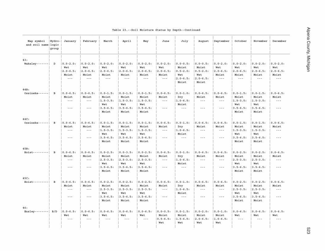
Alpena C
ounty, Michigan
523
Table 23.--Soil Moisture Status by Depth--Continued___________________________________________________________________________________________________________________________________________________________ | | | | | | | | | | | | | Map symbol |Hydro-| January | February | March | April | May | June | July | August |September | October | November | December and soil name|logic | | | | | | | | | | | | |group | | | | | | | | | | | | | | | | | | | | | | | | |___________________________________________________________________________________________________________________________________________________________ | | | | | | | | | | | | |43: | | | | | | | | | | | | | Wakeley-------| D |0.0-2.0: |0.0-2.0: |0.0-2.0: |0.0-2.0: |0.0-2.0: |0.0-2.0: |0.0-0.5: |0.0-0.5: |0.0-2.0: |0.0-2.0: |0.0-2.0: |0.0-2.0: | | Wet | Wet | Wet | Wet | Wet | Wet | Moist | Moist | Wet | Wet | Wet | Wet | |2.0-6.5: |2.0-6.5: |2.0-6.5: |2.0-6.5: |2.0-6.5: |2.0-6.5: |0.5-2.0: |0.5-2.0: |2.0-6.5: |2.0-6.5: |2.0-6.5: |2.0-6.5: | | Moist | Moist | Moist | Moist | Moist | Moist | Wet | Wet | Moist | Moist | Moist | Moist | | --- | --- | --- | --- | --- | --- |2.0-6.5: |2.0-6.5: | --- | --- | --- | --- | | | | | | | | Moist | Moist | | | | | | | | | | | | | | | | |44B: | | | | | | | | | | | | | Ossineke------| B |0.0-6.5: |0.0-6.5: |0.0-1.5: |0.0-1.5: |0.0-1.5: |0.0-6.5: |0.0-1.0: |0.0-6.5: |0.0-6.5: |0.0-1.5: |0.0-1.5: |0.0-6.5: | | Moist | Moist | Moist | Moist | Moist | Moist | Dry | Moist | Moist | Moist | Moist | Moist | | --- | --- |1.5-3.5: |1.5-3.5: |1.5-3.5: | --- |1.0-6.5: | --- | --- |1.5-3.5: |1.5-3.5: | --- | | | | Wet | Wet | Wet | | Moist | | | Wet | Wet | | | --- | --- |3.5-6.5: |3.5-6.5: |3.5-6.5: | --- | --- | --- | --- |3.5-6.5: |3.5-6.5: | --- | | | | Moist | Moist | Moist | | | | | Moist | Moist | | | | | | | | | | | | | |44C: | | | | | | | | | | | | | Ossineke------| B |0.0-6.5: |0.0-6.5: |0.0-1.5: |0.0-1.5: |0.0-1.5: |0.0-6.5: |0.0-1.0: |0.0-6.5: |0.0-6.5: |0.0-1.5: |0.0-1.5: |0.0-6.5: | | Moist | Moist | Moist | Moist | Moist | Moist | Dry | Moist | Moist | Moist | Moist | Moist | | --- | --- |1.5-3.5: |1.5-3.5: |1.5-3.5: | --- |1.0-6.5: | --- | --- |1.5-3.5: |1.5-3.5: | --- | | | | Wet | Wet | Wet | | Moist | | | Wet | Wet | | | --- | --- |3.5-6.5: |3.5-6.5: |3.5-6.5: | --- | --- | --- | --- |3.5-6.5: |3.5-6.5: | --- | | | | Moist | Moist | Moist | | | | | Moist | Moist | | | | | | | | | | | | | |45B: | | | | | | | | | | | | | Hoist---------| B |0.0-6.5: |0.0-6.5: |0.0-2.5: |0.0-3.5: |0.0-2.5: |0.0-6.5: |0.0-1.0: |0.0-6.5: |0.0-6.5: |0.0-2.5: |0.0-2.5: |0.0-6.5: | | Moist | Moist | Moist | Moist | Moist | Moist | Dry | Moist | Moist | Moist | Moist | Moist | | --- | --- |2.5-3.5: |2.5-3.0: |2.5-3.5: | --- |1.0-6.5: | --- | --- |2.5-3.5: |2.5-3.5: | --- | | | | Wet | Wet | Wet | | Moist | | | Wet | Wet | | | --- | --- |3.5-6.5: |3.5-6.5: |3.5-6.5: | --- | --- | --- | --- |3.5-6.5: |3.5-6.5: | --- | | | | Moist | Moist | Moist | | | | | Moist | Moist | | | | | | | | | | | | | |45C: | | | | | | | | | | | | | Hoist---------| B |0.0-6.5: |0.0-6.5: |0.0-2.5: |0.0-2.5: |0.0-2.5: |0.0-6.5: |0.0-1.0: |0.0-6.5: |0.0-6.5: |0.0-2.5: |0.0-2.5: |0.0-6.5: | | Moist | Moist | Moist | Moist | Moist | Moist | Dry | Moist | Moist | Moist | Moist | Moist | | --- | --- |2.5-3.5: |2.5-3.5: |2.5-3.5: | --- |1.0-6.5: | --- | --- |2.5-3.5: |2.5-3.5: | --- | | | | Wet | Wet | Wet | | Moist | | | Wet | Wet | | | --- | --- |3.5-6.5: |3.5-6.5: |3.5-6.5: | --- | --- | --- | --- |3.5-6.5: |3.5-6.5: | --- | | | | Moist | Moist | Moist | | | | | Moist | Moist | | | | | | | | | | | | | |46: | | | | | | | | | | | | | Ensley--------| B/D |0.0-6.5: |0.0-6.5: |0.0-6.5: |0.0-6.5: |0.0-6.5: |0.0-0.5: |0.0-1.5: |0.0-2.0: |0.0-1.0: |0.0-6.5: |0.0-6.5: |0.0-6.5: | | Wet | Wet | Wet | Wet | Wet | Moist | Moist | Moist | Moist | Wet | Wet | Wet | | --- | --- | --- | --- | --- |0.5-6.5: |1.5-6.5: |2.0-6.5: |1.0-6.5: | --- | --- | --- | | | | | | | Wet | Wet | Wet | Wet | | | | | | | | | | | | | | | |
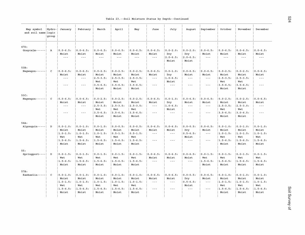
524S
oil Survey of
Table 23.--Soil Moisture Status by Depth--Continued___________________________________________________________________________________________________________________________________________________________ | | | | | | | | | | | | | Map symbol |Hydro-| January | February | March | April | May | June | July | August |September | October | November | December and soil name|logic | | | | | | | | | | | | |group | | | | | | | | | | | | | | | | | | | | | | | | |___________________________________________________________________________________________________________________________________________________________ | | | | | | | | | | | | |47D: | | | | | | | | | | | | | Graycalm------| A |0.0-6.5: |0.0-6.5: |0.0-6.5: |0.0-6.5: |0.0-6.5: |0.0-6.5: |0.0-2.0: |0.0-2.0: |0.0-6.5: |0.0-6.5: |0.0-6.5: |0.0-6.5: | | Moist | Moist | Moist | Moist | Moist | Moist | Dry | Dry | Moist | Moist | Moist | Moist | | --- | --- | --- | --- | --- | --- |2.0-6.5: |2.0-6.5: | --- | --- | --- | --- | | | | | | | | Moist | Moist | | | | | | | | | | | | | | | | |53B: | | | | | | | | | | | | | Negwegon------| C |0.0-6.5: |0.0-6.5: |0.0-2.5: |0.0-2.5: |0.0-2.5: |0.0-6.5: |0.0-1.0: |0.0-6.5: |0.0-6.5: |0.0-2.5: |0.0-2.5: |0.0-6.5: | | Moist | Moist | Moist | Moist | Moist | Moist | Dry | Moist | Moist | Moist | Moist | Moist | | --- | --- |2.5-3.5: |2.5-3.5: |2.5-3.5: | --- |1.0-6.5: | --- | --- |2.5-3.5: |2.5-3.5: | --- | | | | Wet | Wet | Wet | | Moist | | | Wet | Wet | | | --- | --- |3.5-6.5: |3.5-6.5: |3.5-6.5: | --- | --- | --- | --- |3.5-6.5: |3.5-6.5: | --- | | | | Moist | Moist | Moist | | | | | Moist | Moist | | | | | | | | | | | | | |53C: | | | | | | | | | | | | | Negwegon------| C |0.0-6.5: |0.0-6.5: |0.0-2.5: |0.0-2.5: |0.0-2.5: |0.0-6.5: |0.0-1.0: |0.0-6.5: |0.0-6.5: |0.0-2.5: |0.0-2.5: |0.0-6.5: | | Moist | Moist | Moist | Moist | Moist | Moist | Dry | Moist | Moist | Moist | Moist | Moist | | --- | --- |2.5-3.5: |2.5-3.5: |2.5-3.5: | --- |1.0-6.5: | --- | --- |2.5-3.5: |2.5-3.0: | --- | | | | Wet | Wet | Wet | | Moist | | | Wet | Wet | | | --- | --- |3.5-6.5: |3.5-6.5: |3.5-6.5: | --- | --- | --- | --- |3.5-6.5: |3.0-6.5: | --- | | | | Moist | Moist | Moist | | | | | Moist | Moist | | | | | | | | | | | | | |54A: | | | | | | | | | | | | | Algonquin-----| D |0.0-1.0: |0.0-1.0: |0.0-1.0: |0.0-0.5: |0.0-0.5: |0.0-6.5: |0.0-6.5: |0.0-0.5: |0.0-6.5: |0.0-1.0: |0.0-1.0: |0.0-1.0: | | Moist | Moist | Moist | Moist | Moist | Moist | Moist | Dry | Moist | Moist | Moist | Moist | |1.0-1.5: |1.0-1.5: |1.0-1.5: |0.5-1.5: |0.5-1.5: | --- | --- |0.5-6.5: | --- |1.0-1.5: |1.0-1.5: |1.0-1.5: | | Wet | Wet | Wet | Wet | Wet | | | Moist | | Wet | Wet | Wet | |1.5-6.5: |1.5-6.5: |1.5-6.5: |1.5-6.5: |1.5-6.5: | --- | --- | --- | --- |1.5-6.5: |1.5-6.5: |1.5-6.5: | | Moist | Moist | Moist | Moist | Moist | | | | | Moist | Moist | Moist | | | | | | | | | | | | |55: | | | | | | | | | | | | | Springport----| D |0.0-1.5: |0.0-1.5: |0.0-1.5: |0.0-1.5: |0.0-1.5: |0.0-6.5: |0.0-6.5: |0.0-6.5: |0.0-1.5: |0.0-1.5: |0.0-1.5: |0.0-1.5: | | Wet | Wet | Wet | Wet | Wet | Moist | Moist | Moist | Wet | Wet | Wet | Wet | |1.5-6.5: |1.5-6.5: |1.5-6.5: |1.5-6.5: |1.5-6.5: | --- | --- | --- |1.5-6.5: |1.5-6.5: |1.5-6.5: |1.5-6.5: | | Moist | Moist | Moist | Moist | Moist | | | | Moist | Moist | Moist | Moist | | | | | | | | | | | | |57B: | | | | | | | | | | | | | Kawkawlin-----| C |0.0-1.0: |0.0-1.0: |0.0-1.0: |0.0-1.0: |0.0-1.0: |0.0-6.5: |0.0-6.5: |0.0-0.5: |0.0-6.5: |0.0-1.0: |0.0-1.0: |0.0-1.0: | | Moist | Moist | Moist | Moist | Moist | Moist | Moist | Dry | Moist | Moist | Moist | Moist | |1.0-1.5: |1.0-1.5: |1.0-1.5: |1.0-1.5: |1.0-1.5: | --- | --- |0.5-6.5: | --- |1.0-1.5: |1.0-1.5: |1.0-1.5: | | Wet | Wet | Wet | Wet | Wet | | | Moist | | Wet | Wet | Wet | |1.5-6.5: |1.5-6.5: |1.5-6.5: |1.5-6.5: |1.5-6.5: | --- | --- | --- | --- |1.5-6.5: |1.5-6.5: |1.5-6.5: | | Moist | Moist | Moist | Moist | Moist | | | | | Moist | Moist | Moist | | | | | | | | | | | | |
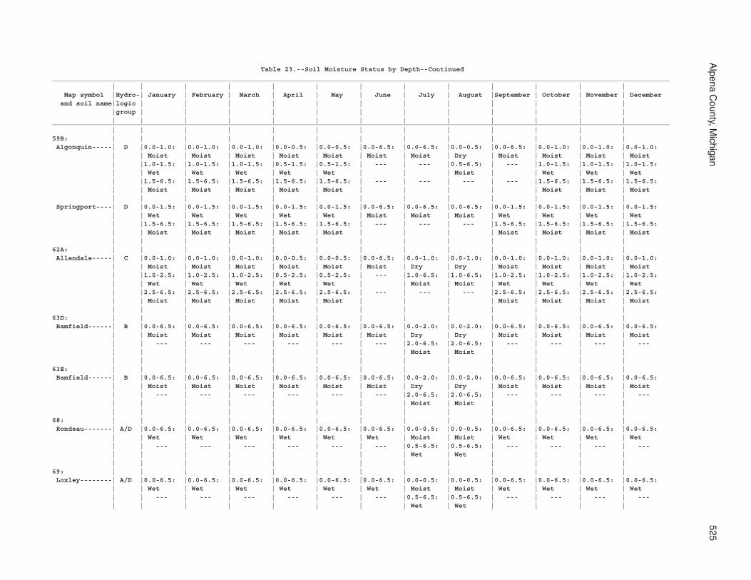
Alpena C
ounty, Michigan
525
Table 23.--Soil Moisture Status by Depth--Continued___________________________________________________________________________________________________________________________________________________________ | | | | | | | | | | | | | Map symbol |Hydro-| January | February | March | April | May | June | July | August |September | October | November | December and soil name|logic | | | | | | | | | | | | |group | | | | | | | | | | | | | | | | | | | | | | | | |___________________________________________________________________________________________________________________________________________________________ | | | | | | | | | | | | |59B: | | | | | | | | | | | | | Algonquin-----| D |0.0-1.0: |0.0-1.0: |0.0-1.0: |0.0-0.5: |0.0-0.5: |0.0-6.5: |0.0-6.5: |0.0-0.5: |0.0-6.5: |0.0-1.0: |0.0-1.0: |0.0-1.0: | | Moist | Moist | Moist | Moist | Moist | Moist | Moist | Dry | Moist | Moist | Moist | Moist | |1.0-1.5: |1.0-1.5: |1.0-1.5: |0.5-1.5: |0.5-1.5: | --- | --- |0.5-6.5: | --- |1.0-1.5: |1.0-1.5: |1.0-1.5: | | Wet | Wet | Wet | Wet | Wet | | | Moist | | Wet | Wet | Wet | |1.5-6.5: |1.5-6.5: |1.5-6.5: |1.5-6.5: |1.5-6.5: | --- | --- | --- | --- |1.5-6.5: |1.5-6.5: |1.5-6.5: | | Moist | Moist | Moist | Moist | Moist | | | | | Moist | Moist | Moist | | | | | | | | | | | | | Springport----| D |0.0-1.5: |0.0-1.5: |0.0-1.5: |0.0-1.5: |0.0-1.5: |0.0-6.5: |0.0-6.5: |0.0-6.5: |0.0-1.5: |0.0-1.5: |0.0-1.5: |0.0-1.5: | | Wet | Wet | Wet | Wet | Wet | Moist | Moist | Moist | Wet | Wet | Wet | Wet | |1.5-6.5: |1.5-6.5: |1.5-6.5: |1.5-6.5: |1.5-6.5: | --- | --- | --- |1.5-6.5: |1.5-6.5: |1.5-6.5: |1.5-6.5: | | Moist | Moist | Moist | Moist | Moist | | | | Moist | Moist | Moist | Moist | | | | | | | | | | | | |62A: | | | | | | | | | | | | | Allendale-----| C |0.0-1.0: |0.0-1.0: |0.0-1.0: |0.0-0.5: |0.0-0.5: |0.0-6.5: |0.0-1.0: |0.0-1.0: |0.0-1.0: |0.0-1.0: |0.0-1.0: |0.0-1.0: | | Moist | Moist | Moist | Moist | Moist | Moist | Dry | Dry | Moist | Moist | Moist | Moist | |1.0-2.5: |1.0-2.5: |1.0-2.5: |0.5-2.5: |0.5-2.5: | --- |1.0-6.5: |1.0-6.5: |1.0-2.5: |1.0-2.5: |1.0-2.5: |1.0-2.5: | | Wet | Wet | Wet | Wet | Wet | | Moist | Moist | Wet | Wet | Wet | Wet | |2.5-6.5: |2.5-6.5: |2.5-6.5: |2.5-6.5: |2.5-6.5: | --- | --- | --- |2.5-6.5: |2.5-6.5: |2.5-6.5: |2.5-6.5: | | Moist | Moist | Moist | Moist | Moist | | | | Moist | Moist | Moist | Moist | | | | | | | | | | | | |63D: | | | | | | | | | | | | | Bamfield------| B |0.0-6.5: |0.0-6.5: |0.0-6.5: |0.0-6.5: |0.0-6.5: |0.0-6.5: |0.0-2.0: |0.0-2.0: |0.0-6.5: |0.0-6.5: |0.0-6.5: |0.0-6.5: | | Moist | Moist | Moist | Moist | Moist | Moist | Dry | Dry | Moist | Moist | Moist | Moist | | --- | --- | --- | --- | --- | --- |2.0-6.5: |2.0-6.5: | --- | --- | --- | --- | | | | | | | | Moist | Moist | | | | | | | | | | | | | | | | |63E: | | | | | | | | | | | | | Bamfield------| B |0.0-6.5: |0.0-6.5: |0.0-6.5: |0.0-6.5: |0.0-6.5: |0.0-6.5: |0.0-2.0: |0.0-2.0: |0.0-6.5: |0.0-6.5: |0.0-6.5: |0.0-6.5: | | Moist | Moist | Moist | Moist | Moist | Moist | Dry | Dry | Moist | Moist | Moist | Moist | | --- | --- | --- | --- | --- | --- |2.0-6.5: |2.0-6.5: | --- | --- | --- | --- | | | | | | | | Moist | Moist | | | | | | | | | | | | | | | | |68: | | | | | | | | | | | | | Rondeau-------| A/D |0.0-6.5: |0.0-6.5: |0.0-6.5: |0.0-6.5: |0.0-6.5: |0.0-6.5: |0.0-0.5: |0.0-0.5: |0.0-6.5: |0.0-6.5: |0.0-6.5: |0.0-6.5: | | Wet | Wet | Wet | Wet | Wet | Wet | Moist | Moist | Wet | Wet | Wet | Wet | | --- | --- | --- | --- | --- | --- |0.5-6.5: |0.5-6.5: | --- | --- | --- | --- | | | | | | | | Wet | Wet | | | | | | | | | | | | | | | | |69: | | | | | | | | | | | | | Loxley--------| A/D |0.0-6.5: |0.0-6.5: |0.0-6.5: |0.0-6.5: |0.0-6.5: |0.0-6.5: |0.0-0.5: |0.0-0.5: |0.0-6.5: |0.0-6.5: |0.0-6.5: |0.0-6.5: | | Wet | Wet | Wet | Wet | Wet | Wet | Moist | Moist | Wet | Wet | Wet | Wet | | --- | --- | --- | --- | --- | --- |0.5-6.5: |0.5-6.5: | --- | --- | --- | --- | | | | | | | | Wet | Wet | | | |
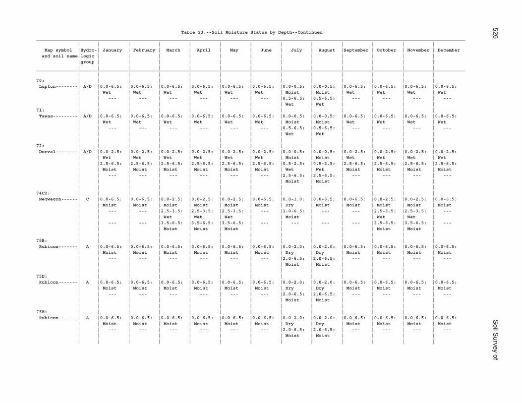
526S
oil Survey of
Table 23.--Soil Moisture Status by Depth--Continued___________________________________________________________________________________________________________________________________________________________ | | | | | | | | | | | | | Map symbol |Hydro-| January | February | March | April | May | June | July | August |September | October | November | December and soil name|logic | | | | | | | | | | | | |group | | | | | | | | | | | | | | | | | | | | | | | | |___________________________________________________________________________________________________________________________________________________________ | | | | | | | | | | | | |70: | | | | | | | | | | | | | Lupton--------| A/D |0.0-6.5: |0.0-6.5: |0.0-6.5: |0.0-6.5: |0.0-6.5: |0.0-6.5: |0.0-0.5: |0.0-0.5: |0.0-6.5: |0.0-6.5: |0.0-6.5: |0.0-6.5: | | Wet | Wet | Wet | Wet | Wet | Wet | Moist | Moist | Wet | Wet | Wet | Wet | | --- | --- | --- | --- | --- | --- |0.5-6.5: |0.5-6.5: | --- | --- | --- | --- | | | | | | | | Wet | Wet | | | |71: | | | | | | | | | | | | | Tawas---------| A/D |0.0-6.5: |0.0-6.5: |0.0-6.5: |0.0-6.5: |0.0-6.5: |0.0-6.5: |0.0-0.5: |0.0-0.5: |0.0-6.5: |0.0-6.5: |0.0-6.5: |0.0-6.5: | | Wet | Wet | Wet | Wet | Wet | Wet | Moist | Moist | Wet | Wet | Wet | Wet | | --- | --- | --- | --- | --- | --- |0.5-6.5: |0.5-6.5: | --- | --- | --- | --- | | | | | | | | Wet | Wet | | | | | | | | | | | | | | | | |72: | | | | | | | | | | | | | Dorval--------| A/D |0.0-2.5: |0.0-2.5: |0.0-2.5: |0.0-2.5: |0.0-2.5: |0.0-2.5: |0.0-0.5: |0.0-0.5: |0.0-2.5: |0.0-2.5: |0.0-2.5: |0.0-2.5: | | Wet | Wet | Wet | Wet | Wet | Wet | Moist | Moist | Wet | Wet | Wet | Wet | |2.5-6.5: |2.5-6.5: |2.5-6.5: |2.5-6.5: |2.5-6.5: |2.5-6.5: |0.5-2.5: |0.5-2.5: |2.5-6.5: |2.5-6.5: |2.5-6.5: |2.5-6.5: | | Moist | Moist | Moist | Moist | Moist | Moist | Wet | Wet | Moist | Moist | Moist | Moist | | --- | --- | --- | --- | --- | --- |2.5-6.5: |2.5-6.5: | --- | --- | --- | --- | | | | | | | | Moist | Moist | | | | | | | | | | | | | | | | |74C2: | | | | | | | | | | | | | Negwegon------| C |0.0-6.5: |0.0-6.5: |0.0-2.5: |0.0-2.5: |0.0-2.5: |0.0-6.5: |0.0-1.0: |0.0-6.5: |0.0-6.5: |0.0-2.5: |0.0-2.5: |0.0-6.5: | | Moist | Moist | Moist | Moist | Moist | Moist | Dry | Moist | Moist | Moist | Moist | Moist | | --- | --- |2.5-3.5: |2.5-3.5: |2.5-3.5: | --- |1.0-6.5: | --- | --- |2.5-3.5: |2.5-3.5: | --- | | | | Wet | Wet | Wet | | Moist | | | Wet | Wet | | | --- | --- |3.5-6.5: |3.5-6.5: |3.5-6.5: | --- | --- | --- | --- |3.5-6.5: |3.5-6.5: | --- | | | | Moist | Moist | Moist | | | | | Moist | Moist | | | | | | | | | | | | | |75B: | | | | | | | | | | | | | Rubicon-------| A |0.0-6.5: |0.0-6.5: |0.0-6.5: |0.0-6.5: |0.0-6.5: |0.0-6.5: |0.0-2.0: |0.0-2.0: |0.0-6.5: |0.0-6.5: |0.0-6.5: |0.0-6.5: | | Moist | Moist | Moist | Moist | Moist | Moist | Dry | Dry | Moist | Moist | Moist | Moist | | --- | --- | --- | --- | --- | --- |2.0-6.5: |2.0-6.5: | --- | --- | --- | --- | | | | | | | | Moist | Moist | | | | | | | | | | | | | | | | |75D: | | | | | | | | | | | | | Rubicon-------| A |0.0-6.5: |0.0-6.5: |0.0-6.5: |0.0-6.5: |0.0-6.5: |0.0-6.5: |0.0-2.0: |0.0-2.0: |0.0-6.5: |0.0-6.5: |0.0-6.5: |0.0-6.5: | | Moist | Moist | Moist | Moist | Moist | Moist | Dry | Dry | Moist | Moist | Moist | Moist | | --- | --- | --- | --- | --- | --- |2.0-6.5: |2.0-6.5: | --- | --- | --- | --- | | | | | | | | Moist | Moist | | | | | | | | | | | | | | | | |75E: | | | | | | | | | | | | | Rubicon-------| A |0.0-6.5: |0.0-6.5: |0.0-6.5: |0.0-6.5: |0.0-6.5: |0.0-6.5: |0.0-2.0: |0.0-2.0: |0.0-6.5: |0.0-6.5: |0.0-6.5: |0.0-6.5: | | Moist | Moist | Moist | Moist | Moist | Moist | Dry | Dry | Moist | Moist | Moist | Moist | | --- | --- | --- | --- | --- | --- |2.0-6.5: |2.0-6.5: | --- | --- | --- | --- | | | | | | | | Moist | Moist | | | | | | | | | | | | | | | | |
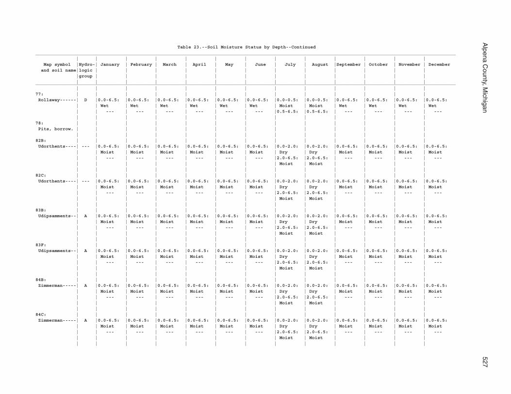
Alpena C
ounty, Michigan
527
Table 23.--Soil Moisture Status by Depth--Continued___________________________________________________________________________________________________________________________________________________________ | | | | | | | | | | | | | Map symbol |Hydro-| January | February | March | April | May | June | July | August |September | October | November | December and soil name|logic | | | | | | | | | | | | |group | | | | | | | | | | | | | | | | | | | | | | | | |___________________________________________________________________________________________________________________________________________________________ | | | | | | | | | | | | |77: | | | | | | | | | | | | | Rollaway------| D |0.0-6.5: |0.0-6.5: |0.0-6.5: |0.0-6.5: |0.0-6.5: |0.0-6.5: |0.0-0.5: |0.0-0.5: |0.0-6.5: |0.0-6.5: |0.0-6.5: |0.0-6.5: | | Wet | Wet | Wet | Wet | Wet | Wet | Moist | Moist | Wet | Wet | Wet | Wet | | --- | --- | --- | --- | --- | --- |0.5-6.5: |0.5-6.5: | --- | --- | --- | --- | | | | | | | | | | | | |78: | | | | | | | | | | | | | Pits, borrow. | | | | | | | | | | | | | | | | | | | | | | | | | |82B: | | | | | | | | | | | | | Udorthents----| --- |0.0-6.5: |0.0-6.5: |0.0-6.5: |0.0-6.5: |0.0-6.5: |0.0-6.5: |0.0-2.0: |0.0-2.0: |0.0-6.5: |0.0-6.5: |0.0-6.5: |0.0-6.5: | | Moist | Moist | Moist | Moist | Moist | Moist | Dry | Dry | Moist | Moist | Moist | Moist | | --- | --- | --- | --- | --- | --- |2.0-6.5: |2.0-6.5: | --- | --- | --- | --- | | | | | | | | Moist | Moist | | | | | | | | | | | | | | | | |82C: | | | | | | | | | | | | | Udorthents----| --- |0.0-6.5: |0.0-6.5: |0.0-6.5: |0.0-6.5: |0.0-6.5: |0.0-6.5: |0.0-2.0: |0.0-2.0: |0.0-6.5: |0.0-6.5: |0.0-6.5: |0.0-6.5: | | Moist | Moist | Moist | Moist | Moist | Moist | Dry | Dry | Moist | Moist | Moist | Moist | | --- | --- | --- | --- | --- | --- |2.0-6.5: |2.0-6.5: | --- | --- | --- | --- | | | | | | | | Moist | Moist | | | | | | | | | | | | | | | | |83B: | | | | | | | | | | | | | Udipsamments--| A |0.0-6.5: |0.0-6.5: |0.0-6.5: |0.0-6.5: |0.0-6.5: |0.0-6.5: |0.0-2.0: |0.0-2.0: |0.0-6.5: |0.0-6.5: |0.0-6.5: |0.0-6.5: | | Moist | Moist | Moist | Moist | Moist | Moist | Dry | Dry | Moist | Moist | Moist | Moist | | --- | --- | --- | --- | --- | --- |2.0-6.5: |2.0-6.5: | --- | --- | --- | --- | | | | | | | | Moist | Moist | | | | | | | | | | | | | | | | |83F: | | | | | | | | | | | | | Udipsamments--| A |0.0-6.5: |0.0-6.5: |0.0-6.5: |0.0-6.5: |0.0-6.5: |0.0-6.5: |0.0-2.0: |0.0-2.0: |0.0-6.5: |0.0-6.5: |0.0-6.5: |0.0-6.5: | | Moist | Moist | Moist | Moist | Moist | Moist | Dry | Dry | Moist | Moist | Moist | Moist | | --- | --- | --- | --- | --- | --- |2.0-6.5: |2.0-6.5: | --- | --- | --- | --- | | | | | | | | Moist | Moist | | | | | | | | | | | | | | | | |84B: | | | | | | | | | | | | | Zimmerman-----| A |0.0-6.5: |0.0-6.5: |0.0-6.5: |0.0-6.5: |0.0-6.5: |0.0-6.5: |0.0-2.0: |0.0-2.0: |0.0-6.5: |0.0-6.5: |0.0-6.5: |0.0-6.5: | | Moist | Moist | Moist | Moist | Moist | Moist | Dry | Dry | Moist | Moist | Moist | Moist | | --- | --- | --- | --- | --- | --- |2.0-6.5: |2.0-6.5: | --- | --- | --- | --- | | | | | | | | Moist | Moist | | | | | | | | | | | | | | | | |84C: | | | | | | | | | | | | | Zimmerman-----| A |0.0-6.5: |0.0-6.5: |0.0-6.5: |0.0-6.5: |0.0-6.5: |0.0-6.5: |0.0-2.0: |0.0-2.0: |0.0-6.5: |0.0-6.5: |0.0-6.5: |0.0-6.5: | | Moist | Moist | Moist | Moist | Moist | Moist | Dry | Dry | Moist | Moist | Moist | Moist | | --- | --- | --- | --- | --- | --- |2.0-6.5: |2.0-6.5: | --- | --- | --- | --- | | | | | | | | Moist | Moist | | | | | | | | | | | | | | | | |
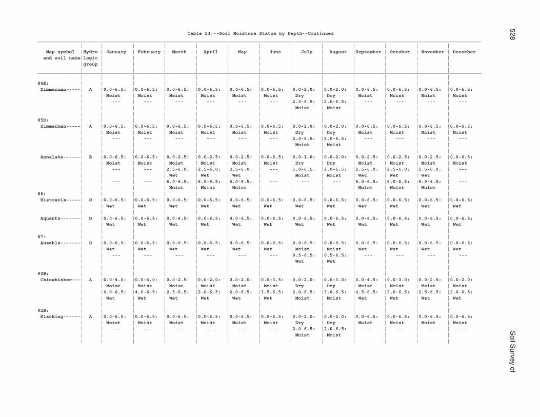
528S
oil Survey of
Table 23.--Soil Moisture Status by Depth--Continued___________________________________________________________________________________________________________________________________________________________ | | | | | | | | | | | | | Map symbol |Hydro-| January | February | March | April | May | June | July | August |September | October | November | December and soil name|logic | | | | | | | | | | | | |group | | | | | | | | | | | | | | | | | | | | | | | | |___________________________________________________________________________________________________________________________________________________________ | | | | | | | | | | | | |84E: | | | | | | | | | | | | | Zimmerman-----| A |0.0-6.5: |0.0-6.5: |0.0-6.5: |0.0-6.5: |0.0-6.5: |0.0-6.5: |0.0-2.0: |0.0-2.0: |0.0-6.5: |0.0-6.5: |0.0-6.5: |0.0-6.5: | | Moist | Moist | Moist | Moist | Moist | Moist | Dry | Dry | Moist | Moist | Moist | Moist | | --- | --- | --- | --- | --- | --- |2.0-6.5: |2.0-6.5: | --- | --- | --- | --- | | | | | | | | Moist | Moist | | | | | | | | | | | | | | | | |85D: | | | | | | | | | | | | | Zimmerman-----| A |0.0-6.5: |0.0-6.5: |0.0-6.5: |0.0-6.5: |0.0-6.5: |0.0-6.5: |0.0-2.0: |0.0-2.0: |0.0-6.5: |0.0-6.5: |0.0-6.5: |0.0-6.5: | | Moist | Moist | Moist | Moist | Moist | Moist | Dry | Dry | Moist | Moist | Moist | Moist | | --- | --- | --- | --- | --- | --- |2.0-6.5: |2.0-6.5: | --- | --- | --- | --- | | | | | | | | Moist | Moist | | | | | | | | | | | | | | | | | Annalake------| B |0.0-6.5: |0.0-6.5: |0.0-2.5: |0.0-2.5: |0.0-2.5: |0.0-6.5: |0.0-1.0: |0.0-2.0: |0.0-2.5: |0.0-2.5: |0.0-2.5: |0.0-6.5: | | Moist | Moist | Moist | Moist | Moist | Moist | Dry | Dry | Moist | Moist | Moist | Moist | | --- | --- |2.5-6.0: |2.5-6.0: |2.5-6.0: | --- |1.0-6.5: |2.0-6.5: |2.5-6.0: |2.5-6.0: |2.5-6.0: | --- | | | | Wet | Wet | Wet | | Moist | Moist | Wet | Wet | Wet | | | --- | --- |6.0-6.5: |6.0-6.5: |6.0-6.5: | --- | --- | --- |6.0-6.5: |6.0-6.5: |6.0-6.5: | --- | | | | Moist | Moist | Moist | | | | Moist | Moist | Moist |86: | | | | | | | | | | | | | Histosols-----| D |0.0-6.5: |0.0-6.5: |0.0-6.5: |0.0-6.5: |0.0-6.5: |0.0-6.5: |0.0-6.5: |0.0-6.5: |0.0-6.5: |0.0-6.5: |0.0-6.5: |0.0-6.5: | | Wet | Wet | Wet | Wet | Wet | Wet | Wet | Wet | Wet | Wet | Wet | Wet | | | | | | | | | | | | | Aquents-------| D |0.0-6.5: |0.0-6.5: |0.0-6.5: |0.0-6.5: |0.0-6.5: |0.0-6.5: |0.0-6.5: |0.0-6.5: |0.0-6.5: |0.0-6.5: |0.0-6.5: |0.0-6.5: | | Wet | Wet | Wet | Wet | Wet | Wet | Wet | Wet | Wet | Wet | Wet | Wet | | | | | | | | | | | | |87: | | | | | | | | | | | | | Ausable-------| D |0.0-6.5: |0.0-6.5: |0.0-6.5: |0.0-6.5: |0.0-6.5: |0.0-6.5: |0.0-0.5: |0.0-0.5: |0.0-6.5: |0.0-6.5: |0.0-6.5: |0.0-6.5: | | Wet | Wet | Wet | Wet | Wet | Wet | Moist | Moist | Wet | Wet | Wet | Wet | | --- | --- | --- | --- | --- | --- |0.5-6.5: |0.5-6.5: | --- | --- | --- | --- | | | | | | | | Wet | Wet | | | | | | | | | | | | | | | | |90B: | | | | | | | | | | | | | Chinwhisker---| A |0.0-4.0: |0.0-4.0: |0.0-2.5: |0.0-2.0: |0.0-2.0: |0.0-3.5: |0.0-2.0: |0.0-3.0: |0.0-4.5: |0.0-3.0: |0.0-2.5: |0.0-2.0: | | Moist | Moist | Moist | Moist | Moist | Moist | Dry | Dry | Moist | Moist | Moist | Moist | |4.0-6.5: |4.0-6.5: |2.5-6.5: |2.0-6.5: |2.0-6.5: |3.5-6.5: |2.0-6.5: |3.0-6.5: |4.5-6.5: |3.0-6.5: |2.5-6.5: |2.0-6.5: | | Wet | Wet | Wet | Wet | Wet | Wet | Moist | Moist | Wet | Wet | Wet | Wet | | | | | | | | | | | | |92B: | | | | | | | | | | | | | Klacking------| A |0.0-6.5: |0.0-6.5: |0.0-6.5: |0.0-6.5: |0.0-6.5: |0.0-6.5: |0.0-2.0: |0.0-2.0: |0.0-6.5: |0.0-6.5: |0.0-6.5: |0.0-6.5: | | Moist | Moist | Moist | Moist | Moist | Moist | Dry | Dry | Moist | Moist | Moist | Moist | | --- | --- | --- | --- | --- | --- |2.0-6.5: |2.0-6.5: | --- | --- | --- | --- | | | | | | | | Moist | Moist | | | | | | | | | | | | | | | | |
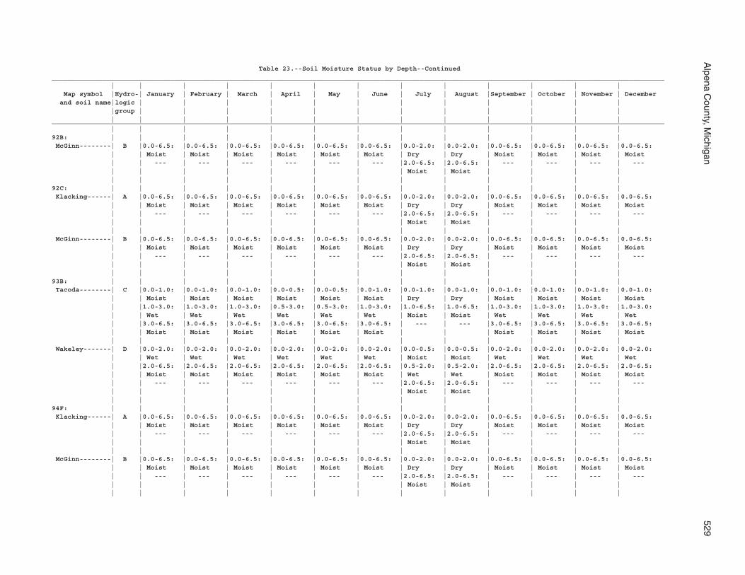
Alpena C
ounty, Michigan
529
Table 23.--Soil Moisture Status by Depth--Continued___________________________________________________________________________________________________________________________________________________________ | | | | | | | | | | | | | Map symbol |Hydro-| January | February | March | April | May | June | July | August |September | October | November | December and soil name|logic | | | | | | | | | | | | |group | | | | | | | | | | | | | | | | | | | | | | | | |___________________________________________________________________________________________________________________________________________________________ | | | | | | | | | | | | |92B: | | | | | | | | | | | | | McGinn--------| B |0.0-6.5: |0.0-6.5: |0.0-6.5: |0.0-6.5: |0.0-6.5: |0.0-6.5: |0.0-2.0: |0.0-2.0: |0.0-6.5: |0.0-6.5: |0.0-6.5: |0.0-6.5: | | Moist | Moist | Moist | Moist | Moist | Moist | Dry | Dry | Moist | Moist | Moist | Moist | | --- | --- | --- | --- | --- | --- |2.0-6.5: |2.0-6.5: | --- | --- | --- | --- | | | | | | | | Moist | Moist | | | | | | | | | | | | | | | | |92C: | | | | | | | | | | | | | Klacking------| A |0.0-6.5: |0.0-6.5: |0.0-6.5: |0.0-6.5: |0.0-6.5: |0.0-6.5: |0.0-2.0: |0.0-2.0: |0.0-6.5: |0.0-6.5: |0.0-6.5: |0.0-6.5: | | Moist | Moist | Moist | Moist | Moist | Moist | Dry | Dry | Moist | Moist | Moist | Moist | | --- | --- | --- | --- | --- | --- |2.0-6.5: |2.0-6.5: | --- | --- | --- | --- | | | | | | | | Moist | Moist | | | | | | | | | | | | | | | | | McGinn--------| B |0.0-6.5: |0.0-6.5: |0.0-6.5: |0.0-6.5: |0.0-6.5: |0.0-6.5: |0.0-2.0: |0.0-2.0: |0.0-6.5: |0.0-6.5: |0.0-6.5: |0.0-6.5: | | Moist | Moist | Moist | Moist | Moist | Moist | Dry | Dry | Moist | Moist | Moist | Moist | | --- | --- | --- | --- | --- | --- |2.0-6.5: |2.0-6.5: | --- | --- | --- | --- | | | | | | | | Moist | Moist | | | | | | | | | | | | | | | | |93B: | | | | | | | | | | | | | Tacoda--------| C |0.0-1.0: |0.0-1.0: |0.0-1.0: |0.0-0.5: |0.0-0.5: |0.0-1.0: |0.0-1.0: |0.0-1.0: |0.0-1.0: |0.0-1.0: |0.0-1.0: |0.0-1.0: | | Moist | Moist | Moist | Moist | Moist | Moist | Dry | Dry | Moist | Moist | Moist | Moist | |1.0-3.0: |1.0-3.0: |1.0-3.0: |0.5-3.0: |0.5-3.0: |1.0-3.0: |1.0-6.5: |1.0-6.5: |1.0-3.0: |1.0-3.0: |1.0-3.0: |1.0-3.0: | | Wet | Wet | Wet | Wet | Wet | Wet | Moist | Moist | Wet | Wet | Wet | Wet | |3.0-6.5: |3.0-6.5: |3.0-6.5: |3.0-6.5: |3.0-6.5: |3.0-6.5: | --- | --- |3.0-6.5: |3.0-6.5: |3.0-6.5: |3.0-6.5: | | Moist | Moist | Moist | Moist | Moist | Moist | | | Moist | Moist | Moist | Moist | | | | | | | | | | | | | Wakeley-------| D |0.0-2.0: |0.0-2.0: |0.0-2.0: |0.0-2.0: |0.0-2.0: |0.0-2.0: |0.0-0.5: |0.0-0.5: |0.0-2.0: |0.0-2.0: |0.0-2.0: |0.0-2.0: | | Wet | Wet | Wet | Wet | Wet | Wet | Moist | Moist | Wet | Wet | Wet | Wet | |2.0-6.5: |2.0-6.5: |2.0-6.5: |2.0-6.5: |2.0-6.5: |2.0-6.5: |0.5-2.0: |0.5-2.0: |2.0-6.5: |2.0-6.5: |2.0-6.5: |2.0-6.5: | | Moist | Moist | Moist | Moist | Moist | Moist | Wet | Wet | Moist | Moist | Moist | Moist | | --- | --- | --- | --- | --- | --- |2.0-6.5: |2.0-6.5: | --- | --- | --- | --- | | | | | | | | Moist | Moist | | | | | | | | | | | | | | | | |94F: | | | | | | | | | | | | | Klacking------| A |0.0-6.5: |0.0-6.5: |0.0-6.5: |0.0-6.5: |0.0-6.5: |0.0-6.5: |0.0-2.0: |0.0-2.0: |0.0-6.5: |0.0-6.5: |0.0-6.5: |0.0-6.5: | | Moist | Moist | Moist | Moist | Moist | Moist | Dry | Dry | Moist | Moist | Moist | Moist | | --- | --- | --- | --- | --- | --- |2.0-6.5: |2.0-6.5: | --- | --- | --- | --- | | | | | | | | Moist | Moist | | | | | | | | | | | | | | | | | McGinn--------| B |0.0-6.5: |0.0-6.5: |0.0-6.5: |0.0-6.5: |0.0-6.5: |0.0-6.5: |0.0-2.0: |0.0-2.0: |0.0-6.5: |0.0-6.5: |0.0-6.5: |0.0-6.5: | | Moist | Moist | Moist | Moist | Moist | Moist | Dry | Dry | Moist | Moist | Moist | Moist | | --- | --- | --- | --- | --- | --- |2.0-6.5: |2.0-6.5: | --- | --- | --- | --- | | | | | | | | Moist | Moist | | | | | | | | | | | | | | | | |
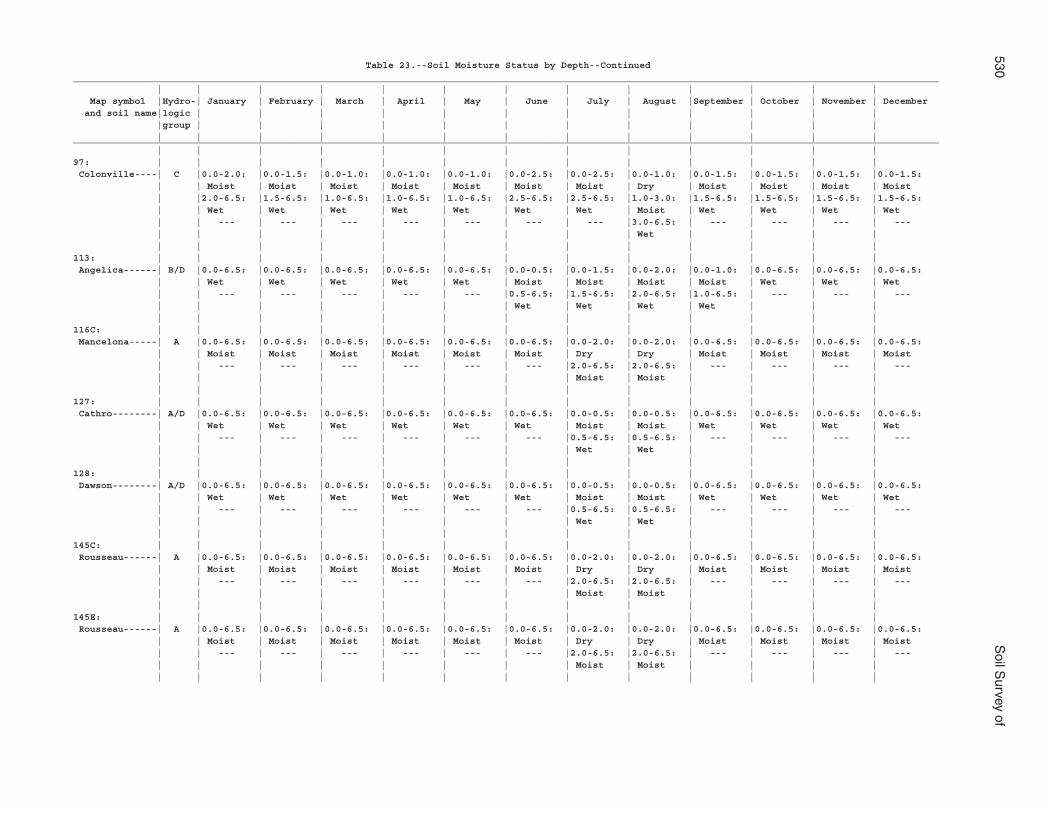
530S
oil Survey of
Table 23.--Soil Moisture Status by Depth--Continued___________________________________________________________________________________________________________________________________________________________ | | | | | | | | | | | | | Map symbol |Hydro-| January | February | March | April | May | June | July | August |September | October | November | December and soil name|logic | | | | | | | | | | | | |group | | | | | | | | | | | | | | | | | | | | | | | | |___________________________________________________________________________________________________________________________________________________________ | | | | | | | | | | | | |97: | | | | | | | | | | | | | Colonville----| C |0.0-2.0: |0.0-1.5: |0.0-1.0: |0.0-1.0: |0.0-1.0: |0.0-2.5: |0.0-2.5: |0.0-1.0: |0.0-1.5: |0.0-1.5: |0.0-1.5: |0.0-1.5: | | Moist | Moist | Moist | Moist | Moist | Moist | Moist | Dry | Moist | Moist | Moist | Moist | |2.0-6.5: |1.5-6.5: |1.0-6.5: |1.0-6.5: |1.0-6.5: |2.5-6.5: |2.5-6.5: |1.0-3.0: |1.5-6.5: |1.5-6.5: |1.5-6.5: |1.5-6.5: | | Wet | Wet | Wet | Wet | Wet | Wet | Wet | Moist | Wet | Wet | Wet | Wet | | --- | --- | --- | --- | --- | --- | --- |3.0-6.5: | --- | --- | --- | --- | | | | | | | | | Wet | | | | | | | | | | | | | | | | |113: | | | | | | | | | | | | | Angelica------| B/D |0.0-6.5: |0.0-6.5: |0.0-6.5: |0.0-6.5: |0.0-6.5: |0.0-0.5: |0.0-1.5: |0.0-2.0: |0.0-1.0: |0.0-6.5: |0.0-6.5: |0.0-6.5: | | Wet | Wet | Wet | Wet | Wet | Moist | Moist | Moist | Moist | Wet | Wet | Wet | | --- | --- | --- | --- | --- |0.5-6.5: |1.5-6.5: |2.0-6.5: |1.0-6.5: | --- | --- | --- | | | | | | | Wet | Wet | Wet | Wet | | | | | | | | | | | | | | | |116C: | | | | | | | | | | | | | Mancelona-----| A |0.0-6.5: |0.0-6.5: |0.0-6.5: |0.0-6.5: |0.0-6.5: |0.0-6.5: |0.0-2.0: |0.0-2.0: |0.0-6.5: |0.0-6.5: |0.0-6.5: |0.0-6.5: | | Moist | Moist | Moist | Moist | Moist | Moist | Dry | Dry | Moist | Moist | Moist | Moist | | --- | --- | --- | --- | --- | --- |2.0-6.5: |2.0-6.5: | --- | --- | --- | --- | | | | | | | | Moist | Moist | | | | | | | | | | | | | | | | |127: | | | | | | | | | | | | | Cathro--------| A/D |0.0-6.5: |0.0-6.5: |0.0-6.5: |0.0-6.5: |0.0-6.5: |0.0-6.5: |0.0-0.5: |0.0-0.5: |0.0-6.5: |0.0-6.5: |0.0-6.5: |0.0-6.5: | | Wet | Wet | Wet | Wet | Wet | Wet | Moist | Moist | Wet | Wet | Wet | Wet | | --- | --- | --- | --- | --- | --- |0.5-6.5: |0.5-6.5: | --- | --- | --- | --- | | | | | | | | Wet | Wet | | | | | | | | | | | | | | | | |128: | | | | | | | | | | | | | Dawson--------| A/D |0.0-6.5: |0.0-6.5: |0.0-6.5: |0.0-6.5: |0.0-6.5: |0.0-6.5: |0.0-0.5: |0.0-0.5: |0.0-6.5: |0.0-6.5: |0.0-6.5: |0.0-6.5: | | Wet | Wet | Wet | Wet | Wet | Wet | Moist | Moist | Wet | Wet | Wet | Wet | | --- | --- | --- | --- | --- | --- |0.5-6.5: |0.5-6.5: | --- | --- | --- | --- | | | | | | | | Wet | Wet | | | | | | | | | | | | | | | | |145C: | | | | | | | | | | | | | Rousseau------| A |0.0-6.5: |0.0-6.5: |0.0-6.5: |0.0-6.5: |0.0-6.5: |0.0-6.5: |0.0-2.0: |0.0-2.0: |0.0-6.5: |0.0-6.5: |0.0-6.5: |0.0-6.5: | | Moist | Moist | Moist | Moist | Moist | Moist | Dry | Dry | Moist | Moist | Moist | Moist | | --- | --- | --- | --- | --- | --- |2.0-6.5: |2.0-6.5: | --- | --- | --- | --- | | | | | | | | Moist | Moist | | | | | | | | | | | | | | | | |145E: | | | | | | | | | | | | | Rousseau------| A |0.0-6.5: |0.0-6.5: |0.0-6.5: |0.0-6.5: |0.0-6.5: |0.0-6.5: |0.0-2.0: |0.0-2.0: |0.0-6.5: |0.0-6.5: |0.0-6.5: |0.0-6.5: | | Moist | Moist | Moist | Moist | Moist | Moist | Dry | Dry | Moist | Moist | Moist | Moist | | --- | --- | --- | --- | --- | --- |2.0-6.5: |2.0-6.5: | --- | --- | --- | --- | | | | | | | | Moist | Moist | | | | | | | | | | | | | | | | |
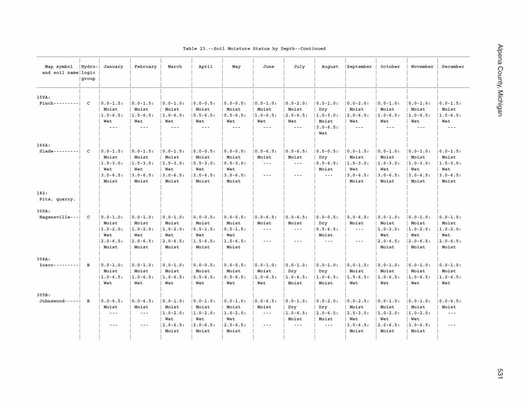
Alpena C
ounty, Michigan
531
Table 23.--Soil Moisture Status by Depth--Continued___________________________________________________________________________________________________________________________________________________________ | | | | | | | | | | | | | Map symbol |Hydro-| January | February | March | April | May | June | July | August |September | October | November | December and soil name|logic | | | | | | | | | | | | |group | | | | | | | | | | | | | | | | | | | | | | | | |___________________________________________________________________________________________________________________________________________________________ | | | | | | | | | | | | |159A: | | | | | | | | | | | | | Finch---------| C |0.0-1.5: |0.0-1.5: |0.0-1.0: |0.0-0.5: |0.0-0.5: |0.0-1.0: |0.0-2.0: |0.0-1.0: |0.0-2.0: |0.0-1.0: |0.0-1.0: |0.0-1.5: | | Moist | Moist | Moist | Moist | Moist | Moist | Moist | Dry | Moist | Moist | Moist | Moist | |1.5-6.5: |1.5-6.5: |1.0-6.5: |0.5-6.5: |0.5-6.5: |1.0-6.5: |2.0-6.5: |1.0-3.0: |2.0-6.5: |1.0-6.5: |1.0-6.5: |1.5-6.5: | | Wet | Wet | Wet | Wet | Wet | Wet | Wet | Moist | Wet | Wet | Wet | Wet | | --- | --- | --- | --- | --- | --- | --- |3.0-6.5: | --- | --- | --- | --- | | | | | | | | | Wet | | | | | | | | | | | | | | | | |166A: | | | | | | | | | | | | | Slade---------| C |0.0-1.5: |0.0-1.5: |0.0-1.5: |0.0-0.5: |0.0-0.5: |0.0-6.5: |0.0-6.5: |0.0-0.5: |0.0-1.5: |0.0-1.0: |0.0-1.0: |0.0-1.5: | | Moist | Moist | Moist | Moist | Moist | Moist | Moist | Dry | Moist | Moist | Moist | Moist | |1.5-3.0: |1.5-3.0: |1.5-3.0: |0.5-3.0: |0.5-3.0: | --- | --- |0.5-6.5: |1.5-3.0: |1.0-3.0: |1.0-3.0: |1.5-3.0: | | Wet | Wet | Wet | Wet | Wet | | | Moist | Wet | Wet | Wet | Wet | |3.0-6.5: |3.0-6.5: |3.0-6.5: |3.0-6.5: |3.0-6.5: | --- | --- | --- |3.0-6.5: |3.0-6.5: |3.0-6.5: |3.0-6.5: | | Moist | Moist | Moist | Moist | Moist | | | | Moist | Moist | Moist | Moist | | | | | | | | | | | | |182: | | | | | | | | | | | | | Pits, quarry. | | | | | | | | | | | | | | | | | | | | | | | | | |300A: | | | | | | | | | | | | | Hagensville---| C |0.0-1.0: |0.0-1.0: |0.0-1.0: |0.0-0.5: |0.0-0.5: |0.0-6.5: |0.0-6.5: |0.0-0.5: |0.0-6.5: |0.0-1.0: |0.0-1.0: |0.0-1.0: | | Moist | Moist | Moist | Moist | Moist | Moist | Moist | Dry | Moist | Moist | Moist | Moist | |1.0-2.0: |1.0-2.0: |1.0-2.0: |0.5-1.5: |0.5-1.5: | --- | --- |0.5-6.5: | --- |1.0-2.0: |1.0-2.0: |1.0-2.0: | | Wet | Wet | Wet | Wet | Wet | | | Moist | | Wet | Wet | Wet | |2.0-6.5: |2.0-6.5: |2.0-6.5: |1.5-6.5: |1.5-6.5: | --- | --- | --- | --- |2.0-6.5: |2.0-6.5: |2.0-6.5: | | Moist | Moist | Moist | Moist | Moist | | | | | Moist | Moist | Moist | | | | | | | | | | | | |304A: | | | | | | | | | | | | | Iosco---------| B |0.0-1.0: |0.0-1.0: |0.0-1.0: |0.0-0.5: |0.0-0.5: |0.0-1.0: |0.0-1.0: |0.0-1.0: |0.0-1.5: |0.0-1.0: |0.0-1.0: |0.0-1.0: | | Moist | Moist | Moist | Moist | Moist | Moist | Dry | Dry | Moist | Moist | Moist | Moist | |1.0-6.5: |1.0-6.5: |1.0-6.5: |0.5-6.5: |0.5-6.5: |1.0-6.5: |1.0-6.5: |1.0-6.5: |1.5-6.5: |1.0-6.5: |1.0-6.5: |1.0-6.5: | | Wet | Wet | Wet | Wet | Wet | Wet | Moist | Moist | Wet | Wet | Wet | Wet | | | | | | | | | | | | |305B: | | | | | | | | | | | | | Johnswood-----| B |0.0-6.5: |0.0-6.5: |0.0-1.0: |0.0-1.0: |0.0-1.0: |0.0-6.5: |0.0-1.0: |0.0-2.0: |0.0-2.5: |0.0-1.0: |0.0-1.0: |0.0-6.5: | | Moist | Moist | Moist | Moist | Moist | Moist | Dry | Dry | Moist | Moist | Moist | Moist | | --- | --- |1.0-2.0: |1.0-2.0: |1.0-2.0: | --- |1.0-6.5: |2.0-6.5: |2.5-3.0: |1.0-2.0: |1.0-2.0: | --- | | | | Wet | Wet | Wet | | Moist | Moist | Wet | Wet | Wet | | | --- | --- |2.0-6.5: |2.0-6.5: |2.0-6.5: | --- | --- | --- |3.0-6.5: |2.0-6.5: |3.0-6.5: | --- | | | | Moist | Moist | Moist | | | | Moist | Moist | Moist | | | | | | | | | | | | | |
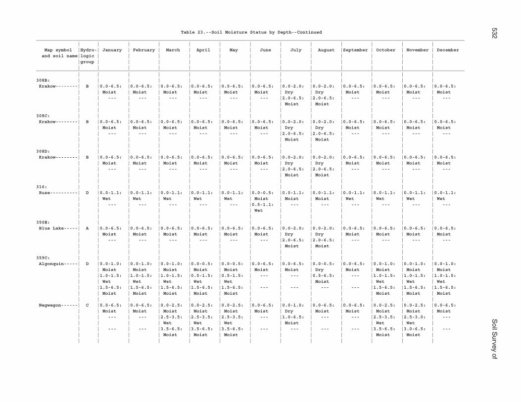
532S
oil Survey of
Table 23.--Soil Moisture Status by Depth--Continued___________________________________________________________________________________________________________________________________________________________ | | | | | | | | | | | | | Map symbol |Hydro-| January | February | March | April | May | June | July | August |September | October | November | December and soil name|logic | | | | | | | | | | | | |group | | | | | | | | | | | | | | | | | | | | | | | | |___________________________________________________________________________________________________________________________________________________________ | | | | | | | | | | | | |308B: | | | | | | | | | | | | | Krakow--------| B |0.0-6.5: |0.0-6.5: |0.0-6.5: |0.0-6.5: |0.0-6.5: |0.0-6.5: |0.0-2.0: |0.0-2.0: |0.0-6.5: |0.0-6.5: |0.0-6.5: |0.0-6.5: | | Moist | Moist | Moist | Moist | Moist | Moist | Dry | Dry | Moist | Moist | Moist | Moist | | --- | --- | --- | --- | --- | --- |2.0-6.5: |2.0-6.5: | --- | --- | --- | --- | | | | | | | | Moist | Moist | | | | | | | | | | | | | | | | |308C: | | | | | | | | | | | | | Krakow--------| B |0.0-6.5: |0.0-6.5: |0.0-6.5: |0.0-6.5: |0.0-6.5: |0.0-6.5: |0.0-2.0: |0.0-2.0: |0.0-6.5: |0.0-6.5: |0.0-6.5: |0.0-6.5: | | Moist | Moist | Moist | Moist | Moist | Moist | Dry | Dry | Moist | Moist | Moist | Moist | | --- | --- | --- | --- | --- | --- |2.0-6.5: |2.0-6.5: | --- | --- | --- | --- | | | | | | | | Moist | Moist | | | | | | | | | | | | | | | | |308D: | | | | | | | | | | | | | Krakow--------| B |0.0-6.5: |0.0-6.5: |0.0-6.5: |0.0-6.5: |0.0-6.5: |0.0-6.5: |0.0-2.0: |0.0-2.0: |0.0-6.5: |0.0-6.5: |0.0-6.5: |0.0-6.5: | | Moist | Moist | Moist | Moist | Moist | Moist | Dry | Dry | Moist | Moist | Moist | Moist | | --- | --- | --- | --- | --- | --- |2.0-6.5: |2.0-6.5: | --- | --- | --- | --- | | | | | | | | Moist | Moist | | | | | | | | | | | | | | | | |316: | | | | | | | | | | | | | Ruse----------| D |0.0-1.1: |0.0-1.1: |0.0-1.1: |0.0-1.1: |0.0-1.1: |0.0-0.5: |0.0-1.1: |0.0-1.1: |0.0-1.1: |0.0-1.1: |0.0-1.1: |0.0-1.1: | | Wet | Wet | Wet | Wet | Wet | Moist | Moist | Moist | Wet | Wet | Wet | Wet | | --- | --- | --- | --- | --- |0.5-1.1: | --- | --- | --- | --- | --- | --- | | | | | | | Wet | | | | | | | | | | | | | | | | | | |350E: | | | | | | | | | | | | | Blue Lake-----| A |0.0-6.5: |0.0-6.5: |0.0-6.5: |0.0-6.5: |0.0-6.5: |0.0-6.5: |0.0-2.0: |0.0-2.0: |0.0-6.5: |0.0-6.5: |0.0-6.5: |0.0-6.5: | | Moist | Moist | Moist | Moist | Moist | Moist | Dry | Dry | Moist | Moist | Moist | Moist | | --- | --- | --- | --- | --- | --- |2.0-6.5: |2.0-6.5: | --- | --- | --- | --- | | | | | | | | Moist | Moist | | | | | | | | | | | | | | | | |359C: | | | | | | | | | | | | | Algonquin-----| D |0.0-1.0: |0.0-1.0: |0.0-1.0: |0.0-0.5: |0.0-0.5: |0.0-6.5: |0.0-6.5: |0.0-0.5: |0.0-6.5: |0.0-1.0: |0.0-1.0: |0.0-1.0: | | Moist | Moist | Moist | Moist | Moist | Moist | Moist | Dry | Moist | Moist | Moist | Moist | |1.0-1.5: |1.0-1.5: |1.0-1.5: |0.5-1.5: |0.5-1.5: | --- | --- |0.5-6.5: | --- |1.0-1.5: |1.0-1.5: |1.0-1.5: | | Wet | Wet | Wet | Wet | Wet | | | Moist | | Wet | Wet | Wet | |1.5-6.5: |1.5-6.5: |1.5-6.5: |1.5-6.5: |1.5-6.5: | --- | --- | --- | --- |1.5-6.5: |1.5-6.5: |1.5-6.5: | | Moist | Moist | Moist | Moist | Moist | | | | | Moist | Moist | Moist | | | | | | | | | | | | | Negwegon------| C |0.0-6.5: |0.0-6.5: |0.0-2.5: |0.0-2.5: |0.0-2.5: |0.0-6.5: |0.0-1.0: |0.0-6.5: |0.0-6.5: |0.0-2.5: |0.0-2.5: |0.0-6.5: | | Moist | Moist | Moist | Moist | Moist | Moist | Dry | Moist | Moist | Moist | Moist | Moist | | --- | --- |2.5-3.5: |2.5-3.5: |2.5-3.5: | --- |1.0-6.5: | --- | --- |2.5-3.5: |2.5-3.0: | --- | | | | Wet | Wet | Wet | | Moist | | | Wet | Wet | | | --- | --- |3.5-6.5: |3.5-6.5: |3.5-6.5: | --- | --- | --- | --- |3.5-6.5: |3.0-6.5: | --- | | | | Moist | Moist | Moist | | | | | Moist | Moist | | | | | | | | | | | | | |
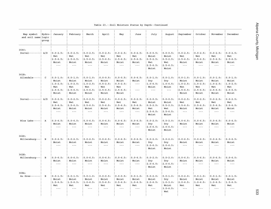
Alpena C
ounty, Michigan
533
Table 23.--Soil Moisture Status by Depth--Continued___________________________________________________________________________________________________________________________________________________________ | | | | | | | | | | | | | Map symbol |Hydro-| January | February | March | April | May | June | July | August |September | October | November | December and soil name|logic | | | | | | | | | | | | |group | | | | | | | | | | | | | | | | | | | | | | | | |___________________________________________________________________________________________________________________________________________________________ | | | | | | | | | | | | |359C: | | | | | | | | | | | | | Dorval--------| A/D |0.0-2.5: |0.0-2.5: |0.0-2.5: |0.0-2.5: |0.0-2.5: |0.0-2.5: |0.0-0.5: |0.0-0.5: |0.0-2.5: |0.0-2.5: |0.0-2.5: |0.0-2.5: | | Wet | Wet | Wet | Wet | Wet | Wet | Moist | Moist | Wet | Wet | Wet | Wet | |2.5-6.5: |2.5-6.5: |2.5-6.5: |2.5-6.5: |2.5-6.5: |2.5-6.5: |0.5-2.5: |0.5-2.5: |2.5-6.5: |2.5-6.5: |2.5-6.5: |2.5-6.5: | | Moist | Moist | Moist | Moist | Moist | Moist | Wet | Wet | Moist | Moist | Moist | Moist | | --- | --- | --- | --- | --- | --- |2.5-6.5: |2.5-6.5: | --- | --- | --- | --- | | | | | | | | Moist | Moist | | | | | | | | | | | | | | | | |361B: | | | | | | | | | | | | | Allendale-----| C |0.0-1.0: |0.0-1.0: |0.0-1.0: |0.0-0.5: |0.0-0.5: |0.0-6.5: |0.0-1.0: |0.0-1.0: |0.0-1.0: |0.0-1.0: |0.0-1.0: |0.0-1.0: | | Moist | Moist | Moist | Moist | Moist | Moist | Dry | Dry | Moist | Moist | Moist | Moist | |1.0-2.5: |1.0-2.5: |1.0-2.5: |0.5-2.5: |0.5-2.5: | --- |1.0-6.5: |1.0-6.5: |1.0-2.5: |1.0-2.5: |1.0-2.5: |1.0-2.5: | | Wet | Wet | Wet | Wet | Wet | | Moist | Moist | Wet | Wet | Wet | Wet | |2.5-6.5: |2.5-6.5: |2.5-6.5: |2.5-6.5: |2.5-6.5: | --- | --- | --- |2.5-6.5: |2.5-6.5: |2.5-6.5: |2.5-6.5: | | Moist | Moist | Moist | Moist | Moist | | | | Moist | Moist | Moist | Moist | | | | | | | | | | | | | Dorval--------| A/D |0.0-2.5: |0.0-2.5: |0.0-2.5: |0.0-2.5: |0.0-2.5: |0.0-2.5: |0.0-0.5: |0.0-0.5: |0.0-2.5: |0.0-2.5: |0.0-2.5: |0.0-2.5: | | Wet | Wet | Wet | Wet | Wet | Wet | Moist | Moist | Wet | Wet | Wet | Wet | |2.5-6.5: |2.5-6.5: |2.5-6.5: |2.5-6.5: |2.5-6.5: |2.5-6.5: |0.5-2.5: |0.5-2.5: |2.5-6.5: |2.5-6.5: |2.5-6.5: |2.5-6.5: | | Moist | Moist | Moist | Moist | Moist | Moist | Wet | Wet | Moist | Moist | Moist | Moist | | --- | --- | --- | --- | --- | --- |2.5-6.5: |2.5-6.5: | --- | --- | --- | --- | | | | | | | | Moist | Moist | | | | | | | | | | | | | | | | | Blue Lake-----| A |0.0-6.5: |0.0-6.5: |0.0-6.5: |0.0-6.5: |0.0-6.5: |0.0-6.5: |0.0-2.0: |0.0-2.0: |0.0-6.5: |0.0-6.5: |0.0-6.5: |0.0-6.5: | | Moist | Moist | Moist | Moist | Moist | Moist | Dry | Dry | Moist | Moist | Moist | Moist | | --- | --- | --- | --- | --- | --- |2.0-6.5: |2.0-6.5: | --- | --- | --- | --- | | | | | | | | Moist | Moist | | | | | | | | | | | | | | | | |362D: | | | | | | | | | | | | | Millersburg---| B |0.0-6.5: |0.0-6.5: |0.0-6.5: |0.0-6.5: |0.0-6.5: |0.0-6.5: |0.0-2.0: |0.0-2.0: |0.0-6.5: |0.0-6.5: |0.0-6.5: |0.0-6.5: | | Moist | Moist | Moist | Moist | Moist | Moist | Dry | Dry | Moist | Moist | Moist | Moist | | --- | --- | --- | --- | --- | --- |2.0-6.5: |2.0-6.5: | --- | --- | --- | --- | | | | | | | | Moist | Moist | | | | | | | | | | | | | | | | |362E: | | | | | | | | | | | | | Millersburg---| B |0.0-6.5: |0.0-6.5: |0.0-6.5: |0.0-6.5: |0.0-6.5: |0.0-6.5: |0.0-2.0: |0.0-2.0: |0.0-6.5: |0.0-6.5: |0.0-6.5: |0.0-6.5: | | Moist | Moist | Moist | Moist | Moist | Moist | Dry | Dry | Moist | Moist | Moist | Moist | | --- | --- | --- | --- | --- | --- |2.0-6.5: |2.0-6.5: | --- | --- | --- | --- | | | | | | | | Moist | Moist | | | | | | | | | | | | | | | | |368A: | | | | | | | | | | | | | Au Gres-------| B |0.0-1.5: |0.0-1.5: |0.0-1.0: |0.0-0.5: |0.0-0.5: |0.0-1.0: |0.0-2.0: |0.0-1.0: |0.0-2.0: |0.0-1.0: |0.0-1.0: |0.0-1.5: | | Moist | Moist | Moist | Moist | Moist | Moist | Moist | Dry | Moist | Moist | Moist | Moist | |1.5-6.5: |1.5-6.5: |1.0-6.5: |0.5-6.5: |0.5-6.5: |1.0-6.5: |2.0-6.5: |1.0-3.0: |2.0-6.5: |1.0-6.5: |1.0-6.5: |1.5-6.5: | | Wet | Wet | Wet | Wet | Wet | Wet | Wet | Moist | Wet | Wet | Wet | Wet | | --- | --- | --- | --- | --- | --- | --- |3.0-6.5: | --- | --- | --- | --- | | | | | | | | | Wet | | | | | | | | | | | | | | | | |
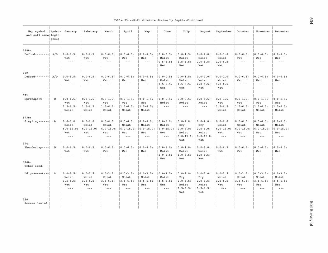
534S
oil Survey of
Table 23.--Soil Moisture Status by Depth--Continued___________________________________________________________________________________________________________________________________________________________ | | | | | | | | | | | | | Map symbol |Hydro-| January | February | March | April | May | June | July | August |September | October | November | December and soil name|logic | | | | | | | | | | | | |group | | | | | | | | | | | | | | | | | | | | | | | | |___________________________________________________________________________________________________________________________________________________________ | | | | | | | | | | | | |368A: | | | | | | | | | | | | | Deford--------| A/D |0.0-6.5: |0.0-6.5: |0.0-6.5: |0.0-6.5: |0.0-6.5: |0.0-0.5: |0.0-1.5: |0.0-2.0: |0.0-1.0: |0.0-6.5: |0.0-6.5: |0.0-6.5: | | Wet | Wet | Wet | Wet | Wet | Moist | Moist | Moist | Moist | Wet | Wet | Wet | | --- | --- | --- | --- | --- |0.5-6.5: |1.5-6.5: |2.0-6.5: |1.0-6.5: | --- | --- | --- | | | | | | | Wet | Wet | Wet | Wet | | | | | | | | | | | | | | | |369: | | | | | | | | | | | | | Deford--------| A/D |0.0-6.5: |0.0-6.5: |0.0-6.5: |0.0-6.5: |0.0-6.5: |0.0-0.5: |0.0-1.5: |0.0-2.0: |0.0-1.0: |0.0-6.5: |0.0-6.5: |0.0-6.5: | | Wet | Wet | Wet | Wet | Wet | Moist | Moist | Moist | Moist | Wet | Wet | Wet | | --- | --- | --- | --- | --- |0.5-6.5: |1.5-6.5: |2.0-6.5: |1.0-6.5: | --- | --- | --- | | | | | | | Wet | Wet | Wet | Wet | | | | | | | | | | | | | | | |371: | | | | | | | | | | | | | Springport----| D |0.0-1.5: |0.0-1.5: |0.0-1.5: |0.0-1.5: |0.0-1.5: |0.0-6.5: |0.0-6.5: |0.0-6.5: |0.0-1.5: |0.0-1.5: |0.0-1.5: |0.0-1.5: | | Wet | Wet | Wet | Wet | Wet | Moist | Moist | Moist | Wet | Wet | Wet | Wet | |1.5-6.5: |1.5-6.5: |1.5-6.5: |1.5-6.5: |1.5-6.5: | --- | --- | --- |1.5-6.5: |1.5-6.5: |1.5-6.5: |1.5-6.5: | | Moist | Moist | Moist | Moist | Moist | | | | Moist | Moist | Moist | Moist | | | | | | | | | | | | |373B: | | | | | | | | | | | | | Grayling------| A |0.0-6.0: |0.0-6.0: |0.0-6.0: |0.0-6.0: |0.0-6.0: |0.0-6.0: |0.0-2.0: |0.0-2.0: |0.0-6.0: |0.0-6.0: |0.0-6.0: |0.0-6.0: | | Moist | Moist | Moist | Moist | Moist | Moist | Dry | Dry | Moist | Moist | Moist | Moist | |6.0-15.0: |6.0-15.0: |6.0-15.0: |6.0-15.0: |6.0-15.0: |6.0-15.0: |2.0-6.0: |2.0-6.0: |6.0-15.0: |6.0-15.0: |6.0-15.0: |6.0-15.0: | | Wet | Wet | Wet | Wet | Wet | Wet | Moist | Moist | Wet | Wet | Wet | Wet | | --- | --- | --- | --- | --- | --- |6.0-15.0: |6.0-15.0: | --- | --- | --- | --- | | | | | | | | Wet | Wet | | | |374: | | | | | | | | | | | | | Thunderbay----| D |0.0-6.5: |0.0-6.5: |0.0-6.5: |0.0-6.5: |0.0-6.5: |0.0-1.0: |0.0-1.0: |0.0-1.0: |0.0-6.5: |0.0-6.5: |0.0-6.5: |0.0-6.5: | | Wet | Wet | Wet | Wet | Wet | Moist | Moist | Moist | Wet | Wet | Wet | Wet | | --- | --- | --- | --- | --- |1.0-6.5: |1.0-6.5: |1.0-6.5: | --- | --- | --- | --- | | | | | | | Wet | Wet | Wet | | | |376A: | | | | | | | | | | | | | Urban land. | | | | | | | | | | | | | | | | | | | | | | | | | | Udipsamments--| A |0.0-3.5: |0.0-3.5: |0.0-3.5: |0.0-3.5: |0.0-3.5: |0.0-3.5: |0.0-2.0: |0.0-2.0: |0.0-3.5: |0.0-3.5: |0.0-3.5: |0.0-3.5: | | Moist | Moist | Moist | Moist | Moist | Moist | Dry | Dry | Moist | Moist | Moist | Moist | |3.5-6.5: |3.5-6.5: |3.5-6.5: |3.5-6.5: |3.5-6.5: |3.5-6.5: |2.0-3.5: |2.0-3.5: |3.5-6.5: |3.5-6.5: |3.5-6.5: |3.5-6.5: | | Wet | Wet | Wet | Wet | Wet | Wet | Moist | Moist | Wet | Wet | Wet | Wet | | --- | --- | --- | --- | --- | --- |3.5-6.5: |3.5-6.5: | --- | --- | --- | --- | | | | | | | | Wet | Wet | | | | | | | | | | | | | | | | |380: | | | | | | | | | | | | | Access denied.| | | | | | | | | | | | | | | | | | | | | | | | | |
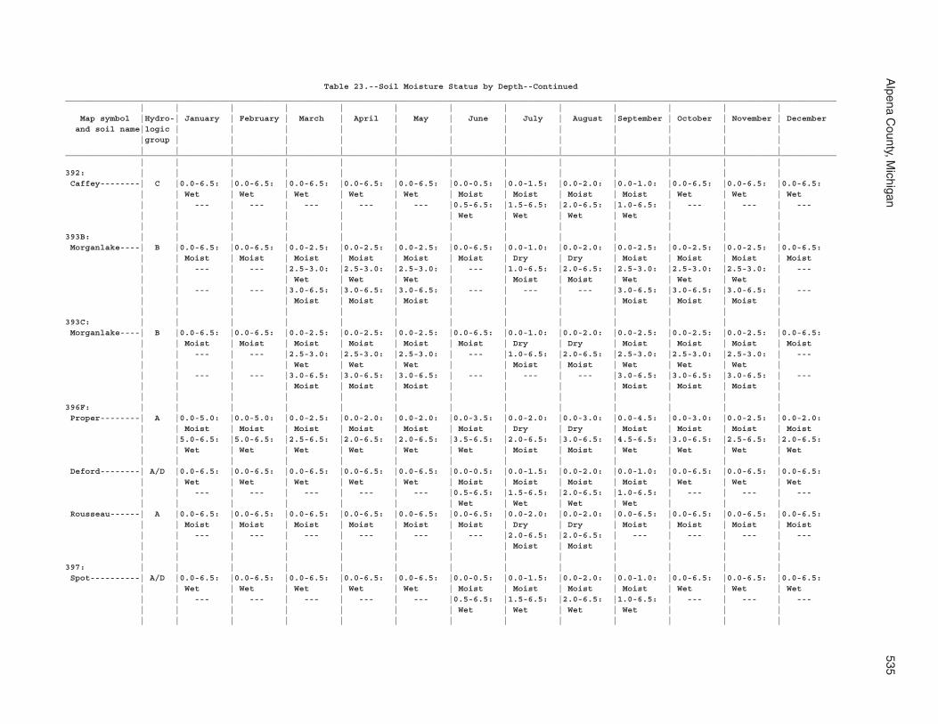
Alpena C
ounty, Michigan
535
Table 23.--Soil Moisture Status by Depth--Continued___________________________________________________________________________________________________________________________________________________________ | | | | | | | | | | | | | Map symbol |Hydro-| January | February | March | April | May | June | July | August |September | October | November | December and soil name|logic | | | | | | | | | | | | |group | | | | | | | | | | | | | | | | | | | | | | | | |___________________________________________________________________________________________________________________________________________________________ | | | | | | | | | | | | |392: | | | | | | | | | | | | | Caffey--------| C |0.0-6.5: |0.0-6.5: |0.0-6.5: |0.0-6.5: |0.0-6.5: |0.0-0.5: |0.0-1.5: |0.0-2.0: |0.0-1.0: |0.0-6.5: |0.0-6.5: |0.0-6.5: | | Wet | Wet | Wet | Wet | Wet | Moist | Moist | Moist | Moist | Wet | Wet | Wet | | --- | --- | --- | --- | --- |0.5-6.5: |1.5-6.5: |2.0-6.5: |1.0-6.5: | --- | --- | --- | | | | | | | Wet | Wet | Wet | Wet | | | | | | | | | | | | | | | |393B: | | | | | | | | | | | | | Morganlake----| B |0.0-6.5: |0.0-6.5: |0.0-2.5: |0.0-2.5: |0.0-2.5: |0.0-6.5: |0.0-1.0: |0.0-2.0: |0.0-2.5: |0.0-2.5: |0.0-2.5: |0.0-6.5: | | Moist | Moist | Moist | Moist | Moist | Moist | Dry | Dry | Moist | Moist | Moist | Moist | | --- | --- |2.5-3.0: |2.5-3.0: |2.5-3.0: | --- |1.0-6.5: |2.0-6.5: |2.5-3.0: |2.5-3.0: |2.5-3.0: | --- | | | | Wet | Wet | Wet | | Moist | Moist | Wet | Wet | Wet | | | --- | --- |3.0-6.5: |3.0-6.5: |3.0-6.5: | --- | --- | --- |3.0-6.5: |3.0-6.5: |3.0-6.5: | --- | | | | Moist | Moist | Moist | | | | Moist | Moist | Moist | | | | | | | | | | | | | |393C: | | | | | | | | | | | | | Morganlake----| B |0.0-6.5: |0.0-6.5: |0.0-2.5: |0.0-2.5: |0.0-2.5: |0.0-6.5: |0.0-1.0: |0.0-2.0: |0.0-2.5: |0.0-2.5: |0.0-2.5: |0.0-6.5: | | Moist | Moist | Moist | Moist | Moist | Moist | Dry | Dry | Moist | Moist | Moist | Moist | | --- | --- |2.5-3.0: |2.5-3.0: |2.5-3.0: | --- |1.0-6.5: |2.0-6.5: |2.5-3.0: |2.5-3.0: |2.5-3.0: | --- | | | | Wet | Wet | Wet | | Moist | Moist | Wet | Wet | Wet | | | --- | --- |3.0-6.5: |3.0-6.5: |3.0-6.5: | --- | --- | --- |3.0-6.5: |3.0-6.5: |3.0-6.5: | --- | | | | Moist | Moist | Moist | | | | Moist | Moist | Moist | | | | | | | | | | | | | |396F: | | | | | | | | | | | | | Proper--------| A |0.0-5.0: |0.0-5.0: |0.0-2.5: |0.0-2.0: |0.0-2.0: |0.0-3.5: |0.0-2.0: |0.0-3.0: |0.0-4.5: |0.0-3.0: |0.0-2.5: |0.0-2.0: | | Moist | Moist | Moist | Moist | Moist | Moist | Dry | Dry | Moist | Moist | Moist | Moist | |5.0-6.5: |5.0-6.5: |2.5-6.5: |2.0-6.5: |2.0-6.5: |3.5-6.5: |2.0-6.5: |3.0-6.5: |4.5-6.5: |3.0-6.5: |2.5-6.5: |2.0-6.5: | | Wet | Wet | Wet | Wet | Wet | Wet | Moist | Moist | Wet | Wet | Wet | Wet | | | | | | | | | | | | | Deford--------| A/D |0.0-6.5: |0.0-6.5: |0.0-6.5: |0.0-6.5: |0.0-6.5: |0.0-0.5: |0.0-1.5: |0.0-2.0: |0.0-1.0: |0.0-6.5: |0.0-6.5: |0.0-6.5: | | Wet | Wet | Wet | Wet | Wet | Moist | Moist | Moist | Moist | Wet | Wet | Wet | | --- | --- | --- | --- | --- |0.5-6.5: |1.5-6.5: |2.0-6.5: |1.0-6.5: | --- | --- | --- | | | | | | | Wet | Wet | Wet | Wet | | | Rousseau------| A |0.0-6.5: |0.0-6.5: |0.0-6.5: |0.0-6.5: |0.0-6.5: |0.0-6.5: |0.0-2.0: |0.0-2.0: |0.0-6.5: |0.0-6.5: |0.0-6.5: |0.0-6.5: | | Moist | Moist | Moist | Moist | Moist | Moist | Dry | Dry | Moist | Moist | Moist | Moist | | --- | --- | --- | --- | --- | --- |2.0-6.5: |2.0-6.5: | --- | --- | --- | --- | | | | | | | | Moist | Moist | | | | | | | | | | | | | | | | |397: | | | | | | | | | | | | | Spot----------| A/D |0.0-6.5: |0.0-6.5: |0.0-6.5: |0.0-6.5: |0.0-6.5: |0.0-0.5: |0.0-1.5: |0.0-2.0: |0.0-1.0: |0.0-6.5: |0.0-6.5: |0.0-6.5: | | Wet | Wet | Wet | Wet | Wet | Moist | Moist | Moist | Moist | Wet | Wet | Wet | | --- | --- | --- | --- | --- |0.5-6.5: |1.5-6.5: |2.0-6.5: |1.0-6.5: | --- | --- | --- | | | | | | | Wet | Wet | Wet | Wet | | | | | | | | | | | | | | | |
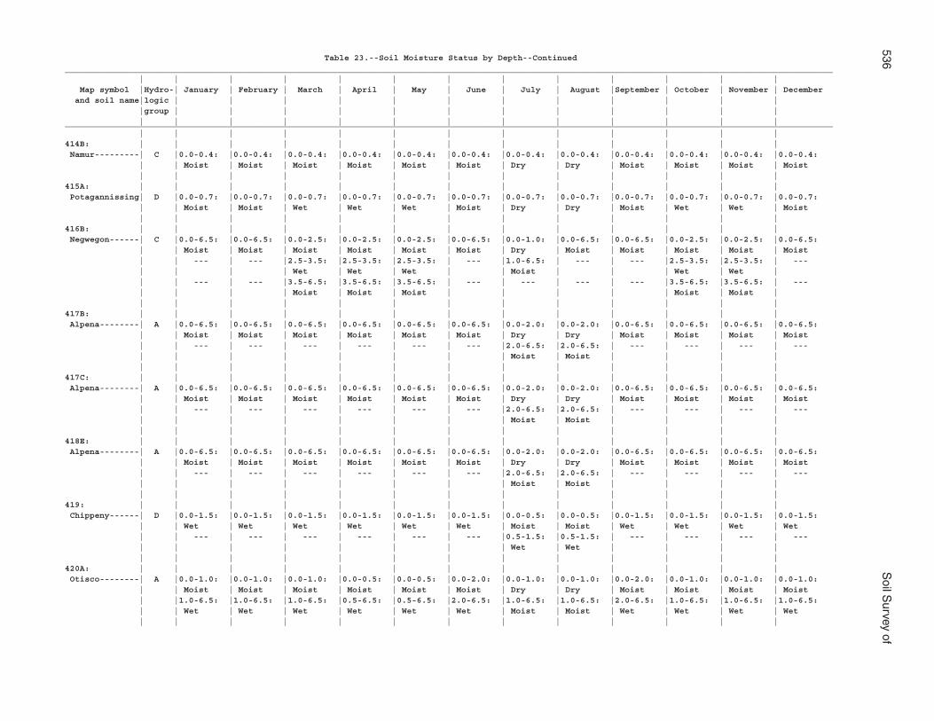
536S
oil Survey of
Table 23.--Soil Moisture Status by Depth--Continued___________________________________________________________________________________________________________________________________________________________ | | | | | | | | | | | | | Map symbol |Hydro-| January | February | March | April | May | June | July | August |September | October | November | December and soil name|logic | | | | | | | | | | | | |group | | | | | | | | | | | | | | | | | | | | | | | | |___________________________________________________________________________________________________________________________________________________________ | | | | | | | | | | | | |414B: | | | | | | | | | | | | | Namur---------| C |0.0-0.4: |0.0-0.4: |0.0-0.4: |0.0-0.4: |0.0-0.4: |0.0-0.4: |0.0-0.4: |0.0-0.4: |0.0-0.4: |0.0-0.4: |0.0-0.4: |0.0-0.4: | | Moist | Moist | Moist | Moist | Moist | Moist | Dry | Dry | Moist | Moist | Moist | Moist | | | | | | | | | | | | |415A: | | | | | | | | | | | | | Potagannissing| D |0.0-0.7: |0.0-0.7: |0.0-0.7: |0.0-0.7: |0.0-0.7: |0.0-0.7: |0.0-0.7: |0.0-0.7: |0.0-0.7: |0.0-0.7: |0.0-0.7: |0.0-0.7: | | Moist | Moist | Wet | Wet | Wet | Moist | Dry | Dry | Moist | Wet | Wet | Moist | | | | | | | | | | | | |416B: | | | | | | | | | | | | | Negwegon------| C |0.0-6.5: |0.0-6.5: |0.0-2.5: |0.0-2.5: |0.0-2.5: |0.0-6.5: |0.0-1.0: |0.0-6.5: |0.0-6.5: |0.0-2.5: |0.0-2.5: |0.0-6.5: | | Moist | Moist | Moist | Moist | Moist | Moist | Dry | Moist | Moist | Moist | Moist | Moist | | --- | --- |2.5-3.5: |2.5-3.5: |2.5-3.5: | --- |1.0-6.5: | --- | --- |2.5-3.5: |2.5-3.5: | --- | | | | Wet | Wet | Wet | | Moist | | | Wet | Wet | | | --- | --- |3.5-6.5: |3.5-6.5: |3.5-6.5: | --- | --- | --- | --- |3.5-6.5: |3.5-6.5: | --- | | | | Moist | Moist | Moist | | | | | Moist | Moist | | | | | | | | | | | | | |417B: | | | | | | | | | | | | | Alpena--------| A |0.0-6.5: |0.0-6.5: |0.0-6.5: |0.0-6.5: |0.0-6.5: |0.0-6.5: |0.0-2.0: |0.0-2.0: |0.0-6.5: |0.0-6.5: |0.0-6.5: |0.0-6.5: | | Moist | Moist | Moist | Moist | Moist | Moist | Dry | Dry | Moist | Moist | Moist | Moist | | --- | --- | --- | --- | --- | --- |2.0-6.5: |2.0-6.5: | --- | --- | --- | --- | | | | | | | | Moist | Moist | | | | | | | | | | | | | | | | |417C: | | | | | | | | | | | | | Alpena--------| A |0.0-6.5: |0.0-6.5: |0.0-6.5: |0.0-6.5: |0.0-6.5: |0.0-6.5: |0.0-2.0: |0.0-2.0: |0.0-6.5: |0.0-6.5: |0.0-6.5: |0.0-6.5: | | Moist | Moist | Moist | Moist | Moist | Moist | Dry | Dry | Moist | Moist | Moist | Moist | | --- | --- | --- | --- | --- | --- |2.0-6.5: |2.0-6.5: | --- | --- | --- | --- | | | | | | | | Moist | Moist | | | | | | | | | | | | | | | | |418E: | | | | | | | | | | | | | Alpena--------| A |0.0-6.5: |0.0-6.5: |0.0-6.5: |0.0-6.5: |0.0-6.5: |0.0-6.5: |0.0-2.0: |0.0-2.0: |0.0-6.5: |0.0-6.5: |0.0-6.5: |0.0-6.5: | | Moist | Moist | Moist | Moist | Moist | Moist | Dry | Dry | Moist | Moist | Moist | Moist | | --- | --- | --- | --- | --- | --- |2.0-6.5: |2.0-6.5: | --- | --- | --- | --- | | | | | | | | Moist | Moist | | | | | | | | | | | | | | | | |419: | | | | | | | | | | | | | Chippeny------| D |0.0-1.5: |0.0-1.5: |0.0-1.5: |0.0-1.5: |0.0-1.5: |0.0-1.5: |0.0-0.5: |0.0-0.5: |0.0-1.5: |0.0-1.5: |0.0-1.5: |0.0-1.5: | | Wet | Wet | Wet | Wet | Wet | Wet | Moist | Moist | Wet | Wet | Wet | Wet | | --- | --- | --- | --- | --- | --- |0.5-1.5: |0.5-1.5: | --- | --- | --- | --- | | | | | | | | Wet | Wet | | | | | | | | | | | | | | | | |420A: | | | | | | | | | | | | | Otisco--------| A |0.0-1.0: |0.0-1.0: |0.0-1.0: |0.0-0.5: |0.0-0.5: |0.0-2.0: |0.0-1.0: |0.0-1.0: |0.0-2.0: |0.0-1.0: |0.0-1.0: |0.0-1.0: | | Moist | Moist | Moist | Moist | Moist | Moist | Dry | Dry | Moist | Moist | Moist | Moist | |1.0-6.5: |1.0-6.5: |1.0-6.5: |0.5-6.5: |0.5-6.5: |2.0-6.5: |1.0-6.5: |1.0-6.5: |2.0-6.5: |1.0-6.5: |1.0-6.5: |1.0-6.5: | | Wet | Wet | Wet | Wet | Wet | Wet | Moist | Moist | Wet | Wet | Wet | Wet | | | | | | | | | | | | |
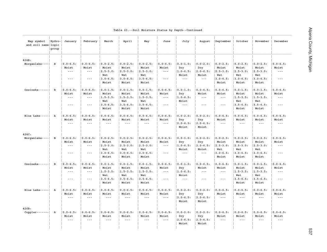
Alpena C
ounty, Michigan
537
Table 23.--Soil Moisture Status by Depth--Continued___________________________________________________________________________________________________________________________________________________________ | | | | | | | | | | | | | Map symbol |Hydro-| January | February | March | April | May | June | July | August |September | October | November | December and soil name|logic | | | | | | | | | | | | |group | | | | | | | | | | | | | | | | | | | | | | | | |___________________________________________________________________________________________________________________________________________________________ | | | | | | | | | | | | |424B: | | | | | | | | | | | | | Morganlake----| B |0.0-6.5: |0.0-6.5: |0.0-2.5: |0.0-2.5: |0.0-2.5: |0.0-6.5: |0.0-1.0: |0.0-2.0: |0.0-2.5: |0.0-2.5: |0.0-2.5: |0.0-6.5: | | Moist | Moist | Moist | Moist | Moist | Moist | Dry | Dry | Moist | Moist | Moist | Moist | | --- | --- |2.5-3.0: |2.5-3.0: |2.5-3.0: | --- |1.0-6.5: |2.0-6.5: |2.5-3.0: |2.5-3.0: |2.5-3.0: | --- | | | | Wet | Wet | Wet | | Moist | Moist | Wet | Wet | Wet | | | --- | --- |3.0-6.5: |3.0-6.5: |3.0-6.5: | --- | --- | --- |3.0-6.5: |3.0-6.5: |3.0-6.5: | --- | | | | Moist | Moist | Moist | | | | Moist | Moist | Moist | | | | | | | | | | | | | | Ossineke------| B |0.0-6.5: |0.0-6.5: |0.0-1.5: |0.0-1.5: |0.0-1.5: |0.0-6.5: |0.0-1.0: |0.0-6.5: |0.0-6.5: |0.0-1.5: |0.0-1.5: |0.0-6.5: | | Moist | Moist | Moist | Moist | Moist | Moist | Dry | Moist | Moist | Moist | Moist | Moist | | --- | --- |1.5-3.5: |1.5-3.5: |1.5-3.5: | --- |1.0-6.5: | --- | --- |1.5-3.5: |1.5-3.5: | --- | | | | Wet | Wet | Wet | | Moist | | | Wet | Wet | | | --- | --- |3.5-6.5: |3.5-6.5: |3.5-6.5: | --- | --- | --- | --- |3.5-6.5: |3.5-6.5: | --- | | | | Moist | Moist | Moist | | | | | Moist | Moist | | | | | | | | | | | | | | Blue Lake-----| A |0.0-6.5: |0.0-6.5: |0.0-6.5: |0.0-6.5: |0.0-6.5: |0.0-6.5: |0.0-2.0: |0.0-2.0: |0.0-6.5: |0.0-6.5: |0.0-6.5: |0.0-6.5: | | Moist | Moist | Moist | Moist | Moist | Moist | Dry | Dry | Moist | Moist | Moist | Moist | | --- | --- | --- | --- | --- | --- |2.0-6.5: |2.0-6.5: | --- | --- | --- | --- | | | | | | | | Moist | Moist | | | | | | | | | | | | | | | | |424C: | | | | | | | | | | | | | Morganlake----| B |0.0-6.5: |0.0-6.5: |0.0-2.5: |0.0-2.5: |0.0-2.5: |0.0-6.5: |0.0-1.0: |0.0-2.0: |0.0-2.5: |0.0-2.5: |0.0-2.5: |0.0-6.5: | | Moist | Moist | Moist | Moist | Moist | Moist | Dry | Dry | Moist | Moist | Moist | Moist | | --- | --- |2.5-3.0: |2.5-3.0: |2.5-3.0: | --- |1.0-6.5: |2.0-6.5: |2.5-3.0: |2.5-3.0: |2.5-3.0: | --- | | | | Wet | Wet | Wet | | Moist | Moist | Wet | Wet | Wet | | | --- | --- |3.0-6.5: |3.0-6.5: |3.0-6.5: | --- | --- | --- |3.0-6.5: |3.0-6.5: |3.0-6.5: | --- | | | | Moist | Moist | Moist | | | | Moist | Moist | Moist | | | | | | | | | | | | | | Ossineke------| B |0.0-6.5: |0.0-6.5: |0.0-1.5: |0.0-1.5: |0.0-1.5: |0.0-6.5: |0.0-1.0: |0.0-6.5: |0.0-6.5: |0.0-1.5: |0.0-1.5: |0.0-6.5: | | Moist | Moist | Moist | Moist | Moist | Moist | Dry | Moist | Moist | Moist | Moist | Moist | | --- | --- |1.5-3.5: |1.5-3.5: |1.5-3.5: | --- |1.0-6.5: | --- | --- |1.5-3.5: |1.5-3.5: | --- | | | | Wet | Wet | Wet | | Moist | | | Wet | Wet | | | --- | --- |3.5-6.5: |3.5-6.5: |3.5-6.5: | --- | --- | --- | --- |3.5-6.5: |3.5-6.5: | --- | | | | Moist | Moist | Moist | | | | | Moist | Moist | | | | | | | | | | | | | | Blue Lake-----| A |0.0-6.5: |0.0-6.5: |0.0-6.5: |0.0-6.5: |0.0-6.5: |0.0-6.5: |0.0-2.0: |0.0-2.0: |0.0-6.5: |0.0-6.5: |0.0-6.5: |0.0-6.5: | | Moist | Moist | Moist | Moist | Moist | Moist | Dry | Dry | Moist | Moist | Moist | Moist | | --- | --- | --- | --- | --- | --- |2.0-6.5: |2.0-6.5: | --- | --- | --- | --- | | | | | | | | Moist | Moist | | | | | | | | | | | | | | | | |426B: | | | | | | | | | | | | | Coppler-------| A |0.0-6.5: |0.0-6.5: |0.0-6.5: |0.0-6.5: |0.0-6.5: |0.0-6.5: |0.0-2.0: |0.0-2.0: |0.0-6.5: |0.0-6.5: |0.0-6.5: |0.0-6.5: | | Moist | Moist | Moist | Moist | Moist | Moist | Dry | Dry | Moist | Moist | Moist | Moist | | --- | --- | --- | --- | --- | --- |2.0-6.5: |2.0-6.5: | --- | --- | --- | --- | | | | | | | | Moist | Moist | | | | | | | | | | | | | | | | |
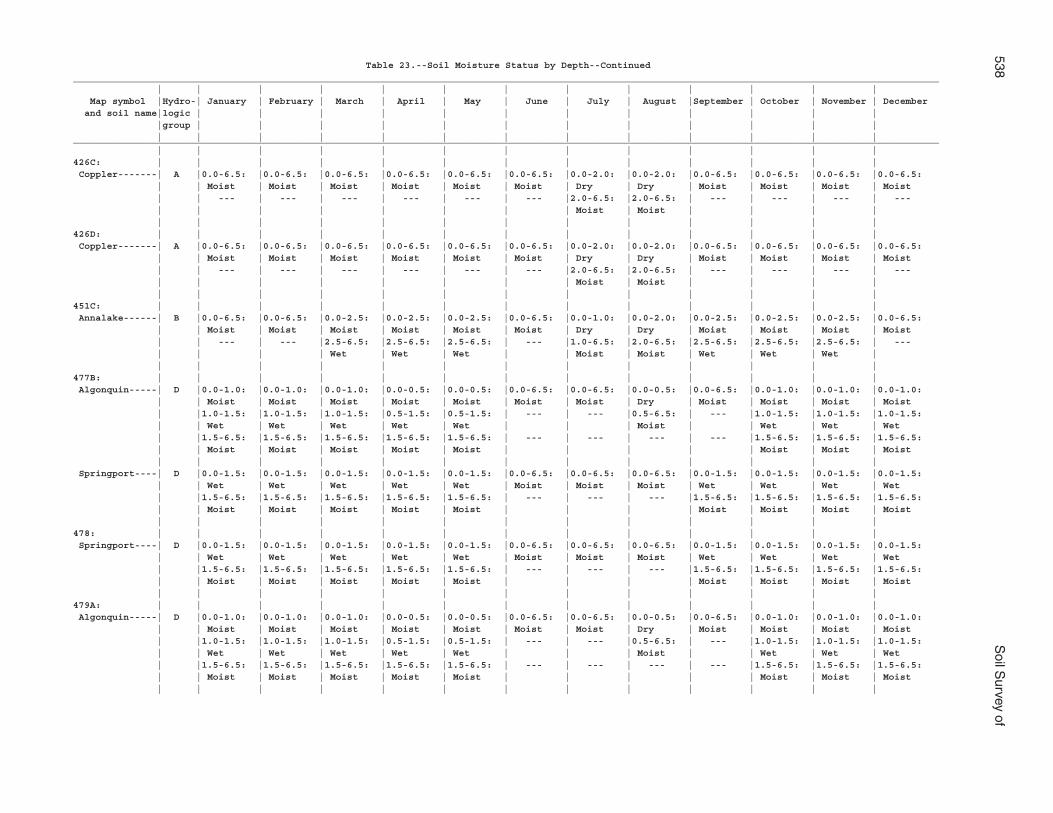
538S
oil Survey of
Table 23.--Soil Moisture Status by Depth--Continued___________________________________________________________________________________________________________________________________________________________ | | | | | | | | | | | | | Map symbol |Hydro-| January | February | March | April | May | June | July | August |September | October | November | December and soil name|logic | | | | | | | | | | | | |group | | | | | | | | | | | | | | | | | | | | | | | | |___________________________________________________________________________________________________________________________________________________________ | | | | | | | | | | | | |426C: | | | | | | | | | | | | | Coppler-------| A |0.0-6.5: |0.0-6.5: |0.0-6.5: |0.0-6.5: |0.0-6.5: |0.0-6.5: |0.0-2.0: |0.0-2.0: |0.0-6.5: |0.0-6.5: |0.0-6.5: |0.0-6.5: | | Moist | Moist | Moist | Moist | Moist | Moist | Dry | Dry | Moist | Moist | Moist | Moist | | --- | --- | --- | --- | --- | --- |2.0-6.5: |2.0-6.5: | --- | --- | --- | --- | | | | | | | | Moist | Moist | | | | | | | | | | | | | | | | |426D: | | | | | | | | | | | | | Coppler-------| A |0.0-6.5: |0.0-6.5: |0.0-6.5: |0.0-6.5: |0.0-6.5: |0.0-6.5: |0.0-2.0: |0.0-2.0: |0.0-6.5: |0.0-6.5: |0.0-6.5: |0.0-6.5: | | Moist | Moist | Moist | Moist | Moist | Moist | Dry | Dry | Moist | Moist | Moist | Moist | | --- | --- | --- | --- | --- | --- |2.0-6.5: |2.0-6.5: | --- | --- | --- | --- | | | | | | | | Moist | Moist | | | | | | | | | | | | | | | | |451C: | | | | | | | | | | | | | Annalake------| B |0.0-6.5: |0.0-6.5: |0.0-2.5: |0.0-2.5: |0.0-2.5: |0.0-6.5: |0.0-1.0: |0.0-2.0: |0.0-2.5: |0.0-2.5: |0.0-2.5: |0.0-6.5: | | Moist | Moist | Moist | Moist | Moist | Moist | Dry | Dry | Moist | Moist | Moist | Moist | | --- | --- |2.5-6.5: |2.5-6.5: |2.5-6.5: | --- |1.0-6.5: |2.0-6.5: |2.5-6.5: |2.5-6.5: |2.5-6.5: | --- | | | | Wet | Wet | Wet | | Moist | Moist | Wet | Wet | Wet | | | | | | | | | | | | | |477B: | | | | | | | | | | | | | Algonquin-----| D |0.0-1.0: |0.0-1.0: |0.0-1.0: |0.0-0.5: |0.0-0.5: |0.0-6.5: |0.0-6.5: |0.0-0.5: |0.0-6.5: |0.0-1.0: |0.0-1.0: |0.0-1.0: | | Moist | Moist | Moist | Moist | Moist | Moist | Moist | Dry | Moist | Moist | Moist | Moist | |1.0-1.5: |1.0-1.5: |1.0-1.5: |0.5-1.5: |0.5-1.5: | --- | --- |0.5-6.5: | --- |1.0-1.5: |1.0-1.5: |1.0-1.5: | | Wet | Wet | Wet | Wet | Wet | | | Moist | | Wet | Wet | Wet | |1.5-6.5: |1.5-6.5: |1.5-6.5: |1.5-6.5: |1.5-6.5: | --- | --- | --- | --- |1.5-6.5: |1.5-6.5: |1.5-6.5: | | Moist | Moist | Moist | Moist | Moist | | | | | Moist | Moist | Moist | | | | | | | | | | | | | Springport----| D |0.0-1.5: |0.0-1.5: |0.0-1.5: |0.0-1.5: |0.0-1.5: |0.0-6.5: |0.0-6.5: |0.0-6.5: |0.0-1.5: |0.0-1.5: |0.0-1.5: |0.0-1.5: | | Wet | Wet | Wet | Wet | Wet | Moist | Moist | Moist | Wet | Wet | Wet | Wet | |1.5-6.5: |1.5-6.5: |1.5-6.5: |1.5-6.5: |1.5-6.5: | --- | --- | --- |1.5-6.5: |1.5-6.5: |1.5-6.5: |1.5-6.5: | | Moist | Moist | Moist | Moist | Moist | | | | Moist | Moist | Moist | Moist | | | | | | | | | | | | |478: | | | | | | | | | | | | | Springport----| D |0.0-1.5: |0.0-1.5: |0.0-1.5: |0.0-1.5: |0.0-1.5: |0.0-6.5: |0.0-6.5: |0.0-6.5: |0.0-1.5: |0.0-1.5: |0.0-1.5: |0.0-1.5: | | Wet | Wet | Wet | Wet | Wet | Moist | Moist | Moist | Wet | Wet | Wet | Wet | |1.5-6.5: |1.5-6.5: |1.5-6.5: |1.5-6.5: |1.5-6.5: | --- | --- | --- |1.5-6.5: |1.5-6.5: |1.5-6.5: |1.5-6.5: | | Moist | Moist | Moist | Moist | Moist | | | | Moist | Moist | Moist | Moist | | | | | | | | | | | | |479A: | | | | | | | | | | | | | Algonquin-----| D |0.0-1.0: |0.0-1.0: |0.0-1.0: |0.0-0.5: |0.0-0.5: |0.0-6.5: |0.0-6.5: |0.0-0.5: |0.0-6.5: |0.0-1.0: |0.0-1.0: |0.0-1.0: | | Moist | Moist | Moist | Moist | Moist | Moist | Moist | Dry | Moist | Moist | Moist | Moist | |1.0-1.5: |1.0-1.5: |1.0-1.5: |0.5-1.5: |0.5-1.5: | --- | --- |0.5-6.5: | --- |1.0-1.5: |1.0-1.5: |1.0-1.5: | | Wet | Wet | Wet | Wet | Wet | | | Moist | | Wet | Wet | Wet | |1.5-6.5: |1.5-6.5: |1.5-6.5: |1.5-6.5: |1.5-6.5: | --- | --- | --- | --- |1.5-6.5: |1.5-6.5: |1.5-6.5: | | Moist | Moist | Moist | Moist | Moist | | | | | Moist | Moist | Moist | | | | | | | | | | | | |
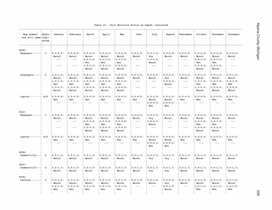
Alpena C
ounty, Michigan
539
Table 23.--Soil Moisture Status by Depth--Continued___________________________________________________________________________________________________________________________________________________________ | | | | | | | | | | | | | Map symbol |Hydro-| January | February | March | April | May | June | July | August |September | October | November | December and soil name|logic | | | | | | | | | | | | |group | | | | | | | | | | | | | | | | | | | | | | | | |___________________________________________________________________________________________________________________________________________________________ | | | | | | | | | | | | |480B: | | | | | | | | | | | | | Negwegon------| C |0.0-6.5: |0.0-6.5: |0.0-2.5: |0.0-2.5: |0.0-2.5: |0.0-6.5: |0.0-1.0: |0.0-6.5: |0.0-6.5: |0.0-2.5: |0.0-2.5: |0.0-6.5: | | Moist | Moist | Moist | Moist | Moist | Moist | Dry | Moist | Moist | Moist | Moist | Moist | | --- | --- |2.5-3.5: |2.5-3.5: |2.5-3.5: | --- |1.0-6.5: | --- | --- |2.5-3.5: |2.5-3.5: | --- | | | | Wet | Wet | Wet | | Moist | | | Wet | Wet | | | --- | --- |3.5-6.5: |3.5-6.5: |3.5-6.5: | --- | --- | --- | --- |3.5-6.5: |3.5-6.5: | --- | | | | Moist | Moist | Moist | | | | | Moist | Moist | | | | | | | | | | | | | | Algonquin-----| D |0.0-1.0: |0.0-1.0: |0.0-1.0: |0.0-0.5: |0.0-0.5: |0.0-6.5: |0.0-6.5: |0.0-0.5: |0.0-6.5: |0.0-1.0: |0.0-1.0: |0.0-1.0: | | Moist | Moist | Moist | Moist | Moist | Moist | Moist | Dry | Moist | Moist | Moist | Moist | |1.0-1.5: |1.0-1.5: |1.0-1.5: |0.5-1.5: |0.5-1.5: | --- | --- |0.5-6.5: | --- |1.0-1.5: |1.0-1.5: |1.0-1.5: | | Wet | Wet | Wet | Wet | Wet | | | Moist | | Wet | Wet | Wet | |1.5-6.5: |1.5-6.5: |1.5-6.5: |1.5-6.5: |1.5-6.5: | --- | --- | --- | --- |1.5-6.5: |1.5-6.5: |1.5-6.5: | | Moist | Moist | Moist | Moist | Moist | | | | | Moist | Moist | Moist | | | | | | | | | | | | | Lupton--------| A/D |0.0-6.5: |0.0-6.5: |0.0-6.5: |0.0-6.5: |0.0-6.5: |0.0-6.5: |0.0-0.5: |0.0-0.5: |0.0-6.5: |0.0-6.5: |0.0-6.5: |0.0-6.5: | | Wet | Wet | Wet | Wet | Wet | Wet | Moist | Moist | Wet | Wet | Wet | Wet | | --- | --- | --- | --- | --- | --- |0.5-6.5: |0.5-6.5: | --- | --- | --- | --- | | | | | | | | Wet | Wet | | | | | | | | | | | | | | | | |481C: | | | | | | | | | | | | | Negwegon------| C |0.0-6.5: |0.0-6.5: |0.0-2.5: |0.0-2.5: |0.0-2.5: |0.0-6.5: |0.0-1.0: |0.0-6.5: |0.0-6.5: |0.0-2.5: |0.0-2.5: |0.0-6.5: | | Moist | Moist | Moist | Moist | Moist | Moist | Dry | Moist | Moist | Moist | Moist | Moist | | --- | --- |2.5-3.5: |2.5-3.5: |2.5-3.5: | --- |1.0-6.5: | --- | --- |2.5-3.5: |2.5-3.5: | --- | | | | Wet | Wet | Wet | | Moist | | | Wet | Wet | | | --- | --- |3.5-6.5: |3.5-6.5: |3.5-6.5: | --- | --- | --- | --- |3.5-6.5: |3.5-6.5: | --- | | | | Moist | Moist | Moist | | | | | Moist | Moist | | | | | | | | | | | | | | Lupton--------| A/D |0.0-6.5: |0.0-6.5: |0.0-6.5: |0.0-6.5: |0.0-6.5: |0.0-6.5: |0.0-0.5: |0.0-0.5: |0.0-6.5: |0.0-6.5: |0.0-6.5: |0.0-6.5: | | Wet | Wet | Wet | Wet | Wet | Wet | Moist | Moist | Wet | Wet | Wet | Wet | | --- | --- | --- | --- | --- | --- |0.5-6.5: |0.5-6.5: | --- | --- | --- | --- | | | | | | | | Wet | Wet | | | | | | | | | | | | | | | | |482B: | | | | | | | | | | | | | Summerville---| D |0.0-1.3: |0.0-1.3: |0.0-1.3: |0.0-1.3: |0.0-1.3: |0.0-1.3: |0.0-1.3: |0.0-1.3: |0.0-1.3: |0.0-1.3: |0.0-1.3: |0.0-1.3: | | Moist | Moist | Moist | Moist | Moist | Moist | Dry | Dry | Moist | Moist | Moist | Moist | | | | | | | | | | | | |482C: | | | | | | | | | | | | | Summerville---| D |0.0-1.3: |0.0-1.3: |0.0-1.3: |0.0-1.3: |0.0-1.3: |0.0-1.3: |0.0-1.3: |0.0-1.3: |0.0-1.3: |0.0-1.3: |0.0-1.3: |0.0-1.3: | | Moist | Moist | Moist | Moist | Moist | Moist | Dry | Dry | Moist | Moist | Moist | Moist | | | | | | | | | | | | |483A: | | | | | | | | | | | | | Lachine-------| C |0.0-1.0: |0.0-1.0: |0.0-1.0: |0.0-1.0: |0.0-1.0: |0.0-1.5: |0.0-1.5: |0.0-0.5: |0.0-1.5: |0.0-1.0: |0.0-1.0: |0.0-1.0: | | Moist | Moist | Moist | Moist | Moist | Moist | Moist | Dry | Moist | Moist | Moist | Moist | |1.0-1.5: |1.0-1.5: |1.0-1.5: |1.0-1.5: |1.0-1.5: | --- | --- |0.5-1.5: | --- |1.0-1.5: |1.0-1.5: |1.0-1.5: | | Wet | Wet | Wet | Wet | Wet | | | Moist | | Wet | Wet | Wet | | | | | | | | | | | | |
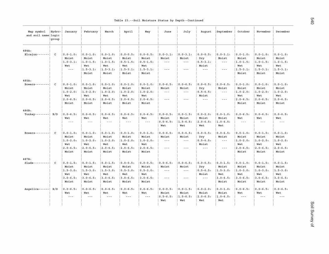
540S
oil Survey of
Table 23.--Soil Moisture Status by Depth--Continued___________________________________________________________________________________________________________________________________________________________ | | | | | | | | | | | | | Map symbol |Hydro-| January | February | March | April | May | June | July | August |September | October | November | December and soil name|logic | | | | | | | | | | | | |group | | | | | | | | | | | | | | | | | | | | | | | | |___________________________________________________________________________________________________________________________________________________________ | | | | | | | | | | | | |484A: | | | | | | | | | | | | | Elcajon-------| C |0.0-1.0: |0.0-1.0: |0.0-1.0: |0.0-0.5: |0.0-0.5: |0.0-3.1: |0.0-3.1: |0.0-0.5: |0.0-3.1: |0.0-1.0: |0.0-1.0: |0.0-1.0: | | Moist | Moist | Moist | Moist | Moist | Moist | Moist | Dry | Moist | Moist | Moist | Moist | |1.0-3.1: |1.0-1.5: |1.0-1.5: |0.5-1.5: |0.5-1.5: | --- | --- |0.5-3.1: | --- |1.0-1.5: |1.0-1.5: |1.0-1.5: | | Wet | Wet | Wet | Wet | Wet | | | Moist | | Wet | Wet | Wet | | --- |1.5-3.1: |1.5-3.1: |1.5-3.1: |1.5-3.1: | --- | --- | --- | --- |1.5-3.1: |1.5-3.1: |1.5-3.1: | | | Moist | Moist | Moist | Moist | | | | | Moist | Moist | Moist | | | | | | | | | | | | |485A: | | | | | | | | | | | | | Bowers--------| C |0.0-1.0: |0.0-1.0: |0.0-1.0: |0.0-1.0: |0.0-1.0: |0.0-6.5: |0.0-6.5: |0.0-0.5: |0.0-6.5: |0.0-1.0: |0.0-1.0: |0.0-1.0: | | Moist | Moist | Moist | Moist | Moist | Moist | Moist | Dry | Moist | Moist | Moist | Moist | |1.0-2.0: |1.0-2.0: |1.0-2.0: |1.0-2.0: |1.0-2.0: | --- | --- |0.5-6.5: | --- |1.0-2.0: |1.0-2.0: |1.0-2.0: | | Wet | Wet | Wet | Wet | Wet | | | Moist | | Wet | Wet | Wet | |2.0-6.5: |2.0-6.5: |2.0-6.5: |2.0-6.5: |2.0-6.5: | --- | --- | --- | --- |2.0-6.5: |2.0-6.5: |2.0-6.5: | | Moist | Moist | Moist | Moist | Moist | | | | | Moist | Moist | Moist | | | | | | | | | | | | |486B: | | | | | | | | | | | | | Tonkey--------| B/D |0.0-6.5: |0.0-6.5: |0.0-6.5: |0.0-6.5: |0.0-6.5: |0.0-0.5: |0.0-1.5: |0.0-2.0: |0.0-1.0: |0.0-6.5: |0.0-6.5: |0.0-6.5: | | Wet | Wet | Wet | Wet | Wet | Moist | Moist | Moist | Moist | Wet | Wet | Wet | | --- | --- | --- | --- | --- |0.5-6.5: |1.5-6.5: |2.0-6.5: |1.0-6.5: | --- | --- | --- | | | | | | | Wet | Wet | Wet | Wet | | | | | | | | | | | | | | | | Bowers--------| C |0.0-1.0: |0.0-1.0: |0.0-1.0: |0.0-1.0: |0.0-1.0: |0.0-6.5: |0.0-6.5: |0.0-0.5: |0.0-6.5: |0.0-1.0: |0.0-1.0: |0.0-1.0: | | Moist | Moist | Moist | Moist | Moist | Moist | Moist | Dry | Moist | Moist | Moist | Moist | |1.0-2.0: |1.0-2.0: |1.0-2.0: |1.0-2.0: |1.0-2.0: | --- | --- |0.5-6.5: | --- |1.0-2.0: |1.0-2.0: |1.0-2.0: | | Wet | Wet | Wet | Wet | Wet | | | Moist | | Wet | Wet | Wet | |2.0-6.5: |2.0-6.5: |2.0-6.5: |2.0-6.5: |2.0-6.5: | --- | --- | --- | --- |2.0-6.5: |2.0-6.5: |2.0-6.5: | | Moist | Moist | Moist | Moist | Moist | | | | | Moist | Moist | Moist | | | | | | | | | | | | |487B: | | | | | | | | | | | | | Slade---------| C |0.0-1.5: |0.0-1.5: |0.0-1.5: |0.0-0.5: |0.0-0.5: |0.0-6.5: |0.0-6.5: |0.0-0.5: |0.0-1.5: |0.0-1.0: |0.0-1.0: |0.0-1.5: | | Moist | Moist | Moist | Moist | Moist | Moist | Moist | Dry | Moist | Moist | Moist | Moist | |1.5-3.0: |1.5-3.0: |1.5-3.0: |0.5-3.0: |0.5-3.0: | --- | --- |0.5-6.5: |1.5-3.0: |1.0-3.0: |1.0-3.0: |1.5-3.0: | | Wet | Wet | Wet | Wet | Wet | | | Moist | Wet | Wet | Wet | Wet | |3.0-6.5: |3.0-6.5: |3.0-6.5: |3.0-6.5: |3.0-6.5: | --- | --- | --- |3.0-6.5: |3.0-6.5: |3.0-6.5: |3.0-6.5: | | Moist | Moist | Moist | Moist | Moist | | | | Moist | Moist | Moist | Moist | | | | | | | | | | | | | Angelica------| B/D |0.0-6.5: |0.0-6.5: |0.0-6.5: |0.0-6.5: |0.0-6.5: |0.0-0.5: |0.0-1.5: |0.0-2.0: |0.0-1.0: |0.0-6.5: |0.0-6.5: |0.0-6.5: | | Wet | Wet | Wet | Wet | Wet | Moist | Moist | Moist | Moist | Wet | Wet | Wet | | --- | --- | --- | --- | --- |0.5-6.5: |1.5-6.5: |2.0-6.5: |1.0-6.5: | --- | --- | --- | | | | | | | Wet | Wet | Wet | Wet | | | | | | | | | | | | | | | |
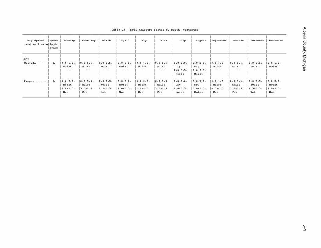
Alpena C
ounty, Michigan
541
Table 23.--Soil Moisture Status by Depth--Continued___________________________________________________________________________________________________________________________________________________________ | | | | | | | | | | | | | Map symbol |Hydro-| January | February | March | April | May | June | July | August |September | October | November | December and soil name|logic | | | | | | | | | | | | |group | | | | | | | | | | | | | | | | | | | | | | | | |___________________________________________________________________________________________________________________________________________________________ | | | | | | | | | | | | |489F: | | | | | | | | | | | | | Crowell-------| A |0.0-6.5: |0.0-6.5: |0.0-6.5: |0.0-6.5: |0.0-6.5: |0.0-6.5: |0.0-2.0: |0.0-2.0: |0.0-6.5: |0.0-6.5: |0.0-6.5: |0.0-6.5: | | Moist | Moist | Moist | Moist | Moist | Moist | Dry | Dry | Moist | Moist | Moist | Moist | | --- | --- | --- | --- | --- | --- |2.0-6.5: |2.0-6.5: | --- | --- | --- | --- | | | | | | | | Moist | Moist | | | | | | | | | | | | | | | | | Proper--------| A |0.0-5.0: |0.0-5.0: |0.0-2.5: |0.0-2.0: |0.0-2.0: |0.0-3.5: |0.0-2.0: |0.0-3.0: |0.0-4.5: |0.0-3.0: |0.0-2.5: |0.0-2.0: | | Moist | Moist | Moist | Moist | Moist | Moist | Dry | Dry | Moist | Moist | Moist | Moist | |5.0-6.5: |5.0-6.5: |2.5-6.5: |2.0-6.5: |2.0-6.5: |3.5-6.5: |2.0-6.5: |3.0-6.5: |4.5-6.5: |3.0-6.5: |2.5-6.5: |2.0-6.5: | | Wet | Wet | Wet | Wet | Wet | Wet | Moist | Moist | Wet | Wet | Wet | Wet | | | | | | | | | | | | |___________________________________________________________________________________________________________________________________________________________
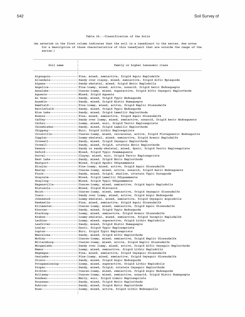
542 Soil Survey of
Table 24.--Classification of the Soils
(An asterisk in the first column indicates that the soil is a taxadjunct to the series. See notes for a description of those characteristics of this taxadjunct that are outside the range of the series.)
____________________________________________________________________________________________________ | Soil name | Family or higher taxonomic class |____________________________________________________________________________________________________ | Algonquin----------------|Fine, mixed, semiactive, frigid Aquic Hapludalfs Allendale----------------|Sandy over clayey, mixed, semiactive, frigid Alfic Epiaquods Alpena-------------------|Sandy-skeletal, mixed, frigid Entic Hapludolls Angelica-----------------|Fine-loamy, mixed, active, nonacid, frigid Aeric Endoaquepts Annalake-----------------|Coarse-loamy, mixed, superactive, frigid Alfic Oxyaquic Haplorthods Aquents------------------|Mixed, frigid Aquents Au Gres------------------|Sandy, mixed, frigid Typic Endoaquods Ausable------------------|Sandy, mixed, frigid Histic Humaquepts Bamfield-----------------|Fine-loamy, mixed, active, frigid Haplic Glossudalfs Battlefield--------------|Sandy, mixed, frigid Typic Endoaquods Blue Lake----------------|Sandy, mixed, frigid Lamellic Haplorthods Bowers-------------------|Fine, mixed, semiactive, frigid Aquic Glossudalfs Caffey-------------------|Sandy over loamy, mixed, semiactive, nonacid, frigid Aeric Endoaquents Cathro-------------------|Loamy, mixed, euic, frigid Terric Haplosaprists Chinwhisker--------------|Sandy, mixed, frigid Lamellic Haplorthods Chippeny-----------------|Euic, frigid Lithic Haplosaprists Colonville---------------|Coarse-loamy, mixed, calcareous, active, frigid Fluvaquentic Endoaquolls Coppler------------------|Loamy-skeletal, mixed, semiactive, frigid Arenic Hapludalfs Croswell-----------------|Sandy, mixed, frigid Oxyaquic Haplorthods Crowell------------------|Sandy, mixed, frigid, ortstein Entic Haplorthods Dawson-------------------|Sandy or sandy-skeletal, mixed, dysic, frigid Terric Haplosaprists Deford-------------------|Mixed, frigid Typic Psammaquents Dorval-------------------|Clayey, mixed, euic, frigid Terric Haplosaprists East Lake----------------|Sandy, mixed, frigid Entic Haplorthods Eastport-----------------|Mixed, frigid Spodic Udipsamments Elcajon------------------|Fine-loamy, mixed, active, frigid Aquic Glossudalfs Ensley-------------------|Coarse-loamy, mixed, active, nonacid, frigid Aeric Endoaquents Finch--------------------|Sandy, mixed, frigid, shallow, ortstein Typic Duraquods Graycalm-----------------|Mixed, frigid Lamellic Udipsamments Grayling-----------------|Mixed, frigid Typic Udipsamments Hagensville--------------|Coarse-loamy, mixed, semiactive, frigid Aquic Hapludolls Histosols----------------|Mixed, frigid Histosols Hoist--------------------|Coarse-loamy, mixed, semiactive, frigid Oxyaquic Glossudalfs Iosco--------------------|Sandy over loamy, mixed, active, frigid Argic Endoaquods Johnswood----------------|Loamy-skeletal, mixed, semiactive, frigid Oxyaquic Argiudolls Kawkawlin----------------|Fine, mixed, semiactive, frigid Aquic Glossudalfs Killmaster---------------|Coarse-loamy, mixed, semiactive, frigid Aquic Glossudalfs Kinross------------------|Sandy, mixed, frigid Typic Endoaquods Klacking-----------------|Loamy, mixed, semiactive, frigid Arenic Glossudalfs Krakow-------------------|Loamy-skeletal, mixed, semiactive, frigid Inceptic Hapludalfs Lachine------------------|Loamy, mixed, superactive, frigid Lithic Hapludolls Leafriver----------------|Sandy, mixed, frigid Histic Humaquepts Loxley-------------------|Dysic, frigid Typic Haplosaprists Lupton-------------------|Euic, frigid Typic Haplosaprists Mancelona----------------|Sandy, mixed, frigid Alfic Haplorthods McGinn-------------------|Coarse-loamy, mixed, semiactive, frigid Haplic Glossudalfs Millersburg--------------|Coarse-loamy, mixed, active, frigid Haplic Glossudalfs Morganlake---------------|Sandy over loamy, mixed, active, frigid Alfic Oxyaquic Haplorthods Namur--------------------|Loamy, mixed, semiactive, frigid Lithic Hapludolls Negwegon-----------------|Fine, mixed, semiactive, frigid Oxyaquic Glossudalfs Ossineke-----------------|Fine-loamy, mixed, semiactive, frigid Oxyaquic Glossudalfs Otisco-------------------|Sandy, mixed, frigid Argic Endoaquods Potagannissing-----------|Loamy, mixed, superactive, frigid Lithic Hapludolls Proper-------------------|Sandy, mixed, frigid, ortstein Oxyaquic Haplorthods Richter------------------|Coarse-loamy, mixed, semiactive, frigid Argic Endoaquods Rollaway-----------------|Coarse-loamy, mixed, semiactive, nonacid, frigid Histic Humaquepts Rondeau------------------|Marly, euic, frigid Limnic Haplosaprists Rousseau-----------------|Sandy, mixed, frigid Entic Haplorthods Rubicon------------------|Sandy, mixed, frigid Entic Haplorthods Ruse---------------------|Loamy, mixed, active, frigid Lithic Endoaquolls |
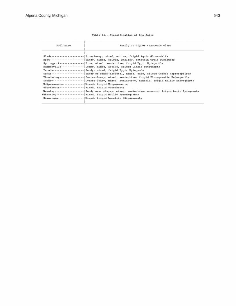
Alpena County, Michigan 543
Table 24.--Classification of the Soils____________________________________________________________________________________________________ | Soil name | Family or higher taxonomic class |____________________________________________________________________________________________________ | Slade--------------------|Fine-loamy, mixed, active, frigid Aquic Glossudalfs Spot---------------------|Sandy, mixed, frigid, shallow, ortstein Typic Duraquods Springport---------------|Fine, mixed, semiactive, frigid Typic Epiaquolls Summerville--------------|Loamy, mixed, active, frigid Lithic Eutrudepts Tacoda-------------------|Sandy, mixed, frigid Typic Epiaquods Tawas--------------------|Sandy or sandy-skeletal, mixed, euic, frigid Terric Haplosaprists Thunderbay---------------|Coarse-loamy, mixed, semiactive, frigid Fluvaquentic Endoaquolls Tonkey-------------------|Coarse-loamy, mixed, semiactive, nonacid, frigid Mollic Endoaquepts Udipsamments-------------|Mixed, frigid Udipsamments Udorthents---------------|Mixed, frigid Udorthents Wakeley------------------|Sandy over clayey, mixed, semiactive, nonacid, frigid Aeric Epiaquents*Wheatley-----------------|Mixed, frigid Mollic Psammaquents Zimmerman----------------|Mixed, frigid Lamellic Udipsamments |____________________________________________________________________________________________________

The Natural Resources Conservation Service (NRCS) is committed to making itsinformation accessible to all of its customers and employees. If you are experiencingaccessibility issues and need assistance, please contact our Helpdesk by phone at1-800-457-3642 or by e-mail at [email protected]. For assistancewith publications that include maps, graphs, or similar forms of information, you mayalso wish to contact our State or local office. You can locate the correct office andphone number at http://offices.sc.egov.usda.gov/locator/app.
NRCS Accessibility Statement


![Collection name: The Alpena News Collection...Finding Aid: The Alpena News Collection [Sports] ANC-3 Collection name: The Alpena News Collection Collection number: ANC – 1 through](https://img.pdfslide.net/doc/110x75/5ea3f6b464547d62a24a34cc/collection-name-the-alpena-news-collection-finding-aid-the-alpena-news-collection.jpg)


![Collection name: The Alpena News Collection · 2015-11-18 · Finding Aid: The Alpena News Collection [Photographs/Negatives 1991-1994] ANC-11 Collection name: The Alpena News Collection](https://img.pdfslide.net/doc/110x75/5fafeb42be42ad3d39291072/collection-name-the-alpena-news-collection-2015-11-18-finding-aid-the-alpena.jpg)