Embed Size (px)
Citation preview
United StatesDepartment ofAgriculture
NaturalResourcesConservationService
Soil Survey ofBrazos County,Texas
In cooperation withTexas AgriculturalExperiment Station andTexas State Soil and WaterConservation Board
General Soil Map
The general soil map, which is a color map, shows the survey area divided into groups of associated soils calledgeneral soil map units. This map is useful in planning the use and management of large areas.
To find information about your area of interest, locate that area on the map, identify the name of the map unit in thearea on the color-coded map legend, then refer to the section General Soil Map Units for a general description ofthe soils in your area.
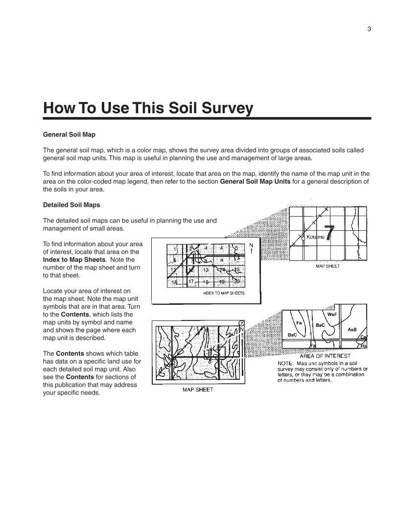
Detailed Soil Maps
The detailed soil maps can be useful in planning the use andmanagement of small areas.
To find information about your areaof interest, locate that area on theIndex to Map Sheets. Note thenumber of the map sheet and turnto that sheet.
Locate your area of interest onthe map sheet. Note the map unitsymbols that are in that area. Turnto the Contents, which lists themap units by symbol and nameand shows the page where eachmap unit is described.
The Contents shows which tablehas data on a specific land use foreach detailed soil map unit. Alsosee the Contents for sections ofthis publication that may addressyour specific needs.
3
How To Use This Soil Survey
4
Additional information about the Nation’s natural resources is available on theNatural Resources Conservation Service homepage on the World Wide Web. Theaddress is http://www.nrcs.usda.gov.
This soil survey is a publication of the National Cooperative Soil Survey, a joint effortof the United States Department of Agriculture and other Federal agencies, Stateagencies including the Agricultural Experiment Stations, and local agencies. TheNatural Resources Conservation Service (formerly the Soil Conservation Service) hasleadership for the Federal part of the National Cooperative Soil Survey.
Major fieldwork for this soil survey was completed in 1990. Soil names anddescriptions were approved in 1993. Unless otherwise indicated, statements in thispublication refer to conditions in the survey area in 1993. This survey was madecooperatively by the Natural Resources Conservation Service, the Texas AgriculturalExperiment Station, and the Texas State Soil and Water Conservation Board. Thesurvey is part of the technical assistance furnished to the Brazos County Soil andWater Conservation District.
Soil maps in this survey may be copied without permission. Enlargement of thesemaps, however, could cause misunderstanding of the detail of mapping. If enlarged,maps do not show the small areas of contrasting soils that could have been shown at alarger scale.
The United States Department of Agriculture (USDA) prohibits discrimination in all ofits programs on the basis of race, color, national origin, gender, religion, age, disability,political beliefs, sexual orientation, and marital or family status. (Not all prohibited basesapply to all programs.) Persons with disabilities who require alternative means forcommunication of program information (Braille, large print, audiotape, etc.) shouldcontact the USDA’s TARGET Center at 202-720-2600 (voice or TDD).
To file a complaint of discrimination, write USDA, Director, Office of Civil Rights,Room 326W, Whitten Building, 14th and Independence Avenue SW, Washington, DC20250-9410, or call 202-720-5964 (voice or TDD). USDA is an equal opportunityprovider and employer.
Cover: Texas A&M University in College Station, Texas, is headquarters for the Texas AgriculturalExperiment Station, a major cooperator in the National Cooperative Soil Survey (photo courtesy ofTexas A&M University, 2002).
5
Contents
How To Use This Soil Survey ................................. 3Preface .................................................................... 9General Nature of the Survey Area ......................... 11
Settlement and Population .................................. 11Urbanization and Economic Status .................... 13Agriculture .......................................................... 14Natural Resources ............................................. 14Climate ............................................................... 14
How This Survey Was Made ................................... 14Statistical Analysis of Map Unit Composition ...... 15
General Soil Map Units ........................................ 17Dominantly Undulating, Loamy Soils onUplands .............................................................. 17
1. Zack-Boonville-Zulch ............................. 172. Burlewash-Singleton .............................. 183. Crockett-Benchley ................................. 194. Spiller-Rosanky-Kurten .......................... 20
Dominantly Nearly Level to GentlyUndulating, Sandy and Loamy Soils onStream Terraces ................................................. 21
5. Tabor-Gredge-Rader.............................. 216. Robco-Chazos ....................................... 237. Burleson-Wilson .................................... 23
Dominantly Nearly Level, Loamy and ClayeySoils on Flood Plains .......................................... 23
8. Ships ..................................................... 249. Sandow.................................................. 24
10. Gladewater-Kaufman ............................. 2511. Weswood ............................................... 25
Detailed Soil Map Units ........................................ 27AxB—Axtell fine sandy loam, 1 to 3 percent
slopes .......................................................... 28BeA—Benchley loam, 0 to 1 percent slopes ....... 29BeB—Benchley loam, 1 to 3 percent slopes ....... 29BoA—Boonville fine sandy loam, 0 to 1
percent slopes ............................................. 30BoB—Boonville fine sandy loam, 1 to 3
percent slopes ............................................. 31BrB—Boonville-Urban land complex, 0 to 3
percent slopes ............................................. 32BuA—Burleson clay, 0 to 1 percent slopes ......... 34BuB—Burleson clay, 1 to 3 percent slopes ......... 35BuC—Burleson clay, 3 to 5 percent slopes ......... 36
BwC—Burlewash fine sandy loam, 1 to 5percent slopes ............................................. 36
BwD—Burlewash fine sandy loam, 5 to 8percent slopes ............................................. 37
ChC—Chazos loamy fine sand, 1 to 5percent slopes ............................................. 38
ChD—Chazos loamy fine sand, 5 to 8percent slopes ............................................. 39
CoA—Coarsewood silt loam, 0 to 1 percentslopes, rarely flooded ................................... 40
CrB—Crockett loam, 1 to 3 percent slopes......... 41CrB2—Crockett loam, 2 to 5 percent slopes,
eroded ......................................................... 42DeA—Derly-Rader complex, 0 to 1 percent
slopes .......................................................... 43DfC—Desan loamy fine sand, 3 to 8 percent
slopes .......................................................... 45DmA—Dimebox clay, 0 to 1 percent slopes ........ 46DuC—Dutek loamy fine sand, 3 to 8 percent
slopes .......................................................... 47EuB—Eufaula loamy fine sand, 1 to 3 percent
slopes .......................................................... 48FaB—Falba fine sandy loam, 1 to 3 percent
slopes .......................................................... 48Gd—Gladewater clay, frequently flooded ............ 49GrC—Gredge fine sandy loam, 1 to 5 percent
slopes .......................................................... 51GrC2—Gredge fine sandy loam, 2 to 5
percent slopes, eroded ................................ 52GrD—Gredge fine sandy loam, 5 to 8
percent slopes ............................................. 52GvC—Gredge very gravelly fine sandy loam,
3 to 8 percent slopes.................................... 53GyC—Greenvine clay, 2 to 5 percent slopes ...... 54HbA—Highbank silty clay loam, 0 to 1
percent slopes, rarely flooded ...................... 55Ka—Kaufman clay, frequently flooded ................ 56KrD—Koether-Rock outcrop complex, 3 to
12 percent slopes ........................................ 57KuC—Kurten fine sandy loam, 2 to 5 percent
slopes .......................................................... 58KuD—Kurten fine sandy loam, 5 to 8 percent
slopes .......................................................... 59

6
LfA—Lufkin fine sandy loam, 0 to 1 percentslopes .......................................................... 59
LuB—Luling clay, 1 to 3 percent slopes .............. 60LuD—Luling clay, 5 to 8 percent slopes .............. 61MaA—Mabank loam, 0 to 1 percent
slopes .......................................................... 62MrA—Mabank-Rader complex, 0 to 1
percent slopes ............................................. 63NvB—Navasan loamy fine sand, 0 to 3
percent slopes ............................................. 64PaC—Padina loamy fine sand, 1 to 5
percent slopes ............................................. 65Pt—Pits .............................................................. 66RaB—Rader fine sandy loam, 0 to 2 percent
slopes .......................................................... 66RbA—Rader-Tabor complex, 1 to 3 percent
slopes .......................................................... 67ReC—Rehburg loamy fine sand, 1 to 5
percent slopes ............................................. 68RoB—Robco loamy fine sand, 1 to 3 percent
slopes .......................................................... 69Rr—Roetex clay, frequently flooded ................... 70RsC—Rosanky fine sandy loam, 2 to 5
percent slopes ............................................. 71RsD—Rosanky fine sandy loam, 5 to 8
percent slopes ............................................. 72RtC—Rosanky soils, graded, 1 to 5 percent
slopes .......................................................... 73RuC—Rosanky-Urban land complex, 2 to 5
percent slopes ............................................. 74Sa—Sandow loam, frequently flooded................ 75Sb—Sandow-Urban land complex, frequently
flooded ......................................................... 75ScC—Shalba-Rock outcrop complex, 2 to 6
percent slopes ............................................. 77ShA—Ships clay, 0 to 1 percent slopes, rarely
flooded ......................................................... 78ShC—Ships clay, 1 to 5 percent slopes, rarely
flooded ......................................................... 79SkB—Shiro loamy fine sand, 1 to 3 percent
slopes .......................................................... 80SmC—Silawa fine sandy loam, 2 to 5
percent slopes ............................................. 81SmD—Silawa fine sandy loam, 5 to 8
percent slopes ............................................. 82
SnB—Singleton fine sandy loam, 1 to 3percent slopes ............................................. 83
SpB—Spiller loamy fine sand, 1 to 3 percentslopes .......................................................... 84
SxB—Styx loamy fine sand, 1 to 3 percentslopes .......................................................... 85
TaA—Tabor fine sandy loam, 0 to 2 percentslopes .......................................................... 86
TgB—Tabor very gravelly fine sandy loam,1 to 3 percent slopes.................................... 87
TuA—Tabor-Urban land complex, 0 to 2percent slopes ............................................. 88
Uh—Uhland loam, frequently flooded ................. 88Ur—Urban land .................................................. 89Us—Ustarents, clayey ........................................ 89WeA—Weswood silt loam, 0 to 1 percent
slopes, rarely flooded ................................... 90WeC—Weswood silt loam, 1 to 5 percent
slopes, rarely flooded ................................... 91WwA—Weswood silty clay loam, 0 to 1
percent slopes, rarely flooded ...................... 92Wy—Weswood-Yahola complex, frequently
flooded ......................................................... 93WzA—Wilson loam, 0 to 1 percent slopes .......... 93YaA—Yahola fine sandy loam, 0 to 1 percent
slopes, rarely flooded ................................... 94ZaB—Zack very fine sandy loam, 1 to 5
percent slopes ............................................. 95ZaC2—Zack very fine sandy loam, 2 to 5
percent slopes, eroded ................................ 96ZaD—Zack very fine sandy loam, 5 to 8
percent slopes ............................................. 97ZaE3—Zack very fine sandy loam, 8 to 25
percent slopes, severely eroded .................. 98ZcB—Zack-Urban land complex, 1 to 5
percent slopes ............................................. 99ZcD—Zack-Urban land complex, 5 to 8
percent slopes ........................................... 100ZuB—Zulch fine sandy loam, 1 to 3 percent
slopes ........................................................ 101Use and Management of the Soils .................... 103
Crops ............................................................... 103Crop Yields per Acre .................................... 104Land Capability Classification ...................... 104Prime Farmland ........................................... 105
7
Pasture and Hayland ........................................ 106Pasture and Hayland Yields.......................... 107
Rangeland ........................................................ 110Gardening and Landscaping ............................ 114Recreation ........................................................ 115Wildlife Habitat ................................................. 116Engineering ...................................................... 118
Building Site Development ........................... 119Sanitary Facilities ......................................... 120Construction Materials ................................. 121Water Management ...................................... 122
Soil Properties .................................................... 125Engineering Index Properties ........................... 125Physical and Chemical Properties .................... 126Soil and Water Features ................................... 127Physical and Chemical Analyses of Selected
Soils ........................................................... 128Engineering Index Test Data ............................. 129
Classification of the Soils .................................. 131Soil Series and Their Morphology ..................... 131
Axtell Series ................................................. 131Benchley Series ........................................... 132Boonville Series ........................................... 133Burleson Series ........................................... 135Burlewash Series ......................................... 136Chazos Series ............................................. 136Coarsewood Series ...................................... 137Crockett Series ............................................ 138Derly Series ................................................. 139Desan Series ............................................... 139Dimebox Series ............................................ 140Dutek Series ................................................ 140Eufaula Series .............................................. 141Falba Series ................................................. 141Gladewater Series ....................................... 142Gredge Series .............................................. 142Greenvine Series ......................................... 143Highbank Series........................................... 144Kaufman Series ........................................... 144Koether Series ............................................. 145Kurten Series ............................................... 145Lufkin Series ................................................ 146Luling Series ................................................ 147Mabank Series ............................................. 148Navasan Series ............................................ 157
Padina Series ............................................... 158Rader Series ................................................ 158Rehburg Series ............................................ 159Robco Series ............................................... 160Roetex Series .............................................. 161Rosanky Series ............................................ 161Sandow Series ............................................. 162Shalba Series .............................................. 163Ships Series ................................................. 164Shiro Series ................................................. 164Silawa Series ............................................... 165Singleton Series ........................................... 166Spiller Series ................................................ 166Styx Series................................................... 167Tabor Series ................................................. 168Uhland Series .............................................. 169Weswood Series .......................................... 170Wilson Series ............................................... 170Yahola Series ............................................... 171Zack Series .................................................. 171Zulch Series ................................................. 172
Formation of the Soils ........................................ 175Factors of Soil Formation ................................. 175
Parent Material ............................................. 175Climate ......................................................... 175Plant and Animal Life ................................... 175Relief ............................................................ 175Time ............................................................. 176
Processes of Horizon Differentiation ................ 176Surface Geology and Geomorphology ............. 176
Tertiary Formations ...................................... 176Quaternary Sediments ................................. 178Geomorphic Surfaces and Soil
Formation ............................................ 180References .......................................................... 183Glossary .............................................................. 187Tables .................................................................. 195
Table 1.—Temperature and Precipitation .......... 196Table 2.—Freeze Dates in Spring and Fall ........ 197Table 3.—Growing Season ............................... 197Table 4.—Acreage and Proportionate Extent
of the Soils ................................................. 198Table 5.—Land Capability and Yields per
Acre of Crops and Pasture ......................... 200Table 6.—Rangeland Productivity ..................... 205
8
Table 7.—Soil Groupings for HorticulturalPlants ......................................................... 208
Table 8.—Selected Flowering Plants ................ 210Table 9.—Recreational Development ............... 211Table 10.—Wildlife Habitat ................................ 217Table 11.—Building Site Development .............. 221Table 12.—Sanitary Facilities ........................... 226Table 13.—Construction Materials .................... 232Table 14.—Water Management ........................ 237Table 15.—Engineering Index Properties ......... 242
Table 16.—Physical and Chemical Propertiesof the Soils ................................................. 253
Table 17.—Soil and Water Features ................. 260Table 18.—Physical Analyses of Selected
Soils ........................................................... 264Table 19.—Chemical Analyses of Selected
Soils ........................................................... 269Table 20.—Engineering Index Test Data ........... 272Table 21.—Classification of the Soils ................ 274
Issued 2002
9
This soil survey contains information that affects land use planning in this surveyarea. It contains predictions of soil behavior for selected land uses. The survey alsohighlights soil limitations, improvements needed to overcome the limitations, and theimpact of selected land uses on the environment.
This soil survey is designed for many different users. Farmers, ranchers, foresters,and agronomists can use it to evaluate the potential of the soil and the managementneeded for maximum food and fiber production. Planners, community officials,engineers, developers, builders, and home buyers can use the survey to plan land use,select sites for construction, and identify special practices needed to ensure properperformance. Conservationists, teachers, students, and specialists in recreation, wildlifemanagement, waste disposal, and pollution control can use the survey to help themunderstand, protect, and enhance the environment.
Various land use regulations of Federal, State, and local governments may imposespecial restrictions on land use or land treatment. The information in this report isintended to identify soil properties that are used in making various land use or landtreatment decisions. Statements made in this report are intended to help the land usersidentify and reduce the effects of soil limitations on various land uses. The landowner oruser is responsible for identifying and complying with existing laws and regulations.
Great differences in soil properties can occur within short distances. Some soils areseasonally wet or subject to flooding. Some are shallow to bedrock. Some are toounstable to be used as a foundation for buildings or roads. Clayey or wet soils arepoorly suited to use as septic tank absorption fields. A high water table makes a soilpoorly suited to basements or underground installations.
These and many other soil properties that affect land use are described in this soilsurvey. Broad areas of soils are shown on the general soil map. The location of eachsoil is shown on the detailed soil maps. Each soil in the survey area is described.Information on specific uses is given for each soil. Help in using this publication andadditional information are available at the local office of the Natural ResourcesConservation Service or Texas Cooperative Extension.
Preface
11
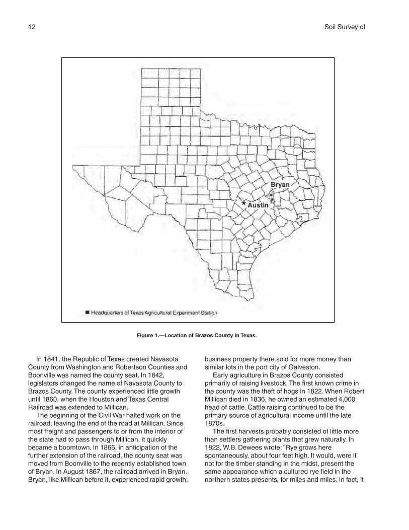
BRAZOS COUNTY is in southeast-central Texas, about125 miles from the Gulf of Mexico (fig. 1). The countyhas an area of 590.8 square miles, or 378,106 acres.The Navasota River borders the county on the east,and the Brazos River forms the western boundary. Thenorthern boundary is the Old San Antonio Road(OSR), which was established in 1691. The elevationin the county ranges from 200 to 400 feet above sealevel. The topography is nearly level to gently sloping.
Brazos County is in the Western Gulf Coastal Plainof the Coastal Plain. It is in the Southern Claypan andthe Southern Blackland Prairie Major Land ResourceAreas (USDA, 1981). The soils formed under post oaksavannah and prairie vegetation. The soils that formedunder post oak savannah are mostly light colored andsandy, and many have a dense clay subsoil that is lessthan 12 inches below the surface. The soils thatformed under prairie vegetation are mostly dark loamsand clays.
The county is drained by numerous streams thatflow into the Navasota River or the Brazos River.
This soil survey updates the survey of BrazosCounty published in 1958 (Mowery and Oakes, 1958).It provides additional information and has larger maps,which show the soils in greater detail. In addition, themapping in this survey has been statistically testedand documented.
General Nature of the Survey AreaThis section provides general information about
Brazos County. It describes settlement and population,urbanization and economic status, agriculture, naturalresources, and climate.
Settlement and Population
Indians hunted in the survey area, but apparentlyneither they nor the Spanish or Mexicans establishedany permanent settlements. American colonistsarrived in 1821, when Robert Millican settled his familynear the present town of Millican. Although the areathat is now Brazos County was included in Stephen F.Austin’s colony, the area remained sparsely populatedfor many years. The earliest residents were primarilyfrom southern states, especially Alabama, Georgia,Mississippi, and Tennessee. After the end of the CivilWar in 1865, immigrants from Italy and Germanybegan to settle in rural parts of the county. Smallernumbers of immigrants from other countries, suchas Czechoslovakia, Poland, and even Canada, alsosettled here. Although scattered references toHispanics appear before 1900, Brazos County didnot have significant numbers of Hispanics until after1900.
Soil Survey of
Brazos County, TexasBy Glen Chervenka, Natural Resources Conservation Service
Fieldwork by Joseph Castille, Glen Chervenka, James Greenwade, Lee Nordt, andRandy Oakley, Natural Resources Conservation Service
United States Department of Agriculture, Natural Resources Conservation Service,in cooperation withthe Texas Agricultural Experiment Station and the Texas State Soil and WaterConservation Board
12 Soil Survey of
In 1841, the Republic of Texas created NavasotaCounty from Washington and Robertson Counties andBoonville was named the county seat. In 1842,legislators changed the name of Navasota County toBrazos County. The county experienced little growthuntil 1860, when the Houston and Texas CentralRailroad was extended to Millican.
The beginning of the Civil War halted work on therailroad, leaving the end of the road at Millican. Sincemost freight and passengers to or from the interior ofthe state had to pass through Millican, it quicklybecame a boomtown. In 1866, in anticipation of thefurther extension of the railroad, the county seat wasmoved from Boonville to the recently established townof Bryan. In August 1867, the railroad arrived in Bryan.Bryan, like Millican before it, experienced rapid growth;
business property there sold for more money thansimilar lots in the port city of Galveston.
Early agriculture in Brazos County consistedprimarily of raising livestock. The first known crime inthe county was the theft of hogs in 1822. When RobertMillican died in 1836, he owned an estimated 4,000head of cattle. Cattle raising continued to be theprimary source of agricultural income until the late1870s.
The first harvests probably consisted of little morethan settlers gathering plants that grew naturally. In1822, W.B. Dewees wrote: “Rye grows herespontaneously, about four feet high. It would, were itnot for the timber standing in the midst, present thesame appearance which a cultured rye field in thenorthern states presents, for miles and miles. In fact, it
Figure 1.—Location of Brazos County in Texas.
Brazos County, Texas 13
far surpasses the common rye fields in beauty, beingmuch larger and thicker” (Letters From an Early Settlerof Texas, 1968).
Some cotton was evidently being raised in the areaquite early, according to an 1826 census in which itwas noted that Robert Millican was building a gin.Cotton remained a rather minor crop for many years;in 1850, for example, local farms produced only 152bales of cotton. The advent of the railroad simplifiedmarketing the cotton, and 6,927 bales were raised in1870. Millican was a major shipping point of cotton forthe Confederacy. Cotton was raised both in theuplands and in areas of bottom land along the BrazosRiver. Brazos County experienced a period of rapidagricultural growth beginning in the late 1860s. Thedevelopment of cotton plantations on the bottom landalong the Brazos River was an important factor in thisgrowth. Cotton production peaked in the 1920s andthen fell sharply. The collapse of the European cottonmarket and the spread of the boll weevil contributed tothe decline. The boll weevil first became a problem in1899 (Veatch and Waldrop, 1916). Also, few farmersused modern agricultural techniques during thisperiod, and soil productivity substantially declinedbecause of such factors as erosion and the failure torotate crops. The 1910 census showed 137,886 acresin cropland; 52 percent of this acreage was in cotton,and 25 percent was in corn.
Over time, the settlers slowly changed the naturalenvironment. In 1807, for example, Zebulon Pikeobserved mesquite trees growing along the Old SanAntonio Road; Spanish cattle had probably brought theseeds for the trees into the area. Other factors placedfurther stress on native trees. By 1872, the railroadrequired 5,000 cords of wood per month, promptingone writer to reflect, “The past and presentgenerations have been destroying the timber; the nextgeneration will have to plant, and plant veryextensively, or fuel in certain localities will be veryscarce” (Letters From an Early Settler of Texas, 1968).Certainly the demands of the railroad, coupled with thedesire for increased croplands, contributed to thewidespread clearing of much of the timber in BrazosCounty. Also, it seems reasonable to believe that thewidespread grazing of sheep in the northern part ofthe county in the late 1840s and in the 1850s mayhave had a significant impact on the prairies.
The early settlers obtained much of their food byhunting. At first, nature supplied an apparently limitlesssupply of wild game and other resources. In 1822,W.B. Dewees wrote:
We have no reason to fear suffering forfood, as the country is literally alive with allkinds of game. We have only to go out for a
few miles . . . to find as many wild cattle asone could wish. If we desire buffalo meat,we are able to go out, load our horses, andreturn the same day. Boars are veryplentiful, but we are obliged to use greatcare when hunting for them, lest thejavelina kill our dogs. . . . The prairies areteeming with wild horses and cattle. Thereare a vast quantity of bee trees about here,so that we have no want of honey. . . . Youwould scarcely believe me, were I to tellyou of the vast herds of buffalo whichabound here. I have frequently seen athousand in a day between this place andthe mouth of Little River. (Letters From anEarly Settler of Texas, 1968)
The wildlife was not inexhaustible, of course; sincethen, at least six species of mammals have beenexterminated, including bears, bison, otters, wolves,panthers, and javelina. And, of course, wild horses nolonger run free.
Urbanization and Economic Status
Historically, Brazos County’s most importanteconomic contributors have been Texas A&MUniversity, established in 1876, and agriculture.Agriculture has, however, steadily declined inimportance since World War II. Retail sales,manufacturing, and the service industries play anincreasingly important role in the county’s economicwell-being. Texas A&M University remains the county’slargest employer.
In 1990, Brazos County had a population of121,862. The major cities in the county are Bryan(population 55,002) and College Station (population52,456). Unincorporated communities in the countyinclude Edge, Tabor, Kurten, Millican, Steep Hollow,Harvey, Wellborn, and Smetana. Texas A&M Universityhas a student population of more than 40,000.
Rural areas have an increasing number ofsubdivisions of 2 to 25 acres provided with water andelectric utilities but no sewer facilities. In 1990, therewere more than 136 platted rural subdivisions, orabout 25,000 acres, in Brazos County with apopulation of about 14,000. The people in these areasgenerally work at a job other than farming or ranching.Some of the larger tracts may have a few livestock.Problems related to rural subdivisions and soils arediscussed in specific sections elsewhere in thissurvey.
The growth of Bryan and College Station continuesand is evidenced by the ongoing annexation of land bythese cities. In 1990, about 36,000 acres in the county
14 Soil Survey of
was considered urban land. Bryan-College Station isthe center of what is known as the “Brazos Valley” withmajor businesses, industry, hospitals, schools, andother facilities.
Agriculture
Livestock, hay, and crops of cotton, corn, grainsorghum, and wheat are the main agriculturalenterprises in Brazos County. Crop production ismainly in areas of bottom land along the Brazos River(the “Brazos Bottom”), and some small grain is grownin the uplands. Crop production accounts for about 26percent of the agricultural income. The main livestockoperations are cow-calf operations, but the number ofstocker operations is increasing. Chicken and hogoperations also are significant in number. Livestocksales accounted for about 74 percent of theagricultural income in 1993. Cattle are mainly pasturedon permanent grasses during the warm season andon temporary pastures of small grain or rye grass andsome native grasses in the winter. Locally grown hayis a major source of feed. The interest in raisinghorses is increasing in the county. Other enterprisesthat are becoming increasingly important are exotic-animal ranches, vineyards, and Christmas tree farms.
Natural Resources
Soil is one of the most important natural resourcesin Brazos County. In the 1980s, oil and gas productionbecame important in the area. Lignite occurs in thesouthern part of the county, but mining is currentlyactive only in adjacent counties. Sand and gravel aremined on the flood plain along the Brazos River.Gravel, sand, and rock are mined in some uplandareas. Water is another important natural resource.The Brazos River is a source of irrigation water forareas adjacent to the river that have riparian rights.Well water is available in the Brazos River alluvium ata depth of 50 to 70 feet and is used extensively forcrop irrigation. Also, the cities of Bryan and CollegeStation, as well as some privately owned watersystems, obtain ground water for human and industrialconsumption from wells that access the Carrizo aquifer.
Climate
Table 1 gives data on temperature and precipitationfor the survey area as recorded at College Station,Texas, in the period 1961 to 1990. Table 2 showsprobable dates of the first freeze in fall and the lastfreeze in spring. Table 3 provides data on length of thegrowing season.
In winter, the average temperature is 51 degrees Fand the average daily minimum temperature is 41degrees. The lowest temperature on record, whichoccurred on December 23, 1989, is 2 degrees. Insummer, the average temperature is 83 degrees andthe average daily maximum temperature is 93degrees. The highest recorded temperature, whichoccurred on July 12, 1954, is 109 degrees.
Growing degree days are shown in table 1. Theyare equivalent to “heat units.” During the month,growing degree days accumulate by the amount thatthe average temperature each day exceeds a basetemperature (50 degrees F). The normal monthlyaccumulation is used to schedule single or successiveplantings of a crop between the last freeze in springand the first freeze in fall.
The total annual precipitation is about 39 inches. Ofthis total, about 21 inches, or 54 percent, usually fallsin April through September. The growing season formost crops falls within this period. The heaviest 1-dayrainfall during the period of record was 6.2 inches onMay 20, 1983. Thunderstorms occur on about 61 dayseach year.
Snowfall is rare. The average seasonal snowfall isabout 0.4 inch. The greatest snow depth at any onetime during the period of record was 4 inches.
The average relative humidity in midafternoon isabout 59 percent. Humidity is higher at night, and theaverage at dawn is about 90 percent. The sun shines65 percent of the time possible in summer and 47percent in winter. The prevailing wind is from the south.Average windspeed is highest, 9 miles per hour, inMarch.
How This Survey Was MadeThis survey was made to provide information about
the soils and miscellaneous areas in the survey area.The information includes a description of the soils andmiscellaneous areas and their location and adiscussion of their suitability, limitations, andmanagement for specified uses. Soil scientistsobserved the steepness, length, and shape of theslopes; the general pattern of drainage; the kinds ofcrops and native plants; and the kinds of bedrock.They dug many holes to study the soil profile, which isthe sequence of natural layers, or horizons, in a soil.The profile extends from the surface down into theunconsolidated material in which the soil formed. Theunconsolidated material is devoid of roots and otherliving organisms and has not been changed by otherbiological activity.
The soils and miscellaneous areas in the surveyarea are in an orderly pattern that is related to the
Brazos County, Texas 15
geology, landforms, relief, climate, and naturalvegetation of the area. Each kind of soil andmiscellaneous area is associated with a particular kindof landform or with a segment of the landform. Byobserving the soils and miscellaneous areas in thesurvey area and relating their position to specificsegments of the landform, a soil scientist develops aconcept, or model, of how they were formed. Thus,during mapping, this model enables the soil scientistto predict with a considerable degree of accuracy thekind of soil or miscellaneous area at a specific locationon the landscape.
Commonly, individual soils on the landscape mergeinto one another as their characteristics graduallychange. To construct an accurate soil map, however,soil scientists must determine the boundaries betweenthe soils. They can observe only a limited number ofsoil profiles. Nevertheless, these observations,supplemented by an understanding of the soil-vegetation-landscape relationship, are sufficient toverify predictions of the kinds of soil in an area and todetermine the boundaries.
Soil scientists recorded the characteristics of thesoil profiles that they studied. They noted soil color,texture, size and shape of soil aggregates, kind andamount of rock fragments, distribution of plant roots,reaction, and other features that enable them toidentify soils. After describing the soils in the surveyarea and determining their properties, the soilscientists assigned the soils to taxonomic classes(units). Taxonomic classes are concepts. Eachtaxonomic class has a set of soil characteristics withprecisely defined limits. The classes are used as abasis for comparison to classify soils systematically.Soil taxonomy, the system of taxonomic classificationused in the United States, is based mainly on the kindand character of soil properties and the arrangementof horizons within the profile. After the soil scientistsclassified and named the soils in the survey area, theycompared the individual soils with similar soils in thesame taxonomic class in other areas so that theycould confirm data and assemble additional databased on experience and research.
While a soil survey is in progress, samples of someof the soils in the area generally are collected forlaboratory analyses and for engineering tests. Soilscientists interpret the data from these analyses andtests as well as the field-observed characteristics andthe soil properties to determine the expected behaviorof the soils under different uses. Interpretations for allof the soils are field tested through observation of thesoils in different uses and under different levels ofmanagement. Some interpretations are modified to fitlocal conditions, and some new interpretations are
developed to meet local needs. Data are assembledfrom other sources, such as research information,production records, and field experience of specialists.For example, data on crop yields under defined levelsof management are assembled from farm records andfrom field or plot experiments on the same kinds ofsoil.
Predictions about soil behavior are based not onlyon soil properties but also on such variables asclimate and biological activity. Soil conditions arepredictable over long periods of time, but they are notpredictable from year to year. For example, soilscientists can predict with a fairly high degree ofaccuracy that a given soil will have a high water tablewithin certain depths in most years, but they cannotpredict that a high water table will always be at aspecific level in the soil on a specific date.
After soil scientists located and identified thesignificant natural bodies of soil in the survey area,they drew the boundaries of these bodies on aerialphotographs and identified each as a specific mapunit. Aerial photographs show trees, buildings, fields,roads, and rivers, all of which help in locatingboundaries accurately.
Statistical Analysis of Map UnitComposition
Dr. C.T. Hallmark, Texas A&M University, provided guidance forand the analysis of this statistical sampling.
Near the end of the soil survey, the soil survey partyselected 30 map units representing 60 percent of thecounty acreage from which to obtain detailed transectobservations of the soils. The purpose of the detailedtransect work was to scientifically and statisticallyestablish the soil composition of the map unit and thepercent of each map unit with moderate or severelimitations for selected uses. The map units that weretransected are listed at the end of this section.
At least four delineations per map unit wereselected randomly in a manner that ensuredselections from throughout the county. At least 40observations were made for each map unit. Withineach delineation, observations were made at intervalsof a minimum of 200 feet along a randomly selectedtransect. This distance interval was chosen to ensuresample independence (Brubaker, 1989). Soilproperties at each observation were described fromsoil cores and included horizonation depth, color,texture, structure, estimated depth to the water table,the depth of the soil over bedrock, the likelihood offlooding, and slope. Where possible, soils wereclassified to the series level. Generally, soils that have
16
similar interpretations are considered similar soils. Themean percentage composition for the named soil(s)and similar soils of each map unit was calculated andis presented in the map unit descriptions. Sufficientobservations were made so that the 80 percentconfidence interval of each mean is within 10 percentof the mean presented in the composition portion ofthe map unit. In other words, there is an 80 percentprobability that the true average extent of the namedsoil in the map unit lies between the mean percentageminus 10 and the mean percentage plus 10. Map unitsthat were not transected have an estimated map unitcomposition based on the judgment of the soilscientist rather than on statistical procedure.
The map units selected for obtaining transect datawere:
AxB Axtell fine sandy loam, 1 to 3 percent slopesBoB Boonville fine sandy loam, 1 to 3 percent
slopesBuA Burleson clay, 0 to 1 percent slopesBwC Burlewash fine sandy loam, 1 to 5 percent
slopesBwD Burlewash fine sandy loam, 5 to 8 percent
slopesChC Chazos loamy fine sand, 1 to 5 percent slopesCrB Crockett loam, 1 to 3 percent slopes
DeA Derly-Rader complex, 0 to 1 percent slopesGd Gladewater clay, frequently floodedGrC Gredge fine sandy loam, 1 to 5 percent slopesGrD Gredge fine sandy loam, 5 to 8 percent slopesKa Kaufman clay, frequently floodedLuB Luling clay, 1 to 3 percent slopesLuD Luling clay, 5 to 8 percent slopesPaC Padina loamy fine sand, 1 to 5 percent slopesRaB Rader fine sandy loam, 0 to 2 percent slopesRbA Rader-Tabor complex, 1 to 3 percent slopesRoB Robco loamy fine sand, 1 to 3 percent slopesSa Sandow loam, frequently floodedShA Ships clay, 0 to 1 percent slopes, rarely
floodedSmC Silawa fine sandy loam, 2 to 5 percent slopesSmD Silawa fine sandy loam, 5 to 8 percent slopesSnB Singleton fine sandy loam, 1 to 3 percent
slopesSpB Spiller loamy fine sand, 1 to 3 percent slopesTaA Tabor fine sandy loam, 0 to 2 percent slopesUh Uhland loam, frequently floodedWeA Weswood silt loam, 0 to 1 percent slopes,
rarely floodedWzA Wilson loam, 0 to 1 percent slopesZaB Zack very fine sandy loam, 1 to 5 percent
slopesZuB Zulch fine sandy loam, 1 to 3 percent slopes
17
The general soil map in this publication showsbroad areas that have a distinctive pattern of soils,relief, and drainage. Each map unit on the general soilmap is a unique natural landscape. Typically, itconsists of one or more major soils or miscellaneousareas and some minor soils or miscellaneous areas. Itis named for the major soils or miscellaneous areas.The components of one map unit can occur in anotherbut in a different pattern.
The general soil map can be used to compare thesuitability of large areas for general land uses. Areasof suitable soils can be identified on the map. Likewise,areas where the soils are not suitable can beidentified.
Because of its small scale, the map is not suitablefor planning the management of a farm or field or forselecting a site for a road or building or other structure.The soils in any one map unit differ from place to placein slope, depth, drainage, and other characteristicsthat affect management.
Dominantly Undulating, LoamySoils on Uplands
This group of general soil map units makes upabout 40 percent of Brazos County. Benchley,Boonville, Burlewash, Crockett, Kurten, Singleton,Spiller, Zack, and Zulch soils are dominant in thisgroup. These soils formed mostly in clayey and loamysediments and shales. The landscape is nearly level toundulating. Vegetative cover ranges from oaksavannah to bluestem prairies. Native grasses aremainly bluestems, indiangrass, paspalums, andpanicums. Trees are predominantly oak and elm.
Most soils in this group are claypan soils that havelow fertility, have a low or moderate water-holdingcapacity, and are highly erodible. These soils are notgenerally suited to crops, although they were farmedin the past. Introduced grasses, mainly improvedbermudagrass and bahiagrass, and native species areused for forage production.
Some of the soils are used for urban development.The hazard of erosion during construction, a high
shrink-swell potential, and restricted permeabilitypresent problems for urban uses.
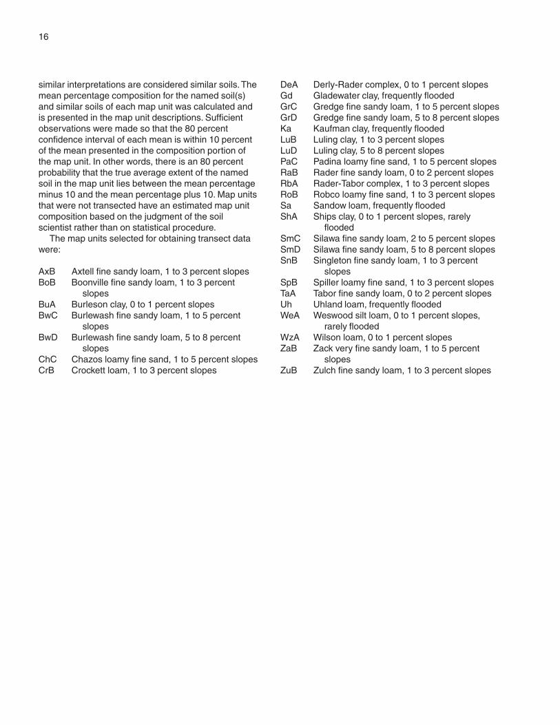
1. Zack-Boonville-Zulch
Nearly level to moderately sloping, moderately deepand very deep, loamy soils that are somewhat poorlydrained or moderately well drained; on prairies
The landscape in areas of this unit consists ofgently rolling dissected erosional uplands and somenearly level footslopes. Small areas of steeper soilsare adjacent to streams. The underlying material isalkaline, loamy sediment and shales of theEasterwood Shale Member of the Yegua Formation.Most of the soils in this unit are moderately deep overthis slowly weathering parent material.
This unit makes up about 19 percent of the county.It is 33 percent Zack soils, 29 percent Boonville soils,14 percent Zulch soils, and 24 percent soils of minorextent (fig. 2).
Zack soils are mostly on summits and the upperbackslopes and on breaks to streams. Typically, thesurface layer is thin. It is dark brown, strongly acid finesandy loam. The subsoil is mostly slightly acid tomoderately alkaline clay that has colors in shades ofbrown. It is underlain by moderately alkaline, loamysediments.
Boonville soils are on nearly level or very gentlysloping footslopes. Typically, the surface layer isbrown, slightly acid fine sandy loam. The thickness ofthe surface layer is highly variable. The subsoil is lightbrownish gray, neutral clay that has red and brownmottles. The underlying material is a mixture ofalkaline gray clay that is part colluvium and part shale.
Zulch soils are on the lower backslopes. Typically,the surface layer is thin. It is grayish brown,moderately acid fine sandy loam. The subsoil is darkgrayish brown, slightly acid clay. The underlyingmaterial is brown and gray, alkaline shale withinterbedded loamy materials.
Of minor extent in this unit are Chazos, Derly,Gredge, Rader, Sandow, and Tabor soils. Chazos andGredge soils are on summits and backslopes. Derly
General Soil Map Units

18 Soil Survey of
and Rader soils are on nearly level, moundedlandscapes. Tabor soils are on summits and toeslopes.Sandow soils are on the flood plains along localstreams.
The soils in this unit are used mainly for pasture,hayland, or range. They are used for pasture orhayland in the less sloping areas and for range in themore sloping areas. Many of these areas have beenused as cropland in the past.
Most of the pasture and hayland is improvedbermudagrass and bahiagrass. The main limitationsaffecting pasture and hayland are low fertility,droughtiness, and a severe hazard of erosion. Ifproper amounts of fertilizer are applied, low or mediumproduction of forage or hay can be expected.Overseeding legumes, such as vetch and clovers, intothe grass can lengthen the grazing season andimprove the soils.
Restricted permeability and a high shrink-swellpotential are problems affecting urban development.
Cracks in foundations and the failure of septic systemsare common in areas of this unit.
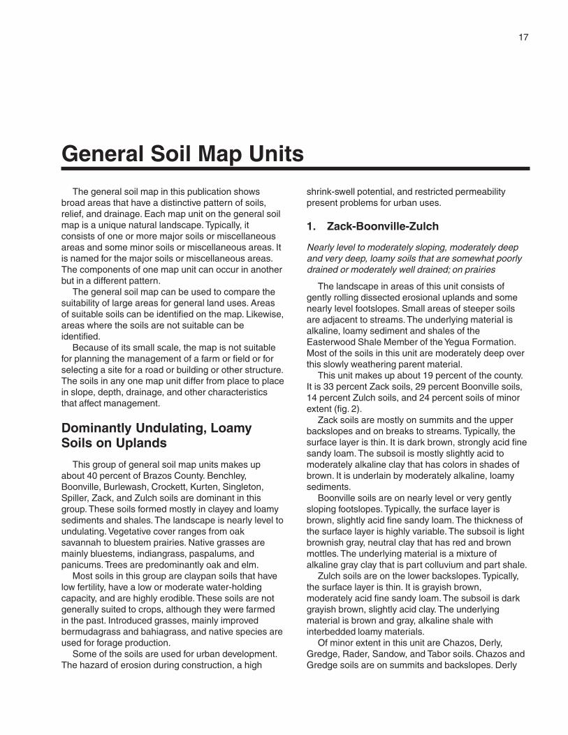
2. Burlewash-Singleton
Gently sloping to moderately sloping, moderatelydeep, loamy soils that are well drained or moderatelywell drained; in areas of oak savannah
The landscape in areas of this unit typically consistsof undulating dissected erosional uplands. Theunderlying material is acid, tuffaceous, slightlycemented sandstone and siltstone of the Jackson andCatahoula Formations. The soils in this unit are mainlymoderately deep, but some of the soils are shallow.Soil depth is limited by the parent material, which isresistant to weathering.
This unit makes up about 9 percent of the county. Itis 38 percent Burlewash soils, 19 percent Singletonsoils, and 43 percent soils of minor extent (fig. 3).
Figure 2.—Pattern of soils and underlying material in the Zack-Boonville-Zulch general soil map unit.
Brazos County, Texas 19
Burlewash soils are on summits and backslopes.Typically, the surface layer is thin. It is gray, moderatelyacid fine sandy loam. The subsoil is light reddishbrown, very strongly acid clay. The underlying materialis gray, very strongly acid, slightly cemented,tuffaceous sandstone or siltstone.
Singleton soils are on backslopes. Typically, thesurface layer is thin. It is gray, slightly acid fine sandyloam. The subsoil is brown or pale brown, verystrongly acid clay. The underlying material is stratified,white and brown tuffaceous siltstone.
Of minor extent in this unit are Chazos, Falba,Gredge, Koether, Sandow, and Shiro soils. Chazosand Gredge soils are on the convex upperbackslopes and ridgetops. Falba soils are onfootslopes. Koether soils are on strongly slopingnorth-facing scarps. Shiro soils are on roundedhilltops and ridges. Sandow soils are on the floodplains along local streams.
The soils in this unit are used mainly for pasture,range, or wildlife habitat. The less sloping areas areused for pasture and some hayland, and the moresloping areas are used for range or as wildlife habitat.The main limitations affecting pasture are low fertility,droughtiness, low pH, and a severe hazard of erosion.
The yield potential for forage and hay is low, even iffertilizer and lime are applied. Overseeding legumes,such as vetch and clovers, into the grass can lengthenthe grazing season and improve the soils.
Restricted permeability and a high shrink-swellpotential are problems affecting urban development.Cracks in foundations and the failure of septic systemsare common in areas of this unit.
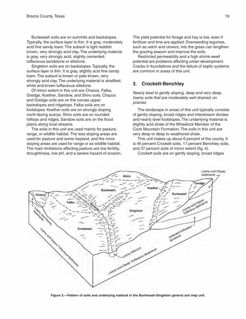
3. Crockett-Benchley
Nearly level to gently sloping, deep and very deep,loamy soils that are moderately well drained; onprairies
The landscape in areas of this unit typically consistsof gently sloping, broad ridges and interstream dividesand nearly level footslopes. The underlying material isslightly acid shale of the Wheelock Member of theCook Mountain Formation. The soils in this unit arevery deep or deep to weathered shale.
This unit makes up about 6 percent of the county. Itis 46 percent Crockett soils, 17 percent Benchley soils,and 37 percent soils of minor extent (fig. 4).
Crockett soils are on gently sloping, broad ridges
Figure 3.—Pattern of soils and underlying material in the Burlewash-Singleton general soil map unit.
20 Soil Survey of
and interstream divides. Typically, the surface layer isthin. It is brown, neutral loam. The subsoil is slightlyacid or neutral clay that has colors in shades of brown.The underlying material is dark brown, slightly acidshale.
Benchley soils are on nearly level or very gentlysloping footslopes. Typically, the surface layer is thin. Itis very dark grayish brown, slightly acid loam. Theupper part of the subsoil is slightly acid clay that hascolors in shades of brown. The lower part of thesubsoil is light yellowish brown, neutral clay loam. Theunderlying material is light yellowish brown, slightlyalkaline shale.
Of minor extent in this unit are Luling, Mabank,Tabor, Wilson, and Sandow soils. Luling soils are onbroad, nearly level ridgetops. Mabank and Wilson soilsare on nearly level stream terraces or remnants ofterraces in the uplands. Tabor soils are on nearly levelfootslopes near streams. Sandow soils are on theflood plains along local streams.
The soils in this unit are used mainly for pasture orrange. Some areas are cropped to temporary winter
pasture of small grain. Most areas of this unit havebeen cultivated in the past.
Most of the pasture is improved bermudagrass andsome kleingrass. The main limitations affecting pastureare low fertility and droughtiness. If proper amounts offertilizer are applied, high production of forage can beexpected. Winter pasture of oats or wheat is used forstocker and cow-calf operations.
Restricted permeability and a high shrink-swellpotential are problems affecting urban development.Cracks in foundations and the failure of septic systemsare common in areas of this unit.
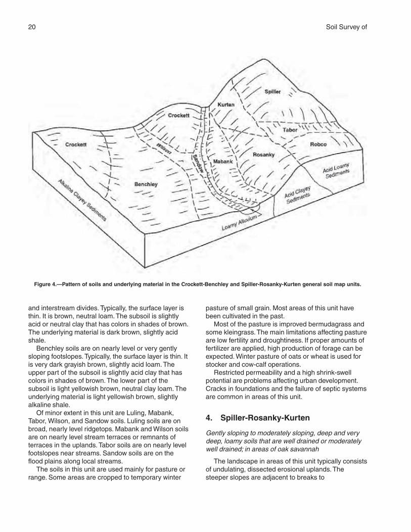
4. Spiller-Rosanky-Kurten
Gently sloping to moderately sloping, deep and verydeep, loamy soils that are well drained or moderatelywell drained; in areas of oak savannah
The landscape in areas of this unit typically consistsof undulating, dissected erosional uplands. Thesteeper slopes are adjacent to breaks to
Figure 4.—Pattern of soils and underlying material in the Crockett-Benchley and Spiller-Rosanky-Kurten general soil map units.
Brazos County, Texas 21
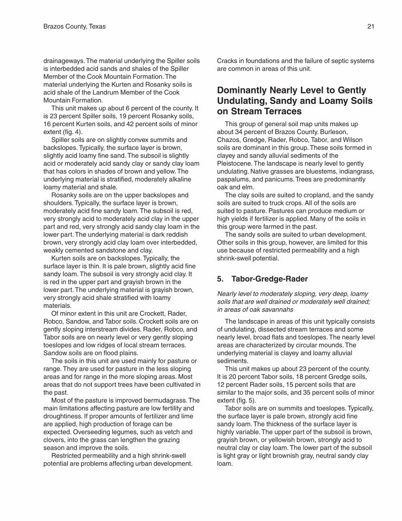
drainageways. The material underlying the Spiller soilsis interbedded acid sands and shales of the SpillerMember of the Cook Mountain Formation. Thematerial underlying the Kurten and Rosanky soils isacid shale of the Landrum Member of the CookMountain Formation.
This unit makes up about 6 percent of the county. Itis 23 percent Spiller soils, 19 percent Rosanky soils,16 percent Kurten soils, and 42 percent soils of minorextent (fig. 4).
Spiller soils are on slightly convex summits andbackslopes. Typically, the surface layer is brown,slightly acid loamy fine sand. The subsoil is slightlyacid or moderately acid sandy clay or sandy clay loamthat has colors in shades of brown and yellow. Theunderlying material is stratified, moderately alkalineloamy material and shale.
Rosanky soils are on the upper backslopes andshoulders. Typically, the surface layer is brown,moderately acid fine sandy loam. The subsoil is red,very strongly acid to moderately acid clay in the upperpart and red, very strongly acid sandy clay loam in thelower part. The underlying material is dark reddishbrown, very strongly acid clay loam over interbedded,weakly cemented sandstone and clay.
Kurten soils are on backslopes. Typically, thesurface layer is thin. It is pale brown, slightly acid finesandy loam. The subsoil is very strongly acid clay. Itis red in the upper part and grayish brown in thelower part. The underlying material is grayish brown,very strongly acid shale stratified with loamymaterials.
Of minor extent in this unit are Crockett, Rader,Robco, Sandow, and Tabor soils. Crockett soils are ongently sloping interstream divides. Rader, Robco, andTabor soils are on nearly level or very gently slopingtoeslopes and low ridges of local stream terraces.Sandow soils are on flood plains.
The soils in this unit are used mainly for pasture orrange. They are used for pasture in the less slopingareas and for range in the more sloping areas. Mostareas that do not support trees have been cultivated inthe past.
Most of the pasture is improved bermudagrass. Themain limitations affecting pasture are low fertility anddroughtiness. If proper amounts of fertilizer and limeare applied, high production of forage can beexpected. Overseeding legumes, such as vetch andclovers, into the grass can lengthen the grazingseason and improve the soils.
Restricted permeability and a high shrink-swellpotential are problems affecting urban development.
Cracks in foundations and the failure of septic systemsare common in areas of this unit.
Dominantly Nearly Level to GentlyUndulating, Sandy and Loamy Soilson Stream Terraces
This group of general soil map units makes upabout 34 percent of Brazos County. Burleson,Chazos, Gredge, Rader, Robco, Tabor, and Wilsonsoils are dominant in this group. These soils formed inclayey and sandy alluvial sediments of thePleistocene. The landscape is nearly level to gentlyundulating. Native grasses are bluestems, indiangrass,paspalums, and panicums. Trees are predominantlyoak and elm.
The clay soils are suited to cropland, and the sandysoils are suited to truck crops. All of the soils aresuited to pasture. Pastures can produce medium orhigh yields if fertilizer is applied. Many of the soils inthis group were farmed in the past.
The sandy soils are suited to urban development.Other soils in this group, however, are limited for thisuse because of restricted permeability and a highshrink-swell potential.
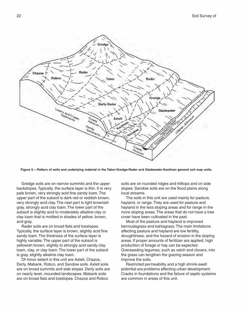
5. Tabor-Gredge-Rader
Nearly level to moderately sloping, very deep, loamysoils that are well drained or moderately well drained;in areas of oak savannahs
The landscape in areas of this unit typically consistsof undulating, dissected stream terraces and somenearly level, broad flats and toeslopes. The nearly levelareas are characterized by circular mounds. Theunderlying material is clayey and loamy alluvialsediments.
This unit makes up about 23 percent of the county.It is 20 percent Tabor soils, 18 percent Gredge soils,12 percent Rader soils, 15 percent soils that aresimilar to the major soils, and 35 percent soils of minorextent (fig. 5).
Tabor soils are on summits and toeslopes. Typically,the surface layer is pale brown, strongly acid finesandy loam. The thickness of the surface layer ishighly variable. The upper part of the subsoil is brown,grayish brown, or yellowish brown, strongly acid toneutral clay or clay loam. The lower part of the subsoilis light gray or light brownish gray, neutral sandy clayloam.
22 Soil Survey of
Gredge soils are on narrow summits and the upperbackslopes. Typically, the surface layer is thin. It is verypale brown, very strongly acid fine sandy loam. Theupper part of the subsoil is dark red or reddish brown,very strongly acid clay. The next part is light brownishgray, strongly acid clay loam. The lower part of thesubsoil is slightly acid to moderately alkaline clay orclay loam that is mottled in shades of yellow, brown,and gray.
Rader soils are on broad flats and toeslopes.Typically, the surface layer is brown, slightly acid finesandy loam. The thickness of the surface layer ishighly variable. The upper part of the subsoil isyellowish brown, slightly to strongly acid sandy clayloam, clay, or clay loam. The lower part of the subsoilis gray, slightly alkaline clay loam.
Of minor extent in this unit are Axtell, Chazos,Derly, Mabank, Robco, and Sandow soils. Axtell soilsare on broad summits and side slopes. Derly soils areon nearly level, mounded landscapes. Mabank soilsare on broad flats and toeslopes. Chazos and Robco
soils are on rounded ridges and hilltops and on sideslopes. Sandow soils are on the flood plains alonglocal streams.
The soils in this unit are used mainly for pasture,hayland, or range. They are used for pasture andhayland in the less sloping areas and for range in themore sloping areas. The areas that do not have a treecover have been cultivated in the past.
Most of the pasture and hayland is improvedbermudagrass and bahiagrass. The main limitationsaffecting pasture and hayland are low fertility,droughtiness, and the hazard of erosion in the slopingareas. If proper amounts of fertilizer are applied, highproduction of forage or hay can be expected.Overseeding legumes, such as vetch and clovers, intothe grass can lengthen the grazing season andimprove the soils.
Restricted permeability and a high shrink-swellpotential are problems affecting urban development.Cracks in foundations and the failure of septic systemsare common in areas of this unit.
Figure 5.—Pattern of soils and underlying material in the Tabor-Gredge-Rader and Gladewater-Kaufman general soil map units.
Brazos County, Texas 23
6. Robco-Chazos
Gently sloping and moderately sloping, very deep,sandy soils that are moderately well drained; in areasof oak savannah
The landscape in areas of this unit typically consistsof undulating, dissected stream terraces. Steeperareas are adjacent to breaks to the major streams.The underlying material is sandy and loamy alluvialsediments.
This unit makes up about 6 percent of the county. Itis 45 percent Robco and similar soils, 22 percentChazos soils, and 33 percent soils of minor extent.
Robco and similar soils are on summits andshoulders. Typically, the surface layer is thick, brown,slightly acid loamy fine sand. The upper part of thesubsoil is mostly light gray, strongly acid sandy clayloam or clay loam. The lower part of the subsoil is red,strongly acid sandy clay loam. In some areas onsummits and backslopes, the thick surface layerconsists of sandy or very sandy material and thesubsoil is loamy. These areas are typically adjacent tobreaks to the major streams and on low terraces.These similar soils include Desan, Dutek, Eufaula,Navasan, Padina, and Styx soils.
Chazos soils are on summits and the upper backslopes. Typically, the surface layer is brownish gray,slightly acid loamy fine sand. The subsoil is reddishbrown or brownish yellow, moderately acid clay orsandy clay in the upper part and yellowish brown orreddish brown, slightly alkaline clay loam or sandy clayloam in the lower part.
Of minor extent in this unit are Axtell, Derly,Gredge, Rader, Sandow, and Tabor soils. Axtell soilsare on broad summits. Derly, Rader, and Tabor soilsare on broad flats and toeslopes. Gredge soils are onnarrow summits and the upper backslopes. Sandowsoils are on the flood plains along local streams.
The soils in this unit are mainly used for pasture,hayland, range, or wildlife habitat. They are used forpasture and hayland in the less sloping areas. Thesteeper areas are used for range. These areas havepotential for wildlife habitat because of their proximityto the more remote flood plains.
Most of the pasture and hayland is improvedbermudagrass. Lovegrass and switchgrass grow inareas of the deeper sands. The main limitationsaffecting pasture and hayland are low fertility, the needfor lime, and droughtiness. If proper amounts offertilizer are applied, high production of forage or haycan be expected. Overseeding legumes, such as vetchand clovers, into the grass can lengthen the grazingseason and improve the soils.
Rapid permeability in some of the soils can be a
problem affecting urban development if onsite sewagedisposal systems are used.
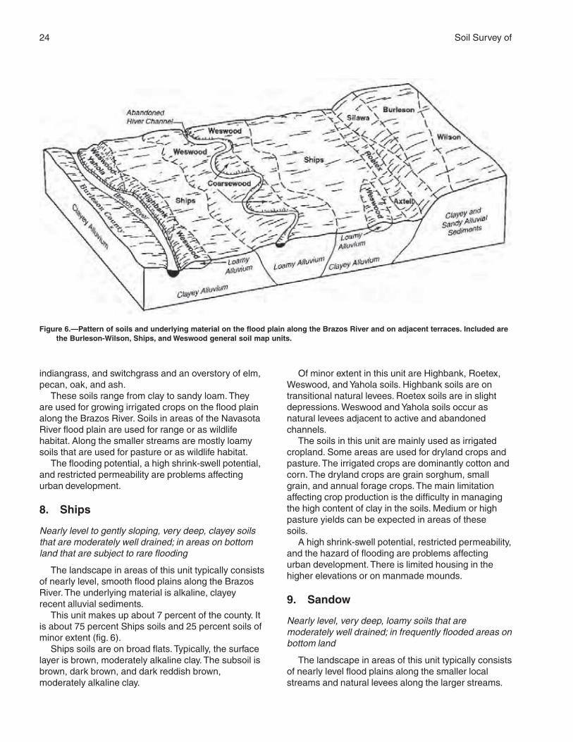
7. Burleson-Wilson
Nearly level to gently sloping, very deep, loamy andclayey soils that are moderately well drained; onprairies
The landscape in areas of this unit typically consistsof nearly level to undulating, smooth stream terraces.The underlying material is alkaline, clayey and loamyalluvial sediments.
This unit makes up about 5 percent of the county. Itis 43 percent Burleson soils, 21 percent Wilson soils,and 36 percent soils of minor extent (fig. 6).
Burleson soils are on flat interstream divides.Typically, the surface layer is very dark gray, neutralclay. The subsoil is dark gray or very dark gray clay. Itis slightly alkaline or moderately alkaline. Theunderlying material is reddish yellow, moderatelyalkaline silty clay.
Wilson soils are on the slightly higher summits.Typically, the surface layer is grayish brown,moderately acid loam. The subsoil is clay. The upperpart is dark gray or gray and is slightly acid ormoderately acid. The lower part is gray and is slightlyalkaline.
Of minor extent in this unit are Axtell, Chazos,Desan, and Silawa soils. Axtell soils are on summits.Chazos and Desan soils are on rounded ridges andhilltops. Silawa soils are on the convex upperbackslopes.
The soils in this unit are mainly used for pastureand hayland. Most of the pasture and hayland isimproved bermudagrass and bahiagrass. The mainlimitation affecting pasture and hayland is low fertility. Ifproper amounts of fertilizer are applied, medium orhigh production of forage or hay can be expected.Many areas of this unit were cultivated in the past.
A high shrink-swell potential and restrictedpermeability can be a problem affecting urbandevelopment. Cracks in foundations and the failure ofseptic systems are common in areas of this unit.
Dominantly Nearly Level, Loamyand Clayey Soils on Flood Plains
This group of general soil map units makes upabout 26 percent of Brazos County. Gladewater,Kaufman, Sandow, Ships, and Weswood soils aredominant in this group. These soils formed in clayey,loamy, and sandy alluvium. The landscape is nearlylevel. Native grasses are mainly bluestems,
24 Soil Survey of
indiangrass, and switchgrass and an overstory of elm,pecan, oak, and ash.
These soils range from clay to sandy loam. Theyare used for growing irrigated crops on the flood plainalong the Brazos River. Soils in areas of the NavasotaRiver flood plain are used for range or as wildlifehabitat. Along the smaller streams are mostly loamysoils that are used for pasture or as wildlife habitat.
The flooding potential, a high shrink-swell potential,and restricted permeability are problems affectingurban development.
8. Ships
Nearly level to gently sloping, very deep, clayey soilsthat are moderately well drained; in areas on bottomland that are subject to rare flooding
The landscape in areas of this unit typically consistsof nearly level, smooth flood plains along the BrazosRiver. The underlying material is alkaline, clayeyrecent alluvial sediments.
This unit makes up about 7 percent of the county. Itis about 75 percent Ships soils and 25 percent soils ofminor extent (fig. 6).
Ships soils are on broad flats. Typically, the surfacelayer is brown, moderately alkaline clay. The subsoil isbrown, dark brown, and dark reddish brown,moderately alkaline clay.
Of minor extent in this unit are Highbank, Roetex,Weswood, and Yahola soils. Highbank soils are ontransitional natural levees. Roetex soils are in slightdepressions. Weswood and Yahola soils occur asnatural levees adjacent to active and abandonedchannels.
The soils in this unit are mainly used as irrigatedcropland. Some areas are used for dryland crops andpasture. The irrigated crops are dominantly cotton andcorn. The dryland crops are grain sorghum, smallgrain, and annual forage crops. The main limitationaffecting crop production is the difficulty in managingthe high content of clay in the soils. Medium or highpasture yields can be expected in areas of thesesoils.
A high shrink-swell potential, restricted permeability,and the hazard of flooding are problems affectingurban development. There is limited housing in thehigher elevations or on manmade mounds.
9. Sandow
Nearly level, very deep, loamy soils that aremoderately well drained; in frequently flooded areas onbottom land
The landscape in areas of this unit typically consistsof nearly level flood plains along the smaller localstreams and natural levees along the larger streams.
Figure 6.—Pattern of soils and underlying material on the flood plain along the Brazos River and on adjacent terraces. Included arethe Burleson-Wilson, Ships, and Weswood general soil map units.
Brazos County, Texas 25
The underlying material is slightly acid, loamyalluvium.
This unit makes up about 7 percent of the county. Itis 60 percent Sandow soils and 40 percent soils ofminor extent.
Sandow soils are on narrow flood plains along smallstreams and on natural levees along the largerstreams. Typically, the surface layer is grayish brown,slightly acid loam. The subsoil is stratified with loamytextures in shades of gray and brown. It is slightly acidor moderately acid.
Of minor extent in this unit are Derly, Gredge,Rader, Robco, Silawa, Tabor, and Uhland soils. Derly,Rader, and Tabor soils are on broad flats andtoeslopes of terraces adjacent to the flood plain.Gredge and Silawa soils are on the upper backslopesof stream terraces. Robco soils are on rounded ridgesand hilltops. Uhland soils are along narrow localstreams and adjacent to channels on natural leveesalong other streams.
The soils in this unit are used for pasture or aswildlife habitat. Pastures of bahiagrass and commonbermudagrass are the most common. Areas of thesesoils that are wooded or adjacent to woodlands areused as wildlife habitat. Because of the natural fertilityof the soils, good pasture production is possible withlittle or no application of fertilizer.
Because of the frequent flooding, areas of this unitare not suited to urban development.
10. Gladewater-Kaufman
Nearly level, very deep, clayey soils that aresomewhat poorly drained to moderately well drained;in frequently or occasionally flooded areas on bottomland
The landscape in areas of this unit typically consistsof nearly level, large, broad major flood plains,especially along the Navasota River. The underlyingmaterial is slightly acid, clayey alluvium.
This unit makes up about 6 percent of the county. Itis 65 percent Gladewater soils, 16 percent Kaufmansoils, and 19 percent soils of minor extent (fig. 5).
Gladewater soils are on broad, level flood plains,mainly along the Navasota River. Typically, the surfacelayer is dark gray, strongly acid clay. The subsoil isdark grayish brown, moderately acid or strongly acidclay.
Kaufman soils are on broad, level flood plains,mainly along major tributaries of the Navasota Riverand on its outer flood plain. Typically, the surface layeris very dark gray, strongly acid clay. The subsoil is very
dark gray, moderately acid clay in the upper part anddark grayish brown, moderately alkaline clay in thelower part.
Of minor extent in this unit are Desan, Dutek,Eufaula, Navasan, Padina, Robco, Sandow, andUhland soils. Desan, Dutek, Padina, and Robco soilsare on slightly rounded ridges and hills on breaks tothe major flood plain. Sandow and Uhland soils are onnatural levees or flood plains along the smallerstreams. Eufaula and Navasan soils are on low streamterraces.
The soils in this unit are used for range or as wildlifehabitat. Because of the flooding, the soils are not usedfor crops or improved pasture.
Areas of this unit are not suitable for urbandevelopment because of the flooding, the shrink-swellpotential, and restricted permeability.
11. Weswood
Nearly level to gently sloping, very deep, loamy soilsthat are well drained; in areas on bottom land that aresubject to rare flooding
The landscape in areas of this unit typically consistsof nearly level to gently sloping flood plains along theBrazos River. The underlying material is alkaline,stratified, loamy alluvial sediments.
This unit makes up about 6 percent of the county. Itis about 58 percent Weswood soils and 42 percentsoils of minor extent (fig. 6).
Weswood soils are on natural levees and alluvialfans. Typically, the surface layer is brown, moderatelyalkaline silt loam. The subsoil is light brown,moderately alkaline silt loam. The underlying materialis stratified, moderately alkaline silt loam in variousshades of brown.
Of minor extent in this unit are Coarsewood,Highbank, Roetex, Ships, and Yahola soils.Coarsewood soils are on natural levees. Highbank andShips soils are on flats away from channels. Roetexsoils are in depressions. Yahola soils are adjacent tochannels.
The soils in this unit are mainly used as irrigatedcropland. Some small areas are used for drylandcrops. The irrigated crops are dominantly cotton andsome corn. The dryland crops are grain sorghum,small grain, and annual forage crops. High yields canbe expected if proper irrigation management, properamounts of herbicide and pesticide, and timely tillageare applied. These soils are well suited to pasture.
The rare flooding is a slight problem affecting urbandevelopment.
27
The map units delineated on the detailed soil mapsin this survey represent the soils or miscellaneousareas in the survey area. The map unit descriptions inthis section, along with the maps, can be used todetermine the suitability and potential of a unit forspecific uses. They also can be used to plan themanagement needed for those uses.
A map unit delineation on a soil map represents anarea dominated by one or more major kinds of soil ormiscellaneous areas. A map unit is identified andnamed according to the taxonomic classification of thedominant soils. Within a taxonomic class there areprecisely defined limits for the properties of the soils.On the landscape, however, the soils are naturalphenomena, and they have the characteristicvariability of all natural phenomena. Thus, the range ofsome observed properties may extend beyond thelimits defined for a taxonomic class. Areas of soils of asingle taxonomic class rarely, if ever, can be mappedwithout including areas of other taxonomic classes.Consequently, every map unit is made up of the soilsor miscellaneous areas for which it is named andsome “included” areas that belong to other taxonomicclasses.
Most included soils have properties similar to thoseof the dominant soil or soils in the map unit, and thusthey do not affect use and management. These arecalled noncontrasting, or similar, inclusions. They mayor may not be mentioned in the map unit description.Other included soils and miscellaneous areas,however, have properties and behavioralcharacteristics divergent enough to affect use or torequire different management. These are calledcontrasting, or dissimilar, inclusions. They generallyare in small areas and could not be mappedseparately because of the scale used. Some smallareas of strongly contrasting soils or miscellaneousareas are identified by a special symbol on the maps.The included areas of contrasting soils ormiscellaneous areas are mentioned in the map unitdescriptions. A few included areas may not have beenobserved, and consequently they are not mentioned inthe descriptions, especially where the pattern was so
complex that it was impractical to make enoughobservations to identify all the soils and miscellaneousareas on the landscape.
The presence of included areas in a map unit in noway diminishes the usefulness or accuracy of the data.The objective of mapping is not to delineate puretaxonomic classes but rather to separate thelandscape into landforms or landform segments thathave similar use and management requirements. Thedelineation of such segments on the map providessufficient information for the development of resourceplans. If intensive use of small areas is planned,however, onsite investigation is needed to define andlocate the soils and miscellaneous areas.
An identifying symbol precedes the map unit namein the map unit descriptions. Each description includesgeneral facts about the unit and gives the principalhazards and limitations to be considered in planningfor specific uses.
Soils that have profiles that are almost alike makeup a soil series. Except for differences in texture of thesurface layer, all the soils of a series have majorhorizons that are similar in composition, thickness,and arrangement.
Soils of one series can differ in texture of thesurface layer, slope, stoniness, salinity, degree oferosion, and other characteristics that affect their use.On the basis of such differences, a soil series isdivided into soil phases. Most of the areas shown onthe detailed soil maps are phases of soil series. Thename of a soil phase commonly indicates a featurethat affects use or management. For example,Weswood silty clay loam, 0 to 1 percent slopes, rarelyflooded, is a phase of the Weswood series.
Some map units are made up of two or more majorsoils or miscellaneous areas. These map units arecalled complexes. A complex consists of two or moresoils or miscellaneous areas in such an intricatepattern or in such small areas that they cannot beshown separately on the maps. The pattern andproportion of the soils or miscellaneous areas aresomewhat similar in all areas. Rader-Tabor complex, 1to 3 percent slopes, is an example.
Detailed Soil Map Units
28 Soil Survey of
This survey includes miscellaneous areas. Suchareas have little or no soil material and support little orno vegetation. Urban land is an example.
Table 4 gives the acreage and proportionate extentof each map unit. Other tables (see Contents) giveproperties of the soils and the limitations, capabilities,and potentials for many uses. The Glossary definesmany of the terms used in describing the soils ormiscellaneous areas.
AxB—Axtell fine sandy loam, 1 to 3percent slopes
Setting
Landform: Stream terracesLandscape position: Summits and the upper side
slopesSlope: Very gently sloping; slightly convex or plane
surfacesShape of areas: Elongated or irregularSize of areas: 8 to 150 acresNative vegetation: Post oak savannah
Typical Profile
Surface layer:0 to 4 inches—grayish brown, strongly acid fine sandy
loam
Subsurface layer:4 to 8 inches—pale brown, moderately acid fine sandy
loam
Subsoil:8 to 29 inches—strong brown, very strongly acid clay
that has mottles in shades of gray, brown, and red29 to 40 inches—red, strongly acid clay that has
strong brown and weak red mottles40 to 50 inches—light olive brown, moderately acid
clay that has yellowish brown and grayish brownmottles
50 to 80 inches—light olive brown, slightly alkaline claythat has yellowish brown and grayish brownmottles
Soil Properties
Depth class: Very deepDrainage class: Moderately well drainedDepth to the water table: More than 6 feetFlooding: NoneRunoff: MediumPermeability: Very slowAvailable water capacity: Moderate
Root zone: Very deep; restricted by the clayey subsoilNatural soil fertility: LowShrink-swell potential: High in the subsoilHazard of water erosion: Moderate or severe
Composition
• Based on transects, this map unit contains 67percent soils of the Axtell series. There is an 80percent probability that Axtell and similar soils makeup 80 to 100 percent of the unit. Contrasting soils areLufkin, Rader, and Silawa soils, but neither of thesesoils makes up as much as 10 percent of the unit.
Contrasting Soils
• Rader soils, which have a thicker surface layer thanthat of the Axtell soil• Lufkin soils, which have a gray subsoil; in the lesssloping areas• Silawa soils, which have a loamy subsoil; on theconvex upper slopes adjacent to streams
Land Uses
Major land use: PastureOther land use: Rangeland
Management Concerns
Pasture
Major limitations:• Water erosion is a concern unless an adequatecover of vegetation is maintained.• The available water capacity limits the potentialforage production during dry seasons.• The low natural fertility also limits the potentialforage production.
Cropland
Major limitations:• Because of the hazard of erosion, conservationmeasures are needed.• The available water capacity limits the potentialproduction during dry seasons.• The low natural fertility limits the potential yields ofmost crops.
Rangeland
Major limitations:• Water erosion is a concern unless an adequatecover of vegetation is maintained.• The available water capacity limits the potentialproduction during dry seasons.• The low natural fertility also limits the potentialproduction.
Brazos County, Texas 29
Urban development
Major limitations:• Structures and roads are affected by the high shrink-swell potential in the subsoil.• Erosion-control measures are needed atconstruction sites.• Disposal of septic tank effluent is a concernbecause of the restricted permeability.
Interpretive Groups
Land capability classification: 3eEcological site: Claypan SavannahPasture management group: 7
BeA—Benchley loam, 0 to 1 percentslopes
Setting
Landform: UplandsLandscape position: FootslopesSlope: Nearly level; plane or slightly concaveShape of areas: IrregularSize of areas: 8 to 50 acresNative vegetation: Tall grass prairie
Typical Profile
Surface layer:0 to 5 inches—grayish brown, slightly acid loam
Subsurface layer:5 to 15 inches—black, slightly acid loam
Subsoil:15 to 21 inches—brown, slightly acid clay that has
yellow mottles21 to 50 inches—mottled gray and brown, slightly acid
clay50 to 80 inches—mottled gray and brown, neutral clay
Soil Properties
Depth class: Very deepDrainage class: Moderately well drainedDepth to the water table: More than 6 feetFlooding: NoneRunoff: SlowPermeability: SlowAvailable water capacity: HighRoot zone: Very deep; restricted by the clayey subsoilNatural soil fertility: HighShrink-swell potential: High in the subsoilHazard of water erosion: Slight
Composition
• This map unit consists of about 85 percent Benchley
soil and similar soils. Contrasting soils make up about15 percent of the unit.
Contrasting Soils
• Dimebox and Luling soils, which are clayeythroughout; in landscape positions similar to those ofthe Benchley soil
Land Uses
Major land use: PastureOther land use: Rangeland
Management Concerns
Pasture
Major limitations:• No major limitations affect the use of this soil forpasture. If good management is applied, high yields ofadapted forage grasses can be produced.
Cropland
Major limitations:• No major limitations affect the use of this soil forcrops. If good management is applied, high yields ofadapted crops can be produced.
Rangeland
Major limitations:• No major limitations affect the use of this soil asrangeland. If good management is applied, high yieldsof native plants can be produced.
Urban development
Major limitations:• Structures and roads are affected by the high shrink-swell potential in the subsoil.• Erosion-control measures are needed atconstruction sites.• Disposal of septic tank effluent is a concernbecause of the restricted permeability.
Interpretive Groups
Land capability classification: 2wEcological site: Clay LoamPasture management group: 1
BeB—Benchley loam, 1 to 3 percentslopes
Setting
Landform: UplandsLandscape position: Lower footslopesSlope: Very gently sloping; plane or slightly concaveShape of areas: Irregular
30 Soil Survey of
Size of areas: 8 to 50 acresNative vegetation: Tall grass prairie
Typical Profile
Surface layer:0 to 10 inches—very dark grayish brown, slightly acid
loam
Subsoil:10 to 16 inches—very dark grayish brown, slightly acid
clay loam that has yellowish brown mottles16 to 30 inches—reddish brown, slightly acid clay that
has light olive brown and pale yellow mottles30 to 54 inches—light yellowish brown, slightly acid
clay that has red mottles54 to 70 inches—light yellowish brown, neutral clay
loam that has pale yellow mottles
Underlying material:70 to 80 inches—light yellowish brown, slightly alkaline
shale that has clayey texture and pale brownmottles
Soil Properties
Depth class: Very deepDrainage class: Moderately well drainedDepth to the water table: More than 6 feetFlooding: NoneRunoff: SlowPermeability: SlowAvailable water capacity: HighRoot zone: Very deep; restricted by the clayey subsoilNatural soil fertility: HighShrink-swell potential: High in the subsoilHazard of water erosion: Moderate
Composition
• This map unit consists of about 85 percent Benchleysoil and similar soils. Contrasting soils make up about15 percent of the unit.
Contrasting Soils
• Dimebox and Luling soils, which are clayeythroughout; in landscape positions similar to those ofthe Benchley soil
Land Uses
Major land use: PastureOther land use: Rangeland
Management Concerns
Pasture
Major limitations:• No major limitations affect the use of this soil for
pasture. If good management is applied, high yields ofadapted forage grasses can be produced.Minor limitations:• Water erosion is a concern unless an adequatecover of vegetation is maintained.
Cropland
Major limitations:• Because of the hazard of erosion, conservationmeasures are needed.
Rangeland
Major limitations:• No major limitations affect the use of this soil asrangeland. If good management is applied, high yieldsof adapted forage grasses can be produced.Minor limitations:• Water erosion is a concern unless an adequatecover of vegetation is maintained.
Urban development
Major limitations:• Structures and roads are affected by the high shrink-swell potential in the subsoil.• Erosion-control measures are needed atconstruction sites.• Disposal of septic tank effluent is a concernbecause of the restricted permeability.
Interpretive Groups
Land capability classification: 2eEcological site: Clay LoamPasture management group: 1
BoA—Boonville fine sandy loam, 0 to 1percent slopes
Setting
Landform: UplandsLandscape position: FootslopesSlope: Nearly level; slightly concave or planeShape of areas: Elongated or ovalSize of areas: 50 to 150 acresNative vegetation: Open savannah with mid and tall
grasses
Typical Profile
Surface layer:0 to 17 inches—dark grayish brown, slightly acid fine
sandy loam
Subsoil:17 to 41 inches—light grayish brown, neutral clay that
has red and brown mottles
Brazos County, Texas 31
41 to 56 inches—light gray, moderately alkaline clayloam
56 to 73 inches—pale yellow, moderately alkaline clayloam
Underlying material:73 to 80 inches—light brownish gray, slightly alkaline
shale that has clay texture
Soil Properties
Depth class: Very deepDrainage class: Somewhat poorly drainedDepth to the water table: 0.5 to 1.0 foot (perched)Flooding: NoneRunoff: SlowPermeability: Very slowAvailable water capacity: ModerateRoot zone: Very deep; restricted by the clay subsoilNatural soil fertility: MediumShrink-swell potential: High in the subsoilHazard of water erosion: Slight
Composition
• This map unit consists of about 85 percent Boonvillesoil and similar soils. Contrasting soils make up about15 percent of the unit.
Contrasting Soils
• Tabor soils, which have a yellower subsoil than thatof the Boonville soil; in landscape positions similar tothose of the Boonville soil• Zack and Zulch soils, which have a thinner surfacelayer than that of the Boonville soil; on convex slopes
Land Uses
Major land use: PastureOther land use: Urban development
Management Concerns
Pasture
Major limitations:• The moderate available water capacity and mediumnatural fertility limit the potential forage production.
Cropland
Major limitations:• The moderate available water capacity and mediumnatural fertility limit yields of most crops.Minor limitations:• Seasonal wetness is a concern in most years.
Rangeland
Major limitations:• The moderate available water capacity and
medium natural fertility limit the potential forageproduction.
Urban development
Major limitations:• Structures and roads are affected by the high shrink-swell potential in the subsoil.• Disposal of septic tank effluent is a concernbecause of the restricted permeability and shortperiods of soil saturation.
Interpretive Groups
Land capability classification: 3wEcological site: Claypan PrairiePasture management group: 7
BoB—Boonville fine sandy loam, 1 to 3percent slopes
Setting
Landform: UplandsLandscape position: FootslopesSlope: Very gently sloping; slightly concave or planeShape of areas: Elongated or ovalSize of areas: 25 to 200 acresNative vegetation: Open savannah with mid and tall
grasses
Typical Profile
Surface layer:0 to 4 inches—pale brown, neutral or slightly acid fine
sandy loam4 to 10 inches—brown, moderately acid fine sandy
loam10 to 17 inches—very pale brown, moderately acid
fine sandy loam
Subsoil:17 to 36 inches—light brownish gray, slightly acid clay
that has red, yellowish brown, and olive brownmottles
36 to 56 inches—light brownish gray and light gray,moderately alkaline clay loam that has olivemottles
56 to 73 inches—pale yellow, moderately alkaline clayloam
Underlying material:73 to 80 inches—light brownish gray, slightly alkaline
shale that has clay loam texture
Soil Properties
Depth class: Very deepDrainage class: Somewhat poorly drained
32 Soil Survey of
Depth to the water table: 0.5 to 1.0 foot (perched)Flooding: NoneRunoff: SlowPermeability: Very slowAvailable water capacity: ModerateRoot zone: Very deep; restricted by the clay subsoilNatural soil fertility: MediumShrink-swell potential: High in the subsoilHazard of water erosion: Severe
Composition
• Based on transects, this map unit contains 85percent soils of the Boonville series. There is an 80percent probability that Boonville and similar soilsmake up 82 to 100 percent of the unit. Contrastingsoils are Tabor, Zack, and Zulch soils, but neither ofthese soils makes up as much as 10 percent of theunit.
Contrasting Soils
• Tabor soils, which have a yellower subsoil than thatof the Boonville soil; in landscape positions similar tothose of the Boonville soil• Zack and Zulch soils, which have a thinner surfacelayer than that of the Boonville soil; on convex slopes
Land Uses
Major land use: Pasture (fig. 7)Other land use: Urban development
Management Concerns
Pasture
Major limitations:• Water erosion is a concern unless an adequatecover of vegetation is maintained.• The moderate available water capacity and mediumnatural fertility limit the potential forage production.
Cropland
Major limitations:• Because of the hazard of erosion, conservationmeasures are needed.• The moderate available water capacity and mediumnatural fertility limit the potential production of mostcrops.Minor limitations:• Seasonal wetness is a concern in most years.
Rangeland
Major limitations:• The moderate available water capacity and mediumnatural fertility limit the potential forage production.• Water erosion is a concern unless an adequatecover of vegetation is maintained.
Urban development
Major limitations:• Structures and roads are affected by the high shrink-swell potential in the subsoil.• Erosion-control measures are needed atconstruction sites.• Disposal of septic tank effluent is a concernbecause of the restricted permeability and shortperiods of soil saturation.
Interpretive Groups
Land capability classification: 3eEcological site: Claypan PrairiePasture management group: 7
BrB—Boonville-Urban land complex, 0 to3 percent slopes
Setting
Landform: UplandsLandscape position: FootslopesSlope: Nearly level and very gently sloping; slightly
concave or planeShape of areas: Elongated or ovalSize of areas: 25 to 1,200 acresNative vegetation: Open savannah with mid and tall
grasses
Typical Profile
Boonville
Surface layer:0 to 12 inches—brown, slightly acid fine sandy
loam
Subsoil:12 to 30 inches—grayish brown, neutral clay that has
red and yellowish brown mottles30 to 55 inches—light gray, moderately alkaline clay
loam that has brown mottles55 to 65 inches—pale olive, moderately alkaline clay
loam
Underlying material:65 to 80 inches—mottled brownish gray, slightly
alkaline clay loam
Soil Properties
Boonville
Depth class: Very deepDrainage class: Somewhat poorly drainedDepth to the water table: 0.5 to 1.0 foot (perched)Flooding: NoneRunoff: Slow
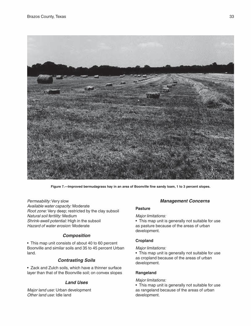
Brazos County, Texas 33
Permeability: Very slowAvailable water capacity: ModerateRoot zone: Very deep; restricted by the clay subsoilNatural soil fertility: MediumShrink-swell potential: High in the subsoilHazard of water erosion: Moderate
Composition
• This map unit consists of about 40 to 60 percentBoonville and similar soils and 35 to 45 percent Urbanland.
Contrasting Soils
• Zack and Zulch soils, which have a thinner surfacelayer than that of the Boonville soil; on convex slopes
Land Uses
Major land use: Urban developmentOther land use: Idle land
Management Concerns
Pasture
Major limitations:• This map unit is generally not suitable for useas pasture because of the areas of urbandevelopment.
Cropland
Major limitations:• This map unit is generally not suitable for useas cropland because of the areas of urbandevelopment.
Rangeland
Major limitations:• This map unit is generally not suitable for useas rangeland because of the areas of urbandevelopment.
Figure 7.—Improved bermudagrass hay in an area of Boonville fine sandy loam, 1 to 3 percent slopes.
34 Soil Survey of
Urban development
Major limitations:• Structures and roads are affected by the high shrink-swell potential in the subsoil.• Disposal of septic tank effluent is a concernbecause of the restricted permeability and shortperiods of soil saturation.• Erosion-control measures are needed atconstruction sites.
Interpretive Groups
Land capability classification: None assignedEcological site: None assignedPasture management group: None assigned
BuA—Burleson clay, 0 to 1 percent slopes
Setting
Landform: Stream terracesLandscape position: Flat interstream dividesSlope: Nearly level; plane to convex surfacesShape of areas: Irregular or elongatedSize of areas: 10 to 300 acresNative vegetation: Tall grass prairie
Typical Profile
Surface layer:0 to 8 inches—very dark gray, neutral clay
Subsoil:8 to 40 inches—very dark gray, slightly alkaline clay40 to 65 inches—moderately alkaline clay that is dark
gray in the upper part and light brownish gray inthe lower part
Underlying material:65 to 80 inches—reddish yellow, moderately alkaline
silty clay
Soil Properties
Depth class: Very deepDrainage class: Moderately well drainedDepth to the water table: More than 6 feetFlooding: NoneRunoff: SlowPermeability: Very slowAvailable water capacity: HighRoot zone: Very deepNatural soil fertility: HighShrink-swell potential: Very highHazard of water erosion: Slight
Composition
• Based on transects, this map unit contains 97
percent soils of the Burleson series. There is an 80percent probability that Burleson and similar soilsmake up 95 to 100 percent of the unit. Contrastingsoils are Crockett, Mabank, and Wilson soils, butneither of these soils makes up as much as 10 percentof the unit.
Contrasting Soils
• Crockett, Mabank, and Wilson soils, which have aloamy surface layer; in landscape positions similar tothose of the Burleson soil
Land Uses
Major land uses: Cropland and pastureOther land use: Rangeland
Management Concerns
Pasture
Major limitations:• No major limitations affect the use of this soil forpasture. If good management is applied, high yields ofadapted forage grasses can be produced.Minor limitations:• The high content of clay limits the uptake of water.
Cropland
Major limitations:• No major limitations affect the use of this soil forcrops. If good management is applied, high yields ofadapted crops can be produced.Minor limitations:• The high content of clay limits the uptake of water.• Surface crusting affects seedling emergence.• Because of the high content of clay, high-poweredequipment is needed.• Wetness resulting from the restricted runoff rate cancause delays in cultivation. It can also promoteseedling problems because it keeps the soiltemperature lower than in other areas.
Rangeland
Major limitations:• No major limitations affect the use of this soil asrangeland. High yields of adapted native plants can beproduced.Minor limitations:• The high content of clay limits the uptake of water.
Urban development
Major limitations:• Structures and roads are affected by the very highshrink-swell potential in the subsoil.• Disposal of septic tank effluent is a concernbecause of the restricted permeability.
Brazos County, Texas 35
• Erosion-control measures are needed atconstruction sites.Minor limitations:• The high content of clay can affect the maintenanceof landscape plants.
Interpretive Groups
Land capability classification: 2wEcological site: BlacklandPasture management group: 6
BuB—Burleson clay, 1 to 3 percent slopes
Setting
Landform: Stream terracesLandscape position: Interstream dividesSlope: Very gently sloping; plane or slightly convexShape of areas: Irregular or elongatedSize of areas: 10 to 50 acresNative vegetation: Tall grass prairie
Typical Profile
Surface layer:0 to 3 inches—very dark gray, slightly alkaline clay
Subsoil:3 to 25 inches—black, moderately alkaline clay25 to 48 inches—very dark gray, moderately alkaline
clay48 to 80 inches—yellowish red, moderately alkaline
clay
Soil Properties
Depth class: Very deepDrainage class: Moderately well drainedDepth to the water table: More than 6 feetFlooding: NoneRunoff: MediumPermeability: Very slowAvailable water capacity: HighRoot zone: Very deepNatural soil fertility: HighShrink-swell potential: Very highHazard of water erosion: Moderate
Composition
• This map unit consists of about 85 percent Burlesonsoil and similar soils. Contrasting soils make up about15 percent of the unit.
Contrasting Soils
• Crockett, Mabank, and Wilson soils, which have a
loamy surface layer; in landscape positions similar tothose of the Burleson soil
Land Uses
Major land uses: Cropland and pastureOther land use: Rangeland
Management Concerns
Pasture
Major limitations:• No major limitations affect the use of this soil forpasture. High yields of adapted forage grasses can beproduced.Minor limitations:• Water erosion is a concern unless an adequatecover of vegetation is maintained.• The high content of clay limits the uptake of water.
Cropland
Major limitations:• Because of the hazard of erosion, conservationmeasures are needed.Minor limitations:• Surface crusting affects seedling emergence.• Because of the high content of clay, high-poweredequipment is needed.
Rangeland
Major limitations:• No major limitations affect the use of this soil asrangeland. High yields of native plants can beproduced.Minor limitations:• Water erosion is a concern unless an adequatecover of vegetation is maintained.• The high content of clay limits the uptake of water.
Urban development
Major limitations:• Structures and roads are affected by the very highshrink-swell potential.• Disposal of septic tank effluent is a concernbecause of the restricted permeability.• Erosion-control measures are needed atconstruction sites.Minor limitations:• The high content of clay can affect the maintenanceof landscaping plants.
Interpretive Groups
Land capability classification: 2eEcological site: BlacklandPasture management group: 6
36 Soil Survey of
BuC—Burleson clay, 3 to 5 percent slopes
Setting
Landform: Stream terracesLandscape position: Interstream dividesSlope: Gently sloping; plane or slightly convexShape of areas: ElongatedSize of areas: 10 to 100 acresNative vegetation: Tall grass prairie
Typical Profile
Surface layer:0 to 6 inches—very dark gray, slightly alkaline clay
Subsoil:6 to 25 inches—black, moderately alkaline clay25 to 45 inches—very dark gray, moderately alkaline
clay45 to 80 inches—yellowish red, moderately alkaline
clay
Soil Properties
Depth class: Very deepDrainage class: Moderately well drainedDepth to the water table: More than 6 feetFlooding: NoneRunoff: MediumPermeability: Very slowAvailable water capacity: HighRoot zone: Very deepNatural soil fertility: HighShrink-swell potential: Very highHazard of water erosion: Severe
Composition
• This map unit consists of about 85 percent Burlesonsoil and similar soils. Contrasting soils make up about15 percent of the unit.
Contrasting Soils
• Crockett soils, which have a loamy surface layer; inlandscape positions similar to those of the Burlesonsoil
Land Uses
Major land uses: Cropland and pastureOther land use: Rangeland
Management Concerns
Pasture
Major limitations:• Water erosion is a concern unless an adequatecover of vegetation is maintained.
Minor limitations:• The high content of clay limits the uptake of water.
Cropland
Major limitations:• Because of the hazard of erosion, conservationmeasures are needed.Minor limitations:• Surface crusting affects seedling emergence.• Because of the high content of clay, high-poweredequipment is needed.
Rangeland
Major limitations:• Water erosion is a concern unless an adequatecover of vegetation is maintained.Minor limitations:• The high content of clay limits the uptake of water.
Urban development
Major limitations:• Structures and roads are affected by the very highshrink-swell potential in the subsoil.• Disposal of septic tank effluent is a concernbecause of the restricted permeability.• Erosion-control measures are needed atconstruction sites.Minor limitations:• The high content of clay can affect the maintenanceof landscape plants.
Interpretive Groups
Land capability classification: 3eEcological site: BlacklandPasture management group: 6
BwC—Burlewash fine sandy loam, 1 to 5percent slopes
Setting
Landform: UplandsLandscape position: Summits and the upper side
slopesSlope: Gently sloping; convex to planeShape of areas: ElongatedSize of areas: 10 to 100 areasNative vegetation: Post oak savannah
Typical Profile
Surface layer:0 to 8 inches—light brownish gray, moderately acid
fine sandy loam
Brazos County, Texas 37
Subsoil:8 to 35 inches—light reddish brown, very strongly acid
clay
Underlying material:35 to 40 inches—light brownish gray, very strongly
acid, slightly cemented tuffaceous siltstone
Soil Properties
Depth class: Moderately deepDrainage class: Well drainedDepth to the water table: More than 6 feetFlooding: NoneRunoff: MediumPermeability: Very slowAvailable water capacity: LowRoot zone: Moderately deep; restricted by the clayey
subsoilNatural soil fertility: LowShrink-swell potential: High in the subsoilHazard of water erosion: Severe
Composition
• Based on transects, this map unit contains 76percent soils of the Burlewash series. There is an 80percent probability that Burleson and similar soilsmake up 78 to 98 percent of the unit. Contrasting soilsare Rehburg, Shalba, Shiro, and Silawa soils and soilsthat have sandstone or slightly cemented materials ata depth of less than 20 inches. None of thesecontrasting soils makes up as much as 10 percent ofthe unit.
Contrasting Soils
• Rehburg and Shiro soils, which have a sandiersurface layer than that of the Burlewash soil; in slightlyconvex positions• Shalba soils and soils that have sandstone orcemented materials within a depth of 20 inches; inlandscape positions similar to those of the Burlewashsoil• Silawa soils, which do not have a clayey subsoil; onstream terraces
Land Uses
Major land use: RangelandOther land use: Pasture
Management Concerns
Pasture
Major limitations:• Water erosion is a concern unless an adequatecover of vegetation is maintained.
• The low available water capacity and low naturalfertility limit the potential forage production.
Cropland
Major limitations:• Because of the hazard of erosion, conservationmeasures are needed.• The low available water capacity and low naturalfertility limit the potential production of most crops.
Rangeland
Major limitations:• Water erosion is a concern unless an adequatecover of vegetation is maintained.• The low available water capacity and low naturalfertility limit the potential forage production.
Urban development
Major limitations:• Structures and roads are affected by the high shrink-swell potential in the subsoil.• Erosion-control measures are needed atconstruction sites.• Disposal of septic tank effluent is a concernbecause of the restricted permeability.
Interpretive Groups
Land capability classification: 4eEcological site: Claypan SavannahPasture management group: 13
BwD—Burlewash fine sandy loam, 5 to 8percent slopes
Setting
Landform: UplandsLandscape position: Narrow summits and backslopesSlope: Strongly sloping; convex to planeShape of areas: ElongatedSize of areas: 10 to 300 acresNative vegetation: Post oak savannah
Typical Profile
Surface layer:0 to 4 inches—light brownish gray, very strongly acid
fine sandy loam
Subsoil:4 to 30 inches—reddish brown, very strongly acid clay
Underlying material:30 to 40 inches—light brownish gray, very strongly
acid, slightly cemented tuffaceous sandstone andsiltstone

38 Soil Survey of
Soil Properties
Depth class: Moderately deepDrainage class: Well drainedDepth to the water table: More than 6 feetFlooding: NoneRunoff: RapidPermeability: Very slowAvailable water capacity: LowRoot zone: Moderately deep; restricted by the clayey
subsoilNatural soil fertility: LowShrink-swell potential: High in the subsoilHazard of water erosion: Severe
Composition
• Based on transects, this map unit contains 72percent soils of the Burlewash series. There is an 80percent probability that Burlewash and similar soilsmake up 78 to 98 percent of the unit. Contrasting soilsare Shalba soils, soils that have sandstone at a depthof less than 20 inches, and Burlewash soils that areseverely eroded. None of these contrasting soilsmakes up as much as 10 percent of the unit.
Contrasting Soils
• Burlewash soils that are severely eroded; on theupper slope breaks• Shalba soils and soils that have sandstone at adepth of less than 20 inches; in landscape positionssimilar to those of the Burlewash soil
Land Uses
Major land uses: Rangeland and pastureOther land uses: Urban development and recreation
Management Concerns
Pasture
Major limitations:• Water erosion is a concern unless an adequatecover of vegetation is maintained.• The low available water capacity and low naturalfertility limit the potential forage production.
Cropland
Major limitations:• This soil is not suited to use as cropland because ofthe slope.
Rangeland
Major limitations:• Water erosion is a concern unless an adequatecover of vegetation is maintained.
• The low available water capacity and low naturalfertility limit the potential forage production.
Urban development
Major limitations:• Structures and roads are affected by the high shrink-swell potential in the subsoil.• Erosion-control measures are needed atconstruction sites.• Disposal of septic tank effluent is a concernbecause of the restricted permeability.
Interpretive Groups
Land capability classification: 6eEcological site: Claypan SavannahPasture management group: 14
ChC—Chazos loamy fine sand, 1 to 5percent slopes
Setting
Landform: Stream terracesLandscape position: Summits and the upper
backslopesSlope: Gently sloping; convexShape of areas: ElongatedSize of areas: 10 to 30 acresNative vegetation: Post oak savannah
Typical Profile
Surface layer:0 to 4 inches—light brownish gray, slightly acid loamy
fine sand
Subsurface layer:4 to 14 inches—very pale brown, slightly acid loamy
fine sand
Subsoil:14 to 26 inches—reddish brown, moderately acid clay
that has light brownish gray mottles26 to 38 inches—brownish yellow, moderately acid
sandy clay that has light brownish gray mottles38 to 52 inches—yellowish brown, slightly alkaline clay
loam that has grayish brown mottles52 to 80 inches—reddish brown and light reddish
brown, slightly alkaline sandy clay loam that hasstrata of sandy loam and loamy sand in the lowerpart
Soil Properties
Depth class: Very deepDrainage class: Moderately well drained
Brazos County, Texas 39
Depth to the water table: More than 6 feetFlooding: NoneRunoff: SlowPermeability: SlowAvailable water capacity: ModerateRoot zone: Very deepNatural soil fertility: MediumShrink-swell potential: Moderate in the subsoilHazard of water erosion: Moderate
Composition
• Based on transects, this map unit contains 60percent soils of the Chazos series. There is an 80percent probability that Chazos and similar soils makeup 76 to 96 percent of the unit. Contrasting soils areGredge and Shiro soils, but neither of these soilsmakes up as much as 10 percent of the unit.
Contrasting Soils
• Gredge soils, which have a more clayey subsoil thanthat of the Chazos soil and have a less sandy surfacelayer; in landscape positions similar to those of theChazos soil• Shiro soils, which have slightly cemented materialswithin a depth of 40 inches; in landscape positionssimilar to those of the Chazos soil
Land Uses
Major land uses: Rangeland and pastureOther land use: Cropland
Management Concerns
Pasture
Major limitations:• No major limitations affect the use of this soil forpasture. High yields of adapted forage grasses can beproduced.Minor limitations:• Water erosion is a concern unless an adequatecover of vegetation is maintained.• The moderate available water capacity and mediumnatural fertility limit the potential forage production.
Cropland
Major limitations:• Because of the hazard of erosion, conservationmeasures are needed.Minor limitations:• The moderate available water capacity and mediumnatural fertility limit the potential production of mostcrops.
Rangeland
Major limitations:• No major limitations affect the use of this soil asrangeland. High yields of adapted forage grasses canbe produced.Minor limitations:• Water erosion is a concern unless an adequatecover of vegetation is maintained.• The moderate available water capacity and mediumnatural fertility limit the potential forage production.
Urban development
Major limitations:• Erosion-control measures are needed atconstruction sites.• Disposal of septic tank effluent is a concernbecause of the restricted permeability.Minor limitations:• Structures and roads are affected by the moderateshrink-swell potential in the subsoil.
Interpretive Groups
Land capability classification: 3eEcological site: Sandy LoamPasture management group: 5
ChD—Chazos loamy fine sand, 5 to 8percent slopes
Setting
Landform: Stream terracesLandscape position: Summits and the upper
backslopesSlope: Strongly sloping; convexShape of areas: ElongatedSize of areas: 10 to 100 acresNative vegetation: Post oak savannah
Typical Profile
Surface layer:0 to 11 inches—brown, moderately acid loamy fine
sand
Subsoil:11 to 23 inches—light yellowish brown, moderately
acid clay that has yellowish red and gray mottles23 to 41 inches—brownish yellow, moderately acid
sandy clay that has grayish brown and yellowishred mottles
41 to 65 inches—brownish yellow, slightly alkalinesandy clay loam that has grayish brown andyellowish red mottles
40 Soil Survey of
Underlying material:65 to 80 inches—light reddish brown, slightly alkaline
clay loam stratified with fine sandy loam andloamy fine sand
Soil Properties
Depth class: Very deepDrainage class: Moderately well drainedDepth to the water table: More than 6 feetFlooding: NoneRunoff: MediumPermeability: SlowAvailable water capacity: ModerateRoot zone: Very deepNatural soil fertility: MediumShrink-swell potential: Moderate in the subsoilHazard of water erosion: Severe
Composition
• This map unit consists of about 85 percent Chazossoil and similar soils. Contrasting soils are Gredge andShiro soils, but neither of these soils makes up asmuch as 10 percent of the unit.
Contrasting Soils
• Gredge soils, which have a more clayey subsoil thanthat of the Chazos soil and a less sandy surface layer;in landscape positions similar to those of the Chazossoil• Shiro soils, which have slightly cemented materialswithin a depth of 40 inches; in landscape positionssimilar to those of the Chazos soil
Land Uses
Major land use: RangelandOther land use: Pasture
Management Concerns
Pasture
Major limitations:• Water erosion is a concern unless an adequatecover of vegetation is maintained.Minor limitations:• The moderate available water capacity and mediumnatural fertility limit the potential forage production.
Cropland
Major limitations:• Because of the hazard of erosion, conservationmeasures are needed.Minor limitations:• The moderate available water capacity and mediumnatural fertility limit the potential production of mostcrops.
Rangeland
Major limitations:• Water erosion is a concern unless an adequatecover of vegetation is maintained.Minor limitations:• The moderate available water capacity and mediumnatural fertility limit the potential forage production.
Urban development
Major limitations:• Erosion-control measures are needed atconstruction sites.• Disposal of septic tank effluent is a concernbecause of the restricted permeability.Minor limitations:• Structures and roads are affected by the moderateshrink-swell potential in the subsoil.
Interpretive Groups
Land capability classification: 4eEcological site: Sandy LoamPasture management group: 5
CoA—Coarsewood silt loam, 0 to 1percent slopes, rarely flooded
Setting
Landform: Flood plainsLandscape position: Natural levees adjacent to stream
channelsSlope: Nearly level; slightly convexShape of areas: ElongatedSize of areas: 10 to 100 acresNative vegetation: Hardwood forest of pecan, elm,
hackberry, and cottonwood and an understory ofbriars, vines, and mid grasses
Typical Profile
Surface layer:0 to 7 inches—light brown, moderately alkaline silt
loam
Subsurface layer:7 to 25 inches—pink, moderately alkaline silt loam
Subsoil:25 to 48 inches—light brown, moderately alkaline silt
loam48 to 80 inches—pink, moderately alkaline silt loam or
loam
Soil Properties
Depth class: Very deepDrainage class: Well drained
Brazos County, Texas 41
Depth to the water table: More than 6 feetFlooding: RareRunoff: SlowPermeability: Moderately rapidAvailable water capacity: ModerateRoot zone: Very deepNatural soil fertility: HighShrink-swell potential: LowHazard of water erosion: None
Composition
• This map unit consists of about 85 percentCoarsewood soil and similar soils. Contrasting soilsmake up about 15 percent of the unit.
Contrasting Soils
• Highbank, Ships, and Weswood soils, which aremore clayey than the Coarsewood soil and generallyhave a smoother surface; in the lower landscapepositions
Land Uses
Major land use: CroplandOther land use: Pasture
Management Concerns
Pasture
Major limitations:• No major limitations affect the use of this soil forpasture. High yields of adapted forage grasses can beproduced.Minor limitations:• A plowpan can develop rapidly and can restrict themovement of water and roots.
Cropland
Major limitations:• No major limitations affect the use of this soil ascropland. High yields of adapted crops can beproduced.Minor limitations:• A plowpan can develop rapidly and can restrict themovement of water and roots.
Rangeland
Major limitations:• No major limitations affect the use of this soil asrangeland; however, very few areas support nativevegetation.
Urban development
Major limitations:• This soil is not suitable for urban developmentunless it is protected from flooding.
Interpretive Groups
Land capability classification: 1Ecological site: Loamy BottomlandPasture management group: 3
CrB—Crockett loam, 1 to 3 percent slopes
Setting
Landform: UplandsLandscape position: Broad ridges and interstream
dividesSlope: Very gently sloping; plane or slightly concaveShape of areas: IrregularSize of areas: 10 to 100 acresNative vegetation: Mid and tall grass prairie
Typical Profile
Surface layer:0 to 8 inches—brown, neutral loam
Subsoil:8 to 21 inches—yellowish brown, slightly acid clay that
has red and dark grayish brown mottles21 to 34 inches—dark reddish brown, slightly acid clay
that has dark gray mottles34 to 45 inches—brown, neutral clay that has red
mottles
Underlying material:45 to 80 inches—dark brown, slightly acid shale that
has clay texture
Soil Properties
Depth class: Deep to shaleDrainage class: Moderately well drainedDepth to the water table: More than 6 feetFlooding: NoneRunoff: MediumPermeability: Very slowAvailable water capacity: ModerateRoot zone: Very deep; restricted by the clayey subsoilNatural soil fertility: MediumShrink-swell potential: High in the subsoilHazard of water erosion: Severe
Composition
• Based on transects, this map unit contains 68percent soils of the Crockett series. There is an 80percent probability that Crockett and similar soils makeup 78 to 98 percent of the unit. Contrasting soils areBenchley, Rader, Spiller, and Wilson soils, but neitherof these soils makes up as much as 10 percent of theunit.
42 Soil Survey of
Contrasting Soils
• Benchley, Rader, and Spiller soils, which have athicker surface layer than that of the Crockett soil; inlandscape positions similar to those of the Crockettsoil• Wilson soils, which have a black subsoil; in the flatterpositions
Land Uses
Major land uses: Pasture and rangelandOther land use: Cropland
Management Concerns
Pasture
Major limitations:• Water erosion is a concern unless an adequatecover of vegetation is maintained.• The moderate available water capacity andmedium natural fertility limit the potential forageproduction.
Cropland
Major limitations:• Because of the hazard of erosion, conservationmeasures are needed.• The moderate available water capacity and mediumnatural fertility limit the potential production of mostcrops.
Rangeland
Major limitations:• Water erosion is a concern unless an adequatecover of vegetation is maintained.• The moderate available water capacity andmedium natural fertility limit the potential forageproduction.
Urban development
Major limitations:• Structures and roads are affected by the high shrink-swell potential in the subsoil.• Erosion-control measures are needed atconstruction sites.• Disposal of septic tank effluent is a concernbecause of the restricted permeability.
Interpretive Groups
Land capability classification: 3eEcological site: Claypan PrairiePasture management group: 7
CrB2—Crockett loam, 2 to 5 percentslopes, eroded
Setting
Landform: UplandsLandscape position: Narrow summits and the upper
backslopesSlope: Gently sloping; slightly convex or plane
surfacesShape of areas: Irregular or elongatedSize of areas: 8 to 25 acresNative vegetation: Mid and tall grass prairie
Typical Profile
Surface layer:0 to 5 inches—dark brown, slightly acid loam
Subsoil:5 to 32 inches—yellowish brown, slightly acid clay that
has red and gray mottles32 to 45 inches—brownish yellow, neutral clay that
has gray mottles
Underlying material:45 to 65 inches—brown, yellow, and light gray,
moderately alkaline shale that has clay texture
Soil Properties
Depth class: Deep to shaleDrainage class: Moderately well drainedDepth to the water table: More than 6 feetFlooding: NoneRunoff: RapidPermeability: Very slowAvailable water capacity: ModerateRoot zone: Very deep; restricted by the clayey subsoilNatural soil fertility: LowShrink-swell potential: High in the subsoilHazard of water erosion: Severe
Composition
• This map unit consists of about 90 percent Crockettsoil and similar soils. Contrasting soils make up about10 percent of the unit.
Contrasting Soils
• Luling soils, which are clayey throughout; inlandscape positions similar to those of the Crockettsoil
Land Uses
Major land uses: Rangeland and pasture

Brazos County, Texas 43
Management ConcernsPasture
Major limitations:• Water erosion has reduced the overall productivity ofthis soil. Further water erosion is a concern unless anadequate cover of vegetation is maintained.• The limited available water capacity hinders theestablishment of a vegetative cover and thusincreases the hazard of erosion.
Cropland
Major limitations:• Because of the hazard of erosion, conservationmeasures are needed.• The available water capacity and the loss ofsurface soil limit the potential production of mostcrops.• The low natural fertility also limits the potentialproduction of most crops.
Rangeland
Major limitations:• Additional water erosion is a concern unless anadequate cover of vegetation is maintained.• The moderate available water capacity and lownatural fertility limit the potential forage production.They also hinder revegetation and thus increase thehazard of erosion.
Urban development
Major limitations:• Structures and roads are affected by the high shrink-swell potential in the subsoil.• Erosion-control measures are needed atconstruction sites.• Disposal of septic tank effluent is a concernbecause of the restricted permeability in the subsoil.• Additions of topsoil are necessary for mostlandscaping projects.
Interpretive Groups
Land capability classification: 4eEcological site: Claypan PrairiePasture management group: 9
DeA—Derly-Rader complex, 0 to 1 percentslopes
Setting
Landform: Stream terraces (fig. 8)Landscape position: Derly—intermound flats; Rader—
mounds
Slope: Nearly levelShape of areas: ElongatedSize of areas: 10 to 200 acresNative vegetation: Post oak savannah
Typical Profile
Derly
Surface layer:0 to 6 inches—light brownish gray, moderately acid
loam
Subsoil:6 to 16 inches—grayish brown, moderately acid clay
loam and light yellowish brown, moderately acidfine sandy loam
16 to 44 inches—grayish brown, moderately acid clayloam
44 to 80 inches—light brownish gray, slightly alkalineclay loam
Rader
Surface layer:0 to 9 inches—light yellowish brown, slightly acid fine
sandy loam
Subsurface layer:9 to 19 inches—very pale brown, slightly acid fine
sandy loam
Subsoil:19 to 24 inches—light yellowish brown, moderately
acid sandy clay loam that has brownish graymottles
24 to 65 inches—light gray, strongly acid sandy claythat has red and yellow mottles
Soil Properties
Depth class: Very deepDrainage class: Derly—poorly drained; Rader—
moderately well drainedSeasonal high water table: Derly—at the surface to 1.5
feet below the surface; Rader—at a depth of 2 to 5feet
Flooding: NoneRunoff: Derly—ponded for 7 to 10 days during the
growing season in most years; Rader—slowPermeability: Very slowAvailable water capacity: HighRoot zone: Very deep, but root growth is restricted by
the clayey subsoilNatural soil fertility: MediumShrink-swell potential: Moderate in the subsoilHazard of water erosion: Slight
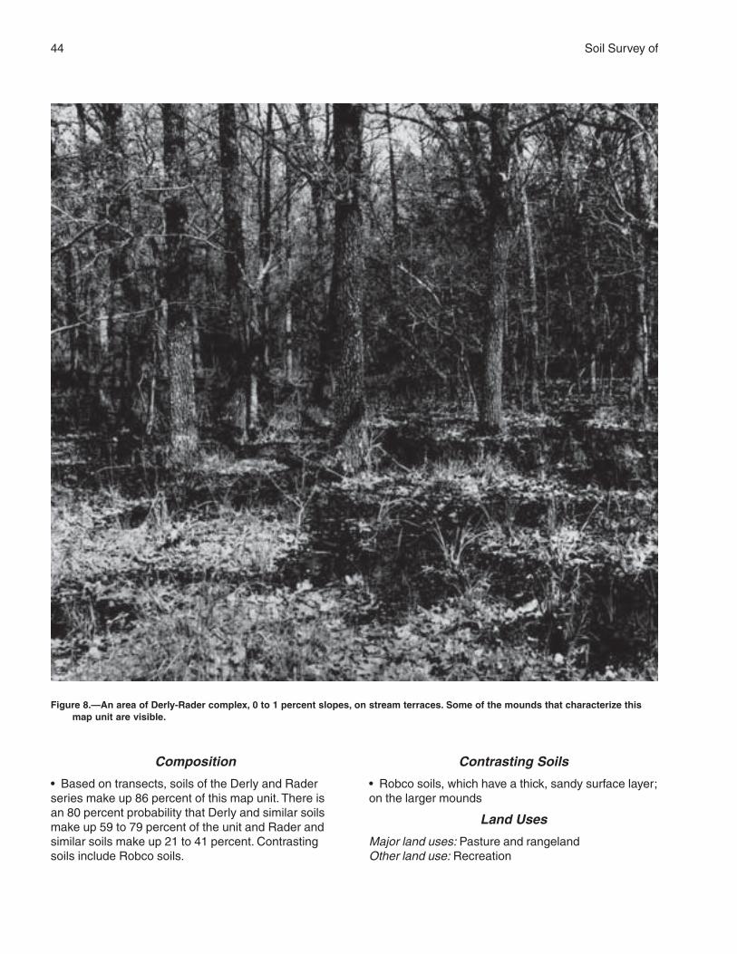
44 Soil Survey of
Composition
• Based on transects, soils of the Derly and Raderseries make up 86 percent of this map unit. There isan 80 percent probability that Derly and similar soilsmake up 59 to 79 percent of the unit and Rader andsimilar soils make up 21 to 41 percent. Contrastingsoils include Robco soils.
Contrasting Soils
• Robco soils, which have a thick, sandy surface layer;on the larger mounds
Land Uses
Major land uses: Pasture and rangelandOther land use: Recreation
Figure 8.—An area of Derly-Rader complex, 0 to 1 percent slopes, on stream terraces. Some of the mounds that characterize thismap unit are visible.
Brazos County, Texas 45
Management Concerns
Pasture
Major limitations:• Production is low in areas of the Derly soil becauseof wetness and low natural fertility. The Rader soilproduces high yields of grasses.Minor limitations:• Plant adaptation on the wetter Derly soil should beconsidered.
Cropland
Major limitations:• Crop production is low or moderate in areas of thismap unit because of wetness and the undulatingtopography.
Rangeland
Major limitations:• Production of native plants is limited on the Derlysoil because of wetness but is high in areas of theRader soil.
Urban development
Major limitations:• Wetness, the restricted permeability, and theundulating topography are concerns affecting manyurban uses.Minor limitations:• Structures and roads are affected by the moderateshrink-swell potential in the subsoil.
Interpretive Groups
Land capability classification: Derly—4w; Rader—2wEcological site: Derly—Claypan Savannah; Rader—
Sandy LoamPasture management group: 12
DfC—Desan loamy fine sand, 3 to 8percent slopes
Setting
Landform: Stream terracesLandscape position: Shoulders on breaks to flood
plainsSlope: Gently sloping or moderately sloping; convex
surfacesShape of areas: ElongatedSize of areas: 10 to 300 acresNative vegetation: Post oak savannah
Typical Profile
Surface layer:0 to 8 inches—light brown, neutral loamy fine sand
Subsurface layer:8 to 52 inches—very pale brown, moderately acid
loamy fine sand
Subsoil:52 to 80 inches—red, moderately acid sandy clay
loam
Soil Properties
Depth class: Very deepDrainage class: Somewhat excessively drainedDepth to the water table: More than 6 feetFlooding: NoneRunoff: SlowPermeability: Rapid in the upper part and moderate in
the subsoilAvailable water capacity: LowRoot zone: Very deepNatural soil fertility: LowShrink-swell potential: LowHazard of water erosion: Moderate
Composition
• This map unit consists of about 90 percent Desansoil and similar soils. Contrasting soils make up about10 percent of the unit.
Contrasting Soils
• Dutek and Silawa soils, which have a thinner surfacelayer than that of the Desan soil; in landscapepositions similar to those of the Desan soil
Land Uses
Major land uses: Rangeland and pasture
Management Concerns
Pasture
Major limitations:• The low available water capacity and low naturalfertility limit the potential forage production.Minor limitations:• Water erosion is a concern unless an adequatecover of vegetation is maintained.
Cropland
Major limitations:• The low available water capacity and low naturalfertility limit the potential forage production.
46 Soil Survey of
Minor limitations:• Because of the hazard of erosion, conservationmeasures are needed.
Rangeland
Major limitations:• The low available water capacity and natural fertilitylimit the potential forage production.Minor limitations:• Water erosion is a concern unless an adequatecover of vegetation is maintained.
Urban development
Major limitations:• Disposal of septic tank effluent is a concernbecause of poor filtration in the upper part of the soil.Minor limitations:• Because of the low available water capacity,supplemental water is needed for the maintenance oflandscape vegetation.• The sidewalls of excavations are unstable becauseof the sandy texture of the soil.
Interpretive Groups
Land capability classification: 3eEcological site: Deep SandPasture management group: 10
DmA—Dimebox clay, 0 to 1 percentslopes
Setting
Landform: UplandsLandscape position: Lower slopes next to streamsSlope: Nearly level; plane or slightly concaveShape of areas: Round or elongatedSize of areas: 10 to 100 acresNative vegetation: Tall grass prairie
Typical Profile
Surface layer:0 to 11 inches—very dark gray, moderately acid
clay
Subsoil:11 to 37 inches—dark gray, slightly alkaline clay37 to 61 inches—mottled light olive brown, yellowish
brown, and gray, moderately alkaline clay
Underlying material:61 to 80 inches—mottled olive brown, yellowish brown,
and gray, moderately alkaline shale that has claytexture
Soil Properties
Depth class: Very deepDrainage class: Moderately well drainedDepth to the water table: More than 6 feetFlooding: NoneRunoff: MediumPermeability: Very slowAvailable water capacity: HighRoot zone: Very deepNatural soil fertility: HighShrink-swell potential: Very highHazard of water erosion: Slight
Composition
• This map unit consists of about 90 percent Dimeboxsoil and similar soils. Contrasting soils make up about10 percent of the unit.
Contrasting Soils
• Crockett and Wilson soils, which have a thin loamysurface layer; in landscape positions similar to those ofthe Dimebox soil
Land Uses
Major land uses: Pasture and rangelandOther land use: Cropland
Management Concerns
Pasture
Major limitations:• No major limitations affect the use of this soil forpasture. High yields of adapted forage grasses can beproduced.Minor limitations:• The high content of clay limits the uptake of water.
Cropland
Major limitations:• No major limitations affect the use of this soil ascropland. High yields of adapted crops can beproduced.Minor limitations:• Surface crusting affects seedling emergence.• Because of the high content of clay, high-poweredequipment is needed.• Wetness resulting from the restricted runoff rate cancause delays in cultivation. It can also promoteseedling problems because it keeps the soiltemperature lower than in other areas.
Rangeland
Major limitations:• No major limitations affect the use of this soil as
Brazos County, Texas 47
rangeland. High yields of native plants can beproduced.Minor limitations:• The high content of clay limits the uptake of water.
Urban development
Major limitations:• Structures and roads are affected by the very highshrink-swell potential.• Disposal of septic tank effluent is a concernbecause of the restricted permeability.• Erosion-control measures are needed atconstruction sites.Minor limitations:• The high content of clay is a concern affectinglandscaping.
Interpretive Groups
Land capability classification: 2wEcological site: BlacklandPasture management group: 6
DuC—Dutek loamy fine sand, 3 to 8percent slopes
Setting
Landform: Stream terracesLandscape position: Shoulders and the upper
backslopesSlope: Gently sloping or moderately sloping; convexShape of areas: Elongated or irregularSize of areas: 10 to 50 acresNative vegetation: Post oak savannah
Typical Profile
Surface layer:0 to 6 inches—light brown, neutral loamy fine sand
Subsurface layer:6 to 35 inches—pink, slightly acid loamy fine sand
Subsoil:35 to 55 inches—red, slightly acid sandy clay loam55 to 75 inches—light red, neutral fine sandy loam75 to 85 inches—reddish yellow, neutral fine sandy
loam
Soil Properties
Depth class: Very deepDrainage class: Well drainedDepth to the water table: More than 6 feetFlooding: NoneRunoff: Slow
Permeability: Rapid in the upper part; moderate in thesubsoil
Available water capacity: ModerateRoot zone: Very deepNatural soil fertility: MediumShrink-swell potential: LowHazard of water erosion: Moderate or severe
Composition
• This map unit consists of about 90 percent Duteksoil and similar soils. Contrasting soils make up about10 percent of the unit.
Contrasting Soils
• Desan and Padina soils, which have a sandy surfacelayer more than 40 inches thick; in landscape positionssimilar to those of the Dutek soil• Gredge soils, which have a loamy surface layer lessthan 10 inches thick; in the less sloping areas
Land Uses
Major land use: PastureOther land use: Rangeland
Management Concerns
Pasture
Major limitations:• Water erosion is a concern unless an adequatecover of vegetation is maintained.Minor limitations:• The moderate available water capacity and mediumnatural fertility limit the potential forage production.
Cropland
Major limitations:• Because of the hazard of erosion, conservationmeasures are needed.Minor limitations:• The moderate available water capacity and mediumnatural fertility limit the potential production of mostcrops.
Rangeland
Major limitations:• Water erosion is a concern unless an adequatecover of vegetation is maintained.Minor limitations:• The moderate available water capacity and mediumnatural fertility limit the potential forage production.
Urban development
Major limitations:• Disposal of septic tank effluent is a concernbecause of poor filtration in the upper part of the soil.
48 Soil Survey of
Minor limitations:• The sidewalls of excavations are unstable becauseof the sandy texture of the soil.
Interpretive Groups
Land capability classification: 3eEcological site: SandyPasture management group: 2
EuB—Eufaula loamy fine sand, 1 to 3percent slopes
Setting
Landform: Stream terracesLandscape position: The lower slopes next to flood
plainsSlope: Very gently sloping; convex to planeShape of areas: IrregularSize of areas: 10 to 50 acresNative vegetation: Post oak savannah
Typical Profile
Surface layer:0 to 15 inches—pale brown, moderately acid loamy
fine sand
Subsurface layer:15 to 42 inches—very pale brown, moderately acid
loamy fine sand42 to 62 inches—very pale brown, moderately acid
loamy fine sand that has a few lamellae of redsandy clay loam
Subsoil:62 to 82 inches—very pale brown, strongly acid loamy
fine sand that has very thin layers of strong brownfine sandy loam
Soil Properties
Depth class: Very deepDrainage class: Somewhat excessively drainedDepth to the water table: More than 6 feetFlooding: NoneRunoff: Very slowPermeability: RapidAvailable water capacity: LowRoot zone: Very deepNatural soil fertility: LowShrink-swell potential: LowHazard of water erosion: Slight
Composition
• This map unit consists of about 90 percent Eufaula
soil and similar soils. Contrasting soils make up about10 percent of the unit.
Contrasting Soils
• Dutek and Robco soils, which have a thinner sandysurface layer than that of the Eufaula soil; in landscapepositions similar to those of the Eufaula soil
Land Uses
Major land use: PastureOther land use: Rangeland
Management Concerns
Pasture
Major limitations:• The low available water capacity and low naturalfertility limit the potential forage production.
Cropland
Major limitations:• The low available water capacity and low naturalfertility limit the potential production of most crops.
Rangeland
Major limitations:• The low available water capacity and low naturalfertility limit the potential forage production.
Urban development
Major limitations:• Disposal of septic tank effluent is a concernbecause of poor filtration.Minor limitations:• The sidewalls of excavations are unstable becauseof the sandy texture of the soil.
Interpretive Groups
Land capability classification: 4sEcological site: Deep SandPasture management group: 10
FaB—Falba fine sandy loam, 1 to 3percent slopes
Setting
Landform: UplandsLandscape position: FootslopesSlope: Very gently sloping; planeShape of areas: Irregular or elongatedSize of areas: 10 to 100 acresNative vegetation: Post oak savannah
Brazos County, Texas 49
Typical Profile
Surface layer:0 to 7 inches—light brownish gray, moderately acid
fine sandy loam
Subsoil:7 to 13 inches—grayish brown, strongly acid clay13 to 36 inches—gray, slightly acid clay
Underlying material:36 to 50 inches—very pale brown, tuffaceous
sandstone
Soil Properties
Depth class: Moderately deepDrainage class: Moderately well drainedDepth to the water table: 0.5 foot to 1.5 feet (perched)Flooding: NoneRunoff: SlowPermeability: Very slowAvailable water capacity: LowRoot zone: Moderately deep; restricted by the clayey
subsoilNatural soil fertility: LowShrink-swell potential: High in the subsoilHazard of water erosion: Severe
Composition
• This map unit consists of about 90 percent Falba soiland similar soils. Contrasting soils make up about 10percent of the unit.
Contrasting Soils
• Rehburg and Shiro soils, which have a sandysurface layer; in the higher, more convex positions
Land Uses
Major land use: PastureOther land use: Rangeland
Management Concerns
Pasture
Major limitations:• Water erosion is a concern unless an adequatecover of vegetation is maintained.• The low available water capacity and low naturalfertility limit the potential forage production.
Cropland
Major limitations:• Because of the hazard of erosion, conservationmeasures are needed.• The low available water capacity and low naturalfertility limit the potential production of most crops.
Rangeland
Major limitations:• Water erosion is a concern unless an adequatecover of vegetation is maintained.• The low available water capacity and low naturalfertility limit the potential forage production.
Urban development
Major limitations:• Structures and roads are affected by the high shrink-swell potential in the subsoil.• Erosion-control measures are needed atconstruction sites.• Depth to rock is a limitation affecting roadconstruction.• Disposal of septic tank effluent is a concernbecause of the depth to rock, the restrictedpermeability, and short periods of soil saturation.
Interpretive Groups
Land capability classification: 4eEcological site: Claypan SavannahPasture management group: 11
Gd—Gladewater clay, frequently flooded
Setting
Landform: Flood plainsLandscape position: Broad backwater areasSlope: Nearly level; plane or slightly concaveShape of areas: ElongatedSize of areas: 25 to 1,000 acresNative vegetation: Hardwood forest of mostly oak and
elm and an understory of shortgrass and shrubs
Typical Profile
Surface layer:0 to 8 inches—dark gray, strongly acid clay
Subsoil:8 to 53 inches—dark grayish brown, strongly acid clay53 to 80 inches—dark grayish brown, moderately acid
clay
Soil Properties
Depth class: Very deepDrainage class: Somewhat poorly drainedDepth to the water table: 1.5 to 3.5 feetFlooding: Frequent; long or very long duration (fig. 9)Runoff: Very slowPermeability: Very slowAvailable water capacity: HighRoot zone: Very deep
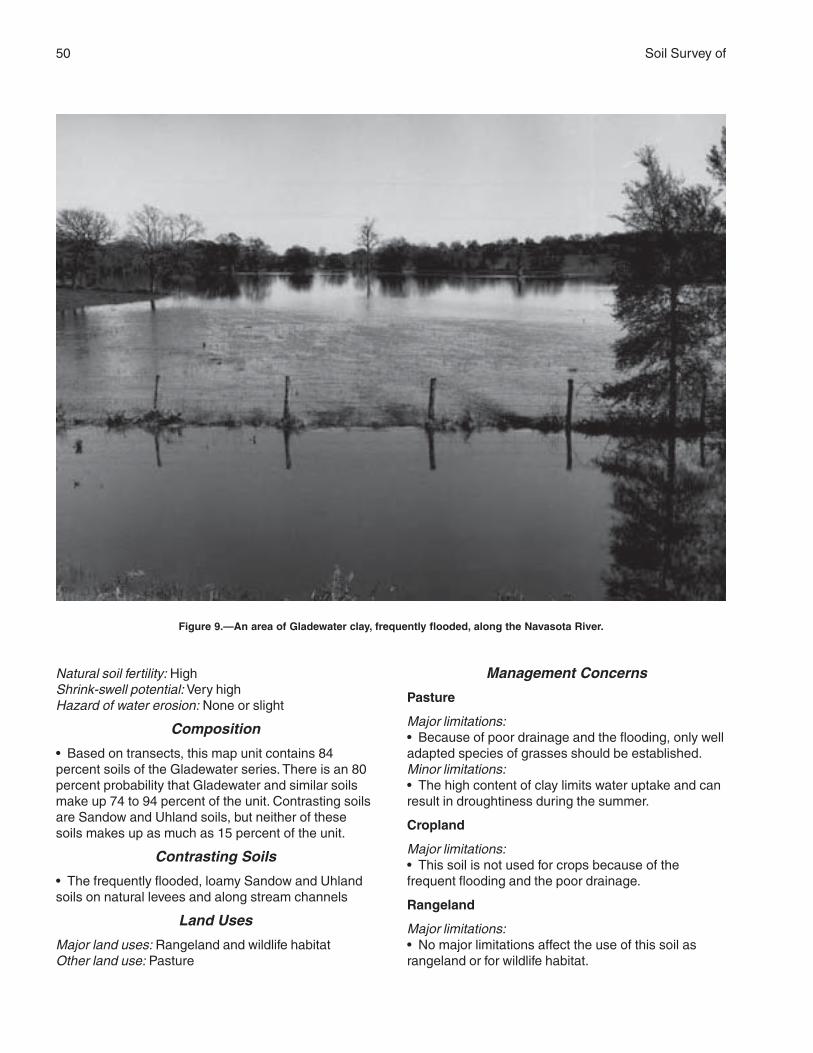
50 Soil Survey of
Natural soil fertility: HighShrink-swell potential: Very highHazard of water erosion: None or slight
Composition
• Based on transects, this map unit contains 84percent soils of the Gladewater series. There is an 80percent probability that Gladewater and similar soilsmake up 74 to 94 percent of the unit. Contrasting soilsare Sandow and Uhland soils, but neither of thesesoils makes up as much as 15 percent of the unit.
Contrasting Soils
• The frequently flooded, loamy Sandow and Uhlandsoils on natural levees and along stream channels
Land Uses
Major land uses: Rangeland and wildlife habitatOther land use: Pasture
Management Concerns
Pasture
Major limitations:• Because of poor drainage and the flooding, only welladapted species of grasses should be established.Minor limitations:• The high content of clay limits water uptake and canresult in droughtiness during the summer.
Cropland
Major limitations:• This soil is not used for crops because of thefrequent flooding and the poor drainage.
Rangeland
Major limitations:• No major limitations affect the use of this soil asrangeland or for wildlife habitat.
Figure 9.—An area of Gladewater clay, frequently flooded, along the Navasota River.
Brazos County, Texas 51
Minor limitations:• Forage production is limited by the flooding and bypoor drainage.
Urban development
Major limitations:• This soil is not suited to urban development becauseof the flooding, the poor drainage, and the shrink-swellpotential.
Interpretive Groups
Land capability classification: 5wEcological site: Clayey BottomlandPasture management group: 14
GrC—Gredge fine sandy loam, 1 to 5percent slopes
Setting
Landform: Stream terracesLandscape position: Narrow summits and the upper
backslopesSlope: Gently sloping; convex to plane surfacesShape of areas: Elongated or irregularSize of areas: 10 to 100 acresNative vegetation: Post oak savannah
Typical ProfileSurface layer:0 to 7 inches—very pale brown, very strongly acid fine
sandy loam
Subsoil:7 to 13 inches—dark red, very strongly acid clay13 to 21 inches—reddish brown, very strongly acid
clay that has light brownish gray mottles21 to 40 inches—light brownish gray, strongly acid clay
loam that has strong brown and red mottles40 to 57 inches—slightly acid clay loam mottled with
colors in shades of yellow and gray57 to 68 inches—moderately alkaline sandy clay loam
mottled with colors in shades of brown and gray
Soil Properties
Depth class: Very deepDrainage class: Well drainedDepth to the water table: More than 6 feetFlooding: NoneRunoff: MediumPermeability: Very slowAvailable water capacity: ModerateRoot zone: Very deep; restricted by the clay subsoilNatural soil fertility: LowShrink-swell potential: High in the subsoilHazard of water erosion: Severe
Composition
• Based on transects, this map unit contains 77percent soils of the Gredge series. There is a 90 to100 percent probability that Gredge and similar soilsmake up 90 to 100 percent of the unit. Contrastingsoils are Rader, Silawa, and Zack soils, but neither ofthese soils makes up as much as 10 percent of theunit.
Contrasting Soils
• Rader soils, which are clayey to a depth of 60 inchesor more; in the less sloping areas• Silawa soils, which have a loamy subsoil; on theconvex upper slopes along drainageways• Zack soils, which are underlain by shale within adepth of 40 inches
Land Uses
Major land use: PastureOther land use: Rangeland
Management Concerns
Pasture
Major limitations:• Water erosion is a concern unless an adequatecover of vegetation is maintained.• The moderate available water capacity and lownatural fertility limit the potential forage production.
Cropland
Major limitations:• Because of the hazard of erosion, conservationmeasures are needed.• The moderate available water capacity and lownatural fertility limit the potential production of mostcrops.
Rangeland
Major limitations:• Water erosion is a concern unless an adequatecover of vegetation is maintained.• The moderate available water capacity and lownatural fertility limit the potential forage production.
Urban development
Major limitations:• Structures and roads are affected by the high shrink-swell potential in the subsoil.• Erosion-control measures are needed atconstruction sites.• Disposal of septic tank effluent is a concernbecause of the restricted permeability.
52 Soil Survey of
Interpretive Groups
Land capability classification: 4eEcological site: Claypan SavannahPasture management group: 7
GrC2—Gredge fine sandy loam, 2 to 5percent slopes, eroded
Setting
Landform: Stream terracesLandscape position: Summits and the upper
backslopesSlope: Very gently sloping; slightly convex or plane
surfacesShape of areas: Irregular or elongatedSize of areas: 8 to 25 acresNative vegetation: Post oak savannah
Typical Profile
Surface layer:0 to 3 inches—grayish brown, strongly acid fine sandy
loam
Subsoil:3 to 25 inches—dark red, strongly acid clay that has
light brownish gray mottles25 to 62 inches—mottled brown, gray, and yellow,
moderately acid clay loam
Underlying material:62 to 80 inches—brown, moderately alkaline, stratified
loamy sediments
Soil Properties
Depth class: Very deepDrainage class: Well drainedDepth to the water table: More than 6 feetFlooding: NoneRunoff: RapidPermeability: Very slowAvailable water capacity: ModerateRoot zone: Very deep; restricted by the clayey subsoilNatural soil fertility: LowShrink-swell potential: High in the subsoilHazard of water erosion: Severe
Composition
• This map unit consists of about 90 percent Gredgesoil and similar soils. Contrasting soils make up about10 percent of the unit.
Contrasting Soils
• Zack soils, which are underlain by shale within a
depth of 40 inches; in landscape positions similar tothose of the Gredge soil
Land Uses
Major land uses: Rangeland and improved pastureOther land use: Wildlife habitat
Management Concerns
Pasture
Major limitations:• Water erosion has reduced the overall productivity ofthis soil. Further erosion is a concern unless anadequate cover of vegetation is maintained.• The moderate available water capacity and lownatural fertility limit the potential forage production.
Cropland
Major limitations:• Because of the hazard of erosion, conservationmeasures are needed.• The moderate available water capacity and lownatural fertility limit the potential production of mostcrops.
Rangeland
Major limitations:• Additional water erosion is a concern unless anadequate cover of vegetation is maintained.• The moderate available water capacity and lownatural fertility limit the potential forage production andhinder revegetation.
Urban development
Major limitations:• Structures and roads are affected by the high shrink-swell potential in the subsoil.• Erosion-control measures are needed atconstruction sites.• Disposal of septic tank effluent is a concernbecause of the restricted permeability.• The addition of topsoil is necessary if lawn grassesand other landscaping plants are established.
Interpretive Groups
Land capability classification: 4eEcological site: Claypan SavannahPasture management group: 9
GrD—Gredge fine sandy loam, 5 to 8percent slopes
Setting
Landform: Stream terraces

Brazos County, Texas 53
Landscape position: BackslopesSlope: Moderately sloping; convexShape of areas: ElongatedSize of areas: 8 to 30 acresNative vegetation: Post oak savannah
Typical Profile
Surface layer:0 to 7 inches—brown, very strongly acid fine sandy
loam
Subsoil:7 to 28 inches—dark red, very strongly acid clay that
has light brownish gray mottles28 to 65 inches—mottled brownish gray, yellowish
brown, and brownish yellow, slightly acid clay loam
Underlying material:65 to 75 inches—brown, moderately alkaline, stratified
loamy sediments
Soil Properties
Depth class: Very deepDrainage class: Well drainedDepth to the water table: More than 6 feetFlooding: NoneRunoff: RapidPermeability: Very slowAvailable water capacity: ModerateRoot zone: Very deep; restricted by the clay subsoilNatural soil fertility: LowShrink-swell potential: High in the subsoilHazard of water erosion: Severe
Composition
• Based on transects, this map unit contains 67percent soils of the Gredge series. There is an 80percent probability that Gredge and similar soils makeup 79 to 99 percent of the unit. Contrasting soils areSilawa and Zack soils, but neither of these soils makesup as much as 10 percent of the unit.
Contrasting Soils
• Silawa soils, which have a loamy subsoil; on theconvex upper slopes along drainageways• Zack soils, which have shale within a depth of 40inches; in landscape positions similar to those of theGredge soil
Land Uses
Major land use: RangelandOther land use: Pasture
Management Concerns
Pasture
Major limitations:• Water erosion is a concern unless an adequatecover of vegetation is maintained.• The moderate available water capacity and lownatural fertility limit the potential forage production.
Cropland
Major limitations:• Because of the hazard of erosion, conservationmeasures are needed.• The moderate available water capacity and lownatural fertility limit the potential production of mostcrops.
Rangeland
Major limitations:• Water erosion is a concern unless an adequatecover of vegetation is maintained.• The moderate available water capacity and lownatural fertility limit the potential forage production.
Urban development
Major limitations:• Structures and roads are affected by the high shrink-swell potential in the subsoil.• Erosion-control measures are needed atconstruction sites.• Disposal of septic tank effluent is a concernbecause of the restricted permeability.
Interpretive Groups
Land capability classification: 6eEcological site: Claypan SavannahPasture management group: 9
GvC—Gredge very gravelly fine sandyloam, 3 to 8 percent slopes
Setting
Landform: Stream terracesLandscape position: Summits and the upper
backslopesSlope: Gently sloping or moderately sloping; plane
surfacesShape of areas: ElongatedSize of areas: 10 to 50 acresNative vegetation: Post oak savannah
54 Soil Survey of
Typical Profile
Surface layer:0 to 8 inches—dark yellowish brown, moderately acid
very gravelly fine sandy loam
Subsoil:8 to 26 inches—red, strongly acid clay that has light
brownish gray mottles26 to 61 inches—red and gray, mottled, moderately
acid sandy clay loam
Underlying material:61 to 70 inches—stratified brown and red, moderately
acid sandy clay loam
Soil Properties
Depth class: Very deepDrainage class: Well drainedDepth to the water table: More than 6 feetFlooding: NoneRunoff: RapidPermeability: Very slowAvailable water capacity: ModerateRoot zone: Very deep; restricted by the clayey subsoilNatural soil fertility: LowShrink-swell potential: High in the subsoilHazard of water erosion: Slight
Composition
• This map unit consists of about 85 percent Gredgesoil and similar soils. Contrasting components makeup about 15 percent of the unit.
Contrasting Components
• Gredge soils that have a surface layer of fine sandyloam; in landscape positions similar to those of themajor Gredge soil• Eroded areas of Gredge soils; in landscapepositions similar to those of the major Gredge soil• Gravel pits; in landscape positions similar to those ofthe major Gredge soil
Land Uses
Major land uses: Rangeland and pasture
Management Concerns
Pasture
Major limitations:• The content of gravel makes it very difficult toestablish vegetation on this soil.Minor limitations:• The moderate available water capacity and lownatural fertility limit the potential forage production.
Cropland
Major limitations:• This soil is not suited to crops because of the slopeand the content of gravel.
Rangeland
Major limitations:• The moderate available water capacity and lownatural fertility limit the potential forage production.
Urban development
Major limitations:• The content of gravel in the surface layer is aproblem affecting urban development.• Structures and roads are affected by the high shrink-swell potential in the subsoil.• Erosion-control measures are needed atconstruction sites.• Disposal of septic tank effluent is a concernbecause of the restricted permeability.
Interpretive Groups
Land capability classification: 6sEcological site: GravellyPasture management group: 14
GyC—Greenvine clay, 2 to 5 percentslopes
Setting
Landform: UplandsLandscape position: BackslopesSlope: Gently sloping; plane or slightly convexShape of areas: IrregularSize of areas: 8 to 50 acresNative vegetation: Mid and tall grass prairie
Typical Profile
Surface layer:0 to 7 inches—very dark gray, moderately alkaline clay
Subsoil:7 to 35 inches—very dark gray, moderately alkaline
clay that has grayish brown mottles
Underlying material:35 to 60 inches—light gray, moderately alkaline,
interbedded tuffaceous siltstone and shale
Soil Properties
Depth class: Moderately deepDrainage class: Well drainedDepth to the water table: More than 6 feet
Brazos County, Texas 55
Flooding: NoneRunoff: MediumPermeability: Very slowAvailable water capacity: LowRoot zone: Moderately deepNatural soil fertility: MediumShrink-swell potential: Very highHazard of water erosion: Severe
Composition
• This map unit consists of about 90 percentGreenvine soil and similar soils. Contrasting soilsmake up about 10 percent of the unit.
Contrasting Soils
• Falba and Shalba soils, which have a loamy surfacelayer; in landscape positions similar to those of theGreenvine soil
Land Uses
Major land use: PastureOther land use: Rangeland
Management Concerns
Pasture
Major limitations:• The low available water capacity limits the potentialforage production.• Water erosion is a concern unless an adequatecover of vegetation is maintained.Minor limitations:• The medium natural fertility limits the potentialproduction of forage plants.
Cropland
Major limitations:• The low available water capacity limits the potentialproduction of most crops.• Water erosion is a concern unless an adequatecover of vegetation is maintained.Minor limitations:• The medium natural fertility limits the potentialproduction of most crops.
Rangeland
Major limitations:• The low available water capacity limits the potentialforage production.• Water erosion is a concern unless an adequatecover of vegetation is maintained.Minor limitations:• The medium natural fertility limits the potentialproduction of forage plants.
Urban development
Major limitations:• Structures and roads are affected by the very highshrink-swell potential of the soil.• Disposal of septic tank effluent is a concernbecause of the restricted permeability.• Erosion-control measures are needed atconstruction sites.
Interpretive Groups
Land capability classification: 3eEcological site: BlacklandPasture management group: 11
HbA—Highbank silty clay loam, 0 to 1percent slopes, rarely flooded
Setting
Landform: Flood plainsLandscape position: Natural levees and main alluvial
fansSlope: Nearly level; plane or slightly convexShape of areas: Irregular or elongatedSize of areas: 10 to 200 acresNative vegetation: Hardwood forest of pecan, elm,
hackberry, and cottonwood and an understory ofbriars, vines, and mid grasses
Typical Profile
Surface layer:0 to 15 inches—reddish brown, moderately alkaline
silty clay loam
Subsoil:15 to 19 inches—reddish brown, moderately alkaline
silty clay19 to 80 inches—reddish brown, moderately alkaline
claySoil Properties
Depth class: Very deepDrainage class: Well drainedDepth to the water table: More than 6 feetFlooding: RareRunoff: SlowPermeability: SlowAvailable water capacity: HighRoot zone: Very deepNatural soil fertility: HighShrink-swell potential: HighHazard of water erosion: None
Composition
• This map unit consists of about 90 percent Highbank
56 Soil Survey of
soil and similar soils. Contrasting soils make up 10percent of the unit.
Contrasting Soils
• Weswood and Coarsewood soils, which are loamythroughout; in positions close to levees adjacent tochannels• Ships soils, which are more clayey than theHighbank soil; in the slightly lower backwaterpositions
Land Uses
Major land use: CroplandOther land use: Pasture
Management Concerns
Pasture
Major limitations:• No major limitations affect the use of this soil forpasture. High yields of adapted forage grasses can beproduced.
Cropland
Major limitations:• No major limitations affect the use of this soil ascropland. High yields of adapted crops can beproduced.Minor limitations:• A plowpan can develop rapidly and can restrict themovement of water and roots.
Rangeland
Major limitations:• No major limitations affect the use of this soil asrangeland; however, very few areas support nativevegetation.
Urban development
Major limitations:• This soil is not suitable for urban developmentunless it is protected from flooding.• Structures and roads are affected by the high shrink-swell potential.• Disposal of septic tank effluent is a concernbecause of the restricted permeability.
Interpretive Groups
Land capability classification: 2sEcological site: Loamy BottomlandPasture management group: 1
Ka—Kaufman clay, frequently flooded
Setting
Landform: Flood plainsLandscape position: Broad backwater areasSlope: Nearly level; plane or slightly concaveShape of areas: ElongatedSize of areas: 50 to 300 acresNative vegetation: Hardwood forest
Typical Profile
Surface layer:0 to 10 inches—very dark gray, strongly acid clay
Subsoil:10 to 48 inches—very dark gray, moderately acid clay48 to 80 inches—dark grayish brown, moderately
alkaline clay
Soil Properties
Depth class: Very deepDrainage class: Moderately well drainedDepth to the water table: 1.5 to 3.5 feet (perched)Flooding: Frequent; very brief or brief durationRunoff: SlowPermeability: Very slowAvailable water capacity: HighRoot zone: Very deepNatural soil fertility: HighShrink-swell potential: Very highHazard of water erosion: None
Composition
• Based on transects, this map unit contains 70percent soils of the Kaufman series. There is an 80percent probability that Kaufman and similar soilsmake up 73 to 93 percent of the unit. Contrasting soilsare Sandow and Uhland soils, but neither of thesesoils makes up as much as 15 percent of the unit.
Contrasting Soils
• The loamy Sandow and Uhland soils on naturallevees and along stream channels
Land Uses
Major land use: RangelandOther land use: Pasture
Management Concerns
Pasture
Major limitations:• Because of poor drainage and the flooding, only welladapted species of grasses should be established.
Brazos County, Texas 57
Minor limitations:• The high content of clay limits water uptake and canresult in droughtiness during the summer.
Cropland
Major limitations:• This soil is not used for crops because of theflooding and poor drainage.
Rangeland
Major limitations:• This soil is well suited to use as rangeland or forwildlife habitat, but production is limited by the floodingand poor drainage.
Urban development
Major limitations:• This soil is not suited to urban development becauseof the flooding, poor drainage, and the shrink-swellpotential.
Interpretive Groups
Land capability classification: 5wEcological site: Clayey BottomlandPasture management group: 6
KrD—Koether-Rock outcrop complex, 3 to12 percent slopes
Setting
Landform: UplandsLandscape position: Summit breaksSlope: Gently sloping to strongly slopingShape of areas: ElongatedSize of areas: 10 to 50 acresNative vegetation: Post oak savannah
Typical Profile
Koether
Surface layer:0 to 12 inches—brown, slightly acid loamy fine sand
that is 40 percent sandstone fragments
Underlying material:12 to 20 inches—indurated sandstone
Soil Properties
Koether
Depth class: ShallowDrainage class: Somewhat excessively drainedDepth to the water table: More than 6 feetFlooding: None
Runoff: RapidPermeability: RapidAvailable water capacity: Very lowRoot zone: ShallowNatural soil fertility: LowShrink-swell potential: Very lowHazard of water erosion: Slight
Characteristics of the Rock Outcrop
Kind of rock: Strongly cemented, coarse grainedsandstone
Composition
• This map unit consists of about 70 to 80 percentKoether soil and similar soils and 15 to 25 percentRock outcrop. Contrasting soils make up the rest ofthe unit.
Contrasting Soils
• Falba, Rehburg, Shalba, and Shiro soils, which aredeeper than the Koether soil and have a clayeysubsoil; in landscape positions similar to those of theKoether soil
Land Uses
Major land use: RangelandOther land use: Wildlife habitat
Management Concerns
Pasture
Major limitations:• The areas of Rock outcrop and the rock fragments inthe soil prevent tillage in most areas of this unit, andthus the establishment of pasture grasses is difficult.Some grasses may be established without tillage inareas where the soil is deeper and the Rock outcrop isminimal.
Cropland
Major limitations:• This soil cannot be cultivated because of the contentof rock fragments.
Rangeland
Major limitations:• The very low available water capacity and lowfertility limit the production of forage.
Urban development
Major limitations:• The depth to rock and the rock fragments in the soilare problems affecting construction, but many areas ofthis unit have scenic value as overlooks.

58 Soil Survey of
Interpretive Groups
Land capability classification: Koether—7s; Rockoutcrop—8s
Ecological site: Koether—Claypan SavannahPasture management group: Koether—14
KuC—Kurten fine sandy loam, 2 to 5percent slopes
Setting
Landform: UplandsLandscape position: BackslopesSlope: Gently sloping; plane to convexShape of areas: ElongatedSize of areas: 10 to 100 acresNative vegetation: Post oak savannah
Typical Profile
Surface layer:0 to 4 inches—pale brown, slightly acid fine sandy
loam
Subsoil:4 to 11 inches—red, very strongly acid clay11 to 33 inches—red, very strongly acid clay that has
gray mottles33 to 45 inches—grayish brown, very strongly acid
clay that has red and yellowish brown mottles
Underlying material:45 to 80 inches—grayish brown, very strongly acid
shale that has clay texture and is stratified withloamy materials
Soil Properties
Depth class: Deep to shaleDrainage class: Well drainedDepth to the water table: More than 6 feetFlooding: NoneRunoff: MediumPermeability: Very slowAvailable water capacity: ModerateRoot zone: Very deep; restricted by the clayey subsoilNatural soil fertility: MediumShrink-swell potential: HighHazard of water erosion: Severe
Composition
• This map unit consists of about 85 percent Kurtensoil and similar soils. Contrasting soils make up about15 percent of the unit.
Contrasting Soils
• Luling soils, which have a clayey surface layer; in
landscape positions similar to those of the Kurtensoil• Spiller soils, which have a sandy surface layer; onrounded summits
Land Uses
Major land use: PastureOther land use: Rangeland
Management Concerns
Pasture
Major limitations:• Water erosion is a concern unless an adequatecover of vegetation is maintained.• The available water capacity limits the potentialforage production.Minor limitations:• The medium natural fertility limits the potentialproduction of forage plants.
Cropland
Major limitations:• Because of the hazard of erosion, conservationmeasures are needed.• The available water capacity limits the potentialproduction of most crops.Minor limitations:• The medium natural fertility limits the potentialproduction of most crops.
Rangeland
Major limitations:• Water erosion is a concern unless an adequatecover of vegetation is maintained.• The available water capacity limits the potentialforage production.Minor limitations:• The medium natural fertility limits the potentialproduction of forage plants.
Urban development
Major limitations:• Structures and roads are affected by the high shrink-swell potential in the subsoil.• Erosion-control measures are needed in areas ofthis soil.• Disposal of septic tank effluent is a concernbecause of the restricted permeability.
Interpretive Groups
Land capability classification: 4eEcological site: Claypan SavannahPasture management group: 9
Brazos County, Texas 59
KuD—Kurten fine sandy loam, 5 to 8percent slopes
Setting
Landform: UplandsLandscape position: BackslopesSlope: Moderately slopingShape of areas: ElongatedSize of areas: 8 to 50 acresNative vegetation: Post oak savannah
Typical ProfileSurface layer:0 to 3 inches—pale brown, strongly acid fine sandy
loam
Subsoil:3 to 42 inches—brown, strongly acid clay that has gray
and red mottles
Underlying material:42 to 60 inches—pale brown, strongly acid clay
Soil Properties
Depth class: Deep to shaleDrainage class: Well drainedDepth to the water table: More than 6 feetFlooding: NoneRunoff: RapidPermeability: Very slowAvailable water capacity: ModerateRoot zone: Very deep; restricted by the clayey
subsoilNatural soil fertility: MediumShrink-swell potential: HighHazard of water erosion: Severe
Composition
• This map unit consists of about 85 percent Kurtensoil and similar soils. Contrasting soils make up about15 percent of the unit.
Contrasting Soils
• Luling soils, which have a clayey surface layer; inlandscape positions similar to those of the Kurtensoil• Spiller soils, which have a sandy surface layer; onrounded summits
Land Uses
Major land use: PastureOther land use: Rangeland
Management ConcernsPasture
Major limitations:• Water erosion is a concern unless an adequatecover of vegetation is maintained.• The moderate available water capacity and lownatural fertility limit the potential forage production.
Cropland
Major limitations:• Because of the hazard of erosion, conservationmeasures are needed.• The moderate available water capacity and low naturalfertility limit the potential production of most crops.
Rangeland
Major limitations:• Water erosion is a concern unless an adequatecover of vegetation is maintained.• The moderate available water capacity and lownatural fertility limit the potential forage production.
Urban development
Major limitations:• Structures and roads are affected by the high shrink-swell potential in the subsoil.• Erosion-control measures are needed atconstruction sites.• Disposal of septic tank effluent is a concernbecause of the restricted permeability.
Interpretive Groups
Land capability classification: 6eEcological site: Claypan SavannahPasture management group: 9
LfA—Lufkin fine sandy loam, 0 to 1percent slopes
Setting
Landform: Stream terracesLandscape position: Flats on interstream dividesSlope: Nearly level; plane to concaveShape of areas: Circular or elongatedSize of areas: 8 to 50 acresNative vegetation: Post oak savannah
Typical Profile
Surface layer:0 to 6 inches—grayish brown, moderately acid fine
sandy loam
60 Soil Survey of
Subsurface layer:6 to 9 inches—light gray, moderately acid loam
Subsoil:9 to 18 inches—grayish brown, strongly acid clay18 to 25 inches—light grayish brown, strongly acid
clay25 to 80 inches—gray, neutral clay loam
Soil Properties
Depth class: Very deepDrainage class: Moderately well drainedDepth to the water table: More than 6 feet (but the soil
is saturated in the upper part for short periodsafter heavy rains)
Flooding: NoneRunoff: Very slowPermeability: Very slowAvailable water capacity: ModerateRoot zone: Very deep; restricted by the clayey subsoilNatural soil fertility: MediumShrink-swell potential: Very high in the subsoilHazard of water erosion: Slight
Composition
• This map unit consists of about 90 percent Lufkinsoil and similar soils. Contrasting soils make up about10 percent of the unit.
Contrasting Soils
• Falba soils, which are less than 60 inches thick; onside slopes• Rader and Robco soils, which have a thicker sandysurface layer than that of the Lufkin soil; on mounds
Land Uses
Major land use: PastureOther land use: Rangeland
Management Concerns
Pasture
Major limitations:• The moderate available water capacity and mediumnatural fertility limit the potential forage production.
Cropland
Major limitations:• The moderate available water capacity and mediumnatural fertility limit the potential production of crops.
Rangeland
Major limitations:• The moderate available water capacity and mediumnatural fertility limit the potential forage production.
Urban development
Major limitations:• Structures and roads are affected by the very highshrink-swell potential in the subsoil.• Disposal of septic tank effluent is a concernbecause of the restricted permeability.
Interpretive Groups
Land capability classification: 3wEcological site: Claypan SavannahPasture management group: 7
LuB—Luling clay, 1 to 3 percent slopes
Setting
Landform: UplandsLandscape position: Broad summits and the upper
backslopesSlope: Very gently sloping; plane or slightly convexShape of areas: Circular or elongatedSize of areas: 10 to 300 acresNative vegetation: Tall grass prairie
Typical Profile
Surface layer:0 to 5 inches—dark grayish brown, moderately
alkaline clay
Subsoil:5 to 62 inches—grayish brown, moderately alkaline
clay that has brown and gray mottles
Underlying material:62 to 75 inches—mottled gray and brown, moderately
alkaline clay
Soil Properties
Depth class: Very deepDrainage class: Well drainedDepth to the water table: More than 6 feetFlooding: NoneRunoff: MediumPermeability: Very slowAvailable water capacity: HighRoot zone: Very deepNatural soil fertility: HighShrink-swell potential: Very highHazard of water erosion: Moderate
Composition
• Based on transects, this map unit contains 77percent soils of the Luling series. There is an 80percent probability that Luling and similar soils makeup 75 to 95 percent of the unit. Contrasting soils are

Brazos County, Texas 61
Benchley and Crockett soils, but neither of these soilsmakes up as much as 10 percent of the unit.
Contrasting Soils
• Benchley and Crockett soils, which have a loamysurface layer; in landscape positions similar to those ofthe Luling soil
Land Uses
Major land use: PastureOther land use: Rangeland
Management Concerns
Pasture
Major limitations:• No major limitations affect the use of this soil forpasture. High yields of adapted forage grasses can beproduced.Minor limitations:• Water erosion is a concern unless an adequatecover of vegetation is maintained.
Cropland
Major limitations:• No major limitations affect the use of this soil ascropland. High yields of adapted crops can beproduced.Minor limitations:• Because of the hazard of erosion, conservationmeasures are needed.
Rangeland
Major limitations:• No major limitations affect the use of this soil asrangeland. High yields of native plants can beproduced.Minor limitations:• Water erosion is a concern unless an adequatecover of vegetation is maintained.
Urban development
Major limitations:• Structures and roads are affected by the very highshrink-swell potential in the subsoil.• Disposal of septic tank effluent is a concernbecause of the restricted permeability.• Erosion-control measures are needed onconstruction sites.Minor limitations:• The high content of clay is a concern affectinglandscaping.
Interpretive Groups
Land capability classification: 2e
Ecological site: BlacklandPasture management group: 6
LuD—Luling clay, 5 to 8 percent slopes
Setting
Landform: UplandsLandscape position: BackslopesSlope: Moderately sloping; plane or slightly convexShape of areas: Circular or elongatedSize of areas: 10 to 100 acresNative vegetation: Tall grass prairie
Typical Profile
Surface layer:0 to 11 inches—dark grayish brown, moderately
alkaline clay
Subsoil:11 to 65 inches—grayish brown, moderately alkaline
clay that has brown mottles
Underlying material:65 to 75 inches—mottled gray and brown, moderately
alkaline clay
Soil Properties
Depth class: Very deepDrainage class: Well drainedDepth to the water table: More than 6 feetFlooding: NoneRunoff: MediumPermeability: Very slowAvailable water capacity: HighRoot zone: Very deepNatural soil fertility: HighShrink-swell potential: Very highHazard of water erosion: Severe
Composition
• Based on transects, this map unit contains 83percent soils of the Luling series. There is an 80percent probability that Luling and similar soils makeup 73 to 93 percent of the unit. Contrasting soils areCrockett and Kurten soils, but neither of these soilsmakes up as much as 10 percent of the unit.
Contrasting Soils
• Crockett and Kurten soils, which have a loamysurface layer; in landscape positions similar to those ofthe Luling soil
Land Uses
Major land use: PastureOther land use: Rangeland
62 Soil Survey of
Management Concerns
Pasture
Major limitations:• Water erosion is a concern unless an adequatecover of vegetation is maintained.
Cropland
Major limitations:• Because of the hazard of erosion, conservationmeasures are needed.
Rangeland
Major limitations:• Water erosion is a concern unless an adequatecover of vegetation is maintained.
Urban development
Major limitations:• Structures and roads are affected by the very highshrink-swell potential in the subsoil.• Disposal of septic tank effluent is a concernbecause of the restricted permeability.• Erosion-control measures are needed onconstruction sites.Minor limitations:• The high content of clay is a concern affecting urbandevelopment.
Interpretive Groups
Land capability classification: 4eEcological site: BlacklandPasture management group: 6
MaA—Mabank loam, 0 to 1 percent slopes
Setting
Landform: Stream terraces and valley fillsLandscape position: Flats on interstream dividesSlope: Nearly level; slightly concaveShape of areas: Circular or elongatedSize of areas: 8 to 100 acresNative vegetation: Open savannah with mid and tall
grasses
Typical Profile
Surface layer:0 to 8 inches—light brownish gray, moderately acid
loam
Subsoil:8 to 10 inches—dark gray, slightly acid clay loam10 to 24 inches—black, neutral clay
24 to 31 inches—very dark gray, neutral clay31 to 65 inches—dark grayish brown, neutral clay
loam
Underlying material:65 to 80 inches—dark grayish brown, neutral clay
loam that has dark brown, yellow, and red mottles
Soil Properties
Depth class: Very deepDrainage class: Moderately well drainedDepth to the water table: More than 6 feet (but the soil
is saturated in the upper part for short periodsafter heavy rains)
Flooding: NoneRunoff: Very slowPermeability: Very slowAvailable water capacity: ModerateRoot zone: Very deep; restricted by the clayey subsoilNatural soil fertility: LowShrink-swell potential: High in the subsoilHazard of water erosion: Slight or moderate
Composition
• This map unit consists of about 90 percent Mabanksoil and similar soils. Contrasting soils make up about10 percent of the unit.
Contrasting Soils
• Boonville and Rader soils, which have a thickerloamy surface layer than that of the Mabank soil; inlandscape positions similar to those of the Mabank soil• Burleson soils, which have a surface layer of clay; inlandscape positions similar to those of the Mabank soil
Land Uses
Major land uses: Rangeland and pasture
Management Concerns
Pasture
Major limitations:• The limited available water capacity results in lowproduction during dry seasons.Minor limitations:• The low natural fertility results in low productionunless fertilizer is applied.• Water erosion is a concern unless an adequatecover of vegetation is maintained.
Cropland
Major limitations:• The limited available water capacity results in lowproduction during dry seasons.
Brazos County, Texas 63
Minor limitations:• Because of the hazard of erosion, conservationmeasures are needed.• Low natural fertility results in low production unlessfertilizer is applied.
Rangeland
Major limitations:• The limited available water capacity results in lowproduction during dry seasons.Minor limitations:• Water erosion is a concern unless an adequatecover of vegetation is maintained.• Low natural fertility results in low production.
Urban development
Major limitations:• Structures and roads are affected by the high shrink-swell potential in the subsoil.• Erosion-control measures are needed atconstruction sites.• Disposal of septic tank effluent is a concernbecause of the restricted permeability.
Interpretive Groups
Land capability classification: 3wEcological site: Claypan PrairiePasture management group: 7
MrA—Mabank-Rader complex, 0 to 1percent slopes
Setting
Landform: Stream terraces and valley fillsLandscape position: Flats along streams and
interstream dividesSlope: Nearly level; low moundsShape of areas: ElongatedSize of areas: 50 to 400 acresNative vegetation: Open savannah with mid grasses
Typical ProfileMabank
Surface layer:0 to 5 inches—dark brown, slightly acid loam
Subsoil:5 to 16 inches—very dark gray, slightly alkaline clay16 to 48 inches—grayish brown, moderately alkaline
clay loam48 to 65 inches—light grayish brown, moderately
alkaline clay loam
Underlying material:65 to 70 inches—mottled gray and yellow, alkaline clay
loam
Rader
Surface layer:0 to 17 inches—brown, slightly acid fine sandy loam
Subsurface layer:17 to 23 inches—brown, neutral loam
Subsoil:23 to 27 inches—mottled gray and brownish yellow,
slightly acid sandy clay loam27 to 35 inches—dark gray, slightly alkaline sandy clay35 to 70 inches—light gray, slightly alkaline sandy clay
loam that has brown and red mottles
Soil Properties
Depth class: Very deepDrainage class: Moderately well drainedDepth to the water table: Mabank—more than 6 feet
(but the soil may be saturated in the surface layerfor short periods after heavy rains); Rader—2 to 4feet (perched)
Flooding: NoneRunoff: Mabank—very slow; Rader—slowPermeability: Very slowAvailable water capacity: ModerateRoot zone: Very deep; restricted by the clayey subsoilNatural soil fertility: Low or mediumShrink-swell potential: High in the subsoilHazard of water erosion: Slight
Composition
• This map unit consists of about 55 to 65 percentMabank soil and similar soils and 25 to 35 percentRader and similar soils. Contrasting soils make up therest of the unit.
Contrasting Soils
• Derly soils, which have a gray subsoil; indepressions• Robco soils, which have a thick, sandy surface layer;on the larger mounds
Land Uses
Major land uses: Rangeland and pasture
Management Concerns
Pasture
Major limitations:• The limited available water capacity of the
64 Soil Survey of
Mabank soil results in low production during dryseasons.• The low natural fertility of the Mabank soil results inlow production unless fertilizer is applied.Minor limitations:• Water erosion is a concern unless an adequatecover of vegetation is maintained.
Cropland
Major limitations:• The limited available water capacity of the Mabanksoil results in low production during dry seasons.• The low natural fertility of the Mabank soil results inlow production unless fertilizer is applied.Minor limitations:• Because of the hazard of erosion, conservationmeasures are needed.• Seasonal wetness is a concern in most years.
Rangeland
Major limitations:• The limited available water capacity of theMabank soil results in low production during dryseasons.• The low natural fertility of the Mabank soil results inlow production.Minor limitations:• Water erosion is a concern unless an adequatecover of vegetation is maintained.
Urban development
Major limitations:• Structures and roads are affected by the high shrink-swell potential in the subsoil.• Erosion-control measures are needed atconstruction sites.• Disposal of septic tank effluent is a concernbecause of the restricted permeability and the shortperiods of soil saturation.
Interpretive Groups
Land capability classification: Mabank—3w; Rader—2w
Ecological site: Mabank—Claypan Prairie; Rader—Sandy Loam
Pasture management group: 7
NvB—Navasan loamy fine sand, 0 to 3percent slopes
Setting
Landform: Stream terracesLandscape position: Low sandy ridges and knolls
Slope: Nearly level and very gently slopingShape of areas: Circular or elongatedSize of areas: 15 to 200 acresNative vegetation: Post oak savannah
Typical Profile
Surface layer:0 to 4 inches—brown, strongly acid loamy fine sand
Subsurface layer:4 to 51 inches—very pale brown, moderately acid or
strongly acid loamy fine sand
Subsoil:51 to 66 inches—brown, strongly acid fine sandy loam
that has yellowish brown mottles66 to 90 inches—light gray, strongly acid sandy clay
loam that has gray, yellow, and brown mottles
Soil Properties
Depth class: Very deepDrainage class: Moderately well drainedDepth to the water table: 4 to 6 feet (perched)Flooding: NoneRunoff: SlowPermeability: Moderately slowAvailable water capacity: LowRoot zone: Very deepNatural soil fertility: LowShrink-swell potential: Very lowHazard of water erosion: Slight
Composition
• This map unit consists of about 90 percent Navasansoil and similar soils. Contrasting soils make up about10 percent of the unit.
Contrasting Soils
• Dutek and Desan soils, which have a subsoil withina depth of 80 inches; in the slightly more slopingpositions• The frequently flooded Sandow soils in small, linearareas on flood plains
Land Uses
Major land uses: Rangeland and pasture
Management Concerns
Pasture
Major limitations:• The low natural fertility results in low productionunless fertilizer is applied.• The low available water capacity results in lowproduction, especially during dry seasons.
Brazos County, Texas 65
Minor limitations:• Water erosion is a concern unless an adequatecover of vegetation is maintained.
Cropland
Major limitations:• The low natural fertility results in low productionunless fertilizer is applied.• The low available water capacity results in lowproduction, especially during dry seasons.Minor limitations:• Because of the hazard of erosion, conservationmeasures are needed.
Rangeland
Major limitations:• The low natural fertility results in low production.• The low available water capacity results in lowproduction, especially during dry seasons.Minor limitations:• Water erosion is a concern unless an adequatecover of vegetation is maintained.
Urban development
Major limitations:• Disposal of septic tank effluent is a concernbecause of poor filtration in the upper part of the soiland restricted permeability in the lower part.Minor limitations:• The sidewalls of excavations are unstable becauseof the sandy texture of the soil.
Interpretive Groups
Land capability classification: 3sEcological site: Deep SandPasture management group: 2
PaC—Padina loamy fine sand, 1 to 5percent slopes
Setting
Landform: Uplands and terracesLandscape position: Summits and the upper
backslopes adjacent to streamsSlope: Gently slopingShape of areas: Circular or elongatedSize of areas: 8 to 100 acresNative vegetation: Post oak savannah
Typical Profile
Surface layer:0 to 8 inches—light yellowish brown, moderately acid
loamy fine sand
Subsurface layer:8 to 62 inches—very pale brown, moderately acid
loamy fine sand
Subsoil:62 to 71 inches—yellowish brown, strongly acid fine
sandy loam and loamy fine sand71 to 82 inches—mottled red, yellowish red, and light
gray, strongly acid sandy clay loam
Soil Properties
Depth class: Very deepDrainage class: Well drainedDepth to the water table: More than 6 feetFlooding: NoneRunoff: SlowPermeability: Rapid in the upper part; moderate in the
subsoilAvailable water capacity: LowRoot zone: Very deepNatural soil fertility: LowShrink-swell potential: Very lowHazard of water erosion: Slight or moderate
Composition
• Based on transects, this map unit contains 43percent soils of the Padina series. There is an 80percent probability that Padina and similar soils makeup 68 to 88 percent of the unit. Contrasting soils areDerly, Eufaula, Robco, and Silawa soils, but neither ofthese soils makes up as much as 15 percent of theunit.
Contrasting Soils
• Derly soils, which have a gray, clayey subsoil; insmall depressions• Eufaula soils, which have a discontinuous loamysubsoil; in landscape positions similar to those of thePadina soil• Robco and Silawa soils, which have a sandy surfacelayer less than 40 inches thick; in landscape positionssimilar to those of the Padina soil
Land Uses
Major land uses: Rangeland and pasture
Management Concerns
Pasture
Major limitations:• The low natural fertility results in low productionunless fertilizer is applied.• The low available water capacity results in lowproduction, especially during dry seasons.
66 Soil Survey of
Minor limitations:• Water erosion is a concern unless an adequatecover of vegetation is maintained.
Cropland
Major limitations:• The low natural fertility results in low productionunless fertilizer is applied.• The low available water capacity results in lowproduction, especially during dry seasons.Minor limitations:• Because of the hazard of erosion, conservationmeasures are needed.
Rangeland
Major limitations:• The low natural fertility results in low production.• The low available water capacity results in lowproduction, especially during dry seasons.Minor limitations:• Water erosion is a concern unless an adequatecover of vegetation is maintained.
Urban development
Major limitations:• Disposal of septic tank effluent is a concernbecause of poor filtration in the upper part of the soil.Minor limitations:• The sidewalls of excavations are unstable becauseof the sandy texture of the soil.
Interpretive Groups
Land capability classification: 3eEcological site: Deep SandPasture management group: 2
Pt—PitsGeneral Description
• This map units consists of areas from which soilsand the underlying strata have been removed. Thematerial that was removed was used as a source ofgravel, sand, or clay for road bases or embankments.Individual areas of this unit range in depth from a fewfeet to more than 10 feet. In the shallower pits, thesubsoil has not been excessively disturbed. These pitswere used mostly as sources of surface gravel. Thedeeper pits were used as borrow pits for clay. Theyhave steep vertical walls and are difficult to reclaim.Many of the pits hold water throughout the year. Someof the large pits are shown on the soil maps as bodiesof water. The land capability classification of this mapunit is 8s.
RaB—Rader fine sandy loam, 0 to 2percent slopes
Setting
Landform: Stream terraces and valley fillsLandscape position: Broad flats and toeslopesSlope: Nearly level and very gently slopingShape of areas: Elongated or circularSize of areas: 10 to 30 acresNative vegetation: Post oak savannah
Typical Profile
Surface layer:0 to 11 inches—brown, slightly acid fine sandy loam
Subsurface layer:11 to 17 inches—very pale brown, moderately acid
fine sandy loam
Subsoil:17 to 28 inches—yellowish brown, strongly acid sandy
clay loam that has light yellowish brown and redmottles
28 to 35 inches—yellowish brown, strongly acid claythat has grayish brown and red mottles
35 to 48 inches—yellowish brown, slightly acid clayloam that has light gray and red mottles
48 to 65 inches—gray, slightly alkaline clay that hasyellowish brown and red mottles
Soil Properties
Depth class: Very deepDrainage class: Moderately well drainedDepth to the water table: 2 to 4 feet (perched)Flooding: NoneRunoff: SlowPermeability: Very slowAvailable water capacity: ModerateRoot zone: Very deepNatural soil fertility: MediumShrink-swell potential: High in the subsoilHazard of water erosion: Slight
Composition
• Based on transects, this map unit contains 94percent soils of the Rader series. There is an 80percent probability that Rader and similar soils makeup 90 to 100 percent of the unit. Contrasting soils areDerly and Robco soils, but neither of these soilsmakes up as much as 10 percent of the unit.
Contrasting Soils
• Derly soils, which have a gray, clayey subsoil and athin, loamy surface layer; in small depressions
Brazos County, Texas 67
• Robco soils, which have a sandy surface layer 20 to40 inches thick; in landscape positions similar to thoseof the Rader soil
Land Uses
Major land uses: Rangeland and pastureOther land use: Cropland
Management Concerns
Pasture
Major limitations:• The available water capacity limits forageproduction, especially during dry seasons.Minor limitations:• The medium fertility limits the potential for forageproduction.
Cropland
Major limitations:• The available water capacity limits production,especially during dry seasons.Minor limitations:• Seasonal wetness is a concern in most years.• The medium fertility limits the potential for cropproduction.
Rangeland
Major limitations:• The available water capacity limits forageproduction, especially during dry seasons.Minor limitations:• The medium fertility limits the potential for forageproduction.
Urban development
Major limitations:• Structures and roads are affected by the high shrink-swell potential in the subsoil.• Erosion-control measures are needed atconstruction sites.• Disposal of septic tank effluent is a concernbecause of the restricted permeability and shortperiods of soil saturation.
Interpretive Groups
Land capability classification: 3eEcological site: Sandy LoamPasture management group: 4
RbA—Rader-Tabor complex, 1 to 3percent slopes
Setting
Landform: Stream terraces and valley fillsLandscape position: Rader—mounds; Tabor—
intermoundsSlope: Very gently slopingShape of areas: Irregular or elongatedSize of areas: 20 to 100 acresNative vegetation: Post oak savannah
Typical Profile
Rader
Surface layer:0 to 11 inches—brownish gray, strongly acid fine
sandy loam
Subsurface layer:11 to 28 inches—light brownish gray, strongly acid fine
sandy loam
Subsoil:28 to 35 inches—mottled grayish brown and brownish
yellow, strongly acid sandy clay loam35 to 65 inches—mottled grayish brown and brownish
yellow, strongly acid clay loam
Tabor
Surface layer:0 to 3 inches—dark grayish brown, moderately acid
fine sandy loam
Subsurface layer:3 to 12 inches—light brownish gray, moderately acid
fine sandy loam
Subsoil:12 to 29 inches—mottled brownish gray, yellowish red,
yellowish brown, and brownish yellow, moderatelyacid clay
29 to 62 inches—mottled yellowish brown and brown,moderately alkaline clay
Underlying material:62 to 70 inches—mottled light gray, light yellowish
brown, and yellowish red, moderately alkaline clay
Soil Properties
Depth class: Very deepDrainage class: Moderately well drainedDepth to the water table: Rader—2 to 4 feet (perched);
68 Soil Survey of
Tabor—more than 6 feet (but the soil may besaturated at a depth of 0.5 foot to 1.5 feet for shortperiods after heavy rains)
Flooding: NoneRunoff: SlowPermeability: Very slowAvailable water capacity: ModerateRoot zone: Very deepNatural soil fertility: MediumShrink-swell potential: HighHazard of water erosion: Rader—moderate; Tabor—
severe
Composition
• Based on transects, this map unit contains 75percent soils of the Rader and Tabor series. There isan 80 percent probability that Rader and similar soilsmake up 35 to 55 percent of the unit and Tabor andsimilar soils make up 20 to 40 percent. Contrastingsoils are Lufkin and Robco soils, but neither of thesesoils makes up as much as 25 percent of the unit.
Contrasting Soils
• Lufkin soils, which have a gray, clayey subsoil; onintermound flats• Robco soils, which have a thick, sandy surface layer;on large mounds
Land Uses
Major land uses: Rangeland and pasture
Management Concerns
Pasture
Major limitations:• Water erosion is a concern unless an adequatecover of vegetation is maintained.• The available water capacity limits forageproduction, especially during dry seasons.Minor limitations:• The medium fertility limits the potential for forageproduction.• Additions of lime may be needed because of theacid conditions.
Cropland
Major limitations:• The available water capacity can limit production,especially during dry seasons.• Because of the hazard of erosion, conservationmeasures are needed.Minor limitations:• Seasonal wetness is a concern in most years.• The medium fertility limits the potential for crop
production. Moderate or high production can beexpected if fertilizer is applied.
Rangeland
Major limitations:• The available water capacity limits forageproduction, especially during dry seasons.• Water erosion is a concern unless an adequatecover of vegetation is maintained.Minor limitations:• The medium fertility limits the potential for forageproduction.
Urban development
Major limitations:• Structures and roads are affected by the high shrink-swell potential in the subsoil.• Erosion-control measures are needed atconstruction sites.• Disposal of septic tank effluent is a concernbecause of the restricted permeability and the shortperiods of soil saturation.
Interpretive Groups
Land capability classification: Rader—3e; Tabor—3eEcological site: Rader—Sandy Loam; Tabor—Sandy
LoamPasture management group: 4
ReC—Rehburg loamy fine sand, 1 to 5percent slopes
Setting
Landform: UplandsLandscape position: Summits and shouldersSlope: Gently slopingShape of areas: Circular or elongatedSize of areas: 10 to 50 acresNative vegetation: Post oak savannah
Typical Profile
Surface layer:0 to 12 inches—brown, moderately acid loamy fine
sand
Subsurface layer:12 to 24 inches—pinkish gray, moderately acid loamy
fine sand
Subsoil:24 to 35 inches—grayish brown, strongly acid clay
loam that has grayish brown mottles35 to 46 inches—light brownish gray, strongly acid
Brazos County, Texas 69
sandy clay loam that has light brownish gray andbrownish yellow mottles
Underlying material:46 to 60 inches—very pale brown, strongly acid,
stratified tuffaceous clay loam and sandstone
Soil Properties
Depth class: DeepDrainage class: Moderately well drainedDepth to the water table: 3 to 4 feet (perched)Flooding: NoneRunoff: SlowPermeability: Rapid in the upper part; very slow in the
subsoilAvailable water capacity: LowRoot zone: DeepNatural soil fertility: LowShrink-swell potential: ModerateHazard of water erosion: Moderate or severe
Composition
• This map unit consists of about 85 percent Rehburgsoil and similar soils. Contrasting soils make up about15 percent of the unit.
Contrasting Soils
• Koether soils, which are shallow or very shallow tosandstone; on slope breaks• Shiro soils, which have a thin, sandy surface layer;on small ridges and hilltops
Land Uses
Major land uses: Rangeland and pasture
Management Concerns
Pasture
Major limitations:• Water erosion is a concern unless an adequatecover of vegetation is maintained.• The low natural fertility limits production unlessfertilizer is applied.• The low available water capacity results in lowproduction, especially during dry seasons.
Cropland
Major limitations:• Because of the hazard of erosion, conservationmeasures are needed.• The low natural fertility limits production unlessfertilizer is applied.• The low available water capacity results in lowproduction, especially during dry seasons.
Rangeland
Major limitations:• Water erosion is a concern unless an adequatecover of vegetation is maintained.• The low natural fertility limits production.• The low available water capacity results in lowproduction, especially during dry seasons.
Urban development
Major limitations:• Disposal of septic tank effluent is a concernbecause of the restricted permeability and shortperiods of saturation.Minor limitations:• Structures and roads are affected by the moderateshrink-swell potential in the subsoil.
Interpretive Groups
Land capability classification: 3eEcological site: SandyPasture management group: 8
RoB—Robco loamy fine sand, 1 to 3percent slopes
Setting
Landform: Uplands and terracesLandscape position: Summits and shouldersSlope: Very gently slopingShape of areas: Circular or elongatedSize of areas: 10 to 50 acresNative vegetation: Post oak savannah
Typical Profile
Surface layer:0 to 15 inches—brown, slightly acid loamy fine sand
Subsurface layer:15 to 28 inches—pale brown, moderately acid loamy
fine sand
Subsoil:28 to 33 inches—brownish yellow, moderately acid
sandy clay loam and light gray loamy fine sand33 to 47 inches—light gray, strongly acid sandy clay
loam that has red and yellowish brown mottles47 to 65 inches—light gray, strongly acid clay loam
that has red mottles65 to 82 inches—red, strongly acid sandy clay loam
that has light gray mottles
Soil Properties
Depth class: Very deep
70 Soil Survey of
Drainage class: Moderately well drainedDepth to the water table: 1.5 to 3.5 feet (perched)Flooding: NoneRunoff: SlowPermeability: Rapid in the upper part; slow in the
subsoilAvailable water capacity: ModerateRoot zone: Very deepNatural soil fertility: LowShrink-swell potential: HighHazard of water erosion: Slight or moderate
Composition
• Based on transects, this map unit contains 44percent soils of the Robco series. There is an 80percent probability that Robco and similar soils makeup 80 to 100 percent of the unit. Contrasting soils arePadina, Rader, and Tabor soils, but neither of thesesoils makes up as much as 10 percent of the unit.
Contrasting Soils
• Padina soils, which have a sandy surface layer 40 to80 inches thick; in landscape positions similar to thoseof the Robco soil• Rader and Tabor soils, which have a thinner surfacelayer than that of the Robco soil; in plane or slightlyconcave positions
Land Uses
Major land uses: Rangeland and pasture
Management Concerns
Pasture
Major limitations:• The low natural fertility results in low productionunless fertilizer is applied.Minor limitations:• The available water capacity limits forageproduction, especially during dry seasons.• Water erosion is a concern unless an adequatecover of vegetation is maintained.
Cropland
Major limitations:• The low natural fertility limits production unlessfertilizer is applied.Minor limitations:• Because of the hazard of erosion, conservationmeasures are needed.• The limited available water capacity results in lowproduction, especially during dry seasons.
Rangeland
Major limitations:• The low natural fertility limits production.Minor limitations:• Water erosion is a concern unless an adequatecover of vegetation is maintained.• The available water capacity limits forageproduction, especially during dry seasons.
Urban development
Major limitations:• Structures and roads are affected by the high shrink-swell potential in the subsoil.• Erosion-control structures are needed onconstruction sites.• Disposal of septic tank effluent is a concernbecause of the restricted permeability in the subsoiland short periods of soil saturation.
Interpretive Groups
Land capability classification: 2eEcological site: SandyPasture management group: 2
Rr—Roetex clay, frequently flooded
Setting
Landform: Flood plainsLandscape position: Depressional backwater areasSlope: Nearly levelShape of areas: ElongatedSize of areas: 10 to 100 acresNative vegetation: Hardwood forest of elm, willow,
pecan, and oak and an understory of wildrye,switchgrass, and sedges
Typical Profile
Surface layer:0 to 15 inches—dark brown, moderately alkaline clay
Subsurface layer:15 to 23 inches—dark brown, moderately alkaline clay
that has reddish brown mottles
Subsoil:23 to 56 inches—reddish brown, moderately alkaline
clay that has brown and dark gray mottles56 to 80 inches—reddish brown, moderately alkaline
clay that has brown mottles
Soil Properties
Depth class: Very deep
Brazos County, Texas 71
Drainage class: Somewhat poorly drainedSeasonal high water table: 0.5 foot above to 2.0 feet
below the surfaceFlooding: Frequent; long or very long durationRunoff: Very slowPermeability: Very slowAvailable water capacity: HighRoot zone: Very deepNatural soil fertility: HighShrink-swell potential: Very highHazard of water erosion: Slight
Composition
• This map unit consists of about 90 percent Roetexsoil and similar soils. Contrasting soils make up 10percent of the unit.
Contrasting Soils
• Ships soils, which are better drained than the Roetexsoil and are subject to only rare flooding; in the slightlyhigher positions• Weswood soils, which are loamy throughout; in thehigher positions
Land Uses
Major land uses: Rangeland and wildlife habitatOther land use: Pasture
Management Concerns
Pasture
Major limitations:• This soil is suited to pasture if species that aretolerant of wet conditions are selected.
Cropland
Major limitations:• This soil is not suited to use as cropland because ofthe flooding and wetness.
Rangeland
Major limitations:• Good production of native plants is possible in areasof this soil, but grazing is limited by the wetness.
Urban development
Major limitations:• This soil is not suited to urban development becauseof the flooding, the wetness, and the shrink-swellpotential.
Interpretive Groups
Land capability classification: 7wEcological site: Clayey BottomlandPasture management group: 14
RsC—Rosanky fine sandy loam, 2 to 5percent slopes
Setting
Landform: UplandsLandscape position: Narrow summits and shouldersSlope: Gently slopingShape of areas: ElongatedSize of areas: 8 to 20 acresNative vegetation: Post oak savannah
Typical Profile
Surface layer:0 to 8 inches—brown, moderately acid fine sandy
loam
Subsoil:8 to 25 inches—red, moderately acid clay25 to 41 inches—red, strongly acid and very strongly
acid clay that has brownish mottles41 to 48 inches—red, very strongly acid sandy clay
loam that has brownish mottles
Underlying material:48 to 65 inches—dark reddish brown, very strongly
acid clay loam that has strata of light gray andreddish yellow
65 to 80 inches—weakly cemented sandstoneinterbedded with gray clay
Soil Properties
Depth class: Very deepDrainage class: Well drainedDepth to the water table: More than 6 feetFlooding: NoneRunoff: ModeratePermeability: Moderately slowAvailable water capacity: ModerateRoot zone: DeepNatural soil fertility: MediumShrink-swell potential: ModerateHazard of water erosion: Moderate or severe
Composition
• This map unit consists of about 85 percent Rosankysoil and similar soils. Contrasting soils make up 15percent of the unit.
Contrasting Soils
• Axtell and Gredge soils, which are less acid than theRosanky soil and have a mottled subsoil; in positionson stream terraces similar to those of the Rosanky soil
Land Uses
Major land uses: Rangeland and pasture
72 Soil Survey of
Management Concerns
Pasture
Major limitations:• Water erosion is a concern unless an adequatecover of vegetation is maintained.Minor limitations:• The available water capacity limits forageproduction, especially during dry seasons.• The medium natural fertility results in low productionunless fertilizer is applied.
Cropland
Major limitations:• Because of the hazard of erosion, conservationmeasures are needed.Minor limitations:• The available water capacity limits production,especially during dry seasons.• The medium natural fertility results in low productionunless fertilizer is applied.
Rangeland
Major limitations:• Water erosion is a concern unless an adequatecover of vegetation is maintained.Minor limitations:• The available water capacity limits forageproduction, especially during dry seasons.• The medium natural fertility results in low production.
Urban development
Major limitations:• Erosion-control measures are needed atconstruction sites.• Disposal of septic tank effluent is a concernbecause of the restricted permeability.Minor limitations:• Structures and roads are affected by the moderateshrink-swell potential in the subsoil.
Interpretive Groups
Land capability classification: 3eEcological site: Sandy LoamPasture management group: 5
RsD—Rosanky fine sandy loam, 5 to 8percent slopes
Setting
Landform: UplandsLandscape position: Shoulders and the upper
backslopes
Slope: Moderately slopingShape of areas: ElongatedSize of areas: 10 to 30 acresNative vegetation: Post oak savannah
Typical Profile
Surface layer:0 to 6 inches—brown, moderately acid fine sandy
loam
Subsoil:6 to 58 inches—dark reddish brown, strongly acid clay
Underlying material:58 to 70 inches—weakly cemented sandstone and
interbedded shale
Soil Properties
Depth class: Very deepDrainage class: Well drainedDepth to the water table: More than 6 feetFlooding: NoneRunoff: RapidPermeability: Moderately slowAvailable water capacity: ModerateRoot zone: DeepNatural soil fertility: Low or mediumShrink-swell potential: ModerateHazard of water erosion: Severe
Composition
• This map unit consists of about 85 percent Rosankysoil and similar soils. Contrasting soils make up 15percent of the unit.
Contrasting Soils
• Axtell and Gredge soils, which are less acid than theRosanky soil and have a mottled subsoil; in positionson stream terraces similar to those of the Rosanky soil
Land Uses
Major land uses: Rangeland and pasture
Management Concerns
Pasture
Major limitations:• Water erosion is a concern unless an adequatecover of vegetation is maintained.• The limited natural fertility results in low productionunless fertilizer is applied.Minor limitations:• The available water capacity limits forageproduction, especially during dry seasons.

Brazos County, Texas 73
Cropland
Major limitations:• Because of the hazard of erosion, conservationmeasures are needed.• The limited natural fertility results in low productionunless fertilizer is applied.Minor limitations:• The available water capacity limits production,especially during dry seasons.
Rangeland
Major limitations:• Water erosion is a concern unless an adequatecover of vegetation is maintained.• The limited natural fertility results in low production.Minor limitations:• The available water capacity limits forageproduction, especially during dry seasons.
Urban development
Major limitations:• Erosion-control measures are needed atconstruction sites.• Disposal of septic tank effluent is a concernbecause of the restricted permeability.Minor limitations:• Structures and roads are affected by the moderateshrink-swell potential in the subsoil.
Interpretive Groups
Land capability classification: 4eEcological site: Sandy LoamPasture management group: 5
RtC—Rosanky soils, graded, 1 to 5percent slopes
Setting
Landform: UplandsLandscape position: Shoulders and the upper
backslopesSlope: Gently slopingShape of areas: Elongated or circularSize of areas: 8 to 50 acresNative vegetation: Post oak savannah
Typical Profile
Surface layer:0 to 2 inches—brown, moderately acid loam
Subsoil:2 to 24 inches—red, moderately acid clay
24 to 65 inches—red, very strongly acid clay that haspale brown mottles
Underlying material:65 to 80 inches—slightly cemented sandstone
Soil Properties
Depth class: Very deepDrainage class: Well drainedDepth to the water table: More than 6 feetFlooding: NoneRunoff: MediumPermeability: Moderately slowAvailable water capacity: LowRoot zone: DeepNatural soil fertility: LowShrink-swell potential: ModerateHazard of water erosion: Severe
Composition
• This map unit consists of about 85 percent Rosankyand similar soils. Contrasting components make upabout 15 percent of the unit.
Contrasting Components
• Axtell and Gredge soils, which are less acid than theRosanky soils and have a mottled subsoil; in positionson stream terraces similar to those of the Rosankysoils• Small, shallow pits
Land Uses
Major land uses: Rangeland and pasture
Management Concerns
Pasture
Major limitations:• Water erosion is a concern unless an adequatecover of vegetation is maintained.• The low available water capacity limits production,especially during dry seasons.• The limited natural fertility results in low productionunless fertilizer is applied.
Cropland
Major limitations:• These soils are not suited to cultivated cropsbecause most of the surface soil has been removed.Also, rock fragments on the surface restrict cultivation.
Rangeland
Major limitations:• Water erosion is a concern unless an adequatecover of vegetation is maintained.
74 Soil Survey of
• The low available water capacity limits production,especially during dry seasons.• The limited natural fertility results in low production.
Urban development
Major limitations:• Erosion-control measures are needed atconstruction sites.• Disposal of septic tank effluent is a concernbecause of the restricted permeability.Minor limitations:• Structures and roads are affected by the moderateshrink-swell potential in the subsoil.
Interpretive Groups
Land capability classification: 6sEcological site: Sandy LoamPasture management group: 14
RuC—Rosanky-Urban land complex, 2 to5 percent slopes
Setting
Landform: UplandsLandscape position: Shoulders and the upper
backslopesSlope: Gently slopingShape of areas: ElongatedSize of areas: 8 to 100 acresNative vegetation: Post oak savannah
Typical Profile
Rosanky
Surface layer:0 to 8 inches—brown, moderately acid fine sandy
loam
Subsoil:8 to 25 inches—red, moderately acid clay25 to 35 inches—red, strongly acid clay35 to 65 inches—red, very strongly acid clay that has
pale brown mottles
Underlying material:65 to 80 inches—weakly cemented sandstone
Soil Properties
Rosanky
Depth class: Very deepDrainage class: Well drainedDepth to the water table: More than 6 feetFlooding: None
Runoff: MediumPermeability: Moderately slowAvailable water capacity: ModerateRoot zone: DeepNatural soil fertility: MediumShrink-swell potential: ModerateHazard of water erosion: Moderate or severe
Composition
• This map unit consists of about 50 to 60 percentRosanky soil and 30 to 40 percent Urban land.Contrasting soils make up the rest of the unit.
Contrasting Soils
• Axtell and Gredge soils, which are less acid than theRosanky soil and have a mottled subsoil; in positionson stream terraces similar to those of the Rosanky soil
Land Uses
Major land use: Urban developmentOther land use: Idle land
Management Concerns
Pasture
Major limitations:• This unit is not suitable for use as pasture becauseof the urban development.
Cropland
Major limitations:• This unit is not suitable for crops because of theurban development.
Rangeland
Major limitations:• This unit is not suitable for use as rangelandbecause of the urban development.
Urban development
Major limitations:• Erosion-control measures are needed atconstruction sites.• Disposal of septic tank effluent is a concernbecause of the restricted permeability.Minor limitations:• Structures and roads are affected by the moderateshrink-swell potential in the subsoil.
Interpretive Groups
Land capability classification: None assignedEcological site: None assignedPasture management group: None assigned
Brazos County, Texas 75
Sa—Sandow loam, frequently flooded
Setting
Landform: Flood plains along local streamsLandscape position: Flats and natural leveesSlope: Nearly levelShape of areas: ElongatedSize of areas: 10 to 500 acresNative vegetation: Hardwood forest of elm, ash,
pecan, and oak and an understory of mid and tallgrasses
Typical Profile
Surface layer:0 to 6 inches—grayish brown, slightly acid loam
Subsurface layer:6 to 15 inches—grayish brown, slightly acid loam
Subsoil:15 to 20 inches—pale brown, slightly acid fine sandy
loam20 to 28 inches—brown, slightly acid sandy clay loam28 to 54 inches—stratified, moderately acid and
slightly acid sandy clay loam and fine sandy loamin shades of brown and gray
54 to 80 inches—pale brown, slightly acid fine sandyloam
Soil Properties
Depth class: Very deepDrainage class: Moderately well drainedDepth to the water table: 3.5 to 6.0 feet (perched)Flooding: Frequent; brief duration (fig. 10)Runoff: SlowPermeability: Moderately slowAvailable water capacity: HighRoot zone: Very deepNatural soil fertility: HighShrink-swell potential: LowHazard of water erosion: Slight
Composition
• Based on transects, this map unit contains 64percent soils of the Sandow series. There is an 80percent probability that Sandow and similar soils makeup 77 to 97 percent of the unit. Contrasting soils areGladewater, Kaufman, and Uhland soils, but neither ofthese soils makes up as much as 10 percent of theunit.
Contrasting Soils
• Gladewater and Kaufman soils, which are clayeythroughout; in broad backwater areas
• Uhland soils, which are more sandy than theSandow soil; on natural levees
Land Uses
Major land uses: Rangeland and pastureOther land use: Wildlife habitat
Management Concerns
Pasture
Major limitations:• No major limitations affect the use of this soil forpasture. High yields of adapted species can beproduced.Minor limitations:• Flooding is a problem affecting livestockmanagement.
Cropland
Major limitations:• This soil is not suited to use as cropland because ofthe flooding.
Rangeland
Major limitations:• No major limitations affect the use of this soil asrangeland. High yields of native plants can beproduced.
Urban development
Major limitations:• This soil is not suited to urban development becauseof the flooding.
Interpretive Groups
Land capability classification: 5wEcological site: Loamy BottomlandPasture management group: 1
Sb—Sandow-Urban land complex,frequently flooded
Setting
Landform: Flood plains along local streamsLandscape position: Flats and natural leveesSlope: Nearly levelShape of areas: ElongatedSize of areas: 10 to 500 acresNative vegetation: Hardwood forest of elm, ash,
pecan, and oak and an understory of mid and tallgrasses
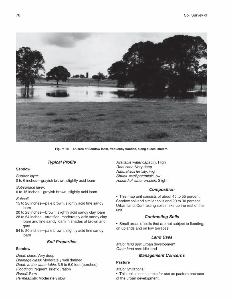
76 Soil Survey of
Typical Profile
Sandow
Surface layer:0 to 6 inches—grayish brown, slightly acid loam
Subsurface layer:6 to 15 inches—grayish brown, slightly acid loam
Subsoil:15 to 20 inches—pale brown, slightly acid fine sandy
loam20 to 28 inches—brown, slightly acid sandy clay loam28 to 54 inches—stratified, moderately acid sandy clay
loam and fine sandy loam in shades of brown andgray
54 to 80 inches—pale brown, slightly acid fine sandyloam
Soil Properties
Sandow
Depth class: Very deepDrainage class: Moderately well drainedDepth to the water table: 3.5 to 6.0 feet (perched)Flooding: Frequent; brief durationRunoff: SlowPermeability: Moderately slow
Available water capacity: HighRoot zone: Very deepNatural soil fertility: HighShrink-swell potential: LowHazard of water erosion: Slight
Composition
• This map unit consists of about 45 to 55 percentSandow soil and similar soils and 20 to 30 percentUrban land. Contrasting soils make up the rest of theunit.
Contrasting Soils
• Small areas of soils that are not subject to flooding;on uplands and on low terraces
Land Uses
Major land use: Urban developmentOther land use: Idle land
Management Concerns
Pasture
Major limitations:• This unit is not suitable for use as pasture becauseof the urban development.
Figure 10.—An area of Sandow loam, frequently flooded, along a local stream.
Brazos County, Texas 77
Cropland
Major limitations:• This unit is not suitable for use as cropland becauseof the urban development.
Rangeland
Major limitations:• This unit is not suitable for use as rangelandbecause of the urban development.
Urban development
Major limitations:• This unit is not suited to urban development unless itis protected from flooding. Channel work and otherimprovements have reduced the frequency of floodingin some areas.
Interpretive Groups
Land capability classification: None assignedEcological site: None assignedPasture management group: None assigned
ScC—Shalba-Rock outcrop complex, 2 to6 percent slopes
Setting
Landform: UplandsLandscape position: ShouldersSlope: Gently slopingShape of areas: ElongatedSize of areas: 10 to 50 acresNative vegetation: Open post oak savannah
Typical Profile
Shalba
Surface layer:0 to 4 inches—light brownish gray, moderately acid
fine sandy loam
Subsoil:4 to 12 inches—grayish brown, strongly acid clay12 to 18 inches—dark grayish brown, moderately acid
silty clay
Underlying material:18 to 30 inches—white, slightly cemented siltstone
Soil Properties
Shalba
Depth class: Shallow or very shallowDrainage class: Moderately well drainedDepth to the water table: More than 6 feetFlooding: None
Runoff: MediumPermeability: Very slowAvailable water capacity: Very lowRoot zone: Very shallow or shallowNatural soil fertility: LowShrink-swell potential: HighHazard of water erosion: Severe
Characteristics of the Rock Outcrop
Kind of rock: White, strongly cemented siltstone andsandstone
Composition
• This map unit consists of about 45 to 55 percentShalba soil and similar soils and 15 to 25 percentRock outcrop. Contrasting soils make up the rest ofthe unit.
Contrasting Soils
• The sandy Koether soils, which are thin over hardbedrock; on slope breaks• Rehburg soils, which have a thick, sandy surfacelayer; in positions similar to or slightly higher thanthose of the Shalba soil
Land Uses
Major land uses: Rangeland and wildlife habitat
Management Concerns
Pasture
Major limitations:• Water erosion is a concern unless an adequatecover of vegetation is maintained.• The low available water capacity limits production,especially during dry seasons.• The limited natural fertility results in low productionunless fertilizer is applied.
Cropland
Major limitations:• Because of the hazard of erosion, conservationmeasures are needed.• The low available water capacity limits production,especially during dry seasons.• The limited natural fertility results in low productionunless fertilizer is applied.
Rangeland
Major limitations:• Water erosion is a concern unless an adequatecover of vegetation is maintained.• The low available water capacity limits production,especially during dry seasons.• The limited natural fertility results in low production.
78 Soil Survey of
Urban development
Major limitations:• Structures and roads are affected by the high shrink-swell potential in the subsoil.• Erosion-control measures are needed atconstruction sites.• Disposal of septic tank effluent is a concernbecause of the restricted permeability and the depth torock.
Interpretive Groups
Land capability classification: Shalba—4s; Rockoutcrop—8s
Ecological site: Claypan SavannahPasture management group: Shalba—14
ShA—Ships clay, 0 to 1 percent slopes,rarely flooded
Setting
Landform: Flood plainsLandscape position: Broad flatsSlope: Nearly levelShape of areas: Irregular or elongatedSize of areas: 15 to 500 acresNative vegetation: Hardwood forest of pecan and elm
and an understory of switchgrass, wildrye, andbluestems
Typical Profile
Surface layer:0 to 8 inches—reddish brown, moderately alkaline clay
Subsoil:8 to 32 inches—reddish brown, moderately alkaline
clay32 to 47 inches—brown, moderately alkaline clay47 to 80 inches—reddish brown, moderately alkaline
clay that has dark reddish brown mottles
Soil Properties
Depth class: Very deepDrainage class: Moderately well drainedDepth to the water table: More than 6 feetFlooding: RareRunoff: SlowPermeability: Very slowAvailable water capacity: HighRoot zone: Very deepNatural soil fertility: HighShrink-swell potential: Very highHazard of water erosion: Slight
Composition
• Based on transects, this map unit contains 82percent soils of the Ships series. There is an 80percent probability that Ships and similar soils makeup 90 to 100 percent of the map unit. Contrasting soilsare Roetex and Weswood soils and soils that areclayey in the upper part and loamy below a depth of20 inches. None of these contrasting soils makes upas much as 10 percent of the unit.
Contrasting Soils
• The somewhat poorly drained Roetex soils in slightdepressions and on flats• The somewhat poorly drained Weswood soils onnatural levees• Soil that are loamy below a depth of 20 inches; inareas near the natural levees
Land Uses
Major land use: Cropland (fig. 11)Other land use: Pasture
Management Concerns
Pasture
Major limitations:• The high clay content of the soil restricts the rate ofwater infiltration and hinders the establishment ofpasture plants.
Cropland
Major limitations:• No major limitations affect the use of this soil forcrops.Minor limitations:• Because of the content of clay, this soil is difficult tomanage.• A plowpan can develop rapidly and can restrict themovement of water and roots.
Rangeland
Major limitations:• No major limitations affect the use of this soil asrangeland; however, very few areas support nativevegetation.
Urban development
Major limitations:• This unit is not suitable for urban developmentunless it is protected from flooding.• Disposal of septic tank effluent is a concernbecause of the restricted permeability.• The shrink-swell potential is a concern affectingstructures and roads.
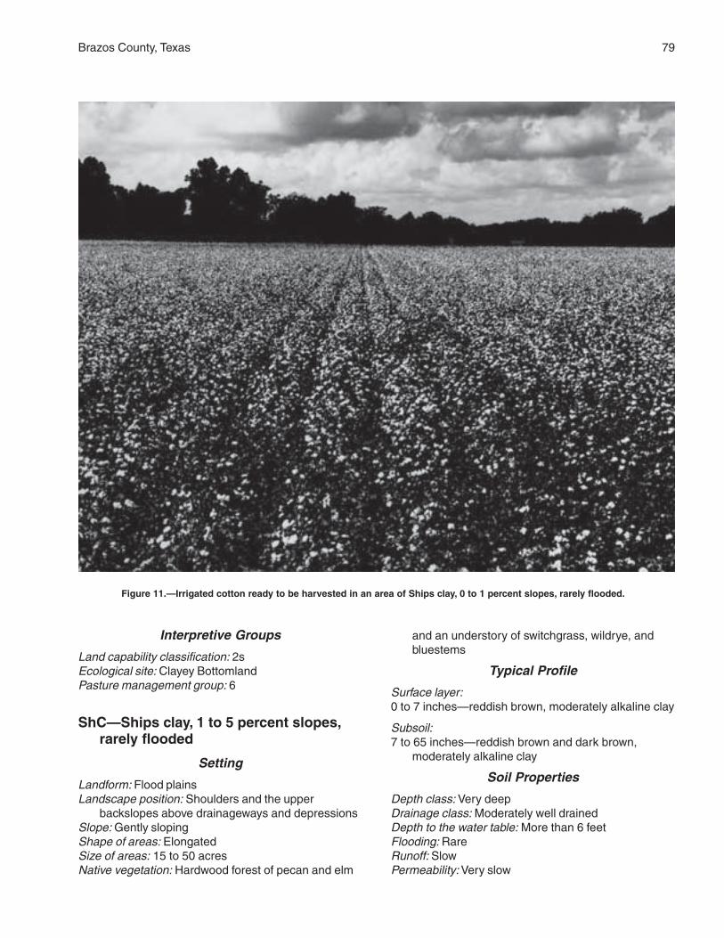
Brazos County, Texas 79
Interpretive Groups
Land capability classification: 2sEcological site: Clayey BottomlandPasture management group: 6
ShC—Ships clay, 1 to 5 percent slopes,rarely flooded
Setting
Landform: Flood plainsLandscape position: Shoulders and the upper
backslopes above drainageways and depressionsSlope: Gently slopingShape of areas: ElongatedSize of areas: 15 to 50 acresNative vegetation: Hardwood forest of pecan and elm
and an understory of switchgrass, wildrye, andbluestems
Typical Profile
Surface layer:0 to 7 inches—reddish brown, moderately alkaline clay
Subsoil:7 to 65 inches—reddish brown and dark brown,
moderately alkaline clay
Soil Properties
Depth class: Very deepDrainage class: Moderately well drainedDepth to the water table: More than 6 feetFlooding: RareRunoff: SlowPermeability: Very slow
Figure 11.—Irrigated cotton ready to be harvested in an area of Ships clay, 0 to 1 percent slopes, rarely flooded.
80 Soil Survey of
Available water capacity: HighRoot zone: Very deepNatural soil fertility: HighShrink-swell potential: Very highHazard of water erosion: Moderate or severe
Composition
• This map unit consists of about 85 percent Shipssoil and similar soils. Contrasting soils make up 15percent of the unit.
Contrasting Soils
• The loamy Coarsewood and Weswood soils onnatural levees
Land Uses
Major land uses: Cropland and pasture
Management Concerns
Pasture
Major limitations:• The high content of clay can restrict the rate of waterinfiltration and hinder the establishment of pastureplants.
Cropland
Major limitations:• The more sloping areas are susceptible to erosion.Minor limitations:• A plowpan can develop rapidly and can restrict themovement of water and roots.
Rangeland
Major limitations:• Erosion is a concern unless an adequate cover ofvegetation is maintained.
Urban development
Major limitations:• This unit is not suitable for urban developmentunless it is protected from flooding.• Disposal of septic tank effluent is a concernbecause of the restricted permeability.• Structures and roads are affected by the very highshrink-swell potential.• Erosion-control measures are needed atconstruction sites.
Interpretive Groups
Land capability classification: 3eEcological site: Clayey BottomlandPasture management group: 6
SkB—Shiro loamy fine sand, 1 to 3percent slopes
Setting
Landform: UplandsLandscape position: SummitsSlope: Very gently sloping; roundedShape of areas: Circular or elongatedSize of areas: 10 to 75 acresNative vegetation: Post oak savannah
Typical Profile
Surface and subsurface layers:0 to 15 inches—pinkish gray, moderately acid loamy
fine sand
Subsoil:15 to 24 inches—reddish brown, moderately acid clay
that has brownish gray mottles24 to 34 inches—light brownish gray, moderately acid
clay that has reddish brown mottles
Underlying material:34 to 50 inches—light gray, tuffaceous siltstone
Soil Properties
Depth class: Moderately deepDrainage class: Well drainedDepth to the water table: More than 6 feetFlooding: NoneRunoff: SlowPermeability: SlowAvailable water capacity: LowRoot zone: Moderately deepNatural soil fertility: LowShrink-swell potential: HighHazard of water erosion: Severe
Composition
• This map unit consists of about 90 percent Shiro soiland similar soils. Contrasting soils make up 10 percentof the unit.
Contrasting Soils
• Koether soils, which are shallow over hard bedrock;on the upper slope breaks• Rehburg soils, which have a thicker sandy surfacelayer than that of the Shiro soil; in the higher, moreconvex positions
Land Uses
Major land uses: Pasture and rangeland
Brazos County, Texas 81
Management Concerns
Pasture
Major limitations:• Water erosion is a concern unless an adequatecover of vegetation is maintained.• The low available water capacity limits production,especially during dry seasons.• The limited natural fertility results in low productionunless fertilizer is applied.
Cropland
Major limitations:• Because of the hazard of erosion, conservationmeasures are needed.• The low available water capacity limits production,especially during dry seasons.• The limited natural fertility results in low productionunless fertilizer is applied.
Rangeland
Major limitations:• Water erosion is a concern unless an adequatecover of vegetation is maintained.• The low available water capacity limits production,especially during dry seasons.• The limited natural fertility results in low production.
Urban development
Major limitations:• Structures and roads may be affected by the highshrink-swell potential in the subsoil.• Erosion-control measures are needed atconstruction sites.• Disposal of septic tank effluent is a concernbecause of the restricted permeability.
Interpretive Groups
Land capability classification: 3eEcological site: Sandy LoamPasture management group: 8
SmC—Silawa fine sandy loam, 2 to 5percent slopes
Setting
Landform: Stream terracesLandscape position: Summits and shouldersSlope: Gently sloping; convexShape of areas: ElongatedSize of areas: 10 to 30 acresNative vegetation: Post oak savannah
Typical Profile
Surface layer:0 to 5 inches—dark grayish brown, slightly acid fine
sandy loam
Subsurface layer:5 to 9 inches—grayish brown, slightly acid fine sandy
loam
Subsoil:9 to 51 inches—reddish brown, moderately acid sandy
clay loam that has brown mottles51 to 80 inches—reddish yellow, slightly acid loamy
sand
Soil Properties
Depth class: Very deepDrainage class: Well drainedDepth to the water table: More than 6 feetFlooding: NoneRunoff: SlowPermeability: ModerateAvailable water capacity: ModerateRoot zone: Very deepNatural soil fertility: MediumShrink-swell potential: ModerateHazard of water erosion: Moderate
Composition
• Based on transects, this map unit contains 59percent soils of the Silawa series. There is an 80percent probability that Silawa and similar soils makeup 75 to 95 percent of the unit. Contrasting soils areGredge, Rader, and Robco soils, but neither of thesesoils makes up as much as 10 percent of the unit.
Contrasting Soils
• Gredge soils, which have a clayey subsoil; inlandscape positions similar to those of the Silawa soil• Rader and Robco soils, which have a thick, sandysurface layer; in landscape positions similar to those ofthe Silawa soil
Land Uses
Major land uses: Rangeland and pasture
Management Concerns
Pasture
Major limitations:• No major limitations affect the use of this soil forpasture.Minor limitations:• Water erosion is a concern unless an adequatecover of vegetation is maintained.

82 Soil Survey of
• The medium natural fertility results in low productionunless fertilizer is applied.• The available water capacity limits forageproduction, especially during dry seasons.
Cropland
Major limitations:• Because of the hazard of erosion, conservationmeasures are needed.Minor limitations:• The medium natural fertility results in low productionunless fertilizer is applied.• The available water capacity limits production,especially during dry seasons.
Rangeland
Major limitations:• No major limitations affect the use of this soil asrangeland.Minor limitations:• Water erosion is a concern unless an adequatecover of vegetation is maintained.• The medium natural fertility results in low production.• The available water capacity limits forageproduction, especially during dry seasons.
Urban development
Major limitations:• No major limitations affect the use of this soil forurban development.Minor limitations:• Structures and roads are affected somewhat by themoderate shrink-swell potential in the subsoil.• The sidewalls of excavations are unstable becauseof the sandy texture of the soil.
Interpretive Groups
Land capability classification: 3eEcological site: Sandy LoamPasture management group: 5
SmD—Silawa fine sandy loam, 5 to 8percent slopes
Setting
Landform: Stream terracesLandscape position: Shoulders and the upper
backslopesSlope: Moderately sloping; convexShape of areas: ElongatedSize of areas: 10 to 50 acresNative vegetation: Post oak savannah
Typical Profile
Surface layer:0 to 15 inches—brown, slightly acid fine sandy loam
Subsoil:15 to 24 inches—reddish brown, moderately acid
sandy clay loam24 to 50 inches—red, moderately acid sandy clay
loam50 to 60 inches—red, moderately acid fine sandy loam
Soil Properties
Depth class: Very deepDrainage class: Well drainedDepth to the water table: More than 6 feetFlooding: NoneRunoff: MediumPermeability: ModerateAvailable water capacity: ModerateRoot zone: Very deepNatural soil fertility: MediumShrink-swell potential: ModerateHazard of water erosion: Severe
Composition
• Based on transects, this map unit contains 56percent soils of the Silawa series. There is an 80percent probability that Silawa and similar soils makeup 64 to 84 percent of the unit. Contrasting soils areDesan, Gredge, Padina, and Robco soils, but neitherof these soils makes up as much as 10 percent of theunit.
Contrasting Soils
• Desan and Padina soils, which have a thick, sandysurface layer; on the convex upper slopes• Gredge soils, which have a clayey subsoil; inlandscape positions similar to those of the Silawa soil• Robco soils, which have a thick, sandy surface layer;in landscape positions similar to those of the Silawasoil
Land Uses
Major land uses: Rangeland and pasture
Management Concerns
Pasture
Major limitations:• Water erosion is a concern unless an adequatecover of vegetation is maintained.Minor limitations:• The medium natural fertility results in low productionunless fertilizer is applied.
Brazos County, Texas 83
• The available water capacity limits forageproduction, especially during dry seasons.
Cropland
Major limitations:• Because of the hazard of erosion, conservationmeasures are needed.Minor limitations:• The medium natural fertility results in low productionunless fertilizer is applied.• The available water capacity limits production,especially during dry seasons.
Rangeland
Major limitations:• Water erosion is a concern unless an adequatecover of vegetation is maintained.Minor limitations:• The medium natural fertility results in low production.• The available water capacity limits forageproduction, especially during dry seasons.
Urban development
Major limitations:• Erosion-control structures are needed atconstruction sites.Minor limitations:• Structures and roads are affected somewhat by themoderate shrink-swell potential in the subsoil.
Interpretive Groups
Land capability classification: 4eEcological site: Sandy LoamPasture management group: 5
SnB—Singleton fine sandy loam, 1 to 3percent slopes
Setting
Landform: UplandsLandscape position: BackslopesSlope: Very gently sloping; plane surfacesShape of areas: Irregular or elongatedSize of areas: 10 to 100 acresNative vegetation: Post oak savannah
Typical Profile
Surface layer:0 to 9 inches—light brownish gray, slightly acid fine
sandy loam
Subsoil:9 to 17 inches—pale brown, very strongly acid clay
that has common yellowish brown mottles
17 to 28 inches—very pale brown, strongly acid claythat has brownish yellow and grayish brownmottles
Underlying material:28 to 60 inches—stratified white, brown, and yellowish
brown, tuffaceous siltstone
Soil Properties
Depth class: Moderately deepDrainage class: Moderately well drainedDepth to the water table: More than 6 feet (but the soil
is saturated in the upper part for short periodsafter heavy rains)
Flooding: NoneRunoff: SlowPermeability: Very slowAvailable water capacity: LowRoot zone: Moderately deepNatural soil fertility: LowShrink-swell potential: HighHazard of water erosion: Severe
Composition
• Based on transects, this map unit contains 97percent soils of the Singleton series. There is an 80percent probability that Singleton and similar soilsmake up 87 to 100 percent of the unit. Contrastingsoils are Gredge and Tabor soils, but neither of thesesoils makes up as much as 10 percent of the unit.
Contrasting Soils
• Gredge and Tabor soils, which do not havecemented materials within a depth of 60 inches
Land Uses
Major land uses: Pasture and rangeland
Management Concerns
Pasture
Major limitations:• Water erosion is a concern unless an adequatecover of vegetation is maintained.• The low available water capacity limits production,especially during dry seasons.• The limited natural fertility results in low productionunless fertilizer is applied.
Cropland
Major limitations:• Because of the hazard of erosion, conservationmeasures are needed.• The low available water capacity limits production,especially during dry seasons.
84 Soil Survey of
• The limited natural fertility results in low productionunless fertilizer is applied.
Rangeland
Major limitations:• Water erosion is a concern unless an adequatecover of vegetation is maintained.• The low available water capacity limits production,especially during dry seasons.• The limited natural fertility results in low production.
Urban development
Major limitations:• Structures and roads are affected by the high shrink-swell potential in the subsoil.• Erosion-control measures are needed atconstruction sites.• Disposal of septic tank effluent is a concernbecause of the restricted permeability and the depth torock.
Interpretive Groups
Land capability classification: 4eEcological site: Claypan SavannahPasture management group: 11
SpB—Spiller loamy fine sand, 1 to 3percent slopes
Setting
Landform: UplandsLandscape position: Summits and the upper
backslopesSlope: Very gently slopingShape of areas: Elongated or irregularSize of areas: 10 to 50 acresNative vegetation: Post oak savannah
Typical Profile
Surface layer:0 to 15 inches—brown, slightly acid loamy fine sand
Subsurface layer:15 to 18 inches—light yellowish brown, slightly acid
loamy fine sand
Subsoil:18 to 24 inches—brownish yellow, slightly acid sandy
clay that has red mottles24 to 33 inches—light yellowish brown, moderately
acid sandy clay that has red and brownish yellowmottles
33 to 43 inches—pale brown, moderately acid sandy
clay that has brownish yellow, red, and lightbrownish gray mottles
43 to 54 inches—brownish yellow, moderately acidsandy clay loam that has red mottles
Underlying material:54 to 85 inches—brownish yellow, moderately alkaline,
stratified loamy material and shale
Soil Properties
Depth class: Very deepDrainage class: Moderately well drainedDepth to the water table: More than 6 feetFlooding: NoneRunoff: MediumPermeability: SlowAvailable water capacity: ModerateRoot zone: Very deepNatural soil fertility: MediumShrink-swell potential: ModerateHazard of water erosion: Slight or moderate
Composition
• Based on transects, this map unit contains 58percent soils of the Spiller series. There is an 80percent probability that Spiller and similar soils makeup 75 to 95 percent of the unit. Contrasting soils areRader and Tabor soils, but neither of these soilsmakes up as much as 10 percent of the unit.
Contrasting Soils
• Rader and Tabor soils, which have a loamy surfacelayer and a clayey subsoil; in the lower positions
Land Uses
Major land uses: Rangeland and pastureOther land uses: Cropland
Management Concerns
Pasture
Major limitations:• No major limitations affect the use of this soil forpasture.Minor limitations:• The moderate available water capacity and mediumnatural fertility limit the potential forage production.
Cropland
Major limitations:• No major limitations affect the use of this soil ascropland.Minor limitations:• The moderate available water capacity and mediumnatural fertility limit production.
Brazos County, Texas 85
• Because of the hazard of erosion, conservationmeasures are needed in some areas.
Rangeland
Major limitations:• No major limitations affect the use of this soil asrangeland.Minor limitations:• The moderate available water capacity and mediumnatural fertility limit production.
Urban development
Major limitations:• No major limitations affect the use of this soil forurban development.Minor limitations:• Structures and roads are affected by the moderateshrink-swell potential in the subsoil.• Erosion-control measures are needed atconstruction sites.• Disposal of septic tank effluent is a concernbecause of the restricted permeability.
Interpretive Groups
Land capability classification: 3eEcological site: Sandy LoamPasture management group: 5
SxB—Styx loamy fine sand, 1 to 3 percentslopes
Setting
Landform: Stream terracesLandscape position: SummitsSlope: Very gently slopingShape of areas: Circular or elongatedSize of areas: 10 to 50 acresNative vegetation: Post oak savannah
Typical Profile
Surface layer:0 to 8 inches—yellowish brown, neutral loamy fine
sand
Subsurface layer:8 to 24 inches—very pale brown, neutral loamy fine
sand
Subsoil:24 to 30 inches—brownish yellow, slightly acid sandy
clay loam30 to 68 inches—red, moderately acid sandy clay
loam that has light brownish gray, brownish yellow,and light yellowish brown mottles
Soil Properties
Depth class: Very deepDrainage class: Well drainedDepth to the water table: 3.5 to 4.5 feet (perched)Flooding: NoneRunoff: SlowPermeability: ModerateAvailable water capacity: ModerateRoot zone: Very deepNatural soil fertility: LowShrink-swell potential: LowHazard of water erosion: Slight
Composition
• This map unit consists of about 90 percent Styx soiland similar soils. Contrasting soils make up 10 percentof the unit.
Contrasting Soils
• Chazos soils, which have a thin, sandy surface layer;on ridges and hilltops• Desan, Eufaula, and Padina soils, which have athick, sandy surface layer; in landscape positionssimilar to those of the Styx soil
Land Uses
Major land uses: Rangeland and pasture
Management Concerns
Pasture
Major limitations:• The low natural fertility limits production unlessfertilizer is applied.• The available water capacity limits forageproduction, especially during dry seasons.
Cropland
Major limitations:• The low natural fertility limits production unlessfertilizer is applied.• The limited available water capacity results inmoderate production, especially during dry seasons.Minor limitations:• Because of the hazard of erosion, conservationmeasures are needed in some areas.
Rangeland
Major limitations:• The low natural fertility and moderate available watercapacity limit production.
86 Soil Survey of
Urban development
Major limitations:• No major limitations affect the use of this soil forurban development.Minor limitations:• The sidewalls of excavations are unstable becauseof the sandy texture of the soil.• Erosion-control measures may be needed atconstruction sites.• Disposal of septic tank effluent may be a concernbecause of short periods of saturation.
Interpretive Groups
Land capability classification: 3eEcological site: SandyPasture management group: 2
TaA—Tabor fine sandy loam, 0 to 2percent slopes
Setting
Landform: Stream terracesLandscape position: Summits and toeslopesSlope: Very gently slopingShape of areas: Elongated or circularSize of areas: 10 to 30 acresNative vegetation: Post oak savannah
Typical Profile
Surface layer:0 to 6 inches—pale brown, strongly acid fine sandy
loam
Subsurface layer:6 to 14 inches—pale brown, strongly acid fine sandy
loam
Subsoil:14 to 23 inches—brown, strongly acid clay that has
yellowish brown and dark red mottles23 to 42 inches—light brownish gray, moderately acid
clay that has yellowish brown and dark red mottles42 to 57 inches—brownish yellow, neutral clay loam
that has brown and strong brown mottles57 to 67 inches—light gray, neutral sandy clay loam
that has yellowish brown and red mottles67 to 80 inches—white, neutral sandy clay loam that
has brownish yellow, red, and yellowish redmottles
Soil Properties
Depth class: Very deepDrainage class: Moderately well drainedDepth to the water table: More than 6 feet (but the soil
is saturated at a depth of 0.5 foot to 1.5 feet forshort periods after heavy rains)
Flooding: NoneRunoff: SlowPermeability: Very slowAvailable water capacity: ModerateRoot zone: Very deep; restricted by the clay subsoilNatural soil fertility: MediumShrink-swell potential: HighHazard of water erosion: Severe
Composition
• Based on transects, this map unit contains 64percent soils of the Tabor series. There is an 80percent probability that Tabor and similar soils makeup 72 to 92 percent of the unit. Contrasting soils areLufkin, Mabank, and Robco soils, but neither of thesesoils makes up as much as 10 percent of the unit.
Contrasting Soils
• Lufkin and Mabank soils, which have a thin, loamysurface layer; on flats or in slight depressions• Robco soils, which have a sandy surface layer 20 to40 inches thick; in landscape positions similar to thoseof the Tabor soil
Land Uses
Major land uses: Rangeland and pastureOther land use: Cropland
Management Concerns
Pasture
Major limitations:• Water erosion is a concern unless an adequatecover of vegetation is maintained.Minor limitations:• The medium natural fertility slightly limits production.• The available water capacity limits forageproduction, especially during dry seasons.
Cropland
Major limitations:• Water erosion is a concern unless an adequatecover of vegetation is maintained.Minor limitations:• The medium natural fertility slightly limits production.• The limited available water capacity results inmoderate production, especially during dry seasons.
Rangeland
Major limitations:• Water erosion is a concern unless an adequatecover of vegetation is maintained.
Brazos County, Texas 87
Minor limitations:• The medium natural fertility slightly limits production.• The available water capacity limits forageproduction, especially during dry seasons.
Urban development
Major limitations:• Structures and roads are affected by the high shrink-swell potential in the subsoil.• Erosion-control measures are needed atconstruction sites.• Disposal of septic tank effluent is a concernbecause of the restricted permeability.
Interpretive Groups
Land capability classification: 3eEcological site: Sandy LoamPasture management group: 4
TgB—Tabor very gravelly fine sandyloam, 1 to 3 percent slopes
Setting
Landform: Stream terracesLandscape position: Summits and toeslopesSlope: Very gently sloping; plane surfacesShape of areas: ElongatedSize of areas: 10 to 50 acresNative vegetation: Post oak savannah
Typical ProfileSurface layer:0 to 18 inches—dark grayish brown, moderately acid
very gravelly fine sandy loam
Subsoil:18 to 72 inches—red, strongly acid clay that has gray
and yellowish brown mottles72 to 80 inches—gray, moderately acid clay
Soil Properties
Depth class: Very deepDrainage class: Moderately well drainedDepth to the water table: More than 6 feet (but the soil
is saturated at a depth of 0.5 foot to 1.5 feet forshort periods after heavy rains)
Flooding: NoneRunoff: SlowPermeability: Very slowAvailable water capacity: ModerateRoot zone: Very deep; restricted by the clayey subsoilNatural soil fertility: MediumShrink-swell potential: HighHazard of water erosion: Slight
Composition
• This map unit consists of about 85 percent Tabor soiland similar soils. Contrasting components make up 15percent of the unit.
Contrasting Components
• Tabor soils that are not gravelly• Tabor soils that are eroded• Small gravel pits
Land Uses
Major land uses: Rangeland and pastureOther land use: Wildlife habitat
Management ConcernsPasture
Major limitations:• Because of the gravel on the surface, establishingvegetation is difficult in areas of this soil.Minor limitations:• The medium natural fertility limits production unlessfertilizer is applied.• The available water capacity limits forageproduction, especially during dry seasons.
Cropland
Major limitations:• This soil is not suited to crops because of thecontent of gravel.
Rangeland
Major limitations:• The medium natural fertility and moderate availablewater capacity limit production.
Urban development
Major limitations:• The content of gravel in this soil interferes with someurban uses.• Structures and roads are affected by the high shrink-swell potential in the subsoil.• Erosion-control measures are needed duringconstruction.• Disposal of septic tank effluent is a concernbecause of the restricted permeability.
Interpretive Groups
Land capability classification: 6sEcological site: GravellyPasture management group: 14
88 Soil Survey of
TuA—Tabor-Urban land complex, 0 to 2percent slopes
Setting
Landform: Stream terracesLandscape position: Summits and toeslopesSlope: Nearly level and very gently slopingShape of areas: Elongated or irregularSize of areas: 10 to 1,000 acresNative vegetation: Post oak savannah
Typical Profile
Tabor
Surface layer:0 to 15 inches—brown, strongly acid fine sandy loam
Subsoil:15 to 67 inches—red, gray, and brownish yellow,
strongly acid clay67 to 80 inches—light gray, neutral clay loam
Soil Properties
Tabor
Depth class: Very deepDrainage class: Moderately well drainedDepth to the water table: More than 6 feet (but the soil
is saturated at a depth of 0.5 foot to 1.5 feet forshort periods after heavy rains)
Flooding: NoneRunoff: SlowPermeability: Very slowAvailable water capacity: ModerateRoot zone: Very deep; restricted by the clay subsoilNatural soil fertility: MediumShrink-swell potential: HighHazard of water erosion: Severe
Composition
• This map unit consists of about 50 to 60 percentTabor soil and 30 to 40 percent Urban land.Contrasting soils make up the rest of the unit.
Contrasting Soils
• Lufkin and Mabank soils, which have a thin, loamysurface layer; on flats or in slight depressions• Robco soils, which have a sandy surface layer 20 to40 inches thick; in landscape positions similar to thoseof the Tabor soil
Land Uses
Major land use: Urban developmentOther land use: Idle land
Management Concerns
Pasture
Major limitations:• This unit is not suitable for use as pasture becauseof the urban development.
Cropland
Major limitations:• This unit is not suitable for use as cropland becauseof the urban development.
Rangeland
Major limitations:• This unit is not suitable for use as rangelandbecause of the urban development.
Urban development
Major limitations:• Erosion-control measures are needed atconstruction sites.• Disposal of septic tank effluent is a concernbecause of the restricted permeability.• Structures and roads are affected by the high shrink-swell potential in the soil.
Interpretive Groups
Land capability classification: None assignedEcological site: None assignedPasture management group: None assigned
Uh—Uhland loam, frequently flooded
Setting
Landform: Flood plainsLandscape position: Flats and natural leveesSlope: Nearly levelShape of areas: ElongatedSize of areas: 10 to 500 acresNative vegetation: Hardwood forest of elm, ash,
pecan, and oak and an understory of mid and tallgrasses
Typical Profile
Surface layer:0 to 7 inches—grayish brown, neutral loam
Subsoil:7 to 20 inches—yellowish brown, neutral fine sandy
loam that has grayish brown mottles20 to 65 inches—pale brown, slightly acid fine sandy
loam that has grayish brown mottles
Brazos County, Texas 89
Soil Properties
Depth class: Very deepDrainage class: Moderately well drainedDepth to the water table: 2.0 to 3.5 feetFlooding: Frequent; brief durationRunoff: SlowPermeability: Moderately slowAvailable water capacity: ModerateRoot zone: Very deepNatural soil fertility: HighShrink-swell potential: LowHazard of water erosion: Slight
Composition
• Based on transects, this map unit contains 58percent soils of the Uhland series. There is an 80percent probability that Uhland and similar soils makeup 81 to 100 percent of the unit. Contrasting soils areGladewater and Kaufman soils and soils that have athick, dark surface layer. Neither of these contrastingsoils makes up as much as 10 percent of the unit.
Contrasting Soils
• Gladewater and Kaufman soils, which are clayeythroughout; in broad backwater areas• Soils that have a dark surface layer; on naturallevees
Land Uses
Major land uses: Rangeland and pastureOther land use: Wildlife habitat
Management Concerns
Pasture
Major limitations:• No major limitations affect the use of this soil forpasture if adapted species are used.Minor limitations:• The available water capacity limits forageproduction, especially during dry seasons.
Cropland
Major limitations:• This soil is not suited to use as cropland because ofthe flooding.
Rangeland
Major limitations:• No major limitations affect the use of this soil asrangeland.Minor limitations:• The available water capacity limits forageproduction, especially during dry seasons.
Urban development
Major limitations:• This soil is not suited to urban development becauseof the flooding.
Interpretive Groups
Land capability classification: 5wEcological site: Loamy BottomlandPasture management group: 3
Ur—Urban land
General Description
• This map unit consists of areas that are 75 to 100percent works and structures, such as houses; officebuildings; hotels; railroad yards; multiple-unit dwellings;shopping centers; churches; schools; streets; andservice, banking, professional, educational,entertainment, and government buildings. Most of therainfall in areas of this unit runs off and reaches majordrains rapidly. Included in mapping are some built-upareas in which buildings and structures cover lessthan 75 percent of the surface. Also included are smallareas of soils that have been covered by fill material.These included areas make up as much as 25 percentof the unit. The soils in areas of this map unit havebeen altered and obscured to the extent that theycannot be classified.
Us—Ustarents, clayey
Setting
Landform: Flood plains and stream terracesLandscape position: Areas that have been strip mined
for gravel (the overburden has been leveled insome areas)
Slope: Nearly level to steepShape of areas: Circular or elongatedSize of areas: 10 to 300 acresNative vegetation: Woody species
Typical Profile
Surface layer:0 to 80 inches—mixed, moderately alkaline to neutral
clay or clay loam in various shades of red, black,and gray
Soil Properties
Depth class: Very deepDrainage class: Well drained to somewhat poorly
drained
90 Soil Survey of
Depth to the water table: More than 6 feetFlooding: RareRunoff: Slow to rapidPermeability: Very slowAvailable water capacity: HighRoot zone: Very deepNatural soil fertility: Medium or highShrink-swell potential: Very highHazard of water erosion: Slight
Composition
• This map unit consists of about 85 percentUstarents and similar soils. Contrasting componentsmake up 15 percent of the unit.
Contrasting Components
• Burleson, Axtell, and Ships soils, which have notbeen mined for gravel; in adjacent areas• Shallow pits, some of which hold water for extendedperiods
Land Uses
Major land use: Wildlife habitatOther land use: Pasture
Management Concerns
Pasture
Major limitations:• These soils are difficult to work because of the claytextures.• The adaptability of plants is limited because the soilmaterial is not biologically active.
Cropland
Major limitations:• Most areas of these soils are not suitable forcultivation because of the slope and the presence ofpits. If the areas are leveled, a few selected crops canbe grown.
Rangeland
Major limitations:• Some areas are not accessible to livestock.
Urban development
Major limitations:• Because of the slope and the presence of pits,areas of these soils are unsuitable for urbandevelopment.
Interpretive Groups
Land capability classification: 6eEcological site: None assignedPasture management group: None assigned
WeA—Weswood silt loam, 0 to 1 percentslopes, rarely flooded
Setting
Landform: Flood plainsLandscape position: Natural levees adjacent to stream
channelsSlope: Nearly level; slightly convexShape of areas: ElongatedSize of areas: 10 to 100 acresNative vegetation: Hardwood forest of pecan, elm,
hackberry, and cottonwood and an understory ofbriars, vines, and mid grasses
Typical Profile
Surface layer:0 to 8 inches—brown, moderately alkaline silt loam
Subsoil:8 to 24 inches—light brown, moderately alkaline silt
loam
Underlying material:24 to 30 inches—stratified light brown, brown, and
yellowish brown, moderately alkaline silt loam30 to 80 inches—stratified brown and light brown,
moderately alkaline silt loam
Soil Properties
Depth class: Very deepDrainage class: Well drainedDepth to the water table: More than 6 feetFlooding: RareRunoff: SlowPermeability: ModerateAvailable water capacity: HighRoot zone: Very deepNatural soil fertility: HighShrink-swell potential: LowHazard of water erosion: Slight
Composition
• Based on transects, this map unit contains 81percent soils of the Weswood series. There is an 80percent probability that Weswood and similar soilsmake up 95 to 100 percent of the unit. Contrastingsoils are Highbank and Ships soils, but neither ofthese soils makes up as much as 10 percent of theunit.
Contrasting Soils
• Highbank and Ships soils, which are more clayeythan the Weswood soil; in the slightly lowerpositions

Brazos County, Texas 91
Land Uses
Major land use: CroplandOther land use: Pasture
Management Concerns
Pasture
Major limitations:• No major limitations affect the use of this soil forpasture. High yields of adapted forage grasses can beproduced.
Cropland
Major limitations:• No major limitations affect the use of this soil ascropland. High yields of adapted crops can beproduced.Minor limitations:• A plowpan can develop rapidly and can restrict themovement of water, air, and roots.
Rangeland
Major limitations:• No major limitations affect the use of this soil asrangeland. High yields of native grasses can beproduced.
Urban development
Major limitations:• This unit is not suitable for urban developmentunless it is protected from flooding.
Interpretive Groups
Land capability classification: 1Ecological site: Loamy BottomlandPasture management group: 1
WeC—Weswood silt loam, 1 to 5 percentslopes, rarely flooded
Setting
Landform: Flood plainsLandscape position: Natural levees adjacent to stream
channelsSlope: Gently sloping; slightly convexShape of areas: ElongatedSize of areas: 10 to 100 acresNative vegetation: Hardwood forest of pecan, elm,
hackberry, and cottonwood and an understory ofbriars, vines, and mid grasses
Typical Profile
Surface layer:0 to 8 inches—light reddish brown, moderately alkaline
silt loam
Subsoil:8 to 22 inches—reddish brown, moderately alkaline
silty clay loam
Underlying material:22 to 65 inches—stratified brown, light brown, and
strong brown, moderately alkaline silt loam
Soil Properties
Depth class: Very deepDrainage class: Well drainedDepth to the water table: More than 6 feetFlooding: RareRunoff: Slow or mediumPermeability: ModerateAvailable water capacity: HighRoot zone: Very deepNatural soil fertility: HighShrink-swell potential: LowHazard of water erosion: Severe
Composition
• This map unit consists of about 90 percentWeswood soil and similar soils. Contrasting soils makeup about 10 percent of the unit.
Contrasting Soils
• Highbank and Ships soils, which are more clayeythan the Weswood soil; in the lower positions
Land Uses
Major land use: CroplandOther land use: Pasture
Management Concerns
Pasture
Major limitations:• Water erosion is a concern unless an adequatecover of vegetation is maintained.
Cropland
Major limitations:• Water erosion is a concern unless conservationmeasures are applied.Minor limitations:• A plowpan can develop rapidly and can restrict themovement of water, air, and roots.
92 Soil Survey of
Rangeland
Major limitations:• No major limitations affect the use of this soil asrangeland.
Urban development
Major limitations:• This unit is not suitable for urban developmentunless it is protected from flooding.Minor limitations:• Erosion-control measures are needed duringconstruction.
Interpretive Groups
Land capability classification: 3eEcological site: Loamy BottomlandPasture management group: 1
WwA—Weswood silty clay loam, 0 to 1percent slopes, rarely flooded
Setting
Landform: Flood plainsLandscape position: Natural levees adjacent to stream
channelsSlope: Nearly level; slightly convexShape of areas: ElongatedSize of areas: 10 to 100 acresNative vegetation: Hardwood forest of pecan, elm,
hackberry, and cottonwood and an understory ofbriars, vines, and mid grasses
Typical Profile
Surface layer:0 to 8 inches—brown, moderately alkaline silty clay
loam
Subsoil:8 to 48 inches—light reddish brown, moderately
alkaline silt loam
Underlying material48 to 65 inches—stratified light brown, brown, and
yellowish brown, moderately alkaline silt loam
Soil Properties
Depth class: Very deepDrainage class: Well drainedDepth to the water table: More than 6 feetFlooding: RareRunoff: Slow
Permeability: ModerateAvailable water capacity: HighRoot zone: Very deepNatural soil fertility: HighShrink-swell potential: LowHazard of water erosion: Slight
Composition
• This map unit consists of about 90 percentWeswood soil and similar soils. Contrasting soils makeup 10 percent of the unit.
Contrasting Soils
• Highbank and Ships soils, which are more clayeythan the Weswood soil; in the lower positions
Land Uses
Major land use: CroplandOther land use: Pasture
Management Concerns
Pasture
Major limitations:• No major limitations affect the use of this soil forpasture. High yields of adapted forage grasses can beproduced.
Cropland
Major limitations:• No major limitations affect the use of this soil ascropland. High yields of adapted crops can beproduced.Minor limitations:• A plowpan can develop rapidly and can restrict themovement of water, air, and roots.
Rangeland
Major limitations:• No major limitations affect the use of this soil asrangeland. High yields of native grasses can beproduced.
Urban development
Major limitations:• This unit is not suitable for urban developmentunless it is protected from flooding.
Interpretive Groups
Land capability classification: 1Ecological site: Loamy BottomlandPasture management group: 1
Brazos County, Texas 93
Wy—Weswood-Yahola complex,frequently flooded
Setting
Landform: Flood plainsLandscape position: Undulating areas adjacent to
stream channelsSlope: Gently sloping or moderately slopingShape of areas: ElongatedSize of areas: 20 to 80 acresNative vegetation: Hardwood forest of pecan, elm,
willow, and cottonwood and an understory ofbriars, vines, and mid grasses
Typical Profile
Weswood
Surface layer:0 to 6 inches—reddish brown, moderately alkaline silt
loam
Subsurface layer:6 to 38 inches—stratified light reddish brown and
brown, moderately alkaline silt loam38 to 65 inches—stratified reddish brown and brown,
moderately alkaline silt loam and very fine sandyloam
Yahola
Surface layer:0 to 6 inches—pink, moderately alkaline very fine
sandy loam
Subsurface layer:6 to 12 inches—light reddish brown, moderately
alkaline very fine sandy loam12 to 60 inches—stratified light reddish brown and
pink, moderately alkaline very fine sandy loam
Soil Properties
Depth class: Very deepDrainage class: Well drainedDepth to the water table: More than 6 feetFlooding: Frequent; very brief or brief durationRunoff: SlowPermeability: ModerateAvailable water capacity: Moderate or highRoot zone: Very deepNatural soil fertility: HighShrink-swell potential: LowHazard of water erosion: Slight
Composition
• This map unit consists of about 50 to 60 percentWeswood and similar soils and 30 to 35 percent
Yahola and similar soils. Contrasting soils make up therest of the unit.
Contrasting Soils
• Roetex and Ships soils, which are clayey throughout;in slightly concave positions
Land Uses
Major land uses: Rangeland and pastureOther land use: Wildlife habitat
Management Concerns
Pasture
Major limitations:• No major limitations affect the use of these soils forpasture. High yields of adapted pasture grasses canbe produced.Minor limitations:• Flooding is a problem affecting livestockmanagement.
Cropland
Major limitations:• Because of the slope and the flooding, these soilsare not suitable for cultivation.
Rangeland
Major limitations:• No major limitations affect the use of these soils asrangeland. The soils are well suited to the productionof native forage plants.Minor limitations:• Flooding is a problem affecting livestockmanagement.
Urban development
Major limitations:• These soils are not suited to urban developmentbecause of the flooding.
Interpretive Groups
Land capability classification: Weswood—5w; Yahola—5w
Ecological site: Weswood—Loamy Bottomland;Yahola—Loamy Bottomland
Pasture management group: 1
WzA—Wilson loam, 0 to 1 percent slopes
Setting
Landform: Stream terraces and valley fillsLandscape position: SummitsSlope: Nearly level; slightly concave
94 Soil Survey of
Shape of areas: Circular or elongatedSize of areas: 8 to 100 acresNative vegetation: Oak savannah with mid and tall
grasses
Typical Profile
Surface layer:0 to 8 inches—grayish brown, moderately acid loam
Subsoil:8 to 21 inches—dark gray, slightly acid clay21 to 34 inches—gray, slightly acid clay34 to 61 inches—dark gray, moderately acid clay61 to 80 inches—gray, slightly alkaline clay that has
strong brown and yellowish brown mottles
Soil Properties
Depth class: Very deepDrainage class: Moderately well drainedDepth to the water table: More than 6 feet (but the soil
is saturated in the upper part for short periodsafter heavy rains)
Flooding: NoneRunoff: Very slowPermeability: Very slowAvailable water capacity: ModerateRoot zone: Very deep; restricted by the clayey subsoilNatural soil fertility: LowShrink-swell potential: HighHazard of water erosion: Slight or moderate
Composition
• Based on transects, this map unit contains 89percent soils of the Wilson series. There is an 80percent probability that Wilson and similar soils makeup 95 to 100 percent of the unit. Contrasting soils areBoonville and Burleson soils, but neither of these soilsmakes up as much as 10 percent of the unit.
Contrasting Soils
• Boonville soils, which have a thick, loamy surfacelayer; in landscape positions similar to those of theWilson soil• Burleson soils, which are clayey throughout; inlandscape positions similar to those of the Wilson soil
Land Uses
Major land uses: Rangeland and pasture
Management Concerns
Pasture
Major limitations:• The available water capacity limits forageproduction, especially during dry seasons.
• The limited natural fertility results in low productionunless fertilizer is applied.Minor limitations:• Water erosion is a concern unless an adequatecover of vegetation is maintained.
Cropland
Major limitations:• The available water capacity limits forageproduction, especially during dry seasons.• The limited natural fertility results in low productionunless fertilizer is applied.Minor limitations:• Because of the hazard of erosion, conservationmeasures are needed.
Rangeland
Major limitations:• The available water capacity limits forageproduction, especially during dry seasons.• The limited natural fertility results in low production.Minor limitations:• Water erosion is a concern unless an adequatecover of vegetation is maintained.
Urban development
Major limitations:• Structures and roads are affected by the high shrink-swell potential in the subsoil.• Erosion-control measures are needed atconstruction sites.• Disposal of septic tank effluent is a concernbecause of the restricted permeability.
Interpretive Groups
Land capability classification: 3wEcological site: Claypan PrairiePasture management group: 7
YaA—Yahola fine sandy loam, 0 to 1percent slopes, rarely flooded
Setting
Landform: Flood plainsLandscape position: Natural levees adjacent to stream
channelsSlope: Nearly level; slightly convexShape of areas: ElongatedSize of areas: 10 to 100 acresNative vegetation: Hardwood forest of pecan, elm,
hackberry, and cottonwood and an understory ofbriars, vines, and mid grasses
Brazos County, Texas 95
Typical ProfileSurface layer:0 to 12 inches—reddish brown, moderately alkaline
fine sandy loam
Underlying material:12 to 24 inches—pink, moderately alkaline fine sandy
loam24 to 42 inches—stratified, pink, moderately alkaline
fine sandy loam42 to 80 inches—stratified, light reddish brown and
pink, moderately alkaline silt loam, silty clay loam,and loamy fine sand
Soil Properties
Depth class: Very deepDrainage class: Well drainedDepth to the water table: More than 6 feetFlooding: RareRunoff: SlowPermeability: Moderately rapidAvailable water capacity: ModerateRoot zone: Very deepNatural soil fertility: HighShrink-swell potential: LowHazard of water erosion: Slight
Composition
• This map unit consists of about 85 percent Yaholasoil and similar soils. Contrasting soils make up 15percent of the unit.
Contrasting Soils
• Highbank and Ships soils, which are clayeythroughout; in the lower positions
Land Uses
Major land use: CroplandOther land use: Pasture
Management ConcernsPasture
Major limitations:• No major limitations affect the use of this soil forpasture. High yields of adapted forage grasses can beproduced.Minor limitations:• The available water capacity limits forageproduction, especially during dry periods.
Cropland
Major limitations:• No major limitations affect the use of this soil ascropland. High yields of adapted crops can beproduced.
Minor limitations:• A plowpan can develop rapidly and can restrict themovement of water, air, and roots.• The available water capacity limits production,especially in dry seasons.
Rangeland
Major limitations:• No major limitations affect the use of this soil asrangeland.Minor limitations:• The available water capacity limits forageproduction, especially in dry seasons.
Urban development
Major limitations:• This unit is not suitable for urban developmentunless it is protected from flooding.
Interpretive Groups
Land capability classification: 2eEcological site: Loamy BottomlandPasture management group: 3
ZaB—Zack very fine sandy loam, 1 to 5percent slopes
Setting
Landform: UplandsLandscape position: Summits and the upper
backslopesSlope: Gently sloping; slightly convex or plane
surfacesShape of areas: Elongated or irregularSize of areas: 8 to 150 acresNative vegetation: Post oak savannah
Typical Profile
Surface layer:0 to 7 inches—dark brown, strongly acid very fine
sandy loam
Subsoil:7 to 18 inches—mottled dark grayish brown, dark
reddish brown, and dark red, slightly acid clay18 to 24 inches—dark brown, neutral clay24 to 36 inches—mottled light yellowish brown and
very dark grayish brown, moderately alkalinesandy clay loam
Underlying material:36 to 60 inches—thinly bedded, moderately alkaline
loam in shades of gray, brown, and red
96 Soil Survey of
Soil Properties
Depth class: Moderately deep to loamy and clayeysediments
Drainage class: Moderately well drainedDepth to the water table: More than 6 feetFlooding: NoneRunoff: MediumPermeability: Very slowAvailable water capacity: LowRoot zone: Moderately deep; restricted by the clayey
subsoilNatural soil fertility: LowShrink-swell potential: HighHazard of water erosion: Severe
Composition
• Based on transects, this map unit contains 84percent soils of the Zack series. There is an 80percent probability that Zack and similar soils make up74 to 94 percent of the unit. Contrasting soils areBoonville and Rader soils, but neither of these soilsmakes up as much as 15 percent of the unit.
Contrasting Soils
• Boonville and Rader soils, which have a thickersurface layer than that of the Zack soil and do nothave shale within a depth of 60 inches; in the lesssloping positions
Land Uses
Major land uses: Rangeland and pasture
Management Concerns
Pasture
Major limitations:• Water erosion is a concern unless an adequatecover of vegetation is maintained.• The low available water capacity limits production,especially during dry seasons.• The limited natural fertility results in low productionunless fertilizer is applied.
Cropland
Major limitations:• Because of the hazard of erosion, conservationmeasures are needed.• The low available water capacity limits production,especially during dry seasons.• The limited natural fertility results in low productionunless fertilizer is applied.
Rangeland
Major limitations:• Water erosion is a concern unless an adequatecover of vegetation is maintained.• The low available water capacity limits production,especially during dry seasons.• The limited natural fertility results in low production.
Urban development
Major limitations:• Structures and roads are affected by the high shrink-swell potential in the subsoil.• Erosion-control measures are needed atconstruction sites.• Disposal of septic tank effluent is a concernbecause of the restricted permeability.
Interpretive Groups
Land capability classification: 4eEcological site: Claypan PrairiePasture management group: 11
ZaC2—Zack very fine sandy loam, 2 to 5percent slopes, eroded
Setting
Landform: UplandsLandscape position: Summits and the upper
backslopesSlope: Gently sloping; slightly convex or plane
surfacesShape of areas: Elongated or irregularSize of areas: 8 to 25 acresNative vegetation: Post oak savannah
Typical Profile
Surface layer:0 to 2 inches—dark yellowish brown, slightly acid very
fine sandy loam
Subsoil:2 to 12 inches—brown, moderately acid clay that has
red mottles12 to 24 inches—light yellowish brown, moderately
acid clay24 to 38 inches—mottled light yellowish brown and
very dark grayish brown, neutral clay loam
Underlying material:38 to 60 inches—gray and brown, moderately alkaline
shale that has clay loam texture
Brazos County, Texas 97
Soil Properties
Depth class: Moderately deep to shaleDrainage class: Moderately well drainedDepth to the water table: More than 6 feetFlooding: NoneRunoff: MediumPermeability: Very slowAvailable water capacity: LowRoot zone: Moderately deep; restricted by the clayey
subsoilNatural soil fertility: LowShrink-swell potential: HighHazard of water erosion: Severe
Composition
• This map unit consists of about 85 percent Zack soiland similar soils. Contrasting soils make up 15 percentof the unit.
Contrasting Soils
• Chazos soils, which have a sandy surface layer; onrounded hilltops
Land Uses
Major land uses: Rangeland and pasture
Management Concerns
Pasture
Major limitations:• Additional water erosion is a concern unless anadequate cover of vegetation is maintained.• The low available water capacity limits production,especially during dry seasons.• The limited natural fertility results in low productionunless fertilizer is applied.
Cropland
Major limitations:• Because of the hazard of erosion, conservationmeasures are needed.• The low available water capacity limits production,especially during dry seasons.• The limited natural fertility results in low productionunless fertilizer is applied.
Rangeland
Major limitations:• Additional water erosion is a concern unless anadequate cover of vegetation is maintained.• The low available water capacity limits production,especially during dry seasons.• The limited natural fertility results in low production.
Urban development
Major limitations:• Structures and roads are affected by the high shrink-swell potential in the subsoil.• Erosion-control measures are needed atconstruction sites.• Disposal of septic tank effluent is a concernbecause of the restricted permeability.
Interpretive Groups
Land capability classification: 4eEcological site: Claypan PrairiePasture management group: 13
ZaD—Zack very fine sandy loam, 5 to 8percent slopes
Setting
Landform: UplandsLandscape position: Upper backslopesSlope: Moderately sloping; slightly convex or plane
surfacesShape of areas: Elongated or irregularSize of areas: 8 to 50 acresNative vegetation: Post oak savannah
Typical Profile
Surface layer:0 to 3 inches—dark brown, strongly acid very fine
sandy loam
Subsoil:3 to 17 inches—yellowish red, strongly acid clay that
has dark grayish brown mottles17 to 30 inches—light yellowish brown, moderately
acid clay
Underlying material:30 to 45 inches—light gray and yellowish brown,
slightly acid shale that has clay loam texture
Soil Properties
Depth class: Moderately deepDrainage class: Moderately well drainedDepth to the water table: More than 6 feetFlooding: NoneRunoff: RapidPermeability: Very slowAvailable water capacity: LowRoot zone: Moderately deep; restricted by the clayey
subsoilNatural soil fertility: Low
98 Soil Survey of
Shrink-swell potential: HighHazard of water erosion: Severe
Composition
• This map unit consists of about 85 percent Zack soiland similar soils. Contrasting soils make up 15 percentof the unit.
Contrasting Soils
• Chazos soils, which have a sandy surface layer; onrounded ridges and hilltops
Land Uses
Major land uses: Rangeland and pasture
Management Concerns
Pasture
Major limitations:• Water erosion is a concern unless an adequatecover of vegetation is maintained.• The low available water capacity limits production,especially during dry seasons.• The low natural fertility limits production unlessfertilizer is applied.
Cropland
Major limitations:• Because of the hazard of erosion, conservationmeasures are needed.• The low available water capacity limits production,especially during dry seasons.• The low natural fertility limits production unlessfertilizer is applied.
Rangeland
Major limitations:• Water erosion is a concern unless an adequatecover of vegetation is maintained.• The low available water capacity limits production,especially during dry seasons.• The low natural fertility also limits production.
Urban development
Major limitations:• Structures and roads are affected by the high shrink-swell potential in the subsoil.• Erosion-control measures are needed atconstruction sites.• Disposal of septic tank effluent is a concernbecause of the restricted permeability.
Interpretive Groups
Land capability classification: 6e
Ecological site: Claypan PrairiePasture management group: 13
ZaE3—Zack very fine sandy loam, 8 to 25percent slopes, severely eroded
Setting
Landform: UplandsLandscape position: Shoulders and the upper
backslopesSlope: Strongly sloping and steepShape of areas: ElongatedSize of areas: 10 to 200 acresNative vegetation: Post oak savannah
Typical Profile
Surface layer:0 to 3 inches—dark brown, strongly acid very fine
sandy loam
Subsoil:3 to 25 inches—yellowish red, strongly acid clay that
has dark grayish brown mottles25 to 30 inches—light yellowish brown, moderately
acid clay
Underlying material:30 to 45 inches—light gray and yellowish brown,
slightly acid shale that has clay loam texture
Soil Properties
Depth class: Moderately deepDrainage class: Moderately well drainedDepth to the water table: More than 6 feetFlooding: NoneRunoff: RapidPermeability: Very slowAvailable water capacity: LowRoot zone: Moderately deep; restricted by the clayey
subsoilNatural soil fertility: LowShrink-swell potential: HighHazard of water erosion: Severe
Composition
• This map unit consists of about 85 percent Zack soiland similar soils. Contrasting areas make up 15percent of the unit.
Contrasting Areas
• Severely eroded areas, many of which are gullies 10to 50 feet deep and 10 to 100 feet wide (most havevertical banks that do not support vegetation, butsome vegetation grows in the basins of the gullies)
Brazos County, Texas 99
Land Uses
Major land uses: Rangeland and wildlife habitat
Management Concerns
Pasture
Major limitations:• In most areas of this unit, gullies are so severe thatpastures cannot be established.• Water erosion is a concern unless an adequatecover of vegetation is maintained.• The low available water capacity limits production,especially during dry seasons.Minor limitations:• The low natural fertility limits production unlessfertilizer is applied.
Cropland
Major limitations:• This unit is not suited to cultivation because of thegullies and the slope.
Rangeland
Major limitations:• Water erosion is a concern unless an adequatecover of vegetation is maintained.• The low available water capacity limits production,especially during dry seasons.Minor limitations:• The low natural fertility limits production.
Urban development
Major limitations:• This unit is not suited to urban development becauseof the slope and the gullies.
Interpretive Groups
Land capability classification: 7eEcological site: Claypan PrairiePasture management group: 14
ZcB—Zack-Urban land complex, 1 to 5percent slopes
Setting
Landform: UplandsLandscape position: Summits and the upper
backslopesSlope: Gently sloping; slightly convex or plane
surfacesShape of areas: Elongated or irregularSize of areas: 8 to 300 acresNative vegetation: Post oak savannah
Typical Profile
Zack
Surface layer:0 to 7 inches—dark brown, strongly acid very fine
sandy loam
Subsoil:7 to 18 inches—mottled dark grayish brown and
reddish brown, moderately acid clay18 to 24 inches—dark brown, neutral clay24 to 36 inches—mottled light yellowish brown and
very dark grayish brown, moderately alkaline clay
Underlying material:36 to 60 inches—stratified gray, brown, and red,
moderately alkaline loam
Soil Properties
Zack
Depth class: Moderately deepDrainage class: Moderately well drainedDepth to the water table: More than 6 feetFlooding: NoneRunoff: MediumPermeability: Very slowAvailable water capacity: LowRoot zone: Moderately deep; restricted by the clayey
subsoilNatural soil fertility: LowShrink-swell potential: HighHazard of water erosion: Severe
Composition
• This map unit consists of about 55 to 65 percentZack soil and 35 to 45 percent Urban land. Contrastingsoils make up the rest of the unit.
Contrasting Soils
• Boonville and Rader soils, which have a thickersurface layer than that of the Zack soil and do nothave shale within a depth of 60 inches; in the lesssloping positions
Land Uses
Major land use: Urban developmentOther land use: Idle land
Management Concerns
Pasture
Major limitations:• This unit is not suitable for use as pasture becauseof the urban development.
100 Soil Survey of
Cropland
Major limitations:• This unit is not suitable for use as cropland becauseof the urban development.
Rangeland
Major limitations:• This unit is not suitable for use as rangelandbecause of the urban development.
Urban development
Major limitations:• Structures and roads are affected by the high shrink-swell potential in the subsoil.• Erosion-control measures are needed atconstruction sites.• Disposal of septic tank effluent is a concernbecause of the restricted permeability.
Interpretive Groups
Land capability classification: None assignedEcological site: None assignedPasture management group: None assigned
ZcD—Zack-Urban land complex, 5 to 8percent slopes
Setting
Landform: UplandsLandscape position: ShouldersSlope: Moderately sloping; slightly convex or plane
surfacesShape of areas: Elongated or irregularSize of areas: 8 to 100 acresNative vegetation: Post oak savannah
Typical Profile
Zack
Surface layer:0 to 3 inches—dark brown, strongly acid very fine
sandy loam
Subsoil:3 to 17 inches—yellowish red, strongly acid clay that
has dark grayish brown mottles17 to 30 inches—light yellowish brown, moderately
acid clay
Underlying material:30 to 45 inches—light gray and yellowish brown,
slightly acid shale that has clay loam texture
Soil Properties
Zack
Depth class: Moderately deepDrainage class: Moderately well drainedDepth to the water table: More than 6 feetFlooding: NoneRunoff: RapidPermeability: Very slowAvailable water capacity: LowRoot zone: Moderately deep; restricted by the clayey
subsoilNatural soil fertility: LowShrink-swell potential: HighHazard of water erosion: Severe
Composition
• This map unit consists of about 55 to 65 percentZack soil and 35 to 45 percent Urban land. Contrastingsoils make up the rest of the unit.
Contrasting Soils
• Boonville and Rader soils, which have a thickersurface layer than that of the Zack soil and do nothave shale within a depth of 60 inches; in the lesssloping positions
Land Uses
Major land use: Urban developmentOther land use: Idle land
Management Concerns
Pasture
Major limitations:• This unit is not suitable for use as pasture becauseof the urban development.
Cropland
Major limitations:• This unit is not suitable for use as cropland becauseof the urban development.
Rangeland
Major limitations:• This unit is not suitable for use as rangelandbecause of the urban development.
Urban development
Major limitations:• Structures and roads are affected by the high shrink-swell potential in the subsoil.
Brazos County, Texas 101
• Erosion-control measures are needed atconstruction sites.• Disposal of septic tank effluent is a concernbecause of the restricted permeability.
Interpretive Groups
Land capability classification: None assignedEcological site: None assignedPasture management group: None assigned
ZuB—Zulch fine sandy loam, 1 to 3percent slopes
Setting
Landform: UplandsLandscape position: Lower backslopesSlope: Very gently sloping; plane surfacesShape of areas: Irregular or elongatedSize of areas: 10 to 300 acresNative vegetation: Post oak savannah
Typical Profile
Surface layer:0 to 5 inches—grayish brown, moderately acid fine
sandy loam
Subsoil:5 to 13 inches—dark grayish brown, slightly acid clay13 to 27 inches—dark gray, neutral clay27 to 36 inches—gray, slightly alkaline clay
Underlying material:36 to 60 inches—mottled grayish brown and light gray
clay interbedded with soft shale
Soil Properties
Depth class: Moderately deepDrainage class: Moderately well drainedDepth to the water table: More than 6 feetFlooding: NoneRunoff: SlowPermeability: Very slowAvailable water capacity: LowRoot zone: Deep; restricted by the clayey subsoilNatural soil fertility: LowShrink-swell potential: HighHazard of water erosion: Severe
Composition
• Based on transects, this map unit contains 54percent soils of the Zulch series. There is an 80percent probability that Zulch and similar soils makeup 90 to 100 percent of the map unit. Contrasting soilsare Boonville, Chazos, and Robco soils, but neither of
these soils makes up as much as 10 percent of theunit.
Contrasting Soils
• Chazos and Robco soils, which have a sandysurface layer; in the higher, more convex positions• Boonville soils, which have a thicker loamy surfacelayer than that of the Zulch soil; on footslopes
Land Uses
Major land uses: Pasture and rangeland
Management Concerns
Pasture
Major limitations:• Water erosion is a concern unless an adequatecover of vegetation is maintained.• The low available water capacity limits production,especially during dry seasons.• The low natural fertility limits production unlessfertilizer is applied.
Cropland
Major limitations:• Because of the hazard of erosion, conservationmeasures are needed.• The low available water capacity limits production,especially during dry seasons.• The low natural fertility limits production unlessfertilizer is applied.
Rangeland
Major limitations:• Water erosion is a concern unless an adequatecover of vegetation is maintained.• The low available water capacity limits production,especially during dry seasons.• The low natural fertility also limits production.
Urban development
Major limitations:• Structures and roads are affected by the high shrink-swell potential in the subsoil.• Erosion-control measures are needed atconstruction sites.• Disposal of septic tank effluent is a concernbecause of the restricted permeability.
Interpretive Groups
Land capability classification: 3eEcological site: Claypan PrairiePasture management group: 11
103
This soil survey is an inventory and evaluation ofthe soils in the survey area. It can be used to adjustland uses to the limitations and potentials of naturalresources and the environment. Also, it can help toprevent soil-related failures in land uses.
In preparing a soil survey, soil scientists,conservationists, engineers, and others collectextensive field data about the nature and behavioralcharacteristics of the soils. They collect data onerosion, droughtiness, flooding, and other factors thataffect various soil uses and management. Fieldexperience and collected data on soil properties andperformance are used as a basis in predicting soilbehavior.
Information in this section can be used to plan theuse and management of soils for crops and pasture;as rangeland; as sites for buildings, sanitary facilities,highways and other transportation systems, and parksand other recreational facilities; and for wildlife habitat.It can be used to identify the potentials and limitationsof each soil for specific land uses and to help preventconstruction failures caused by unfavorable soilproperties.
Planners and others using soil survey informationcan evaluate the effect of specific land uses onproductivity and on the environment. The survey canhelp planners to maintain or create a land use patternin harmony with the natural soil.
Contractors can use this survey to locate sourcesof sand and gravel, roadfill, and topsoil. They can useit to identify areas where bedrock, wetness, or veryfirm soil layers can cause difficulty in excavation.
Health officials, highway officials, engineers, andothers may also find this survey useful. The surveycan help them plan the safe disposal of wastes andlocate sites for pavements, sidewalks, campgrounds,playgrounds, lawns, and trees and shrubs.
CropsDuane Garner, district conservationist, and John C. Copeland,
area resource conservationist, Natural Resources ConservationService, helped prepare this section.
General management needed for crops issuggested in this section. The estimated yields of the
main crops are listed, the system of land capabilityclassification used by the Natural ResourcesConservation Service is explained, and primefarmland is described.
Planners of management systems for individualfields or farms should consider the detailedinformation given in the description of each soil underthe heading “Detailed Soil Map Units.” Specificinformation can be obtained from the local office of theNatural Resources Conservation Service or the TexasCooperative Extension.
Cropland is a very important land use for theeconomy of Brazos County. Approximately 10 percentof the acreage in the county is used for crops. Most ofthe cropland is in areas of bottom land along theBrazos River, but some crops are grown in theuplands in the northern and western parts of thecounty. The major crops grown in areas of bottom landare cotton, corn, and grain sorghum and smallerquantities of small grain and soybeans. Most uplandfields are planted to small grain and forage sorghumfor grazing or hay production.
Perhaps the most important management practiceapplied in the county is irrigation water management.About one-half of the approximately 40,000 acres ofbottom-land cropland is irrigated in any given year.Irrigation water is drawn from wells and from theBrazos River. Replacing the existing inefficientirrigation systems with buried irrigation pipeline wouldgreatly improve irrigation efficiency. Land leveling alsoimproves irrigation water management by facilitatingproper control of irrigation water and improvingdrainage of excess rain water. Surface drainage isvery important in areas of clayey soils.
The timing of irrigation applications ranges fromapplications on a regular basis to applications basedon moisture monitoring with gyp blocks, neutronprobe, or tensiometers. Water close to the surface andrelatively inexpensive fuel currently contribute to thehigh frequency of irrigation that is more common thanprecise applications.
The major irrigated soils in the area areCoarsewood, Highbank, Ships, Weswood, and Yaholasoils. The clayey Highbank and Ships soils have veryslow permeability and a low intake rate. The loamy
Use and Management of the Soils
104 Soil Survey of
Coarsewood, Weswood, and Yahola soils havefavorable permeability and intake rates in a naturalcondition. Because of numerous cultivations and othervehicle trips over the fields during the croppingseason, plowpans can be a problem in areas of theseloamy soils, which have a high silt content that alsocontributes to the formation of a plowpan. Also, manyyears of cultivation have reduced the content oforganic matter. Using a rotation of corn and grainsorghum with cotton can improve the content oforganic matter. Recently, additional deep tillagemethods have been used to break up plowpans. Suchmethods, however, must be repeated almost annuallyunless a rotation using high-residue crops is appliedand fewer trips are made with vehicles. A plowpanreduces the intake rate of the soils and restricts thepenetration of roots. Also, planting may be delayed if awet winter and spring occur after a deep tillagemethod has been used. Because of the low intake rateresulting from a plowpan, the risk of contamination ofrunoff water with agricultural chemicals is high. Properirrigation management involves using the most currentpest-control methods, growth regulators, fertilizer, andadapted crop varieties. In some situations, drylandproduction may be more feasible than irrigation.
Soil fertility is naturally medium or high in the soilson flood plains. It varies considerably in upland soils.Most of the clayey upland soils have medium or highfertility. The loamy soils generally have medium fertility,and the sandy soils are low or medium in fertility.
Nitrogen, phosphorus, and potassium are neededon most loamy and sandy soils, and some loamy andsandy soils require lime. Soils that are clay loam orclay typically require only nitrogen and phosphorus.For all soils, additions of lime and fertilizer should bebased on the results of soil tests, the needs of thecrop, and the expected yield. The Texas CooperativeExtension can help determine the kinds and amountsof fertilizer and lime to be applied.
Erosion is an important consideration on uplandfields and sloping bottom-land fields. Productivity isreduced when the surface layer is lost and part of thesubsoil is incorporated into the plow layer. Erosion isespecially damaging on soils that have a clayeysubsoil and a loamy surface layer.
Erosion-control practices provide a protective coverof vegetation, reduce the runoff rate, and increase therate of water infiltration. A cropping system that keepsvegetation on the soil for extended periods can holdsoil losses to an amount that will not reduce theproductive capacity of the soil. Keeping a cover of cropresidue on the surface minimizes surface crusting,helps to prevent the compaction of the surface by rainand by farm machinery, and conserves soil moisture.
Crop Yields per Acre
The average yields per acre that can be expectedof the principal crops under a high level ofmanagement are shown in table 5. In any given year,yields may be higher or lower than those indicated inthe table because of variations in rainfall and otherclimatic factors. The land capability classification ofmap units in the survey area also is shown in thetable.
The yields are based mainly on the experience andrecords of farmers, conservationists, and extensionagents. Available yield data from nearby counties andresults of field trials and demonstrations also areconsidered.
The management needed to obtain the indicatedyields of the various crops depends on the kind of soiland the crop. Management can include drainage,erosion control, and protection from flooding; theproper planting and seeding rates; suitable high-yielding crop varieties; appropriate and timely tillage;control of weeds, plant diseases, and harmful insects;favorable soil reaction and optimum levels of nitrogen,phosphorus, potassium, and trace elements for eachcrop; effective use of crop residue, barnyard manure,and green manure crops; and harvesting that ensuresthe smallest possible loss.
For yields of irrigated crops, it is assumed that theirrigation system is adapted to the soils and to thecrops grown, that good-quality irrigation water isuniformly applied as needed, and that tillage is kept toa minimum.
The estimated yields reflect the productive capacityof each soil for each of the principal crops. Yields arelikely to increase as new production technology isdeveloped. The productivity of a given soil comparedwith that of other soils, however, is not likely tochange.
The local office of the Natural ResourcesConservation Service or of the Texas CooperativeExtension can provide information about themanagement and productivity of the soils for thosecrops.
Land Capability Classification
Land capability classification shows, in a generalway, the suitability of soils for most kinds of field crops.Crops that require special management are excluded.The soils are grouped according to their limitations forfield crops, the risk of damage if they are used forcrops, and the way they respond to management. Thecriteria used in grouping the soils do not include majorand generally expensive landforming that would
Brazos County, Texas 105
change slope, depth, or other characteristics of thesoils, nor do they include possible but unlikely majorreclamation projects. Capability classification is not asubstitute for interpretations designed to showsuitability and limitations of groups of soils forrangeland, for woodland, or for engineering purposes.
In the capability system, soils are generally groupedat three levels—capability class, subclass, and unit(USDA, 1961). Only class and subclass are used inthis survey.
Capability classes, the broadest groups, aredesignated by the numbers 1 through 8. The numbersindicate progressively greater limitations and narrowerchoices for practical use. The classes are defined asfollows:
Class 1 soils have few limitations that restrict theiruse.
Class 2 soils have moderate limitations that reducethe choice of plants or that require moderateconservation practices.
Class 3 soils have severe limitations that reduce thechoice of plants or that require special conservationpractices, or both.
Class 4 soils have very severe limitations thatreduce the choice of plants or that require very carefulmanagement, or both.
Class 5 soils are not likely to erode but have otherlimitations, impractical to remove, that limit their use.
Class 6 soils have severe limitations that makethem generally unsuitable for cultivation.
Class 7 soils have very severe limitations that makethem unsuitable for cultivation.
Class 8 soils and miscellaneous areas havelimitations that nearly preclude their use forcommercial crop production.
Capability subclasses are soil groups within oneclass. They are designated by adding a small letter, e,w, s, or c, to the class numeral, for example, 2e. Theletter e shows that the main hazard is the risk oferosion unless close-growing plant cover ismaintained; w shows that water in or on the soilinterferes with plant growth or cultivation (in some soilsthe wetness can be partly corrected by artificialdrainage); s shows that the soil is limited mainlybecause it is shallow, droughty, or stony; and c, usedin only some parts of the United States, shows that thechief limitation is climate that is very cold or very dry.
In class 1 there are no subclasses because thesoils of this class have few limitations. Class 5contains only the subclasses indicated by w, s, or cbecause the soils in class 5 are subject to little or noerosion. They have other limitations that restrict theiruse to pasture, rangeland, woodland, wildlife habitat,or recreation.
The capability classification of map units in thissurvey area is given in the section “Detailed Soil MapUnits” and in the yields table.
Prime Farmland
Prime farmland is one of several kinds of importantfarmland defined by the U.S. Department ofAgriculture. It is of major importance in meeting theNation’s short- and long-range needs for food andfiber. Because the supply of high-quality farmland islimited, the U.S. Department of Agriculture recognizesthat responsible levels of government, as well asindividuals, should encourage and facilitate the wiseuse of our Nation’s prime farmland.
Prime farmland, as defined by the U.S. Departmentof Agriculture, is land that has the best combination ofphysical and chemical characteristics for producingfood, feed, forage, fiber, and oilseed crops and isavailable for these uses. It could be cultivated land,pastureland, forest land, or other land, but it is noturban or built-up land or water areas. The soil qualities,growing season, and moisture supply are thoseneeded for the soil to economically produce sustainedhigh yields of crops when proper management,including water management, and acceptable farmingmethods are applied. In general, prime farmland hasan adequate and dependable supply of moisture fromprecipitation or irrigation, a favorable temperature andgrowing season, acceptable acidity or alkalinity, anacceptable salt and sodium content, and few or norocks. It is permeable to water and air. It is notexcessively erodible or saturated with water for longperiods, and it either is not frequently flooded duringthe growing season or is protected from flooding.Slope ranges mainly from 0 to 5 percent. Moredetailed information about the criteria for primefarmland is available at the local office of the NaturalResources Conservation Service.
About 98,000 acres in the survey area, or about26 percent of the total acreage, meets the soilrequirements for prime farmland. Most of the primefarmland soils are along the prairie area in thenorthwestern part of the county and on the floodplain along the Brazos River. About 42,500 acres onthis flood plain is used for cotton, corn, and grainsorghum. Most of the remaining acreage of primefarmland soils has been cultivated in the past and isnow pasture or is planted to small grain used forlivestock grazing.
A recent trend in land use in some parts of thesurvey area has been the loss of some prime farmlandto industrial and urban uses. The loss of primefarmland to other uses puts pressure on marginal
106 Soil Survey of
lands, which generally are more erodible, droughty,and less productive and cannot be easily cultivated.
The map units in the survey area that areconsidered prime farmland are listed at the end of thissection. This list does not constitute arecommendation for a particular land use. The extentof each listed map unit is shown in table 4. Thelocation is shown on the detailed soil maps. The soilqualities that affect use and management aredescribed under the heading “Detailed Soil Map Units.”
BeA Benchley loam, 0 to 1 percent slopesBeB Benchley loam, 1 to 3 percent slopesBuB Burleson clay, 1 to 3 percent slopesBuC Burleson clay, 3 to 5 percent slopesChC Chazos loamy fine sand, 1 to 5 percent slopesCoA Coarsewood silt loam, 0 to 1 percent slopes,
rarely floodedDmA Dimebox clay, 0 to 1 percent slopesGyC Greenvine clay, 2 to 5 percent slopesHbA Highbank silty clay loam, 0 to 1 percent
slopes, rarely floodedLuB Luling clay, 1 to 3 percent slopesRaB Rader fine sandy loam, 0 to 2 percent slopesRbA Rader-Tabor complex, 1 to 3 percent slopesRsC Rosanky fine sandy loam, 2 to 5 percent
slopesShA Ships clay, 0 to 1 percent slopes, rarely
floodedShC Ships clay, 1 to 5 percent slopes, rarely
floodedSmC Silawa fine sandy loam, 2 to 5 percent slopesSpB Spiller loamy fine sand, 1 to 3 percent slopesWeA Weswood silt loam, 0 to 1 percent slopes,
rarely floodedWeC Weswood silt loam, 1 to 5 percent slopes,
rarely floodedWwA Weswood silty clay loam, 0 to 1 percent
slopes, rarely floodedYaA Yahola fine sandy loam, 0 to 1 percent slopes,
rarely flooded
Pasture and HaylandRick Leopold, agronomist, Natural Resources Conservation
Service, helped prepare this section.
Land used for pasture and hay in Brazos County ismainly planted to introduced grasses that respond torecommended management practices. Some of thespecies used are common and hybrid varieties ofbermudagrass, bahiagrass, and kleingrass.Established bermudagrass and many other grass
species can be overseeded with winter annuals, suchas adapted clovers, ryegrass, or small grain, foradditional winter and early spring forage. Somecropland fields are used continuously for annual winterpasture production. Fall-seeded annual forage cropsplanted on prepared seedbeds typically yield 20 to 50percent more than those overseeded on perennialwarm-season grass pasture.
Well managed perennial warm-season pasturegrasses typically produce more forage than is neededduring the peak of the growing season. The excessgrass is often harvested as hay for use during thewinter. Some perennial grass is managed strictly forhay production. Annual plantings of forage sorghumprovide an additional source of hay and some grazing.
Year-round forage programs can be developed byselecting and managing adapted winter foragespecies. Such a planned grazing system maximizesproduction by providing a guide to stocking rates,allowing timely rest periods from grazing, andproviding more efficient forage harvest.
Recommended pasture management practicesinclude adequate fence arrangement for rotationgrazing and efficient use of forage. Proper use offorage ensures that plant vigor remains high forcontinued production and for protection from erosion.The selection of the best-adapted plants that meet theyield and economic goals of the operation is important.In a well managed pasture, weeds and brush arecontrolled, fertilizer is applied at the proper time and inthe recommended amount, and an adequate supply ofwater is available for livestock.
Application of recommended amounts of fertilizershould be accomplished by splitting applicationsthroughout the growing season, such as after grazingcycles in pasture or after harvest on hayland. Thispractice is particularly important on sandy soilsbecause of the potential for nitrogen and othernutrients to leach into ground water. Split applicationsshould also be used on sloping clay soils because oftheir high runoff potential. In some pastures,applications of agricultural limestone are needed tocorrect acidity problems and to allow better utilizationof applied nutrients by plants. Soil pH should bemaintained at a minimum of 5.5 for most grasses. Iflegumes are to be overseeded, a pH of at least 6.0should be maintained.
Hay production requires the same highmanagement standards as pasture production. Also,cutting the forage at the proper interval and heightbased on species requirements helps to maintainstand vigor and promotes timely regrowth. Large areasare used for quality hay production. Various methods
Brazos County, Texas 107
of harvest are used to store the hay. Maintaining highfertility and following recommended growth periodshelp to produce large amounts of high-protein hay.
Pasture and Hayland Yields
For the purpose of determining potential annualpasture yields, the soils of Brazos County have beenrated and assigned to pasture management groupsbased on characteristics that affect plantestablishment and growth. Some of thesecharacteristics include surface texture, thickness ofthe topsoil, drainage, erosion, available water capacity,permeability, and overall soil depth. The pasturemanagement group for the soils in the survey area isgiven under the heading “Detailed Soil Map Units.”
The yields shown in the pasture managementgroups represent current (1993) yield estimates forestablished grasses, which are usually attainable byfollowing recommended management practices,assuming average weather patterns. Recommendedmanagement practices include setting economicallyfeasible yield goals and establishing and maintainingthe proper fertility levels based on the results ofcurrent soil tests; applying a system of intensiverotation grazing; controlling weeds, insects, anddiseases; and applying brush management. Manysoils in Brazos County have a very slowly permeableclay subsoil that restricts water infiltration and rootpenetration, and thus they have a less than desirablesoil-plant-water relationship.
The yield for pasture is expressed in animal unitmonths (AUM) for the grass most commonly grown ineach group. An animal unit month is the length of timethat the forage produced on 1 acre will feed oneanimal unit at a given utilization rate. An animal unit isthe equivalent of one 1,000-pound animal. Forexample, a yield of 8 animal unit months providesforage for one animal unit for 8 months. Thus, 1.5acres producing at this rate is needed to provideadequate forage for one animal unit for a year.Estimated forage yields are given in table 5 for all soilssuitable for pasture. These yields are based on autilization rate of 60 percent. Utilization rate is theamount of the total forage produced that is actuallyconsumed by the livestock. The remaining forage maybe lost to grazing because of trampling or fouling bymanure, or it can be left to ensure erosion control andcontinued productivity. Utilization typically decreasesas the rotation period lengthens. Hay yields in tons peracre can be estimated by multiplying the AUMs listedin table 5 by 1.67.
The following descriptions of the pasturemanagement groups list the soil characteristics that
affect pasture production, the major adapted grassesand legumes, yield estimates of major grasses,management problems, and soil limitations associatedwith forage production. Additional information isprovided in the sections “Detailed Soil Map Units” and“Soil Series and Their Morphology.”
Pasture Management Group 1 includes theBenchley, Highbank, Sandow, and Weswood soils inmap units BeA, BeB, HbA, Sa, WeA, WeC, WwA, andWy. These nearly level soils are on uplands and floodplains and are moderately well drained or well drained.They have a loamy surface layer over a loamy andclayey subsoil.
These soils are very well suited to the production ofgrasses and legumes and have no major limitations forpasture production. Adapted grasses include hybridbermudagrass, common bermudagrass, kleingrass,old world bluestem, and switchgrass. Bahiagrass canbe grown on Benchley and Sandow soils because ofthe pH levels of these soils. Bigbee berseem clover,hairy vetch, and singletary peas are adapted legumesthat are suitable for all of the soils, except theBenchley and Sandow soils. Crimson clover, arrowleafclover, subterranean clover, rose clover, and hairyvetch are legumes suitable for the Benchley andSandow soils. If recommended management isapplied, hybrid bermudagrass can produce about 8animal unit months of grazing in a normal year.
Pasture Management Group 2 includes the Dutek,Navasan, Padina, Robco, and Styx soils in map unitsDuC, NvB, PaC, RoB, and SxB. These sloping soilsare on terraces and are moderately well drained orwell drained. They have a sandy surface layer that is20 to 40 inches thick over a loamy subsoil.
These soils are very well suited to the production ofgrasses and legumes. The available water capacity isa limitation resulting from the sandy textures. Themovement of fertilizer and chemicals through the soilis restricted.
Adapted grasses include hybrid bermudagrass,lovegrass, and switchgrass. Legumes that are adaptedare crimson clover, hop clover, rose clover, and hairyvetch. If recommended management is applied, hybridbermudagrass can produce about 7 animal unitmonths of grazing in a normal year.
Pasture Management Group 3 includes theCoarsewood, Uhland, and Yahola soils in map unitsCoA, Uh, and YaA. These nearly level soils are onflood plains and are moderately well drained or welldrained. They are loamy throughout.
These soils are very well suited to the production ofgrasses and legumes. The available water capacity isa limitation.
Adapted grasses include hybrid bermudagrass,
108 Soil Survey of
kleingrass, and switchgrass. Adapted legumes that aresuitable for the alkaline soils are bigbee berseemclover, hairy vetch, and singletary pea. Bahiagrass,crimson clover, arrowleaf clover, subterranean clover,rose clover, and hairy vetch are adapted to the moreacid Uhland soils. If recommended management isapplied, hybrid bermudagrass can produce about 7animal unit months of grazing in a normal year.
Pasture Management Group 4 includes the Raderand Tabor soils in map units RaB, RbA, and TaA.These nearly level to gently sloping soils are onuplands and terraces and are moderately well drained.They have a loamy surface layer that is 10 to 20inches thick over a clayey subsoil.
These soils are very well suited to the production ofgrasses and legumes. The available water capacity isa limitation. In areas that have slopes of more than 1percent, erosion is a hazard during pastureestablishment or renovation and if pastures areovergrazed.
Adapted grasses are hybrid bermudagrass,bahiagrass, common bermudagrass, kleingrass, oldworld bluestem, and switchgrass. Adapted legumesare ball clover, crimson clover, arrowleaf clover,subterranean clover, rose clover, and hairy vetch. Ifrecommended management is applied, hybridbermudagrass can produce about 7 animal unitmonths of grazing in a normal year.
Pasture Management Group 5 includes the Chazos,Rosanky, Silawa, and Spiller soils in map units ChC,ChD, RsC, RsD, SmC, SmD, and SpB. These nearlylevel to moderately sloping soils are on uplands andterraces and are moderately well drained or welldrained. They have a loamy surface layer and asubsoil that ranges from loamy to clayey.
These soils are well suited to the production ofgrasses and legumes. The available water capacity isa limitation. In areas that have slopes of more than 1percent, erosion is a hazard during pastureestablishment or renovation and if pastures areovergrazed. Yields are lower in the steeper areas.
Adapted grasses include hybrid bermudagrass,bahiagrass, common bermudagrass, and switchgrass.Adapted legumes include crimson clover, arrowleafclover, rose clover, and hairy vetch. If recommendedmanagement is applied, hybrid bermudagrass canproduce about 6 to 7 animal unit months of grazing ina normal year.
Pasture Management Group 6 includes theBurleson, Dimebox, Kaufman, Luling, and Ships soilsin map units BuA, BuB, BuC, DmA, Ka, LuB, LuD,ShA, and ShC. These nearly level to moderatelysloping soils are on uplands and flood plains and are
moderately well drained or well drained. They areclayey throughout.
These soils are well suited to the production ofgrasses and legumes. Clay textures are a limitationaffecting water intake and recovery after dry seasons.In areas that have slopes of more than 1 percent,erosion is a hazard during pasture establishment orrenovation and if pastures are overgrazed. The use ofsoils on flood plains may be restricted during wetseasons.
Adapted grasses are hybrid bermudagrass,kleingrass, bahiagrass, common bermudagrass, oldworld bluestems, and switchgrass. Adapted legumesare subterranean clover, rose clover, and hairy vetch.If recommended management is applied, hybridbermudagrass can produce about 6 animal unitmonths of grazing in a normal year.
Pasture Management Group 7 includes the Axtell,Boonville, Crockett, Gredge, Lufkin, Mabank, andWilson soils in map units AxB, BoA, BoB, CrB, GrC,LfA, MaA, MrA, and WzA. These nearly level togently sloping soils are on uplands and terraces andare somewhat poorly drained to well drained. Theyhave a loamy surface layer over a dense, clayeysubsoil.
These soils are well suited to the production ofgrasses and legumes. The available water capacity isa limitation. In areas that have slopes of more than 1percent, erosion is a hazard during pastureestablishment or renovation and if pastures areovergrazed.
Adapted grasses are hybrid bermudagrass,bahiagrass, kleingrass, common bermudagrass, oldworld bluestems, and switchgrass. Adapted legumesare ball clover, subterranean clover, rose clover, andhairy vetch. If recommended management is applied,hybrid bermudagrass can produce about 6 animal unitmonths of grazing in a normal year.
Pasture Management Group 8 includes theRehburg and Shiro soils in map units ReC and SkB.These gently sloping soils are on uplands and aremoderately well drained or well drained. They have asandy surface layer over a loamy subsoil.
These soils are moderately suited to the productionof grasses and legumes. The available water capacityis a limitation. Erosion is a hazard during pastureestablishment or renovation and if pastures areovergrazed.
Adapted grasses include hybrid bermudagrass,common bermudagrass, bahiagrass, lovegrass, andswitchgrass. Adapted legumes are arrowleaf clover,crimson clover, hop clover, and hairy vetch. Ifrecommended management is applied, hybrid
Brazos County, Texas 109
bermudagrass can produce about 5 to 6 animal unitmonths of grazing in a normal year.
Pasture Management Group 9 includes theCrockett, Gredge, and Kurten soils in map units CrB2,GrC2, GrD, KuC, and KuD. These gently sloping tomoderately sloping soils are on uplands and terracesand are moderately well drained. They have a thin,loamy surface layer over a dense, clayey subsoil.
These soils are moderately well suited to theproduction of grasses and legumes. The availablewater capacity is a limitation. Erosion is a hazardduring pasture establishment or renovation and ifpastures are overgrazed.
Adapted grasses are hybrid bermudagrass,bahiagrass, kleingrass, common bermudagrass, oldworld bluestems, and switchgrass. Adapted legumesare ball clover, subterranean clover, rose clover, andhairy vetch. If recommended management is applied,hybrid bermudagrass can produce about 5 animal unitmonths of grazing in a normal year.
Pasture Management Group 10 includes the Desanand Eufaula soils in map units DfC and EuB. Thesegently sloping soils are on terraces and are somewhatexcessively drained. They have a sandy surface layerthat is more than 40 inches thick over a subsoil thatranges from loamy to sandy.
These soils are moderately suited to theproduction of grasses and legumes. The low availablewater capacity and excessive drainage are limitations.The leaching of fertilizer and chemicals may be aproblem.
Adapted grasses are hybrid bermudagrass,lovegrass, and switchgrass. Adapted legumes arecrimson clover, hop clover, and hairy vetch. Ifrecommended management is applied, hybridbermudagrass can produce about 4 to 5 animal unitmonths of grazing in a normal year.
Pasture Management Group 11 includes the Falba,Singleton, Zack, and Zulch soils in map units FaB,SnB, ZaB, and ZuB. These gently sloping soils are onuplands and are moderately well drained. They have athin, loamy surface layer over a dense, clayey subsoiland have parent material within a depth of 40 inches.
These soils are moderately suited to the productionof grasses and legumes. The available water capacityis a limitation. Erosion is a hazard during pastureestablishment or renovation and if pastures areovergrazed.
Adapted grasses are hybrid bermudagrass,bahiagrass, common bermudagrass, kleingrass, oldworld bluestem, and switchgrass. Adapted legumesare ball clover, crimson clover, arrowleaf clover,subterranean clover, rose clover, and hairy vetch. If
recommended management is applied, hybridbermudagrass can produce about 4 animal unitmonths of grazing in a normal year.
Pasture Management Group 12 includes the Derlyand Rader soils in map unit DeA. These nearly level,moundy soils are on terraces and are poorly drainedto moderately well drained. They have a loamy surfacelayer over a clayey subsoil.
These soils are moderately suited to the productionof grasses and legumes. The available water capacityis a limitation in areas of the Derly soil. Drainage is aproblem during certain seasons in areas of the Derlysoil.
Adapted grasses are hybrid bermudagrass,bahiagrass, common bermudagrass, old worldbluestems, and switchgrass. Adapted legumes arewhite clover and ball clover. If recommendedmanagement is applied, hybrid bermudagrass canproduce about 4 animal unit months of grazing in anormal year (based on map unit composition of 70percent Derly soil and 30 percent Rader soil).
Pasture Management Group 13 includes theBurlewash and Zack soils in map units BwC, ZaC2,and ZaD. These moderately sloping or strongly slopingsoils are on uplands and are moderately well drained.They have a thin, loamy surface layer over a dense,clayey subsoil.
These soils are very poorly suited to the productionof grasses and legumes. The low available watercapacity and low natural fertility are limitations. Someareas are already eroded, and further erosion is ahazard, especially during pasture establishment orrenovation and if pastures are overgrazed.
Adapted grasses are hybrid bermudagrass,bahiagrass, common bermudagrass, kleingrass, oldworld bluestem, and switchgrass. Adapted legumesare ball clover, crimson clover, arrowleaf clover,subterranean clover, rose clover, and hairy vetch. Ifrecommended management is applied, hybridbermudagrass can produce about 2 animal unitmonths of grazing in a normal year.
Pasture Management Group 14 includes theBurlewash, Gladewater, Gredge, Koether, Roetex,Rosanky, Shalba, Tabor, and Zack soils in map unitsBwD, Gd, GvC, KrD, Rr, RtC, ScC, TgB, and ZaE3.These soils are not considered suitable for pasture ofhybrid grasses and legumes. Most have yields of 2animal unit months or less because of flooding,shallow depth to bedrock, a gravelly surface, the lossof topsoil, the slope, or large gullies. These soils aresuitable only for use as rangeland or wildlife habitat oras intensive treatment areas for erosion controlwithout livestock grazing.
110 Soil Survey of
RangelandJohn C. Copeland, area resource conservationist, and Duane
Garner, district conservationist, Natural Resources ConservationService, prepared this section.
The native forage in Brazos County consists ofrangeland vegetation of the Southern Blackland Prairieand the Southern Claypan Major Land ResourceAreas (USDA, 1981).
Rangeland is land on which the native vegetation(the historic climax plant community or the potentialnatural plant community) is predominantly grasses,grasslike plants, forbs, or shrubs suitable for grazing orbrowsing use. Rangeland receives no regular orfrequent cultural treatment. Management that isdesigned to conserve the soil and water and improveproduction is accomplished by balancing livestocknumbers to forage production and by rotating livestockso that the vigor of desirable plants is improved andthe plants are allowed to produce seed and establishseedlings. In Brazos County, about 109,000 acres, or29 percent of the total acreage, is rangeland.
When Brazos County was first settled byEuropeans, the rangelands were open prairies andopen post oak/blackjack oak savannahs. The floodplains along the Brazos and Navasota Rivers wereheavily wooded and had only a few open areas ofherbaceous vegetation. The open upland prairies werealong the northern boundary of the county and at theextreme southern tip.
The climax prairie vegetation consisted of littlebluestem, indiangrass, switchgrass, big bluestem,native legumes, and forbs. A few large oak, elm, andhackberry trees grew along the draws or in scatteredmotts. The climax savannah typically was an openstand of trees or motts of trees and an understory oflittle bluestem, indiangrass, purpletop, brownseedpaspalum and other paspalums, and low panicums.The savannah also supported a variety of nativelegumes, forbs, and woody shrubs and vines.
The trees on flood plains consisted of oak, elm,hackberry, pecan, cottonwood, ash, black willow, andsycamore. The understory included hawthorns,Alabama supplejack, green briar, peppervine,trumpetcreeper, honeysuckle, grapes, and berry vines.
In the moist, open areas of bottom land along therivers, the herbaceous vegetation included sedges,Virginia wildrye, Canada wildrye, Florida paspalum,hairawn muhly, and Texas bluegrass but wasdominated by switchgrass, indiangrass, big bluestem,eastern gamagrass, vine mesquite, and beakedpanicum. In the drier open areas, little bluestem wasdominant along with midheight perennial panicums,
paspalums, dropseeds, Texas wintergrass,bristlegrass, and sideoats grama.
Wildfires were a natural part of the rangelandecosystem on the uplands in the county. The repeatedburning of the area by wildfires helped to control thespread and thickening of the trees and underbrushand promoted the production of the tall grasses,legumes, and forbs. After the county was settled, anumber of events changed the climax rangevegetation. Most of the rangelands were plowed upand planted to cotton, corn, and cane. Wildfires weresuppressed, fences were constructed, and domesticlivestock were confined on the remaining rangelands,resulting in overgrazing of the tall grasses, legumes,and forbs. This overgrazing led to a rapid increase inthe savannah areas of a woody canopy of oak andassociated brush species that shaded the understoryplant community. The sun-loving native tall grasseswere grazed and shaded out, the more shade-tolerantperennials increased, and annuals, such as sixweeksfescue, invaded. Increased grazing pressure on anyremaining prairie rangelands caused a decrease in themost productive tall species and an increase in theless productive mid grasses and invading species.
A large portion of the current rangeland in thecounty has been farmed in the past. Farming ofcropland fields was discontinued, and herbaceous andwoody vegetation was allowed to becomereestablished. The vegetation consists of species thatwere able to reestablish from surrounding seedsources. Only a few areas of this type of range weremanaged for the purpose of promoting the betternative species. Consequently, most rangeland doesnot currently support vegetation similar to that whichgrew before the county was settled. Forage productionis now very limited both in areas of prairie and in areasof oak thickets that were once lush grasslands. A fewsmall isolated areas that still produce good rangevegetation have been protected from grazing or havehad only limited grazing for many years.
In areas that have similar climate and topography,differences in the kind and amount of vegetationproduced on rangeland are closely related to the kindof soil. Effective management is based on therelationship between the soils and vegetation andwater.
Table 6 shows, for each soil that supportsrangeland vegetation, the ecological site and thepotential annual production of vegetation in favorable,normal, and unfavorable years. An explanation of thecolumn headings in the table follows.
An ecological site, sometimes called a range site, isthe product of all the environmental factors

Brazos County, Texas 111
responsible for its development. It has characteristicsoils that have developed over time throughout the soildevelopment process; a characteristic hydrology,particularly infiltration and runoff, that has developedover time; and a characteristic plant community (kindand amount of vegetation). The hydrology of a site isinfluenced by development of the soil and plantcommunity. The vegetation, soils, and hydrology are allinterrelated. Each is influenced by the others andinfluences the development of the others. The plantcommunity on an ecological site is typified by anassociation of species that differs from that of otherecological sites in the kind and/or proportion ofspecies or in total production. Descriptions ofecological sites are provided at the end of this sectionand in the Field Office Technical Guide, which isavailable in local offices of the Natural ResourcesConservation Service.
Potential annual production is the amount ofvegetation that can be expected to grow annually onwell managed rangeland that is supporting thepotential natural plant community. It includes allvegetation, whether or not it is palatable to grazinganimals. It includes the current year’s growth of leaves,twigs, and fruits of woody plants. It does not includethe increase in stem diameter of trees and shrubs. It isexpressed in pounds per acre of air-dry vegetation forfavorable, normal, and unfavorable years. In afavorable year, the amount and distribution ofprecipitation and the temperatures make growingconditions substantially better than average. In anormal year, growing conditions are about average. Inan unfavorable year, growing conditions are well belowaverage, generally because of low available soilmoisture. Yields are adjusted to a common percent ofair-dry moisture content.
Range management requires a knowledge of thekinds of soil and of the potential natural plantcommunity. It also requires an evaluation of thepresent range similarity index and rangeland trend.Range similarity index is determined by comparing thepresent plant community with the potential naturalplant community on a particular rangeland ecologicalsite. The more closely the existing communityresembles the potential community, the higher therange similarity index. Rangeland trend is defined asthe direction of change in an existing plant communityrelative to the potential natural plant community.Further information about the range similarity indexand rangeland trend is available in chapter 4 of the“National Range and Pasture Handbook” (http://www.ftw.nrcs.usda.gov/glti/NRPH.html).
The objective in range management is to controlgrazing so that the plants growing on a site are about
the same in kind and amount as the potential naturalplant community for that site. Sometimes, however, anarea with a range similarity index somewhat below thepotential meets grazing needs, provides wildlifehabitat, and protects soil and water resources.
The primary range management practices used inBrazos County include prescribed grazing, stock-waterdevelopment, and fences. If undesirable plantsbecome dominant, range seeding, brushmanagement, or prescribed burning is commonlyused. Effective range management conserves rainfall,enhances water quality, reduces the hazard ofdownstream flooding, improves yields and providesforage for livestock and wildlife, enhances recreationalopportunities, and controls soil erosion.
The ten ecological sites in the survey area are:Blackland, Clay Loam, Clayey Bottomland, ClaypanPrairie, Claypan Savannah, Deep Sand, Gravelly,Loamy Bottomland, Sandy, and Sandy Loam.
Blackland Ecological Site
The Burleson, Dimebox, Greenvine, and Lulingsoils in map units BuA, BuB, BuC, DmA, GyC, LuB,and LuD are in the Blackland ecological site. Theclimax vegetation is a tall grass prairie and a few largelive oak, elm, and hackberry trees along the drawsand in scattered motts. The composition, by weight, is85 percent grasses, 5 percent woody plants, and 10percent forbs. This site has high natural fertility.
Little bluestem, indiangrass, and big bluestemproduce 75 percent of the forage in climax condition.Many other grasses, mainly switchgrass, sideoatsgrama, Texas wintergrass, Texas cupgrass, talldropseed, silver bluestem, longspike tridens, Floridapaspalum, and Virginia wildrye, make up the other 10percent. Woody plants are live oak, elm, hackberry,bumelia, and coralberry. About 34 forbs grow on thissite.
Overgrazing by cattle eventually kills out the littlebluestem, big bluestem, indiangrass, switchgrass, andeastern gamagrass. These species are replaced bysilver bluestem, Texas wintergrass, sideoats grama,tall dropseed, and other mid grasses. If these grassesare overgrazed, buffalograss will dominate the site withannual forbs and an invasion of mesquite, huisache,osageorange, winged elm, honeylocust, Texas grama,and tumblegrass.
Clay Loam Ecological Site
The Benchley soils in map units BeA and BeB arein the Clay Loam ecological site. The climax plantcommunity is a tall grass prairie that is highlyproductive. Hackberry, elm, and pecan trees growalong drainageways, and oak trees may be widely
112 Soil Survey of
scattered over the site. The composition, by weight, is90 percent grasses, 5 percent woody plants, and 5percent forbs.
About 70 percent of the climax plant community islittle bluestem, indiangrass, and big bluestem.Sideoats grama, switchgrass, Florida paspalum,Canada wildrye, silver bluestem, tall dropseed, andTexas wintergrass make up 15 percent. Other shortgrasses, such as buffalograss, make up 5 percent. Thewoody plants include hackberry, elm, pecan, and oak.The forbs are Maximilian sunflower, Engelmann daisy,and bundleflower.
Continued overgrazing by cattle decreases bigbluestem, little bluestem, indiangrass, switchgrass,Florida paspalum, and palatable forbs. These grassesare replaced by increasers, such as sideoats grama,silver bluestem, Texas wintergrass, tall dropseed, lowpanicums, and less palatable forbs. If these plants aregrazed out, the site will be dominated by buffalograss,Texas wintergrass, Texas grama, hairy grama,threeawn, windmillgrass, tumblegrass, westernragweed, and prairie coneflower and by woody plants,such as mesquite.
Clayey Bottomland Ecological Site
The Gladewater, Kaufman, Roetex, and Ships soilsin map units Gd, Ka, Rr, ShA, and ShC are in theClayey Bottomland ecological site. The climax plantcommunity is a savannah with a 40 percent canopy ofoak, elm, hackberry, cottonwood, ash, black willow,pecan, and other large trees. The canopy generally isheavier adjacent to streams. Cool-season grasses andsedges grow under the canopy, and warm-seasongrasses and forbs dominate the openings. Thecomposition, by weight, is 70 percent grasses, 25percent woody plants, and 5 percent forbs.
Sedges, Virginia wildrye, Canada wildrye, andrustyseed paspalum produce 35 percent of thecomposition by weight. Beaked panicum, switchgrass,indiangrass, little bluestem, big bluestem, easterngamagrass, vine mesquite, and Florida paspalumproduce 25 percent. Buffalograss, longleaf uniola,knotroot bristlegrass, and other grasses produce 10percent. Woody plants include oak, elm, cottonwood,hackberry, black willow, pecan, and hawthorn treesand woody vines. The forbs are tickclover, snoutbean,lespedeza, and gayfeather.
This ecological site is preferred by livestock. Heavygrazing and suppression of fire reduce the warm-season grasses and forbs and allow the brush to forma dense canopy. Shade-tolerant grasses thendominate the herbaceous production, and total usableforage is drastically reduced.
Claypan Prairie Ecological Site
The Boonville, Crockett, Mabank, Wilson, Zack, andZulch soils in map units BoA, BoB, CrB, CrB2, MaA,MrA, WzA, ZaB, ZaC2, ZaD, ZaE3, and ZuB are in theClaypan Prairie ecological site. The climax plantcommunity is a tall grass prairie or a very opensavannah with a few scattered live oak, elm, andhackberry trees along watercourses or in scatteredmotts.
Little bluestem and indiangrass compose 65percent of the climax plant community. Switchgrass,big bluestem, Virginia wildrye, Canada wildrye, Floridapaspalum, sideoats grama, meadow dropseed, Texaswintergrass, vine mesquite, and Texas cupgrassproduce 15 percent. Purpletop, brownseed paspalum,longspike tridens, buffalograss, low panicums, fallwitchgrass, and sedges make up 5 percent. Live oak,elm, hackberry, bumelia, coralberry, and post oakmake up 5 percent of the total production. Many forbs,such as Maximilian sunflower, Engelmann daisy,halfshrub sundrop, western indigo, and prairie-clover,make up 10 percent of the composition.
If continued overgrazing is allowed, big bluestem,little bluestem, indiangrass, and switchgrass decreaseand meadow dropseed, silver bluestem, sideoatsgrama, and Texas wintergrass increase. Finally,mesquite and pricklypear invade the site andbuffalograss, Texas wintergrass, Texas grama,windmillgrass, and weedy forbs dominate.
Claypan Savannah Ecological Site
The Axtell, Burlewash, Derly, Falba, Gredge,Koether, Kurten, Lufkin, Shalba, and Singleton soilsin map units AxB, BwC, BwD, DeA, FaB, GrC, GrC2,GrD, KrD, KuC, KuD, LfA, ScC, and SnB are in theClaypan Savannah ecological site. The climax plantcommunity is a post oak and blackjack oaksavannah with trees shading 20 to 25 percent of theground. Mid and tall grasses dominate the understory.The composition, by weight, is about 75 percentgrasses, 20 percent woody plants, and 5 percentforbs.
About 60 percent of the climax vegetation is madeup of little bluestem, indiangrass, and brownseedpaspalum. The other grasses are switchgrass, Floridapaspalum, purpletop, low panicums, low paspalums,silver bluestem, tall dropseed, and Texas wintergrass.Woody plants include post oak, blackjack oak, elm,yaupon, hawthorn, and American beautyberry. Forbsinclude dayflower, bundleflower, sensitivebriar,tickclover, wildbean, and lespedeza.
If retrogression occurs as a result of heavy grazing
Brazos County, Texas 113
or fire suppression (or both), little bluestem,indiangrass, and switchgrass are replaced bybrownseed paspalum, silver bluestem, arrowfeatherthreeawn, tall dropseed, purpletop, and low panicums.Woody plants, such as post oak, elm, yaupon, andhackberry, increase and form a dense canopy thatsuppresses grass and forb production.
Deep Sand Ecological Site
The Desan, Eufaula, Navasan, and Padina soils inmap units DfC, EuB, NvB, and PaC are in the DeepSand ecological site. The climax vegetation is asavannah of bluejack oak, blackjack oak, and post oakwith 20 to 25 percent woody canopy. The composition,by weight, is 80 percent grasses, 15 percent woodyplants, and 5 percent forbs.
About 65 percent of the composition is littlebluestem, indiangrass, switchgrass, sand lovegrass,and purpletop. Other grasses are low panicums, lowpaspalums, purple lovegrass, sand dropseed, andsplitbeard bluestem. Woody plants, such as bluejackoak, blackjack oak, and post oak, make up 10 percentof the composition. Other woody plants includeshrubs, such as yaupon, hawthorn, and Americanbeautyberry. The forbs include lespedeza, tickclover,wildbean, and partridge pea.
As retrogression takes place, little bluestem, sandlovegrass, indiangrass, and purpletop decrease andlow panicums, low paspalums, purple lovegrass, andwoolysheath threeawn increase on the site. Oak andyaupon increase to form a dense canopy. Thedecreasing and increasing plants are finally replacedby red lovegrass, tumble lovegrass, crabgrass, redsprangletop, sandbur, brackenfern, pricklypear, andqueensdelight. Production of forage species is halted.
Gravelly Ecological Site
Gredge very gravelly fine sandy loam and Taborgravelly fine sandy loam in map units GvC and TgBare in the Gravelly Ecological Site. The climax plantcommunity is a post oak and blackjack oak savannahwith trees shading about 15 to 20 percent of theground. The composition, by weight, is about 75percent grasses, 20 percent woody plants, and 5percent forbs.
About 50 percent of the climax vegetation is littlebluestem. Indiangrass, switchgrass, beaked panicum,and purpletop make up an additional 15 percent. Othergrasses include brownseed paspalum, sideoatsgrama, purple lovegrass, hairy dropseed, lowpanicums, fall witchgrass, silver bluestem,arrowfeather threeawn, Carolina jointtrail, and sedges.Post oak and blackjack oak make up 15 percent of thetotal production. Other woody plants include hickory,
hawthorns, American beautyberry, greenbriar, berryvines, and yaupon. Forbs include lespedezas,tickclover, bundleflowers, sensitivebriar, wildbean,snoutbeans, partridge pea, dayflowers, croton, andwestern ragweed.
As retrogression occurs, brownseed paspalum andwoody plants increase and replace the more palatablegrasses and forbs on the site. Oaks and brush, suchas yaupon, greenbriar, hawthorns, and Americanbeautyberry, commonly form a dense thicket, whichseverely limits herbaceous production. Other invadingspecies include annual grasses, weeds, low-qualityforbs, baccharis, eastern redcedar, mesquite, andwinged elm.
Loamy Bottomland Ecological Site
The Coarsewood, Highbank, Sandow, Uhland,Weswood, and Yahola soils in map units CoA, HbA,Sa, Uh, WeA, WeC, WwA, Wy, and YaA are in theLoamy Bottomland ecological site. The climax plantcommunity is a tall grass savannah with such trees asoak, pecan, hackberry, elm, cottonwood, black willow,sycamore, hickory, and ash shading about 40 percentof the ground. Underbrush consists of shrubs andvines. Cool-season grasses and sedges dominate theshaded areas, and warm-season plants dominate theopenings. The composition, by weight, is 70 percentgrasses, 25 percent woody plants, and 5 percentforbs.
Virginia wildrye, sedges, and rustyseed paspalumgrow in the shaded and wet areas. They make up 25percent of the composition. Switchgrass, beakedpanicum, indiangrass, big bluestem, little bluestem,eastern gamagrass, plumegrass, vine mesquite, andpurpletop grow in the open areas and make up 35percent of the plant community. Redtop panicum,gaping panicum, low panicums, uniolas, buffalograss,knotroot bristlegrass, Texas wintergrass, and othergrasses make up 10 percent. The woody plantsinclude oaks, pecan, hackberry, elm, cottonwood,black willow, sycamore, hickory, ash, and many otherunderbrush species. The forbs are tickclover,lespedeza, snoutbean, partridge pea, and gayfeather.
This site is preferred by livestock. Overgrazing andfire suppression reduce the extent of warm-seasongrasses and forbs and increase the tree and brushcanopy. Shade-tolerant grasses and forbs thendominate the herbaceous production, and forageproduction is drastically reduced.
Sandy Ecological Site
The Dutek, Rehburg, Robco, and Styx soils in mapunits DuC, ReC, RoB, and SxB are in the SandyEcological Site. The climax vegetation is an open
114 Soil Survey of
savannah of post oak and blackjack oak. These treesshade 25 to 30 percent of the ground. The interspacesare predominantly tall grasses. The composition, byweight, is 75 percent grasses, 20 percent woodyplants, and 5 percent forbs.
About 50 percent of the composition is littlebluestem, and indiangrass makes up 10 percent.Switchgrass, beaked panicum, sand lovegrass,purpletop, and brownseed paspalum total 10 percent.Other grasses are fringeleaf paspalum, purplelovegrass, tall dropseed, splitbeard bluestem, and lowpanicums. Post oak and blackjack oak make up about15 percent of the total annual production. Woodyplants in the understory are hawthorn, Americanbeautyberry, greenbriar, yaupon, and berry vines. Theforbs are lespedeza, tickclover, sensitivebriar,snoutbean, tephrosia, partridge pea, and westernragweed.
If continuous overgrazing is allowed and naturalfires are suppressed, the taller grasses are grazedout, shaded out, or both by an increasing canopy ofwoody species. Little bluestem, indiangrass, andswitchgrass are replaced by brownseed paspalum, talldropseed, fall witchgrass, and other increasingspecies. These species, in turn, are grazed out andreplaced by red lovegrass, yankeeweed, bullnettle,snakecotton, and croton. Other invading plants arebroomsedge bluestem, smutgrass, sandbur,pricklypear, queensdelight, beebalm, pricklypoppy,baccharis, and waxmyrtle. Woody species increaseand invade to form dense thickets.
Sandy Loam Ecological Site
The Chazos, Rader, Rosanky, Shiro, Silawa, Spiller,and Tabor soils in map units ChC, ChD, DeA, MrA,RaB, RbA, RsC, RsD, RtC, SkB, SmC, SmD, SpB, andTaA are in the Sandy Loam Ecological Site. The climaxvegetation is a post oak and blackjack oak savannahwith a 25 to 30 percent canopy. Tall grasses fill theinterspaces. The composition, by weight, is 75 percentgrasses, 20 percent woody plants, and 5 percentforbs.
The dominant grass on this site is little bluestem,which makes up 50 percent of the composition.Indiangrass makes up about 10 percent. Easterngamagrass, switchgrass, big bluestem, brownseedpaspalum, beaked panicum, and longleaf uniola makeup 10 percent of the total composition, and numerousother grasses make up another 10 percent. Post oakand blackjack oak make up about 10 percent of thetotal annual production. Other woody plants includeelm, hackberry, hickory, yaupon, greenbriar, Americanbeautyberry, and berry vines. The forbs include
Engelmann daisy, gayfeather, sensitivebriar, andnative legumes.
If wildfires are suppressed and if overgrazingcontinues, this ecological site will deteriorate. Thedeterioration is characterized by an increase in woodycanopy and a decline in tall grasses, such as littlebluestem, indiangrass, big bluestem, and easterngamagrass. These plants are replaced by an increasein such plants as brownseed paspalum. If overgrazingpersists, the site deteriorates to thickets of oak andbrush, annual grasses, forbs, and carpetgrass.
Gardening and LandscapingJanell H. Zeigler, Texas master gardener, prepared this section.
Gardening in Brazos County can be a challengebecause of the hot dry summers and the specialcharacteristics of many of the soils. With proper plantselection and soil management, however, gardeningcan be successful.
Good landscape design is of foremost importancein creating a plan for the best possible use of the area.The current and future needs of the area should beconsidered. The services of a landscape architect areavailable to those who want professional help. Help isalso available through the Texas CooperativeExtension. This soil survey can provide informationregarding soil types and characteristics. Specificproperties of the soil can also be determined fromonsite observation.
The plants chosen should be suitable for the site.Important considerations when plants are selectedinclude form, mature size, color, growth habits,maintenance needs, placement on the landscape, andsoil, fertility, and water requirements.
In areas of the county where the soils have slowpermeability, raised beds for landscaping and gardensare recommended. Additions of humus to the soil canbe beneficial. Landscape timbers, railroad ties, andbuilding blocks can be used for edging the raisedbeds. When plants are selected for home landscaping,the cultural needs of the plants should be considered.For example, eastern magnolia needs acid soil andcool roots. It can be grown as an understory tree, but ifit is planted in an open area, the roots should beshaded until the tree can provide its own shade. Usingplants that are naturally adapted (native) to the soil iseasier than trying to adapt the soil to the plant. Goodreference material is available at the local libraryand in the local offices of the Texas CooperativeExtension.
When home landscaping is planned, the principles
Brazos County, Texas 115
of low-maintenance landscaping and xeriscape landmanagement should be considered. Low-maintenancelandscaping is the use of plants that require very littlecare, such as dwarf varieties that require little pruningand ground cover that needs little or no mowing.Plants or trees that constantly drop blooms, seeds,twigs, and leaves should be avoided. Xeriscapemanagement refers to water conservation throughcreative design. The seven basic principles are:1) good design; 2) thorough soil preparation;3) practical turf areas; 4) appropriate plant selection;5) effective and efficient watering methods; 6) mulchedflower and shrub beds; and 7) proper landscapemaintenance. With proper use of plant selection (lowwater-demand plants) and good cultural practices, thexeriscape principle can be achieved.
In much of Brazos County, the soils have a thin,sandy or loamy surface layer over a dense, veryslowly permeable clay subsoil. Reaction in most ofthese soils is slightly acid to moderately acid. If theyare used for landscaping, these soils need drainage,additions of organic material, and added fertility. Themodification of soil reaction depends on plantselection. Some of the soils, such as Silawa, Spiller,and Chazos soils, have a more permeable subsoil, arebetter drained, and are better suited to plant growth.
The sandy soils of the county, such as Styx, Dutek,Robco, Rehburg, Padina, Desan, Navasan, andEufaula soils, have a limited available water capacityand a low content of organic matter.
The prairie soils of the county, such as Benchley,Wilson, Crockett, Dimebox, Luling, and Burleson soils,are alkaline in reaction and have a relatively highnatural fertility. These soils, however, have a highcontent of clay and thus can be difficult to till.
Table 7 shows the suitability of various plants forlandscaping. The soils on the flood plain along theBrazos River are included in the table because theyare rarely flooded. Other soils on flood plains,however, are not included because they are frequentlyflooded and are generally not suited to urbandevelopment.
Table 8 provides information about the suitability ofselected flowering plants.
RecreationThe soils of the survey area are rated in table 9
according to limitations that affect their suitability forrecreation. The ratings are based on restrictive soilfeatures, such as wetness, slope, and texture of thesurface layer. Susceptibility to flooding is considered.Not considered in the ratings, but important inevaluating a site, are the location and accessibility of
the area, the size and shape of the area and its scenicquality, vegetation, access to water, potential waterimpoundment sites, and access to public sewer lines.The capacity of the soil to absorb septic tank effluentand the ability of the soil to support vegetation also areimportant. Soils that are subject to flooding are limitedfor recreational uses by the duration and intensity offlooding and the season when flooding occurs. Inplanning recreational facilities, onsite assessment ofthe height, duration, intensity, and frequency offlooding is essential.
In table 9, the degree of soil limitation is expressedas slight, moderate, or severe. Slight means that soilproperties are generally favorable and that limitationsare minor and easily overcome. Moderate means thatlimitations can be overcome or alleviated by planning,design, or special maintenance. Severe means thatsoil properties are unfavorable and that limitations canbe offset only by costly soil reclamation, specialdesign, intensive maintenance, limited use, or acombination of these.
The information in table 9 can be supplemented byother information in this survey, for example,interpretations for septic tank absorption fields andinterpretations for dwellings without basements and forlocal roads and streets.
Camp areas require site preparation, such asshaping and leveling the tent and parking areas,stabilizing roads and intensively used areas, andinstalling sanitary facilities and utility lines. Campareas are subject to heavy foot traffic and somevehicular traffic. The best soils have mild slopes andare not wet or subject to flooding during the period ofuse. The surface has few or no stones or boulders,absorbs rainfall readily but remains firm, and is notdusty when dry. Strong slopes and stones or boulderscan greatly increase the cost of constructingcampsites.
Picnic areas are subject to heavy foot traffic. Mostvehicular traffic is confined to access roads andparking areas. The best soils for picnic areas are firmwhen wet, are not dusty when dry, are not subject toflooding during the period of use, and do not haveslopes or stones or boulders that increase the cost ofshaping sites or of building access roads and parkingareas.
Playgrounds require soils that can withstandintensive foot traffic. The best soils are almost leveland are not wet or subject to flooding during theseason of use. The surface is free of stones andboulders, is firm after rains, and is not dusty when dry.If grading is needed, the depth of the soil over bedrockor a hardpan should be considered.
Paths and trails for hiking and horseback riding
116 Soil Survey of
should require little or no cutting and filling. The bestsoils are not wet, are firm after rains, are not dustywhen dry, and are not subject to flooding more thanonce a year during the period of use. They havemoderate slopes and few or no stones or boulders onthe surface.
Golf fairways are subject to heavy foot traffic andsome light vehicular traffic. Cutting or filling may berequired. The best soils for use as golf fairways arefirm when wet, are not dusty when dry, and are notsubject to prolonged flooding during the period of use.They have moderate slopes and no stones or boulderson the surface. The suitability of the soil for tees orgreens is not considered in rating the soils.
Wildlife HabitatGary Valentine, biologist, Natural Resources Conservation
Service, helped prepare this section.
Brazos County is bordered on the west by theBrazos River and on the east by the Navasota River.Major tributaries of the Navasota River are Little CedarCreek, Cedar Creek, Bowman Creek, Wickson Creek,Carters Creek, and Peach Creek. The Little BrazosRiver is the major tributary of the Brazos River.
Bryan Lake, an 828-acre impoundment heated byelectrical generating effluent, is the largest publicfishery in the county. Smaller public and privateimpoundments dot the countryside in addition tonumerous farm ponds and stock-water tanks. Theaverage size of these impoundments equals one-halfsurface acre.
The Texas Parks and Wildlife Department hasidentified four wildlife habitat types in Brazos County:(1) cropland on the flood plain along the Brazos River,(2) bottom-land hardwoods and wooded wetlandsalong the Navasota River, (3) native and introducedpastures around Bryan-College Station and alongmajor highways radiating from the metroplex, and(4) post oak woodlands and savannah, which is themain habitat type in the county.
The cropland area on the Brazos River flood plainprovides feeding grounds for certain resident andmigratory wildlife. About 1,500 acres of Roetex soilsconsists of depressional areas that are subject tofrequent flooding and prolonged inundation. Many ofthese areas are wetlands and provide excellent wildlifehabitat.
The wooded bottom land along the Navasota Riverprovides the most diverse and productive wildlifehabitat in the county. Approximately 20,000 acres ofGladewater and Kaufman soils are subject to frequentflooding and prolonged inundation, and these areas
provide habitat for resident and migratory wetlandwildlife. Adjacent bottom-land hardwoods support anabundance of game and nongame species. Sandowand Uhland soils are dominant soils in loamy bottom-land areas.
The native and introduced pastures provide onlylimited cover and food sources for wildlife, especiallywhere they are in close proximity to urbanization.Wooded corridors along streams in these areasprovide the most beneficial habitat for wildlife.
Post oak woods and savannahs provide more thanhalf the wildlife habitat in the county. This diverseupland habitat includes many wet depressions.Dominant soils are Boonville, Burlewash, Gredge,Rader, Spiller, Tabor, Zack, and Zulch soils. Derly soilsare in the depressions.
The fish population in Bryan Lake is managedprimarily for largemouth bass and channel catfish bythe Texas Parks and Wildlife Department. TheNavasota and Brazos Rivers are fished primarily forchannel catfish, blue catfish, and flathead catfish.Other species commonly taken include smallmouthbuffalo, freshwater drum, and common carp.
Most farm ponds and the larger privateimpoundments have been stocked. Technicalassistance was provided by the Brazos Soil and WaterConservation District. The District stockingrecommendation for ponds less than 1 surface acre ischannel catfish. Fathead minnows or a commercialfish ration are recommended as a food source.Largemouth bass and channel catfish arerecommended in ponds larger than 1 surface acre.Bluegill sunfish, redear sunfish, threadfin shad, andgolden shiner are recommended for bass forage.
White-tailed deer are scattered throughout thecounty, but the highest population densities are inareas of bottom-land habitat along the Navasota Riverand its tributaries.
Brazos County does not offer good habitat forbobwhite. A covey of bobwhite, an immobile species,requires a mixture of shrubs, weeds, grasses, andbare ground arranged in proper proportions within arelatively small area, roughly 40 to 60 acres. Currentland use and management in the county cannotprovide the “patchwork” of covey ranges needed tosupport significant numbers of this species.
Mourning dove, a migratory and very mobilespecies, nests and raises young in woodlands andriparian areas. In late summer, birds concentrate inharvested grain fields along the Brazos River to feedon scattered waste grains.
The Texas Parks and Wildlife Department isreleasing eastern wild turkey in areas of suitablehabitat along the Navasota River and nearby post oak

Brazos County, Texas 117
woodlands. Local landowners are cooperating byprotecting released birds from illegal hunting untilpopulations become established.
Migratory waterfowl frequent natural wetlands,streams, and manmade reservoirs. Geese andsandhill cranes feed on small grain crops in areas ofbottom land along the Brazos River. Coots,cormorants, ruddy duck, ring-necked duck, andscaups can be observed in open areas of the largerreservoirs. Ring-necked duck, gadwall, and widgeonuse the smaller reservoirs and farm ponds during falland winter. Mallard, pintail, teals, and wood duck feedand roost in shallows of reservoirs and naturalwetlands.
Alligators are occasionally reported from naturalwetlands along the Navasota River and its majortributaries. Southern bald eagles are known to nest inremote areas of the Navasota wooded bottom land.
Navasota ladies’-tresses, a federally endangeredplant, can be found in post oak savannahs in areas ofthe Burlewash-Singleton general soil map unit. Thisrare orchid, which does not compete well with densestands of native bunch grasses, grows best underpartial shade where grasses are not dense.
Personnel from the Brazos Soil and WaterConservation District and the Natural ResourcesConservation Service have been assisting landownersfor 40 years in preparing conservation plans thatinclude practices beneficial for fish and wildlife.
Many of the numerous farm ponds in the countyhave been built with the assistance of the NaturalResources Conservation Service. In addition to helpwith siting, designing, and constructing ponds, pondowners have been provided with management plansfor recreational fisheries. These plans includerecommendations for species and numbers of fish tostock, control of nuisance aquatic vegetation,fertilization, fish population, renovation, and regulationof fish removal by fishing.
Leaving motts (clumps) or strips of brush duringbrush management can provide “edge” habitat forwildlife. Seeding areas cleared during brushmanagement to a mixture of grasses, legumes, andforbs (broad-leaved herbaceous vegetation) canimprove wildlife food supplies.
Grazing systems that defer grazing by domesticlivestock during the fawning and nesting seasons(April through June) are encouraged. Proper grazingand prescribed burning benefit many wildlife species inBrazos County.
Soils affect the kind and amount of vegetation thatis available to wildlife as food and cover. They alsoaffect the construction of water impoundments. Thekind and abundance of wildlife depend largely on the
amount and distribution of food, cover, and water.Wildlife habitat can be created or improved by plantingappropriate vegetation, by maintaining the existingplant cover, or by promoting the natural establishmentof desirable plants.
In table 10, the soils in the survey area are ratedaccording to their potential for providing habitat forvarious kinds of wildlife. This information can be usedin planning parks, wildlife refuges, nature study areas,and other developments for wildlife; in selecting soilsthat are suitable for establishing, improving, ormaintaining specific elements of wildlife habitat; and indetermining the intensity of management needed foreach element of the habitat.
The potential of the soil is rated good, fair, poor, orvery poor. A rating of good indicates that the elementor kind of habitat is easily established, improved, ormaintained. Few or no limitations affect management,and satisfactory results can be expected. A rating offair indicates that the element or kind of habitat can beestablished, improved, or maintained in most places.Moderately intensive management is required forsatisfactory results. A rating of poor indicates thatlimitations are severe for the designated element orkind of habitat. Habitat can be created, improved, ormaintained in most places, but management is difficultand must be intensive. A rating of very poor indicatesthat restrictions for the element or kind of habitat arevery severe and that unsatisfactory results can beexpected. Creating, improving, or maintaining habitatis impractical or impossible.
The elements of wildlife habitat are described in thefollowing paragraphs.
Grain and seed crops are domestic grains andseed-producing herbaceous plants. Soil propertiesand features that affect the growth of grain and seedcrops are depth of the root zone, texture of the surfacelayer, available water capacity, wetness, slope, surfacestoniness, and flooding. Soil temperature and soilmoisture also are considerations. Grain sorghum,oats, wheat, corn, sunflowers, and soybeans areagricultural commodities produced in Brazos Countythat provide food for many wildlife species. Plantings ofElbon rye, grain sorghum, millets, sunflowers,cowpeas, and sesbania can be established in foodplots and specifically benefit white-tailed deer, wildturkey, mourning dove, and waterfowl.
Grasses and legumes are domestic perennialgrasses and herbaceous legumes. Soil properties andfeatures that affect the growth of grasses and legumesare depth of the root zone, texture of the surface layer,available water capacity, wetness, surface stoniness,flooding, and slope. Soil temperature and soil moisturealso are considerations. Oat and wheat fields and
118 Soil Survey of
winter pastures overseeded with annual ryegrassbenefit deer, turkey, and geese as well as domesticlivestock. Vetches and arrowleaf clover provide food formany wildlife species during the critical period fromlate winter through early spring.
Wild herbaceous plants are native or naturallyestablished grasses and forbs, including weeds. Soilproperties and features that affect the growth of theseplants are depth of the root zone, texture of thesurface layer, available water capacity, wetness,surface stoniness, and flooding. Soil temperature andsoil moisture also are considerations. Native grassesthat produce large, hard seed consumed by wildlifeare Florida paspalum, brownseed paspalum, vinemesquite, low panicums, and bristlegrasses. Littlebluestem and tall dropseed have little food value butprovide cover if properly managed. Rescuegrass,Canada wildrye, and Virginia wildrye provide winterforage for deer and turkey. Forbs beneficial to wildlifeare crotons, snow-on-the-mountain, annual sunflower,annual broomweed, Engelmann daisy, ragweeds, andsmartweeds. Legumes are important plants for wildlife.Examples are partridge pea, tickclover, wildbean,vetches, snoutbean, sesbania, and bundleflowers.
Hardwood trees and woody understory producenuts or other fruit, buds, catkins, twigs, bark, andfoliage. Soil properties and features that affect thegrowth of hardwood trees and shrubs are depth of theroot zone, available water capacity, and wetness.Examples of these plants are oak, poplar, cherry,sweetgum, apple, hawthorn, dogwood, hickory,blackberry, and blueberry. Beneficial species inbottom-land habitat are water oak, willow oak, waterhickory, pecan, sugarberry, and live oak. Hackberry,bois d’arc, persimmon, and prickly ash are importantto wildlife in the open uplands. Post oak woodlandsand savannahs support post oak, blackjack oak, blackhickory, eastern redcedar, persimmon, Alabamasupplejack, mustang grape, postoak grape, and gumelastic.
Shrubs are bushy woody plants that produce fruit,buds, twigs, bark, and foliage. Soil properties andfeatures that affect the growth of shrubs are depth ofthe root zone, available water capacity, salinity, andsoil moisture. Shrubs that are important for wildlifehabitat are greenbriars, dewberry, wild grape, yaupon,deciduous holly, American beautyberry, rustyblackhaw, coralberry, huckleberry, and hawthorns.Most soils in Brazos County are suitable for shrubs.
Wetland plants are annual and perennial wildherbaceous plants that grow on moist or wet sites,either at the water edge or in areas of deep, openwater. Soil properties and features affecting wetlandplants are texture of the surface layer, wetness,
reaction, salinity, slope, and surface stoniness.Examples of plants that grow around edges and inshallow areas are arrowheads, sedges, bulrushes,spikesedges, rushes, cattails, smartweed, andumbrella sedge. Aquatic plants, such as water lilies,American lotus, sago pondweed, hydrilla, coontail,bushy pondweed, and longleaf pondweed, grow in thedeeper water.
Shallow water areas have an average depth of lessthan 5 feet. Some are naturally wet areas. Others arecreated by dams, levees, or other water-controlstructures. Shallow water occurs in areas of Roetex,Gladewater, and Kaufman soils on flood plains alongthe Navasota and Brazos Rivers. Derly soils onuplands also have natural areas of shallow water. Soilproperties and features affecting shallow water areasare depth to bedrock, wetness, surface stoniness,slope, and permeability.
The habitat for various kinds of wildlife is describedin the following paragraphs.
Habitat for openland wildlife consists of cropland,pasture, meadows, and areas that are overgrown withgrasses, herbs, shrubs, and vines. These areasproduce grain and seed crops, grasses and legumes,and wild herbaceous plants. Wildlife attracted to theseareas include geese, nighthawk, mourning dove,meadowlark, scissor-tailed flycatcher, easternkingbird, kestrels, harriers, cattle egret, cottontail,coyote, and skunk.
Habitat for woodland wildlife in Brazos Countyconsists mainly of bottom-land hardwoods. Wildlifeattracted to these areas include white-tailed deer, wildturkey, squirrels, raccoon, feral hogs, woodpeckers,opossum, titmice, chickadees, nuthatches, vireos, grayfox, and owls.
Habitat for wetland wildlife consists of shallow waterareas and margins of ponds and reservoirs. Some ofthe wildlife attracted to such areas are pied-billedgrebe, ducks, great blue heron, green heron, Wilsonsnipe, kingfisher, greater yellowlegs, beaver, nutria,and alligators.
Habitat for rangeland wildlife consists of areas ofshrubs and wild herbaceous plants interspersed withupland trees. Wildlife attracted to rangeland includewhite-tailed deer, red-tailed hawk, Harris sparrow,rufous-sided towhee, fox sparrow, bobcat, coyote, foxsquirrel, cottontail, and raccoon.
EngineeringThis section provides information for planning land
uses related to urban development and to watermanagement. Soils are rated for various uses, and themost limiting features are identified. Ratings are given
Brazos County, Texas 119
for building site development, sanitary facilities,construction materials, and water management. Theratings are based on observed performance of thesoils and on the data given in the tables describedunder the heading “Soil Properties.”
Information in this section is intended for land useplanning, for evaluating land use alternatives, and forplanning site investigations prior to design andconstruction. The information, however, has limitations.For example, estimates and other data generally applyonly to that part of the soil within a depth of 5 or 6 feet.Because of the map scale, small areas of differentsoils may be included within the mapped areas of aspecific soil.
The information is not site specific and does noteliminate the need for onsite investigation of the soilsor for testing and analysis by personnel experienced inthe design and construction of engineering works.
Government ordinances and regulations thatrestrict certain land uses or impose specific designcriteria were not considered in preparing theinformation in this section. Local ordinances andregulations should be considered in planning, in siteselection, and in design.
Soil properties, site features, and observedperformance were considered in determining theratings in this section. During the fieldwork for this soilsurvey, determinations were made about grain-sizedistribution, liquid limit, plasticity index, soil reaction,depth to bedrock, hardness of bedrock within 5 or 6feet of the surface, soil wetness, depth to a seasonalhigh water table, slope, likelihood of flooding, naturalsoil structure aggregation, and soil density. Data werecollected about kinds of clay minerals, mineralogy ofthe sand and silt fractions, and the kinds of adsorbedcations. Estimates were made for erodibility,permeability, corrosivity, shrink-swell potential,available water capacity, and other behavioralcharacteristics affecting engineering uses.
This information can be used to evaluate thepotential of areas for residential, commercial,industrial, and recreational uses; make preliminaryestimates of construction conditions; evaluatealternative routes for roads, streets, highways,pipelines, and underground cables; evaluatealternative sites for sanitary landfills, septic tankabsorption fields, and sewage lagoons; plan detailedonsite investigations of soils and geology; locatepotential sources of gravel, sand, earthfill, and topsoil;plan drainage systems, irrigation systems, ponds,terraces, and other structures for soil and waterconservation; and predict performance of proposedsmall structures and pavements by comparing the
performance of existing similar structures on the sameor similar soils.
The information in the tables, along with the soilmaps, the soil descriptions, and other data provided inthis survey, can be used to make additionalinterpretations.
Some of the terms used in this soil survey have aspecial meaning in soil science and are defined in theGlossary.
Building Site Development
Table 11 shows the degree and kind of soillimitations that affect shallow excavations, dwellingswith and without basements, small commercialbuildings, local roads and streets, and lawns andlandscaping. The limitations are considered slight ifsoil properties and site features are generallyfavorable for the indicated use and limitations areminor and easily overcome; moderate if soil propertiesor site features are not favorable for the indicated useand special planning, design, or maintenance isneeded to overcome or minimize the limitations; andsevere if soil properties or site features are sounfavorable or so difficult to overcome that specialdesign, significant increases in construction costs, andpossibly increased maintenance are required. Specialfeasibility studies may be required where the soillimitations are severe.
Shallow excavations are trenches or holes dug to amaximum depth of 5 or 6 feet for basements, graves,utility lines, open ditches, or other purposes. Theratings are based on soil properties, site features, andobserved performance of the soils. The ease ofdigging, filling, and compacting is affected by the depthto bedrock or a very firm dense layer, stone content,soil texture, and slope. The time of the year thatexcavations can be made is affected by the depth to aseasonal high water table and the susceptibility of thesoil to flooding. The resistance of the excavation wallsor banks to sloughing or caving is affected by soiltexture and depth to the water table. Soils that have ahigh shrink-swell potential can cause problems withshallow excavations. Shoring may be necessary inareas of these soils.
Dwellings and small commercial buildings arestructures built on shallow foundations on undisturbedsoil. The load limit is the same as that for single-familydwellings no higher than three stories. Ratings aremade for small commercial buildings withoutbasements, for dwellings with basements, and fordwellings without basements. The ratings are basedon soil properties, site features, and observed
120 Soil Survey of
performance of the soils. A high water table, flooding,shrinking and swelling, and organic layers can causethe movement of footings.
The large number of clayey soils in the survey areathat have a high shrink-swell potential and the extrememoisture variability result in considerable stress tofoundations. Some site preparation prior toconstruction should be considered. Well compactedbackfill may be needed in any excavation for utilitytrenches or in holes caused by the removal of treestumps. Any loose surface soil should be removed,especially if it has a high content of organic matter.Proper compaction of cut and fill material is necessary.Drainage of the site should be considered. Trees andlarge shrubs should be kept away from foundationsbecause they extract moisture from under thefoundation and cause moisture changes. Applicationsof water around the foundation during dry seasonshelp to maintain a stable moisture condition. In areasof these clayey soils, foundations should be designedwith additional reinforcement bars, proper cement-water ratios, and the proper number and sizes ofbeams. A type of foundation called “post tension” isbeing used (Godwin and others). Even under the bestconditions, moisture changes can cause considerablestress to foundations.
A high water table, depth to bedrock, large stones,slope, and flooding affect the ease of excavation andconstruction of dwellings and small commercialbuildings. Landscaping and grading that require cutsand fills of more than 5 or 6 feet are not considered.
Local roads and streets have an all-weather surfaceand carry automobile and light truck traffic all year.They have a subgrade of cut or fill soil material; a baseof gravel, crushed rock, or stabilized soil material; anda flexible or rigid surface. Cuts and fills are generallylimited to less than 6 feet. The ratings are based onsoil properties, site features, and observedperformance of the soils. Depth to bedrock, a highwater table, flooding, large stones, and slope affect theease of excavating and grading. Soil strength (asinferred from the engineering classification of the soil),shrink-swell potential, frost action potential, and depthto a high water table affect the traffic-supportingcapacity.
Lawns and landscaping require soils on which turfand ornamental trees and shrubs can be establishedand maintained. The ratings are based on soilproperties, site features, and observed performance ofthe soils. Soil reaction, a high water table, depth tobedrock, the available water capacity in the upper 40inches, and the content of salts, sodium, and sulfidicmaterials affect plant growth. Flooding, wetness, slope,stoniness, and the amount of sand, clay, or organic
matter in the surface layer affect trafficability aftervegetation is established.
Sanitary Facilities
Table 12 shows the degree and kind of soillimitations that affect septic tank absorption fields,sewage lagoons, and sanitary landfills. The limitationsare considered slight if soil properties and site featuresare generally favorable for the indicated use andlimitations are minor and easily overcome; moderate ifsoil properties or site features are not favorable for theindicated use and special planning, design, ormaintenance is needed to overcome or minimize thelimitations; and severe if soil properties or site featuresare so unfavorable or so difficult to overcome thatspecial design, significant increases in constructioncosts, and possibly increased maintenance arerequired.
The table also shows the suitability of the soils foruse as daily cover for landfill. A rating of goodindicates that soil properties and site features arefavorable for the use and good performance and lowmaintenance can be expected; fair indicates that soilproperties and site features are moderately favorablefor the use and one or more soil properties or sitefeatures make the soil less desirable than the soilsrated good; and poor indicates that one or more soilproperties or site features are unfavorable for the useand overcoming the unfavorable properties requiresspecial design, extra maintenance, or costly alteration.
Septic tank absorption fields are areas in whicheffluent from a septic tank is distributed into the soilthrough subsurface tiles or perforated pipe. Only thatpart of the soil between depths of 24 and 72 inches isevaluated. The ratings are based on soil properties,site features, and observed performance of the soils.Permeability, a high water table, depth to bedrock, andflooding affect absorption of the effluent. Large stonesand bedrock interfere with installation.
Unsatisfactory performance of septic tankabsorption fields, including excessively slowabsorption of effluent, surfacing of effluent, and hillsideseepage, can affect public health. Ground water canbe polluted if highly permeable sand or gravel is lessthan 4 feet below the base of the absorption field, ifslope is excessive, or if the water table is near thesurface. There must be unsaturated soil materialbeneath the absorption field to filter the effluenteffectively. Many local ordinances require that thismaterial be of a certain thickness.
Disposal of the effluent from septic systems can bea problem because of the large number of soils in thesurvey area in which the subsoil has very slow
Brazos County, Texas 121
permeability and because of the large number of ruralresidences that have onsite septic systems. Thesystems may fail, even if the filter fields are oversized.Filter fields other than the conventional type have beenused successfully in the survey area. One example isa low-pressure pipe system in which a network ofsmall-diameter perforated pipe is placed in a narrowtrench and effluent is pumped through in controlledquantities so that uniform distribution is achieved. Amound system is another example. In this system,effluent is pumped through small-diameter pipes intoan above-ground-level mound of desirable soilmaterial. Other systems are currently beingresearched (Carlile and Osborne, 1979; Kleiss, 1981).Homeowners who have onsite septic systems shouldconsider local and state regulations and obtaininformation about the latest techniques of effluentdisposal.
Sewage lagoons are shallow ponds constructed tohold sewage while aerobic bacteria decompose thesolid and liquid wastes. Lagoons should have a nearlylevel floor surrounded by cut slopes or embankmentsof compacted soil. Lagoons generally are designed tohold the sewage within a depth of 2 to 5 feet. Nearlyimpervious soil material for the lagoon floor and sidesis required to minimize seepage and contamination ofground water.
The table gives ratings for the natural soil thatmakes up the lagoon floor. The surface layer and,generally, 1 or 2 feet of soil material below the surfacelayer are excavated to provide material for theembankments. The ratings are based on soilproperties, site features, and observed performance ofthe soils. Considered in the ratings are slope,permeability, a high water table, depth to bedrock,flooding, large stones, and content of organic matter.
Excessive seepage resulting from rapidpermeability in the soil or a water table that is highenough to raise the level of sewage in the lagooncauses a lagoon to function unsatisfactorily. Pollutionresults if seepage is excessive or if floodwaterovertops the lagoon. A high content of organic matteris detrimental to proper functioning of the lagoonbecause it inhibits aerobic activity. Slope and bedrockcan cause construction problems, and large stonescan hinder compaction of the lagoon floor.
Sanitary landfills are areas where solid waste isdisposed of by burying it in soil. There are two types oflandfill—trench and area. In a trench landfill, the wasteis placed in a trench. It is spread, compacted, andcovered daily with a thin layer of soil excavated at thesite. In an area landfill, the waste is placed insuccessive layers on the surface of the soil. The waste
is spread, compacted, and covered daily with a thinlayer of soil from a source away from the site.
Both types of landfill must be able to bear heavyvehicular traffic. Both types involve a risk of ground-water pollution. Ease of excavation and revegetationshould be considered.
The ratings in the table are based on soilproperties, site features, and observed performance ofthe soils. Permeability, depth to bedrock, a high watertable, slope, and flooding affect both types of landfill.Texture, stones and boulders, highly organic layers,soil reaction, and content of salts and sodium affecttrench landfills. Unless otherwise stated, the ratingsapply only to that part of the soil within a depth ofabout 6 feet. For deeper trenches, a limitation ratedslight or moderate may not be valid. Onsiteinvestigation is needed.
Daily cover for landfill is the soil material that isused to cover compacted solid waste in an areasanitary landfill. The soil material is obtained offsite,transported to the landfill, and spread over the waste.
Soil texture, wetness, rock fragments, and slopeaffect the ease of removing and spreading the materialduring wet and dry periods. Loamy or silty soils thatare free of large stones or excess gravel are the bestcover for a landfill. Clayey soils are sticky or cloddyand are difficult to spread; sandy soils are subject towind erosion.
After soil material has been removed, the soilmaterial remaining in the borrow area must be thickenough over bedrock or the water table to permitrevegetation. The soil material used as the final coverfor a landfill should be suitable for plants. The surfacelayer generally has the best workability, more organicmatter, and the best potential for plants. Material fromthe surface layer should be stockpiled for use as thefinal cover.
Construction Materials
Table 13 gives information about the soils as asource of roadfill, sand, gravel, and topsoil. The soilsare rated good, fair, or poor as a source of roadfill andtopsoil. They are rated as a probable or improbablesource of sand and gravel. The ratings are based onsoil properties and site features that affect the removalof the soil and its use as construction material. Normalcompaction, minor processing, and other standardconstruction practices are assumed. Each soil isevaluated to a depth of 5 or 6 feet.
Roadfill is soil material that is excavated in oneplace and used in road embankments in anotherplace. In this table, the soils are rated as a source of
122 Soil Survey of
roadfill for low embankments, generally less than 6feet high and less exacting in design than higherembankments.
The ratings are for the soil material below thesurface layer to a depth of 5 or 6 feet. It is assumedthat soil layers will be mixed during excavating andspreading. Many soils have layers of contrastingsuitability within their profile. The table showingengineering index properties provides detailedinformation about each soil layer. This information canhelp to determine the suitability of each layer for useas roadfill. The performance of soil after it is stabilizedwith lime or cement is not considered in the ratings.
The ratings are based on soil properties, sitefeatures, and observed performance of the soils. Thethickness of suitable material is a major consideration.The ease of excavation is affected by large stones, ahigh water table, and slope. How well the soil performsin place after it has been compacted and drained isdetermined by its strength (as inferred from theengineering classification of the soil) and shrink-swellpotential.
Soils rated good contain significant amounts ofsand or gravel or both. They have at least 5 feet ofsuitable material, a low shrink-swell potential, fewcobbles and stones, and slopes of 15 percent or less.Depth to the water table is more than 3 feet. Soilsrated fair are more than 35 percent silt- and clay-sizedparticles and have a plasticity index of less than 10.They have a moderate shrink-swell potential, slopes of15 to 25 percent, or many stones. Depth to the watertable is 1 to 3 feet. Soils rated poor have a plasticityindex of more than 10, a high shrink-swell potential,many stones, or slopes of more than 25 percent. Theyare wet and have a water table at a depth of less than1 foot. They may have layers of suitable material, butthe material is less than 3 feet thick.
Sand and gravel are natural aggregates suitable forcommercial use with a minimum of processing. Theyare used in many kinds of construction. Specificationsfor each use vary widely. In table 13, only theprobability of finding material in suitable quantity isevaluated. The suitability of the material for specificpurposes is not evaluated, nor are factors that affectexcavation of the material.
The properties used to evaluate the soil as a sourceof sand or gravel are gradation of grain sizes (asindicated by the engineering classification of the soil),the thickness of suitable material, and the content ofrock fragments. Kinds of rock, acidity, and stratificationare given in the soil series descriptions. Gradation ofgrain sizes is given in the table on engineering indexproperties.
A soil rated as a probable source has a layer ofclean sand or gravel or a layer of sand or gravel that isup to 12 percent silty fines. This material must be atleast 3 feet thick and less than 50 percent, by weight,large stones. All other soils are rated as an improbablesource. Coarse fragments of soft bedrock, such asshale and siltstone, are not considered to be sand andgravel.
Topsoil is used to cover an area so that vegetationcan be established and maintained. The upper 40inches of a soil is evaluated for use as topsoil. Alsoevaluated is the reclamation potential of the borrowarea.
Plant growth is affected by toxic material and bysuch properties as soil reaction, available watercapacity, and fertility. The ease of excavating, loading,and spreading is affected by rock fragments, slope, awater table, soil texture, and thickness of suitablematerial. Reclamation of the borrow area is affected byslope, a water table, rock fragments, bedrock, andtoxic material.
Soils rated good have friable, loamy material to adepth of at least 40 inches. They are free of stonesand cobbles, have little or no gravel, and have slopesof less than 8 percent. They are low in content ofsoluble salts, are naturally fertile or respond well tofertilizer, and are not so wet that excavation is difficult.
Soils rated fair are sandy soils, loamy soils thathave a relatively high content of clay, soils that haveonly 20 to 40 inches of suitable material, soils thathave an appreciable amount of gravel, stones, orsoluble salts, or soils that have slopes of 8 to 15percent. The soils are not so wet that excavation isdifficult.
Soils rated poor are very sandy or clayey, have lessthan 20 inches of suitable material, have a largeamount of gravel, stones, or soluble salts, have slopesof more than 15 percent, or have a seasonal highwater table at or near the surface.
The surface layer of most soils is generallypreferred for topsoil because of its organic mattercontent. Organic matter greatly increases theabsorption and retention of moisture and nutrients forplant growth.
Water Management
Table 14 gives information on the soil propertiesand site features that affect water management. Thedegree and kind of soil limitations are given for pondreservoir areas and for embankments, dikes, andlevees. The limitations are considered slight if soilproperties and site features are generally favorable for
Brazos County, Texas 123
the indicated use and limitations are minor and areeasily overcome; moderate if soil properties or sitefeatures are not favorable for the indicated use andspecial planning, design, or maintenance is needed toovercome or minimize the limitations; and severe if soilproperties or site features are so unfavorable or sodifficult to overcome that special design, significantincrease in construction costs, and possibly increasedmaintenance are required.
This table also gives for each soil the restrictivefeatures that affect drainage, irrigation, terraces anddiversions, and grassed waterways.
Pond reservoir areas hold water behind a dam orembankment. Soils best suited to this use have lowseepage potential in the upper 60 inches. Theseepage potential is determined by the permeability ofthe soil and the depth to fractured bedrock or otherpermeable material. Excessive slope can affect thestorage capacity of the reservoir area.
Embankments, dikes, and levees are raisedstructures of soil material, generally less than 20 feethigh, constructed to impound water or to protect landagainst overflow. In this table, the soils are rated as asource of material for embankment fill. The ratingsapply to the soil material below the surface layer to adepth of about 5 feet. It is assumed that soil layers willbe uniformly mixed and compacted duringconstruction.
The ratings do not indicate the ability of the naturalsoil to support an embankment. Soil properties to adepth even greater than the height of the embankmentcan affect performance and safety of the embankment.Generally, deeper onsite investigation is needed todetermine these properties.
Soil material in embankments must be resistant toseepage, piping, and erosion and have favorablecompaction characteristics. Unfavorable featuresinclude less than 5 feet of suitable material and a highcontent of stones or boulders, organic matter, or saltsor sodium. A high water table affects the amount ofusable material. It also affects trafficability.
Some parts of the survey area are characterized byhighly dispersive soils. These are soils that have ahigher relative content of dissolved sodium in the porewater. Construction of embankments of soil materialsthat contain highly dispersive soils presents bothinternal and external structural problems (McCook andMcElroy, 1991). The origin of dispersive soils cannotalways be identified with any degree of certainty.Presently, these soils are not associated with specificsoil series. They are related to types of geology ratherthan to certain classifications of soils. Tests of
construction material can be made to identify thesecharacteristics, and design measures can be planned.Assistance from local experts who are familiar with thearea should be considered.
Many farm ponds and small reservoirs have metal(steel) pipes through the embankment for use as awater-control device. Experience and research haveshown that in some parts of the survey area thesesteel pipes were corroding out in a matter of a fewyears (Moore and Hallmark 1987; Moore and others,1986). Because the water-control devices were notfunctioning, the embankments became unstable. Manystructures have failed because of this situation. Thecondition can be predicted only through laboratoryanalysis of water samples from the drainage area.Recently, the use of aluminum pipe has resolved theproblem.
Drainage is the removal of excess surface andsubsurface water from the soil. How easily andeffectively the soil is drained depends on the depth tobedrock or to other layers that affect the rate of watermovement; permeability; depth to a high water table ordepth of standing water if the soil is subject to ponding;slope; susceptibility to flooding; subsidence of organiclayers; and the potential for frost action. Excavatingand grading and the stability of ditchbanks are affectedby depth to bedrock, large stones, slope, and thehazard of cutbanks caving. The productivity of the soilafter drainage is adversely affected by extreme acidityor by toxic substances in the root zone, such as salts,sodium, and sulfur. Availability of drainage outlets isnot considered in the ratings.
Irrigation is the controlled application of water tosupplement rainfall and support plant growth. Thedesign and management of an irrigation systemare affected by depth to the water table, the needfor drainage, flooding, available water capacity,intake rate, permeability, erosion hazard, and slope.The construction of a system is affected by largestones and depth to bedrock. The performance of asystem is affected by the depth of the root zone, theformation of plowpans, the intake rate, and soilreaction.
Terraces and diversions are embankments or acombination of channels and ridges constructedacross a slope to control erosion and conservemoisture by intercepting runoff. Slope, wetness, largestones, and depth to bedrock affect the construction ofterraces and diversions. A restricted rooting depth, asevere hazard of wind erosion or water erosion, anexcessively coarse texture, and restricted permeabilityadversely affect maintenance.

124
Grassed waterways are natural or constructedchannels, generally broad and shallow, that conductsurface water to outlets at a nonerosive velocity. Largestones, wetness, slope, and depth to bedrock affectthe construction of grassed waterways. A hazard of
wind erosion, low available water capacity, restrictedrooting depth, toxic substances such as salts andsodium, and restricted permeability adversely affectthe growth and maintenance of the grass afterconstruction.
125
Data relating to soil properties are collected duringthe course of the soil survey. The data and theestimates of soil and water features, listed in tables,are explained on the following pages.
Soil properties are determined by field examinationof the soils and by laboratory index testing of somebenchmark soils. Established standard procedures arefollowed. During the survey, many shallow borings aremade and examined to identify and classify the soilsand to delineate them on the soil maps. Samples aretaken from some typical profiles and tested in thelaboratory to determine grain-size distribution,plasticity, and compaction characteristics. Theseresults are reported in table 20.
Estimates of soil properties are based on fieldexaminations, on laboratory tests of samples from thesurvey area, and on laboratory tests of samples ofsimilar soils in nearby areas. Tests verify fieldobservations, verify properties that cannot beestimated accurately by field observation, and help tocharacterize key soils.
The estimates of soil properties shown in the tablesinclude the range of grain-size distribution andAtterberg limits, the engineering classification, and thephysical and chemical properties of the major layers ofeach soil. Pertinent soil and water features also aregiven.
Engineering Index PropertiesTable 15 gives estimates of the engineering
classification and of the range of index properties forthe major layers of each soil in the survey area. Mostsoils have layers of contrasting properties within theupper 5 or 6 feet.
Depth to the upper and lower boundaries of eachlayer is indicated. The range in depth and informationon other properties of each layer are given for eachsoil series under the heading “Soil Series and TheirMorphology.”
Texture is given in the standard terms used by theU.S. Department of Agriculture. These terms aredefined according to percentages of sand, silt, andclay in the fraction of the soil that is less than 2
millimeters in diameter. “Loam,” for example, is soil thatis 7 to 27 percent clay, 28 to 50 percent silt, and lessthan 52 percent sand. If the content of particlescoarser than sand is as much as about 15 percent, anappropriate modifier is added, for example, “gravelly.”Textural terms are defined in the Glossary.
Classification of the soils is determined according tothe Unified soil classification system (ASTM, 2001)and the system adopted by the American Associationof State Highway and Transportation Officials(AASHTO, 2000).
The Unified system classifies soils according toproperties that affect their use as constructionmaterial. Soils are classified according to grain-sizedistribution of the fraction less than 3 inches indiameter and according to plasticity index, liquid limit,and organic matter content. Sandy and gravelly soilsare identified as GW, GP, GM, GC, SW, SP, SM, andSC; silty and clayey soils as ML, CL, OL, MH, CH, andOH; and highly organic soils as PT. Soils exhibitingengineering properties of two groups can have a dualclassification, for example, CL-ML.
The AASHTO system classifies soils according tothose properties that affect roadway construction andmaintenance. In this system, the fraction of a mineralsoil that is less than 3 inches in diameter is classifiedin one of seven groups from A-1 through A-7 on thebasis of grain-size distribution, liquid limit, andplasticity index. Soils in group A-1 are coarse grainedand low in content of fines (silt and clay). At the otherextreme, soils in group A-7 are fine grained. Highlyorganic soils are classified in group A-8 on the basis ofvisual inspection.
If laboratory data are available, the A-1, A-2, andA-7 groups are further classified as A-1-a, A-1-b,A-2-4, A-2-5, A-2-6, A-2-7, A-7-5, or A-7-6. As anadditional refinement, the suitability of a soil assubgrade material can be indicated by a group indexnumber. Group index numbers range from 0 for thebest subgrade material to 20 or higher for the poorest.The AASHTO classification for soils tested, with groupindex numbers in parentheses, is given in table 20.
Rock fragments 3 to 10 inches in diameter areindicated as a percentage of the total soil on a dry-
Soil Properties
126 Soil Survey of
weight basis. The percentages are estimatesdetermined mainly by converting volume percentagein the field to weight percentage.
Percentage (of soil particles) passing designatedsieves is the percentage of the soil fraction less than 3inches in diameter based on an ovendry weight. Thesieves, numbers 4, 10, 40, and 200 (USA StandardSeries), have openings of 4.76, 2.00, 0.420, and 0.074millimeters, respectively. Estimates are based onlaboratory tests of soils sampled in the survey areaand in nearby areas and on estimates made in thefield.
Liquid limit and plasticity index (Atterberg limits)indicate the plasticity characteristics of a soil. Theestimates are based on test data from the survey areaor from nearby areas and on field examination.
The estimates of grain-size distribution, liquid limit,and plasticity index are generally rounded to thenearest 5 percent. Thus, if the ranges of gradation andAtterberg limits extend a marginal amount (1 or 2percentage points) across classification boundaries,the classification in the marginal zone is omitted in thetable.
Physical and Chemical PropertiesTable 16 shows estimates of some characteristics
and features that affect soil behavior. These estimatesare given for the major layers of each soil in the surveyarea. The estimates are based on field observationsand on test data for these and similar soils.
Depth to the upper and lower boundaries of eachlayer is indicated.
Clay as a soil separate consists of mineral soilparticles that are less than 0.002 millimeter indiameter. In the table, the estimated clay content ofeach major soil layer is given as a percentage, byweight, of the soil material that is less than 2millimeters in diameter.
The amount and kind of clay greatly affect thefertility and physical condition of the soil. Theydetermine the ability of the soil to adsorb cations andto retain moisture. They influence shrink-swellpotential, permeability, plasticity, the ease of soildispersion, and other soil properties. The amount andkind of clay in a soil also affect tillage and earthmovingoperations.
Moist bulk density is the weight of soil (ovendry) perunit volume. Volume is measured when the soil is atfield moisture capacity, that is, the moisture content at1/3-bar moisture tension. Weight is determined after thesoil is dried at 105 degrees C. In table 16, theestimated moist bulk density of each major soil
horizon is expressed in grams per cubic centimeter ofsoil material that is less than 2 millimeters in diameter.Bulk density data are used to compute shrink-swellpotential, available water capacity, total pore space,and other soil properties. The moist bulk density of asoil indicates the pore space available for water androots. A bulk density of more than 1.6 can restrictwater storage and root penetration. Moist bulk densityis influenced by texture, kind of clay, content of organicmatter, and soil structure.
Permeability refers to the ability of a soil to transmitwater or air. The estimates indicate the rate ofdownward movement of water when the soil issaturated. They are based on soil characteristicsobserved in the field, particularly structure, porosity,and texture. Permeability is considered in the design ofsoil drainage systems and septic tank absorptionfields.
Available water capacity refers to the quantity ofwater that the soil is capable of storing for use byplants. The capacity for water storage is given ininches of water per inch of soil for each major soillayer. The capacity varies, depending on soilproperties that affect retention of water and depth ofthe root zone. The most important properties are thecontent of organic matter, soil texture, bulk density,and soil structure. Available water capacity is animportant factor in the choice of plants or crops to begrown and in the design and management of irrigationsystems. Available water capacity is not an estimate ofthe quantity of water actually available to plants at anygiven time.
Soil reaction is a measure of acidity or alkalinity andis expressed as a range in pH values. The range in pHof each major horizon is based on many field tests. Formany soils, values have been verified by laboratoryanalyses. Soil reaction is important in selecting cropsand other plants, in evaluating soil amendments forfertility and stabilization, and in determining the risk ofcorrosion.
Shrink-swell potential is the potential for volumechange in a soil with a loss or gain in moisture. Volumechange occurs mainly because of the interaction ofclay minerals with water and varies with the amountand type of clay minerals in the soil. The size of theload on the soil and the magnitude of the change insoil moisture content influence the amount of swellingof soils in place. Laboratory measurements of swellingof undisturbed clods were made for many soils. Forothers, swelling was estimated on the basis of the kindand amount of clay minerals in the soil and on thebasis of measurements of similar soils.
If the shrink-swell potential is rated moderate to
Brazos County, Texas 127
very high, shrinking and swelling can cause damageto buildings, roads, and other structures. Specialdesign is often needed.
Shrink-swell potential classes are based on thechange in length of an unconfined clod as moisturecontent is increased from air-dry to field capacity. Theclasses are low, a change of less than 3 percent;moderate, 3 to 6 percent; high, 6 to 9 percent; andvery high, greater than 9 percent.
Erosion factor K indicates the susceptibility of a soilto sheet and rill erosion by water. Factor K is one of sixfactors used in the Universal Soil Loss Equation(USLE) to predict the average annual rate of soil lossby sheet and rill erosion in tons per acre per year. Theestimates are based primarily on percentage of silt,sand, and organic matter (up to 4 percent) and on soilstructure and permeability. Values of K range from0.02 to 0.64. Other factors being equal, the higher thevalue, the more susceptible the soil is to sheet and rillerosion by water.
Erosion factor T is an estimate of the maximumaverage annual rate of soil erosion by wind or waterthat can occur without affecting crop productivity overa sustained period. The rate is in tons per acre peryear.
Organic matter is the plant and animal residue inthe soil at various stages of decomposition. In table16, the estimated content of organic matter isexpressed as a percentage, by weight, of the soilmaterial that is less than 2 millimeters in diameter.
The content of organic matter in a soil can bemaintained or increased by returning crop residue tothe soil. Organic matter affects the available watercapacity, infiltration rate, and tilth. It is a source ofnitrogen and other nutrients for crops.
Soil and Water FeaturesTable 17 gives estimates of various soil and water
features. The estimates are used in land use planningthat involves engineering considerations.
Hydrologic soil groups are based on estimates ofrunoff potential. Soils are assigned to one of fourgroups according to the rate of water infiltration whenthe soils are not protected by vegetation, arethoroughly wet, and receive precipitation from long-duration storms.
The four hydrologic soil groups are:Group A. Soils having a high infiltration rate (low
runoff potential) when thoroughly wet. These consistmainly of very deep and deep, well drained toexcessively drained sands or gravelly sands. Thesesoils have a high rate of water transmission.
Group B. Soils having a moderate infiltration ratewhen thoroughly wet. These consist chiefly ofmoderately deep to very deep, moderately welldrained or well drained soils that have moderately finetexture to moderately coarse texture. These soils havea moderate rate of water transmission.
Group C. Soils having a slow infiltration rate whenthoroughly wet. These consist chiefly of soils having alayer that impedes the downward movement of wateror soils of moderately fine texture or fine texture.These soils have a slow rate of water transmission.
Group D. Soils having a very slow infiltration rate(high runoff potential) when thoroughly wet. Theseconsist chiefly of clays that have a high shrink-swellpotential, soils that have a high water table, soils thathave a claypan or clay layer at or near the surface,and soils that are shallow over nearly imperviousmaterial. These soils have a very slow rate of watertransmission.
Flooding, the temporary inundation of an area, iscaused by overflowing streams, by runoff fromadjacent slopes, or by tides. Water standing for shortperiods after rainfall or snowmelt is not consideredflooding, and water standing in swamps and marshesis considered ponding rather than flooding.
The table gives the frequency and duration offlooding and the time of year when flooding is mostlikely.
Frequency, duration, and probable dates ofoccurrence are estimated. Frequency is expressed asnone, rare, occasional, and frequent. None means thatflooding is not probable; rare that it is unlikely butpossible under unusual weather conditions (thechance of flooding is nearly 0 percent to 5 percent inany year); occasional that it occurs, on the average,once or less in 2 years (the chance of flooding is 5 to50 percent in any year); and frequent that it occurs, onthe average, more than once in 2 years (the chance offlooding is more than 50 percent in any year). Durationis expressed as very brief if less than 2 days, brief if 2to 7 days, long if 7 days to 1 month, and very long ifmore than 1 month. Probable dates are expressed inmonths. About two-thirds to three-fourths of all floodingoccurs during the stated period.
The information is based on evidence in the soilprofile, namely thin strata of gravel, sand, silt, or claydeposited by floodwater; irregular decrease in organicmatter content with increasing depth; and little or nohorizon development.
Also considered are local information about theextent and levels of flooding and the relation of eachsoil on the landscape to historic floods. Information onthe extent of flooding based on soil data is less

128 Soil Survey of
specific than that provided by detailed engineeringsurveys that delineate flood-prone areas at specificflood frequency levels.
High water table (seasonal) is the highest level of asaturated zone in the soil in most years. The estimatesare based mainly on observations of the water table atselected sites and on the evidence of a saturatedzone, namely grayish colors or mottles (redoximorphicfeatures) in the soil. Indicated in the table are depth tothe seasonal high water table, the kind of water table,and the months of the year that the water tablecommonly is high. A water table that is seasonally highfor less than 1 month is not indicated in the table.
An apparent water table is a thick zone of free waterin the soil. It is indicated by the level at which waterstands in an uncased borehole after adequate time isallowed for adjustment in the surrounding soil. Aperched water table is water standing above anunsaturated zone. In places an upper, or perched,water table is separated from a lower one by a dryzone.
Two numbers in the column showing depth to thewater table indicate the normal range in depth to asaturated zone. Depth is given to the nearest half foot.The first numeral in the range indicates the highestwater level. A plus sign preceding the range in depthindicates that the water table is above the surface ofthe soil. “More than 6.0” indicates that the water tableis below a depth of 6 feet or that it is within a depth of6 feet for less than a month.
Depth to bedrock is given if bedrock is within adepth of 5 feet. The depth is based on many soilborings and on observations during soil mapping. Therock is either soft or hard. If the rock is soft orfractured, excavations can be made with trenchingmachines, backhoes, or small rippers. If the rock ishard or massive, blasting or special equipmentgenerally is needed for excavation.
Risk of corrosion pertains to potential soil-inducedelectrochemical or chemical action that dissolves orweakens uncoated steel or concrete. The rate ofcorrosion of uncoated steel is related to such factorsas soil moisture, particle-size distribution, acidity, andelectrical conductivity of the soil. The rate of corrosionof concrete is based mainly on the sulfate and sodiumcontent, texture, moisture content, and acidity of thesoil. Special site examination and design may beneeded if the combination of factors results in a severehazard of corrosion. The steel in installations thatintersect soil boundaries or soil layers is moresusceptible to corrosion than steel in installations thatare entirely within one kind of soil or within one soillayer.
For uncoated steel, the risk of corrosion, expressed
as low, moderate, or high, is based on soil drainageclass, total acidity, electrical resistivity near fieldcapacity, and electrical conductivity of the saturationextract.
For concrete, the risk of corrosion also is expressedas low, moderate, or high. It is based on soil texture,acidity, and amount of sulfates in the saturationextract.
Physical and Chemical Analyses ofSelected Soils
The results of physical analysis of several typicalpedons in the survey area are given in table 18 andthe results of chemical analysis in table 19. The dataare for soils sampled at carefully selected sites.Unless otherwise indicated, the pedons are typical ofthe series. They are described in the section “SoilSeries and Their Morphology.” Soil samples wereanalyzed by the Soil Characterization Laboratory,Texas Agricultural Experiment Station, College Station,Texas.
Most determinations, except those for grain-sizeanalysis and bulk density, were made on soil materialsmaller than 2 millimeters in diameter. Measurementsreported as percent or quantity of unit weight werecalculated on an ovendry basis. The methods used inobtaining the data are indicated in the list that follows.The codes in parentheses refer to published methods(USDA, 1996).
Sand—(0.05-2.0 mm fraction) weight percentages ofmaterial less than 2 mm (3A1).
Silt—(0.002-0.05 mm fraction) pipette extraction,weight percentages of all material less than 2 mm(3A1).
Clay—(fraction less than 0.002 mm) pipette extraction,weight percentages of material less than 2 mm(3A1).
Water retained—pressure extraction, percentage ofovendry weight of less than 2 mm material; 1/3 or1/10 bar (4B1), 15 bars (4B2).
Bulk density—of less than 2 mm material, saran-coated clods field moist (4A1a), 1/3 bar (4A1d),ovendry (4A1h).
Linear extensibility—change in clod dimension basedon whole soil (4D).
Organic carbon—wet combustion. Walkley-Blackmodified acid-dichromate, ferric sulfate titration(6A1c).
Extractable cations—ammonium acetate pH 7.0,atomic absorption; calcium (6N2e), magnesium(6O2d), sodium (6P2b), potassium (6Q2b).

Brazos County, Texas 129
Cation-exchange capacity—ammonium acetate, pH7.0, steam distillation (5A8b).
Base saturation—ammonium acetate, pH 7.0 (5C1).Reaction (pH)—1:1 water dilution (8C1f).Sodium adsorption ratio (5E).
Engineering Index Test DataTable 20 shows laboratory test data for several
pedons sampled at carefully selected sites in thesurvey area. The pedons are representative of theseries described in the section “Soil Series and TheirMorphology.” The soil samples were tested by the Soil
Mechanics Laboratory, Natural ResourcesConservation Service, Fort Worth, Texas.
The testing methods generally are those of theAmerican Association of State Highway andTransportation Officials (AASHTO) or the AmericanSociety for Testing and Materials (ASTM).
The tests and methods are AASHTOclassification—M 145 (AASHTO), D 3282 (ASTM);Unified classification—D 2487 (ASTM); Mechanicalanalysis—T 88 (AASHTO), D 422 (ASTM), D 2217(ASTM); Liquid limit—T 89 (AASHTO), D 4318(ASTM); and Plasticity index—T 90 (AASHTO), D4318 (ASTM).
131
The system of soil classification used by theNational Cooperative Soil Survey has six categories(Soil Survey Staff, 1998 and 1999). Beginning with thebroadest, these categories are the order, suborder,great group, subgroup, family, and series.Classification is based on soil properties observed inthe field or inferred from those observations or fromlaboratory measurements. Table 21 shows theclassification of the soils in the survey area. Thecategories are defined in the following paragraphs.
ORDER. Twelve soil orders are recognized. Thedifferences among orders reflect the dominant soil-forming processes and the degree of soil formation.Each order is identified by a word ending in sol. Anexample is Alfisol.
SUBORDER. Each order is divided into subordersprimarily on the basis of properties that influence soilgenesis and are important to plant growth orproperties that reflect the most important variableswithin the orders. The last syllable in the name of asuborder indicates the order. An example is Ustalf(Ust, referring to an ustic moisture regime, plus alf,from Alfisol).
GREAT GROUP. Each suborder is divided intogreat groups on the basis of close similarities in kind,arrangement, and degree of development ofpedogenic horizons; soil moisture and temperatureregimes; type of saturation; and base status. Eachgreat group is identified by the name of a suborderand by a prefix that indicates a property of the soil. Anexample is Haplustalfs (Hapl, meaning minimalhorizonation, plus ustalf, the suborder of the Alfisolsthat has an ustic moisture regime).
SUBGROUP. Each great group has a typicsubgroup. Other subgroups are intergrades orextragrades. The typic subgroup is the central conceptof the great group; it is not necessarily the mostextensive. Intergrades are transitions to other orders,suborders, or great groups. Extragrades have someproperties that are not representative of the greatgroup but do not indicate transitions to any othertaxonomic class. Each subgroup is identified by one ormore adjectives preceding the name of the greatgroup. An example is Udertic Haplustalfs.
FAMILY. Families are established within a
subgroup on the basis of physical and chemicalproperties and other characteristics that affectmanagement. Generally, the properties are those ofhorizons below plow depth where there is muchbiological activity. Among the properties andcharacteristics considered are particle-size class,mineralogy class, cation-exchange activity class, soiltemperature regime, soil depth, and reaction class. Afamily name consists of the name of a subgrouppreceded by terms that indicate soil properties. Anexample is fine, mixed, active, thermic UderticHaplustalfs.
SERIES. The series consists of soils within afamily that have horizons similar in color, texture,structure, reaction, consistence, mineral and chemicalcomposition, and arrangement in the profile.
Soil Series and Their MorphologyIn this section, each soil series recognized in the
survey area is described. Characteristics of the soiland the material in which it formed are identified foreach series. A pedon, a small three-dimensional areaof soil, that is typical of the series in the survey area isdescribed. The detailed description of each soilhorizon follows standards in the “Soil Survey Manual”(Soil Survey Division Staff, 1993). Many of thetechnical terms used in the descriptions are defined in“Soil Taxonomy” (Soil Survey Staff, 1999) and in “Keysto Soil Taxonomy” (Soil Survey Staff, 1998). Unlessotherwise indicated, matrix colors in the descriptionsare for dry soil. Following the pedon description is therange of important characteristics of the soils in theseries.
Axtell Series
The Axtell series consists of very deep, moderatelywell drained, very slowly permeable, loamy soils thatformed in loamy and clayey alluvium. These soils areon ancient stream terraces. Slopes range from 1 to 3percent.
Typical pedon of Axtell fine sandy loam, 1 to 3percent slopes; from the intersection of Farm Road
Classification of the Soils
132 Soil Survey of
2038 and Cobb Road about 5 miles east of Kurten, 0.8mile south on Cobb Road to Grassbur Road, 2.7 milessouth and east on Grassbur Road, 0.6 mile east onElmo Weedon Road, 0.2 mile east, in subdivision:
A—0 to 4 inches; grayish brown (10YR 5/2) fine sandyloam, dark grayish brown (10YR 4/2) moist; weakfine subangular blocky structure; very hard, friable;many fine roots; strongly acid; clear wavyboundary.
E—4 to 8 inches; pale brown (10YR 6/3) fine sandyloam, brown (10YR 5/3) moist; weak finesubangular blocky structure; very hard, friable;many fine roots; moderately acid; abrupt wavyboundary.
Bt—8 to 19 inches; strong brown (7.5YR 5/6) clay;moderate medium subangular blocky structure;very hard, very firm; common dark browndiscontinuous clay films on faces of peds and inroot channels; many fine roots; few pressurefaces; few fine distinct pinkish gray (7.5YR 6/2)iron depletions with sharp boundaries and few finefaint dark brown (7.5YR 4/4) masses of ironaccumulation with sharp boundaries; very stronglyacid; gradual wavy boundary.
Btss1—19 to 29 inches; strong brown (7.5YR 5/6)clay; moderate medium angular blocky structure;very hard, very firm; many fine roots; commondark brown discontinuous clay films on faces ofpeds and in root channels; few pressure faces;common medium prominent grayish brown (10YR5/2) iron depletions with sharp boundaries andcommon medium distinct yellowish red (5YR 5/6)masses of iron accumulation with sharpboundaries; strongly acid; gradual wavy boundary.
Btss2—29 to 40 inches; red (2.5YR 5/6) clay; weakcoarse angular blocky structure; extremely hard,very firm; few discontinuous clay films on faces ofpeds and in root channels; few fine roots; commonslickensides and pressure faces; common mediumprominent strong brown (7.5YR 5/6) masses ofiron accumulation with sharp boundaries andcommon medium distinct weak red (2.5YR 5/2)iron depletions with sharp boundaries; stronglyacid; gradual wavy boundary.
Btss3—40 to 50 inches; light olive brown (2.5Y 5/4)clay; weak coarse angular blocky structure;extremely hard, very firm; few discontinuousbrown (10YR 5/3) clay films lining root channels;common slickensides and pressure faces; few fineblack (N 2/0) iron-manganese concretions; fewfine roots; common medium prominent yellowishbrown (10YR 5/8) masses of iron accumulationwith sharp boundaries and common medium faintgrayish brown (2.5Y 5/2) iron depletions with
sharp boundaries; moderately acid; gradual wavyboundary.
BCky—50 to 80 inches; light olive brown (2.5Y 5/4)clay; weak coarse angular blocky structure;extremely hard, very firm; few fine roots; few finecalcium carbonate concretions; common finegypsum crystals; few pressure faces andslickensides; common medium prominentyellowish brown (10YR 5/8) masses of ironaccumulation with sharp boundaries and commonmedium faint grayish brown (2.5Y 5/2) irondepletions with sharp boundaries; slightly alkaline.
The thickness of the solum is more than 80 inches.These soils do not remain saturated long enough todevelop aquic conditions, except in years that aremuch wetter than normal. Iron depletions areconsidered to be relict redoximorphic features.
The thickness of the A and E horizons is less than10 inches but may be as thick as 15 inches oversubsoil troughs. The A horizon is dark grayish brown,light brownish gray, pale brown, grayish brown, orbrown. The E horizon is brown, very pale brown, lightyellowish brown, or pale brown. Reaction in the A andE horizons ranges from strongly acid to slightly acid.
The Bt horizon has matrix colors of red, yellowishred, reddish yellow, and strong brown. The texture isclay loam or clay. Reaction is very strongly acid orstrongly acid.
The Btss horizon is light olive brown and hasredoximorphic features in shades of red, brown,yellow, and gray. The texture is clay loam or clay.Reaction ranges from strongly acid to neutral.
The BCky horizon has shades of brown, red, andyellow and has gray iron depletions. The texture is clayloam or clay. Reaction ranges from moderately acid tomoderately alkaline.
Benchley Series
The Benchley series consists of very deep,moderately well drained, slowly permeable, loamysoils that formed in clayey marine sediments. Thesesoils are on uplands. Slopes range from 0 to 3percent.
Typical pedon of Benchley loam, 1 to 3 percentslopes; from the intersection of Texas Highway 21 andTexas Highway 6 in Bryan, 6.3 miles north on TexasHighway 6 to intersection with Old San Antonio Road(OSR), 50 feet east and 75 feet south, in a pasture:
A—0 to 10 inches; very dark grayish brown (10YR 3/2)loam, dark brown (10YR 2/2) moist; moderatemedium granular structure; hard, friable; commonvery fine and fine roots; common fine pores; few
Brazos County, Texas 133
reddish brown wormcasts; about 1 percentrounded ironstone pebbles, mainly less than 1/2
inch in diameter; slightly acid; clear smoothboundary.
Bt—10 to 16 inches; very dark grayish brown (10YR3/2) clay loam, dark brown (10YR 2/2) moist;moderate medium subangular blocky structureparting to moderate very fine subangular blocky;hard, friable; common very fine and fine roots;common fine and few medium pores; few pressurefaces; less than 1 percent rounded ironstonepebbles about 1/4 to 1/2 inch in diameter; commonfine and medium distinct dark yellowish brown(10YR 4/6) masses of iron accumulation withsharp boundaries; slightly acid; clear smoothboundary.
Btss1—16 to 30 inches; reddish brown (5YR 4/4) clay,reddish brown (5YR 4/3) moist; moderate mediumangular blocky structure; very hard, very firm; fewfine roots; few fine and medium pores; commonpressure faces and slickensides; distinctdiscontinuous clay films on faces of peds and insome pores; less than 1 percent roundedironstone pebbles about 1/4 to 1/2 inch in diameter;many fine distinct light olive brown (2.5Y 5/4) andpale yellow (2.5Y 7/3) masses of ironaccumulation with sharp boundaries; slightly acid;gradual wavy boundary.
Btss2—30 to 44 inches; light yellowish brown (2.5Y6/4) clay, light olive brown (2.5Y 5/4) moist;moderate medium angular blocky structure; veryhard, very firm; few fine roots; few fine andmedium pores; common slickensides; distinctdiscontinuous clay films on faces of peds and inpores; less than 1 percent rounded ironstonepebbles about 1/4 to 1/2 inch in diameter; manymedium and coarse prominent red (2.5YR 4/8)masses of iron accumulation with sharpboundaries; slightly acid; gradual wavy boundary.
Btss3—44 to 54 inches; light yellowish brown (2.5Y6/4) clay, light olive brown (2.5Y 5/4) moist;moderate medium angular blocky structure; veryhard, very firm; few fine roots; few fine andmedium pores; common slickensides; distinctdiscontinuous clay films on faces of peds and inpores; few fine iron-manganese concretions; lessthan 1 percent rounded ironstone and siliceouspebbles about 1/4 to 1/2 inch in diameter; commonmedium prominent red (2.5YR 4/8) masses of ironaccumulation with sharp boundaries; slightly acid;gradual wavy boundary.
BCt—54 to 70 inches; light yellowish brown (2.5Y 6/4)clay loam, light olive brown (2.5Y 5/4) moist; weakmedium subangular blocky structure; very hard,
firm; few fine roots; few fine and medium pores;distinct discontinuous clay films on faces of pedsand in some pores; few small slickensides;common iron-manganese concretions; about 5percent rounded ironstone and siliceous pebbles,mainly less than 1/2 inch in diameter; common fineand medium faint pale yellow (2.5Y 7/4) masses ofiron accumulation with sharp boundaries; neutral;gradual smooth boundary.
Ck—70 to 80 inches; light yellowish brown (2.5Y 6/4)shale that has clay texture, light olive brown (2.5Y5/6) moist; angular rocklike structure; very hard,very firm; few fine roots, mainly along fractures;common fine and medium concretions and softmasses of calcium carbonate; few fine iron-manganese concretions; less than 1 percentironstone pebbles about 1/4 to 1/2 inch in diameter;common medium faint pale yellow (2.5Y 7/4)masses of iron accumulation with sharpboundaries; slightly alkaline.
The thickness of the solum ranges from 60 to morethan 80 inches. Masses of iron accumulation areconsidered to be relict redoximorphic features.
The A or Ap horizon is very dark grayish brown,dark grayish brown, or dark brown. Reaction rangesfrom moderately acid to neutral.
The Bt horizon is very dark grayish brown, darkgrayish brown, dark brown, or dark grayish brown.Reaction is moderately acid or slightly acid. Thetexture is clay loam or clay. Masses of ironaccumulation in shades of red and yellow arecommon.
The Btss horizons are reddish brown and lightyellowish brown and have common or many brownand red masses of iron accumulation. Reaction rangesfrom slightly acid to moderately alkaline.
Some pedons have BC and Ck horizons. Thesehorizons are yellowish brown and have dark reddishbrown and yellowish brown masses of ironaccumulation. Reaction ranges from slightly acid toslightly alkaline.
The C horizon, if it occurs, is stratified shale thathas clayey texture. It is shades of brown, yellow, gray,and olive.
Boonville Series
The Boonville series consists of very deep,somewhat poorly drained, very slowly permeable soilson uplands. These soils formed in weatheredcolluvium and alluvium derived from the YeguaFormation. Slopes range from 0 to 3 percent.
Typical pedon of Boonville fine sandy loam, 1 to 3
134 Soil Survey of
percent slopes (fig. 12); from the intersection of TexasHighway 21 and Farm Road 2038 near Kurten,southeast 2.5 miles on Farm Road 2038, southwest1.3 miles on Old Reliance Road, 1,000 feet southeaston oil field road, 500 feet southwest of oil well, in animproved pasture:
Ap—0 to 4 inches; pale brown (10YR 6/3) fine sandyloam, dark grayish brown (10YR 4/2) moist; weakmedium subangular blocky structure; hard, friable;many fine and medium roots; few fine pores; about1 percent siliceous pebbles, mainly less than 3/4inch in diameter; few fine distinct brownish yellow(10YR 6/6) masses of iron accumulation with clearto diffuse boundaries; few fine brown (7.5YR 4/4)masses of iron accumulation lining pores and rootchannels; slightly acid; abrupt smooth boundary.
A—4 to 10 inches; brown (10YR 5/3) fine sandy loam,dark grayish brown (10YR 4/2) moist; about 3percent yellowish brown (10YR 5/4) krotovinas;weak medium subangular blocky structure; hard,friable; many fine and medium roots; few fine andmedium pores; about 1 percent siliceous pebbles,mainly less than 3/4 inch in diameter; few finedistinct brown (7.5YR 4/4) masses of ironaccumulation with clear to diffuse boundaries; fewfine brown (7.5YR 4/4) masses of ironaccumulation lining pores and root channels;moderately acid; clear wavy boundary.
Eg—10 to 17 inches; very pale brown (10YR 7/3) finesandy loam, grayish brown (10YR 5/2) moist;weak medium subangular blocky structure; hard,friable; common fine and few medium roots; fewvery fine pores; few fine iron-manganeseconcretions; about 1 percent siliceous andironstone pebbles, mainly less than 3/4 inch indiameter; few medium distinct yellowish brown(10YR 5/8) masses of iron accumulation with clearto diffuse boundaries; moderately acid; abruptwavy boundary.
Btssg1—17 to 24 inches; light brownish gray (10YR6/2) clay, dark grayish brown (10YR 4/2) moist;weak very coarse prismatic structure parting tomoderate medium angular blocky; extremely hard,very firm; common fine roots; few fine pores;common pressure faces and few smallslickensides; discontinuous dark gray clay films onsurfaces of prisms; few fine iron-manganeseconcretions; about 1 percent siliceous andironstone pebbles, mainly less than 3/4 inch indiameter; common medium prominent red (2.5YR4/8) and common fine distinct yellowish brown(10YR 5/6) masses of iron accumulation with clear
to diffuse boundaries; slightly acid; clear wavyboundary.
Btssg2—24 to 36 inches; light brownish gray (2.5Y6/2) clay, brownish gray (2.5Y 5/2) moist; weakcoarse prismatic structure parting to weakmedium angular blocky; extremely hard, very firm;few fine roots; few fine pores; few pressure facesand small slickensides; discontinuous dark grayishbrown clay films on surface of prisms; few fineiron-manganese concretions; about 1 percentsiliceous and ironstone pebbles, mainly less than3/4 inch in diameter; common medium distinct lightolive brown (2.5Y 5/4) masses of ironaccumulation with clear to diffuse boundaries;neutral; clear wavy boundary.
Btg—36 to 41 inches; light brownish gray (2.5Y 6/2)clay loam, grayish brown (2.5Y 5/2) moist; weakcoarse prismatic structure parting to weak fineangular blocky; extremely hard, very firm; few fineroots; few fine pores; few pressure faces;discontinuous clay films on surface of prisms; fewfine iron-manganese concretions; few fine massesof gypsum; about 1 percent siliceous andironstone pebbles, mainly less than 3/4 inch indiameter; moderately alkaline; clear wavyboundary.
Btk—41 to 56 inches; light gray (2.5Y 7/2) clay loam,light brownish gray (2.5Y 6/2) moist; weak coarseprismatic structure parting to moderate mediumangular blocky; extremely hard, very firm; few fineroots; few fine pores; few discontinuous clay filmson surface of prisms; few fine iron-manganeseconcretions and common iron stains on faces ofpeds and in some root channels; common finecalcium carbonate masses; few fine masses ofgypsum; about 1 percent siliceous and ironstonepebbles, mainly less than 3/4 inch in diameter;slightly effervescent; moderately alkaline; clearwavy boundary.
BCt1—56 to 64 inches; pale yellow (10YR 7/4) clayloam, light yellowish brown (10YR 6/4) moist;weak coarse prismatic structure parting tomoderate medium angular blocky; hard, firm; fewfine roots; common fine pores; few discontinuousclay films on surface of prisms; few fine iron-manganese concretions; masses of gypsum makeup 3 to 5 percent; about 5 percent shalefragments, mainly less than 2 inches in diameter;about 1 percent siliceous and ironstone pebbles,mainly less than 3/4 inch in diameter; few finedistinct reddish yellow (7.5YR 6/8) masses of ironaccumulation; moderately alkaline; clear wavyboundary.
Brazos County, Texas 135
BCt2—64 to 73 inches; pale yellow (10YR 7/4) clayloam, light yellowish brown (10YR 6/4) moist;weak coarse prismatic structure parting tomoderate medium angular blocky; hard, firm; fewfine roots; common fine pores; few discontinuousclay films on surface of prisms; few fine iron-manganese concretions; few fine masses ofgypsum; about 5 percent shale fragments, mainlyless than 2 inches in diameter; about 1 percentsiliceous and ironstone pebbles, mainly less than3/4 inch in diameter; moderately alkaline; abruptsmooth boundary.
2CB—73 to 80 inches; light brownish gray (2.5Y 6/2)shale that has clay loam texture; weak very coarseprismatic structure parting to moderate mediumplaty; very firm, very hard; few fine and mediummasses of gypsum; some plates have iron stainson horizontal surfaces; about 1 percent siliceousand ironstone pebbles, mainly less than 3/4 inch indiameter; common medium prominent yellowishbrown (10YR 5/8) masses of iron accumulation;slightly alkaline.
The thickness of the solum ranges from 60 to about80 inches. Cracks 0.4 inch or more wide and morethan 12 inches deep are in the Btg horizon when thesoils are dry. Few to many pressure faces and smallslickensides are in the upper part of the argillic horizon.The upper boundary of the subsoil has amplitude ofwaviness of 3 to 30 inches between the subsoil crestsand the subsoil troughs; the length of the cycle rangesfrom 3 to 8 feet. Troughs are commonly oriented parallelwith the slope. Depressions are within the troughs. Thecontent of siliceous and ironstone pebbles ranges from0 to about 5 percent throughout. These soils have aquicsoil conditions in most years. Masses of ironaccumulation are considered to be contemporaryredoximorphic features.
The A horizon is dark grayish brown, dark brown,grayish brown, pale brown, or brown. Reaction rangesfrom strongly acid to neutral. The boundary betweenthe A and Bt horizons is abrupt over the subsoil crestsand clear in the subsoil troughs. An E horizon iscommon in the subsoil troughs but is absent on mostsubsoil crests.
The E horizon is light gray, light brownish gray, palebrown, or very pale brown. The texture is fine sandyloam or very fine sandy loam. Reaction ranges fromstrongly acid to slightly acid.
The Btssg horizon is light brownish gray, dark gray,gray, dark grayish brown, or grayish brown. It has fewor common masses of iron accumulation in shades ofbrown and yellow. Typically, the subsoil crests havemore high-chroma colors than the subsoil troughs.This horizon is clay or clay loam and has a clay
content of 35 to 55 percent. Reaction ranges fromstrongly acid to neutral.
The Btg horizon ranges from slightly acid tomoderately alkaline.
Some pedons have a Btk horizon in shades ofbrown or gray with or without redoximorphic features.This horizon has few or common carbonates. Reactionis slightly alkaline or moderately alkaline.
The BCt horizon has matrix colors in shades ofbrown or gray. It has few to many redoximorphicfeatures in shades of red or yellow. The texture isloam, sandy clay loam, or clay loam. Reaction isslightly alkaline or moderately alkaline.
The 2CB horizon has colors in shades of brown,gray, or yellow. It is loamy or shaly materials of theYegua Formation. The texture is sandy clay loam, clayloam, or clay. Reaction ranges from moderately acid tomoderately alkaline.
Burleson Series
The Burleson series consists of very deep,moderately well drained, very slowly permeable,clayey soils that formed in alluvial sediments. Thesesoils are on stream terraces of the Brazos River.Slopes range from 0 to 5 percent.
Typical pedon of Burleson clay, 0 to 1 percentslopes; from the intersection of Texas High 21 andFarm Road 2818 in Bryan, west 2.7 miles on TexasHighway 21, southwest 0.6 mile on Westward HoRoad, west 0.8 mile on Goodson Bend Road, 0.2 milenorth of road, in a pasture:
Ap—0 to 8 inches; very dark gray (10YR 3/1) clay,black (10YR 2/1) moist; few fine pressure faces;moderate medium angular blocky structure; veryhard, very firm; many fine roots; neutral; gradualwavy boundary.
Bss1—8 to 40 inches; very dark gray (10YR 3/1) clay,black (10YR 2/1) moist; moderate medium angularblocky structure; very hard, very firm; commonfine roots; common medium intersectingslickensides; slightly alkaline; gradual wavyboundary.
Bss2—40 to 55 inches; dark gray (10YR 4/1) clay,very dark gray (10YR 3/1) moist; weak mediumangular blocky structure; very hard, very firm; fewfine roots; common medium and large intersectingslickensides; common fine iron-manganeseconcretions; few fine and medium calciumcarbonate concretions; common medium distinctgrayish brown (10YR 5/2) iron depletions withsharp boundaries; moderately alkaline; gradualwavy boundary.
136 Soil Survey of
Bss3—55 to 65 inches; light brownish gray (10YR 6/2)clay, grayish brown (10YR 5/2) moist; weakmedium angular blocky structure; very hard, veryfirm; few fine roots; common large slickensides;common medium distinct yellowish brown (10YR5/4) masses of iron accumulation with sharpboundaries; moderately alkaline; gradual wavyboundary.
2CBss—65 to 80 inches; reddish yellow (7.5YR 6/6)silty clay, strong brown (7.5YR 5/6) moist; weakcoarse angular blocky structure; very hard, veryfirm; few fine roots; common medium distinctgrayish brown (10YR 5/2) iron depletions withsharp boundaries; few large slickensides; fewcalcium carbonate concretions; slightlyeffervescent; moderately alkaline.
The solum is 60 to 80 inches thick. The depth toslickensides ranges from 8 to 24 inches. When thesoils are dry, cracks form at the surface. The cracksare as much as 2 inches wide and extend to a depthof 40 inches or more. Cycles of microdepressions andmicrohighs are repeated at intervals of 8 to 12 feet. Inundisturbed areas, the microhighs are 3 to 10 incheshigher than the microdepressions. Masses of ironaccumulation and iron depletions are considered to berelict redoximorphic features.
The A horizon is very dark gray or dark gray.Reaction is neutral or slightly alkaline.
The Bss horizon is gray, dark gray, very dark gray,grayish brown, or light brownish gray. Some pedonscontain yellowish brown and dark yellowish brownmasses of iron accumulation and light brownish grayand grayish brown iron depletions. Reaction is slightlyalkaline or moderately alkaline.
The 2CBss horizon, if it occurs, is light yellowishbrown, reddish yellow, or yellowish red. The texture isclay loam or clay. Reaction is slightly alkaline ormoderately alkaline.
Burlewash Series
The Burlewash series consists of moderately deep,well drained, very slowly permeable, loamy soils thatformed in weakly cemented tuffaceous sandstone andsiltstone. These soils are on uplands. Slopes rangefrom 1 to 8 percent.
Typical pedon of Burlewash fine sandy loam, 1 to 5percent slopes (fig. 13); from the intersection of TexasHighway 6 and Greens Prairie Road (which isapproximately 3 miles south of College Station), 0.2mile northeast on Greens Prairie Road; site is 50 feetsouth of the road:
A—0 to 8 inches; light brownish gray (10YR 6/2) fine
sandy loam, grayish brown (10YR 5/2) moist;weak fine subangular blocky structure; friable,hard; many fine roots; moderately acid; abruptsmooth boundary.
Bt1—8 to 24 inches; light reddish brown (5YR 6/4)clay, reddish brown (5YR 5/4) moist; moderatemedium blocky structure; very firm, very hard;many fine roots; common clay films; very stronglyacid; clear smooth boundary.
Bt2—24 to 35 inches; light reddish brown (5YR 6/4)clay, reddish brown (5YR 5/4) moist; moderatemedium blocky structure; very firm, very hard; fewfine roots; common clay films; common mediumdistinct reddish brown (10YR 5/3) masses of ironaccumulation with sharp boundaries; very stronglyacid; clear smooth boundary.
Cr—35 to 40 inches; light brownish gray (2.5Y 6/2),slightly cemented siltstone; very strongly acid.
The thickness of the solum ranges from 20 to 40inches. The content of siliceous pebbles ranges from 0to about 10 percent throughout the profile. Masses ofiron accumulation are considered to be relictredoximorphic features.
The A horizon is light brownish gray or light gray.Reaction is moderately acid or strongly acid.
The Bt horizons are light reddish brown, yellowishred, or brown and have brown and yellowish redmasses of iron accumulation. The texture ranges fromclay loam to clay. Reaction ranges from moderatelyacid to very strongly acid.
The Cr horizon consists of slightly cementedtuffaceous siltstone or sandstone in shades of gray,brown, and yellow.
Chazos Series
The Chazos series consists of very deep,moderately well drained, slowly permeable, sandysoils that formed in alkaline loamy and clayey alluvium.These soils are on stream terraces. Slopes range from1 to 8 percent.
Typical pedon of Chazos loamy fine sand, 1 to 5percent slopes; from the intersection of Farm Road 60and Farm Road 2818 in College Station, 3.1 mileswest on Farm Road 60, 0.1 mile north on county road,100 feet east of road, in an area of rangeland:
A—0 to 4 inches; light brownish gray (10YR 6/2) loamyfine sand, grayish brown (10YR 5/2) moist; weakfine subangular blocky structure; slightly hard,friable; many fine roots; few fine siliceous pebbles;slightly acid; clear smooth boundary.
E—4 to 14 inches; very pale brown (10YR 7/3) loamyfine sand, pale brown (10YR 6/3) moist; weak fine
Brazos County, Texas 137
subangular blocky structure; slightly hard, friable;many fine roots; few fine siliceous pebbles; slightlyacid; abrupt wavy boundary.
Bt1—14 to 26 inches; reddish brown (5YR 5/4) clay,reddish brown (5YR 4/4) moist; moderate mediumsubangular blocky structure; very hard, very firm;common thin discontinuous clay films; few fineroots; few fine siliceous pebbles; common mediumdistinct light brownish gray (10YR 6/2) irondepletions with clear to diffuse boundaries;moderately acid; gradual wavy boundary.
Bt2—26 to 38 inches; brownish yellow (10YR 6/6)sandy clay, yellowish brown (10YR 5/6) moist;moderate medium subangular blocky structure;very hard, very firm; few fine siliceous pebbles;few discontinuous clay films; few fine roots;common medium distinct light brownish gray(10YR 6/2) iron depletions with clear to diffuseboundaries; light yellowish brown (10YR 6/4) andfew fine prominent reddish brown (5YR 5/4)masses of iron accumulation with sharpboundaries; moderately acid; gradual wavyboundary.
Bt3—38 to 52 inches; yellowish brown (10YR 5/4) clayloam, dark yellowish brown (10YR 4/4) moist;moderate medium subangular blocky structure;very hard, very firm; few fine siliceous pebbles;few discontinuous clay films; few fine roots;common medium distinct grayish brown (10YR5/2) iron depletions with sharp boundaries; slightlyalkaline; gradual wavy boundary.
BCt1—52 to 65 inches; reddish brown (5YR 5/4)sandy clay loam, dark yellowish brown (10YR 4/4)moist; weak medium subangular blocky structure;very hard, firm; few discontinuous clay films; fewfine roots; common medium distinct yellowishbrown (10YR 5/4) masses of iron accumulationwith sharp boundaries; slightly alkaline; gradualwavy boundary.
BCt2—65 to 80 inches; light reddish brown (5YR 6/4)sandy clay loam, reddish brown (5YR 5/4) moist;weak fine and medium subangular blockystructure; very hard, friable; few discontinuous clayfilms; few thin strata of fine sandy loam and loamyfine sand; slightly alkaline.
The thickness of the solum is more than 80 inches.The content of siliceous pebbles ranges from 0 to 5percent in the surface layer. These soils do not remainsaturated long enough to develop aquic conditions,except in years that are much wetter than normal.Masses of iron accumulation and iron depletions areconsidered to be relict redoximorphic features.
The A horizon is brown, grayish brown, light
brownish gray, pale brown, light gray, or very palebrown. Reaction is slightly acid or moderately acid.
The E horizon is pale brown, very pale brown, lightbrownish gray, or light gray. Reaction is slightly acid ormoderately acid.
The Bt horizon is reddish brown, yellowish brown,light yellowish brown, or brownish yellow. Masses ofiron accumulation are shades of red, brown, andyellow. Iron depletions are shades of gray. This horizonis clay or sandy clay and has a clay content of 35 to 50percent. Reaction ranges from moderately acid toslightly alkaline.
The BCt horizon is light gray, reddish brown, lightreddish brown, light yellowish brown, or light brown.Masses of iron accumulation are shades of red,brown, and yellow. Iron depletions are shades of gray.The texture is clay loam or sandy clay loam. Reactionranges from slightly acid to moderately alkaline.
Coarsewood Series
The Coarsewood series consists of very deep, welldrained, moderately rapidly permeable soils thatformed in recent loamy calcareous alluvial sediments.These soils are on channel levees of flood plains.Slopes are 0 to 1 percent.
Typical pedon of Coarsewood silt loam, 0 to 1percent slopes, rarely flooded (fig. 14), in westernBrazos County; from the intersection of Texas Highway21 and Farm Road 50 about 8 miles west of Bryan,0.25 mile west on Texas Highway 21, 200 feet north ofhighway:
Ap—0 to 7 inches; light brown (7.5YR 6/4) silt loam,brown (7.5YR 5/4) moist; weak mediumsubangular blocky structure; slightly hard, veryfriable; common fine and medium roots; few finepores; few shell fragments less than 1/4 inch indiameter; violently effervescent; moderatelyalkaline; abrupt smooth boundary.
Bw1—7 to 25 inches; pink (7.5YR 7/4) silt loam, brown(7.5YR 5/4) moist; weak coarse prismaticstructure parting to weak fine subangular blocky;slightly hard, very friable; common fine roots; fewfine pores; many very fine and fine faint strata oflight brown (7.5YR 6/4) silt loam; few shellfragments less than 1/4 inch in diameter; violentlyeffervescent; moderately alkaline; abrupt smoothboundary.
Bw2—25 to 48 inches; light brown (7.5YR 6/4) siltloam, brown (7.5YR 5/4) moist; weak coarseprismatic structure parting to weak finesubangular blocky; very friable; few fine roots; few
138 Soil Survey of
fine pores; common fine distinct strata of darkreddish brown (5YR 3/2) silt loam; few shellfragments less than 1/4 inch in diameter; violentlyeffervescent; moderately alkaline; abrupt smoothboundary.
C1—48 to 65 inches; pink (7.5YR 7/4) silt loam, lightbrown (7.5YR 6/4) moist; massive; very friable; fewfine roots; common fine and medium distinct strataof dark reddish brown (5YR 3/2) silt loam; violentlyeffervescent; moderately alkaline; abrupt smoothboundary.
C2—65 to 80 inches; pink (7.5YR 7/4) loam, lightbrown (7.5YR 6/4) moist; massive; very friable;common fine distinct strata of dark reddish brown(5YR 3/2) silt loam; violently effervescent;moderately alkaline.
The thickness of the solum ranges from 40 to about60 inches. The clay content of the control sectionranges from 8 to 18 percent. Less than 15 percent ofthe sand fraction is coarser than very fine sand.Reaction is slightly alkaline or moderately alkaline, andeffervescence ranges from slight to violent. Thecontent of snail-shell fragments less than 1/2 inch indiameter ranges from 0 to 2 percent by volume.
The A horizon is dark brown, light brown, or reddishyellow. The darker horizons are less than 10 inchesthick.
The Bw horizon is pink, light brown, reddish brown,yellowish red, or brown. It has few to many strata asmuch as 1/2 inch thick in shades of light brown orbrown. This horizon is very fine sandy loam, loam, orsilt loam.
The C horizon is light brown, brown, dark brown, oryellowish brown. The texture is very fine sandy loam,fine sandy loam, or silt loam.
Crockett Series
The Crockett series consists of moderately welldrained, very slowly permeable soils that are deep toweathered shale. These soils formed in clayey marinesediments. They are on uplands. Slopes range from 1to 5 percent.
Typical pedon of Crockett loam, 1 to 3 percentslopes; from the intersection of Farm Road 974 andFarm Road 2223 north of Bryan, 2.7 miles north onFarm Road 2223, 300 feet east of farm gate, in apasture:
A—0 to 8 inches; brown (7.5YR 4/3) loam, dark brown(7.5YR 3/3) moist; weak fine subangular blockystructure; very hard, firm; many fine roots; few fineironstone fragments; neutral; abrupt wavyboundary.
Bt—8 to 21 inches; yellowish brown (10YR 5/4) clay;moderate medium angular blocky structure;extremely hard, very firm, very sticky and veryplastic; common fine roots; few fine pressure facesand slickensides; few ironstone fragments; few thinclay films; common medium distinct red (2.5YR4/6) masses of iron accumulation with sharpboundaries and few fine distinct dark grayishbrown (10YR 4/2) iron depletions with sharpboundaries; slightly acid; gradual wavy boundary.
Btss—21 to 34 inches; dark reddish brown (2.5YR 3/3)clay; moderate medium angular blocky structure;extremely hard, very firm, very sticky and veryplastic; few fine roots; common slickensides andpressure faces; common thin clay films on faces ofpeds; many medium distinct dark gray (10YR 4/1)iron depletions with sharp boundaries; slightlyacid; gradual wavy boundary.
Btssy—34 to 45 inches; brown (10YR 5/3) clay;moderate medium angular blocky structure;extremely hard, very firm, very sticky and veryplastic; about 5 percent gypsum crystals; commonblack stains; few thin clay films; few fine roots;common slickensides and pressure faces;common medium distinct red (2.5YR 4/6) massesof iron accumulation; neutral; gradual wavyboundary.
C—45 to 80 inches; dark brown (10YR 4/3) shale thathas clay texture; rock structure; extremely hard,very firm, very sticky and very plastic; commongypsum crystals; slightly acid.
The thickness of the solum ranges from 40 to 60inches. The content of clay in the upper 20 inches ofthe argillic horizon ranges from 40 to 60 percent.Masses of iron accumulation and iron depletions areconsidered to be relict redoximorphic features.
The A horizon typically is less than 10 inches thickbut is as much as 15 inches thick in subsoil troughs. Itis very dark grayish brown, dark grayish brown, darkbrown, grayish brown, or brown. Reaction ranges frommoderately acid to neutral.
The Bt horizon is clay or sandy clay. The content ofclay is 40 to 50 percent in the upper 20 inches. Thishorizon is brown, reddish brown, or yellowish brown.Masses of iron accumulation are shades of yellow,brown, and red. Iron depletions are shades of gray.Reaction ranges from moderately acid to slightlyalkaline.
The Btss horizon is dark reddish brown, reddishbrown, brown, brownish yellow, or yellowish brown.Masses of iron accumulation are shades of yellow,brown, and red. Iron depletions are shades of gray.Reaction ranges from neutral to moderately alkaline.
The Btssy horizon is mainly shades of olive, yellow,
Brazos County, Texas 139
and brown. The texture is clay loam or clay. Thishorizon has few to many concretions of calciumcarbonate and gypsum. Reaction ranges frommoderately acid to moderately alkaline.
The C horizon is shale that has clay loam or claytexture. This horizon is shades of brown, yellow, andgray. Reaction ranges from neutral to moderatelyalkaline.
Derly Series
The Derly series consists of very deep, poorlydrained, very slowly permeable soils that formed inloamy and clayey alluvium. These soils are onPleistocene terraces of the Navasota River and majorlocal streams. Slopes are 0 to 1 percent.
Typical pedon of Derly loam, in an area of Derly-Rader complex, 0 to 1 percent slopes, in northeasternBrazos County; from the intersection of Farm Road2038 and Texas Highway 21 near Kurten, 3.8 mileseast on Farm Road 2038, 1.0 mile north on countyroad to ranch gate, 0.3 mile east on private road and1,000 feet north, in a pasture:
A—0 to 6 inches; light brownish gray (10YR 6/2) loam;weak medium angular blocky structure; extremelyhard, very firm; many fine roots; common mediumdistinct dark yellowish brown (10YR 4/6) massesof iron accumulation; moderately acid; clear wavyboundary.
Btg/E—6 to 16 inches; grayish brown (10YR 5/2) clayloam; about 25 percent tongues and streaks oflight yellowish brown (10YR 6/4) albic material (E);weak medium subangular blocky structure;extremely hard, extremely firm; few fine roots;common thick clay films; few medium distinctbrownish yellow (10YR 6/6) masses of ironaccumulation with clear to diffuse boundaries;moderately acid; gradual wavy boundary.
Btg1—16 to 29 inches; grayish brown (10YR 5/2) clayloam; moderate medium subangular blockystructure; extremely hard, extremely firm; few fineroots; few sand coats along ped faces; commonthick clay films; moderately acid; gradual wavyboundary.
Btg2—29 to 44 inches; grayish brown (10YR 5/2) clayloam; weak medium blocky structure; extremelyhard, extremely firm; few fine roots; common thinclay films; slightly acid; gradual wavy boundary.
BCtg—44 to 80 inches; light brownish gray (2.5Y 6/2)clay loam; weak medium subangular blockystructure; extremely hard, very firm; few fine roots;few thin clay films; slightly alkaline.
The thickness of the solum is more than 80 inches.During most years these soils have aquic conditions.Masses of iron accumulation are considered to becontemporary redoximorphic features.
The A horizon is light brownish gray or grayishbrown. Reaction ranges from strongly acid to slightlyacid.
The Btg/E horizon is grayish brown, light gray, orlight brownish gray. The texture is clay loam or siltyclay loam. Tongues and streaks of albic material makeup 15 to 30 percent of this horizon. Reaction isstrongly acid or moderately acid.
The Btg horizon is grayish brown or light brownishgray. The texture is clay loam or clay. Reaction rangesfrom strongly acid to neutral.
The BCtg horizon is light brownish gray or grayishbrown. The texture is loam, clay loam, or silty clayloam. Reaction ranges from strongly acid to slightlyalkaline.
Desan Series
The Desan series consists of very deep, somewhatexcessively drained, moderately permeable soils thatformed in ancient sandy alluvium. These soils are onterraces along breaks into the Navasota River andmajor local streams. Slopes range from 3 to 8 percent.
Typical pedon of Desan loamy fine sand, 3 to 8percent slopes; from the intersection of Farm Road158 and Texas Highway 30, 1.1 miles east on TexasHighway 30, 2.0 miles east on Hardy Weedon road,1.8 miles south and east on Weedon Loop to corner inroad, 1,500 feet southwest along fenceline, in an areaof rangeland:
A—0 to 8 inches; light brown (7.5YR 6/3) loamy finesand, brown (7.5YR 5/3) moist; single grained;loose, very friable; many fine roots; neutral; clearsmooth boundary.
E—8 to 52 inches; very pale brown (10YR 7/3) loamyfine sand, pale brown (10YR 6/3) moist; singlegrained; loose, very friable; common fine roots;moderately acid; clear smooth boundary.
Bt1—52 to 62 inches; red (2.5YR 4/6) sandy clayloam; moderate medium subangular blockystructure; very hard, firm; few fine roots; commonthin clay films; common medium distinct strongbrown (7.5YR 5/6) masses of iron accumulationwith sharp boundaries; moderately acid; clearsmooth boundary.
Bt2—62 to 80 inches; red (2.5YR 4/6) sandy clayloam; moderate medium subangular blockystructure; very hard, firm; few fine roots; few
140 Soil Survey of
discontinuous clay films; common fine distinctstrong brown (7.5YR 5/6) masses of ironaccumulation with sharp boundaries; moderatelyacid.
The thickness of the solum ranges from 65 to morethan 80 inches. Masses of iron accumulation areconsidered to be both relict and contemporaryredoximorphic features.
The A horizon is brown, light brown, or pale brown.Reaction is slightly acid or neutral.
The E horizon is pale brown or very pale brown.Reaction ranges from moderately acid to neutral.
The Bt horizon is reddish brown, red, or yellowishred. Reaction is moderately acid or slightly acid.
The C horizon, if it occurs, is red, yellow, or brown.The texture is fine sandy loam or loamy fine sand.Reaction is strongly acid or moderately acid.
Dimebox Series
The Dimebox series consists of very deep,moderately well drained, very slowly permeable,clayey soils that formed in clayey marine sediments.These soils are on uplands. Slopes are 0 to 1 percent.
Typical pedon of Dimebox clay, 0 to 1 percentslopes; from the intersection of Farm Road 46 and OldSan Antonio Road (OSR), 1.0 mile northeast on OSR,100 feet east, in a pasture:
A—0 to 11 inches; very dark gray (10YR 3/1) clay,black (10YR 2/1) moist; moderate mediumsubangular blocky structure; very hard, very firm;common fine roots; few fine ironstone pebbles;moderately acid; gradual wavy boundary.
Bss—11 to 37 inches; dark gray (10YR 4/1) clay, verydark gray (10YR 3/1) moist; weak coarse angularblocky structure; very hard, very firm; few fineroots; common intersecting slickensides; few finedistinct yellowish brown (10YR 5/8) masses of ironaccumulation with sharp boundaries; few fineironstone pebbles; slightly alkaline; gradual wavyboundary.
Bkss—37 to 49 inches; light olive brown (2.5Y 5/4)clay, olive brown (2.5Y 4/4) moist; weak coarseangular blocky structure; very hard, very firm; fewfine roots; common intersecting slickensides;common fine and medium calcium carbonateconcretions; many fine distinct yellowish brown(10YR 5/6) masses of iron accumulation withsharp boundaries; few fine ironstone pebbles;moderately alkaline; gradual wavy boundary.
BCssy—49 to 61 inches; mixed olive brown (2.5Y 4/4),gray (10YR 5/1), and yellowish brown (10YR 5/6)clay; weak coarse angular blocky structure; very
hard, very firm; few fine roots; partially weatheredshale fragments making up 30 percent of themass; common intersecting slickensides; few finegypsum crystals; few organic stains; moderatelyalkaline; abrupt wavy boundary.
C—61 to 80 inches; mixed olive brown (2.5Y 4/4), gray(10YR 5/1), and yellowish brown (10YR 5/6) shalethat has clay texture; common ironstone strata;moderately alkaline.
The thickness of the solum ranges from 60 to 80inches. When the soils are dry, cracks 1 to 2 incheswide extend to a depth of 40 inches or more. Gilgaimicrorelief is evident in undisturbed areas. Few fineironstone and siliceous pebbles are in most pedons.Masses of iron accumulation are considered to beboth relict and contemporary redoximorphic features.
The A horizon is dark gray, very dark gray, or black.Reaction ranges from moderately acid to neutral.
The B horizon is dark gray, very dark gray, lightolive brown, or olive brown and has yellowish brownmasses of iron accumulation. Reaction is slightlyalkaline or moderately alkaline. In some pedons thehorizon has calcium carbonate concretions andgypsum crystals in the lower part.
The C horizon is light olive brown, olive brown, oryellowish brown. Reaction is slightly alkaline ormoderately alkaline. Calcium carbonate concretionsand gypsum crystals are in some pedons.
Dutek Series
The Dutek series consists of very deep, welldrained, moderately permeable, sandy soils thatformed in loamy and sandy alluvial sediments. Thesesoils are on stream terraces. Slopes range from 3 to 8percent.
Typical pedon of Dutek loamy fine sand, 3 to 8percent slopes, in western Brazos County; from theintersection of Farm Road 60 and Farm Road 2818 onthe west edge of College Station, 3.0 miles west onFarm Road 60, 0.4 mile northwest on Old Jones Road,200 feet north of road, near edge of sand pit:
A—0 to 6 inches; light brown (7.5YR 6/4) loamy finesand, brown (7.5YR 5/4) moist; single grained;loose; many fine and medium roots; neutral; clearwavy boundary.
E—6 to 35 inches; pink (7.5YR 7/4) loamy fine sand,light brown (7.5YR 6/4) moist; single grained;loose; few fine roots; slightly acid; clear wavyboundary.
Bt—35 to 55 inches; red (2.5YR 5/6) sandy clay loam,red (2.5YR 5/6) moist; moderate mediumsubangular blocky structure; hard, firm; few fine
Brazos County, Texas 141
roots; clay films on faces of peds; slightly acid;gradual wavy boundary.
BCt1—55 to 75 inches; light red (2.5YR 6/6) finesandy loam, light red (2.5YR 6/6) moist; weakmedium blocky structure; hard, firm; few fine roots;few discontinuous clay films on faces of peds;neutral; gradual smooth boundary.
BCt2—75 to 85 inches; reddish yellow (5YR 7/6) finesandy loam, reddish yellow (5YR 6/6) moist; weakmedium subangular blocky structure; slightly hard;friable; few fine roots; neutral.
The thickness of the solum ranges from 60 to morethan 80 inches.
The combined thickness of the A and E horizonsranges from 20 to 40 inches. Colors include palebrown, very pale brown, light brown, pink, darkyellowish brown, and light yellowish brown. Reaction isslightly acid or neutral.
The Bt horizon is reddish brown, reddish yellow,yellowish red, light red, or red. It is clay loam, sandyclay loam, or loam. Reaction ranges from strongly acidto slightly acid.
The BCt horizon is light red, light reddish brown, orreddish yellow. The texture is fine sandy loam or loam.Reaction ranges from strongly acid to neutral.
Some pedons have a 2C horizon. This horizon isstrong brown, reddish yellow, or yellowish red. Thetexture is loamy fine sand or fine sandy loam. Reactionranges from strongly acid to neutral.
Eufaula Series
The Eufaula series consists of very deep,somewhat excessively drained, rapidly permeablesoils that formed in sandy alluvial sediments. Thesesoils are on stream terraces. Slopes range from 1 to 3percent.
Typical pedon of Eufaula loamy fine sand, 1 to 3percent slopes; from the intersection of Farm Road158 and Texas Highway 30 east of College Station, 1.0mile east on Texas Highway 30, 2.0 miles northeast onHardy Weedon Road, 3.0 miles southeast on WeedonLoop, 1.5 miles north and east on Hensarling Lane, 50feet south of the road:
A—0 to 15 inches; pale brown (10YR 6/3) loamy finesand, brown (10YR 5/3) moist; single grained;loose; many fine roots; moderately acid; clearsmooth boundary.
E1—15 to 42 inches; very pale brown (10YR 7/4)loamy fine sand, light yellowish brown (10YR 6/4)moist; single grained; few fine roots; moderatelyacid; clear smooth boundary.
E2—42 to 62 inches; very pale brown (10YR 8/4)
loamy fine sand; single grained; loose; few coarseroots; few lamellae of red (2.5YR 5/6) sandy clayloam about 1/8 inch thick; moderately acid; clearsmooth boundary.
E&Bt—62 to 82 inches; very pale brown (10YR 7/4)loamy fine sand; common lamellae of strongbrown (7.5YR 5/6) fine sandy loam about 1/4 to 1inch thick and 2 to 4 inches apart (Bt); claybridging between sand grains in the lamellae; fewfine roots; strongly acid.
The thickness of the solum ranges from about 80 to100 inches. The combined thickness of the A and Ehorizons ranges from 34 to 75 inches.
The A horizon is yellowish brown, dark yellowishbrown, brown, or pale brown. Reaction ranges frommoderately acid to neutral.
The E horizon is yellowish brown, light yellowishbrown, pale brown, or very pale brown loamy sand orloamy fine sand. Reaction ranges from moderatelyacid to neutral.
The E&Bt horizon consists of lamellae or pockets ofBt material in a horizon dominated by E material. TheE part is yellowish brown, brownish yellow, light gray,light brownish gray, or very pale brown loamy sand orloamy fine sand. The Bt material is yellowish red,reddish yellow, strong brown, or red fine sandy loam orloamy fine sand. Reaction ranges from strongly acid toslightly acid.
Falba Series
The Falba series consists of moderately deep,moderately well drained, very slowly permeable, loamysoils on uplands. These soils formed in weaklycemented tuffaceous sandstone of marine origin.Slopes range from 1 to 3 percent.
Typical pedon of Falba fine sandy loam, 1 to 3percent slopes; from the intersection of Texas Highway6 and Farm Road 159 about 8.0 miles south ofCollege Station, 3.0 miles southeast on TexasHighway 6, 0.6 mile south and east in subdivision, 50feet south, in a pasture:
Ap—0 to 7 inches; light brownish gray (10YR 6/2) finesandy loam, grayish brown (10YR 5/2) moist;weak medium subangular blocky structure; hard,friable; common fine roots; few fine distinct darkyellowish brown masses of iron accumulation withsharp boundaries; moderately acid; abrupt wavyboundary.
Bt1—7 to 13 inches; grayish brown (10YR 5/2) clay,dark grayish brown (10YR 4/2) moist; weakmedium angular blocky structure; extremely hard,extremely firm; few fine roots; few thin clay films;

142 Soil Survey of
few fine distinct yellowish brown (10YR 5/6)masses of iron accumulation with sharpboundaries; strongly acid; gradual wavy boundary.
Bt2—13 to 36 inches; gray (10YR 5/1) clay, dark gray(10YR 4/1) moist; weak medium angular blockystructure; extremely hard, extremely firm; few fineroots; few thin clay films; few fine distinct yellowishbrown (10YR 5/6) masses of iron accumulationwith sharp boundaries; slightly acid; gradual wavyboundary.
Cr—36 to 50 inches; very pale brown (10YR 7/3),tuffaceous sandstone.
The thickness of the solum ranges from 20 to 40inches. When the soils are dry, small cracks may format the surface.
The A horizon is less than 10 inches thick. It is lightbrownish gray, grayish brown, or brown. Reaction ismoderately acid or slightly acid.
The Bt horizon is dark grayish brown, grayishbrown, or dark gray. It has few or common masses ofiron accumulation in shades of brown and yellow. Thetexture is clay or clay loam. Reaction ranges fromextremely acid to slightly acid.
The Cr horizon is white, very pale brown, or lightgray, tuffaceous sandstone.
Gladewater Series
The Gladewater series consists of very deep,somewhat poorly drained, very slowly permeable,clayey soils on flood plains along the Navasota Riverand its major tributaries. These soils formed in slightlyacid, clayey alluvium. Slopes are 0 to 1 percent.
Typical pedon of Gladewater clay, frequentlyflooded (fig. 15); from the intersection of TexasHighway 21 and Farm Road 2038 about 10 miles eastof Bryan, 3.8 miles east on Farm Road 2038, 2.2 milesnorth on Clear Lake Road to a gate, 4,200 feet east, inan area of woodland:
A—0 to 8 inches; dark gray (10YR 4/1) clay, very darkgray (10YR 3/1) moist; moderate mediumsubangular blocky structure; extremely hard, veryfirm; many fine roots; few fine faint yellowish brownmasses of iron accumulation with clear to diffuseboundaries; strongly acid; clear wavy boundary.
Bssg1—8 to 53 inches; dark grayish brown (10YR 4/2)clay, very dark grayish brown (10YR 3/2) moist;weak coarse angular blocky structure; extremelyhard; very firm; many fine roots; commonslickensides; few fine faint yellowish brownmasses of iron accumulation with clear to diffuseboundaries; strongly acid; gradual wavy boundary.
Bssg2—53 to 80 inches; dark grayish brown (10YR
4/2) clay, grayish brown (10YR 5/2) moist; weakcoarse angular blocky structure; few fine roots;common slickensides; few medium faint yellowishbrown masses of iron accumulation with clear todiffuse boundaries; moderately acid.
The thickness of the solum is more than 80 inches.When the soils are dry, cracks form at the surface. Thecracks are 1/2 inch to 2 inches wide and 15 to 35inches deep. These soils have aquic conditions duringmost years. Masses of iron accumulation areconsidered to be contemporary redoximorphicfeatures.
The A horizon is dark gray, gray, or dark brown. Ithas few or common, faint to distinct, dark yellowishbrown, brown, or dark grayish brown masses of ironaccumulation. Reaction is moderately acid or stronglyacid.
The Bssg horizon is dark grayish brown, grayishbrown, or dark gray. It has brown or yellowish brownmasses of iron accumulation. Reaction ranges fromvery strongly acid to slightly acid.
Gredge Series
The Gredge series consists of very deep, welldrained, very slowly permeable soils on dissectedPleistocene terraces and terrace scarps. These soilsformed in slightly acid or moderately alkaline clayeyand loamy sediments. Slopes range from 1 to 8percent.
Typical pedon of Gredge fine sandy loam, 1 to 5percent slopes; from the Navasota River on TexasHighway 30, 2.4 miles west on Texas Highway 30 and1,000 feet north, in a pasture:
A—0 to 7 inches; very pale brown (10YR 7/3) finesandy loam, brown (10YR 5/3) moist; weak coarsesubangular blocky structure; very hard, firm; manyfine, medium, and coarse roots; common finepores; very strongly acid; abrupt wavy boundary.
Bt1—7 to 13 inches; dark red (2.5YR 3/6) clay, darkred (2.5YR 3/6) moist; moderate fine angularblocky structure; very hard, very firm; many fine,medium, and coarse roots; continuous clay filmson faces of peds; very strongly acid; clear smoothboundary.
Bt2—13 to 21 inches; reddish brown (5YR 5/4) clay,reddish brown (5YR 5/4) moist; moderate mediumangular blocky structure; very hard, very firm;common fine and medium roots and few coarseroots; continuous clay films on faces of peds;common medium distinct light brownish gray(10YR 6/2) iron depletions; very strongly acid;clear smooth boundary.
Brazos County, Texas 143
Bt3—21 to 27 inches; light brownish gray (10YR 6/2)clay loam, grayish brown (10YR 5/2) moist;moderate coarse angular blocky structure partingto moderate fine angular blocky; very hard, veryfirm; few fine and medium roots; continuous clayfilms on faces of peds; common medium distinctstrong brown (7.5YR 5/8) and common fineprominent red (2.5YR 4/8) masses of ironaccumulation inside peds; strongly acid; gradualsmooth boundary.
Bt4—27 to 40 inches; light brownish gray (10YR 6/2)clay loam, grayish brown (10YR 5/2) moist;moderate coarse angular blocky structure; veryhard, very firm; few fine roots; discontinuous clayfilms on faces of peds; few white salt crystals(barite); few fine distinct strong brown (7.5YR 5/8)masses of iron accumulation; strongly acid;gradual smooth boundary.
BCt1—40 to 57 inches; mixed brownish yellow (10YR6/8), gray (10YR 6/1), and light gray (2.5Y 7/2)clay loam; moderate and weak coarse angularblocky structure; hard, firm; few fine roots; fewdiscontinuous clay films on faces of peds; fewsand coats or fillings between peds; slightly acid;gradual wavy boundary.
BCt2—57 to 68 inches; mixed yellowish brown (10YR5/4), very pale brown (10YR 7/3), and gray (10YR6/1) sandy clay loam; weak medium and coarsesubangular blocky structure; hard, firm; few fineroots; few discontinuous clay films on faces ofpeds; moderately alkaline.
The thickness of the solum ranges from 60 to about80 inches. The boundary between the A and Bthorizons is abrupt or clear and is somewhat wavy.These soils do not remain saturated long enough inmost years to develop aquic conditions; however, inyears that are much wetter than normal, aquicconditions may develop in the area of contact betweenthe A and Bt horizons. Masses of iron accumulationand iron depletions are considered to be relictredoximorphic features. The clay content decreases by20 percent or more within a depth of 20 to 35 inches.Calcium carbonate concretions are in some pedonsbelow a depth of 28 inches.
The A horizon averages less than 10 inches thickbut may be as much as 15 inches thick in somepedons. This horizon is dark grayish brown, very palebrown, brown, pale brown, or light brownish gray. Thecontent of siliceous pebbles ranges from 0 to 5percent by volume. Reaction ranges from very stronglyacid to slightly acid.
Some pedons have a thin E horizon.The Bt1 horizon is red, dark red, or reddish brown.
Reaction ranges from very strongly acid to moderatelyacid.
The Bt2 horizon is red, dark red, reddish brown,brown, yellowish brown, light yellowish brown, or darkbrown and has light brownish gray iron depletions. Thetexture is clay, clay loam, or sandy clay loam. Reactionranges from very strongly acid to slightly acid.
The Bt3 and Bt4 horizons are yellowish brown,brown, grayish brown, gray, or light gray.Redoximorphic features are shades of brown, red,gray, and yellow. The texture ranges from clay loam tosandy clay loam. Reaction ranges from strongly acidto moderately alkaline. The horizons are noncalcareous.
The BCt horizon has mixed redoximorphic featuresin shades of brown, yellow, red, and gray. Somepedons have a matrix color of grayish brown, lightgray, and reddish yellow with or without redoximorphicfeatures. The BCt horizon is sandy clay loam or clayloam. Reaction ranges from moderately acid tomoderately alkaline. The horizon is noncalcareous.
Some pedons have a 2C horizon. This horizon isshale, mudstone, or stratified soil materials and occursbelow a depth of 60 inches. The texture is mainlyloam, clay loam, or clay. Reaction ranges from slightlyacid to moderately alkaline. Some strata arecalcareous.
Greenvine Series
The Greenvine series consists of moderately deep,well drained, very slowly permeable, clayey soils thatformed in tuffaceous clay and siltstone. These soils areon uplands. Slopes range from 2 to 5 percent.
Typical pedon of Greenvine clay, 2 to 5 percentslopes; from the intersection of Texas Highway 6 andFarm Road 159 about 2.6 miles northeast of Millican,2.5 miles south on Texas Highway 6, 1.5 miles west,north, and then east on a county road, 200 feet southof road, in an area of rangeland:
A—0 to 7 inches; very dark gray (10YR 3/1) clay, verydark gray (10YR 3/1) moist; moderate mediumsubangular blocky structure; extremely hard, veryfirm, very sticky and very plastic; common fineroots; slightly effervescent; moderately alkaline;clear wavy boundary.
Bss1—7 to 24 inches; very dark gray (10YR 3/1) clay,very dark gray (10YR 3/1) moist; moderatemedium angular blocky structure; extremely hard,very firm, very sticky and very plastic; commonfine roots; few intersecting slickensides; slightlyeffervescent; moderately alkaline; clear wavyboundary.
144 Soil Survey of
Bss2—24 to 35 inches; very dark gray (10YR 3/1)clay; moderate medium angular blocky structure;extremely hard, very firm, very sticky and veryplastic; few fine roots; common intersectingslickensides; common medium distinct light gray(10YR 7/2), light brownish gray (10YR 6/2), andgrayish brown (10YR 5/2) iron depletions withsharp boundaries; slightly effervescent;moderately alkaline; clear wavy boundary.
Cr—35 to 60 inches; light gray (10YR 7/2),interbedded tuffaceous siltstone and shale;extremely hard; extremely firm; slightlyeffervescent; moderately alkaline.
The thickness of the solum ranges from 30 to 40inches. When the soils are dry, cracks extend from thesurface to the Cr horizon. Some pedons havecarbonates below a depth of 6 inches. Intersectingslickensides begin at a depth of about 15 inches. Irondepletions are considered to be relict redoximorphicfeatures.
The A horizon ranges from 3 to 26 inches inthickness. It is black, dark gray, or very dark gray.Reaction ranges from neutral to moderately alkaline.
The Bss horizon is gray or dark gray. In somepedons it has grayish brown, light brownish gray, lightgray, very pale brown, or white redoximorphic features.Reaction is slightly alkaline or moderately alkaline.
The Cr horizon ranges from clayey tuffaceoussiltstone or shale to fine grained sandstone. Reactionis slightly alkaline or moderately alkaline.
Highbank Series
The Highbank series consists of very deep, welldrained, slowly permeable soils on natural leveesadjacent to the Brazos River. These soils formed inloamy and clayey alluvium. Slopes are 0 to 1 percent.
Typical pedon of Highbank silty clay loam, 0 to 1percent slopes, rarely flooded (fig. 16), in westernBrazos County; from the intersection of Texas Highway21 and Farm Road 50 about 10 miles west of Bryan,2.1 miles north on Farm Road 50, 0.1 mile west onSims Road, 0.2 mile south on county road, 2.0 mileswest on private road, 100 feet south of road, in anarea of rangeland:
A1—0 to 8 inches; reddish brown (5YR 5/4) silty clayloam, reddish brown (5YR 4/4) moist; weakmedium subangular blocky structure; hard, firm,slightly sticky; common fine roots; stronglyeffervescent; moderately alkaline; abrupt smoothboundary.
A2—8 to 15 inches; reddish brown (5YR 5/4) silty clay
loam, reddish brown (5YR 4/4) moist; weakmedium subangular blocky structure; common finepressure faces; hard, firm, slightly sticky; commonfine roots; strongly effervescent; moderatelyalkaline; abrupt smooth boundary.
Bss—15 to 19 inches; reddish brown (5YR 5/3) siltyclay, reddish brown (5YR 4/3) moist; moderatemedium subangular blocky structure; hard, firm,sticky; common intersecting slickensides; few fineroots; few thin strata of light reddish brown siltloam; few bedding planes; strongly effervescent;moderately alkaline; abrupt smooth boundary.
Abss—19 to 80 inches; reddish brown (5YR 4/3) clay,dark reddish brown (5YR 3/3) moist; weakmedium blocky structure; very hard, very firm,very sticky and very plastic; few fine roots; few finepores; few shiny pressure faces; few intersectingslickensides; strongly effervescent; moderatelyalkaline.
The A horizon is reddish brown or yellowish red.The Bss horizon is reddish brown, light reddish
brown, or yellowish red. The texture is clay, silty clay,or silty clay loam. Faint stratification may occur in thishorizon.
The buried horizon below a depth of 25 inches isreddish brown, dark reddish brown, reddish gray, orlight reddish brown. It is clay, silty clay loam, or siltloam or is stratified with these textures.
Kaufman Series
The Kaufman series consists of very deep,moderately well drained, very slowly permeable,clayey soils on flood plains along the Navasota Riverand major local streams. Slopes are 0 to 1 percent.
Typical pedon of Kaufman clay, frequently flooded,on the flood plain along Wickson Creek in easternBrazos County; from the intersection of Texas Highway30 and Farm Road 158, 1.1 miles south on TexasHighway 30, 2.8 miles east on Hardy Weedon Road toWickson Creek, 700 feet south on private road, in anarea of open rangeland:
A—0 to 10 inches; very dark gray (10YR 3/1) clay,black (10YR 2/1) moist; moderate mediumsubangular blocky structure; extremely hard,extremely firm; many fine roots; strongly acid;clear wavy boundary.
Bss1—10 to 48 inches; very dark gray (10YR 3/1)clay, black (10YR 2/1) moist; moderate mediumsubangular blocky structure; extremely hard,extremely firm; common fine roots; commonmedium intersecting slickensides; few fine
Brazos County, Texas 145
yellowish brown masses of iron accumulation withsharp boundaries; moderately acid; gradualsmooth boundary.
Bss2—48 to 80 inches; dark grayish brown (10YR 4/2)clay, very dark grayish brown (10YR 3/2) moist;weak coarse subangular blocky structure;extremely hard, extremely firm; few fine roots;common intersecting slickensides; few fineyellowish brown masses of iron accumulation withsharp boundaries; moderately alkaline.
The thickness of the solum is more than 80 inches.Cracks 1 to 2 inches wide and up to 30 inches deepform during the dry seasons. Masses of ironaccumulation are considered to be relictredoximorphic features.
The A horizon is dark gray or very dark gray.Reaction is slightly acid or neutral.
The Bss horizon is very dark gray, dark gray, orgray. Few yellowish brown masses of ironaccumulation are in the lower part. In some pedonsthe lower part is clay loam. Reaction ranges fromslightly acid to moderately alkaline.
Koether Series
The Koether series consists of shallow, somewhatexcessively drained, rapidly permeable soils thatformed in strongly cemented sandstone. These soilsare on uplands. Slopes range from 3 to 12 percent.
Typical pedon of Koether loamy fine sand, in anarea of Koether-Rock outcrop complex, 3 to 12percent slopes; from the intersection of Texas Highway6 and Texas Business 6, 1.9 miles south on TexasHighway 6 to Greens Prairie Road, 0.3 mile on GreensPrairie Road, 500 feet northwest, in an area ofrangeland:
A1—0 to 8 inches; brown (10YR 5/3) loamy fine sand,brown (10YR 4/3) moist; weak fine subangularblocky structure; soft, very friable; many fine roots;about 35 percent, by volume, sandstonefragments 2 inches wide and 5 inches long;moderately acid; gradual wavy boundary.
A2—8 to 12 inches; pale brown (10YR 6/3) loamy finesand, brown (10YR 5/3) moist; weak finesubangular blocky structure; soft, very friable;common fine roots; about 40 percent, by volume,sandstone fragments 2 inches wide and 5 incheslong; few siliceous pebbles; moderately acid.
R—12 to 20 inches; indurated sandstone.
The depth to hard sandstone bedrock ranges from7 to 20 inches. The content of coarse angular
sandstone fragments ranges from 35 to 50 percent inthe surface horizon.
The A horizon is brown or pale brown. Reactionranges from moderately acid to very strongly acid.
Kurten Series
The Kurten series consists of well drained, veryslowly permeable, loamy soils that are deep to shale.These soils formed in mostly acid deltaic shales andclays. They are on uplands. Slopes range from 2 to 8percent.
Typical pedon of Kurten fine sandy loam, 2 to 5percent slopes; from the intersection of Old SanAntonio Road (OSR) and Texas Highway 6 about 5miles north of Bryan, 15.1 miles east on OSR, 1.1miles southeast on private road (Pecan Valley Ranch),0.1 mile east, in a pasture:
Ap—0 to 4 inches; pale brown (10YR 6/3) fine sandyloam, brown (10YR 4/3) moist; weak finesubangular blocky structure; hard, very friable;many fine and medium roots; few fine siliceouspebbles; slightly acid; abrupt smooth boundary.
Bt—4 to 11 inches; red (2.5YR 5/6) clay, red (2.5YR4/6) moist; moderate coarse prismatic structureparting to weak coarse subangular blocky; veryhard, very firm; many fine and medium roots alongfaces of peds; few pressure faces; few siliceouspebbles; very strongly acid; gradual wavyboundary.
Btss1—11 to 20 inches; red (2.5YR 4/6) clay;moderate coarse prismatic structure parting tomoderate medium angular blocky; very hard, veryfirm; common fine and medium roots; commonpressure faces; few prominent intersectingslickensides; grayish brown (10YR 5/2) coatsalong root channels; common fine and mediumprominent light brownish gray (2.5Y 6/2) irondepletions with sharp boundaries; few siliceouspebbles; very strongly acid; gradual wavyboundary.
Btss2—20 to 33 inches; red (2.5YR 4/6) clay;moderate coarse prismatic structure parting tomoderate medium angular blocky; very hard, veryfirm; common fine and medium roots; fewprominent intersecting slickensides; grayish brown(10YR 5/2) coats along root channels; moderatemedium and coarse prominent pale red (2.5YR6/2) iron depletions with sharp boundaries; verystrongly acid; gradual wavy boundary.
BCtss—33 to 45 inches; grayish brown (10YR 5/2)clay; weak coarse prismatic structure parting to
146 Soil Survey of
weak thick platy; very hard, very firm; commonfine roots; few prominent large slickensides; manymedium prominent red (2.5YR 5/6) and yellowishbrown (10YR 5/8) masses of iron accumulation;very strongly acid; gradual wavy boundary.
C1—45 to 58 inches; grayish brown (10YR 5/2) shalethat has clay texture; massive; hard, firm; few fineand medium roots; stratified rock fragments fromthe C2 horizon; thin strata of reddish yellow(7.5YR 6/6) material; thin loamy strata of strongbrown (7.5YR 4/6) and yellow (2.5Y 7/6); clay filmson horizontal surfaces; few large masses ofgypsum crystals; very strongly acid; gradual wavyboundary.
C2—58 to 80 inches; grayish brown (10YR 5/2) shalethat has clay texture; massive; hard, firm; few fineroots; approximately 20 percent strong brown(7.5YR 4/6), yellow (2.5Y 7/6), and light gray(10YR 7/2) loamy strata 1/4 to 1/2 inch thick; fewfaint yellowish brown (10YR 5/4) masses of ironaccumulation; very strongly acid.
The thickness of the solum ranges from 40 to 60inches. The boundary between the A and Bt horizonsis abrupt over the subsoil crests and clear over thesubsoil troughs. The content of ironstone pebblesranges from 0 to 10 percent by volume. A fewironstone fragments up to 20 inches in diameter areon the surface of some pedons. The content of clay inthe particle-size control section ranges from 40 to 60percent. The coefficient of linear extensibility rangesfrom 0.07 to 0.10 in the upper 20 inches of the Bthorizon, and the potential linear extensibility is morethan 2.5 inches in the upper 50 inches of the soil.Masses of iron accumulation and iron depletions areconsidered to be relict redoximorphic features.
The A horizon averages less than 10 inches thick inmore than 50 percent of the pedon, but it is as muchas 12 inches thick over some subsoil troughs. The Ahorizon is brown, dark grayish brown, grayish brown,or light grayish brown. Some pedons have masses ofiron accumulation in shades of yellow and brown.
The E horizon, if it occurs, is light grayish brown,grayish brown, or pale brown. Reaction ranges fromstrongly acid to neutral.
The Bt horizon is red, dark reddish brown, reddishbrown, or yellowish red. Redoximorphic features inshades of red, brown, gray, or yellow are in somepedons. The texture is clay or silty clay. Reactionranges from very strongly acid to moderately acid.Base saturation is 35 to 75 percent.
The Btss horizon is red, dark reddish brown,reddish brown, or yellowish red. The texture is clay or
silty clay. Reaction ranges from very strongly acid toneutral. Few or common gypsum crystals are in somepedons.
The BCtss horizon is red, dark reddish brown, orbrown. The texture is mainly clay, silty clay, or clayloam and is less commonly sandy clay loam. Reactionranges from very strongly acid to slightly alkaline. Fewor common gypsum crystals and few calciumcarbonate concretions are in some pedons.
The C horizon is shades of red, brown, yellow, orgray. It is mostly soft shale but is stratified with siltloam, clay loam, loam, or very fine sandy loam insome pedons. Reaction ranges from very strongly acidto slightly alkaline. Few or common gypsum crystalsand few calcium carbonate concretions are in somepedons.
Lufkin Series
The Lufkin series consists of very deep, moderatelywell drained, very slowly permeable soils onPleistocene terraces or remnants of terraces in theuplands. These soils formed in slightly acid to alkalineclayey sediments. Slopes are 0 to 1 percent.
Typical pedon of Lufkin fine sandy loam, 0 to 1percent slopes (fig. 17); from the intersection of TexasHighway 21 and Farm Road 2038 in Kurten, 0.2 mileeast on Texas Highway 21, 2.6 miles northeast onDemocrat Road, 1.1 miles east on Plagen Road, 600feet north of the road:
Ap—0 to 6 inches; grayish brown (10YR 5/2) finesandy loam, dark grayish brown (10YR 4/2) moist;weak coarse subangular blocky structure; friable,nonsticky; many fine roots; many fine distinctbrown (7.5YR 4/4) masses of iron accumulationwith sharp boundaries; few fine siliceous pebbles;moderately acid; clear smooth boundary.
Eg—6 to 9 inches; light gray (10YR 7/2) loam, darkgrayish brown (10YR 6/2) moist; weak mediumsubangular blocky structure; friable, nonsticky;many fine roots; many medium distinct brownmasses of iron accumulation and commonmedium distinct grayish brown iron depletions withclear to sharp boundaries; few fine siliceouspebbles; moderately acid; abrupt wavy boundary.
Btg—9 to 18 inches; grayish brown (10YR 5/2) clay,dark grayish brown (10YR 4/2) moist; moderatemedium angular blocky structure; very firm,plastic; common fine roots; few pressure faces;few discontinuous clay films; common mediumdistinct gray (10YR 5/1) iron depletions and few
Brazos County, Texas 147
fine prominent red (2.5YR 4/6) masses of ironaccumulation; few fine siliceous pebbles; stronglyacid; clear smooth boundary.
Btssg1—18 to 25 inches; light brownish gray (10YR6/2) clay, grayish brown (10YR 5/2) moist;moderate medium angular blocky structure; veryfirm, plastic; common fine roots; dark grayishbrown clay films on faces of peds and on smallslickensides; common fine pressure faces; manycoarse distinct yellowish brown (10YR 5/8)masses of iron accumulation with sharpboundaries; few fine siliceous pebbles; stronglyacid; clear smooth boundary.
Btssg2—25 to 32 inches; gray (10YR 6/1) clay loam,gray (10YR 5/1) moist; moderate coarse angularblocky structure; very firm, plastic; few fine roots;few pressure faces and small slickensides; grayclay films on faces of peds; few fine black iron-manganese concretions; few fine distinct yellowishbrown (10YR 5/8) masses of iron accumulationwith sharp to diffuse boundaries; moderately acid;clear wavy boundary.
Btgk1—32 to 40 inches; gray (10YR 6/1) clay loam,gray (10YR 5/1) moist; moderate coarse angularblocky structure; very firm, plastic; few fine roots;few pressure faces; gray clay films on faces ofpeds; few fine calcium carbonate concretions; fewfine iron-manganese concretions; few fine distinctyellowish brown (10YR 5/8) masses of ironaccumulation with sharp to clear boundaries;neutral; clear wavy boundary.
Btgk2—40 to 80 inches; light gray (10YR 6/1) clayloam, gray (10YR 5/1) moist; moderate mediumangular blocky structure; firm, plastic; few fineroots; few pressure faces; gray clay films; few fineiron-manganese concretions; few coarse distinctgray (10YR 5/1) iron depletions with sharp to clearboundaries; few fine siliceous pebbles; neutral.
The thickness of the solum is more than 80 inches.Cracks form during dry periods. During most yearsthese soils do not have aquic conditions, but they aresaturated for short periods and may develop someaquic features. Masses of iron accumulation and irondepletions are considered to be both relict andcontemporary redoximorphic features.
The A horizon is hard and massive when dry. It isdark gray, gray, light gray, dark grayish brown, grayishbrown, or light brownish gray. Reaction ranges fromstrongly acid to slightly acid.
The E horizon is gray, light gray, light brownish gray,or white. Some pedons in cultivated areas do not havean E horizon.
The Bt horizon typically is gray, light gray, grayishbrown, or light brownish gray. Less than 20 percent of
the volume of the Bt horizon has masses of ironaccumulation in shades of brown, olive, or yellow. Thetexture is clay or clay loam, and the content of clayranges from 35 to 45 percent. Reaction ranges fromstrongly acid to slightly alkaline.
Luling Series
The Luling series consists of very deep, welldrained, very slowly permeable soils on uplands.These soils formed in marine clays. Slopes range from1 to 8 percent.
Typical pedon of Luling clay, 1 to 3 percent slopes(fig. 18); from the intersection of Old San AntonioRoad (OSR) and Farm Road 1687 about 5 miles westof Bryan, 600 feet west on Farm Road 1687, 100 feetnorth, in a pasture:
A—0 to 5 inches; dark grayish brown (2.5Y 4/2) clay,very dark grayish brown (2.5Y 3/2) moist;moderate medium subangular blocky structure;hard, firm; common fine roots; few fine calciumcarbonate concretions; moderately alkaline;gradual wavy boundary.
Bss—5 to 17 inches; grayish brown (2.5Y 5/2) clay,dark grayish brown (2.5Y 4/2) moist; moderatemedium angular blocky structure; very hard, veryfirm; common fine roots; few fine pressure faces;few fine slickensides in the lower part; few finecalcium carbonate concretions; few fine andmedium ironstone pebbles; moderately alkaline;gradual wavy boundary.
Bssk1—17 to 31 inches; grayish brown (2.5Y 5/2) clay,dark grayish brown (2.5Y 4/2) moist; few fine verydark grayish brown (2.5Y 3/2) masses in oldcracks; weak coarse angular blocky structure;extremely hard, extremely firm; few fine roots;common fine intersecting slickensides; commonfine and medium calcium carbonate concretions;few fine iron-manganese concretions; moderatelyalkaline; gradual wavy boundary.
Bssk2—31 to 44 inches; grayish brown (2.5Y 5/2) clay;common fine distinct light olive brown (2.5Y 5/6)masses of iron accumulation; common fineintersecting slickensides; weak coarse angularblocky structure; extremely hard, extremely firm;few fine roots; common fine and medium calciumcarbonate concretions; few fine black iron-manganese concretions; moderately alkaline;gradual smooth boundary.
BCky—44 to 62 inches; mixed grayish brown (2.5Y5/2), light olive brown (2.5Y 5/6), and gray (10YR6/1) clay; weak coarse angular blocky structure;very hard, very firm; few fine roots; few fine
148 Soil Survey of
pressure faces; few fine gypsum and calciumcarbonate concretions; moderately alkaline;gradual smooth boundary.
Cky—62 to 75 inches; mixed light brownish gray(10YR 6/2), pale brown (10YR 6/3), and light olivebrown (2.5Y 5/6) clay; massive; few fine calciumcarbonate concretions; 10 to 15 percent gypsumcrystals; moderately alkaline.
The thickness of the solum ranges from 60 to 80inches. Slickensides extend to a depth of 12 inches.When the soils are dry, cracks form at the surface. Thecracks are as much as 2 inches wide and extend to adepth of about 40 inches. Undisturbed areas havegilgai microrelief. Microknolls are 3 to 10 inches higherthan microdepressions. Reaction ranges from neutralto moderately alkaline throughout the profile. Thecontent of gypsum crystals ranges from 0 to 20percent.
The A horizon is grayish brown, dark grayish brown,or very dark grayish brown.
The B horizon is mostly grayish brown, dark grayishbrown, or gray. It is light olive brown or yellowish brownin some pedons.
The C horizon is light olive brown, light brownishgray, pale brown, or grayish brown.
Mabank Series
The Mabank series consists of very deep,moderately well drained, very slowly permeable soilsthat formed in alkaline clays. These soils are onstream terraces and valley fills. Slopes are 0 to 1percent.
Typical pedon of Mabank loam, 0 to 1 percentslopes; from the intersection of Texas Highway 6(Business 6) and Texas Highway 6 (Bypass) north ofBryan, 500 feet east, in an old cropland field:
A—0 to 8 inches; light brownish gray (10YR 6/2) loam,dark grayish brown (10YR 4/2) moist; moderatefine subangular blocky structure; hard, firm;common fine roots; common fine faint darkyellowish brown (10YR 4/6) masses of ironaccumulation with sharp boundaries; moderatelyacid; clear smooth boundary.
BE—8 to 10 inches; dark gray (10YR 4/1) clay loam,very dark gray (10YR 3/1) moist; moderatemedium subangular blocky structure; hard, firm;few fine roots; slightly acid; clear smoothboundary.
Btss1—10 to 24 inches; black (10YR 2/1) clay, black(10YR 2/1) moist; weak coarse blocky structure;extremely hard, very firm; few fine roots; fewslickensides; common pressure faces; common
discontinuous clay films; few fine ironstonepebbles; neutral; clear smooth boundary.
Btss2—24 to 31 inches; very dark gray (10YR 3/1)clay; weak medium angular blocky structure; hard,very firm; few fine roots; few slickensides; commonpressure faces; common discontinuous clay films;common medium prominent weak red (2.5YR 4/2)and common fine distinct dark brown (7.5YR 3/2)iron depletions with sharp to clear boundaries; fewfine ironstone pebbles; neutral; clear smoothboundary.
Btyg1—31 to 45 inches; dark grayish brown (10YR4/2) clay loam; weak medium angular blockystructure; extremely hard, extremely firm; commondiscontinuous clay films; few fine roots; 15 percentgypsum crystals; common fine faint dark yellowishbrown (10YR 3/4) masses of iron accumulationwith sharp to clear boundaries; neutral; gradualsmooth boundary.
Btyg2—45 to 65 inches; dark grayish brown (10YR4/2) clay loam; weak medium subangular blockystructure; very hard, very firm; few fine roots;common discontinuous clay films; many finedistinct strong brown (7.5YR 4/6) and few fineprominent yellowish red (5YR 4/6) masses of ironaccumulation with sharp to clear boundaries; 15percent gypsum crystals; neutral; gradual smoothboundary.
2CBy—65 to 70 inches; dark grayish brown (10YR4/2) clay loam; weak medium subangular blockystructure; very hard, very firm; common mediumdark brown (10YR 3/3) masses of ironaccumulation; 15 percent gypsum crystals;neutral; gradual smooth boundary.
2C—70 to 80 inches; mixed dark brown (7.5YR 4/3),yellow (10YR 7/6), and red (2.5YR 4/6) clay loam;bedding planes; 20 percent gypsum crystals;neutral.
The thickness of the solum ranges from 60 to morethan 80 inches. The depth to gypsum crystals rangesfrom 35 to 45 inches. When the soils are dry, cracks 1/2inch wide extend from the top of the argillic horizon toa depth of 20 inches or more. During most years thesesoils do not have aquic conditions, but they aresaturated for short periods and may develop someaquic features. Masses of iron accumulation and irondepletions are considered to be both relict andcontemporary redoximorphic features.
The thickness of the A and E horizons averagesless than 10 inches, but the thickness ranges to 15inches in subsoil troughs. The A and E horizons arelight brownish gray, dark grayish brown, grayish brown,or gray. Reaction ranges from moderately acid toneutral.
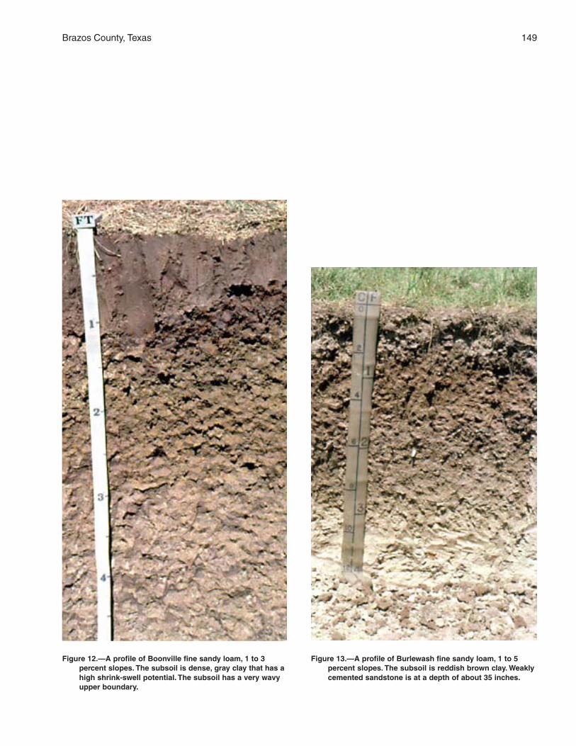
Brazos County, Texas 149
Figure 12.—A profile of Boonville fine sandy loam, 1 to 3percent slopes. The subsoil is dense, gray clay that has ahigh shrink-swell potential. The subsoil has a very wavyupper boundary.
Figure 13.—A profile of Burlewash fine sandy loam, 1 to 5percent slopes. The subsoil is reddish brown clay. Weaklycemented sandstone is at a depth of about 35 inches.
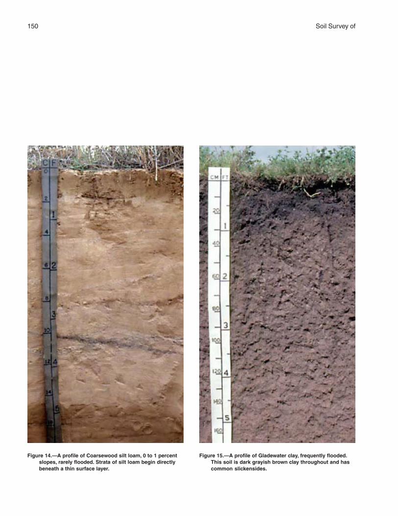
150 Soil Survey of
Figure 14.—A profile of Coarsewood silt loam, 0 to 1 percentslopes, rarely flooded. Strata of silt loam begin directlybeneath a thin surface layer.
Figure 15.—A profile of Gladewater clay, frequently flooded.This soil is dark grayish brown clay throughout and hascommon slickensides.
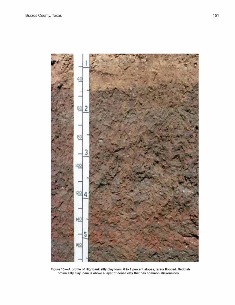
Brazos County, Texas 151
Figure 16.—A profile of Highbank silty clay loam, 0 to 1 percent slopes, rarely flooded. Reddishbrown silty clay loam is above a layer of dense clay that has common slickensides.
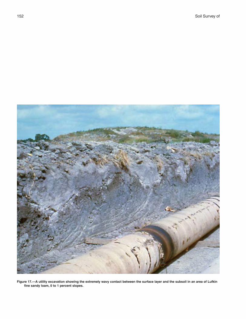
152 Soil Survey of
Figure 17.—A utility excavation showing the extremely wavy contact between the surface layer and the subsoil in an area of Lufkinfine sandy loam, 0 to 1 percent slopes.
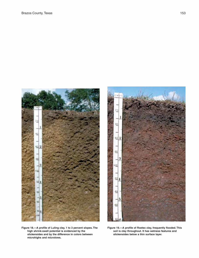
Brazos County, Texas 153
Figure 18.—A profile of Luling clay, 1 to 3 percent slopes. Thehigh shrink-swell potential is evidenced by theslickensides and by the difference in colors betweenmicrohighs and microlows.
Figure 19.—A profile of Roetex clay, frequently flooded. Thissoil is clay throughout. It has wetness features andslickensides below a thin surface layer.
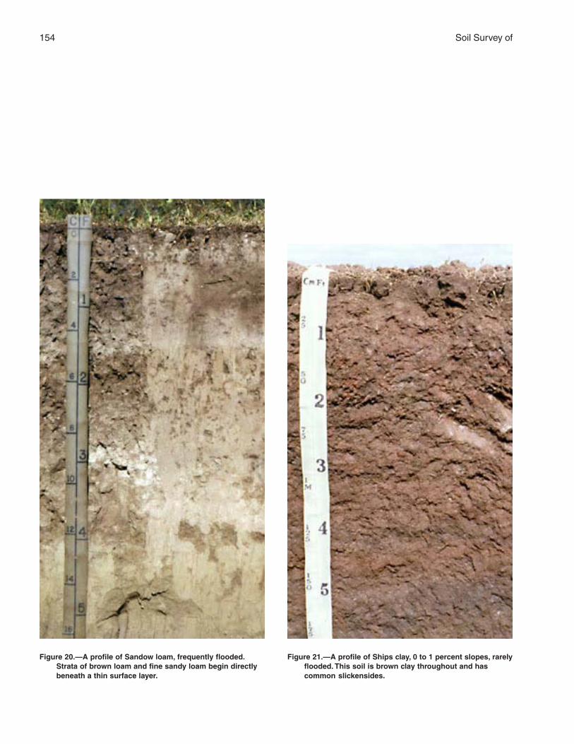
154 Soil Survey of
Figure 20.—A profile of Sandow loam, frequently flooded.Strata of brown loam and fine sandy loam begin directlybeneath a thin surface layer.
Figure 21.—A profile of Ships clay, 0 to 1 percent slopes, rarelyflooded. This soil is brown clay throughout and hascommon slickensides.
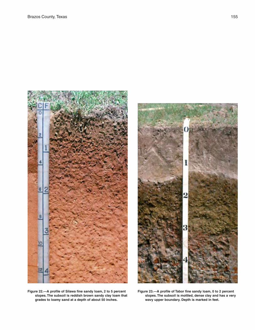
Brazos County, Texas 155
Figure 22.—A profile of Silawa fine sandy loam, 2 to 5 percentslopes. The subsoil is reddish brown sandy clay loam thatgrades to loamy sand at a depth of about 50 inches.
Figure 23.—A profile of Tabor fine sandy loam, 0 to 2 percentslopes. The subsoil is mottled, dense clay and has a verywavy upper boundary. Depth is marked in feet.
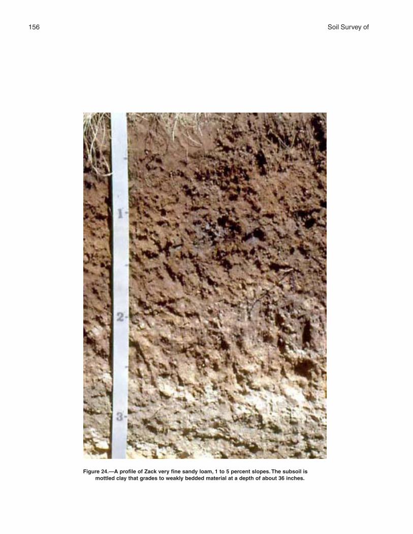
156 Soil Survey of
Figure 24.—A profile of Zack very fine sandy loam, 1 to 5 percent slopes. The subsoil ismottled clay that grades to weakly bedded material at a depth of about 36 inches.
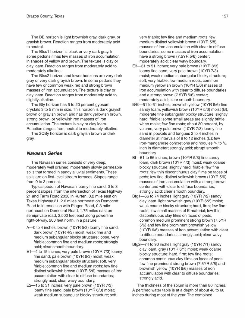
Brazos County, Texas 157
The BE horizon is light brownish gray, dark gray, orgrayish brown. Reaction ranges from moderately acidto neutral.
The Btss1 horizon is black or very dark gray. Insome pedons it has few masses of iron accumulationin shades of yellow and brown. The texture is clay orclay loam. Reaction ranges from moderately acid tomoderately alkaline.
The Btss2 horizon and lower horizons are very darkgray or very dark grayish brown. In some pedons theyhave few or common weak red and strong brownmasses of iron accumulation. The texture is clay orclay loam. Reaction ranges from moderately acid toslightly alkaline.
The Bty horizon has 5 to 20 percent gypsumcrystals 3 to 5 mm in size. This horizon is dark grayishbrown or grayish brown and has dark yellowish brown,strong brown, or yellowish red masses of ironaccumulation. The texture is clay or clay loam.Reaction ranges from neutral to moderately alkaline.
The 2CBy horizon is dark grayish brown or darkgray.
Navasan Series
The Navasan series consists of very deep,moderately well drained, moderately slowly permeablesoils that formed in sandy alluvial sediments. Thesesoils are on first-level stream terraces. Slopes rangefrom 0 to 3 percent.
Typical pedon of Navasan loamy fine sand, 0 to 3percent slopes; from the intersection of Texas Highway21 and Farm Road 2038 in Kurten, 0.2 mile east onTexas Highway 21, 2.6 miles northeast on DemocratRoad to intersection with Plagen Road, 0.3 milenortheast on Democrat Road, 1.75 miles east onsemiprivate road, 2,500 feet east along powerlineright-of-way, 200 feet north, in a pasture:
A—0 to 4 inches; brown (10YR 5/3) loamy fine sand,dark brown (10YR 4/3) moist; weak fine andmedium subangular blocky structure; loose, veryfriable; common fine and medium roots; stronglyacid; clear smooth boundary.
E1—4 to 15 inches; very pale brown (10YR 7/3) loamyfine sand, pale brown (10YR 6/3) moist; weakmedium subangular blocky structure; soft, veryfriable; common fine and medium roots; few finedistinct yellowish brown (10YR 5/6) masses of ironaccumulation with clear to diffuse boundaries;strongly acid; clear wavy boundary.
E2—15 to 31 inches; very pale brown (10YR 7/3)loamy fine sand, pale brown (10YR 6/3) moist;weak medium subangular blocky structure; soft,
very friable; few fine and medium roots; fewmedium distinct yellowish brown (10YR 5/8)masses of iron accumulation with clear to diffuseboundaries; some masses of iron accumulationhave a strong brown (7.5YR 5/6) center;moderately acid; clear wavy boundary.
E3—31 to 51 inches; very pale brown (10YR 8/3)loamy fine sand, very pale brown (10YR 7/3)moist; weak medium subangular blocky structure;soft, very friable; few medium roots; commonmedium yellowish brown (10YR 5/6) masses ofiron accumulation with clear to diffuse boundariesand a strong brown (7.5YR 5/6) center;moderately acid; clear smooth boundary.
B/E—51 to 61 inches; brownish yellow (10YR 6/6) finesandy loam, yellowish brown (10YR 5/6) moist (B);moderate fine subangular blocky structure; slightlyhard, friable; some small areas are slightly brittlewhen moist; few fine roots; about 30 percent, byvolume, very pale brown (10YR 7/3) loamy finesand in pockets and tongues 2 to 4 inches indiameter at intervals of 8 to 12 inches (E); fewiron-manganese concretions and nodules 1/4 to 1/2inch in diameter; strongly acid; abrupt smoothboundary.
Bt—61 to 66 inches; brown (10YR 5/3) fine sandyloam, dark brown (10YR 4/3) moist; weak coarseblocky structure; slightly hard, friable; few fineroots; few thin discontinuous clay films on faces ofpeds; few fine distinct yellowish brown (10YR 5/6)masses of iron accumulation with a strong browncenter and with clear to diffuse boundaries;strongly acid; clear smooth boundary.
Btg1—66 to 74 inches; light gray (10YR 7/2) sandyclay loam, light brownish gray (10YR 6/2) moist;weak coarse blocky structure; hard, firm; few fineroots; few small masses of E material; few thindiscontinuous clay films on faces of peds;common medium prominent strong brown (7.5YR5/6) and few fine prominent brownish yellow(10YR 6/6) masses of iron accumulation with clearto diffuse boundaries; strongly acid; clear wavyboundary.
Btg2—74 to 90 inches; light gray (10YR 7/1) sandyclay loam, gray (10YR 6/1) moist; weak coarseblocky structure; hard, firm; few fine roots;common continuous clay films on faces of peds;few fine prominent strong brown (7.5YR 5/6) andbrownish yellow (10YR 6/6) masses of ironaccumulation with clear to diffuse boundaries;strongly acid.
The thickness of the solum is more than 80 inches.A perched water table is at a depth of about 48 to 60inches during most of the year. The combined
158 Soil Survey of
thickness of the A and E horizons ranges from 40 to60 inches. Redoximorphic features are considered tobe contemporary.
The A or Ap horizon is brown or grayish brown. Ithas yellowish brown or brownish yellow masses of ironaccumulation in some pedons. Reaction ranges fromstrongly acid to neutral.
The E horizon is very pale brown, pale brown, orlight yellowish brown. In most pedons the lower part ofthis horizon has few or common brownish andyellowish masses of iron accumulation. Reaction in theE horizon ranges from strongly acid to neutral. Thetexture is loamy fine sand or loamy sand.
The E/B or B/E horizon consists of masses,interfingers, and tongues of material that arecontinuous and contain isolated masses of B material.The E part of the horizon is very pale brown or palebrown. The B material is yellowish brown or brownishyellow. The texture in the B part is fine sandy loam,sandy clay loam, or loam. Reaction ranges from verystrongly acid to moderately acid. In most pedons thelower part of the E/B horizon contains few or commonfine or medium pebbles.
The Bt horizon is yellowish brown, brown, orbrownish yellow. It has few or common masses of ironaccumulation in shades of brown and yellow. Irondepletions in shades of gray are in some pedons. Thetexture is sandy loam or fine sandy loam. Reactionranges from very strongly acid to moderately acid.
The Btg horizon has grayish matrix colors and fewto many masses of iron accumulation in shades ofbrown and yellow. Some pedons have iron depletionsin shades of gray. Some pedons have a mixed matrixwith these colors. The texture is sandy clay loam orclay loam. Reaction is strongly acid or moderatelyacid.
Padina Series
The Padina series consists of very deep, welldrained, moderately permeable soils that formed inthick sandy beds. These soils are on uplands andPleistocene terraces. Slopes range from 1 to 5percent.
Typical pedon of Padina loamy fine sand, 1 to 5percent slopes, in northeastern Brazos County; fromthe intersection of Texas Highway 21 and Farm Road2038 at Kurten, 5.5 miles southeast on Farm Road2038, 0.3 mile southwest on Cobb Road, 0.2 mile easton private road, 200 feet north of road, in a pasture:
A—0 to 8 inches; light yellowish brown (10YR 6/4)loamy fine sand, yellowish brown (10YR 5/4)moist; single grained; loose; common fine and
medium roots; moderately acid; clear smoothboundary.
E—8 to 62 inches; very pale brown (10YR 7/4) loamyfine sand, light yellowish brown (10YR 6/4) moist;single grained; loose; few fine roots; moderatelyacid; gradual smooth boundary.
B/E—62 to 71 inches; yellowish brown (10YR 5/6) finesandy loam; about 40 percent light yellowishbrown (10YR 6/4) loamy fine sand (E); weakmedium subangular blocky structure; slightly hard,firm; few fine roots; few discontinuous clay films;common medium distinct yellowish red (5YR 5/6)masses of iron accumulation with clear to diffuseboundaries; strongly acid; gradual smooth boundary.
Bt—71 to 82 inches; mixed light gray (10YR 7/2),yellowish red (5YR 4/6), and red (2.5YR 4/6)sandy clay loam; moderate medium subangularblocky structure; hard, firm; few fine roots;common discontinuous clay films; strongly acid.
The thickness of the solum is more than 80 inches.These soils may become saturated in the lower part ofthe profile for short periods after heavy rains and maydevelop aquic conditions in years that are much wetterthan normal. The combined thickness of the A and Ehorizons ranges from 40 to 65 inches.
The A horizon is dark grayish brown, dark brown,brown, pale brown, dark yellowish brown, lightyellowish brown, yellowish brown, very pale brown,grayish brown, or light brownish gray. Reaction rangesfrom moderately acid to neutral.
The E horizon is light yellowish brown, pale brown,very pale brown, or brown. Reaction ranges frommoderately acid to neutral. The boundary between theA and Bt1 horizons is wavy or irregular.
The Bt horizon is light gray, brownish yellow, yellowishbrown, or yellowish red. It has few or common massesof iron accumulation in shades of brown and yellow. Irondepletions in shades of gray are in some pedons. Thetexture is fine sandy loam or sandy clay loam, and thecontent of clay ranges from 18 to 35 percent. Reactionranges from strongly acid to slightly acid.
The BC horizon, if it occurs, is mixed yellowish red,red, light gray, and brownish yellow. The texture issandy clay loam or fine sandy loam. Reaction rangesfrom slightly acid to strongly acid.
Rader Series
The Rader series consists of very deep, moderatelywell drained, very slowly permeable soils that formedin loamy and sandy alluvial sediments. These soils areon terraces and on upland valley fills. Slopes rangefrom 0 to 3 percent.
Brazos County, Texas 159
Typical pedon of Rader fine sandy loam, 0 to 2percent slopes, in eastern Brazos County; from theintersection of Farm Road 2038 and Texas Highway21 at Kurten, 3.8 miles east on Farm Road 2038, 0.5mile north, 0.6 mile east, and 0.1 mile north on countyroad, 200 feet west of road; in a pasture:
A—0 to 11 inches; brown (10YR 5/3) fine sandy loam,brown (10YR 4/3) moist; weak fine subangularblocky structure; slightly hard, friable; many fineand medium roots; common fine faint dark grayishbrown and dark yellowish brown masses of ironaccumulation with clear to diffuse boundaries;slightly acid; clear wavy boundary.
E—11 to 17 inches; very pale brown (10YR 7/4) finesandy loam, light yellowish brown (10YR 6/4)moist; weak fine subangular blocky structure;slightly hard, friable; many fine roots; few fineyellowish brown masses of iron accumulation withclear to diffuse boundaries; moderately acid;gradual wavy boundary.
Bt/E—17 to 28 inches; yellowish brown (10YR 5/6)sandy clay loam; 10 to 20 percent very pale brown(10YR 7/4) albic materials (E); weak finesubangular blocky structure; hard, firm; few fineroots; few discontinuous clay films on faces ofpeds; common medium distinct light yellowishbrown (10YR 6/4) and few fine distinct red (2.5YR4/8) masses of iron accumulation with clear todiffuse boundaries; strongly acid; gradual wavyboundary.
Bt1—28 to 35 inches; yellowish brown (10YR 5/6) clay;moderate medium subangular blocky structure;very hard, very firm, sticky and plastic; few fineroots; few discontinuous clay films on faces ofpeds; many fine distinct grayish brown (10YR 5/2)iron depletions and common medium distinct red(2.5YR 4/8) masses of iron accumulation withclear to diffuse boundaries; strongly acid; gradualwavy boundary.
Bt2—35 to 48 inches; yellowish brown (10YR 5/6) clayloam; weak medium subangular blocky structure;very hard, very firm, sticky and plastic; few fineroots; few discontinuous clay films; many mediumdistinct light gray (10YR 6/1) iron depletions andfew medium distinct red (2.5YR 4/6) masses ofiron accumulation with clear to diffuse boundaries;slightly acid; gradual wavy boundary.
BCt—48 to 65 inches; gray (10YR 6/1) clay loam;weak medium subangular blocky structure; hard,firm; few discontinuous clay films; few sand coatsalong faces of peds; common medium distinctyellowish brown (10YR 5/6) and red (2.5YR 4/6)masses of iron accumulation; slightly alkaline.
The thickness of the solum is more than 80 inches.The content of clay in the control section ranges from28 to 35 percent. These soils have aquic conditionsduring most years. Masses of iron accumulation andiron depletions are considered to be contemporaryredoximorphic features.
The A horizon is dark grayish brown, dark brown,dark yellowish brown, brown, grayish brown, oryellowish brown. Reaction is moderately acid orslightly acid.
The E horizon is light brownish gray, pale brown,light yellowish brown, very pale brown, or light gray.Reaction is moderately acid or slightly acid.
The Bt/E horizon is yellowish brown or lightyellowish brown and has red or yellowish red massesof iron accumulation. The E material ranges from 5 toabout 20 percent. The texture is loam, sandy clayloam, or clay loam. Reaction is strongly acid ormoderately acid.
The Bt horizon is yellowish brown or light yellowishbrown and has masses of iron accumulation in shadesof yellow, brown, or red and iron depletions in shadesof gray. The texture is clay, clay loam, or sandy clayloam. Reaction ranges from very strongly acid toslightly alkaline.
The BCt horizon is shades of gray or brown.Masses of iron accumulation are shades of yellow,brown, or red. The texture is clay, clay loam, or sandyclay loam. Reaction ranges from strongly acid toslightly alkaline. In some pedons the lower part has afew masses or concretions of calcium carbonate.
Rehburg Series
The Rehburg series consists of deep, moderatelywell drained, very slowly permeable soils that formedin stratified, compact tuffaceous materials andsandstone. These soils are on uplands. Slopes rangefrom 1 to 5 percent.
Typical pedon of Rehburg loamy fine sand, 1 to 5percent slopes, in southeastern Brazos County; fromthe intersection of Texas Highway 6 and TexasBusiness 6 south of College Station, 1.9 miles southon Texas Highway 6 to Greens Prairie Road, 1.7 milesnortheast on Greens Prairie Road, 2.9 miles east onRock Prairie Road, 300 feet east of road, in a pasture:
A—0 to 12 inches; brown (7.5YR 5/2) loamy fine sand,dark brown (7.5YR 4/2) moist; single grained;loose, very friable; common fine and mediumroots; few fine siliceous pebbles; moderately acid;clear wavy boundary.
E—12 to 24 inches; pinkish gray (7.5YR 6/2) loamy
160 Soil Survey of
fine sand, brown (7.5YR 5/2) moist; single grained;loose, very friable; common fine and mediumroots; few siliceous pebbles; moderately acid;abrupt smooth boundary.
Bt—24 to 35 inches; grayish brown (10YR 5/2) clayloam; moderate medium subangular blockystructure; hard, very firm, very sticky and veryplastic; few fine roots; common discontinuous clayfilms; common medium distinct gray (10YR 5/1)iron depletions with clear to diffuse boundaries;few siliceous pebbles; strongly acid; gradual wavyboundary.
BCt—35 to 46 inches; light brownish gray (10YR 6/2)sandy clay loam; weak medium blocky structure;very hard, extremely firm; few fine roots; fewdiscontinuous clay films; common medium distinctlight brownish gray iron depletions and brownishyellow masses of iron accumulation with clear todiffuse boundaries; few fine siliceous pebbles;strongly acid; gradual wavy boundary.
Cr—46 to 60 inches; very pale brown (10YR 7/3) andyellow (10YR 7/6), thinly bedded tuffaceous clayloam and sandstone; extremely hard, firm; stronglyacid.
The thickness of the solum and the depth toparalithic contact range from 40 to 60 inches. Thecombined thickness of the A and E horizons rangesfrom 20 to 36 inches. These soils have aquicconditions during most years. Masses of ironaccumulation and iron depletions are considered to becontemporary redoximorphic features.
The A and E horizons are brown, light gray, pinkishgray, or gray. Reaction ranges from strongly acid toneutral.
The Bt horizon is light brownish gray or grayishbrown. It has few to many masses of iron accumulationin shades of yellow, brown, and red. The texture is clayloam or sandy clay. The content of clay in the particle-size control section ranges from 25 to 35 percent.Reaction ranges from strongly acid to slightly acid.
The BCt horizon has redoximorphic features inshades of red and brown. The texture is sandy clayloam or clay loam. Reaction ranges from strongly acidto slightly acid.
The Cr horizon is weakly to strongly cementedsandstone or compact tuffaceous clays that aremassive.
Robco Series
The Robco series consists of very deep,moderately well drained, slowly permeable, sandysoils that formed in loamy sediments. These soils are
on uplands and Pleistocene terraces. Slopes rangefrom 1 to 3 percent.
Typical pedon of Robco loamy fine sand, 1 to 3percent slopes, in northern Brazos County; from theintersection of Texas Highway 21 and Farm Road2038 at Kurten, 0.9 mile north on Farm Road 2038,0.3 mile west on Kurten Cemetery Road, 0.1 milesouth to cemetery entrance, 0.1 mile south on privateroad along the east side of the cemetery, 200 feetsouthwest of the southeast corner of cemetery, in apasture:
A—0 to 15 inches; brown (10YR 5/3) loamy fine sand,brown (10YR 4/3) moist; single grained; loose,very friable; many fine grass roots; slightly acid;clear smooth boundary.
E—15 to 28 inches; pale brown (10YR 6/3) loamy finesand, brown (10YR 5/3) moist; single grained;loose, very friable; many fine grass roots;moderately acid; gradual wavy boundary.
Bt/E—28 to 33 inches; brownish yellow (10YR 6/6)sandy clay loam, yellowish brown (10YR 5/6)moist (Bt); 40 percent tongues of light gray (10YR7/2) loamy fine sand (E); moderate mediumsubangular blocky structure; slightly hard, friable;common fine roots; few fine pores; fewdiscontinuous clay films; few fine distinct light gray(10YR 7/2) iron depletions with clear to diffuseboundaries; moderately acid; gradual wavyboundary.
Btg1—33 to 47 inches; light gray (10YR 7/2) sandyclay loam; moderate medium subangular blockystructure; hard, firm; few fine roots; few fine pores;few discontinuous clay films; common coarse red(2.5YR 4/6) and yellowish brown (10YR 5/6)masses of iron accumulation; strongly acid;gradual wavy boundary.
Btg2—47 to 65 inches; light gray (10YR 7/2) clayloam, light brownish gray (10YR 6/2) moist; weakmedium subangular blocky structure; very hard,very firm; few fine roots; many medium prominentred (10R 4/6) masses of iron accumulation withclear to diffuse boundaries; strongly acid; gradualwavy boundary.
BCt—65 to 82 inches; red (2.5YR 4/6) sandy clayloam; weak medium subangular blocky structure(some of the red material is structureless); hard,friable; few discontinuous clay films; many mediumprominent light gray (10YR 7/2) iron depletionswith clear to diffuse boundaries; strongly acid.
The thickness of the solum ranges from 60 to morethan 80 inches. The average clay content in the upper20 inches of the argillic horizon is 25 to 35 percent.These soils have aquic conditions during most years.
Brazos County, Texas 161
Masses of iron accumulation and iron depletions areconsidered to be contemporary redoximorphicfeatures.
The A horizon is brown, dark yellowish brown, orpale brown. It ranges from 20 to 40 inches inthickness. Reaction ranges from strongly acid toslightly acid.
The E horizon is pale brown, brown, or lightbrownish gray. In some pedons it has few or commonredoximorphic features in shades of gray or yellow.Reaction ranges from very strongly acid to moderatelyacid.
The Bt/E horizon is 60 to 90 percent Bt material byvolume. The Bt part is brownish yellow, yellowishbrown, or light yellowish brown. The texture is sandyclay loam, loam, or clay loam. The E material consistsof tongues, interfingers, and pockets of light gray, lightgrayish brown, or pale brown. The horizon has fewredoximorphic features in shades of gray, yellow, andred or has a matrix with a mixture of these colors.Reaction ranges from very strongly acid to moderatelyacid.
The Bt horizon is light gray, light brownish gray, orgrayish brown. The horizon has few to manyredoximorphic features in shades of gray, red, yellow,and brown or has a matrix with mixed shades of red,gray, and yellow. The texture is mostly clay loam orsandy clay loam, but the range includes sandy clay.Reaction ranges from very strongly acid to moderatelyacid.
The BCt horizon is shades of red, gray, yellow, orbrown and has few to many redoximorphic features.The texture ranges from sandy clay loam to clay.Reaction ranges from very strongly acid to neutral. Insome pedons the horizon has few or common pocketsof gypsum and other salts.
Roetex Series
The Roetex series consists of very deep, somewhatpoorly drained, very slowly permeable, clayey soilsthat formed in clayey alluvium. These soils are indepressions on the flood plain along the Brazos River.Slopes are 0 to 1 percent.
Typical pedon of Roetex clay, frequently flooded (fig.19); from the intersection of Farm Road 2154 andTexas Highway 6 about 4 miles southeast of Millican,1.3 miles northwest on Farm Road 2154, 0.9 milesouthwest on county road, 800 feet east, in adepression in a field:
A—0 to 15 inches; dark brown (7.5YR 3/2) clay, darkbrown (7.5YR 3/2) moist; weak mediumsubangular blocky structure; extremely hard,
extremely firm; few fine roots; slightly effervescent;moderately alkaline; gradual wavy boundary.
Bss1—15 to 23 inches; dark brown (7.5YR 3/2) clay,dark brown (7.5YR 3/2) moist; streaks of reddishbrown (5YR 4/4); weak medium angular blockystructure; extremely hard, extremely firm; commonfine roots; common medium intersectingslickensides; slightly effervescent; moderatelyalkaline; gradual wavy boundary.
Bss2—23 to 56 inches; reddish brown (5YR 4/4) clay,reddish brown (5YR 4/4) moist; few fine streaks ofbrown (7.5YR 3/2); moderate medium angularblocky structure; extremely hard, extremely firm;common fine roots; common medium intersectingslickensides; few fine distinct dark gray (10YR 4/1)iron depletions with clear to diffuse boundaries;slightly effervescent; moderately alkaline; gradualwavy boundary.
Bss3—56 to 75 inches; reddish brown (5YR 4/3) clay,reddish brown (5YR 4/3) moist; brown material infilled cracks; extremely firm; few fine roots;common medium intersecting slickensides; slightlyeffervescent; moderately alkaline.
The thickness of the solum ranges from 60 to morethan 80 inches. The soils are slightly effervescent andmoderately alkaline throughout. Slickensides thatintersect are common below a depth of about 15inches. The soils crack when dry, but the cracksremain open for less than 90 cumulative days in mostyears. These soils have aquic conditions during mostyears. Iron depletions are considered to becontemporary redoximorphic features.
The A horizon is 10 to 17 inches thick. It is darkbrown, dark reddish brown, or reddish brown.
The Bss horizon is dark brown, dark reddish brown,or reddish brown. It has dark gray and brownredoximorphic features.
Some pedons have a C horizon within a depth of 60to 80 inches. This horizon is shades of red, brown, oryellow. The texture is clay or silty clay with thin strataof loamy materials, or the horizon is stratified withloamy and clayey materials.
Rosanky Series
The Rosanky series consists of very deep, welldrained, very slowly permeable soils that formed instratified loamy and clayey sediments. These soils areon uplands. Slopes range from 1 to 8 percent.
Typical pedon of Rosanky fine sandy loam, 2 to 5percent slopes, in northeastern Brazos County; fromthe intersection of Farm Road 974 and Farm Road2776 about 1.0 mile northeast of Tabor, 1.0 mile south
162 Soil Survey of
on Farm Road 2776, 2.0 miles east on county road,300 feet north of gate, in a wooded pasture:
A—0 to 8 inches; brown (7.5YR 5/4) fine sandy loam,dark brown (7.5YR 4/4) moist; weak finesubangular blocky structure; slightly hard, veryfriable; common fine roots; moderately acid; clearsmooth boundary.
Bt1—8 to 25 inches; red (2.5YR 4/6) clay, dark red(2.5YR 3/6) moist; strong fine subangular blockystructure; very hard, firm; common fine roots; thinclay films on faces of peds; few fine ironstonefragments; moderately acid; gradual smoothboundary.
Bt2—25 to 35 inches; red (2.5YR 4/6) clay, red (2.5YR3/6) moist; moderate medium subangular blockystructure; very hard, firm; few fine roots; thin clayfilms on faces of peds; common medium distinctstrong brown (7.5YR 5/6) masses of ironaccumulation with sharp boundaries; few fineironstone nodules; strongly acid; gradual smoothboundary.
Bt3—35 to 41 inches; red (2.5YR 5/6) clay, dark red(2.5YR 3/6) moist; moderate medium subangularblocky structure; very hard, firm; few fine roots; fewdiscontinuous clay films on faces of peds;common medium distinct pale brown (10YR 6/3)masses of iron accumulation with sharpboundaries; very strongly acid; gradual smoothboundary.
BCt—41 to 48 inches; red (2.5YR 5/6) sandy clayloam, red (2.5YR 4/6) moist; moderate mediumsubangular blocky structure; hard, friable; few fineroots; few discontinuous clay films on faces ofpeds; common medium distinct very pale brown(10YR 7/4) masses of iron accumulation withsharp boundaries; very strongly acid; abrupt wavyboundary.
C—48 to 65 inches; dark reddish brown (2.5YR 3/4)clay loam stratified with light gray and reddishyellow; rocklike structure with finely dividedfractures; very strongly acid; clear wavy boundary.
Cr—65 to 80 inches; stratified dark reddish brown,light gray, and reddish yellow, weakly cementedsandstone interbedded with gray clay; verystrongly acid.
The thickness of the solum ranges from 40 to 60inches. Some pedons contain as much as 5 percentironstone fragments. Masses of iron accumulation areconsidered to be relict redoximorphic features.
The A horizon averages less than 10 inches inthickness but ranges from 3 to 12 inches. This horizonis dark brown, dark yellowish brown, very dark grayish
brown, brown, or yellowish brown. Reaction rangesfrom strongly acid to neutral.
The Bt horizon is dark red, dark reddish brown, red,light red, yellowish red, or reddish brown. The textureis clay or clay loam, and the content of clay rangesfrom 35 to 50 percent. Reaction ranges from verystrongly acid to moderately acid.
The BCt horizon is brown, light yellowish brown,light gray, grayish brown, yellowish brown, lightbrownish gray, yellowish red, or red. Reaction rangesfrom very strongly acid to neutral.
The C horizon is dark reddish brown, light gray, orreddish yellow. The texture is clay, sandy clay loam, orfine sandy loam, but the horizon may be stratified withironstone or shale. Reaction is very strongly acid orstrongly acid.
The Cr horizon is at a depth of 60 to 70 inches inmost pedons.
Sandow Series
The Sandow series consists of very deep,moderately well drained, moderately slowly permeablesoils that formed in loamy sediments. These soils areon natural levees on flood plains. Slopes are 0 to 1percent.
Typical pedon of Sandow loam, frequently flooded(fig. 20); from the intersection of Texas Highway 21and Farm Road 2818 on the west edge of Bryan, 1.8miles west on Texas Highway 21, 0.2 mile south onranch road, 200 feet northwest of road, in a pasture:
A1—0 to 6 inches; grayish brown (10YR 5/2) loam,very dark grayish brown (10YR 3/2) moist; weakmedium subangular blocky structure parting toweak very fine subangular blocky; extremely hard,very firm; few fine pores; common fine andmedium roots; slightly acid; clear smoothboundary.
A2—6 to 15 inches; grayish brown (10YR 5/2) loam,dark grayish brown (10YR 4/2) moist; weakmedium subangular blocky structure parting toweak very fine subangular blocky; hard, firm;common fine and medium roots; common fine andmedium pores; few fine faint yellowish brown(10YR 5/4) masses of iron accumulation with clearto diffuse boundaries; slightly acid; abrupt smoothboundary.
Bw—15 to 20 inches; pale brown (10YR 6/3) finesandy loam, brown (10YR 5/3) moist; weak fineand medium subangular blocky structure; hard,firm; few fine and medium roots; few fine andmedium pores; few fine faint yellowish brown
Brazos County, Texas 163
(10YR 5/4) masses of iron accumulation with clearto diffuse boundaries; slightly acid; abrupt smoothboundary.
Ab—20 to 28 inches; brown (10YR 4/3) sandy clayloam, brown (10YR 4/3) moist; weak very coarseprismatic structure; very hard, very firm; few fineand medium roots; few fine and medium pores;few fine faint yellowish brown (10YR 5/4) massesof iron accumulation with clear to diffuseboundaries; slightly acid; gradual smoothboundary.
Bwb1—28 to 34 inches; grayish brown (10YR 5/2)sandy clay loam, dark grayish brown (10YR 4/2)moist; moderate coarse angular blocky structure;very hard, very firm; few fine and medium roots;few fine and medium pores; few faint white (10YR8/2) clean sand coats on vertical faces of peds;few fine faint yellowish brown (10YR 5/4) massesof iron accumulation with clear to diffuseboundaries; moderately acid; gradual smoothboundary.
Bwb2—34 to 41 inches; pale brown (10YR 6/3) sandyclay loam, brown (10YR 5/3) moist; moderatecoarse prismatic structure parting to weak coarseangular blocky; very hard, very firm; few fine andmedium roots; few fine and medium pores; manyprominent white (10YR 8/2) sand coats on mostvertical faces of prisms; few fine faint yellowishbrown (10YR 5/4) masses of iron accumulationwith clear to diffuse boundaries; slightly acid;gradual smooth boundary.
BCb—41 to 46 inches; pale brown (10YR 6/3) finesandy loam, brown (10YR 5/3) moist; weak coarseprismatic structure parting to weak coarse angularblocky; very hard, firm; few fine and medium roots;few fine and medium pores; few fine black iron-manganese stains along root channels; few finefaint yellowish brown (10YR 5/4) masses of ironaccumulation with clear to diffuse boundaries;slightly acid; clear smooth boundary.
A´b—46 to 54 inches; pale brown (10YR 6/3) finesandy loam, brown (10YR 5/3) moist; weakmedium and coarse subangular blocky structure;slightly hard, friable; few fine and medium roots;few fine and medium pores; few fine iron-manganese stains along root channels; few finedistinct light olive brown (2.5Y 5/6) masses of ironaccumulation with clear to diffuse boundaries;moderately acid; clear smooth boundary.
Btgb—54 to 80 inches; pale brown (10YR 6/3) finesandy loam, brown (10YR 5/3) moist; weak coarseprismatic structure parting to weak coarse angularblocky; slightly hard, friable; few fine and mediumroots; few fine and medium pores; many thin
continuous dark gray (10YR 4/1) clay films onvertical faces of peds; few fine black concretions;few medium barite segregations on faces of peds;slightly acid.
The thickness of the solum is more than 80 inches.The content of clay in the particle-size control sectionranges from 18 to 35 percent. These soils do notremain saturated long enough to develop aquicconditions above a depth of 40 inches, except in yearsthat are much wetter than normal. Masses of ironaccumulation are considered to be both relict andcontemporary redoximorphic features.
The A1 horizon is less than 10 inches thick. It isgrayish brown, dark grayish brown, or dark brown.Reaction ranges from moderately acid to neutral.
The A2 horizon is loam or fine sandy loam.Reaction ranges from moderately acid to neutral.
The Bw horizon is brown, grayish brown, lightbrownish gray, or pale brown. The texture is loam orfine sandy loam. Reaction ranges from moderatelyacid to neutral.
The Ab horizon, if it occurs, is brown, dark grayishbrown, or very dark grayish brown.
The buried B horizon, if it occurs, is grayish brown,light brownish gray, brown, or dark brown. In somepedons it has few or common masses of ironaccumulation in shades of brown or thin silty strata ofbrown and pale brown. The horizon is fine sandy loam,sandy clay loam, or clay loam. Reaction ranges frommoderately acid to neutral.
Shalba Series
The Shalba series consists of shallow, moderatelywell drained, very slowly permeable soils that formedin weakly cemented, tuffaceous, fine grainedsandstone. These soils are on uplands. Slopes rangefrom 2 to 6 percent.
Typical pedon of Shalba fine sandy loam, in an areaof Shalba-Rock outcrop complex, 2 to 6 percentslopes, in southern Brazos County; from theintersection of Texas Highway 6 and Farm Road 159about 3 miles east of Millican, 2.7 miles south onTexas Highway 6, 0.6 mile west on Westward HoRoad, 0.8 mile west and north on Chisolm Trail Road,0.2 mile east on county road, 300 feet north, in anarea of rangeland:
A—0 to 4 inches; light brownish gray (10YR 6/2) finesandy loam, grayish brown (10YR 5/2) moist;massive; hard, firm; common fine roots;moderately acid; abrupt wavy boundary.
Bt1—4 to 12 inches; grayish brown (10YR 5/2) clay,
164 Soil Survey of
dark grayish brown (10YR 4/2) moist; moderatemedium subangular blocky structure; very hard,extremely firm; common fine roots; fewdiscontinuous clay films; strongly acid; gradualwavy boundary.
Bt2—12 to 18 inches; dark grayish brown (10YR 4/2)clay; weak medium subangular blocky structure;very hard, extremely firm; few fine roots; fewdiscontinuous clay films; common medium distinctlight gray iron depletions with sharp boundaries;moderately acid; clear wavy boundary.
Cr—18 to 30 inches; white (10YR 8/2) siltstone, lightgray (10YR 7/2) moist; rock structure; extremelyhard, extremely firm.
The thickness of the solum and the depth toparalithic contact range from 14 to 20 inches. Matrixcolors with low chroma are inherited from the parentmaterial. Iron depletions are considered to be relictredoximorphic features.
The A horizon is light gray, gray, or light brownishgray. Reaction ranges from very strongly acid tomoderately acid.
The Bt horizon is grayish brown, dark grayishbrown, or dark gray. It has few or common ped coatsof very dark gray, dark gray, and very dark grayishbrown. Reaction ranges from very strongly acid tomoderately acid. The lower boundary of the Bt horizonis wavy or irregular.
The Cr horizon is clayey tuff, tuffaceous sandstone,siltstone, or tuffaceous clay. The texture is fine sandyloam or clay loam.
Ships Series
The Ships series consists of very deep, moderatelywell drained, very slowly permeable soils that formedin thick, clayey alluvial sediments. These soils are onthe flood plain along the Brazos River. Slopes rangefrom 0 to 5 percent.
Typical pedon of Ships clay, 0 to 1 percent slopes,rarely flooded (fig. 21), in western Brazos County; fromthe intersection of Old San Antonio Road (OSR) andFarm Road 1687 about 5 miles west of Bryan, 1.8miles west on Farm Road 1687, 1.0 mile south onSims Cutoff Road, 1.0 mile west on Sims Road, 0.1mile north on private road, then 200 feet east, in acultivated field:
Ap—0 to 8 inches; reddish brown (5YR 4/3) clay, darkreddish brown (5YR 3/3) moist; moderate mediumgranular structure; very hard, extremely firm, verysticky and very plastic; few fine roots; stronglyeffervescent; moderately alkaline; abrupt smoothboundary.
A—8 to 15 inches; reddish brown (5YR 5/4) clay,reddish brown (5YR 4/4) moist; moderate mediumangular blocky structure; common fine pressurefaces; very hard, very firm, very sticky and veryplastic; few fine roots; strongly effervescent;moderately alkaline; gradual wavy boundary.
Bss1—15 to 32 inches; reddish brown (5YR 5/4) clay,reddish brown (5YR 5/4) moist; weak mediumangular blocky structure; very hard, very firm, verysticky and very plastic; few fine roots; commonintersecting slickensides; few vertical cracks filledwith darker soil material from the horizon above;strongly effervescent; moderately alkaline; gradualwavy boundary.
Bss2—32 to 47 inches; brown (7.5YR 4/4) clay, brown(7.5YR 4/4) moist; many coarse distinct streaks orcrack fillings of reddish brown (5YR 5/4); weakmedium angular blocky structure; very hard, veryfirm, very sticky and very plastic; few fine roots;few calcium carbonate concretions; commonintersecting slickensides; few vertical cracks filledwith darker soil material from the horizons above;strongly effervescent; moderately alkaline; gradualwavy boundary.
Bss3—47 to 80 inches; reddish brown (2.5YR 4/4)clay, reddish brown (2.5YR 4/4) moist; commonmedium distinct streaks of reddish brown (5YR5/4) and dark reddish brown (5YR 3/3); weakmedium angular blocky structure; few fine roots;few calcium carbonate concretions; commonintersecting slickensides; strongly effervescent;moderately alkaline.
The thickness of the solum is more than 80 inches.When the soils are dry, cracks form at the surface. Thecracks are more than 1 cm wide and extend to a depthof 40 inches or more. The soils are moderately alkalineand strongly effervescent throughout.
The combined thickness of the A horizons rangesfrom 15 to 40 inches. These horizons are reddishbrown, dark reddish brown, dark reddish gray, or darkbrown.
The Bss horizon is reddish brown, dark reddishbrown, or brown. The texture is clay or silty clay.
Shiro Series
The Shiro series consists of moderately deep, welldrained, slowly permeable soils on uplands. Thesesoils formed in tuffaceous sandstone and siltstone.Slopes range from 1 to 3 percent.
Typical pedon of Shiro loamy fine sand, 1 to 3percent slopes, in southern Brazos County; from theintersection of Texas Highway 6 and Texas Business 6
Brazos County, Texas 165
in College Station, 1.9 miles south on Texas Highway6, 0.9 mile east on Greens Prairie Road, 1,200 feetsouth, in an area of rangeland:
A—0 to 6 inches; pinkish gray (7.5YR 6/2) loamy finesand, brown (7.5YR 5/2) moist; weak finesubangular blocky structure; loose, very friable;common fine roots; about 5 percent siliceouspebbles; moderately acid; clear wavy boundary.
E—6 to 15 inches; pinkish gray (7.5YR 7/2) loamy finesand, pinkish gray (7.5YR 6/2) moist; weak finesubangular blocky structure; loose, very friable;common fine roots; about 5 percent siliceouspebbles; moderately acid; abrupt wavy boundary.
Bt1—15 to 24 inches; reddish brown (2.5YR 5/4) clay,reddish brown (2.5YR 4/4) moist; moderatemedium blocky structure; extremely hard,extremely firm; common fine and medium roots;few siliceous pebbles; clay films on faces of peds;common medium prominent light brownish gray(10YR 6/2) iron depletions with sharp boundaries;moderately acid; gradual wavy boundary.
Bt2—24 to 34 inches; light brownish gray (10YR 6/2)clay, grayish brown (10YR 5/2) moist; weakmedium blocky structure; extremely hard,extremely firm; few fine roots; clay films on facesof peds; common medium prominent reddishbrown masses of iron accumulation with sharpboundaries; moderately acid; gradual wavyboundary.
Cr—34 to 50 inches; light gray (10YR 7/2) siltstone;common medium distinct yellowish brown, reddishbrown, and red masses of iron accumulation;interbedded tuffaceous sandstone; extremely hard;moderately acid.
The thickness of the solum and the depth to the Crhorizon range from 20 to 40 inches. The combinedthickness of the A and E horizons ranges from 10 to18 inches. Masses of iron accumulation and irondepletions are considered to be relict redoximorphicfeatures.
The A horizon is brown, pinkish gray, light brownishgray, grayish brown, or pale brown. Reaction rangesfrom strongly acid to slightly acid.
The E horizon is pinkish gray, pinkish white, lightbrownish gray, light gray, or pale brown. Reactionranges from strongly acid to slightly acid.
The upper part of the Bt horizon is reddish brown,yellowish red, or red and has common light brownishgray iron depletions. The lower part of the horizon islight brownish gray, light gray, or grayish brown andhas redoximorphic features in shades of red, yellow,and gray. The Bt horizon is clay, sandy clay, or clay
loam. Reaction ranges from very strongly acid toneutral.
The Cr horizon is weakly to strongly cemented,tuffaceous sandstone or siltstone that is interbeddedwith shale in some pedons.
Silawa Series
The Silawa series consists of very deep, welldrained, moderately permeable soils on streamterraces. These soils formed in sandy and loamyalluvial sediments. Slopes range from 2 to 8 percent.
Typical pedon of Silawa fine sandy loam (fig. 22), 5to 8 percent slopes, in southwestern Brazos County;from the intersection of Farm Road 2154 and KoppeBridge Road in Wellborn, 4.4 miles on Koppe BridgeRoad, 1,000 feet southeast of road, in an area ofrangeland:
A—0 to 15 inches; brown (7.5YR 5/4) fine sandy loam,brown (7.5YR 4/4) moist; weak fine subangularblocky structure; slightly hard, very friable;common fine roots; few siliceous pebbles; slightlyacid; abrupt smooth boundary.
Bt1—15 to 24 inches; reddish brown (5YR 5/4) sandyclay loam, reddish brown (5YR 4/4) moist;moderate medium prismatic structure parting tomoderate medium subangular blocky; hard, firm;common fine roots; few siliceous pebbles; clayfilms on faces of peds; moderately acid; gradualwavy boundary.
Bt2—24 to 40 inches; red (2.5YR 5/6) sandy clayloam, red (2.5YR 4/6) moist; moderate mediumprismatic structure parting to weak mediumsubangular blocky; very hard, very firm; few fineroots; few discontinuous clay films on faces ofpeds; moderately acid; gradual wavy boundary.
Bt3—40 to 50 inches; red (2.5YR 5/8) sandy clayloam, red (2.5YR 4/8) moist; weak mediumprismatic structure breaking to weak mediumsubangular blocky; hard, firm; few fine roots; fewdiscontinuous clay films on faces of peds; few finesiliceous pebbles; moderately acid; gradual wavyboundary.
BCt—50 to 60 inches; red (2.5YR 5/6) fine sandyloam, red (2.5YR 5/6) moist; single grained;slightly hard, friable; moderately acid.
The thickness of the solum ranges from 40 to 60inches. The clay content decreases from the maximumby more than 20 percent within a depth of 60 inches.Reaction ranges from strongly acid to slightly acidthroughout the profile.
166 Soil Survey of
The A horizon is pinkish gray, grayish brown, lightbrownish gray, brown, or dark grayish brown. Somepedons have an E horizon. This horizon has colorvalues 1 or 2 units higher than those in the A horizon.
The Bt horizon is reddish yellow, yellowish red,reddish brown, light red, or red. The texture is clayloam or sandy clay loam.
The BCt horizon is strong brown, red, reddishyellow, or yellowish red. The texture is sandy clay loamor fine sandy loam.
The C horizon, if it occurs, has colors of reddishyellow, strong brown, yellowish red, yellow, brown, orvery pale brown. The texture is fine sandy loam orloamy fine sand. Strata of sand or gravel are in manypedons.
Singleton Series
The Singleton series consists of moderately deep,moderately well drained, very slowly permeable soilson uplands. These soils formed in tuffaceous siltstoneand sandstone. Slopes range from 1 to 3 percent.
Typical pedon of Singleton fine sandy loam, 1 to 3percent slopes; from the intersection of Texas Highway6 and Texas Business 6 south of College Station, 1.0mile south on Texas Highway 6, 0.2 mile west intosubdivision, 200 feet south along a drainage ditch:
A—0 to 9 inches; light brownish gray (10YR 6/2) finesandy loam, dark grayish brown (10YR 4/2) moist;weak medium subangular blocky structure; hard,friable; many fine roots; slightly acid; abrupt wavyboundary.
Bt1—9 to 17 inches; pale brown (10YR 6/3) clay,brown (10YR 5/3) moist; moderate mediumangular blocky structure; extremely hard,extremely firm; common fine roots; dark grayishbrown (10YR 3/2) clay films on faces of peds;common medium distinct yellowish brown (10YR5/6) masses of iron accumulation with sharpboundaries; very strongly acid; gradual wavyboundary.
Bt2—17 to 28 inches; very pale brown (10YR 7/3) clay,pale brown (10YR 6/3) moist; moderate coarseangular blocky structure; extremely hard, veryfirm; grayish brown (10YR 5/2) clay films on facesof peds; few fine roots; few fine faint brownishyellow (10YR 6/6) masses of iron accumulationwith sharp boundaries; strongly acid; clear wavyboundary.
Cr—28 to 60 inches; stratified white (10YR 8/1),yellowish brown (10YR 5/6), and brown (10YR5/3) siltstone.
The thickness of the solum ranges from 20 to 40
inches. The content of clay in the upper 20 inches ofthe Bt horizon ranges from 35 to 45 percent. When thesoils are dry, small cracks form at the surface. Graycolors are inherited from the parent material. Massesof iron accumulation are considered to be relictredoximorphic features.
The combined thickness of the A and E horizonsranges from 5 to 12 inches. The A horizon is light gray,light brownish gray, grayish brown, brown, or palebrown. The E horizon is light gray or very pale brown.Reaction in these horizons ranges from strongly acidto slightly acid.
The Bt horizon is grayish brown, light brownish gray,brown, or dark grayish brown on ped exteriors andpale brown, brown, dark brown, or light brown on pedinteriors. The horizon is clay or clay loam and has aclay content of 35 to 50 percent. Reaction ranges fromvery strongly acid to moderately acid.
The Cr horizon is weakly cemented, tuffaceoussandstone or siltstone. In some pedons it isinterbedded with clay loam or sandy clay loam.
Spiller Series
The Spiller series consists of very deep, moderatelywell drained, slowly permeable soils on erosionaluplands. These soils formed in thinly stratified, loamyand clayey Tertiary sediments. Slopes range from 1 to5 percent.
Typical pedon of Spiller loamy fine sand, 1 to 3percent slopes, in northern Brazos County; from theintersection of Texas Highway 6 and Farm Road 974 inBryan, 0.9 mile northeast on Farm Road 974, 5.4miles northwest on Farm Road 2223 past BroachRoad, 1,000 feet northeast on oil field road, 600 feetnorthwest on oil field road, 100 feet southwest, in apasture:
Ap—0 to 15 inches; brown (10YR 5/3) loamy finesand, brown (10YR 4/3) moist; weak fine andmedium subangular blocky structure; loose, veryfriable; common fine and medium roots; slightlyacid; clear smooth boundary.
E—15 to 18 inches; light yellowish brown (10YR 6/4)loamy fine sand, yellowish brown (10YR 5/4)moist; weak fine and medium subangular blockystructure; loose, very friable; common fine andmedium roots; slightly acid; clear smoothboundary.
Bt1—18 to 24 inches; brownish yellow (10YR 6/6)sandy clay, yellowish brown (10YR 5/6) moist;strong fine subangular blocky structure; hard,friable, sticky and plastic; common fine roots;many thick continuous dark yellowish brown
Brazos County, Texas 167
(10YR 4/4) clay films on vertical and horizontalfaces of peds; few fine prominent red (2.5YR 5/6)masses of iron accumulation with sharpboundaries; slightly acid; clear smooth boundary.
Bt2—24 to 33 inches; light yellowish brown (10YR 6/4)sandy clay, yellowish brown (10YR 5/4) moist;strong fine and medium subangular blockystructure; hard, friable, sticky and plastic; commonfine roots; many thick continuous light brownishyellow (10YR 6/4) clay films on vertical andhorizontal faces of peds; many medium distinctbrownish yellow (10YR 6/8) and common mediumprominent red (2.5YR 5/8) masses of ironaccumulation with sharp boundaries; moderatelyacid; clear smooth boundary.
Bt3—33 to 43 inches; pale brown (10YR 6/3) sandyclay, brown (10YR 5/3) moist; common distinctlight brownish gray (2.5Y 6/2) mottles; moderatefine and medium subangular blocky structure; veryhard, firm, sticky and plastic; common fine rootsalong faces of peds; many thick continuous palebrown (10YR 6/3) clay films on vertical andhorizontal faces of peds; many medium distinctbrownish yellow (10YR 6/6) masses of ironaccumulation with sharp boundaries and with afine and medium red (2.5YR 5/8) center;moderately acid; clear smooth boundary.
BCt—43 to 54 inches; brownish yellow (10YR 6/8)sandy clay loam, yellowish brown (10YR 5/8)moist; weak fine and medium angular blockystructure; very hard, very firm, sticky and plastic;few fine roots and root traces on faces of peds;common distinct light brownish gray (2.5Y 6/2)shale fragments; common thin clay films on facesof peds; many coarse prominent red (2.5YR 5/8)masses of iron accumulation with sharpboundaries; moderately acid; abrupt smoothboundary.
C—54 to 85 inches; weakly consolidated brownishyellow (10YR 6/8) loamy material with strata oflight brownish gray (2.5Y 6/2} shale 1 to 2 inchesthick; moderately alkaline.
The thickness of the solum ranges from 40 to about60 inches. The content of clay in the particle-sizecontrol section ranges from 35 to 45 percent. Basesaturation throughout the argillic horizon ranges from35 to 75 percent. Some pedons contain as much as 15percent, by volume, ironstone pebbles less than 15mm in size.
The combined thickness of the A and E horizonsranges from 10 to about 20 inches. These horizons aredark brown, brown, pale brown, or light yellowishbrown. Reaction ranges from moderately acid toneutral.
The upper part of the Bt horizon is light yellowishbrown, yellowish brown, brownish yellow, or brown. Itis clay or sandy clay. Reaction ranges from stronglyacid to slightly acid.
The lower part of the Bt horizon is brown, palebrown, light yellowish brown, or yellowish brown. It hasfew to many masses of iron accumulation in shades ofred, yellow, and brown. Some pedons have mottles inshades of gray that are inherited from the parentmaterial. The texture is clay, clay loam, or sandy clay.Reaction ranges from strongly acid to slightly acid.
The BCt horizon is shades of red, brown, yellow, orgray. The texture is sandy clay, clay loam, sandy clayloam, or loam. Reaction ranges from strongly acid toslightly acid.
The C horizon is shades of red, brown, or yellow.The texture is fine sandy loam, loam, or sandy clayloam that has strata of gray shale 1 to 5 inches thick.Reaction ranges from strongly acid to moderatelyalkaline.
Styx Series
The Styx series consists of very deep, well drained,moderately permeable soils on high stream terraces.These soils formed in sandy and loamy alluvialsediments. Slopes range from 1 to 3 percent.
Typical pedon of Styx loamy fine sand, 1 to 3percent slopes, in eastern Brazos County; from theintersection of Texas Highway 21 and Farm Road2038 in Kurten, 5.5 miles southeast on Farm Road2038, 0.3 mile southwest on Cobb Road, 0.2 mile easton private road, 1,000 feet east, in a pasture:
A—0 to 8 inches; yellowish brown (10YR 5/4) loamyfine sand, dark yellowish brown (10YR 4/4) moist;single grained; loose; common fine roots; neutral;gradual smooth boundary.
E—8 to 24 inches; very pale brown (10YR 7/4) loamyfine sand, light yellowish brown (10YR 6/4) moist;single grained; few fine roots; neutral; clear smoothboundary.
Bt1—24 to 30 inches; brownish yellow (10YR 6/6)sandy clay loam, yellowish brown (10YR 5/4)moist; moderate medium subangular blockystructure; hard, firm; few fine roots; clay films onfaces of peds; slightly acid; gradual smoothboundary.
Bt2—30 to 44 inches; red (2.5YR 5/8) sandy clayloam, red (2.5YR 4/8) moist; moderate mediumsubangular blocky structure; hard, firm; few fineroots; discontinuous clay films on faces of peds;common medium distinct light yellowish brown(10YR 6/4) masses of iron accumulation with
168 Soil Survey of
sharp boundaries; few fine distinct light brownishgray (10YR 6/2) iron depletions with sharpboundaries; moderately acid; gradual wavyboundary.
Bt3—44 to 68 inches; red (2.5YR 5/8) sandy clayloam, red (2.5YR 4/8) moist; weak mediumangular blocky structure; hard, firm; few fine roots;common medium distinct brownish yellow (10YR6/6) masses of iron accumulation with sharpboundaries; common medium distinct lightbrownish gray (10YR 6/2) iron depletions withsharp boundaries; moderately acid.
The thickness of the solum ranges from 60 to morethan 80 inches. The combined thickness of the A andE horizons is 20 to 40 inches. Masses of ironaccumulation and iron depletions are considered to beboth relict and contemporary redoximorphic features.
The A horizon is yellowish brown, pale brown,brown, grayish brown, or light gray. The E horizon islight yellowish brown, very pale brown, light brownishgray, light gray, or white. Reaction in the A and Ehorizons ranges from strongly acid to neutral.
The upper part of the Bt horizon is sandy clay loamor clay loam. The average clay content in the upper 20inches ranges from 20 to 35 percent. The horizon islight yellowish brown, brownish yellow, yellowishbrown, strong brown, or reddish yellow. Reactionranges from strongly acid to slightly acid.
The lower part of the Bt horizon has matrix colors inshades of brown, yellow, red, or gray or is mixed withthese colors. Reaction ranges from strongly acid toslightly acid.
The C horizon, if it occurs, is stratified fine sandyloam and sandy clay loam. It is shades of brown oryellow and has masses of iron accumulation in shadesof red. Reaction ranges from strongly acid to neutral.
Tabor Series
The Tabor series consists of very deep, moderatelywell drained, very slowly permeable soils that formedin clayey and loamy alluvial sediments. These soils areon stream terraces and terrace remnants in theuplands. Slopes range from 0 to 3 percent.
Typical pedon of Tabor fine sandy loam, 0 to 2percent slopes (fig. 23); from the intersection of TexasHighway 21 and Texas Highway 6 (east bypass) inBryan, 8.5 miles northeast on Texas Highway 21, 2.9miles east and north on Democrat Road, 0.7 mile easton semiprivate road, 200 feet south, in a pasture:
Ap—0 to 6 inches; pale brown (10YR 6/3) fine sandyloam, brown (10YR 4/3) moist; moderate medium
and fine subangular blocky structure; hard, friable;many fine roots; common medium prominentstrong brown (7.5YR 4/6) masses of ironaccumulation with clear to diffuse boundaries; 5percent siliceous pebbles; strongly acid; clearsmooth boundary.
E—6 to 14 inches; pale brown (10YR 6/3) fine sandyloam, brown (10YR 5/3) moist; moderate mediumand fine subangular blocky structure; hard, friable;many fine roots; common fine distinct darkyellowish brown (10YR 3/4) masses of ironaccumulation with clear to diffuse boundaries; 6percent siliceous pebbles; strongly acid; clearwavy boundary.
Btss1—14 to 23 inches; brown (10YR 5/3) clay, brown(10YR 4/3) moist; moderate medium angularblocky structure; very hard, very firm; commonfine roots; few fine pores; common distinctpressure faces; few distinct slickensides; commonpale brown (10YR 6/3) clay films on faces of peds;common medium prominent dark red (2.5YR 3/6)and common coarse prominent yellowish brown(10YR 5/6) masses of iron accumulation with clearto diffuse boundaries; few siliceous pebbles;strongly acid; gradual wavy boundary.
Btss2—23 to 42 inches; light brownish gray (10YR 6/2)clay, grayish brown (10YR 5/2) moist; weak coarseangular blocky structure; very hard, very firm; fewfine roots; common distinct slickensides; manydistinct pressure faces; few dark grayish brown(10YR 4/2) clay films on vertical faces of peds;many coarse prominent yellowish brown (10YR5/6) and few fine prominent dark red (2.5YR 3/6)masses of iron accumulation with clear to diffuseboundaries; 2 percent siliceous pebbles;moderately acid; clear smooth boundary.
Btss3—42 to 57 inches; brownish yellow (10YR 6/6)clay loam, yellowish brown (10YR 5/6) moist;weak coarse prismatic structure parting tomoderate medium angular blocky; very hard, veryfirm; few fine roots; few fine pores; manycontinuous very dark grayish brown (10YR 3/2)clay films on faces of peds and in pores; fewdistinct slickensides; common distinct pressurefaces; common medium distinct strong brown(7.5YR 4/6) masses of iron accumulation withclear to diffuse boundaries and few fine grayishbrown (10YR 5/2) iron depletions with clear todiffuse boundaries; few siliceous pebbles; neutral;gradual smooth boundary.
Btg—57 to 67 inches; light gray (10YR 7/2) sandy clayloam, light brownish gray (10YR 6/2) moist; weakcoarse prismatic structure parting to weakmedium angular blocky; very hard, very firm; few
Brazos County, Texas 169
fine roots; few fine pores; common continuousvery dark grayish brown (10YR 3/2) clay films onvertical faces of peds; few calcium carbonateconcretions; many medium prominent yellowishbrown (10YR 5/6) and common medium distinctred (2.5YR 4/6)) masses of iron accumulation withclear to diffuse boundaries; 2 percent siliceouspebbles; neutral; gradual smooth boundary.
BCtg1—67 to 72 inches; white (10YR 8/2) sandy clayloam, light gray (10YR 7/2) moist; weak coarseangular blocky structure; hard, firm; few fine roots;few fine pores; few discontinuous very darkgrayish brown (10YR 3/2) clay films and fewdistinct grayish brown (10YR 5/2) clay films onvertical faces of peds; few distinct brown (10YR4/3) sand coats along faces of peds; commoncoarse prominent red (10R 4/6) and commonmedium prominent brownish yellow (10YR 6/6)masses of iron accumulation with clear to diffuseboundaries; 8 percent siliceous pebbles; neutral;gradual smooth boundary.
BCtg2—72 to 80 inches; white (10YR 8/1) sandy clayloam, light gray (10YR 7/1) moist; weak coarseangular blocky structure; hard, friable; few fineroots; few fine pores; few discontinuous darkgrayish brown (10YR 4/2) clay films on verticalfaces of peds; thick continuous prominent (10YR6/4) sand coats on vertical faces of peds; manycoarse prominent yellowish red (5YR 5/8) andcommon medium prominent red (10R 4/6) massesof iron accumulation with clear to diffuseboundaries; few siliceous pebbles; neutral.
The thickness of the solum ranges from 60 to morethan 80 inches. The combined thickness of the A andE horizons typically ranges from 10 to 18 inches;however, in more than 50 percent of the pedons, it isless than 15 inches. In some pedons it is as much as22 inches in subsoil troughs and is less than 6 incheson subsoil crests. The average content of clay in theparticle-size control section is about 48 percent, but itranges from 45 to 55 percent. The coefficient of linearextensibility ranges from 0.07 to 0.12 in the upper 20inches of the argillic horizon. Base saturation is 75 to90 percent in some part of the Bt horizon. These soilsdo not remain saturated long enough to develop aquicconditions, except in years that are much wetter thannormal. Masses of iron accumulation and irondepletions are considered to be both relict andcontemporary redoximorphic features.
The A horizon is brown, grayish brown, lightbrownish gray, or pale brown. The E horizon is gray,light brownish gray, or grayish brown. The A and E
horizons are fine sandy loam or very gravelly finesandy loam. Reaction ranges from strongly acid toslightly acid.
Most pedons have a BE horizon. This horizon istypically less than 3 inches thick but may be as muchas 7 inches thick. It is thickest in subsoil troughs and isthinnest on subsoil crests. The texture is fine sandyloam or sandy clay loam.
The Bt horizon is brown, grayish brown, yellowishbrown, light brownish gray, pale brown, light yellowishbrown, or brownish yellow and has redoximorphicfeatures in shades of red, gray, brown, or yellow. Thetexture is clay or clay loam. Reaction ranges from verystrongly acid to neutral.
The BCtg horizon is shades of gray or grayishbrown. It has masses of iron accumulation in shadesof gray, yellow, or brown. The texture is sandy clayloam, loam, or clay loam. Reaction ranges frommoderately acid to slightly alkaline.
The C horizon, if it occurs, is clay, sandy clay loam,or clay loam. It typically contains thin strata of shale orweakly consolidated sandstone. Reaction ranges frommoderately acid to moderately alkaline.
Uhland Series
The Uhland series consists of very deep,moderately well drained, moderately slowly permeablesoils on natural levees of flood plains. These soilsformed in sandy alluvium. Slopes are 0 to 1 percent.
Typical pedon of Uhland loam, frequently flooded;from the intersection of Texas Highway 30 and FarmRoad 158, 1.9 miles east on Elmo Weedon Road, 0.5mile northwest on Steep Hollow Road, 1.5 miles northon Cargill Lane, 500 feet northeast, across WicksonCreek:
Ap—0 to 7 inches; grayish brown (10YR 5/2) loam,very dark grayish brown (10YR 4/2) moist;moderate medium subangular blocky structure;hard, friable; many fine roots; neutral; abruptsmooth boundary.
Bw1—7 to 20 inches; yellowish brown (10YR 5/4) finesandy loam, dark yellowish brown (10YR 4/4)moist; moderate medium subangular blockystructure; hard, friable; common fine roots;common fine distinct grayish brown (10YR 5/2)iron depletions with clear to diffuse boundaries;neutral; clear smooth boundary.
Bw2—20 to 65 inches; pale brown (10YR 6/3) finesandy loam, brown (10YR 5/3) moist; moderatemedium subangular blocky structure; few fine

170 Soil Survey of
roots; common fine distinct grayish brown (10YR5/2) iron depletions with clear to diffuseboundaries; slightly acid.
The solum is more than 80 inches thick. Thecontent of clay in the particle-size control sectionranges from 10 to 18 percent. The texture is fine sandyloam or loam throughout. Reaction is slightly acid orneutral. Iron depletions are considered to becontemporary redoximorphic features. These soilshave aquic conditions during most years.
The A horizon is dark grayish brown or grayishbrown. In pedons where the A horizon has moistvalues of 3 or less, the horizon is less than 10 inchesthick.
The Bw horizon is brown, pale brown, yellowishbrown, or light yellowish brown. These colors arevariable in various strata.
Some pedons have a buried A horizon. This horizonis brown, grayish brown, or dark grayish brown.
Weswood Series
The Weswood series consists of very deep, welldrained, moderately permeable soils on flood plainsalong the Brazos River. These soils formed in recentloamy alluvium. Slopes range from 0 to 5 percent.
Typical pedon of Weswood silt loam, 0 to 1 percentslopes, rarely flooded; 200 feet east of the intersectionof Texas Highway 21 and Farm Road 50, in an area ofcropland:
Ap—0 to 8 inches; brown (7.5YR 5/4) silt loam, darkbrown (7.5YR 4/4) moist; moderate fine andmedium subangular blocky structure; slightly hard,friable; few fine roots; strongly effervescent;moderately alkaline; abrupt smooth boundary.
Bw—8 to 24 inches; light brown (7.5YR 6/4) silt loam,brown (7.5YR 5/4) moist; moderate mediumsubangular blocky structure; slightly hard, friable;few fine roots; strongly effervescent; moderatelyalkaline; clear smooth boundary.
C1—24 to 30 inches; stratified light brown (7.5YR 6/4),brown (7.5YR 5/2), and yellowish brown (10YR5/6) silt loam; platy structure; few fine roots;strongly effervescent; moderately alkaline; clearsmooth boundary.
C2—30 to 34 inches; light brown (7.5YR 6/4) silt loamthat has few strata of brown (7.5YR 4/4) silty clay;platy structure; few fine roots; stronglyeffervescent; moderately alkaline; clear smoothboundary.
C3—34 to 40 inches; stratified strong brown (7.5YR5/6), brown (7.5YR 5/2), and light brown (7.5YR6/4) silt loam and silty clay loam; platy structure;
few fine roots; strongly effervescent; moderatelyalkaline; clear smooth boundary.
C4—40 to 80 inches; brown (7.5YR 5/4) silt loam;common fine distinct brown (7.5YR 5/2) irondepletions; platy structure; few fine roots; stronglyeffervescent; moderately alkaline.
The depth to bedding planes ranges from 20 to 30inches. Reaction is slightly alkaline or moderatelyalkaline throughout.
The A horizon is light brown, brown, dark brown,light reddish brown, or reddish brown. The texture issilt loam or silty clay loam.
The Bw horizon is light brown, brown, dark brown,light reddish brown, or reddish brown. The texture issilt loam or silty clay loam.
The C horizon is light brown, brown, dark brown,strong brown, light reddish brown, or reddish brown. Itis stratified with textures of silt loam, silty clay loam,clay loam, and silty clay.
Wilson Series
The Wilson series consists of very deep,moderately well drained, very slowly permeable soilsthat formed in alkaline clayey sediments. These soilsare on terraces and valley fills. Slopes are 0 to 1percent.
Typical pedon of Wilson loam, 0 to 1 percentslopes, in northern Brazos County; from theintersection of Old San Antonio Road (OSR) and FarmRoad 46 about 12 miles north of Bryan, 0.1 mile easton OSR, 0.5 mile south on private road, 300 feet west,in a pasture:
A—0 to 8 inches; grayish brown (10YR 5/2) loam, verydark grayish brown (10YR 3/2) moist; massive;very hard, very firm, sticky and plastic; commonfine roots; few fine ironstone fragments;moderately acid; abrupt wavy boundary.
Bt—8 to 21 inches; dark gray (10YR 4/1) clay, verydark gray (10YR 3/1) moist; moderate mediumblocky structure; extremely hard, extremely firm,very sticky and very plastic; common fine roots;common fine slickensides; few thin clay films onfaces of peds; few ironstone fragments; slightlyacid; gradual wavy boundary.
Btss—21 to 34 inches; gray (10YR 5/1) clay, dark gray(10YR 4/1) moist; moderate medium blockystructure; very hard, extremely firm, very stickyand very plastic; few fine roots; common fineslickensides; few thin clay films on faces of peds;few ironstone fragments; slightly acid; gradualwavy boundary.
Btssy—34 to 61 inches; dark gray (10YR 4/1) clay;
Brazos County, Texas 171
weak medium blocky structure; very hard,extremely firm, very sticky and very plastic; fewfine roots; common fine slickensides; few gypsumcrystals; common medium distinct yellowish brown(10YR 5/6) masses of iron accumulation withsharp to clear boundaries; moderately acid;gradual wavy boundary.
BCy—61 to 80 inches; gray (10YR 5/1) clay; weakcoarse angular blocky structure; very hard,extremely firm, very sticky and very plastic;common fine gypsum crystals; common mediumdistinct yellowish brown and strong brown massesof iron accumulation with clear to diffuseboundaries; slightly alkaline.
The thickness of the solum ranges from 60 to morethan 80 inches. When the soils are dry, cracks form atthe surface. The cracks are 1/2 to 1 inch wide andextend to a depth of 20 inches or more. During mostyears these soils do not have aquic conditions, butthey are saturated for short periods and may developsome aquic features. Masses of iron accumulation andiron depletions are considered to be both relict andcontemporary redoximorphic features.
The A horizon ranges from 4 to 12 inches inthickness. It is dark brown, dark grayish brown, grayishbrown, or dark gray. Reaction ranges from moderatelyacid to neutral. The horizon is massive and is hard orvery hard when dry.
The Bt horizon is gray, dark gray, or very dark gray.It is clay or clay loam. The horizon has few or commonironstone and chert fragments. A few gypsum crystalsare in the lower part of the horizon in some pedons.The Btss subhorizons have few or commonslickensides. Reaction in the Bt horizon ranges frommoderately acid to slightly alkaline.
The BC horizon is gray or light brownish gray. Thetexture is clay or clay loam. The content of gypsumcrystals ranges from 5 to 10 percent of the soil massin some pedons. Reaction ranges from neutral tomoderately alkaline.
Yahola Series
The Yahola series consists of very deep, welldrained, moderately rapidly permeable soils thatformed in loamy alluvium. These soils are on naturallevees of the flood plain along the Brazos River.Slopes are 0 to 1 percent.
Typical pedon of Yahola fine sandy loam, 0 to 1percent slopes, rarely flooded, in western BrazosCounty; from the intersection of Texas Highway 21 andFarm Road 50 about 10 miles west of Bryan, 1.1 milessouth on Farm Road 50, 300 feet south, in a pasture:
A—0 to 12 inches; reddish brown (5YR 5/4) finesandy loam, light reddish brown (5YR 6/3) moist;weak fine subangular blocky structure; slightly hard,friable; common fine roots; strongly effervescent;moderately alkaline; abrupt smooth boundary.
C1—12 to 24 inches; pink (5YR 7/3) fine sandy loam,light reddish brown (5YR 6/3) moist; weak finesubangular blocky structure; slightly hard, friable;few fine roots; few fine discontinuous pink (5YR7/4) bedding planes; strongly effervescent;moderately alkaline; abrupt smooth boundary.
C2—24 to 42 inches; pink (5YR 7/3) fine sandy loam,pink (5YR 7/3) moist; common faint pink (5YR 7/4)bedding planes; slightly hard, friable; few fineroots; strongly effervescent; moderately alkaline;abrupt smooth boundary.
C3—42 to 48 inches; strata of light reddish brown(5YR 6/3) silty clay loam and pink (5YR 7/3) loamyfine sand; each texture makes up 50 percent ofthe horizon by volume; common faint pink (5YR7/4) bedding planes; slightly hard, friable; few fineroots; strongly effervescent; moderately alkaline;abrupt smooth boundary.
C4—48 to 80 inches; pink (5YR 7/3) silt loam, lightreddish brown (5YR 6/3) moist; common beddingplanes; slightly hard, friable; few fine roots;strongly effervescent; moderately alkaline.
The content of clay in the particle-size controlsection ranges from 10 to 18 percent. Effervescenceranges from slight to strong throughout the profile.
The A horizon is reddish brown, light reddish brown,or reddish gray.
The C horizon is reddish brown, light reddishbrown, reddish gray, pink, or pinkish gray. The horizonis fine sandy loam or loam above a depth of 40 inchesand is stratified with various sandy and loamy texturesin the lower part.
Zack Series
The Zack series consists of soils that aremoderately deep to thinly bedded loamy and clayeysediments. These soils are on uplands. They aremoderately well drained. Permeability is very slow.Slopes are dominantly 1 to 5 percent but range from 1to 25 percent.
Typical pedon of Zack very fine sandy loam, 1 to 5percent slopes (fig. 24); from the intersection of TexasHighway 6 Bypass and Farm Road 158 1.0 mile eastof Bryan, 3.1 miles southeast on Farm Road 158,about 1.0 mile north and east on Copperfield Driveand Canterbury Drive, 2,000 feet south, under postoak tree on ridgetop:
172 Soil Survey of
Ap—0 to 7 inches; dark brown (10YR 4/3) very finesandy loam, dark brown (10YR 3/3) moist; weakmedium subangular blocky structure; hard, veryfriable; common fine roots; few fine siliceouspebbles; strongly acid; abrupt smooth boundary.
Bt1—7 to 18 inches; mixed dark grayish brown (10YR4/2), dark reddish brown (5YR 3/3), and dark red(2.5YR 3/6) clay; moderate medium angularblocky structure; very hard, very firm; commonfine roots; few cracks 1/2 inch wide; few pressurefaces; continuous clay films on faces of peds; fewfine siliceous pebbles; slightly acid; clear wavyboundary.
Bt2—18 to 24 inches; dark brown (7.5YR 4/4) clay,dark brown (7.5YR 3/4) moist; moderate coarseangular blocky structure; very hard, very firm;common fine roots; few cracks 1/2 inch wide; fewwedge-shaped peds; continuous clay films onfaces of peds; few fine siliceous pebbles; neutral;clear smooth boundary.
2BCk—24 to 36 inches; mixed light yellowish brown(10YR 6/4) and very dark grayish brown (10YR3/2) sandy clay loam; weak medium subangularblocky structure; slightly hard, firm; few fine roots;common concretions of calcium carbonate;moderately alkaline; abrupt irregular boundary.
2Ck—36 to 60 inches; thinly bedded light brownishgray (10YR 6/2), dark reddish brown (5YR 3/3),and light red (2.5YR 6/8) loam; massive; extremelyhard, extremely firm; common calcium carbonateconcretions; moderately alkaline.
The thickness of the solum and the depth tostratified clayey or loamy deltaic sediments range from25 to 40 inches. Colors with chroma of 2 or less areinherited from the parent material, or they are relictredoximorphic features.
The A horizon is dark brown, dark grayish brown, orgrayish brown. Reaction ranges from strongly acid toslightly acid.
The Bt horizon is dark reddish brown, dark red,dark brown, or dark grayish brown, or it is a mixture ofthese colors. The texture is clay or silty clay. Thecontent of clay ranges from 40 to 60 percent. Smallslickensides or pressure faces are in some pedons.Reaction ranges from moderately acid to neutral. Insome pedons the lower part of the Bt horizon is clayloam and ranges from neutral to moderately alkaline.
The 2BC horizon is shades of brown and gray andhas mottles in shades of brown, gray, and yellow. Thetexture is silty clay loam, clay loam, or sandy clayloam. Reaction ranges from neutral to moderatelyalkaline.
The 2Ck or 2C horizon is light gray, light brownishgray, or grayish brown. The texture is loam, clay loam,
or silty clay loam. Some pedons have alternating strataof loamy and clayey sediments. Reaction ranges fromneutral to moderately alkaline.
Zulch Series
The Zulch series consists of soils that aremoderately deep to weathered shale. Thesemoderately well drained soils formed in loamy andclayey sediments. Permeability is very slow. Slopesrange from 1 to 3 percent.
Typical pedon of Zulch fine sandy loam, 1 to 3percent slopes; from the intersection of Texas Highway21 and Texas Highway 6 Bypass, 0.8 mile southeaston Texas Highway 6 Bypass, 2.6 miles northeast onold Reliance road, 0.3 mile south on private road, 800feet west, in a pasture:
Ap—0 to 5 inches; grayish brown (10YR 5/2) finesandy loam, dark grayish brown (10YR 4/2) moist;weak medium subangular blocky structure;extremely hard, friable; many fine roots;moderately acid; abrupt wavy boundary.
Bt1—5 to 13 inches; dark grayish brown (10YR 4/2)clay, very dark grayish brown (10YR 3/2) moist;weak coarse subangular blocky structure;extremely hard, very firm; few fine roots; commonclay films; shiny ped faces; few fine faint yellowishbrown (10YR 5/4) masses of iron accumulationwith sharp boundaries; few fine pebbles; slightlyacid; clear smooth boundary.
Bt2—13 to 27 inches; dark gray (10YR 4/1) clay, verydark gray (10YR 3/1) moist; weak coarsesubangular blocky structure; extremely hard, veryfirm; few fine roots; common clay films; few smallpressure faces; neutral; clear smooth boundary.
Bt3—27 to 36 inches; gray (10YR 5/1) clay, dark gray(10YR 4/1) moist; weak coarse subangular blockystructure; extremely hard, very firm; few fine roots;few small pressure faces; few clay films; slightlyalkaline; clear smooth boundary.
C—36 to 60 inches; grayish brown (10YR 5/2) clay,grayish brown (10YR 5/2) moist; interbedded withsoft shale; extremely hard, very firm; commonwhite salts and calcium carbonate concretions atthe contact with the Bt3 horizon; stronglyeffervescent; moderately alkaline.
The thickness of the solum and the depth tounderlying siltstone and shale strata range from 30 to40 inches. The content of clay in the particle-sizecontrol section ranges from 35 to 45 percent. Whenthe soils are dry, cracks form at the surface. Thecracks are 1/2 inch to 11/2 inches wide and extend to adepth of 40 inches or more. Common or many salts
Brazos County, Texas 173
and carbonate concretions are at the contact with Cmaterials. Some pedons have an exchangeablesodium percentage of 4 to 10 in the C horizon. A fewsiliceous pebbles are throughout the profile in somepedons. Gray colors are inherited from the parentmaterial.
The A horizon is less than 10 inches thick in morethan 50 percent of the pedon but ranges to as muchas 12 inches thick in some parts of the pedon. It isdark grayish brown, dark gray, or grayish brown.Reaction ranges from moderately acid to neutral.Some pedons have a thin E horizon.
The Bt horizon is gray, dark gray, dark grayish
brown, or very dark grayish brown. Few or commonmasses of iron accumulation in shades of brown orred are in some pedons. The Bt horizon is clay loam orclay. Reaction ranges from moderately acid to slightlyalkaline.
The BC or CB horizon, if it occurs, is light brownishgray or grayish brown. The texture is clay or clay loam.Reaction ranges from neutral to moderately alkaline.
The C or 2C horizon is weakly consolidatedsiltstone or shale. It is grayish brown or dark grayishbrown and has mottles in shades of brown, yellow, andgray. It is clay or clay loam and is thinly bedded.Reaction ranges from neutral to moderately alkaline.
175
This section describes the factors of soil formationand relates them to the formation of the soils in BrazosCounty. It also describes the surface geology of thesurvey area.
Factors of Soil FormationSoil is formed by the action of soil-forming
processes on material deposited or accumulated bygeological forces. The characteristics of a soil at anygiven point depend on the physical and mineralogicalcomposition of the parent material; the climate underwhich the soil material has accumulated and hasexisted since accumulation; the plant and animal lifeon and in the soil; the relief, or lay of the land; and thelength of time the forces of soil formation have actedon the soil material.
All five factors are important in the genesis of eachsoil; some have had more influence than others on agiven soil.
Parent Material
Parent material is the unconsolidated mass in whicha soil forms. It determines the chemical and mineralcomposition of the soil. In Brazos County, the parentmaterial consists of unconsolidated sandy, loamy, andclayey sediment deposited by water from the Eocene,Pleistocene, and Holocene epochs. The geology of theparent material is described in the section “SurfaceGeology and Geomorphology.”
Climate
The warm and humid climate of Brazos Countypromotes moderately rapid soil development. Theclimate is uniform throughout the survey area, but itseffect is modified locally by runoff. In some areas theeffect of climate also is modified by the direction of
exposure. Major differences among soils in this surveyarea are not believed to have resulted from the effectsof climate.
Plant and Animal Life
Plants, insects, earthworms, animals, micro-organisms, and other living organisms, includinghumans, contributed to the development of the soils.The addition of organic material and nitrogen to thesoil, the addition and removal of plant nutrients, andchanges in structure and porosity are caused byplants, animals, and humans.
Plants probably have affected soil formation inBrazos County more than other kinds of livingorganisms. Soils that formed under grasses tend tohave a higher content of organic matter in the surfacelayer than soils that formed under trees.
Relief
Relief, or topography, influences soil formationthrough its effect on drainage, erosion, and plant cover.
The soils in Brazos County range from nearly levelto steep, although most of the county is gently sloping.The nearly level areas consist of flood plains and theterraces associated with them. The more slopingareas are the uplands and the higher lying terraces orterrace remnants.
The degree of soil profile development typicallydepends on the amount of moisture in the soil.Gladewater soils are in nearly level, somewhat poorlydrained areas that receive extra water; therefore, theyhave gleyed characteristics and the horizondevelopment is not well defined. Gredge soils are inthe more sloping, better drained areas. These soilsexhibit bright colors and distinct horizons throughout.Soils on footslopes, such as Benchley soils, receiveadditional organic material and have a thick, darksurface layer. Soils on adjacent side slopes, such as
Formation of the Soils
176 Soil Survey of
Crockett soils, have a thin, light-colored surface layerbecause the surface layer is removed by erosion asquickly as it is developed.
Time
A great length of time is required for the formationof soils that have distinct horizons. The differences inthe length of time that the parent material has been inplace are generally reflected in the degree ofdevelopment of soil horizons. Young soils have littlehorizon development, and old soils have wellexpressed horizons.
Sandow and Uhland soils are young soils. They areon nearly level flood plains. Although they haveundergone some horizon development, they closelyresemble the loamy and sandy parent material inwhich they formed. Benchley and Crockett soils areolder soils. They have developed distinct horizons thatdo not resemble the parent material.
Processes of HorizonDifferentiation
Several processes are involved in the formation ofhorizons in soils. These processes include theaccumulation of organic matter, the leaching ofcarbonates and other bases, and the formation andtranslocation of silicate clay minerals. In most soilsmore than one of these processes have been active inthe development of horizons.
The accumulation of organic matter in the upperpart of a profile results in the formation of a distinct,dark surface layer. The soils in Brazos County rangefrom low to high in content of organic matter. Benchleysoils have accumulated organic matter and have adark surface layer.
Carbonates have been leached downward in mostof the soils in the survey area. Much leaching hasoccurred in the very deep soils that have a sandysurface layer, such as Padina and Navasan soils.Carbonates still remain in the profile of the clayeyLuling soils.
The translocation of clay minerals has alsocontributed to horizon development in many soils. Clayminerals are produced by weathering of primaryminerals. The subsoil in many of the soils in BrazosCounty has accumulations of clay films in pores andon the faces of peds. These soils were probablyleached of carbonates and bases before thetranslocation of silicate clay took place. A horizon thathas accumulations of translocated clay is called an
argillic horizon. Chazos soils, for example, have anargillic horizon.
Surface Geology andGeomorphology
Lee Nordt, assistant professor, Department of Geology, BaylorUniversity, Waco, Texas, and Saul Aronow, professor emeritus,Department of Geology, Lamar University, Beaumont, Texas,prepared this section. The assistance of Ray B. Daniels in theinterpretation of geomorphic surfaces is acknowledged.
Brazos County is in the Gulf Coastal Plain of Texas,which is part of the larger Atlantic and Gulf CoastalProvince of the United States (Walker and Coleman,1987). The county is bordered on the west by theBrazos River and on the east by the Navasota River.The confluence of these rivers forms the southernboundary. Most of the northern boundary of the countyfollows the Old San Antonio Road (OSR).
The geologic units that are exposed in the countycan be broadly grouped into Tertiary formations andQuaternary sediments. The Tertiary formations rangein age from about 45 million to 2 million years. Theyare exposed at the surface in coast-parallelingpatterns and dip gently in the subsurface toward theGulf. This structural configuration deflects the localsoutheast-flowing streams eastward when resistantbeds are encountered. As a result, most tributarystreams, such as Wickson Creek and Carter Creek,flow eastward into the Navasota River. This processproduces several prominent northeast to southweststrike-oriented cuestas where relatively resistantsandstones underlie the ridges. Quaternary sedimentstypically occur as alluvium along streams and asalluvial remnants in the uplands. These sedimentswere deposited during the last 1.5 million years.
The general soil map of Brazos County is used tofacilitate the descriptions of geological formations.Tertiary formations are described in order of outcropfrom north (oldest) to south (youngest). Quaternarysediments are addressed as they relate to individualstreams.
Tertiary Formations
Tertiary formations in Brazos County, including theCook Mountain and Yegua Formations, are part of theClaiborne Group. Gulf of Mexico transgressive andregressive cycles resulted in deposition of clayeysediments in shallow marine-deltaic and fluvio-deltaicenvironments, whereas sands were deposited inmainly fluvial environments (Berg, 1979; Fisher and
Brazos County, Texas 177
others, 1970; LeBlanc, 1970; Stenzel, 1938; Stenzel,1940). These deposits subsequently consolidated intoshales and sandstones.
The oldest Tertiary unit, the Cook MountainFormation, crops out in the northernmost part of thecounty. It originated as a shallow marine deposit ofEocene age (Aronow and Nordt, 1988). It has beensubdivided into four mappable members. From oldestto youngest, these are the Wheelock Marl, LandrumShale, Spiller Sand, and Mount Tabor Shale (Mathews,1950). The basal Wheelock Marl Member ischaracterized by partly calcareous, brown, glauconitic,and fossiliferous shales and clays. Soils of theCrockett-Benchley general soil map unit occur on theWheelock Marl Member.
The partly acidic, brown or dark brown LandrumShale overlies the Wheelock Marl. The Landrum Shalecrops out primarily on the north-facing slope of theprominent cuesta that separates the outcrops ofWheelock Marl from the Spiller Sand.
The Spiller Sand Member forms the south-facingdipslope of the cuesta. It is composed mainly of grayand brown, acidic sands with locally interbeddedshales. Soils of the Spiller-Rosanky-Kurten generalsoil map unit occur on the Landrum Shale and SpillerSand Members.
The Mount Tabor Shale Member is composed ofgray and brown, partly acidic shales that formerosional outliers at a higher elevation than thesurrounding Spiller Sand. Soils of the Crockett-Benchley general soil map unit occur on the MountTabor Shale.
The Yegua Formation is exposed in the middle partof the county (Barnes, 1981). It is the product ofdeltaic progression over the Cook Mountain Formationin response to a major marine regression (LeBlanc,1970). The Yegua Formation is subdivided into fourmembers (Mathews, 1950); however, only three ofthese significantly affect soil distribution. The basalmember (oldest) is the Smetana Sandstone, whichforms a narrow but prominent cuesta separating theCook Mountain and Yegua Formations. It consists ofacidic, reddish, iron-rich sandstones with locallyinterbedded gray and brown shales. Soils of theSpiller-Rosanky-Kurten general soil map unit occur onthe Smetana Sandstone as well as on the Spiller SandMember of the Cook Mountain Formation. This soilmapping indicates similarities in both depositionalenvironment and lithology between the two geologicunits. Soils that formed in the Smetana Sandstone,however, typically have steeper slopes than those onthe Spiller Sand Member, and some of the includedsoils have a lower base status.
The Smetana Sandstone grades into the overlyingBryan Sandstone Member of the Yegua Formation.The Bryan Sandstone consists mainly of white, cross-bedded sands and sandstones and smaller amountsof clay and shale. The only significant surfaceexposure is in the northeastern part of the county.Soils of the Robco-Chazos general soil map unit occuron the Bryan Sandstone.
The Easterwood Shale is the uppermost (youngest)member of the Yegua Formation. It is the largest insurface area and consists principally of partlycalcareous, white to gray shales and clays. Soils of theZack-Boonville-Zulch general soil map unit developedon the Easterwood Shale. A few ridges in the vicinityof Easterwood Shale contain relict alluvial deposits inwhich Gredge, Chazos, Rader, Silawa, and Tabor soilshave formed.
Five Tertiary formations are exposed at the surfacein the southern part of the county. From oldest toyoungest, these are the Cadell, Wellborn, Manning,Whitsett, and Catahoula Formations. These formationscrop out mainly as narrow southwest-northeast-trending strata. The Cadell, Wellborn, Manning, andWhitsett Formations comprise the Jackson Group,which ranges in age from Eocene to Oligocene (Fisherand others, 1970). The Cadell, Wellborn, and ManningFormations are prodelta and marine deposits,whereas the Whitsett Formation is a fluvial deposit.The overlying Catahoula Formation is mainly fluvial inorigin (Galloway, 1977). The Jackson Group and theCatahoula Formation contain more volcanic ash thanthe older Eocene Claiborne Group (Barnes, 1981).
The basal Cadell Formation consists of calcareous,brown clays and sands, and the overlying Wellbornand Manning Formations contain variable proportionsof sandstone and brown clay. The uppermost Whitsettand Catahoula Formations are composed mainly ofresistant sandstones that form discontinuous strike-trending bands related to extensive faulting near thetown of Millican (Barnes, 1981). This structural activitymay have been caused by a slowly rising salt domethat faulted the underlying Whitsett Formation strataup into the overlying Catahoula Formation strata(Drake, 1960). This process has created WhitsettFormation inliers within outcrops of the CatahoulaFormation.
The major soils of the Burlewash-Singleton generalsoil map unit are mapped continually across theJackson Group and the Catahoula Formation. Soils oflesser extent vary across the area. In some areas, theCadell Formation weathered to form Boonville soils,which are part of the Zack-Boonville-Zulch general soilmap unit. In many areas, the Whitsett and Catahoula
178 Soil Survey of
Formations weathered to form Falba soils. Shiro soilsformed on some of the ridges. The resistant Koether-Rock outcrop and Shalba-Rock outcrop complexes areon steep, north-facing cuesta slopes.
Quaternary Sediments
Quaternary sediments cover about 60 percent ofBrazos County. The chronology of Quaternarydeposition on the Tertiary Gulf Coastal Plain in Texasis complex and poorly understood. It is clear, however,that modern streams and their predecessors haveplayed an important role in creating the landscapesand depositing the sediments overlying older Tertiaryformations.
Alluvial processes affecting soil distribution beganwith Pliocene or early Pleistocene erosion andsedimentation by the ancestral Brazos and NavasotaRivers (Byrd, 1971; Waters and Nordt, 1995). Siliceouslag gravels on major and minor interfluves are notrelated to the modern drainage network, indicatingdeposition by an ancient stream system. The paucityof gravel in Tertiary formations suggests thatinterfluvial gravels are probably relict fluvial depositscorrelative with the Uvalde Gravel of Central Texas(Plummer, 1932) or with the Willis Formation of EastTexas. Reconstruction of depositional patterns ofthese ancient streams is difficult because most gravelshave been reworked and transported to secondarylandscape positions by mass-wasting and colluviation.Gravel sources were probably chert-rich Cretaceouslimestones and Ogallala Formation gravels ofMiocene-Pliocene age exposed during erosion andbackwearing of the Southern High Plains of Texas(Byrd, 1971). These channel lag deposits may haveacted as surface armor deflecting trunk and tributarystream channels laterally to less resistant positions,retaining gravels in higher interfluvial positions(Walker, 1978). The surface horizons of most uplandsoils contain few to many pebbles. Locally, gravels areassociated with relatively thick deposits ofunconsolidated Quaternary alluvium in which Gredge,Silawa, Chazos, and Tabor soils developed.
The next major Quaternary event occurred duringthe middle to late Pleistocene when the Brazos andNavasota Rivers underwent at least five cycles ofchannel incision and flood-plain construction.Abandonment of the flood plains resulted in theformation of four terraces at elevations ranging from10 to 80 feet above the modern flood plain. Alluvialsediments underlying these terraces and the modernflood plains generally fine upward from basal gravelsto overlying silts and clays.
Brazos River Terraces and Flood Plain
The highest alluvial deposits associated with themodern Brazos River are more than 65 feet above thepresent flood plain. Remnants of this alluvium aretypically gravelly and occur across all Tertiaryformations in the county. However, individual areascovered by these deposits are generally of insufficientsize to be shown on the general soil map. The verygravelly phases of Gredge and Tabor soils formed inthese deposits.
Several areas of the Burleson-Wilson general soilmap unit are on a succession of intermediate and lowterraces of the Brazos River. These soils formed in finegrained overbank deposits that are 15 to 50 feet aboveflood-plain level. However, two areas of this map unitnear the town of Millican are approximately 100 feetabove the flood plain. They were uplifted to anunusually high landscape position presumably as aresult of faulting. Sandier soils, such as Silawa,Chazos, Dutek, Padina, and Desan soils, are on thelower Brazos River terraces within the Burleson-Wilson general soil map unit. These soils formed insediments of relict point bars and levees, in sedimentsof eolian origin, or both.
The flood plain along the Brazos River is underlainby 50 to 65 feet of alluvium (Cronin and Wilson, 1967).It can be subdivided into two broad stratigraphic unitsrepresenting separate depositional episodes (Watersand Nordt, 1995). The lower unit is deeply buried andtypically consists of cross-bedded sands and gravels.The upper unit consists mainly of fine sands, silts, andclays. Fossil evidence (Carlson and others, 1984) nearthe contact of the lower and upper units indicates aPleistocene age for the lower unit and a Holocene agefor the upper unit (Waters and Nordt, 1995). The lowercoarse grained unit may be correlative with the latePleistocene Deweyville Formation of East Texas.
Deposition on the upper flood plain stratigraphicunit occurred during the Holocene. Deposition wasinterrupted by several periods of landscape stabilityand soil formation during the late Holocene (Watersand Nordt, 1995). The last of these was subsequentlyburied by 3 to 6 feet of sediment deposited by theBrazos River when it traversed the central portion ofthe flood plain about 400 to 500 years ago (Watersand Nordt, 1995). The river abandoned this channeland shifted to its current position on the outer marginof the flood-plain valley approximately 400 years ago.As a result, the distribution of most soils in the floodplain follows the abandoned channel and its adjacentlevee, crevasse-splay, and flood-basin deposits ratherthan those of the modern channel. Soils of theWeswood general soil map unit formed in very fine

Brazos County, Texas 179
sands and silts on levees and crevasse splaysadjacent to the abandoned channel. Soils of the Shipsgeneral soil map unit occur in clayey flood-basinsediments deposited by flooding from the abandonedchannel.
The modern Brazos River channel is entrenchedand laterally confined to the outer portions of the floodplain. Fluvial deposition consists of sands and gravelsalong a narrow, frequently flooded zone within themodern meander belt. Yahola soils are on sparselyvegetated point bars. Weswood and Yahola soils areon ridges and swales of migrating meander scrolls.Highbank soils are mostly in modern levee positions.This modern levee is the only overbank fluvial faciesrelated to the modern river channel. Most clayey flood-plain sediments that lie between this modern leveeand the centrally located abandoned channel arealluvial deposits associated with the ancestralabandoned channel.
The broad Brazos River flood plain often floodedprior to construction of the last dams upstream duringthe 1960s. However, relatively high surface gradients(downstream) associated with entrenchment of themodern channel created adequate flood runoff totransport most suspended clays back into the modernlow-water channel. Absence of a clay veneer acrossthe levees and crevasse splays of the abandonedchannel supports this conclusion.
Navasota River Terraces and Flood Plain
The Navasota River has a succession of fourterraces. This terrace sequence is more extensivethan those in the Brazos River basin and ranges froma few feet to more than 80 feet above the modern floodplain. The third and fourth terraces are the highest andoldest along the Navasota River, occurring at 50 to 80feet above the flood plain. Soils of the Tabor-Gredge-Rader and Robco-Chazos general soil map unitsoccur on these terraces and on dissected terraceremnants.
The well drained Gredge soils occur on dissectedlandscapes, and Tabor soils are in broad, nearly levelareas. Many areas of the third and fourth terraceshave a mound and intermound topography and areshown on the detailed soil maps as Derly-Radercomplex, 0 to 1 percent slopes. Moderately sloping tosteep, sandy soils, such as Padina, Desan, Dutek, andEufaula soils, are on terrace scarps.
Soil texture and terrace morphology of many soilson the third and fourth terraces suggest an eoliansediment source. The numerous rounded andsubrounded mounds, 1 to 6 feet high and 50 to 100feet in diameter, scattered across these terraces mayrepresent relict coppice dunes. Soils on mounds and
intermounds consistently have silt and very fine sandcomposition ranging from 25 to 50 percent.Furthermore, many of the moderately sloping to steepterrace scarps that connect the Navasota River floodplain to these higher terraces are covered with thicksandy drapes that typically consist of coarser grainedmaterial than the underlying silt and very fine sanddeposits.
There are numerous theories on the origin ofmounded landscapes (Carty and others, 1988). Aneolian origin is suggested for mounds on theseterraces due to the textural gradation of sedimentsfrom sandy terrace scarps to silty mounds andintermounds on the terrace treads. The source area forthese eolian sediments may have been latePleistocene or Holocene point bar and levee depositsfrom the Navasota River flood plain or from theformerly more extensive lower second terrace.
The second terrace of the Navasota River is 23 to30 feet above the modern flood plain. Soils of theRobco-Chazos general soil map unit occur on thisterrace. Only three small remnants of this terrace havebeen identified within Brazos County.
The first (youngest) terrace consists of rounded tosubrounded sandy knolls about 3 to 9 feet above theflood plain. These areas are typically isolated withinthe flood plain and are about 1 to 20 acres in size(Nordt, 1986). These sediments range from 15 to 33feet thick and extend laterally beneath adjacent flood-basin clays. Two of the larger knolls have meanderscrolls that suggest a fluvial depositional origin (Nordt,1983). These features may be the product of a high-energy, relict fluvial regime that was partially buried byyounger fine grained sediments deposited by themodern Navasota River. Sediments comprising thefirst terrace may also be equivalent to the buried flood-plain sands of the Brazos River and, therefore,correlative with the Deweyville Formation. Theexceptionally large valley meander scars of theNavasota River valley may have also been formedduring channel migration in the late Pleistocene.Climatic conditions were likely wetter during the latePleistocene, and these conditions yielded highchannel discharges and deposition of medium orcoarse grained point bar sands (Bernard, 1950). Themodern Navasota River is in many places underfitrelative to these valley meanders, suggesting asubstantial decrease in channel discharge.
Soils on the sandy knolls of the first terrace aremainly those of the Navasan series. It is unclear,however, whether sands in the upper part of thesesoils (A and E horizons) are pedogenically related tothe subsurface clays (Bt horizons) or if they are aresult of fluvial or eolian stratification. The knolls that
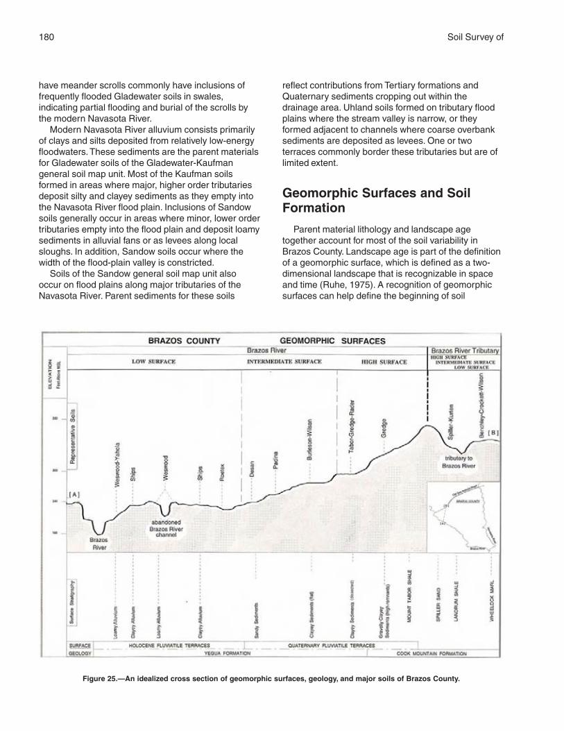
180 Soil Survey of
have meander scrolls commonly have inclusions offrequently flooded Gladewater soils in swales,indicating partial flooding and burial of the scrolls bythe modern Navasota River.
Modern Navasota River alluvium consists primarilyof clays and silts deposited from relatively low-energyfloodwaters. These sediments are the parent materialsfor Gladewater soils of the Gladewater-Kaufmangeneral soil map unit. Most of the Kaufman soilsformed in areas where major, higher order tributariesdeposit silty and clayey sediments as they empty intothe Navasota River flood plain. Inclusions of Sandowsoils generally occur in areas where minor, lower ordertributaries empty into the flood plain and deposit loamysediments in alluvial fans or as levees along localsloughs. In addition, Sandow soils occur where thewidth of the flood-plain valley is constricted.
Soils of the Sandow general soil map unit alsooccur on flood plains along major tributaries of theNavasota River. Parent sediments for these soils
reflect contributions from Tertiary formations andQuaternary sediments cropping out within thedrainage area. Uhland soils formed on tributary floodplains where the stream valley is narrow, or theyformed adjacent to channels where coarse overbanksediments are deposited as levees. One or twoterraces commonly border these tributaries but are oflimited extent.
Geomorphic Surfaces and SoilFormation
Parent material lithology and landscape agetogether account for most of the soil variability inBrazos County. Landscape age is part of the definitionof a geomorphic surface, which is defined as a two-dimensional landscape that is recognizable in spaceand time (Ruhe, 1975). A recognition of geomorphicsurfaces can help define the beginning of soil
Figure 25.—An idealized cross section of geomorphic surfaces, geology, and major soils of Brazos County.
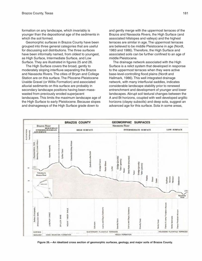
Brazos County, Texas 181
formation on any landscape, which invariably isyounger than the depositional age of the sediments inwhich the soil formed.
Geomorphic surfaces in Brazos County have beengrouped into three general categories that are usefulfor discussing soil distributions. The three surfaceshave been informally named, from oldest to youngest,as High Surface, Intermediate Surface, and LowSurface. They are illustrated in figures 25 and 26.
The High Surface covers the broad, gently tomoderately sloping interfluve separating the Brazosand Navasota Rivers. The cities of Bryan and CollegeStation are on this surface. The Pliocene-PleistoceneUvalde Gravel (or Willis Formation) and associatedalluvial sediments on this surface are probably insecondary landscape positions having been mass-wasted from previously eroded superjacentlandscapes. This limits the maximum landscape age ofthe High Surface to early Pleistocene. Because slopesand drainageways of the High Surface grade down to
and gently merge with the uppermost terraces of theBrazos and Navasota Rivers, the High Surface (andassociated hillslopes and valleys) and the highestterraces are similar in age. The uppermost terracesare believed to be middle Pleistocene in age (Nordt,1983 and 1986). Therefore, the High Surface andassociated soils can be further confined to an age ofmiddle Pleistocene.
The drainage network associated with the HighSurface is a relict system that developed in responseto the uppermost terraces when they were activebase-level-controlling flood plains (Nordt andHallmark, 1986). This well integrated drainagenetwork, with many interfluvial saddles, indicatesconsiderable landscape stability prior to renewedentrenchment and development of younger and lowerlandscapes. Abrupt soil textural changes between theA and Bt horizons, coupled with well developed argillichorizons (clayey subsoils) and deep sola, suggest anadvanced age for this surface. Sola in some areas,
Figure 26.—An idealized cross section of geomorphic surfaces, geology, and major soils of Brazos County.
182
however, are surprisingly thin, probably due to thestratified and resistant nature of the underlying Tertiaryparent materials. Furthermore, surface horizon erosionand subsequent eolian deposition may have producedabrupt textural changes between A and Bt horizons. Inthis case, textural differences between the surface andsubsoil horizons are of lithogenic and not pedogenicorigin. The most developed soils in Brazos Countyoccur on terrace counterparts to the High Surface dueto long-term landscape stability and nearly level slopes.
The Intermediate Surface is a slightly lower andnarrower landscape that separates the broad HighSurface and the lower, steeper Low Surface.Geomorphic relationships indicate that theIntermediate Surface consists of a group ofinextensive surfaces that formed in response to one ormore cycles of entrenchment and flood-plaindevelopment that constructed the lower two or threeBrazos River and Navasota River terraces. The age ofthese terraces is probably late Pleistocene (Nordt,1986), an age similar to that of the IntermediateSurface. Soils on upland and terrace counterparts ofthe Intermediate Surface display a similar degree ofsoil development to those on the High Surface. Thus,similar soils are mapped on both surfaces.
Soils on High and Intermediate Surfaces are similarmainly because of the “Steady State” principle. Thisprinciple asserts that with advancing age, many soilproperties attain their maximum expression, afterwhich there is little change (Birkeland, 1984). TheIntermediate Surface has a few areas where slopesare slightly steeper than those on the High Surface. Inthese areas, the soil map units have a higherpercentage of included soils with thinner sola.
The last major entrenchment episode of the Brazosand Navasota Rivers occurred during the latePleistocene, possibly during deposition of Deweyvillesands. This downcutting event lowered the local baselevel appreciably and initiated rapid upland knickpointmigration from the entrenched tributary network. Thisdegradational episode resulted in the development ofthe Low Surface.
Steep slopes associated with the entrenched
tributary network and gently rolling modern floodplains characterize the Low Surface. Strongly slopingphases of the Gredge, Zack, and Zulch soils aremapped in some areas on the Low Surface. It isunlikely, however, that well developed Bt horizonsassociated with these Low Surface soils formed duringthe Holocene. One explanation is the partial removalof the thick sandy A and E horizons of the Padina,Desan, and Eufaula soils by erosion during the lastentrenchment episode. The Gredge and Silawa soilsthat have a thin surface layer could have formed in thismanner. Alternatively, the alluvium was completelyremoved during downcutting and a veneer of colluviumwas deposited. In this case, the soils would haveformed in two stratigraphic units: eroded bedrock forthe Bt horizons and colluvium for the A horizons.Clayey soils, such as Luling soils, developed in areasof the Low Surface where colluvial drapes do notoccur and truncated shales are exposed.
Weakly developed soils on the flood plain, such asWeswood and Ships soils, are products of continuedflood-plain deposition during the last 500 years(Waters and Nordt, 1995). These soils may besomewhat younger than the soils on hillslopecomponents of the Low Surface.
Taxonomically, soils that formed in equilibrium withthe High and Intermediate Surfaces are welldeveloped Alfisols. Soil variabilities at lower taxonomiclevels occur mostly as a result of differences in parentmaterial lithologies. Terrace counterparts to the Highand Intermediate Surfaces contain the most developedAlfisols in the county because of long-term landscapestability. Soils that formed in equilibrium with the LowSurface display the widest variety of propertiesbecause many formed on hillslopes that weretruncated to bedrock, had a veneer of colluvium, orhad partial removal of pre-existing surface horizons.Soils on the steep segments of the Low Surface aremainly Alfisols, but Vertisols have developed wherecomplete alluvial and colluvial truncation has occurred.Soils on flood plains, which are the depositionalcounterpart to the Low Surface, are weakly developedInceptisols, Mollisols, and Vertisols.
183
American Association of State Highway and Transportation Officials (AASHTO). 2000.Standard specifications for transportation materials and methods of sampling andtesting. 20th edition, 2 volumes.
American Society for Testing and Materials (ASTM). 2001. Standard classification ofsoils for engineering purposes. ASTM Standard D 2487–00.
Aronow, S., and L.C. Nordt. 1988. Report on test drilling of low terraces and floodplainof the Trinity River in the Madison-Houston County area, Texas. USDA-SCS Contract40–7442–6–687.
Barnes, V.E. 1981. Geologic atlas of Texas, scale 1:250,000—Austin sheet. TheUniversity of Texas at Austin, Bureau of Economic Geology.
Berg, R.P. 1979. Stratigraphy of the Claiborne Group. In Lower Tertiary of the BrazosRiver Valley. Edited by D.G. Kersey. Houston Geological Society Guidebook, pages5–10.
Bernard, H.A. 1950. Quaternary geology of southeast Texas. Ph.D. thesis, LouisianaState University, Baton Rouge.
Birkeland, P.W. 1984. Soils and geomorphology.
Brubaker, S.C. 1989. Evaluating soil variability as related to landscape position usingdifferent statistical methods. Ph.D. dissertation, Texas A&M University.
Byrd, C.L. 1971. Origin and history of the Uvalde Gravel of central Texas. BaylorGeological Studies Bulletin 17, Baylor University.
Carlile, B.L., and D.J. Osborne. 1979. Low-pressure pipe distribution system forresidential septic tank effluent.
Carlson, D.L., D.G. Steele, and A.G. Commuzzie. 1984. Mammoth excavations at theDuewall-Newberry site on the Brazos River in Texas. Current Research, volume 1,page 64.
Carty, D.J., J.B. Dixon, L.P. Wilding, and F.T. Turner. 1988. Characterization of a pimplemound-intermound complex in the Gulf Coast prairie region of Texas. Soil ScienceSociety of America Journal, volume 52, pages 1715–1721.
Cronin, J.G., and C.A. Wilson. 1967. Groundwater in the floodplain alluvium of theBrazos River, Whitney dam to vicinity of Richmond, Texas. Texas Water DevelopmentBoard Report 41.
References
184 Soil Survey of
Drake, D.A. 1960. Millican and Millican East gas fields, Brazos County, Texas. InGuidebook for Annual Field Trip, Houston Geological Society and Gulf Coast Section ofthe Society of Economic Paleontologists and Mineralogists. W.L. Russell, editor. Pages11–13.
Fisher, W.L., C.V. Proctor, Jr., W.E. Galloway, and J.S. Nagle. 1970. Depositionalsystems in the Jackson Group of Texas—their relationship to oil, gas, and uranium. TheUniversity of Texas at Austin, Bureau of Economic Geology, Circular 70–4.
Galloway, W.E. 1977. Catahoula Formation of the Texas Coastal Plain. The University ofTexas at Austin, Bureau of Economic Geology, Report of Investigations 87.
Godwin, C.J., R.O. Segner, Jr., C.D. Clay Camp, and Susan Quiring. What prospectivecustom homebuyers should know about foundations. Texas Agricultural ExtensionService, College Station, Texas, Publication series L–5011.
Kleiss, H.J. 1981. Soil ratings for ground absorption sewage disposal systems. NorthCarolina Agricultural Extension, North Carolina State University.
LeBlanc, R.J., Jr. 1970. Environments of deposition of the Yegua Formation (Eocene),Brazos County, Texas. Master’s thesis, Texas A&M University, College Station, Texas.
Letters from an early settler of Texas. 1968. Texian Press, Waco, Texas.
Mathews, A.A.L. 1950. Geology of Brazos County. Texas A&M University, CollegeStation, Texas. Engineering Experiment Station Research Report 14.
McCook, Danny, and C. McElroy. 1991. Dispersive clays. U.S. Department ofAgriculture, Soil Conservation Service, Engineering Division. Soil Mechanics Note 13.
Moore, T.J., and C.T. Hallmark. 1987. Soil properties influencing corrosion of steel inTexas soils. Soil Science Society of America Journal, volume 51, pages 1250–1256.
Moore, T.J., C.T. Hallmark, G. Chervenka, D. Henry, and D. Garner. 1986. Corrosion ofgalvanized steel in farm pond structures of Brazos County, Texas. Journal of Soil andWater Conservation, volume 41, pages 128–131.
Mowery, Irvin C., and Harvey Oakes. 1958. Soil survey of Brazos County, Texas. U.S.Department of Agriculture, in cooperation with the Texas Agricultural ExperimentStation.
Nordt, L.C. 1983. Soils-geomorphology of the Brazos River terraces, Brazos County,Texas. Master’s thesis, Texas A&M University, College Station, Texas.
Nordt, L.C. 1986. Regional correlation of terraces and soils of the Brazos, Trinity, andNavasota Rivers of the Tertiary Coast Plain of Texas. Soil Survey Horizons, volume 27,number 1, pages 29–35.
Nordt, L.C., and C.T. Hallmark. 1986. Pedogeomorphic evolution of the Boonville soils:Brazos County, Texas. Agronomy Abstracts, Soil Science Society of America.
Plummer, F.B. 1932. Cenozoic systems in Texas. In The Geology of Texas. Volume 1:Stratigraphy. Bureau of Economic Geology Bulletin 3232, pages 519–818.
Brazos County, Texas 185
Ruhe, R.V. 1975. Geomorphology.
Soil Survey Division Staff. 1993. Soil survey manual. Soil Conservation Service. U.S.Department of Agriculture Handbook 18.
Soil Survey Staff. 1998. Keys to soil taxonomy. 8th edition. U.S. Department ofAgriculture, Natural Resources Conservation Service.
Soil Survey Staff. 1999. Soil taxonomy: A basic system of soil classification for makingand interpreting soil surveys. 2nd edition. Natural Resources Conservation Service.U.S. Department of Agriculture Handbook 436.
Stenzel, H.B. 1938. The geology of Leon County. The University of Texas at Austin,Bureau of Economic Geology Publication 3818, pages 125–186.
Stenzel, H.B. 1940. The Yegua problem. In Contributions to Geology, 1939. TheUniversity of Texas at Austin, Bureau of Economic Geology Publication 3945, pages847–910.
United States Department of Agriculture. 1961. Land capability classification. SoilConservation Service, U.S. Department of Agriculture Handbook 210.
United States Department of Agriculture. 1981. Land resource regions and major landresource areas of the United States. Soil Conservation Service. U.S. Department ofAgriculture Handbook 296.
United States Department of Agriculture. 1996. Soil survey laboratory methods manual.Natural Resources Conservation Service. Soil Survey Investigations Report 42.
Veatch, J.O., and C.S. Waldrop. 1916. Soil survey of Brazos County, Texas. U.S.Department of Agriculture, Bureau of Soils.
Walker, J.H., and J.M. Coleman. 1987. Atlantic and Gulf Coastal Province. InGeomorphic Systems of North America. W.L. Graf, editor. Geological Society AmericanCentennial Special, volume 2.
Walker, J.R. 1978. Geomorphic evolution of the Southern High Plains. Baylor University,Baylor Geological Studies Bulletin 35.
Waters, M.R., and L.C. Nordt, 1995. Late Quaternary alluvial history of the Brazos Riverin east-central Texas. Quaternary Research, volume 43, pages 311–319.
187
Aggregate, soil. Many fine particles held in a singlemass or cluster. Natural soil aggregates, such asgranules, blocks, or prisms, are called peds. Clodsare aggregates produced by tillage or logging.
Alluvial fan. The fanlike deposit of a stream where itissues from a gorge upon a plain or of a tributarystream near or at its junction with its main stream.
Alluvium. Material, such as sand, silt, or clay,deposited on land by streams.
Alpha,alpha-dipyridyl. A dye that when dissolved in1N ammonium acetate is used to detect thepresence of reduced iron (Fe II) in the soil. Apositive reaction indicates a type of redoximorphicfeature.
Animal unit month (AUM). The amount of foragerequired by one mature cow of approximately1,000 pounds weight, with or without a calf, for 1month.
Aquic conditions. Current soil wetness characterizedby saturation, reduction, and redoximorphicfeatures.
Area reclaim (in tables). An area difficult to reclaimafter the removal of soil for construction and otheruses. Revegetation and erosion control areextremely difficult.
Argillic horizon. A subsoil horizon characterized byan accumulation of illuvial clay.
Aspect. The direction in which a slope faces.Available water capacity (available moisture
capacity). The capacity of soils to hold wateravailable for use by most plants. It is commonlydefined as the difference between the amount ofsoil water at field moisture capacity and theamount at wilting point. It is commonly expressedas inches of water per inch of soil. The capacity, ininches, in a 60-inch profile or to a limiting layer isexpressed as:
Very low ............................................................ 0 to 3
Low ................................................................... 3 to 6
Moderate .......................................................... 6 to 9
High ................................................................ 9 to 12
Very high .............................................. more than 12
Backslope. The position that forms the steepest andgenerally linear, middle portion of a hillslope. In
profile, backslopes are commonly bounded by aconvex shoulder above and a concave footslopebelow.
Base saturation. The degree to which material havingcation-exchange properties is saturated withexchangeable bases (sum of Ca, Mg, Na, and K),expressed as a percentage of the total cation-exchange capacity.
Bedding planes. Fine strata, less than 5 millimetersthick, in unconsolidated alluvial, eolian, lacustrine,or marine sediment.
Bedrock. The solid rock that underlies the soil andother unconsolidated material or that is exposed atthe surface.
Bottom land. The normal flood plain of a stream,subject to flooding.
Breaks. The steep and very steep broken land at theborder of an upland summit that is dissected byravines.
Calcareous soil. A soil containing enough calciumcarbonate (commonly combined with magnesiumcarbonate) to effervesce visibly when treated withcold, dilute hydrochloric acid.
Cation. An ion carrying a positive charge of electricity.The common soil cations are calcium, potassium,magnesium, sodium, and hydrogen.
Cation-exchange capacity. The total amount ofexchangeable cations that can be held by the soil,expressed in terms of milliequivalents per 100grams of soil at neutrality (pH 7.0) or at someother stated pH value. The term, as applied tosoils, is synonymous with base-exchange capacitybut is more precise in meaning.
Chiseling. Tillage with an implement having one ormore soil-penetrating points that shatter or loosenhard, compacted layers to a depth below normalplow depth.
Clay. As a soil separate, the mineral soil particles lessthan 0.002 millimeter in diameter. As a soil texturalclass, soil material that is 40 percent or more clay,less than 45 percent sand, and less than 40percent silt.
Clay depletions. Low-chroma zones having a lowcontent of iron, manganese, and clay because ofthe chemical reduction of iron and manganese
Glossary

188 Soil Survey of
and the removal of iron, manganese, and clay. Atype of redoximorphic depletion.
Clay film. A thin coating of oriented clay on thesurface of a soil aggregate or lining pores or rootchannels. Synonyms: clay coating, clay skin.
Claypan. A slowly permeable soil horizon thatcontains much more clay than the horizons aboveit. A claypan is commonly hard when dry andplastic or stiff when wet.
Climax plant community. The stabilized plantcommunity on a particular site. The plant coverreproduces itself and does not change so long asthe environment remains the same.
Coarse textured soil. Sand or loamy sand.Colluvium. Soil material or rock fragments, or both,
moved by creep, slide, or local wash anddeposited at the base of steep slopes.
Complex, soil. A map unit of two or more kinds of soilor miscellaneous areas in such an intricate patternor so small in area that it is not practical to mapthem separately at the selected scale of mapping.The pattern and proportion of the soils ormiscellaneous areas are somewhat similar in allareas.
Concretions. Cemented bodies with crude internalsymmetry organized around a point, a line, or aplane. They typically take the form of concentriclayers visible to the naked eye. Calcium carbonate,iron oxide, and manganese oxide are commoncompounds making up concretions. If formed inplace, concretions of iron oxide or manganeseoxide are generally considered a type ofredoximorphic concentration.
Conservation cropping system. Growing crops incombination with needed cultural andmanagement practices. In a good conservationcropping system, the soil-improving crops andpractices more than offset the effects of the soil-depleting crops and practices. Cropping systemsare needed on all tilled soils. Soil-improvingpractices in a conservation cropping systeminclude the use of rotations that contain grassesand legumes and the return of crop residue to thesoil. Other practices include the use of greenmanure crops of grasses and legumes, propertillage, adequate fertilization, and weed and pestcontrol.
Conservation tillage. A tillage system that does notinvert the soil and that leaves a protective amountof crop residue on the surface throughout the year.
Consistence, soil. Refers to the degree of cohesionand adhesion of soil material and its resistance todeformation when ruptured. Consistence includesresistance of soil material to rupture and to
penetration; plasticity, toughness, and stickiness ofpuddled soil material; and the manner in which thesoil material behaves when subject tocompression. Terms describing consistence aredefined in the “Soil Survey Manual.”
Control section. The part of the soil on whichclassification is based. The thickness variesamong different kinds of soil, but for many it is thatpart of the soil profile between depths of 10 inchesand 40 or 80 inches.
Coppice dune. A small dune of fine grained soilmaterial stabilized around shrubs or small trees.
Corrosion. Soil-induced electrochemical or chemicalaction that dissolves or weakens concrete oruncoated steel.
Cropping system. Growing crops according to aplanned system of rotation and managementpractices.
Crop residue management. Returning crop residueto the soil, which helps to maintain soil structure,organic matter content, and fertility and helps tocontrol erosion.
Cuesta. A hill or ridge that has a gentle slope on oneside and a steep slope on the other; specifically,an asymmetric, homoclinal ridge capped byresistant rock layers of slight or moderate dip.
Cutbanks cave (in tables). The walls of excavationstend to cave in or slough.
Decreasers. The most heavily grazed climax rangeplants. Because they are the most palatable, theyare the first to be destroyed by overgrazing.
Delta. A body of alluvium having a surface that isnearly flat and fan shaped; deposited at or nearthe mouth of a river or stream where it enters abody of relatively quiet water, generally a sea orlake.
Depth, soil. Generally, the thickness of the soil overbedrock. Very deep soils are more than 60 inchesdeep over bedrock; deep soils, 40 to 60 inches;moderately deep, 20 to 40 inches; shallow, 10 to20 inches; and very shallow, less than 10 inches.
Depth to rock (in tables). Bedrock is too near thesurface for the specified use.
Diversion (or diversion terrace). A ridge of earth,generally a terrace, built to protect downslopeareas by diverting runoff from its natural course.
Drainage class (natural). Refers to the frequency andduration of wet periods under conditions similar tothose under which the soil formed. Alterations ofthe water regime by human activities, eitherthrough drainage or irrigation, are not aconsideration unless they have significantlychanged the morphology of the soil. Sevenclasses of natural soil drainage are recognized—
Brazos County, Texas 189
excessively drained, somewhat excessivelydrained, well drained, moderately well drained,somewhat poorly drained, poorly drained, andvery poorly drained. These classes are defined inthe “Soil Survey Manual.”
Drainage, surface. Runoff, or surface flow of water,from an area.
Eluviation. The movement of material in true solutionor colloidal suspension from one place to anotherwithin the soil. Soil horizons that have lost materialthrough eluviation are eluvial; those that havereceived material are illuvial.
Eolian soil material. Earthy parent materialaccumulated through wind action; commonlyrefers to sandy material in dunes or to loess inblankets on the surface.
Erosion. The wearing away of the land surface bywater, wind, ice, or other geologic agents and bysuch processes as gravitational creep.Erosion (geologic). Erosion caused by geologicprocesses acting over long geologic periods andresulting in the wearing away of mountains andthe building up of such landscape features asflood plains and coastal plains. Synonym: naturalerosion.Erosion (accelerated). Erosion much more rapidthan geologic erosion, mainly as a result of humanor animal activities or of a catastrophe in nature,such as a fire, that exposes the surface.
Excess fines (in tables). Excess silt and clay in thesoil. The soil does not provide a source of gravelor sand for construction purposes.
Excess salt (in tables). Excess water-soluble salts inthe soil that restrict the growth of most plants.
Fast intake (in tables). The rapid movement of waterinto the soil.
Fertility, soil. The quality that enables a soil to provideplant nutrients, in adequate amounts and in properbalance, for the growth of specified plants whenlight, moisture, temperature, tilth, and other growthfactors are favorable.
Fibric soil material (peat). The least decomposed ofall organic soil material. Peat contains a largeamount of well preserved fiber that is readilyidentifiable according to botanical origin. Peat hasthe lowest bulk density and the highest watercontent at saturation of all organic soil material.
Field moisture capacity. The moisture content of asoil, expressed as a percentage of the ovendryweight, after the gravitational, or free, water hasdrained away; the field moisture content 2 or 3days after a soaking rain; also called normal fieldcapacity, normal moisture capacity, or capillarycapacity.
Fine textured soil. Sandy clay, silty clay, or clay.First bottom. The normal flood plain of a stream,
subject to frequent or occasional flooding.Flood plain. A nearly level alluvial plain that borders a
stream and is subject to flooding unless protectedartificially.
Fluvial. Of or pertaining to rivers; produced by riveraction, as a fluvial plain.
Footslope. The position that forms the inner, gentlyinclined surface at the base of a hillslope. Inprofile, footslopes are commonly concave. Afootslope is a transition zone between upslopesites of erosion and transport (shoulders andbackslopes) and downslope sites of deposition(toeslopes).
Forb. Any herbaceous plant not a grass or a sedge.Genesis, soil. The mode of origin of the soil. Refers
especially to the processes or soil-forming factorsresponsible for the formation of the solum, or truesoil, from the unconsolidated parent material.
Gilgai. Commonly, a succession of microbasins andmicroknolls in nearly level areas or of microvalleysand microridges parallel with the slope. Typically,the microrelief of clayey soils that shrink and swellconsiderably with changes in moisture content.
Gleyed soil. Soil that formed under poor drainage,resulting in the reduction of iron and otherelements in the profile and in gray colors.
Grassed waterway. A natural or constructedwaterway, typically broad and shallow, seeded tograss as protection against erosion. Conductssurface water away from cropland.
Gravel. Rounded or angular fragments of rock asmuch as 3 inches (2 millimeters to 7.6centimeters) in diameter. An individual piece is apebble.
Ground water. Water filling all the unblocked pores ofthe material below the water table.
Gully. A miniature valley with steep sides cut byrunning water and through which water ordinarilyruns only after rainfall. The distinction between agully and a rill is one of depth. A gully generally isan obstacle to farm machinery and is too deep tobe obliterated by ordinary tillage; a rill is of lesserdepth and can be smoothed over by ordinarytillage.
Hard bedrock. Bedrock that cannot be excavatedexcept by blasting or by the use of specialequipment that is not commonly used inconstruction.
Head slope. A geomorphic component of hillsconsisting of a laterally concave area of a hillside,especially at the head of a drainageway. Theoverland waterflow is converging.
190 Soil Survey of
Hemic soil material (mucky peat). Organic soilmaterial intermediate in degree of decompositionbetween the less decomposed fibric material andthe more decomposed sapric material.
High-residue crops. Such crops as small grain andcorn used for grain. If properly managed, residuefrom these crops can be used to control erosionuntil the next crop in the rotation is established.These crops return large amounts of organicmatter to the soil.
Horizon, soil. A layer of soil, approximately parallel tothe surface, having distinct characteristicsproduced by soil-forming processes. In theidentification of soil horizons, an uppercase letterrepresents the major horizons. Numbers orlowercase letters that follow representsubdivisions of the major horizons. An explanationof the subdivisions is given in the “Soil SurveyManual.” The major horizons of mineral soil are asfollows:O horizon.—An organic layer of fresh anddecaying plant residue.A horizon.—The mineral horizon at or near thesurface in which an accumulation of humifiedorganic matter is mixed with the mineral material.Also, a plowed surface horizon, most of which wasoriginally part of a B horizon.E horizon.—The mineral horizon in which the mainfeature is loss of silicate clay, iron, aluminum, orsome combination of these.B horizon.—The mineral horizon below an Ahorizon. The B horizon is in part a layer oftransition from the overlying A to the underlying Chorizon. The B horizon also has distinctivecharacteristics, such as (1) accumulation of clay,sesquioxides, humus, or a combination of these;(2) prismatic or blocky structure; (3) redder orbrowner colors than those in the A horizon; or (4)a combination of these.C horizon.—The mineral horizon or layer,excluding indurated bedrock, that is little affectedby soil-forming processes and does not have theproperties typical of the overlying soil material.The material of a C horizon may be either like orunlike that in which the solum formed. If thematerial is known to differ from that in the solum,an Arabic numeral, commonly a 2, precedes theletter C.Cr horizon.—Soft, consolidated bedrock beneaththe soil.R layer.—Consolidated bedrock beneath the soil.The bedrock commonly underlies a C horizon, butit can be directly below an A or a B horizon.
Humus. The well decomposed, more or less stablepart of the organic matter in mineral soils.
Hydrologic soil groups. Refers to soils groupedaccording to their runoff potential. The soilproperties that influence this potential are thosethat affect the minimum rate of water infiltration ona bare soil during periods after prolonged wettingwhen the soil is not frozen. These properties aredepth to a seasonal high water table, theinfiltration rate and permeability after prolongedwetting, and depth to a very slowly permeablelayer. The slope and the kind of plant cover are notconsidered but are separate factors in predictingrunoff.
Illuviation. The movement of soil material from onehorizon to another in the soil profile. Generally,material is removed from an upper horizon anddeposited in a lower horizon.
Increasers. Species in the climax vegetation thatincrease in amount as the more desirable plantsare reduced by close grazing. Increaserscommonly are the shorter plants and the lesspalatable to livestock.
Infiltration. The downward entry of water into theimmediate surface of soil or other material, ascontrasted with percolation, which is movement ofwater through soil layers or material.
Infiltration rate. The rate at which water penetratesthe surface of the soil at any given instant, usuallyexpressed in inches per hour. The rate can belimited by the infiltration capacity of the soil or therate at which water is applied at the surface.
Interfluve. An elevated area between two drainagewaysthat sheds water to those drainageways.
Intermittent stream. A stream, or reach of a stream,that flows for prolonged periods only when itreceives ground-water discharge or long,continued contributions from melting snow or othersurface and shallow subsurface sources.
Invaders. On range, plants that encroach into an areaand grow after the climax vegetation has beenreduced by grazing. Generally, plants invadefollowing disturbance of the surface.
Iron depletions. Low-chroma zones having a lowcontent of iron and manganese oxide because ofchemical reduction and removal, but having a claycontent similar to that of the adjacent matrix. Atype of redoximorphic depletion.
Large stones (in tables). Rock fragments 3 inches(7.6 centimeters) or more across. Large stonesadversely affect the specified use of the soil.
Leaching. The removal of soluble material from soil orother material by percolating water.
Brazos County, Texas 191
Liquid limit. The moisture content at which the soilpasses from a plastic to a liquid state.
Loam. Soil material that is 7 to 27 percent clayparticles, 28 to 50 percent silt particles, and lessthan 52 percent sand particles.
Loess. Fine grained material, dominantly of silt-sizedparticles, deposited by wind.
Low strength. The soil is not strong enough tosupport loads.
Masses. Concentrations of substances in the soilmatrix that do not have a clearly defined boundarywith the surrounding soil material and cannot beremoved as a discrete unit. Common compoundsmaking up masses are calcium carbonate,gypsum or other soluble salts, iron oxide, andmanganese oxide. Masses consisting of iron oxideor manganese oxide generally are considered atype of redoximorphic concentration.
Medium textured soil. Very fine sandy loam, loam,silt loam, or silt.
Mineral soil. Soil that is mainly mineral material andlow in organic material. Its bulk density is morethan that of organic soil.
Miscellaneous area. An area that has little or nonatural soil and supports little or no vegetation.
Moderately coarse textured soil. Coarse sandyloam, sandy loam, or fine sandy loam.
Moderately fine textured soil. Clay loam, sandy clayloam, or silty clay loam.
Mollic epipedon. A thick, dark, humus-rich surfacehorizon (or horizons) that has high base saturationand pedogenic soil structure. It may include theupper part of the subsoil.
Morphology, soil. The physical makeup of the soil,including the texture, structure, porosity,consistence, color, and other physical, mineral,and biological properties of the various horizons,and the thickness and arrangement of thosehorizons in the soil profile.
Mott. A grove or clump of trees in an area of prairie oropen country.
Mottling, soil. Irregular spots of different colors thatvary in number and size. Descriptive terms are asfollows: abundance—few, common, and many;size—fine, medium, and coarse; and contrast—faint, distinct, and prominent. The sizemeasurements are of the diameter along thegreatest dimension. Fine indicates less than 5millimeters (about 0.2 inch); medium, from 5 to 15millimeters (about 0.2 to 0.6 inch); and coarse,more than 15 millimeters (about 0.6 inch).
Muck. Dark, finely divided, well decomposed organicsoil material. (See Sapric soil material.)
Munsell notation. A designation of color by degrees
of three simple variables—hue, value, andchroma. For example, a notation of 10YR 6/4 isa color with hue of 10YR, value of 6, and chromaof 4.
Neutral soil. A soil having a pH value of 6.6 to 7.3.(See Reaction, soil.)
Nose slope. A geomorphic component of hillsconsisting of the projecting end (laterally convexarea) of a hillside. The overland waterflow ispredominantly divergent.
Organic matter. Plant and animal residue in the soil invarious stages of decomposition. The content oforganic matter in the surface layer is described asfollows:
Very low ................................... less than 0.5 percent
Low ................................................ 0.5 to 1.0 percent
Moderately low .............................. 1.0 to 2.0 percent
Moderate ....................................... 2.0 to 4.0 percent
High ............................................... 4.0 to 8.0 percent
Very high ............................... more than 8.0 percent
Pan. A compact, dense layer in a soil that impedes themovement of water and the growth of roots. Forexample, hardpan, fragipan, claypan, plowpan,and traffic pan.
Parent material. The unconsolidated organic andmineral material in which soil forms.
Peat. Unconsolidated material, largely undecomposedorganic matter, that has accumulated underexcess moisture. (See Fibric soil material.)
Ped. An individual natural soil aggregate, such as agranule, a prism, or a block.
Pedisediment. A thin layer of alluvial material thatmantles an erosion surface and has beentransported to its present position from higherlying areas of the erosion surface.
Pedon. The smallest volume that can be called “a soil.”A pedon is three dimensional and large enough topermit study of all horizons. Its area ranges fromabout 10 to 100 square feet (1 square meter to 10square meters), depending on the variability of thesoil.
Percolation. The movement of water through the soil.Percs slowly (in tables). The slow movement of water
through the soil adversely affects the specifieduse.
Permeability. The quality of the soil that enables wateror air to move downward through the profile. Therate at which a saturated soil transmits water isaccepted as a measure of this quality. In soilphysics, the rate is referred to as “saturatedhydraulic conductivity,” which is defined in the “SoilSurvey Manual.” In line with conventional usage inthe engineering profession and with traditional
192 Soil Survey of
usage in published soil surveys, this rate of flowcontinues to be expressed as “permeability.” Termsdescribing permeability, measured in inches perhour, are as follows:
Extremely slow ................................. 0.0 to 0.01 inch
Very slow ........................................ 0.01 to 0.06 inch
Slow .................................................. 0.06 to 0.2 inch
Moderately slow ................................. 0.2 to 0.6 inch
Moderate ................................ 0.6 inch to 2.0 inches
Moderately rapid ............................ 2.0 to 6.0 inches
Rapid ............................................... 6.0 to 20 inches
Very rapid ................................. more than 20 inches
Phase, soil. A subdivision of a soil series based onfeatures that affect its use and management, suchas slope, stoniness, and flooding.
pH value. A numerical designation of acidity andalkalinity in soil. (See Reaction, soil.)
Piping (in tables). Formation of subsurface tunnels orpipelike cavities by water moving through the soil.
Plasticity index. The numerical difference betweenthe liquid limit and the plastic limit; the range ofmoisture content within which the soil remainsplastic.
Plastic limit. The moisture content at which a soilchanges from semisolid to plastic.
Plowpan. A compacted layer formed in the soildirectly below the plowed layer.
Ponding. Standing water on soils in closeddepressions. Unless the soils are artificiallydrained, the water can be removed only bypercolation or evapotranspiration.
Poor filter (in tables). Because of rapid or very rapidpermeability, the soil may not adequately filtereffluent from a waste disposal system.
Poorly graded. Refers to a coarse grained soil or soilmaterial consisting mainly of particles of nearlythe same size. Because there is little difference insize of the particles, density can be increased onlyslightly by compaction.
Prescribed burning. Deliberately burning an area forspecific management purposes, under theappropriate conditions of weather and soilmoisture and at the proper time of day.
Profile, soil. A vertical section of the soil extendingthrough all its horizons and into the parentmaterial.
Proper grazing use. Grazing at an intensity thatmaintains enough cover to protect the soil andmaintain or improve the quantity and quality of thedesirable vegetation. This practice increases thevigor and reproduction capacity of the key plantsand promotes the accumulation of litter and mulchnecessary to conserve soil and water.
Range condition. The present composition of theplant community on a range site in relation to thepotential natural plant community for that site.Range condition is expressed as excellent, good,fair, or poor on the basis of how much the presentplant community has departed from the potential.
Rangeland. Land on which the potential naturalvegetation is predominantly grasses, grasslikeplants, forbs, or shrubs suitable for grazing orbrowsing. It includes natural grasslands,savannahs, many wetlands, some deserts,tundras, and areas that support certain forb andshrub communities.
Range site. An area of rangeland where climate, soil,and relief are sufficiently uniform to produce adistinct natural plant community. A range site is theproduct of all the environmental factorsresponsible for its development. It is typified by anassociation of species that differ from those onother range sites in kind or proportion of speciesor total production.
Reaction, soil. A measure of acidity or alkalinity of asoil, expressed in pH values. A soil that tests to pH7.0 is described as precisely neutral in reactionbecause it is neither acid nor alkaline. Thedegrees of acidity or alkalinity, expressed as pHvalues, are:
Ultra acid .............................................. less than 3.5
Extremely acid ........................................... 3.5 to 4.4
Very strongly acid ...................................... 4.5 to 5.0
Strongly acid .............................................. 5.1 to 5.5
Moderately acid .......................................... 5.6 to 6.0
Slightly acid ................................................ 6.1 to 6.5
Neutral ........................................................ 6.6 to 7.3
Slightly alkaline .......................................... 7.4 to 7.8
Moderately alkaline .................................... 7.9 to 8.4
Strongly alkaline ........................................ 8.5 to 9.0
Very strongly alkaline ......................... 9.1 and higher
Redoximorphic concentrations. Nodules,concretions, soft masses, pore linings, and otherfeatures resulting from the accumulation of iron ormanganese oxide. An indication of chemicalreduction and oxidation resulting from saturation.
Redoximorphic depletions. Low-chroma zones fromwhich iron and manganese oxide or a combinationof iron and manganese oxide and clay has beenremoved. These zones are indications of thechemical reduction of iron resulting fromsaturation.
Redoximorphic features. Redoximorphicconcentrations, redoximorphic depletions, reducedmatrices, a positive reaction to alpha,alpha-dipyridyl, and other features indicating the
Brazos County, Texas 193
chemical reduction and oxidation of iron andmanganese compounds resulting from saturation.
Reduced matrix. A soil matrix that has low chroma insitu because of chemically reduced iron (Fe II).The chemical reduction results from nearlycontinuous wetness. The matrix undergoes achange in hue or chroma within 30 minutes afterexposure to air as the iron is oxidized (Fe III). Atype of redoximorphic feature.
Relief. The elevations or inequalities of a land surface,considered collectively.
Root zone. The part of the soil that can be penetratedby plant roots.
Runoff. The precipitation discharged into streamchannels from an area. The water that flows off thesurface of the land without sinking into the soil iscalled surface runoff. Water that enters the soilbefore reaching surface streams is called ground-water runoff or seepage flow from ground water.
Sand. As a soil separate, individual rock or mineralfragments from 0.05 millimeter to 2.0 millimeters indiameter. Most sand grains consist of quartz. As asoil textural class, a soil that is 85 percent or moresand and not more than 10 percent clay.
Sandstone. Sedimentary rock containing dominantlysand-sized particles.
Sapric soil material (muck). The most highlydecomposed of all organic soil material. Muck hasthe least amount of plant fiber, the highest bulkdensity, and the lowest water content at saturationof all organic soil material.
Saturation. Wetness characterized by zero or positivepressure of the soil water. Under conditions ofsaturation, the water will flow from the soil matrixinto an unlined auger hole.
Savannah. A grassland area containing scatteredtrees and drought-resistant undergrowth.
Seepage (in tables). The movement of water throughthe soil. Seepage adversely affects the specifieduse.
Series, soil. A group of soils that have profiles that arealmost alike, except for differences in texture ofthe surface layer. All the soils of a series havehorizons that are similar in composition, thickness,and arrangement.
Shale. Sedimentary rock formed by the hardening of aclay deposit.
Sheet erosion. The removal of a fairly uniform layer ofsoil material from the land surface by the action ofrainfall and surface runoff.
Shoulder. The position that forms the uppermostinclined surface near the top of a hillslope. It is atransition from backslope to summit. The surface
is dominantly convex in profile and erosional inorigin.
Shrink-swell (in tables). The shrinking of soil whendry and the swelling when wet. Shrinking andswelling can damage roads, dams, buildingfoundations, and other structures. It can alsodamage plant roots.
Side slope. A geomorphic component of hillsconsisting of a laterally planar area of a hillside.The overland waterflow is predominantly parallel.
Silt. As a soil separate, individual mineral particlesthat range in diameter from the upper limit of clay(0.002 millimeter) to the lower limit of very finesand (0.05 millimeter). As a soil textural class, soilthat is 80 percent or more silt and less than 12percent clay.
Siltstone. Sedimentary rock made up of dominantlysilt-sized particles.
Similar soils. Soils that share limits of diagnosticcriteria, behave and perform in a similar manner,and have similar conservation needs ormanagement requirements for the major land usesin the survey area.
Slickensides. Polished and grooved surfacesproduced by one mass sliding past another. Insoils, slickensides may occur at the bases of slipsurfaces on the steeper slopes; on faces of blocks,prisms, and columns; and in swelling clayey soils,where there is marked change in moisturecontent.
Slope. The inclination of the land surface from thehorizontal. Percentage of slope is the verticaldistance divided by horizontal distance, thenmultiplied by 100. Thus, a slope of 20 percent is adrop of 20 feet in 100 feet of horizontal distance. Inthis survey, classes for simple slopes are asfollows:
Nearly level ......................................... 0 to 1 percent
Very gently sloping .............................. 1 to 3 percent
Gently sloping ..................................... 1 to 5 percent
Moderately sloping .............................. 5 to 8 percent
Strongly sloping ................................ 8 to 12 percent
Moderately steep ............................ 12 to 20 percent
Steep ............................................... 20 to 45 percent
Slope (in tables). Slope is great enough that specialpractices are required to ensure satisfactoryperformance of the soil for a specific use.
Slow intake (in tables). The slow movement of waterinto the soil.
Small stones (in tables). Rock fragments less than 3inches (7.6 centimeters) in diameter. Small stonesadversely affect the specified use of the soil.
194
Soft bedrock. Bedrock that can be excavated withtrenching machines, backhoes, small rippers,and other equipment commonly used inconstruction.
Soil. A natural, three-dimensional body at the earth’ssurface. It is capable of supporting plants and hasproperties resulting from the integrated effect ofclimate and living matter acting on earthy parentmaterial, as conditioned by relief and by thepassage of time.
Soil separates. Mineral particles less than 2millimeters in equivalent diameter and rangingbetween specified size limits. The names andsizes, in millimeters, of separates recognized inthe United States are as follows:
Very coarse sand ....................................... 2.0 to 1.0
Coarse sand ............................................... 1.0 to 0.5
Medium sand ........................................... 0.5 to 0.25
Fine sand ............................................... 0.25 to 0.10
Very fine sand ........................................ 0.10 to 0.05
Silt ........................................................ 0.05 to 0.002
Clay .................................................. less than 0.002
Solum. The upper part of a soil profile, above the Chorizon, in which the processes of soil formationare active. The solum in soil consists of the A, E,and B horizons. Generally, the characteristics ofthe material in these horizons are unlike those ofthe material below the solum. The living roots andplant and animal activities are largely confined tothe solum.
Structure, soil. The arrangement of primary soilparticles into compound particles or aggregates.The principal forms of soil structure are—platy(laminated), prismatic (vertical axis of aggregateslonger than horizontal), columnar (prisms withrounded tops), blocky (angular or subangular),and granular. Structureless soils are either singlegrained (each grain by itself, as in dune sand) ormassive (the particles adhering without anyregular cleavage, as in many hardpans).
Subsoil. Technically, the B horizon; roughly, the part ofthe solum below plow depth.
Substratum. The part of the soil below the solum.Subsurface layer. Any surface soil horizon (A, E, AB,
or EB) below the surface layer.Summit. The topographically highest position of a
hillslope. It has a nearly level (planar or onlyslightly convex) surface.
Surface layer. The soil ordinarily moved in tillage, orits equivalent in uncultivated soil, ranging in depthfrom 4 to 10 inches (10 to 25 centimeters).
Frequently designated as the “plow layer,” or the“Ap horizon.”
Terrace (geologic). An old alluvial plain, ordinarily flator undulating, bordering a river, a lake, or the sea.
Texture, soil. The relative proportions of sand, silt,and clay particles in a mass of soil. The basictextural classes, in order of increasing proportionof fine particles, are sand, loamy sand, sandyloam, loam, silt loam, silt, sandy clay loam, clayloam, silty clay loam, sandy clay, silty clay, andclay. The sand, loamy sand, and sandy loamclasses may be further divided by specifying“coarse,” “fine,” or “very fine.”
Thin layer (in tables). Otherwise suitable soil materialthat is too thin for the specified use.
Toeslope. The position that forms the gently inclinedsurface at the base of a hillslope. Toeslopes inprofile are commonly gentle and linear and areconstructional surfaces forming the lower part of ahillslope continuum that grades to valley or closed-depression floors.
Topsoil. The upper part of the soil, which is the mostfavorable material for plant growth. It is ordinarilyrich in organic matter and is used to topdressroadbanks, lawns, and land affected by mining.
Tuff. A compacted deposit that is 50 percent or morevolcanic ash and dust.
Upland. Land at a higher elevation, in general, thanthe alluvial plain or stream terrace; land above thelowlands along streams.
Valley fill. In glaciated regions, material deposited instream valleys by glacial meltwater. Innonglaciated regions, alluvium deposited byheavily loaded streams.
Weathering. All physical and chemical changesproduced in rocks or other deposits at or near theearth’s surface by atmospheric agents. Thesechanges result in disintegration anddecomposition of the material.
Well graded. Refers to soil material consisting ofcoarse grained particles that are well distributedover a wide range in size or diameter. Such soilnormally can be easily increased in density andbearing properties by compaction. Contrasts withpoorly graded soil.
Wilting point (or permanent wilting point). Themoisture content of soil, on an ovendry basis, atwhich a plant (specifically a sunflower) wilts somuch that it does not recover when placed in ahumid, dark chamber.
Windthrow. The uprooting and tipping over of trees bythe wind.

195
Tables

196 Soil Survey of
Table 1.--Temperature and Precipitation
(Recorded in the period 1961-90 at College Station, Texas)
_______________________________________________________________________________________________________________ | | | Temperature | Precipitation | | __________________________________________________________________________________________________ | | | | 2 years in | | |2 years in 10| | | | | | 10 will have-- | | | will have-- | | _______________________ _____________ Month |Average|Average|Average| | | Average |Average| | | Average |Average | daily | daily | | Maximum | Minimum |number of| | Less | More |number of|snowfall |maximum|minimum| |temperature|temperature| growing | |than--|than--|days with| | | | | higher | lower | degree | | | |0.10 inch| | | | | than-- | than-- | days* | | | | or more |_______________________________________________________________________________________________________________ | oF | oF | oF | oF | oF | Units | In | In | In | | In | | | | | | | | | | | January----| 58.4 | 38.7 | 48.5 | 81 | 15 | 118 | 2.65 | 1.07| 3.99| 5 | 0.3 | | | | | | | | | | | February---| 63.0 | 41.9 | 52.5 | 84 | 21 | 150 | 2.62 | 1.12| 3.89| 4 | .1 | | | | | | | | | | | March------| 71.0 | 49.7 | 60.3 | 88 | 27 | 342 | 2.58 | 1.16| 3.79| 4 | .0 | | | | | | | | | | | April------| 78.3 | 58.0 | 68.2 | 90 | 36 | 545 | 3.38 | 1.22| 5.18| 4 | .0 | | | | | | | | | | | May--------| 84.0 | 65.0 | 74.5 | 93 | 49 | 760 | 4.80 | 1.88| 7.25| 5 | .0 | | | | | | | | | | | June-------| 90.3 | 71.0 | 80.7 | 99 | 59 | 920 | 3.68 | 1.01| 5.82| 4 | .0 | | | | | | | | | | | July-------| 93.8 | 73.4 | 83.6 | 102 | 66 | 1,042 | 2.29 | .53| 3.67| 3 | .0 | | | | | | | | | | | August-----| 94.8 | 73.2 | 84.0 | 104 | 64 | 1,053 | 2.42 | .77| 3.76| 3 | .0 | | | | | | | | | | | September--| 88.4 | 68.7 | 78.6 | 100 | 51 | 857 | 4.87 | 2.33| 7.07| 5 | .0 | | | | | | | | | | | October----| 80.2 | 58.6 | 69.4 | 93 | 39 | 602 | 3.81 | 1.48| 5.76| 4 | .0 | | | | | | | | | | | November---| 70.1 | 49.4 | 59.8 | 87 | 28 | 317 | 3.15 | 1.52| 4.56| 4 | .0 | | | | | | | | | | | December---| 61.5 | 41.2 | 51.3 | 81 | 18 | 149 | 2.79 | 1.30| 4.07| 4 | .0 | | | | | | | | | | | Yearly: | | | | | | | | | | | | | | | | | | | | | | Average---| 77.8 | 57.4 | 67.6 | --- | --- | --- | --- | ---| ---| --- | --- | | | | | | | | | | | Extreme---| --- | --- | --- | 104 | 13 | --- | --- | ---| ---| --- | --- | | | | | | | | | | | Total-----| --- | --- | --- | --- | --- | 6,856 | 39.04 | 30.99| 46.65| 49 | 0.4 | | | | | | | | | | |_______________________________________________________________________________________________________________
* A growing degree day is a unit of heat available for plant growth. It can be calculated by adding themaximum and minimum daily temperatures, dividing the sum by 2, and subtracting the temperature below whichgrowth is minimal for the principal crops in the area (50 degrees F).
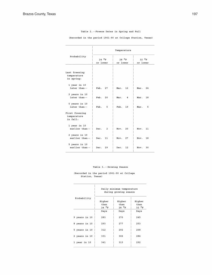
Brazos County, Texas 197
Table 2.--Freeze Dates in Spring and Fall
(Recorded in the period 1961-90 at College Station, Texas)
_____________________________________________________________ | | Temperature |__________________________________________ Probability | | | | 24 oF | 28 oF | 32 oF | or lower | or lower | or lower_____________________________________________________________ | | | | | |Last freezing | | | temperature | | | in spring: | | | | | | 1 year in 10 | | | later than-- | Feb. 27 | Mar. 12 | Mar. 24 | | | 2 years in 10 | | | later than-- | Feb. 20 | Mar. 4 | Mar. 18 | | | 5 years in 10 | | | later than-- | Feb. 5 | Feb. 19 | Mar. 5 | | |First freezing | | | temperature | | | in fall: | | | | | | 1 year in 10 | | | earlier than-- | Dec. 2 | Nov. 20 | Nov. 11 | | | 2 years in 10 | | | earlier than-- | Dec. 11 | Nov. 27 | Nov. 18 | | | 5 years in 10 | | | earlier than-- | Dec. 29 | Dec. 12 | Nov. 30 | | |_____________________________________________________________
Table 3.--Growing Season
(Recorded in the period 1961-90 at College Station, Texas)
__________________________________________________ | | Daily minimum temperature | during growing season |___________________________________ Probability | | | | Higher | Higher | Higher | than | than | than | 24 oF | 28 oF | 32 oF__________________________________________________ | Days | Days | Days | | |9 years in 10 | 283 | 270 | 245 | | |8 years in 10 | 293 | 277 | 253 | | |5 years in 10 | 312 | 292 | 268 | | |2 years in 10 | 331 | 306 | 284 | | |1 year in 10 | 341 | 313 | 292 | | |__________________________________________________
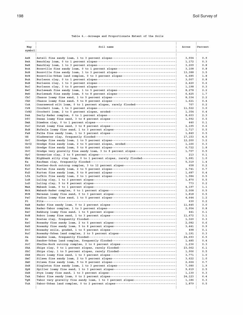
198 Soil Survey of
Table 4.--Acreage and Proportionate Extent of the Soils______________________________________________________________________________________________________________ | | | Map | Soil name | Acres |Percentsymbol| | |______________________________________________________________________________________________________________ | | |AxB |Axtell fine sandy loam, 1 to 3 percent slopes--------------------------------------| 3,554 | 0.9BeA |Benchley loam, 0 to 1 percent slopes-----------------------------------------------| 1,172 | 0.3BeB |Benchley loam, 1 to 3 percent slopes-----------------------------------------------| 3,209 | 0.8BoA |Boonville fine sandy loam, 0 to 1 percent slopes-----------------------------------| 3,108 | 0.8BoB |Boonville fine sandy loam, 1 to 3 percent slopes-----------------------------------| 13,388 | 3.5BrB |Boonville-Urban land complex, 0 to 3 percent slopes--------------------------------| 6,685 | 1.8BuA |Burleson clay, 0 to 1 percent slopes-----------------------------------------------| 3,007 | 0.8BuB |Burleson clay, 1 to 3 percent slopes-----------------------------------------------| 2,420 | 0.6BuC |Burleson clay, 3 to 5 percent slopes-----------------------------------------------| 1,198 | 0.3BwC |Burlewash fine sandy loam, 1 to 5 percent slopes-----------------------------------| 8,278 | 2.2BwD |Burlewash fine sandy loam, 5 to 8 percent slopes-----------------------------------| 6,425 | 1.7ChC |Chazos loamy fine sand, 1 to 5 percent slopes--------------------------------------| 8,334 | 2.2ChD |Chazos loamy fine sand, 5 to 8 percent slopes--------------------------------------| 1,621 | 0.4CoA |Coarsewood silt loam, 0 to 1 percent slopes, rarely flooded------------------------| 707 | 0.2CrB |Crockett loam, 1 to 3 percent slopes-----------------------------------------------| 11,522 | 3.0CrB2 |Crockett loam, 2 to 5 percent slopes, eroded---------------------------------------| 1,354 | 0.4DeA |Derly-Rader complex, 0 to 1 percent slopes-----------------------------------------| 8,603 | 2.3DfC |Desan loamy fine sand, 3 to 8 percent slopes---------------------------------------| 1,992 | 0.5DmA |Dimebox clay, 0 to 1 percent slopes------------------------------------------------| 440 | 0.1DuC |Dutek loamy fine sand, 3 to 8 percent slopes---------------------------------------| 2,195 | 0.6EuB |Eufaula loamy fine sand, 1 to 3 percent slopes-------------------------------------| 1,717 | 0.5FaB |Falba fine sandy loam, 1 to 3 percent slopes---------------------------------------| 1,849 | 0.5Gd |Gladewater clay, frequently flooded------------------------------------------------| 17,153 | 4.5GrC |Gredge fine sandy loam, 1 to 5 percent slopes--------------------------------------| 12,200 | 3.2GrC2 |Gredge fine sandy loam, 2 to 5 percent slopes, eroded------------------------------| 1,166 | 0.3GrD |Gredge fine sandy loam, 5 to 8 percent slopes--------------------------------------| 6,722 | 1.8GvC |Gredge very gravelly fine sandy loam, 3 to 8 percent slopes------------------------| 1,707 | 0.5GyC |Greenvine clay, 2 to 5 percent slopes----------------------------------------------| 213 | 0.1HbA |Highbank silty clay loam, 0 to 1 percent slopes, rarely flooded--------------------| 3,681 | 1.0Ka |Kaufman clay, frequently flooded---------------------------------------------------| 5,319 | 1.4KrD |Koether-Rock outcrop complex, 3 to 12 percent slopes-------------------------------| 658 | 0.2KuC |Kurten fine sandy loam, 2 to 5 percent slopes--------------------------------------| 2,741 | 0.7KuD |Kurten fine sandy loam, 5 to 8 percent slopes--------------------------------------| 1,687 | 0.4LfA |Lufkin fine sandy loam, 0 to 1 percent slopes--------------------------------------| 1,984 | 0.5LuB |Luling clay, 1 to 3 percent slopes-------------------------------------------------| 1,870 | 0.5LuD |Luling clay, 5 to 8 percent slopes-------------------------------------------------| 773 | 0.2MaA |Mabank loam, 0 to 1 percent slopes-------------------------------------------------| 4,197 | 1.1MrA |Mabank-Rader complex, 0 to 1 percent slopes----------------------------------------| 2,008 | 0.5NvB |Navasan loamy fine sand, 0 to 3 percent slopes-------------------------------------| 1,818 | 0.5PaC |Padina loamy fine sand, 1 to 5 percent slopes--------------------------------------| 4,644 | 1.2Pt |Pits-------------------------------------------------------------------------------| 630 | 0.2RaB |Rader fine sandy loam, 0 to 2 percent slopes---------------------------------------| 11,445 | 3.0RbA |Rader-Tabor complex, 1 to 3 percent slopes-----------------------------------------| 2,954 | 0.8ReC |Rehburg loamy fine sand, 1 to 5 percent slopes-------------------------------------| 441 | 0.1RoB |Robco loamy fine sand, 1 to 3 percent slopes---------------------------------------| 11,672 | 3.1Rr |Roetex clay, frequently flooded----------------------------------------------------| 1,320 | 0.3RsC |Rosanky fine sandy loam, 2 to 5 percent slopes-------------------------------------| 2,082 | 0.6RsD |Rosanky fine sandy loam, 5 to 8 percent slopes-------------------------------------| 3,441 | 0.9RtC |Rosanky soils, graded, 1 to 5 percent slopes---------------------------------------| 498 | 0.1RuC |Rosanky-Urban land complex, 2 to 5 percent slopes----------------------------------| 1,191 | 0.3Sa |Sandow loam, frequently flooded----------------------------------------------------| 24,693 | 6.5Sb |Sandow-Urban land complex, frequently flooded--------------------------------------| 1,485 | 0.4ScC |Shalba-Rock outcrop complex, 2 to 6 percent slopes---------------------------------| 1,236 | 0.3ShA |Ships clay, 0 to 1 percent slopes, rarely flooded----------------------------------| 23,062 | 6.1ShC |Ships clay, 1 to 5 percent slopes, rarely flooded----------------------------------| 1,906 | 0.5SkB |Shiro loamy fine sand, 1 to 3 percent slopes---------------------------------------| 3,771 | 1.0SmC |Silawa fine sandy loam, 2 to 5 percent slopes--------------------------------------| 3,622 | 1.0SmD |Silawa fine sandy loam, 5 to 8 percent slopes--------------------------------------| 2,664 | 0.7SnB |Singleton fine sandy loam, 1 to 3 percent slopes-----------------------------------| 7,080 | 1.9SpB |Spiller loamy fine sand, 1 to 3 percent slopes-------------------------------------| 9,619 | 2.5SxB |Styx loamy fine sand, 1 to 3 percent slopes----------------------------------------| 1,130 | 0.3TaA |Tabor fine sandy loam, 0 to 2 percent slopes---------------------------------------| 24,123 | 6.4TgB |Tabor very gravelly fine sandy loam, 1 to 3 percent slopes-------------------------| 1,186 | 0.3TuA |Tabor-Urban land complex, 0 to 2 percent slopes------------------------------------| 1,879 | 0.5 | | |
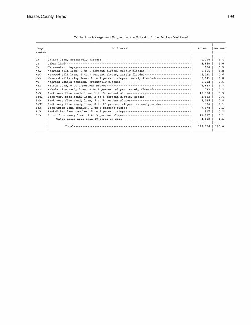
Brazos County, Texas 199
Table 4.--Acreage and Proportionate Extent of the Soils--Continued______________________________________________________________________________________________________________ | | | Map | Soil name | Acres |Percentsymbol| | |______________________________________________________________________________________________________________ | | |Uh |Uhland loam, frequently flooded----------------------------------------------------| 5,328 | 1.4Ur |Urban land-------------------------------------------------------------------------| 3,840 | 1.0Us |Ustarents, clayey------------------------------------------------------------------| 956 | 0.3WeA |Weswood silt loam, 0 to 1 percent slopes, rarely flooded---------------------------| 6,666 | 1.8WeC |Weswood silt loam, 1 to 5 percent slopes, rarely flooded---------------------------| 2,131 | 0.6WwA |Weswood silty clay loam, 0 to 1 percent slopes, rarely flooded---------------------| 2,941 | 0.8Wy |Weswood-Yahola complex, frequently flooded-----------------------------------------| 2,202 | 0.6WzA |Wilson loam, 0 to 1 percent slopes-------------------------------------------------| 4,843 | 1.3YaA |Yahola fine sandy loam, 0 to 1 percent slopes, rarely flooded----------------------| 733 | 0.2ZaB |Zack very fine sandy loam, 1 to 5 percent slopes-----------------------------------| 12,380 | 3.3ZaC2 |Zack very fine sandy loam, 2 to 5 percent slopes, eroded---------------------------| 1,623 | 0.4ZaD |Zack very fine sandy loam, 5 to 8 percent slopes-----------------------------------| 3,025 | 0.8ZaE3 |Zack very fine sandy loam, 8 to 25 percent slopes, severely eroded-----------------| 374 | 0.1ZcB |Zack-Urban land complex, 1 to 5 percent slopes-------------------------------------| 7,978 | 2.1ZcD |Zack-Urban land complex, 5 to 8 percent slopes-------------------------------------| 917 | 0.2ZuB |Zulch fine sandy loam, 1 to 3 percent slopes---------------------------------------| 11,707 | 3.1 | Water areas more than 40 acres in size----------------------------------------| 4,013 | 1.1 | |-----------|------- | Total--------------------------------------------------------------------| 378,106 | 100.0 | | |______________________________________________________________________________________________________________
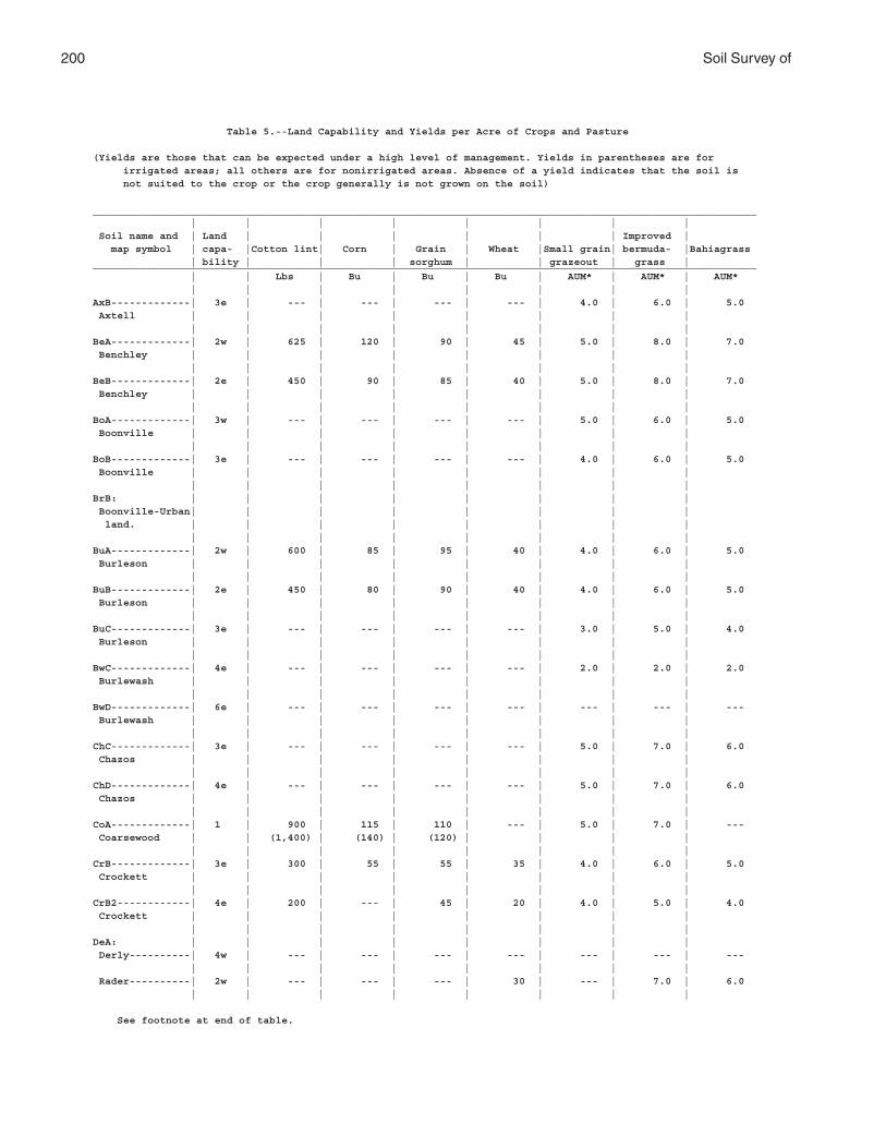
200 Soil Survey of
Table 5.--Land Capability and Yields per Acre of Crops and Pasture
(Yields are those that can be expected under a high level of management. Yields in parentheses are for irrigated areas; all others are for nonirrigated areas. Absence of a yield indicates that the soil is not suited to the crop or the crop generally is not grown on the soil)
_____________________________________________________________________________________________________________ | | | | | | | | Soil name and | Land | | | | | | Improved | map symbol | capa- |Cotton lint| Corn | Grain | Wheat |Small grain| bermuda- |Bahiagrass | bility | | | sorghum | | grazeout | grass |_____________________________________________________________________________________________________________ | | Lbs | Bu | Bu | Bu | AUM* | AUM* | AUM* | | | | | | | |AxB-------------| 3e | --- | --- | --- | --- | 4.0 | 6.0 | 5.0 Axtell | | | | | | | | | | | | | | | |BeA-------------| 2w | 625 | 120 | 90 | 45 | 5.0 | 8.0 | 7.0 Benchley | | | | | | | | | | | | | | | |BeB-------------| 2e | 450 | 90 | 85 | 40 | 5.0 | 8.0 | 7.0 Benchley | | | | | | | | | | | | | | | |BoA-------------| 3w | --- | --- | --- | --- | 5.0 | 6.0 | 5.0 Boonville | | | | | | | | | | | | | | | |BoB-------------| 3e | --- | --- | --- | --- | 4.0 | 6.0 | 5.0 Boonville | | | | | | | | | | | | | | | |BrB: | | | | | | | | Boonville-Urban| | | | | | | | land. | | | | | | | | | | | | | | | |BuA-------------| 2w | 600 | 85 | 95 | 40 | 4.0 | 6.0 | 5.0 Burleson | | | | | | | | | | | | | | | |BuB-------------| 2e | 450 | 80 | 90 | 40 | 4.0 | 6.0 | 5.0 Burleson | | | | | | | | | | | | | | | |BuC-------------| 3e | --- | --- | --- | --- | 3.0 | 5.0 | 4.0 Burleson | | | | | | | | | | | | | | | |BwC-------------| 4e | --- | --- | --- | --- | 2.0 | 2.0 | 2.0 Burlewash | | | | | | | | | | | | | | | |BwD-------------| 6e | --- | --- | --- | --- | --- | --- | --- Burlewash | | | | | | | | | | | | | | | |ChC-------------| 3e | --- | --- | --- | --- | 5.0 | 7.0 | 6.0 Chazos | | | | | | | | | | | | | | | |ChD-------------| 4e | --- | --- | --- | --- | 5.0 | 7.0 | 6.0 Chazos | | | | | | | | | | | | | | | |CoA-------------| 1 | 900 | 115 | 110 | --- | 5.0 | 7.0 | --- Coarsewood | | (1,400) | (140) | (120) | | | | | | | | | | | |CrB-------------| 3e | 300 | 55 | 55 | 35 | 4.0 | 6.0 | 5.0 Crockett | | | | | | | | | | | | | | | |CrB2------------| 4e | 200 | --- | 45 | 20 | 4.0 | 5.0 | 4.0 Crockett | | | | | | | | | | | | | | | |DeA: | | | | | | | | Derly----------| 4w | --- | --- | --- | --- | --- | --- | --- | | | | | | | | Rader----------| 2w | --- | --- | --- | 30 | --- | 7.0 | 6.0 | | | | | | | |
See footnote at end of table.
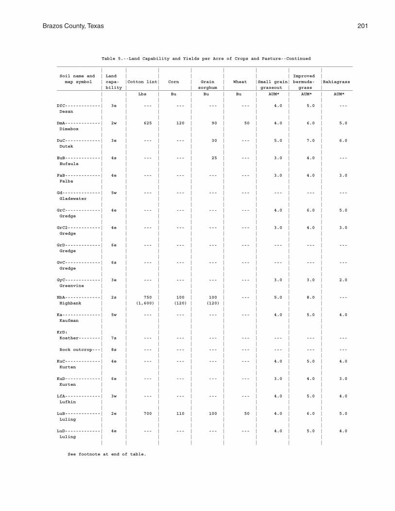
Brazos County, Texas 201
Table 5.--Land Capability and Yields per Acre of Crops and Pasture--Continued_____________________________________________________________________________________________________________ | | | | | | | | Soil name and | Land | | | | | | Improved | map symbol | capa- |Cotton lint| Corn | Grain | Wheat |Small grain| bermuda- |Bahiagrass | bility | | | sorghum | | grazeout | grass |_____________________________________________________________________________________________________________ | | Lbs | Bu | Bu | Bu | AUM* | AUM* | AUM* | | | | | | | |DfC-------------| 3e | --- | --- | --- | --- | 4.0 | 5.0 | --- Desan | | | | | | | | | | | | | | | |DmA-------------| 2w | 625 | 120 | 90 | 50 | 4.0 | 6.0 | 5.0 Dimebox | | | | | | | | | | | | | | | |DuC-------------| 3e | --- | --- | 30 | --- | 5.0 | 7.0 | 6.0 Dutek | | | | | | | | | | | | | | | |EuB-------------| 4s | --- | --- | 25 | --- | 3.0 | 4.0 | --- Eufaula | | | | | | | | | | | | | | | |FaB-------------| 4e | --- | --- | --- | --- | 3.0 | 4.0 | 3.0 Falba | | | | | | | | | | | | | | | |Gd--------------| 5w | --- | --- | --- | --- | --- | --- | --- Gladewater | | | | | | | | | | | | | | | |GrC-------------| 4e | --- | --- | --- | --- | 4.0 | 6.0 | 5.0 Gredge | | | | | | | | | | | | | | | |GrC2------------| 4e | --- | --- | --- | --- | 3.0 | 4.0 | 3.0 Gredge | | | | | | | | | | | | | | | |GrD-------------| 6e | --- | --- | --- | --- | --- | --- | --- Gredge | | | | | | | | | | | | | | | |GvC-------------| 6s | --- | --- | --- | --- | --- | --- | --- Gredge | | | | | | | | | | | | | | | |GyC-------------| 3e | --- | --- | --- | --- | 3.0 | 3.0 | 2.0 Greenvine | | | | | | | | | | | | | | | |HbA-------------| 2s | 750 | 100 | 100 | --- | 5.0 | 8.0 | --- Highbank | | (1,600) | (120) | (120) | | | | | | | | | | | |Ka--------------| 5w | --- | --- | --- | --- | 4.0 | 5.0 | 4.0 Kaufman | | | | | | | | | | | | | | | |KrD: | | | | | | | | Koether--------| 7s | --- | --- | --- | --- | --- | --- | --- | | | | | | | | Rock outcrop---| 8s | --- | --- | --- | --- | --- | --- | --- | | | | | | | |KuC-------------| 4e | --- | --- | --- | --- | 4.0 | 5.0 | 4.0 Kurten | | | | | | | | | | | | | | | |KuD-------------| 6e | --- | --- | --- | --- | 3.0 | 4.0 | 3.0 Kurten | | | | | | | | | | | | | | | |LfA-------------| 3w | --- | --- | --- | --- | 4.0 | 5.0 | 4.0 Lufkin | | | | | | | | | | | | | | | |LuB-------------| 2e | 700 | 110 | 100 | 50 | 4.0 | 6.0 | 5.0 Luling | | | | | | | | | | | | | | | |LuD-------------| 4e | --- | --- | --- | --- | 4.0 | 5.0 | 4.0 Luling | | | | | | | | | | | | | | | |
See footnote at end of table.

202 Soil Survey of
Table 5.--Land Capability and Yields per Acre of Crops and Pasture--Continued_____________________________________________________________________________________________________________ | | | | | | | | Soil name and | Land | | | | | | Improved | map symbol | capa- |Cotton lint| Corn | Grain | Wheat |Small grain| bermuda- |Bahiagrass | bility | | | sorghum | | grazeout | grass |_____________________________________________________________________________________________________________ | | Lbs | Bu | Bu | Bu | AUM* | AUM* | AUM* | | | | | | | |MaA-------------| 3w | 330 | 55 | 55 | --- | 4.0 | 5.0 | 4.0 Mabank | | | | | | | | | | | | | | | |MrA: | | | | | | | | Mabank---------| 3w | 330 | 55 | 55 | --- | 4.0 | 5.0 | 4.0 | | | | | | | | Rader----------| 2w | --- | 65 | 70 | 30 | --- | 7.0 | 6.0 | | | | | | | |NvB-------------| 3s | --- | --- | --- | --- | --- | 7.0 | --- Navasan | | | | | | | | | | | | | | | |PaC-------------| 3e | --- | --- | --- | --- | 5.0 | 7.0 | --- Padina | | | | | | | | | | | | | | | |Pt--------------| 8s | --- | --- | --- | --- | --- | --- | --- Pits | | | | | | | | | | | | | | | |RaB-------------| 3e | 200 | 60 | 70 | 30 | 5.0 | 7.0 | 6.0 Rader | | | | | | | | | | | | | | | |RbA: | | | | | | | | Rader----------| 3e | 200 | 60 | 70 | 30 | 5.0 | 7.0 | --- | | | | | | | | Tabor----------| 3e | --- | --- | --- | --- | --- | 7.0 | 6.0 | | | | | | | |ReC-------------| 3e | --- | --- | --- | --- | 4.0 | 6.0 | 5.0 Rehburg | | | | | | | | | | | | | | | |RoB-------------| 2e | --- | --- | --- | --- | 5.0 | 7.0 | 6.0 Robco | | | | | | | | | | | | | | | |Rr--------------| 7w | --- | --- | --- | --- | --- | --- | --- Roetex | | | | | | | | | | | | | | | |RsC-------------| 3e | --- | --- | --- | 30 | 5.0 | 7.0 | 6.0 Rosanky | | | | | | | | | | | | | | | |RsD-------------| 4e | --- | --- | 35 | 25 | 4.0 | 6.0 | 5.0 Rosanky | | | | | | | | | | | | | | | |RtC-------------| 6s | --- | --- | --- | --- | --- | --- | --- Rosanky | | | | | | | | | | | | | | | |RuC: | | | | | | | | Rosanky-Urban | | | | | | | | land. | | | | | | | | | | | | | | | |Sa--------------| 5w | --- | --- | --- | --- | 5.0 | 8.0 | 7.0 Sandow | | | | | | | | | | | | | | | |Sb: | | | | | | | | Sandow-Urban | | | | | | | | land. | | | | | | | | | | | | | | | |
See footnote at end of table.
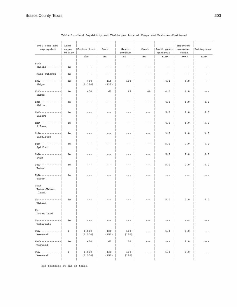
Brazos County, Texas 203
Table 5.--Land Capability and Yields per Acre of Crops and Pasture--Continued_____________________________________________________________________________________________________________ | | | | | | | | Soil name and | Land | | | | | | Improved | map symbol | capa- |Cotton lint| Corn | Grain | Wheat |Small grain| bermuda- |Bahiagrass | bility | | | sorghum | | grazeout | grass |_____________________________________________________________________________________________________________ | | Lbs | Bu | Bu | Bu | AUM* | AUM* | AUM* | | | | | | | |ScC: | | | | | | | | Shalba---------| 4s | --- | --- | --- | --- | --- | --- | --- | | | | | | | | Rock outcrop---| 8s | --- | --- | --- | --- | --- | --- | --- | | | | | | | |ShA-------------| 2s | 750 | 115 | 100 | --- | 4.0 | 6.0 | --- Ships | | (1,150) | (125) | | | | | | | | | | | | |ShC-------------| 3e | 400 | 60 | 45 | 40 | 4.0 | 6.0 | --- Ships | | | | | | | | | | | | | | | |SkB-------------| 3e | --- | --- | --- | --- | 4.0 | 5.0 | 4.0 Shiro | | | | | | | | | | | | | | | |SmC-------------| 3e | --- | --- | --- | --- | 5.0 | 7.0 | 6.0 Silawa | | | | | | | | | | | | | | | |SmD-------------| 4e | --- | --- | --- | --- | 4.0 | 6.0 | 5.0 Silawa | | | | | | | | | | | | | | | |SnB-------------| 4e | --- | --- | --- | --- | 3.0 | 4.0 | 3.0 Singleton | | | | | | | | | | | | | | | |SpB-------------| 3e | --- | --- | --- | --- | 5.0 | 7.0 | 6.0 Spiller | | | | | | | | | | | | | | | |SxB-------------| 3e | --- | --- | --- | --- | 5.0 | 7.0 | 6.0 Styx | | | | | | | | | | | | | | | |TaA-------------| 3e | --- | --- | --- | --- | 5.0 | 7.0 | 6.0 Tabor | | | | | | | | | | | | | | | |TgB-------------| 6s | --- | --- | --- | --- | --- | --- | --- Tabor | | | | | | | | | | | | | | | |TuA: | | | | | | | | Tabor-Urban | | | | | | | | land. | | | | | | | | | | | | | | | |Uh--------------| 5w | --- | --- | --- | --- | 5.0 | 7.0 | 6.0 Uhland | | | | | | | | | | | | | | | |Ur. | | | | | | | | Urban land | | | | | | | | | | | | | | | |Us--------------| 6e | --- | --- | --- | --- | --- | --- | --- Ustarents | | | | | | | | | | | | | | | |WeA-------------| 1 | 1,000 | 130 | 100 | --- | 5.0 | 8.0 | --- Weswood | | (1,500) | (150) | (120) | | | | | | | | | | | |WeC-------------| 3e | 450 | 60 | 70 | --- | --- | 8.0 | --- Weswood | | | | | | | | | | | | | | | |WwA-------------| 1 | 1,000 | 130 | 100 | --- | 5.0 | 8.0 | --- Weswood | | (1,500) | (150) | (120) | | | | | | | | | | | |
See footnote at end of table.
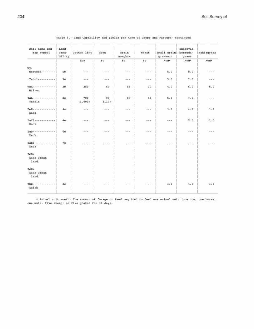
204 Soil Survey of
Table 5.--Land Capability and Yields per Acre of Crops and Pasture--Continued_____________________________________________________________________________________________________________ | | | | | | | | Soil name and | Land | | | | | | Improved | map symbol | capa- |Cotton lint| Corn | Grain | Wheat |Small grain| bermuda- |Bahiagrass | bility | | | sorghum | | grazeout | grass |_____________________________________________________________________________________________________________ | | Lbs | Bu | Bu | Bu | AUM* | AUM* | AUM* | | | | | | | |Wy: | | | | | | | | Weswood--------| 5w | --- | --- | --- | --- | 5.0 | 8.0 | --- | | | | | | | | Yahola---------| 5w | --- | --- | --- | --- | 5.0 | 7.0 | --- | | | | | | | |WzA-------------| 3w | 350 | 60 | 55 | 30 | 4.0 | 6.0 | 5.0 Wilson | | | | | | | | | | | | | | | |YaA-------------| 2e | 700 | 90 | 80 | 45 | 5.0 | 7.0 | --- Yahola | | (1,000) | (110) | | | | | | | | | | | | |ZaB-------------| 4e | --- | --- | --- | --- | 3.0 | 4.0 | 3.0 Zack | | | | | | | | | | | | | | | |ZaC2------------| 4e | --- | --- | --- | --- | --- | 2.0 | 1.0 Zack | | | | | | | | | | | | | | | |ZaD-------------| 6e | --- | --- | --- | --- | --- | --- | --- Zack | | | | | | | | | | | | | | | |ZaE3------------| 7e | --- | --- | --- | --- | --- | --- | --- Zack | | | | | | | | | | | | | | | |ZcB: | | | | | | | | Zack-Urban | | | | | | | | land. | | | | | | | | | | | | | | | |ZcD: | | | | | | | | Zack-Urban | | | | | | | | land. | | | | | | | | | | | | | | | |ZuB-------------| 3e | --- | --- | --- | --- | 3.0 | 4.0 | 3.0 Zulch | | | | | | | | | | | | | | | |_____________________________________________________________________________________________________________
* Animal unit month: The amount of forage or feed required to feed one animal unit (one cow, one horse,one mule, five sheep, or five goats) for 30 days.
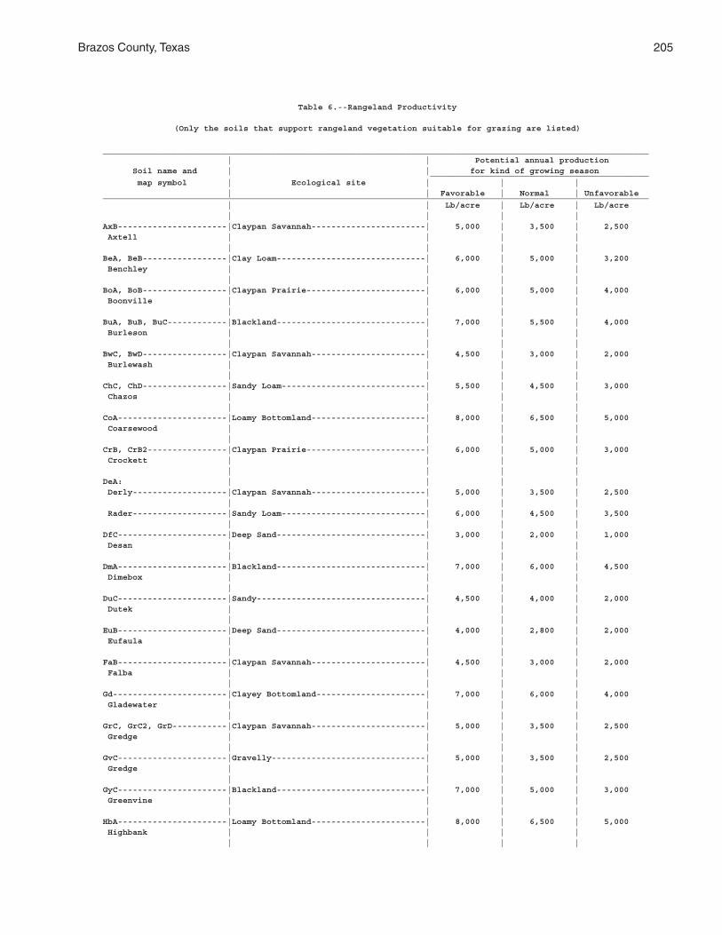
Brazos County, Texas 205
Table 6.--Rangeland Productivity
(Only the soils that support rangeland vegetation suitable for grazing are listed)
______________________________________________________________________________________________________________ | | Potential annual production Soil name and | | for kind of growing season ____________________________________________ map symbol | Ecological site | | | | | Favorable | Normal | Unfavorable______________________________________________________________________________________________________________ | | Lb/acre | Lb/acre | Lb/acre | | | |AxB----------------------|Claypan Savannah-----------------------| 5,000 | 3,500 | 2,500 Axtell | | | | | | | |BeA, BeB-----------------|Clay Loam------------------------------| 6,000 | 5,000 | 3,200 Benchley | | | | | | | |BoA, BoB-----------------|Claypan Prairie------------------------| 6,000 | 5,000 | 4,000 Boonville | | | | | | | |BuA, BuB, BuC------------|Blackland------------------------------| 7,000 | 5,500 | 4,000 Burleson | | | | | | | |BwC, BwD-----------------|Claypan Savannah-----------------------| 4,500 | 3,000 | 2,000 Burlewash | | | | | | | |ChC, ChD-----------------|Sandy Loam-----------------------------| 5,500 | 4,500 | 3,000 Chazos | | | | | | | |CoA----------------------|Loamy Bottomland-----------------------| 8,000 | 6,500 | 5,000 Coarsewood | | | | | | | |CrB, CrB2----------------|Claypan Prairie------------------------| 6,000 | 5,000 | 3,000 Crockett | | | | | | | |DeA: | | | | Derly-------------------|Claypan Savannah-----------------------| 5,000 | 3,500 | 2,500 | | | | Rader-------------------|Sandy Loam-----------------------------| 6,000 | 4,500 | 3,500 | | | |DfC----------------------|Deep Sand------------------------------| 3,000 | 2,000 | 1,000 Desan | | | | | | | |DmA----------------------|Blackland------------------------------| 7,000 | 6,000 | 4,500 Dimebox | | | | | | | |DuC----------------------|Sandy----------------------------------| 4,500 | 4,000 | 2,000 Dutek | | | | | | | |EuB----------------------|Deep Sand------------------------------| 4,000 | 2,800 | 2,000 Eufaula | | | | | | | |FaB----------------------|Claypan Savannah-----------------------| 4,500 | 3,000 | 2,000 Falba | | | | | | | |Gd-----------------------|Clayey Bottomland----------------------| 7,000 | 6,000 | 4,000 Gladewater | | | | | | | |GrC, GrC2, GrD-----------|Claypan Savannah-----------------------| 5,000 | 3,500 | 2,500 Gredge | | | | | | | |GvC----------------------|Gravelly-------------------------------| 5,000 | 3,500 | 2,500 Gredge | | | | | | | |GyC----------------------|Blackland------------------------------| 7,000 | 5,000 | 3,000 Greenvine | | | | | | | |HbA----------------------|Loamy Bottomland-----------------------| 8,000 | 6,500 | 5,000 Highbank | | | | | | | |
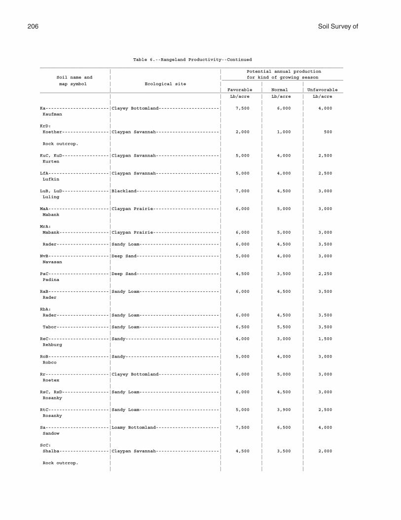
206 Soil Survey of
Table 6.--Rangeland Productivity--Continued______________________________________________________________________________________________________________ | | Potential annual production Soil name and | | for kind of growing season ____________________________________________ map symbol | Ecological site | | | | | Favorable | Normal | Unfavorable______________________________________________________________________________________________________________ | | Lb/acre | Lb/acre | Lb/acre | | | |Ka-----------------------|Clayey Bottomland----------------------| 7,500 | 6,000 | 4,000 Kaufman | | | | | | | |KrD: | | | | Koether-----------------|Claypan Savannah-----------------------| 2,000 | 1,000 | 500 | | | | Rock outcrop. | | | | | | | |KuC, KuD-----------------|Claypan Savannah-----------------------| 5,000 | 4,000 | 2,500 Kurten | | | | | | | |LfA----------------------|Claypan Savannah-----------------------| 5,000 | 4,000 | 2,500 Lufkin | | | | | | | |LuB, LuD-----------------|Blackland------------------------------| 7,000 | 4,500 | 3,000 Luling | | | | | | | |MaA----------------------|Claypan Prairie------------------------| 6,000 | 5,000 | 3,000 Mabank | | | | | | | |MrA: | | | | Mabank------------------|Claypan Prairie------------------------| 6,000 | 5,000 | 3,000 | | | | Rader-------------------|Sandy Loam-----------------------------| 6,000 | 4,500 | 3,500 | | | |NvB----------------------|Deep Sand------------------------------| 5,000 | 4,000 | 3,000 Navasan | | | | | | | |PaC----------------------|Deep Sand------------------------------| 4,500 | 3,500 | 2,250 Padina | | | | | | | |RaB----------------------|Sandy Loam-----------------------------| 6,000 | 4,500 | 3,500 Rader | | | | | | | |RbA: | | | | Rader-------------------|Sandy Loam-----------------------------| 6,000 | 4,500 | 3,500 | | | | Tabor-------------------|Sandy Loam-----------------------------| 6,500 | 5,500 | 3,500 | | | |ReC----------------------|Sandy----------------------------------| 4,000 | 3,000 | 1,500 Rehburg | | | | | | | |RoB----------------------|Sandy----------------------------------| 5,000 | 4,000 | 3,000 Robco | | | | | | | |Rr-----------------------|Clayey Bottomland----------------------| 6,000 | 5,000 | 3,000 Roetex | | | | | | | |RsC, RsD-----------------|Sandy Loam-----------------------------| 6,000 | 4,500 | 3,000 Rosanky | | | | | | | |RtC----------------------|Sandy Loam-----------------------------| 5,000 | 3,900 | 2,500 Rosanky | | | | | | | |Sa-----------------------|Loamy Bottomland-----------------------| 7,500 | 6,500 | 4,000 Sandow | | | | | | | |ScC: | | | | Shalba------------------|Claypan Savannah-----------------------| 4,500 | 3,500 | 2,000 | | | | Rock outcrop. | | | | | | | |

Brazos County, Texas 207
Table 6.--Rangeland Productivity--Continued______________________________________________________________________________________________________________ | | Potential annual production Soil name and | | for kind of growing season ____________________________________________ map symbol | Ecological site | | | | | Favorable | Normal | Unfavorable______________________________________________________________________________________________________________ | | Lb/acre | Lb/acre | Lb/acre | | | |ShA, ShC-----------------|Clayey Bottomland----------------------| 7,500 | 6,000 | 4,500 Ships | | | | | | | |SkB----------------------|Sandy Loam-----------------------------| 5,000 | 4,200 | 2,500 Shiro | | | | | | | |SmC, SmD-----------------|Sandy Loam-----------------------------| 5,500 | 4,500 | 2,500 Silawa | | | | | | | |SnB----------------------|Claypan Savannah-----------------------| 5,000 | 4,000 | 2,500 Singleton | | | | | | | |SpB----------------------|Sandy Loam-----------------------------| 6,000 | 4,500 | 3,000 Spiller | | | | | | | |SxB----------------------|Sandy----------------------------------| 5,500 | 4,500 | 3,000 Styx | | | | | | | |TaA----------------------|Sandy Loam-----------------------------| 6,500 | 5,500 | 3,500 Tabor | | | | | | | |TgB----------------------|Gravelly-------------------------------| 4,500 | 3,500 | 2,000 Tabor | | | | | | | |Uh-----------------------|Loamy Bottomland-----------------------| 7,500 | 6,500 | 4,000 Uhland | | | | | | | |WeA, WeC, WwA------------|Loamy Bottomland-----------------------| 8,000 | 6,500 | 5,000 Weswood | | | | | | | |Wy: | | | | Weswood-----------------|Loamy Bottomland-----------------------| 8,000 | 6,500 | 5,000 | | | | Yahola------------------|Loamy Bottomland-----------------------| 7,000 | 4,900 | 3,500 | | | |WzA----------------------|Claypan Prairie------------------------| 6,000 | 4,500 | 3,000 Wilson | | | | | | | |YaA----------------------|Loamy Bottomland-----------------------| 7,500 | 5,500 | 4,000 Yahola | | | | | | | |ZaB, ZaC2, ZaD, ZaE3-----|Claypan Prairie------------------------| 5,000 | 3,500 | 2,000 Zack | | | | | | | |ZuB----------------------|Claypan Prairie------------------------| 5,000 | 4,000 | 3,500 Zulch | | | | | | | |______________________________________________________________________________________________________________
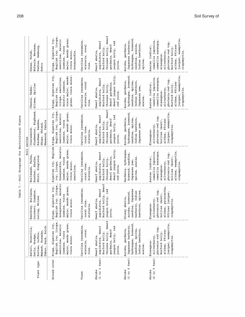
208 Soil Survey ofTable 7.--Soil Groupings for Horticultural Plants
_________________________________________________________________________________________________________________________________________________
| Soil series
___________________________________________________________________________________________________________________________________
|Axtell, Boonville, |Benchley, Burleson, |Burlewash, Falba, |Coarsewood, |Chazos, Rader, |Desan, Dutek,
|Derly, Gredge, |Crockett, Dimebox, |Koether, Shalba, |Gladewater, Highbank,|Silawa, Spiller |Eufaula, Navasan,
Plant type |Kurten, Lufkin, |Luling, Wilson |Shiro, Singleton |Kaufman, Sandow, | |Padina, Rehburg,
|Mabank, Rosanky, | | |Ships, Uhland, | |Robco
|Tabor, Zack, Zulch | | |Weswood, Yahola | |
_________________________________________________________________________________________________________________________________________________
| | | | | |
Ground cover |Ajuga, Algerian ivy, |Ajuga, Algerian ivy, |Algerian ivy, English|Ajuga, Algerian ivy, |Ajuga, Algerian ivy, |Ajuga, Algerian ivy,
| English ivy, lirope,| English ivy, lirope,| ivy, lirope, | English ivy, lirope,| English ivy, | English ivy, lirope,
| santolina, Asiatic | honeysuckle, Asiatic| honeysuckle, Asiatic| santolina, Asiatic | lirope, santolina, | santolina, Asiatic
| jasmine, vinca | jasmine, vinca | jasmine, vinca | jasmine, vinca | Asiatic jasmine, | jasmine, vinca
| major, mondo grass, | major, mondo grass, | major, mondo grass, | major, mondo grass, | vinca major, mondo | major, mondo grass,
| vinca minor. | vinca minor. | vinca minor, | vinca minor. | grass, vinca minor. | vinca minor,
| | | santolina. | | | honeysuckle.
| | | | | |
Vines |Carolina jessamine, |Carolina jessamine, |Carolina jessamine, |Carolina jessamine, |Carolina jessamine, |Carolina jessamine,
| wisteria, coral | coral vine, | coral vine, | coral vine, | wisteria, coral | wisteria, coral
| vine. | wisteria. | wisteria. | wisteria. | vine. | vine.
| | | | | |
Shrubs |Dwarf abelia, |Dwarf abelia, |Dwarf abelia, |Dwarf abelia, |Dwarf abelia, |Dwarf abelia,
(1 to 3 feet)| aspidistra, dwarf | aspidistra, dwarf | aspidistra, dwarf | aspidistra, dwarf | aspidistra, dwarf | aspidistra, dwarf
| Burford holly, | Burford holly, dwarf| Burford holly, | Burford holly, | Burford holly, | Burford holly,
| Chinese holly, dwarf| yaupon holly, red | Chinese holly, | Chinese holly, dwarf| Chinese holly, | Chinese holly, dwarf
| gardenia, dwarf | yucca. | dwarf gardenia, | gardenia, dwarf | dwarf gardenia, | gardenia, dwarf
| yaupon holly, red | | dwarf yaupon holly, | yaupon holly, red | dwarf yaupon holly, | yaupon holly, red
| yucca. | | red yucca. | yucca. | red yucca. | yucca.
| | | | | |
Shrubs |Aucuba, gardenia, |Glossy abelia, |Gardenia, hydrangea, |Aucuba, gardenia, |Aucuba, gardenia, |Aucuba, gardenia,
(3 to 5 feet)| Japanese barberry, | aucuba, boxwood, | boxwood, nandina, | hydrangea, boxwood, | hydrangea, boxwood, | Japanese barberry,
| hydrangea, boxwood, | nandina, Japanese | Japanese yew, | nandina, spirea, | nandina, spirea, | hydrangea, boxwood,
| nandina, spirea, | barberry, Indian | spirea, azalea. | Indian hawthorn, | Indian hawthorn, | nandina, azalea,
| Indian hawthorn, | hawthorn, spirea. | | Japanese yew. | Japanese yew, | Indian hawthorn,
| azalea. | | | | azalea. | spirea.
| | | | | |
Shrubs |Elaeagnus- |Elaeagnus- |Azalea (indica), |Elaeagnus- |Azalea (indica), |Azalea (indica),
(6 to 9 feet)| silverberry, | silverberry, | camellia japonica, | silverberry, | camellia japonica, | camellia japonica,
| photenia-red top, | photenia-red top, | camellia sasanqua, | photenia-red top, | camellia sasanqua, | camellia sasanqua,
| Burford holly, | hollies (most), | elaeagnus- | hollies (most), | elaeagnus- | elaeagnus-
| althea, Pfitzer | althea, pyracantha, | silverberry, | althea, Pfitzer | silverberry, | silverberry,
| juniper, waxmyrtle, | Pfitzer juniper, | photenia-red top, | juniper, waxmyrtle, | photenia-red top, | photenia-red top,
| crapemyrtle. | crapemyrtle. | hollies (most), | crapemyrtle. | Burford holly, | Burford holly,
| | | althea, waxmyrtle, | | althea, Pfitzer | althea, Pfitzer
| | | crapemyrtle. | | juniper, waxmyrtle, | juniper, waxmyrtle,
| | | | | crapemyrtle. | crapemyrtle.
| | | | | |
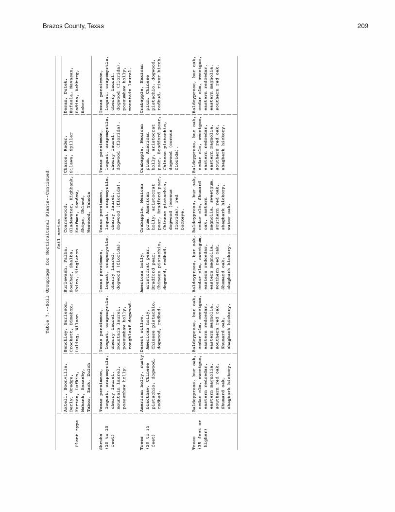
Brazos County, Texas 209
Table 7.--Soil Groupings for Horticultural Plants--Continued
_________________________________________________________________________________________________________________________________________________
| Soil series
___________________________________________________________________________________________________________________________________
|Axtell, Boonville, |Benchley, Burleson, |Burlewash, Falba, |Coarsewood, |Chazos, Rader, |Desan, Dutek,
|Derly, Gredge, |Crockett, Dimebox, |Koether, Shalba, |Gladewater, Highbank,|Silawa, Spiller |Eufaula, Navasan,
Plant type |Kurten, Lufkin, |Luling, Wilson |Shiro, Singleton |Kaufman, Sandow, | |Padina, Rehburg,
|Mabank, Rosanky, | | |Ships, Uhland, | |Robco
|Tabor, Zack, Zulch | | |Weswood, Yahola | |
_________________________________________________________________________________________________________________________________________________
| | | | | |
Shrubs |Texas persimmon, |Texas persimmon, |Texas persimmon, |Texas persimmon, |Texas persimmon, |Texas persimmon,
(10 to 25 | loquat, crapemyrtle,| loquat, crapemyrtle,| loquat, crapemyrtle,| loquat, crapemyrtle,| loquat, crapemyrtle,| loquat, crapemyrtle,
feet) | cherry laurel, | cherry laurel, | cherry laurel, | cherry laurel, | cherry laurel, | cherry laurel,
| mountain laurel, | mountain laurel, | dogwood (florida). | dogwood (florida). | dogwood (florida). | dogwood (florida),
| possumhaw holly. | possumhaw holly, | | | | possumhaw holly,
| | roughleaf dogwood. | | | | mountain laurel.
| | | | | |
Trees |American holly, rusty|Desert willow, |American holly, |Crabapple, Mexican |Crabapple, Mexican |Crabapple, Mexican
(20 to 35 | blackhaw, Chinese | American holly, | aristocrat pear, | plum, American | plum, American | plum, Chinese
feet) | pistachio, dogwood, | Chinese pistachio, | Bradford pear, | holly, aristocrat | holly, aristocrat | pistachio, dogwood,
| redbud. | dogwood, redbud. | Chinese pistachio, | pear, Bradford pear,| pear, Bradford pear,| redbud, river birch.
| | | dogwood, redbud. | Chinese pistachio, | Chinese pistachio, |
| | | | dogwood (cornus | dogwood (cornus |
| | | | florida), red | florida). |
| | | | buckeye. | |
| | | | | |
Trees |Baldcypress, bur oak,|Baldcypress, bur oak,|Baldcypress, bur oak,|Baldcypress, bur oak,|Baldcypress, bur oak,|Baldcypress, bur oak,
(35 feet or | cedar elm, sweetgum,| cedar elm, sweetgum,| cedar elm, sweetgum,| cedar elm, Shumard | cedar elm, sweetgum,| cedar elm, sweetgum,
higher) | eastern redcedar, | eastern redcedar, | eastern redcedar, | oak, eastern | eastern redcedar, | eastern redcedar,
| eastern magnolia, | eastern magnolia, | eastern magnolia, | magnolia, sweetgum, | eastern magnolia, | eastern magnolia,
| southern red oak, | southern red oak, | southern red oak, | southern red oak, | southern red oak, | southern red oak.
| Shumard oak, | Shumard oak, | Shumard oak, | shagbark hickory, | shagbark hickory. |
| shagbark hickory. | shagbark hickory. | shagbark hickory. | water oak. | |
| | | | | |
_________________________________________________________________________________________________________________________________________________
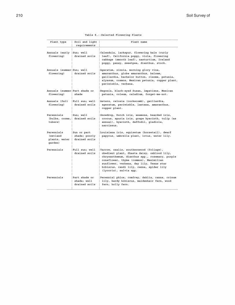
210 Soil Survey of
Table 8.--Selected Flowering Plants_________________________________________________________________________________ Plant type | Soil and light | Plant name | requirements |_________________________________________________________________________________ | |Annuals (early |Sun; well |Calendula, larkspur, flowering kale (curly flowering) | drained soils | leaf), California poppy, viola, flowering | | cabbage (smooth leaf), nasturtium, Iceland | | poppy, pansy, sweetpea, dianthus, stock. | |Annuals (summer|Sun; well |Ageratum, zinnia, morning glory vine, flowering) | drained soils | amaranthus, globe amaranthus, balsam, | | gaillardia, bachelor button, cleome, petunia, | | alyssum, cosmos, Mexican petunia, copper plant, | | periwinkle, verbena. | |Annuals (summer|Part shade or |Begonia, black-eyed Susan, impatiens, Mexican flowering) | shade | petunia, coleum, caladium, forget-me-not. | |Annuals (fall |Full sun; well |Asters, celosia (cockscomb), gaillardia, flowering) | drained soils | ageratum, periwinkle, lantana, amaranthus, | | copper plant. | |Perennials |Sun; well |Snowdrop, Dutch iris, anemone, bearded iris, (bulbs, corms,| drained soils | crocus, spuria iris, grape hyacinth, tulip (as tubers) | | annual), hyacinth, daffodil, gladiola, | | narcissus. | |Perennials |Sun or part |Louisiana iris, equisetum (horsetail), dwarf (wetland | shade; poorly | papyrus, umbrella plant, lotus, water lily. plants, water | drained soils | garden) | | | |Perennials |Full sun; well |Yarrow, oxalis, southernwood (foliage), | drained soils | obedient plant, Shasta daisy, oxblood lily, | | chrysanthemum, dianthus spp., rosemary, purple | | coneflower, thyme (common), Maximilian | | sunflower, verbena, day lily, Texas star | | hibiscus, candi lily, canna, spider lily | | (lycoris), salvia spp. | |Perennials |Part shade or |Perennial phlox, comfrey, dahlia, canna, crinum | shade; well | lily, hardy hibiscus, maidenhair fern, wood | drained soils | fern, holly fern. | |_________________________________________________________________________________
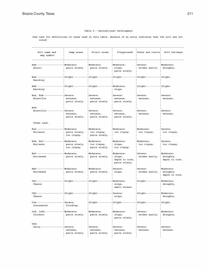
Brazos County, Texas 211
Table 9.--Recreational Development
(See text for definitions of terms used in this table. Absence of an entry indicates that the soil was not rated)
___________________________________________________________________________________________________________ | | | | | Soil name and | Camp areas | Picnic areas | Playgrounds |Paths and trails| Golf fairways map symbol | | | | | | | | | |___________________________________________________________________________________________________________ | | | | |AxB-------------------|Moderate: |Moderate: |Moderate: |Severe: |Moderate: Axtell | percs slowly. | percs slowly. | slope, | erodes easily. | droughty. | | | percs slowly. | | | | | | |BeA-------------------|Slight----------|Slight----------|Slight----------|Slight----------|Slight. Benchley | | | | | | | | | |BeB-------------------|Slight----------|Slight----------|Moderate: |Slight----------|Slight. Benchley | | | slope. | | | | | | |BoA, BoB--------------|Severe: |Severe: |Severe: |Severe: |Severe: Boonville | wetness, | wetness, | wetness, | wetness. | wetness. | percs slowly. | percs slowly. | percs slowly. | | | | | | |BrB: | | | | | Boonville------------|Severe: |Severe: |Severe: |Severe: |Severe: | wetness, | wetness, | wetness, | wetness. | wetness. | percs slowly. | percs slowly. | percs slowly. | | | | | | | Urban land. | | | | | | | | | |BuA-------------------|Moderate: |Moderate: |Moderate: |Moderate: |Severe: Burleson | percs slowly, | too clayey, | too clayey. | too clayey. | too clayey. | too clayey. | percs slowly. | | | | | | | |BuB, BuC--------------|Moderate: |Moderate: |Moderate: |Moderate: |Severe: Burleson | percs slowly, | too clayey, | slope, | too clayey. | too clayey. | too clayey. | percs slowly. | too clayey. | | | | | | |BwC-------------------|Moderate: |Moderate: |Moderate: |Severe: |Moderate: Burlewash | percs slowly. | percs slowly. | slope, | erodes easily. | droughty, | | | depth to rock, | | depth to rock. | | | percs slowly. | | | | | | |BwD-------------------|Moderate: |Moderate: |Severe: |Severe: |Moderate: Burlewash | percs slowly. | percs slowly. | slope. | erodes easily. | droughty, | | | | | depth to rock. | | | | |ChC-------------------|Slight----------|Slight----------|Moderate: |Slight----------|Moderate: Chazos | | | slope, | | droughty. | | | small stones. | | | | | | |ChD-------------------|Slight----------|Slight----------|Severe: |Slight----------|Moderate: Chazos | | | slope. | | droughty. | | | | |CoA-------------------|Severe: |Slight----------|Slight----------|Slight----------|Slight. Coarsewood | flooding. | | | | | | | | |CrB, CrB2-------------|Moderate: |Moderate: |Moderate: |Severe: |Moderate: Crockett | percs slowly. | percs slowly. | slope, | erodes easily. | droughty. | | | percs slowly. | | | | | | |DeA: | | | | | Derly----------------|Severe: |Severe: |Severe: |Severe: |Severe: | wetness, | wetness, | wetness, | wetness. | wetness. | percs slowly. | percs slowly. | percs slowly. | | | | | | |
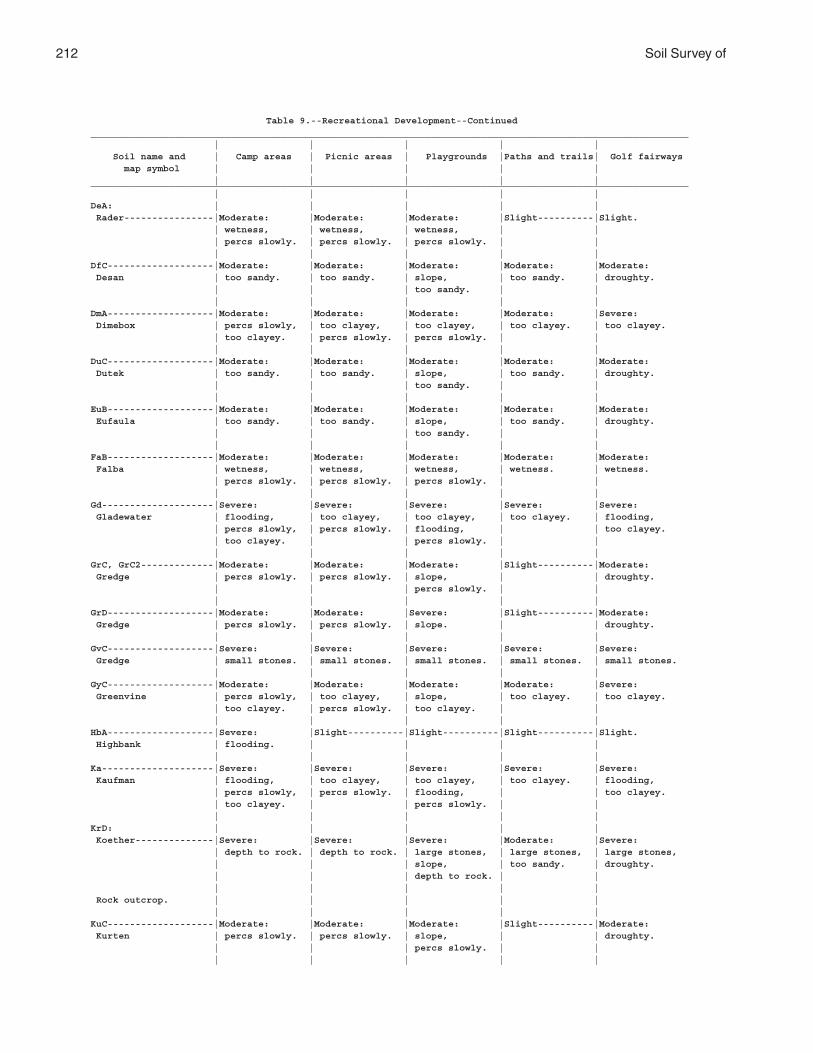
212 Soil Survey of
Table 9.--Recreational Development--Continued___________________________________________________________________________________________________________ | | | | | Soil name and | Camp areas | Picnic areas | Playgrounds |Paths and trails| Golf fairways map symbol | | | | | | | | | |___________________________________________________________________________________________________________ | | | | |DeA: | | | | | Rader----------------|Moderate: |Moderate: |Moderate: |Slight----------|Slight. | wetness, | wetness, | wetness, | | | percs slowly. | percs slowly. | percs slowly. | | | | | | |DfC-------------------|Moderate: |Moderate: |Moderate: |Moderate: |Moderate: Desan | too sandy. | too sandy. | slope, | too sandy. | droughty. | | | too sandy. | | | | | | |DmA-------------------|Moderate: |Moderate: |Moderate: |Moderate: |Severe: Dimebox | percs slowly, | too clayey, | too clayey, | too clayey. | too clayey. | too clayey. | percs slowly. | percs slowly. | | | | | | |DuC-------------------|Moderate: |Moderate: |Moderate: |Moderate: |Moderate: Dutek | too sandy. | too sandy. | slope, | too sandy. | droughty. | | | too sandy. | | | | | | |EuB-------------------|Moderate: |Moderate: |Moderate: |Moderate: |Moderate: Eufaula | too sandy. | too sandy. | slope, | too sandy. | droughty. | | | too sandy. | | | | | | |FaB-------------------|Moderate: |Moderate: |Moderate: |Moderate: |Moderate: Falba | wetness, | wetness, | wetness, | wetness. | wetness. | percs slowly. | percs slowly. | percs slowly. | | | | | | |Gd--------------------|Severe: |Severe: |Severe: |Severe: |Severe: Gladewater | flooding, | too clayey, | too clayey, | too clayey. | flooding, | percs slowly, | percs slowly. | flooding, | | too clayey. | too clayey. | | percs slowly. | | | | | | |GrC, GrC2-------------|Moderate: |Moderate: |Moderate: |Slight----------|Moderate: Gredge | percs slowly. | percs slowly. | slope, | | droughty. | | | percs slowly. | | | | | | |GrD-------------------|Moderate: |Moderate: |Severe: |Slight----------|Moderate: Gredge | percs slowly. | percs slowly. | slope. | | droughty. | | | | |GvC-------------------|Severe: |Severe: |Severe: |Severe: |Severe: Gredge | small stones. | small stones. | small stones. | small stones. | small stones. | | | | |GyC-------------------|Moderate: |Moderate: |Moderate: |Moderate: |Severe: Greenvine | percs slowly, | too clayey, | slope, | too clayey. | too clayey. | too clayey. | percs slowly. | too clayey. | | | | | | |HbA-------------------|Severe: |Slight----------|Slight----------|Slight----------|Slight. Highbank | flooding. | | | | | | | | |Ka--------------------|Severe: |Severe: |Severe: |Severe: |Severe: Kaufman | flooding, | too clayey, | too clayey, | too clayey. | flooding, | percs slowly, | percs slowly. | flooding, | | too clayey. | too clayey. | | percs slowly. | | | | | | |KrD: | | | | | Koether--------------|Severe: |Severe: |Severe: |Moderate: |Severe: | depth to rock. | depth to rock. | large stones, | large stones, | large stones, | | | slope, | too sandy. | droughty. | | | depth to rock. | | | | | | | Rock outcrop. | | | | | | | | | |KuC-------------------|Moderate: |Moderate: |Moderate: |Slight----------|Moderate: Kurten | percs slowly. | percs slowly. | slope, | | droughty. | | | percs slowly. | | | | | | |
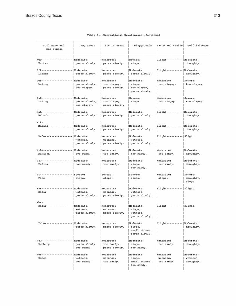
Brazos County, Texas 213
Table 9.--Recreational Development--Continued___________________________________________________________________________________________________________ | | | | | Soil name and | Camp areas | Picnic areas | Playgrounds |Paths and trails| Golf fairways map symbol | | | | | | | | | |___________________________________________________________________________________________________________ | | | | |KuD-------------------|Moderate: |Moderate: |Severe: |Slight----------|Moderate: Kurten | percs slowly. | percs slowly. | slope. | | droughty. | | | | |LfA-------------------|Moderate: |Moderate: |Moderate: |Slight----------|Moderate: Lufkin | percs slowly. | percs slowly. | percs slowly. | | droughty. | | | | |LuB-------------------|Moderate: |Moderate: |Moderate: |Moderate: |Severe: Luling | percs slowly, | too clayey, | slope, | too clayey. | too clayey. | too clayey. | percs slowly. | too clayey, | | | | | percs slowly. | | | | | | |LuD-------------------|Moderate: |Moderate: |Severe: |Moderate: |Severe: Luling | percs slowly, | too clayey, | slope. | too clayey. | too clayey. | too clayey. | percs slowly. | | | | | | | |MaA-------------------|Moderate: |Moderate: |Moderate: |Slight----------|Moderate: Mabank | percs slowly. | percs slowly. | percs slowly. | | droughty. | | | | |MrA: | | | | | Mabank---------------|Moderate: |Moderate: |Moderate: |Slight----------|Moderate: | percs slowly. | percs slowly. | percs slowly. | | droughty. | | | | | Rader----------------|Moderate: |Moderate: |Moderate: |Slight----------|Slight. | wetness, | wetness, | wetness, | | | percs slowly. | percs slowly. | percs slowly. | | | | | | |NvB-------------------|Moderate: |Moderate: |Moderate: |Moderate: |Moderate: Navasan | too sandy. | too sandy. | too sandy. | too sandy. | droughty. | | | | |PaC-------------------|Moderate: |Moderate: |Moderate: |Moderate: |Moderate: Padina | too sandy. | too sandy. | slope, | too sandy. | droughty. | | | too sandy. | | | | | | |Pt--------------------|Severe: |Severe: |Severe: |Moderate: |Severe: Pits | slope. | slope. | slope. | slope. | droughty, | | | | | slope. | | | | |RaB-------------------|Moderate: |Moderate: |Moderate: |Slight----------|Slight. Rader | wetness, | wetness, | wetness, | | | percs slowly. | percs slowly. | percs slowly. | | | | | | |RbA: | | | | | Rader----------------|Moderate: |Moderate: |Moderate: |Slight----------|Slight. | wetness, | wetness, | slope, | | | percs slowly. | percs slowly. | wetness, | | | | | percs slowly. | | | | | | | Tabor----------------|Moderate: |Moderate: |Moderate: |Slight----------|Moderate: | percs slowly. | percs slowly. | slope, | | droughty. | | | small stones, | | | | | percs slowly. | | | | | | |ReC-------------------|Moderate: |Moderate: |Moderate: |Moderate: |Moderate: Rehburg | percs slowly, | too sandy, | slope, | too sandy. | droughty. | too sandy. | percs slowly. | too sandy. | | | | | | |RoB-------------------|Moderate: |Moderate: |Moderate: |Moderate: |Moderate: Robco | wetness, | wetness, | slope, | wetness, | wetness, | too sandy. | too sandy. | small stones, | too sandy. | droughty. | | | too sandy. | | | | | | |

214 Soil Survey of
Table 9.--Recreational Development--Continued___________________________________________________________________________________________________________ | | | | | Soil name and | Camp areas | Picnic areas | Playgrounds |Paths and trails| Golf fairways map symbol | | | | | | | | | |___________________________________________________________________________________________________________ | | | | |Rr--------------------|Severe: |Severe: |Severe: |Severe: |Severe: Roetex | flooding, | ponding, | too clayey, | ponding, | ponding, | ponding, | too clayey, | ponding, | too clayey. | flooding, | percs slowly. | percs slowly. | flooding. | | too clayey. | | | | |RsC-------------------|Slight----------|Slight----------|Moderate: |Slight----------|Slight. Rosanky | | | slope, | | | | | small stones. | | | | | | |RsD-------------------|Slight----------|Slight----------|Severe: |Slight----------|Slight. Rosanky | | | slope. | | | | | | |RtC-------------------|Slight----------|Slight----------|Moderate: |Slight----------|Slight. Rosanky | | | slope, | | | | | small stones. | | | | | | |RuC: | | | | | Rosanky--------------|Slight----------|Slight----------|Moderate: |Slight----------|Slight. | | | slope, | | | | | small stones. | | | | | | | Urban land. | | | | | | | | | |Sa--------------------|Severe: |Moderate: |Severe: |Moderate: |Severe: Sandow | flooding. | flooding. | flooding. | flooding. | flooding. | | | | |Sb: | | | | | Sandow---------------|Severe: |Moderate: |Severe: |Moderate: |Severe: | flooding. | flooding. | flooding. | flooding. | flooding. | | | | | Urban land. | | | | | | | | | |ScC: | | | | | Shalba---------------|Severe: |Severe: |Severe: |Slight----------|Severe: | depth to rock. | depth to rock. | depth to rock. | | depth to rock. | | | | | Rock outcrop---------|Severe: |Severe: |Severe: |Slight----------|Severe: | depth to rock. | depth to rock. | depth to rock. | | depth to rock. | | | | |ShA, ShC--------------|Severe: |Severe: |Severe: |Severe: |Severe: Ships | flooding, | too clayey, | too clayey, | too clayey. | too clayey. | percs slowly, | percs slowly. | percs slowly. | | | too clayey. | | | | | | | | |SkB-------------------|Slight----------|Slight----------|Moderate: |Slight----------|Moderate: Shiro | | | slope, | | droughty, | | | depth to rock. | | depth to rock. | | | | |SmC-------------------|Slight----------|Slight----------|Moderate: |Slight----------|Slight. Silawa | | | slope. | | | | | | |SmD-------------------|Slight----------|Slight----------|Severe: |Slight----------|Slight. Silawa | | | slope. | | | | | | |SnB-------------------|Moderate: |Moderate: |Moderate: |Slight----------|Moderate: Singleton | percs slowly. | percs slowly. | slope, | | droughty, | | | depth to rock, | | depth to rock. | | | percs slowly. | | | | | | |SpB-------------------|Slight----------|Slight----------|Moderate: |Slight----------|Moderate: Spiller | | | slope. | | droughty. | | | | |
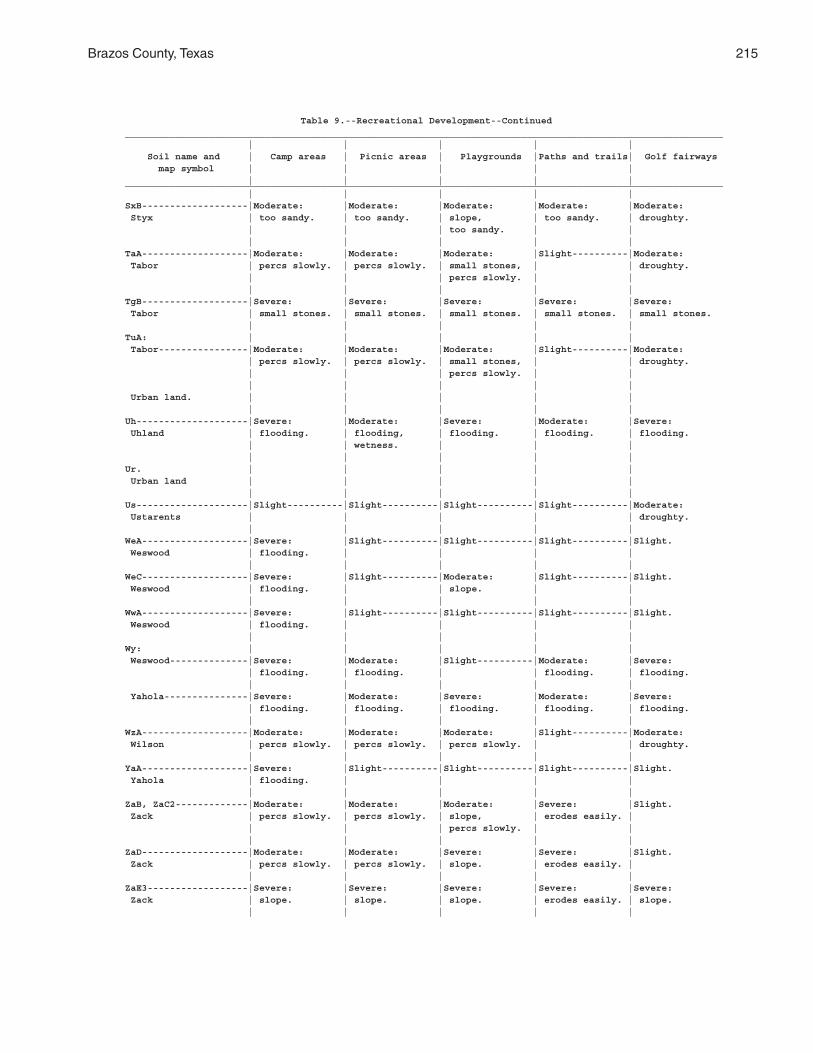
Brazos County, Texas 215
Table 9.--Recreational Development--Continued___________________________________________________________________________________________________________ | | | | | Soil name and | Camp areas | Picnic areas | Playgrounds |Paths and trails| Golf fairways map symbol | | | | | | | | | |___________________________________________________________________________________________________________ | | | | |SxB-------------------|Moderate: |Moderate: |Moderate: |Moderate: |Moderate: Styx | too sandy. | too sandy. | slope, | too sandy. | droughty. | | | too sandy. | | | | | | |TaA-------------------|Moderate: |Moderate: |Moderate: |Slight----------|Moderate: Tabor | percs slowly. | percs slowly. | small stones, | | droughty. | | | percs slowly. | | | | | | |TgB-------------------|Severe: |Severe: |Severe: |Severe: |Severe: Tabor | small stones. | small stones. | small stones. | small stones. | small stones. | | | | |TuA: | | | | | Tabor----------------|Moderate: |Moderate: |Moderate: |Slight----------|Moderate: | percs slowly. | percs slowly. | small stones, | | droughty. | | | percs slowly. | | | | | | | Urban land. | | | | | | | | | |Uh--------------------|Severe: |Moderate: |Severe: |Moderate: |Severe: Uhland | flooding. | flooding, | flooding. | flooding. | flooding. | | wetness. | | | | | | | |Ur. | | | | | Urban land | | | | | | | | | |Us--------------------|Slight----------|Slight----------|Slight----------|Slight----------|Moderate: Ustarents | | | | | droughty. | | | | |WeA-------------------|Severe: |Slight----------|Slight----------|Slight----------|Slight. Weswood | flooding. | | | | | | | | |WeC-------------------|Severe: |Slight----------|Moderate: |Slight----------|Slight. Weswood | flooding. | | slope. | | | | | | |WwA-------------------|Severe: |Slight----------|Slight----------|Slight----------|Slight. Weswood | flooding. | | | | | | | | |Wy: | | | | | Weswood--------------|Severe: |Moderate: |Slight----------|Moderate: |Severe: | flooding. | flooding. | | flooding. | flooding. | | | | | Yahola---------------|Severe: |Moderate: |Severe: |Moderate: |Severe: | flooding. | flooding. | flooding. | flooding. | flooding. | | | | |WzA-------------------|Moderate: |Moderate: |Moderate: |Slight----------|Moderate: Wilson | percs slowly. | percs slowly. | percs slowly. | | droughty. | | | | |YaA-------------------|Severe: |Slight----------|Slight----------|Slight----------|Slight. Yahola | flooding. | | | | | | | | |ZaB, ZaC2-------------|Moderate: |Moderate: |Moderate: |Severe: |Slight. Zack | percs slowly. | percs slowly. | slope, | erodes easily. | | | | percs slowly. | | | | | | |ZaD-------------------|Moderate: |Moderate: |Severe: |Severe: |Slight. Zack | percs slowly. | percs slowly. | slope. | erodes easily. | | | | | |ZaE3------------------|Severe: |Severe: |Severe: |Severe: |Severe: Zack | slope. | slope. | slope. | erodes easily. | slope. | | | | |
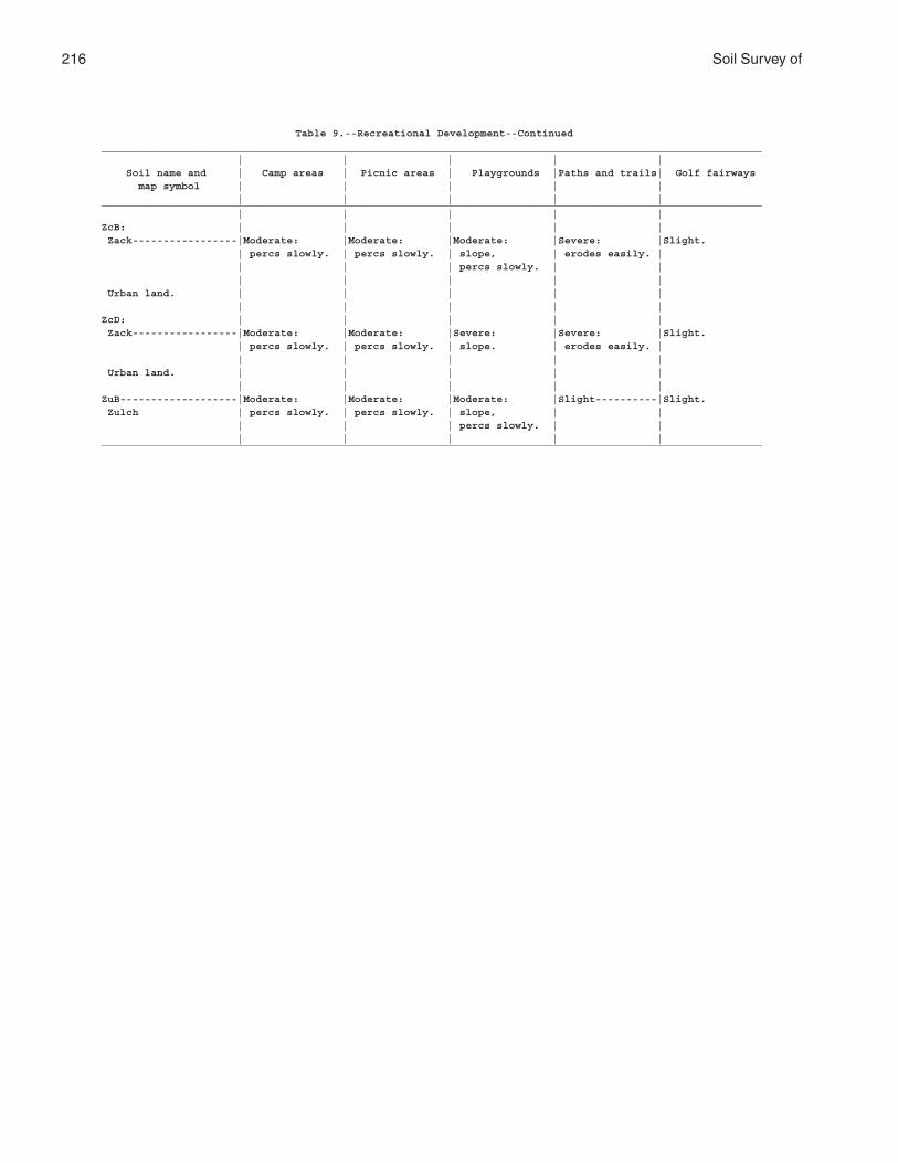
216 Soil Survey of
Table 9.--Recreational Development--Continued___________________________________________________________________________________________________________ | | | | | Soil name and | Camp areas | Picnic areas | Playgrounds |Paths and trails| Golf fairways map symbol | | | | | | | | | |___________________________________________________________________________________________________________ | | | | |ZcB: | | | | | Zack-----------------|Moderate: |Moderate: |Moderate: |Severe: |Slight. | percs slowly. | percs slowly. | slope, | erodes easily. | | | | percs slowly. | | | | | | | Urban land. | | | | | | | | | |ZcD: | | | | | Zack-----------------|Moderate: |Moderate: |Severe: |Severe: |Slight. | percs slowly. | percs slowly. | slope. | erodes easily. | | | | | | Urban land. | | | | | | | | | |ZuB-------------------|Moderate: |Moderate: |Moderate: |Slight----------|Slight. Zulch | percs slowly. | percs slowly. | slope, | | | | | percs slowly. | | | | | | |___________________________________________________________________________________________________________
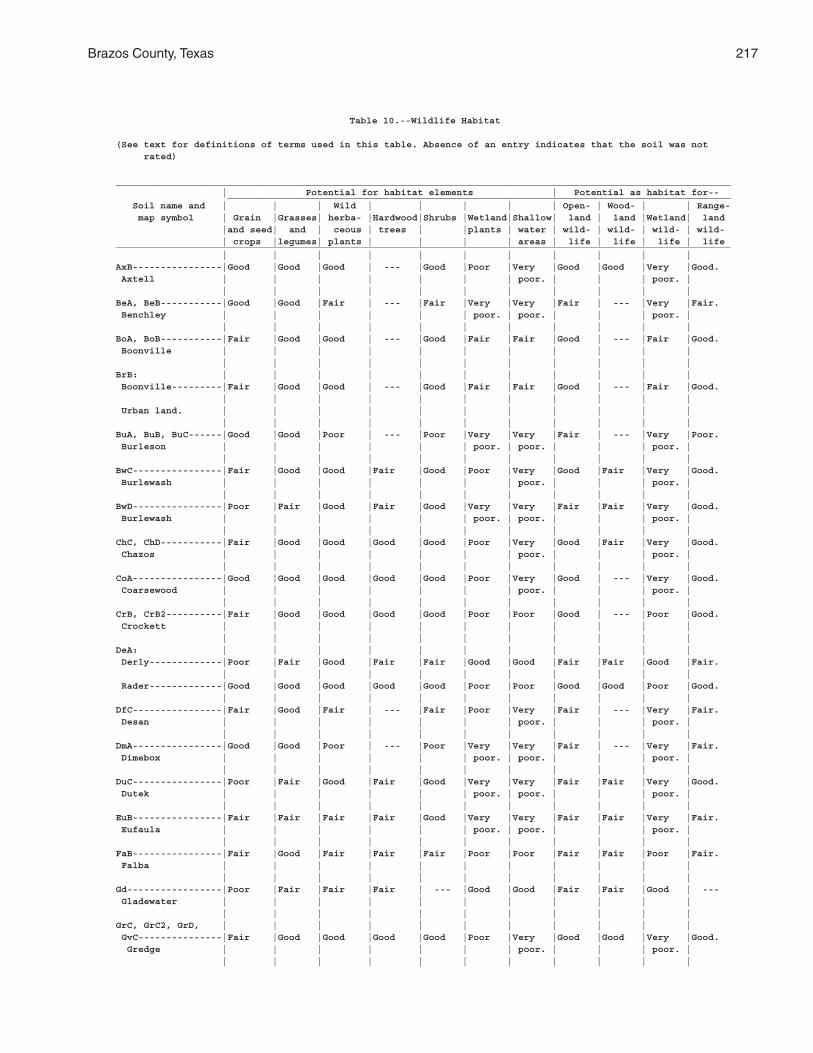
Brazos County, Texas 217
Table 10.--Wildlife Habitat
(See text for definitions of terms used in this table. Absence of an entry indicates that the soil was not rated)
______________________________________________________________________________________________________________ | Potential for habitat elements | Potential as habitat for-- __________________________________________________________________________________________ Soil name and | | | Wild | | | | | Open- | Wood- | | Range- map symbol | Grain |Grasses| herba- |Hardwood|Shrubs |Wetland|Shallow| land | land |Wetland| land |and seed| and | ceous | trees | |plants | water | wild- | wild- | wild- | wild- | crops |legumes| plants | | | | areas | life | life | life | life______________________________________________________________________________________________________________ | | | | | | | | | | |AxB----------------|Good |Good |Good | --- |Good |Poor |Very |Good |Good |Very |Good. Axtell | | | | | | | poor. | | | poor. | | | | | | | | | | | |BeA, BeB-----------|Good |Good |Fair | --- |Fair |Very |Very |Fair | --- |Very |Fair. Benchley | | | | | | poor. | poor. | | | poor. | | | | | | | | | | | |BoA, BoB-----------|Fair |Good |Good | --- |Good |Fair |Fair |Good | --- |Fair |Good. Boonville | | | | | | | | | | | | | | | | | | | | | |BrB: | | | | | | | | | | | Boonville---------|Fair |Good |Good | --- |Good |Fair |Fair |Good | --- |Fair |Good. | | | | | | | | | | | Urban land. | | | | | | | | | | | | | | | | | | | | | |BuA, BuB, BuC------|Good |Good |Poor | --- |Poor |Very |Very |Fair | --- |Very |Poor. Burleson | | | | | | poor. | poor. | | | poor. | | | | | | | | | | | |BwC----------------|Fair |Good |Good |Fair |Good |Poor |Very |Good |Fair |Very |Good. Burlewash | | | | | | | poor. | | | poor. | | | | | | | | | | | |BwD----------------|Poor |Fair |Good |Fair |Good |Very |Very |Fair |Fair |Very |Good. Burlewash | | | | | | poor. | poor. | | | poor. | | | | | | | | | | | |ChC, ChD-----------|Fair |Good |Good |Good |Good |Poor |Very |Good |Fair |Very |Good. Chazos | | | | | | | poor. | | | poor. | | | | | | | | | | | |CoA----------------|Good |Good |Good |Good |Good |Poor |Very |Good | --- |Very |Good. Coarsewood | | | | | | | poor. | | | poor. | | | | | | | | | | | |CrB, CrB2----------|Fair |Good |Good |Good |Good |Poor |Poor |Good | --- |Poor |Good. Crockett | | | | | | | | | | | | | | | | | | | | | |DeA: | | | | | | | | | | | Derly-------------|Poor |Fair |Good |Fair |Fair |Good |Good |Fair |Fair |Good |Fair. | | | | | | | | | | | Rader-------------|Good |Good |Good |Good |Good |Poor |Poor |Good |Good |Poor |Good. | | | | | | | | | | |DfC----------------|Fair |Good |Fair | --- |Fair |Poor |Very |Fair | --- |Very |Fair. Desan | | | | | | | poor. | | | poor. | | | | | | | | | | | |DmA----------------|Good |Good |Poor | --- |Poor |Very |Very |Fair | --- |Very |Fair. Dimebox | | | | | | poor. | poor. | | | poor. | | | | | | | | | | | |DuC----------------|Poor |Fair |Good |Fair |Good |Very |Very |Fair |Fair |Very |Good. Dutek | | | | | | poor. | poor. | | | poor. | | | | | | | | | | | |EuB----------------|Fair |Fair |Fair |Fair |Good |Very |Very |Fair |Fair |Very |Fair. Eufaula | | | | | | poor. | poor. | | | poor. | | | | | | | | | | | |FaB----------------|Fair |Good |Fair |Fair |Fair |Poor |Poor |Fair |Fair |Poor |Fair. Falba | | | | | | | | | | | | | | | | | | | | | |Gd-----------------|Poor |Fair |Fair |Fair | --- |Good |Good |Fair |Fair |Good | --- Gladewater | | | | | | | | | | | | | | | | | | | | | |GrC, GrC2, GrD, | | | | | | | | | | | GvC---------------|Fair |Good |Good |Good |Good |Poor |Very |Good |Good |Very |Good. Gredge | | | | | | | poor. | | | poor. | | | | | | | | | | | |
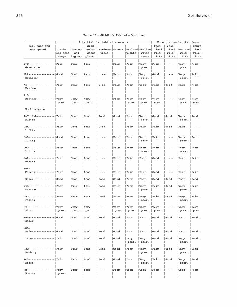
218 Soil Survey of
Table 10.--Wildlife Habitat--Continued______________________________________________________________________________________________________________ | Potential for habitat elements | Potential as habitat for-- __________________________________________________________________________________________ Soil name and | | | Wild | | | | | Open- | Wood- | | Range- map symbol | Grain |Grasses| herba- |Hardwood|Shrubs |Wetland|Shallow| land | land |Wetland| land |and seed| and | ceous | trees | |plants | water | wild- | wild- | wild- | wild- | crops |legumes| plants | | | | areas | life | life | life | life______________________________________________________________________________________________________________ | | | | | | | | | | |GyC----------------|Fair |Fair |Poor | --- |Fair |Poor |Very |Poor | --- |Very |Poor. Greenvine | | | | | | | poor. | | | poor. | | | | | | | | | | | |HbA----------------|Good |Good |Fair | --- |Fair |Poor |Very |Good | --- |Very |Fair. Highbank | | | | | | | poor. | | | poor. | | | | | | | | | | | |Ka-----------------|Fair |Fair |Poor |Good |Fair |Poor |Good |Fair |Good |Fair |Poor. Kaufman | | | | | | | | | | | | | | | | | | | | | |KrD: | | | | | | | | | | | Koether-----------|Very |Very |Very | --- |Poor |Very |Very |Very | --- |Very |Very | poor. | poor. | poor. | | | poor. | poor. | poor. | | poor. | poor. | | | | | | | | | | | Rock outcrop. | | | | | | | | | | | | | | | | | | | | | |KuC, KuD-----------|Fair |Good |Good |Good |Good |Poor |Very |Good |Good |Very |Good. Kurten | | | | | | | poor. | | | poor. | | | | | | | | | | | |LfA----------------|Fair |Good |Fair |Good | --- |Fair |Fair |Fair |Good |Fair | --- Lufkin | | | | | | | | | | | | | | | | | | | | | |LuB----------------|Good |Good |Poor | --- |Fair |Poor |Very |Fair | --- |Very |Poor. Luling | | | | | | | poor. | | | poor. | | | | | | | | | | | |LuD----------------|Fair |Good |Poor | --- |Fair |Poor |Very |Fair | --- |Very |Poor. Luling | | | | | | | poor. | | | poor. | | | | | | | | | | | |MaA----------------|Fair |Good |Good | --- |Fair |Fair |Poor |Good | --- |Fair |Fair. Mabank | | | | | | | | | | | | | | | | | | | | | |MrA: | | | | | | | | | | | Mabank------------|Fair |Good |Good | --- |Fair |Fair |Fair |Good | --- |Fair |Fair. | | | | | | | | | | | Rader-------------|Good |Good |Good |Good |Good |Poor |Poor |Good |Good |Poor |Good. | | | | | | | | | | |NvB----------------|Poor |Fair |Fair |Good |Fair |Poor |Very |Fair |Good |Very |Fair. Navasan | | | | | | | poor. | | | poor. | | | | | | | | | | | |PaC----------------|Poor |Fair |Fair |Good |Fair |Poor |Very |Fair |Good |Very |Fair. Padina | | | | | | | poor. | | | poor. | | | | | | | | | | | |Pt-----------------|Very |Very |Very | --- |Very |Very |Very |Very | --- |Very |Very Pits | poor. | poor. | poor. | | poor. | poor. | poor. | poor. | | poor. | poor. | | | | | | | | | | |RaB----------------|Good |Good |Good |Good |Good |Poor |Poor |Good |Good |Poor |Good. Rader | | | | | | | | | | | | | | | | | | | | | |RbA: | | | | | | | | | | | Rader-------------|Good |Good |Good |Good |Good |Poor |Poor |Good |Good |Poor |Good. | | | | | | | | | | | Tabor-------------|Fair |Good |Good |Good |Good |Very |Very |Good |Good |Very |Good. | | | | | | poor. | poor. | | | poor. | | | | | | | | | | | |ReC----------------|Fair |Fair |Good |Good |Good |Poor |Very |Fair |Good |Very |Good. Rehburg | | | | | | | poor. | | | poor. | | | | | | | | | | | |RoB----------------|Fair |Fair |Good |Good |Good |Poor |Very |Fair |Good |Very |Good. Robco | | | | | | | poor. | | | poor. | | | | | | | | | | | |Rr-----------------|Very |Poor |Poor | --- |Poor |Good |Good |Poor | --- |Good |Poor. Roetex | poor. | | | | | | | | | | | | | | | | | | | | |
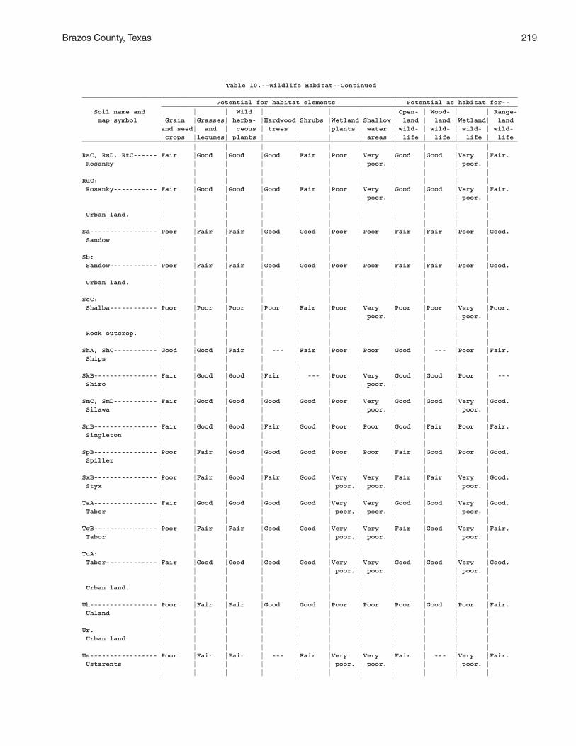
Brazos County, Texas 219
Table 10.--Wildlife Habitat--Continued______________________________________________________________________________________________________________ | Potential for habitat elements | Potential as habitat for-- __________________________________________________________________________________________ Soil name and | | | Wild | | | | | Open- | Wood- | | Range- map symbol | Grain |Grasses| herba- |Hardwood|Shrubs |Wetland|Shallow| land | land |Wetland| land |and seed| and | ceous | trees | |plants | water | wild- | wild- | wild- | wild- | crops |legumes| plants | | | | areas | life | life | life | life______________________________________________________________________________________________________________ | | | | | | | | | | |RsC, RsD, RtC------|Fair |Good |Good |Good |Fair |Poor |Very |Good |Good |Very |Fair. Rosanky | | | | | | | poor. | | | poor. | | | | | | | | | | | |RuC: | | | | | | | | | | | Rosanky-----------|Fair |Good |Good |Good |Fair |Poor |Very |Good |Good |Very |Fair. | | | | | | | poor. | | | poor. | | | | | | | | | | | | Urban land. | | | | | | | | | | | | | | | | | | | | | |Sa-----------------|Poor |Fair |Fair |Good |Good |Poor |Poor |Fair |Fair |Poor |Good. Sandow | | | | | | | | | | | | | | | | | | | | | |Sb: | | | | | | | | | | | Sandow------------|Poor |Fair |Fair |Good |Good |Poor |Poor |Fair |Fair |Poor |Good. | | | | | | | | | | | Urban land. | | | | | | | | | | | | | | | | | | | | | |ScC: | | | | | | | | | | | Shalba------------|Poor |Poor |Poor |Poor |Fair |Poor |Very |Poor |Poor |Very |Poor. | | | | | | | poor. | | | poor. | | | | | | | | | | | | Rock outcrop. | | | | | | | | | | | | | | | | | | | | | |ShA, ShC-----------|Good |Good |Fair | --- |Fair |Poor |Poor |Good | --- |Poor |Fair. Ships | | | | | | | | | | | | | | | | | | | | | |SkB----------------|Fair |Good |Good |Fair | --- |Poor |Very |Good |Good |Poor | --- Shiro | | | | | | | poor. | | | | | | | | | | | | | | |SmC, SmD-----------|Fair |Good |Good |Good |Good |Poor |Very |Good |Good |Very |Good. Silawa | | | | | | | poor. | | | poor. | | | | | | | | | | | |SnB----------------|Fair |Good |Good |Fair |Good |Poor |Poor |Good |Fair |Poor |Fair. Singleton | | | | | | | | | | | | | | | | | | | | | |SpB----------------|Poor |Fair |Good |Good |Good |Poor |Poor |Fair |Good |Poor |Good. Spiller | | | | | | | | | | | | | | | | | | | | | |SxB----------------|Poor |Fair |Good |Fair |Good |Very |Very |Fair |Fair |Very |Good. Styx | | | | | | poor. | poor. | | | poor. | | | | | | | | | | | |TaA----------------|Fair |Good |Good |Good |Good |Very |Very |Good |Good |Very |Good. Tabor | | | | | | poor. | poor. | | | poor. | | | | | | | | | | | |TgB----------------|Poor |Fair |Fair |Good |Good |Very |Very |Fair |Good |Very |Fair. Tabor | | | | | | poor. | poor. | | | poor. | | | | | | | | | | | |TuA: | | | | | | | | | | | Tabor-------------|Fair |Good |Good |Good |Good |Very |Very |Good |Good |Very |Good. | | | | | | poor. | poor. | | | poor. | | | | | | | | | | | | Urban land. | | | | | | | | | | | | | | | | | | | | | |Uh-----------------|Poor |Fair |Fair |Good |Good |Poor |Poor |Poor |Good |Poor |Fair. Uhland | | | | | | | | | | | | | | | | | | | | | |Ur. | | | | | | | | | | | Urban land | | | | | | | | | | | | | | | | | | | | | |Us-----------------|Poor |Fair |Fair | --- |Fair |Very |Very |Fair | --- |Very |Fair. Ustarents | | | | | | poor. | poor. | | | poor. | | | | | | | | | | | |
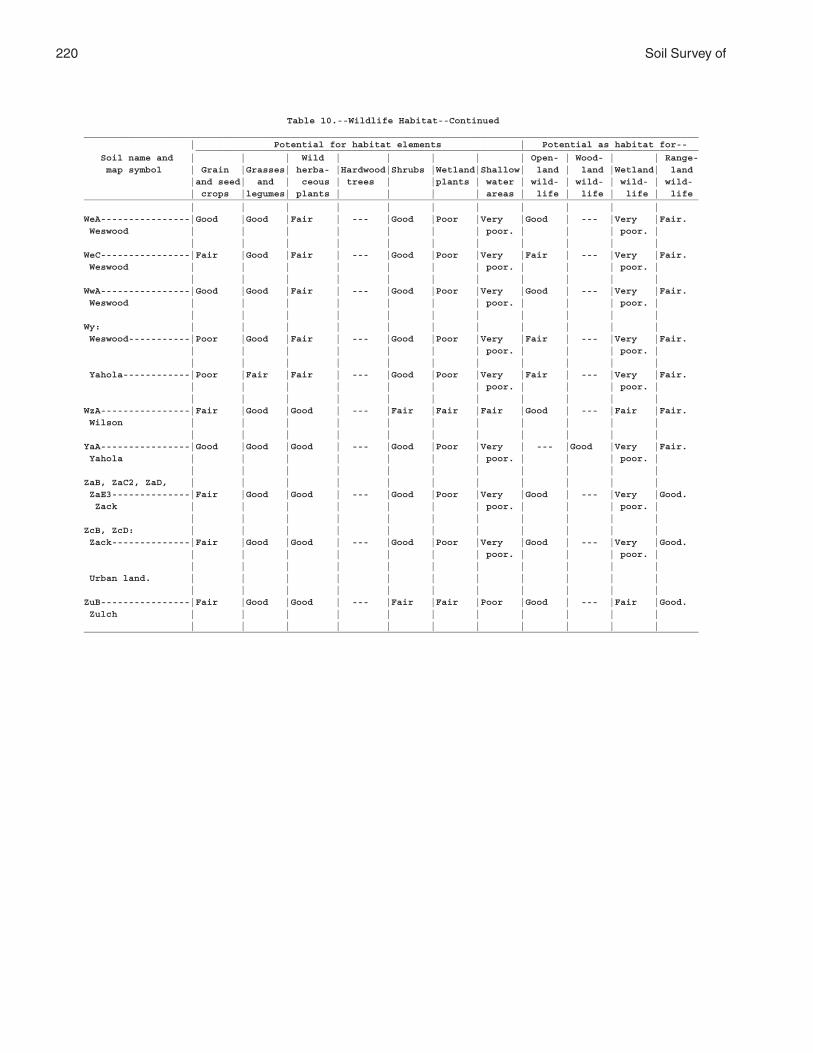
220 Soil Survey of
Table 10.--Wildlife Habitat--Continued______________________________________________________________________________________________________________ | Potential for habitat elements | Potential as habitat for-- __________________________________________________________________________________________ Soil name and | | | Wild | | | | | Open- | Wood- | | Range- map symbol | Grain |Grasses| herba- |Hardwood|Shrubs |Wetland|Shallow| land | land |Wetland| land |and seed| and | ceous | trees | |plants | water | wild- | wild- | wild- | wild- | crops |legumes| plants | | | | areas | life | life | life | life______________________________________________________________________________________________________________ | | | | | | | | | | |WeA----------------|Good |Good |Fair | --- |Good |Poor |Very |Good | --- |Very |Fair. Weswood | | | | | | | poor. | | | poor. | | | | | | | | | | | |WeC----------------|Fair |Good |Fair | --- |Good |Poor |Very |Fair | --- |Very |Fair. Weswood | | | | | | | poor. | | | poor. | | | | | | | | | | | |WwA----------------|Good |Good |Fair | --- |Good |Poor |Very |Good | --- |Very |Fair. Weswood | | | | | | | poor. | | | poor. | | | | | | | | | | | |Wy: | | | | | | | | | | | Weswood-----------|Poor |Good |Fair | --- |Good |Poor |Very |Fair | --- |Very |Fair. | | | | | | | poor. | | | poor. | | | | | | | | | | | | Yahola------------|Poor |Fair |Fair | --- |Good |Poor |Very |Fair | --- |Very |Fair. | | | | | | | poor. | | | poor. | | | | | | | | | | | |WzA----------------|Fair |Good |Good | --- |Fair |Fair |Fair |Good | --- |Fair |Fair. Wilson | | | | | | | | | | | | | | | | | | | | | |YaA----------------|Good |Good |Good | --- |Good |Poor |Very | --- |Good |Very |Fair. Yahola | | | | | | | poor. | | | poor. | | | | | | | | | | | |ZaB, ZaC2, ZaD, | | | | | | | | | | | ZaE3--------------|Fair |Good |Good | --- |Good |Poor |Very |Good | --- |Very |Good. Zack | | | | | | | poor. | | | poor. | | | | | | | | | | | |ZcB, ZcD: | | | | | | | | | | | Zack--------------|Fair |Good |Good | --- |Good |Poor |Very |Good | --- |Very |Good. | | | | | | | poor. | | | poor. | | | | | | | | | | | | Urban land. | | | | | | | | | | | | | | | | | | | | | |ZuB----------------|Fair |Good |Good | --- |Fair |Fair |Poor |Good | --- |Fair |Good. Zulch | | | | | | | | | | | | | | | | | | | | | |______________________________________________________________________________________________________________
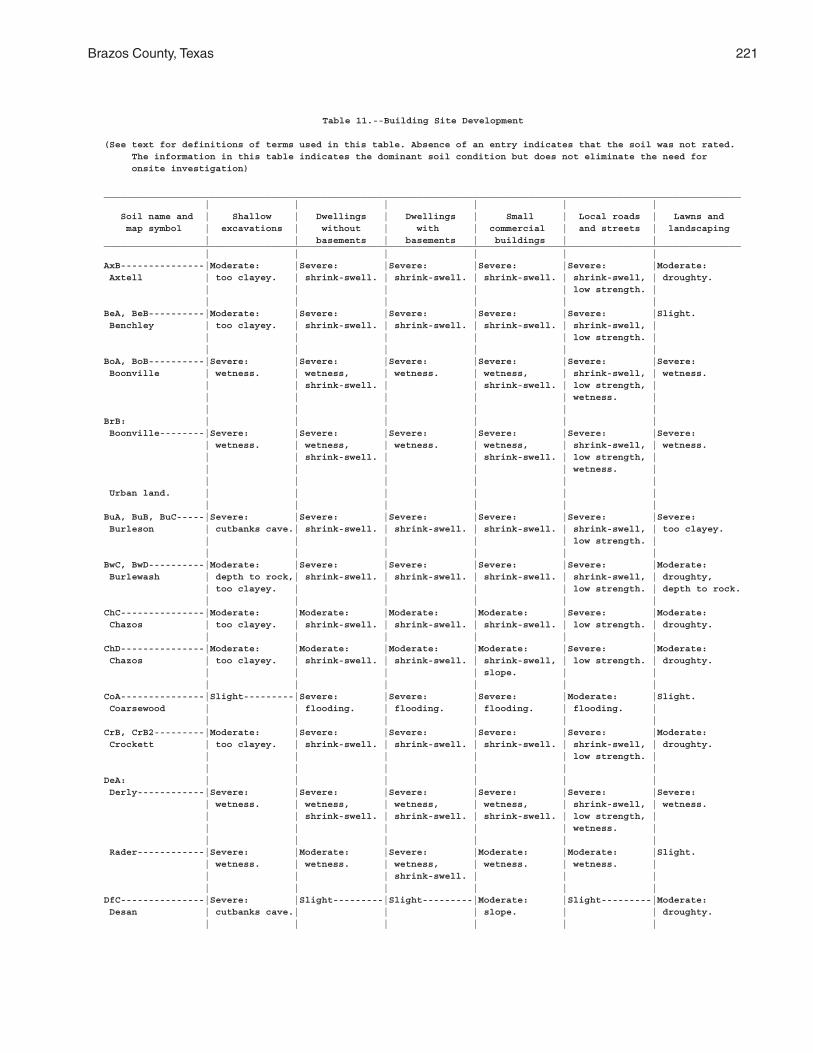
Brazos County, Texas 221
Table 11.--Building Site Development
(See text for definitions of terms used in this table. Absence of an entry indicates that the soil was not rated. The information in this table indicates the dominant soil condition but does not eliminate the need for onsite investigation)
__________________________________________________________________________________________________________________ | | | | | | Soil name and | Shallow | Dwellings | Dwellings | Small | Local roads | Lawns and map symbol | excavations | without | with | commercial | and streets | landscaping | | basements | basements | buildings | |__________________________________________________________________________________________________________________ | | | | | |AxB---------------|Moderate: |Severe: |Severe: |Severe: |Severe: |Moderate: Axtell | too clayey. | shrink-swell. | shrink-swell. | shrink-swell. | shrink-swell, | droughty. | | | | | low strength. | | | | | | |BeA, BeB----------|Moderate: |Severe: |Severe: |Severe: |Severe: |Slight. Benchley | too clayey. | shrink-swell. | shrink-swell. | shrink-swell. | shrink-swell, | | | | | | low strength. | | | | | | |BoA, BoB----------|Severe: |Severe: |Severe: |Severe: |Severe: |Severe: Boonville | wetness. | wetness, | wetness. | wetness, | shrink-swell, | wetness. | | shrink-swell. | | shrink-swell. | low strength, | | | | | | wetness. | | | | | | |BrB: | | | | | | Boonville--------|Severe: |Severe: |Severe: |Severe: |Severe: |Severe: | wetness. | wetness, | wetness. | wetness, | shrink-swell, | wetness. | | shrink-swell. | | shrink-swell. | low strength, | | | | | | wetness. | | | | | | | Urban land. | | | | | | | | | | | |BuA, BuB, BuC-----|Severe: |Severe: |Severe: |Severe: |Severe: |Severe: Burleson | cutbanks cave.| shrink-swell. | shrink-swell. | shrink-swell. | shrink-swell, | too clayey. | | | | | low strength. | | | | | | |BwC, BwD----------|Moderate: |Severe: |Severe: |Severe: |Severe: |Moderate: Burlewash | depth to rock,| shrink-swell. | shrink-swell. | shrink-swell. | shrink-swell, | droughty, | too clayey. | | | | low strength. | depth to rock. | | | | | |ChC---------------|Moderate: |Moderate: |Moderate: |Moderate: |Severe: |Moderate: Chazos | too clayey. | shrink-swell. | shrink-swell. | shrink-swell. | low strength. | droughty. | | | | | |ChD---------------|Moderate: |Moderate: |Moderate: |Moderate: |Severe: |Moderate: Chazos | too clayey. | shrink-swell. | shrink-swell. | shrink-swell, | low strength. | droughty. | | | | slope. | | | | | | | |CoA---------------|Slight---------|Severe: |Severe: |Severe: |Moderate: |Slight. Coarsewood | | flooding. | flooding. | flooding. | flooding. | | | | | | |CrB, CrB2---------|Moderate: |Severe: |Severe: |Severe: |Severe: |Moderate: Crockett | too clayey. | shrink-swell. | shrink-swell. | shrink-swell. | shrink-swell, | droughty. | | | | | low strength. | | | | | | |DeA: | | | | | | Derly------------|Severe: |Severe: |Severe: |Severe: |Severe: |Severe: | wetness. | wetness, | wetness, | wetness, | shrink-swell, | wetness. | | shrink-swell. | shrink-swell. | shrink-swell. | low strength, | | | | | | wetness. | | | | | | | Rader------------|Severe: |Moderate: |Severe: |Moderate: |Moderate: |Slight. | wetness. | wetness. | wetness, | wetness. | wetness. | | | | shrink-swell. | | | | | | | | |DfC---------------|Severe: |Slight---------|Slight---------|Moderate: |Slight---------|Moderate: Desan | cutbanks cave.| | | slope. | | droughty. | | | | | |
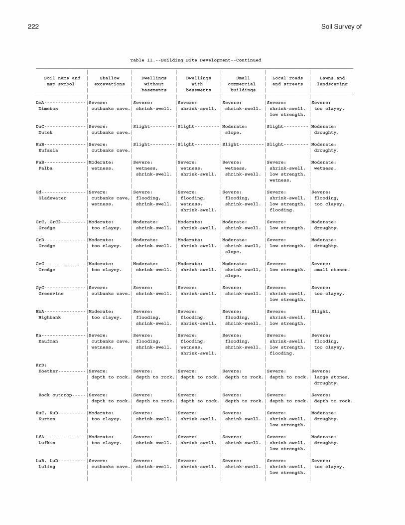
222 Soil Survey of
Table 11.--Building Site Development--Continued__________________________________________________________________________________________________________________ | | | | | | Soil name and | Shallow | Dwellings | Dwellings | Small | Local roads | Lawns and map symbol | excavations | without | with | commercial | and streets | landscaping | | basements | basements | buildings | |__________________________________________________________________________________________________________________ | | | | | |DmA---------------|Severe: |Severe: |Severe: |Severe: |Severe: |Severe: Dimebox | cutbanks cave.| shrink-swell. | shrink-swell. | shrink-swell. | shrink-swell, | too clayey. | | | | | low strength. | | | | | | |DuC---------------|Severe: |Slight---------|Slight---------|Moderate: |Slight---------|Moderate: Dutek | cutbanks cave.| | | slope. | | droughty. | | | | | |EuB---------------|Severe: |Slight---------|Slight---------|Slight---------|Slight---------|Moderate: Eufaula | cutbanks cave.| | | | | droughty. | | | | | |FaB---------------|Moderate: |Severe: |Severe: |Severe: |Severe: |Moderate: Falba | wetness. | wetness, | wetness, | wetness, | shrink-swell, | wetness. | | shrink-swell. | shrink-swell. | shrink-swell. | low strength, | | | | | | wetness. | | | | | | |Gd----------------|Severe: |Severe: |Severe: |Severe: |Severe: |Severe: Gladewater | cutbanks cave,| flooding, | flooding, | flooding, | shrink-swell, | flooding, | wetness. | shrink-swell. | wetness, | shrink-swell. | low strength, | too clayey. | | | shrink-swell. | | flooding. | | | | | | |GrC, GrC2---------|Moderate: |Moderate: |Moderate: |Moderate: |Severe: |Moderate: Gredge | too clayey. | shrink-swell. | shrink-swell. | shrink-swell. | low strength. | droughty. | | | | | |GrD---------------|Moderate: |Moderate: |Moderate: |Moderate: |Severe: |Moderate: Gredge | too clayey. | shrink-swell. | shrink-swell. | shrink-swell, | low strength. | droughty. | | | | slope. | | | | | | | |GvC---------------|Moderate: |Moderate: |Moderate: |Moderate: |Severe: |Severe: Gredge | too clayey. | shrink-swell. | shrink-swell. | shrink-swell, | low strength. | small stones. | | | | slope. | | | | | | | |GyC---------------|Severe: |Severe: |Severe: |Severe: |Severe: |Severe: Greenvine | cutbanks cave.| shrink-swell. | shrink-swell. | shrink-swell. | shrink-swell, | too clayey. | | | | | low strength. | | | | | | |HbA---------------|Moderate: |Severe: |Severe: |Severe: |Severe: |Slight. Highbank | too clayey. | flooding, | flooding, | flooding, | shrink-swell, | | | shrink-swell. | shrink-swell. | shrink-swell. | low strength. | | | | | | |Ka----------------|Severe: |Severe: |Severe: |Severe: |Severe: |Severe: Kaufman | cutbanks cave,| flooding, | flooding, | flooding, | shrink-swell, | flooding, | wetness. | shrink-swell. | wetness, | shrink-swell. | low strength, | too clayey. | | | shrink-swell. | | flooding. | | | | | | |KrD: | | | | | | Koether----------|Severe: |Severe: |Severe: |Severe: |Severe: |Severe: | depth to rock.| depth to rock.| depth to rock.| depth to rock.| depth to rock.| large stones, | | | | | | droughty. | | | | | | Rock outcrop-----|Severe: |Severe: |Severe: |Severe: |Severe: |Severe: | depth to rock.| depth to rock.| depth to rock.| depth to rock.| depth to rock.| depth to rock. | | | | | |KuC, KuD----------|Moderate: |Severe: |Severe: |Severe: |Severe: |Moderate: Kurten | too clayey. | shrink-swell. | shrink-swell. | shrink-swell. | shrink-swell, | droughty. | | | | | low strength. | | | | | | |LfA---------------|Moderate: |Severe: |Severe: |Severe: |Severe: |Moderate: Lufkin | too clayey. | shrink-swell. | shrink-swell. | shrink-swell. | shrink-swell, | droughty. | | | | | low strength. | | | | | | |LuB, LuD----------|Severe: |Severe: |Severe: |Severe: |Severe: |Severe: Luling | cutbanks cave.| shrink-swell. | shrink-swell. | shrink-swell. | shrink-swell, | too clayey. | | | | | low strength. | | | | | | |

Brazos County, Texas 223
Table 11.--Building Site Development--Continued__________________________________________________________________________________________________________________ | | | | | | Soil name and | Shallow | Dwellings | Dwellings | Small | Local roads | Lawns and map symbol | excavations | without | with | commercial | and streets | landscaping | | basements | basements | buildings | |__________________________________________________________________________________________________________________ | | | | | |MaA---------------|Moderate: |Severe: |Severe: |Severe: |Severe: |Moderate: Mabank | too clayey. | shrink-swell. | shrink-swell. | shrink-swell. | shrink-swell, | droughty. | | | | | low strength. | | | | | | |MrA: | | | | | | Mabank-----------|Moderate: |Severe: |Severe: |Severe: |Severe: |Moderate: | too clayey. | shrink-swell. | shrink-swell. | shrink-swell. | shrink-swell, | droughty. | | | | | low strength. | | | | | | | Rader------------|Severe: |Moderate: |Severe: |Moderate: |Moderate: |Slight. | wetness. | wetness. | wetness, | wetness. | wetness. | | | | shrink-swell. | | | | | | | | |NvB---------------|Severe: |Slight---------|Moderate: |Slight---------|Slight---------|Moderate: Navasan | cutbanks cave.| | wetness. | | | droughty. | | | | | |PaC---------------|Severe: |Slight---------|Slight---------|Slight---------|Slight---------|Moderate: Padina | cutbanks cave.| | | | | droughty. | | | | | |Pt----------------|Severe: |Severe: |Severe: |Severe: |Severe: |Severe: Pits | slope. | slope. | slope. | slope. | slope. | droughty, | | | | | | slope. | | | | | |RaB---------------|Severe: |Moderate: |Severe: |Moderate: |Moderate: |Slight. Rader | wetness. | wetness. | wetness, | wetness. | wetness. | | | | shrink-swell. | | | | | | | | |RbA: | | | | | | Rader------------|Severe: |Moderate: |Severe: |Moderate: |Moderate: |Slight. | wetness. | wetness. | wetness, | wetness. | wetness. | | | | shrink-swell. | | | | | | | | | Tabor------------|Moderate: |Severe: |Severe: |Severe: |Severe: |Moderate: | too clayey. | shrink-swell. | shrink-swell. | shrink-swell. | shrink-swell, | droughty. | | | | | low strength. | | | | | | |ReC---------------|Severe: |Moderate: |Moderate: |Moderate: |Severe: |Moderate: Rehburg | cutbanks cave.| shrink-swell. | wetness, | shrink-swell. | low strength. | droughty. | | | shrink-swell. | | | | | | | | |RoB---------------|Severe: |Moderate: |Severe: |Moderate: |Moderate: |Moderate: Robco | cutbanks cave,| wetness. | wetness, | wetness. | wetness. | wetness, | wetness. | | shrink-swell. | | | droughty. | | | | | |Rr----------------|Severe: |Severe: |Severe: |Severe: |Severe: |Severe: Roetex | cutbanks cave,| flooding, | flooding, | flooding, | shrink-swell, | ponding, | ponding. | ponding, | ponding, | ponding, | low strength, | flooding, | | shrink-swell. | shrink-swell. | shrink-swell. | ponding. | too clayey. | | | | | |RsC---------------|Moderate: |Moderate: |Slight---------|Moderate: |Severe: |Slight. Rosanky | too clayey. | shrink-swell. | | shrink-swell. | low strength. | | | | | | |RsD---------------|Moderate: |Moderate: |Slight---------|Moderate: |Severe: |Slight. Rosanky | too clayey. | shrink-swell. | | shrink-swell, | low strength. | | | | | slope. | | | | | | | |RtC---------------|Moderate: |Moderate: |Slight---------|Moderate: |Severe: |Slight. Rosanky | too clayey. | shrink-swell. | | shrink-swell. | low strength. | | | | | | |
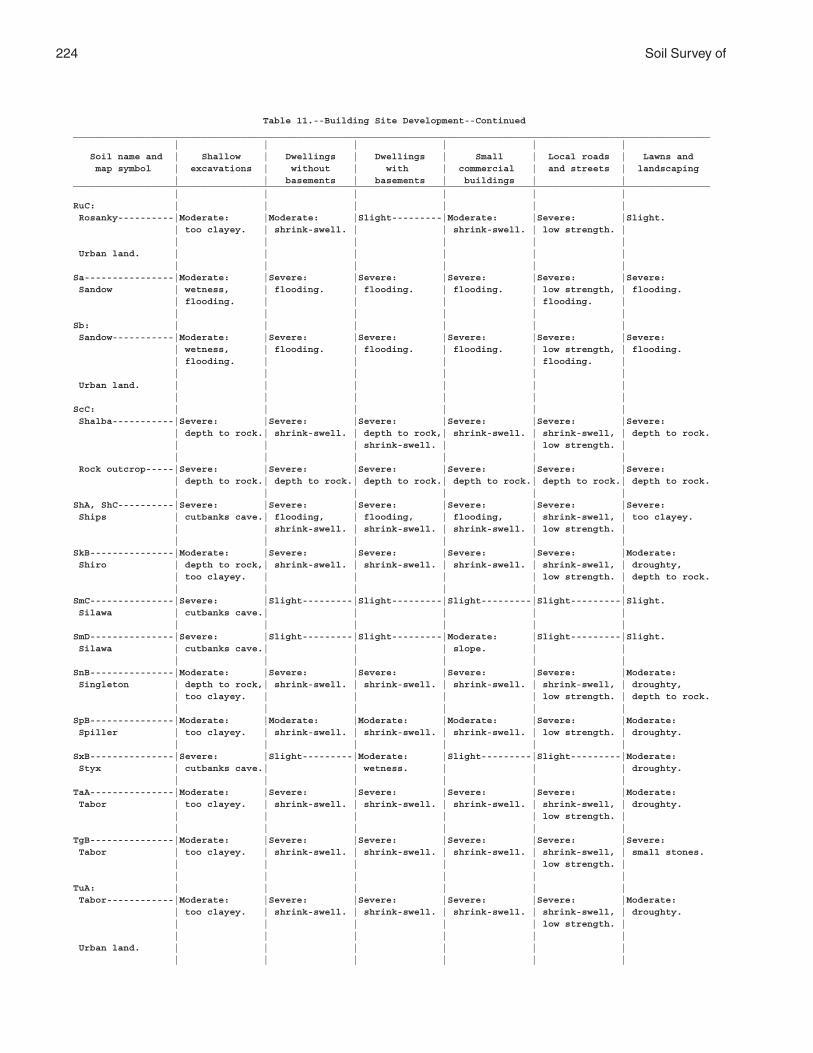
224 Soil Survey of
Table 11.--Building Site Development--Continued__________________________________________________________________________________________________________________ | | | | | | Soil name and | Shallow | Dwellings | Dwellings | Small | Local roads | Lawns and map symbol | excavations | without | with | commercial | and streets | landscaping | | basements | basements | buildings | |__________________________________________________________________________________________________________________ | | | | | |RuC: | | | | | | Rosanky----------|Moderate: |Moderate: |Slight---------|Moderate: |Severe: |Slight. | too clayey. | shrink-swell. | | shrink-swell. | low strength. | | | | | | | Urban land. | | | | | | | | | | | |Sa----------------|Moderate: |Severe: |Severe: |Severe: |Severe: |Severe: Sandow | wetness, | flooding. | flooding. | flooding. | low strength, | flooding. | flooding. | | | | flooding. | | | | | | |Sb: | | | | | | Sandow-----------|Moderate: |Severe: |Severe: |Severe: |Severe: |Severe: | wetness, | flooding. | flooding. | flooding. | low strength, | flooding. | flooding. | | | | flooding. | | | | | | | Urban land. | | | | | | | | | | | |ScC: | | | | | | Shalba-----------|Severe: |Severe: |Severe: |Severe: |Severe: |Severe: | depth to rock.| shrink-swell. | depth to rock,| shrink-swell. | shrink-swell, | depth to rock. | | | shrink-swell. | | low strength. | | | | | | | Rock outcrop-----|Severe: |Severe: |Severe: |Severe: |Severe: |Severe: | depth to rock.| depth to rock.| depth to rock.| depth to rock.| depth to rock.| depth to rock. | | | | | |ShA, ShC----------|Severe: |Severe: |Severe: |Severe: |Severe: |Severe: Ships | cutbanks cave.| flooding, | flooding, | flooding, | shrink-swell, | too clayey. | | shrink-swell. | shrink-swell. | shrink-swell. | low strength. | | | | | | |SkB---------------|Moderate: |Severe: |Severe: |Severe: |Severe: |Moderate: Shiro | depth to rock,| shrink-swell. | shrink-swell. | shrink-swell. | shrink-swell, | droughty, | too clayey. | | | | low strength. | depth to rock. | | | | | |SmC---------------|Severe: |Slight---------|Slight---------|Slight---------|Slight---------|Slight. Silawa | cutbanks cave.| | | | | | | | | | |SmD---------------|Severe: |Slight---------|Slight---------|Moderate: |Slight---------|Slight. Silawa | cutbanks cave.| | | slope. | | | | | | | |SnB---------------|Moderate: |Severe: |Severe: |Severe: |Severe: |Moderate: Singleton | depth to rock,| shrink-swell. | shrink-swell. | shrink-swell. | shrink-swell, | droughty, | too clayey. | | | | low strength. | depth to rock. | | | | | |SpB---------------|Moderate: |Moderate: |Moderate: |Moderate: |Severe: |Moderate: Spiller | too clayey. | shrink-swell. | shrink-swell. | shrink-swell. | low strength. | droughty. | | | | | |SxB---------------|Severe: |Slight---------|Moderate: |Slight---------|Slight---------|Moderate: Styx | cutbanks cave.| | wetness. | | | droughty. | | | | | |TaA---------------|Moderate: |Severe: |Severe: |Severe: |Severe: |Moderate: Tabor | too clayey. | shrink-swell. | shrink-swell. | shrink-swell. | shrink-swell, | droughty. | | | | | low strength. | | | | | | |TgB---------------|Moderate: |Severe: |Severe: |Severe: |Severe: |Severe: Tabor | too clayey. | shrink-swell. | shrink-swell. | shrink-swell. | shrink-swell, | small stones. | | | | | low strength. | | | | | | |TuA: | | | | | | Tabor------------|Moderate: |Severe: |Severe: |Severe: |Severe: |Moderate: | too clayey. | shrink-swell. | shrink-swell. | shrink-swell. | shrink-swell, | droughty. | | | | | low strength. | | | | | | | Urban land. | | | | | | | | | | | |
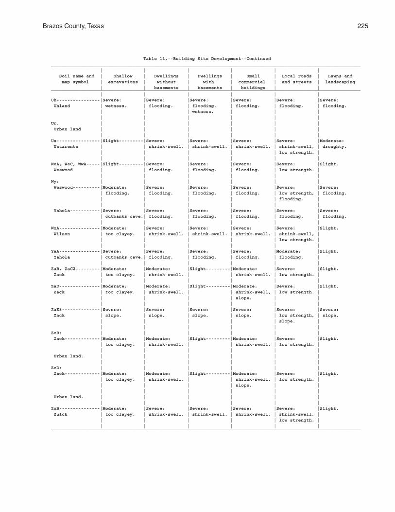
Brazos County, Texas 225
Table 11.--Building Site Development--Continued__________________________________________________________________________________________________________________ | | | | | | Soil name and | Shallow | Dwellings | Dwellings | Small | Local roads | Lawns and map symbol | excavations | without | with | commercial | and streets | landscaping | | basements | basements | buildings | |__________________________________________________________________________________________________________________ | | | | | |Uh----------------|Severe: |Severe: |Severe: |Severe: |Severe: |Severe: Uhland | wetness. | flooding. | flooding, | flooding. | flooding. | flooding. | | | wetness. | | | | | | | | |Ur. | | | | | | Urban land | | | | | | | | | | | |Us----------------|Slight---------|Severe: |Severe: |Severe: |Severe: |Moderate: Ustarents | | shrink-swell. | shrink-swell. | shrink-swell. | shrink-swell, | droughty. | | | | | low strength. | | | | | | |WeA, WeC, WwA-----|Slight---------|Severe: |Severe: |Severe: |Severe: |Slight. Weswood | | flooding. | flooding. | flooding. | low strength. | | | | | | |Wy: | | | | | | Weswood----------|Moderate: |Severe: |Severe: |Severe: |Severe: |Severe: | flooding. | flooding. | flooding. | flooding. | low strength, | flooding. | | | | | flooding. | | | | | | | Yahola-----------|Severe: |Severe: |Severe: |Severe: |Severe: |Severe: | cutbanks cave.| flooding. | flooding. | flooding. | flooding. | flooding. | | | | | |WzA---------------|Moderate: |Severe: |Severe: |Severe: |Severe: |Slight. Wilson | too clayey. | shrink-swell. | shrink-swell. | shrink-swell. | shrink-swell, | | | | | | low strength. | | | | | | |YaA---------------|Severe: |Severe: |Severe: |Severe: |Moderate: |Slight. Yahola | cutbanks cave.| flooding. | flooding. | flooding. | flooding. | | | | | | |ZaB, ZaC2---------|Moderate: |Moderate: |Slight---------|Moderate: |Severe: |Slight. Zack | too clayey. | shrink-swell. | | shrink-swell. | low strength. | | | | | | |ZaD---------------|Moderate: |Moderate: |Slight---------|Moderate: |Severe: |Slight. Zack | too clayey. | shrink-swell. | | shrink-swell, | low strength. | | | | | slope. | | | | | | | |ZaE3--------------|Severe: |Severe: |Severe: |Severe: |Severe: |Severe: Zack | slope. | slope. | slope. | slope. | low strength, | slope. | | | | | slope. | | | | | | |ZcB: | | | | | | Zack-------------|Moderate: |Moderate: |Slight---------|Moderate: |Severe: |Slight. | too clayey. | shrink-swell. | | shrink-swell. | low strength. | | | | | | | Urban land. | | | | | | | | | | | |ZcD: | | | | | | Zack-------------|Moderate: |Moderate: |Slight---------|Moderate: |Severe: |Slight. | too clayey. | shrink-swell. | | shrink-swell, | low strength. | | | | | slope. | | | | | | | | Urban land. | | | | | | | | | | | |ZuB---------------|Moderate: |Severe: |Severe: |Severe: |Severe: |Slight. Zulch | too clayey. | shrink-swell. | shrink-swell. | shrink-swell. | shrink-swell, | | | | | | low strength. | | | | | | |__________________________________________________________________________________________________________________
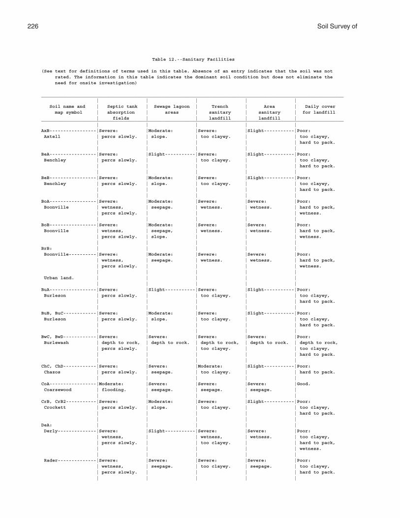
226 Soil Survey of
Table 12.--Sanitary Facilities
(See text for definitions of terms used in this table. Absence of an entry indicates that the soil was not rated. The information in this table indicates the dominant soil condition but does not eliminate the need for onsite investigation)
______________________________________________________________________________________________________________ | | | | | Soil name and | Septic tank | Sewage lagoon | Trench | Area | Daily cover map symbol | absorption | areas | sanitary | sanitary | for landfill | fields | | landfill | landfill |______________________________________________________________________________________________________________ | | | | |AxB-----------------|Severe: |Moderate: |Severe: |Slight-----------|Poor: Axtell | percs slowly. | slope. | too clayey. | | too clayey, | | | | | hard to pack. | | | | |BeA-----------------|Severe: |Slight-----------|Severe: |Slight-----------|Poor: Benchley | percs slowly. | | too clayey. | | too clayey, | | | | | hard to pack. | | | | |BeB-----------------|Severe: |Moderate: |Severe: |Slight-----------|Poor: Benchley | percs slowly. | slope. | too clayey. | | too clayey, | | | | | hard to pack. | | | | |BoA-----------------|Severe: |Moderate: |Severe: |Severe: |Poor: Boonville | wetness, | seepage. | wetness. | wetness. | hard to pack, | percs slowly. | | | | wetness. | | | | |BoB-----------------|Severe: |Moderate: |Severe: |Severe: |Poor: Boonville | wetness, | seepage, | wetness. | wetness. | hard to pack, | percs slowly. | slope. | | | wetness. | | | | |BrB: | | | | | Boonville----------|Severe: |Moderate: |Severe: |Severe: |Poor: | wetness, | seepage. | wetness. | wetness. | hard to pack, | percs slowly. | | | | wetness. | | | | | Urban land. | | | | | | | | | |BuA-----------------|Severe: |Slight-----------|Severe: |Slight-----------|Poor: Burleson | percs slowly. | | too clayey. | | too clayey, | | | | | hard to pack. | | | | |BuB, BuC------------|Severe: |Moderate: |Severe: |Slight-----------|Poor: Burleson | percs slowly. | slope. | too clayey. | | too clayey, | | | | | hard to pack. | | | | |BwC, BwD------------|Severe: |Severe: |Severe: |Severe: |Poor: Burlewash | depth to rock, | depth to rock. | depth to rock, | depth to rock. | depth to rock, | percs slowly. | | too clayey. | | too clayey, | | | | | hard to pack. | | | | |ChC, ChD------------|Severe: |Severe: |Moderate: |Slight-----------|Poor: Chazos | percs slowly. | seepage. | too clayey. | | hard to pack. | | | | |CoA-----------------|Moderate: |Severe: |Severe: |Severe: |Good. Coarsewood | flooding. | seepage. | seepage. | seepage. | | | | | |CrB, CrB2-----------|Severe: |Moderate: |Severe: |Slight-----------|Poor: Crockett | percs slowly. | slope. | too clayey. | | too clayey, | | | | | hard to pack. | | | | |DeA: | | | | | Derly--------------|Severe: |Slight-----------|Severe: |Severe: |Poor: | wetness, | | wetness, | wetness. | too clayey, | percs slowly. | | too clayey. | | hard to pack, | | | | | wetness. | | | | | Rader--------------|Severe: |Severe: |Severe: |Severe: |Poor: | wetness, | seepage. | too clayey. | seepage. | too clayey, | percs slowly. | | | | hard to pack. | | | | |
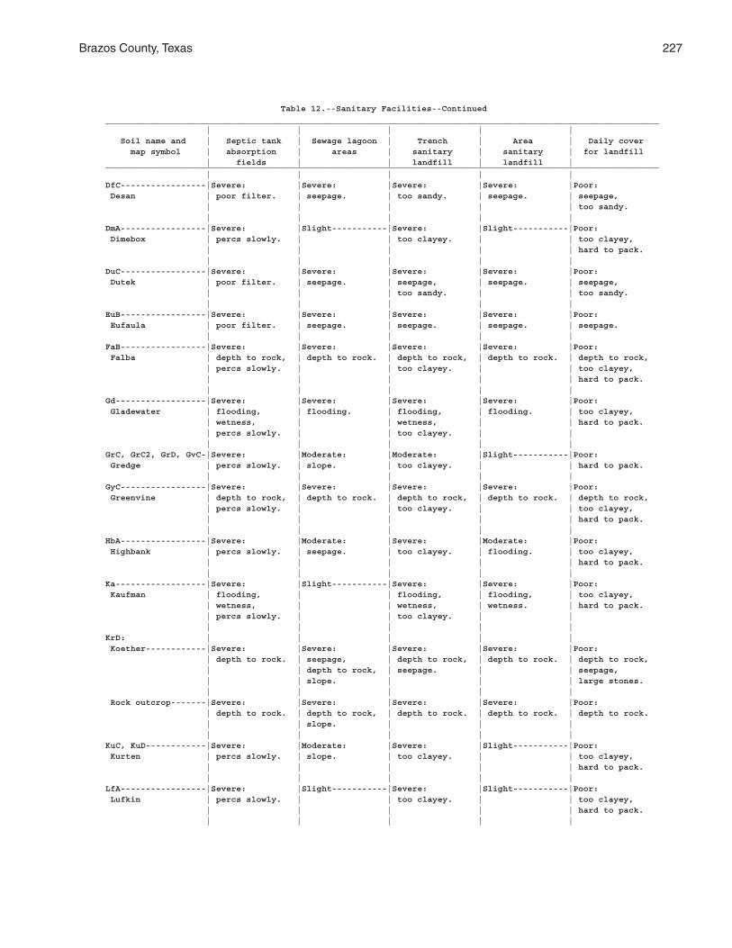
Brazos County, Texas 227
Table 12.--Sanitary Facilities--Continued______________________________________________________________________________________________________________ | | | | | Soil name and | Septic tank | Sewage lagoon | Trench | Area | Daily cover map symbol | absorption | areas | sanitary | sanitary | for landfill | fields | | landfill | landfill |______________________________________________________________________________________________________________ | | | | |DfC-----------------|Severe: |Severe: |Severe: |Severe: |Poor: Desan | poor filter. | seepage. | too sandy. | seepage. | seepage, | | | | | too sandy. | | | | |DmA-----------------|Severe: |Slight-----------|Severe: |Slight-----------|Poor: Dimebox | percs slowly. | | too clayey. | | too clayey, | | | | | hard to pack. | | | | |DuC-----------------|Severe: |Severe: |Severe: |Severe: |Poor: Dutek | poor filter. | seepage. | seepage, | seepage. | seepage, | | | too sandy. | | too sandy. | | | | |EuB-----------------|Severe: |Severe: |Severe: |Severe: |Poor: Eufaula | poor filter. | seepage. | seepage. | seepage. | seepage. | | | | |FaB-----------------|Severe: |Severe: |Severe: |Severe: |Poor: Falba | depth to rock, | depth to rock. | depth to rock, | depth to rock. | depth to rock, | percs slowly. | | too clayey. | | too clayey, | | | | | hard to pack. | | | | |Gd------------------|Severe: |Severe: |Severe: |Severe: |Poor: Gladewater | flooding, | flooding. | flooding, | flooding. | too clayey, | wetness, | | wetness, | | hard to pack. | percs slowly. | | too clayey. | | | | | | |GrC, GrC2, GrD, GvC-|Severe: |Moderate: |Moderate: |Slight-----------|Poor: Gredge | percs slowly. | slope. | too clayey. | | hard to pack. | | | | |GyC-----------------|Severe: |Severe: |Severe: |Severe: |Poor: Greenvine | depth to rock, | depth to rock. | depth to rock, | depth to rock. | depth to rock, | percs slowly. | | too clayey. | | too clayey, | | | | | hard to pack. | | | | |HbA-----------------|Severe: |Moderate: |Severe: |Moderate: |Poor: Highbank | percs slowly. | seepage. | too clayey. | flooding. | too clayey, | | | | | hard to pack. | | | | |Ka------------------|Severe: |Slight-----------|Severe: |Severe: |Poor: Kaufman | flooding, | | flooding, | flooding, | too clayey, | wetness, | | wetness, | wetness. | hard to pack. | percs slowly. | | too clayey. | | | | | | |KrD: | | | | | Koether------------|Severe: |Severe: |Severe: |Severe: |Poor: | depth to rock. | seepage, | depth to rock, | depth to rock. | depth to rock, | | depth to rock, | seepage. | | seepage, | | slope. | | | large stones. | | | | | Rock outcrop-------|Severe: |Severe: |Severe: |Severe: |Poor: | depth to rock. | depth to rock, | depth to rock. | depth to rock. | depth to rock. | | slope. | | | | | | | |KuC, KuD------------|Severe: |Moderate: |Severe: |Slight-----------|Poor: Kurten | percs slowly. | slope. | too clayey. | | too clayey, | | | | | hard to pack. | | | | |LfA-----------------|Severe: |Slight-----------|Severe: |Slight-----------|Poor: Lufkin | percs slowly. | | too clayey. | | too clayey, | | | | | hard to pack. | | | | |
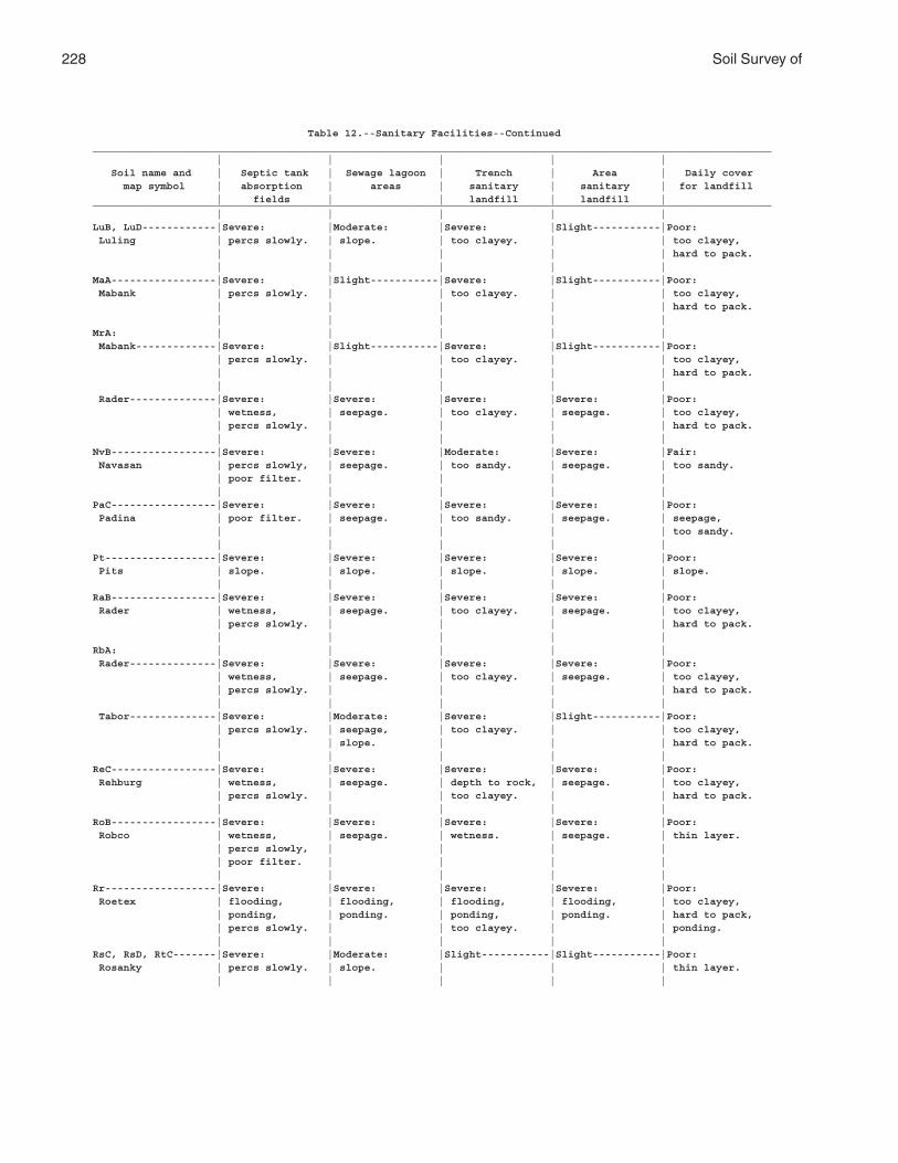
228 Soil Survey of
Table 12.--Sanitary Facilities--Continued______________________________________________________________________________________________________________ | | | | | Soil name and | Septic tank | Sewage lagoon | Trench | Area | Daily cover map symbol | absorption | areas | sanitary | sanitary | for landfill | fields | | landfill | landfill |______________________________________________________________________________________________________________ | | | | |LuB, LuD------------|Severe: |Moderate: |Severe: |Slight-----------|Poor: Luling | percs slowly. | slope. | too clayey. | | too clayey, | | | | | hard to pack. | | | | |MaA-----------------|Severe: |Slight-----------|Severe: |Slight-----------|Poor: Mabank | percs slowly. | | too clayey. | | too clayey, | | | | | hard to pack. | | | | |MrA: | | | | | Mabank-------------|Severe: |Slight-----------|Severe: |Slight-----------|Poor: | percs slowly. | | too clayey. | | too clayey, | | | | | hard to pack. | | | | | Rader--------------|Severe: |Severe: |Severe: |Severe: |Poor: | wetness, | seepage. | too clayey. | seepage. | too clayey, | percs slowly. | | | | hard to pack. | | | | |NvB-----------------|Severe: |Severe: |Moderate: |Severe: |Fair: Navasan | percs slowly, | seepage. | too sandy. | seepage. | too sandy. | poor filter. | | | | | | | | |PaC-----------------|Severe: |Severe: |Severe: |Severe: |Poor: Padina | poor filter. | seepage. | too sandy. | seepage. | seepage, | | | | | too sandy. | | | | |Pt------------------|Severe: |Severe: |Severe: |Severe: |Poor: Pits | slope. | slope. | slope. | slope. | slope. | | | | |RaB-----------------|Severe: |Severe: |Severe: |Severe: |Poor: Rader | wetness, | seepage. | too clayey. | seepage. | too clayey, | percs slowly. | | | | hard to pack. | | | | |RbA: | | | | | Rader--------------|Severe: |Severe: |Severe: |Severe: |Poor: | wetness, | seepage. | too clayey. | seepage. | too clayey, | percs slowly. | | | | hard to pack. | | | | | Tabor--------------|Severe: |Moderate: |Severe: |Slight-----------|Poor: | percs slowly. | seepage, | too clayey. | | too clayey, | | slope. | | | hard to pack. | | | | |ReC-----------------|Severe: |Severe: |Severe: |Severe: |Poor: Rehburg | wetness, | seepage. | depth to rock, | seepage. | too clayey, | percs slowly. | | too clayey. | | hard to pack. | | | | |RoB-----------------|Severe: |Severe: |Severe: |Severe: |Poor: Robco | wetness, | seepage. | wetness. | seepage. | thin layer. | percs slowly, | | | | | poor filter. | | | | | | | | |Rr------------------|Severe: |Severe: |Severe: |Severe: |Poor: Roetex | flooding, | flooding, | flooding, | flooding, | too clayey, | ponding, | ponding. | ponding, | ponding. | hard to pack, | percs slowly. | | too clayey. | | ponding. | | | | |RsC, RsD, RtC-------|Severe: |Moderate: |Slight-----------|Slight-----------|Poor: Rosanky | percs slowly. | slope. | | | thin layer. | | | | |
Brazos County, Texas 229
Table 12.--Sanitary Facilities--Continued______________________________________________________________________________________________________________ | | | | | Soil name and | Septic tank | Sewage lagoon | Trench | Area | Daily cover map symbol | absorption | areas | sanitary | sanitary | for landfill | fields | | landfill | landfill |______________________________________________________________________________________________________________ | | | | |RuC: | | | | | Rosanky------------|Severe: |Moderate: |Slight-----------|Slight-----------|Poor: | percs slowly. | slope. | | | thin layer. | | | | | Urban land. | | | | | | | | | |Sa------------------|Severe: |Severe: |Severe: |Severe: |Fair: Sandow | flooding, | flooding. | flooding. | flooding. | too clayey. | wetness, | | | | | percs slowly. | | | | | | | | |Sb: | | | | | Sandow-------------|Severe: |Severe: |Severe: |Severe: |Fair: | flooding, | flooding. | flooding. | flooding. | too clayey. | wetness, | | | | | percs slowly. | | | | | | | | | Urban land. | | | | | | | | | |ScC: | | | | | Shalba-------------|Severe: |Severe: |Severe: |Severe: |Poor: | depth to rock. | depth to rock. | depth to rock, | depth to rock. | depth to rock, | | | too clayey. | | too clayey, | | | | | hard to pack. | | | | | Rock outcrop-------|Severe: |Severe: |Severe: |Severe: |Poor: | depth to rock. | depth to rock. | depth to rock. | depth to rock. | depth to rock. | | | | |ShA-----------------|Severe: |Slight-----------|Severe: |Moderate: |Poor: Ships | percs slowly. | | too clayey. | flooding. | too clayey, | | | | | hard to pack. | | | | |ShC-----------------|Severe: |Moderate: |Severe: |Moderate: |Poor: Ships | percs slowly. | slope. | too clayey. | flooding. | too clayey, | | | | | hard to pack. | | | | |SkB-----------------|Severe: |Severe: |Severe: |Severe: |Poor: Shiro | depth to rock, | depth to rock. | depth to rock, | depth to rock. | depth to rock, | percs slowly. | | too clayey. | | too clayey, | | | | | hard to pack. | | | | |SmC, SmD------------|Moderate: |Severe: |Severe: |Severe: |Fair: Silawa | percs slowly. | seepage. | seepage. | seepage. | too clayey, | | | | | thin layer. | | | | |SnB-----------------|Severe: |Severe: |Severe: |Severe: |Poor: Singleton | depth to rock, | depth to rock. | depth to rock, | depth to rock. | depth to rock, | percs slowly. | | too clayey. | | too clayey, | | | | | hard to pack. | | | | |SpB-----------------|Severe: |Severe: |Severe: |Slight-----------|Poor: Spiller | percs slowly. | seepage. | too clayey. | | too clayey, | | | | | hard to pack. | | | | |SxB-----------------|Moderate: |Severe: |Moderate: |Severe: |Fair: Styx | wetness. | seepage. | wetness, | seepage. | too clayey. | | | too clayey. | | | | | | |TaA-----------------|Severe: |Moderate: |Severe: |Slight-----------|Poor: Tabor | percs slowly. | seepage. | too clayey. | | too clayey, | | | | | hard to pack. | | | | |
230 Soil Survey of
Table 12.--Sanitary Facilities--Continued______________________________________________________________________________________________________________ | | | | | Soil name and | Septic tank | Sewage lagoon | Trench | Area | Daily cover map symbol | absorption | areas | sanitary | sanitary | for landfill | fields | | landfill | landfill |______________________________________________________________________________________________________________ | | | | |TgB-----------------|Severe: |Moderate: |Severe: |Slight-----------|Poor: Tabor | percs slowly. | seepage, | too clayey. | | too clayey, | | slope. | | | hard to pack. | | | | |TuA: | | | | | Tabor--------------|Severe: |Moderate: |Severe: |Slight-----------|Poor: | percs slowly. | seepage. | too clayey. | | too clayey, | | | | | hard to pack. | | | | | Urban land. | | | | | | | | | |Uh------------------|Severe: |Severe: |Severe: |Severe: |Fair: Uhland | flooding, | flooding, | flooding. | flooding. | wetness. | wetness, | wetness. | | | | percs slowly. | | | | | | | | |Ur. | | | | | Urban land | | | | | | | | | |Us------------------|Severe: |Slight-----------|Slight-----------|Slight-----------|Poor: Ustarents | percs slowly. | | | | hard to pack. | | | | |WeA-----------------|Moderate: |Moderate: |Moderate: |Moderate: |Good. Weswood | flooding, | seepage. | flooding. | flooding. | | percs slowly. | | | | | | | | |WeC-----------------|Moderate: |Moderate: |Moderate: |Moderate: |Good. Weswood | flooding, | seepage, | flooding. | flooding. | | percs slowly. | slope. | | | | | | | |WwA-----------------|Moderate: |Moderate: |Moderate: |Moderate: |Good. Weswood | flooding, | seepage. | flooding. | flooding. | | percs slowly. | | | | | | | | |Wy: | | | | | Weswood------------|Severe: |Severe: |Severe: |Severe: |Good. | flooding. | flooding. | flooding. | flooding. | | | | | | Yahola-------------|Severe: |Severe: |Severe: |Severe: |Good. | flooding. | seepage, | flooding, | flooding, | | | flooding. | seepage. | seepage. | | | | | |WzA-----------------|Severe: |Slight-----------|Severe: |Slight-----------|Poor: Wilson | percs slowly. | | too clayey. | | too clayey, | | | | | hard to pack. | | | | |YaA-----------------|Moderate: |Severe: |Severe: |Severe: |Good. Yahola | flooding. | seepage. | seepage. | seepage. | | | | | |ZaB, ZaC2, ZaD------|Severe: |Moderate: |Moderate: |Slight-----------|Fair: Zack | percs slowly. | slope. | too clayey. | | too clayey. | | | | |ZaE3----------------|Severe: |Severe: |Severe: |Severe: |Poor: Zack | percs slowly, | slope. | slope. | slope. | slope. | slope. | | | | | | | | |ZcB, ZcD: | | | | | Zack---------------|Severe: |Moderate: |Moderate: |Slight-----------|Fair: | percs slowly. | slope. | too clayey. | | too clayey. | | | | | Urban land. | | | | | | | | | |

Brazos County, Texas 231
Table 12.--Sanitary Facilities--Continued______________________________________________________________________________________________________________ | | | | | Soil name and | Septic tank | Sewage lagoon | Trench | Area | Daily cover map symbol | absorption | areas | sanitary | sanitary | for landfill | fields | | landfill | landfill |______________________________________________________________________________________________________________ | | | | |ZuB-----------------|Severe: |Moderate: |Severe: |Slight-----------|Poor: Zulch | percs slowly. | slope. | too clayey. | | too clayey, | | | | | hard to pack. | | | | |______________________________________________________________________________________________________________
232 Soil Survey of
Table 13.--Construction Materials
(See text for definitions of terms used in this table. Absence of an entry indicates that the soil was not rated. The information in this table indicates the dominant soil condition but does not eliminate the need for onsite investigation)
______________________________________________________________________________________________________________ | | | | Soil name and | Roadfill | Sand | Gravel | Topsoil map symbol | | | | | | | |______________________________________________________________________________________________________________ | | | |AxB-------------------|Poor: |Improbable: |Improbable: |Poor: Axtell | shrink-swell, | excess fines. | excess fines. | too clayey. | low strength. | | | | | | |BeA, BeB--------------|Poor: |Improbable: |Improbable: |Poor: Benchley | low strength. | excess fines. | excess fines. | too clayey. | | | |BoA, BoB--------------|Poor: |Improbable: |Improbable: |Poor: Boonville | low strength, | excess fines. | excess fines. | too clayey, | wetness. | | | wetness. | | | |BrB: | | | | Boonville------------|Poor: |Improbable: |Improbable: |Poor: | low strength, | excess fines. | excess fines. | too clayey, | wetness. | | | wetness. | | | | Urban land. | | | | | | | |BuA, BuB, BuC---------|Poor: |Improbable: |Improbable: |Poor: Burleson | shrink-swell, | excess fines. | excess fines. | too clayey. | low strength. | | | | | | |BwC, BwD--------------|Poor: |Improbable: |Improbable: |Poor: Burlewash | depth to rock, | excess fines. | excess fines. | too clayey, | shrink-swell, | | | too acid. | low strength. | | | | | | |ChC, ChD--------------|Poor: |Improbable: |Improbable: |Poor: Chazos | low strength. | excess fines. | excess fines. | thin layer. | | | |CoA-------------------|Good-----------------|Improbable: |Improbable: |Good. Coarsewood | | excess fines. | excess fines. | | | | |CrB, CrB2-------------|Poor: |Improbable: |Improbable: |Poor: Crockett | shrink-swell, | excess fines. | excess fines. | too clayey. | low strength. | | | | | | |DeA: | | | | Derly----------------|Poor: |Improbable: |Improbable: |Poor: | shrink-swell, | excess fines. | excess fines. | too clayey, | low strength, | | | wetness. | wetness. | | | | | | | Rader----------------|Poor: |Improbable: |Improbable: |Fair: | low strength. | excess fines. | excess fines. | thin layer. | | | |DfC-------------------|Good-----------------|Probable-------------|Improbable: |Poor: Desan | | | too sandy. | too sandy. | | | |DmA-------------------|Poor: |Improbable: |Improbable: |Poor: Dimebox | shrink-swell, | excess fines. | excess fines. | too clayey. | low strength. | | | | | | |DuC-------------------|Good-----------------|Probable-------------|Improbable: |Poor: Dutek | | | too sandy. | too sandy. | | | |EuB-------------------|Good-----------------|Probable-------------|Improbable: |Fair: Eufaula | | | too sandy. | too sandy. | | | |
Brazos County, Texas 233
Table 13.--Construction Materials--Continued______________________________________________________________________________________________________________ | | | | Soil name and | Roadfill | Sand | Gravel | Topsoil map symbol | | | | | | | |______________________________________________________________________________________________________________ | | | |FaB-------------------|Poor: |Improbable: |Improbable: |Poor: Falba | depth to rock, | excess fines. | excess fines. | too clayey, | shrink-swell, | | | wetness. | low strength. | | | | | | |Gd--------------------|Poor: |Improbable: |Improbable: |Poor: Gladewater | low strength. | excess fines. | excess fines. | too clayey. | | | |GrC, GrC2, GrD, GvC---|Fair: |Improbable: |Improbable: |Poor: Gredge | shrink-swell. | excess fines. | excess fines. | thin layer. | | | |GyC-------------------|Poor: |Improbable: |Improbable: |Poor: Greenvine | depth to rock, | excess fines. | excess fines. | too clayey. | shrink-swell, | | | | low strength. | | | | | | |HbA-------------------|Poor: |Improbable: |Improbable: |Poor: Highbank | shrink-swell, | excess fines. | excess fines. | too clayey. | low strength. | | | | | | |Ka--------------------|Poor: |Improbable: |Improbable: |Poor: Kaufman | shrink-swell, | excess fines. | excess fines. | too clayey. | low strength. | | | | | | |KrD: | | | | Koether--------------|Poor: |Improbable: |Improbable: |Poor: | depth to rock. | thin layer. | too sandy. | depth to rock, | | | | large stones. | | | | Rock outcrop. | | | | | | | |KuC, KuD--------------|Poor: |Improbable: |Improbable: |Poor: Kurten | shrink-swell, | excess fines. | excess fines. | too clayey. | low strength. | | | | | | |LfA-------------------|Poor: |Improbable: |Improbable: |Poor: Lufkin | shrink-swell, | excess fines. | excess fines. | too clayey. | low strength. | | | | | | |LuB, LuD--------------|Poor: |Improbable: |Improbable: |Poor: Luling | shrink-swell, | excess fines. | excess fines. | too clayey. | low strength. | | | | | | |MaA-------------------|Poor: |Improbable: |Improbable: |Poor: Mabank | shrink-swell, | excess fines. | excess fines. | too clayey. | low strength. | | | | | | |MrA: | | | | Mabank---------------|Poor: |Improbable: |Improbable: |Poor: | shrink-swell, | excess fines. | excess fines. | too clayey. | low strength. | | | | | | | Rader----------------|Poor: |Improbable: |Improbable: |Fair: | low strength. | excess fines. | excess fines. | thin layer. | | | |NvB-------------------|Good-----------------|Improbable: |Improbable: |Fair: Navasan | | excess fines. | excess fines. | too sandy. | | | |PaC-------------------|Good-----------------|Probable-------------|Improbable: |Poor: Padina | | | too sandy. | too sandy. | | | |
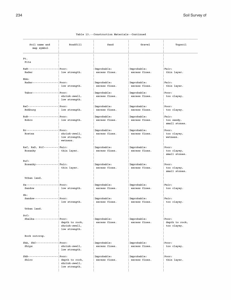
234 Soil Survey of
Table 13.--Construction Materials--Continued______________________________________________________________________________________________________________ | | | | Soil name and | Roadfill | Sand | Gravel | Topsoil map symbol | | | | | | | |______________________________________________________________________________________________________________ | | | |Pt. | | | | Pits | | | | | | | |RaB-------------------|Poor: |Improbable: |Improbable: |Fair: Rader | low strength. | excess fines. | excess fines. | thin layer. | | | |RbA: | | | | Rader----------------|Poor: |Improbable: |Improbable: |Fair: | low strength. | excess fines. | excess fines. | thin layer. | | | | Tabor----------------|Poor: |Improbable: |Improbable: |Poor: | shrink-swell, | excess fines. | excess fines. | too clayey. | low strength. | | | | | | |ReC-------------------|Poor: |Improbable: |Improbable: |Poor: Rehburg | low strength. | excess fines. | excess fines. | too clayey. | | | |RoB-------------------|Poor: |Improbable: |Improbable: |Fair: Robco | low strength. | excess fines. | excess fines. | too sandy, | | | | small stones. | | | |Rr--------------------|Poor: |Improbable: |Improbable: |Poor: Roetex | shrink-swell, | excess fines. | excess fines. | too clayey, | low strength, | | | wetness. | wetness. | | | | | | |RsC, RsD, RtC---------|Fair: |Improbable: |Improbable: |Poor: Rosanky | thin layer. | excess fines. | excess fines. | too clayey, | | | | small stones. | | | |RuC: | | | | Rosanky--------------|Fair: |Improbable: |Improbable: |Poor: | thin layer. | excess fines. | excess fines. | too clayey, | | | | small stones. | | | | Urban land. | | | | | | | |Sa--------------------|Poor: |Improbable: |Improbable: |Fair: Sandow | low strength. | excess fines. | excess fines. | too clayey. | | | |Sb: | | | | Sandow---------------|Poor: |Improbable: |Improbable: |Fair: | low strength. | excess fines. | excess fines. | too clayey. | | | | Urban land. | | | | | | | |ScC: | | | | Shalba---------------|Poor: |Improbable: |Improbable: |Poor: | depth to rock, | excess fines. | excess fines. | depth to rock, | shrink-swell, | | | too clayey. | low strength. | | | | | | | Rock outcrop. | | | | | | | |ShA, ShC--------------|Poor: |Improbable: |Improbable: |Poor: Ships | shrink-swell, | excess fines. | excess fines. | too clayey. | low strength. | | | | | | |SkB-------------------|Poor: |Improbable: |Improbable: |Poor: Shiro | depth to rock, | excess fines. | excess fines. | thin layer. | shrink-swell, | | | | low strength. | | | | | | |
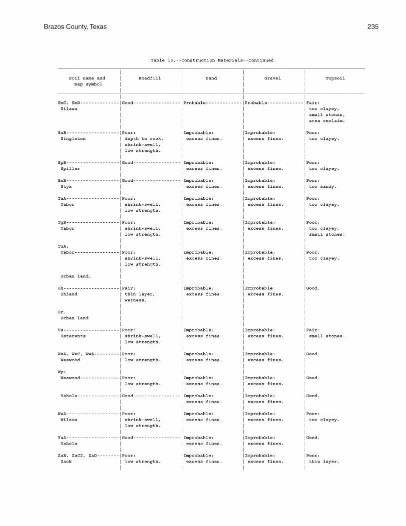
Brazos County, Texas 235
Table 13.--Construction Materials--Continued______________________________________________________________________________________________________________ | | | | Soil name and | Roadfill | Sand | Gravel | Topsoil map symbol | | | | | | | |______________________________________________________________________________________________________________ | | | |SmC, SmD--------------|Good-----------------|Probable-------------|Probable-------------|Fair: Silawa | | | | too clayey, | | | | small stones, | | | | area reclaim. | | | |SnB-------------------|Poor: |Improbable: |Improbable: |Poor: Singleton | depth to rock, | excess fines. | excess fines. | too clayey. | shrink-swell, | | | | low strength. | | | | | | |SpB-------------------|Good-----------------|Improbable: |Improbable: |Poor: Spiller | | excess fines. | excess fines. | too clayey. | | | |SxB-------------------|Good-----------------|Improbable: |Improbable: |Poor: Styx | | excess fines. | excess fines. | too sandy. | | | |TaA-------------------|Poor: |Improbable: |Improbable: |Poor: Tabor | shrink-swell, | excess fines. | excess fines. | too clayey. | low strength. | | | | | | |TgB-------------------|Poor: |Improbable: |Improbable: |Poor: Tabor | shrink-swell, | excess fines. | excess fines. | too clayey, | low strength. | | | small stones. | | | |TuA: | | | | Tabor----------------|Poor: |Improbable: |Improbable: |Poor: | shrink-swell, | excess fines. | excess fines. | too clayey. | low strength. | | | | | | | Urban land. | | | | | | | |Uh--------------------|Fair: |Improbable: |Improbable: |Good. Uhland | thin layer, | excess fines. | excess fines. | | wetness. | | | | | | |Ur. | | | | Urban land | | | | | | | |Us--------------------|Poor: |Improbable: |Improbable: |Fair: Ustarents | shrink-swell, | excess fines. | excess fines. | small stones. | low strength. | | | | | | |WeA, WeC, WwA---------|Poor: |Improbable: |Improbable: |Good. Weswood | low strength. | excess fines. | excess fines. | | | | |Wy: | | | | Weswood--------------|Poor: |Improbable: |Improbable: |Good. | low strength. | excess fines. | excess fines. | | | | | Yahola---------------|Good-----------------|Improbable: |Improbable: |Good. | | excess fines. | excess fines. | | | | |WzA-------------------|Poor: |Improbable: |Improbable: |Poor: Wilson | shrink-swell, | excess fines. | excess fines. | too clayey. | low strength. | | | | | | |YaA-------------------|Good-----------------|Improbable: |Improbable: |Good. Yahola | | excess fines. | excess fines. | | | | |ZaB, ZaC2, ZaD--------|Poor: |Improbable: |Improbable: |Poor: Zack | low strength. | excess fines. | excess fines. | thin layer. | | | |
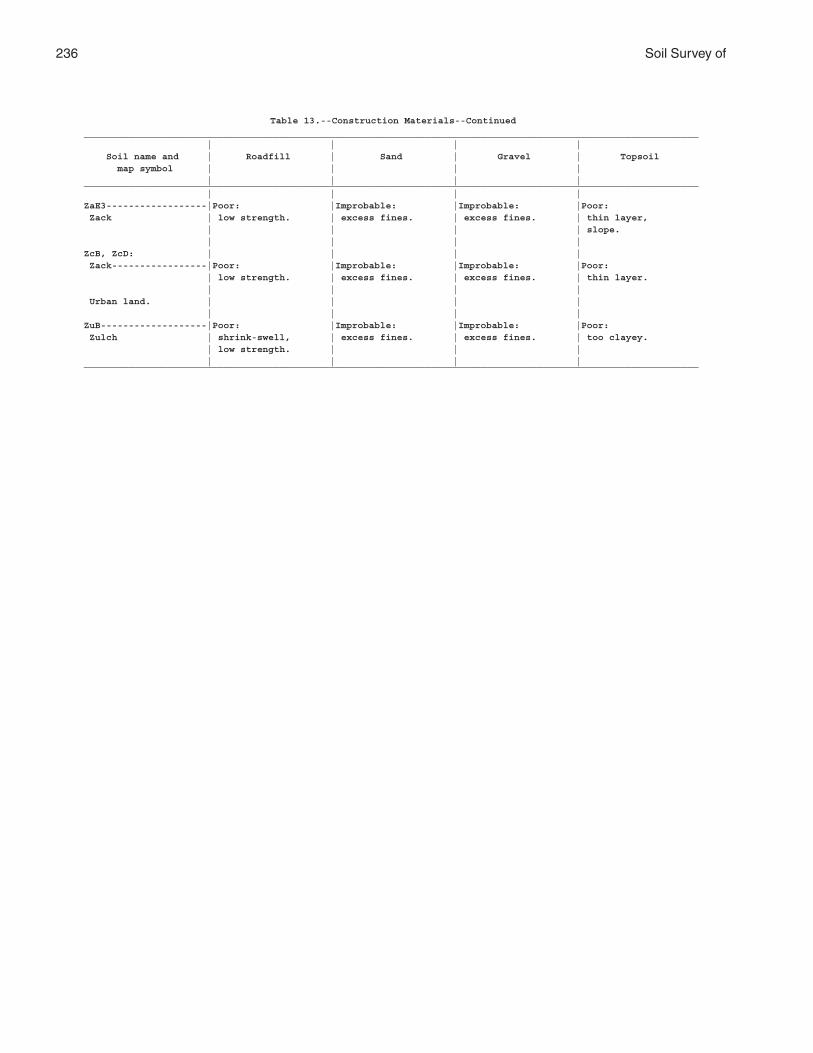
236 Soil Survey of
Table 13.--Construction Materials--Continued______________________________________________________________________________________________________________ | | | | Soil name and | Roadfill | Sand | Gravel | Topsoil map symbol | | | | | | | |______________________________________________________________________________________________________________ | | | |ZaE3------------------|Poor: |Improbable: |Improbable: |Poor: Zack | low strength. | excess fines. | excess fines. | thin layer, | | | | slope. | | | |ZcB, ZcD: | | | | Zack-----------------|Poor: |Improbable: |Improbable: |Poor: | low strength. | excess fines. | excess fines. | thin layer. | | | | Urban land. | | | | | | | |ZuB-------------------|Poor: |Improbable: |Improbable: |Poor: Zulch | shrink-swell, | excess fines. | excess fines. | too clayey. | low strength. | | | | | | |______________________________________________________________________________________________________________
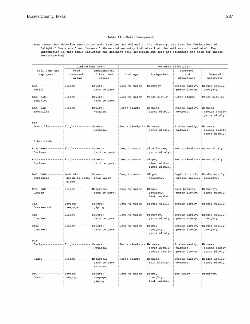
Brazos County, Texas 237
Table 14.--Water Management
(Some terms that describe restrictive soil features are defined in the Glossary. See text for definitions of "slight," "moderate," and "severe." Absence of an entry indicates that the soil was not evaluated. The information in this table indicates the dominant soil condition but does not eliminate the need for onsite investigation)
__________________________________________________________________________________________________________________ | Limitations for-- | Features affecting-- _______________________________________________________________________________________________ Soil name and | Pond | Embankments, | | | Terraces | map symbol | reservoir | dikes, and | Drainage | Irrigation | and | Grassed | areas | levees | | | diversions | waterways__________________________________________________________________________________________________________________ | | | | | |AxB---------------|Slight---------|Severe: |Deep to water |Droughty-------|Erodes easily, |Erodes easily, Axtell | | hard to pack. | | | percs slowly. | droughty. | | | | | |BeA, BeB----------|Slight---------|Severe: |Deep to water |Percs slowly---|Percs slowly---|Percs slowly. Benchley | | hard to pack. | | | | | | | | | |BoA, BoB----------|Slight---------|Severe: |Percs slowly---|Wetness, |Erodes easily, |Wetness, Boonville | | wetness. | | percs slowly. | wetness. | erodes easily, | | | | | | percs slowly. | | | | | |BrB: | | | | | | Boonville--------|Slight---------|Severe: |Percs slowly---|Wetness, |Erodes easily, |Wetness, | | wetness. | | percs slowly. | wetness. | erodes easily, | | | | | | percs slowly. | | | | | | Urban land. | | | | | | | | | | | |BuA, BuB----------|Slight---------|Severe: |Deep to water |Slow intake, |Percs slowly---|Percs slowly. Burleson | | hard to pack. | | percs slowly. | | | | | | | |BuC---------------|Slight---------|Severe: |Deep to water |Slope, |Percs slowly---|Percs slowly. Burleson | | hard to pack. | | slow intake, | | | | | | percs slowly. | | | | | | | |BwC, BwD----------|Moderate: |Severe: |Deep to water |Slope, |Depth to rock, |Erodes easily, Burlewash | depth to rock,| thin layer. | | droughty. | erodes easily.| droughty. | slope. | | | | | | | | | | |ChC, ChD----------|Slight---------|Moderate: |Deep to water |Slope, |Soil blowing, |Droughty, Chazos | | hard to pack. | | droughty, | percs slowly. | percs slowly. | | | | fast intake. | | | | | | | |CoA---------------|Severe: |Severe: |Deep to water |Erodes easily |Erodes easily |Erodes easily. Coarsewood | seepage. | piping. | | | | | | | | | |CrB---------------|Slight---------|Severe: |Deep to water |Droughty, |Erodes easily, |Erodes easily, Crockett | | hard to pack. | | percs slowly. | percs slowly. | droughty. | | | | | |CrB2--------------|Slight---------|Severe: |Deep to water |Slope, |Erodes easily, |Erodes easily, Crockett | | hard to pack. | | droughty, | percs slowly. | droughty. | | | | percs slowly. | | | | | | | |DeA: | | | | | | Derly------------|Slight---------|Severe: |Percs slowly---|Wetness, |Erodes easily, |Wetness, | | wetness. | | percs slowly, | wetness, | erodes easily, | | | | erodes easily.| percs slowly. | percs slowly. | | | | | | Rader------------|Slight---------|Moderate: |Percs slowly---|Wetness, |Erodes easily, |Erodes easily, | | hard to pack, | | soil blowing. | wetness. | percs slowly. | | wetness. | | | | | | | | | |DfC---------------|Severe: |Severe: |Deep to water |Slope, |Too sandy------|Droughty. Desan | seepage. | seepage, | | droughty, | | | | piping. | | fast intake. | | | | | | | |
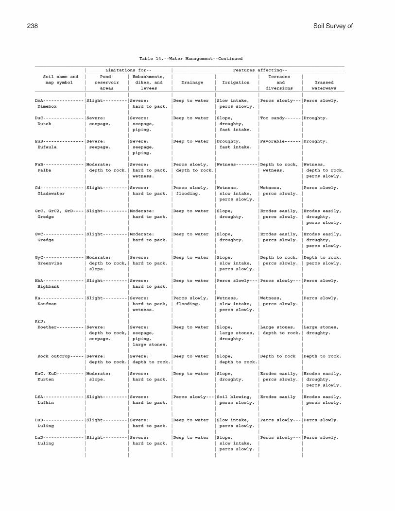
238 Soil Survey of
Table 14.--Water Management--Continued__________________________________________________________________________________________________________________ | Limitations for-- | Features affecting-- _______________________________________________________________________________________________ Soil name and | Pond | Embankments, | | | Terraces | map symbol | reservoir | dikes, and | Drainage | Irrigation | and | Grassed | areas | levees | | | diversions | waterways__________________________________________________________________________________________________________________ | | | | | |DmA---------------|Slight---------|Severe: |Deep to water |Slow intake, |Percs slowly---|Percs slowly. Dimebox | | hard to pack. | | percs slowly. | | | | | | | |DuC---------------|Severe: |Severe: |Deep to water |Slope, |Too sandy------|Droughty. Dutek | seepage. | seepage, | | droughty, | | | | piping. | | fast intake. | | | | | | | |EuB---------------|Severe: |Severe: |Deep to water |Droughty, |Favorable------|Droughty. Eufaula | seepage. | seepage, | | fast intake. | | | | piping. | | | | | | | | | |FaB---------------|Moderate: |Severe: |Percs slowly, |Wetness--------|Depth to rock, |Wetness, Falba | depth to rock.| hard to pack, | depth to rock.| | wetness. | depth to rock, | | wetness. | | | | percs slowly. | | | | | |Gd----------------|Slight---------|Severe: |Percs slowly, |Wetness, |Wetness, |Percs slowly. Gladewater | | hard to pack. | flooding. | slow intake, | percs slowly. | | | | | percs slowly. | | | | | | | |GrC, GrC2, GrD----|Slight---------|Moderate: |Deep to water |Slope, |Erodes easily, |Erodes easily, Gredge | | hard to pack. | | droughty. | percs slowly. | droughty, | | | | | | percs slowly. | | | | | |GvC---------------|Slight---------|Moderate: |Deep to water |Slope, |Erodes easily, |Erodes easily, Gredge | | hard to pack. | | droughty. | percs slowly. | droughty, | | | | | | percs slowly. | | | | | |GyC---------------|Moderate: |Severe: |Deep to water |Slope, |Depth to rock, |Depth to rock, Greenvine | depth to rock,| hard to pack. | | slow intake, | percs slowly. | percs slowly. | slope. | | | percs slowly. | | | | | | | |HbA---------------|Slight---------|Severe: |Deep to water |Percs slowly---|Percs slowly---|Percs slowly. Highbank | | hard to pack. | | | | | | | | | |Ka----------------|Slight---------|Severe: |Percs slowly, |Wetness, |Wetness, |Percs slowly. Kaufman | | hard to pack, | flooding. | slow intake, | percs slowly. | | | wetness. | | percs slowly. | | | | | | | |KrD: | | | | | | Koether----------|Severe: |Severe: |Deep to water |Slope, |Large stones, |Large stones, | depth to rock,| seepage, | | large stones, | depth to rock.| droughty. | seepage. | piping, | | droughty. | | | | large stones. | | | | | | | | | | Rock outcrop-----|Severe: |Severe: |Deep to water |Slope, |Depth to rock |Depth to rock. | depth to rock.| depth to rock.| | depth to rock.| | | | | | | |KuC, KuD----------|Moderate: |Severe: |Deep to water |Slope, |Erodes easily, |Erodes easily, Kurten | slope. | hard to pack. | | droughty. | percs slowly. | droughty, | | | | | | percs slowly. | | | | | |LfA---------------|Slight---------|Severe: |Percs slowly---|Soil blowing, |Erodes easily |Erodes easily, Lufkin | | hard to pack. | | percs slowly. | | percs slowly. | | | | | | | | | | | |LuB---------------|Slight---------|Severe: |Deep to water |Slow intake, |Percs slowly---|Percs slowly. Luling | | hard to pack. | | percs slowly. | | | | | | | |LuD---------------|Slight---------|Severe: |Deep to water |Slope, |Percs slowly---|Percs slowly. Luling | | hard to pack. | | slow intake, | | | | | | percs slowly. | | | | | | | |
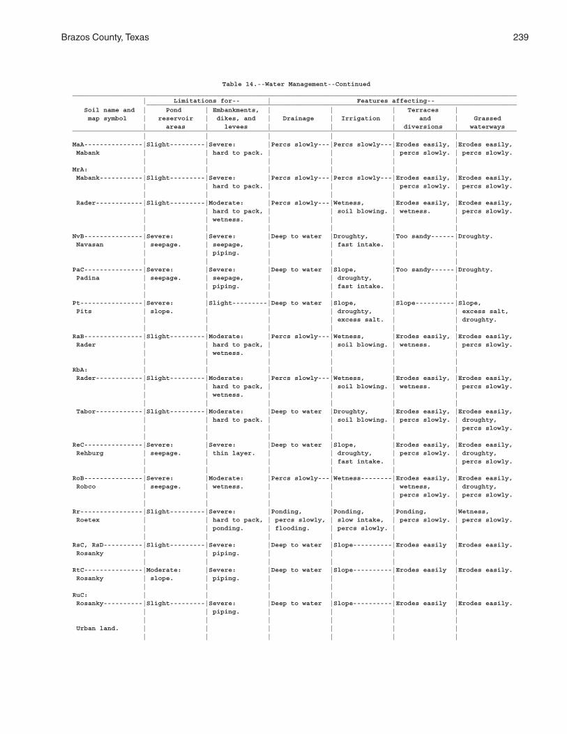
Brazos County, Texas 239
Table 14.--Water Management--Continued__________________________________________________________________________________________________________________ | Limitations for-- | Features affecting-- _______________________________________________________________________________________________ Soil name and | Pond | Embankments, | | | Terraces | map symbol | reservoir | dikes, and | Drainage | Irrigation | and | Grassed | areas | levees | | | diversions | waterways__________________________________________________________________________________________________________________ | | | | | |MaA---------------|Slight---------|Severe: |Percs slowly---|Percs slowly---|Erodes easily, |Erodes easily, Mabank | | hard to pack. | | | percs slowly. | percs slowly. | | | | | |MrA: | | | | | | Mabank-----------|Slight---------|Severe: |Percs slowly---|Percs slowly---|Erodes easily, |Erodes easily, | | hard to pack. | | | percs slowly. | percs slowly. | | | | | | Rader------------|Slight---------|Moderate: |Percs slowly---|Wetness, |Erodes easily, |Erodes easily, | | hard to pack, | | soil blowing. | wetness. | percs slowly. | | wetness. | | | | | | | | | |NvB---------------|Severe: |Severe: |Deep to water |Droughty, |Too sandy------|Droughty. Navasan | seepage. | seepage, | | fast intake. | | | | piping. | | | | | | | | | |PaC---------------|Severe: |Severe: |Deep to water |Slope, |Too sandy------|Droughty. Padina | seepage. | seepage, | | droughty, | | | | piping. | | fast intake. | | | | | | | |Pt----------------|Severe: |Slight---------|Deep to water |Slope, |Slope----------|Slope, Pits | slope. | | | droughty, | | excess salt, | | | | excess salt. | | droughty. | | | | | |RaB---------------|Slight---------|Moderate: |Percs slowly---|Wetness, |Erodes easily, |Erodes easily, Rader | | hard to pack, | | soil blowing. | wetness. | percs slowly. | | wetness. | | | | | | | | | |RbA: | | | | | | Rader------------|Slight---------|Moderate: |Percs slowly---|Wetness, |Erodes easily, |Erodes easily, | | hard to pack, | | soil blowing. | wetness. | percs slowly. | | wetness. | | | | | | | | | | Tabor------------|Slight---------|Moderate: |Deep to water |Droughty, |Erodes easily, |Erodes easily, | | hard to pack. | | soil blowing. | percs slowly. | droughty, | | | | | | percs slowly. | | | | | |ReC---------------|Severe: |Severe: |Deep to water |Slope, |Erodes easily, |Erodes easily, Rehburg | seepage. | thin layer. | | droughty, | percs slowly. | droughty, | | | | fast intake. | | percs slowly. | | | | | |RoB---------------|Severe: |Moderate: |Percs slowly---|Wetness--------|Erodes easily, |Erodes easily, Robco | seepage. | wetness. | | | wetness, | droughty, | | | | | percs slowly. | percs slowly. | | | | | |Rr----------------|Slight---------|Severe: |Ponding, |Ponding, |Ponding, |Wetness, Roetex | | hard to pack, | percs slowly, | slow intake, | percs slowly. | percs slowly. | | ponding. | flooding. | percs slowly. | | | | | | | |RsC, RsD----------|Slight---------|Severe: |Deep to water |Slope----------|Erodes easily |Erodes easily. Rosanky | | piping. | | | | | | | | | |RtC---------------|Moderate: |Severe: |Deep to water |Slope----------|Erodes easily |Erodes easily. Rosanky | slope. | piping. | | | | | | | | | |RuC: | | | | | | Rosanky----------|Slight---------|Severe: |Deep to water |Slope----------|Erodes easily |Erodes easily. | | piping. | | | | | | | | | | Urban land. | | | | | | | | | | | |

240 Soil Survey of
Table 14.--Water Management--Continued__________________________________________________________________________________________________________________ | Limitations for-- | Features affecting-- _______________________________________________________________________________________________ Soil name and | Pond | Embankments, | | | Terraces | map symbol | reservoir | dikes, and | Drainage | Irrigation | and | Grassed | areas | levees | | | diversions | waterways__________________________________________________________________________________________________________________ | | | | | |Sa----------------|Slight---------|Severe: |Deep to water |Erodes easily, |Erodes easily |Erodes easily. Sandow | | piping. | | flooding. | | | | | | | |Sb: | | | | | | Sandow-----------|Slight---------|Severe: |Deep to water |Erodes easily, |Erodes easily |Erodes easily. | | piping. | | flooding. | | | | | | | | Urban land. | | | | | | | | | | | |ScC: | | | | | | Shalba-----------|Severe: |Severe: |Deep to water |Slope, |Depth to rock, |Erodes easily, | depth to rock.| hard to pack. | | percs slowly. | erodes easily.| depth to rock, | | | | | | percs slowly. | | | | | | Rock outcrop-----|Severe: |Severe: |Deep to water |Slope, |Depth to rock |Depth to rock. | depth to rock.| depth to rock.| | depth to rock.| | | | | | | |ShA---------------|Slight---------|Severe: |Deep to water |Slow intake, |Percs slowly---|Percs slowly. Ships | | hard to pack. | | percs slowly. | | | | | | | |ShC---------------|Slight---------|Severe: |Deep to water |Slope, |Percs slowly---|Percs slowly. Ships | | hard to pack. | | slow intake, | | | | | | percs slowly. | | | | | | | |SkB---------------|Moderate: |Severe: |Deep to water |Droughty, |Depth to rock, |Droughty, Shiro | depth to rock.| thin layer. | | fast intake. | percs slowly. | depth to rock, | | | | | | percs slowly. | | | | | |SmC, SmD----------|Severe: |Severe: |Deep to water |Slope----------|Favorable------|Favorable. Silawa | seepage. | thin layer. | | | | | | | | | |SnB---------------|Moderate: |Severe: |Deep to water |Droughty-------|Depth to rock, |Erodes easily, Singleton | depth to rock.| thin layer. | | | erodes easily.| droughty, | | | | | | depth to rock. | | | | | |SpB---------------|Slight---------|Moderate: |Deep to water |Droughty-------|Percs slowly---|Droughty, Spiller | | thin layer, | | | | percs slowly. | | hard to pack. | | | | | | | | | |SxB---------------|Severe: |Moderate: |Deep to water |Droughty, |Favorable------|Droughty. Styx | seepage. | piping. | | fast intake. | | | | | | | |TaA---------------|Slight---------|Moderate: |Deep to water |Droughty-------|Erodes easily, |Erodes easily, Tabor | | hard to pack. | | | percs slowly. | droughty, | | | | | | percs slowly. | | | | | |TgB---------------|Slight---------|Moderate: |Deep to water |Droughty-------|Percs slowly---|Droughty, Tabor | | hard to pack. | | | | percs slowly. | | | | | |TuA: | | | | | | Tabor------------|Slight---------|Moderate: |Deep to water |Droughty-------|Erodes easily, |Erodes easily, | | hard to pack. | | | percs slowly. | droughty, | | | | | | percs slowly. | | | | | | Urban land. | | | | | | | | | | | |Uh----------------|Moderate: |Severe: |Flooding-------|Wetness, |Erodes easily, |Erodes easily. Uhland | seepage. | piping. | | erodes easily.| wetness. | | | | | | |Ur. | | | | | | Urban land | | | | | | | | | | | |
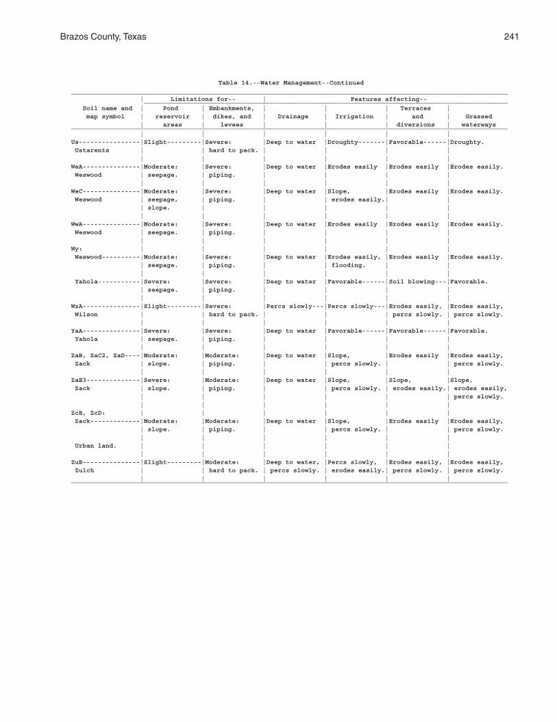
Brazos County, Texas 241
Table 14.--Water Management--Continued__________________________________________________________________________________________________________________ | Limitations for-- | Features affecting-- _______________________________________________________________________________________________ Soil name and | Pond | Embankments, | | | Terraces | map symbol | reservoir | dikes, and | Drainage | Irrigation | and | Grassed | areas | levees | | | diversions | waterways__________________________________________________________________________________________________________________ | | | | | |Us----------------|Slight---------|Severe: |Deep to water |Droughty-------|Favorable------|Droughty. Ustarents | | hard to pack. | | | | | | | | | |WeA---------------|Moderate: |Severe: |Deep to water |Erodes easily |Erodes easily |Erodes easily. Weswood | seepage. | piping. | | | | | | | | | |WeC---------------|Moderate: |Severe: |Deep to water |Slope, |Erodes easily |Erodes easily. Weswood | seepage, | piping. | | erodes easily.| | | slope. | | | | | | | | | | |WwA---------------|Moderate: |Severe: |Deep to water |Erodes easily |Erodes easily |Erodes easily. Weswood | seepage. | piping. | | | | | | | | | |Wy: | | | | | | Weswood----------|Moderate: |Severe: |Deep to water |Erodes easily, |Erodes easily |Erodes easily. | seepage. | piping. | | flooding. | | | | | | | | Yahola-----------|Severe: |Severe: |Deep to water |Favorable------|Soil blowing---|Favorable. | seepage. | piping. | | | | | | | | | |WzA---------------|Slight---------|Severe: |Percs slowly---|Percs slowly---|Erodes easily, |Erodes easily, Wilson | | hard to pack. | | | percs slowly. | percs slowly. | | | | | |YaA---------------|Severe: |Severe: |Deep to water |Favorable------|Favorable------|Favorable. Yahola | seepage. | piping. | | | | | | | | | |ZaB, ZaC2, ZaD----|Moderate: |Moderate: |Deep to water |Slope, |Erodes easily |Erodes easily, Zack | slope. | piping. | | percs slowly. | | percs slowly. | | | | | |ZaE3--------------|Severe: |Moderate: |Deep to water |Slope, |Slope, |Slope, Zack | slope. | piping. | | percs slowly. | erodes easily.| erodes easily, | | | | | | percs slowly. | | | | | |ZcB, ZcD: | | | | | | Zack-------------|Moderate: |Moderate: |Deep to water |Slope, |Erodes easily |Erodes easily, | slope. | piping. | | percs slowly. | | percs slowly. | | | | | | Urban land. | | | | | | | | | | | |ZuB---------------|Slight---------|Moderate: |Deep to water, |Percs slowly, |Erodes easily, |Erodes easily, Zulch | | hard to pack. | percs slowly. | erodes easily.| percs slowly. | percs slowly. | | | | | |__________________________________________________________________________________________________________________
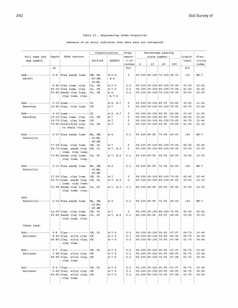
242 Soil Survey of
Table 15.--Engineering Index Properties
(Absence of an entry indicates that data were not estimated)
_________________________________________________________________________________________________________________ | | | Classification |Frag- | Percentage passing | | ____________________ Soil name and |Depth| USDA texture | | |ments | sieve number-- |Liquid | Plas- ___________________________ map symbol | | | Unified | AASHTO | 3-10 | | | | | limit | ticity | | | | |inches| 4 | 10 | 40 | 200 | | index_________________________________________________________________________________________________________________ | In | | | | Pct | | | | | Pct | | | | | | | | | | | |AxB--------------| 0-8 |Fine sandy loam |SM, ML, |A-2-4, | 0 |90-100|80-100|75-100|28-75 | <31 | NP-7 Axtell | | | SC-SM, | A-4 | | | | | | | | | | CL-ML | | | | | | | | | 8-40|Clay loam, clay |CL, CH |A-7-6 | 0-2 |95-100|95-100|85-100|70-98 | 41-65 | 25-42 |40-50|Clay loam, clay |CL, CH |A-7-6 | 0-2 |95-100|95-100|85-100|70-98 | 41-65 | 25-42 |50-80|Sandy clay loam, |CL, CH |A-6, | 0-2 |95-100|95-100|75-100|50-95 | 35-63 | 20-45 | | clay loam, clay.| | A-7-6 | | | | | | | | | | | | | | | | | |BeA--------------| 0-15|Loam-------------|CL |A-6, A-7 | 0 |90-100|90-100|80-95 |60-80 | 30-43 | 11-22 Benchley |15-80|Clay, clay loam |CH |A-7 | 0 |95-100|90-100|90-100|75-95 | 56-75 | 33-46 | | | | | | | | | | |BeB--------------| 0-10|Loam-------------|CL |A-6, A-7 | 0 |90-100|90-100|80-95 |60-80 | 30-43 | 11-22 Benchley |10-16|Clay loam, clay |CL, CH |A-7 | 0 |90-100|90-100|80-95 |70-95 | 44-66 | 23-41 |16-70|Clay, clay loam |CH |A-7 | 0 |95-100|90-100|90-100|75-95 | 56-75 | 33-46 |70-80|Stratified clay |CL, CH |A-7 | 0 |95-100|90-100|60-90 |50-85 | 41-60 | 21-36 | | to shaly clay. | | | | | | | | | | | | | | | | | | | |BoA--------------| 0-17|Fine sandy loam |ML, SM, |A-4 | 0-1 |95-100|85-98 |70-95 |40-65 | <20 | NP-7 Boonville | | | CL-ML, | | | | | | | | | | | SC-SM | | | | | | | | |17-24|Clay, clay loam |CH, CL |A-7 | 0 |95-100|90-100|85-100|70-90 | 45-65 | 25-40 |24-73|Loam, sandy clay |CH, CL |A-7, A-6 | 0 |95-100|95-100|80-100|50-95 | 35-60 | 15-35 | | loam, clay loam.| | | | | | | | | |73-80|Sandy clay loam, |CL, SC |A-7, A-6 | 0-1 |80-100|80-98 |65-95 |45-95 | 35-50 | 15-30 | | clay loam, clay.| | | | | | | | | | | | | | | | | | | |BoB--------------| 0-17|Fine sandy loam |ML, SM, |A-4 | 0-1 |95-100|85-98 |70-95 |40-65 | <20 | NP-7 Boonville | | | CL-ML, | | | | | | | | | | | SC-SM | | | | | | | | |17-36|Clay, clay loam |CH, CL |A-7 | 0 |95-100|90-100|85-100|70-90 | 45-65 | 25-40 |36-73|Loam, sandy clay |CH, CL |A-7, A-6 | 0 |95-100|95-100|80-100|50-95 | 35-60 | 15-35 | | loam, clay loam.| | | | | | | | | |73-88|Sandy clay loam, |CL, SC |A-7, A-6 | 0-1 |80-100|80-98 |65-95 |45-95 | 35-50 | 15-30 | | clay loam, clay.| | | | | | | | | | | | | | | | | | | |BrB: | | | | | | | | | | | Boonville-------| 0-12|Fine sandy loam |ML, SM, |A-4 | 0-1 |95-100|85-98 |70-95 |40-65 | <20 | NP-7 | | | CL-ML, | | | | | | | | | | | SC-SM | | | | | | | | |12-65|Clay, clay loam |CH, CL |A-7 | 0 |95-100|90-100|85-100|70-90 | 45-65 | 25-40 |65-80|Sandy clay loam, |CL, SC |A-7, A-6 | 0-1 |80-100|80-98 |65-95 |45-95 | 35-50 | 15-30 | | clay loam, clay.| | | | | | | | | | | | | | | | | | | | Urban land. | | | | | | | | | | | | | | | | | | | | | |BuA--------------| 0-8 |Clay-------------|CH, CL |A-7-6 | 0-2 |90-100|90-100|90-99 |67-97 | 56-75 | 33-49 Burleson | 8-40|Clay, silty clay |CH |A-7-6 | 0-1 |90-100|90-100|90-99 |80-99 | 56-75 | 34-54 |40-80|Clay, silty clay,|CH |A-7-6 | 0-2 |90-100|80-100|75-99 |67-98 | 51-75 | 34-54 | | clay loam. | | | | | | | | | | | | | | | | | | | |BuB--------------| 0-7 |Clay-------------|CH, CL |A-7-6 | 0-2 |90-100|90-100|90-99 |67-97 | 56-75 | 33-49 Burleson | 7-48|Clay, silty clay |CH |A-7-6 | 0-1 |90-100|90-100|90-99 |80-99 | 56-75 | 34-54 |48-80|Clay, silty clay,|CH |A-7-6 | 0-2 |90-100|80-100|75-99 |67-98 | 51-75 | 34-54 | | clay loam. | | | | | | | | | | | | | | | | | | | |BuC--------------| 0-6 |Clay-------------|CH, CL |A-7-6 | 0-2 |90-100|90-100|90-99 |67-97 | 56-75 | 33-49 Burleson | 6-45|Clay, silty clay |CH |A-7-6 | 0-1 |90-100|90-100|90-99 |80-99 | 56-75 | 34-54 |45-80|Clay, silty clay,|CH |A-7-6 | 0-2 |90-100|80-100|75-99 |67-98 | 51-75 | 34-54 | | clay loam. | | | | | | | | | | | | | | | | | | | |
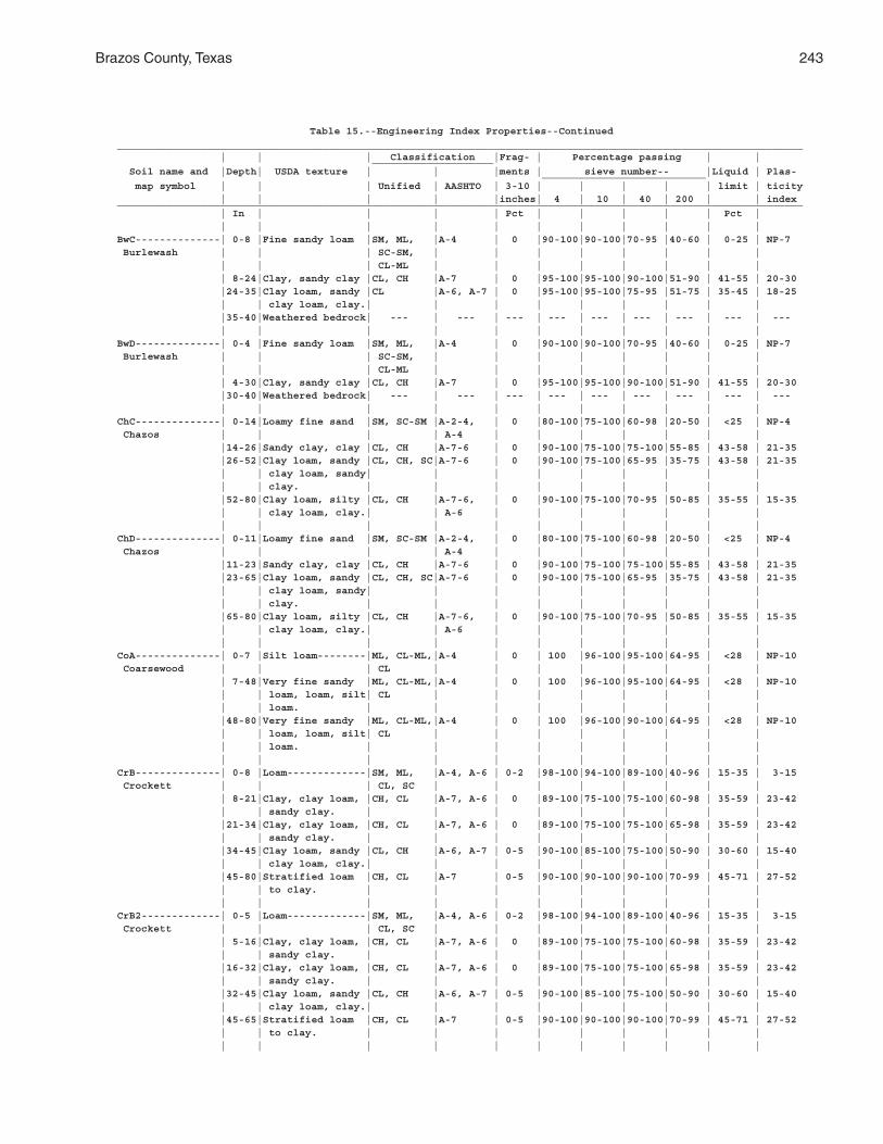
Brazos County, Texas 243
Table 15.--Engineering Index Properties--Continued_________________________________________________________________________________________________________________ | | | Classification |Frag- | Percentage passing | | ____________________ Soil name and |Depth| USDA texture | | |ments | sieve number-- |Liquid | Plas- ___________________________ map symbol | | | Unified | AASHTO | 3-10 | | | | | limit | ticity | | | | |inches| 4 | 10 | 40 | 200 | | index_________________________________________________________________________________________________________________ | In | | | | Pct | | | | | Pct | | | | | | | | | | | |BwC--------------| 0-8 |Fine sandy loam |SM, ML, |A-4 | 0 |90-100|90-100|70-95 |40-60 | 0-25 | NP-7 Burlewash | | | SC-SM, | | | | | | | | | | | CL-ML | | | | | | | | | 8-24|Clay, sandy clay |CL, CH |A-7 | 0 |95-100|95-100|90-100|51-90 | 41-55 | 20-30 |24-35|Clay loam, sandy |CL |A-6, A-7 | 0 |95-100|95-100|75-95 |51-75 | 35-45 | 18-25 | | clay loam, clay.| | | | | | | | | |35-40|Weathered bedrock| --- | --- | --- | --- | --- | --- | --- | --- | --- | | | | | | | | | | |BwD--------------| 0-4 |Fine sandy loam |SM, ML, |A-4 | 0 |90-100|90-100|70-95 |40-60 | 0-25 | NP-7 Burlewash | | | SC-SM, | | | | | | | | | | | CL-ML | | | | | | | | | 4-30|Clay, sandy clay |CL, CH |A-7 | 0 |95-100|95-100|90-100|51-90 | 41-55 | 20-30 |30-40|Weathered bedrock| --- | --- | --- | --- | --- | --- | --- | --- | --- | | | | | | | | | | |ChC--------------| 0-14|Loamy fine sand |SM, SC-SM |A-2-4, | 0 |80-100|75-100|60-98 |20-50 | <25 | NP-4 Chazos | | | | A-4 | | | | | | | |14-26|Sandy clay, clay |CL, CH |A-7-6 | 0 |90-100|75-100|75-100|55-85 | 43-58 | 21-35 |26-52|Clay loam, sandy |CL, CH, SC|A-7-6 | 0 |90-100|75-100|65-95 |35-75 | 43-58 | 21-35 | | clay loam, sandy| | | | | | | | | | | clay. | | | | | | | | | |52-80|Clay loam, silty |CL, CH |A-7-6, | 0 |90-100|75-100|70-95 |50-85 | 35-55 | 15-35 | | clay loam, clay.| | A-6 | | | | | | | | | | | | | | | | | |ChD--------------| 0-11|Loamy fine sand |SM, SC-SM |A-2-4, | 0 |80-100|75-100|60-98 |20-50 | <25 | NP-4 Chazos | | | | A-4 | | | | | | | |11-23|Sandy clay, clay |CL, CH |A-7-6 | 0 |90-100|75-100|75-100|55-85 | 43-58 | 21-35 |23-65|Clay loam, sandy |CL, CH, SC|A-7-6 | 0 |90-100|75-100|65-95 |35-75 | 43-58 | 21-35 | | clay loam, sandy| | | | | | | | | | | clay. | | | | | | | | | |65-80|Clay loam, silty |CL, CH |A-7-6, | 0 |90-100|75-100|70-95 |50-85 | 35-55 | 15-35 | | clay loam, clay.| | A-6 | | | | | | | | | | | | | | | | | |CoA--------------| 0-7 |Silt loam--------|ML, CL-ML,|A-4 | 0 | 100 |96-100|95-100|64-95 | <28 | NP-10 Coarsewood | | | CL | | | | | | | | | 7-48|Very fine sandy |ML, CL-ML,|A-4 | 0 | 100 |96-100|95-100|64-95 | <28 | NP-10 | | loam, loam, silt| CL | | | | | | | | | | loam. | | | | | | | | | |48-80|Very fine sandy |ML, CL-ML,|A-4 | 0 | 100 |96-100|90-100|64-95 | <28 | NP-10 | | loam, loam, silt| CL | | | | | | | | | | loam. | | | | | | | | | | | | | | | | | | | |CrB--------------| 0-8 |Loam-------------|SM, ML, |A-4, A-6 | 0-2 |98-100|94-100|89-100|40-96 | 15-35 | 3-15 Crockett | | | CL, SC | | | | | | | | | 8-21|Clay, clay loam, |CH, CL |A-7, A-6 | 0 |89-100|75-100|75-100|60-98 | 35-59 | 23-42 | | sandy clay. | | | | | | | | | |21-34|Clay, clay loam, |CH, CL |A-7, A-6 | 0 |89-100|75-100|75-100|65-98 | 35-59 | 23-42 | | sandy clay. | | | | | | | | | |34-45|Clay loam, sandy |CL, CH |A-6, A-7 | 0-5 |90-100|85-100|75-100|50-90 | 30-60 | 15-40 | | clay loam, clay.| | | | | | | | | |45-80|Stratified loam |CH, CL |A-7 | 0-5 |90-100|90-100|90-100|70-99 | 45-71 | 27-52 | | to clay. | | | | | | | | | | | | | | | | | | | |CrB2-------------| 0-5 |Loam-------------|SM, ML, |A-4, A-6 | 0-2 |98-100|94-100|89-100|40-96 | 15-35 | 3-15 Crockett | | | CL, SC | | | | | | | | | 5-16|Clay, clay loam, |CH, CL |A-7, A-6 | 0 |89-100|75-100|75-100|60-98 | 35-59 | 23-42 | | sandy clay. | | | | | | | | | |16-32|Clay, clay loam, |CH, CL |A-7, A-6 | 0 |89-100|75-100|75-100|65-98 | 35-59 | 23-42 | | sandy clay. | | | | | | | | | |32-45|Clay loam, sandy |CL, CH |A-6, A-7 | 0-5 |90-100|85-100|75-100|50-90 | 30-60 | 15-40 | | clay loam, clay.| | | | | | | | | |45-65|Stratified loam |CH, CL |A-7 | 0-5 |90-100|90-100|90-100|70-99 | 45-71 | 27-52 | | to clay. | | | | | | | | | | | | | | | | | | | |
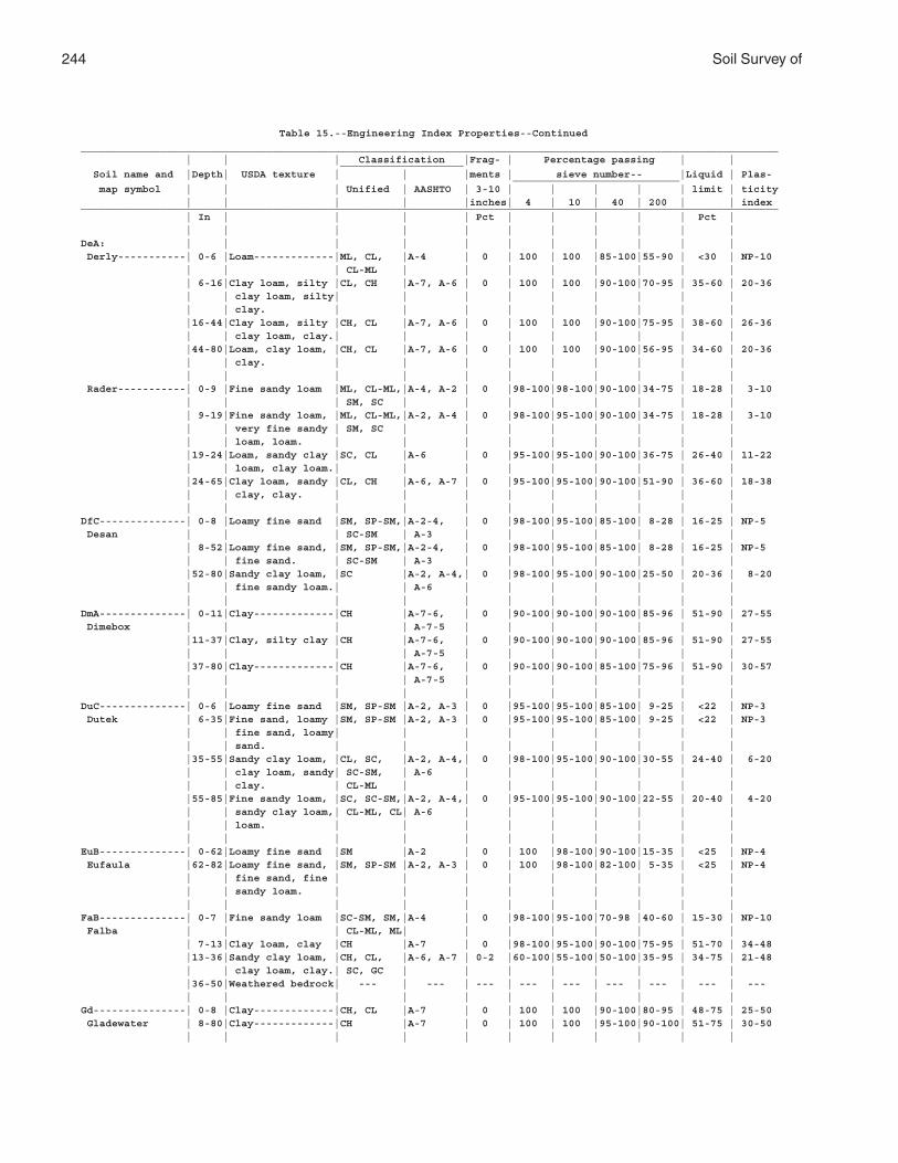
244 Soil Survey of
Table 15.--Engineering Index Properties--Continued_________________________________________________________________________________________________________________ | | | Classification |Frag- | Percentage passing | | ____________________ Soil name and |Depth| USDA texture | | |ments | sieve number-- |Liquid | Plas- ___________________________ map symbol | | | Unified | AASHTO | 3-10 | | | | | limit | ticity | | | | |inches| 4 | 10 | 40 | 200 | | index_________________________________________________________________________________________________________________ | In | | | | Pct | | | | | Pct | | | | | | | | | | | |DeA: | | | | | | | | | | | Derly-----------| 0-6 |Loam-------------|ML, CL, |A-4 | 0 | 100 | 100 |85-100|55-90 | <30 | NP-10 | | | CL-ML | | | | | | | | | 6-16|Clay loam, silty |CL, CH |A-7, A-6 | 0 | 100 | 100 |90-100|70-95 | 35-60 | 20-36 | | clay loam, silty| | | | | | | | | | | clay. | | | | | | | | | |16-44|Clay loam, silty |CH, CL |A-7, A-6 | 0 | 100 | 100 |90-100|75-95 | 38-60 | 26-36 | | clay loam, clay.| | | | | | | | | |44-80|Loam, clay loam, |CH, CL |A-7, A-6 | 0 | 100 | 100 |90-100|56-95 | 34-60 | 20-36 | | clay. | | | | | | | | | | | | | | | | | | | | Rader-----------| 0-9 |Fine sandy loam |ML, CL-ML,|A-4, A-2 | 0 |98-100|98-100|90-100|34-75 | 18-28 | 3-10 | | | SM, SC | | | | | | | | | 9-19|Fine sandy loam, |ML, CL-ML,|A-2, A-4 | 0 |98-100|95-100|90-100|34-75 | 18-28 | 3-10 | | very fine sandy | SM, SC | | | | | | | | | | loam, loam. | | | | | | | | | |19-24|Loam, sandy clay |SC, CL |A-6 | 0 |95-100|95-100|90-100|36-75 | 26-40 | 11-22 | | loam, clay loam.| | | | | | | | | |24-65|Clay loam, sandy |CL, CH |A-6, A-7 | 0 |95-100|95-100|90-100|51-90 | 36-60 | 18-38 | | clay, clay. | | | | | | | | | | | | | | | | | | | |DfC--------------| 0-8 |Loamy fine sand |SM, SP-SM,|A-2-4, | 0 |98-100|95-100|85-100| 8-28 | 16-25 | NP-5 Desan | | | SC-SM | A-3 | | | | | | | | 8-52|Loamy fine sand, |SM, SP-SM,|A-2-4, | 0 |98-100|95-100|85-100| 8-28 | 16-25 | NP-5 | | fine sand. | SC-SM | A-3 | | | | | | | |52-80|Sandy clay loam, |SC |A-2, A-4,| 0 |98-100|95-100|90-100|25-50 | 20-36 | 8-20 | | fine sandy loam.| | A-6 | | | | | | | | | | | | | | | | | |DmA--------------| 0-11|Clay-------------|CH |A-7-6, | 0 |90-100|90-100|90-100|85-96 | 51-90 | 27-55 Dimebox | | | | A-7-5 | | | | | | | |11-37|Clay, silty clay |CH |A-7-6, | 0 |90-100|90-100|90-100|85-96 | 51-90 | 27-55 | | | | A-7-5 | | | | | | | |37-80|Clay-------------|CH |A-7-6, | 0 |90-100|90-100|85-100|75-96 | 51-90 | 30-57 | | | | A-7-5 | | | | | | | | | | | | | | | | | |DuC--------------| 0-6 |Loamy fine sand |SM, SP-SM |A-2, A-3 | 0 |95-100|95-100|85-100| 9-25 | <22 | NP-3 Dutek | 6-35|Fine sand, loamy |SM, SP-SM |A-2, A-3 | 0 |95-100|95-100|85-100| 9-25 | <22 | NP-3 | | fine sand, loamy| | | | | | | | | | | sand. | | | | | | | | | |35-55|Sandy clay loam, |CL, SC, |A-2, A-4,| 0 |98-100|95-100|90-100|30-55 | 24-40 | 6-20 | | clay loam, sandy| SC-SM, | A-6 | | | | | | | | | clay. | CL-ML | | | | | | | | |55-85|Fine sandy loam, |SC, SC-SM,|A-2, A-4,| 0 |95-100|95-100|90-100|22-55 | 20-40 | 4-20 | | sandy clay loam,| CL-ML, CL| A-6 | | | | | | | | | loam. | | | | | | | | | | | | | | | | | | | |EuB--------------| 0-62|Loamy fine sand |SM |A-2 | 0 | 100 |98-100|90-100|15-35 | <25 | NP-4 Eufaula |62-82|Loamy fine sand, |SM, SP-SM |A-2, A-3 | 0 | 100 |98-100|82-100| 5-35 | <25 | NP-4 | | fine sand, fine | | | | | | | | | | | sandy loam. | | | | | | | | | | | | | | | | | | | |FaB--------------| 0-7 |Fine sandy loam |SC-SM, SM,|A-4 | 0 |98-100|95-100|70-98 |40-60 | 15-30 | NP-10 Falba | | | CL-ML, ML| | | | | | | | | 7-13|Clay loam, clay |CH |A-7 | 0 |98-100|95-100|90-100|75-95 | 51-70 | 34-48 |13-36|Sandy clay loam, |CH, CL, |A-6, A-7 | 0-2 |60-100|55-100|50-100|35-95 | 34-75 | 21-48 | | clay loam, clay.| SC, GC | | | | | | | | |36-50|Weathered bedrock| --- | --- | --- | --- | --- | --- | --- | --- | --- | | | | | | | | | | |Gd---------------| 0-8 |Clay-------------|CH, CL |A-7 | 0 | 100 | 100 |90-100|80-95 | 48-75 | 25-50 Gladewater | 8-80|Clay-------------|CH |A-7 | 0 | 100 | 100 |95-100|90-100| 51-75 | 30-50 | | | | | | | | | | |
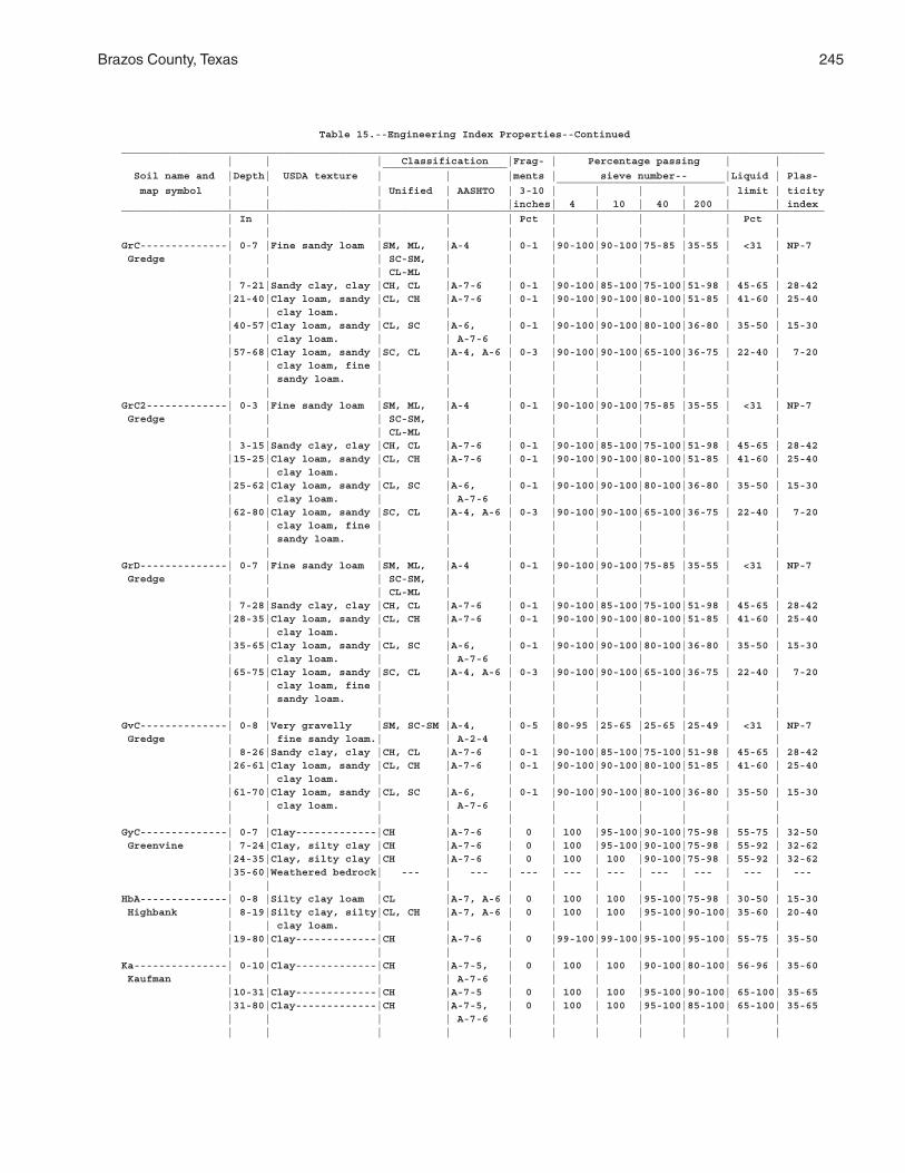
Brazos County, Texas 245
Table 15.--Engineering Index Properties--Continued_________________________________________________________________________________________________________________ | | | Classification |Frag- | Percentage passing | | ____________________ Soil name and |Depth| USDA texture | | |ments | sieve number-- |Liquid | Plas- ___________________________ map symbol | | | Unified | AASHTO | 3-10 | | | | | limit | ticity | | | | |inches| 4 | 10 | 40 | 200 | | index_________________________________________________________________________________________________________________ | In | | | | Pct | | | | | Pct | | | | | | | | | | | |GrC--------------| 0-7 |Fine sandy loam |SM, ML, |A-4 | 0-1 |90-100|90-100|75-85 |35-55 | <31 | NP-7 Gredge | | | SC-SM, | | | | | | | | | | | CL-ML | | | | | | | | | 7-21|Sandy clay, clay |CH, CL |A-7-6 | 0-1 |90-100|85-100|75-100|51-98 | 45-65 | 28-42 |21-40|Clay loam, sandy |CL, CH |A-7-6 | 0-1 |90-100|90-100|80-100|51-85 | 41-60 | 25-40 | | clay loam. | | | | | | | | | |40-57|Clay loam, sandy |CL, SC |A-6, | 0-1 |90-100|90-100|80-100|36-80 | 35-50 | 15-30 | | clay loam. | | A-7-6 | | | | | | | |57-68|Clay loam, sandy |SC, CL |A-4, A-6 | 0-3 |90-100|90-100|65-100|36-75 | 22-40 | 7-20 | | clay loam, fine | | | | | | | | | | | sandy loam. | | | | | | | | | | | | | | | | | | | |GrC2-------------| 0-3 |Fine sandy loam |SM, ML, |A-4 | 0-1 |90-100|90-100|75-85 |35-55 | <31 | NP-7 Gredge | | | SC-SM, | | | | | | | | | | | CL-ML | | | | | | | | | 3-15|Sandy clay, clay |CH, CL |A-7-6 | 0-1 |90-100|85-100|75-100|51-98 | 45-65 | 28-42 |15-25|Clay loam, sandy |CL, CH |A-7-6 | 0-1 |90-100|90-100|80-100|51-85 | 41-60 | 25-40 | | clay loam. | | | | | | | | | |25-62|Clay loam, sandy |CL, SC |A-6, | 0-1 |90-100|90-100|80-100|36-80 | 35-50 | 15-30 | | clay loam. | | A-7-6 | | | | | | | |62-80|Clay loam, sandy |SC, CL |A-4, A-6 | 0-3 |90-100|90-100|65-100|36-75 | 22-40 | 7-20 | | clay loam, fine | | | | | | | | | | | sandy loam. | | | | | | | | | | | | | | | | | | | |GrD--------------| 0-7 |Fine sandy loam |SM, ML, |A-4 | 0-1 |90-100|90-100|75-85 |35-55 | <31 | NP-7 Gredge | | | SC-SM, | | | | | | | | | | | CL-ML | | | | | | | | | 7-28|Sandy clay, clay |CH, CL |A-7-6 | 0-1 |90-100|85-100|75-100|51-98 | 45-65 | 28-42 |28-35|Clay loam, sandy |CL, CH |A-7-6 | 0-1 |90-100|90-100|80-100|51-85 | 41-60 | 25-40 | | clay loam. | | | | | | | | | |35-65|Clay loam, sandy |CL, SC |A-6, | 0-1 |90-100|90-100|80-100|36-80 | 35-50 | 15-30 | | clay loam. | | A-7-6 | | | | | | | |65-75|Clay loam, sandy |SC, CL |A-4, A-6 | 0-3 |90-100|90-100|65-100|36-75 | 22-40 | 7-20 | | clay loam, fine | | | | | | | | | | | sandy loam. | | | | | | | | | | | | | | | | | | | |GvC--------------| 0-8 |Very gravelly |SM, SC-SM |A-4, | 0-5 |80-95 |25-65 |25-65 |25-49 | <31 | NP-7 Gredge | | fine sandy loam.| | A-2-4 | | | | | | | | 8-26|Sandy clay, clay |CH, CL |A-7-6 | 0-1 |90-100|85-100|75-100|51-98 | 45-65 | 28-42 |26-61|Clay loam, sandy |CL, CH |A-7-6 | 0-1 |90-100|90-100|80-100|51-85 | 41-60 | 25-40 | | clay loam. | | | | | | | | | |61-70|Clay loam, sandy |CL, SC |A-6, | 0-1 |90-100|90-100|80-100|36-80 | 35-50 | 15-30 | | clay loam. | | A-7-6 | | | | | | | | | | | | | | | | | |GyC--------------| 0-7 |Clay-------------|CH |A-7-6 | 0 | 100 |95-100|90-100|75-98 | 55-75 | 32-50 Greenvine | 7-24|Clay, silty clay |CH |A-7-6 | 0 | 100 |95-100|90-100|75-98 | 55-92 | 32-62 |24-35|Clay, silty clay |CH |A-7-6 | 0 | 100 | 100 |90-100|75-98 | 55-92 | 32-62 |35-60|Weathered bedrock| --- | --- | --- | --- | --- | --- | --- | --- | --- | | | | | | | | | | |HbA--------------| 0-8 |Silty clay loam |CL |A-7, A-6 | 0 | 100 | 100 |95-100|75-98 | 30-50 | 15-30 Highbank | 8-19|Silty clay, silty|CL, CH |A-7, A-6 | 0 | 100 | 100 |95-100|90-100| 35-60 | 20-40 | | clay loam. | | | | | | | | | |19-80|Clay-------------|CH |A-7-6 | 0 |99-100|99-100|95-100|95-100| 55-75 | 35-50 | | | | | | | | | | |Ka---------------| 0-10|Clay-------------|CH |A-7-5, | 0 | 100 | 100 |90-100|80-100| 56-96 | 35-60 Kaufman | | | | A-7-6 | | | | | | | |10-31|Clay-------------|CH |A-7-5 | 0 | 100 | 100 |95-100|90-100| 65-100| 35-65 |31-80|Clay-------------|CH |A-7-5, | 0 | 100 | 100 |95-100|85-100| 65-100| 35-65 | | | | A-7-6 | | | | | | | | | | | | | | | | | |
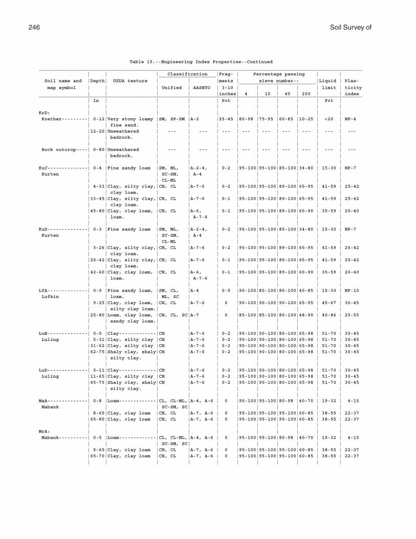
246 Soil Survey of
Table 15.--Engineering Index Properties--Continued_________________________________________________________________________________________________________________ | | | Classification |Frag- | Percentage passing | | ____________________ Soil name and |Depth| USDA texture | | |ments | sieve number-- |Liquid | Plas- ___________________________ map symbol | | | Unified | AASHTO | 3-10 | | | | | limit | ticity | | | | |inches| 4 | 10 | 40 | 200 | | index_________________________________________________________________________________________________________________ | In | | | | Pct | | | | | Pct | | | | | | | | | | | |KrD: | | | | | | | | | | | Koether---------| 0-12|Very stony loamy |SM, SP-SM |A-2 |25-45 |80-98 |75-95 |60-85 |10-25 | <20 | NP-4 | | fine sand. | | | | | | | | | |12-20|Unweathered | --- | --- | --- | --- | --- | --- | --- | --- | --- | | bedrock. | | | | | | | | | | | | | | | | | | | | Rock outcrop----| 0-80|Unweathered | --- | --- | --- | --- | --- | --- | --- | --- | --- | | bedrock. | | | | | | | | | | | | | | | | | | | |KuC--------------| 0-4 |Fine sandy loam |SM, ML, |A-2-4, | 0-2 |95-100|95-100|85-100|34-80 | 15-30 | NP-7 Kurten | | | SC-SM, | A-4 | | | | | | | | | | CL-ML | | | | | | | | | 4-33|Clay, silty clay,|CH, CL |A-7-6 | 0-2 |95-100|95-100|89-100|65-95 | 41-59 | 25-42 | | clay loam. | | | | | | | | | |33-45|Clay, silty clay,|CH, CL |A-7-6 | 0-1 |95-100|95-100|89-100|65-95 | 41-59 | 25-42 | | clay loam. | | | | | | | | | |45-80|Clay, clay loam, |CH, CL |A-6, | 0-1 |95-100|95-100|89-100|60-90 | 35-59 | 20-40 | | loam. | | A-7-6 | | | | | | | | | | | | | | | | | |KuD--------------| 0-3 |Fine sandy loam |SM, ML, |A-2-4, | 0-2 |95-100|95-100|85-100|34-80 | 15-30 | NP-7 Kurten | | | SC-SM, | A-4 | | | | | | | | | | CL-ML | | | | | | | | | 3-26|Clay, silty clay,|CH, CL |A-7-6 | 0-2 |95-100|95-100|89-100|65-95 | 41-59 | 25-42 | | clay loam. | | | | | | | | | |26-42|Clay, silty clay,|CH, CL |A-7-6 | 0-1 |95-100|95-100|89-100|65-95 | 41-59 | 25-42 | | clay loam. | | | | | | | | | |42-60|Clay, clay loam, |CH, CL |A-6, | 0-1 |95-100|95-100|89-100|60-90 | 35-59 | 20-40 | | loam. | | A-7-6 | | | | | | | | | | | | | | | | | |LfA--------------| 0-9 |Fine sandy loam, |SM, CL, |A-4 | 0-5 |90-100|80-100|80-100|40-85 | 15-30 | NP-10 Lufkin | | loam. | ML, SC | | | | | | | | | 9-25|Clay, clay loam, |CH, CL |A-7-6 | 0 |90-100|90-100|90-100|65-95 | 45-67 | 30-45 | | silty clay loam.| | | | | | | | | |25-80|Loam, clay loam, |CH, CL, SC|A-7 | 0 |85-100|85-100|80-100|48-90 | 40-86 | 25-55 | | sandy clay loam.| | | | | | | | | | | | | | | | | | | |LuB--------------| 0-5 |Clay-------------|CH |A-7-6 | 0-2 |95-100|90-100|80-100|65-98 | 51-70 | 30-45 Luling | 5-31|Clay, silty clay |CH |A-7-6 | 0-2 |95-100|90-100|80-100|65-98 | 51-70 | 30-45 |31-62|Clay, silty clay |CH |A-7-6 | 0-2 |95-100|90-100|80-100|65-98 | 51-70 | 30-45 |62-75|Shaly clay, shaly|CH |A-7-6 | 0-2 |95-100|90-100|80-100|65-98 | 51-70 | 30-45 | | silty clay. | | | | | | | | | | | | | | | | | | | |LuD--------------| 0-11|Clay-------------|CH |A-7-6 | 0-2 |95-100|90-100|80-100|65-98 | 51-70 | 30-45 Luling |11-65|Clay, silty clay |CH |A-7-6 | 0-2 |95-100|90-100|80-100|65-98 | 51-70 | 30-45 |65-75|Shaly clay, shaly|CH |A-7-6 | 0-2 |95-100|90-100|80-100|65-98 | 51-70 | 30-45 | | silty clay. | | | | | | | | | | | | | | | | | | | |MaA--------------| 0-8 |Loam-------------|CL, CL-ML,|A-4, A-6 | 0 |95-100|95-100|80-98 |40-70 | 19-32 | 4-15 Mabank | | | SC-SM, SC| | | | | | | | | 8-65|Clay, clay loam |CH, CL |A-7, A-6 | 0 |95-100|95-100|95-100|60-85 | 38-55 | 22-37 |65-80|Clay, clay loam |CH, CL |A-7, A-6 | 0 |95-100|95-100|95-100|60-85 | 38-55 | 22-37 | | | | | | | | | | |MrA: | | | | | | | | | | | Mabank----------| 0-5 |Loam-------------|CL, CL-ML,|A-4, A-6 | 0 |95-100|95-100|80-98 |40-70 | 19-32 | 4-15 | | | SC-SM, SC| | | | | | | | | 5-65|Clay, clay loam |CH, CL |A-7, A-6 | 0 |95-100|95-100|95-100|60-85 | 38-55 | 22-37 |65-70|Clay, clay loam |CH, CL |A-7, A-6 | 0 |95-100|95-100|95-100|60-85 | 38-55 | 22-37 | | | | | | | | | | |
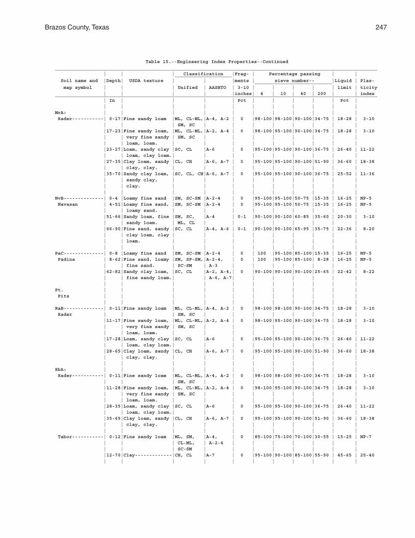
Brazos County, Texas 247
Table 15.--Engineering Index Properties--Continued_________________________________________________________________________________________________________________ | | | Classification |Frag- | Percentage passing | | ____________________ Soil name and |Depth| USDA texture | | |ments | sieve number-- |Liquid | Plas- ___________________________ map symbol | | | Unified | AASHTO | 3-10 | | | | | limit | ticity | | | | |inches| 4 | 10 | 40 | 200 | | index_________________________________________________________________________________________________________________ | In | | | | Pct | | | | | Pct | | | | | | | | | | | |MrA: | | | | | | | | | | | Rader-----------| 0-17|Fine sandy loam |ML, CL-ML,|A-4, A-2 | 0 |98-100|98-100|90-100|34-75 | 18-28 | 3-10 | | | SM, SC | | | | | | | | |17-23|Fine sandy loam, |ML, CL-ML,|A-2, A-4 | 0 |98-100|95-100|90-100|34-75 | 18-28 | 3-10 | | very fine sandy | SM, SC | | | | | | | | | | loam, loam. | | | | | | | | | |23-27|Loam, sandy clay |SC, CL |A-6 | 0 |95-100|95-100|90-100|36-75 | 26-40 | 11-22 | | loam, clay loam.| | | | | | | | | |27-35|Clay loam, sandy |CL, CH |A-6, A-7 | 0 |95-100|95-100|90-100|51-90 | 36-60 | 18-38 | | clay, clay. | | | | | | | | | |35-70|Sandy clay loam, |SC, CL, CH|A-6, A-7 | 0 |95-100|95-100|90-100|36-75 | 25-52 | 11-36 | | sandy clay, | | | | | | | | | | | clay. | | | | | | | | | | | | | | | | | | | |NvB--------------| 0-4 |Loamy fine sand |SM, SC-SM |A-2-4 | 0 |95-100|95-100|50-75 |15-35 | 16-25 | NP-5 Navasan | 4-51|Loamy fine sand, |SM, SC-SM |A-2-4 | 0 |95-100|95-100|50-75 |15-35 | 16-25 | NP-5 | | loamy sand. | | | | | | | | | |51-66|Sandy loam, fine |SM, SC, |A-4 | 0-1 |90-100|90-100|60-85 |35-60 | 20-30 | 3-10 | | sandy loam. | ML, CL | | | | | | | | |66-90|Fine sand, sandy |SC, CL |A-4, A-6 | 0-1 |90-100|90-100|65-95 |35-75 | 22-36 | 8-20 | | clay loam, clay | | | | | | | | | | | loam. | | | | | | | | | | | | | | | | | | | |PaC--------------| 0-8 |Loamy fine sand |SM, SC-SM |A-2-4 | 0 | 100 |95-100|85-100|15-35 | 16-25 | NP-5 Padina | 8-62|Fine sand, loamy |SM, SP-SM,|A-2-4, | 0 | 100 |95-100|85-100| 8-28 | 16-25 | NP-5 | | fine sand. | SC-SM | A-3 | | | | | | | |62-82|Sandy clay loam, |SC, CL |A-2, A-4,| 0 |90-100|90-100|90-100|25-65 | 22-42 | 8-22 | | fine sandy loam.| | A-6, A-7| | | | | | | | | | | | | | | | | |Pt. | | | | | | | | | | | Pits | | | | | | | | | | | | | | | | | | | | | |RaB--------------| 0-11|Fine sandy loam |ML, CL-ML,|A-4, A-2 | 0 |98-100|98-100|90-100|34-75 | 18-28 | 3-10 Rader | | | SM, SC | | | | | | | | |11-17|Fine sandy loam, |ML, CL-ML,|A-2, A-4 | 0 |98-100|95-100|90-100|34-75 | 18-28 | 3-10 | | very fine sandy | SM, SC | | | | | | | | | | loam, loam. | | | | | | | | | |17-28|Loam, sandy clay |SC, CL |A-6 | 0 |95-100|95-100|90-100|36-75 | 26-40 | 11-22 | | loam, clay loam.| | | | | | | | | |28-65|Clay loam, sandy |CL, CH |A-6, A-7 | 0 |95-100|95-100|90-100|51-90 | 36-60 | 18-38 | | clay, clay. | | | | | | | | | | | | | | | | | | | |RbA: | | | | | | | | | | | Rader-----------| 0-11|Fine sandy loam |ML, CL-ML,|A-4, A-2 | 0 |98-100|98-100|90-100|34-75 | 18-28 | 3-10 | | | SM, SC | | | | | | | | |11-28|Fine sandy loam, |ML, CL-ML,|A-2, A-4 | 0 |98-100|95-100|90-100|34-75 | 18-28 | 3-10 | | very fine sandy | SM, SC | | | | | | | | | | loam, loam. | | | | | | | | | |28-35|Loam, sandy clay |SC, CL |A-6 | 0 |95-100|95-100|90-100|36-75 | 26-40 | 11-22 | | loam, clay loam.| | | | | | | | | |35-65|Clay loam, sandy |CL, CH |A-6, A-7 | 0 |95-100|95-100|90-100|51-90 | 36-60 | 18-38 | | clay, clay. | | | | | | | | | | | | | | | | | | | | Tabor-----------| 0-12|Fine sandy loam |ML, SM, |A-4, | 0 |85-100|75-100|70-100|30-55 | 15-25 | NP-7 | | | CL-ML, | A-2-4 | | | | | | | | | | SC-SM | | | | | | | | |12-70|Clay-------------|CH, CL |A-7 | 0 |95-100|90-100|85-100|55-90 | 45-65 | 25-40 | | | | | | | | | | |
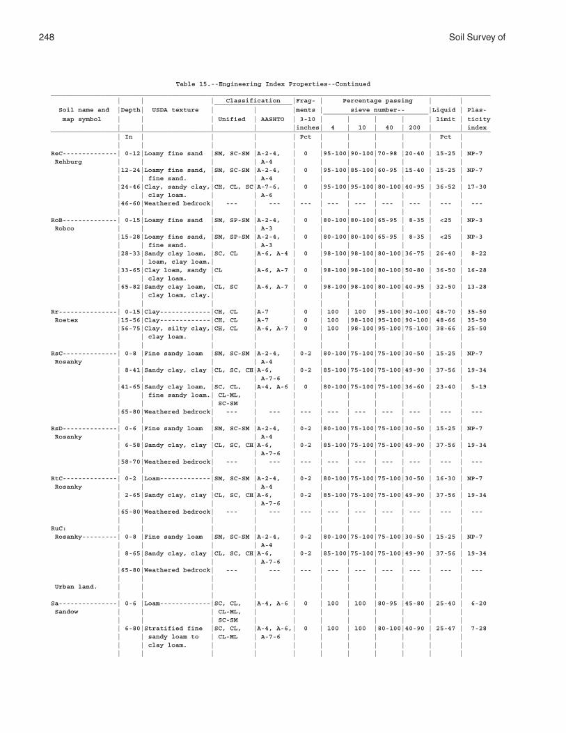
248 Soil Survey of
Table 15.--Engineering Index Properties--Continued_________________________________________________________________________________________________________________ | | | Classification |Frag- | Percentage passing | | ____________________ Soil name and |Depth| USDA texture | | |ments | sieve number-- |Liquid | Plas- ___________________________ map symbol | | | Unified | AASHTO | 3-10 | | | | | limit | ticity | | | | |inches| 4 | 10 | 40 | 200 | | index_________________________________________________________________________________________________________________ | In | | | | Pct | | | | | Pct | | | | | | | | | | | |ReC--------------| 0-12|Loamy fine sand |SM, SC-SM |A-2-4, | 0 |95-100|90-100|70-98 |20-40 | 15-25 | NP-7 Rehburg | | | | A-4 | | | | | | | |12-24|Loamy fine sand, |SM, SC-SM |A-2-4, | 0 |95-100|85-100|60-95 |15-40 | 15-25 | NP-7 | | fine sand. | | A-4 | | | | | | | |24-46|Clay, sandy clay,|CH, CL, SC|A-7-6, | 0 |95-100|95-100|80-100|40-95 | 36-52 | 17-30 | | clay loam. | | A-6 | | | | | | | |46-60|Weathered bedrock| --- | --- | --- | --- | --- | --- | --- | --- | --- | | | | | | | | | | |RoB--------------| 0-15|Loamy fine sand |SM, SP-SM |A-2-4, | 0 |80-100|80-100|65-95 | 8-35 | <25 | NP-3 Robco | | | | A-3 | | | | | | | |15-28|Loamy fine sand, |SM, SP-SM |A-2-4, | 0 |80-100|80-100|65-95 | 8-35 | <25 | NP-3 | | fine sand. | | A-3 | | | | | | | |28-33|Sandy clay loam, |SC, CL |A-6, A-4 | 0 |98-100|98-100|80-100|36-75 | 26-40 | 8-22 | | loam, clay loam.| | | | | | | | | |33-65|Clay loam, sandy |CL |A-6, A-7 | 0 |98-100|98-100|80-100|50-80 | 36-50 | 16-28 | | clay loam. | | | | | | | | | |65-82|Sandy clay loam, |CL, SC |A-6, A-7 | 0 |98-100|98-100|80-100|40-95 | 32-50 | 13-28 | | clay loam, clay.| | | | | | | | | | | | | | | | | | | |Rr---------------| 0-15|Clay-------------|CH, CL |A-7 | 0 | 100 | 100 |95-100|90-100| 48-70 | 35-50 Roetex |15-56|Clay-------------|CH, CL |A-7 | 0 | 100 |98-100|95-100|90-100| 48-66 | 35-50 |56-75|Clay, silty clay,|CH, CL |A-6, A-7 | 0 | 100 |98-100|95-100|75-100| 38-66 | 25-50 | | clay loam. | | | | | | | | | | | | | | | | | | | |RsC--------------| 0-8 |Fine sandy loam |SM, SC-SM |A-2-4, | 0-2 |80-100|75-100|75-100|30-50 | 15-25 | NP-7 Rosanky | | | | A-4 | | | | | | | | 8-41|Sandy clay, clay |CL, SC, CH|A-6, | 0-2 |85-100|75-100|75-100|49-90 | 37-56 | 19-34 | | | | A-7-6 | | | | | | | |41-65|Sandy clay loam, |SC, CL, |A-4, A-6 | 0 |80-100|75-100|75-100|36-60 | 23-40 | 5-19 | | fine sandy loam.| CL-ML, | | | | | | | | | | | SC-SM | | | | | | | | |65-80|Weathered bedrock| --- | --- | --- | --- | --- | --- | --- | --- | --- | | | | | | | | | | |RsD--------------| 0-6 |Fine sandy loam |SM, SC-SM |A-2-4, | 0-2 |80-100|75-100|75-100|30-50 | 15-25 | NP-7 Rosanky | | | | A-4 | | | | | | | | 6-58|Sandy clay, clay |CL, SC, CH|A-6, | 0-2 |85-100|75-100|75-100|49-90 | 37-56 | 19-34 | | | | A-7-6 | | | | | | | |58-70|Weathered bedrock| --- | --- | --- | --- | --- | --- | --- | --- | --- | | | | | | | | | | |RtC--------------| 0-2 |Loam-------------|SM, SC-SM |A-2-4, | 0-2 |80-100|75-100|75-100|30-50 | 16-30 | NP-7 Rosanky | | | | A-4 | | | | | | | | 2-65|Sandy clay, clay |CL, SC, CH|A-6, | 0-2 |85-100|75-100|75-100|49-90 | 37-56 | 19-34 | | | | A-7-6 | | | | | | | |65-80|Weathered bedrock| --- | --- | --- | --- | --- | --- | --- | --- | --- | | | | | | | | | | |RuC: | | | | | | | | | | | Rosanky---------| 0-8 |Fine sandy loam |SM, SC-SM |A-2-4, | 0-2 |80-100|75-100|75-100|30-50 | 15-25 | NP-7 | | | | A-4 | | | | | | | | 8-65|Sandy clay, clay |CL, SC, CH|A-6, | 0-2 |85-100|75-100|75-100|49-90 | 37-56 | 19-34 | | | | A-7-6 | | | | | | | |65-80|Weathered bedrock| --- | --- | --- | --- | --- | --- | --- | --- | --- | | | | | | | | | | | Urban land. | | | | | | | | | | | | | | | | | | | | | |Sa---------------| 0-6 |Loam-------------|SC, CL, |A-4, A-6 | 0 | 100 | 100 |80-95 |45-80 | 25-40 | 6-20 Sandow | | | CL-ML, | | | | | | | | | | | SC-SM | | | | | | | | | 6-80|Stratified fine |SC, CL, |A-4, A-6,| 0 | 100 | 100 |80-100|40-90 | 25-47 | 7-28 | | sandy loam to | CL-ML | A-7-6 | | | | | | | | | clay loam. | | | | | | | | | | | | | | | | | | | |
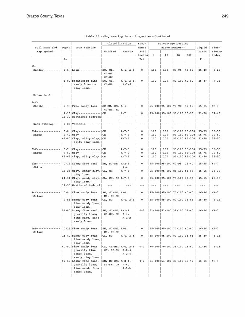
Brazos County, Texas 249
Table 15.--Engineering Index Properties--Continued_________________________________________________________________________________________________________________ | | | Classification |Frag- | Percentage passing | | ____________________ Soil name and |Depth| USDA texture | | |ments | sieve number-- |Liquid | Plas- ___________________________ map symbol | | | Unified | AASHTO | 3-10 | | | | | limit | ticity | | | | |inches| 4 | 10 | 40 | 200 | | index_________________________________________________________________________________________________________________ | In | | | | Pct | | | | | Pct | | | | | | | | | | | |Sb: | | | | | | | | | | | Sandow----------| 0-6 |Loam-------------|SC, CL, |A-4, A-6 | 0 | 100 | 100 |80-95 |45-80 | 25-40 | 6-20 | | | CL-ML, | | | | | | | | | | | SC-SM | | | | | | | | | 6-80|Stratified fine |SC, CL, |A-4, A-6,| 0 | 100 | 100 |80-100|40-90 | 25-47 | 7-28 | | sandy loam to | CL-ML | A-7-6 | | | | | | | | | clay loam. | | | | | | | | | | | | | | | | | | | | Urban land. | | | | | | | | | | | | | | | | | | | | | |ScC: | | | | | | | | | | | Shalba----------| 0-4 |Fine sandy loam |SC-SM, SM,|A-4 | 0 |95-100|95-100|70-98 |40-60 | 15-25 | NP-7 | | | CL-ML, ML| | | | | | | | | 4-18|Clay-------------|CH |A-7 | 0 |95-100|95-100|90-100|75-95 | 51-70 | 34-48 |18-30|Weathered bedrock| --- | --- | --- | --- | --- | --- | --- | --- | --- | | | | | | | | | | | Rock outcrop----| 0-80|Variable---------| --- | --- | --- | --- | --- | --- | --- | --- | --- | | | | | | | | | | |ShA--------------| 0-8 |Clay-------------|CH |A-7-6 | 0 | 100 | 100 |95-100|95-100| 55-75 | 35-50 Ships | 8-47|Clay-------------|CH |A-7-6 | 0 | 100 | 100 |95-100|95-100| 55-75 | 35-50 |47-80|Clay, silty clay,|CH |A-7-6 | 0 | 100 | 100 |95-100|85-100| 51-70 | 32-50 | | silty clay loam.| | | | | | | | | | | | | | | | | | | |ShC--------------| 0-7 |Clay-------------|CH |A-7-6 | 0 | 100 | 100 |95-100|95-100| 55-75 | 35-50 Ships | 7-62|Clay-------------|CH |A-7-6 | 0 | 100 | 100 |95-100|95-100| 55-75 | 35-50 |62-65|Clay, silty clay |CH |A-7-6 | 0 | 100 | 100 |95-100|85-100| 51-70 | 32-50 | | | | | | | | | | |SkB--------------| 0-15|Loamy fine sand |SM, SC-SM |A-2-4, | 0 |95-100|95-100|60-95 |15-40 | 15-25 | NP-7 Shiro | | | | A-4 | | | | | | | |15-24|Clay, sandy clay,|CL, CH |A-7-6 | 0 |95-100|95-100|85-100|51-95 | 45-65 | 23-38 | | clay loam. | | | | | | | | | |24-34|Clay, sandy clay,|CL, CH, SC|A-7-6 | 0 |95-100|95-100|75-100|40-70 | 45-65 | 25-38 | | clay loam. | | | | | | | | | |34-50|Weathered bedrock| --- | --- | --- | --- | --- | --- | --- | --- | --- | | | | | | | | | | |SmC--------------| 0-9 |Fine sandy loam |SM, SC-SM,|A-4 | 0 |95-100|95-100|70-100|40-60 | 16-26 | NP-7 Silawa | | | ML, CL-ML| | | | | | | | | 9-51|Sandy clay loam, |CL, SC |A-4, A-6 | 0 |85-100|85-100|80-100|35-65 | 25-40 | 8-18 | | fine sandy loam,| | | | | | | | | | | clay loam. | | | | | | | | | |51-80|Loamy fine sand, |SM, SC-SM,|A-2-4, | 0-2 |51-100|51-100|38-100|12-40 | 16-26 | NP-7 | | gravelly loamy | SP-SM, GM| A-4, | | | | | | | | | fine sand, fine | | A-1-b | | | | | | | | | sandy loam. | | | | | | | | | | | | | | | | | | | |SmD--------------| 0-15|Fine sandy loam |SM, SC-SM,|A-4 | 0 |95-100|95-100|70-100|40-60 | 16-26 | NP-7 Silawa | | | ML, CL-ML| | | | | | | | |15-40|Sandy clay loam, |CL, SC |A-4, A-6 | 0 |85-100|85-100|80-100|35-65 | 25-40 | 8-18 | | fine sandy loam,| | | | | | | | | | | clay loam. | | | | | | | | | |40-50|Fine sandy loam, |CL, CL-ML,|A-4, A-6,| 0-2 |70-100|70-100|38-100|18-60 | 21-34 | 4-14 | | gravelly fine | SC, SC-SM| A-2-4, | | | | | | | | | sandy loam, | | A-2-6 | | | | | | | | | sandy clay loam.| | | | | | | | | |50-60|Loamy fine sand, |SM, SC-SM,|A-2-4, | 0-2 |51-100|51-100|38-100|12-40 | 16-26 | NP-7 | | gravelly loamy | SP-SM, GM| A-4, | | | | | | | | | fine sand, fine | | A-1-b | | | | | | | | | sandy loam. | | | | | | | | | | | | | | | | | | | |
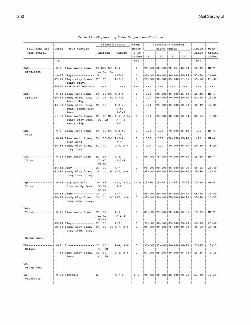
250 Soil Survey of
Table 15.--Engineering Index Properties--Continued_________________________________________________________________________________________________________________ | | | Classification |Frag- | Percentage passing | | ____________________ Soil name and |Depth| USDA texture | | |ments | sieve number-- |Liquid | Plas- ___________________________ map symbol | | | Unified | AASHTO | 3-10 | | | | | limit | ticity | | | | |inches| 4 | 10 | 40 | 200 | | index_________________________________________________________________________________________________________________ | In | | | | Pct | | | | | Pct | | | | | | | | | | | |SnB--------------| 0-9 |Fine sandy loam |SC-SM, SM,|A-4 | 0 |95-100|90-100|70-95 |40-60 | 16-25 | NP-7 Singleton | | | CL-ML, ML| | | | | | | | | 9-17|Clay-------------|CH |A-7-6 | 0 |95-100|90-100|90-100|75-95 | 51-70 | 34-48 |17-28|Clay, clay loam, |CH, CL |A-7-6 | 0 |95-100|90-100|85-100|51-95 | 45-60 | 23-36 | | sandy clay. | | | | | | | | | |28-60|Weathered bedrock| --- | --- | --- | --- | --- | --- | --- | --- | --- | | | | | | | | | | |SpB--------------| 0-18|Loamy fine sand |SM, SC-SM |A-2-4 | 0 | 100 |95-100|80-100|15-30 | 16-20 | NP-6 Spiller |18-43|Sandy clay, clay |CL, CH, SC|A-7-6 | 0 | 100 |95-100|90-100|40-70 | 41-55 | 18-28 | | loam, clay. | | | | | | | | | |43-54|Sandy clay, clay |CL, SC |A-2-7, | 0 | 100 |95-100|85-100|30-70 | 30-49 | 11-25 | | loam, sandy clay| | A-6, | | | | | | | | | loam. | | A-7-6 | | | | | | | |54-85|Fine sandy loam, |CL, CL-ML,|A-4, A-6,| 0 | 100 |95-100|80-100|20-60 | 26-55 | 5-28 | | sandy clay loam,| SC, CH | A-7-6, | | | | | | | | | sandy clay. | | A-2 | | | | | | | | | | | | | | | | | |SxB--------------| 0-8 |Loamy fine sand |SM, SC-SM |A-2-4, | 0 | 100 | 100 |70-100|15-40 | <25 | NP-4 Styx | | | | A-4 | | | | | | | | 8-24|Fine sand, loamy |SM, SC-SM |A-2-4, | 0 | 100 | 100 |70-100|15-40 | <25 | NP-4 | | fine sand. | | A-4 | | | | | | | |24-68|Sandy clay loam, |SC, CL |A-6, A-4 | 0 | 100 | 100 |80-100|36-70 | 20-40 | 8-20 | | clay loam. | | | | | | | | | | | | | | | | | | | |TaA--------------| 0-14|Fine sandy loam |ML, SM, |A-4, | 0 |85-100|75-100|70-100|30-55 | 15-25 | NP-7 Tabor | | | CL-ML, | A-2-4 | | | | | | | | | | SC-SM | | | | | | | | |14-42|Clay-------------|CH, CL |A-7 | 0 |95-100|90-100|85-100|55-90 | 45-65 | 25-40 |42-80|Sandy clay loam, |CH, CL, SC|A-7, A-6 | 0 |95-100|90-100|75-100|40-90 | 35-60 | 15-35 | | clay loam, clay.| | | | | | | | | | | | | | | | | | | |TgB--------------| 0-18|Very gravelly |GM, SM, |A-1, A-3,| 0-10 |15-80 |15-75 |12-65 | 5-25 | 15-20 | NP-5 Tabor | | fine sandy loam.| SC-SM, | A-2 | | | | | | | | | | SP-SM | | | | | | | | |18-38|Clay-------------|CH, CL |A-7 | 0 |95-100|90-100|85-100|55-90 | 45-65 | 25-40 |38-80|Sandy clay loam, |CH, CL, SC|A-7, A-6 | 0 |95-100|90-100|75-100|40-90 | 35-60 | 15-35 | | clay loam, clay.| | | | | | | | | | | | | | | | | | | |TuA: | | | | | | | | | | | Tabor-----------| 0-15|Fine sandy loam |ML, SM, |A-4, | 0 |85-100|75-100|70-100|30-55 | 15-25 | NP-7 | | | CL-ML, | A-2-4 | | | | | | | | | | SC-SM | | | | | | | | |15-28|Clay-------------|CH, CL |A-7 | 0 |95-100|90-100|85-100|55-90 | 45-65 | 25-40 |28-80|Sandy clay loam, |CH, CL, SC|A-7, A-6 | 0 |95-100|90-100|75-100|40-90 | 35-60 | 15-35 | | clay loam, clay.| | | | | | | | | | | | | | | | | | | | Urban land. | | | | | | | | | | | | | | | | | | | | | |Uh---------------| 0-7 |Loam-------------|CL, SC, |A-4, A-6 | 0 |97-100|97-100|80-100|36-70 | 22-35 | 3-13 Uhland | | | ML, SM | | | | | | | | | 7-65|Fine sandy loam, |CL, SC, |A-4, A-6 | 0 |97-100|95-100|80-100|36-78 | 18-36 | 3-18 | | loam. | ML, SM | | | | | | | | | | | | | | | | | | |Ur. | | | | | | | | | | | Urban land | | | | | | | | | | | | | | | | | | | | | |Us---------------| 0-80|Variable---------|CH |A-7-6 | 0-1 |95-100|90-100|80-100|70-99 | 51-80 | 30-54 Ustarents | | | | | | | | | | | | | | | | | | | | | |
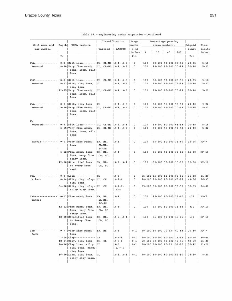
Brazos County, Texas 251
Table 15.--Engineering Index Properties--Continued_________________________________________________________________________________________________________________ | | | Classification |Frag- | Percentage passing | | ____________________ Soil name and |Depth| USDA texture | | |ments | sieve number-- |Liquid | Plas- ___________________________ map symbol | | | Unified | AASHTO | 3-10 | | | | | limit | ticity | | | | |inches| 4 | 10 | 40 | 200 | | index_________________________________________________________________________________________________________________ | In | | | | Pct | | | | | Pct | | | | | | | | | | | |WeA--------------| 0-8 |Silt loam--------|CL, CL-ML |A-4, A-6 | 0 | 100 |98-100|90-100|65-95 | 20-35 | 5-18 Weswood | 8-80|Very fine sandy |CL, CL-ML |A-4, A-6 | 0 | 100 |98-100|95-100|70-98 | 20-40 | 5-22 | | loam, loam, silt| | | | | | | | | | | loam. | | | | | | | | | | | | | | | | | | | |WeC--------------| 0-8 |Silt loam--------|CL, CL-ML |A-4, A-6 | 0 | 100 |98-100|90-100|65-95 | 20-35 | 5-18 Weswood | 8-22|Silty clay loam, |CL |A-4, A-6 | 0 | 100 |98-100|95-100|75-98 | 20-40 | 9-22 | | clay loam. | | | | | | | | | |22-65|Very fine sandy |CL, CL-ML |A-4, A-6 | 0 | 100 |98-100|95-100|70-98 | 20-40 | 5-22 | | loam, loam, silt| | | | | | | | | | | loam. | | | | | | | | | | | | | | | | | | | |WwA--------------| 0-9 |Silty clay loam |CL |A-4, A-6 | 0 | 100 |98-100|95-100|75-98 | 20-40 | 9-22 Weswood | 9-80|Very fine sandy |CL, CL-ML |A-4, A-6 | 0 | 100 |98-100|95-100|70-98 | 20-40 | 5-22 | | loam, loam, silt| | | | | | | | | | | loam. | | | | | | | | | | | | | | | | | | | |Wy: | | | | | | | | | | | Weswood---------| 0-6 |Silt loam--------|CL, CL-ML |A-4, A-6 | 0 | 100 |98-100|90-100|65-95 | 20-35 | 5-18 | 6-65|Very fine sandy |CL, CL-ML |A-4, A-6 | 0 | 100 |98-100|95-100|70-98 | 20-40 | 5-22 | | loam, loam, silt| | | | | | | | | | | loam. | | | | | | | | | | | | | | | | | | | | Yahola----------| 0-6 |Very fine sandy |SM, ML, |A-4 | 0 | 100 |95-100|90-100|36-60 | 15-26 | NP-7 | | loam. | CL-ML, | | | | | | | | | | | SC-SM | | | | | | | | | 6-12|Fine sandy loam, |SM, ML, |A-4 | 0 | 100 |95-100|90-100|36-85 | 15-30 | NP-10 | | loam, very fine | CL, SC | | | | | | | | | | sandy loam. | | | | | | | | | |12-60|Stratified loam |SM, ML, |A-2, A-4 | 0 | 100 |95-100|90-100|15-85 | 15-30 | NP-10 | | to loamy fine | CL, SC | | | | | | | | | | sand. | | | | | | | | | | | | | | | | | | | |WzA--------------| 0-8 |Loam-------------|CL |A-6 | 0 |95-100|85-100|80-100|60-96 | 26-38 | 11-20 Wilson | 8-34|Silty clay, clay,|CL, CH |A-7-6 | 0 |90-100|80-100|80-100|65-96 | 43-56 | 26-37 | | clay loam. | | | | | | | | | |34-80|Silty clay, clay,|CL, CH |A-7-6, | 0 |95-100|90-100|85-100|70-96 | 38-65 | 24-48 | | silty clay loam.| | A-6 | | | | | | | | | | | | | | | | | |YaA--------------| 0-12|Fine sandy loam |SM, ML, |A-4 | 0 | 100 |95-100|90-100|36-60 | <26 | NP-7 Yahola | | | CL-ML, | | | | | | | | | | | SC-SM | | | | | | | | |12-42|Fine sandy loam, |SM, ML, |A-4 | 0 | 100 |95-100|90-100|36-85 | <30 | NP-10 | | loam, very fine | CL, SC | | | | | | | | | | sandy loam. | | | | | | | | | |42-80|Stratified loam |SM, ML, |A-2, A-4 | 0 | 100 |95-100|90-100|15-85 | <30 | NP-10 | | to loamy fine | CL, SC | | | | | | | | | | sand. | | | | | | | | | | | | | | | | | | | |ZaB--------------| 0-7 |Very fine sandy |SM, ML |A-4 | 0-1 |90-100|90-100|70-95 |40-65 | 20-30 | NP-7 Zack | | loam. | | | | | | | | | | 7-18|Clay-------------|CH |A-7-6 | 0-1 |90-100|90-100|90-100|75-95 | 50-70 | 30-45 |18-24|Clay, clay loam |CH, CL |A-7-6 | 0-1 |90-100|90-100|90-100|70-95 | 42-60 | 25-38 |24-36|Clay loam, silty |CL |A-6, | 0-1 |90-100|90-100|80-95 |51-90 | 30-42 | 11-20 | | clay loam, sandy| | A-7-6 | | | | | | | | | clay loam. | | | | | | | | | |36-60|Loam, clay loam, |CL |A-4, A-6 | 0-1 |90-100|90-100|80-100|51-90 | 26-40 | 8-20 | | silty clay loam.| | | | | | | | | | | | | | | | | | | |
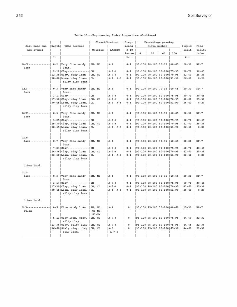
252 Soil Survey of
Table 15.--Engineering Index Properties--Continued_________________________________________________________________________________________________________________ | | | Classification |Frag- | Percentage passing | | ____________________ Soil name and |Depth| USDA texture | | |ments | sieve number-- |Liquid | Plas- ___________________________ map symbol | | | Unified | AASHTO | 3-10 | | | | | limit | ticity | | | | |inches| 4 | 10 | 40 | 200 | | index_________________________________________________________________________________________________________________ | In | | | | Pct | | | | | Pct | | | | | | | | | | | |ZaC2-------------| 0-2 |Very fine sandy |SM, ML |A-4 | 0-1 |90-100|90-100|70-95 |40-65 | 20-30 | NP-7 Zack | | loam. | | | | | | | | | | 2-12|Clay-------------|CH |A-7-6 | 0-1 |90-100|90-100|90-100|75-95 | 50-70 | 30-45 |12-38|Clay, clay loam |CH, CL |A-7-6 | 0-1 |90-100|90-100|90-100|70-95 | 42-60 | 25-38 |38-60|Loam, clay loam, |CL |A-4, A-6 | 0-1 |90-100|90-100|80-100|51-90 | 26-40 | 8-20 | | silty clay loam.| | | | | | | | | | | | | | | | | | | |ZaD--------------| 0-3 |Very fine sandy |SM, ML |A-4 | 0-1 |90-100|90-100|70-95 |40-65 | 20-30 | NP-7 Zack | | loam. | | | | | | | | | | 3-17|Clay-------------|CH |A-7-6 | 0-1 |90-100|90-100|90-100|75-95 | 50-70 | 30-45 |17-30|Clay, clay loam |CH, CL |A-7-6 | 0-1 |90-100|90-100|90-100|70-95 | 42-60 | 25-38 |30-45|Loam, clay loam, |CL |A-4, A-6 | 0-1 |90-100|90-100|80-100|51-90 | 26-40 | 8-20 | | silty clay loam.| | | | | | | | | | | | | | | | | | | |ZaE3-------------| 0-3 |Very fine sandy |SM, ML |A-4 | 0-1 |90-100|90-100|70-95 |40-65 | 20-30 | NP-7 Zack | | loam. | | | | | | | | | | 3-25|Clay-------------|CH |A-7-6 | 0-1 |90-100|90-100|90-100|75-95 | 50-70 | 30-45 |25-30|Clay, clay loam |CH, CL |A-7-6 | 0-1 |90-100|90-100|90-100|70-95 | 42-60 | 25-38 |30-45|Loam, clay loam, |CL |A-4, A-6 | 0-1 |90-100|90-100|80-100|51-90 | 26-40 | 8-20 | | silty clay loam.| | | | | | | | | | | | | | | | | | | |ZcB: | | | | | | | | | | | Zack------------| 0-7 |Very fine sandy |SM, ML |A-4 | 0-1 |90-100|90-100|70-95 |40-65 | 20-30 | NP-7 | | loam. | | | | | | | | | | 7-24|Clay-------------|CH |A-7-6 | 0-1 |90-100|90-100|90-100|75-95 | 50-70 | 30-45 |24-36|Clay, clay loam |CH, CL |A-7-6 | 0-1 |90-100|90-100|90-100|70-95 | 42-60 | 25-38 |36-60|Loam, clay loam, |CL |A-4, A-6 | 0-1 |90-100|90-100|80-100|51-90 | 26-40 | 8-20 | | silty clay loam.| | | | | | | | | | | | | | | | | | | | Urban land. | | | | | | | | | | | | | | | | | | | | | |ZcD: | | | | | | | | | | | Zack------------| 0-3 |Very fine sandy |SM, ML |A-4 | 0-1 |90-100|90-100|70-95 |40-65 | 20-30 | NP-7 | | loam. | | | | | | | | | | 3-17|Clay-------------|CH |A-7-6 | 0-1 |90-100|90-100|90-100|75-95 | 50-70 | 30-45 |17-30|Clay, clay loam |CH, CL |A-7-6 | 0-1 |90-100|90-100|90-100|70-95 | 42-60 | 25-38 |30-45|Loam, clay loam, |CL |A-4, A-6 | 0-1 |90-100|90-100|80-100|51-90 | 26-40 | 8-20 | | silty clay loam.| | | | | | | | | | | | | | | | | | | | Urban land. | | | | | | | | | | | | | | | | | | | | | |ZuB--------------| 0-5 |Fine sandy loam |SM, ML, |A-4 | 0 |95-100|95-100|70-100|40-60 | 15-30 | NP-7 Zulch | | | CL-ML, | | | | | | | | | | | SC-SM | | | | | | | | | 5-13|Clay loam, clay, |CH, CL |A-7-6 | 0 |95-100|95-100|90-100|75-95 | 44-60 | 22-32 | | silty clay. | | | | | | | | | |13-36|Clay, silty clay |CH, CL |A-7-6 | 0 |95-100|95-100|90-100|75-95 | 44-66 | 22-36 |36-60|Shaly clay, clay,|CH, CL |A-6, | 0 |95-100|95-100|90-100|65-90 | 44-60 | 22-32 | | clay loam. | | A-7-6 | | | | | | | | | | | | | | | | | |_________________________________________________________________________________________________________________
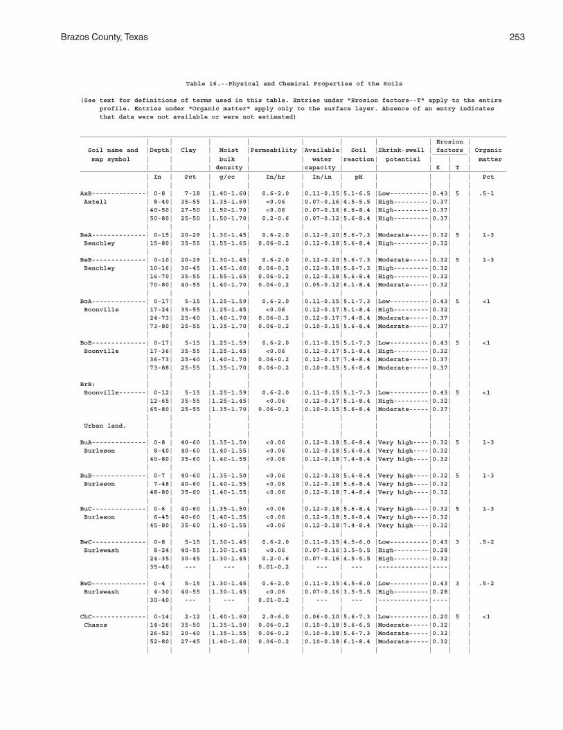
Brazos County, Texas 253
Table 16.--Physical and Chemical Properties of the Soils
(See text for definitions of terms used in this table. Entries under "Erosion factors--T" apply to the entire profile. Entries under "Organic matter" apply only to the surface layer. Absence of an entry indicates that data were not available or were not estimated)
______________________________________________________________________________________________________________ | | | | | | | | Erosion | Soil name and |Depth| Clay | Moist |Permeability |Available| Soil |Shrink-swell | factors | Organic _________ map symbol | | | bulk | | water |reaction| potential | | | matter | | | density | |capacity | | | K | T |______________________________________________________________________________________________________________ | In | Pct | g/cc | In/hr | In/in | pH | | | | Pct | | | | | | | | | |AxB--------------| 0-8 | 7-18 |1.40-1.60| 0.6-2.0 |0.11-0.15|5.1-6.5 |Low----------|0.43| 5 | .5-1 Axtell | 8-40| 35-55 |1.35-1.60| <0.06 |0.07-0.16|4.5-5.5 |High---------|0.37| | |40-50| 27-50 |1.50-1.70| <0.06 |0.07-0.16|6.6-8.4 |High---------|0.37| | |50-80| 25-50 |1.50-1.70| 0.2-0.6 |0.07-0.12|5.6-8.4 |High---------|0.37| | | | | | | | | | | |BeA--------------| 0-15| 20-29 |1.30-1.45| 0.6-2.0 |0.12-0.20|5.6-7.3 |Moderate-----|0.32| 5 | 1-3 Benchley |15-80| 35-55 |1.55-1.65| 0.06-0.2 |0.12-0.18|5.6-8.4 |High---------|0.32| | | | | | | | | | | |BeB--------------| 0-10| 20-29 |1.30-1.45| 0.6-2.0 |0.12-0.20|5.6-7.3 |Moderate-----|0.32| 5 | 1-3 Benchley |10-16| 30-45 |1.45-1.60| 0.06-0.2 |0.12-0.18|5.6-7.3 |High---------|0.32| | |16-70| 35-55 |1.55-1.65| 0.06-0.2 |0.12-0.18|5.6-8.4 |High---------|0.32| | |70-80| 40-55 |1.40-1.70| 0.06-0.2 |0.05-0.12|6.1-8.4 |Moderate-----|0.32| | | | | | | | | | | |BoA--------------| 0-17| 5-15 |1.25-1.59| 0.6-2.0 |0.11-0.15|5.1-7.3 |Low----------|0.43| 5 | <1 Boonville |17-24| 35-55 |1.25-1.45| <0.06 |0.12-0.17|5.1-8.4 |High---------|0.32| | |24-73| 25-40 |1.40-1.70| 0.06-0.2 |0.12-0.17|7.4-8.4 |Moderate-----|0.37| | |73-80| 25-55 |1.35-1.70| 0.06-0.2 |0.10-0.15|5.6-8.4 |Moderate-----|0.37| | | | | | | | | | | |BoB--------------| 0-17| 5-15 |1.25-1.59| 0.6-2.0 |0.11-0.15|5.1-7.3 |Low----------|0.43| 5 | <1 Boonville |17-36| 35-55 |1.25-1.45| <0.06 |0.12-0.17|5.1-8.4 |High---------|0.32| | |36-73| 25-40 |1.40-1.70| 0.06-0.2 |0.12-0.17|7.4-8.4 |Moderate-----|0.37| | |73-88| 25-55 |1.35-1.70| 0.06-0.2 |0.10-0.15|5.6-8.4 |Moderate-----|0.37| | | | | | | | | | | |BrB: | | | | | | | | | | Boonville-------| 0-12| 5-15 |1.25-1.59| 0.6-2.0 |0.11-0.15|5.1-7.3 |Low----------|0.43| 5 | <1 |12-65| 35-55 |1.25-1.45| <0.06 |0.12-0.17|5.1-8.4 |High---------|0.32| | |65-80| 25-55 |1.35-1.70| 0.06-0.2 |0.10-0.15|5.6-8.4 |Moderate-----|0.37| | | | | | | | | | | | Urban land. | | | | | | | | | | | | | | | | | | | |BuA--------------| 0-8 | 40-60 |1.35-1.50| <0.06 |0.12-0.18|5.6-8.4 |Very high----|0.32| 5 | 1-3 Burleson | 8-40| 40-60 |1.40-1.55| <0.06 |0.12-0.18|5.6-8.4 |Very high----|0.32| | |40-80| 35-60 |1.40-1.55| <0.06 |0.12-0.18|7.4-8.4 |Very high----|0.32| | | | | | | | | | | |BuB--------------| 0-7 | 40-60 |1.35-1.50| <0.06 |0.12-0.18|5.6-8.4 |Very high----|0.32| 5 | 1-3 Burleson | 7-48| 40-60 |1.40-1.55| <0.06 |0.12-0.18|5.6-8.4 |Very high----|0.32| | |48-80| 35-60 |1.40-1.55| <0.06 |0.12-0.18|7.4-8.4 |Very high----|0.32| | | | | | | | | | | |BuC--------------| 0-6 | 40-60 |1.35-1.50| <0.06 |0.12-0.18|5.6-8.4 |Very high----|0.32| 5 | 1-3 Burleson | 6-45| 40-60 |1.40-1.55| <0.06 |0.12-0.18|5.6-8.4 |Very high----|0.32| | |45-80| 35-60 |1.40-1.55| <0.06 |0.12-0.18|7.4-8.4 |Very high----|0.32| | | | | | | | | | | |BwC--------------| 0-8 | 5-15 |1.30-1.45| 0.6-2.0 |0.11-0.15|4.5-6.0 |Low----------|0.43| 3 | .5-2 Burlewash | 8-24| 40-55 |1.30-1.45| <0.06 |0.07-0.16|3.5-5.5 |High---------|0.28| | |24-35| 30-45 |1.30-1.45| 0.2-0.6 |0.07-0.16|4.5-5.5 |High---------|0.32| | |35-40| --- | --- | 0.01-0.2 | --- | --- |-------------|----| | | | | | | | | | | |BwD--------------| 0-4 | 5-15 |1.30-1.45| 0.6-2.0 |0.11-0.15|4.5-6.0 |Low----------|0.43| 3 | .5-2 Burlewash | 4-30| 40-55 |1.30-1.45| <0.06 |0.07-0.16|3.5-5.5 |High---------|0.28| | |30-40| --- | --- | 0.01-0.2 | --- | --- |-------------|----| | | | | | | | | | | |ChC--------------| 0-14| 2-12 |1.40-1.60| 2.0-6.0 |0.06-0.10|5.6-7.3 |Low----------|0.20| 5 | <1 Chazos |14-26| 35-50 |1.35-1.50| 0.06-0.2 |0.10-0.18|5.6-6.5 |Moderate-----|0.32| | |26-52| 20-40 |1.35-1.55| 0.06-0.2 |0.10-0.18|5.6-7.3 |Moderate-----|0.32| | |52-80| 27-45 |1.40-1.60| 0.06-0.2 |0.10-0.18|6.1-8.4 |Moderate-----|0.32| | | | | | | | | | | |
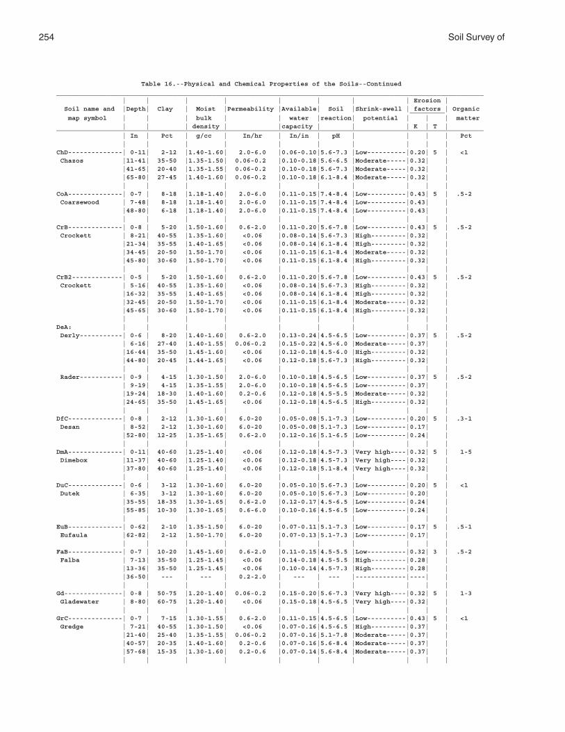
254 Soil Survey of
Table 16.--Physical and Chemical Properties of the Soils--Continued______________________________________________________________________________________________________________ | | | | | | | | Erosion | Soil name and |Depth| Clay | Moist |Permeability |Available| Soil |Shrink-swell | factors | Organic _________ map symbol | | | bulk | | water |reaction| potential | | | matter | | | density | |capacity | | | K | T |______________________________________________________________________________________________________________ | In | Pct | g/cc | In/hr | In/in | pH | | | | Pct | | | | | | | | | |ChD--------------| 0-11| 2-12 |1.40-1.60| 2.0-6.0 |0.06-0.10|5.6-7.3 |Low----------|0.20| 5 | <1 Chazos |11-41| 35-50 |1.35-1.50| 0.06-0.2 |0.10-0.18|5.6-6.5 |Moderate-----|0.32| | |41-65| 20-40 |1.35-1.55| 0.06-0.2 |0.10-0.18|5.6-7.3 |Moderate-----|0.32| | |65-80| 27-45 |1.40-1.60| 0.06-0.2 |0.10-0.18|6.1-8.4 |Moderate-----|0.32| | | | | | | | | | | |CoA--------------| 0-7 | 8-18 |1.18-1.40| 2.0-6.0 |0.11-0.15|7.4-8.4 |Low----------|0.43| 5 | .5-2 Coarsewood | 7-48| 8-18 |1.18-1.40| 2.0-6.0 |0.11-0.15|7.4-8.4 |Low----------|0.43| | |48-80| 6-18 |1.18-1.40| 2.0-6.0 |0.11-0.15|7.4-8.4 |Low----------|0.43| | | | | | | | | | | |CrB--------------| 0-8 | 5-20 |1.50-1.60| 0.6-2.0 |0.11-0.20|5.6-7.8 |Low----------|0.43| 5 | .5-2 Crockett | 8-21| 40-55 |1.35-1.60| <0.06 |0.08-0.14|5.6-7.3 |High---------|0.32| | |21-34| 35-55 |1.40-1.65| <0.06 |0.08-0.14|6.1-8.4 |High---------|0.32| | |34-45| 20-50 |1.50-1.70| <0.06 |0.11-0.15|6.1-8.4 |Moderate-----|0.32| | |45-80| 30-60 |1.50-1.70| <0.06 |0.11-0.15|6.1-8.4 |High---------|0.32| | | | | | | | | | | |CrB2-------------| 0-5 | 5-20 |1.50-1.60| 0.6-2.0 |0.11-0.20|5.6-7.8 |Low----------|0.43| 5 | .5-2 Crockett | 5-16| 40-55 |1.35-1.60| <0.06 |0.08-0.14|5.6-7.3 |High---------|0.32| | |16-32| 35-55 |1.40-1.65| <0.06 |0.08-0.14|6.1-8.4 |High---------|0.32| | |32-45| 20-50 |1.50-1.70| <0.06 |0.11-0.15|6.1-8.4 |Moderate-----|0.32| | |45-65| 30-60 |1.50-1.70| <0.06 |0.11-0.15|6.1-8.4 |High---------|0.32| | | | | | | | | | | |DeA: | | | | | | | | | | Derly-----------| 0-6 | 8-20 |1.40-1.60| 0.6-2.0 |0.13-0.24|4.5-6.5 |Low----------|0.37| 5 | .5-2 | 6-16| 27-40 |1.40-1.55| 0.06-0.2 |0.15-0.22|4.5-6.0 |Moderate-----|0.37| | |16-44| 35-50 |1.45-1.60| <0.06 |0.12-0.18|4.5-6.0 |High---------|0.32| | |44-80| 20-45 |1.44-1.65| <0.06 |0.12-0.18|5.6-7.3 |High---------|0.32| | | | | | | | | | | | Rader-----------| 0-9 | 4-15 |1.30-1.50| 2.0-6.0 |0.10-0.18|4.5-6.5 |Low----------|0.37| 5 | .5-2 | 9-19| 4-15 |1.35-1.55| 2.0-6.0 |0.10-0.18|4.5-6.5 |Low----------|0.37| | |19-24| 18-30 |1.40-1.60| 0.2-0.6 |0.12-0.18|4.5-5.5 |Moderate-----|0.32| | |24-65| 35-50 |1.45-1.65| <0.06 |0.12-0.18|4.5-6.5 |High---------|0.32| | | | | | | | | | | |DfC--------------| 0-8 | 2-12 |1.30-1.60| 6.0-20 |0.05-0.08|5.1-7.3 |Low----------|0.20| 5 | .3-1 Desan | 8-52| 2-12 |1.30-1.60| 6.0-20 |0.05-0.08|5.1-7.3 |Low----------|0.17| | |52-80| 12-25 |1.35-1.65| 0.6-2.0 |0.12-0.16|5.1-6.5 |Low----------|0.24| | | | | | | | | | | |DmA--------------| 0-11| 40-60 |1.25-1.40| <0.06 |0.12-0.18|4.5-7.3 |Very high----|0.32| 5 | 1-5 Dimebox |11-37| 40-60 |1.25-1.40| <0.06 |0.12-0.18|4.5-7.3 |Very high----|0.32| | |37-80| 40-60 |1.25-1.40| <0.06 |0.12-0.18|5.1-8.4 |Very high----|0.32| | | | | | | | | | | |DuC--------------| 0-6 | 3-12 |1.30-1.60| 6.0-20 |0.05-0.10|5.6-7.3 |Low----------|0.20| 5 | <1 Dutek | 6-35| 3-12 |1.30-1.60| 6.0-20 |0.05-0.10|5.6-7.3 |Low----------|0.20| | |35-55| 18-35 |1.30-1.65| 0.6-2.0 |0.12-0.17|4.5-6.5 |Low----------|0.24| | |55-85| 10-30 |1.30-1.65| 0.6-6.0 |0.10-0.16|4.5-6.5 |Low----------|0.24| | | | | | | | | | | |EuB--------------| 0-62| 2-10 |1.35-1.50| 6.0-20 |0.07-0.11|5.1-7.3 |Low----------|0.17| 5 | .5-1 Eufaula |62-82| 2-12 |1.50-1.70| 6.0-20 |0.07-0.13|5.1-7.3 |Low----------|0.17| | | | | | | | | | | |FaB--------------| 0-7 | 10-20 |1.45-1.60| 0.6-2.0 |0.11-0.15|4.5-5.5 |Low----------|0.32| 3 | .5-2 Falba | 7-13| 35-50 |1.25-1.45| <0.06 |0.14-0.18|4.5-5.5 |High---------|0.28| | |13-36| 35-50 |1.25-1.45| <0.06 |0.10-0.14|4.5-7.3 |High---------|0.28| | |36-50| --- | --- | 0.2-2.0 | --- | --- |-------------|----| | | | | | | | | | | |Gd---------------| 0-8 | 50-75 |1.20-1.40| 0.06-0.2 |0.15-0.20|5.6-7.3 |Very high----|0.32| 5 | 1-3 Gladewater | 8-80| 60-75 |1.20-1.40| <0.06 |0.15-0.18|4.5-6.5 |Very high----|0.32| | | | | | | | | | | |GrC--------------| 0-7 | 7-15 |1.30-1.55| 0.6-2.0 |0.11-0.15|4.5-6.5 |Low----------|0.43| 5 | <1 Gredge | 7-21| 40-55 |1.30-1.50| <0.06 |0.07-0.16|4.5-6.5 |High---------|0.37| | |21-40| 25-40 |1.35-1.55| 0.06-0.2 |0.07-0.16|5.1-7.8 |Moderate-----|0.37| | |40-57| 20-35 |1.40-1.60| 0.2-0.6 |0.07-0.16|5.6-8.4 |Moderate-----|0.37| | |57-68| 15-35 |1.30-1.60| 0.2-0.6 |0.07-0.14|5.6-8.4 |Moderate-----|0.37| | | | | | | | | | | |
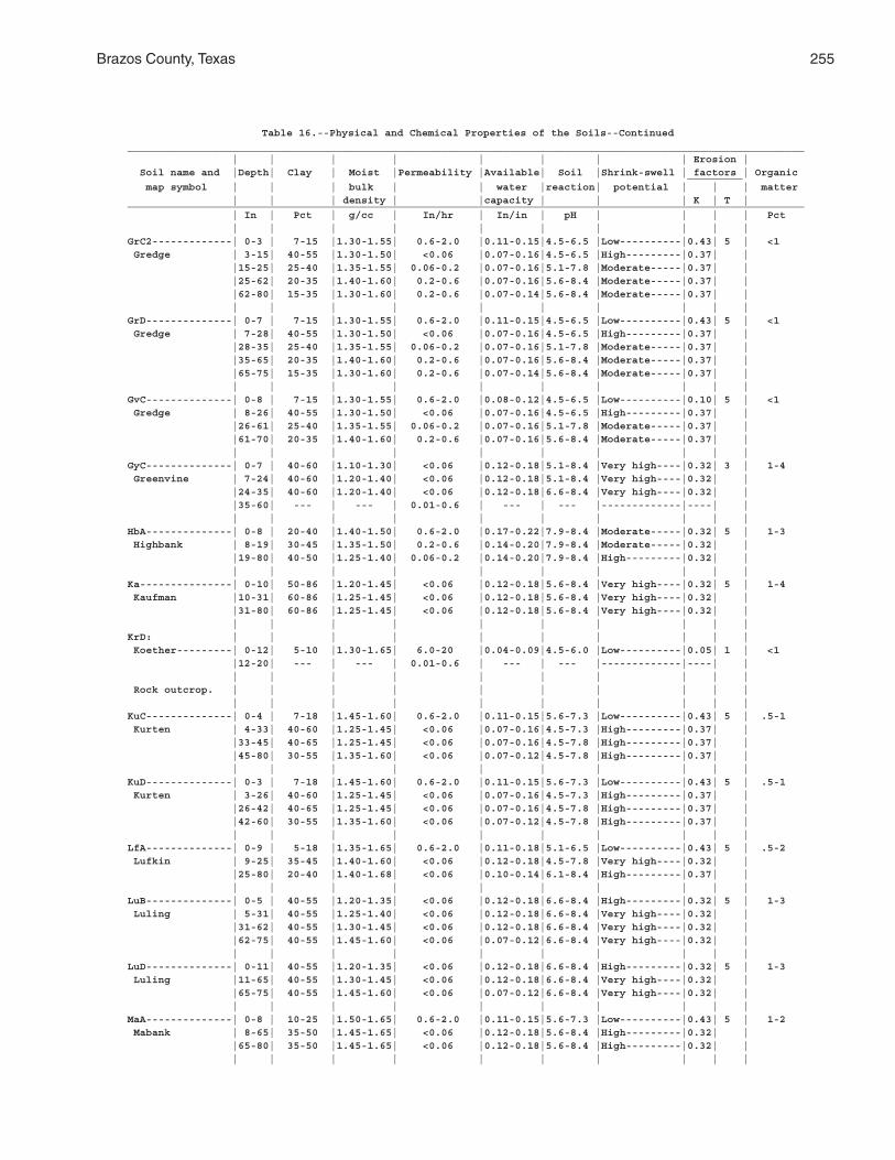
Brazos County, Texas 255
Table 16.--Physical and Chemical Properties of the Soils--Continued______________________________________________________________________________________________________________ | | | | | | | | Erosion | Soil name and |Depth| Clay | Moist |Permeability |Available| Soil |Shrink-swell | factors | Organic _________ map symbol | | | bulk | | water |reaction| potential | | | matter | | | density | |capacity | | | K | T |______________________________________________________________________________________________________________ | In | Pct | g/cc | In/hr | In/in | pH | | | | Pct | | | | | | | | | |GrC2-------------| 0-3 | 7-15 |1.30-1.55| 0.6-2.0 |0.11-0.15|4.5-6.5 |Low----------|0.43| 5 | <1 Gredge | 3-15| 40-55 |1.30-1.50| <0.06 |0.07-0.16|4.5-6.5 |High---------|0.37| | |15-25| 25-40 |1.35-1.55| 0.06-0.2 |0.07-0.16|5.1-7.8 |Moderate-----|0.37| | |25-62| 20-35 |1.40-1.60| 0.2-0.6 |0.07-0.16|5.6-8.4 |Moderate-----|0.37| | |62-80| 15-35 |1.30-1.60| 0.2-0.6 |0.07-0.14|5.6-8.4 |Moderate-----|0.37| | | | | | | | | | | |GrD--------------| 0-7 | 7-15 |1.30-1.55| 0.6-2.0 |0.11-0.15|4.5-6.5 |Low----------|0.43| 5 | <1 Gredge | 7-28| 40-55 |1.30-1.50| <0.06 |0.07-0.16|4.5-6.5 |High---------|0.37| | |28-35| 25-40 |1.35-1.55| 0.06-0.2 |0.07-0.16|5.1-7.8 |Moderate-----|0.37| | |35-65| 20-35 |1.40-1.60| 0.2-0.6 |0.07-0.16|5.6-8.4 |Moderate-----|0.37| | |65-75| 15-35 |1.30-1.60| 0.2-0.6 |0.07-0.14|5.6-8.4 |Moderate-----|0.37| | | | | | | | | | | |GvC--------------| 0-8 | 7-15 |1.30-1.55| 0.6-2.0 |0.08-0.12|4.5-6.5 |Low----------|0.10| 5 | <1 Gredge | 8-26| 40-55 |1.30-1.50| <0.06 |0.07-0.16|4.5-6.5 |High---------|0.37| | |26-61| 25-40 |1.35-1.55| 0.06-0.2 |0.07-0.16|5.1-7.8 |Moderate-----|0.37| | |61-70| 20-35 |1.40-1.60| 0.2-0.6 |0.07-0.16|5.6-8.4 |Moderate-----|0.37| | | | | | | | | | | |GyC--------------| 0-7 | 40-60 |1.10-1.30| <0.06 |0.12-0.18|5.1-8.4 |Very high----|0.32| 3 | 1-4 Greenvine | 7-24| 40-60 |1.20-1.40| <0.06 |0.12-0.18|5.1-8.4 |Very high----|0.32| | |24-35| 40-60 |1.20-1.40| <0.06 |0.12-0.18|6.6-8.4 |Very high----|0.32| | |35-60| --- | --- | 0.01-0.6 | --- | --- |-------------|----| | | | | | | | | | | |HbA--------------| 0-8 | 20-40 |1.40-1.50| 0.6-2.0 |0.17-0.22|7.9-8.4 |Moderate-----|0.32| 5 | 1-3 Highbank | 8-19| 30-45 |1.35-1.50| 0.2-0.6 |0.14-0.20|7.9-8.4 |Moderate-----|0.32| | |19-80| 40-50 |1.25-1.40| 0.06-0.2 |0.14-0.20|7.9-8.4 |High---------|0.32| | | | | | | | | | | |Ka---------------| 0-10| 50-86 |1.20-1.45| <0.06 |0.12-0.18|5.6-8.4 |Very high----|0.32| 5 | 1-4 Kaufman |10-31| 60-86 |1.25-1.45| <0.06 |0.12-0.18|5.6-8.4 |Very high----|0.32| | |31-80| 60-86 |1.25-1.45| <0.06 |0.12-0.18|5.6-8.4 |Very high----|0.32| | | | | | | | | | | |KrD: | | | | | | | | | | Koether---------| 0-12| 5-10 |1.30-1.65| 6.0-20 |0.04-0.09|4.5-6.0 |Low----------|0.05| 1 | <1 |12-20| --- | --- | 0.01-0.6 | --- | --- |-------------|----| | | | | | | | | | | | Rock outcrop. | | | | | | | | | | | | | | | | | | | |KuC--------------| 0-4 | 7-18 |1.45-1.60| 0.6-2.0 |0.11-0.15|5.6-7.3 |Low----------|0.43| 5 | .5-1 Kurten | 4-33| 40-60 |1.25-1.45| <0.06 |0.07-0.16|4.5-7.3 |High---------|0.37| | |33-45| 40-65 |1.25-1.45| <0.06 |0.07-0.16|4.5-7.8 |High---------|0.37| | |45-80| 30-55 |1.35-1.60| <0.06 |0.07-0.12|4.5-7.8 |High---------|0.37| | | | | | | | | | | |KuD--------------| 0-3 | 7-18 |1.45-1.60| 0.6-2.0 |0.11-0.15|5.6-7.3 |Low----------|0.43| 5 | .5-1 Kurten | 3-26| 40-60 |1.25-1.45| <0.06 |0.07-0.16|4.5-7.3 |High---------|0.37| | |26-42| 40-65 |1.25-1.45| <0.06 |0.07-0.16|4.5-7.8 |High---------|0.37| | |42-60| 30-55 |1.35-1.60| <0.06 |0.07-0.12|4.5-7.8 |High---------|0.37| | | | | | | | | | | |LfA--------------| 0-9 | 5-18 |1.35-1.65| 0.6-2.0 |0.11-0.18|5.1-6.5 |Low----------|0.43| 5 | .5-2 Lufkin | 9-25| 35-45 |1.40-1.60| <0.06 |0.12-0.18|4.5-7.8 |Very high----|0.32| | |25-80| 20-40 |1.40-1.68| <0.06 |0.10-0.14|6.1-8.4 |High---------|0.37| | | | | | | | | | | |LuB--------------| 0-5 | 40-55 |1.20-1.35| <0.06 |0.12-0.18|6.6-8.4 |High---------|0.32| 5 | 1-3 Luling | 5-31| 40-55 |1.25-1.40| <0.06 |0.12-0.18|6.6-8.4 |Very high----|0.32| | |31-62| 40-55 |1.30-1.45| <0.06 |0.12-0.18|6.6-8.4 |Very high----|0.32| | |62-75| 40-55 |1.45-1.60| <0.06 |0.07-0.12|6.6-8.4 |Very high----|0.32| | | | | | | | | | | |LuD--------------| 0-11| 40-55 |1.20-1.35| <0.06 |0.12-0.18|6.6-8.4 |High---------|0.32| 5 | 1-3 Luling |11-65| 40-55 |1.30-1.45| <0.06 |0.12-0.18|6.6-8.4 |Very high----|0.32| | |65-75| 40-55 |1.45-1.60| <0.06 |0.07-0.12|6.6-8.4 |Very high----|0.32| | | | | | | | | | | |MaA--------------| 0-8 | 10-25 |1.50-1.65| 0.6-2.0 |0.11-0.15|5.6-7.3 |Low----------|0.43| 5 | 1-2 Mabank | 8-65| 35-50 |1.45-1.65| <0.06 |0.12-0.18|5.6-8.4 |High---------|0.32| | |65-80| 35-50 |1.45-1.65| <0.06 |0.12-0.18|5.6-8.4 |High---------|0.32| | | | | | | | | | | |
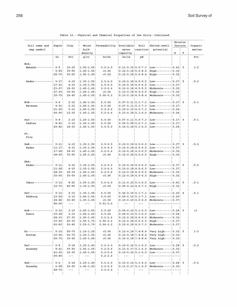
256 Soil Survey of
Table 16.--Physical and Chemical Properties of the Soils--Continued______________________________________________________________________________________________________________ | | | | | | | | Erosion | Soil name and |Depth| Clay | Moist |Permeability |Available| Soil |Shrink-swell | factors | Organic _________ map symbol | | | bulk | | water |reaction| potential | | | matter | | | density | |capacity | | | K | T |______________________________________________________________________________________________________________ | In | Pct | g/cc | In/hr | In/in | pH | | | | Pct | | | | | | | | | |MrA: | | | | | | | | | | Mabank----------| 0-5 | 10-25 |1.50-1.65| 0.6-2.0 |0.11-0.15|5.6-7.3 |Low----------|0.43| 5 | 1-2 | 5-65| 35-50 |1.45-1.65| <0.06 |0.12-0.18|5.6-8.4 |High---------|0.32| | |65-70| 35-50 |1.45-1.65| <0.06 |0.12-0.18|5.6-8.4 |High---------|0.32| | | | | | | | | | | | Rader-----------| 0-17| 4-15 |1.30-1.50| 2.0-6.0 |0.10-0.18|4.5-6.5 |Low----------|0.37| 5 | .5-2 |17-23| 4-15 |1.35-1.55| 2.0-6.0 |0.10-0.18|4.5-6.5 |Low----------|0.37| | |23-27| 18-30 |1.40-1.60| 0.2-0.6 |0.12-0.18|4.5-5.5 |Moderate-----|0.32| | |27-35| 35-50 |1.45-1.65| <0.06 |0.12-0.18|4.5-6.5 |High---------|0.32| | |35-70| 24-45 |1.45-1.65| 0.06-0.2 |0.12-0.18|4.5-8.4 |Moderate-----|0.32| | | | | | | | | | | |NvB--------------| 0-4 | 2-10 |1.40-1.60| 6.0-20 |0.07-0.11|5.1-7.3 |Low----------|0.17| 5 | .5-1 Navasan | 4-51| 2-10 |1.40-1.60| 6.0-20 |0.07-0.11|5.1-7.3 |Low----------|0.17| | |51-66| 5-15 |1.40-1.60| 0.2-0.6 |0.10-0.15|4.5-7.3 |Low----------|0.24| | |66-90| 12-35 |1.40-1.65| 0.2-0.6 |0.13-0.18|5.1-6.0 |Moderate-----|0.24| | | | | | | | | | | |PaC--------------| 0-8 | 2-10 |1.20-1.50| 6.0-20 |0.07-0.11|5.6-7.3 |Low----------|0.17| 5 | .5-1 Padina | 8-62| 2-10 |1.20-1.50| 6.0-20 |0.05-0.08|5.6-7.3 |Low----------|0.17| | |62-82| 18-30 |1.40-1.60| 0.6-2.0 |0.14-0.18|5.1-6.5 |Low----------|0.24| | | | | | | | | | | |Pt. | | | | | | | | | | Pits | | | | | | | | | | | | | | | | | | | |RaB--------------| 0-11| 4-15 |1.30-1.50| 2.0-6.0 |0.10-0.18|4.5-6.5 |Low----------|0.37| 5 | .5-2 Rader |11-17| 4-15 |1.35-1.55| 2.0-6.0 |0.10-0.18|4.5-6.5 |Low----------|0.37| | |17-28| 18-30 |1.40-1.60| 0.2-0.6 |0.12-0.18|4.5-5.5 |Moderate-----|0.32| | |28-65| 35-50 |1.45-1.65| <0.06 |0.12-0.18|4.5-6.5 |High---------|0.32| | | | | | | | | | | |RbA: | | | | | | | | | | Rader-----------| 0-11| 4-15 |1.30-1.50| 2.0-6.0 |0.10-0.18|4.5-6.5 |Low----------|0.37| 5 | .5-2 |11-28| 4-15 |1.35-1.55| 2.0-6.0 |0.10-0.18|4.5-6.5 |Low----------|0.37| | |28-35| 18-30 |1.40-1.60| 0.2-0.6 |0.12-0.18|4.5-5.5 |Moderate-----|0.32| | |35-65| 35-50 |1.45-1.65| <0.06 |0.12-0.18|4.5-6.5 |High---------|0.32| | | | | | | | | | | | Tabor-----------| 0-12| 8-20 |1.50-1.60| 0.6-2.0 |0.11-0.15|5.1-6.5 |Low----------|0.43| 5 | .5-1 |12-70| 40-55 |1.35-1.55| <0.06 |0.09-0.12|4.5-7.3 |High---------|0.32| | | | | | | | | | | |ReC--------------| 0-12| 4-10 |1.35-1.55| 6.0-20 |0.06-0.10|5.1-7.3 |Low----------|0.20| 4 | .5-1 Rehburg |12-24| 2-10 |1.40-1.60| 6.0-20 |0.05-0.10|5.1-7.3 |Low----------|0.20| | |24-46| 30-45 |1.35-1.60| <0.06 |0.10-0.15|4.5-6.5 |Moderate-----|0.37| | |46-60| --- | --- | 0.01-0.2 | --- | --- |-------------|----| | | | | | | | | | | |RoB--------------| 0-15| 2-10 |1.40-1.60| 6.0-20 |0.04-0.10|5.1-6.5 |Low----------|0.24| 5 | <1 Robco |15-28| 2-10 |1.40-1.60| 6.0-20 |0.04-0.10|5.1-6.5 |Low----------|0.24| | |28-33| 27-35 |1.50-1.65| 0.2-0.6 |0.12-0.18|4.5-6.0 |Moderate-----|0.32| | |33-65| 20-35 |1.55-1.70| 0.06-0.2 |0.12-0.18|4.5-6.0 |High---------|0.37| | |65-82| 25-45 |1.55-1.70| 0.06-0.2 |0.10-0.18|4.5-7.3 |Moderate-----|0.37| | | | | | | | | | | |Rr---------------| 0-15| 55-75 |1.10-1.25| <0.06 |0.12-0.18|7.4-8.4 |Very high----|0.32| 5 | 1-3 Roetex |15-56| 60-75 |1.20-1.35| <0.06 |0.12-0.18|7.4-8.4 |Very high----|0.32| | |56-75| 35-60 |1.25-1.40| <0.06 |0.12-0.18|7.4-8.4 |Very high----|0.32| | | | | | | | | | | |RsC--------------| 0-8 | 5-18 |1.20-1.40| 0.6-2.0 |0.10-0.14|5.1-6.5 |Low----------|0.28| 5 | .5-2 Rosanky | 8-41| 35-50 |1.40-1.60| 0.2-0.6 |0.11-0.17|5.1-6.0 |Moderate-----|0.32| | |41-65| 15-35 |1.40-1.65| 0.2-0.6 |0.10-0.16|5.1-6.0 |Low----------|0.37| | |65-80| --- | --- | 0.2-2.0 | --- | --- |-------------|----| | | | | | | | | | | |RsD--------------| 0-6 | 5-18 |1.20-1.40| 0.6-2.0 |0.10-0.14|5.1-6.5 |Low----------|0.28| 5 | .5-2 Rosanky | 6-58| 35-50 |1.40-1.60| 0.2-0.6 |0.11-0.17|5.1-6.0 |Moderate-----|0.32| | |58-70| --- | --- | 0.2-2.0 | --- | --- |-------------|----| | | | | | | | | | | |
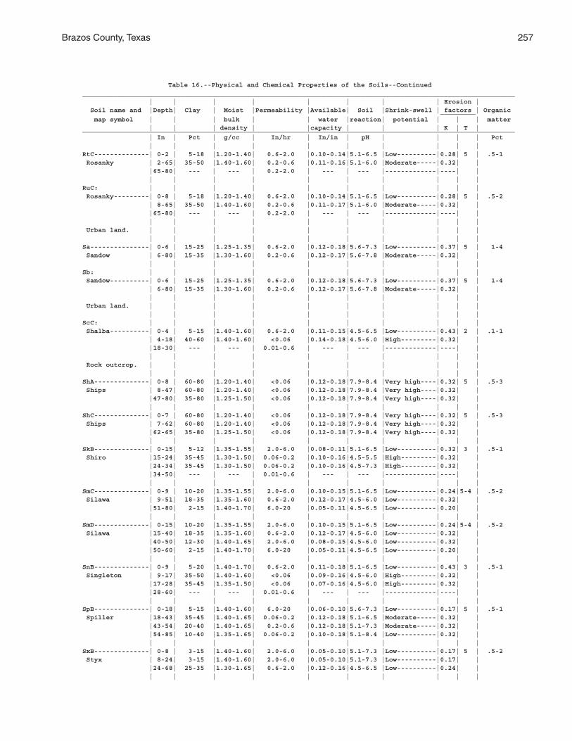
Brazos County, Texas 257
Table 16.--Physical and Chemical Properties of the Soils--Continued______________________________________________________________________________________________________________ | | | | | | | | Erosion | Soil name and |Depth| Clay | Moist |Permeability |Available| Soil |Shrink-swell | factors | Organic _________ map symbol | | | bulk | | water |reaction| potential | | | matter | | | density | |capacity | | | K | T |______________________________________________________________________________________________________________ | In | Pct | g/cc | In/hr | In/in | pH | | | | Pct | | | | | | | | | |RtC--------------| 0-2 | 5-18 |1.20-1.40| 0.6-2.0 |0.10-0.14|5.1-6.5 |Low----------|0.28| 5 | .5-1 Rosanky | 2-65| 35-50 |1.40-1.60| 0.2-0.6 |0.11-0.16|5.1-6.0 |Moderate-----|0.32| | |65-80| --- | --- | 0.2-2.0 | --- | --- |-------------|----| | | | | | | | | | | |RuC: | | | | | | | | | | Rosanky---------| 0-8 | 5-18 |1.20-1.40| 0.6-2.0 |0.10-0.14|5.1-6.5 |Low----------|0.28| 5 | .5-2 | 8-65| 35-50 |1.40-1.60| 0.2-0.6 |0.11-0.17|5.1-6.0 |Moderate-----|0.32| | |65-80| --- | --- | 0.2-2.0 | --- | --- |-------------|----| | | | | | | | | | | | Urban land. | | | | | | | | | | | | | | | | | | | |Sa---------------| 0-6 | 15-25 |1.25-1.35| 0.6-2.0 |0.12-0.18|5.6-7.3 |Low----------|0.37| 5 | 1-4 Sandow | 6-80| 15-35 |1.30-1.60| 0.2-0.6 |0.12-0.17|5.6-7.8 |Moderate-----|0.32| | | | | | | | | | | |Sb: | | | | | | | | | | Sandow----------| 0-6 | 15-25 |1.25-1.35| 0.6-2.0 |0.12-0.18|5.6-7.3 |Low----------|0.37| 5 | 1-4 | 6-80| 15-35 |1.30-1.60| 0.2-0.6 |0.12-0.17|5.6-7.8 |Moderate-----|0.32| | | | | | | | | | | | Urban land. | | | | | | | | | | | | | | | | | | | |ScC: | | | | | | | | | | Shalba----------| 0-4 | 5-15 |1.40-1.60| 0.6-2.0 |0.11-0.15|4.5-6.5 |Low----------|0.43| 2 | .1-1 | 4-18| 40-60 |1.40-1.60| <0.06 |0.14-0.18|4.5-6.0 |High---------|0.32| | |18-30| --- | --- | 0.01-0.6 | --- | --- |-------------|----| | | | | | | | | | | | Rock outcrop. | | | | | | | | | | | | | | | | | | | |ShA--------------| 0-8 | 60-80 |1.20-1.40| <0.06 |0.12-0.18|7.9-8.4 |Very high----|0.32| 5 | .5-3 Ships | 8-47| 60-80 |1.20-1.40| <0.06 |0.12-0.18|7.9-8.4 |Very high----|0.32| | |47-80| 35-80 |1.25-1.50| <0.06 |0.12-0.18|7.9-8.4 |Very high----|0.32| | | | | | | | | | | |ShC--------------| 0-7 | 60-80 |1.20-1.40| <0.06 |0.12-0.18|7.9-8.4 |Very high----|0.32| 5 | .5-3 Ships | 7-62| 60-80 |1.20-1.40| <0.06 |0.12-0.18|7.9-8.4 |Very high----|0.32| | |62-65| 35-80 |1.25-1.50| <0.06 |0.12-0.18|7.9-8.4 |Very high----|0.32| | | | | | | | | | | |SkB--------------| 0-15| 5-12 |1.35-1.55| 2.0-6.0 |0.08-0.11|5.1-6.5 |Low----------|0.32| 3 | .5-1 Shiro |15-24| 35-45 |1.30-1.50| 0.06-0.2 |0.10-0.16|4.5-5.5 |High---------|0.32| | |24-34| 35-45 |1.30-1.50| 0.06-0.2 |0.10-0.16|4.5-7.3 |High---------|0.32| | |34-50| --- | --- | 0.01-0.6 | --- | --- |-------------|----| | | | | | | | | | | |SmC--------------| 0-9 | 10-20 |1.35-1.55| 2.0-6.0 |0.10-0.15|5.1-6.5 |Low----------|0.24|5-4 | .5-2 Silawa | 9-51| 18-35 |1.35-1.60| 0.6-2.0 |0.12-0.17|4.5-6.0 |Low----------|0.32| | |51-80| 2-15 |1.40-1.70| 6.0-20 |0.05-0.11|4.5-6.5 |Low----------|0.20| | | | | | | | | | | |SmD--------------| 0-15| 10-20 |1.35-1.55| 2.0-6.0 |0.10-0.15|5.1-6.5 |Low----------|0.24|5-4 | .5-2 Silawa |15-40| 18-35 |1.35-1.60| 0.6-2.0 |0.12-0.17|4.5-6.0 |Low----------|0.32| | |40-50| 12-30 |1.40-1.65| 2.0-6.0 |0.08-0.15|4.5-6.0 |Low----------|0.32| | |50-60| 2-15 |1.40-1.70| 6.0-20 |0.05-0.11|4.5-6.5 |Low----------|0.20| | | | | | | | | | | |SnB--------------| 0-9 | 5-20 |1.40-1.70| 0.6-2.0 |0.11-0.18|5.1-6.5 |Low----------|0.43| 3 | .5-1 Singleton | 9-17| 35-50 |1.40-1.60| <0.06 |0.09-0.16|4.5-6.0 |High---------|0.32| | |17-28| 35-45 |1.35-1.50| <0.06 |0.07-0.16|4.5-6.0 |High---------|0.32| | |28-60| --- | --- | 0.01-0.6 | --- | --- |-------------|----| | | | | | | | | | | |SpB--------------| 0-18| 5-15 |1.40-1.60| 6.0-20 |0.06-0.10|5.6-7.3 |Low----------|0.17| 5 | .5-1 Spiller |18-43| 35-45 |1.40-1.65| 0.06-0.2 |0.12-0.18|5.1-6.5 |Moderate-----|0.32| | |43-54| 20-40 |1.40-1.65| 0.2-0.6 |0.12-0.18|5.1-7.3 |Moderate-----|0.32| | |54-85| 10-40 |1.35-1.65| 0.06-0.2 |0.10-0.18|5.1-8.4 |Low----------|0.32| | | | | | | | | | | |SxB--------------| 0-8 | 3-15 |1.40-1.60| 2.0-6.0 |0.05-0.10|5.1-7.3 |Low----------|0.17| 5 | .5-2 Styx | 8-24| 3-15 |1.40-1.60| 2.0-6.0 |0.05-0.10|5.1-7.3 |Low----------|0.17| | |24-68| 25-35 |1.30-1.65| 0.6-2.0 |0.12-0.16|4.5-6.5 |Low----------|0.24| | | | | | | | | | | |
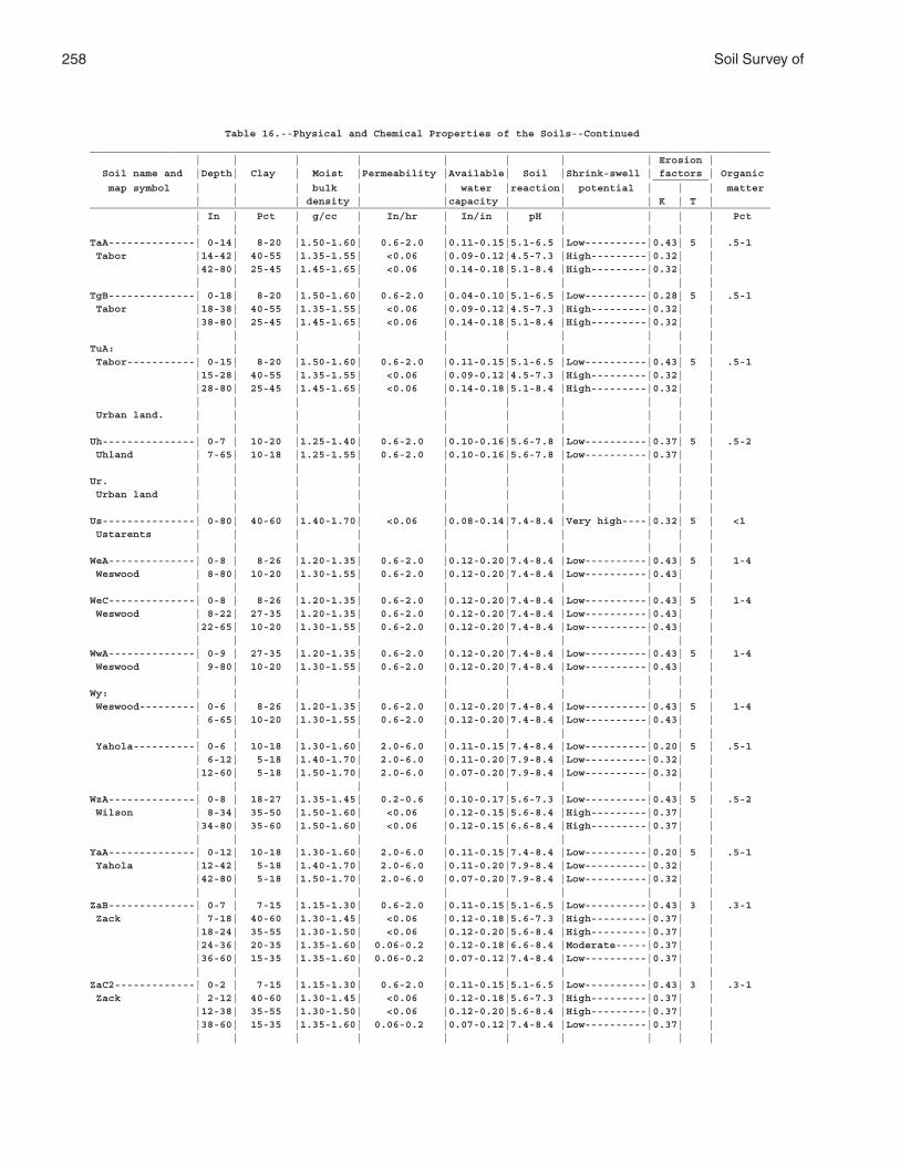
258 Soil Survey of
Table 16.--Physical and Chemical Properties of the Soils--Continued______________________________________________________________________________________________________________ | | | | | | | | Erosion | Soil name and |Depth| Clay | Moist |Permeability |Available| Soil |Shrink-swell | factors | Organic _________ map symbol | | | bulk | | water |reaction| potential | | | matter | | | density | |capacity | | | K | T |______________________________________________________________________________________________________________ | In | Pct | g/cc | In/hr | In/in | pH | | | | Pct | | | | | | | | | |TaA--------------| 0-14| 8-20 |1.50-1.60| 0.6-2.0 |0.11-0.15|5.1-6.5 |Low----------|0.43| 5 | .5-1 Tabor |14-42| 40-55 |1.35-1.55| <0.06 |0.09-0.12|4.5-7.3 |High---------|0.32| | |42-80| 25-45 |1.45-1.65| <0.06 |0.14-0.18|5.1-8.4 |High---------|0.32| | | | | | | | | | | |TgB--------------| 0-18| 8-20 |1.50-1.60| 0.6-2.0 |0.04-0.10|5.1-6.5 |Low----------|0.28| 5 | .5-1 Tabor |18-38| 40-55 |1.35-1.55| <0.06 |0.09-0.12|4.5-7.3 |High---------|0.32| | |38-80| 25-45 |1.45-1.65| <0.06 |0.14-0.18|5.1-8.4 |High---------|0.32| | | | | | | | | | | |TuA: | | | | | | | | | | Tabor-----------| 0-15| 8-20 |1.50-1.60| 0.6-2.0 |0.11-0.15|5.1-6.5 |Low----------|0.43| 5 | .5-1 |15-28| 40-55 |1.35-1.55| <0.06 |0.09-0.12|4.5-7.3 |High---------|0.32| | |28-80| 25-45 |1.45-1.65| <0.06 |0.14-0.18|5.1-8.4 |High---------|0.32| | | | | | | | | | | | Urban land. | | | | | | | | | | | | | | | | | | | |Uh---------------| 0-7 | 10-20 |1.25-1.40| 0.6-2.0 |0.10-0.16|5.6-7.8 |Low----------|0.37| 5 | .5-2 Uhland | 7-65| 10-18 |1.25-1.55| 0.6-2.0 |0.10-0.16|5.6-7.8 |Low----------|0.37| | | | | | | | | | | |Ur. | | | | | | | | | | Urban land | | | | | | | | | | | | | | | | | | | |Us---------------| 0-80| 40-60 |1.40-1.70| <0.06 |0.08-0.14|7.4-8.4 |Very high----|0.32| 5 | <1 Ustarents | | | | | | | | | | | | | | | | | | | |WeA--------------| 0-8 | 8-26 |1.20-1.35| 0.6-2.0 |0.12-0.20|7.4-8.4 |Low----------|0.43| 5 | 1-4 Weswood | 8-80| 10-20 |1.30-1.55| 0.6-2.0 |0.12-0.20|7.4-8.4 |Low----------|0.43| | | | | | | | | | | |WeC--------------| 0-8 | 8-26 |1.20-1.35| 0.6-2.0 |0.12-0.20|7.4-8.4 |Low----------|0.43| 5 | 1-4 Weswood | 8-22| 27-35 |1.20-1.35| 0.6-2.0 |0.12-0.20|7.4-8.4 |Low----------|0.43| | |22-65| 10-20 |1.30-1.55| 0.6-2.0 |0.12-0.20|7.4-8.4 |Low----------|0.43| | | | | | | | | | | |WwA--------------| 0-9 | 27-35 |1.20-1.35| 0.6-2.0 |0.12-0.20|7.4-8.4 |Low----------|0.43| 5 | 1-4 Weswood | 9-80| 10-20 |1.30-1.55| 0.6-2.0 |0.12-0.20|7.4-8.4 |Low----------|0.43| | | | | | | | | | | |Wy: | | | | | | | | | | Weswood---------| 0-6 | 8-26 |1.20-1.35| 0.6-2.0 |0.12-0.20|7.4-8.4 |Low----------|0.43| 5 | 1-4 | 6-65| 10-20 |1.30-1.55| 0.6-2.0 |0.12-0.20|7.4-8.4 |Low----------|0.43| | | | | | | | | | | | Yahola----------| 0-6 | 10-18 |1.30-1.60| 2.0-6.0 |0.11-0.15|7.4-8.4 |Low----------|0.20| 5 | .5-1 | 6-12| 5-18 |1.40-1.70| 2.0-6.0 |0.11-0.20|7.9-8.4 |Low----------|0.32| | |12-60| 5-18 |1.50-1.70| 2.0-6.0 |0.07-0.20|7.9-8.4 |Low----------|0.32| | | | | | | | | | | |WzA--------------| 0-8 | 18-27 |1.35-1.45| 0.2-0.6 |0.10-0.17|5.6-7.3 |Low----------|0.43| 5 | .5-2 Wilson | 8-34| 35-50 |1.50-1.60| <0.06 |0.12-0.15|5.6-8.4 |High---------|0.37| | |34-80| 35-60 |1.50-1.60| <0.06 |0.12-0.15|6.6-8.4 |High---------|0.37| | | | | | | | | | | |YaA--------------| 0-12| 10-18 |1.30-1.60| 2.0-6.0 |0.11-0.15|7.4-8.4 |Low----------|0.20| 5 | .5-1 Yahola |12-42| 5-18 |1.40-1.70| 2.0-6.0 |0.11-0.20|7.9-8.4 |Low----------|0.32| | |42-80| 5-18 |1.50-1.70| 2.0-6.0 |0.07-0.20|7.9-8.4 |Low----------|0.32| | | | | | | | | | | |ZaB--------------| 0-7 | 7-15 |1.15-1.30| 0.6-2.0 |0.11-0.15|5.1-6.5 |Low----------|0.43| 3 | .3-1 Zack | 7-18| 40-60 |1.30-1.45| <0.06 |0.12-0.18|5.6-7.3 |High---------|0.37| | |18-24| 35-55 |1.30-1.50| <0.06 |0.12-0.20|5.6-8.4 |High---------|0.37| | |24-36| 20-35 |1.35-1.60| 0.06-0.2 |0.12-0.18|6.6-8.4 |Moderate-----|0.37| | |36-60| 15-35 |1.35-1.60| 0.06-0.2 |0.07-0.12|7.4-8.4 |Low----------|0.37| | | | | | | | | | | |ZaC2-------------| 0-2 | 7-15 |1.15-1.30| 0.6-2.0 |0.11-0.15|5.1-6.5 |Low----------|0.43| 3 | .3-1 Zack | 2-12| 40-60 |1.30-1.45| <0.06 |0.12-0.18|5.6-7.3 |High---------|0.37| | |12-38| 35-55 |1.30-1.50| <0.06 |0.12-0.20|5.6-8.4 |High---------|0.37| | |38-60| 15-35 |1.35-1.60| 0.06-0.2 |0.07-0.12|7.4-8.4 |Low----------|0.37| | | | | | | | | | | |
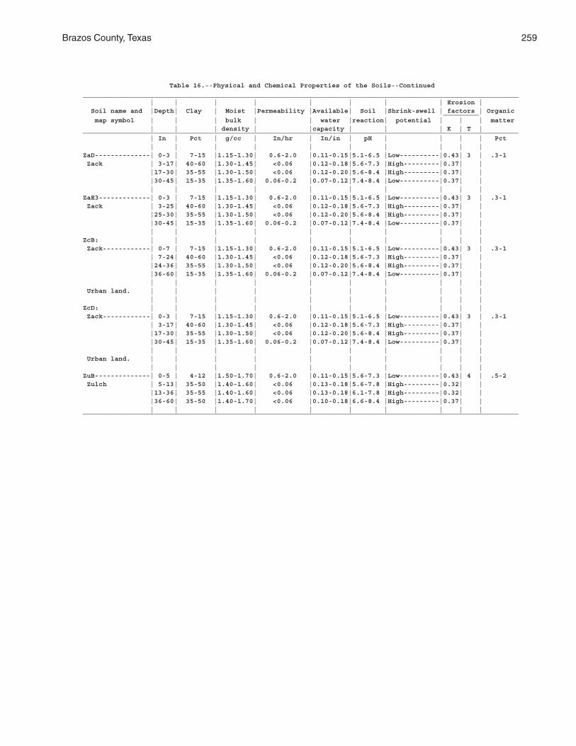
Brazos County, Texas 259
Table 16.--Physical and Chemical Properties of the Soils--Continued______________________________________________________________________________________________________________ | | | | | | | | Erosion | Soil name and |Depth| Clay | Moist |Permeability |Available| Soil |Shrink-swell | factors | Organic _________ map symbol | | | bulk | | water |reaction| potential | | | matter | | | density | |capacity | | | K | T |______________________________________________________________________________________________________________ | In | Pct | g/cc | In/hr | In/in | pH | | | | Pct | | | | | | | | | |ZaD--------------| 0-3 | 7-15 |1.15-1.30| 0.6-2.0 |0.11-0.15|5.1-6.5 |Low----------|0.43| 3 | .3-1 Zack | 3-17| 40-60 |1.30-1.45| <0.06 |0.12-0.18|5.6-7.3 |High---------|0.37| | |17-30| 35-55 |1.30-1.50| <0.06 |0.12-0.20|5.6-8.4 |High---------|0.37| | |30-45| 15-35 |1.35-1.60| 0.06-0.2 |0.07-0.12|7.4-8.4 |Low----------|0.37| | | | | | | | | | | |ZaE3-------------| 0-3 | 7-15 |1.15-1.30| 0.6-2.0 |0.11-0.15|5.1-6.5 |Low----------|0.43| 3 | .3-1 Zack | 3-25| 40-60 |1.30-1.45| <0.06 |0.12-0.18|5.6-7.3 |High---------|0.37| | |25-30| 35-55 |1.30-1.50| <0.06 |0.12-0.20|5.6-8.4 |High---------|0.37| | |30-45| 15-35 |1.35-1.60| 0.06-0.2 |0.07-0.12|7.4-8.4 |Low----------|0.37| | | | | | | | | | | |ZcB: | | | | | | | | | | Zack------------| 0-7 | 7-15 |1.15-1.30| 0.6-2.0 |0.11-0.15|5.1-6.5 |Low----------|0.43| 3 | .3-1 | 7-24| 40-60 |1.30-1.45| <0.06 |0.12-0.18|5.6-7.3 |High---------|0.37| | |24-36| 35-55 |1.30-1.50| <0.06 |0.12-0.20|5.6-8.4 |High---------|0.37| | |36-60| 15-35 |1.35-1.60| 0.06-0.2 |0.07-0.12|7.4-8.4 |Low----------|0.37| | | | | | | | | | | | Urban land. | | | | | | | | | | | | | | | | | | | |ZcD: | | | | | | | | | | Zack------------| 0-3 | 7-15 |1.15-1.30| 0.6-2.0 |0.11-0.15|5.1-6.5 |Low----------|0.43| 3 | .3-1 | 3-17| 40-60 |1.30-1.45| <0.06 |0.12-0.18|5.6-7.3 |High---------|0.37| | |17-30| 35-55 |1.30-1.50| <0.06 |0.12-0.20|5.6-8.4 |High---------|0.37| | |30-45| 15-35 |1.35-1.60| 0.06-0.2 |0.07-0.12|7.4-8.4 |Low----------|0.37| | | | | | | | | | | | Urban land. | | | | | | | | | | | | | | | | | | | |ZuB--------------| 0-5 | 4-12 |1.50-1.70| 0.6-2.0 |0.11-0.15|5.6-7.3 |Low----------|0.43| 4 | .5-2 Zulch | 5-13| 35-50 |1.40-1.60| <0.06 |0.13-0.18|5.6-7.8 |High---------|0.32| | |13-36| 35-55 |1.40-1.60| <0.06 |0.13-0.18|6.1-7.8 |High---------|0.32| | |36-60| 35-50 |1.40-1.70| <0.06 |0.10-0.18|6.6-8.4 |High---------|0.37| | | | | | | | | | | |______________________________________________________________________________________________________________
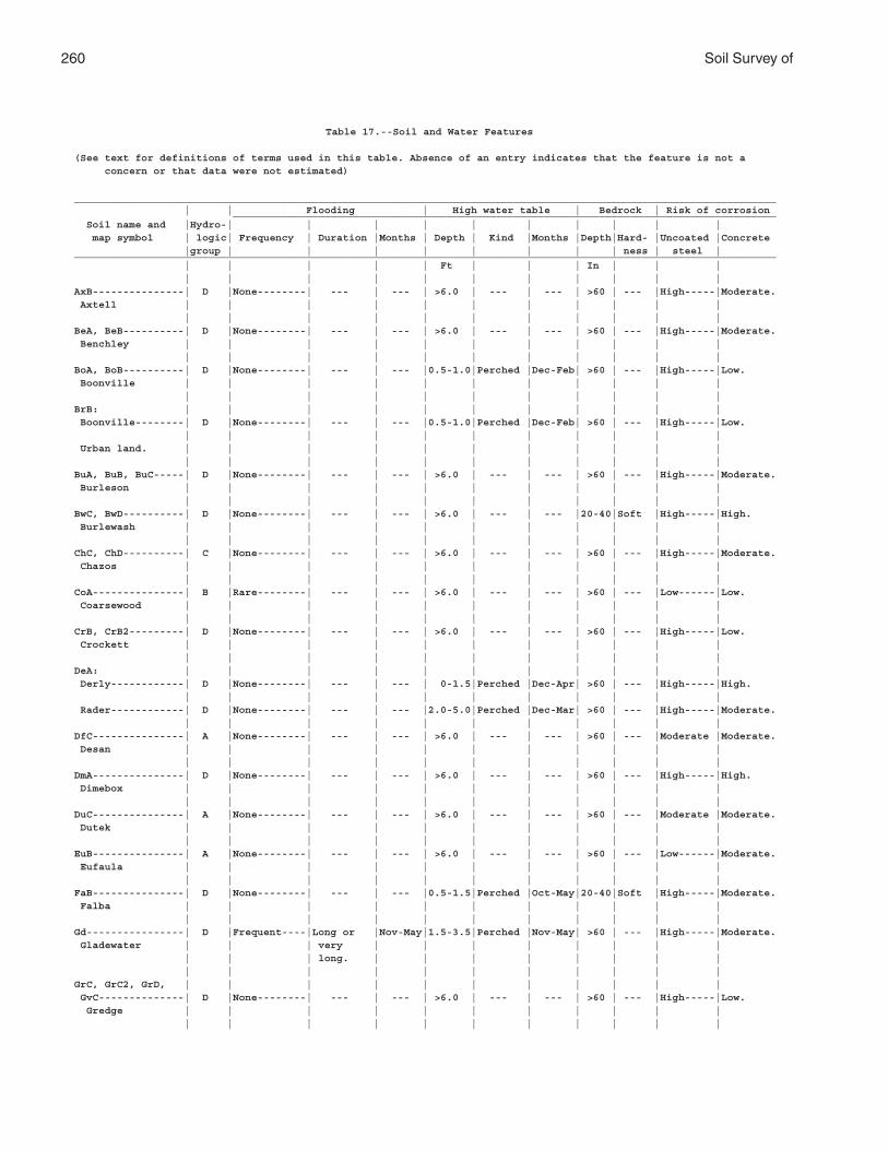
260 Soil Survey of
Table 17.--Soil and Water Features
(See text for definitions of terms used in this table. Absence of an entry indicates that the feature is not a concern or that data were not estimated)
___________________________________________________________________________________________________________________ | | Flooding | High water table | Bedrock | Risk of corrosion _________________________________________________________________________________________ Soil name and |Hydro-| | | | | | | | | | map symbol | logic| Frequency | Duration |Months | Depth | Kind |Months |Depth|Hard- |Uncoated |Concrete |group | | | | | | | | ness | steel |___________________________________________________________________________________________________________________ | | | | | Ft | | | In | | | | | | | | | | | | | |AxB---------------| D |None--------| --- | --- | >6.0 | --- | --- | >60 | --- |High-----|Moderate. Axtell | | | | | | | | | | | | | | | | | | | | | |BeA, BeB----------| D |None--------| --- | --- | >6.0 | --- | --- | >60 | --- |High-----|Moderate. Benchley | | | | | | | | | | | | | | | | | | | | | |BoA, BoB----------| D |None--------| --- | --- |0.5-1.0|Perched |Dec-Feb| >60 | --- |High-----|Low. Boonville | | | | | | | | | | | | | | | | | | | | | |BrB: | | | | | | | | | | | Boonville--------| D |None--------| --- | --- |0.5-1.0|Perched |Dec-Feb| >60 | --- |High-----|Low. | | | | | | | | | | | Urban land. | | | | | | | | | | | | | | | | | | | | | |BuA, BuB, BuC-----| D |None--------| --- | --- | >6.0 | --- | --- | >60 | --- |High-----|Moderate. Burleson | | | | | | | | | | | | | | | | | | | | | |BwC, BwD----------| D |None--------| --- | --- | >6.0 | --- | --- |20-40|Soft |High-----|High. Burlewash | | | | | | | | | | | | | | | | | | | | | |ChC, ChD----------| C |None--------| --- | --- | >6.0 | --- | --- | >60 | --- |High-----|Moderate. Chazos | | | | | | | | | | | | | | | | | | | | | |CoA---------------| B |Rare--------| --- | --- | >6.0 | --- | --- | >60 | --- |Low------|Low. Coarsewood | | | | | | | | | | | | | | | | | | | | | |CrB, CrB2---------| D |None--------| --- | --- | >6.0 | --- | --- | >60 | --- |High-----|Low. Crockett | | | | | | | | | | | | | | | | | | | | | |DeA: | | | | | | | | | | | Derly------------| D |None--------| --- | --- | 0-1.5|Perched |Dec-Apr| >60 | --- |High-----|High. | | | | | | | | | | | Rader------------| D |None--------| --- | --- |2.0-5.0|Perched |Dec-Mar| >60 | --- |High-----|Moderate. | | | | | | | | | | |DfC---------------| A |None--------| --- | --- | >6.0 | --- | --- | >60 | --- |Moderate |Moderate. Desan | | | | | | | | | | | | | | | | | | | | | |DmA---------------| D |None--------| --- | --- | >6.0 | --- | --- | >60 | --- |High-----|High. Dimebox | | | | | | | | | | | | | | | | | | | | | |DuC---------------| A |None--------| --- | --- | >6.0 | --- | --- | >60 | --- |Moderate |Moderate. Dutek | | | | | | | | | | | | | | | | | | | | | |EuB---------------| A |None--------| --- | --- | >6.0 | --- | --- | >60 | --- |Low------|Moderate. Eufaula | | | | | | | | | | | | | | | | | | | | | |FaB---------------| D |None--------| --- | --- |0.5-1.5|Perched |Oct-May|20-40|Soft |High-----|Moderate. Falba | | | | | | | | | | | | | | | | | | | | | |Gd----------------| D |Frequent----|Long or |Nov-May|1.5-3.5|Perched |Nov-May| >60 | --- |High-----|Moderate. Gladewater | | | very | | | | | | | | | | | long. | | | | | | | | | | | | | | | | | | |GrC, GrC2, GrD, | | | | | | | | | | | GvC--------------| D |None--------| --- | --- | >6.0 | --- | --- | >60 | --- |High-----|Low. Gredge | | | | | | | | | | | | | | | | | | | | | |
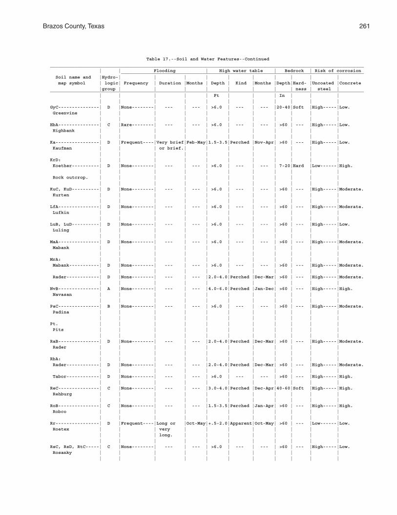
Brazos County, Texas 261
Table 17.--Soil and Water Features--Continued___________________________________________________________________________________________________________________ | | Flooding | High water table | Bedrock | Risk of corrosion _________________________________________________________________________________________ Soil name and |Hydro-| | | | | | | | | | map symbol | logic| Frequency | Duration |Months | Depth | Kind |Months |Depth|Hard- |Uncoated |Concrete |group | | | | | | | | ness | steel |___________________________________________________________________________________________________________________ | | | | | Ft | | | In | | | | | | | | | | | | | |GyC---------------| D |None--------| --- | --- | >6.0 | --- | --- |20-40|Soft |High-----|Low. Greenvine | | | | | | | | | | | | | | | | | | | | | |HbA---------------| C |Rare--------| --- | --- | >6.0 | --- | --- | >60 | --- |High-----|Low. Highbank | | | | | | | | | | | | | | | | | | | | | |Ka----------------| D |Frequent----|Very brief|Feb-May|1.5-3.5|Perched |Nov-Apr| >60 | --- |High-----|Low. Kaufman | | | or brief.| | | | | | | | | | | | | | | | | | |KrD: | | | | | | | | | | | Koether----------| D |None--------| --- | --- | >6.0 | --- | --- | 7-20|Hard |Low------|High. | | | | | | | | | | | Rock outcrop. | | | | | | | | | | | | | | | | | | | | | |KuC, KuD----------| D |None--------| --- | --- | >6.0 | --- | --- | >60 | --- |High-----|Moderate. Kurten | | | | | | | | | | | | | | | | | | | | | |LfA---------------| D |None--------| --- | --- | >6.0 | --- | --- | >60 | --- |High-----|Moderate. Lufkin | | | | | | | | | | | | | | | | | | | | | |LuB, LuD----------| D |None--------| --- | --- | >6.0 | --- | --- | >60 | --- |High-----|Low. Luling | | | | | | | | | | | | | | | | | | | | | |MaA---------------| D |None--------| --- | --- | >6.0 | --- | --- | >60 | --- |High-----|Moderate. Mabank | | | | | | | | | | | | | | | | | | | | | |MrA: | | | | | | | | | | | Mabank-----------| D |None--------| --- | --- | >6.0 | --- | --- | >60 | --- |High-----|Moderate. | | | | | | | | | | | Rader------------| D |None--------| --- | --- |2.0-4.0|Perched |Dec-Mar| >60 | --- |High-----|Moderate. | | | | | | | | | | |NvB---------------| A |None--------| --- | --- |4.0-6.0|Perched |Jan-Dec| >60 | --- |High-----|High. Navasan | | | | | | | | | | | | | | | | | | | | | |PaC---------------| B |None--------| --- | --- | >6.0 | --- | --- | >60 | --- |High-----|Moderate. Padina | | | | | | | | | | | | | | | | | | | | | |Pt. | | | | | | | | | | | Pits | | | | | | | | | | | | | | | | | | | | | |RaB---------------| D |None--------| --- | --- |2.0-4.0|Perched |Dec-Mar| >60 | --- |High-----|Moderate. Rader | | | | | | | | | | | | | | | | | | | | | |RbA: | | | | | | | | | | | Rader------------| D |None--------| --- | --- |2.0-4.0|Perched |Dec-Mar| >60 | --- |High-----|Moderate. | | | | | | | | | | | Tabor------------| D |None--------| --- | --- | >6.0 | --- | --- | >60 | --- |High-----|High. | | | | | | | | | | |ReC---------------| C |None--------| --- | --- |3.0-4.0|Perched |Dec-Apr|40-60|Soft |High-----|High. Rehburg | | | | | | | | | | | | | | | | | | | | | |RoB---------------| C |None--------| --- | --- |1.5-3.5|Perched |Jan-Apr| >60 | --- |High-----|High. Robco | | | | | | | | | | | | | | | | | | | | | |Rr----------------| D |Frequent----|Long or |Oct-May|+.5-2.0|Apparent|Oct-May| >60 | --- |Low------|Low. Roetex | | | very | | | | | | | | | | | long. | | | | | | | | | | | | | | | | | | |RsC, RsD, RtC-----| C |None--------| --- | --- | >6.0 | --- | --- | >60 | --- |High-----|Low. Rosanky | | | | | | | | | | | | | | | | | | | | | |
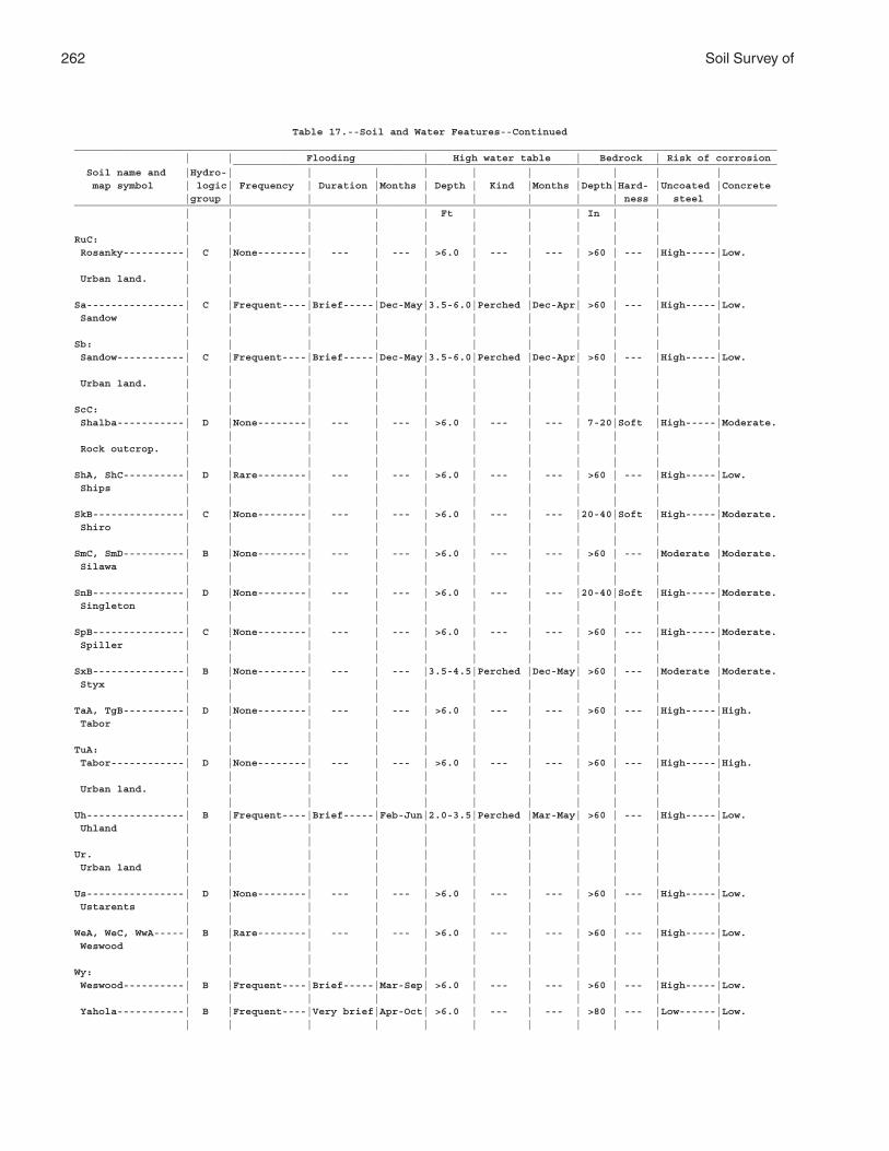
262 Soil Survey of
Table 17.--Soil and Water Features--Continued___________________________________________________________________________________________________________________ | | Flooding | High water table | Bedrock | Risk of corrosion _________________________________________________________________________________________ Soil name and |Hydro-| | | | | | | | | | map symbol | logic| Frequency | Duration |Months | Depth | Kind |Months |Depth|Hard- |Uncoated |Concrete |group | | | | | | | | ness | steel |___________________________________________________________________________________________________________________ | | | | | Ft | | | In | | | | | | | | | | | | | |RuC: | | | | | | | | | | | Rosanky----------| C |None--------| --- | --- | >6.0 | --- | --- | >60 | --- |High-----|Low. | | | | | | | | | | | Urban land. | | | | | | | | | | | | | | | | | | | | | |Sa----------------| C |Frequent----|Brief-----|Dec-May|3.5-6.0|Perched |Dec-Apr| >60 | --- |High-----|Low. Sandow | | | | | | | | | | | | | | | | | | | | | |Sb: | | | | | | | | | | | Sandow-----------| C |Frequent----|Brief-----|Dec-May|3.5-6.0|Perched |Dec-Apr| >60 | --- |High-----|Low. | | | | | | | | | | | Urban land. | | | | | | | | | | | | | | | | | | | | | |ScC: | | | | | | | | | | | Shalba-----------| D |None--------| --- | --- | >6.0 | --- | --- | 7-20|Soft |High-----|Moderate. | | | | | | | | | | | Rock outcrop. | | | | | | | | | | | | | | | | | | | | | |ShA, ShC----------| D |Rare--------| --- | --- | >6.0 | --- | --- | >60 | --- |High-----|Low. Ships | | | | | | | | | | | | | | | | | | | | | |SkB---------------| C |None--------| --- | --- | >6.0 | --- | --- |20-40|Soft |High-----|Moderate. Shiro | | | | | | | | | | | | | | | | | | | | | |SmC, SmD----------| B |None--------| --- | --- | >6.0 | --- | --- | >60 | --- |Moderate |Moderate. Silawa | | | | | | | | | | | | | | | | | | | | | |SnB---------------| D |None--------| --- | --- | >6.0 | --- | --- |20-40|Soft |High-----|Moderate. Singleton | | | | | | | | | | | | | | | | | | | | | |SpB---------------| C |None--------| --- | --- | >6.0 | --- | --- | >60 | --- |High-----|Moderate. Spiller | | | | | | | | | | | | | | | | | | | | | |SxB---------------| B |None--------| --- | --- |3.5-4.5|Perched |Dec-May| >60 | --- |Moderate |Moderate. Styx | | | | | | | | | | | | | | | | | | | | | |TaA, TgB----------| D |None--------| --- | --- | >6.0 | --- | --- | >60 | --- |High-----|High. Tabor | | | | | | | | | | | | | | | | | | | | | |TuA: | | | | | | | | | | | Tabor------------| D |None--------| --- | --- | >6.0 | --- | --- | >60 | --- |High-----|High. | | | | | | | | | | | Urban land. | | | | | | | | | | | | | | | | | | | | | |Uh----------------| B |Frequent----|Brief-----|Feb-Jun|2.0-3.5|Perched |Mar-May| >60 | --- |High-----|Low. Uhland | | | | | | | | | | | | | | | | | | | | | |Ur. | | | | | | | | | | | Urban land | | | | | | | | | | | | | | | | | | | | | |Us----------------| D |None--------| --- | --- | >6.0 | --- | --- | >60 | --- |High-----|Low. Ustarents | | | | | | | | | | | | | | | | | | | | | |WeA, WeC, WwA-----| B |Rare--------| --- | --- | >6.0 | --- | --- | >60 | --- |High-----|Low. Weswood | | | | | | | | | | | | | | | | | | | | | |Wy: | | | | | | | | | | | Weswood----------| B |Frequent----|Brief-----|Mar-Sep| >6.0 | --- | --- | >60 | --- |High-----|Low. | | | | | | | | | | | Yahola-----------| B |Frequent----|Very brief|Apr-Oct| >6.0 | --- | --- | >80 | --- |Low------|Low. | | | | | | | | | | |
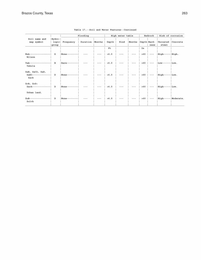
Brazos County, Texas 263
Table 17.--Soil and Water Features--Continued___________________________________________________________________________________________________________________ | | Flooding | High water table | Bedrock | Risk of corrosion _________________________________________________________________________________________ Soil name and |Hydro-| | | | | | | | | | map symbol | logic| Frequency | Duration |Months | Depth | Kind |Months |Depth|Hard- |Uncoated |Concrete |group | | | | | | | | ness | steel |___________________________________________________________________________________________________________________ | | | | | Ft | | | In | | | | | | | | | | | | | |WzA---------------| D |None--------| --- | --- | >6.0 | --- | --- | >60 | --- |High-----|High. Wilson | | | | | | | | | | | | | | | | | | | | | |YaA---------------| B |Rare--------| --- | --- | >6.0 | --- | --- | >60 | --- |Low------|Low. Yahola | | | | | | | | | | | | | | | | | | | | | |ZaB, ZaC2, ZaD, | | | | | | | | | | | ZaE3-------------| D |None--------| --- | --- | >6.0 | --- | --- | >60 | --- |High-----|Low. Zack | | | | | | | | | | | | | | | | | | | | | |ZcB, ZcD: | | | | | | | | | | | Zack-------------| D |None--------| --- | --- | >6.0 | --- | --- | >60 | --- |High-----|Low. | | | | | | | | | | | Urban land. | | | | | | | | | | | | | | | | | | | | | |ZuB---------------| D |None--------| --- | --- | >6.0 | --- | --- | >60 | --- |High-----|Moderate. Zulch | | | | | | | | | | | | | | | | | | | | | |___________________________________________________________________________________________________________________
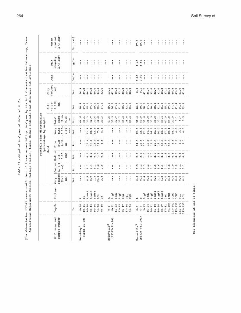
264 Soil Survey ofTable 18.--Physical Analyses of Selected Soils
(The abbreviation "COLE" means coefficient of linear extensibility. Analyses by the Soil Characterization Laboratory, Texas
Agricultural Experiment Station, College Station, Texas. Dashes indicate that data were not available)
____________________________________________________________________________________________________________________________
| | | Particle-size distribution | | |
| | | (percentage by weight) | | |
____________________________________________________________
| | | Sand | Silt | Clay | | |
| | |__________________________________________| (0.05- |(<0.002| COLE | Bulk | Water
Soil name and | Depth | Horizon |Very |Coarse|Medium| Fine | Very |Total | 0.002 | mm) | | density | content
sample number | | |coarse|(1-0.5|(0.5- | (0.25-| fine | Sand | mm) | | | (1/3 bar) | (1/3 bar)
| | | (2-1 | mm) | 0.25 | 0.10 |(0.10-| (2.0-| | | | |
| | | mm) | | mm) | mm) | 0.05 | 0.05 | | | | |
| | | | | | | mm) | mm | | | | |
____________________________________________________________________________________________________________________________
| In | | Pct | Pct | Pct | Pct | Pct | Pct | Pct | Pct | Cm/cm| g/cc | Pct (wt)
| | | | | | | | | | | | |
Benchley1 | 0-10 | A | --- | --- | --- | --- | --- | 44.6 | 30.4 | 24.9 | --- | --- | ---
(S62TX-21-90) | 10-16 | Bt | --- | --- | --- | --- | --- | 35.1 | 27.8 | 37.2 | --- | --- | ---
| 16-30 | Btss1 | 0.8 | 1.3 | 0.5 | 15.6 | 12.1 | 30.3 | 25.6 | 44.1 | --- | --- | ---
| 30-44 | Btss2 | 2.7 | 2.1 | 0.7 | 15.0 | 12.4 | 32.7 | 27.5 | 39.8 | --- | --- | ---
| 44-54 | Btss3 | 1.3 | 1.2 | 0.6 | 15.0 | 12.5 | 30.6 | 29.1 | 40.4 | --- | --- | ---
| 54-70 | BCt | 15.9 | 6.6 | 1.5 | 11.8 | 7.1 | 42.8 | 22.8 | 34.4 | --- | --- | ---
| 70-80 | Ck | 2.8 | 2.8 | 0.8 | 8.8 | 5.3 | 20.3 | 27.2 | 52.4 | --- | --- | ---
| | | | | | | | | | | | --- |
Boonville2 | 0-8 | A | --- | --- | --- | --- | --- | 47.5 | 39.5 | 13.1 | --- | --- | ---
(S53TX-21-90) | 8-11 | Btg1 | --- | --- | --- | --- | --- | 30.9 | 26.2 | 42.9 | --- | --- | ---
| 11-23 | Btg2 | --- | --- | --- | --- | --- | 32.7 | 27.1 | 40.3 | --- | --- | ---
| 23-35 | Btg3 | --- | --- | --- | --- | --- | 35.7 | 31.1 | 33.2 | --- | --- | ---
| 35-47 | BCg | --- | --- | --- | --- | --- | 39.3 | 30.8 | 30.0 | --- | --- | ---
| 47-64 | Cg1 | --- | --- | --- | --- | --- | 38.0 | 32.9 | 29.2 | --- | --- | ---
| 64-74 | Cg2 | --- | --- | --- | --- | --- | 27.6 | 33.6 | 38.9 | --- | --- | ---
| | | | | | | | | | | | |
Boonville3 | 0-6 | A | 0.6 | 0.5 | 2.9 | 24.3 | 22.3 | 50.6 | 40.5 | 8.9 | 0.03 | 1.43 | 27.8
(S83TX-041-001)| 6-9 | E | 0.1 | 0.2 | 2.6 | 25.6 | 22.4 | 50.9 | 40.0 | 9.1 | 0.02 | 1.56 | 19.6
| 9-15 | Btg1 | 0.4 | 0.3 | 1.6 | 15.1 | 12.6 | 30.0 | 28.8 | 41.2 | --- | --- | ---
| 15-24 | Btg2 | 0.2 | 0.2 | 1.9 | 18.8 | 14.9 | 36.0 | 27.3 | 36.7 | --- | --- | ---
| 24-31 | Btg3 | 0.3 | 0.1 | 2.0 | 19.0 | 16.5 | 37.9 | 30.1 | 32.0 | --- | --- | ---
| 31-40 | Btgk1 | 0.5 | 0.5 | 2.0 | 20.4 | 15.6 | 39.0 | 28.4 | 32.7 | --- | --- | ---
| 40-50 | Btgk2 | 2.1 | 1.6 | 2.3 | 17.1 | 14.0 | 37.1 | 31.9 | 31.0 | --- | --- | ---
| 50-67 | Btgk3 | 1.2 | 1.3 | 3.7 | 17.3 | 13.9 | 37.4 | 21.8 | 40.8 | --- | --- | ---
| 67-81 | 2BC | 0.0 | 0.1 | 1.1 | 29.5 | 17.2 | 47.9 | 25.0 | 27.1 | --- | --- | ---
| 81-123| 2CB1 | 0.0 | 0.0 | 0.5 | 10.3 | 12.4 | 23.2 | 37.9 | 38.9 | --- | --- | ---
|123-142| 2CB2 | 0.0 | 0.0 | 0.1 | 3.8 | 18.0 | 21.9 | 37.3 | 40.8 | --- | --- | ---
|142-151| 3CB3 | 0.0 | 0.2 | 0.5 | 3.6 | 4.8 | 9.1 | 41.4 | 49.5 | --- | --- | ---
|151-173| 4C1 | 0.0 | 0.1 | 0.1 | 1.3 | 3.2 | 4.7 | 44.3 | 51.0 | --- | --- | ---
|173-197| 4C2 | 0.1 | 0.1 | 0.2 | 1.1 | 4.0 | 5.5 | 52.9 | 41.6 | --- | --- | ---
| | | | | | | | | | | | |
See footnotes at end of table.
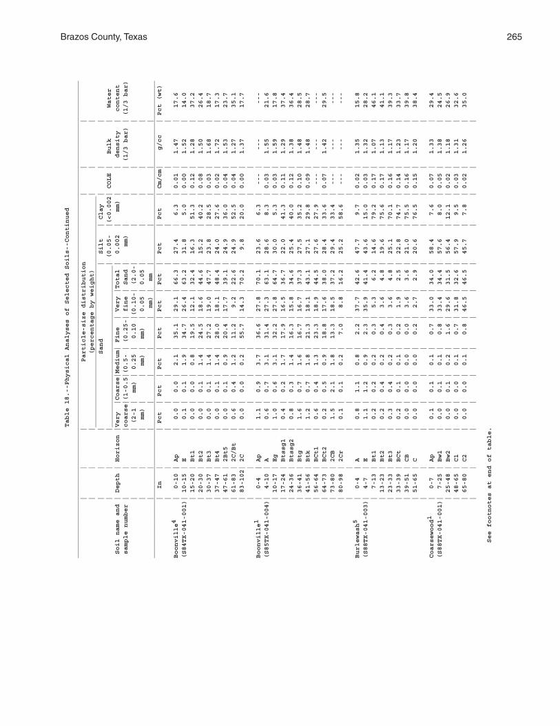
Brazos County, Texas 265
Table 18.--Physical Analyses of Selected Soils--Continued
____________________________________________________________________________________________________________________________
| | | Particle-size distribution | | |
| | | (percentage by weight) | | |
____________________________________________________________
| | | Sand | Silt | Clay | | |
| | |__________________________________________| (0.05- |(<0.002| COLE | Bulk | Water
Soil name and | Depth | Horizon |Very |Coarse|Medium| Fine | Very |Total | 0.002 | mm) | | density | content
sample number | | |coarse|(1-0.5|(0.5- | (0.25-| fine | Sand | mm) | | | (1/3 bar) | (1/3 bar)
| | | (2-1 | mm) | 0.25 | 0.10 |(0.10-| (2.0-| | | | |
| | | mm) | | mm) | mm) | 0.05 | 0.05 | | | | |
| | | | | | | mm) | mm | | | | |
____________________________________________________________________________________________________________________________
| In | | Pct | Pct | Pct | Pct | Pct | Pct | Pct | Pct | Cm/cm| g/cc | Pct (wt)
| | | | | | | | | | | | |
Boonville4 | 0-10 | Ap | 0.0 | 0.0 | 2.1 | 35.1 | 29.1 | 66.3 | 27.4 | 6.3 | 0.01 | 1.47 | 17.6
(S84TX-041-001)| 10-15 | E | 0.1 | 0.1 | 1.9 | 34.7 | 26.4 | 63.2 | 31.8 | 5.0 | 0.00 | 1.52 | 14.0
| 15-20 | Bt1 | 0.0 | 0.0 | 0.8 | 19.5 | 12.1 | 32.4 | 16.3 | 51.3 | 0.12 | 1.28 | 37.2
| 20-30 | Bt2 | 0.0 | 0.1 | 1.4 | 24.5 | 18.6 | 44.6 | 15.2 | 40.2 | 0.08 | 1.50 | 26.4
| 30-37 | Bt3 | 0.0 | 0.1 | 1.4 | 27.2 | 19.0 | 47.7 | 23.8 | 28.5 | 0.03 | 1.68 | 18.7
| 37-47 | Bt4 | 0.0 | 0.1 | 1.4 | 28.0 | 18.1 | 48.4 | 24.0 | 27.6 | 0.02 | 1.72 | 17.3
| 47-61 | 2Bt5 | 0.0 | 0.1 | 0.9 | 20.4 | 17.7 | 39.1 | 24.9 | 36.0 | 0.04 | 1.53 | 23.7
| 61-83 | 2C/Bt | 0.6 | 0.4 | 1.2 | 11.2 | 9.2 | 22.6 | 24.9 | 52.5 | 0.04 | 1.27 | 35.1
| 83-102| 2C | 0.0 | 0.0 | 0.2 | 55.7 | 14.3 | 70.2 | 9.8 | 20.0 | 0.00 | 1.37 | 17.7
| | | | | | | | | | | | |
Boonville1 | 0-4 | Ap | 1.1 | 0.9 | 3.7 | 36.6 | 27.8 | 70.1 | 23.6 | 6.3 | --- | --- | ---
(S85TX-041-004)| 4-10 | A | 0.6 | 0.7 | 3.1 | 31.4 | 27.3 | 63.1 | 28.6 | 8.3 | 0.03 | 1.55 | 21.6
| 10-17 | Eg | 1.0 | 0.6 | 3.1 | 32.2 | 27.8 | 64.7 | 30.0 | 5.3 | 0.03 | 1.59 | 17.8
| 17-24 | Btssg1 | 0.4 | 0.2 | 1.7 | 17.9 | 16.5 | 36.7 | 22.0 | 41.3 | 0.11 | 1.29 | 37.4
| 24-36 | Btssg2 | 0.8 | 0.3 | 1.4 | 16.3 | 15.8 | 34.6 | 25.4 | 40.0 | 0.12 | 1.38 | 36.4
| 36-41 | Btg | 1.6 | 0.7 | 1.6 | 16.7 | 16.7 | 37.3 | 27.5 | 35.2 | 0.10 | 1.48 | 28.5
| 41-56 | Btk | 1.2 | 0.7 | 1.8 | 21.3 | 18.1 | 43.1 | 27.1 | 29.8 | 0.09 | 1.48 | 28.7
| 56-64 | BCt1 | 0.6 | 0.4 | 1.3 | 23.3 | 18.9 | 44.5 | 27.6 | 27.9 | --- | --- | ---
| 64-73 | BCt2 | 0.2 | 0.5 | 0.9 | 18.8 | 17.6 | 38.0 | 28.4 | 33.6 | 0.07 | 1.42 | 29.5
| 73-80 | 2CB | 1.5 | 2.1 | 1.8 | 13.3 | 18.5 | 37.2 | 29.4 | 33.4 | --- | --- | ---
| 80-98 | 2Cr | 0.1 | 0.1 | 0.2 | 7.0 | 8.8 | 16.2 | 25.2 | 58.6 | --- | --- | ---
| | | | | | | | | | | | |
Burlewash5 | 0-4 | A | 0.8 | 1.1 | 0.8 | 2.2 | 37.7 | 42.6 | 47.7 | 9.7 | 0.02 | 1.35 | 15.8
(S88TX-041-003)| 4-7 | E | 1.1 | 1.2 | 0.9 | 2.3 | 35.9 | 41.4 | 43.6 | 15.0 | 0.03 | 1.32 | 28.2
| 7-13 | Bt1 | 0.2 | 0.2 | 0.2 | 0.3 | 5.3 | 6.2 | 14.6 | 79.2 | 0.17 | 1.07 | 46.1
| 13-23 | Bt2 | 0.2 | 0.4 | 0.2 | 0.4 | 3.6 | 4.8 | 19.6 | 75.6 | 0.17 | 1.13 | 41.1
| 23-33 | Bt3 | 0.3 | 0.4 | 0.2 | 0.3 | 3.6 | 4.8 | 25.1 | 70.1 | 0.16 | 1.17 | 39.3
| 33-39 | BCt | 0.2 | 0.1 | 0.1 | 0.2 | 1.9 | 2.5 | 22.8 | 74.7 | 0.14 | 1.23 | 33.7
| 39-51 | CB | 0.0 | 0.0 | 0.0 | 0.0 | 3.6 | 3.6 | 21.0 | 75.5 | 0.16 | 1.17 | 39.8
| 51-65 | C | 0.0 | 0.0 | 0.0 | 0.2 | 2.7 | 2.9 | 20.6 | 76.5 | 0.15 | 1.20 | 38.4
| | | | | | | | | | | | |
Coarsewood1 | 0-7 | Ap | 0.1 | 0.1 | 0.1 | 0.7 | 33.0 | 34.0 | 58.4 | 7.6 | 0.07 | 1.33 | 29.4
(S88TX-041-001)| 7-25 | Bw1 | 0.0 | 0.1 | 0.1 | 0.8 | 33.4 | 34.4 | 57.6 | 8.0 | 0.05 | 1.38 | 24.5
| 25-48 | Bw2 | 0.0 | 0.1 | 0.2 | 1.6 | 29.6 | 31.5 | 56.4 | 12.1 | 0.02 | 1.18 | 26.9
| 48-65 | C1 | 0.0 | 0.0 | 0.1 | 0.7 | 31.8 | 32.6 | 57.9 | 9.5 | 0.03 | 1.31 | 32.6
| 65-80 | C2 | 0.0 | 0.0 | 0.1 | 0.8 | 46.5 | 46.5 | 45.7 | 7.8 | 0.02 | 1.26 | 35.0
| | | | | | | | | | | | |
See footnotes at end of table.
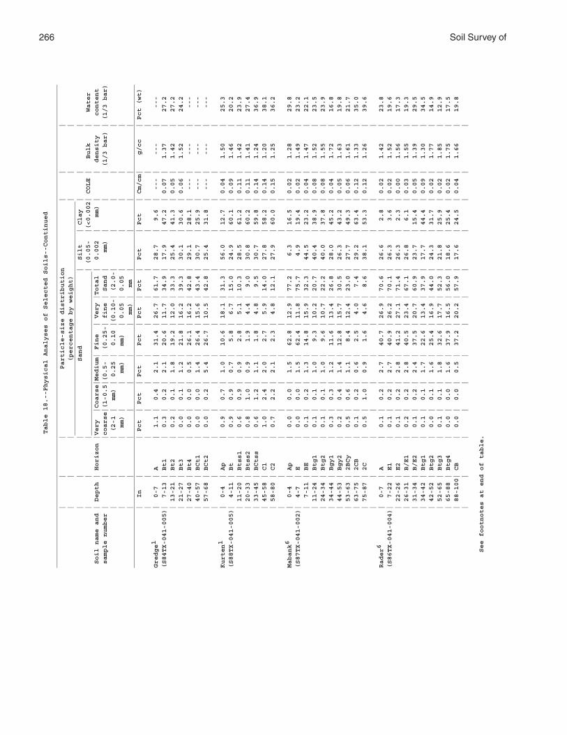
266 Soil Survey ofTable 18.--Physical Analyses of Selected Soils--Continued
____________________________________________________________________________________________________________________________
| | | Particle-size distribution | | |
| | | (percentage by weight) | | |
____________________________________________________________
| | | Sand | Silt | Clay | | |
| | |__________________________________________| (0.05- |(<0.002| COLE | Bulk | Water
Soil name and | Depth | Horizon |Very |Coarse|Medium| Fine | Very |Total | 0.002 | mm) | | density | content
sample number | | |coarse|(1-0.5|(0.5- | (0.25-| fine | Sand | mm) | | | (1/3 bar) | (1/3 bar)
| | | (2-1 | mm) | 0.25 | 0.10 |(0.10-| (2.0-| | | | |
| | | mm) | | mm) | mm) | 0.05 | 0.05 | | | | |
| | | | | | | mm) | mm | | | | |
____________________________________________________________________________________________________________________________
| In | | Pct | Pct | Pct | Pct | Pct | Pct | Pct | Pct | Cm/cm| g/cc | Pct (wt)
| | | | | | | | | | | | |
Gredge1 | 0-7 | A | 1.1 | 0.4 | 2.1 | 31.4 | 26.7 | 61.7 | 28.7 | 9.6 | --- | --- | ---
(S84TX-041-005)| 7-13 | Bt1 | 0.3 | 0.2 | 2.1 | 20.6 | 11.7 | 34.9 | 17.9 | 47.2 | 0.07 | 1.37 | 27.2
| 13-21 | Bt2 | 0.2 | 0.1 | 1.8 | 19.2 | 12.0 | 33.3 | 25.4 | 41.3 | 0.05 | 1.42 | 27.2
| 21-27 | Bt3 | 0.0 | 0.1 | 1.2 | 21.8 | 16.2 | 39.3 | 30.1 | 30.6 | 0.06 | 1.52 | 24.2
| 27-40 | Bt4 | 0.0 | 0.0 | 0.5 | 26.1 | 16.2 | 42.8 | 29.1 | 28.1 | --- | --- | ---
| 40-57 | BCt1 | 0.0 | 0.0 | 1.4 | 26.4 | 15.6 | 43.4 | 30.7 | 25.9 | --- | --- | ---
| 57-68 | BCt2 | 0.0 | 0.2 | 5.4 | 26.7 | 10.5 | 42.8 | 25.4 | 31.8 | --- | --- | ---
| | | | | | | | | | | | |
Kurten1 | 0-4 | Ap | 0.9 | 0.7 | 1.0 | 10.6 | 18.1 | 31.3 | 56.0 | 12.7 | 0.04 | 1.50 | 25.3
(S88TX-041-005)| 4-11 | Bt | 0.9 | 0.9 | 0.7 | 5.8 | 6.7 | 15.0 | 24.9 | 60.1 | 0.09 | 1.46 | 20.2
| 11-20 | Btss1 | 0.6 | 0.9 | 0.9 | 2.8 | 5.1 | 10.3 | 28.5 | 61.2 | 0.11 | 1.42 | 23.9
| 20-33 | Btss2 | 0.8 | 1.0 | 0.9 | 1.9 | 4.4 | 9.0 | 30.8 | 60.2 | 0.11 | 1.41 | 27.4
| 33-45 | BCtss | 0.6 | 1.2 | 1.1 | 1.8 | 4.8 | 9.5 | 30.7 | 59.8 | 0.14 | 1.24 | 36.9
| 45-58 | C1 | 1.0 | 2.4 | 2.0 | 2.7 | 5.9 | 14.0 | 27.8 | 58.2 | 0.14 | 1.20 | 38.1
| 58-80 | C2 | 0.7 | 2.2 | 2.1 | 2.3 | 4.8 | 12.1 | 27.9 | 60.0 | 0.15 | 1.25 | 36.2
| | | | | | | | | | | | |
Mabank6 | 0-4 | Ap | 0.0 | 0.0 | 1.5 | 62.8 | 12.9 | 77.2 | 6.3 | 16.5 | 0.02 | 1.28 | 29.8
(S87TX-041-002)| 4-7 | E | 0.0 | 0.0 | 1.5 | 62.4 | 11.8 | 75.7 | 4.9 | 19.4 | 0.02 | 1.49 | 23.2
| 7-11 | BE | 0.1 | 0.2 | 1.3 | 14.8 | 15.9 | 32.3 | 44.5 | 23.2 | 0.04 | 1.47 | 22.1
| 11-24 | Btg1 | 0.1 | 0.1 | 1.0 | 9.3 | 10.2 | 20.7 | 40.4 | 38.9 | 0.08 | 1.52 | 23.5
| 24-34 | Btg2 | 0.1 | 0.1 | 1.0 | 9.6 | 10.7 | 22.2 | 40.0 | 37.8 | 0.08 | 1.55 | 23.9
| 34-44 | Bgy1 | 0.3 | 0.3 | 1.2 | 11.6 | 13.4 | 26.8 | 28.0 | 45.2 | 0.04 | 1.72 | 16.8
| 44-53 | Bgy2 | 0.2 | 0.4 | 1.4 | 12.8 | 15.7 | 30.5 | 26.3 | 43.2 | 0.05 | 1.63 | 19.8
| 53-63 | 2BCy | 0.5 | 0.6 | 1.1 | 8.4 | 12.4 | 23.0 | 27.7 | 49.3 | 0.06 | 1.61 | 21.7
| 63-75 | 2CB | 0.1 | 0.2 | 0.6 | 2.5 | 4.0 | 7.4 | 29.2 | 63.4 | 0.12 | 1.33 | 35.0
| 75-87 | 2C | 0.5 | 1.0 | 0.9 | 1.6 | 4.6 | 8.6 | 38.1 | 53.3 | 0.12 | 1.26 | 39.6
| | | | | | | | | | | | |
Rader6 | 0-7 | A | 0.1 | 0.2 | 2.7 | 40.7 | 26.9 | 70.6 | 26.6 | 2.8 | 0.02 | 1.42 | 23.8
(S86TX-041-004)| 7-22 | E1 | 0.1 | 0.2 | 2.7 | 40.9 | 26.2 | 70.1 | 26.3 | 3.6 | 0.02 | 1.52 | 19.6
| 22-26 | E2 | 0.1 | 0.2 | 2.8 | 41.2 | 27.1 | 71.4 | 26.3 | 2.3 | 0.00 | 1.56 | 17.3
| 26-31 | B/E1 | 0.2 | 0.2 | 2.8 | 40.5 | 23.4 | 67.1 | 26.8 | 6.1 | 0.03 | 1.55 | 19.3
| 31-34 | B/E2 | 0.1 | 0.2 | 2.4 | 37.5 | 20.7 | 60.9 | 23.7 | 15.4 | 0.05 | 1.39 | 29.5
| 34-42 | Btg1 | 0.1 | 0.1 | 1.7 | 22.6 | 13.4 | 37.9 | 17.7 | 44.4 | 0.09 | 1.30 | 34.5
| 42-52 | Btg2 | 0.0 | 0.1 | 1.6 | 25.4 | 16.9 | 44.0 | 24.3 | 31.7 | 0.02 | 1.77 | 14.9
| 52-65 | Btg3 | 0.1 | 0.1 | 1.8 | 32.6 | 17.7 | 52.3 | 21.8 | 25.9 | 0.02 | 1.85 | 12.9
| 65-88 | Btg4 | 0.0 | 0.0 | 1.6 | 37.9 | 16.5 | 56.0 | 18.6 | 25.4 | 0.02 | 1.75 | 17.5
| 88-100| CB | 0.0 | 0.0 | 0.5 | 37.2 | 20.2 | 57.9 | 17.6 | 24.5 | 0.04 | 1.66 | 19.8
| | | | | | | | | | | | |
See footnotes at end of table.
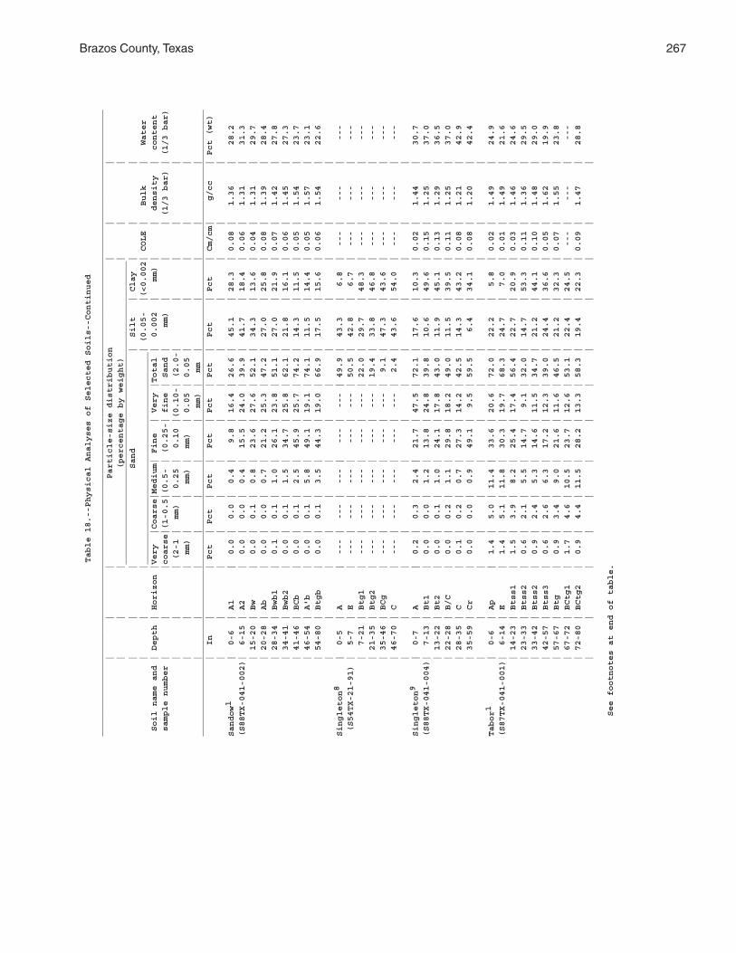
Brazos County, Texas 267
Table 18.--Physical Analyses of Selected Soils--Continued
____________________________________________________________________________________________________________________________
| | | Particle-size distribution | | |
| | | (percentage by weight) | | |
____________________________________________________________
| | | Sand | Silt | Clay | | |
| | |__________________________________________| (0.05- |(<0.002| COLE | Bulk | Water
Soil name and | Depth | Horizon |Very |Coarse|Medium| Fine | Very |Total | 0.002 | mm) | | density | content
sample number | | |coarse|(1-0.5|(0.5- | (0.25-| fine | Sand | mm) | | | (1/3 bar) | (1/3 bar)
| | | (2-1 | mm) | 0.25 | 0.10 |(0.10-| (2.0-| | | | |
| | | mm) | | mm) | mm) | 0.05 | 0.05 | | | | |
| | | | | | | mm) | mm | | | | |
____________________________________________________________________________________________________________________________
| In | | Pct | Pct | Pct | Pct | Pct | Pct | Pct | Pct | Cm/cm| g/cc | Pct (wt)
| | | | | | | | | | | | |
Sandow1 | 0-6 | A1 | 0.0 | 0.0 | 0.4 | 9.8 | 16.4 | 26.6 | 45.1 | 28.3 | 0.08 | 1.36 | 28.2
(S88TX-041-002)| 6-15 | A2 | 0.0 | 0.0 | 0.4 | 15.5 | 24.0 | 39.9 | 41.7 | 18.4 | 0.06 | 1.31 | 31.3
| 15-20 | Bw | 0.0 | 0.1 | 0.8 | 23.6 | 27.6 | 52.1 | 34.3 | 13.6 | 0.04 | 1.31 | 29.7
| 20-28 | Ab | 0.0 | 0.0 | 0.7 | 21.2 | 25.3 | 47.2 | 27.0 | 25.8 | 0.08 | 1.39 | 28.4
| 28-34 | Bwb1 | 0.1 | 0.1 | 1.0 | 26.1 | 23.8 | 51.1 | 27.0 | 21.9 | 0.07 | 1.42 | 27.8
| 34-41 | Bwb2 | 0.0 | 0.1 | 1.5 | 34.7 | 25.8 | 62.1 | 21.8 | 16.1 | 0.06 | 1.45 | 27.3
| 41-46 | BCb | 0.0 | 0.1 | 2.5 | 45.9 | 25.7 | 74.2 | 14.3 | 11.5 | 0.05 | 1.54 | 23.7
| 46-54 | A'b | 0.0 | 0.1 | 5.8 | 49.1 | 19.1 | 74.1 | 11.5 | 14.4 | 0.05 | 1.57 | 23.1
| 54-80 | Btgb | 0.0 | 0.1 | 3.5 | 44.3 | 19.0 | 66.9 | 17.5 | 15.6 | 0.06 | 1.54 | 22.6
| | | | | | | | | | | | |
Singleton8 | 0-5 | A | --- | --- | --- | --- | --- | 49.9 | 43.3 | 6.8 | --- | --- | ---
(S54TX-21-91) | 5-7 | E | --- | --- | --- | --- | --- | 50.5 | 42.8 | 6.7 | --- | --- | ---
| 7-21 | Btg1 | --- | --- | --- | --- | --- | 22.0 | 29.7 | 48.3 | --- | --- | ---
| 21-35 | Btg2 | --- | --- | --- | --- | --- | 19.4 | 33.8 | 46.8 | --- | --- | ---
| 35-46 | BCg | --- | --- | --- | --- | --- | 9.1 | 47.3 | 43.6 | --- | --- | ---
| 46-70 | C | --- | --- | --- | --- | --- | 2.4 | 43.6 | 54.0 | --- | --- | ---
| | | | | | | | | | | | |
Singleton9 | 0-7 | A | 0.2 | 0.3 | 2.4 | 21.7 | 47.5 | 72.1 | 17.6 | 10.3 | 0.02 | 1.44 | 30.7
(S88TX-041-004)| 7-13 | Bt1 | 0.0 | 0.0 | 1.2 | 13.8 | 24.8 | 39.8 | 10.6 | 49.6 | 0.15 | 1.25 | 37.0
| 13-22 | Bt2 | 0.0 | 0.1 | 1.0 | 24.1 | 17.8 | 43.0 | 11.9 | 45.1 | 0.13 | 1.29 | 36.5
| 22-28 | B/C | 0.0 | 0.2 | 1.1 | 29.8 | 18.2 | 49.0 | 11.5 | 39.5 | 0.11 | 1.25 | 37.0
| 28-35 | C | 0.1 | 0.2 | 0.7 | 27.3 | 14.2 | 42.5 | 14.3 | 43.2 | 0.08 | 1.21 | 42.9
| 35-59 | Cr | 0.0 | 0.0 | 0.9 | 49.1 | 9.5 | 59.5 | 6.4 | 34.1 | 0.08 | 1.20 | 42.4
| | | | | | | | | | | | |
Tabor1 | 0-6 | Ap | 1.4 | 5.0 | 11.4 | 33.6 | 20.6 | 72.0 | 22.2 | 5.8 | 0.02 | 1.49 | 24.9
(S87TX-041-001)| 6-14 | E | 1.4 | 5.1 | 11.8 | 30.3 | 19.7 | 68.3 | 24.7 | 7.0 | 0.01 | 1.49 | 21.6
| 14-23 | Btss1 | 1.5 | 3.9 | 8.2 | 25.4 | 17.4 | 56.4 | 22.7 | 20.9 | 0.03 | 1.46 | 24.6
| 23-33 | Btss2 | 0.6 | 2.1 | 5.5 | 14.7 | 9.1 | 32.0 | 14.7 | 53.3 | 0.11 | 1.36 | 29.5
| 33-42 | Btss2 | 0.9 | 2.4 | 5.3 | 14.6 | 11.5 | 34.7 | 21.2 | 44.1 | 0.10 | 1.48 | 29.0
| 42-57 | Btss3 | 0.6 | 2.6 | 6.3 | 17.2 | 12.3 | 39.0 | 24.4 | 36.6 | 0.05 | 1.62 | 19.9
| 57-67 | Btg | 0.9 | 3.4 | 9.0 | 21.6 | 11.6 | 46.5 | 21.2 | 32.3 | 0.07 | 1.55 | 23.8
| 67-72 | BCtg1 | 1.7 | 4.6 | 10.5 | 23.7 | 12.6 | 53.1 | 22.4 | 24.5 | --- | --- | ---
| 72-80 | BCtg2 | 0.9 | 4.4 | 11.5 | 28.2 | 13.3 | 58.3 | 19.4 | 22.3 | 0.09 | 1.47 | 28.8
| | | | | | | | | | | | |
See footnotes at end of table.
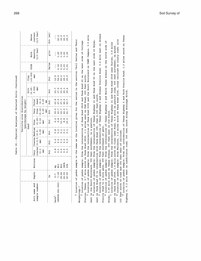
268 Soil Survey ofTable 18.--Physical Analyses of Selected Soils--Continued
____________________________________________________________________________________________________________________________
| | | Particle-size distribution | | |
| | | (percentage by weight) | | |
____________________________________________________________
| | | Sand | Silt | Clay | | |
| | |__________________________________________| (0.05- |(<0.002| COLE | Bulk | Water
Soil name and | Depth | Horizon |Very |Coarse|Medium| Fine | Very |Total | 0.002 | mm) | | density | content
sample number | | |coarse|(1-0.5|(0.5- | (0.25-| fine | Sand | mm) | | | (1/3 bar) | (1/3 bar)
| | | (2-1 | mm) | 0.25 | 0.10 |(0.10-| (2.0-| | | | |
| | | mm) | | mm) | mm) | 0.05 | 0.05 | | | | |
| | | | | | | mm) | mm | | | | |
____________________________________________________________________________________________________________________________
| In | | Pct | Pct | Pct | Pct | Pct | Pct | Pct | Pct | Cm/cm| g/cc | Pct (wt)
| | | | | | | | | | | | |
Zack1 | 0-7 | Ap | 0.8 | 0.6 | 0.8 | 6.2 | 39.0 | 63.8 | 23.7 | 12.5 | --- | --- | ---
(S84TX-041-002)| 7-18 | Bt1 | 0.1 | 0.0 | 0.2 | 6.8 | 20.7 | 27.5 | 17.9 | 54.6 | 0.16 | 1.20 | 42.2
| 18-24 | Bt2 | 0.0 | 0.1 | 0.1 | 13.5 | 22.7 | 27.3 | 23.5 | 49.2 | 0.10 | 1.32 | 32.6
| 24-36 | 2BCk | 0.5 | 0.2 | 0.1 | 8.8 | 42.6 | 46.6 | 25.1 | 28.3 | 0.03 | 1.41 | 26.5
| 36-60 | 2Ck | 0.0 | 0.0 | 0.1 | 10.0 | 41.7 | 43.7 | 29.4 | 26.9 | 0.01 | 1.36 | 25.3
| | | | | | | | | | | | |
____________________________________________________________________________________________________________________________
1 Location of pedon sample is the same as the location given for the series in the section "Soil Series and Their
Morphology."
2 Location of pedon sample: From the intersection of Farm Road 2818 and Farm Road 60 on the west side of College
Station, Texas, 0.7 mile north on Farm Road 2818, 1.1 miles east on F&B Road, 200 feet north.
3 Location of pedon sample: From the intersection of Farm Road 2154 and Joe Routt Boulevard on TAMU Campus, 0.5 mile
west on Joe Routt Boulevard, 300 feet southwest, in a pasture.
4 Location of pedon sample: From the intersection of Texas Highway 21 and Farm Road 60 on the east side of Bryan,
east on Farm Road 60 to intersection with Farm Road 158, then 4,100 feet north.
5 Location of pedon sample: From the intersection of Texas Highway 6 and Greens Prairie Road, 0.4 mile east on Greens
Prairie Road to a wire gate, 300 feet northeast of gate.
6 Location of pedon sample: From the intersection of Texas Highway 6 and North Texas Avenue on the north side of
Bryan, 0.45 mile south on Texas Avenue, 500 feet east in old field.
7 Location of pedon sample: From the intersection of Texas Highway 21 and Farm Road 2038 near Kurten, 3.8 miles
east on Farm Road 2038, 1.0 mile north on Clear Lake Road, 0.4 mile on pasture road, 200 feet northwest, on mound.
8 Location of pedon sample: From Wellborn, 1.2 miles south on Farm Road 2154, cross railroad on county road; site
100 feet north of road and 100 feet west of railroad.
9 Location of pedon sample: From the intersection of Texas Highway 6 and Rock Prairie Road, 1.2 miles south on Texas
Highway 6, 0.2 mile west on subdivision road, 300 feet south along drainage ditch.
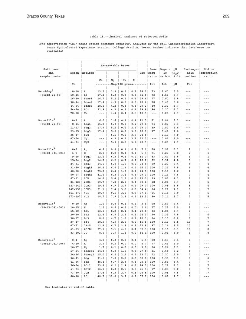
Brazos County, Texas 269
Table 19.--Chemical Analyses of Selected Soils
(The abbreviation "CEC" means cation-exchange capacity. Analyses by the Soil Characterization Laboratory, Texas Agricultural Experiment Station, College Station, Texas. Dashes indicate that data were not available)
__________________________________________________________________________________________________________ | | | | | | | | | | | | Extractable bases | | | | | | Soil name | | |________________________| | Base |Organ-| pH | Exchange-| Sodium and | Depth |Horizon| | | | | CEC |satu- | ic |(H2O | able |adsorption sample number | | | | | | | |ration|carbon| 1:1)| sodium | ratio | | | Ca | Mg | Na | K | | | | | |__________________________________________________________________________________________________________ | In | |---------Meq/100 grams--------| Pct | Pct | pH | Pct | | | | | | | | | | | | |Benchley1 | 0-10 | A | 13.2 | 3.9 | 0.2 | 0.2| 24.1| 73 | 1.60 | 5.9 | --- | --- (S62TX-21-90) | 10-16 | Bt | 17.2 | 5.3 | 0.3 | 0.3| 31.6| 73 | 1.50 | 5.7 | --- | --- | 16-30 | Btss1 | 16.7 | 5.2 | 0.2 | 0.4| 29.4| 77 | 0.80 | 5.8 | --- | --- | 30-44 | Btss2 | 17.4 | 4.3 | 0.2 | 0.3| 28.4| 78 | 0.40 | 5.6 | --- | --- | 44-54 | Btss3 | 18.5 | 4.2 | 0.3 | 0.3| 29.2| 80 | 0.30 | 5.7 | --- | --- | 54-70 | BCt | 22.9 | 4.3 | 0.3 | 0.4| 29.9| 90 | 0.20 | 6.2 | --- | --- | 70-80 | Ck | --- | 4.4 | 0.4 | 0.5| 43.9| --- | 0.20 | 7.7 | --- | --- | | | | | | | | | | | |Boonville2 | 0-8 | A | 6.0 | 1.6 | 0.1 | 0.4| 11.5| 71 | 1.04 | 6.3 | --- | --- (S53TX-21-90) | 8-11 | Btg1 | 15.8 | 6.0 | 0.2 | 0.2| 29.8| 74 | 0.87 | 5.3 | --- | --- | 11-23 | Btg2 | 17.9 | 5.2 | 0.2 | 2.5| 29.0| 89 | 0.52 | 5.6 | --- | --- | 23-35 | Btg3 | 17.4 | 5.0 | 0.2 | 3.3| 26.9| 97 | 0.41 | 7.0 | --- | --- | 35-47 | BCg | --- | 5.1 | 0.2 | 3.7| 24.6| --- | 0.17 | 7.9 | --- | --- | 47-64 | Cg1 | --- | 4.9 | 0.2 | 3.9| 22.7| --- | 0.06 | 8.0 | --- | --- | 64-74 | Cg2 | --- | 5.9 | 0.2 | 5.2| 28.9| --- | 0.06 | 7.7 | --- | --- | | | | | | | | | | | |Boonville3 | 0-6 | Ap | 4.8 | 0.8 | 0.1 | 0.2| 7.6| 78 | 0.91 | 6.1 | 1 | 1 (S83TX-041-001) | 6-9 | E | 2.9 | 0.8 | 0.1 | 0.1| 5.5| 71 | 0.27 | 5.8 | 2 | 1 | 9-15 | Btg1 | 12.4 | 6.5 | 0.4 | 0.2| 31.0| 63 | 0.44 | 4.6 | 1 | 1 | 15-24 | Btg2 | 14.2 | 6.2 | 0.7 | 0.2| 26.2| 82 | 0.32 | 4.8 | 3 | 2 | 24-31 | Btg3 | 14.6 | 6.0 | 1.0 | 0.2| 24.6| 89 | 0.27 | 5.4 | 4 | 4 | 31-40 | Btgk1 | 26.6 | 6.6 | 1.3 | 0.2| 26.1| 100 | 0.21 | 7.8 | 4 | 4 | 40-50 | Btgk2 | 75.8 | 6.4 | 1.7 | 0.1| 24.9| 100 | 0.18 | 7.6 | 4 | 3 | 50-67 | Btgk3 | 41.6 | 8.3 | 3.4 | 0.3| 29.0| 100 | 0.14 | 7.6 | 7 | 4 | 67-81 | 2CB | 14.8 | 5.4 | 2.8 | 0.3| 23.5| 99 | 0.07 | 7.1 | 8 | 5 | 81-123| 2CB1 | 19.7 | 7.2 | 2.9 | 0.4| 30.8| 98 | 0.06 | 6.7 | 7 | 5 |123-142| 2CB2 | 19.5 | 6.9 | 2.9 | 0.4| 29.0| 100 | 0.08 | 6.8 | 8 | 4 |142-151| 3CB3 | 21.1 | 7.4 | 3.8 | 0.6| 34.4| 96 | 0.21 | 7.1 | 8 | 7 |151-173| 4C1 | 19.7 | 9.1 | 3.2 | 0.5| 37.8| 86 | 0.11 | 6.9 | 8 | 5 |173-197| 4C2 | 18.7 | 7.9 | 2.9 | 0.4| 33.3| 90 | 0.12 | 6.7 | 7 | 5 | | | | | | | | | | | |Boonville4 | 0-10 | Ap | 1.6 | 0.8 | 0.1 | 0.1| 3.8| 68 | 0.53 | 5.4 | 3 | --- (S84TX-041-001) | 10-15 | E | 1.2 | 0.6 | 0.2 | 0.0| 2.6| 77 | 0.22 | 5.9 | 8 | --- | 15-20 | Bt1 | 13.6 | 8.2 | 2.1 | 0.4| 29.4| 83 | 1.06 | 6.7 | 7 | --- | 20-30 | Bt2 | 12.4 | 6.9 | 2.1 | 0.3| 24.3| 90 | 0.33 | 7.8 | 7 | 6 | 30-37 | Bt3 | 8.6 | 4.7 | 1.8 | 0.2| 16.3| 94 | 0.15 | 8.2 | 9 | 7 | 37-47 | Bt4 | 10.9 | 4.9 | 2.0 | 0.2| 16.6| 100 | 0.10 | 8.5 | 10 | 7 | 47-61 | 2Bt5 | 12.4 | 6.7 | 2.8 | 0.3| 22.9| 97 | 0.14 | 8.5 | 10 | 8 | 61-83 | 2C/Bt | 27.1 | 9.1 | 4.0 | 0.4| 32.3| 100 | 0.16 | 8.3 | 10 | 8 | 83-102| 2C | 8.6 | 3.9 | 1.4 | 0.2| 14.1| 100 | 0.01 | 8.0 | 8 | 8 | | | | | | | | | | | |Boonville1 | 0-4 | Ap | 4.8 | 0.3 | 0.0 | 0.1| 6.5| 80 | 0.63 | 6.1 | 0 | --- (S85TX-041-004) | 4-10 | A | 3.9 | 0.5 | 0.0 | 0.0| 5.7| 77 | 0.49 | 6.0 | 0 | --- | 10-17 | Eg | 1.7 | 0.1 | 0.0 | 0.0| 3.0| 60 | 0.24 | 6.1 | 0 | --- | 17-24 | Btssg1| 14.8 | 5.8 | 1.5 | 0.3| 27.6| 81 | 0.66 | 6.2 | 5 | --- | 24-36 | Btssg2| 15.0 | 6.5 | 2.2 | 0.6| 33.7| 72 | 0.30 | 6.9 | 7 | --- | 36-41 | Btg | 31.6 | 7.8 | 2.2 | 0.3| 30.8| 100 | 0.38 | 8.1 | 6 | 6 | 41-56 | Btk | 45.4 | 6.7 | 2.3 | 0.3| 25.9| 100 | 0.59 | 8.4 | 7 | 7 | 56-64 | BCt1 | 23.8 | 6.2 | 2.4 | 0.3| 24.3| 100 | 0.22 | 8.3 | 8 | 7 | 64-73 | BCt2 | 16.9 | 6.3 | 2.6 | 0.3| 26.9| 97 | 0.09 | 8.0 | 8 | 7 | 73-80 | 2CB | 17.6 | 6.3 | 2.7 | 0.3| 26.6| 100 | 0.08 | 7.8 | 9 | 7 | 80-98 | 2Cr | 40.7 | 12.6 | 3.7 | 0.7| 57.7| 100 | 0.08 | 7.7 | 6 | --- | | | | | | | | | | | |
See footnotes at end of table.
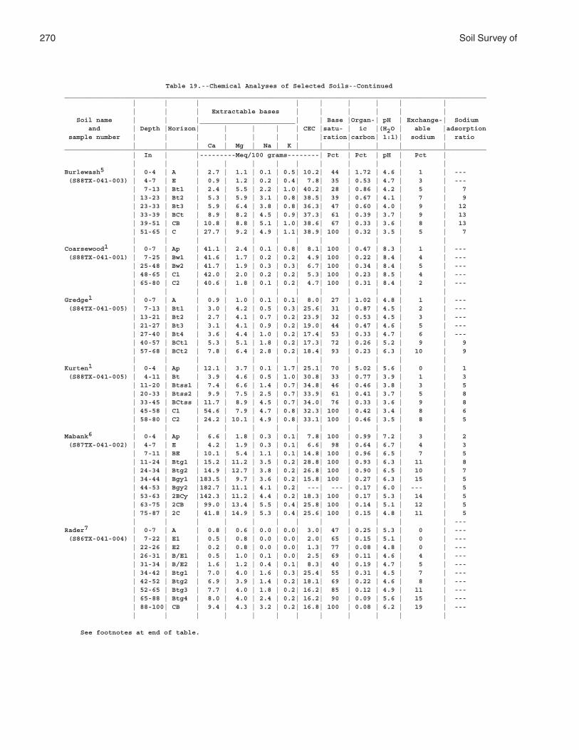
270 Soil Survey of
Table 19.--Chemical Analyses of Selected Soils--Continued__________________________________________________________________________________________________________ | | | | | | | | | | | | Extractable bases | | | | | | Soil name | | |________________________| | Base |Organ-| pH | Exchange-| Sodium and | Depth |Horizon| | | | | CEC |satu- | ic |(H2O | able |adsorption sample number | | | | | | | |ration|carbon| 1:1)| sodium | ratio | | | Ca | Mg | Na | K | | | | | |__________________________________________________________________________________________________________ | In | |---------Meq/100 grams--------| Pct | Pct | pH | Pct | | | | | | | | | | | | |Burlewash5 | 0-4 | A | 2.7 | 1.1 | 0.1 | 0.5| 10.2| 44 | 1.72 | 4.6 | 1 | --- (S88TX-041-003) | 4-7 | E | 0.9 | 1.2 | 0.2 | 0.4| 7.8| 35 | 0.53 | 4.7 | 3 | --- | 7-13 | Bt1 | 2.4 | 5.5 | 2.2 | 1.0| 40.2| 28 | 0.86 | 4.2 | 5 | 7 | 13-23 | Bt2 | 5.3 | 5.9 | 3.1 | 0.8| 38.5| 39 | 0.67 | 4.1 | 7 | 9 | 23-33 | Bt3 | 5.9 | 6.4 | 3.8 | 0.8| 36.3| 47 | 0.60 | 4.0 | 9 | 12 | 33-39 | BCt | 8.9 | 8.2 | 4.5 | 0.9| 37.3| 61 | 0.39 | 3.7 | 9 | 13 | 39-51 | CB | 10.8 | 8.8 | 5.1 | 1.0| 38.6| 67 | 0.33 | 3.6 | 8 | 13 | 51-65 | C | 27.7 | 9.2 | 4.9 | 1.1| 38.9| 100 | 0.32 | 3.5 | 5 | 7 | | | | | | | | | | | |Coarsewood1 | 0-7 | Ap | 41.1 | 2.4 | 0.1 | 0.8| 8.1| 100 | 0.47 | 8.3 | 1 | --- (S88TX-041-001) | 7-25 | Bw1 | 41.6 | 1.7 | 0.2 | 0.2| 4.9| 100 | 0.22 | 8.4 | 4 | --- | 25-48 | Bw2 | 41.7 | 1.9 | 0.3 | 0.3| 6.7| 100 | 0.34 | 8.4 | 5 | --- | 48-65 | C1 | 42.0 | 2.0 | 0.2 | 0.2| 5.3| 100 | 0.23 | 8.5 | 4 | --- | 65-80 | C2 | 40.6 | 1.8 | 0.1 | 0.2| 4.7| 100 | 0.31 | 8.4 | 2 | --- | | | | | | | | | | | |Gredge1 | 0-7 | A | 0.9 | 1.0 | 0.1 | 0.1| 8.0| 27 | 1.02 | 4.8 | 1 | --- (S84TX-041-005) | 7-13 | Bt1 | 3.0 | 4.2 | 0.5 | 0.3| 25.6| 31 | 0.87 | 4.5 | 2 | --- | 13-21 | Bt2 | 2.7 | 4.1 | 0.7 | 0.2| 23.9| 32 | 0.53 | 4.5 | 3 | --- | 21-27 | Bt3 | 3.1 | 4.1 | 0.9 | 0.2| 19.0| 44 | 0.47 | 4.6 | 5 | --- | 27-40 | Bt4 | 3.6 | 4.4 | 1.0 | 0.2| 17.4| 53 | 0.33 | 4.7 | 6 | --- | 40-57 | BCt1 | 5.3 | 5.1 | 1.8 | 0.2| 17.3| 72 | 0.26 | 5.2 | 9 | 9 | 57-68 | BCt2 | 7.8 | 6.4 | 2.8 | 0.2| 18.4| 93 | 0.23 | 6.3 | 10 | 9 | | | | | | | | | | | |Kurten1 | 0-4 | Ap | 12.1 | 3.7 | 0.1 | 1.7| 25.1| 70 | 5.02 | 5.6 | 0 | 1 (S88TX-041-005) | 4-11 | Bt | 3.9 | 4.6 | 0.5 | 1.0| 30.8| 33 | 0.77 | 3.9 | 1 | 3 | 11-20 | Btss1 | 7.4 | 6.6 | 1.4 | 0.7| 34.8| 46 | 0.46 | 3.8 | 3 | 5 | 20-33 | Btss2 | 9.9 | 7.5 | 2.5 | 0.7| 33.9| 61 | 0.41 | 3.7 | 5 | 8 | 33-45 | BCtss | 11.7 | 8.9 | 4.5 | 0.7| 34.0| 76 | 0.33 | 3.6 | 9 | 8 | 45-58 | C1 | 54.6 | 7.9 | 4.7 | 0.8| 32.3| 100 | 0.42 | 3.4 | 8 | 6 | 58-80 | C2 | 24.2 | 10.1 | 4.9 | 0.8| 33.1| 100 | 0.46 | 3.5 | 8 | 5 | | | | | | | | | | | |Mabank6 | 0-4 | Ap | 6.6 | 1.8 | 0.3 | 0.1| 7.8| 100 | 0.99 | 7.2 | 3 | 2 (S87TX-041-002) | 4-7 | E | 4.2 | 1.9 | 0.3 | 0.1| 6.6| 98 | 0.64 | 6.7 | 4 | 3 | 7-11 | BE | 10.1 | 5.4 | 1.1 | 0.1| 14.8| 100 | 0.96 | 6.5 | 7 | 5 | 11-24 | Btg1 | 15.2 | 11.2 | 3.5 | 0.2| 28.8| 100 | 0.93 | 6.3 | 11 | 8 | 24-34 | Btg2 | 14.9 | 12.7 | 3.8 | 0.2| 26.8| 100 | 0.90 | 6.5 | 10 | 7 | 34-44 | Bgy1 |183.5 | 9.7 | 3.6 | 0.2| 15.8| 100 | 0.27 | 6.3 | 15 | 5 | 44-53 | Bgy2 |182.7 | 11.1 | 4.1 | 0.2| ---| --- | 0.17 | 6.0 | --- | 5 | 53-63 | 2BCy |142.3 | 11.2 | 4.4 | 0.2| 18.3| 100 | 0.17 | 5.3 | 14 | 5 | 63-75 | 2CB | 99.0 | 13.4 | 5.5 | 0.4| 25.8| 100 | 0.14 | 5.1 | 12 | 5 | 75-87 | 2C | 41.8 | 14.9 | 5.3 | 0.4| 25.6| 100 | 0.15 | 4.8 | 11 | 5 | | | | | | | | | | | | ---Rader7 | 0-7 | A | 0.8 | 0.6 | 0.0 | 0.0| 3.0| 47 | 0.25 | 5.3 | 0 | --- (S86TX-041-004) | 7-22 | E1 | 0.5 | 0.8 | 0.0 | 0.0| 2.0| 65 | 0.15 | 5.1 | 0 | --- | 22-26 | E2 | 0.2 | 0.8 | 0.0 | 0.0| 1.3| 77 | 0.08 | 4.8 | 0 | --- | 26-31 | B/E1 | 0.5 | 1.0 | 0.1 | 0.0| 2.5| 69 | 0.11 | 4.6 | 4 | --- | 31-34 | B/E2 | 1.6 | 1.2 | 0.4 | 0.1| 8.3| 40 | 0.19 | 4.7 | 5 | --- | 34-42 | Btg1 | 7.0 | 4.0 | 1.6 | 0.3| 25.4| 55 | 0.31 | 4.5 | 7 | --- | 42-52 | Btg2 | 6.9 | 3.9 | 1.4 | 0.2| 18.1| 69 | 0.22 | 4.6 | 8 | --- | 52-65 | Btg3 | 7.7 | 4.0 | 1.8 | 0.2| 16.2| 85 | 0.12 | 4.9 | 11 | --- | 65-88 | Btg4 | 8.0 | 4.0 | 2.4 | 0.2| 16.2| 90 | 0.09 | 5.6 | 15 | --- | 88-100| CB | 9.4 | 4.3 | 3.2 | 0.2| 16.8| 100 | 0.08 | 6.2 | 19 | --- | | | | | | | | | | | |
See footnotes at end of table.

Brazos County, Texas 271
Table 19.--Chemical Analyses of Selected Soils--Continued__________________________________________________________________________________________________________ | | | | | | | | | | | | Extractable bases | | | | | | Soil name | | |________________________| | Base |Organ-| pH | Exchange-| Sodium and | Depth |Horizon| | | | | CEC |satu- | ic |(H2O | able |adsorption sample number | | | | | | | |ration|carbon| 1:1)| sodium | ratio | | | Ca | Mg | Na | K | | | | | |__________________________________________________________________________________________________________ | In | |---------Meq/100 grams--------| Pct | Pct | pH | Pct | | | | | | | | | | | | |Sandow1 | 0-6 | A1 | 19.2 | 3.6 | 0.1 | 0.4| 25.8| 90 | 2.17 | 5.9 | 0 | --- (S88TX-041-002) | 6-15 | A2 | 11.4 | 2.2 | 0.1 | 0.2| 14.1| 99 | 0.73 | 6.3 | 1 | --- | 15-20 | Bw | 7.4 | 1.9 | 0.1 | 0.2| 8.8| 100 | 0.44 | 6.6 | 1 | --- | 20-28 | Ab | 12.9 | 4.7 | 0.4 | 0.3| 19.0| 97 | 0.32 | 6.1 | 2 | --- | 28-34 | Bwb1 | 9.0 | 3.6 | 0.6 | 0.2| 14.3| 94 | 0.21 | 5.5 | 4 | --- | 34-41 | Bwb2 | 5.5 | 2.7 | 0.5 | 0.2| 10.4| 85 | 0.17 | 5.7 | 5 | --- | 41-46 | BCb | 4.1 | 2.2 | 0.7 | 0.1| 7.2| 99 | 0.11 | 6.0 | 10 | --- | 46-54 | A'b | 6.0 | 3.0 | 1.8 | 0.2| 9.7| 100 | 0.08 | 7.1 | 12 | 9 | 54-80 | Btgb | 8.4 | 4.2 | 2.2 | 0.2| 11.5| 100 | 0.10 | 7.6 | 11 | 7 | | | | | | | | | | | |Singleton8 | 0-5 | A | 3.7 | 0.6 | 0.2 | 0.4| 6.9| 71 | 1.28 | 5.8 | --- | --- (S54TX-21-91) | 5-7 | E | 2.3 | 0.7 | 0.2 | 0.2| 6.1| 56 | 0.52 | 5.3 | --- | --- | 7-21 | Btg1 | 16.1 | 6.7 | 3.3 | 0.3| 35.4| 75 | 0.70 | 4.6 | --- | --- | 21-35 | Btg2 | --- | 8.0 | 4.7 | 0.3| 37.6| --- | 0.52 | 4.6 | --- | --- | 35-46 | BCg | --- | 4.4 | 7.4 | 0.5| 34.1| --- | 0.29 | 4.7 | --- | --- | 46-70 | C | --- | 12.0 | 8.7 | 0.5| 44.9| --- | 0.23 | 4.7 | --- | --- | | | | | | | | | | | |Singleton9 | 0-7 | A | 3.9 | 1.3 | 0.2 | 0.1| 7.9| 71 | 0.50 | 5.4 | 3 | --- (S88TX-041-004) | 7-13 | Bt1 | 17.8 | 7.1 | 1.8 | 0.3| 37.2| 73 | 0.63 | 4.9 | 5 | --- | 13-22 | Bt2 | 21.3 | 8.4 | 3.6 | 0.4| 35.7| 94 | 0.47 | 4.7 | 8 | 8 | 22-28 | B/C | 18.5 | 7.3 | 3.2 | 0.3| 31.7| 92 | 0.33 | 4.7 | 8 | 8 | 28-35 | C | 21.8 | 8.5 | 3.9 | 0.4| 35.7| 97 | 0.24 | 5.4 | 8 | 9 | 35-59 | Cr | 19.0 | 6.3 | 3.7 | 0.3| 29.8| 99 | 0.13 | 6.6 | 8 | 11 | | | | | | | | | | | |Tabor1 | 0-6 | Ap | 1.3 | 0.5 | 0.0 | 0.0| 3.3| 55 | 0.43 | 5.3 | 0 | --- (S87TX-041-001) | 6-14 | E | 1.3 | 0.6 | 0.1 | 0.0| 2.9| 69 | 0.31 | 5.2 | 3 | --- | 14-23 | Btss1 | 2.9 | 1.5 | 0.4 | 0.0| 6.7| 73 | 0.43 | 5.6 | 6 | --- | 23-33 | Btss2 | 9.6 | 5.3 | 1.8 | 0.2| 21.0| 81 | 0.60 | 5.4 | 9 | --- | 33-42 | Btss2 | 10.8 | 6.1 | 2.7 | 0.2| 18.1| 100 | 0.25 | 5.9 | 15 | --- | 42-57 | Btss3 | 10.6 | 5.6 | 2.9 | 0.2| 18.0| 100 | 0.28 | 6.7 | 14 | 10 | 57-67 | Btg | 9.0 | 5.3 | 3.0 | 0.2| 15.2| 100 | 0.18 | 7.1 | 16 | 12 | 67-72 | BCtg1 | 7.8 | 4.4 | 2.5 | 0.1| 12.0| 100 | 0.08 | 7.2 | 17 | 12 | 72-80 | BCtg2 | 6.8 | 3.8 | 2.0 | 0.1| 10.1| 100 | 0.07 | 7.3 | 16 | 13 | | | | | | | | | | | |Zack1 | 0-7 | Ap | 2.9 | 1.3 | 0.2 | 0.2| 7.7| 61 | 0.67 | 5.2 | 3 | --- (S84TX-041-002) | 7-18 | Bt1 | 19.2 | 9.9 | 2.3 | 0.4| 31.9| 82 | 0.87 | 6.4 | 6 | --- | 18-24 | Bt2 | 22.5 | 11.4 | 3.1 | 0.4| 39.1| 96 | 0.73 | 7.3 | 7 | 6 | 24-36 | 2BCk | 17.0 | 7.7 | 2.5 | 0.3| 25.1| 100 | 0.49 | 8.0 | 8 | 7 | 36-60 | 2Ck | 12.6 | 7.3 | 3.5 | 0.3| 22.9| 100 | 0.17 | 7.7 | 11 | 9 | | | | | | | | | | | |__________________________________________________________________________________________________________
1 Location of pedon sample is the same as the location given for the series in the section "SoilSeries and Their Morphology."
2 Location of pedon sample: From the intersection of Farm Road 2818 and Farm Road 60 on the westside of College Station, Texas, 0.7 mile north on Farm Road 2818, 1.1 miles east on F&B Road, 200 feetnorth.
3 Location of pedon sample: From the intersection of Farm Road 2154 and Joe Routt Boulevard on TAMUCampus, 0.5 mile west on Joe Routt Boulevard, 300 feet southwest, in a pasture.
4 Location of pedon sample: From the intersection of Texas Highway 21 and Farm Road 60 on the eastside of Bryan, east on Farm Road 60 to intersection with Farm Road 158, then 4,100 feet north.
5 Location of pedon sample: From the intersection of Texas Highway 6 and Greens Prairie Road, 0.4mile east on Greens Prairie Road to a wire gate, 300 feet northeast of gate.
6 Location of pedon sample: From the intersection of Texas Highway 6 and North Texas Avenue on thenorth side of Bryan, 0.45 mile south on Texas Avenue, 500 feet east in old field.
7 Location of pedon sample: From the intersection of Texas Highway 21 and Farm Road 2038 nearKurten, 3.8 miles east on Farm Road 2038, 1.0 mile north on Clear Lake Road, 0.4 mile on pasture road, 200feet northwest, on mound.
8 Location of pedon sample: From Wellborn, 1.2 miles south on Farm Road 2154, cross railroad oncounty road; site 100 feet north of road and 100 feet west of railroad.
9 Location of pedon sample: From the intersection of Texas Highway 6 and Rock Prairie Road, 1.2 milessouth on Texas Highway 6, 0.2 mile west on subdivision road, 300 feet south along drainage ditch.
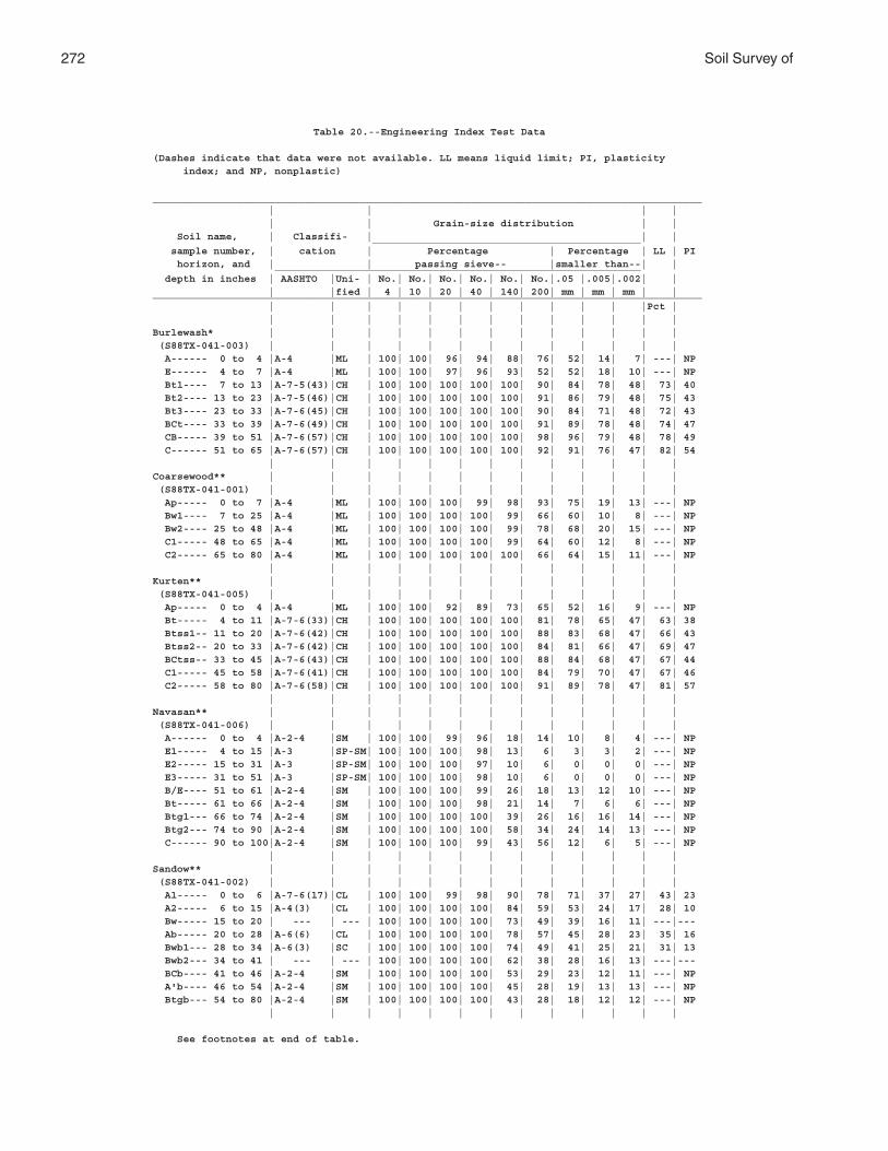
272 Soil Survey of
Table 20.--Engineering Index Test Data
(Dashes indicate that data were not available. LL means liquid limit; PI, plasticity index; and NP, nonplastic)
__________________________________________________________________________________________ | | | | | | Grain-size distribution | | Soil name, | Classifi- | | | ____________________________________________ sample number, | cation | Percentage | Percentage | LL | PI horizon, and | | passing sieve-- |smaller than--| | ____________________________________________________________ depth in inches | AASHTO |Uni- | No.| No.| No.| No.| No.| No.|.05 |.005|.002| | | |fied | 4 | 10 | 20 | 40 | 140| 200| mm | mm | mm | |__________________________________________________________________________________________ | | | | | | | | | | | |Pct | | | | | | | | | | | | | |Burlewash* | | | | | | | | | | | | | (S88TX-041-003) | | | | | | | | | | | | | A------ 0 to 4 |A-4 |ML | 100| 100| 96| 94| 88| 76| 52| 14| 7| ---| NP E------ 4 to 7 |A-4 |ML | 100| 100| 97| 96| 93| 52| 52| 18| 10| ---| NP Bt1---- 7 to 13 |A-7-5(43)|CH | 100| 100| 100| 100| 100| 90| 84| 78| 48| 73| 40 Bt2---- 13 to 23 |A-7-5(46)|CH | 100| 100| 100| 100| 100| 91| 86| 79| 48| 75| 43 Bt3---- 23 to 33 |A-7-6(45)|CH | 100| 100| 100| 100| 100| 90| 84| 71| 48| 72| 43 BCt---- 33 to 39 |A-7-6(49)|CH | 100| 100| 100| 100| 100| 91| 89| 78| 48| 74| 47 CB----- 39 to 51 |A-7-6(57)|CH | 100| 100| 100| 100| 100| 98| 96| 79| 48| 78| 49 C------ 51 to 65 |A-7-6(57)|CH | 100| 100| 100| 100| 100| 92| 91| 76| 47| 82| 54 | | | | | | | | | | | | |Coarsewood** | | | | | | | | | | | | | (S88TX-041-001) | | | | | | | | | | | | | Ap----- 0 to 7 |A-4 |ML | 100| 100| 100| 99| 98| 93| 75| 19| 13| ---| NP Bw1---- 7 to 25 |A-4 |ML | 100| 100| 100| 100| 99| 66| 60| 10| 8| ---| NP Bw2---- 25 to 48 |A-4 |ML | 100| 100| 100| 100| 99| 78| 68| 20| 15| ---| NP C1----- 48 to 65 |A-4 |ML | 100| 100| 100| 100| 99| 64| 60| 12| 8| ---| NP C2----- 65 to 80 |A-4 |ML | 100| 100| 100| 100| 100| 66| 64| 15| 11| ---| NP | | | | | | | | | | | | |Kurten** | | | | | | | | | | | | | (S88TX-041-005) | | | | | | | | | | | | | Ap----- 0 to 4 |A-4 |ML | 100| 100| 92| 89| 73| 65| 52| 16| 9| ---| NP Bt----- 4 to 11 |A-7-6(33)|CH | 100| 100| 100| 100| 100| 81| 78| 65| 47| 63| 38 Btss1-- 11 to 20 |A-7-6(42)|CH | 100| 100| 100| 100| 100| 88| 83| 68| 47| 66| 43 Btss2-- 20 to 33 |A-7-6(42)|CH | 100| 100| 100| 100| 100| 84| 81| 66| 47| 69| 47 BCtss-- 33 to 45 |A-7-6(43)|CH | 100| 100| 100| 100| 100| 88| 84| 68| 47| 67| 44 C1----- 45 to 58 |A-7-6(41)|CH | 100| 100| 100| 100| 100| 84| 79| 70| 47| 67| 46 C2----- 58 to 80 |A-7-6(58)|CH | 100| 100| 100| 100| 100| 91| 89| 78| 47| 81| 57 | | | | | | | | | | | | |Navasan** | | | | | | | | | | | | | (S88TX-041-006) | | | | | | | | | | | | | A------ 0 to 4 |A-2-4 |SM | 100| 100| 99| 96| 18| 14| 10| 8| 4| ---| NP E1----- 4 to 15 |A-3 |SP-SM| 100| 100| 100| 98| 13| 6| 3| 3| 2| ---| NP E2----- 15 to 31 |A-3 |SP-SM| 100| 100| 100| 97| 10| 6| 0| 0| 0| ---| NP E3----- 31 to 51 |A-3 |SP-SM| 100| 100| 100| 98| 10| 6| 0| 0| 0| ---| NP B/E---- 51 to 61 |A-2-4 |SM | 100| 100| 100| 99| 26| 18| 13| 12| 10| ---| NP Bt----- 61 to 66 |A-2-4 |SM | 100| 100| 100| 98| 21| 14| 7| 6| 6| ---| NP Btg1--- 66 to 74 |A-2-4 |SM | 100| 100| 100| 100| 39| 26| 16| 16| 14| ---| NP Btg2--- 74 to 90 |A-2-4 |SM | 100| 100| 100| 100| 58| 34| 24| 14| 13| ---| NP C------ 90 to 100|A-2-4 |SM | 100| 100| 100| 99| 43| 56| 12| 6| 5| ---| NP | | | | | | | | | | | | |Sandow** | | | | | | | | | | | | | (S88TX-041-002) | | | | | | | | | | | | | A1----- 0 to 6 |A-7-6(17)|CL | 100| 100| 99| 98| 90| 78| 71| 37| 27| 43| 23 A2----- 6 to 15 |A-4(3) |CL | 100| 100| 100| 100| 84| 59| 53| 24| 17| 28| 10 Bw----- 15 to 20 | --- | --- | 100| 100| 100| 100| 73| 49| 39| 16| 11| ---|--- Ab----- 20 to 28 |A-6(6) |CL | 100| 100| 100| 100| 78| 57| 45| 28| 23| 35| 16 Bwb1--- 28 to 34 |A-6(3) |SC | 100| 100| 100| 100| 74| 49| 41| 25| 21| 31| 13 Bwb2--- 34 to 41 | --- | --- | 100| 100| 100| 100| 62| 38| 28| 16| 13| ---|--- BCb---- 41 to 46 |A-2-4 |SM | 100| 100| 100| 100| 53| 29| 23| 12| 11| ---| NP A'b---- 46 to 54 |A-2-4 |SM | 100| 100| 100| 100| 45| 28| 19| 13| 13| ---| NP Btgb--- 54 to 80 |A-2-4 |SM | 100| 100| 100| 100| 43| 28| 18| 12| 12| ---| NP | | | | | | | | | | | | |
See footnotes at end of table.
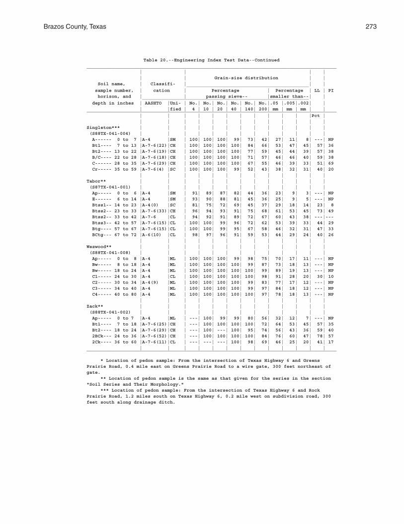
Brazos County, Texas 273
Table 20.--Engineering Index Test Data--Continued__________________________________________________________________________________________ | | | | | | Grain-size distribution | | Soil name, | Classifi- | | | ____________________________________________ sample number, | cation | Percentage | Percentage | LL | PI horizon, and | | passing sieve-- |smaller than--| | ____________________________________________________________ depth in inches | AASHTO |Uni- | No.| No.| No.| No.| No.| No.|.05 |.005|.002| | | |fied | 4 | 10 | 20 | 40 | 140| 200| mm | mm | mm | |__________________________________________________________________________________________ | | | | | | | | | | | |Pct | | | | | | | | | | | | | |Singleton*** | | | | | | | | | | | | | (S88TX-041-004) | | | | | | | | | | | | | A------ 0 to 7 |A-4 |SM | 100| 100| 100| 99| 73| 42| 27| 11| 8| ---| NP Bt1---- 7 to 13 |A-7-6(22)|CH | 100| 100| 100| 100| 84| 66| 53| 47| 45| 57| 36 Bt2---- 13 to 22 |A-7-6(19)|CH | 100| 100| 100| 100| 77| 59| 45| 44| 39| 57| 38 B/C---- 22 to 28 |A-7-6(18)|CH | 100| 100| 100| 100| 71| 57| 46| 46| 40| 59| 38 C------ 28 to 35 |A-7-6(29)|CH | 100| 100| 100| 100| 67| 55| 46| 39| 33| 51| 69 Cr----- 35 to 59 |A-7-6(4) |SC | 100| 100| 100| 99| 52| 43| 38| 32| 31| 40| 20 | | | | | | | | | | | | |Tabor** | | | | | | | | | | | | | (S87TX-041-001) | | | | | | | | | | | | | Ap----- 0 to 6 |A-4 |SM | 91| 89| 87| 82| 44| 36| 23| 9| 3| ---| NP E------ 6 to 14 |A-4 |SM | 93| 90| 88| 81| 45| 36| 25| 9| 5| ---| NP Btss1-- 14 to 23 |A-4(0) |SC | 81| 75| 72| 69| 45| 37| 29| 18| 14| 23| 8 Btss2-- 23 to 33 |A-7-6(33)|CH | 96| 94| 93| 91| 75| 68| 61| 53| 45| 73| 49 Btss2-- 33 to 42 |A-7-6 |CL | 94| 92| 91| 89| 72| 67| 60| 43| 38| ---|--- Btss3-- 42 to 57 |A-7-6(15)|CL | 100| 100| 99| 96| 72| 62| 53| 39| 33| 44| 29 Btg---- 57 to 67 |A-7-6(15)|CL | 100| 100| 99| 95| 67| 58| 46| 32| 31| 47| 33 BCtg--- 67 to 72 |A-6(10) |CL | 98| 97| 96| 91| 59| 53| 44| 29| 24| 40| 26 | | | | | | | | | | | | |Weswood** | | | | | | | | | | | | | (S88TX-041-008) | | | | | | | | | | | | | Ap----- 0 to 8 |A-4 |ML | 100| 100| 100| 99| 98| 75| 70| 17| 11| ---| NP Bw----- 8 to 18 |A-4 |ML | 100| 100| 100| 100| 99| 87| 73| 18| 13| ---| NP Bw----- 18 to 24 |A-4 |ML | 100| 100| 100| 100| 100| 99| 89| 19| 13| ---| NP C1----- 24 to 30 |A-4 |CL | 100| 100| 100| 100| 100| 98| 91| 28| 20| 30| 10 C2----- 30 to 34 |A-4(9) |ML | 100| 100| 100| 100| 99| 83| 77| 17| 12| ---| NP C3----- 34 to 40 |A-4 |ML | 100| 100| 100| 100| 99| 97| 84| 18| 12| ---| NP C4----- 40 to 80 |A-4 |ML | 100| 100| 100| 100| 100| 97| 78| 18| 13| ---| NP | | | | | | | | | | | | |Zack** | | | | | | | | | | | | | (S88TX-041-002) | | | | | | | | | | | | | Ap----- 0 to 7 |A-4 |ML | ---| 100| 99| 99| 80| 56| 32| 12| 7| ---| NP Bt1---- 7 to 18 |A-7-6(25)|CH | ---| 100| 100| 100| 100| 72| 64| 53| 45| 57| 35 Bt2---- 18 to 24 |A-7-6(29)|CH | ---| 100| ---| 100| 95| 74| 56| 43| 36| 59| 40 2BCk--- 24 to 36 |A-7-6(52)|CH | ---| 100| 100| 100| 100| 84| 76| 60| 47| 78| 57 2Ck---- 36 to 60 |A-7-6(11)|CL | ---| ---| ---| 100| 98| 69| 46| 25| 20| 41| 17 | | | | | | | | | | | | |__________________________________________________________________________________________
* Location of pedon sample: From the intersection of Texas Highway 6 and GreensPrairie Road, 0.4 mile east on Greens Prairie Road to a wire gate, 300 feet northeast ofgate. ** Location of pedon sample is the same as that given for the series in the section"Soil Series and Their Morphology." *** Location of pedon sample: From the intersection of Texas Highway 6 and RockPrairie Road, 1.2 miles south on Texas Highway 6, 0.2 mile west on subdivision road, 300feet south along drainage ditch.
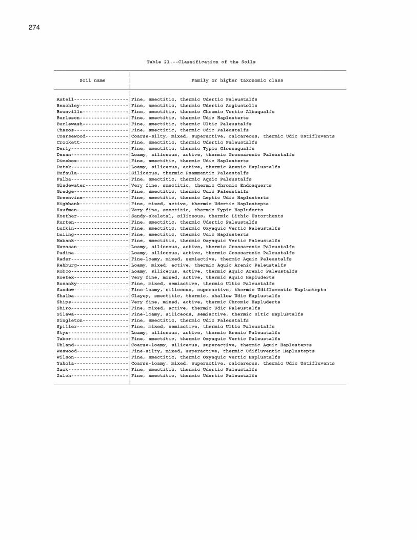
274
Table 21.--Classification of the Soils______________________________________________________________________________________________________ | Soil name | Family or higher taxonomic class |______________________________________________________________________________________________________ | Axtell-------------------|Fine, smectitic, thermic Udertic Paleustalfs Benchley-----------------|Fine, smectitic, thermic Udertic Argiustolls Boonville----------------|Fine, smectitic, thermic Chromic Vertic Albaqualfs Burleson-----------------|Fine, smectitic, thermic Udic Haplusterts Burlewash----------------|Fine, smectitic, thermic Ultic Paleustalfs Chazos-------------------|Fine, smectitic, thermic Udic Paleustalfs Coarsewood---------------|Coarse-silty, mixed, superactive, calcareous, thermic Udic Ustifluvents Crockett-----------------|Fine, smectitic, thermic Udertic Paleustalfs Derly--------------------|Fine, smectitic, thermic Typic Glossaqualfs Desan--------------------|Loamy, siliceous, active, thermic Grossarenic Paleustalfs Dimebox------------------|Fine, smectitic, thermic Udic Haplusterts Dutek--------------------|Loamy, siliceous, active, thermic Arenic Haplustalfs Eufaula------------------|Siliceous, thermic Psammentic Paleustalfs Falba--------------------|Fine, smectitic, thermic Aquic Paleustalfs Gladewater---------------|Very fine, smectitic, thermic Chromic Endoaquerts Gredge-------------------|Fine, smectitic, thermic Udic Paleustalfs Greenvine----------------|Fine, smectitic, thermic Leptic Udic Haplusterts Highbank-----------------|Fine, mixed, active, thermic Udertic Haplustepts Kaufman------------------|Very fine, smectitic, thermic Typic Hapluderts Koether------------------|Sandy-skeletal, siliceous, thermic Lithic Ustorthents Kurten-------------------|Fine, smectitic, thermic Udertic Paleustalfs Lufkin-------------------|Fine, smectitic, thermic Oxyaquic Vertic Paleustalfs Luling-------------------|Fine, smectitic, thermic Udic Haplusterts Mabank-------------------|Fine, smectitic, thermic Oxyaquic Vertic Paleustalfs Navasan------------------|Loamy, siliceous, active, thermic Grossarenic Paleustalfs Padina-------------------|Loamy, siliceous, active, thermic Grossarenic Paleustalfs Rader--------------------|Fine-loamy, mixed, semiactive, thermic Aquic Paleustalfs Rehburg------------------|Loamy, mixed, active, thermic Aquic Arenic Paleustalfs Robco--------------------|Loamy, siliceous, active, thermic Aquic Arenic Paleustalfs Roetex-------------------|Very fine, mixed, active, thermic Aquic Hapluderts Rosanky------------------|Fine, mixed, semiactive, thermic Ultic Paleustalfs Sandow-------------------|Fine-loamy, siliceous, superactive, thermic Udifluventic Haplustepts Shalba-------------------|Clayey, smectitic, thermic, shallow Udic Haplustalfs Ships--------------------|Very fine, mixed, active, thermic Chromic Hapluderts Shiro--------------------|Fine, mixed, active, thermic Udic Paleustalfs Silawa-------------------|Fine-loamy, siliceous, semiactive, thermic Ultic Haplustalfs Singleton----------------|Fine, smectitic, thermic Udic Paleustalfs Spiller------------------|Fine, mixed, semiactive, thermic Ultic Paleustalfs Styx---------------------|Loamy, siliceous, active, thermic Arenic Paleustalfs Tabor--------------------|Fine, smectitic, thermic Oxyaquic Vertic Paleustalfs Uhland-------------------|Coarse-loamy, siliceous, superactive, thermic Aquic Haplustepts Weswood------------------|Fine-silty, mixed, superactive, thermic Udifluventic Haplustepts Wilson-------------------|Fine, smectitic, thermic Oxyaquic Vertic Haplustalfs Yahola-------------------|Coarse-loamy, mixed, superactive, calcareous, thermic Udic Ustifluvents Zack---------------------|Fine, smectitic, thermic Udertic Paleustalfs Zulch--------------------|Fine, smectitic, thermic Udertic Paleustalfs |______________________________________________________________________________________________________

The Natural Resources Conservation Service (NRCS) is committed to making itsinformation accessible to all of its customers and employees. If you are experiencingaccessibility issues and need assistance, please contact our Helpdesk by phone at1-800-457-3642 or by e-mail at [email protected]. For assistancewith publications that include maps, graphs, or similar forms of information, you mayalso wish to contact our State or local office. You can locate the correct office andphone number at http://offices.sc.egov.usda.gov/locator/app.
NRCS Accessibility Statement