Embed Size (px)
Citation preview
United States Department of Agriculture Natural Resources Conservation Service
In cooperation with Texas Agricultural Experiment Station
Soil Survey of Colorado County,Texas

i
How To Use This Soil Survey
General Soil Map
The general soil map, which is a color map, shows the survey area divided into groups of associated soils called general soil map units. This map is useful in planning the use and management of large areas.
To find information about your area of interest, locate that area on the map, identify the name of the map unit in the area on the color-coded map legend, then refer to the section General Soil Map Units for a general description of the soils in your area.
Detailed Soil Maps
The detailed soil maps can be useful in planning the use and management of small areas.
To find information about your area of interest, locate that area on the Index to Map Sheets. Note the number of the map sheet and go to that sheet.
Locate your area of interest on the map sheet. Note the map unit symbols that are in that area. Go to the Contents, which lists the map units by symbol and name and shows the page where each map unit is described.
The Contents shows which table has data on a specific land use for each detailed soil map unit. Also see the Contents for sections of this publication that may address your specific needs.

ii
This soil survey is a publication of the National Cooperative Soil Survey, a joint effort of the United States Department of Agriculture and other Federal agencies, State agencies including the Agricultural Experiment Stations, and local agencies. The Natural Resources Conservation Service has leadership for the Federal part of the National Cooperative Soil Survey.
Major fieldwork for this soil survey was completed in 1996. Soil names and descriptions were approved in 1997. Unless otherwise indicated, statements in this publication refer to conditions in the survey area in 1996. This survey was made cooperatively by the Natural Resources Conservation Service and the Texas Agricultural Experiment Station. The survey is part of the technical assistance furnished to the Colorado County Soil and Water Conservation District.
Soil maps in this survey may be copied without permission. Enlargement of these maps, however, could cause misunderstanding of the detail of mapping. If enlarged, maps do not show the small areas of contrasting soils that could have been shown at a larger scale.
The U.S. Department of Agriculture (USDA) prohibits discrimination in all its programs and activities on the basis of race, color, national origin, age, disability, and where applicable, sex, marital status, familial status, parental status, religion, sexual orientation, genetic information, political beliefs, reprisal, or because all or part of an individual’s income is derived from any public assistance program. (Not all prohibited bases apply to all programs.) Persons with disabilities who require alternative means for communication of program information (Braille, large print, audiotape, etc.) should contact USDA’s TARGET Center at (202) 720-2600 (voice and TDD). To file a complaint of discrimination, write to USDA, Director, Office of Civil Rights, 1400 Independence Avenue, S.W., Washington, D.C. 20250-9410, or call (800) 795-3272 (voice) or (202) 795-6382 (TDD). USDA is an equal opportunity provider and employer. Cover: Attwater Prairie Chicken Refuge located in southeastern Colorado County. Watering areas are
important for cattle and wildlife. This area is Katy fine sandy loam, 0 to 1 percent slopes.
Additional information about the Nation’s natural resources is available on the Natural Resources Conservation Service homepage on the World Wide Web. The address is http://www.nrcs.usda.gov
iii
Contents
How to Use This Survey ..............................................................................i Foreword .....................................................................................................xi General Nature of the Survey Area ............................................................... 2
Settlement and Population....................................................................... 2 Agriculture............................................................................................... 3 Natural Resources................................................................................... 3 Climate.................................................................................................... 4
How this Survey Was Made .......................................................................... 4 General Soil Map Units ............................................................................... 7
Loamy and Clayey, Moderately Well Drained Soils; on Uplands of the Coast Prairie ............................................................................ 7 1. Telf-Nada-Garwood ....................................................................... 7 2. Dacosta-Laewest ........................................................................... 9
Sandy and Loamy, Dominantly Moderately Well Drained Soils; on Uplands of the Southern Claypan Area........................................ 10 3. Straber-Tremona-Lufkin............................................................... 10 4. Catilla-Joiner................................................................................ 12
Sandy and Loamy, Moderately Well Drained and Somewhat Poorly Drained Soils; on Uplands of the Coast Prairie ...................... 13 5. Cheetham-Wockley-Mentz........................................................... 13 6. Kuy-Milby-Nez ............................................................................. 15 7. Katy-Fordtran............................................................................... 16
Sandy, Loamy, and Clayey, Moderately Well Drained and Well Drained Soils; on Flood Plains and Terraces.................................... 18
8. Norwood-Brazoria-Mohat ............................................................. 18 9. Tabor-Robco-Chazos................................................................... 19 10. Wilson-Gholson-Burleson ............................................................ 21 11. Pursley-Whitesboro-Ganado ........................................................ 22 12. Ships-Weswood-Bergstrom.......................................................... 23
Loamy and Clayey, Moderately Well Drained and Well Drained Soils; on Uplands of the Southern Blackland Prairie ......................... 24
13. Hallettsville-Frelsburg-Carbengle ................................................. 24 Detailed Soil Map Units ............................................................................ 27
BgA—Bergstrom silt loam, 0 to 1 percent slopes, rarely flooded ............ 28 BkB—Bleiblerville clay, 1 to 3 percent slopes......................................... 30 BoA—Bosque clay loam, 0 to 1 percent slopes,
occasionally flooded......................................................................... 32 BrA—Brazoria clay, 0 to 1 percent slopes, rarely flooded....................... 35 BsD—Brenham clay loam, 3 to 8 percent slopes ................................... 36 BuA—Burleson clay, 0 to 1 percent slopes ............................................ 38 BuB—Burleson clay, 1 to 3 percent slopes ............................................ 40 CbC—Carbengle sandy clay loam, 3 to 5 percent slopes....................... 42 CbD—Carbengle sandy clay loam, 5 to 8 percent slopes....................... 44 CbE2—Carbengle sandy clay loam, 8 to 12 percent slopes,
eroded ............................................................................................. 46 CcC—Catilla loamy sand, 1 to 5 percent slopes..................................... 47

iv
ChB—Chazos loamy fine sand, 1 to 3 percent slopes............................ 49 CmB—Cheetham loamy sand, 1 to 3 percent slopes ............................. 52 CvA—Clemville silty clay loam, 0 to 1 percent slopes,
occasionally flooded......................................................................... 54 CwA—Coarsewood loam, 0 to 1 percent slopes,
occasionally flooded......................................................................... 56 DaA—Dacosta loam, 0 to 1 percent slopes............................................ 57 DnC—Dubina loamy fine sand, 2 to 5 percent slopes ............................ 60 DtB—Dutek loamy fine sand, 1 to 3 percent slopes................................ 62 EcA—Edco fine sandy loam, 0 to 1 percent slopes ................................ 64 EdA—Edna fine sandy loam, 0 to 1 percent slopes................................ 67 EnB—Elmenwood-Denvaca complex, 1 to 3 percent slopes .................. 69 FaB—Faula sand, 1 to 3 percent slopes ................................................ 72 FoA—Fordtran loamy sand, 0 to 1 percent slopes ................................. 74 FrB—Frelsburg clay, 1 to 3 percent slopes ............................................ 76 FrC—Frelsburg clay, 3 to 5 percent slopes ............................................ 78 GaA—Gad loamy fine sand, 0 to 1 percent slopes,
rarely flooded................................................................................... 80 GdA—Gad fine sandy loam, 0 to 1 percent slopes,
frequently flooded ........................................................................... 82 GeA—Ganado clay, 0 to 1 percent slopes, occasionally flooded ............ 84 GoA—Garwood fine sandy loam, 0 to 1 percent slopes ......................... 86 GrA—Garwood-Cieno complex, 0 to 1 percent slopes ........................... 89 GsB—Gholson fine sandy loam, 1 to 3 percent slopes........................... 91 GsD—Gholson sandy loam, 3 to 8 percent slopes ................................. 93 HeB—Hallettsville sandy clay loam, 1 to 3 percent slopes ..................... 95 JoB—Joiner loamy sand, 1 to 3 percent slopes...................................... 98 KaA—Katy fine sandy loam, 0 to 1 percent slopes................................. 99 KuB—Kuy sand, 1 to 3 percent slopes..................................................102LaA—Laewest clay, 0 to 1 percent slopes ............................................104LaD—Latium clay, 3 to 8 percent slopes...............................................106LtE3—Latium clay, 5 to 15 percent slopes, severely eroded .................108LuA—Lufkin fine sandy loam, 0 to 1 percent slopes..............................110M-W—Miscellaneous water ..................................................................112MeA—Mentz fine sandy loam, 0 to 1 percent slopes.............................112MeB—Mentz sandy loam, 1 to 3 percent slopes ...................................114MfB—Milby sand, 1 to 3 percent slopes................................................117MkB—Mockley fine sandy loam, 1 to 3 percent slopes..........................119MmB—Mockley very gravelly sandy loam, 1 to 3 percent
slopes, graded ................................................................................121MoA—Mohat loam, 0 to 1 percent slopes, rarely flooded ......................122MvB—Monaville loamy fine sand, 1 to 3 percent slopes........................125MxA—Morales-Cieno complex, 0 to 1 percent slopes ...........................127NaA—Nada-Cieno complex, 0 to 1 percent slopes ...............................130NeB—Newulm loamy fine sand, 1 to 3 percent slopes ..........................133NgA—Nez loamy sand, 0 to 1 percent slopes .......................................135NhA—Nez fine sandy loam, 0 to 1 percent slopes ................................137NoA—Norwood loam, 0 to 1 percent slopes, rarely flooded...................140NrA—Norwood silty clay loam, 0 to 1 percent slopes,
occasionally flooded........................................................................142PuA—Pursley sandy clay loam, 0 to 1 percent slopes,
frequently flooded ...........................................................................144RbD—Rabbs clay loam, 3 to 8 percent slopes ......................................146
v
RkB—Rek extremely gravelly coarse sandy loam, 1 to 3 percent slopes.......................................................................147
RNA—Riverwash .................................................................................150RoB—Robco loamy fine sand, 1 to 3 percent slopes.............................150RtA—Roetex clay, 0 to 1 percent slopes, frequently flooded .................152RuB—Rupley sand, 1 to 3 percent slopes.............................................154SpA—Ships clay, 0 to 1 percent slopes, rarely flooded .........................156StA—Smithville fine sandy loam, 0 to 1 percent slopes.........................158SvF—Stein very gravelly loamy fine sand, 12 to 40 percent slopes .......159SwB—Straber loamy fine sand, 1 to 3 percent slopes...........................161SwC—Straber loamy fine sand, 3 to 5 percent slopes...........................163SxB—Straber very gravelly loamy fine sand, 1 to 3 percent slopes .......165SxD—Straber very gravelly loamy fine sand, 3 to 8 percent slopes .......167TaA—Tabor fine sandy loam, 0 to 1 percent slopes..............................170TaB—Tabor fine sandy loam, 1 to 3 percent slopes..............................172TcC—Tadina fine sand, 1 to 5 percent slopes.......................................173TdA—Telferner fine sandy loam, 0 to 1 percent slopes .........................176TdB—Telferner fine sandy loam, 1 to 3 percent slopes .........................178TeA—Telf fine sandy loam, 0 to 1 percent slopes .................................181TeB—Telf fine sandy loam, 1 to 3 percent slopes .................................183TfA—Telf-Cieno complex, 0 to 1 percent slopes ...................................186TmA—Tremona loamy sand, 0 to 1 percent slopes...............................189TmC—Tremona fine sand, 1 to 5 percent slopes ..................................191TrB—Tremona extremely gravelly loamy sand,
1 to 3 percent slopes.......................................................................193TwA—Trinity clay, 0 to 1 percent slopes, occasionally flooded ..............195UEF—Udarents, flood plain, hilly ..........................................................197UFC—Udarents, gently undulating, rarely flooded ................................198UGC—Udarents, upland, gently undulating ..........................................198UHF—Udarents, upland, hilly ...............................................................199UnA—Uhland sandy clay loam, 0 to 1 percent slopes,
frequently flooded ...........................................................................199W—Water ............................................................................................201WeA—Weswood loam, 0 to 1 percent slopes, rarely flooded ................201WfA—Weswood loam, 1 to 3 percent slopes, occasionally flooded .......203WhA—Whitesboro sandy clay loam, 0 to 1 percent slopes,
occasionally flooded........................................................................205WsA—Wilson clay loam, 0 to 1 percent slopes .....................................207WyA—Wockley fine sandy loam, 0 to 1 percent slopes.........................209WyB—Wockley fine sandy loam, 1 to 3 percent slopes.........................211ZaA—Zalco fine sand, 0 to 1 percent slopes, frequently flooded ...........214
Prime Farmland........................................................................................217Use and Management of the Soils ..........................................................219
Interpretive Ratings ..............................................................................219Rating Class Terms..............................................................................219Numerical Ratings................................................................................219Crops and Pasture ...............................................................................220
Crops..............................................................................................220Pasture and Hayland ......................................................................221Pecan Orchards..............................................................................222
Yields Per Acre ....................................................................................224Land Capability Classification...............................................................225Woodland Management and Productivity..............................................226Rangeland ...........................................................................................227
vi
Southern Blackland Prairie (MLRA 86B)..........................................228Southern Claypan Area (MLRA 87A)...............................................228Coast Prairie (MLRA 150A).............................................................228Ecological Sites ..............................................................................228
Blackland Ecological Site...........................................................230Clay Loam Ecological Site.........................................................231Clayey Bottomland Ecological Site ............................................231Claypan Prairie Ecological Site..................................................231Claypan Savannah Ecological Site ............................................232Deep Sand Ecological Site ........................................................232Eroded Blackland Ecological Site ..............................................233Gravelly Ecological Site.............................................................233Loamy Bottomland Ecological Site.............................................233Loamy Prairie Ecological Site ....................................................234Lowland Ecological Site.............................................................234Sandy Ecological Site................................................................234Sandy Bottomland Ecological Site .............................................235Sandy Loam Ecological Site ......................................................235Sandy Prairie Ecological Site.....................................................236
Rangeland Productivity ...................................................................236Recreation............................................................................................237Wildlife Habitat .....................................................................................240Hydric Soils..........................................................................................244Engineering..........................................................................................245
Building Site Development ..............................................................246Sanitary Facilities............................................................................248Agricultural Waste Management .....................................................250Construction Materials ....................................................................252Water Management ........................................................................253
Soil Properties .........................................................................................255Engineering Index Properties................................................................255Physical Soil Properties........................................................................256Chemical Soil Properties ......................................................................258Water Features ....................................................................................259Soil Features........................................................................................260Physical, Chemical, and Clay Mineralogy Analyses of
Selected Soils.................................................................................261Classification of the Soils........................................................................263
Soil Series and Their Morphology.........................................................264Bergstrom Series............................................................................264Bleiblerville Series ..........................................................................265Bosque Series ................................................................................266Brazoria Series ...............................................................................268Brenham Series..............................................................................270Burleson Series ..............................................................................272Carbengle Series............................................................................274Catilla Series ..................................................................................276Chazos Series ................................................................................277Cheetham Series............................................................................279Cieno Series...................................................................................281Clemville Series..............................................................................282Coarsewood Series ........................................................................284Dacosta Series ...............................................................................285
vii
Denvaca Series ..............................................................................287Dubina Series.................................................................................288Dutek Series...................................................................................291Edco Series ....................................................................................292Edna Series....................................................................................294Elmenwood Series..........................................................................296Faula Series ...................................................................................297Fordtran Series...............................................................................299Frelsburg Series .............................................................................301Gad Series .....................................................................................303Ganado Series................................................................................304Garwood Series..............................................................................305Gholson Series ...............................................................................308Hallettsville Series ..........................................................................310Joiner Series...................................................................................313Katy Series .....................................................................................314Kuy Series ......................................................................................316Laewest Series ...............................................................................317Latium Series..................................................................................318Lufkin Series...................................................................................320Mentz Series...................................................................................322Milby Series....................................................................................325Mockley Series ...............................................................................326Mohat Series ..................................................................................329Monaville Series .............................................................................330Morales Series................................................................................331Nada Series....................................................................................333Newulm Series ...............................................................................335Nez Series......................................................................................337Norwood Series ..............................................................................339Pursley Series ................................................................................342Rabbs Series ..................................................................................344Rek Series......................................................................................345Robco Series..................................................................................346Roetex Series.................................................................................348Rupley Series .................................................................................349Ships Series ...................................................................................350Smithville Series .............................................................................352Stein Series ....................................................................................353Straber Series.................................................................................355Tabor Series...................................................................................356Tadina Series .................................................................................358Telf Series ......................................................................................359Telferner Series ..............................................................................361Tremona Series ..............................................................................363Trinity Series...................................................................................364Uhland Series.................................................................................366Weswood Series.............................................................................368Whitesboro Series ..........................................................................370Wilson Series..................................................................................372Wockley Series...............................................................................373Zalco Series ...................................................................................375

viii
Formation of the Soils .............................................................................377Factors of Soil Formation......................................................................377
Parent Material ...............................................................................377Climate...........................................................................................377Plant and Animal Life......................................................................378Relief ..............................................................................................378Time...............................................................................................378
Processes of Horizon Differentiation.....................................................378Surface Geology ..................................................................................380
Fleming Formation..........................................................................380Goliad Formation ............................................................................381Willis Formation ..............................................................................381Lissie Formation .............................................................................382Beaumont Formation ......................................................................382Post-Beaumont Age Pleistocene to Holocene Fluvial Terraces
and Flood Plains .......................................................................382Microrelief Features ........................................................................383
Gilgai Topography.....................................................................383Pimple Mounds .........................................................................383Undrained Depressions .............................................................383
References ...............................................................................................385Glossary ...................................................................................................389Tables.......................................................................................................411
Table 1.—Temperature and Precipitation..............................................412Table 2.—Freeze Date in Spring and Fall .............................................413Table 3.—Growing Season...................................................................413Table 4.—Acreage and Proportionate Extent of the Soils......................414Table 5.—Land Capability and Crop Yields per Acre by Map
Unit Component..............................................................................416Table 6.—Rangeland Productivity.........................................................423Table 7.—Camp Areas, Picnic Areas, and Playgrounds........................428Table 8.—Paths, Trails, and Golf Fairways ...........................................437Table 9.—Wildlife Habitat .....................................................................444Table 10.—Dwellings and Small Commercial Buildings.........................453Table 11.—Roads and Streets, Shallow Excavations, and
Lawns and Landscaping .................................................................461Table 12.—Sewage Disposal................................................................470Table 13.—Landfills..............................................................................480Table 14.—Agricultural Disposal of Manure, Food-Processing
Waste, and Sewage Sludge............................................................489Table 15.—Agricultural Disposal of of Wastewater by Irrigation
and Overland Flow..........................................................................500Table 16.—Source of Gravel and Sand ................................................511Table 17.—Source of Reclamation Material, Roadfill, and Topsoil.........519Table 18.—Ponds and Embankments...................................................530Table 19.—Water Management............................................................537Table 20.—Water Management............................................................546Table 21.—Water Management............................................................556Table 22.—Engineering Index Properties..............................................566Table 23.—Physical Soil Properties......................................................591Table 24.—Chemical Soil Properties ....................................................604Table 25.—Water Features ..................................................................613Table 26.—Soil Features......................................................................645
ix
Table 27.—Physical Analyses of Selected Soils....................................650Table 28.—Chemical Analyses of Selected Soils..................................652Table 29.—Clay Mineralogy of Selected Soils.......................................654Table 30.—Taxonomic Classification of the Soils..................................655
August 2006
xi
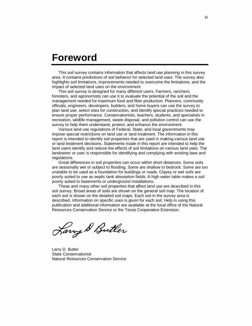
Foreword
This soil survey contains information that affects land use planning in this survey area. It contains predictions of soil behavior for selected land uses. The survey also highlights soil limitations, improvements needed to overcome the limitations, and the impact of selected land uses on the environment.
This soil survey is designed for many different users. Farmers, ranchers, foresters, and agronomists can use it to evaluate the potential of the soil and the management needed for maximum food and fiber production. Planners, community officials, engineers, developers, builders, and home buyers can use the survey to plan land use, select sites for construction, and identify special practices needed to ensure proper performance. Conservationists, teachers, students, and specialists in recreation, wildlife management, waste disposal, and pollution control can use the survey to help them understand, protect, and enhance the environment.
Various land use regulations of Federal, State, and local governments may impose special restrictions on land use or land treatment. The information in this report is intended to identify soil properties that are used in making various land use or land treatment decisions. Statements made in this report are intended to help the land users identify and reduce the effects of soil limitations on various land uses. The landowner or user is responsible for identifying and complying with existing laws and regulations.
Great differences in soil properties can occur within short distances. Some soils are seasonally wet or subject to flooding. Some are shallow to bedrock. Some are too unstable to be used as a foundation for buildings or roads. Clayey or wet soils are poorly suited to use as septic tank absorption fields. A high water table makes a soil poorly suited to basements or underground installations.
These and many other soil properties that affect land use are described in this soil survey. Broad areas of soils are shown on the general soil map. The location of each soil is shown on the detailed soil maps. Each soil in the survey area is described. Information on specific uses is given for each soil. Help in using this publication and additional information are available at the local office of the Natural Resources Conservation Service or the Texas Cooperative Extension.
Larry D. Butler State Conservationist Natural Resources Conservation Service

1
Soil Survey of Colorado County, Texas
By Samuel E. Brown, Jr., Natural Resources Conservation Service
Fieldwork by
Samuel E. Brown, Jr., James A. Douglass II, J. David Wagner, Jorge Lugo, and Frederich Schrank, Natural Resources Conservation Service
United States Department of Agriculture, Natural Resources Conservation Service, In cooperation with Texas Agricultural Experiment Station
Colorado County is in southeast Central Texas (fig. 1). The total area of the county is 623,417 acres or about 974 square miles. The county is bordered on the west side by Fayette County, on the south by Lavaca County, on the east by Wharton County and on the north by Austin County.
Columbus is the county seat. Other communities in the county include Alleyton, Altair, Bernardo, Borden, Eagle Lake, Frelsburg, Garwood, Glidden, Hillcrest, Mentz, Nada, Oakland, Provident City, Ramsey, Rock Island, Sheridan, and Weimar.
The survey area is dissected by the Colorado River. Most of the area drains into the river. The elevation ranges from 151 feet above sea level on the eastern side to 450 feet above sea level in the northern part of the county.
The major land uses in Colorado County are cattle ranching and farming. In 1995, about 48 percent of the county was used as rangeland, 15 percent was used as pasture and hayland, 33 percent was used as cropland, and 1 percent as urban or built-up land. Eagle Lake is the major lake and provides water for municipal and industrial use in the town nearby of the same name. Water wells are the main source for drinking water. Much of the irrigation water used for rice fields comes from the Colorado River.
Colorado County is in the Southern Blackland Prairie, Southern Claypan Area, and the Coast Prairie Major Land Resource Areas. The clayey and loamy soils of the Southern Blackland Prairie formed under prairie vegetation and are dominantly dark in color. These soils are mainly in the northern and western parts of the county. The sandy and loamy soils of the Southern Claypan Area formed under post oak savannah vegetation and are dominantly light in color. These soils are in the northern and western parts of the county. The loamy and sandy soils of the Coast Prairie formed under somewhat poorly or poorly drained conditions and are dominantly light in color. These soils are mainly in the southern part of the county.
Descriptions, names, and delineations of soil in the survey do not fully agree with those on soil maps for adjacent counties. The disagreements result from improvements in knowledge of soils, modifications in series concepts, and differences in intensities of mapping or in the extent of soils in the area.

2 Soil Survey of
Figure 1.—Location of Colorado County in Texas.
General Nature of the Survey Area This section provides general information about Colorado County. It describes
settlement and population, agriculture, natural resources, and climate.
Settlement and Population Bill Stein, Columbus Library, helped to prepare this section
Colorado County, named for the Colorado River, which traverses it, was created in 1836. It was originally substantially larger than it is now, but in 1837, part of it was used to form Fayette County, and in 1846, more territory was lost when Lavaca and Wharton counties were created. A surveying error and subsequent border disputes with Wharton and Jackson Counties added the small panhandle on the southwestern tip of the county in the early twentieth century.
The land that now makes up Colorado County was part of Stephen F. Austin’s original colony in Texas, and was initially settled by some of the “The Old Three Hundred” beginning in the 1820’s. Evidence exists of extensive earlier Indian activity in the area.
The earliest place names in the county; Montezuma, Beeson’s Crossing, and Dewees’ Crossing, all designated spots where travel routes crossed the Colorado River. Columbus, the county seat, was established and named in late 1835. Large numbers of Germans settled in the northern part of the county in communities that became known as Frelsburg, Bernardo, and Mentz. Other towns, including Eagle Lake, Alleyton, Borden, and Weimar, sprang up along the route of the railroad as it
■ Headquarters of Texas Agricultural Experiment Station.
Colorado County, Texas 3
was built through the county between 1856 and 1873. Garwood arose during the rice boom in the southern part of the county in the early twentieth century. Rock Island, Cheetham, Sheridan, and in the panhandle, Provident City, were established by promoters between 1895 and 1910.
The county had a population of 18,383 in 1990. Columbus had a population of 3,367, Eagle Lake was 3,551, and Weimar was 2,052 in 1990.
Agriculture Connie Fair, District Conservationist, Natural Resources Conservation Service, helped to prepare this section
Prior to 1890, most of Colorado County was grassland prairies except for a few small farms along the Colorado River. The original Austin Land Grant was approved in 1823. Cattle ranching was the main agricultural enterprise in the county at that time, and Colorado County now ranks number five in the State of Texas in cow-calf production. The major crops during this period of time were cotton, corn, grain sorghum, and sugar cane. Rice production and rice irrigation was introduced into the county in 1898 in the Eagle Lake area. Rice irrigation is provided by irrigation wells and/or by water pumped from the Colorado River. Rice production reached its peak in the 1970’s when some 50,000 acres were planted. Rice, corn, grain sorghum, and soybeans are now the main crops grown in the county. Rice is the number one agricultural commodity in Colorado County at this time with some 35,000 acres being planted. Cotton was the primary crop in the early years, but has been replaced by introduced grasses for grazing and/or hay production as the crop production decreased. Currently, some 400 acres of pecans are grown commercially along the Colorado River, and some 30,000 acres of native pecans are in small pecan orchards scattered throughout the county.
New breeds of cattle changed the industry in Colorado County. The first introduced breed was the Brahma which increased herd resistance to heat, and disease as cross-breeding began. In more recent years, Chianiana, Limousine, Piedmontese, Simmental, and other breeds have been introduced into the county. Some exotic breeds such as Watusi have also been introduced. In times past, there were several dairy farms in the county, but these are now gone. Two poultry egg production operations now exist in Colorado County.
Natural Resources Connie Fair, District Conservationist, Natural Resources Conservation Service, helped to prepare this section
Soil is the most important natural resource in Colorado County. The production of crops, livestock, and food, which are sources of livelihood for the people of Colorado County, all depend on the soil.
Other natural resources in Colorado County include oil, natural gas, sand and gravel, and fresh water. Commercial oil and gas production began in the 1920’s. Sand and gravel mines are scattered along the Colorado River and Cummins Creek. Underground aquifers, and several major creeks and streams provide an abundant water source for residential and industrial use.
Wildlife, especially deer, turkey, and waterfowl, are valuable economic resources. These are plentiful throughout the county, and hunting leases along with day hunting provide much needed additional revenue for many of the landowners in the county. Eagle Lake was incorporated in 1888. It boasts of having the largest private lake in the State of Texas, and also of being the “Goose Hunting Capital of the World.” The Attwater's Prairie Chicken National Refuge is nearby, and is making a major effort to preserve this endangered species.

4 Soil Survey of
Climate Table 1 provides data on temperature and precipitation for the survey area as
recorded at Columbus, Texas in the period 1961 to 1990. Table 2 provides probable dates of the first freeze in fall and the last freeze in spring. Table 3 provides data on length of the growing season.
In winter, the average temperature is 51.5 degrees F and the average daily minimum temperature is 38.8 degrees. The lowest temperature on record, which occurred on December 24, 1989, is 4 degrees. In summer, the average temperature is 82.3 degrees and the average daily maximum temperature is 94.2 degrees. The highest recorded temperature, which occurred on August 28, 1990, is 108 degrees.
Growing degree days are shown in Table 1. They are equivalent to "heat units." During the month, growing degree days accumulate by the amount that the average temperature each day exceeds a base temperature (50 degrees F). The normal monthly accumulation is used to schedule single or successive plantings of a crop between the last freeze in spring and the first freeze in fall.
The total annual precipitation is about 41.63 inches. Of this, 29.11 inches, or 70 percent, usually falls in April through September. The growing season for most crops falls within this period. The heaviest 1-day rainfall during the period of record was 10 inches at Columbus on June 13, 1973. Thunderstorms occur on about 61 days each year, and most occur in July.
The average seasonal snowfall is about zero inches. The greatest snow depth at any one time during the period of record was 8 inches recorded on January 31, 1949. On the average, zero days of the year have at least 1 inch of snow on the ground. The number of such days varies greatly from year to year.
The average relative humidity in midafternoon is about 59 percent. Humidity is higher at night, and the average at dawn is about 90 percent. The sun shines 65 percent of the time possible in summer and 47 percent in winter. The prevailing wind is from the south southeast. Average windspeed is highest, 9.4 miles per hour, in March.
How This Survey Was Made This survey was made to provide information about the soils and miscellaneous
areas in the survey area. The information includes a description of the soils and miscellaneous areas and their location and a discussion of their suitability, limitations, and management for specified uses. Soil scientists observed the steepness, length, and shape of the slopes; the general pattern of drainage; the kinds of crops and native plants; and the kinds of bedrock. They dug many holes to study the soil profile, which is the sequence of natural layers, or horizons, in a soil. The profile extends from the surface down into the unconsolidated material in which the soil formed. The unconsolidated material is devoid of roots and other living organisms and has not been changed by other biological activity.
The soils and miscellaneous areas in the survey area are in an orderly pattern that is related to the geology, landforms, relief, climate, and natural vegetation of the area. Each kind of soil and miscellaneous area is associated with a particular kind of landform or with a segment of the landform. By observing the soils and miscellaneous areas in the survey area and relating their position to specific segments of the landform, a soil scientist develops a concept or model of how they were formed. Thus, during mapping, this model enables the soil scientist to predict with a considerable degree of accuracy the kind of soil or miscellaneous area at a specific location on the landscape.
Commonly, individual soils on the landscape merge into one another as their characteristics gradually change. To construct an accurate soil map, however, soil
Colorado County, Texas 5
scientists must determine the boundaries between the soils. They can observe only a limited number of soil profiles. Nevertheless, these observations, supplemented by an understanding of the soil-vegetation-landscape relationship, are sufficient to verify predictions of the kinds of soil in an area and to determine the boundaries.
Soil scientists recorded the characteristics of the soil profiles that they studied. They noted soil color, texture, size and shape of soil aggregates, kind and amount of rock fragments, distribution of plant roots, reaction, and other features that enable them to identify soils. After describing the soils in the survey area and determining their properties, the soil scientists assigned the soils to taxonomic classes (units). Taxonomic classes are concepts. Each taxonomic class has a set of soil characteristics with precisely defined limits. The classes are used as a basis for comparison to classify soils systematically. Soil taxonomy, the system of taxonomic classification used in the United States, is based mainly on the kind and character of soil properties and the arrangement of horizons within the profile. After the soil scientists classified and named the soils in the survey area, they compared the individual soils with similar soils in the same taxonomic class in other areas so that they could confirm data and assemble additional data based on experience and research.
While a soil survey is in progress, samples of some of the soils in the area generally are collected for laboratory analyses and for engineering tests. Soil scientists interpret the data from these analyses and tests as well as the field-observed characteristics and the soil properties to determine the expected behavior of the soils under different uses. Interpretations for all of the soils are field tested through observation of the soils in different uses and under different levels of management. Some interpretations are modified to fit local conditions, and some new interpretations are developed to meet local needs. Data are assembled from other sources, such as research information, production records, and field experience of specialists. For example, data on crop yields under defined levels of management are assembled from farm records and from field or plot experiments on the same kinds of soil.
Predictions about soil behavior are based not only on soil properties but also on such variables as climate and biological activity. Soil conditions are predictable over long periods of time, but they are not predictable from year to year. For example, soil scientists can predict with a fairly high degree of accuracy that a given soil will have a high water table within certain depths in most years, but they cannot predict that a high water table will always be at a specific level in the soil on a specific date.
After soil scientists located and identified the significant natural bodies of soil in the survey area, they drew the boundaries of these bodies on aerial photographs and identified each as a specific map unit. Aerial photographs show trees, buildings, fields, roads, and rivers, all of which help in locating boundaries accurately.
.


7
General Soil Map Units
The general soil map in this publication shows broad areas that have a distinctive pattern of soils, relief, and drainage. Each map unit on the general soil map is a unique natural landscape. Typically, it consists of one or more major soils or miscellaneous areas and some minor soils or miscellaneous areas. It is named for the major soils or miscellaneous areas. The components of one map unit can occur in another but in a different pattern.
The general soil map can be used to compare the suitability of large areas for general land uses. Areas of suitable soils can be identified on the map. Likewise, areas where the soils are not suitable can be identified.
Because of its small scale, the map is not suitable for planning the management of a farm or field or for selecting a site for a road or building or other structure. The soils in any one map unit differ from place to place in slope, depth, drainage, and other characteristics that affect management.
Loamy and Clayey, Moderately Well Drained Soils; on Uplands of the Coast Prairie
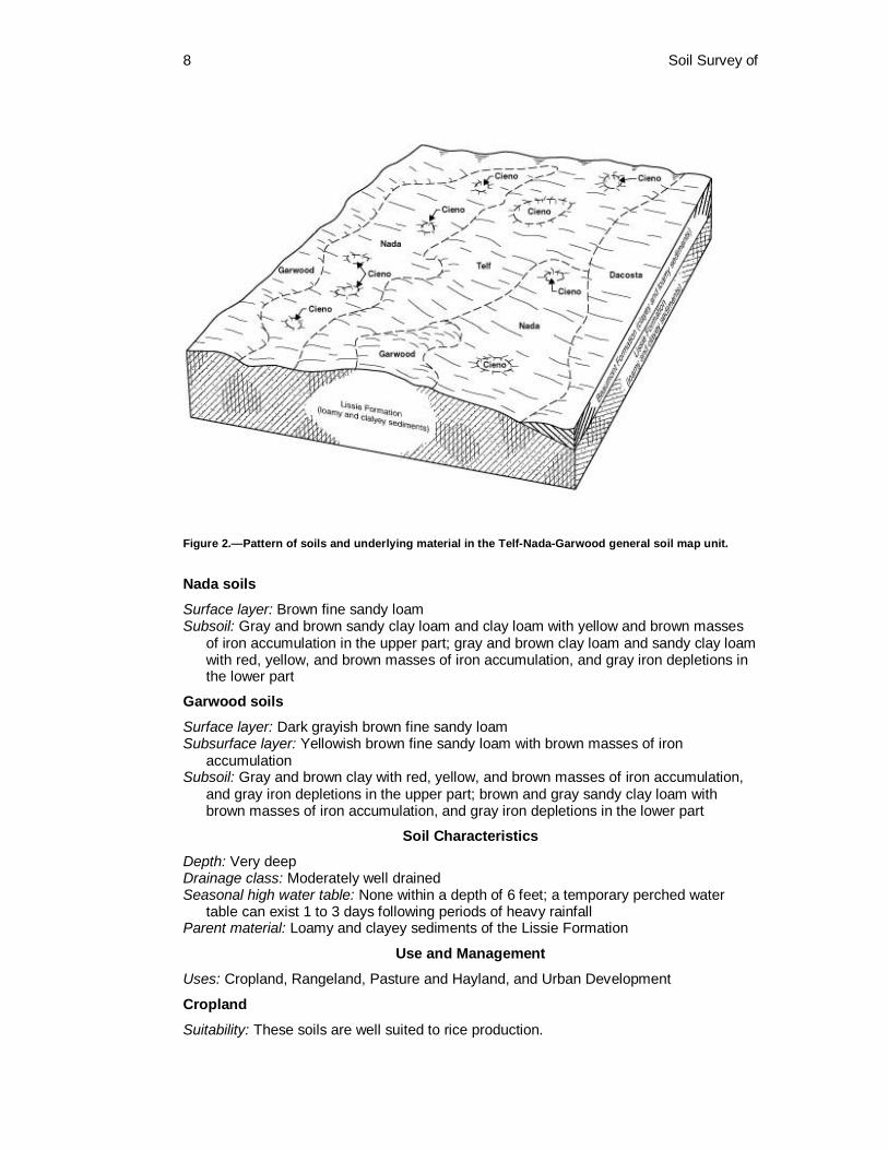
1. Telf-Nada-Garwood Very deep, nearly level to gently sloping, moderately well drained soils that formed in loamy and clayey sediments of the Lissie Formation (fig. 2)
Setting
Contrasting inclusions: South central and southwest parts of the county Landscape position: Flat Coastal Plain Slope: Telf—0 to 3 percent; Nada and Garwood—0 to 1 percent
Composition
Percent of the survey area: 29 Telf soils: 29 percent Nada soils: 32 percent Garwood soils: 14 percent Minor soils (including Cieno, Telferner, Edco, and Udarents): 25 percent
Typical Profile
Telf soils
Surface layer: Dark grayish brown fine sandy loam Subsurface layer: Grayish brown fine sandy loam with brown masses of iron
accumulation Subsoil: Gray and brown clay with red, yellow, and brown masses of iron accumulation in
the upper part; gray and white clay loam and sandy clay loam with red and brown masses of iron accumulation, and gray iron depletions in the lower part
Underlying layer: Gray sandy clay loam with yellow and brown masses of iron accumulation
8 Soil Survey of
Figure 2.—Pattern of soils and underlying material in the Telf-Nada-Garwood general soil map unit.
Nada soils
Surface layer: Brown fine sandy loam Subsoil: Gray and brown sandy clay loam and clay loam with yellow and brown masses
of iron accumulation in the upper part; gray and brown clay loam and sandy clay loam with red, yellow, and brown masses of iron accumulation, and gray iron depletions in the lower part
Garwood soils
Surface layer: Dark grayish brown fine sandy loam Subsurface layer: Yellowish brown fine sandy loam with brown masses of iron
accumulation Subsoil: Gray and brown clay with red, yellow, and brown masses of iron accumulation,
and gray iron depletions in the upper part; brown and gray sandy clay loam with brown masses of iron accumulation, and gray iron depletions in the lower part
Soil Characteristics
Depth: Very deep Drainage class: Moderately well drained Seasonal high water table: None within a depth of 6 feet; a temporary perched water
table can exist 1 to 3 days following periods of heavy rainfall Parent material: Loamy and clayey sediments of the Lissie Formation
Use and Management
Uses: Cropland, Rangeland, Pasture and Hayland, and Urban Development
Cropland
Suitability: These soils are well suited to rice production.

Colorado County, Texas 9
Management concerns: Seasonal wetness, compaction, low soil fertility, adequate moisture storage in topsoil
Rangeland
Suitability: These soils are well suited to this use. Management concerns: None
Pasture and Hayland Suitability: These soils are suited to this use. Management concerns: Seasonal wetness, low moisture storage in topsoil
Urban Development
Suitability: These soils are poorly suited to this use. Management concerns: Very slow permeability, ponding, seasonal wetness, high shrink-
swell potential, high corrosivity to steel
2. Dacosta-Laewest Very deep, nearly level, moderately well drained soils that formed in loamy and clayey sediments of the Beaumont Formation
Setting
Contrasting inclusions: Central and south central portion of the county Landscape position: Flat Coastal Plain Slope: 0 to 1 percent
Composition
Percent of the survey area: 3 Dacosta soils: 62 percent Laewest soils: 36 percent Minor soils (including Edna and Telferner soils): 2 percent
Typical Profile
Dacosta soils
Surface layer: Very dark gray loam Subsoil: Black clay loam and clay in the upper part; gray and brown clay with yellow and
brown masses of iron accumulation in the lower part Underlying layer: Yellowish red clay with brown masses of iron accumulation
Laewest soils
Surface layer: Black clay Subsoil: Gray and brown clay Underlying layer: Brown clay with olive gray iron depletions
Soil Characteristics
Depth: Very deep Drainage class: Moderately well drained Seasonal high water table: None within a depth of 6 feet; a temporary perched water
table can exist on the surface following periods of heavy rainfall. Landscape position: Flats Slope: 0 to 1 percent Parent material: Clayey sediments of the Beaumont Formation
10 Soil Survey of
Use and Management
Uses: Cropland, Rangeland, Pasture and Hayland, Urban Development
Cropland
Suitability: These soils are well suited to this use. Management concerns: None
Rangeland Suitability: These soils are well suited to this use. Management concerns: None
Pasture and Hayland
Suitability: These soils are well suited to this use. Management concerns: None
Urban Development
Suitability: These soils are poorly suited to this use. Management concerns: Very slow permeability, clayey nature of subsoil, high shrink-
swell potential, high corrosivity to steel, low strength
Sandy and Loamy, Dominantly Moderately Well Drained Soils; on Uplands of the Southern Claypan Area
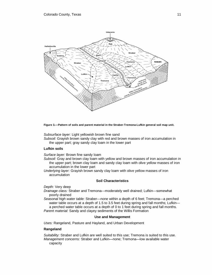
3. Straber-Tremona-Lufkin Very deep, nearly level to moderately sloping, somewhat poorly drained and moderately well drained soils that formed in sandy and clayey sediments of the Willis Formation (fig. 3)
Setting
Location in the survey area: Southwest and north central portion of the county Landscape position: Straber and Tremona—inland dissected coastal plain; Lufkin—
ancient river valley terrace Slope: Straber—1 to 8 percent; Tremona—0 to 5 percent; Lufkin—0 to 1 percent
Composition
Percent of the survey area: 21 Straber soils: 50 percent Tremona soils: 39 percent Lufkin soils: 4 percent Minor soils (including Rek, Newulm, Stein, and Tabor): 7 percent
Typical Profile
Straber soils
Surface layer: Dark yellowish brown loamy fine sand Subsurface layer: Yellowish brown loamy fine sand Subsoil: Gray and brown clay with red, yellow, and brown masses of iron accumulation in
the upper part; gray and brown sandy clay and sandy clay loam with red and yellow masses of iron accumulation in the lower part
Tremona soils Surface layer: Yellowish brown fine sand
Colorado County, Texas 11
Figure 3.—Pattern of soils and parent material in the Straber-Tremona-Lufkin general soil map unit.
Subsurface layer: Light yellowish brown fine sand Subsoil: Grayish brown sandy clay with red and brown masses of iron accumulation in
the upper part; gray sandy clay loam in the lower part
Lufkin soils
Surface layer: Brown fine sandy loam Subsoil: Gray and brown clay loam with yellow and brown masses of iron accumulation in
the upper part; brown clay loam and sandy clay loam with olive yellow masses of iron accumulation in the lower part
Underlying layer: Grayish brown sandy clay loam with olive yellow masses of iron accumulation
Soil Characteristics
Depth: Very deep Drainage class: Straber and Tremona—moderately well drained; Lufkin—somewhat
poorly drained Seasonal high water table: Straber—none within a depth of 6 feet; Tremona—a perched
water table occurs at a depth of 1.5 to 3.5 feet during spring and fall months; Lufkin—a perched water table occurs at a depth of 0 to 1 feet during spring and fall months.
Parent material: Sandy and clayey sediments of the Willis Formation
Use and Management
Uses: Rangeland, Pasture and Hayland, and Urban Development
Rangeland
Suitability: Straber and Lufkin are well suited to this use; Tremona is suited to this use. Management concerns: Straber and Lufkin—none; Tremona—low available water
capacity
12 Soil Survey of
Pasture and Hayland
Suitability: These soils are suited to this use. Management concerns: Straber—acidic surface layer, low natural fertility; Tremona—
acidic surface layer, low natural fertility, low available water capacity; Lufkin—low natural fertility, droughty nature of the surface layer
Urban Development Suitability: Straber and Tremona are poorly suited to this use; Lufkin is not suited to this
use. Management concerns: Straber and Tremona—very slow permeability, seepage, clayey
nature of subsoil, high shrink-swell potential, high corrosivity to steel, low strength; Lufkin—very slow permeability, seasonal wetness, clayey nature of subsoil, very high shrink-swell potential, high corrosivity to steel, low strength
4. Catilla-Joiner Very deep, very gently sloping to gently sloping, somewhat excessively drained and moderately well drained soils that formed in sandy and loamy sediments of the Willis Formation
Setting
Location in the survey area: Southwest and northern portion of the county Landscape position: Catilla and Joiner—inland dissected coastal plain Slope: Catilla—1 to 5 percent; Joiner—1 to 3 percent
Composition
Percent of the survey area: 2 Catilla soils: 78 percent Joiner soils: 20 percent Minor soils (including Newulm, Straber, and Tremona): 2 percent
Typical Profile
Catilla
Surface layer: Dark yellowish brown loamy sand Subsurface layer: Yellowish brown loamy sand in the upper part; brownish yellow loamy
sand with red masses of iron accumulation and gray iron depletions Subsoil: Gray and red sandy clay loam with brown masses of iron accumulation
Joiner
Surface layer: Brown loamy sand Subsurface layer: Brown loamy sand Subsoil: Brown loamy sand with lamellae
Soil Characteristics
Depth: Very deep Drainage class: Catilla—moderately well drained; Joiner—somewhat excessively drained Seasonal high water table: Catilla—a perched water table can exist at a depth of 4 to 6
feet in fall and spring months; Joiner—none within a depth of 6 feet. Landscape position: Catilla and Joiner—interstream divides Parent material: Sandy and loamy sediments of the Willis Formation
Use and Management
Uses: Rangeland, Pasture and Hayland, and Urban Development
Colorado County, Texas 13
Rangeland
Suitability: These soils are suited to this use. Management concerns: Low natural fertility, low available water capacity
Pasture and Hayland
Suitability: These soils are suited to this use. Management concerns: Low natural fertility, low available water capacity
Urban Development
Suitability: These soils are suited to this use. Management concerns: Seepage, poor filtering ability, moderately slow permeability,
sandy nature of subsoil, shoring is needed to prevent cave-ins
Sandy and Loamy, Moderately Well Drained and Somewhat Poorly Drained Soils; on Uplands of the Coast Prairie
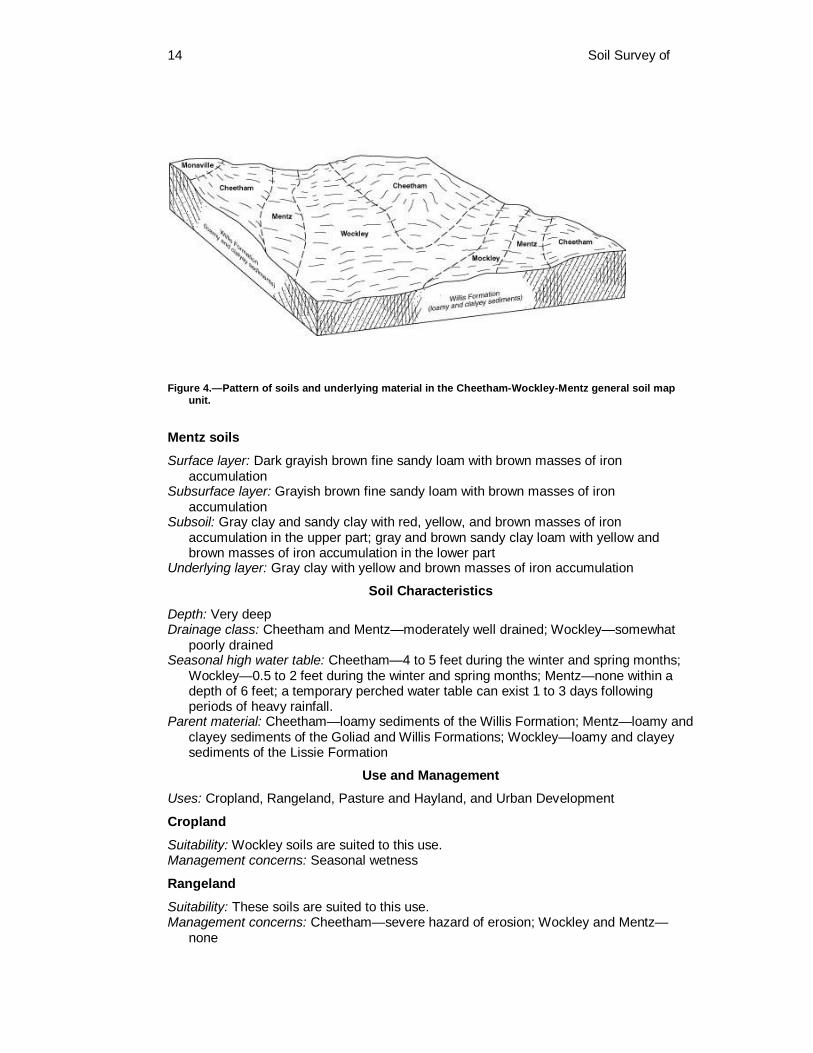
5. Cheetham-Wockley-Mentz Very deep, nearly level and very gently sloping, moderately well drained soils that formed in loamy sediments of the Lissie Formation (fig. 4)
Setting
Location in the survey area: Southwest and northeast portion of the county Landscape position: Inland dissected coastal plain; Cheetham—low hills; Wockley and
Mentz—flats and low hills Slope: Cheetham—1 to 3 percent; Wockley—0 to 3 percent; Mentz—0 to 3 percent
Composition
Percent of the survey area: 7 Cheetham soils: 48 percent Wockley soils: 28 percent Mentz soils: 9 percent Minor soils (including Mockley and Monaville soils): 15 percent
Typical Profile
Cheetham soils Surface layer: Brown loamy sand Subsurface layer: Yellowish brown loamy sand in the upper part; light yellowish brown
loamy sand in the lower part Subsoil: Gray and brown sandy clay loam with red, yellow, and brown masses of iron
accumulation in the upper part; white sandy clay loam with red and yellow masses of iron accumulation in the lower part
Wockley soils
Surface layer: Brown fine sandy loam Subsurface layer: Brown fine sandy loam Subsoil: Gray and brown sandy clay loam with red, yellow, and brown masses of iron
accumulation in the upper part; yellow and brown sandy clay loam with red, yellow, and brown masses of iron accumulation in the lower part
14 Soil Survey of
Figure 4.—Pattern of soils and underlying material in the Cheetham-Wockley-Mentz general soil map unit.
Mentz soils
Surface layer: Dark grayish brown fine sandy loam with brown masses of iron accumulation
Subsurface layer: Grayish brown fine sandy loam with brown masses of iron accumulation
Subsoil: Gray clay and sandy clay with red, yellow, and brown masses of iron accumulation in the upper part; gray and brown sandy clay loam with yellow and brown masses of iron accumulation in the lower part
Underlying layer: Gray clay with yellow and brown masses of iron accumulation
Soil Characteristics
Depth: Very deep Drainage class: Cheetham and Mentz—moderately well drained; Wockley—somewhat
poorly drained Seasonal high water table: Cheetham—4 to 5 feet during the winter and spring months;
Wockley—0.5 to 2 feet during the winter and spring months; Mentz—none within a depth of 6 feet; a temporary perched water table can exist 1 to 3 days following periods of heavy rainfall.
Parent material: Cheetham—loamy sediments of the Willis Formation; Mentz—loamy and clayey sediments of the Goliad and Willis Formations; Wockley—loamy and clayey sediments of the Lissie Formation
Use and Management Uses: Cropland, Rangeland, Pasture and Hayland, and Urban Development
Cropland
Suitability: Wockley soils are suited to this use. Management concerns: Seasonal wetness
Rangeland
Suitability: These soils are suited to this use. Management concerns: Cheetham—severe hazard of erosion; Wockley and Mentz—
none

Colorado County, Texas 15
Pasture and Hayland
Suitability: These soils are suited to this use. Management concerns: Cheetham—severe hazard of erosion; Wockley—high acidity in
topsoil, seasonal wetness; Mentz—low moisture storage in topsoil, hard when dry, root penetration
Urban Development Suitability: Cheetham, Wockley, and Mentz soils are poorly suited to urban development. Management concerns: Cheetham and Wockley—seasonal wetness, moderately slow
permeability, seepage, low strength, high corrosivity to steel; Mentz—very slow permeability, clayey nature of subsoil, high shrink-swell potential, high corrosivity to steel, low strength
6. Kuy-Milby-Nez Very deep, nearly level to gently sloping, moderately well drained soils that formed in sandy, loamy, and clayey sediments of the Lissie Formation
Setting
Location in the survey area: Southern portion of the county Landscape position: Kuy and Milby—ancient river valley; Nez—flat coastal plain Slope: Kuy and Milby—1 to 3 percent; Nez—0 to 1 percent
Composition
Percent of the survey area: 7 Kuy soils: 36 percent Milby soils: 31 percent Nez soils: 24 percent Minor soils (including Rupley, Fordtran, and Katy): 9 percent
Typical Profile
Kuy
Surface layer: Brown sand Subsurface layer: Yellowish brown sand in the upper part; pale brown sand in the lower
part Subsoil: Yellow and brown sandy loam with brown masses of iron accumulation, and gray
iron depletions in the upper part; Gray and brown sandy clay loam with red and yellow masses of iron accumulation in the lower part
Milby
Surface layer: Brown sand Subsurface layer: Brown sand with brown masses of iron accumulation in the upper part;
light brown sand in the lower part Subsoil: Brown fine sandy loam with brown masses of iron accumulation in the upper
part; gray sandy clay and sandy clay loam with red and brown masses of iron accumulation in the lower part
Underlying layer: Gray sandy clay loam with red and brown masses of iron accumulation
Nez
Surface layer: Brown loamy sand Subsurface layer: Pale brown loamy sand
16 Soil Survey of
Subsoil: Gray clay and sandy clay with red, yellow, and brown masses of iron accumulation in the upper part; gray and brown sandy clay loam with red, yellow, and brown masses of iron accumulation in the lower part
Soil Characteristics
Depth: Very deep Drainage class: Moderately well drained Seasonal high water table: Kuy and Milby—none; Nez—none within a depth of 6 feet; a
temporary perched water table can exist 1 to 3 days following periods of heavy rainfall.
Landscape position: Kuy and Milby—terraces; Nez—flats Parent material: Sandy, loamy, and clayey sediments of the Lissie Formation
Use and Management
Uses: Rangeland, Pasture and Hayland, and Urban Development
Rangeland
Suitability: Nez soils are well suited to this use; Kuy and Milby soils are suited to this use. Management concerns: Kuy and Milby—low natural fertility, low available water capacity;
Nez—none
Pasture and Hayland Suitability: These soils are suited to this use. Management concerns: Kuy and Milby—low natural fertility, low available water capacity;
Nez—low natural fertility, low moisture storage in topsoil
Urban Development
Suitability: These soils are poorly suited to this use. Management concerns: Kuy—seasonal wetness, seepage, droughtiness, poor filtering
ability of subsoil, shoring needed to prevent cave-ins; Milby—seasonal wetness, seepage, poor filtering ability of subsoil; Nez—very slow permeability, clayey nature of the subsoil, high shrink-swell potential, high corrosivity to steel, low strength
7. Katy-Fordtran Very deep, nearly level to gently sloping, moderately well drained soils that formed in loamy and clayey sediments of the Lissie Formation
Setting
Location in the survey area: Southeast portion of the county Landscape position: Katy—flat coastal plain; Fordtran—ancient river valley Slope: 0 to 1 percent
Composition
Percent of the survey area: 3 Katy soils: 88 percent Fordtran soils: 8 percent Minor soils (including Cieno, Kuy, Nada, and Telferner): 4 percent
Typical Profile
Katy soils
Surface layer: Grayish brown fine sandy loam with brown masses of iron accumulation Subsurface layer: Brown fine sandy loam with brown masses of iron accumulation
Colorado County, Texas 17
Subsoil: Brown sandy clay loam with red and brown masses of iron accumulation in the upper part; gray and brown sandy clay with red, yellow, and brown masses of iron accumulation in the lower part
Fordtran soils
Surface layer: Pale brown loamy fine sand Subsurface layer: Yellowish brown loamy fine sand with yellow and brown masses of iron
accumulation Subsurface layer: Yellowish brown loamy fine sand with yellow and brown masses of iron
accumulation Subsoil: Gray sandy clay with yellow and brown masses of iron accumulation in the upper
part; gray, yellow, and brown clay and sandy clay with red, yellow, and brown masses of iron accumulation in the lower part
Underlying layer: Gray sandy clay loam with red, yellow, and brown masses of iron accumulation
Soil Characteristics
Depth: Very deep Drainage class: Moderately well drained Seasonal high water table: Fordtran—none within a depth of 6 feet; Katy—none within a
depth of 6 feet; a temporary perched water table can exist 1 to 3 days following periods of heavy rainfall.
Landscape position: Flats Parent material: Loamy and clayey sediments of the Lissie Formation
Use and Management
Uses: Cropland, Rangeland, Pasture and Hayland, and Urban Development
Cropland
Suitability: Katy—this soil is well suited to rice production; Fordtran—not used for cropland.
Management concerns: Low moisture storage in topsoil, surface becomes hard when dry, root penetration
Rangeland
Suitability: These soils are well suited to this use. Management concerns: Katy—none; Fordtran—low natural fertility, low available water
capacity
Pasture and Hayland
Suitability: These soils are suited to this use. Management concerns: Katy—low moisture storage in topsoil, surface becomes hard
when dry, root penetration; Fordtran—low natural fertility, low available water capacity
Urban Development
Suitability: These soils are suited to this use. Management concerns: Katy—moderately slow permeability, moderately clayey subsoil,
high corrosivity to steel, low strength; Fordtran—very slow permeability, seepage, clayey subsoil, low strength, shoring needed to prevent cave-ins

18 Soil Survey of
Sandy, Loamy, and Clayey, Moderately Well Drained and Well Drained Soils; on Flood Plains and Terraces
8. Norwood-Brazoria-Mohat Very deep, nearly level, moderately well drained and well drained soils that formed in calcareous loamy and clayey alluvium of the Colorado River (fig. 5)
Setting
Location in the survey area: Along the Colorado River Landscape position: Norwood and Mohat—river valley; Brazoria—ancient river valley Slope: 0 to 1 percent
Composition
Percent of the survey area: 6 Norwood soils: 39 percent Brazoria soils: 21 percent Mohat soils: 18 percent Minor soils (including Udarents, Clemville, Coarsewood, and Riverwash): 22 percent
Typical Profile
Norwood
Surface layer: Light brown loam Subsurface layer: Brown silt loam Subsoil: Brown and yellow silt loam with red bedding planes Underlying layer: Brown silty clay loam with red masses of iron accumulation in the upper
part; brown very fine sandy loam with brown masses of iron accumulation and gray iron depletions
Brazoria
Surface layer: Dark brown clay Subsoil: Brown and red clay
Mohat
Surface layer: Brown loam Subsoil: Brown very fine sandy loam in the upper part; brown very fine sandy loam with
red masses of iron accumulation in the lower part Underlying layer: Brown very fine sandy loam
Soil Characteristics
Depth: Very deep Drainage class: Norwood and Mohat—well drained; Brazoria—moderately well drained Seasonal high water table: None within a depth of 6 feet Flooding: Rarely flooded Parent material: Calcareous loamy and clayey alluvium of the Colorado River
Use and Management
Uses: Cropland, Pasture and Hayland, and Urban Development
Cropland Suitability: These soils are well suited to this use.

Colorado County, Texas 19
Figure 5.—Pattern of soils and underlying material in the Norwood-Brazoria-Mohat general soil map unit.
Management concerns: None
Pasture and Hayland
Suitability: These soils are well suited to this use. Management concerns: None
Urban Development
Suitability: These soils are not suited to this use. Management concerns: Norwood—severe hazard of flooding, high corrosivity to steel,
low strength; Brazoria—severe hazard of flooding, very slow permeability, clayey nature of subsoil, very high shrink-swell potential, high corrosivity to steel; Mohat—severe hazard of flooding, seepage
9. Tabor-Robco-Chazos Very deep, nearly level and very gently sloping, moderately well drained and well drained soils that formed in loamy and clayey stream terrace sediments of the Willis Formation
Setting
Location in the survey area: Northern portion of the county Landscape position: Ancient river valley Slope: Tabor—0 to 3 percent; Robco and Chazos—1 to 3 percent
Composition
Percent of the survey area: 4 Tabor soils: 42 percent Robco soils: 27 percent Chazos soils: 18 percent Minor soils (including Faula, Lufkin, Straber and Tadina): 13 percent

20 Soil Survey of
Typical Profile
Tabor
Surface layer: Brown fine sandy loam Subsurface layer: Brown fine sandy loam Subsoil: Brown clay with red and brown masses of iron accumulation in the upper part;
gray clay and sandy clay with red, yellow, and brown masses of iron accumulation in the lower part
Robco
Surface layer: Dark grayish brown loamy fine sand Subsurface layer: Yellowish brown loamy fine sand Subsoil: Gray and yellow sandy clay loam with red and yellow masses of iron
accumulation in the upper part; gray sandy clay loam with red, yellow, and brown masses of iron accumulation in the lower part
Chazos
Surface layer: Dark grayish brown loamy fine sand Subsurface layer: Yellowish brown loamy fine sand Subsoil: Gray sandy clay with red, yellow, and brown masses of iron accumulation in the
upper part; gray sandy clay loam with red, yellow, and brown masses of iron accumulation in the lower part
Soil Characteristics
Depth: Very deep Drainage class: Moderately well drained Seasonal high water table: Tabor and Chazos—none within a depth of 6 feet; Robco—a
perched water table occurs at a depth of 4 to 5 feet during winter and spring months. Parent material: Robco—Loamy sediments of the Willis Formation; Chazos—Loamy and
clayey sediments associated with streams; Tabor—Loamy and clayey stream terrace sediments of the Willis Formation
Use and Management
Uses: Rangeland, Pasture and Hayland, and Urban Development
Rangeland
Suitability: These soils are well suited to this use. Management concerns: Robco—low natural fertility; Tabor and Chazos—none
Pasture and Hayland
Suitability: These soils are suited to this use. Management concerns: Tabor—none; Robco and Chazos—low natural fertility
Urban Development
Suitability: These soils are poorly suited to this use. Management concerns: Tabor—very slow permeability, clayey nature of subsoil, high
shrink-swell potential, high corrosivity to steel, low strength; Robco—seasonal wetness, seepage, moderately high shrink-swell potential, high corrosivity to steel, low strength, shoring is needed to prevent cave-ins; Chazos—slow permeability, seepage, high corrosivity to steel, low strength
Colorado County, Texas 21
10. Wilson-Gholson-Burleson Very deep, nearly level to moderately sloping, moderately well drained and well drained soils that formed in loamy alluvium and alkaline clayey sediments of Pleistocene fluvial terraces
Setting
Location in the survey area: Along the Colorado River Landscape position: Ancient river valley Slope: Wilson—0 to 1 percent; Gholson—1 to 8 percent; Burleson—1 to 3 percent
Composition
Percent of the survey area: 3 Wilson soils: 30 percent Gholson soils: 22 percent Burleson soils: 16 percent Minor soils (including Dutek, Smithville, Rabbs, and Trinity): 32 percent
Typical Profile
Wilson
Surface layer: Dark brown clay loam Subsoil: Gray clay with brown masses of iron accumulation in the upper part; brown clay
with brown masses of iron accumulation in the lower part
Gholson
Surface layer: Dark yellowish brown fine sandy loam Subsoil: Red sandy clay loam in the upper part; brown loamy and loamy fine sand in the
lower part Underlying layer: Brown loamy fine sand with pebbles
Burleson
Surface layer: Very dark gray clay Subsoil: Gray clay in the upper part; gray and olive clay with gray iron depletions in the
lower part
Soil Characteristics
Depth: Very deep Drainage class: Wilson and Burleson—moderately well drained; Gholson—well drained Seasonal high water table: Gholson and Burleson—none within a depth of 6 feet;
Wilson—a perched water table occurs at a depth of 0 to 1 foot during winter and spring months
Parent material: Wilson and Burleson—clayey alluvial sediments; Gholson—loamy alluvial sediments along Colorado River
Use and Management
Uses: Cropland, Rangeland, Pasture and Hayland, and Urban Development
Cropland
Suitability: Gholson and Burleson are well suited to this use; Wilson is suited to this use. Management concerns: Gholson and Burleson—none; Wilson—seasonal wetness,
surface drainage

22 Soil Survey of
Rangeland
Suitability: These soils are well suited to this use. Management concerns: None
Pasture and Hayland
Suitability: These soils are well suited to this use. Management concerns: None
Urban Development
Suitability: Wilson and Burleson are poorly suited to this use; Gholson is suited to this use.
Management concerns: Wilson—seasonal wetness, very slow permeability, clayey nature of subsoil, high shrink-swell potential, high corrosivity to steel, low strength; Gholson—seepage; Burleson—very slow permeability, clayey nature of subsoil, high shrink-swell potential, high corrosivity to steel, low strength
11. Pursley-Whitesboro-Ganado Very deep, nearly level, moderately well drained and well drained soils that formed in loamy and clayey alluvium on flood plains
Setting
Location in the survey area: Northern portion of the county Landscape position: River valley Slope: 0 to 1 percent
Composition
Percent of the survey area: 2 Pursley soils: 42 percent Whitesboro soils: 29 percent Ganado soils: 19 percent Minor soils (including Bosque and Uhland): 10 percent
Typical Profile Pursley
Surface layer: Dark brown sandy clay loam Subsurface layer: Very dark grayish brown sandy clay loam Subsoil: Brown and gray sandy clay loam Underlying layer: Brown sandy clay loam and clay loam in the upper part; brown and gray
clay in the lower part
Whitesboro
Surface layer: Dark grayish brown sandy clay loam Subsoil: Brown sandy clay loam and fine sandy loam with brown masses of iron
accumulation in the upper part; gray and brown sandy clay loam and clay loam with brown masses of iron accumulation in the lower part
Ganado
Surface layer: Black clay Subsoil: Black clay in the upper part; black clay loam in the lower part
Colorado County, Texas 23
Soil Characteristics
Depth: Very deep Drainage class: Pursley and Whitesboro—well drained; Ganado—moderately well
drained Seasonal high water table: None within a depth of 6 feet Flooding: Pursley—frequently flooded; Whitesboro and Ganado—occasionally flooded Parent material: Pursley and Whitesboro—loamy alluvial sediments associated with
smaller streams and creeks; Ganado—clayey alluvial sediments of major streams
Use and Management
Uses: Cropland, Rangeland, Pasture, and Hayland
Cropland
Suitability: These soils are suited to this use. Management concerns: Severe hazard of flooding
Rangeland
Suitability: These soils are well suited to this use. Management concerns: None
Pasture and Hayland
Suitability: These soils are suited to this use. Management concerns: Severe hazard of flooding
12. Ships-Weswood-Bergstrom Very deep, nearly level and very gently sloping, moderately well drained and well drained soils that formed in calcareous loamy and clayey alluvium of the Colorado River
Setting
Location in the survey area: Along the Colorado River Landscape position: River valley Slope: 0 to 1 percent
Composition
Percent of the survey area: 1 Ships soils: 27 percent Weswood soils: 26 percent Bergstrom soils: 18 percent Minor soils (including Gad, Gholson, Rabbs and Roetex): 29 percent
Typical Profile
Ships
Surface layer: Dark brown clay Subsoil: Brown clay
Weswood
Surface layer: Brown loam Subsoil: Brown silt loam Underlying layer: Brown silt loam
Bergstrom
Surface layer: Dark brown silt loam

24 Soil Survey of
Subsurface layer: Dark brown silt loam and silty clay loam Subsoil: Brown silty clay loam
Soil Characteristics
Depth: Very deep Drainage class: Ships—moderately well drained; Weswood and Bergstrom—well drained Seasonal high water table: None within a depth of 6 feet Flooding: Rarely flooded Parent material: Ships—clayey alluvial sediments along the Colorado River; Weswood
and Bergstrom—loamy alluvial sediments along the Colorado River
Use and Management
Uses: Cropland, Rangeland, Pasture and Hayland, and Urban Development
Cropland
Suitability: These soils are well suited to this use. Management concerns: None
Rangeland
Suitability: These soils are well suited to this use. Management concerns: None
Pasture and Hayland Suitability: These soils are well suited to this use. Management concerns: None
Urban Development
Suitability: These soils are not suited to this use. Management concerns: Ships—severe hazard of flooding, very slow permeability, clayey
nature of subsoil, very high shrink-swell potential, high corrosivity to steel, low strength; Weswood—severe hazard of flooding, high corrosivity to steel, low strength; Bergstrom—severe hazard of flooding
Loamy and Clayey, Moderately Well Drained and Well Drained Soils; on Uplands of the Southern Blackland Prairie
13. Hallettsville-Frelsburg-Carbengle Moderately deep to very deep, very gently sloping to strongly sloping, moderately well drained and well drained soils that formed in loamy and clayey sediments and residuum from weakly calcareous sandstone of the Fleming Formation (fig. 6)
Setting
Location in the survey area: Western and northern portion of the county Landscape position: Inland dissected coastal plain Slope: Hallettsville—1 to 3 percent; Frelsburg—1 to 5 percent; Carbengle—3 to 12
percent
Composition
Percent of the survey area: 11 Hallettsville soils: 32 percent Frelsburg soils: 23 percent
Colorado County, Texas 25
Carbengle soils: 14 percent Minor soils (including Bleiblerville, Brenham, Denvaca, Dubina, Elmenwood, and Latium
soils): 31 percent
Typical Profile Hallettsville
Surface layer: Very dark gray fine sandy loam Subsoil: Gray and brown clay loam and brown loam with brown masses of iron
accumulation Underlying layer: Brown loam with red masses of iron accumulation
Frelsburg
Surface layer: Black clay Subsoil: Dark gray clay in the upper part; gray and brown clay in the lower part Underlying layer: Mottled gray, brown, and yellow clay
Carbengle
Surface layer: Very dark grayish brown sandy clay loam Subsurface layer: Dark brown sandy clay loam Subsoil: Dark yellowish brown loam in the upper part; brown loam in the middle part; and
light yellowish brown in the lower part Underlying layer: Pale brown weakly consolidated sandstone
Soil Characteristics
Depth: Hallettsville and Frelsburg—very deep; Carbengle—moderately deep Drainage class: Hallettsville and Frelsburg—moderately well drained; Carbengle—well
drained Seasonal high water table: None Landscape position: Hallettsville—shoulders, footslopes; Frelsburg—footslopes, low
ridges, side slopes; Carbengle—ridges, side slopes Parent material: Hallettsville and Frelsburg—Clayey sediments of the Fleming Formation;
Carbengle—residuum from weakly calcareous sandstone of the Fleming Formation
Use and Management Uses: Cropland, Rangeland, Pasture and Hayland, and Urban Development
Cropland
Suitability: These soils are suited to this use. Management concerns: Carbengle—low available water capacity
Rangeland
Suitability: These soils are suited to this use. Management concerns: Carbengle—low available water capacity
Pasture and Hayland
Suitability: These soils are suited to this use. Management concerns: Carbengle—low available water capacity
Urban Development
Suitability: These soils are poorly suited to this use. Management concerns: Hallettsville and Frelsburg—very slow permeability, clayey nature
of the subsoil, high shrink-swell potential, low strength, high corrosivity, possibility of cave-ins; Carbengle—moderate depth to bedrock

26
Figure 6.—Pattern of soils and underlying material in the Hallettsville-Frelsburg-Carbengle general soil map unit.

27
Detailed Soil Map Units
The map units delineated on the detailed soil maps in this survey represent the soils or miscellaneous areas in the survey area. The map unit descriptions in this section, along with the maps, can be used to determine the suitability and potential of a unit for specific uses. They also can be used to plan the management needed for those uses.
A map unit delineation on a soil map represents an area dominated by one or more major kinds of soil or miscellaneous areas. A map unit is identified and named according to the taxonomic classification of the dominant soils. Within a taxonomic class there are precisely defined limits for the properties of the soils. On the landscape, however, the soils are natural phenomena, and they have the characteristic variability of all natural phenomena. Thus, the range of some observed properties may extend beyond the limits defined for a taxonomic class. Areas of soils of a single taxonomic class rarely, if ever, can be mapped without including areas of other taxonomic classes. Consequently, every map unit is made up of the soils or miscellaneous areas for which it is named and some minor components that belong to taxonomic classes other than those of the major soils.
Most minor soils have properties similar to those of the dominant soil or soils in the map unit, and thus they do not affect use and management. These are called noncontrasting, or similar, components. They may or may not be mentioned in a particular map unit description. Other minor components, however, have properties and behavioral characteristics divergent enough to affect use or to require different management. These are called contrasting, or dissimilar, components. They generally are in small areas and could not be mapped separately because of the scale used. Some small areas of strongly contrasting soils or miscellaneous areas are identified by a special symbol on the maps. The contrasting components are mentioned in the map unit descriptions. A few areas of minor components may not have been observed, and consequently they are not mentioned in the descriptions, especially where the pattern was so complex that it was impractical to make enough observations to identify all the soils and miscellaneous areas on the landscape.
The presence of minor components in a map unit in no way diminishes the usefulness or accuracy of the data. The objective of mapping is not to delineate pure taxonomic classes but rather to separate the landscape into landforms or landform segments that have similar use and management requirements. The delineation of such segments on the map provides sufficient information for the development of resource plans. If intensive use of small areas is planned, however, onsite investigation is needed to define and locate the soils and miscellaneous areas.
An identifying symbol precedes the map unit name in the map unit descriptions. Each description includes general facts about the unit and gives the principal hazards and limitations to be considered in planning for specific uses.
Soils that have profiles that are almost alike make up a soil series. Except for differences in texture of the surface layer, all the soils of a series have major horizons that are similar in composition, thickness, and arrangement.
Soils of one series can differ in texture of the surface layer, slope, stoniness, salinity, degree of erosion, and other characteristics that affect their use. On the basis of such differences, a soil series is divided into soil phases. Most of the areas shown on the detailed soil maps are phases of soil series. The name of a soil phase

28 Soil Survey of
commonly indicates a feature that affects use or management. For example, Frelsburg clay, 1 to 3 percent slopes is a phase of the Frelsburg series.
Some map units are made up of two or more major soils or miscellaneous areas. These map units are complexes.
A complex consists of two or more soils or miscellaneous areas in such an intricate pattern or in such small areas that they cannot be shown separately on the maps. The pattern and proportion of the soils or miscellaneous areas are somewhat similar in all areas. Elmenwood-Denvaca complex, 1 to 3 percent slopes is an example.
This survey includes miscellaneous areas. Such areas have little or no soil material and support little or no vegetation. Riverwash is an example.
Table 4 shows the acreage and proportionate extent of each map unit. Other tables give properties of the soils and the limitations, capabilities, and potentials for many uses. The Glossary defines many of the terms used in describing the soils or miscellaneous areas.
BgA—Bergstrom silt loam, 0 to 1 percent slopes, rarely flooded
Setting
Landscape: River valley Landform or position on landform: Flats on flood plain Distinctive surface features: Smooth Parent material: Loamy alliuvial sediments along the Colorado River Slope: Nearly level Shape of areas: Oval to irregular Size of areas: 20 to 200 acres Native vegetation: Native vegetation consists of tall bunch grasses and scattered
hardwoods
Typical Profile
Surface layer: 0 to 8 inches—slightly alkaline, dark brown silt loam
Subsurface layer: 8 to 17 inches—slightly alkaline, dark brown silt loam 17 to 23 inches—slightly alkaline, dark brown silty clay loam
Subsoil: 23 to 40 inches—slightly alkaline, dark brown silty clay loam 40 to 80 inches—moderately alkaline, brown silt loam that has common concretions
of calcium carbonate
Soil Properties
Depth: Very deep Drainage class: Well drained Water table: None within a depth of 6 feet Flooding: Rarely. This soil floods on average 1 to 5 times in 100 years. The duration
usually lasts from 2 to 7 days and occurs from March to September. This soil is protected from flooding activity by large upstream structures.
Runoff: Negligible Permeability: Moderate Available water capacity: High Root zone: Very deep Natural soil fertility: High

Colorado County, Texas 29
Shrink-swell potential: Moderate Water erosion hazard: Slight Wind erosion hazard: Slight
Composition
Bergstrom soil and similar inclusions: 75 to 90 percent Contrasting inclusions: 10 to 25 percent
Contrasting Inclusions
Contrasting inclusions in this map unit are the Coarsewood, Gholson, Ships, and Wilson soils. Coarsewood soils are sandier and are closer to the river. Gholson soils are loamy and are on slightly higher positions. Ships soils are clayey throughout and are in slightly lower positions. Wilson soils have clayey subsoils and are on higher positions.
Land Uses
Major land use: Cropland (fig. 7). Other land uses: Pasture, rangeland, and wildlife habitat
Management Concerns
Cropland
This soil is well suited to crops such as cotton, grain sorghum, and corn.
Major limitations: • There are no major limitations.
Rangeland
This soil is well suited to Virginia wildrye, beaked panicum, rustyseed paspalum, switchgrass, Indiangrass, and little bluestem. Forbs and shrubs are also well suited. Trees suitable for this soil are elm, pecan, and hackberry.
Major limitations:
• There are no major limitations.
Pasture
This soil is well suited to pasture grasses such as improved varieties of bermudagrass.
Major limitations: • There are no major limitations.
Wildlife Habitat
This soil is suited to openland wildlife habitat. This soil provides a source for food and shelter for deer, small mammals, and waterfowl. Food sources include cultivated grains, native grains, forbs, and legumes.
Major limitations: • There are no major limitations.
Minor limitations: • The minor limitation that affects this soil for use as wildlife habitat is the lack of
trees, although trees are located on adjacent soils.
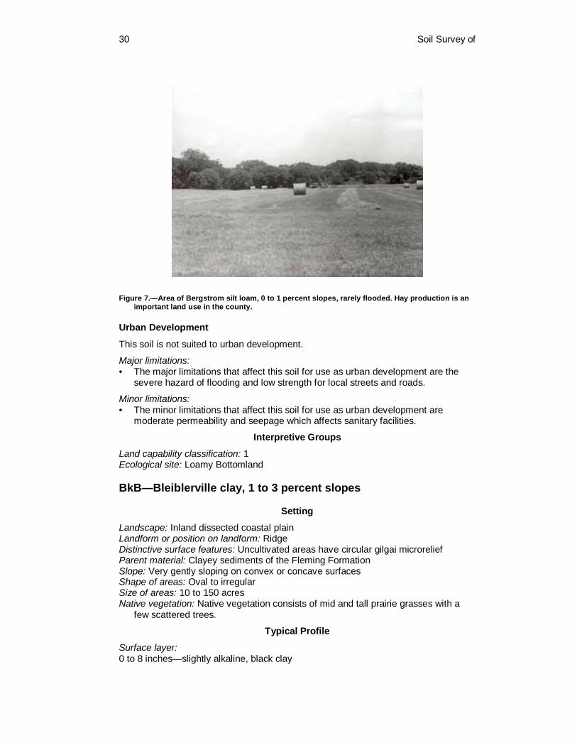
30 Soil Survey of
Figure 7.—Area of Bergstrom silt loam, 0 to 1 percent slopes, rarely flooded. Hay production is an important land use in the county.
Urban Development
This soil is not suited to urban development.
Major limitations: • The major limitations that affect this soil for use as urban development are the
severe hazard of flooding and low strength for local streets and roads.
Minor limitations: • The minor limitations that affect this soil for use as urban development are
moderate permeability and seepage which affects sanitary facilities.
Interpretive Groups
Land capability classification: 1 Ecological site: Loamy Bottomland
BkB—Bleiblerville clay, 1 to 3 percent slopes
Setting
Landscape: Inland dissected coastal plain Landform or position on landform: Ridge Distinctive surface features: Uncultivated areas have circular gilgai microrelief Parent material: Clayey sediments of the Fleming Formation Slope: Very gently sloping on convex or concave surfaces Shape of areas: Oval to irregular Size of areas: 10 to 150 acres Native vegetation: Native vegetation consists of mid and tall prairie grasses with a
few scattered trees.
Typical Profile
Surface layer: 0 to 8 inches—slightly alkaline, black clay

Colorado County, Texas 31
Subsurface layer: 8 to 24 inches—slightly alkaline, very dark gray clay that has slickensides and
pressure surfaces
Subsoil: 24 to 50 inches—slightly alkaline, dark gray clay that has slickensides and pressure
surfaces 50 to 55 inches—slightly alkaline, dark grayish brown clay that has slickensides and
pressure surfaces 55 to 66 inches—moderately alkaline, grayish brown, very dark gray and brownish
yellow clay that has slickensides, pressure surfaces and common concretions of calcium carbonate
66 to 80 inches—moderately alkaline, brownish yellow and grayish brown clay that has slickensides, pressure surfaces and common concretions of calcium carbonate
Soil Properties
Depth: Very deep Drainage class: Moderately well drained Water table: None within a depth of 6 feet Flooding: None Runoff: Very high Permeability: Very slow Available water capacity: High Root zone: Very deep Natural soil fertility: High Shrink-swell potential: Very high Water erosion hazard: Moderate Wind erosion hazard: Slight
Composition
Bleiblerville soil and similar inclusions: 85 to 95 percent Contrasting inclusions: 5 to 15 percent
Contrasting Inclusions
Contrasting inclusions in this map unit are the Brenham and Hallettsville soils. Brenham soils have a loamy surface layer and are on steeper side slopes. Hallettsville soils have a loamy surface layer and are in higher positions.
Land Uses
Major land use: Cropland and pasture Other land uses: Rangeland, wildlife habitat, pond reservoir development, and urban
development
Management Concerns
Cropland
This soil is well suited to crops such as corn, small grains, and grain sorghum.
Major limitations: • There are no major limitations.
Minor limitations: • The minor limitations that affect this soil for use as cropland are seasonal
wetness and compaction.
32 Soil Survey of
Rangeland
This soil is well suited to rangeland vegetation such as little bluestem, Indiangrass, big bluestem, eastern gamagrass, switchgrass, and other perennial grasses. Perennial forbs are also suited to this soil. Trees suitable for this soil are mesquite, hackberry, and live oak.
Major limitations: • There are no major limitations.
Pasture
This soil is well suited to pasture grasses such as improved varieties of bermudagrass, kleingrass, and johnsongrass.
Major limitations: • There are no major limitations.
Minor limitations: • The minor limitations that affect this soil for use as cropland are seasonal
wetness and compaction.
Wildlife Habitat
This soil is suited to openland wildlife habitat. This soil provides a source for food and shelter for deer, small mammals, and waterfowl. Food sources include cultivated grains, native grasses, forbs, and legumes.
Major limitations: • There are no major limitations.
Pond Reservoir Development
This soil is well suited to pond reservoir development. The clayey subsoil layers can provide a seal for holding water.
Major limitations: • There are no major limitations.
Urban Development
This soil is poorly suited to urban development.
Major limitations: • The major limitations that affect this soil for use as urban development are very
slow permeability, clayey subsoil, very high shrink-swell potential, high corrosivity to steel, and low strength can affect sanitary facilities and building site development. Shallow excavations should be shored to prevent cave-ins.
Interpretive Groups
Land capability classification: 2e Ecological site: Blackland
BoA—Bosque clay loam, 0 to 1 percent slopes, occasionally flooded
Setting
Landscape: River valley Landform or position on landform: Flood plain Distinctive surface features: Smooth

Colorado County, Texas 33
Parent material: Loamy alluvial sediments Slope: Nearly level Shape of areas: Elongated to irregular Size of areas: 15 to 100 acres Native vegetation: Native vegetation consists of perennial grasses, perennial forbs,
and mixed hardwoods
Typical Profile
Surface layer: 0 to 6 inches—slightly alkaline, dark brown clay loam
Subsurface layer: 6 to 20 inches—slightly alkaline, very dark grayish brown clay loam 20 to 27 inches—slightly alkaline, dark brown sandy clay loam 27 to 41 inches—moderately alkaline, very dark grayish brown clay loam that has
common threads of calcium carbonate
Subsoil: 41 to 53 inches—moderately alkaline, dark grayish brown clay loam that has
common threads and concretions of calcium carbonate 53 to 64 inches—moderately alkaline, dark grayish brown clay loam 64 to 80 inches—moderately alkaline, dark brown fine sandy loam that has common
bedding planes
Soil Properties
Depth: Very deep Drainage class: Well drained Water table: None within a depth of 6 feet Flooding: Occasional. This soil floods 5 to 50 times in 100 years. The duration usually
lasts from 2 to 7 days and occurs during October to May. Runoff: Negligible Permeability: Moderate Available water capacity: High Root zone: Very deep Natural soil fertility: High Shrink-swell potential: Low Water erosion hazard: Slight Wind erosion hazard: Slight
Composition
Bosque soil and similar inclusions: 85 to 95 percent Contrasting inclusions: 5 to 15 percent
Contrasting Inclusions
Contrasting inclusions in this map unit are the Pursley and Uhland soils. These soils are in similar positions. Pursley soils have a mollic epipedon less than 20 inches thick. Uhland soils have wetness features.
Land Uses
Major land use: Pasture Other land uses: Cropland, rangeland, wildlife habitat, pond reservoir development,
and urban development
34 Soil Survey of
Management Concerns
Cropland
This soil is suited to crops such as corn, cotton, small grains, and forage sorghum. This soil is well suited to pecan orchards when managed for pecan production.
Major limitations: • There are no major limitations.
Minor limitations: • The minor limitation that affects this soil for use as is occasional flooding.
Rangeland
This soil is well suited to rangeland vegetation such as Indiangrass, big and little bluestem, switchgrass, and other perennial grasses. Perennial forbs and shrubs are also suited. Trees suitable for this soil are elm, hackberry, live oak, cottonwood, and pecan.
Major limitations: • There are no major limitations.
Pasture
This soil is well suited to pasture grasses such as improved varieties of bermudagrass, kleingrass, and johnsongrass.
Major limitations: • There are no major limitations.
Wildlife Habitat
This soil has high potential to support wildlife such as deer, small mammals, and turkey. This soil provides food in the form of grain, seed, grass, legumes, and wild herbs.
Major limitations: • There are no major limitations.
Pond Reservoir Development
This soil is suited to pond reservoir development.
Major limitations: • There are no major limitations.
Minor limitations: • The minor limitation that affects this soil for use as pond reservoir development is
seepage.
Urban Development
This soil has severe limitations affecting urban development.
Major limitations: • The major limitations that affect this soil for use as urban development are severe
hazard of flooding, corrosivity to steel, and low strength.
Interpretive Groups
Land capability classification: 2w Ecological site: Loamy Bottomland

Colorado County, Texas 35
BrA—Brazoria clay, 0 to 1 percent slopes, rarely flooded
Setting
Landscape: Ancient river valley Landform or position on landform: Terrace Distinctive surface features: Uncultivated areas have circular gilgai microrelief Parent material: Clayey alluvial sediments along the Colorado River Slope: Nearly level on linear surfaces Shape of areas: Irregular Size of areas: 15 to 900 acres Native vegetation: Native vegetation consists of perennial grasses, perennial forbs,
and mixed hardwoods
Typical Profile
Surface layer: 0 to 6 inches—slightly alkaline, dark brown clay
Subsoil: 6 to 22 inches—slightly alkaline, dark brown clay 22 to 37 inches—slightly alkaline, brown clay that has slickensides and pressure
surfaces 37 to 54 inches—slightly alkaline, reddish brown clay that has slickensides and
pressure surfaces 54 to 73 inches—slightly alkaline, dark reddish gray and dark reddish brown clay that
has slickensides and pressure surfaces 73 to 80 inches—slightly alkaline, very dark grayish brown clay that has slickensides
and pressure surfaces
Soil Properties
Depth: Very deep Drainage class: Moderately well drained Water table: None within a depth of 6 feet Flooding: Rare. This soil floods about 1 to 5 times in 100 years. The duration usually
lasts from 2 to 7 days and occurs during March through October. Runoff: High Permeability: Very slow Available water capacity: Very high Root zone: Very deep Natural soil fertility: High Shrink-swell potential: Very high Water erosion hazard: Slight Wind erosion hazard: Slight
Composition
Brazoria soil and similar inclusions: 85 to 95 percent Contrasting inclusions: 5 to 15 percent
Contrasting Inclusions
Contrasting inclusions in this map unit are the Clemville, Coarsewood, and Norwood soils. Clemville soils have loamy upper subsoils and are on similar positions. Coarsewood and Norwood soils are loamy throughout and are on slightly higher positions.
36 Soil Survey of
Land Uses
Major land use: Cropland Other land uses: Pasture, wildlife habitat, and urban development
Management Concerns
Cropland
This soil is well suited to crops such as corn, cotton, grain sorghum, and soybean. This soil is well suited to pecan orchards when managed for pecan production.
Major limitations: • There are no major limitations.
Minor limitations: • The minor limitations that affect this soil for use as cropland are seasonal
wetness and compaction.
Pasture
This soil is well suited to pasture grasses such as common bermudagrass and kleingrass. Some areas of this soil are used for native pastureland.
Major limitations: • There are no major limitations.
Minor limitations: • The minor limitations that affect this soil for use as pasture are seasonal wetness
and compaction.
Wildlife Habitat
This soil is well suited to wildlife habitat. This soil provides a source for food and shelter for deer, small mammals, and waterfowl. This soil also supports habitat for alligators in areas along the Colorado River channel.
Major limitations: • There are no major limitations.
Urban Development
This soil is poorly suited to urban development.
Major limitations: • There are several major limitations that affect this soil for use as sanitary facilities
and building site development. These are the very slow permeability, clayey subsoil, very high shrink-swell potential, high corrosivity to steel, and low strength. Shallow excavations should be shored to prevent cave-ins.
Interpretive Groups
Land capability classification: 2w Ecological site: Clayey Bottomland
BsD—Brenham clay loam, 3 to 8 percent slopes
Setting
Landscape: Inland dissected coastal plain Landform or position on landform: Shoulder slopes on low hills Distinctive surface features: None Parent material: Loamy and clayey sediments of the Fleming Formation
Colorado County, Texas 37
Slope: Gently sloping to moderately sloping on convex surfaces Shape of areas: Irregular Size of areas: 15 to 70 acres Native vegetation: Native vegetation consists of perennial grasses and perennial
forbs
Typical Profile
Surface layer: 0 to 10 inches—moderately alkaline, very dark gray clay loam
Subsoil: 10 to 15 inches—moderately alkaline, mottled light yellowish brown, grayish brown,
and dark grayish brown clay loam 15 to 23 inches— moderately alkaline, mottled yellow, olive yellow, light yellowish
brown, and light brownish gray clay loam 23 to 33 inches—moderately alkaline, mottled light yellowish brown, olive yellow, and
brownish yellow clay loam 33 to 40 inches—moderately alkaline, mottled brownish yellow, light yellowish brown,
and light gray silty clay that has many concretions of calcium carbonate
Underlying material: 40 to 48 inches—moderately alkaline, brownish yellow and light gray silty clay that
has many concretions of calcium carbonate 48 to 60 inches—moderately alkaline, brownish yellow and light gray clay that has
concretions of calcium carbonate 60 to 80 inches—moderately alkaline, brownish yellow and light gray clay that has
pressure surfaces and concretions of calcium carbonate
Soil Properties
Depth: Very deep Drainage class: Well drained Water table: None within a depth of 6 feet Flooding: None Runoff: 3 to 5 percent slopes—medium; 5 to 8 percent slopes—high Permeability: Moderately slow Available water capacity: High Root zone: Very deep Natural soil fertility: Medium Shrink-swell potential: Moderate Water erosion hazard: Severe Wind erosion hazard: Slight
Composition
Brenham soil and similar inclusions: 80 to 90 percent Contrasting inclusions: 10 to 20 percent
Contrasting Inclusions
Contrasting inclusions in this map unit are the Frelsburg and Latium soils. The Frelsburg and Latium soils are clayey throughout and are on similar positions.
Land Uses
Major land use: Rangeland and pasture Other land uses: Wildlife habitat

38 Soil Survey of
Management Concerns
Rangeland
This soil is well suited to rangeland vegetation such as little and big bluestem, Indiangrass, sideoats grama, switchgrass, and other perennial grasses. Perennial forbs are also suited.
Major limitations: • The major limitation that affects this soil for use as rangeland is the severe hazard
of water erosion.
Pasture
This soil is well suited to pasture grasses such as improved varieties of bermudagrass, kleingrass, and legumes.
Major limitations: • The major limitation that affects this soil for use as pasture is the severe hazard of
water erosion.
Wildlife Habitat
This soil is suited to openland wildlife habitat. This soil provides a source for food and shelter for deer, small mammals, and waterfowl. Food sources include cultivated grains, native grains, forbs, and legumes.
Major limitations: • The major limitation that affects this soil for use as wildlife habitat is the severe
hazard of water erosion.
Urban Development
This soil has major limitations that affect urban development.
Major limitations: • The major limitations that affect this soil for use as sanitary facilities and building
site development are slope, clayey subsoil, low strength, and high corrosivity to steel.
Interpretive Groups
Land capability classification: 4e Ecological site: Clay Loam
BuA—Burleson clay, 0 to 1 percent slopes Setting
Landscape: Ancient river valley Landform or position on landform: Terrace Distinctive surface features: Uncultivated areas have circular gilgai microrelief Parent material: Clayey alluvial sediments Slope: Nearly level on smooth surfaces Shape of areas: Oval to irregular Size of areas: 15 to 100 acres Native vegetation: Native vegetation consists of perennial grasses, perennial forbs,
and scattered hardwoods
Colorado County, Texas 39
Typical Profile
Surface layer: 0 to 7 inches—moderately acid, very dark gray clay
Subsoil: 7 to 20 inches—slightly acid, very dark gray clay that has slickensides and pressure
surfaces 20 to 38 inches—slightly acid, dark gray clay that has slickensides and pressure
surfaces 38 to 44 inches—moderately alkaline, gray and dark gray clay that has slickensides
and pressure surfaces 44 to 52 inches—moderately alkaline, light brownish gray clay that has slickensides
and pressure surfaces 52 to 65 inches—moderately alkaline, light brownish gray clay that has slickensides,
pressure surfaces, and many light yellowish brown masses of iron accumulation
Underlying material: 65 to 80 inches—moderately alkaline, light olive gray clay that has many light
brownish gray iron depletions
Soil Properties
Depth: Very deep Drainage class: Moderately well drained Water table: None within a depth of 6 feet Flooding: None Runoff: High Permeability: Very slow Available water capacity: High Root zone: Very deep Natural soil fertility: High Shrink-swell potential: High Water erosion hazard: Slight Wind erosion hazard: Slight
Composition
Burleson soil and similar inclusions: 80 to 90 percent Contrasting inclusions: 10 to 20 percent
Contrasting Inclusions
Contrasting inclusions in this map unit are the Dutek and Gholson soils, and the Udarents miscellaneous unit. Dutek soils have a sandy surface layer and are on higher positions. Gholson soils have a loamy surface layer and are on higher positions. Udarents are areas that have been mined for sand and gravel or areas that have been mined and reclaimed. Also included in this map unit are similar soils that are calcareous within 12 inches of the soil surface.
Land Uses
Major land use: Pasture Other land uses: Rangeland and urban development

40 Soil Survey of
Management Concerns
Rangeland
This soil is well suited to rangeland vegetation such as little bluestem, Indiangrass, big bluestem, sideoats grama, and switchgrass. Perennial forbs are also suited to this soil.
Major limitations: • There are no major limitations.
Pasture
This soil is well suited to pasture grasses such as improved varieties of bermudagrass, common bermudagrass, and kleingrass. Some areas of this soil are used for native pastureland.
Major limitations: • There are no major limitations.
Minor limitations: • The minor limitations that affect this soil for use as pasture are seasonal wetness
and compaction.
Urban Development
This soil is poorly suited to urban development.
Major limitations: • There are several major limitations that affect this soil for use as sanitary facilities
and building site development. These are the very slow permeability, clayey subsoil, high shrink-swell potential, high corrosivity to steel, and low strength. Shallow excavations should be shored to prevent cave-ins.
Interpretive Groups
Land capability classification: 2w Ecological site: Blackland
BuB—Burleson clay, 1 to 3 percent slopes Setting
Landscape: Ancient river valley Landform or position on landform: Terrace Distinctive surface features: Uncultivated areas have circular gilgai microrelief Parent material: Clayey alluvial sediments Slope: Very gently sloping on concave surfaces Shape of areas: Oval to irregular Size of areas: 20 to 300 acres Native vegetation: Native vegetation consists of perennial grasses, perennial forbs,
and mixed hardwoods
Typical Profile
Surface layer: 0 to 4 inches—neutral, black clay
Subsurface layer: 4 to 10 inches—neutral, very dark gray clay 10 to 25 inches—moderately alkaline, very dark gray clay

Colorado County, Texas 41
Subsoil: 25 to 47 inches—slightly alkaline, very dark gray and dark gray clay that has many
intersecting slickensides and many pressure surfaces 47 to 61 inches—moderately alkaline, light yellowish brown and olive yellow clay that
has many intersecting slickensides and many pressure surfaces 61 to 69 inches—moderately alkaline, light gray and light yellowish brown clay that
has common intersecting slickensides and common pressure surfaces
Underlying material: 69 to 75 inches—moderately alkaline, strong brown and light gray silty clay loam that
has olive yellow masses of iron accumulation 75 to 80 inches—moderately alkaline, strong brown and light gray loam that has
brown strata
Soil Properties
Depth: Very deep Drainage class: Moderately well drained Water table: None within a depth of 6 feet Flooding: None Runoff: Very high Permeability: Very slow Available water capacity: High Root zone: Very deep Natural soil fertility: High Shrink-swell potential: High Water erosion hazard: Moderate Wind erosion hazard: Slight
Composition
Burleson soil and similar inclusions: 85 to 95 percent Contrasting inclusions: 5 to 15 percent
Contrasting Inclusions
Contrasting inclusions in this map unit are the Telferner soils. Telferner soils have a loamy surface layer and are on higher positions. Included in this map unit are similar soils that are calcareous within 12 inches of the soil surface.
Land Uses
Major land use: Rangeland and pasture Other land uses: Urban development
Management Concerns
Rangeland
This soil is well suited to rangeland vegetation such as little bluestem, Indiangrass, big bluestem, sideoats grama, and switchgrass. Perennial forbs are also suited to this soil.
Major limitations: • There are no major limitations.
Pasture
This soil is well suited to pasture grasses such as improved varieties of bermudagrass, kleingrass, johnsongrass, and legumes.

42 Soil Survey of
Major limitations: • There are no major limitations.
Minor limitations: • The minor limitations that affect this soil for use as pasture are seasonal wetness
and the moderate hazard of water erosion.
Urban Development
This soil is poorly suited to urban development.
Major limitations: • There are several major limitations that affect this soil for use as sanitary facilities
and building site development. These are the very slow permeability, clayey subsoil, high shrink-swell potential, high corrosivity to steel, and low strength. Shallow excavations should be shored to prevent cave-ins.
Interpretive Groups
Land capability classification: 2e Ecological site: Blackland
CbC—Carbengle sandy clay loam, 3 to 5 percent slopes
Setting
Landscape: Inland dissected coastal plain Landform or position on landform: Knoll Distinctive surface features: None Parent material: Residuum from weakly cemented sandstones Slope: Gently sloping on convex surfaces Shape of areas: Oblong to irregular Size of areas: 15 to 120 acres Native vegetation: Native vegetation consists of perennial grasses, perennial forbs,
and trees
Typical Profile
Surface layer: 0 to 11 inches—moderately alkaline, very dark grayish brown sandy clay loam
Subsurface layer: 11 to 16 inches—moderately alkaline, dark brown sandy clay loam
Subsoil: 16 to 23 inches—moderately alkaline, dark yellowish brown loam that has common
concretions of calcium carbonate 23 to 27 inches—moderately alkaline, brown loam that has common concretions of
calcium carbonate 27 to 35 inches—moderately alkaline, light yellowish brown loam that has common
concretions of calcium carbonate
Underlying material: 35 to 48 inches—moderately alkaline, pale brown weakly cemented sandstone
Soil Properties
Depth: Moderately deep Drainage class: Well drained Water table: None Flooding: None

Colorado County, Texas 43
Runoff: Low Permeability: Moderate Available water capacity: Low Root zone: Moderately deep Natural soil fertility: High Shrink-swell potential: Low Water erosion hazard: Moderate Wind erosion hazard: Slight
Composition
Carbengle soil and similar inclusions: 80 to 90 percent Contrasting inclusions: 10 to 20 percent
Contrasting Inclusions
Contrasting inclusions in this map unit are the Bleiblerville, Frelsburg, Hallettsville, and Latium soils. The Bleiblerville, Frelsburg, and Latium soils are clayey throughout and are in lower positions than the Carbengle soils. Hallettsville soils have clayey subsoils and are in lower positions. Included in this map unit are similar soils that do not have sandstone within 40 inches of the soil surface.
Land Uses
Major land use: Pasture Other land uses: Cropland, rangeland, wildlife habitat, and urban development
Management Concerns
Cropland
This soil is suited to crops such as corn, sorghums, and small grains.
Major limitations: • The major limitation that affects this soil for use as cropland is the low available
water capacity.
Minor limitations: • The minor limitations that affect this soil for use as cropland are the moderately
deep root zone and the moderate hazard of water erosion.
Rangeland
This soil is suited to rangeland vegetation such as little bluestem, Indiangrass, big bluestem, sideoats grama, and other perennial grasses. Perennial forbs are also suited to this soil. Trees suitable for this soil are live oak and mesquite.
Major limitations: • The major limitation that affects this soil for use as rangeland is the low available
water capacity.
Minor limitations: • The minor limitation that affects this soil for use as rangeland is the moderately
deep root zone.
Pasture
This soil is suited to pasture grasses such as improved varieties of bermudagrass.
Major limitations: • The major limitation that affects this soil for use as pasture is the low available
water capacity.

44 Soil Survey of
Minor limitations: • The minor limitations that affect this soil for use as pasture are the moderate
hazard of water erosion and the moderately deep root zone
Wildlife Habitat
This soil is suited to openland wildlife habitat. This soil provides a source for food and shelter for deer, small mammals, and waterfowl. Food sources include cultivated grains, native grains, forbs, and legumes.
Major limitations: • There are no major limitations.
Urban Development
This soil has a major limitation that affects urban development.
Major limitations: • The major limitation that affects this soil for use as sanitary facilities and building
development is the moderately deep depth to sandstone bedrock.
Minor limitations: • The minor limitations that affect this soil for urban development are the slope, low
strength, and corrosivity to steel.
Interpretive Groups
Land capability classification: 3e Ecological site: Clay Loam
CbD—Carbengle sandy clay loam, 5 to 8 percent slopes
Setting
Landscape: Inland dissected coastal plain Landform or position on landform: Hill slopes Distinctive surface features: None Parent material: Residuum from weakly cemented sandstone Slope: Moderately sloping on convex surfaces Shape of areas: Irregular Size of areas: 15 to 550 acres Native vegetation: Native vegetation consists of perennial grasses, perennial forbs,
and mixed hardwoods
Typical Profile
Surface layer: 0 to 8 inches—moderately alkaline, dark brown sandy clay loam
Subsoil: 8 to 19 inches—moderately alkaline, dark yellowish brown loam 19 to 25 inches—moderately alkaline, dark yellowish brown fine sandy loam 25 to 34 inches—moderately alkaline, brownish yellow fine sandy loam
Underlying material: 34 to 60 inches—moderately alkaline, brownish yellow weakly cemented sandstone
bedrock
Soil Properties
Depth: Moderately deep Drainage class: Well drained

Colorado County, Texas 45
Water table: None Flooding: None Runoff: Medium Permeability: Moderate Available water capacity: Low Root zone: Moderately deep Natural soil fertility: High Shrink-swell potential: Low Water erosion hazard: Severe Wind erosion hazard: Slight
Composition
Carbengle soil and similar inclusions: 80 to 90 percent Contrasting inclusions: 10 to 20 percent
Contrasting Inclusions
Contrasting inclusions in this map unit are the Frelsburg and Latium soils. The Frelsburg and Latium soils are clayey throughout and are in lower positions. Included in this map unit are small exposures of strongly cemented bedrock.
Land Uses
Major land use: Rangeland Other land uses: Pasture and wildlife habitat
Management Concerns
Rangeland
This soil is suited to rangeland vegetation such as little bluestem, Indiangrass, big bluestem, sideoats grama, and other perennial grasses. Perennial forbs are also suited to this soil. Trees suitable for this soil are live oak and mesquite.
Major limitations: • The major limitations that affect this soil for use as rangeland are the severe
hazard of water erosion and the low available water capacity.
Pasture
This soil is suited to pasture grasses such as improved varieties of bermudagrass.
Major limitations: • The major limitations that affect this soil for use as pasture are the severe hazard
of water erosion and the low available water capacity.
Minor limitations: • The minor limitation that affects this soil for rangeland is the moderately deep root
zone.
Wildlife Habitat
This soil is suited to openland wildlife habitat. This soil provides a source for food and shelter for deer, small mammals, and waterfowl. Food sources include cultivated grains, native grains, forbs, and legumes.
Major limitations: • The major limitation that affects this soil for use as wildlife habitat is the severe
hazard of water erosion.

46 Soil Survey of
Interpretive Groups
Land capability classification: 4e Ecological site: Clay Loam
CbE2—Carbengle sandy clay loam, 8 to 12 percent slopes, eroded
Setting
Landscape: Inland dissected coastal plain Landform or position on landform: Erosional hill slope Distinctive surface features: In some areas a large part of the surface layer has been
removed by sheet erosion Parent material: Residuum from weakly cemented sandstone Slope: Strongly sloping on slightly convex surfaces Shape of areas: Irregular Size of areas: 20 to 200 acres Native vegetation: Native vegetation consists of perennial grasses, perennial forbs,
and mixed hardwoods
Typical Profile
Surface layer: 0 to 12 inches—moderately alkaline, very dark grayish brown sandy clay loam
Subsoil: 12 to 24 inches—moderately alkaline, grayish brown clay loam 24 to 30 inches—moderately alkaline, pale yellow clay loam that has common
concretions of calcium carbonate
Underlying material: 30 to 36 inches—moderately alkaline, yellow weathered bedrock 36 to 48 inches—moderately alkaline, yellow weathered bedrock that has fragments
of weakly cemented sandstone
Soil Properties
Depth: Moderately deep Drainage class: Well drained Water table: None Flooding: None Runoff: Medium Permeability: Moderate Available water capacity: Low Root zone: Moderately deep Natural soil fertility: High Shrink-swell potential: Low Water erosion hazard: Severe Wind erosion hazard: Slight
Composition
Carbengle soil and similar inclusions: 80 to 90 percent Contrasting inclusions: 10 to 20 percent
Contrasting Inclusions
Contrasting inclusions in this map unit are the Frelsburg and Latium soils. The Frelsburg and Latium soils are clayey throughout and are in lower positions.

Colorado County, Texas 47
Included in this map unit are exposures of strongly cemented sandstone bedrock with steep slopes.
Land Uses
Major land use: Rangeland Other land uses: Wildlife habitat
Management Concerns
Rangeland
This soil is suited to rangeland vegetation such as little bluestem, Indiangrass, big bluestem, sideoats grama, and other perennial grasses. Perennial forbs are also suited to this soil. Trees suitable for this soil are live oak and mesquite.
Major limitations: • The major limitations that affect this soil for use as rangeland are the severe
hazard of water erosion and the low available water capacity.
Wildlife Habitat
This soil is suited to openland wildlife habitat. This soil provides a source for food and shelter for deer, small mammals, and waterfowl. Food sources include cultivated grains, native grains, forbs, and legumes.
Major limitations: • The major limitation that affects this soil for use as wildlife habitat is the severe
hazard of water erosion.
Interpretive Groups
Land capability classification: 6e Ecological site: Clay Loam
CcC—Catilla loamy sand, 1 to 5 percent slopes
Setting
Landscape: Inland dissected coastal plain Landform or position on landform: Ridge Distinctive surface features: Hummocky Parent material: Sandy and loamy sediments of the Willis Formation Slope: Gently sloping on convex surfaces Shape of areas: Irregular Size of areas: 15 to 950 acres Native vegetation: Native vegetation consists of perennial grasses, perennial forbs,
shrubs and trees
Typical Profile
Surface layer: 0 to 5 inches—moderately acid, dark yellowish brown loamy sand
Subsurface layer: 5 to 24 inches—strongly acid, dark yellowish brown loamy sand 24 to 48 inches—strongly acid, yellowish brown loamy sand 48 to 53 inches—strongly acid, brownish yellow loamy fine sand and yellowish brown
sandy loam that has red and gray masses of iron accumulation

48 Soil Survey of
Subsoil: 53 to 60 inches—strongly acid, light gray and red sandy clay loam that has yellowish
red masses of iron accumulation 60 to 70 inches—very strongly acid, light gray and dark red sandy clay loam that has
yellowish red masses of iron accumulation 70 to 80 inches— very strongly acid, light brownish gray and dark red sandy clay
loam
Soil Properties
Depth: Very deep Drainage class: Well drained Water table: A perched water table occurs at a depth of 4 to 6 feet during fall and
spring months. Flooding: None Runoff: Negligible Permeability: Moderately slow Available water capacity: Low Root zone: Very deep Natural soil fertility: Low Shrink-swell potential: Low Water erosion hazard: Moderate Wind erosion hazard: Moderate
Composition
Catilla soil and similar inclusions: 85 to 95 percent Contrasting inclusions: 5 to 15 percent
Contrasting Inclusions
Contrasting inclusions in this map unit are the Joiner, Newulm, Straber, and Tremona soils. Joiner soils have sandy subsoils and are on similar positions. Newulm soils have sandy surface layers 20 to 40 inches thick and are on similar positions. Straber and Tremona soils have clayey subsoils and are on summits and side slopes.
Land Uses
Major land use: Rangeland and pasture Other land uses: Wildlife habitat, pond reservoir development, and urban
development
Management Concerns
Rangeland
Rangeland grasses suited to this soils are little bluestem, panicum, purpletop tridens, paspalum, and switchgrass. Trees suitable for this soil are post oak and blackjack oak. In some areas pine trees have been planted and managed for timber production.
Major limitations: • The major limitations that affect this soil for use as rangeland are the low natural
fertility and the low available water capacity.
Pasture
Pasture grasses suited to this soil are common and improved bermudagrass.

Colorado County, Texas 49
Major limitations: • The major limitations that affect this soil for use as pasture are doughtiness and
low natural fertility.
Minor limitations: • The minor limitations are a moderate hazard of wind and water erosion.
Pond Reservoir Development
This soil is not suited to pond reservoir development.
Major limitations: • The major limitation that affects this soil for use as pond development is seepage.
Wildlife Habitat
This soil is suited to wildlife habitat. This soil provides a source for food and shelter for deer, small mammals, and waterfowl. Food sources include cultivated grains, native grains, forbs, and legumes.
Major limitations: • There are no major limitations.
Urban Development
This soil is poorly suited to use as urban development.
Major limitations: • The major limitations that affect this soil for sanitary facilities and building site
development are the moderately slow permeability and poor filtering ability of the subsoil. Shallow excavations should be shored to prevent cave-ins.
Minor limitations: • The minor limitations that affect this soil for use as urban development are
seasonal wetness, slope, and droughtiness.
Interpretive Groups
Land capability classification: 3e Ecological site: Deep Sand
ChB—Chazos loamy fine sand, 1 to 3 percent slopes
Setting
Landscape: Ancient river valley Landform or position on landform: Terrace Distinctive surface features: None Parent material: Loamy and clayey sediments associated with streams Slope: Very gently sloping on convex surfaces Shape of areas: Irregular Size of areas: 15 to 120 acres Native vegetation: Native vegetation consists of perennial grasses, forbs, shrubs, and
mixed hardwoods
Typical Profile
Surface layer: 0 to 6 inches—slightly acid, dark grayish brown loamy fine sand
Subsurface layer: 6 to 18 inches—slightly acid, yellowish brown loamy fine sand

50 Soil Survey of
Subsoil: 18 to 25 inches—very strongly acid, dark gray clay that has brown and red masses of
iron accumulation 25 to 42 inches—very strongly acid, light brownish gray sandy clay that has red,
yellow, and brown masses of iron accumulation 42 to 50 inches—moderately acid, light gray sandy clay that has red and yellow
masses of iron accumulation 50 to 55 inches—neutral, light gray sandy clay loam that has red and yellow masses
of iron accumulation 55 to 66 inches—neutral, light gray sandy clay loam that has red, yellow, and brown
masses of iron accumulation 66 to 80 inches—slightly acid, light gray sandy clay loam that has yellow and brown
masses of iron accumulation
Soil Properties
Depth: Very deep Drainage class: Moderately well drained Water table: None within a depth of 6 feet Flooding: None Runoff: High Permeability: Slow Available water capacity: Moderate Root zone: Very deep Natural soil fertility: Low Shrink-swell potential: Low in surface layer, moderate in subsoil Water erosion hazard: Moderate Wind erosion hazard: Moderate
Composition
Chazos soil and similar inclusions: 80 to 90 percent Contrasting inclusions: 10 to 20 percent
Contrasting Inclusions
Contrasting inclusions in this map unit are the Lufkin, Robco, Straber, Tabor, and Tremona soils. Lufkin soils have a loamy surface layer and are in lower positions. Robco soils have sandy surface layers 20 to 40 inches thick and are on similar positions. Tabor soils have a loamy surface layer and are on similar positions. Straber and Tremona soils are on slightly higher positions. Straber soils have sandy surfaces less than 20 inches thick. Tremona soils have sandy surfaces 20 to 40 inches thick.
Land Uses
Major land use: Pasture and rangeland Other land uses: Cropland, wildlife habitat, pond reservoir development, and urban
development
Management Concerns
Cropland
This soil is suited to crops such as peanuts, grain sorghum, corn, and small grains.
Major limitations: • The major limitation that affects this soil for use as cropland is the low natural
fertility.

Colorado County, Texas 51
Minor limitations: • The minor limitation that affects this soil for use as cropland is the moderate
hazard of wind and water erosion.
Rangeland
This soil is suited to rangeland vegetation such as little bluestem, Indiangrass, switchgrass, and other perennial grasses. Trees suitable for this soil are post oak and blackjack oak.
Major limitations: • There are no major limitations.
Minor limitations: • The minor limitations that affect this soil for use as rangeland are the low natural
fertility and moderate hazard of wind and water erosion.
Pasture
This soil is suited to bahiagrass, common bermudagrass, and improved varieties of bermudagrass.
Major limitations: • The major limitation that affects this soil for use as pasture is the low natural
fertility.
Minor limitations: • The minor limitation that affects this soil for use as pasture is the moderate
hazard of wind and water erosion.
Wildlife Habitat
This soil is well suited to openland wildlife habitat. This soil provides a source for food and shelter for deer, small mammals, and waterfowl.
Major limitations: • There are no major limitations.
Pond Reservoir Development
This soil is well suited to pond reservoir development. The clayey subsoil layers can provide a seal for holding water.
Major limitations: • There are no major limitations.
Urban Development
This soil has major limitations that affect urban development.
Major limitations: • The major limitations that affect this soil for use as sanitary facilities and building
site development are slow permeability, seepage, low strength, and high corrosivity to steel.
Minor limitations: • The minor limitations that affect this soil for use as urban development are clayey
subsoils, moderate shrink-swell potential, and corrosivity to concrete.
Interpretive Groups
Land capability classification: 2e Ecological site: Sandy Loam
52 Soil Survey of
CmB—Cheetham loamy sand, 1 to 3 percent slopes
Setting
Landscape: Inland dissected coastal plain Landform or position on landform: Low hills Distinctive surface features: None Parent material: Loamy sediments of the Willis Formation Slope: Very gently sloping on convex surfaces Shape of areas: Irregular Size of areas: 10 to 1,100 acres Native vegetation: Native vegetation consists of perennial grasses, yaupon, American
beautyberry, post oak, and blackjack oak
Typical Profile
Surface layer: 0 to 5 inches—slightly acid, brown loamy sand
Subsurface layer: 5 to 20 inches—slightly acid, light yellowish brown loamy sand 20 to 28 inches—slightly acid, yellowish brown loamy sand
Subsoil: 28 to 36 inches—slightly acid, light gray and pale brown sandy clay loam that has
yellowish brown, brownish yellow, and yellowish red masses of iron accumulation 36 to 49 inches—slightly acid, light gray sandy clay loam that has brownish yellow
and red masses of iron accumulation 49 to 67 inches—moderately acid, light gray sandy clay loam that has red, yellowish
brown, and brown masses of iron accumulation with plinthite 67 to 74 inches—strongly acid, white sandy clay loam that has olive yellow and red
masses of iron accumulation with plinthite 74 to 80 inches—strongly acid, white sandy clay loam that has red masses of iron
accumulation
Soil Properties
Depth: Very deep Drainage class: Moderately well drained Water table: A perched water occurs at a depth of 2.0 to 4.0 feet from December to
April. Flooding: None Runoff: Low Permeability: Moderately slow Available water capacity: Moderate Root zone: Very deep Natural soil fertility: Low Shrink-swell potential: Low in surface layer, moderate to high in subsoil Water erosion hazard: Moderate Wind erosion hazard: Severe
Composition
Cheetham soil and similar inclusions: 85 to 95 percent Contrasting inclusions: 5 to 15 percent

Colorado County, Texas 53
Contrasting Inclusions
Contrasting inclusions in this map unit are Mockley, Katy, Tremona, and Wockley soils. Katy and Wockley soils have a loamy surface layer and are in nearly level positions. Mockley soils are on higher positions. Tremona soils have clayey subsoils and are on similar positions.
Land Uses
Major land use: Rangeland Other land uses: Pasture, wildlife habitat, pond reservoir development, and urban
development
Management Concerns
Rangeland
Rangeland grasses suited to this soil are little bluestem, Indiangrass, brownseed paspalum, panicum, and other perennial grasses.
Major limitations: • The major limitation that affects this soil for use as rangeland is the severe hazard
of wind erosion.
Minor limitations: • The minor limitations that affect this soil for use as rangeland are the low natural
fertility and the moderate hazard of water erosion.
Pasture
This soil is suited to pasture grasses such as common bermudagrass, improved varieties of bermudagrass, and bahiagrass.
Major limitations: • The major limitation that affects this soil for use as pasture is the severe hazard of
wind erosion.
Minor limitations: • The minor limitations that affect this soil for pasture are low natural fertility, low
available water capacity, and moderate hazard of water erosion.
Wildlife Habitat
This soil has potential to support habitat for deer, feral hogs, and dove.
Major limitations: • The major limitation that affects this soil for use as wildlife habitat is the severe
hazard of wind erosion.
Pond Reservoir Development
This soil is not suited to pond reservoir development.
Major limitations: • The major limitation that affects this soil for use as pond reservoir development is
seepage.
Urban Development
This soil has major limitations that affect urban use.

54 Soil Survey of
Major limitations: • The major limitations that affect urban uses such as sanitary facilities and building
site development are seasonal wetness, moderately slow permeability, poor filtering ability of the subsoil, seepage, moderate to high shrink-swell potential, low strength, and high corrosivity to concrete and steel.
Minor limitations: • The minor limitation that affects this soil for use as urban development is low
available water capacity. Shallow excavations should be shored to prevent cave-ins.
Interpretive Groups
Land capability classification: 3s Ecological site: Sandy
CvA—Clemville silty clay loam, 0 to 1 percent slopes, occasionally flooded
Setting
Landscape: River valley Landform or position on landform: Flood plain Distinctive surface features: None Parent material: Loamy alluvial sediments along the Colorado River Slope: Nearly level on smooth surfaces Shape of areas: Oblong Size of areas: 15 to 300 acres Native vegetation: Native vegetation consists of mixed hardwoods and perennial
grasses and shrubs
Typical Profile
Surface layer: 0 to 6 inches—moderately alkaline, dark brown silty clay loam
Underlying material: 6 to 21 inches—moderately alkaline, brown silty clay loam 21 to 26 inches—moderately alkaline, brown silty clay 26 to 69 inches—slightly to moderately alkaline, dark brown clay 69 to 80 inches—moderately alkaline, dark reddish brown clay
Soil Properties
Depth: Very deep Drainage class: Well Water table: None within a depth of 6 feet Flooding: Occasional. This soil floods 5 to 50 times in 100 years. The duration usually
lasts from 2 to 7 days and occurs during October to May. Runoff: Low Permeability: Slow Available water capacity: High Root zone: Very deep Natural soil fertility: High Shrink-swell potential: Low Water erosion hazard: Slight Wind erosion hazard: Moderate

Colorado County, Texas 55
Composition
Clemville soil and similar inclusions: 85 to 95 percent Contrasting inclusions: 5 to 15 percent
Contrasting Inclusions
Contrasting inclusions in this map unit are the Brazoria, Mohat, and Norwood soils. Brazoria soils are clayey throughout and are in slightly lower positions. Mohat and Norwood soils do not have clayey layers within 36 inches of the soil surface and are on slightly higher positions.
Land Uses
Major land use: Cropland Other land uses: Pasture, wildlife habitat, pond reservoir development, and urban
development
Management Concerns
Cropland
This soil is well suited to corn, cotton, grain sorghum, and soybeans. This soil is well suited to pecan orchards when managed for pecans.
Major limitations: • There are no major limitations.
Pasture
This soil is well suited to common bermudagrass and kleingrass. Some areas of this soil are used as native pastureland.
Major limitations: • There are no major limitations.
Wildlife Habitat
This soil is well suited to wildlife habitat. This soil provides a source for food and shelter for deer, small mammals, and waterfowl. This soil supports habitat for alligators in mapped areas along the Colorado River channel.
Major limitations: • There are no major limitations.
Pond Reservoir Development
This soil is well suited to pond reservoir development. The lower clayey layers can provide a seal for holding water.
Major limitations: • There are no major limitations.
Urban Development
This soil is poorly suited to urban development.
Major limitations: • The major limitations that affect this soil for use as urban development are the
flooding hazard, slow permeability, low strength, and corrosivity to steel.
Minor limitations: • The clayey subsoil is a minor limitation for sanitary facilities.

56 Soil Survey of
Interpretive Groups
Land capability classification: 2w Ecological site: Loamy Bottomland
CwA—Coarsewood loam, 0 to 1 percent slopes, occasionally flooded
Setting
Landscape: River valley Landform or position on landform: Flood plain Distinctive surface features: None Parent material: Loamy alluvial sediments along the Colorado River Slope: Nearly level Shape of areas: Irregular Size of areas: 15 to 600 acres Native vegetation: Native vegetation consists of mid and tall prairie grasses with an
overstory of mixed hardwoods
Typical Profile
Surface layer: 0 to 5 inches—moderately alkaline, dark brown loam
Subsoil: 5 to 35 inches—moderately alkaline, brown silt loam 35 to 41 inches—moderately alkaline, dark brown silty clay loam that has threads of
calcium carbonate 41 to 61 inches—moderately alkaline, brown silty clay loam that has threads of
calcium carbonate 61 to 80 inches—moderately alkaline, brown silty clay loam that has concretions of
calcium carbonate
Soil Properties
Depth: Very deep Drainage class: Well Water table: None within a depth of 6 feet Flooding: Occasional. This soil floods 5 to 50 times in 100 years. The duration usually
lasts from 4 to 48 hours and occurs during March through May. Runoff: Negligible Permeability: Moderately rapid Available water capacity: Moderate Root zone: Very deep Natural soil fertility: High Shrink-swell potential: Low Water erosion hazard: Slight Wind erosion hazard: Moderate
Composition
Coarsewood soil and similar inclusions: 85 to 95 percent Contrasting inclusions: 5 to 15 percent

Colorado County, Texas 57
Contrasting Inclusions
Contrasting inclusions in this map unit are the Ships and Weswood soils. Ships soils are clayey throughout and are in slightly lower positions. Weswood soils have more clay in the subsoil and are on similar positions.
Land Uses
Major land use: Cropland Other land uses: Pasture, wildlife habitat, and urban development
Management Concerns
Cropland
This soil is well suited to corn, cotton, grain sorghum, and soybean. This soil is well suited to pecan orchards when managed for pecan production.
Major limitations: • There are no major limitations.
Pasture
This soil is well suited to common bermudagrass and kleingrass. Some mapped areas of this soil are used as native pastureland.
Major limitations: • There are no major limitations.
Wildlife Habitat
This soil is well suited to wildlife habitat. This soil provides a source for food and shelter for deer, small mammals, and waterfowl. This soil supports habitat for alligators in areas along the Colorado River channel.
Major limitations: • There are no major limitations.
Urban development
This soil is poorly suited to urban development.
Major limitations: • The major limitations that affect this soil for use as urban development are
seepage and the severe hazard of flooding.
Interpretive Groups
Land capability classification: 2w Ecological site: Loamy Bottomland
DaA—Dacosta loam, 0 to 1 percent slopes
Setting
Landscape: Flat coastal plain Landform or position on landform: Flats Distinctive surface features: Smooth Parent material: Clayey sediments of the Beaumont Formation Slope: Nearly level Shape of areas: Irregular Size of areas: 15 to 3,200 acres

58 Soil Survey of
Native vegetation: Native vegetation consists of perennial grasses, perennial forbs, and few, scattered live oak trees
Typical Profile
Surface layer: 0 to 9 inches—slightly acid, very dark gray loam
Subsoil: 9 to 22 inches—neutral, black clay loam that has slickensides and pressure surfaces 22 to 40 inches—neutral, black clay that has slickensides and pressure surfaces 40 to 48 inches—neutral, very dark gray clay that has slickensides, pressure
surfaces, and concretions of calcium carbonate 48 to 58 inches—slightly alkaline, grayish brown clay that has few fine and medium
yellowish red masses of iron accumulation and concretions of calcium carbonate 58 to 67 inches—slightly alkaline, brown and yellowish red clay that has concretions
of calcium carbonate
Underlying material: 67 to 80 inches—slightly alkaline, yellowish red clay that has yellowish brown masses
of iron accumulation and grayish brown iron depletions
Soil Properties
Depth: Very deep Drainage class: Moderately well drained Water table: None within a depth of 6 feet. A temporary perched water table at the
surface can exist after periods of heavy rains. Flooding: None Runoff: High Permeability: Very slow Available water capacity: High Root zone: Very deep Natural soil fertility: High Shrink-swell potential: High Water erosion hazard: Slight Wind erosion hazard: Slight
Composition
Dacosta soil and similar inclusions: 85 to 95 percent Contrasting inclusions: 5 to 15 percent
Contrasting Inclusions
Contrasting inclusions in this map unit are the Edna, Laewest, and Telferner soils. Edna soils have a fine sandy loam surface layer less than 10 inches thick, and are on slightly higher positions. Laewest soils are clayey throughout and are on slightly lower positions. Telferner soils have a fine sandy loam surface layer greater than 10 inches thick, and are on slightly higher positions.
Land Uses
Major land use: Cropland Other land uses: Pasture, rangeland, wildlife habitat, pond reservoir development,
and urban development
Colorado County, Texas 59
Management Concerns
Cropland
This soil is well suited to crops such as corn, sorghum, rice, and cotton.
Major limitations: • There are no major limitations.
Minor limitations: • The minor limitations that affect this soil for use as cropland are seasonal
wetness and compaction.
Rangeland
This soil is well suited to rangeland vegetation such as little bluestem, Indiangrass, switchgrass, brownseed paspalum, and other perennial grasses. Perennial forbs are also suited to this soil.
Major limitations: • There are no major limitations.
Pasture
This soil is well suited to pasture grasses such as coastal bermudagrass, common bermudagrass, and kleingrass. Some areas of this soil are used as native pastureland.
Major limitations: • There are no major limitations.
Minor limitations: • The minor limitations that affect this soil for use as pasture are seasonal wetness
and compaction.
Wildlife Habitat
This soil is suited to openland wildlife habitat. This soil provides a source for food and shelter for deer, small mammals, and waterfowl. Food sources include cultivated grains, native grasses, forbs, and legumes.
Major limitations: • There are no major limitations that affect this soil for use as openland wildlife
habitat. The scarcity of trees is a major limitation that affects this soil for use as woodland wildlife habitat.
Pond Reservoir Development
This soil is well suited to pond reservoir development. The clayey subsoil layers can provide a seal for holding water.
Major limitations: • There are no major limitations.
Urban Development
This soil is poorly suited to urban development.
Major limitations: • There are several major limitations that affect this soil for use as sanitary facilities
and building site development. The limitations are very slow permeability, clayey subsoil, high shrink-swell potential, high corrosivity to steel, and low strength.

60 Soil Survey of
Interpretive Groups
Land capability classification: 2w Ecological site: Blackland
DnC—Dubina loamy fine sand, 2 to 5 percent slopes
Setting
Landscape: Inland dissected coastal plain Landform or position on landform: Back slopes on hill slopes Distinctive surface features: None Parent material: Loamy and sandy sediments of the Fleming and Willis Formations Slope: Gently sloping on convex surfaces Shape of areas: Irregular Size of areas: 15 to 1,000 acres Native vegetation: Native vegetation consists of perennial grasses, perennial forbs,
shrubs, and mixed hardwoods
Typical Profile
Surface layer: 0 to 9 inches—moderately acid, very dark grayish brown loamy fine sand
Subsoil: 9 to 16 inches—slightly acid, very dark gray sandy clay that has red, dark yellowish
brown, and yellowish brown masses of iron accumulation 16 to 22 inches—slightly acid, dark yellowish brown and dark grayish brown sandy
clay that has red masses of iron accumulation 22 to 34 inches—moderately acid, yellowish brown and grayish brown sandy clay
that has red masses of iron accumulation 34 to 40 inches—moderately acid, yellowish brown and light brownish gray sandy
clay that has red masses of iron accumulation 40 to 47 inches—slightly acid, yellowish brown, and light brownish gray sandy clay
loam that has red masses of iron accumulation 47 to 56 inches—slightly acid, mottled red, yellowish brown, and grayish brown sandy
clay loam 56 to 60 inches—neutral, mottled red, reddish brown, grayish brown, and yellowish
brown sandy clay loam 60 to 72 inches—neutral, strong brown and yellowish red sandy clay loam that has
masses of yellow silty clay loam 72 to 77 inches—moderately alkaline, mottled brownish yellow and strong brown
sandy clay loam that has nodules and masses of calcium carbonate
Underlying material: 77 to 80 inches—moderately alkaline, brownish yellow fine sandy loam that has
nodules and threads of calcium carbonate
Soil Properties
Depth: Very deep Drainage class: Moderately well drained Water table: None within a depth of 6 feet Flooding: None Runoff: High Permeability: Slow Available water capacity: High Root zone: Very deep
Colorado County, Texas 61
Natural soil fertility: High Shrink-swell potential: Low in the surface; high to moderate in the subsoil Water erosion hazard: Moderate Wind erosion hazard: Moderate
Composition
Dubina soil and similar inclusions: 75 to 85 percent Contrasting inclusions: 15 to 25 percent
Contrasting Inclusions
Contrasting inclusions in this map unit are the Brenham, Carbengle, Hallettsville, and Tabor soils. Brenham and Carbengle soils have loamy subsoils and are on side slopes. Hallettsville soils have a loamy surface layer and are on similar positions. Tabor soils have a loamy surface layer and are along stream terraces.
Land Uses
Major land use: Cropland Other land uses: Rangeland, pasture, wildlife habitat, pond reservoir development,
and urban development
Management Concerns
Cropland
This soil is suited to crops such as corn, cotton, grain sorghums, vineyards, peanuts, and small grains.
Major limitations: • There are no major limitations.
Minor limitations: • The minor limitations that affect this soil for use as cropland are the moderate
hazard of wind and water erosion.
Rangeland
This soil is well suited to rangeland vegetation such as little bluestem, Indiangrass, brownseed paspalum, and switchgrass. Perennial forbs and shrubs are also suited to this soil. Trees suitable for this soil are live oak and post oak.
Major limitations: • There are no major limitations.
Minor limitations: • The minor limitations that affect this soil for use as rangeland are the moderate
hazard of wind and water erosion.
Pasture
This soil is suited to pasture grasses such as bahiagrass and improved varieties of bermudagrass.
Major limitations: • There are no major limitations.
Minor limitations: • The minor limitations that affect the use of this soil for pasture are the moderate
acidity in the topsoil and the moderate hazard of wind and water erosion.

62 Soil Survey of
Wildlife Habitat
This soil has potential to support habitat for deer, dove, and turkey. Wildlife management practices should be used to establish and maintain preferred animal species.
Major limitations: • There are no major limitations.
Pond Reservoir Development
This soil is well suited to pond reservoir development. The clayey subsoil layers can provide a seal for holding water.
Major limitations: • There are no major limitations.
Urban Development
This soil has major limitations that affect urban development.
Major limitations: • The major limitations that affect this soil for use as sanitary facilities and building
site development are slow permeability, clayey subsoils, high shrink-swell potential, high corrosivity to steel, and low strength.
Minor limitations: • The minor limitation that affects this soil for use as sanitary facilities is slope.
Interpretive Groups
Land capability classification: 3e Ecological site: Sandy Loam
DtB—Dutek loamy fine sand, 1 to 3 percent slopes
Setting Landscape: Ancient river valley Landform or position on landform: Terrace Distinctive surface features: None Parent material: Sandy and loamy alluvial sediments along the Colorado River Slope: Very gently sloping Shape of areas: Irregular to oblong Size of areas: 15 to 200 acres Native vegetation: Native vegetation consists of perennial grasses, perennial forbs,
and trees
Typical Profile
Surface layer: 0 to 10 inches— slightly acid, brown loamy fine sand
Subsurface layer: 10 to 19 inches—slightly acid, yellowish brown loamy fine sand 19 to 32 inches—moderately acid, yellowish brown loamy fine sand 32 to 37 inches—slightly acid, light yellowish brown loamy fine sand
Subsoil: 37 to 46 inches—slightly acid, yellowish brown sandy clay loam that has red mottles 46 to 50 inches—neutral, red and yellowish brown sandy clay loam that has strong
brown mottles

Colorado County, Texas 63
50 to 55 inches—neutral, yellowish red sandy clay loam that has reddish yellow and pale brown mottles
55 to 67 inches—neutral, yellowish red loam that has strong brown mottles 67 to 80 inches—neutral, yellowish red loam that has red mottles
Soil Properties
Depth: Very deep Drainage class: Well drained Water table: None within a depth of 6 feet Flooding: None Runoff: Negligible Permeability: Moderate Available water capacity: Moderate Root zone: Very deep Natural soil fertility: Medium Shrink-swell potential: Low Water erosion hazard: Moderate Wind erosion hazard: Severe
Composition
Dutek soil and similar inclusions: 85 to 95 percent Contrasting inclusions: 5 to 15 percent
Contrasting Inclusions
Contrasting inclusions in this map unit are the Bergstrom, Burleson, Gad, Gholson, and Smithville soils. Bergstrom soils are silty throughout and are in slightly lower positions. Burleson soils are clayey throughout and are in slightly lower positions. Gad soils are sandy throughout and are on similar or slightly lower positions. Gholson and Smithville soils have a loamy surface layer and are on similar positions. Included in this map unit are small areas of similar soils that have grayish mottled clayey subsoils.
Land Uses
Major land use: Pasture and urban development Other land uses: Cropland and wildlife habitat
Management Concerns
Cropland
This soil is well suited to crops such as corn, peanuts, small grains, grain sorghums, and melons. Speciality crops such as grapes, fruits, and nuts are also well suited.
Major limitations: • The major limitation that affects this soil for use as cropland is the severe hazard
of wind erosion.
Minor limitations: • The minor limitations that affect this soil are the moderate hazard of water erosion
and the droughtiness of the topsoil.
Pasture
This soil is suited to pasture grasses such as improved varieties of bermudagrass.
64 Soil Survey of
Major limitations: • The major limitation that affects this soil for use as pasture is the severe hazard of
wind erosion.
Minor limitations: • The minor limitations that affect this soil are the moderate hazard of water erosion
and the droughtiness of the topsoil.
Wildlife Habitat
This soil is suited to openland wildlife habitat. This soil provides a source for food and shelter for deer, small mammals, and waterfowl. Food sources include cultivated grains, native grains, forbs, and legumes.
Major limitations: • There are no major limitations.
Urban Development
This soil has a major limitation affecting urban development.
Major limitations: • The major limitations that affect the use of this soil for sanitary facilities are
seepage and poor filtering ability of the subsoil. Shallow excavations should be shored to prevent cave-ins.
Minor limitations: • The minor limitation that affects this soil for use as urban development is
corrosivity to steel and concrete.
Interpretive Groups
Land capability classification: 3s Ecological site: Sandy
EcA—Edco fine sandy loam, 0 to 1 percent slopes
Setting
Landscape: Flat coastal plain Landform or position on landform: Flats Distinctive surface features: None Parent material: Clayey sediments of the Lissie Formation Slope: Nearly level Shape of areas: Irregular Size of areas: 15 to 480 acres Native vegetation: Native vegetation consists of perennial grasses, perennial forbs,
and mixed hardwoods
Typical Profile
Surface layer: 0 to 4 inches—moderately acid, dark grayish brown fine sandy loam that has dark
gray mottles
Subsurface layer: 4 to 7 inches—neutral, dark gray fine sandy loam that has dark yellowish brown
mottles

Colorado County, Texas 65
Subsoil: 7 to 14 inches—neutral, dark grayish brown clay that has yellowish brown and strong
brown mottles 14 to 31 inches—neutral, grayish brown sandy clay that has light olive brown and
yellowish brown mottles 31 to 44 inches—neutral, grayish brown sandy clay that has light olive brown mottles 44 to 56 inches—moderately alkaline, light brownish gray sandy clay loam that has
yellow mottles and concretions of calcium carbonate 56 to 68 inches—moderately alkaline, light gray sandy clay loam that has yellow and
brown mottles, and concretions of calcium carbonate 68 to 74 inches—moderately alkaline, light gray sandy clay loam that has brownish
yellow and strong brown mottles, and concretions of calcium carbonate 74 to 80 inches—moderately alkaline, light gray sandy clay that has brownish yellow
and yellowish red mottles, and concretions of calcium carbonate
Soil Properties
Depth: Very deep Drainage class: Somewhat poorly drained Water table: None within a depth of 6 feet. A temporary perched water table can exist
1 to 3 days after periods of heavy rain. Flooding: None Runoff: High Permeability: Very slow Available water capacity: Moderate Root zone: Very deep Natural soil fertility: Low Shrink-swell potential: Low in the surface layer, high in the subsoil Water erosion hazard: Slight Wind erosion hazard: Slight
Composition
Edco soil and similar inclusions: 85 to 95 percent Contrasting inclusions: 5 to 15 percent
Contrasting Inclusions
Contrasting inclusions in this map unit are the Cieno and Telf soils. Cieno soils are in slightly concave oval depressions, have perched water tables, and are saturated for more than 7 to 14 days during the annual growing season. Telf soils have surface layers greater than 10 inches thick and are on similar positions. Included in this map unit are small areas of similar soils that are subject to frequent flooding along narrow stream channels.
Land Uses
Major land use: Rice production Other land uses: Rangeland, pasture, wildlife habitat, pond reservoir development,
and urban development
Management Concerns
Cropland
This soil is used for growing rice. Edco soils are well suited to rice because of the perched water table that remains on top of the clayey subsoil when flooded. The perched water is necessary for rice production.

66 Soil Survey of
Major limitations: • The major limitations that affect the use of this soil for rice production are the
inability of the surface layer to maintain adequate moisture and low natural fertility. The surface layer can become hard when dry, especially during warm seasons making it difficult for root penetration.
Rangeland
This soil is suited to rangeland vegetation such as little bluestem, Indiangrass, brownseed paspalum, Florida paspalum, and other perennial grasses. Perennial forbs are also suited to this soil. Trees suitable for this soil are post oak, blackjack oak, and live oak.
Major limitations: • There are no major limitations.
Minor limitations: • The minor limitations that affect the use of this soil for rangeland are the inability
of the soil to maintain natural fertility and moisture in the surface layer. The surface layer can become hard when dry making it difficult for root penetration.
Pasture
This soil is suited to pasture grasses such as common bermudagrass and improved varieties of bermudagrass.
Major limitations: • The major limitations that affect the use of this soil for pasture are the inability of
the soil to maintain natural fertility and moisture in the surface layer. The surface layer can become hard when dry making it difficult for root penetration.
Minor limitations: • The minor limitations that affect this soil for use as pasture are seasonal wetness
and compaction.
Wildlife Habitat
This soil is well suited to wildlife habitat. This soil provides a source for food and shelter for deer, small mammals, and waterfowl. This soil can support a wetland habitat for geese, ducks, and other waterfowl. Food sources for waterfowl include grains, rice, and wild legumes.
Major limitations: • There are no major limitations.
Pond Reservoir Development
This soil is well suited to pond reservoir development. The clayey subsoil layers can provide a seal for holding water.
Major limitations: • There are no major limitations.
Urban Development
This soil is poorly suited to urban development.
Major limitations: • The major limitations that affect this soil for use as urban development such as
sanitary facilities and building site development are very slow permeability, clayey subsoil, high shrink-swell potential, high corrosivity to steel, and low strength.

Colorado County, Texas 67
Minor limitations: • The minor limitation that affects this soil for use as sanitary facilities is seepage.
Interpretive Groups
Land capability classification: 3w Ecological site: Claypan Prairie
EdA—Edna fine sandy loam, 0 to 1 percent slopes Setting
Landscape: Flat coastal plain Landform or position on landform: Flats Distinctive surface features: None Parent material: Clayey sediments of the Beaumont Formation Slope: Nearly level Shape of areas: Irregular Size of areas: 15 to 300 acres Native vegetation: Native vegetation consists of perennial grasses and perennial
forbs
Typical Profile
Surface layer: 0 to 10 inches—moderately acid, dark grayish brown fine sandy loam that has strong
brown and dark yellowish brown mottles
Subsoil: 10 to 16 inches—neutral, dark grayish brown clay that has strong brown, yellowish
brown, and red mottles 16 to 25 inches—neutral, grayish brown and light brownish gray clay that has strong
brown and grayish brown mottles 25 to 36 inches—slightly alkaline, yellowish brown and grayish brown sandy clay
loam that has yellowish brown and yellowish red mottles 36 to 43 inches—slightly alkaline, yellowish brown sandy clay loam that has brown
and reddish brown mottles 43 to 60 inches—slightly alkaline, light gray and yellowish brown sandy clay loam that
has red and strong brown mottles
Underlying material: 60 to 67 inches—moderately alkaline, red sandy clay loam 67 to 80 inches—moderately alkaline, red clay
Soil Properties
Depth: Very deep Drainage class: Somewhat poorly drained Water table: None within a depth of 6 feet. A temporary perched water table can exist
1 to 3 days after periods of heavy rain. Flooding: None Runoff: High Permeability: Very slow Available water capacity: Moderate Root zone: Very deep Natural soil fertility: Low Shrink-swell potential: Low in the surface layer, high in the subsoil Water erosion hazard: Slight
68 Soil Survey of
Wind erosion hazard: Slight
Composition
Edna soil and similar inclusions: 85 to 95 percent Contrasting inclusions: 5 to 15 percent
Contrasting Inclusions
Contrasting inclusions in this map unit are the Cieno, Dacosta, Laewest, and Telferner soils. Cieno soils are in slightly concave oval depressions, have perched water tables and are saturated for more than 7 to 14 days during the annual growing season. Dacosta and Laewest soils are clayey and are in slightly lower positions. Telferner soils have surface layers more than 10 inches thick and are on similar positions.
Land Uses
Major land use: Rice production Other land uses: Rangeland, pasture, wildlife habitat, pond reservoir development,
and urban development
Management Concerns
Cropland
This soil is used for growing rice. Edna soils are well suited to rice because of the perched water table that remains on top of the clayey subsoil when flooded. The perched water is necessary for rice production.
Major limitations: • The major limitations that affect this soil for use as cropland are the inability of the
surface layer to maintain adequate moisture and low natural fertility. The surface layer can become hard when dry, especially during warm seasons making it difficult for root penetration.
Rangeland
This soil is suited to rangeland vegetation such as little bluestem, Indiangrass, brownseed paspalum, Florida paspalum, and other perennial grasses. Perennial forbs are also suited to this soil. Trees suitable for this soil are post oak, blackjack oak, and live oak.
Major limitations: • There are no major limitations.
Minor limitations: • The minor limitations that affect this soil for use as rangeland are the inability of
the soil to maintain natural fertility and moisture in the surface layer. The surface layer can become hard when dry making it difficult for root penetration.
Pasture
This soil is suited to pasture grasses such as common bermudagrass and improved varieties of bermudagrass.
Major limitations: • The major limitations that affect this soil for use as pasture are the inability of the
soil to maintain natural fertility and moisture in the surface layer. The surface layer can become hard when dry making it difficult for root penetration.

Colorado County, Texas 69
Minor limitations: • The minor limitations that affect this soil for use as pasture are seasonal wetness
and compaction.
Wildlife Habitat
This soil is well suited to wildlife habitat. This soil provides a source for food and shelter for deer, small mammals, and waterfowl. This soil can support a wetland habitat for geese, ducks, and other waterfowl. Food sources for waterfowl include grains, rice, and wild legumes.
Major limitations: • There are no major limitations.
Pond Reservoir Development
This soil is well suited to pond reservoir development. The clayey subsoil layers can provide a seal for holding water.
Major limitations: • There are no major limitations that affect this soil for use as pond reservoir
development.
Urban Development
This soil is poorly suited to urban development.
Major limitations: • The major limitations that affect this soil for use as urban development such as
sanitary facilities and building site development are very slow permeability, clayey subsoil, high shrink-swell potential, high corrosivity to steel, and low strength.
Minor limitations: • The minor limitation that affects this soil for use as sanitary facilities is seepage.
Interpretive Groups
Land capability classification: 3w Ecological site: Claypan Prairie
EnB—Elmenwood-Denvaca complex, 1 to 3 percent slopes
Setting
Landscape: Inland dissected coastal plain Landform or position on landform: Elmenwood—microhighs; Denvaca—microlows Distinctive surface features: Uncultivated areas have linear gilgai microrelief Parent material: Loamy and clayey sediments of the Goliad and Fleming Formations Slope: Very gently sloping on convex surfaces Shape of areas: Elongated to oval Size of areas: 15 to 650 acres Native vegetation: Native vegetation consists of perennial grasses, perennial forbs,
and trees
Typical Profile
Elmenwood
Surface layer: 0 to 4 inches—slightly acid, very dark gray sandy clay loam

70 Soil Survey of
Subsurface layer: 4 to 8 inches—slightly acid, very dark gray sandy clay loam
Subsoil: 8 to 16 inches—slightly acid, very dark grayish brown and very dark gray sandy clay
loam that has dark brown and dark yellowish brown mottles 16 to 20 inches—slightly acid, very dark grayish brown and very dark gray clay loam
that has strong brown mottles 20 to 25 inches—slightly acid, very dark grayish brown and dark gray clay loam that
has strong brown mottles 25 to 42 inches—slightly acid, dark gray clay that has light olive brown and yellowish
brown mottles 42 to 65 inches—neutral, gray and olive gray clay loam that has yellowish brown and
brownish yellow mottles 65 to 80 inches—slightly alkaline, pale yellow and light yellowish brown clay loam
that has concretions and masses of calcium carbonate
Denvaca
Surface layer: 0 to 4 inches—slightly alkaline, very dark gray sandy clay loam
Subsoil: 4 to 11 inches—slightly alkaline, brownish gray and very dark grayish brown clay
loam that has concretions of calcium carbonate 11 to 20 inches—moderately alkaline, grayish brown and light olive brown clay loam
that has very dark gray mottles and concretions of calcium carbonate 20 to 38 inches—moderately alkaline, olive gray and light gray clay loam that has
slickensides and concretions of calcium carbonate 38 to 55 inches—moderately alkaline, gray and olive clay loam that has slickensides,
and olive brown, strong brown, and gray mottles 55 to 65 inches—moderately alkaline, light gray and pale yellow silty clay that has
slickensides and concretions of calcium carbonate 65 to 80 inches—moderately alkaline, light gray clay that has slickensides, and
brownish yellow mottles
Soil Properties
Depth: Very deep Drainage class: Well drained Water table: None within a depth of 6 feet Flooding: None Runoff: High Permeability: Slow Available water capacity: Elmenwood—high, Denvaca—high Root zone: Very deep Natural soil fertility: High Shrink-swell potential: Moderate in surface layer, high in subsoil Water erosion hazard: Moderate Wind erosion hazard: Slight
Composition
Elmenwood soil and similar inclusions: 45 percent Denvaca soil and similar inclusions: 37 percent Contrasting inclusions: 18 percent
Colorado County, Texas 71
Contrasting Inclusions
Contrasting inclusions in this map unit are the Dubina, Straber, and Tabor soils. Dubina and Straber soils have a sandy surface layer and are on slightly higher positions. Tabor soils are on side slopes along stream channels.
Land Uses
Major land use: Rangeland and pasture Other land uses: Cropland, wildlife habitat, pond reservoir development, and urban
development
Management Concerns
Cropland
This complex is suited to crops such as corn, cotton, small grains, and grain sorghum.
Major limitations: • There are no major limitations.
Minor limitations: • The minor limitation that affects these soils for use as cropland is the moderate
hazard of water erosion.
Rangeland
This complex is well suited to rangeland vegetation such as sideoats grama, fourflower trichloris, Texas cupgrass, buffalograss, and other perennial grasses. Perennial forbs are also suited to this complex. Trees suitable for this soil are live oak and mesquite.
Major limitations: • There are no major limitations.
Pasture
This complex is suited to pasture grasses such as kleingrass and improved varieties of bermudagrass.
Major limitations: • There are no major limitations.
Minor limitations: • The minor limitation that affects these soils for use as pasture is the moderate
hazard of water erosion.
Wildlife Habitat
This complex is suited to openland wildlife habitat. This soil provides a source for food and shelter for deer, small mammals, and waterfowl. Food sources include cultivated grains, native grains, forbs, and legumes.
Major limitations: • There are no major limitations.
Pond Reservoir Development
This complex is well suited to pond reservoir development. The clayey subsoil layers can provide a seal for holding water.
72 Soil Survey of
Major limitations: • There are no major limitations.
Urban Development
This complex is not suited to urban development.
Major limitations: • There are several major limitations that affect these soils for use as sanitary
facilities and building site development. The limitations are very slow permeability, clayey subsoils, high shrink-swell potential, high corrosivity to steel, and low strength.
Interpretive Groups
Land capability classification: Elmenwood soil—2e; Denvaca soil—3e Ecological site: Elmenwood soil—Blackland; Denvaca soil—Blackland
FaB—Faula sand, 1 to 3 percent slopes
Setting
Landscape: Ancient river valley Landform or position on landform: Terrace Distinctive surface features: Hummocky Parent material: Sandy alluvial sediments of Pleistocene age along the Colorado
River Slope: Very gently sloping on convex surfaces Shape of areas: Elongated, irregular, and oval Size of areas: 15 to 680 acres Native vegetation: Native vegetation consists of perennial grasses, perennial forbs,
and mixed hardwood trees
Typical Profile
Surface layer: 0 to 13 inches—slightly acid, brown sand
Subsurface layer: 13 to 36 inches—neutral, brownish yellow sand 36 to 57 inches—neutral, brownish yellow sand that has yellowish brown masses of
iron accumulation
Subsoil: 57 to 67 inches—moderately acid, yellowish brown loamy fine sand that has pockets
of broken lamellae 67 to 80 inches—slightly acid, brownish yellow loamy fine sand that has yellowish
brown masses of iron accumulation
Soil Properties
Depth: Very deep Drainage class: Somewhat excessively drained Water table: None within a depth of 6 feet Flooding: None Runoff: Negligible Permeability: Rapid Available water capacity: Low Root zone: Very deep

Colorado County, Texas 73
Natural soil fertility: Low Shrink-swell potential: Low Water erosion hazard: Slight Wind erosion hazard: Severe
Composition
Faula soil and similar inclusions: 85 to 95 percent Contrasting inclusions: 5 to 15 percent
Contrasting Inclusions
Contrasting inclusions in this map unit are the Catilla, Cheetham, Newulm, Straber, and Tremona soils. Catilla soils have loamy subsoils and are on similar positions. Cheetham and Newulm soils have a surface layer 20 to 40 inches thick and are on similar positions. Straber and Tremona soils have clayey subsoils and are on summits and side slopes.
Land Uses
Major land use: Rangeland and pasture Other land uses: Cropland, wildlife habitat, and urban development
Management Concerns
Cropland
This soil is suited to crops such as peanuts, watermelons, and grapes.
Major limitations: • The major limitations that affect this soil for use as cropland are the low available
water capacity, low natural fertility, and the severe hazard of water erosion.
Rangeland
This soil is suited to rangeland vegetation such as big and little bluestem, Indiangrass, switchgrass, purpletop tridens, Scribner's panicum, and lespedeza. Trees suitable for this soil are hickory, post oak, and blackjack oak.
Major limitations: • The major limitations that affect this soil for use as rangeland are the low natural
fertility, low available water capacity, and the severe hazard of water erosion.
Pasture
This soil is suited to common bermudagrass, improved varieties of bermudagrass, weeping lovegrass, and bahiagrass.
Major limitations: • The major limitations that affect this soil for use as pasture are low natural fertility,
low available water capacity, and the severe hazard of water erosion.
Wildlife Habitat
This soil has high potential to support habitat for deer and small mammals.
Major limitations: • There are no major limitations.
Urban Development
This soil has major limitations that affect urban development.

74 Soil Survey of
Major limitations: • The major limitations that affect this soil for use as sanitary facilities are poor
filtering ability of the subsoil, seepage, and the sandy nature of this soil. Shallow excavations should be shored to prevent cave-ins.
Minor limitations: • The minor limitation that affects this soil for use as building development is
corrosivity to concrete.
Interpretive Groups
Land capability classification: 3s Ecological site: Deep Sand
FoA—Fordtran loamy sand, 0 to 1 percent slopes
Setting
Landscape: Ancient river valley Landform or position on landform: Terrace Distinctive surface features: None Parent material: Loamy and clayey sediments of the Lissie Formation Slope: Nearly level linear surfaces Shape of areas: Irregular Size of areas: 15 to 600 acres Native vegetation: Native vegetation consists of perennial grasses and mixed
hardwood trees
Typical Profile
Surface layer: 0 to 14 inches—slightly acid, brown loamy sand
Subsurface layer: 14 to 28 inches—neutral, yellowish brown loamy fine sand that has yellowish brown
masses of iron accumulation
Subsoil: 28 to 32 inches—neutral, gray sandy clay that has brownish yellow and yellowish
brown masses of iron accumulation 32 to 43 inches—neutral, grayish clay that has yellowish brown, brownish yellow, and
red masses of iron accumulation 43 to 48 inches—neutral, light brownish gray and brownish yellow sandy clay that
has brownish yellow, yellowish brown, and red masses of iron accumulation 48 to 52 inches—slightly alkaline, light brownish gray and pale brown sandy clay that
has brownish yellow, yellowish brown, and red masses of iron accumulation 52 to 71 inches—slightly alkaline, light brownish gray and very pale brown sandy clay
loam that has yellowish brown, strong brown, and red masses of iron accumulation
Underlying material: 71 to 80 inches—slightly alkaline, light brownish gray sandy clay loam that has
brownish yellow, dark brown, and red masses of iron accumulation
Soil Properties
Depth: Very deep Drainage class: Moderately well Water table: None within a depth of 6 feet

Colorado County, Texas 75
Flooding: None Runoff: Medium Permeability: Very slow Available water capacity: Low Root zone: Very deep Natural soil fertility: Low Shrink-swell potential: Moderate in subsoil Water erosion hazard: Moderate Wind erosion hazard: Moderate
Composition
Fordtran soil and similar inclusions: 85 to 95 percent Contrasting inclusions: 5 to 15 percent
Contrasting Inclusions
Contrasting inclusions in this map unit are the Katy, Kuy, Milby, and Rupley soils. Katy soils have loamy surface layers and are on similar positions. Kuy soils have a surface layer more than 40 inches thick and are on higher positions. Milby soils have loamy subsoils and are under live oak trees on slightly higher positions. Rupley soils are sandy throughout and are on higher positions near stream channels.
Land Uses
Major land use: Rangeland and pasture Other land uses: Wildlife habitat and urban development
Management Concerns
Rangeland
Rangeland grasses suited to this soil are little bluestem, Indiangrass, purpletop tridens, and brownseed paspalum.
Major limitations: • The major limitations that affect the use of this soil for rangeland are low natural
fertility and low available water capacity.
Pasture
Pasture grasses suited to this soil are improved bermudagrass, bahiagrass, and lovegrass.
Major limitations: • The major limitations that affect this soil for use as pasture are low natural fertility
and low available water capacity.
Minor limitations: • The minor limitation that affects this soil for use as pasture is moderate hazard of
wind and water erosion.
Wildlife Habitat
This soil is suited to wildlife habitat such as deer, dove, quail, and squirrels.
Major limitations: • There are no major limitations.
Urban Development
This soil has major limitations that affect urban development.

76 Soil Survey of
Major limitations: • The major limitations that affect this soil for use as sanitary facilities and building
site development are very slow permeability, seepage, clayey subsoils, and low strength. Shallow excavations should be shored to prevent cave-ins.
Minor limitations: • The minor limitation that affects building site development is moderate shrink-
swell potential.
Interpretive Groups
Land capability classification: 2w Ecological site: Sandy Prairie
FrB—Frelsburg clay, 1 to 3 percent slopes
Setting
Landscape: Inland dissected coastal plain Landform or position on landform: Linear ridge Distinctive surface features: Uncultivated areas have linear gilgai microrelief Parent material: Clayey sediments of the Fleming Formation Slope: Very gently sloping on convex surfaces Shape of areas: Irregular Size of areas: 15 to 230 acres Native vegetation: Native vegetation consists of perennial grasses, perennial forbs,
and live oak trees
Typical Profile
Surface layer: 0 to 8 inches—slightly alkaline, black clay
Subsoil: 8 to 21 inches—slightly alkaline, dark gray clay that has common intersecting
slickensides and common pressure surfaces 21 to 30 inches—slightly alkaline, dark gray clay that has many intersecting
slickensides and many coarse pressure surfaces 30 to 42 inches—moderately alkaline, dark gray clay that has many intersecting
slickensides and many coarse pressure surfaces 42 to 62 inches—moderately alkaline, grayish brown and light olive brown clay that
has many intersecting slickensides, and many medium and coarse pressure surfaces
62 to 80 inches—moderately alkaline, mottled grayish brown, light olive brown, and brownish yellow clay that has few intersecting slickensides and common medium pressure surfaces
Soil Properties
Depth: Very deep Drainage class: Moderately well drained Water table: None within a depth of 6 feet Flooding: None Runoff: Very high Permeability: Very slow Available water capacity: High Root zone: Very deep Natural soil fertility: High
Colorado County, Texas 77
Shrink-swell potential: Very high Water erosion hazard: Moderate Wind erosion hazard: Slight
Composition
Frelsburg soil and similar inclusions: 80 to 90 percent Contrasting inclusions: 10 to 20 percent
Contrasting Inclusions
Contrasting inclusions in this map unit are the Brenham and Hallettsville soils. Brenham soils have a loamy surface layer and are on side slopes. Hallettsville soils have a loamy surface layer and are on similar positions.
Land Uses
Major land use: Pasture Other land uses: Cropland, rangeland, wildlife habitat, pond reservoir development,
and urban development
Management Concerns
Cropland
This soil is suited to crops such as corn, cotton, grain sorghum, soybeans and small grains
Major limitations: • There are no major limitations.
Minor limitations: • The minor limitations that affect this soil for use as cropland are seasonal
wetness, compaction, the moderate hazard of water erosion, and surface cracking that may damage some crops.
Rangeland
This soil is well suited to rangeland vegetation such as little bluestem, Indiangrass, big bluestem, eastern gamagrass, switchgrass, sideoats grama, and other perennial grasses. Perennial forbs are also suited. Trees suitable for this soil are live oak.
Major limitations: • There are no major limitations.
Pasture
This soil is suited to pasture grasses such as kleingrass, johnsongrass, and improved varieties of bermudagrass. Some areas of this soil are used for native pastureland.
Major limitations: • There are no major limitations.
Minor limitations: • The minor limitations that affect this soil for use as pasture are seasonal wetness,
compaction, and the moderate hazard of water erosion.

78 Soil Survey of
Wildlife Habitat
This soil is suited to openland wildlife habitat. This soil provides a source for food and shelter for deer, small mammals, and waterfowl. Food sources include cultivated grains, native grains, forbs, and legumes.
Major limitations: • There are no major limitations.
Pond Reservoir Development
This soil is well suited to pond reservoir development. The clayey subsoil layers can provide a seal for holding water.
Major limitations: • There are no major limitations.
Urban Development
This soil is poorly suited to urban development.
Major limitations: • There are several major limitations that affect this soil for use as sanitary facilities
and building site development. These are very slow permeability, clayey subsoil, very high shrink-swell potential, high corrosivity to steel, and low strength. Shallow excavations should be shored to prevent cave-ins.
Interpretive Groups
Land capability classification: 2e Ecological site: Blackland
FrC—Frelsburg clay, 3 to 5 percent slopes
Setting
Landscape: Inland dissected coastal plain Landform or position on landform: Linear ridge Distinctive surface features: Uncultivated areas have linear gilgai microrelief Parent material: Clayey sediments of the Fleming Formation Slope: Gently sloping on convex surfaces Shape of areas: Irregular Size of areas: 15 to 200 acres Native vegetation: Native vegetation consists of perennial grasses, perennial forbs,
and scattered hardwoods
Typical Profile
Surface layer: 0 to 4 inches—slightly alkaline, dark gray clay
Subsoil: 4 to 10 inches—slightly alkaline, grayish brown and dark gray clay that has common
intersecting slickensides and common medium pressure surfaces 10 to 24 inches—slightly alkaline, grayish brown clay that has common intersecting
slickensides and common medium pressure surfaces 24 to 41 inches—slightly alkaline, light brownish gray clay that has many intersecting
slickensides, many medium and coarse pressure surfaces, and few concretions of calcium carbonate

Colorado County, Texas 79
41 to 54 inches—moderately alkaline, light brownish gray clay that has many intersecting slickensides, many medium and coarse pressure surfaces, and few concretions of calcium carbonate
54 to 60 inches—moderately alkaline, light yellowish brown clay that has many intersecting slickensides, many medium and coarse pressure surfaces, and few concretions of calcium carbonate
60 to 80 inches—moderately alkaline, pale olive clay that has gray iron depletions and common concretions of calcium carbonate
Soil Properties
Depth: Very deep Drainage class: Moderately well drained Water table: None within a depth of 6 feet Flooding: None Runoff: Very high Permeability: Very slow Available water capacity: High Root zone: Very deep Natural soil fertility: High Shrink-swell potential: Very high Water erosion hazard: Moderate Wind erosion hazard: Slight
Composition
Frelsburg soil and similar inclusions: 75 to 85 percent Contrasting inclusions: 15 to 25 percent
Contrasting Inclusions
Contrasting inclusions in this map unit are the Brenham and Hallettsville soils. Brenham soils have a loamy surface layer and are on similar positions. Hallettsville soils have a loamy surface layer and are on footslopes.
Land Uses
Major land use: Pasture Other land uses: Cropland, rangeland, wildlife habitat, pond reservoir development,
and urban development
Management Concerns
Cropland
This soil is suited to crops such as corn, cotton, grain sorghum, soybeans, and small grains.
Major limitations: • There are no major limitations.
Minor limitations: • The minor limitations that affect this soil for use as cropland are seasonal
wetness, moderate hazard of water erosion, and surface cracking that may damage some crops.
Rangeland
This soil is well suited to rangeland vegetation such as little bluestem, Indiangrass, big bluestem, eastern gamagrass, switchgrass, sideoats grama, and other

80 Soil Survey of
perennial grasses. Perennial forbs are also suited. Trees suitable for this soil are live oak.
Major limitations: • There are no major limitations.
Pasture
This soil is suited to pasture grasses such as kleingrass, johnsongrass, and improved varieties of bermudagrass. Some areas of this soil are used for native pastureland.
Major limitations: • There are no major limitations.
Minor limitations: • The minor limitations that affect this soil for use as pasture are the seasonal
wetness, compaction, and the moderate hazard of water erosion.
Wildlife Habitat
This soil is suited to openland wildlife habitat. This soil provides a source for food and shelter for deer, small mammals, and waterfowl. Food sources include cultivated grains, native grains, forbs, and legumes.
Major limitations: • There are no major limitations.
Pond Reservoir Development
This soil is well suited to pond reservoir development. The clayey subsoil layers can provide a seal for holding water.
Major limitations: • There are no major limitations.
Urban Development
This soil is poorly suited to urban development.
Major limitations: • There are several major limitations that affect this soil for use as sanitary facilities
and building site development. These are very slow permeability, clayey subsoil, very high shrink-swell potential, slope, high corrosivity to steel, and low strength. Shallow excavations should be shored to prevent cave-ins.
Interpretive Groups
Land capability classification: 3e Ecological site: Blackland
GaA—Gad loamy fine sand, 0 to 1 percent slopes, rarely flooded
Setting
Landscape: River valley Landform or position on landform: Flood plain Distinctive surface features: Hummocky Parent material: Sandy alluvial sediments along the Colorado River Slope: Nearly level on slightly undulating surfaces Shape of areas: Oblong Size of areas: 15 to 300 acres

Colorado County, Texas 81
Native vegetation: Native vegetation consists of perennial grasses and mixed hardwoods
Typical Profile
Surface layer: 0 to 17 inches—moderately alkaline, yellowish brown loamy fine sand
Underlying material: 17 to 25 inches—moderately alkaline, brown loamy fine sand 25 to 35 inches—moderately alkaline, yellowish brown loamy fine sand 35 to 52 inches—moderately alkaline, brown fine sand 52 to 65 inches—moderately alkaline, brown sandy loam
Soil Properties
Depth: Deep Drainage class: Somewhat excessively drained Water table: None within a depth of 6 feet Flooding: Rarely. This soil floods 1 to 5 times in 100 years. The duration usually lasts
from 4 to 48 hours and occurs during March through October. Runoff: Negligible Permeability: Rapid Available water capacity: Low Root zone: Very deep Natural soil fertility: Low Shrink-swell potential: Low Water erosion hazard: Slight Wind erosion hazard: Moderate
Composition
Gad soil and similar inclusions: 80 to 90 percent Contrasting inclusions: 10 to 20 percent
Contrasting Inclusions
Contrasting inclusions in this map unit are the Bergstrom, Smithville, and Trinity series. Bergstrom soils are silty throughout and are on similar positions. Smithville soils are loamy throughout and are on similar positions. Trinity soils are clayey throughout and are in lower positions.
Land Uses
Major land use: Urban development Other land uses: Cropland, rangeland, pasture, and wildlife habitat
Management Concerns
Cropland
This soil is suited to crops such as corn, grain sorghum, small grains, and peanuts. This soil is well suited to pecan orchards when managed for pecan production.
Major limitations: • The major limitation that affects this soil for use as cropland is the low available
water capacity.
82 Soil Survey of
Minor limitations: • The minor limitations that affect this soil for use as cropland are the occasional
hazard of flooding which may damage crops, and the moderate hazard of wind erosion.
Rangeland
This soil is well suited to rangeland vegetation such as switchgrass, sand bluestem, Indiangrass, and other perennial grasses. Perennial forbs are also suited to this soil. Trees suitable for this soil are pecan, cottonwood, and elm.
Major limitations: • The major limitation that affects this soil for use as rangeland is the low available
water capacity.
Pasture
This soil is well suited to pasture grasses such as improved varieties of bermudagrass.
Major limitations: • The major limitation that affects the use of this soil for pasture is the low available
water capacity.
Minor limitations: • The minor limitation that affects this soil for use as pasture is the hazard of
flooding.
Wildlife Habitat
This soil is suited to openland wildlife habitat. This soil provides a source for food and shelter for deer, small mammals, and waterfowl. Food sources include cultivated grains, native grains, forbs, and legumes.
Major limitations: • There are no major limitations.
Urban Development
This soil has major limitations that affect urban development. A large portion of the city of Columbus is located on areas of this soil.
Major limitations: • The major limitations that affect this soil for use as urban development are severe
hazard of flooding, and seepage. Shallow excavations should be shored to prevent cave-ins.
Interpretive Groups
Land capability classification: 3s Ecological site: Sandy Bottomland
GdA—Gad fine sandy loam, 0 to 1 percent slopes, frequently flooded
Setting
Landscape: River valley Landform or position on landform: Natural levees on flood plains Distinctive surface features: None Parent material: Sandy alluvial sediments along the Colorado River
Colorado County, Texas 83
Slope: Nearly level on slightly undulating surfaces Shape of areas: Elongated Size of areas: 15 to 60 acres Native vegetation: Native vegetation consists of perennial grasses and mixed
hardwoods
Typical Profile
Surface layer: 0 to 19 inches—moderately alkaline, brown fine sandy loam
Underlying material: 19 to 26 inches—slightly alkaline, yellowish brown loamy fine sand 26 to 47 inches—slightly alkaline, pale brown fine sand 47 to 67 inches—moderately alkaline, brown loamy fine sand 67 to 80 inches—moderately alkaline, brown very fine sandy loam
Soil Properties
Depth: Very Deep Drainage class: Somewhat excessively drained Water table: None within a depth of 6 feet Flooding: Frequent. This soil floods more than 50 times in 100 years. The duration
usually lasts from 2 to 7 days and occurs during March through October. Runoff: Negligible Permeability: Rapid Available water capacity: Low Root zone: Very deep Natural soil fertility: Low Shrink-swell potential: Low Water erosion hazard: Slight Wind erosion hazard: Moderate
Composition
Gad soil and similar inclusions: 75 to 85 percent Contrasting inclusions: 15 to 25 percent
Contrasting Inclusions
Contrasting inclusions in this map unit are the Coarsewood, Ships, Smithville, and Weswood series. The Udarents miscellaneous areas are also contrasting inclusions in this map unit. Coarsewood and Weswood soils are silty throughout and are on higher positions. Ships soils are clayey throughout and are on slightly higher nearly level positions. Smithville soils have a fine sandy loam surface layer, a loamy subsoil, and are on higher positions. Udarents are miscellaneous areas that have been mined for sand and gravel or have been mined and reclaimed.
Land Uses
Major land use: Rangeland Other land uses: Pasture, range, and wildlife habitat
Management Concerns
Cropland
This soil is not suited to crops because of the hazard of frequent flooding.

84 Soil Survey of
Rangeland
This soil is well suited to rangeland vegetation such as switchgrass, sand bluestem, Indiangrass, and other perennial grasses. Perennial forbs are also suited to this soil. Trees suitable for this soil are pecan, cottonwood, and elm.
Major limitations: • The major limitations that affect this soil for use as rangeland are the low
available water capacity and low natural fertility.
Minor limitations: • The minor limitation that affects this soil for use as rangeland is the frequent
hazard of flooding.
Pasture
This soil is well suited to pasture grasses such as improved varieties of bermudagrass.
Major limitations: • The major limitations that affect this soil soil for use as pasture are the low
available water capacity and low natural fertility.
Minor limitations: • The minor limitation that affects this soil for use as pasture is the frequent hazard
of flooding.
Wildlife Habitat
This soil is suited to openland wildlife habitat. This soil provides a source for food and shelter for deer, small mammals, and waterfowl. Food sources include cultivated grains, native grains, forbs, and legumes.
Major limitations: • There are no major limitations.
Urban Development
This soil has major limitations that affect urban development.
Major limitations: • The major limitations that affect this soil for use as urban development are severe
hazard of flooding and seepage. Shallow excavations should be shored to prevent cave-ins.
Interpretive Groups
Land capability classification: 5w Ecological site: Sandy Bottomland
GeA—Ganado clay, 0 to 1 percent slopes, occasionally flooded
Setting
Landscape: River valley Landform or position on landform: Flood plain Distinctive surface features: Uncultivated areas have gilgai microrelief Parent material: Clayey alluvial sediments of major streams Slope: Nearly level on smooth surfaces Shape of areas: Irregular Size of areas: 15 to 150 acres
Colorado County, Texas 85
Native vegetation: Native vegetation consists of perennial grasses, perennial forbs and mixed hardwoods
Typical Profile
Surface layer: 0 to 15 inches—moderately alkaline, black clay that has pressure surfaces
Subsoil: 15 to 65 inches—moderately alkaline, black clay that has slickensides and pressure
surfaces 65 to 80 inches—moderately alkaline, black clay loam that has slickensides, pressure
surfaces, and concretions of calcium carbonate
Soil Properties
Depth: Very deep Drainage class: Moderately well drained Water table: None within a depth of 6 feet Flooding: Occasional. This soil floods 5 to 50 times in 100 years. The duration usually
lasts from 2 to 7 days and occurs during January through December. Runoff: High Permeability: Very slow Available water capacity: High Root zone: Very deep Natural soil fertility: High Shrink-swell potential: High in the surface layer, very high to moderate in the subsoil Water erosion hazard: Slight Wind erosion hazard: Slight
Composition
Ganado soil and similar inclusions: 75 to 85 percent Contrasting inclusions: 15 to 25 percent
Contrasting Inclusions
Contrasting inclusions in this map unit are the Bosque, Pursley, and Whitesboro soils. Bosque and Whitesboro soils are loamy throughout and are on slightly higher positions. Pursley soils are loamy throughout and are in lower positions adjacent to the stream channel.
Land Uses
Major land use: Pasture Other land uses: Rangeland, cropland, and wildlife habitat
Management Concerns
Cropland
This soil is well suited to corn, cotton, grain sorghum, small grains, and pecan orchards.
Major limitations: • There are no major limitations.
Minor limitations: • The minor limitations that affect this soil for use as cropland are the seasonal
wetness, compaction, and the hazard of flooding which may damage some crops.
86 Soil Survey of
Rangeland
This soil is well suited to rangeland vegetation such as Virginia wildrye, switchgrass, eastern gamagrass, Indiangrass, big bluestem, and other perennial grasses. Perennial forbs are also suited to this soil. Trees suitable for this soil are elm, pecan, and hackberry.
Major limitations: • There are no major limitations.
Pasture
This soil is well suited to pasture grasses such as kleingrass, johnsongrass, dallisgrass, and improved varieties of bermudagrass. Some areas of this soil are used for native pastureland.
Major limitations: • There are no major limitations.
Minor limitations: • The minor limitations that affect this soil for use as pasture are the seasonal
wetness and compaction.
Wildlife Habitat
This soil is suited to woodland wildlife habitat. This soil provides a source for food and shelter for deer, small mammals, and waterfowl. Food sources include cultivated grains, native grains, forbs, and legumes.
Major limitations: • There are no major limitations.
Interpretive Groups
Land capability classification: 2w Ecological site: Clayey Bottomland
GoA—Garwood fine sandy loam, 0 to 1 percent slopes
Setting
Landscape: Inland dissected coastal plain Landform or position on landform: Flats Distinctive surface features: None Parent material: Loamy sediments of the Lissie Formation Slope: Nearly level Shape of areas: Irregular Size of areas: 15 to 480 acres Native vegetation: Native vegetation consists of perennial grasses, perennial forbs,
and mixed hardwoods
Typical Profile
Surface layer: 0 to 13 inches—strongly acid, dark grayish brown fine sandy loam
Subsurface layer: 13 to 19 inches—strongly acid, yellowish brown fine sandy loam that has strong
brown masses of iron accumulation 19 to 23 inches—strongly acid, yellowish brown fine sandy loam that has brownish
yellow and strong brown masses of iron accumulation

Colorado County, Texas 87
Subsoil: 23 to 31 inches—strongly acid, grayish brown clay that has red, strong brown, and
yellowish brown masses of iron accumulation 31 to 38 inches—very strongly acid, yellowish brown clay that has red masses of iron
accumulation and gray iron depletions 38 to 53 inches—moderately acid, gray clay that has red and yellowish brown
masses of iron accumulation, and gray iron depletions 53 to 62 inches—moderately acid, yellowish brown, brownish yellow, and light gray
sandy clay loam that has red masses of iron accumulation 62 to 80 inches—slightly acid, light gray sandy clay loam that has yellowish brown
masses of iron accumulation and light brownish gray iron depletions
Soil Properties
Depth: Very deep Drainage class: Moderately well Water table: A perched water table occurs at a depth of 1.0 to 2.0 feet from
December to April. Flooding: None Runoff: Low Permeability: Slow Available water capacity: High Root zone: Very deep Natural soil fertility: Medium Shrink-swell potential: Low in surface layer, high in subsoil Water erosion hazard: Slight Wind erosion hazard: Slight
Composition
Garwood soil and similar inclusions: 85 to 95 percent Contrasting inclusions: 5 to 15 percent
Contrasting Inclusions
Contrasting inclusions in this map unit are the Cieno, Katy, Nada, and Telf soils. Cieno soils are in slightly concave oval depressions, have perched water tables, and are saturated for more than 7 to 14 days during the annual growing season. Katy soils have loamy subsoils and are on similar positions. Nada soils have a surface layer typically less than 12 inches thick and are on similar positions. Telf soils have a surface layer less than 20 inches thick and are on similar positions.
Land Uses
Major land use: Rice production Other land uses: Rangeland, pasture, wildlife habitat, pond reservoir development,
and urban development
Management Concerns
Cropland
This soil is used for growing rice. Garwood soils are well suited to rice because of the perched water table that remains on top of the clayey subsoil when flooded. The perched water is necessary for rice production.
Major limitations: • The major limitations that affect this soil for use as cropland are the inability of the
surface layer to maintain adequate moisture and natural fertility. The surface layer

88 Soil Survey of
can become hard when dry especially during warm seasons making it difficult for root penetration.
Rangeland
This soil is suited to rangeland vegetation such as little bluestem, Indiangrass, brownseed paspalum, Florida paspalum, and other perennial grasses. Trees suitable for this soil are post oak, blackjack oak, and live oak. Perennial forbs are also suited to this soil.
Major limitations: • There are no major limitations.
Minor limitations: • The minor limitations that affect this soil for use as rangeland are the inability of
the soil to maintain natural fertility and moisture in the surface layer. The surface layer can become hard when dry making it difficult for root penetration.
Pasture
This soil is suited to pasture grasses such as common bermudagrass and improved varieties of bermudagrass.
Major limitations: • The major limitations that affect this soil for use as pasture are the inability of the
soil to maintain natural fertility and moisture in the surface layer. The surface layer can become hard when dry making it difficult for root penetration.
Minor limitations: • The minor limitations that affect this soil for use as pasture are seasonal wetness
and compaction.
Wildlife Habitat
This soil is well suited to wildlife habitat. This soil provides a source for food and shelter for deer, small mammals, and waterfowl. This soil can support a wetland habitat for geese, ducks, and other waterfowl. Food sources for waterfowl include grains, rice, and wild legumes.
Major limitations: • There are no major limitations.
Pond Reservoir Development
This soil is well suited to pond reservoir development. The clayey subsoil layers can provide a seal for holding water.
Major limitations: • There are no major limitations.
Urban Development
This soil has major limitations that affect urban development.
Major limitations: • The major limitations that affect this soil for use as sanitary facilities and building
site development are very slow permeability, clayey subsoils, high shrink-swell potential, high corrosivity to steel, and low strength.
Minor limitations: • The minor limitation that affects this soil for use as sanitary facilities is seepage.

Colorado County, Texas 89
Interpretive Groups
Land capability classification: 2w Ecological site: Loamy Prairie
GrA—Garwood-Cieno complex, 0 to 1 percent slopes
Setting
Landscape: Flat coastal plain Landform or position on landform: Garwood—flats; Cieno—oval depressions Distinctive surface features: Depressions Parent material: Loamy sediments of the Lissie Formation Slope: Nearly level on plane surfaces Shape of areas: Irregular Size of areas: 15 to 680 acres Native vegetation: Native vegetation consists of perennial grasses, perennial forbs,
and perennial weeds
Typical Profile
Garwood Surface layer: 0 to 7 inches—strongly acid, brown and gray fine sandy loam
Subsurface layer: 7 to 22 inches—strongly acid, grayish fine sandy loam
Subsoil: 22 to 31 inches—strongly acid, light gray sandy clay that has strong brown masses of
iron accumulation 31 to 46 inches—strongly acid, light gray sandy clay that has few red slightly brittle
concretions 46 to 60 inches—strongly acid, light gray sandy clay that has red and yellow masses
of iron accumulation
Underlying material: 60 to 80 inches—strongly acid, light gray sandy clay loam that has yellowish brown
masses of iron accumulation and few dark concretions
Cieno Surface layer: 0 to 4 inches—strongly acid, gray sandy clay loam
Subsoil: 4 to 10 inches—strongly acid, sandy clay loam 10 to 48 inches—moderately acid, clay loam that has many strong brown root
channels 48 to 64 inches—moderately acid, sandy clay loam that has common dark yellowish
brown masses of iron accumulation and few black concretions
Underlying material: 64 to 80 inches—slightly acid, gray sandy clay loam that has yellow and brown
masses of iron accumulation and few pockets of clean sand
Soil Properties
Depth: Very deep Drainage class: Garwood—moderately well drained; Cieno—poorly drained
90 Soil Survey of
Water table: A perched water table occurs at a depth of 1 to 2 feet from December to April. A seasonal water table occurs at a depth of 2 to 3 feet in the Cieno soil mainly during winter and spring months. The Cieno soil receives runoff water from surrounding soils because it occurs in a slightly concave position.
Flooding: None Runoff: Garwood—low; Cieno—negligible Permeability: Garwood—slow; Cieno—very slow Available water capacity: Garwood—high; Cieno—moderate Root zone: Very deep Natural soil fertility: Low Shrink-swell potential: Garwood—high; Cieno—medium Water erosion hazard: Slight Wind erosion hazard: Slight
Composition
Garwood soil and similar inclusions: 40 to 60 percent Cieno soil and similar inclusions: 20 to 30 percent Contrasting inclusions: 10 to 30 percent
Contrasting Inclusions
Contrasting inclusions in this map unit are the Katy, Nada, and Telf soils. Katy soils have loamy subsoils and are along drainageways and on slightly higher positions. Nada soils have a surface layer less than 12 inches thick and are on similar positions. Telf soils a have surface layer less than 20 inches thick and are on similar positions.
Land Uses
Major land use: Rice production Other land uses: Rangeland, pasture, wildlife habitat, pond reservoir development,
and urban development
Management Concerns
Cropland
This complex is used for growing rice. These soils are well suited to rice because of the perched water table that remains on top of the clayey subsoils when flooded. The perched water is necessary for rice production.
Major limitations: • The major limitations that affect these soils for use as cropland are the inability of
the Garwood and Cieno soils to maintain adequate moisture and natural fertility in the surface layer. The surface layer can become hard when dry making it difficult for root penetration.
Rangeland
This complex is suited to rangeland vegetation such as little bluestem, Indiangrass, brownseed paspalum, Florida paspalum, switchgrass, big bluestem, knotroot bristlegrass, longtom, sedge, broomsedge bluestem, catclaw sensitivebrier, and bundleflower. Other vegetation includes sumpweed, smartweed, and ragweed.
Major limitations: • There are no major limitations.

Colorado County, Texas 91
Pasture
This complex is suited to pasture grasses such as common and improved bermudagrass.
Major limitations: • The major limitations that affect these soils for use as pasture are the inability of
the Garwood and Cieno soils to maintain natural fertility and moisture in the surface layer. The surface layer can become hard when dry making it difficult for root penetration.
Minor limitations: • The minor limitations that affect these soils for pasture are seasonal wetness and
compaction.
Wildlife Habitat
This complex is well suited to wildlife habitat. These soils provide a source for food and shelter for deer, small mammals, and waterfowl. These soils can support a wetland habitat for geese, ducks, and other waterfowl. The Cieno soil is well suited as wetland habitat because of its landscape position. It receives runoff water from surrounding soils and maintains adequate amounts of water for long periods during the year. Food sources for waterfowl include grains, rice, and wild legumes.
Major limitations: • There are no major limitations.
Pond Reservoir Development
This complex is well suited to pond reservoir development. The clayey subsoil layers can provide a seal for holding water.
Major limitations: • There are no major limitations.
Urban Development
This complex has major soil limitations that affect urban development.
Major limitations: • The major limitations that affect these soils for use as sanitary facilities and
building site development are very slow and slow permeability, ponding, clayey subsoil, high shrink-swell potential, high corrosivity to steel, and low strength.
Minor limitations: • The minor limitations that affect these soils for use as sanitary facilities are
seepage and moderate shrink-swell potential of the Cieno soil.
Interpretive Groups
Land capability classification: Garwood soil—2w; Cieno soil—4w Ecological site: Garwood soil—Loamy Prairie; Cieno soil—Lowland
GsB—Gholson fine sandy loam, 1 to 3 percent slopes Setting
Landscape: Ancient river valley Landform or position on landform: Terrace Distinctive surface features: None Parent material: Loamy alluvial sediments along the Colorado River Slope: Very gently sloping on plane to convex surfaces

92 Soil Survey of
Shape of areas: Oblong to irregular Size of areas: 15 to 140 acres Native vegetation: Native vegetation consists of perennial grasses, perennial forbs,
and mixed hardwoods
Typical Profile
Surface layer: 0 to 10 inches—slightly acid, dark yellowish brown fine sandy loam
Subsoil: 10 to 19 inches—very strongly acid, red sandy clay loam 19 to 26 inches—moderately acid, red sandy clay loam 26 to 36 inches—slightly acid, red sandy clay loam 36 to 44 inches—neutral, red sandy clay loam 44 to 55 inches—neutral, strong brown loam 55 to 62 inches—neutral, strong brown loamy fine sand
Underlying material: 62 to 80 inches—neutral, strong brown loamy fine sand that has siliceous pebbles
Soil Properties
Depth: Very deep Drainage class: Well drained Water table: None within a depth of 6 feet Flooding: None Runoff: Low Permeability: Moderate Available water capacity: Moderate Root zone: Very deep Natural soil fertility: Medium Shrink-swell potential: Low Water erosion hazard: Moderate Wind erosion hazard: Moderate
Composition
Gholson soil and similar inclusions: 80 to 90 percent Contrasting inclusions: 10 to 20 percent
Contrasting Inclusions
Contrasting inclusions in this map unit are the Burleson, Coarsewood, Dutek, Mohat, Norwood, Smithville, Trinity, and Wilson soils. Burleson and Trinity soils are clayey throughout and are in lower positions. Coarsewood, Mohat, and Norwood soils are silty throughout and are in lower positions. Smithville soils have surfaces more than 20 inches deep and are on similar positions. Wilson soils have a clayey subsoil and are in slightly lower positions.
Land Uses
Major land use: Pasture Other land uses: Cropland, rangeland, wildlife habitat, and urban development
Management Concerns
Cropland
This soil is well suited to crops such as corn, cotton, grain sorghum, peanuts, grapes, truck crops, and orchards.
Colorado County, Texas 93
Major limitations: • There are no major limitations.
Minor limitations: • The minor limitation that affects this soil for use as cropland is the moderate
hazard of wind and water erosion.
Rangeland
This soil is well suited to rangeland vegetation such as little bluestem, Indiangrass, switchgrass, purpletop tridens, sideoats grama, and other perennial grasses. Perennial forbs are also suited to this soil. Trees suitable for this soil are live oak, post oak, blackjack oak, and hickory.
Major limitations: • There are no major limitations.
Minor limitations: • The minor limitation that affects this soil for use as rangeland is the moderate
hazard of wind and water erosion.
Pasture
This soil is well suited to pasture grasses such as weeping lovegrass, kleingrass, and improved varieties of bermudagrass.
Major limitations: • There are no major limitations.
Minor limitations: • The minor limitation that affects this soil for use as cropland is the moderate
hazard of wind and water erosion.
Wildlife Habitat
This soil is suited to openland wildlife habitat. This soil provides a source for food and shelter for deer, small mammals, and waterfowl. Food sources include cultivated grains, native grains, forbs, and legumes.
Major limitations: • There are no major limitations.
Urban Development
This soil has a major limitation that affects urban development.
Major limitations: • The major limitation that affects this soil for use as sanitary facilities is seepage.
Minor limitations: • The minor limitations that affect this soil for use as urban development are
moderate permeability and low strength.
Interpretive Groups
Land capability classification: 2e Ecological site: Sandy Loam
GsD—Gholson sandy loam, 3 to 8 percent slopes Setting
Landscape: Ancient river valley Landform or position on landform: Terrace
94 Soil Survey of
Distinctive surface features: None Parent material: Loamy alluvial sediments along the Colorado River Slope: Gently sloping to moderately sloping on plane to convex surfaces Shape of areas: Elongated Size of areas: 15 to 270 acres Native vegetation: Native vegetation consists of perennial grasses, perennial forbs,
and mixed hardwoods
Typical Profile
Surface layer: 0 to 9 inches—slightly acid, brown sandy loam
Subsoil: 9 to 14 inches—slightly acid, dark reddish brown sandy clay loam 14 to 24 inches—slightly acid, yellowish red sandy clay loam 24 to 36 inches—neutral, yellowish red gravelly sandy clay loam that has 25 percent
siliceous pebbles 36 to 43 inches—neutral, yellowish red loam that has 10 percent siliceous pebbles 43 to 57 inches—neutral, yellowish red sandy loam
Underlying material: 57 to 62 inches—slightly alkaline, yellowish red loamy fine sand 62 to 80 inches—slightly alkaline, yellowish red loamy fine sand
Soil Properties
Depth: Very deep Drainage class: Well drained Water table: None within a depth of 6 feet Flooding: None Runoff: 3 to 5 percent slopes—low; 5 to 8 percent slopes—medium Permeability: Moderate Available water capacity: Moderate Root zone: Very deep Natural soil fertility: Medium Shrink-swell potential: Low Water erosion hazard: Severe Wind erosion hazard: Moderate
Composition
Gholson soil and similar inclusions: 85 to 95 percent Contrasting inclusions: 5 to 15 percent
Contrasting Inclusions
Contrasting inclusions in this map unit are the Norwood, Ships, Straber, Tabor, Telferner, and Wilson soils. Norwood soils are in lower positions associated with the Colorado River flood plain. Straber soils have a sandy surface layer and are on higher positions. Tabor and Telferner soils have clayey subsoils and are on higher upland positions. Wilson soils have clayey subsoils and are in slightly lower positions.
Land Uses
Major land use: Pasture and rangeland Other land uses: Wildlife habitat
Colorado County, Texas 95
Management Concerns
Rangeland
This soil is well suited to rangeland vegetation such as little bluestem, Indiangrass, switchgrass, purpletop tridens, sideoats grama, and other perennial grasses. Perennial forbs are also suited to this soil. Trees suitable for this soil are live oak, post oak, blackjack oak, and hickory.
Major limitations: • The major limitation that affects this soil for use as rangeland is the severe hazard
of water erosion.
Minor limitations: • The minor limitation that affects this soil for rangeland is the moderate hazard of
wind erosion.
Pasture
This soil is well suited to pasture grasses such as weeping lovegrass, kleingrass, and improved varieties of bermudagrass.
Major limitations: • The major limitation affecting this soil for use as pasture is the severe hazard of
water erosion.
Wildlife Habitat
This soil is suited to openland wildlife habitat. This soil provides a source for food and shelter for deer, small mammals, and waterfowl. Food sources include cultivated grains, native grains, forbs, and legumes.
Major limitations: • The major limitation that affects this soil for use as pasture is the severe hazard of
water erosion.
Interpretive Groups
Land capability classification: 4e Ecological site: Sandy Loam
HeB—Hallettsville sandy clay loam, 1 to 3 percent slopes
Setting
Landscape: Inland dissected coastal plain Landform or position on landform: Hill slopes Distinctive surface features: None Parent material: Clayey sediments of the Fleming Formation Slope: Very gently sloping on convex surfaces Shape of areas: Irregular Size of areas: 15 to 900 acres Native vegetation: Native vegetation consists of perennial grasses, perennial forbs,
shrubs, and hardwoods
Typical Profile
Surface layer: 0 to 6 inches—moderately acid, very dark gray sandy clay loam

96 Soil Survey of
Subsoil: 6 to 11 inches—moderately acid, very dark brown clay loam that has dark yellowish
brown masses of iron accumulation 11 to 21 inches—slightly alkaline, very dark grayish brown clay loam that has strong
brown masses of iron accumulation 21 to 34 inches—moderately alkaline, dark grayish brown clay loam that has
slickensides and strong brown masses of iron accumulation 34 to 49 inches—moderately alkaline, dark yellowish brown clay loam that has
slickensides and strong brown masses of iron accumulation 49 to 60 inches—moderately alkaline, dark grayish brown clay loam that has
slickensides and yellowish brown and strong brown masses of iron accumulation 60 to 65 inches—moderately alkaline, yellowish brown loam that has strong brown
masses of iron accumulation
Underlying material: 65 to 80 inches—moderately alkaline, yellowish brown loam that has grayish
interbedded shale
Soil Properties
Depth: Very deep Drainage class: Moderately well drained Water table: None within a depth of 6 feet Flooding: None Runoff: High Permeability: Very slow Available water capacity: Moderate Root zone: Very deep Natural soil fertility: High Shrink-swell potential: Moderate in surface layer; high in subsoil Water erosion hazard: Moderate Wind erosion hazard: Slight
Composition
Hallettsville soil and similar inclusions: 80 to 90 percent Contrasting inclusions: 10 to 20 percent
Contrasting Inclusions
Contrasting inclusions in this map unit are the Bleiblerville, Brenham, Dubina, Frelsburg, and Straber soils. Bleiblerville and Frelsburg soils are clayey throughout and are on similar positions. Brenham soils are loamy throughout and are on side slopes. Dubina and Straber soils have a sandy surface layer and are on similar positions.
Land Uses
Major land use: Pasture and cropland Other land uses: Rangeland, wildlife habitat, pond reservoir development, and urban
development
Management Concerns
Cropland
This soil is well suited to crops such as corn, grain sorghum, and small grains. Cotton is also suited.

Colorado County, Texas 97
Major limitations: • There are no major limitations.
Minor limitations: • The minor limitation that affects this soil for use as cropland is the moderate
hazard of water erosion.
Rangeland
This soil is well suited to rangeland vegetation such as big and little bluestem, Indiangrass, sideoats grama, meadow dropseed, and other perennial grasses. Perennial forbs are also suited to this soil. Trees suitable for this soil are live oak and post oak.
Major limitations: • There are no major limitations.
Minor limitations: • The minor limitation that affects this soil for use as rangeland is the moderate
hazard of water erosion.
Pasture
This soil is well suited to pasture grasses such as improved varieties of bermudagrass, weeping lovegrass, and kleingrass.
Major limitations: • There are no major limitations.
Minor limitations: • The minor limitation that affects this soil for use as pasture is the moderate
hazard of water erosion.
Wildlife Habitat
This soil is suited to rangeland wildlife habitat.
Major limitations: • There are no major limitations.
Pond Reservoir Development
This soil is well suited to pond reservoir development. The clayey subsoil layers can provide a seal for holding water.
Major limitations: • There are no major limitations.
Urban Development
This soil is poorly suited to urban development.
Major limitations: • The major limitations that affect this soil for use as sanitary facilities and building
site development are very slow permeability, clayey subsoil, high shrink-swell potential, low strength, and high corrosivity to steel.
Interpretive Groups
Land capability classification: 2e Ecological site: Claypan Prairie

98 Soil Survey of
JoB—Joiner loamy sand, 1 to 3 percent slopes
Setting
Landscape: Inland dissected coastal plain Landform or position on landform: Interfluve Distinctive surface features: None Parent material: Sandy sediments of the Willis Formation Slope: Very gently sloping on convex surfaces Shape of areas: Elongated, irregular, and oval Size of areas: 15 to 680 acres Native vegetation: Native vegetation consists of perennial grasses, perennial forbs,
and mixed hardwood trees
Typical Profile
Surface layer: 0 to 4 inches—moderately acid, brown loamy sand
Subsurface layer: 4 to 25 inches—strongly acid, light yellowish brown loamy sand 25 to 36 inches—strongly acid, brown loamy sand 36 to 56 inches—strongly acid, light brown loamy sand
Subsoil: 56 to 80 inches—very strongly acid, strong brown loamy sand that has pockets of
lamellae
Soil Properties
Depth: Very deep Drainage class: Somewhat excessively drained Water table: None within a depth of 6 feet Flooding: None Runoff: Negligible Permeability: Rapid Available water capacity: Low Root zone: Very deep Natural soil fertility: Low Shrink-swell potential: Low Water erosion hazard: Slight Wind erosion hazard: Severe
Composition
Joiner soil and similar inclusions: 85 to 95 percent Contrasting inclusions: 5 to 15 percent
Contrasting Inclusions
Contrasting inclusions in this map unit are the Catilla, Cheetham, Straber, and Tremona soils. Catilla soils have loamy subsoils and are on similar positions. Cheetham and Newulm soils have a surface layer 20 to 40 inches thick and are on similar positions. Straber and Tremona soils have clayey subsoils and are on summits and side slopes.
Land Uses
Major land use: Rangeland and pasture Other land uses: Cropland, wildlife habitat, and urban development

Colorado County, Texas 99
Management Concerns
Cropland
This soil is suited to crops such as peanuts, watermelons, and grapes.
Major limitations: • The major limitations that affect this soil for use as cropland are the low available
water capacity, low natural fertility, and the severe hazard of water erosion.
Rangeland
This soil is suited to rangeland vegetation such as big and little bluestem, Indiangrass, switchgrass, purpletop tridens, Scribner panicum, and lespedeza. Trees suitable for this soil are hickory, post oak, and blackjack oak.
Major limitations: • The major limitations that affect this soil for use as rangeland are the low natural
fertility, low available water capacity, and the severe hazard of water erosion.
Pasture
This soil is suited to common bermudagrass, improved varieties of bermudagrass, weeping lovegrass, and bahiagrass.
Major limitations: • The major limitations that affect this soil for use as pasture are low natural fertility,
low available water capacity, and the severe hazard of water erosion.
Wildlife Habitat
This soil has high potential to support habitat for deer and small mammals.
Major limitations: • There no major are no limitations.
Urban Development
This soil has major limitations that affect urban development.
Major limitations: • The major soil limitations that affect this soil for use as sanitary facilities are poor
filtering ability of the subsoil, seepage, and the sandy nature of this soil. Shallow excavations should be shored to prevent cave-ins.
Minor limitations: • The minor soil limitation that affects this soil for use as building development is
corrosivity to concrete.
Interpretive Groups
Land capability classification: 3s Ecological site: Deep Sand
KaA—Katy fine sandy loam, 0 to 1 percent slopes
Setting
Landscape: Flat coastal plain Landform or position on landform: Flats Distinctive surface features: Smooth Parent material: Loamy sediments of the Lissie Formation Slope: Nearly level
100 Soil Survey of
Shape of areas: Irregular Size of areas: 30 to 1,100 acres Native vegetation: Native vegetation consists of perennial grasses and perennial
forbs
Typical Profile
Surface layer: 0 to 15 inches—slightly acid, brown fine sandy loam that has dark yellowish brown
masses of iron accumulation
Subsurface layer: 15 to 19 inches—very strongly acid, brown fine sandy loam that has brown masses of
iron accumulation 19 to 24 inches—very strongly acid, brown fine sandy loam that has yellowish brown
and strong brown masses of iron accumulation
Subsoil: 24 to 27 inches—very strongly acid, dark grayish brown sandy clay loam that has
yellowish brown, strong brown, and red masses of iron accumulation 27 to 42 inches—strongly acid, light gray and dark grayish brown sandy clay loam
that has brownish yellow and red masses of iron accumulation 42 to 55 inches—moderately acid, white and dark grayish brown sandy clay that has
brownish yellow and red masses of iron accumulation 55 to 71 inches—neutral, light gray and light grayish brown sandy clay that has
brownish yellow and red masses of iron accumulation 71 to 80 inches—neutral, light brownish gray and light gray sandy clay that has
brownish yellow and red masses of iron accumulation
Soil Properties
Depth: Very deep Drainage class: Moderately well drained Water table: None within a depth of 6 feet. A temporary perched water table can exist
1 to 3 days after periods of heavy rainfall. Flooding: None Runoff: Negligible Permeability: Moderately slow Available water capacity: High Root zone: Very deep Natural soil fertility: Medium Shrink-swell potential: Low in surface layer, moderate in subsoil Water erosion hazard: Slight Wind erosion hazard: Slight
Composition
Katy soil and similar inclusions: 85 to 95 percent Contrasting inclusions: 5 to 15 percent
Contrasting Inclusions
Contrasting inclusions in this map unit are the Cieno, Garwood, Kuy, Nada, and Telferner soils. Cieno soils are in slightly concave oval depressions, have perched water tables, and are saturated for more than 7 to 14 days during the annual growing season. Garwood and Telferner soils have clayey subsoils and are on similar positions. Kuy soils have a sandy surface layer greater than 40 inches thick and are on slightly higher positions. Nada soils have a surface layer typically less than 12 inches thick and are on similar positions.

Colorado County, Texas 101
Land Uses
Major land use: Rice production Other land uses: Rangeland, pasture, wildlife habitat, pond reservoir development,
and urban development
Management Concerns
Cropland
This soil is used for growing rice. Katy soils are well suited to rice because of the perched water that remains on top of the clayey subsoil when flooded. The perched water is necessary for rice production.
Major limitations: • The major limitation that affects this soil for rice production is the inability of the
surface layer to maintain adequate moisture and natural fertility. The surface layer can become hard when dry making it difficult for root penetration.
Rangeland
This soil is suited to rangeland vegetation such as little bluestem, inidangrass, brownseed paspalum, Florida paspalum, and other perennial grasses. Trees suitable for this soil are live oak, loblolly pine, and slash pine. Perennial forbs are also suited to this soil.
Major limitations: • There are no major limitations.
Minor limitations: • The minor limitation that affects this soil for use as rangeland is the inability of the
soil to maintain natural fertility and moisture in the surface layer. The surface layer can become hard when dry making it difficult for root penetration.
Pasture
This soil is well suited to pasture grasses such as common bermudagrass and improved varieties of bermudagrass.
Major limitations: • The major limitations that affect this soil for use as pasture are the inability of the
soil to maintain natural fertility and moisture in the surface layer. The surface layer can become hard when dry making root penetration difficult.
Minor limitations: • The minor limitations that affect this soil for use as pasture are seasonal wetness
and compaction.
Wildlife Habitat
This soil is well suited to wildlife habitat. This soil provides a source for food and shelter for deer, small mammals, and waterfowl. This soil can support a wetland habitat for geese, ducks, and other waterfowl where slope is less than 1 percent. Food sources for waterfowl include grains, rice, and wild legumes.
Major limitations: • There are no major limitations.
Pond Reservoir Development
This soil is well suited to pond reservoir development. The deep clayey subsoil layers can provide a seal for holding water.
102 Soil Survey of
Major limitations: • There are no major limitations.
Minor limitations: • The minor limitation that affects this soil for use as ponds is seepage.
Urban Development
This soil has major limitations that affect urban development.
Major limitations: • The major soil limitations that affect this soil for use as sanitary facilities and
building site development are moderately slow permeability, moderately clayey subsoils, high corrosivity to steel, and low strength.
Minor limitations: • The minor soil limitations that affect this soil for use as sanitary facilities and
building site development are seepage, moderate shrink-swell potential, and corrosivity to concrete.
Interpretive Groups
Land capability classification: 2w Ecological site: Loamy Prairie
KuB—Kuy sand, 1 to 3 percent slopes
Setting
Landscape: Ancient river valley Landform or position on landform: Terrace Distinctive surface features: Hummocky surfaces Parent material: Sandy sediments of the Lissie Formation Slope: Gently sloping on convex surfaces Shape of areas: Irregular Size of areas: 20 to 600 acres Native vegetation: Native vegetation consists of perennial grasses and mixed
hardwood trees
Typical Profile
Surface layer: 0 to 5 inches—moderately acid, brown sand
Subsurface layer: 5 to 26 inches—slightly acid, light yellowish brown sand 26 to 62 inches—moderately acid, very pale brown sand
Subsoil: 62 to 71 inches—very strongly acid, yellowish brown and brownish yellow sandy clay
loam with brown and gray iron depletions 71 to 80 inches—very strongly acid, light gray and brownish yellow sandy clay loam
with reddish yellow and red masses of iron accumulation
Soil Properties
Depth: Very deep Drainage class: Moderately well drained Water table: A perched water table occurs at a depth of 4.0 to 6.0 feet from
December to July. Flooding: None

Colorado County, Texas 103
Runoff: Negligible Permeability: Moderate Available water capacity: Low Root zone: Very deep Natural soil fertility: Low Shrink-swell potential: Very low in surface and low in subsoil Water erosion hazard: Slight Wind erosion hazard: Moderate
Composition
Kuy soil and similar inclusions: 85 to 95 percent Contrasting inclusions: 5 to 15 percent
Contrasting Inclusions
Contrasting inclusions in this map unit are the Fordtran, Katy, Milby, and Rupley soils. Fordtran soils have clayey subsoils and are on nearly level positions. Katy soils have loamy surface layers and are on nearly level positions. Milby soils have a surface layer 20 to 40 inches thick and are on similar positions. Rupley soils are sandy throughout and are on slightly higher positions.
Land Uses
Major land use: Rangeland and pasture Other land uses: Wildlife habitat and urban development
Management Concerns
Rangeland
Rangeland grasses suited to this soil are little bluestem, Indiangrass, purpletop tridens, and brownseed paspulum. Trees suitable for this soil are live oak and post oak.
Major limitations: • The major limitations that affect this soil for use as rangeland are low available
water capacity, and low natural fertility.
Pasture
Pasture grasses suited to this soil are improved varieties of bermudagrass, bahiagrass, and lovegrass.
Major limitations: • The major limitations that affect this soil for use as pasture are low available
water capacity, and low natural fertility.
Minor limitations: • The minor limitation that affects this soil for pasture is the moderate hazard of
wind erosion.
Wildlife Habitat
This soil is suited to wildlife habitat such as deer, dove, quail, and squirrels.
Major limitations: • There are no major limitations.
Urban Development
This soil has major limitations that affect urban development.

104 Soil Survey of
Major limitations: • The major soil limitations that affect this soil for use as sanitary facilities and
building site development are seasonal wetness, seepage, doughtiness, and the poor filtering ability of the subsoil. Shallow excavations should be shored to prevent cave-ins.
Interpretive Groups
Land capability classification: 3s Ecological site: Deep Sand
LaA—Laewest clay, 0 to 1 percent slopes
Setting
Landscape: Flat coastal plain Landform or position on landform: Flats Distinctive surface features: Uncultivated areas have gilgai microrelief Parent material: Clayey sediments of the Beaumont Formation Slope: Nearly level on plane surfaces Shape of areas: Irregular Size of areas: 20 to 1,430 acres Native vegetation: Native vegetation consists of perennial grasses, perennial forbs,
and few, scattered live oak
Typical Profile
Surface layer: 0 to 10 inches—slightly acid, black clay
Subsoil: 10 to 54 inches—neutral, very dark gray clay that has slickensides and pressure
surfaces 54 to 65 inches—slightly alkaline, grayish brown clay that has slickensides, pressure
surfaces, and few concretions of calcium carbonate
Underlying material: 65 to 80 inches—slightly alkaline, strong brown clay that has olive gray iron
depletions and few concretions of calcium carbonate
Soil Properties
Depth: Very deep Drainage class: Moderately well drained Water table: None within a depth of 6 feet. A temporary perched water table on the
surface can exist after periods of heavy rains. Flooding: None Runoff: High Permeability: Very slow Available water capacity: High Root zone: Very deep Natural soil fertility: High Shrink-swell potential: Very high Water erosion hazard: Slight Wind erosion hazard: Slight
Composition
Laewest and similar inclusions: 85 to 95 percent

Colorado County, Texas 105
Contrasting inclusions: 5 to 15 percent
Contrasting Inclusions
Contrasting inclusions in this map unit are the Dacosta, Edna, and Telferner soils. Dacosta, Edna, and Telferner soils have loamy surface layers and are on slightly higher positions.
Land Uses
Major land use: Cropland Other land uses: Rangeland, pasture, wildlife habitat, and urban development
Management Concerns
Cropland
This soil is well suited to crops such as corn, sorghum, rice, and cotton. (fig. 8)
Major limitations: • There are no major limitations.
Minor limitations: • The minor limitations that affect this soil for use as cropland are seasonal
wetness and compaction.
Rangeland
This soil is well suited to rangeland vegetation such as little bluestem, Indiangrass, eastern gamagrass, switchgrass, paspalums, and other perennial grasses and forbs.
Figure 8.—Harvesting corn in an area of Laewest clay, 0 to 1 percent slopes.

106 Soil Survey of
Major limitations: • There are no major limitations.
Pasture
This soil is well suited to pasture grasses such as coastal bermudagrass, common bermudagrass, and kleingrass. Some areas of this soil are used for native pastureland.
Major limitations: • There are no major limitations.
Minor limitations: • The minor limitations that affect this soil for use as pasture are seasonal wetness
and compaction.
Wildlife Habitat
This soil is suited to openland wildlife habitat. This soil provides a source for food and shelter for deer, small mammals, and waterfowl. Food sources include cultivated grains, native grasses, forbs, and legumes.
Major limitations: • There are no major limitations.
Pond Reservoir Development
This soil is well suited to pond reservoir development. The clayey subsoil layers can provide a seal for holding water.
Major limitations: • There are no major limitations.
Urban Development
This soil is poorly suited to urban development.
Major limitations: • There are several major limitations that affect this soil for use as sanitary facilities
and building site development. These are very slow permeability, clayey subsoil, very high shrink-swell potential, high corrosivity to steel, and low strength. Shallow excavations should be shored to prevent cave-ins.
Interpretive Groups
Land capability classification: 2w Ecological site: Blackland
LaD—Latium clay, 3 to 8 percent slopes
Setting
Landscape: Inland dissected coastal plain Landform or position on landform: Ridge Distinctive surface features: Uncultivated areas have linear gilgai microrelief Parent material: Clayey sediments of the Fleming Formation Slope: Gently sloping to moderately sloping on convex surfaces Shape of areas: Irregular Size of areas: 10 to 200 acres Native vegetation: Native vegetation consists of perennial grasses, perennial forbs,
and a few scattered trees

Colorado County, Texas 107
Typical Profile
Surface layer: 0 to 5 inches—moderately alkaline, very dark grayish brown clay
Subsoil: 5 to 10 inches—moderately alkaline, very dark grayish brown clay that has
slickensides and pressure surfaces 10 to 16 inches—moderately alkaline, dark grayish brown clay that has slickensides
and pressure surfaces 16 to 24 inches—moderately alkaline, olive clay that has slickensides and pressure
surfaces 24 to 30 inches—moderately alkaline, grayish brown and light olive brown clay that
has slickensides and pressure surfaces 30 to 42 inches—moderately alkaline, light olive brown clay that has slickensides and
pressure surfaces 42 to 50 inches—moderately alkaline, light olive brown clay that has slickensides and
pressure surfaces
Underlying Material: 50 to 80 inches—moderately alkaline, light yellowish brown silty clay that has few
weakly cemented fragments of shale
Soil Properties
Depth: Very deep Drainage class: Well drained Water table: None within a depth of 6 feet Flooding: None Runoff: Very high Permeability: Very slow Available water capacity: High Root zone: Very deep Natural soil fertility: High Shrink-swell potential: Very high Water erosion hazard: Severe Wind erosion hazard: Slight
Composition
Latium soil and similar inclusions: 75 to 85 percent Contrasting inclusions: 15 to 25 percent
Contrasting Inclusions
Contrasting inclusions in this map unit are the Brenham, Carbengle, and Hallettsville soils. Brenham and Carbengle soils are loamy throughout and are on similar positions. Hallettsville soils have a loamy surface layer and are on higher positions.
Land Uses
Major land use: Pasture Other land uses: Rangeland, pond reservoir development, and wildlife habitat

108 Soil Survey of
Management Concerns
Rangeland
This soil is well suited to rangeland vegetation such as little bluestem, Indiangrass, switchgrass, and other perennial grasses. Perennial forbs and shrubs are also suited to this soil. Trees suitable for this soil are honey locust and live oak.
Major limitations: • The major limitation that affects this soil for use as rangeland is the severe water
erosion hazard.
Pasture
This soil is suited to pasture grasses such as improved varieties of bermudagrass and kleingrass.
Major limitations: • The major limitation that affects this soil for use as pasture is the severe water
erosion hazard.
Pond Reservoir Development
This soil is well suited to pond reservoir development. The clayey subsoil layers can provide a seal for holding water.
Major limitations: • There are no major limitations.
Wildlife Habitat
This soil is suited to openland wildlife habitat. This soil provides a source for food and shelter for deer, small mammals, and waterfowl. Food sources include cultivated grains, native grains, forbs, and legumes.
Major limitations: • There are no major limitations.
Interpretive Groups
Land capability classification: 4e Ecological site: Eroded Blackland
LtE3—Latium clay, 5 to 15 percent slopes, severely eroded
Setting
Landscape: Inland dissected coastal plain Landform or position on landform: Eroded ridge Distinctive surface features: Uncultivated areas have eroded linear gilgai microrelief.
Except in moderately steep areas, most of this soil has been cultivated and damaged by sheet and gully erosion. On upper slopes, sheet erosion has removed most of the surface layer. A few gullies occur and most have been shaped and smoothed. The shaping has further reduced the thickness of the surface layer and has exposed the less fertile subsoil. A few gullies are not crossable with farm machinery.
Parent material: Clayey sediments of the Fleming and Goliad Formations Slope: Moderately sloping to moderately steep on convex surfaces Shape of areas: Irregular Size of areas: 10 to 270 acres
Colorado County, Texas 109
Native vegetation: Native vegetation consists of perennial grasses, perennial forbs, and a few scattered trees
Typical Profile
Surface layer: 0 to 4 inches—slightly alkaline, very dark gray clay
Subsurface layer: 4 to 8 inches—slightly alkaline, very dark gray and grayish brown clay
Subsoil: 8 to 20 inches—slightly alkaline, grayish brown and dark gray clay that has
slickensides and pressure surfaces 20 to 27 inches—slightly alkaline, grayish brown clay that has slickensides and
pressure surfaces 27 to 38 inches—slightly alkaline, light yellowish brown clay that has slickensides and
pressure surfaces 38 to 43 inches—moderately alkaline, light yellowish brown clay that has
slickensides, pressure surfaces, and olive yellow masses of iron accumulation 43 to 56 inches—slightly alkaline, brownish yellow and light gray clay that has
slickensides and pressure surfaces 56 to 80 inches—slightly alkaline, brownish yellow clay that has slickensides,
pressure surfaces, and light brownish gray iron depletions
Soil Properties
Depth: Very deep Drainage class: Well drained Water table: None within a depth of 6 feet Flooding: None Runoff: Very high Permeability: Very slow Available water capacity: High Root zone: Very deep Natural soil fertility: High Shrink-swell potential: Very high Water erosion hazard: Severe Wind erosion hazard: Slight
Composition
Latium soil and similar inclusions: 75 to 85 percent Contrasting inclusions: 15 to 25 percent
Contrasting Inclusions
Contrasting inclusions in this map unit are the Brenham, Carbengle, and Hallettsville soils. Brenham and Carbengle soils are loamy throughout and are on similar positions. Hallettsville soils have a loamy surface layer and are on higher positions.
Land Uses
Major land use: Rangeland Other land uses: Pond reservoir development and wildlife habitat
110 Soil Survey of
Management Concerns
Rangeland
This soil is well suited to rangeland vegetation such as little bluestem, Indiangrass, switchgrass, and other perennial grasses. Perennial forbs and shrubs are also suited to this soil. Trees suitable for this soil are honey locust and live oak.
Major limitations: • The major limitation that affects this soil for use as rangeland is the severe water
erosion hazard.
Pond Reservoir Development
This soil is well suited to pond reservoir development. The clayey subsoil layers can provide a seal for holding water.
Major limitations: • There are no major limitations.
Wildlife Habitat
This soil is suited to openland wildlife habitat. This soil provides a source for food and shelter for deer, small mammals, and waterfowl. Food sources include cultivated grains, native grains, forbs, and legumes.
Major limitations: • There are no major limitations.
Interpretive Groups
Land capability classification: 6e Ecological site: Eroded Blackland
LuA—Lufkin fine sandy loam, 0 to 1 percent slopes
Setting
Landscape: Ancient river valley Landform or position on landform: Terrace Distinctive surface features: None Parent material: Clayey sediments of the Willis Formation Slope: Nearly level on concave surfaces Shape of areas: Irregular Size of areas: 10 to 280 acres Native vegetation: Native vegetation consists of perennial grasses, perennial forbs,
and mixed hardwoods
Typical Profile
Surface layer: 0 to 7 inches—moderately acid, brown fine sandy loam
Subsoil: 7 to 16 inches—strongly acid, dark grayish brown clay loam that has yellowish brown
masses of iron accumulation 16 to 30 inches—slightly acid, dark gray clay loam that has yellowish brown masses
of iron accumulation 30 to 49 inches—neutral, dark grayish brown clay loam

Colorado County, Texas 111
49 to 64 inches—neutral, grayish brown and olive brown sandy clay loam that has olive yellow masses of iron accumulation
Underlying material: 64 to 80 inches—slightly alkaline, grayish brown sandy clay loam that has olive
yellow masses of iron accumulation
Soil Properties
Depth: Very deep Drainage class: Moderately well drained Water table: A perched water table occurs at a depth of 0 to 1 foot during the fall and
spring months. Flooding: None Runoff: High Permeability: Very slow Available water capacity: Moderate Root zone: Very deep Natural soil fertility: Low Shrink-swell potential: Low in surface layer; very high to high in subsoil Water erosion hazard: Slight Wind erosion hazard: Slight
Composition
Lufkin soil and similar inclusions: 75 to 85 percent Contrasting inclusions: 15 to 25 percent
Contrasting Inclusions
Contrasting inclusions in this map unit are the Straber and Tremona soils. Straber and Tremona soils have sandy surface layers and are on higher positions.
Land Uses
Major land use: Rangeland Other land uses: Pasture, wildlife habitat, and urban development
Management Concerns
Rangeland
This soil is well suited to rangeland vegetation such as little bluestem, Indiangrass, brownseed paspalum, purpletop tridens, and other perennial grasses. Perennial forbs are also suited to this soil. Trees suitable for this soil are post oak and water oak.
Major limitations: • There are no major limitations.
Minor limitations: • The minor limitations that affect this soil for use as rangeland are seasonal
wetness and compaction.
Pasture
This soil is suited to pasture grasses such as improved varieties of bermudagrass, common bermudagrass, and bahiagrass.
Major limitations: • The major limitations that affect this soil for use as pasture are the low natural
fertility and the inability of the soil to maintain nutrients for forage plant growth.

112 Soil Survey of
Minor limitations: • The minor limitations that affect this soil for use as pasture are seasonal wetness
and compaction.
Wildlife Habitat
This soil is suited to openland wildlife habitat. This soil provides a source for food and shelter for deer, small mammals, and waterfowl. Food sources include cultivated grains, native grains, forbs, and legumes.
Major limitations: • There are no major limitations.
Urban Development
This soil is poorly suited to urban development.
Major limitations: • There are major limitations that affect this soil for use as sanitary facilities and
building site development. The limitations are very slow permeability, seasonal wetness, clayey subsoil, high to very high shrink-swell potential, high corrosivity to steel, and low strength.
Interpretive Groups
Land capability classification: 3w Ecological site: Claypan Savannah
M-W—Miscellaneous water Areas of miscellaneous water occur adjacent to sand and gravel mines, and spoil
areas associated with the sand and gravel mines. The water is non-potable and present most of the year. Some areas are difficult for livestock to access.
MeA—Mentz fine sandy loam, 0 to 1 percent slopes Setting
Landscape: Inland dissected coastal plain Landform or position on landform: Hill Distinctive surface features: None Parent material: Loamy and clayey sediments of the Goliad and Willis Formations Slope: Gently sloping on convex surfaces Shape of areas: Irregular Size of areas: 15 to 160 acres Native vegetation: Native vegetation consists of perennial grasses and perennial
forbs.
Typical Profile
Surface layer: 0 to 10 inches—slightly acid, dark brown sandy loam that has brown masses of iron
accumulation
Subsurface layer: 10 to 22 inches—slightly acid, dark yellowish brown fine sandy loam that has brown
masses of iron accumulation
Subsoil: 22 to 34 inches—moderately acid, grayish brown clay that has red and brown
masses of iron accumulation, and gray iron depletions
Colorado County, Texas 113
34 to 40 inches—slightly acid, grayish brown clay that has red and brown masses of iron accumulation, and gray iron depletions
40 to 53 inches—neutral, grayish brown and yellowish brown clay that has red masses of iron accumulation
53 to 66 inches—slightly alkaline, grayish brown and yellowish brown clay loam that has red masses of iron accumulation
66 to 80 inches—moderately alkaline, grayish brown and strong brown sandy clay loam that has brown masses of iron accumulation
Soil Properties
Depth: Very deep Drainage class: Moderately well Water table: None within a depth of 6 feet. A temporary perched water table can exist
1 to 3 days after periods of heavy rain. Flooding: None Runoff: Very high Permeability: Very slow Available water capacity: High Root zone: Very deep Natural soil fertility: Medium Shrink-swell potential: High in subsoil Water erosion hazard: Slight Wind erosion hazard: Slight
Composition
Mentz soil and similar inclusions: 85 to 95 percent Contrasting inclusions: 5 to 15 percent
Contrasting Inclusions
Contrasting inclusions in this map unit are the Cheetham, Fordtran, Katy, Mockley, Monaville, and Wockley soils. Cheetham, Fordtran, Katy, and Kuy are in lower positions near drainageways. Wockley soils are on similar positions. Mockley and Monaville soils occupy slightly higher surfaces and have surfaces thicker than 20 inches. Kuy soils have sandy surfaces thicker than 40 inches. Katy soils have loamy subsoils and surfaces thicker than 18 inches. Mockley soils contain plinthite. Wockley soils have loamy subsoils and contain plinthite.
Land Uses
Major land use: Pasture and pasture Other land uses: Wildlife habitat, pond reservoir development, and urban
development
Management Concerns
Rangeland
This soil is suited to rangeland vegetation such as little bluestem, Indiangrass, brownseed paspalum, Florida paspalum, and other perennial grasses. Perennial forbs are also suited to this soil. Trees suitable for this soil are post oak, blackjack oak, and live oak.
Major limitations: • There are no major limitations.

114 Soil Survey of
Minor limitations: • The minor limitations that affect this soil for use as rangeland are the inability of
the soil to maintain natural fertility and moisture in the surface layer. The surface layer can become hard when dry making it difficult for root penetration.
Pasture
This soil is suited to pasture grasses such as common bermudagrass and improved varieties of bermudagrass.
Major limitations: • The major limitations that affect this soil for use as pasture are the inability of the
soil to maintain natural fertility and moisture in the surface layer. The surface layer can become hard when dry making it difficult for root penetration.
Minor limitations: • The minor limitations that affect this soil for pasture are the moderate hazard of
water erosion, seasonal wetness, and compaction.
Wildlife Habitat
This soil is well suited to wildlife habitat. This soil provides a source for food and shelter for deer, small mammals, and waterfowl.
Major limitations: • There are no major limitations.
Pond Reservoir Development
This soil is well suited to pond reservoir development. The clayey subsoil layers can provide a seal for holding water.
Major limitations: • There are no major limitations.
Minor limitations: • The minor limitation that affects this soil for use as ponds is seepage.
Urban Development
This soil has major limitations that affect urban development.
Major limitations: • The major limitations that affect urban development such as sanitary facilities and
building site development are very slow permeability, clayey subsoil, high shrink-swell potential, high corrosivity to steel, and low strength.
Minor limitations: • The minor limitation that affects sanitary facilities is seepage.
Interpretive Groups
Land capability classification: 2w Ecological site: Loamy Prairie
MeB—Mentz sandy loam, 1 to 3 percent slopes
Setting
Landscape: Inland dissected coastal plain Landform or position on landform: Flats Distinctive surface features: None Parent material: Loamy and clayey sediments of the Goliad and Willis Formations
Colorado County, Texas 115
Slope: Nearly level Shape of areas: Irregular Size of areas: 15 to 300 acres Native vegetation: Native vegetation consists of perennial grasses and forbs
Typical Profile
Surface layer: 0 to 12 inches—slightly acid, dark grayish brown fine sandy loam that has brown
masses of iron accumulation, grayish brown and dark grayish brown iron depletions
Subsurface layer: 12 to 16 inches—very strongly acid, grayish brown and dark grayish brown fine
sandy loam that has brown and dark yellowish brown masses of iron accumulation
Subsoil: 16 to 20 inches—strongly acid, light brownish gray and gray clay that has red, yellow,
and brown masses of iron accumulation 20 to 30 inches—moderately acid, gray and light brownish gray clay that has red and
brown masses of iron accumulation 30 to 41 inches—moderately acid, gray clay that has red, yellow, and brown masses
of iron accumulation 41 to 48 inches—neutral, gray clay that has yellow and brown masses of iron
accumulation 48 to 61 inches—moderately alkaline, yellowish brown and brownish yellow sandy
clay loam that has brown masses of iron accumulation and gray iron depletions 61 to 66 inches—moderately alkaline, light yellowish brown and yellowish brown clay
loam concretions of calcium carbonate 66 to 80 inches—moderately alkaline, light gray clay that has yellow and brown
masses of iron accumulation
Soil Properties
Depth: Very deep Drainage class: Moderately well Water table: None within a depth of 6 feet. A temporary perched water table can exist
1 to 3 days after periods of heavy rain. Flooding: None Runoff: High Permeability: Very slow Available water capacity: High Root zone: Very deep Natural soil fertility: Medium Shrink-swell potential: Low in surface layer, high in subsoil Water erosion hazard: Slight Wind erosion hazard: Slight
Composition
Mentz soil and similar inclusions: 85 to 95 percent Contrasting inclusions: 5 to 15 percent
Contrasting Inclusions
Contrasting inclusions in this map unit are the Cheetham, Fordtran, Katy, Kuy, Mockley, Monaville, and Wockley soils. Cheetham, Fordtran, Katy, and Kuy soils are in lower positions near drainageways. Wockley soils are in similar positions.
116 Soil Survey of
Cheetham, Fordtran, and Monaville soils have sandy surfaces thicker than 20 inches thick. Kuy soils have sandy surfaces thicker than 40 inches. Katy soils have loamy subsoils and surfaces thicker than 18 inches. Mockley soils contain plinthite and have dark colored surfaces. Wockley soils have loamy subsoils and contain plinthite.
Land Uses
Major land use: Pasture and rangeland Other land uses: Wildlife habitat, pond reservoir development, and urban
development
Management Concerns
Rangeland
This soil is suited to rangeland vegetation such as little bluestem, Indiangrass, brownseed paspalum, Florida paspalum, and other perennial grasses. Perennial forbs are also suited to this soil.
Major limitations: • There are no major limitations.
Minor limitations: • The minor limitations that affect this soil for use as rangeland are the inability of
the soil to maintain natural fertility and moisture in the surface layer. The surface layer can become hard when dry making it difficult for root penetration.
Pasture
This soil is suited to pasture grasses such as common bermudagrass and improved varieties of bermudagrass.
Major limitations: • The major limitations that affect this soil for use as pasture are the inability of the
soil to maintain natural fertility and moisture in the surface layer. The surface layer can become hard when dry making it difficult for root penetration.
Minor limitations: • The minor limitations that affect this soil for use as pasture are seasonal wetness
and compaction.
Wildlife Habitat
This soil is well suited to wildlife habitat. This soil provides a source for food and shelter for deer, small mammals, and waterfowl.
Major limitations: • There are no major limitations.
Pond Reservoir Development
This soil is well suited to pond reservoir development. The clayey subsoil layers can provide a seal for holding water.
Major limitations: • There are no major limitations.
Urban Development
This soil has major limitations that affect urban development.
Colorado County, Texas 117
Major limitations: • The major limitations that affect this soil for use as sanitary facilities and building
site development are very slow permeability, clayey subsoils, high shrink-swell potential, high corrosivity to steel, and low strength.
Minor limitations: • The minor limitation that affects this soil for use as sanitary facilities is seepage.
Interpretive Groups
Land capability classification: 2w Ecological site: Loamy Prairie
MfB—Milby sand, 1 to 3 percent slopes
Setting
Landscape: Ancient river valley Landform or position on landform: Terrace Distinctive surface features: Hummocky surfaces Parent material: Sandy and loamy sediments of the Lissie Formation Slope: Gently sloping Shape of areas: Irregular Size of areas: 15 to 370 acres Native vegetation: Native vegetation consists of perennial grasses and mixed
hardwood trees
Typical Profile
Surface layer: 0 to 6 inches—strongly acid, brown sand
Subsurface layer: 6 to 18 inches—moderately acid, brown sand that has strong brown masses of iron
accumulation 18 to 24 inches—slightly acid, light brown loamy sand
Subsoil: 24 to 28 inches—moderately acid, light brown fine sandy loam that has yellowish red,
strong brown, and brown masses of iron accumulation 28 to 54 inches—strongly acid and very strongly acid, light brownish gray sandy clay
that has strong brown, dark red, and red masses of iron accumulation 54 to 72 inches—very strongly acid, light brownish gray sandy clay loam that has red
masses of iron accumulation
Underlying material: 72 to 80 inches—extremely acid, light gray sandy loam that has strong brown and red
masses of iron accumulation
Soil Properties
Depth: Very deep Drainage class: Moderately well drained Water table: None within a depth of 6 feet Flooding: None Runoff: Medium Permeability: Slow Available water capacity: Low Root zone: Very deep
118 Soil Survey of
Natural soil fertility: Low Shrink-swell potential: Very low in surface layer, low in subsoil Water erosion hazard: Moderate Wind erosion hazard: Moderate
Composition
Milby soil and similar inclusions: 85 to 95 percent Contrasting inclusions: 5 to 15 percent
Contrasting Inclusions
Contrasting inclusions in this map unit are the Fordtran, Kuy, and Rupley soils. Fordtran soils have clayey subsoils and are on nearly level positions. Kuy soils have a surface layer greater than 40 inches thick and are on similar positions. Rupley soils are sandy throughout and are on slightly higher positions.
Land Uses
Major land use: Rangeland and pasture Other land uses: Wildlife habitat and urban development
Management Concerns
Rangeland
Rangeland grasses suited to this soil are little bluestem, Indiangrass, purpletop tridens, and brownseed paspalum. Trees suitable for this soil are live oak and post oak.
Major limitations: • The major limitations that affect this soil for use as rangeland production are the
low available water capacity and low natural fertility.
Pasture
Pasture grasses suited to this soil are improved varieties of bermudagrass, bahiagrass, and lovegrass.
Major limitations: • The major limitations that affect this soil for use as pasture are low available
water capacity and low natural fertility.
Minor limitations: • The minor limitation that affects this soil for use as pasture is the moderate
hazard of wind and water erosion.
Wildlife Habitat
This soil is suited to wildlife habitat such as deer, feral hogs, dove, quail and squirrels.
Major limitations: • There are no major limitations.
Urban Development
This soil has major limitations that affect urban development.
Major limitations: • The major soil limitations that affect this soil for use as sanitary facilities and
building site development are seasonal wetness, poor filtering ability of the subsoil, and seepage.

Colorado County, Texas 119
Minor limitations: • The minor soil limitations that affect this soil for use as building site development
are the moderate shrink-swell potential and corrosivity to concrete.
Interpretive Groups
Land capability classification: 3s Ecological site: Sandy
MkB—Mockley fine sandy loam, 1 to 3 percent slopes
Setting
Landscape: Inland dissected coastal plain Landform or position on landform: Hill slope Distinctive surface features: None Parent material: Loamy and clayey sediments of the Willis Formation Slope: Very gently sloping on convex surfaces Shape of areas: Oval Size of areas: 15 to 160 acres Native vegetation: Native vegetation consists of perennial grasses, perennial forbs,
and trees
Typical Profile
Surface layer: 0 to 8 inches—very strongly acid, dark brown fine sandy loam
Subsurface layer: 8 to 15 inches—very strongly acid, dark brown fine sandy loam
Subsoil: 15 to 20 inches—very strongly acid, brownish yellow and yellowish brown clay 20 to 28 inches—very strongly acid, yellowish brown clay that has plinthite, red,
yellow, and brown masses of iron accumulation 28 to 38 inches—very strongly acid, gray, red, and brownish yellow clay that has
plinthite, red and brown masses of iron accumulation 38 to 54 inches—very strongly acid, red, light gray, yellow, and brownish yellow clay
that has plinthite and brown masses of iron accumulation 54 to 80 inches—very strongly acid, white, and brownish yellow clay that has red and
yellow masses of iron accumulation
Soil Properties
Depth: Very deep Drainage class: Moderately well drained Water table: None within a depth of 6.0 feet. A temporary perched water table can
exist 1 to 3 days after periods of heavy rain. Flooding: None Runoff: Medium Permeability: Moderately slow Available water capacity: High Root zone: Very deep Natural soil fertility: Medium Shrink-swell potential: Low in surface layer; moderate in subsoil Water erosion hazard: Moderate Wind erosion hazard: Slight

120 Soil Survey of
Composition
Mockley soil and similar inclusions: 85 to 95 percent Contrasting inclusions: 5 to 15 percent
Contrasting Inclusions
Contrasting inclusions in this map unit are the Cheetham, Mentz, Monaville, and Wockley soils. Cheetham, Mentz, and Wockley soils are in lower positions. Monaville soils are on similar positions and have thick sandy surfaces.
Land Uses
Major land use: Pasture and rangeland Other land uses: Cropland, wildlife habitat, and urban development
Management Concerns
Cropland
This soil is suited to crops such as corn, peanuts, small grains, and forage sorghum.
Major limitations: • There are no major limitations.
Minor limitations: • The minor limitations that affect this soil for use as cropland are the moderate
hazard of water erosion, seasonal wetness, and compaction.
Rangeland
This soil has the potential to produce high yields of native grasses such as little bluestem, brownseed paspalum, threeawn, tridens, sedge, and panicum.
Major limitations: • There are no major limitations.
Minor limitations: • The minor limitation that affects this soil for use as rangeland is the moderate
hazard of water erosion.
Pasture
This soil is well suited to pasture grasses such as improved varieties of bermudagrass, weeping lovegrass, and bahiagrass.
Major limitations: • There are no major limitations.
Minor limitations: • The minor limitation that affects this soil for use as pasture are the moderate
hazard of water erosion, seasonal wetness, and compaction.
Wildlife Habitat
This is suited to openland wildlife habitat. This soil provides a source for food and shelter for deer, small mammals, and waterfowl.
Major limitations: • There are no major limitations.
Pond Reservoir Development
This soil is poorly suited to pond reservoir development.

Colorado County, Texas 121
Major limitations: • The major limitation that affects this soil for use as pond reservoir development is
seepage.
Urban Development
This soil is poorly suited to urban development.
Major limitations: • The major limitations that affect this soil for use such as sanitary facilities and
building site development are seasonal wetness, moderately slow permeability, low strength, and corrosivity to concrete.
Minor limitations: • The minor limitations that affect this soil for use as urban development are
corrosivity to steel, and moderate shrink-swell potential.
Interpretive Groups
Land capability classification: 2e Ecological site: Loamy Prairie
MmB—Mockley very gravelly sandy loam, 1 to 3 percent slopes, graded
Setting
Landscape: Inland dissected coastal plain Landform or position on landform: Hill slope Distinctive surface features: These areas have been desurfaced for resource
materials Parent material: Loamy and clayey sediments of the Willis Formation Slope: Very gently sloping on convex surfaces Shape of areas: Oval and irregular Size of areas: 10 to 80 acres Native vegetation: Native vegetation consists of perennial grasses, perennial forbs,
and trees
Typical Profile
Surface layer: 0 to 2 inches—strongly acid, brown very gravelly sandy loam
Subsoil: 2 to 12 inches—very strongly acid, brownish yellow and dark red clay 12 to 21 inches—very strongly acid, brownish yellow, yellow, and light brownish gray
clay that has plinthite and red masses of iron accumulation 21 to 28 inches—very strongly acid, brownish yellow and white sandy clay that has
plinthite, red and yellow masses of iron accumulation, and gray iron depletions 28 to 48 inches—very strongly acid, white clay loam that has plinthite, and red,
yellow, and brown masses of iron accumulation 48 to 65 inches—very strongly acid, white and dark red clay loam that has yellow and
brown masses of iron accumulation 65 to 80 inches—very strongly acid, dark red and white clay loam that has yellow
masses of iron accumulation
Soil Properties
Depth: Very deep Drainage class: Moderately well drained
122 Soil Survey of
Water table: None within a depth of 6.0 feet. A temporary perched water table can exist 1 to 3 days after periods of heavy rain.
Flooding: None Runoff: Medium Permeability: Moderately slow Available water capacity: Moderate Root zone: Very deep Natural soil fertility: Medium Shrink-swell potential: Low in surface layer, moderate in subsoil Water erosion hazard: Severe Wind erosion hazard: Slight
Composition
Mockley soil and similar inclusions: 85 to 95 percent Contrasting inclusions: 5 to 15 percent
Contrasting Inclusions
Contrasting inclusions in this map unit are the Mentz, Monaville, and Wockley soils. Mentz and Wockley soils are in lower positions. Monaville soils are on similar positions and have thick sandy surfaces.
Land Uses
Major land use: Pasture and rangeland Other land uses: Urban development
Management Concerns
Rangeland
This soil usually has low yield production for native grasses after the topsoil has been removed.
Major limitations: • The major limitations that affect this soil for use as rangeland are the lack of
topsoil, high acidity, low natural fertility, and severe hazard of water erosion.
Pasture
Pasture grasses such as improved varieties of bermudagrass and bahiagrass will grow, but are difficult to establish.
Major limitations: • The major limitations that affect this soil for use as pasture are the lack of topsoil,
high acidity, low natural fertility, and severe hazard of erosion.
Interpretive Groups
Land capability classification: 6e Ecological site: Gravelly
MoA—Mohat loam, 0 to 1 percent slopes, rarely flooded
Setting
Landscape: River valley Landform or position on landform: Flood plain Distinctive surface features: None Parent material: Loamy alluvial sediments along the Colorado River

Colorado County, Texas 123
Slope: Nearly level Shape of areas: Irregular Size of areas: 15 to 600 acres Native vegetation: Native vegetation consists of mid and tall prairie grasses with an
overstory of mixed hardwoods
Typical Profile
Surface layer: 0 to 8 inches—moderately alkaline, brown loam
Subsoil: 8 to 29 inches—moderately alkaline, yellowish brown very fine sandy loam 29 to 48 inches—moderately alkaline, yellowish brown loam 48 to 58 inches—moderately alkaline, brown very fine sandy loam that has red
masses of iron accumulation
Underlying material: 58 to 80 inches—moderately alkaline, yellowish brown very fine sandy loam
Soil Properties
Depth: Very deep Drainage class: Well Water table: None within a depth of 6 feet Flooding: Rare. This soil floods 1 to 5 times in 100 years. The duration usually lasts
from 4 to 48 hours and occurs during March through May. Runoff: Negligible Permeability: Moderately rapid Available water capacity: Moderate Root zone: Very deep Natural soil fertility: High Shrink-swell potential: Low Water erosion hazard: Slight Wind erosion hazard: Moderate
Composition
Mohat soil and similar inclusions: 85 to 95 percent Contrasting inclusions: 5 to 15 percent
Contrasting Inclusions
Contrasting inclusions in this map unit are the Brazoria, Clemville, and Norwood soils. Brazoria soils are clayey throughout and are in slightly lower positions. Clemville soils have clayey layers within 36 inches of the soil surface and are in slightly lower positions. Norwood soils have more clay in the subsoil and are on similar positions.
Land Uses
Major land use: Cropland (fig. 9) Other land uses: Pasture, wildlife habitat, and urban development
Management Concerns
Cropland
This soil is well suited to corn, cotton, grain sorghum, and soybean. This soil is well suited to pecan orchards when managed for pecan production.

124 Soil Survey of
Figure 9.—A crop of corn in the foreground, and an active sand mine in the background. The soil in the foreground is Mohat loam, 0 to 1 percent slopes, rarely flooded. The sand pit in the background is in an area of Udarents, gently undulating, rarely flooded.
Major limitations: • There are no major limitations.
Pasture
This soil is well suited to common bermudagrass and kleingrass. Some mapped areas of this soil are used as native pastureland.
Major limitations: • There are no major limitations.
Wildlife Habitat
This soil is well suited to wildlife habitat. This soil provides a source for food and shelter for deer, small mammals, and waterfowl. This soil supports habitat for alligators in areas along the Colorado River channel.
Major limitations: • There are no major limitations.
Urban Development
This soil is poorly suited to urban development.
Major limitations: • The major limitations that affect this soil for use as urban development are the
severe hazard of flooding and seepage, which affects sanitary facilities.
Interpretive Groups
Land capability classification: 1 Ecological site: Loamy Bottomland
Colorado County, Texas 125
MvB—Monaville loamy fine sand, 1 to 3 percent slopes
Setting
Landscape: Inland dissected coastal plain Landform or position on landform: Ridge on interfluve Distinctive surface features: None Parent material: Loamy sediments of the Willis Formation Slope: Very gently sloping on convex surfaces Shape of areas: Irregular Size of areas: 10 to 300 acres Native vegetation: Native vegetation consists of perennial grasses
Typical Profile
Surface layer: 0 to 12 inches—slightly acid, dark yellowish brown loamy fine sand
Subsurface layer: 12 to 34 inches—slightly acid, yellowish brown loamy fine sand
Subsoil: 34 to 44 inches—very strongly acid, brown and yellowish brown sandy clay loam that
has red and brown masses of iron accumulation 44 to 50 inches—strongly acid, yellowish brown and pinkish gray sandy clay loam
that has red and brown masses of iron accumulation 50 to 62 inches—moderately acid, brown and yellowish brown sandy clay loam that
has plinthite, and red and brown masses of iron accumulation 62 to 67 inches—slightly acid, light brownish gray sandy clay loam that has plinthite,
red, yellow, and brown masses of iron accumulation 67 to 80 inches—slightly acid, light brownish gray sandy clay loam that has red and
yellow masses of iron accumulation
Soil Properties
Depth: Very deep Drainage class: Moderately well drained Water table: A perched water occurs at a depth of 4 to 5 feet from December to April. Flooding: None Runoff: Low Permeability: Moderately slow Available water capacity: Low Root zone: Very deep Natural soil fertility: Low Shrink-swell potential: Very low in surface layer, moderate in subsoil Water erosion hazard: Moderate Wind erosion hazard: Moderate
Composition
Monaville soil and similar inclusions: 85 to 95 percent Contrasting inclusions: 5 to 15 percent
Contrasting Inclusions
Contrasting inclusions in this map unit are the Cheetham, Katy, Mockley, and Wockley soils. Cheetham soils are in slightly lower positions and have scattered mixed hardwood trees. Katy and Wockley soils have a loamy surface layer and

126 Soil Survey of
are on nearly level positions. Mockley soils have a loamy surface layer less than 20 inches thick and are on higher positions.
Land Uses
Major land use: Rangeland Other land uses: Cropland, pasture, wildlife habitat, and urban development
Management Concerns
Cropland
This soil is suited to crops such as corn, watermelons, peanuts, and grain sorghum.
Major limitations: • The major limitations that affect this soil for use as cropland are low natural
fertility, low available water capacity of the topsoil, and the moderate hazard of wind erosion.
Minor limitations: • The minor limitation that affects this soil for use as cropland is the moderate
hazard of water erosion.
Rangeland
Rangeland grasses suited to this soil are little bluestem, big bluestem, Indiangrass, switchgrass, Florida paspalum, brownseed paspalum, and other perennial grasses.
Major limitations: • The major limitations that affect this soil for use as rangeland are the moderate
hazard of wind erosion and the low available water capacity.
Minor limitations: • The minor limitation that affects this soil for use as rangeland are low natural
fertility and the moderate hazard of water erosion.
Pasture
This soil is suited to pasture grasses such as improved varieties of bermudagrass and bahiagrass.
Major limitations: • The major limitations that affect this soil for use as pasture are low natural fertility,
low available water capacity, and the severe hazard of wind erosion.
Minor limitations: • The minor limitation that affects this soil for use as pasture is the moderate
hazard of water erosion.
Wildlife Habitat
This soil has potential to support habitat for deer and dove.
Major limitations: • The major limitation that affects this soil for use as wildlife habitat is the moderate
hazard of wind erosion.
Urban Development
This soil has major limitations that affect urban development.

Colorado County, Texas 127
Major limitations: • The major soil limitations that affect this soil for use as sanitary facilities and
building site development are moderately slow permeability, poor filtering ability of the subsoil, seepage, and corrosivity to steel. Shallow excavations should be shored to prevent cave-ins.
Minor limitations: • The minor soil limitations that affect this soil for use as sanitary facilities and
building site development are low available water capacity, moderate shrink-swell potential, clayey subsoils, and corrosivity to concrete.
Interpretive Groups
Land capability classification: 3s Ecological site: Sandy Prairie
MxA—Morales-Cieno complex, 0 to 1 percent slopes
Setting
Landscape: Flat coastal plain Landform or position on landform: Morales—flats; Cieno—depressions Distinctive surface features: Depressions Parent material: Loamy sediments of the Lissie Formation Slope: Nearly level on plane surfaces Shape of areas: Irregular Size of areas: 60 to 900 acres Native vegetation: Native vegetation consists of perennial grasses, perennial forbs,
perennial weeds, and mixed hardwoods
Typical Profile
Morales Surface layer: 0 to 7 inches—strongly acid, yellowish brown fine sandy loam that has yellowish
brown masses of iron accumulation
Subsoil: 7 to 18 inches—strongly acid, grayish brown and light brownish gray fine sandy loam
that has yellow and brown masses of iron accumulation 18 to 32 inches—strongly acid, grayish brown sandy clay that has red masses of iron
accumulation 32 to 48 inches—strongly acid, light brownish gray sandy clay loam that has
yellowish brown and red masses of iron accumulation 48 to 58 inches—moderately acid, grayish brown sandy clay loam that has strong
brown and red masses of iron accumulation 58 to 65 inches— slightly acid, grayish brown sandy clay loam that has yellowish
brown masses of iron accumulation 65 to 74 inches—neutral, light gray sandy clay loam that has yellowish brown masses
of iron accumulation, and grayish brown iron depletions 74 to 80 inches—neutral, light gray sandy loam that has yellowish brown masses of
iron accumulation and light brownish gray iron depletions
Cieno
Surface layer: 0 to 7 inches—moderately acid, dark gray sandy clay loam that has dark yellowish
brown masses of iron accumulation
128 Soil Survey of
Subsurface layer: 7 to 14 inches—moderately acid, dark grayish brown sandy clay loam that has dark
yellowish brown masses of iron accumulation
Subsoil: 14 to 33 inches—moderately acid, dark grayish brown clay loam that has dark
yellowish brown and strong brown masses of iron accumulation 33 to 57 inches—moderately acid, gray sandy clay loam that has yellowish brown
masses of iron accumulation
Underlying material: 57 to 76 inches—moderately acid, light gray sandy clay loam that has dark yellowish
brown, brownish yellow, and olive masses of iron accumulation 76 to 80 inches—slightly acid, light gray sandy clay loam that has brownish yellow
and dark yellowish brown masses of iron accumulation
Soil Properties
Depth: Very deep Drainage class: Morales—moderately well drained; Cieno—poorly drained Water table: A seasonal water table occurs below a depth of 6 feet in the Morales
soil; A seasonal water table occurs at a depth of 2 to 3 feet in the Cieno soil mainly during winter and spring months. The Cieno soil receives runoff water from surrounding soils because it is in a slightly concave position.
Flooding: None Runoff: Morales—medium; Cieno—negligible Permeability: Morales—slow; Cieno—very slow Available water capacity: Morales—moderate; Cieno—high Root zone: Very deep Natural soil fertility: Low Shrink-swell potential: Low in surface layer, moderate in subsoil Water erosion hazard: Slight Wind erosion hazard: Slight
Composition
Morales soil and similar inclusions: 85 to 95 percent Cieno soil and similar inclusions: 90 to 95 percent Contrasting inclusions: 5 to 15 percent
Contrasting Inclusions
Contrasting inclusions in this map unit are the Nez, Nada, and Telferner soils. Nez soils have sandy surface layers more than 12 inches thick and are on similar positions. Nada soils have a surface layer typically less than 12 inches thick and are on similar positions. Telferner soils have clayey subsoils and are on slightly higher positions.
Land Uses
Major land use: Rice production Other land uses: Rangeland, pasture, pond reservoir development, and wildlife
habitat

Colorado County, Texas 129
Management Concerns
Cropland
This map unit is used for rice production. These soils are well suited to rice because of the perched water that remains on top of the clayey subsoils when flooded. The perched water is necessary for rice production.
Major limitations: • The major limitations that affect these soils for rice production is the ability of the
soils to maintain adequate moisture and natural fertility in the surface layers. The surface layers can become hard when dry making it difficult for root penetration.
Rangeland
This map unit is suited to rangeland vegetation such as little bluestem, Indiangrass, brownseed paspalum, Florida paspalum, switchgrass, big bluestem, knotroot bristlegrass, longtom, sedge, broomsedge bluestem, catclaw sensitivebrier, and bundleflower. Other suited vegetation includes sumpweed, smartweed, and ragweed.
Major limitations: • There are no major limitations.
Pasture
This map unit is suited to pasture grasses such as common bermudagrass and improved varieties of bermudagrass.
Major limitations: • The major limitations that affect these soils for use as pasture are the inability of
the Morales and Cieno soils to maintain natural fertility, and moisture in the surface layer. The surface layer can become hard when dry making it difficult for root penetration.
Minor limitations: • The minor limitations that affect these soils for use as pasture are seasonal
wetness and compaction.
Wildlife Habitat
This map unit is well suited to wildlife habitat. These soils provide a source for food and shelter for deer, small mammals, and waterfowl. These soils can support a wetland habitat for geese, ducks, and other waterfowl. The Cieno soil is well suited to wetland habitat because of its landscape position. It receives runoff water from surrounding soils and maintains adequate amounts of water for long periods during the year. Food sources for waterfowl include grains, rice, and wild legumes.
Major limitations: • There are no major limitations.
Pond Reservoir Development
This map unit is well suited to pond reservoir development. The subsoil layers can provide a seal for holding water.
Major limitations: • There are no major limitations.

130 Soil Survey of
Urban Development
This map unit has major limitations that affect urban development.
Major limitations: • The major soil limitations that affect these soils for use as sanitary facilities and
building site development are slow and very slow permeability, ponding, seasonal wetness, high corrosivity to steel, and concrete, and low strength.
Minor limitations: • The minor soil limitations that affect these soils for use as sanitary facilities and
building site development are seepage and moderate shrink-swell potential.
Interpretive Groups
Land capability classification: Morales soil—2w; Cieno soil—4w Ecological site: Morales soil—Sandy Loam; Cieno soil—Lowland
NaA—Nada-Cieno complex, 0 to 1 percent slopes
Setting
Landscape: Flat coastal plain Landform or position on landform: Nada—flats; Cieno—slightly concave depressions Distinctive surface features: None Parent material: Loamy sediments of the Lissie Formation Slope: Nearly level on plane surfaces Shape of areas: Irregular Size of areas: 10 to 1,400 acres Native vegetation: Native vegetation consists of perennial grasses, perennial forbs,
and perennial weeds
Typical Profile
Nada Surface layer: 0 to 6 inches—neutral, brown fine sandy loam
Subsoil: 6 to 21 inches—neutral and slightly acid, grayish brown sandy clay loam that has
yellowish brown masses of iron accumulation 21 to 27 inches—moderately acid, light brownish gray clay loam that has brownish
yellow masses of iron accumulation 27 to 36 inches—moderately acid, grayish brown clay loam that has yellowish brown
masses of iron accumulation and light gray iron depletions 36 to 52 inches—neutral, grayish brown sandy clay loam that has red, yellow, and
brown masses of iron accumulation 52 to 61 inches—neutral, light brownish gray sandy clay loam that has red and yellow
masses of iron accumulation 61 to 70 inches—neutral, light gray sandy clay loam that has yellow and brown
masses of iron accumulation 70 to 80 inches—slightly alkaline, light gray sandy clay loam that has reddish yellow
masses of iron accumulation and masses of calcium carbonate
Cieno Surface layer: 0 to 8 inches—moderately acid, dark gray loam that has yellowish brown masses of
iron accumulation

Colorado County, Texas 131
Subsurface layer: 8 to 14 inches—neutral, grayish brown sandy clay loam that has yellowish brown
masses of iron accumulation
Subsoil: 14 to 34 inches—slightly acid, gray sandy clay loam that has brown masses of iron
accumulation 34 to 48 inches—moderately acid, gray sandy clay loam that has brown and red
masses of iron accumulation 48 to 60 inches—moderately acid, light gray sandy clay loam that has brown and
yellow masses of iron accumulation
Underlying material: 60 to 80 inches—moderately acid, light gray sandy clay loam that has brown and
yellow masses of iron accumulation
Soil Properties
Depth: Very deep Drainage class: Nada—moderately well drained; Cieno—poorly drained Water table: A seasonal water table occurs below a depth of 6 feet in the Nada soil;
however, a temporary perched table can exist in the Nada soil on top of the clayey subsoil layer for 1 to 3 days after periods of heavy rain. A seasonal water table occurs at a depth of 2 to 3 feet in the Cieno soil mainly during winter and spring months. The Cieno soil receives runoff water from surrounding soils because it is in a slightly concave position.
Flooding: None Runoff: Nada—high; Cieno—negligible Permeability: Very slow Available water capacity: Nada—moderate; Cieno—high Root zone: Very deep Natural soil fertility: Low Shrink-swell potential: Low in surface layer, moderate in subsoil Water erosion hazard: Slight Wind erosion hazard: Slight
Composition
Nada soil and similar inclusions: 45 to 65 percent Cieno soil and similar inclusions: 10 to 35 percent Contrasting inclusions: 5 to 25 percent
Contrasting Inclusions
Contrasting inclusions in this map unit are the Garwood, Nez, and Katy soils. Garwood soils have a surface layer greater than 20 inches thick and are in similar positions. Nez soils have a surface layer more than 12 inches thick and are on similar positions. Katy soils have loamy subsoils and are along drainageways.
Land Uses
Major land use: Rice production Other land uses: Rangeland, pasture, pond reservoir development, wildlife habitat,
and urban development
132 Soil Survey of
Management Concerns
Cropland
This map unit is used for growing rice. These soils are well suited to rice because of the perched water that remains on top of the subsoils when flooded. The perched water is necessary for rice production.
Major limitations: • The major limitation that affects these soils for rice production is the inability of
the Nada and Cieno soils to maintain adequate moisture and natural fertility in the surface layers. The surface layers can become hard when dry making it difficult for root penetration.
Rangeland
This map unit is suited to rangeland vegetation such as little bluestem, Indiangrass, brownseed paspalum, Florida paspalum, switchgrass, big bluestem, knotroot bristlegrass, longtom, sedge, broomsedge bluestem, catclaw sensitivebrier, and bundleflower. Other vegetation includes sumpweed, smartweed, and ragweed.
Major limitations: • There are no major limitations.
Pasture
This map unit is suited to pasture grasses such as common bermudagrass and improved varieties of bermudagrass.
Major limitations: • The major limitations that affect these soils for use as pasture are the inability of
the Nada and Cieno soils to maintain natural fertility, and moisture in the surface layer. The surface layer can become hard when dry making it difficult for root penetration.
Minor limitations: • The minor limitations that affect these soils for use as pasture are seasonal
wetness and compaction.
Wildlife Habitat
This map unit is well suited to wildlife habitat. These soils provide a source for food and shelter for deer, small mammals, and waterfowl. These soils can support a wetland habitat for geese, ducks, and other waterfowl. The Cieno soil is well suited to wetland habitat because of its landscape position. It receives runoff water from surrounding soils and maintains adequate amounts of water for long periods during the year. Food sources for waterfowl include grains, rice, and wild legumes.
Major limitations: • There are no major limitations.
Pond Reservoir Development
This map unit is well suited to pond reservoir development. The subsoil layers can provide a seal for holding water.
Major limitations: • There are no major limitations.
Colorado County, Texas 133
Urban Development
This map unit has major limitations that affect urban development.
Major limitations: • The major soil limitations that affect these soils for use as sanitary facilities and
building site development are very slow permeability, ponding, seasonal wetness, clayey subsoil, high corrosivity to steel, and low strength.
Minor limitations: • The minor soil limitations that affect these soils for use as sanitary facilities and
building development are seepage and moderate shrink-swell potential.
Interpretive Groups
Land capability classification: Nada soil—2w; Cieno soil—4w Ecological site: Nada soil—Claypan Prairie; Cieno soil—Lowland
NeB—Newulm loamy fine sand, 1 to 3 percent slopes
Setting
Landscape: Inland dissected coastal plain Landform or position on landform: Ridge on interfluve Distinctive surface features: None Parent material: Loamy and clayey sediments of the Willis Formation Slope: Gently sloping on convex surfaces Shape of areas: Irregular Size of areas: 15 to 200 acres Native vegetation: Native vegetation consists of perennial grasses, perennial forbs,
mixed hardwoods, and pine trees
Typical Profile
Surface layer: 0 to 5 inches—very strongly acid, brown loamy fine sand
Subsurface layer: 5 to 25 inches—strongly acid, brownish yellow loamy sand 25 to 30 inches—slightly acid, strong brown loamy sand
Subsoil: 30 to 35 inches—very strongly acid, mottled white, brownish yellow, dark red, and red
sandy clay loam 35 to 41 inches—very strongly acid, mottled white, dark red, and red clay loam that
has red and yellow masses of iron accumulation 41 to 50 inches—very strongly acid, mottled white and dark red clay loam that has
yellow and brown masses of iron accumulation, and gray iron depletions 50 to 59 inches—extremely acid, red and white sandy clay loam that has red and
brown masses of iron accumulation 59 to 80 inches—extremely acid, red and white sandy clay loam that has red and
yellow masses of iron accumulation
Soil Properties
Depth: Very deep Drainage class: Well drained Water table: None within a depth of 6 feet Flooding: None
134 Soil Survey of
Runoff: Low Permeability: Moderately slow Available water capacity: Moderate Root zone: Very deep Natural soil fertility: Low Shrink-swell potential: Low Water erosion hazard: Moderate Wind erosion hazard: Severe
Composition
Newulm soil and similar inclusions: 85 to 95 percent Contrasting inclusions: 5 to 15 percent
Contrasting Inclusions
Contrasting inclusions in this map unit are the Catilla, Joiner, Straber, and Tremona soils. Catilla and Joiner soils have sandy surface layers greater than 40 inches thick and are on similar positions. Straber and Tremona soils have clayey subsoils and are on summits and side slopes. Included in this map unit are small areas of Newulm soils with slopes of 4 percent.
Land Uses
Major land use: Rangeland Other land uses: Wildlife habitat and urban development
Management Concerns
Rangeland
Rangeland grasses suited to this soil are little bluestem, Indiangrass, brownseed paspalum, panicum, and other perennial grasses. Trees suitable for this soil are post oak, blackjack oak, and pine.
Major limitations: • The major limitation that affects this soil for use as rangeland is the severe hazard
of wind erosion.
Minor limitations: • The minor limitations that affect this soil for use as rangeland are the low natural
fertility, low available water capacity, and the moderate hazard of water erosion.
Wildlife Habitat
This soil has high potential to support habitat for deer and small mammals.
Major limitations: • The major limitation that affects this soil for use as wildlife habitat is the severe
hazard of wind erosion.
Urban Development
This soil has major limitations that affect urban development.
Major limitations: • The major soil limitations that affect this soil for use as sanitary facilities and
building site development are moderately slow permeability, poor filtering ability of the subsoil, seepage, clayey subsoils, low strength, and high corrosivity to concrete. Shallow excavations should be shored to prevent cave-ins.
Colorado County, Texas 135
Minor limitations: • The minor soil limitations that affect this soil for use as building site development
are corrosivity to steel and low available water capacity.
Interpretive Groups
Land capability classification: 3s Ecological site: Sandy
NgA—Nez loamy sand, 0 to 1 percent slopes
Setting
Landscape: Flat coastal plain Landform or position on landform: Flats Distinctive surface features: None Parent material: Loamy and clayey sediments of the Lissie Formation Slope: Nearly level Shape of areas: Irregular Size of areas: 15 to 900 acres Native vegetation: Native vegetation consists of perennial grasses, perennial forbs,
and mixed hardwoods
Typical Profile
Surface layer: 0 to 5 inches—strongly acid, brown loamy sand
Subsurface layer: 5 to 14 inches—moderately acid, pale brown loamy sand
Subsoil: 14 to 27 inches—very strongly acid, light brownish gray clay that has brown and red
masses of iron accumulation, and gray iron depletions 27 to 43 inches—strongly acid, gray sandy clay that has strong brown and red
masses of iron accumulation 43 to 54 inches—strongly acid, light gray sandy clay loam that has yellowish brown
masses of iron accumulation 54 to 65 inches—slightly acid, light gray and light brownish gray sandy clay loam that
has brownish yellow masses of iron accumulation 65 to 80 inches—neutral, light gray and yellowish brown sandy clay loam that has red
masses of iron accumulation
Soil Properties
Depth: Very deep Drainage class: Moderately well drained Water table: None within a depth of 6 feet. A temporary perched water table can exist
1 to 3 days after periods of heavy rain. Flooding: None Runoff: High Permeability: Very slow Available water capacity: High Root zone: Very deep Natural soil fertility: Low Shrink-swell potential: Low in surface layer; high to moderate in subsoil Water erosion hazard: Slight Wind erosion hazard: Slight

136 Soil Survey of
Composition
Nez soil and similar inclusions: 85 to 95 percent Contrasting inclusions: 5 to 15 percent
Contrasting Inclusions
Contrasting inclusions in this map unit are the Garwood, Telf, Telferner, and Milby soils. Milby soils have a sandy surface layer greater than 20 inches thick. Garwood soils have a fine sandy loam surface layer greater than 20 inches thick and are on similar positions. Telf and Telferner soils are less acid and have fewer hardwood trees.
Land Uses
Major land use: Pasture and rangeland Other land uses: Wildlife habitat, pond reservoir development, and urban
development
Management Concerns
Rangeland
This soil is suited to rangeland vegetation such as little bluestem, Indiangrass, brownseed paspalum, Florida paspalum, and other perennial grasses. Perennial forbs are also suited to this soil. Trees suitable for this soil are post oak, blackjack oak, and live oak.
Major limitations: • There are no major limitations.
Minor limitations: • The minor limitations that affect this soil for use as rangeland are the inability of
the soil to maintain natural fertility and moisture in the surface layer.
Pasture
This soil is suited to pasture grasses such as common bermudagrass and improved varieties of bermudagrass.
Major limitations: • The major limitations that affect this soil for use as pasture are the inability of the
soil to maintain natural fertility and moisture in the surface layer.
Minor limitations: • The minor limitations that affect this soil for use as pasture are seasonal wetness
and compaction.
Wildlife Habitat
This soil is well suited to wildlife habitat. This soil provides a source for food and shelter for deer, small mammals, and waterfowl. This soil can support a wetland habitat for geese, ducks, and other waterfowl. Food sources for waterfowl include grains and wild legumes.
Major limitations: • There are no major limitations.
Pond Reservoir Development
This soil is well suited to pond reservoir development. The clayey subsoil layers can provide a seal for holding water.

Colorado County, Texas 137
Major limitations: • There are no major limitations.
Urban Development
This soil has major limitations that affect urban development.
Major limitations: • The major soil limitations that affect this soil for use as sanitary facilities and
building site development are very slow permeability, clayey subsoils, high shrink-swell potential, high corrosivity to steel, and low strength.
Minor limitations: • The minor soil limitation that affects this soil for use as sanitary facilities is
seepage.
Interpretive Groups
Land capability classification: 2w Ecological site: Sandy Loam
NhA—Nez fine sandy loam, 0 to 1 percent slopes
Setting
Landscape: Flat coastal plain Landform or position on landform: Flats Distinctive surface features: None Parent material: Loamy and clayey sediments of the Lissie Formation Slope: Nearly level Shape of areas: Irregular Size of areas: 20 to 800 acres Native vegetation: Native vegetation consists of perennial grasses, perennial forbs,
and mixed hardwoods
Typical Profile
Surface layer: 0 to 12 inches—moderately acid, brown fine sandy loam that has brownish yellow
and brown masses of iron accumulation
Subsurface layer: 12 to 17 inches—very strongly acid, grayish brown fine sandy loam that has brownish
yellow and yellowish brown masses of iron accumulation
Subsoil: 17 to 23 inches—very strongly acid, dark grayish brown clay that has brownish
yellow, strong brown, and yellowish red masses of iron accumulation 23 to 32 inches—moderately acid, dark grayish brown clay that has brownish yellow,
dark yellowish brown, and dark grayish brown masses of iron accumulation 32 to 37 inches—slightly acid, grayish brown clay that has brownish yellow, dark
yellowish brown, yellowish red masses of iron accumulation, and light gray iron depletions
37 to 46 inches—neutral, grayish brown sandy clay that has brownish yellow, strong brown, yellowish red masses of iron accumulation, and light gray iron depletions
46 to 51 inches—moderately alkaline, grayish brown sandy clay that has yellowish brown, strong brown, yellowish red masses of iron accumulation, and light gray iron depletions
138 Soil Survey of
51 to 80 inches—moderately alkaline, grayish brown sandy clay that has red, strong brown, yellowish brown, and pale brown masses of iron accumulation
Soil Properties
Depth: Very deep Drainage class: Moderately well drained Water table: None within a depth of 6 feet. A temporary perched water table can exist
1 to 3 days after periods of heavy rain. Flooding: None Runoff: High Permeability: Very slow Available water capacity: High Root zone: Very deep Natural soil fertility: Low Shrink-swell potential: Low in surface layer, high to moderate in subsoil Water erosion hazard: Slight Wind erosion hazard: Slight
Composition
Nez soil and similar inclusions: 85 to 95 percent Contrasting inclusions: 5 to 15 percent
Contrasting Inclusions
Contrasting inclusions in this map unit are the Cieno, Garwood, Katy, Nada, Telf, and Telferner soils. Cieno soils occur in slightly concave oval depressions, have perched water tables, and are saturated for more than 7 to 14 days during the annual growing season. Garwood soils have a surface layer more than 20 inches thick and are on similar positions. Katy soils have loamy subsoils and are along drainageways. Nada soils have a surface layer typically less than 12 inches thick and are on similar positions. Telf and Telferner soils are less acid and have fewer hardwood trees.
Land Uses
Major land use: Rice production Other land uses: Rangeland, pasture, wildlife habitat, pond reservoir development,
and urban development
Management Concerns
Cropland
This soil is used for growing rice. Nez soils are well suited to rice because of the perched water table that remains on top of the clayey subsoil when flooded. The perched water is necessary for rice production.
Major limitations: • The major limitations that affect this soil for use as rice production are the inability
of the surface layer to maintain adequate moisture and natural fertility. The surface layer can become hard when dry making it difficult for root penetration.
Minor limitations: • The minor limitations that affect this soil for use as cropland are seasonal
wetness and compaction.
Colorado County, Texas 139
Rangeland
This soil is suited to rangeland vegetation such as little bluestem, Indiangrass, brownseed paspalum, Florida paspalum, and other perennial grasses. Perennial forbs are also suited to this soil. Trees suitable for this soil are post oak, blackjack oak, and live oak.
Major limitations: • There are no major limitations.
Minor limitations: • The minor limitations that affect this soil for use as rangeland are the inability of
the soil to maintain natural fertility and moisture in the surface layer. The surface layer can become hard when dry making it difficult for root penetration.
Pasture
This soil is suited to pasture grasses such as common bermudagrass and improved varieties of bermudagrass.
Major limitations: • The major limitations that affect this soil for use as pasture are the inability of the
soil to maintain natural fertility and moisture in the surface layer. The surface layer can become hard when dry making it difficult for root penetration.
Minor limitations: • The minor limitations that affect this soil for use as pasture are seasonal wetness
and compaction.
Wildlife Habitat
This soil is well suited to wildlife habitat. This soil provides a source for food and shelter for deer, small mammals, and waterfowl. This soil can support a wetland habitat for geese, ducks, and other waterfowl. Food sources for waterfowl include grains, rice, and wild legumes.
Major limitations: • There are no major limitations.
Pond Reservoir Development
This soil is well suited to pond reservoir development. The clayey subsoil layers can provide a seal for holding water.
Major limitations: • There are no major limitations.
Urban Development
This soil has major limitations that affect urban development.
Major limitations: • The major limitations that affect this soil for use as sanitary facilities and building
site development are very slow permeability, clayey subsoils, high shrink-swell potential, high corrosivity to steel, and low strength.
Minor limitations: • The minor limitation that affects this soil for use as sanitary facilities is seepage.
Interpretive Groups
Land capability classification: 2w Ecological site: Sandy Loam

140 Soil Survey of
NoA—Norwood loam, 0 to 1 percent slopes, rarely flooded
Setting
Landscape: River valley Landform or position on landform: Flood plain Distinctive surface features: None Parent material: Loamy alluvial sediments along the Colorado River Slope: Nearly level on slightly undulating surfaces Shape of areas: Irregular Size of areas: 15 to 1,280 acres Native vegetation: Native vegetation consists of perennial grasses and mixed
hardwoods
Typical Profile
Surface layer: 0 to 4 inches—slightly alkaline, light brown loam
Subsurface layer: 4 to 10 inches—moderately alkaline, brown silt loam
Subsoil: 10 to 18 inches—moderately alkaline, yellowish brown silt loam that has fragments of
snail shells 18 to 28 inches—moderately alkaline, reddish yellow silt loam that has film and
threads of calcium carbonate 28 to 49 inches—moderately alkaline, light brown and brown silt loam that has brown
and red horizontal bedding planes
Underlying material: 49 to 53 inches—moderately alkaline, brown silty clay loam that has red masses of
iron accumulation 53 to 80 inches—moderately alkaline, light yellowish brown and yellowish brown very
fine sandy loam that has brown masses of iron accumulation and gray iron depletions
Soil Properties
Depth: Very deep Drainage class: Well drained Water table: None within a depth of 6 feet Flooding: Rare. This soil floods 1 to 5 times in 100 years. The duration usually lasts
from 4 to 48 hours and occurs during October through March. Runoff: Negligible Permeability: Moderate Available water capacity: High Root zone: Very deep Natural soil fertility: High Shrink-swell potential: Low Water erosion hazard: Slight Wind erosion hazard: Slight
Composition
Norwood soil and similar inclusions: 85 to 95 percent Contrasting inclusions: 5 to 15 percent
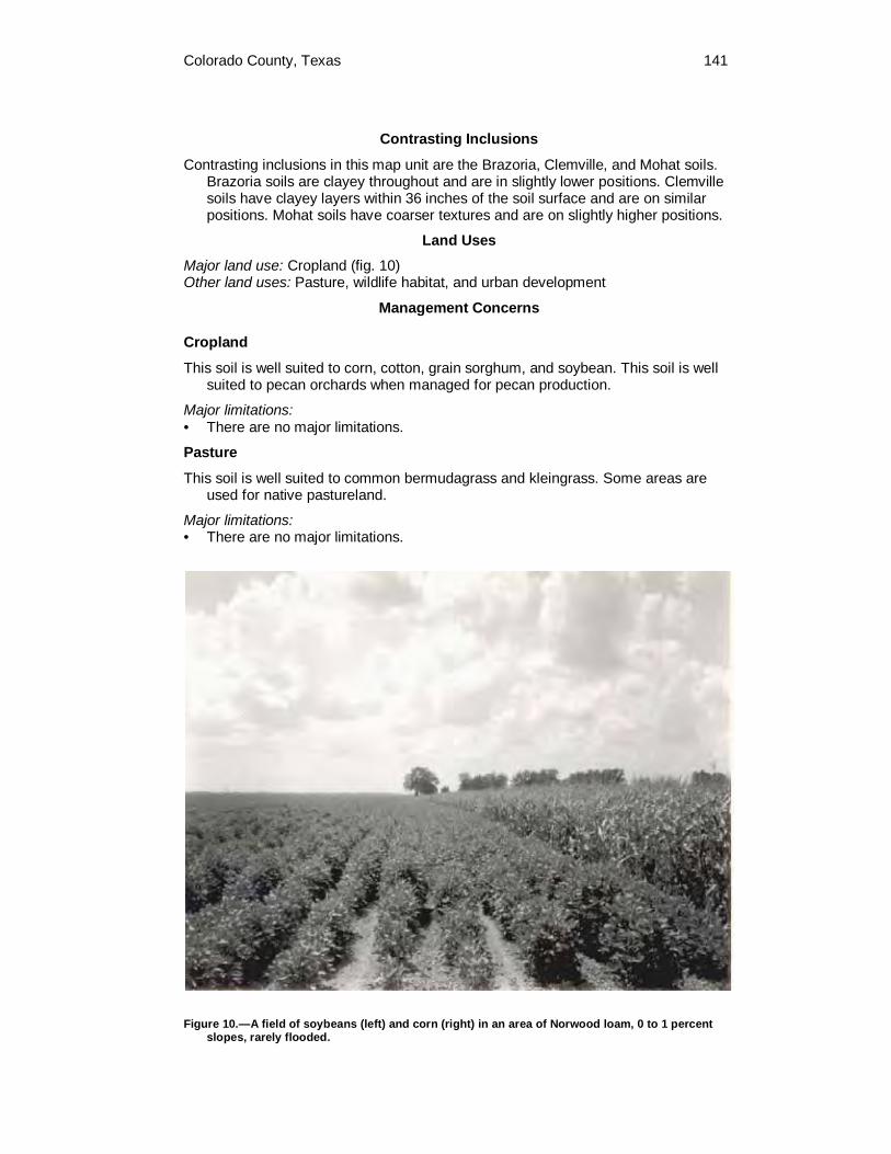
Colorado County, Texas 141
Contrasting Inclusions
Contrasting inclusions in this map unit are the Brazoria, Clemville, and Mohat soils. Brazoria soils are clayey throughout and are in slightly lower positions. Clemville soils have clayey layers within 36 inches of the soil surface and are on similar positions. Mohat soils have coarser textures and are on slightly higher positions.
Land Uses
Major land use: Cropland (fig. 10) Other land uses: Pasture, wildlife habitat, and urban development
Management Concerns
Cropland
This soil is well suited to corn, cotton, grain sorghum, and soybean. This soil is well suited to pecan orchards when managed for pecan production.
Major limitations: • There are no major limitations.
Pasture
This soil is well suited to common bermudagrass and kleingrass. Some areas are used for native pastureland.
Major limitations: • There are no major limitations.
Figure 10.—A field of soybeans (left) and corn (right) in an area of Norwood loam, 0 to 1 percent slopes, rarely flooded.

142 Soil Survey of
Wildlife Habitat
This soil is well suited to wildlife habitat. This soil provides a source for food and shelter for deer, small mammals, and waterfowl. This soil also supports habitat for alligators in areas along the Colorado River channel.
Major limitations: • There are no major limitations.
Urban Development
This soil has major limitations that affect urban development.
Major limitations: • The major soil limitations that affect this soil for use as sanitary facilities and
building site development are the severe hazard of flooding, low strength, and corrosivity to steel.
Interpretive Groups
Land capability classification: 1 Ecological site: Loamy Bottomland
NrA—Norwood silty clay loam, 0 to 1 percent slopes, occasionally flooded
Setting
Landscape: River valley Landform or position on landform: Flood plain Distinctive surface features: None Parent material: Loamy alluvial sediments along the Colorado River Slope: Nearly level on smooth surfaces Shape of areas: Irregular Size of areas: 15 to 800 acres Native vegetation: Native vegetation consists of perennial grasses and mixed
hardwoods
Typical Profile
Surface layer: 0 to 8 inches—moderately alkaline, dark brown silty clay loam
Subsoil: 8 to 28 inches—moderately alkaline, brown silt loam 28 to 48 inches—moderately alkaline, brown silty clay loam that has dark brown
masses of iron accumulation 48 to 56 inches—slightly alkaline, dark brown silty clay loam
Underlying material: 56 to 69 inches—slightly alkaline, brown silty clay that has dark brown masses of iron
accumulation 69 to 80 inches—slightly alkaline, brown clay that has dark brown masses of iron
accumulation
Soil Properties
Depth: Very deep Drainage class: Well drained Water table: None within a depth of 6 feet

Colorado County, Texas 143
Flooding: Occasional. This soil floods 5 to 50 times in 100 years. The duration usually lasts from 2 to 7 days and occurs during October through May.
Runoff: Negligible Permeability: Moderate Available water capacity: High Root zone: Very deep Natural soil fertility: High Shrink-swell potential: Low Water erosion hazard: Slight Wind erosion hazard: Slight
Composition
Norwood soil and similar inclusions: 85 to 95 percent Contrasting inclusions: 5 to 15 percent
Contrasting Inclusions
Contrasting inclusions in this map unit are the Brazoria, Clemville, and Mohat soils. Brazoria soils are clayey throughout and are in slightly lower positions. Clemville soils have clayey layers within 36 inches of the soil surface and are on similar positions. Mohat soils have coarser textures and are on slightly higher positions.
Land Uses
Major land use: Cropland Other land uses: Pasture, wildlife habitat, and urban development
Management Concerns
Cropland
This soil is well suited to corn, cotton, grain sorghum, and soybean. This soil is well suited to pecan orchards when managed for pecan production.
Major limitations: • There are no major limitations.
Minor limitations: • The minor limitations that affect this soil for use as cropland are the hazard of
flooding, and wetness. The occasional flooding hazard is caused by runoff from adjacent soils. Wetness in the upper subsoil layers are related to slow internal drainage caused by the presence of underlying clayey materials. These soil limitations may slow tillage operations for a few days after heavy periods of rain.
Pasture
This soil is well suited to common bermudagrass and kleingrass. Some areas are used for native pastureland.
Major limitations: • There are no major limitations.
Wildlife Habitat
This soil is well suited to wildlife habitat. This soil provides a source for food and shelter for deer, small mammals, and waterfowl. This soil supports habitat for alligators in mapped areas along the Colorado River channel.
Major limitations: • There are no major limitations.

144 Soil Survey of
Urban Development
This soil has major soil limitations that affect urban development.
Major limitations: • The major soil limitations that affect this soil for use as sanitary facilities and
building site development are the severe hazard of flooding, moderate permeability, low strength, and corrosivity to steel.
Interpretive Groups
Land capability classification: 2w Ecological site: Loamy Bottomland
PuA—Pursley sandy clay loam, 0 to 1 percent slopes, frequently flooded
Setting
Landscape: River valley Landform or position on landform: Flood plain Distinctive surface features: None Parent material: Loamy alluvial sediments associated with smaller streams and
creeks Slope: Nearly level on smooth surfaces Shape of areas: Elongated to irregular Size of areas: 15 to 500 acres Native vegetation: Native vegetation consists of perennial grasses, perennial forbs,
and mixed hardwoods
Typical Profile
Surface layer: 0 to 6 inches—moderately alkaline, dark brown sandy clay loam
Subsurface layer: 6 to 11 inches—moderately alkaline, very dark grayish brown sandy clay loam
Subsoil: 11 to 21 inches—moderately alkaline, light olive brown and dark grayish brown sandy
clay loam
Underlying material: 21 to 30 inches—moderately alkaline, olive brown sandy clay loam 30 to 41 inches—moderately alkaline, very dark grayish brown clay loam 41 to 52 inches—moderately alkaline, very dark grayish brown clay 52 to 64 inches—moderately alkaline, gray and light olive brown clay 64 to 80 inches—moderately alkaline, light olive brown and light gray clay
Soil Properties
Depth: Very deep Drainage class: Well drained Water table: None within a depth of 6 feet Flooding: Frequent. This soil floods more than 50 times in 100 years. The duration
usually lasts from 2 to 7 days and occurs during May through September. Runoff: Negligible Permeability: Moderate Available water capacity: High Root zone: Very deep

Colorado County, Texas 145
Natural soil fertility: High Shrink-swell potential: Moderate Water erosion hazard: Slight Wind erosion hazard: Slight
Composition
Pursley soil and similar inclusions: 85 to 95 percent Contrasting inclusions: 5 to 15 percent
Contrasting Inclusions
Contrasting inclusions in this map unit are the Uhland soils. Uhland soils have sandier textures and are adjacent to stream channels.
Land Uses
Major land use: Pasture Other land uses: Rangeland and wildlife habitat
Management Concerns
Rangeland
This soil is well suited to rangeland vegetation such as Indiangrass, big and little bluestem, switchgrass, and other perennial grasses. Perennial forbs and shrubs are also suited. Trees suitable for this soil are elm, hackberry, live oak, cottonwood, and pecan.
Major limitations: • There are no major limitations.
Pasture
This soil is well suited to pasture grasses such as improved varieties of bermudagrass, kleingrass, and johnsongrass.
Major limitations: • The major limitation that affects this soil for use as pasture is the severe hazard of
flooding.
Wildlife Habitat
This soil has high potential to support wildlife such as deer, small mammals, and turkey. This soil provides food in the form of grain, seed, grass, legumes, and wild herbs.
Major limitations: • There are no major limitations.
Urban Development
This soil is poorly suited to urban development.
Major limitations: • The major soil limitations that affect this soil for use as urban development are the
severe hazard of flooding, clayey nature of the subsoil, and low strength.
Interpretive Groups
Land capability classification: 5w Ecological site: Loamy Bottomland
146 Soil Survey of
RbD—Rabbs clay loam, 3 to 8 percent slopes
Setting
Landscape: River valley Landform or position on landform: Terrace Distinctive surface features: None Parent material: Loamy alluvium along the Colorado River Slope: Moderately sloping on convex surfaces Shape of areas: Elongated Size of areas: 10 to 70 acres Native vegetation: Native vegetation consists of perennial grasses, perennial forbs,
and scattered hardwoods
Typical Profile
Surface layer: 0 to 9 inches—neutral, dark brown clay loam
Subsoil: 9 to 18 inches—slightly alkaline, brown clay loam 18 to 48 inches—moderately alkaline, brown clay loam that has concretions of
calcium carbonate 48 to 58 inches—moderately alkaline, strong brown loam that has threads and
concretions of calcium carbonate 58 to 68 inches—moderately alkaline, pink clay loam that has threads and
concretions of calcium carbonate
Underlying material: 68 to 80 inches—moderately alkaline, brown loam that has masses and concretions
of calcium carbonate
Soil Properties
Depth: Very deep Drainage class: Well drained Water table: None Flooding: None Runoff: 3 to 5 percent slopes—low; 5 to 8 percent slopes—medium Permeability: Moderate Available water capacity: High Root zone: Very deep Natural soil fertility: Medium Shrink-swell potential: Low Water erosion hazard: Severe Wind erosion hazard: Slight
Composition
Rabbs soil and similar inclusions: 80 to 90 percent Contrasting inclusions: 10 to 20 percent
Contrasting Inclusions
Contrasting inclusions in this map unit are the Burleson, Chazos, Coarsewood, Roetex, and Trinity soils. Burleson, Roetex, and Trinity soils are clayey throughout. Burleson soils are on higher positions. Roetex and Trinity soils are in lower positions. Chazos soils have sandy surfaces and are on higher positions. Coarsewood soils are in lower positions.

Colorado County, Texas 147
Land Uses
Major land use: Rangeland Other land uses: Pasture and wildlife habitat
Management Concerns
Rangeland
This soil is suited to rangeland vegetation such as little bluestem, Indiangrass, big bluestem, and other perennial grasses. Perennial forbs are also suited to this soil. Trees suitable for this soil are live oak, elm and locust.
Major limitations: • The major limitation that affects this soil for use as rangeland is the severe hazard
of water erosion.
Pasture
This soil is suited to pasture grasses such as improved varieties of bermudagrass.
Major limitations: • The major limitation that affects this soil for use as pasture is the severe hazard of
water erosion.
Wildlife Habitat
This soil is suited to openland wildlife habitat. This soil provides a source for food and shelter for deer, small mammals, and waterfowl. Food sources include cultivated grains, native grains, forbs, and legumes.
Major limitations: • There are no major limitations.
Interpretive Groups
Land capability classification: 4e Ecological site: Clay Loam
RkB—Rek extremely gravelly coarse sandy loam, 1 to 3 percent slopes
Setting
Landscape: Inland dissected coastal plain Landform or position on landform: Ridge Distinctive surface features: Areas desurfaced for resource materials (fig. 11) Parent material: Stratified gravelly, sandy, and clayey sediments over loamy
materials derived from sandstone of the Willis Formation Slope: Gently sloping on convex surfaces Shape of areas: Rounded to irregular Size of areas: 10 to 420 acres Native vegetation: Native vegetation consists of perennial grasses, perennial forbs,
and mixed hardwoods
Typical Profile
Surface layer: 0 to 2 inches—strongly acid, brown extremely gravelly coarse sandy loam

148 Soil Survey of
Figure 11.—Area of Rek extremely gravelly coarse sandy loam, 1 to 3 percent slopes. This area has been stripped of the gravels for use in roadbeds.
Subsoil: 2 to 14 inches—extremely acid, light gray gravelly clay that has red and yellow
masses of iron accumulation 14 to 44 inches—extremely acid, light gray clay and sandy clay that has red, yellow,
and brown masses of iron accumulation 44 to 54 inches—strongly acid, light brownish gray clay that has yellow and brown
masses of iron accumulation 54 to 80 inches—strongly acid, yellowish brown and light brownish gray clay
Soil Properties
Depth: Very deep Drainage class: Moderately well drained Water table: A perched water table is at a depth of 2.5 to 3.5 feet during winter and
spring months. Flooding: None Runoff: Very high Permeability: Very slow Available water capacity: Moderate Root zone: Very deep Natural soil fertility: Very low Shrink-swell potential: Low in surface layer; moderate to high in upper subsoil; low in
lower subsoil Water erosion hazard: Severe Wind erosion hazard: Slight
Composition
Rek soil and similar inclusions: 85 to 95 percent Contrasting inclusions: 5 to 15 percent
Colorado County, Texas 149
Contrasting Inclusions
Contrasting inclusions in this map unit are the Straber and Tremona soils. Straber soils have a sandy surface layer less than 20 inches thick and are on similar positions. Tremona soils have a sandy surface layer greater than 20 inches thick and are on similar positions.
Land Uses
Major land use: Rangeland Other land uses: Pasture, pond reservoir development, and wildlife habitat
Management Concerns
Rangeland
This soil is suited to rangeland vegetation such as little bluestem, Indiangrass, brownseed paspalum, purpletop tridens, and other perennial grasses. Trees suitable for this soil are post oak and blackjack oak.
Major limitations: • The major limitations that affect this soil for use as rangeland are the very low
natural fertility and severe hazard of water erosion.
Pasture
This soil is suited to pasture grasses such as common bermudagrass and bahiagrass.
Major limitations: • The major limitations that affect this soil for use as pasture are the very low
natural fertility and the severe hazard of water erosion.
Minor limitations: • The minor limitation that affects this soil for use as pasture is seasonal wetness.
Wildlife Habitat
This soil has potential to support habitat for deer, dove, and turkey.
Major limitations: • There are no major limitations.
Pond Reservoir Development
This soil is well suited to pond reservoir development. The clayey subsoil layers can provide a seal for holding water.
Major limitations: • There are no major limitations.
Minor limitations: • The minor limitation that affects this soil for use as pond reservoir development is
seepage.
Interpretive Groups
Land capability classification: 4e Ecological site: Gravelly
150 Soil Survey of
RNA—Riverwash
Setting
Landscape: River valley Landform or position on landform: Flood plain bar and channel Distinctive surface features: Sandbars along the Colorado River Parent material: Loamy and sandy alluvium along the Colorado River Slope: Nearly level to gently undulating Shape of areas: Oblong and narrow Size of areas: 10 to 60 acres Native vegetation: None
Land Uses
Major land use: This miscellaneous map unit consists of sandbars adjacent to the Colorado River. These soils are frequently flooded and exposed only when the Colorado River current is low. These areas are usually void of vegetation and are very poorly suited to agricultural and urban use. The major limitation is the severe hazard of flooding.
Interpretive Groups
Land capability classification: 5w Ecological site: Not assigned
RoB—Robco loamy fine sand, 1 to 3 percent slopes
Setting
Landscape: Ancient river valley Landform or position on landform: High terrace Distinctive surface features: None Parent material: Loamy sediments of the Willis Formation Slope: Very gently sloping on convex surfaces Shape of areas: Irregular Size of areas: 20 to 100 acres Native vegetation: Native vegetation consists of perennial grasses, yaupon, American
beautyberry, post oak, and blackjack oak
Typical Profile
Surface layer: 0 to 10 inches—moderately acid, dark yellowish brown loamy fine sand
Subsurface layer: 10 to 20 inches—moderately acid, yellowish brown loamy fine sand 20 to 33 inches—moderately acid, pale brown loamy fine sand
Subsoil: 33 to 40 inches—slightly acid, gray and brownish yellow sandy clay loam that has red
masses of iron accumulation 40 to 55 inches—neutral, gray sandy clay loam that has red and yellow masses of
iron accumulation 55 to 65 inches—very strongly acid, light brownish gray sandy clay loam that has red
and yellow masses of iron accumulation

Colorado County, Texas 151
65 to 80 inches—very strongly acid, light gray and light brownish gray sandy clay loam that has red, yellow, and brown masses of iron accumulation
Soil Properties
Depth: Very deep Drainage class: Moderately well drained Water table: A perched water occurs at a depth of 1.5 to 3.5 feet from January to
April. Flooding: None Runoff: Medium Permeability: Slow Available water capacity: Moderate Root zone: Very deep Natural soil fertility: Low Shrink-swell potential: Low in surface layer; moderate to high in subsoil Water erosion hazard: Moderate Wind erosion hazard: Moderate
Composition
Robco soil and similar inclusions: 85 to 95 percent Contrasting inclusions: 5 to 15 percent
Contrasting Inclusions
Contrasting inclusions in this map unit are the Chazos, Lufkin, Straber, Tabor, and Tremona soils. All of these soils have clayey subsoils. Lufkin and Tabor soils have loamy surface layers.
Land Uses
Major land use: Pasture and rangeland Other land uses: Wildlife habitat and urban development
Management Concerns
Rangeland
This soil is suited to rangeland vegetation such as little bluestem, Indiangrass, brownseed paspalum, panicum, and other perennial grasses. Trees suitable for this soil are post oak and blackjack oak.
Major limitations: • The major limitation that affects this soil for use as rangeland is the low natural
fertility.
Minor limitations: • The minor limitation that affects this soil for use as rangeland is the moderate
hazard of wind and water erosion.
Pasture
This soil is suited to pasture grasses such as common bermudagrass, bahiagrass, and improved varieties of bermudagrass.
Major limitations: • The major limitation that affects this soil for use as pasture is the low natural
fertility.
152 Soil Survey of
Minor limitations: • The minor limitation that affects this soil for use as pasture is the moderate
hazard of wind and water erosion.
Wildlife Habitat
This soil has the potential to support habitat for deer and dove.
Major limitations: • There are no major limitations.
Urban Development
There are major limitations that affect this soil for urban development.
Major limitations: • The major soil limitations that affect this soil for use as sanitary facilities and
building site development are seasonal wetness, slow permeability, poor filtering ability of the subsoil, seepage, moderate to high shrink-swell potential, low strength, and high corrosivity to concrete and steel. Shallow excavations should be shored to prevent cave-ins.
Minor limitations: • The minor soil limitation that affects this soil for use as lawns is the low available
water capacity in the topsoil.
Interpretive Groups
Land capability classification: 2e Ecological site: Sandy
RtA—Roetex clay, 0 to 1 percent slopes, frequently flooded
Setting
Landscape: River valley Landform or position on landform: Old river channels, oxbows, backwater
depressions on flood plains Distinctive surface features: None Parent material: Clayey alluvial sediments along the Colorado River Slope: Nearly level on concave surfaces Shape of areas: Crescent to irregular Size of areas: 10 to 140 acres Native vegetation: Native vegetation consists of perennial grasses, perennial forbs,
and trees
Typical Profile
Surface layer: 0 to 9 inches—moderately alkaline, very dark grayish brown clay
Subsoil: 9 to 20 inches—moderately alkaline, reddish brown clay that has dark gray iron
depletions 20 to 46 inches—moderately alkaline, reddish brown clay that has slickensides,
pressure surfaces, and gray iron depletions 46 to 65 inches—moderately alkaline, yellowish red clay that has slickensides,
pressure surfaces, and many dark gray iron depletions 65 to 80 inches—moderately alkaline, dark gray clay that has slickensides, pressure
surfaces, and many yellowish red masses of iron accumulation

Colorado County, Texas 153
Soil Properties
Depth: Very deep Drainage class: Somewhat poorly drained Water table: An apparent water table occurs at a depth of 0.5 feet above the soil
surface to 2 feet below the soil surface during the fall through spring months. Flooding: Frequent. This soil floods more than 50 times in 100 years. The duration
usually lasts from 7 days to more than 30 days and occurs during October through May.
Runoff: Negligible Permeability: Very slow Available water capacity: High Root zone: Very deep Natural soil fertility: High Shrink-swell potential: High Water erosion hazard: Slight Wind erosion hazard: Slight
Composition
Roetex soil and similar inclusions: 85 to 95 percent Contrasting inclusions: 5 to 15 percent
Contrasting Inclusions
Contrasting inclusions in this map unit are the Brazoria, Coarsewood, Norwood, Ships, and Weswood soils. Brazoria and Ships soils are on higher benches of the flood plain. Coarsewood, Norwood, and Weswood soils are loamy throughout and are on higher positions.
Land Uses
Major land use: Pasture Other land uses: Rangeland and wildlife habitat
Management Concerns
Rangeland
This soil is well suited to rangeland vegetation such as Virginia wildrye, eastern gamagrass, beaked panicum, broadleaf uniola, and other perennial grasses. Perennial forbs are also suited to this soil. Trees suitable for this soil are black willow, elm, oak, ash, bois d'arc, hackberry, and pecan.
Major limitations: • There are no major limitations.
Pasture
Areas that have proper drainage are suitable for pasture grasses such as improved varieties of bermudagrass. Some areas of this soil are used for native pastureland.
Major limitations: • The major limitations that affect this soil for use as pasture are the seasonal
wetness, the frequent hazard of flooding, and surface ponding.

154 Soil Survey of
Wildlife Habitat
This soil is suited to shallow water wildlife habitat. This soil provides a source for food and shelter for small mammals and waterfowl. Food sources include grasses, forbs, trees, and small grains from adjacent areas.
Major limitations: • There are no major limitations.
Interpretive Groups
Land capability classification: 7w Ecological site: Clayey Bottomland
RuB—Rupley sand, 1 to 3 percent slopes
Setting
Landscape: River valley Landform or position on landform: Terrace Distinctive surface features: Plane to hummocky Parent material: Sandy sediments of the Lissie Formation Slope: Very gently sloping on convex surfaces Shape of areas: Oblong Size of areas: 30 to 660 acres Native vegetation: Native vegetation consists of perennial grasses and mixed
hardwoods
Typical Profile
Surface layer: 0 to 8 inches—moderately acid, dark yellowish brown sand
Underlying material: 8 to 66 inches—moderately acid, yellowish brown fine sand 66 to 80 inches—moderately acid, brownish yellow fine sand
Soil Properties
Depth: Very deep Drainage class: Somewhat excessively drained Water table: A perched water table occurs at a depth of 5 to 6 feet from December to
July. Flooding: None Runoff: Negligible Permeability: Rapid Available water capacity: Low Root zone: Very deep Natural soil fertility: Low Shrink-swell potential: Very low Water erosion hazard: Slight Wind erosion hazard: Severe
Composition
Rupley soil and similar inclusions: 85 to 95 percent Contrasting inclusions: 5 to 15 percent

Colorado County, Texas 155
Contrasting Inclusions
Contrasting inclusions in this map unit are the Nez, Milby, and Zalco soils. Milby soils have a sandy surface layer 20 to 40 inches thick and are in slightly lower positions. Nez soils have a sandy surface layer less than 20 inches thick and are in nearly level positions. Zalco soils are sandy throughout, are along drainageways, and frequently flooded.
Land Uses
Major land use: Rangeland and pasture Other land uses: Wildlife habitat
Management Concerns
Rangeland
Native grasses suited to this soil include little bluestem, Indiangrass, purpletop tridens, and brownseed paspalum. Bluestems and paspalums are the main grasses. Trees suitable for this soil are live oak and post oak. This soil is well suited to rangeland overstory vegetation such as live oak, blackjack oak, and post oak.
Major limitations: • The major limitations that affect this soil for use as rangeland are the low
available water capacity, low natural fertility, and the severe hazard of wind erosion.
Pasture
This soil is suited to pasture grasses such as common bermudagrass, weeping lovegrass, and improved varieties of bermudagrass. This soil is well suited to pasture grasses such as lovegrass and bahiagrass.
Major limitations: • The major limitations that affect this soil for use as pasture are the low available
water capacity, low natural fertility, and the severe hazard of wind erosion.
Wildlife Habitat
This soil is fairly suited to wildlife habitat. This soil provides a source for food and shelter for deer, small mammals, and waterfowl.
Major limitations: • The major limitation that affects this soil for use as wildlife habitat is the severe
hazard of wind erosion.
Minor limitations: • The minor limitation that affects this soil for use as wildlife habitat is the low
available water capacity.
Interpretive Groups
Land capability classification: 6s Ecological site: Deep Sand

156 Soil Survey of
SpA—Ships clay, 0 to 1 percent slopes, rarely flooded
Setting
Landscape: River valley Landform or position on landform: Flood plain Distinctive surface features: Uncultivated areas have gilgai microrelief Parent material: Clayey alluvial sediments along the Colorado River Slope: Nearly level on plane surfaces Shape of areas: Irregular Size of areas: 15 to 450 acres Native vegetation: Native vegetation consists of perennial grasses and perennial
forbs
Typical Profile
Surface layer: 0 to 12 inches—moderately alkaline, dark brown clay
Subsoil: 12 to 30 inches—moderately alkaline, dark brown clay that has slickensides and
pressure surfaces 30 to 56 inches—moderately alkaline, brown clay that has slickensides and pressure
surfaces 56 to 80 inches—moderately alkaline, brown clay that has slickensides, pressure
surfaces, and concretions of calcium carbonate
Soil Properties
Depth: Very deep Drainage class: Moderately well drained Water table: None within a depth of 6 feet Flooding: Rarely. This soil floods 1 to 5 times out of 100 years, the duration is 2 to 7
days during the spring and fall months. Runoff: High Permeability: Very slow Available water capacity: High Root zone: Very deep Natural soil fertility: High Shrink-swell potential: Very high Water erosion hazard: Slight Wind erosion hazard: Slight
Composition
Ships soil and similar inclusions: 80 to 90 percent Contrasting inclusions: 10 to 20 percent
Contrasting Inclusions
Contrasting inclusions in this map unit are the Bergstrom, Gholson, and Rabbs soils, and the Udarents miscellaneous unit. Bergstrom soils have a loamy surface layer and are on higher positions. Gholson soils are loamy throughout and are on higher positions. Rabbs soils are loamy throughout, contain a high amount of calcium carbonate, and are on side slopes. The Udarents miscellaneous unit consists of areas that have been mined for sand and gravel or have been mined and reclaimed.

Colorado County, Texas 157
Land Uses
Major land use: Pasture and cropland Other land uses: Rangeland, wildlife habitat, pond reservoir development, and urban
development
Management Concerns
Cropland
This soil is well suited to crops such as corn, grain sorghums, cotton, and small grains.
Major limitations: • There are no major limitations.
Minor limitations: • The minor limitations that affect this soil for use as cropland are seasonal
wetness and compaction.
Rangeland
This soil is well suited to rangeland vegetation such as Virginia wildrye, beaked panicum, broadleaf uniola, and other perennial grasses. Perennial forbs are also suited to this soil.
Major limitations: • There are no major limitations.
Pasture
This soil is suited to pasture grass such as improved varieties of bermudagrass.
Major limitations: • There are no major limitations.
Minor limitations: • The minor limitations that affect this soil for use as pasture are seasonal wetness
and compaction.
Wildlife Habitat
This soil is suited to openland wildlife habitat. This soil provides a source for food and shelter for deer, small mammals, and waterfowl. Food sources include cultivated grains, native grains, forbs, and legumes.
Major limitations: • There are no major limitations.
Pond Reservoir Development
This soil is well suited to pond reservoir development. The clayey subsoil layers can provide a seal for holding water.
Major limitations: • There are no major limitations.
Urban Development
This soil is poorly suited to urban development.
Major limitations: • There are several major limitations that affect this soil for use as sanitary facilities
and building site development. These are very slow permeability, clayey subsoil,
158 Soil Survey of
very high shrink-swell potential, high corrosivity to steel, and low strength. Shallow excavations should be shored to prevent cave-ins.
Interpretive Groups
Land capability classification: 2s Ecological site: Clayey Bottomland
StA—Smithville fine sandy loam, 0 to 1 percent slopes
Setting
Landscape: Ancient river valley Landform or position on landform: Terrace Distinctive surface features: None Parent material: Loamy alluvial sediments along the Colorado River Slope: Nearly level on convex surfaces Shape of areas: Elongated to oval Size of areas: 15 to 250 acres Native vegetation: Native vegetation consists of perennial grasses, perennial forbs,
and trees
Typical Profile
Surface layer: 0 to 6 inches—slightly alkaline, very dark grayish brown fine sandy loam
Subsurface layer: 6 to 15 inches—slightly alkaline, very dark gray fine sandy loam 15 to 26 inches—slightly alkaline, very dark gray fine sandy loam
Subsoil: 26 to 33 inches—neutral, dark brown sandy clay loam 33 to 42 inches—slightly alkaline, dark brown sandy clay loam 42 to 68 inches—neutral and slightly alkaline, brown sandy clay loam 68 to 80 inches—slightly alkaline, dark yellowish brown sandy clay loam that has
yellowish red masses of iron accumulation
Soil Properties
Depth: Very deep Drainage class: Well drained Water table: None Flooding: None Runoff: Negligible Permeability: Moderate Available water capacity: High Root zone: Very deep Natural soil fertility: High Shrink-swell potential: Low in surface layer; moderate to low in subsoil Water erosion hazard: Slight Wind erosion hazard: Slight
Composition
Smithville soil and similar inclusions: 85 to 95 percent Contrasting inclusions: 5 to 15 percent

Colorado County, Texas 159
Contrasting Inclusions
Contrasting inclusions in this map unit are the Gad and Wilson soils and the Udarents miscellaneous map units. Gad soils are sandy throughout and are on similar or slightly lower positions. Wilson soils have clayey subsoils and are in lower positions. Udarents are areas that have been mined for sand and gravel or have been mined and reclaimed.
Land Uses
Major land use: Pasture and urban development Other land uses: Cropland and wildlife habitat
Management Concerns
Cropland
This soil is well suited to crops such as corn, grain sorghum, and cotton.
Major limitations: • There are no major limitations.
Pasture
This soil is well suited to pasture grasses such as improved varieties of bermudagrass.
Major limitations: • There are no major limitations.
Wildlife Habitat
This soil is suited to openland wildlife habitat. This soil provides a source for food and shelter for deer, small mammals, and waterfowl. Food sources include cultivated grains, native grains, forbs, and legumes.
Major limitations: • There are no major limitations.
Urban Development
This soil has a major limitation that affects urban development. A portion of the city of Columbus is located on areas of this soil.
Major limitations: • The major limitation that affects this soil for use as local roads and streets is low
strength.
Minor limitations: • The minor limitations that affect this soil for use as urban development are
seepage and the moderate shrink-swell potential.
Interpretive Groups
Land capability classification: 1 Ecological site: Loamy Bottomland
SvF—Stein very gravelly loamy fine sand, 12 to 40 percent slopes
Setting
Landscape: Inland dissected coastal plain Landform or position on landform: Hill slopes

160 Soil Survey of
Distinctive surface features: Short steep slopes, gravel on the surface Parent material: Loamy and clayey sediments of the Willis Formation Slope: Moderately steep and steep sloping on convex surfaces Shape of areas: Irregular Size of areas: 10 to 100 acres Native vegetation: Native vegetation consists of perennial grasses, perennial forbs,
and mixed hardwoods
Typical Profile
Surface layer: 0 to 6 inches—slightly acid, dark brown very gravelly loamy fine sand
Subsurface layer: 6 to 10 inches—slightly acid, brown very gravelly loamy fine sand
Subsoil: 10 to 21 inches—very strongly acid, dark red and dark reddish brown clay 21 to 28 inches—very strongly acid, dark red sandy clay that has brownish yellow
masses of iron accumulation 28 to 36 inches—very strongly acid, dark red and red sandy clay loam 36 to 48 inches—very strongly acid, dark red sandy clay loam that has yellow and
brown sandy and loamy material 48 to 58 inches—very strongly acid, dark red, reddish yellow, and very pale brown
sandy clay loam that has interbedded pale yellow and brown materials
Underlying material: 58 to 80 inches—very strongly acid, strong brown sandy clay loam
Soil Properties
Depth: Very deep Drainage class: Well drained Water table: None within a depth of 6 feet Flooding: None Runoff: Very high Permeability: Slow Available water capacity: Moderate Root zone: Very deep Natural soil fertility: Low Shrink-swell potential: Low in surface layer; high in subsoil Water erosion hazard: Severe Wind erosion hazard: Moderate
Composition
Stein soil and similar inclusions: 75 to 90 percent Contrasting inclusions: 10 to 25 percent
Contrasting Inclusions
Contrasting inclusions in this map unit are the Brenham, Latium, Straber, and Tremona soils. Brenham soils are calcareous throughout and have loamy subsoils. Latium soils are clayey throughout and calcareous. Straber soils have sandy surface layers 10 to 20 inches thick. Tremona soils have sandy surface layers 20 to 40 inches thick and are on higher positions.
Land Uses
Major land use: Rangeland and wildlife habitat Other land uses: None
Colorado County, Texas 161
Management Concerns
Rangeland
This soil is suited to rangeland vegetation such as little bluestem, Indiangrass, brownseed paspalum, purpletop tridens, and other perennial grasses. Trees suitable for this soil are post oak and blackjack oak.
Major limitations: • The major limitation that affects this soil for use as rangeland is the severe hazard
of water erosion.
Minor limitations: • The minor limitations that affect this soil for use as rangeland are the moderate
hazard of wind erosion, the inability to maintain natural fertility and moisture in the topsoil, and the high gravel content in the surface layers.
Wildlife Habitat
This soil has the potential to support habitat for deer, dove, and turkey.
Major limitations: • The major limitation that affects this soil for use as wildlife habitat is the severe
hazard of water erosion.
Pond Reservoir Development
This soil is poorly suited to pond reservoir development.
Major limitations: • The major limitations that affect this soil for use as pond reservoir development
are seepage and lack of adequate material for dam construction.
Interpretive Groups
Land capability classification: 7e Ecological site: Gravelly
SwB—Straber loamy fine sand, 1 to 3 percent slopes
Setting
Landscape: Inland dissected coastal plain Landform or position on landform: Hill slopes Distinctive surface features: None Parent material: Clayey sediments of the Willis Formation Slope: Very gently sloping on convex surfaces Shape of areas: Irregular Size of areas: 10 to 1,250 acres Native vegetation: Native vegetation consists of perennial grasses, perennial forbs,
and mixed hardwoods
Typical Profile
Surface layer: 0 to 8 inches—strongly acid, dark yellowish brown loamy fine sand
Subsurface layer: 8 to 18 inches—very strongly acid, brown loamy fine sand

162 Soil Survey of
Subsoil: 18 to 30 inches—strongly acid, grayish brown clay that has strong brown, yellowish
brown, and red masses of iron accumulation 30 to 41 inches—strongly acid, light brownish gray clay that has red, strong brown,
and yellowish red masses of iron accumulation 41 to 59 inches—slightly acid, light brownish gray sandy clay that has red, reddish
yellow, and yellowish red masses of iron accumulation 59 to 80 inches—slightly alkaline, light yellowish brown sandy clay loam that has red
and yellowish red masses of iron accumulation
Soil Properties
Depth: Very deep Drainage class: Moderately well drained Water table: None within a depth of 6 feet Flooding: None Runoff: Very high Permeability: Very slow Available water capacity: Moderate Root zone: Very deep Natural soil fertility: Low Shrink-swell potential: Low in surface layer; high in subsoil Water erosion hazard: Moderate Wind erosion hazard: Moderate
Composition
Straber soil and similar inclusions: 85 to 95 percent Contrasting inclusions: 5 to 15 percent
Contrasting Inclusions
Contrasting inclusions in this map unit are the Catilla, Dubina, Joiner, Lufkin, and Tabor soils. Catilla and Joiner soils have a sandy surface layer greater than 40 inches thick and are on slightly higher positions. Dubina soils have a dark sandy surface layer and are on similar positions. Lufkin soils have a loamy surface layer and are on nearly level positions. Tabor soils have a loamy surface layer and are on side slopes and along stream channels.
Land Uses
Major land use: Pasture Other land uses: Rangeland, wildlife habitat, pond reservoir development, and urban
development
Management Concerns
Rangeland
This soil is suited to rangeland vegetation such as little bluestem, Indiangrass, brownseed paspalum, purpletop tridens, and other perennial grasses. Trees suitable for this soil are post oak and blackjack oak.
Major limitations: • There are no major limitations.
Minor limitations: • The minor limitation that affects this soil for use as rangeland is the inability to
maintain natural fertility and moisture in the topsoil.

Colorado County, Texas 163
Pasture
This soil is suited to pasture grasses such as common bermudagrass and improved varieties of bermudagrass.
Major limitations: • The major limitations that affect this soil for use as pasture are high acidity in the
topsoil, and low natural fertility.
Minor limitations: • The minor limitation that affects this soil for use as pasture is the moderate
hazard of wind and water erosion.
Wildlife Habitat
This soil has the potential to support habitat for deer, feral hogs, dove, and turkey.
Major limitations: • There are no major limitations.
Pond Reservoir Development
This soil is well suited to pond reservoir development. The clayey subsoil layers can provide a seal for holding water.
Major limitations: • There are no major limitations.
Urban Development
This soil has major limitations that affect urban development.
Major limitations: • The major limitations that affect this soil for use as sanitary facilities and building
site development are very slow permeability, seepage, clayey subsoil, high shrink-swell potential, low strength, and high corrosivity to concrete and steel.
Interpretive Groups
Land capability classification: 3e Ecological site: Sandy
SwC—Straber loamy fine sand, 3 to 5 percent slopes
Setting
Landscape: Inland dissected coastal plain Landform or position on landform: Hill slopes Distinctive surface features: None Parent material: Clayey sediments of the Willis Formation Slope: Gently sloping on convex surfaces Shape of areas: Irregular Size of areas: 30 to 60 acres Native vegetation: Native vegetation consists of perennial grasses, perennial forbs,
and mixed hardwoods
Typical Profile
Surface layer: 0 to 13 inches—neutral, brown loamy fine sand
Subsurface layer: 13 to 17 inches—slightly acid, yellowish brown loamy fine sand

164 Soil Survey of
Subsoil: 17 to 24 inches—very strongly acid, mottled yellowish brown, dark yellowish brown,
and brown clay that has red and brown masses of iron accumulation 24 to 33 inches—very strongly acid, mottled yellowish brown, light brownish gray,
and grayish brown clay that has red and brown masses of iron accumulation 33 to 46 inches—very strongly acid, light gray clay loam that has red, yellow, and
brown masses of iron accumulation 46 to 56 inches—very strongly acid, light gray and brownish yellow sandy clay loam
that has red, yellow, and brown masses of iron accumulation 56 to 70 inches—very strongly acid, strong brown and yellowish red sandy clay loam
that has brown masses of iron accumulation 70 to 80 inches—very strongly acid, strong brown sandy clay loam that has red
masses of iron accumulation
Soil Properties
Depth: Very deep Drainage class: Moderately well drained Water table: None within a depth of 6 feet Flooding: None Runoff: Very high Permeability: Very slow Available water capacity: Moderate Root zone: Very deep Natural soil fertility: Low Shrink-swell potential: Low in surface layer; high in subsoil Water erosion hazard: Severe Wind erosion hazard: Moderate
Composition
Straber soil and similar inclusions: 85 to 95 percent Contrasting inclusions: 5 to 15 percent
Contrasting Inclusions
Contrasting inclusions in this map unit are the Catilla and Tremona soils. These soils have a thick sandy surface layer greater than 20 inches and are on similar positions.
Land Uses
Major land use: Pasture Other land uses: Rangeland, wildlife habitat, pond reservoir development, and urban
development
Management Concerns
Rangeland
This soil is suited to rangeland vegetation such as little bluestem, Indiangrass, brownseed paspalum, purpletop tridens, and other perennial grasses. Trees suitable for this soil are post oak and blackjack oak.
Major limitations: • The major limitation that affects this soil for use as rangeland is the severe hazard
of water erosion.
Colorado County, Texas 165
Minor limitations: • The minor limitations that affect this soil for use as rangeland are the moderate
hazard of wind erosion, the inability to maintain natural fertility and moisture in the topsoil.
Pasture
This soil is suited to pasture grasses such as common bermudagrass and improved varieties of bermudagrass.
Major limitations: • The major limitation that affects this soil for use as pasture is the severe hazard of
water erosion.
Minor limitations: • The minor limitation that affects this soil for use as pasture is the moderate
hazard of wind erosion.
Wildlife Habitat
This soil has the potential to support habitat for deer, feral hogs, dove, and turkey.
Major limitations: • The major limitation that affects this soil for use as wildlife habitat is the severe
hazard of water erosion.
Pond Reservoir Development
This soil is well suited to pond reservoir development. The clayey subsoil layers can provide a seal for holding water.
Major limitations: • There are no major limitations.
Urban Development
This soil has major limitations that affect urban development.
Major limitations: • The major limitations that affect this soil for use as sanitary facilities and building
site development are very slow permeability, seepage, clayey subsoils, slope, high shrink-swell potential, low strength, and high corrosivity to concrete and steel.
Interpretive Groups
Land capability classification: 4e Ecological site: Sandy
SxB—Straber very gravelly loamy fine sand, 1 to 3 percent slopes Setting
Landscape: Inland dissected coastal plain Landform or position on landform: Hill slopes Distinctive surface features: Cobbles, stones, and gravel Parent material: Gravelly and clayey sediments of the Willis Formation Slope: Very gently sloping on convex surfaces

166 Soil Survey of
Shape of areas: Irregular Size of areas: 10 to 630 acres Native vegetation: Native vegetation consists of perennial grasses, perennial forbs,
and mixed hardwoods
Typical Profile
Surface layer: 0 to 8 inches—very strongly acid, yellowish brown very gravelly loamy fine sand
Subsurface layer: 8 to 14 inches—very strongly acid, yellowish brown very gravelly loamy fine sand
Subsoil: 14 to 32 inches—extremely acid, gray clay that has red and yellow masses of iron
accumulation 32 to 52 inches—extremely acid, grayish brown clay that has red, yellow, and brown
masses of iron accumulation 52 to 66 inches—extremely acid, light brownish gray and light gray clay loam that has
red, yellow, and brown masses of iron accumulation 66 to 80 inches—very strongly acid, light gray and pale yellow clay that has red and
brown masses of iron accumulation
Soil Properties
Depth: Very deep Drainage class: Moderately well drained Water table: None within a depth of 6 feet Flooding: None Runoff: Very high Permeability: Very slow Available water capacity: Moderate Root zone: Very deep Natural soil fertility: Low Shrink-swell potential: Low in surface layer; high in subsoil Water erosion hazard: Moderate Wind erosion hazard: Moderate
Composition
Straber soil and similar inclusions: 85 to 95 percent Contrasting inclusions: 5 to 15 percent
Contrasting Inclusions
Contrasting inclusions in this map unit are the Lufkin, Rek, Tabor, and Tremona soils. Lufkin soils are on nearly level positions. Rek soils have been desurfaced for resource materials. Tabor soils are on side slopes and along stream channels. Tremona soils have a thick sandy surface layer and are on similar positions. Also included are small areas of Straber soils with less than 15 percent gravel in the surface layer and small areas where more than 35 percent gravel is in the surface layer.
Land Uses
Major land use: Pasture Other land uses: Rangeland, wildlife habitat, pond reservoir development, and urban
development

Colorado County, Texas 167
Management Concerns
Rangeland
This soil is suited to rangeland vegetation such as little bluestem, Indiangrass, brownseed paspalum, purpletop tridens, and other perennial grasses. Trees suitable for this soil are post oak and blackjack oak.
Major limitations: • There are no major limitations.
Minor limitations: • The minor limitation affecting this soil for use as rangeland is the inability to
maintain natural fertility and moisture in the topsoil.
Pasture
This soil is suited to pasture grasses such as improved varieties of bermudagrass.
Major limitations: • The major limitation that affects this soil for use as pasture is the high acidity in
the topsoil.
Minor limitations: • The minor limitations that affect this soil for use as pasture are the presence of
coarse gravel, cobbles, small stones on the surface, and the moderate hazard of wind and water erosion.
Wildlife Habitat
This soil has the potential to support habitat for deer, dove, and turkey.
Major limitations: • There are no major limitations.
Pond Reservoir Development
This soil is suited to pond reservoir development.
Major limitations: • There are no major limitations.
Urban development
This soil has major limitations that affect urban development.
Major limitations: • The major limitations that affect this soil for use such as sanitary facilities and
building site development are very slow permeability, seepage, clayey subsoil, high shrink-swell potential, low strength, and high corrosivity to concrete and steel.
Interpretive Groups
Land capability classification: 3e Ecological site: Sandy
SxD—Straber very gravelly loamy fine sand, 3 to 8 percent slopes
Setting
Landscape: Hills Landform or position on landform: Hill slopes
168 Soil Survey of
Distinctive surface features: Cobbles, stones, and gravel Parent material: Gravelly and clayey sediments of the Willis Formation Slope: Gently sloping to moderately sloping on convex surfaces Shape of areas: Irregular Size of areas: 30 to 60 acres Native vegetation: Native vegetation consists of perennial grasses, perennial forbs,
and mixed hardwoods
Typical Profile
Surface layer: 0 to 11 inches—very strongly acid, brown very gravelly loamy fine sand
Subsoil: 11 to 17 inches—extremely acid, red clay 17 to 26 inches—extremely acid, red sandy clay 26 to 53 inches—extremely acid, yellowish red sandy clay that has gray iron
depletions 53 to 80 inches—very strongly acid, light brownish gray and strong brown sandy clay
loam that has yellowish red masses of iron accumulation
Soil Properties Depth: Very deep Drainage class: Moderately well drained Water table: None within a depth of 6 feet Flooding: None Runoff: Very high Permeability: Very slow Available water capacity: Moderate Root zone: Very deep Natural soil fertility: Low Shrink-swell potential: Low in surface layer; high in subsoil Water erosion hazard: Severe Wind erosion hazard: Moderate
Composition
Straber soil and similar inclusions: 75 to 95 percent Contrasting inclusions: 5 to 25 percent
Contrasting Inclusions
Contrasting inclusions in this map unit are the Lufkin, Rek, Tabor, and Tremona soils. Lufkin soils are in nearly level positions. Rek soils have been desurfaced for resource materials. Tabor soils are on side slopes and along stream channels. Tremona soils have a thick sandy surface layer and are on higher positions. Also included are small areas of Straber soils with less than 15 percent gravel in the surface layer and small areas where more than 35 percent gravel is in the surface layer.
Land Uses
Major land use: Pasture Other land uses: Rangeland, wildlife habitat, pond reservoir development, and urban
development
Colorado County, Texas 169
Management Concerns
Rangeland
This soil is suited to rangeland vegetation such as little bluestem, Indiangrass, brownseed paspalum, purpletop tridens, and other perennial grasses. Trees suitable for this soil are post oak and blackjack oak.
Major limitations: • The major limitation that affects this soil for use as rangeland is the severe hazard
of water erosion.
Minor limitations: • The minor limitations that affect this soil for use as rangeland are the moderate
hazard of wind erosion, the inability to maintain natural fertility and moisture in the topsoil.
Pasture
This soil is suited to pasture grasses such as improved varieties of bermudagrass.
Major limitations: • The major limitations that affect this soil for use as pasture are the high acidity in
the topsoil, and the severe hazard of water erosion.
Minor limitations: • The minor limitations that affect this soil for use as pasture are the presence of
coarse gravel, cobbles, and small stones on the surface that decrease the surface area for plant growth.
Wildlife Habitat
This soil has the potential to support habitat for deer, dove, and turkey.
Major limitations: • The major limitation that affects this soil for use as wildlife habitat is the severe
hazard of water erosion.
Pond Reservoir Development
This soil is suited to pond reservoir development.
Major limitations: • There are no major limitations.
Urban Development
This soil has major limitations that affect urban development.
Major limitations: • The major limitations that affect this soil for use as sanitary facilities and building
site development are very slow permeability, seepage, clayey subsoil, slope, small stones on the surface, high shrink-swell potential, low strength, and high corrosivity to concrete and steel.
Interpretive Groups
Land capability classification: 4e Ecological site: Gravelly

170 Soil Survey of
TaA—Tabor fine sandy loam, 0 to 1 percent slopes
Setting
Landscape: Ancient river valley Landform or position on landform: Terrace Distinctive surface features: None Parent material: Loamy and clayey sediments of the Willis Formation Slope: Nearly level on smooth surfaces Shape of areas: Oval to irregular Size of areas: 20 to 200 acres Native vegetation: Native vegetation consists of perennial grasses and mixed
hardwoods
Typical Profile
Surface layer: 0 to 10 inches—strongly acid, dark yellowish brown fine sandy loam
Subsoil: 10 to 19 inches—strongly acid, grayish brown clay that has yellowish brown and red
masses of iron accumulation 19 to 26 inches—strongly acid, grayish brown and yellowish brown clay 26 to 43 inches—neutral, light olive brown clay that has grayish brown masses of iron
accumulation 43 to 48 inches—slightly alkaline, brownish yellow clay that has strong brown masses
of iron accumulation 48 to 80 inches—slightly alkaline, reddish yellow sandy clay loam that has dark
reddish yellow and very pale brown masses of iron accumulation, and concretions of calcium carbonate
Soil Properties
Depth: Very deep Drainage class: Moderately well drained Water table: None within a depth of 6 feet Flooding: None Runoff: High Permeability: Very slow Available water capacity: Moderate Root zone: Very deep Natural soil fertility: Low Shrink-swell potential: Low in surface layer; high in subsoil Water erosion hazard: Moderate Wind erosion hazard: Slight
Composition
Tabor soil and similar inclusions: 80 to 90 percent Contrasting inclusions: 10 to 20 percent
Contrasting Inclusions
Contrasting inclusions in this map unit are Chazos, Robco, and Straber soils. Chazos and Straber soils have a sandy surface layer and are on slightly higher positions. Robco soils have loamy subsoils and are on similar positions.
Colorado County, Texas 171
Land Uses
Major land use: Rangeland and pasture Other land uses: Wildlife habitat, pond reservoir development, and urban
development
Management Concerns
Rangeland
This soil is well suited to rangeland vegetation such as bluestem, Indiangrass, purpletop tridens, brownseed paspalum, other perennial grasses, and perennial forbs. Trees suitable for this soil are post oak and blackjack oak.
Major limitations: • There are no major limitations.
Pasture
This soil is suited to pasture grasses such as bahiagrass and improved varieties of bermudagrass.
Major limitations: • There are no major limitations.
Minor limitations: • The minor limitation that affects this soil for use as pasture is the high acidity in
the topsoil.
Wildlife Habitat
This soil has the potential to support habitat for deer, small mammals, and turkey.
Major limitations: • There are no major limitations.
Pond Reservoir Development
This soil is well suited to pond reservoir development. The clayey subsoil layers can provide a seal for holding water.
Major limitations: • There are no major limitations.
Urban Development
This soil is poorly suited to urban development.
Major limitations: • The major limitations that affect this soil for use as sanitary facilities and building
site development are very slow permeability, clayey subsoil, high shrink-swell potential, high corrosivity to concrete and steel, and low strength.
Interpretive Groups
Land capability classification: 3s Ecological site: Sandy loam
172 Soil Survey of
TaB—Tabor fine sandy loam, 1 to 3 percent slopes
Setting
Landscape: Ancient river valley Landform or position on landform: Terrace Distinctive surface features: None Parent material: Loamy and clayey sediments of the Willis Formation Slope: Very gently sloping on convex surfaces Shape of areas: Irregular and oblong Size of areas: 10 to 760 acres Native vegetation: Native vegetation consists of perennial grasses and mixed
hardwoods
Typical Profile
Surface layer: 0 to 6 inches—moderately acid, brown fine sandy loam
Subsurface layer: 6 to 16 inches—strongly acid, brown fine sandy loam
Subsoil: 16 to 28 inches—moderately acid, dark grayish brown clay that has yellowish brown,
brown, and dark red masses of iron accumulation 28 to 40 inches—moderately acid, light brownish gray clay that has dark red and
yellowish brown masses of iron accumulation 40 to 48 inches—slightly acid, light brownish gray sandy clay that has red and
yellowish brown masses of iron accumulation 48 to 80 inches—slightly acid, light brownish gray sandy clay loam that has dark red
and yellowish brown masses of iron accumulation
Soil Properties
Depth: Very deep Drainage class: Moderately well drained Water table: None within a depth of 6 feet Flooding: None Runoff: Very high Permeability: Very slow Available water capacity: Moderate Root zone: Very deep Natural soil fertility: Low Shrink-swell potential: Low in surface layer; high in subsoil Water erosion hazard: Moderate Wind erosion hazard: Slight
Composition
Tabor soil and similar inclusions: 85 to 95 percent Contrasting inclusions: 5 to 15 percent
Contrasting Inclusions
Contrasting inclusions in this map unit are the Dubina and Straber soils. Dubina and Straber soils have a sandy surface layer and are on slightly higher positions.
Land Uses
Major land use: Rangeland and pasture

Colorado County, Texas 173
Other land uses: Wildlife habitat, pond reservoir development, and urban development
Management Concerns
Rangeland
This soil is well suited to rangeland vegetation such as bluestem, Indiangrass, purpletop tridens, brownseed paspalum, other perennial grasses, and perennial forbs. Trees suitable for this soil are post oak and blackjack oak.
Major limitations: • There are no major limitations.
Pasture
This soil is suited to pasture grasses such as bahiagrass and improved varieties of bermudagrass.
Major limitations: • There are no major limitations.
Minor limitations: • The minor limitations that affect this soil for use as pasture are the high acidity in
the topsoil and the moderate hazard of water erosion.
Wildlife Habitat
This soil has the potential to support habitat for deer, small mammals, and turkey.
Major limitations: • There are no major limitations.
Pond Reservoir Development
This soil is well suited to pond reservoir development. The clayey subsoil layers can provide a seal for holding water.
Major limitations: • There are no major limitations.
Urban Development
This soil is poorly suited to urban development.
Major limitations: • The major limitations that affect this soil for use as sanitary facilities and building
site development are very slow permeability, clayey subsoil, high shrink-swell potential, high corrosivity to concrete and steel, and low strength.
Interpretive Groups
Land capability classification: 3e Ecological site: Sandy loam
TcC—Tadina fine sand, 1 to 5 percent slopes
Setting
Landscape: Ancient river valley Landform or position on landform: Terrace Distinctive surface features: None Parent material: Sandy and loamy sediments of the Willis Formation
174 Soil Survey of
Slope: Gently sloping on convex surfaces Shape of areas: Irregular Size of areas: 15 to 950 acres Native vegetation: Native vegetation consists of perennial grasses, perennial forbs,
shrubs, and trees
Typical Profile
Surface layer: 0 to 4 inches—slightly acid, dark yellowish brown fine sand
Subsurface layer: 4 to 34 inches—moderately acid, dark yellowish brown loamy sand 34 to 51 inches—moderately acid, yellowish brown loamy sand 51 to 58 inches—moderately acid, very pale brown loamy fine sand
Subsoil: 58 to 64 inches—strongly acid, light brownish gray sandy clay loam that has
yellowish brown and dark red masses of iron accumulation 64 to 70 inches—strongly acid, light gray sandy clay loam that has yellowish brown
masses of iron accumulation 70 to 80 inches—strongly acid, light gray sandy clay loam that has yellowish red
masses of iron accumulation
Soil Properties
Depth: Very deep Drainage class: Moderately well drained Water table: A perched water table occurs at a depth of 4 to 6 feet during fall and
spring months. Flooding: None Runoff: Negligible Permeability: Moderately slow Available water capacity: Low Root zone: Very deep Natural soil fertility: Low Shrink-swell potential: Low Water erosion hazard: Moderate Wind erosion hazard: Moderate
Composition
Tadina soil and similar inclusions: 85 to 95 percent Contrasting inclusions: 5 to 15 percent
Contrasting Inclusions
Contrasting inclusions in this map unit are the Faula, Chazos, Robco, and Tabor soils. Faula soils have sandy subsoils and are on similar positions. Chazos and Robco soils have sandy surface layers 20 to 40 inches thick and are on similar positions. Tabor soils have loamy surface layers and clayey subsoils and are on slightly higher positions.
Land Uses
Major land use: Rangeland and pasture Other land uses: Wildlife habitat, pond reservoir development, and urban
development

Colorado County, Texas 175
Management Concerns
Rangeland
Rangeland grasses suited to this soils are little bluestem, panicum, purpletop tridens, paspalum, and switchgrass. Trees suitable for this soil are post oak and blackjack oak. In some areas pine trees have been planted and managed for timber production.
Major limitations: • The major limitations that affect this soil for use as rangeland are the low natural
fertility and the low available water capacity.
Pasture
Pasture grasses suited to this soil are common and improved bermudagrass.
Major limitations: • The major limitations that affect this soil for use as pasture are doughtiness and
low natural fertility.
Minor limitations: • The minor limitation that affects this soil for use as pasture is the moderate
hazard of wind and water erosion.
Pond Reservoir Development
This soil is not suited to pond reservoir development.
Major limitations: • The limitation that affects this soil for use as pond reservoir development is
seepage.
Wildlife Habitat
This soil is suited to wildlife habitat. This soil provides a source for food and shelter for deer, small mammals, and waterfowl. Food sources include cultivated grains, native grains, forbs, and legumes.
Major limitations: • There are no major limitations.
Urban Development
This soil is poorly suited to use as urban development.
Major limitations: • The major limitations that affect this soil for use as sanitary facilities and building
site development are moderately slow permeability and poor filtering ability of the subsoil. Shallow excavations should be shored to prevent cave-ins.
Minor limitations: • The minor limitations that affect this soil for use as urban development are
seasonal wetness, slope, and doughtiness.
Interpretive Groups
Land capability classification: 3e Ecological site: Deep Sand
176 Soil Survey of
TdA—Telferner fine sandy loam, 0 to 1 percent slopes
Setting
Landscape: Flat coastal plain Landform or position on landform: Ridge Distinctive surface features: None Parent material: Loamy and clayey sediments of the Beaumont Formation Slope: Nearly level on plane surfaces Shape of areas: Irregular Size of areas: 15 to 800 acres Native vegetation: Native vegetation consists of perennial grasses, perennial forbs,
and mixed hardwoods
Typical Profile
Surface layer: 0 to 13 inches—slightly acid, dark grayish brown fine sandy loam that has brown
masses of iron accumulation
Subsurface layer: 13 to 17 inches—slightly acid, grayish brown fine sandy loam that has yellowish
brown masses of iron accumulation
Subsoil: 17 to 23 inches—slightly acid, gray and yellowish brown clay that has red and
yellowish red masses of iron accumulation 23 to 38 inches—slightly acid, gray and yellowish brown clay that has red masses of
iron accumulation 38 to 48 inches—neutral, gray and yellowish brown clay that has brown masses of
iron accumulation 48 to 54 inches—neutral, light brownish gray and gray sandy clay that has brown
masses of iron accumulation
Underlying material: 54 to 63 inches—slightly alkaline, light brownish gray sandy clay that has brown
masses of iron accumulation, gray iron depletions, and calcium carbonate concretions
63 to 80 inches—slightly alkaline, light yellowish brown sandy clay that has calcium carbonate concretions
Soil Properties
Depth: Very deep Drainage class: Moderately well drained Water table: None within a depth of 6 feet. A temporary perched water table can exist
1 to 3 days after periods of heavy rain. Flooding: None Runoff: High Permeability: Very slow Available water capacity: Moderate Root zone: Very deep Natural soil fertility: Low Shrink-swell potential: Low in surface layer; high in subsoil Water erosion hazard: Slight Wind erosion hazard: Slight
Colorado County, Texas 177
Composition
Telferner soil and similar inclusions: 85 to 95 percent Contrasting inclusions: 5 to 15 percent
Contrasting Inclusions
Contrasting inclusions in this map unit are the Cieno, Dacosta, Edna, and Laewest soils. Cieno soils are in slightly concave oval depressions, have perched water tables, and are saturated for more than 7 to 14 days during the annual growing season. Dacosta soils have more clay in the surface layer and are in lower positions. Edna soils have a surface layer less than 10 inches thick and are on similar positions. Laewest soils are clayey throughout and are in slightly lower positions.
Land Uses
Major land use: Rice production Other land uses: Rangeland, pasture, wildlife habitat, pond reservoir development,
and urban development
Management Concerns
Cropland
This soil is used for growing rice. Telferner soils are well suited to rice because of the perched water that remains on top of the clayey subsoil when flooded. The perched water is necessary for rice production.
Major limitations: • The major limitations that affect this soil for use as rice production are the inability
of the surface layer to maintain adequate moisture and natural fertility. The surface layer can become hard when dry making it difficult for root penetration.
Minor limitations: • The minor limitations that affect this soil for use as cropland are seasonal
wetness and compaction.
Rangeland
This soil is suited to rangeland vegetation such as little bluestem, Indiangrass, brownseed paspalum, Florida paspalum, and other perennial grasses. Perennial forbs are also suited to this soil. Trees suitable for this soil are post oak, blackjack oak, and live oak.
Major limitations: • There are no major limitations.
Minor limitations: • The minor limitations that affect this soil for rangeland are the inability of the soil
to maintain natural fertility and moisture in the surface layer. The surface layer can become hard when dry making it difficult for root penetration.
Pasture
This soil is suited to pasture grasses such as common bermudagrass and improved varieties of bermudagrass.
Major limitations: • The major limitations that affect this soil for use as pasture are the inability of the
soil to maintain natural fertility and moisture in the surface layer. The surface layer can become hard when dry making it difficult for root penetration.
178 Soil Survey of
Minor limitations: • The minor limitations that affect this soil for use as pasture are seasonal wetness
and compaction.
Wildlife Habitat
This soil is well suited to wildlife habitat. This soil provides a source for food and shelter for deer, small mammals, and waterfowl. This soil can support a wetland habitat for geese, ducks, and other waterfowl. Food sources for waterfowl include grains, rice, and wild legumes.
Major limitations: • There are no major limitations.
Pond Reservoir Development
This soil is well suited to pond reservoir development. The clayey subsoil layers can provide a seal for holding water.
Major limitations: • There are no major limitations.
Urban Development
This soil has major limitations that affect urban development.
Major limitations: • The major soil limitations that affect this soil for use as sanitary facilities and
building site development are very slow permeability, clayey subsoil, high shrink swell potential, high corrosivity to steel, and low strength.
Minor limitations: • The minor soil limitation that affects this soil for use as sanitary facilities is
seepage.
Interpretive Groups
Land capability classification: 2w Ecological site: Loamy Prairie
TdB—Telferner fine sandy loam, 1 to 3 percent slopes
Setting
Landscape: Flat coastal plain Landform or position on landform: Ridge Distinctive surface features: None Parent material: Loamy and clayey sediments of the Beaumont Formation Slope: Very gently sloping on convex surfaces Shape of areas: Irregular Size of areas: 15 to 240 acres Native vegetation: Native vegetation consists of perennial grasses, perennial forbs,
and mixed hardwoods
Typical Profile
Surface layer: 0 to 5 inches—slightly acid, brown fine sandy loam that has dark yellowish brown and
yellowish brown masses of iron accumulation
Colorado County, Texas 179
Subsurface layer: 5 to 14 inches—slightly acid, dark grayish brown fine sandy loam that has dark
yellowish brown masses of iron accumulation
Subsoil: 14 to 21 inches—slightly acid, dark gray, dark yellowish brown, and yellowish brown
clay that has red masses of iron accumulation 21 to 34 inches—slightly acid, gray and yellowish brown clay that has red masses of
iron accumulation 34 to 46 inches—neutral, brown and gray clay that has calcium carbonate
concretions 46 to 58 inches—neutral, brown clay that has calcium carbonate concretions 58 to 68 inches—slightly alkaline, yellowish red and light olive gray clay that has
strong brown masses of iron accumulation and calcium carbonate concretions 68 to 80 inches—slightly alkaline, brown, yellowish red, and light olive gray sandy
clay that has light gray iron depletions and calcium carbonate concretions
Soil Properties
Depth: Very deep Drainage class: Moderately well drained Water table: None within a depth of 6 feet. A temporary perched water table can exist
1 to 3 days after periods of heavy rain. Flooding: None Runoff: Very high Permeability: Very slow Available water capacity: Moderate Root zone: Very deep Natural soil fertility: Low Shrink-swell potential: Low in surface layer; high in subsoil Water erosion hazard: Moderate Wind erosion hazard: Slight
Composition
Telferner soil and similar inclusions: 85 to 95 percent Contrasting inclusions: 5 to 15 percent
Contrasting Inclusions
Contrasting inclusions in this map unit are the Edna, Dacosta, and Laewest soils. Edna soils have surface layers less than 10 inches thick and are on similar positions. Dacosta soils have more clay in the surface layer and are in slightly lower positions. Laewest soils are clayey throughout and are in slightly lower positions.
Land Uses
Major land use: Pasture and rangeland Other land uses: Wildlife habitat, pond reservoir development, and urban
development
Management Concerns
Rangeland
This soil is suited to rangeland vegetation such as little bluestem, Indiangrass, brownseed paspalum, Florida paspalum, and other perennial grasses. Perennial

180 Soil Survey of
forbs are also suited to this soil. Trees suitable for this soil are post oak, blackjack oak, and live oak.
Major limitations: • There are no major limitations.
Minor limitations: • The minor limitations that affect this soil for use as rangeland are moderate
hazard of water erosion, and the inability of the soil to maintain natural fertility and moisture in the surface layer. The surface layer can become hard when dry making it difficult for root penetration.
Pasture
This soil is suited to pasture grasses such as common bermudagrass and improved varieties of bermudagrass.
Major limitations: • The major limitations that affect this soil for use as pasture are the inability of the
soil to maintain natural fertility and moisture in the surface layer. The surface layer can become hard when dry making it difficult for root penetration.
Minor limitations: • The minor limitations that affect this soil for use as pasture are the moderate
hazard of water erosion, seasonal wetness, and compaction.
Wildlife Habitat
This soil is well suited to wildlife habitat. This soil provides a source for food and shelter for deer, small mammals, and waterfowl.
Major limitations: • There are no major limitations.
Pond Reservoir Development
This soil is well suited to pond reservoir development. The clayey subsoil layers can provide a seal for holding water.
Major limitations: • There are no major limitations.
Urban Development
This soil has major limitations that affect urban development.
Major limitations: • The major soil limitations that affect this soil for use as sanitary facilities and
building site development are very slow permeability, clayey subsoil, high shrink-swell potential, high corrosivity to steel, and low strength.
Minor limitations: • The minor soil limitation that affects this soil for use as sanitary facilities is
seepage.
Interpretive Groups
Land capability classification: 3e Ecological site: Loamy Prairie

Colorado County, Texas 181
TeA—Telf fine sandy loam, 0 to 1 percent slopes
Setting
Landscape: Flat coastal plain Landform or position on landform: Ridge Distinctive surface features: None Parent material: Loamy and clayey sediments of the Lissie Formation Slope: Nearly level on plane surfaces Shape of areas: Irregular Size of areas: 15 to 1,480 acres Native vegetation: Native vegetation consists of perennial grasses, perennial forbs,
and mixed hardwoods
Typical Profile
Surface layer: 0 to 10 inches—slightly acid, dark grayish brown fine sandy loam
Subsurface layer: 10 to 15 inches—neutral, grayish brown fine sandy loam that has dark yellowish
brown masses of iron accumulation
Subsoil: 15 to 25 inches—neutral, grayish brown clay that has red, yellowish red, and
yellowish brown masses of iron accumulation 25 to 34 inches—slightly acid, light brownish gray clay that has red, yellowish red,
and strong brown masses of iron accumulation 34 to 50 inches—neutral, grayish brown clay loam 50 to 58 inches—neutral, yellowish brown clay loam that has red and strong brown
masses of iron accumulation, and light gray iron depletions 58 to 68 inches—moderately alkaline, white sandy clay loam that has yellowish
brown, brownish yellow, yellowish red, and reddish yellow masses of iron accumulation
68 to 75 inches—moderately alkaline, yellowish brown sandy clay loam that has white and reddish yellow masses of iron accumulation
Underlying material: 75 to 80 inches—moderately acid, light gray sandy clay loam that has reddish yellow
and yellowish brown masses of iron accumulation and calcium carbonate concretions
Soil Properties
Depth: Very deep Drainage class: Moderately well drained Water table: None within a depth of 6 feet. A temporary perched water table can exist
1 to 3 days after periods of heavy rain. Flooding: None Runoff: High Permeability: Very slow Available water capacity: Moderate Root zone: Very deep Natural soil fertility: Low Shrink-swell potential: Low in surface layer; high in subsoil Water erosion hazard: Slight Wind erosion hazard: Slight

182 Soil Survey of
Composition
Telf soil and similar inclusions: 85 to 95 percent Contrasting inclusions: 5 to 15 percent
Contrasting Inclusions
Contrasting inclusions in this map unit are the Edco, Garwood, Nez, Katy, Morales, and Nada soils. Edco soils have a surface layer less than 10 inches thick and are in similar positions. Garwood soils have a surface layer greater than 20 inches thick and are on similar positions. Nez soils have an abundance of live oak and post oak trees and are on similar positions. Katy soils have loamy subsoils and are along drainageways. Morales and Nada soils have loamy subsoils and are on similar positions.
Land Uses
Major land use: Rice production Other land uses: Rangeland, pasture, wildlife habitat, pond reservoir development,
and urban development
Management Concerns
Cropland
This soil is used for growing rice. Telf soils are well suited to rice because of the perched water that remains on top of the clayey subsoil when flooded. The perched water is necessary for rice production.
Major limitations: • The major limitations that affect this soil for use as rice production are the inability
of the surface layer to maintain adequate moisture and natural fertility. The surface layer can become hard when dry making it difficult for root penetration.
Minor limitations: • The minor limitations that affect this soil for use as cropland are seasonal
wetness and compaction.
Rangeland
This soil is suited to rangeland vegetation such as little bluestem, Indiangrass, brownseed paspalum, Florida paspalum, and other perennial grasses. Perennial forbs are also suited to this soil. Trees suitable for this soil are post oak and live oak.
Major limitations: • There are no major limitations.
Minor limitations: • The minor limitations that affect this soil for use as rangeland are the inability of
the soil to maintain natural fertility and moisture in the surface layer. The surface layer can become hard when dry making it difficult for root penetration.
Pasture
This soil is suited to pasture grasses such as common bermudagrass and improved varieties of bermudagrass.
Major limitations: • The major limitations that affect this soil for use as pasture are the inability of the
soil to maintain natural fertility and moisture in the surface layer. The surface layer can become hard when dry making it difficult for root penetration.

Colorado County, Texas 183
Minor limitations: • The minor limitations that affect this soil for use as pasture are seasonal wetness
and compaction.
Wildlife Habitat
This soil is well suited to wildlife habitat. This soil provides a source for food and shelter for deer, small mammals, and waterfowl. This soil can support a wetland habitat for geese, ducks, and other waterfowl. Food sources for waterfowl include grains, rice, and wild legumes.
Major limitations: • There are no major limitations.
Pond Reservoir Development
This soil is well suited to pond reservoir development. The clayey subsoil layers can provide a seal for holding water.
Major limitations: • There are no major limitations.
Urban Development
This soil has major limitations that affect urban development.
Major limitations: • The major soil limitations that affect this soil for use as sanitary facilities and
building site development are very slow permeability, clayey subsoil, high shrink swell potential, high corrosivity to steel, and low strength.
Minor limitations: • The minor soil limitation that affects this soil for use as sanitary facilities is
seepage.
Interpretive Groups
Land capability classification: 2w Ecological site: Loamy Prairie
TeB—Telf fine sandy loam, 1 to 3 percent slopes
Setting
Landscape: Flat coastal plain Landform or position on landform: Ridge Distinctive surface features: None Parent material: Loamy and clayey sediments of the Lissie Formation Slope: Very gently sloping on convex surfaces Shape of areas: Irregular Size of areas: 15 to 240 acres Native vegetation: Native vegetation consists of perennial grasses, perennial forbs,
and mixed hardwoods
Typical Profile
Surface layer: 0 to 6 inches—slightly acid, dark grayish brown fine sandy loam that has dark
yellowish masses of iron accumulation
184 Soil Survey of
Subsurface layer: 6 to 16 inches—neutral, pale brown fine sandy loam that has dark yellowish brown
masses of iron accumulation
Subsoil: 16 to 26 inches—neutral, light brownish gray clay that has yellowish red and
yellowish brown masses of iron accumulation 26 to 38 inches—slightly acid, gray sandy clay that has brownish yellow masses of
iron accumulation 38 to 56 inches—neutral, light brownish gray sandy clay that has yellowish brown
masses of iron accumulation 56 to 66 inches—moderately alkaline, light gray sandy clay that has brownish yellow
masses of iron accumulation 66 to 80 inches—mpoderately alkaline, light gray clay that has brownish yellow
masses of iron accumulation and concretions of calcium carbonate
Soil Properties
Depth: Very deep Drainage class: Moderately well drained Water table: None within a depth of 6 feet. A temporary perched water table can exist
1 to 3 days after periods of heavy rain. Flooding: None Runoff: Very high Permeability: Very slow Available water capacity: Moderate Root zone: Very deep Natural soil fertility: Low Shrink-swell potential: Low in surface layer; high in subsoil Water erosion hazard: Moderate Wind erosion hazard: Slight
Composition
Telf soil and similar inclusions: 85 to 95 percent Contrasting inclusions: 5 to 15 percent
Contrasting Inclusions
Contrasting inclusions in this map unit are the Edco, Garwood, Nez, Katy, and Nada soils. Edco soils have a surface layer less than 10 inches thick and are in similar positions. Garwood soils have a surface layer greater than 20 inches thick and are on similar positions. Nez soils have an abundance of live oak and post oak trees and are on similar positions. Katy soils have loamy subsoils and are in and along drainageways. Nada soils have loamy subsoils and are on similar positions.
Land Uses
Major land use: Pasture and rangeland Other land uses: Wildlife habitat, pond reservoir development, and urban
development
Management Concerns
Rangeland
This soil is suited to rangeland vegetation such as little bluestem, Indiangrass, brownseed paspalum, Florida paspalum, and other perennial grasses. Perennial

Colorado County, Texas 185
forbs are also suited to this soil. Trees suitable for this soil are post oak and live oak.
Major limitations: • There are no major limitations.
Minor limitations: • The minor limitations that affect this soil for use as rangeland are moderate
hazard of water erosion, and the inability of the soil to maintain natural fertility and moisture in the surface layer. The surface layer can become hard when dry making it difficult for root penetration.
Pasture
This soil is suited to pasture grasses such as common bermudagrass and improved varieties of bermudagrass.
Major limitations: • The major limitations that affect the use of this soil for use as pasture are the
inability of the soil to maintain natural fertility and moisture in the surface layer. The surface layer can become hard when dry making it difficult for root penetration.
Minor limitations: • The minor limitations that affect this soil for use as pasture are the moderate
hazard of water erosion, seasonal wetness, and compaction.
Wildlife Habitat
This soil is well suited to wildlife habitat. This soil provides a source for food and shelter for deer, small mammals, and waterfowl.
Major limitations: • There are no major limitations.
Pond Reservoir Development
This soil is well suited to pond reservoir development. The clayey subsoil layers can provide a seal for holding water.
Major limitations: • There are no major limitations.
Urban Development
This soil has major limitations that affect to urban development.
Major limitations: • The major soil limitations that affect this soil for use as sanitary facilities and
building site development are very slow permeability, clayey subsoil, high shrink-swell potential, high corrosivity to steel, and low strength.
Minor limitations: • The minor soil limitation that affects this soil for use as sanitary facilities is
seepage. Interpretive Groups
Land capability classification: 3e Ecological site: Loamy Prairie
186 Soil Survey of
TfA—Telf-Cieno complex, 0 to 1 percent slopes
Setting
Landscape: Flat coastal plain Landform or position on landform: Telf—flats; Cieno—slightly concave oval
depressions Distinctive surface features: None Parent material: Loamy and clayey sediments of the Lissie Formation Slope: Nearly level on plane surfaces Shape of areas: Irregular Size of areas: 75 to 1,480 acres Native vegetation: Native vegetation consists of perennial grasses, perennial forbs,
and perennial weeds
Typical Profile
Telf
Surface layer: 0 to 9 inches—moderately acid, dark grayish brown fine sandy loam that has dark
yellowish brown masses of iron accumulation and grayish brown iron depletions
Subsurface layer: 9 to 16 inches—slightly acid, light brownish gray fine sandy loam that has yellowish
brown masses of iron accumulation
Subsoil: 16 to 26 inches—slightly acid, gray clay that has strong brown, red, yellowish brown,
brownish yellow masses of iron accumulation, and grayish brown iron depletions 26 to 40 inches—moderately acid, grayish brown and light brownish gray sandy clay
loam that has strong brown and yellowish brown masses of iron accumulation 40 to 52 inches—neutral, light brownish gray sandy clay loam that has red, yellowish
brown, and brownish yellow masses of iron accumulation 52 to 70 inches—neutral, light brownish gray sandy clay loam that has red, strong
brown, yellowish brown, and brownish yellow masses of iron accumulation 70 to 80 inches—slightly alkaline, light brownish gray sandy clay loam that has red,
yellowish brown, and brownish yellow masses of iron accumulation
Cieno
Surface layer: 0 to 4 inches—slightly acid, dark grayish brown loam
Subsoil: 4 to 10 inches—slightly acid, dark grayish brown sandy clay loam 10 to 27 inches—neutral, dark grayish brown sandy clay loam 27 to 44 inches—neutral, dark grayish brown sandy clay
Underlying material: 44 to 64 inches—slightly acid, light gray sandy clay loam 64 to 80 inches—neutral, light gray sandy clay loam
Soil Properties
Depth: Very deep Drainage class: Telf—moderately well drained; Cieno—poorly drained Water table: A seasonal water table occurs below a depth of 6 feet in the Telf soil;
however, a temporary perched water table can exist in the Telf soil on top of the clayey subsoil layer for 1 to 3 days after periods of heavy rain. A seasonal water

Colorado County, Texas 187
table occurs at a depth of 2 to 3 feet in the Cieno soil mainly during winter and spring months. The Cieno soil receives runoff water from surrounding soils because it is in a slightly concave position.
Flooding: None Runoff: Telf—high; Cieno—negligible Permeability: Very slow Available water capacity: Telf—moderate; Cieno—high Root zone: Very deep Natural soil fertility: Low Shrink-swell potential: Low in surface layer; moderate in subsoil Water erosion hazard: Slight Wind erosion hazard: Slight
Composition
Telf soil and similar inclusions: 60 to 80 percent Cieno soil and similar inclusions: 10 to 20 percent Contrasting inclusions: 10 to 20 percent
Contrasting Inclusions
Contrasting inclusions in this map unit are the Edco, Garwood, Nez, Katy, Morales, and Nada soils. Edco soils have a surface layer less than 10 inches thick and are on similar positions. Garwood soils have a surface layer greater than 20 inches thick and are on similar positions. Nez soils have an abundance of live oak and post oak trees and are on similar positions. Katy soils have loamy subsoils and are in and along drainageways. Morales and Nada soils have loamy subsoils and are on similar positions.
Land Uses
Major land use: Rice production (fig. 12) Other land uses: Rangeland, pasture, wildlife habitat, pond reservoir development,
and urban development
Management Concerns
Cropland
These soils are well suited to rice production because of the perched water that remains on top of the clayey subsoils when flooded. The perched water is necessary for rice production.
Major limitations: • The major limitations that affect these soils for use as rice production are the
inability of the Telf and Cieno soils to maintain adequate moisture and natural fertility in the surface layers. The surface layers can become hard when dry making it difficult for root penetration.
Rangeland
This map unit is suited to rangeland vegetation such as little bluestem, Indiangrass, brownseed paspalum, Florida paspalum, switchgrass, big bluestem, knotroot bristlegrass, longtom, sedge, broomsedge bluestem, catclaw sensitivebrier, and bundleflower. Other suited vegetation is sumpweed, smartweed, and ragweed.
Major limitations: • There are no major limitations.

188 Soil Survey of
Figure 12.—Land-leveling a field for rice production in an area of Telf-Cieno complex, 0 to 1 percent slopes.
Minor limitations: • The minor limitation that affects these soils for use as rangeland is the low natural
fertility.
Pasture
This map unit is suited to pasture grasses such as common bermudagrass and improved varieties of bermudagrass.
Major limitations: • The major limitations that affect these soils for use as pasture are the inability of
the Telf and Cieno soils to maintain natural fertility and moisture in the surface layer. The surface layer can become hard when dry making it difficult for root penetration.
Minor limitations: • The minor limitations that affect these soils for use as pasture are seasonal
wetness and compaction.
Wildlife Habitat
This map unit is well suited to wildlife habitat. These soils provide a source for food and shelter for deer, small mammals, and waterfowl. These soils can support a wetland habitat for geese, ducks, and other waterfowl. The Cieno soil is well suited to wetland habitat because of its landscape position. It receives runoff water from surrounding soils and maintains adequate amounts of water for long periods during the year. Food sources for waterfowl include grains, rice, and wild legumes.
Major limitations: • There are no major limitations.

Colorado County, Texas 189
Pond Reservoir Development
This map unit is well suited to pond reservoir development. The clayey subsoil layers can provide a seal for holding water.
Major limitations: • There are no major limitations.
Urban Development
This map unit has major soil limitations that affect urban development.
Major limitations: • The major soil limitations that affect these soils for use as sanitary facilities and
building site development are very slow permeability, ponding, seasonal wetness, clayey subsoils, high shrink-swell potential, high corrosivity to steel, and low strength.
Minor limitations: • The minor soil limitation that affects these soils for use as sanitary facilities is
seepage.
Interpretive Groups
Land capability classification: Telf soil—2w; Cieno soil—4w Ecological site: Telf soil—Loamy Prairie; Cieno soil—Lowland
TmA—Tremona loamy sand, 0 to 1 percent slopes
Setting
Landscape: Inland dissected coastal plain Landform or position on landform: Flats Distinctive surface features: None Parent material: Sandy and clayey sediments of the Willis Formation Slope: Nearly level on plane surfaces Shape of areas: Irregular Size of areas: 10 to 520 acres Native vegetation: Native vegetation consists of perennial grasses, perennial forbs,
and mixed hardwoods
Typical Profile
Surface layer: 0 to 8 inches—slightly acid, yellowish brown loamy sand
Subsurface layer: 8 to 25 inches—slightly acid, light yellowish brown loamy sand
Subsoil: 25 to 31 inches—strongly acid, light gray clay with red, yellow, and brown masses of
iron accumulation 31 to 55 inches—strongly acid, gray sandy clay with red, yellow, and brown masses
of iron accumulation 55 to 68 inches—strongly acid, light gray sandy clay with red, yellow, and brown
masses of iron accumulation
Underlying material: 68 to 80 inches—strongly acid, light gray sandy clay with strong brown and red
masses of iron accumulation
190 Soil Survey of
Soil Properties
Depth: Very deep Drainage class: Moderately well drained Water table: A perched water table occurs at a depth of 1.5 to 3.5 feet from
November to April. Flooding: None Runoff: Medium Permeability: Very slow Available water capacity: Moderate Root zone: Very deep Natural soil fertility: Low Shrink-swell potential: Low in surface layer; high in subsoil Water erosion hazard: Slight Wind erosion hazard: Moderate
Composition
Tremona soil and similar inclusions: 85 to 95 percent Contrasting inclusions: 5 to 15 percent
Contrasting Inclusions
Contrasting inclusions in this map unit are the Lufkin, Robco, and Straber soils. Lufkin soils have a loamy surface layer and are in slightly lower and nearly level positions. Robco soils have loamy subsoils and are in slightly lower positions. Straber soils have a sandy surface layer less than 20 inches thick and are on similar positions.
Land Uses
Major land use: Pasture Other land uses: Rangeland, wildlife habitat, pond reservoir development, and urban
development
Management Concerns
Rangeland
This soil is suited to rangeland vegetation such as little bluestem, Indiangrass, sand lovegrass, switchgrass, brownseed paspalum, panicum, purpletop tridens, and other perennial grasses. Trees suitable for this soil are post oak and blackjack oak.
Major limitations: • The major limitation that affects this soil for use as rangeland is the low available
water capacity.
Minor limitations: • The minor limitations that affect this soil for use as rangeland are the moderate
hazard of wind erosion, and the low natural fertility.
Pasture
This soil is suited to pasture grasses such as common bermudagrass and improved varieties of bermudagrass.
Major limitations: • The major limitations that affect this soil for use as pasture are the low natural
fertility and low available water capacity.

Colorado County, Texas 191
Minor limitations: • The minor limitation that affects this soil for use as pasture is the moderate
hazard of wind erosion.
Wildlife Habitat
This soil has the potential to support habitat for deer, feral hogs, dove, and turkey.
Major limitations: • There are no major limitations.
Pond Reservoir Development
This soil is not suited to pond reservoir development.
Major limitations: • The major limitation that affects this soil for use as pond reservoir development is
seepage.
Urban Development
This soil is poorly suited to urban development.
Major limitations: • The major limitations that affect this soil for use as sanitary facilities and building
site development are seasonal wetness, very slow permeability, high shrink-swell potential, seepage, clayey subsoil, low available water capacity, and high corrosivity to concrete and steel. Shallow excavations should be shored to prevent cave-ins.
Interpretive Groups
Land capability classification: 3e Ecological site: Sandy
TmC—Tremona fine sand, 1 to 5 percent slopes
Setting
Landscape: Inland dissected coastal plain Landform or position on landform: Hill slopes Distinctive surface features: None Parent material: Sandy and clayey sediments of the Willis Formation Slope: Gently sloping on convex surfaces Shape of areas: Irregular Size of areas: 10 to 980 acres Native vegetation: Native vegetation consists of perennial grasses, perennial forbs,
and mixed hardwoods
Typical Profile
Surface layer: 0 to 8 inches—strongly acid, brown fine sand
Subsurface layer: 8 to 25 inches—strongly acid, pale brown fine sand
Subsoil: 25 to 37 inches—very strongly acid, grayish brown sandy clay that has strong brown,
yellowish brown,, and red masses of iron accumulation

192 Soil Survey of
37 to 45 inches—very strongly acid, grayish brown sandy clay that has yellowish brown, strong brown, and dark red masses of iron accumulation
45 to 57 inches—very strongly acid, light brownish gray sandy clay loam 57 to 80 inches—very strongly acid, light gray sandy clay loam
Soil Properties
Depth: Very deep Drainage class: Moderately well drained Water table: Perched water table occurs at a depth of 1.5 to 3.5 feet from November
to April. Flooding: None Runoff: High Permeability: Very slow Available water capacity: Moderate Root zone: Very deep Natural soil fertility: Low Shrink-swell potential: Low in surface layer; high in subsoil Water erosion hazard: Moderate Wind erosion hazard: Moderate
Composition
Tremona soil and similar inclusions: 85 to 95 percent Contrasting inclusions: 5 to 15 percent
Contrasting Inclusions
Contrasting inclusions in this map unit are the Lufkin, Straber, and Tabor soils. Lufkin soils have a loamy surface layer and are in slightly lower and nearly level positions. Straber soils have a sandy surface layer less than 20 inches thick and are on similar positions. Tabor soils have a loamy surface layer and are in slightly lower positions and along stream channels.
Land Uses
Major land use: Pasture Other land uses: Rangeland, wildlife habitat, pond reservoir development, and urban
development
Management Concerns
Rangeland
This soil is suited to rangeland vegetation such as little bluestem, Indiangrass, sand lovegrass, switchgrass, brownseed paspalum, panicum, purpletop tridens, and other perennial grasses. Trees suitable for this soil are post oak and blackjack oak.
Major limitations: • The major limitation that affects this soil for use as rangeland is the low available
water capacity.
Minor limitations: • The minor limitations that affect this soil for use as rangeland are the low natural
fertility and the moderate hazard of wind and water erosion.
Pasture
This soil is suited to common bermudagrass and improved varieties of bermudagrass.

Colorado County, Texas 193
Major limitations: • The major limitations that affect this soil for use as pasture are the high acidity in
the topsoil, low natural fertility, and low available water capacity.
Minor limitations: • The minor limitation that affects this soil for use as pasture is the moderate
hazard of wind and water erosion.
Wildlife Habitat
This soil has the potential to support habitat for deer, feral hogs, dove, and turkey.
Major limitations: • There are no major limitations.
Pond Reservoir Development
This soil is not suited to pond reservoir development.
Major limitations: • The major limitation that affects this soil for use as pond reservoir development is
seepage.
Urban Development
This soil is poorly suited to urban development.
Major limitations: • The major limitations that affect this soil for use as sanitary facilities and building
site development are seasonal wetness, very slow permeability, high shrink-swell potential, seepage, clayey subsoil, low available water capacity, and high corrosivity to concrete and steel. Shallow excavations should be shored to prevent cave-ins.
Interpretive Groups
Land capability classification: 3e Ecological site: Sandy
TrB—Tremona extremely gravelly loamy sand, 1 to 3 percent slopes
Setting
Landscape: Inland dissected coastal plain Landform or position on landform: Hill slopes Distinctive surface features: Cobbles, stones, and coarse gravels Parent material: Gravelly, sandy, and clayey sediments of the Willis Formation Slope: Very gently sloping on convex surfaces Shape of areas: Irregular Size of areas: 10 to 600 acres Native vegetation: Native vegetation consists of perennial grasses, perennial forbs,
and mixed hardwoods
Typical Profile
Surface layer: 0 to 9 inches—very strongly acid, dark yellowish brown extremely gravelly loamy
sand

194 Soil Survey of
Subsurface layer: 9 to 18 inches—very strongly acid, light brown extremely gravelly loamy sand 18 to 25 inches—very strongly acid, light brown extremely gravelly loamy sand
Subsoil: 25 to 38 inches—very strongly acid, red and light gray sandy clay 38 to 56 inches—very strongly acid, reddish brown sandy clay that has dark red and
yellowish red masses of iron accumulation, and light gray iron depletions 56 to 80 inches—very strongly acid, reddish brown sandy clay loam that has dark red
masses of iron accumulation, and light gray iron depletions
Soil Properties
Depth: Very deep Drainage class: Moderately well drained Water table: Perched water table occurs at a depth of 1.5 to 3.5 feet from November
to April. Flooding: None Runoff: High Permeability: Very slow Available water capacity: Moderate Root zone: Very deep Natural soil fertility: Low Shrink-swell potential: Low in surface layer; high in subsoil Water erosion hazard: Slight Wind erosion hazard: Slight
Composition
Tremona soil and similar inclusions: 85 to 95 percent Contrasting inclusions: 5 to 15 percent
Contrasting Inclusions
Contrasting inclusions in this map unit are the Lufkin, Rek, Straber, and Tabor soils. Lufkin soils have a loamy surface layer and are in slightly lower and nearly level positions. Rek soils have been desurfaced for resource materials and are on similar positions. Straber soils have a sandy surface layer less than 20 inches thick and are on similar positions. Tabor soils have a loamy surface layer and are in slightly lower positions and along stream channels.
Land Uses
Major land use: Pasture Other land uses: Rangeland, wildlife habitat, pond reservoir development, and urban
development
Management Concerns
Rangeland
This soil is suited to rangeland vegetation such as little bluestem, Indiangrass, sand lovegrass, switchgrass, brownseed paspalum, panicum, purpletop tridens, and other perennial grasses. Trees suitable for this soil are post oak and blackjack oak.
Major limitations: • The major limitation that affects this soil for use as rangeland is the very low
available water capacity.

Colorado County, Texas 195
Minor limitations: • The minor limitation that affects this soil for use as rangeland is the low natural
fertility.
Pasture
This soil is suited to pasture grasses such as common bermudagrass, bahiagrass, and improved varieties of bermudagrass.
Major limitations: • The major limitations that affect this soil for use as pasture are the high acidity in
the topsoil, very low available water capacity, and the low natural fertility.
Minor limitations: • The minor limitations that affect this soil for use as pasture are seasonal wetness,
the presence of coarse gravel, cobbles, and small stones on the surface that decrease surface area for plant growth.
Wildlife Habitat
This soil has the potential to support habitat for deer, dove, and turkey.
Major limitations: • The major limitation that affects this soil for use as wildlife habitat is the very low
available water capacity.
Pond Reservoir Development
This soil is poorly suited to pond reservoir development.
Major limitations: • The major limitation that affects this soil for use as pond reservoir development is
seepage.
Urban Development
This soil is poorly suited to urban development.
Major limitations: • The major limitations that affect this soil for use as sanitary facilities and building
site development are seasonal wetness, very slow permeability, high shrink-swell potential, seepage, clayey subsoil, presence of small stones, very low available water capacity, and high corrosivity to concrete and steel. Shallow excavations should be shored to prevent cave-ins.
Interpretive Groups
Land capability classification: 4s Ecological site: Gravelly
TwA—Trinity clay, 0 to 1 percent slopes, occasionally flooded
Setting
Landscape: River valley Landform or position on landform: Flood plain Distinctive surface features: Uncultivated areas have gilgai microrelief Parent material: Clayey alluvial sediments along the Colorado River Slope: Nearly level on plane surfaces Shape of areas: Irregular Size of areas: 0 to 250 acres

196 Soil Survey of
Native vegetation: Native vegetation consists of perennial grasses, perennial forbs, and trees
Typical Profile
Surface layer: 0 to 7 inches—slightly alkaline, black clay
Subsoil: 7 to 16 inches—slightly alkaline, black clay with slickensides and pressure surfaces 16 to 58 inches—slightly alkaline, black clay that has slickensides and pressure
surfaces 58 to 80 inches—slightly alkaline, very dark grayish brown clay that has slickensides
and pressure surfaces
Soil Properties
Depth: Very deep Drainage class: Somewhat poorly drained Water table: An apparent water table occurs at a depth of 1.5 to 3 feet during fall and
winter months. Flooding: Occasional, this soil floods 5 to 50 times in 100 years. The duration usually
lasts from 2 to 7 days and occurs during February through May. Runoff: High Permeability: Very slow Available water capacity: High Root zone: Very deep Natural soil fertility: High Shrink-swell potential: Very high Water erosion hazard: Slight Wind erosion hazard: Slight
Composition
Trinity soil and similar inclusions: 85 to 95 percent Contrasting inclusions: 5 to 15 percent
Contrasting Inclusions
Contrasting inclusions in this map unit are the Gad, Gholson, and Smithville soils and the Udarents miscellaneous unit. Gad soils are sandy throughout and are on higher positions. Gholson and Smithville soils are loamy throughout and are on higher positions. Udarents are areas that have been mined for sand and gravel or have been mined and reclaimed.
Land Uses
Major land use: Pasture and rangeland Other land uses: Cropland, wildlife habitat, pond reservoir development, and urban
development
Management Concerns
Cropland
This soil is well suited to crops such as corn, sorghums, cotton, small grains, and soybean.
Major limitations: • There are no major limitations.

Colorado County, Texas 197
Minor limitations: • The minor limitations that affect this soil for use as cropland are seasonal
wetness, compaction, and the occasional hazard of flooding which may damage some crops.
Rangeland
This soil is well suited to rangeland vegetation such as Virginia wildrye, eastern gamagrass, switchgrass, Indiangrass, and other perennial grasses. Perennial forbs are also suited to this soil. Trees suitable for this soil are elm, hackberry, oak, and ash.
Major limitations: • There are no major limitations.
Pasture
This soil is suited to pasture grasses such as improved varieties of bermudagrass.
Major limitations: • There are no major limitations.
Minor limitations: • The minor limitations that affect this soil for use as pasture are seasonal wetness
and compaction.
Wildlife Habitat
This soil is suited to openland wildlife habitat. This soil provides a source for food and shelter for deer, small mammals, and waterfowl. Food sources include cultivated grains, native grains, forbs, and legumes.
Major limitations: • There are no major limitations.
Pond Reservoir Development
This soil is well suited to pond reservoir development. The clayey subsoil layers can provide a seal for holding water.
Major limitations: • There are no major limitations.
Urban Development
This soil is not suited to urban development.
Major limitations: • This soil has severe limitations that affect this soil for use as urban development.
The limitations are severe hazard of flooding, very slow permeability, clayey subsoil, very high shrink-swell potential, high corrosivity to steel, and low strength. Shallow excavations should be shored to prevent cave-ins.
Interpretive Groups
Land capability classification: 2w Ecological site: Clayey Bottomland
UEF—Udarents, flood plain, hilly Setting
Landscape: River valley Landform or position on landform: Flood plain

198 Soil Survey of
Distinctive surface features: Sand and gravel mines, convex mounds of material Parent material: Loamy alluvial sediments along the Colorado River Slope: Strongly sloping Shape of areas: Irregular Size of areas: 100 to 500 acres Native vegetation: None
Land Uses
Major land use: This miscellaneous map unit consists of excavated areas where gravel and other material have been mined. This unit is usually void of vegetation and contains areas of ponded water. These areas are not suited to agricultural and urban use.
Interpretive Groups
Land capability classification: 7e Ecological site: Not Assigned
UFC—Udarents, gently undulating, rarely flooded
Setting
Landscape: River valley Landform or position on landform: Flood plains Distinctive surface features: Sand and gravel mines, convex mounds of material Parent material: Loamy sediments along the Colorado River Slope: Gently sloping and moderately sloping on convex surfaces Shape of areas: Irregular Size of areas: 100 to 500 acres Native vegetation: None
Land Uses
Major land use: This miscellaneous map unit consists of reclaimed areas where gravel and other material have been mined. This unit is used as pasture and rangeland. These areas are poorly suited to urban use.
Interpretive Groups
Land capability classification: 3e Ecological site: Not Assigned
UGC—Udarents, upland, gently undulating
Setting
Landscape: Flat coastal plain Landform or position on landform: Flats Distinctive surface features: Mined areas and convex mounds of material Parent material: Loamy and clayey sediments of the Lissie and Beaumont
Formations Slope: Gently sloping and moderately sloping on convex surfaces Shape of areas: Irregular Size of areas: 100 to 500 acres Native vegetation: None

Colorado County, Texas 199
Land Uses
Major land use: This miscellaneous map unit consists of reclaimed areas where gravel and other material have been mined. This unit is used as pasture and rangeland. These areas are not suited to urban use.
Interpretive Groups
Land capability classification: 3e Ecological site: Not Assigned
UHF—Udarents, upland, hilly
Setting
Landscape: Flat coastal plain Landform or position on landform: Flats Distinctive surface features: Mined areas and convex mounds of material Parent material: Loamy and clayey sediments of the Lissie and Beaumont
Formations Slope: Strongly sloping Shape of areas: Irregular Size of areas: 100 to 500 acres Native vegetation: None
Land Uses
Major land use: This miscellaneous map unit consists of excavated areas where gravel and other material have been mined. This unit is usually void of vegetation and contains areas of ponded water. These areas are very poorly suited to agricultural and urban use.
Interpretive Groups
Land capability classification: 7e Ecological site: Not Assigned
UnA—Uhland sandy clay loam, 0 to 1 percent slopes, frequently flooded
Setting
Landscape: River valley Landform or position on landform: Flood plain Distinctive surface features: None Parent material: Loamy alluvial sediments associated with smaller streams Slope: Nearly level on smooth surfaces Shape of areas: Elongated to irregular Size of areas: 30 to 100 acres Native vegetation: Native vegetation consists of perennial grasses, perennial forbs,
and mixed hardwoods
Typical Profile
Surface layer: 0 to 8 inches—slightly acid, dark grayish brown sandy clay loam

200 Soil Survey of
Subsoil: 8 to 20 inches—slightly acid, brown loam 20 to 29 inches—slightly acid, brown very fine sandy loam 29 to 42 inches—neutral, brown fine sandy loam 42 to 60 inches—neutral, brown fine sandy loam 60 to 71 inches—slightly alkaline, dark grayish brown fine sandy loam 71 to 80 inches—slightly alkaline, light brownish gray sandy clay loam that has brown
masses of iron accumulation
Soil Properties
Depth: Very deep Drainage class: Moderately well drained Water table: An apparent water table can occur at a depth of 1.5 to 3 feet during
spring months. Flooding: Frequently. This soil floods more than 50 times in 100 years. The duration
usually lasts from 2 to 7 days and occurs during March to May. Runoff: Low Permeability: Moderately slow Available water capacity: Moderate Root zone: Very deep Natural soil fertility: High Shrink-swell potential: Low Water erosion hazard: Slight Wind erosion hazard: Slight
Composition
Uhland soil and similar inclusions: 85 to 95 percent Contrasting inclusions: 5 to 15 percent
Contrasting Inclusions
Contrasting inclusions in this map unit are the Bosque, Pursley, and Whitesboro soils. These soils are loamy throughout and are on higher positions.
Land Uses
Major land use: Pasture Other land uses: Rangeland and wildlife habitat
Management Concerns
Rangeland
This soil is well suited to rangeland vegetation such as Indiangrass, little bluestem, switchgrass, purpletop tridens, Virginia wildrye, and other perennial grasses. Trees suitable for this soil are elm, willow, live oak, and post oak.
Major limitations: • There are no major limitations.
Pasture
This soil is well suited to pasture grasses such as improved varieties of bermudagrass.
Major limitations: • The major limitation that affects this soil is the severe hazard of flooding.

Colorado County, Texas 201
Wildlife Habitat
This soil has high potential to support wildlife such as deer, small mammals, and turkey. This soil provides food in the form of grain, seed, grass, legumes, and wild herbs.
Major limitations: • There are no major limitations.
Interpretive Groups
Land capability classification: 5w Ecological site: Loamy Bottomland
W—Water These areas are natural or constructed bodies of surface water.
WeA—Weswood loam, 0 to 1 percent slopes, rarely flooded
Setting
Landscape: River valley Landform or position on landform: Flood plain Distinctive surface features: None Parent material: Loamy alluvial sediments along the Colorado River Slope: Nearly level on slightly undulating surfaces Shape of areas: Irregular Size of areas: 15 to 330 acres Native vegetation: Native vegetation consists of perennial grasses, perennial forbs,
and mixed hardwoods
Typical Profile
Surface layer: 0 to 7 inches—slightly alkaline, dark brown loam
Subsoil: 7 to 28 inches—slightly alkaline, dark yellowish brown silt loam 28 to 35 inches—moderately alkaline, yellowish brown silt loam 35 to 47 inches—moderately alkaline, brown silt loam
Underlying material: 47 to 80 inches—moderately alkaline, brown, dark yellowish brown, and dark brown
silty clay loam
Soil Properties
Depth: Very deep Drainage class: Well drained Water table: None within a depth of 6 feet Flooding: Rare. This soil floods 1 to 5 times in 100 years. The duration usually lasts
from 2 to 7 days and occurs in spring and fall months. Runoff: Negligible Permeability: Moderate Available water capacity: High Root zone: Very deep Natural soil fertility: High
202 Soil Survey of
Shrink-swell potential: Low to moderate Water erosion hazard: Slight Wind erosion hazard: Slight
Composition
Weswood soil and similar inclusions: 85 to 95 percent Contrasting inclusions: 5 to 15 percent
Contrasting Inclusions
Contrasting inclusions in this map unit are the Coarsewood, Gad, and Ships soils. Coarsewood soils are less clayey and are on similar positions. Gad soils are sandy throughout and are associated with the Colorado River channel. Ships soils are clayey throughout and are on higher positions.
Land Uses
Major land use: Cropland and pasture Other land uses: Rangeland, wildlife habitat, and urban development
Management Concerns
Cropland
This soil is well suited to crops such as cotton, corn, and small grains. This soil is well suited to pecan orchards when managed for pecan production.
Major limitations: • There are no major limitations.
Rangeland
This soil is well suited to rangeland vegetation such as Indiangrass, big and little bluestem, switchgrass, Virginia wildrye, and other perennial grasses. Perennial forbs are also suited. Trees suitable for this soil are cottonwood, pecan, elm, oak, willow, and hackberry.
Major limitations: • There are no major limitations.
Pasture
This soil is well suited to pasture grasses such as common bermudagrass and improved varieties of bermudagrass.
Major limitations: • There are no major limitations.
Wildlife Habitat
This soil is suited to openland wildlife habitat. This soil provides a source for food and shelter for deer, small mammals, and waterfowl. Food sources include forbs, nearby cropland, and legumes.
Major limitations: • There are no major limitations.
Urban Development
This soil is not suited to urban development.

Colorado County, Texas 203
Major limitations: • The major limitations that affect this soil for urban development are the severe
hazard of flooding, low strength, and the high corrosivity to steel.
Interpretive Groups
Land capability classification: 1 Ecological site: Loamy Bottomland
WfA—Weswood loam, 1 to 3 percent slopes, occasionally flooded
Setting
Landscape: River valley Landform or position on landform: Flood plain Distinctive surface features: None Parent material: Loamy alluvial sediments along the Colorado River Slope: Very gently sloping on slightly undulating surfaces Shape of areas: Irregular Size of areas: 15 to 330 acres Native vegetation: Native vegetation consists of perennial grasses, perennial forbs,
and mixed hardwoods
Typical Profile
Surface layer: 0 to 7 inches—moderately alkaline, brown loam
Subsoil: 7 to 16 inches—slightly alkaline, brown silt loam that has brown masses of iron
accumulation 16 to 28 inches—slightly alkaline, brown and very dark grayish brown silty clay loam 28 to 37 inches—slightly alkaline, brown and dark brown silty clay loam 37 to 53 inches—slightly alkaline, dark brown silty clay loam 53 to 75 inches—slightly alkaline, brown silt loam that has brown masses of iron
accumulation
Underlying material: 75 to 80 inches—slightly alkaline, reddish yellow silty clay loam
Soil Properties
Depth: Very deep Drainage class: Well drained Water table: None within a depth of 6 feet Flooding: Occasional. This soil floods 5 to 50 times in 100 years. The duration usually
lasts from 2 to 7 days and occur in spring and fall months. Runoff: Low Permeability: Moderate Available water capacity: High Root zone: Very deep Natural soil fertility: High Shrink-swell potential: Low to moderate Water erosion hazard: Slight Wind erosion hazard: Slight

204 Soil Survey of
Composition
Weswood soil and similar inclusions: 85 to 95 percent Contrasting inclusions: 5 to 15 percent
Contrasting Inclusions
Contrasting inclusions in this map unit are the Coarsewood, Gad, and Ships soils. Coarsewood soils are less clayey and are on similar positions. Gad soils are sandy throughout and are associated with the Colorado River channel. Ships soils are clayey throughout and are on higher positions.
Land Uses
Major land use: Cropland and pasture Other land uses: Rangeland, wildlife habitat, and urban development
Management Concerns
Cropland
This soil is well suited to crops such as cotton, corn, and small grains. This soil is well suited to pecan orchards when managed for pecan production.
Major limitations: • There are no major limitations.
Rangeland
This soil is well suited to rangeland vegetation such as Indiangrass, big and little bluestem, switchgrass, Virginia wildrye, and other perennial grasses. Perennial forbs are also suited. Trees suitable for this soil are cottonwood, pecan, elm, oak, willow, and hackberry.
Major limitations: • There are no major limitations.
Pasture
This soil is well suited to pasture grasses such as common bermudagrass and improved varieties of bermudagrass.
Major limitations: • There are no major limitations.
Wildlife Habitat
This soil is suited to openland wildlife habitat. This soil provides a source for food and shelter for deer, small mammals, and waterfowl. Food sources include forbs, legumes, and nearby cropland
Major limitations: • There are no major limitations.
Urban Development
This soil is not suited to urban development.
Major limitations: • The major limitations that affect this soil for urban use are the severe hazard of
flooding, low strength, and the high corrosivity to steel.

Colorado County, Texas 205
Interpretive Groups
Land capability classification: 2w Ecological site: Loamy Bottomland
WhA—Whitesboro sandy clay loam, 0 to 1 percent slopes, occasionally flooded
Setting
Landscape: River valley Landform or position on landform: Flood plain Distinctive surface features: None Parent material: Loamy alluvial sediments associated with smaller streams Slope: Nearly level on smooth surfaces Shape of areas: Elongated and irregular Size of areas: 15 to 160 acres Native vegetation: Native vegetation consists of perennial grasses, perennial forbs,
and mixed hardwoods
Typical Profile
Surface layer: 0 to 8 inches—slightly alkaline, very dark grayish brown loam
Subsoil: 8 to 15 inches—slightly alkaline, very dark grayish brown sandy clay loam 15 to 30 inches—slightly alkaline, very dark grayish brown, fine sandy loam and
sandy clay loam 30 to 37 inches—slightly alkaline, very dark grayish brown, sandy clay loam with
brown masses of iron accumulation 37 to 42 inches—slightly alkaline, very dark grayish brown clay loam that has brown
masses of iron accumulation 42 to 48 inches—slightly alkaline, dark gray clay loam that has brown masses of iron
accumulation 48 to 60 inches—slightly alkaline, dark grayish brown gray clay loam that has brown
masses of iron accumulation 60 to 80 inches—moderately alkaline, dark grayish brown and olive brown sandy clay
loam that has strong brown masses of iron accumulation
Soil Properties
Depth: Very deep Drainage class: Well drained Water table: None within a depth of 6 feet Flooding: Occasional. This soil floods 5 to 50 times in 100 years. The duration usually
lasts from 2 to 7 days and occurs during June through September. Runoff: Negligible Permeability: Moderate Available water capacity: High Root zone: Very deep Natural soil fertility: High Shrink-swell potential: Low Water erosion hazard: Slight Wind erosion hazard: Slight

206 Soil Survey of
Composition
Whitesboro soil and similar inclusions: 85 to 95 percent Contrasting inclusions: 5 to 15 percent
Contrasting Inclusions
Contrasting inclusions in this map unit are the Pursley and Uhland soils. These soils are on similar positions.
Land Uses
Major land use: Pasture (fig. 13) Other land uses: Cropland, rangeland, wildlife habitat, and urban development
Management Concerns
Cropland
This soil is suited to crops such as corn, cotton, grain sorghum, small grains, and truck crops. This soil is well suited to pecan orchards when managed for pecan production.
Major limitations: • There are no major limitations.
Figure 13.—Native pasture in an area of Whitesboro loam, 0 to 1 percent slopes, occasionally flooded, along Cummins Creek. Whitesboro soils are in the Loamy Bottomland Ecological Site.

Colorado County, Texas 207
Minor limitations: • The minor limitation that affects this soil for use as cropland is occasional flooding
which may cause damage to crops.
Rangeland
This soil is well suited to rangeland vegetation such as Virginia wildrye, switchgrass, Indiangrass, big and little bluestem, and other perennial grasses. Perennial forbs are also suited to this soil. Trees suitable for this soil are elm and pecan.
Major limitations: • There are no major limitations.
Pasture
This soil is well suited to pasture grasses such as improved varieties of bermudagrass, kleingrass, and johnsongrass.
Major limitations: • There are no major limitations.
Wildlife Habitat
This soil has the potential to support wildlife such as deer, small mammals, and turkey. This soil provides food in the form of grain, seed, grass, legumes, and wild herbs.
Major limitations: • There are no major limitations.
Urban Development
This soil is not suited to urban development.
Major limitations: • The major limitation that affects this soil for use as urban development is the
severe hazard of flooding.
Interpretive Groups
Land capability classification: 2w Ecological site: Loamy Bottomland
WsA—Wilson clay loam, 0 to 1 percent slopes
Setting
Landscape: Ancient river valley Landform or position on landform: Terrace Distinctive surface features: None Parent material: Clayey alluvial sediments Slope: Nearly level on plane surfaces Shape of areas: Elongated to oval Size of areas: 11 to 600 acres Native vegetation: Native vegetation consists of perennial grasses and perennial
forbs
Typical Profile
Surface layer: 0 to 10 inches—slightly acid, dark brown clay loam

208 Soil Survey of
Subsoil: 10 to 27 inches—slightly acid, dark gray clay that has yellowish brown masses of iron
accumulation and pressure surfaces 27 to 47 inches—slightly acid, light brownish gray and very dark gray clay that has
yellowish brown masses of iron accumulation, slickensides, and pressure surfaces
47 to 67 inches—neutral, grayish brown and light olive brown clay that has brown masses of iron accumulation, slickensides, pressure surfaces, and cracks
67 to 80 inches—neutral, grayish brown and dark yellowish brown clay
Soil Properties
Depth: Very deep Drainage class: Moderately well drained Water table: A perched water table occurs at a depth of 0 to 1 foot during winter and
spring months. Flooding: None Runoff: High Permeability: Very slow Available water capacity: Moderate Root zone: Very deep Natural soil fertility: High Shrink-swell potential: Moderate in surface layer; high in subsoil Water erosion hazard: Slight Wind erosion hazard: Slight
Composition
Wilson soil and similar inclusions: 80 to 90 percent Contrasting inclusions: 10 to 20 percent
Contrasting Inclusions
Contrasting inclusions in this map unit are the Burleson, Dutek, Gholson, Lufkin, and Tabor soils. Burleson soils are clayey throughout and are in slightly lower positions. Dutek soils have a thick sandy surface layer and are on higher positions. Gholson soils are loamy throughout and are on higher positions. Lufkin and Tabor soils are on slightly higher upland footslope positions. Included in this map unit are similar soils that have sandier surface layers.
Land Uses
Major land use: Rangeland Other land uses: Cropland, pasture, wildlife habitat, and urban development
Management Concerns
Cropland
This soil is suited to crops such as corn, grain sorghum, cotton, and small grains.
Major limitations: • The major limitation that affects this soil for use as cropland is seasonal wetness,
surface drainage may be needed in some areas.
Rangeland
This soil is well suited to rangeland vegetation such as big and little bluestem, Indiangrass, Virginia wildrye, and other perennial grasses. Perennial forbs are also suited to this soil. Trees suitable for this soil are oak and elm.
Colorado County, Texas 209
Major limitations: • There are no major limitations.
Minor limitations: • The minor limitation that affects this soil for use as rangeland is seasonal
wetness.
Pasture
This soil is suited to pasture grasses such as improved varieties of bermudagrass and legumes.
Major limitations: • There are no major limitations.
Minor limitations: • The minor limitations that affect this soil for use as pasture are seasonal wetness,
compaction, and crusting of the surface layer which makes seedbed preparation difficult.
Wildlife Habitat
This soil is suited to openland wildlife habitat. This soil provides a source for food and shelter for deer, small mammals, and waterfowl. Food sources include cultivated grains, native grains, forbs, and legumes.
Major limitations: • There are no major limitations.
Urban Development
This soil is poorly suited to urban development.
Major limitations: • The major limitations that affect this soil for use as sanitary facilities and building
site development are seasonal wetness, very slow permeability, clayey subsoil, high shrink-swell potential, high corrosivity to steel, and low strength.
Interpretive Groups
Land capability classification: 3w Ecological site: Claypan Prairie
WyA—Wockley fine sandy loam, 0 to 1 percent slopes
Setting
Landscape: Inland dissected coastal plain Landform or position on landform: Flats Distinctive surface features: None Parent material: Loamy sediments of the Willis Formation Slope: Nearly level on concave surfaces Shape of areas: Irregular Size of areas: 15 to 480 acres Native vegetation: Native vegetation consists of perennial grasses, perennial forbs,
and pine trees
Typical Profile
Surface layer: 0 to 6 inches—slightly acid, brown fine sandy loam

210 Soil Survey of
Subsurface layer: 6 to 22 inches—moderately acid, brown fine sandy loam
Subsoil: 22 to 32 inches—slightly acid, light brownish gray and brown sandy clay loam that
has red, yellow, and brown masses of iron accumulation 32 to 40 inches—slightly acid, light brownish gray sandy clay loam that has red and
yellow masses of iron accumulation 40 to 50 inches—neutral, light brownish gray and yellow sandy clay loam that has 15
percent plinthite, red and yellow masses of iron accumulation 50 to 58 inches—neutral, brownish yellow sandy clay loam that has 20 percent
plinthite, red and yellow masses of iron accumulation 58 to 71 inches—neutral, reddish yellow sandy clay loam that has 5 percent plinthite,
red, yellow, and brown masses of iron accumulation, and gray iron depletions 71 to 80 inches—neutral, strong brown sandy clay that has red and yellow masses of
iron accumulation
Soil Properties
Depth: Very deep Drainage class: Somewhat poorly drained Water table: A perched water table occurs at a depth of 0.5 to 2 feet from November
to April. Flooding: None Runoff: Low Permeability: Moderately slow Available water capacity: High Root zone: Very deep Natural soil fertility: Medium Shrink-swell potential: Low Water erosion hazard: Slight Wind erosion hazard: Slight
Composition
Wockley soil and similar inclusions: 85 to 95 percent Contrasting inclusions: 5 to 15 percent
Contrasting Inclusions
Contrasting inclusions in this map unit are the Hockley, Katy, Mockley, and Monaville soils. Hockley and Mockley soils are on slightly higher positions. Katy soils are on similar positions. Monaville soils have a sandy surface layer and are on shoulder and side slope positions.
Land Uses
Major land use: Pasture, cropland, and urban development Other land uses: Rangeland and pond reservoir development
Management Concerns
Cropland
This soil is suited to crops such as corn, peanuts, small grains, forage sorghum, and grain sorghum.
Major limitations: • The major limitation that affects this soil for use as cropland is seasonal wetness.
Colorado County, Texas 211
Rangeland
This soil has potential to produce high yields of native grasses such as little bluestem, big bluestem, eastern gamagrass, brownseed paspalum, switchgrass, Florida paspalum, pinehill bluestem, beaked panicum, longleaf uniola, purpletop tridens, panicum, and paspalum. Rangeland management practices such as stocking at proper rates and rotation grazing should be used to protect and maintain desired plant species.
Major limitations: • There are no major limitations.
Minor limitations: • The minor limitation that affects this soil for use as rangeland is seasonal
wetness.
Pasture
This soil is well suited to pasture grasses such as improved varieties of bermudagrass.
Major limitations: • The major limitations that affect this soil for use as pasture are high acidity and
seasonal wetness.
Wildlife Habitat
This soil has high potential to support habitat for deer, small mammals, dove, quail, and waterfowl. Wildlife management practices should be used to establish and maintain preferred animal species.
Major limitations: • There are no major limitations.
Pond Reservoir Development
This soil is well suited to pond reservoir development.
Major limitations: • There are no major limitations.
Urban Development
This soil is not suited to urban use.
Major limitations: • The major limitations that affect this soil for use as sanitary facilities and building
site development are seasonal wetness, moderately slow permeability, seepage, low strength, and corrosivity to steel.
Interpretive Groups
Land capability classification: 3w Ecological site: Loamy Prairie
WyB—Wockley fine sandy loam, 1 to 3 percent slopes
Setting
Landscape: Inland dissected coastal plain Landform or position on landform: Low hills Distinctive surface features: None Parent material: Loamy sediments of the Willis Formation

212 Soil Survey of
Slope: Very gently sloping on concave surfaces Shape of areas: Irregular Size of areas: 15 to 480 acres Native vegetation: Native vegetation consists of perennial grasses, perennial forbs,
and pine trees
Typical Profile
Surface layer: 0 to 13 inches—strongly acid, brown fine sandy loam
Subsurface layer: 13 to 20 inches—very strongly acid, brown fine sandy loam
Subsoil: 20 to 25 inches—strongly acid, grayish brown sandy clay loam that brown masses of
iron accumulation 25 to 36 inches—slightly acid, grayish brown sandy clay loam that has 10 percent
plinthite and yellow masses of iron accumulation 36 to 43 inches—slightly acid, grayish brown sandy clay loam that has 20 percent
plinthite, and brown masses of iron accumulation 43 to 58 inches—slightly acid, grayish brown sandy clay loam that has 10 percent
plinthite, red and yellow masses of iron accumulation 58 to 65 inches—neutral, light brownish gray and light gray sandy clay loam that has
2 percent plinthite, and yellow and brown masses of iron accumulation 65 to 80 inches—neutral, light brownish gray sandy clay that has yellow and brown
masses of iron accumulation
Soil Properties
Depth: Very deep Drainage class: Somewhat poorly drained Water table: A perched water table occurs at a depth of 0.5 to 2 feet from November
to April. Flooding: None Runoff: Medium Permeability: Moderately slow Available water capacity: High Root zone: Very deep Natural soil fertility: Medium Shrink-swell potential: Low Water erosion hazard: Slight Wind erosion hazard: Slight
Composition
Wockley soil and similar inclusions: 85 to 95 percent Contrasting inclusions: 5 to 15 percent
Contrasting Inclusions
Contrasting inclusions in this map unit are the Mockley, Katy, and Monaville soils. Mockley soils are on slightly higher positions. Katy soils are on similar positions. Monaville soils have a sandy surface layer and are on shoulder and side slope positions.
Land Uses
Major land use: Pasture, cropland, and urban development Other land uses: Rangeland and pond reservoir development

Colorado County, Texas 213
Management Concerns
Cropland
This soil is suited to crops such as corn, peanuts, small grains, forage sorghum, and grain sorghum.
Major limitations: • The major limitation that affects this soil for use as cropland is seasonal wetness.
Rangeland
This soil has potential to produce high yields of native grasses such as little bluestem, big bluestem, eastern gamagrass, brownseed paspalum, switchgrass, Florida paspalum, pinehill bluestem, beaked panicum, longleaf uniola, purpletop tridens, panicum, and paspalum. Rangeland management practices such as stocking at proper rates and rotation grazing should be used to protect and maintain desired plant species.
Major limitations: • There are no major limitations.
Minor limitations: • The minor limitation that affects this soil for use as rangeland is seasonal
wetness.
Pasture
This soil is well suited to pasture grasses such as improved varieties of bermudagrass.
Major limitations: • The major limitations that affect this soil for use as pasture are high acidity and
seasonal wetness.
Wildlife Habitat
This soil has high potential to support habitat for deer, small mammals, dove, quail, and waterfowl. Wildlife management practices should be used to establish and maintain preferred animal species.
Major limitations: • There are no major limitations.
Pond Reservoir Development
This soil is well suited to pond reservoir development.
Major limitations: • There are no major limitations.
Urban Development
This soil is not suited to urban use.
Major limitations: • The major limitations that affect this soil for use as sanitary facilities and building
site development are seasonal wetness, moderately slow permeability, seepage, low strength, and corrosivity to steel.
Interpretive Groups
Land capability classification: 3w Ecological site: Loamy Prairie
214 Soil Survey of
ZaA—Zalco fine sand, 0 to 1 percent slopes, frequently flooded
Setting
Landscape: River valley Landform or position on landform: Flood plain Distinctive surface features: None Parent material: Sandy alluvial sediments associated with smaller streams Slope: Nearly level on slightly undulating surfaces Shape of areas: Elongated and irregular Size of areas: 30 to 260 acres Native vegetation: Native vegetation consists of perennial grasses and mixed
hardwoods
Typical Profile
Surface layer: 0 to 5 inches—slightly acid, dark yellowish brown fine sand
Underlying Material: 5 to 12 inches—slightly acid, light yellowish brown fine sand 12 to 26 inches—slightly acid, very pale brown fine sand 26 to 34 inches—neutral, light yellowish brown sand 34 to 44 inches—slightly acid, pale brown sand 44 to 54 inches—slightly acid, light yellowish brown gravelly coarse sand 54 to 58 inches—slightly acid, pale brown gravelly coarse sand 58 to 75 inches—neutral, light yellowish brown gravelly coarse sand
Soil Properties
Depth: Very deep Drainage class: Somewhat excessively drained Water table: None within a depth of 6 feet Flooding: Frequent. This soil floods more than 50 times in 100 years. The duration
usually last from 2 to 7 days and occurs from December to January. Runoff: Negligible Permeability: Rapid Available water capacity: Low Root zone: Very deep Natural soil fertility: Low Shrink-swell potential: Low Water erosion hazard: Slight Wind erosion hazard: Moderate
Composition
Zalco soil and similar inclusions: 85 to 95 percent Contrasting inclusions: 5 to 15 percent
Contrasting Inclusions
Contrasting inclusions in this map unit are the Robco and Rupley soils, and Udarents miscellaneous area. Robco soils have loamy subsoils and are on slightly higher positions. Rupley soils sandy throughout and are on higher positions. Udarents are areas that have been mined for sand and gravel or have been mined and reclaimed.

Colorado County, Texas 215
Land Uses
Major land use: Rangeland Other land uses: Pasture and wildlife habitat (fig. 14)
Management Concerns
Rangeland
This soil is well suited to rangeland vegetation such as switchgrass, purpletop tridens, Virginia wildrye, little bluestem, big bluestem, Indiangrass, and knotroot bristlegrass. Perennial forbs are also suited to this soil. Trees suitable for this soil are pecan, cottonwood, and elm.
Major limitations: • The major limitation that affects this soil for use as rangeland is the low available
water capacity.
Pasture
This soil is suited to pasture grasses such as improved varieties of bermudagrass.
Major limitations: • The major limitations that affect this soil for use as pasture are the low available
water capacity and the low natural fertility.
Wildlife Habitat
This soil has the potential to support wildlife such as deer, small mammals, and turkey. This soil provides food in the form of grain, seed, grass, legumes, and wild herbs.
Major limitations: • There are no major limitations.
Interpretive Groups
Land capability classification: 5w Ecological site: Sandy Bottomland
Figure 14.—Located in southern Colorado County, Sandy Creek is a major stream. The soil is Zalco fine sand, 0 to 1 percent slopes, frequently flooded.

217
Prime Farmland
Prime farmland, as defined by the U.S. Department of Agriculture, is land that has the best combination of physical and chemical characteristics for producing food, feed, forage, fiber, and oilseed crops and is available for these uses. It could be cultivated land, pastureland, forest land, or other land, but it is not urban or built-up land or water areas. The soil qualities, growing season, and moisture supply are those needed for the soil to economically produce sustained high yields of crops when proper management, including water management, and acceptable farming methods are applied. In general, prime farmland has an adequate and dependable supply of moisture from precipitation or irrigation, a favorable temperature and growing season, acceptable acidity or alkalinity, an acceptable salt and sodium content, and few or no rocks. It is permeable to water and air. It is not excessively erodible or saturated with water for long periods, and it either is not frequently flooded during the growing season or is protected from flooding. The slope ranges mainly from 0 to 5 percent. More detailed information about the criteria for prime farmland is available at the local office of the Natural Resources ConservationService.
About 164,658 acres in the survey area, or nearly 27 percent of the total acreage meets the soil requirements for prime farmland. It is located throughout the county, but the major portion lies in General Soil Map Units 2, 3, 5, 8, 9, 12, 13 and 14; which are on prairie uplands, savannah uplands, terraces, and the flood plains of the Colorado River. Most of the acreage is used for cultivated crops, improved pasture, and rangeland.
A trend in land use in some parts of the survey area has been the loss of some prime farmland to industrial and urban uses. The loss of prime farmland to other uses puts pressure on marginal lands, which generally are more erodible, droughty, and less productive and cannot be easily cultivated.
The map units that make up the prime farmland in Colorado County are listed in this section. This list does not constitute a recommendation for a particular land use. On some soils included in the list, measures that overcome a hazard or limitation, such as flooding, wetness, and droughtiness, are needed. Onsite evaluation is needed to determine whether or not the hazard or limitation has been overcome by corrective measures. The extent of each listed map unit is shown in table 4. The location is shown on the detailed soil maps. The soil qualities that affect use and management are described under the heading "Detailed Soil Map Units."
The map units that meet the requirements for prime farmland are: BgA—Bergstrom silt loam, 0 to 1 percent slopes, rarely flooded BkB—Bleiblerville clay, 1 to 3 percent slopes BoA—Bosque clay loam, 0 to 1 percent slopes, occasionally flooded BrA—Brazoria clay, 0 to 1 percent slopes, rarely flooded BuA—Burleson clay, 0 to 1 percent slopes BuB—Burleson clay, 1 to 3 percent slopes CbC—Carbengle sandy clay loam, 3 to 5 percent slopes CvA—Clemville silty clay loam, 0 to 1 percent slopes, occasionally flooded CwA—Coarsewood loam, 0 to 1 percent slopes, occasionally flooded DaA—Dacosta loam, 0 to 1 percent slopes
218
DnC—Dubina loamy fine sand, 2 to 5 percent slopes EnB—Elmenwood-Denvaca complex, 1 to 3 percent slopes FrB—Frelsburg clay, 1 to 3 percent slopes FrC—Frelsburg clay, 3 to 5 percent slopes GeA—Ganado clay, 0 to 1 percent slopes, occasionally flooded GsB—Gholson fine sandy loam, 1 to 3 percent slopes HeB—Hallettsville sandy clay loam, 1 to 3 percent slopes KaA—Katy fine sandy loam, 0 to 1 percent slopes LaA—Laewest clay, 0 to 1 percent slopes MkB—Mockley fine sandy loam, 1 to 3 percent slopes MoA—Mohat loam, 0 to 1 percent slopes, rarely flooded NoA—Norwood loam, 0 to 1 percent slopes, rarely flooded NrA—Norwood silty clay loam, 0 to 1 percent slopes, occasionally flooded RtA—Roetex clay, 0 to 1 percent slopes, frequently flooded (Prime farmland if
protected from flooding or not frequently flooded during the growing season)
SpA—Ships clay, 0 to 1 percent slopes, rarely flooded StA—Smithville fine sandy loam, 0 to 1 percent slopes TwA—Trinity clay, 0 to 1 percent slopes, occasionally flooded WeA—Weswood loam, 0 to 1 percent slopes, rarely flooded WfA—Weswood loam, 1 to 3 percent slopes, occasionally flooded WhA—Whitesboro loam, 0 to 1 percent slopes, occasionally flooded WyA—Wockley fine sandy loam, 0 to 1 percent slopes WyB—Wockley fine sandy loam, 1 to 3 percent slopes

219
Use and Management of the Soils
This soil survey is an inventory and evaluation of the soils in the survey area. It can be used to adjust land uses to the limitations and potentials of natural resources and the environment. Also, it can help to prevent soil-related failures in land uses.
In preparing a soil survey, soil scientists, conservationists, engineers, and others collect extensive field data about the nature and behavioral characteristics of the soils. They collect data on erosion, droughtiness, flooding, and other factors that affect various soil uses and management. Field experience and collected data on soil properties and performance are used as a basis in predicting soil behavior.
Information in this section can be used to plan the use and management of soils for crops and pasture; as rangeland and forestland; as sites for buildings, sanitary facilities, highways and other transportation systems, and parks and other recreational facilities; and for wildlife habitat. It can be used to identify the potentials and limitations of each soil for specific land uses and to help prevent construction failures caused by unfavorable soil properties.
Planners and others using soil survey information can evaluate the effect of specific land uses on productivity and on the environment in all or part of the survey area. The survey can help planners to maintain or create a land use pattern in harmony with the natural soil.
Contractors can use this survey to locate sources of sand and gravel, roadfill, and topsoil. They can use it to identify areas where bedrock, wetness, or very firm soil layers can cause difficulty in excavation.
Health officials, highway officials, engineers, and others may also find this survey useful. The survey can help them plan the safe disposal of wastes and locate sites for pavements, sidewalks, campgrounds, playgrounds, lawns, and trees and shrubs.
Interpretive Ratings The interpretive tables in this survey rate the soils in the survey area for various
uses. Many of the tables identify the limitations that affect specified uses and indicate the severity of those limitations. The ratings in these tables are both verbal and numerical.
Rating Class Terms Rating classes are expressed in the tables in terms that indicate the extent to
which the soils are limited by all of the soil features that affect a specified use or in terms that indicate the suitability of the soils for the use. Thus, the tables may show limitation classes or suitability classes. Terms for the limitation classes are not limited, somewhat limited, and very limited. The suitability ratings are expressed as well suited, moderately suited, poorly suited, and unsuited or as good, fair, and poor.
Numerical Ratings Numerical ratings in the tables indicate the relative severity of individual
limitations. The ratings are shown as decimal fractions ranging from 0.00 to 1.00. They indicate gradations between the point at which a soil feature has the greatest negative impact on the use and the point at which the soil feature is not a limitation.
220 Soil Survey of
The limitations appear in order from the most limiting to the least limiting. Thus, if more than one limitation is identified, the most severe limitation is listed first and the least severe one is listed last.
Crops and Pasture Rick Leopold, Agronomist, Natural Resources Conservation Service, helped prepare this section
General management needed for crops and pasture is suggested in this section. The system of land capability classification used by the Natural Resources Conservation Service is explained. The estimated yields of the main crops and pasture plants are listed for each soil in Table 5.
Planners of management systems for individual fields or farms should consider the detailed information given in the description of each soil under the heading "Detailed Soil Map Units." Specific information can be obtained from the local office of the Natural Resources Conservation Service or Texas Cooperative Extension.
Crops Cropland makes up about 15 percent of Colorado County. The major crops grown
in the county are rice and corn (fig. 15), with some cotton, and grain sorghum. Other crops include watermelons and truck crops. Soils commonly used for cropland include Bergstrom, Laewest, Norwood and Ships. Other soils are suitable for crop production, but are presently in other uses.
The 1995 estimated yields per acre that can be expected for the principal crops and soils are shown in Table 5. The yields given for irrigated crops assume that the irrigation systems are designed and managed according to each crops needs and soil requirements, that good quality irrigation water is applied as needed, and that tillage is kept to a minimum. In any given year yields may be higher or lower than those indicated in the Table 5 because of variations in management, rainfall, and other climate factors.
The yields for cropland are based on experience and records of agricultural producers, conservationists, and extension agents. Available data from other nearby counties is also considered. The estimated yields reflect the productive capacity of the soils for each of the principal crops. Yields may increase as new production techniques are developed.
The management needed to obtain the indicated yields of the various crops is dependent upon the kind of soil and the crop. Management is needed to control erosion, maintain soil and water quality, manage fertility, control weed and insect pests, and to maintain existing drainage systems. The major practices used to accomplish these tasks are conservation cropping sequence (rotation), residue management, conservation tillage, nutrient and pest management, and cover crops. Land-leveling, surface drainage, and irrigation water management are important water management practices in the rice production area of the county.
Management of residue helps control erosion and improve soil quality. A cover of 30 percent or more of crop residue left on the soils' surface helps protect against packing rains, reduces crusting, decreases runoff, reduces evaporation from the soil surface, and it shades the soil, thus moderating the soil temperature. The increased organic matter at the surface can reduce the compacting effects of farm machinery. Crop residue should be protected from burning and over grazing. Tillage equipment that keeps residue on the surface should be used. Residue management and conservation tillage can be used on most soils in the county.
Contour farming and terraces can be used to reduce erosion on sloping uplands. These practices slow and redirect runoff from crop fields. They are most effective on deep to moderately deep clayey to loamy soils that have more than 1 percent
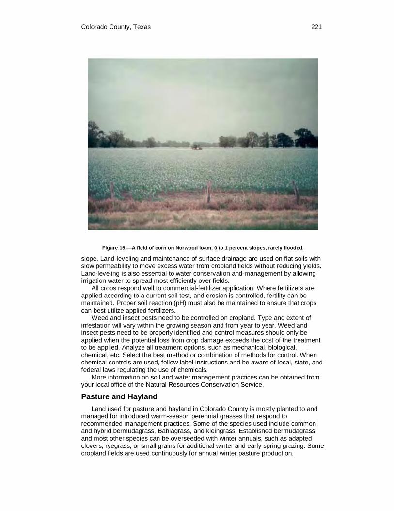
Colorado County, Texas 221
Figure 15.—A field of corn on Norwood loam, 0 to 1 percent slopes, rarely flooded.
slope. Land-leveling and maintenance of surface drainage are used on flat soils with slow permeability to move excess water from cropland fields without reducing yields. Land-leveling is also essential to water conservation and-management by allowing irrigation water to spread most efficiently over fields.
All crops respond well to commercial-fertilizer application. Where fertilizers are applied according to a current soil test, and erosion is controlled, fertility can be maintained. Proper soil reaction (pH) must also be maintained to ensure that crops can best utilize applied fertilizers.
Weed and insect pests need to be controlled on cropland. Type and extent of infestation will vary within the growing season and from year to year. Weed and insect pests need to be properly identified and control measures should only be applied when the potential loss from crop damage exceeds the cost of the treatment to be applied. Analyze all treatment options, such as mechanical, biological, chemical, etc. Select the best method or combination of methods for control. When chemical controls are used, follow label instructions and be aware of local, state, and federal laws regulating the use of chemicals.
More information on soil and water management practices can be obtained from your local office of the Natural Resources Conservation Service.
Pasture and Hayland Land used for pasture and hayland in Colorado County is mostly planted to and
managed for introduced warm-season perennial grasses that respond to recommended management practices. Some of the species used include common and hybrid bermudagrass, Bahiagrass, and kleingrass. Established bermudagrass and most other species can be overseeded with winter annuals, such as adapted clovers, ryegrass, or small grains for additional winter and early spring grazing. Some cropland fields are used continuously for annual winter pasture production.

222 Soil Survey of
Well managed perennial warm-season pasture grasses will usually produce more grass than is needed during the peak of the growing seasons Excess pasture production is often harvested as hay for use during the winter. Some perennial grasses and annually planted forage sorghum are managed strictly for hay production.
Year round forage programs can be developed by planning land use and selecting various types of forages to be grown. Such a planned grazing system maximizes forage utilization by allowing timely rest periods from grazing, providing a guide to stocking rates, and reducing the amount of hay needed for winter feeding.
Recommended pasture management practices include selection of the best-adapted forage species for the site that meets the yield and economic goals of the operation; adequate fencing for rotational grazing, and proper use of the forage that ensures plant vigor remains high for continued production and erosion control. In a well-managed pasture, weeds and brush are controlled, fertilization is at the proper time and in the recommended amount, and an adequate supply of clean water is available for livestock. Some pastures need applications of agricultural limestone to correct soil acidity resulting in better utilization of applied nutrients by the forage. Soil pH should be maintained at a minimum of 5.5 for most grasses, and if legumes are to be over-seeded pH of 6.0 or greater is preferred.
Hay production requires the same high management standards as pasture production. Additionally the forage needs to be cut at the proper interval and height based on species requirements in order to harvest high quality hay, maintain stand vigor, and promote timely regrowth.
Pecan Orchards Rick Jahn, Colorado County Extension Agent assisted in preparing this section
The soils in Colorado County have potential for increased pecan production and thus increased agricultural income. The soils on the bottomland have a tremendous potential for pecan production (fig. 16). Healthy native trees with good nut quality should be examined before cutting or bulldozing them down. These native, high-quality trees can be left in production if they can be managed. Several improved pecan varieties also are adapted to Colorado County. They include the Cheyenne, Choctaw, Desirable, Kiowa, and Shawnee varieties.
Soils on bottomlands and stream terraces have the highest potential for pecan production. The flood plains of the Colorado River, Cummins Creek, and the East Navidad River are currently used for pecan production. Some of the bottomland soils include Bergstrom, Bosque, Brazoria, Coarsewood, Gad, Mohat, Pursley, Ships, Uhland, Weswood, and Whitesboro. The soils on the stream terraces that have a high potential for pecan production are mainly the Dutek, Gholson and Smithville soils.
Soil that is well suited to good tree growth and production is the key to success in commercial pecan production. Unfortunately, many sites currently planted or sites being considered to be planted are not profitable because of poor site selection. The most frequent problem with site selection is poor soil drainage. Pecans require deep, well drained soils.
There is no simple definition of an ideal soil. However, there are two types of soil that are well suited to commercial pecan production—alluvial soils and soils on uplands.
Alluvial soils are commonly found along the Colorado River, major creeks or stream terraces. The best soils in this group have the following characteristics. The rooting depth is deep or very deep, the texture is loamy, and permeability is not too fast or too slow. The soils are inherently rich in both major and minor nutrient elements.

Colorado County, Texas 223
Figure 16.—Cattle in the shade of a pecan orchard. The soil is Mohat loam, 0 to 1 percent slopes, rarely flooded.
These soils have the ability to absorb and hold large quantities of water. The soils are well drained which permits easy and rapid movement of water into the root zone, this is essential to pecan production. Soils with clayey textures in areas that become waterlogged, inhibit pecan production. The static water table should be from 10 to 25 feet below the soil surface.
Upland soil types must be selected with care. These soils must provide many of the same characteristics found in the alluvial soils. The range of upland soil types suitable for commercial pecan production is limited in Colorado County. The following are some of the more important characteristics. The topsoil must have a depth of at least 30 to 36 inches, with a recommended texture of loamy fine sand or fine sandy loam.
The key to a good upland pecan soil is the makeup of the subsoil. A permeable, loamy or clayey subsoil that allows water and air to penetrate is essential. This type of subsoil will usually be red or brown in color indicating oxidation.
Pecan trees should not be fertilized the first year after transplanting. Beginning with the second year, a nitrogen fertilizer should be applied each year during April, May, and June. The amount of fertilizer applied will depend on the age and size of the trees.
Water is essential for good growth of young trees and regular production of quality nuts on mature, nutbearing trees. Drip irrigation, sprinkler irrigation, and flood irrigation can be used. For young trees, small amounts of water should be applied during periods of new growth each spring. The amount of water should be increased
224 Soil Survey of
as growth increases, temperatures climb, and the days become longer. Young trees should not be watered in the fall because of the hazard of freezing. The trees may need some water in the winter if a prolonged drought occurs. Mature, nutbearing trees need one inch of water per week from April to October. They should not go without water for more than three weeks during this period.
Pecan scab and stem-end blight are the major diseases affecting pecans in the county. Pecan scab is a fungus that forms lesions on the leaves and shucks. Dark black, sunken spots on the shucks are a typical symptom. During periods of high relative humidity, pecan scab is a very serious problem. Stem-end blight is a fungus that infects the pecan nut at the water stage in late July. It is a serious disease because it occurs in both wet and dry climates. Stem-end blight cannot be identified until after the damage has occurred. The symptoms are black areas on the shuck, a reduction in the size of the kernel, and a tendency of the shuck to stick to the shell.
Insects that affect pecan trees in the county are the pecan nut casebearer, pecan weevils, hickory shuckworms, and black aphids. The pecan nut casebearer is a problem in mid May. The other insects usually appear in August and September.
Pecans cannot be grown successfully in the county without foliar zinc sprays. Soil tests may show that adequate levels of zinc are present; however, the trees cannot absorb the zinc from the soil. The symptoms of zinc rosette are stunted growth, shoots growing in bunches and dead shoots throughout the top of the older trees. Young trees should be sprayed every two weeks from April to August to ensure that growth will continue throughout the season. Trees that are bearing should be sprayed at bud break, prepollination, casebearer, and second-generation casebearer to allow maximum shoot growth and leaf expansion.
Pecans are usually harvested after mid-November. If a major freeze or frost occurs before that date, the shuck can stick to the shell. Pecans grown in residential areas are frequently eaten by squirrels and bluejays. It is not uncommon for a single squirrel to gather 25 pounds of nuts. Most commercial orchards are now harvested with tractor- or truck-mounted shakers. Pecans are then picked up with mechanical harvesters, cleaned in mechanical cleaners, and sacked and sold to wholesalers.
Yields per Acre The average yields per acre that can be expected of the principal crops under a
high level of management are shown in Table 5. In any given year, yields may be higher or lower than those indicated in the table because of variations in rainfall and other climatic factors. The land capability classification of map units in the survey area also is shown in the table.
The yields are based mainly on the experience and records of farmers, conservationists, and extension agents. Available yield data from nearby counties and results of field trials and demonstrations also are considered.
The management needed to obtain the indicated yields of the various crops depends on the kind of soil and the crop. Management can include drainage, erosion control, and protection from flooding; the proper planting and seeding rates; suitable high-yielding crop varieties; appropriate and timely tillage; control of weeds, plant diseases, and harmful insects; favorable soil reaction and optimum levels of nitrogen, phosphorus, potassium, and trace elements for each crop; effective use of crop residue, barnyard manure, and green manure crops; and harvesting that ensures the smallest possible loss.
For yields of irrigated crops, it is assumed that the irrigation system is adapted to the soils and to the crops grown, that good-quality irrigation water is uniformly applied as needed, and that tillage is kept to a minimum.
The estimated yields reflect the productive capacity of each soil for each of the principal crops. Yields are likely to increase as new production technology is

Colorado County, Texas 225
developed. The productivity of a given soil compared with that of other soils, however, is not likely to change.
Crops other than those shown in Table 5 are grown in the survey area, but estimated yields are not listed because the acreage of such crops is small. The local office of the Natural Resources Conservation Service or Texas Cooperative Extension can provide information about the management and productivity of the soils for those crops.
Land Capability Classification Land capability classification shows, in a general way, the suitability of soils for
most kinds of field crops. Crops that require special management are excluded. The soils are grouped according to their limitations for field crops, the risk of damage if they are used for crops, and the way they respond to management. The criteria used in grouping the soils do not include major and generally expensive landforming that would change slope, depth, or other characteristics of the soils, nor do they include possible but unlikely major reclamation projects. Capability classification is not a substitute for interpretations designed to show suitability and limitations of groups of soils for rangeland, for forestland, or for engineering purposes.
In the capability system, soils are generally grouped at three levels—capability class, subclass, and unit.
Capability classes, the broadest groups, are designated by the numbers 1 through 8. The numbers indicate progressively greater limitations and narrower choices for practical use. The classes are defined as follows:
Class 1 soils have slight limitations that restrict their use. Class 2 soils have moderate limitations that restrict the choice of plants or that
require moderate conservation practices. Class 3 soils have severe limitations that restrict the choice of plants or that
require special conservation practices, or both. Class 4 soils have very severe limitations that restrict the choice of plants or that
require very careful management, or both. Class 5 soils are subject to little or no erosion but have other limitations,
impractical to remove, that restrict their use mainly to pasture, rangeland, forestland, or wildlife habitat.
Class 6 soils have severe limitations that make them generally unsuitable for cultivation and that restrict their use mainly to pasture, rangeland, forestland, or wildlife habitat.
Class 7 soils have very severe limitations that make them unsuitable for cultivation and that restrict their use mainly to grazing, forestland, or wildlife habitat.
Class 8 soils and miscellaneous areas have limitations that preclude commercial plant production and that restrict their use to recreational purposes, wildlife habitat, watershed, or esthetic purposes.
Capability subclasses are soil groups within one class. They are designated by adding a small letter, e, w, s, or c, to the class numeral, for example, 2e. The letter e shows that the main hazard is the risk of erosion unless close-growing plant cover is maintained; w shows that water in or on the soil interferes with plant growth or cultivation (in some soils the wetness can be partly corrected by artificial drainage); s shows that the soil is limited mainly because it is shallow, droughty, or stony; and c, used in only some parts of the United States, shows that the chief limitation is climate that is very cold or very dry.
In class 1 there are no subclasses because the soils of this class have few limitations. Class 5 contains only the subclasses indicated by w, s, or c because the soils in class 5 are subject to little or no erosion. They have other limitations that restrict their use to pasture, rangeland, forestland, wildlife habitat, or recreation.

226 Soil Survey of
Capability units are soil groups within a subclass. The soils in a capability unit are enough alike to be suited to the same crops and pasture plants, to require similar management, and to have similar productivity. Capability units are generally designated by adding an Arabic numeral to the subclass symbol, for example, 2e-4 and 3e-6. These units are not given in all soil surveys.
Woodland Management and Productivity Connie Fair, District Conservationist, Natural Resources Conservation Service, helped to prepare this section
Although woodland is not a major land use in Colorado County, several soils have the potential for limited commercial timber production. In the past, trees such as cypress, mixed hardwoods, and pine were cut for private and commercial use. Local saw mill operations no longer exist in the county today. However, a few unmanaged stands of loblolly pine are being cut in the Lost Pines Forest and shipped to East Texas saw mills.
The Lost Pines Forest located in the north central part of the county have soils that support good stands of loblolly pine (fig. 17). Natural reforestation from unmanaged stands cut in the 1920's and 1930's represent the forest today. Recent clear cut areas continue to maintain natural reforestation, consisting mainly of loblolly pine.
The Lost Pines Forest makes up about 10,000 acres of potential commercial trees. Most of the forest is privately owned and a few ownerships are certified as tree farms. The average age of trees in the Lost Pine Forest ranges from 60 to 70 years. The majority of the forest is located on nearly level to gentle slopes and has tree heights ranging from 65 to 70 feet. In steep sloping areas, tree height ranges up to 100 feet.
Figure 17.—The Lost Pines Forest in northern Colorado County. The soil is Joiner loamy sand, 1 to 3 percent slopes.

Colorado County, Texas 227
The Catilla, Rek, Robco, Straber, and Tremona, soils in the Lost Pines Forest have potential suitability for growing and maintaining commercial pine forest, if timber management practices are utilized. Presently, timber management practices such as fire prevention and insect infestation control are implemented by the Texas Forest Service.
Soils on the bottomlands of the Colorado River and associated tributaries are suited to hardwood growth and management. These soils include the Bosque, Brazoria, Ganado, Norwood, Pursley, and Whitesboro series. The hardwood is being cut and sold as firewood in metropolitan areas. Cedar is recognized by the land user as a commercial woodland product, but is not managed as such.
Rangeland Homer Sanchez, Range Management Specialist, Natural Resource Conservation Service, Temple, Texas prepared this section.
Rangeland is land on which the native vegetation (the climax plant community) is predominantly grasses, grasslike plants, forbs, shrubs, and trees. Rangeland receives no regular or frequent cultural treatment. The composition and production of the natural plant community is determined mainly by soil, climate, and topography. The management needed to conserve soil and water resources and improve production includes balancing livestock numbers with forage production and rotating livestock to allow desirable plants to improve vigor, produce seed, and establish seedlings.
Rangeland no longer makes up a major portion of the acreage as was the case several hundred years ago. The majority of the native grazing lands has been plowed up and now exist as tame pasture or cropland. Few grazing managers depend exclusively on rangeland to feed livestock. Range vegetation often contributes significant amounts of forage during winter months, but it is supplemented by protein concentrates and small grain pasture. True native vegetation in most of the county is found only in small blocks of less than 250 acres. These areas of rangeland, for the most part, have been depleted in forage productivity because of improper grazing management and invasion of woody and/or weedy vegetation which reduces the quality and quantity of suitable forage plants. Much of the acreage listed as rangeland is land which is abandoned cropland or pastureland. Because of the lack of management, these lands generally produce less than half of their original potential. The majority of the rangeland is in poor to fair condition with some of the dominant grasses being Texas wintergrass, threeawns, little bluestem, silver bluestem, and brownseed paspalum. Introduced species like King Ranch bluestem dominate many areas where the more palatable natives have been depleted. Paspalum species will dominate many sites in the Southern Claypan Area and in the Coast Prairie.
Approximately 300,000 acres or 48 percent of Colorado County is classified as rangeland. The rangeland in Colorado County can be classified into three major areas, known as Major Land Resource Areas (MLRA’s). Major Land Resource Areas are geographically associated land resource units. Identification of these large areas is important in statewide agricultural planning. MLRA’s are characterized by differences in land use, elevation and topography, climate, water, soils, and potential vegetation. Colorado County has three MLRA’s; the Southern Blackland Prairie (86B), the Southern Claypan Area (87A), and the Coast Prairie (150A).
The Southern Blackland Prairie makes up about 15 percent of Colorado County and is located on the north end of Colorado County. The county is basically divided in thirds by the three MLRA's, with the divisions running southwest to northeast. The Southern Claypan Area is located along the middle of the county and makes up approximately 43 percent of the total area. The Coast Prairie makes up the remaining

228 Soil Survey of
42 percent of the total area and this land type is along the southern half of Colorado County.
The same ecological site may occur within one or several MLRA's. The site descriptions for species composition may differ between MLRA's for the same ecological site.
Southern Blackland Prairie (MLRA 86B) This portion of Colorado County has predominantly clayey soils. These soils have
the potential to support tall grasses and a climax plant community that is dominantly a tall grass prairie. History shows that these areas maintained a mixture of tall grasses such as big bluestem, little bluestem, switchgrass, Indiangrass, Virginia wildrye, and some eastern gamagrass. Midgrasses species such as sideoats grama, tall dropseed, and Texas wintergrass should occur. Interspersed areas of trees should occur frequently along major drainageways and occasionally in motts.
Five different ecological sites can be found within the Southern Blackland Prairie. These sites are: Blackland, Clay Loam, Clayey Bottomland, Eroded Blackland, and Loamy Bottomland.
Southern Claypan Area (MLRA 87A) Typical of this portion of Colorado County are loamy and sandy soils.
Approximately 60 percent of the Southern Claypan Area is in rangeland and 25 percent is in improved pastureland. The remainder is in cultivation and woodland. The climax plant community generally is a post oak, blackjack oak savannah. In climax, trees should shade as much as 15 to 20 percent of the ground on uplands. Large trees, such as oaks, American elm, and hackberry form dense overstory along major drainageways. Mid to tall grasses dominate the understory. As retrogression or deterioration occurs, woody plants invade and tall grasses are replaced by mid to short grasses and forbs which are less productive and less nutritious to livestock.
Eight different ecological sites can be found within the Southern Claypan Area. These sites are: Claypan Prairie, Claypan Savannah, Deep Sand, Gravelly, Loamy Bottomland, Sandy, Sandy Bottomland, and Sandy loam.
Coast Prairie (MLRA 150A) Climax vegetation of this area is a true prairie with very little if any woody
vegetation. This MLRA lies on the southern portion of Colorado County. Little bluestem or seacoast bluestem is the dominant species. Paspalums and panicums increase with retrogression and thus play a major role in these plant communities.
Eight different ecological sites occur within the Coast Prairie MLRA. These sites are: Claypan Prairie, Deep Sand, Loamy Bottomland, Loamy Prairie, Lowland, Sandy Bottomland, Sandy Loam, and Sandy Prairie.
Ecological Sites An ecological site for rangeland is a distinctive kind of land with specific physical
characteristics that makes it different from other kinds of land in its ability to produce a distinctive kind and amount of vegetation (a characteristic plant community). Rangeland ecological sites generally can be determined directly from the soil map. Soil properties that affect moisture supply and plant nutrients have the greatest influence on the productivity of plants. Soil reaction, salt content, and a seasonal high water table are also important. The electronic "Field Office Technical Guide, (eFOTG)" which is available online at http://www.nrcs.usda.gov/technical/efotg, can provide specific information about ecological sites.
Over historical time, the combination of plants best suited to a particular soil and climate became dominant. If the soil is not excessively disturbed, this group of plants

Colorado County, Texas 229
is the historic climax plant community for the site. Historic climax plant communities are not static but vary slightly from year to year and place to place.
Nearly all plant communities have undergone changes over time. Many years of continuous livestock grazing, the absence of fire, the invasion of plants that were not originally in the plant community, and climatic events, such as major droughts, have all interacted to affect changes in the vegetation on rangeland.
Abnormal disturbances that change the historic climax plant community include repeated overuse by livestock, excessive burning, erosion, and plowing. Grazing animals select the most palatable plants. These plants will eventually die if they are continually grazed at a severity that does not allow for recovery. Under these conditions, less desirable plants, such as annuals and weed-like plants, can increase. Usually, these degradation processes (also called retrogression) take place over many years. If the plant community and soils have not been degraded significantly and proper grazing management is implemented, native plants can return.
The Natural Resources Conservation Service and other agencies assist landowners in identifying problems and concerns, as well as opportunities to maintain or improve their rangeland resources. A rangeland ecological site may be evaluated by three distinct methods: similarity index, rangeland trend, and rangeland health.
A similarity index is a comparison of the present plant community to the historic climax plant community. A similarity index is the percentage, by weight, of historic climax vegetation that is found in the present plant community. This index provides an indication of past disturbance as well as potential for improvement. Further information about range similarity index is available in the "National Range and Pasture Handbook" (http://www.glti.nrcs.usda.gov/technical/publications/nrph.html).
Rangeland trend determinations assess the direction of change occurring in the present plant community compared to the historic climax plant community. The plant community may be either moving toward or away from the historic climax plant community. This rating provides information to landowners regarding the direction of change in plant community in response to present management.
Rangeland health is a determination of how the ecological processes on a rangeland ecological site are functioning. Ecological processes evaluated soil and site stability, hydrologic function, and biotic integrity.
How rangeland is managed affects forage production, species composition, plant health, and the ability of the vegetation to protect the soil. Rangeland management requires knowledge of the kinds of soil and of the historic climax plant community. Effective range management conserves rainfall, enhances water quality, reduces the hazard of downstream flooding, improves yields, provides forage for livestock and wildlife, enhances recreational opportunities, and protects the soil.
Following years of prolonged overuse of range, seed sources of desirable vegetation will be eliminated. In such instances, vegetation can be reestablished by applying one or a combination of the following practices: mechanical or chemical treatment, range planting, fencing, water development, prescribed burning, or other treatments to revitalize stands of native plants. Thereafter, deferred grazing, proper grazing use, and planned grazing systems must be applied to maintain and improve the range. The implementation of physical practices must be followed by grazing management and follow-up brush control for maintenance purposes. The combination of alternatives, or Resource Management Systems (RMS), is essential if rangeland productivity is to be maintained. Following are some of the more commonly used resource management practices.
Proper Grazing Use. The objective is to graze at an intensity that will maintain enough cover to protect the soil and maintain or improve the quality and quantity of desirable vegetation.
Deferred Grazing. This is the deferment or restriction of grazing until the better plants have completed most of their seasonal growth or have made seed. It is one

230 Soil Survey of
way to help keep the desirable plants healthy and vigorous. The use of deferred grazing also permits plants that have been depleted to become strong again. Deferred grazing will help to improve plant cover and hydrologic cover conditions, and reduce soil losses.
Fencing. This practice excludes livestock from areas that should be protected from grazing, confines livestock to an area, subdivides grazing land to permit use of a planned grazing system, and protects new seedlings or plantings from grazing.
Prescribed Burning. Livestock operators and wildlife managers use this practice to periodically burn off dense residues of mature vegetation. When done properly and at the right time, the practice will stimulate new succulent growth for both cattle and wildlife, increase the availability of forage and restore climax plant species in upland rangeland, and reduce infestations of noxious weed and brush species. However, forage can be severely damaged by burns in periods when the soil surface is dry because fire can reach the plant crowns and roots which can kill the plant. Burning is not recommended more often than once every three years, since doing so may harm perennial grass vegetation. Prescribed burning is an effective management tool which can be substituted for chemical or mechanical treatments in many plant communities. Prescribed burning can be very effective in controlling regrowth juniper and other non-sprouting brush species. All burns will require adequate deferment for necessary fuel loads, and more importantly, should be preceded by a complete prescribed burn management plan designed by qualified personnel.
Planned Grazing Systems. The objective is to rotate livestock through two or more pastures in a planned sequence for a period of years to meet the deferred grazing needs of the plant community and the nutritional needs of the livestock. A planned grazing system may be relatively simple in design using two pastures, or may be more complex and management intensive, using one or two herds and numerous pastures. It must be tailored to each ranch unit and meet the needs of the plants, animals, and ranchers abilities and desires to be successful.
There are 15 ecological sites identified in the survey area. They are Blackland, Clay Loam, Clayey Bottomland, Claypan Prairie, Claypan Savannah, Deep Sand, Eroded Blackland, Gravelly, Loamy Bottomland, Loamy Prairie, Lowland, Sandy, Sandy Bottomland, Sandy Loam, and Sandy Prairie,
Blackland Ecological Site
The Bleiblerville, Burleson, Dacosta, Frelsburg, Laewest, and Elmenwood-Denvaca complex soils in map units BkB, BuA, BuB, DaA, EnB, FrB, FrC, and LaA are in the Blackland ecological site. The climax vegetation is a tall grass prairie with a few large live oak, elm, and hackberry trees along drainageways and in motts. The composition by weight is 85 percent grasses, 5 percent woody plants, and 10 percent forbs. This site has high natural fertility.
Little bluestem, Indiangrass, and big bluestem produce 75 percent of the forage in climax. Other grasses such as switchgrass, sideoats grama, Texas wintergrass, Texas cupgrass, tall dropseed, Florida paspalum, and Virginia wildrye make up the other 10 percent of grasses. Woody plants are live oak, elm, hackberry, bumelia, and coralberry. Many palatable forbs and legumes are native to this site. Overgrazing by cattle eventually kills out tall grasses like big bluestem, Indiangrass, switchgrass, and eastern gamagrass. These are replaced by silver bluestem, Texas wintergrass, tall dropseed, and other mid grasses. If continued grazing pressure occurs, buffalograss, Texas grama, tumblegrass, annual weeds, and annual grasses will dominate the site and an invasion of noxious brush species like mesquite, winged elm, retama, baccharis, and huisache will occur.
Colorado County, Texas 231
Clay Loam Ecological Site
The Brenham, Carbengle, and Rabbs soils in map units BsD, CbC, CbD, CbE2, and RbD are in the Clay Loam ecological site. This ecological site occurs only in the Southern Blackland Prairie MLRA. In its pristine condition, this is a true tall grass prairie site which is highly productive. The composition by weight is 85 percent grasses, 5 percent woody plants, and 10 percent forbs.
Little bluestem dominates the site, constituting 50 to 60 percent of the total annual yield. Indiangrass, big bluestem, switchgrass, Virginia and Canada wildrye, and Florida paspalum make up about 20 percent. Sideoats grama, silver bluestem, low panicums, and Texas wintergrass make up about 10 percent. Short grasses make up about 5 percent. Woody plants include hackberry, elm, pecan, and oak. The primary forbs are Maximilian sunflower, Engelmann’s daisy, penstemon, bundleflower, and numerous other legumes.
As retrogression occurs, due to overgrazing, tall grasses such as bluestems, Indiangrass, switchgrass, and Florida paspalum decrease and are replaced by sideoats grama, silver bluestem, low panicums, Texas wintergrass, and tall dropseed. In a deteriorated condition, invader plants such as threeawns, hairy grama, red lovegrass, Texas grama, buffalograss, tumblegrass, western ragweed, broomweed, prairie coneflower, and woody plants such as mesquite, baccharis, yaupon, and hawthorn dominate and total annual production potential is reduced.
Clayey Bottomland Ecological Site
The Brazoria, Ganado, Roetex, Ships, and Trinity soils in map units BrA, GeA, RtA, SpA, and TwA are in the Clayey Bottomland ecological site. This ecological site occurs only in the Southern Blackland Prairie MLRA. The climax plant community is a tall grass savannah. Oak, elm, hackberry, cottonwood, ash, black willow, some pecan, and other large trees make up about 30 percent canopy cover. The canopy is generally heavier along streams or drainageways. Cool-season grasses and sedges grow under the canopy, and warm-season grasses and forbs dominate the open areas. The composition weight is 75 percent grasses, 20 percent woody plants, and 5 percent forbs.
Sedges, Virginia wildrye, Canada wildrye, and rustyseed paspalum produce 15 percent of the composition by weight. Beaked panicum, switchgrass, Indiangrass, vine mesquite, and Florida paspalum and others produce 55 percent. Buffalograss, long leaf uniola, knotroot bristlegrass, and other grasses produce about 5 percent. The forbs are tickclover, snoutbean, lespedeza, and gayfeather.
Heavy grazing and suppression of fire reduce the warm-season grasses and forbs and allow the brush to form a dense canopy. Shade tolerant grasses then dominate the understory and total usable forage is drastically reduced.
Claypan Prairie Ecological Site
The Edco, Edna, Hallettsville, Wilson soils and the Nada soils in the Nada-Cieno complex in map units EcA, EdA, HeB, NaA, and WsA are in the Claypan Prairie ecological site. This ecological site occurs in both the Southern Claypan Area MLRA and the Coast Prairie MLRA. In climax condition this is a true tall grass prairie site for both MLRA regions. Very little if any woody vegetation should occur on this site. Oaks, elms, and hackberry may occur along drainageways or in motts. The composition weight is 85 percent grasses, 10 percent forbs, and 5 percent woody plants.
Little bluestem and Indiangrass compose 65 percent of the climax plant community. Switchgrass, big bluestem, Virginia wildrye, Canada wildrye, and Florida paspalum, are subdominants to both MLRA's and should make up about 15 percent of the composition. Sideoats grama, meadow dropseed, Texas wintergrass, and vine mesquite are species which will occur in the Southern Claypan Area MLRA only,
232 Soil Survey of
while brownseed and longspike tridens may be present within the Coast Prairie MLRA. Live oak, elm, hackberry, bumelia, coralberry, and an occasional post oak make up 5 percent of the total production. Many forbs, such as Maximilian sunflower, Engelmann’s daisy, halfshrub sundrop, western indigo, yellow neptunia, and prairie clover produce 10 percent of the composition.
Continued overgrazing by cattle decreases big bluestem, little bluestem, Indiangrass, and switchgrass. Meadow dropseed, silver bluestem, sideoats grama, and Texas wintergrass or brownseed paspalum and smutgrass increase as desirable grasses disappear. Finally, mesquite, huisache, baccharis, McCartney rose, and pricklypear invade the site. Buffalograss, threeawns, and windmillgrasses will dominate deteriorated Claypan sites, while smutgrass, carpetgrass, gulf muhly, and threeawns dominate the Coast Prairie sites.
Claypan Savannah Ecological Site
The Lufkin soil in map unit LuA is in the Claypan Savannah ecological site. This ecological site occurs only in the Southern Claypan Area MLRA. The climax plant community is a post oak and a blackjack oak savannah with trees shading 15 to 20 percent of the ground. The composition by weight is about 80 percent grasses, 15 percent woody plants, and 5 percent forbs.
About 60 percent of the climax vegetation is made up of little bluestem, Indiangrass, and brownseed paspalum. The other grasses are switchgrass, Florida paspalum, purpletop tridens, low panicums, low paspalums, silver bluestem, tall dropseed, and Texas wintergrass. Woody plants include post oak, blackjack oak, elm, yaupon, hawthorn, and American beautyberry. Forbs include dayflower, bundleflower, sensitivebrier, tickclover, wildbean, and lespedeza.
If retrogression occurs as a result of heavy grazing or fire suppression, or both, little bluestem, Indiangrass, and switchgrass are replaced by brownseed paspalum, silver bluestem, arrowfeather threeawn, tall dropseed, purpletop tridens, and low panicums. Woody plants, such as post oak, elm, yaupon, and hackberry increase and form a dense canopy that suppresses grass and forb production.
Deep Sand Ecological Site
The Catilla, Faula, Joiner, Kuy, Rupley, and Tadina soils in map units CcC, FaB, JoB, KuB, RuB, and TcC make up the Deep Sand ecological site. This ecological site occurs in the Southern Claypan Area MLRA and in the Coast Prairie MLRA. The climax vegetation is a post oak and blackjack oak savannah with a 20 to 25 percent canopy. The understory consists of mid to tall grasses. The composition by weight is 80 percent grasses, 15 percent woody plants, and 5 percent forbs.
Little bluestem makes up about 50 percent of the composition and Indiangrass makes up about 10 percent. Also present, but in lesser amounts are purpletop tridens, switchgrass, and sand lovegrass. Other grasses are low panicums, purple lovegrass, sand dropseed, brownseed paspalum, and splitbeard bluestem. Woody plants such as blackjack oak and post oak make up 10 percent of the composition. Other woody plants include shrubs such as yaupon, hawthorn, and American beautyberry which are the understory species. Forbs include legumes such as lespedeza, tickclover, and partridge pea.
As retrogression takes place, little bluestem, sand lovegrass, Indiangrass, and purpletop tridens decrease and low panicums, low paspalums, purple lovegrass, and woolysheath threeawn increase on the site. Oak and yaupon increase to form a dense canopy. The decreasing and increasing plants are finally replaced by red lovegrass, tumble lovegrass, crabgrass, red sprangletop, sandbur, brackenfern, pricklypear, and queensdelight. Production of forage species is reduced to nothing.

Colorado County, Texas 233
Eroded Blackland Ecological Site
The Latium soil in map units LaD and LtE3 are in the Eroded Blackland ecological site. This ecological site occurs only in the Southern Blackland Prairie MLRA. The potential plant community is a tall grass prairie. Although the climax vegetation has been destroyed by cultivation, and the productive ability of the site reduced by erosion, the altered site will grow essentially the same tall grass species as the Blackland ecological site. A long period of time (40 years or longer) is required for secondary plant succession to reestablish itself under natural conditions. The potential plant community by weight is 85 percent grasses, 5 percent woody plants, and 10 percent forbs.
Little bluestem, Indiangrass, and big bluestem make up 70 percent of the potential plant community. Virginia wildrye, Canada wildrye, switchgrass, Florida paspalum, sideoats grama, tall dropseed, silver bluestem, Texas wintergrass, and vine mesquite make up 15 percent. Live oak, hackberry, elm, bumelia, and coralberry make up 5 percent. Forbs, such as Maximilian sunflower, Engelmann’s daisy, and bundleflower, make up 10 percent. Most of this site is in some intermediate stage of secondary plant succession. Silver bluestem, tall dropseed, Texas wintergrass, sideoats grama, and buffalograss normally dominate this condition, and they respond as increasers. If heavy use is continued, buffalograss or Texas wintergrass, or both, will dominate the site.
Gravelly Ecological Site
The Rek, Stein, Straber, and Tremona soils in map units RkB, SvF, SxB, SxD, and TrB are in the Gravelly ecological site. This ecological site occurs in both the Southern Claypan Area MLRA and in the Coast Prairie MLRA. In its pristine condition, this site is a post oak and a blackjack oak savannah. The overstory of oak and associated species shades about 15 to 20 percent of the ground. The understory is dominated by little bluestem which constitutes about 50 to 65 percent of the total annual yield. The composition by weight is 80 percent grasses, 5 percent forbs, and 15 percent woody plants.
Occurring in smaller amounts are Indiangrass, beaked panicum, purpletop tridens, brownseed paspalum, and sideoats grama. Good palatable, cool-season forage plants are scarce to this site. A good variety of forbs, legumes, shrubs, and woody vines grow on this site.
As retrogression occurs, the tall decreasers are replaced by increasers such as brownseed paspalum, low panicums, and dropseeds. As further abuse occurs, oak, yaupon, greenbriar, hawthorns, and American beautyberry often form a dense overstory, which severely limits production of herbaceous plants. In a deteriorated condition annual grasses and forbs will dominate the site. These invader species such as eastern red cedar, baccharis, bitter sneezeweed, mesquite, and broomsedge bluestem limit the productivity of the site.
Loamy Bottomland Ecological Site
The Bergstrom, Bosque, Clemville, Coarsewood, Mohat, Norwood, Pursley, Smithville, Uhland, Weswood, and Whitesboro soils in map units BgA, BoA, CvA, CwA, MoA, NoA, NrA, PuA, StA, UnA, WeA, WfA, and WhA are in the Loamy Bottomland ecological site. This ecological site can be found in all three MLRA's. The climax plant community is a tall grass savannah with trees shading 30 percent of the ground. Overstory consists of oaks, pecan, hackberry, elm, cottonwood, and hickory or ash species. Understory species are hawthorns, greenbrier, honeysuckle, grapes, and peppervines. Cool-season grasses and sedges dominate the shaded areas, while warm-season grasses dominate the openings. The composition by weight is 75 percent grasses, 20 percent woody plants, and 5 percent forbs.

234 Soil Survey of
Virginia wildrye, sedges, and rustyseed paspalum grow in the shaded and wet areas. Longtom, sedges, and bristlegrasses dominate the wetter sites. Switchgrass, beaked panicum, Indiangrass, big bluestem, little bluestem, eastern gamagrass, vine mesquite, and purpletop tridens grow in the open areas and make up 35 to 45 percent of the plant community. Redtop panicum, gaping panicum, low panicums, uniolas, buffalograss, knotroot bristlegrass, Texas wintergrass, and other grasses make up 10 to 15 percent. The forbs are tickclover, lespedeza, snoutbean, partridge pea, and gayfeather.
Overgrazing and fire suppression reduce warm-season grasses and forbs and increase the tree and brush canopy. Shade-tolerant grasses and forbs then dominate the herbaceous production, and forage production is drastically reduced.
Loamy Prairie Ecological Site
The Garwood, Katy, Mentz, Mockley, Telferner, Telf, and Wockley soils in map units GoA, GrA, KaA, MeA, MeB, MkB, MmB, TdA, TdB, TeA, TfA, WyA, and WyB, are in the Loamy Prairie ecological site. This site occurs only in the Coast Prairie MLRA. This site is a true tall grass prairie with little bluestem being the dominant species making up approximately 50 percent of the total annual yield. Indiangrass and switchgrass are subdominants. Florida paspalum, brownseed paspalum, longspike tridens, and dichantheliums occur in lesser quantities.
This site may occur adjacent to woodlands and thus may look more like a savannah with woody canopies of 20 to 25 percent. Brownseed is a strong increaser and dominates many sites. Sites in a deteriorated condition will be dominated by species such as smutgrass, carpetgrass, bushy bluestem, gulf muhly, and broomsedge bluestem. Woody invaders are McCartney rose, huisache, wax myrtle, baccharis, bigleaf sumpweed, and Chinese tallow.
Lowland Ecological Site
The Cieno portion of the Garwood-Cieno complex, Morales-Cieno, Nada-Cieno, and the Telf-Cieno complex in map units GrA, MxA, NaA, and TfA are located in the Lowland ecological site. This site occurs only in the Coast Prairie MLRA. The potential plant community for this site is a wet prairie. This site occurs in low lying flats along drainageways.
Switchgrass, maidencane, and eastern gamagrass dominate this site, making up about 50 percent of the total production. Occurring in lesser amounts are Indiangrass, little bluestem, Florida paspalum, longtom, brownseed paspalum, knotroot bristlegrass, dichantheliums, soft rush, and spike rush.
Longtom, broomsedge bluestem and longspike tridens increase under continuous heavy grazing pressure. Vaseygrass, needlegrass rush, carpetgrass, baccharis, wax myrtle, and Chinese tallow occupy these sites under deteriorated conditions. Areas of water also occupy this site.
Sandy Ecological Site
The Cheetham, Dutek, Milby, Newulm, Robco, Straber, and Tremona soils in map units CmB, DtB, MfB, NeB, RoB, SwB, SwC, TmA, and TmC are in the Sandy ecological site. This ecological site occurs only in the Southern Claypan Area MLRA. The climax vegetation is an open savannah of post oak and blackjack oak, which shades 20 to 25 percent of the ground. The interspaces are predominantly tall grasses. The composition by weight is 80 percent grasses, 15 percent woody plants, and 5 percent forbs.
About 50 percent of the composition is little bluestem, with Indiangrass making up 10 percent. Switchgrass, beaked panicum, sand lovegrass, purpletop tridens, and brownseed paspalum total 10 percent. Other grasses are fringeleaf paspalum, purple lovegrass, tall dropseed, splitbeard bluestem, and low panicums. Post oak and
Colorado County, Texas 235
blackjack oak make up about 10 percent of the total annual production. Woody plants in the understory are hawthorn, American beautyberry, greenbrier, yaupon, and berry vines. The forbs are lespedeza, tickclover, sensitivebrier, snoutbean, tephrosia, partridge pea, and western ragweed.
With continuous overgrazing and the lack of natural fires, the taller grasses are grazed out or shaded out, or both, by an increasing canopy of woody species. The little bluestem, Indiangrass, and switchgrass are replaced by brownseed paspalum, tall dropseed, fall witchgrass, and other increasing species. They, in turn, are grazed out and replaced by red lovegrass, yankeeweed, bullnettle, snakecotton, and croton. Other invading plants are broomsedge bluestem, smutgrass, sandbur, pricklypear, queensdelight, beebalm, pricklypoppy, baccharis, and wax myrtle. Woody species increase and invade to form dense thickets.
Sandy Bottomland Ecological Site
The Gad and Zalco soils in map units GaA, GdA, and ZaA are located within the Sandy Bottomland ecological site. This site occurs only within the Coast Prairie MLRA. This is a savannah site of about 30 percent canopy. Grasses make up approximately 75 percent of the vegetation while woody species make up about 20 percent of the total plant community.
Little bluestem makes up about 40 percent of the total production. Indiangrass and switchgrass should make up another 20 percent. Virginia wildrye, purpletop tridens, knotroot bristlegrass, and sedges dominate the shaded areas. Brownseed paspalum, knotroot bristlegrass, and Pan American balsamscale occur in more open areas but in less frequent quantities. As retrogression occurs, the more palatable species like Indiangrass begin to disappear and less palatable species like smutgrass, bullnettle, grassbur, red lovegrass, and broomsedge bluestem invade. Invader brush species are mesquite and willows.
Sandy Loam Ecological Site
The Chazos, Dubina, Gholson, Nez, and Tabor soils and the Morales portion of the Morales-Cieno complex in map units Chb, DnC, GsB, GsD, NgA, NhA, TaA, TaB, and MxA, are in the Sandy Loam ecological site (fig. 18). This site appears in both the Southern Claypan Area MLRA and in the Coast Prairie MLRA. The climax plant community is a live oak, post oak, and blackjack oak savannah with a 20 to 35 percent canopy. The understory consists of mid and tall grasses and is dominated by little bluestem, which makes up 40 to 50 percent of the composition. The total composition by weight is 75 percent grasses, 15 to 20 percent woody plants, and 5 percent forbs.
Little bluestem is the dominant grass and Indiangrass is the next dominant, making up about 10 percent. Eastern gamagrass, switchgrass, big bluestem, beaked panicum, purpletop tridens, and longleaf uniola make up 10 to 15 percent of the total composition. Pan American balsamscale and Florida paspalum are more noticeable in the Coast Prairie MLRA site. Post oak and blackjack oak make up about 10 percent of the total annual production, and numerous other woody plants include elm, yaupon, greenbrier, American beautyberry, and berry vines. The forbs include Engelmann’s daisy, gayfeather, sensitivebrier, and native legumes.
If occurrence of wildfires is reduced and if overgrazing continues, this ecological site deteriorates, with an increase in woody canopy and a decline in tall grasses, such as little bluestem, Indiangrass, big bluestem, and eastern gamagrass. These plants are replaced by an increase in such plants as brownseed paspalum. If overgrazing persists, the sites deteriorate to thickets of oak and brush, annual grasses, forbs, and carpetgrass.

236 Soil Survey of
Figure 18.—Rangeland on an area of Nez fine sandy loam, 0 to 1 percent slopes. The Nez soils are in the Sandy Loam Ecological Site.
Sandy Prairie Ecological Site
The Fordtran and Monaville soils in map units FoA and MvB are in the Sandy Prairie ecological site. This site occurs only in the Coast Prairie MLRA. The climax vegetation is a true prairie. Grass vegetation makes up about 90 to 95 percent of the total vegetation in a pristine state.
About 75 percent of the climax vegetation is made up of little bluestem, Indiangrass, crinkleawn, and big bluestem. Other dominant grasses are eastern gamagrass, Florida paspalum, low panicums, brownseed paspalum, sedges, and Pan American balsamscale.
If regression occurs as a result of heavy grazing, the more palatable species such as bluestems, switchgrass, and eastern gamagrass will disappear. Increasers such as brownseed paspalum, knotroot bristlegrass, and low panicums will replace the decreaser plants. Further deterioration in range condition will lead to a plant community primarily comprised of invader plants such as smutgrass, red lovegrass, broomsedge bluestem, yankeeweed, bitter sneezeweed, and woody plants such as McCartney rose, huisache, sennabean, and running live oak.
Rangeland Productivity Table 6 shows, for each soil that supports rangeland vegetation, the ecological
site and the potential annual production of vegetation in favorable, normal, and unfavorable years. An explanation of the column headings in table 6 follows.
Total dry-weight production is the amount of vegetation that can be expected to grow annually on well managed rangeland that is supporting the potential natural plant community. It includes all vegetation, whether or not it is palatable to grazing animals. It includes the current year's growth of leaves, twigs, and fruits of woody plants. It does not include the increase in stem diameter of trees and shrubs. It is expressed in pounds per acre of air-dry vegetation for favorable, normal, and unfavorable years. In a favorable year, the amount and distribution of precipitation and the temperatures make growing conditions substantially better than average. In a normal year, growing conditions are about average. In an unfavorable year, growing
Colorado County, Texas 237
conditions are well below average, generally because of low available soil moisture. Yields are adjusted to a common percent of air-dry moisture content.
The objective in range management is to control grazing so that the plants growing on a site remain or improve to about the same in kind and amount as the climax plant community for that site. Such management generally results in the optimum production of vegetation, reduction of undesirable brush species, conservation of water, and control of erosion. Sometimes, however, a range condition somewhat below the potential meets grazing needs, provides wildlife habitat, and protects soil and water resources.
Good production of livestock and forage on rangeland is obtained primarily by managing the time of grazing and limiting the amount of forage removed. The green parts of plants manufacture food for growth and store part of it for use in regrowth and seed production.
A typical growth curve for dominantly little bluestem and native perennial grasses in the Southern Claypan Area (MLRA 87A) and in the Southern Blackland Prairie (MLRA 86B) would be: Jan. Feb. Mar. Apr. May Jun. Jul. Aug. Sep. Oct. Nov. Dec. 0 0 3 7 20 35 15 5 10 5 0 0
Approximately 77 percent of the annual forage production occurs in the months April to July responding to spring and early summer rains. A second smaller growth period may occur in the fall if sufficient moisture is available.
In areas that have similar climate and topography, differences in the kind and amount of vegetation produced on rangeland are closely related to the kind of soil. Effective management is based on the relationship between the soils and vegetation and water.
Recreation John C. Copeland, Area Resource Conservationist, Natural Resources Conservation Service, helped prepare this section.
Colorado County, with its location, climate, topography, highways, and natural resources, has a high potential for numerous outdoor recreational activities. The county is about a 45-minute drive from Houston, a 1.25-hour drive from Austin, and a 1.5-hour drive from San Antonio. Pleasant daytime temperatures and cool nights contribute to summer activity. The mean temperature and rainfall of the county are favorable when compared to the three major metropolitan areas mentioned. Pleasant temperatures and little snowfall are typical characteristics of winter. A few cold fronts that are severe enough to restrict outside recreational activity for a few days move through the region in the winter. Rolling terrain and a variety of vegetative patterns contribute to the visual quality.
Local people call Eagle Lake, in Colorado County, the "Goose Hunting Capital of the World," and each year, thousands of hunters swarm to the area to hunt ducks and geese. Numerous day hunting clubs operate in the county.
The Attwater Prairie Chicken National Wildlife Refuge is located in the southeastern portion of Colorado County. This 8,000 acre refuge was established in 1972 to preserve habitat for a remnant population of endangered Attwater's prairie chickens. About 264 species of birds, waterfowl, and animals use the refuge.
The Colorado River flows through the center of the county. Several parks along the river provide recreational opportunities. Canoeing and sightseeing are popular activities on the Colorado River.
Colorado County provides numerous hunting opportunities on private land including white-tailed deer, dove, quail, and feral hogs. Numerous private lakes, provide fishing and other recreational opportunities.
238 Soil Survey of
The soils of the survey area are rated in table 7 and Table 8 according to limitations that affect their suitability for recreation. The ratings are both verbal and numerical. Rating class terms indicate the extent to which the soils are limited by all of the soil features that affect the recreational uses. Not limited indicates that the soil has features that are very favorable for the specified use. Good performance and very low maintenance can be expected. Somewhat limited indicates that the soil has features that are moderately favorable for the specified use. The limitations can be overcome or minimized by special planning, design, or installation. Fair performance and moderate maintenance can be expected. Very limited indicates that the soil has one or more features that are unfavorable for the specified use. The limitations generally cannot be overcome without major soil reclamation, special design, or expensive installation procedures. Poor performance and high maintenance can be expected.
Numerical ratings in the tables indicate the severity of individual limitations. The ratings are shown as decimal fractions ranging from 0.01 to 1.00. They indicate gradations between the point at which a soil feature has the greatest negative impact on the use (1.00) and the point at which the soil feature is not a limitation (0.00).
The ratings in the tables are based on restrictive soil features, such as wetness, slope, and texture of the surface layer. Susceptibility to flooding is considered. Not considered in the ratings, but important in evaluating a site, are the location and accessibility of the area, the size and shape of the area and its scenic quality, vegetation, access to water, potential water impoundment sites, and access to public sewer lines. The capacity of the soil to absorb septic tank effluent and the ability of the soil to support vegetation also are important. Soils that are subject to flooding are limited for recreational uses by the duration and intensity of flooding and the season when flooding occurs. In planning recreational facilities, onsite assessment of the height, duration, intensity, and frequency of flooding is essential.
The information in table 7 and Table 8 can be supplemented by other information in this survey, for example, interpretations for building site development, construction materials, sanitary facilities, and water management.
Camp areas require site preparation, such as shaping and leveling the tent and parking areas, stabilizing roads and intensively used areas, and installing sanitary facilities and utility lines. Camp areas are subject to heavy foot traffic and some vehicular traffic. The ratings are based on the soil properties that affect the ease of developing camp areas and the performance of the areas after development. Slope, stoniness, and depth to bedrock or a cemented pan are the main concerns affecting the development of camp areas. The soil properties that affect the performance of the areas after development are those that influence trafficability and promote the growth of vegetation, especially in heavily used areas. For good trafficability, the surface of camp areas should absorb rainfall readily, remain firm under heavy foot traffic, and not be dusty when dry. The soil properties that influence trafficability are texture of the surface layer, depth to a water table, ponding, flooding, permeability, and large stones. The soil properties that affect the growth of plants are depth to bedrock or a cemented pan, permeability, and toxic substances in the soil.
Picnic areas are subject to heavy foot traffic. Most vehicular traffic is confined to access roads and parking areas. The ratings are based on the soil properties that affect the ease of developing picnic areas and that influence trafficability and the growth of vegetation after development. Slope and stoniness are the main concerns affecting the development of picnic areas. For good trafficability, the surface of picnic areas should absorb rainfall readily, remain firm under heavy foot traffic, and not be dusty when dry. The soil properties that influence trafficability are texture of the surface layer, depth to a water table, ponding, flooding, permeability, and large stones. The soil properties that affect the growth of plants are depth to bedrock or a cemented pan, permeability, and toxic substances in the soil.

Colorado County, Texas 239
Playgrounds require soils that are nearly level, are free of stones, and can withstand intensive foot traffic. The ratings are based on the soil properties that affect the ease of developing playgrounds and that influence trafficability and the growth of vegetation after development. Slope and stoniness are the main concerns affecting the development of playgrounds. For good trafficability, the surface of the playgrounds should absorb rainfall readily, remain firm under heavy foot traffic, and not be dusty when dry. The soil properties that influence trafficability are texture of the surface layer, depth to a water table, ponding, flooding, permeability, and large stones. The soil properties that affect the growth of plants are depth to bedrock or a cemented pan, permeability, and toxic substances in the soil.
Paths and trails for hiking and horseback riding should require little or no slope modification through cutting and filling. The ratings are based on the soil properties that affect trafficability and erodibility. These properties are stoniness, depth to a water table, ponding, flooding, slope, and texture of the surface layer.
Off-road motorcycle trails require little or no site preparation. They are not covered with surfacing material or vegetation. Considerable compaction of the soil material is likely. The ratings are based on the soil properties that influence erodibility, trafficability, dustiness, and the ease of revegetation. These properties are stoniness, slope, depth to a seasonal high water table, ponding, flooding, and texture of the surface layer.
Golf fairways (fig. 19) are subject to heavy foot traffic and some light vehicular traffic. Cutting or filling may be required. Irrigation is not considered in the ratings. The ratings are based on the soil properties that affect plant growth and trafficability after vegetation is established. The properties that affect plant growth are reaction; depth to a water table; ponding; depth to bedrock or a cemented pan; the available water capacity in the upper 40 inches; the content of salts, sodium, or calcium carbonate; and sulfidic materials. The properties that affect trafficability are flooding,
Figure 19.—Golf course located near Eagle Lake. The soils in the foreground are Burleson clay, 0 to 1 percent slopes, and Wilson clay loam, 0 to 1 percent slopes. The soil in the background is Telf fine sandy loam, 0 to 1 percent slopes.

240 Soil Survey of
depth to a water table, ponding, slope, stoniness, and the amount of sand, clay, or organic matter in the surface layer. The suitability of the soil for traps, tees, roughs, and greens is not considered in the ratings.
Wildlife Habitat Mike Stellbauer, Area Biologist, Natural Resources Conservation Service, helped to prepare this section.
The soil, along with climate, topography, and human influence, directly affects the quality and quantity of wildlife habitat occurring in Colorado County.
Texas Parks and Wildlife Department has identified five major habitat types in Colorado County: (1) post oak woods-grassland mosaic, (2) post oak woods, (3) cropland, (4) native or introduced grasslands, and (5) pine-hardwood forest. In addition to these major habitat types, bottomland hardwoods and wooded riparian zones occur in association with the Colorado River and the San Bernard River and their tributaries. Aquatic habitat exists in open water habitats including Eagle Lake, numerous farm ponds and gravel pits, the Colorado and San Bernard Rivers, and their major tributaries including the Little San Bernard River and Cummins, Middle, and Skull Creeks.
The post oak woods-grassland mosaic habitat type and post oak woods habitat type generally are on soils on uplands such as Catilla, Tremona, Straber, and Rek. Plant species associated with the woods component include post oak, blackjack oak, live oak, black hickory, winged elm, eastern red cedar, yaupon, greenbriar, rattan, sparkleberry, and coralberry. The grassland component of the mosaic may include native species such as little bluestem, yellow Indiangrass, arrowfeather threeawn, lespedeza, western ragweed, croton, and tickclover; introduced species such as coastal bermudagrass and bahiagrass or a combination of both. White-tailed deer, wild turkey, fox squirrel, raccoon, opossum, bobcat, bobwhite quail, mourning dove, owls, hawks, woodpeckers, and song birds may be found in these habitat types.
The habitat quality of the "woodland" component is influenced by the density of canopy in the overstory and midstory, by livestock grazing management practices, and by the presence or absence of fire. As canopy cover increases, the diversity and quantity of understory plant species decreases. Continuous livestock grazing, especially during the winter, also decreases the quality and quantity of understory plant species such as greenbriar, rattan, and yaupon. Selective thinning, creating openings, planting supplemental food plots, prescribed burning, and proper grazing management are practices that may improve the quality of this habitat.
The habitat quality of the "grassland" component is related to the structure and diversity of plants occupying the grassland. This habitat, when occupied by a mixture of native grasses, legumes, forbs, vines, and shrubs provides fawning cover and forage for white-tailed deer and nesting, feeding, and loafing cover for bobwhite quail and wild turkey. Establishing introduced grasses, such as bermudagrass or bahiagrass limits the plant diversity and structure needed for deer, turkey, quail, and mourning dove. Introduced bunchgrasses, such as kleingrass or switchgrass provide better structure and plant diversity. Selective annual disking, selective control of shrubs and trees, developing supplemental food plots, prescribed burning, and planned grazing management are practices that can improve the structure and diversity of this component.
Areas of grassland habitat occur on Blackland ecological sites scattered around the county in association with the post oak woodlands. Most areas are located along the west and northwest corners along the Fayette County border. This tall grass prairie provided habitat to deer, wolf, antelope, turkey, and prairie chicken in its native state of bluestem grasses and perennial forbs. Much of the prairie is now bermudagrass or bahiagrass pasture, cropland, or low quality rangeland being invaded by mesquite, elm, hackberry, cedar, and huisache. Deer, feral hogs, turkey, and coyotes occur along the wooded riparian drainages that cross the prairie. Prairie

Colorado County, Texas 241
soils occurring in the county include Bleiblerville, Brenham, Carbengle, and Frelsburg.
Improvement practices applicable to prairie grassland habitats include brush control, reestablishment to native or introduced bunch grasses, prescribed burning, proper grazing management, annual food plot establishment, establishment of perennial legumes and forbs in pastures, and riparian area protection.
Wildlife habitat associated with cropland occurs in the south and southeast portions of the county mainly on the Coast Prairie surrounding Eagle Lake and Garwood. Principal cropland soils in this area include Garwood, Katy, Laewest, Mockley, and Wockley. Waste grain from rice and corn along with associated forbs such as croton, ragweed, and partridge pea provide food for geese, ducks, dove, quail, song birds, and other resident and migratory waterfowl. Depressional wet areas are common on these Coast Prairie soils and provide nesting and feeding habitat for mottled ducks as well as feeding, roosting, and loafing habitat for other migratory ducks, ibises, herons, and egrets. White-tailed deer, feral hogs, raccoon, coyotes, fox squirrels, and rabbits also find food and cover in the habitats associated with cropland. Annual cool-season forage crops such as wheat, oats, and ryegrass provide food for deer, rabbits, geese, and cranes.
Improvement practices applicable to cropland habitats include retaining crop residues on the soil surface through the winter months; maintaining forbs, grasses, and shrubs in fence lines, along turnrows, and on levees; providing unharvested rows of grain crops through the winter months; establishing cover crops of small grains or legumes; and the installation of structures and levees to provide shallow water areas for waterfowl.
The pine-hardwood habitat type occurs in a small area of northern Colorado County. This habitat type is a mixture of loblolly pine, post oak, blackjack oak, hickory, yaupon, and sparkleberry. White-tailed deer, fox squirrels, and turkey along with song birds, owls, hawks, raccoon, bobcats, and coyotes occupy this habitat. Representative soils in this habitat type include Catilla, Joiner, and Tremona.
Improvement practices applicable to the pine and hardwood habitat type include prescribed burning, selective thinning of both pines and hardwoods, establishment of food plots, and proper livestock grazing management or livestock exclusion.
The bottomland hardwood and riparian habitat types occur in the flood plains and associated terraces of the drainages in the county. Characteristic soils of these flood plains are Brazoria, Coarsewood, Trinity, Bosque, Norwood, Ships, and Uhland. Associated plant species in the flood plains include pecan, cedar, elm, water and willow oaks, water hickory, cottonwood, ash, hackberry, black willow, yaupon, wax myrtle, baccharis, Alabama supplejack, greenbriar, and pepper vine. Representative terrace soils include Burleson, Robco, and Tabor. Plant species associated with the terrace soils include post oak, ash, water oak, sycamore, hackberry, yaupon, and American beautyberry.
These flood plains and terraces are some of the most productive wildlife lands in the county and provide habitat to migratory and resident waterfowl, white-tailed deer, feral hog, wild turkey, beaver, raccoon, bobcat, gray and fox squirrels, woodpeckers, and songbirds. Water snakes, frogs, toads, turtles, and salamanders are also present in these flood plains and terraces.
Improvement practices applicable to this habitat type includes selective thinning of hardwoods, hardwood reforestation where needed, properly managed livestock grazing, creation of food plots, and installation of structures to create shallow water areas for waterfowl.
Lakes, rivers, and creeks along with the many farm ponds and gravel pits occurring in the county provide aquatic habitat for largemouth bass, channel, blue, and yellow catfish, crappie, and bluegill sunfish. Beaver, raccoon, blue and green herons, common and cattle egrets, wood ducks, mallards, scaup, and redhead ducks

242 Soil Survey of
also use these aquatic habitats. Farm ponds in the county also provide aquatic habitat to upland wildlife species (fig. 20). Soils suitable for farm pond construction include Tremona, Straber, Dacosta, Fordtran, Edna, and Katy. These ponds are usually stocked with largemouth bass, channel catfish, fathead minnows, and bluegill sunfish.
Farm ponds in Colorado County may require the application of agricultural limestone to ensure good productivity. Other practices useful in maintaining or improving quality pond habitat include aquatic weed control, fertilization, proper fish stocking and harvest, the installation of siphon or trickle tubes, and proper grazing use in the pond watershed.
Soils affect the kind and amount of vegetation that is available to wildlife as food and cover. They also affect the construction of water impoundments. The kind and abundance of wildlife depend largely on the amount and distribution of food, cover, and water. Wildlife habitat can be created or improved by planting appropriate vegetation, by maintaining the existing plant cover, or by promoting the natural establishment of desirable plants.
In Table 9, the soils in the survey area are rated according to their potential for providing habitat for various kinds of wildlife. This information can be used in planning parks, wildlife refuges, nature study areas, and other developments for wildlife; in selecting soils that are suitable for establishing, improving, or maintaining specific elements of wildlife habitat; and in determining the intensity of management needed for each element of the habitat.
The potential of the soil is rated good, fair, poor, or very poor. A rating of good indicates that the element or kind of habitat is easily established, improved, or maintained. Few or no limitations affect management, and satisfactory results can be expected. A rating of fair indicates that the element or kind of habitat can be established, improved, or maintained in most places. Moderately intensive management is required for satisfactory results. A rating of poor indicates that limitations are severe for the designated element or kind of habitat. Habitat can be created, improved, or maintained in most places, but management is difficult and
Figure 20.—Rio Grande turkey on an area of Catilla loamy sand, 1 to 5 percent slopes.

Colorado County, Texas 243
must be intensive. A rating of very poor indicates that restrictions for the element or kind of habitat are very severe and that unsatisfactory results can be expected. Creating, improving, or maintaining habitat is impractical or impossible.
The elements of wildlife habitat are described in the following paragraphs. Grain and seed crops are domestic grains and seed-producing herbaceous
plants. Soil properties and features that affect the growth of grain and seed crops are depth of the root zone, texture of the surface layer, available water capacity, wetness, slope, surface stoniness, and flooding. Soil temperature and soil moisture are also considerations. Examples of grain and seed crops are corn, wheat, and oats.
Grasses and legumes are domestic perennial grasses and herbaceous legumes. Soil properties and features that affect the growth of grasses and legumes are depth of the root zone, texture of the surface layer, available water capacity, wetness, surface stoniness, flooding, and slope. Soil temperature and soil moisture are also considerations. Examples of grasses and legumes are lovegrass, bromegrass, clover, and alfalfa.
Wild herbaceous plants are native or naturally established grasses and forbs, including weeds. Soil properties and features that affect the growth of these plants are depth of the root zone, texture of the surface layer, available water capacity, wetness, surface stoniness, and flooding. Soil temperature and soil moisture are also considerations. Examples of wild herbaceous plants are bluestem, goldenrod, beggarweed, wheatgrass, and grama.
Hardwood trees and woody understory produce nuts or other fruit, buds, catkins, twigs, bark, and foliage. Soil properties and features that affect the growth of hardwood trees and shrubs are depth of the root zone, available water capacity, and wetness. Examples of these plants are oak, sweetgum, hawthorn, dogwood, and hickory.
Coniferous plants furnish browse and seeds. Soil properties and features that affect the growth of coniferous trees, shrubs, and ground cover are depth of the root zone, available water capacity, and wetness. Examples of coniferous plants are pine, cedar, and juniper.
Shrubs are bushy woody plants that produce fruit, buds, twigs, bark, and foliage. Soil properties and features that affect the growth of shrubs are depth of the root zone, available water capacity, salinity, and soil moisture. Examples of shrubs are yaupon, American beautyberry, and dewberry.
Wetland plants are annual and perennial wild herbaceous plants that grow on moist or wet sites. Submerged or floating aquatic plants are excluded. Soil properties and features affecting wetland plants are texture of the surface layer, wetness, reaction, salinity, slope, and surface stoniness. Examples of wetland plants are smartweed, cordgrass, rushes, sedges, and reeds.
Shallow water areas have an average depth of less than 5 feet. Some are naturally wet areas. Others are created by dams, levees, or other water-control structures. Soil properties and features affecting shallow water areas are depth to bedrock, wetness, surface stoniness, slope, and permeability. Examples of shallow water areas are marshes, waterfowl feeding areas, and ponds.
The habitat for various kinds of wildlife is described in the following paragraphs. Habitat for openland wildlife consists of cropland, pasture, meadows, and areas
that are overgrown with grasses, herbs, shrubs, and vines. These areas produce grain and seed crops, grasses and legumes, and wild herbaceous plants. Wildlife attracted to these areas include bobwhite quail, pheasant, meadowlarks, field sparrows, cottontail rabbits, and red fox.
Habitat for woodland wildlife consists of areas of deciduous plants or coniferous plants or both and associated grasses, legumes, and wild herbaceous plants. Wildlife attracted to these areas include wild turkey, woodpeckers, squirrels, fox, raccoon, and white-tailed deer.

244 Soil Survey of
Habitat for wetland wildlife (fig. 21) consists of open, marshy, or swampy shallow water areas. Wildlife attracted to these areas include ducks, geese, sandhill cranes, herons, kingfishers, beaver, and alligators.
Habitat for rangeland wildlife consists of areas of shrubs and wild herbaceous plants. Wildlife attracted to these areas include white-tailed deer, cottontail rabbits, meadowlarks, roadrunners, harriers, skunks, and coyotes.
Hydric Soils In this section, hydric soils are defined and described. The three essential characteristics of wetlands are hydrophytic vegetation, hydric
soils, and wetland hydrology (Cowardin and others, 1979; U.S. Army Corps of Engineers, 1987; National Research Council, 1995; Tiner, 1985). Criteria for each of the characteristics must be met for areas to be identified as wetlands. Hydric soils are defined by the National Technical Committee for Hydric Soils (NTCHS) as soils that formed under conditions of saturation, flooding, or ponding long enough during the growing season to develop anaerobic conditions in the upper part (Federal Register, 1994). These soils are either saturated or inundated long enough during the growing season to support the growth and reproduction of hydrophytic vegetation.
The NTCHS definition identifies general soil properties that are associated with wetness. In order to determine whether a specific soil is a hydric soil or nonhydric soil, however, more specific information, such as information about the depth and duration of the water table, is needed. Thus, criteria that identify those estimated soil properties unique to hydric soils have been established (Federal Register, 1995). The criteria are used to identify a phase of a soil series that normally is also a hydric soil. The criteria used are selected estimated soil properties that are described in "Soil Taxonomy" (Soil Survey Staff, 1999) and "Keys to Soil Taxonomy" (Soil Survey Staff, 2003) and in the "Soil Survey Manual" (Soil Survey Division Staff, 1993).
Figure 21.—Waterfowl in a Cieno depression. The area is in the Telf-Cieno complex, 0 to 1 percent slopes.

Colorado County, Texas 245
If soils are wet enough for a long enough period to be considered hydric, they generally exhibit certain properties that can be observed in the field. These visible properties are indicators of hydric soils. The indicators used to make onsite determinations of hydric soils in this survey area are specified in "Field Indicators of Hydric Soils in the United States" (Hurt and others, 1998).
For information regarding hydric soils in the soil survey area, refer to the USDA Natural Resources Conservation Service Soil Data Mart at http://soildatamart.nrcs.usda.gov.
Engineering This section provides information for planning land uses related to urban
development and to water management. Soils are rated for various uses, and the most limiting features are identified. Ratings are given for building site development, sanitary facilities, construction materials, and water management. The ratings are based on observed performance of the soils and on the data in the tables described under the heading "Soil Properties."
Information in this section is intended for land use planning, for evaluating land use alternatives, and for planning site investigations prior to design and construction. The information, however, has limitations. For example, estimates and other data generally apply only to that part of the soil between the surface and a depth of 5 to 7 feet. Because of the map scale, small areas of different soils may be included within the mapped areas of a specific soil.
The information is not site specific and does not eliminate the need for onsite investigation of the soils or for testing and analysis by personnel experienced in the design and construction of engineering works.
Government ordinances and regulations that restrict certain land uses or impose specific design criteria were not considered in preparing the information in this section. Local ordinances and regulations should be considered in planning, in site selection, and in design.
Soil properties, site features, and observed performance were considered in determining the ratings in this section. During the fieldwork for this soil survey, determinations were made about particle-size distribution, liquid limit, plasticity index, soil reaction, depth to bedrock, hardness of bedrock within 5 to 7 feet of the surface, soil wetness, depth to a water table, ponding, slope, likelihood of flooding, natural soil structure aggregation, and soil density. Data were collected about kinds of clay minerals, mineralogy of the sand and silt fractions, and the kinds of adsorbed cations. Estimates were made for erodibility, permeability, corrosivity, shrink-swell potential, available water capacity, and other behavioral characteristics affecting engineering uses.
This information can be used to evaluate the potential of areas for residential, commercial, industrial, and recreational uses; make preliminary estimates of construction conditions; evaluate alternative routes for roads, streets, highways, pipelines, and underground cables; evaluate alternative sites for sanitary landfills, septic tank absorption fields, and sewage lagoons; plan detailed onsite investigations of soils and geology; locate potential sources of gravel, sand, earthfill, and topsoil; plan drainage systems, irrigation systems, ponds, terraces, and other structures for soil and water conservation; and predict performance of proposed small structures and pavements by comparing the performance of existing similar structures on the same or similar soils.
The information in the tables, along with the soil maps, the soil descriptions, and other data provided in this survey, can be used to make additional interpretations.
Some of the terms used in this soil survey have a special meaning in soil science and are defined in the Glossary.

246 Soil Survey of
Building Site Development Soil properties influence the development of building sites, including the selection
of the site, the design of the structure, construction, performance after construction, and maintenance. Table 10 and Table 11 shows the degree and kind of soil limitations that affect dwellings with and without basements, small commercial buildings, local roads and streets, shallow excavations, and lawns and landscaping.
Rating class terms indicate the extent to which the soils are limited by all of the soil features that affect building site development. Not limited indicates that the soil has features that are very favorable for the specified use. Good performance and very low maintenance can be expected. Somewhat limited indicates that the soil has features that are moderately favorable for the specified use. The limitations can be overcome or minimized by special planning, design, or installation. Fair performance and moderate maintenance can be expected. Very limited indicates that the soil has one or more features that are unfavorable for the specified use. The limitations generally cannot be overcome without major soil reclamation, special design, or expensive installation procedures. Poor performance and high maintenance can be expected.
Numerical ratings in the tables indicate the severity of individual limitations. The ratings are shown as decimal fractions ranging from 0.01 to 1.00. They indicate gradations between the point at which a soil feature has the greatest negative impact on the use (1.00) and the point at which the soil feature is not a limitation (0.00).
Dwellings are single-family houses of three stories or less. For dwellings without basements, the foundation is assumed to consist of spread footings of reinforced concrete built on undisturbed soil at a depth of 2 feet or at the depth of maximum frost penetration, whichever is deeper. For dwellings with basements, the foundation is assumed to consist of spread footings of reinforced concrete built on undisturbed soil at a depth of about 7 feet. The ratings for dwellings are based on the soil properties that affect the capacity of the soil to support a load without movement and on the properties that affect excavation and construction costs. The properties that affect the load-supporting capacity include depth to a water table, ponding, flooding, subsidence, linear extensibility (shrink-swell potential), and compressibility. Compressibility is inferred from the Unified classification. The properties that affect the ease and amount of excavation include depth to a water table, ponding, flooding, slope, depth to bedrock or a cemented pan, hardness of bedrock or a cemented pan, and the amount and size of rock fragments.
Small commercial buildings are structures that are less than three stories high and do not have basements. The foundation is assumed to consist of spread footings of reinforced concrete built on undisturbed soil at a depth of 2 feet or at the depth of maximum frost penetration, whichever is deeper. The ratings are based on the soil properties that affect the capacity of the soil to support a load without movement and on the properties that affect excavation and construction costs. The properties that affect the load-supporting capacity include depth to a water table, ponding, flooding, subsidence, linear extensibility (shrink-swell potential), and compressibility (which is inferred from the Unified classification). The properties that affect the ease and amount of excavation include flooding, depth to a water table, ponding, slope, depth to bedrock or a cemented pan, hardness of bedrock or a cemented pan, and the amount and size of rock fragments.
Local roads and streets have an all-weather surface and carry automobile and light truck traffic all year. They have a subgrade of cut or fill soil material; a base of gravel, crushed rock, or soil material stabilized by lime or cement; and a surface of flexible material (asphalt), rigid material (concrete), or gravel with a binder. The ratings are based on the soil properties that affect the ease of excavation and grading and the traffic-supporting capacity. The properties that affect the ease of excavation and grading are depth to bedrock or a cemented pan, hardness of
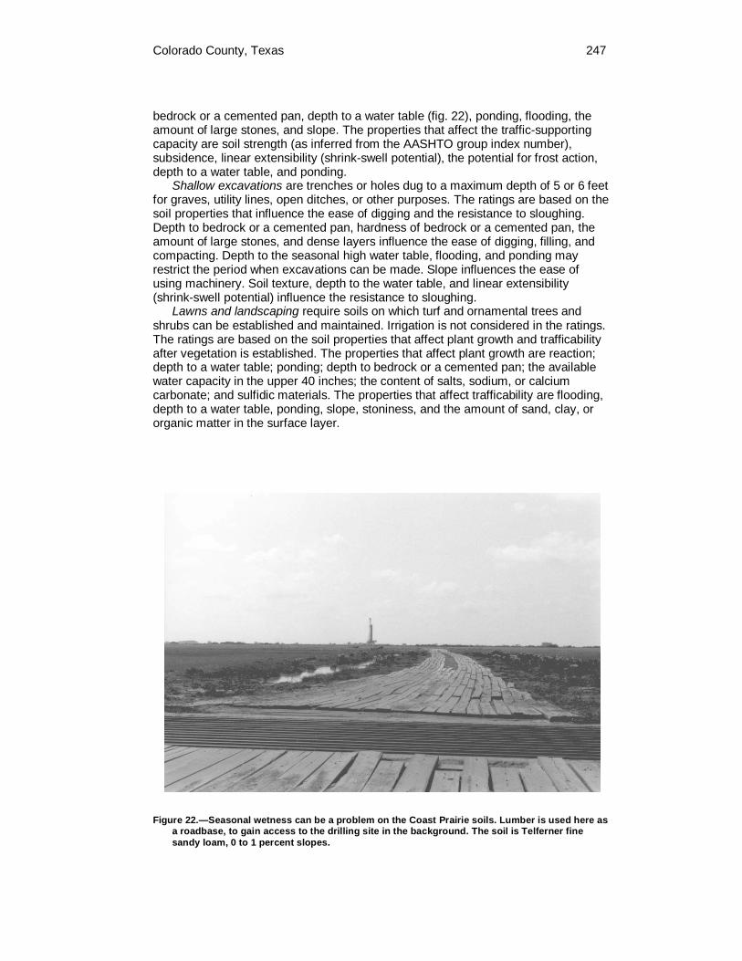
Colorado County, Texas 247
bedrock or a cemented pan, depth to a water table (fig. 22), ponding, flooding, the amount of large stones, and slope. The properties that affect the traffic-supporting capacity are soil strength (as inferred from the AASHTO group index number), subsidence, linear extensibility (shrink-swell potential), the potential for frost action, depth to a water table, and ponding.
Shallow excavations are trenches or holes dug to a maximum depth of 5 or 6 feet for graves, utility lines, open ditches, or other purposes. The ratings are based on the soil properties that influence the ease of digging and the resistance to sloughing. Depth to bedrock or a cemented pan, hardness of bedrock or a cemented pan, the amount of large stones, and dense layers influence the ease of digging, filling, and compacting. Depth to the seasonal high water table, flooding, and ponding may restrict the period when excavations can be made. Slope influences the ease of using machinery. Soil texture, depth to the water table, and linear extensibility (shrink-swell potential) influence the resistance to sloughing.
Lawns and landscaping require soils on which turf and ornamental trees and shrubs can be established and maintained. Irrigation is not considered in the ratings. The ratings are based on the soil properties that affect plant growth and trafficability after vegetation is established. The properties that affect plant growth are reaction; depth to a water table; ponding; depth to bedrock or a cemented pan; the available water capacity in the upper 40 inches; the content of salts, sodium, or calcium carbonate; and sulfidic materials. The properties that affect trafficability are flooding, depth to a water table, ponding, slope, stoniness, and the amount of sand, clay, or organic matter in the surface layer.
Figure 22.—Seasonal wetness can be a problem on the Coast Prairie soils. Lumber is used here as a roadbase, to gain access to the drilling site in the background. The soil is Telferner fine sandy loam, 0 to 1 percent slopes.
248 Soil Survey of
Sanitary Facilities Table 12 and Table 13 shows the degree and kind of soil limitations that affect
septic tank absorption fields, sewage lagoons, sanitary landfills, and daily cover for landfill. The ratings are both verbal and numerical. Rating class terms indicate the extent to which the soils are limited by all of the soil features that affect these uses. Not limited indicates that the soil has features that are very favorable for the specified use. Good performance and very low maintenance can be expected. Somewhat limited indicates that the soil has features that are moderately favorable for the specified use. The limitations can be overcome or minimized by special planning, design, or installation. Fair performance and moderate maintenance can be expected. Very limited indicates that the soil has one or more features that are unfavorable for the specified use. The limitations generally cannot be overcome without major soil reclamation, special design, or expensive installation procedures. Poor performance and high maintenance can be expected.
Numerical ratings in the tables indicate the severity of individual limitations. The ratings are shown as decimal fractions ranging from 0.01 to 1.00. They indicate gradations between the point at which a soil feature has the greatest negative impact on the use (1.00) and the point at which the soil feature is not a limitation (0.00).
Septic tank absorption fields are areas in which effluent from a septic tank is distributed into the soil through subsurface tiles or perforated pipe. Only that part of the soil between depths of 24 and 60 inches is evaluated. The ratings are based on the soil properties that affect absorption of the effluent, construction and maintenance of the system, and public health. Permeability, depth to a water table, ponding, depth to bedrock or a cemented pan, and flooding affect absorption of the effluent. Stones and boulders, ice, and bedrock or a cemented pan interfere with installation. Subsidence interferes with installation and maintenance. Excessive slope may cause lateral seepage and surfacing of the effluent in down slope areas.
Some soils are underlain by loose sand and gravel or fractured bedrock at a depth of less than 4 feet below the distribution lines. In these soils the absorption field may not adequately filter the effluent, particularly when the system is new. As a result, the ground water may become contaminated.
Sewage lagoons are shallow ponds constructed to hold sewage while aerobic bacteria decompose the solid and liquid wastes. Lagoons should have a nearly level floor surrounded by cut slopes or embankments of compacted soil. Nearly impervious soil material for the lagoon floor and sides is required to minimize seepage and contamination of ground water. Considered in the ratings are slope, permeability, depth to a water table, ponding, depth to bedrock or a cemented pan, flooding, large stones, and content of organic matter.
Soil permeability is a critical property affecting the suitability for sewage lagoons. Most porous soils eventually become sealed when they are used as sites for sewage lagoons. Until sealing occurs, however, the hazard of pollution is severe. Soils that have a permeability rate of more than 2 inches per hour are too porous for the proper functioning of sewage lagoons. In these soils, seepage of the effluent can result in contamination of the ground water. Ground-water contamination is also a hazard if fractured bedrock is within a depth of 40 inches, if the water table is high enough to raise the level of sewage in the lagoon, or if floodwater overtops the lagoon.
A high content of organic matter is detrimental to proper functioning of the lagoon because it inhibits aerobic activity. Slope, bedrock, and cemented pans can cause construction problems, and large stones can hinder compaction of the lagoon floor. If the lagoon is to be uniformly deep throughout, the slope must be gentle enough and the soil material must be thick enough over bedrock or a cemented pan to make land smoothing practical.
A trench sanitary landfill is an area where solid waste is placed in successive layers in an excavated trench. The waste is spread, compacted, and covered daily

Colorado County, Texas 249
with a thin layer of soil excavated at the site. When the trench is full, a final cover of soil material at least 2 feet thick is placed over the landfill. The ratings in the table are based on the soil properties that affect the risk of pollution, the ease of excavation, trafficability, and revegetation. These properties include permeability, depth to bedrock or a cemented pan, depth to a water table, ponding, slope, flooding, texture, stones and boulders, highly organic layers, soil reaction, and content of salts and sodium. Unless otherwise stated, the ratings apply only to that part of the soil within a depth of about 6 feet. For deeper trenches, onsite investigation may be needed.
Hard, nonrippable bedrock, creviced bedrock, or highly permeable strata in or directly below the proposed trench bottom can affect the ease of excavation and the hazard of ground-water pollution. Slope affects construction of the trenches and the movement of surface water around the landfill. It also affects the construction and performance of roads in areas of the landfill.
Soil texture and consistence affect the ease with which the trench is dug and the ease with which the soil can be used as daily or final cover. They determine the workability of the soil when dry and when wet. Soils that are plastic and sticky when wet are difficult to excavate, grade, or compact and are difficult to place as a uniformly thick cover over a layer of refuse.
The soil material used as the final cover for a trench landfill should be suitable for plants. It should not have excess sodium or salts and should not be too acid. The surface layer generally has the best workability, the highest content of organic matter, and the best potential for plants. Material from the surface layer should be stockpiled for use as the final cover.
In an area sanitary landfill, solid waste is placed in successive layers on the surface of the soil. The waste is spread, compacted, and covered daily with a thin layer of soil from a source away from the site. A final cover of soil material at least 2 feet thick is placed over the completed landfill. The ratings in the table are based on the soil properties that affect trafficability and the risk of pollution. These properties include flooding, permeability, depth to a water table, ponding, slope, and depth to bedrock or a cemented pan.
Flooding is a serious problem because it can result in pollution in areas downstream from the landfill. If permeability is too rapid or if fractured bedrock, a fractured cemented pan, or the water table is close to the surface, the leachate can contaminate the water supply. Slope is a consideration because of the extra grading required to maintain roads in the steeper areas of the landfill. Also, leachate may flow along the surface of the soils in the steeper areas and cause difficult seepage problems.
Daily cover for landfill is the soil material that is used to cover compacted solid waste in an area sanitary landfill. The soil material is obtained offsite, transported to the landfill, and spread over the waste. The ratings in the table also apply to the final cover for a landfill. They are based on the soil properties that affect workability, the ease of digging, and the ease of moving and spreading the material over the refuse daily during wet and dry periods. These properties include soil texture, depth to a water table, ponding, rock fragments, slope, depth to bedrock or a cemented pan, reaction, and content of salts, sodium, or lime.
Loamy or silty soils that are free of large stones and excess gravel are the best cover for a landfill. Clayey soils may be sticky and difficult to spread; sandy soils are subject to wind erosion.
Slope affects the ease of excavation and of moving the cover material. Also, it can influence runoff, erosion, and reclamation of the borrow area.
After soil material has been removed, the soil material remaining in the borrow area must be thick enough over bedrock, a cemented pan, or the water table to permit revegetation. The soil material used as the final cover for a landfill should be

250 Soil Survey of
suitable for plants. It should not have excess sodium, salts, or lime and should not be too acid.
Agricultural Waste Management Soil properties are important considerations in areas where soils are used as
sites for the treatment and disposal of organic waste and wastewater. Selection of soils with properties that favor waste management can help to prevent environmental damage.
Table 14 and Table 15 shows the degree and kind of soil limitations affecting the treatment of agricultural waste, including municipal and food-processing wastewater and effluent from lagoons or storage ponds. Municipal wastewater is the waste stream from a municipality. It contains domestic waste and may contain industrial waste. It may have received primary or secondary treatment. It is rarely untreated sewage. Food-processing wastewater results from the preparation of fruits, vegetables, milk, cheese, and meats for public consumption. In places it is high in content of sodium and chloride. In the context of these tables, the effluent in lagoons and storage ponds is from facilities used to treat or store food-processing wastewater or domestic or animal waste. Domestic and food-processing wastewater is very dilute, and the effluent from the facilities that treat or store it commonly is very low in content of carbonaceous and nitrogenous material; the content of nitrogen commonly ranges from 10 to 30 milligrams per liter. The wastewater from animal waste treatment lagoons or storage ponds, however, has much higher concentrations of these materials, mainly because the manure has not been diluted as much as the domestic waste. The content of nitrogen in this wastewater generally ranges from 50 to 2,000 milligrams per liter. When wastewater is applied, checks should be made to ensure that nitrogen, heavy metals, and salts are not added in excessive amounts.
The ratings in the tables are for waste management systems that not only dispose of and treat organic waste or wastewater but also are beneficial to crops (application of manure and food-processing waste, application of sewage sludge, and disposal of wastewater by irrigation) and for waste management systems that are designed only for the purpose of wastewater disposal and treatment (overland flow of wastewater, rapid infiltration of wastewater, and slow rate treatment of wastewater).
The ratings are both verbal and numerical. Rating class terms indicate the extent to which the soils are limited by all of the soil features that affect agricultural waste management. Not limited indicates that the soil has features that are very favorable for the specified use. Good performance and very low maintenance can be expected. Somewhat limited indicates that the soil has features that are moderately favorable for the specified use. The limitations can be overcome or minimized by special planning, design, or installation. Fair performance and moderate maintenance can be expected. Very limited indicates that the soil has one or more features that are unfavorable for the specified use. The limitations generally cannot be overcome without major soil reclamation, special design, or expensive installation procedures. Poor performance and high maintenance can be expected.
Numerical ratings in the tables indicate the severity of individual limitations. The ratings are shown as decimal fractions ranging from 0.01 to 1.00. They indicate gradations between the point at which a soil feature has the greatest negative impact on the use (1.00) and the point at which the soil feature is not a limitation (0.00).
Application of manure and food-processing waste not only disposes of waste material but also can improve crop production by increasing the supply of nutrients in the soils where the material is applied. Manure is the excrement of livestock and poultry, and food-processing waste is damaged fruit and vegetables and the peelings, stems, leaves, pits, and soil particles removed in food preparation. The manure and food-processing waste are either solid, slurry, or liquid. Their nitrogen content varies. A high content of nitrogen limits the application rate. Toxic or
Colorado County, Texas 251
otherwise dangerous wastes, such as those mixed with the lye used in food processing, are not considered in the ratings.
The ratings are based on the soil properties that affect absorption, plant growth, microbial activity, erodibility, the rate at which the waste is applied, and the method by which the waste is applied. The properties that affect absorption include permeability, depth to a water table, ponding, the sodium adsorption ratio, depth to bedrock or a cemented pan, and available water capacity. The properties that affect plant growth and microbial activity include reaction, the sodium adsorption ratio, salinity, and bulk density. The wind erodibility group, the soil erodibility factor K, and slope are considered in estimating the likelihood that wind erosion or water erosion will transport the waste material from the application site. Stones, cobbles, a water table, ponding, and flooding can hinder the application of waste. Permanently frozen soils are unsuitable for waste treatment.
Application of sewage sludge not only disposes of waste material but also can improve crop production by increasing the supply of nutrients in the soils where the material is applied. In the context of this table, sewage sludge is the residual product of the treatment of municipal sewage. The solid component consists mainly of cell mass, primarily bacteria cells that developed during secondary treatment and have incorporated soluble organics into their own bodies. The sludge has small amounts of sand, silt, and other solid debris. The content of nitrogen varies. Some sludge has constituents that are toxic to plants or hazardous to the food chain, such as heavy metals and exotic organic compounds, and should be analyzed chemically prior to use.
The content of water in the sludge ranges from about 98 percent to less than 40 percent. The sludge is considered liquid if it is more than about 90 percent water, slurry if it is about 50 to 90 percent water, and solid if it is less than about 50 percent water.
The ratings in the table are based on the soil properties that affect absorption, plant growth, microbial activity, erodibility, the rate at which the sludge is applied, and the method by which the sludge is applied. The properties that affect absorption, plant growth, and microbial activity include permeability, depth to a water table, ponding, the sodium adsorption ratio, depth to bedrock or a cemented pan, available water capacity, reaction, salinity, and bulk density. The wind erodibility group, the soil erodibility factor K, and slope are considered in estimating the likelihood that wind erosion or water erosion will transport the waste material from the application site. Stones, cobbles, a water table, ponding, and flooding can hinder the application of sludge. Permanently frozen soils are unsuitable for waste treatment.
Rapid infiltration of wastewater is a process in which wastewater applied in a level basin at a rate of 4 to 120 inches per week percolates through the soil. The wastewater may eventually reach the ground water. The application rate commonly exceeds the rate needed for irrigation of cropland. Vegetation is not a necessary part of the treatment; hence, the basins may or may not be vegetated. The thickness of the soil material needed for proper treatment of the wastewater is more than 72 inches. As a result, geologic and hydrologic investigation is needed to ensure proper design and performance and to determine the risk of ground-water pollution.
The ratings in the table are based on the soil properties that affect the risk of pollution and the design, construction, and performance of the system. Depth to a water table, ponding, flooding, and depth to bedrock or a cemented pan affect the risk of pollution and the design and construction of the system. Slope, stones, and cobbles also affect design and construction. Permeability and reaction affect performance. Permanently frozen soils are unsuitable for waste treatment.
Slow rate treatment of wastewater is a process in which wastewater is applied to land at a rate normally between 0.5 inch and 4.0 inches per week. The application rate commonly exceeds the rate needed for irrigation of cropland. The applied
252 Soil Survey of
wastewater is treated as it moves through the soil. Much of the treated water may percolate to the ground water, and some enters the atmosphere through evapotranspiration. The applied water generally is not allowed to run off the surface. Waterlogging is prevented either through control of the application rate or through the use of tile drains, or both.
The ratings in the table are based on the soil properties that affect absorption, plant growth, microbial activity, erodibility, and the application of waste. The properties that affect absorption include the sodium adsorption ratio, depth to a water table, ponding, available water capacity, permeability, depth to bedrock or a cemented pan, reaction, the cation-exchange capacity, and slope. Reaction, the sodium adsorption ratio, salinity, and bulk density affect plant growth and microbial activity. The wind erodibility group, the soil erodibility factor K, and slope are considered in estimating the likelihood of wind erosion or water erosion. Stones, cobbles, a water table, ponding, and flooding can hinder the application of waste. Permanently frozen soils are unsuitable for waste treatment.
Construction Materials Table 16 and Table 17 provides information about the soils as potential sources
of gravel, sand, topsoil, reclamation material, and roadfill. Normal compaction, minor processing, and other standard construction practices are assumed.
Sand and gravel are natural aggregates suitable for commercial use with a minimum of processing. They are used in many kinds of construction. Specifications for each use vary widely. In table 16, only the likelihood of finding material in suitable quantity is evaluated. The suitability of the material for specific purposes is not evaluated, nor are factors that affect excavation of the material. The properties used to evaluate the soil as a source of sand or gravel are gradation of grain sizes (as indicated by the Unified classification of the soil), the thickness of suitable material, and the content of rock fragments. If the bottom layer of the soil contains sand or gravel, the soil is considered a likely source regardless of thickness. The assumption is that the sand or gravel layer below the depth of observation exceeds the minimum thickness.
The soils are rated good, fair, or poor as potential sources of sand and gravel. A rating of good or fair means that the source material is likely to be in or below the soil. The bottom layer and the thickest layer of the soils are assigned numerical ratings. These ratings indicate the likelihood that the layer is a source of sand or gravel. The number 0.00 indicates that the layer is a poor source. The number 1.00 indicates that the layer is a good source. A number between 0.00 and 1.00 indicates the degree to which the layer is a likely source.
The soils are rated good, fair, or poor as potential sources of topsoil, reclamation material, and roadfill. The features that limit the soils as sources of these materials are specified in the tables. The numerical ratings given after the specified features indicate the degree to which the features limit the soils as sources of topsoil, reclamation material, or roadfill. The lower the number, the greater the limitation.
Topsoil is used to cover an area so that vegetation can be established and maintained. The upper 40 inches of a soil is evaluated for use as topsoil. Also evaluated is the reclamation potential of the borrow area. The ratings are based on the soil properties that affect plant growth; the ease of excavating, loading, and spreading the material; and reclamation of the borrow area. Toxic substances, soil reaction, and the properties that are inferred from soil texture, such as available water capacity and fertility, affect plant growth. The ease of excavating, loading, and spreading is affected by rock fragments, slope, depth to a water table, soil texture, and thickness of suitable material. Reclamation of the borrow area is affected by slope, depth to a water table, rock fragments, depth to bedrock or a cemented pan, and toxic material.

Colorado County, Texas 253
The surface layer of most soils is generally preferred for topsoil because of its organic matter content. Organic matter greatly increases the absorption and retention of moisture and nutrients for plant growth.
Reclamation material is used in areas that have been drastically disturbed by surface mining or similar activities. When these areas are reclaimed, layers of soil material or unconsolidated geological material, or both, are replaced in a vertical sequence. The reconstructed soil favors plant growth. The ratings in the table do not apply to quarries and other mined areas that require an offsite source of reconstruction material. The ratings are based on the soil properties that affect erosion and stability of the surface and the productive potential of the reconstructed soil. These properties include the content of sodium, salts, and calcium carbonate; reaction; available water capacity; erodibility; texture; content of rock fragments; and content of organic matter and other features that affect fertility.
Roadfill is soil material that is excavated in one place and used in road embankments in another place. In this table, the soils are rated as a source of roadfill for low embankments, generally less than 6 feet high and less exacting in design than higher embankments.
The ratings are for the whole soil, from the surface to a depth of about 5 feet. It is assumed that soil layers will be mixed when the soil material is excavated and spread.
The ratings are based on the amount of suitable material and on soil properties that affect the ease of excavation and the performance of the material after it is in place. The thickness of the suitable material is a major consideration. The ease of excavation is affected by large stones, depth to a water table, and slope. How well the soil performs in place after it has been compacted and drained is determined by its strength (as inferred from the AASHTO classification of the soil) and linear extensibility (shrink-swell potential).
Water Management Table 18, Table 19, Table 20, and Table 21 provides information on the soil
properties and site features that affect water management. The degree and kind of soil limitations are given for pond reservoir areas; embankments, dikes, and levees; and aquifer-fed excavated ponds. The ratings are both verbal and numerical. Rating class terms indicate the extent to which the soils are limited by all of the soil features that affect these uses. Not limited indicates that the soil has features that are very favorable for the specified use. Good performance and very low maintenance can be expected. Somewhat limited indicates that the soil has features that are moderately favorable for the specified use. The limitations can be overcome or minimized by special planning, design, or installation. Fair performance and moderate maintenance can be expected. Very limited indicates that the soil has one or more features that are unfavorable for the specified use. The limitations generally cannot be overcome without major soil reclamation, special design, or expensive installation procedures. Poor performance and high maintenance can be expected.
Numerical ratings in the tables indicate the severity of individual limitations. The ratings are shown as decimal fractions ranging from 0.01 to 1.00. They indicate gradations between the point at which a soil feature has the greatest negative impact on the use (1.00) and the point at which the soil feature is not a limitation (0.00).
Pond reservoir areas hold water behind a dam or embankment (fig. 23). Soils best suited to this use have low seepage potential in the upper 60 inches. The seepage potential is determined by the permeability of the soil and the depth to fractured bedrock or other permeable material. Excessive slope can affect the storage capacity of the reservoir area.

254
Embankments, dikes, and levees are raised structures of soil material, generally less than 20 feet high, constructed to impound water or to protect land against overflow. Embankments that have zoned construction (core and shell) are not considered. In this table, the soils are rated as a source of material for embankment fill. The ratings apply to the soil material below the surface layer to a depth of about 5 feet. It is assumed that soil layers will be uniformly mixed and compacted during construction.
The ratings do not indicate the ability of the natural soil to support an embankment. Soil properties to a depth even greater than the height of the embankment can affect performance and safety of the embankment. Generally, deeper onsite investigation is needed to determine these properties.
Soil material in embankments must be resistant to seepage, piping, and erosion and have favorable compaction characteristics. Unfavorable features include less than 5 feet of suitable material and a high content of stones or boulders, organic matter, or salts or sodium. A high water table affects the amount of usable material. It also affects trafficability.
Aquifer-fed excavated ponds are pits or dugouts that extend to a ground-water aquifer or to a depth below a permanent water table. Excluded are ponds that are fed only by surface runoff and embankment ponds that impound water 3 feet or more above the original surface. Excavated ponds are affected by depth to a permanent water table, permeability of the aquifer, and quality of the water as inferred from the salinity of the soil. Depth to bedrock and the content of large stones affect the ease of excavation.
Figure 23.—Clayey soils such as Latium and Brenham, are suited to the construction of ponds that control erosion and provide livestock watering.

255
Soil Properties
Data relating to soil properties are collected during the course of the soil survey. Soil properties are ascertained by field examination of the soils and by laboratory
index testing of some benchmark soils. Established standard procedures are followed. During the survey, many shallow borings are made and examined to identify and classify the soils and to delineate them on the soil maps. Samples are taken from some typical profiles and tested in the laboratory to determine particle-size distribution, plasticity, and compaction characteristics.
Estimates of soil properties are based on field examinations, on laboratory tests of samples from the survey area, and on laboratory tests of samples of similar soils in nearby areas. Tests verify field observations, verify properties that cannot be estimated accurately by field observation, and help to characterize key soils.
The estimates of soil properties are shown in tables. They include physical and chemical properties, and clay mineralogy.
Engineering Index Properties Table 22 provides the engineering classifications and the range of index
properties for the layers of each soil in the survey area. Depth to the upper and lower boundaries of each layer is indicated. Texture is given in the standard terms used by the U.S. Department of
Agriculture. These terms are defined according to percentages of sand, silt, and clay in the fraction of the soil that is less than 2 millimeters across. "Loam," for example, is soil that is 7 to 27 percent clay, 28 to 50 percent silt, and less than 52 percent sand. If the content of particles coarser than sand is 15 percent or more, an appropriate modifier is added, for example, "gravelly." Textural terms are defined in the Glossary.
Classification of the soils is determined according to the Unified soil classification system (ASTM, 2001) and the system adopted by the American Association of State Highway and Transportation Officials (AASHTO, 2000).
The Unified system classifies soils according to properties that affect their use as construction material. Soils are classified according to particle-size distribution of the fraction less than 3 inches across and according to plasticity index, liquid limit, and organic matter content. Sandy and gravelly soils are identified as GW, GP, GM, GC, SW, SP, SM, and SC; silty and clayey soils as ML, CL, OL, MH, CH, and OH; and highly organic soils as PT. Soils exhibiting engineering properties of two groups can have a dual classification, for example, CL-ML.
The AASHTO system classifies soils according to those properties that affect roadway construction and maintenance. In this system, the fraction of a mineral soil that is less than 3 inches across is classified in one of seven groups from A-1 through A-7 on the basis of particle-size distribution, liquid limit, and plasticity index. Soils in group A-1 are coarse grained and low in content of fines (silt and clay). At the other extreme, soils in group A-7 are fine grained. Highly organic soils are classified in group A-8 on the basis of visual inspection.

256 Soil Survey of
If laboratory data are available, the A-1, A-2, and A-7 groups are further classified as A-1-a, A-1-b, A-2-4, A-2-5, A-2-6, A-2-7, A-7-5, or A-7-6. As an additional refinement, the suitability of a soil as subgrade material can be indicated by a group index number. Group index numbers range from 0 for the best subgrade material to 20 or higher for the poorest.
Rock fragments larger than 10 inches across and 3 to 10 inches across are indicated as a percentage of the total soil on a dry-weight basis. The percentages are estimates determined mainly by converting volume percentage in the field to weight percentage.
Percentage (of soil particles) passing designated sieves is the percentage of the soil fraction less than 3 inches across based on an ovendry weight. The sieves, numbers 4, 10, 40, and 200 (USA Standard Series), have openings of 4.76, 2.00, 0.420, and 0.074 millimeters, respectively. Estimates are based on laboratory tests of soils sampled in the survey area and in nearby areas and on estimates made in the field.
Liquid limit and plasticity index (Atterberg limits) indicate the plasticity characteristics of a soil. The estimates are based on test data from the survey area or from nearby areas and on field examination.
The estimates of particle-size distribution, liquid limit, and plasticity index are generally rounded to the nearest 5 percent. Thus, if the ranges of gradation and Atterberg limits extend a marginal amount (1 or 2 percentage points) across classification boundaries, the classification in the marginal zone is generally omitted in the table.
Physical Soil Properties Table 23 shows estimates of some physical characteristics and features that
affect soil behavior. These estimates are given for the layers of each soil in the survey area. The estimates are based on field observations and on test data for these and similar soils.
Depth to the upper and lower boundaries of each layer is indicated. Particle size is the effective diameter of a soil particle as measured by
sedimentation, sieving, or micrometric methods. Particle sizes are expressed as classes with specific effective diameter class limits. The broad classes are sand, silt, and clay, ranging from the larger to the smaller.
Sand as a soil separate consists of mineral soil particles that are 0.05 millimeter to 2 millimeters in diameter. In table 23, the estimated sand content of each soil layer is given as a percentage, by weight, of the soil material that is less than 2 millimeters in diameter.
Silt as a soil separate consists of mineral soil particles that are 0.002 to 0.05 millimeter in diameter. In table 23, the estimated silt content of each soil layer is given as a percentage, by weight, of the soil material that is less than 2 millimeters in diameter.
Clay as a soil separate consists of mineral soil particles that are less than 0.002 millimeter in diameter. In table 23, the estimated clay content of each soil layer is given as a percentage, by weight, of the soil material that is less than 2 millimeters in diameter.
The content of sand, silt, and clay affects the physical behavior of a soil. Particle size is important for engineering and agronomic interpretations, for determination of soil hydrologic qualities, and for soil classification.
The amount and kind of clay affect the fertility and physical condition of the soil and the ability of the soil to adsorb cations and to retain moisture. They influence shrink-swell potential, permeability, plasticity, the ease of soil dispersion, and other soil properties. The amount and kind of clay in a soil also affect tillage and earthmoving operations.

Colorado County, Texas 257
Moist bulk density is the weight of soil (ovendry) per unit volume. Volume is measured when the soil is at field moisture capacity, that is, the moisture content at 1/3- or 1/10-bar (33kPa or 10kPa) moisture tension. Weight is determined after the soil is dried at 105 degrees C. In the table, the estimated moist bulk density of each soil horizon is expressed in grams per cubic centimeter of soil material that is less than 2 millimeters in diameter. Bulk density data are used to compute shrink-swell potential, available water capacity, total pore space, and other soil properties. The moist bulk density of a soil indicates the pore space available for water and roots. Depending on soil texture, a bulk density of more than 1.4 can restrict water storage and root penetration. Moist bulk density is influenced by texture, kind of clay, content of organic matter, and soil structure.
Permeability (K-sat) refers to the ability of a soil to transmit water or air. The term "permeability," as used in soil surveys, indicates saturated hydraulic conductivity (K-sat). The estimates in the table indicate the rate of water movement, in inches per hour, when the soil is saturated. They are based on soil characteristics observed in the field, particularly structure, porosity, and texture. Permeability is considered in the design of soil drainage systems and septic tank absorption fields.
Available water capacity refers to the quantity of water that the soil is capable of storing for use by plants. The capacity for water storage is given in inches of water per inch of soil for each soil layer. The capacity varies, depending on soil properties that affect retention of water. The most important properties are the content of organic matter, soil texture, bulk density, and soil structure. Available water capacity is an important factor in the choice of plants or crops to be grown and in the design and management of irrigation systems. Available water capacity is not an estimate of the quantity of water actually available to plants at any given time.
Linear extensibility refers to the change in length of an unconfined clod as moisture content is decreased from a moist to a dry state. It is an expression of the volume change between the water content of the clod at 1/3- or 1/10-bar tension (33kPa or 10kPa tension) and oven dryness. The volume change is reported in the table as percent change for the whole soil. Volume change is influenced by the amount and type of clay minerals in the soil.
Linear extensibility is used to determine the shrink-swell potential of soils. The shrink-swell potential is low if the soil has a linear extensibility of less than 3 percent; moderate if 3 to 6 percent; high if 6 to 9 percent; and very high if more than 9 percent. If the linear extensibility is more than 3, shrinking and swelling can cause damage to buildings, roads, and other structures and to plant roots. Special design commonly is needed.
Organic matter is the plant and animal residue in the soil at various stages of decomposition. In table 23, the estimated content of organic matter is expressed as a percentage, by weight, of the soil material that is less than 2 millimeters in diameter.
The content of organic matter in a soil can be maintained by returning crop residue to the soil. Organic matter has a positive effect on available water capacity, water infiltration, soil organism activity, and tilth. It is a source of nitrogen and other nutrients for crops and soil organisms.
Erosion factors are shown in table 23 as the K factor (Kw and Kf) and the T factor. Erosion factor K indicates the susceptibility of a soil to sheet and rill erosion by water. Factor K is one of several factors used in the Universal Soil Loss Equation (USLE) and the Revised Universal Soil Loss Equation (RUSLE) to predict the average annual rate of soil loss by sheet and rill erosion in tons per acre per year. The estimates are based primarily on percentage of silt, sand, and organic matter and on soil structure and permeability. Values of K range from 0.02 to 0.69. Other factors being equal, the higher the value, the more susceptible the soil is to sheet and rill erosion by water.

258 Soil Survey of
Erosion factor Kw indicates the erodibility of the whole soil. The estimates are modified by the presence of rock fragments.
Erosion factor Kf indicates the erodibility of the fine-earth fraction, or the material less than 2 millimeters in size.
Erosion factor T is an estimate of the maximum average annual rate of soil erosion by wind or water that can occur without affecting crop productivity over a sustained period. The rate is in tons per acre per year.
Wind erodibility groups are made up of soils that have similar properties affecting their susceptibility to wind erosion in cultivated areas. The soils assigned to group 1 are the most susceptible to wind erosion, and those assigned to group 8 are the least susceptible. The groups are as follows:
1. Coarse sands, sands, fine sands, and very fine sands. 2. Loamy coarse sands, loamy sands, loamy fine sands, loamy very fine sands,
ash material, and sapric soil material. 3. Coarse sandy loams, sandy loams, fine sandy loams, and very fine sandy
loams. 4L. Calcareous loams, silt loams, clay loams, and silty clay loams. 4. Clays, silty clays, noncalcareous clay loams, and silty clay loams that are
more than 35 percent clay. 5. Noncalcareous loams and silt loams that are less than 20 percent clay and
sandy clay loams, sandy clays, and hemic soil material. 6. Noncalcareous loams and silt loams that are more than 20 percent clay and
noncalcareous clay loams that are less than 35 percent clay. 7. Silts, noncalcareous silty clay loams that are less than 35 percent clay, and
fibric soil material. 8. Soils that are not subject to wind erosion because of rock fragments on the
surface or because of surface wetness. Wind erodibility index is a numerical value indicating the susceptibility of soil to
wind erosion, or the tons per acre per year that can be expected to be lost to wind erosion. There is a close correlation between wind erosion and the texture of the surface layer, the size and durability of surface clods, rock fragments, organic matter, and a calcareous reaction. Soil moisture and frozen soil layers also influence wind erosion.
Chemical Soil Properties Table 24 shows estimates of some chemical characteristics and features that
affect soil behavior. These estimates are given for the layers of each soil in the survey area. The estimates are based on field observations and on test data for these and similar soils.
Depth to the upper and lower boundaries of each layer is indicated. Cation-exchange capacity is the total amount of extractable bases that can be
held by the soil, expressed in terms of milliequivalents per 100 grams of soil at neutrality (pH 7.0) or at some other stated pH value. Soils having a low cation-exchange capacity hold fewer cations and may require more frequent applications of fertilizer than soils having a high cation-exchange capacity. The ability to retain cations reduces the hazard of ground-water pollution.
Effective cation-exchange capacity refers to the sum of extractable bases plus aluminum expressed in terms of milliequivalents per 100 grams of soil. It is determined for soils that have pH of less than 5.5.
Soil reaction is a measure of acidity or alkalinity. The pH of each soil horizon is based on many field tests. For many soils, values have been verified by laboratory analyses. Soil reaction is important in selecting crops and other plants, in evaluating soil amendments for fertility and stabilization, and in determining the risk of corrosion.

Colorado County, Texas 259
Calcium carbonate equivalent is the percent of carbonates, by weight, in the fraction of the soil less than 2 millimeters in size. The availability of plant nutrients is influenced by the amount of carbonates in the soil. Incorporating nitrogen fertilizer into calcareous soils helps to prevent nitrite accumulation and ammonium-N volatilization.
Gypsum is expressed as a percent, by weight, of hydrated calcium sulfates in the fraction of the soil less than 20 millimeters in size. Gypsum is partially soluble in water. Soils that have a high content of gypsum may collapse if the gypsum is removed by percolating water.
Salinity is a measure of soluble salts in the soil at saturation. It is expressed as the electrical conductivity of the saturation extract, in millimhos per centimeter (mmhos/cm) or decisiemens per meter (dS/m) at 25 degrees C. Estimates are based on field and laboratory measurements at representative sites of nonirrigated soils. The salinity of irrigated soils is affected by the quality of the irrigation water and by the frequency of water application. Hence, the salinity of soils in individual fields can differ greatly from the value given in the table. Salinity affects the suitability of a soil for crop production, the stability of soil if used as construction material, and the potential of the soil to corrode metal and concrete.
Sodium adsorption ratio (SAR) is a measure of the amount of sodium (Na) relative to calcium (Ca) and magnesium (Mg) in the water extract from saturated soil paste. It is the ratio of the Na concentration divided by the square root of one-half of the Ca + Mg concentration. Soils that have SAR values of 13 or more may be characterized by an increased dispersion of organic matter and clay particles, reduced permeability and aeration, and a general degradation of soil structure.
Water Features Table 25 gives estimates of various water features. The estimates are used in
land use planning that involves engineering considerations. Hydrologic soil groups are based on estimates of runoff potential. Soils are
assigned to one of four groups according to the rate of water infiltration when the soils are not protected by vegetation, are thoroughly wet, and receive precipitation from long-duration storms.
The four hydrologic soil groups are: Group A. Soils having a high infiltration rate (low runoff potential) when
thoroughly wet. These consist mainly of deep, well drained to excessively drained sands or gravelly sands. These soils have a high rate of water transmission.
Group B. Soils having a moderate infiltration rate when thoroughly wet. These consist chiefly of moderately deep or deep, moderately well drained or well drained soils that have moderately fine texture to moderately coarse texture. These soils have a moderate rate of water transmission.
Group C. Soils having a slow infiltration rate when thoroughly wet. These consist chiefly of soils having a layer that impedes the downward movement of water or soils of moderately fine texture or fine texture. These soils have a slow rate of water transmission.
Group D. Soils having a very slow infiltration rate (high runoff potential) when thoroughly wet. These consist chiefly of clays that have a high shrink-swell potential, soils that have a high water table, soils that have a claypan or clay layer at or near the surface, and soils that are shallow over nearly impervious material. These soils have a very slow rate of water transmission.
The months in the table indicate the portion of the year in which the feature is most likely to be a concern.
Water table refers to a saturated zone in the soil. Table 25 indicates, by month, depth to the top (upper limit) and base (lower limit) of the saturated zone in most years. Estimates of the upper and lower limits are based mainly on observations of

260 Soil Survey of
the water table at selected sites and on evidence of a saturated zone, namely grayish colors or mottles (redoximorphic features) in the soil. A saturated zone that lasts for less than a month is not considered a water table.
Ponding is standing water in a closed depression. Unless a drainage system is installed, the water is removed only by percolation, transpiration, or evaporation. Table 25 indicates surface water depth and the duration and frequency of ponding. Duration is expressed as very brief if less than 2 days, brief if 2 to 7 days, long if 7 to 30 days, and very long if more than 30 days. Frequency is expressed as none, rare, occasional, and frequent. None means that ponding is not probable; rare that it is unlikely but possible under unusual weather conditions (the chance of ponding is nearly 0 percent to 5 percent in any year); occasional that it occurs, on the average, once or less in 2 years (the chance of ponding is 5 to 50 percent in any year); and frequent that it occurs, on the average, more than once in 2 years (the chance of ponding is more than 50 percent in any year).
Flooding is the temporary inundation of an area caused by overflowing streams, by runoff from adjacent slopes, or by tides. Water standing for short periods after rainfall or snowmelt is not considered flooding, and water standing in swamps and marshes is considered ponding rather than flooding.
Duration and frequency are estimated. Duration is expressed as extremely brief if 0.1 hour to 4 hours, very brief if 4 hours to 2 days, brief if 2 to 7 days, long if 7 to 30 days, and very long if more than 30 days. Frequency is expressed as none, very rare, rare, occasional, frequent, and very frequent. None means that flooding is not probable; very rare that it is very unlikely but possible under extremely unusual weather conditions (the chance of flooding is less than 1 percent in any year); rare that it is unlikely but possible under unusual weather conditions (the chance of flooding is 1 to 5 percent in any year); occasional that it occurs infrequently under normal weather conditions (the chance of flooding is 5 to 50 percent in any year); frequent that it is likely to occur often under normal weather conditions (the chance of flooding is more than 50 percent in any year but is less than 50 percent in all months in any year); and very frequent that it is likely to occur very often under normal weather conditions (the chance of flooding is more than 50 percent in all months of any year).
The information is based on evidence in the soil profile, namely thin strata of gravel, sand, silt, or clay deposited by floodwater; irregular decrease in organic matter content with increasing depth; and little or no horizon development.
Also considered is local information about the extent and levels of flooding and the relation of each soil on the landscape to historic floods. Information on the extent of flooding based on soil data is less specific than that provided by detailed engineering surveys that delineate flood-prone areas at specific flood frequency levels.
Soil Features Table 26 gives estimates of various soil features. The estimates are used in land
use planning that involves engineering considerations. A restrictive layer is a nearly continuous layer that has one or more physical,
chemical, or thermal properties that significantly impede the movement of water and air through the soil or that restrict roots or otherwise provide an unfavorable root environment. Examples are bedrock, cemented layers, dense layers, and frozen layers. The table indicates the hardness and thickness of the restrictive layer, both of which significantly affect the ease of excavation. Depth to top is the vertical distance from the soil surface to the upper boundary of the restrictive layer.
Risk of corrosion pertains to potential soil-induced electrochemical or chemical action that corrodes or weakens uncoated steel or concrete. The rate of corrosion of uncoated steel is related to such factors as soil moisture, particle-size distribution,

Colorado County, Texas 261
acidity, and electrical conductivity of the soil. The rate of corrosion of concrete is based mainly on the sulfate and sodium content, texture, moisture content, and acidity of the soil. Special site examination and design may be needed if the combination of factors results in a severe hazard of corrosion. The steel or concrete in installations that intersect soil boundaries or soil layers is more susceptible to corrosion than the steel or concrete in installations that are entirely within one kind of soil or within one soil layer.
For uncoated steel, the risk of corrosion, expressed as low, moderate, or high, is based on soil drainage class, total acidity, electrical resistivity near field capacity, and electrical conductivity of the saturation extract.
For concrete, the risk of corrosion also is expressed as low, moderate, or high. It is based on soil texture, acidity, and amount of sulfates in the saturation extract.
Physical, Chemical, and Clay Mineralogy Analyses of Selected Soils The results of physical analysis of several typical pedons in the survey area are
given in table 27 the results of chemical analysis in table 28, and the results of clay mineralogy are given in table 29. The data are for soils sampled at carefully selected sites. Unless otherwise indicated, the pedons are typical of the series. They are described in the section "Soil Series and Their Morphology." Soil samples were analyzed by USDA-NRCS, National Soil Survey Laboratory at Lincoln, Nebraska.
Depth to the upper and lower boundaries of each layer is indicated. Most determinations, except those for grain-size analysis and bulk density, were
made on soil material smaller than 2 millimeters across. Measurements reported as percent or quantity of unit weight were calculated on an ovendry basis. The methods used in obtaining the data are indicated in the list that follows. The codes in parentheses refer to published methods (USDA, 1996).
Sand—(0.05-2.0 mm fraction) weight percentages of material less than 2 mm (3A1). Silt—(0.002-0.05 mm fraction) pipette extraction, weight percentages of all material
less than 2 mm (3A1). Clay—(fraction less than 0.002 mm) pipette extraction, weight percentages of
material less than 2 mm (3A1). Water content—pressure extraction, percentage of ovendry weight of less than 2 mm
material; 1/3 or 1/10 bar (4B1), 15 bars (4B2). Bulk density—of less than 2 mm material, saran-coated clods field moist (4A1a), 1/3
bar (4A1d), ovendry (4A1h). Coefficient of linear extensibility—change in clod dimension based on whole soil
(4D). Extractable cations—ammonium acetate pH 7.0, ICP; calcium (6N2i), magnesium
(6O2h), sodium (6P2f), potassium (6Q2f). Extractable acidity—barium chloride-triethanolamine IV (6H5a). Base saturation—ammonium acetate, pH 7.0 (5C1). Organic carbon—wet combustion. Walkley-Black modified acid-dichromate, ferric
sulfate titration (6A1c). Organic carbon—dry combustion (6A2d). Reaction (pH)—1:1 water dilution (8C1f). Electrical conductivity—saturation extract (8A3a). Sodium adsorption ratio, SAR (5E). Exchangeable sodium percentage, ESP (5E). Carbonate as calcium carbonate—fraction less than 2 mm [80 mesh]) manometric
(6E1g). Ratio of CEC7 to clay (8D1). X-ray diffraction, thin film on glass, resin pretreatment II (7A2i).


263
Classification of the Soils
The system of soil classification used by the National Cooperative Soil Survey has six categories (Soil Survey Staff, 1998 and 1999). Beginning with the broadest, these categories are the order, suborder, great group, subgroup, family, and series. Classification is based on soil properties observed in the field or inferred from those observations or from laboratory measurements. Table 30 shows the classification of the soils in the survey area. The categories are defined in the following paragraphs.
ORDER. Twelve soil orders are recognized. The differences among orders reflect the dominant soil-forming processes and the degree of soil formation. Each order is identified by a word ending in sol. An example is Alfisol.
SUBORDER. Each order is divided into suborders primarily on the basis of properties that influence soil genesis and are important to plant growth or properties that reflect the most important variables within the orders. The last syllable in the name of a suborder indicates the order. An example is Udalf (Ud, meaning humid, plus alf, from Alfisol).
GREAT GROUP. Each suborder is divided into great groups on the basis of close similarities in kind, arrangement, and degree of development of pedogenic horizons; soil moisture and temperature regimes; type of saturation; and base status. Each great group is identified by the name of a suborder and by a prefix that indicates a property of the soil. An example is Hapludalfs (Hapl, meaning minimal horizonation, plus udalf, the suborder of the Alfisols that has a udic moisture regime).
SUBGROUP. Each great group has a typic subgroup. Other subgroups are intergrades or extragrades. The typic subgroup is the central concept of the great group; it is not necessarily the most extensive. Intergrades are transitions to other orders, suborders, or great groups. Extragrades have some properties that are not representative of the great group but do not indicate transitions to any other taxonomic class. Each subgroup is identified by one or more adjectives preceding the name of the great group. The adjective Typic identifies the subgroup that typifies the great group. An example is Typic Hapludalfs.
FAMILY. Families are established within a subgroup on the basis of physical and chemical properties and other characteristics that affect management. Generally, the properties are those of horizons below plow depth where there is much biological activity. Among the properties and characteristics considered are particle-size class, mineralogy class, cation-exchange activity class, soil temperature regime, soil depth, and reaction class. A family name consists of the name of a subgroup preceded by terms that indicate soil properties. An example is fine-loamy, mixed, active, mesic Typic Hapludalfs.
SERIES. The series consists of soils within a family that have horizons similar in color, texture, structure, reaction, consistence, mineral and chemical composition, and arrangement in the profile.
.

264 Soil Survey of
Soil Series and Their Morphology In this section, each soil series recognized in the survey area is described.
Characteristics of the soil and the material in which it formed are identified for each series. A pedon, a small three-dimensional area of soil, that is typical of the series in the survey area is described. The detailed description of each soil horizon follows standards in the "Soil Survey Manual" (Soil Survey Division Staff, 1993). Many of the technical terms used in the descriptions are defined in "Soil Taxonomy" (Soil Survey Staff, 1999) and in "Keys to Soil Taxonomy" (Soil Survey Staff, 1998). Unless otherwise indicated, colors in the descriptions are for moist soil. Following the pedon description is the range of important characteristics of the soils in the series.
Bergstrom Series The Bergstrom series consists of very deep, moderately permeable, well drained
soils on terraces. They formed in alkaline loamy sediments of the Colorado River. Slopes are 0 to 1 percent. The soils are fine-silty, mixed, superactive, thermic Cumulic Haplustolls.
Typical pedon of Bergstrom silt loam, 0 to 1 percent slopes, rarely flooded; in Columbus, from the intersection of U.S. Highway 90 and Texas Highway 71, 3.1 miles north and northwest to the bypass, 0.9 mile northwest on Texas Highway 71, 4.5 miles west and north on Farm Road 1890, 1.1 miles south on ranch road, 0.2 mile south on field road, and 0.1 mile north in cropland; USGS Ellinger topographic quadrangle; lat. 29 degrees 45 minutes 23.5 seconds N., and long. 96 degrees 40 minutes 20.0 seconds W.
Ap—0 to 8 inches; dark brown (7.5YR 3/2) silt loam, brown (7.5YR 4/2) dry; strong coarse angular blocky structure parting to moderate fine subangular blocky; slightly hard, friable, sticky and plastic; common very fine and fine roots; few fine and medium pores; few fine fragments of snail shells; slightly effervescent; slightly alkaline; clear smooth boundary.
A1—8 to 17 inches; dark brown (7.5YR 3/2) silt loam, brown (7.5YR 4/2) dry; moderate medium angular blocky structure parting to moderate fine subangular blocky; slightly hard, friable, sticky and plastic; common very fine and fine roots; few fine and medium pores; common pockets of brown (7.5YR 4/4) material; few fine fragments of snail shells; slightly effervescent; slightly alkaline; clear smooth boundary.
A2—17 to 23 inches; dark brown (7.5YR 3/2) silty clay loam, brown (7.5YR 4/2) dry; moderate medium angular blocky structure parting to moderate fine subangular blocky; hard, firm, sticky and plastic; few fine roots; few fine and medium pores; common fine and medium pockets of brown (7.5YR 4/4) material; strongly effervescent; slightly alkaline; gradual smooth boundary.
Bw—23 to 40 inches; dark brown (7.5YR 3/4) silty clay loam, brown (7.5YR 4/4) dry; moderate medium prismatic structure parting to moderate fine and medium angular blocky; hard, firm, sticky and plastic; few fine roots; few fine pores; few pockets of dark brown (7.5YR 4/2) material; many thick coatings of dark brown (10YR 3/3) material; few fine fragments of snail shells; strongly effervescent; slightly alkaline; gradual smooth boundary.
Bk1—40 to 53 inches; brown (7.5YR 4/4) silt loam, brown (7.5YR 5/4) dry; moderate fine and medium subangular blocky structure; slightly hard, friable, slightly sticky and plastic; few fine roots; common fine threads and few medium concretions of calcium carbonate; few fine fragments of snail shells violently effervescent; moderately alkaline; gradual smooth boundary.
Bk2—53 to 60 inches; brown (7.5YR 4/4) silt loam, brown (7.5YR 5/4) dry; weak fine and medium subangular blocky structure; slightly hard, friable, slightly

Colorado County, Texas 265
sticky and plastic; few fine roots; common fine threads and common fine and medium concretions of calcium carbonate; few very fine siliceous pebbles; few fine fragments of snail shells; violently effervescent; moderately alkaline; gradual smooth boundary.
Bk3—60 to 80 inches; brown (7.5YR 5/4) silt loam, light brown (7.5YR 6/4) dry; weak fine and medium subangular blocky structure; slightly hard, friable, slightly sticky and plastic; common fine threads and common fine and medium concretions of calcium carbonate; few fine pockets of dark brown (7.5YR 3/2) material; few very fine siliceous pebbles; few fine fragments of snail shells; violently effervescent; moderately alkaline.
The solum thickness ranges from 50 to more than 80 inches. The mollic epipedon ranges from 20 to 48 inches.
The Ap and A horizons have hue of 7.5YR or 10YR, value of 3 to 5, and chroma of 2 or 3.
The Bw or Bk horizons have hue of 5YR to 10YR, value of 3 to 5, and chroma of 2 to 6. Texture is silt loam, silty clay loam, or clay loam.
Where present, the BC or C horizon, is brown, yellow, or red silt loam or silty clay loam with strata of more clayey or sandy sediments.
Bleiblerville Series The Bleiblerville series consists of very deep, very slowly permeable, moderately
well drained soils on uplands. They formed in alkaline clays of the Fleming Formation. Slopes range from 1 to 3 percent. The soils are fine, smectitic, thermic Udic Haplusterts.
Typical pedon of Bleiblerville clay, 1 to 3 percent slopes; in Columbus, from the intersection of U.S. Highway 90 and Texas Highway, 0.9 mile north on Texas Highway 71, 11.2 miles north on Farm Road 109 to Frelsburg, about 0.1 mile west on Farm Road 1291 to Frelsburg Cemetery, and about 300 feet west of the southwest corner of Cemetery in native hay meadow; USGS Frelsburg topographic quadrangle; lat. 29 degrees 52 minutes 16.0 seconds N., and long. 96 degrees 33 minutes 3.0 seconds W.
Ap—0 to 8 inches; black (10YR 2/1) clay, very dark gray (10YR 3/1) dry; moderate medium subangular blocky structure parting to moderate fine angular blocky; very hard, very firm, very sticky and very plastic; many fine to coarse roots; many fine and medium fragments of snail shells; strongly effervescent; slightly alkaline; gradual wavy boundary.
Bss1—8 to 24 inches; very dark gray (10YR 3/1) clay, dark gray (10YR 4/1) dry; moderate medium prismatic structure parting to moderate medium angular blocky; very hard, very firm, very sticky and very plastic; many fine to coarse roots; few slickensides; few distinct pressure surfaces; common vertical cracks partly filled with common medium and coarse vertical streaks and pockets of black (10YR 2/1) material from above; many fine and medium fragments of snail shells; strongly effervescent; slightly alkaline; gradual wavy boundary.
Bss2—24 to 50 inches; dark gray (10YR 4/1) clay, gray (10YR 5/1) dry; moderate medium prismatic structure parting to moderate medium angular blocky; very hard, very firm, very sticky and very plastic; common fine and medium roots; common slickensides; few distinct pressure surfaces; many vertical cracks partly filled with common medium vertical streaks and pockets of black (10YR 2/1) material from above; common fine rounded masses of iron-manganese; common fine distinct brownish yellow (10YR 6/6) masses of iron accumulation with sharp boundaries; few fine and medium fragments of snail shells; strongly effervescent; slightly alkaline; clear wavy boundary.
266 Soil Survey of
Bkss1—50 to 55 inches; dark grayish brown (10YR 4/2) clay, grayish brown (10YR 5/2) dry; moderate medium prismatic structure parting to moderate medium angular blocky; very hard, very firm, very sticky and very plastic; few fine and medium roots; common slickensides; common distinct pressure surfaces; common vertical cracks partly filled with common fine and medium vertical streaks and pockets of very dark gray (10YR 3/1) material from above; common fine and medium rounded concretions of calcium carbonate; few fine and medium fragments of snail shells; strongly effervescent; slightly alkaline; clear wavy boundary.
Bkss2—55 to 66 inches; grayish brown (10YR 5/2), very dark gray (10YR 3/1) and brownish yellow (10YR 6/6) clay, same colors dry; moderate medium prismatic structure parting to moderate fine and medium angular blocky; very hard, very firm, very sticky and very plastic; few fine roots; many slickensides; many medium pressure surfaces; few vertical cracks; few fine rounded black masses of manganese with sharp boundaries; few fine threads of calcium carbonate; common fine and medium rounded concretions of calcium carbonate; violently effervescent; moderately alkaline; clear wavy boundary.
Bkss3—66 to 80 inches; brownish yellow (10YR 6/6) and grayish brown (10YR 5/2) clay, same colors dry; moderate medium angular blocky structure; very hard, very firm, very sticky and very plastic; few slickensides; few medium pressure surfaces; few vertical cracks; common fine threads of iron-manganese; few fine threads of calcium carbonate; common fine to coarse rounded concretions of calcium carbonate; violently effervescent; moderately alkaline.
The solum thickness is more than 80 inches. When dry, cracks up to three inches wide on the surface extend to about 50 inches. Cracks remain open for 90 to 150 cumulative days in most years. Cycles of microlows and microhighs are repeated every five to ten feet. In native grass areas, microhighs are 4 to 16 inches higher than microlows. Intersecting slickensides begin at 8 to 15 inches below the surface. Slickensides are several feet across and are tilted 45 to 50 degrees from horizontal. Texture is clay. Weighted average clay content of the particle-size control section ranges from 59 to 62 percent. Reaction is slightly alkaline or moderately alkaline.
The Ap horizon has hue of 10YR, value of 2 or 3, and chroma of 1. The Bss horizon has hue of 10YR, value of 2 to 4, and chroma of 1 or 2.
Redoximorphic features in shades of yellow or brown range from none to common. Most pedons have vertical streaks of darker material that are old filled cracks.
The Bkss horizon has hue of 10YR or 2.5Y, value of 4 to 8, and chroma of 2 to 6. Redoximorphic features in shades of yellow, brown and gray range from none to common. Few to common threads, masses or concretions of calcium carbonate are present in the lower portion. Iron-manganese concretions range from none to few.
Bosque Series The Bosque series consists of very deep, well drained, moderately permeable
soils on flood plains. They formed in alkaline loamy alluvium. Slopes are 0 to 1 percent. The soils are fine-loamy, mixed, superactive, thermic Cumulic Haplustolls.
Typical pedon of Bosque clay loam, 0 to 1 percent slopes, occasionally flooded; in Weimar, from the intersection of U.S. Highway 90 and Farm Road 155, 5.8 miles south on Farm Road 155, 4.5 miles west on Farm Road 532, 1.5 miles south on county road across creek and 40 east in pasture next to Chinaberry tree; USGS Oakland topographic quadrangle; lat. 29 degrees 35 minutes 6.0 seconds N., and long. 96 degrees 49 minutes 39.7 seconds W.
A1—0 to 6 inches; dark brown (10YR 3/3) clay loam, brown (10YR 4/3) dry; moderate fine subangular blocky structure; hard, firm, sticky and very plastic;

Colorado County, Texas 267
common fine to coarse roots; few fine pores; few discontinuous lenses and pockets of brown (10YR 5/4) material; few fine black masses; few fine siliceous pebbles; slightly effervescent; slightly alkaline; clear smooth boundary.
A2—6 to 20 inches; very dark grayish brown (10YR 3/2) clay loam, dark grayish brown (10YR 4/2) dry; moderate medium angular blocky structure; hard, firm, sticky and very plastic; common fine and medium roots; few pockets of brown (10YR 5/4) material; strongly effervescent; slightly alkaline; gradual smooth boundary.
A3—20 to 27 inches; dark brown (10YR 3/3) sandy clay loam, brown (10YR 4/3) dry; moderate fine subangular blocky structure; slightly hard, firm, sticky and plastic; few fine roots; few pockets and discontinuous lenses of brown (10YR 5/4) material; few fine threads of calcium carbonate; strongly effervescent; slightly alkaline; clear smooth boundary.
A4—27 to 41 inches; very dark grayish brown (10YR 3/2) clay loam, dark grayish brown (10YR 4/2) dry; moderate fine prismatic structure parting to moderate fine and medium angular blocky; hard, firm, sticky and very plastic; common fine and medium roots; common fine and medium pockets of brown (10YR 5/4) material; common fine threads of calcium carbonate on vertical surfaces of peds; few fine concretions of calcium carbonate; violently effervescent; moderately alkaline; clear smooth boundary.
Bw1—41 to 53 inches; dark grayish brown (10YR 4/2) clay loam, grayish brown (10YR 5/2) dry; moderate fine and medium prismatic structure parting to moderate fine subangular blocky; slightly hard, firm, sticky and plastic; few fine roots; few fine pores; common fine threads of calcium carbonate on vertical surfaces of peds; few fine rounded concretions of calcium carbonate; violently effervescent; moderately alkaline; clear smooth boundary.
Bw2—53 to 64 inches; dark grayish brown (10YR 4/2) clay loam, grayish brown (10YR 5/2) dry; weak fine subangular blocky structure; slightly hard, friable, sticky and plastic; common medium and coarse pockets and discontinuous lenses of brown (10YR 5/4) material; few fine threads of calcium carbonate on vertical surfaces of peds; few fine rounded concretions of calcium carbonate; violently effervescent; moderately alkaline; clear smooth boundary.
C—64 to 80 inches; dark brown (10YR 3/3) fine sandy loam, brown (10YR 4/3) dry; weak fine subangular blocky structure; slightly hard, very friable, nonsticky and nonplastic; common bedding planes; many lenses of brown (10YR 5/4) loamy sand material; violently effervescent; moderately alkaline.
The texture of the control section is loam, sandy clay loam, or clay loam, with clay content ranging from 20 to 30 percent. Some pedons have thin, discontinuous fine sandy loam or silt loam strata. Siliceous pebbles range from none to about 5 percent by volume in some horizons. Most pedons have films and threads of calcium carbonate throughout the control section. The reaction is slightly alkaline or moderately alkaline.
The A horizon has hue of 10YR, value of 2 to 4, and chroma of 1 to 3. The mollic epipedon ranges from 20 to 41 inches thick. Texture is loam, sandy clay loam, or clay loam.
The Bw horizon has hue of 10YR, value of 3 to 6, and chroma of 2 to 4. Redoximorphic features in shades of yellow or brown range from none to common. Texture is loam, sandy clay loam, or clay loam. Strata with textures of fine sandy loam to clay range from few to many.
Some pedons have C horizons that range from fine sandy loam to clay.
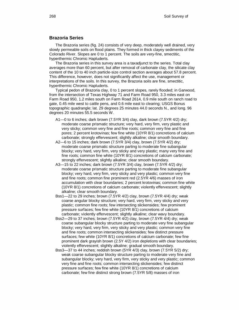
268 Soil Survey of
Brazoria Series The Brazoria series (fig. 24) consists of very deep, moderately well drained, very
slowly permeable soils on flood plains. They formed in thick clayey sediments of the Colorado River. Slopes are 0 to 1 percent. The soils are very-fine, smectitic, hyperthermic Chromic Hapluderts.
The Brazoria series in this survey area is a taxadjunct to the series. Total clay averages more than 60 percent, but after removal of carbonate clay, the silicate clay content of the 10 to 40 inch particle-size control section averages about 57.8 percent. This difference, however, does not significantly affect the use, management or interpretations of the soils. In this survey, the Brazoria soils are fine, smectitic, hyperthermic Chromic Hapluderts.
Typical pedon of Brazoria clay, 0 to 1 percent slopes, rarely flooded; in Garwood, from the intersection of Texas Highway 71 and Farm Road 950, 3.3 miles east on Farm Road 950, 1.2 miles south on Farm Road 2614, 0.9 mile south on ranch road to gate, 0.45 mile west to cattle pens, and 0.6 mile east to clearing; USGS Bonus topographic quadrangle; lat. 29 degrees 25 minutes 44.0 seconds N., and long. 96 degrees 20 minutes 55.5 seconds W.
A1—0 to 6 inches; dark brown (7.5YR 3/4) clay, dark brown (7.5YR 4/2) dry; moderate coarse prismatic structure; very hard, very firm, very plastic and very sticky; common very fine and fine roots; common very fine and fine pores; 2 percent krotovinas; few fine white (10YR 8/1) concretions of calcium carbonate; strongly effervescent; slightly alkaline; clear smooth boundary.
A2—6 to 15 inches; dark brown (7.5YR 3/4) clay, brown (7.5YR 4/2) dry; moderate coarse prismatic structure parting to moderate fine subangular blocky; very hard, very firm, very sticky and very plastic; many very fine and fine roots; common fine white (10YR 8/1) concretions of calcium carbonate; strongly effervescent; slightly alkaline; clear smooth boundary.
A3—15 to 22 inches; dark brown (7.5YR 3/4) clay, brown (7.5YR 4/2) dry; moderate coarse prismatic structure parting to moderate fine subangular blocky; very hard, very firm, very sticky and very plastic; common very fine and fine roots; common fine prominent red (2.5YR 4/6) masses of iron accumulation with clear boundaries; 2 percent krotovinas; common fine white (10YR 8/1) concretions of calcium carbonate; violently effervescent; slightly alkaline; clear smooth boundary.
Bss1—22 to 29 inches; brown (7.5YR 4/2) clay, brown (7.5YR 4/4) dry; weak coarse angular blocky structure; very hard, very firm, very sticky and very plastic; common fine roots; few intersecting slickensides; few prominent pressure surfaces; few fine white (10YR 8/1) concretions of calcium carbonate; violently effervescent; slightly alkaline; clear wavy boundary.
Bss2—29 to 37 inches; brown (7.5YR 4/2) clay, brown (7.5YR 4/4) dry; weak coarse subangular blocky structure parting to moderate very fine subangular blocky; very hard, very firm, very sticky and very plastic; common very fine and fine roots; common intersecting slickensides; few distinct pressure surfaces; few white (10YR 8/1) concretions of calcium carbonate; few fine prominent dark grayish brown (2.5Y 4/2) iron depletions with clear boundaries; violently effervescent; slightly alkaline; gradual smooth boundary.
Bss3—37 to 44 inches; reddish brown (5YR 4/3) clay, brown (7.5YR 5/2) dry; weak coarse subangular blocky structure parting to moderate very fine and subangular blocky; very hard, very firm, very sticky and very plastic; common very fine and fine roots; common intersecting slickensides; few distinct pressure surfaces; few fine white (10YR 8/1) concretions of calcium carbonate; few fine distinct strong brown (7.5YR 5/8) masses of iron
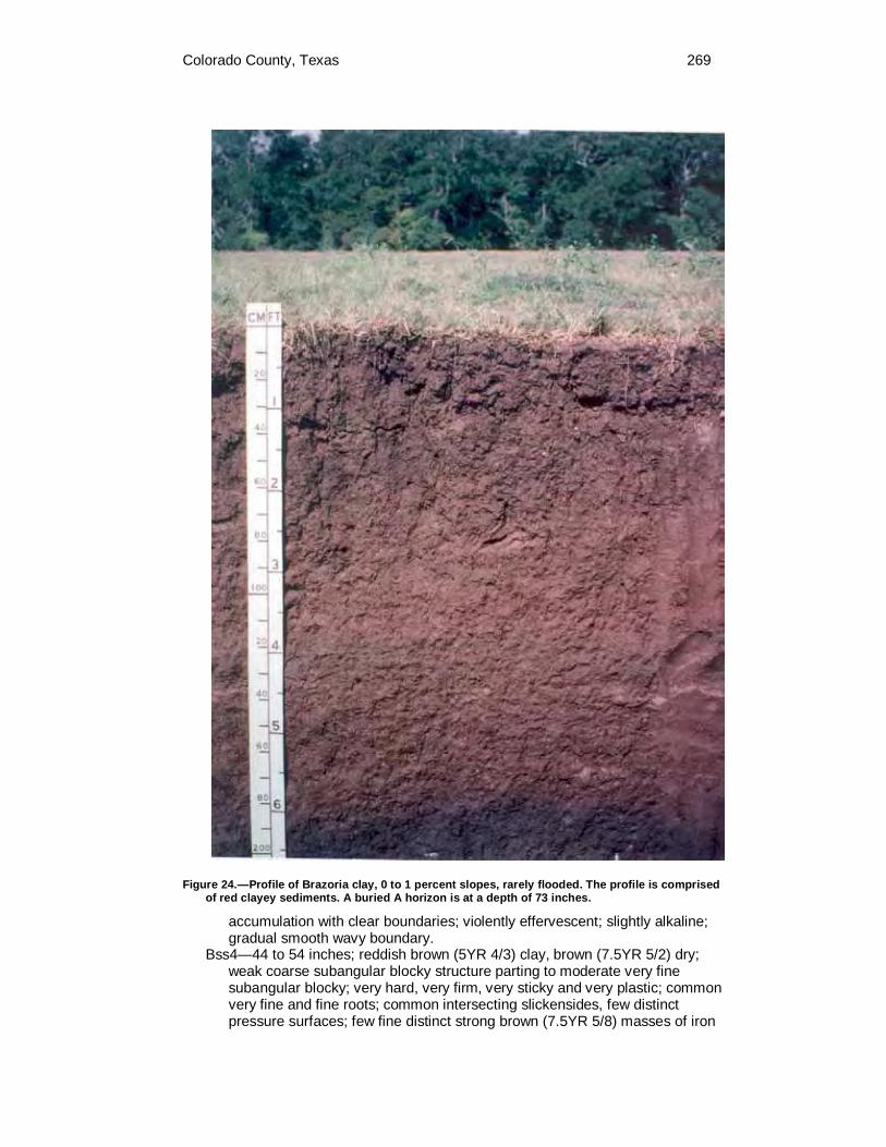
Colorado County, Texas 269
Figure 24.—Profile of Brazoria clay, 0 to 1 percent slopes, rarely flooded. The profile is comprised of red clayey sediments. A buried A horizon is at a depth of 73 inches.
accumulation with clear boundaries; violently effervescent; slightly alkaline; gradual smooth wavy boundary.
Bss4—44 to 54 inches; reddish brown (5YR 4/3) clay, brown (7.5YR 5/2) dry; weak coarse subangular blocky structure parting to moderate very fine subangular blocky; very hard, very firm, very sticky and very plastic; common very fine and fine roots; common intersecting slickensides, few distinct pressure surfaces; few fine distinct strong brown (7.5YR 5/8) masses of iron

270 Soil Survey of
accumulation with clear boundaries; violently effervescent; slightly alkaline; gradual smooth boundary.
Bss5—54 to 65 inches; dark reddish gray (5YR 4/2) clay, brown (7.5YR 4/2) dry; weak coarse subangular blocky structure parting to moderate very fine subangular blocky; very hard, very firm, very sticky and very plastic; common intersecting slickensides, few prominent pressure surfaces; few fine white (10YR 8/1) concretions of calcium carbonate; few fine distinct strong brown (7.5YR 5/8) and few fine faint dark reddish brown (5YR 3/4) masses of iron accumulation with clear boundaries; violently effervescent; slightly alkaline; gradual smooth boundary.
Bss6—65 to 73 inches; dark reddish brown (5YR 3/3) clay, brown (7.5YR 4/4) dry; weak coarse subangular blocky structure parting to moderate very fine subangular blocky; very hard, very firm, very sticky and very plastic; few intersecting slickensides; few distinct pressure surfaces; very few faint very dark grayish brown (10YR 3/2) black stains on faces of peds; 1 percent krotovinas; fine white (10YR 8/1) concretions of calcium carbonate; few fine and medium distinct dark reddish brown (2.5YR 3/4) masses of iron accumulation; violently effervescent; slightly alkaline; gradual smooth boundary.
Abss—73 to 80 inches; very dark grayish brown (2.5Y 3/2) clay, very dark grayish brown (10YR 3/2) dry; weak coarse subangular blocky structure parting to moderate very fine angular blocky; hard, firm, very sticky and very plastic; common very fine and fine roots; few intersecting slickensides; few distinct pressure surfaces; 4 percent krotovinas; few fine white (10YR 8/1) concretions of calcium carbonate; few fine distinct yellowish brown (10YR 5/8) masses of iron accumulation with clear boundaries; strongly effervescent; slightly alkaline.
The solum thickness is more than 80 inches. The soil is slightly alkaline or moderately alkaline throughout and secondary powdery lime ranges from none to common. Weighted average clay content of the particle-size control section ranges from 60 to 80 percent. Cracks more than 1 centimeter wide extend from the surface to a depth of about 40 inches during some seasons in most years. Cracks remain open for less than 90 cumulative days in most years. Slickensides and wedge-shaped peds range from few to common and begin at a depth ranging from 15 to 25 inches. Undisturbed areas have slight gilgai, with microhighs 2 to 6 inches higher than microlows. Distance between the microhigh and the microlow ranges from 6 to 10 feet. Boundary between horizons is wavy with amplitude of 10 inches between the highs and lows. Buried horizons occur in some pedons.
The A horizon has hue of 5YR or 7.5YR, value of 2 or 3, and chroma of 3 or 4. Redoximorphic features in shades of red range from none to few.
The Bss horizon has hue of 2.5YR to 7.5YR, value of 3 or 4, and chroma of 2 to 4. Redoximorphic features in shades of red, yellow or brown range from none to few. COLE values range from 0.07 to 1.5.
Some pedons have buried horizons at depths greater than 40 inches. These horizons are usually clay, but include clay loam, silty clay loam, or silty clay.
Brenham Series The Brenham series consists of very deep, well drained, moderately slowly
permeable soils on uplands. They formed in alkaline silty and clayey sediments of the Fleming Formation. Slopes range from 3 to 8 percent. The soils are fine-silty, carbonatic, thermic Udic Calciustolls.
Typical pedon of Brenham clay loam, 3 to 8 percent slopes; in Columbus, from the intersection of U.S. Highway 90 and Texas Highway 71, 0.9 miles north on Texas

Colorado County, Texas 271
Highway 71, 11.2 miles north on Farm Road 109 to Frelsburg, 4.15 miles north on county road across railroad tracks, 1.2 miles west on county road, 1.8 miles northwest on county road, 0.6 mile northeast on county road and about 100 feet northwest of road in native pasture; USGS Industry topographic quadrangle; lat. 29 degrees 56 minutes 53.5 seconds N., and long. 96 degrees 34 minutes 31.0 seconds W.
A—0 to 10 inches; very dark gray (10YR 3/1) clay loam, dark gray (10YR 4/1) dry; weak medium subangular blocky structure parting to strong very fine and fine subangular blocky; hard, firm, sticky and plastic; many very fine and fine roots; common very dark gray (10YR 3/1) and light yellowish brown (10YR 6/4) wormcasts; few fine fragments of snail shells; strongly effervescent; moderately alkaline; abrupt smooth boundary.
Bk1—10 to 15 inches; mottled light yellowish brown (2.5Y 6/4), grayish brown (2.5Y 5/2) and dark grayish brown (2.5Y 4/2) clay loam; weak medium subangular blocky structure parting to moderate very fine and fine subangular blocky; hard, firm, sticky and plastic; many very fine and fine roots; common very dark gray (10YR 3/1) and dark gray (10YR 4/1) mottles; few light yellowish brown (2.5Y 6/4) and grayish brown (2.5Y 5/2) wormcasts; common fine and medium distinct pale yellow (2.5Y 7/4) masses of iron accumulation with sharp boundaries; violently effervescent; moderately alkaline; clear smooth boundary.
Bk2—15 to 23 inches; mottled yellow (2.5Y 7/6), olive yellow (2.5Y 6/6), light yellowish brown (2.5Y 6/4) and light brownish gray (2.5Y 6/2) clay loam; weak fine and medium subangular blocky structure; slightly hard, friable, sticky and plastic; common very fine and fine roots; common fine and medium distinct brownish yellow (10YR 6/8) masses of iron accumulation with sharp boundaries in matrix; few fine rounded masses of iron-manganese; few fine and medium rounded masses of calcium carbonate; few dark grayish brown (10YR 4/2) and light brownish gray (2.5Y 6/2) wormcasts; violently effervescent; moderately alkaline; clear smooth boundary.
Bk3—23 to 33 inches; mottled light yellowish brown (2.5Y 6/4), olive yellow (2.5Y 6/6) and brownish yellow (10YR 6/8) clay loam; weak fine and medium subangular blocky structure; slightly hard, friable, sticky and plastic; few very fine and fine roots; few fine and medium rounded masses and nodules of calcium carbonate; violently effervescent; moderately alkaline; gradual smooth boundary.
BCk—33 to 40 inches; mottled brownish yellow (10YR 6/6), light yellowish brown (10YR 6/4) and light gray (10YR 7/2) silty clay; weak medium subangular blocky structure parting to weak very fine subangular blocky; very hard, very firm, sticky and plastic; few very fine and fine roots; few fine and medium rounded concretions of iron-manganese; many fine to coarse rounded masses and nodules of calcium carbonate; common fine and medium distinct brownish yellow (10YR 6/8) masses of iron accumulation with sharp boundaries; common fine to coarse distinct light gray (10YR 7/1) iron depletions with sharp boundaries; strongly effervescent; moderately alkaline; gradual smooth boundary.
2BCk1—40 to 48 inches; brownish yellow (10YR 6/6) and light gray (10YR 7/1) silty clay; massive; very hard, very firm, sticky and very plastic; few very fine and fine roots; few fine rounded masses of iron-manganese; many fine to coarse masses and nodules of calcium carbonate; strongly effervescent; moderately alkaline; gradual smooth boundary.
2BCk2—48 to 60 inches; brownish yellow (10YR 6/6) and light gray (10YR 7/1) clay; massive; very hard, very firm, sticky and very plastic; few prominent pressure surfaces; few fine rounded masses of iron-manganese; common fine

272 Soil Survey of
to coarse masses and nodules of calcium carbonate; strongly effervescent; moderately alkaline; gradual smooth boundary.
2BCk3—60 to 80 inches; brownish yellow (10YR 6/6) and light gray (10YR 7/1) and brownish yellow (10YR 6/8) clay; massive; very hard, very firm, sticky and very plastic; few prominent pressure surfaces; few fine rounded masses of black manganese; common fine to coarse masses of calcium carbonate; strongly effervescent; moderately alkaline.
The solum thickness ranges from 40 to more than 80 inches. Depth to the calcic horizon ranges from 10 to 30 inches. Calcium carbonate equivalent of the 10 to 40 inch control section ranges from 31 to more than 50 percent. Texture in the control section is clay loam or silty clay loam with the total clay content ranging from 33 to 41 percent. Silicate clay percentage in the 10 to 40 inch control section ranges from 20 to 35 percent.
The A horizon has hue of 10YR, value of 3, and chroma of 1 or 2. Texture is clay loam.
The Bk horizon has hue of 10YR or 2.5Y, value of 5 to 7, and chroma of 2 to 6. Texture is clay loam or silty clay loam.
The BCk horizon, where present, has hue of 10YR, value of 5 or 6, and chroma of 2 to 6. Texture is silty clay loam, silty clay, or clay.
The 2BCk horizon has hue of 10YR or 2.5Y, value of 5 to 7, and chroma of 1 to 8. Texture is clay or silty clay with the total clay content of 40 to 65 percent.
Burleson Series The Burleson series consists of very deep, very slowly permeable, moderately
well drained soils on terraces. They formed in alkaline clayey sediments of the Colorado River. Slopes range from 0 to 3 percent. The soils are fine, smectitic, thermic Udic Haplusterts.
Typical pedon of Burleson clay, 0 to 1 percent slopes; in Eagle Lake, from the intersection of U.S. Highway 90 Alternate and Farm Road 102, 4.5 miles west on U.S. Highway 90 Alternate, 0.7 mile north on county road and 170 feet west in native pasture; USGS Altair topographic quadrangle; lat. 29 degrees 35 minutes 51.5 seconds N., and long. 96 degrees 24 minutes 35.0 seconds W.
Ap—0 to 7 inches; very dark gray (10YR 3/1) clay, dark gray (10YR 4/1) dry; moderate medium subangular blocky structure; very hard, very firm, very sticky and very plastic; many fine and medium roots; few fine pores; 1 percent by volume siliceous pebbles; moderately acid; clear smooth boundary.
Bss1—7 to 20 inches; very dark gray (10YR 3/1) clay, dark gray (10YR 4/1) dry; weak coarse subangular blocky structure parting to strong fine and medium subangular blocky; very hard, very firm, very sticky and very plastic; common fine roots; few very fine and medium pores; few slickensides; many distinct pressure surfaces; few vertical cracks partly filled with material from above; 1 percent siliceous pebbles; slightly acid; gradual smooth boundary.
Bss2—20 to 38 inches; dark gray (10YR 4/1) clay, gray (10YR 5/1) dry; weak coarse subangular blocky structure; very hard, very firm, very sticky and very plastic; common very fine and fine roots; few very fine pores; common fine distinct dark yellowish brown masses of iron accumulation with sharp boundaries; common slickensides; common distinct and prominent pressure surfaces; common vertical cracks partly filled with material from above; few fine faint gray iron depletions with sharp boundaries; 1 percent siliceous pebbles; slightly acid; gradual smooth boundary.
Bss3—38 to 44 inches; 70 percent gray (10YR 5/1) and 30 percent dark gray (10YR 4/1) clay, light gray (10YR 6/1) and gray (10YR 5/1) dry; weak coarse subangular blocky structure; very hard, very firm, very sticky and very plastic;

Colorado County, Texas 273
few very fine roots; common slickensides; common distinct pressure surfaces; common vertical cracks partly filled with fine and medium pockets of very dark gray (10YR 3/1) material from above; 2 percent fine and medium siliceous pebbles; moderately alkaline; gradual smooth boundary.
Bss4—44 to 52 inches; light brownish gray (10YR 6/2) clay, light gray (10YR 7/2) dry; moderate medium subangular blocky structure; very hard, very firm, very sticky and very plastic; common slickensides; common distinct pressure surfaces; common vertical cracks filled with fine and medium pockets of very dark gray (10YR 3/1) material from above; few fine black concretions; common fine distinct dark yellowish brown masses of iron accumulation with sharp boundaries; common fine distinct dark yellowish brown old root channels; less than 1 percent fine siliceous pebbles; moderately alkaline; gradual wavy boundary.
Bss5—52 to 65 inches; light brownish gray (2.5Y 6/2) clay, light gray (2.5Y 7/2) dry; weak coarse subangular blocky structure; very hard, very firm, very sticky and very plastic; many slickensides; common distinct pressure surfaces; few vertical cracks; many medium and coarse faint light yellowish brown (2.5Y 6/4) masses of iron accumulation with sharp boundaries; few fine white barite crystals; 1 percent fine siliceous pebbles; moderately alkaline; clear smooth boundary.
Bkss—65 to 80 inches; light olive gray (5Y 6/2) clay, pale olive (5Y 6/3) dry; weak coarse subangular blocky structure; very hard, very firm, very sticky and very plastic; common slickensides; few distinct pressure surfaces; many fine faint light brownish gray iron depletions with sharp boundaries; 2 percent fine and medium and few coarse siliceous pebbles; moderately alkaline.
The solum thickness ranges from 60 to more than 80 inches. The control section has 40 to 60 percent clay. Iron-manganese in the form of concretions and masses range from none to few throughout. This is a cyclic soil and undisturbed areas have gilgai microrelief with microhighs 6 to 12 inches higher than the microlows. Distance between the center of the microhigh and the center of the microlow is about 5 to 15 feet. The microhigh makes up about 20 percent. When dry, cracks 1 to 3 inches wide extend from the surface to a depth of 40 inches or more. The cracks remain open for 90 to 150 cummulative days during most years. Intersecting slickensides begin at a depth of 7 to 25 inches.
The A horizon has hue of 10YR, value of 2 or 3, and chroma of 1. Reaction ranges from moderately acid to slightly alkaline and is noneffervescent. However, on microhighs some pedons are moderately alkaline.
The upper Bss horizon has hue of 10YR, value of 3 or 4, and chroma of 1. Texture is clay. Redoximorphic features in shades of brown or gray range from none to few. Siliceous pebbles range from none to few. Concretions of calcium carbonate range from none to few. Reaction ranges from slightly acid to moderately alkaline and typically is noneffervescent.
The lower Bss horizon has hue of 10YR or 2.5Y, value of 4 to 6, and chroma of 1 or 2. Redoximorphic features in shades of yellow, brown, or gray range from none to few. Texture is clay. Siliceous pebbles range from none to 5 percent. Concretions of calcium carbonate range from none to common. Reaction is moderately alkaline and is noneffervescent.
The Bkss horizon has hue of 10YR to 5Y, value of 5 to 6, and chroma of 2 to 6. Texture is clay or silty clay. Reaction is moderately alkaline and is noneffervescent.
Where present, the 2C horizon has colors in shades of red, pink, yellow, or brown. Texture is sandy clay loam, silty clay loam, silty clay, or clay. Some pedons have sandy or loamy strata with or without gravel below 65 inches. Siliceous pebbles range from none to 5 percent. Concretions and masses of calcium carbonate range
274 Soil Survey of
from few to many. Reaction is moderately alkaline and effervescence ranges from slight to violent.
Carbengle Series The Carbengle series (fig. 25) consists of moderately deep, moderately
permeable, well drained soils on uplands. They formed in residuum from weakly cemented calcareous sandstone. Slopes range from 3 to 12 percent. The soils are fine-loamy, carbonatic, thermic Udic Calciustolls.
Typical pedon of Carbengle sandy clay loam, 3 to 5 percent slopes; in Weimar, from the intersection of U.S. Highway 90 and Farm Road 155, 5.0 miles south on Farm Road 155, 2.7 miles west on Farm Road 2144, 1.0 mile south on county road, 0.5 mile west on county road to gate, 0.15 mile southeast on ranch road to mott of trees and 80 feet south of trees in pasture; USGS Oakland topographic quadrangle; lat. 29 degrees 36 minutes 2.5 seconds N., and long. 96 degrees 48 minutes 17.0 seconds W.
A1—0 to 11 inches; very dark grayish brown (10YR 3/2) sandy clay loam, dark grayish brown (10YR 4/2) dry; weak medium subangular blocky structure parting to weak very fine subangular blocky; slightly hard, friable, slightly sticky and slightly plastic; many fine to coarse roots; few fine and medium pockets of brown (10YR 5/3) material; few fine concretions of calcium carbonate; few fine fragments of snail shells; strongly effervescent; moderately alkaline; clear smooth boundary.
A2—11 to 16 inches; dark brown (7.5YR 3/2) sandy clay loam, brown (7.5YR 4/2) dry; moderate fine and medium subangular blocky structure; slightly hard, friable, slightly sticky and slightly plastic; common fine and medium roots; few fine concretions of calcium carbonate; few fragments of snail shells; strongly effervescent; moderately alkaline; clear smooth boundary.
Bk1—16 to 23 inches; dark yellowish brown (10YR 4/4) loam, yellowish brown (10YR 5/4) dry; weak fine subangular blocky structure; slightly hard, friable, slightly sticky and slightly plastic; common fine and medium roots; common fine and medium concretions of calcium carbonate; common fine and medium, few coarse fragments of weakly cemented sandstone; violently effervescent; moderately alkaline; clear smooth boundary.
Bk2—23 to 27 inches; brown (10YR 5/3) loam, pale brown (10YR 6/3) dry; moderate fine and medium subangular blocky structure; hard, friable, slightly sticky and slightly plastic; common fine and medium roots; common fine and medium concretions and masses of calcium carbonate; few fine and medium fragments of snail shells; violently effervescent; moderately alkaline; clear smooth boundary.
BCk—27 to 35 inches; light yellowish brown (10YR 6/4) loam, light gray (10YR 7/2) dry; weak fine subangular blocky structure; slightly hard, friable, slightly sticky and slightly plastic; few fine and medium roots; common fine concretions and threads of calcium carbonate; common fragments of weakly cemented sandstone; violently effervescent; moderately alkaline; abrupt smooth boundary.
Cr—35 to 48 inches; pale brown (10YR 6/3) weathered bedrock, very pale brown (10YR 7/3) dry; massive; yellowish brown (10YR 5/4) and strong brown (7.5YR 4/6) masses of iron accumulation on crack faces; violently effervescent; moderately alkaline.
The solum thickness and depth to weathered bedrock ranges from 20 to 40 inches, the lower limit being the depth to weakly to strongly cemented calcareous sandstone interbedded with loamy materials. Secondary carbonates are present throughout the B horizon in the form of threads, films, masses, nodules and

Colorado County, Texas 275
concretions. Calcium carbonate equivalent ranges from 41 to 61 percent. The average clay content of the 10 to 40 inch control section ranges from 20 to 35 percent. The control section contains more than 15 percent material coarser than very fine sand.
The A horizon has hue of 10YR, value of 3 or 4, and chroma of 2. The Bk and BCk horizons have hue of 10YR to 2.5Y, value of 5 to 8, and chroma
of 2 to 6. Mottles in shades of yellow, brown, or gray range from none to common. Texture is loam, sandy clay loam, or clay loam.
The Cr horizon ranges from calcareous weakly cemented to strongly cemented sandstone that is interbedded with loamy sediments. It can be cut with a spade or auger. Roots penetrate only in occasional fractures and in loamy interbedded material.
Figure 25.—Profile of Carbengle sandy clay loam, 3 to 5 percent slopes. Sandstone occurs below 24 inches.

276 Soil Survey of
Catilla Series The Catilla series consists of very deep, moderately well drained, moderately
slowly permeable soils on uplands. They formed from sandy and loamy sediments of the Willis Formation. Slopes range from 1 to 5 percent. The soils are loamy, siliceous, active, thermic Grossarenic Paleustalfs.
Typical pedon of Catilla loamy sand, 1 to 5 percent slopes; in Columbus, from the intersection of Texas Highway 71 and U.S. Highway 90, 0.9 mile north on Texas Highway 71, 8.3 miles north on Farm Road 109, 4.8 miles east and southeast on county road to gate, about 0.1 mile south on ranch road, about 0.25 mile south-southwest on ranch road, about 0.2 mile south on ranch road, about 0.2 mile southeast on ranch road and 100 feet west of road in pine plantation; USGS Bernardo topographic quadrangle; lat. 29 degrees 47 minutes 53.0 seconds N., and long. 96 degrees 28 minutes 37.0 seconds W.
Ap—0 to 5 inches; dark yellowish brown (10YR 4/4) loamy sand, yellowish brown (10YR 5/4) dry; weak medium subangular blocky structure; soft, very friable, nonsticky and nonplastic; many fine and medium roots; common fine pores; moderately acid; clear wavy boundary.
E1—5 to 24 inches; dark yellowish brown (10YR 4/4) loamy sand, yellowish brown (10YR 5/4) dry; single grain; soft, loose, nonsticky and nonplastic; common fine and medium roots; 1 percent subrounded siliceous pebbles; strongly acid; gradual wavy boundary.
E2—24 to 44 inches; yellowish brown (10YR 5/4) loamy sand, light yellowish brown (10YR 6/4) dry; single grain; soft, loose, nonsticky and nonplastic; few distinct strong brown (7.5YR 5/6) coats between sand grains; strongly acid; diffuse wavy boundary.
E3—44 to 48 inches; yellowish brown (10YR 5/4) loamy sand, very pale brown (10YR 7/4) dry; single grain; soft, friable, nonsticky and nonplastic; common fine roots; many fine to coarse pores; few distinct reddish yellow (7.5YR 6/6) coats between sand grains; strongly acid; clear wavy boundary.
E/Bt—48 to 53 inches; brownish yellow (10YR 6/6) loamy fine sand (E), yellow (10YR 7/6) dry, yellowish brown (10YR 5/4) sandy loam, light yellowish brown (10YR 6/4) dry (Bt); weak fine subangular blocky structure; slightly hard, friable, nonsticky and slightly plastic; many fine to coarse pores; few prominent clay films; 1 percent subrounded siliceous gravel; many coarse prominent red (2.5YR 4/6 and 4/8) masses of iron accumulation; few fine distinct gray (10YR 5/1) iron depletions; strongly acid; gradual wavy boundary.
Bt1—53 to 60 inches; 60 percent light gray (10YR 7/2) and 40 percent red (2.5YR 4/6) sandy clay loam, light gray (10YR 7/2) and reddish brown (5YR 5/4) dry; weak fine and medium subangular blocky structure; slightly hard, friable, nonsticky and slightly plastic; many fine to coarse pores; few prominent clay films; 1 percent subrounded siliceous gravel; common fine and medium distinct reddish yellow (7.5YR 6/8) and yellowish red (5YR 4/6) masses of iron accumulation; few fine and medium grayish brown (10YR 5/2) iron depletions; strongly acid; gradual wavy boundary.
Bt2—60 to 70 inches; 75 percent light gray (2.5Y 7/2) and 25 percent dark red (2.5YR 3/6) sandy clay loam, light gray (2.5Y 7/2) dark reddish brown (2.5YR 3/4) dry; moderate medium subangular blocky structure; hard, firm, slightly sticky and plastic; few prominent clay films; common fine and medium distinct yellowish red (5YR 5/6) and common fine distinct reddish yellow (5YR 6/6) masses of iron accumulation; few fine faint light gray iron depletions; very strongly acid; gradual wavy boundary.
Bt3—70 to 80 inches; 55 percent light brownish gray (10YR 6/2) and 45 percent dark red (10R 3/6) sandy clay loam, light gray (10YR 7/2) and red brown

Colorado County, Texas 277
(2.5YR 3/4) dry; moderate medium subangular blocky structure; hard, firm, nonsticky and slightly plastic; 1 percent nodular plinthite and oxidized concretions; few fine and medium pockets of white salts; few fine distinct brownish yellow (10YR 6/6) masses of iron accumulation; very strongly acid.
The solum thickness ranges from 60 to more than 100 inches. Texture of the A and E horizons are sand, fine sand, or loamy fine sand. The clay content of the control section ranges from 20 to 26 percent. Coarse fragments, that are mainly siliceous pebbles, may occur in any horizon of some pedons and range up to about 10 percent by volume.
The A horizon has hue of 10YR, value of 4 to 6, and chroma of 3 or 4. Reaction ranges from moderately acid to slightly acid.
The E horizon has hue of 7.5YR or 10YR, value of 5 to 8, and chroma of 2 to 4. Reaction ranges from moderately acid to slightly acid.
Most pedons have an E/Bt or BE horizon that has hue of 10YR, value of 5 to 8, and chroma of 2 to 6. Redoximorphic features in shades of red, yellow, brown, or gray range from none to common. Texture of the Bt horizon is sandy loam or loam, and texture of the E horizon is sand or loamy sand. Reaction ranges from strongly acid to slightly acid.
The Bt horizon has hue of 10YR, value of 5 to 7, and chroma of 1 to 6. Redoximorphic features in shades of red, yellow, brown, or gray range from few to common in the upper part and increase in size and abundance with depth, or the matrix may be mottled with these colors. Texture is sandy clay loam except the upper 6 to 10 inches is sandy clay in some pedons. Reaction is very strongly acid to slightly acid. The depth to the horizon with rounded masses of iron enriched red mottles ranges from 56 to 70 inches below the surface.
Chazos Series The Chazos series consists of very deep, moderately well drained, slowly
permeable soils on stream terraces. They formed in loamy and clayey sediments associated with streams. Slopes range from 1 to 3 percent. The soils are fine, smectitic, thermic Udic Paleustalfs.
Typical pedon of Chazos loamy fine sand, 1 to 3 percent slopes; in Columbus, from the intersection of U.S. Highway 90 and Texas Highway 71, 6.2 miles west on U.S. Highway 90, 0.3 mile south on Hatterman Lane and about 130 feet east in woods; USGS Borden topographic quadrangle; lat. 29 degrees 41 minutes 19.0 seconds N., and long. 96 degrees 38 minutes 53.7 seconds W.
A—0 to 6 inches; dark grayish brown (10YR 4/2) loamy fine sand, grayish brown (10YR 5/2) dry; weak medium subangular blocky structure; slightly hard, very friable, nonsticky and nonplastic; many very fine and fine, few coarse roots; common fine pores; common earthwormcasts; many fine faint dark yellowish brown (10YR 4/4) and few fine distinct dark yellowish brown (10YR 3/4) masses of iron accumulation with diffuse boundaries; slightly acid; gradual wavy boundary.
E—6 to 18 inches; yellowish brown (10YR 5/4) loamy fine sand, pale brown (10YR 6/3) dry; weak medium subangular blocky structure; slightly hard, loose, nonsticky and nonplastic; common very fine, fine and coarse roots; many fine faint dark yellowish brown (10YR 4/4) masses of iron accumulation with diffuse boundaries; slightly acid; abrupt wavy boundary.
Bt1—18 to 25 inches; dark gray (10YR 4/1) clay, grayish brown (10YR 5/2) dry; moderate medium subangular blocky structure parting to moderate fine angular blocky; extremely hard, extremely firm, sticky and very plastic; common very fine, fine and medium roots; many distinct clay films on surfaces of peds; 2 percent lenses of yellowish brown (10YR 5/4) loamy very fine sand

278 Soil Survey of
on surfaces of peds; many fine and medium distinct strong brown (7.5YR 4/6 and 5/6), common fine prominent red (2.5YR 4/6) masses of iron accumulation with sharp boundaries; very strongly acid; clear wavy boundary.
Bt2—25 to 42 inches; light brownish gray (10YR 6/2) sandy clay, light gray (10YR 7/2) dry; moderate medium subangular blocky structure parting to moderate fine angular blocky; extremely hard, extremely firm, sticky and very plastic; few very fine, fine and medium roots; many distinct clay films on surfaces of peds; 1 percent lenses of light yellowish brown (10YR 6/4) loamy very fine sand on surfaces of peds; many fine to coarse distinct brownish yellow (10YR 6/6), few fine and medium distinct strong brown (7.5YR 5/6) and few fine prominent red (2.5YR 4/6) masses of iron accumulation with sharp boundaries; very strongly acid; gradual smooth boundary.
Bt3—42 to 50 inches; light gray (10YR 7/1) sandy clay, light gray (10YR 7/2) dry; moderate medium subangular blocky structure; very hard, very firm, sticky and very plastic; few very fine, fine and medium roots; 1 percent lenses of light yellowish brown (10YR 6/4) fine sand on vertical surfaces of peds; many fine to coarse distinct brownish yellow (10YR 6/8) and yellow (10YR 7/6) masses of iron accumulation with sharp and diffuse boundaries; few fine prominent red (2.5YR 4/6) masses of iron accumulation with diffuse boundaries; moderately acid; gradual smooth boundary.
Bt4—50 to 55 inches; light gray (10YR 7/2) sandy clay loam, light gray (10YR 7/2) dry; moderate medium subangular blocky structure; very hard, very firm, sticky and very plastic; few very fine, fine and medium roots; common fine to coarse distinct brownish yellow (10YR 6/8) and yellow (10YR 7/8), few fine and medium prominent yellowish red (5YR 5/6) masses of iron accumulation with sharp boundaries; few fine rounded masses of iron- manganese; few fine masses of barite; neutral; clear smooth boundary.
Bt5—55 to 66 inches; light gray (10YR 7/2) sandy clay loam, light gray (10YR 7/2) dry; weak coarse subangular blocky structure; very hard, very firm, sticky and very plastic; few very fine and fine roots; few distinct clay films on surfaces of peds; few fine and medium rounded masses of iron-manganese; common fine and medium masses of barite; many fine to coarse distinct brownish yellow (10YR 6/8) and yellow (10YR 7/8) masses of iron accumulation with sharp and diffuse boundaries; few fine and medium prominent yellowish red (5YR 5/8) and few fine and medium distinct dark yellowish brown (10YR 4/6) masses of iron accumulation with sharp boundaries; neutral; abrupt smooth boundary.
Bt6—66 to 80 inches; light gray (10YR 7/2) sandy clay loam, light gray (10YR 7/2) dry; weak coarse subangular blocky structure; very hard, firm, sticky and plastic; 1 percent fine masses of iron-manganese; 1 percent barite; 4 percent lenses of very pale brown (10YR 7/4) fine sand on surfaces of peds; at 66 to 69 inches, very pale brown (10YR 8/3) loamy sand layer; many fine to coarse distinct brownish yellow (10YR 6/8) masses of iron accumulation with sharp and diffuse boundaries; common fine and medium distinct strong brown (7.5YR 5/8) and yellowish brown (10YR 5/4) masses of iron accumulation with sharp boundaries; slightly acid.
The solum thickness is more than 80 inches. Rounded siliceous pebbles range from none to about 5 percent by volume throughout the solum. The combined thickness of the A and E horizons ranges from 10 to 20 inches.
The A horizon has hue of 7.5YR or 10YR, value of 4 or 5, and chroma of 2 to 4. Reaction ranges from moderately acid to neutral.
The E horizon has hue of 7.5YR or 10YR, value of 5 to 7, and chroma of 2 to 4. Texture is loamy sand or loamy fine sand. Reaction ranges from moderately acid to neutral.

Colorado County, Texas 279
The Bt1 horizon has hue of 2.5YR to 10YR, value of 5 or 6, and chroma of 4 to 8. Redoximorphic features in shades of red, yellow, brown or gray range from few to many. Other pedons have a mixed matrix. Some pedons have hue of 10YR, value 5 to 7, and chroma of 1 or 2 with many redox concentrations. Texture is clay loam, sandy clay, or clay with clay content ranging from 35 to 50 percent. Reaction is moderately acid or slightly acid.
The lower Bt horizon has hue of 10YR or 2.5Y, value of 4 to 7, and chroma of 2 to 6. Redoximorphic features in shades of red, yellow, brown, or gray range from common to many. Some pedons have a mixed matrix of these colors. Texture is sandy clay loam, clay loam, or sandy clay with the clay content ranging from 27 to 40 percent. Some pedons have a few streaks of albic material in the lower part. Reaction ranges from moderately acid to neutral.
Where present, the Btk horizon has colors in shades of brown, with or without redox concentrations of red and yellow. Calcium carbonate in the form of threads, masses, and concretions range from 1 to 4 percent by volume. Reaction is slightly alkaline or moderately alkaline.
Where present, the BCt horizon has colors mainly in shades of brown or gray with or without red or yellow redox concentrations. Texture is fine sandy loam or sandy clay loam. Concretions or masses of calcium carbonate range from none to many. Reaction ranges from slightly acid to moderately alkaline.
Cheetham Series The Cheetham series consists of very deep, moderately well drained, moderately
slowly permeable soils that formed in thick loamy sediments of Pleistocene age, mainly of the Willis Formation. These soils are on very gently sloping uplands. Slopes range from 1 to 3 percent. The soils are fine-loamy, siliceous, active, hyperthermic Plinthaquic Paleudalfs.
Typical pedon of Cheetham loamy sand, 1 to 3 percent slopes; in Columbus, from the intersection of U.S. Highway 90 and Texas Highway 71, 1.0 mile west on U.S. Highway 90, 3.3 miles south on Farm Road 806, 5.9 miles south on county road, 2.0 miles west and north on county road, 300 feet west on private road and about 500 feet north in woods.; USGS Sawmill Branch topographic quadrangle; lat. 29 degrees 35 minutes 35.5 seconds N., and long. 96 degrees 38 minutes 20.0 seconds W.
A—0 to 5 inches; brown (10YR 4/3) loamy sand, pale brown (10YR 6/3) dry; weak medium subangular blocky structure; very friable, nonsticky and nonplastic; many very fine and fine roots; few fine rounded concretions of iron-manganese; few fine iron concretions; slightly acid; clear wavy boundary.
E1—5 to 20 inches; light yellowish brown (10YR 6/4) loamy sand, very pale brown (10YR 7/4) dry; weak medium subangular blocky structure; loose, nonsticky and nonplastic; many fine roots; few fine and medium rounded concretions of iron-manganese; slightly acid; gradual smooth boundary.
E2—20 to 28 inches; yellowish brown (10YR 5/4) loamy sand, light yellowish brown (10YR 6/4) dry; weak fine subangular blocky structure; loose, nonsticky and nonplastic; common very fine and fine roots; many fine and medium pores; few fine rounded concretions of iron-manganese; few fine ironstone pebbles; many fine and medium faint (10YR 5/6) masses of iron accumulation with sharp, clear, and diffuse boundaries; slightly acid; clear wavy boundary.
Bt1—28 to 36 inches; light gray (10YR 7/1) and pale brown (10YR 6/3) sandy clay loam, white (10YR 8/1) dry; weak medium subangular blocky structure; hard, friable, slightly sticky and plastic; common very fine and fine roots; common faint clay films on surfaces of peds; 1 percent (7.5YR 7/3) lenses of uncoated sand on surfaces of peds; 3 percent (10YR 7/2) clay depletions on surfaces of peds; few fine and medium rounded concretions of iron-manganese; few fine ironstone pebbles; common fine pores; many fine and

280 Soil Survey of
medium distinct yellowish brown (10YR 5/8), many fine and medium distinct brownish yellow (10YR 6/8), and few fine prominent yellowish red (5YR 4/6) masses of iron accumulation with sharp, clear, or diffuse boundaries; slightly acid; clear smooth boundary.
Bt2—36 to 49 inches; light gray (10YR 7/1) sandy clay loam, white (10YR 8/1) dry; weak medium subangular blocky structure; hard, firm, slightly sticky and plastic; common faint clay films on surfaces of peds; few fine and medium rounded concretions of iron-manganese; many fine to coarse prominent brownish yellow (10YR 6/8) and few fine and medium prominent red (2.5YR 4/8) masses of iron accumulation with sharp boundaries; slightly acid; gradual smooth boundary.
Btv1—49 to 67 inches; light gray (10YR 7/1) sandy clay loam, white (10YR 8/1) dry; weak medium subangular blocky structure; hard, firm, slightly sticky and plastic; 10 percent nodular plinthite; common faint and distinct clay films on surfaces of peds; few fine and medium rounded concretions of iron-manganese; many medium and coarse prominent brownish yellow (10YR 6/8), many medium and coarse prominent yellow (10YR 7/8), and many fine to coarse prominent red (2.5YR 4/8) masses of iron accumulation with sharp boundaries; moderately acid; gradual smooth boundary.
Btv2—67 to 74 inches; white (2.5Y 8/2) sandy clay loam, white (5Y 8/1) dry; weak medium subangular blocky structure; hard, firm, sticky and plastic; 10 percent nodular plinthite; common faint and distinct clay films on surfaces of peds; common medium distinct olive yellow (2.5Y 6/6, 6/8) and many fine to coarse prominent red (2.5YR 4/8) masses of iron accumulation with sharp boundaries; strongly acid; clear smooth boundary.
BCt—74 to 80 inches; white (2.5Y 8/2) sandy clay loam, white (5Y 8/1) dry; weak coarse subangular blocky structure; very hard, very firm, sticky and very plastic; few faint clay films on surfaces of peds; 1 percent (7.5YR 5/4) lenses of uncoated sand on surfaces of peds; many medium and coarse prominent red (2.5YR 3/6) masses of iron accumulation with sharp boundaries; strongly acid.
The solum thickness is more than 80 inches. Depth to horizons containing 5 to 15 percent plinthite ranges from 25 to 49 inches. Ironstone pebbles range from 0 to 5 percent.
The combined thickness of the A and E horizons range from 20 to 40 inches. Reaction ranges from very strongly acid to slightly acid.
The A or Ap horizon has hue of 10YR, value of 4 to 6, and chroma of 3 or 6. Texture is loamy sand.
The E horizon has hue of 10YR, value of 5 to 7, and chroma of 3 to 6. The E horizon is 1 to 2 units of value higher than the A horizon in most pedons. Texture is loamy sand or loamy fine sand.
The Bt horizon has hue of 7.5YR or 10YR, value of 5 to 8, and chroma of 1 to 8. Masses of iron accumulation in shades of red, yellow or brown range from common to many. Iron accumulations are redoximorphic features. Iron depletions in shades of gray range from few to many and are both contemporary and relict redoximorphic features. Depth to low chroma depletions related to contemporary wetness ranges from 24 to more than 50 inches. Texture is sandy clay loam, loam, or clay loam. Clay content ranges from 20 to 35 percent. Plinthite ranges from 0 to 5 percent by volume. Ironstone pebbles range from 0 to 15 percent by volume. Reaction ranges from strongly acid to slightly acid.
The Btv horizon is mottled with matrix color in hue of 7.5YR or 10YR, value of 3 to 8, and chroma of 1 to 8. Masses of iron accumulation in shades of red, yellow, or brown range from common to many. Iron accumulations are relict redoximorphic features. Iron depletions in shades of gray range from few to many and are both
Colorado County, Texas 281
contemporary and relict redoximorphic features. Texture is sandy clay loam, clay loam, or sandy clay. Plinthite ranges from 5 to 15 percent by volume. Reaction ranges from very strongly acid to moderately acid.
The BCt horizon, where present, below a depth of 60 inches, have hue of 2.5Y, value of 6 to 8, and chroma of 1 or 2. Masses of iron accumulation in shades of red and brown range from few to many. Iron accumulations are relict redoximorphic features. Texture is sandy clay loam, sandy clay, or clay. Lenses of sand on surfaces of peds range none to few. Reaction ranges from neutral to extremely acid.
Cieno Series The Cieno series consists of very deep, poorly drained, very slowly permeable
soils on uplands. They formed in loamy sediments of the Lissie Formation. Slopes are 0 to 1 percent. The soils are fine-loamy, siliceous, active, hyperthermic Typic Vermaqualfs.
Typical pedon of Cieno loam, in an area of Telferner-Cieno complex, 0 to 1 percent slopes; in Garwood, from the intersection of Texas Highway 71 and Farm Road 1693, 7.1 miles west on Farm Road 1693, 1.1 miles west on county road and 500 feet north in rice field; USGS Sheridan NE topographic quadrangle; lat. 29 degrees 25 minutes 41.0 seconds N., and long. 96 degrees 24 minutes 5.0 seconds W.
Ap—0 to 4 inches; dark grayish brown (10YR 4/2) loam, light brownish gray (10YR 6/2) dry; weak medium subangular blocky structure parting to weak fine subangular blocky; very hard, firm, slightly sticky and slightly plastic; many fine roots; few fine pores; few crayfish krotovinas 1 to 3 centimeters across; few brown (7.5YR 4/4) root pore linings; common fine pockets of uncoated silt; common fine distinct yellowish brown (10YR 5/6) and dark yellowish brown (10YR 4/6) masses of iron accumulation; slightly acid; abrupt wavy boundary.
Btg1—4 to 10 inches; dark grayish brown (10YR 4/2) sandy clay loam, light brownish gray (10YR 6/2) dry; weak medium subangular blocky structure; very hard, firm, slightly sticky and slightly plastic; many fine roots; common fine pores; few crayfish krotovinas 1 to 3 centimeters across; many brown (7.5YR 4/4) and strong brown (7.5YR 4/6) root pore linings; few fine dark masses; many fine pockets of uncoated silt and very fine sand; common fine distinct strong brown (7.5YR 5/6) masses of iron accumulation; slightly acid; clear wavy boundary.
Btg2—10 to 15 inches; dark grayish brown (10YR 4/2) clay loam, gray (10YR 6/1) dry; weak medium subangular blocky structure; very hard, firm, sticky and plastic; many fine roots; many fine pores; few crayfish krotovinas 1 to 3 centimeters across; many brown (7.5YR 4/4) and dark brown (7.5YR 3/4) root pore linings; few fine dark masses; many fine and medium pockets of uncoated silt and very fine sand; many fine distinct dark yellowish brown (10YR 3/6) masses of iron accumulation; neutral; clear wavy boundary.
Btg3—15 to 27 inches; dark grayish brown (10YR 4/2) sandy clay loam, light brownish gray (10YR 6/2) dry; moderate medium subangular blocky structure; very hard, very firm, very sticky and plastic; few fine roots; few crayfish krotovinas 1 to 3 centimeters across; few thin albic materials as coatings on surfaces of peds; few fine pockets of uncoated silt; few dark concretions 2 to 5 millimeters across; few dark stains; 1 percent siliceous pebbles; many fine and medium distinct dark yellowish brown (10YR 4/6) and dark yellowish brown (10YR 3/6) masses of iron accumulation; neutral; clear wavy boundary.
Btg4—27 to 44 inches; dark grayish brown (10YR 4/2) and light gray (10YR 7/2) sandy clay, gray (10YR 6/1) and light gray (10YR 7/2) dry; moderate medium subangular structure; very hard, very firm, sticky and plastic; few fine roots;
282 Soil Survey of
few crayfish krotovinas 1 to 3 centimeters across; few dark concretions 2 to 5 millimeters across; few dark stains; few thin albic materials as coatings on surfaces of peds; many grayish brown (10YR 5/2) silt coatings on surfaces of peds; few fine faint dark yellowish brown and common medium distinct yellowish brown (10YR 5/8) masses of iron accumulation; slightly acid; gradual wavy boundary.
Btg5—44 to 64 inches; light gray (10YR 7/1) sandy clay loam, white (10YR 8/2) dry; moderate medium subangular blocky structure; very hard, very firm, sticky and plastic; few crayfish krotovinas 1 to 3 centimeters across; few dark concretions 1 to 3 millimeters across; few thin albic materials as coatings on surfaces of peds; few grayish brown (10YR 5/2) silt coatings on surfaces of peds; few fine prominent reddish brown (5YR 4/4) and many fine and medium distinct yellowish brown (10YR 5/8) masses of iron accumulation; slightly acid; gradual wavy boundary.
Btg6—64 to 80 inches; light gray (10YR 7/1) sandy clay loam, white (10YR 8/2) dry; moderate medium subangular blocky structure; very hard, very firm and plastic; few dark masses; few thin albic materials as coatings on surfaces of peds; many brown (10YR 5/3) silt coatings on surfaces of peds; common fine prominent red (2.5YR 4/8) and many fine and medium distinct brownish yellow (10YR 6/8) masses of iron accumulation; moderately acid.
The solum thickness is more than 60 inches. The COLE of the argillic horizon is typically about 0.04 but ranges from 0.02 to 0.08. Depth to free carbonates is 30 to about 60 inches. Few to common crayfish krotovinas are mainly in the upper 60 inches, are usually 1 to 6 centimeters across and commonly contain less clay than the Btg horizon. Uncoated sand grains are on the surface of some peds. Albic materials 2 to 4 centimeters long and about 1 centimeter wide, range from none to a few throughout the argillic horizon and comprise less than 5 percent of the matrix. Dark concretions 4 to 8 millimeters across range from none to a few throughout.
The A horizon has hue of 10YR, value of 4 or 5, and chroma of 1 to 3. Redoximorphic features in shades of brown range from none to many. Reaction ranges from strongly acid to neutral.
The Btg horizon has hue of 10YR or 2.5Y, value of 4 to 7, and chroma of 1 to 3. Redoximorphic features in shades of yellow or brown range from none to many in the upper Btg. The lower Btg horizons have redoximorphic features in shades of red, yellow, brown, or gray that range from none to many. Texture is sandy clay loam, sandy clay, or clay loam. The weighted average clay content of the control section is 27 to 35 percent. Reaction ranges from strongly acid to neutral in the Btg1 horizon and from moderately acid to moderately alkaline in the lower Btg horizons.
Where present, the Bg and BC horizons, have hue of 10YR or 2.5Y, value of 5 to 7, and chroma of 1 or 2. Redoximorphic features in shades of red, yellow, brown, or gray range from few to many. Texture is sandy clay loam, clay loam, or sandy clay. Threads, films, masses, and concretions of calcium carbonate range from few to common. Reaction is moderately acid to moderately alkaline.
Clemville Series The Clemville series consists of very deep, well drained, slowly permeable soils
on flood plains. They formed in loamy and clayey calcareous alluvial sediments of the Colorado River. Slopes are 0 to 1 percent. The soils are fine-silty, mixed, superactive, hyperthermic Fluventic Eutrochrepts.
The Clemville series in this survey area is a taxadjunct to the series. The clay content of the 10- to 40- inch particle-size control section averages greater than 35 percent in the majority of pedons. Depth to fine textured buried horizons is shallower than typical for the series. This difference, however, does not significantly affect the

Colorado County, Texas 283
use, management or interpretations of the soils. In this survey, the Clemville soils are fine, mixed, superactive, hyperthermic Fluventic Eutrochrepts.
Typical pedon of Clemville silty clay loam, 0 to 1 percent slopes, occasionally flooded; in Garwood, from the intersection of Texas Highway 71 and Farm Road 950, 3.3 miles east on Farm Road 950, 1.2 miles south on Farm Road 2614, 0.9 mile southwest on field road to gate, 0.45 mile southwest to cattle pens, 0.25 mile southeast along fence line, and 300 feet north in pasture; USGS Bonus topographic quadrangle; lat. 29 degrees 26 minutes 2.0 seconds N., and long. 96 degrees 21 minutes 13.0 seconds W.
Ap—0 to 6 inches; dark brown (7.5YR 3/2) silty clay loam, brown (7.5YR 5/2) dry; moderate medium subangular blocky structure; hard, firm, sticky and plastic; many fine and medium roots; common fine pores; common fine and medium pockets of yellowish brown (10YR 5/4) materials in matrix; strongly effervescent; moderately alkaline; abrupt smooth boundary.
C1—6 to 16 inches; brown (7.5YR 5/4) silty clay loam, yellowish brown (10YR 5/4) dry; weak medium platy structure; hard, firm, sticky and plastic; common fine roots; common fine pores; common thin horizontal bedding planes; violently effervescent; moderately alkaline; abrupt smooth boundary.
C2—16 to 21 inches; brown (7.5YR 4/2) silty clay loam, grayish brown (10YR 5/2) dry; weak medium platy structure; hard, firm, sticky and plastic; common fine roots; common fine pores; common thin bedding planes; few fine pockets of pink (7.5YR 7/4) materials in matrix; few thin coats of calcium carbonate on surfaces of peds; violently effervescent; moderately alkaline; abrupt smooth boundary.
C3—21 to 26 inches; brown (7.5YR 4/4) silty clay, brown (10YR 5/3) dry; weak medium subangular blocky structure; hard, firm, sticky and plastic; common fine roots; common fine pores; few thin bedding planes; common fine and medium pockets of pink (7.5YR 7/4) and brown (7.5YR 5/4) materials in matrix; few thin coats of calcium carbonate on surfaces of peds; violently effervescent; moderately alkaline; abrupt smooth boundary.
Ab—26 to 36 inches; dark brown (7.5YR 3/2) clay, brown (7.5YR 4/2) dry; weak medium subangular blocky structure; very hard, very firm, very sticky and very plastic; common fine roots; many distinct and prominent shiny surfaces of peds; violently effervescent; moderately alkaline; clear smooth boundary.
Bb1—36 to 48 inches; dark brown (7.5YR 3/2) clay, brown (7.5YR 4/2) dry; weak medium subangular blocky structure; very hard, very firm, very sticky and very plastic; common fine pores; common thin dark reddish gray (5YR 4/2) lenses of clay on surfaces of peds; common fine and medium pockets of light brown (7.5YR 6/4) materials in matrix; violently effervescent; moderately alkaline; abrupt smooth boundary.
Bb2—48 to 69 inches; dark brown (7.5YR 3/2) clay, brown (7.5YR 4/2) dry; moderate medium platy structure; very hard, very firm, very sticky and very plastic; common thin distinct horizontal silty and clayey bedding planes; violently effervescent; slightly alkaline; abrupt smooth boundary.
Bb3—69 to 80 inches; dark reddish brown (2.5YR 3/4) clay, reddish brown (5YR 4/3) dry; weak medium platy structure; very hard, very firm, very sticky and very plastic; common fine pockets of very dark grayish brown (10YR 3/2) clay; common fine pockets of pink (7.5YR 7/4) silt in matrix; many faint, distinct, and prominent shiny surfaces of peds; violently effervescent; moderately alkaline.
Depth to horizons with more than 35 percent clay ranges from 20 to 37 inches. The 10- to 40-inch control section averages about 35 to 45 percent clay, with less than 15 percent sand coarser than very fine sand. Reaction is slightly alkaline or
284 Soil Survey of
moderately alkaline, except in the buried layers where the reaction ranges from neutral to moderately alkaline.
The A horizon has hue of 7.5YR or 10YR, value of 3 or 4, and chroma of 2 or 3. The C horizon has the same colors as the A horizon. Texture of the C horizon
above the dense clayey horizons is silt loam, silty clay loam, or silty clay with the average clay content ranging from 27 to 45 percent. Thin horizontal stratification of coarser or fine texture varies from few to many with bedding planes.
The Ab horizon has hue of 7.5YR or 10YR, values of 2 to 4, and chroma of 1 or 2. Texture of the Ab and Bb horizons ranges from silty clay loam to clay, with clay content of 35 to 50 percent, or about 10 to 20 percent more clay than the overlying silty C horizon.
The Bb horizon, where present, has hue of 2.5YR to 7.5YR, value of 3 or 4, and chroma of 2 to 4.
Coarsewood Series The Coarsewood series consists of very deep, well drained, moderately rapidly
permeable soils on flood plains. They formed in calcareous, loamy alluvial sediments of the Colorado River. Slopes are 0 to 1 percent. The soils are coarse-silty, mixed, superactive, calcareous, thermic Udic Ustifluvents.
Typical pedon of Coarsewood loam, 0 to 1 percent slopes, rarely flooded; in Columbus, from the intersection of U.S. Highway 90 and Texas Highway 71, 3.1 miles north and northwest on Texas Highway 71 bypass, 8.9 miles northwest on Texas Highway 71 to Chovanec Road, 1.3 miles south and east on Chovanec Road, 1.0 mile south on Chovanec Road to cattle guard, 0.7 mile south on private road and 85 feet east of road in native pecan orchard; USGS Ellinger topographic quadrangle; lat. 29 degrees 47 minutes 19.0 seconds N., and long. 96 degrees 43 minutes 6.5 seconds W.
Ap—0 to 5 inches; dark brown (7.5YR 4/2) loam, brown (7.5YR 4/4) dry; moderate fine subangular blocky structure parting to weak fine granular; slightly hard, very friable, slightly sticky and slightly plastic; many fine to coarse roots; few fine and medium pores; few krotovinas; common very fine concretions of calcium carbonate; few very fine fragments of snail shells; strongly effervescent; moderately alkaline; clear smooth boundary.
Bw1—5 to 17 inches; brown (10YR 5/3) silt loam, yellowish brown (10YR 5/4) dry; moderate fine and medium subangular blocky structure; slightly hard, very friable, slightly sticky and slightly plastic; common fine and medium roots; common very fine and medium pores; few krotovinas; common very fine fragments of snail shells; strongly effervescent; moderately alkaline; gradual smooth boundary.
Bw2—17 to 30 inches; brown (10YR 5/3) silt loam, yellowish brown (10YR 5/4) dry; weak fine and medium subangular blocky structure; slightly hard, very friable, slightly sticky and slightly plastic; common fine and medium roots; common fine and medium pores; few krotovinas; few medium pockets of darker material; strongly effervescent; moderately alkaline; gradual smooth boundary.
Bw3—30 to 35 inches; brown (10YR 5/3) silt loam, pale brown (10YR 6/3) dry; moderate fine and medium subangular blocky structure; slightly hard, very friable, slightly sticky and slightly plastic; common fine and medium roots; few fine pores; common krotovinas; many fine earthwormcasts; strongly effervescent; moderately alkaline; clear smooth boundary.
Ab—35 to 41 inches; dark brown (7.5YR 3/2) silty clay loam, brown (7.5YR 5/4) dry; moderate medium angular blocky structure; hard, firm, sticky and plastic; few fine roots; common fine pockets of brown (10YR 5/3) material; 20 percent threads of calcium carbonate; common very fine flakes and nodules of

Colorado County, Texas 285
calcium carbonate; strongly; strongly effervescent; moderately alkaline; gradual smooth boundary.
Bkb1—41 to 61 inches; brown (7.5YR 4/4) silty clay loam, light brown (7.5YR 6/4) dry; weak fine angular blocky structure; slightly hard, friable, sticky and plastic; few fine roots; 15 percent threads of calcium carbonate; common fine and medium concretions of calcium carbonate; few bedding planes; strongly effervescent; moderately alkaline; gradual smooth boundary.
Bbk2—61 to 80 inches; brown (10YR 4/3) silty clay loam, pale brown (10YR 6/3) dry; weak fine subangular blocky structure; slightly hard, friable, slightly sticky and plastic; few fine roots; common fine and few medium pores; 5 percent fine concretions of calcium carbonate; few fine fragments of snail shells; violently effervescent; moderately alkaline.
The solum thickness ranges from 40 to about 60 inches. The clay content of the control section ranges from 8 to 18 percent, with less than 15 percent sand coarser than very fine sand. Reaction is slightly alkaline or moderately alkaline and effervescence ranges from slight to violent throughout. Fragments of snail shellss less than 1/2 inch across range from 0 to 2 percent by volume. Some pedons have buried A and Bk horizons in the lower part of the control section, or within 60 inches of the surface.
The A horizon has hue of 7.5YR or 10YR, value of 4 or 5, and chroma of 2 to 4. The Bw horizon has hue of 5YR to 10YR, value of 5 to 7, and chroma of 3 to 6.
Very fine to coarse strata, less than 1/2 inch thick, in faint to distinct shades of brown, range from few to common. Redoximorphic features in shades of red range from none to few. Texture of the matrix is very fine sandy loam, loam, or silt loam. Some pedons contain a few threads and fine concretions of calcium carbonate.
Where present, the Ab horizon has hue of hue of 5YR to 7.5YR, value of 3 or 4, and chroma of 2 or 3. Texture is silt loam or silty clay loam.
Where present, the Bkb horizon has hue of 7.5YR or 10YR, value of 3 to 5, and chroma of 3 or 4. Texture is silty clay loam.
Where present, the C horizon has hue of 5YR to 10YR, value of 5 to 7, and chroma of 2 to 4. It is stratified with these colors and with textures of very fine sandy loam, loam, silt loam, or with strata that are slightly more sandy or clayey.
Dacosta Series The Dacosta series consists of very deep, moderately well drained, very slowly
permeable soils on uplands. They formed in loamy and clayey sediments of the Beaumont Formation. Slopes are 0 to 1 percent. The soils are fine, smectitic, hyperthermic Vertic Argiudolls.
Typical pedon of Dacosta loam, 0 to 1 percent slopes; in Garwood, from the intersection of Texas Highway 71 and Farm Road 333, 3.0 miles south on Texas Highway 71, and 1,000 feet northeast in cropland; USGS Garwood topographic quadrangle; lat. 29 degrees 23 minutes 40.0 seconds N., and long. 96 degrees 22 minutes 47.0 seconds W.
Ap—0 to 9 inches; very dark gray (10YR 3/1) loam, dark grayish brown (10YR 4/2) dry; weak coarse subangular blocky structure; very hard, very firm, sticky and plastic; many fine roots; common fine pores; slightly acid; clear wavy boundary.
Bt1—9 to 22 inches; black (10YR 2/1) clay loam, very dark gray (10YR 3/1) dry; moderate medium subangular blocky structure parting to strong fine subangular blocky; very hard, very firm, very sticky and very plastic; common fine roots; common fine pores; few slickensides; few pressure surfaces; few distinct clay films on surfaces of peds; few concretions of iron-manganese 1 to 3 millimeters across; many thin very dark gray (10YR 3/2) stains on surfaces
286 Soil Survey of
of peds; common thin silt and sand coatings of surfaces of peds; neutral; few fine distinct yellow (10YR 7/8) masses of iron accumulation with clear boundaries; neutral; gradual wavy boundary.
Bt2—22 to 40 inches; black (10YR 2/1) clay, very dark gray (10YR 3/1) dry; strong medium subangular blocky structure parting to moderate fine subangular blocky; very hard, very firm, very sticky and very plastic; few slickensides; few pressure surfaces; many shiny surfaces of peds; few distinct clay films on surfaces of peds; few concretions of iron-manganese; common coarse faint very dark grayish brown (10YR 3/2) stains on surfaces of peds; few medium and coarse pockets of uncoated fine sand and silt on surfaces of peds; neutral; gradual wavy boundary.
Btk1—40 to 48 inches; very dark gray (10YR 3/1) clay, dark gray (10YR 4/1) dry; moderate medium subangular blocky structure parting to moderate fine subangular blocky; very hard, very firm, very sticky and very plastic; few slickensides; few pressure surfaces; few faint clay films on surfaces of peds; 2 percent concretions of calcium carbonate 2 to 5 millimeters across; few medium silt and sand coatings on surfaces of peds; neutral; gradual wavy boundary.
Btk2—48 to 58 inches; grayish brown (10YR 5/2) clay, light brownish gray (10YR 6/2) dry; moderate medium subangular blocky structure; very hard, very firm, very sticky and very plastic; few faint clay films on surfaces of peds; common fine concretions of iron-manganese; 2 to 3 percent concretions of calcium carbonate 2 to 5 millimeters across; common medium very dark gray (10YR 3/1) stains on surfaces of peds; few fine and medium prominent yellowish red (5YR 5/6) masses of iron accumulation with sharp boundaries; slightly alkaline; gradual wavy boundary.
BCtk—58 to 67 inches; brown (10YR 5/3) and yellowish red (5YR 4/6) clay, light brownish gray (10YR 6/2) and strong brown(7.5YR 5/6) dry; weak medium subangular blocky structure; very hard, very firm, very sticky and very plastic; few patchy clay films on surfaces of peds; few fine soft black flakes; 2 to 3 percent concretions of calcium carbonate 2 to 5 millimeters across; many medium distinct grayish brown (10YR 5/2) and dark gray (10YR 4/1) iron depletions; strongly effervescent; slightly alkaline; gradual wavy boundary.
2C—67 to 80 inches; yellowish red (5YR 4/6) clay, yellowish red (5YR 5/6) dry; massive; very hard, very firm, very sticky and very plastic; few fine soft black flakes; 2 to 5 percent concretions of calcium carbonate 2 to 5 millimeters across; few masses of calcium carbonate; few thin and medium very dark gray (10YR 3/1) stains on surfaces of peds; many fine and medium yellowish brown (10YR 5/4) masses of iron accumulation with clear boundaries; few fine prominent grayish brown iron depletions; violently effervescent; slightly alkaline.
The solum thickness ranges from 60 to 70 inches. The COLE value in the upper part of the Bt horizon ranges from 0.09 to 0.12. When dry, there are cracks 0.4 to 2 inches wide that extend from the surface to a depth of more than 20 inches. Black concretions 4 to 7 millimeters across range none to few throughout.
The A horizon has hue of 10YR, value of 2 to 4, and chroma of 2 or less. Texture is loam or clay loam. It is hard or very hard when dry, but not massive. Reaction is slightly acid or neutral.
The Bt1 horizon has hue of 10YR, value of 2 to 5, and chroma of 1 or 2. Texture is clay loam or clay. Reaction ranges from slightly acid to moderately alkaline.
The Bt or Btk horizon has hue of 10YR or 2.5Y, value of 2 to 6, and chroma of 1 to 4. Some pedons have redoximorphic features in shades of yellow, brown, or gray that range from few to many. Texture is clay loam or clay with clay content of 35 to 50 percent. Concretions of calcium carbonate range from none to few throughout.

Colorado County, Texas 287
Masses, films or threads of calcium carbonate range from none to few below a depth of 40 inches. Reaction ranges from slightly acid to moderately alkaline.
The BCtk horizon and lower horizons have hue of 10YR or 2.5Y, value of 4 to 7, and chroma of 1 to 4. Redoximorphic features in shades of red, yellow, brown, or gray range from none to common. Texture is clay loam or clay. Concretions, masses, threads, or films of calcium carbonate range from none to common. Reaction is slightly alkaline or moderately alkaline.
The 2C horizon has colors in shades of red and brown. It has hue of 2.5YR to 7.5YR. Texture is clay or clay loam. This horizon is strongly to violently effervescent. Reaction is slightly alkaline or moderately alkaline.
Denvaca Series The Denvaca series consists of very deep, well drained, slowly permeable soils
that formed in calcareous clayey sediments of the Goliad and Fleming Formations. These soils are on very gently sloping uplands. Slopes range from 1 to 3 percent. The soils are fine, smectitic, hyperthermic Udertic Haplustalfs.
Typical pedon of Denvaca sandy clay loam, in an area of Elmenwood-Denvaca complex, 1 to 3 percent slopes; in Weimar, from the intersection of U.S. Highway 90 and Farm Road 155, 1.5 miles east on U.S. Highway 90, 2.7 miles north and east on county road, and 900 feet north west in pasture (south of pipeline). USGS Borden topographic quadrangle; lat. 29 degrees43 minutes 25.0 seconds N., and long. 96 degrees 43 minutes 52.0 seconds W.
A—0 to 4 inches; very dark gray (10YR 3/1) sandy clay loam, dark gray (10YR 4/1) dry; moderate fine and medium subangular blocky structure; very hard, firm; common fine roots; few fine pores; 1 percent black and brown concretions; 1 percent calcium carbonate concretions; 19 percent calcium carbonate equivalent; violently effervescent; slightly alkaline; clear smooth boundary.
Btk—4 to 11 inches; brownish gray (2.5Y 5/2) and very dark gray (10YR 3/1) clay loam, brownish gray (2.5Y 5/2) and very dark grayish brown (2.5Y 4/2) dry; moderate fine and medium subangular blocky structure; very hard, very firm; few fine roots; few fine pores; common faint clay films on surfaces of peds; 1 percent black and brown concretions; 3 percent calcium carbonate concretions and masses; 30 percent calcium carbonate equivalent; violently effervescent; slightly alkaline; gradual smooth boundary.
Btk2—11 to 20 inches; grayish brown (2.5Y 5/2) and light olive brown (2.5Y 5/4) clay loam, light grayish brown (2.5Y 6/2) and light yellowish brown (2.5Y 6/4) dry; moderate medium subangular blocky structure; very hard, very firm; few fine roots; few distinct pressure surfaces; common vertical cracks partly filled with material from above; common faint clay films on surfaces of peds; 1 percent black concretions; 5 percent calcium carbonate concretions; 30 percent calcium carbonate equivalent; violently effervescent; moderately alkaline; gradual smooth boundary.
Btkss1—20 to 38 inches; olive gray (5Y 5/2) and light gray (5Y 6/1) clay loam, olive (5Y 5/3) and light gray (5Y 6/1) dry; moderate medium subangular blocky structure; very hard, very firm; common slickensides; many prominent pressure surfaces; few vertical cracks partly filled with material from above; common faint clay films on surfaces of peds; 2 percent black concretions; 8 percent calcium carbonate concretions; 30 percent calcium carbonate equivalent; common fine and medium distinct olive (5Y 5/6) and olive yellow (5Y 6/6) brownish yellow (10YR 6/8) masses of iron accumulation with sharp boundaries; violently effervescent; moderately alkaline; gradual smooth boundary.

288 Soil Survey of
Btkss2—38 to 55 inches; gray (5Y 6/1) and olive (5Y 5/3) clay loam, light gray (5Y 6/1) and olive (5Y 5/3) dry; moderate medium subangular blocky structure; very hard, very firm; common distinct slickensides; many prominent pressure surfaces; common faint clay films on surfaces of peds; 2 percent black and brown concretions; 11 percent calcium carbonate concretions; 31 calcium carbonate equivalent; common fine and medium distinct light olive brown (2.5Y 5/6) masses of iron accumulation with sharp boundaries; violently effervescent; moderately alkaline; clear wavy boundary.
Btkss3—55 to 65 inches; light gray (5Y 7/1) and pale yellow (2.5Y 7/4) silty clay, light gray (5Y 7/1) and pale yellow (2.5Y 7/4) dry; moderate medium subangular blocky structure; very hard, very firm; common distinct slickensides; many prominent pressure surfaces; common faint clay films on surfaces of peds; 2 percent very dark grayish brown and strong brown concretions; 5 percent calcium carbonate concretions; 40 percent calcium carbonate equivalent; violently effervescent; moderately alkaline.
BCkss—65 to 80 inches; light gray (2.5YR 6/2) clay, light gray (2.5YR 7/2) dry; massive; very hard, very firm; common distinct slickensides; many prominent pressure surfaces; 2 percent black concretions; 3 percent concretions of calcium carbonate; 39 percent calcium carbonate equivalent; few fine and medium distinct brownish yellow (10YR 6/6) masses of iron accumulation with sharp boundaries in matrix; violently effervescent; moderately alkaline.
The solum thickness ranges from 60 to more than 80 inches. When dry, cracks extend to depths of 25 to 50 inches. Depth to slickensides and pressure surfaces range from 15 to 30 inches. Weighted average clay content of the particle-size control section ranges from 35 to 45 percent. Calcium carbonate clay in the particle-size control section ranges from 1 to 5 percent. Linear extensibility exceeds 6.0 centimeters within 40 inches of the surface.
The A horizon has hue of 10YR or 2.5Y, value of 4 to 7, and chroma of 1 to 3. Texture is sandy clay loam. Clay content ranges from 20 to 30 percent. Some pedons have few fine concretions of calcium carbonate. Calcium carbonate equivalent ranges from 5 to 25 percent. Reaction ranges from neutral to moderately alkaline.
The Bt and Btk horizons have hue of 10YR to 5Y, value of 4 to 6, and chroma of 2 to 6. Texture is clay loam, sandy clay loam, or clay. Clay content ranges from 30 to 45 percent. Calcium carbonate equivalent ranges from 10 to 35 percent by weight. Reaction is slightly alkaline or moderately alkaline.
The Btkss horizon has hue of 10YR to 5Y, value of 4 to 7, and chroma of 1 to 4. Texture is clay loam or clay. Clay content ranges from 35 to 50 percent. Calcium carbonate equivalent ranges from 15 to 40 percent. Reaction is slightly alkaline or moderately alkaline.
The BC horizon has hue of 7.5YR to 2.5Y, value of 4 to 7, and chroma of 2 to 4. Texture is clay loam or clay. Clay content ranges from 35 to 60 percent. Calcium carbonate equivalent ranges from 15 to 40 percent. Reaction is slightly alkaline or moderately alkaline.
Where present, the C horizon is weakly consolidated shale that has clay loam or clay texture. It is mottled and streaked in shades of gray, brown, pink, and yellow. Some pedons have chroma that are 2 to 3 units higher than the BC horizon. Reaction ranges from slightly alkaline to moderately alkaline.
Dubina Series The Dubina series consists of very deep, moderately well drained, slowly
permeable soils on uplands. They formed in loamy and sandy sediments of the Fleming and Willis Formations. Slopes range from 2 to 5 percent. The soils are fine, smectitic, thermic Udic Paleustolls.
Colorado County, Texas 289
Typical pedon of Dubina loamy fine sand, 2 to 5 percent slopes; in Weimar, from the intersection of U.S. Highway 90 and Farm Road 155, 5.8 miles south on Farm Road 155, 0.3 miles southwest on Farm Road 532 and 1,600 feet northwest in pasture; USGS Oakland topographic quadrangle; lat. 29 degrees 37 minutes 26.5 seconds N., and long. 96 degrees 46 minutes 51.0 seconds W.
Ap—0 to 9 inches; very dark grayish brown (10YR 3/2) loamy fine sand, dark grayish brown (10YR 4/2) dry; weak medium subangular blocky structure; loose, very friable, nonsticky and nonplastic; many very fine and fine roots; moderately acid; abrupt smooth boundary.
Bt1—9 to 16 inches; very dark gray (10YR 3/1) sandy clay, dark gray (10YR 4/1) dry; strong medium subangular blocky structure; very hard, very firm, sticky and very plastic; many very fine and fine, and few medium roots; many faint clay films on vertical and horizontal surfaces of peds; few very fine barite crystals; many fine and medium prominent red (2.5YR 4/8), many fine and medium dark yellowish brown (10YR 4/4) and yellowish brown (10YR 5/6) masses of iron accumulation with sharp boundaries; slightly acid; clear smooth boundary.
Bt2—16 to 22 inches; dark yellowish brown (10YR 4/6) and dark grayish brown (10YR 4/2) sandy clay, yellowish brown (10YR 5/6) and grayish brown (10YR 5/2) dry; moderate medium subangular blocky structure; very hard, very firm, sticky and very plastic; few very fine and fine roots; many distinct clay films on vertical and horizontal surfaces of peds; many fine and medium and few coarse prominent red (2.5YR 4/8) masses of iron accumulation with sharp boundaries; few very fine barite crystals; slightly acid; clear smooth boundary.
Bt3—22 to 34 inches; yellowish brown (10YR 5/8) and grayish brown (10YR 5/2) sandy clay, brownish yellow (10YR 6/8) and grayish brown (10YR 5/2) dry; moderate medium subangular blocky structure; very hard, very firm, sticky and very plastic; few very fine and fine roots; 1 percent very dark grayish brown (10YR 3/2) organic-coated sand lenses on vertical surfaces of peds; 1 percent fine to coarse nodules of calcium carbonate; few very fine barite crystals; common fine and medium and few coarse prominent red (2.5YR 4/8) masses of iron accumulation with sharp boundaries; moderately acid; clear smooth boundary.
Bt4—34 to 40 inches; yellowish brown (10YR 5/8) and light brownish gray (10YR 6/2) sandy clay, brownish yellow (10YR 6/6) and light brownish gray (10YR 6/2) dry; moderate medium subangular blocky structure; very hard, very firm, sticky and very plastic; few very fine and fine roots; many distinct clay films on vertical and horizontal surfaces of peds; 1 percent dark grayish brown (10YR 4/2) silt coatings on vertical surfaces of peds; few very fine barite crystals; many fine and medium and few coarse prominent red (2.5YR 4/8) masses of iron accumulation with sharp boundaries; moderately acid; gradual smooth boundary.
Bt5—40 to 47 inches; yellowish brown (10YR 5/6) and light brownish gray (10YR 6/2) sandy clay loam, brownish yellow (10YR 6/6) and light brownish gray (10YR 6/2) dry; weak medium subangular blocky structure; very hard, very firm, sticky and very plastic; few very fine and fine roots; common distinct clay films on vertical surfaces of peds; few fine to coarse black stains; common very fine barite crystals; many fine to coarse prominent red (2.5YR 4/8) masses of iron accumulation with sharp boundaries; slightly acid; gradual smooth boundary.
Bt6—47 to 56 inches; mottled red (2.5YR 4/8 and 2.5YR 4/6), grayish brown (10YR 5/2), and yellowish brown (10YR 5/6 and 10YR 4/6) sandy clay loam; weak coarse subangular blocky structure; hard, firm, sticky and plastic; few fine roots; common distinct clay films on vertical and horizontal surfaces of

290 Soil Survey of
peds; common fine to coarse black stains; slightly acid; clear smooth boundary.
Bt7—56 to 60 inches; mottled red (2.5YR 4/6), reddish brown (2.5YR 4/4), grayish brown (10YR 5/2) and yellowish brown (10YR 5/6) sandy clay loam; weak coarse subangular blocky structure; hard, firm, sticky and plastic; few fine roots; common distinct clay films on vertical and horizontal surfaces of peds; few fine to coarse black stains; common very fine barite crystals; neutral; gradual smooth boundary.
BC—60 to 72 inches; strong brown (7.5YR 5/6) and yellowish red (5YR 4/6) sandy clay loam, reddish yellow (7.5YR 6/6) and yellowish red (5YR 5/6) dry; weak coarse subangular blocky structure; hard, firm, sticky and plastic; common coarse yellow (10YR 7/8) masses of silty clay loam; common fine and medium distinct brown (10YR 5/3) iron depletions with sharp boundaries; common very fine barite crystals; neutral; clear wavy boundary.
BCk1—72 to 77 inches; mottled brownish yellow (10YR 6/6), strong brown (7.5YR 4/6 and 7.5YR 5/6) sandy clay loam; weak coarse subangular blocky structure; slightly hard, friable, sticky and plastic; few coarse black stains; 40 percent fine to coarse nodules and masses of calcium carbonate; 10 percent threads of calcium carbonate; violently effervescent; moderately alkaline; clear smooth boundary.
BCk2—77 to 80 inches; brownish yellow (10YR 6/6) fine sandy loam, brownish yellow (10YR 7/6) dry; massive; slightly hard, very friable, slightly sticky and slightly plastic; 15 percent strong brown (7.5YR 5/6) masses of loam; 7 percent fine to coarse nodules; 3 percent and threads of calcium carbonate; 2 percent fine rounded siliceous pebbles; violently effervescent; moderately alkaline.
The solum thickness ranges from 64 to more than 80 inches. The average clay content of the control section ranges from 35 to 40 percent. Most pedons contains masses and concretions of calcium carbonate below a depth of 36 inches.
The A horizon has hue of 10YR, value of 3, and chroma of 2 or 3. Moist values are less than 3.5. Texture is loamy fine sand or loamy sand. Reaction is moderately acid or slightly acid.
The upper Bt horizon has hue of 10YR, value of 3 or 4, and chroma of 1 or 2. Redoximorphic features in shades of red, yellow, brown or gray range from none to common. Most pedons have dark gray or very dark gray coatings on the exterior pf peds in this horizon. Texture is clay loam or sandy clay. Reaction is very strongly acid to neutral.
The lower Bt horizon has hue of 7.5YR or 10YR, value of 4 to 6, and chroma of 2 to 6. Redoximorphic features in shades of red, yellow, brown or gray range from few to many or the horizons may be mottled in these colors. Texture is sandy clay loam, clay loam, or sandy clay. Reaction ranges from strongly acid to slightly alkaline.
The BCk or BCt horizon has hue of 5YR to 10YR, value of 4 to 6, and chroma of 2 to 6. Relict redoximorphic features in shades of red, yellow, brown, or gray range from none to common. Texture is fine sandy loam, sandy clay loam, or clay loam. Reaction ranges from moderately acid in the upper part to moderately alkaline in the lower part.
The C horizon, where present, is loamy sand, fine sandy loam, sandy clay or sandy clay loam. Some pedons contain interbedded layers of weakly consolidated packsand or weakly cemented sandstone. Reaction ranges from neutral to moderately alkaline.
Colorado County, Texas 291
Dutek Series The Dutek series consists of very deep, well drained, moderately permeable soils
on terraces. They formed in loamy and sandy alluvial materials. Slopes range from 1 to 3 percent. The soils are loamy, siliceous, thermic Arenic Haplustalfs.
Typical pedon of Dutek loamy fine sand, 1 to 3 percent slopes; in Columbus, from the intersection of U.S. Highway 90 and Texas Highway 71, 10.8 miles south on Texas Highway 71, 3.9 miles east on U.S. Highway 90 Alternate, 0.8 mile north on county road, 1.5 miles west on county road to gate, 0.4 mile west on ranch road, 0.4 mile south on ranch road to pole barn, about 600 feet northwest of barn in pasture; USGS Altair topographic quadrangle; lat. 29 degrees 36.0 minutes 3.7 seconds N., and long. 96 degrees 26 minutes 29.5 seconds W.
Ap—0 to 10 inches; brown (10YR 4/3) loamy fine sand, pale brown (10YR 6/3) dry; weak fine subangular blocky structure parting to weak fine granular; loose, very friable, nonsticky and nonplastic; many fine to coarse roots; slightly acid; clear smooth boundary.
A—10 to 19 inches; yellowish brown (10YR 5/4) loamy fine sand, pale brown (10YR 6/3) dry; weak fine subangular blocky structure parting to single grain; loose, very friable, nonsticky and nonplastic; many fine to coarse roots; common medium and coarse pockets of brown (10YR 4/3) material on surfaces of peds; slightly acid; clear smooth boundary.
E1—19 to 32 inches; yellowish brown (10YR 5/4) loamy fine sand, light yellowish brown (10YR 6/4) dry; weak fine subangular blocky structure parting to single grain; loose, very friable, nonsticky and nonplastic; many fine to coarse roots; few fine pores; few pockets of white (10YR 8/1) sandy material; moderately acid; clear smooth boundary.
E2—32 to 37 inches; light yellowish brown (10YR 6/4) loamy fine sand, very pale brown (10YR 7/4) dry; weak fine subangular blocky structure parting to single grain; loose, very friable, nonsticky and nonplastic; common fine to coarse roots; few fine and medium pores; 3 percent by volume nodules of iron-manganese; few fine siliceous pebbles; slightly acid; abrupt wavy boundary.
Bt1—37 to 46 inches; yellowish brown (10YR 5/4) sandy clay loam, light yellowish brown (10YR 6/4) dry; moderate fine and medium angular blocky structure; hare; slightly hard, firm, sticky and plastic; few fine pores; common distinct clay films on faces of peds; common medium distinct reddish yellow (7.5YR 6/8) and common medium and coarse distinct pale brown (10YR 6/4) masses of iron accumulation with sharp boundaries; common fine flakes of barite; few fine siliceous pebbles; neutral; gradual smooth boundary.
Bt2—46 to 50 inches; 50 percent red (2.5YR 4/6) and 50 percent yellowish brown (10YR 5/4) sandy clay loam, red (2.5YR 5/6) and light yellowish brown (10YR 6/4) dry; moderate fine and medium subangular blocky structure; hard, firm, sticky and plastic; few fine pores; common fine distinct strong brown (7.5YR 5/6) masses of iron accumulation with sharp boundaries in matrix; few fine flakes of barite; neutral; gradual smooth boundary.
Bt3—50 to 55 inches; yellowish red (5YR 5/6) sandy clay loam, reddish yellow (5YR 6/6) dry; weak fine subangular blocky structure; slightly hard, firm sticky and plastic; few fine pores; common medium distinct reddish yellow (7.5YR 6/8) and common medium and coarse distinct pale brown (10YR 6/4) masses of iron accumulation with sharp boundaries in matrix; common fine flakes of barite; few fine siliceous pebbles; neutral; gradual smooth boundary.
Bt4—55 to 67 inches; yellowish red (5YR 5/6) loam, reddish yellow (5YR 6/6) dry; weak fine subangular blocky structure; slightly hard, firm, slightly sticky and slightly plastic; common faint red (2.5YR 4/6) clay films on surfaces of peds; few fine distinct strong brown (7.5YR 5/6) masses of iron accumulation with

292 Soil Survey of
sharp boundaries; common fine flakes of barite; neutral; gradual smooth boundary.
BCt—67 to 80 inches; yellowish red (5YR 4/6) loam, yellowish red (5YR 5/6) dry; weak fine subangular blocky structure; slightly hard, firm, slightly sticky and slightly plastic; few faint clay films on surfaces of peds; few medium distinct red (2.5YR 4/6) masses of iron accumulation with sharp boundaries; few pockets of clean sand; few fine flakes of barite; neutral.
The solum thickness ranges from 60 to more than 80 inches. The combined thickness of the A and E horizons is 20 to 40 inches. The clay content of the control section averages 18 to 35 percent.
The A horizon has hue of 7.5YR or 10YR, value of 5 to 7, and chroma of 3 to 6. The E horizon has hue of 7.5YR or 10YR, value of 6 to 8, and chroma of 3 to 6.
Texture is loamy fine sand, loamy sand, or fine sand. Reaction is moderately acid to neutral.
The Bt horizon has hue of 2.5YR or 5YR, value of 4 to 6, and chroma of 6 or 8. Some pedons have redoximorphic features in shades of red or yellow. The Bt1 horizon is sandy clay loam, clay loam, or sandy clay. Reaction is strongly acid or moderately acid. The Bt2 horizon is fine sandy loam, loam, or sandy clay loam. Reaction ranges from very strongly acid to slightly acid.
The BCt horizon, where present, is yellowish red, reddish yellow, strong brown, or brown in hues of 2.5YR to 7.5YR. Some pedons are yellow in hue of 10YR. Texture is loamy fine sand or fine sandy loam. Some pedons have a fine sandy loam BCt horizon.
Edco Series The Edco series consists of very deep, somewhat poorly drained, very slowly
permeable soils that formed in thick clayey sediments of the Lissie Formation. These soils are on broad Coast Prairies. Slopes are 0 to 1 percent. The soils are fine, mixed, active, hyperthermic Aquertic Chromic Hapludalfs.
Typical pedon of Edco fine sandy loam, 0 to 1 percent slopes; in Eagle Lake, from the intersection of U.S. Highway 90 Alternate and Farm Road 3013, 4.0 miles south on Farm Road 3013, 0.6 mile east on field road (Wintermann), and 300 feet south in rice field; USGS Eagle Lake topographic quadrangle; lat. 29 degrees 31 minutes 43.5 seconds N., and long. 96 degrees 18 minutes 48.5 seconds W.
Ap1—0 to 4 inches; dark grayish brown (10YR 4/2) fine sandy loam, pale brown (10YR 6/3) dry; weak medium subangular blocky structure; soft, friable, slightly sticky and slightly plastic; many fine roots; 1 percent siliceous pebbles; common fine pores; many fine and medium faint dark gray (10YR 4/1) iron depletions with diffuse boundaries on surfaces of peds; common fine faint dark yellowish brown rhizospheres; moderately acid; clear wavy boundary.
Ap2—4 to 7 inches; dark gray (10YR 4/1) fine sandy loam, light brownish gray (10YR 6/2) dry; weak medium subangular blocky structure parting to weak fine subangular blocky; slightly hard, friable, slightly sticky and slightly plastic; many fine roots; few fine masses of iron-manganese; 1 percent siliceous pebbles; many fine faint dark yellowish brown (10YR 4/4) masses of iron accumulation with clear boundaries of surfaces of peds; neutral; abrupt wavy boundary.
Bt1—7 to 14 inches; dark grayish brown (10YR 4/2) clay, grayish brown (10YR 5/2) dry; strong fine and medium angular blocky structure; very hard, extremely firm, very sticky and very plastic; common fine roots; few distinct pressure faces and wedged-shaped aggregates; few vertical cracks 5 to 10 millimeters wide partly filled with material from above; many distinct clay films on surfaces of peds; few fine faint dark yellowish brown, few fine distinct

Colorado County, Texas 293
strong brown (7.5YR 5/6) and common medium and coarse distinct yellowish brown (10YR 5/6) masses of iron accumulation with sharp boundaries on surfaces of peds; neutral; clear smoothds; few fine concretions of iron-manganese; 2 percent siliceous pebbles; common medium faint light olive brown (2.5Y 5/4) masses of iron accumulation with clear boundaries; neutral; clear smooth boundary.
Bt2—14 to 31 inches; grayish brown (2.5Y 5/2) sandy clay, light brownish gray (2.5Y 6/2), dry; moderate fine and medium angular blocky structure; extremely firm, very hard, very sticky, very plastic; common fine roots; common patchy distinct clay films on surfaces of peds; many medium and coarse light olive brown (2.5Y 5/4) and few fine distinct yellowish brown masses of iron accumulation in matrix; common medium and coarse dark grayish brown (10YR 4/2) iron depletions in matrix and on surfaces of peds; 1 percent by volume siliceous pebbles; neutral; clear smooth boundary.
Bt3—31 to 44 inches; grayish brown (2.5Y 5/2) sandy clay, light brownish gray (2.5Y 6/2), dry; moderate medium angular blocky structure; extremely firm, very hard, very sticky, very plastic; common patchy distinct clay films on faces of peds; common medium distinct light olive brown (2.5Y 5/4) masses of iron accumulation in matrix; few fine concretions of iron-manganese; 2 percent by volume siliceous pebbles; neutral; clear smooth boundary.
Btk—44 to 56 inches; light brownish gray (2.5Y 6/2) sandy clay loam, light gray (2.5Y 7/2) dry; strong coarse subangular blocky structure; very hard, extremely firm, very sticky and very plastic; common distinct clay films on surfaces of peds; few fine concretions of iron-manganese; few fine distinct brown (10YR 5/3), strong brown (7.5YR 5/6) and common medium distinct light yellowish brown (2.5Y6/4) masses of iron accumulation with clear and sharp boundaries on surfaces of peds; common fine to coarse concretions of calcium carbonate; 2 percent siliceous pebbles; violently effervescent; moderately alkaline; clear smooth boundary.
BCtk—56 to 68 inches; light gray (10YR 7/2) sandy clay loam, white (2.5Y 8/2) dry; moderate medium subangular blocky structure; very hard, extremely firm, very sticky and very plastic; few faint clay films on surfaces of peds; few fine rounded concretions of iron-manganese; few fine and medium distinct yellowish brown (10YR 5/6) and many fine distinct brownish yellow (10YR 6/6) and yellow (10YR 7/6) masses of iron accumulation with sharp boundaries on surfaces of peds; common fine to coarse rounded concretions of calcium carbonate; common fine and medium soft flakes and threads of manganese; 2 percent rounded siliceous pebbles; violently effervescent; moderately alkaline; clear smooth boundary.
BCk1—68 to 74 inches; light gray (10YR 7/1) sandy clay loam, light gray (2.5Y 7/2) dry; moderate medium subangular blocky structure; very hard, extremely firm, very sticky and very plastic; few fine threads of iron-manganese; common fine distinct brownish yellow (10YR 6/6) and common fine and medium distinct strong brown (7.5YR 5/6) masses of iron accumulation with sharp boundaries on surfaces of peds; common fine and medium concretions of calcium carbonate; common fine and medium crystals and concretions of barite; 3 percent siliceous pebbles; violently effervescent; moderately alkaline; clear smooth boundary.
BCk2—74 to 80 inches; light gray (10YR 7/1) sandy clay loam, light gray (2.5Y 7/2) dry; weak medium subangular blocky structure; very hard, extremely firm, very sticky and very plastic; few fine masses of iron-manganese; common fine and medium prominent yellowish red (5YR 5/8) and many fine and medium distinct brownish yellow (10YR 6/6) masses of iron accumulation with sharp boundaries on surfaces of peds; common fine and medium concretions of

294 Soil Survey of
calcium carbonate; many fine and medium crystals and concretions of barite; 3 percent siliceous pebbles; violently effervescent; moderately alkaline.
The solum thickness ranges from 60 to more than 80 inches. The upper part of the argillic horizon cracks when dry.
The Ap or A horizon is less than 10 inches thick in more than 50 percent of any pedon, but ranges up to 12 inches thick. It has hue of 10YR, value of 4 or 5, and chroma of 1 to 3. When dry, this horizon is massive and very hard or extremely hard. Some pedons have an E horizon of higher value than the Ap or A horizon. Reaction ranges from moderately acid to neutral.
The Bt horizon has hue of 10YR or 2.5Y, values of 4 to 7, and chroma of 1 or 2. Texture is clay loam or clay in the upper Bt horizons and sandy clay loam, clay loam, or sandy clay in the lower Bt horizons. The clay percent in the upper Bt horizons range from 35 to 55 percent and clay percent in the lower Bt horizons range from 27 to 40 percent. COLE ranges from 0.09 to 0.11. Redoximorphic features in shades of red, yellow, brown, or olive range from few to common and are throughout the horizon. Coatings of darker colors are on surfaces of peds in some pedons. Concretions, masses, films, and threads of calcium carbonate range from 0 to 5 percent. Reaction is moderately acid to neutral in the upper part and is slightly alkaline or moderately alkaline in the lower part.
The BCt horizon is mottled or has a gray matrix with redoximorphic features in shades of red, yellow, brown, or olive that range from few to common. Dominant colors are in hue of 7.5YR to 2.5Y, value of 4 to 7, and chroma of 2 to 6. Texture is sandy clay loam, clay loam, or clay. Concretions, masses, films, and threads of calcium carbonate range from none to common. Reaction ranges from slightly acid to moderately alkaline. Some pedons are calcareous.
The BCk horizon has hue of 2.5YR to 2.5Y, value of 4 to 7, and chroma of 1 to 8. Redoximorphic features in shades of red, yellow, brown, or gray range from none to many. Texture ranges from sandy loam to clay. Concretions of calcium carbonate range from few to many. Reaction is slightly alkaline or moderately alkaline.
Edna Series The Edna series consists of very deep, somewhat poorly drained, very slowly
permeable soils on uplands. They formed in thick clayey sediments of the Beaumont Formation. Slopes are 0 to 1 percent. The soils are fine, smectitic, hyperthermic Aquertic Chromic Hapludalfs.
Typical pedon of Edna fine sandy loam, 0 to 1 percent slopes; in Garwood, from the intersection of Texas Highway 71 and Farm Road 333, 6.5 miles south on Texas Highway 71, and 650 feet southwest in cropland; USGS Garwood topographic quadrangle; lat. 29 degrees 25 minutes 26.0 seconds N., and long. 96 degrees 23 minutes 39.0 seconds W.
Ap—0 to 10 inches; dark grayish brown (10YR 4/2) fine sandy loam, pale brown (10YR 6/3) dry; weak medium subangular blocky structure; soft, friable, slightly sticky and slightly plastic; many very fine and fine roots; common fine pores; many fine faint strong brown (7.5YR 4/6) masses of iron accumulation with clear boundaries; many fine faint dark yellowish brown (10YR 4/4) masses of iron accumulation with clear boundaries; moderately acid; abrupt wavy boundary.
Bt1—10 to 16 inches; dark grayish brown (10YR 4/2) clay, dark grayish brown (10YR 4/2) dry; strong fine and medium angular blocky structure; very hard, extremely firm, very sticky and very plastic; common very fine and fine roots; few distinct pressure faces; few vertical cracks partly filled with material from above; many prominent clay films on surfaces of peds; many fine distinct strong brown (7.5YR 5/6), many fine faint yellowish brown (10YR 5/6), and

Colorado County, Texas 295
few fine prominent red (2.5YR 4/6) masses of iron accumulation with sharp boundaries; few dark silt coatings on surfaces of peds; neutral; clear smooth boundary.
Bt2—16 to 25 inches; grayish brown (2.5Y 5/2) clay, light brownish gray (2.5Y 6/2) dry; weak medium subangular blocky structure, parting to strong fine angular blocky; very hard, extremely sticky and very plastic; few very fine and fine roots; few prominent clay films on surfaces of peds; common medium faint brown (10YR 5/3) and few fine distinct reddish brown (5YR 5/4) masses of iron accumulation with clear and sharp boundaries; few fine rounded concretions of calcium carbonate; few fine sand coatings on vertical surfaces of peds; slightly alkaline; gradual smooth boundary.
BCt—43 to 60 inches; 50 percent light gray (10YR 7/1) and 50 percent yellowish brown (10YR 5/4) sandy clay loam, white (10YR 8/1) dry and light brownish gray (10YR 6/2) dry; weak medium subangular blocky structure; very hard, extremely firm, very sticky and very plastic; few faint clay films on surfaces of peds; few fine rounded concretions of iron-manganese; common fine and medium prominent red (2.5YR 4/6) and common fine and medium distinct strong brown (7.5YR 5/8) masses of iron accumulation with clear and sharp boundaries; few fine rounded concretions of calcium carbonate; slightly alkaline; gradual smooth boundary.
2C1—60 to 67 inches; red (2.5 YR 4/6) sandy clay, red (2.5YR 5/6) dry; weak coarse prismatic structure; very hard, extremely firm, very sticky and very plastic; few distinct clay films on surfaces of prisms; many fine, medium, and coarse streaks of light gray (10YR 7/2) and pale brown (10YR 6/3) loamy materials on surfaces of prisms; common fine spots of black material in matrix; violently effervescent; moderately alkaline; gradual smooth boundary.
2C2—67 to 80 inches; red (2.5YR 4/6) clay, red (2.5YR 5/6) dry; weak coarse prismatic structure; very hard, extremely firm, very sticky and very plastic; few distinct clay films on surfaces of prisms; many fine, medium, and coarse streaks loamy brown (10YR 5/3) and pale brown (10YR 6/3) loamy materials on surfaces of prisms; common fine spots of black material in matrix; violently effervescent; moderately alkaline; gradual smooth boundary.
The solum thickness ranges from 60 to 65 inches. The soil cracks when dry, but cracks rarely extend upward through the A horizon.
The A horizon is less than 10 inches thick in more than 50 percent of any pedon, but ranges up to 10 inches thick. It has hue of 10YR, value of 3 to 5, and chroma of 1 to 2. When dry, this horizon is massive and very hard or extremely hard. Some pedons have an E horizon of higher value than the Ap or and A horizon. Reaction ranges from moderately acid to neutral.
The Bt horizon has hue of 10YR or 2.5Y, values of 4 to 7, and chroma of 1 or 2. Texture is clay loam or clay. The clay content of the upper Bt horizon ranges from 35 to 55 percent. COLE ranges from 0.09 to 0.11. Redoximorphic features in shades of red, yellow, brown, or olive range from few to common and are throughout the horizon. Coatings of darker colors are on surfaces of peds in some pedons. Reaction is moderately acid to neutral in the upper part and is slightly alkaline or moderately alkaline in the lower part.
The BCt horizon is mottled or has a gray matrix with redoximorphic features in shades of red, yellow, brown, or olive that range from few to common. Dominant colors are in hue of 7.5YR to 2.5Y, value of 4 to 7, and chroma of 2 to 6. Texture is commonly sandy clay loam or clay loam and less commonly sandy clay or clay. Concretions, masses, films, and threads of calcium carbonate range from none to common. Reaction ranges from slightly acid to moderately alkaline. Some pedons are calcareous.

296 Soil Survey of
The 2C horizon has hue of 2.5YR to 5YR, value of 4 to 6, and chroma of 6 to 8. Redoximorphic features in shades of red, yellow, brown, or gray range from none to many. Texture ranges from sandy clay loam to clay. Concretions of calcium carbonate range from none to common. Reaction is slightly alkaline or moderately alkaline.
Elmenwood Series The Elmenwood series consists of very deep, well drained, slowly permeable
soils that formed in calcareous loamy and clayey sediments of the Goliad and Fleming Formations. These soils are on very gently sloping uplands. Slopes range from 1 to 3 percent. The soils are fine, smectitic, hyperthermic Udertic Argiustolls.
Typical pedon of Elmenwood sandy clay loam, in an area of Elmenwood-Denvaca complex, 1 to 3 percent slopes; in Weimar, from the intersection of U.S. Highway 90 and Farm Road 155, 1.5 miles east on U.S. Highway 90, 2.7 miles north and east on county road, and 1,100 feet northwest in pasture (south of pipeline). USGS Borden topographic quadrangle; lat. 29 degrees 43 minutes 25.0 seconds N., and long. 96 degrees 43 minutes 54.0 seconds W.
A1—0 to 4 inches; very dark gray (10YR 3/1) sandy clay loam, dark grayish brown (10YR 4/2) dry; weak medium subangular blocky structure; hard, firm; many fine roots; slightly acid; clear wavy boundary.
A2—4 to 8 inches; , very dark gray (10YR 3/1) sandy clay loam,dark gray (10YR 4/1) dry; weak medium subangular blocky structure; hard, firm; many fine roots; common fine pores; common very dark gray and very dark grayish brown wormcasts; slightly acid; clear smooth boundary.
AB—8 to 16 inches; very dark grayish brown (10YR 3/2) and very dark gray (10YR 3/1) sandy clay loam, dark grayish brown (10YR 4/2) and dark gray (10YR 4/1) dry; weak medium subangular blocky structure parting to moderate fine subangular blocky; hard, firm; many fine roots; common very dark gray and dark grayish brown wormcasts; common fine distinct dark brown (10YR 3/3) and few fine distinct dark yellowish brown (10YR 4/4) masses of iron accumulation with clear boundaries in matrix; slightly acid; clear wavy boundary.
Bt1—16 to 25 inches; dark grayish brown (10YR 4/2), gray (10YR 5/1) and brown (10YR 4/3) clay loam, dark grayish brown (10YR 4/2) and gray (10YR 6/1) and brown (10YR 5/3), dry; moderate fine and medium subangular blocky structure; very firm, very hard, moderately sticky, very plastic; few very fine and fine roots; many distinct discontinuous clay films on vertical and horizontal surfaces of peds; many fine and medium distinct strong brown (7.5YR 4/6 and 5/8) masses of iron accumulations with sharp boundaries; many fine and medium distinct very dark gray (10YR 3/1) iron depletions in matrix; neutral; clear smooth boundary.
Bt2—25 to 42 inches; dark gray (10YR 4/1) clay loam, gray (10YR 5/1) dry; moderate medium subangular blocky structure; very hard, extremely firm; few fine roots; common slickensides; common prominent pressure faces; few vertical cracks partly filled with material from above; many faint and distinct clay films on faces of peds; 1 percent fine black concretions; 1 percent dark grayish brown (10YR 4/2) coatings on vertical faces of peds; many fine and medium distinct light olive brown (2.5Y 5/4) masses of iron accumulation with clear boundaries; common fine distinct yellowish brown (10YR 5/6) masses of iron accumulation with clear boundaries; slightly acid; gradual smooth boundary.
Btss1—42 to 65 inches; gray (10YR 5/1) and olive gray (2.5Y 6/2) clay loam, gray (10YR 6/1) and pale olive (2.5Y 6/4) dry; moderate medium subangular blocky structure; common slickensides; common prominent pressure surfaces; many
Colorado County, Texas 297
faint and distinct clay films on surfaces of peds; 1 percent dark grayish brown (10YR 4/2) coatings on vertical surfaces of peds; 1 percent fine black concretions; common fine distinct yellowish brown (10YR 5/6) and brownish yellow (10YR 6/6) masses of iron accumulation with clear boundaries in matrix; 5 percent calcium carbonate concretions; slightly effervescent; neutral; clear smooth boundary.
Btss2—65 to 80 inches; pale yellow (2.5Y 7/3) and light yellowish brown (2.5Y 6/3) clay loam, pale yellow (2.5Y 7/4) and light yellowish brown (2.5Y 6/4) dry; weak coarse subangular blocky structure; common slickensides; common distinct pressure surfaces; 3 percent fine black concretions; common fine distinct brownish yellow (10YR 6/6) masses of iron accumulation with clear boundaries; 10 percent calcium carbonate as fine and medium concretions and masses; strongly effervescent; slightly alkaline.
The solum thickness is 60 to more than 80 inches. Thickness of the mollic epipedon ranges from 20 to 55 inches and the amplitude of waviness of the lower boundary is about 15 to 30 inches. When dry, cracks 1 to 2 inches wide extend from the surface to depths of more than 50 inches. Depth to slickensides and pressure surfaces ranges from 20 to 30 inches. Weighted average clay content of the particle-size control section ranges from 35 to 40 percent. Depth to secondary carbonates ranges from 16 to 54 inches. The soil is noncalcareous in the upper part.
The A horizon has hue of 10YR or 2.5Y, value of 2 to 4, and chroma of 1 or 2. Texture is sandy clay loam. Reaction is slightly acid or neutral.
The AB or BA horizons, where present, have hue of 10YR or 2.5Y, value of 2 to 4, and chroma of 1 or 2. Texture is loam, sandy clay loam, or clay loam. Clay content ranges from 20 to 30 percent. Reaction ranges from slightly acid to slightly acid.
The Bt horizon has hue of 10YR or 2.5Y, value of 2 to 4, and chroma of 1 or 2. Texture is clay loam. Clay content ranges from 35 to 40 percent. Reaction ranges from slightly acid to slightly alkaline.
The Btss horizon has hue of 10YR to 5Y, value of 4 to 6, and chroma of 1 to 6. Few to common redoximorphic features are in shades of red, yellow, brown, or gray. Texture is clay loam or clay. Clay content ranges from 35 to 40 percent. Secondary calcium carbonate in the form of films, threads, masses, or concretions ranges 2 to 10 percent. Reaction ranges from neutral to moderately alkaline.
Where present, the Bkss horizon, has hue of 10YR to 5Y, value of 5 to 7, and chroma of 1 to 8. Few to common redoximorphic feature are in shades of red, yellow, brown, or gray. Texture is clay loam. Clay content ranges from 35 to 40 percent. Secondary calcium carbonate in the form of films, threads, masses, or concretions ranges 2 to 10 percent. Reaction ranges neutral or slightly alkaline.
Where present, the BC or C horizon is in shades of gray, pink, brown, and yellow. Texture is clay or interbedded loamy material.
Faula Series The Faula series (fig. 26) consists of very deep, somewhat excessively drained,
rapid permeable soils on terraces. They formed in sandy sediments of Pleistocene age. Slopes range from 1 to 3 percent. The soils are sandy, siliceous, thermic Lamellic Paleustalfs.
Typical pedon of Faula loamy sand, 1 to 3 percent slopes; in Columbus, from the intersection of U.S. Highway 90 and Texas Highway 71, 1.9 miles east on U.S. Highway 90 to frontage road on northern side of Interstate Highway 10, 0.7 mile east on frontage road, 1.1 miles north on county road and 500 feet east in rangeland. USGS Columbus topographic quadrangle; lat 29 degrees 43 minutes 20.0 seconds N., and long. 96 degrees 29 minutes 57.0 seconds W.
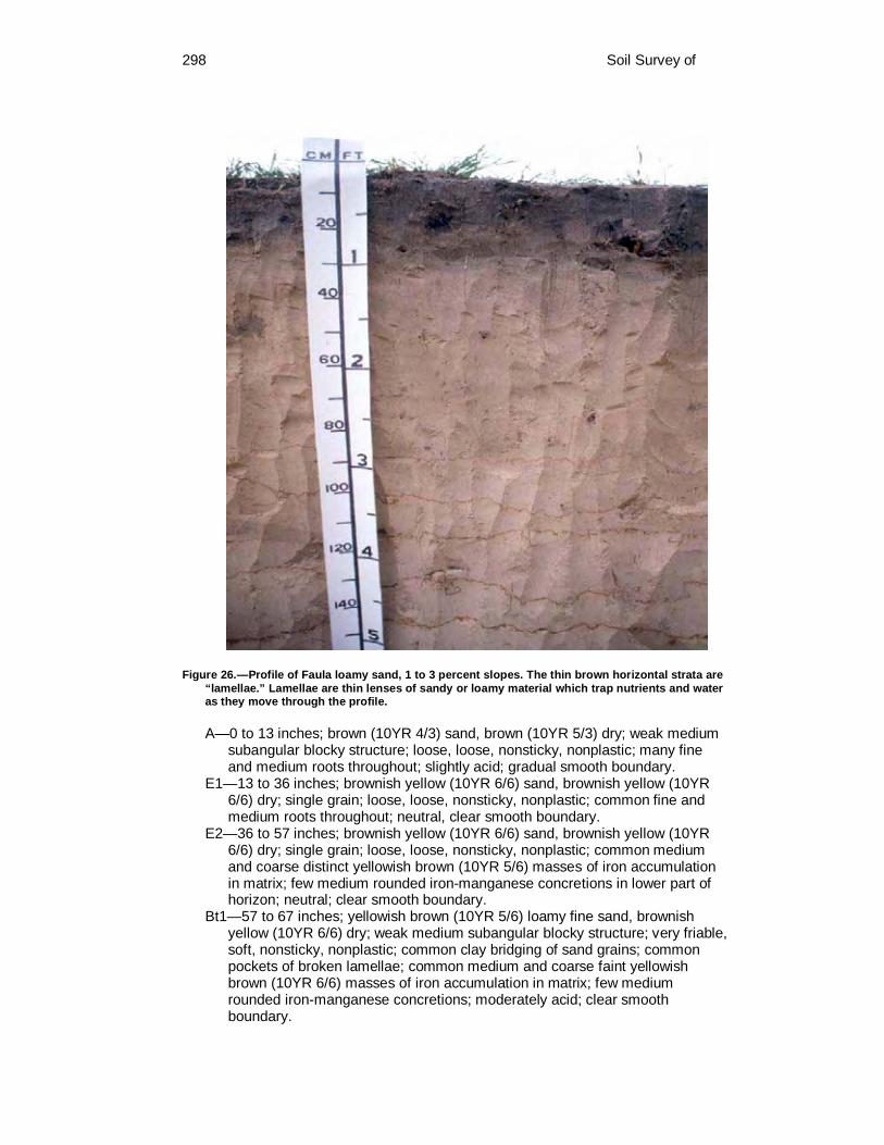
298 Soil Survey of
Figure 26.—Profile of Faula loamy sand, 1 to 3 percent slopes. The thin brown horizontal strata are “lamellae.” Lamellae are thin lenses of sandy or loamy material which trap nutrients and water as they move through the profile.
A—0 to 13 inches; brown (10YR 4/3) sand, brown (10YR 5/3) dry; weak medium subangular blocky structure; loose, loose, nonsticky, nonplastic; many fine and medium roots throughout; slightly acid; gradual smooth boundary.
E1—13 to 36 inches; brownish yellow (10YR 6/6) sand, brownish yellow (10YR 6/6) dry; single grain; loose, loose, nonsticky, nonplastic; common fine and medium roots throughout; neutral, clear smooth boundary.
E2—36 to 57 inches; brownish yellow (10YR 6/6) sand, brownish yellow (10YR 6/6) dry; single grain; loose, loose, nonsticky, nonplastic; common medium and coarse distinct yellowish brown (10YR 5/6) masses of iron accumulation in matrix; few medium rounded iron-manganese concretions in lower part of horizon; neutral; clear smooth boundary.
Bt1—57 to 67 inches; yellowish brown (10YR 5/6) loamy fine sand, brownish yellow (10YR 6/6) dry; weak medium subangular blocky structure; very friable, soft, nonsticky, nonplastic; common clay bridging of sand grains; common pockets of broken lamellae; common medium and coarse faint yellowish brown (10YR 6/6) masses of iron accumulation in matrix; few medium rounded iron-manganese concretions; moderately acid; clear smooth boundary.
Colorado County, Texas 299
Bt2—67 to 80 inches; brownish yellow (10YR 6/6) loamy fine sand, brownish yellow (10YR 6/6) dry; weak medium subangular blocky structure; very friable, nonsticky, nonplastic; common medium and coarse faint yellowish brown (10YR 6/6) masses of iron accumulation in matrix; slightly acid.
The solum thickness is more than 80 inches. The clay percentage of the control section ranges from 5 to 10 percent.
The A horizon has hue of 7.5YR or 10YR, value of 4 to 7, and chroma of 2 to 4. The clay content ranges from 1 to 3 percent. Reaction ranges from moderately acid to neutral.
The E horizon has hue of 7.5YR or 10YR, value of 5 to 8, and chroma of 2 to 6. Texture is sand or loamy sand. The clay content ranges from 1 to 3 percent. Reaction ranges from strongly acid to neutral.
The Bt horizon has hue of 7.5YR or 10YR, value of 5 to 8, and chroma of 2 to 8. Redoximorphic features in shades of red, brown, or gray range from none to common. Texture is loamy sand or loamy fine sand. The Bt horizons are continuous vertically and horizontally and have lamellae as very thin clay films or coatings on sand grains and bridges between sand grains. Reaction ranges from very strongly acid to slightly acid.
Fordtran Series The Fordtran series consists of very deep, moderately well drained, very slowly
permeable soils on uplands. They formed in loamy and clayey sediments of the Lissie Formation. Slopes are 0 to 1 percent. The soils are clayey, smectitic, hyperthermic Aquic Arenic Hapludalfs.
Typical pedon of Fordtran loamy sand, 0 to 1 percent slopes; in Eagle Lake, from the intersection of U.S. Highway 90 Alternate and Farm Road 3013, 5.5 miles northeast on Farm Road 3013, 1.0 mile south on County Road 299 past intersection with County Road 210, and 130 feet east in field; USGS Rexville topographic quadrangle; lat. 29 degrees 37 minutes 42.0 seconds N., and long. 96 degrees 14 minutes 58.0 seconds W.
A—0 to 14 inches; brown (10YR 4/3) loamy sand, pale brown (10YR 6/3) dry; weak medium subangular blocky structure; loose, very friable, nonsticky and nonplastic; many very fine and fine roots; many fine and medium pores; few fine faint brownish yellow masses of iron accumulation with diffuse boundaries; slightly acid; abrupt smooth boundary.
E1—14 to 20 inches; yellowish brown (10YR 5/4) loamy fine sand, light yellowish brown (10YR 6/4) dry; single grain; loose, loose, nonsticky and nonplastic; common very fine and fine roots; few fine and medium pores; common fine distinct dark yellowish brown (10YR 4/6) masses of iron accumulation with diffuse boundaries; neutral; clear smooth boundary.
E2—20 to 28 inches; yellowish brown (10YR 5/4) loamy fine sand, very pale brown (10YR 7/4) dry; single grain; loose, loose, nonsticky and nonplastic; few very fine and fine roots; few medium and coarse rounded weakly cemented concretions of iron-manganese; few fine faint yellowish brown (10YR 5/6) masses of iron accumulation with diffuse boundaries; neutral; clear wavy boundary.
Btg1—28 to 32 inches; gray (10YR 6/1) sandy clay, light gray (10YR 7/1) dry; moderate medium subangular blocky structure; very hard, very firm, sticky and very plastic; few fine roots; common distinct clay films on surfaces of peds; common fine to coarse rounded black weakly cemented concretions of iron-manganese; many fine to coarse distinct brownish yellow (10YR 5/6) and yellowish brown (10YR 6/8) masses of iron accumulation with diffuse boundaries; 2 percent pale brown (10YR 6/3) lenses of fine sand on surfaces

300 Soil Survey of
of peds; few fine and medium rounded ironstone pebbles; few fine rounded siliceous pebbles; neutral; clear wavy boundary.
Btg2—32 to 38 inches; gray (10YR 6/1) clay, light gray (10YR 7/1) dry; moderate medium subangular blocky structure; very hard, extremely firm, sticky and very plastic; few very fine and fine roots; common distinct clay films on surfaces of peds; common fine to coarse rounded black weakly cemented concretions of iron-manganese; many fine to coarse distinct yellowish brown (10YR 5/6) and brownish yellow (10YR 6/8) masses of iron accumulation with diffuse and sharp boundaries; 2 percent light yellowish brown (10YR 6/4) lenses of very fine sand on surfaces of peds; few fine rounded ironstone pebbles; neutral; clear wavy boundary.
Btg3—38 to 43 inches; light brownish gray (10YR 6/2) clay, light gray (10YR 7/2) dry; moderate medium subangular blocky structure; very hard, extremely firm, sticky and very plastic; few very fine roots; common distinct clay films on surfaces of peds; common fine to coarse rounded black weakly cemented concretions of iron-manganese; many fine to coarse distinct brownish yellow (10YR 6/8) and common fine and medium distinct yellowish brown (10YR 5/6) masses of iron accumulation with diffuse boundaries, few fine prominent yellowish red (5YR 4/6) and red (2.5YR 4/8) masses of accumulation with sharp boundaries; 2 percent light yellowish brown (10YR 6/4) lenses of very fine sand on surfaces of peds; few fine rounded ironstone pebbles; neutral; clear smooth boundary.
Btg4—43 to 48 inches; 55 percent light brownish gray (10YR 6/2) and 45 percent brownish yellow (10YR 6/8) sandy clay, light gray (10YR 7/2) and brownish yellow (10YR 6/8) dry; moderate medium subangular blocky structure; very hard, very firm, sticky and very plastic; few very fine roots; common distinct clay films on surfaces of peds; few fine to coarse rounded black weakly cemented concretions of iron-manganese; common fine to coarse distinct brownish yellow (10YR 6/8) and common fine and medium distinct yellowish brown (10YR 5/6), common fine and medium prominent yellowish red (5YR 5/8), few fine and medium prominent red (2.5YR 4/8) masses of iron accumulation with sharp boundaries; 1 percent light yellowish brown (10YR 6/4) lenses of very fine sand on surfaces of peds; neutral; clear smooth boundary.
Btg5—48 to 52 inches; 60 percent light brownish gray (10YR 6/2) and 40 percent pale brown (10YR 6/3) sandy clay, light gray (10YR 7/2) and very pale brown (10YR 7/3) dry; moderate medium subangular structure; very hard, very firm, sticky and very plastic; few very fine roots; common distinct clay films on surfaces of peds; few fine concretions of iron-manganese; many fine to coarse distinct brownish yellow (10YR 6/8) and common fine to coarse distinct yellowish brown (10YR 5/6) masses of iron accumulation with sharp and diffuse boundaries, common fine and medium prominent yellowish red (5YR 5/6) and few fine prominent red (2.5YR 4/6) masses of iron accumulation with sharp boundaries; few fine distinct grayish brown (10YR 5/2) iron depletions in root channels; 1 percent grayish brown (10YR 5/2) coatings on vertical surfaces of peds; slightly alkaline; gradual smooth boundary.
Btg6—52 to 65 inches; 70 percent light brownish gray (10YR 6/2) and 30 percent very pale brown (10YR 7/3) sandy clay loam, light gray (10YR 7/2) and very pale brown (10YR 8/3) dry; moderate medium subangular blocky structure; very hard, very firm, sticky and very plastic; few very fine roots; common distinct clay films on surfaces of peds; few fine crystals of barite; ; many fine coarse distinct yellowish brown (10YR 5/8) and brownish yellow (10YR 6/8), common fine to coarse distinct strong brown (7.5YR 5/8), few fine and medium prominent yellowish red (5YR 5/8) masses of iron accumulation with
Colorado County, Texas 301
sharp and diffuse boundaries; few distinct grayish brown (10YR 5/2) iron depletions in root channels; 1 percent grayish brown (10YR 5/2) coatings on vertical surfaces of peds slightly alkaline; gradual smooth boundary.
Btg7—65 to 71 inches; 60 percent light brownish gray (10YR 6/2) and 40 percent very pale brown (10YR 7/3) sandy clay loam, light gray (10YR 7/2) and very pale brown (10YR 8/3) dry; moderate medium subangular blocky structure; hard, firm, sticky and plastic; few very fine roots; common distinct clay films on surfaces of peds; few fine crystals of barite; many fine to coarse distinct brownish yellow (10YR 6/8), common fine to coarse distinct yellowish brown (10YR 5/8) and strong brown (7.5YR 5/8), common fine and medium yellowish red (5YR 5/8) masses of iron accumulation with sharp and diffuse boundaries; few fine distinct grayish brown (10YR 5/2) iron depletions in root channels; slightly alkaline; clear smooth boundary.
BCt—71 to 80 inches; light brownish gray (10YR 6/2) sandy clay loam, light gray (10YR 7/2) dry; moderate medium subangular blocky structure; hard, firm, sticky and plastic; few faint clay films on surfaces of peds; many fine to coarse distinct brownish yellow (10YR 6/6) and yellowish brown (10YR 5/6) masses of iron accumulation with diffuse boundaries; common fine to coarse distinct dark brown (7.5YR 4/4), common fine to coarse prominent yellowish red (5YR 5/6) and reddish brown (5YR 5/4) masses of accumulation with sharp boundaries; 2 percent yellowish brown (10YR 5/4) lenses of sand on surfaces of peds; slightly alkaline.
The solum thickness ranges from 60 to more than 80 inches. The combined thickness of the A and E horizons range from 22 to 34 inches.
Base saturation is 75 percent or more in some part of the argillic horizon. Black and brown concretions range from none to few throughout. Siliceous pebbles range from none to 5 percent by volume.
The A horizon has hue of 10YR, value of 3 or 4 chroma of 3 or 4. Reaction ranges from very strongly acid to slightly acid.
The E horizon has hue of 7.5YR or 10YR, value of 4 to 6, and chroma of 3 or 4. Texture is loamy fine sand. Reaction is moderately acid or slightly acid.
The Bt horizon has hue of 7.5YR or 10YR, value of 5 to 7, and chroma of 1 to 3. Redoximorphic features in shades of red, yellow, brown, or gray range from few to many. Texture is sandy clay in the upper 20 inches of the Bt horizon with clay content ranging from 35 to 45 percent. The upper part of the Bt horizon ranges from extremely acid to neutral. Texture of the lower Bt horizons is sandy clay loam. Reaction ranges from strongly acid to moderately alkaline.
The BCt horizon, where present, is in shades of gray, yellow, or brown with redoximorphic features in shades of red, yellow, and brown or it has a mottled matrix with these colors. Texture is sandy clay loam or clay loam. Reaction ranges from very strongly acid to moderately alkaline. Some pedons have concretions and masses of calcium carbonate with or without gypsum crystals.
Frelsburg Series The Frelsburg series consists of very deep, moderately well drained, very slowly
permeable soils on uplands. They formed in alkaline clayey sediments of the Fleming Formation. Slopes range from 1 to 5 percent. The soils are fine, smectitic, thermic Udic Calciusterts.
Typical pedon of Frelsburg clay, 1 to 3 percent slopes; in Weimar, from the intersection of U.S. Highway 90 and Farm Road 155, 2.6 miles south on Farm Road 155, and 200 feet south in pasture; USGS Weimar topographic quadrangle; lat. 29 degrees, 39 minutes, 55.0 seconds N. and long. 96 degrees, 46 minutes, 19.5 seconds W.
302 Soil Survey of
Ap—0 to 8 inches; black (10YR 2/1) clay, very dark gray (10YR 3/1) dry; moderate medium prismatic structure parting to moderate medium angular blocky; very hard, very firm, very sticky and very plastic; common fine and medium roots; few fine and medium pores; many fine pockets of dark grayish brown (10YR 4/2) material; few very fine concretions of calcium carbonate; slightly effervescent; slightly alkaline; clear wavy boundary.
Bss1—8 to 21 inches; dark gray (10YR 4/1) clay, gray (10YR 5/1) dry; moderate medium prismatic structure parting to moderate medium angular blocky; very hard, very firm, very sticky and very plastic; common fine and medium roots; common slickensides; common distinct pressure surfaces; common vertical cracks partly filled with common very dark gray (10YR 3/1) material from above; common filled krotovinas with very dark gray (10YR 3/1); 2 percent very fine concretion, threads and masses of calcium carbonate; 2 percent very fine fragments of snail shells; 3 percent very fine siliceous pebbles; slightly effervescent; slightly alkaline; gradual wavy boundary.
Bss2—21 to 30 inches; dark gray (10YR 4/1) clay, gray (10YR 5/1) dry; strong medium prismatic structure parting to moderate medium angular blocky; very hard, very firm, very sticky and very plastic; few fine and medium roots; many slickensides; many prominent pressure surfaces; many vertical cracks partly filled with common very dark gray (10YR 3/1) material from above; 2 percent very fine concretions and masses of calcium carbonate; 3 percent very fine fragments of snail shells; strongly effervescent; slightly alkaline; gradual wavy boundary.
Bss3—30 to 42 inches; dark gray (10YR 4/1) clay, grayish brown (10YR 5/2) dry; strong medium prismatic structure parting to strong medium angular blocky; very hard, very firm, very sticky and very plastic; few fine and medium roots; many slickensides; many prominent pressure surfaces; common vertical cracks partly filled with common medium pockets and streaks of light olive brown (2.5Y 5/6) material; 2 percent fine concretions and masses of calcium carbonate; strongly effervescent; slightly alkaline; gradual wavy boundary.
Bkss1—42 to 62 inches; 55 percent grayish brown (2.5Y 5/2) and 45 percent light olive brown (2.5Y 5/4) clay, and 55 percent grayish brown (2.5Y 5/2), 45 percent light olive brown (2.5Y 5/4) and dry; moderate medium prismatic structure parting to moderate medium angular blocky; very hard, very firm, very sticky and very plastic; many slickensides; many distinct pressure surfaces; pressure surfaces have coatings of grayish brown (2.5Y 5/2); few fine nodules of iron-manganese; 5 percent fine and medium concretions of calcium carbonate; violently effervescent; moderately alkaline; clear wavy boundary.
Bkss2—62 to 80 inches; 40 percent grayish brown (2.5Y 5/2) and 35 percent light olive brown (2.5Y 5/4) and 25 percent brownish yellow (10YR 6/6) clay, grayish brown (2.5Y 5/2) and light olive brown (2.5Y 5/4) and brownish yellow (10YR 6/6) dry; moderate medium prismatic structure parting to moderate medium angular blocky; very hard, very firm, very sticky and very plastic; few slickensides; common distinct pressure surfaces; few fine streaks of very dark grayish brown (10YR 3/1) material; 2 percent fine nodules of iron-manganese; 7 percent fine and medium concretions of calcium carbonate; violently effervescent; moderately alkaline.
The solum thickness is more than 80 inches. The range includes 50 percent or more of the pedon. Colors are not included for the chimneys, or high value materials that extend to the surface of some microhighs, and the center of some microlows that are thicker or darker. These conditions makeup 5 to 25 percent of most pedons. The weighted average clay content of the particle-size control section ranges from 40 to 50 percent. This is a cyclic soil and in undisturbed areas cycles of microhighs and
Colorado County, Texas 303
microlows are repeated at 5- to 15-foot intervals and microhighs are 4 to 12 inches higher than microlows. The external microrelief is typically a tiger stripe pattern on areas with a slope gradient that exceeds 3 percent. Large slickensides begin at a depth of 12 to 24 inches below the surface and extend throughout the solum. When dry, the soil has cracks up to 3 inches wide at the surface and 0.5- to 2-inch wide cracks extend to a depth greater than 20 inches. The cracks remain open for a period of 90 to 150 cumulative days in most years. Iron-manganese concretions range from none to few. Effervescence ranges from very slight to strong. The reaction is slightly alkaline or moderately alkaline.
The A horizon has hue of 10YR, value of 2 to 4, and chroma of 1. If the color value is 2 or 3 the horizon is less than 12 inches thick. Texture is clay.
Where present, the Bw horizon has hue of 10YR, value of 4, and chroma of 1. Redox concentrations in shades of yellow or brown range from none to few. Pressure surfaces range from few to common. This horizon is typically absent in part of the pedon.
The Bss and Bkss horizons have hue of 10YR or 2.5Y, value of 4 to 7, and chroma of 1 or 2. Redoximorphic features in shades of yellow, brown, or gray range from none in some subhorizons to many. Masses, films, threads, and concretions of calcium carbonate range from very few to common.
Where present, the BCss or BCkss horizons have hue of 10YR to 5Y, value of 5 to 7, and chroma of 2 to 6. Redoximorphic features in shades of yellow, brown, or gray range from few to many. Fragments of shale, mudstone, or siltstone range from none to common. Discontinuous bedding planes range from none to few. Masses and concretions of calcium carbonate range from few to common.
Gad Series The Gad series consists of very deep, somewhat excessively drained, moderately
rapid to rapidly permeable soils on flood plains. They formed in sandy alluvium of the Colorado River. Slopes are 0 to 1 percent. The soils are sandy, mixed, thermic Udic Ustifluvents.
Typical pedon of Gad fine sandy loam, 0 to 1 percent slopes, frequently flooded; in Columbus, from the intersection of Texas Highway 71 and U.S. Highway 90, 1.3 miles west on U.S. Highway 90, 100 feet north on county road across railroad tracks to gate on east side, 0.3 mile east on ranch road through trees, 0.6 mile north on ranch road past gravel mine, 0.3 mile east on ranch road and 50 feet north under pecan trees in bermudagrass pasture; USGS Columbus topographic quadrangle; lat. 29 degrees 42 minutes 58.0 seconds N., and long. 96 degrees 33.0 minutes 52 seconds W.
A—0 to 19 inches; brown (10YR 4/3) fine sandy loam, yellowish brown (10YR 5/4) dry; weak fine subangular blocky structure; soft, very friable, nonsticky and nonplastic; common very fine and fine roots; common very fine and fine pores; few fine to coarse fragments of snail shells; strongly effervescent; moderately alkaline; clear smooth boundary.
C1—19 to 26 inches; yellowish brown (10YR 5/4) loamy fine sand, light yellowish brown (10YR 6/4) dry; single grain; loose, very friable, nonsticky and nonplastic; few fine fragments of snail shells; slightly effervescent; slightly alkaline; clear smooth boundary.
C2—26 to 47 inches; pale brown (10YR 6/3) fine sand, very pale brown (10YR 7/4) dry; single grain; loose, very friable, nonsticky and nonplastic; few fine fragments fragments of snail shells; slightly effervescent; moderately alkaline; abrupt smooth boundary.
C3—47 to 56 inches; brown (10YR 5/3) loamy fine sand, light yellowish brown (10YR 6/4) dry; single grain; loose, very friable, nonsticky and nonplastic; strongly effervescent; moderately alkaline; clear smooth boundary.

304 Soil Survey of
C4—56 to 67 inches; brown (10YR 5/3) loamy fine sand, light yellowish brown (10YR 6/4) dry; single grain; loose, very friable, nonsticky and nonplastic; 5 percent dark brown (10YR 4/3) coarse masses of silt loam material; slightly effervescent; moderately alkaline; abrupt smooth boundary.
C5—67 to 80 inches; brown (10YR 4/3) very fine sandy loam, light yellowish brown (10YR 6/4) dry; weak fine subangular structure; soft, very friable, slightly sticky and slightly plastic; 2 percent fine threads and masses of calcium carbonate; strongly effervescent; moderately alkaline.
These soils are slightly alkaline or moderately alkaline and calcareous throughout the 10 to 40 inch control section. In some pedons, the upper 10 inches is noncalcareous and slightly alkaline.
The Ap or A horizon has hue of 10YR, value of 4 to 6, and chroma of 3 or 4. Where the moist color value and chroma are less than 3.5, the thickness is less than 10 inches, or the organic matter content is less than 1 percent. Texture varies, but ranges from loamy fine sand to very fine sandy loam.
The C horizon has hue of 10YR, value of 6 or 7, and chroma of 3 to 6. Texture is loamy fine sand or fine sand and is stratified with thin strata of fine sandy loam to clay loam. The thin strata are less than 1 inch thick, are darker in color, and contain more organic matter than the matrix.
Ganado Series The Ganado series consists of very deep, moderately well drained, very slowly
permeable soils on flood plains. They formed in clayey alluvium of major streams. Slopes are 0 to 1 percent. The soils are fine, smectitic, hyperthermic Typic Hapluderts.
Typical pedon of Ganado clay, 0 to 1 percent slopes, occasionally flooded; in Columbus, from the intersection of Texas Highway 71 and Texas Highway 90, 1.7 miles west on Texas Highway 90, 4.5 miles south and west on Farm Road 2434, and about 300 feet north in pasture; USGS Borden topographic quadrangle; lat. 29 degrees, 40 minutes, 10 seconds N and long. 96 degrees, 38 minutes, 29 seconds W.
A—0 to 15 inches; black (10YR 2/1) clay, very dark gray (10YR 3/1) dry; moderate medium angular blocky structure; extremely hard, very firm, very sticky and very plastic; many very fine and fine roots; common distinct pressure surfaces; very slightly effervescent; moderately alkaline; gradual smooth boundary.
Bss1—15 to 35 inches; black (10YR 2/1) clay, very dark gray (10YR 3/1) dry; moderate medium angular blocky structure; extremely hard, very firm, very sticky and very plastic; common very fine and fine roots; common slickensides; common prominent pressure surfaces; few vertical cracks partly filled with material from above; very slightly effervescent; moderately alkaline; gradual smooth boundary.
Bss2—35 to 65 inches; black (10YR 2/1) clay, very dark gray (10YR 3/1) dry; moderate medium angular blocky structure; extremely hard, very firm, very sticky and very plastic; common very fine and fine roots; common slickensides; common prominent pressure surfaces; few vertical cracks partly filled with material from above; very slightly effervescent; moderately alkaline; gradual smooth boundary.
2Bkss—65 to 80 inches; black (10YR 2/1) clay loam, very dark gray (10YR 3/1) dry; moderate medium angular blocky structure; extremely hard, very firm, very sticky and very plastic; common very fine and fine roots; common slickensides; common prominent pressure surfaces; few vertical cracks partly

Colorado County, Texas 305
filled with material from above; 2 percent fine and medium rounded carbonate concretions; slightly effervescent; moderately alkaline.
The solum thickness is more than 70 inches. Depth to the C horizon or horizons with a loamy texture is 39 to more than 60 inches. The 10- to 40-inch control section contains 33 to 53 percent clay. Some pedons have a few loamy strata below 60 inches. In undisturbed areas, gilgai microrelief consists of microhighs 5 to 10 inches higher than the microlows, with distance between the center of microhigh and center of microlow being 5 to 20 feet. When dry, cracks 1 to 2 inches wide extend from the surface to a depth of 40 inches or more, but remain open less than 90 cumulative days each year in most years. Intersecting slickensides begin at depths of 7 to 15 inches. Most pedons are calcareous at depths below 24 inches, and many are calcareous throughout. Concretions and masses of calcium carbonate range from few to common below a depth of 39 inches in most pedons.
The A horizon has hue of 10YR, value of 2 or 3, and chroma of 1 or less. Reaction is neutral to moderately alkaline.
The Bss horizon has hue of 10YR or 2.5Y, value of 2 or 3, and chroma of 2 or less. Some pedons have redoximorphic features in shades of red, yellow, or brown that range from none to few. Reaction is neutral to moderately alkaline.
The 2Bkss horizon has hue of 10YR or 2.5Y, value of 2 to 4, and chroma of 2 or less. Calcium carbonate in the form of concretions, threads, and masses range from few to common. Reaction is slightly alkaline or moderately alkaline.
Where present, the 2Bk or 2Bw horizon has hue of 10YR, value of 3 or 4, and chroma of 1 or 2. Redoximorphic features in shades of red, yellow, brown, or gray range from none to common. Texture ranges from silty clay loam to sandy clay. Reaction is moderately alkaline.
Some pedons have a 2BCk horizon that has hue of 10YR, value of 4 to 6, and chroma of 1 to 4. Redoximorphic features in shades of red, yellow, brown, or gray range from none to common. Texture is sandy clay loam. Reaction is moderately alkaline.
The C horizon occurs at depths of less than 80 inches in some pedons and have hue of 10YR or 2.5Y, value of 5 or 6, and chroma of 2 to 4. Some pedons have redoximorphic features in shades of red, yellow, or brown that range from none to few. Texture is sandy clay loam, silty clay loam, clay loam, or sandy clay. Reaction is moderately alkaline.
Garwood Series The Garwood series (fig. 27) consists of very deep, moderately well drained, very
slowly permeable soils on uplands. They formed in loamy sediments of the Lissie Formation. Slopes are 0 to 1 percent. The soils are fine, kaolinitic, hyperthermic Albaquic Hapludalfs.
Typical pedon of Garwood fine sandy loam, 0 to 1 percent slopes; in Columbus, from the junction of Interstate Highway 10 and Texas Highway 71, 9.8 miles south on Texas Highway 71 to Altair, from the intersection of U.S. Highway 90 Alternate and Texas Highway 71, 5.6 miles west on U.S. Highway 90 Alternate, 0.5 miles south on county road, 0.6 mile east on county road, 1.15 miles south on county road, 0.15 mile east and 700 feet south-southeast in pasture; USGS Rock Island topographic quadrangle; lat. 29 degrees 30 minutes 55.0 seconds N., and long. 96 degrees 32 minutes 38.0 seconds W.
Ap—0 to 7 inches; dark grayish brown (10YR 4/2) fine sandy loam, light brownish gray (10YR 6/2) dry; weak coarse prismatic structure parting to weak fine and medium subangular blocky; hard, very friable, nonsticky and nonplastic; many fine roots; many very fine and fine tubular pores, few medium tubular pores; few very fine and fine wormcasts and worms; 1 percent brown 10YR 5/4)

306 Soil Survey of
Figure 27.—Profile of Garwood fine sandy loam, 0 to 1 percent slopes. The contact of the fine sandy loam surface layer and the clayey subsoil is about 23 inches.
uncoated sand grains on ped interiors; common fine distinct yellowish brown (10YR 5/8) rhizospheres; 1 percent fine siliceous pebbles; strongly acid; gradual smooth boundary.
A—7 to 13 inches; dark grayish brown (10YR 4/2) fine sandy loam, grayish brown (10YR 5/2) dry; weak coarse prismatic structure parting to weak fine and medium subangular blocky; hard, very friable, nonsticky and nonplastic; many fine roots; many very fine and fine tubular pores, few medium tubular pores; few wormcasts; common dark yellowish brown (10YR 4/6) masses of iron accumulation with diffuse boundaries; few fine distinct strong brown (7.5YR 5/8) rhizospheres; 2 percent fine and medium siliceous pebbles; strongly acid; clear wavy boundary.
E1—13 to 19 inches; yellowish brown (10YR 5/4) fine sandy loam, pale brown (10YR 6/3) dry; weak coarse subangular blocky structure parting to weak fine and medium subangular blocky; hard, very friable, nonsticky and nonplastic;

Colorado County, Texas 307
many fine roots; many very fine and fine tubular pores, many medium tubular pores; few wormcasts; many coarse faint strong brown (7.5YR 5/8) masses of iron accumulation with sharp boundaries, common strong brown (7.5YR 5/6) masses of iron accumulation with diffuse boundaries; few strong brown (7.5YR 5/8) rhizospheres; 2 percent fine and medium siliceous pebbles; strongly acid; clear wavy boundary.
E2—19 to 23 inches; yellowish brown (10YR 5/4) fine sandy loam, pale brown (10YR 6/3) dry; weak coarse prismatic structure parting to weak fine and medium subangular blocky; hard, very friable, nonsticky and nonplastic; many fine roots; many very fine and fine tubular pores, few medium tubular pores; few wormcasts; common coarse distinct brownish yellow (10YR 6/8) masses of iron accumulation with sharp boundaries, common fine and medium distinct strong brown (7.5YR 5/6) masses of iron accumulation with diffuse boundaries; many fine distinct strong brown (7.5YR 5/8) rhizospheres; 2 percent fine to coarse siliceous pebbles at the contact of E2 and Bt horizons; strongly acid; abrupt smooth boundary.
Bt1—23 to 31 inches; grayish brown (10YR 5/2) clay, grayish brown (10YR 5/2) dry; moderate coarse prismatic structure parting to strong medium and coarse subangular blocky; very hard, very firm, very sticky and very plastic; many fine roots; common fine tubular pores, few medium tubular pores; many prominent dark gray (10YR 4/1) clay films on surfaces of prisms; many medium distinct strong brown (7.5YR 5/8) masses of iron accumulation with sharp boundaries, many medium prominent red (2.5YR 4/6) masses of iron accumulation with sharp boundaries, few medium and coarse distinct yellowish brown (10YR 6/8) masses of iron accumulation with sharp boundaries; strongly acid; clear wavy boundary.
Bt2—31 to 38 inches; yellowish brown (10YR 5/8) clay, yellowish brown (10YR 5/8) dry; moderate coarse prismatic structure parting to moderate fine and medium subangular blocky; very hard, very firm, very sticky and very plastic; common fine roots; common fine tubular pores; many prominent dark gray (10YR 4/1) clay films on surfaces of prisms; common medium prominent red (2.5YR 4/6) masses of iron accumulation with sharp boundaries; common medium and coarse distinct gray (10YR 5/1) iron depletions with sharp boundaries; few fine and medium faint dark gray (10YR 4/1) clay depletions with diffuse boundaries on surfaces of peds; very strongly acid; clear wavy boundary.
Bt3—38 to 53 inches; gray (10YR 6/1) clay, light gray (10YR 7/1) dry; moderate coarse prismatic structure parting to moderate medium subangular blocky; very hard, very firm, very sticky and very plastic; common fine roots; few fine tubular pores; common distinct clay films on surfaces of prisms; 1 percent pale brown (10YR 6/3) albic material on surfaces of prisms; many coarse distinct yellowish brown (10YR 5/6) masses of iron accumulation with sharp boundaries, few fine and medium prominent red (2.5YR 4/6) masses of iron accumulation with sharp boundaries; few fine faint light gray iron depletions with diffuse boundaries; common fine dark gray (10YR 4/1) clay depletions on surfaces of prisms 1 millimeter thick; moderately acid; gradual smooth boundary.
Bt4—53 to 62 inches; 55 percent yellowish brown (10YR 5/8) and 45 percent gray (10YR 6/1) sandy clay loam, brownish yellow (10YR 6/6) and light gray (10YR 7/1) dry; moderate coarse prismatic structure parting to moderate medium subangular blocky; hard, firm, sticky and very plastic; few fine roots; few fine tubular pores; common distinct clay films on surfaces of prisms; 4 percent fine and medium nodules of iron-manganese; common organic stains dark gray (10YR 4/1) on surfaces of prisms 1 millimeter thick; 1 percent yellowish brown

308 Soil Survey of
(10YR 5/4) albic material on surfaces of prisms; common fine and medium prominent red (2.5YR 4/6) masses of iron accumulation with sharp boundaries; moderately acid; gradual smooth boundary.
Bt5—62 to 80 inches; light gray (10YR 7/2) sandy clay loam, white (10YR 8/1) dry; moderate coarse prismatic structure parting to moderate coarse angular blocky; hard, firm, sticky and very plastic; few fine roots; few fine tubular pores; common distinct clay films on surfaces of prisms; 2 percent fine nodules of iron-manganese; 2 percent brownish yellow (10YR 6/6) albic materials on surfaces of prisms; many coarse distinct yellowish brown (10YR 5/8) masses of iron accumulation with sharp boundaries; common fine faint light brownish gray (10YR 6/2) iron depletions with diffuse boundaries; slightly acid.
The solum thickness is more than 80 inches. The control section average for the upper 20 inches of the Bt horizon ranges from 36 to 55 percent clay. COLE values range from 0.08 to 0.11. Concretions of iron-manganese range none to common throughout most pedons. The combined thickness of the A and E horizons is 20 to 30 inches.
The A and Ap horizon has hue of 10YR, value of 4, and chroma of 2 or 3. Reaction ranges from strongly acid to neutral.
The E horizon has hue of 10YR, value of 5 to 7, and chroma of 2 to 4. Redoximorphic features in shades of yellow or brown with irregular boundaries range from few to many and are in most pedons. Texture is fine sandy loam. Reaction ranges from very strongly acid to neutral.
The Bt1 horizon has hue of 10YR, value of 4 to 7, and chroma of 1 to 6. Redoximorphic features in shades of red, yellow, or brown with sharp boundaries range from few to many and are present throughout the horizon. Texture is sandy clay loam, sandy clay, and clay with clay content ranging from 38 to 60 percent. Reaction ranges very strongly acid to neutral.
The lower Bt horizon has hue of 7.5YR or 10YR, value of 4 to 7, and chroma of 1 to 8. Redoximorphic features in shades of red, yellow, brown or gray with sharp boundaries range from few to many and are present in most pedons. About 1 to 3 percent by volume uncoated sand coatings are present on surfaces of peds in most pedons. Textures are sandy clay loam, sandy clay, and clay loam. Reaction ranges from very strongly acid to neutral, but in some pedons the reaction is slightly alkaline below a depth of 50 inches.
Gholson Series The Gholson series consists of very deep, well drained, moderately permeable
soils on terraces. They formed in loamy alluvial materials. Slopes range from 1 to 8 percent. The soils are fine-loamy, siliceous, active, thermic Udic Haplustalfs.
Typical pedon of Gholson fine sandy loam, 1 to 3 percent slopes; in Columbus, from the intersection of U.S. Highway 90 and Texas Highway 71, 2.6 miles south on Texas Highway 71 to gate on east side of road, 0.2 mile east on ranch road and 15 feet north in pasture; USGS Columbus topographic quadrangle; lat. 29 degrees 40 minutes 30.0 seconds N., and long. 96 degrees 31 minutes 46.5 seconds W.
A—0 to 10 inches; dark yellowish brown (10YR 4/4) fine sandy loam, yellowish brown (10YR 5/4) dry; moderate medium subangular blocky structure parting to weak fine granular; slightly hard, very friable, nonsticky and nonplastic; many fine to coarse roots; slightly acid; abrupt smooth boundary.
Bt1—10 to 19 inches; red (2.5YR 4/6) sandy clay loam, red (2.5YR 5/6) dry; moderate medium angular blocky structure; hard, firm, sticky and plastic; common fine and medium roots; many dark yellowish brown (10YR 3/4) distinct clay films on vertical and horizontal surfaces of peds; many fine and
Colorado County, Texas 309
medium faint dark red (2.5YR 3/6) masses of iron accumulation with sharp boundaries; few fine siliceous pebbles; very strongly acid; abrupt wavy boundary.
Bt2—19 to 26 inches; red (2.5YR 4/8) sandy clay loam, red (2.5YR 5/8) dry; moderate fine and medium subangular blocky structure; hard, firm, sticky and plastic; common fine and medium roots; few dark yellowish brown (10YR 3/4) distinct clay films on vertical surfaces of peds; common medium distinct strong brown (7.5YR 5/6) and light yellowish brown (10YR 6/4) masses of iron accumulation with sharp boundaries; common old root channels stained with dark yellowish brown (10YR 3/4); moderately acid; clear smooth boundary.
Bt3—26 to 36 inches; red (2.5YR 4/8) sandy clay loam, red (2.5YR 5/8) dry; weak fine subangular blocky structure; hard, firm, slightly sticky and slightly plastic; few fine roots; few distinct dark yellowish brown (10YR 3/4) clay films on surfaces of peds; few fine and medium very dark grayish brown (10YR 3/2) and dark yellowish brown (10YR 3/4) stains in old root channels; few fine siliceous pebbles; slightly acid; gradual smooth boundary.
Bt4—36 to 44 inches; red (2.5YR 4/6) sandy clay loam, red (2.5YR 5/6) dry; weak fine and medium subangular blocky structure; slightly hard, friable, slightly sticky and slightly plastic; few fine roots; common faint and distinct dark yellowish brown (10YR 3/4) clay films on surfaces of peds; neutral; gradual smooth boundary.
Bt5—44 to 55 inches; strong brown (7.5YR 5/6) loam, reddish yellow (7.5YR 6/6) dry; weak fine subangular blocky structure; slightly hard, friable, slightly sticky and slightly plastic; few fine roots; many few faint clay films on surfaces of peds; very fine and fine pyrite flakes; neutral; clear smooth boundary.
BC1—55 to 62 inches; strong brown (7.5YR 5/6) loamy fine sand, reddish yellow (7.5YR 6/6) dry; single grain; loose, loose, nonsticky and nonplastic; common loamy bodies of strong brown (7.5YR 5/6) and yellowish red (5YR 5/8); few fine calcium carbonate concretions; few fine siliceous pebbles; neutral; clear smooth boundary.
BC2—62 to 80 inches; strong brown (7.5YR 5/6) loamy fine sand, reddish yellow (7.5YR 6/6) dry; single grain; loose, loose, nonsticky and nonplastic; few loamy bodies of strong brown (7.5YR 5/6) and yellowish red (5YR 5/8); few fine calcium carbonate concretions; few fine siliceous pebbles; neutral.
The solum thickness ranges from 60 to more than 80 inches. Small siliceous pebbles range from none to about 10 percent by volume. Clay content of the control section ranges from 20 to 30 percent. Clay films range from few to common throughout the argillic horizon.
The A horizon has hue of 5YR to 10YR, value of 4 to 6, and chroma of 2 to 6. Some pedons contain an E horizon that is about 1 or 2 units of value higher than the A horizon. Texture of the A and E horizons is loamy fine sand, fine sandy loam, or very fine sandy loam. Reaction ranges from moderately acid to neutral.
The Bt horizon has hue of 2.5YR or 5YR, value of 4 to 6, and chroma of 4 to 8. Texture is sandy clay loam, clay loam, or loam. Reaction ranges from slightly acid to slightly alkaline.
Some pedons contain a BCt horizon that has hue of 5YR or 7.5YR, value of 4 to 6, and chroma of 4 to 8. Texture is loamy fine sand, loam, or fine sandy loam. Reaction ranges from neutral to slightly alkaline. The layer is calcareous with none to few visible carbonates in the form of streaks and films.
The BCk or BC horizons have hue of 5YR or 7.5YR, value of 4 to 6, and chroma of 4 to 8. Texture is loamy fine sand, loam, or fine sandy loam. Reaction ranges from neutral to moderately alkaline. Carbonates in the form of films, threads, masses, and concretions range from none to common.
310 Soil Survey of
Where present, the C horizon has hue of 5YR or 7.5YR, value of 4 to 6, and chroma of 4 to 8. Texture is sandy clay loam, very fine sandy loam, fine sandy loam, loamy fine sand, or loamy very fine sand. Some pedons contain thin layers and seams of fine gravel and thin bedding planes below 70 inches.
Hallettsville Series The Hallettsville series (fig. 28) consists of very deep, moderately well drained,
slowly permeable soils on uplands. They formed in alkaline loamy and clayey sediments of the Fleming Formation. Slopes range from 1 to 3 percent. The soils are fine, smectitic, thermic, Udertic Paleustolls.
Typical pedon of Hallettsville sandy clay loam, 1 to 3 percent slopes; in Columbus, from the intersection of U.S. Highway 90 and Texas Highway 71, 12.5 miles west on U.S. Highway 90, 1.2 miles north on county road, 0.6 mile east on county road and about 1,400 feet south of county road in pasture.; USGS Borden topographic quadrangle; lat. 29 degrees 43 minutes 52.5 seconds N. and long. 96 degrees 44 minutes 44.0 seconds W.
A—0 to 6 inches; very dark gray (10YR 3/1) sandy clay loam, very dark gray (10YR 3/1) moist; moderate coarse prismatic structure parting to strong coarse angular blocky parting to moderate fine and medium subangular blocky; hard, firm, sticky and plastic; many very fine and fine roots; common fine and few medium pores; few wormcasts; 1 percent fine nodules of calcium carbonate; few fine distinct yellowish brown masses of iron accumulations with sharp boundaries; 1 percent fine siliceous pebbles; moderately acid; clear smooth boundary.
Bt1—6 to 11 inches; very dark brown (10YR 2/2) clay loam, very dark gray (10YR 3/1),dry; moderate coarse prismatic structure parting to strong fine and medium angular blocky; very hard, very firm, very sticky and very plastic; common fine roots; common fine pores; common prominent pressure surfaces; common distinct very dark grayish brown (2.5Y 3/2) clay films on surfaces of prisms; 1 percent fine masses of iron-manganese with sharp boundaries; common very dark gray (10YR 3/1) material on surfaces of prisms; common fine and distinct dark yellowish brown (10YR 3/6) masses of iron accumulations with diffuse boundaries, few fine prominent yellowish red masses of iron accumulations with sharp boundaries; 1 percent very fine siliceous pebbles; moderately acid; clear wavy boundary.
Bt2—11 to 21 inches; very dark grayish brown (10YR 3/2) clay loam, very dark grayish brown (2.5Y 3/2) dry; moderate coarse prismatic structure parting to strong medium angular blocky; very hard, very firm, very sticky and very plastic; many fine roots; few fine pores; few prominent slickensides with grooves; many distinct pressure surfaces; common distinct clay films on surfaces of peds; 1 percent medium masses of iron-manganese with diffuse boundaries; 1 percent fine nodules of iron-manganese with sharp boundaries; few fine distinct strong brown (7.5YR 5/8) masses of iron accumulations with sharp boundaries; 1 percent masses of calcium carbonate; few medium very dark grayish brown (10YR 3/2) and common fine and medium black (10YR 2/1) organic stains with sharp boundaries; few fine siliceous pebbles; slightly alkaline; gradual smooth boundary.
Btkss1—21 to 34 inches; dark grayish brown (2.5Y 4/2) clay loam, olive brown (2.5Y 4/4) dry; moderate coarse prismatic structure parting to strong coarse angular blocky; very hard, very firm, very sticky and very plastic; many fine roots; few fine pores; common prominent slickensides; many distinct pressure surfaces; few faint very dark gray (10YR 3/2) clay films; few fine distinct strong brown (7.5YR 5/8) masses of iron accumulations with sharp boundaries; 3 percent concretions of calcium carbonate; common very dark gray (10YR 3/1)

Colorado County, Texas 311
Figure 28.—Profile of Hallettsville sandy clay loam, 1 to 3 percent slopes. The lighter colored calcic horizon is at a depth of 48 inches.
with diffuse boundaries and common very dark grayish brown (10YR 3/2) organic stains with sharp boundaries; moderately alkaline; gradual smooth boundary.
Btkss2—34 to 49 inches; dark yellowish brown (10YR 4/6) clay loam, yellowish brown (10YR 5/6) dry; moderate coarse prismatic structure parting to strong medium and coarse angular blocky; very hard, very firm, very sticky and very plastic; few fine roots; common fine and medium pores; common prominent slickensides; common large pressure surfaces; common distinct clay films on surfaces of prisms; 4 percent fine concretions of iron-manganese; few fine distinct strong brown masses of iron accumulations with sharp boundaries; 7 percent calcium carbonate; common coarse dark grayish brown (2.5Y 4/2) organic stains with diffuse boundaries; few medium very dark gray (10YR 3/1) organic stains with sharp boundaries; moderately alkaline; gradual smooth boundary.

312 Soil Survey of
Bkss—49 to 60 inches; dark grayish brown (2.5Y 4/2) clay loam, olive brown (2.5Y 4/4) dry; weak very coarse prismatic structure parting to strong medium angular blocky; very hard, very firm, very sticky and very plastic; few fine roots; common fine and medium pores; common prominent slickensides; common large pressure surfaces; 4 percent fine concretions of iron-manganese; few fine distinct strong brown masses of iron accumulations with sharp boundaries; 7 percent concretions of calcium carbonate; 30 percent dark gray (10YR 4/1) organic stains with diffuse boundaries in the matrix; common medium distinct yellowish brown (10YR 5/8) masses of iron accumulations with diffuse boundaries; moderately alkaline; gradual smooth boundary.
BCk—60 to 65 inches; yellowish brown (10YR 5/6) loam, brownish yellow (10YR 6/6) dry; moderate coarse platy structure parting to strong fine and medium platy; very hard, very firm, sticky and very plastic; few very fine roots; many fine pores; 3 percent iron-manganese stains; few fine distinct strong brown masses of iron accumulations with sharp boundaries; 3 percent masses of calcium carbonate; 30 percent very dark grayish brown (10YR 3/2), dark gray (10YR 4/1) and dark grayish brown (10YR 4/2) organic stains with sharp boundaries along old root channels and prism surfaces; 2 percent masses of light gray (10YR 7/2) shale and pale yellow (2.5Y 7/4) weakly cemented sandstone material; moderately alkaline; clear smooth boundary.
C—65 to 80 inches; yellowish brown (10YR 5/6) loam, brownish yellow (10YR 6/6) dry; moderate coarse platy structure parting to strong fine platy; very hard, very firm, sticky and very plastic; many fine and medium pores; few faint clay films on surfaces of prisms; few very fine and medium iron-manganese stains with sharp boundaries on surfaces of peds and along cracks; 5 percent masses of calcium carbonate; 25 percent very dark grayish brown (10YR 3/2) and dark grayish brown (10YR 4/2) organic stains, 1 millimeter thick; few fine pockets of gray (10YR 6/1) and light brownish gray (10YR 6/2) shale interbedded among plates; common very fine old root channels; moderately alkaline.
The solum ranges from 60 to more than 80 inches in thickness. The mollic epipedon ranges from 10 to 20 inches thick and includes the upper part of the argillic horizon in some pedons. Depth to secondary carbonates ranges from 30 to 50 inches thick. Slickensides and pressure surfaces range from few to common in the control section. COLE ranges from 0.07 to 0.10. Exchangeable sodium ranges from 5 to 12 percent in the control section.
The A horizon has hue of 10YR or 2.5Y, value of 3 or 5, and chroma of 1 or 2. Texture is mainly sandy clay loam, but areas of fine sandy loam are present. Reaction ranges from moderately acid to neutral.
The Bt horizon has hue of 7.5YR to 2.5Y, value of 3 to 6, and chroma of 1 to 6. Values of 3 or 4 are limited to the upper 30 inches, and chroma of 6 is limited to the lower part. Texture is sandy clay or clay loam. The average clay content of the control section ranges from 35 to 40 percent. Redoximorphic features in shades of yellow, red, or brown range from few to common and some layers have a mottled matrix. Reaction is moderately acid to slightly alkaline.
The Btk horizon has hue of 7.5YR, 10YR, or 2.5Y, value of 4 to 6, and chroma of 2 to 4, with or without redoximorphic features in shades of red, brown, or gray. Texture is sandy clay, clay loam, or sandy clay loam. Concretions, threads, or soft masses of calcium carbonate range from few to common. Reaction is slightly alkaline or moderately alkaline and the matrix is calcareous in some pedons.
The BCk or C horizon is in shades of brown, yellow, gray, or white. Texture is clay loam, sandy clay loam, loam, or fine sandy loam. Some pedons have red, yellow, or

Colorado County, Texas 313
brown mottles. Most pedons contain a few masses of barite. Siliceous pebbles range from none to a few. Reaction ranges from neutral to moderately alkaline.
Where present, the 2BCand 2C horizons are in shades of brown, yellow, gray, or white. Texture is clay loam, sandy clay loam, loam, or fine sandy loam. Some pedons have red, yellow, or brown mottles. Most pedons contain a few masses of barite. Siliceous pebbles range from none to a few. Reaction ranges from neutral to moderately alkaline.
Joiner Series The Joiner series consists of very deep, somewhat excessively drained, rapid
permeable soils on uplands. They formed in sandy sediments of the Willis Formation. Slopes range from 1 to 3 percent. The soils are siliceous, thermic Psammentic Paleustalfs.
Typical pedon of Joiner loamy sand, 1 to 3 percent slopes; in Columbus, from the intersection of U.S. Highway 90 and Texas Highway 71, 0.9 miles north on Texas Highway 71, 8.3 miles north on Farm Road 102, 6.6 miles east on Zimmerscheidt Road and 4,500 feet west in pine forest; USGS Bernaldo topographic quadrangle; lat. 29 degrees 47 minutes 34.5 seconds N., and long. 96 degrees 28 minutes 20.0 seconds W.
A—0 to 4 inches; brown (10YR 4/3) loamy sand, brown (10YR 5/3) dry; single grain; very soft, loose, nonsticky and nonplastic; many fine to coarse roots; moderately acid; clear smooth boundary.
E1—4 to 25 inches; light yellow brown (10YR 6/4) loamy sand, pale brown (10YR 7/4) dry; single grain; very soft, loose, nonsticky and nonplastic; common fine and medium, few coarse roots; strongly acid; clear smooth boundary.
E2—25 to 36 inches; brown (7.5YR 5/4) loamy sand, light brown (10YR 6/4) dry; single grain; very soft, loose, nonsticky and nonplastic; common fine and medium, few coarse roots; strongly acid; gradual smooth boundary.
E3—36 to 56 inches; light brown (7.5YR 6/4) loamy sand, pink (7.5YR 7/4) dry; single grain; very soft, loose, nonsticky and nonplastic; common fine and medium, few coarse roots; few broken bands of lamellae; strongly acid; gradual smooth boundary.
Bt1—56 to 67 inches; strong brown (7.5YR 5/6) loamy sand, reddish yellow (7.5YR 6/6) dry; weak medium subangular blocky structure; soft, very friable, nonsticky and nonplastic; common fine faint clay films as coatings and clay bridging of sand grains; many medium bands of broken lamellae; 2 percent fine rounded ironstone and siliceous pebbles; very strongly acid; clear smooth boundary.
Bt2—67 to 80 inches; strong brown (7.5YR 5/6) loamy sand, pink (7.5YR 6/6) dry; weak medium subangular blocky structure; soft, loose, nonsticky and nonplastic; few fine faint clay films as coatings and clay bridging of sand grains; many fine and medium bands of lamellae; 2 percent fine rounded siliceous and ironstone pebbles; very strongly acid.
The solum thickness is more than 80 inches. The combined thickness of the A and E horizons ranges from 40 to 60 inches. The clay percentage of the control section ranges from 5 to 10 percent.
The A horizon has hue of 7.5YR or 10YR, value of 5 to 7, and chroma of 2 to 4. The clay content ranges from 1 to 3 percent. Reaction ranges from extremely acid to slightly acid.
The E horizon has hue of 7.5YR or 10YR, value of 5 to 8, and chroma of 2 to 6. Texture is sand or loamy sand. The clay content ranges from 1 to 3 percent. Reaction ranges from extremely acid to slightly acid.

314 Soil Survey of
The Bt horizon has hue of 5YR to 10YR, value of 5 to 8, and chroma of 2 to 8. Redoximorphic features in shades of red, brown, or gray range from none to common. Texture is loamy sand or loamy fine sand. The Bt horizons are continuous vertically and horizontally and have very thin clay films as coatings on sand grains and as bridges between sand grains. Reaction ranges from very strongly acid to slightly acid.
Where present, the BCt horizon has hue of 7.5YR or 10YR, value of 5 to 7, and chroma of 2 to 8. Texture is sand or loamy sand. Reaction is moderately acid or slightly acid.
Katy Series The Katy series consists of very deep, moderately well drained, moderately
slowly permeable soils on uplands. They formed in loamy sediments of the Lissie Formation. Slopes are 0 to 1 percent. The soils are fine-loamy, siliceous, active, hyperthermic Aquic Paleudalfs.
The Katy series in this survey area is a taxadjunct to the series. National Soil Survey Laboratory data indicates the soil is in the semiactive cation exchange activity class. This difference, however, does not affect the use, management or interpretations of the soils. In this survey area, Katy soils are classified as fine-loamy, semiactive, hyperthermic Aquic Paleudalfs.
Typical pedon of Katy fine sandy loam, 0 to 1 percent slopes; in Columbus, from the intersection of Interstate Highway 10 and Texas Highway 71, 9.8 miles south on Texas Highway 71, 9.5 miles east on U.S. Highway 90 Alternate to Farm Road 3013 in Eagle Lake, 6.0 miles northeast on Farm Road 3013, 1.0 mile northwest on paved road to Attwater Prairie Chicken National Wildlife Refuge gate, 1.1 miles northeast on gravel road to headquarters, 1.5 mile west on refuge road, 2.4 miles north on refuge road pass reservoir, and 600 feet south west of road in rangeland; USGS Eagle Lake N.E. topographic quadrangle; lat. 29 degrees 41 minutes 37.5 seconds N., and long. 96 degrees 17 minutes 22.0 seconds W.
A1—0 to 15 inches; brown (10YR 4/3) fine sandy loam, grayish brown (10YR 5/2) dry; weak coarse prismatic structure parting to weak medium subangular blocky; very hard, very friable, nonsticky and nonplastic; many very fine and fine roots; common very fine and fine tubular pores; few earthwormcasts; common fine distinct dark yellowish brown (10YR 3/4) and dark yellowish brown masses of iron accumulation with diffuse and clear boundaries; common fine distinct dark yellowish brown (10YR 3/4) rhizospheres in root channels; 1 percent siliceous pebbles; slightly acid; gradual smooth boundary.
A2—15 to 19 inches; brown (10YR 4/3) fine sandy loam, grayish brown (10YR 5/2) dry; weak coarse prismatic structure parting to weak medium subangular blocky structure; very hard, friable, slightly sticky and slightly plastic; common very fine and fine roots; common very fine and fine tubular pores; few earthwormcasts; common fine distinct dark yellowish brown (10YR 3/4) and dark yellowish brown (10YR 4/6) masses of iron accumulation with clear and sharp boundaries; 1 percent siliceous pebbles; very strongly acid; clear smooth boundary.
E—19 to 24 inches; brown (10YR 5/3) fine sandy loam, pale brown (10YR 6/3) dry; weak coarse prismatic structure parting to weak medium subangular blocky structure; hard, very friable, nonsticky and nonplastic; few very fine and fine roots; common very fine and fine tubular pores; many fine distinct yellowish brown (10YR 5/6) and common fine distinct strong brown (7.5YR 5/6) masses of iron accumulation with diffuse and clear boundaries, few fine distinct (10YR 3/4) masses of iron accumulation with diffuse and clear boundaries; 2 percent siliceous pebbles; very strongly acid; clear abrupt wavy boundary.

Colorado County, Texas 315
Bt1—24 to 27 inches; dark grayish brown (10YR 4/2) sandy clay loam, grayish brown (10YR 5/2) dry; moderate coarse prismatic structure parting to weak medium subangular blocky; hard, firm, sticky and plastic; few very fine and fine roots; few very fine and fine tubular pores; common faint clay films on surfaces of peds; many medium and coarse distinct yellowish brown (10YR 5/6) and common fine and medium distinct strong brown (7.5YR 5/6) masses of iron accumulation with sharp boundaries; few fine prominent yellowish red (5YR 4/6) rhizospheres in root channels; 2 percent siliceous pebbles; very strongly acid; clear smooth boundary.
Bt2—27 to 42 inches; 60 percent light gray (10YR 7/2) and 40 percent dark grayish brown (10YR 4/2) sandy clay loam, light gray (10YR 7/2) and grayish brown (10YR 5/2) dry; strong coarse prismatic structure parting to moderate medium subangular blocky; very hard, very firm, sticky and plastic; few fine roots; few fine tubular pores; common distinct clay films on surfaces of peds; many coarse and medium distinct brownish yellow (10YR 6/8) and common medium and coarse prominent red (2.5YR 4/8) masses of iron accumulation with clear and sharp boundaries, 1 percent siliceous pebbles; 1 percent ironstone pebbles; strongly acid; gradual smooth boundary.
Bt3—42 to 46 inches; 60 percent white (10YR 8/1) and 40 percent dark grayish brown (10YR 4/2) sandy clay, white (10YR 8/1) and grayish brown (10YR 5/2) dry; strong coarse prismatic structure parting to moderate medium subangular blocky; very hard, very firm, sticky and plastic; few very fine roots; few fine tubular pores; common distinct clay films on surfaces of peds; many coarse and medium distinct brownish yellow (10YR 6/8) and many medium and coarse prominent red (2.5YR 4/8) masses of iron accumulation with sharp boundaries; 1 percent ironstone pebbles; 1 percent nodular plinthite; moderately acid; clear smooth boundary.
Bt4—46 to 55 inches; 60 percent white (10YR 8/1) and 40 percent dark grayish brown (10YR 4/2) sandy clay, white (10YR 8/1) and grayish brown (10YR 5/2) dry; moderate coarse prismatic structure parting to moderate medium subangular blocky; very hard, very firm, sticky and plastic; common distinct clay films on surfaces of peds; many coarse and medium distinct brownish yellow (10YR 6/8) and common medium and fine prominent red (2.5YR 4/8) masses of iron accumulation with sharp boundaries; 1 percent ironstone pebbles; 1 percent nodular plinthite; moderately acid; clear smooth boundary.
Bt5—55 to 71 inches; 50 percent light gray (10YR 7/2) and 50 percent light brownish gray (10YR 6/2) sandy clay, light gray dry; weak coarse prismatic structure parting to weak medium subangular blocky; extremely hard, very firm, sticky and very plastic; common distinct clay films on surfaces of peds; few fine hard flakes of barite; few thin brown (10YR 5/3) silt coatings on surfaces of peds; many coarse and medium distinct brownish yellow (10YR 6/8) and few fine and medium prominent red (2.5YR 4/8) masses of iron accumulation with sharp boundaries; 1 percent ironstone pebbles; neutral; clear smooth boundary.
Bt6—71 to 80 inches; 50 percent light brownish gray (10YR 6/2) and 50 percent light gray (10YR 7/2) sandy clay, light gray (10YR 7/2) dry; weak coarse prismatic structure parting to weak medium subangular blocky; extremely hard, very firm, sticky and very plastic; common distinct clay films on surfaces of peds; few thin brown (10YR 5/3) silt coatings on surfaces of peds; few fine hard flakes of barite; many coarse and medium distinct brownish yellow (10YR 6/8) and few medium prominent red (2.5YR 4/8) masses of iron accumulation with sharp boundaries; 1 percent ironstone pebbles; neutral.
The solum thickness is more than 80 inches. The combined thickness of the A and E horizons ranges from 20 to 29 inches.

316 Soil Survey of
The A horizon has hue of 10YR, value of 3 to 6, and chroma of 2 to 4. Reaction ranges from very strongly acid to slightly acid.
The E horizon has hue of 10YR, value of 5 to 7, and chroma of 2 to 4. Redoximorphic features in shades of yellow, brown, or gray range from few to common in the lower part of the horizon. Texture is fine sandy loam. Reaction ranges from very strongly acid to slightly acid.
The Bt horizon is prominently mottled and has hue of 2.5YR to 10YR, value of 4 to 7, and chroma of 1 to 8. Redoximorphic features in shades of red, yellow, brown, or gray range from few to many. Some surfaces of peds are coated with very dark gray (10YR 3/1) or dark gray (10YR 4/1) material in most pedons. Texture is sandy clay loam or clay loam in the upper part and sandy clay loam, clay loam, or sandy clay in the lower part. The clay content of the control section averages 25 to 35 percent and the silt content exceeds 24 percent. Plinthite ranges from 0 to 4 percent by volume. The Bt horizon is very strongly acid to neutral, but in some pedons the reaction is slightly alkaline below a depth of 45 inches.
Kuy Series The Kuy series consists of very deep, moderately well drained, moderately
permeable soils on uplands terraces near large streams. They formed in sandy sediments of the Lissie Formation. Slopes range from 1 to 3 percent. The soils are loamy, siliceous, active, hyperthermic Grossarenic Paleudalfs.
Typical pedon of Kuy sand, 1 to 3 percent slopes; in Garwood, from the intersection of Texas Highway 71 and Farm Road 333, 11.5 west on Farm Road 333, 4.6 miles south and west into Lavaca County, 0.8 mile north on oil field road to gate, 1.2 miles north on oil field road to cattle guard, 0.7 mile northeast on oil field road, and 120 feet west in trees; USGS Sheridan topographic quadrangle; lat. 29 degrees 23 minutes 2.0 seconds N., and long. 96 degrees 36 minutes 5.0 seconds W.
A—0 to 5 inches; brown (10YR 4/3) sand, brown (10YR 5/3) dry; single grain; soft, loose, nonsticky and nonplastic; common fine roots; moderately acid; clear wavy boundary.
E1—5 to 13 inches; light yellowish brown (10YR 6/4) sand, very pale brown (10YR 7/4) dry; single grain; soft, loose, nonsticky and nonplastic; common fine roots; slightly acid; gradual wavy boundary.
E2—13 to 26 inches; light yellowish brown (10YR 6/4) sand, pink (7.5YR 8/4) dry; single grain; soft, loose, nonsticky and nonplastic; common fine roots; few fine reddish yellow (7.5YR 6/8) coats on sand grains; few fine rounded siliceous pebbles; slightly acid; gradual wavy boundary.
E3—26 to 56 inches; very pale brown (10YR 7/4) sand, pinkish white (7.5YR 8/2) dry; single grain; soft, loose, nonsticky and nonplastic; moderately acid; gradual wavy boundary.
E4—56 to 62 inches; very pale brown (10YR 7/4) sand, very pale brown (10YR 7/4) dry; single grain; soft, loose, nonsticky and nonplastic; few fine broken bands of lamellae; moderately acid; clear wavy boundary.
Btg1—62 to 71 inches; yellowish brown (10YR 5/8) and brownish yellow (10YR 6/6) sandy clay loam, yellowish brown (10YR 5/8) dry; weak medium subangular blocky structure; soft, friable, nonsticky and nonplastic; many fine pores; common faint clay films on surfaces of peds; few fine and medium distinct strong brown (7.5YR 5/8) masses of iron accumulation with sharp boundaries; few medium distinct light gray (10YR 7/2) iron depletions with diffuse and clear boundaries; very strongly acid; clear wavy boundary.
Btg2—71 to 80 inches; light gray (10YR 7/2) and brownish yellow (10YR 6/8) sandy clay loam, light gray (10YR 7/2) and yellowish brown (10YR 5/8) dry; weak medium subangular blocky structure; soft, friable, sticky and nonplastic; common fine pores; common faint clay films on surfaces of peds; common

Colorado County, Texas 317
coarse distinct reddish yellow (7.5YR 6/6) and many fine to coarse prominent red (2.5YR 4/8) masses of iron accumulations with sharp boundaries; very strongly acid.
The solum thickness is more than 80 inches. The combined thickness of the A and E horizons ranges from 42 to 68 inches. Some pedons contain a few rounded siliceous pebbles. Dark concretions 2 to 6 millimeters across range from none to few throughout.
The A horizon has hue of 10YR, value of 3 to 5, and chroma of 2 to 4. Reaction ranges from very strongly acid to slightly acid.
The E horizon has hue of 7.5YR or 10YR, value of 4 to 7, and chroma of 2 to 4. Redoximorphic features in shades of yellow or brown range from none to few in some pedons. Texture is sand or loamy sand. Few faint lamellae occur in the lower 18 inches in some pedons. Reaction ranges from very strongly acid to neutral.
Some pedons have a transitional layer between the E and Bt horizons. Where present, the E\Bt, Bt\E, or EB horizon have hue of 10YR, value of 5 to 8, and chroma of 1 to 8. Redoximorphic features in shades of red, yellow, brown, or gray range from none to common. Texture of the Bt part ranges from loamy sand to sandy clay loam and may occur as thin lamellae or coated sand grains. The E part has texture of sand or loamy sand. Reaction is moderately or slightly acid.
The Bt or Btg horizon has hue of 7.5YR or 10YR, value of 5 to 7, and chroma of 1 to 8. If the Btg horizon has dominant chroma of 2 or less, there are many coarse mottles with hue redder than 7.5YR or chroma of 6 or more. Redoximorphic features in shades of red, yellow, brown, or gray range from few to many. Texture is sandy loam, sandy clay loam, or clay loam and the clay content in the Bt horizon and Btg horizon is 18 to 35 percent. Reaction ranges from strongly acid to neutral.
Laewest Series The Laewest series consists of very deep, moderately well drained, very slowly
permeable soils on uplands. They formed in thick clayey sediments of the Beaumont Formation. Slopes are 0 to 1 percent. The soils are fine, smectitic, hyperthermic Typic Hapluderts.
Typical pedon of Laewest clay, 0 to 1 percent slopes; in Garwood, from the intersection of Texas Highway 71 and Farm Road 333, 1.7 miles west on Farm Road 333, and 200 feet north in cropland. USGS Garwood topographic quadrangle; lat. 29 degrees, 25 minutes, 32.5 seconds N., and long. 96 degrees, 24 minutes, 41.0 seconds W.
Ap—0 to 10 inches; black (10YR 2/1) clay, dark gray (10YR 4/1) dry; weak medium subangular blocky structure; very hard, very firm, very sticky and very plastic; many fine roots; few fine pores; slightly acid; gradual wavy boundary.
Bss—10 to 54 inches; very dark gray (10YR 3/1) clay, dark gray (10YR 4/1) dry; weak medium subangular blocky structure; very hard, very firm, very sticky and very plastic; few fine roots; common slickensides; many distinct pressure surfaces; common vertical cracks partly filled with material from above; 1 percent fine concretions of iron-manganese; few fine faint dark yellowish brown masses of iron accumulations; common black (10YR 2/1) stains on surfaces of peds; neutral; gradual smooth boundary.
Bkss—54 to 65 inches; grayish brown (2.5Y 5/2) clay, grayish brown (10YR 5/2) dry; weak medium subangular blocky structure; very hard, very firm, very sticky and very plastic; common slickensides; many distinct pressure surfaces; common vertical cracks partly filled with material from above; 3 percent fine concretions of iron-manganese; 3 percent common fine and medium concretions of calcium carbonate 1 to 3 millimeters across; common

318 Soil Survey of
very dark grayish brown (10YR 3/2) stains on surfaces of peds; slightly alkaline; gradual smooth boundary.
2C—65 to 80 inches; strong brown (7.5YR 5/6) clay, light brown (7.5YR 6/4) dry; massive; very hard, very firm, very sticky and very plastic common very dark gray (10YR 3/1) stains on surfaces of peds; 2 percent fine concretions of iron-manganese; many fine and medium distinct olive gray (5Y 5/2) iron depletions; 1 percent concretions of calcium carbonate 1 to 3 millimeters across; slightly alkaline.
The solum thickness ranges from 60 to 67 inches. The clay content of the control section ranges from 45 to 60 percent and contains more than 28 percent silt. Texture is clay throughout. Concretions of iron-manganese, mainly less than 5 millimeters across, range from none to few throughout, but are common in the lower part. This is a cyclic soil and undisturbed areas have microrelief with microhighs 6 to 12 inches higher than microlows. Distance from the center of the microhigh to the center of the microlow ranges from about 4 to 16 feet. The microhigh makes up about 20 percent of the area and the microlow makes up about 50 percent of the area. When dry, the soil has cracks 0.5 to 2 inches wide at the surface and commonly 0.5-inch-wide cracks extend to a depth of 4 feet during the summer. The cracks remain open for less than 90 cumulative days in most years. Intersecting slickensides begin at a depth of 12 to 24 inches and extend throughout the solum.
The Ap horizon has hue of 10YR, value of 2 or 3, and chroma of 1 or less. Redoximorphic features in shades of yellow or brown range from none to common and where present, make up less than 5 percent. Reaction ranges from slightly acid to slightly alkaline.
The Bss horizon has hue of 10YR or 2.5Y, value of 2 or 3, and chroma of 1 or less. Redoximorphic features in shades of yellow or brown range from none to common. Concretions of calcium carbonate range none to few. Reaction ranges from slightly acid to slightly alkaline.
The Bkss horizon has hue of 10YR or 2.5Y, value of 4 to 6, and chroma of 1 or 2. Redoximorphic features in shades of yellow, brown, or gray range from few to common. Dark spots on surfaces of peds range from none to common. Concretions of calcium carbonate range 2 to 6 percent. Matrix effervescence ranges from very slight to strong. Reaction ranges is slightly alkaline or moderately alkaline.
The 2C horizon has colors in shades of red, brown, or gray. The matrix effervescence ranges from slight to violent. Reaction is slightly alkaline or moderately alkaline.
Latium Series The Latium series consists of very deep, well drained, very slowly permeable
soils on uplands. They formed in alkaline clayey sediments of the Fleming and Goliad Formations. Slopes range from 3 to 8 percent. The soils are fine, smectitic, thermic Udic Calciusterts.
Typical pedon of Latium clay, 3 to 8 percent slopes; in Weimar, from the intersection of U.S. Highway 90 and Farm Road 155, 0.4 miles west on U.S. Highway 90, 0.1 mile south on College Street, 4.3 miles west, south, and west on county road, 0.8 mile south on Fayette County Road 410, 0.2 mile east on county road and 100 feet north of fence in rangeland.; USGS Weimar topographic quadrangle; lat. 29 degrees, 40 minutes, 20.0 seconds N., and long. 96 degrees, 49 minutes, 57.0 seconds W.
A—0 to 5 inches; very dark grayish brown (10YR 3/2) clay, dark grayish brown (10YR 4/2) dry; moderate medium angular blocky structure; very hard, very firm, very sticky and very plastic; many fine and medium roots; few krotovinas filled with light yellowish brown (2.5Y 6/4) material; 10 percent very fine

Colorado County, Texas 319
concretions of calcium carbonate; 2 percent very fine fragments of snail shells; strongly effervescent; moderately alkaline; clear smooth boundary.
Bw—5 to 10 inches; very dark grayish brown (2.5Y 3/2) clay, dark grayish brown (2.5Y 4/2) dry; moderate medium prismatic structure parting to moderate medium angular blocky; very hard, very firm, very sticky and very plastic; many fine and medium roots; few slickensides; common prominent pressure surfaces; common vertical cracks partly filled with pockets of very dark gray (10YR 4/2) material; 1 percent very fine concretions of calcium carbonate; 1 very fine fragments of snail shells; common krotovinas filled with (2.5Y 6/4) and very dark gray (10YR 4/2); violently effervescent; moderately alkaline; clear smooth boundary.
Bkss1—10 to 16 inches; dark grayish brown (2.5Y 4/2) clay, grayish brown (2.5Y 5/2) dry; moderate medium prismatic structure parting to moderate fine and medium angular blocky; very hard, very firm, very sticky and very plastic; many fine and medium roots; common slickensides; common prominent pressure surfaces; common vertical cracks partly filled with pockets of very dark gray (10YR 4/2) material; 4 percent very fine concretions of calcium carbonate; 3 percent very fine fragments of snail shells; violently effervescent; moderately alkaline; gradual smooth boundary.
Bkss2—16 to 24 inches; olive (5Y 4/3) clay, olive (5Y 5/3) dry; weak medium prismatic structure parting to moderate fine and medium angular blocky; very hard, very firm, very sticky and very plastic; few fine and medium roots; common slickensides; common prominent pressure surfaces; common vertical cracks partly filled with pockets of very dark gray (10YR 4/2) material; 4 percent fine and medium concretions, 2 percent threads and masses of calcium carbonate; violently effervescent; moderately alkaline; clear smooth boundary.
Bkss3—24 to 30 inches; grayish brown (2.5Y 5/2) and light olive brown (2.5Y 5/4) clay, grayish brown (2.5Y 5/2) and light olive brown (2.5Y 5/4) dry; weak medium prismatic structure parting to moderate fine and medium angular blocky; very hard, very firm, very sticky and very plastic; few fine roots; common slickensides; common prominent pressure surfaces; common vertical cracks partly filled with pockets of very dark gray (10YR 4/2) material; 4 percent fine and medium concretions, 2 percent fine threads and masses of calcium carbonate; violently effervescent; moderately alkaline; clear smooth boundary.
Bkss4—30 to 42 inches; light olive brown (2.5Y 5/4) clay, light olive brown (2.5Y 5/4) dry; weak medium prismatic structure parting to moderate fine and medium angular blocky; very hard, very firm, very sticky and very plastic; few very fine roots; common medium faint grayish brown (2.5Y 5/2) mottles; common slickensides; common prominent pressure surfaces; common vertical cracks partly filled with pockets of very dark gray (10YR 4/2) material; 4 percent fine and medium concretions, 1 percent fine threads and masses of calcium carbonate; few fine and medium weakly cemented fragments of sandstone; violently effervescent; moderately alkaline; clear smooth boundary.
BCkss—42 to 50 inches; light olive brown (2.5Y 5/4) and light olive brown (2.5Y 5/6) clay, light olive brown (2.5Y 5/4) and olive yellow (2.5Y 6/6) dry; moderate medium angular blocky structure; very hard, very firm, very sticky and very plastic; few very fine roots; common slickensides; common distinct pressure surfaces; few vertical cracks partly filled with pockets of very dark gray (10YR 4/2) material; 3 percent fine and medium concretions of calcium carbonate; violently effervescent; moderately alkaline; diffuse wavy boundary.

320 Soil Survey of
C—50 to 80 inches; light yellowish brown (2.5Y 6/4) silty clay, pale yellow (2.5Y 7/4) dry; massive; few weakly cemented fragments of shale; violently effervescent; moderately alkaline.
The solum thickness ranges from 40 to more than 60 inches. The soil is silty clay or clay throughout. Reaction is slightly alkaline or moderately alkaline and calcareous throughout. Clay content of the control section ranges from 40 to 60 percent. Cracks which extend from the surface to a depth of more than 20 inches are up to 2 inches wide on the surface and remain open 90 to 150 cumulative days in most years. Uncultivated areas have gilgai microrelief with microlows 1 to 3 inches wide and 2 to 8 inches deep, and microhighs 10 to 16 feet wide that extend up and down slopes. Slickensides begin at 8 inches and are present throughout the pedon. Chroma is 2 or more within 12 inches on more than half of the pedons. Where the A horizon is 12 inches thick or less, the value moist is 4 or more, 6 or more dry, and the chroma is 3 or more.
The A horizon has hue of 10YR or 2.5Y, value of 3 to 5, and chroma of 1 or 2. Redoximorphic features in shades of brown or gray range from none to common. Few fine concretions of calcium carbonate are commonly present.
The Bw horizon has hue of 10YR or 2.5Y, value of 4 to 7, and chroma of 2 to 4. A few small slickensides and pressure surfaces are in some pedons. Calcium carbonate in the form of concretions, masses and threads range from none to few.
The Bkss horizon has hue of 10YR to 5Y, value of 5 to 7, and chroma of 2 to 6. Redoximorphic features in shades of brown, gray, or olive range from none to common. Darker material is along old crack channels. This horizon has slickensides that are tilted 45 to 75 degrees from the horizontal and extend for 2 to 8 feet in width. Slickensides are tilted at a higher degree near the microhigh. Masses and concretions of calcium carbonate range from common to many.
The BCkss horizon has hue of 10YR to 5Y, value of 6 or 7, and chroma of 2 to 6. Redoximorphic features in shades of brown, yellow or gray range from none to common. Small and medium sized slickensides are common.
The C horizon, where present has hue of 2.5Y or 5Y, value of 6 or 7, and chroma of 2 to 6. Texture is silty clay.
Lufkin Series The Lufkin series consists of very deep, moderately well drained, very slowly
permeable soils on terraces and uplands. They formed in clayey sediments of the Willis Formation. Slopes are 0 to 1 percent. The soils are fine, smectitic, thermic Oxyaquic Vertic Paleustalfs.
Typical pedon of Lufkin fine sandy loam, 0 to 1 percent slopes; in Weimar, from the intersection of Farm Road 155 and Interstate Highway 10, 13.6 miles south on Farm Road 155 to private road, 1.8 miles east on private road, 0.8 mile north and east on private road to camp, 0.2 mile east on ranch road across creek and about 50 feet north of road in pasture; USGS Sawmill Branch topographic quadrangle; lat. 29 degrees 32 minutes 14.0 seconds N., and long. 96 degrees, 42 minutes, 40.0 seconds W.
A—0 to 7 inches; brown (10YR 4/3) fine sandy loam, brown (10YR 5/3) dry; moderate fine and medium subangular blocky structure; hard, friable, nonsticky and plastic; common fine and medium roots; common fine and medium faint yellowish brown (10YR 5/4) masses of iron accumulation with clear boundaries; few very fine root pore linings; moderately acid; abrupt wavy boundary.
Btg1—7 to 16 inches; dark grayish brown (10YR 4/2) clay loam, grayish brown (10YR 5/2) dry; moderate medium angular blocky structure; very hard, very firm, very sticky and very plastic; common fine to coarse roots; few distinct

Colorado County, Texas 321
pressure surfaces; few vertical cracks partly filled with material from above; common medium faint and distinct clay films on surfaces of peds; 1 percent fine masses of iron-manganese; common fine and medium faint yellowish brown (10YR 5/4) masses of iron accumulation with clear boundaries; strongly acid; clear wavy boundary.
Btg2—16 to 30 inches; dark gray (10YR 4/1) clay loam, dark gray (10YR 4/1) dry; moderate medium prismatic structure parting to moderate medium angular blocky; very hard, very firm, very sticky and very plastic; common fine and medium roots; common medium faint and distinct clay films on surfaces of peds; few vertical cracks; 1 percent very fine masses and concretions of iron-manganese; common fine and medium yellowish brown (10YR 5/4) masses of iron accumulation with clear boundaries; slightly acid; gradual wavy boundary.
Btg3—30 to 49 inches; dark grayish brown (10YR 4/2) clay loam, dark grayish brown (10YR 4/2) dry; moderate medium prismatic structure parting to moderate medium angular blocky; very hard, very firm, very sticky and very plastic; few fine and medium roots; few vertical cracks; few medium faint and distinct clay films on surfaces of peds; 1 percent fine masses and concretions of iron-manganese; 2 percent pockets of clean sand on surfaces of prisms; neutral; clear smooth boundary.
BC1—49 to 64 inches; grayish brown (2.5Y 5/2) and olive brown (2.5Y 4/4) sandy clay loam, light brownish gray (2.5Y 6/2) and light olive brown (2.5Y 5/4) dry; weak fine and medium angular blocky structure; very hard, firm, sticky and very plastic; 3 percent medium masses of iron-manganese; common medium distinct olive yellow (2.5Y 6/8) masses of iron accumulation with sharp boundaries; 1 percent fine white threads and masses of calcium carbonate; slightly effervescent; neutral; clear smooth boundary.
BC2—64 to 80 inches; grayish brown (2.5Y 5/2) sandy clay loam, light brownish gray (2.5Y 6/2) dry; massive; very hard, firm, sticky and very plastic; common fine distinct olive yellow (2.5Y 6/8) masses of iron accumulation with sharp boundaries; 1 percent medium masses of calcium carbonate; slightly effervescent; slightly alkaline.
The solum thickness ranges from 60 to more than 80 inches. The base saturation ranges from 80 to 100 percent by sum of cation throughout the argillic horizon. The clay content of the control section ranges from 35 to 45 percent. The COLE ranges from 0.07 to 0.10 in the upper 20 inches of the Btg horizons and PLE of 2.5 to 4.5 inches in the upper 50 inches of the soil. When dry, cracks up to 0.5-inch-wide extend from the surface to a depth greater than 12 inches. Pressure surfaces and slickensides range from few to common throughout the subsoil. Siliceous pebbles range from none to 10 percent of some subhorizons. Most pedons contain secondary carbonates, barite masses or gypsum crystals beginning at a depth of 40 to 70 inches. This soil is seasonally wet and is saturated in the surface layer and upper part of the Bt horizon during the winter and spring seasons for periods of 10 to 30 days during most years. Redoximorphic features are both relict and contemporary. It does not have aquic soil conditions in most years.
The combined thickness of the A and E horizons averages less than 10 inches in more than 50 percent of the pedon, but ranges up to 15 inches thick in subsoil troughs. The A horizon has hue of 10YR, value of 4 or 5, and chroma of 2 or 3. The E horizon, where present, has hue of 10YR, value of 5 to 7, and chroma of 2 or 3. Redoximorphic features in shades of brown range from none to common. Reaction ranges from extremely acid to slightly acid. The boundary between the A or E and Bt horizon is abrupt.
The upper part of the Btg horizon has hue of 10YR or 2.5Y, value of 4 or 5, and chroma of 1 or 2. Redoximorphic features in shades of yellow or brown range from none to common. Texture is clay loam or clay, with clay content ranging from 35 to
322 Soil Survey of
45 percent. Reaction of the Btg1 horizon is extremely acid to moderately acid. Reaction of the Btg2 horizon ranges from very strongly acid to slightly acid.
The middle and lower part of the Btg horizon has hue of 10YR or 2.5Y, value of 4 to 6, and chroma of 2 to 4. Redoximorphic features in shades of red, yellow or brown range from few to common in most pedons. Texture is sandy clay loam, sandy clay, or clay. Reaction ranges from strongly acid to slightly alkaline.
Where present, the BCg horizon has hue of 10YR or 2.5Y, value of 4 to 7, and chroma of 2 to 6. Redoximorphic features in shades of yellow, brown or olive range from none to common. Texture is sandy clay loam, sandy clay, or clay. Reaction ranges from moderately acid to moderately alkaline.
The BC horizon has hue of 7.5YR to 2.5Y, value of 5 or 6, and chroma of 2 to 6. Redoximorphic features in shades of brown, gray or olive range from none to common. Texture is sandy clay or clay. Reaction is slightly alkaline or moderately alkaline.
Where present, the 2C horizon is below a depth of 60 inches and is siltstone, mudstone, shale, or is stratified with these loamy and clayey geological materials.
Mentz Series The Mentz series consists of very deep, moderately well drained, very slowly
permeable soils on uplands. These nearly level to very gently sloping soils formed in loamy and clayey sediments of the Willis and Goliad Formations. Slopes range from 0 to 3 percent. The soils are fine, smectitic, thermic Aquertic Chromic Hapludalfs.
Typical pedon of Mentz sandy loam, 1 to 3 percent slopes; east of Columbus, Texas, from the intersection of U.S. Highway Interstate 10 and Farm Road 949, 4.0 miles northeast on Farm Road 949, 0.25 mile southeast on county road, and 84 feet southwest from county road in rangeland. USGS Alleyton topographic quadrangle; lat. 29 degrees 45 minutes 52.0 seconds N., and long. 96 degrees 23 minutes 2.0 seconds W.
A1—0 to 12 inches; brown (10YR 4/3) sandy loam, brown (10YR 5/3) dry; weak medium subangular blocky structure parting to moderate very fine subangular blocky; soft, friable, slightly sticky and slightly plastic; many very fine and fine roots; common fine pores; common wormcasts; common fine faint dark yellowish brown (10YR 4/4 and 3/4) masses of iron accumulation with clear boundaries; many fine and medium faint grayish brown (10YR 5/2) and dark grayish brown (10YR 4/2) iron depletions with diffuse boundaries; slightly acid; clear wavy boundary.
A2—12 to 16 inches; 60 percent grayish brown (10YR 5/2) and 40 percent dark grayish brown (10YR 4/2) fine sandy loam, light brownish gray (10YR 6/2) and grayish brown (10YR 5/2) dry; weak medium subangular blocky structure parting to weak very fine subangular blocky; soft, friable, slightly sticky and slightly plastic; many very fine and fine roots; common medium pores; common wormcasts; few fine brown (10YR 4/3) masses of iron accumulation with diffuse boundaries; few fine and medium distinct dark yellowish brown (10YR 3/4 and 4/4) masses of iron accumulation with clear boundaries; strongly acid; abrupt wavy boundary.
Bt1—16 to 20 inches; 60 percent light brownish gray (10YR 6/2) and 40 percent gray (10YR 5/1) clay, light gray (10YR 7/2) and gray (10YR 6/1) dry; moderate medium subangular blocky structure parting to strong fine angular blocky; extremely hard, extremely firm, very sticky and very plastic; common very fine and fine roots; few cracks partly filled with material from above; 1 percent grayish brown (10YR 5/2) coatings on vertical surfaces of peds; many distinct clay films on surfaces of peds; 1 percent fine and medium rounded concretions of iron-manganese; many fine and medium distinct yellowish brown (10YR 5/6 and 5/8) and brownish yellow (10YR 6/6) masses of iron
Colorado County, Texas 323
accumulation with diffuse boundaries; few fine prominent yellowish red (5YR 5/6) masses of iron accumulation with clear boundaries; 1 percent fine rounded siliceous pebbles; strongly acid; clear smooth boundary.
Bt2—20 to 30 inches; 70 percent gray (10YR 6/1) and 30 percent light brownish gray (10YR 6/2) clay, light gray (10YR 7/1) and light gray (10YR 7/2) dry; moderate medium subangular blocky structure parting to strong fine angular blocky; extremely hard, extremely firm, very sticky and very plastic; few very fine and fine roots; few slickensides; few distinct pressure surfaces; few vertical cracks partly filled with material from above; many distinct clay films on surfaces of peds; 1 percent fine and medium rounded concretions of iron-manganese; many fine and medium distinct yellowish brown (10YR 5/6) and light yellowish brown (10YR 6/4) masses of iron accumulation with diffuse boundaries; few fine and medium prominent yellowish red (5YR 5/6) masses of iron accumulation with clear and diffuse boundaries; 1 percent fine rounded siliceous pebbles; moderately acid; gradual smooth boundary.
Bt3—30 to 41 inches; gray (10YR 6/1) clay, light gray (10YR 7/1) dry; moderate medium subangular blocky structure parting to strong fine and medium angular blocky; extremely hard, extremely firm, very sticky and very plastic; few very fine and fine roots; few slickensides; few wedge-shaped aggregates; few distinct pressure surfaces; few vertical cracks partly filled with material from above; many distinct clay films on surfaces of peds; 1 percent fine and medium rounded concretions of iron-manganese; common fine and medium prominent yellowish red (5YR 5/6) and few fine prominent red (2.5YR 5/8) masses of iron accumulation with clear boundaries; common fine and medium distinct light yellowish brown (10YR 6/4) and brownish yellow (10YR 6/6), and common fine to coarse distinct strong brown (7.5YR 5/6) masses of iron accumulation with diffuse boundaries; 1 percent very fine and fine barite crystals; 1 percent fine rounded siliceous pebbles; moderately acid; gradual wavy boundary.
Bt4—41 to 48 inches; gray (10YR 6/1) clay, light gray (10YR 7/1) dry; moderate medium subangular blocky structure parting to strong fine and medium angular blocky; extremely hard, extremely firm, very sticky and very plastic; few very fine and fine roots; few slickensides; few wedge-shaped aggregates; common prominent pressure surfaces; few vertical cracks partly filled with material from above; many distinct clay films on surfaces of peds; 3 percent fine and medium rounded concretions of manganese; many fine to coarse distinct light yellowish brown (10YR 6/4) and brownish yellow (10YR 6/6) and yellowish brown (10YR 5/6) masses of iron accumulation with diffuse boundaries; few fine distinct dark yellowish brown (10YR 4/6) masses of iron accumulation with diffuse boundaries; 1 percent very fine and fine barite crystals; 1 percent fine rounded siliceous pebbles; neutral; gradual wavy boundary.
Btk—48 to 61 inches; 40 percent yellowish brown (10YR 5/6) and 40 percent brownish yellow (10YR 6/6) and 20 percent yellowish brown (10YR 5/4) sandy clay loam, 40 percent brownish yellow (10YR 6/6) and 40 percent yellow (10YR 7/6) and 20 percent light yellowish brown (10YR 6/4) dry; moderate coarse prismatic structure parting to strong fine and medium angular blocky; extremely hard, extremely firm, very sticky and very plastic; few very fine and fine roots; few slickensides; few wedge-shaped aggregates; few prominent pressure surfaces; few vertical cracks partly filled material from above; common distinct clay films on surfaces of peds; 3 percent fine and medium rounded concretions of iron-manganese; few fine faint gray, light brownish gray and grayish brown iron depletions with diffuse boundaries; 4 percent fine
324 Soil Survey of
to coarse rounded concretions of calcium carbonate; moderately alkaline; clear smooth boundary.
BCtk—61 to 66 inches; 40 percent light yellowish brown (10YR 6/4) and 40 percent yellowish brown (10YR 5/4) and 20 percent light gray (10YR 7/1) clay loam, 40 percent very pale brown (10YR 7/4) and 40 percent light yellowish brown (10YR 6/4) and 20 percent white (10YR 8/1) dry; moderate coarse prismatic structure parting to moderate medium subangular blocky; extremely hard, extremely firm, very sticky and very plastic; few wedge-shaped aggregates; few distinct pressure surfaces; common distinct clay films on surfaces of peds; 1 percent fine rounded iron-manganese masses; 1 percent brown (10YR 5/3) lenses of very fine sandy loam on vertical surfaces of peds; 6 percent fine and medium coarse rounded calcium carbonate concretions and masses; moderately alkaline; gradual wavy boundary.
BCk1—66 to 74 inches; light gray (5Y 7/1) clay, white (5Y 8/1) dry; weak coarse prismatic structure parting to weak fine and medium angular blocky; extremely hard, extremely firm, very sticky and very plastic; few prominent pressure surfaces; 1 percent fine rounded masses of iron-manganese; common fine and medium distinct yellowish brown (10YR 5/4) and brownish yellow (10YR 6/6) and light brown (7.5YR 6/4) masses of iron accumulation with diffuse boundaries; 12 percent fine to coarse rounded masses and concretions of calcium carbonate; moderately alkaline; gradual wavy boundary.
BCk2—74 to 80 inches; light gray (5Y 7/1) clay, white (5Y 8/1) dry; weak coarse prismatic structure parting to weak fine and medium angular blocky; extremely hard, extremely firm, very sticky and very plastic; few distinct pressure surfaces; 1 percent fine and medium rounded masses of iron-manganese; many fine to coarse distinct brownish yellow (10YR 6/6) and yellowish brown (10YR 5/6) and very pale brown (10YR 7/4) masses of iron accumulation with diffuse boundaries; common fine and medium distinct brownish yellow (10YR 6/8) masses of iron accumulation with sharp boundaries; 7 percent fine to coarse rounded masses of calcium carbonate; moderately alkaline.
The solum thickness is from 60 to more than 80 inches. Some pedons have secondary carbonates below a depth of 50 inches. Black concretions range from none to common throughout. Ironstone pebbles range from none to common throughout. Siliceous pebbles range from none to common throughout. When dry, cracks that are 5 millimeter or more wide extend to depths of 2 to 5 feet. Pressure surfaces, slickensides and wedge-shaped aggregates range from few to common in the lower Bt horizons and in the BC horizons in some pedons. COLE ranges from 0.07 to 0.10. Clay content of the particle-size control section ranges from 30 to 59 percent.
The combined thickness of the A and E horizons average about 15 inches thick and range from 8 to 24 inches thick. The A horizon has hue of 10YR, value of 3 to 5, and chroma of 2 to 4. Texture is fine sandy loam or sandy loam. Reaction ranges from strongly acid to slightly acid.
Where present, the E horizon has hue of 10YR value of 4 or 5, and chroma of 2 or 3. Redoximorphic features in shades of brown or yellow range from few to common. Texture is fine sandy loam or sandy loam. Reaction ranges from very strongly acid to slightly acid.
The Bt1 and Bt2 horizons have hue of 10YR, value of 4 to 7, and chroma of 1 to 8. Redoximorphic features in shades of red, yellow, brown, or gray range from few to many. Many of the features contain clear or sharp boundaries and are considered relict. Texture is sandy clay or clay. Reaction ranges from very strongly acid to moderately acid.
The Bt3 and Bt4 horizons, where present, have hue of 10YR or 2.5Y, value of 5 or 6, and chroma of 1 to 6. Redoximorphic features in shades of red, yellow, brown,

Colorado County, Texas 325
or gray range from few to many and boundaries range from diffuse to sharp. Slickensides and wedge shaped aggregates range none to few. Texture is clay loam, sandy clay, or clay. Reaction ranges from strongly acid to slightly acid.
The Btk horizon has hue of 10YR, value of 5 to 7, and chroma of 2 to 6. Redoximorphic features in shades of red, yellow, brown, or gray range from few to many with diffuse to sharp boundaries. Slickensides and wedge-shaped aggregates range none to few. Texture is sandy clay loam, clay loam, sandy clay, or clay. Masses or concretions of calcium carbonate range from few to common. Reaction is slightly alkaline or moderately alkaline.
The BC, BCk or BCtk horizon has hue of 7.5YR to 5Y, value of 5 to 8, and chroma of 1 to 6. Redoximorphic features in shades of red, yellow, brown, or gray range from few to common with diffuse to sharp boundaries. Texture is sandy clay loam, clay loam, sandy clay, or clay. Masses or concretions of calcium carbonate range from none to common. Reaction ranges from neutral to moderately alkaline.
Milby Series The Milby series consists of very deep, moderately well drained, slowly
permeable soils on terraces. They formed in sandy and loamy alluvial sediments of the Lissie Formation. Slopes range from 1 to 3 percent. The soils are loamy, siliceous, active, hyperthermic Arenic Paleudalfs.
Typical pedon of Milby sand, 1 to 3 percent slopes; in Altair, from the intersection of U.S. Highway 90 Alternate and Texas Highway 71, 10.4 miles west on U.S. Highway 90 Alternate, 3.75 miles south on County Road 255 (pass Shell Oil and Gas Plant), 0.1 mile east on gravel road, 0.5 mile south on gravel road, 4.1 miles south and east on gravel road and 320 feet south of road in rangeland; USGS Sheridan topographic quadrangle; lat. 96 degrees 36 minutes 28.0 seconds N., and long. 29 degrees 24 minutes 32.0 seconds W.
A—0 to 6 inches; brown (10YR 4/3) sand, brown (10YR 5/3) dry; weak fine granular structure; loose, very friable, nonsticky and nonplastic; many fine and medium roots; strongly acid; clear smooth boundary.
E1—6 to 18 inches; brown (7.5YR 5/4) sand, very pale brown (10YR 7/3) dry; single grain; soft, loose, nonsticky and nonplastic; few fine and medium roots; few fine faint strong brown masses of iron accumulation; 1 percent fine and medium dark concretions; moderately acid; clear wavy boundary.
E2—18 to 24 inches; light brown (7.5YR 6/4) loamy sand, very pale brown (10YR 7/3) dry; single grain; soft, loose, nonsticky and nonplastic; few fine and medium roots; few fine and medium masses of sandy clay loam material; 2 percent fine and medium dark concretions; neutral; abrupt wavy boundary.
Bt/E1—24 to 28 inches; light brown (7.5YR 6/4) fine sandy loam, light yellowish brown (10YR 6/4) dry (Bt); moderate fine and medium subangular blocky structure; soft, very friable, nonsticky and nonplastic; common fine roots; common faint clay films on surfaces of peds; 2 percent albic materials (E1) lenses of uncoated sand on surfaces of peds; few fine distinct yellowish red (5YR 5/8), many fine faint strong brown (7.5YR 5/6) and brown (7.5YR 5/4) masses of iron accumulation; moderately acid; abrupt wavy boundary.
Bt/E2—28 to 32 inches; light brownish gray (10YR 6/2) sandy clay, light gray (10YR 7/2) dry (Bt); moderate medium subangular blocky structure; hard, very firm, sticky and plastic; common faint clay films on surfaces of peds; common fine prominent dark red (10R 3/6) and many fine distinct strong brown (7.5YR 5/8) masses of iron accumulation; 5 to 8 percent albic materials (E2) lenses of uncoated sand on surfaces of peds; strongly acid; abrupt wavy boundary.
Bt1—32 to 54 inches; light brownish gray (10YR 6/2) and light gray (10YR 7/2) sandy clay, light gray (10YR 7/2) dry; moderate fine subangular blocky structure; hard, very firm, sticky and plastic; common faint clay films on
326 Soil Survey of
surfaces of peds; common fine prominent red (2.5YR 4/8) and many medium and coarse prominent dark red (10R 3/6) masses of iron accumulation; very strongly acid; clear wavy boundary.
Bt2—54 to 63 inches; light brownish gray (10YR 6/2) sandy clay loam, light gray (10YR 7/2) dry; moderate medium subangular blocky structure; very hard, very firm, sticky and plastic; common faint clay films on surfaces of peds; few fine distinct strong brown, common medium and coarse prominent red (2.5YR 4/6 and 5/6), and many medium and coarse prominent dark red (10R 3/6) masses of iron accumulation; very strongly acid; abrupt wavy boundary.
Bt3—63 to 72 inches; light brownish gray (10YR 6/2) and light gray (10YR 7/2) sandy clay loam, light gray (10YR 7/2) dry; weak medium subangular blocky structure; hard, firm, sticky and plastic; few faint clay films on surfaces of peds; few fine prominent yellowish red, few medium prominent dark red (10R 3/6) and many medium and coarse prominent dark red (2.5YR 3/6) and red (2.5YR 4/6) masses of iron accumulation; extremely acid; abrupt wavy boundary.
BC—72 to 80 inches; light gray (10YR 7/2) sandy loam, white (10YR 8/1) dry; weak medium subangular blocky structure; hard, firm, sticky and plastic; common fine and medium distinct strong brown (7.5YR 5/8), common fine and medium prominent red (2.5YR 4/6) and common medium and coarse strong brown (7.5YR 4/6) masses of iron accumulation; very strongly acid.
The solum thickness ranges from 60 to more than 80 inches. The combined thickness of the A and E horizons ranges from 20 to 38 inches. The clay content of the control section ranges from 27 to 35 percent. The argillic horizon of most pedons has clean sand grains in the upper part and a few dark concretions in the lower part.
The A horizon has hue of 7.5YR or 10YR, value of 4 or 5, and chroma of 3 or 4. Reaction ranges from strongly acid to slightly acid.
The E horizon has hue of 7.5YR or 10YR, value of 4 to 7, and chroma of 2 to 4. Texture is sand. Reaction ranges from very strongly acid to neutral.
The Bt/E horizon is a mixture of Bt and E soil materials, typically with the E materials grading into the Bt horizon. The albic materials (E) are white, light gray, or very pale brown. The Bt is yellow or brown with or without redoximorphic features in shades of red or brown that range from none to common. Texture of these materials mixed is clay loam or clay. Reaction is extremely acid to slightly acid.
The Bt horizon has hue of 7.5YR or 10YR, value of 5 to 7, and chroma of 2 to 8. Redoximorphic features in shades of red, yellow, or brown range from few to many and in some pedons have a mottled matrix of these colors. Texture is sandy clay loam, clay loam, or sandy clay. Reaction ranges from extremely acid to slightly acid.
Mockley Series The Mockley series consists of very deep, moderately well drained, moderately
slowly permeable soils on uplands. These very gently sloping soils formed in unconsolidated loamy and clayey sediments of the Willis Formation. Slopes range from 1 to 3 percent slopes. The soils are fine, kaolinitic, thermic Plinthic Paleudults.
Typical pedon of Mockley fine sandy loam, 1 to 3 percent slopes; east of Columbus, from the intersection of U.S. Interstate Highway 10 and Farm Road 949, 5.25 miles east on Interstate Highway 10 to Farm Road 2761 (Bernardo Road), 1.1 miles northwest on Bernardo Road, 200 feet southwest in rangeland (near fence line); USGS Cat Spring topographic quadrangle; lat. 29 degrees 45 minutes 4.0 seconds N., and long. 96 degrees 20 minutes 42.0 seconds W.
A1—0 to 8 inches; dark brown (10YR 3/3) fine sandy loam, brown (10YR 4/3) dry; moderate coarse subangular blocky structure parting to moderate fine subangular blocky; slightly hard, friable, slightly sticky and slightly plastic;
Colorado County, Texas 327
many very fine and fine roots; common wormcasts; 3 percent rounded ironstone pebbles; very strongly acid; clear smooth boundary.
A2—8 to 15 inches; dark brown (10YR 3/3) fine sandy loam, brown (10YR 4/3) dry; moderate coarse subangular blocky structure parting to moderate fine subangular blocky; slightly hard, friable, slightly sticky and slightly plastic; many very fine and fine roots; few medium pores; 5 percent rounded ironstone pebbles; very strongly acid; clear smooth boundary.
Bt—15 to 20 inches; 65 percent brownish yellow (10YR 6/6) and 35 percent yellowish brown (10YR 5/6) clay, yellow (10YR 7/6) and brownish yellow (10YR 6/6) dry; moderate medium subangular blocky structure parting to moderate fine subangular blocky; hard, firm, sticky and plastic; common very fine and fine roots; 3 percent plinthite; common faint clay films on surfaces of peds; many fine to coarse prominent dark red (10R 3/6) masses of iron accumulation with clear and sharp boundaries; many medium and coarse prominent red (2.5YR 4/6), common fine distinct reddish yellow (7.5YR 6/8), and common fine and medium distinct brown (10YR 5/3) masses of iron accumulation with clear boundaries; 5 percent rounded ironstone pebbles; very strongly acid; gradual smooth boundary.
Btv1—20 to 28 inches; yellowish brown (10YR 5/6) clay, brownish yellow (10YR 6/6) dry; moderate medium subangular blocky structure; hard, firm, sticky and plastic; few fine and medium roots; 7 percent plinthite; common faint clay films on surfaces of peds; common very fine pockets of light brownish gray (10YR 6/2) and light yellowish brown (10YR 6/4) clay bodies; many fine to coarse prominent dark red (10YR 3/6), many medium prominent red (2.5YR 4/8) and few medium prominent many medium prominent red (2.5YR 4/8) and few medium prominent light reddish brown (2.5YR 6/4) masses of iron accumulation with clear and sharp boundaries, common fine and medium distinct reddish yellow (7.5YR 6/8) masses of iron accumulation with clear boundaries; 2 percent rounded ironstone pebbles; very strongly acid; clear smooth boundary.
Btv2—28 to 38 inches; 40 percent light gray (10YR 7/1) and 30 percent red (2.5YR 4/8) and 30 percent brownish yellow (10YR 6/6 and 6/8) clay, red (2.5YR 5/8), white (10YR 8/1) and yellow (10YR 7/6) and 7/8) dry; moderate medium subangular blocky structure; hard, firm, sticky and plastic; few very fine and fine roots; 5 percent plinthite; common distinct clay films on surfaces of peds; many fine to coarse prominent dark red (10YR 3/6) masses of iron accumulation with clear boundaries, few fine and medium prominent light reddish brown (2.5YR 6/4) and common fine and medium distinct reddish yellow (7.5YR 6/8) masses of iron accumulation with clear and sharp boundaries, common fine and medium distinct yellowish brown (10YR 5/4) masses of iron accumulation with clear boundaries; 3 percent rounded ironstone pebbles; 1 percent fine and medium rounded siliceous pebbles; very strongly acid; gradual smooth boundary.
Bt'—38 to 54 inches; 45 percent red (2.5YR 4/8), 40 percent light gray (10YR 7/1), 10 percent yellow (10YR 7/8) and 5 percent brownish yellow (10YR 6/8) clay, yellow (10YR 7/8) and 5 percent brownish yellow (10YR 6/8) clay, red (2.5YR 5/8), white (10YR 8/1), yellow (10YR 8/6) dry; moderate medium and coarse angular blocky structure; hard, very firm, sticky and very plastic; few very fine roots; few pressure surfaces; 2 percent plinthite; common distinct clay films on surfaces of peds; common fine prominent light reddish brown (2.5YR 6/4) masses of iron accumulation with sharp boundaries, common fine and medium distinct yellowish brown (10YR 5/8) masses of iron accumulation with clear and sharp boundaries; 2 percent rounded ironstone pebbles; very strongly acid; gradual smooth boundary.

328 Soil Survey of
BCt—54 to 80 inches; 70 percent white (10YR 8/1) and 30 percent brownish yellow (10YR 6/8) clay, white (10YR 8/1) and yellow (10YR 7/8) dry; strong coarse angular blocky structure; very hard, very firm, very sticky and very plastic; common pressure surfaces; common distinct clay films on surfaces of peds; many fine prominent dark red (2.5YR 6/4) masses of iron accumulation with sharp boundaries, few prominent yellowish red (5YR 5/8) masses of iron accumulation with clear and sharp boundaries, many fine to coarse distinct reddish yellow (7.5YR 6/8) masses of iron accumulation with clear boundaries; few very fine concretions of barite; very strongly acid.
The solum thickness ranges from 60 to more than 80 inches. Base saturation in the epipedon and subsoil is less than 50 percent throughout. Base saturation at 50 inches below the top of the Bt horizon ranges from 15 to 34 percent. Depth to horizons containing more than 5 percent by volume plinthite ranges from 8 to 50 inches. Redoximorphic features in the subsoil are considered to be relict. The clay content of the particle-size control section ranges from 30 to 55 percent with silt content less than 15 percent. Redoximorphic features in shades of red, yellow, brown, or gray are considered to be relict.
The combined thickness of the A horizons range from 8 to 20 inches, and average about 15 inches. The A horizon has hue of 10YR, value of 3 to 4, and chroma of 2 to 4. Redoximorphic features in shades of brown with clear and sharp boundaries range from none to common. Texture is fine sandy loam or sandy loam. Rounded ironstone and siliceous pebbles range from 0 to 15 percent by volume, with highest concentrations occurring at the A2/Btv contact. A graded phase that has the surface layer removed is also recognized. Reaction ranges from very strongly acid to slightly acid.
The Bt horizon is coarsely mottled with hue of 2.5YR to 10YR, value of 4 to 7, and chroma of 3 to 8. Redoximorphic feature in shades of red, yellow, brown, or gray range from few to many with clear or sharp boundaries. Texture is sandy clay loam, clay loam, or clay. Plinthite ranges from 0 to 4 percent by volume. Rounded ironstone pebbles range from 0 to 10 percent by volume. Reaction ranges from very strongly acid to moderately acid.
The Btv horizons are reticulately and coarsely mottled in hues of 10YR to 10YR, value of 3 to 8, and chroma of 1 to 8. Redoximorphic features in shades of red, yellow, brown, or gray range from few to many with clear and sharp boundaries. Texture is sandy clay loam, clay loam, or clay. Plinthite ranges from 5 to 20 percent by volume. Rounded ironstone pebbles range from 0 to 14 percent by volume. Reaction ranges from very strongly acid to moderately acid.
The Bt' horizon, where present, is coarsely mottled in hue of 10R to 10YR, value of 3 to 8, and chroma of 1 to 8. Redoximorphic features in shades of red, yellow, brown, or gray range from few to many with clear and sharp boundaries. Texture is sandy clay or clay. Plinthite ranges from 0 to 4 percent by volume. Rounded ironstone pebbles range from 0 to 5 percent by volume. Reaction ranges from very strongly acid to moderately acid.
The BCt and BC,horizons, where present, are coarsely mottled in hue of 10YR to 10YR, value of 3 to 8, and chroma of 1 to 8. Redoximorphic features in shades of red, yellow, brown, or gray range from few to many with clear and sharp boundaries. Texture is sandy clay loam, clay loam, and sandy clay. Plinthite ranges from 0 to 4 percent by volume. Rounded ironstone pebbles range from 0 to 5 percent by volume. Reaction ranges from very strongly acid to moderately acid.
Where present, the 2C horizon has hue of 10YR, value of 7 to 8, and chroma of 1 to 2. Redoximorphic features in shades of red, yellow, brown, or gray range from few to many with clear and sharp boundaries. Texture is clay or sandy clay. Reaction is strongly acid to slightly acid.

Colorado County, Texas 329
Mohat Series The Mohat series consists of very deep, well drained, moderately rapidly
permeable soils that formed in calcareous loamy alluvium. These soils are on nearly level flood plains. Slopes are 0 to 1 percent. The soils are coarse-silty, mixed, superactive, calcareous, hyperthermic Typic Udifluvents.
Typical pedon of Mohat loam, rarely flooded; from the intersection of Texas Highway 71 and Farm Road 950, 5.5 miles east on Farm Road 950, 200 feet north on field road across drain, and 700 feet southwest in cropland near large pecan tree; USGS Bonus topographic quadrangle; lat. 29 degrees 29 minutes 46.0 seconds N., and long. 96 degrees 20 minutes 23.0 seconds W.
Ap—0 to 8 inches; brown (10YR 4/3) loam, pale brown (10YR 6/3) dry; moderate fine subangular blocky structure; soft, very friable, nonsticky and nonplastic; common very fine pores; few very fine mica flakes; violently effervescent; moderately alkaline; clear wavy boundary.
Bw1—8 to 16 inches; yellowish brown (10YR 5/4) very fine sandy loam, very pale brown (10YR 7/3) dry; weak fine subangular blocky structure; soft, very friable, nonsticky and nonplastic; common very fine pores; few very fine mica flakes; violently effervescent; moderately alkaline; gradual wavy boundary.
Bw2—16 to 29 inches; yellowish brown (10YR 5/4) very fine sandy loam, very pale brown (10YR 7/3) dry; weak fine subangular blocky structure; soft, very friable, nonsticky and nonplastic; many fine and fine pores; few very fine mica flakes; violently effervescent; moderately alkaline; boundary.
Bw3—29 to 40 inches; yellowish brown (10YR 5/4) loam, very pale brown (10YR 7/3) dry; weak fine subangular blocky structure; soft, very friable, nonsticky and nonplastic; common very fine pores; few very fine mica flakes; violently effervescent; moderately alkaline; gradual wavy boundary.
Bw4—40 to 48 inches; yellowish brown (10YR 5/4) loam, very pale brown (10YR 7/3); weak coarse subangular blocky structure; soft, very friable, nonsticky and nonplastic; common very fine pores; few very fine mica flakes; violently effervescent; moderately alkaline; gradual wavy boundary.
Bw5—48 to 58 inches; brown (10YR 5/3) very fine sandy loam, very pale brown (10YR 7/3) dry; weak coarse subangular blocky structure; soft, very friable, nonsticky and nonplastic; common very fine pores; few fine prominent red (2.5YR 4/6) masses of iron accumulation with sharp boundaries; moderately alkaline; gradual wavy boundary.
C—58 to 80 inches; yellowish brown (10YR 5/4) very fine sandy loam, very pale brown (10YR 7/4) dry; massive; soft, very friable, nonsticky and non plastic; common very fine mica flakes; violently effervescent; moderately alkaline.
The solum thickness ranges from 60 to more than 80 inches. The particle-size control section has a weighted average clay content of 8 to 18 percent. Texture is very fine sandy loam, loam, or silt loam. The organic carbon content is irregular in the control section. Reaction is slightly alkaline or moderately alkaline and effervescence ranges from slight to violent throughout. Fragments of snail shells less than 1/2 inch in width range from 0 to 2 percent by volume. Some pedons have buried A horizons in the lower part of the particle-size control section or within 60 inches of the surface.
The Ap or A horizon has hue of 7.5YR or 10YR, value of 4 or 5, and chroma of 3 or 4.
The Bw horizon has hue of 5YR to 10YR, value of 5 to 7, and chroma of 3 to 6. Very fine to coarse strata, less than 1/2 inch thick, in faint to distinct shades of brown, range from few to common. Masses of iron accumulation in shades of red range from none to few. Some pedons contain few threads and fine concretions of calcium carbonate.
330 Soil Survey of
The C horizon has hue of 5YR to 10YR, value of 5 to 7, and chroma of 2 to 4. It is stratified with these colors. Textures are very fine sandy loam, loam, or silt loam. It is stratified with sandy or clayey textures.
Monaville Series The Monaville series consists of very deep, moderately well drained, moderately
slowly permeable soils on uplands. They formed in thick loamy sediments of the Willis Formation. Slopes range from 1 to 3 percent. The soils are loamy, siliceous, active, thermic Arenic Plinthic Paleudalfs.
Typical pedon of Monaville loamy fine sand, 1 to 3 percent slopes; from the intersection of Interstate Highway 10 and Farm Road 949, 5.3 miles northwest and northeast on Farm Road 949, 0.7 mile northwest on county road, 0.4 mile north along fence line and 180 feet west in native pasture; USGS Bernardo topographic quadrangle; lat. 29 degrees 47 minutes 32.0 seconds N., and long. 96 degrees 22 minutes 51.0 seconds W.
A—0 to 12 inches; dark yellowish brown (10YR 4/4) loamy fine sand, pale brown (10YR 6/3) dry; weak fine granular structure; soft, very friable, nonsticky and nonplastic; many fine and medium roots; slightly acid; clear smooth boundary.
E—12 to 34 inches; yellowish brown (10YR 5/4) loamy fine sand, light yellowish brown (10YR 6/4) dry; single grain; soft, very friable, nonsticky and nonplastic; many fine, common medium and coarse roots; slightly acid; gradual wavy boundary.
Bt1—34 to 44 inches; 60 percent brown (10YR 5/3) and 40 percent yellowish brown (10YR 5/4) sandy clay loam, pale brown (10YR 6/3) and light yellowish brown (10YR 6/4) dry; moderate fine subangular blocky structure; slightly hard, friable, slightly sticky and plastic; few coarse, common fine and medium roots; 1 percent nodular plinthite; common distinct clay films on surfaces of peds; few fine and medium prominent yellowish red (5YR 5/8) and few medium distinct strong brown (7.5YR 5/8) masses of iron accumulation with sharp boundaries; very strongly acid; gradual wavy boundary.
Bt2—44 to 50 inches; 65 percent yellowish brown (10YR 5/6) and 35 percent pinkish gray (7.5YR 6/2) sandy clay loam, pinkish gray (7.5YR 7/2) and brownish yellow (10YR 6/6) dry; moderate fine and medium subangular blocky structure; hard, friable, sticky and plastic; few fine and medium roots; 1 percent nodular plinthite; common distinct clay films on surfaces of peds; common fine and medium prominent red (2.5YR 4/6) and common medium distinct strong brown (7.5YR 5/8) masses of iron accumulation with sharp boundaries; strongly acid; gradual smooth boundary.
Btv1—50 to 62 inches; 80 percent brown (10YR 5/3) and 20 percent yellowish brown (10YR 5/6) sandy clay loam, pale brown (10YR 6/3) and brownish yellow (10YR 6/6) dry; weak fine subangular blocky structure; slightly hard, friable, slightly sticky and plastic; few fine roots; 7 percent nodular plinthite; common distinct clay films on surfaces of peds; 2 percent nodules of iron-manganese; few fine pockets of pale brown (10YR 6/4) sand; common medium and coarse prominent red (2.5YR 4/6) and common fine and medium distinct strong brown (7.5YR 5/8) masses of iron accumulation with sharp boundaries; moderately acid; clear wavy boundary.
Btv2—62 to 67 inches; light brownish gray (10YR 6/2) sandy clay loam, light gray (10YR 7/2) dry; strong medium subangular blocky structure parting to weak fine subangular blocky; hard, firm, sticky and plastic; few fine roots; 5 percent nodular plinthite; common distinct clay films on surfaces of peds; few fine crystals of barite; few fine siliceous pebbles; common fine and medium distinct yellowish brown (10YR 6/6), common fine and medium distinct brownish yellow (7.5YR 6/8), many medium and coarse prominent dark red (2.5YR 3/6)

Colorado County, Texas 331
and many fine and medium prominent really dark red (10R 3/6) masses of iron accumulation with sharp boundaries; slightly acid; clear wavy boundary.
BC—67 to 80 inches; light brownish gray (10YR 6/2) sandy clay loam, light gray (10YR 7/2) dry; moderate medium subangular blocky structure; hard, firm, sticky and plastic; 2 percent nodular plinthite; few fine crystals of barite; many medium and coarse prominent dark red (10R 3/6), many medium and coarse dark red (2.5YR 3/6), common medium distinct strong brown (7.5YR 6/8) and few fine distinct yellowish brown (10YR 6/8) masses of iron accumulation with sharp boundaries; slightly acid.
The solum thickness ranges from 60 to more than 80 inches. The depth to horizons containing more than 5 percent plinthite ranges from 22 to 55 inches. Nodules of ironstone range from none to common.
The A horizon has hue of 7.5YR or 10YR, value of 3 to 6, and chroma of 3 or 4. The E horizon has hue of 10YR, value of 4 to 6, and chroma of 2 to 4. The
combined thickness of the A and E horizons ranges from 20 to 40 inches. Textures are fine sand or loamy fine sand. Reaction ranges from very strongly acid to slightly acid.
The Bt horizon has hue of 7.5YR or 10YR, value of 4 to 6, and chroma of 2 to 8. Texture is loam or sandy clay loam with the clay content of the control section averaging from 20 to 35 percent. Ironstone pebbles range from none to 15 percent by volume. Reaction ranges from very strongly acid to moderately acid. Plinthite ranges from 0 to 5 percent.
The Btv horizon is mottled with redoximorphic features. Matrix colors or dominant colors have hue of 7.5YR or 10YR. Redoximorphic features range from common to many and medium to coarse, in shades of red, yellow, brown, or gray. Hues of the redoximorphic features range from 10R to 10YR, value of 3 to 7, and chroma of 2 to 8. Depth to iron depletions with chroma of 2 ranges from 30 to more than 50 inches. Texture is loam, sandy clay loam, or clay loam. Reaction ranges from very strongly acid to moderately acid. Plinthite ranges from 5 to 20 percent by volume.
The BC horizon has hue of 2.5YR to 10YR, value of 3 to 7, and chroma of 2 to 8. Redoximorphic features range from common to many in shades of red, yellow, brown or gray. Texture is loam, sandy clay loam, or clay loam. Reaction ranges from very strongly acid to moderately acid.
Morales Series The Morales series consists of very deep, moderately well drained, slowly
permeable soils on uplands. They formed in loamy sediments of the Lissie Formation. Slopes are 0 to 1 percent. The soils are fine-loamy, siliceous, active, hyperthermic Aquic Glossudalfs.
Typical pedon of Morales fine sandy loam, in an area of Morales-Cieno complex, 0 to 1 percent slopes; in Garwood, from the intersection of Texas Highway 71 and Farm Road 333, 11.5 miles west on Farm Road 333, 4.6 miles south and west on county road into Lavaca County to oil field gate, 0.8 mile north on oil field road to gate, 1.5 miles north on ranch road and 200 feet east in wooded pasture; USGS Sheridan N.E. topographic quadrangle; lat. 29 degrees 23 minutes 4.0 seconds N., and long. 96 degrees 36 minutes 7.0 seconds W.
A—0 to 7 inches; yellowish brown (10YR 5/4) fine sandy loam, very pale brown (10YR 7/3) dry; weak medium subangular blocky structure; very hard, very friable, nonsticky and nonplastic; many fine roots; many fine pores; many fine and medium distinct faint yellowish brown (10YR 5/8) masses of iron accumulation with clear and diffuse boundaries; strongly acid; clear wavy boundary.

332 Soil Survey of
Bt/E1—7 to 13 inches; grayish brown (10YR 5/2) fine sandy loam, pale brown (10YR 6/3) dry (Bt); weak medium subangular blocky structure; very hard, friable, slightly sticky and slightly plastic; common fine to coarse roots; common fine pores; few faint clay films on surfaces of peds (Bt); 20 percent albic materials (E1) embedded on surfaces of peds; many fine and medium distinct yellowish brown (10YR 5/6) and brownish yellow (10YR 6/6) masses of iron accumulation with diffuse boundaries; strongly acid; clear wavy boundary.
Bt/E2—13 to 18 inches; light brownish gray (10YR 6/2) sandy loam, light gray (10YR 7/2) dry (Bt); weak medium subangular blocky structure; very hard, friable, slightly sticky and slightly plastic; common fine to coarse roots; common fine pores; few faint clay films on surfaces of peds; 15 to 20 percent albic materials (E2) embedded on surfaces of peds; common fine and medium distinct yellowish brown (10YR 5/6) and brownish yellow (10YR 6/6) masses of iron accumulation with clear and diffuse boundaries; strongly acid; abrupt smooth boundary.
Bt1—18 to 32 inches; grayish brown (10YR 5/2) sandy clay, grayish brown (10YR 5/2) dry (Bt); moderate medium subangular blocky structure; very hard, very firm, very sticky and very plastic; common fine roots; common fine pores; common distinct clay films on surfaces of peds; 3 to 5 percent albic materials (E3) embedded on surfaces of peds; few fine prominent red and common fine and medium prominent yellowish red (5YR 5/8) masses of iron accumulation with clear and sharp boundaries; strongly acid; gradual smooth boundary.
Bt2—32 to 48 inches; light brownish gray (10YR 6/2) sandy clay loam, light brownish gray (10YR 6/2) dry; moderate medium subangular blocky structure; hard, very firm, sticky and very plastic; common fine roots; common fine pores; common distinct clay films on surfaces of peds; 2 percent albic materials embedded on surfaces of peds; common fine and medium distinct yellowish brown (10YR 5/6 and 5/8), common fine and medium prominent red (2.5YR 4/8) masses of iron accumulation with clear and sharp boundaries; few fine and medium pockets of red masses of iron; strongly acid; gradual smooth boundary.
Bt3—48 to 58 inches; grayish brown (10YR 5/2) sandy clay loam, light brownish gray (10YR 6/2) dry; moderate medium subangular blocky structure; hard, very firm, sticky and very plastic; common distinct clay films on surfaces of peds; 2 percent albic materials embedded on surfaces of peds; common fine and medium prominent red (2.5YR 4/8) and many fine and medium distinct strong brown (7.5YR 5/8) masses of iron accumulation with sharp boundaries; moderately acid; gradual smooth boundary.
BCt—58 to 65 inches; grayish brown (10YR 5/2) sandy clay loam, light brownish gray (10YR 6/2) dry; weak medium subangular blocky structure; hard, firm, sticky and plastic; few faint clay films on surfaces of peds; 2 percent albic materials embedded on surfaces of peds; common fine and medium distinct yellowish brown (10YR 5/6 and 5/8) masses of iron accumulation with sharp boundaries; slightly acid; clear smooth boundary.
BCt/E1—65 to 74 inches; light gray (10YR 7/2) sandy clay loam, light gray (10YR 7/2) dry (BCt); weak medium subangular blocky structure; hard, firm, sticky and plastic; few faint clay films on surfaces of peds; 4 percent albic materials (E1) on surfaces of peds; common fine and medium distinct yellowish brown (10YR 5/8) masses of iron accumulation with sharp boundaries; common fine and medium faint grayish brown (10YR 5/2) iron depletions with diffuse and clear boundaries; few fine pockets of white salts; neutral; clear smooth boundary.
Colorado County, Texas 333
BCt/E2—74 to 80 inches; light gray (10YR 7/2) sandy clay loam, light gray (10YR 7/2) dry (BCt); weak medium subangular blocky structure; slightly hard, firm, sticky and plastic; few faint clay films on surfaces of peds; 2 percent medium black and brown concretions; few black stains on surfaces of peds; 4 percent albic materials (E2) on surfaces of peds; few fine and medium distinct yellowish brown (10YR 5/8) masses of iron accumulation with sharp boundaries; few fine and medium faint light brownish gray (10YR 6/2) iron depletions with diffuse boundaries; neutral.
The solum thickness ranges from 60 to more than 80 inches. Clay content of the control section ranges from 25 to 35 percent. Most pedons contain dark concretions and salts in the lower part of the pedon.
The A horizon has hue of 10YR, value of 4 to 6, and chroma of 2 to 4. Reaction ranges from strongly acid to moderately acid.
The E horizon, where present, has hue of 10YR, value of 5 to 8, and chroma of 3 or 4. Masses of iron accumulation in shades of red or brown range from none to many. Texture is fine sandy loam. Reaction is strongly acid to moderately acid.
The Bt/E horizon has hue of 7.5YR or 10YR, value of 4 to 7, and chroma of 2 to 8 in the B part, and hue of 10YR or 2.5Y, value of 4 to 7, and chroma of 1 to 2 in the E part. Masses of iron accumulation in shades of red, yellow, or brown and range from few to common. Texture of the Bt material is sandy loam, loam, sandy clay loam, or clay loam. Streaks and small pockets of sandy albic materials (E) make up 15 to 25 percent by volume. The texture of mixed B and E materials is very fine sandy loam, loam, or sandy clay loam. Reaction ranges from very strongly acid to moderately acid.
The Bt horizon has hue of 10YR or 2.5Y, value of 4 to 7, and chroma of 1 or 2. Masses of iron accumulation in shades of red, yellow, or brown range from few to many. Texture is sandy clay loam, clay loam, or sandy clay. Albic materials (E) make up 3 to 10 percent by volume. Reaction is strongly acid or moderately acid.
The BCt horizon has hue of 10YR or 2.5Y, value of 5 to 7, and chroma of 1 or 2. Masses of iron accumulation in shades of red, yellow, or brown range from few to many. Texture is very fine sandy loam, loam, or sandy clay loam. Albic materials (E) make up 3 to 10 percent by volume. Reaction ranges from slightly acid to slightly alkaline.
Nada Series The Nada series consists of very deep, moderately well drained, very slowly
permeable soils on uplands. They formed in loamy sediments of the Lissie Formation. Slopes are 0 to 1 percent. The soils are fine-loamy, siliceous, active, hyperthermic Albaquic Hapludalfs.
Typical pedon of Nada fine sandy loam, in an are of Nada-Cieno complex, 0 to 1 percent slopes; in Eagle Lake, from the intersection of U.S. Highway 90 Alternate and Farm Road 3013, 3.3 miles north-northeast on Farm Road 3013, 1.7 miles northwest on county road, 0.35 mile southwest on county road, and 200 feet south in rice field; USGS Eagle Lake topographic quadrangle; lat. 29 degrees 37 minutes 8.0 seconds N., and long. 96 degrees 18 minutes 32.0 seconds W.
Ap—0 to 6 inches; brown (10YR 4/3) fine sandy loam, pale brown (10YR 6/3) dry; weak medium subangular blocky structure; very hard, friable and nonplastic; many fine roots; common fine pores; neutral; abrupt smooth boundary.
Bt1—6 to 13 inches; grayish brown (10YR 5/2) sandy clay loam, light brownish gray (10YR 6/2) dry; weak medium subangular blocky structure; very hard, friable and slightly plastic; few fine roots; few fine pores; few faint clay films on surfaces of peds; many fine distinct dark yellowish brown (10YR 4/6) masses of iron accumulation diffuse boundaries; neutral; clear smooth boundary.

334 Soil Survey of
Bt2—13 to 21 inches; grayish brown (10YR 5/2) sandy clay loam, light brown gray (10YR 6/2) dry; weak medium subangular blocky structure; very hard, firm and plastic; few fine roots; few fine pores; few faint clay films on surfaces of peds; 2 percent thin lenses of albic materials on surfaces of peds; common medium distinct yellowish brown (10YR 5/8) masses of iron accumulation with sharp boundaries; slightly acid; abrupt smooth boundary.
Bt3—21 to 27 inches; light brownish gray (10YR 6/2) clay loam, light gray (10YR 7/2) dry; weak medium subangular blocky structure; very hard, very firm and very plastic; few fine roots; common distinct clay films on surfaces of peds; 2 percent thin and medium lenses of albic materials on surfaces of peds; common fine and medium distinct brownish yellow (10YR 6/8) masses of iron accumulation sharp boundaries; moderately acid; clear smooth boundary.
Bt4—27 to 36 inches; grayish brown (10YR 5/2) clay loam, light brownish gray (10YR 6/2) dry; weak medium subangular blocky structure; very hard, very firm and very plastic; few fine roots; common faint clay films on surfaces of peds; 3 percent thin lenses of albic materials on surfaces of peds; common fine and medium distinct dark yellowish brown (10YR 4/6) masses of iron accumulation with diffuse boundaries; common fine and medium light gray (10YR 7/2) iron depletions diffuse boundaries; moderately acid; clear smooth boundary.
Bt5—36 to 52 inches; grayish brown (10YR 5/2) sandy clay loam, light gray (10YR 7/2) dry; weak medium prismatic structure; very hard, very firm and very plastic; few fine roots; few faint clay films on surfaces of prisms; 4 percent thin lenses of albic materials on surfaces of prisms; few fine and medium distinct yellowish brown (10YR 5/6) and few fine and medium prominent red (2.5YR 4/8) masses of iron accumulation with sharp boundaries; neutral; abrupt smooth boundary.
Bt6—52 to 61 inches; light brownish gray (10YR 6/2) sandy clay loam, light gray (10YR 7/2) dry; weak medium prismatic structure; very hard, very firm and very plastic; few fine roots; few faint clay films on surfaces of prisms; few thin black stains; common fine and medium brownish yellow (10YR 6/8) and few fine and medium prominent red (2.5YR 4/8) masses of iron accumulation with sharp boundaries; neutral; gradual smooth boundary;
Bt7—61 to 70 inches; light brownish gray (10YR 6/1) sandy clay loam, light gray (10YR 7/2) dry; weak medium prismatic structure; very hard, very firm and very plastic; few faint clay films on surfaces of prisms; 1 percent fine masses of calcium carbonate; few thin black stains; few fine prominent brownish yellow masses of iron accumulation with sharp boundaries; neutral; clear smooth boundary.
BCk—70 to 80 inches; light gray (10YR 7/2) sandy clay loam, light gray (10YR 7/2) dry; weak medium prismatic structure; very hard, very firm and very plastic; 3 percent fine masses of calcium carbonate; few fine and medium prominent reddish yellow (7.5YR 6/8) masses of iron accumulation with sharp boundaries; slightly alkaline.
The solum thickness is more than 80 inches. The COLE is usually about 0.04 but ranges from 0.02 to 0.08. Albic materials are on the surface of some peds and prisms, range from none to few throughout the argillic horizon, and comprise less than 5 percent of the matrix. Some pedons contain few dark concretions and masses. Depth to secondary forms of calcium carbonate is more than 30 inches.
The A horizon is typically less than 10 inches thick. It has hue of 10YR, value of 4 or 5, and chroma of 2 or 3. Masses of iron accumulation in shades of red, yellow, or brown range from none to common. Some pedons have a thin E horizon one or two units of value greater in color than the A horizon. Reaction ranges from moderately acid to neutral.
Colorado County, Texas 335
The Bt horizon has hue of 10YR or 2.5Y, value of 4 to 6, and chroma of 1 to 2. Redoximorphic features in shades of red, yellow, brown, or gray range from few to many. Texture is sandy clay loam, clay loam, or sandy clay. The weighted average clay content of the control section ranges from 25 to 35 percent. Some pedons contain a few concretions or masses of calcium carbonate in the lower part. Reaction ranges from moderately acid to neutral in the Bt1 and Bt2 horizon and from neutral to moderately alkaline in lower horizons.
The BCk horizon has hue of 10YR or 2.5Y, value of 5 to 7, and chroma of 1 to 2. Redoximorphic features in shades of red, yellow, brown, or gray range from none to common. Texture is sandy clay loam or clay loam. Concentrations and masses of calcium carbonate range from none to common. Reaction is neutral to moderately alkaline.
Newulm Series The Newulm series consists of deep, well drained, moderately slowly permeable
soils on uplands. They formed from thick beds of sandy and loamy coastal plain sediments of the Willis Formation. Slopes range from 1 to 3 percent. The soils are loamy, siliceous, semiactive, thermic Arenic Haplustults.
Typical pedon of Newulm loamy fine sand, 1 to 3 percent slopes; in Columbus, from the intersection of U.S. Highway 90 and Texas Highway 71, 4.1 miles east on U.S. Highway 90 and northern frontage road of Interstate Highway 10 to Mentz Road, 4.0 miles northeast on Mentz Road, 3.6 miles northwest and east on county road, 3.9 miles north on Braden Lane, 1.0 mile northwest on Weishuhn Road and 250 feet west-southwest in pasture; USGS Bernardo topographic quadrangle; lat. 29 degrees 52 minutes 39.0 seconds N., and long. 96 degrees 27 minutes 9.7 seconds W.
A—0 to 5 inches; brown (10YR 4/3) loamy fine sand, yellowish brown (10YR 5/4) dry; single grain; loose, loose, nonsticky and nonplastic; many very fine and fine roots; 1 percent fine and medium rounded ironstone pebbles; 5 percent rounded siliceous pebbles; very strongly acid; clear smooth boundary.
E1—5 to 25 inches; brownish yellow (10YR 6/6) loamy sand, very pale brown (10YR 7/3) dry; single grain; loose, loose, nonsticky and nonplastic; few very fine and fine roots; 3 percent rounded siliceous pebbles; strongly acid; gradual smooth boundary.
E2—25 to 30 inches; strong brown (7.5YR 5/6) loamy sand, pink (7.5YR 7/3) dry; single grain; loose, loose, nonsticky and nonplastic; few very fine and fine roots; 2 percent rounded siliceous pebbles; slightly acid; abrupt wavy boundary.
Bt1—30 to 35 inches; mottled white (10YR 8/1), brownish yellow (10YR 6/8), dark red (2.5YR 3/6) and red (2.5YR 4/6) sandy clay loam, white (10YR 8/1), yellow (10YR 7/8), red (2.5YR 4/6) and red (2.5YR 5/6) dry; weak medium subangular blocky structure; hard, firm, sticky and plastic; few very fine and fine roots; common distinct clay films on surfaces of pedscommon fine and medium distinct brownish yellow (10YR 6/6) and common fine and medium prominent yellowish red (5YR 5/6) masses of iron accumulation with sharp boundaries; few fine and medium distinct light brownish gray (10YR 6/2) iron depletions with sharp boundaries; ; 1 percent rounded siliceous pebbles; very strongly acid; clear smooth boundary.
Bt2—35 to 41 inches; mottled white (10YR 8/1), dark red (2.5YR 3/6) and red (2.5YR 4/8) clay loam, white (10YR 8/1) and red (2.5YR 4/6) and (2.5YR 5/8) dry; weak medium subangular blocky structure; very hard, very firm, sticky and plastic; few very fine and fine roots; common distinct clay films on surfaces of peds; very strongly acid; common fine and medium distinct yellow (10YR 7/6), common fine to coarse prominent dark red (2.5YR 3/4) masses of iron accumulation with sharp boundaries; few medium distinct light brownish

336 Soil Survey of
gray (10YR 6/2) iron depletions with sharp boundaries; common fine to coarse prominent dark red (2.5YR 3/4) masses of iron; 1 percent rounded siliceous pebbles; very strongly acid; clear smooth boundary.
Bt3—41 to 50 inches; mottled white (10YR 8/1), dark red (2.5YR 3/6), dark reddish brown (2.5YR 3/4) and red (2.5YR 4/8) clay loam, white (10YR 8/1), red (2.5YR 4/6), reddish brown (2.5YR 4/4), and red (2.5YR 5/8) dry; weak medium subangular blocky structure; very hard, very firm, sticky and plastic; few very fine roots; common distinct clay films on surfaces of pedscommon fine and medium distinct yellow (10YR 7/6), few fine and medium distinct strong brown (7.5YR 5/6) masses of iron accumulation with sharp boundaries; common fine to coarse prominent dark red (2.5YR 3/4) masses of iron accumulation with sharp boundaries; few fine distinct grayish brown (10YR 5/2) iron depletions with sharp boundaries in matrix and root channels; ; 1 percent rounded siliceous pebbles; very strongly acid; clear smooth boundary.
Bt4—50 to 59 inches; 50 percent red (2.5YR 4/8) and 50 percent white (10YR 8/1) sandy clay loam, red (2.5YR 5/8) and white (10YR 8/1) dry; weak coarse subangular blocky structure; hard, friable, sticky and plastic; common distinct clay films on surfaces of peds; 50 percent white (10YR 8/1) material is clay loam texture; few fine black masses in white (10YR 8/1) material; many coarse masses of iron enriched sandy loam red (2.5YR 4/8) material; common fine to coarse masses of dark red (10R 3/6) and dark red (2.5YR 3/6) iron; common fine and medium distinct yellow (10YR 7/8), common medium and coarse prominent yellowish red (5YR 5/6) and few fine and medium distinct strong brown (7.5YR 5/8) masses of iron accumulation with sharp boundaries in white (10YR 8/1) material; 2 percent rounded siliceous pebbles; extremely acid; gradual smooth boundary.
BC—59 to 80 inches; 50 percent red (2.5YR 4/8) and 50 percent white (2.5Y 8/2) sandy clay loam, red (2.5YR 5/8) and white (2.5Y 8/2) dry; weak coarse subangular blocky structure; hard, friable, sticky and plastic; common fine to coarse dark red (10R 3/6) and (2.5YR 3/6) masses of silty clay in white (2.5Y 8/2) material; 50 percent coarse masses of red (2.5YR 4/8) iron enriched sandy loam material; few fine and medium prominent dark red (2.5YR 3/6) masses of iron in white (2.5Y 8/2) material; 50 percent of white (2.5Y 8/2) material has texture of sandy clay loam and clay loam; 2 percent rounded siliceous pebbles; few fine and medium distinct brownish yellow (10YR 6/8) and few fine and medium prominent yellowish red (5YR 5/6) masses of iron accumulation with sharp boundaries in white (2.5Y 8/2) material; extremely acid.
The solum thickness ranges from 60 to more than 80 inches. Base saturation ranges from 9 to 35 percent at a depth 50 inches below the top of the Bt horizon. The combined thickness of the A and E horizons ranges from 20 to 40 inches.
The A horizon has hue of 10YR, value of 7 or 8, and chroma of 2 to 4. Reaction ranges from very strongly acid to slightly acid.
The Bt horizon has matrix colors with hue of 2.5YR to 7.5YR, value of 4 to 6, and chroma of 4 to 6. Masses of iron accumulation in shades of red, yellow, or brown with sharp boundaries range from common to many. Texture is sandy clay loam, clay loam, or sandy clay with the clay content of the control section ranging from 20 to 35 percent. Clay films range from faint in the upper part to prominent in the lower part. Reaction ranges from very strongly acid to moderately acid.
The BC horizon has hue of 10R to 5YR, value of 3 or 4, and chroma of 4 to 6; hue of 10YR, value of 5 to 7, and chroma of 1 or 2. Redoximorphic features in shades of brown or gray with sharp boundaries range from few to many in interior of peds. Low chroma mottles are inherent from parent material. Texture is sandy loam, sandy clay loam, or clay loam. Coatings 2 to 15 millimeters thick of clayey material (clay flows)

Colorado County, Texas 337
coat vertical surfaces of prisms. Vertical surfaces of prisms are spaced 6 to 18 inches apart. Reaction ranges from very strongly acid to moderately acid.
Nez Series The Nez series consists of very deep, moderately well drained, very slowly
permeable soils on uplands. They formed in loamy and clayey sediments of the Lissie Formation. Slopes are 0 to 1 percent. The soils are fine, mixed, active, hyperthermic Aquertic Chromic Hapludalfs.
Typical pedon of Nez fine sandy loam, 0 to 1 percent slopes; in Columbus, from the intersection of U.S. Highway 90 and Texas Highway 71, 1.0 mile west on U.S. Highway 90, 0.9 mile south on Farm Road 806, 1.1 miles west on southern frontage road of Interstate 10, 1.0 mile west and south on county road and 240 feet east in rangeland; USGS Columbus topographic quadrangle; lat. 29 degrees 31 minutes 5.0 seconds N., and long. 96 degrees 34 minutes 56.0 seconds W.
A—0 to 12 inches; brown (10YR 5/3) fine sandy loam, pale brown (10YR 6/3) dry; moderate medium subangular blocky structure parting to weak fine granular; hard, friable, nonsticky and nonplastic; many fine to coarse roots; few fine pores; few fine rounded nodules of iron-manganese; common fine distinct brownish yellow (10YR 5/6) masses of iron accumulation with diffuse boundaries on surfaces of peds, common fine faint brown (10YR 4/3) masses of iron accumulation with sharp boundaries on surfaces of peds; moderately acid; abrupt wavy boundary.
E—12 to 16 inches; grayish brown (10YR 5/2) fine sandy loam, light gray (10YR 7/2) dry; moderate coarse subangular blocky structure parting to weak fine subangular blocky; hard, friable, nonsticky and nonplastic; many fine and medium roots; many fine and common medium pores; few fine rounded nodules of iron-manganese; common medium distinct brownish yellow (10YR 5/6) and few fine distinct dark yellowish brown (10YR 4/4) masses of iron accumulation with sharp boundaries on surfaces of peds; very strongly acid; abrupt wavy boundary.
Bt1—16 to 23 inches; dark grayish brown (10YR 4/2) clay, grayish brown (10YR 5/2) dry; moderate coarse angular blocky structure parting to moderate medium angular blocky; very hard, very firm, very sticky and very plastic; common fine to coarse roots; common distinct clay films on surfaces of peds; common fine nodules and concretions of iron-manganese; 2 percent clean sand on vertical surfaces of peds; common fine distinct brownish yellow (10YR 5/8) masses of iron accumulation with diffuse boundaries on surfaces of peds, common fine distinct strong brown (7.5YR 5/6) and few fine prominent yellowish red (5YR 5/6) masses of iron accumulation with sharp boundaries on surfaces of peds; few fine siliceous pebbles; very strongly acid; clear smooth boundary.
Bt2—23 to 32 inches; dark grayish brown (10YR 4/2) clay, grayish brown (10YR 5/2) dry; moderate coarse angular blocky structure parting to moderate medium angular blocky; very hard, very firm, very sticky and very plastic; few fine and medium roots; common distinct clay films on surfaces of peds; common medium and coarse distinct brownish yellow (10YR 5/6) masses of iron accumulation with diffuse boundaries on surfaces of peds, common fine distinct dark yellowish brown (10YR 4/4) masses of iron accumulation with sharp boundaries on surfaces of peds; common fine and medium distinct dark grayish brown (10YR 4/2) iron depletions with diffuse boundaries on surfaces of peds; few very fine crystals of barite; few fine siliceous pebbles; moderately acid; gradual smooth boundary.
Bt3—32 to 37 inches; grayish brown (10YR 5/2) clay, light brownish gray (10YR 6/2) dry; moderate medium angular blocky structure; very hard, very firm, very

338 Soil Survey of
sticky and very plastic; few fine roots; common distinct clay films on surfaces of peds; 2 percent pockets of clean sand on vertical surfaces of peds; few medium rounded nodules of iron-manganese; few very fine white flakes; many fine and medium distinct brownish yellow (10YR 5/6) and dark yellowish brown (10YR 4/6) masses of iron accumulation with sharp boundaries on surfaces of peds, few fine prominent yellowish red (5YR 5/6) masses of iron accumulation with sharp boundaries on surfaces of peds; common medium faint light gray (10YR 5/1) iron depletions with diffuse boundaries on surfaces of peds; slightly acid; clear smooth boundary.
Btc—37 to 46 inches; grayish brown (10YR 5/2) clay, light brownish gray (10YR 6/2) dry; moderate medium angular blocky structure; very hard, very firm, very sticky and very plastic; few very fine roots; common distinct clay films on surfaces of peds; few pockets of very dark grayish brown (10YR 3/2) clay; 5 percent masses and nodules of iron-manganese; common fine and medium distinct brownish yellow (10YR 5/8) and strong brown (7.5YR 6/8), few fine prominent yellowish red (5YR 5/8) masses of iron accumulation with sharp boundaries on surfaces of peds; common medium faint light gray (10YR 5/1) iron depletions with diffuse boundaries on surfaces of peds; neutral; clear smooth boundary.
Btck1—46 to 51 inches; grayish brown (10YR 5/2) sandy clay, light brownish gray (10YR 6/2) dry; moderate medium angular blocky structure; very hard, very firm, very sticky and very plastic; common distinct clay films on surfaces of peds; 3 percent masses and nodules of iron-manganese; common thin pockets of dark grayish brown (10YR 4/2) material in old root channels; common medium distinct yellowish brown (10YR 6/8) and strong brown (7.5YR 6/8), few fine prominent yellowish red (5YR 5/6) masses of iron accumulation with sharp boundaries on surfaces of peds; common fine and medium faint light gray (10YR 5/1) iron depletions with diffuse boundaries on surfaces of peds; 2 percent masses and concretions of calcium carbonate; moderately alkaline; clear smooth boundary.
Btck2—51 to 58 inches; grayish brown (2.5Y 5/2) sandy clay, light brownish gray (2.5Y 6/2) dry; moderate medium angular blocky structure; very hard, very firm, very sticky and very plastic; common distinct clay films on surfaces of peds; 4 percent nodules of iron-manganese; common medium distinct yellowish brown (10YR 6/8), common fine and medium distinct strong brown (7.5YR 5/8), and few medium prominent red (2.5YR 4/6) masses of iron accumulation with sharp boundaries on surfaces of peds; common medium faint grayish brown (2.5Y 5/2) iron depletions with diffuse boundaries on surfaces of peds; 5 percent fine rounded concretions of calcium carbonate; many fine flakes of calcium carbonate; moderately alkaline; clear smooth boundary.
BCt—58 to 80 inches; grayish brown (2.5Y 5/2) sandy clay, light brownish gray (2.5Y 6/2) dry; moderate medium angular blocky structure; very hard, very firm, very sticky and very plastic; common distinct clay films on surfaces of peds; 1 percent nodules of iron-manganese; common fine and medium prominent red (2.5YR 4/6), common fine distinct strong brown (7.5YR 6/8), common fine distinct yellowish brown (10YR 6/8) and common medium distinct pale brown (10YR 6/4) masses of iron accumulation with sharp boundaries on surfaces of peds; 1 percent fine concretions, masses and flakes of calcium carbonate; moderately alkaline.
The solum thickness ranges from 60 to more than 80 inches. The combined thickness of the A and E horizons ranges from 12 to 20 inches and
averages about 16 inches thick. Depth to free carbonates ranges from 33 to more than 80 inches. Most pedons have a few dark masses and concretions.
Colorado County, Texas 339
The A horizon has hue of 10YR, value of 4 or 5, and chroma of 2 to 4. Redoximorphic features in shades of yellow or brown range from none to common in most pedons. Texture is loamy sand or fine sandy loam. Reaction is strongly acid to slightly acid.
The E horizon has hue of 10YR, value of 5 to 7, and chroma of 2 to 4. Redoximorphic features in shades of yellow or brown range from none to common in most pedons. Texture is loamy sand or sandy loam. Reaction ranges from very strongly acid to slightly acid.
The Bt horizon has hue of 10YR, value of 4 to 7, and chroma of 1 to 3. Redoximorphic features in shades of red, yellow, brown, or gray with sharp, clear, or diffuse boundaries range from few to many. Texture is sandy clay or clay in the upper Bt horizons and sandy clay loam, sandy clay, or clay in the lower Bt horizons. The clay percent in the upper Bt horizons range from 40 to 65 percent and the lower Bt horizons range from 27 to 40 percent. Coatings of clean sand range from 0 to 3 percent. Base saturation ranges from 60 to 75 percent in the Bt1 horizon. Reaction ranges from very strongly acid to slightly acid in the upper Bt horizons and the lower Bt horizons range from strongly acid to neutral.
The Btc horizon has hue of 10YR or 2.5Y, value of 5 to 7, and chroma of 1 or 2. Most pedons have redoximorphic features in shades of red, yellow, brown, or gray with sharp boundaries that range from few to common. Texture is sandy clay loam or sandy clay. Coatings and clean sand range from 0 to 3 percent. Dark masses and concretions range from 1 to 5 percent. Concretions and masses of calcium carbonate range from 0 to 5 percent. Reaction is neutral to moderately alkaline.
The Bctk horizon is mottled or has a gray matrix with redoximorphic features in shades of red, yellow, brown, or olive that range from few to common. Dominant colors are in hue of 7.5YR to 2.5Y, value of 4 to 7, and chroma of 2 to 6. Texture is sandy clay loam or sandy clay. Concretions, masses, films, and threads of calcium carbonate range from 0 to 5 percent. Reaction ranges from slightly acid to moderately alkaline.
Where present, the BC or C horizon has hue of 2.5YR to 2.5Y, value of 4 to 7, and chroma of 1 to 8. Redoximorphic features in shades of red, yellow, brown, or gray range from none to many. Texture ranges from sandy loam to clay. Concretions, masses, films, and threads of calcium carbonate range from none to common. Reaction ranges from slightly acid to moderately alkaline.
Norwood Series The Norwood series (fig. 29) consists of very deep, well drained, moderately
permeable soils on flood plains. They formed in red calcareous loamy sediments of the Colorado River. Slopes are 0 to 1 percent. The soils are fine-silty, mixed, superactive, hyperthermic Fluventic Eutrochrepts.
Typical pedon of Norwood loam, 0 to 1 percent slopes, rarely flooded; in Garwood, from the intersection of Texas Highway 71 and Farm Road 950, 6.5 miles east on Farm Road 950, 1.0 mile north on Farm Road 102, 2.6 miles west on County Road 79A, and 100 feet west in cropland; USGS Eagle Lake topographic quadrangle; lat. 29 degrees 30 minutes 29.0 seconds N., and long. 96 degrees 21 minutes 0.0 seconds W.
Ap1—0 to 4 inches; light brown (7.5YR 6/4) loam, pink (7.5YR 7/4) dry; weak fine subangular blocky structure; soft, very friable, slightly sticky and nonplastic; common fine and few coarse roots; common fine and few coarse pores; few fine fragments of snail shells; common wormcasts; strongly effervescent; slightly alkaline; clear wavy boundary.
Ap2—4 to 10 inches; brown (7.5YR 4/2) silt loam, brown (7.5YR 5/4) dry; weak coarse subangular blocky structure; soft, very friable, slightly sticky and nonplastic; common fine and few coarse roots; common fine and few coarse

340 Soil Survey of
Figure 29.—Profile of Norwood loam, 0 to 1 percent slopes, rarely flooded. This fertile soil is located along the flood plains of the Colorado River.
pores; few wormcasts; few fine fragments of snail shells; strongly effervescent; moderately alkaline; clear smooth boundary.
Bw—10 to 18 inches; yellowish brown (10YR 5/4) silt loam, yellowish brown (10YR 5/4) dry; weak medium prismatic structure parting to moderate fine subangular blocky; soft, very friable, slightly sticky and slightly plastic; common fine roots; common fine to coarse pores; few wormcasts; few films and threads of calcium carbonate; few fine fragments of snail shells; few fine mica flakes; strongly effervescent; moderately alkaline; clear smooth boundary.
Bk—18 to 28 inches; reddish yellow (7.5YR 6/6) silt loam, pink (7.5YR 7/4) dry; weak coarse prismatic structure parting to weak medium subangular blocky; soft, friable, slightly sticky and slightly plastic; common fine roots; many fine and medium pores; few wormcasts; few thin coatings of manganese; common films and threads of calcium carbonate; few fine faint reddish brown and

Colorado County, Texas 341
common fine and medium faint strong brown (7.5YR 4/6) masses of iron accumulations; 10 percent discontinuous horizontal light brownish gray (10YR 6/2) iron depleted bedding planes, 1 to 3 millimeters thick; strongly effervescent; moderately alkaline; clear smooth boundary.
BC1—28 to 34 inches; light brown (7.5YR 6/6) silt loam, pink (7.5YR 7/4) dry; weak coarse prismatic structure parting to weak medium subangular blocky; soft, friable, slightly sticky and slightly plastic; common fine roots; common fine and medium pores; few wormcasts; few thin manganese coatings along some pores; common fine and medium distinct strong brown (7.5YR 4/6) masses of iron accumulation with diffuse boundaries; few fine faint strong brown (7.5YR 4/6) masses of iron accumulation along pore linings and root channels; 25 percent continuous horizontal grayish brown (10YR 5/2) iron depleted bedding planes 4 millimeters thick; violently effervescent; moderately alkaline; clear smooth boundary.
BC2—34 to 44 inches; light brown (7.5YR 6/4) silt loam, pink (7.5YR 7/4) dry; weak coarse prismatic structure parting to weak medium subangular blocky; soft, friable, slightly sticky and slightly plastic; common fine roots; many fine to coarse pores; few wormcasts; few thin iron-manganese coatings in some pores 35 percent discontinuous horizontal strong brown (7.5YR 4/6) silty clay loam bedding planes 4 to 6 millimeters thick; few fine distinct yellowish red (5YR 4/6) masses of iron accumulation with clear boundaries; violently effervescent; moderately alkaline; abrupt smooth boundary.
BC3—44 to 49 inches; brown (7.5YR 5/4) silt loam, pink (7.5YR 7/4) dry; weak medium subangular blocky structure; slightly hard, friable, slightly sticky and plastic; common fine roots; common fine to coarse pores; few wormcasts; few gray (10YR 5/1) iron depletions along some pores; 35 percent discontinuous horizontal bedding planes 1 to 3 millimeters thick; common fine and medium faint strong brown (7.5YR 4/6) masses of iron accumulation with clear boundaries; few strong brown (7.5YR 4/6) masses of iron accumulation with diffuse boundaries along pore linings; violently effervescent; moderately alkaline; abrupt smooth boundary.
Ab—49 to 53 inches; brown (7.5YR 4/2) silty clay loam, brown (10YR 4/3) dry; weak medium angular blocky structure; very hard, very firm, very sticky and very plastic; common fine roots; common fine and medium pores; few wormcasts; few thin iron-manganese coatings in some pore linings; few fragments of snail shells; few fine mica flakes; few red (2.5YR 4/6) masses of iron accumulation with diffuse boundaries along pore linings; violently effervescent; moderately alkaline; abrupt smooth boundary.
Bwb1—53 to 63 inches; light yellowish brown (10YR 6/4) very fine sandy loam, brown (7.5YR 6/4) dry; weak coarse prismatic structure parting to weak fine and medium subangular blocky; soft, very friable, nonsticky and nonplastic; few medium distinct yellowish brown (10YR 5/8) masses of iron accumulation with clear boundaries; few medium distinct very pale brown (10YR 7/3) iron depletions with diffuse boundaries; violently effervescent; moderately alkaline; clear smooth boundary.
Bwb2—63 to 80 inches; yellowish brown (10YR 5/4) very fine sandy loam, brown (7.5YR 5/4) dry; weak coarse prismatic structure parting to weak medium subangular blocky; soft, very friable, nonsticky and nonplastic; many fine and medium pores; few fine mica flakes; few wormcasts; few medium faint yellowish brown (10YR 5/6) masses of iron accumulation with diffuse boundaries along pore linings; few fine distinct gray (10YR 6/1) iron depletions with diffuse boundaries along pore linings; violently effervescent; moderately alkaline.

342 Soil Survey of
The solum thickness is variable, but typically ranges from 60 to greater than 80 inches. Bedding planes or buried profiles occur in the majority of pedons. Bedding planes, where present, occur between 15 and 40 inches. Buried horizons, where present, are between a depth of 30 and 60 inches.
The A horizon has hue of 5YR to 10YR, value of 4 or 5, and chroma of 2 to 4. Where the A horizon has moist value of less than 3.5, it is less than 6 inches thick. Texture is mainly loam or silty clay loam. Reaction is slightly alkaline or moderately alkaline.
The Bw horizon has hue of 7.5YR or 10YR, value of 4 to 6, and chroma of 2 to 4. Texture is silt loam, loam, or silty clay loam, with clay content ranging from 20 to 30 percent. Structure of the Bw horizon ranges from weak medium to coarse prismatic parting to weak to moderate, fine to medium subangular blocky, or moderate or strong, very fine and medium granular.
The Bk horizon, where present, has color similar to the Bw horizon. Calcium carbonate in the form of films and threads range from few to common.
The BC and C horizons, where present, have colors similar to the Bw and Bk horizons. Calcium carbonate in the form of films and threads range from none to few. Bedding planes are present within the BC and C horizons. Masses of iron accumulation in shades of brown, yellow, and red range from few to many in the BC horizon and are absent in C horizons.
The Ab horizon has hue of 7.5YR or 10YR, value of 3 to 5, and chroma of 2 to 5. Texture is silt loam, loam, or silty clay loam. Reaction is moderately alkaline.
The Bwb horizon has hue of 7.5YR or 10YR, value of 4 to 6, and chroma of 3 to 7. Texture is silt loam, loam, clay loam, or silty clay loam. Reaction is moderately alkaline.
Where present, the 2C horizon has hue of 5YR or 7.5YR, value of 4 to 7, and chroma of 3 to 6. Texture is mainly loam, silty loam, silty clay loam, or very fine sandy loam with strata of coarser and finer textures. Bedding planes are evident throughout the 2C horizon.
Pursley Series The Pursley series consists of deep, well drained moderately permeable loamy
soils on flood plains. They formed in alkaline loamy sediments associated with creeks and streams. Slopes are 0 to 1 percent. The soils are fine-loamy, mixed, superactive, thermic Fluventic Haplustolls.
Typical pedon of Pursley sandy clay loam, 0 to 1 percent slopes, frequently flooded; in Columbus, from the intersection of U.S. Highway 90 and Texas Highway 71, 0.9 mile north on Texas Highway 71, 1.6 miles north on Farm Road 102, 9.9 miles north and west on Brune's Mill Road, 1.9 miles north on Brushy Road, 1.0 mile northeast on Ellinger Road, 0.5 mile north on county road and 150 feet west in pasture along Bull Creek; USGS Ellinger topographic quadrangle; lat. 29 degrees 52 minutes 25.0 seconds N., and long. 96 degrees 37 minutes 56.0 seconds W.
Ap—0 to 6 inches; dark brown (10YR 3/3) sandy clay loam, brown (10YR 4/3) dry; moderate medium subangular blocky structure; very hard, firm, sticky and plastic; many fine roots; common fine and few medium pores; few fine fragments of snail shells; violently effervescent; moderately alkaline; clear smooth boundary.
A—6 to 11 inches; dark grayish brown (2.5Y 3/2) sandy clay loam, dark grayish brown (2.5Y 4/2) dry; weak coarse angular blocky structure parting to moderate medium subangular blocky; slightly hard, firm, slightly sticky and plastic; common fine roots; many very fine and few fine pores; common fine light olive brown (2.5Y 5/4) coated sand on surfaces of peds; few fine fragments of snail shells; violently effervescent; moderately alkaline; clear smooth boundary.

Colorado County, Texas 343
Bw—11 to 21 inches; 60 percent light olive brown (2.5Y 5/4) and 40 percent dark grayish brown (2.5Y 4/2) sandy clay loam, light yellowish brown (2.5Y 6/4) and grayish brown (2.5Y 5/2) dry; moderate medium subangular blocky structure; slightly hard, firm, slightly sticky and slightly plastic; few fine and medium roots; few medium pores; few fine threads of calcium carbonate; violently effervescent; moderately alkaline; gradual wavy boundary.
C1—21 to 30 inches; olive brown (2.5Y 4/4) sandy clay loam, light olive brown (2.5Y 5/4) dry; weak medium subangular blocky structure; slightly hard, friable, sticky and very plastic; few fine roots; few fine and medium pores; common fine to coarse pockets of light olive brown (2.5Y 5/4) sandy and loamy materials; common coarse pockets of very dark grayish brown (10YR 3/2) and grayish brown (10YR 5/2) clay loam material; violently effervescent; moderately alkaline; gradual wavy boundary.
C2—30 to 41 inches; very dark grayish brown (10YR 3/2) clay loam, dark grayish brown (10YR 4/2) dry; weak medium subangular blocky structure; hard, firm, very sticky and very plastic; few fine pores; many fine and medium light yellowish brown (10YR 6/4) sand on surfaces of peds; slightly effervescent; moderately alkaline; gradual smooth boundary.
C3—41 to 52 inches; very dark grayish brown (10YR 3/2) clay, dark grayish brown (10YR 4/2) dry; weak medium subangular blocky structure; hard, firm, very sticky and very plastic; few very fine roots; few very fine pores; few fine and medium pockets of light olive brown (2.5Y 5/4) materials; slightly effervescent; moderately alkaline; gradual smooth boundary.
C4—52 to 64 inches; 60 percent gray (10YR 6/1) and 40 percent light olive brown (2.5Y 5/4) clay, light gray (10YR 7/1) and light yellowish brown (2.5Y 6/2) dry; weak coarse angular blocky structure parting to weak medium subangular blocky; very hard, very firm, very sticky and very plastic; common fine roots; few fine clay depletions along root channels; few fine black stains; 1 percent fine threads of calcium carbonate; common fine fragments of snail shells; violently effervescent; moderately alkaline; gradual smooth boundary.
C5—64 to 80 inches; 70 percent light olive brown (2.5Y 5/4) and 30 percent light gray (10YR 7/1) clay, light yellowish brown (2.5Y 6/4) and light gray (10YR 7/1) dry; weak coarse angular blocky structure parting to weak medium subangular blocky; very hard, very firm, very sticky and very plastic; few very fine roots; few very fine pores; 1 percent very fine brown concretions; 1 percent threads and concretions of calcium carbonate; common fine distinct yellowish brown masses of iron accumulations with sharp boundaries; violently effervescent; moderately alkaline.
Organic matter decreases irregularly with depth and is more than 0.3 percent at a depth of 50 inches below the surface. The mollic epipedon is 10 to 20 inches thick. Bedding planes are visible within 40 inches of the surface. The soil is slightly alkaline or moderately alkaline throughout.
The Ap or A horizon has hue of 7.5YR or 10YR, value of 3 to 5, and chroma of 1 or 3.
The Bw horizon has hue of 10YR or 2.5Y, value of 3 to 5, and chroma of 2 to 4. Chroma of 2 is assumed to be inherited from the high lime content. Where present, the B horizon is loam or clay loam. Clay content of the 10 to 40 inches control section ranges from 18 to 35 percent, with more than 15 percent material coarser than very fine sand.
The C horizon is stratified with sandy to clayey textures. It has hue of 10YR or 2.5Y, value of 3 to 7, and chroma of 1 to 6. Texture varies greatly, but includes sand, loamy fine sand, fine sandy loam, loam, clay loam, or clay. Bedding planes or strata of these textures range from common to many in most pedons. In some pedons buried darker colored clay is below a depth of 40 inches.

344 Soil Survey of
Rabbs Series The Rabbs series consists of very deep, well drained, moderately permeable soils
on uplands. They formed in loamy alkaline sediments. Slopes range from 3 to 8 percent. The soils are fine-loamy, mixed, superactive, thermic Calcic Udic Ustochrepts.
Typical pedon of Rabbs clay loam, 3 to 8 percent slopes; in Columbus, from the intersection of Texas Highway 71 and U.S. Highway 90, 2.3 miles north on Texas Highway 71 to Texas Highway 71 Bypass, 6.3 miles northwest on Texas Highway 71 to Koehl Lane, 0.2 mile southwest on Koehl Lane, about 0.1 mile south to gate, about 0.4 mile south on ranch road to metal barn, about 1,000 feet southwest of barn in coastal bermudagrass pasture; USGS Ellinger topographic quadrangle; lat. 29 degrees 47 minutes 23.0 seconds N., and long. 96 degrees 40 minutes 15.0 seconds W.
A—0 to 9 inches; dark brown (10YR 3/3) clay loam, dark brown (10YR 4/3) dry; moderate medium subangular blocky structure; hard, friable, sticky and plastic; common fine and medium roots; 1 percent fine concretions of calcium carbonate; slightly effervescent; neutral; clear smooth boundary.
Bk1—9 to 18 inches; brown (7.5YR 4/4) clay loam, brown (7.5YR 5/4) dry; moderate fine and medium subangular blocky structure; hard, friable, sticky and plastic; common fine and medium roots; common fine pores; 3 percent fine and medium concretions of calcium carbonate; strongly effervescent; slightly alkaline; clear smooth boundary.
Bk2—18 to 29 inches; brown (7.5YR 5/4) clay loam, light brown (7.5YR 6/4) dry; weak medium subangular blocky structure; hard, friable, sticky and plastic; few fine roots; common fine and medium pores; common krotovinas, some filled with A material; 3 percent fine and medium concretions of calcium carbonate; violently effervescent; moderately alkaline; gradual smooth boundary.
Bk3—29 to 48 inches; brown (7.5YR 5/4) clay loam, light brown (7.5YR 6/4) dry; weak fine subangular blocky structure; hard, firm, very sticky and plastic; few fine roots; common fine pores; common fine krotovinas; 3 percent fine and medium concretions and 3 percent fine threads of calcium carbonate; violently effervescent; moderately alkaline; gradual smooth boundary.
Bk4—48 to 58 inches; strong brown (7.5YR 5/6) loam, reddish yellow (7.5YR 6/6) dry; weak fine subangular blocky structure; hard, firm, sticky and plastic; few fine roots; few fine pores; 3 percent fine and medium concretions of calcium carbonate, 1 percent fine threads of calcium carbonate; violently effervescent; moderately alkaline; gradual smooth boundary.
BCk1—58 to 68 inches; pink (7.5YR 8/4) clay loam, pink (7.5YR 7/4) dry; moderate medium angular blocky structure; very hard, firm, sticky and very plastic; 3 percent medium concretions of calcium carbonate, 2 percent fine threads of calcium carbonate; few splotches of brown (7.5YR 4/4) material; violently effervescent; moderately alkaline; gradual smooth boundary.
BCk2—68 to 80 inches; brown (7.5YR 5/4) loam, light brown (7.5YR 6/4) dry; massive; slightly hard, friable, nonsticky and nonplastic; 10 percent fine and medium concretions of calcium carbonate; 5 percent masses of calcium carbonate; violently effervescent; moderately alkaline.
The solum thickness ranges from 60 to more than 80 inches. The soil is moderately alkaline throughout. Siliceous pebbles range from 0 to 10 percent in some horizons.
The A horizon has hue of 7.5YR or 10YR, value of 3 or 4, and chroma of 2 to 4. Calcium carbonate equivalent ranges from 5 to 15 percent.

Colorado County, Texas 345
The Bk horizon has hue of 5YR to 10YR, value of 4 to 6, and chroma of 3 to 8. Texture is loam, sandy clay loam, or clay loam and contains 10 to 20 percent visible secondary carbonates in the form of threads, films, masses, and concretions. Calcium carbonate equivalent is 25 to 40 percent.
The BCk horizon has hue of 5YR to 10YR, value of 5 to 7, and chroma of 3 to 8. Texture is loam or sandy clay loam and contains 5 to 10 percent secondary carbonates in the form of threads, films, masses, and concretions. Calcium carbonate equivalent is 15 to 25 percent.
Rek Series The Rek series consists of very deep, moderately well drained, very slowly
permeable soils on uplands. They formed from stratified gravelly, sandy and clayey sediments over loamy materials derived from sandstone of the Willis Formation. These soils have had the gravelly surface removed for resource materials. Slopes range from 1 to 3 percent. The soils are fine, mixed, semiactive, thermic Typic Haplustults.
Typical pedon of Rek extremely gravelly coarse sandy loam, 1 to 3 percent slopes; in Columbus, from the intersection of U.S. Highway 90 and Texas Highway 71, 0.9 mile northwest on Texas Highway 71, 5.4 miles north on Farm Road 109 to gravel mine on east side of road, 0.3 mile north-northeast on gravel road, and 300 feet northwest in desurfaced area; USGS Frelsburg topographic quadrangle; lat. 29 degrees 47 minutes 47.5 seconds N., and long. 96 degrees 31 minutes 43.0 seconds W.
A—0 to 2 inches; brown (7.5YR 5/4) extremely gravelly coarse sandy loam, pink (7.5YR 7/4) dry; massive; soft, very friable, nonsticky and nonplastic; common fine roots; 75 percent subrounded siliceous pebbles; strongly acid; abrupt wavy boundary.
Bt1—2 to 14 inches; light gray (10YR 7/1) gravelly clay, light gray (10YR 7/1) dry; moderate medium subangular blocky structure; very hard, very firm, very sticky and very plastic; common fine roots; common fine pores; few distinct clay films on surfaces of peds; common fine and medium distinct reddish yellow (7.5YR 6/8), common fine distinct yellow (10YR 7/8), and common fine to coarse prominent red (2.5YR 4/6) masses of iron accumulation with sharp boundaries; common fine white salts; 16 percent subrounded siliceous pebbles; extremely acid; clear wavy boundary.
Bt2—14 to 20 inches; light gray (10YR 7/2) clay, light gray (10YR 7/1) dry; strong medium subangular blocky structure; very hard, very firm, very sticky and very plastic; common fine roots; common fine pores; few distinct clay films on surfaces of peds; common fine to coarse distinct dark gray (10YR 4/1) stains in old root channelscommon fine to coarse prominent red (2.5YR 4/6), few fine and medium distinct yellow (10YR 7/6), few fine and medium prominent reddish brown (5YR 5/4), and few fine prominent yellowish red (5YR 5/8) masses of iron accumulation with sharp boundaries; few fine white salts; 10 percent subrounded siliceous pebbles; extremely acid; clear wavy boundary.
Bt3—20 to 25 inches; light gray (10YR 7/2) clay, light gray (10YR 7/1) dry; strong medium subangular blocky structure; very hard, very firm, very sticky and very plastic; common fine roots; few distinct clay films on surfaces of peds; common fine and medium very dark grayish brown (10YR 3/2) stains in old root channels; common fine to coarse prominent red (2.5YR 4/6), few fine and medium distinct yellow (10YR 7/6), and few fine prominent yellowish red (5YR 5/6) masses of iron accumulation with sharp boundaries; common fine and medium white (10YR 8/1) salts; 12 percent subrounded siliceous pebbles; extremely acid; clear wavy boundary.
346 Soil Survey of
2Bt4—25 to 44 inches; light gray (2.5Y 7/2) sandy clay, light gray (2.5Y 7/1) dry; moderate medium subangular blocky structure; very hard, firm, sticky and very plastic; common fine roots; few distinct clay films on surfaces of peds; few fine and medium distinct very dark grayish brown (10YR 3/2) stains in old root channels; few coarse distinct yellowish red (5YR 5/6) masses of iron accumulation with sharp boundaries; common fine white salts; 7 percent subrounded siliceous pebbles; extremely acid; gradual wavy boundary.
2Bt5—44 to 54 inches; light brownish gray (2.5Y 6/2) clay, light brownish gray (2.5Y 6/2) dry; moderate medium subangular blocky structure; very hard, very firm, very sticky and very plastic; few distinct clay films on surfaces of peds; few fine and medium very dark grayish brown (10YR 3/2) stains in old root channels; common fine to coarse distinct brownish yellow (10YR 6/6) and few medium distinct yellowish brown (10YR 5/6) masses of iron accumulation with sharp boundaries; strongly acid; gradual wavy boundary.
2Bt6—54 to 80 inches; mottled yellowish brown (10YR 5/6) and light brownish gray (2.5Y 6/2) clay, brownish yellow (10YR 6/6) and light brownish gray (10YR 6/2) dry; weak medium subangular blocky structure parting to strong fine subangular blocky; very hard, very firm, very sticky and very plastic; few distinct clay films on surfaces of peds; common fine and medium very dark grayish brown (10YR 3/2) stains in old root channels; strongly acid.
The solum thickness and depth to a paralithic contact ranges from 60 to more than 80 inches. Rounded siliceous pebbles and cobbles are on the surface and in the A and upper Bt horizons. COLE is less than 0.07. Clay content in the upper 20 inches of the argillic horizon ranges from 35 to 70 percent. Base saturation at 50 inches below the top of the argillic horizon or immediately above a paralithic contact ranges from 15 to 35 percent.
The A horizon has hue of 7.5YR or 10YR, value of 4 to 7, and chroma of 3 to 6. Texture is variable consisting of extremely gravelly loamy coarse sand, extremely gravelly loamy sand, or extremely gravelly coarse sandy loam. Gravel and cobble content ranges from 65 to 80 percent. About 5 to 10 percent of the volume of the coarse fraction is composed of cobbles, mainly less than 5 inches across their long axis. Reaction ranges from extremely acid to strongly acid. The boundary is abrupt.
The Bt1 horizon has hue of 2.5YR to 10YR, value of 3 to 7, and chroma of 1 to 6. Relict redoximorphic features in shades of red, yellow, brown, or gray range from few to many. Texture is gravelly sandy clay or gravelly clay. Coarse fragments range from 15 to 35 percent by volume. Reaction ranges from extremely acid to strongly acid.
The Bt2 and Bt3 horizons have hue of 2.5YR to 10YR, value of 3 to 7, and chroma of 1 to 8. Relict redoximorphic features in shades of red, yellow, brown, or gray range from few to many. Texture is sandy clay or clay. Coarse fragments range from 0 to 15 percent by volume. Reaction ranges from extremely acid to slightly acid.
The 2Bt horizon has hue of 10YR or 2.5Y, value of 6 to 8, and chroma of 1 to 4. Relict redoximorphic features in shades of red, yellow, brown, or gray range from few to many. Texture is sandy clay loam, clay loam, or sandy clay. Coarse fragments range from 0 to 15 percent by volume. Reaction ranges from extremely acid to slightly acid.
Where present, the 2Cr or 2C horizons have hue of 10YR to 5Y, value of 5 to 8, and chroma of 1 to 3. Relict redoximorphic features in shades of red occur in most pedons. It is shale or weakly cemented sandstone that has texture of fine sandy loam, sandy clay loam, sandy clay, or clay. Siliceous pebbles range from 1 to 3 percent by volume. Reaction ranges from extremely acid to slightly acid.
Robco Series The Robco series consists of very deep, moderately well drained, slowly
permeable soils on uplands. They formed in loamy sediments of the Willis Formation.

Colorado County, Texas 347
Slopes range from 1 to 3 percent. The soils are loamy, siliceous, active, thermic Aquic Arenic Paleustalfs.
Typical pedon of Robco loamy fine sand, 1 to 3 percent slopes; in Sheridan, from the intersection of U.S. Highway 90 Alternate and Farm Road 2437, 1.4 miles southwest on U.S. Highway 90 Alternate, and about 0.3 mile south in wooded pasture; USGS Sheridan topographic quadrangle; lat. 29 degrees 29 minutes 59.5 seconds N., and long. 96 degrees 41 minutes 33.7 seconds W.
A—0 to 10 inches; dark yellowish brown (10YR 4/4) loamy fine sand, yellowish brown (10YR 5/4) dry; single grain; soft, loose, nonsticky and nonplastic; many very fine and fine roots; moderately acid; clear wavy boundary.
E1—10 to 20 inches; yellowish brown (10YR 5/3) loamy fine sand, pale brown (10YR 6/3) dry; single grain; soft, loose, nonsticky and nonplastic; common very fine and fine roots; moderately acid; gradual smooth boundary.
E2—20 to 33 inches; pale brown (10YR 6/3) loamy fine sand, pale brown (10YR 6/3) dry; single grain; soft, loose, nonsticky and nonplastic; few very fine and fine roots; common medium rounded masses of light gray (10YR 7/2) loamy very fine sand; few fine faint dark yellowish brown masses of iron accumulation with sharp boundaries; 6 percent fine and medium rounded ironstone pebbles; moderately acid; abrupt wavy boundary.
Bt1—33 to 40 inches; 40 percent gray (10YR 6/1) and 35 percent brownish yellow (10YR 6/6) and 25 percent brownish yellow (10YR 6/6) sandy clay loam, light brownish gray (10YR 6/2) and brownish yellow (10YR 6/8) dry; weak medium subangular blocky structure; hard, firm, sticky and plastic; common distinct clay films on surfaces of peds; 1 percent fine and medium rounded concretions of iron-manganese; few fine and medium prominent red (2.5YR 4/6) masses of iron accumulation with sharp boundaries; slightly acid; gradual smooth boundary.
Bt2—40 to 55 inches; gray (10YR 6/1) sandy clay loam, light brownish gray (10YR 6/2) dry; weak medium subangular blocky structure; very hard, very firm, sticky and plastic; common distinct clay films on surfaces of peds; many medium and coarse distinct brownish yellow (10YR 6/6 and 6/8) and yellow (10YR 7/8), common medium and coarse red (2.5YR 4/6) and dark red (2.5YR 3/6) masses of iron accumulation with sharp boundaries; neutral; clear smooth boundary.
Bt3—55 to 65 inches; light brownish gray (10YR 6/2) sandy clay loam, light gray (10YR 7/2) dry; weak coarse subangular blocky structure; hard, firm, sticky and plastic; common distinct clay films on surfaces of peds; many medium and coarse distinct brownish yellow (10YR 6/6 and 6/8) and yellow (10YR 7/8), common medium and coarse prominent red (2.5YR 4/6) and yellowish red (5YR 5/6) masses of iron accumulation with sharp boundaries; very strongly acid; gradual smooth boundary.
BCt—65 to 80 inches; 60 percent light gray (10YR 7/2) and 40 percent light brownish gray (10YR 6/2) sandy clay loam, light gray (10YR 7/2) and light brownish gray (10YR 6/2) dry; weak coarse subangular blocky structure; very hard, very firm, sticky and plastic; common faint clay films on surfaces of peds; many medium and coarse distinct brownish yellow (10YR 6/6 and 6/8), yellowish brown (10YR 5/6) and yellow (10YR 7/8), common medium and coarse prominent red (2.5YR 4/6) and yellowish red (5YR 4/6) masses of iron accumulation with sharp boundaries; very strongly acid.
The solum thickness ranges from 60 to more than 80 inches. The average clay content of the upper 20 inches of the argillic horizon ranges from 25 to 35 percent. The combined thickness of the A and E horizons ranges from 20 to 40 inches.
348 Soil Survey of
The A horizon has hue of 7.5YR or 10YR, value of 4 to 7, and chroma of 3 or 4. Reaction ranges from strongly acid to slightly acid.
The E horizon has hue of 7.5YR or 10YR, value of 5 to 7, and chroma of 2 to 4. Redoximorphic features in shades of yellow or gray range from none to common. Reaction ranges from very strongly acid to moderately acid.
Where present, the Bt/E horizon is 85 to 90 percent by volume of B material. The Bt part has a matrix with hue of 10YR, value of 5 to 7, and chroma of 4 to 6. Texture is loam, sandy clay loam, or clay loam. The E material consists of horizontal and vertical streaks or pockets. The E part has a matrix with hue of 10YR, value of 6 to 8, and chroma of 1 to 4. It is fine sand or loamy fine sand. Redoximorphic features in shades of red, yellow, or gray range from few to a mottled matrix of these colors. Reaction ranges from very strongly acid to moderately acid.
The Bt1 horizon has hue of 7.5YR to 2.5Y, value of 4 to 7, and chroma of 1 to 6. Redoximorphic features in shades of red, yellow, brown, or gray range from few to many or the matrix is mottled in shades of red, yellow, or gray. Texture is sandy clay loam or clay loam and some pedons have sandy clay textures. Reaction ranges from very strongly acid to slightly acid.
The Bt2 and lower Bt horizons have hue of 7.5YR to 2.5Y, value of 4 to 7, and chroma of 1 to 8. Redoximorphic features in shades of red, yellow, brown, or gray range from few to many. Texture is sandy clay loam, clay loam, or clay. Some pedons have vertical streaks of albic material in the lower part. Reaction ranges from very strongly acid to neutral.
The BCt horizon, where present, has colors in shades of red, yellow, brown or gray with few to many redoximorphic features in these same colors. Texture is variable and ranges from sandy clay loam to clay. Reaction ranges from very strongly acid to neutral. Gypsum and other salts range from none to common.
Roetex Series The Roetex series consists of very deep, somewhat poorly drained, very slowly
permeable soils on flood plains. They formed from clayey alluvium of the Colorado River. Slope are 0 to 1 percent. The soils are very-fine, mixed, active, thermic Aquic Hapluderts.
Typical pedon of Roetex clay, 0 to 1 percent slopes, frequently flooded; in Columbus, from the intersection of U.S. Highway 90 and Texas Highway 71, 9.4 miles east on U.S. Highway 90, 0.4 mile northeast on county road, 0.8 mile north and west on county road, about 1.6 mile north on county road, about 2.2 miles east and north on county road to gate, 0.6 mile north-northeast on ranch road to gate, 0.3 mile north and northwest on ranch road and 700 feet northeast in rangeland; USGS Ellinger topographic quadrangle; lat. 29 degrees 46 minutes 7.0 seconds N., and long. 96 degrees 41 minutes 16.5 seconds W.
A—0 to 9 inches; very dark grayish brown (10YR 3/2) clay, dark grayish brown (10YR 4/2) dry; weak medium subangular blocky structure; very hard, very firm, very sticky and very plastic; common fine and medium roots; violently effervescent; moderately alkaline; abrupt smooth boundary.
Bw—9 to 20 inches; reddish brown (5YR 4/3) clay, reddish brown (5YR 5/3) dry; moderate medium subangular blocky structure; very hard, very firm, very sticky and very plastic; common fine roots; common fine to coarse dark gray (5YR 4/1) iron depletions with diffuse boundaries; violently effervescent; moderately alkaline; abrupt smooth boundary.
Bss1—20 to 46 inches; reddish brown (5YR 4/3) clay, reddish brown (5YR 5/3) dry; weak medium subangular blocky structure; very hard, very firm, very sticky and very plastic; common fine roots; common slickensides; common distinct pressure surfaces; common fine distinct red (2.5YR 4/6) masses of iron accumulation with sharp boundaries; many medium and coarse dark gray
Colorado County, Texas 349
(5YR 4/1) iron depletions with diffuse boundaries; violently effervescent; moderately alkaline; abrupt smooth boundary.
Bss2—46 to 65 inches; yellowish red (5YR 4/6) clay, yellowish red (5YR 5/6) dry; weak medium subangular blocky structure; very hard, very firm, very sticky and very plastic; common fine roots; common slickensides; common distinct pressure surfaces; many medium and coarse distinct dark gray (5YR 4/1) iron depletions with diffuse boundaries; violently effervescent; moderately alkaline; abrupt smooth boundary.
Bss3—65 to 80 inches; dark gray (5YR 4/1) clay, gray (5YR 5/1) dry; weak medium subangular blocky structure; very hard, very firm, very sticky and very plastic; few slickensides; few distinct pressure surfaces; many medium and coarse distinct yellowish red (5YR 4/6) masses of iron accumulation with sharp boundaries; violently effervescent; moderately alkaline.
The solum thickness ranges from 60 to about 80 inches. The clay content of the control section ranges from 60 to 65. This is a cyclic soil and undisturbed areas have gilgai microrelief with microhighs a few inches higher than microlows. The amplitude of waviness between the mollic colored materials in the upper part of the solum and the higher value colors in the lower part ranges from 6 to 18 inches. Intersecting slickensides range from few to many. They begin at a depth of 19 to 30 inches in most pedons and extend throughout the solum. The soil cracks when dry. However, the cracks remain open for less than 90 cumulative days during most years. Masses and concretions of iron-manganese range from none to about 3 percent by volume throughout. Reaction is slightly alkaline or moderately alkaline and effervescence ranges from slight to strong. Some pedons have buried A horizons in the control section.
The A horizon has hue of 2.5YR to 10YR, value of 3 or 4, and chroma of 2 or 3. Most pedons have a few pressure surfaces or small slickensides in the lower part.
The Bw horizon has hue of horizon has hue of 2.5YR to 7.5YR, value of 3 or 4, and chroma of 2 to 4. Redox depletions with chroma of 2 or less range from few to common, or the matrix has chroma of 2 or 3 with distinct redox concentrations on shades of red, yellow, or brown.
The Bss horizon has hue of 2.5YR to 7.5YR, value of 3 to 5, and chroma of 1 to 4. Some pedons have redoximorphic features in shades of red, yellow, brown, or gray. Intersecting slickensides range from common to many.
Where present, the C horizon has colors in shades of red, yellow, or brown. Texture is silty clay or clay with strata of loamy materials or it is stratified with loamy and clayey layers.
Rupley Series The Rupley series consists of very deep, somewhat excessively drained, rapidly
permeable soils on uplands. They formed in noncalcareous sandy sediments of the Lissie Formation. Slopes range from 1 to 3 percent. The soils are hyperthermic, coated Typic Quartzipsamments.
Typical pedon of Rupley sand, 1 to 3 percent slopes; in Garwood, from the intersection of Texas Highway 71 and Farm Road 333, 11.5 miles west on Farm Road 333, 0.6 mile south on County Road 110 to gate, 0.7 mile south and west on farm road, 1.1 mile south on farm road gate, 0.3 mile west on farm road, and 370 feet south pass house, in native pasture; USGS Sheridan S.E. topographic quadrangle; lat. 29 degrees 19 minutes 53 seconds N., and long. 96 degrees 33 minutes 17.5 seconds W.
A—0 to 8 inches; dark yellowish brown (10YR 4/4) sand, brown (10YR 5/3) dry; single grain; soft, loose, nonsticky and nonplastic; common very fine roots; moderately acid; clear wavy boundary.

350 Soil Survey of
C1—8 to 36 inches; yellowish brown (10YR 5/6) fine sand, light yellowish brown (10YR 6/4) dry; single grain; soft, loose, nonsticky and nonplastic; common very fine roots; coated; moderately acid; gradual wavy boundary.
C2—36 to 48 inches; yellowish brown (10YR 5/6) fine sand, very pale brown (10YR 7/4) dry; single grain; soft, loose, nonsticky and nonplastic; coated; moderately acid; gradual wavy boundary.
C3—48 to 66 inches; yellowish brown (10YR 5/6) fine sand, very pale brown (10YR 7/4) dry; single grain; soft, loose, nonsticky and nonplastic; coated; moderately acid; gradual wavy boundary.
C4—66 to 80 inches; brownish yellow (10YR 6/6) fine sand, very pale brown (10YR 7/4) dry; single grain; soft, loose, nonsticky and nonplastic; coated; moderately acid.
The soil is sand or fine sand to a depth of more than 80 inches. The reaction ranges from strongly acid to neutral.
The A horizon has hue of 10YR, value of 4 to 6, and chroma of 2 to 4. The C horizon has hue of 10YR, value of 5 to 7, and chroma of 2 to 6.
Redoximorphic features in shades of yellow or brown range from none to common in the lower part. Some pedons have loamy layers at depths of 84 to 115 inches.
Ships Series The Ships series (fig. 30) consists of very deep, moderately well drained, very
slowly permeable soils on flood plains. They formed in calcareous clayey alluvium. Slopes are 0 to 1 percent. The soils are very-fine, mixed, active, thermic Chromic Hapluderts.
Typical pedon of Ships clay, 0 to 1 percent, rarely flooded; in Columbus, from the intersection of U.S. Highway 90 and Texas Highway 71, 3.1 miles north on Texas Highway 71 Business to bypass, 8.6 miles northwest on Texas Highway 71 to Kallus-Beyer Road, 1.4 miles south on Kallus-Beyer Road, 0.9 mile southwest on private road past gravel pit lakes, and 35 feet northwest of road in field; USGS Ellinger topographic quadrangle; lat. 29 degrees 47 minutes 27.0 seconds N., and long. 96 degrees 42 minutes 16.5 seconds W.
A—0 to 12 inches; dark brown (7.5YR 3/2) clay, dark brown (7.5YR 4/2) dry; moderate coarse angular blocky structure parting to moderate medium angular blocky; very hard, very firm, very sticky and very plastic; many fine and medium, few coarse roots; common fine fragments of snail shells; 1 percent fine rounded nodules of calcium carbonate; 1 percent fine siliceous pebbles; slightly effervescent; moderately alkaline; clear wavy boundary.
Bss1—12 to 17 inches; dark brown (7.5YR 4/2) clay, brown (7.5YR 4/2) dry; moderate medium prismatic structure parting to moderate medium angular blocky; very hard, very firm, very sticky and very plastic; common fine and medium roots; common slickensides; common distinct pressure surfaces; common vertical cracks partly filled with common dark brown (7.5YR 3/2) material; 1 percent fine and medium rounded concretions of calcium carbonate; common fine fragments of snail shells; 1 percent fine siliceous pebbles; slightly effervescent; moderately alkaline; gradual wavy boundary.
Bss2—17 to 30 inches; dark brown (7.5YR 4/2) clay, brown (7.5YR 4/2) dry; strong medium prismatic structure parting to moderate fine angular blocky; very hard, very firm, very sticky and very plastic; few fine roots; many slickensides; many prominent pressure surfaces; common vertical cracks filled with common dark brown (7.5YR 3/2) material; 1 percent fine black masses; 5 percent fine nodules and concretions of calcium carbonate; few fine fragments of snail shells; strongly effervescent; moderately alkaline; clear wavy boundary.

Colorado County, Texas 351
Figure 30.—Profile of Ships clay, 0 to 1 percent slopes, rarely flooded. The soil is clayey throughout and the red colors are typical of the sediments laid down by the Colorado River.
Bss3—30 to 56 inches; brown (7.5YR 4/2) clay, brown (7.5YR 5/2) dry; strong medium prismatic structure parting to moderate medium angular blocky; very hard, very firm, very sticky and very plastic; few fine roots; many slickensides; many prominent pressure surfaces of peds; common vertical cracks partly filled with common dark brown (7.5YR 3/2) material; 1 percent fine black masses; 10 percent fine and medium nodules of calcium carbonate; common fine fragments of snail shells; strongly effervescent; moderately alkaline; clear wavy boundary.
Bkss—56 to 74 inches; brown (7.5YR 4/2) clay, brown (7.5YR 5/2) dry; strong medium angular blocky structure parting to weak fine and medium angular blocky; very hard, very firm, very sticky and very plastic; few very fine roots; common slickensides; common distinct pressure surfaces; few vertical cracks partly filled with dark brown (7.5YR 3/2) material; 1 percent fine black masses; 10 percent fine and medium rounded concretions of calcium carbonate, 1 percent of masses of calcium carbonate; strongly effervescent; moderately alkaline; clear wavy boundary.
BCkss—74 to 80 inches; brown (7.5YR 4/4) clay, brown (7.5YR 4/4) dry; moderate medium angular blocky structure; very hard, very firm, very sticky and very plastic; few very fine roots; common slickensides; few vertical cracks partly filled with common pockets of dark brown (7.5YR 3/2) material; 3 percent fine and medium concretions of calcium carbonate; strongly effervescent; moderately alkaline.
The solum thickness is greater than 80 inches. Reaction is slightly alkaline or moderately alkaline. Effervescence ranges from very slight to strong. The weighted average clay content of the particle-size control section ranges from 40 to 60 percent.

352 Soil Survey of
Texture is silty clay or clay throughout. Undisturbed areas have subdued gilgai microrelief, with microhighs 2 to 6 inches higher than the microlows. Slickensides and/or wedge-shaped aggregates begin at depths from 6 to 20 inches, becoming more distantly expressed between 20 and 60 inches. The soil cracks when dry and the cracks are 0.5 inch to about 2 inches wide and extend to a depth of more than 12 inches. The cracks remain open from 60 to 90 cumulative days in most years.
The A horizon has hue of 7.5YR, value of 3 to 4, and chroma of 2 or 4. A Bw horizon is present in some pedons. Where present, the colors and textures
are similar to those of the A horizon. The Bss, Bkss and BCkss horizons have hue of 7.5YR, value of 3 to 5, and
chroma of 3 or 4. Redoximorphic features in shades of yellow, brown, or olive range from none to common. Masses and concretions of calcium carbonate range from none to common.
Smithville Series The Smithville series consists of very deep, well drained, moderately permeable
loamy soils on terraces. They formed in loamy sediments associated with the Colorado River. Slopes are 0 to 1 percent. The soils are fine-loamy, mixed, active, thermic Pachic Argiustolls.
Typical pedon of Smithville fine sandy loam, 0 to 1 percent slopes; in Columbus, from the intersection of U.S. Highway 90 and Texas Highway 71, 0.4 mile west on U.S. Highway 90, 200 feet north of road and about 20 feet west of parking lot in hay meadow; USGS Columbus topographic quadrangle; lat. 29 degrees 42 minutes 38.5 seconds N., and long. 96 degrees 33 minutes 15.0 seconds W.
Ap—0 to 6 inches; very dark grayish brown (10YR 3/2) fine sandy loam, dark grayish brown (10YR 4/2) dry; weak medium subangular blocky structure; slightly hard, friable, slightly sticky and slightly plastic; many very fine and fine roots; common very fine and fine pores; 1 percent fine rounded concretions of calcium carbonate; few fine fragments of snail shells; 1 percent rounded siliceous pebbles; noneffervescent; slightly alkaline; clear smooth boundary.
A1—6 to 15 inches; very dark gray (10YR 3/1) fine sandy loam, very dark grayish brown (10YR 3/2) dry; weak medium subangular blocky structure parting to weak fine subangular blocky; slightly hard, friable, slightly sticky and slightly plastic; common very fine and fine roots; few very fine and fine pores; few fine fragments of snail shells; noneffervescent; slightly alkaline; gradual smooth boundary.
A2—15 to 26 inches; very dark gray (10YR 3/1) fine sandy loam, very dark grayish brown (10YR 3/2) dry; weak fine and medium subangular blocky structure; slightly hard, friable, slightly sticky and slightly plastic; few very fine and fine roots; few very fine and fine pores; noneffervescent; slightly alkaline; clear smooth boundary.
Bt1—26 to 33 inches; dark brown (7.5YR 3/2) sandy clay loam, brown (7.5YR 4/2) dry; weak fine and medium subangular blocky structure; slightly hard, friable, slightly sticky and slightly plastic; few very fine and fine roots; 1 percent fine flakes and threads of calcium carbonate; neutral; clear smooth boundary.
Bt2—33 to 42 inches; dark brown (10YR 3/3) sandy clay loam, brown (10YR 4/3) dry; moderate fine and medium subangular blocky structure; hard, firm, sticky and plastic; 1 percent fine threads of calcium carbonate; noneffervescent; slightly alkaline; clear smooth boundary.
Bt3—42 to 60 inches; brown (7.5YR 5/4) sandy clay loam, brown (7.5YR 5/4) dry; moderate fine and medium subangular blocky structure; hard, firm, sticky and plastic; 1 percent fine threads of calcium carbonate; neutral; clear smooth boundary.

Colorado County, Texas 353
Bt4—60 to 68 inches; brown (7.5YR 5/4) sandy clay loam, brown (7.5YR 5/4) dry; moderate fine and medium subangular blocky structure; hard, firm, sticky and plastic; 1 percent fine threads of calcium carbonate; 1 percent fine rounded concretions of iron-manganese; noneffervescent; slightly alkaline; gradual smooth boundary.
Btk—68 to 80 inches; dark yellowish brown (10YR 4/4) sandy clay loam, yellowish brown (10YR 5/4) dry; weak medium subangular blocky structure; hard, firm, sticky and plastic; few fine rounded concretions of manganese; 2 percent fine and medium threads and masses of calcium carbonate; few fine distinct yellowish red (5YR 4/6) masses of iron accumulation with sharp boundaries; noneffervescent; slightly alkaline.
The solum thickness over evident stratification is 40 to 60 inches. The mollic epipedon ranges from 26 to 40 inches thick. Depth to visible secondary calcium carbonate is from the surface to 36 inches.
The A horizon has hue of 7.5YR or 10YR, value of 3 to 5, and chroma of 1 to 3. Reaction is neutral or slightly alkaline.
The Bt1 horizon has hue of 5YR to 10YR, value of 3 to 5, and chroma of 2 to 4. Texture is loam or sandy clay loam. Clay content ranges from 18 to 25 percent. Reaction is neutral to moderately alkaline.
The Btk horizon has hue of 5YR to 10YR, value of 4 or 5, and chroma of 3 to 6. Texture is fine sandy loam, loam, or sandy clay loam. Visible secondary calcium carbonate in the form of films, threads, masses, or concretions comprise 1 to 10 percent by volume in the Btk and C horizons.
Where present, the BCk horizon is red, yellow, or brown fine sandy loam or loam. Visible secondary calcium carbonate in the form of films, threads, masses, or concretions comprise 1 to 5 percent by volume. In some pedons it is stratified and contains 0 to 15 percent volume of siliceous pebbles.
Stein Series The Stein series consists of very deep, well drained, slowly permeable soils on
uplands. These moderately steep to steep soils formed in loamy and clayey sediments of the Willis Formation. Slopes range from 12 to 40 percent. The soils are fine, mixed, semiactive, thermic Typic Haplustults.
Typical pedon of Stein very gravelly loamy fine sand, 12 to 40 percent slopes; in Columbus, from the intersection of U.S. Highway 90 and Texas Highway 71, 0.9 mile north on Texas Highway 71, 11.2 miles north on Farm Road 102 to Frelsburg, 0.7 mile west on Farm Road 1291, 3.4 miles west on county road, 1.0 mile south on private road, and about 225 feet west of road in wooded area; USGS Frelsburg topographic quadrangle; lat. 29 degrees 51 minutes 11.0 seconds N., and long. 96 degrees 36 minutes 27.0 seconds W.
A—0 to 6 inches; dark brown (10YR 3/3) very gravelly loamy fine sand, brown (10YR 4/3) dry; weak fine granular structure; loosed, very friable, nonsticky and nonplastic; many fine and medium, few coarse roots; 47 percent subrounded gravel; slightly acid; clear wavy boundary.
E—6 to 10 inches; brown (7.5YR 4/4) very gravelly loamy fine sand, brown (7.5YR 5/4) dry; weak fine granular structure; loose, very friable, nonsticky and nonplastic; many fine and medium, few coarse roots; 55 percent subangular gravel; slightly acid; abrupt wavy boundary.
Bt1—10 to 21 inches; 60 percent dark red (2.5YR 3/6) and 40 percent dark reddish brown (2.5YR 3/4) clay, red (2.5YR 4/6), and reddish brown (2.5YR 4/4) dry; strong medium subangular blocky structure parting to weak fine and medium subangular blocky; very hard, very firm, sticky and plastic; many fine

354 Soil Survey of
to coarse roots; common distinct clay films on surfaces of peds; 1 percent fine siliceous pebbles; very strongly acid; gradual smooth boundary.
Bt2—21 to 28 inches; dark red (2.5YR 3/6) sandy clay, red (2.5YR 4/6) dry; moderate fine and medium subangular blocky structure; hard, firm, sticky and plastic; common fine and medium roots; common fine prominent brownish yellow (10YR 6/6) clay bodies; common distinct clay films on surfaces of peds; 1 percent fine siliceous pebbles; very strongly acid; clear smooth boundary.
Bt3—28 to 36 inches; 50 percent dark red (2.5YR 3/6) and 50 percent red (2.5YR 4/6) sandy clay loam, red (2.5YR 4/6) and red (2.5YR 5/6) dry; moderate fine and medium subangular blocky structure; hard, firm, sticky and plastic; common fine and medium, and few coarse roots; common distinct clay films on surfaces of peds; common medium and coarse lenses of reddish yellow (7.5YR 6/6 and 6/8) sandy material; 1 percent fine siliceous pebbles; very strongly acid; gradual smooth boundary.
Bt4—36 to 48 inches; dark red (2.5YR 3/6) sandy clay loam, red (2.5YR 4/6) dry; strong medium subangular blocky structure parting to weak fine subangular blocky; hard, firm, sticky and plastic; few find roots; common distinct clay films on surfaces of peds; common medium and coarse distinct pockets of strong brown (7.5YR 5/6) and reddish yellow (7.5YR 6/6) sandy material; common fine to coarse prominent very pale brown (10YR 7/4 and 8/4) silty material; 1 percent medium distinct fragments of reddish yellow (7.5YR 6/8) weakly cemented sandstone; 1 percent fine barite flakes; very strongly acid; clear smooth boundary.
BCt—48 to 58 inches; 45 percent dark red (2.5YR 3/6) and 35 percent reddish yellow (7.5YR 6/8) and 20 percent very pale brown (10YR 8/4) sandy clay loam, red (2.5YR 4/6) and reddish yellow (7.5YR 6/8) and very pale brown (10YR 8/4) dry; moderate fine and medium subangular blocky structure; slightly hard, friable, slightly sticky and slightly plastic; few distinct dark red (10R 3/6) clay films on surfaces of peds; few fine prominent pale yellow (2.5Y 7/4) and very pale brown (10YR 8/4) C material that has a very fine sandy loam texture; very strongly acid; clear smooth boundary.
C—58 to 80 inches; strong brown (7.5YR 5/6) sandy clay loam, reddish yellow (7.5YR 6/6) dry; massive; slightly hard, friable, slightly sticky and slightly plastic; some ped interiors have dark red (10R 3/6) and red (2.5YR 4/6) colors; very strongly acid.
The solum thickness ranges from 45 to 60 inches. Base saturation in the BCt and C horizons ranges from 10 to 34. The clay content of the particle-size control section averages 35 to 50 percent, with silt content less than 20 percent. Redoximorphic features in shades of red, yellow, or brown are considered to be relict. Coarse fragments range from 35 to 60 percent by volume in the A and E horizons. Fragments less than 3 inches across range from less than 15 percent by volume in the upper Bt horizons.
The A horizon has hue of 10YR, value of 3 to 5, and chroma of 2 to 4. Where the moist value is 3, the horizon is less than 7 inches thick. Texture is very gravelly loamy fine sand. Reaction ranges from strongly acid to slightly acid.
The A2 or E horizon, where present, has hue of 10YR, value of 3 to 5, and chroma of 3 or 4. Texture is very gravelly loamy fine sand. Reaction ranges from strongly acid to slightly acid.
The Bt1 horizon has hue of 2.5YR to 10YR, value of 4 to 6, and chroma of 2 to 8. Redoximorphic features in shades of red, yellow, or brown range from few to many and have clear or sharp boundaries. Mottles in shades of gray range from none to common and are associated with the parent material (relict). Texture is sandy clay or clay. Reaction ranges from very strongly acid to moderately acid.

Colorado County, Texas 355
The Bt2 and Bt3 horizons have hue of 2.5YR to 10YR, value of 4 to 7, and value of 2 to 8. Redoximorphic features in shades of red, yellow, or brown range from few to many and have clear and sharp boundaries. Mottles in shades of gray range from few to many. Texture is sandy clay loam, sandy clay, or clay. Reaction ranges from very strongly acid to moderately acid.
The Bt4 and Bt5 horizon, where present, have hue of 2.5YR to 10YR, value of 4 to 7, and chroma of 1 to 8. Redoximorphic features in shades of red, yellow, or brown range from few to many and have sharp boundaries. Mottles in shades of gray range from few to many. Texture is sandy clay loam. Reaction ranges from very strongly acid to moderately acid.
The BCt horizon has hue of 5YR to 2.5Y, value of 4 to 7, and chroma of 2 to 8. Redoximorphic features in shades of red, yellow, or brown range from few to many and have sharp boundaries. Texture is sandy clay loam or sandy clay. Reaction ranges from very strongly acid to moderately acid.
The C horizon is in shades of red, yellow, brown, or gray. Texture is mainly sandy clay loam with some strata of sandier materials. A few areas contain a conglomerate of iron-cemented gravel. Reaction ranges from very strongly acid to slightly acid.
Straber Series The Straber series consists of very deep, moderately well drained, very slowly
permeable soils on uplands. They formed in the clayey sediments of the Willis Formation. Slopes range from 1 to 8 percent. The soils are fine, mixed, active, thermic Aquic Paleustalfs.
Typical pedon of Straber loamy fine sand, 1 to 3 percent slopes; in Weimar, from the intersection of Farm Road 155 and Interstate Highway 10, 13.6 miles south on Farm Road 155 to private road, 1.8 miles east on private road, 0.8 mile east and north on private road, 0.7 mile north-northwest on private road and about 200 feet west of road in pasture; USGS Sawmill Branch topographic quadrangle; lat. 29 degrees 32 minutes 4.0 seconds N., and long. 96 degrees 42 minutes 50.0 seconds W.
A—0 to 8 inches; dark yellowish brown (10YR 4/4) loamy fine sand, brown (10YR 5/3) dry; weak fine granular structure; loose, very friable, nonsticky and nonplastic; many fine to coarse roots; strongly acid; clear smooth boundary.
E—8 to 18 inches; brown (10YR 5/3) loamy fine sand, light pale brown (10YR 6/3) dry; single grain; loose, very friable, nonsticky and nonplastic; common fine and medium roots; very strongly acid; abrupt wavy boundary.
Bt1—18 to 30 inches; grayish brown (10YR 5/2) clay, light brownish gray (10YR 6/2) dry; moderate medium angular blocky structure; very hard, very firm, very sticky and very plastic; few fine and medium roots; common distinct clay films on surfaces of peds; few fine prominent red (2.5YR 3/6), common medium distinct strong brown (7.5YR 5/6) and yellowish brown (10YR 5/4) masses of iron accumulation; strongly acid; clear wavy boundary.
Bt2—30 to 41 inches; light brownish gray (10YR 6/2) clay, light gray (10YR 7/2) dry; moderate fine and medium angular blocky structure; very hard, very firm, very sticky and very plastic; few fine roots; common distinct clay films on surfaces of peds; few fine prominent red (2.5YR 4/6), common fine and medium distinct strong brown (7.5YR 5/8) and yellowish red (5YR 5/6) masses of iron accumulation; strongly acid; clear wavy boundary.
Bt3—41 to 59 inches; light brownish gray (2.5Y 6/2) sandy clay, light gray (2.5Y 7/2) dry; moderate fine subangular blocky structure; hard, firm, sticky and very plastic; few distinct clay films on surfaces of peds; few medium prominent red (2.5YR 4/6), common medium distinct reddish yellow (7.5YR 6/8) and common coarse prominent yellowish red (5YR 5/8) masses of iron accumulation; slightly acid; clear wavy boundary.
356 Soil Survey of
BC—59 to 80 inches; light yellowish brown (2.5Y 6/4) sandy clay loam, pale yellow (2.5Y 7/4) dry; weak fine subangular blocky structure; hard, firm, sticky and very plastic; few medium prominent red (2.5YR 4/6) and common medium prominent yellowish red (5YR 5/8) masses of iron accumulation; 1 percent fine masses of calcium carbonate; slightly alkaline.
The solum ranges from 60 to more than 80 inches. Base saturation is 40 to 75 percent by sum of cations in the upper part of the argillic horizon. The boundary between the E and Bt horizon is abrupt over the subsoil crests and clear over the subsoil troughs. The texture change is abrupt. The combined thickness of the A and E horizons is 10 to 20 inches in more than 50 percent of the pedon, but is as thin as 7 inches over some subsoil crests. Siliceous pebbles range from none to 15 percent by volume.
The A horizon has hue of 7.5YR or 10YR, value of 4 or 5, and chroma of 2 to 4. Where values are less than 3.5 moist, it is less than 6 inches thick.
The E horizon is about 1 or 2 units of value higher than the A horizon. Texture is loamy fine sand or gravelly loamy fine sand. Reaction is strongly acid to neutral in the A horizon and very strongly acid to neutral in the E horizon.
The Bt1 horizon has hue of 7.5YR to 2.5Y, value of 5 to 7, and chroma of 2 to 8. Redoximorphic features in shades of red, yellow, brown, or gray range from few to many, and some pedons are mottled in these colors. Texture is sandy clay or clay with a weighted average clay content of 35 to 58 percent in the upper 20 inches of the Bt horizons. Reaction is very strongly acid to slightly acid.
The Bt2 and Bt3 horizons have hue of 7.5YR to 2.5Y, value of 5 to 7, and chroma of 1 to 8. Redoximorphic features in shades of red, yellow, brown, or gray range from few to many. Texture is sandy clay loam, clay loam, or sandy clay. Reaction ranges from very strongly acid to slightly acid in the Bt2 horizon and very strongly acid to slightly alkaline in the Bt3 horizon. Iron enriched red or dark red mottles range from 0 to about 5 percent.
Where present, the Bt4 and Bt5 horizons have hue of 5YR to 2.5Y, value of 5 to 7, and chroma of 2 to 8. Redoximorphic features in shades of red, brown, or gray range from few to many or the horizon is mottled in these colors. Texture is sandy clay loam, clay loam, or clay. Reaction ranges from very strongly acid to neutral.
Where present, the Btk horizon has hue of 5YR to 2.5Y, value of 4 to 7, and chroma of 2 to 8. Redoximorphic features in shades of red or brown range from none to many. Texture is sandy clay loam or clay loam. Masses and concretions of calcium carbonate range from none to common. Reaction is slightly alkaline or moderately alkaline.
The BC or BCk horizon, where present, have hue of 7.5YR to 2.5Y, value of 5 to 8, and chroma of 2 to 8. Redoximorphic features in shades of red, yellow, or brown range from none to common. Texture is sandy clay loam, clay loam, or sandy clay. Masses of calcium carbonate range from none to common. Reaction ranges from very strongly acid to moderately alkaline.
Tabor Series The Tabor series consists of very deep, moderately well drained, very slowly
permeable soils on terraces and uplands. They formed in loamy and clayey sediments of the Willis Formation. Slopes range from 0 to 3 percent. The soils are fine, smectitic, thermic Oxyaquic Vertic Paleustalfs.
Typical pedon of Tabor fine sandy loam, 1 to 3 percent slopes; in Columbus, from the intersection of Texas State Highway 71 and U.S. Highway 90, 0.9 mile north on Texas State Highway 71 to Farm Road 109, 11.2 miles north on Farm Road 109 to Farm Road 1291 in Frelsburg, 0.7 mile west on Farm Road 1291 to Ehlinger Road, 4.6 miles west on Ehlinger Road to Cummins-Stein Road, 2.0 miles northeast on Cummins-Stein Road to gravel road, 0.4 mile south on gravel road, and 150 feet east
Colorado County, Texas 357
in pasture; USGS Frelsburg topographic quadrangle; lat. 29 degrees 52 minutes 27.0 seconds N., and long. 96 degrees 36 minutes 43.0 seconds W.
Ap—0 to 6 inches; brown (10YR 4/3) fine sandy loam, brown (10YR 5/3) dry; weak fine and medium subangular blocky structure; soft, very friable, nonsticky and nonplastic; many very fine and fine roots; common fine and medium pores; common fine faint dark yellowish brown (10YR 3/4) masses of iron accumulation with diffuse and clear boundaries; moderately acid; clear wavy boundary.
E—6 to 16 inches; brown (10YR 5/3) fine sandy loam, pale brown (10YR 6/3) dry; weak fine subangular blocky structure; soft, very friable, nonsticky and nonplastic; common very fine and fine roots throughout; common fine and medium pores; common fine faint brown (10YR 4/3) and common fine and medium faint dark brown (10YR 3/3) masses of iron accumulation with diffuse and clear boundaries; 1 percent rounded gravel; strongly acid; abrupt wavy boundary.
Bt1—16 to 28 inches; dark grayish brown (10YR 4/2) clay, grayish brown (10YR 5/2) dry; moderate fine and medium subangular blocky structure; extremely hard, very firm, sticky and very plastic; common very fine and fine roots throughout; few distinct pressure surfaces; few vertical cracks partly filled with material from above; many distinct clay films on surfaces of peds; common fine and medium distinct yellowish brown (10YR 5/6), common fine prominent dark red (2.5YR 3/6) and many fine and medium distinct brown (7.5YR 4/4) masses of iron accumulation with clear and sharp boundaries; common coarse distinct light brownish gray (10YR 6/2) iron depletions with diffuse and clear boundaries; moderately acid; clear wavy boundary.
Bt2—28 to 40 inches; light brownish gray (10YR 6/2) clay, light gray (10YR 7/2) dry; moderate medium subangular blocky structure; extremely hard, very firm, sticky and very plastic; common very fine and fine roots throughout and very fine; common distinct clay films on surfaces of peds; few distinct pressure surfaces; few vertical cracks; common fine prominent dark red (2.5YR 3/6) and many fine and medium distinct yellowish brown (10YR 5/6) masses of iron accumulation with sharp boundaries; moderately acid; gradual smooth boundary.
Bt3—40 to 48 inches; light brownish gray (10YR 6/2) clay, light gray (10YR 7/2) dry; many weak medium subangular blocky structure; extremely hard, very firm, sticky and very plastic; common roots; few distinct pressure surfaces; few vertical cracks; few distinct clay films on surfaces of peds; common fine and medium prominent dark red (2.5YR 3/6) and common medium and coarse distinct yellowish brown (10YR 5/6) masses of iron accumulation with sharp boundaries; common medium and coarse faint grayish brown (10YR 5/2) iron depletions with diffuse and clear boundaries; 5 percent rounded gravel; slightly acid; clear smooth boundary.
Bt4—48 to 80 inches; light brownish gray (10YR 6/2) sandy clay loam, light gray (10YR 7/2) dry; weak medium subangular blocky structure; extremely hard, very firm, sticky and very plastic; few distinct clay films on surfaces of peds; 2 percent light brown (10YR 5/4) sand lenses on surfaces of peds; common fine and medium prominent dark red (2.5YR 3/6) and many medium and coarse distinct yellowish brown (10YR 5/6) masses of iron accumulation with sharp boundaries; 13 percent rounded gravel; slightly acid.
The solum thickness ranges from 60 to more than 80 inches. The A and E horizons typically range from 10 to 16 inches thick; however, more than 50 percent of the pedon is less than 15 inches thick. In subsoil troughs it is up to 22 inches thick, and on subsoil crests it is less than 6 inches thick in some pedons. The average clay

358 Soil Survey of
content of the control section is about 48 percent and ranges from 40 to 49 percent. The COLE ranges from 0.07 to 0.12 in the upper 20 inches of the argillic horizon. Base saturation is 75 to 90 percent in some part of the Bt horizon.
The A horizon has hue of 10YR, value of 4 to 6, and chroma of 2 to 4. Reaction ranges from very strongly acid to slightly acid except where limed.
The E horizon has hue of 10YR, value of 5, and chroma of 3 or 4. Texture is fine sandy loam. Reaction ranges from very strongly acid to neutral. The boundary between the E and Bt is abrupt over the subsoil crests and clear in subsoil troughs.
Where present, the BE horizon is 1 to 7 inches thick but typically is less than 3 inches thick. Texture is fine sandy loam or sandy clay loam. It is thickest in subsoil troughs and absent or thinnest on subsoil crests.
The Bt horizon has hue of 7.5YR to 2.5Y, value of 4 to 6, and chroma of 2 to 6. Redoximorphic features in shades of red, yellow, brown, or gray range from few to many, or some pedons have a mottled matrix of these colors. Texture is mainly clay; however, some lower Bt horizons are clay loam. Reaction is very strongly acid to slightly acid in the Bt1 horizon but ranges to neutral in the lower Bt horizons.
Where present, the Btg horizon has hue of 10YR or 2.5Y, value of 5 to 7, and chroma of 1 or 2. Redoximorphic features in shades of red, yellow, or brown range from few to many. Texture is mainly sandy clay loam or clay loam, but some pedons have clay textures. Reaction ranges from strongly acid to neutral.
Where present, the Btk horizon has hue of 7.5YR to 2.5Y, value of 5 to 7, and chroma of 1 to 6. Redoximorphic features in shades of red, brown, or gray range from few to common. Masses and concretions of calcium carbonate range from none to 4 percent by volume. Reaction is slightly alkaline or moderately alkaline.
Where present, the BCk or BCtg horizon is in shades of brown or gray. Redoximorphic features in shades of red, yellow, or brown range from none to common. Texture is sandy clay loam, loam, or clay loam. Reaction ranges from moderately acid to moderately alkaline.
Where present, the C horizon is clay, sandy clay loam, or clay loam. Reaction ranges from moderately acid to moderately alkaline. Gypsum crystals and calcium carbonate concretions are in the BC and C horizons of some pedons.
Tadina Series The Tadina series consists of very deep, moderately well drained, moderately
slowly permeable soils on upland stream terraces. They formed from sandy and loamy sediments of the Willis Formation. Slopes range from 1 to 5 percent. The soils are loamy, siliceous, active, thermic Grossarenic Paleustalfs.
Typical pedon of Tadina fine sand, 1 to 5 percent slopes; in Columbus, from the intersection of Texas Highway 71 and U.S. Highway 90, 0.9 mile north on Texas Highway 71, 2.3 miles north on Farm Road 109 and 400 feet north of road in pasture; USGS Frelsburg topographic quadrangle; lat. 29 degrees 45 minutes 0.0 seconds N., and long. 96 degrees 32 minutes 50.0 seconds W.
Ap—0 to 4 inches; dark yellowish brown (10YR 4/4) fine sand, yellowish brown (10YR 5/4) dry; weak medium granular structure; soft, very friable, nonsticky and nonplastic; many fine, medium and coarse roots; many fine pores; slightly acid; clear smooth boundary.
E1—4 to 34 inches; brown (10YR 5/4) fine sand, yellowish brown (10YR 5/4) dry; single grain; soft, loose, nonsticky and nonplastic; common fine and medium roots; moderately acid; gradual smooth boundary.
E2—34 to 51 inches; yellowish brown (10YR 5/4) fine sand, light yellowish brown (10YR 6/4) dry; single grain; soft, loose, nonsticky and nonplastic; few thin brownish yellow (10YR 6/6) lamellae; moderately acid; gradual smooth boundary.

Colorado County, Texas 359
E3—51 to 58 inches; very pale brown (10YR 7/3) fine sand, very pale brown (10YR 7/4) dry; single grain; soft, loose, nonsticky and nonplastic; common fine roots; many fine to coarse pores; many fine distinct brownish yellow (10YR 6/6) masses of iron accumulation; moderately acid; clear smooth boundary.
Bt1—58 to 64 inches; light brownish gray (10YR 6/2) sandy clay loam, pale brown (10YR 6/3) dry, weak fine subangular blocky structure; slightly hard, firm, nonsticky and slightly plastic; common fine roots; common fine and medium pores; common prominent clay films; common fine distinct yellowish brown (10YR 5/6) masses of iron accumulation, common medium prominent dark red (2.5YR 3/6) masses of iron accumulation; strongly acid; clear smooth boundary.
Bt2—64 to 70 inches; light gray (10YR 7/2) sandy clay loam, very pale brown (10YR 7/3) dry; moderate medium subangular blocky structure; slightly hard, firm, slightly sticky and slightly plastic; few fine roots; many fine to coarse pores; common prominent clay films; many medium prominent dark red(2.5YR 3/6) masses of iron accumulations, common medium prominent yellowish brown (5YR 5/6) masses of iron accumulations; 1 percent subrounded siliceous gravel; strongly acid; gradual smooth boundary.
Bt3—70 to 80 inches; light gray (10YR 7/2) sandy clay loam, very pale brown (10YR 7/3) dry; moderate medium subangular blocky structure; slightly hard, firm, slightly sticky and slightly plastic; few fine roots; many fine to coarse pores; common prominent clay films; few fine lenses of white sand grains; many medium prominent yellowish brown (5YR 5/6) masses of iron accumulations; 1 percent subrounded siliceous gravel; strongly acid; gradual smooth boundary.
The solum thickness ranges more than 80 inches. Texture of the A and E horizons is sand, fine sand, loamy sand, or loamy fine sand. The clay content of the control section ranges from 18 to 35 percent. Coarse fragments, that are mainly siliceous pebbles, may occur in any horizon of some pedons and range from none to 10 percent.
The A horizon has hue of 10YR, value of 4 to 6, and chroma of 3 or 4. Reaction is from moderately acid to neutral.
The E horizon has hue of 10YR, value of 5 to 8, and chroma of 2 to 4. Redoximorphic features in shades of brown and yellow range from none to many. Reaction is moderately acid to neutral.
Where present, the BE or E/Bt horizon has hue of 10YR, value of 5 to 8, and chroma of 2 to 6. Redoximorphic features in shades of red, yellow, brown, or gray range from none to common. Texture of the Bt part is fine sandy loam, loam, or sandy clay loam. Texture of the E part is sand, fine sand, loamy sand, or loamy fine sand. Reaction ranges from very strongly acid to slightly acid.
The Bt horizon has hue of 10YR, value of 5 to 7, and chroma of 1 to 6. Redoximorphic features mottled in shades of red, yellow, brown, or gray range from few to common in the upper part and increase in size and abundance with depth, or the matrix may be mottled with these colors. Texture is fine sandy loam, loam, sandy clay loam, or clay loam. Reaction is very strongly acid to slightly acid. Black and brown concretions range none to 3 percent. The depth to the horizon with masses of iron enriched red accumulations ranges from 56 to 80 inches below the soil surface.
Telf Series The Telf series consists of very deep, moderately well drained, very slowly
permeable soils that formed in alkaline loamy and clayey sediments of the Lissie Formation. These nearly level to gently sloping soils are on uplands. Slopes range

360 Soil Survey of
from 0 to 3 percent. The soils are fine, mixed, active, hyperthermic Aquertic Chromic Hapludalfs.
Typical pedon of Telf fine sandy loam, in an area of Telf-Cieno complex, 0 to 1 percent slopes; in Columbus, from the intersection of Interstate 10 and Texas Highway 71, 17.2 miles south on Texas Highway 71 in Garwood, 7.1 miles west on FM 1693, 0.7 mile west county road to windmill north of county road, and 300 feet northeast in rice field; USGS Sheridan N.E. topographic quadrangle; lat. 29 degrees 25 minutes 40.0 seconds N., and long. 96 degrees 30 minutes 42.0 seconds W.
Ap—0 to 9 inches; dark grayish brown (10YR 4/2) fine sandy loam, grayish brown (10YR 5/2) dry; weak coarse subangular blocky structure; hard, very friable, nonsticky and nonplastic; many very fine and roots; few very fine pores; many very fine distinct dark yellowish brown (10YR 3/4) masses of iron accumulation on surfaces of peds with clear and sharp boundaries; many fine distinct dark yellowish brown and yellowish brown (10YR 4/6, 5/6) root pore linings; moderately acid; abrupt smooth boundary.
E—9 to 16 inches; light brownish gray (10YR 6/2) fine sandy loam, pale brown (10YR 6/3) dry; weak coarse subangular blocky structure; hard, very friable, nonsticky and nonplastic; few very fine and fine roots; few very fine pores; 1 percent black and brown concretions; many fine and medium distinct yellowish brown (10YR 5/6) masses of iron accumulation on surfaces of peds with clear and sharp boundaries; common fine distinct dark yellowish brown (10YR 4/6) root pore linings; slightly acid; abrupt smooth boundary.
Bt1—16 to 26 inches; gray (10YR 5/1) clay, gray (10YR 6/1) dry; moderate medium subangular blocky structure; very hard, very firm, sticky and very plastic; few fine roots; few very fine pores; few distinct pressure surfaces and wedged-shaped aggregates; few vertical cracks 5 to 10 millimeters wide partly filled with material from above; common distinct clay films on surfaces of peds; few fine and medium distinct strong brown (7.5YR 5/6), common fine and medium prominent red (2.5YR 4/8) and many fine and medium distinct yellowish brown (10YR 5/6) and brownish yellow (10YR 6/6) masses of iron accumulation on surfaces of peds with clear and sharp boundaries; few fine faint grayish brown (10YR 4/2) iron depletions on surfaces of peds with diffuse boundaries; 1 percent fine siliceous pebbles; slightly acid; clear smooth boundary.
Bt2—26 to 40 inches; grayish brown (10YR 5/2) sandy clay loam, light brownish gray (10YR 6/2) dry; weak medium subangular blocky structure; hard, firm, sticky and plastic; few fine roots; few faint clay films on surfaces of peds; few dark grayish brown (10YR 4/2) stains on surfaces of peds; 2 percent clean sand on surfaces of peds; few fine distinct strong brown (7.5YR 5/6), many fine to coarse distinct yellowish brown (10YR 5/6) and common medium distinct yellowish brown (10YR 5/8) masses of iron accumulation on surfaces of peds with clear and sharp boundaries; moderately acid; clear smooth boundary.
Bt3—40 to 52 inches; light brownish gray (10YR 6/2) sandy clay loam, light gray (10YR 7/1) dry; weak medium subangular blocky structure; hard, firm, sticky and plastic; common faint clay films on surfaces of peds; 3 percent clean sand on surfaces of peds; few fine prominent red (2.5YR 4/8), many fine to coarse distinct yellowish brown (10YR 5/6) and common medium brownish yellow (10YR 6/6) masses of iron accumulation on surfaces of peds with clear and sharp boundaries; common fine to coarse distinct light yellowish brown (10YR 6/4) root pore linings; slightly acid; clear smooth boundary.
Bt4—52 to 70 inches; light brownish gray (10YR 6/2) sandy clay loam, light gray (10YR 7/2) dry; weak medium prismatic structure; hard, firm, sticky and plastic; few faint clay films on surfaces of prisms; 3 percent clean sand on
Colorado County, Texas 361
surfaces of prisms; common fine prominent red (2.5YR 4/8), common medium distinct strong brown (7.5YR 5/6), common medium yellowish brown (10YR 5/6) and brownish yellow (10YR 6/6) masses of iron accumulation on surfaces of prisms with clear and sharp boundaries; neutral; clear smooth boundary.
Bt5—70 to 80 inches; light brownish gray (10YR 6/2) sandy clay loam, light gray (10YR 7/2) dry; weak medium prismatic structure; hard, firm, sticky and plastic; few faint clay films on surfaces of prisms; few fine black stains of surfaces of peds; 2 percent clean sand on surfaces of peds and prisms; few fine prominent red (2.5YR 4/6), few fine and medium distinct yellowish brown (10YR 5/6) and common medium brownish yellow (10YR 6/6) masses of iron accumulation on surfaces of prisms with clear and sharp boundaries; few fine white salts; neutral.
The solum thickness ranges from 60 to more than 80 inches. Some pedons have secondary carbonates below a depth of 50 inches. The upper part of the argillic horizon cracks when dry. Dark concretions range from none to few throughout. Iron-manganese concretions range from none to a few throughout. Siliceous pebbles range from none to few.
The combined thickness of the A and E horizons averages about 15 inches thick and ranges from 10 to 20 inches thick.
The A horizon has hue of 10YR, value of 4 or 5, and chroma of 2 to 4. Redoximorphic features in shades of yellow or brown range from none to common in most pedons. Reaction is strongly acid to slightly acid.
The E horizon has hue of 10YR, value of 5 to 7, and chroma of 2 to 4. Redoximorphic features in shades of yellow or brown range from none to common in most pedons. Texture is fine sandy loam. Reaction ranges from strongly acid to slightly acid.
The Bt horizon has hue of 10YR, value of 4 to 7, and chroma of 1 to 3. Redoximorphic features in shades of red, yellow, brown, or gray with sharp, clear or diffuse boundaries range from few to many. Texture is clay loam or clay in the upper Bt horizons and sandy clay loam, clay loam, or sandy clay in the lower Bt horizons. The clay percent in the upper Bt horizons range from 35 to 55 percent and clay percent in the lower Bt horizons range from 27 to 40 percent. Coatings of clean sand range from 0 to 3 percent at a depth of 30 to 50 inches. Reaction ranges from moderately acid to slightly alkaline with base saturation more than 75 percent in the Bt1.
Where present, the BCt horizon is mottled or has a gray matrix with redoximorphic features in shades of red, yellow, brown, or olive that range from few to common. Dominant colors are in hue of 7.5YR to 2.5Y, value of 4 to 7, and chroma of 2 to 6. Texture is commonly sandy clay loam or clay loam. Concretions, masses, films, and threads of calcium carbonate range from none to common. Reaction ranges from slightly acid to slightly alkaline.
Where present, the BC horizon has hue of 2.5YR to 2.5Y, value of 4 to 7, and chroma of 1 to 8. Redoximorphic features in shades of red, yellow, brown, or gray range from none to many. Texture ranges from sandy clay loam to clay. Concretions, masses, films, and threads of calcium carbonate range from none to common. Reaction ranges from neutral to moderately alkaline.
Telferner Series The Telferner series consists of very deep, moderately well drained, very slowly
permeable soils on uplands. They formed in alkaline loamy and clayey sediments of the Beaumont Formation. Slopes range from 0 to 3 percent. The soils are fine, smectitic, hyperthermic Aquertic Chromic Hapludalfs.
Typical pedon of Telferner fine sandy loam, 0 to 1 percent slopes; in Columbus, from the intersection of Interstate 10 and Texas Highway 71, 4.05 miles south on

362 Soil Survey of
Texas Highway 71, and 200 feet east in native pasture; USGS Columbus topographic quadrangle; lat. 29 degrees 38 minutes 28.0 seconds N., and long. 96 degrees 30 minutes 44.0 seconds W.
Ap—0 to 13 inches; dark grayish brown (10YR 4/2) fine sandy loam, grayish brown (10YR 5/2) dry; massive; hard, very friable, slightly sticky and slightly plastic; many very fine and fine roots; common medium pores; common fine faint brown (10YR 4/3) masses of iron accumulation and dark yellowish brown (10YR 4/4) with diffuse boundaries; common fine distinct yellowish brown (10YR 5/6) masses of iron accumulation with sharp boundaries in root channels; slightly acid; clear smooth boundary.
E—13 to 17 inches; grayish brown (10YR 5/2) fine sandy loam, white (10YR 8/1) dry; massive; hard, very friable, slightly sticky and slightly plastic; common very fine and fine roots; common medium pores; 2 percent fine rounded iron-manganese concretions; common fine distinct dark yellowish brown (10YR 4/4) masses of iron accumulation clear and diffuse boundaries, few fine dark yellowish brown (10YR 4/6) masses of iron accumulation with sharp boundaries along root channels; slightly acid; wavy boundary.
Bt1—17 to 23 inches; 60 percent gray (10YR 5/1) and 25 percent yellowish brown (10YR 5/4) and 15 percent yellowish brown (10YR 5/8) clay, strong fine and medium angular blocky structure; extremely hard, extremely firm, very sticky and very plastic; common very fine and fine roots; few distinct pressure surfaces on surfaces of peds; many prominent clay films on surfaces of peds; 1 percent fine rounded masses of iron-manganese; less than 1 percent light brownish gray (10YR 6/2) sand coats on vertical surfaces of peds; common fine prominent yellowish red (5YR 5/8) and red (2.5YR 4/6) masses of iron accumulation with clear boundaries; slightly acid; clear smooth boundary.
Bt2—23 to 38 inches; 70 percent gray (10YR 6/1) and 20 percent yellowish brown (10YR 5/4) and 10 percent yellowish brown (10YR 5/6) clay; strong fine and medium angular blocky structure; extremely hard, extremely firm, very sticky and very plastic; common very fine and fine roots; many distinct clay films on surfaces of peds; few distinct pressure surfaces; 1 percent rounded iron-manganese concretions; less than 1 percent light brownish gray (10YR 6/2) sand coats on vertical surfaces of peds; common fine prominent red (2.5YR 4/8) masses of iron accumulation with sharp boundaries; slightly acid; gradual smooth boundary.
Bt3—38 to 48 inches; 60 percent gray (10YR 6/1) and 25 percent gray (10YR 5/1) and 15 percent yellowish brown (10YR 5/4) clay; moderate medium subangular blocky structure; extremely hard, extremely firm, sticky and very plastic; common fine roots; many distinct clay films on surfaces of peds; 2 percent fine and medium rounded masses of iron-manganese; less than 1 percent light gray (10YR 7/2) sand coats on vertical surfaces of peds; common fine and medium distinct brown (7.5YR 4/4) masses of iron accumulation with clear boundaries; neutral; clear smooth boundary.
BCt—48 to 54 inches; 70 percent light brownish gray (2.5YR 6/2) and 30 percent gray (10YR 6/1) sandy clay; moderate coarse prismatic blocky structure; extremely hard, extremely firm, sticky and very plastic; common fine roots; common faint clay films on surfaces of peds; 2 percent fine rounded masses of iron-manganese; less than 1 percent brown (10YR 5/3) sand coats on surfaces of peds; common fine and medium distinct brown (10YR 4/3) masses of accumulation with sharp boundaries; few fine rounded carbonate concretions; 1 percent fine rounded masses of barite; neutral; clear smooth boundary.
BCtk—54 to 63 inches; light brownish gray (2.5Y 6/2) sandy clay, light gray (2.5Y 7/2) dry; weak coarse prismatic structure; extremely hard, extremely firm, very
Colorado County, Texas 363
sticky and very plastic; few faint clay films on surfaces of peds; common medium distinct brown (10YR 5/3) masses of iron accumulation with sharp boundaries; common medium faint gray (10YR 6/1) iron depletions with clear and diffuse boundaries; 3 percent fine and medium rounded calcium carbonate concretions; strongly effervescent; slightly alkaline; clear smooth boundary.
BCk—63 to 80 inches; light yellowish brown (2.5Y 6/4) sandy clay, pale yellow (2.5Y 7/4) dry; weak coarse prismatic structure; extremely hard, extremely firm, very sticky and very plastic; 1 percent fine rounded masses of iron-manganese; 2 percent fine rounded calcium carbonate concretions; 1 percent siliceous pebbles; strongly effervescent; slightly alkaline.
The solum thickness ranges from 60 to more than 80 inches. Some pedons have free carbonates below a depth of 50 inches. Iron-manganese concretions range from none to few.
The A horizon has hue of 10YR, value of 4 to 6, and chroma of 1 or 2. The E horizon is 1 to 2 units of value greater than the A horizon.
The E horizon is absent in parts of some pedons. Redoximorphic features in shades of yellow or brown range from none to common. The combined thickness of the A and E horizons ranges from 13 to 20 inches thick and averages about 15 inches. Reaction is slightly acid or neutral.
The Bt horizon has hue of 10YR, value of 4 to 7, and chroma of 1 or 2. Redoximorphic features in shades of red, yellow, and gray range few to many. Texture is sandy clay loam, clay loam, or sandy clay with clay content of 35 to 50 percent. Reaction ranges from slightly acid to slightly alkaline with base saturation more than 75 percent in the Bt1.
The BC horizon has colors in shades of yellow, brown, or gray. Texture is sandy clay loam, clay loam, or sandy clay. Reaction ranges from neutral to moderately alkaline.
Where present, the Bk horizon has colors in shades of brown, yellow, or gray. Texture is sandy clay loam, clay loam, or sandy clay. Concretions or masses of calcium carbonate range from few to common. Reaction ranges from neutral to moderately alkaline.
Where present, a 2C horizon is below 70 inches and has colors in shades brown or yellow. Texture is fine sandy loam. Reaction ranges from neutral to moderately alkaline.
Tremona Series The Tremona series consists of very deep, moderately well drained, slowly
permeable soils on uplands. They formed in the sandy and clayey sediments of the Willis Formation. Slopes range from 0 to 5 percent. The soils are clayey, mixed, active, thermic Aquic Arenic Paleustalfs.
Typical pedon of Tremona fine sand, 2 to 5 percent slopes; in Weimar, from the intersection of Farm Road 155 and Interstate Highway 10, 13.6 miles south on Farm Road 155 to private road, 1.8 miles east on private road, 0.8 mile east and north on private road, 1.0 mile north on private road to cattleguard north of camp, 0.1 mile west on ranch road and about 100 feet north of road in woods; USGS Sawmill Branch topographic quadrangle; lat. 29 degrees 32 minutes 15.0 seconds N., and long. 96 degrees 43 minutes 0.0 seconds W.
A—0 to 8 inches; brown (10YR 5/3) fine sand, brown (10YR 4/3) moist; weak fine granular structure; loose, very friable, nonsticky and nonplastic; many fine and medium roots; strongly acid; clear smooth boundary.
364 Soil Survey of
E—8 to 25 inches; very pale brown (10YR 7/4) fine sand, pale brown (10YR 6/3) moist; single grain; loose, very friable, nonsticky and nonplastic; common fine and medium roots; strongly acid; abrupt wavy boundary.
Bt1—25 to 37 inches; light brownish gray (10YR 6/2) sandy clay, grayish brown (10YR 5/2) moist; moderate medium subangular blocky structure; very hard, very firm, very sticky and very plastic; few fine roots; common distinct clay films on surfaces of peds; common medium distinct strong brown (7.5YR 5/8) and yellowish brown (10YR 5/6), common fine and medium prominent red (2.5YR 3/6) masses of iron accumulation; 1 percent very fine white barite crystals; very strongly acid; clear smooth boundary.
Bt2—37 to 45 inches; light brownish gray (10YR 6/2) sandy clay, grayish brown (10YR 5/2) moist; moderate fine subangular blocky structure; hard, firm, sticky and plastic; common distinct clay films on surfaces of peds; common medium distinct yellowish brown (10YR 5/6) and strong brown (7.5YR 5/8), common medium and coarse prominent dark red (2.5YR 3/6) masses of iron accumulation; very strongly acid; clear wavy boundary.
Bt3—45 to 57 inches; light brownish gray (2.5Y 6/2) sandy clay, light brownish gray (2.5Y 6/2) moist; weak fine subangular blocky structure; hard, firm, sticky and plastic; common distinct clay films; 1 percent fine concretions of iron-manganese; common fine barite crystals; very strongly acid; clear wavy boundary.
BC—57 to 80 inches; white (2.5Y 8/2) sandy clay loam, light gray (2.5Y 7/2) moist; weak fine subangular blocky structure; hard, firm, sticky and plastic; common fine barite crystals; very strongly acid.
The solum thickness ranges from 60 to more than 80 inches. Coarse fragments, mainly siliceous pebbles, less than three inches across range up to 75 percent by volume in the A and E horizons and less than 15 percent in lower layers. The combined thickness of the A and E horizons range from 20 to 40 inches.
The A horizon has hue of 7.5YR or 10YR, value of 4 or 5, and chroma of 2 to 4. Texture is fine sand, loamy sand, or extremely gravelly loamy sand. Reaction ranges from very strongly acid to slightly acid.
The E horizon is one or two units of value greater than the A horizon. Redoximorphic features in shades of brown range from none to many. Texture is fine sand, loamy sand, or extremely gravelly loamy sand. Reaction ranges from very strongly acid to slightly acid.
The Bt horizon has hue of 10YR or 2.5Y, value of 5 to 7, and chroma of 1 or 2. Redoximorphic features in shades of red, yellow, brown, or gray range from few to many and some pedons have a mottled matrix in these colors. Texture is sandy clay or clay with the clay content of the control section ranging from 35 to 50 percent. Reaction ranges form very strongly acid to slightly acid. Iron enriched red mottles range from none to 5 percent by volume.
The BC, Bk, or BCk horizon is in shades of red, yellow, brown, gray, or white. Textures are sandy clay loam or sandy clay but range to clay loam in some pedons. Reaction ranges from strongly acid to moderately alkaline. The BC or BCk horizon is very strongly acid in some pedons. Concretions, films, threads, and masses of calcium carbonate range form none to common.
Trinity Series The Trinity series consists of very deep, somewhat poorly drained, very slowly
permeable soils on flood plains. They formed from alkaline clayey sediments of the Colorado River. Slopes are 0 to 1 percent. The soils are very-fine, smectitic, thermic Typic Hapluderts.
Typical pedon of Trinity clay, 0 to 1 percent slopes, occasionally flooded; in Columbus, from the intersection of U.S. Highway 90 and Texas Highway 71, 1.3

Colorado County, Texas 365
miles south on Texas Highway 71 to gate, 0.8 mile west on ranch road to deer blind and 800 feet west-northwest in pasture; USGS Columbus quadrangle; lat. 29 degrees 40 minutes 13.0 seconds N., and long. 96 degrees 32 minutes 52.0 seconds W.
Ap—0 to 7 inches; black (10YR 2/1) clay, very dark gray (10YR 3/1) dry; moderate medium prismatic structure parting to moderate medium angular blocky; very hard, very firm, very sticky and very plastic; many fine and medium roots; few distinct pressure surfaces; slightly effervescent; slightly alkaline; diffuse irregular boundary.
A—7 to 16 inches; black (10YR 2/1) clay, very dark gray (10YR 3/1) dry; moderate medium prismatic structure parting to moderate medium angular blocky; very hard, very firm, very sticky and very plastic; many fine and medium roots; few slickensides; few distinct pressure surfaces; slightly effervescent; slightly alkaline; diffuse irregular boundary.
Bss1—16 to 25 inches; black (10YR 2/1) clay, very dark gray (10YR 3/1) dry; strong medium prismatic structure parting to moderate medium angular blocky; very hard, very firm, very sticky and very plastic; common fine and medium roots; common slickensides; many distinct pressure surfaces; 1 percent fine and medium rounded masses of calcium carbonate; slightly effervescent; slightly alkaline; diffuse irregular boundary.
Bss2—25 to 43 inches; black (10YR 2/1) clay, very dark gray (10YR 3/1) dry; strong medium prismatic structure parting to moderate medium angular blocky; very hard, very firm, very sticky and very plastic; common slickensides; many distinct pressure surfaces; 1 percent fine and medium rounded masses of calcium carbonate throughout; slightly effervescent; slightly alkaline; gradual wavy boundary.
Bss3—43 to 58 inches; black (10YR 2/1) clay, very dark gray (10YR 3/1) dry; moderate medium prismatic structure parting to moderate medium angular blocky; very hard, very firm, very sticky and very plastic; common fine roots; common slickensides; many distinct pressure surfaces; few clay films on surfaces of prisms; less than 1 percent fine rounded masses of calcium carbonate; 1 percent fine concretions of calcium carbonate; slightly effervescent; slightly alkaline; gradual wavy boundary.
Bkss1—58 to 77 inches; very dark grayish brown (10YR 3/2) clay, dark grayish brown (10YR 4/2) dry; moderate medium angular blocky structure; very hard, very firm, very sticky and very plastic; common fine roots; common slickensides; common distinct pressure surfaces; 1 percent fine and medium rounded masses of calcium carbonate; 2 percent fine rounded concretions of calcium carbonate; slightly effervescent; slightly alkaline; gradual wavy boundary.
Bkss2—77 to 80 inches; very dark grayish brown (10YR 3/2) clay, dark grayish brown (10YR 4/2) dry; moderate medium angular blocky structure; very hard, very firm, very sticky and very plastic; few intersecting slickensides; few distinct pressure surfaces; 3 percent fine and medium rounded concretions of calcium carbonate; slightly effervescent; moderately alkaline.
The solum thickness is more than 80 inches. Gilgai microrelief is present in undisturbed areas, but is more subdued with the microhighs 2 to 6 inches higher than the microlows. When dry, cracks 0.25 inches to more than 1 inch wide extend to a depth of 20 inches or more for less than 90 cumulative days. Grooved slickensides typically begin at a depth of 10 to 28 inches and increase in number and size with depth. Clay content of the control section ranges from 60 to 80 percent. The soil is slightly alkaline or moderately alkaline and slightly or strongly effervescent throughout.

366 Soil Survey of
The A horizon has hue of 10YR, value of 2 or 3, and chroma of 1. The Bss horizon has hue of 10YR to 5Y, value of 3 to 5, and chroma of 2 or less.
Redoximorphic features in shades of yellow, brown, olive, or gray range from few to many are in the lower part. Calcium carbonate in the form of masses, threads, and concretions range from none to common.
Where present, the BCk horizon has hue of 5YR to 2.5Y, value of 4 to 6, and chroma of 2 to 6. Redoximorphic features in shades of brown or gray range from few to many. Texture is silty clay or clay.
Where present, the C horizon has hue of 7.5YR to 2.5Y, value of 4 to 6, and chroma of 3 to 6. Redoximorphic features in shades of yellow, brown, or gray range from few to many. Texture is silty clay or clay.
Uhland Series The Uhland series (fig. 31) consists of very deep, moderately well drained,
moderately slowly permeable soils on flood plains. They formed in sandy and loamy alluvium associated with smaller streams. Slopes are 0 to 1 percent. The soils are coarse loamy, siliceous, superactive, thermic Aquic Ustochrepts.
Typical pedon of Uhland sandy clay loam, 0 to 1 percent slopes, frequently flooded; in Columbus, from the intersection of U.S. Highway 90 and Texas Highway 71, 6.7 miles west on U.S. Highway 90, 1.7 miles west on county road, 0.8 mile north and east on private road along railroad tracks and 0.1 mile north in pasture; USGS Borden topographic quadrangle; lat. 29 degrees 41 minutes 53.0 seconds N., and long. 96 degrees 30 minutes 16.5 seconds W.
A—0 to 8 inches; dark grayish brown (10YR 4/2) sandy clay loam, grayish brown (10YR 5/2) dry; moderate medium subangular blocky structure; hard, friable, sticky and plastic; many fine to coarse roots; common fine and medium, few coarse pores; common fine distinct yellowish brown (10YR 4/6) masses of iron accumulation with sharp boundaries in matrix, root channels, and pore linings; common root pore linings; few pockets of white (10YR 8/1) clean sand; slightly acid; clear smooth boundary.
Bw1—8 to 20 inches; brown (10YR 4/3) loam, brown (10YR 5/3) dry; moderate medium subangular blocky structure; hard, friable, sticky and plastic; many fine to coarse roots; common fine to coarse pores; common fine and medium distinct yellowish brown (10YR 4/6) masses of iron accumulation with diffuse boundaries in matrix, along root channels, and pore linings; few fine faint grayish brown (10YR 5/2) iron depletions with diffuse boundaries in matrix; common fine distinct dark brown (10YR 3/3) iron depletions with diffuse boundaries; common fine pockets of white (10YR 8/1) clean sand; slightly acid; clear smooth boundary.
Bw2—20 to 29 inches; brown (10YR 5/3) very fine sandy loam, pale brown (10YR 6/3) dry; weak fine subangular blocky structure; slightly hard, very friable, nonsticky and nonplastic; many fine to coarse roots; few fine and medium pores; few very fine masses of iron-manganese; common fine and medium distinct yellowish brown (10YR 5/6) masses of iron accumulation with sharp boundaries in matrix and along root channels; few fine and medium faint grayish brown (10YR 5/2) iron depletions with diffuse boundaries; few medium distinct very dark grayish brown (10YR 3/2) iron depletions with diffuse boundaries in matrix; slightly acid; clear smooth boundary.
Bw3—29 to 42 inches; brown (10YR 5/3) fine sandy loam, light yellowish brown (10YR 6/4) dry; weak fine subangular blocky structure; slightly hard, very friable, slightly sticky and nonplastic; few fine and medium roots; few fine and medium pores; common fine and medium masses of iron-manganese; common fine distinct yellowish brown (10YR 5/6) masses of iron accumulation

Colorado County, Texas 367
Figure 31.—Profile of Uhland clay loam, 0 to 1 percent slopes, frequently flooded. The horizontal strata vary by texture and color and are common in flood plain soils.
with sharp boundaries in matrix; common fine distinct yellowish brown (10YR 5/4) masses of iron accumulation with diffuse boundaries in matrix; few fine faint grayish brown (10YR 5/2) iron depletions with diffuse boundaries; 3 percent pockets of albic material; neutral; clear smooth boundary.
Bw4—42 to 50 inches; brown (10YR 4/3) fine sandy loam, brown (10YR 5/3) dry; moderate fine and medium subangular blocky structure; hard, friable, slightly sticky and slightly plastic; few fine and medium roots; few fine and medium pores; few fine masses of iron-manganese; few fine distinct yellowish brown (10YR 5/6) masses of iron accumulation with diffuse boundaries in matrix; common pockets of clean sand; few very thin strata or bedding planes; neutral; gradual smooth boundary.
Bw5—50 to 55 inches; brown (10YR 4/3) fine sandy loam, brown (10YR 5/3) dry; moderate medium subangular blocky structure; slightly hard, friable, slightly sticky and slightly plastic; common fine and medium roots; few fine pores; few fine distinct yellowish brown (10YR 5/6) masses of iron accumulation with sharp boundaries in matrix; few fine very dark grayish brown (10YR 3/2) bedding planes; 2 percent pockets of albic material; neutral; gradual smooth boundary.
Bw6—55 to 60 inches; brown (10YR 4/3) fine sandy loam, brown (10YR 5/3) dry; weak fine and medium subangular blocky structure; slightly hard, friable, slightly sticky and slightly plastic; few fine roots; few fine pores; few fine and
368 Soil Survey of
medium distinct yellowish brown (10YR 5/6) masses of iron accumulation with diffuse and clear boundaries in matrix; many medium and coarse very dark grayish brown (10YR 3/2) pockets and bedding planes; 1 percent linings of albic material as clay depletions; neutral; clear smooth boundary.
Bg1—60 to 71 inches; dark grayish brown (10YR 4/2) fine sandy loam, brown (10YR 5/2) dry; weak fine and medium subangular blocky structure parting to weak fine granular; slightly hard, very friable, slightly sticky and slightly plastic; few fine and medium roots; few fine and medium distinct yellowish brown (10YR 5/6) masses of iron accumulation with diffuse boundaries in matrix; few fine pockets of white sand; few medium pockets of dark grayish brown (10YR 4/2) material; slightly alkaline; abrupt smooth boundary.
Bg2—71 to 80 inches; light brownish gray (10YR 6/2) sandy clay loam, light gray (10YR 7/2) dry; moderate fine and medium subangular blocky structure; hard, firm, sticky and plastic; few fine roots; few faint clay films on surfaces of peds; few fine nodules of iron-manganese; common medium distinct yellowish brown (10YR 5/6 & 5/8) masses of iron accumulation with diffuse and sharp boundaries in matrix; common medium faint grayish brown (10YR 5/2) iron depletions with diffuse boundaries in matrix; slightly alkaline.
The depth of alluvial sediments ranges from 6 to about 15 feet. The average clay content of the particle-size control section ranges from 10 to 18 percent. Redoximorphic depletions occur at a depth of 20 to 30 inches below the soil surface in most years. Reaction ranges from slightly acid to slightly alkaline throughout. Siliceous pebbles comprise up to 10 percent of some horizons.
The A horizon has hue of 7.5YR or 10YR, value of 3 to 5, and chroma of 2 to 4. Horizons with moist value less than 3 are less than 10 inches thick. Some pedons have redoximorphic features in shades of brown or gray.
The Bw horizon has hue of 10YR, value of 4 to 6, and chroma of 3 to 4. Redoximorphic features in shades of brown or gray range from few to common. Texture is fine sandy loam or loam.
The Bg or Bgb horizon, where present, has hue of 10YR, value of 5 or more, and chroma of 2 or less. Redoximorphic features in shades of brown, yellow, or red range from few to many. Texture is fine sandy loam or sandy clay loam. The colors are mostly in shades of yellow, brown, or gray.
Weswood Series The Weswood series (fig. 32) consists of very deep, well drained, moderately
permeable soils on flood plains. They formed in alkaline loamy sediments along the Colorado River. Slopes range from 0 to 3 percent. The soils are fine-silty, mixed, superactive, thermic Udifluventic Ustochrepts.
Typical pedon of Weswood loam, 0 to 1 percent slopes, rarely flooded; in Columbus, from the intersection of U.S. Highway 90 and Texas Highway 71, 3.1 miles north and northwest on Texas Highway 71, 1.4 miles south and east on Kallus-Beyer Road, 1.4 miles southwest on ranch road through gate, and about 50 feet southwest of road in orchard; USGS Ellinger topographic quadrangle; lat. 29 degrees 47 minutes 9.5 seconds N., and long. 96 degrees 42 minutes 37.5 seconds W.
Ap—0 to 7 inches; dark brown (10YR 3/3) loam, brown (7.5YR 4/4) dry; moderate fine and medium subangular blocky structure; slightly hard, friable, slightly sticky and plastic; common fine to coarse roots; many wormcasts; few fragments of snail shells; few fine pockets and lenses of yellowish brown (10YR 5/6) material; few fine siliceous pebbles; slightly effervescent; slightly alkaline; gradual smooth boundary.
Bw1—7 to 12 inches; dark yellowish brown (10YR 4/4) silt loam, brown (7.5YR 5/4) dry; moderate fine and medium subangular blocky structure; slightly hard,

Colorado County, Texas 369
Figure 32.—Profile of Weswood loam, 0 to 1 percent slopes, rarely flooded. The different strata relate to the many flooding events along the Colorado River.
friable, slightly sticky and plastic; common fine and medium roots; common fine and medium pores; common wormcasts; many medium and coarse strata, pockets, and interior of peds that are dark brown (10YR 3/3); slightly effervescent; slightly alkaline; clear smooth boundary.
Bw2—12 to 21 inches; dark yellowish brown (10YR 4/4) silt loam, brown 7.5YR 5/4) dry; moderate fine subangular blocky structure; slightly hard, friable, slightly sticky and plastic; common fine and medium roots; few fine and medium pores; common wormcasts; common medium and coarse strata, pockets, and interior of peds that dark brown (10YR 3/3); slightly effervescent; slightly alkaline; gradual smooth boundary.
Bw3—21 to 28 inches; brown (7.5YR 4/4) silt loam, brown 7.5YR 5/4) dry; moderate fine and medium subangular blocky structure; slightly hard, friable, slightly sticky and plastic; few fine roots; few fine pores; common wormcasts; common medium and coarse strata, pockets, and interior of peds that are dark brown (10YR 3/3); slightly effervescent; slightly alkaline; gradual smooth boundary.
Bw4—28 to 35 inches; yellowish brown (10YR 5/4) silt loam, light brown (7.5YR 6/4) dry; weak fine and medium subangular blocky structure; slightly hard, friable, slightly sticky and plastic; few fine roots; few fine faint dark yellowish brown masses of iron accumulation with diffuse boundaries; 1 percent very fine threads and concretions of calcium carbonate; few fine pockets of dark
370 Soil Survey of
brown (10YR 3/3) material; few fine bedding planes; strongly effervescent; moderately alkaline; gradual smooth boundary.
Bw5—35 to 47 inches; brown (7.5YR 4/4) silt loam, brown (7.5YR 5/4) dry; moderate fine and medium subangular blocky structure; slightly hard, friable, slightly sticky and plastic; few fine roots; few fine lenses and strata of light yellowish brown (10YR 6/4) and dark brown (7.5YR 3/4 material; few very fine threads and concretions of calcium carbonate; few flakes of pyrite; strongly effervescent; moderately alkaline; clear smooth boundary.
Bw6—47 to 56 inches; brown (7.5YR 4/4) silty clay loam, brown (7.5YR 5/4) dry; moderate medium subangular blocky structure; hard, firm, sticky and plastic; few fine roots; few fine pores; few fine masses of iron-manganese; common fine threads of calcium carbonate; few fine pockets of light yellowish brown (10YR 6/4) sandy material; strongly effervescent; moderately alkaline; gradual smooth boundary.
Bw7—56 to 66 inches; dark brown (7.5YR 3/4) silty clay loam, brown (7.5YR 4/4); moderate fine and medium subangular blocky structure; hard, firm, sticky and plastic; few fine roots; common fine threads and few fine concretions of calcium carbonate; common medium an coarse strata of dark brown (10YR 3/3) material; common pockets of light yellowish brown (10YR 6/4) sandy material; strongly effervescent; moderately alkaline; gradual smooth boundary.
Bw8—66 to 80 inches; dark yellowish brown (10YR 3/4) silty clay loam, brown 7.5YR 4/4) dry; moderate fine and medium subangular blocky structure; hard, firm, sticky and plastic; few fine roots; common pockets of light yellowish brown (10YR 6/4) sandy material; common lenses and pockets of dark brown (10YR 3/3) material; strongly effervescent; moderately alkaline.
The solum thickness ranges from 60 to more than 80 inches. The particle-size control section has a weighted average clay content of 18 to 35 percent. Texture is mainly silt loam with few to common thin discontinuous strata of loamy very fine sand, very fine sandy loam, loam, silty clay loam, or clay loam. Effervescence ranges from very slight to violent and the reaction is slightly alkaline or moderately alkaline.
The A horizon has hue of 5YR or 7.5YR, value of 3 to 6, and chroma of 3 or 4. Some pedons have value and chroma of 2 or 3 but are less than 10 inches thick.
The Bw horizon has hue of 2.5YR to 7.5YR, value of 4 to 6, and chroma of 3 to 6. Texture is silt loam, loam, or silty clay loam. Some pedons have buried Bwb horizons with textures that include silty clay or clay. Some pedons have buried A horizons with dark colors in shades of brown or gray. These buried horizons are below a depth of 40 inches.
Where present, the C horizon has hue of 2.5YR to 7.5YR, value of 4 to 7, and chroma of 4 to 6. It is stratified with loamy and sandy textures and commonly has horizontal bedding planes.
Whitesboro Series The Whitesboro series consists of very deep, well drained, moderately permeable
soils on flood plains. They formed in loamy recent alluvium. Slopes are 0 to 1 percent. The soils are fine-loamy, mixed, superactive, thermic Cumulic Haplustolls.
Typical pedon of Whitesboro loam, 0 to 1 percent slopes, occasionally flooded; in Columbus, from the intersection of U.S. Highway 90 and Texas Highway 71, 0.9 mile north on Texas Highway 71, 4.0 miles north on Farm Road 102, 1.0 mile west and north on private road, 0.8 mile west on ranch road to low water crossing on Cummins Creek, 0.6 mile north and northwest on ranch road on western side of creek and about 700 feet west in native pastureland; USGS Frelsburg topographic quadrangle; lat. 29 degrees 46 minutes 37.0 seconds N., and long. 96 degrees 33 minutes 21.0 seconds W.
Colorado County, Texas 371
A1—0 to 8 inches; very dark grayish brown (10YR 3/2) loam, dark grayish brown (10YR 4/2) dry; moderate fine and medium subangular blocky structure; hard, friable, sticky and plastic; many fine to coarse roots; few fine flakes of calcium carbonate; few fine fragments of snail shells; slightly alkaline; clear smooth boundary.
A2—8 to 15 inches; very dark grayish brown (10YR 3/2) sandy clay loam, dark grayish brown (10YR 4/2) dry; weak fine subangular blocky structure; slightly hard, very friable, slightly sticky and slightly plastic; many fine to coarse roots; few fine pores; slightly alkaline; clear smooth boundary.
A3—15 to 24 inches; very dark grayish brown (10YR 3/2) fine sandy loam, dark grayish brown (10YR 4/2) dry; weak fine subangular blocky structure; slightly hard, very friable, slightly sticky and slightly plastic; common fine and medium roots; few fine fragments of snail shells; slightly alkaline; clear smooth boundary.
A4—24 to 30 inches; very dark grayish brown (10YR 3/2) sandy clay loam, dark grayish brown (10YR 4/2) dry; weak fine subangular blocky structure; slightly hard, very friable, slightly sticky and slightly plastic; common fine and medium roots; few fine fragments of snail shells; slightly alkaline; clear smooth boundary.
A5—30 to 37 inches; very dark grayish brown (10YR 3/2) sandy clay loam, dark grayish brown (10YR 4/2) dry; moderate medium subangular blocky structure; hard, friable, sticky and plastic; common fine and medium roots; few fine pores; common fine and medium faint dark yellowish brown (10YR 4/4) masses of iron accumulation with sharp boundaries; slightly alkaline; gradual smooth boundary.
A6—37 to 42 inches; very dark grayish brown (10YR 3/2) clay loam, dark grayish brown (10YR 4/2) dry; moderate medium angular blocky structure; hard, firm, sticky and plastic; few fine and medium roots; few fine pores; common fine distinct strong brown (7.5YR 5/8) and few fine faint dark yellowish brown masses of iron accumulation with sharp boundaries; slightly alkaline; clear smooth boundary.
Bw1—42 to 48 inches; dark gray (10YR 4/1) clay loam, gray (10YR 5/1) dry; moderate medium angular blocky structure; hard, firm, sticky and plastic; few fine roots; few fine and medium rounded nodules of iron-manganese; common medium distinct strong brown (7.5YR 5/8) and common fine faint dark yellowish brown (10YR 4/6) masses of iron accumulation with sharp boundaries; slightly alkaline; clear smooth boundary.
Bw2—48 to 60 inches; dark grayish brown (10YR 4/2) clay loam, brownish gray (10YR 5/2) dry; moderate medium angular blocky structure; hard, firm, sticky and plastic; few fine roots; common fine distinct strong brown (7.5YR 5/8), common medium faint yellowish brown (10YR 5/4) and common fine faint dark yellowish brown masses of iron accumulation with sharp boundaries; 1 percent fine and medium masses of iron-manganese, 2 percent rounded nodules of iron-manganese; slightly alkaline; clear smooth boundary.
Bw3—60 to 80 inches; 50 percent dark grayish brown (2.5Y 4/2) and 50 percent olive brown (2.5Y 4/4) sandy clay loam, grayish brown (2.5Y 5/2) and olive brown (2.5Y 4/4) dry; moderate fine and medium subangular blocky structure; hard, friable, sticky and plastic; few fine and medium roots; less than 1 percent fine threads of calcium carbonate; common masses of iron-manganese; common fine distinct strong brown (7.5YR 5/8) masses of iron accumulation with sharp boundaries; moderately alkaline.
The solum thickness is more than 60 inches. The mollic epipedon ranges from 20 to about 60 inches thick. Texture of the particle-size control section is loam, sandy clay loam, or clay loam with clay content ranging from 22 to 35 percent.
372 Soil Survey of
The A horizon has hue of 7.5YR or 10YR, value of 2 to 5, and chroma of 1 to 3. Gray colors are not considered to be due to wetness. Texture of the lower A horizons is fine sandy loam, loam, sandy clay loam, or clay loam. Reaction ranges from slightly acid to slightly alkaline.
The Bw horizon has hue of 10YR or 2.5Y, value of 4 or 5, and chroma of 1 to 4. Reaction ranges from neutral to moderately alkaline. There are stratified layers with evident bedding planes. Texture is loam, sandy clay loam, or clay loam.
Wilson Series The Wilson series consists of very deep, moderately well drained, very slowly
permeable soils on terraces. They formed from alkaline clayey sediments. Slopes are 0 to 1 percent. The soils are fine, smectitic, thermic Oxyaquic Vertic Hapludalfs.
Typical pedon of Wilson clay loam, 0 to 1 percent slopes; in Columbus, from the intersection of U.S. Highway 90 and Texas Highway 71, 1.0 mile west on U.S. Highway 90, 2.0 miles south on Farm Road 806, 0.6 mile west and north on paved private road, 1.0 mile west and north on ranch road and 50 feet west in rangeland; USGS Columbus topographic quadrangle; lat. 29 degrees 41 minutes 20.0 seconds N., and long. 96 degrees34 minutes 23.0 seconds W.
A—0 to 10 inches; dark brown (10YR 3/2) clay loam, dark gray (10YR 4/1) dry; moderate fine and medium subangular blocky structure; hard, firm, sticky and plastic; common fine and medium roots; very few faint skeletans on surfaces of peds; few fine distinct yellowish brown (10YR 5/4) masses of iron accumulations with diffuse boundaries; 1 percent fine siliceous pebbles; slightly acid; clear wavy boundary.
Bt—10 to 27 inches; dark gray (10YR 4/1) clay, gray (10YR 5/1) dry; moderate medium prismatic structure parting to moderate medium angular blocky; very hard, very firm, very sticky and very plastic; common fine and medium roots; common distinct pressure surfaces; few vertical cracks partly filled with material from above; few distinct clay films on surfaces of peds; few fine distinct yellowish brown (10YR 5/4) masses of iron accumulation with clear boundaries; 1 percent fine siliceous pebbles; 1 percent fine rounded carbonate concretions; slightly acid; gradual wavy boundary.
Btssg1—27 to 47 inches; 55 percent light brownish gray (10YR 6/2) and 45 percent very dark gray (10YR 3/1) clay, light gray (10YR 7/2) and dark gray (10YR 4/1) dry; moderate medium prismatic structure parting to moderate medium angular blocky; very hard, very firm, very sticky and very plastic; common fine roots; common slickensides; common distinct pressure surfaces; few vertical cracks partly filled with material from above; few distinct clay films on surfaces of peds; very few distinct skeletans on surfaces of peds; 3 percent very fine siliceous pebbles; common fine distinct yellowish brown (10YR 5/4) masses of iron accumulation with clear boundaries; common distinct yellow brown (10YR 5/4) rhizospheres; 1 percent fine concretions of calcium carbonate; 1 percent fine barite crystals; slightly acid; gradual wavy boundary.
Btssg2—47 to 60 inches; grayish brown (2.5Y 5/2) clay, light brownish gray (2.5Y 6/2) dry; weak medium angular blocky structure; very hard, very firm, very sticky and very plastic; common fine roots; common slickensides; common distinct pressure surfaces; common vertical cracks partly filled with dark grayish brown (10YR 4/2) material from above; few distinct clay films on surfaces of peds; 3 percent medium rounded dark brown iron-manganese concretions; few black stains; common skeletans on surfaces of peds; common distinct yellowish brown (10YR 5/6) masses of iron accumulation with sharp boundaries; 2 percent fine rounded barite crystals; neutral; clear wavy boundary.
Colorado County, Texas 373
Btssg3—60 to 67 inches; 50 percent grayish brown (2.5Y 5/2) and 50 percent light olive brown (2.5Y 5/4) clay, light brownish gray (2.5Y 6/2) light yellowish brown (2.5Y 6/4) dry; weak medium angular blocky structure; very hard, very firm, very sticky and very plastic; common slickensides; common distinct pressure surfaces; few vertical cracks partly filled with material from above; few distinct clay films on surfaces of peds; few distinct black stains and streaks; common medium rounded dark masses; common fine distinct brown (7.5YR 5/4) masses of iron accumulation with clear boundaries; neutral; clear wavy boundary.
BC—67 to 80 inches; 50 percent grayish brown (2.5Y 5/2) and 50 percent dark yellowish brown (10YR 4/6) clay, light brownish gray (2.5Y 6/2) and yellowish brown (10YR 5/6) dry; moderate fine and medium angular blocky structure; very hard, very firm, very sticky and very plastic; few distinct pressure surfaces; 1 percent fine rounded masses of barite; few vertical streaks of grayish material; neutral.
The solum thickness ranges from 60 to more than 80 inches. The weighted average clay content of the control section ranges from 35 to 42 percent. When dry, cracks 0.4 to about 2 inches wide extend from the top of the Bt horizon to a depth of more than 12 inches. Slickensides or wedge-shaped peds begin at a depth of 14 to 26 inches. The surface layer is variable in thickness with a series of microcrests and troughs in the Bt horizon that range from 4 to about 20 feet apart. It is seasonally wet and is saturated in the upper surface layer for periods of 10 to 25 days. Redoximorphic features are mainly relict. The soil does not have aquic soil conditions in most years.
The A horizon is less than 10 inches thick in more than 50 percent of the pedon, but it is as much as 15 inches thick in some subsoil troughs. The A horizon has hue of 10YR, value of 3 or 4, and chroma of 1 or 2. It is massive and hard or very hard when dry, but is soft and friable with structure when moist. Some pedons have a thin E horizon in subsoil troughs. Reaction ranges from slightly acid to neutral.
The Bt and upper part of the Btssg horizon has hue of 10YR or 2.5Y, value of 3 or 4, and chroma of 2 or less. Texture is clay loam or clay. Redoximorphic features in shades of yellow or brown range from few to common. Siliceous pebbles range from 0 to about 5 percent by volume. Reaction ranges from slightly acid to slightly alkaline. The middle and lower parts of the Btssg horizon have hue of 10YR to 2.5Y, value of 4 to 6, and chroma of 2 or less. Redoximorphic features in shades of yellow, brown, or olive range from none to common. Texture is clay loam or clay. Reaction ranges from slightly acid to slightly alkaline and is typically noncalcareous.
The BC or BCk horizon, where present, has colors in shades of brown or gray. Redoximorphic features in shades of red, yellow, gray, or olive range from few to many. Texture is clay loam, silty clay loam, silty clay, or clay. Some pedons have fragments or thin strata of shale or marl. These materials make up less than 35 percent of the matrix. Concretions and masses of calcium carbonate range from none to common. Wockley Series
The Wockley series consists of very deep, somewhat poorly drained, moderately slowly permeable soils on uplands. They formed in unconsolidated loamy material of the Willis Formation. Slopes are 0 to 1 percent. The soils are fine-loamy, siliceous, active, thermic Plinthaquic Paleudalfs.
Typical pedon of Wockley fine sandy loam, 0 to 1 percent slopes; in Columbus, from the intersection of U.S. Highway 90 and Texas Highway 71, 13.3 miles east-northeast on U.S. Highway 90 and northern frontage road of Interstate Highway 10, and about 410 feet north of fence line in native pastureland; USGS Eagle Lake N.E.
374 Soil Survey of
topographic quadrangle; lat. 29 degrees 44 minutes 32.5 seconds N., and long. 96 degrees 20 minutes 4.0 seconds W.
Ap—0 to 6 inches; brown (10YR 4/3) fine sandy loam, pale brown (10YR 6/3) dry; weak fine granular structure; soft, very friable, slightly sticky and slightly plastic; common fine to coarse roots; few fine faint yellowish brown masses of iron accumulation with diffuse boundaries; 1 percent ironstone pebbles; slightly acid; clear smooth boundary.
E—6 to 22 inches; brown (10YR 5/3) fine sandy loam, pale brown (10YR 6/3) dry; weak fine granular structure; soft, very friable, slightly sticky and slightly plastic; common fine to coarse roots; common fine faint yellowish brown (10YR 4/6) masses of iron accumulation with diffuse boundaries; 1 percent ironstone pebbles; moderately acid; clear smooth boundary.
Bt1—22 to 32 inches; 70 percent light brownish gray (10YR 6/2) and 30 percent brown (10YR 5/3) sandy clay loam, light gray (10YR 7/2) and pale brown (10YR 6/3) dry; moderate fine and medium subangular blocky structure; hard, firm, sticky and plastic; common fine and medium roots; 2 percent plinthite; common distinct clay films on horizontal and vertical surfaces of peds; 5 percent rounded nodules of iron-manganese; many medium distinct reddish yellow (7.5YR 6/8), common fine and medium distinct brownish yellow (10YR 6/8) and yellow (10YR 7/8) and few medium prominent yellowish red (5YR 5/8) masses of iron accumulation with sharp boundaries; common medium distinct yellowish brown (10YR 5/6) masses of iron accumulation with diffuse boundaries; slightly acid; clear smooth boundary.
Bt2—32 to 40 inches; light brownish gray (10YR 6/2) sandy clay loam, light gray (10YR 7/2) dry; moderate medium subangular blocky structure; hard, firm, sticky and plastic; few fine and medium roots; 3 percent plinthite; common distinct grayish brown (10YR 5/2) clay films on horizontal and vertical surfaces of peds; 2 percent of iron-manganese; many medium distinct brownish yellow (10YR 5/6), yellow (10YR 7/8), and reddish yellow (7.5YR 6/8), few fine prominent red (2.5YR 5/8) masses of iron accumulation with sharp boundaries; 1 percent fine yellow (10YR 8/8) crystals of barite; slightly acid; clear smooth boundary.
Btv1—40 to 50 inches; 50 percent light brownish gray (10YR 6/2) and 50 percent yellow (10YR 7/8) sandy clay loam, light gray (10YR 7/2) and yellow (10YR 7/8) dry; moderate medium subangular blocky structure; hard, firm, sticky and plastic; 15 percent nodular plinthite; common distinct grayish brown (10YR 5/2) clay films on horizontal and vertical surfaces of peds; 10 percent nodules and pebbles of iron-manganese; common medium prominent dark red (10R 3/6 & 2.5YR 3/6), common medium distinct strong brown (7.5YR 5/6), and reddish yellow (7.5YR 6/8) masses of iron accumulation with sharp boundaries; 1 percent fine yellow (10YR 8/8) crystals of barite; neutral; clear smooth boundary.
Btv2—50 to 58 inches; brownish yellow (10YR 6/8) sandy clay loam, brownish yellow (10YR 6/8) dry; moderate fine and medium subangular blocky structure; hard, firm, sticky and plastic; 20 percent by volume plinthite; few fine grayish brown (10YR 5/2) clay films on surfaces of peds; 15 percent nodules of iron-manganese; common medium prominent dark red (2.5YR 3/6), common fine distinct yellowish red (5YR 5/8) and few fine faint yellow masses of iron accumulation with sharp boundaries; few fine and medium distinct light brownish gray (10YR 6/2) iron depletions; few fine yellow (10YR 8/8) crystals of barite; neutral; clear smooth boundary.
Btv3—58 to 71 inches; reddish yellow (7.5YR 6/8) sandy clay, reddish yellow (7.5YR 6/8) dry; weak fine and medium subangular blocky structure; hard, firm, sticky and very plastic; 5 percent plinthite; few faint grayish brown (10YR

Colorado County, Texas 375
5/2) clay films on horizontal and vertical surfaces of peds and along old root channels; 2 percent nodules of iron-manganese; common fine and medium prominent dark red (2.5YR 3/6) and red (2.5YR 4/6) with sharp boundaries; few fine and medium prominent light red (2.5YR 6/6), common medium distinct yellowish brown (10YR 5/6) and brownish yellow (10YR 6/6) masses of iron accumulation with diffuse boundaries; common medium distinct pinkish gray (7.5YR 6/2) iron depletions with sharp boundaries; 1 percent fine white crystals; neutral; clear smooth boundary.
BCt—71 to 80 inches; strong brown (7.5YR 5/8) sandy clay, reddish yellow (7.5YR 6/8) dry; moderate medium angular blocky structure; very hard, firm, sticky and very plastic; common medium and coarse grayish brown (10YR 5/2) clayey bodies; common strong clay films in gray areas; 2 percent pebbles of iron-manganese; common medium and coarse distinct brownish yellow (10YR 6/8) and few fine distinct yellow (10YR 7/8), common fine prominent dark red (10R 3/6 & 2.5YR 3/6) masses of iron accumulation with sharp boundaries; few fine prominent light red (2.5YR 6/6) masses of iron accumulation with diffuse boundaries; many medium and coarse distinct light brownish gray (10YR 6/2) iron depletions; 1 percent very fine white flakes; neutral.
The solum thickness is more than 60 inches. Redoximorphic features with chroma of 2 or less are present in some subhorizon between 13 and 30 inches. Plinthite makes up 5 to 15 percent of some subhorizon between 30 and 55 inches.
The A or Ap horizon has hue of 10YR, value of 3 to 6, and chroma of 2 or 3. Where values are 3.5 or less, the horizon is less than 7 inches thick.
The E horizon has hue of 10YR, value of 5 or 6, and chroma of 2 to 5. Texture of the A and E horizons is fine sandy loam or loam. Reaction is very strongly acid to slightly acid.
The Bt horizon has hue of 7.5YR or 10YR, value of 4 to 6, and chroma of 1 to 8. Redoximorphic features in shades of red, brown, or gray range from few to many. Gray colors dominate the surfaces of peds in many pedons. Texture is loam, sandy clay loam, or clay loam. Reaction is very strongly acid to slightly acid. Plinthite generally makes up about 2 to 4 percent by volume of this horizon, but ranges up to about 10 percent, and ironstone pebbles range up to 15 percent by volume.
The Btv horizon has hue of 7.5YR or 10YR, value of 4 to 7, and chroma of 1 to 8. Typically the horizon is gray with redoximorphic features in shades of red, yellow, or brown, or it has a mottled matrix of these colors. Prism surfaces in this horizon are coated with a slightly darker material than the matrix color in most pedons. Texture is sandy clay loam, clay loam, or sandy clay. Reaction ranges from strongly acid to neutral. Plinthite ranges from 5 to 20 percent by volume. The upper part of the Bt horizon of some pedons contain crayfish krotovinas filled with uncoated fine sandy loam.
The BCt horizon has hue of 7.5YR to 2.5Y, value of 4 to 7, and chroma of 1 to 8. Redoximorphic features in shades of red, yellow, brown, or gray range from few to many, or it has a mottled matrix of these colors. Texture is sandy clay loam, clay loam, or sandy clay. Typically clay films are present in the gray colored material. Reaction ranges from moderately acid to neutral. Plinthite ranges up to 5 percent.
Zalco Series The Zalco series consists of very deep, somewhat excessively drained, rapidly
permeable soils on flood plains. They formed in sandy alluvium. Slopes are 0 to 1 percent. The soils are sandy, siliceous, hyperthermic Typic Udifluvents.
Typical pedon of Zalco fine sand, 0 to 1 percent slopes, frequently flooded; in Altair, from the intersection of U.S. Highway 90 Alternate and Texas Highway 71, 2.4 miles west on U.S. Highway 90 Alternate, 1.0 mile south on private gravel road, 0.5
376
mile east on field road, 0.4 mile south on field road, and 1,500 feet east across Skull Creek to small tributary under Live Oak trees; USGS Altair topographic quadrangle; lat. 29 degrees 32 minutes 58.5 seconds N., and long. 96 degrees 29 minutes 7.5 seconds W.
A—0 to 5 inches; dark yellowish brown (10YR 4/4) fine sand, light yellowish brown (10YR 6/4) dry; weak fine granular structure; loose, very friable, nonsticky and nonplastic; many fine to coarse roots; 5 percent siliceous pebbles; slightly acid; clear smooth boundary.
C1—5 to 12 inches; light yellowish brown (10YR 6/4) fine sand, very pale brown (10YR 7/4) dry; single grain; loose, very friable, nonsticky and nonplastic; many fine to coarse roots; 7 percent siliceous pebbles; slightly acid; gradual smooth boundary.
C2—12 to 26 inches; very pale brown (10YR 7/4) fine sand, very pale brown (10YR 7/4) dry; single grain; loose, very friable, nonsticky and nonplastic; many fine to coarse roots; few medium loamy bodies; 7 percent siliceous pebbles; slightly acid; gradual smooth boundary.
C3—26 to 34 inches; light yellowish brown (10YR 6/4) sand, very pale brown (10YR 7/4) dry; single grain; loose, very friable, nonsticky and nonplastic; common fine and medium roots; 10 percent siliceous pebbles; neutral; gradual smooth boundary.
C4—34 to 44 inches; pale brown (10YR 6/3) sand, very pale brown (10YR 7/3) dry; single grain; loose, very friable, nonsticky and nonplastic; common fine and medium roots; 14 percent siliceous pebbles; slightly acid; gradual smooth boundary.
C5—44 to 54 inches; light yellowish brown (10YR 6/4) gravelly coarse sand, very pale brown (10YR 7/4) dry; single grain; loose, very friable, nonsticky and nonplastic; few fine roots; 20 percent siliceous pebbles; slightly acid; gradual smooth boundary. C6—54 to 58 inches; pale brown (10YR 6/3) gravelly coarse sand, very pale brown (10YR 7/3) dry; single grain; loose, very friable, nonsticky and nonplastic; few fine roots; 25 percent siliceous pebbles; slightly acid; gradual smooth boundary.
C7—58 to 80 inches; light yellowish brown (10YR 6/4) gravelly coarse sand, very pale brown (10YR 7/4) dry; single grain; loose, very friable, nonsticky and nonplastic; few fine roots; 30 percent siliceous pebbles; neutral.
This alluvial soil has sandy sediments greater than 80 inches in thickness. Texture is dominantly sand or fine sand. Thin strata or lenses of fine sandy loam, loam, silt loam, or clay loam are throughout the control section. Reaction ranges from neutral to moderately alkaline and most pedons are calcareous.
The A horizon has hue of 10YR, value of 4 to 6, and chroma of 2 or 3. The C horizon has hue of 10YR, value of 4 to 7, and chroma of 2 to 4. Some
pedons have a few thin strata of gravel mainly below the control section.

377
Formation of the Soil
In this section the factors of soil formation are related to the formation of the soils in Colorado County. Also, processes of horizon differentiation and the surface geology of the county are described.
Factors of Soil Formation Soil is formed by the action of soil-forming processes on material deposited or
accumulated by geological forces. The characteristics of a soil depend on the physical and mineralogical composition of the parent material, the climate under which the soil material has accumulated and has existed since accumulation, the plant and animal life on and in the soil, the relief, and the length of time the forces of soil development have acted on the soil material.
Climate and living organisms are active factors of soil formation. They act on the parent material that has accumulated through the weathering of rocks and slowly change it into a natural body that has genetically related horizons. The effects of climate and living organisms are conditioned by relief. The parent material affects the kind of soil profile that forms and, in extreme cases, determines it almost entirely. Finally, time is needed for changing the parent material into soil. Generally, a long time is needed for the development of distinct horizons.
The factors of soil formation are so closely interrelated in their effects on the soil that few generalizations can be made regarding the effect of any one factor unless conditions are specified for the other factors.
Parent Material Parent material is the unconsolidated mass in which a soil forms. It affects the
chemical and mineral composition of the soil. The parent material in Colorado County consists of loamy and clayey sediments deposited by ancient streams and rivers. Some of the loamy and clayey sediments have been reworked and modified by the wind. Some areas have windblown sands. The geology of the parent material is described in the section "Surface Geology."
Climate Precipitation, temperature, and wind have had a major effect on the formation of
soils in Colorado County. Wetter or drier climates in the past had an effect on how parent material was
deposited. The climate was drier when the sandy parent material of the Kuy and Rupley soils was deposited by wind. The climate was similar to the present one when the loamy and clayey parent material of the Dacosta and Laewest soils was deposited by rivers.
Colorado County has a humid subtropical climate. The climate is uniform throughout the county. The dominant climatic influence on soil formation has been precipitation, which has caused the translocation of carbonates and clays. The moderate amount of rainfall has resulted in moderately rapid soil formation.
378 Soil Survey of
Plant and Animal Life Plants, microorganisms, earthworms, and other living organisms have contributed
to the formation of the soils. They provide organic matter, help to decompose plant residue, influence the chemistry of the soil, and contribute to soil development. Gains in content of organic matter and nitrogen in the soil, gains and losses in plant nutrients, and changes in structure and porosity are caused by plants and animals.
The dominant native vegetation in most of the county consisted of prairie plants. Soils that formed under this vegetation such as the Dacosta, Frelsburg, Hallettsville, and Laewest soils, have a dark-colored surface layer that contains an appreciable amount of organic matter. In some parts of the county, however, the native vegetation was dominantly woody plants. Soils that formed under these plants, such as Morales and Kuy soils, have a lighter colored surface layer that has less organic matter than the soils that formed under prairie vegetation.
Relief Relief influences soil development through its effect on drainage and runoff. If
other factors are equal, the degree of profile development depends mainly on the average amount of water in the soil. Soils in nearly level areas, such as Katy soils, absorb more water and generally have a more distinctly developed profile than soils in the more sloping areas, such as the Latium soils, which erode almost as rapidly as they form.
Relief also affects the kind and amount of vegetation on a soil. Slopes that face north and east receive less direct sunlight and lose less moisture through evaporation than slopes facing south and west. As a result, vegetation is usually denser on slopes that face north and east. Nearly level soils or those in slightly concave positions, such as Garwood soils, receive more runoff than sloping soils and thus produce more vegetation. As a result, they generally have more organic matter and are darker in color.
Time The length of time that the soil-forming factors have acted on the parent material
determines, to a large degree, the characteristics of the soil. Usually a long time is required for formation of soils that have distinct horizons. In Colorado County, Rupley and Zalco soils are young soils that have little horizon development. Newulm soils are older soils that have better developed horizons.
Processes of Horizon Differentiation Soils are derived from the decomposition of the mineral particles they contain and
from the plant and animal remains added to them. Silicate clays, mineral particles, humus, living organisms, and water have a major influence in determining the character of the soil. Soil layers, or horizons, are formed by additions, removals, transfers, and transformations within the soil profile (Wilding and others, 1983). These processes include additions or losses of organic, mineral, and gaseous materials to the soil, transfers of material from one point to another within the soil, and physical and chemical transformation of mineral and organic materials within the soil. In most soils, more than one of these processes have been active in the development of horizons and many processes occur simultaneously.
Soil profiles are made up of a series of horizons that extend from the surface to the parent material. The parent material has been influenced little by the processes of soil formation. The horizons that make up a soil profile differ in one or more properties, such as color, texture, structure, consistence, porosity, and reaction.

Colorado County, Texas 379
Most profiles have four major horizons. These are the A, E, B, and C horizons. Some soils do not have E or B horizons.
The A horizon is the surface layer. It is the horizon that has the maximum accumulation of organic matter. Organic matter has accumulated, partially decomposed, and been incorporated into the soil. The accumulation of organic matter in soils is greatest in and above the surface layer. Many of the more stable products of organic matter decomposition remain as finely divided materials that result in darker colors, increased water-holding and cation-exchange capacities, and granulation of the soil.
The content of organic matter in the soils in Colorado County ranges from low to medium. Dacosta, Frelsburg, Hallettsville, Laewest, Bosque, and Ganado soils have accumulated sufficient organic matter to form a dark surface layer, or A horizon.
The E horizon is the subsurface layer. It is directly below the A horizon. It is characterized by the leaching of dissolved or suspended materials. Clay particles, organic matter, and oxides of free iron have been leached from the E horizon, leaving a concentration of light-colored sand and silt particles or other resistant materials. Fordtran, Milby, and Tremona soils have well-developed E horizons.
The B horizon is the subsoil. It is directly below the A or E horizons. It is the horizon that has the maximum accumulation of dissolved or suspended materials, such as clay and iron. It may also be an altered horizon that has a distinctly different structure than that of the A horizon but shows little evidence of clay translocation or accumulation.
A B horizon that has a significant amount of clay accumulation is called a Bt horizon. Clay accumulates in horizons largely because of translocation from upper to lower horizons. As water moves downward, it can carry small amounts of clay in suspension. This clay accumulates at depths penetrated by water. It accumulates in fine pores in the soil and as clay films on surfaces of peds. Over long periods of time, at least a few thousand years, such processes can result in distinct horizons. Edco, Morales, Nez, Straber, and Telf soils are examples of soils that have strongly developed Bt horizons. Dacosta soils have a less developed Bt horizon.
A B horizon that has distinct structure or color development with little or no evidence of clay accumulation is called a Bw horizon. Plant roots and other organisms contribute to the rearrangement of soil materials into secondary aggregates. Organic residues and secretions of organisms serve as cementing agents that help stabilize structural aggregates. Soils that have appreciable amounts of clay develop structural aggregates because of drying and wetting and because of shrinking and swelling.
Some soils in Colorado County have a high content of clay that has montmorillonite (smectite) as the dominant clay mineral. These soils shrink and develop wide, deep cracks when dry and swell and become very plastic and cohesive when wet. Because of overburden pressure, soil movement, and stress caused by wetting and drying, a platy and wedge-like structure can form in the Bss horizon. Individual structural aggregates have distinct cleavage planes and polished faces known as slickensides. When the soil is dry, soil material from the surface often falls into the wide, deep cracks or is washed into the cracks by rain. When the soil is wet, lateral pressure caused by the swelling can result in surface heaving, which eventually leads to the formation of gilgai microrelief that consists of microhighs and microlows. This gilgai microrelief is locally referred to as "hog wallow land." Frelsburg, Ganado, and Laewest soils have Bss horizons that have slickensides. They have gilgai microrelief.
The C horizon is relatively unchanged by soil-forming processes, although in some places it is modified by weathering. It is generally below the B horizon, such as in Carbengle and Stein soils. In some alluvial sediments near streams, rivers, and
380 Soil Survey of
bays, the C horizon is directly below the A horizon. Rupley and Zalco soils have C horizons directly below A horizons.
A horizon that is gray and shows evidence of reduction and segregation of iron compounds is designated by the addition of the symbol "g." Relatively long periods of wetness in poorly aerated horizons can reduce the amount of these iron compounds. In the more soluble, reduced form, appreciable amounts of iron can be translocated by water from one position to another within the soil. The presence of brown, yellow, or red mottles in predominantly gray horizons indicates segregation and local concentration of oxidized iron compounds as a result of oxidizing and reducing (wetting and drying) conditions in the soil. Cieno, Nada, and Telferner soils are examples of soils that have mottles in these colors.
Another important process in soil formation is the loss of components from the soil. Water can leach many soluble components, such as calcium carbonate, to the lower horizons in the profile. A horizon that has a significant accumulation of calcium carbonate is designated by the addition of the symbol "k." Bergstrom, Carbengle, Denvaca, Ganado, and Nez soils are examples of soils that have accumulations of calcium carbonate in the lower horizons.
Surface Geology Prepared by Dr. Saul Aronow (deceased), Department of Geology, Lamar University, Beaumont,
Texas
Colorado County is in the Western Gulf Coastal Plain geomorphic unit (Hunt, 1974) (Wilding and Tessier, 1988) in which the geologic outcrops dip gulfward at low angles, less than 6 degrees, and crop out in gulf-paralleling bands.
The county lies within the drainage basins of three rivers. The Colorado River, the major drainageway, flows southeasterly through the center of the county. The San Bernard River, which is most of the northeastern county boundary, drains the northeastern part of the county. Navidad River tributaries drain the western and southwestern portions of the county.
The surface geology of Colorado County is depicted on the Seguin Sheet of the Geologic Atlas of Texas (Barnes, 1979), the Geologic Map of Texas (Barnes, 1992), and the Quaternary Geologic Map of the Austin 4° x 6° Quadrangle (Moore and Wermund, 1993).
The geologic outcrops range in age from about 24 million years to less than 10,000 years. The Miocene Epoch encompasses the time interval between 24 and 5 million years B. P. (before the present). The Fleming Formation, exposed in the northwestern part of the county, is the oldest surface strata in the county. In order of decreasing age toward the coast, the geologic outcrops are the Miocene age Fleming Formation and Goliad Formation, the Late Pliocene to early Pleistocene age Willis Formation and the Pleistocene age Lissie and Beaumont Formations. The only late Pleistocene to early Holocene age terraces mapped on the Sequin Geologic Atlas Sheet in Colorado County parallel the Colorado River and Cummins Creek. The present-day flood plains of the Colorado River, San Bernard River, and other smaller streams in the county are Holocene age (Barnes, 1979).
The Colorado County General Soil Map approximates the surface geology and will be used in the discussion to follow. The general soils map units trend northeasterly as do the geologic outcrops other than stream terraces and flood plain deposits.
Fleming Formation The Fleming Formation is an unbedded calcareous clay with many calcareous
nodules. The clay is interbedded with calcareous sands and calcite-cemented sandstones, some of which are cross-bedded. The sandy parts of the formation

Colorado County, Texas 381
contain clay clasts, presumably eroded from contemporaneous clayey deposits (Bailey, 1923); (Barnes, 1979). The Fleming Formation is a fluvial deposit, laid down by low-velocity clay-rich meandering streams. The clays are overbank or flood basin sediments; the sands are levee, point bar, and channel deposition (Cassell, 1958) (Galloway, 1985).
The outcrop area of the Fleming Formation is mainly confined to the Hallettsville-Frelsburg-Carbengle general soil map unit. The topography where these soils are mapped is hilly and incised by streams.
Clayey soils, such as the Bleiblerville, Frelsburg, and Latium soils, are developed on flood basin sediments and have a gilgai microrelief. Soils with coarser BC and C horizons, the Dubina, Hallettsville, and possibly Brenham soils, may be partially formed on Fleming Formation channel point bar and levee deposits. It is also plausible that some clayey and loamy soils may have developed on unmapped parts of the overlying calcareous Goliad Formation. The upper acidic parts of the Dubina profile may be on the Fleming Formation surficially leached of calcium carbonate, or on thin veneers of the overlying calcite-free Willis Formation.
Goliad Formation The only outcrop mapped is south of Interstate Highway 10 on the eastern side of
the Colorado River (Barnes, 1979). The paucity of outcrops suggests large scale erosion or non-deposition of the formation. The formation is probably fluvial in origin.
The Goliad Formation is generally recognized by its thick massive caliche deposits, cross-bedded calcite-cemented sand, cross-bedded angular to rounded caliche clasts and fine to coarse siliceous gravel. The presence of detrital caliche indicates that some of the caliche formed contemporaneously with the other Goliad Formation strata.
The Goliad Formation outcrop in Colorado County is within the Straber-Tremona-Lufkin general soil map unit. Carbengle sandy clay loam, Hallettsville sandy clay loam, Straber loamy fine sand, and Tabor fine sandy loam are delineated over the Goliad Formation in Colorado County.
Willis Formation The Willis Formation topography consists of rounded hills separated by numerous
streams. If locally undissected or flat, the slopes are 8 to 10 feet per mile. The formation is fluvial in origin, the product of gravel and sand laden, meandering or braided, streams. The younger Willis Formation unconformably overlies the Fleming Formation. Outliers on interfluves in the northern sector of the county suggests that at one time the Willis Formation was a continuous cover over the Fleming Formation (Barnes, 1979).
The Willis Formation in Colorado County consists of clays, silts, and fine sand to coarse gravel, some of which is cross-bedded, and much of which is iron oxide-cemented and plinthitic. Reddish brown, yellowish brown, and reddish yellow colors are common. Clay clasts derived from contemporaneous clayey facies in the Willis Formation or from the underlying Fleming Formation are locally abundant.
The Willis Formation is the parent material of the Straber-Tremona-Lufkin, Catilla-Joiner, Cheetham-Wockley-Mentz, and a small part of the Kuy-Milby-Nez general soil map units.
The major soils on the Willis Formation are the Catilla, Cheetham, Joiner, Mockley, Monaville, Straber, and Tremona. Minor soils are the Dubina, Newulm, Robco, Tabor, and Rek. Catilla, Joiner, and Rek soil profiles exhibit coarse sand and gravel, and have probably developed from channel and point bar sediments. Rek soils have been quarried for their sand and gravel. The Mockley, Monaville, Cheetham, Newulm, Robco, and Tabor with their finer textured sola have probably developed in levee and flood basin deposits. The calcareous lower horizons of the
382 Soil Survey of
Straber and Tremona soils indicate they could have formed in a thin Willis Formation cover over the calcium carbonate-rich Fleming or Goliad Formations.
Lissie Formation Most of the Lissie Formation in Colorado County underlies a broad, southeasterly
sloping plain. A flatter surface, more widely spaced drainage, and the numerous undrained depressions on the Lissie Formation contrast with the well-dissected Willis Formation terrain with rare undrained depressions.
Most of the Lissie Formation outcrop historically was marked by numerous small rounded to elliptical closed depressions and pimple or prairie mounds. The number of depressions and mounds; however, have been depleted due to cultivation and drainage improvements. The presence of the undrained depressions is indicative of slight erosion on the interfluves and incomplete development of a stream channel system. Much of the interfluve storm runoff is drained by overland flow or by man-made channels.
The Lissie Formation was laid down in a fluvial depositional environment with clay, silt, and sand the principal sediments; gravel is not abundant. The Lissie Formation surface probably had a fluvial topography similar to the topography of the younger Beaumont Formation. However, a variety of processes occurred during the time interval between the deposition of the Lissie Formation and the Beaumont Formation. Lateral movement of surface materials by wind and water erosion with subsequent deposition, mass wasting and colluviation, and small to large scale organic effects such as burrowing animals and uprooting of trees have mixed and homogenized the Lissie Formation surface. These processes have eliminated any Vertisols and yielded a terrain underlain by soils with loamy and sandy surfaces; although shallow clays capable of forming Vertisols, such as Edna soils, are present.
The general soil map units on the Lissie Formation are the Telf-Nada-Garwood, Katy-Fordtran, most of the Kuy-Milby-Nez, and a small portion of the Cheetham-Wockley-Mentz.
Beaumont Formation The Beaumont Formation, represented in Colorado County only by deposits
under high-level terraces along the Colorado River flood plain. The terraces are continuous with the coast-paralleling Beaumont Formation in Fort Bend, Wharton, and Jackson Counties (Barnes, 1979). Soils of the Dacosta-Laewest general soil map unit have developed on the Beaumont age terraces in Colorado County.
The Beaumont Formation is the parent material of the Laewest and Dacosta soils in Colorado County. Vertisols, like the Laewest, formed in ancient flood basin deposits. Thin surfaced vertic soils, such as Dacosta, are along the inner margins of flood plains. Dacosta soils developed close to major paleo-streams which provided eolian, levee, or crevasse splay deposits over clayey flood basin sediments
Post-Beaumont Age Pleistocene to Holocene Fluvial Terraces and Flood Plains The dominant post-Beaumont age fluvial deposition in the county is substratum
for Colorado River relict, late Pleistocene terraces, and Holocene flood plain. The Pleistocene terraces and Holocene flood plain of the Colorado River are relatively narrow and occur northwest of Columbus. The river is enclosed here in a high relief, bedrock constrained channel with few meanders. Southward from the Columbus vicinity, the Colorado River meander belt and flood plain is significantly wider. Sediments under the broad flood plain and adjacent terraces are a major source of sand and gravel. Few smaller streams in Colorado County have well defined flood
Colorado County, Texas 383
plains. The soils adjacent to the smaller streams are on slopes to the streams or on poorly defined terraces.
The soils of the Kuy-Milby-Nez general soil map unit generally flank or parallel the rivers and larger tributaries in Colorado County. Sandy Rupley soils formed in eolian sediments derived from the terraces and flood plains of subjacent streams.
Microrelief Features
Gilgai Topography
Vertisols on the Fleming Formation and Colorado River terraces and flood plain have surfaces consisting of microhighs and microlows. Vertical relief is generally less than 20 inches. Horizontal distances from the bottoms of microlows to the top of microhighs are approximately 5 to 10 feet. These surfaces are commonly referred to as gilgai topography or gilgai microrelief.
Gilgai topography is generally underlain by clayey soils with profiles dissected by slickensides. Ten feet is probably the limiting depth for the formation of slickensides. The surfaces of these smectitic soils after a drought may display cracks up to 3 inches in width. The microrelief, slickensides, and surface cracks are caused by alternately wetting and drying the soil profile. Wetting produces expansion; drying affects contraction (Gustavson, 1975) (Wilding and Tessier, 1988).
The micro-depressions, on level to low slopes, fill with water after significant rainfall and produce a dimpled appearance on the surface. Micro-depressions and micro-knolls on greater slopes tend to elongate and generate a fine, striped pattern (Gustavson, 1975). Gilgai topography tends to disappear with intensive cultivation and land-leveling. With a longtime cessation of these practices, however, the micro-depressions and micro-knolls would probably reappear.
Gilgai topography is found on the Fleming Formation outcrop in areas of the Bleiblerville, Frelsburg, and Latium soils. The Brazoria, Burleson, Ganado, Roetex, and Ships soils on Pleistocene terraces and the Holocene flood plain of the Colorado River exhibit gilgai topography.
Pimple Mounds
Pimple mounds, prairie mounds, or mima mounds outside of the Gulf Coast region are hillocks 10 to 150 feet across and up to 4 feet in height. Most mound relief is produced by a thickening of the loamy and sandy A and E horizons, which have a more or less flat interface with the underlying B horizons. This is common to most Gulf Coast mounds for which detailed data are available (Carty and others, 1988).
Pimple mounds were apparently numerous during the early 1920’s (Bailey, 1923). Early aerial photographs also record numerous mounds. The mounds were observed to be abundant in the late 1960's. Presently, however, very few pimple mounds remain in Colorado County. The decline in numbers is credited to land-leveling, to facilitate crop production, which probably started in the early 1940's. The loamy A horizon soils of the leveled mounds are now dispersed over adjacent areas. Formerly mounded soils include the Telferner, Nada, and Garwood.
Eolian processes are the most likely origin of pimple mounds in the Gulf Coast Region. These processes include accumulations of wind-transported sand, silt, or clay pellets or chips around clumps of vegetation; and Eolian accumulations whose sites were instigated or topographically enhanced by erosional processes. Eolian accumulation suggests a partly non-pedogenic origin for thickened A and E horizons and drier climates than at present.
Undrained Depressions
Round to elliptical undrained depressions on the Lissie Formation surface range in size from about 200 feet to 1,200 feet. Their depths are generally less than 4 feet.

384
A clue to their origin in Colorado County may be on the 1-foot contour interval maps for Harris County. These detailed maps were prepared in 1916. The undrained depressions on the Lissie Formation surface in Harris County are similar to those in Colorado County. Many of the depressions are partly encircled by raised rims less than 2 feet in height. These features suggest that deflation played some role in their origin (Geib and Bushnell, 1928).
Land-leveling to facilitate crop production has filled many of the smaller depressions in Colorado County. Where large enough, the depression fillings are delineated as the Cieno soil, which is mapped in complexes with the Morales, Nada, and Telferner soils.
385
References
Bailey, T.L., 1923. The geology and natural resources of Colorado County: University of Texas Bulletin No. 2333.
Barnes, V.E., Project Director. 1979. Seguin Sheet of the Geologic Atlas of Texas: Austin, University of Texas Bureau of Economic Geology, scale 1:250,000.
Barnes, V.E., Project Supervisor. 1992. Geologic map of Texas: University of Texas Bureau of Economic Geology, scale:1:500,000.
Carty, D.J., J. B. Dixon, L. P. Wilding, and F. T. Turner. 1988. Characterization of a pimple mound-intermound soil complex in the Gulf Coast region of Texas: Soil Science Society of America Journal, Vol. 52, p. 1715-1721.
Cassell, D.E., 1958. Geology of the Coldspring area and the petrology of the Fleming Formation, San Jacinto County, Texas: Austin, University of Texas, unpublished masters thesis.
Cowardin, L.M., V. Carter, F.C. Golet, and E.T. LaRoe. 1979. Classification of wetlands and deep-water habitats of the United States. U.S. Fish and Wildlife Service FWS/OBS-79/31.
Federal Register. July 13, 1994. Changes in hydric soils of the United States.
Federal Register. February 24, 1995. Hydric soils of the United States.
Galloway, W.E., 1985. Depositional framework of the Lower Miocene (Fleming) episode, northwest Gulf of Mexico Basin: Gulf Coast Association of Geological Society Transactions, Vol. 35, p.67-73.
Geib, H. V. and T. M. Bushnell. 1928. Soil survey of Harris County, Texas: Washington. D. C., U. S. Department of Agriculture, Bureau of Soils.
Gustavson, T.C., 1975. Microrelief (gilgai) structures on expansive clays of the Texas Coastal Plain—their recognition and significance in engineering construction: University of Texas, Bureau of Economic Geology, Geological Circular 75-7.
Hunt, C.B., 1974. Natural regions of the United States and Canada: San Francisco, W. H. Freeman and Co.
Hurt, G.W., P.M. Whited, and R.F. Pringle, editors. 1996. Field indicators of hydric soils in the United States.
Hurt, G.W., P.M. Whited, and R.F. Pringle, editors. 1998. Field indicators of hydric soils in the United States. Version 4.0.
386 Soil Survey of
Moore, D.W., and E. G. Wermund, compilers. 1993. Quaternary geologic map of the Austin 4° x 6° quadrangle, United States: U. S. Geological Survey Miscellaneous Investigations Map I-1420 (NH-14), scale 1,000,000.
National Research Council. 1995. Wetlands: Characteristics and boundaries.
Soil Survey Division Staff. 1993. Soil survey manual. Soil Conservation Service. U.S. Department of Agriculture Handbook 18.
Soil Survey Staff. 1998. Keys to soil taxonomy. 8th edition. U.S. Department of Agriculture, Natural Resources Conservation Service.
Soil Survey Staff. 1999. Soil taxonomy: A basic system of soil classification for making and interpreting soil surveys. 2nd edition. Natural Resources Conservation Service. U.S. Department of Agriculture Handbook 436.
Tiner, R.W., Jr. 1985. Wetlands of Delaware. U.S. Fish and Wildlife Service and Delaware Department of Natural Resources and Environmental Control, Wetlands Section.
United States Army Corps of Engineers, Environmental Laboratory. 1987. Corps of Engineers wetlands delineation manual. Waterways Experiment Station Technical Report Y-87-1.
United States Department of Agriculture, Soil Conservation Service. 1975. Soil Taxonomy: A basis system of soil classification for making and interpreting soil surveys. U.S. Dep. Agric. Handb. 436.
United States Department of Agriculture, 1984 (rev.). Procedures for collecting soil samples and methods of analysis for soil survey. Soil Surv. Invest. Rep. 1.
United States Department of Agriculture. 1992. The 1992 national resources inventory statistical tables of Texas.
United States Department of Agriculture, Natural Resources Conservation Service. National engineering handbook. (Available in the State Office of the Natural Resources Conservation Service at Temple, Texas)
United States Department of Agriculture, Natural Resources Conservation Service. 1996. National soil survey handbook, title 430-VI. Soil Survey Staff. (Available online at http://soils.usda.gov/technical/handbook)
United States Department of Agriculture, Natural Resources Conservation Service. 1996. Soil survey laboratory methods manual. Soil Survey Investigations Report 42.
United States Department of Agriculture, Natural Resources Conservation Service. 1998. Keys to soil taxonomy. 8th edition. Soil Survey Staff.
United States Department of Agriculture, Natural Resources Conservation Service. 2003. Keys to soil taxonomy. 9th edition. Soil Survey Staff.

Colorado County, Texas 387
United States Department of Agriculture, Natural Resources Conservation Service. 1999. Soil taxonomy: A basic system of soil classification for making and interpreting soil surveys. 2nd edition. Soil Survey Staff. U.S. Department of Agriculture Handbook 436.
United States Department of Agriculture, Soil Conservation Service. 1961. Land capability classification. U.S. Department of Agriculture Handbook 210.
United States Department of Agriculture, Soil Conservation Service. 1981. Land resource regions and major land resource areas of the United States. U.S. Department of Agriculture Handbook 296.
United States Department of Agriculture, Soil Conservation Service. 1987. Basic statistics, 1982 national resources inventory. Statistical Bulletin 756.
United States Department of Agriculture, Soil Conservation Service. 1992. Keys to soil taxonomy. 5th ed. Soil Surv. Staff, Soil Mange. Support Serv. Tech. Monogr. 19.
United States Department of Agriculture, Soil Conservation Service. 1993. Soil survey manual. Soil Survey Staff, U.S. Department of Agriculture Handbook 18.
University of Texas, Bureau of Economic Geology. 1974. Geologic atlas of Texas, Austin sheet.
Walker, H.J. and J. M. Coleman. 1987. Atlantic and Gulfcoastal Plain, in W. L. Graf, editor, Geomorphic systems of North America, Centennial Special, Vol. 2: Boulder, Geological Society of America, p. 51-110.
Wilding, L.P. and D. Tessier. 1988. Genesis of Vertisols: shrink-swell phenomena, in L. P. Wilding and Ruben Puentes, Vertisols: their distribution, properties, classification and management: College Station, Soil Management Support Services, Technical Monograph No. 18, Texas A&M University
Wilding, L.P., N.E. Smeck, and G.F. Hall. 1983. Pedogenesis and soil taxonomy, II: The soil orders.
.


389
Glossary
Many of the terms relating to landforms, geology, and geomorphology are defined in more detail in the "National Soil Survey Handbook" (available in local offices of the Natural Resources Conservation Service or on the Internet).
ABC soil. A soil having an A, a B, and a C horizon. AC soil. A soil having only an A and a C horizon. Commonly, such soil formed in
recent alluvium or on steep, rocky slopes. Aeration, soil. The exchange of air in soil with air from the atmosphere. The air in a
well aerated soil is similar to that in the atmosphere; the air in a poorly aerated soil is considerably higher in carbon dioxide and lower in oxygen.
Aggregate, soil. Many fine particles held in a single mass or cluster. Natural soil aggregates, such as granules, blocks, or prisms, are called peds. Clods are aggregates produced by tillage or logging.
Alkali (sodic) soil. A soil having so high a degree of alkalinity (pH 8.5 or higher) or so high a percentage of exchangeable sodium (15 percent or more of the total exchangeable bases), or both, that plant growth is restricted.
Alluvial cone. A semiconical type of alluvial fan having very steep slopes. It is higher, narrower, and steeper than a fan and is composed of coarser and thicker layers of material deposited by a combination of alluvial episodes and (to a much lesser degree) landslides (debris flow). The coarsest materials tend to be concentrated at the apex of the cone.
Alluvial fan. A low, outspread mass of loose materials and/or rock material, commonly with gentle slopes. It is shaped like an open fan or a segment of a cone. The material was deposited by a stream at the place where it issues from a narrow mountain valley or upland valley or where a tributary stream is near or at its junction with the main stream. The fan is steepest near its apex, which points upstream, and slopes gently and convexly outward (downstream) with a gradual decrease in gradient.
Alluvium. Unconsolidated material, such as gravel, sand, silt, clay, and various mixtures of these, deposited on land by running water.
Alpha, alpha-dipyridyl. A compound that when dissolved in ammonium acetate is used to detect the presence of reduced iron (Fe II) in the soil. A positive reaction implies reducing conditions and the likely presence of redoximorphic features.
Animal unit month (AUM). The amount of forage required by one mature cow of approximately 1,000 pounds weight, with or without a calf, for 1 month.
Aquic conditions. Current soil wetness characterized by saturation, reduction, and redoximorphic features.
Argillic horizon. A subsoil horizon characterized by an accumulation of illuvial clay. Arroyo. The flat-floored channel of an ephemeral stream, commonly with very steep
to vertical banks cut in unconsolidated material. It is usually dry but can be transformed into a temporary watercourse or short-lived torrent after heavy rain within the watershed.
Aspect. The direction toward which a slope faces. Also called slope aspect. Association, soil. A group of soils or miscellaneous areas geographically associated
in a characteristic repeating pattern and defined and delineated as a single map unit.

390 Soil Survey of
Available water capacity (available moisture capacity). The capacity of soils to hold water available for use by most plants. It is commonly defined as the difference between the amount of soil water at field moisture capacity and the amount at wilting point. It is commonly expressed as inches of water per inch of soil. The capacity, in inches, in a 60-inch profile or to a limiting layer is expressed as:
Very low ....................................................0 to 3 Low ...........................................................3 to 6 Moderate ...................................................6 to 9 High.........................................................9 to 12 Very high .......................................more than 12
Backslope. The position that forms the steepest and generally linear, middle portion of a hillslope. In profile, backslopes are commonly bounded by a convex shoulder above and a concave footslope below.
Backswamp. A flood-plain landform. Extensive, marshy or swampy, depressed areas of flood plains between natural levees and valley sides or terraces.
Badland. A landscape that is intricately dissected and characterized by a very fine drainage network with high drainage densities and short, steep slopes and narrow interfluves. Badlands develop on surfaces that have little or no vegetative cover overlying unconsolidated or poorly cemented materials (clays, silts, or sandstones) with, in some cases, soluble minerals, such as gypsum or halite.
Bajada. A broad, gently inclined alluvial piedmont slope extending from the base of a mountain range out into a basin and formed by the lateral coalescence of a series of alluvial fans. Typically, it has a broadly undulating transverse profile, parallel to the mountain front, resulting from the convexities of component fans. The term is generally restricted to constructional slopes of intermontane basins.
Basal area. The area of a cross section of a tree, generally referring to the section at breast height and measured outside the bark. It is a measure of stand density, commonly expressed in square feet.
Base saturation. The degree to which material having cation-exchange properties is saturated with exchangeable bases (sum of Ca, Mg, Na, and K), expressed as a percentage of the total cation-exchange capacity.
Base slope (geomorphology). A geomorphic component of hills consisting of the concave to linear (perpendicular to the contour) slope that, regardless of the lateral shape, forms an apron or wedge at the bottom of a hillside dominated by colluvium and slope-wash sediments (for example, slope alluvium).
Bedding plane. A planar or nearly planar bedding surface that visibly separates each successive layer of stratified sediment or rock (of the same or different lithology) from the preceding or following layer; a plane of deposition. It commonly marks a change in the circumstances of deposition and may show a parting, a color difference, a change in particle-size, or various combinations of these. The term is commonly applied to any bedding surface, even one that is conspicuously bent or deformed by folding.
Bedding system. A drainage system made by plowing, grading, or otherwise shaping the surface of a flat field. It consists of a series of low ridges separated by shallow, parallel dead furrows.
Bedrock. The solid rock that underlies the soil and other unconsolidated material or that is exposed at the surface.
Bedrock-controlled topography. A landscape where the configuration and relief of the landforms are determined or strongly influenced by the underlying bedrock.
Bench terrace. A raised, level or nearly level strip of earth constructed on or nearly on a contour, supported by a barrier of rocks or similar material, and designed to make the soil suitable for tillage and to prevent accelerated erosion.
Colorado County, Texas 391
Bisequum. Two sequences of soil horizons, each of which consists of an illuvial horizon and the overlying eluvial horizons.
Blowout. A saucer-, cup-, or trough-shaped depression formed by wind erosion on a preexisting dune or other sand deposit, especially in an area of shifting sand or loose soil or where protective vegetation is disturbed or destroyed; the adjoining accumulation of sand derived from the depression, where recognizable, is commonly included. Blowouts are commonly small.
Bottom land. An informal term loosely applied to various portions of a flood plain. Boulders. Rock fragments larger than 2 feet (60 centimeters) across. Breaks. A landscape or tract of steep, rough or broken land dissected by ravines and
gullies and marking a sudden change in topography. Breast height. An average height of 4.5 feet above the ground surface; the point on
a tree where diameter measurements are ordinarily taken. Brush management. Use of mechanical, chemical, or biological methods to make
conditions favorable for reseeding or to reduce or eliminate competition from woody vegetation and thus allow understory grasses and forbs to recover. Brush management increases forage production and thus reduces the hazard of erosion. It can improve the habitat for some species of wildlife.
Butte. An isolated, generally flat-topped hill or mountain with relatively steep slopes and talus or precipitous cliffs and characterized by summit width that is less than the height of bounding escarpments; commonly topped by a caprock of resistant material and representing an erosion remnant carved from flat-lying rocks.
Cable yarding. A method of moving felled trees to a nearby central area for transport to a processing facility. Most cable yarding systems involve use of a drum, a pole, and wire cables in an arrangement similar to that of a rod and reel used for fishing. To reduce friction and soil disturbance, felled trees generally are reeled in while one end is lifted or the entire log is suspended.
Calcareous soil. A soil containing enough calcium carbonate (commonly combined with magnesium carbonate) to effervesce visibly when treated with cold, dilute hydrochloric acid.
Caliche. A general term for a prominent zone of secondary carbonate accumulation in surficial materials in warm, subhumid to arid areas. Caliche is formed by both geologic and pedologic processes. Finely crystalline calcium carbonate forms a nearly continuous surface-coating and void-filling medium in geologic (parent) materials. Cementation ranges from weak in nonindurated forms to very strong in indurated forms. Other minerals (e.g., carbonates, silicate, and sulfate) may occur as accessory cements. Most petrocalcic horizons and some calcic horizons are caliche.
California bearing ratio (CBR). The load-supporting capacity of a soil as compared to that of standard crushed limestone, expressed as a ratio. First standardized in California. A soil having a CBR of 16 supports 16 percent of the load that would be supported by standard crushed limestone, per unit area, with the same degree of distortion.
Canopy. The leafy crown of trees or shrubs. (See Crown.) Canyon. A long, deep, narrow valley with high, precipitous walls in an area of high
local relief. Capillary water. Water held as a film around soil particles and in tiny spaces
between particles. Surface tension is the adhesive force that holds capillary water in the soil.
Catena. A sequence, or "chain," of soils on a landscape that formed in similar kinds of parent material and under similar climatic conditions but that have different characteristics as a result of differences in relief and drainage.
Cation. An ion carrying a positive charge of electricity. The common soil cations are calcium, potassium, magnesium, sodium, and hydrogen.

392 Soil Survey of
Cation-exchange capacity. The total amount of exchangeable cations that can be held by the soil, expressed in terms of milliequivalents per 100 grams of soil at neutrality (pH 7.0) or at some other stated pH value. The term, as applied to soils, is synonymous with base-exchange capacity but is more precise in meaning.
Catsteps. See Terracettes. Cement rock. Clayey limestone used in the manufacture of cement. Channery soil material. Soil material that has, by volume, 15 to 35 percent thin, flat
fragments of sandstone, shale, slate, limestone, or schist as much as 6 inches (15 centimeters) along the longest axis. A single piece is called a channer.
Chemical treatment. Control of unwanted vegetation through the use of chemicals. Chiseling. Tillage with an implement having one or more soil-penetrating points that
shatter or loosen hard, compacted layers to a depth below normal plow depth. Clay. As a soil separate, the mineral soil particles less than 0.002 millimeter across.
As a soil textural class, soil material that is 40 percent or more clay, less than 45 percent sand, and less than 40 percent silt.
Clay depletions. See Redoximorphic features. Clay film. A thin coating of oriented clay on the surface of a soil aggregate or lining
pores or root channels. Synonyms: clay coating, clay skin. Claypan. A dense, compact, slowly permeable subsoil layer that contains much more
clay than the overlying materials, from which it is separated by a sharply defined boundary. A claypan is commonly hard when dry and plastic and sticky when wet.
Climax plant community. The stabilized plant community on a particular site. The plant cover reproduces itself and does not change so long as the environment remains the same.
Coarse textured soil. Sand or loamy sand. Cobble (or cobblestone). A rounded or partly rounded fragment of rock 3 to 10
inches (7.6 to 25 centimeters) across. Cobbly soil material. Material that has 15 to 35 percent, by volume, rounded or
partially rounded rock fragments 3 to 10 inches (7.6 to 25 centimeters) across. Very cobbly soil material has 35 to 60 percent of these rock fragments, and extremely cobbly soil material has more than 60 percent.
COLE (coefficient of linear extensibility). See Linear extensibility. Colluvium. Unconsolidated, unsorted earth material being transported or deposited
on side slopes and/or at the base of slopes by mass movement (e.g., direct gravitational action) and by local, unconcentrated runoff.
Complex slope. Irregular or variable slope. Planning or establishing terraces, diversions, and other water-control structures on a complex slope is difficult.
Complex, soil. A map unit of two or more kinds of soil or miscellaneous areas in such an intricate pattern or so small in area that it is not practical to map them separately at the selected scale of mapping. The pattern and proportion of the soils or miscellaneous areas are somewhat similar in all areas.
Concretions. Cemented bodies with crude internal symmetry organized around a point, a line, or a plane. They typically take the form of concentric layers visible to the naked eye. Calcium carbonate, iron oxide, and manganese oxide are compounds making up concretions. See Redoximorphic features.
Conglomerate. A coarse grained, clastic sedimentary rock composed of rounded or subangular rock fragments more than 2 millimeters across. It commonly has a matrix of sand and finer textured material. Conglomerate is the consolidated equivalent of gravel.
Conservation cropping system. Growing crops in combination with needed cultural and management practices. In a good conservation cropping system, the soil-improving crops and practices more than offset the effects of the soil-depleting crops and practices. Cropping systems are needed on all tilled soils. Soil-improving practices in a conservation cropping system include the use of

Colorado County, Texas 393
rotations that contain grasses and legumes and the return of crop residue to the soil. Other practices include the use of green manure crops of grasses and legumes, proper tillage, adequate fertilization, and weed and pest control.
Conservation tillage. A tillage system that does not invert the soil and that leaves a protective amount of crop residue on the surface throughout the year.
Consistence, soil. Refers to the degree of cohesion and adhesion of soil material and its resistance to deformation when ruptured. Consistence includes resistance of soil material to rupture and to penetration; plasticity, toughness, and stickiness of puddled soil material; and the manner in which the soil material behaves when subject to compression. Terms describing consistence are defined in the "Soil Survey Manual."
Contour stripcropping. Growing crops in strips that follow the contour. Strips of grass or close-growing crops are alternated with strips of clean-tilled crops or summer fallow.
Control section. The part of the soil on which classification is based. The thickness varies among different kinds of soil, but for many it is that part of the soil profile between depths of 10 inches and 40 or 80 inches.
Coppice dune. See Shrub-coppice dune. Coprogenous earth (sedimentary peat). A type of limnic layer composed
predominantly of fecal material derived from aquatic animals. Corrosion (geomorphology). A process of erosion whereby rocks and soil are
removed or worn away by natural chemical processes, especially by the solvent action of running water, but also by other reactions, such as hydrolysis, hydration, carbonation, and oxidation.
Corrosion (soil survey interpretations). Soil-induced electrochemical or chemical action that dissolves or weakens concrete or uncoated steel.
Cover crop. A close-growing crop grown primarily to improve and protect the soil between periods of regular crop production, or a crop grown between trees and vines in orchards and vineyards.
Crop residue management. Returning crop residue to the soil, which helps to maintain soil structure, organic matter content, and fertility and helps to control erosion.
Cropping system. Growing crops according to a planned system of rotation and management practices.
Cross-slope farming. Deliberately conducting farming operations on sloping farmland in such a way that tillage is across the general slope.
Crown. The upper part of a tree or shrub, including the living branches and their foliage.
Cuesta. An asymmetric ridge capped by resistant rock layers of slight or moderate dip (commonly less than 15 percent slopes); a type of homocline produced by differential erosion of interbedded resistant and weak rocks. A cuesta has a long, gentle slope on one side (dip slope) that roughly parallels the inclined beds; on the other side, it has a relatively short and steep or clifflike slope (scarp) that cuts through the tilted rocks.
Culmination of the mean annual increment (CMAI). The average annual increase per acre in the volume of a stand. Computed by dividing the total volume of the stand by its age. As the stand increases in age, the mean annual increment continues to increase until mortality begins to reduce the rate of increase. The point where the stand reaches its maximum annual rate of growth is called the culmination of the mean annual increment.
Cutbanks cave (in tables). The walls of excavations tend to cave in or slough. Decreasers. The most heavily grazed climax range plants. Because they are the
most palatable, they are the first to be destroyed by overgrazing. Deferred grazing. Postponing grazing or resting grazing land for a prescribed period.
394 Soil Survey of
Delta. A body of alluvium having a surface that is fan shaped and nearly flat; deposited at or near the mouth of a river or stream where it enters a body of relatively quiet water, generally a sea or lake.
Dense layer (in tables). A very firm, massive layer that has a bulk density of more than 1.8 grams per cubic centimeter. Such a layer affects the ease of digging and can affect filling and compacting.
Depth, soil. Generally, the thickness of the soil over bedrock. Very deep soils are more than 60 inches deep over bedrock; deep soils, 40 to 60 inches; moderately deep, 20 to 40 inches; shallow, 10 to 20 inches; and very shallow, less than 10 inches.
Desert pavement. A natural, residual concentration or layer of wind-polished, closely packed gravel, boulders, and other rock fragments mantling a desert surface. It forms where wind action and sheetwash have removed all smaller particles or where rock fragments have migrated upward through sediments to the surface. It typically protects the finer grained underlying material from further erosion.
Diatomaceous earth. A geologic deposit of fine, grayish siliceous material composed chiefly or entirely of the remains of diatoms.
Dip slope. A slope of the land surface, roughly determined by and approximately conforming to the dip of the underlying bedrock.
Diversion (or diversion terrace). A ridge of earth, generally a terrace, built to protect downslope areas by diverting runoff from its natural course.
Divided-slope farming. A form of field stripcropping in which crops are grown in a systematic arrangement of two strips, or bands, across the slope to reduce the hazard of water erosion. One strip is in a close-growing crop that provides protection from erosion, and the other strip is in a crop that provides less protection from erosion. This practice is used where slopes are not long enough to permit a full stripcropping pattern to be used.
Drainage class (natural). Refers to the frequency and duration of wet periods under conditions similar to those under which the soil formed. Alterations of the water regime by human activities, either through drainage or irrigation, are not a consideration unless they have significantly changed the morphology of the soil. Seven classes of natural soil drainage are recognized—excessively drained, somewhat excessively drained, well drained, moderately well drained, somewhat poorly drained, poorly drained, and very poorly drained. These classes are defined in the "Soil Survey Manual."
Drainage, surface. Runoff, or surface flow of water, from an area. Drainageway. A general term for a course or channel along which water moves in
draining an area. A term restricted to relatively small, linear depressions that at some time move concentrated water and either do not have a defined channel or have only a small defined channel.
Draw. A small stream valley that generally is shallower and more open than a ravine or gulch and that has a broader bottom. The present stream channel may appear inadequate to have cut the drainageway that it occupies.
Duff. A generally firm organic layer on the surface of mineral soils. It consists of fallen plant material that is in the process of decomposition and includes everything from the litter on the surface to underlying pure humus.
Dune. A low mound, ridge, bank, or hill of loose, windblown granular material (generally sand), either barren and capable of movement from place to place or covered and stabilized with vegetation but retaining its characteristic shape.
Earthy fill. See Mine spoil. Ecological site. An area where climate, soil, and relief are sufficiently uniform to
produce a distinct natural plant community. An ecological site is the product of all the environmental factors responsible for its development. It is typified by an

Colorado County, Texas 395
association of species that differ from those on other ecological sites in kind and/or proportion of species or in total production.
Eluviation. The movement of material in true solution or colloidal suspension from one place to another within the soil. Soil horizons that have lost material through eluviation are eluvial; those that have received material are illuvial.
Endosaturation. A type of saturation of the soil in which all horizons between the upper boundary of saturation and a depth of 2 meters are saturated.
Eolian deposit. Sand-, silt-, or clay-sized clastic material transported and deposited primarily by wind, commonly in the form of a dune or a sheet of sand or loess.
Ephemeral stream. A stream, or reach of a stream, that flows only in direct response to precipitation. It receives no long-continued supply from melting snow or other source, and its channel is above the water table at all times.
Episaturation. A type of saturation indicating a perched water table in a soil in which saturated layers are underlain by one or more unsaturated layers within 2 meters of the surface.
Erosion. The wearing away of the land surface by water, wind, ice, or other geologic agents and by such processes as gravitational creep. Erosion (accelerated). Erosion much more rapid than geologic erosion, mainly as
a result of human or animal activities or of a catastrophe in nature, such as a fire, that exposes the surface.
Erosion (geologic). Erosion caused by geologic processes acting over long geologic periods and resulting in the wearing away of mountains and the building up of such landscape features as flood plains and coastal plains. Synonym: Natural erosion.
Erosion pavement. A surficial lag concentration or layer of gravel and other rock fragments that remains on the soil surface after sheet or rill erosion or wind has removed the finer soil particles and that tends to protect the underlying soil from further erosion.
Erosion surface. A land surface shaped by the action of erosion, especially by running water.
Escarpment. A relatively continuous and steep slope or cliff breaking the general continuity of more gently sloping land surfaces and resulting from erosion or faulting. Most commonly applied to cliffs produced by differential erosion. Synonym: Scarp.
Extrusive rock. Igneous rock derived from deep-seated molten matter (magma) deposited and cooled on the earth's surface.
Fallow. Cropland left idle in order to restore productivity through accumulation of moisture. Summer fallow is common in regions of limited rainfall where cereal grain is grown. The soil is tilled for at least one growing season for weed control and decomposition of plant residue.
Fan remnant. A general term for landforms that are the remaining parts of older fan landforms, such as alluvial fans, that have been either dissected or partially buried.
Fertility, soil. The quality that enables a soil to provide plant nutrients, in adequate amounts and in proper balance, for the growth of specified plants when light, moisture, temperature, tilth, and other growth factors are favorable.
Fibric soil material (peat). The least decomposed of all organic soil material. Peat contains a large amount of well preserved fiber that is readily identifiable according to botanical origin. Peat has the lowest bulk density and the highest water content at saturation of all organic soil material.
Field moisture capacity. The moisture content of a soil, expressed as a percentage of the ovendry weight, after the gravitational, or free, water has drained away; the field moisture content 2 or 3 days after a soaking rain; also called normal field capacity, normal moisture capacity, or capillary capacity.

396 Soil Survey of
Fill slope. A sloping surface consisting of excavated soil material from a road cut. It commonly is on the downhill side of the road.
Fine textured soil. Sandy clay, silty clay, or clay. Firebreak. An area cleared of flammable material to stop or help control creeping or
running fires. It also serves as a line from which to work and to facilitate the movement of firefighters and equipment. Designated roads also serve as firebreaks.
First bottom. An obsolete, informal term loosely applied to the lowest flood-plain steps that are subject to regular flooding.
Flaggy soil material. Material that has, by volume, 15 to 35 percent flagstones. Very flaggy soil material has 35 to 60 percent flagstones, and extremely flaggy soil material has more than 60 percent flagstones.
Flagstone. A thin fragment of sandstone, limestone, slate, shale, or (rarely) schist 6 to 15 inches (15 to 38 centimeters) long.
Flood plain. The nearly level plain that borders a stream and is subject to flooding unless protected artificially.
Flood-plain landforms. A variety of constructional and erosional features produced by stream channel migration and flooding. Examples include backswamps, flood-plain splays, meanders, meander belts, meander scrolls, oxbow lakes, and natural levees.
Flood-plain splay. A fan-shaped deposit or other outspread deposit formed where an overloaded stream breaks through a levee (natural or artificial) and deposits its material (commonly coarse grained) on the flood plain.
Flood-plain step. An essentially flat, terrace-like alluvial surface within a valley that is frequently covered by floodwater from the present stream; any approximately horizontal surface still actively modified by fluvial scour and/or deposition. May occur individually or as a series of steps.
Fluvial. Of or pertaining to rivers or streams; produced by stream or river action. Foothills. A region of steeply sloping hills that fringes a mountain range or high-
plateau escarpment. The hills have relief of as much as 1,000 feet (300 meters). Footslope. The concave surface at the base of a hillslope. A footslope is a transition
zone between upslope sites of erosion and transport (shoulders and backslopes) and downslope sites of deposition (toeslopes).
Forb. Any herbaceous plant not a grass or a sedge. Forest cover. All trees and other woody plants (underbrush) covering the ground in a
forest. Forest type. A stand of trees similar in composition and development because of
given physical and biological factors by which it may be differentiated from other stands.
Fragipan. A loamy, brittle subsurface horizon low in porosity and content of organic matter and low or moderate in clay but high in silt or very fine sand. A fragipan appears cemented and restricts roots. When dry, it is hard or very hard and has a higher bulk density than the horizon or horizons above. When moist, it tends to rupture suddenly under pressure rather than to deform slowly.
Genesis, soil. The mode of origin of the soil. Refers especially to the processes or soil-forming factors responsible for the formation of the solum, or true soil, from the unconsolidated parent material.
Gilgai. Commonly, a succession of microlows (microbasins) and microhighs (microknolls) in nearly level areas or of microvalleys and microridges parallel with the slope. Typically, the microrelief of clayey soils that shrink and swell considerably with changes in moisture content.
Gleyed soil. Soil that formed under poor drainage, resulting in the reduction of iron and other elements in the profile and in gray colors.
Colorado County, Texas 397
Graded stripcropping. Growing crops in strips that grade toward a protected waterway.
Grassed waterway. A natural or constructed waterway, typically broad and shallow, seeded to grass as protection against erosion. Conducts surface water away from cropland.
Gravel. Rounded or angular fragments of rock as much as 3 inches (2 millimeters to 7.6 centimeters) across. An individual piece is a pebble.
Gravelly soil material. Material that has 15 to 35 percent, by volume, rounded or angular rock fragments, not prominently flattened, as much as 3 inches (7.6 centimeters) across.
Green manure crop (agronomy). A soil-improving crop grown to be plowed under in an early stage of maturity or soon after maturity.
Ground water. Water filling all the unblocked pores of the material below the water table.
Gully. A small channel with steep sides caused by erosion and cut in unconsolidated materials by concentrated but intermittent flow of water. The distinction between a gully and a rill is one of depth. A gully generally is an obstacle to farm machinery and is too deep to be obliterated by ordinary tillage; a rill is of lesser depth and can be smoothed over by ordinary tillage.
Hard bedrock. Bedrock that cannot be excavated except by blasting or by the use of special equipment that is not commonly used in construction.
Hard to reclaim (in tables). Reclamation is difficult after the removal of soil for construction and other uses. Revegetation and erosion control are extremely difficult.
Hardpan. A hardened or cemented soil horizon, or layer. The soil material is sandy, loamy, or clayey and is cemented by iron oxide, silica, calcium carbonate, or other substance.
Head slope (geomorphology). A geomorphic component of hills consisting of a laterally concave area of a hillside, especially at the head of a drainageway. The overland waterflow is converging.
Hemic soil material (mucky peat). Organic soil material intermediate in degree of decomposition between the less decomposed fibric material and the more decomposed sapric material.
High-residue crops. Such crops as small grain and corn used for grain. If properly managed, residue from these crops can be used to control erosion until the next crop in the rotation is established. These crops return large amounts of organic matter to the soil.
Hill. A generic term for an elevated area of the land surface, rising as much as 1,000 feet above surrounding lowlands, commonly of limited summit area and having a well defined outline. Slopes are generally more than 15 percent. The distinction between a hill and a mountain is arbitrary and may depend on local usage.
Hillslope. A generic term for the steeper part of a hill between its summit and the drainage line, valley flat, or depression floor at the base of a hill.
Horizon, soil. A layer of soil, approximately parallel to the surface, having distinct characteristics produced by soil-forming processes. In the identification of soil horizons, an uppercase letter represents the major horizons. Numbers or lowercase letters that follow represent subdivisions of the major horizons. An explanation of the subdivisions is given in the "Soil Survey Manual." The major horizons of mineral soil are as follows: O horizon.—An organic layer of fresh and decaying plant residue. L horizon.—A layer of organic and mineral limnic materials, including
coprogenous earth (sedimentary peat), diatomaceous earth, and marl.

398 Soil Survey of
A horizon.—The mineral horizon at or near the surface in which an accumulation of humified organic matter is mixed with the mineral material. Also, a plowed surface horizon, most of which was originally part of a B horizon.
E horizon.—The mineral horizon in which the main feature is loss of silicate clay, iron, aluminum, or some combination of these.
B horizon.—The mineral horizon below an A horizon. The B horizon is in part a layer of transition from the overlying A to the underlying C horizon. The B horizon also has distinctive characteristics, such as (1) accumulation of clay, sesquioxides, humus, or a combination of these; (2) prismatic or blocky structure; (3) redder or browner colors than those in the A horizon; or (4) a combination of these.
C horizon.—The mineral horizon or layer, excluding indurated bedrock, that is little affected by soil-forming processes and does not have the properties typical of the overlying soil material. The material of a C horizon may be either like or unlike that in which the solum formed. If the material is known to differ from that in the solum, an Arabic numeral, commonly a 2, precedes the letter C.
Cr horizon.—Soft, consolidated bedrock beneath the soil. R layer.—Consolidated bedrock beneath the soil. The bedrock commonly
underlies a C horizon, but it can be directly below an A or a B horizon. Humus. The well decomposed, more or less stable part of the organic matter in
mineral soils. Hydrologic soil groups. Refers to soils grouped according to their runoff potential.
The soil properties that influence this potential are those that affect the minimum rate of water infiltration on a bare soil during periods after prolonged wetting when the soil is not frozen. These properties are depth to a seasonal high water table, the infiltration rate and permeability after prolonged wetting, and depth to a very slowly permeable layer. The slope and the kind of plant cover are not considered but are separate factors in predicting runoff.
Igneous rock. Rock that was formed by cooling and solidification of magma and that has not been changed appreciably by weathering since its formation. Major varieties include plutonic and volcanic rock (e.g., andesite, basalt, and granite).
Illuviation. The movement of soil material from one horizon to another in the soil profile. Generally, material is removed from an upper horizon and deposited in a lower horizon.
Impervious soil. A soil through which water, air, or roots penetrate slowly or not at all. No soil is absolutely impervious to air and water all the time.
Increasers. Species in the climax vegetation that increase in amount as the more desirable plants are reduced by close grazing. Increasers commonly are the shorter plants and the less palatable to livestock.
Infiltration. The downward entry of water into the immediate surface of soil or other material, as contrasted with percolation, which is movement of water through soil layers or material.
Infiltration capacity. The maximum rate at which water can infiltrate into a soil under a given set of conditions.
Infiltration rate. The rate at which water penetrates the surface of the soil at any given instant, usually expressed in inches per hour. The rate can be limited by the infiltration capacity of the soil or the rate at which water is applied at the surface.
Intake rate. The average rate of water entering the soil under irrigation. Most soils have a fast initial rate; the rate decreases with application time. Therefore, intake rate for design purposes is not a constant but is a variable depending on the net irrigation application. The rate of water intake, in inches per hour, is expressed as follows:

Colorado County, Texas 399
Less than 0.2 .........................................very low 0.2 to 0.4 ...................................................... low 0.4 to 0.75 ..................................moderately low 0.75 to 1.25 .........................................moderate 1.25 to 1.75 ...............................moderately high 1.75 to 2.5 ...................................................high More than 2.5 ...................................... very high
Interfluve. A landform composed of the relatively undissected upland or ridge between two adjacent valleys containing streams flowing in the same general direction. An elevated area between two drainageways that sheds water to those drainageways.
Interfluve (geomorphology). A geomorphic component of hills consisting of the uppermost, comparatively level or gently sloping area of a hill; shoulders of backwearing hillslopes can narrow the upland or can merge, resulting in a strongly convex shape.
Intermittent stream. A stream, or reach of a stream, that does not flow year-round but that is commonly dry for 3 or more months out of 12 and whose channel is generally below the local water table. It flows only during wet periods or when it receives ground-water discharge or long, continued contributions from melting snow or other surface and shallow subsurface sources.
Invaders. On range, plants that encroach into an area and grow after the climax vegetation has been reduced by grazing. Generally, plants invade following disturbance of the surface.
Iron depletions. See Redoximorphic features. Irrigation. Application of water to soils to assist in production of crops. Methods of
irrigation are: Basin.—Water is applied rapidly to nearly level plains surrounded by levees or
dikes. Border.—Water is applied at the upper end of a strip in which the lateral flow of
water is controlled by small earth ridges called border dikes, or borders. Controlled flooding.—Water is released at intervals from closely spaced field
ditches and distributed uniformly over the field. Corrugation.—Water is applied to small, closely spaced furrows or ditches in
fields of close-growing crops or in orchards so that it flows in only one direction.
Drip (or trickle).—Water is applied slowly and under low pressure to the surface of the soil or into the soil through such applicators as emitters, porous tubing, or perforated pipe.
Furrow.—Water is applied in small ditches made by cultivation implements. Furrows are used for tree and row crops.
Sprinkler.—Water is sprayed over the soil surface through pipes or nozzles from a pressure system.
Subirrigation.—Water is applied in open ditches or tile lines until the water table is raised enough to wet the soil.
Wild flooding.—Water, released at high points, is allowed to flow onto an area without controlled distribution.
Karst (topography). A kind of topography that formed in limestone, gypsum, or other soluble rocks by dissolution and that is characterized by closed depressions, sinkholes, caves, and underground drainage.
Knoll. A small, low, rounded hill rising above adjacent landforms. Ksat. Saturated hydraulic conductivity. (See Permeability.) Lacustrine deposit. Material deposited in lake water and exposed when the water
level is lowered or the elevation of the land is raised.
400 Soil Survey of
Lake plain. A nearly level surface marking the floor of an extinct lake filled by well sorted, generally fine textured, stratified deposits, commonly containing varves.
Lake terrace. A narrow shelf, partly cut and partly built, produced along a lakeshore in front of a scarp line of low cliffs and later exposed when the water level falls.
Landslide. A general, encompassing term for most types of mass movement landforms and processes involving the downslope transport and outward deposition of soil and rock materials caused by gravitational forces; the movement may or may not involve saturated materials. The speed and distance of movement, as well as the amount of soil and rock material, vary greatly.
Large stones (in tables). Rock fragments 3 inches (7.6 centimeters) or more across. Large stones adversely affect the specified use of the soil.
Leaching. The removal of soluble material from soil or other material by percolating water.
Linear extensibility. Refers to the change in length of an unconfined clod as moisture content is decreased from a moist to a dry state. Linear extensibility is used to determine the shrink-swell potential of soils. It is an expression of the volume change between the water content of the clod at 1/3- or 1/10-bar tension (33kPa or 10kPa tension) and oven dryness. Volume change is influenced by the amount and type of clay minerals in the soil. The volume change is the percent change for the whole soil. If it is expressed as a fraction, the resulting value is COLE, coefficient of linear extensibility.
Liquid limit. The moisture content at which the soil passes from a plastic to a liquid state.
Loam. Soil material that is 7 to 27 percent clay particles, 28 to 50 percent silt particles, and less than 52 percent sand particles.
Loess. Material transported and deposited by wind and consisting dominantly of silt-sized particles.
Low strength. The soil is not strong enough to support loads. Low-residue crops. Such crops as corn used for silage, peas, beans, and potatoes.
Residue from these crops is not adequate to control erosion until the next crop in the rotation is established. These crops return little organic matter to the soil.
Marl. An earthy, unconsolidated deposit consisting chiefly of calcium carbonate mixed with clay in approximately equal proportions; formed primarily under freshwater lacustrine conditions but also formed in more saline environments.
Mass movement. A generic term for the dislodgment and downslope transport of soil and rock material as a unit under direct gravitational stress.
Masses. Concentrations of substances in the soil matrix that do not have a clearly defined boundary with the surrounding soil material and cannot be removed as a discrete unit. Common compounds making up masses are calcium carbonate, gypsum or other soluble salts, iron oxide, and manganese oxide. See Redoximorphic features.
Meander belt. The zone within which migration of a meandering channel occurs; the flood-plain area included between two imaginary lines drawn tangential to the outer bends of active channel loops.
Meander scar. A crescent-shaped, concave or linear mark on the face of a bluff or valley wall, produced by the lateral erosion of a meandering stream that impinged upon and undercut the bluff.
Meander scroll. One of a series of long, parallel, close-fitting, crescent-shaped ridges and troughs formed along the inner bank of a stream meander as the channel migrated laterally down-valley and toward the outer bank.
Mechanical treatment. Use of mechanical equipment for seeding, brush management, and other management practices.
Medium textured soil. Very fine sandy loam, loam, silt loam, or silt.

Colorado County, Texas 401
Mesa. A broad, nearly flat topped and commonly isolated landmass bounded by steep slopes or precipitous cliffs and capped by layers of resistant, nearly horizontal rocky material. The summit width is characteristically greater than the height of the bounding escarpments.
Metamorphic rock. Rock of any origin altered in mineralogical composition, chemical composition, or structure by heat, pressure, and movement at depth in the earth's crust. Nearly all such rocks are crystalline.
Mine spoil. An accumulation of displaced earthy material, rock, or other waste material removed during mining or excavation. Also called earthy fill.
Mineral soil. Soil that is mainly mineral material and low in organic material. Its bulk density is more than that of organic soil.
Minimum tillage. Only the tillage essential to crop production and prevention of soil damage.
Miscellaneous area. A kind of map unit that has little or no natural soil and supports little or no vegetation.
Moderately coarse textured soil. Coarse sandy loam, sandy loam, or fine sandy loam.
Moderately fine textured soil. Clay loam, sandy clay loam, or silty clay loam. Mollic epipedon. A thick, dark, humus-rich surface horizon (or horizons) that has
high base saturation and pedogenic soil structure. It may include the upper part of the subsoil.
Morphology, soil. The physical makeup of the soil, including the texture, structure, porosity, consistence, color, and other physical, mineral, and biological properties of the various horizons, and the thickness and arrangement of those horizons in the soil profile.
Mottling, soil. Irregular spots of different colors that vary in number and size. Descriptive terms are as follows: abundance—few, common, and many; size—fine, medium, and coarse; and contrast—faint, distinct, and prominent. The size measurements are of the diameter along the greatest dimension. Fine indicates less than 5 millimeters (about 0.2 inch); medium, from 5 to 15 millimeters (about 0.2 to 0.6 inch); and coarse, more than 15 millimeters (about 0.6 inch).
Mountain. A generic term for an elevated area of the land surface, rising more than 1,000 feet (300 meters) above surrounding lowlands, commonly of restricted summit area (relative to a plateau) and generally having steep sides. A mountain can occur as a single, isolated mass or in a group forming a chain or range. Mountains are formed primarily by tectonic activity and/or volcanic action but can also be formed by differential erosion.
Muck. Dark, finely divided, well decomposed organic soil material. (See Sapric soil material.)
Mudstone. A blocky or massive, fine grained sedimentary rock in which the proportions of clay and silt are approximately equal. Also, a general term for such material as clay, silt, claystone, siltstone, shale, and argillite and that should be used only when the amounts of clay and silt are not known or cannot be precisely identified.
Munsell notation. A designation of color by degrees of three simple variables—hue, value, and chroma. For example, a notation of 10YR 6/4 is a color with hue of 10YR, value of 6, and chroma of 4.
Natric horizon. A special kind of argillic horizon that contains enough exchangeable sodium to have an adverse effect on the physical condition of the subsoil.
Neutral soil. A soil having a pH value of 6.6 to 7.3. (See Reaction, soil.) Nodules. Cemented bodies lacking visible internal structure. Calcium carbonate, iron
oxide, and manganese oxide are common compounds making up nodules. See Redoximorphic features.
402 Soil Survey of
Nose slope (geomorphology). A geomorphic component of hills consisting of the projecting end (laterally convex area) of a hillside. The overland waterflow is predominantly divergent. Nose slopes consist dominantly of colluvium and slope-wash sediments (for example, slope alluvium).
Nutrient, plant. Any element taken in by a plant essential to its growth. Plant nutrients are mainly nitrogen, phosphorus, potassium, calcium, magnesium, sulfur, iron, manganese, copper, boron, and zinc obtained from the soil and carbon, hydrogen, and oxygen obtained from the air and water.
Organic matter. Plant and animal residue in the soil in various stages of decomposition. The content of organic matter in the surface layer is described as follows:
Very low ............................ less than 0.5 percent Low ........................................ 0.5 to 1.0 percent Moderately low ....................... 1.0 to 2.0 percent Moderate ................................ 2.0 to 4.0 percent High........................................ 4.0 to 8.0 percent Very high ......................... more than 8.0 percent
Paleoterrace. An erosional remnant of a terrace that retains the surface form and alluvial deposits of its origin but was not emplaced by, and commonly does not grade to, a present-day stream or drainage network.
Pan. A compact, dense layer in a soil that impedes the movement of water and the growth of roots. For example, hardpan, fragipan, claypan, plowpan, and traffic pan.
Parent material. The unconsolidated organic and mineral material in which soil forms.
Peat. Unconsolidated material, largely undecomposed organic matter, that has accumulated under excess moisture. (See Fibric soil material.)
Ped. An individual natural soil aggregate, such as a granule, a prism, or a block. Pedisediment. A layer of sediment, eroded from the shoulder and backslope of an
erosional slope, that lies on and is being (or was) transported across a gently sloping erosional surface at the foot of a receding hill or mountain slope.
Pedon. The smallest volume that can be called "a soil." A pedon is three-dimensional and large enough to permit study of all horizons. Its area ranges from about 10 to 100 square feet (1 square meter to 10 square meters), depending on the variability of the soil.
Percolation. The movement of water through the soil. Permeability. The quality of the soil that enables water or air to move downward
through the profile. The rate at which a saturated soil transmits water is accepted as a measure of this quality. In soil physics, the rate is referred to as "saturated hydraulic conductivity," which is defined in the "Soil Survey Manual." In line with conventional usage in the engineering profession and with traditional usage in published soil surveys, this rate of flow continues to be expressed as "permeability." Terms describing permeability, measured in inches per hour, are as follows:
Impermeable..................... less than 0.0015 inch Very slow..............................0.0015 to 0.06 inch Slow .......................................... 0.06 to 0.2 inch Moderately slow........................... 0.2 to 0.6 inch Moderate .......................... 0.6 inch to 2.0 inches Moderately rapid.......................2.0 to 6.0 inches Rapid.........................................6.0 to 20 inches Very rapid...........................more than 20 inches

Colorado County, Texas 403
pH value. A numerical designation of acidity and alkalinity in soil. (See Reaction, soil.)
Phase, soil. A subdivision of a soil series based on features that affect its use and management, such as slope, stoniness, and flooding.
Piping (in tables). Formation of subsurface tunnels or pipelike cavities by water moving through the soil.
Pitting (in tables). Pits caused by melting around ice. They form on the soil after plant cover is removed.
Plastic limit. The moisture content at which a soil changes from semisolid to plastic. Plasticity index. The numerical difference between the liquid limit and the plastic
limit; the range of moisture content within which the soil remains plastic. Plateau (geomorphology). A comparatively flat area of great extent and elevation;
specifically, an extensive land region that is considerably elevated (more than 100 meters) above the adjacent lower lying terrain, is commonly limited on at least one side by an abrupt descent, and has a flat or nearly level surface. A comparatively large part of a plateau surface is near summit level.
Playa. The generally dry and nearly level lake plain that occupies the lowest parts of closed depressions, such as those on intermontane basin floors. Temporary flooding occurs primarily in response to precipitation and runoff. Playa deposits are fine grained and may or may not have a high water table and saline conditions.
Plinthite. The sesquioxide-rich, humus-poor, highly weathered mixture of clay with quartz and other diluents. It commonly appears as red mottles, usually in platy, polygonal, or reticulate patterns. Plinthite changes irreversibly to an ironstone hardpan or to irregular aggregates on repeated wetting and drying, especially if it is exposed also to heat from the sun. In a moist soil, plinthite can be cut with a spade. It is a form of laterite.
Plowpan. A compacted layer formed in the soil directly below the plowed layer. Ponding. Standing water on soils in closed depressions. Unless the soils are
artificially drained, the water can be removed only by percolation or evapotranspiration.
Poorly graded. Refers to a coarse grained soil or soil material consisting mainly of particles of nearly the same size. Because there is little difference in size of the particles, density can be increased only slightly by compaction.
Pore linings. See Redoximorphic features. Potential native plant community. See Climax plant community. Potential rooting depth (effective rooting depth). Depth to which roots could
penetrate if the content of moisture in the soil were adequate. The soil has no properties restricting the penetration of roots to this depth.
Prescribed burning. Deliberately burning an area for specific management purposes, under the appropriate conditions of weather and soil moisture and at the proper time of day.
Productivity, soil. The capability of a soil for producing a specified plant or sequence of plants under specific management.
Profile, soil. A vertical section of the soil extending through all its horizons and into the parent material.
Proper grazing use. Grazing at an intensity that maintains enough cover to protect the soil and maintain or improve the quantity and quality of the desirable vegetation. This practice increases the vigor and reproduction capacity of the key plants and promotes the accumulation of litter and mulch necessary to conserve soil and water.
Rangeland. Land on which the potential natural vegetation is predominantly grasses, grasslike plants, forbs, or shrubs suitable for grazing or browsing. It includes

404 Soil Survey of
natural grasslands, savannas, many wetlands, some deserts, tundras, and areas that support certain forb and shrub communities.
Reaction, soil. A measure of acidity or alkalinity of a soil, expressed as pH values. A soil that tests to pH 7.0 is described as precisely neutral in reaction because it is neither acid nor alkaline. The degrees of acidity or alkalinity, expressed as pH values, are:
Ultra acid ........................................less than 3.5 Extremely acid .....................................3.5 to 4.4 Very strongly acid ................................4.5 to 5.0 Strongly acid........................................5.1 to 5.5 Moderately acid ...................................5.6 to 6.0 Slightly acid .........................................6.1 to 6.5 Neutral.................................................6.6 to 7.3 Slightly alkaline....................................7.4 to 7.8 Moderately alkaline..............................7.9 to 8.4 Strongly alkaline ..................................8.5 to 9.0 Very strongly alkaline................... 9.1 and higher
Red beds. Sedimentary strata that are mainly red and are made up largely of sandstone and shale.
Redoximorphic concentrations. See Redoximorphic features. Redoximorphic depletions. See Redoximorphic features. Redoximorphic features. Redoximorphic features are associated with wetness and
result from alternating periods of reduction and oxidation of iron and manganese compounds in the soil. Reduction occurs during saturation with water, and oxidation occurs when the soil is not saturated. Characteristic color patterns are created by these processes. The reduced iron and manganese ions may be removed from a soil if vertical or lateral fluxes of water occur, in which case there is no iron or manganese precipitation in that soil. Wherever the iron and manganese are oxidized and precipitated, they form either soft masses or hard concretions or nodules. Movement of iron and manganese as a result of redoximorphic processes in a soil may result in redoximorphic features that are defined as follows: 1. Redoximorphic concentrations.—These are zones of apparent accumulation of
iron-manganese oxides, including: a. Nodules and concretions, which are cemented bodies that can be removed
from the soil intact. Concretions are distinguished from nodules on the basis of internal organization. A concretion typically has concentric layers that are visible to the naked eye. Nodules do not have visible organized internal structure; and
b. Masses, which are noncemented concentrations of substances within the soil matrix; and
c. Pore linings, i.e., zones of accumulation along pores that may be either coatings on pore surfaces or impregnations from the matrix adjacent to the pores.
2. Redoximorphic depletions.—These are zones of low chroma (chromas less than those in the matrix) where either iron-manganese oxides alone or both iron-manganese oxides and clay have been stripped out, including: a. Iron depletions, i.e., zones that contain low amounts of iron and
manganese oxides but have a clay content similar to that of the adjacent matrix; and
b. Clay depletions, i.e., zones that contain low amounts of iron, manganese, and clay (often referred to as silt coatings or skeletans).

Colorado County, Texas 405
3. Reduced matrix.—This is a soil matrix that has low chroma in situ but undergoes a change in hue or chroma within 30 minutes after the soil material has been exposed to air.
Reduced matrix. See Redoximorphic features. Regolith. All unconsolidated earth materials above the solid bedrock. It includes
material weathered in place from all kinds of bedrock and alluvial, glacial, eolian, lacustrine, and pyroclastic deposits.
Relief. The relative difference in elevation between the upland summits and the lowlands or valleys of a given region.
Residuum (residual soil material). Unconsolidated, weathered or partly weathered mineral material that accumulated as bedrock disintegrated in place.
Rill. A very small, steep-sided channel resulting from erosion and cut in unconsolidated materials by concentrated but intermittent flow of water. A rill generally is not an obstacle to wheeled vehicles and is shallow enough to be smoothed over by ordinary tillage.
Riser. The vertical or steep side slope (e.g., escarpment) of terraces, flood-plain steps, or other stepped landforms; commonly a recurring part of a series of natural, steplike landforms, such as successive stream terraces.
Road cut. A sloping surface produced by mechanical means during road construction. It is commonly on the uphill side of the road.
Rock fragments. Rock or mineral fragments having a diameter of 2 millimeters or more; for example, pebbles, cobbles, stones, and boulders.
Root zone. The part of the soil that can be penetrated by plant roots. Runoff. The precipitation discharged into stream channels from an area. The water
that flows off the surface of the land without sinking into the soil is called surface runoff. Water that enters the soil before reaching surface streams is called ground-water runoff or seepage flow from ground water.
Saline soil. A soil containing soluble salts in an amount that impairs growth of plants. A saline soil does not contain excess exchangeable sodium.
Sand. As a soil separate, individual rock or mineral fragments from 0.05 millimeter to 2.0 millimeters across. Most sand grains consist of quartz. As a soil textural class, a soil that is 85 percent or more sand and not more than 10 percent clay.
Sandstone. Sedimentary rock containing dominantly sand-sized particles. Sapric soil material (muck). The most highly decomposed of all organic soil
material. Muck has the least amount of plant fiber, the highest bulk density, and the lowest water content at saturation of all organic soil material.
Saturated hydraulic conductivity (Ksat). See Permeability. Saturation. Wetness characterized by zero or positive pressure of the soil water.
Under conditions of saturation, the water will flow from the soil matrix into an unlined auger hole.
Scarification. The act of abrading, scratching, loosening, crushing, or modifying the surface to increase water absorption or to provide a more tillable soil.
Sedimentary rock. A consolidated deposit of clastic particles, chemical precipitates, or organic remains accumulated at or near the surface of the earth under normal low temperature and pressure conditions. Sedimentary rocks include consolidated equivalents of alluvium, colluvium, drift, and eolian, lacustrine, and marine deposits. Examples are sandstone, siltstone, mudstone, claystone, shale, conglomerate, limestone, dolomite, and coal.
Sequum. A sequence consisting of an illuvial horizon and the overlying eluvial horizon. (See Eluviation.)
Series, soil. A group of soils that have profiles that are almost alike, except for differences in texture of the surface layer. All the soils of a series have horizons that are similar in composition, thickness, and arrangement.

406 Soil Survey of
Shale. Sedimentary rock that formed by the hardening of a deposit of clay, silty clay, or silty clay loam and that has a tendency to split into thin layers.
Sheet erosion. The removal of a fairly uniform layer of soil material from the land surface by the action of rainfall and surface runoff.
Shoulder. The convex, erosional surface near the top of a hillslope. A shoulder is a transition from summit to backslope.
Shrink-swell (in tables). The shrinking of soil when dry and the swelling when wet. Shrinking and swelling can damage roads, dams, building foundations, and other structures. It can also damage plant roots.
Shrub-coppice dune. A small, streamlined dune that forms around brush and clump vegetation.
Side slope (geomorphology). A geomorphic component of hills consisting of a laterally planar area of a hillside. The overland waterflow is predominantly parallel. Side slopes are dominantly colluvium and slope-wash sediments.
Silica. A combination of silicon and oxygen. The mineral form is called quartz. Silica-sesquioxide ratio. The ratio of the number of molecules of silica to the
number of molecules of alumina and iron oxide. The more highly weathered soils or their clay fractions in warm-temperate, humid regions, and especially those in the tropics, generally have a low ratio.
Silt. As a soil separate, individual mineral particles that range across from the upper limit of clay (0.002 millimeter) to the lower limit of very fine sand (0.05 millimeter). As a soil textural class, soil that is 80 percent or more silt and less than 12 percent clay.
Siltstone. An indurated silt having the texture and composition of shale but lacking its fine lamination or fissility; a massive mudstone in which silt predominates over clay.
Similar soils. Soils that share limits of diagnostic criteria, behave and perform in a similar manner, and have similar conservation needs or management requirements for the major land uses in the survey area.
Sinkhole. A closed, circular or elliptical depression, commonly funnel shaped, characterized by subsurface drainage and formed either by dissolution of the surface of underlying bedrock (e.g., limestone, gypsum, or salt) or by collapse of underlying caves within bedrock. Complexes of sinkholes in carbonate-rock terrain are the main components of karst topography.
Site index. A designation of the quality of a forest site based on the height of the dominant stand at an arbitrarily chosen age. For example, if the average height attained by dominant and codominant trees in a fully stocked stand at the age of 50 years is 75 feet, the site index is 75.
Slickensides (pedogenic). Grooved, striated, and/or glossy (shiny) slip faces on structural peds, such as wedges; produced by shrink-swell processes, most commonly in soils that have a high content of expansive clays.
Slope. The inclination of the land surface from the horizontal. Percentage of slope is the vertical distance divided by horizontal distance, then multiplied by 100. Thus, a slope of 20 percent is a drop of 20 feet in 100 feet of horizontal distance. In this survey, classes for simple slopes are as follows:
Nearly level................................... 0 to 1 percent Very gently sloping ....................... 1 to 3 percent Gently sloping............................... 3 to 5 percent Moderately sloping........................ 5 to 8 percent Strongly sloping .......................... 8 to 12 percent Moderately steep ...................... 12 to 20 percent Steep........................................ 20 to 40 percent

Colorado County, Texas 407
Classes for complex slopes are as follows:
Gently undulating.......................... 1 to 5 percent Hilly ............................................ 1 to 30 percent
Slope alluvium. Sediment gradually transported down the slopes of mountains or hills primarily by nonchannel alluvial processes (i.e., slope-wash processes) and characterized by particle sorting. Lateral particle sorting is evident on long slopes. In a profile sequence, sediments may be distinguished by differences in size and/or specific gravity of rock fragments and may be separated by stone lines. Burnished peds and sorting of rounded or subrounded pebbles or cobbles distinguish these materials from unsorted colluvial deposits.
Slow refill (in tables). The slow filling of ponds, resulting from restricted permeability in the soil.
Sodic (alkali) soil. A soil having so high a degree of alkalinity (pH 8.5 or higher) or so high a percentage of exchangeable sodium (15 percent or more of the total exchangeable bases), or both, that plant growth is restricted.
Sodicity. The degree to which a soil is affected by exchangeable sodium. Sodicity is expressed as a sodium adsorption ratio (SAR) of a saturation extract, or the ratio of Na+ to Ca ++ + Mg++. The degrees of sodicity and their respective ratios are:
Slight ............................................less than 13:1 Moderate ............................................13 to 30:1 Strong.........................................more than 30:1
Sodium adsorption ratio (SAR). A measure of the amount of sodium (Na) relative to calcium (Ca) and magnesium (Mg) in the water extract from saturated soil paste. It is the ratio of the Na concentration divided by the square root of one-half of the Ca + Mg concentration.
Soft bedrock. Bedrock that can be excavated with trenching machines, backhoes, small rippers, and other equipment commonly used in construction.
Soil. A natural, three-dimensional body at the earth's surface. It is capable of supporting plants and has properties resulting from the integrated effect of climate and living matter acting on earthy parent material, as conditioned by relief and by the passage of time.
Soil separates. Mineral particles less than 2 millimeters in equivalent diameter and ranging between specified size limits. The names and sizes, in millimeters, of separates recognized in the United States are as follows:
Very coarse sand.................................2.0 to 1.0 Coarse sand ........................................1.0 to 0.5 Medium sand.....................................0.5 to 0.25 Fine sand.........................................0.25 to 0.10 Very fine sand..................................0.10 to 0.05 Silt ................................................. 0.05 to 0.002 Clay............................................ less than 0.002
Solum. The upper part of a soil profile, above the C horizon, in which the processes of soil formation are active. The solum in soil consists of the A, E, and B horizons. Generally, the characteristics of the material in these horizons are unlike those of the material below the solum. The living roots and plant and animal activities are largely confined to the solum.
Stone line. In a vertical cross section, a line formed by scattered fragments or a discrete layer of angular and subangular rock fragments (commonly a gravel- or cobble-sized lag concentration) that formerly was draped across a topographic surface and was later buried by additional sediments. A stone line generally caps material that was subject to weathering, soil formation, and erosion before burial.
408 Soil Survey of
Many stone lines seem to be buried erosion pavements, originally formed by sheet and rill erosion across the land surface.
Stones. Rock fragments 10 to 24 inches (25 to 60 centimeters) across if rounded or 15 to 24 inches (38 to 60 centimeters) in length if flat.
Stony. Refers to a soil containing stones in numbers that interfere with or prevent tillage.
Strath terrace. A type of stream terrace; formed as an erosional surface cut on bedrock and thinly mantled with stream deposits (alluvium).
Stream terrace. One of a series of platforms in a stream valley, flanking and more or less parallel to the stream channel, originally formed near the level of the stream; represents the remnants of an abandoned flood plain, stream bed, or valley floor produced during a former state of fluvial erosion or deposition.
Stripcropping. Growing crops in a systematic arrangement of strips or bands that provide vegetative barriers to wind erosion and water erosion.
Structure, soil. The arrangement of primary soil particles into compound particles or aggregates. The principal forms of soil structure are—platy (laminated), prismatic (vertical axis of aggregates longer than horizontal), columnar (prisms with rounded tops), blocky (angular or subangular), and granular. Structureless soils are either single grained (each grain by itself, as in dune sand) or massive (the particles adhering without any regular cleavage, as in many hardpans).
Stubble mulch. Stubble or other crop residue left on the soil or partly worked into the soil. It protects the soil from wind erosion and water erosion after harvest, during preparation of a seedbed for the next crop, and during the early growing period of the new crop.
Subsoil. Technically, the B horizon; roughly, the part of the solum below plow depth. Subsoiling. Tilling a soil below normal plow depth, ordinarily to shatter a hardpan or
claypan. Substratum. See Underlying material. Subsurface layer. Any surface soil horizon (A, E, AB, or EB) below the surface
layer. Summer fallow. The tillage of uncropped land during the summer to control weeds
and allow storage of moisture in the soil for the growth of a later crop. A practice common in semiarid regions, where annual precipitation is not enough to produce a crop every year. Summer fallow is frequently practiced before planting winter grain.
Summit. The topographically highest position of a hillslope. It has a nearly level (planar or only slightly convex) surface.
Surface layer. The soil ordinarily moved in tillage, or its equivalent in uncultivated soil, ranging in depth from 4 to 10 inches (10 to 25 centimeters). Frequently designated as the "plow layer," or the "Ap horizon."
Surface soil. The A, E, AB, and EB horizons, considered collectively. It includes all subdivisions of these horizons.
Talus. Rock fragments of any size or shape (commonly coarse and angular) derived from and lying at the base of a cliff or very steep rock slope. The accumulated mass of such loose broken rock formed chiefly by falling, rolling, or sliding.
Taxadjuncts. Soils that cannot be classified in a series recognized in the classification system. Such soils are named for a series they strongly resemble and are designated as taxadjuncts to that series because they differ in ways too small to be of consequence in interpreting their use and behavior. Soils are recognized as taxadjuncts only when one or more of their characteristics are slightly outside the range defined for the family of the series for which the soils are named.
Terrace (conservation). An embankment, or ridge, constructed across sloping soils on the contour or at a slight angle to the contour. The terrace intercepts surface
Colorado County, Texas 409
runoff so that water soaks into the soil or flows slowly to a prepared outlet. A terrace in a field generally is built so that the field can be farmed. A terrace intended mainly for drainage has a deep channel that is maintained in permanent sod.
Terrace (geomorphology). A steplike surface, bordering a valley floor or shoreline, that represents the former position of a flood plain, lake, or seashore. The term is usually applied both to the relatively flat summit surface (tread) that was cut or built by stream or wave action and to the steeper descending slope (scarp or riser) that has graded to a lower base level of erosion.
Terracettes. Small, irregular steplike forms on steep hillslopes, especially in pasture, formed by creep or erosion of surficial materials that may be induced or enhanced by trampling of livestock, such as sheep or cattle.
Texture, soil. The relative proportions of sand, silt, and clay particles in a mass of soil. The basic textural classes, in order of increasing proportion of fine particles, are sand, loamy sand, sandy loam, loam, silt loam, silt, sandy clay loam, clay loam, silty clay loam, sandy clay, silty clay, and clay. The sand, loamy sand, and sandy loam classes may be further divided by specifying "coarse," "fine," or "very fine."
Thin layer (in tables). Otherwise suitable soil material that is too thin for the specified use.
Tilth, soil. The physical condition of the soil as related to tillage, seedbed preparation, seedling emergence, and root penetration.
Toeslope. The gently inclined surface at the base of a hillslope. Toeslopes in profile are commonly gentle and linear and are constructional surfaces forming the lower part of a hillslope continuum that grades to valley or closed-depression floors.
Topsoil. The upper part of the soil, which is the most favorable material for plant growth. It is ordinarily rich in organic matter and is used to topdress roadbanks, lawns, and land affected by mining.
Trace elements. Chemical elements, for example, zinc, cobalt, manganese, copper, and iron, in soils in extremely small amounts. They are essential to plant growth.
Tread. The flat to gently sloping, topmost, laterally extensive slope of terraces, flood-plain steps, or other stepped landforms; commonly a recurring part of a series of natural steplike landforms, such as successive stream terraces.
Tuff. A generic term for any consolidated or cemented deposit that is 50 percent or more volcanic ash.
Upland. An informal, general term for the higher ground of a region, in contrast with a low-lying adjacent area, such as a valley or plain, or for land at a higher elevation than the flood plain or low stream terrace; land above the footslope zone of the hillslope continuum.
Underlying material. The part of the soil below the solum. Valley fill. The unconsolidated sediment deposited by any agent (water, wind, ice, or
mass wasting) so as to fill or partly fill a valley. Variegation. Refers to patterns of contrasting colors assumed to be inherited from
the parent material rather than to be the result of poor drainage. Water bars. Smooth, shallow ditches or depressional areas that are excavated at an
angle across a sloping road. They are used to reduce the downward velocity of water and divert it off and away from the road surface. Water bars can easily be driven over if constructed properly.
Weathering. All physical disintegration, chemical decomposition, and biologically induced changes in rocks or other deposits at or near the earth's surface by atmospheric or biologic agents or by circulating surface waters but involving essentially no transport of the altered material.
Well graded. Refers to soil material consisting of coarse grained particles that are well distributed over a wide range in size or diameter. Such soil normally can be

410
easily increased in density and bearing properties by compaction. Contrasts with poorly graded soil. Wilting point (or permanent wilting point). The moisture content of soil, on an
ovendry basis, at which a plant (specifically a sunflower) wilts so much that it does not recover when placed in a humid, dark chamber.
Windthrow. The uprooting and tipping over of trees by the wind.

The Natural Resources Conservation Service (NRCS) is committed to making itsinformation accessible to all of its customers and employees. If you are experiencingaccessibility issues and need assistance, please contact our Helpdesk by phone at1-800-457-3642 or by e-mail at [email protected]. For assistance withpublications that include maps, graphs, or similar forms of information, you may alsowish to contact our State or local office. You can locate the correct office and phonenumber at http://offices.sc.egov.usda.gov/locator/app.
NRCS Accessibility Statement