Embed Size (px)
Citation preview
United StatesDepartment ofAgriculture
NaturalResourcesConservationService
Soil Survey ofPaulding County,Ohio
In cooperation with OhioDepartment of NaturalResources, Division of Soiland Water Conservation;Ohio Agricultural Researchand Development Center;The Ohio State UniversityExtension; Paulding Soiland Water ConservationDistrict; and the PauldingCounty Commissioners

General Soil Map
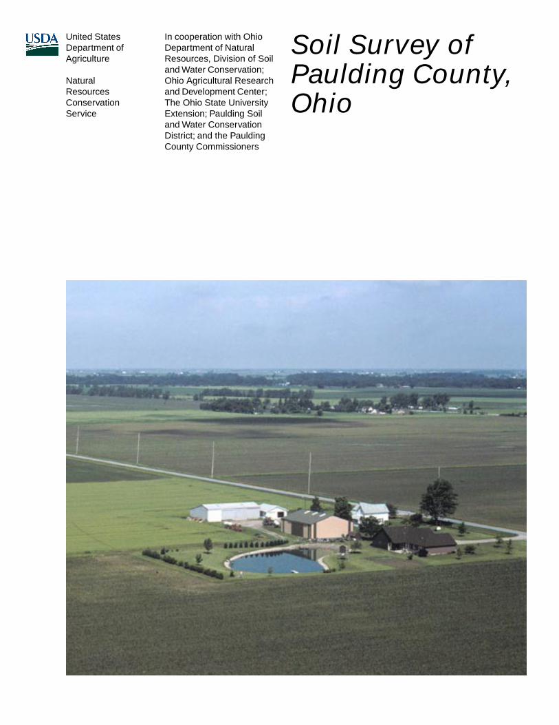
The general soil map, which is a color map, shows the survey area divided into groups of associated soils calledgeneral soil map units. This map is useful in planning the use and management of large areas.
To find information about your area of interest, locate that area on the map, identify the name of the map unit in thearea on the color-coded map legend, then refer to the section General Soil Map Units for a general description ofthe soils in your area.
Detailed Soil Maps
The detailed soil maps can be useful in planning the use andmanagement of small areas.
To find information about your areaof interest, locate that area on theIndex to Map Sheets. Note thenumber of the map sheet and turnto that sheet.
Locate your area of interest onthe map sheet. Note the map unitsymbols that are in that area. Turnto the Contents, which lists themap units by symbol and nameand shows the page where eachmap unit is described.
The Contents shows which tablehas data on a specific land use foreach detailed soil map unit. Alsosee the Contents for sections ofthis publication that may addressyour specific needs.
3
How To Use This Soil Survey
A portion of the State Soil Geographic Database (STATSGO) is available for this county. This database consistsof a soil map at a scale of 1:250,000 and descriptions of groups of associated soils. It replaces the general soilmap published in earlier soil surveys. The map and the database can be used for multicounty planning, and mapoutput can be tailored for a specific use. More information about the State Soil Geographic database for this countyor for any other part of Ohio is available at the local office of the Natural Resources Conservation Service.

4
Additional information about the Nation’s natural resources is available on theNatural Resources Conservation Service homepage on the World Wide Web. Theaddress is http://www.nrcs.usda.gov.
This soil survey is a publication of the National Cooperative Soil Survey, a joint effortof the United States Department of Agriculture and other Federal agencies, Stateagencies including the Agricultural Experiment Stations, and local agencies. TheNatural Resources Conservation Service (formerly the Soil Conservation Service) hasleadership for the Federal part of the National Cooperative Soil Survey.
Major fieldwork for this soil survey was completed in 1991. Soil names anddescriptions were approved in 1993. Unless otherwise indicated, statements in thispublication refer to conditions in the survey area in 1993. This survey was madecooperatively by the Natural Resources Conservation Service; the Ohio Department ofNatural Resources, Division of Soil and Water Conservation; the Ohio AgriculturalResearch and Development Center; and The Ohio State University Extension. Thesurvey is part of the technical assistance furnished to the Paulding Soil and WaterConservation District. Additional funds were provided by the Paulding CountyCommissioners.
Soil maps in this survey may be copied without permission. Enlargement of thesemaps, however, could cause misunderstanding of the detail of mapping. If enlarged,maps do not show the small areas of contrasting soils that could have been shown at alarger scale.
The United States Department of Agriculture (USDA) prohibits discrimination in allof its programs and activities on the basis of race, color, national origin, sex, religion,age, disability, political beliefs, sexual orientation, or marital or family status. (Not allprohibited bases apply to all programs.) Persons with disabilities who requirealternative means for communication of program information (Braille, large print,audiotape, etc.) should contact USDA’s TARGET Center at 202-720-2600 (voice andTDD).
To file a complaint of discrimination, write USDA, Director, Office of Civil Rights,Room 326-W, Whitten Building, 1400 Independence Avenue, SW, Washington, D.C.20250-9410, or call 202-720-5964 (voice and TDD). USDA is an equal opportunityprovider and employer.
Cover: A pond in an area of Latty silty clay on a typical farmstead in Blue Creek Township,Paulding County, Ohio.
5
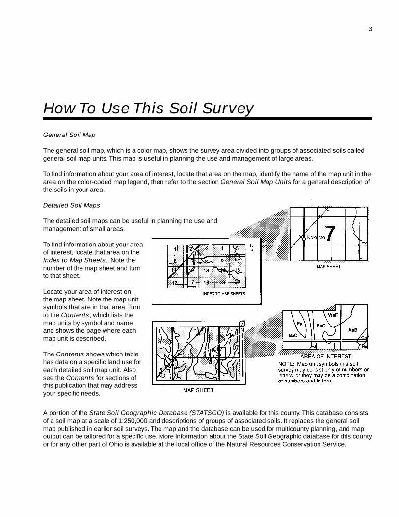
Contents
How To Use This Soil Survey ................................. 3Foreword ................................................................. 9General Nature of the County ................................. 11
Climate ............................................................... 11Physiography, Relief, and Drainage .................... 12Farming .............................................................. 13Natural Resources ............................................. 14History ................................................................ 14Recreation .......................................................... 14
How This Survey Was Made ................................... 15Survey Procedures ............................................. 16
General Soil Map Units ........................................ 191. Paulding-Roselms association ..................... 192. Latty-Nappanee association ........................ 193. Hoytville-Nappanee association................... 214. Toledo-Fulton association ............................ 225. Fulton, loamy substratum-Rossburg-
Lucas, loamy substratum, association ...... 236. Toledo-Bixler association ............................. 23
Detailed Soil Map Units ........................................ 25BeB—Belmore loam, till substratum, 2 to 6
percent slopes ............................................. 26BkA—Bixler loamy sand, clayey substratum,
0 to 2 percent slopes ................................... 27BrB2—Broughton silty clay loam, 2 to 6
percent slopes, eroded ................................ 27BrC2—Broughton silty clay loam, 6 to 12
percent slopes, eroded ................................ 28BrD2—Broughton silty clay loam, 12 to 18
percent slopes, eroded ................................ 29BrE2—Broughton silty clay loam, 18 to 35
percent slopes, eroded ................................ 29BsC3—Broughton silty clay, 6 to 12 percent
slopes, severely eroded ............................... 30BsD3—Broughton silty clay, 12 to 18 percent
slopes, severely eroded ............................... 31Db—Defiance silty clay loam, occasionally
flooded ......................................................... 31Dc—Defiance silty clay loam, frequently
flooded ......................................................... 32Fb—Flatrock silt loam, occasionally flooded ...... 32Fc—Flatrock silt loam, frequently flooded .......... 33FtA—Fulton loam, 0 to 2 percent slopes ............ 34FuA—Fulton silty clay loam, 0 to 2 percent
slopes .......................................................... 34
FuB2—Fulton silty clay loam, 2 to 6 percentslopes, eroded ............................................. 35
FxA—Fulton silty clay loam, loamysubstratum, 0 to 2 percent slopes ................ 36
FxB—Fulton silty clay loam, loamysubstratum, 2 to 6 percent slopes ................ 36
Gr—Granby loamy sand, clayey substratum ...... 37HaA—Haskins loamy sand, 0 to 2 percent
slopes .......................................................... 38HkA—Haskins loam, 0 to 2 percent slopes ........ 38HkB—Haskins loam, 2 to 6 percent slopes ........ 39Hs—Hoytville silty clay loam .............................. 40Ht—Hoytville silty clay ........................................ 40Kn—Knoxdale silt loam, occasionally flooded .... 41La—Landes loam, occasionally flooded ............. 41Lb—Latty silty clay loam .................................... 42Lc—Latty silty clay ............................................. 43LtA—Lucas silt loam, loamy substratum,
0 to 2 percent slopes ................................... 43LuB2—Lucas silty clay loam, loamy
substratum, 2 to 6 percent slopes,eroded ......................................................... 44
LuC2—Lucas silty clay loam, loamysubstratum, 6 to 12 percent slopes,eroded ......................................................... 45
Md—Medway silt loam, occasionallyflooded ......................................................... 45
Me—Mermill loam .............................................. 46Mg—Millgrove loam, till substratum.................... 47NnA—Nappanee loam, 0 to 2 percent
slopes .......................................................... 47NpA—Nappanee silty clay loam, 0 to 2
percent slopes ............................................. 48NpB—Nappanee silty clay loam, 2 to 6
percent slopes ............................................. 49NpB2—Nappanee silty clay loam, 2 to 6
percent slopes, eroded ................................ 49OsB—Oshtemo sandy loam, till substratum,
2 to 6 percent slopes ................................... 50OtB—Ottokee loamy sand, 0 to 6 percent
slopes .......................................................... 51Pc—Paulding clay .............................................. 51Pt—Pits, quarry .................................................. 53RkA—Rimer loamy sand, 0 to 2 percent
slopes .......................................................... 53
6
RkB—Rimer loamy sand, 2 to 6 percentslopes .......................................................... 53
RmA—Rimer-Fulton complex, 0 to 2 percentslopes .......................................................... 54
RnA—Roselms loam, 0 to 2 percent slopes ....... 55RoA—Roselms silty clay loam, 0 to 2
percent slopes ............................................. 56RoB—Roselms silty clay loam, 2 to 6
percent slopes ............................................. 56RpA—Roselms silty clay, 0 to 2 percent
slopes .......................................................... 57RpB2—Roselms silty clay, 2 to 6 percent
slopes, eroded ............................................. 58Rt—Rossburg silt loam, occasionally
flooded ......................................................... 58Sb—Saranac silty clay loam, occasionally
flooded ......................................................... 59Sh—Shoals silt loam, occasionally flooded ........ 60Sk—Shoals silt loam, frequently flooded ............ 60StB2—St. Clair silty clay loam, 2 to 6
percent slopes, eroded ................................ 61StC2—St. Clair silty clay loam, 6 to 12
percent slopes, eroded ................................ 61StD2—St. Clair silty clay loam, 12 to 18
percent slopes, eroded ................................ 62StE2—St. Clair silty clay loam, 18 to 35
percent slopes, eroded ................................ 63SuC3—St. Clair silty clay, 6 to 12 percent
slopes, severely eroded ............................... 63SuE3—St. Clair silty clay, 12 to 25 percent
slopes, severely eroded ............................... 64TeA—Tedrow loamy sand, 0 to 3 percent
slopes .......................................................... 65Tn—Toledo silty clay loam.................................. 65To—Toledo silty clay ........................................... 66Uc—Udorthents, clayey, hilly .............................. 66Wb—Wabasha silty clay loam, frequently
flooded ......................................................... 67WhA—Whitaker loam, 0 to 2 percent slopes ...... 67
Use and Management of the Soils ...................... 69Crops and Pasture ............................................. 69
Yields per Acre .............................................. 73Cropland Limitations and Hazards ................. 74Land Capability Classification ........................ 76Prime Farmland ............................................. 78
Forestland .......................................................... 79Windbreaks and Environmental Plantings .......... 81Recreation .......................................................... 81Wildlife Habitat ................................................... 82Hydric Soils ........................................................ 83Engineering ........................................................ 85
Building Site Development ............................. 86Sanitary Facilities ........................................... 86Construction Materials ................................... 87Water Management ........................................ 88
Soil Properties ...................................................... 91Engineering Index Properties ............................. 91Physical and Chemical Properties ..................... 92Water Features ................................................... 94Soil Features ...................................................... 95Physical and Chemical Analyses of
Selected Soils .............................................. 96Classification of the Soils .................................... 97Soil Series and Their Morphology .......................... 97
Belmore Series .................................................. 97Bixler Series ....................................................... 98Broughton Series ............................................... 99Defiance Series ................................................ 101Flatrock Series ................................................. 102Fulton Series .................................................... 102Granby Series .................................................. 104Haskins Series ................................................. 105Hoytville Series ................................................ 106Knoxdale Series ............................................... 107Landes Series .................................................. 107Latty Series ...................................................... 108Lucas Series .................................................... 109Medway Series ................................................. 110Mermill Series .................................................. 112Millgrove Series................................................ 113Nappanee Series ............................................. 114Oshtemo Series ............................................... 115Ottokee Series ................................................. 116Paulding Series ................................................ 117Rimer Series .................................................... 117Roselms Series ................................................ 119Rossburg Series............................................... 120Saranac Series ................................................ 120Shoals Series ................................................... 121St. Clair Series ................................................. 122
7
Tedrow Series .................................................. 123Toledo Series ................................................... 124Wabasha Series ............................................... 125Whitaker Series ................................................ 126
Formation of the Soils ........................................ 129Factors of Soil Formation ................................. 129
Parent Material ............................................. 129Climate ........................................................ 129Living Organisms ......................................... 130Relief ........................................................... 130Time ............................................................. 130
Processes of Soil Formation ............................ 130References .......................................................... 133Glossary .............................................................. 135Tables .................................................................. 147
Table 1.—Temperature and Precipitation .......... 148Table 2.—Freeze Dates in Spring and Fall ....... 149Table 3.—Growing Season ............................... 149Table 4.—Acreage and Proportionate Extent
of the Soils ................................................. 150Table 5.—Land Capability and Yields per
Acre of Crops ............................................. 152Table 6.—Crop Yield Index ............................... 156
Table 7.—Main Cropland Limitations andHazards ..................................................... 160
Table 8.—Capability Classes andSubclasses ................................................ 169
Table 9.—Prime Farmland ................................ 170Table 10.—Woodland Management and
Productivity ................................................ 171Table 11.—Windbreaks and Environmental
Plantings .................................................... 188Table 12.—Recreational Development ............. 197Table 13.—Wildlife Habitat ............................... 203Table 14.—Building Site Development ............. 207Table 15.—Sanitary Facilities ........................... 213Table 16.—Construction Materials ................... 220Table 17.—Water Management ........................ 226Table 18.—Engineering Index Properties ......... 234Table 19.—Physical Properties of the Soils ...... 247Table 20.—Chemical Properties of the
Soils ........................................................... 253Table 21.—Water Features ............................... 259Table 22.—Soil Features .................................. 263Table 23.—Classification of the Soils ............... 267
Interpretive Groups ............................................ 269
Issued 2006

9
This soil survey contains information that affects land use planning in this surveyarea. It contains predictions of soil behavior for selected land uses. The survey alsohighlights soil limitations, improvements needed to overcome the limitations, and theimpact of selected land uses on the environment.
This soil survey is designed for many different users. Farmers, foresters, andagronomists can use it to evaluate the potential of the soil and the managementneeded for maximum food and fiber production. Planners, community officials,engineers, developers, builders, and home buyers can use the survey to plan land use,select sites for construction, and identify special practices needed to ensure properperformance. Conservationists, teachers, students, and specialists in recreation,wildlife management, waste disposal, and pollution control can use the survey to helpthem understand, protect, and enhance the environment.
Various land use regulations of Federal, State, and local governments may imposespecial restrictions on land use or land treatment. The information in this report isintended to identify soil properties that are used in making various land use or landtreatment decisions. Statements made in this report are intended to help the land usersidentify and reduce the effects of soil limitations that affect various land uses. Thelandowner or user is responsible for identifying and complying with existing laws andregulations.
Great differences in soil properties can occur within short distances. Some soils areseasonally wet or subject to flooding. Some are shallow to bedrock. Some are toounstable to be used as a foundation for buildings or roads. Clayey or wet soils arepoorly suited to use as septic tank absorption fields. A high water table makes a soilpoorly suited to basements or underground installations.
These and many other soil properties that affect land use are described in this soilsurvey. Broad areas of soils are shown on the general soil map. The location of eachsoil is shown on the detailed soil maps. Each soil in the survey area is described, andinformation on specific uses is given. Help in using this publication and additionalinformation are available at the local office of the Natural Resources ConservationService or the Cooperative Extension Service.
Kevin BrownState ConservationistNatural Resources Conservation Service
Foreword

11
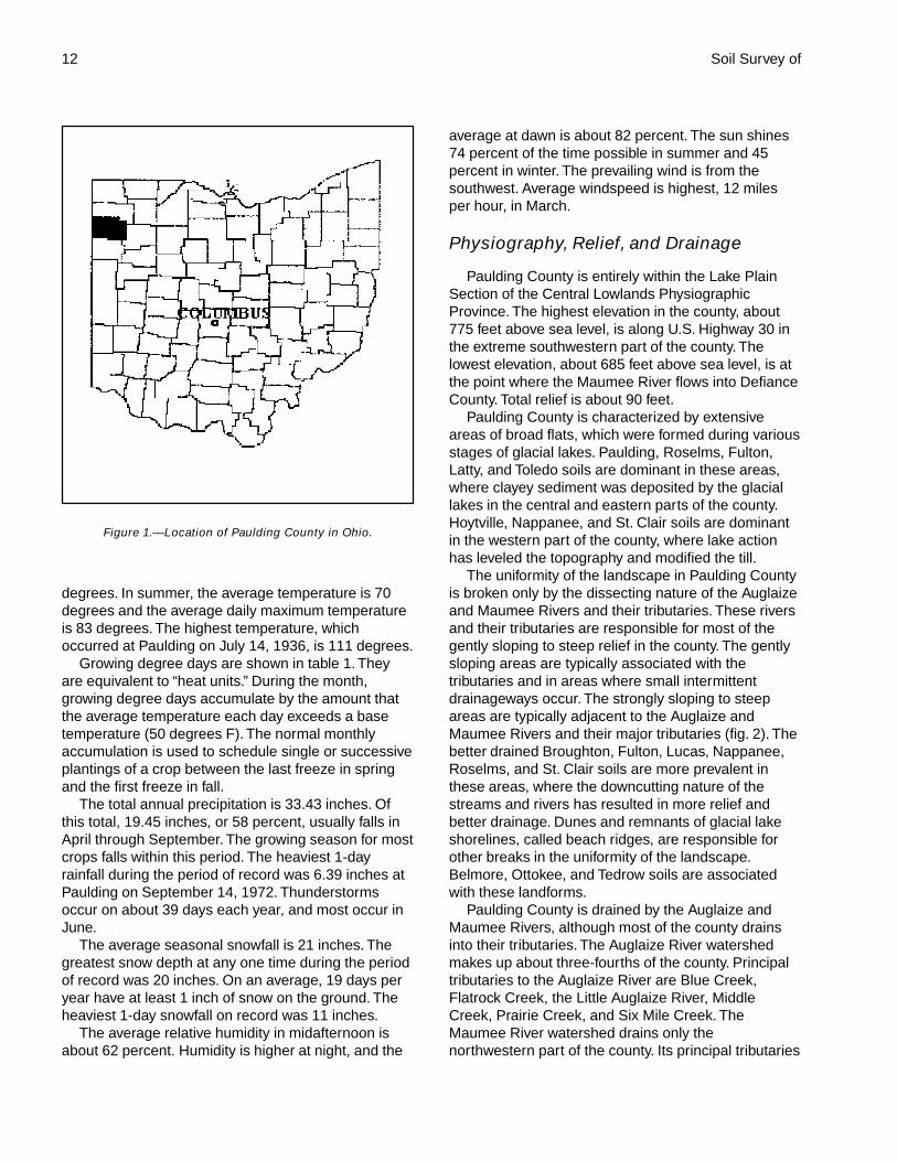
PAULDING COUNTY is in northwestern Ohio (fig. 1). Itborders the State of Indiana. The county has an areaof about 268,100 acres, or 419 square miles.Paulding, the county seat, is near the center of thecounty. In 1990, the population of the county was20,488 and the population of the village of Pauldingwas 2,605 (Rand McNally, 1992).
Most of the county is used for farming. The mainenterprises are cash-grain farming and some livestockproduction and dairying. Urban or built-up land makesup about 1.4 percent of the county and is expanding ata very slow pace (Paulding Soil and WaterConservation District, 1986). Most areas that are usedas farmland have been drained for improved cropproduction.
Most of Paulding County is level to gently sloping.The land is dissected in some areas by small riversand streams. Wetness is a major limitation affectingthe use of most of the soils in the county. The hazardof erosion is generally severe in sloping to steep areasalong stream valleys. The low, loamy beach ridges inthe county are locally unique physiographic features.These ridges are in the southwestern andnortheastern parts of the county and make upapproximately 3,750 acres.
This soil survey updates the survey of PauldingCounty published in 1960 (Baker and others, 1960).The current survey provides more detailed information
on recent aerial photography. An earlier survey waspublished in 1915 (Lewis and Shiffler, 1915).
General Nature of the CountyThis section provides some general information
about the survey area. It describes climate;physiography, relief, and drainage; farming; naturalresources; history; and recreation.
Climate
Paulding County is cold in winter and quite warm insummer. Winter precipitation, which frequently occursas snow, results in a good accumulation of soilmoisture by spring and thus minimizes drought inmost areas. The normal annual precipitation isadequate for all of the crops that are suited to thetemperature and growing season in the county.
Table 1 gives data on temperature and precipitationfor the survey area as recorded at Paulding in theperiod 1961 to 1990. Table 2 shows probable dates ofthe first freeze in fall and the last freeze in spring.Table 3 provides data on length of the growing season.
In winter, the average temperature is 25 degrees Fand the average daily minimum temperature is 16degrees. The lowest temperature on record, whichoccurred at Paulding on January 21, 1984, is -25
Soil Survey of
Paulding County, OhioBy Mark M. Feusner and Rick A. Robbins, Ohio Department of Natural Resources,Division of Soil and Water Conservation, and Jeffrey A. Glanville, Natural ResourcesConservation Service
Fieldwork by Rick A. Robbins, Mark M. Feusner, and K. Ed Miller, Ohio Department ofNatural Resources, Division of Soil and Water Conservation
United States Department of Agriculture, Natural Resources Conservation Service,in cooperation withthe Ohio Department of Natural Resources, Division of Soil and Water Conservation;the Ohio Agricultural Research and Development Center; The Ohio State UniversityExtension; the Paulding Soil and Water Conservation District; and the Paulding CountyCommissioners
12 Soil Survey of
degrees. In summer, the average temperature is 70degrees and the average daily maximum temperatureis 83 degrees. The highest temperature, whichoccurred at Paulding on July 14, 1936, is 111 degrees.
Growing degree days are shown in table 1. Theyare equivalent to “heat units.” During the month,growing degree days accumulate by the amount thatthe average temperature each day exceeds a basetemperature (50 degrees F). The normal monthlyaccumulation is used to schedule single or successiveplantings of a crop between the last freeze in springand the first freeze in fall.
The total annual precipitation is 33.43 inches. Ofthis total, 19.45 inches, or 58 percent, usually falls inApril through September. The growing season for mostcrops falls within this period. The heaviest 1-dayrainfall during the period of record was 6.39 inches atPaulding on September 14, 1972. Thunderstormsoccur on about 39 days each year, and most occur inJune.
The average seasonal snowfall is 21 inches. Thegreatest snow depth at any one time during the periodof record was 20 inches. On an average, 19 days peryear have at least 1 inch of snow on the ground. Theheaviest 1-day snowfall on record was 11 inches.
The average relative humidity in midafternoon isabout 62 percent. Humidity is higher at night, and the
average at dawn is about 82 percent. The sun shines74 percent of the time possible in summer and 45percent in winter. The prevailing wind is from thesouthwest. Average windspeed is highest, 12 milesper hour, in March.
Physiography, Relief, and Drainage
Paulding County is entirely within the Lake PlainSection of the Central Lowlands PhysiographicProvince. The highest elevation in the county, about775 feet above sea level, is along U.S. Highway 30 inthe extreme southwestern part of the county. Thelowest elevation, about 685 feet above sea level, is atthe point where the Maumee River flows into DefianceCounty. Total relief is about 90 feet.
Paulding County is characterized by extensiveareas of broad flats, which were formed during variousstages of glacial lakes. Paulding, Roselms, Fulton,Latty, and Toledo soils are dominant in these areas,where clayey sediment was deposited by the glaciallakes in the central and eastern parts of the county.Hoytville, Nappanee, and St. Clair soils are dominantin the western part of the county, where lake actionhas leveled the topography and modified the till.
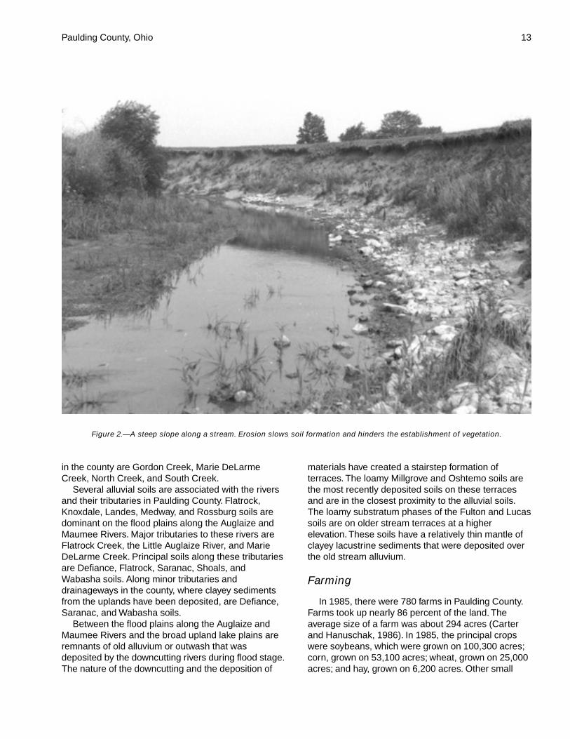
The uniformity of the landscape in Paulding Countyis broken only by the dissecting nature of the Auglaizeand Maumee Rivers and their tributaries. These riversand their tributaries are responsible for most of thegently sloping to steep relief in the county. The gentlysloping areas are typically associated with thetributaries and in areas where small intermittentdrainageways occur. The strongly sloping to steepareas are typically adjacent to the Auglaize andMaumee Rivers and their major tributaries (fig. 2). Thebetter drained Broughton, Fulton, Lucas, Nappanee,Roselms, and St. Clair soils are more prevalent inthese areas, where the downcutting nature of thestreams and rivers has resulted in more relief andbetter drainage. Dunes and remnants of glacial lakeshorelines, called beach ridges, are responsible forother breaks in the uniformity of the landscape.Belmore, Ottokee, and Tedrow soils are associatedwith these landforms.
Paulding County is drained by the Auglaize andMaumee Rivers, although most of the county drainsinto their tributaries. The Auglaize River watershedmakes up about three-fourths of the county. Principaltributaries to the Auglaize River are Blue Creek,Flatrock Creek, the Little Auglaize River, MiddleCreek, Prairie Creek, and Six Mile Creek. TheMaumee River watershed drains only thenorthwestern part of the county. Its principal tributaries
Figure 1.—Location of Paulding County in Ohio.
Paulding County, Ohio 13
in the county are Gordon Creek, Marie DeLarmeCreek, North Creek, and South Creek.
Several alluvial soils are associated with the riversand their tributaries in Paulding County. Flatrock,Knoxdale, Landes, Medway, and Rossburg soils aredominant on the flood plains along the Auglaize andMaumee Rivers. Major tributaries to these rivers areFlatrock Creek, the Little Auglaize River, and MarieDeLarme Creek. Principal soils along these tributariesare Defiance, Flatrock, Saranac, Shoals, andWabasha soils. Along minor tributaries anddrainageways in the county, where clayey sedimentsfrom the uplands have been deposited, are Defiance,Saranac, and Wabasha soils.
Between the flood plains along the Auglaize andMaumee Rivers and the broad upland lake plains areremnants of old alluvium or outwash that wasdeposited by the downcutting rivers during flood stage.The nature of the downcutting and the deposition of
materials have created a stairstep formation ofterraces. The loamy Millgrove and Oshtemo soils arethe most recently deposited soils on these terracesand are in the closest proximity to the alluvial soils.The loamy substratum phases of the Fulton and Lucassoils are on older stream terraces at a higherelevation. These soils have a relatively thin mantle ofclayey lacustrine sediments that were deposited overthe old stream alluvium.
Farming
In 1985, there were 780 farms in Paulding County.Farms took up nearly 86 percent of the land. Theaverage size of a farm was about 294 acres (Carterand Hanuschak, 1986). In 1985, the principal cropswere soybeans, which were grown on 100,300 acres;corn, grown on 53,100 acres; wheat, grown on 25,000acres; and hay, grown on 6,200 acres. Other small
Figure 2.—A steep slope along a stream. Erosion slows soil formation and hinders the establishment of vegetation.
14 Soil Survey of
grain crops, pasture, corn for silage, and specialtycrops were grown on about 40,900 acres (Carter andHanuschak, 1986).
The major kinds of livestock in the county are beefcattle, hogs, and dairy cattle. Many farms have nolivestock (Carter and Hanuschak, 1986).
Natural Resources
Soil is one of the most important natural resourcesin the county. Cash crops and livestock are themarketable products resulting from stewardship of thesoil.
Dolostone, limestone, and clay have all beenquarried throughout Paulding County at one time oranother. Most of these resources have been of minorextent, mainly because of the relatively thin depositsof materials of sufficiently high quality for widecommercial use.
Clay was an important natural resource for earlyfarmers, who used it in tile manufacturing for drainagepurposes and for brick for home construction. Manysmall areas were utilized as local sources and can stillbe seen as shallow depressions that are currentlybeing farmed. With the advent of plastic tile and otherconstruction materials, most clay pits and kiln ovenshave been abandoned.
Dolostone and limestone are the major componentsof bedrock in the county. The Antrim shale, theTraverse group, the Dundee limestone, and the DetroitRiver group formed during the Devonian Age. Theseformations are in the northern part of the county andare mainly limestone and shale. The Salina group,which formed during the late Silurian Age, is in thesouthern part of the county. It is mainly limestone(Bownocker, 1920; Ohio Department of NaturalResources, 1998). Limestone has been mined fromthese formations in several areas of the county;however, only two quarries are still active. Thesequarries are in the north-central and northeasternparts of the county. They produce aggregate and rockfor Portland cement. Most of the limestone in PauldingCounty is suitable for many agricultural and industrialuses.
Small sand and gravel pits are scattered throughoutthe county, mostly along rivers and streams. Thesedeposits are limited in size, ranging from 1 to 10acres.
History
Prior to the arrival of European settlers, theinhabitants of the survey area were members of theOttawa and Wyandotte tribes. These people grew corn
and other crops in small clearings on terraces andflood plains to supplement their diet. The first whitefamily settled on the east bank of the Auglaize River in1819 (Howe, 1847). Other early settlers built theirprimitive homes along the banks of the Auglaize River,the Little Auglaize River, the Maumee River, BlueCreek, Flatrock Creek, and Crooked Creek (Morrowand Bashmore, 1892).
Paulding County was created by an act of the OhioLegislature on February 12, 1820. It was reduced to itspresent limits by an act of the State Legislature onMarch 4, 1845. The county was named in honor ofJohn Paulding, a Revolutionary War hero and a nativeof Peekskill, New York (Overman, 1958).
Paulding was one of the very last counties in Ohioto become thoroughly settled. The area was stillheavily forested after most of the timber insurrounding counties had disappeared (Winter, 1917).
The Miami-Erie Canal and the Wabash-Erie Canalfrom Indiana join in northern Paulding County. Thesecanals were pushed through in the 1840’s and helpedto open up the country (Izant, 1953).
Early industry consisted of forest products, mainlybarrel staves, railroad ties, and cord wood during thecanal building days. The shipment of timber beganaround 1856, and charcoal making had begun by1860. Some oil was discovered in 1887 in Pauldingand to the west (Winter, 1917).
Timbering played a dominant role in the settlementand early development of Paulding County. Agriculturewas not developed extensively in the county untilmethods were devised for draining the extensive levelareas of wet, clayey soils. The major period ofdevelopment was not until the 1870’s and 1880’s,when the gigantic task of drainage was begun. Morethan 5,000 miles of ditches, main and subsidiarychannels, were cut through this part of Ohio (Izant,1953).
In the period from 1880 to 1890, the farmersbegan to build drainage ditches and to install tiledrains. This practice continued for several decadesand opened the last major virgin areas of land forcultivation. Various crops were grown, includingbuckwheat, broom corn, tobacco, and grapes (Howe,1847).
Recreation
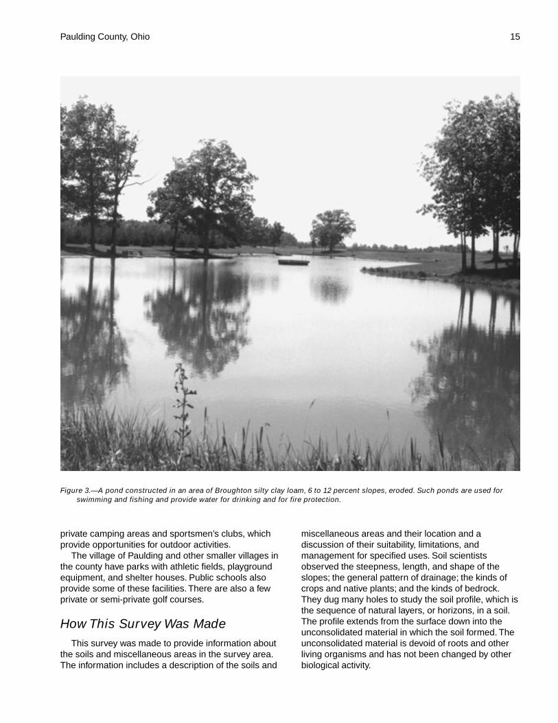
Paulding County has many recreational areas(fig. 3). The 44-acre Paulding Ponds Wildlife Area isjust south of the village of Paulding, along FlatrockCreek. The area along the Auglaize River in easternPaulding County has many private fishing camps andseveral public boat launches. There are also some
Paulding County, Ohio 15
private camping areas and sportsmen’s clubs, whichprovide opportunities for outdoor activities.
The village of Paulding and other smaller villages inthe county have parks with athletic fields, playgroundequipment, and shelter houses. Public schools alsoprovide some of these facilities. There are also a fewprivate or semi-private golf courses.
How This Survey Was MadeThis survey was made to provide information about
the soils and miscellaneous areas in the survey area.The information includes a description of the soils and
miscellaneous areas and their location and adiscussion of their suitability, limitations, andmanagement for specified uses. Soil scientistsobserved the steepness, length, and shape of theslopes; the general pattern of drainage; the kinds ofcrops and native plants; and the kinds of bedrock.They dug many holes to study the soil profile, which isthe sequence of natural layers, or horizons, in a soil.The profile extends from the surface down into theunconsolidated material in which the soil formed. Theunconsolidated material is devoid of roots and otherliving organisms and has not been changed by otherbiological activity.
Figure 3.—A pond constructed in an area of Broughton silty clay loam, 6 to 12 percent slopes, eroded. Such ponds are used forswimming and fishing and provide water for drinking and for fire protection.
16 Soil Survey of
The soils and miscellaneous areas in the surveyarea are in an orderly pattern that is related to thegeology, landforms, relief, climate, and naturalvegetation of the area. Each kind of soil andmiscellaneous area is associated with a particularkind of landform or with a segment of the landform. Byobserving the soils and miscellaneous areas in thesurvey area and relating their position to specificsegments of the landform, a soil scientist develops aconcept, or model, of how they were formed. Thus,during mapping, this model enables the soil scientistto predict with a considerable degree of accuracy thekind of soil or miscellaneous area at a specificlocation on the landscape.
Commonly, individual soils on the landscape mergeinto one another as their characteristics graduallychange. To construct an accurate soil map, however,soil scientists must determine the boundaries betweenthe soils. They can observe only a limited number ofsoil profiles. Nevertheless, these observations,supplemented by an understanding of the soil-vegetation-landscape relationship, are sufficient toverify predictions of the kinds of soil in an area and todetermine the boundaries.
Soil scientists recorded the characteristics of thesoil profiles that they studied. They noted soil color,texture, size and shape of soil aggregates, kind andamount of rock fragments, distribution of plant roots,reaction, and other features that enable them toidentify soils. After describing the soils in the surveyarea and determining their properties, the soilscientists assigned the soils to taxonomic classes(units). Taxonomic classes are concepts. Eachtaxonomic class has a set of soil characteristics withprecisely defined limits. The classes are used as abasis for comparison to classify soils systematically.Soil taxonomy, the system of taxonomic classificationused in the United States, is based mainly on the kindand character of soil properties and the arrangementof horizons within the profile. After the soil scientistsclassified and named the soils in the survey area, theycompared the individual soils with similar soils in thesame taxonomic class in other areas so that theycould confirm data and assemble additional databased on experience and research.
While a soil survey is in progress, samples of someof the soils in the area generally are collected forlaboratory analyses and for engineering tests. Soilscientists interpret the data from these analyses andtests as well as the field-observed characteristics andthe soil properties to determine the expected behaviorof the soils under different uses. Interpretations for allof the soils are field tested through observation of thesoils in different uses and under different levels of
management. Some interpretations are modified to fitlocal conditions, and some new interpretations aredeveloped to meet local needs. Data are assembledfrom other sources, such as research information,production records, and field experience of specialists.For example, data on crop yields under defined levelsof management are assembled from farm records andfrom field or plot experiments on the same kinds ofsoil.
Predictions about soil behavior are based not onlyon soil properties but also on such variables asclimate and biological activity. Soil conditions arepredictable over long periods of time, but they are notpredictable from year to year. For example, soilscientists can predict with a fairly high degree ofaccuracy that a given soil will have a high water tablewithin certain depths in most years, but they cannotpredict that a high water table will always be at aspecific level in the soil on a specific date.
After soil scientists located and identified thesignificant natural bodies of soil in the survey area,they drew the boundaries of these bodies on aerialphotographs and identified each as a specific mapunit. Aerial photographs show trees, buildings, fields,roads, and rivers, all of which help in locatingboundaries accurately.
The descriptions, names, and delineations of thesoils in this survey area do not fully agree with thoseof the soils in adjacent survey areas. Differences arethe result of a better knowledge of soils, modificationsin series concepts, or variations in the intensity ofmapping or in the extent of the soils in the surveyareas.
Survey Procedures
The general procedures followed in making thissurvey are described in the National Soil SurveyHandbook of the Natural Resources ConservationService. The soil survey of Paulding County issuedOctober 1960 (Baker and others, 1960) and a reporton the geology of the county (Newberry and others,1874) were among the references used.
Prior to the soil survey modernization, a soil surveyreview team conducted an evaluation of the 1960Paulding County soil survey at the request of thePaulding County Commissioners. A report of theevaluation was prepared and sent to the Ohio SoilInventory Board for review. After reviewing theevaluation report, the Soil Inventory Boardrecommended a soil survey modernization programand outlined the work to be completed for the soilsurvey modernization.
Before the actual fieldwork was begun, a detailed
Paulding County, Ohio 17
study of all existing laboratory data, soil surveyreports, and research studies was conducted by thePaulding County soil survey staff. The soil scientistsused U.S. Geological Survey topographic maps, at ascale of 1:24,000, to relate land and image features.
A reconnaissance was made by pickup truck beforethe soil scientists traversed the surface on foot andexamined the soils. Areas having the lowest map unitreliability for soil interpretations were examined first.Areas in the northwest and northeast corners of thecounty and areas of alluvial soils were determined tobe the least reliable. In these areas, where the soilpattern is very complex, observations were spaced asclosely as 100 yards. In areas of the Latty-Nappaneeassociation and in other areas where the soil patternis relatively simple, observations were spaced aboutone-fourth mile apart.
As they traversed the surface, the soil scientistsdivided the landscape into segments based on the useand management of the soils. For example, a flat areawould be separated from a depression or a gentlysloping knoll or a side slope would be separated froma flat area. In most areas soil examinations along thetraverses were made at points 100 to 800 yards apart,depending on the landscape and soil pattern.
Observations of such items as landforms, blown-down trees, vegetation, ditchbanks, and surface colorswere made without regard to spacing. Soil boundarieswere determined on the basis of soil examinations,observations, and photo interpretation. The soilmaterial was examined to a depth of about 80 inchesor to bedrock if within a depth of 80 inches. Thepedons described as typical were observed andstudied in pits that were dug with shovels and spades.
At the beginning of the survey, sample areas wereselected to represent the major landscapes in thecounty. These areas were then mapped. Extensivenotes were taken on the composition of the map unitsin these preliminary study areas. These notes weremodified as mapping progressed, and a finalassessment of the composition of the individual mapunits was made. Some transects were made todetermine the composition of map units, especially theRimer-Fulton complex.
Samples for chemical and physical analyses weretaken from representative sites of several of the soilsin the survey area. The chemical and physicalanalyses were made by the Soil CharacterizationLaboratory, School of Natural Resources, The OhioState University, Columbus, Ohio. The results of theanalyses are stored in a computerized data file at thelaboratory. The analyses for engineering propertieswere made by the Ohio Department ofTransportation, Division of Highways, Bureau ofTesting, Soils and Foundation Section, Columbus,Ohio. The laboratory procedures can be obtained onrequest from the respective laboratories. The results ofthe analyses can be obtained from the School ofNatural Resources, The Ohio State University; theOhio Department of Natural Resources, Division ofSoil and Water Conservation; and the NaturalResources Conservation Service, State Office,Columbus, Ohio.
After completion of the soil mapping on aerialphotographs, map unit delineations were transferredby hand to another set of the same photographs.Surface features were recorded from observation ofthe maps and the landscape.


19
The general soil map in this publication showsbroad areas that have a distinctive pattern of soils,relief, and drainage. These areas are calledassociations. Each association on the general soilmap is a unique natural landscape. Typically, itconsists of one or more major soils or miscellaneousareas and some minor soils or miscellaneous areas. Itis named for the major soils or miscellaneous areas.The components of one association can occur inanother but in a different pattern.
The general soil map can be used to compare thesuitability of large areas for general land uses. Areasof suitable soils can be identified on the map.Likewise, areas where the soils are not suitable canbe identified.
Because of its small scale, the map is not suitablefor planning the management of a farm or field or forselecting a site for a road or building or otherstructure. The soils in any one association differ fromplace to place in slope, depth, drainage, and othercharacteristics that affect management.
1. Paulding-Roselms association
Very deep, nearly level and gently sloping, very poorlydrained and somewhat poorly drained soils thatformed in lacustrine deposits
Setting
Landform: Lake plainsSlope range: 0 to 6 percentLandscape features: Extensive flat areas and slight
rises
Composition
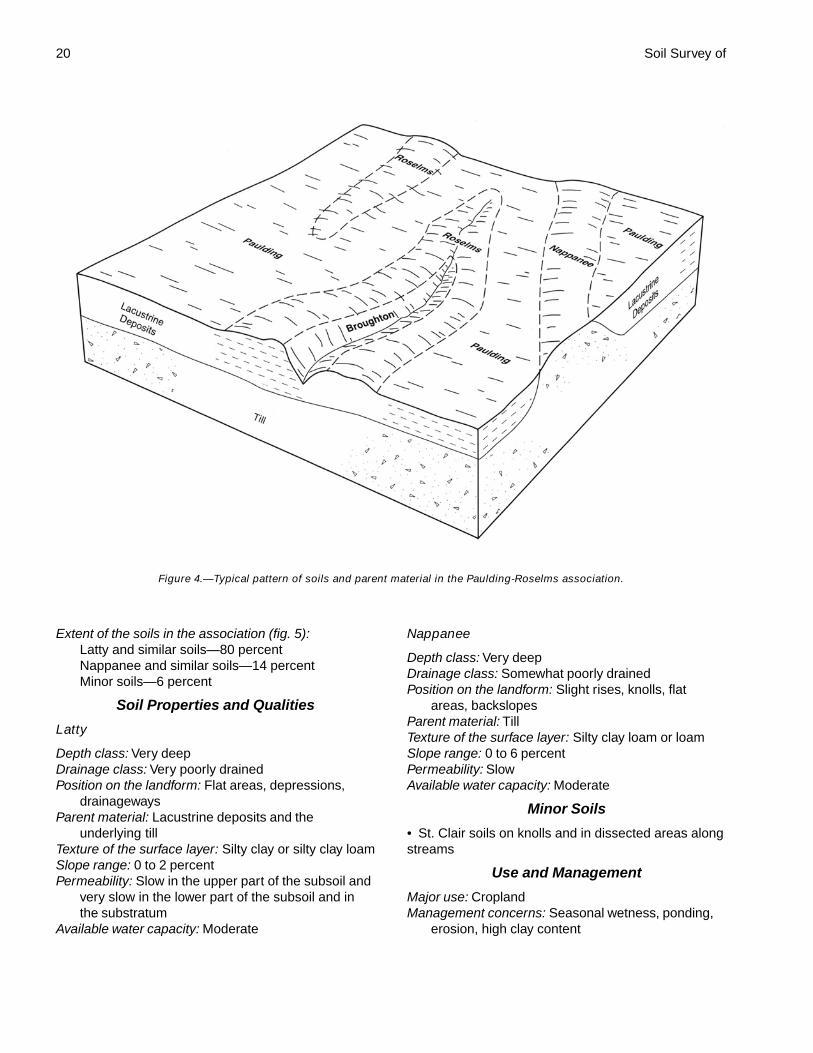
Percent of the survey area: 41Extent of the soils in the association (fig. 4):
Paulding and similar soils—64 percentRoselms and similar soils—21 percentMinor soils—15 percent
Soil Properties and Qualities
Paulding
Depth class: Very deep
Drainage class: Very poorly drainedPosition on the landform: Extensive flat areas,
depressions, drainagewaysParent material: Lacustrine depositsTexture of the surface layer: ClaySlope range: 0 to 2 percentPermeability: Very slowAvailable water capacity: Low
Roselms
Depth class: Very deepDrainage class: Somewhat poorly drainedPosition on the landform: Slight rises, knolls, flat
areas, backslopesParent material: Lacustrine depositsTexture of the surface layer: Silty clay, silty clay loam,
or loamSlope range: 0 to 6 percentPermeability: Very slowAvailable water capacity: Low
Minor Soils
• Broughton and St. Clair soils on knolls andbackslopes and in dissected areas along streams• The loamy Haskins soils on knolls and slight rises
Use and Management
Major use: CroplandManagement concerns: Seasonal wetness, ponding,
high clay content, erosion
2. Latty-Nappanee association
Very deep, nearly level and gently sloping, very poorlydrained and somewhat poorly drained soils thatformed in lacustrine deposits and/or in till
Setting
Landform: Lake plainsSlope range: 0 to 6 percentLandscape features: Extensive flat areas and slight
risesComposition
Percent of the survey area: 30
General Soil Map Units
20 Soil Survey of
Extent of the soils in the association (fig. 5):Latty and similar soils—80 percentNappanee and similar soils—14 percentMinor soils—6 percent
Soil Properties and Qualities
Latty
Depth class: Very deepDrainage class: Very poorly drainedPosition on the landform: Flat areas, depressions,
drainagewaysParent material: Lacustrine deposits and the
underlying tillTexture of the surface layer: Silty clay or silty clay loamSlope range: 0 to 2 percentPermeability: Slow in the upper part of the subsoil and
very slow in the lower part of the subsoil and inthe substratum
Available water capacity: Moderate
Nappanee
Depth class: Very deepDrainage class: Somewhat poorly drainedPosition on the landform: Slight rises, knolls, flat
areas, backslopesParent material: TillTexture of the surface layer: Silty clay loam or loamSlope range: 0 to 6 percentPermeability: SlowAvailable water capacity: Moderate
Minor Soils
• St. Clair soils on knolls and in dissected areas alongstreams
Use and Management
Major use: CroplandManagement concerns: Seasonal wetness, ponding,
erosion, high clay content
Figure 4.—Typical pattern of soils and parent material in the Paulding-Roselms association.

Paulding County, Ohio 21
3. Hoytville-Nappanee association
Very deep, nearly level and gently sloping, very poorlydrained and somewhat poorly drained soils thatformed in till
Setting
Landform: Lake plainsSlope range: 0 to 6 percentLandscape features: Extensive flat areas and slight
rises
Composition
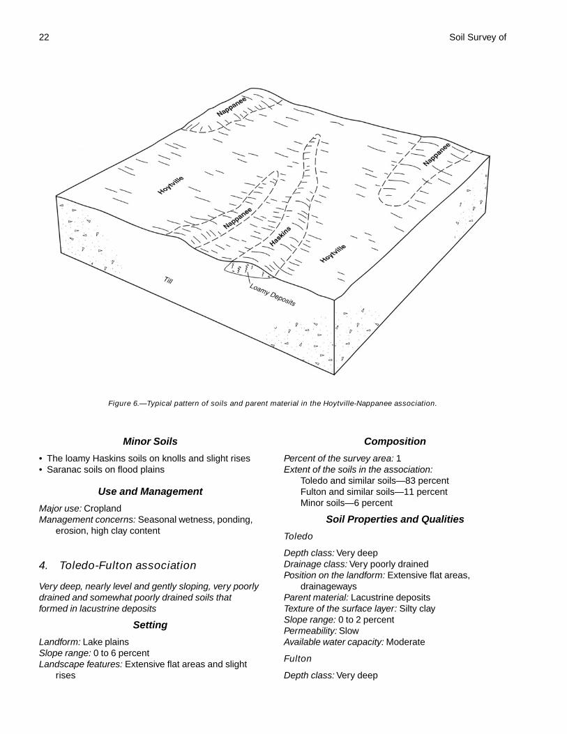
Percent of the survey area: 21Extent of the soils in the association (fig. 6):
Hoytville and similar soils—82 percentNappanee and similar soils—14 percentMinor soils—4 percent
Soil Properties and Qualities
Hoytville
Depth class: Very deep
Drainage class: Very poorly drainedPosition on the landform: Flat areas, depressions,
drainagewaysParent material: TillTexture of the surface layer: Silty clay or silty clay
loamSlope range: 0 to 2 percentPermeability: Moderately slow in the upper part of the
subsoil and slow in the lower part of the subsoiland in the substratum
Available water capacity: Moderate
Nappanee
Depth class: Very deepDrainage class: Somewhat poorly drainedPosition on the landform: Slight rises, knolls, flat
areas, backslopesParent material: TillTexture of the surface layer: Silty clay loam or loamSlope range: 0 to 6 percentPermeability: SlowAvailable water capacity: Moderate
Figure 5.—Typical pattern of soils and parent material in the Latty-Nappanee association.
22 Soil Survey of
Minor Soils
• The loamy Haskins soils on knolls and slight rises• Saranac soils on flood plains
Use and Management
Major use: CroplandManagement concerns: Seasonal wetness, ponding,
erosion, high clay content
4. Toledo-Fulton association
Very deep, nearly level and gently sloping, very poorlydrained and somewhat poorly drained soils thatformed in lacustrine deposits
Setting
Landform: Lake plainsSlope range: 0 to 6 percentLandscape features: Extensive flat areas and slight
rises
Composition
Percent of the survey area: 1Extent of the soils in the association:
Toledo and similar soils—83 percentFulton and similar soils—11 percentMinor soils—6 percent
Soil Properties and Qualities
Toledo
Depth class: Very deepDrainage class: Very poorly drainedPosition on the landform: Extensive flat areas,
drainagewaysParent material: Lacustrine depositsTexture of the surface layer: Silty claySlope range: 0 to 2 percentPermeability: SlowAvailable water capacity: Moderate
Fulton
Depth class: Very deep
Figure 6.—Typical pattern of soils and parent material in the Hoytville-Nappanee association.
Paulding County, Ohio 23
Drainage class: Somewhat poorly drainedPosition on the landform: Slight rises, knolls, flat
areas, backslopesParent material: Lacustrine depositsTexture of the surface layer: Silty clay loam or loamSlope range: 0 to 6 percentPermeability: Slow in the upper part of the subsoil and
slow or very slow in the lower part of the subsoiland in the substratum
Available water capacity: Moderate
Minor Soils
• The loamy Haskins soils on slight rises and knolls
Use and Management
Major use: CroplandManagement concerns: Seasonal wetness, ponding,
erosion, compaction, high clay content
5. Fulton, loamy substratum-Rossburg-Lucas, loamy substratum, association
Very deep, nearly level to strongly sloping, somewhatpoorly drained, well drained, and moderately welldrained soils that formed in lacustrine depositsoverlying loamy glaciofluvial deposits on streamterraces and in alluvium on flood plains
Setting
Landform: Stream terraces and flood plainsSlope range: Generally 0 to 2 percent; 0 to 12 percent
in a few areas on terracesLandscape features: Flat areas and slight rises
Composition
Percent of the survey area: 4Extent of the soils in the association:
Fulton, loamy substratum, and similar soils—30percent
Rossburg and similar soils—22 percentLucas, loamy substratum, and similar soils—14
percentMinor soils—34 percent
Soil Properties and Qualities
Fulton, loamy substratum
Depth class: Very deepDrainage class: Somewhat poorly drainedPosition on the landform: Flat areas, slight rises,
knolls, and backslopes on stream terracesParent material: Lacustrine deposits overlying loamy
glaciofluvial depositsTexture of the surface layer: Silty clay loam
Slope range: 0 to 6 percentPermeability: Slow in the subsoil and moderate in the
substratumAvailable water capacity: Moderate
Rossburg
Depth class: Very deepDrainage class: Well drainedPosition on the landform: Slight rises and areas
adjacent to the stream channel on flood plainsParent material: AlluviumTexture of the surface layer: Silt loamSlope range: 0 to 2 percentPermeability: Moderate in the subsoil and moderately
rapid or rapid in the substratumAvailable water capacity: High
Lucas, loamy substratum
Depth class: Very deepDrainage class: Moderately well drainedPosition on the landform: Slight rises, knolls, and
backslopes on stream terracesParent material: Lacustrine deposits overlying loamy
glaciofluvial depositsTexture of the surface layer: Silt loam or silty clay loamSlope range: 0 to 12 percentPermeability: Slow in the solum and moderate or
moderately slow in the substratumAvailable water capacity: Moderate
Minor Soils
• Toledo soils in depressions on stream terraces• Flatrock, Medway, and Shoals soils on flood plains
Use and Management
Major use: CroplandManagement concerns: Rossburg—occasional
flooding; Fulton and Lucas—seasonal wetness,erosion, high content of clay in the subsoil
6. Toledo-Bixler association
Very deep, nearly level, very poorly drained andsomewhat poorly drained soils that formed inlacustrine deposits
Setting
Landform: Lake plainsSlope range: 0 to 2 percentLandscape features: Extensive flat areas, knolls, slight
rises, and drainageways
Composition
Percent of the survey area: 3
24
Extent of the soils in the association:Toledo and similar soils—51 percentBixler and similar soils—20 percentMinor soils—29 percent
Soil Properties and QualitiesToledo
Depth class: Very deepDrainage class: Very poorly drainedPosition on the landform: Extensive flat areas,
drainagewaysParent material: Lacustrine depositsTexture of the surface layer: Silty clay loamSlope range: 0 to 2 percentPermeability: SlowAvailable water capacity: Moderate
Bixler
Depth class: Very deepDrainage class: Somewhat poorly drained
Position on the landform: Slight rises, knollsParent material: Lacustrine depositsTexture of the surface layer: Loamy sandSlope range: 0 to 2 percentPermeability: Rapid in the sandy material, moderate in
the underlying loamy and silty subsoil andsubstratum, and slow or very slow in the clayeysubstratum
Available water capacity: Moderate
Minor Soils
• The loamy Mermill soils in flat areas and indepressions• The sandy Tedrow soils on beach ridges
Use and Management
Major use: CroplandManagement concerns: Seasonal wetness, ponding,
wind erosion, high clay content
25
The map units delineated on the detailed soil mapsin this survey represent the soils or miscellaneousareas in the county. The map unit descriptions in thissection, along with the maps, can be used todetermine the suitability and potential of a unit forspecific uses. They also can be used to plan themanagement needed for those uses. More informationabout each map unit is given in the tables describedunder the heading “Use and Management of theSoils.”
A map unit delineation on a soil map represents anarea dominated by one or more major kinds of soil ormiscellaneous areas. A map unit is identified andnamed according to the taxonomic classification of thedominant soils. Within a taxonomic class there areprecisely defined limits for the properties of the soils.On the landscape, however, the soils andmiscellaneous areas are natural phenomena, and theyhave the characteristic variability of all naturalphenomena. Thus, the range of some observedproperties may extend beyond the limits defined for ataxonomic class. Areas of soils of a single taxonomicclass rarely, if ever, can be mapped without includingareas of other taxonomic classes. Consequently, everymap unit is made up of the soils or miscellaneousareas for which it is named and some “included” areasthat belong to other taxonomic classes.
Most included soils have properties similar to thoseof the dominant soil or soils in the map unit, and thusthey do not affect use and management. These arecalled noncontrasting, or similar, inclusions. They mayor may not be mentioned in the map unit description.Other included soils and miscellaneous areas,however, have properties and behavioralcharacteristics divergent enough to affect use or torequire different management. These are calledcontrasting, or dissimilar, components. They generallyare in small areas and could not be mappedseparately because of the scale used. Some smallareas of strongly contrasting soils or miscellaneousareas are identified by a special symbol on the maps.The included areas of contrasting soils ormiscellaneous areas are mentioned in the map unitdescriptions. A few included areas may not have beenobserved, and consequently they are not mentioned in
the descriptions, especially where the pattern was socomplex that it was impractical to make enoughobservations to identify all the soils and miscellaneousareas on the landscape.
The presence of included areas in a map unit in noway diminishes the usefulness or accuracy of thedata. The objective of mapping is not to delineate puretaxonomic classes but rather to separate thelandscape into landforms or landform segments thathave similar use and management requirements. Thedelineation of such segments on the map providessufficient information for the development of resourceplans, but if intensive use of small areas is planned,onsite investigation is needed to define and locate thesoils and miscellaneous areas.
An identifying symbol precedes the map unit namein the map unit descriptions. Each description includesgeneral facts about the unit and lists some of the soilproperties and qualities that can affect use andmanagement.
Soils that have profiles that are almost alike makeup a soil series. Except for differences in texture of thesurface layer, all the soils of a series have majorhorizons that are similar in composition, thickness,and arrangement.
Soils of one series can differ in texture of thesurface layer, slope, stoniness, salinity, degree oferosion, and other characteristics that affect their use.On the basis of such differences, a soil series isdivided into soil phases. Most of the areas shown onthe detailed soil maps are phases of soil series. Thename of a soil phase commonly indicates a featurethat affects use or management. For example,Belmore loam, till substratum, 2 to 6 percent slopes, isa phase of the Belmore series.
Some map units are made up of two or more majorsoils or miscellaneous areas. These map units arecalled complexes. A complex consists of two or moresoils or miscellaneous areas in such an intricatepattern or in such small areas that they cannot beshown separately on the maps. The pattern andproportion of the soils or miscellaneous areas aresomewhat similar in all areas. Rimer-Fulton complex,0 to 2 percent slopes, is an example.
This survey includes miscellaneous areas. Such
Detailed Soil Map Units
26 Soil Survey of
areas have little or no soil material and support little orno vegetation. The map unit Pits, quarry, is anexample.
Table 4 gives the acreage and proportionate extentof each map unit. Other tables give properties of thesoils and the limitations, capabilities, and potentials formany uses. The Glossary defines many of the termsused in describing the soils or miscellaneous areas.
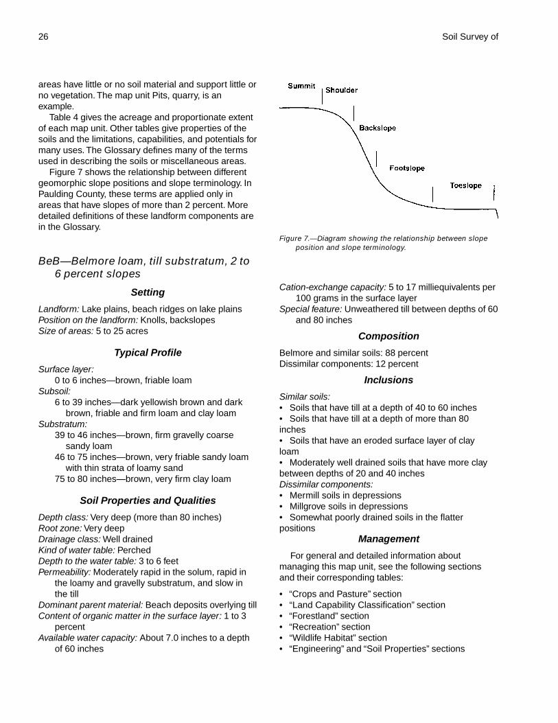
Figure 7 shows the relationship between differentgeomorphic slope positions and slope terminology. InPaulding County, these terms are applied only inareas that have slopes of more than 2 percent. Moredetailed definitions of these landform components arein the Glossary.
BeB—Belmore loam, till substratum, 2 to6 percent slopes
Setting
Landform: Lake plains, beach ridges on lake plainsPosition on the landform: Knolls, backslopesSize of areas: 5 to 25 acres
Typical Profile
Surface layer:0 to 6 inches—brown, friable loam
Subsoil:6 to 39 inches—dark yellowish brown and dark
brown, friable and firm loam and clay loamSubstratum:
39 to 46 inches—brown, firm gravelly coarsesandy loam
46 to 75 inches—brown, very friable sandy loamwith thin strata of loamy sand
75 to 80 inches—brown, very firm clay loam
Soil Properties and Qualities
Depth class: Very deep (more than 80 inches)Root zone: Very deepDrainage class: Well drainedKind of water table: PerchedDepth to the water table: 3 to 6 feetPermeability: Moderately rapid in the solum, rapid in
the loamy and gravelly substratum, and slow inthe till
Dominant parent material: Beach deposits overlying tillContent of organic matter in the surface layer: 1 to 3
percentAvailable water capacity: About 7.0 inches to a depth
of 60 inches
Cation-exchange capacity: 5 to 17 milliequivalents per100 grams in the surface layer
Special feature: Unweathered till between depths of 60and 80 inches
Composition
Belmore and similar soils: 88 percentDissimilar components: 12 percent
Inclusions
Similar soils:• Soils that have till at a depth of 40 to 60 inches• Soils that have till at a depth of more than 80inches• Soils that have an eroded surface layer of clayloam• Moderately well drained soils that have more claybetween depths of 20 and 40 inchesDissimilar components:• Mermill soils in depressions• Millgrove soils in depressions• Somewhat poorly drained soils in the flatterpositions
Management
For general and detailed information aboutmanaging this map unit, see the following sectionsand their corresponding tables:
• “Crops and Pasture” section• “Land Capability Classification” section• “Forestland” section• “Recreation” section• “Wildlife Habitat” section• “Engineering” and “Soil Properties” sections
Figure 7.—Diagram showing the relationship between slopeposition and slope terminology.
Paulding County, Ohio 27
BkA—Bixler loamy sand, clayeysubstratum, 0 to 2 percent slopes
Setting
Landform: Lake plainsPosition on the landform: Slight rises, knollsSize of areas: 5 to 40 acres
Typical Profile
Surface layer:0 to 10 inches—very dark grayish brown, very
friable loamy sandSubsurface layer:
10 to 28 inches—yellowish brown, mottled, veryfriable loamy sand
Subsoil:28 to 36 inches—grayish brown, mottled, friable
sandy loam36 to 46 inches—grayish brown, mottled, firm silt
loam with thin strata of silty clay loamSubstratum:
46 to 74 inches—dark yellowish brown, mottled,friable silt loam with thin strata of very finesandy loam
74 to 80 inches—dark yellowish brown, mottled,firm silty clay
Soil Properties and Qualities
Depth class: Very deep (more than 80 inches)Root zone: Very deepDrainage class: Somewhat poorly drainedKind of water table: PerchedDepth to the water table: 1.5 to 3.0 feetPermeability: Rapid in the sandy material, moderate in
the underlying loamy and silty subsoil andsubstratum, and slow or very slow in the clayeysubstratum
Dominant parent material: Lacustrine depositsContent of organic matter in the surface layer: 0.5 to
3.0 percentPotential for frost action: HighAvailable water capacity: About 7.0 inches to a depth
of 60 inchesCation-exchange capacity: 2 to 15 milliequivalents per
100 grams in the surface layerSpecial features: A clayey substratum between depths
of 60 and 80 inches; the surface layer may besusceptible to wind erosion.
Composition
Bixler and similar soils: 92 percentDissimilar components: 8 percent
Inclusions
Similar soils:• Soils that have a darker surface layer• Soils that have more clay in the substratum• Soils that have a surface layer of loamy sand andare less than 20 inches thick in the upper part of thesubsoil• Soils that have a surface layer of loamy fine sand• Soils that are loamy sand or sand to a depth ofmore than 80 inchesDissimilar components:• Very poorly drained soils in depressions anddrainageways
Management
For general and detailed information aboutmanaging this map unit, see the following sectionsand their corresponding tables:
• “Crops and Pasture” section• “Land Capability Classification” section• “Forestland” section• “Recreation” section• “Wildlife Habitat” section• “Engineering” and “Soil Properties” sections
BrB2—Broughton silty clay loam, 2 to 6percent slopes, eroded
Setting
Landform: Lake plainsPosition on the landform: Knolls, backslopesSize of areas: 5 to 20 acresSpecial feature: Part of the original surface layer has
been removed.
Typical Profile
Surface layer:0 to 6 inches—dark grayish brown, firm silty clay
loamSubsoil:
6 to 13 inches—dark yellowish brown, very firmclay
13 to 17 inches—dark yellowish brown, mottled,very firm clay
17 to 26 inches—yellowish brown, mottled, veryfirm clay
Substratum:26 to 80 inches—yellowish brown, mottled, very
firm clay
28 Soil Survey of
Soil Properties and Qualities
Depth class: Very deep (more than 80 inches)Root zone: Restricted by a very high content of clay in
the subsoil and substratumDrainage class: Moderately well drainedKind of water table: PerchedDepth to the water table: 1.5 to 3.0 feetPermeability: Very slowDominant parent material: Lacustrine depositsContent of organic matter in the surface layer: 1 to 3
percentShrink-swell potential: High in the subsoil and
substratumAvailable water capacity: About 4.1 inches to a depth
of 60 inchesCation-exchange capacity: 13 to 30 milliequivalents
per 100 grams in the surface layerSpecial feature: A high content of clay in the surface
layer
Composition
Broughton and similar soils: 93 percentDissimilar components: 7 percent
Inclusions
Similar soils:• Soils that have a surface layer of silt loam or loam• Soils that have more clay in the severely erodedsurface layer• Somewhat poorly drained soilsDissimilar components:• Paulding soils in drainageways
Management
For general and detailed information aboutmanaging this map unit, see the following sectionsand their corresponding tables:
• “Crops and Pasture” section• “Land Capability Classification” section• “Forestland” section• “Recreation” section• “Wildlife Habitat” section• “Engineering” and “Soil Properties” sections
BrC2—Broughton silty clay loam, 6 to 12percent slopes, eroded
Setting
Landform: Lake plainsPosition on the landform: Dissected areas along
streamsSize of areas: 5 to 15 acres
Special feature: Part of the original surface layer hasbeen removed.
Typical Profile
Surface layer:0 to 8 inches—brown, firm silty clay loam
Subsoil:8 to 15 inches—yellowish brown, very firm clay15 to 18 inches—yellowish brown, mottled, very
firm clay18 to 27 inches—dark yellowish brown, mottled,
very firm claySubstratum:
27 to 80 inches—dark yellowish brown, mottled,very firm clay
Soil Properties and Qualities
Depth class: Very deep (more than 80 inches)Root zone: Restricted by a very high content of clay in
the subsoil and substratumDrainage class: Moderately well drainedKind of water table: PerchedDepth to the water table: 1.5 to 3.0 feetPermeability: Very slowDominant parent material: Lacustrine depositsContent of organic matter in the surface layer: 1 to 3
percentShrink-swell potential: High in the subsoil and
substratumAvailable water capacity: About 4.3 inches to a depth
of 60 inchesCation-exchange capacity: 13 to 30 milliequivalents
per 100 grams in the surface layerSpecial feature: A high content of clay in the surface
layer
Composition
Broughton and similar soils: 95 percentDissimilar components: 5 percent
Inclusions
Similar soils:• Soils that have till at a depth of 60 to 80 inches• Soils that have more clay in the severely erodedsurface layer• Soils that have a surface layer of silt loam• Somewhat poorly drained soilsDissimilar components:• Wabasha soils in drainageways
Management
For general and detailed information aboutmanaging this map unit, see the following sectionsand their corresponding tables:
Paulding County, Ohio 29
• “Crops and Pasture” section• “Land Capability Classification” section• “Forestland” section• “Recreation” section• “Wildlife Habitat” section• “Engineering” and “Soil Properties” sections
BrD2—Broughton silty clay loam, 12 to 18percent slopes, eroded
Setting
Landform: Lake plainsPosition on the landform: Dissected areas along
streamsSize of areas: 5 to 20 acresSpecial feature: Part of the original surface layer has
been removed.
Typical Profile
Surface layer:0 to 6 inches—brown, very firm silty clay loam
Subsoil:6 to 12 inches—yellowish brown, very firm clay12 to 16 inches—yellowish brown, mottled, very
firm clay16 to 21 inches—dark yellowish brown, mottled,
very firm claySubstratum:
21 to 80 inches—dark yellowish brown, mottled,very firm clay
Soil Properties and Qualities
Depth class: Very deep (more than 80 inches)Root zone: Restricted by a very high content of clay in
the subsoil and substratumDrainage class: Moderately well drainedKind of water table: PerchedDepth to the water table: 1.5 to 3.0 feetPermeability: Very slowDominant parent material: Lacustrine depositsContent of organic matter in the surface layer: 1 to 3
percentShrink-swell potential: High in the subsoil and
substratumAvailable water capacity: About 4.1 inches to a depth
of 60 inchesCation-exchange capacity: 13 to 30 milliequivalents
per 100 grams in the surface layerSpecial feature: A high content of clay in the surface
layer
Composition
Broughton and similar soils: 95 percentDissimilar components: 5 percent
Inclusions
Similar soils:• Soils that have till at a depth of 60 to 80 inches• Soils that have more clay in the severely erodedsurface layer• Soils that have a surface layer of silt loam• Somewhat poorly drained soilsDissimilar components:• Wabasha soils in drainageways
Management
For general and detailed information aboutmanaging this map unit, see the following sectionsand their corresponding tables:
• “Crops and Pasture” section• “Land Capability Classification” section• “Forestland” section• “Recreation” section• “Wildlife Habitat” section• “Engineering” and “Soil Properties” sections
BrE2—Broughton silty clay loam, 18 to 35percent slopes, eroded
Setting
Landform: Lake plainsPosition on the landform: Dissected areas along
streamsSize of areas: 5 to 15 acresSpecial feature: Part of the original surface layer has
been removed.
Typical Profile
Surface layer:0 to 4 inches—very dark grayish brown, firm silty
clay loamSubsoil:
4 to 8 inches—pale brown, firm silty clay loam8 to 13 inches—yellowish brown, very firm clay13 to 22 inches—dark yellowish brown and
yellowish brown, mottled, very firm claySubstratum:
22 to 80 inches—brown, mottled, very firm clay
Soil Properties and Qualities
Depth class: Very deep (more than 80 inches)
30 Soil Survey of
Root zone: Restricted by a very high content of clay inthe subsoil and substratum
Drainage class: Moderately well drainedKind of water table: PerchedDepth to the water table: 1.5 to 3.0 feetPermeability: Very slowDominant parent material: Lacustrine depositsContent of organic matter in the surface layer: 1 to 3
percentShrink-swell potential: High in the subsoil and
substratumAvailable water capacity: About 4.5 inches to a depth
of 60 inchesCation-exchange capacity: 13 to 30 milliequivalents
per 100 grams in the surface layerSpecial feature: A high content of clay in the surface
layer
Composition
Broughton and similar soils: 95 percentDissimilar components: 5 percent
Inclusions
Similar soils:• Soils that have till at a depth of 60 to 80 inches• Soils that have more clay in the severely erodedsurface layer• Soils that have a surface layer of silt loam• Somewhat poorly drained soilsDissimilar components:• Wabasha soils in drainageways
Management
For general and detailed information aboutmanaging this map unit, see the following sectionsand their corresponding tables:
• “Crops and Pasture” section• “Land Capability Classification” section• “Forestland” section• “Recreation” section• “Wildlife Habitat” section• “Engineering” and “Soil Properties” sections
BsC3—Broughton silty clay, 6 to 12percent slopes, severely eroded
Setting
Landform: Lake plainsPosition on the landform: Dissected areas along
streamsSize of areas: 5 to 15 acres
Special feature: Most of the original surface layer hasbeen removed.
Typical Profile
Surface layer:0 to 5 inches—brown, very firm silty clay
Subsoil:5 to 12 inches—yellowish brown, mottled, very
firm clay12 to 27 inches—brown and yellowish brown,
mottled, very firm clay27 to 34 inches—dark yellowish brown, mottled,
very firm claySubstratum:
34 to 80 inches—dark yellowish brown, mottled,very firm clay
Soil Properties and Qualities
Depth class: Very deep (more than 80 inches)Root zone: Restricted by a very high content of clay in
the subsoil and substratumDrainage class: Moderately well drainedKind of water table: PerchedDepth to the water table: 1.5 to 3.0 feetPermeability: Very slowDominant parent material: Lacustrine depositsContent of organic matter in the surface layer: 0.5 to
2.0 percentShrink-swell potential: High throughout the profileAvailable water capacity: About 3.8 inches to a depth
of 60 inchesCation-exchange capacity: 17 to 37 milliequivalents
per 100 grams in the surface layerSpecial feature: A high content of clay in the surface
layer
Composition
Broughton and similar soils: 95 percentDissimilar components: 5 percent
Inclusions
Similar soils:• Soils that have less clay in the eroded surface layer• Soils that have till at a depth of 40 to 80 inches• Somewhat poorly drained soilsDissimilar components:• Wabasha soils in drainageways
Management
For general and detailed information aboutmanaging this map unit, see the following sectionsand their corresponding tables:
Paulding County, Ohio 31
• “Crops and Pasture” section• “Land Capability Classification” section• “Forestland” section• “Recreation” section• “Wildlife Habitat” section• “Engineering” and “Soil Properties” sections
BsD3—Broughton silty clay, 12 to 18percent slopes, severely eroded
Setting
Landform: Lake plainsPosition on the landform: Dissected areas along
streamsSize of areas: 5 to 20 acresSpecial feature: Most of the original surface layer has
been removed.
Typical Profile
Surface layer:0 to 5 inches—yellowish brown, very firm silty clay
Subsoil:5 to 11 inches—yellowish brown, very firm clay11 to 25 inches—dark yellowish brown, mottled,
very firm claySubstratum:
25 to 80 inches—dark yellowish brown, mottled,very firm clay
Soil Properties and Qualities
Depth class: Very deep (more than 80 inches)Root zone: Restricted by a very high content of clay in
the subsoil and substratumDrainage class: Moderately well drainedKind of water table: PerchedDepth to the water table: 1.5 to 3.0 feetPermeability: Very slowDominant parent material: Lacustrine depositsContent of organic matter in the surface layer: 0.5 to
2.0 percentShrink-swell potential: High throughout the profileAvailable water capacity: About 3.7 inches to a depth
of 60 inchesCation-exchange capacity: 17 to 37 milliequivalents
per 100 grams in the surface layerSpecial feature: A high content of clay in the surface
layer
Composition
Broughton and similar soils: 95 percentDissimilar components: 5 percent
Inclusions
Similar soils:• Soils that have till at a depth of 40 to 80 inches• Soils that have less clay in the eroded surface layer• Somewhat poorly drained soilsDissimilar components:• Wabasha soils in drainageways
Management
For general and detailed information aboutmanaging this map unit, see the following sectionsand their corresponding tables:
• “Crops and Pasture” section• “Land Capability Classification” section• “Forestland” section• “Recreation” section• “Wildlife Habitat” section• “Engineering” and “Soil Properties” sections
Db—Defiance silty clay loam,occasionally flooded
Setting
Landform: Flood plainsPosition on the landform: Slight rises, flat areasSlope range: 0 to 2 percentSize of areas: 10 to 40 acres
Typical Profile
Surface layer:0 to 8 inches—dark grayish brown, firm silty clay
loamSubsoil:
8 to 48 inches—brown, grayish brown, andyellowish brown, mottled, firm silty clay loam,silty clay, and clay
Substratum:48 to 80 inches—grayish brown, mottled, firm clay
with thin strata of clay loam
Soil Properties and Qualities
Depth class: Very deep (more than 80 inches)Root zone: Very deepDrainage class: Somewhat poorly drainedKind of water table: ApparentDepth to the water table: 1.0 to 2.5 feetFlooding duration: BriefPermeability: SlowDominant parent material: AlluviumContent of organic matter in the surface layer: 2 to 3
percent
32 Soil Survey of
Shrink-swell potential: High in the subsoil andsubstratum
Potential for frost action: HighAvailable water capacity: About 8.5 inches to a depth
of 60 inchesCation-exchange capacity: 15 to 30 milliequivalents
per 100 grams in the surface layerSpecial feature: A high content of clay throughout
Composition
Defiance and similar soils: 93 percentDissimilar components: 7 percent
Inclusions
Similar soils:• Soils that have less clay in the subsoil• Soils that have till at a depth of 60 to 80 inches• Moderately well drained soilsDissimilar components:• Saranac soils in depressions and old streamchannels
Management
For general and detailed information aboutmanaging this map unit, see the following sectionsand their corresponding tables:
• “Crops and Pasture” section• “Land Capability Classification” section• “Forestland” section• “Recreation” section• “Wildlife Habitat” section• “Engineering” and “Soil Properties” sections
Dc—Defiance silty clay loam, frequentlyflooded
Setting
Landform: Flood plainsPosition on the landform: Flat areas, slight risesSlope range: 0 to 2 percentSize of areas: 5 to 40 acres
Typical Profile
Surface layer:0 to 8 inches—dark grayish brown, firm silty clay
loamSubsoil:
8 to 34 inches—grayish brown and yellowishbrown, mottled, firm silty clay
Substratum:34 to 80 inches—grayish brown, mottled, very firm
silty clay
Soil Properties and Qualities
Depth class: Very deep (more than 80 inches)Root zone: Very deepDrainage class: Somewhat poorly drainedKind of water table: ApparentDepth to the water table: 1.0 to 2.5 feetFlooding duration: BriefPermeability: SlowDominant parent material: AlluviumContent of organic matter in the surface layer: 2 to 3
percentShrink-swell potential: High in the subsoil and
substratumPotential for frost action: HighAvailable water capacity: About 8.3 inches to a depth
of 60 inchesCation-exchange capacity: 15 to 30 milliequivalents
per 100 grams in the surface layerSpecial feature: A high content of clay throughout
Composition
Defiance and similar soils: 93 percentDissimilar components: 7 percent
InclusionsSimilar soils:• Soils that have less clay in the subsoil• Soils that have till at a depth of 60 to 80 inches• Moderately well drained soilsDissimilar components:• Wabasha soils in depressions and old streamchannels
Management
For general and detailed information aboutmanaging this map unit, see the following sectionsand their corresponding tables:
• “Crops and Pasture” section• “Land Capability Classification” section• “Forestland” section• “Recreation” section• “Wildlife Habitat” section• “Engineering” and “Soil Properties” sections
Fb—Flatrock silt loam, occasionallyflooded
Setting
Landform: Flood plainsPosition on the landform: Slight rises, areas adjacent
to the stream channelSlope range: 0 to 2 percentSize of areas: 10 to 50 acres
Paulding County, Ohio 33
Typical Profile
Surface layer:0 to 10 inches—brown, friable silt loam
Subsoil:10 to 15 inches—dark yellowish brown, friable silt
loam15 to 38 inches—dark yellowish brown, mottled,
friable silt loam and loamSubstratum:
38 to 80 inches—yellowish brown, mottled, friableloam with strata of silt loam
Soil Properties and Qualities
Depth class: Very deep (more than 80 inches)Root zone: Very deepDrainage class: Moderately well drainedKind of water table: ApparentDepth to the water table: 1.5 to 3.0 feetFlooding duration: BriefPermeability: Moderate in the solum and moderate or
moderately rapid in the substratumDominant parent material: AlluviumContent of organic matter in the surface layer: 1 to 3
percentAvailable water capacity: About 11.0 inches to a depth
of 60 inchesCation-exchange capacity: 9 to 20 milliequivalents per
100 grams in the surface layer
Composition
Flatrock and similar soils: 97 percentDissimilar components: 3 percent
Inclusions
Similar soils:• Soils that have a darker surface layer• Soils that have a surface layer of loam• Well drained soils• Somewhat poorly drained soilsDissimilar components:• Areas that are subject to only rare flooding;intermixed throughout the mapped areas
Management
For general and detailed information aboutmanaging this map unit, see the following sectionsand their corresponding tables:
• “Crops and Pasture” section• “Land Capability Classification” section• “Forestland” section• “Recreation” section
• “Wildlife Habitat” section• “Engineering” and “Soil Properties” sections
Fc—Flatrock silt loam, frequently flooded
Setting
Landform: Flood plainsPosition on the landform: Slight rises, areas adjacent
to the stream channelSlope range: 0 to 2 percentSize of areas: 10 to 80 acres
Typical Profile
Surface layer:0 to 13 inches—brown, friable silt loam
Subsoil:13 to 18 inches—yellowish brown, mottled, friable
silt loam18 to 44 inches—dark yellowish brown, mottled,
firm loamSubstratum:
44 to 80 inches—yellowish brown, mottled, friableloam with thin strata of silt loam and fine sandyloam
Soil Properties and Qualities
Depth class: Very deep (more than 80 inches)Root zone: Very deepDrainage class: Moderately well drainedKind of water table: ApparentDepth to the water table: 1.5 to 3.0 feetFlooding duration: BriefPermeability: Moderate in the solum and moderate or
moderately rapid in the substratumDominant parent material: AlluviumContent of organic matter in the surface layer: 1 to 3
percentAvailable water capacity: About 11.3 inches to a depth
of 60 inchesCation-exchange capacity: 9 to 20 milliequivalents per
100 grams in the surface layer
Composition
Flatrock and similar soils: 97 percentDissimilar components: 3 percent
Inclusions
Similar soils:• Soils that have a surface layer of loam• Well drained soils• Somewhat poorly drained soils
34 Soil Survey of
Dissimilar components:• Wabasha soils in old stream channels
Management
For general and detailed information aboutmanaging this map unit, see the following sectionsand their corresponding tables:
• “Crops and Pasture” section• “Land Capability Classification” section• “Forestland” section• “Recreation” section• “Wildlife Habitat” section• “Engineering” and “Soil Properties” sections
FtA—Fulton loam, 0 to 2 percent slopes
Setting
Landform: Lake plainsPosition on the landform: Slight rises, flat areasSize of areas: 5 to 50 acres
Typical Profile
Surface layer:0 to 10 inches—dark grayish brown, friable loam
Subsoil:10 to 37 inches—yellowish brown, mottled, firm
and very firm clay37 to 42 inches—yellowish brown, mottled, very
firm silty claySubstratum:
42 to 80 inches—olive brown, mottled, very firmsilty clay
Soil Properties and Qualities
Depth class: Very deep (more than 80 inches)Root zone: Very deepDrainage class: Somewhat poorly drainedKind of water table: PerchedDepth to the water table: 1.0 to 2.5 feetPermeability: Slow in the upper part of the subsoil and
slow or very slow in the lower part of the subsoiland in the substratum
Dominant parent material: Lacustrine depositsContent of organic matter in the surface layer: 2 to 3
percentShrink-swell potential: High in the subsoil and
substratumPotential for frost action: HighAvailable water capacity: About 7.5 inches to a depth
of 60 inchesCation-exchange capacity: 14 to 24 milliequivalents
per 100 grams in the surface layer
Special feature: A high content of clay in the subsoiland substratum
Composition
Fulton and similar soils: 94 percentDissimilar components: 6 percent
Inclusions
Similar soils:• Soils that have till at a depth of 60 to 80 inches• Soils that have a surface layer of silty clay loam orclay loam• Soils that have less clay in the subsoilDissimilar components:• Latty and Toledo soils in depressions anddrainageways
Management
For general and detailed information aboutmanaging this map unit, see the following sectionsand their corresponding tables:
• “Crops and Pasture” section• “Land Capability Classification” section• “Forestland” section• “Recreation” section• “Wildlife Habitat” section• “Engineering” and “Soil Properties” sections
FuA—Fulton silty clay loam, 0 to 2percent slopes
Setting
Landform: Lake plainsPosition on the landform: Slight rises, flat areasSize of areas: 5 to 50 acres
Typical Profile
Surface layer:0 to 10 inches—dark grayish brown, firm silty clay
loamSubsoil:
10 to 38 inches—yellowish brown and brown,mottled, firm and very firm silty clay
38 to 47 inches—yellowish brown, mottled, veryfirm silty clay
Substratum:47 to 80 inches—yellowish brown, mottled, very
firm silty clay
Soil Properties and Qualities
Depth class: Very deep (more than 80 inches)Root zone: Very deep

Paulding County, Ohio 35
Drainage class: Somewhat poorly drainedKind of water table: PerchedDepth to the water table: 1.0 to 2.5 feetPermeability: Slow in the upper part of the subsoil and
slow or very slow in the lower part of the subsoiland in the substratum
Dominant parent material: Lacustrine depositsContent of organic matter in the surface layer: 2 to 3
percentShrink-swell potential: High in the subsoil and
substratumPotential for frost action: HighAvailable water capacity: About 7.5 inches to a depth
of 60 inchesCation-exchange capacity: 15 to 30 milliequivalents
per 100 grams in the surface layerSpecial feature: A high content of clay throughout
Composition
Fulton and similar soils: 94 percentDissimilar components: 6 percent
Inclusions
Similar soils:• Soils that have till at a depth of 60 to 80 inches• Soils that have a surface layer of loam or silt loam• Soils that have less clay in the subsoilDissimilar components:• Latty and Toledo soils in depressions anddrainageways
Management
For general and detailed information aboutmanaging this map unit, see the following sectionsand their corresponding tables:
• “Crops and Pasture” section• “Land Capability Classification” section• “Forestland” section• “Recreation” section• “Wildlife Habitat” section• “Engineering” and “Soil Properties” sections
FuB2—Fulton silty clay loam, 2 to 6percent slopes, eroded
Setting
Landform: Lake plainsPosition on the landform: Knolls, backslopesSize of areas: 5 to 20 acresSpecial feature: Part of the original surface layer has
been removed.
Typical Profile
Surface layer:0 to 7 inches—brown, firm silty clay loam
Subsoil:7 to 31 inches—yellowish brown and dark
yellowish brown, mottled, firm and very firmsilty clay
31 to 38 inches—dark yellowish brown, mottled,very firm silty clay
Substratum:38 to 80 inches—dark yellowish brown, mottled,
very firm silty clay
Soil Properties and Qualities
Depth class: Very deep (more than 80 inches)Root zone: Very deepDrainage class: Somewhat poorly drainedKind of water table: PerchedDepth to the water table: 1.0 to 2.5 feetPermeability: Slow in the upper part of the subsoil and
slow or very slow in the lower part of the subsoiland in the substratum
Dominant parent material: Lacustrine depositsContent of organic matter in the surface layer: 2 to 3
percentShrink-swell potential: High in the subsoil and
substratumPotential for frost action: HighAvailable water capacity: About 7.1 inches to a depth
of 60 inchesCation-exchange capacity: 15 to 30 milliequivalents
per 100 grams in the surface layerSpecial feature: A high content of clay throughout
Composition
Fulton and similar soils: 95 percentDissimilar components: 5 percent
Inclusions
Similar soils:• Soils that have till at a depth of 40 to 80 inches• Soils that have more clay in the subsoil andsubstratum• Moderately well drained soilsDissimilar components:• Latty soils in drainageways
Management
For general and detailed information aboutmanaging this map unit, see the following sectionsand their corresponding tables:
• “Crops and Pasture” section
36 Soil Survey of
• “Land Capability Classification” section• “Forestland” section• “Recreation” section• “Wildlife Habitat” section• “Engineering” and “Soil Properties” sections
FxA—Fulton silty clay loam, loamysubstratum, 0 to 2 percent slopes
Setting
Landform: Lake plains, stream terracesPosition on the landform: Flat areas, slight risesSize of areas: 5 to 50 acres
Typical Profile
Surface layer:0 to 9 inches—dark grayish brown, firm silty clay
loamSubsoil:
9 to 36 inches—yellowish brown and grayishbrown, mottled, very firm silty clay
36 to 44 inches—yellowish brown, mottled, friablesilty clay loam
Substratum:44 to 80 inches—yellowish brown, mottled, friable
silt loam with strata of clay loam and fine sandyloam
Soil Properties and Qualities
Depth class: Very deep (more than 80 inches)Root zone: Very deepDrainage class: Somewhat poorly drainedKind of water table: PerchedDepth to the water table: 1.0 to 2.5 feetPermeability: Slow in the subsoil and moderate in the
substratumDominant parent material: Lacustrine deposits
overlying loamy glaciofluvial depositsContent of organic matter in the surface layer: 2 to 3
percentShrink-swell potential: High in the subsoilPotential for frost action: HighAvailable water capacity: About 8.1 inches to a depth
of 60 inchesCation-exchange capacity: 15 to 30 milliequivalents
per 100 grams in the surface layerSpecial features: A loamy substratum between depths
of 40 and 80 inches; a high content of clay in thesurface layer and subsoil
Composition
Fulton and similar soils: 95 percentDissimilar components: 5 percent
Inclusions
Similar soils:• Soils that have a surface layer of silt loam• Soils that have carbonates at a depth of less than40 inches• Soils that have more clay and less sand in thesubstratum• Moderately well drained soilsDissimilar components:• Toledo soils in depressions and drainageways
Management
For general and detailed information aboutmanaging this map unit, see the following sectionsand their corresponding tables:
• “Crops and Pasture” section• “Land Capability Classification” section• “Forestland” section• “Recreation” section• “Wildlife Habitat” section• “Engineering” and “Soil Properties” sections
FxB—Fulton silty clay loam, loamysubstratum, 2 to 6 percent slopes
Setting
Landform: Lake plains, stream terracesPosition on the landform: Knolls, backslopesSize of areas: 5 to 20 acres
Typical Profile
Surface layer:0 to 8 inches—dark grayish brown, friable silty
clay loamSubsoil:
8 to 31 inches—yellowish brown and brown,mottled, firm silty clay
31 to 38 inches—yellowish brown, mottled, firmsilty clay
38 to 51 inches—gray, mottled, firm silty claySubstratum:
51 to 80 inches—yellowish brown, mottled, friablesilt loam with thin strata of clay loam and loam
Soil Properties and Qualities
Depth class: Very deep (more than 80 inches)Root zone: Very deepDrainage class: Somewhat poorly drainedKind of water table: PerchedDepth to the water table: 1.0 to 2.5 feetPermeability: Slow in the subsoil and moderate in the
substratum
Paulding County, Ohio 37
Dominant parent material: Lacustrine depositsoverlying loamy glaciofluvial deposits
Content of organic matter in the surface layer: 2 to 3percent
Shrink-swell potential: High in the subsoilPotential for frost action: HighAvailable water capacity: About 7.7 inches to a depth
of 60 inchesCation-exchange capacity: 15 to 30 milliequivalents
per 100 grams in the surface layerSpecial features: A loamy substratum between depths
of 40 and 80 inches; a high content of clay in thesurface layer and subsoil
Composition
Fulton and similar soils: 95 percentDissimilar components: 5 percent
InclusionsSimilar soils:• Soils that have a surface layer of silt loam• Soils that have carbonates at a depth of less than40 inches• Soils that have more clay and less sand in thesubstratum• Moderately well drained soilsDissimilar components:• Toledo soils in drainageways
Management
For general and detailed information aboutmanaging this map unit, see the following sectionsand their corresponding tables:
• “Crops and Pasture” section• “Land Capability Classification” section• “Forestland” section• “Recreation” section• “Wildlife Habitat” section• “Engineering” and “Soil Properties” sections
Gr—Granby loamy sand, clayeysubstratum
Setting
Landform: Lake plainsPosition on the landform: Flat areas, depressionsSlope range: 0 to 2 percentSize of areas: 5 to 40 acresSpecial feature: Subject to ponding
Typical Profile
Surface layer:0 to 10 inches—very dark brown, very friable
loamy sand
Subsurface layer:10 to 13 inches—very dark brown, mottled, very
friable loamy sandSubsoil:
13 to 37 inches—dark gray and grayish brown,mottled, very friable sand and loamy sand
Substratum:37 to 61 inches—grayish brown, mottled, loose
sand61 to 80 inches—dark gray, very firm silty clay
Soil Properties and Qualities
Depth class: Very deep (more than 80 inches)Root zone: Very deepDrainage class: Poorly drained and very poorly
drainedKind of water table: ApparentWater table depth: 1 foot above to 1 foot below the
surfacePermeability: Rapid in the sandy solum and
substratum and slow or very slow in theunderlying clayey substratum
Dominant parent material: Lacustrine depositsContent of organic matter in the surface layer: 3 to 6
percentAvailable water capacity: About 5.1 inches to a depth
of 60 inchesCation-exchange capacity: 10 to 15 milliequivalents
per 100 grams in the surface layerSpecial features: This soil is a hydric soil. Also, the
surface layer may be susceptible to wind erosion,and a clayey substratum is between depths of 60and 80 inches.
Composition
Granby and similar soils: 92 percentDissimilar components: 8 percent
Inclusions
Similar soils:• Soils that have less clay in the clayey substratum• Soils that have a surface layer of fine sandy loam• Soils that have clayey material at a depth of 20 to60 inchesDissimilar components:• Tedrow soils on slight rises
Management
For general and detailed information aboutmanaging this map unit, see the following sectionsand their corresponding tables:
• “Crops and Pasture” section• “Land Capability Classification” section• “Forestland” section
38 Soil Survey of
• “Recreation” section• “Wildlife Habitat” section• “Engineering” and “Soil Properties” sections
HaA—Haskins loamy sand, 0 to 2 percentslopes
Setting
Landform: Lake plains, beach ridges on lake plainsPosition on the landform: Slight rises, knollsSize of areas: 5 to 20 acres
Typical Profile
Surface layer:0 to 9 inches—dark grayish brown, very friable
loamy sandSubsurface layer:
9 to 15 inches—brown, mottled, very friable loamysand
Subsoil:15 to 34 inches—dark yellowish brown and
yellowish brown, mottled, friable fine sandyloam
34 to 40 inches—dark yellowish brown, mottled,very firm silty clay
Substratum:40 to 80 inches—dark yellowish brown, mottled,
very firm silty clay and clay
Soil Properties and Qualities
Depth class: Very deep (more than 80 inches)Root zone: Restricted by clayey materials between
depths of 20 and 40 inchesDrainage class: Somewhat poorly drainedKind of water table: PerchedDepth to the water table: 1.0 to 2.5 feetPermeability: Moderately rapid or rapid in the sandy
material, moderate in the loamy subsoil, and slowor very slow in the underlying material
Dominant parent material: Loamy deposits and theunderlying lacustrine deposits or till
Content of organic matter in the surface layer: 1 to 3percent
Potential for frost action: HighAvailable water capacity: About 6.2 inches to a depth
of 60 inchesCation-exchange capacity: 2 to 15 milliequivalents per
100 grams in the surface layerSpecial feature: The surface layer may be susceptible
to wind erosion.
Composition
Haskins and similar soils: 88 percentDissimilar components: 12 percent
Inclusions
Similar soils:• Soils that have a surface layer of sandy loam• Soils that have a darker surface layer• Soils that have less clay in the lower part of thesubsoil and in the substratum• Soils that have a surface layer of fine sandy loam• Soils that have thicker surface and subsurfacelayers of loamy sandDissimilar components:• Mermill soils in depressions and drainageways• Nappanee and Fulton soils on slight rises and lowknolls
Management
For general and detailed information aboutmanaging this map unit, see the following sectionsand their corresponding tables:
• “Crops and Pasture” section• “Land Capability Classification” section• “Forestland” section• “Recreation” section• “Wildlife Habitat” section• “Engineering” and “Soil Properties” sections
HkA—Haskins loam, 0 to 2 percent slopes
Setting
Landform: Lake plainsPosition on the landform: Slight rises, knollsSize of areas: 2 to 20 acres
Typical Profile
Surface layer:0 to 9 inches—dark grayish brown, friable loam
Subsoil:9 to 35 inches—yellowish brown and grayish
brown, mottled, friable clay loam35 to 44 inches—yellowish brown, mottled, very
firm silty claySubstratum:
44 to 80 inches—yellowish brown, mottled, veryfirm silty clay
Soil Properties and Qualities
Depth class: Very deep (more than 80 inches)Root zone: Restricted by clayey materials between
depths of 20 and 40 inchesDrainage class: Somewhat poorly drainedKind of water table: PerchedDepth to the water table: 1.0 to 2.5 feet
Paulding County, Ohio 39
Permeability: Moderate in the loamy deposits and slowor very slow in the underlying material
Dominant parent material: Loamy deposits and theunderlying till or lacustrine deposits
Content of organic matter in the surface layer: 1 to 3percent
Potential for frost action: HighAvailable water capacity: About 7.4 inches to a depth
of 60 inchesCation-exchange capacity: 6 to 15 milliequivalents per
100 grams in the surface layer
Composition
Haskins and similar soils: 95 percentDissimilar components: 5 percent
Inclusions
Similar soils:• Soils that have a darker surface layer• Soils that have less clay in the lower part of thesubsoil and in the substratum• Soils that have a surface layer of sandy loam• Soils that have more clay in the subsoilDissimilar components:• Mermill soils in depressions and drainageways
Management
For general and detailed information aboutmanaging this map unit, see the following sectionsand their corresponding tables:
• “Crops and Pasture” section• “Land Capability Classification” section• “Forestland” section• “Recreation” section• “Wildlife Habitat” section• “Engineering” and “Soil Properties” sections
HkB—Haskins loam, 2 to 6 percent slopes
Setting
Landform: Lake plainsPosition on the landform: Knolls, backslopesSize of areas: 2 to 20 acres
Typical Profile
Surface layer:0 to 9 inches—dark grayish brown, friable loam
Subsoil:9 to 30 inches—dark yellowish brown, mottled,
friable clay loam and loam
30 to 40 inches—yellowish brown, mottled, veryfirm silty clay loam
Substratum:40 to 80 inches—yellowish brown, mottled, very
firm silty clay loam
Soil Properties and Qualities
Depth class: Very deep (more than 80 inches)Root zone: Restricted by clayey materials between
depths of 20 and 40 inchesDrainage class: Somewhat poorly drainedKind of water table: PerchedDepth to the water table: 1.0 to 2.5 feetPermeability: Moderate in the loamy deposits and slow
or very slow in the underlying materialDominant parent material: Loamy deposits and the
underlying till or lacustrine depositsContent of organic matter in the surface layer: 1 to 3
percentPotential for frost action: HighAvailable water capacity: About 7.1 inches to a depth
of 60 inchesCation-exchange capacity: 6 to 15 milliequivalents per
100 grams in the surface layer
Composition
Haskins and similar soils: 95 percentDissimilar components: 5 percent
Inclusions
Similar soils:• Soils that have a darker surface layer• Soils that have less clay in the lower part of thesubsoil and in the substratum• Soils that have a surface layer of sandy loam• Moderately well drained soils• Soils that have more clay in the subsoilDissimilar components:• Mermill soils in depressions and drainageways
Management
For general and detailed information aboutmanaging this map unit, see the following sectionsand their corresponding tables:
• “Crops and Pasture” section• “Land Capability Classification” section• “Forestland” section• “Recreation” section• “Wildlife Habitat” section• “Engineering” and “Soil Properties” sections

40 Soil Survey of
Hs—Hoytville silty clay loam
Setting
Landform: Lake plainsPosition on the landform: Flat areas, depressions,
drainagewaysSlope range: 0 to 2 percentSize of areas: 50 to 100 acresSpecial feature: Subject to ponding
Typical Profile
Surface layer:0 to 9 inches—very dark gray, firm silty clay loam
Subsoil:9 to 39 inches—dark grayish brown and grayish
brown, mottled, firm clay39 to 46 inches—grayish brown, mottled, firm silty
claySubstratum:
46 to 80 inches—dark yellowish brown, mottled,very firm silty clay loam
Soil Properties and Qualities
Depth class: Very deep (more than 80 inches)Root zone: Restricted by unweathered till between
depths of 36 and 55 inchesDrainage class: Very poorly drainedKind of water table: PerchedWater table depth: 1 foot above to 1 foot below the
surfacePermeability: Moderately slow in the upper part of the
subsoil and slow in the lower part of the subsoiland in the substratum
Dominant parent material: TillContent of organic matter in the surface layer: 3 to 6
percentShrink-swell potential: High in the subsoil and
substratumPotential for frost action: HighAvailable water capacity: About 7.3 inches to a depth
of 60 inchesCation-exchange capacity: 17 to 35 milliequivalents
per 100 grams in the surface layerSpecial features: Hydric soil; a high content of clay
throughoutComposition
Hoytville and similar soils: 95 percentDissimilar components: 5 percent
Inclusions
Similar soils:• Soils that have a lighter colored surface layer• Soils that have till at a depth of 60 to 80 inches
• Soils that have less clay in the subsoil• Soils that have a surface layer of silty clay or clayloamDissimilar components:• Nappanee soils on slight rises
Management
For general and detailed information aboutmanaging this map unit, see the following sectionsand their corresponding tables:
• “Crops and Pasture” section• “Land Capability Classification” section• “Forestland” section• “Recreation” section• “Wildlife Habitat” section• “Engineering” and “Soil Properties” sections
Ht—Hoytville silty clay
Setting
Landform: Lake plainsPosition on the landform: Extensive flat areas,
drainageways, depressionsSlope range: 0 to 2 percentSize of areas: 25 to more than 1,000 acresSpecial feature: Subject to ponding
Typical Profile
Surface layer:0 to 9 inches—very dark gray, firm silty clay
Subsoil:9 to 39 inches—dark gray and gray, mottled, firm
silty clay39 to 46 inches—dark yellowish brown, mottled,
very firm silty clay loamSubstratum:
46 to 80 inches—dark yellowish brown, mottled,very firm silty clay loam
Soil Properties and Qualities
Depth class: Very deep (more than 80 inches)Root zone: Restricted by unweathered till between
depths of 36 and 55 inchesDrainage class: Very poorly drainedKind of water table: PerchedWater table depth: 1 foot above to 1 foot below the
surfacePermeability: Moderately slow in the upper part of the
subsoil and slow in the lower part of the subsoiland in the substratum
Dominant parent material: TillContent of organic matter in the surface layer: 3 to 6
percent
Paulding County, Ohio 41
Shrink-swell potential: High throughout the profilePotential for frost action: HighAvailable water capacity: About 5.9 inches to a depth
of 60 inchesCation-exchange capacity: 24 to 40 milliequivalents
per 100 grams in the surface layerSpecial features: Hydric soil; a high content of clay
throughoutComposition
Hoytville and similar soils: 90 percentDissimilar components: 10 percent
Inclusions
Similar soils:• Soils that have a lighter colored surface layer• Soils that have till at a depth of 60 to 80 inches• Soils that have a surface layer of clay or silty clayloamDissimilar components:• Nappanee soils on slight rises
Management
For general and detailed information aboutmanaging this map unit, see the following sectionsand their corresponding tables:
• “Crops and Pasture” section• “Land Capability Classification” section• “Forestland” section• “Recreation” section• “Wildlife Habitat” section• “Engineering” and “Soil Properties” sections
Kn—Knoxdale silt loam, occasionallyflooded
Setting
Landform: Flood plainsPosition on the landform: Slight rises, areas adjacent
to the stream channelSlope range: 0 to 2 percentSize of areas: 10 to 30 acres
Typical Profile
Surface layer:0 to 9 inches—brown, friable silt loam
Subsoil:9 to 20 inches—dark yellowish brown, friable silt
loam20 to 35 inches—dark yellowish brown, mottled,
friable loamSubstratum:
35 to 56 inches—dark yellowish brown, friableloam with thin strata of silt loam
56 to 80 inches—yellowish brown, very friable,stratified sandy loam and loam with thin layersof loamy sand
Soil Properties and Qualities
Depth class: Very deep (more than 80 inches)Root zone: Very deepDrainage class: Well drainedKind of water table: ApparentDepth to the water table: 3 to 6 feetFlooding duration: BriefPermeability: Moderate in the solum and moderate or
moderately rapid in the substratumDominant parent material: AlluviumContent of organic matter in the surface layer: 1 to 3
percentAvailable water capacity: About 10.8 inches to a depth
of 60 inchesCation-exchange capacity: 9 to 20 milliequivalents per
100 grams in the surface layer
Composition
Knoxdale and similar soils: 97 percentDissimilar components: 3 percent
Inclusions
Similar soils:• Soils that have a darker surface layer• Soils that have more sand and less clay in thesubsoil and substratum• Moderately well drained soils• Somewhat poorly drained soilsDissimilar components:• Areas that are subject to only rare flooding; onslight rises
Management
For general and detailed information aboutmanaging this map unit, see the following sectionsand their corresponding tables:
• “Crops and Pasture” section• “Land Capability Classification” section• “Forestland” section• “Recreation” section• “Wildlife Habitat” section• “Engineering” and “Soil Properties” sections
La—Landes loam, occasionally flooded
Setting
Landform: Flood plainsPosition on the landform: Areas adjacent to the stream
channel, slight rises
42 Soil Survey of
Slope range: 0 to 6 percentSize of areas: 10 to 30 acres
Typical Profile
Surface layer:0 to 10 inches—very dark grayish brown, friable
loamSubsurface layer:
10 to 18 inches—very dark grayish brown, friableloam
Subsoil:18 to 26 inches—brown, friable loam
Substratum:26 to 80 inches—dark yellowish brown, friable and
very friable loam
Soil Properties and Qualities
Depth class: Very deep (more than 80 inches)Root zone: Very deepDrainage class: Well drainedDepth to the water table: More than 6 feetFlooding duration: BriefPermeability: Moderately rapid in the solum and rapid
in the substratumDominant parent material: AlluviumContent of organic matter in the surface layer: 1 to 2
percentAvailable water capacity: About 8.2 inches to a depth
of 60 inchesCation-exchange capacity: 8 to 17 milliequivalents per
100 grams in the surface layerSpecial feature: The soil is calcareous throughout.
Composition
Landes and similar soils: 100 percent
Inclusions
Similar soils:• Soils that have a lighter colored surface layer• Soils that have a surface layer of silt loam• Soils that have more clay in the subsoil• Moderately well drained soils that have a darkersurface layer
Management
For general and detailed information aboutmanaging this map unit, see the following sectionsand their corresponding tables:
• “Crops and Pasture” section• “Land Capability Classification” section• “Forestland” section• “Recreation” section• “Wildlife Habitat” section• “Engineering” and “Soil Properties” sections
Lb—Latty silty clay loam
Setting
Landform: Lake plainsPosition on the landform: Flat areas, depressions,
drainagewaysSlope range: 0 to 2 percentSize of areas: 10 to 100 acresSpecial feature: Subject to ponding
Typical ProfileSurface layer:
0 to 7 inches—dark grayish brown, firm silty clayloam
Subsoil:7 to 32 inches—grayish brown, mottled, very firm
silty clay32 to 45 inches—yellowish brown, mottled, very
firm silty claySubstratum:
45 to 80 inches—yellowish brown, mottled, veryfirm silty clay loam
Soil Properties and Qualities
Depth class: Very deep (more than 80 inches)Root zone: Restricted by a high content of clay
throughoutDrainage class: Very poorly drainedKind of water table: PerchedWater table depth: 0.5 foot above to 1.0 foot below the
surfacePermeability: Slow in the subsoil and very slow in the
substratumDominant parent material: Lacustrine deposits or
lacustrine deposits and the underlying tillContent of organic matter in the surface layer: 3 to 5
percentShrink-swell potential: High in the subsoil and
substratumPotential for frost action: HighAvailable water capacity: About 6.9 inches to a depth
of 60 inchesCation-exchange capacity: 20 to 34 milliequivalents
per 100 grams in the surface layerSpecial features: Hydric soil; a high content of clay
throughout; till between depths of 32 and 80inches
Composition
Latty and similar soils: 90 percentDissimilar components: 10 percent
Inclusions
Similar soils:• Soils that contain more rock fragments in the
Paulding County, Ohio 43
subsoil and that have till at a depth of 40 to 60inches• Soils that have a darker surface layer• Soils that have a surface layer of silty clay or clayDissimilar components:• Fulton and Nappanee soils on slight rises
Management
For general and detailed information aboutmanaging this map unit, see the following sectionsand their corresponding tables:
• “Crops and Pasture” section• “Land Capability Classification” section• “Forestland” section• “Recreation” section• “Wildlife Habitat” section• “Engineering” and “Soil Properties” sections
Lc—Latty silty clay
Setting
Landform: Lake plainsPosition on the landform: Extensive flat areas,
depressions, drainagewaysSlope range: 0 to 2 percentSize of areas: 50 to more than 1,000 acresSpecial feature: Subject to ponding
Typical Profile
Surface layer:0 to 11 inches—dark grayish brown, very firm silty
claySubsoil:
11 to 42 inches—grayish brown, gray, and olivegray, mottled, very firm clay
42 to 48 inches—yellowish brown, mottled, veryfirm clay
Substratum:48 to 80 inches—yellowish brown and brown,
mottled, very firm silty clay
Soil Properties and Qualities
Depth class: Very deep (more than 80 inches)Root zone: Restricted by a high content of clay
throughoutDrainage class: Very poorly drainedKind of water table: PerchedWater table depth: 0.5 foot above to 1.0 foot below the
surfacePermeability: Slow in the upper part of the subsoil and
very slow in the lower part of the subsoil and inthe substratum
Dominant parent material: Lacustrine deposits orlacustrine deposits and the underlying till
Content of organic matter in the surface layer: 3 to 5percent
Shrink-swell potential: High throughout the profilePotential for frost action: HighAvailable water capacity: About 6.4 inches to a depth
of 60 inchesCation-exchange capacity: 22 to 40 milliequivalents
per 100 grams in the surface layerSpecial features: Hydric soil; a high content of clay
throughout; till between depths of 40 and 80inches
Composition
Latty and similar soils: 95 percentDissimilar components: 5 percent
Inclusions
Similar soils:• Soils that have more clay in the subsoil andsubstratum• Soils that have a darker surface layer• Soils that have a surface layer of silty clay loam orclayDissimilar components:• Fulton and Nappanee soils on slight rises
Management
For general and detailed information aboutmanaging this map unit, see the following sectionsand their corresponding tables:
• “Crops and Pasture” section• “Land Capability Classification” section• “Forestland” section• “Recreation” section• “Wildlife Habitat” section• “Engineering” and “Soil Properties” sections
LtA—Lucas silt loam, loamy substratum,0 to 2 percent slopes
Setting
Landform: Lake plains, stream terracesPosition on the landform: Slight rises, knollsSize of areas: 2 to 25 acres
Typical ProfileSurface layer:
0 to 9 inches—brown, friable silt loamSubsoil:
9 to 28 inches—yellowish brown, firm silty clay
44 Soil Survey of
28 to 48 inches—yellowish brown, mottled, firmsilty clay
Substratum:48 to 80 inches—dark yellowish brown, mottled,
friable clay loam and loam with thin strata ofsandy loam and fine sandy loam
Soil Properties and Qualities
Depth class: Very deep (more than 80 inches)Root zone: Very deepDrainage class: Moderately well drainedKind of water table: PerchedDepth to the water table: 2.5 to 4.0 feetPermeability: Slow in the solum and moderate or
moderately slow in the substratumDominant parent material: Lacustrine deposits
overlying loamy glaciofluvial depositsContent of organic matter in the surface layer: 1 to 3
percentShrink-swell potential: High in the subsoilAvailable water capacity: About 8.4 inches to a depth
of 60 inchesCation-exchange capacity: 9 to 19 milliequivalents per
100 grams in the surface layerSpecial features: A high content of clay in the subsoil;
a loamy substratum between depths of 40 and 60inches
Composition
Lucas and similar soils: 95 percentDissimilar components: 5 percent
Inclusions
Similar soils:• Soils that have a surface layer of silty clay loam• Soils that have a loamy substratum at a depth ofless than 40 inches• Somewhat poorly drained soilsDissimilar components:• Toledo soils in depressions and drainageways
Management
For general and detailed information aboutmanaging this map unit, see the following sectionsand their corresponding tables:
• “Crops and Pasture” section• “Land Capability Classification” section• “Forestland” section• “Recreation” section• “Wildlife Habitat” section• “Engineering” and “Soil Properties” sections
LuB2—Lucas silty clay loam, loamysubstratum, 2 to 6 percent slopes,eroded
Setting
Landform: Lake plains, stream terracesPosition on the landform: Knolls, backslopesSize of areas: 5 to 20 acresSpecial feature: Part of the original surface layer has
been removed.
Typical Profile
Surface layer:0 to 7 inches—brown, friable silty clay loam
Subsoil:7 to 25 inches—yellowish brown, firm silty clay25 to 44 inches—yellowish brown and brown,
mottled, firm silty claySubstratum:
44 to 80 inches—brown, mottled, friable clay loamwith strata of silt loam and loam
Soil Properties and Qualities
Depth class: Very deep (more than 80 inches)Root zone: Very deepDrainage class: Moderately well drainedKind of water table: PerchedDepth to the water table: 2.5 to 4.0 feetPermeability: Slow in the solum and moderate or
moderately slow in the substratumDominant parent material: Lacustrine deposits
overlying loamy glaciofluvial depositsContent of organic matter in the surface layer: 1 to 3
percentShrink-swell potential: High in the subsoilAvailable water capacity: About 8.0 inches to a depth
of 60 inchesCation-exchange capacity: 12 to 27 milliequivalents
per 100 grams in the surface layerSpecial features: A high content of clay in the surface
layer and subsoil; a loamy substratum betweendepths of 40 and 60 inches
Composition
Lucas and similar soils: 95 percentDissimilar components: 5 percent
InclusionsSimilar soils:• Soils that have a surface layer of silt loam• Soils that have a severely eroded surface layer ofsilty clay• Somewhat poorly drained soils
Paulding County, Ohio 45
Dissimilar components:• Toledo soils in drainageways
Management
For general and detailed information aboutmanaging this map unit, see the following sectionsand their corresponding tables:
• “Crops and Pasture” section• “Land Capability Classification” section• “Forestland” section• “Recreation” section• “Wildlife Habitat” section• “Engineering” and “Soil Properties” sections
LuC2—Lucas silty clay loam, loamysubstratum, 6 to 12 percent slopes,eroded
Setting
Landform: Lake plains, stream terracesPosition on the landform: BackslopesSize of areas: 5 to 25 acresSpecial feature: Part of the original surface layer has
been removed.
Typical Profile
Surface layer:0 to 7 inches—brown, friable silty clay loam
Subsoil:7 to 17 inches—yellowish brown, firm silty clay17 to 36 inches—yellowish brown, mottled, firm
silty claySubstratum:
36 to 80 inches—yellowish brown, mottled, friableclay loam with strata of silt loam and loam
Soil Properties and Qualities
Depth class: Very deep (more than 80 inches)Root zone: Very deepDrainage class: Moderately well drainedKind of water table: PerchedDepth to the water table: 2.5 to 4.0 feetPermeability: Slow in the solum and moderate or
moderately slow in the substratumDominant parent material: Lacustrine deposits
overlying loamy glaciofluvial depositsContent of organic matter in the surface layer: 1 to 3
percentShrink-swell potential: High in the subsoilAvailable water capacity: About 8.5 inches to a depth
of 60 inchesCation-exchange capacity: 12 to 27 milliequivalents
per 100 grams in the surface layer
Special features: A high content of clay in the surfacelayer and subsoil; a loamy substratum betweendepths of 36 and 60 inches
Composition
Lucas and similar soils: 93 percentDissimilar components: 7 percent
Inclusions
Similar soils:• Soils that have a surface layer of silt loam• Soils that have a severely eroded surface layer ofsilty clay• Somewhat poorly drained soils• Soils that have slopes of 12 to 18 percentDissimilar components:• Toledo soils in drainageways
Management
For general and detailed information aboutmanaging this map unit, see the following sectionsand their corresponding tables:
• “Crops and Pasture” section• “Land Capability Classification” section• “Forestland” section• “Recreation” section• “Wildlife Habitat” section• “Engineering” and “Soil Properties” sections
Md—Medway silt loam, occasionallyflooded
Setting
Landform: Flood plainsPosition on the landform: Flat areasSlope range: 0 to 2 percentSize of areas: 5 to 80 acres
Typical Profile
Surface layer:0 to 10 inches—very dark grayish brown, friable
silt loamSubsurface layer:
10 to 19 inches—very dark grayish brown, friablesilt loam
Subsoil:19 to 41 inches—brown and dark yellowish brown,
mottled, friable silt loam and loam41 to 47 inches—yellowish brown, mottled, friable
fine sandy loamSubstratum:
47 to 58 inches—dark yellowish brown, mottled,very friable sandy loam
46 Soil Survey of
58 to 80 inches—yellowish brown, mottled, loosegravelly loamy coarse sand
Soil Properties and Qualities
Depth class: Very deep (more than 80 inches)Root zone: Very deepDrainage class: Moderately well drainedKind of water table: ApparentDepth to the water table: 1.5 to 3.0 feetFlooding duration: BriefPermeability: Moderate in the upper part of the subsoil
and moderate or moderately rapid in the lowerpart of the subsoil and in the substratum
Dominant parent material: AlluviumContent of organic matter in the surface layer: 3 to 6
percentPotential for frost action: HighAvailable water capacity: About 10.1 inches to a depth
of 60 inchesCation-exchange capacity: 13 to 28 milliequivalents
per 100 grams in the surface layer
Composition
Medway and similar soils: 100 percent
Inclusions
Similar soils:• Soils that have more silt in the subsoil• Soils that have a lighter colored surface layer• Somewhat poorly drained soils• Well drained soils
Management
For general and detailed information aboutmanaging this map unit, see the following sectionsand their corresponding tables:
• “Crops and Pasture” section• “Land Capability Classification” section• “Forestland” section• “Recreation” section• “Wildlife Habitat” section• “Engineering” and “Soil Properties” sections
Me—Mermill loam
Setting
Landform: Lake plainsPosition on the landform: Flat areas, depressions,
drainagewaysSlope range: 0 to 2 percentSize of areas: 5 to 40 acresSpecial feature: Subject to ponding
Typical ProfileSurface layer:
0 to 9 inches—very dark grayish brown, friableloam
Subsoil:9 to 37 inches—gray and grayish brown, mottled,
friable clay loam37 to 44 inches—grayish brown, mottled, firm silty
clay loamSubstratum:
44 to 80 inches—dark yellowish brown, mottled,firm silty clay loam and silty clay
Soil Properties and Qualities
Depth class: Very deep (more than 80 inches)Root zone: Restricted by clayey materials between
depths of 20 and 40 inchesDrainage class: Very poorly drainedKind of water table: PerchedWater table depth: 1 foot above to 1 foot below the
surfacePermeability: Moderate in the upper part of the subsoil
and slow or very slow in the lower part of thesubsoil and in the substratum
Dominant parent material: Loamy deposits and theunderlying till or lacustrine deposits
Content of organic matter in the surface layer: 3 to 6percent
Potential for frost action: HighAvailable water capacity: About 7.7 inches to a depth
of 60 inchesCation-exchange capacity: 13 to 26 milliequivalents
per 100 grams in the surface layerSpecial feature: Hydric soil
Composition
Mermill and similar soils: 92 percentDissimilar components: 8 percent
InclusionsSimilar soils:• Soils that have less clay in the lower part of thesubsoil and in the substratum• Soils that have more sand and less clay in thesubsoil• Soils that have a thicker surface layer• Soils that have a surface layer of fine sandyloam• Soils that have more clay in the subsoilDissimilar components:• Haskins soils on slight rises
Management
For general and detailed information about
Paulding County, Ohio 47
managing this map unit, see the following sectionsand their corresponding tables:
• “Crops and Pasture” section• “Land Capability Classification” section• “Forestland” section• “Recreation” section• “Wildlife Habitat” section• “Engineering” and “Soil Properties” sections
Mg—Millgrove loam, till substratum
Setting
Landform: Stream terraces, lake plainsPosition on the landform: Flat areas, depressions,
drainagewaysSlope range: 0 to 2 percentSize of areas: 5 to 40 acresSpecial feature: Subject to ponding
Typical Profile
Surface layer:0 to 10 inches—very dark grayish brown, friable
loamSubsurface layer:
10 to 15 inches—very dark grayish brown,mottled, firm loam
Subsoil:15 to 36 inches—dark gray, mottled, friable and
firm sandy clay loam36 to 50 inches—dark grayish brown, mottled,
very friable gravelly sandy loamSubstratum:
50 to 61 inches—dark grayish brown, mottled,friable, stratified gravelly sandy loam, loam, andsilt loam
61 to 80 inches—dark grayish brown, mottled, firmclay loam
Soil Properties and Qualities
Depth class: Very deep (more than 80 inches)Root zone: Very deepDrainage class: Very poorly drainedKind of water table: PerchedWater table depth: 1 foot above to 1 foot below the
surfacePermeability: Moderate in the loamy solum;
moderately rapid in the sandy, gravelly, and loamysubstratum; and slow in the underlying till
Dominant parent material: Loamy material and theunderlying stratified sandy, gravelly, and loamydeposits overlying till
Content of organic matter in the surface layer: 3 to 8percent
Potential for frost action: HighAvailable water capacity: About 8.6 inches to a depth
of 60 inchesCation-exchange capacity: 12 to 32 milliequivalents
per 100 grams in the surface layerSpecial features: Hydric soil; till between depths of 60
and 80 inches
Composition
Millgrove and similar soils: 85 percentDissimilar components: 15 percent
Inclusions
Similar soils:• Soils that have a lighter colored surface layer• Soils that have a surface layer of clay loam• Soils that have more clay at a depth of 40 to 60inchesDissimilar components:• Somewhat poorly drained soils on slight rises
Management
For general and detailed information aboutmanaging this map unit, see the following sectionsand their corresponding tables:
• “Crops and Pasture” section• “Land Capability Classification” section• “Forestland” section• “Recreation” section• “Wildlife Habitat” section• “Engineering” and “Soil Properties” sections
NnA—Nappanee loam, 0 to 2 percentslopes
Setting
Landform: Lake plainsPosition on the landform: Slight rises, flat areasSize of areas: 5 to 25 acres
Typical Profile
Surface layer:0 to 10 inches—dark grayish brown, friable loam
Subsoil:10 to 27 inches—yellowish brown and brown,
mottled, firm and very firm silty clay27 to 36 inches—dark yellowish brown, mottled,
very firm silty clay loamSubstratum:
36 to 80 inches—dark yellowish brown, mottled,very firm silty clay loam
48 Soil Survey of
Soil Properties and Qualities
Depth class: Very deep (more than 80 inches)Root zone: Restricted by unweathered till between
depths of 20 and 50 inchesDrainage class: Somewhat poorly drainedKind of water table: PerchedDepth to the water table: 1 to 2 feetPermeability: SlowDominant parent material: TillContent of organic matter in the surface layer: 1 to 3
percentShrink-swell potential: High in the subsoil and
substratumPotential for frost action: HighAvailable water capacity: About 7.0 inches to a depth
of 60 inchesCation-exchange capacity: 10 to 22 milliequivalents
per 100 grams in the surface layerSpecial feature: A high content of clay in the subsoil
and substratum
Composition
Nappanee and similar soils: 93 percentDissimilar components: 7 percent
Inclusions
Similar soils:• Soils that have carbonates at a depth of more than40 inches• Soils that have less clay in the lower part of thesubsoil and in the substratum• Soils that have a surface layer of silt loam or clayloam• Soils that have less clay in the subsoilDissimilar components:• Latty soils in depressions and drainageways
Management
For general and detailed information aboutmanaging this map unit, see the following sectionsand their corresponding tables:
• “Crops and Pasture” section• “Land Capability Classification” section• “Forestland” section• “Recreation” section• “Wildlife Habitat” section• “Engineering” and “Soil Properties” sections
NpA—Nappanee silty clay loam, 0 to 2percent slopes
Setting
Landform: Lake plainsPosition on the landform: Slight rises, flat areasSize of areas: 5 to 200 acres
Typical Profile
Surface layer:0 to 10 inches—dark grayish brown, friable silty
clay loamSubsoil:
10 to 27 inches—yellowish brown and brown,mottled, firm and very firm silty clay
27 to 35 inches—dark yellowish brown, mottled,very firm silty clay loam
Substratum:35 to 80 inches—dark yellowish brown, mottled,
very firm silty clay loam
Soil Properties and Qualities
Depth class: Very deep (more than 80 inches)Root zone: Restricted by unweathered till between
depths of 20 and 50 inchesDrainage class: Somewhat poorly drainedKind of water table: PerchedDepth to the water table: 1 to 2 feetPermeability: SlowDominant parent material: TillContent of organic matter in the surface layer: 1 to 3
percentShrink-swell potential: High in the subsoil and
substratumPotential for frost action: HighAvailable water capacity: About 6.8 inches to a depth
of 60 inchesCation-exchange capacity: 14 to 30 milliequivalents
per 100 grams in the surface layerSpecial feature: A high content of clay throughout
Composition
Nappanee and similar soils: 90 percentDissimilar components: 10 percent
Inclusions
Similar soils:• Soils that have less sand and a lower content ofrock fragments in the subsoil and substratum• Soils that have a surface layer of clay loam or loam
Paulding County, Ohio 49
Dissimilar components:• Latty soils in depressions and drainageways
Management
For general and detailed information aboutmanaging this map unit, see the following sectionsand their corresponding tables:
• “Crops and Pasture” section• “Land Capability Classification” section• “Forestland” section• “Recreation” section• “Wildlife Habitat” section• “Engineering” and “Soil Properties” sections
NpB—Nappanee silty clay loam, 2 to 6percent slopes
Setting
Landform: Lake plainsPosition on the landform: Knolls, backslopesSize of areas: 5 to 20 acres
Typical Profile
Surface layer:0 to 10 inches—dark grayish brown, friable silty
clay loamSubsoil:
10 to 28 inches—yellowish brown, mottled, firmsilty clay
28 to 46 inches—yellowish brown, mottled, veryfirm silty clay loam
Substratum:46 to 80 inches—yellowish brown, mottled, very
firm silty clay loam
Soil Properties and Qualities
Depth class: Very deep (more than 80 inches)Root zone: Restricted by unweathered till between
depths of 20 and 50 inchesDrainage class: Somewhat poorly drainedKind of water table: PerchedDepth to the water table: 1 to 2 feetPermeability: SlowDominant parent material: TillContent of organic matter in the surface layer: 1 to 3
percentShrink-swell potential: High in the subsoil and
substratumPotential for frost action: HighAvailable water capacity: About 6.9 inches to a depth
of 60 inches
Cation-exchange capacity: 14 to 30 milliequivalentsper 100 grams in the surface layer
Special feature: A high content of clay throughout
Composition
Nappanee and similar soils: 95 percentDissimilar components: 5 percent
Inclusions
Similar soils:• Soils that have a surface layer of silt loam• Eroded soils• Soils that have a darker surface layer• Moderately well drained soilsDissimilar components:• Latty soils in drainageways
Management
For general and detailed information aboutmanaging this map unit, see the following sectionsand their corresponding tables:
• “Crops and Pasture” section• “Land Capability Classification” section• “Forestland” section• “Recreation” section• “Wildlife Habitat” section• “Engineering” and “Soil Properties” sections
NpB2—Nappanee silty clay loam, 2 to 6percent slopes, eroded
Setting
Landform: Lake plainsPosition on the landform: Knolls, backslopesSize of areas: 5 to 20 acresSpecial feature: Part of the original surface layer has
been removed.
Typical Profile
Surface layer:0 to 7 inches—dark grayish brown, firm silty clay
loamSubsoil:
7 to 28 inches—yellowish brown and grayishbrown, mottled, firm silty clay
28 to 35 inches—yellowish brown, mottled, veryfirm silty clay loam
Substratum:35 to 80 inches—yellowish brown, mottled, very
firm silty clay loam
50 Soil Survey of
Soil Properties and Qualities
Depth class: Very deep (more than 80 inches)Root zone: Restricted by unweathered till between
depths of 20 and 50 inchesDrainage class: Somewhat poorly drainedKind of water table: PerchedDepth to the water table: 1 to 2 feetPermeability: SlowDominant parent material: TillContent of organic matter in the surface layer: 1 to 3
percentShrink-swell potential: High in the subsoil and
substratumPotential for frost action: HighAvailable water capacity: About 6.9 inches to a depth
of 60 inchesCation-exchange capacity: 14 to 30 milliequivalents
per 100 grams in the surface layerSpecial feature: A high content of clay throughout
Composition
Nappanee and similar soils: 95 percentDissimilar components: 5 percent
InclusionsSimilar soils:• Soils that have a surface layer of silt loam or loam• Soils that have a severely eroded surface layer ofcalcareous silty clay• Moderately well drained soilsDissimilar components:• Latty soils in depressions
Management
For general and detailed information aboutmanaging this map unit, see the following sectionsand their corresponding tables:
• “Crops and Pasture” section• “Land Capability Classification” section• “Forestland” section• “Recreation” section• “Wildlife Habitat” section• “Engineering” and “Soil Properties” sections
OsB—Oshtemo sandy loam, tillsubstratum, 2 to 6 percent slopes
Setting
Landform: Stream terraces, beach ridges on lakeplains
Position on the landform: Knolls, backslopesSize of areas: 5 to 15 acres
Typical Profile
Surface layer:0 to 8 inches—brown, friable sandy loam
Subsoil:8 to 26 inches—brown, mottled, friable sandy
loam26 to 42 inches—brown and dark brown, friable
sandy clay loam and very friable coarse sandyloam
42 to 68 inches—yellowish brown, very friablesandy loam
Substratum:68 to 74 inches—brown, loose very gravelly loamy
sand74 to 80 inches—dark gray, very firm silty clay
Soil Properties and Qualities
Depth class: Very deep (more than 80 inches)Root zone: Very deepDrainage class: Well drainedKind of water table: PerchedDepth to the water table: 3 to 6 feetPermeability: Moderately rapid in the solum, very rapid
in the sandy and gravelly substratum, and slow inthe till
Dominant parent material: Loamy and sandy materialoverlying till
Content of organic matter in the surface layer: 0.5 to3.0 percent
Available water capacity: About 8.0 inches to a depthof 60 inches
Cation-exchange capacity: 3 to 12 milliequivalents per100 grams in the surface layer
Special feature: Till between depths of 60 and 80inches
Composition
Oshtemo and similar soils: 89 percentDissimilar components: 11 percent
Inclusions
Similar soils:• Soils that have more silt and clay, less sand, and alower content of rock fragments at a depth of 40 to 60inches• Soils that have a darker surface layer• Moderately well drained soilsDissimilar components:• Millgrove soils in depressions• Somewhat poorly drained soils in the flatter positions• Areas that are subject to only rare flooding; near theedges of the mapped areas
Paulding County, Ohio 51
Management
For general and detailed information aboutmanaging this map unit, see the following sectionsand their corresponding tables:
• “Crops and Pasture” section• “Land Capability Classification” section• “Forestland” section• “Recreation” section• “Wildlife Habitat” section• “Engineering” and “Soil Properties” sections
OtB—Ottokee loamy sand, 0 to 6 percentslopes
Setting
Landform: Beach ridges, dunesPosition on the landform: Knolls, risesSize of areas: 5 to 15 acresSpecial feature: This soil is in the highest, most
prominent positions on the landscape.
Typical Profile
Surface layer:0 to 10 inches—dark brown, very friable loamy
sandSubsurface layer:
10 to 23 inches—yellowish brown, loose loamysand
23 to 35 inches—yellowish brown, mottled, looseloamy sand
Subsoil:35 to 60 inches—brown and dark yellowish brown,
mottled, loose and very friable loamy sandSubstratum:
60 to 80 inches—brown, mottled, loose sand
Soil Properties and Qualities
Depth class: Very deep (more than 80 inches)Root zone: Very deepDrainage class: Moderately well drainedKind of water table: ApparentDepth to the water table: 2.0 to 3.5 feetPermeability: RapidDominant parent material: Beach deposits or eolian
depositsContent of organic matter in the surface layer: 0.5 to
2.0 percentAvailable water capacity: About 5.1 inches to a depth
of 60 inchesCation-exchange capacity: 4 to 12 milliequivalents per
100 grams in the surface layerSpecial feature: The surface layer may be susceptible
to wind erosion.
Composition
Ottokee and similar soils: 95 percentDissimilar components: 5 percent
Inclusions
Similar soils:• Soils that have more silt and clay, less sand, and alower content of rock fragments at a depth of 60 to 80inches• Soils that have a darker surface layer• Somewhat poorly drained soils• Well drained soilsDissimilar components:• Granby soils in depressions
Management
For general and detailed information aboutmanaging this map unit, see the following sectionsand their corresponding tables:
• “Crops and Pasture” section• “Land Capability Classification” section• “Forestland” section• “Recreation” section• “Wildlife Habitat” section• “Engineering” and “Soil Properties” sections
Pc—Paulding clay
Setting
Landform: Lake plainsPosition on the landform: Extensive flat areas,
depressions, drainagewaysSlope range: 0 to 2 percentSize of areas: 50 to more than 1,000 acresSpecial features: Subject to ponding (fig. 8); this soil is
in the lowest positions on the landscape.
Typical Profile
Surface layer:0 to 6 inches—dark gray, very firm clay
Subsoil:6 to 48 inches—gray, mottled, very firm clay
Substratum:48 to 80 inches—gray and dark yellowish brown,
mottled, very firm and firm clay
Soil Properties and Qualities
Depth class: Very deep (more than 80 inches)Root zone: Restricted by a very high content of clay in
the subsoil and substratumDrainage class: Very poorly drainedKind of water table: Perched
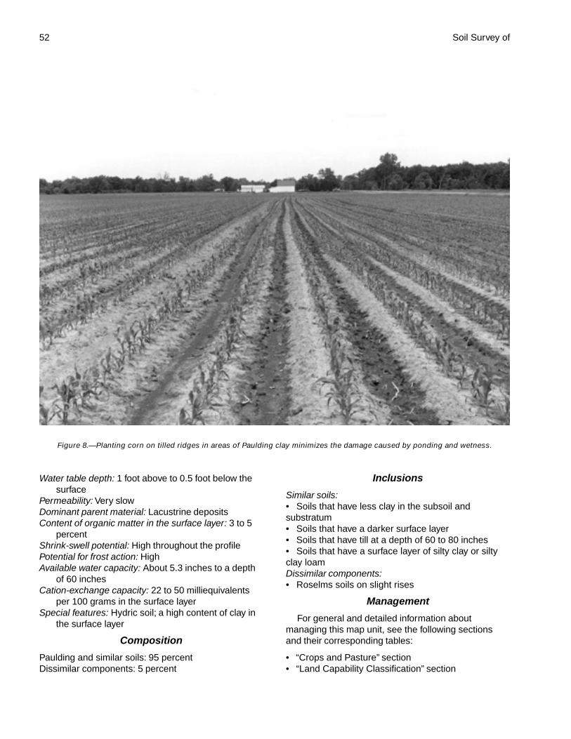
52 Soil Survey of
Water table depth: 1 foot above to 0.5 foot below thesurface
Permeability: Very slowDominant parent material: Lacustrine depositsContent of organic matter in the surface layer: 3 to 5
percentShrink-swell potential: High throughout the profilePotential for frost action: HighAvailable water capacity: About 5.3 inches to a depth
of 60 inchesCation-exchange capacity: 22 to 50 milliequivalents
per 100 grams in the surface layerSpecial features: Hydric soil; a high content of clay in
the surface layer
Composition
Paulding and similar soils: 95 percentDissimilar components: 5 percent
Inclusions
Similar soils:• Soils that have less clay in the subsoil andsubstratum• Soils that have a darker surface layer• Soils that have till at a depth of 60 to 80 inches• Soils that have a surface layer of silty clay or siltyclay loamDissimilar components:• Roselms soils on slight rises
Management
For general and detailed information aboutmanaging this map unit, see the following sectionsand their corresponding tables:
• “Crops and Pasture” section• “Land Capability Classification” section
Figure 8.—Planting corn on tilled ridges in areas of Paulding clay minimizes the damage caused by ponding and wetness.
Paulding County, Ohio 53
• “Forestland” section• “Recreation” section• “Wildlife Habitat” section• “Engineering” and “Soil Properties” sections
Pt—Pits, quarrySetting
Landform: Lake plainsPosition on the landform: Flat areasSize of areas: 20 to 50 acres
Component Description
• This map unit consists of an open pit excavationwith stockpiled limestone.
Composition
Pits, quarry: 100 percent
RkA—Rimer loamy sand, 0 to 2 percentslopes
Setting
Landform: Lake plains, beach ridges on lake plainsPosition on the landform: Slight rises, knollsSize of areas: 5 to 20 acres
Typical Profile
Surface layer:0 to 9 inches—brown, very friable loamy sand
Subsurface layer:9 to 17 inches—brown and yellowish brown, very
friable loamy sand17 to 23 inches—yellowish brown, mottled, loose
loamy sandSubsoil:
23 to 33 inches—dark yellowish brown, mottled,friable sandy loam
33 to 45 inches—brown, mottled, very firm siltyclay
Substratum:45 to 80 inches—brown, mottled, very firm silty
clay
Soil Properties and Qualities
Depth class: Very deep (more than 80 inches)Root zone: Restricted by clayey materials between
depths of 25 and 40 inchesDrainage class: Somewhat poorly drainedKind of water table: PerchedDepth to the water table: 1.0 to 2.5 feetPermeability: Rapid in the sandy material, moderately
rapid in the loamy subsoil, and slow or very slowin the underlying material
Dominant parent material: Beach deposits and theunderlying lacustrine deposits or till
Content of organic matter in the surface layer: 1 to 3percent
Potential for frost action: HighAvailable water capacity: About 5.7 inches to a depth
of 60 inchesCation-exchange capacity: 3 to 15 milliequivalents per
100 grams in the surface layerSpecial feature: The surface layer may be susceptible
to wind erosion.
Composition
Rimer and similar soils: 96 percentDissimilar components: 4 percent
Inclusions
Similar soils:• Soils that have less clay in the lower part of thesubsoil and in the substratum• Soils that have a surface layer of fine sandy loam• Soils that have thinner surface and subsurfacelayers of loamy sand• Soils in which the subsoil is loamy sand or sandand the substratum is more than 80 inches thick• Moderately well drained soilsDissimilar components:• Mermill soils in depressions and drainageways
Management
For general and detailed information aboutmanaging this map unit, see the following sectionsand their corresponding tables:
• “Crops and Pasture” section• “Land Capability Classification” section• “Forestland” section• “Recreation” section• “Wildlife Habitat” section• “Engineering” and “Soil Properties” sections
RkB—Rimer loamy sand, 2 to 6 percentslopes
Setting
Landform: Lake plains, beach ridges on lake plainsPosition on the landform: Knolls, backslopesSize of areas: 5 to 20 acres
Typical Profile
Surface layer:0 to 10 inches—brown, very friable loamy sand
54 Soil Survey of
Subsurface layer:10 to 17 inches—brown, very friable loamy sand17 to 21 inches—brown, mottled, very friable
loamy sandSubsoil:
21 to 27 inches—yellowish brown, mottled, friablesandy loam that grades to sandy clay loam inthe lower part
27 to 33 inches—yellowish brown, mottled, veryfirm clay
Substratum:33 to 80 inches—yellowish brown and dark
yellowish brown, mottled, very firm clay
Soil Properties and Qualities
Depth class: Very deep (more than 80 inches)Root zone: Restricted by clayey materials between
depths of 25 and 40 inchesDrainage class: Somewhat poorly drainedKind of water table: PerchedDepth to the water table: 1.0 to 2.5 feetPermeability: Rapid in the sandy material, moderately
rapid in the loamy subsoil, and slow or very slowin the underlying material
Dominant parent material: Beach deposits and theunderlying lacustrine deposits or till
Content of organic matter in the surface layer: 1 to 3percent
Potential for frost action: HighAvailable water capacity: About 5.4 inches to a depth
of 60 inchesCation-exchange capacity: 3 to 15 milliequivalents per
100 grams in the surface layerSpecial feature: The surface layer may be susceptible
to wind erosion.
Composition
Rimer and similar soils: 96 percentDissimilar components: 4 percent
Inclusions
Similar soils:• Soils that have less clay in the subsoil andsubstratum• Soils that have a surface layer of fine sandy loam• Soils that have thinner surface and subsurfacelayers of loamy sand• Soils in which the subsoil is loamy sand or sandand the substratum is more than 80 inches thick• Moderately well drained soilsDissimilar components:• Mermill soils in depressions and drainageways
Management
For general and detailed information aboutmanaging this map unit, see the following sectionsand their corresponding tables:
• “Crops and Pasture” section• “Land Capability Classification” section• “Forestland” section• “Recreation” section• “Wildlife Habitat” section• “Engineering” and “Soil Properties” sections
RmA—Rimer-Fulton complex, 0 to 2percent slopes
Setting
Landform: Rimer—lake plains, beach ridges on lakeplains; Fulton—lake plains
Position on the landform: Rimer—summits, knolls;Fulton—flat areas
Size of areas: 5 to 15 acres
Typical ProfileRimer
Surface layer:0 to 8 inches—dark grayish brown, very friable
loamy sandSubsurface layer:
8 to 21 inches—yellowish brown, mottled, veryfriable loamy sand
Subsoil:21 to 38 inches—yellowish brown, mottled, friable
sandy loam that grades to sandy clay loam inthe lower part
38 to 46 inches—light olive brown, mottled, veryfirm clay
Substratum:46 to 80 inches—light olive brown, mottled, very
firm clay
Fulton
Surface layer:0 to 8 inches—dark grayish brown, friable loam
Subsoil:8 to 33 inches—yellowish brown, mottled, firm
clay33 to 39 inches—dark yellowish brown, mottled,
very firm silty claySubstratum:
39 to 80 inches—dark yellowish brown, mottled,very firm silty clay
Paulding County, Ohio 55
Soil Properties and Qualities
Rimer
Depth class: Very deep (more than 80 inches)Root zone: Restricted by clayey materials between
depths of 25 and 40 inchesDrainage class: Somewhat poorly drainedKind of water table: PerchedDepth to the water table: 1.0 to 2.5 feetPermeability: Rapid in the sandy material, moderately
rapid in the loamy subsoil, and slow or very slowin the underlying material
Dominant parent material: Beach deposits and theunderlying lacustrine deposits
Content of organic matter in the surface layer: 1 to 3percent
Potential for frost action: HighAvailable water capacity: About 6.1 inches to a depth
of 60 inchesCation-exchange capacity: 3 to 15 milliequivalents per
100 grams in the surface layerSpecial feature: The surface layer may be susceptible
to wind erosion.
Fulton
Depth class: Very deep (more than 80 inches)Root zone: Very deepDrainage class: Somewhat poorly drainedKind of water table: PerchedDepth to the water table: 1.0 to 2.5 feetPermeability: Slow or very slowDominant parent material: Lacustrine depositsContent of organic matter in the surface layer: 2 to 3
percentShrink-swell potential: High in the subsoil and
substratumPotential for frost action: HighAvailable water capacity: About 7.2 inches to a depth
of 60 inchesCation-exchange capacity: 14 to 24 milliequivalents
per 100 grams in the surface layerSpecial feature: A high content of clay in the subsoil
and substratum
Composition
Rimer and similar soils: 64 percentFulton and similar soils: 30 percentDissimilar components: 6 percent
Inclusions
Soils similar to the Rimer soil:• Soils that have a surface layer of sandy loam• Soils that have thinner surface and subsurfacelayers of loamy sand or sand
• Soils that have clayey material at a depth of 40 to60 inchesSoils similar to the Fulton soil:• Soils that have a surface layer of clay loam orsandy loam• Soils that have more clay in the subsoil andsubstratumDissimilar components:• Latty soils in depressions and drainageways
Management
For general and detailed information aboutmanaging this map unit, see the following sectionsand their corresponding tables:
• “Crops and Pasture” section• “Land Capability Classification” section• “Forestland” section• “Recreation” section• “Wildlife Habitat” section• “Engineering” and “Soil Properties” sections
RnA—Roselms loam, 0 to 2 percentslopes
Setting
Landform: Lake plainsPosition on the landform: Slight rises, knollsSize of areas: 5 to 20 acres
Typical Profile
Surface layer:0 to 9 inches—dark grayish brown, friable loam
Subsoil:9 to 29 inches—yellowish brown, mottled, very
firm clay29 to 47 inches—brown, mottled, very firm clay
Substratum:47 to 80 inches—dark yellowish brown, mottled,
very firm clay
Soil Properties and Qualities
Depth class: Very deep (more than 80 inches)Root zone: Restricted by a very high content of clay in
the subsoil and substratumDrainage class: Somewhat poorly drainedKind of water table: PerchedDepth to the water table: 1.0 to 2.5 feetPermeability: Very slowDominant parent material: Lacustrine depositsContent of organic matter in the surface layer: 2 to 3
percentShrink-swell potential: High in the subsoil and
substratum
56 Soil Survey of
Potential for frost action: HighAvailable water capacity: About 5.2 inches to a depth
of 60 inchesCation-exchange capacity: 10 to 20 milliequivalents
per 100 grams in the surface layer
Composition
Roselms and similar soils: 95 percentDissimilar components: 5 percent
Inclusions
Similar soils:• Soils that have till at a depth of 40 to 60 inches• Soils that have less clay in the subsoil andsubstratum• Soils that have a surface layer of sandy loam orclay loam• Soils that have slopes of 2 to 6 percentDissimilar components:• Paulding soils in depressions and drainageways
Management
For general and detailed information aboutmanaging this map unit, see the following sectionsand their corresponding tables:
• “Crops and Pasture” section• “Land Capability Classification” section• “Forestland” section• “Recreation” section• “Wildlife Habitat” section• “Engineering” and “Soil Properties” sections
RoA—Roselms silty clay loam, 0 to 2percent slopes
Setting
Landform: Lake plainsPosition on the landform: Flat areas, slight risesSize of areas: 5 to 200 acres
Typical Profile
Surface layer:0 to 8 inches—dark grayish brown, firm silty clay
loamSubsoil:
8 to 32 inches—brown and yellowish brown,mottled, very firm clay
32 to 53 inches—light olive brown, mottled, veryfirm clay
Substratum:53 to 80 inches—light olive brown, mottled, very
firm clay
Soil Properties and Qualities
Depth class: Very deep (more than 80 inches)Root zone: Restricted by a very high content of clay in
the subsoil and substratumDrainage class: Somewhat poorly drainedKind of water table: PerchedDepth to the water table: 1.0 to 2.5 feetPermeability: Very slowDominant parent material: Lacustrine depositsContent of organic matter in the surface layer: 2 to 3
percentShrink-swell potential: High in the subsoil and
substratumPotential for frost action: HighAvailable water capacity: About 4.9 inches to a depth
of 60 inchesCation-exchange capacity: 17 to 26 milliequivalents
per 100 grams in the surface layerSpecial feature: A high content of clay in the surface
layerComposition
Roselms and similar soils: 97 percentDissimilar components: 3 percent
Inclusions
Similar soils:• Soils that have till at a depth of 40 to 60 inches• Soils that have less clay in the subsoil andsubstratum• Soils that have a surface layer of loam or silty clay• Soils that have slopes of 2 to 6 percentDissimilar components:• Paulding soils in depressions and drainageways
Management
For general and detailed information aboutmanaging this map unit, see the following sectionsand their corresponding tables:
• “Crops and Pasture” section• “Land Capability Classification” section• “Forestland” section• “Recreation” section• “Wildlife Habitat” section• “Engineering” and “Soil Properties” sections
RoB—Roselms silty clay loam, 2 to 6percent slopes
Setting
Landform: Lake plainsPosition on the landform: Knolls, backslopes
Paulding County, Ohio 57
Size of areas: 5 to 20 acres
Typical Profile
Surface layer:0 to 9 inches—dark grayish brown, friable silty
clay loamSubsoil:
9 to 16 inches—yellowish brown and grayishbrown, mottled, very firm clay
16 to 30 inches—brown, mottled, very firm claySubstratum:
30 to 80 inches—dark yellowish brown, mottled,very firm clay
Soil Properties and Qualities
Depth class: Very deep (more than 80 inches)Root zone: Restricted by a very high content of clay in
the subsoil and substratumDrainage class: Somewhat poorly drainedKind of water table: PerchedDepth to the water table: 1.0 to 2.5 feetPermeability: Very slowDominant parent material: Lacustrine depositsContent of organic matter in the surface layer: 2 to 3
percentShrink-swell potential: High in the subsoil and
substratumPotential for frost action: HighAvailable water capacity: About 4.7 inches to a depth
of 60 inchesCation-exchange capacity: 17 to 26 milliequivalents
per 100 grams in the surface layerSpecial feature: A high content of clay in the surface
layer
Composition
Roselms and similar soils: 95 percentDissimilar components: 5 percent
Inclusions
Similar soils:• Soils that have till at a depth of 40 to 60 inches• Soils that have less clay in the subsoil andsubstratum• Soils that have an eroded surface layer of silty clay• Moderately well drained soilsDissimilar components:• Paulding soils in depressions and drainageways
Management
For general and detailed information aboutmanaging this map unit, see the following sectionsand their corresponding tables:
• “Crops and Pasture” section
• “Land Capability Classification” section• “Forestland” section• “Recreation” section• “Wildlife Habitat” section• “Engineering” and “Soil Properties” sections
RpA—Roselms silty clay, 0 to 2 percentslopes
Setting
Landform: Lake plainsPosition on the landform: Slight rises, flat areasSize of areas: 5 to 75 acres
Typical Profile
Surface layer:0 to 8 inches—dark grayish brown, firm silty clay
Subsoil:8 to 34 inches—yellowish brown and brown,
mottled, very firm clay34 to 51 inches—brown, mottled, very firm clay
Substratum:51 to 80 inches—brown, mottled, very firm clay
Soil Properties and Qualities
Depth class: Very deep (more than 80 inches)Root zone: Restricted by a very high content of clay in
the subsoil and substratumDrainage class: Somewhat poorly drainedKind of water table: PerchedDepth to the water table: 1.0 to 2.5 feetPermeability: Very slowDominant parent material: Lacustrine depositsContent of organic matter in the surface layer: 2 to 3
percentShrink-swell potential: High throughout the profilePotential for frost action: HighAvailable water capacity: About 4.6 inches to a depth
of 60 inchesCation-exchange capacity: 20 to 32 milliequivalents
per 100 grams in the surface layerSpecial feature: A high content of clay in the surface
layer
Composition
Roselms and similar soils: 95 percentDissimilar components: 5 percent
Inclusions
Similar soils:• Soils that have till at a depth of 40 to 60 inches• Soils that have less clay in the subsoil• Soils that have a surface layer of loam or silty clayloam

58 Soil Survey of
• Soils that have slopes of 2 to 6 percentDissimilar components:• Paulding soils in depressions and drainageways
Management
For general and detailed information aboutmanaging this map unit, see the following sectionsand their corresponding tables:
• “Crops and Pasture” section• “Land Capability Classification” section• “Forestland” section• “Recreation” section• “Wildlife Habitat” section• “Engineering” and “Soil Properties” sections
RpB2—Roselms silty clay, 2 to 6 percentslopes, eroded
Setting
Landform: Lake plainsPosition on the landform: Backslopes, knollsSize of areas: 5 to 20 acresSpecial feature: Part of the original surface layer has
been removed.
Typical Profile
Surface layer:0 to 6 inches—dark grayish brown, firm silty clay
Subsoil:6 to 26 inches—yellowish brown, mottled, very
firm clay26 to 45 inches—dark yellowish brown, mottled,
very firm claySubstratum:
45 to 80 inches—dark yellowish brown, mottled,very firm clay
Soil Properties and Qualities
Depth class: Very deep (more than 80 inches)Root zone: Restricted by a very high content of clay in
the subsoil and substratumDrainage class: Somewhat poorly drainedKind of water table: PerchedDepth to the water table: 1.0 to 2.5 feetPermeability: Very slowDominant parent material: Lacustrine depositsContent of organic matter in the surface layer: 2 to 3
percentShrink-swell potential: High throughout the profilePotential for frost action: HighAvailable water capacity: About 4.2 inches to a depth
of 60 inches
Cation-exchange capacity: 20 to 32 milliequivalentsper 100 grams in the surface layer
Special feature: A high content of clay in the surfacelayer
Composition
Roselms and similar soils: 95 percentDissimilar components: 5 percent
Inclusions
Similar soils:• Soils that have a surface layer of silty clay loam• Soils that have carbonates in the severely erodedsurface layer• Soils that have till at a depth of 40 to 60 inches• Moderately well drained soilsDissimilar components:• Paulding soils in drainageways
Management
For general and detailed information aboutmanaging this map unit, see the following sectionsand their corresponding tables:
• “Crops and Pasture” section• “Land Capability Classification” section• “Forestland” section• “Recreation” section• “Wildlife Habitat” section• “Engineering” and “Soil Properties” sections
Rt—Rossburg silt loam, occasionallyflooded
Setting
Landform: Flood plainsPosition on the landform: Slight rises, areas adjacent
to the stream channelSlope range: 0 to 2 percentSize of areas: 10 to 100 acres
Typical Profile
Surface layer:0 to 10 inches—very dark grayish brown, friable
silt loamSubsurface layer:
10 to 15 inches—very dark grayish brown, friablesilt loam
Subsoil:15 to 48 inches—brown and dark yellowish brown,
friable silt loam and loamSubstratum:
48 to 80 inches—yellowish brown, very friable finesandy loam with strata of loam
Paulding County, Ohio 59
Soil Properties and Qualities
Depth class: Very deep (more than 80 inches)Root zone: Very deepDrainage class: Well drainedDepth to the water table: More than 6 feetFlooding duration: BriefPermeability: Moderate in the solum and moderately
rapid or rapid in the substratumDominant parent material: AlluviumContent of organic matter in the surface layer: 4 to 8
percentAvailable water capacity: About 10.5 inches to a depth
of 60 inchesCation-exchange capacity: 13 to 32 milliequivalents
per 100 grams in the surface layer
Composition
Rossburg and similar soils: 100 percent
Inclusions
Similar soils:• Soils that have a lighter colored surface layer• Soils that have less clay in the subsoil• Soils that have thicker surface and subsurfacelayers• Soils that have more silt and less sand in thesubsoil• Moderately well drained soils
Management
For general and detailed information aboutmanaging this map unit, see the following sectionsand their corresponding tables:
• “Crops and Pasture” section• “Land Capability Classification” section• “Forestland” section• “Recreation” section• “Wildlife Habitat” section• “Engineering” and “Soil Properties” sections
Sb—Saranac silty clay loam, occasionallyflooded
Setting
Landform: Flood plainsPosition on the landform: Depressions, flat areasSlope range: 0 to 2 percentSize of areas: 10 to 200 acresSpecial feature: This soil is in the lowest positions on
the landscape.
Typical Profile
Surface layer:0 to 11 inches—very dark gray, firm silty clay loam
Subsoil:11 to 46 inches—dark gray, gray, and olive gray,
mottled, firm silty claySubstratum:
46 to 80 inches—grayish brown and dark grayishbrown, mottled, firm silty clay
Soil Properties and Qualities
Depth class: Very deep (more than 80 inches)Root zone: Very deepDrainage class: Poorly drained and very poorly
drainedKind of water table: ApparentWater table depth: At the surface to 1 foot below the
surfaceFlooding duration: LongPermeability: Moderately slowDominant parent material: AlluviumContent of organic matter in the surface layer: 4 to 6
percentShrink-swell potential: High in the subsoil and
substratumPotential for frost action: HighAvailable water capacity: About 9.8 inches to a depth
of 60 inchesCation-exchange capacity: 15 to 30 milliequivalents
per 100 grams in the surface layerSpecial features: Hydric soil; a high content of clay
throughout
Composition
Saranac and similar soils: 90 percentDissimilar components: 10 percent
Inclusions
Similar soils:• Soils that have a thinner surface layer• Soils that have more sand and less clay in thesubsoil and substratum• Soils that have till at a depth of 60 to 80 inchesDissimilar components:• Defiance soils in the higher positions
Management
For general and detailed information aboutmanaging this map unit, see the following sectionsand their corresponding tables:
• “Crops and Pasture” section• “Land Capability Classification” section
60 Soil Survey of
• “Forestland” section• “Recreation” section• “Wildlife Habitat” section• “Engineering” and “Soil Properties” sections
Sh—Shoals silt loam, occasionallyflooded
Setting
Landform: Flood plainsPosition on the landform: Slight rises, flat areasSlope range: 0 to 2 percentSize of areas: 10 to 40 acres
Typical Profile
Surface layer:0 to 8 inches—dark grayish brown, friable silt
loamSubsoil:
8 to 44 inches—dark grayish brown, brown, andyellowish brown, mottled, friable silt loam andclay loam
Substratum:44 to 80 inches—yellowish brown, mottled, friable
loam with thin strata of silt loam and sandyloam
Soil Properties and Qualities
Depth class: Very deep (more than 80 inches)Root zone: Very deepDrainage class: Somewhat poorly drainedKind of water table: ApparentDepth to the water table: 0.5 foot to 1.5 feetFlooding duration: BriefPermeability: ModerateDominant parent material: AlluviumContent of organic matter in the surface layer: 2 to 5
percentPotential for frost action: HighAvailable water capacity: About 11.5 inches to a depth
of 60 inchesCation-exchange capacity: 12 to 27 milliequivalents
per 100 grams in the surface layer
Composition
Shoals and similar soils: 93 percentDissimilar components: 7 percent
Inclusions
Similar soils:• Soils that have more clay in the subsoil• Soils that have till at a depth of 60 to 80 inches• Moderately well drained soils
Dissimilar components:• Saranac soils in depressions and old streamchannels
Management
For general and detailed information aboutmanaging this map unit, see the following sectionsand their corresponding tables:
• “Crops and Pasture” section• “Land Capability Classification” section• “Forestland” section• “Recreation” section• “Wildlife Habitat” section• “Engineering” and “Soil Properties” sections
Sk—Shoals silt loam, frequently flooded
Setting
Landform: Flood plainsPosition on the landform: Slight rises, flat areasSlope range: 0 to 2 percentSize of areas: 5 to 25 acres
Typical Profile
Surface layer:0 to 8 inches—brown, friable silt loam
Subsoil:8 to 44 inches—grayish brown and brown,
mottled, friable silt loam and firm clay loamSubstratum:
44 to 80 inches—gray, mottled, friable loam
Soil Properties and Qualities
Depth class: Very deep (more than 80 inches)Root zone: Very deepDrainage class: Somewhat poorly drainedKind of water table: ApparentDepth to the water table: 0.5 foot to 1.5 feetFlooding duration: BriefPermeability: ModerateDominant parent material: AlluviumContent of organic matter in the surface layer: 2 to 5
percentPotential for frost action: HighAvailable water capacity: About 11.5 inches to a depth
of 60 inchesCation-exchange capacity: 12 to 27 milliequivalents
per 100 grams in the surface layer
Composition
Shoals and similar soils: 93 percentDissimilar components: 7 percent
Paulding County, Ohio 61
Inclusions
Similar soils:• Soils that have more clay in the subsoil• Soils that have till at a depth of 60 to 80 inches• Moderately well drained soilsDissimilar components:• Wabasha soils in depressions and old streamchannels
Management
For general and detailed information aboutmanaging this map unit, see the following sectionsand their corresponding tables:
• “Crops and Pasture” section• “Land Capability Classification” section• “Forestland” section• “Recreation” section• “Wildlife Habitat” section• “Engineering” and “Soil Properties” sections
StB2—St. Clair silty clay loam, 2 to 6percent slopes, eroded
Setting
Landform: Lake plainsPosition on the landform: Backslopes, knollsSize of areas: 5 to 20 acresSpecial feature: Part of the original surface layer has
been removed.
Typical Profile
Surface layer:0 to 8 inches—brown, firm silty clay loam
Subsoil:8 to 15 inches—yellowish brown, firm silty clay15 to 25 inches—dark yellowish brown, mottled,
firm silty clay25 to 30 inches—yellowish brown, mottled, very
firm silty clay loamSubstratum:
30 to 80 inches—yellowish brown, mottled, veryfirm silty clay loam
Soil Properties and Qualities
Depth class: Very deep (more than 80 inches)Root zone: Restricted by unweathered till between
depths of 20 and 32 inchesDrainage class: Moderately well drainedKind of water table: PerchedDepth to the water table: 2 to 3 feetPermeability: SlowDominant parent material: Till
Content of organic matter in the surface layer: 1 to 3percent
Shrink-swell potential: High in the subsoil andsubstratum
Available water capacity: About 7.0 inches to a depthof 60 inches
Cation-exchange capacity: 13 to 30 milliequivalentsper 100 grams in the surface layer
Special feature: A high content of clay throughout
Composition
St. Clair and similar soils: 95 percentDissimilar components: 5 percent
Inclusions
Similar soils:• Soils that have a surface layer of silt loam• Somewhat poorly drained soilsDissimilar components:• Latty soils in depressions and drainageways
Management
For general and detailed information aboutmanaging this map unit, see the following sectionsand their corresponding tables:
• “Crops and Pasture” section• “Land Capability Classification” section• “Forestland” section• “Recreation” section• “Wildlife Habitat” section• “Engineering” and “Soil Properties” sections
StC2—St. Clair silty clay loam, 6 to 12percent slopes, eroded
Setting
Landform: Lake plainsPosition on the landform: Backslopes, dissected areas
along streamsSize of areas: 5 to 15 acresSpecial feature: Part of the original surface layer has
been removed.
Typical Profile
Surface layer:0 to 6 inches—brown, firm silty clay loam
Subsoil:6 to 32 inches—yellowish brown, mottled, firm
silty claySubstratum:
32 to 80 inches—yellowish brown and darkyellowish brown, mottled, very firm clay loam
62 Soil Survey of
Soil Properties and Qualities
Depth class: Very deep (more than 80 inches)Root zone: Restricted by unweathered till between
depths of 20 and 32 inchesDrainage class: Moderately well drainedKind of water table: PerchedDepth to the water table: 2 to 3 feetPermeability: SlowDominant parent material: TillContent of organic matter in the surface layer: 1 to 3
percentShrink-swell potential: High in the subsoil and
substratumAvailable water capacity: About 6.8 inches to a depth
of 60 inchesCation-exchange capacity: 13 to 30 milliequivalents
per 100 grams in the surface layerSpecial feature: A high content of clay throughout
Composition
St. Clair and similar soils: 97 percentDissimilar components: 3 percent
Inclusions
Similar soils:• Soils that have more clay in the subsoil andsubstratum• Soils that have a severely eroded surface layer ofcalcareous silty clay or clay• Somewhat poorly drained soils• Soils that have slopes of 12 to 18 percentDissimilar components:• Latty soils in drainageways
Management
For general and detailed information aboutmanaging this map unit, see the following sectionsand their corresponding tables:
• “Crops and Pasture” section• “Land Capability Classification” section• “Forestland” section• “Recreation” section• “Wildlife Habitat” section• “Engineering” and “Soil Properties” sections
StD2—St. Clair silty clay loam, 12 to 18percent slopes, eroded
Setting
Landform: Lake plainsPosition on the landform: Backslopes, dissected areas
along streams
Size of areas: 5 to 15 acresSpecial feature: Part of the original surface layer has
been removed.
Typical Profile
Surface layer:0 to 7 inches—brown, firm silty clay loam
Subsoil:7 to 21 inches—yellowish brown, very firm silty
clay21 to 24 inches—yellowish brown, mottled, very
firm silty clay loamSubstratum:
24 to 80 inches—yellowish brown, mottled, veryfirm silty clay loam
Soil Properties and Qualities
Depth class: Very deep (more than 80 inches)Root zone: Restricted by unweathered till between
depths of 20 and 32 inchesDrainage class: Moderately well drainedKind of water table: PerchedDepth to the water table: 2 to 3 feetPermeability: SlowDominant parent material: TillContent of organic matter in the surface layer: 1 to 3
percentShrink-swell potential: High in the subsoil and
substratumAvailable water capacity: About 6.8 inches to a depth
of 60 inchesCation-exchange capacity: 13 to 30 milliequivalents
per 100 grams in the surface layerSpecial feature: A high content of clay throughout
Composition
St. Clair and similar soils: 95 percentDissimilar components: 5 percent
Inclusions
Similar soils:• Soils that have more clay in the subsoil andsubstratum• Soils that have slopes of 18 to 25 percent• Soils that have a severely eroded surface layer ofcalcareous silty clay• Somewhat poorly drained soilsDissimilar components:• Wabasha soils in drainageways
Management
For general and detailed information aboutmanaging this map unit, see the following sectionsand their corresponding tables:
Paulding County, Ohio 63
• “Crops and Pasture” section• “Land Capability Classification” section• “Forestland” section• “Recreation” section• “Wildlife Habitat” section• “Engineering” and “Soil Properties” sections
StE2—St. Clair silty clay loam, 18 to 35percent slopes, eroded
Setting
Landform: Lake plainsPosition on the landform: Backslopes, dissected areas
along streamsSize of areas: 5 to 15 acresSpecial feature: Part of the original surface layer has
been removed.
Typical ProfileSurface layer:
0 to 3 inches—very dark grayish brown, firm siltyclay loam
Subsoil:3 to 10 inches—brown, firm silty clay10 to 23 inches—dark yellowish brown, very firm
clay23 to 28 inches—yellowish brown, mottled, very
firm silty claySubstratum:
28 to 80 inches—yellowish brown, mottled, veryfirm silty clay loam
Soil Properties and Qualities
Depth class: Very deep (more than 80 inches)Root zone: Restricted by unweathered till between
depths of 20 and 32 inchesDrainage class: Moderately well drainedKind of water table: PerchedDepth to the water table: 2 to 3 feetPermeability: SlowDominant parent material: TillContent of organic matter in the surface layer: 1 to 3
percentShrink-swell potential: High in the subsoil and
substratumAvailable water capacity: About 6.6 inches to a depth
of 60 inchesCation-exchange capacity: 13 to 30 milliequivalents
per 100 grams in the surface layerSpecial feature: A high content of clay throughout
Composition
St. Clair and similar soils: 95 percentDissimilar components: 5 percent
Inclusions
Similar soils:• Soils that have more clay in the subsoil andsubstratum• Soils that have a surface layer of silt loam• Soils that have a severely eroded surface layer ofsilty clay• Somewhat poorly drained soilsDissimilar components:• Wabasha soils in drainageways
Management
For general and detailed information aboutmanaging this map unit, see the following sectionsand their corresponding tables:
• “Crops and Pasture” section• “Land Capability Classification” section• “Forestland” section• “Recreation” section• “Wildlife Habitat” section• “Engineering” and “Soil Properties” sections
SuC3—St. Clair silty clay, 6 to 12 percentslopes, severely eroded
Setting
Landform: Lake plainsPosition on the landform: Backslopes, dissected areas
along streamsSize of areas: 5 to 15 acresSpecial feature: Most of the original surface layer has
been removed.
Typical Profile
Surface layer:0 to 8 inches—brown, very firm silty clay
Subsoil:8 to 12 inches—yellowish brown, very firm silty
clay12 to 18 inches—yellowish brown, mottled, very
firm silty clay18 to 25 inches—yellowish brown, mottled, very
firm silty clay loamSubstratum:
25 to 80 inches—yellowish brown, mottled, veryfirm silty clay loam
Soil Properties and Qualities
Depth class: Very deep (more than 80 inches)Root zone: Restricted by unweathered till between
depths of 20 and 32 inchesDrainage class: Moderately well drained
64 Soil Survey of
Kind of water table: PerchedDepth to the water table: 2 to 3 feetPermeability: SlowDominant parent material: TillContent of organic matter in the surface layer: 0.5 to
1.0 percentShrink-swell potential: High throughout the profileAvailable water capacity: About 6.2 inches to a depth
of 60 inchesCation-exchange capacity: 17 to 32 milliequivalents
per 100 grams in the surface layerSpecial feature: A high content of clay throughout
Composition
St. Clair and similar soils: 95 percentDissimilar components: 5 percent
Inclusions
Similar soils:• Soils that have more clay in the subsoil andsubstratum• Soils that have an eroded surface layer of silty clayloam• Somewhat poorly drained soilsDissimilar components:• Latty soils in drainageways
Management
For general and detailed information aboutmanaging this map unit, see the following sectionsand their corresponding tables:
• “Crops and Pasture” section• “Land Capability Classification” section• “Forestland” section• “Recreation” section• “Wildlife Habitat” section• “Engineering” and “Soil Properties” sections
SuE3—St. Clair silty clay, 12 to 25 percentslopes, severely eroded
Setting
Landform: Lake plainsPosition on the landform: Backslopes, dissected areas
along streamsSize of areas: 5 to 15 acresSpecial feature: Most of the original surface layer has
been removed.
Typical Profile
Surface layer:0 to 6 inches—brown, very firm silty clay
Subsoil:6 to 9 inches—yellowish brown, very firm clay9 to 15 inches—yellowish brown, mottled, very
firm clay15 to 21 inches—yellowish brown, mottled, very
firm silty clay loamSubstratum:
21 to 80 inches—yellowish brown, mottled, veryfirm silty clay loam
Soil Properties and Qualities
Depth class: Very deep (more than 80 inches)Root zone: Restricted by unweathered till between
depths of 20 and 32 inchesDrainage class: Moderately well drainedKind of water table: PerchedDepth to the water table: 2 to 3 feetPermeability: SlowDominant parent material: TillContent of organic matter in the surface layer: 0.5 to
1.0 percentShrink-swell potential: High throughout the profileAvailable water capacity: About 6.2 inches to a depth
of 60 inchesCation-exchange capacity: 17 to 32 milliequivalents
per 100 grams in the surface layerSpecial feature: A high content of clay throughout
Composition
St. Clair and similar soils: 95 percentDissimilar components: 5 percent
Inclusions
Similar soils:• Soils that have an eroded surface layer of silty clayloam• Soils that have a calcareous surface layer• Somewhat poorly drained soilsDissimilar components:• Wabasha soils in drainageways
Management
For general and detailed information aboutmanaging this map unit, see the following sectionsand their corresponding tables:
• “Crops and Pasture” section• “Land Capability Classification” section• “Forestland” section• “Recreation” section• “Wildlife Habitat” section• “Engineering” and “Soil Properties” sections
Paulding County, Ohio 65
TeA—Tedrow loamy sand, 0 to 3 percentslopes
Setting
Landform: Beach ridgesPosition on the landform: Flat areas, slight risesSize of areas: 5 to 15 acres
Typical Profile
Surface layer:0 to 12 inches—very dark grayish brown, very
friable loamy sandSubsoil:
12 to 44 inches—yellowish brown and brown,mottled, very friable loamy sand and sand
Substratum:44 to 80 inches—brown and grayish brown,
mottled, loose sand
Soil Properties and Qualities
Depth class: Very deep (more than 80 inches)Root zone: Very deepDrainage class: Somewhat poorly drainedKind of water table: ApparentDepth to the water table: 1 to 2 feetPermeability: RapidDominant parent material: Beach depositsContent of organic matter in the surface layer: 1 to 3
percentAvailable water capacity: About 5.0 inches to a depth
of 60 inchesCation-exchange capacity: 5 to 14 milliequivalents per
100 grams in the surface layerSpecial feature: The surface layer may be susceptible
to wind erosion.
Composition
Tedrow and similar soils: 93 percentDissimilar components: 7 percent
Inclusions
Similar soils:• Soils that have more silt and clay, less sand, and alower content of rock fragments at a depth of 60 to 80inches• Moderately well drained soilsDissimilar components:• Granby soils in depressions
Management
For general and detailed information aboutmanaging this map unit, see the following sectionsand their corresponding tables:
• “Crops and Pasture” section• “Land Capability Classification” section• “Forestland” section• “Recreation” section• “Wildlife Habitat” section• “Engineering” and “Soil Properties” sections
Tn—Toledo silty clay loam
Setting
Landform: Lake plainsPosition on the landform: Drainageways, extensive flat
areasSlope range: 0 to 2 percentSize of areas: 5 to 200 acresSpecial feature: Subject to ponding
Typical Profile
Surface layer:0 to 9 inches—very dark grayish brown, firm silty
clay loamSubsoil:
9 to 43 inches—gray and grayish brown, mottled,firm and very firm silty clay
Substratum:43 to 80 inches—grayish brown, mottled, very firm
silty clay
Soil Properties and Qualities
Depth class: Very deep (more than 80 inches)Root zone: Very deepDrainage class: Very poorly drainedKind of water table: ApparentWater table depth: 1 foot above to 1 foot below the
surfacePermeability: SlowDominant parent material: Lacustrine depositsContent of organic matter in the surface layer: 3 to 6
percentShrink-swell potential: High in the subsoil and
substratumPotential for frost action: HighAvailable water capacity: About 7.2 inches to a depth
of 60 inchesCation-exchange capacity: 17 to 36 milliequivalents
per 100 grams in the surface layerSpecial features: Hydric soil; a high content of clay
throughout
Composition
Toledo and similar soils: 95 percentDissimilar components: 5 percent
66 Soil Survey of
Inclusions
Similar soils:• Soils that have till at a depth of 60 to 80 inches• Soils that have a surface layer of silty clay or clayloam• Soils that have less clay in the surface layer andsubsoilDissimilar components:• Fulton soils on slight rises
Management
For general and detailed information aboutmanaging this map unit, see the following sectionsand their corresponding tables:
• “Crops and Pasture” section• “Land Capability Classification” section• “Forestland” section• “Recreation” section• “Wildlife Habitat” section• “Engineering” and “Soil Properties” sections
To—Toledo silty clay
Setting
Landform: Lake plainsPosition on the landform: Drainageways, extensive flat
areasSlope range: 0 to 2 percentSize of areas: 20 to 500 acresSpecial feature: Subject to ponding
Typical Profile
Surface layer:0 to 9 inches—very dark grayish brown, firm silty
claySubsoil:
9 to 43 inches—grayish brown and gray, mottled,firm silty clay
Substratum:43 to 74 inches—dark yellowish brown, mottled,
firm silty clay74 to 80 inches—brown, very firm clay
Soil Properties and Qualities
Depth class: Very deep (more than 80 inches)Root zone: Very deepDrainage class: Very poorly drainedKind of water table: ApparentWater table depth: 1 foot above to 1 foot below the
surfacePermeability: SlowDominant parent material: Lacustrine deposits
Content of organic matter in the surface layer: 3 to 6percent
Shrink-swell potential: High in the subsoil andsubstratum
Potential for frost action: HighAvailable water capacity: About 6.6 inches to a depth
of 60 inchesCation-exchange capacity: 22 to 45 milliequivalents
per 100 grams in the surface layerSpecial feature: Hydric soil; a high content of clay
throughout
Composition
Toledo and similar soils: 95 percentDissimilar components: 5 percent
Inclusions
Similar soils:• Soils that have till at a depth of 60 to 80 inches• Soils that have a lighter colored surface layer• Soils that have a surface layer of silty clay loam orclay loam• Soils that have less clay in the surface layer andsubsoilDissimilar components:• Fulton soils on slight rises
Management
For general and detailed information aboutmanaging this map unit, see the following sectionsand their corresponding tables:
• “Crops and Pasture” section• “Land Capability Classification” section• “Forestland” section• “Recreation” section• “Wildlife Habitat” section• “Engineering” and “Soil Properties” sections
Uc—Udorthents, clayey, hilly
Setting
Landform: Lake plains, flood plainsPosition on the landform: KnollsSlope range: 12 to 25 percentSize of areas: 20 to 60 acres
Typical Profile
0 to 80 inches—a mixture of surface, subsoil, andsubstratum material of silty clay or clay and, lesscommonly, silty clay loam and clay loam
Soil Properties and Qualities
Depth class: Very deep (more than 80 inches)
Paulding County, Ohio 67
Dominant parent material: Lacustrine deposits oralluvium
General description: High knolls and ridges createdduring various construction activities orexcavations or as reservoir embankments
Composition
Udorthents and similar soils: 80 percentDissimilar components: 20 percent
Inclusions
Similar soils:• Udorthents that have less clayDissimilar components:• Areas that have slopes of 0 to 12 percent• Areas that have slopes of 25 to 50 percent• Small, undisturbed areas of Fulton, Latty, andPaulding soils• Occasionally flooded areas along streams andrivers
Wb—Wabasha silty clay loam, frequentlyflooded
Setting
Landform: Flood plainsPosition on the landform: Depressions, old stream
channels, flat areasSlope range: 0 to 2 percentSize of areas: 5 to 80 acresSpecial feature: This soil is in the lowest positions on
the landscape.
Typical Profile
Surface layer:0 to 9 inches—very dark grayish brown, firm silty
clay loamSubsoil:
9 to 52 inches—dark gray, gray, and grayishbrown, mottled, firm silty clay
Substratum:52 to 80 inches—yellowish brown, mottled, firm
silty clay
Soil Properties and Qualities
Depth class: Very deep (more than 80 inches)Root zone: Very deepDrainage class: Poorly drained and very poorly
drainedKind of water table: ApparentWater table depth: At the surface to 1 foot below the
surfaceFlooding duration: Brief
Permeability: SlowDominant parent material: AlluviumContent of organic matter in the surface layer: 3 to 6
percentShrink-swell potential: High in the subsoil and
substratumPotential for frost action: HighAvailable water capacity: About 8.8 inches to a depth
of 60 inchesCation-exchange capacity: 20 to 36 milliequivalents
per 100 grams in the surface layerSpecial features: Hydric soil; a high content of clay
throughout
Composition
Wabasha and similar soils: 90 percentDissimilar components: 10 percent
Inclusions
Similar soils:• Soils that have a thicker surface layer• Soils that have a lighter colored surface layer• Soils that have more sand and less clay in thesubsoil and substratum• Soils that have till at a depth of 60 to 80 inches• Soils that have a surface layer of silty clayDissimilar components:• Defiance soils in the higher positions
Management
For general and detailed information aboutmanaging this map unit, see the following sectionsand their corresponding tables:
• “Crops and Pasture” section• “Land Capability Classification” section• “Forestland” section• “Recreation” section• “Wildlife Habitat” section• “Engineering” and “Soil Properties” sections
WhA—Whitaker loam, 0 to 2 percentslopes
Setting
Landform: Lake plainsPosition on the landform: Knolls, slight risesSize of areas: 5 to 10 acres
Typical Profile
Surface layer:0 to 9 inches—dark grayish brown, friable loam
Subsurface layer:9 to 13 inches—pale brown, mottled, friable loam
68
Subsoil:13 to 23 inches—yellowish brown, mottled, firm
clay loam23 to 32 inches—gray, mottled, firm silty clay
loam32 to 44 inches—gray, mottled, firm clay loam
Substratum:44 to 60 inches—light gray, very friable, stratified
silt, silt loam, and sand
Soil Properties and Qualities
Depth class: Very deep (more than 60 inches)Root zone: Very deepDrainage class: Somewhat poorly drainedKind of water table: ApparentDepth to the water table: 1 to 3 feetPermeability: Moderate in the solum and moderate or
moderately rapid in the substratumDominant parent material: Lacustrine depositsContent of organic matter in the surface layer: 1 to 3
percentPotential for frost action: HighAvailable water capacity: About 11.3 inches to a depth
of 60 inches
Cation-exchange capacity: 5 to 18 milliequivalents per100 grams in the surface layer
Composition
Whitaker and similar soils: 100 percent
Inclusions
Similar soils:• Soils that have more clay in the subsoil andsubstratum• Soils that have a darker surface layer• Soils that have a surface layer of silt loam
Management
For general and detailed information aboutmanaging this map unit, see the following sectionsand their corresponding tables:
• “Crops and Pasture” section• “Land Capability Classification” section• “Forestland” section• “Recreation” section• “Wildlife Habitat” section• “Engineering” and “Soil Properties” sections
69
This soil survey is an inventory and evaluation ofthe soils in the survey area. It can be used to adjustland uses to the limitations and potentials of naturalresources and the environment. Also, it can help toprevent soil-related failures in land uses.
In preparing a soil survey, soil scientists,conservationists, engineers, and others collectextensive field data about the nature and behavioralcharacteristics of the soils. They collect data onerosion, droughtiness, flooding, and other factors thataffect various soil uses and management. Fieldexperience and collected data on soil properties andperformance are used as a basis in predicting soilbehavior.
Information in this section can be used to plan theuse and management of soils for crops and pasture;as woodland; as sites for buildings, sanitary facilities,highways and other transportation systems, and parksand other recreational facilities; and for wildlife habitat.It can be used to identify the potentials and limitationsof each soil for specific land uses and to help preventconstruction failures caused by unfavorable soilproperties.
Planners and others using soil survey informationcan evaluate the effect of specific land uses onproductivity and on the environment in the surveyarea. The survey can help planners to maintain orcreate a land use pattern in harmony with the naturalsoil.
Contractors can use this survey to locate sourcesof sand and gravel, roadfill, and topsoil. They can useit to identify areas where bedrock, wetness, or veryfirm soil layers can cause difficulty in excavation.
Health officials, highway officials, engineers, andothers may also find this survey useful. The surveycan help them plan the safe disposal of wastes andlocate sites for pavements, sidewalks, campgrounds,playgrounds, lawns, and trees and shrubs.
Crops and PastureGeneral management needed for crops and
pasture is suggested in this section. The estimatedyields of the main crops and pasture plants are listed
for each soil, the system of land capabilityclassification used by the Natural ResourcesConservation Service is explained, and primefarmland is described.
Planners of management systems for individualfields or farms should consider the detailedinformation given in the description of each soil underthe heading “Detailed Soil Map Units.” Specificinformation can be obtained from the local office of theNatural Resources Conservation Service or theCooperative Extension Service.
In 1986, more than 229,000 acres, or about 86percent of the county, was used as cropland orpastureland (Paulding Soil and Water ConservationDistrict, 1986). Of this total, nearly 3,800 acres, orabout 1.4 percent of the county, was used aspastureland. Of the nearly 225,000 acres used ascropland, about 153,400 acres was used for rowcrops, mainly corn and soybeans; about 31,000 acreswas used for close-growing crops, such as wheat andoats; and 6,200 acres was used for rotation hay andpasture (Carter and Hanuschak, 1986).
The soils in Paulding County vary widely in theirsuitability for specific crops. Different soils also requiredifferent management practices. Certain basicmanagement practices, however, such as maintainingan adequate level of soil fertility, improving drainage,controlling erosion, and maintaining or improving soiltilth, are needed on nearly all of the soils in the county.Most of the soils in the county are suited to the cropscommonly grown in the area and to some crops thatare not commonly grown, such as barley, grainsorghum, popcorn, and sunflowers.
Very deep, well drained and moderately welldrained, loamy soils that warm up early in the springare well suited to many vegetables, small fruits,nursery plants, and orchards. These soils include theBelmore, Oshtemo, and Ottokee soils on beach ridgesand dunes. These soils may occur in low areas whereair drainage is poor and frost occurs earlier and morefrequently than in other areas. Generally, these lowareas are poorly suited to early small fruits andorchards.
The latest information and recommendations for
Use and Management of the Soils
70 Soil Survey of
growing specialty crops are available from local officesof The Ohio State University Extension and theNatural Resources Conservation Service.
The potential for increased crop production inPaulding County is good. Crop production can beincreased by applying the latest crop productiontechnology to the existing cropland in the county.About 2,400 acres of idle land, woodland, andunimproved pasture could be used as productivecropland (Paulding Soil and Water ConservationDistrict, 1986), but the cost of converting to croplandand the impact of these conversions on theenvironment should be considered. Also, the 1985Food Security Act placed certain restrictions onbringing wetlands and highly erodible fields intoproduction for those who participate in Federal farmprograms.
Very little of the cropland and pastureland inPaulding County has been used for urbandevelopment. In 1986, an estimated 3,800 acres wasused as urban land. The acreage of crops and pasturehas not been significantly affected by development forurban or other uses.
Soil drainage is the major management concern inPaulding County. Wetness is a limitation on nearly 95percent of the land. Subsurface and surface drains areused to remove excess water and allow soils to dryout and warm up earlier in the spring, thus improvingplant growth (fig. 9). Short-season or early maturingcrop varieties can be harvested earlier. Subsurfacedrains lower the seasonal high water table and thusincrease the depth to which plant roots can penetrate.
Most of the soils in the county commonly have aseasonal high water table near or above the surface.Natural drainage outlets are generally not availablebecause of the position of the soils on the landscape.If surface and subsurface drainage is not provided,these soils are usually too wet to produce most of thecommonly grown crops. The poorly drained and verypoorly drained Granby, Hoytville, Latty, Mermill,Millgrove, Paulding, and Toledo soils have a seasonalhigh water table above the surface. These soils makeup about 190,000 acres, or 71 percent of the county.
The somewhat poorly drained soils have a watertable in the upper part of the subsoil in winter andspring. Subsurface drainage is needed for most crops.Crop growth and yields are generally affected if thesoils are not drained. Planting and harvesting areusually delayed. Bixler, Defiance, Fulton, Haskins,Nappanee, Rimer, Roselms, Shoals, Tedrow, andWhitaker soils are somewhat poorly drained. Thesesoils make up 55,753 acres, or about 21 percent of thecounty.
Broughton, Flatrock, Lucas, Ottokee, and St. Clair
soils are moderately well drained. The mapped areasof these soils commonly include areas of wetter soilsin seeps and depressions and along drainageways,especially where slopes are 2 to 6 percent. Randomsurface and subsurface drains are effective in thesewetter areas.
The design of both surface and subsurfacedrainage systems varies with the type of soil and theavailability of adequate outlets. A combination ofsurface drainage and subsurface drainage is neededin most areas of the very poorly drained, poorlydrained, and somewhat poorly drained soils that areintensively row cropped.
Drains should be more closely spaced in soils thathave slow or very slow permeability than in soils thatare more permeable. Subsurface drainage is slow orvery slow in Broughton, Defiance, Fulton, Haskins,Hoytville, Latty, Lucas, Nappanee, Paulding, Roselms,Saranac, St. Clair, Toledo, and Wabasha soils.
Seeding ditchbanks and berms helps to preventstreambank erosion and the slumping of banks.Removing brush reduces the risk of floodwater risingabove the level of outlets for subsurface drains. Animalguards prevent animals from damaging subsurfacedrains and blocking the flow of water. Replacingbroken drains keeps silt from accumulating on thebottom of the drains and blocking drainage. Bankprotection underneath the drain outlets preventserosion. Materials used for bank protection caninclude rock, broken tile fragments, and grass.
Erosion is a major management concern on about4 percent of the land in Paulding County. It is a hazardin areas where slopes are more than 2 percent.
Erosion is damaging for two main reasons—soilproductivity is reduced, and the water in streams andlakes becomes polluted. Erosion of the surface layer isespecially damaging on soils that have a clayeysubsoil, such as Broughton, Fulton, Nappanee,Roselms, and St. Clair soils. As the surface layer isremoved, part of the clayey subsoil is incorporatedinto the plow layer. The higher clay content in thesurface layer impairs soil tilth, resulting in a poorerseedbed. More energy is needed to till the soils, andmore fertilizer is needed to replace lost plant nutrients.Erosion is also damaging in areas where the soils aremoderately deep over unweathered till, such asNappanee and St. Clair soils, because it furtherrestricts the root zone. Erosion reduces productivity onsoils that tend to be droughty, such as Ottokee andTedrow soils. Most of the available water generally isstored in the surface layer. Thus, erosion of thesurface layer reduces the available water capacity ofthe soil.
Erosion degrades water quality by increasing the
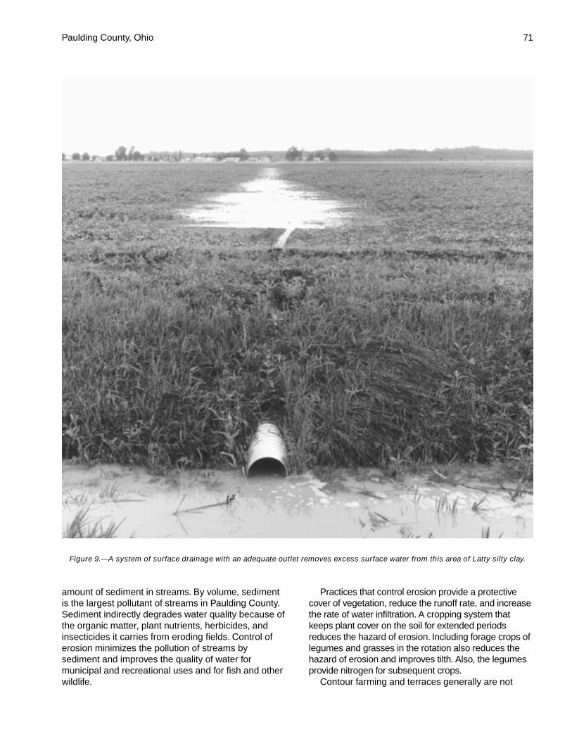
Paulding County, Ohio 71
amount of sediment in streams. By volume, sedimentis the largest pollutant of streams in Paulding County.Sediment indirectly degrades water quality because ofthe organic matter, plant nutrients, herbicides, andinsecticides it carries from eroding fields. Control oferosion minimizes the pollution of streams bysediment and improves the quality of water formunicipal and recreational uses and for fish and otherwildlife.
Practices that control erosion provide a protectivecover of vegetation, reduce the runoff rate, and increasethe rate of water infiltration. A cropping system thatkeeps plant cover on the soil for extended periodsreduces the hazard of erosion. Including forage crops oflegumes and grasses in the rotation also reduces thehazard of erosion and improves tilth. Also, the legumesprovide nitrogen for subsequent crops.
Contour farming and terraces generally are not
Figure 9.—A system of surface drainage with an adequate outlet removes excess surface water from this area of Latty silty clay.
72 Soil Survey of
practical in areas of the gently sloping to moderatelysteep Broughton and St. Clair soils because of theshort, irregular slopes. The hazard of erosion is severeif these soils are farmed using conventional methods.Minimum tillage and no-till farming systems, whichleave crop residue on the surface, increase the rate ofwater infiltration and help to control runoff and erosion.Belmore, Knoxdale, Landes, Lucas, Oshtemo,Ottokee, and Rossburg soils are well suited to no-tillplanting. The eroded Broughton, Lucas, and St. Clairsoils are suited to no-till planting. If drained, areas ofBixler, Defiance, Flatrock, Fulton, Granby, Haskins,Hoytville, Latty, Medway, Mermill, Millgrove,Nappanee, Paulding, Rimer, Roselms, Saranac,Shoals, Tedrow, Toledo, and Wabasha soils are suitedto no-till planting.
Grassed waterways are natural or constructedoutlets protected by grass cover. Naturaldrainageways are the best locations for waterwaysbecause they typically require a minimum of shapingfor the production of a good channel. Waterwaysshould be wide and flat so that they can be crossedwith farm machinery.
Wind erosion is a hazard on soils that have a sandysurface layer, such as Bixler, Ottokee, Rimer, andTedrow soils. These soils are subject to damage ifwinds are strong and the soils are level and dry andbare of vegetation or mulch. Maintaining a plant cover,mulching, or keeping the surface ridged or roughthrough proper tillage minimizes the amount of soilloss caused by the wind. Maintaining field windbreaksof suitable shrubs or trees, such as eastern white pineor silky dogwood, reduces the hazard of wind erosion.
Information on the design of erosion-controlpractices for each kind of soil is available from thePaulding Soil and Water Conservation District.
Soil fertility is naturally low in many of the sandysoils and the more sloping soils on uplands. Sandysoils are naturally more acid than loamy or clayeysoils, and they generally have a lower content oforganic matter. In addition, sandy soils retain only asmall amount of plant nutrients; therefore, morefrequent additions of fertilizers are needed. The moreacid subsoil limits the availability of some plantnutrients. Special fertilizer may be needed because ofdeficiencies of boron and other trace elements.
Soils on flood plains, including Flatrock, Medway,and Shoals soils, are naturally higher in plant nutrientsthan most of the upland soils. In most soils on floodplains, the content of organic matter is moderate orhigh. The Granby, Hoytville, and Millgrove soils thatare in flat areas or in depressions and drainagewayshave a dark surface layer. The content of organicmatter is moderate or high in these soils.
The effectiveness of nitrogen applied in the fall tovery poorly drained, poorly drained, and somewhatpoorly drained soils is reduced by leaching anddenitrification. Incorporating fertilizer into the soil ingently sloping and sloping areas minimizes lossthrough erosion. Applications of lime may benecessary to raise the reaction of the surface layer toa level where most plant nutrients are readilyavailable. On all of the soils, a balanced fertilityprogram that includes additions of lime and fertilizershould be based on the results of soil tests and plantanalysis. The Ohio State University Extension andprivate soil labs can help in determining the kinds andamounts of fertilizer to apply.
Soil tilth is an important factor in the germination ofseeds and in the infiltration of water into the soils.Soils that have good tilth are friable and porous. Theycan be worked easily, provide good seed contact, andallow quick seedling emergence and strong rootgrowth.
Many of the soils on uplands that are used ascropland have a surface layer of silt loam or silty clayloam that has a relatively low content of organicmatter. A crust generally forms on the surface of thesesoils when the surface dries after a heavy rainfall. Thecrust is hard and absorbs water slowly. It reduces theinfiltration rate, retards seedling emergence, andincreases the runoff rate. Regularly adding cropresidue, manure, and other organic materialsmaintains or improves soil structure and minimizescrusting. Applying minimum tillage or mulch tillage orincorporating crop residue into the surface layer alsohelps to prevent crusting. Allowing part of the residueto be exposed above the surface provides pathwaysfor the movement of air and water.
Fall moldboard plowing is generally not the bestpractice on soils that have a light-colored surface layerof silt loam or silty clay loam. The surface of thesesoils tends to form a crust in winter and spring. Manyof these soils are nearly as dense and hard in thespring after fall moldboard plowing as they werebefore plowing. Moreover, soils that have slopes ofmore than 2 percent are more susceptible to erosion ifthey are moldboard plowed in the fall. A rough,irregular surface that leaves residue partially coveredabsorbs more water and dries faster than a smoothlytilled surface.
Latty and Paulding soils and some Hoytville soilshave more clay in the surface layer than most of theother soils in the county. Poor tilth is a problembecause these soils tend to stay wet until late inspring. These soils can be tilled only within a narrowrange in moisture content. If they are tilled when wet,the soils tend to be very cloddy and hard when they
Paulding County, Ohio 73
dry and the preparation of a good seedbed is difficult.Fall plowing allows winter freezing and drying to breakup clods. Using mulch tillage and returning cropresidue to the soil help to prevent crusting. The soilsgenerally crack when they dry. The cracks in the soilincrease the rate of water infiltration.
Soil compaction occurs if the soils are tilled orharvested when wet or if they are subject to heavytraffic or heavy loads. Compaction can be preventedby tilling the soils under the proper soil moistureconditions, using minimum tillage, and plantingdeep-rooted legumes and grasses. Also, using four-wheel-drive tractors with flotation tires can minimizesurface compaction. Compaction limits root growth,reduces water movement, and creates plowpans.
Field crops suited to the soils and climate of thesurvey area include many that are not commonlygrown. Corn and soybeans are the main row crops.Grain sorghum, sugar beets, sunflowers, navy beans,and similar crops can be grown. Economic conditionsgenerally determine whether these crops are grown.
Wheat, rye, and oats are the most common close-growing crops. Alfalfa and grass-legume hay also aregrown. The soils and climate are suited to barley,buckwheat, and flax and to grass seed produced frombromegrass, fescue, timothy, and bluegrass.
Specialty crops grown commercially in the surveyarea are mainly popcorn, sugar beets, tomatoes, andsweet corn. The acreage of such crops is limited butcould be increased if economic conditions werefavorable.
Belmore, Oshtemo, and Ottokee soils have goodnatural drainage and warm up early in spring. Thesesoils are especially well suited to vegetables andfruits. They make up 346 acres in the county. Cropsgenerally can be planted and harvested earlier onthese soils than on most other soils in the county.
Permanent pasture makes up about 1.4 percent ofthe acreage in the survey area (Paulding Soil andWater Conservation District, 1986). This lowpercentage is partly the result of a reduction inlivestock and the increased use of confined feeding.Some of the permanent pasture is in eroded stripsand in irregularly shaped areas of frequently floodedsoils. A few woodlots also are pastured. Woodlotsgenerally provide grazing of poor quality, however,because forage plants are sparse. Permanent pasturenear farmsteads is commonly used as feedlots oraccess lanes.
Most of the soils in the county are suited to theproduction of high-quality permanent pasture,although yields vary widely. Because of a rapid runoffrate, gently sloping to moderately steep areas ofBroughton and St. Clair soils are commonly eroded,
are low in fertility, and have relatively less wateravailable for plants. Forage production on these soilsis low. Growth is good in the gently sloping areas ofFulton, Haskins, and Nappanee soils, but these soilsare subject to erosion if the plant cover is damaged byovergrazing. Compaction occurs if grazing livestockare allowed to trample the soils during wet periods.
Defiance, Flatrock, Medway, Shoals, and someSaranac and Wabasha soils on flood plains arepotentially well suited to use as permanent pasture.The occasional or frequent flooding during the growingseason in areas of these soils is less damaging topasture than to grain crops. These alluvial soils arefertile and have a moderate or high available watercapacity. Potential pasture yields are high. Surfacedrains and subsurface drains are needed to removeexcess water on the somewhat poorly drainedDefiance and Shoals soils and the very poorly drainedSaranac and Wabasha soils, particularly if legumesare grown. Artificial drainage generally is not neededon the better drained Flatrock and Medway soils.
Permanent pasture has fertility requirements similarto those of cropland. Lime and fertilizer should beapplied at rates determined by the results of soil tests.The control of weeds by periodic mowing and the useof recommended herbicides encourage the growth ofdesirable pasture plants. Controlled grazing helps tomaintain pasture plants. The latest information onseeding mixtures, herbicide treatment, and othermanagement for specific soils can be obtained fromthe local offices of The Ohio State UniversityExtension and the Natural Resources ConservationService.
Irrigation is not used to a great extent in PauldingCounty. Generally, rainfall is ample for crop moisturerequirements but may not be timely or well distributed.During dry periods, supplemental irrigation couldincrease yields. Some of the soils in the county aresuited to irrigation and can be irrigated if water isavailable. Belmore, Oshtemo, Ottokee, and Tedrowsoils are especially well suited to irrigation.
Yields per Acre
The average yields per acre that can be expectedof the principal crops under a high level ofmanagement are shown in table 5. In any given year,yields may be higher or lower than those indicated inthe table because of variations in rainfall and otherclimatic factors. The land capability classification ofmap units in the survey area also is shown in the table.
The yields are based mainly on the experience andrecords of farmers, conservationists, and extensionagents. Available yield data from nearby counties and
74 Soil Survey of
results of field trials and demonstrations also areconsidered.
The management needed to obtain the indicatedyields of the various crops depends on the kind of soiland the crop. Management can include drainage,erosion control, and protection from flooding; theproper planting and seeding rates; suitable high-yielding crop varieties; appropriate and timely tillage;control of weeds, plant diseases, and harmful insects;favorable soil reaction and optimum levels of nitrogen,phosphorus, potassium, and trace elements for eachcrop; effective use of crop residue, barnyard manure,and green manure crops; and harvesting that ensuresthe smallest possible loss.
The estimated yields reflect the productive capacityof each soil for each of the principal crops. Yields arelikely to increase as new production technology isdeveloped. The productivity of a given soil comparedwith that of other soils, however, is not likely tochange.
Crops other than those shown in table 5 are grownin the survey area, but estimated yields are not listedbecause the acreage of such crops is small. The localoffice of the Natural Resources Conservation Serviceor of the Cooperative Extension Service can provideinformation about the management and productivity ofthe soils for those crops.
The crop yield index (table 6) reflects the relativeproductivity of a soil in relation to other soils in thecounty. This index is provided to assist in ranking soilsby relative productivity within the county. The mostproductive soil is given a rating of 100, and other soilsare ranked against this standard. The index is basedon a crop rotation of corn, soybeans, and winterwheat.
Advances in planter technology, crop genetics,drainage, weed control, pest management, soil fertility,and soil management can make a standard yield tableobsolete within several years. The yield index in table6 should provide users with good information on therelative productivity of soils in the county for years tocome.
Soils that have slopes of more than 12 percentwere not ranked for crop production. These soils wereranked on the basis of estimated pasture and haylandyields.
Some map units are not used for any type of cropproduction and thus are not rated in the table.
Cropland Limitations and Hazards
The management concerns affecting the use of thedetailed map units in the county for crops are shownin table 7. The main concerns in managing
nonirrigated cropland are controlling water erosion,removing excess water, minimizing surface crustingand compaction, and maintaining soil tilth, organicmatter content, and fertility.
Generally, a combination of several practices isneeded to control water erosion. Conservation tillage,contour farming, conservation cropping systems, cropresidue management, diversions, and grassedwaterways help to prevent excessive soil loss.
Surface and/or subsurface drainage is used tolower a seasonal high water table and to controlponding.
Tilling within the proper range in moisture contentminimizes surface compaction.
Measures that help to maintain soil tilth, organicmatter content, and fertility include applying fertilizer,both organic and inorganic, including manure;incorporating crop residue or green manure crops intothe soil; and using proper crop rotations. Controllingerosion helps to prevent the loss of organic matter andplant nutrients and thus helps to maintain productivity,although the level of fertility can be reduced even inareas where erosion is controlled. All soils used fornonirrigated crops respond well to applications offertilizer.
Some of the limitations and hazards shown in thetable cannot be easily overcome. These are ponding,flooding, slope, depth to rock, and limited organicmatter content.
Ponding.—Surface drains help to remove excesssurface water and reduce damage caused by ponding.
Flooding.—Flooding can damage winter grain andforage crops. A tillage method that partly covers cropresidue and leaves a rough or ridged surface helps toprevent the removal of crop residue by floodwater.Tilling and planting should be delayed in the springuntil flooding is no longer a hazard.
Slope.—Where the slope is more than 15 percent,water erosion can be excessive on cultivated fields.The selection of crops and the use of equipment arelimited. Cultivation may be restricted.
Depth to rock.—Rooting depth and availablemoisture may be limited by bedrock within a depth of40 inches.
Limited organic matter content.—Many soils thathave a light-colored surface layer have a low ormoderately low content of organic matter and weak ormoderate structure. Regularly adding crop residue,manure, and other organic materials to the soilmaintains or improves the organic matter content andthe soil structure.
Additional limitations and hazards are as follows:Potential for ground-water pollution.—This is a
hazard in soils that have excessive permeability or
Paulding County, Ohio 75
have bedrock or an apparent water table within theprofile.
Root-restricting layer.—Soil layers with high bulkdensity have little pore space. These layers limit waterstorage and restrict the penetration of plant roots.
Limited available water capacity, poor tilth or fairtilth, and surface crusting.—These limitations can beovercome by incorporating green manure crops,manure, or crop residue into the soil; applying asystem of conservation tillage; and using conservationcropping systems.
Excessive permeability.—This limitation causesdeep leaching of nutrients and pesticides. Thecapacity of the soil to retain moisture for plant use ispoor. Crops generally respond better to smaller, morefrequent applications of fertilizer and lime than to onelarge application.
Surface rock fragments.—This limitation causesrapid wear of tillage equipment. It cannot be easilyovercome.
Surface stones.—Stones or boulders on the surfacecan hinder normal tillage unless they are removed.
Very high clay content in the subsoil andsubstratum.—A very high content of clay in the subsoiland substratum restricts rooting depth.
High clay content in the subsoil and substratum.—Ahigh content of clay in the subsoil and substratumrestricts rooting depth.
Surface crusting.—Hardening of the bare soilsurface can hinder or prevent seedling emergence.Minimizing tillage slows the destruction of soilstructure and helps to prevent crusting.
Frost heave.—Frost heaving can damage deep-rooted legumes and some small grain.
Subsidence of organic matter.—Subsidence orshrinking occurs as a result of oxidation in the organicmaterial after the soil is drained. Control of the watertable by subirrigation through subsurface drain linesreduces the hazards of subsidence, burning, and soilblowing.
Wind erosion.—The detachment and transportationof soil particles by wind. Cover crops and fieldwindbreaks help to protect the soil surface by reducingthe amount of exposed surface or by reducing thelength of unsheltered areas exposed to prevailingwinds.
Following is an explanation of the criteria used todetermine the limitations or hazards.
Ponding.—Ponding duration is assigned to thecomponent of the map unit.
Frequent flooding.—The component of the map unitis frequently flooded.
Occasional flooding.—The component of the mapunit is occasionally flooded.
Rare flooding.—The component of the map unit issubject to rare flooding.
High potential for ground-water pollution.—The soilhas an apparent water table within a depth of 4 feet orbedrock within a depth of 60 inches, or permeability ismore than 6 inches per hour in at least one layerwithin the soil.
Moderate potential for ground-water pollution.—Permeability is between 2 and 6 inches per hour in atleast one layer within the soil.
Easily eroded.—The surface K factor multiplied bythe upper slope limit is more than 2.
Slope.—The upper slope range of the componentof the map unit is more than 15 percent.
Most of surface layer removed.—The surface layerof the component of the map unit is severely eroded(75 percent or more of the original A and E horizonshas been lost).
Part of surface layer removed.—The surface layerof the component of the map unit is eroded (25 to 75percent of the original A and E horizons has been lost).
Root-restricting layer.—At least one layer within adepth of 40 inches has a bulk density of 1.75 or morebelow a layer that has a bulk density of 1.7 or less.
Limited available water capacity.—The availablewater capacity calculated to a depth of 60 inches or toa root-limiting layer is 6 inches or less.
Depth to rock.—Bedrock is within a depth of 40inches.
Excessive permeability.—The upper limit of thepermeability range is 6 inches or more within the soilprofile.
Surface stones.—The terms describing the textureof the surface layer include any stony or boulderymodifier, or the soil is a stony or bouldery phase.
Surface rock fragments.—The terms describing thetexture of the surface layer include any rock fragmentmodifier except for gravelly or channery, and “surfacestones” is not already indicated as a limitation.
Very high clay content in the subsoil andsubstratum.—The component of the map unit hasmore than 60 percent clay in the subsoil and thesubstratum.
High clay content in the subsoil and substratum.—The component of the map unit has 40 to 60 percentclay in the subsoil and the substratum.
Seasonal high water table.—The top of the watertable in the component of the map unit is at a depth of1.5 feet or shallower, and ponding duration is notassigned.
Surface compaction.—The component of the mapunit has a surface layer of silt loam, silty clay loam,clay loam, or silty clay.
Poor tilth.—The component of the map unit is
76 Soil Survey of
severely eroded, has less than 1 percent organicmatter in the surface layer, or has more than 35percent clay in the surface layer.
Fair tilth.—The component of the map unit has asurface layer of silty clay loam or clay loam or is amoderately eroded phase of loam or silt loam.
Surface crusting.—The average organic mattercontent in the surface layer is less than or equal to 3percent, and the texture is silt loam or silty clay loam.
Limited organic matter content.—The averageorganic matter content in the surface layer of thecomponent of the map unit is less than or equal to 3percent.
Frost heave.—The component of the map unit hasa high potential for frost action.
Subsidence of organic matter.—The organic mattercontent in the surface layer of the component of themap unit is greater than or equal to 20 percent.
Wind erosion.—The component of the map unit isassigned to wind erodibility group 1 or 2.
Land Capability Classification
Land capability classification shows, in a generalway, the suitability of soils for most kinds of field crops.Crops that require special management are excluded.The soils are grouped according to their limitations forfield crops, the risk of damage if they are used forcrops, and the way they respond to management. Thecriteria used in grouping the soils do not include majorand generally expensive landforming that wouldchange slope, depth, or other characteristics of thesoils, nor do they include possible but unlikely majorreclamation projects. Capability classification is not asubstitute for interpretations designed to showsuitability and limitations of groups of soils forwoodland or for engineering purposes.
In the capability system, soils are generallygrouped at three levels—capability class, subclass,and unit. Only class and subclass are used in thissurvey.
Capability classes, the broadest groups, aredesignated by the numbers 1 through 8. The numbersindicate progressively greater limitations and narrowerchoices for practical use. The classes are defined asfollows:
Class 1 soils have few limitations that restrict theiruse.
Class 2 soils have moderate limitations that reducethe choice of plants or that require moderateconservation practices.
Class 3 soils have severe limitations that reducethe choice of plants or that require specialconservation practices, or both.
Class 4 soils have very severe limitations thatreduce the choice of plants or that require very carefulmanagement, or both.
Class 5 soils are not likely to erode but have otherlimitations, impractical to remove, that limit their use.
Class 6 soils have severe limitations that makethem generally unsuitable for cultivation.
Class 7 soils have very severe limitations that makethem unsuitable for cultivation.
Class 8 soils and miscellaneous areas havelimitations that nearly preclude their use forcommercial crop production.
Capability subclasses are soil groups within oneclass. They are designated by adding a letter, e, w, s,or c, to the class numeral, for example, 2e. The letter eshows that the main hazard is the risk of erosionunless close-growing plant cover is maintained; wshows that water in or on the soil interferes with plantgrowth or cultivation (in some soils the wetness canbe partly corrected by artificial drainage); s shows thatthe soil is limited mainly because it is shallow,droughty, or stony; and c, used in only some parts ofthe United States, shows that the chief limitation isclimate that is very cold or very dry.
In class 1 there are no subclasses because thesoils of this class have few limitations. Class 5contains only the subclasses indicated by w, s, or cbecause the soils in class 5 are subject to little or noerosion. They have other limitations that restrict theiruse to pasture, woodland, wildlife habitat, orrecreation.
The acreage of soils in each capability class andsubclass is shown in table 8. The capabilityclassification of map units in this survey area is givenin table 5 and under the heading "Interpretive Groups."
Pasture and Hayland Interpretations
Soils are assigned to pasture and hayland groupsaccording to their suitability for the production offorage. The soils in each group are similar enough tobe suited to the same species of grasses or legumes,have similar limitations and hazards, require similarmanagement, and have similar productivity levels andother responses to management.
Under good management, proper grazing isessential for the production of high-quality forage,stand survival, and erosion control. Proper grazinghelps plants to maintain sufficient and generallyvigorous top growth during the growing season. Brushcontrol is essential in many areas, and weed controlgenerally is needed. Rotation grazing and renovationalso are important management practices.
Yield estimates are often provided in animal unitmonths (AUM), or the amount of forage or feed
Paulding County, Ohio 77
required to feed one animal unit (one cow, one horse,one mule, five sheep, or five goats) for 30 days.
The pasture and hayland suitability group symbolfor each soil is listed in the section “InterpretiveGroups.” Soils assigned the same suitability groupsymbol require the same general management andhave about the same potential productivity. Thepasture and hayland suitability groups are based onsoil characteristics and limitations.
Soils assigned to Group A have few limitationsaffecting the management and growth of climaticallyadapted plants.
Soils in group A-1 are deep or very deep and arewell drained or moderately well drained. They have asurface layer of sandy loam, silt loam, loam, or siltyclay loam. The available water capacity ranges frommoderate to very high. These soils respond favorablyto additions of lime. Frequent applications may beneeded to maintain an adequate pH level. A low pH inthe subsoil can shorten the life of some deep-rootedlegumes in the stand. Slopes range from 0 to 18percent.
Soils in group A-2 are deep or very deep and arewell drained or moderately well drained. They have asurface layer of silt loam. Available water capacityranges from moderate to very high. These soilsrespond favorably to additions of lime. Frequentapplications may be needed to maintain an adequatepH level. The low pH of the subsoil can shorten the lifeof some deep-rooted legumes in the stand. Slopesrange from 18 to 25 percent. The slope may interferewith mechanical application of lime and fertilizer andwith clipping, mowing, and spraying for weed control.The slope also increases the hazard of erosion if theareas or overgrazed or cultivated for reseeding. Thesesoils are suited to no-till reseedings and interseedings.
Soils in group A-3 are deep or very deep and arewell drained or moderately well drained. They have asurface layer of silt loam. Slopes range from 25 to 50percent. These soils generally are not suited topasture or hay because of the slope.
Soils in group A-5 are deep or very deep and arewell drained or moderately well drained. They aresubject to brief or very brief periods of flooding. Theflooding limits the use of these soils for pasture duringperiods of stream overflow, and sediment lowers thequality of the forage. The soils have a surface layer ofsilt loam or loam. Available water capacity ranges fromlow to very high. Slopes range from 0 to 2 percent.
Soils in group A-6 are deep or very deep, are welldrained or moderately well drained, and are subject tofrost action. Frost action can damage legume stands.Mixing fibrous-rooted grasses with legumes and using
proper grazing management methods help to preventthe damage caused by frost action. The soils have asurface layer of silt loam or silty clay loam. Availablewater capacity ranges from low to very high. Slopesrange from 0 to 18 percent.
Soils in group B have limited growth and productionpotential because of droughtiness.
Soils in group B-1 are deep or very deep and arewell drained to very poorly drained. They have asurface layer ranging from loamy sand to silty clayloam. Available water capacity is low or very low.These soils are sandy or skeletal in the subsoil.Slopes range from 0 to 25 percent.
Soils in group C are wet because of a seasonalhigh water table.
Soils in group C-1 are deep or very deep and aresomewhat poorly drained or very poorly drained. Theyhave a surface layer of loamy sand, silt loam, loam,silty clay loam, or silty clay. Available water capacityranges from low to very high. These soils normallyrespond well to subsurface drainage. Slopes rangefrom 0 to 6 percent.
Soils in group C-2 are moderately deep to verydeep and are somewhat poorly drained or very poorlydrained. They have a surface layer of silt loam, loam,silty clay loam, clay loam, or silty clay. Available watercapacity ranges from low to very high. A seasonalhigh water table limits the rooting depth of deep-rootedforage plants. Some of these soils have bedrock at adepth that also restricts root penetration. Shallow-rooted species grow best in areas of these soils.Subsurface drains are used to lower the seasonal highwater table. The effectiveness of subsurface drainageis typically restricted by the permeability of thesubsoil, the depth to bedrock, or the landscapeposition of the soil. Because of the limited root zone,the soils in this group are better suited to foragespecies that do not have a taproot. Slopes range from0 to 4 percent.
Soils in group C-3 are very deep and are verypoorly drained, poorly drained, or somewhat poorlydrained. They are subject to flooding. The floodinglimits the use of these soils for pasture during periodsof stream overflow, and sediment lowers the quality ofthe forage. The soils have a surface layer of silt loamor silty clay loam. Available water capacity rangesfrom moderate to very high. Slopes range from 0 to 2percent. Frost action may damage legumes. Includinggrasses in a seeding mixture and using proper grazingmanagement methods help to prevent the damagecaused by frost heaving. A seasonal high water tablelimits the rooting depth of forage plants. Shallow-rooted species grow best in areas of these soils.
78 Soil Survey of
Subsurface drains are used to lower the seasonal highwater table. The effectiveness of subsurface drainageis restricted by the landscape position of the soils.
Soils in group D are organic soils.Soils in group D-1 are very deep and are very
poorly drained. They formed entirely or partially inorganic material. Available water capacity ranges frommoderate to very high. Slopes range from 0 to 2percent.
Soils in group F have only a moderately deep rootzone. The growth of climatically adapted plants isrestricted in these soils to a depth of 20 to 40 inches.These soils are better suited to forage species that donot have a taproot.
Soils in group F-1 are moderately deep and arewell drained or moderately well drained. They have asurface layer of silt loam. Available water capacity islow. These soils are droughty but are suitable forwarm-season grasses, such as switchgrass, bigbluestem, indiangrass, and Caucasian bluestem. Thesoils respond favorably to additions of lime. Frequentapplications may be needed to maintain an adequatepH level. The low pH of the subsoil in some of thesesoils can shorten the life of some deep-rootedlegumes in the stand. Slopes range from 0 to 18percent.
Soils in group F-2 are moderately deep and arewell drained or moderately well drained. They have asurface layer of silt loam. Available water capacity islow or moderate. Slopes range from 20 to 50 percent.These soils generally are not suited to pasture or haybecause of the slope.
Soils in group F-5 are very deep and aremoderately well drained. They have a surface layer ofsilty clay loam or silty clay. Available water capacity islow or moderate. A high content of clay in the subsoilrestricts the rooting depth of deep-rooted forageplants. Shallow-rooted species grow best in areas ofthese soils. The soils are better suited to foragespecies that do not have a taproot. Slopes range from2 to 25 percent.
Soils in group F-6 are very deep and aremoderately well drained. They have a surface layer ofsilty clay loam. Available water capacity is low ormoderate. A high content of clay in the subsoilrestricts the rooting depth of deep-rooted forageplants. Shallow-rooted species grow best in areas ofthese soils. The soils are better suited to foragespecies that do not have a taproot. Slopes range from18 to 35 percent.
Soils in group F-7 are very deep and are somewhatpoorly drained or very poorly drained. They have asurface layer of loam, silty clay loam, silty clay, or clay.Available water capacity is low or moderate. A high
content of clay in the subsoil restricts the rootingdepth of deep-rooted forage plants. Shallow-rootedspecies grow best in areas of these soils. Subsurfacedrains are used to lower the seasonal high water table.The effectiveness of subsurface drainage is generallylimited by the permeability of the subsoil and thelandscape position of the soils. These soils are bettersuited to forage species that do not have a taproot.Slopes range from 0 to 6 percent.
Soils in group H-1 are not suited to pasture or haybecause they are toxic or because they have slopes ofmore than 40 percent.
The local office of the Natural ResourcesConservation Service or The Ohio State UniversityExtension can provide additional information aboutforage yields in the county.
Prime Farmland
Prime farmland is one of several kinds of importantfarmland defined by the U.S. Department ofAgriculture. It is of major importance in meeting theNation’s short- and long-range needs for food andfiber. Because the supply of high-quality farmland islimited, the U.S. Department of Agriculture recognizesthat responsible levels of government, as well asindividuals, should encourage and facilitate the wiseuse of our Nation’s prime farmland.
Prime farmland, as defined by the U.S. Departmentof Agriculture, is land that has the best combination ofphysical and chemical characteristics for producingfood, feed, forage, fiber, and oilseed crops and isavailable for these uses. It could be cultivated land,pastureland, forestland, or other land, but it is noturban or built-up land or water areas. The soilqualities, growing season, and moisture supply arethose needed for the soil to economically producesustained high yields of crops when propermanagement, including water management, andacceptable farming methods are applied. In general,prime farmland has an adequate and dependablesupply of moisture from precipitation or irrigation, afavorable temperature and growing season,acceptable acidity or alkalinity, an acceptable salt andsodium content, and few or no rocks. It is permeableto water and air. It is not excessively erodible orsaturated with water for long periods, and it either isnot frequently flooded during the growing season or isprotected from flooding. The slope ranges mainly from0 to 6 percent. More detailed information about thecriteria for prime farmland is available at the localoffice of the Natural Resources Conservation Service.
About 169,000 acres in the survey area, or nearly63 percent of the total acreage, meets the soil

Paulding County, Ohio 79
requirements for prime farmland. Scattered areas ofthis land are throughout the county, mainly inassociations 2, 3, and 4, which are described underthe heading “General Soil Map Units.” Almost all ofthis prime farmland is used for crops. The crops grownon this land, mainly corn, soybeans, and wheat,account for an estimated 70 percent of the county’stotal agricultural income each year.
A recent trend in land use in a few areas of thecounty has been the loss of some prime farmland toindustrial and urban uses. The loss of prime farmlandto other uses puts pressure on marginal lands, whichgenerally are more erodible, droughty, and lessproductive and cannot be easily cultivated.
The map units in the survey area that areconsidered prime farmland are listed in table 9. Thislist does not constitute a recommendation for aparticular land use. On some soils included in the list,measures that overcome a hazard or limitation, suchas flooding, wetness, and droughtiness, are needed.Onsite evaluation is needed to determine whether ornot the hazard or limitation has been overcome bycorrective measures. The extent of each listed mapunit is shown in table 4. The location is shown on thedetailed soil maps. The soil qualities that affect useand management are described under the heading“Detailed Soil Map Units.”
More than 3,200 acres of prime farmland in thecounty consists of well drained and moderately welldrained soils on ridgetops and benches in the uplands.Nearly 16,000 acres consists of poorly drained,somewhat poorly drained, moderately well drained,and well drained soils on terraces and flood plains andon footslopes, toeslopes, and fans at the base ofhillsides.
ForestlandMichael Jurkiewicz, service forester, Ohio Department of
Natural Resources, Division of Forestry, helped prepare thissection.
Nearly all of Paulding County was forested at thetime of the earliest land surveys. The entire county isin the Great Black Swamp of northwestern Ohio, andthe area once supported heavy timber. The climaxforest communities were dominantly elm and ashswamp forest in the broad flat areas away from riversand streams. Areas adjacent to rivers and streams aretypically better drained and supported such speciesas oak, hickory, eastern cottonwood, maple, andAmerican basswood.
In 1986, about 16,800 acres, or 6.3 percent of thecounty, was wooded (Paulding Soil and WaterConservation District, 1986). Most of this acreage is in
small scattered woodlots on slopes along streamvalleys, on flood plains, and in undrained areas onuplands. Stands are dominantly mixed American elm,black ash, white ash, silver maple, red maple, swampwhite oak, pin oak, cottonwood, and Americansycamore. Most of the woodland has been cut over,and much of it has been grazed.
The potential for increased production of timber ishigh. If managed well, woodlots are capable ofproducing high-quality, rapidly growing nativehardwoods. In addition, many woodlots could providefirewood, edible nuts, wildlife habitat, esthetic value,and protection from strong winds.
About 8,200 acres, or about 50 percent, of thewoodland in the county is in need of some type ofconservation treatment (Paulding Soil and WaterConservation District, 1986). Livestock grazing in thewoodland and inadequately stocked timber stands arethe major problems. Timber stand improvementpractices, such as culling diseased and less desirabletrees and cutting and spraying vines, improve thegrowth rate of favored species. Harvesting maturetrees benefits desirable trees by reducing competitionand the potential for disease. When species areselected for planting on open ground, the slope andthe type of soil should be considered. Planting inestablished stands is seldom needed or advised.Fencing livestock out of the woods and providing fireprotection help to maintain good stands.
Information on forest management is available fromthe Ohio Department of Natural Resources, Divisionof Forestry; The Ohio State University Extension; andthe Natural Resources Conservation Service.
Table 10 can be used by forest managers inplanning the use of soils for wood crops. Only thosesoils suitable for wood crops are listed.
The table lists the woodland ordination symbol foreach soil. The ordination system is a nationwideuniform system of labeling soils or groups of soils thatare similar in use and management. The primaryfactors evaluated in the woodland ordination systemare productivity of the forest overstory tree speciesand the principal soil properties resulting in hazardsand limitations that affect forest management. Thereare three parts of the ordination system—class,subclass, and group. The class and subclass arereferred to as the ordination symbol. The ordinationsymbol listed in the table is for south aspects. Theordination symbol of the soils in the survey area isalso given in the section “Interpretive Groups.”
The first part of the ordination symbol, a number,indicates the potential productivity of the soils for anindicator tree species. The number indicates thevolume, in cubic meters per hectare per year, which
80 Soil Survey of
the indicator species can produce in a pure standunder natural conditions. The number 1 indicates lowpotential productivity; 2 or 3, moderate; 4 or 5,moderately high; 6 to 8, high; 9 to 11, very high; and12 to 39, extremely high. The second part of thesymbol, a letter, indicates the major kind of soillimitation. The letter R indicates steep slopes; X,stoniness or rockiness; W, excess water in or on thesoil; T, toxic substances in the soil; D, restricted rootingdepth; C, clay in the upper part of the soil; S, sandytexture; F, a high content of rock fragments in the soil;L, low strength; and N, snowpack. The letter Aindicates that limitations or restrictions areinsignificant. If a soil has more than one limitation, thepriority is as follows: R, X, W, T, D, C, S, F, L, and N.
In the table, slight, moderate, and severe indicatethe degree of the major soil limitations to beconsidered in management.
Erosion hazard is the probability that damage willoccur as a result of site preparation and cutting wherethe soil is exposed along roads, skid trails, and firelanes and in log-handling areas. Forests that havebeen burned or overgrazed are also subject toerosion. Ratings of the erosion hazard are based onthe percent of the slope. A rating of slight indicatesthat no particular prevention measures are neededunder ordinary conditions. A rating of moderateindicates that erosion-control measures are needed incertain silvicultural activities. A rating of severeindicates that special precautions are needed tocontrol erosion in most silvicultural activities.
Equipment limitation reflects the characteristics andconditions of the soil that restrict use of the equipmentgenerally needed in woodland management orharvesting. The chief characteristics and conditionsconsidered in the ratings are slope, stones on thesurface, rock outcrops, soil wetness, and texture of thesurface layer. A rating of slight indicates that undernormal conditions the kind of equipment and seasonof use are not significantly restricted by soil factors.Soil wetness can restrict equipment use, but the wetperiod does not exceed 1 month. A rating of moderateindicates that equipment use is moderately restrictedbecause of one or more soil factors. If the soil is wet,the wetness restricts equipment use for a period of 1to 3 months. A rating of severe indicates thatequipment use is severely restricted either as to thekind of equipment that can be used or the season ofuse. If the soil is wet, the wetness restricts equipmentuse for more than 3 months.
Seedling mortality refers to the death of naturallyoccurring or planted tree seedlings, as influenced bythe kinds of soil, soil wetness, or topographic
conditions. The factors used in rating the soils forseedling mortality are texture of the surface layer,depth to a seasonal high water table and the length ofthe period when the water table is high, rockfragments in the surface layer, effective rooting depth,and slope aspect. A rating of slight indicates thatseedling mortality is not likely to be a problem undernormal conditions. Expected mortality is less than 25percent. A rating of moderate indicates that someproblems from seedling mortality can be expected.Extra precautions are advisable. Expected mortality is25 to 50 percent. A rating of severe indicates thatseedling mortality is a serious problem. Extraprecautions are important. Replanting may benecessary. Expected mortality is more than 50percent.
Windthrow hazard is the likelihood that trees will beuprooted by the wind because the soil is not deepenough for adequate root anchorage. The mainrestrictions that affect rooting are a seasonal highwater table and the depth to bedrock, a fragipan, orother limiting layers. A rating of slight indicates thatunder normal conditions no trees are blown down bythe wind. Strong winds may damage trees, but they donot uproot them. A rating of moderate indicates thatsome trees can be blown down during periods whenthe soil is wet and winds are moderate or strong. Arating of severe indicates that many trees can beblown down during these periods.
Plant competition ratings indicate the degree towhich undesirable species are expected to invade andgrow when openings are made in the tree canopy. Themain factors that affect plant competition are depth tothe water table and the available water capacity. Arating of slight indicates that competition fromundesirable plants is not likely to prevent naturalregeneration or suppress the more desirable species.Planted seedlings can become established withoutundue competition. A rating of moderate indicates thatcompetition may delay the establishment of desirablespecies. Competition may hamper stand development,but it will not prevent the eventual development of fullystocked stands. A rating of severe indicates thatcompetition can be expected to prevent regenerationunless precautionary measures are applied.
The potential productivity of merchantable orcommon trees on a soil is expressed as a site indexand as a volume number. The site index is the averageheight, in feet, that dominant and codominant trees ofa given species attain in a specified number of years.The site index applies to fully stocked, even-aged,unmanaged stands. Commonly grown trees are thosethat woodland managers generally favor in
Paulding County, Ohio 81
intermediate or improvement cuttings. They areselected on the basis of growth rate, quality, value,and marketability.
The volume, a number, is the yield likely to beproduced by the most important trees. This number,expressed as cubic feet per acre per year, indicatesthe amount of fiber produced in a fully stocked, even-aged, unmanaged stand.
Suggested trees to plant are those that are suitablefor commercial wood production.
Windbreaks and EnvironmentalPlantings
Windbreaks protect livestock, buildings, and yardsfrom wind and snow. They also protect fruit trees andgardens, and they furnish habitat for wildlife. Severalrows of low- and high-growing broadleaf andconiferous trees and shrubs provide the mostprotection.
Field windbreaks are narrow plantings made atright angles to the prevailing wind and at specificintervals across the field. The interval depends on theerodibility of the soil. Field windbreaks protectcropland and crops from wind, help to keep snow onthe fields, and provide food and cover for wildlife.
Environmental plantings help to beautify andscreen houses and other buildings and to abate noise.The plants, mostly evergreen shrubs and trees, areclosely spaced. To ensure plant survival, a healthyplanting stock of suitable species should be plantedproperly on a well prepared site and maintained ingood condition.
Table 11 shows the height that locally grown treesand shrubs are expected to reach in 20 years onvarious soils. The estimates in the table are based onmeasurements and observation of establishedplantings that have been given adequate care. Theycan be used as a guide in planning windbreaks andscreens. Additional information on planningwindbreaks and screens and planting and caring fortrees and shrubs can be obtained from the local officeof the Natural Resources Conservation Service or ofthe Cooperative Extension Service or from acommercial nursery.
RecreationThe soils of the survey area are rated in table 12
according to limitations that affect their suitability forrecreation. The ratings are based on restrictive soilfeatures, such as wetness, slope, and texture of thesurface layer. Susceptibility to flooding is considered.
Not considered in the ratings, but important inevaluating a site, are the location and accessibility ofthe area, the size and shape of the area and its scenicquality, vegetation, access to water, potential waterimpoundment sites, and access to public sewer lines.The capacity of the soil to absorb septic tank effluentand the ability of the soil to support vegetation alsoare important. Soils subject to flooding are limited forrecreational uses by the duration and intensity offlooding and the season when flooding occurs. Inplanning recreational facilities, onsite assessment ofthe height, duration, intensity, and frequency offlooding is essential.
In the table, the degree of soil limitation isexpressed as slight, moderate, or severe. Slightmeans that soil properties are generally favorable andthat limitations are minor and easily overcome.Moderate means that limitations can be overcome oralleviated by planning, design, or specialmaintenance. Severe means that soil properties areunfavorable and that limitations can be offset only bycostly soil reclamation, special design, intensivemaintenance, limited use, or a combination of thesemeasures.
The information in the table can be supplementedby other information in this survey, for example,interpretations for septic tank absorption fields in table15 and interpretations for dwellings without basementsand for local roads and streets in table 14.
Camp areas require site preparation, such asshaping and leveling the tent and parking areas,stabilizing roads and intensively used areas, andinstalling sanitary facilities and utility lines. Campareas are subject to heavy foot traffic and somevehicular traffic. The best soils have mild slopes andare not wet or subject to flooding during the period ofuse. The surface has few or no stones or boulders,absorbs rainfall readily but remains firm, and is notdusty when dry. Strong slopes and stones or boulderscan greatly increase the cost of constructingcampsites.
Picnic areas are subject to heavy foot traffic. Mostvehicular traffic is confined to access roads andparking areas. The best soils for picnic areas are firmwhen wet, are not dusty when dry, are not subject toflooding during the period of use, and do not haveslopes or stones or boulders that increase the cost ofshaping sites or of building access roads and parkingareas.
Playgrounds require soils that can withstandintensive foot traffic. The best soils are almost leveland are not wet or subject to flooding during theseason of use. The surface is free of stones andboulders, is firm after rains, and is not dusty when dry.
82 Soil Survey of
If grading is needed, the depth of the soil over bedrockor a hardpan should be considered.
Paths and trails for hiking and horseback ridingshould require little or no cutting and filling. The bestsoils are not wet, are firm after rains, are not dustywhen dry, and are not subject to flooding more thanonce a year during the period of use. They havemoderate slopes and few or no stones or boulders onthe surface.
Golf fairways are subject to heavy foot traffic andsome light vehicular traffic. Cutting or filling may berequired. The best soils for use as golf fairways arefirm when wet, are not dusty when dry, and are notsubject to prolonged flooding during the period of use.They have moderate slopes and no stones or boulderson the surface. The suitability of the soil for tees orgreens is not considered in rating the soils.
Wildlife HabitatJ.M. Daugherty, private lands biologist, Wildlife District Two,
Findlay, Ohio, Ohio Department of Natural Resources, Division ofWildlife, helped prepare this section.
Wildlife habitat is directly related to soils and toland use. The quality, type, and abundance of habitatlimit the species and populations in an area. Manyspecies of wildlife inhabit the survey area, and mosthave varied in numbers over the years because ofchanges in land use. Cottontail rabbits, bobwhite quail,ring-necked pheasants, eastern meadowlarks, andbobolinks were once among the most abundantupland wildlife species. Populations of these specieshave declined recently, however, because of changesin land use, mainly farming practices. The conversionof pasture and hayland to the production of row crops,the removal of fencerows, and intensified croppingsystems have all contributed to the loss of uplandwildlife habitat. White-tailed deer populations haveincreased in recent years, partly because of theavailability of old pastures and woodlots that are nolonger being grazed by livestock. Furbearers, such asred fox, gray fox, raccoon, skunks, opossum, andmuskrat, are also relatively abundant. Many species ofresident and migratory birds nest in the county.
Most areas along the Maumee and Auglaize Riversand their tributaries provide excellent habitat for alltypes of wildlife species that are common in thecounty. These areas also provide habitat and stagingareas during periods of waterfowl migration. If propermanagement is applied, all of the soils in PauldingCounty can be used to provide habitat for wildlife. Inplaces, incorporating habitat elements for openland,wetland, and woodland wildlife into a single area canattract the widest variety of wildlife species.
Habitat for wetland wildlife can be further developedin undrained depressions and in old stream channelson flood plains. Ponds and marshes provide habitat forsongbirds, waterfowl, shore birds, and wetlandfurbearers. Special plantings help to attract waterfowl.Water level management can further enhance thevalue to wildlife in some of these areas.
Most of the upland soils in the county are wellsuited to plants that are valuable as wildlife food andcover. Grassland nesting areas are especially critical.Planting grasses and legumes helps to create theseareas. Additional nesting cover can be provided bydelaying the mowing of odd areas, such as ditchberms, roadsides, field edges, and pastures, until afterAugust 1 of each year. Also, fruit-bearing shrubs canbe planted in hedgerows and along field borders toprovide winter cover and food. Managing for food-producing trees and leaving hollow den trees improvewoodlots as wildlife habitat. Cropland also can bevaluable as wildlife habitat if managed properly.Eroded soils can be developed into habitat for uplandwildlife by planting grasses and legumes and shrubs.These plantings provide food and cover for wildlife andalso help to control erosion.
Field windbreaks and shelterbelts around farmbuildings can provide food and cover for wildlife ifsuitable species are planted and maintained. Creatingspecial habitat through the use of artificial nestingstructures and feeding stations and planting patchesof grain or wildflowers can attract wildlife.
Soils affect the kind and amount of vegetation thatis available to wildlife as food and cover. They alsoaffect the construction of water impoundments. Thekind and abundance of wildlife depend largely on theamount and distribution of food, cover, and water.Wildlife habitat can be created or improved by plantingappropriate vegetation, by maintaining the existingplant cover, or by promoting the natural establishmentof desirable plants.
In table 13, the soils in the survey area are ratedaccording to their potential for providing habitat forvarious kinds of wildlife. This information can be usedin planning parks, wildlife refuges, nature study areas,and other developments for wildlife; in selecting soilsthat are suitable for establishing, improving, ormaintaining specific elements of wildlife habitat; and indetermining the intensity of management needed foreach element of the habitat.
The potential of the soil is rated good, fair, poor, orvery poor. A rating of good indicates that the elementor kind of habitat is easily established, improved, ormaintained. Few or no limitations affect management,and satisfactory results can be expected. A rating offair indicates that the element or kind of habitat can be
Paulding County, Ohio 83
established, improved, or maintained in most places.Moderately intensive management is required forsatisfactory results. A rating of poor indicates thatlimitations are severe for the designated element orkind of habitat. Habitat can be created, improved, ormaintained in most places, but management is difficultand must be intensive. A rating of very poor indicatesthat restrictions for the element or kind of habitat arevery severe and that unsatisfactory results can beexpected. Creating, improving, or maintaining habitatis impractical or impossible.
The elements of wildlife habitat are described in thefollowing paragraphs.
Grain and seed crops are domestic grains andseed-producing herbaceous plants. Soil propertiesand features that affect the growth of grain and seedcrops are depth of the root zone, texture of the surfacelayer, available water capacity, wetness, slope, surfacestoniness, and flooding. Soil temperature and soilmoisture also are considerations. Examples of grainand seed crops are corn, wheat, oats, and soybeans.
Grasses and legumes are domestic perennialgrasses and herbaceous legumes. Soil properties andfeatures that affect the growth of grasses and legumesare depth of the root zone, texture of the surface layer,available water capacity, wetness, surface stoniness,flooding, and slope. Soil temperature and soil moisturealso are considerations. Examples of grasses andlegumes are fescue, bromegrass, clover, and alfalfa.
Wild herbaceous plants are native or naturallyestablished grasses and forbs, including weeds. Soilproperties and features that affect the growth of theseplants are depth of the root zone, texture of thesurface layer, available water capacity, wetness,surface stoniness, and flooding. Soil temperature andsoil moisture also are considerations. Examples ofwild herbaceous plants are pigweed, goldenrod,lamb’s-quarters, Queen Anne’s lace, and yarrow.
Hardwood trees and woody understory producenuts or other fruit, buds, catkins, twigs, bark, andfoliage. Soil properties and features that affect thegrowth of hardwood trees and shrubs are depth of theroot zone, available water capacity, and wetness.Examples of these plants are oak, poplar, cherry,sweetgum, apple, hawthorn, dogwood, hickory, andblackberry. Examples of fruit-producing shrubs thatare suitable for planting on soils rated good areRussian-olive, autumn-olive, and crabapple.
Coniferous plants furnish browse and seeds. Soilproperties and features that affect the growth ofconiferous trees, shrubs, and ground cover are depthof the root zone, available water capacity, andwetness. Examples of coniferous plants are pine,spruce, fir, cedar, and juniper.
Wetland plants are annual and perennial wildherbaceous plants that grow on moist or wet sites.Submerged or floating aquatic plants are excluded.Soil properties and features affecting wetland plantsare texture of the surface layer, wetness, reaction,salinity, slope, and surface stoniness. Examples ofwetland plants are smartweed, wild millet, rushes,sedges, and reeds.
Shallow water areas have an average depth of lessthan 5 feet. Some are naturally wet areas. Others arecreated by dams, levees, or other water-controlstructures. Soil properties and features affectingshallow water areas are depth to bedrock, wetness,surface stoniness, slope, and permeability. Examplesof shallow water areas are marshes, waterfowl feedingareas, and ponds.
The habitat for various kinds of wildlife is describedin the following paragraphs.
Habitat for openland wildlife consists of cropland,pasture, meadows, and areas that are overgrown withgrasses, herbs, shrubs, and vines. These areasproduce grain and seed crops, grasses and legumes,and wild herbaceous plants. Wildlife attracted to theseareas include bobwhite quail, pheasant, meadowlark,field sparrow, cottontail, and red fox.
Habitat for woodland wildlife consists of areas ofdeciduous plants or coniferous plants or both andassociated grasses, legumes, and wild herbaceousplants. Wildlife attracted to these areas includewoodcock, thrushes, woodpeckers, squirrels, gray fox,raccoon, and deer.
Habitat for wetland wildlife consists of open, marshyor swampy shallow water areas. Some of the wildlifeattracted to such areas are ducks, geese, herons,shore birds, muskrat, and mink.
Additional information regarding the development ofwildlife habitat is available from the Ohio Departmentof Natural Resources, Wildlife District Two; from theState game protector; or from the local office of theNatural Resources Conservation Service.
Hydric SoilsIn this section, hydric soils are defined and
described and the hydric soils in the survey area arelisted.
The three essential characteristics of wetlands arehydrophytic vegetation, hydric soils, and wetlandhydrology (Cowardin and others, 1979; U.S. ArmyCorps of Engineers, 1987; National Research Council,1995; Tiner, 1985). Criteria for each of thecharacteristics must be met for areas to be identifiedas wetlands. Undrained hydric soils that have naturalvegetation should support a dominant population of
84 Soil Survey of
ecological wetland plant species. Hydric soils thathave been converted to other uses should be capableof being restored to wetlands.
Hydric soils are defined by the National TechnicalCommittee for Hydric Soils (NTCHS) as soils thatformed under conditions of saturation, flooding, orponding long enough during the growing season todevelop anaerobic conditions in the upper part(Federal Register, 1994). These soils are eithersaturated or inundated long enough during thegrowing season to support the growth andreproduction of hydrophytic vegetation.
The NTCHS definition identifies general soilproperties that are associated with wetness. In orderto determine whether a specific soil is a hydric soil ornonhydric soil, however, more specific information,such as information about the depth and duration ofthe water table, is needed. Thus, criteria that identifythose estimated soil properties unique to hydric soilshave been established (Federal Register, 1995).These criteria are used to identify a phase of a soilseries that normally is associated with wetlands. Thecriteria used are selected estimated soil propertiesthat are described in “Soil Taxonomy” (Soil SurveyStaff, 1999) and in the “Soil Survey Manual” (SoilSurvey Division Staff, 1993).
If soils are wet enough for a long enough period tobe considered hydric, they should exhibit certainproperties that can be easily observed in the field.These visible properties are indicators of hydric soils.The indicators that can be used to make onsitedeterminations of hydric soils in this survey area arespecified in “Field Indicators of Hydric Soils in theUnited States” (Hurt and others, 1998).
Hydric soils are identified by examining anddescribing the soil to a depth of about 20 inches. Thisdepth may be greater if determination of anappropriate indicator so requires. It is alwaysrecommended that soils be excavated and describedto the depth necessary for an understanding of theredoximorphic processes. Then, using the completedsoil descriptions, soil scientists can compare the soilfeatures required by each indicator and specify whichindicators have been matched with the conditionsobserved in the soil. The soil can be identified as ahydric soil if at least one of the approved indicators ispresent.
This survey can be used to locate probable areasof hydric soils.
The following map units meet the definition ofhydric soils and, in addition, have at least one of thehydric soil indicators. This list can help in planningland uses; however, onsite investigation isrecommended to determine the hydric soils on a
specific site (National Research Council, 1995; Hurtand others, 1998).
Gr Granby loamy sand, clayey substratumHs Hoytville silty clay loamHt Hoytville silty clayLb Latty silty clay loamLc Latty silty clayMe Mermill loamMg Millgrove loam, till substratumPc Paulding claySb Saranac silty clay loam, occasionally floodedTn Toledo silty clay loamTo Toledo silty clayWb Wabasha silty clay loam, frequently flooded
Map units that are made up of hydric soils mayhave small areas, or inclusions, of nonhydric soils inthe higher positions on the landform, and map unitsmade up of nonhydric soils may have inclusions ofhydric soils in the lower positions on the landform.
The following map units, in general, do not meet thedefinition of hydric soils because they do not have oneof the hydric soil indicators. A portion of these mapunits, however, may include hydric soils. Onsiteinvestigation is recommended to determine whetherhydric soils occur and the location of the includedhydric soils.
BeB Belmore loam, till substratum, 2 to 6 percentslopes
BkA Bixler loamy sand, clayey substratum, 0 to 2percent slopes
BrB2 Broughton silty clay loam, 2 to 6 percentslopes, eroded
BrC2 Broughton silty clay loam, 6 to 12 percentslopes, eroded
BrD2 Broughton silty clay loam, 12 to 18 percentslopes, eroded
BrE2 Broughton silty clay loam, 18 to 35 percentslopes, eroded
BsC3 Broughton silty clay, 6 to 12 percent slopes,severely eroded
BsD3 Broughton silty clay, 12 to 18 percent slopes,severely eroded
Db Defiance silty clay loam, occasionallyflooded
Dc Defiance silty clay loam, frequently floodedFc Flatrock silt loam, frequently floodedFtA Fulton loam, 0 to 2 percent slopesFuA Fulton silty clay loam, 0 to 2 percent slopesFuB2 Fulton silty clay loam, 2 to 6 percent slopes,
erodedFxA Fulton silty clay loam, loamy substratum, 0 to
2 percent slopes
Paulding County, Ohio 85
FxB Fulton silty clay loam, loamy substratum, 2 to6 percent slopes
HaA Haskins loamy sand, 0 to 2 percent slopesHkA Haskins loam, 0 to 2 percent slopesHkB Haskins loam, 2 to 6 percent slopesLtA Lucas silt loam, loamy substratum, 0 to 2
percent slopesLuB2 Lucas silty clay loam, loamy substratum, 2 to
6 percent slopes, erodedLuC2 Lucas silty clay loam, loamy substratum, 6 to
12 percent slopes, erodedNnA Nappanee loam, 0 to 2 percent slopesNpA Nappanee silty clay loam, 0 to 2 percent
slopesNpB Nappanee silty clay loam, 2 to 6 percent
slopesNpB2 Nappanee silty clay loam, 2 to 6 percent
slopes, erodedOsB Oshtemo sandy loam, till substratum, 2 to 6
percent slopesOtB Ottokee loamy sand, 0 to 6 percent slopesRkA Rimer loamy sand, 0 to 2 percent slopesRkB Rimer loamy sand, 2 to 6 percent slopesRmA Rimer-Fulton complex, 0 to 2 percent slopesRnA Roselms loam, 0 to 2 percent slopesRoA Roselms silty clay loam, 0 to 2 percent slopesRoB Roselms silty clay loam, 2 to 6 percent slopesRpA Roselms silty clay, 0 to 2 percent slopesRpB2 Roselms silty clay, 2 to 6 percent slopes,
erodedSh Shoals silt loam, occasionally floodedSk Shoals silt loam, frequently floodedStB2 St. Clair silty clay loam, 2 to 6 percent slopes,
erodedStC2 St. Clair silty clay loam, 6 to 12 percent
slopes, erodedStD2 St. Clair silty clay loam, 12 to 18 percent
slopes, erodedStE2 St. Clair silty clay loam, 18 to 35 percent
slopes, erodedSuC3 St. Clair silty clay, 6 to 12 percent slopes,
severely erodedSuE3 St. Clair silty clay, 12 to 25 percent slopes,
severely erodedTeA Tedrow loamy sand, 0 to 3 percent slopes
EngineeringThis section provides information for planning land
uses related to urban development and to watermanagement. Soils are rated for various uses, and themost limiting features are identified. Ratings are givenfor building site development, sanitary facilities,construction materials, and water management. The
ratings are based on observed performance of thesoils and on the data in the tables described under theheading “Soil Properties.”
Information in this section is intended for land useplanning, for evaluating land use alternatives, and forplanning site investigations prior to design andconstruction. The information, however, has limitations.For example, estimates and other data generally applyonly to that part of the soil within a depth of 5 or 6 feet.Because of the map scale, small areas of differentsoils may be included within the mapped areas of aspecific soil.
The information is not site specific and does noteliminate the need for onsite investigation of the soilsor for testing and analysis by personnel experienced inthe design and construction of engineering works.
Government ordinances and regulations thatrestrict certain land uses or impose specific designcriteria were not considered in preparing theinformation in this section. Local ordinances andregulations should be considered in planning, in siteselection, and in design.
Soil properties, site features, and observedperformance were considered in determining theratings in this section. During the fieldwork for this soilsurvey, determinations were made about grain-sizedistribution, liquid limit, plasticity index, soil reaction,depth to bedrock, hardness of bedrock within 5 or 6feet of the surface, soil wetness, depth to a seasonalhigh water table, slope, likelihood of flooding, naturalsoil structure aggregation, and soil density. Data werecollected about kinds of clay minerals, mineralogy ofthe sand and silt fractions, and the kinds of adsorbedcations. Estimates were made for erodibility,permeability, corrosivity, shrink-swell potential,available water capacity, and other behavioralcharacteristics affecting engineering uses.
This information can be used to evaluate thepotential of areas for residential, commercial,industrial, and recreational uses; make preliminaryestimates of construction conditions; evaluatealternative routes for roads, streets, highways,pipelines, and underground cables; evaluatealternative sites for sanitary landfills, septic tankabsorption fields, and sewage lagoons; plan detailedonsite investigations of soils and geology; locatepotential sources of gravel, sand, earthfill, and topsoil;plan drainage systems, irrigation systems, ponds,terraces, and other structures for soil and waterconservation; and predict performance of proposedsmall structures and pavements by comparing theperformance of existing similar structures on the sameor similar soils.
The information in the tables, along with the soil
86 Soil Survey of
maps, the soil descriptions, and other data provided inthis survey, can be used to make additionalinterpretations.
Some of the terms used in this soil survey have aspecial meaning in soil science and are defined in theGlossary.
Building Site Development
Table 14 shows the degree and kind of soillimitations that affect shallow excavations, dwellingswith and without basements, small commercialbuildings, local roads and streets, and lawns andlandscaping. The limitations are considered slight ifsoil properties and site features are generallyfavorable for the indicated use and limitations areminor and easily overcome; moderate if soil propertiesor site features are not favorable for the indicated useand special planning, design, or maintenance isneeded to overcome or minimize the limitations; andsevere if soil properties or site features are sounfavorable or so difficult to overcome that specialdesign, significant increases in construction costs,and possibly increased maintenance are required.Special feasibility studies may be required where thesoil limitations are severe.
Shallow excavations are trenches or holes dug to amaximum depth of 5 or 6 feet for basements, graves,utility lines, open ditches, and other purposes. Theratings are based on soil properties, site features, andobserved performance of the soils. The ease ofdigging, filling, and compacting is affected by thedepth to bedrock, a cemented pan, or a very firmdense layer; stone content; soil texture; and slope. Thetime of the year that excavations can be made isaffected by the depth to a seasonal high water tableand the susceptibility of the soil to flooding. Theresistance of the excavation walls or banks tosloughing or caving is affected by soil texture anddepth to the water table.
Dwellings and small commercial buildings arestructures built on shallow foundations on undisturbedsoil. The load limit is the same as that for single-familydwellings no higher than three stories. Ratings aremade for small commercial buildings withoutbasements, for dwellings with basements, and fordwellings without basements. The ratings are basedon soil properties, site features, and observedperformance of the soils. A high water table, flooding,shrinking and swelling, and organic layers can causethe movement of footings. A high water table, depth tobedrock or to a cemented pan, large stones, slope,and flooding affect the ease of excavation andconstruction. Landscaping and grading that require
cuts and fills of more than 5 or 6 feet are notconsidered.
Local roads and streets have an all-weather surfaceand carry automobile and light truck traffic all year.They have a subgrade of cut or fill soil material; abase of gravel, crushed rock, or stabilized soilmaterial; and a flexible or rigid surface. Cuts and fillsare generally limited to less than 6 feet. The ratingsare based on soil properties, site features, andobserved performance of the soils. Depth to bedrockor to a cemented pan, a high water table, flooding,large stones, and slope affect the ease of excavatingand grading. Soil strength (as inferred from theengineering classification of the soil), shrink-swellpotential, frost action potential, and depth to a highwater table affect the traffic-supporting capacity.
Lawns and landscaping require soils on which turfand ornamental trees and shrubs can be establishedand maintained. The ratings are based on soilproperties, site features, and observed performance ofthe soils. Soil reaction, a high water table, depth tobedrock or to a cemented pan, the available watercapacity in the upper 40 inches, and the content ofsalts, sodium, and sulfidic materials affect plantgrowth. Flooding, wetness, slope, stoniness, and theamount of sand, clay, or organic matter in the surfacelayer affect trafficability after vegetation is established.
Sanitary Facilities
Table 15 shows the degree and kind of soillimitations that affect septic tank absorption fields,sewage lagoons, and sanitary landfills. The limitationsare considered slight if soil properties and sitefeatures are generally favorable for the indicated useand limitations are minor and easily overcome;moderate if soil properties or site features are notfavorable for the indicated use and special planning,design, or maintenance is needed to overcome orminimize the limitations; and severe if soil propertiesor site features are so unfavorable or so difficult toovercome that special design, significant increases inconstruction costs, and possibly increasedmaintenance are required.
The table also shows the suitability of the soils foruse as daily cover for landfill. A rating of goodindicates that soil properties and site features arefavorable for the use and good performance and lowmaintenance can be expected; fair indicates that soilproperties and site features are moderately favorablefor the use and one or more soil properties or sitefeatures make the soil less desirable than the soilsrated good; and poor indicates that one or more soilproperties or site features are unfavorable for the use
Paulding County, Ohio 87
and overcoming the unfavorable properties requiresspecial design, extra maintenance, or costly alteration.
Septic tank absorption fields are areas in whicheffluent from a septic tank is distributed into the soilthrough subsurface tiles or perforated pipe. Only thatpart of the soil between depths of 24 and 72 inches isevaluated. The ratings are based on soil properties,site features, and observed performance of the soils.Permeability, a high water table, depth to bedrock or toa cemented pan, and flooding affect absorption of theeffluent. Large stones and bedrock or a cemented paninterfere with installation.
Unsatisfactory performance of septic tankabsorption fields, including excessively slowabsorption of effluent, surfacing of effluent, andhillside seepage, can affect public health. Groundwater can be polluted if highly permeable sand andgravel or fractured bedrock is less than 4 feet belowthe base of the absorption field, if slope is excessive,or if the water table is near the surface. There must beunsaturated soil material beneath the absorption fieldto filter the effluent effectively. Many local ordinancesrequire that this material be of a certain thickness.
Sewage lagoons are shallow ponds constructed tohold sewage while aerobic bacteria decompose thesolid and liquid wastes. Lagoons should have a nearlylevel floor surrounded by cut slopes or embankmentsof compacted soil. Lagoons generally are designed tohold the sewage within a depth of 2 to 5 feet. Nearlyimpervious soil material for the lagoon floor and sidesis required to minimize seepage and contamination ofground water.
The table gives ratings for the natural soil thatmakes up the lagoon floor. The surface layer and,generally, 1 or 2 feet of soil material below the surfacelayer are excavated to provide material for theembankments. The ratings are based on soilproperties, site features, and observed performance ofthe soils. Considered in the ratings are slope,permeability, a high water table, depth to bedrock or toa cemented pan, flooding, large stones, and content oforganic matter.
Excessive seepage resulting from rapidpermeability in the soil or a water table that is highenough to raise the level of sewage in the lagooncauses a lagoon to function unsatisfactorily. Pollutionresults if seepage is excessive or if floodwaterovertops the lagoon. A high content of organic matteris detrimental to proper functioning of the lagoonbecause it inhibits aerobic activity. Slope, bedrock,and cemented pans can cause construction problems,and large stones can hinder compaction of the lagoonfloor.
Sanitary landfills are areas where solid waste is
disposed of by burying it in soil. There are two types oflandfill—trench and area. In a trench landfill, the wasteis placed in a trench. It is spread, compacted, andcovered daily with a thin layer of soil excavated at thesite. In an area landfill, the waste is placed insuccessive layers on the surface of the soil. The wasteis spread, compacted, and covered daily with a thinlayer of soil from a source away from the site.
Both types of landfill must be able to bear heavyvehicular traffic. Both types involve a risk of ground-water pollution. Ease of excavation and revegetationshould be considered.
The ratings in the table are based on soilproperties, site features, and observed performance ofthe soils. Permeability, depth to bedrock or to acemented pan, a high water table, slope, and floodingaffect both types of landfill. Texture, stones andboulders, highly organic layers, soil reaction, andcontent of salts and sodium affect trench landfills.Unless otherwise stated, the ratings apply only to thatpart of the soil within a depth of about 6 feet. Fordeeper trenches, a limitation rated slight or moderatemay not be valid. Onsite investigation is needed.
Daily cover for landfill is the soil material that isused to cover compacted solid waste in an areasanitary landfill. The soil material is obtained offsite,transported to the landfill, and spread over the waste.
Soil texture, wetness, rock fragments, and slopeaffect the ease of removing and spreading the materialduring wet and dry periods. Loamy or silty soils thatare free of large stones or excess gravel are the bestcover for a landfill. Clayey soils are sticky or cloddyand are difficult to spread; sandy soils are subject towind erosion.
After soil material has been removed, the soilmaterial remaining in the borrow area must be thickenough over bedrock, a cemented pan, or the watertable to permit revegetation. The soil material used asthe final cover for a landfill should be suitable forplants. The surface layer generally has the bestworkability, more organic matter, and the bestpotential for plants. Material from the surface layershould be stockpiled for use as the final cover.
Construction Materials
Table 16 gives information about the soils as asource of roadfill, sand, gravel, and topsoil. The soilsare rated good, fair, or poor as a source of roadfill andtopsoil. They are rated as a probable or improbablesource of sand and gravel. The ratings are based onsoil properties and site features that affect the removalof the soil and its use as construction material. Normalcompaction, minor processing, and other standard
88 Soil Survey of
construction practices are assumed. Each soil isevaluated to a depth of 5 or 6 feet.
Roadfill is soil material that is excavated in oneplace and used in road embankments in anotherplace. In this table, the soils are rated as a source ofroadfill for low embankments, generally less than 6feet high and less exacting in design than higherembankments.
The ratings are for the soil material below thesurface layer to a depth of 5 or 6 feet. It is assumedthat soil layers will be mixed during excavating andspreading. Many soils have layers of contrastingsuitability within their profile. The table showingengineering index properties provides detailedinformation about each soil layer. This information canhelp to determine the suitability of each layer for useas roadfill. The performance of soil after it is stabilizedwith lime or cement is not considered in the ratings.
The ratings are based on soil properties, sitefeatures, and observed performance of the soils. Thethickness of suitable material is a major consideration.The ease of excavation is affected by large stones, ahigh water table, and slope. How well the soil performsin place after it has been compacted and drained isdetermined by its strength (as inferred from theengineering classification of the soil) and shrink-swellpotential.
Soils rated good contain significant amounts ofsand or gravel or both. They have at least 5 feet ofsuitable material, a low shrink-swell potential, fewcobbles and stones, and slopes of 15 percent or less.Depth to the water table is more than 3 feet. Soilsrated fair are more than 35 percent silt- and clay-sizedparticles and have a plasticity index of less than 10.They have a moderate shrink-swell potential, slopes of15 to 25 percent, or many stones. Depth to the watertable is 1 to 3 feet. Soils rated poor have a plasticityindex of more than 10, a high shrink-swell potential,many stones, or slopes of more than 25 percent. Theyare wet and have a water table at a depth of less than1 foot. They may have layers of suitable material, butthe material is less than 3 feet thick.
Sand and gravel are natural aggregates suitable forcommercial use with a minimum of processing. Theyare used in many kinds of construction. Specificationsfor each use vary widely. In the table, only theprobability of finding material in suitable quantity isevaluated. The suitability of the material for specificpurposes is not evaluated, nor are factors that affectexcavation of the material.
The properties used to evaluate the soil as asource of sand or gravel are gradation of grain sizes(as indicated by the engineering classification of thesoil), the thickness of suitable material, and the
content of rock fragments. Kinds of rock, acidity, andstratification are given in the soil series descriptions.Gradation of grain sizes is given in the table onengineering index properties.
A soil rated as a probable source has a layer ofclean sand or gravel or a layer of sand or gravel that isup to 12 percent silty fines. This material must be atleast 3 feet thick and less than 50 percent, by weight,large stones. All other soils are rated as an improbablesource. Fragments of soft bedrock, such as shale andsiltstone, are not considered to be sand and gravel.
Topsoil is used to cover an area so that vegetationcan be established and maintained. The upper 40inches of a soil is evaluated for use as topsoil. Alsoevaluated is the reclamation potential of the borrowarea.
Plant growth is affected by toxic material and bysuch properties as soil reaction, available watercapacity, and fertility. The ease of excavating, loading,and spreading is affected by rock fragments, slope, awater table, soil texture, and thickness of suitablematerial. Reclamation of the borrow area is affected byslope, a water table, rock fragments, bedrock, andtoxic material.
Soils rated good have friable, loamy material to adepth of at least 40 inches. They are free of stonesand cobbles, have little or no gravel, and have slopesof less than 8 percent. They are low in content ofsoluble salts, are naturally fertile or respond well tofertilizer, and are not so wet that excavation is difficult.
Soils rated fair are sandy soils, loamy soils thathave a relatively high content of clay, soils that haveonly 20 to 40 inches of suitable material, soils thathave an appreciable amount of gravel, stones, orsoluble salts, or soils that have slopes of 8 to 15percent. The soils are not so wet that excavation isdifficult.
Soils rated poor are very sandy or clayey, have lessthan 20 inches of suitable material, have a largeamount of gravel, stones, or soluble salts, have slopesof more than 15 percent, or have a seasonal highwater table at or near the surface.
The surface layer of most soils is generallypreferred for topsoil because of its organic mattercontent. Organic matter greatly increases theabsorption and retention of moisture and nutrients forplant growth.
Water Management
Table 17 gives information on the soil propertiesand site features that affect water management. Thedegree and kind of soil limitations are given for pondreservoir areas; embankments, dikes, and levees; and
Paulding County, Ohio 89
aquifer-fed excavated ponds. The limitations areconsidered slight if soil properties and site featuresare generally favorable for the indicated use andlimitations are minor and are easily overcome;moderate if soil properties or site features are notfavorable for the indicated use and special planning,design, or maintenance is needed to overcome orminimize the limitations; and severe if soil propertiesor site features are so unfavorable or so difficult toovercome that special design, significant increase inconstruction costs, and possibly increasedmaintenance are required.
This table also gives for each soil the restrictivefeatures that affect drainage, irrigation, terraces anddiversions, and grassed waterways.
Pond reservoir areas hold water behind a dam orembankment. Soils best suited to this use have lowseepage potential in the upper 60 inches. Theseepage potential is determined by the permeability ofthe soil and the depth to fractured bedrock or otherpermeable material. Excessive slope can affect thestorage capacity of the reservoir area.
Embankments, dikes, and levees are raisedstructures of soil material, generally less than 20 feethigh, constructed to impound water or to protect landagainst overflow. In this table, the soils are rated as asource of material for embankment fill. The ratingsapply to the soil material below the surface layer to adepth of about 5 feet. It is assumed that soil layers willbe uniformly mixed and compacted duringconstruction.
The ratings do not indicate the ability of the naturalsoil to support an embankment. Soil properties to adepth even greater than the height of the embankmentcan affect performance and safety of the embankment.Generally, deeper onsite investigation is needed todetermine these properties.
Soil material in embankments must be resistant toseepage, piping, and erosion and have favorablecompaction characteristics. Unfavorable featuresinclude less than 5 feet of suitable material and a highcontent of stones or boulders, organic matter, or saltsor sodium. A high water table affects the amount ofusable material. It also affects trafficability.
Aquifer-fed excavated ponds are pits or dugoutsthat extend to a ground-water aquifer or to a depthbelow a permanent water table. Excluded are pondsthat are fed only by surface runoff and embankmentponds that impound water 3 feet or more above the
original surface. Excavated ponds are affected bydepth to a permanent water table, permeability of theaquifer, and quality of the water as inferred from thesalinity of the soil. Depth to bedrock and the content oflarge stones affect the ease of excavation.
Drainage is the removal of excess surface andsubsurface water from the soil. How easily andeffectively the soil is drained depends on the depth tobedrock, to a cemented pan, or to other layers thataffect the rate of water movement; permeability; depthto a high water table or depth of standing water if thesoil is subject to ponding; slope; susceptibility toflooding; subsidence of organic layers; and thepotential for frost action. Excavating and grading andthe stability of ditchbanks are affected by depth tobedrock or to a cemented pan, large stones, slope,and the hazard of cutbanks caving. Availability ofdrainage outlets is not considered in the ratings.
Irrigation is the controlled application of water tosupplement rainfall and support plant growth. Thedesign and management of an irrigation system areaffected by depth to the water table, the need fordrainage, flooding, available water capacity, intakerate, permeability, erosion hazard, and slope. Theconstruction of a system is affected by large stonesand depth to bedrock or to a cemented pan. Theperformance of a system is affected by the depth ofthe root zone, the amount of salts or sodium, and soilreaction.
Terraces and diversions are embankments or acombination of channels and ridges constructedacross a slope to control erosion and conservemoisture by intercepting runoff. Slope, wetness, largestones, and depth to bedrock or to a cemented panaffect the construction of terraces and diversions. Arestricted rooting depth, a severe hazard of winderosion or water erosion, an excessively coarsetexture, and restricted permeability adversely affectmaintenance.
Grassed waterways are natural or constructedchannels, generally broad and shallow, that conductsurface water to outlets at a nonerosive velocity. Largestones, wetness, slope, and depth to bedrock or to acemented pan affect the construction of grassedwaterways. A hazard of wind erosion, low availablewater capacity, restricted rooting depth, toxicsubstances such as salts and sodium, and restrictedpermeability adversely affect the growth andmaintenance of the grass after construction.

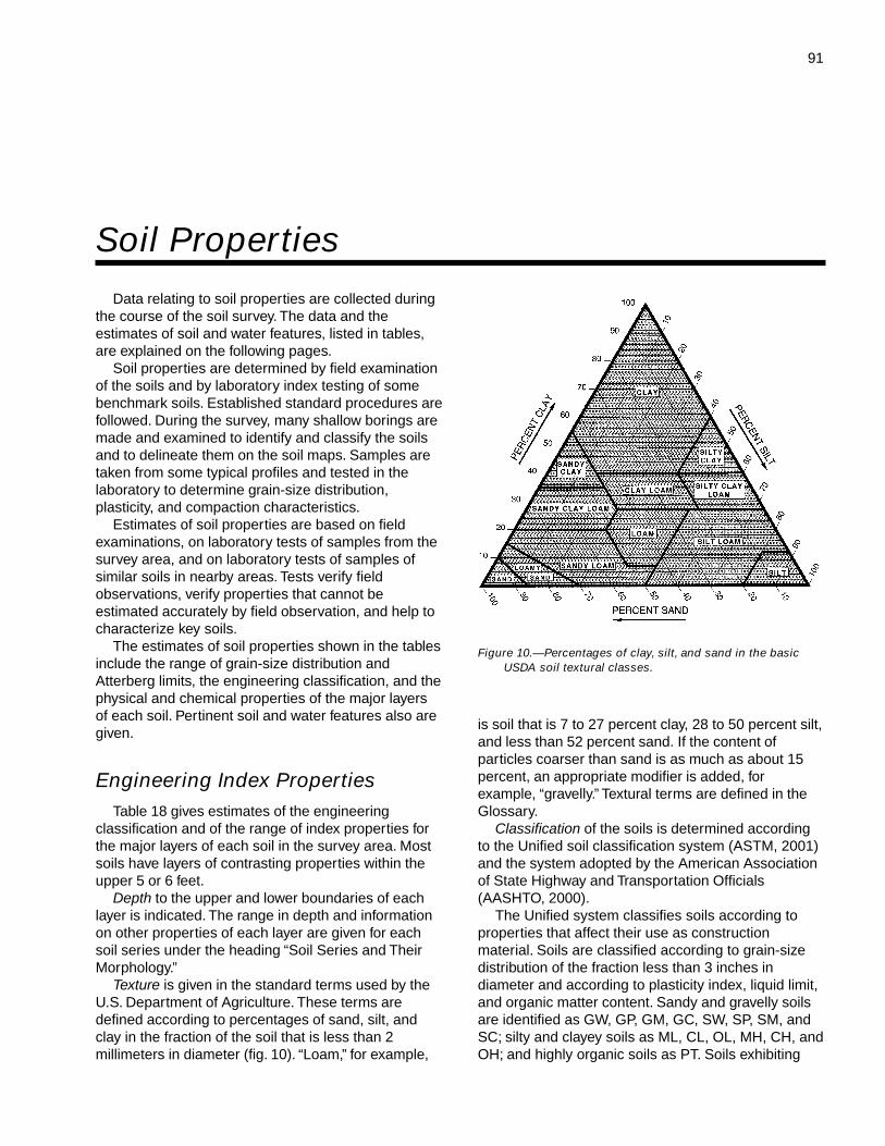
91
Data relating to soil properties are collected duringthe course of the soil survey. The data and theestimates of soil and water features, listed in tables,are explained on the following pages.
Soil properties are determined by field examinationof the soils and by laboratory index testing of somebenchmark soils. Established standard procedures arefollowed. During the survey, many shallow borings aremade and examined to identify and classify the soilsand to delineate them on the soil maps. Samples aretaken from some typical profiles and tested in thelaboratory to determine grain-size distribution,plasticity, and compaction characteristics.
Estimates of soil properties are based on fieldexaminations, on laboratory tests of samples from thesurvey area, and on laboratory tests of samples ofsimilar soils in nearby areas. Tests verify fieldobservations, verify properties that cannot beestimated accurately by field observation, and help tocharacterize key soils.
The estimates of soil properties shown in the tablesinclude the range of grain-size distribution andAtterberg limits, the engineering classification, and thephysical and chemical properties of the major layersof each soil. Pertinent soil and water features also aregiven.
Engineering Index PropertiesTable 18 gives estimates of the engineering
classification and of the range of index properties forthe major layers of each soil in the survey area. Mostsoils have layers of contrasting properties within theupper 5 or 6 feet.
Depth to the upper and lower boundaries of eachlayer is indicated. The range in depth and informationon other properties of each layer are given for eachsoil series under the heading “Soil Series and TheirMorphology.”
Texture is given in the standard terms used by theU.S. Department of Agriculture. These terms aredefined according to percentages of sand, silt, andclay in the fraction of the soil that is less than 2millimeters in diameter (fig. 10). “Loam,” for example,
is soil that is 7 to 27 percent clay, 28 to 50 percent silt,and less than 52 percent sand. If the content ofparticles coarser than sand is as much as about 15percent, an appropriate modifier is added, forexample, “gravelly.” Textural terms are defined in theGlossary.
Classification of the soils is determined accordingto the Unified soil classification system (ASTM, 2001)and the system adopted by the American Associationof State Highway and Transportation Officials(AASHTO, 2000).
The Unified system classifies soils according toproperties that affect their use as constructionmaterial. Soils are classified according to grain-sizedistribution of the fraction less than 3 inches indiameter and according to plasticity index, liquid limit,and organic matter content. Sandy and gravelly soilsare identified as GW, GP, GM, GC, SW, SP, SM, andSC; silty and clayey soils as ML, CL, OL, MH, CH, andOH; and highly organic soils as PT. Soils exhibiting
Soil Properties
Figure 10.—Percentages of clay, silt, and sand in the basicUSDA soil textural classes.
92 Soil Survey of
engineering properties of two groups can have a dualclassification, for example, CL-ML.
The AASHTO system classifies soils according tothose properties that affect roadway construction andmaintenance. In this system, the fraction of a mineralsoil that is less than 3 inches in diameter is classifiedin one of seven groups from A-1 through A-7 on thebasis of grain-size distribution, liquid limit, andplasticity index. Soils in group A-1 are coarse grainedand low in content of fines (silt and clay). At the otherextreme, soils in group A-7 are fine grained. Highlyorganic soils are classified in group A-8 on the basisof visual inspection.
If laboratory data are available, the A-1, A-2, andA-7 groups are further classified as A-1-a, A-1-b,A-2-4, A-2-5, A-2-6, A-2-7, A-7-5, or A-7-6. As anadditional refinement, the suitability of a soil assubgrade material can be indicated by a group indexnumber. Group index numbers range from 0 for thebest subgrade material to 20 or higher for the poorest.
Rock fragments larger than 10 inches in diameterand 3 to 10 inches in diameter are indicated as apercentage of the total soil on a dry-weight basis. Thepercentages are estimates determined mainly byconverting volume percentage in the field to weightpercentage.
Percentage (of soil particles) passing designatedsieves is the percentage of the soil fraction less than 3inches in diameter based on an ovendry weight. Thesieves, numbers 4, 10, 40, and 200 (USA StandardSeries), have openings of 4.76, 2.00, 0.420, and 0.074millimeters, respectively. Estimates are based onlaboratory tests of soils sampled in the survey areaand in nearby areas and on estimates made in thefield.
Liquid limit and plasticity index (Atterberg limits)indicate the plasticity characteristics of a soil. Theestimates are based on test data from the survey areaor from nearby areas and on field examination.
The estimates of grain-size distribution, liquid limit,and plasticity index are generally rounded to thenearest 5 percent. Thus, if the ranges of gradation andAtterberg limits extend a marginal amount (1 or 2percentage points) across classification boundaries,the classification in the marginal zone is omitted in thetable.
Physical and Chemical PropertiesTables 19 and 20 show estimates of some
characteristics and features that affect soil behavior.These estimates are given for the major layers of eachsoil in the survey area. The estimates are based on
field observations and on test data for these andsimilar soils.
Depth to the upper and lower boundaries of eachlayer is indicated. The range in depth and informationon other properties of each layer are given for eachsoil series under the heading “Soil Series and TheirMorphology.”
Clay as a soil separate consists of mineral soilparticles that are less than 0.002 millimeter indiameter. In this table, the estimated clay content ofeach major soil layer is given as a percentage, byweight, of the soil material that is less than 2millimeters in diameter.
The amount and kind of clay greatly affect thefertility and physical condition of the soil. Theydetermine the ability of the soil to adsorb cations andto retain moisture. They influence shrink-swellpotential, permeability, plasticity, the ease of soildispersion, and other soil properties. The amount andkind of clay in a soil also affect tillage andearthmoving operations.
In table 19, moist bulk density is the weight of soil(ovendry) per unit volume. Volume is measured whenthe soil is at field moisture capacity, that is, themoisture content at 1/3-bar moisture tension. Weight isdetermined after drying the soil at 105 degrees C. Inthis table, the estimated moist bulk density of eachmajor soil horizon is expressed in grams per cubiccentimeter of soil material that is less than 2millimeters in diameter. Bulk density data are used tocompute shrink-swell potential, available watercapacity, total pore space, and other soil properties.The moist bulk density of a soil indicates the porespace available for water and roots. A bulk density ofmore than 1.6 can restrict water storage and rootpenetration. Moist bulk density is influenced bytexture, kind of clay, content of organic matter, and soilstructure.
Permeability refers to the ability of a soil to transmitwater or air. The estimates indicate the rate ofdownward movement of water when the soil issaturated. They are based on soil characteristicsobserved in the field, particularly structure, porosity,and texture. Permeability is considered in the designof soil drainage systems and septic tank absorptionfields.
Available water capacity refers to the quantity ofwater that the soil is capable of storing for use byplants. The capacity for water storage is given ininches of water per inch of soil for each major soillayer. The capacity varies, depending on soilproperties that affect the retention of water and thedepth of the root zone. The most important properties
Paulding County, Ohio 93
are the content of organic matter, soil texture, bulkdensity, and soil structure. Available water capacity isan important factor in the choice of plants or crops tobe grown and in the design and management ofirrigation systems. Available water capacity is not anestimate of the quantity of water actually available toplants at any given time.
Shrink-swell potential is the potential for volumechange in a soil with a loss or gain in moisture.Volume change occurs mainly because of theinteraction of clay minerals with water and varies withthe amount and type of clay minerals in the soil. Thesize of the load on the soil and the magnitude of thechange in soil moisture content influence the amountof swelling of soils in place. Laboratory measurementsof swelling of undisturbed clods were made for manysoils. For others, swelling was estimated on the basisof the kind and amount of clay minerals in the soil andon the basis of measurements of similar soils.
If the shrink-swell potential is rated moderate tovery high, shrinking and swelling can cause damageto buildings, roads, and other structures (fig. 11).Special design is often needed.
Shrink-swell potential classes are based on thechange in length of an unconfined clod as moisturecontent is increased from air-dry to field capacity. Theclasses are low, a change of less than 3 percent;moderate, 3 to 6 percent; high, 6 to 9 percent; andvery high, greater than 9 percent.
Organic matter is the plant and animal residue inthe soil at various stages of decomposition. In thetable, the estimated content of organic matter isexpressed as a percentage, by weight, of the soilmaterial that is less than 2 millimeters in diameter.
The content of organic matter in a soil can bemaintained or increased by returning crop residue tothe soil. Organic matter affects the available watercapacity, infiltration rate, and tilth. It is a source ofnitrogen and other nutrients for crops.
Erosion factor K indicates the susceptibility of a soilto sheet and rill erosion by water. Factor K is one ofsix factors used in the Universal Soil Loss Equation(USLE) to predict the average annual rate of soil lossby sheet and rill erosion in tons per acre per year. Theestimates are based primarily on percentage of silt,sand, and organic matter (up to 4 percent) and on soilstructure and permeability. Values of K range from0.02 to 0.64. Other factors being equal, the higher thevalue, the more susceptible the soil is to sheet and rillerosion by water.
Erosion factor Kf indicates the erodibility of the fine-earth fraction, or the material less than 2 millimeters insize.
Erosion factor T is an estimate of the maximumaverage annual rate of soil erosion by wind or water thatcan occur without affecting crop productivity over asustained period. The rate is in tons per acre per year.
Wind erodibility groups are made up of soils thathave similar properties affecting their resistance towind erosion in cultivated areas. The groups indicatethe susceptibility of soil to wind erosion. The soilsassigned to group 1 are the most susceptible to winderosion, and those assigned to group 8 are the leastsusceptible. The groups are as follows:
1. Coarse sands, sands, fine sands, and very finesands.
2. Loamy coarse sands, loamy sands, loamy finesands, loamy very fine sands, ash material, and sapricsoil material.
3. Coarse sandy loams, sandy loams, fine sandyloams, and very fine sandy loams.
4L. Calcareous loams, silt loams, clay loams, andsilty clay loams.
4. Clays, silty clays, noncalcareous clay loams,and silty clay loams that are more than 35 percentclay.
5. Noncalcareous loams and silt loams that areless than 20 percent clay and sandy clay loams,sandy clays, and hemic soil material.
6. Noncalcareous loams and silt loams that aremore than 20 percent clay and noncalcareous clayloams that are less than 35 percent clay.
7. Silts, noncalcareous silty clay loams that areless than 35 percent clay, and fibric soil material.
8. Soils that are not subject to wind erosionbecause of rock fragments on the surface or becauseof surface wetness.
The wind erodibility index is a numerical valueindicating the susceptibility of soil to wind erosion, orthe tons per acre per year that can be expected to belost to wind erosion. There is a close correlationbetween wind erosion and the size and durability ofsurface clods, rock fragments, organic matter, and acalcareous reaction. Soil moisture and frozen soillayers also influence wind erosion.
In table 20, cation-exchange capacity is the totalamount of exchangeable cations that can be held bythe soil, expressed in terms of milliequivalents per 100grams of soil at neutrality (pH 7.0) or at some otherstated pH value. Soils having a low cation-exchangecapacity hold fewer cations and may require morefrequent applications of fertilizer than soils having ahigh cation-exchange capacity. Soils having a highcation-exchange capacity can retain cations. Theability to retain cations helps to prevent the pollution ofground water.
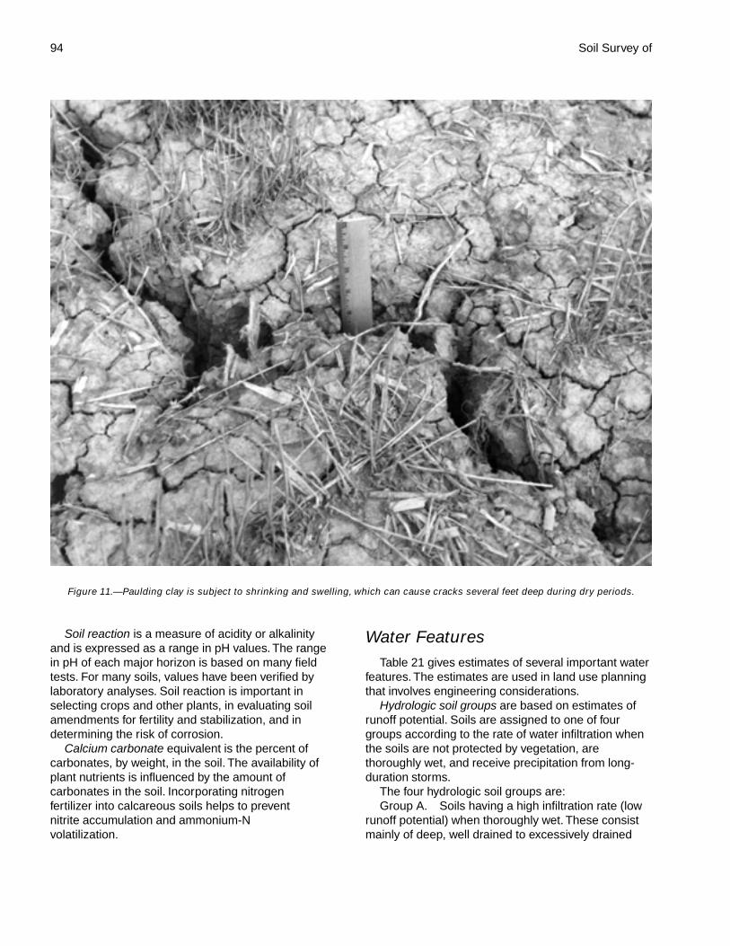
94 Soil Survey of
Soil reaction is a measure of acidity or alkalinityand is expressed as a range in pH values. The rangein pH of each major horizon is based on many fieldtests. For many soils, values have been verified bylaboratory analyses. Soil reaction is important inselecting crops and other plants, in evaluating soilamendments for fertility and stabilization, and indetermining the risk of corrosion.
Calcium carbonate equivalent is the percent ofcarbonates, by weight, in the soil. The availability ofplant nutrients is influenced by the amount ofcarbonates in the soil. Incorporating nitrogenfertilizer into calcareous soils helps to preventnitrite accumulation and ammonium-Nvolatilization.
Water FeaturesTable 21 gives estimates of several important water
features. The estimates are used in land use planningthat involves engineering considerations.
Hydrologic soil groups are based on estimates ofrunoff potential. Soils are assigned to one of fourgroups according to the rate of water infiltration whenthe soils are not protected by vegetation, arethoroughly wet, and receive precipitation from long-duration storms.
The four hydrologic soil groups are:Group A. Soils having a high infiltration rate (low
runoff potential) when thoroughly wet. These consistmainly of deep, well drained to excessively drained
Figure 11.—Paulding clay is subject to shrinking and swelling, which can cause cracks several feet deep during dry periods.
Paulding County, Ohio 95
sands or gravelly sands. These soils have a high rateof water transmission.
Group B. Soils having a moderate infiltration ratewhen thoroughly wet. These consist chiefly ofmoderately deep or deep, moderately well drained orwell drained soils that have moderately fine texture tomoderately coarse texture. These soils have amoderate rate of water transmission.
Group C. Soils having a slow infiltration rate whenthoroughly wet. These consist chiefly of soils having alayer that impedes the downward movement of wateror soils of moderately fine texture or fine texture.These soils have a slow rate of water transmission.
Group D. Soils having a very slow infiltration rate(high runoff potential) when thoroughly wet. Theseconsist chiefly of clays that have a high shrink-swellpotential, soils that have a high water table, soils thathave a claypan or clay layer at or near the surface,and soils that are shallow over nearly imperviousmaterial. These soils have a very slow rate of watertransmission.
If a soil is assigned to two hydrologic groups in thetable, the first letter is for drained areas and thesecond is for undrained areas.
Flooding, the temporary inundation of an area, iscaused by overflowing streams, by runoff fromadjacent slopes, or by tides. Water standing for shortperiods after rainfall or snowmelt is not consideredflooding, and water standing in swamps and marshesis considered ponding rather than flooding.
The table gives the frequency and duration offlooding and the time of year when flooding is mostlikely.
Frequency, duration, and probable dates ofoccurrence are estimated. Frequency is expressed asnone, rare, occasional, and frequent. None means thatflooding is not probable; rare that it is unlikely butpossible under unusual weather conditions (thechance of flooding is nearly 0 percent to 5 percent inany year); occasional that it occurs, on the average,once or less in 2 years (the chance of flooding is 5 to50 percent in any year); and frequent that it occurs, onthe average, more than once in 2 years (the chance offlooding is more than 50 percent in any year). Durationis expressed as very brief if less than 2 days, brief if 2to 7 days, long if 7 days to 1 month, and very long ifmore than 1 month. Probable dates are expressed inmonths. About two-thirds to three-fourths of allflooding occurs during the stated period.
The information is based on evidence in the soilprofile, namely thin strata of gravel, sand, silt, or claydeposited by floodwater; irregular decrease in organicmatter content with increasing depth; and little or nohorizon development.
Also considered are local information about theextent and levels of flooding and the relation of eachsoil on the landscape to historic floods. Information onthe extent of flooding based on soil data is lessspecific than that provided by detailed engineeringsurveys that delineate flood-prone areas at specificflood frequency levels.
High water table (seasonal) is the highest level of asaturated zone in the soil in most years. The estimatesare based mainly on observations of the water table atselected sites and on the evidence of a saturatedzone, namely grayish colors or mottles (redoximorphicfeatures) in the soil. Indicated in the table are thedepth to the seasonal high water table; the kind ofwater table—that is, perched or apparent; and themonths of the year that the water table commonly ishigh. A water table that is seasonally high for less than1 month is not indicated in the table.
An apparent water table is a thick zone of freewater in the soil. It is indicated by the level at whichwater stands in an uncased borehole after adequatetime is allowed for adjustment in the surrounding soil.A perched water table is water standing above anunsaturated zone. In places an upper, or perched,water table is separated from a lower one by a dryzone. An artesian water table is under hydrostatichead, generally below an impermeable layer. Whenthis layer is penetrated, the water level rises in anuncased borehole.
Two numbers in the column showing depth to thewater table indicate the normal range in depth to asaturated zone. Depth is given to the nearest half foot.The first numeral in the range indicates the highestwater level. “More than 6.0” indicates that the watertable is below a depth of 6 feet or that it is within adepth of 6 feet for less than a month.
Ponding is standing water in a closed depression.Unless a drainage system is installed, the water isremoved only by percolation, transpiration, orevaporation. Table 21 indicates the maximum pondingdepth and the duration of the ponding. Maximumponding depth refers to the depth of the water abovethe surface of the soil. Duration is expressed as verybrief if less than 2 days, brief if 2 to 7 days, long if 7 to30 days, and very long if more than 30 days.
Soil FeaturesTable 22 gives estimates of several important soil
features. The estimates are used in land use planningthat involves engineering considerations.
Depth to bedrock is given if bedrock is within adepth of 5 feet. The depth is based on many soilborings and on observations during soil mapping. The
96
rock is either soft or hard. If the rock is soft orfractured, excavations can be made with trenchingmachines, backhoes, or small rippers. If the rock ishard or massive, blasting or special equipmentgenerally is needed for excavation.
Potential frost action is the likelihood of upward orlateral expansion of the soil caused by the formation ofsegregated ice lenses (frost heave) and thesubsequent collapse of the soil and loss of strength onthawing. Frost action occurs when moisture movesinto the freezing zone of the soil. Temperature, texture,density, permeability, content of organic matter, anddepth to the water table are the most important factorsconsidered in evaluating the potential for frost action. Itis assumed that the soil is not insulated by vegetationor snow and is not artificially drained. Silty and highlystructured, clayey soils that have a high water table inwinter are the most susceptible to frost action. Welldrained, very gravelly, or very sandy soils are the leastsusceptible. Frost heave and low soil strength duringthawing cause damage mainly to pavements andother rigid structures.
Risk of corrosion pertains to potential soil-inducedelectrochemical or chemical action that dissolves orweakens uncoated steel or concrete. The rate ofcorrosion of uncoated steel is related to such factorsas soil moisture, particle-size distribution, acidity, andelectrical conductivity of the soil. The rate of corrosionof concrete is based mainly on the sulfate and sodiumcontent, texture, moisture content, and acidity of thesoil. Special site examination and design may beneeded if the combination of factors results in asevere hazard of corrosion. The steel in installationsthat intersect soil boundaries or soil layers is moresusceptible to corrosion than steel in installations thatare entirely within one kind of soil or within one soillayer.
For uncoated steel, the risk of corrosion, expressedas low, moderate, or high, is based on soil drainageclass, total acidity, electrical resistivity near field
capacity, and electrical conductivity of the saturationextract.
For concrete, the risk of corrosion is also expressedas low, moderate, or high. It is based on soil texture,acidity, and amount of sulfates in the saturationextract.
Physical and Chemical Analyses ofSelected Soils
Many of the soils in Paulding County weresampled by the Soil Characterization Laboratory,School of Natural Resources, The Ohio StateUniversity, Columbus, Ohio. The physical andchemical data obtained on most samples includedparticle-size distribution, reaction, organic mattercontent, calcium carbonate equivalent, and extractablecations.
These data were used in the classification andcorrelation of the soils and in evaluating their behaviorunder various land uses. Among the samplesevaluated, two pedons were selected asrepresentative of their respective series. They aredescribed in the section “Soil Series and TheirMorphology.” These series and their laboratoryidentification numbers are Latty, PD-S33, andPaulding, PD-S8.
In addition to the data from Paulding County,laboratory data are available from nearby counties innorthwestern Ohio that include many of the samesoils. These data and the data from Paulding Countyare on file at the School of Natural Resources, TheOhio State University, Columbus, Ohio; the OhioDepartment of Natural Resources, Division of Soil andWater Conservation, Columbus, Ohio; and the NaturalResources Conservation Service, State Office,Columbus, Ohio. Some of these data have beenpublished in special studies of soils in PauldingCounty and nearby counties.
97
The system of soil classification used by theNational Cooperative Soil Survey has six categories(Soil Survey Staff, 1992 and 1999). Beginning with thebroadest, these categories are the order, suborder,great group, subgroup, family, and series.Classification is based on soil properties observed inthe field or inferred from those observations or fromlaboratory measurements. Table 23 shows theclassification of the soils in the survey area. Thecategories are defined in the following paragraphs.
ORDER. Twelve soil orders are recognized. Thedifferences among orders reflect the dominant soil-forming processes and the degree of soil formation.Each order is identified by a word ending in sol. Anexample is Alfisol.
SUBORDER. Each order is divided intosuborders primarily on the basis of properties thatinfluence soil genesis and are important to plantgrowth or properties that reflect the most importantvariables within the orders. The last syllable in thename of a suborder indicates the order. An example isUdalf (Ud, meaning humid, plus alf, from Alfisol).
GREAT GROUP. Each suborder is divided intogreat groups on the basis of close similarities in kind,arrangement, and degree of development ofpedogenic horizons; soil moisture and temperatureregimes; type of saturation; and base status. Eachgreat group is identified by the name of a suborderand by a prefix that indicates a property of the soil. Anexample is Hapludalfs (Hapl, meaning minimalhorizonation, plus udalf, the suborder of the Alfisolsthat has a udic moisture regime).
SUBGROUP. Each great group has a typicsubgroup. Other subgroups are intergrades orextragrades. The typic subgroup is the central conceptof the great group; it is not necessarily the mostextensive. Intergrades are transitions to other orders,suborders, or great groups. Extragrades have someproperties that are not representative of the greatgroup but do not indicate transitions to any othertaxonomic class. Each subgroup is identified by one ormore adjectives preceding the name of the greatgroup. The adjective Typic identifies the subgroup thattypifies the great group. An example is TypicHapludalfs.
FAMILY. Families are established within asubgroup on the basis of physical and chemicalproperties and other characteristics that affectmanagement. Generally, the properties are those ofhorizons below plow depth where there is muchbiological activity. Among the properties andcharacteristics considered are particle size, mineralcontent, soil temperature regime, soil depth, andreaction. A family name consists of the name of asubgroup preceded by terms that indicate soilproperties. An example is fine-loamy, mixed, mesicTypic Hapludalfs.
SERIES. The series consists of soils within afamily that have horizons similar in color, texture,structure, reaction, consistence, mineral and chemicalcomposition, and arrangement in the profile.
Soil Series and Their MorphologyIn this section, each soil series recognized in the
survey area is described. Characteristics of the soiland the material in which it formed are identified foreach series. A pedon, a small three-dimensional areaof soil, that is typical of the series in the survey area isdescribed. The detailed description of each soilhorizon follows standards in the “Soil Survey Manual”(Soil Survey Division Staff, 1993). Many of thetechnical terms used in the descriptions are defined in“Soil Taxonomy” (Soil Survey Staff, 1999) and in “Keysto Soil Taxonomy” (Soil Survey Staff, 1992). Unlessotherwise indicated, colors in the descriptions are formoist soil. Following the pedon description is therange of important characteristics of the soils in theseries.
Belmore Series
Depth class: Very deepDrainage class: Well drainedPermeability: Moderately rapid in the solum, rapid in
the loamy and gravelly substratum, and slow inthe till
Parent material: Beach deposits overlying tillLandform: Lake plains, beach ridges on lake plains
Classification of the Soils
98 Soil Survey of
Position on the landform: Knolls, backslopesSlope range: 2 to 6 percentAdjacent soils: Millgrove
Taxonomic classification: Fine-loamy, mixed, mesicTypic Hapludalfs
Typical Pedon
Belmore loam, till substratum, 2 to 6 percent slopes,about 5 miles southwest of Payne, in BentonTownship, about 2,280 feet west and 1,760 feet northof the southeast corner of sec. 31, T. 1 N., R. 1 E.
Ap—0 to 6 inches; brown (10YR 4/3) loam, pale brown(10YR 6/3) dry; weak fine and medium granularstructure; friable; common fine and medium roots;5 percent rock fragments; moderately acid; clearwavy boundary.
Bt1—6 to 18 inches; dark yellowish brown (10YR 4/4)loam; weak medium subangular blocky structure;friable; common fine and few medium roots; fewfaint brown (10YR 4/3) clay films on faces of peds;10 percent rock fragments; strongly acid; clearwavy boundary.
Bt2—18 to 29 inches; dark brown (7.5YR 3/4) clayloam; weak medium and coarse subangularblocky structure; friable; common fine roots;common faint dark brown (10YR 3/3) clay films onfaces of peds and clay bridging between sandgrains; 8 percent rock fragments; moderately acid;clear wavy boundary.
Bt3—29 to 39 inches; dark brown (10YR 3/3) clayloam; weak medium and coarse subangularblocky structure; firm; common fine roots; manyfaint dark brown (10YR 3/3) clay films on faces ofpeds and clay bridging between sand grains; 10percent rock fragments; neutral; abrupt smoothboundary.
2C1—39 to 46 inches; brown (10YR 5/3) gravellycoarse sandy loam; massive; firm because ofweak cementation by calcium carbonates; 20percent rock fragments; strongly effervescent;slightly alkaline; clear smooth boundary.
2C2—46 to 75 inches; brown (10YR 5/3) sandy loam;massive; very friable; thin strata of loamy sand; 10percent rock fragments; strongly effervescent;slightly alkaline; clear wavy boundary.
3C3—75 to 80 inches; brown (10YR 5/3) clay loam;massive; very firm; 5 percent rock fragments;strongly effervescent; moderately alkaline.
Range in Characteristics
Thickness of the solum: 22 to 55 inchesDepth to carbonates: 22 to 55 inchesDepth to till substratum: 60 to 80 inches
Ap horizon:Color—hue of 10YR, value of 4 or 5, chroma of 2
or 3Texture—loamContent of rock fragments—2 to 10 percent
Bt horizon:Color—hue of 7.5YR or 10YR, value of 3 to 5,
chroma of 3 or 4Texture—loam, clay loam, or sandy clay loamContent of rock fragments—2 to 15 percent
2C or 2Cg horizon:Color—hue of 10YR or 7.5YR, value of 4 to 6,
chroma of 2 to 4Texture—sandy loam, coarse sandy loam, or the
gravelly analogs of these textures; common thinstrata of loamy sand or sand
Content of rock fragments—10 to 30 percent
3C horizon:Color—hue of 10YR or 2.5Y, value of 4 or 5,
chroma of 2 to 4Texture—clay loam, silty clay loam, or silty clayContent of rock fragments—2 to 10 percent
Bixler Series
Depth class: Very deepDrainage class: Somewhat poorly drainedPermeability: Rapid in the sandy material, moderate in
the underlying loamy and silty subsoil andsubstratum, and slow or very slow in the clayeysubstratum
Parent material: Lacustrine depositsLandform: Lake plainsPosition on the landform: Slight rises, knollsSlope range: 0 to 2 percentAdjacent soils: Fulton, Granby, Mermill, Toledo
Taxonomic classification: Loamy, mixed, mesicAquic Arenic Hapludalfs
Typical Pedon
Bixler loamy sand, clayey substratum, 0 to 2 percentslopes, about 2 miles south of Arthur, in AuglaizeTownship, about 1,720 feet west and 340 feet north ofthe southeast corner of sec. 35, T. 3 N., R. 4 E.
Ap—0 to 10 inches; very dark grayish brown (10YR3/2) loamy sand, light brownish gray (10YR 6/2)dry; weak fine and medium granular structure;very friable; common coarse and medium rootsand many fine roots; strongly acid; abrupt smoothboundary.
E1—10 to 20 inches; yellowish brown (10YR 5/4)
Paulding County, Ohio 99
loamy sand; weak medium and coarsesubangular blocky structure; very friable;common medium and fine roots; few distinctvery dark grayish brown (10YR 3/2) wormcastsand organic coatings in root channels; fewmedium faint pale brown (10YR 6/3) irondepletions in the matrix; common coarse faintyellowish brown (10YR 5/6) masses of ironaccumulation in the matrix; common coarsedistinct strong brown (7.5YR 5/6) masses of ironaccumulation in the matrix; moderately acid; clearwavy boundary.
E2—20 to 28 inches; yellowish brown (10YR 5/6)loamy sand; weak medium and coarse subangularblocky structure; very friable; few fine roots; fewprominent dark grayish brown (10YR 4/2) organiccoatings in root channels; many fine and mediumprominent grayish brown (10YR 5/2) irondepletions in the matrix; few fine distinct strongbrown (7.5YR 5/6) masses of iron accumulation inthe matrix; moderately acid; clear smoothboundary.
Btg1—28 to 36 inches; grayish brown (10YR 5/2)sandy loam; weak medium and coarse subangularblocky structure; friable; few fine roots; many faintgray (10YR 5/1) clay films on faces of peds and inroot channels; few fine distinct black (10YR 2/1)masses of iron and manganese accumulation onfaces of peds; common fine prominent yellowishbrown (10YR 5/6) and few coarse prominentstrong brown (7.5YR 5/6) masses of ironaccumulation in the matrix; moderately acid;abrupt wavy boundary.
2Btg2—36 to 46 inches; grayish brown (2.5Y 5/2) siltloam; moderate medium and coarse subangularblocky structure; firm; thin strata of silty clay loam;few fine roots; many distinct gray (10YR 5/1) clayfilms on faces of peds; many fine and mediumprominent strong brown (7.5YR 5/6) masses ofiron accumulation in the matrix; few fine prominentblack (10YR 2/1) iron and manganese concretionsin the matrix; neutral; clear wavy boundary.
2C1—46 to 74 inches; dark yellowish brown (10YR4/4) silt loam; massive; friable; thin strata of veryfine sandy loam; common medium and coarsedistinct grayish brown (10YR 5/2) iron depletionsin the matrix; few coarse prominent strong brown(7.5YR 5/6) masses of iron accumulation in thematrix; strongly effervescent; slightly alkaline;abrupt wavy boundary.
3C2—74 to 80 inches; dark yellowish brown (10YR4/4) silty clay; massive; firm; light gray (10YR 7/2)masses of calcium carbonate accumulation onvertical faces of partings; common medium
distinct grayish brown (10YR 5/2) iron depletionsin the matrix; few fine prominent strong brown(7.5YR 5/6) masses of iron accumulation in thematrix; strongly effervescent; slightly alkaline.
Range in Characteristics
Thickness of the A and E horizons: 20 to 35 inchesThickness of the solum: 28 to 55 inchesDepth to carbonates: 28 to 55 inchesDepth to clayey substratum: 60 to 80 inches
Ap horizon:Color—hue of 10YR, value of 2 to 4, chroma of 1
to 3Texture—loamy sandContent of rock fragments—0 to 5 percent
E horizon:Color—hue of 10YR or 7.5YR, value of 4 to 6,
chroma of 3 to 6Texture—loamy sand or sandContent of rock fragments—0 to 5 percent
Bt or Btg horizon:Color—hue of 10YR or 7.5YR, value of 4 to 6,
chroma of 2 to 6Texture—sandy loam, fine sandy loam, or loam
2Bt or 2Btg horizon:Color—hue of 7.5YR to 2.5Y, value of 4 to 6,
chroma of 2 to 6Texture—silt loam with thin strata of silty clay loam
2C or 2Cg horizon:Color—hue of 7.5YR to 2.5Y or N, value of 4 to 6,
chroma of 0 to 6Texture—silt loam that is commonly stratified with
silty clay loam, silt, fine sand, or very finesandy loam
3C or 3Cg horizon:Color—hue of 7.5YR to 2.5Y or N, value of 4 to 6,
chroma of 0 to 6Texture—silty clay, clay, or silty clay loam
Broughton Series
Depth class: Very deepDrainage class: Moderately well drainedPermeability: Very slowParent material: Lacustrine depositsLandform: Lake plainsPosition on the landform: Knolls, backslopes,
dissected areas along streamsSlope range: 2 to 35 percentAdjacent soils: Paulding, Roselms
100 Soil Survey of
Taxonomic classification: Very fine, illitic, mesicAquic Hapludalfs
Typical Pedon
Broughton silty clay, 6 to 12 percent slopes, severelyeroded, about 1.5 miles east of Oakwood, in BrownTownship, about 800 feet west and 160 feet south ofthe northeast corner of sec. 36, T. 2 N., R. 4 E.
Ap—0 to 5 inches; brown (10YR 5/3) silty clay, verypale brown (10YR 7/3) dry; weak mediumsubangular blocky structure; very firm; fewmedium and common fine roots; neutral; clearsmooth boundary.
Bt1—5 to 12 inches; yellowish brown (10YR 5/4) clay;moderate medium and coarse subangular blockystructure; very firm; few fine roots; common faintyellowish brown (10YR 5/4) clay films on faces ofpeds; many medium faint brown (10YR 5/3) irondepletions in the matrix; few medium distinctyellowish brown (10YR 5/6) masses of ironaccumulation in the matrix; few fine prominentstrong brown (7.5YR 5/6) masses of ironaccumulation in the matrix; neutral; clear wavyboundary.
Bt2—12 to 16 inches; brown (10YR 5/3) clay; strongmedium and coarse subangular blocky structure;very firm; few fine roots; common faint grayishbrown (10YR 5/2) clay films on faces of peds;common faint brown (10YR 5/3) pressure faces onvertical faces of peds; common medium prominentwhite (10YR 8/1) masses of calcium carbonateaccumulation occurring as coatings on verticalfaces of peds; common medium distinct yellowishbrown (10YR 5/6) masses of iron accumulation inthe matrix; common fine and medium distinct gray(10YR 6/1) iron depletions in the matrix; few fineprominent strong brown (7.5YR 5/6) masses ofiron accumulation in the matrix; stronglyeffervescent; slightly alkaline; clear wavyboundary.
Bt3—16 to 27 inches; yellowish brown (10YR 5/4)clay; weak coarse prismatic structure; very firm;few fine roots on vertical faces of peds; manydistinct grayish brown (10YR 5/2) and faint brown(10YR 5/3) clay films on faces of peds; commonfaint yellowish brown (10YR 5/4) pressure faceson vertical faces of peds; common mediumprominent white (10YR 8/1) masses of calciumcarbonate accumulation occurring as coatings onvertical faces of peds; common fine and mediumdistinct grayish brown (10YR 5/2) iron depletionsin the matrix; few medium distinct black (10YR
2/1) masses of iron and manganese accumulationin the matrix; strongly effervescent; slightlyalkaline; gradual smooth boundary.
BC—27 to 34 inches; dark yellowish brown (10YR 4/4)clay; weak coarse prismatic structure; very firm;few fine roots on vertical faces of peds; commondistinct gray (10YR 6/1) pressure faces on verticalfaces of peds; common medium distinct yellowishbrown (10YR 5/6) masses of iron accumulation inthe matrix; common medium distinct grayishbrown (10YR 5/2) iron depletions in the matrix;common medium distinct black (10YR 2/1)masses of iron and manganese accumulation inthe matrix; common fine light gray (10YR 7/1)masses of calcium sulfate accumulation occurringas crystals on faces of peds; stronglyeffervescent; moderately alkaline; gradual wavyboundary.
C1—34 to 44 inches; dark yellowish brown (10YR 4/4)clay; massive; very firm; many distinct gray (10YR6/1) pressure faces on vertical faces of partings;common fine light gray (10YR 7/1) masses ofcalcium sulfate accumulation occurring as crystalson faces of partings; many medium distinctgrayish brown (10YR 5/2) iron depletions in thematrix; common medium distinct yellowish brown(10YR 5/6) masses of iron accumulation in thematrix; common medium distinct black (10YR 2/1)masses of iron and manganese accumulation inthe matrix; strongly effervescent; moderatelyalkaline; gradual wavy boundary.
C2—44 to 80 inches; dark yellowish brown (10YR 4/4)clay; massive; laminated; very firm; brown (10YR5/3) pressure faces that decrease in number withincreasing depth on vertical faces of partings;many medium distinct grayish brown (10YR 5/2)iron depletions in the matrix; common mediumdistinct yellowish brown (10YR 5/6) masses ofiron accumulation in the matrix; stronglyeffervescent; moderately alkaline.
Range in Characteristics
Thickness of the solum: 14 to 36 inchesDepth to carbonates: 11 to 32 inches
Ap horizon:Color—hue of 10YR, value of 4 or 5, chroma of 2
to 4Texture—silty clay or silty clay loam
Bt or Btg horizon:Color—hue of 10YR, value of 4 or 5, chroma of 2
to 6Texture—clay
Paulding County, Ohio 101
C or Cg horizon:Color—hue of 10YR or 2.5Y, value of 4 or 5,
chroma of 1 to 4Texture—clay
Defiance Series
Depth class: Very deepDrainage class: Somewhat poorly drainedPermeability: SlowParent material: AlluviumLandform: Flood plainsPosition on the landform: Flat areas, slight risesSlope range: 0 to 2 percentAdjacent soils: Flatrock, Saranac, Wabasha
Taxonomic classification: Fine, illitic, nonacid, mesicAeric Fluvaquents
Typical Pedon
Defiance silty clay loam, occasionally flooded, about4.3 miles east-southeast of Cecil, in EmeraldTownship, about 1,240 feet west and 200 feet north ofthe southeast corner of sec. 16, T. 3 N., R. 3 E.
Ap—0 to 8 inches; dark grayish brown (10YR 4/2) siltyclay loam, light brownish gray (10YR 6/2) dry;weak medium subangular blocky structure partingto weak fine and medium granular; firm; commonmedium and many fine roots; few faint very darkgrayish brown (10YR 3/2) organic coatings onfaces of peds; 2 percent rock fragments; slightlyacid; abrupt smooth boundary.
Bw—8 to 13 inches; brown (10YR 5/3) silty clay loam;weak medium and fine subangular blockystructure; firm; common fine roots; common faintdark grayish brown (10YR 4/2) organic coatingson faces of peds; common fine distinct very darkgrayish brown (10YR 3/2) masses of iron andmanganese accumulation on faces of peds;common medium distinct yellowish brown (10YR5/6) masses of iron accumulation in the matrix;common medium faint grayish brown (10YR 5/2)iron depletions in the matrix; 2 percent rockfragments; moderately acid; clear wavy boundary.
Bg1—13 to 20 inches; grayish brown (10YR 5/2) siltyclay; moderate fine and medium subangularblocky structure; firm; few fine roots; few faint darkgrayish brown (10YR 4/2) organic coatings onvertical faces of peds; common fine faint very darkgrayish brown (10YR 3/2) masses of iron andmanganese accumulation on faces of peds;common medium prominent yellowish brown(10YR 5/6) masses of iron accumulation in the
matrix; 2 percent rock fragments; moderately acid;clear wavy boundary.
Bg2—20 to 36 inches; grayish brown (10YR 5/2) siltyclay; moderate medium subangular blockystructure; firm; few fine roots; few faint grayishbrown (10YR 5/2) coatings on vertical faces ofpeds; common fine and medium faint very darkgrayish brown (10YR 3/2) masses of iron andmanganese accumulation on faces of peds;common medium prominent yellowish brown(10YR 5/6) masses of iron accumulation in thematrix; 3 percent rock fragments; slightly acid;gradual wavy boundary.
B´w—36 to 48 inches; yellowish brown (10YR 5/4)clay; weak coarse and medium subangular blockystructure; firm; common medium distinct yellowishbrown (10YR 5/6) masses of iron accumulation inthe matrix; common fine and medium distinctgrayish brown (10YR 5/2) iron depletions in thematrix; few fine and medium distinct very darkgrayish brown (10YR 3/2) masses of iron andmanganese accumulation in the matrix; 3 percentrock fragments; neutral; gradual wavy boundary.
Cg—48 to 80 inches; grayish brown (10YR 5/2) clay;massive; firm; thin strata of clay loam; commonmedium and coarse prominent yellowish brown(10YR 5/6) masses of iron accumulation in thematrix; common medium and coarse faint gray(10YR 5/1) iron depletions in the matrix; 2 percentrock fragments; neutral.
Range in Characteristics
Thickness of the solum: 24 to 50 inches
Ap horizon:Color—hue of 10YR, value of 4, chroma of 2Texture—silty clay loamContent of rock fragments—0 to 10 percent
Bw horizon:Color—hue of 10YR, value of 4 to 6, chroma of 3
to 6Texture—silty clay, silty clay loam, clay, or clay
loamContent of rock fragments—0 to 15 percent
Bg horizon:Color—hue of 10YR or 2.5Y, value of 4 to 6,
chroma of 1 or 2Texture—silty clay, silty clay loam, clay, or clay
loamContent of rock fragments—0 to 15 percent
Cg horizon:Color—hue of 10YR or 2.5Y, value of 4 to 6,
chroma of 1 or 2
102 Soil Survey of
Texture—silty clay or clay; thin strata of silty clayloam, clay loam, silt loam, loam, or sandy loamin most pedons
Content of rock fragments—0 to 15 percent
Flatrock Series
Depth class: Very deepDrainage class: Moderately well drainedPermeability: Moderate in the solum and moderate or
moderately rapid in the substratumParent material: AlluviumLandform: Flood plainsPosition on the landform: Slight rises, areas adjacent
to the stream channelSlope range: 0 to 2 percentAdjacent soils: Defiance, Knoxdale, Saranac, Shoals,
Wabasha
Taxonomic classification: Fine-loamy, mixed, mesicFluvaquentic Eutrochrepts
Typical Pedon
Flatrock silt loam, frequently flooded, about 1.7 milessouthwest of Paulding, in Paulding Township, about1,450 feet east and 1,450 feet north of the southwestcorner of sec. 14, T. 2 N., R. 2 E.
Ap—0 to 13 inches; brown (10YR 4/3) silt loam, lightbrownish gray (10YR 6/2) dry; weak mediumsubangular blocky structure parting to moderatefine and medium granular; friable; few fine roots;common faint dark grayish brown (10YR 4/2)organic coatings on faces of peds and in wormchannels; neutral; clear smooth boundary.
Bw1—13 to 18 inches; yellowish brown (10YR 5/4) siltloam; weak medium subangular blocky structure;friable; few fine roots; many faint dark brown(10YR 4/3) wormcasts; few faint brown (10YR 5/3)coatings on vertical faces of peds; few fine faintdark yellowish brown (10YR 4/4) masses of ironaccumulation in the matrix; few fine distinctprominent very dark gray (10YR 3/1) masses ofiron and manganese accumulation in the matrix;slightly acid; gradual wavy boundary.
Bw2—18 to 30 inches; dark yellowish brown (10YR4/4) loam; moderate medium subangular blockystructure; firm; few fine roots; common faintdistinct brown (10YR 5/3) and common distinctlight brownish gray (10YR 6/2) coatings on verticalfaces of peds; few fine distinct prominent black(10YR 2/1) masses of iron and manganeseaccumulation in the matrix; few fine distinctgrayish brown (10YR 5/2) and common fine faint
distinct brown (10YR 5/3) iron depletions in thematrix; neutral; gradual wavy boundary.
Bw3—30 to 44 inches; dark yellowish brown (10YR4/4) loam; weak and moderate mediumsubangular blocky structure; firm; few fine roots;few distinct dark grayish brown (10YR 4/2)coatings on vertical faces of peds; many mediumdistinct prominent black (10YR 2/1) masses ofiron and manganese accumulation on faces ofpeds; common medium faint yellowish brown(10YR 5/4) masses of iron accumulation in thematrix; few medium distinct light brownish gray(10YR 6/2) iron depletions in the matrix; neutral;gradual wavy boundary.
C—44 to 80 inches; yellowish brown (10YR 5/4) loam;massive; friable; thin strata of silt loam and finesandy loam; common medium prominent black(10YR 2/1) masses of iron and manganeseaccumulation in the matrix and on faces of peds;common medium distinct grayish brown (10YR5/2) iron depletions in the matrix; commonmedium distinct faint yellowish brown (10YR 5/6)masses of iron accumulation in the matrix; neutral.
Range in Characteristics
Thickness of the solum: 24 to 50 inches
Ap horizon:Color—hue of 10YR, value of 4, chroma of 2 or 3Texture—silt loam
Bw horizon:Color—hue of 10YR, value of 4 or 5, chroma of 3
or 4Texture—silt loam or loam
C or Cg horizon:Color—hue of 10YR, value of 4 to 6, chroma of 2
to 4Texture—loam, silt loam, sandy loam, or fine
sandy loam; commonly stratified
Fulton Series
Depth class: Very deepDrainage class: Somewhat poorly drainedPermeability: Slow in the upper part of the subsoil and
slow or very slow in the lower part of the subsoiland in the substratum (slow in the subsoil andmoderate in the substratum in the loamysubstratum phase)
Parent material: Lacustrine deposits (lacustrinedeposits overlying loamy glaciofluvial deposits inthe loamy substratum phase)
Paulding County, Ohio 103
Landform: Lake plains, stream terracesPosition on the landform: Slight rises, flat areas,
knolls, backslopesSlope range: 0 to 6 percentAdjacent soils: Haskins, Latty, Lucas, Rimer, Toledo
Taxonomic classification: Fine, illitic, mesic AericEpiaqualfs
Typical Pedon
Fulton silty clay loam, 0 to 2 percent slopes, about 2.1miles north of Oakwood, in Brown Township, about1,600 feet west and 600 feet north of the southeastcorner of sec. 14, T. 2 N., R. 4 E.
Ap—0 to 10 inches; dark grayish brown (10YR 4/2)silty clay loam, light brownish gray (10YR 6/2) dry;weak coarse subangular blocky structure partingto moderate fine and medium granular; firm; fewfine and medium roots; 10 percent mixing ofyellowish brown (10YR 5/4) material from the Bt1horizon; moderately acid; clear smooth boundary.
Bt1—10 to 18 inches; yellowish brown (10YR 5/4) siltyclay; moderate medium subangular blockystructure; firm; few fine and medium roots; manydistinct grayish brown (10YR 5/2) clay films (irondepletions) on faces of peds; many medium andcoarse distinct yellowish brown (10YR 5/8)masses of iron accumulation in the matrix; manymedium distinct grayish brown (10YR 5/2) irondepletions in the matrix; strongly acid; gradualsmooth boundary.
Bt2—18 to 24 inches; brown (10YR 5/3) silty clay;moderate medium subangular blocky structure;firm; few fine roots; many faint grayish brown(10YR 5/2) clay films (iron depletions) on faces ofpeds; common medium distinct yellowish brown(10YR 5/6) masses of iron accumulation in thematrix; many medium faint grayish brown (10YR5/2) iron depletions in the matrix; common finedistinct prominent black (10YR 2/1) iron andmanganese oxide concretions in the matrix;moderately acid; gradual smooth boundary.
Bt3—24 to 31 inches; brown (10YR 5/3) silty clay;weak medium prismatic structure parting tomoderate medium subangular blocky; firm; fewfine roots; common faint grayish brown (10YR 5/2)clay films (iron depletions) on faces of peds;common medium distinct yellowish brown (10YR5/6) masses of iron accumulation in the matrix;many medium faint grayish brown (10YR 5/2) irondepletions in the matrix; common fine distinctprominent black (10YR 2/1) iron and manganeseoxide concretions in the matrix; neutral; gradualwavy boundary.
Bt4—31 to 38 inches; yellowish brown (10YR 5/4) siltyclay; weak medium and coarse subangular blockystructure; very firm; common distinct gray (10YR5/1) clay films (iron depletions) on faces of peds;common medium distinct grayish brown (10YR5/2) iron depletions in the matrix; commonmedium distinct faint yellowish brown (10YR 5/6)masses of iron accumulation in the matrix; fewfine distinct prominent black (10YR 2/1) iron andmanganese oxide concretions in the matrix;neutral; gradual wavy boundary.
BC—38 to 47 inches; yellowish brown (10YR 5/4) siltyclay; weak medium and coarse subangular blockystructure; very firm; common distinct gray (10YR5/1) coatings (iron depletions) on vertical faces ofpeds; few fine distinct faint yellowish brown (10YR5/6) masses of iron accumulation in the matrix;common medium distinct gray (10YR 5/1) irondepletions in the matrix; common medium distinctprominent white (10YR 7/2) calcium carbonatenodules in the matrix; strongly effervescent;moderately alkaline; gradual wavy boundary.
C—47 to 80 inches; yellowish brown (10YR 5/4) siltyclay; massive; weakly laminated; very firm;common distinct gray (10YR 5/1) coatings (irondepletions) on faces of vertical partings; few finedistinct faint yellowish brown (10YR 5/6) massesof iron accumulations in the matrix; commonmedium distinct gray (10YR 5/1) iron depletions inthe matrix; common medium distinct prominentwhite (10YR 7/2) calcium carbonate nodules inthe matrix; few medium distinct prominent white(10YR 8/1) calcium carbonate crystals in thematrix; strongly effervescent; moderately alkaline.
Range in Characteristics
Thickness of the solum: 24 to 60 inchesDepth to carbonates: 22 to 40 inchesDepth to loamy substratum: More than 80 inches (40
to 80 inches in the loamy substratum phase)
Ap horizon:Color—hue of 10YR or 2.5Y, value of 4 or 5,
chroma of 1 to 3Texture—silty clay loam or loam
Bt or Btg horizon:Color—hue of 10YR or 2.5Y, value of 4 or 5,
chroma of 1 to 4Texture—silty clay or clay
C or Cg horizon:Color—hue of 10YR or 2.5Y, value of 4 to 6,
chroma of 2 to 6Texture—silty clay, clay, or silty clay loam with thin
104 Soil Survey of
strata of silt loam, loam, or fine sandy loam insome pedons (loam, silt loam, fine sandy loam,or clay loam that is commonly stratified in theloamy substratum phase)
Granby Series
Depth class: Very deepDrainage class: Poorly drained and very poorly
drainedPermeability: Rapid in the sandy solum and
substratum and slow or very slow in theunderlying clayey substratum
Parent material: Lacustrine depositsLandform: Lake plainsPosition on the landform: Flat areas, depressionsSlope range: 0 to 2 percentAdjacent soils: Bixler, Ottokee, Tedrow
Taxonomic classification: Sandy, mixed, mesic TypicEndoaquolls
Typical Pedon
Granby loamy sand, clayey substratum, about 2.25miles northwest of Junction, in Emerald Township,about 1,060 feet east and 2,480 feet north of thesouthwest corner of sec. 14, T. 3 N., R. 3 E.
Ap—0 to 10 inches; very dark brown (10YR 2/2)loamy sand, grayish brown (10YR 5/2) dry; weakfine and medium granular structure; very friable;many fine, common medium, and few coarseroots; common faint very dark gray (10YR 3/1)organic coatings on faces of peds; strongly acid;abrupt smooth boundary.
A—10 to 13 inches; very dark brown (10YR 2/2)loamy sand, grayish brown (10YR 5/2) dry; weakfine and medium granular structure; very friable;common fine and few medium roots; few faint verydark brown (10YR 2/2) coatings on faces of peds;few medium distinct brown (10YR 5/3) masses ofiron accumulation in the matrix; moderately acid;clear smooth boundary.
Bg1—13 to 20 inches; dark gray (10YR 4/1) sand;weak medium and fine subangular blockystructure; very friable; few medium and commonfine roots; few faint very dark grayish brown (10YR3/2) organic coatings on vertical faces of peds;common faint very dark grayish brown (10YR 3/2)wormcasts; common medium distinct gray (10YR6/1) iron depletions in the matrix; moderately acid;clear wavy boundary.
Bg2—20 to 27 inches; grayish brown (10YR 5/2) sand;weak medium and coarse subangular blocky
structure; very friable; common fine and fewmedium roots; few faint very dark grayish brown(10YR 3/2) organic coatings on vertical faces ofpeds; few distinct black (10YR 2/1) masses of ironand manganese accumulation on faces of peds;common faint very dark grayish brown (10YR 3/2)wormcasts; few coarse faint dark grayish brown(10YR 4/2) iron depletions in the matrix;moderately acid; clear smooth boundary.
Bg3—27 to 37 inches; dark gray (10YR 4/1) loamysand; weak coarse subangular blocky structure;very friable; few fine roots; common faint very darkgrayish brown (10YR 3/2) masses of iron andmanganese accumulation on faces of peds; fewfine prominent brown (7.5YR 5/4) masses of ironaccumulation in the matrix; neutral; clear wavyboundary.
Cg1—37 to 61 inches; grayish brown (10YR 5/2) sand;single grain; loose; few prominent brown (7.5YR5/4) masses of iron and manganese accumulationon faces of peds; common medium distinctyellowish brown (10YR 5/4) masses of ironaccumulation in the matrix; slightly alkaline; abruptwavy boundary.
2Cg2—61 to 80 inches; dark gray (10YR 4/1) siltyclay; massive; very firm; few faint black (10YR 2/1)masses of iron and manganese accumulation onfaces of peds; strongly effervescent; moderatelyalkaline.
Range in Characteristics
Thickness of the solum: 24 to 52 inchesThickness of the mollic epipedon: 10 to 15 inchesDepth to carbonates: 40 to 72 inchesDepth to clayey substratum: 60 to 80 inches
Ap and A horizons:Color—hue of 10YR or N, value of 2 or 3, chroma
of 0 to 2Texture—loamy sand
Bg horizon:Color—hue of 10YR or 2.5Y, value of 4 to 6,
chroma of 1 or 2Texture—loamy sand or sand
Cg or C horizon:Color—hue of 10YR to 5Y, value of 5 or 6, chroma
of 1 to 4Texture—loamy sand or sand
2Cg or 2C horizon:Color—hue of 10YR to 5Y, value of 4 to 6, chroma
of 1 to 3Texture—silty clay, clay, or silty clay loam
Paulding County, Ohio 105
Haskins Series
Depth class: Very deepDrainage class: Somewhat poorly drainedPermeability: Moderate to rapid in the upper material
and slow or very slow in the underlying materialParent material: Loamy deposits and the underlying till
or lacustrine depositsLandform: Lake plains, beach ridges on lake plainsPosition on the landform: Slight rises, knolls,
backslopesSlope range: 0 to 6 percentAdjacent soils: Fulton, Hoytville, Latty, Nappanee,
Roselms
Taxonomic classification: Fine-loamy, mixed, mesicAeric Epiaqualfs
Typical Pedon
Haskins loamy sand, 0 to 2 percent slopes, about 1.5miles north-northwest of Cecil, in Crane Township,about 700 feet north and 690 feet west of thesoutheast corner of sec. 3, T. 3 N., R. 2 E.
Ap—0 to 9 inches; dark grayish brown (10YR 4/2)loamy sand, light brownish gray (10YR 6/2) dry;weak fine and medium granular structure; veryfriable; many fine and common medium roots; 15percent intermixing of brown (10YR 5/3) subsoilmaterial; 2 percent rock fragments; strongly acid;abrupt smooth boundary.
E—9 to 15 inches; brown (10YR 5/3) loamy sand;weak medium subangular blocky structure; veryfriable; few fine and medium roots; commonmedium distinct strong brown (7.5YR 5/6) massesof iron accumulation in the matrix; few fine distinctlight brownish gray (10YR 6/2) iron depletions inthe matrix; moderately acid; clear smoothboundary.
Bt1—15 to 23 inches; dark yellowish brown (10YR4/4) fine sandy loam; moderate medium andcoarse subangular blocky structure; friable; fewfine roots; many distinct grayish brown (10YR 5/2)clay films on faces of peds; common fine andmedium prominent strong brown (7.5YR 5/6)masses of iron accumulation in the matrix;common fine and medium distinct gray (10YR 5/1)iron depletions in the matrix; many fine distinctblack (10YR 2/1) masses of iron and manganeseaccumulation in the matrix; moderately acid; clearwavy boundary.
Bt2—23 to 34 inches; yellowish brown (10YR 5/4) finesandy loam; moderate medium and coarsesubangular blocky structure; friable; few fine roots;many distinct grayish brown (10YR 5/2) clay films
on faces of peds; many medium prominentyellowish brown (10YR 5/8) masses of ironaccumulation in the matrix; common medium andcoarse distinct grayish brown (10YR 5/2) irondepletions in the matrix; few fine prominent verydark grayish brown (10YR 3/2) masses of iron andmanganese accumulation in the matrix; neutral;abrupt smooth boundary.
2Bt3—34 to 40 inches; dark yellowish brown (10YR4/4) silty clay; moderate coarse prismatic structureparting to moderate fine and medium subangularblocky; very firm; many distinct grayish brown(10YR 5/2) clay films on faces of peds; commonfine and medium distinct grayish brown (10YR5/2) iron depletions in the matrix; many fineprominent white (10YR 8/1) masses of calciumcarbonate accumulation occurring as concretionson faces of peds; strongly effervescent; slightlyalkaline; clear wavy boundary.
2C1—40 to 62 inches; dark yellowish brown (10YR4/4) silty clay; moderate coarse prismaticstructure; very firm; many distinct grayish brown(10YR 5/2) coatings on vertical partings; few finedistinct black (10YR 2/1) masses of iron andmanganese accumulation on faces of peds;common medium distinct grayish brown (10YR5/2) iron depletions in the matrix; common finedistinct white (10YR 8/1) masses of calciumcarbonate accumulation occurring as concretionson vertical faces of peds; strongly effervescent;slightly alkaline; clear wavy boundary.
2C2—62 to 80 inches; dark yellowish brown (10YR4/4) clay; massive; very firm; common mediumand coarse distinct grayish brown (10YR 5/2) irondepletions in the matrix; few fine prominent white(10YR 8/1) masses of calcium carbonateaccumulation occurring as concretions in seams;strongly effervescent; slightly alkaline.
Range in Characteristics
Thickness of the solum: 25 to 50 inchesThickness of the A and E horizons: 8 to 17 inchesDepth to carbonates: 25 to 40 inchesDepth to the underlying till or lacustrine deposits: 20 to
40 inches
Ap horizon:Color—hue of 10YR or 2.5Y, value of 4 or 5,
chroma of 1 or 2Texture—loam or loamy sandContent of rock fragments—0 to 10 percent
E horizon:Color—hue of 10YR or 2.5Y, value of 5 or 6,
chroma of 3 or 4
106 Soil Survey of
Texture—loamy sand or loamy fine sandContent of rock fragments—0 to 10 percent
Bt or Btg horizon:Color—hue of 10YR or 2.5Y, value of 4 to 6,
chroma of 1 to 6Texture—clay loam, sandy clay loam, fine sandy
loam, loam, or the gravelly analogs of thesetextures
Content of rock fragments—0 to 20 percent
2Bt or 2Btg horizon and 2C or 2Cg horizon:Color—hue of 10YR to 5Y or N, value of 4 or 5,
chroma of 0 to 4Texture—clay, silty clay, clay loam, or silty clay
loamContent of rock fragments—0 to 10 percent
Hoytville Series
Depth class: Very deepDrainage class: Very poorly drainedPermeability: Moderately slow in the upper part of the
subsoil and slow in the lower part of the subsoiland in the substratum
Parent material: TillLandform: Lake plainsPosition on the landform: Flat areas, depressions,
drainagewaysSlope range: 0 to 2 percentAdjacent soils: Latty, Nappanee
Taxonomic classification: Fine, illitic, mesic MollicEpiaqualfs
Typical Pedon
Hoytville silty clay, about 3.3 miles northwest ofPayne, in Harrison Township, about 1,540 feet eastand 160 feet south of the northwest corner of sec. 29,T. 2 N., R. 1 E.
Ap—0 to 9 inches; very dark gray (10YR 3/1) silty clay,grayish brown (10YR 5/2) dry; moderate mediumsubangular blocky structure; firm; many fine andcoarse roots; 1 percent rock fragments; slightlyacid; clear smooth boundary.
Btg1—9 to 19 inches; dark gray (10YR 4/1) silty clay;moderate medium subangular blocky structure;firm; common fine and medium roots; few faintdark gray (10YR 4/1) clay films on vertical faces ofpeds; few faint very dark grayish brown (10YR 3/2)krotovinas; few medium prominent yellowishbrown (10YR 5/6) masses of iron accumulation inthe matrix; common fine and medium distinct darkgrayish brown (2.5Y 4/2) iron depletions in the
matrix; 2 percent rock fragments; neutral; gradualwavy boundary.
Btg2—19 to 28 inches; gray (10YR 5/1) silty clay;weak medium prismatic structure parting tomoderate medium subangular blocky; firm; fewfine roots; common faint gray (10YR 5/1) clay filmson vertical faces of peds; common mediumprominent yellowish brown (10YR 5/6) and fewmedium prominent light olive brown (2.5Y 5/4)masses of iron accumulation in the matrix; fewfine faint very dark gray (10YR 3/1) masses of ironand manganese accumulation in the matrix; 2percent rock fragments; neutral; gradual wavyboundary.
Btg3—28 to 39 inches; gray (10YR 5/1) silty clay;weak medium prismatic structure parting tomoderate medium subangular blocky; firm; fewfine roots; common faint gray (10YR 5/1) clay filmson vertical faces of peds; common mediumprominent yellowish brown (10YR 5/6) masses ofiron accumulation in the matrix; few fine faint verydark gray (10YR 3/1) masses of iron andmanganese accumulation in the matrix; fewmedium distinct white (10YR 8/1) masses ofcalcium carbonate accumulation occurring asconcretions in the lower 4 inches; 2 percent rockfragments; neutral; gradual wavy boundary.
BC—39 to 46 inches; dark yellowish brown (10YR 4/4)silty clay loam; weak medium and coarsesubangular blocky structure; very firm; few fineroots; common distinct gray (10YR 5/1) coatingson vertical faces of peds; many coarse distinctgray (10YR 5/1) iron depletions in the matrix; fewmedium prominent white (10YR 8/1) masses ofcalcium carbonate accumulation occurring asconcretions on faces of peds; 5 percent rockfragments; strongly effervescent; moderatelyalkaline; gradual wavy boundary.
C—46 to 80 inches; dark yellowish brown (10YR 4/4)silty clay loam; massive with widely spacedvertical partings; very firm; few distinct gray (10YR5/1) coatings on faces of vertical partings;common fine and medium prominent gray (2.5Y5/1) iron depletions in the matrix; commonmedium prominent white (10YR 8/1) masses ofcalcium carbonate accumulation occurring asconcretions on faces of peds; 5 percent rockfragments; strongly effervescent; moderatelyalkaline.
Range in Characteristics
Thickness of the solum: 36 to 55 inchesThickness of the dark epipedon: 7 to 9 inchesDepth to carbonates: 36 to 55 inches
Paulding County, Ohio 107
Ap horizon:Color—hue of 10YR or 2.5Y, value of 2 or 3,
chroma of 1 or 2Texture—silty clay or silty clay loamContent of rock fragments—0 to 5 percent
Btg horizon:Color—hue of 10YR to 5Y, value of 4 to 6, chroma
of 1 or 2Texture—silty clay or clayContent of rock fragments—2 to 5 percent
C or Cg horizon:Color—hue of 10YR to 5Y, value of 4 to 6, chroma
of 1 to 6Texture—clay, silty clay loam, clay loam, or silty
clayContent of rock fragments—2 to 10 percent
Knoxdale Series
Depth class: Very deepDrainage class: Well drainedPermeability: Moderate in the solum and moderate or
moderately rapid in the substratumParent material: AlluviumLandform: Flood plainsPosition on the landform: Slight rises, areas adjacent
to the stream channelSlope range: 0 to 2 percentAdjacent soils: Flatrock, Rossburg, Shoals
Taxonomic classification: Fine-loamy, mixed, mesicDystric Fluventic Eutrochrepts
Typical Pedon
Knoxdale silt loam, occasionally flooded, about 2.5miles northeast of Antwerp, in Carryall Township,about 1,190 feet south and 595 feet east of thenorthwest corner of sec. 24, T. 3 N., R. 1 E.
Ap—0 to 9 inches; brown (10YR 4/3) silt loam, palebrown (10YR 6/3) dry; moderate fine and mediumgranular structure; friable; common medium andmany fine roots; many faint dark brown (10YR 3/3)organic coatings on faces of peds; neutral; clearsmooth boundary.
Bw1—9 to 20 inches; dark yellowish brown (10YR 4/4)silt loam; moderate medium subangular blockystructure; friable; common fine roots; commondistinct dark grayish brown (10YR 4/2) wormcasts;many faint brown (10YR 4/3) organic coatings onfaces of peds; neutral; clear wavy boundary.
Bw2—20 to 35 inches; dark yellowish brown (10YR4/4) loam; weak coarse subangular blocky
structure; friable; few fine roots; common faintdistinct brown (10YR 4/3) wormcasts; commonfaint brown (10YR 4/3) organic coatings onvertical faces of peds; few coarse faint distinctbrown (10YR 5/3) and prominent strong brown(7.5YR 5/6) masses of iron accumulation in thematrix; neutral; clear wavy boundary.
C1—35 to 56 inches; dark yellowish brown (10YR 4/4)loam; massive with weak coarse subangulartendencies; friable; thin strata of silt loam; few fineroots; few faint brown (10YR 4/3) wormcasts; fewfaint brown (10YR 4/3) organic coatings onvertical partings; neutral; clear wavy boundary.
C2—56 to 80 inches; yellowish brown (10YR 5/4),stratified sandy loam and loam; massive; veryfriable; thin strata of loamy sand; 2 percent rockfragments; slightly effervescent; slightly alkaline.
Range in Characteristics
Thickness of the solum: 20 to 40 inchesDepth to carbonates: 40 to 60 inches
Ap horizon:Color—hue of 10YR, value of 3 to 5, chroma of 2
to 4Texture—silt loamContent of rock fragments—0 to 5 percent
Bw horizon:Color—hue of 10YR, value of 4 or 5, chroma of 3
or 4Texture—silt loam or loam; thin strata of sandy
loam or fine sandy loam in some pedonsContent of rock fragments—0 to 5 percent
C horizon:Color—hue of 10YR, value of 4 or 5, chroma of 3
or 4Texture—commonly stratified; loam, sandy loam,
silt loam, or fine sandy loam; thin strata ofloamy sand or loamy fine sand
Content of rock fragments—0 to 15 percent
Landes Series
Depth class: Very deepDrainage class: Well drainedPermeability: Moderately rapid in the solum and rapid
in the substratumParent material: AlluviumLandform: Flood plainsPosition on the landform: Areas adjacent to the stream
channel, slight risesSlope range: 0 to 6 percentAdjacent soils: Medway, Rossburg
108 Soil Survey of
Taxonomic classification: Coarse-loamy, mixed,mesic Fluventic Hapludolls
Typical Pedon
Landes loam, occasionally flooded, about 3.4 mileswest of Cecil, in Crane Township, about 600 feet eastand 160 feet south of the northwest corner of sec. 17,T. 3 N., R. 2 E.
Ap—0 to 10 inches; very dark grayish brown (10YR3/2) loam, grayish brown (10YR 5/2) dry; weakfine and medium granular structure; friable;common fine and medium roots; few mediumprominent white (10YR 8/1) aquatic shells; veryslightly effervescent; moderately alkaline; clearsmooth boundary.
A—10 to 18 inches; very dark grayish brown (10YR3/2) loam, grayish brown (10YR 5/2) dry; weakmedium and coarse subangular blocky structureparting to weak fine and medium granular; friable;few fine roots; common faint very dark gray (10YR3/1) organic coatings on faces of peds; fewmedium prominent white (10YR 8/1) aquaticshells; very slightly effervescent; moderatelyalkaline; clear wavy boundary.
Bw—18 to 26 inches; brown (10YR 4/3) loam; weakfine and medium subangular blocky structure;friable; few fine roots; many faint very darkgrayish brown (10YR 3/2) organic coatings onfaces of peds; few faint very dark grayish brown(10YR 3/2) wormcasts; common mediumprominent white (10YR 8/1) aquatic shells;strongly effervescent; moderately alkaline; gradualsmooth boundary.
C1—26 to 46 inches; dark yellowish brown (10YR 4/4)loam; weak medium and coarse subangularblocky structure; very friable; few fine roots; fewdistinct dark grayish brown (10YR 4/2) wormcasts;common medium prominent white (10YR 8/1)aquatic shells; strongly effervescent; moderatelyalkaline; gradual smooth boundary.
C2—46 to 80 inches; dark yellowish brown (10YR 4/4)loam; massive; friable; few medium prominentwhite (10YR 8/1) aquatic shells; stronglyeffervescent; moderately alkaline.
Range in Characteristics
Thickness of the solum: 22 to 32 inchesThickness of the mollic epipedon: 10 to 22 inches
Ap and A horizons:Color—hue of 10YR, value of 2 or 3, chroma of 1
to 3Texture—loam
Bw horizon:Color—hue of 10YR, value of 4 to 6, chroma of 3
or 4Texture—loam, very fine sandy loam, fine sandy
loam, or sandy loam
C horizon:Color—hue of 10YR, value of 4 to 6, chroma of 3
or 4Texture—loam, sandy loam, fine sandy loam, very
fine sandy loam, or sand
Latty Series
Depth class: Very deepDrainage class: Very poorly drainedPermeability: Slow in the upper part of the subsoil and
very slow in the lower part of the subsoil and inthe substratum
Parent material: Lacustrine deposits or lacustrinedeposits and the underlying till
Landform: Lake plainsPosition on the landform: Flat areas, depressions,
drainagewaysSlope range: 0 to 2 percentAdjacent soils: Fulton, Nappanee, Paulding
Taxonomic classification: Fine, illitic, nonacid, mesicTypic Epiaquepts
Typical Pedon
Latty silty clay, about 0.8 mile southwest of Latty, inPaulding Township, about 320 feet west and 960 feetnorth of the southeast corner of sec. 35, T. 2 N., R. 2E.
Ap1—0 to 6 inches; dark grayish brown (2.5Y 4/2) siltyclay, light brownish gray (10YR 6/2) dry; moderatefine and medium angular blocky structure partingto moderate fine and medium granular; very firm;common coarse and many fine roots; slightly acid;gradual smooth boundary.
Ap2—6 to 11 inches; dark grayish brown (2.5Y 4/2)silty clay, light brownish gray (10YR 6/2) dry;moderate medium and fine angular blockystructure; very firm; common coarse and manyfine roots; 10 percent intermixing of grayish brown(10YR 5/2) subsoil material; slightly acid; abruptsmooth boundary.
Bg1—11 to 16 inches; grayish brown (10YR 5/2) clay;moderate fine and medium angular blockystructure; very firm; few coarse and common fineroots; few faint dark grayish brown (10YR 4/2)organic coatings on vertical faces of peds; few
Paulding County, Ohio 109
distinct dark grayish brown (2.5Y 4/2) krotovinas;common medium distinct gray (N 5/0) irondepletions in the matrix; common fine prominentstrong brown (7.5YR 5/8) masses of ironaccumulation in the matrix; neutral; gradualsmooth boundary.
Bg2—16 to 21 inches; gray (5Y 5/1) clay; weakmedium prismatic structure parting to moderatemedium angular blocky; very firm; few fine andmedium roots; few distinct grayish brown (2.5Y5/2) pressure faces on vertical faces of primarypeds; few distinct dark grayish brown (2.5Y 4/2)krotovinas; many medium prominent yellowishbrown (10YR 5/4) and few medium prominentstrong brown (7.5YR 5/6) masses of ironaccumulation in the matrix; few fine prominentblack (10YR 2/1) masses of iron and manganeseaccumulation in the matrix; neutral; gradual wavyboundary.
Bg3—21 to 33 inches; gray (5Y 5/1) clay; weakmedium prismatic structure parting to moderatemedium angular blocky; very firm; few fine roots;few faint grayish brown (2.5Y 5/2) pressure faceson vertical faces of primary peds; few distinct darkgrayish brown (2.5Y 4/2) krotovinas; commonmedium and coarse prominent yellowish brown(10YR 5/4) and common coarse prominentstrong brown (7.5YR 5/6) masses of ironaccumulation in the matrix; few fine prominentblack (10YR 2/1) masses of iron and manganeseaccumulation in the matrix; neutral; gradual wavyboundary.
Bg4—33 to 42 inches; olive gray (5Y 5/2) clay; weakmedium and coarse prismatic structure parting tomoderate medium angular blocky; very firm; fewfine roots; few faint gray (5Y 5/1) pressure faceson vertical faces of primary peds; few distinct darkgrayish brown (2.5Y 4/2) krotovinas; commoncoarse prominent strong brown (7.5YR 5/6) andfew medium prominent dark yellowish brown(10YR 4/4) masses of iron accumulation in thematrix; neutral; gradual wavy boundary.
2BC—42 to 48 inches; yellowish brown (10YR 5/4)clay; weak medium subangular blocky structure;very firm; few fine roots; many coarse distinct gray(10YR 5/1) iron depletions in the matrix; commonmedium distinct white (10YR 8/2) masses ofcalcium carbonate accumulation occurring asconcretions on faces of peds; 5 percent rockfragments; slightly effervescent; moderatelyalkaline; clear irregular boundary.
2C1—48 to 63 inches; yellowish brown (10YR 5/4)silty clay; massive with widely spaced verticalpartings; very firm; few distinct gray (10YR 5/1)
coatings on faces of vertical partings; manymedium distinct gray (10YR 5/1) iron depletions inthe matrix; common medium distinct white (10YR8/2) masses of calcium carbonate accumulationoccurring as concretions on faces of peds; 5percent rock fragments; strongly effervescent;moderately alkaline; gradual wavy boundary.
2C2—63 to 80 inches; brown (10YR 5/3) silty clay;massive; very firm; many medium distinct gray(10YR 5/1) iron depletions in the matrix; 5 percentrock fragments; strongly effervescent; moderatelyalkaline.
Range in Characteristics
Thickness of the solum: 32 to 60 inchesDepth to till: 32 to more than 80 inchesDepth to carbonates: 32 to 48 inches
Ap horizon:Color—hue of 10YR or 2.5Y, value of 4, chroma of
1 or 2Texture—silty clay or silty clay loam
Bg horizon:Color—hue of 10YR to 5Y, value of 4 to 6, chroma
of 1 or 2Texture—clay or silty clay
C or Cg horizon (if it occurs):Color—hue of 10YR to 5Y, value of 4 to 6, chroma
of 1 to 8Texture—silty clay, clay, or silty clay loam
2C or 2Cg horizon:Color—hue of 10YR to 5Y, value of 4 to 6, chroma
of 1 to 8Texture—silty clay, clay, silty clay loam, or clay
loamContent of rock fragments—0 to 5 percent
Lucas Series
Depth class: Very deepDrainage class: Moderately well drainedPermeability: Slow in the solum and moderate or
moderately slow in the substratumParent material: Lacustrine deposits overlying loamy
glaciofluvial depositsLandform: Lake plains, stream terracesPosition on the landform: Slight rises, knolls,
backslopesSlope range: 0 to 12 percentAdjacent soils: Fulton, Toledo
Taxonomic classification: Fine, illitic, mesicOxyaquic Hapludalfs
110 Soil Survey of
Typical Pedon
Lucas silt loam, loamy substratum, 0 to 2 percentslopes, about 1 mile south of Oakwood, in BrownTownship, about 2,160 feet east and 540 feet north ofthe southwest corner of sec. 35, T. 2 N., R. 4 E.
Ap—0 to 9 inches; brown (10YR 4/3) silt loam, lightbrownish gray (10YR 6/2) dry; moderate fine andmedium granular structure; friable; common fineand medium roots; 10 percent intermixing ofyellowish brown (10YR 5/4) subsoil material; 2percent rock fragments; slightly acid; abruptsmooth boundary.
Bt1—9 to 20 inches; yellowish brown (10YR 5/4) siltyclay; moderate medium subangular blockystructure; firm; common fine and few mediumroots; many faint brown (10YR 5/3) clay films onfaces of peds; few fine faint brown (10YR 5/3) irondepletions in the matrix; few distinct very darkgrayish brown (10YR 3/2) masses of iron andmanganese accumulation in the matrix;moderately acid; gradual wavy boundary.
Bt2—20 to 28 inches; yellowish brown (10YR 5/4) siltyclay; moderate medium subangular blockystructure; firm; common fine roots; common faintbrown (10YR 5/3) clay films on faces of peds;common fine and medium faint brown (10YR 5/3)iron depletions in the matrix; common fine andmedium distinct yellowish brown (10YR 5/6)masses of iron accumulation in the matrix;common distinct very dark grayish brown (10YR3/2) masses of iron and manganese accumulationin the matrix; moderately acid; gradual wavyboundary.
Bt3—28 to 39 inches; yellowish brown (10YR 5/4) siltyclay; moderate medium subangular blockystructure; firm; few fine roots; many distinctgrayish brown (10YR 5/2) clay films on faces ofpeds; common medium distinct yellowish brown(10YR 5/6) masses of iron accumulation in thematrix; common fine and medium distinct grayishbrown (10YR 5/2) iron depletions in the matrix;common distinct black (10YR 2/1) masses of ironand manganese accumulation in the matrix;slightly acid; gradual wavy boundary.
Bt4—39 to 48 inches; yellowish brown (10YR 5/4) siltyclay; moderate fine and medium subangularblocky structure; firm; few fine roots; many distinctgrayish brown (10YR 5/2) clay films on faces ofpeds; common medium prominent yellowishbrown (10YR 5/8) masses of iron accumulation inthe matrix; common medium and coarse distinctgrayish brown (10YR 5/2) iron depletions in thematrix; few distinct black (10YR 2/1) masses of
iron and manganese accumulation in the matrix;slightly acid; clear wavy boundary.
2C1—48 to 67 inches; dark yellowish brown (10YR4/4) clay loam; massive; friable; thin strata of loamand sandy loam; few fine roots; common mediumfaint yellowish brown (10YR 5/4) masses of ironaccumulation in the matrix; common fine distinctgrayish brown (10YR 5/2) iron depletions in thematrix; few distinct black (10YR 2/1) masses ofiron and manganese accumulation on faces ofpeds; 2 percent rock fragments; 10 percent rockfragments in sandy loam strata; slightly acid;gradual wavy boundary.
2C2—67 to 80 inches; dark yellowish brown (10YR4/4) loam; massive; friable; thin strata of finesandy loam and clay loam; common mediumdistinct grayish brown (10YR 5/2) iron depletionsin the matrix; few medium prominent yellowishbrown (10YR 5/8) masses of iron accumulation inthe matrix; 4 percent rock fragments; slightly acid.
Range in Characteristics
Thickness of the solum: 40 to 48 inchesDepth to carbonates: 50 to more than 80 inchesDepth to loamy substratum: 36 to 60 inches
Ap horizon:Color—hue of 10YR, value of 4 or 5, chroma of 2
to 4Texture—silt loam or silty clay loam
Bt horizon:Color—hue of 10YR or 2.5Y, value of 4 to 6,
chroma of 3 or 4Texture—silty clay or clay
2C or Cg horizon:Color—hue of 10YR or 2.5Y, value of 4 or 5,
chroma of 2 to 6Texture—clay loam, loam, silt loam, fine sandy
loam, or sandy loam; commonly stratifiedContent of rock fragments—0 to 15 percent
Medway Series
Depth class: Very deepDrainage class: Moderately well drainedPermeability: Moderate in the upper part of the subsoil
and moderate or moderately rapid in the lowerpart of the subsoil and in the substratum
Parent material: AlluviumLandform: Flood plainsPosition on the landform: Flat areasSlope range: 0 to 2 percentAdjacent soils: Landes, Rossburg
Paulding County, Ohio 111
Taxonomic classification: Fine-loamy, mixed, mesicFluvaquentic Hapludolls
Typical Pedon
Medway silt loam, occasionally flooded, about 2.6miles west of Cecil, in Crane Township, about 900 feetnorth and 460 feet west of the southeast corner of sec.8, T. 3 N., R. 2 E.
Ap—0 to 10 inches; very dark grayish brown (10YR3/2) silt loam, grayish brown (10YR 5/2) dry;moderate fine and medium granular structure;friable; few fine and medium roots; many faintvery dark gray (10YR 3/1) organic coatings onfaces of peds; slightly alkaline; gradual smoothboundary.
A—10 to 19 inches; very dark grayish brown (10YR3/2) silt loam, grayish brown (10YR 5/2) dry;moderate fine and medium granular structure;friable; few fine and medium roots; many faint verydark gray (10YR 3/1) organic coatings on faces ofpeds; neutral; clear wavy boundary.
Bw1—19 to 25 inches; brown (10YR 4/3) silt loam;moderate medium subangular blocky structure;friable; few fine roots; common pores; many faintvery dark grayish brown (10YR 3/2) organiccoatings on faces of peds; common faint darkbrown (10YR 3/3) coatings in pores; commonmedium faint grayish brown (10YR 5/2) irondepletions in the matrix; common fine distinctyellowish brown (10YR 5/6) masses of ironaccumulation in the matrix; common fine distinctblack (10YR 2/1) masses of iron and manganeseaccumulation in the matrix; neutral; clear wavyboundary.
Bw2—25 to 33 inches; dark yellowish brown (10YR4/4) silt loam; moderate medium subangularblocky structure; friable; few fine roots; few pores;common distinct grayish brown (10YR 5/2)coatings on faces of peds; few faint dark brown(10YR 3/3) coatings in pores; common finedistinct grayish brown (10YR 5/2) iron depletionsin the matrix; common medium distinct yellowishbrown (10YR 5/6) masses of iron accumulation inthe matrix; common fine distinct black (10YR 2/1)masses of iron and manganese accumulation inthe matrix; neutral; gradual wavy boundary.
Bw3—33 to 41 inches; dark yellowish brown (10YR4/4) loam; weak medium subangular blockystructure; friable; few pores; few faint brown (10YR5/3) coatings on vertical faces of peds; few distinctgrayish brown (10YR 5/2) coatings in pores;common fine and medium distinct grayish brown(10YR 5/2) iron depletions in the matrix; many
medium distinct yellowish brown (10YR 5/6)masses of iron accumulation in the matrix;common distinct very dark gray (10YR 3/1)masses of iron and manganese accumulation inthe matrix; neutral; gradual wavy boundary.
Bw4—41 to 47 inches; yellowish brown (10YR 5/4)fine sandy loam; weak medium and coarsesubangular blocky structure; friable; commonmedium distinct grayish brown (10YR 5/2) irondepletions in the matrix; few medium distinctyellowish brown (10YR 5/6) masses of ironaccumulation in the matrix; common fine distinctvery dark gray (10YR 3/1) masses of iron andmanganese accumulation in the matrix; neutral;gradual wavy boundary.
C1—47 to 58 inches; dark yellowish brown (10YR 4/4)sandy loam; massive; very friable; few mediumdistinct grayish brown (10YR 5/2) iron depletionsin the matrix; yellowish brown (10YR 5/6) massesof iron accumulation in the matrix; 5 percent rockfragments; slightly alkaline; clear wavy boundary.
C2—58 to 80 inches; yellowish brown (10YR 5/4)gravelly loamy coarse sand; single grain; loose;few fine distinct grayish brown (10YR 5/2) irondepletions in the matrix; 25 percent rockfragments; strongly effervescent; moderatelyalkaline.
Range in Characteristics
Thickness of the solum: 28 to 50 inchesThickness of the mollic epipedon: 10 to 23 inches
Ap and A horizons:Color—hue of 10YR, value of 2 or 3, chroma of 1
to 3Texture—silt loamContent of rock fragments—0 to 5 percent
Bw or Bg horizon:Color—hue of 7.5YR to 2.5Y, value of 4 or 5,
chroma of 2 to 4Texture—commonly silt loam or loam; less
commonly clay loam, silty clay loam, sandyloam, or fine sandy loam
Content of rock fragments—0 to 15 percent
C or Cg horizon:Color—hue of 7.5YR to 2.5Y, value of 4 or 5,
chroma of 1 to 6Texture—loam, silt loam, clay loam, sandy loam,
loamy coarse sand, loamy sand, or the gravellyanalogs of these textures; commonly stratified
Content of rock fragments—0 to 15 percent abovea depth of 40 inches and 0 to 35 percent belowa depth of 40 inches
112 Soil Survey of
Mermill Series
Depth class: Very deepDrainage class: Very poorly drainedPermeability: Moderate in the upper part of the subsoil
and slow or very slow in the lower part of thesubsoil and in the substratum
Parent material: Loamy deposits and the underlying tillor lacustrine deposits
Landform: Lake plainsPosition on the landform: Flat areas, depressions,
drainagewaysSlope range: 0 to 2 percentAdjacent soils: Bixler, Granby, Haskins, Toledo
Taxonomic classification: Fine-loamy, mixed, mesicMollic Epiaqualfs
Typical Pedon
Mermill loam, about 2 miles south of Arthur, in BrownTownship, about 980 feet west and 280 feet south ofthe northeast corner of sec. 2, T. 2 N., R. 4 E.
Ap—0 to 9 inches; very dark grayish brown (10YR 3/2)loam, grayish brown (10YR 5/2) dry; moderate fineand medium granular structure; friable; many fineand common medium roots; neutral; abruptsmooth boundary.
Btg1—9 to 19 inches; gray (10YR 5/1) clay loam;moderate medium and coarse subangular blockystructure; friable; many fine and common mediumroots; common faint gray (10YR 5/1) clay films onfaces of peds; few very dark grayish brown (10YR3/2) organic coatings on vertical faces of peds andin root channels; common fine distinct darkyellowish brown (10YR 4/4) masses of ironaccumulation in the matrix; 2 percent rockfragments; neutral; clear wavy boundary.
Btg2—19 to 30 inches; gray (10YR 5/1) clay loam;moderate medium and coarse subangular blockystructure; friable; many fine and common mediumroots; many faint dark grayish brown (10YR 4/2)and few faint gray (10YR 6/1) clay films on facesof peds; few fine distinct black (10YR 2/1) massesof iron and manganese accumulation on faces ofpeds; few faint very dark grayish brown (10YR 3/2)wormcasts; few coarse prominent yellowish brown(10YR 5/6) masses of iron accumulation in thematrix; few medium and coarse faint gray (10YR6/1) iron depletions in the matrix; neutral; clearwavy boundary.
Btg3—30 to 37 inches; grayish brown (10YR 5/2) clayloam; moderate medium and coarse subangularblocky structure; friable; common fine roots;common faint dark grayish brown (10YR 4/2) and
gray (10YR 5/1) clay films on faces of peds;common fine and medium faint dark gray (10YR4/1) iron depletions in the matrix; common fineand medium prominent yellowish brown (10YR5/6) masses of iron accumulation in the matrix;neutral; clear smooth boundary.
2BCg—37 to 44 inches; grayish brown (10YR 5/2) siltyclay loam; weak coarse prismatic structure partingto weak medium subangular blocky; firm; few fineroots; common faint gray (10YR 5/1) coatings onvertical faces of peds; many medium prominentyellowish brown (10YR 5/6) masses of ironaccumulation in the matrix; neutral; clear wavyboundary.
2C1—44 to 54 inches; dark yellowish brown (10YR4/4) silty clay loam; weak coarse prismaticstructure parting to weak medium subangularblocky; firm; common fine distinct grayish brown(10YR 5/2) iron depletions in the matrix; many finedistinct yellowish brown (10YR 5/6) masses ofiron accumulation in the matrix; neutral; clearwavy boundary.
2C2—54 to 80 inches; dark yellowish brown (10YR4/4) silty clay; massive; firm; common fine distinctgrayish brown (10YR 5/2) iron depletions in thematrix; common fine and medium faint yellowishbrown (10YR 5/4) masses of iron accumulation inthe matrix; strongly effervescent; slightly alkaline.
Range in Characteristics
Thickness of the solum: 30 to 48 inchesThickness of the dark epipedon: 7 to 9 inchesDepth to till or lacustrine material: 20 to 40 inches
Ap horizon:Color—hue of 10YR, value of 2 or 3, chroma of 1
or 2Texture—loamContent of rock fragments—0 to 5 percent
Btg horizon:Color—hue of 10YR to 5Y or N, value of 4 to 6,
chroma of 0 to 2Texture—clay loam, sandy clay loam, or loamContent of rock fragments—0 to 10 percent
2BCg horizon:Color—hue of 10YR to 5Y or N, value of 4 to 6,
chroma of 0 to 2Texture—silty clay, clay, silty clay loam, or clay
loamContent of rock fragments—0 to 10 percent
2C or 2Cg horizon:Color—hue of 10YR to 5Y, value of 4 to 6, chroma
of 1 to 6
Paulding County, Ohio 113
Texture—silty clay, clay, silty clay loam, or clayloam
Content of rock fragments—0 to 5 percent
Millgrove Series
Depth class: Very deepDrainage class: Very poorly drainedPermeability: Moderate in the loamy solum;
moderately rapid in the loamy, sandy, or gravellysubstratum; and slow in the underlying till
Parent material: Loamy material and the underlyingstratified sandy, gravelly, and loamy depositsoverlying till
Landform: Stream terraces, lake plainsPosition on the landform: Flat areas, depressions,
drainagewaysSlope range: 0 to 2 percentAdjacent soils: Belmore, Haskins, Oshtemo
Taxonomic classification: Fine-loamy, mixed, mesicTypic Argiaquolls
Typical Pedon
Millgrove loam, till substratum, about 1.75 milesnortheast of Cecil, in Crane Township, about 2,560feet west and 280 feet south of the northeast corner ofsec. 12, T. 3 N., R. 2 E.
Ap—0 to 8 inches; very dark grayish brown (10YR 3/2)loam, grayish brown (10YR 5/2) dry; weak fineand medium granular structure; friable; commonfine and medium roots; 4 percent rock fragments;moderately acid; clear wavy boundary.
A—8 to 15 inches; very dark grayish brown (10YR 3/2)loam, grayish brown (10YR 5/2) dry; moderate fineand medium subangular blocky structure; firm; fewmedium and common fine roots; common faintblack (10YR 2/1) masses of iron and manganeseaccumulation on faces of peds; few fine faintgrayish brown (10YR 5/2) iron depletions in thematrix; 4 percent rock fragments; moderately acid;clear smooth boundary.
Btg1—15 to 23 inches; dark gray (10YR 4/1) sandyclay loam; moderate medium and coarsesubangular blocky structure; firm; few fine andmedium roots; common faint dark grayish brown(10YR 4/2) clay films on faces of peds; commonfaint very dark grayish brown (10YR 3/2) organiccoatings on vertical faces of peds; common faintblack (10YR 2/1) masses of iron and manganeseaccumulation on faces of peds; common fineprominent yellowish brown (10YR 5/6) massesof iron accumulation in the matrix; 10 percent
rock fragments; moderately acid; clear wavyboundary.
Btg2—23 to 36 inches; dark gray (10YR 4/1) sandyclay loam; weak fine and medium subangularblocky structure; friable; few fine and mediumroots; common faint dark grayish brown (10YR4/2) clay films on faces of peds; few distinct verydark grayish brown (10YR 3/2) organic coatingson vertical faces of peds; few fine distinctyellowish brown (10YR 5/4) masses of ironaccumulation in the matrix; 10 percent rockfragments; slightly acid; clear wavy boundary.
2BCtg—36 to 50 inches; dark grayish brown (10YR4/2) gravelly sandy loam; weak coarse subangularblocky structure; very friable; few faint dark grayishbrown (10YR 4/2) clay films on vertical faces ofpeds; common fine faint grayish brown (10YR 5/2)iron depletions in the matrix; few fine prominentyellowish brown (10YR 5/6) masses of ironaccumulation in the matrix; 20 percent rockfragments; neutral; clear smooth boundary.
2Cg1—50 to 61 inches; dark grayish brown (10YR4/2), stratified gravelly sandy loam, loam, and siltloam; massive; friable; few medium distinctyellowish brown (10YR 5/4) masses of ironaccumulation in the matrix; 25 percent rockfragments; strongly effervescent; slightly alkaline;clear wavy boundary.
3Cg2—61 to 80 inches; dark grayish brown (10YR4/2) clay loam; massive; firm; common fine andmedium distinct yellowish brown (10YR 5/4)masses of iron accumulation in the matrix; 10percent rock fragments; strongly effervescent;slightly alkaline.
Range in Characteristics
Thickness of the solum: 28 to 55 inchesThickness of the mollic epipedon: 10 to 18 inchesDepth to carbonates: 24 to 60 inchesDepth to till substratum: 60 to 80 inches
Ap and A horizons:Color—hue of 10YR, value of 2 or 3, chroma of 1
or 2Texture—loamContent of rock fragments—2 to 10 percent
Btg horizon:Color—hue of 10YR to 5Y, value of 4 or 5, chroma
of 1 or 2Texture—clay loam, sandy clay loam, or loamContent of rock fragments—2 to 15 percent
2Btg or 2BCtg horizon:Color—hue of 10YR to 5Y, value of 4 or 5, chroma
of 1 or 2
114 Soil Survey of
Texture—loam, sandy loam, sandy clay loam, orthe gravelly or very gravelly analogs of thesetextures
Content of rock fragments—10 to 40 percent
2Cg horizon:Color—hue of 10YR or 2.5Y, value of 4 to 6,
chroma of 1 or 2Texture—loam, sandy loam, or the gravelly or very
gravelly analogs of these textures; strata ofloam, silt loam, sandy loam, sand, or loamysand
Content of rock fragments—10 to 40 percent
3Cg horizon:Color—hue of 10YR or 2.5Y, value of 4 to 6,
chroma of 1 or 2Texture—clay loam, silty clay loam, or silty clayContent of rock fragments—0 to 10 percent
Nappanee Series
Depth class: Very deepDrainage class: Somewhat poorly drainedPermeability: SlowParent material: TillLandform: Lake plainsPosition on the landform: Slight rises, flat areas,
knolls, backslopesSlope range: 0 to 6 percentAdjacent soils: Haskins, Hoytville, Latty, St. Clair
Taxonomic classification: Fine, illitic, mesic AericEpiaqualfs
Typical Pedon
Nappanee silty clay loam, 0 to 2 percent slopes, about3.8 miles southwest of Paulding, in Paulding Township,about 2,420 feet north and 460 feet east of thesouthwest corner of sec. 21, T. 2 N., R. 2 E.
Ap—0 to 10 inches; dark grayish brown (10YR 4/2)silty clay loam, light brownish gray (10YR 6/2) dry;weak medium and coarse subangular blockystructure parting to moderate fine and mediumgranular; friable; few coarse and common fine andmedium roots; 1 percent rock fragments; neutral;abrupt smooth boundary.
Bt1—10 to 16 inches; yellowish brown (10YR 5/4) siltyclay; strong medium prismatic structure parting tomoderate medium subangular blocky; firm; fewfine roots; many distinct grayish brown (10YR 5/2)clay films on vertical faces of peds; commondistinct dark grayish brown (10YR 4/2) organiccoatings on vertical faces of peds; many medium
prominent strong brown (7.5YR 5/6) masses ofiron accumulation in the matrix; common mediumdistinct grayish brown (10YR 5/2) iron depletionsin the matrix; few fine distinct very dark gray(10YR 3/1) masses of iron and manganeseaccumulation in the matrix; 1 percent rockfragments; neutral; gradual wavy boundary.
Bt2—16 to 21 inches; brown (10YR 5/3) silty clay;strong medium prismatic structure parting tomoderate medium subangular blocky; firm; fewfine roots; many faint grayish brown (10YR 5/2)clay films on faces of peds; common mediumprominent strong brown (7.5YR 5/6) masses ofiron accumulation in the matrix; common mediumdistinct gray (10YR 5/1) iron depletions in thematrix; few fine distinct very dark gray (10YR 3/1)masses of iron and manganese accumulation inthe matrix; 1 percent rock fragments; neutral;gradual wavy boundary.
Bt3—21 to 27 inches; brown (10YR 5/3) silty clay;moderate medium subangular blocky structure;very firm; few fine roots; many faint grayish brown(10YR 5/2) clay films on faces of peds; commondistinct gray (10YR 5/1) coatings on vertical facesof peds; common medium distinct gray (10YR 5/1)iron depletions in the matrix; common fine andmedium distinct yellowish brown (10YR 5/6)masses of iron accumulation in the matrix; fewfine distinct very dark gray (10YR 3/1) masses ofiron and manganese accumulation in the matrix; 3percent rock fragments; slightly alkaline; gradualwavy boundary.
BC—27 to 35 inches; dark yellowish brown (10YR 4/4)silty clay loam; weak medium subangular blockystructure; very firm; few fine roots; commondistinct gray (10YR 5/1) coatings on vertical facesof peds; common fine and medium distinct gray(10YR 5/1) iron depletions in the matrix; commonmedium distinct yellowish brown (10YR 5/6)masses of iron accumulation in the matrix; fewfine distinct very dark gray (10YR 3/1) masses ofiron and manganese accumulation in the matrix;common medium prominent white (10YR 8/1)masses of calcium carbonate accumulationoccurring as concretions in the matrix; 3 percentrock fragments; slightly effervescent; slightlyalkaline; gradual wavy boundary.
C—35 to 80 inches; dark yellowish brown (10YR 4/4)silty clay loam; massive with widely spacedvertical partings; very firm; few distinct gray (10YR5/1) coatings on faces of partings; commonmedium distinct gray (10YR 5/1) iron depletions inthe matrix; common fine distinct yellowish brown(10YR 5/6) masses of iron accumulation in the
Paulding County, Ohio 115
matrix; many medium prominent white (10YR 8/1)masses of calcium carbonate accumulationoccurring as concretions in the matrix; 3 percentrock fragments; strongly effervescent; moderatelyalkaline.
Range in Characteristics
Thickness of the solum: 20 to 50 inchesDepth to carbonates: 20 to 30 inches
Ap horizon:Color—hue of 10YR, value of 4 or 5, chroma of 2
or 3Texture—silty clay loam or loamContent of rock fragments—0 to 5 percent
Bt or Btg horizon:Color—hue of 10YR or 2.5Y, value of 4 to 6,
chroma of 1 to 4Texture—silty clay or clayContent of rock fragments—0 to 5 percent
C or Cg horizon:Color—hue of 10YR or 2.5Y, value of 4 to 6,
chroma of 2 to 4Texture—silty clay loam, silty clay, clay, or clay
loamContent of rock fragments—0 to 5 percent
Oshtemo Series
Depth class: Very deepDrainage class: Well drainedPermeability: Moderately rapid in the solum, very rapid
in the sandy and gravelly substratum, and slow inthe till
Parent material: Loamy and sandy material overlyingtill
Landform: Stream terraces, beach ridges on lakeplains
Position on the landform: Knolls, backslopesSlope range: 2 to 6 percentAdjacent soils: Lucas, Millgrove
Taxonomic classification: Coarse-loamy, mixed,mesic Typic Hapludalfs
Typical Pedon
Oshtemo sandy loam, till substratum, 2 to 6 percentslopes, about 3.5 miles northeast of Antwerp, in CraneTownship, about 1,900 feet east and 360 feet north ofthe southwest corner of sec. 18, T. 3 N., R. 2 E.
Ap—0 to 8 inches; brown (10YR 4/3) sandy loam, palebrown (10YR 6/3) dry; weak fine and mediumgranular structure; friable; many fine and common
medium and coarse roots; 2 percent rockfragments; strongly acid; abrupt wavy boundary.
Bt1—8 to 17 inches; brown (7.5YR 5/4) sandy loam;moderate fine and medium subangular blockystructure; friable; few fine and medium distinctstrong brown (7.5YR 5/6) mottles in the matrix;few medium and coarse distinct brown (10YR 5/3)mottles in the matrix; common fine and fewmedium roots; common faint brown (7.5YR 4/4)clay films on faces of peds; few prominent verydark gray (10YR 3/1) masses of iron andmanganese accumulation in the matrix; 2 percentrock fragments; moderately acid; clear wavyboundary.
Bt2—17 to 26 inches; brown (7.5YR 5/4) sandy loam;moderate fine and medium subangular blockystructure; friable; few fine distinct brown (10YR5/3) mottles in the matrix; few fine roots; commondistinct dark brown (7.5YR 3/4) clay films on facesof peds; common prominent very dark gray (10YR3/1) masses of iron and manganese accumulationin the matrix; 5 percent rock fragments;moderately acid; clear smooth boundary.
Bt3—26 to 35 inches; brown (7.5YR 4/4) sandy clayloam; weak medium and coarse subangularblocky structure; friable; common faint dark brown(7.5YR 3/4) clay films on faces of peds and claybridging between sand grains; 10 percent rockfragments; moderately acid; clear smoothboundary.
Bt4—35 to 42 inches; dark brown (7.5YR 3/4) coarsesandy loam; weak coarse subangular blockystructure; very friable; common faint dark brown(7.5YR 3/4) clay bridging between sand grains; 10percent rock fragments; slightly acid; gradual wavyboundary.
BC—42 to 68 inches; yellowish brown (10YR 5/4)sandy loam; massive; very friable; 5 percent rockfragments; neutral; gradual wavy boundary.
2C—68 to 74 inches; brown (10YR 5/3) very gravellyloamy sand; single grain; loose; 40 percent rockfragments; strongly effervescent; slightly alkaline;abrupt smooth boundary.
3Cg—74 to 80 inches; dark gray (5Y 4/1) silty clay;massive; very firm; 5 percent rock fragments;strongly effervescent; slightly alkaline.
Range in Characteristics
Thickness of the solum: 40 to 70 inchesDepth to carbonates: 40 to 70 inchesDepth to till substratum: 60 to 80 inches
Ap horizon:Color—hue of 10YR, value of 3 or 4, chroma of 2
or 3
116 Soil Survey of
Texture—sandy loamContent of rock fragments—1 to 10 percent
Bt horizon:Color—hue of 7.5YR or 10YR, value of 3 to 5,
chroma of 3 or 4Texture—sandy loam, coarse sandy loam, sandy
clay loam, or the gravelly analogs of thesetextures
Content of rock fragments—1 to 20 percent
2C horizon:Color—hue of 10YR, value of 5 or 6, chroma of 2
to 4Texture—loamy sand, loamy coarse sand, sand,
or the gravelly or very gravelly analogs of thesetextures
Content of rock fragments—10 to 50 percent
3Cg or 3C horizon:Color—hue of 10YR to 5Y, value of 4 or 5, chroma
of 1 to 3Texture—silty clay, silty clay loam, or clay loamContent of rock fragments—0 to 10 percent
Ottokee Series
Depth class: Very deepDrainage class: Moderately well drainedPermeability: RapidParent material: Beach deposits or eolian depositsLandform: Beach ridges, dunesPosition on the landform: Knolls, risesSlope range: 0 to 6 percentAdjacent soils: Bixler, Granby, Tedrow
Taxonomic classification: Mixed, mesic AquicUdipsamments
Typical Pedon
Ottokee fine sand, 0 to 6 percent slopes; in FultonCounty, about 5 miles south of Delta, in York Township,about 2,500 feet south and 1,720 feet east of thenorthwest corner of sec. 12, T. 6 N., R. 7 E.
Ap—0 to 8 inches; very dark grayish brown (10YR 3/2)fine sand, light brownish gray (10YR 6/2) dry;weak fine granular structure; very friable; slightlyacid; abrupt smooth boundary.
E1—8 to 22 inches; yellowish brown (10YR 5/4) finesand; single grain; loose; slightly acid; clear wavyboundary.
E2—22 to 27 inches; light yellowish brown (10YR 6/4)fine sand; single grain; loose; many fine prominentyellowish red (5YR 5/8 and 4/6) masses of ironaccumulation in the matrix; common fine faint pale
brown (10YR 6/3) iron depletions in the matrix;areas with numerous dark iron and manganeseconcretions; slightly acid; gradual wavy boundary.
E3—27 to 33 inches; pale brown (10YR 6/3) fine sand;single grain; loose; few fine distinct gray (10YR6/1) iron depletions in the matrix; fine and mediumprominent strong brown (7.5YR 5/8) masses ofiron accumulation in the matrix; masses of ironaccumulation ranging from few to many within ashort distance in the horizon; slightly acid; clearwavy boundary.
E4—33 to 39 inches; light brownish gray (10YR 6/2)fine sand; single grain; loose; fine and mediumprominent yellowish brown (10YR 5/8) andbrownish yellow (10YR 6/8) masses of ironaccumulation in the matrix; masses of ironaccumulation ranging from few to many within ashort distance in the horizon; neutral; abruptirregular boundary with tongues extending into thehorizon below.
E&Bt—39 to 60 inches; light brownish gray (10YR 6/2)loamy fine sand in the upper part and pale brown(10YR 6/3) loamy fine sand in the lower part (E);single grain; loose; some discontinuous strongbrown (7.5YR 5/8) lamellae of loamy fine sand 1/8to 3/4 inch thick that increase in thickness withincreasing depth (Bt); weak fine subangularblocky structure in some parts and massive inother parts; very friable; neutral; clear wavyboundary.
Cg—60 to 78 inches; gray (10YR 5/1) fine sand; singlegrain; loose; many medium prominent light olivebrown (2.5Y 5/6) masses of iron accumulation inthe matrix; strongly effervescent; moderatelyalkaline.
Range in Characteristics
Thickness of the solum: 40 to 90 inchesDepth to carbonates: 40 to 90 inches
Ap horizon:Color—hue of 10YR, value of 3 or 4, chroma of 2
or 3Texture—fine sand or loamy sandContent of rock fragments—0 to 5 percent
E horizon:Color—hue of 10YR or 7.5YR, value of 5 or 6,
chroma of 4 to 8; with depth, ranges to hue of2.5Y, value of 4 to 6, chroma of 2 to 4
Texture—loamy sand, sand, loamy fine sand, orfine sand
Content of rock fragments—0 to 6 percent
E&Bt horizon:Color—hue of 10YR or 2.5Y, value of 4 to 6,
Paulding County, Ohio 117
chroma of 1 to 3 (E part); hue of 10YR to 5YR,value of 3 to 6, chroma of 4 to 8 (Bt part)
Texture—loamy sand, sand, loamy fine sand, orfine sand
Content of rock fragments—0 to 6 percent
C or Cg horizon:Color—hue of 10YR to 5Y or N, value of 5 or 6,
chroma of 0 to 3Texture—sand or fine sandContent of rock fragments—0 to 2 percent
Paulding Series
Depth class: Very deepDrainage class: Very poorly drainedPermeability: Very slowParent material: Lacustrine depositsLandform: Lake plainsPosition on the landform: Extensive flat areas,
depressions, drainagewaysSlope range: 0 to 2 percentAdjacent soils: Latty, Nappanee, Roselms
Taxonomic classification: Very fine, illitic, nonacid,mesic Typic Epiaquepts
Typical Pedon
Paulding clay, about 1 mile northwest of Junction, inAuglaize Township, about 2,480 feet south and 130feet east of the northwest corner of sec. 24, T. 3 N., R.3 E.
Ap—0 to 6 inches; dark gray (N 4/0) clay, gray (10YR6/1) dry; weak coarse granular structure; very firm;neutral; abrupt smooth boundary.
Bg1—6 to 9 inches; gray (N 5/0) clay; weak mediumprismatic structure parting to weak fine angularblocky; very firm; many fine prominent yellowishbrown (10YR 5/8) masses of iron accumulation inthe matrix; slightly acid; gradual smooth boundary.
Bg2—9 to 22 inches; gray (N 5/0) clay; moderatecoarse prismatic structure parting to strongmedium angular blocky; very firm; common coarseprominent yellowish brown (10YR 5/8) masses ofiron accumulation in the matrix; neutral; gradualsmooth boundary.
Bg3—22 to 30 inches; gray (N 5/0) clay; weak verycoarse prismatic structure parting to weak coarseangular blocky; very firm; many fine prominentyellowish brown (10YR 5/6) masses of ironaccumulation in the matrix; neutral; gradualsmooth boundary.
BCg—30 to 48 inches; gray (5Y 5/1) clay; weak verycoarse prismatic structure in the upper part;
massive in the lower part; very firm; many fineprominent yellowish brown (10YR 5/6) masses ofiron accumulation in the matrix; slightly alkaline;clear wavy boundary.
Cg—48 to 63 inches; gray (5Y 5/1) clay; massive; veryfirm; many coarse prominent dark yellowish brown(10YR 4/4) masses of iron accumulation in thematrix; few coarse prominent light gray (10YR 7/2)masses of calcium carbonate accumulation in thematrix; strongly effervescent; moderately alkaline;clear smooth boundary.
C—63 to 80 inches; dark yellowish brown (10YR 4/4)clay; massive; weakly laminated; firm; manymedium prominent gray (N 5/0) iron depletions inthe matrix; few medium distinct gray (10YR 6/1)masses of calcium carbonate accumulation onlaminae in the matrix; strongly effervescent;moderately alkaline.
Range in Characteristics
Thickness of the solum: 25 to 55 inchesDepth to carbonates: 25 to 55 inches
Ap horizon:Color—hue of 10YR, 2.5Y, or N, value of 4,
chroma of 0 to 2Texture—clay
Bg horizon:Color—hue of 10YR to 5Y or N, value of 4 to 6,
chroma of 0 to 2Texture—clay
C and Cg horizons:Color—hue of 10YR to 5Y or N, value of 4 to 6,
chroma of 0 to 4Texture—clay
Rimer Series
Depth class: Very deepDrainage class: Somewhat poorly drainedPermeability: Rapid in the sandy material, moderately
rapid in the loamy subsoil, and slow or very slowin the underlying material
Parent material: Beach deposits and the underlyinglacustrine deposits or till
Landform: Lake plains, beach ridges on lake plainsPosition on the landform: Slight rises, knolls,
backslopes, summitsSlope range: 0 to 6 percentAdjacent soils: Fulton, Haskins, Roselms, Tedrow
Taxonomic classification: Loamy, mixed, mesicAquic Arenic Hapludalfs
118 Soil Survey of
Typical Pedon
Rimer loamy sand, 0 to 2 percent slopes, about 1.5miles west of Arthur, in Auglaize Township, about2,040 feet east and 640 feet north of the southwestcorner of sec. 22, T. 3 N., R. 4 E.
Ap—0 to 9 inches; brown (10YR 4/3) loamy sand, palebrown (10YR 6/3) dry; weak medium and coarsegranular structure; very friable; many fine andcommon medium roots; few faint dark brown(10YR 3/3) organic coatings; strongly acid; clearwavy boundary.
A/E—9 to 17 inches; brown (10YR 4/3) (80 percent)and yellowish brown (10YR 5/4) (20 percent)loamy sand; weak medium and coarse granularstructure; very friable; common medium and fineroots; few faint brown (10YR 4/3) organic coatings;2 percent rock fragments; strongly acid; clearwavy boundary.
E—17 to 23 inches; yellowish brown (10YR 5/4) loamysand; single grain; loose; few fine and mediumroots; few faint brown (10YR 4/3) organic coatings;few fine prominent very dark grayish brown(7.5YR 3/2) masses of iron and manganeseaccumulation on faces of peds; common mediumdistinct light brownish gray (10YR 6/2) irondepletions in the matrix; common fine andmedium prominent strong brown (7.5YR 5/6)masses of iron accumulation in the matrix; 2percent rock fragments; strongly acid; clearsmooth boundary.
Bt1—23 to 33 inches; dark yellowish brown (10YR4/4) sandy loam; weak coarse prismatic structureparting to weak medium subangular blocky;friable; few fine roots; many distinct light brownishgray (10YR 6/2) clay films on vertical faces ofprisms; few distinct very dark grayish brown(10YR 3/2) organic coatings in old root channels;common medium distinct gray (10YR 6/1) irondepletions in the matrix; common fine and mediumprominent strong brown (7.5YR 5/6) masses ofiron accumulation in the matrix; 2 percent rockfragments; moderately acid; abrupt smoothboundary.
2Bt2—33 to 38 inches; brown (10YR 4/3) silty clay;weak coarse prismatic structure parting to strongmedium subangular blocky; very firm; few fine andmedium roots on vertical faces of prisms; manydistinct gray (10YR 6/1) clay films on faces ofpeds; few faint yellowish brown (10YR 5/4) sandcoatings on vertical faces of prisms; commonmedium distinct yellowish brown (10YR 5/6)masses of iron accumulation in the matrix;common medium faint grayish brown (10YR 5/2)
iron depletions in the matrix; slightly acid; gradualwavy boundary.
2BC—38 to 45 inches; brown (10YR 4/3) silty clay;strong coarse prismatic structure parting to strongmedium subangular blocky; very firm; few fineroots on vertical faces of prisms; many distinctgray (10YR 6/1) coatings on faces of peds; fewfaint yellowish brown (10YR 5/4) sand coatings onvertical faces of prisms; few fine faint grayishbrown (10YR 5/2) iron depletions in the matrix;common fine distinct yellowish brown (10YR 5/6)masses of iron accumulation in the matrix; fewdistinct light gray (10YR 7/1) masses of calciumcarbonate accumulation occurring as nodules onfaces of peds; strongly effervescent; slightlyalkaline; gradual wavy boundary.
2C—45 to 80 inches; brown (10YR 4/3) silty clay;massive; very firm; few faint dark yellowish brown(10YR 4/4) pressure faces on faces of widelyspaced vertical partings; common fine andmedium faint yellowish brown (10YR 5/4) massesof iron accumulation in the matrix; commonmedium and coarse faint grayish brown (10YR5/2) iron depletions in the matrix; few prominentwhite (10YR 8/1) masses of calcium carbonateaccumulation occurring as nodules on partings;strongly effervescent; slightly alkaline.
Range in Characteristics
Thickness of the A and E horizons: 20 to 32 inchesThickness of the solum: 25 to 48 inchesDepth to fine textured material: 25 to 40 inches
Ap horizon:Color—hue of 10YR, value of 3 to 5, chroma of 1
to 3Texture—loamy sandContent of rock fragments—0 to 3 percent
E horizon:Color—hue of 10YR or 7.5YR, value of 4 to 6,
chroma of 2 to 4Texture—loamy sand, loamy fine sand, or fine
sandContent of rock fragments—0 to 3 percent
Bt or Btg horizon:Color—hue of 10YR or 7.5YR, value of 4 to 6,
chroma of 2 to 6Texture—sandy loam, fine sandy loam, and thin
subhorizons of sandy clay loamContent of rock fragments—0 to 3 percent
2Bt or 2Btg horizon:Color—hue of 10YR or 2.5Y, value of 3 to 6,
chroma of 1 to 4
Paulding County, Ohio 119
Texture—silty clay, clay, silty clay loam, or clayloam
Content of rock fragments—0 to 3 percent
2C or 2Cg horizon:Color—hue of 10YR or 2.5Y, value of 3 to 6,
chroma of 1 to 4Texture—silty clay, clay, silty clay loam, or clay
loamContent of rock fragments—0 to 8 percent
Roselms Series
Depth class: Very deepDrainage class: Somewhat poorly drainedPermeability: Very slowParent material: Lacustrine depositsLandform: Lake plainsPosition on the landform: Slight rises, knolls, flat
areas, backslopesSlope range: 0 to 6 percentAdjacent soils: Broughton, Haskins, Paulding
Taxonomic classification: Very fine, illitic, mesicAeric Epiaqualfs
Typical Pedon
Roselms silty clay loam, 0 to 2 percent slopes, about0.8 mile northeast of Cecil, in Crane Township, about1,600 feet north and 880 feet west of the southeastcorner of sec. 11, T. 3 N., R. 2 E.
Ap—0 to 8 inches; dark grayish brown (10YR 4/2) siltyclay loam, pale brown (10YR 6/3) dry; weakmedium and coarse subangular blocky structureparting to moderate fine and medium granular;firm; many fine and common medium roots; 10percent intermixing of subsoil material; moderatelyacid; abrupt smooth boundary.
Bt1—8 to 17 inches; yellowish brown (10YR 5/4) clay;moderate fine and medium subangular blockystructure; very firm; common fine and few mediumroots; many distinct grayish brown (10YR 5/2) clayfilms on faces of peds; common medium distinctgrayish brown (10YR 5/2) iron depletions in thematrix; common fine and medium prominentstrong brown (7.5YR 5/6) masses of ironaccumulation in the matrix; strongly acid; gradualwavy boundary.
Bt2—17 to 23 inches; brown (10YR 5/3) clay;moderate medium subangular blocky structure;very firm; common fine and few medium roots;common faint grayish brown (10YR 5/2) clay filmson faces of peds; few distinct gray (10YR 5/1)pressure faces on vertical faces of peds; common
fine distinct gray (10YR 5/1) iron depletions in thematrix; few medium distinct yellowish brown(10YR 5/6) masses of iron accumulation in thematrix; slightly acid; clear wavy boundary.
Bt3—23 to 32 inches; brown (10YR 5/3) clay; weakmedium and coarse subangular blocky structure;very firm; common fine roots; common faintgrayish brown (10YR 5/2) clay films on faces ofpeds; few fine and medium faint very dark grayishbrown (10YR 3/2) masses of iron and manganeseaccumulation on faces of peds; common fine andmedium distinct grayish brown (2.5Y 5/2) irondepletions in the matrix; common fine and mediumdistinct white (10YR 8/1) masses of calciumcarbonate accumulation occurring as nodules onfaces of peds; strongly effervescent; moderatelyalkaline; gradual wavy boundary.
BC—32 to 53 inches; light olive brown (2.5Y 5/4) clay;weak medium and coarse subangular blockystructure; very firm; few fine roots in the upperpart; few prominent grayish brown (10YR 5/2) clayfilms on vertical faces of peds; common mediumprominent grayish brown (10YR 5/2) irondepletions in the matrix; common fine prominentyellowish brown (10YR 5/6) masses of ironaccumulation in the matrix; common fine andmedium distinct very pale brown (10YR 7/3)masses of calcium carbonate accumulationoccurring as crystals on faces of peds; stronglyeffervescent; moderately alkaline; gradual wavyboundary.
C—53 to 80 inches; light olive brown (2.5Y 5/4) clay;massive; weak and thin laminations; very firm;common medium prominent grayish brown (10YR5/2) iron depletions in the matrix; common fineprominent yellowish brown (10YR 5/6) masses ofiron accumulation in the matrix; common fine andmedium distinct very pale brown (10YR 7/3)masses of calcium carbonate accumulationoccurring as crystals on faces of peds; stronglyeffervescent; moderately alkaline.
Range in Characteristics
Thickness of the solum: 25 to 55 inchesDepth to carbonates: 16 to 35 inches
Ap horizon:Color—hue of 10YR or 2.5Y, value of 4 or 5,
chroma of 1 or 2Texture—silty clay loam, silty clay, or loam
Bt or Btg horizon:Color—hue of 10YR or 2.5Y, value of 4 to 6,
chroma of 1 to 4Texture—clay
120 Soil Survey of
C or Cg horizon:Color—hue of 10YR or 2.5Y, value of 4 to 6,
chroma of 1 to 4Texture—clay
Rossburg Series
Depth class: Very deepDrainage class: Well drainedPermeability: Moderate in the solum and moderately
rapid or rapid in the substratumParent material: AlluviumLandform: Flood plainsPosition on the landform: Slight rises, areas adjacent
to the stream channelSlope range: 0 to 2 percentAdjacent soils: Landes, Medway
Taxonomic classification: Fine-loamy, mixed, mesicFluventic Hapludolls
Typical Pedon
Rossburg silt loam, occasionally flooded, about 4.1miles northeast of Antwerp, in Crane Township, about2,540 feet west and 1,340 feet south of the northeastcorner of sec. 18, T. 3 N., R. 2 E.
Ap—0 to 10 inches; very dark grayish brown (10YR3/2) silt loam, grayish brown (10YR 5/2) dry; weakfine and medium granular structure; friable;common fine and medium roots; neutral; clearsmooth boundary.
A—10 to 15 inches; very dark grayish brown (10YR3/2) silt loam, grayish brown (10YR 5/2) dry; weakmedium angular blocky structure parting to weakmedium and fine granular; friable; few mediumand common fine roots; neutral; clear smoothboundary.
Bw1—15 to 32 inches; brown (10YR 4/3) silt loam;moderate fine and medium subangular blockystructure; friable; common fine roots; commonpores; many faint dark grayish brown (10YR 4/2)organic coatings on faces of peds and in pores;neutral; clear wavy boundary.
Bw2—32 to 48 inches; dark yellowish brown (10YR4/4) loam; weak medium and coarse subangularblocky structure; friable; few fine roots; few pores;common faint brown (10YR 4/3) organic coatingson vertical faces of peds and in pores; neutral;clear wavy boundary.
C—48 to 80 inches; yellowish brown (10YR 5/4) finesandy loam; massive; very friable; strata of loam;few fine roots in the upper part; few mediumdistinct white (10YR 8/1) aquatic shells; stronglyeffervescent; moderately alkaline.
Range in Characteristics
Thickness of the mollic epipedon: 10 to 23 inchesThickness of the solum: 24 to 60 inches
Ap and A horizons:Color—hue of 10YR, value and chroma of 2 or 3Texture—silt loamContent of rock fragments—0 to 5 percent
Bw horizon:Color—hue of 10YR or 7.5YR, value of 4 or 5,
chroma of 3 to 6Texture—silt loam or loam; sandy loam or fine
sandy loam in the lower part in some pedonsContent of rock fragments—0 to 10 percent
C horizon:Color—hue of 10YR or 7.5YR, value of 4 to 6,
chroma of 3 to 6Texture—commonly stratified; silt loam, loam,
sandy loam, or fine sandy loam; strata of loamysand, sand, or the gravelly or very gravellyanalogs of these textures
Content of rock fragments—0 to 20 percent abovea depth of 48 inches and 0 to 50 percent inindividual strata below a depth of 48 inches
Saranac Series
Depth class: Very deepDrainage class: Poorly drained and very poorly
drainedPermeability: Moderately slowParent material: AlluviumLandform: Flood plainsPosition on the landform: Depressions, flat areasSlope range: 0 to 2 percentAdjacent soils: Defiance, Flatrock
Taxonomic classification: Fine, mixed, mesicFluvaquentic Endoaquolls
Typical Pedon
Saranac silty clay loam, occasionally flooded, about0.75 mile east of Knoxdale, in Crane Township, about1,960 feet west and 1,280 feet north of the southeastcorner of sec. 20, T. 3 N., R. 2 E.
Ap—0 to 11 inches; very dark gray (10YR 3/1) siltyclay loam, gray (10YR 5/1) dry; weak fine andmedium granular structure; firm; few medium andmany fine roots; slightly acid; gradual smoothboundary.
Bg1—11 to 16 inches; dark gray (5Y 4/1) silty clay;weak fine and medium subangular blockystructure; firm; few fine roots; few prominent very
Paulding County, Ohio 121
dark grayish brown (10YR 3/2) krotovinas; fewmedium prominent olive brown (2.5Y 4/4) massesof iron accumulation in the matrix; slightly acid;gradual wavy boundary.
Bg2—16 to 26 inches; gray (5Y 5/1) silty clay;moderate fine and medium subangular blockystructure; firm; few fine roots; few fine prominentolive brown (2.5Y 4/4) masses of ironaccumulation in the matrix; common prominentstrong brown (7.5YR 5/6) masses of iron andmanganese accumulation in the matrix; 3 percentrock fragments; neutral; clear wavy boundary.
Bg3—26 to 38 inches; olive gray (5Y 5/2) silty clay;weak medium and coarse subangular blockystructure; firm; few fine roots; common mediumprominent gray (10YR 5/1) iron depletions in thematrix; common fine prominent olive brown (2.5Y4/4) masses of iron accumulation in the matrix;many prominent strong brown (7.5YR 5/6) massesof iron and manganese accumulation in thematrix; 1 percent rock fragments; neutral; clearwavy boundary.
Bg4—38 to 46 inches; olive gray (5Y 5/2) silty clay;weak medium subangular blocky structure; firm;few fine roots; common fine and mediumprominent strong brown (7.5YR 5/6) masses ofiron accumulation in the matrix; commonprominent brown (7.5YR 4/4) masses of iron andmanganese accumulation in the matrix; 2 percentrock fragments; neutral; gradual wavy boundary.
Cg1—46 to 70 inches; grayish brown (2.5Y 5/2) siltyclay; massive; firm; many fine distinct light olivebrown (2.5Y 5/4) masses of iron accumulation inthe matrix; common prominent brown (7.5YR 4/4)and strong brown (7.5YR 5/6) masses of iron andmanganese accumulation in the matrix; 1 percentrock fragments; neutral; gradual wavy boundary.
Cg2—70 to 80 inches; dark grayish brown (2.5Y 4/2)silty clay; massive; firm; common fine and mediumdistinct gray (N 5/0) iron depletions in the matrix; 3percent rock fragments; slightly effervescent;slightly alkaline.
Range in Characteristics
Thickness of the solum: 30 to 50 inchesThickness of the mollic epipedon: 10 to 15 inchesDepth to carbonates: 50 to 70 inches
Ap horizon:Color—hue of 10YR, value of 3, chroma of 1 or 2Texture—silty clay loam
Bg horizon:Color—hue of 10YR to 5Y or N, value of 4 to 6,
chroma of 0 to 2
Texture—silty clay, clay, silty clay loam, or clayloam
Cg horizon:Color—hue of 10YR to 5Y, value of 4 to 6, chroma
of 1 or 2Texture—silty clay or clay; less commonly silty
clay loam or clay loam
Shoals Series
Depth class: Very deepDrainage class: Somewhat poorly drainedPermeability: ModerateParent material: AlluviumLandform: Flood plainsPosition on the landform: Slight rises, flat areasSlope range: 0 to 2 percentAdjacent soils: Flatrock, Knoxdale, Saranac, Wabasha
Taxonomic classification: Fine-loamy, mixed,nonacid, mesic Aeric Fluvaquents
Taxadjunct features: The Shoals soils in PauldingCounty have higher chroma in the Bw horizonsthan is defined as the range for the series. Thesesoils are classified as fine-loamy, mixed, nonacid,mesic Aquic Hapludalfs.
Typical Pedon
Shoals silt loam, occasionally flooded, about 2.5 milesnorthwest of Knoxdale, in Crane Township, about1,280 feet north and 820 feet east of the southwestcorner of sec. 6, T. 3 N., R. 2 E.
Ap—0 to 8 inches; dark grayish brown (10YR 4/2) siltloam, light brownish gray (10YR 6/2) dry; weakfine and medium granular structure; friable; manyfine and common medium roots; few faint darkgrayish brown (10YR 4/2) wormcasts; 1 percentrock fragments; neutral; clear wavy boundary.
Bg—8 to 12 inches; dark grayish brown (10YR 4/2) siltloam; weak medium subangular blocky structureparting to moderate fine and medium granular;friable; common fine roots; few fine distinctyellowish brown (10YR 5/4) masses of ironaccumulation in the matrix; 1 percent rockfragments; neutral; clear wavy boundary.
Bw1—12 to 18 inches; brown (10YR 5/3) silt loam;weak fine and medium subangular blockystructure; friable; common fine roots; many faintgrayish brown (10YR 5/2) coatings on faces ofpeds; many fine faint grayish brown (10YR 5/2)iron depletions in the matrix; many distinct verydark grayish brown (10YR 3/2) masses of iron and
122 Soil Survey of
manganese accumulation in the matrix; 1 percentrock fragments; neutral; clear wavy boundary.
Bw2—18 to 26 inches; brown (10YR 5/3) clay loam;moderate fine and medium subangular blockystructure; friable; few fine roots; common fine faintgrayish brown (10YR 5/2) coatings on faces ofpeds; common fine and medium faint grayishbrown (10YR 5/2) iron depletions in the matrix;common fine distinct yellowish brown (10YR 5/6)masses of iron accumulation in the matrix; manyfine distinct very dark grayish brown (10YR 3/2)masses of iron and manganese accumulation inthe matrix; 1 percent rock fragments; neutral; clearwavy boundary.
Bw3—26 to 44 inches; yellowish brown (10YR 5/4)clay loam; weak medium subangular blockystructure; friable; few fine roots; few mediumdistinct grayish brown (10YR 5/2) coatings onvertical faces of peds; common medium distinctgrayish brown (10YR 5/2) iron depletions in thematrix; common fine distinct very dark grayishbrown (10YR 3/2) masses of iron and manganeseaccumulation in the matrix; 1 percent rockfragments; neutral; clear wavy boundary.
C1—44 to 50 inches; yellowish brown (10YR 5/6)loam; massive; friable; few fine roots; commonmedium distinct strong brown (7.5YR 5/6) massesof iron accumulation in the matrix; many fine andmedium prominent grayish brown (10YR 5/2) irondepletions in the matrix; common fine prominentvery dark grayish brown (10YR 3/2) masses ofiron and manganese accumulation in the matrix; 1percent rock fragments; neutral; abrupt wavyboundary.
C2—50 to 80 inches; yellowish brown (10YR 5/4)loam; massive; friable; thin strata of silt loam andsandy loam; common medium prominent strongbrown (7.5YR 5/6) masses of iron accumulation inthe matrix; common medium and coarse distinctgrayish brown (10YR 5/2) iron depletions in thematrix; 5 percent rock fragments; neutral.
Range in Characteristics
Ap horizon:Color—hue of 10YR, value of 4 or 5, chroma of 2
or 3Texture—silt loamContent of rock fragments—0 to 3 percent
Bg horizon:Color—hue of 10YR or 2.5Y, value of 4 or 5,
chroma of 2Texture—silt loam, loam, or clay loamContent of rock fragments—0 to 3 percent
Bw horizon:Color—hue of 10YR, value of 4 or 5, chroma of 3
or 4Texture—silt loam, loam, or clay loamContent of rock fragments—0 to 3 percent
C or Cg horizon:Color—hue of 10YR or 2.5Y, value of 5 or 6,
chroma of 1 to 6Texture—loam, silt loam, or sandy loam;
commonly with thin strataContent of rock fragments—0 to 10 percent
St. Clair Series
Depth class: Very deepDrainage class: Moderately well drainedPermeability: SlowParent material: TillLandform: Lake plainsPosition on the landform: Backslopes, knolls,
dissected areas along streamsSlope range: 2 to 35 percentAdjacent soils: Nappanee
Taxonomic classification: Fine, illitic, mesicOxyaquic Hapludalfs
Typical Pedon
St. Clair silty clay loam, 6 to 12 percent slopes,eroded, about 1 mile east-northeast of Paulding, inJackson Township, about 900 feet south and 360 feeteast of the northwest corner of sec. 8, T. 2 N., R. 3 E.
Ap—0 to 6 inches; brown (10YR 4/3) silty clay loam,pale brown (10YR 6/3) dry; moderate fine andmedium granular structure; firm; common fine andfew medium roots; 15 percent intermixing ofyellowish brown (10YR 5/4) subsoil material; 2percent rock fragments; slightly acid; abruptsmooth boundary.
Bt1—6 to 17 inches; yellowish brown (10YR 5/4) siltyclay; moderate fine and medium subangularblocky structure; firm; common fine roots; commonfaint yellowish brown (10YR 5/4) and brown (10YR5/3) clay films on faces of peds; common fine andmedium faint brown (10YR 5/3) iron depletions inthe lower part of the matrix; common mediumdistinct black (10YR 2/1) masses of iron andmanganese accumulation in the matrix; 2 percentrock fragments; slightly acid; clear wavy boundary.
Bt2—17 to 22 inches; yellowish brown (10YR 5/4) siltyclay; moderate medium subangular blockystructure; firm; common fine roots; common
Paulding County, Ohio 123
distinct grayish brown (10YR 5/2) and many faintbrown (10YR 5/3) clay films on faces of peds; manyfine distinct yellowish brown (10YR 5/6) masses ofiron accumulation in the matrix; common fine andmedium distinct grayish brown (10YR 5/2) irondepletions in the matrix; many medium distinct black(10YR 2/1) masses of iron and manganeseaccumulation in the matrix; 3 percent rockfragments; neutral; clear wavy boundary.
BC—22 to 32 inches; yellowish brown (10YR 5/4) siltyclay; moderate coarse prismatic structure partingto moderate fine and medium subangular blocky;firm; few fine roots on faces of prisms; commonfaint brown (10YR 5/3) and many distinct grayishbrown (10YR 5/2) clay films on faces of peds;common fine distinct very dark grayish brown(10YR 3/2) masses of iron and manganeseaccumulation on faces of prisms; commonmedium and coarse distinct grayish brown (10YR5/2) iron depletions in the matrix; 5 percent rockfragments; slightly effervescent; slightly alkaline;clear wavy boundary.
C1—32 to 40 inches; yellowish brown (10YR 5/4) clayloam; massive; very firm; grayish brown (10YR5/2) coatings on vertical partings; commonmedium distinct grayish brown (10YR 5/2) irondepletions in the matrix; common fine distinct verydark grayish brown (10YR 3/2) masses of iron andmanganese accumulation in the matrix; 5 percentrock fragments; strongly effervescent; slightlyalkaline; gradual wavy boundary.
C2—40 to 80 inches; dark yellowish brown (10YR 4/4)clay loam; massive; very firm; distinct grayishbrown (10YR 5/2) coatings on vertical partings;common medium distinct yellowish brown (10YR5/6) masses of iron accumulation in the matrix;common medium and coarse distinct grayishbrown (10YR 5/2) iron depletions in the matrix; 5percent rock fragments; strongly effervescent;slightly alkaline.
Range in Characteristics
Thickness of the solum: 20 to 32 inchesDepth to carbonates: 9 to 30 inches
Ap or A horizon:Color—hue of 10YR or 7.5YR, value of 3 or 4,
chroma of 1 to 3; value of 3 to 5 in severelyeroded areas
Texture—silty clay loam or silty clayContent of rock fragments—0 to 5 percent
Bt horizon:Color—hue of 10YR or 7.5YR, value of 4 or 5,
chroma of 3 or 4
Texture—silty clay or clayContent of rock fragments—0 to 5 percent
C horizon:Color—hue of 10YR or 7.5YR, value of 4 or 5,
chroma of 1 to 4Texture—silty clay, clay loam, or silty clay loamContent of rock fragments—0 to 5 percent
Tedrow Series
Depth class: Very deepDrainage class: Somewhat poorly drainedPermeability: RapidParent material: Beach depositsLandform: Beach ridgesPosition on the landform: Flat areas, slight risesSlope range: 0 to 3 percentAdjacent soils: Bixler, Granby, Ottokee
Taxonomic classification: Mixed, mesic AquicUdipsamments
Typical Pedon
Tedrow loamy sand, 0 to 3 percent slopes, about 2.5miles south of Arthur, in Brown Township, about 2,560feet south and 2,280 feet east of the northwest cornerof sec. 1, T. 2 N., R. 4 E.
Ap—0 to 12 inches; very dark grayish brown (10YR3/2) loamy sand, light brownish gray (10YR 6/2)dry; weak fine and medium granular structure;very friable; few medium and common fine roots;slightly acid; abrupt smooth boundary.
Bw1—12 to 19 inches; yellowish brown (10YR 5/4)loamy sand; weak fine and medium subangularblocky structure; very friable; few fine roots; fewdistinct very dark grayish brown (10YR 3/2)organic coatings in old root channels; commonmedium distinct grayish brown (10YR 5/2) irondepletions in the matrix; few medium distinctyellowish brown (10YR 5/6) masses of ironaccumulation in the matrix; few medium prominentstrong brown (7.5YR 5/8) masses of ironaccumulation in the matrix; moderately acid;gradual wavy boundary.
Bw2—19 to 24 inches; yellowish brown (10YR 5/4)sand; weak fine and medium subangular blockystructure; very friable; few fine roots; few distinctvery dark grayish brown (10YR 3/2) organiccoatings in old root channels; many medium andcoarse distinct grayish brown (10YR 5/2) irondepletions in the matrix; few medium prominentstrong brown (7.5YR 5/6) masses of iron
124 Soil Survey of
accumulation in the matrix; moderately acid;gradual wavy boundary.
Bw3—24 to 31 inches; yellowish brown (10YR 5/4)sand; weak medium subangular blocky structure;very friable; few fine roots; common fine andmedium distinct grayish brown (10YR 5/2) irondepletions in the matrix; common fine distinctbrown (7.5YR 4/4) masses of iron accumulation inthe matrix; many medium and coarse prominentstrong brown (7.5YR 5/6) masses of ironaccumulation in the matrix; neutral; gradual wavyboundary.
Bw4—31 to 44 inches; brown (10YR 5/3) sand; weakmedium subangular blocky structure; very friable;few medium distinct brown (7.5YR 4/4) masses ofiron accumulation in the matrix; common mediumfaint grayish brown (10YR 5/2) iron depletions inthe matrix; common medium and coarseprominent strong brown (7.5YR 5/6) masses ofiron accumulation in the matrix; neutral; gradualwavy boundary.
C—44 to 60 inches; brown (10YR 5/3) sand; singlegrain; loose; common medium and coarse faintgrayish brown (10YR 5/2) iron depletions in thematrix; few fine prominent strong brown (7.5YR5/6) masses of iron accumulation in the matrix;single grain; loose; neutral; gradual wavyboundary.
Cg—60 to 80 inches; grayish brown (10YR 5/2)sand; single grain; loose; few fine prominentbrown (7.5YR 4/4) masses of iron accumulationin the matrix; very slightly effervescent; slightlyalkaline.
Range in Characteristics
Thickness of the solum: 24 to 54 inchesDepth to carbonates: 36 to 60 inches
Ap horizon:Color—hue of 10YR or 2.5Y, value of 3 or 4,
chroma of 1 to 3Texture—loamy sand
Bw horizon:Color—hue of 7.5YR to 2.5Y, value of 4 to 6,
chroma of 3 to 6; chroma of 1 to 6 in the lowerpart
Texture—loamy sand, sand, loamy fine sand, orfine sand
C or Cg horizon:Color—hue of 10YR or 2.5Y, value of 4 to 6,
chroma of 1 to 4Texture—sand or fine sand
Toledo Series
Depth class: Very deepDrainage class: Very poorly drainedPermeability: SlowParent material: Lacustrine depositsLandform: Lake plainsPosition on the landform: Drainageways, extensive flat
areasSlope range: 0 to 2 percentAdjacent soils: Fulton, Haskins, Latty, Mermill
Taxonomic classification: Fine, illitic, nonacid, mesicMollic Endoaquepts
Typical Pedon
Toledo silty clay, about 3.3 miles north-northeast ofOakwood, in Brown Township, about 1,460 feet westand 180 feet south of the northeast corner of sec. 13,T. 2 N., R. 4 E.
Ap—0 to 9 inches; very dark grayish brown (2.5Y 3/2)silty clay, grayish brown (10YR 5/2) dry; weakmedium subangular blocky structure parting tomoderate medium and fine granular; firm;common fine and medium roots; neutral; abruptsmooth boundary.
Bg1—9 to 19 inches; grayish brown (10YR 5/2) siltyclay; moderate medium and coarse angular blockystructure; firm; few fine roots; few faint darkgrayish brown (10YR 4/2) pressure faces onvertical faces of peds; few faint dark grayish brown(10YR 4/2) krotovinas; common mediumprominent yellowish brown (10YR 5/6) masses ofiron accumulation in the matrix; common mediumfaint gray (10YR 5/1) iron depletions in the matrix;few fine faint very dark grayish brown (10YR 3/2)masses of iron and manganese accumulation inthe matrix; neutral; clear wavy boundary.
Bg2—19 to 33 inches; gray (10YR 5/1) silty clay; weakmedium and coarse prismatic structure parting tomoderate medium angular blocky; firm; few fineroots; few pores; common faint gray (10YR 5/1)pressure faces on vertical faces of primary peds;few faint grayish brown (10YR 5/2) coatings inpores; few faint dark grayish brown (10YR 4/2)krotovinas; common fine and medium prominentyellowish brown (10YR 5/6) masses of ironaccumulation in the matrix; common fine faintgrayish brown (10YR 5/2) iron depletions in thematrix; few fine faint very dark grayish brown(10YR 3/2) masses of iron and manganeseaccumulation in the matrix; neutral; clear wavyboundary.
Paulding County, Ohio 125
Bg3—33 to 43 inches; gray (10YR 5/1) silty clay; weakcoarse prismatic structure parting to moderatemedium angular blocky; firm; few fine roots;common faint gray (10YR 5/1) pressure faces onvertical faces of primary peds; few faint darkgrayish brown (10YR 4/2) krotovinas; commoncoarse prominent yellowish brown (10YR 5/6)masses of iron accumulation in the matrix;common fine and medium faint grayish brown(10YR 5/2) iron depletions in the matrix; few finefaint very grayish brown (10YR 3/2) masses ofiron and manganese accumulation in the matrix;neutral; clear wavy boundary.
C1—43 to 74 inches; dark yellowish brown (10YR 4/4)silty clay; massive; firm; few distinct gray (10YR5/1) pressure faces on faces of vertical partings inthe upper part; few distinct dark grayish brown(10YR 4/2) krotovinas in the upper part; commonmedium and coarse distinct yellowish brown(10YR 5/6) masses of iron accumulation in thematrix; common medium distinct gray (10YR 5/1)iron depletions in the matrix; common mediumdistinct light gray (10YR 7/2) masses of calciumcarbonate accumulation occurring as concretionsin the matrix; strongly effervescent; moderatelyalkaline; gradual wavy boundary.
C2—74 to 80 inches; brown (10YR 4/3) clay; massive;weakly laminated; very firm; strongly effervescent;moderately alkaline.
Range in Characteristics
Thickness of the dark epipedon: 7 to 9 inchesThickness of the solum: 30 to 55 inchesDepth to carbonates: 30 to 50 inches
Ap horizon:Color—hue of 10YR or 2.5Y, value of 2 or 3,
chroma of 1 or 2Texture—silty clay or silty clay loam
Bg horizon:Color—hue of 10YR to 5Y or N, value of 4 to 6,
chroma of 0 to 2Texture—silty clay or clay
C or Cg horizon:Color—hue of 10YR to 5Y or N, value of 4 to 6,
chroma of 0 to 6Texture—typically silty clay or clay; less commonly
silty clay loam
Wabasha Series
Depth class: Very deepDrainage class: Poorly drained and very poorly drained
Permeability: SlowParent material: AlluviumLandform: Flood plainsPosition on the landform: Depressions, old stream
channels, flat areasSlope range: 0 to 2 percentAdjacent soils: Defiance, Flatrock, Shoals
Taxonomic classification: Fine, illitic, nonacid, mesicMollic Fluvaquents
Typical Pedon
Wabasha silty clay loam, frequently flooded, about 1.5miles east of Oakwood, in Brown Township, about2,600 feet north and 2,400 feet west of the southeastcorner of sec. 25, T. 2 N., R. 4 E.
Ap—0 to 9 inches; very dark grayish brown (2.5Y 3/2)silty clay loam, brown (10YR 5/3) dry; weakcoarse subangular blocky structure parting tomoderate fine granular; firm; few medium andcommon fine roots; neutral; gradual smoothboundary.
Bg1—9 to 12 inches; dark gray (10YR 4/1) silty clay;weak medium subangular blocky structure; firm;few fine roots; common faint very dark grayishbrown (10YR 3/2) organic coatings on faces ofpeds; few medium prominent yellowish brown(10YR 5/6) masses of iron accumulation in thematrix; common medium faint grayish brown(10YR 5/2) iron depletions in the matrix; many finefaint very dark grayish brown (10YR 3/2) massesof iron and manganese accumulation in thematrix; slightly acid; clear wavy boundary.
Bg2—12 to 24 inches; gray (10YR 5/1) silty clay;moderate medium subangular blocky structure;firm; few fine roots; common faint gray (10YR 5/1)coatings on vertical faces of peds; commonmedium faint gray (10YR 5/1) iron depletions inthe matrix; common coarse prominent strongbrown (7.5YR 5/6) masses of iron accumulation inthe matrix; many fine faint very dark grayish brown(10YR 3/2) masses of iron and manganeseaccumulation in the matrix; slightly acid; clearwavy boundary.
Bg3—24 to 42 inches; gray (2.5Y 5/1) silty clay; weakmedium and coarse subangular blocky structure;firm; common distinct gray (10YR 5/1) coatings onvertical faces of peds; common medium distinctlight olive brown (2.5Y 5/4) masses of ironaccumulation in the matrix; few medium prominentyellowish brown (10YR 5/6) masses of ironaccumulation in the matrix; common medium andcoarse prominent yellowish brown (10YR 5/4)
126 Soil Survey of
masses of iron accumulation in the matrix; neutral;gradual wavy boundary.
Bg4—42 to 52 inches; grayish brown (2.5Y 5/2) siltyclay; weak coarse subangular blocky structure;firm; common distinct gray (10YR 5/1) coatings onvertical faces of peds; common medium andcoarse prominent yellowish brown (10YR 5/4)masses of iron accumulation in the matrix;common medium distinct gray (10YR 5/1) irondepletions in the matrix; slightly alkaline; gradualwavy boundary.
C—52 to 80 inches; yellowish brown (10YR 5/4) siltyclay; massive; firm; common medium distinctgrayish brown (10YR 5/2) iron depletions in thematrix; slightly effervescent at a depth of 70inches; slightly alkaline.
Range in Characteristics
Thickness of the solum: 40 to 60 inchesThickness of the dark epipedon: 7 to 9 inchesDepth to carbonates: 40 to more than 80 inches
Ap horizon:Color—hue of 10YR or 2.5Y, value of 3, chroma of
1 or 2Texture—silty clay loam
Bg horizon:Color—hue of 10YR to 5Y or N, value of 4 to 6,
chroma of 0 to 2Texture—silty clay or clay
C or Cg horizon:Color—hue of 10YR to 5Y or N, value of 4 to 6,
chroma of 0 to 4Texture—typically silty clay or clay; less commonly
silty clay loam or clay loam
Whitaker Series
Depth class: Very deepDrainage class: Somewhat poorly drainedPermeability: Moderate in the solum and moderate or
moderately rapid in the substratumParent material: Lacustrine depositsLandform: Lake plainsPosition on the landform: Knolls, slight risesSlope range: 0 to 2 percentAdjacent soils: Haskins, Mermill
Taxonomic classification: Fine-loamy, mixed, mesicAeric Endoaqualfs
Typical Pedon
Whitaker loam, 0 to 2 percent slopes, about 1.5 milessouth of Harlan, in Milan Township, Allen County,Indiana; NW1/4SE1/4NW1/4 of sec. 2, T. 31 N., R. 14 E.
Ap—0 to 9 inches; dark grayish brown (10YR 4/2)loam, pale brown (10YR 6/3) dry; moderate fineand medium granular structure; friable; slightlyacid; abrupt smooth boundary.
E—9 to 13 inches; pale brown (10YR 6/3) loam;weak thick and very thick platy structure partingto moderate fine and medium subangularblocky; friable; few fine and medium distinctyellowish brown (10YR 5/6) masses of ironaccumulation in the matrix; few fine and mediumfaint light brownish gray (10YR 6/2) irondepletions in the matrix; slightly acid; clear smoothboundary.
Bt1—13 to 23 inches; yellowish brown (10YR 5/6) clayloam; moderate medium and coarse angularblocky and subangular blocky structure; firm;common faint yellowish brown (10YR 5/4) clayfilms on faces of peds; many medium prominentgrayish brown (10YR 5/2) iron depletions in thematrix; strongly acid; clear wavy boundary.
Bt2—23 to 32 inches; gray (10YR 6/1) silty clay loam;moderate medium and coarse angular blockystructure; firm; many faint grayish brown (10YR5/2) clay films on faces of peds; common fineprominent yellowish brown (10YR 5/6) anddistinct brown (10YR 5/3) masses of ironaccumulation in the matrix; strongly acid; clearwavy boundary.
BC—32 to 44 inches; gray (10YR 6/1) clay loam; weakcoarse angular blocky structure; firm; manycoarse prominent yellowish brown (10YR 5/6)masses of iron accumulation in the matrix; slightlyacid; clear wavy boundary.
Cg—44 to 60 inches; light gray (10YR 7/2), stratifiedsilt, silt loam, and sand; massive; very friable;strongly effervescent; slightly alkaline.
Range in Characteristics
Thickness of the solum: 40 to 60 inchesDepth to carbonates: 40 to 60 inches
Ap and E horizons:Color—hue of 10YR, value of 4 to 6, chroma of 2
or 3Texture—loamContent of rock fragments—0 to 3 percent

Paulding County, Ohio 127
Bt or Btg horizon and BC or BCg horizon:Color—hue of 7.5YR or 10YR, value of 4 to 6,
chroma of 1 to 6Texture—loam, clay loam, silty clay loam, or
sandy clay loamContent of rock fragments—0 to 3 percent
Cg horizon:Color—hue of 10YR, value of 5 to 7, chroma
of 2Texture—loam, silt, silt loam, sandy loam, or
sand; commonly stratifiedContent of rock fragments—0 to 3 percent

129
This section relates the major factors of soilformation to the soils in Paulding County anddescribes the processes of soil formation.
Factors of Soil FormationSoil is a three-dimensional natural body capable of
supporting plant growth. The nature of the soil at aspecific site is the result of the interaction of five majorfactors—parent material, climate, living organisms,relief, and time.
Parent Material
The material in which a soil formed is called parentmaterial. Most of the parent material in PauldingCounty was deposited by the last glacier that coveredthe area thousands of years ago or by meltwater fromthis glacier. The more recent alluvium deposited bymodern streams is another type of parent material inthe survey area.
Till was deposited directly beneath glacial ice andunderlies most of Paulding County at varying depths.The till contains a variety of particles, ranging in sizefrom clay to boulders. Although most of the material inthe till is of local origin, some igneous, metamorphic,and sedimentary rocks were carried from parts ofCanada and northern Michigan. Most of the till in thecounty was subject to modification by water actionduring various stages of lake formation during andafter the Wisconsinan glaciation. Water-modified tillprimarily occupies the surficial deposits in the west-central, southwestern, and south-central parts of thecounty. It is also along major streams and rivers inother parts of the county where downcutting into thelacustrine deposits has exposed the till. Till is theparent material of Hoytville, Nappanee, and St. Clairsoils.
Clayey and very clayey lacustrine deposits areextensive in Paulding County. These deposits are in alarge lake basin formed by the melting glacier. Thislake basin occupies most of the northern, eastern,and southeastern parts of the county. The lacustrinesoils in the county have a wide range in clay content.Broughton, Paulding, and Roselms soils formed in
areas where the clayey deposits contain 60 to 80percent clay. Fulton, Latty, and Toledo soils formed inareas where the clayey deposits contain 35 to 60percent clay.
Loamy glaciofluvial sediments were deposited bywater or wave action, either along old lake shorelinesor as offshore bars. The loamy Belmore and Oshtemosoils formed on beach ridges and offshore bars alongold shorelines.
Alluvium is the parent material of the soils on floodplains. These materials accumulate when freshsediments are added by stream overflow. Thecomposition of the deposits varies widely, dependingon the stream gradient and the source of thesediment. Alluvial deposits are stratified becausedeposition occurs in three basic stages. Gravel andstones are deposited on the streambed; sand isdeposited as bars along meandering inner banks; andsand, silt, and clay are deposited on the flood plainduring flooding. Defiance, Flatrock, Knoxdale, Landes,Medway, Rossburg, Saranac, Shoals, and Wabashasoils formed in alluvium.
Climate
The climate in Paulding County is uniform enoughthat it has not greatly contributed to differences amongthe soils. Climate has favored physical change andchemical weathering of the parent material and theactivity of living organisms.
The amount of precipitation varies as a result ofmicroclimate. However, runoff on steep slopesreduces the amount of effective precipitation, anddrainage into depressions increases it. Rainfall hasbeen adequate to leach from the upper part of thesubsoil any carbonates that were in the parentmaterial of some of the soils on uplands and terraces.Wetting and drying cycles have resulted in thetranslocation of clay minerals and the formation of soilstructure.
The range in temperature has favored both physicalchange and chemical weathering of the parentmaterial. Freezing and thawing aid the formation ofsoil structure. Warm temperatures in summer favorchemical reactions in the weathering of the primary
Formation of the Soils
130 Soil Survey of
minerals. Rainfall and temperatures have beenconducive to plant growth and the accumulation oforganic matter in all of the soils.
Living Organisms
The vegetation under which a soil forms influencesthe color, structure, and content of organic matter. Thesurface layer of soils that formed under trees isgenerally thinner than the surface layer of soils thatformed under grass. Grasses generally return moreorganic matter to the soil than trees. Grasses alsoprovide shelter for many burrowing animals that alterthe structure and thickness of soil horizons.Earthworms, burrowing insects, and small animals areconstantly mixing the soil, making it more porous andadding organic residue. Bacteria, fungi, and othermicro-organisms contribute to the breakdown oforganic residue. Generally, fungi are more active inacid soils and bacteria are more active in alkalinesoils.
Two major native plant communities are recognizedas the original vegetation of Paulding County. Thedominant type, making up approximately 90 percent ofthe county, is the elm-ash swamp forest. White ash,swamp white oak, pin oak, American sycamore, andeastern cottonwood were the principal species. Thiscommunity was associated with Hoytville, Nappanee,Latty, Paulding, Roselms, and Toledo soils. In theextreme northern part of the county, a small area ofbeech forest was associated with better drained areasalong the Maumee River. White oak, northern red oak,and sugar maple were the principal species in thesebetter drained areas. This community was associatedwith Broughton, Flatrock, Knoxdale, and St. Clair soils.
Human activities also affect soil formation.Examples of these activities are cultivation, seeding,artificial drainage, irrigation, and cutting and filling.Accelerated erosion caused by clearing andcultivating the sloping soils, such as Broughton and St.Clair soils, illustrates the impact of human activities onsoil formation. Loss of surface soil and compaction ofthe soil surface affect runoff and plant growth. In largeareas, Hoytville, Latty, and Paulding soils have beendrained by ditches, surface drains, and subsurfacedrains. Drainage reduces the content of organic matterand affects the processes of soil formation. Addinglime or fertilizer also affects the long-termdevelopment of the soil.
Relief
Relief, along with parent material, affects thenatural drainage of soils. Relief influences the amount
of runoff and the depth to the water table. Generally,the steeper soils have better drainage than the nearlylevel soils. If the extent of drainage differs, differentsoils can form in the same parent material. Forexample, both Broughton and Paulding soils formed inlacustrine deposits. Broughton soils are in higher ormore sloping positions than the Paulding soils, andthe water table generally is not close to the surface.Broughton soils are moderately well drained. Pauldingsoils are in low, nearly level areas, and the water tableis near or above the surface in the winter. These soilsare very poorly drained.
A drainage sequence, or soil catena, is a group ofsoils that formed in the same parent material but differin the extent of natural drainage. For example, themoderately well drained Broughton soils, thesomewhat poorly drained Roselms soils, and the verypoorly drained Paulding soils make up a drainagesequence. All of these soils formed in lacustrinedeposits.
Time
The length of time during which the parent materialhas been exposed to the soil-forming processesaffects the nature of the soil that forms. The youngestsoils in Paulding County are those that formed inrecent stream deposits, such as Knoxdale and Shoalssoils. Younger soils have horizons that are less welldefined than those in the older soils.
The glacial deposits in Paulding County are ofWisconsinan age and are geologically young.Nevertheless, sufficient time has elapsed for theactive forces of climate and plants and animals toproduce distinct horizons. In most of the soils,carbonates have been leached, structure hasdeveloped in the subsoil, and organic matter hasaccumulated in the surface layer.
Processes of Soil FormationSoil forms through complex, continuing processes.
These processes can be grouped into four generalcategories: addition, removal, transfer, and alteration.
The accumulation of organic matter in theformation of mineral soils is an example of theaddition process. The addition of organic residue hasproduced a dark surface layer. The upper part of theparent material originally was not darker than thelower part.
The loss of lime from the upper 3 to 6 feet of manyof the soils in Paulding County is an example of theremoval process. Although the parent material waslimy, water percolating through the soil has leached
Paulding County, Ohio 131
the lime from the upper part of the soil. Water is thecarrier for most of the transfers that have occurred inthe formation of soils in Paulding County. Clay hasbeen transferred from the A and E horizons to the Bhorizon in some of the soils. The E horizon hasbecome a zone of eluviation, and the B horizon is azone of illuviation. Thin clay films are in pores and onthe faces of peds in the B horizons of some soils. Thepresence of clay films is an important criterion in soilclassification. An example of the alteration process isthe reduction and solution of ferrous iron. This processhas taken place most dramatically in the very poorlydrained soils. Reduction of iron, or gleying, is evidentin Hoytville, Latty, and Paulding soils. It is the result ofa recurring water table. Gray soil indicates gleying.
Reduced iron is soluble; however, the iron in the soilsin Paulding County commonly has remained in thehorizon where it originated or has settled in anunderlying horizon. Iron can be reoxidized andsegregated in places to form yellowish brownaccumulations that are brighter than the surroundingsoil. The alteration of iron causes mottling in soils thatare not well drained.
To varying degrees, each of the four soil-formingprocesses has affected all of the soils in PauldingCounty. The accumulation of organic matter has beenprominent in the formation of Mermill, Millgrove, andHoytville soils. The removal of carbonates and thetransfer of clay have been prominent in the formationof Fulton and Nappanee soils.

133
American Association of State Highway and Transportation Officials (AASHTO). 2000.Standard specifications for transportation materials and methods of sampling andtesting. 20th edition, 2 volumes.
American Society for Testing and Materials (ASTM). 2001. Standard classification ofsoils for engineering purposes. ASTM Standard D 2487–00.
Baker, Francis J., Ralph L. Meeker, and Nicholas Holowaychuk. 1960. Soil survey ofPaulding County, Ohio.
Bownocker, J.A. 1920 (Reprinted 1965). Geologic map of Ohio.
Carter, Homer L., and George A. Hanuschak. 1986. Ohio agricultural statistics 1985.U.S. Department of Agriculture, Statistical Reporting Service.
Cowardin, L.M., V. Carter, F.C. Golet, and E.T. LaRoe. 1979. Classification ofwetlands and deep-water habitats of the United States. U.S. Fish and WildlifeService FWS/OBS–79/31.
Federal Register. July 13, 1994. Changes in hydric soils of the United States.
Federal Register. February 24, 1995. Hydric soils of the United States.
Howe, Henry. 1847. Historical collection of Ohio.
Hurt, G.W., P.M. Whited, and R.F. Pringle, editors. Version 4.0, 1998. Field indicators ofhydric soils in the United States.
Izant, Grace G. 1953. This is Ohio.
Lewis, H.G., and Carl W. Shiffler. 1915. Soil survey of Paulding County, Ohio.
Morrow, O., and F.W. Bashmore. 1892 (Reprinted 1978). Historical atlas—PauldingCounty, Ohio.
National Research Council. 1995. Wetlands: Characteristics and boundaries.
Newberry, J.S., E.B. Andrews, Edward Orton, T.G. Wormley, and F.B. Meek. 1874.Report of the Geological Survey of Ohio. Volume II—Geology and paleontology.Part I—Geology.
Ohio Department of Natural Resources, Division of Geological Survey. 1998. Bedrockgeology map.
Overman, William D. 1958. Ohio town names.
References
134
Paulding Soil and Water Conservation District. 1986. Paulding Soil and WaterConservation District resources inventory.
Rand McNally. 1992. Commercial atlas and marketing guide.
Soil Survey Division Staff. 1993. Soil survey manual. Soil Conservation Service. U.S.Department of Agriculture Handbook 18.
Soil Survey Staff. 1992. Keys to soil taxonomy. 5th edition. Soil Conservation Service.U.S. Department of Agriculture.
Soil Survey Staff. 1999. Soil taxonomy: A basic system of soil classification for makingand interpreting soil surveys. 2nd edition. Natural Resources Conservation Service.U.S. Department of Agriculture Handbook 436.
Tiner, R.W., Jr. 1985. Wetlands of Delaware. U.S. Fish and Wildlife Service andDelaware Department of Natural Resources and Environmental Control, WetlandsSection.
United States Army Corps of Engineers, Environmental Laboratory. 1987. Corps ofEngineers wetlands delineation manual. Waterways Experiment Station TechnicalReport Y–87–1.
Winter, Nevin O. 1917. A history of northwest Ohio. 3 volumes.
135
Aggregate, soil. Many fine particles held in a singlemass or cluster. Natural soil aggregates, such asgranules, blocks, or prisms, are called peds. Clodsare aggregates produced by tillage or logging.
Alluvium. Material, such as sand, silt, or clay,deposited on land by streams.
Alpha,alpha-dipyridyl. A dye that when dissolved in1N ammonium acetate is used to detect thepresence of reduced iron (Fe II) in the soil. Apositive reaction indicates a type of redoximorphicfeature.
Animal unit month (AUM). The amount of foragerequired by one mature cow of approximately1,000 pounds weight, with or without a calf, for 1month.
Aquic conditions. Current soil wetness characterizedby saturation, reduction, and redoximorphicfeatures.
Area reclaim (in tables). An area difficult to reclaimafter the removal of soil for construction and otheruses. Revegetation and erosion control areextremely difficult.
Aspect. The direction in which a slope faces.Association, soil. A group of soils or miscellaneous
areas geographically associated in acharacteristic repeating pattern and defined anddelineated as a single map unit.
Available water capacity (available moisturecapacity). The capacity of soils to hold wateravailable for use by most plants. It is commonlydefined as the difference between the amount ofsoil water at field moisture capacity and theamount at wilting point. It is commonly expressedas inches of water per inch of soil. The capacity, ininches, in a 60-inch profile or to a limiting layer isexpressed as:
Very low ............................................................ 0 to 3
Low ................................................................... 3 to 6
Moderate .......................................................... 6 to 9
High ................................................................ 9 to 12
Very high .............................................. more than 12
Backslope. The geomorphic component that formsthe steepest inclined surface and principalelement of many hillsides. Backslopes in profile
are commonly steep, are linear, and may or maynot include cliff segments.
Base saturation. The degree to which material havingcation-exchange properties is saturated withexchangeable bases (sum of Ca, Mg, Na, and K),expressed as a percentage of the total cation-exchange capacity.
Bedrock. The solid rock that underlies the soil andother unconsolidated material or that is exposedat the surface.
Bottom land. The normal flood plain of a stream,subject to flooding.
Boulders. Rock fragments larger than 2 feet (60centimeters) in diameter.
Brush management. Use of mechanical, chemical, orbiological methods to make conditions favorablefor reseeding or to reduce or eliminate competitionfrom woody vegetation and thus allow understorygrasses and forbs to recover. Brush managementincreases forage production and thus reduces thehazard of erosion. It can improve the habitat forsome species of wildlife.
Bulk density. The mass of a dry soil per unit bulkvolume. The bulk volume is determined beforedrying to a constant weight at 105 degrees C.
Calcareous soil. A soil containing enough calciumcarbonate (commonly combined with magnesiumcarbonate) to effervesce visibly when treated withcold, dilute hydrochloric acid.
Canopy. The leafy crown of trees or shrubs. (SeeCrown.)
Capillary water. Water held as a film around soilparticles and in tiny spaces between particles.Surface tension is the adhesive force that holdscapillary water in the soil.
Catena. A sequence, or “chain,” of soils on alandscape that formed in similar kinds of parentmaterial but have different characteristics as aresult of differences in relief and drainage.
Cation. An ion carrying a positive charge of electricity.The common soil cations are calcium, potassium,magnesium, sodium, and hydrogen.
Cation-exchange capacity. The total amount ofexchangeable cations that can be held by the soil,expressed in terms of milliequivalents per 100
Glossary
136 Soil Survey of
grams of soil at neutrality (pH 7.0) or at someother stated pH value. The term, as applied tosoils, is synonymous with base-exchange capacitybut is more precise in meaning.
Channery soil material. Soil material that is, byvolume, 15 to 35 percent thin, flat fragments ofsandstone, shale, slate, limestone, or schist asmuch as 6 inches (15 centimeters) along thelongest axis. A single piece is called a channer.
Chemical treatment. Control of unwanted vegetationthrough the use of chemicals.
Clay. As a soil separate, the mineral soil particles lessthan 0.002 millimeter in diameter. As a soil texturalclass, soil material that is 40 percent or more clay,less than 45 percent sand, and less than 40percent silt.
Clay depletions. Low-chroma zones having a lowcontent of iron, manganese, and clay because ofthe chemical reduction of iron and manganeseand the removal of iron, manganese, and clay. Atype of redoximorphic depletion.
Clayey. Containing more than 40 percent clay but lessthan 60 percent clay.
Clay film. A thin coating of oriented clay on thesurface of a soil aggregate or lining pores or rootchannels. Synonyms: clay coating, clay skin.
Claypan. A slowly permeable soil horizon thatcontains much more clay than the horizons aboveit. A claypan is commonly hard when dry andplastic or stiff when wet.
Climax plant community. The stabilized plantcommunity on a particular site. The plant coverreproduces itself and does not change so long asthe environment remains the same.
Coarse textured soil. Sand or loamy sand.Cobble (or cobblestone). A rounded or partly
rounded fragment of rock 3 to 10 inches (7.6 to 25centimeters) in diameter.
Cobbly soil material. Material that is 15 to 35percent, by volume, rounded or partially roundedrock fragments 3 to 10 inches (7.6 to 25centimeters) in diameter. Very cobbly soil materialhas 35 to 60 percent of these rock fragments, andextremely cobbly soil material has more than 60percent.
Complex slope. Irregular or variable slope. Planningor establishing terraces, diversions, and otherwater-control structures on a complex slope isdifficult.
Complex, soil. A map unit of two or more kinds of soilor miscellaneous areas in such an intricatepattern or so small in area that it is not practical tomap them separately at the selected scale of
mapping. The pattern and proportion of the soilsor miscellaneous areas are somewhat similar inall areas.
Concretions. Cemented bodies with crude internalsymmetry organized around a point, a line, or aplane. They typically take the form of concentriclayers visible to the naked eye. Calciumcarbonate, iron oxide, and manganese oxide arecommon compounds making up concretions. Ifformed in place, concretions of iron oxide ormanganese oxide are generally considered a typeof redoximorphic concentration.
Conglomerate. A coarse grained, clastic rockcomposed of rounded or subangular rockfragments more than 2 millimeters in diameter. Itcommonly has a matrix of sand and finer texturedmaterial. Conglomerate is the consolidatedequivalent of gravel.
Conservation cropping system. Growing crops incombination with needed cultural andmanagement practices. In a good conservationcropping system, the soil-improving crops andpractices more than offset the effects of the soil-depleting crops and practices. Cropping systemsare needed on all tilled soils. Soil-improvingpractices in a conservation cropping systeminclude the use of rotations that contain grassesand legumes and the return of crop residue to thesoil. Other practices include the use of greenmanure crops of grasses and legumes, propertillage, adequate fertilization, and weed and pestcontrol.
Conservation tillage. A tillage system that does notinvert the soil and that leaves a protective amountof crop residue on the surface throughout theyear.
Consistence, soil. Refers to the degree of cohesionand adhesion of soil material and its resistance todeformation when ruptured. Consistence includesresistance of soil material to rupture and topenetration; plasticity, toughness, and stickinessof puddled soil material; and the manner in whichthe soil material behaves when subject tocompression. Terms describing consistence aredefined in the “Soil Survey Manual.”
Contour. An imaginary line on the surface of the earthconnecting points of the same elevation.
Contour stripcropping. Growing crops in strips thatfollow the contour. Strips of grass or close-growingcrops are alternated with strips of clean-tilledcrops or summer fallow.
Coprogenous earth (sedimentary peat). Fecalmaterial deposited in water by aquatic organisms.
Paulding County, Ohio 137
Corrosion. Soil-induced electrochemical or chemicalaction that dissolves or weakens concrete oruncoated steel.
Cropland. Land used primarily for the production ofadapted cultivated, close-growing fruit or nutcrops for harvest, alone or in association with sodcrops.
Cropping system. Growing crops according to aplanned system of rotation and managementpractices.
Crop residue management. Returning crop residueto the soil, which helps to maintain soil structure,organic matter content, and fertility and helps tocontrol erosion.
Crown. The upper part of a tree or shrub, includingthe living branches and their foliage.
Cutbanks cave (in tables). The walls of excavationstend to cave in or slough.
Cut or fill area. A disturbed area of soil from whichmaterial has been excavated or added. Typicallyone-fourth acre to 2 acres in size. Areas that aremore than 2 acres in size are classified andmapped as Udorthents.
Delta. A body of alluvium having a surface that isnearly flat and fan shaped; deposited at or nearthe mouth of a river or stream where it enters abody of relatively quiet water, generally a sea orlake.
Depression. Any relatively sunken part of the earth’ssurface; especially a low-lying area surrounded byhigher ground.
Depth, soil. Generally, the thickness of the soil overbedrock. Very deep soils are more than 60 inchesdeep over bedrock; deep soils, 40 to 60 inches;moderately deep, 20 to 40 inches; shallow, 10 to20 inches; and very shallow, less than 10 inches.
Diversion (or diversion terrace). A ridge of earth,generally a terrace, built to protect downslopeareas by diverting runoff from its natural course.
Dolostone. A term for the sedimentary rock formerlycalled dolomite. A carbonate sedimentary rockconsisting chiefly (more than 50 percent byweight) of the mineral dolomite.
Drainage class (natural). Refers to the frequency andduration of wet periods under conditions similar tothose under which the soil formed. Alterations ofthe water regime by human activities, eitherthrough drainage or irrigation, are not aconsideration unless they have significantlychanged the morphology of the soil. Sevenclasses of natural soil drainage are recognized—excessively drained, somewhat excessivelydrained, well drained, moderately well drained,somewhat poorly drained, poorly drained, and
very poorly drained. These classes are defined inthe “Soil Survey Manual.”
Drainage, surface. Runoff, or surface flow of water,from an area.
Drift. Pulverized and other rock material transportedby glacial ice and then deposited. Also, the sortedand unsorted material deposited by streamsflowing from glaciers.
Eluviation. The movement of material in true solutionor colloidal suspension from one place to anotherwithin the soil. Soil horizons that have lost materialthrough eluviation are eluvial; those that havereceived material are illuvial.
Endosaturation. A type of saturation of the soil inwhich all horizons between the upper boundary ofsaturation and a depth of 2 meters are saturated.
Eolian soil material. Earthy parent materialaccumulated through wind action; commonlyrefers to sandy material in dunes or to loess inblankets on the surface.
Episaturation. A type of saturation indicating aperched water table in a soil in which saturatedlayers are underlain by one or more unsaturatedlayers within 2 meters of the surface.
Erosion. The wearing away of the land surface bywater, wind, ice, or other geologic agents and bysuch processes as gravitational creep.Erosion (geologic). Erosion caused by geologicprocesses acting over long geologic periods andresulting in the wearing away of mountains andthe building up of such landscape features asflood plains and coastal plains. Synonym: naturalerosion.Erosion (accelerated). Erosion much more rapidthan geologic erosion, mainly as a result of humanor animal activities or of a catastrophe in nature,such as a fire, that exposes the surface.
Esker. A narrow, winding ridge of stratified gravellyand sandy drift deposited by a stream flowing in atunnel beneath a glacier.
Excess fines (in tables). Excess silt and clay in thesoil. The soil does not provide a source of gravelor sand for construction purposes.
Fallow. Cropland left idle in order to restoreproductivity through accumulation of moisture.Summer fallow is common in regions of limitedrainfall where cereal grain is grown. The soil istilled for at least one growing season for weedcontrol and decomposition of plant residue.
Fast intake (in tables). The rapid movement of waterinto the soil.
Fertility, soil. The quality that enables a soil to provideplant nutrients, in adequate amounts and in properbalance, for the growth of specified plants when
138 Soil Survey of
light, moisture, temperature, tilth, and other growthfactors are favorable.
Fibric soil material (peat). The least decomposed ofall organic soil material. Peat contains a largeamount of well preserved fiber that is readilyidentifiable according to botanical origin. Peat hasthe lowest bulk density and the highest watercontent at saturation of all organic soil material.
Field moisture capacity. The moisture content of asoil, expressed as a percentage of the ovendryweight, after the gravitational, or free, water hasdrained away; the field moisture content 2 or 3days after a soaking rain; also called normal fieldcapacity, normal moisture capacity, or capillarycapacity.
Fine textured soil. Sandy clay, silty clay, or clay.Flaggy soil material. Material that is, by volume, 15
to 35 percent flagstones. Very flaggy soil materialhas 35 to 60 percent flagstones, and extremelyflaggy soil material has more than 60 percentflagstones.
Flagstone. A thin fragment of sandstone, limestone,slate, shale, or (rarely) schist 6 to 15 inches (15 to38 centimeters) long.
Flood plain. A nearly level alluvial plain that borders astream and is subject to flooding unless protectedartificially.
Footslope. The inclined surface at the base of a hill.Forb. Any herbaceous plant not a grass or a sedge.Forest cover. All trees and other woody plants
(underbrush) covering the ground in a forest.Fragipan. A loamy, brittle subsurface horizon low in
porosity and content of organic matter and low ormoderate in clay but high in silt or very fine sand.A fragipan appears cemented and restricts roots.When dry, it is hard or very hard and has a higherbulk density than the horizon or horizons above.When moist, it tends to rupture suddenly underpressure rather than to deform slowly.
Frost action (in tables). Freezing and thawing of soilmoisture. Frost action can damage roads,buildings and other structures, and plant roots.
Genesis, soil. The mode of origin of the soil. Refersespecially to the processes or soil-forming factorsresponsible for the formation of the solum, or truesoil, from the unconsolidated parent material.
Glaciofluvial deposits. Material moved by glaciersand subsequently sorted and deposited bystreams flowing from the melting ice. The depositsare stratified and occur as kames, eskers, deltas,and outwash plains.
Gleyed soil. Soil that formed under poor drainage,resulting in the reduction of iron and otherelements in the profile and in gray colors.
Grassed waterway. A natural or constructedwaterway, typically broad and shallow, seeded tograss as protection against erosion. Conductssurface water away from cropland.
Gravel. Rounded or angular fragments of rock asmuch as 3 inches (2 millimeters to 7.6centimeters) in diameter. An individual piece is apebble.
Gravelly soil material. Material that is 15 to 35percent, by volume, rounded or angular rockfragments, not prominently flattened, as much as3 inches (7.6 centimeters) in diameter. Verygravelly soil material has 35 to 60 percentpebbles, and extremely gravelly soil material hasmore than 60 percent pebbles.
Green manure crop (agronomy). A soil-improvingcrop grown to be plowed under in an early stageof maturity or soon after maturity.
Ground water. Water filling all the unblocked pores ofthe material below the water table.
Hardpan. A hardened or cemented soil horizon, orlayer. The soil material is sandy, loamy, or clayeyand is cemented by iron oxide, silica, calciumcarbonate, or other substance.
Head slope. A geomorphic component of hillsconsisting of a laterally concave area of a hillside,especially at the head of a drainageway. Theoverland waterflow is converging.
Hemic soil material (mucky peat). Organic soilmaterial intermediate in degree of decompositionbetween the less decomposed fibric material andthe more decomposed sapric material.
Horizon, soil. A layer of soil, approximately parallel tothe surface, having distinct characteristicsproduced by soil-forming processes. In theidentification of soil horizons, an uppercase letterrepresents the major horizons. Numbers orlowercase letters that follow representsubdivisions of the major horizons. An explanationof the subdivisions is given in the “Soil SurveyManual.” The major horizons of mineral soil are asfollows:O horizon.—An organic layer of fresh anddecaying plant residue.A horizon.—The mineral horizon at or near thesurface in which an accumulation of humifiedorganic matter is mixed with the mineral material.Also, a plowed surface horizon, most of which wasoriginally part of a B horizon.E horizon.—The mineral horizon in which themain feature is loss of silicate clay, iron,aluminum, or some combination of these.B horizon.—The mineral horizon below an Ahorizon. The B horizon is in part a layer of
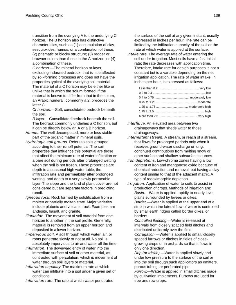
Paulding County, Ohio 139
transition from the overlying A to the underlying Chorizon. The B horizon also has distinctivecharacteristics, such as (1) accumulation of clay,sesquioxides, humus, or a combination of these;(2) prismatic or blocky structure; (3) redder orbrowner colors than those in the A horizon; or (4)a combination of these.C horizon.—The mineral horizon or layer,excluding indurated bedrock, that is little affectedby soil-forming processes and does not have theproperties typical of the overlying soil material.The material of a C horizon may be either like orunlike that in which the solum formed. If thematerial is known to differ from that in the solum,an Arabic numeral, commonly a 2, precedes theletter C.Cr horizon.—Soft, consolidated bedrock beneaththe soil.R layer.—Consolidated bedrock beneath the soil.The bedrock commonly underlies a C horizon, butit can be directly below an A or a B horizon.
Humus. The well decomposed, more or less stablepart of the organic matter in mineral soils.
Hydrologic soil groups. Refers to soils groupedaccording to their runoff potential. The soilproperties that influence this potential are thosethat affect the minimum rate of water infiltration ona bare soil during periods after prolonged wettingwhen the soil is not frozen. These properties aredepth to a seasonal high water table, theinfiltration rate and permeability after prolongedwetting, and depth to a very slowly permeablelayer. The slope and the kind of plant cover are notconsidered but are separate factors in predictingrunoff.
Igneous rock. Rock formed by solidification from amolten or partially molten state. Major varietiesinclude plutonic and volcanic rock. Examples areandesite, basalt, and granite.
Illuviation. The movement of soil material from onehorizon to another in the soil profile. Generally,material is removed from an upper horizon anddeposited in a lower horizon.
Impervious soil. A soil through which water, air, orroots penetrate slowly or not at all. No soil isabsolutely impervious to air and water all the time.
Infiltration. The downward entry of water into theimmediate surface of soil or other material, ascontrasted with percolation, which is movement ofwater through soil layers or material.
Infiltration capacity. The maximum rate at whichwater can infiltrate into a soil under a given set ofconditions.
Infiltration rate. The rate at which water penetrates
the surface of the soil at any given instant, usuallyexpressed in inches per hour. The rate can belimited by the infiltration capacity of the soil or therate at which water is applied at the surface.
Intake rate. The average rate of water entering thesoil under irrigation. Most soils have a fast initialrate; the rate decreases with application time.Therefore, intake rate for design purposes is not aconstant but is a variable depending on the netirrigation application. The rate of water intake, ininches per hour, is expressed as follows:
Less than 0.2 ............................................... very low
0.2 to 0.4 .............................................................. low
0.4 to 0.75 ......................................... moderately low
0.75 to 1.25 ................................................ moderate
1.25 to 1.75 ..................................... moderately high
1.75 to 2.5 .......................................................... high
More than 2.5 ............................................. very high
Interfluve. An elevated area between twodrainageways that sheds water to thosedrainageways.
Intermittent stream. A stream, or reach of a stream,that flows for prolonged periods only when itreceives ground-water discharge or long,continued contributions from melting snow orother surface and shallow subsurface sources.
Iron depletions. Low-chroma zones having a lowcontent of iron and manganese oxide because ofchemical reduction and removal, but having a claycontent similar to that of the adjacent matrix. Atype of redoximorphic depletion.
Irrigation. Application of water to soils to assist inproduction of crops. Methods of irrigation are:Basin.—Water is applied rapidly to nearly levelplains surrounded by levees or dikes.Border.—Water is applied at the upper end of astrip in which the lateral flow of water is controlledby small earth ridges called border dikes, orborders.Controlled flooding.—Water is released atintervals from closely spaced field ditches anddistributed uniformly over the field.Corrugation.—Water is applied to small, closelyspaced furrows or ditches in fields of close-growing crops or in orchards so that it flows inonly one direction.Drip (or trickle).—Water is applied slowly andunder low pressure to the surface of the soil orinto the soil through such applicators as emitters,porous tubing, or perforated pipe.Furrow.—Water is applied in small ditches madeby cultivation implements. Furrows are used fortree and row crops.
140 Soil Survey of
Sprinkler.—Water is sprayed over the soil surfacethrough pipes or nozzles from a pressure system.Subirrigation.—Water is applied in open ditches ortile lines until the water table is raised enough towet the soil.Wild flooding.—Water, released at high points, isallowed to flow onto an area without controlleddistribution.
Kame. An irregular, short ridge or hill of stratified drift.Knoll. A small, low, rounded hill rising above adjacent
landforms.Krotovinas. Irregular tubular streaks within one layer
of material transported from another layer by fillingof tunnels made by burrowing animals withmaterial from outside the layer in which they arefound.
Lacustrine deposit. Material deposited in lake waterand exposed when the water level is lowered orthe elevation of the land is raised.
Lamina. The thinnest recognizable layer (commonlyless than 1 centimeter in thickness) of originaldeposition in a sediment or sedimentary rock,differing from other layers in color, composition, orparticle size. Several laminae constitute a bed.
Leaching. The removal of soluble material from soil orother material by percolating water.
Limestone. A sedimentary rock composed of calciumcarbonate (CaCO
3). There are many impure
varieties.Liquid limit. The moisture content at which the soil
passes from a plastic to a liquid state.Loam. Soil material that is 7 to 27 percent clay
particles, 28 to 50 percent silt particles, and lessthan 52 percent sand particles.
Loamy soil. Coarse sandy loam, sandy loam, finesandy loam, very fine sandy loam, loam, silt loam,silt, clay loam, sandy clay loam, or silty clay loam.
Loess. Fine grained material, dominantly of silt-sizedparticles, deposited by wind.
Low strength. The soil is not strong enough tosupport loads.
Map unit. A kind of soil, a combination of kinds of soil,or miscellaneous land type or types that can beshown at the scale of mapping for the definedpurposes and objectives of the survey. Map unitsare generally designed to reflect significantdifferences in use and management.
Masses. Concentrations of substances in the soilmatrix that do not have a clearly defined boundarywith the surrounding soil material and cannot beremoved as a discrete unit. Common compoundsmaking up masses are calcium carbonate,gypsum or other soluble salts, iron oxide, andmanganese oxide. Masses consisting of iron oxide
or manganese oxide generally are considered atype of redoximorphic concentration.
Mechanical treatment. Use of mechanical equipmentfor seeding, brush management, and othermanagement practices.
Medium textured soil. Very fine sandy loam, loam,silt loam, or silt.
Metamorphic rock. Rock of any origin altered inmineralogical composition, chemical composition,or structure by heat, pressure, and movement.Nearly all such rocks are crystalline.
Mineral soil. Soil that is mainly mineral material andlow in organic material. Its bulk density is morethan that of organic soil.
Minimum tillage. Only the tillage essential to cropproduction and prevention of soil damage.
Miscellaneous area. An area that has little or nonatural soil and supports little or no vegetation.
Moderately coarse textured soil. Coarse sandyloam, sandy loam, or fine sandy loam.
Moderately fine textured soil. Clay loam, sandy clayloam, or silty clay loam.
Mollic epipedon. A thick, dark, humus-rich surfacehorizon (or horizons) that has high base saturationand pedogenic soil structure. It may include theupper part of the subsoil.
Morphology, soil. The physical makeup of the soil,including the texture, structure, porosity,consistence, color, and other physical, mineral,and biological properties of the various horizons,and the thickness and arrangement of thosehorizons in the soil profile.
Mottling, soil. Irregular spots of different colors thatvary in number and size. Descriptive terms are asfollows: abundance—few, common, and many;size—fine, medium, and coarse; and contrast—faint, distinct, and prominent. The sizemeasurements are of the diameter along thegreatest dimension. Fine indicates less than 5millimeters (about 0.2 inch); medium, from 5 to 15millimeters (about 0.2 to 0.6 inch); and coarse,more than 15 millimeters (about 0.6 inch).
Muck. Dark, finely divided, well decomposed organicsoil material. (See Sapric soil material.)
Mulch. Any material, such as straw, sawdust, leaves,plastic film, and loose soil, that is spread upon thesurface of the soil to protect the soil and plantroots from the effects of raindrops, soil crusting,freezing, evaporation, and other phenomena.
Munsell notation. A designation of color by degreesof three simple variables—hue, value, andchroma. For example, a notation of 10YR 6/4 isa color with hue of 10YR, value of 6, and chromaof 4.
Paulding County, Ohio 141
Neutral soil. A soil having a pH value of 6.6 to 7.3.(See Reaction, soil.)
Nodules. Cemented bodies lacking visible internalstructure. Calcium carbonate, iron oxide, andmanganese oxide are common compoundsmaking up nodules. If formed in place, nodules ofiron oxide or manganese oxide are consideredtypes of redoximorphic concentrations.
Nose slope. A geomorphic component of hillsconsisting of the projecting end (laterally convexarea) of a hillside. The overland waterflow ispredominantly divergent.
No-till farming. A method of planting crops thatinvolves no seedbed preparation other thanopening the soil for the purpose of placing theseed at the intended depth. This method usuallyinvolves opening a small slit or punching a holeinto the soil. There is typically no cultivation duringcrop production. Chemical weed control isnormally used.
Nutrient, plant. Any element taken in by a plantessential to its growth. Plant nutrients are mainlynitrogen, phosphorus, potassium, calcium,magnesium, sulfur, iron, manganese, copper,boron, and zinc obtained from the soil and carbon,hydrogen, and oxygen obtained from the air andwater.
Organic matter. Plant and animal residue in the soilin various stages of decomposition.
Outwash. Gravel, sand, and silt, commonly stratified,deposited by glacial meltwater.
Outwash plain. A landform of mainly sandy or coarsetextured material of glaciofluvial origin. Anoutwash plain is commonly smooth; where pitted,it generally is low in relief.
Pan. A compact, dense layer in a soil that impedes themovement of water and the growth of roots. Forexample, hardpan, fragipan, claypan, plowpan,and traffic pan.
Parent material. The unconsolidated organic andmineral material in which soil forms.
Peat. Unconsolidated material, largely undecomposedorganic matter, that has accumulated underexcess moisture. (See Fibric soil material.)
Ped. An individual natural soil aggregate, such as agranule, a prism, or a block.
Pedon. The smallest volume that can be called “asoil.” A pedon is three dimensional and largeenough to permit study of all horizons. Its arearanges from about 10 to 100 square feet (1 squaremeter to 10 square meters), depending on thevariability of the soil.
Percolation. The movement of water through the soil.
Percs slowly (in tables). The slow movement of waterthrough the soil adversely affects the specifieduse.
Permeability. The quality of the soil that enableswater or air to move downward through the profile.The rate at which a saturated soil transmits wateris accepted as a measure of this quality. In soilphysics, the rate is referred to as “saturatedhydraulic conductivity,” which is defined in the “SoilSurvey Manual.” In line with conventional usage inthe engineering profession and with traditionalusage in published soil surveys, this rate of flowcontinues to be expressed as “permeability.”Terms describing permeability, measured ininches per hour, are as follows:
Extremely slow ................................. 0.0 to 0.01 inch
Very slow ........................................ 0.01 to 0.06 inch
Slow .................................................. 0.06 to 0.2 inch
Moderately slow ................................. 0.2 to 0.6 inch
Moderate ................................. 0.6 inch to 2.0 inches
Moderately rapid ............................ 2.0 to 6.0 inches
Rapid ............................................... 6.0 to 20 inches
Very rapid ................................. more than 20 inches
Phase, soil. A subdivision of a soil series based onfeatures that affect its use and management, suchas slope, stoniness, and flooding.
pH value. A numerical designation of acidity andalkalinity in soil. (See Reaction, soil.)
Piping (in tables). Formation of subsurface tunnels orpipelike cavities by water moving through the soil.
Plasticity index. The numerical difference betweenthe liquid limit and the plastic limit; the range ofmoisture content within which the soil remainsplastic.
Plastic limit. The moisture content at which a soilchanges from semisolid to plastic.
Plowpan. A compacted layer formed in the soildirectly below the plowed layer.
Ponding. Standing water on soils in closeddepressions. Unless the soils are artificiallydrained, the water can be removed only bypercolation or evapotranspiration.
Poor filter (in tables). Because of rapid or very rapidpermeability, the soil may not adequately filtereffluent from a waste disposal system.
Poorly graded. Refers to a coarse grained soil or soilmaterial consisting mainly of particles of nearlythe same size. Because there is little difference insize of the particles, density can be increasedonly slightly by compaction.
Pressure face. A smoothed or smeared surface onthe surface of a soil aggregate, formed through
142 Soil Survey of
rearrangement as a result of shear forces. Maypersist through successive drying and wettingcycles.
Productivity, soil. The capability of a soil forproducing a specified plant or sequence of plantsunder specific management.
Profile, soil. A vertical section of the soil extendingthrough all its horizons and into the parentmaterial.
Proper grazing use. Grazing at an intensity thatmaintains enough cover to protect the soil andmaintain or improve the quantity and quality of thedesirable vegetation. This practice increases thevigor and reproduction capacity of the key plantsand promotes the accumulation of litter and mulchnecessary to conserve soil and water.
Reaction, soil. A measure of acidity or alkalinity of asoil, expressed in pH values. A soil that tests topH 7.0 is described as precisely neutral inreaction because it is neither acid nor alkaline.The degrees of acidity or alkalinity, expressed aspH values, are:
Ultra acid ............................................... less than 3.5
Extremely acid ............................................ 3.5 to 4.4
Very strongly acid ....................................... 4.5 to 5.0
Strongly acid .............................................. 5.1 to 5.5
Moderately acid .......................................... 5.6 to 6.0
Slightly acid ................................................ 6.1 to 6.5
Neutral ........................................................ 6.6 to 7.3
Slightly alkaline .......................................... 7.4 to 7.8
Moderately alkaline .................................... 7.9 to 8.4
Strongly alkaline ......................................... 8.5 to 9.0
Very strongly alkaline ......................... 9.1 and higher
Redoximorphic concentrations. Nodules,concretions, soft masses, pore linings, and otherfeatures resulting from the accumulation of iron ormanganese oxide. An indication of chemicalreduction and oxidation resulting from saturation.
Redoximorphic depletions. Low-chroma zones fromwhich iron and manganese oxide or a combinationof iron and manganese oxide and clay has beenremoved. These zones are indications of thechemical reduction of iron resulting fromsaturation.
Redoximorphic features. Redoximorphicconcentrations, redoximorphic depletions,reduced matrices, a positive reaction toalpha,alpha-dipyridyl, and other featuresindicating the chemical reduction and oxidation ofiron and manganese compounds resulting fromsaturation.
Reduced matrix. A soil matrix that has low chroma insitu because of chemically reduced iron (Fe II).
The chemical reduction results from nearlycontinuous wetness. The matrix undergoes achange in hue or chroma within 30 minutes afterexposure to air as the iron is oxidized (Fe III). Atype of redoximorphic feature.
Relief. The elevations or inequalities of a land surface,considered collectively.
Rill. A steep-sided channel resulting from acceleratederosion. A rill generally is a few inches deep andnot wide enough to be an obstacle to farmmachinery.
Rock fragments. Rock or mineral fragments having adiameter of 2 millimeters or more; for example,pebbles, cobbles, stones, and boulders.
Rooting depth (in tables). Shallow root zone. The soilis shallow over a layer that greatly restricts roots.
Root zone. The part of the soil that can be penetratedby plant roots.
Runoff. The precipitation discharged into streamchannels from an area. The water that flows offthe surface of the land without sinking into the soilis called surface runoff. Water that enters the soilbefore reaching surface streams is called ground-water runoff or seepage flow from ground water.
Sand. As a soil separate, individual rock or mineralfragments from 0.05 millimeter to 2.0 millimetersin diameter. Most sand grains consist of quartz. Asa soil textural class, a soil that is 85 percent ormore sand and not more than 10 percent clay.
Sandstone. Sedimentary rock containing dominantlysand-sized particles.
Sandy soil. Sand or loamy sand.Sandy spot. An area of soil where the surface layer is
sandy (loamy sand or sand) in an area where thesurrounding soil or soils have a loamy or clayeysurface layer.
Sapric soil material (muck). The most highlydecomposed of all organic soil material. Muck hasthe least amount of plant fiber, the highest bulkdensity, and the lowest water content at saturationof all organic soil material.
Saturation. Wetness characterized by zero or positivepressure of the soil water. Under conditions ofsaturation, the water will flow from the soil matrixinto an unlined auger hole.
Sedimentary rock. Rock made up of particlesdeposited from suspension in water. The chiefkinds of sedimentary rock are conglomerate,formed from gravel; sandstone, formed from sand;shale, formed from clay; and limestone, formedfrom soft masses of calcium carbonate. There aremany intermediate types. Some wind-depositedsand is consolidated into sandstone.
Seepage (in tables). The movement of water through
Paulding County, Ohio 143
the soil. Seepage adversely affects the specifieduse.
Series, soil. A group of soils that have profiles thatare almost alike, except for differences in textureof the surface layer. All the soils of a series havehorizons that are similar in composition,thickness, and arrangement.
Shale. Sedimentary rock formed by the hardening of aclay deposit.
Sheet erosion. The removal of a fairly uniform layer ofsoil material from the land surface by the action ofrainfall and surface runoff.
Short steep slope. An elongated soil area that hasslopes at least two slope classes steeper than theslope class of the surrounding map unit(s).
Shoulder. The position that forms the uppermostinclined surface near the top of a hillslope. It is atransition from backslope to summit. The surfaceis dominantly convex in profile and erosional inorigin.
Shrink-swell (in tables). The shrinking of soil whendry and the swelling when wet. Shrinking andswelling can damage roads, dams, buildingfoundations, and other structures. It can alsodamage plant roots.
Side slope. A geomorphic component of hillsconsisting of a laterally planar area of a hillside.The overland waterflow is predominantly parallel.
Silica. A combination of silicon and oxygen. Themineral form is called quartz.
Silt. As a soil separate, individual mineral particlesthat range in diameter from the upper limit of clay(0.002 millimeter) to the lower limit of very finesand (0.05 millimeter). As a soil textural class, soilthat is 80 percent or more silt and less than 12percent clay.
Siltstone. Sedimentary rock made up of dominantlysilt-sized particles.
Similar soils. Soils that share limits of diagnosticcriteria, behave and perform in a similar manner,and have similar conservation needs ormanagement requirements for the major landuses in the survey area.
Site index. A designation of the quality of a forest sitebased on the height of the dominant stand at anarbitrarily chosen age. For example, if the averageheight attained by dominant and codominant treesin a fully stocked stand at the age of 50 years is75 feet, the site index is 75.
Slope. The inclination of the land surface from thehorizontal. Percentage of slope is the verticaldistance divided by horizontal distance, thenmultiplied by 100. Thus, a slope of 20 percent is adrop of 20 feet in 100 feet of horizontal distance.
In this survey, classes for simple slopes are asfollows:
Nearly level .......................................... 0 to 2 percent
Gently sloping ..................................... 2 to 6 percent
Strongly sloping ................................ 6 to 12 percent
Moderately steep ............................ 12 to 25 percent
Steep ............................................... 25 to 35 percent
Slope (in tables). Slope is great enough that specialpractices are required to ensure satisfactoryperformance of the soil for a specific use.
Slow intake (in tables). The slow movement of waterinto the soil.
Slow refill (in tables). The slow filling of ponds,resulting from restricted permeability in the soil.
Small stones (in tables). Rock fragments less than 3inches (7.6 centimeters) in diameter. Small stonesadversely affect the specified use of the soil.
Soft bedrock. Bedrock that can be excavated withtrenching machines, backhoes, small rippers, andother equipment commonly used in construction.
Soil. A natural, three-dimensional body at the earth’ssurface. It is capable of supporting plants and hasproperties resulting from the integrated effect ofclimate and living matter acting on earthy parentmaterial, as conditioned by relief over periods oftime.
Soil separates. Mineral particles less than 2millimeters in equivalent diameter and rangingbetween specified size limits. The names andsizes, in millimeters, of separates recognized inthe United States are as follows:
Very coarse sand ....................................... 2.0 to 1.0
Coarse sand ............................................... 1.0 to 0.5
Medium sand ............................................ 0.5 to 0.25
Fine sand ............................................... 0.25 to 0.10
Very fine sand ........................................ 0.10 to 0.05
Silt ........................................................ 0.05 to 0.002
Clay .................................................. less than 0.002
Solum. The upper part of a soil profile, above the Chorizon, in which the processes of soil formationare active. The solum in soil consists of the A, E,and B horizons. Generally, the characteristics ofthe material in these horizons are unlike those ofthe material below the solum. The living roots andplant and animal activities are largely confined tothe solum.
Stones. Rock fragments 10 to 24 inches (25 to 60centimeters) in diameter if rounded or 15 to 24inches (38 to 60 centimeters) in length if flat.
Stony. Refers to a soil containing stones in numbersthat interfere with or prevent tillage.
Stream terrace. One of a series of platforms in a
144 Soil Survey of
stream valley, flanking and more or less parallel tothe stream channel. It originally formed near thelevel of the stream and is the dissected remnantsof an abandoned flood plain, streambed, or valleyfloor that were produced during a former stage oferosion or deposition.
Stripcropping. Growing crops in a systematicarrangement of strips or bands that providevegetative barriers to wind erosion and watererosion.
Structure, soil. The arrangement of primary soilparticles into compound particles or aggregates.The principal forms of soil structure are—platy(laminated), prismatic (vertical axis of aggregateslonger than horizontal), columnar (prisms withrounded tops), blocky (angular or subangular),and granular. Structureless soils are either singlegrain (each grain by itself, as in dune sand) ormassive (the particles adhering without anyregular cleavage, as in many hardpans).
Subsoil. Technically, the B horizon; roughly, the part ofthe solum below plow depth.
Substratum. The part of the soil below the solum.Subsurface layer. Any surface soil horizon (A, E, AB,
or EB) below the surface layer.Summit. The topographically highest position of a
hillslope. It has a nearly level (planar or onlyslightly convex) surface.
Surface layer. The soil ordinarily moved in tillage, orits equivalent in uncultivated soil, ranging in depthfrom 4 to 10 inches (10 to 25 centimeters).Frequently designated as the “plow layer,” or the“Ap horizon.”
Surface soil. The A, E, AB, and EB horizons,considered collectively. It includes all subdivisionsof these horizons.
Taxadjuncts. Soils that cannot be classified in aseries recognized in the classification system.Such soils are named for a series they stronglyresemble and are designated as taxadjuncts tothat series because they differ in ways too smallto be of consequence in interpreting their useand behavior. Soils are recognized astaxadjuncts only when one or more of theircharacteristics are slightly outside the rangedefined for the family of the series for which thesoils are named.
Terrace. An embankment, or ridge, constructedacross sloping soils on the contour or at a slightangle to the contour. The terrace interceptssurface runoff so that water soaks into the soil orflows slowly to a prepared outlet. A terrace in a
field generally is built so that the field can befarmed. A terrace intended mainly for drainagehas a deep channel that is maintained inpermanent sod.
Terrace (geologic). An old alluvial plain, ordinarilyflat or undulating, bordering a river, a lake, or thesea.
Texture, soil. The relative proportions of sand, silt,and clay particles in a mass of soil. The basictextural classes, in order of increasing proportionof fine particles, are sand, loamy sand, sandyloam, loam, silt loam, silt, sandy clay loam, clayloam, silty clay loam, sandy clay, silty clay, andclay. The sand, loamy sand, and sandy loamclasses may be further divided by specifying“coarse,” “fine,” or “very fine.”
Thin layer (in tables). Otherwise suitable soil materialthat is too thin for the specified use.
Till. Unsorted, nonstratified drift consisting of clay, silt,sand, and boulders transported and deposited byglacial ice.
Till plain. An extensive area of nearly level toundulating soils underlain by glacial till.
Tilth, soil. The physical condition of the soil as relatedto tillage, seedbed preparation, seedlingemergence, and root penetration.
Toeslope. The outermost inclined surface at the baseof a hill; part of a footslope.
Topsoil. The upper part of the soil, which is the mostfavorable material for plant growth. It is ordinarilyrich in organic matter and is used to topdressroadbanks, lawns, and land affected by mining.
Trace elements. Chemical elements, for example,zinc, cobalt, manganese, copper, and iron, in soilsin extremely small amounts. They are essential toplant growth.
Upland. Land at a higher elevation, in general, thanthe alluvial plain or stream terrace; land above thelowlands along streams.
Very clayey. Containing more than 60 percent clay.Weathering. All physical and chemical changes
produced in rocks or other deposits at or near theearth’s surface by atmospheric agents. Thesechanges result in disintegration anddecomposition of the material.
Well graded. Refers to soil material consisting ofcoarse grained particles that are well distributedover a wide range in size or diameter. Such soilnormally can be easily increased in density andbearing properties by compaction. Contrasts withpoorly graded soil.
Wet spot. A somewhat poorly drained to very poorly

Paulding County, Ohio 145
drained area that is at least two drainage classeswetter than the named soils in the surroundingmap unit.
Wilting point (or permanent wilting point). Themoisture content of soil, on an ovendry basis, at
which a plant (specifically a sunflower) wilts somuch that it does not recover when placed in ahumid, dark chamber.
Windthrow. The uprooting and tipping over of trees bythe wind.


147
Tables
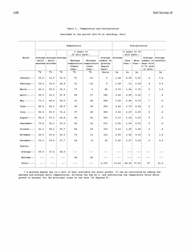
148 Soil Survey of
Table 1.--Temperature and Precipitation
(Recorded in the period 1961-90 at Paulding, Ohio)
_______________________________________________________________________________________________________________ | | | Temperature | Precipitation | | __________________________________________________________________________________________________ | | | | 2 years in | | |2 years in 10| | | | | | 10 will have-- | | | will have-- | | _______________________ _____________ Month |Average|Average|Average| | | Average |Average| | | Average |Average | daily | daily | | Maximum | Minimum |number of| | Less | More |number of|snowfall |maximum|minimum| |temperature|temperature| growing | |than--|than--|days with| | | | | higher | lower | degree | | | |0.10 inch| | | | | than-- | than-- | days* | | | | or more |_______________________________________________________________________________________________________________ | oF | oF | oF | oF | oF | Units | In | In | In | | In | | | | | | | | | | | January----| 30.9 | 12.9 | 21.9 | 57 | -16 | 4 | 1.68 | 0.69| 2.51| 4 | 5.6 | | | | | | | | | | | February---| 34.2 | 15.5 | 24.8 | 61 | -12 | 9 | 1.68 | .71| 2.60| 4 | 5.5 | | | | | | | | | | | March------| 46.3 | 25.9 | 36.1 | 77 | 0 | 80 | 2.70 | 1.56| 3.70| 6 | 3.2 | | | | | | | | | | | April------| 59.5 | 36.1 | 47.8 | 84 | 17 | 266 | 3.24 | 2.05| 4.32| 7 | .6 | | | | | | | | | | | May--------| 71.3 | 46.6 | 59.0 | 91 | 28 | 564 | 3.65 | 2.45| 4.75| 7 | .0 | | | | | | | | | | | June-------| 80.9 | 56.1 | 68.5 | 96 | 39 | 839 | 3.44 | 1.70| 4.94| 6 | .0 | | | | | | | | | | | July-------| 84.5 | 59.9 | 72.2 | 97 | 45 | 980 | 3.43 | 2.27| 4.50| 6 | .0 | | | | | | | | | | | August-----| 82.4 | 57.3 | 69.8 | 95 | 41 | 910 | 2.73 | 1.36| 3.93| 5 | .0 | | | | | | | | | | | September--| 75.8 | 50.3 | 63.0 | 92 | 32 | 676 | 2.96 | 1.50| 4.23| 5 | .0 | | | | | | | | | | | October----| 63.1 | 38.3 | 50.7 | 84 | 20 | 333 | 2.33 | 1.05| 3.43| 5 | .0 | | | | | | | | | | | November---| 49.5 | 30.4 | 40.0 | 75 | 11 | 112 | 2.95 | 1.52| 4.19| 6 | 1.6 | | | | | | | | | | | December---| 36.1 | 19.4 | 27.7 | 64 | -8 | 20 | 2.65 | 1.37| 3.93| 6 | 4.5 | | | | | | | | | | | Yearly: | | | | | | | | | | | | | | | | | | | | | | Average---| 59.5 | 37.4 | 48.5 | --- | --- | --- | --- | ---| ---| --- | --- | | | | | | | | | | | Extreme---| --- | --- | --- | 98 | -18 | --- | --- | ---| ---| --- | --- | | | | | | | | | | | Total-----| --- | --- | --- | --- | --- | 4,793 | 33.43 | 28.32| 37.03| 67 | 21.0 | | | | | | | | | | |_______________________________________________________________________________________________________________
* A growing degree day is a unit of heat available for plant growth. It can be calculated by adding themaximum and minimum daily temperatures, dividing the sum by 2, and subtracting the temperature below whichgrowth is minimal for the principal crops in the area (50 degrees F).
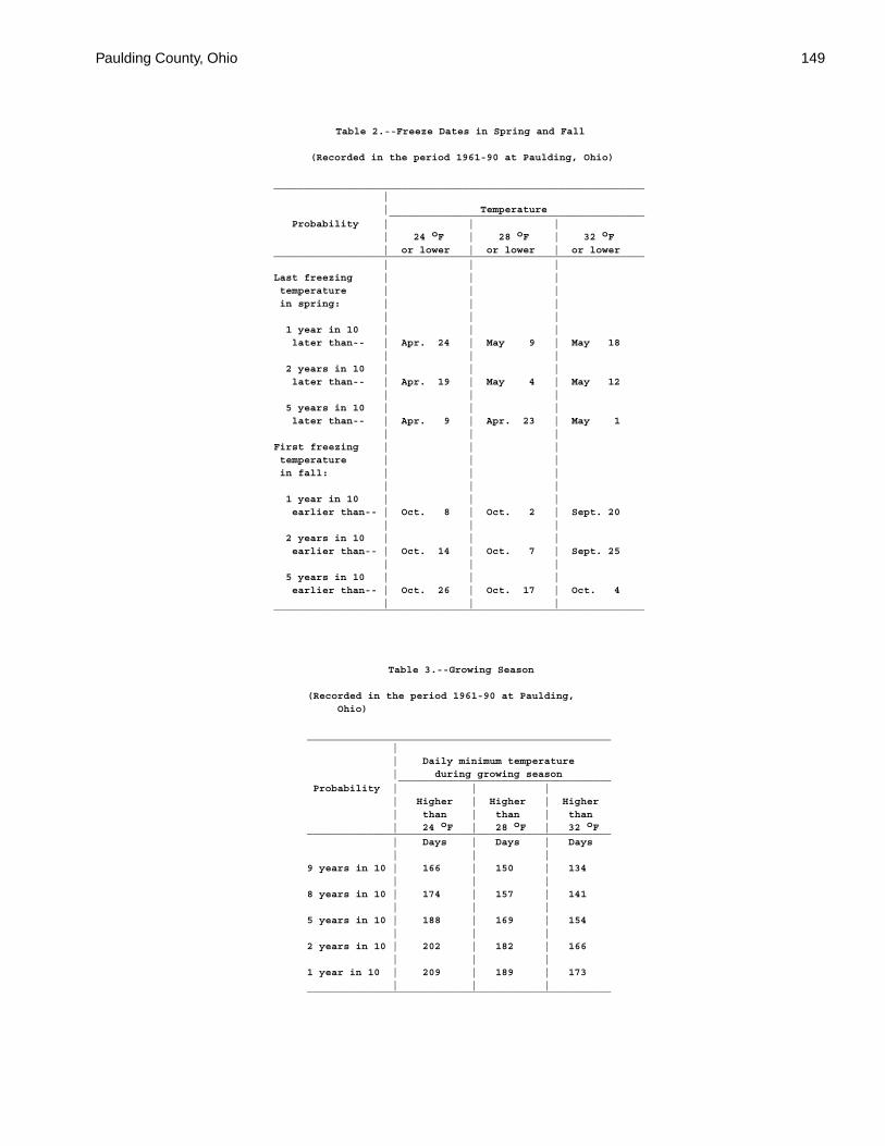
Paulding County, Ohio 149
Table 2.--Freeze Dates in Spring and Fall
(Recorded in the period 1961-90 at Paulding, Ohio)
_____________________________________________________________ | | Temperature __________________________________________ Probability | | | | 24 oF | 28 oF | 32 oF | or lower | or lower | or lower_____________________________________________________________ | | |Last freezing | | | temperature | | | in spring: | | | | | | 1 year in 10 | | | later than-- | Apr. 24 | May 9 | May 18 | | | 2 years in 10 | | | later than-- | Apr. 19 | May 4 | May 12 | | | 5 years in 10 | | | later than-- | Apr. 9 | Apr. 23 | May 1 | | |First freezing | | | temperature | | | in fall: | | | | | | 1 year in 10 | | | earlier than-- | Oct. 8 | Oct. 2 | Sept. 20 | | | 2 years in 10 | | | earlier than-- | Oct. 14 | Oct. 7 | Sept. 25 | | | 5 years in 10 | | | earlier than-- | Oct. 26 | Oct. 17 | Oct. 4 | | |_____________________________________________________________
Table 3.--Growing Season
(Recorded in the period 1961-90 at Paulding, Ohio)
__________________________________________________ | | Daily minimum temperature | during growing season ___________________________________ Probability | | | | Higher | Higher | Higher | than | than | than | 24 oF | 28 oF | 32 oF__________________________________________________ | Days | Days | Days | | |9 years in 10 | 166 | 150 | 134 | | |8 years in 10 | 174 | 157 | 141 | | |5 years in 10 | 188 | 169 | 154 | | |2 years in 10 | 202 | 182 | 166 | | |1 year in 10 | 209 | 189 | 173 | | |__________________________________________________
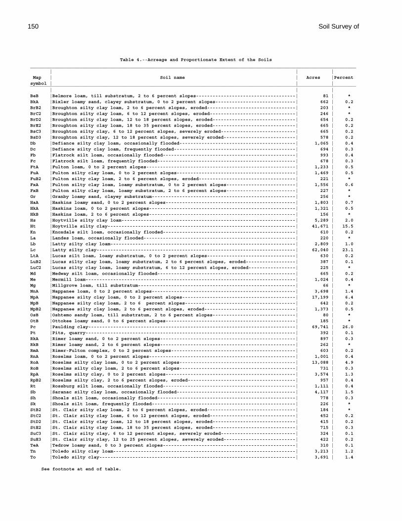
150 Soil Survey of
Table 4.--Acreage and Proportionate Extent of the Soils______________________________________________________________________________________________________________________ | | | Map | Soil name | Acres |Percentsymbol | | |______________________________________________________________________________________________________________________ | | |BeB |Belmore loam, till substratum, 2 to 6 percent slopes------------------------------------| 81 | *BkA |Bixler loamy sand, clayey substratum, 0 to 2 percent slopes-----------------------------| 662 | 0.2BrB2 |Broughton silty clay loam, 2 to 6 percent slopes, eroded--------------------------------| 203 | *BrC2 |Broughton silty clay loam, 6 to 12 percent slopes, eroded-------------------------------| 246 | *BrD2 |Broughton silty clay loam, 12 to 18 percent slopes, eroded------------------------------| 654 | 0.2BrE2 |Broughton silty clay loam, 18 to 35 percent slopes, eroded------------------------------| 665 | 0.2BsC3 |Broughton silty clay, 6 to 12 percent slopes, severely eroded---------------------------| 665 | 0.2BsD3 |Broughton silty clay, 12 to 18 percent slopes, severely eroded--------------------------| 578 | 0.2Db |Defiance silty clay loam, occasionally flooded------------------------------------------| 1,065 | 0.4Dc |Defiance silty clay loam, frequently flooded--------------------------------------------| 694 | 0.3Fb |Flatrock silt loam, occasionally flooded------------------------------------------------| 993 | 0.4Fc |Flatrock silt loam, frequently flooded--------------------------------------------------| 678 | 0.3FtA |Fulton loam, 0 to 2 percent slopes------------------------------------------------------| 1,233 | 0.5FuA |Fulton silty clay loam, 0 to 2 percent slopes-------------------------------------------| 1,469 | 0.5FuB2 |Fulton silty clay loam, 2 to 6 percent slopes, eroded-----------------------------------| 221 | *FxA |Fulton silty clay loam, loamy substratum, 0 to 2 percent slopes-------------------------| 1,556 | 0.6FxB |Fulton silty clay loam, loamy substratum, 2 to 6 percent slopes-------------------------| 227 | *Gr |Granby loamy sand, clayey substratum----------------------------------------------------| 256 | *HaA |Haskins loamy sand, 0 to 2 percent slopes-----------------------------------------------| 1,803 | 0.7HkA |Haskins loam, 0 to 2 percent slopes-----------------------------------------------------| 1,321 | 0.5HkB |Haskins loam, 2 to 6 percent slopes-----------------------------------------------------| 156 | *Hs |Hoytville silty clay loam---------------------------------------------------------------| 5,289 | 2.0Ht |Hoytville silty clay--------------------------------------------------------------------| 41,671 | 15.5Kn |Knoxdale silt loam, occasionally flooded------------------------------------------------| 610 | 0.2La |Landes loam, occasionally flooded-------------------------------------------------------| 220 | *Lb |Latty silty clay loam-------------------------------------------------------------------| 2,809 | 1.0Lc |Latty silty clay------------------------------------------------------------------------| 62,040 | 23.1LtA |Lucas silt loam, loamy substratum, 0 to 2 percent slopes--------------------------------| 630 | 0.2LuB2 |Lucas silty clay loam, loamy substratum, 2 to 6 percent slopes, eroded------------------| 387 | 0.1LuC2 |Lucas silty clay loam, loamy substratum, 6 to 12 percent slopes, eroded-----------------| 225 | *Md |Medway silt loam, occasionally flooded--------------------------------------------------| 665 | 0.2Me |Mermill loam----------------------------------------------------------------------------| 1,024 | 0.4Mg |Millgrove loam, till substratum---------------------------------------------------------| 66 | *NnA |Nappanee loam, 0 to 2 percent slopes----------------------------------------------------| 3,698 | 1.4NpA |Nappanee silty clay loam, 0 to 2 percent slopes-----------------------------------------| 17,199 | 6.4NpB |Nappanee silty clay loam, 2 to 6 percent slopes----------------------------------------| 642 | 0.2NpB2 |Nappanee silty clay loam, 2 to 6 percent slopes, eroded---------------------------------| 1,373 | 0.5OsB |Oshtemo sandy loam, till substratum, 2 to 6 percent slopes------------------------------| 80 | *OtB |Ottokee loamy sand, 0 to 6 percent slopes-----------------------------------------------| 185 | *Pc |Paulding clay---------------------------------------------------------------------------| 69,741 | 26.0Pt |Pits, quarry----------------------------------------------------------------------------| 392 | 0.1RkA |Rimer loamy sand, 0 to 2 percent slopes-------------------------------------------------| 897 | 0.3RkB |Rimer loamy sand, 2 to 6 percent slopes-------------------------------------------------| 262 | *RmA |Rimer-Fulton complex, 0 to 2 percent slopes---------------------------------------------| 603 | 0.2RnA |Roselms loam, 0 to 2 percent slopes-----------------------------------------------------| 1,001 | 0.4RoA |Roselms silty clay loam, 0 to 2 percent slopes------------------------------------------| 13,088 | 4.9RoB |Roselms silty clay loam, 2 to 6 percent slopes------------------------------------------| 731 | 0.3RpA |Roselms silty clay, 0 to 2 percent slopes-----------------------------------------------| 3,574 | 1.3RpB2 |Roselms silty clay, 2 to 6 percent slopes, eroded---------------------------------------| 957 | 0.4Rt |Rossburg silt loam, occasionally flooded------------------------------------------------| 1,111 | 0.4Sb |Saranac silty clay loam, occasionally flooded-------------------------------------------| 4,117 | 1.5Sh |Shoals silt loam, occasionally flooded--------------------------------------------------| 778 | 0.3Sk |Shoals silt loam, frequently flooded----------------------------------------------------| 226 | *StB2 |St. Clair silty clay loam, 2 to 6 percent slopes, eroded--------------------------------| 184 | *StC2 |St. Clair silty clay loam, 6 to 12 percent slopes, eroded-------------------------------| 452 | 0.2StD2 |St. Clair silty clay loam, 12 to 18 percent slopes, eroded------------------------------| 415 | 0.2StE2 |St. Clair silty clay loam, 18 to 35 percent slopes, eroded------------------------------| 715 | 0.3SuC3 |St. Clair silty clay, 6 to 12 percent slopes, severely eroded---------------------------| 324 | 0.1SuE3 |St. Clair silty clay, 12 to 25 percent slopes, severely eroded--------------------------| 422 | 0.2TeA |Tedrow loamy sand, 0 to 3 percent slopes------------------------------------------------| 310 | 0.1Tn |Toledo silty clay loam------------------------------------------------------------------| 3,213 | 1.2To |Toledo silty clay-----------------------------------------------------------------------| 3,691 | 1.4
See footnote at end of table.
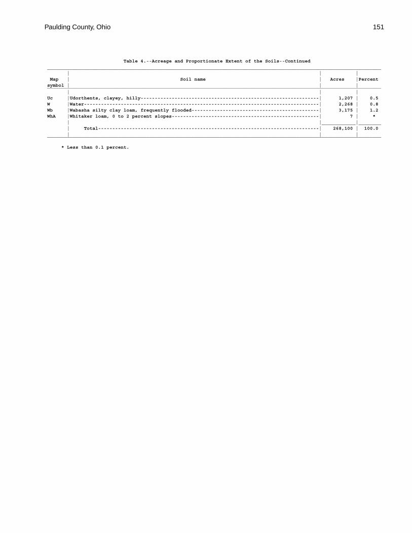
Paulding County, Ohio 151
Table 4.--Acreage and Proportionate Extent of the Soils--Continued______________________________________________________________________________________________________________________ | | | Map | Soil name | Acres |Percentsymbol | | |______________________________________________________________________________________________________________________ | | |Uc |Udorthents, clayey, hilly---------------------------------------------------------------| 1,207 | 0.5W |Water-----------------------------------------------------------------------------------| 2,268 | 0.8Wb |Wabasha silty clay loam, frequently flooded---------------------------------------------| 3,175 | 1.2WhA |Whitaker loam, 0 to 2 percent slopes----------------------------------------------------| 7 | * | |____________|________ | Total------------------------------------------------------------------------------| 268,100 | 100.0 | | |______________________________________________________________________________________________________________________
* Less than 0.1 percent.
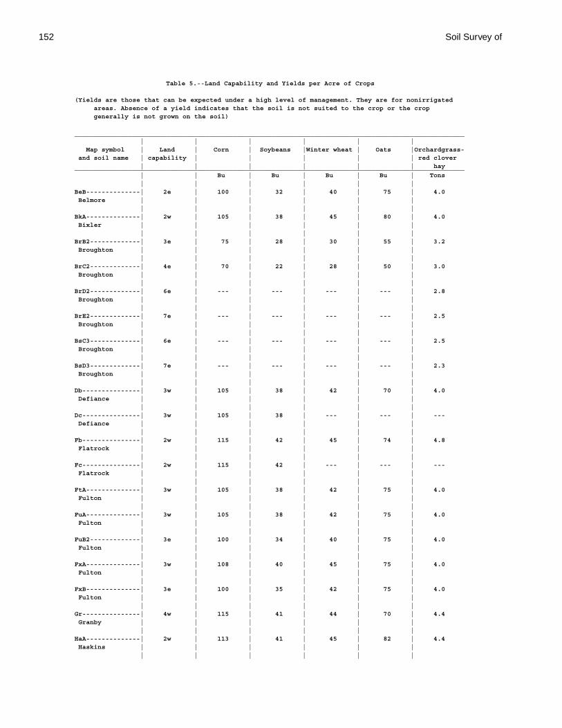
152 Soil Survey of
Table 5.--Land Capability and Yields per Acre of Crops
(Yields are those that can be expected under a high level of management. They are for nonirrigated areas. Absence of a yield indicates that the soil is not suited to the crop or the crop generally is not grown on the soil)
_____________________________________________________________________________________________________ | | | | | | Map symbol | Land | Corn | Soybeans |Winter wheat | Oats |Orchardgrass- and soil name | capability | | | | | red clover | | | | | | hay_____________________________________________________________________________________________________ | | Bu | Bu | Bu | Bu | Tons | | | | | |BeB--------------| 2e | 100 | 32 | 40 | 75 | 4.0 Belmore | | | | | | | | | | | |BkA--------------| 2w | 105 | 38 | 45 | 80 | 4.0 Bixler | | | | | | | | | | | |BrB2-------------| 3e | 75 | 28 | 30 | 55 | 3.2 Broughton | | | | | | | | | | | |BrC2-------------| 4e | 70 | 22 | 28 | 50 | 3.0 Broughton | | | | | | | | | | | |BrD2-------------| 6e | --- | --- | --- | --- | 2.8 Broughton | | | | | | | | | | | |BrE2-------------| 7e | --- | --- | --- | --- | 2.5 Broughton | | | | | | | | | | | |BsC3-------------| 6e | --- | --- | --- | --- | 2.5 Broughton | | | | | | | | | | | |BsD3-------------| 7e | --- | --- | --- | --- | 2.3 Broughton | | | | | | | | | | | |Db---------------| 3w | 105 | 38 | 42 | 70 | 4.0 Defiance | | | | | | | | | | | |Dc---------------| 3w | 105 | 38 | --- | --- | --- Defiance | | | | | | | | | | | |Fb---------------| 2w | 115 | 42 | 45 | 74 | 4.8 Flatrock | | | | | | | | | | | |Fc---------------| 2w | 115 | 42 | --- | --- | --- Flatrock | | | | | | | | | | | |FtA--------------| 3w | 105 | 38 | 42 | 75 | 4.0 Fulton | | | | | | | | | | | |FuA--------------| 3w | 105 | 38 | 42 | 75 | 4.0 Fulton | | | | | | | | | | | |FuB2-------------| 3e | 100 | 34 | 40 | 75 | 4.0 Fulton | | | | | | | | | | | |FxA--------------| 3w | 108 | 40 | 45 | 75 | 4.0 Fulton | | | | | | | | | | | |FxB--------------| 3e | 100 | 35 | 42 | 75 | 4.0 Fulton | | | | | | | | | | | |Gr---------------| 4w | 115 | 41 | 44 | 70 | 4.4 Granby | | | | | | | | | | | |HaA--------------| 2w | 113 | 41 | 45 | 82 | 4.4 Haskins | | | | | | | | | | | |
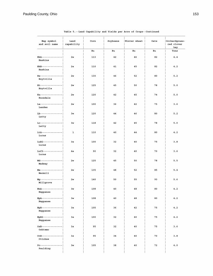
Paulding County, Ohio 153
Table 5.--Land Capability and Yields per Acre of Crops--Continued_____________________________________________________________________________________________________ | | | | | | Map symbol | Land | Corn | Soybeans |Winter wheat | Oats |Orchardgrass- and soil name | capability | | | | | red clover | | | | | | hay_____________________________________________________________________________________________________ | | Bu | Bu | Bu | Bu | Tons | | | | | |HkA--------------| 2w | 113 | 42 | 46 | 82 | 4.4 Haskins | | | | | | | | | | | |HkB--------------| 2e | 110 | 41 | 45 | 82 | 4.2 Haskins | | | | | | | | | | | |Hs---------------| 2w | 130 | 46 | 52 | 80 | 5.2 Hoytville | | | | | | | | | | | |Ht---------------| 2w | 125 | 45 | 50 | 78 | 5.0 Hoytville | | | | | | | | | | | |Kn---------------| 2w | 120 | 42 | 45 | 74 | 5.0 Knoxdale | | | | | | | | | | | |La---------------| 2w | 100 | 36 | 42 | 75 | 3.6 Landes | | | | | | | | | | | |Lb---------------| 3w | 120 | 44 | 46 | 80 | 5.2 Latty | | | | | | | | | | | |Lc---------------| 3w | 118 | 42 | 45 | 78 | 5.0 Latty | | | | | | | | | | | |LtA--------------| 1 | 110 | 40 | 44 | 80 | 4.2 Lucas | | | | | | | | | | | |LuB2-------------| 3e | 100 | 32 | 40 | 75 | 3.8 Lucas | | | | | | | | | | | |LuC2-------------| 4e | 90 | 32 | 40 | 70 | 3.6 Lucas | | | | | | | | | | | |Md---------------| 2w | 125 | 45 | 50 | 78 | 5.5 Medway | | | | | | | | | | | |Me---------------| 2w | 135 | 48 | 52 | 85 | 5.4 Mermill | | | | | | | | | | | |Mg---------------| 2w | 140 | 50 | 55 | 93 | 5.6 Millgrove | | | | | | | | | | | |NnA--------------| 3w | 108 | 40 | 48 | 80 | 4.2 Nappanee | | | | | | | | | | | |NpA--------------| 3w | 108 | 40 | 48 | 80 | 4.2 Nappanee | | | | | | | | | | | |NpB--------------| 3e | 105 | 36 | 42 | 75 | 4.2 Nappanee | | | | | | | | | | | |NpB2-------------| 3e | 100 | 32 | 40 | 75 | 4.2 Nappanee | | | | | | | | | | | |OsB--------------| 3s | 95 | 32 | 40 | 75 | 3.6 Oshtemo | | | | | | | | | | | |OtB--------------| 3s | 95 | 34 | 40 | 70 | 3.8 Ottokee | | | | | | | | | | | |Pc---------------| 3w | 105 | 38 | 40 | 72 | 4.0 Paulding | | | | | | | | | | | |

154 Soil Survey of
Table 5.--Land Capability and Yields per Acre of Crops--Continued_____________________________________________________________________________________________________ | | | | | | Map symbol | Land | Corn | Soybeans |Winter wheat | Oats |Orchardgrass- and soil name | capability | | | | | red clover | | | | | | hay_____________________________________________________________________________________________________ | | Bu | Bu | Bu | Bu | Tons | | | | | |Pt. | | | | | | Pits, quarry | | | | | | | | | | | |RkA--------------| 2w | 105 | 38 | 45 | 80 | 4.0 Rimer | | | | | | | | | | | |RkB--------------| 2e | 100 | 35 | 42 | 75 | 3.8 Rimer | | | | | | | | | | | |RmA--------------| 2w | 106 | 39 | 45 | 78 | 4.0 Rimer-Fulton | | | | | | | | | | | |RnA--------------| 3w | 90 | 34 | 35 | 65 | 3.5 Roselms | | | | | | | | | | | |RoA--------------| 3w | 90 | 34 | 35 | 65 | 3.5 Roselms | | | | | | | | | | | |RoB--------------| 3e | 80 | 30 | 30 | 55 | 3.2 Roselms | | | | | | | | | | | |RpA--------------| 3w | 85 | 30 | 35 | 65 | 3.5 Roselms | | | | | | | | | | | |RpB2-------------| 3e | 75 | 28 | 30 | 55 | 3.2 Roselms | | | | | | | | | | | |Rt---------------| 2w | 125 | 45 | 50 | 78 | 5.2 Rossburg | | | | | | | | | | | |Sb---------------| 3w | 115 | 42 | 44 | 80 | 4.6 Saranac | | | | | | | | | | | |Sh---------------| 2w | 115 | 42 | 45 | 74 | 4.8 Shoals | | | | | | | | | | | |Sk---------------| 2w | 115 | 42 | --- | --- | --- Shoals | | | | | | | | | | | |StB2-------------| 3e | 80 | 30 | 35 | 55 | 3.4 St. Clair | | | | | | | | | | | |StC2-------------| 4e | 75 | 25 | 30 | 55 | 3.2 St. Clair | | | | | | | | | | | |StD2-------------| 6e | --- | --- | --- | --- | 3.0 St. Clair | | | | | | | | | | | |StE2-------------| 7e | --- | --- | --- | --- | 2.7 St. Clair | | | | | | | | | | | |SuC3-------------| 6e | --- | --- | --- | --- | 2.7 St. Clair | | | | | | | | | | | |SuE3-------------| 7e | --- | --- | --- | --- | 2.3 St. Clair | | | | | | | | | | | |TeA--------------| 3s | 95 | 32 | 40 | 70 | 3.8 Tedrow | | | | | | | | | | | |
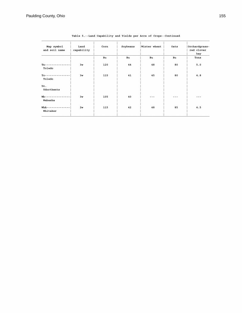
Paulding County, Ohio 155
Table 5.--Land Capability and Yields per Acre of Crops--Continued_____________________________________________________________________________________________________ | | | | | | Map symbol | Land | Corn | Soybeans |Winter wheat | Oats |Orchardgrass- and soil name | capability | | | | | red clover | | | | | | hay_____________________________________________________________________________________________________ | | Bu | Bu | Bu | Bu | Tons | | | | | |Tn---------------| 3w | 120 | 44 | 48 | 80 | 5.0 Toledo | | | | | | | | | | | |To---------------| 3w | 115 | 41 | 45 | 80 | 4.8 Toledo | | | | | | | | | | | |Uc. | | | | | | Udorthents | | | | | | | | | | | |Wb---------------| 3w | 105 | 40 | --- | --- | --- Wabasha | | | | | | | | | | | |WhA--------------| 2w | 115 | 42 | 48 | 85 | 4.5 Whitaker | | | | | | | | | | | |_____________________________________________________________________________________________________
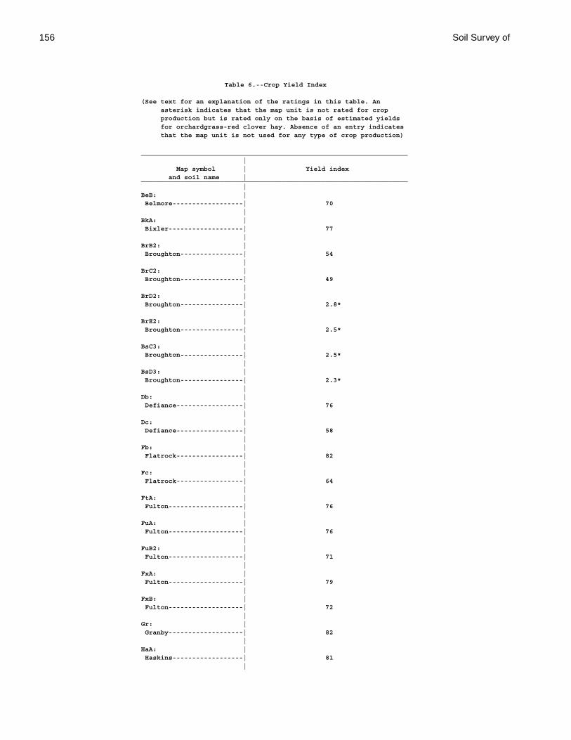
156 Soil Survey of
Table 6.--Crop Yield Index
(See text for an explanation of the ratings in this table. An asterisk indicates that the map unit is not rated for crop production but is rated only on the basis of estimated yields for orchardgrass-red clover hay. Absence of an entry indicates that the map unit is not used for any type of crop production)
____________________________________________________________________ | Map symbol | Yield index and soil name |____________________________________________________________________ |BeB: | Belmore------------------| 70 |BkA: | Bixler-------------------| 77 |BrB2: | Broughton----------------| 54 |BrC2: | Broughton----------------| 49 |BrD2: | Broughton----------------| 2.8* |BrE2: | Broughton----------------| 2.5* |BsC3: | Broughton----------------| 2.5* |BsD3: | Broughton----------------| 2.3* |Db: | Defiance-----------------| 76 |Dc: | Defiance-----------------| 58 |Fb: | Flatrock-----------------| 82 |Fc: | Flatrock-----------------| 64 |FtA: | Fulton-------------------| 76 |FuA: | Fulton-------------------| 76 |FuB2: | Fulton-------------------| 71 |FxA: | Fulton-------------------| 79 |FxB: | Fulton-------------------| 72 |Gr: | Granby-------------------| 82 |HaA: | Haskins------------------| 81 |
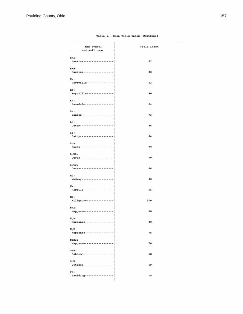
Paulding County, Ohio 157
Table 6.--Crop Yield Index--Continued____________________________________________________________________ | Map symbol | Yield index and soil name |____________________________________________________________________ |HkA: | Haskins------------------| 82 |HkB: | Haskins------------------| 80 |Hs: | Hoytville----------------| 93 |Ht: | Hoytville----------------| 90 |Kn: | Knoxdale-----------------| 84 |La: | Landes-------------------| 73 |Lb: | Latty--------------------| 86 |Lc: | Latty--------------------| 84 |LtA: | Lucas--------------------| 79 |LuB2: | Lucas--------------------| 70 |LuC2: | Lucas--------------------| 66 |Md: | Medway-------------------| 90 |Me: | Mermill------------------| 96 |Mg: | Millgrove----------------| 100 |NnA: | Nappanee-----------------| 80 |NpA: | Nappanee-----------------| 80 |NpB: | Nappanee-----------------| 75 |NpB2: | Nappanee-----------------| 70 |OsB: | Oshtemo------------------| 68 |OtB: | Ottokee------------------| 69 |Pc: | Paulding-----------------| 75 |
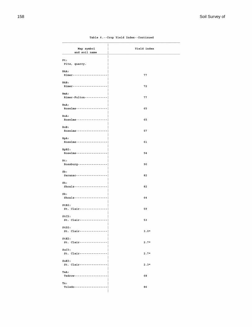
158 Soil Survey of
Table 6.--Crop Yield Index--Continued____________________________________________________________________ | Map symbol | Yield index and soil name |____________________________________________________________________ |Pt: | Pits, quarry. | |RkA: | Rimer--------------------| 77 |RkB: | Rimer--------------------| 72 |RmA: | Rimer-Fulton-------------| 77 |RnA: | Roselms------------------| 65 |RoA: | Roselms------------------| 65 |RoB: | Roselms------------------| 57 |RpA: | Roselms------------------| 61 |RpB2: | Roselms------------------| 54 |Rt: | Rossburg-----------------| 90 |Sb: | Saranac------------------| 82 |Sh: | Shoals-------------------| 82 |Sk: | Shoals-------------------| 64 |StB2: | St. Clair----------------| 59 |StC2: | St. Clair----------------| 53 |StD2: | St. Clair----------------| 3.0* |StE2: | St. Clair----------------| 2.7* |SuC3: | St. Clair----------------| 2.7* |SuE3: | St. Clair----------------| 2.3* |TeA: | Tedrow-------------------| 68 |Tn: | Toledo-------------------| 86 |
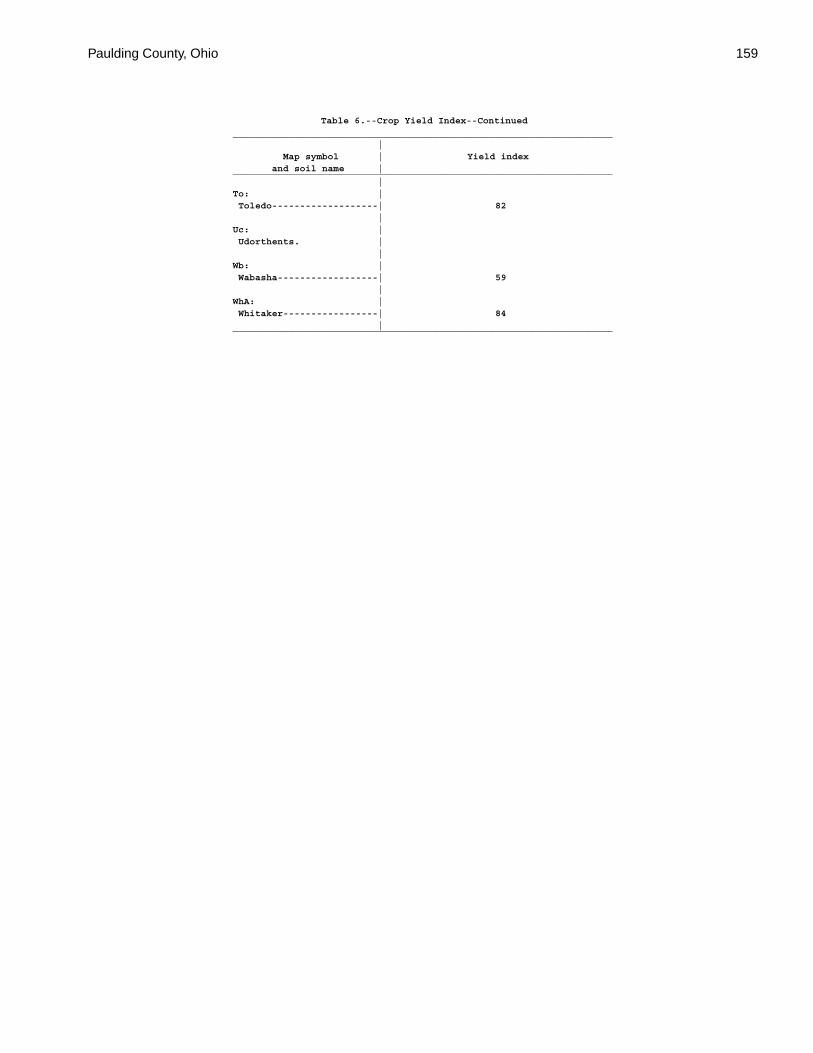
Paulding County, Ohio 159
Table 6.--Crop Yield Index--Continued____________________________________________________________________ | Map symbol | Yield index and soil name |____________________________________________________________________ |To: | Toledo-------------------| 82 |Uc: | Udorthents. | |Wb: | Wabasha------------------| 59 |WhA: | Whitaker-----------------| 84 |____________________________________________________________________
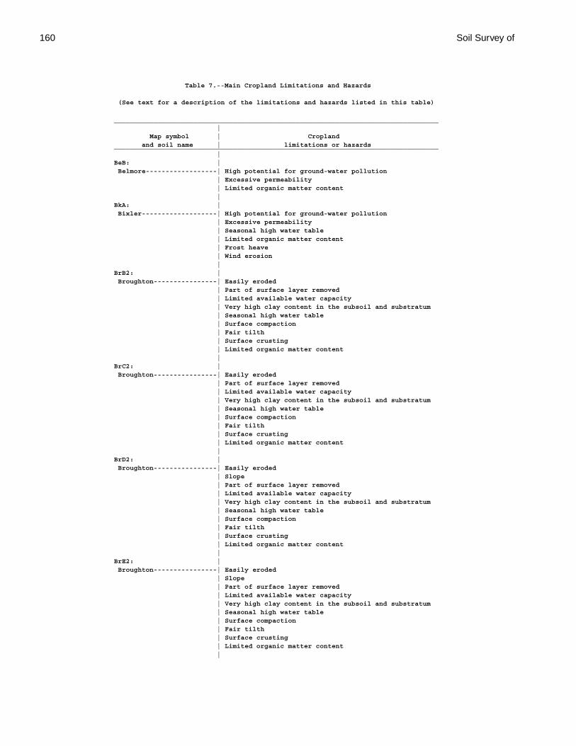
160 Soil Survey of
Table 7.--Main Cropland Limitations and Hazards
(See text for a description of the limitations and hazards listed in this table)
__________________________________________________________________________________ | Map symbol | Cropland and soil name | limitations or hazards__________________________________________________________________________________ |BeB: | Belmore------------------| High potential for ground-water pollution | Excessive permeability | Limited organic matter content |BkA: | Bixler-------------------| High potential for ground-water pollution | Excessive permeability | Seasonal high water table | Limited organic matter content | Frost heave | Wind erosion |BrB2: | Broughton----------------| Easily eroded | Part of surface layer removed | Limited available water capacity | Very high clay content in the subsoil and substratum | Seasonal high water table | Surface compaction | Fair tilth | Surface crusting | Limited organic matter content |BrC2: | Broughton----------------| Easily eroded | Part of surface layer removed | Limited available water capacity | Very high clay content in the subsoil and substratum | Seasonal high water table | Surface compaction | Fair tilth | Surface crusting | Limited organic matter content |BrD2: | Broughton----------------| Easily eroded | Slope | Part of surface layer removed | Limited available water capacity | Very high clay content in the subsoil and substratum | Seasonal high water table | Surface compaction | Fair tilth | Surface crusting | Limited organic matter content |BrE2: | Broughton----------------| Easily eroded | Slope | Part of surface layer removed | Limited available water capacity | Very high clay content in the subsoil and substratum | Seasonal high water table | Surface compaction | Fair tilth | Surface crusting | Limited organic matter content |
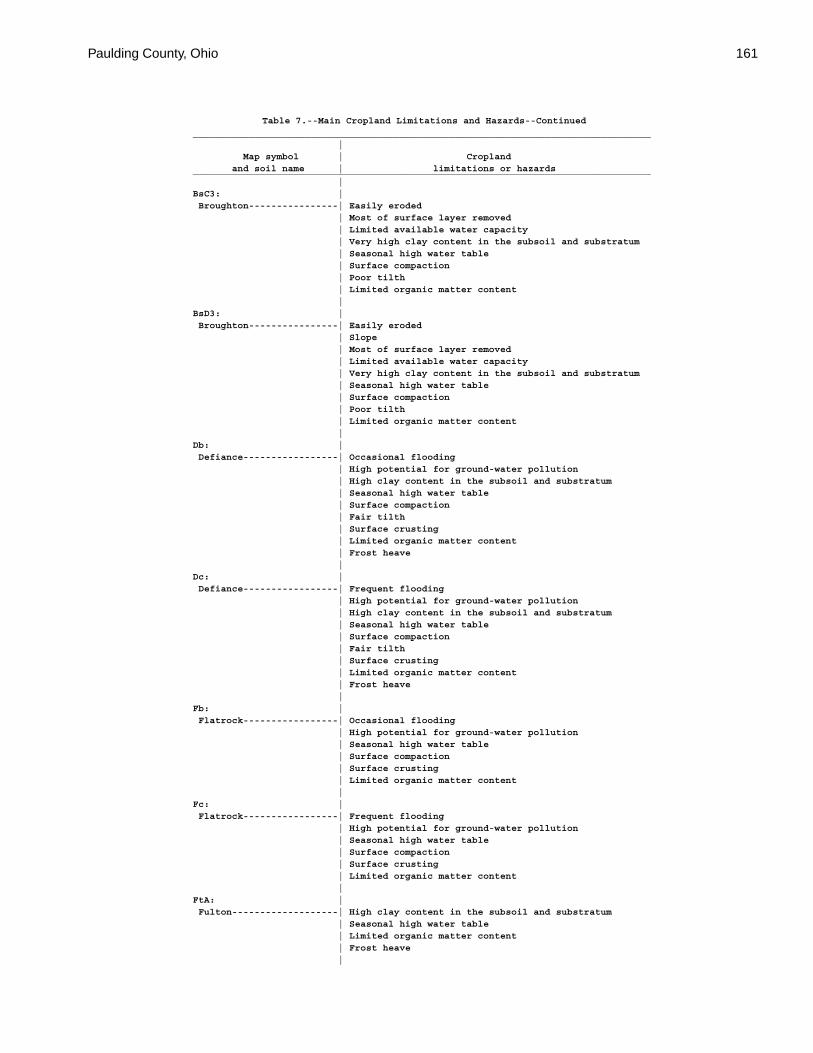
Paulding County, Ohio 161
Table 7.--Main Cropland Limitations and Hazards--Continued__________________________________________________________________________________ | Map symbol | Cropland and soil name | limitations or hazards__________________________________________________________________________________ |BsC3: | Broughton----------------| Easily eroded | Most of surface layer removed | Limited available water capacity | Very high clay content in the subsoil and substratum | Seasonal high water table | Surface compaction | Poor tilth | Limited organic matter content |BsD3: | Broughton----------------| Easily eroded | Slope | Most of surface layer removed | Limited available water capacity | Very high clay content in the subsoil and substratum | Seasonal high water table | Surface compaction | Poor tilth | Limited organic matter content |Db: | Defiance-----------------| Occasional flooding | High potential for ground-water pollution | High clay content in the subsoil and substratum | Seasonal high water table | Surface compaction | Fair tilth | Surface crusting | Limited organic matter content | Frost heave |Dc: | Defiance-----------------| Frequent flooding | High potential for ground-water pollution | High clay content in the subsoil and substratum | Seasonal high water table | Surface compaction | Fair tilth | Surface crusting | Limited organic matter content | Frost heave |Fb: | Flatrock-----------------| Occasional flooding | High potential for ground-water pollution | Seasonal high water table | Surface compaction | Surface crusting | Limited organic matter content |Fc: | Flatrock-----------------| Frequent flooding | High potential for ground-water pollution | Seasonal high water table | Surface compaction | Surface crusting | Limited organic matter content |FtA: | Fulton-------------------| High clay content in the subsoil and substratum | Seasonal high water table | Limited organic matter content | Frost heave |
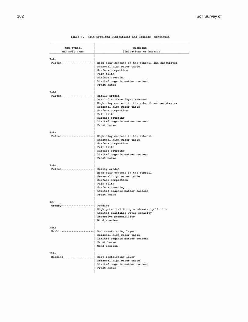
162 Soil Survey of
Table 7.--Main Cropland Limitations and Hazards--Continued__________________________________________________________________________________ | Map symbol | Cropland and soil name | limitations or hazards__________________________________________________________________________________ |FuA: | Fulton-------------------| High clay content in the subsoil and substratum | Seasonal high water table | Surface compaction | Fair tilth | Surface crusting | Limited organic matter content | Frost heave |FuB2: | Fulton-------------------| Easily eroded | Part of surface layer removed | High clay content in the subsoil and substratum | Seasonal high water table | Surface compaction | Fair tilth | Surface crusting | Limited organic matter content | Frost heave |FxA: | Fulton-------------------| High clay content in the subsoil | Seasonal high water table | Surface compaction | Fair tilth | Surface crusting | Limited organic matter content | Frost heave |FxB: | Fulton-------------------| Easily eroded | High clay content in the subsoil | Seasonal high water table | Surface compaction | Fair tilth | Surface crusting | Limited organic matter content | Frost heave |Gr: | Granby-------------------| Ponding | High potential for ground-water pollution | Limited available water capacity | Excessive permeability | Wind erosion |HaA: | Haskins------------------| Root-restricting layer | Seasonal high water table | Limited organic matter content | Frost heave | Wind erosion |HkA: | Haskins------------------| Root-restricting layer | Seasonal high water table | Limited organic matter content | Frost heave |

Paulding County, Ohio 163
Table 7.--Main Cropland Limitations and Hazards--Continued__________________________________________________________________________________ | Map symbol | Cropland and soil name | limitations or hazards__________________________________________________________________________________ |HkB: | Haskins------------------| Easily eroded | Root-restricting layer | Seasonal high water table | Limited organic matter content | Frost heave |Hs: | Hoytville----------------| Ponding | High clay content in the subsoil and substratum | Surface compaction | Fair tilth | Frost heave |Ht: | Hoytville----------------| Ponding | High clay content in the subsoil and substratum | Surface compaction | Poor tilth | Frost heave |Kn: | Knoxdale-----------------| Occasional flooding | Surface compaction | Surface crusting | Limited organic matter content |La: | Landes-------------------| Occasional flooding | High potential for ground-water pollution | Easily eroded | Excessive permeability | Limited organic matter content |Lb: | Latty--------------------| Ponding | High clay content in the subsoil and substratum | Surface compaction | Poor tilth | Frost heave |Lc: | Latty--------------------| Ponding | High clay content in the subsoil and substratum | Surface compaction | Poor tilth | Frost heave |LtA: | Lucas--------------------| High clay content in the subsoil | Surface compaction | Surface crusting | Limited organic matter content |LuB2: | Lucas--------------------| Easily eroded | Part of surface layer removed | High clay content in the subsoil | Surface compaction | Fair tilth | Surface crusting | Limited organic matter content |
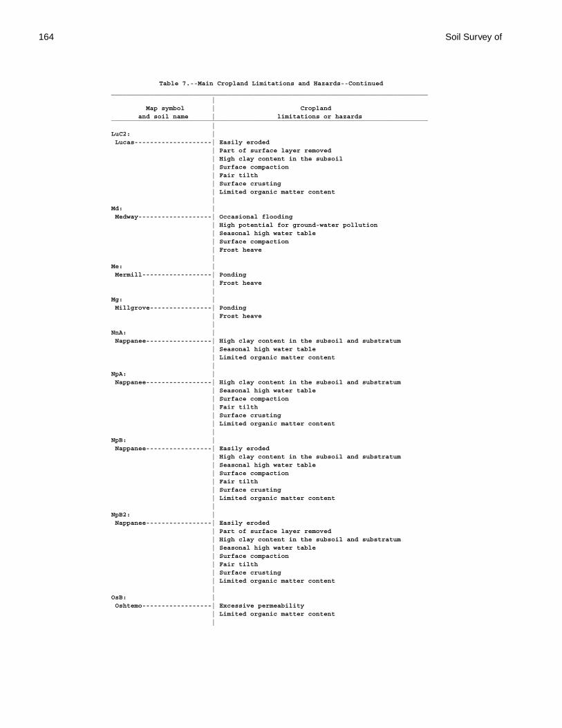
164 Soil Survey of
Table 7.--Main Cropland Limitations and Hazards--Continued__________________________________________________________________________________ | Map symbol | Cropland and soil name | limitations or hazards__________________________________________________________________________________ |LuC2: | Lucas--------------------| Easily eroded | Part of surface layer removed | High clay content in the subsoil | Surface compaction | Fair tilth | Surface crusting | Limited organic matter content |Md: | Medway-------------------| Occasional flooding | High potential for ground-water pollution | Seasonal high water table | Surface compaction | Frost heave |Me: | Mermill------------------| Ponding | Frost heave |Mg: | Millgrove----------------| Ponding | Frost heave |NnA: | Nappanee-----------------| High clay content in the subsoil and substratum | Seasonal high water table | Limited organic matter content |NpA: | Nappanee-----------------| High clay content in the subsoil and substratum | Seasonal high water table | Surface compaction | Fair tilth | Surface crusting | Limited organic matter content |NpB: | Nappanee-----------------| Easily eroded | High clay content in the subsoil and substratum | Seasonal high water table | Surface compaction | Fair tilth | Surface crusting | Limited organic matter content |NpB2: | Nappanee-----------------| Easily eroded | Part of surface layer removed | High clay content in the subsoil and substratum | Seasonal high water table | Surface compaction | Fair tilth | Surface crusting | Limited organic matter content |OsB: | Oshtemo------------------| Excessive permeability | Limited organic matter content |
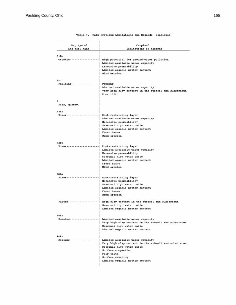
Paulding County, Ohio 165
Table 7.--Main Cropland Limitations and Hazards--Continued__________________________________________________________________________________ | Map symbol | Cropland and soil name | limitations or hazards__________________________________________________________________________________ |OtB: | Ottokee------------------| High potential for ground-water pollution | Limited available water capacity | Excessive permeability | Limited organic matter content | Wind erosion |Pc: | Paulding-----------------| Ponding | Limited available water capacity | Very high clay content in the subsoil and substratum | Poor tilth |Pt: | Pits, quarry. | |RkA: | Rimer--------------------| Root-restricting layer | Limited available water capacity | Excessive permeability | Seasonal high water table | Limited organic matter content | Frost heave | Wind erosion |RkB: | Rimer--------------------| Root-restricting layer | Limited available water capacity | Excessive permeability | Seasonal high water table | Limited organic matter content | Frost heave | Wind erosion |RmA: | Rimer--------------------| Root-restricting layer | Excessive permeability | Seasonal high water table | Limited organic matter content | Frost heave | Wind erosion | Fulton-------------------| High clay content in the subsoil and substratum | Seasonal high water table | Limited organic matter content |RnA: | Roselms------------------| Limited available water capacity | Very high clay content in the subsoil and substratum | Seasonal high water table | Limited organic matter content |RoA: | Roselms------------------| Limited available water capacity | Very high clay content in the subsoil and substratum | Seasonal high water table | Surface compaction | Fair tilth | Surface crusting | Limited organic matter content |

166 Soil Survey of
Table 7.--Main Cropland Limitations and Hazards--Continued__________________________________________________________________________________ | Map symbol | Cropland and soil name | limitations or hazards__________________________________________________________________________________ |RoB: | Roselms------------------| Easily eroded | Limited available water capacity | Very high clay content in the subsoil and substratum | Seasonal high water table | Surface compaction | Fair tilth | Surface crusting | Limited organic matter content |RpA: | Roselms------------------| Limited available water capacity | Very high clay content in the subsoil and substratum | Seasonal high water table | Surface compaction | Poor tilth | Limited organic matter content |RpB2: | Roselms------------------| Part of surface layer removed | Limited available water capacity | Very high clay content in the subsoil and substratum | Seasonal high water table | Surface compaction | Poor tilth | Limited organic matter content |Rt: | Rossburg-----------------| Occasional flooding | High potential for ground-water pollution | Surface compaction |Sb: | Saranac------------------| Occasional flooding | High potential for ground-water pollution | High clay content in the subsoil and substratum | Seasonal high water table | Surface compaction | Fair tilth | Frost heave |Sh: | Shoals-------------------| Occasional flooding | High potential for ground-water pollution | Seasonal high water table | Surface compaction | Frost heave |Sk: | Shoals-------------------| Frequent flooding | High potential for ground-water pollution | Seasonal high water table | Surface compaction | Frost heave |StB2: | St. Clair----------------| Easily eroded | Part of surface layer removed | High clay content in the subsoil and substratum | Surface compaction | Fair tilth | Surface crusting | Limited organic matter content |
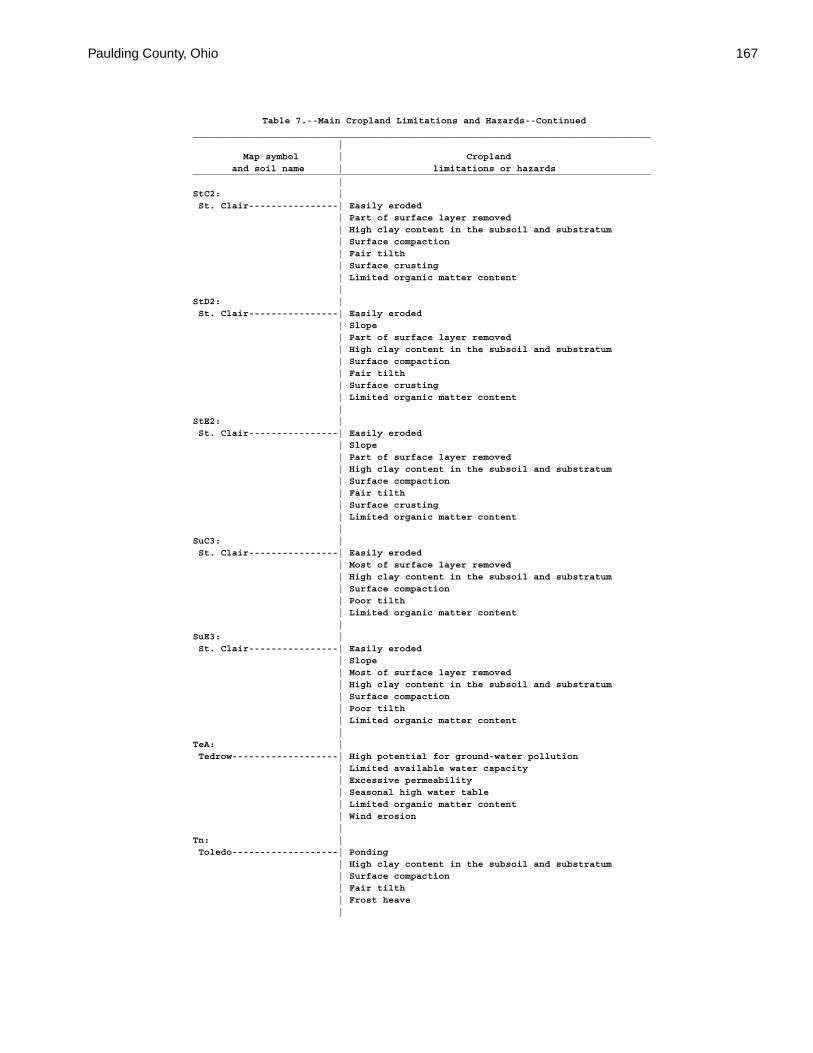
Paulding County, Ohio 167
Table 7.--Main Cropland Limitations and Hazards--Continued__________________________________________________________________________________ | Map symbol | Cropland and soil name | limitations or hazards__________________________________________________________________________________ |StC2: | St. Clair----------------| Easily eroded | Part of surface layer removed | High clay content in the subsoil and substratum | Surface compaction | Fair tilth | Surface crusting | Limited organic matter content |StD2: | St. Clair----------------| Easily eroded | Slope | Part of surface layer removed | High clay content in the subsoil and substratum | Surface compaction | Fair tilth | Surface crusting | Limited organic matter content |StE2: | St. Clair----------------| Easily eroded | Slope | Part of surface layer removed | High clay content in the subsoil and substratum | Surface compaction | Fair tilth | Surface crusting | Limited organic matter content |SuC3: | St. Clair----------------| Easily eroded | Most of surface layer removed | High clay content in the subsoil and substratum | Surface compaction | Poor tilth | Limited organic matter content |SuE3: | St. Clair----------------| Easily eroded | Slope | Most of surface layer removed | High clay content in the subsoil and substratum | Surface compaction | Poor tilth | Limited organic matter content |TeA: | Tedrow-------------------| High potential for ground-water pollution | Limited available water capacity | Excessive permeability | Seasonal high water table | Limited organic matter content | Wind erosion |Tn: | Toledo-------------------| Ponding | High clay content in the subsoil and substratum | Surface compaction | Fair tilth | Frost heave |
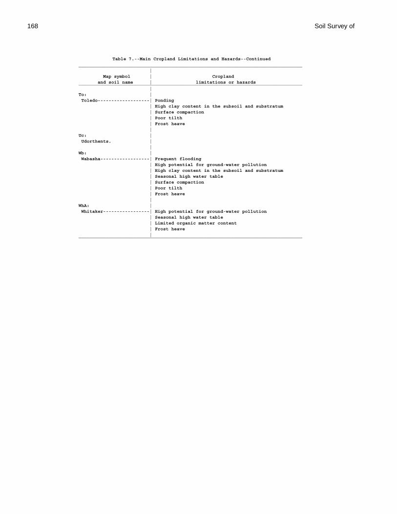
168 Soil Survey of
Table 7.--Main Cropland Limitations and Hazards--Continued__________________________________________________________________________________ | Map symbol | Cropland and soil name | limitations or hazards__________________________________________________________________________________ |To: | Toledo-------------------| Ponding | High clay content in the subsoil and substratum | Surface compaction | Poor tilth | Frost heave |Uc: | Udorthents. | |Wb: | Wabasha------------------| Frequent flooding | High potential for ground-water pollution | High clay content in the subsoil and substratum | Seasonal high water table | Surface compaction | Poor tilth | Frost heave |WhA: | Whitaker-----------------| High potential for ground-water pollution | Seasonal high water table | Limited organic matter content | Frost heave |__________________________________________________________________________________
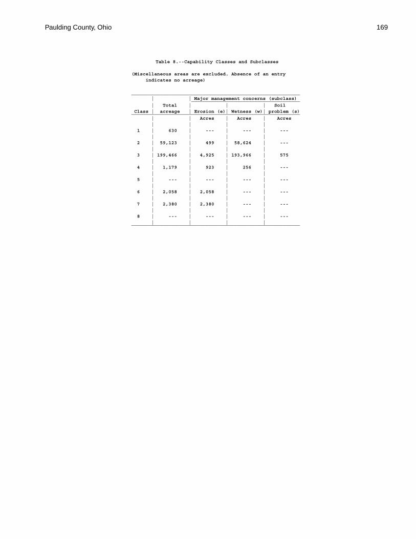
Paulding County, Ohio 169
Table 8.--Capability Classes and Subclasses
(Miscellaneous areas are excluded. Absence of an entry indicates no acreage)
___________________________________________________________ | | Major management concerns (subclass) ______________________________________ | Total | | | Soil Class | acreage | Erosion (e)| Wetness (w)| problem (s)___________________________________________________________ | | Acres | Acres | Acres | | | | 1 | 630 | --- | --- | --- | | | | 2 | 59,123 | 499 | 58,624 | --- | | | | 3 | 199,466 | 4,925 | 193,966 | 575 | | | | 4 | 1,179 | 923 | 256 | --- | | | | 5 | --- | --- | --- | --- | | | | 6 | 2,058 | 2,058 | --- | --- | | | | 7 | 2,380 | 2,380 | --- | --- | | | | 8 | --- | --- | --- | --- | | | |___________________________________________________________
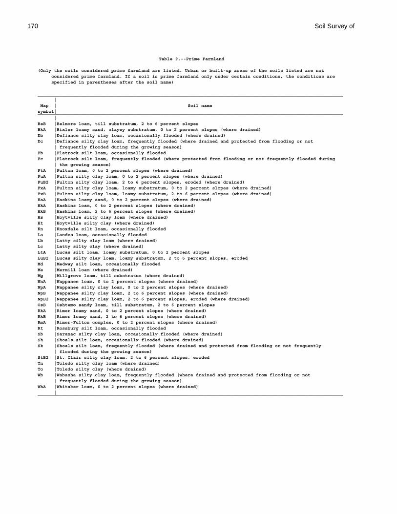
170 Soil Survey of
Table 9.--Prime Farmland
(Only the soils considered prime farmland are listed. Urban or built-up areas of the soils listed are not considered prime farmland. If a soil is prime farmland only under certain conditions, the conditions are specified in parentheses after the soil name)
________________________________________________________________________________________________________________ | Map | Soil namesymbol|________________________________________________________________________________________________________________ |BeB |Belmore loam, till substratum, 2 to 6 percent slopesBkA |Bixler loamy sand, clayey substratum, 0 to 2 percent slopes (where drained)Db |Defiance silty clay loam, occasionally flooded (where drained)Dc |Defiance silty clay loam, frequently flooded (where drained and protected from flooding or not | frequently flooded during the growing season)Fb |Flatrock silt loam, occasionally floodedFc |Flatrock silt loam, frequently flooded (where protected from flooding or not frequently flooded during | the growing season)FtA |Fulton loam, 0 to 2 percent slopes (where drained)FuA |Fulton silty clay loam, 0 to 2 percent slopes (where drained)FuB2 |Fulton silty clay loam, 2 to 6 percent slopes, eroded (where drained)FxA |Fulton silty clay loam, loamy substratum, 0 to 2 percent slopes (where drained)FxB |Fulton silty clay loam, loamy substratum, 2 to 6 percent slopes (where drained)HaA |Haskins loamy sand, 0 to 2 percent slopes (where drained)HkA |Haskins loam, 0 to 2 percent slopes (where drained)HkB |Haskins loam, 2 to 6 percent slopes (where drained)Hs |Hoytville silty clay loam (where drained)Ht |Hoytville silty clay (where drained)Kn |Knoxdale silt loam, occasionally floodedLa |Landes loam, occasionally floodedLb |Latty silty clay loam (where drained)Lc |Latty silty clay (where drained)LtA |Lucas silt loam, loamy substratum, 0 to 2 percent slopesLuB2 |Lucas silty clay loam, loamy substratum, 2 to 6 percent slopes, erodedMd |Medway silt loam, occasionally floodedMe |Mermill loam (where drained)Mg |Millgrove loam, till substratum (where drained)NnA |Nappanee loam, 0 to 2 percent slopes (where drained)NpA |Nappanee silty clay loam, 0 to 2 percent slopes (where drained)NpB |Nappanee silty clay loam, 2 to 6 percent slopes (where drained)NpB2 |Nappanee silty clay loam, 2 to 6 percent slopes, eroded (where drained)OsB |Oshtemo sandy loam, till substratum, 2 to 6 percent slopesRkA |Rimer loamy sand, 0 to 2 percent slopes (where drained)RkB |Rimer loamy sand, 2 to 6 percent slopes (where drained)RmA |Rimer-Fulton complex, 0 to 2 percent slopes (where drained)Rt |Rossburg silt loam, occasionally floodedSb |Saranac silty clay loam, occasionally flooded (where drained)Sh |Shoals silt loam, occasionally flooded (where drained)Sk |Shoals silt loam, frequently flooded (where drained and protected from flooding or not frequently | flooded during the growing season)StB2 |St. Clair silty clay loam, 2 to 6 percent slopes, erodedTn |Toledo silty clay loam (where drained)To |Toledo silty clay (where drained)Wb |Wabasha silty clay loam, frequently flooded (where drained and protected from flooding or not | frequently flooded during the growing season)WhA |Whitaker loam, 0 to 2 percent slopes (where drained) |________________________________________________________________________________________________________________
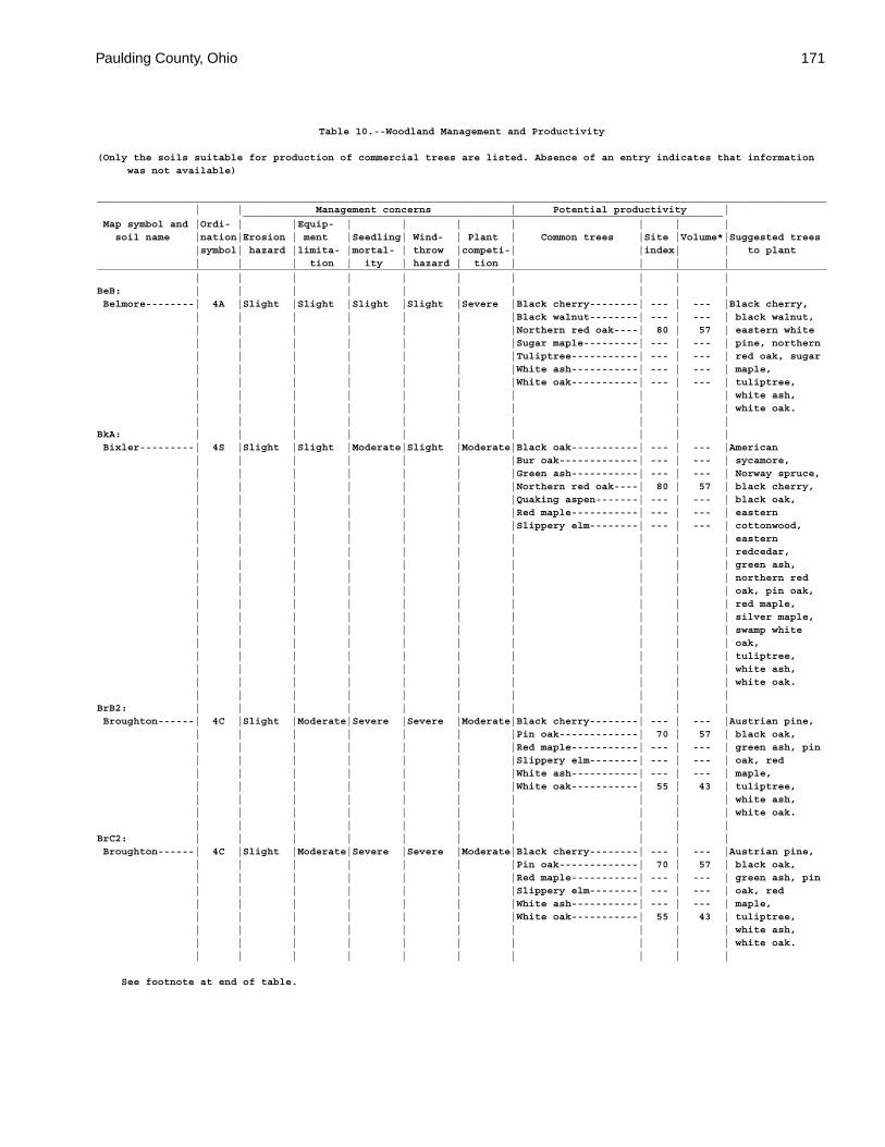
Paulding County, Ohio 171
Table 10.--Woodland Management and Productivity
(Only the soils suitable for production of commercial trees are listed. Absence of an entry indicates that information was not available)
_________________________________________________________________________________________________________________________ | | Management concerns | Potential productivity | _______________________________________________________________________________ Map symbol and |Ordi- | |Equip- | | | | | | | soil name |nation|Erosion | ment |Seedling| Wind- | Plant | Common trees |Site |Volume*|Suggested trees |symbol| hazard |limita- |mortal- | throw |competi-| |index| | to plant | | | tion | ity | hazard | tion | | | |_________________________________________________________________________________________________________________________ | | | | | | | | | |BeB: | | | | | | | | | | Belmore--------| 4A |Slight |Slight |Slight |Slight |Severe |Black cherry--------| --- | --- |Black cherry, | | | | | | |Black walnut--------| --- | --- | black walnut, | | | | | | |Northern red oak----| 80 | 57 | eastern white | | | | | | |Sugar maple---------| --- | --- | pine, northern | | | | | | |Tuliptree-----------| --- | --- | red oak, sugar | | | | | | |White ash-----------| --- | --- | maple, | | | | | | |White oak-----------| --- | --- | tuliptree, | | | | | | | | | | white ash, | | | | | | | | | | white oak. | | | | | | | | | |BkA: | | | | | | | | | | Bixler---------| 4S |Slight |Slight |Moderate|Slight |Moderate|Black oak-----------| --- | --- |American | | | | | | |Bur oak-------------| --- | --- | sycamore, | | | | | | |Green ash-----------| --- | --- | Norway spruce, | | | | | | |Northern red oak----| 80 | 57 | black cherry, | | | | | | |Quaking aspen-------| --- | --- | black oak, | | | | | | |Red maple-----------| --- | --- | eastern | | | | | | |Slippery elm--------| --- | --- | cottonwood, | | | | | | | | | | eastern | | | | | | | | | | redcedar, | | | | | | | | | | green ash, | | | | | | | | | | northern red | | | | | | | | | | oak, pin oak, | | | | | | | | | | red maple, | | | | | | | | | | silver maple, | | | | | | | | | | swamp white | | | | | | | | | | oak, | | | | | | | | | | tuliptree, | | | | | | | | | | white ash, | | | | | | | | | | white oak. | | | | | | | | | |BrB2: | | | | | | | | | | Broughton------| 4C |Slight |Moderate|Severe |Severe |Moderate|Black cherry--------| --- | --- |Austrian pine, | | | | | | |Pin oak-------------| 70 | 57 | black oak, | | | | | | |Red maple-----------| --- | --- | green ash, pin | | | | | | |Slippery elm--------| --- | --- | oak, red | | | | | | |White ash-----------| --- | --- | maple, | | | | | | |White oak-----------| 55 | 43 | tuliptree, | | | | | | | | | | white ash, | | | | | | | | | | white oak. | | | | | | | | | |BrC2: | | | | | | | | | | Broughton------| 4C |Slight |Moderate|Severe |Severe |Moderate|Black cherry--------| --- | --- |Austrian pine, | | | | | | |Pin oak-------------| 70 | 57 | black oak, | | | | | | |Red maple-----------| --- | --- | green ash, pin | | | | | | |Slippery elm--------| --- | --- | oak, red | | | | | | |White ash-----------| --- | --- | maple, | | | | | | |White oak-----------| 55 | 43 | tuliptree, | | | | | | | | | | white ash, | | | | | | | | | | white oak. | | | | | | | | | |
See footnote at end of table.
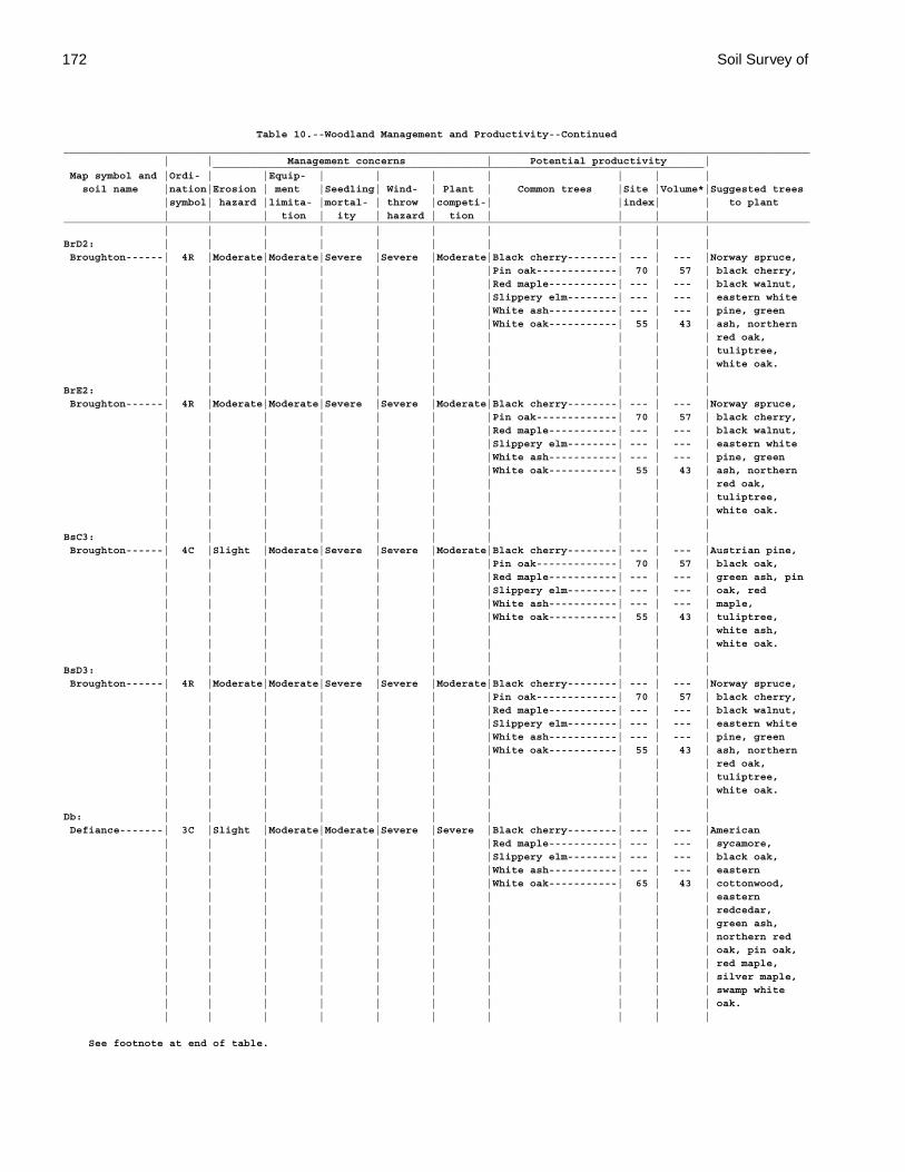
172 Soil Survey of
Table 10.--Woodland Management and Productivity--Continued_________________________________________________________________________________________________________________________ | | Management concerns | Potential productivity | _______________________________________________________________________________ Map symbol and |Ordi- | |Equip- | | | | | | | soil name |nation|Erosion | ment |Seedling| Wind- | Plant | Common trees |Site |Volume*|Suggested trees |symbol| hazard |limita- |mortal- | throw |competi-| |index| | to plant | | | tion | ity | hazard | tion | | | |_________________________________________________________________________________________________________________________ | | | | | | | | | |BrD2: | | | | | | | | | | Broughton------| 4R |Moderate|Moderate|Severe |Severe |Moderate|Black cherry--------| --- | --- |Norway spruce, | | | | | | |Pin oak-------------| 70 | 57 | black cherry, | | | | | | |Red maple-----------| --- | --- | black walnut, | | | | | | |Slippery elm--------| --- | --- | eastern white | | | | | | |White ash-----------| --- | --- | pine, green | | | | | | |White oak-----------| 55 | 43 | ash, northern | | | | | | | | | | red oak, | | | | | | | | | | tuliptree, | | | | | | | | | | white oak. | | | | | | | | | |BrE2: | | | | | | | | | | Broughton------| 4R |Moderate|Moderate|Severe |Severe |Moderate|Black cherry--------| --- | --- |Norway spruce, | | | | | | |Pin oak-------------| 70 | 57 | black cherry, | | | | | | |Red maple-----------| --- | --- | black walnut, | | | | | | |Slippery elm--------| --- | --- | eastern white | | | | | | |White ash-----------| --- | --- | pine, green | | | | | | |White oak-----------| 55 | 43 | ash, northern | | | | | | | | | | red oak, | | | | | | | | | | tuliptree, | | | | | | | | | | white oak. | | | | | | | | | |BsC3: | | | | | | | | | | Broughton------| 4C |Slight |Moderate|Severe |Severe |Moderate|Black cherry--------| --- | --- |Austrian pine, | | | | | | |Pin oak-------------| 70 | 57 | black oak, | | | | | | |Red maple-----------| --- | --- | green ash, pin | | | | | | |Slippery elm--------| --- | --- | oak, red | | | | | | |White ash-----------| --- | --- | maple, | | | | | | |White oak-----------| 55 | 43 | tuliptree, | | | | | | | | | | white ash, | | | | | | | | | | white oak. | | | | | | | | | |BsD3: | | | | | | | | | | Broughton------| 4R |Moderate|Moderate|Severe |Severe |Moderate|Black cherry--------| --- | --- |Norway spruce, | | | | | | |Pin oak-------------| 70 | 57 | black cherry, | | | | | | |Red maple-----------| --- | --- | black walnut, | | | | | | |Slippery elm--------| --- | --- | eastern white | | | | | | |White ash-----------| --- | --- | pine, green | | | | | | |White oak-----------| 55 | 43 | ash, northern | | | | | | | | | | red oak, | | | | | | | | | | tuliptree, | | | | | | | | | | white oak. | | | | | | | | | |Db: | | | | | | | | | | Defiance-------| 3C |Slight |Moderate|Moderate|Severe |Severe |Black cherry--------| --- | --- |American | | | | | | |Red maple-----------| --- | --- | sycamore, | | | | | | |Slippery elm--------| --- | --- | black oak, | | | | | | |White ash-----------| --- | --- | eastern | | | | | | |White oak-----------| 65 | 43 | cottonwood, | | | | | | | | | | eastern | | | | | | | | | | redcedar, | | | | | | | | | | green ash, | | | | | | | | | | northern red | | | | | | | | | | oak, pin oak, | | | | | | | | | | red maple, | | | | | | | | | | silver maple, | | | | | | | | | | swamp white | | | | | | | | | | oak. | | | | | | | | | |
See footnote at end of table.
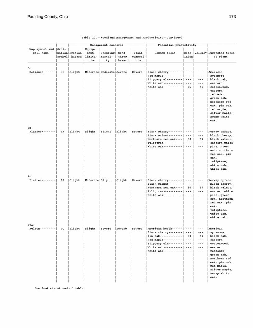
Paulding County, Ohio 173
Table 10.--Woodland Management and Productivity--Continued_________________________________________________________________________________________________________________________ | | Management concerns | Potential productivity | _______________________________________________________________________________ Map symbol and |Ordi- | |Equip- | | | | | | | soil name |nation|Erosion | ment |Seedling| Wind- | Plant | Common trees |Site |Volume*|Suggested trees |symbol| hazard |limita- |mortal- | throw |competi-| |index| | to plant | | | tion | ity | hazard | tion | | | |_________________________________________________________________________________________________________________________ | | | | | | | | | |Dc: | | | | | | | | | | Defiance-------| 3C |Slight |Moderate|Moderate|Severe |Severe |Black cherry--------| --- | --- |American | | | | | | |Red maple-----------| --- | --- | sycamore, | | | | | | |Slippery elm--------| --- | --- | black oak, | | | | | | |White ash-----------| --- | --- | eastern | | | | | | |White oak-----------| 65 | 43 | cottonwood, | | | | | | | | | | eastern | | | | | | | | | | redcedar, | | | | | | | | | | green ash, | | | | | | | | | | northern red | | | | | | | | | | oak, pin oak, | | | | | | | | | | red maple, | | | | | | | | | | silver maple, | | | | | | | | | | swamp white | | | | | | | | | | oak. | | | | | | | | | |Fb: | | | | | | | | | | Flatrock-------| 4A |Slight |Slight |Slight |Slight |Severe |Black cherry--------| --- | --- |Norway spruce, | | | | | | |Black walnut--------| --- | --- | black cherry, | | | | | | |Northern red oak----| 80 | 57 | black walnut, | | | | | | |Tuliptree-----------| --- | --- | eastern white | | | | | | |White oak-----------| --- | --- | pine, green | | | | | | | | | | ash, northern | | | | | | | | | | red oak, pin | | | | | | | | | | oak, | | | | | | | | | | tuliptree, | | | | | | | | | | white ash, | | | | | | | | | | white oak. | | | | | | | | | |Fc: | | | | | | | | | | Flatrock-------| 4A |Slight |Moderate|Slight |Slight |Severe |Black cherry--------| --- | --- |Norway spruce, | | | | | | |Black walnut--------| --- | --- | black cherry, | | | | | | |Northern red oak----| 80 | 57 | black walnut, | | | | | | |Tuliptree-----------| --- | --- | eastern white | | | | | | |White oak-----------| --- | --- | pine, green | | | | | | | | | | ash, northern | | | | | | | | | | red oak, pin | | | | | | | | | | oak, | | | | | | | | | | tuliptree, | | | | | | | | | | white ash, | | | | | | | | | | white oak. | | | | | | | | | |FtA: | | | | | | | | | | Fulton---------| 4C |Slight |Slight |Severe |Severe |Severe |American beech------| --- | --- |American | | | | | | |Black cherry--------| --- | --- | sycamore, | | | | | | |Pin oak-------------| 80 | 57 | black oak, | | | | | | |Red maple-----------| --- | --- | eastern | | | | | | |Slippery elm--------| --- | --- | cottonwood, | | | | | | |White ash-----------| --- | --- | eastern | | | | | | |White oak-----------| --- | --- | redcedar, | | | | | | | | | | green ash, | | | | | | | | | | northern red | | | | | | | | | | oak, pin oak, | | | | | | | | | | red maple, | | | | | | | | | | silver maple, | | | | | | | | | | swamp white | | | | | | | | | | oak. | | | | | | | | | |
See footnote at end of table.
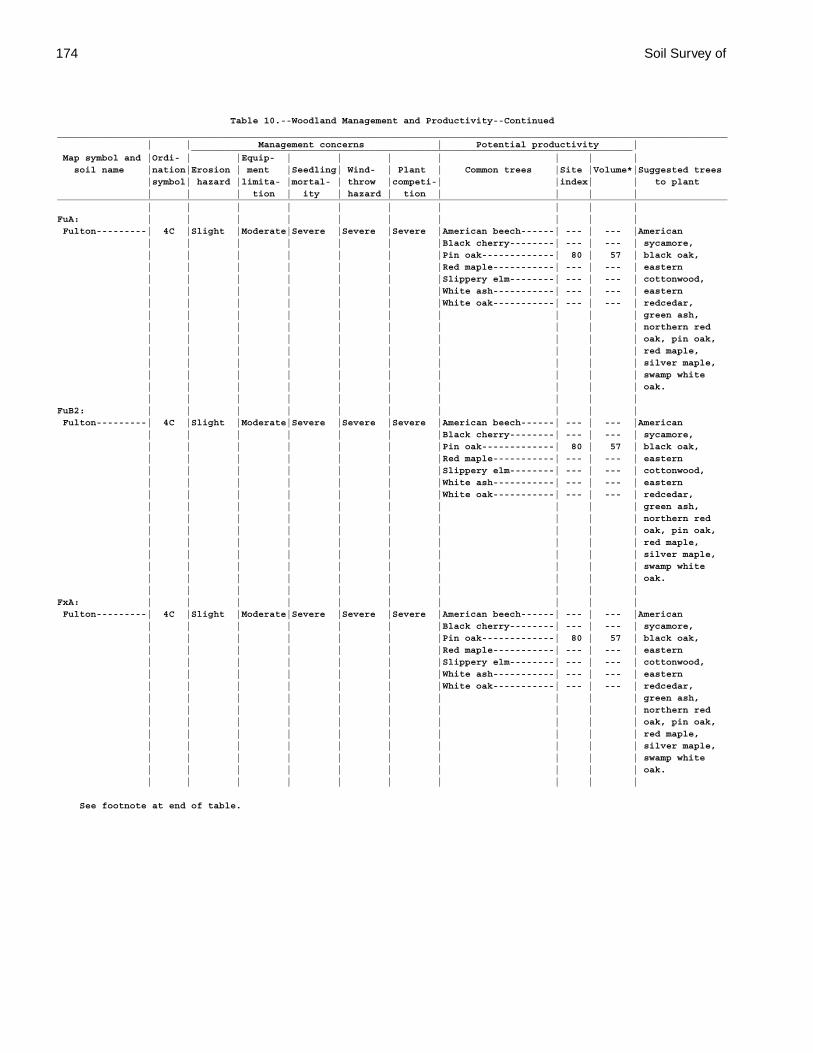
174 Soil Survey of
Table 10.--Woodland Management and Productivity--Continued_________________________________________________________________________________________________________________________ | | Management concerns | Potential productivity | _______________________________________________________________________________ Map symbol and |Ordi- | |Equip- | | | | | | | soil name |nation|Erosion | ment |Seedling| Wind- | Plant | Common trees |Site |Volume*|Suggested trees |symbol| hazard |limita- |mortal- | throw |competi-| |index| | to plant | | | tion | ity | hazard | tion | | | |_________________________________________________________________________________________________________________________ | | | | | | | | | |FuA: | | | | | | | | | | Fulton---------| 4C |Slight |Moderate|Severe |Severe |Severe |American beech------| --- | --- |American | | | | | | |Black cherry--------| --- | --- | sycamore, | | | | | | |Pin oak-------------| 80 | 57 | black oak, | | | | | | |Red maple-----------| --- | --- | eastern | | | | | | |Slippery elm--------| --- | --- | cottonwood, | | | | | | |White ash-----------| --- | --- | eastern | | | | | | |White oak-----------| --- | --- | redcedar, | | | | | | | | | | green ash, | | | | | | | | | | northern red | | | | | | | | | | oak, pin oak, | | | | | | | | | | red maple, | | | | | | | | | | silver maple, | | | | | | | | | | swamp white | | | | | | | | | | oak. | | | | | | | | | |FuB2: | | | | | | | | | | Fulton---------| 4C |Slight |Moderate|Severe |Severe |Severe |American beech------| --- | --- |American | | | | | | |Black cherry--------| --- | --- | sycamore, | | | | | | |Pin oak-------------| 80 | 57 | black oak, | | | | | | |Red maple-----------| --- | --- | eastern | | | | | | |Slippery elm--------| --- | --- | cottonwood, | | | | | | |White ash-----------| --- | --- | eastern | | | | | | |White oak-----------| --- | --- | redcedar, | | | | | | | | | | green ash, | | | | | | | | | | northern red | | | | | | | | | | oak, pin oak, | | | | | | | | | | red maple, | | | | | | | | | | silver maple, | | | | | | | | | | swamp white | | | | | | | | | | oak. | | | | | | | | | |FxA: | | | | | | | | | | Fulton---------| 4C |Slight |Moderate|Severe |Severe |Severe |American beech------| --- | --- |American | | | | | | |Black cherry--------| --- | --- | sycamore, | | | | | | |Pin oak-------------| 80 | 57 | black oak, | | | | | | |Red maple-----------| --- | --- | eastern | | | | | | |Slippery elm--------| --- | --- | cottonwood, | | | | | | |White ash-----------| --- | --- | eastern | | | | | | |White oak-----------| --- | --- | redcedar, | | | | | | | | | | green ash, | | | | | | | | | | northern red | | | | | | | | | | oak, pin oak, | | | | | | | | | | red maple, | | | | | | | | | | silver maple, | | | | | | | | | | swamp white | | | | | | | | | | oak. | | | | | | | | | |
See footnote at end of table.
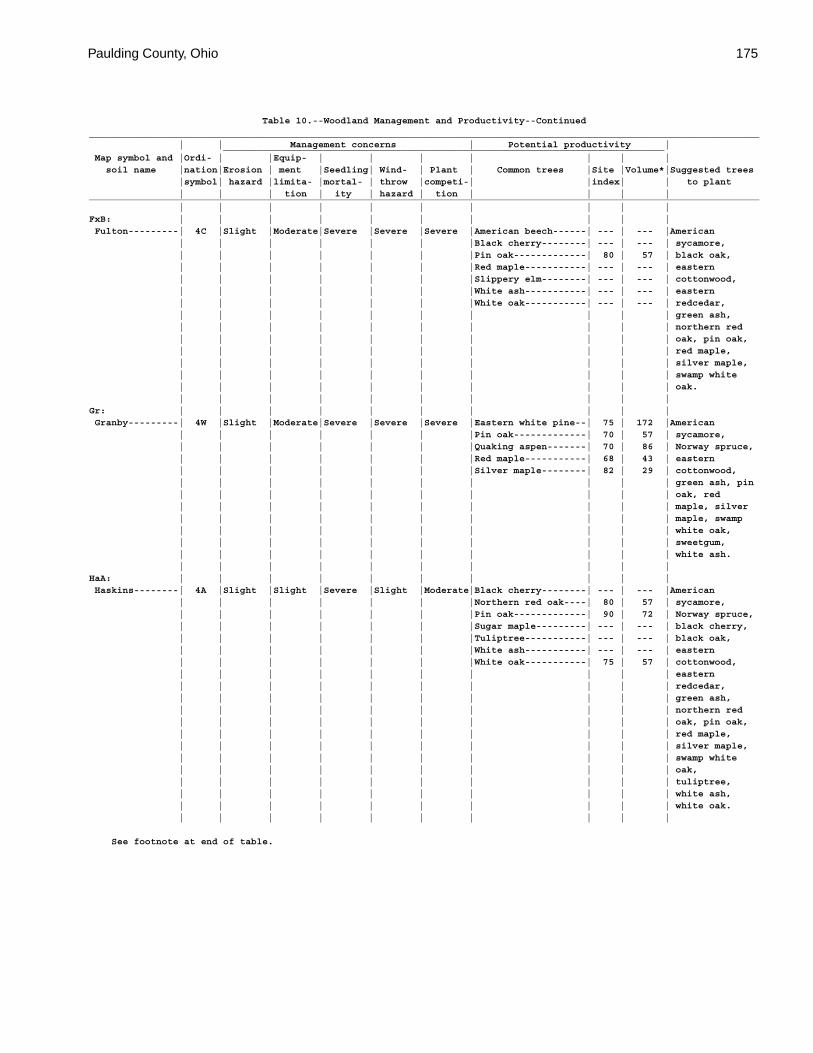
Paulding County, Ohio 175
Table 10.--Woodland Management and Productivity--Continued_________________________________________________________________________________________________________________________ | | Management concerns | Potential productivity | _______________________________________________________________________________ Map symbol and |Ordi- | |Equip- | | | | | | | soil name |nation|Erosion | ment |Seedling| Wind- | Plant | Common trees |Site |Volume*|Suggested trees |symbol| hazard |limita- |mortal- | throw |competi-| |index| | to plant | | | tion | ity | hazard | tion | | | |_________________________________________________________________________________________________________________________ | | | | | | | | | |FxB: | | | | | | | | | | Fulton---------| 4C |Slight |Moderate|Severe |Severe |Severe |American beech------| --- | --- |American | | | | | | |Black cherry--------| --- | --- | sycamore, | | | | | | |Pin oak-------------| 80 | 57 | black oak, | | | | | | |Red maple-----------| --- | --- | eastern | | | | | | |Slippery elm--------| --- | --- | cottonwood, | | | | | | |White ash-----------| --- | --- | eastern | | | | | | |White oak-----------| --- | --- | redcedar, | | | | | | | | | | green ash, | | | | | | | | | | northern red | | | | | | | | | | oak, pin oak, | | | | | | | | | | red maple, | | | | | | | | | | silver maple, | | | | | | | | | | swamp white | | | | | | | | | | oak. | | | | | | | | | |Gr: | | | | | | | | | | Granby---------| 4W |Slight |Moderate|Severe |Severe |Severe |Eastern white pine--| 75 | 172 |American | | | | | | |Pin oak-------------| 70 | 57 | sycamore, | | | | | | |Quaking aspen-------| 70 | 86 | Norway spruce, | | | | | | |Red maple-----------| 68 | 43 | eastern | | | | | | |Silver maple--------| 82 | 29 | cottonwood, | | | | | | | | | | green ash, pin | | | | | | | | | | oak, red | | | | | | | | | | maple, silver | | | | | | | | | | maple, swamp | | | | | | | | | | white oak, | | | | | | | | | | sweetgum, | | | | | | | | | | white ash. | | | | | | | | | |HaA: | | | | | | | | | | Haskins--------| 4A |Slight |Slight |Severe |Slight |Moderate|Black cherry--------| --- | --- |American | | | | | | |Northern red oak----| 80 | 57 | sycamore, | | | | | | |Pin oak-------------| 90 | 72 | Norway spruce, | | | | | | |Sugar maple---------| --- | --- | black cherry, | | | | | | |Tuliptree-----------| --- | --- | black oak, | | | | | | |White ash-----------| --- | --- | eastern | | | | | | |White oak-----------| 75 | 57 | cottonwood, | | | | | | | | | | eastern | | | | | | | | | | redcedar, | | | | | | | | | | green ash, | | | | | | | | | | northern red | | | | | | | | | | oak, pin oak, | | | | | | | | | | red maple, | | | | | | | | | | silver maple, | | | | | | | | | | swamp white | | | | | | | | | | oak, | | | | | | | | | | tuliptree, | | | | | | | | | | white ash, | | | | | | | | | | white oak. | | | | | | | | | |
See footnote at end of table.
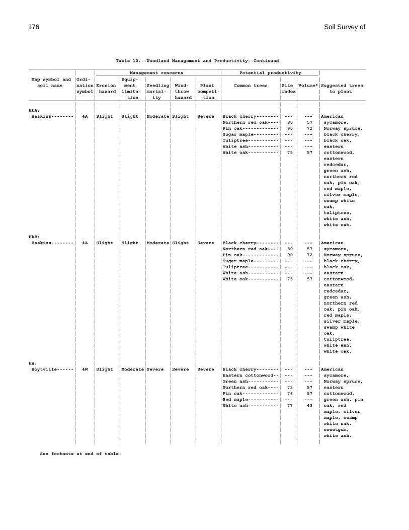
176 Soil Survey of
Table 10.--Woodland Management and Productivity--Continued_________________________________________________________________________________________________________________________ | | Management concerns | Potential productivity | _______________________________________________________________________________ Map symbol and |Ordi- | |Equip- | | | | | | | soil name |nation|Erosion | ment |Seedling| Wind- | Plant | Common trees |Site |Volume*|Suggested trees |symbol| hazard |limita- |mortal- | throw |competi-| |index| | to plant | | | tion | ity | hazard | tion | | | |_________________________________________________________________________________________________________________________ | | | | | | | | | |HkA: | | | | | | | | | | Haskins--------| 4A |Slight |Slight |Moderate|Slight |Severe |Black cherry--------| --- | --- |American | | | | | | |Northern red oak----| 80 | 57 | sycamore, | | | | | | |Pin oak-------------| 90 | 72 | Norway spruce, | | | | | | |Sugar maple---------| --- | --- | black cherry, | | | | | | |Tuliptree-----------| --- | --- | black oak, | | | | | | |White ash-----------| --- | --- | eastern | | | | | | |White oak-----------| 75 | 57 | cottonwood, | | | | | | | | | | eastern | | | | | | | | | | redcedar, | | | | | | | | | | green ash, | | | | | | | | | | northern red | | | | | | | | | | oak, pin oak, | | | | | | | | | | red maple, | | | | | | | | | | silver maple, | | | | | | | | | | swamp white | | | | | | | | | | oak, | | | | | | | | | | tuliptree, | | | | | | | | | | white ash, | | | | | | | | | | white oak. | | | | | | | | | |HkB: | | | | | | | | | | Haskins--------| 4A |Slight |Slight |Moderate|Slight |Severe |Black cherry--------| --- | --- |American | | | | | | |Northern red oak----| 80 | 57 | sycamore, | | | | | | |Pin oak-------------| 90 | 72 | Norway spruce, | | | | | | |Sugar maple---------| --- | --- | black cherry, | | | | | | |Tuliptree-----------| --- | --- | black oak, | | | | | | |White ash-----------| --- | --- | eastern | | | | | | |White oak-----------| 75 | 57 | cottonwood, | | | | | | | | | | eastern | | | | | | | | | | redcedar, | | | | | | | | | | green ash, | | | | | | | | | | northern red | | | | | | | | | | oak, pin oak, | | | | | | | | | | red maple, | | | | | | | | | | silver maple, | | | | | | | | | | swamp white | | | | | | | | | | oak, | | | | | | | | | | tuliptree, | | | | | | | | | | white ash, | | | | | | | | | | white oak. | | | | | | | | | |Hs: | | | | | | | | | | Hoytville------| 4W |Slight |Moderate|Severe |Severe |Severe |Black cherry--------| --- | --- |American | | | | | | |Eastern cottonwood--| --- | --- | sycamore, | | | | | | |Green ash-----------| --- | --- | Norway spruce, | | | | | | |Northern red oak----| 72 | 57 | eastern | | | | | | |Pin oak-------------| 76 | 57 | cottonwood, | | | | | | |Red maple-----------| --- | --- | green ash, pin | | | | | | |White ash-----------| 77 | 43 | oak, red | | | | | | | | | | maple, silver | | | | | | | | | | maple, swamp | | | | | | | | | | white oak, | | | | | | | | | | sweetgum, | | | | | | | | | | white ash. | | | | | | | | | |
See footnote at end of table.
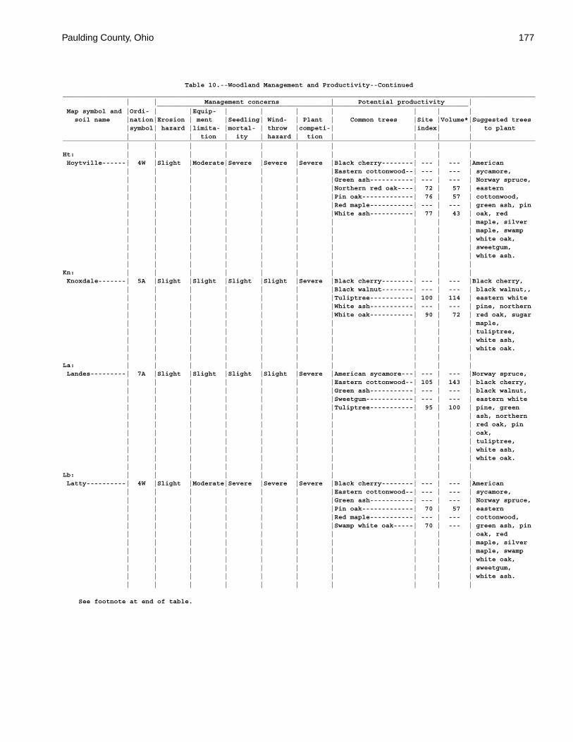
Paulding County, Ohio 177
Table 10.--Woodland Management and Productivity--Continued_________________________________________________________________________________________________________________________ | | Management concerns | Potential productivity | _______________________________________________________________________________ Map symbol and |Ordi- | |Equip- | | | | | | | soil name |nation|Erosion | ment |Seedling| Wind- | Plant | Common trees |Site |Volume*|Suggested trees |symbol| hazard |limita- |mortal- | throw |competi-| |index| | to plant | | | tion | ity | hazard | tion | | | |_________________________________________________________________________________________________________________________ | | | | | | | | | |Ht: | | | | | | | | | | Hoytville------| 4W |Slight |Moderate|Severe |Severe |Severe |Black cherry--------| --- | --- |American | | | | | | |Eastern cottonwood--| --- | --- | sycamore, | | | | | | |Green ash-----------| --- | --- | Norway spruce, | | | | | | |Northern red oak----| 72 | 57 | eastern | | | | | | |Pin oak-------------| 76 | 57 | cottonwood, | | | | | | |Red maple-----------| --- | --- | green ash, pin | | | | | | |White ash-----------| 77 | 43 | oak, red | | | | | | | | | | maple, silver | | | | | | | | | | maple, swamp | | | | | | | | | | white oak, | | | | | | | | | | sweetgum, | | | | | | | | | | white ash. | | | | | | | | | |Kn: | | | | | | | | | | Knoxdale-------| 5A |Slight |Slight |Slight |Slight |Severe |Black cherry--------| --- | --- |Black cherry, | | | | | | |Black walnut--------| --- | --- | black walnut,, | | | | | | |Tuliptree-----------| 100 | 114 | eastern white | | | | | | |White ash-----------| --- | --- | pine, northern | | | | | | |White oak-----------| 90 | 72 | red oak, sugar | | | | | | | | | | maple, | | | | | | | | | | tuliptree, | | | | | | | | | | white ash, | | | | | | | | | | white oak. | | | | | | | | | |La: | | | | | | | | | | Landes---------| 7A |Slight |Slight |Slight |Slight |Severe |American sycamore---| --- | --- |Norway spruce, | | | | | | |Eastern cottonwood--| 105 | 143 | black cherry, | | | | | | |Green ash-----------| --- | --- | black walnut, | | | | | | |Sweetgum------------| --- | --- | eastern white | | | | | | |Tuliptree-----------| 95 | 100 | pine, green | | | | | | | | | | ash, northern | | | | | | | | | | red oak, pin | | | | | | | | | | oak, | | | | | | | | | | tuliptree, | | | | | | | | | | white ash, | | | | | | | | | | white oak. | | | | | | | | | |Lb: | | | | | | | | | | Latty----------| 4W |Slight |Moderate|Severe |Severe |Severe |Black cherry--------| --- | --- |American | | | | | | |Eastern cottonwood--| --- | --- | sycamore, | | | | | | |Green ash-----------| --- | --- | Norway spruce, | | | | | | |Pin oak-------------| 70 | 57 | eastern | | | | | | |Red maple-----------| --- | --- | cottonwood, | | | | | | |Swamp white oak-----| 70 | --- | green ash, pin | | | | | | | | | | oak, red | | | | | | | | | | maple, silver | | | | | | | | | | maple, swamp | | | | | | | | | | white oak, | | | | | | | | | | sweetgum, | | | | | | | | | | white ash. | | | | | | | | | |
See footnote at end of table.
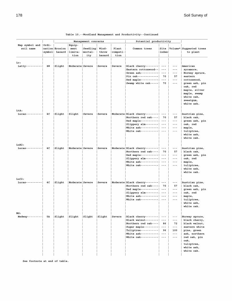
178 Soil Survey of
Table 10.--Woodland Management and Productivity--Continued_________________________________________________________________________________________________________________________ | | Management concerns | Potential productivity | _______________________________________________________________________________ Map symbol and |Ordi- | |Equip- | | | | | | | soil name |nation|Erosion | ment |Seedling| Wind- | Plant | Common trees |Site |Volume*|Suggested trees |symbol| hazard |limita- |mortal- | throw |competi-| |index| | to plant | | | tion | ity | hazard | tion | | | |_________________________________________________________________________________________________________________________ | | | | | | | | | |Lc: | | | | | | | | | | Latty----------| 4W |Slight |Moderate|Severe |Severe |Severe |Black cherry--------| --- | --- |American | | | | | | |Eastern cottonwood--| --- | --- | sycamore, | | | | | | |Green ash-----------| --- | --- | Norway spruce, | | | | | | |Pin oak-------------| 70 | 57 | eastern | | | | | | |Red maple-----------| --- | --- | cottonwood, | | | | | | |Swamp white oak-----| 70 | --- | green ash, pin | | | | | | | | | | oak, red | | | | | | | | | | maple, silver | | | | | | | | | | maple, swamp | | | | | | | | | | white oak, | | | | | | | | | | sweetgum, | | | | | | | | | | white ash. | | | | | | | | | |LtA: | | | | | | | | | | Lucas----------| 4C |Slight |Slight |Severe |Severe |Moderate|Black cherry--------| --- | --- |Austrian pine, | | | | | | |Northern red oak----| 70 | 57 | black oak, | | | | | | |Red maple-----------| --- | --- | green ash, pin | | | | | | |Slippery elm--------| --- | --- | oak, red | | | | | | |White ash-----------| --- | --- | maple, | | | | | | |White oak-----------| --- | --- | tuliptree, | | | | | | | | | | white ash, | | | | | | | | | | white oak. | | | | | | | | | |LuB2: | | | | | | | | | | Lucas----------| 4C |Slight |Moderate|Severe |Severe |Moderate|Black cherry--------| --- | --- |Austrian pine, | | | | | | |Northern red oak----| 70 | 57 | black oak, | | | | | | |Red maple-----------| --- | --- | green ash, pin | | | | | | |Slippery elm--------| --- | --- | oak, red | | | | | | |White ash-----------| --- | --- | maple, | | | | | | |White oak-----------| --- | --- | tuliptree, | | | | | | | | | | white ash, | | | | | | | | | | white oak. | | | | | | | | | |LuC2: | | | | | | | | | | Lucas----------| 4C |Slight |Moderate|Severe |Severe |Moderate|Black cherry--------| --- | --- |Austrian pine, | | | | | | |Northern red oak----| 70 | 57 | black oak, | | | | | | |Red maple-----------| --- | --- | green ash, pin | | | | | | |Slippery elm--------| --- | --- | oak, red | | | | | | |White ash-----------| --- | --- | maple, | | | | | | |White oak-----------| --- | --- | tuliptree, | | | | | | | | | | white ash, | | | | | | | | | | white oak. | | | | | | | | | |Md: | | | | | | | | | | Medway---------| 5A |Slight |Slight |Slight |Slight |Severe |Black cherry--------| --- | --- |Norway spruce, | | | | | | |Black walnut--------| --- | --- | black cherry, | | | | | | |Northern red oak----| 86 | 72 | black walnut, | | | | | | |Sugar maple---------| --- | --- | eastern white | | | | | | |Tuliptree-----------| 96 | 100 | pine, green | | | | | | |White ash-----------| --- | --- | ash, northern | | | | | | |White oak-----------| --- | --- | red oak, pin | | | | | | | | | | oak, | | | | | | | | | | tuliptree, | | | | | | | | | | white ash, | | | | | | | | | | white oak. | | | | | | | | | |
See footnote at end of table.
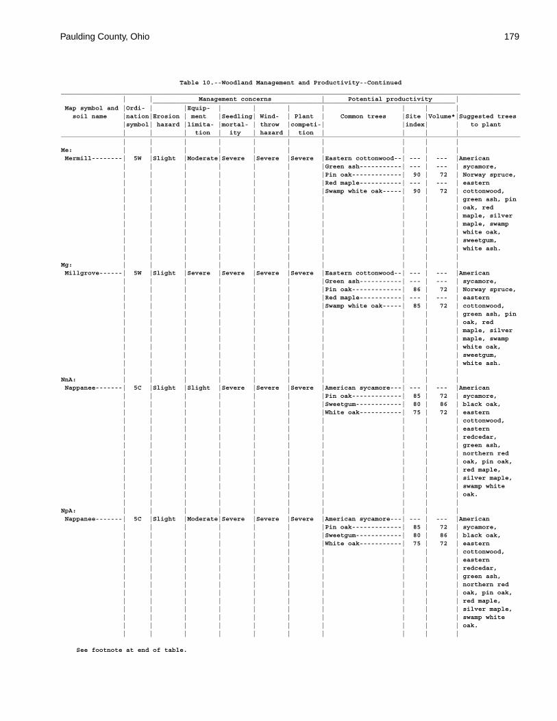
Paulding County, Ohio 179
Table 10.--Woodland Management and Productivity--Continued_________________________________________________________________________________________________________________________ | | Management concerns | Potential productivity | _______________________________________________________________________________ Map symbol and |Ordi- | |Equip- | | | | | | | soil name |nation|Erosion | ment |Seedling| Wind- | Plant | Common trees |Site |Volume*|Suggested trees |symbol| hazard |limita- |mortal- | throw |competi-| |index| | to plant | | | tion | ity | hazard | tion | | | |_________________________________________________________________________________________________________________________ | | | | | | | | | |Me: | | | | | | | | | | Mermill--------| 5W |Slight |Moderate|Severe |Severe |Severe |Eastern cottonwood--| --- | --- |American | | | | | | |Green ash-----------| --- | --- | sycamore, | | | | | | |Pin oak-------------| 90 | 72 | Norway spruce, | | | | | | |Red maple-----------| --- | --- | eastern | | | | | | |Swamp white oak-----| 90 | 72 | cottonwood, | | | | | | | | | | green ash, pin | | | | | | | | | | oak, red | | | | | | | | | | maple, silver | | | | | | | | | | maple, swamp | | | | | | | | | | white oak, | | | | | | | | | | sweetgum, | | | | | | | | | | white ash. | | | | | | | | | |Mg: | | | | | | | | | | Millgrove------| 5W |Slight |Severe |Severe |Severe |Severe |Eastern cottonwood--| --- | --- |American | | | | | | |Green ash-----------| --- | --- | sycamore, | | | | | | |Pin oak-------------| 86 | 72 | Norway spruce, | | | | | | |Red maple-----------| --- | --- | eastern | | | | | | |Swamp white oak-----| 85 | 72 | cottonwood, | | | | | | | | | | green ash, pin | | | | | | | | | | oak, red | | | | | | | | | | maple, silver | | | | | | | | | | maple, swamp | | | | | | | | | | white oak, | | | | | | | | | | sweetgum, | | | | | | | | | | white ash. | | | | | | | | | |NnA: | | | | | | | | | | Nappanee-------| 5C |Slight |Slight |Severe |Severe |Severe |American sycamore---| --- | --- |American | | | | | | |Pin oak-------------| 85 | 72 | sycamore, | | | | | | |Sweetgum------------| 80 | 86 | black oak, | | | | | | |White oak-----------| 75 | 72 | eastern | | | | | | | | | | cottonwood, | | | | | | | | | | eastern | | | | | | | | | | redcedar, | | | | | | | | | | green ash, | | | | | | | | | | northern red | | | | | | | | | | oak, pin oak, | | | | | | | | | | red maple, | | | | | | | | | | silver maple, | | | | | | | | | | swamp white | | | | | | | | | | oak. | | | | | | | | | |NpA: | | | | | | | | | | Nappanee-------| 5C |Slight |Moderate|Severe |Severe |Severe |American sycamore---| --- | --- |American | | | | | | |Pin oak-------------| 85 | 72 | sycamore, | | | | | | |Sweetgum------------| 80 | 86 | black oak, | | | | | | |White oak-----------| 75 | 72 | eastern | | | | | | | | | | cottonwood, | | | | | | | | | | eastern | | | | | | | | | | redcedar, | | | | | | | | | | green ash, | | | | | | | | | | northern red | | | | | | | | | | oak, pin oak, | | | | | | | | | | red maple, | | | | | | | | | | silver maple, | | | | | | | | | | swamp white | | | | | | | | | | oak. | | | | | | | | | |
See footnote at end of table.
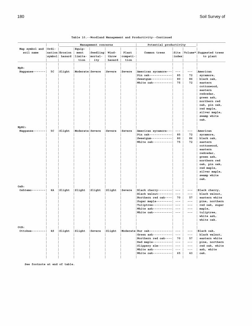
180 Soil Survey of
Table 10.--Woodland Management and Productivity--Continued_________________________________________________________________________________________________________________________ | | Management concerns | Potential productivity | _______________________________________________________________________________ Map symbol and |Ordi- | |Equip- | | | | | | | soil name |nation|Erosion | ment |Seedling| Wind- | Plant | Common trees |Site |Volume*|Suggested trees |symbol| hazard |limita- |mortal- | throw |competi-| |index| | to plant | | | tion | ity | hazard | tion | | | |_________________________________________________________________________________________________________________________ | | | | | | | | | |NpB: | | | | | | | | | | Nappanee-------| 5C |Slight |Moderate|Severe |Severe |Severe |American sycamore---| --- | --- |American | | | | | | |Pin oak-------------| 85 | 72 | sycamore, | | | | | | |Sweetgum------------| 80 | 86 | black oak, | | | | | | |White oak-----------| 75 | 72 | eastern | | | | | | | | | | cottonwood, | | | | | | | | | | eastern | | | | | | | | | | redcedar, | | | | | | | | | | green ash, | | | | | | | | | | northern red | | | | | | | | | | oak, pin oak, | | | | | | | | | | red maple, | | | | | | | | | | silver maple, | | | | | | | | | | swamp white | | | | | | | | | | oak. | | | | | | | | | |NpB2: | | | | | | | | | | Nappanee-------| 5C |Slight |Moderate|Severe |Severe |Severe |American sycamore---| --- | --- |American | | | | | | |Pin oak-------------| 85 | 72 | sycamore, | | | | | | |Sweetgum------------| 80 | 86 | black oak, | | | | | | |White oak-----------| 75 | 72 | eastern | | | | | | | | | | cottonwood, | | | | | | | | | | eastern | | | | | | | | | | redcedar, | | | | | | | | | | green ash, | | | | | | | | | | northern red | | | | | | | | | | oak, pin oak, | | | | | | | | | | red maple, | | | | | | | | | | silver maple, | | | | | | | | | | swamp white | | | | | | | | | | oak. | | | | | | | | | |OsB: | | | | | | | | | | Oshtemo--------| 4A |Slight |Slight |Slight |Slight |Severe |Black cherry--------| --- | --- |Black cherry, | | | | | | |Black walnut--------| --- | --- | black walnut, | | | | | | |Northern red oak----| 70 | 57 | eastern white | | | | | | |Sugar maple---------| --- | --- | pine, northern | | | | | | |Tuliptree-----------| --- | --- | red oak, sugar | | | | | | |White ash-----------| --- | --- | maple, | | | | | | |White oak-----------| --- | --- | tuliptree, | | | | | | | | | | white ash, | | | | | | | | | | white oak. | | | | | | | | | |OtB: | | | | | | | | | | Ottokee--------| 4S |Slight |Slight |Severe |Slight |Moderate|Bur oak-------------| --- | --- |Black oak, | | | | | | |Green ash-----------| --- | --- | black walnut, | | | | | | |Northern red oak----| 70 | 57 | eastern white | | | | | | |Red maple-----------| --- | --- | pine, northern | | | | | | |Slippery elm--------| --- | --- | red oak, white | | | | | | |White ash-----------| --- | --- | ash, white | | | | | | |White oak-----------| 65 | 43 | oak. | | | | | | | | | |
See footnote at end of table.

Paulding County, Ohio 181
Table 10.--Woodland Management and Productivity--Continued_________________________________________________________________________________________________________________________ | | Management concerns | Potential productivity | _______________________________________________________________________________ Map symbol and |Ordi- | |Equip- | | | | | | | soil name |nation|Erosion | ment |Seedling| Wind- | Plant | Common trees |Site |Volume*|Suggested trees |symbol| hazard |limita- |mortal- | throw |competi-| |index| | to plant | | | tion | ity | hazard | tion | | | |_________________________________________________________________________________________________________________________ | | | | | | | | | |Pc: | | | | | | | | | | Paulding-------| 4W |Slight |Moderate|Severe |Severe |Severe |Black cherry--------| --- | --- |American | | | | | | |Eastern cottonwood--| --- | --- | sycamore, | | | | | | |Green ash-----------| --- | --- | Norway spruce, | | | | | | |Pin oak-------------| 76 | 57 | eastern | | | | | | |Red maple-----------| --- | --- | cottonwood, | | | | | | |Swamp white oak-----| 65 | 43 | green ash, pin | | | | | | | | | | oak, red | | | | | | | | | | maple, silver | | | | | | | | | | maple, swamp | | | | | | | | | | white oak, | | | | | | | | | | sweetgum, | | | | | | | | | | white ash. | | | | | | | | | |RkA: | | | | | | | | | | Rimer----------| 4A |Slight |Slight |Severe |Slight |Moderate|Black oak-----------| --- | --- |American | | | | | | |Bur oak-------------| --- | --- | sycamore, | | | | | | |Green ash-----------| --- | --- | Norway spruce, | | | | | | |Northern red oak----| 80 | 57 | black cherry, | | | | | | |Quaking aspen-------| --- | --- | black oak, | | | | | | |Red maple-----------| --- | --- | eastern | | | | | | |Slippery elm--------| --- | --- | cottonwood, | | | | | | |White oak-----------| 75 | 57 | eastern | | | | | | | | | | redcedar, | | | | | | | | | | green ash, | | | | | | | | | | northern red | | | | | | | | | | oak, pin oak, | | | | | | | | | | red maple, | | | | | | | | | | silver maple, | | | | | | | | | | swamp white | | | | | | | | | | oak, | | | | | | | | | | tuliptree, | | | | | | | | | | white ash, | | | | | | | | | | white oak. | | | | | | | | | |RkB: | | | | | | | | | | Rimer----------| 4A |Slight |Slight |Severe |Slight |Moderate|Black oak-----------| --- | --- |American | | | | | | |Bur oak-------------| --- | --- | sycamore, | | | | | | |Green ash-----------| --- | --- | Norway spruce, | | | | | | |Northern red oak----| 80 | 57 | black cherry, | | | | | | |Quaking aspen-------| --- | --- | black oak, | | | | | | |Red maple-----------| --- | --- | eastern | | | | | | |Slippery elm--------| --- | --- | cottonwood, | | | | | | |White oak-----------| 75 | 57 | eastern | | | | | | | | | | redcedar, | | | | | | | | | | green ash, | | | | | | | | | | northern red | | | | | | | | | | oak, pin oak, | | | | | | | | | | red maple, | | | | | | | | | | silver maple, | | | | | | | | | | swamp white | | | | | | | | | | oak, | | | | | | | | | | tuliptree, | | | | | | | | | | white ash, | | | | | | | | | | white oak. | | | | | | | | | |
See footnote at end of table.
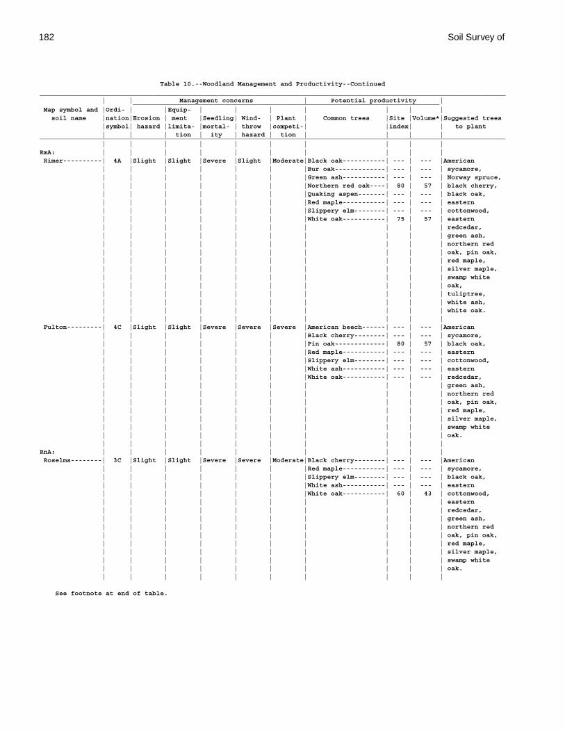
182 Soil Survey of
Table 10.--Woodland Management and Productivity--Continued_________________________________________________________________________________________________________________________ | | Management concerns | Potential productivity | _______________________________________________________________________________ Map symbol and |Ordi- | |Equip- | | | | | | | soil name |nation|Erosion | ment |Seedling| Wind- | Plant | Common trees |Site |Volume*|Suggested trees |symbol| hazard |limita- |mortal- | throw |competi-| |index| | to plant | | | tion | ity | hazard | tion | | | |_________________________________________________________________________________________________________________________ | | | | | | | | | |RmA: | | | | | | | | | | Rimer----------| 4A |Slight |Slight |Severe |Slight |Moderate|Black oak-----------| --- | --- |American | | | | | | |Bur oak-------------| --- | --- | sycamore, | | | | | | |Green ash-----------| --- | --- | Norway spruce, | | | | | | |Northern red oak----| 80 | 57 | black cherry, | | | | | | |Quaking aspen-------| --- | --- | black oak, | | | | | | |Red maple-----------| --- | --- | eastern | | | | | | |Slippery elm--------| --- | --- | cottonwood, | | | | | | |White oak-----------| 75 | 57 | eastern | | | | | | | | | | redcedar, | | | | | | | | | | green ash, | | | | | | | | | | northern red | | | | | | | | | | oak, pin oak, | | | | | | | | | | red maple, | | | | | | | | | | silver maple, | | | | | | | | | | swamp white | | | | | | | | | | oak, | | | | | | | | | | tuliptree, | | | | | | | | | | white ash, | | | | | | | | | | white oak. | | | | | | | | | | Fulton---------| 4C |Slight |Slight |Severe |Severe |Severe |American beech------| --- | --- |American | | | | | | |Black cherry--------| --- | --- | sycamore, | | | | | | |Pin oak-------------| 80 | 57 | black oak, | | | | | | |Red maple-----------| --- | --- | eastern | | | | | | |Slippery elm--------| --- | --- | cottonwood, | | | | | | |White ash-----------| --- | --- | eastern | | | | | | |White oak-----------| --- | --- | redcedar, | | | | | | | | | | green ash, | | | | | | | | | | northern red | | | | | | | | | | oak, pin oak, | | | | | | | | | | red maple, | | | | | | | | | | silver maple, | | | | | | | | | | swamp white | | | | | | | | | | oak. | | | | | | | | | |RnA: | | | | | | | | | | Roselms--------| 3C |Slight |Slight |Severe |Severe |Moderate|Black cherry--------| --- | --- |American | | | | | | |Red maple-----------| --- | --- | sycamore, | | | | | | |Slippery elm--------| --- | --- | black oak, | | | | | | |White ash-----------| --- | --- | eastern | | | | | | |White oak-----------| 60 | 43 | cottonwood, | | | | | | | | | | eastern | | | | | | | | | | redcedar, | | | | | | | | | | green ash, | | | | | | | | | | northern red | | | | | | | | | | oak, pin oak, | | | | | | | | | | red maple, | | | | | | | | | | silver maple, | | | | | | | | | | swamp white | | | | | | | | | | oak. | | | | | | | | | |
See footnote at end of table.

Paulding County, Ohio 183
Table 10.--Woodland Management and Productivity--Continued_________________________________________________________________________________________________________________________ | | Management concerns | Potential productivity | _______________________________________________________________________________ Map symbol and |Ordi- | |Equip- | | | | | | | soil name |nation|Erosion | ment |Seedling| Wind- | Plant | Common trees |Site |Volume*|Suggested trees |symbol| hazard |limita- |mortal- | throw |competi-| |index| | to plant | | | tion | ity | hazard | tion | | | |_________________________________________________________________________________________________________________________ | | | | | | | | | |RoA: | | | | | | | | | | Roselms--------| 3C |Slight |Moderate|Severe |Severe |Moderate|Black cherry--------| --- | --- |American | | | | | | |Red maple-----------| --- | --- | sycamore, | | | | | | |Slippery elm--------| --- | --- | black oak, | | | | | | |White ash-----------| --- | --- | eastern | | | | | | |White oak-----------| 60 | 43 | cottonwood, | | | | | | | | | | eastern | | | | | | | | | | redcedar, | | | | | | | | | | green ash, | | | | | | | | | | northern red | | | | | | | | | | oak, pin oak, | | | | | | | | | | red maple, | | | | | | | | | | silver maple, | | | | | | | | | | swamp white | | | | | | | | | | oak. | | | | | | | | | |RoB: | | | | | | | | | | Roselms--------| 3C |Slight |Moderate|Severe |Severe |Moderate|Black cherry--------| --- | --- |American | | | | | | |Red maple-----------| --- | --- | sycamore, | | | | | | |Slippery elm--------| --- | --- | black oak, | | | | | | |White ash-----------| --- | --- | eastern | | | | | | |White oak-----------| 60 | 43 | cottonwood, | | | | | | | | | | eastern | | | | | | | | | | redcedar, | | | | | | | | | | green ash, | | | | | | | | | | northern red | | | | | | | | | | oak, pin oak, | | | | | | | | | | red maple, | | | | | | | | | | silver maple, | | | | | | | | | | swamp white | | | | | | | | | | oak. | | | | | | | | | |RpA: | | | | | | | | | | Roselms--------| 3C |Slight |Moderate|Severe |Severe |Moderate|Black cherry--------| --- | --- |American | | | | | | |Red maple-----------| --- | --- | sycamore, | | | | | | |Slippery elm--------| --- | --- | black oak, | | | | | | |White ash-----------| --- | --- | eastern | | | | | | |White oak-----------| 60 | 43 | cottonwood, | | | | | | | | | | eastern | | | | | | | | | | redcedar, | | | | | | | | | | green ash, | | | | | | | | | | northern red | | | | | | | | | | oak, pin oak, | | | | | | | | | | red maple, | | | | | | | | | | silver maple, | | | | | | | | | | swamp white | | | | | | | | | | oak. | | | | | | | | | |
See footnote at end of table.
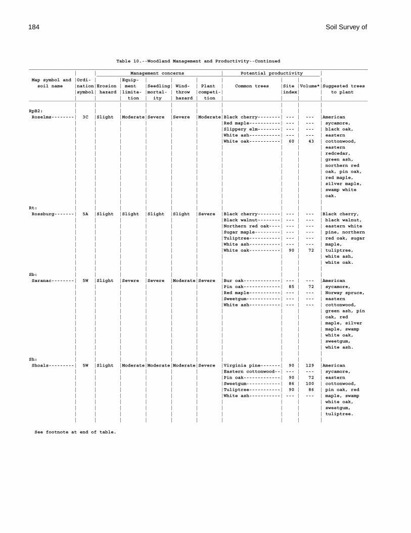
184 Soil Survey of
Table 10.--Woodland Management and Productivity--Continued_________________________________________________________________________________________________________________________ | | Management concerns | Potential productivity | _______________________________________________________________________________ Map symbol and |Ordi- | |Equip- | | | | | | | soil name |nation|Erosion | ment |Seedling| Wind- | Plant | Common trees |Site |Volume*|Suggested trees |symbol| hazard |limita- |mortal- | throw |competi-| |index| | to plant | | | tion | ity | hazard | tion | | | |_________________________________________________________________________________________________________________________ | | | | | | | | | |RpB2: | | | | | | | | | | Roselms--------| 3C |Slight |Moderate|Severe |Severe |Moderate|Black cherry--------| --- | --- |American | | | | | | |Red maple-----------| --- | --- | sycamore, | | | | | | |Slippery elm--------| --- | --- | black oak, | | | | | | |White ash-----------| --- | --- | eastern | | | | | | |White oak-----------| 60 | 43 | cottonwood, | | | | | | | | | | eastern | | | | | | | | | | redcedar, | | | | | | | | | | green ash, | | | | | | | | | | northern red | | | | | | | | | | oak, pin oak, | | | | | | | | | | red maple, | | | | | | | | | | silver maple, | | | | | | | | | | swamp white | | | | | | | | | | oak. | | | | | | | | | |Rt: | | | | | | | | | | Rossburg-------| 5A |Slight |Slight |Slight |Slight |Severe |Black cherry--------| --- | --- |Black cherry, | | | | | | |Black walnut--------| --- | --- | black walnut, | | | | | | |Northern red oak----| --- | --- | eastern white | | | | | | |Sugar maple---------| --- | --- | pine, northern | | | | | | |Tuliptree-----------| --- | --- | red oak, sugar | | | | | | |White ash-----------| --- | --- | maple, | | | | | | |White oak-----------| 90 | 72 | tuliptree, | | | | | | | | | | white ash, | | | | | | | | | | white oak. | | | | | | | | | |Sb: | | | | | | | | | | Saranac--------| 5W |Slight |Severe |Severe |Moderate|Severe |Bur oak-------------| --- | --- |American | | | | | | |Pin oak-------------| 85 | 72 | sycamore, | | | | | | |Red maple-----------| --- | --- | Norway spruce, | | | | | | |Sweetgum------------| --- | --- | eastern | | | | | | |White ash-----------| --- | --- | cottonwood, | | | | | | | | | | green ash, pin | | | | | | | | | | oak, red | | | | | | | | | | maple, silver | | | | | | | | | | maple, swamp | | | | | | | | | | white oak, | | | | | | | | | | sweetgum, | | | | | | | | | | white ash. | | | | | | | | | |Sh: | | | | | | | | | | Shoals---------| 5W |Slight |Moderate|Moderate|Moderate|Severe |Virginia pine-------| 90 | 129 |American | | | | | | |Eastern cottonwood--| --- | --- | sycamore, | | | | | | |Pin oak-------------| 90 | 72 | eastern | | | | | | |Sweetgum------------| 86 | 100 | cottonwood, | | | | | | |Tuliptree-----------| 90 | 86 | pin oak, red | | | | | | |White ash-----------| --- | --- | maple, swamp | | | | | | | | | | white oak, | | | | | | | | | | sweetgum, | | | | | | | | | | tuliptree. | | | | | | | | | |
See footnote at end of table.
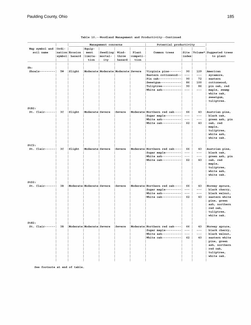
Paulding County, Ohio 185
Table 10.--Woodland Management and Productivity--Continued_________________________________________________________________________________________________________________________ | | Management concerns | Potential productivity | _______________________________________________________________________________ Map symbol and |Ordi- | |Equip- | | | | | | | soil name |nation|Erosion | ment |Seedling| Wind- | Plant | Common trees |Site |Volume*|Suggested trees |symbol| hazard |limita- |mortal- | throw |competi-| |index| | to plant | | | tion | ity | hazard | tion | | | |_________________________________________________________________________________________________________________________ | | | | | | | | | |Sk: | | | | | | | | | | Shoals---------| 5W |Slight |Moderate|Moderate|Moderate|Severe |Virginia pine-------| 90 | 129 |American | | | | | | |Eastern cottonwood--| --- | --- | sycamore, | | | | | | |Pin oak-------------| 90 | 72 | eastern | | | | | | |Sweetgum------------| 86 | 100 | cottonwood, | | | | | | |Tuliptree-----------| 90 | 86 | pin oak, red | | | | | | |White ash-----------| --- | --- | maple, swamp | | | | | | | | | | white oak, | | | | | | | | | | sweetgum, | | | | | | | | | | tuliptree. | | | | | | | | | |StB2: | | | | | | | | | | St. Clair------| 3C |Slight |Moderate|Severe |Severe |Moderate|Northern red oak----| 66 | 43 |Austrian pine, | | | | | | |Sugar maple---------| --- | --- | black oak, | | | | | | |White ash-----------| --- | --- | green ash, pin | | | | | | |White oak-----------| 62 | 43 | oak, red | | | | | | | | | | maple, | | | | | | | | | | tuliptree, | | | | | | | | | | white ash, | | | | | | | | | | white oak. | | | | | | | | | |StC2: | | | | | | | | | | St. Clair------| 3C |Slight |Moderate|Severe |Severe |Moderate|Northern red oak----| 66 | 43 |Austrian pine, | | | | | | |Sugar maple---------| --- | --- | black oak, | | | | | | |White ash-----------| --- | --- | green ash, pin | | | | | | |White oak-----------| 62 | 43 | oak, red | | | | | | | | | | maple, | | | | | | | | | | tuliptree, | | | | | | | | | | white ash, | | | | | | | | | | white oak. | | | | | | | | | |StD2: | | | | | | | | | | St. Clair------| 3R |Moderate|Moderate|Severe |Severe |Moderate|Northern red oak----| 66 | 43 |Norway spruce, | | | | | | |Sugar maple---------| --- | --- | black cherry, | | | | | | |White ash-----------| --- | --- | black walnut, | | | | | | |White oak-----------| 62 | 43 | eastern white | | | | | | | | | | pine, green | | | | | | | | | | ash, northern | | | | | | | | | | red oak, | | | | | | | | | | tuliptree, | | | | | | | | | | white oak. | | | | | | | | | |StE2: | | | | | | | | | | St. Clair------| 3R |Moderate|Moderate|Severe |Severe |Moderate|Northern red oak----| 66 | 43 |Norway spruce, | | | | | | |Sugar maple---------| --- | --- | black cherry, | | | | | | |White ash-----------| --- | --- | black walnut, | | | | | | |White oak-----------| 62 | 43 | eastern white | | | | | | | | | | pine, green | | | | | | | | | | ash, northern | | | | | | | | | | red oak, | | | | | | | | | | tuliptree, | | | | | | | | | | white oak. | | | | | | | | | |
See footnote at end of table.
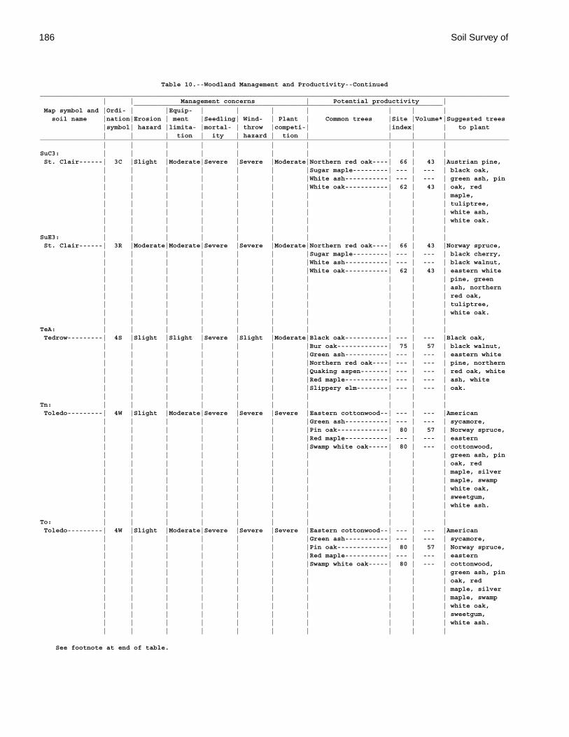
186 Soil Survey of
Table 10.--Woodland Management and Productivity--Continued_________________________________________________________________________________________________________________________ | | Management concerns | Potential productivity | _______________________________________________________________________________ Map symbol and |Ordi- | |Equip- | | | | | | | soil name |nation|Erosion | ment |Seedling| Wind- | Plant | Common trees |Site |Volume*|Suggested trees |symbol| hazard |limita- |mortal- | throw |competi-| |index| | to plant | | | tion | ity | hazard | tion | | | |_________________________________________________________________________________________________________________________ | | | | | | | | | |SuC3: | | | | | | | | | | St. Clair------| 3C |Slight |Moderate|Severe |Severe |Moderate|Northern red oak----| 66 | 43 |Austrian pine, | | | | | | |Sugar maple---------| --- | --- | black oak, | | | | | | |White ash-----------| --- | --- | green ash, pin | | | | | | |White oak-----------| 62 | 43 | oak, red | | | | | | | | | | maple, | | | | | | | | | | tuliptree, | | | | | | | | | | white ash, | | | | | | | | | | white oak. | | | | | | | | | |SuE3: | | | | | | | | | | St. Clair------| 3R |Moderate|Moderate|Severe |Severe |Moderate|Northern red oak----| 66 | 43 |Norway spruce, | | | | | | |Sugar maple---------| --- | --- | black cherry, | | | | | | |White ash-----------| --- | --- | black walnut, | | | | | | |White oak-----------| 62 | 43 | eastern white | | | | | | | | | | pine, green | | | | | | | | | | ash, northern | | | | | | | | | | red oak, | | | | | | | | | | tuliptree, | | | | | | | | | | white oak. | | | | | | | | | |TeA: | | | | | | | | | | Tedrow---------| 4S |Slight |Slight |Severe |Slight |Moderate|Black oak-----------| --- | --- |Black oak, | | | | | | |Bur oak-------------| 75 | 57 | black walnut, | | | | | | |Green ash-----------| --- | --- | eastern white | | | | | | |Northern red oak----| --- | --- | pine, northern | | | | | | |Quaking aspen-------| --- | --- | red oak, white | | | | | | |Red maple-----------| --- | --- | ash, white | | | | | | |Slippery elm--------| --- | --- | oak. | | | | | | | | | |Tn: | | | | | | | | | | Toledo---------| 4W |Slight |Moderate|Severe |Severe |Severe |Eastern cottonwood--| --- | --- |American | | | | | | |Green ash-----------| --- | --- | sycamore, | | | | | | |Pin oak-------------| 80 | 57 | Norway spruce, | | | | | | |Red maple-----------| --- | --- | eastern | | | | | | |Swamp white oak-----| 80 | --- | cottonwood, | | | | | | | | | | green ash, pin | | | | | | | | | | oak, red | | | | | | | | | | maple, silver | | | | | | | | | | maple, swamp | | | | | | | | | | white oak, | | | | | | | | | | sweetgum, | | | | | | | | | | white ash. | | | | | | | | | |To: | | | | | | | | | | Toledo---------| 4W |Slight |Moderate|Severe |Severe |Severe |Eastern cottonwood--| --- | --- |American | | | | | | |Green ash-----------| --- | --- | sycamore, | | | | | | |Pin oak-------------| 80 | 57 | Norway spruce, | | | | | | |Red maple-----------| --- | --- | eastern | | | | | | |Swamp white oak-----| 80 | --- | cottonwood, | | | | | | | | | | green ash, pin | | | | | | | | | | oak, red | | | | | | | | | | maple, silver | | | | | | | | | | maple, swamp | | | | | | | | | | white oak, | | | | | | | | | | sweetgum, | | | | | | | | | | white ash. | | | | | | | | | |
See footnote at end of table.
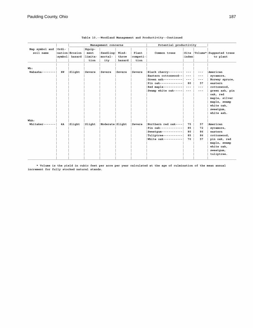
Paulding County, Ohio 187
Table 10.--Woodland Management and Productivity--Continued_________________________________________________________________________________________________________________________ | | Management concerns | Potential productivity | _______________________________________________________________________________ Map symbol and |Ordi- | |Equip- | | | | | | | soil name |nation|Erosion | ment |Seedling| Wind- | Plant | Common trees |Site |Volume*|Suggested trees |symbol| hazard |limita- |mortal- | throw |competi-| |index| | to plant | | | tion | ity | hazard | tion | | | |_________________________________________________________________________________________________________________________ | | | | | | | | | |Wb: | | | | | | | | | | Wabasha--------| 4W |Slight |Severe |Severe |Severe |Severe |Black cherry--------| --- | --- |American | | | | | | |Eastern cottonwood--| --- | --- | sycamore, | | | | | | |Green ash-----------| --- | --- | Norway spruce, | | | | | | |Pin oak-------------| 80 | 57 | eastern | | | | | | |Red maple-----------| --- | --- | cottonwood, | | | | | | |Swamp white oak-----| --- | --- | green ash, pin | | | | | | | | | | oak, red | | | | | | | | | | maple, silver | | | | | | | | | | maple, swamp | | | | | | | | | | white oak, | | | | | | | | | | sweetgum, | | | | | | | | | | white ash. | | | | | | | | | |WhA: | | | | | | | | | | Whitaker-------| 4A |Slight |Slight |Moderate|Slight |Severe |Northern red oak----| 75 | 57 |American | | | | | | |Pin oak-------------| 85 | 72 | sycamore, | | | | | | |Sweetgum------------| 80 | 86 | eastern | | | | | | |Tuliptree-----------| 85 | 86 | cottonwood, | | | | | | |White oak-----------| 70 | 57 | pin oak, red | | | | | | | | | | maple, swamp | | | | | | | | | | white oak, | | | | | | | | | | sweetgum, | | | | | | | | | | tuliptree. | | | | | | | | | |_________________________________________________________________________________________________________________________
* Volume is the yield in cubic feet per acre per year calculated at the age of culmination of the mean annualincrement for fully stocked natural stands.
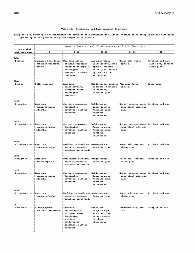
188 Soil Survey of
Table 11.--Windbreaks and Environmental Plantings
(Only the soils suitable for windbreaks and environmental plantings are listed. Absence of an entry indicates that trees generally do not grow to the given height on that soil)
________________________________________________________________________________________________________________________ | Trees having predicted 20-year average height, in feet, of-- Map symbol |________________________________________________________________________________________________________ and soil name | <8 | 8-15 | 16-25 | 26-35 | >35________________________________________________________________________________________________________________________ | | | | |BeB: | | | | | Belmore-------|Japanese tree lilac,|European alder, |Austrian pine, |White oak, white |Northern red oak, | Siberian peashrub, | radiant crabapple, | Osage-orange, blue | spruce. | white ash, eastern | redbud. | Siberian crabapple,| spruce, eastern | | white pine. | | Washington | white pine, Norway | | | | hawthorn, eastern | spruce, northern | | | | redcedar. | whitecedar. | | | | | | |BkA: | | | | | Bixler--------|Silky dogwood-------|American |Baldcypress, eastern|Pin oak, Norway |Green ash. | | cranberrybush, | redcedar, northern | spruce. | | | European alder, | whitecedar, | | | | Washington | Austrian pine. | | | | hawthorn. | | | | | | | |BrB2: | | | | | Broughton-----|American |Southern arrowwood, |Baldcypress, |Norway spruce, green|Northern red oak. | cranberrybush, | Washington | Osage-orange, | ash, black oak, pin| | blackhaw. | hawthorn, eastern | Austrian pine, | oak. | | | redcedar. | northern | | | | | whitecedar. | | | | | | |BrC2: | | | | | Broughton-----|American |Southern arrowwood, |Baldcypress, |Norway spruce, green|Northern red oak. | cranberrybush, | Washington | Osage-orange, | ash, black oak, pin| | blackhaw. | hawthorn, eastern | Austrian pine, | oak. | | | redcedar. | northern | | | | | whitecedar. | | | | | | |BrD2: | | | | | Broughton-----|American |Washington hawthorn,|Osage-orange, |Green ash, eastern |Northern red oak. | cranberrybush. | eastern redcedar, | Austrian pine. | white pine. | | | southern arrowwood.| | | | | | | |BrE2: | | | | | Broughton-----|American |Washington hawthorn,|Osage-orange, |Green ash, eastern |Northern red oak. | cranberrybush. | eastern redcedar, | Austrian pine. | white pine. | | | southern arrowwood.| | | | | | | |BsC3: | | | | | Broughton-----|American |Southern arrowwood, |Baldcypress, |Norway spruce, green|Northern red oak. | cranberrybush, | Washington | Osage-orange, | ash, black oak, pin| | blackhaw. | hawthorn, eastern | Austrian pine, | oak. | | | redcedar. | northern | | | | | whitecedar. | | | | | | |BsD3: | | | | | Broughton-----|American |Washington hawthorn,|Osage-orange, |Green ash, eastern |Northern red oak. | cranberrybush. | eastern redcedar, | Austrian pine. | white pine. | | | southern arrowwood.| | | | | | | |Db: | | | | | Defiance------|Silky dogwood, |American |Green ash, |Shumard's oak, pin |Swamp white oak. | southern arrowwood.| cranberrybush, | Osage-orange, | oak. | | | European alder, | Austrian pine, | | | | Washington | Norway spruce, | | | | hawthorn, | northern | | | | baldcypress, | whitecedar. | | | | blackhaw, eastern | | | | | redcedar. | | | | | | | |
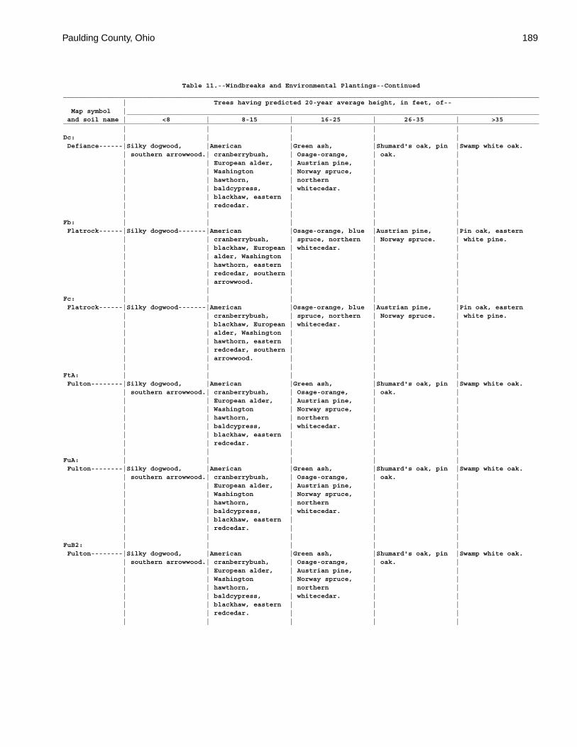
Paulding County, Ohio 189
Table 11.--Windbreaks and Environmental Plantings--Continued________________________________________________________________________________________________________________________ | Trees having predicted 20-year average height, in feet, of-- Map symbol |________________________________________________________________________________________________________ and soil name | <8 | 8-15 | 16-25 | 26-35 | >35________________________________________________________________________________________________________________________ | | | | |Dc: | | | | | Defiance------|Silky dogwood, |American |Green ash, |Shumard's oak, pin |Swamp white oak. | southern arrowwood.| cranberrybush, | Osage-orange, | oak. | | | European alder, | Austrian pine, | | | | Washington | Norway spruce, | | | | hawthorn, | northern | | | | baldcypress, | whitecedar. | | | | blackhaw, eastern | | | | | redcedar. | | | | | | | |Fb: | | | | | Flatrock------|Silky dogwood-------|American |Osage-orange, blue |Austrian pine, |Pin oak, eastern | | cranberrybush, | spruce, northern | Norway spruce. | white pine. | | blackhaw, European | whitecedar. | | | | alder, Washington | | | | | hawthorn, eastern | | | | | redcedar, southern | | | | | arrowwood. | | | | | | | |Fc: | | | | | Flatrock------|Silky dogwood-------|American |Osage-orange, blue |Austrian pine, |Pin oak, eastern | | cranberrybush, | spruce, northern | Norway spruce. | white pine. | | blackhaw, European | whitecedar. | | | | alder, Washington | | | | | hawthorn, eastern | | | | | redcedar, southern | | | | | arrowwood. | | | | | | | |FtA: | | | | | Fulton--------|Silky dogwood, |American |Green ash, |Shumard's oak, pin |Swamp white oak. | southern arrowwood.| cranberrybush, | Osage-orange, | oak. | | | European alder, | Austrian pine, | | | | Washington | Norway spruce, | | | | hawthorn, | northern | | | | baldcypress, | whitecedar. | | | | blackhaw, eastern | | | | | redcedar. | | | | | | | |FuA: | | | | | Fulton--------|Silky dogwood, |American |Green ash, |Shumard's oak, pin |Swamp white oak. | southern arrowwood.| cranberrybush, | Osage-orange, | oak. | | | European alder, | Austrian pine, | | | | Washington | Norway spruce, | | | | hawthorn, | northern | | | | baldcypress, | whitecedar. | | | | blackhaw, eastern | | | | | redcedar. | | | | | | | |FuB2: | | | | | Fulton--------|Silky dogwood, |American |Green ash, |Shumard's oak, pin |Swamp white oak. | southern arrowwood.| cranberrybush, | Osage-orange, | oak. | | | European alder, | Austrian pine, | | | | Washington | Norway spruce, | | | | hawthorn, | northern | | | | baldcypress, | whitecedar. | | | | blackhaw, eastern | | | | | redcedar. | | | | | | | |
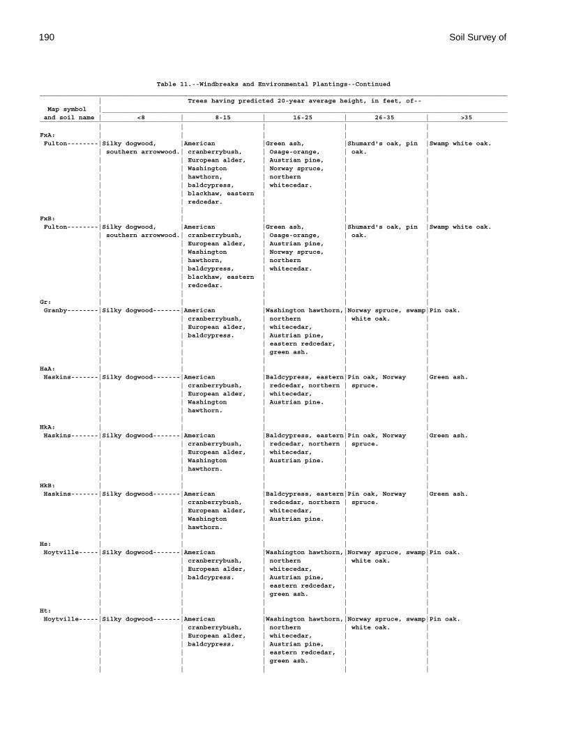
190 Soil Survey of
Table 11.--Windbreaks and Environmental Plantings--Continued________________________________________________________________________________________________________________________ | Trees having predicted 20-year average height, in feet, of-- Map symbol |________________________________________________________________________________________________________ and soil name | <8 | 8-15 | 16-25 | 26-35 | >35________________________________________________________________________________________________________________________ | | | | |FxA: | | | | | Fulton--------|Silky dogwood, |American |Green ash, |Shumard's oak, pin |Swamp white oak. | southern arrowwood.| cranberrybush, | Osage-orange, | oak. | | | European alder, | Austrian pine, | | | | Washington | Norway spruce, | | | | hawthorn, | northern | | | | baldcypress, | whitecedar. | | | | blackhaw, eastern | | | | | redcedar. | | | | | | | |FxB: | | | | | Fulton--------|Silky dogwood, |American |Green ash, |Shumard's oak, pin |Swamp white oak. | southern arrowwood.| cranberrybush, | Osage-orange, | oak. | | | European alder, | Austrian pine, | | | | Washington | Norway spruce, | | | | hawthorn, | northern | | | | baldcypress, | whitecedar. | | | | blackhaw, eastern | | | | | redcedar. | | | | | | | |Gr: | | | | | Granby--------|Silky dogwood-------|American |Washington hawthorn,|Norway spruce, swamp|Pin oak. | | cranberrybush, | northern | white oak. | | | European alder, | whitecedar, | | | | baldcypress. | Austrian pine, | | | | | eastern redcedar, | | | | | green ash. | | | | | | |HaA: | | | | | Haskins-------|Silky dogwood-------|American |Baldcypress, eastern|Pin oak, Norway |Green ash. | | cranberrybush, | redcedar, northern | spruce. | | | European alder, | whitecedar, | | | | Washington | Austrian pine. | | | | hawthorn. | | | | | | | |HkA: | | | | | Haskins-------|Silky dogwood-------|American |Baldcypress, eastern|Pin oak, Norway |Green ash. | | cranberrybush, | redcedar, northern | spruce. | | | European alder, | whitecedar, | | | | Washington | Austrian pine. | | | | hawthorn. | | | | | | | |HkB: | | | | | Haskins-------|Silky dogwood-------|American |Baldcypress, eastern|Pin oak, Norway |Green ash. | | cranberrybush, | redcedar, northern | spruce. | | | European alder, | whitecedar, | | | | Washington | Austrian pine. | | | | hawthorn. | | | | | | | |Hs: | | | | | Hoytville-----|Silky dogwood-------|American |Washington hawthorn,|Norway spruce, swamp|Pin oak. | | cranberrybush, | northern | white oak. | | | European alder, | whitecedar, | | | | baldcypress. | Austrian pine, | | | | | eastern redcedar, | | | | | green ash. | | | | | | |Ht: | | | | | Hoytville-----|Silky dogwood-------|American |Washington hawthorn,|Norway spruce, swamp|Pin oak. | | cranberrybush, | northern | white oak. | | | European alder, | whitecedar, | | | | baldcypress. | Austrian pine, | | | | | eastern redcedar, | | | | | green ash. | | | | | | |
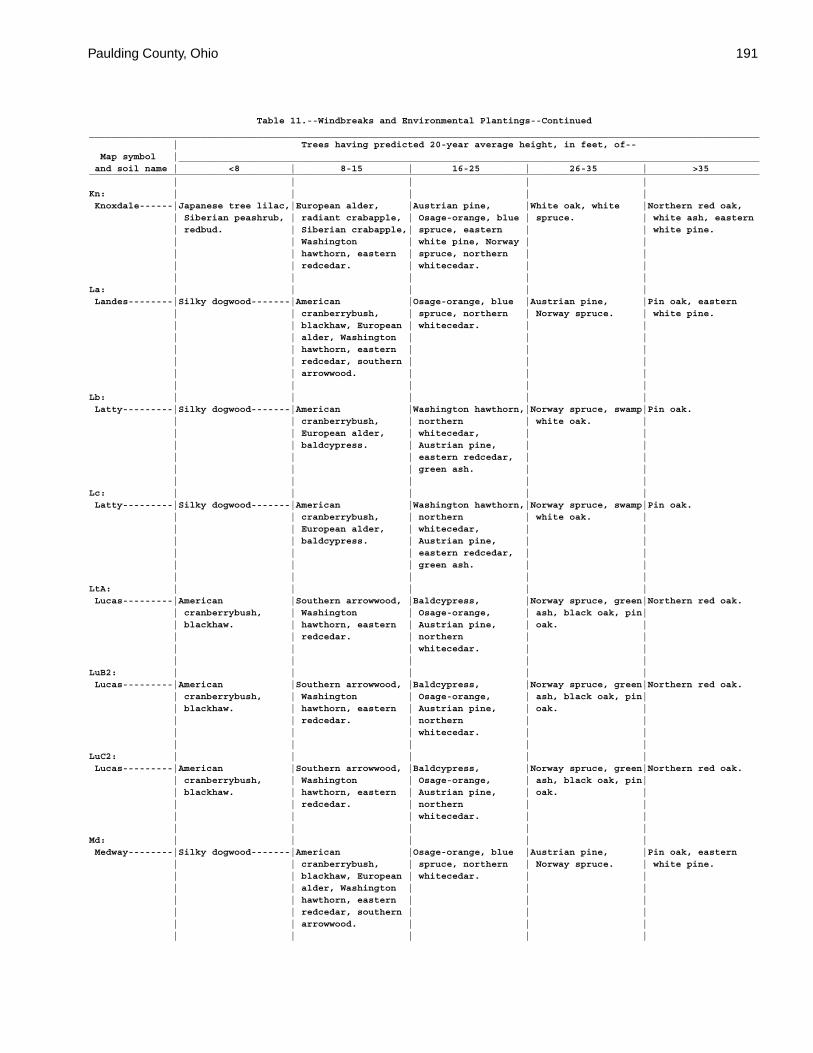
Paulding County, Ohio 191
Table 11.--Windbreaks and Environmental Plantings--Continued________________________________________________________________________________________________________________________ | Trees having predicted 20-year average height, in feet, of-- Map symbol |________________________________________________________________________________________________________ and soil name | <8 | 8-15 | 16-25 | 26-35 | >35________________________________________________________________________________________________________________________ | | | | |Kn: | | | | | Knoxdale------|Japanese tree lilac,|European alder, |Austrian pine, |White oak, white |Northern red oak, | Siberian peashrub, | radiant crabapple, | Osage-orange, blue | spruce. | white ash, eastern | redbud. | Siberian crabapple,| spruce, eastern | | white pine. | | Washington | white pine, Norway | | | | hawthorn, eastern | spruce, northern | | | | redcedar. | whitecedar. | | | | | | |La: | | | | | Landes--------|Silky dogwood-------|American |Osage-orange, blue |Austrian pine, |Pin oak, eastern | | cranberrybush, | spruce, northern | Norway spruce. | white pine. | | blackhaw, European | whitecedar. | | | | alder, Washington | | | | | hawthorn, eastern | | | | | redcedar, southern | | | | | arrowwood. | | | | | | | |Lb: | | | | | Latty---------|Silky dogwood-------|American |Washington hawthorn,|Norway spruce, swamp|Pin oak. | | cranberrybush, | northern | white oak. | | | European alder, | whitecedar, | | | | baldcypress. | Austrian pine, | | | | | eastern redcedar, | | | | | green ash. | | | | | | |Lc: | | | | | Latty---------|Silky dogwood-------|American |Washington hawthorn,|Norway spruce, swamp|Pin oak. | | cranberrybush, | northern | white oak. | | | European alder, | whitecedar, | | | | baldcypress. | Austrian pine, | | | | | eastern redcedar, | | | | | green ash. | | | | | | |LtA: | | | | | Lucas---------|American |Southern arrowwood, |Baldcypress, |Norway spruce, green|Northern red oak. | cranberrybush, | Washington | Osage-orange, | ash, black oak, pin| | blackhaw. | hawthorn, eastern | Austrian pine, | oak. | | | redcedar. | northern | | | | | whitecedar. | | | | | | |LuB2: | | | | | Lucas---------|American |Southern arrowwood, |Baldcypress, |Norway spruce, green|Northern red oak. | cranberrybush, | Washington | Osage-orange, | ash, black oak, pin| | blackhaw. | hawthorn, eastern | Austrian pine, | oak. | | | redcedar. | northern | | | | | whitecedar. | | | | | | |LuC2: | | | | | Lucas---------|American |Southern arrowwood, |Baldcypress, |Norway spruce, green|Northern red oak. | cranberrybush, | Washington | Osage-orange, | ash, black oak, pin| | blackhaw. | hawthorn, eastern | Austrian pine, | oak. | | | redcedar. | northern | | | | | whitecedar. | | | | | | |Md: | | | | | Medway--------|Silky dogwood-------|American |Osage-orange, blue |Austrian pine, |Pin oak, eastern | | cranberrybush, | spruce, northern | Norway spruce. | white pine. | | blackhaw, European | whitecedar. | | | | alder, Washington | | | | | hawthorn, eastern | | | | | redcedar, southern | | | | | arrowwood. | | | | | | | |
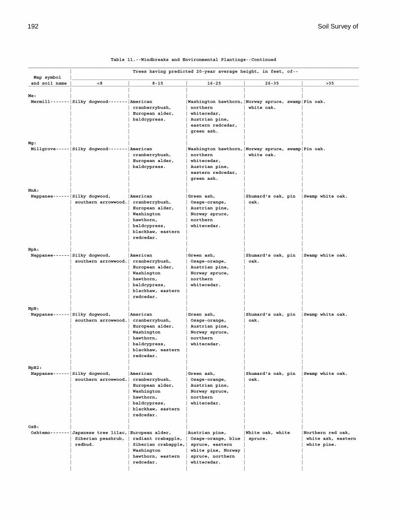
192 Soil Survey of
Table 11.--Windbreaks and Environmental Plantings--Continued________________________________________________________________________________________________________________________ | Trees having predicted 20-year average height, in feet, of-- Map symbol |________________________________________________________________________________________________________ and soil name | <8 | 8-15 | 16-25 | 26-35 | >35________________________________________________________________________________________________________________________ | | | | |Me: | | | | | Mermill-------|Silky dogwood-------|American |Washington hawthorn,|Norway spruce, swamp|Pin oak. | | cranberrybush, | northern | white oak. | | | European alder, | whitecedar, | | | | baldcypress. | Austrian pine, | | | | | eastern redcedar, | | | | | green ash. | | | | | | |Mg: | | | | | Millgrove-----|Silky dogwood-------|American |Washington hawthorn,|Norway spruce, swamp|Pin oak. | | cranberrybush, | northern | white oak. | | | European alder, | whitecedar, | | | | baldcypress. | Austrian pine, | | | | | eastern redcedar, | | | | | green ash. | | | | | | |NnA: | | | | | Nappanee------|Silky dogwood, |American |Green ash, |Shumard's oak, pin |Swamp white oak. | southern arrowwood.| cranberrybush, | Osage-orange, | oak. | | | European alder, | Austrian pine, | | | | Washington | Norway spruce, | | | | hawthorn, | northern | | | | baldcypress, | whitecedar. | | | | blackhaw, eastern | | | | | redcedar. | | | | | | | |NpA: | | | | | Nappanee------|Silky dogwood, |American |Green ash, |Shumard's oak, pin |Swamp white oak. | southern arrowwood.| cranberrybush, | Osage-orange, | oak. | | | European alder, | Austrian pine, | | | | Washington | Norway spruce, | | | | hawthorn, | northern | | | | baldcypress, | whitecedar. | | | | blackhaw, eastern | | | | | redcedar. | | | | | | | |NpB: | | | | | Nappanee------|Silky dogwood, |American |Green ash, |Shumard's oak, pin |Swamp white oak. | southern arrowwood.| cranberrybush, | Osage-orange, | oak. | | | European alder, | Austrian pine, | | | | Washington | Norway spruce, | | | | hawthorn, | northern | | | | baldcypress, | whitecedar. | | | | blackhaw, eastern | | | | | redcedar. | | | | | | | |NpB2: | | | | | Nappanee------|Silky dogwood, |American |Green ash, |Shumard's oak, pin |Swamp white oak. | southern arrowwood.| cranberrybush, | Osage-orange, | oak. | | | European alder, | Austrian pine, | | | | Washington | Norway spruce, | | | | hawthorn, | northern | | | | baldcypress, | whitecedar. | | | | blackhaw, eastern | | | | | redcedar. | | | | | | | |OsB: | | | | | Oshtemo-------|Japanese tree lilac,|European alder, |Austrian pine, |White oak, white |Northern red oak, | Siberian peashrub, | radiant crabapple, | Osage-orange, blue | spruce. | white ash, eastern | redbud. | Siberian crabapple,| spruce, eastern | | white pine. | | Washington | white pine, Norway | | | | hawthorn, eastern | spruce, northern | | | | redcedar. | whitecedar. | | | | | | |
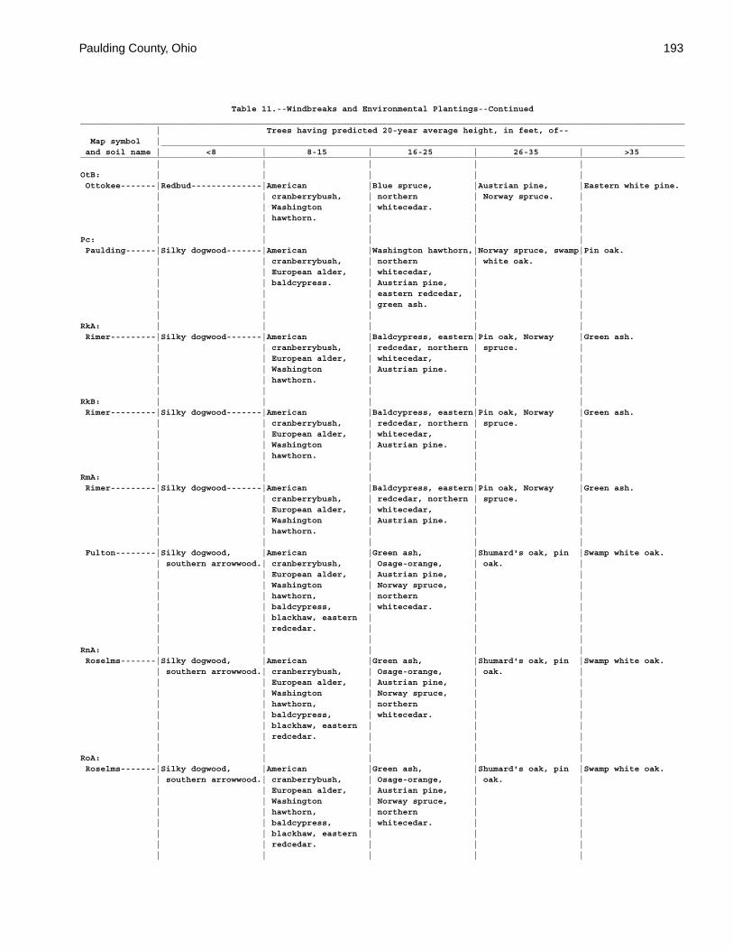
Paulding County, Ohio 193
Table 11.--Windbreaks and Environmental Plantings--Continued________________________________________________________________________________________________________________________ | Trees having predicted 20-year average height, in feet, of-- Map symbol |________________________________________________________________________________________________________ and soil name | <8 | 8-15 | 16-25 | 26-35 | >35________________________________________________________________________________________________________________________ | | | | |OtB: | | | | | Ottokee-------|Redbud--------------|American |Blue spruce, |Austrian pine, |Eastern white pine. | | cranberrybush, | northern | Norway spruce. | | | Washington | whitecedar. | | | | hawthorn. | | | | | | | |Pc: | | | | | Paulding------|Silky dogwood-------|American |Washington hawthorn,|Norway spruce, swamp|Pin oak. | | cranberrybush, | northern | white oak. | | | European alder, | whitecedar, | | | | baldcypress. | Austrian pine, | | | | | eastern redcedar, | | | | | green ash. | | | | | | |RkA: | | | | | Rimer---------|Silky dogwood-------|American |Baldcypress, eastern|Pin oak, Norway |Green ash. | | cranberrybush, | redcedar, northern | spruce. | | | European alder, | whitecedar, | | | | Washington | Austrian pine. | | | | hawthorn. | | | | | | | |RkB: | | | | | Rimer---------|Silky dogwood-------|American |Baldcypress, eastern|Pin oak, Norway |Green ash. | | cranberrybush, | redcedar, northern | spruce. | | | European alder, | whitecedar, | | | | Washington | Austrian pine. | | | | hawthorn. | | | | | | | |RmA: | | | | | Rimer---------|Silky dogwood-------|American |Baldcypress, eastern|Pin oak, Norway |Green ash. | | cranberrybush, | redcedar, northern | spruce. | | | European alder, | whitecedar, | | | | Washington | Austrian pine. | | | | hawthorn. | | | | | | | | Fulton--------|Silky dogwood, |American |Green ash, |Shumard's oak, pin |Swamp white oak. | southern arrowwood.| cranberrybush, | Osage-orange, | oak. | | | European alder, | Austrian pine, | | | | Washington | Norway spruce, | | | | hawthorn, | northern | | | | baldcypress, | whitecedar. | | | | blackhaw, eastern | | | | | redcedar. | | | | | | | |RnA: | | | | | Roselms-------|Silky dogwood, |American |Green ash, |Shumard's oak, pin |Swamp white oak. | southern arrowwood.| cranberrybush, | Osage-orange, | oak. | | | European alder, | Austrian pine, | | | | Washington | Norway spruce, | | | | hawthorn, | northern | | | | baldcypress, | whitecedar. | | | | blackhaw, eastern | | | | | redcedar. | | | | | | | |RoA: | | | | | Roselms-------|Silky dogwood, |American |Green ash, |Shumard's oak, pin |Swamp white oak. | southern arrowwood.| cranberrybush, | Osage-orange, | oak. | | | European alder, | Austrian pine, | | | | Washington | Norway spruce, | | | | hawthorn, | northern | | | | baldcypress, | whitecedar. | | | | blackhaw, eastern | | | | | redcedar. | | | | | | | |
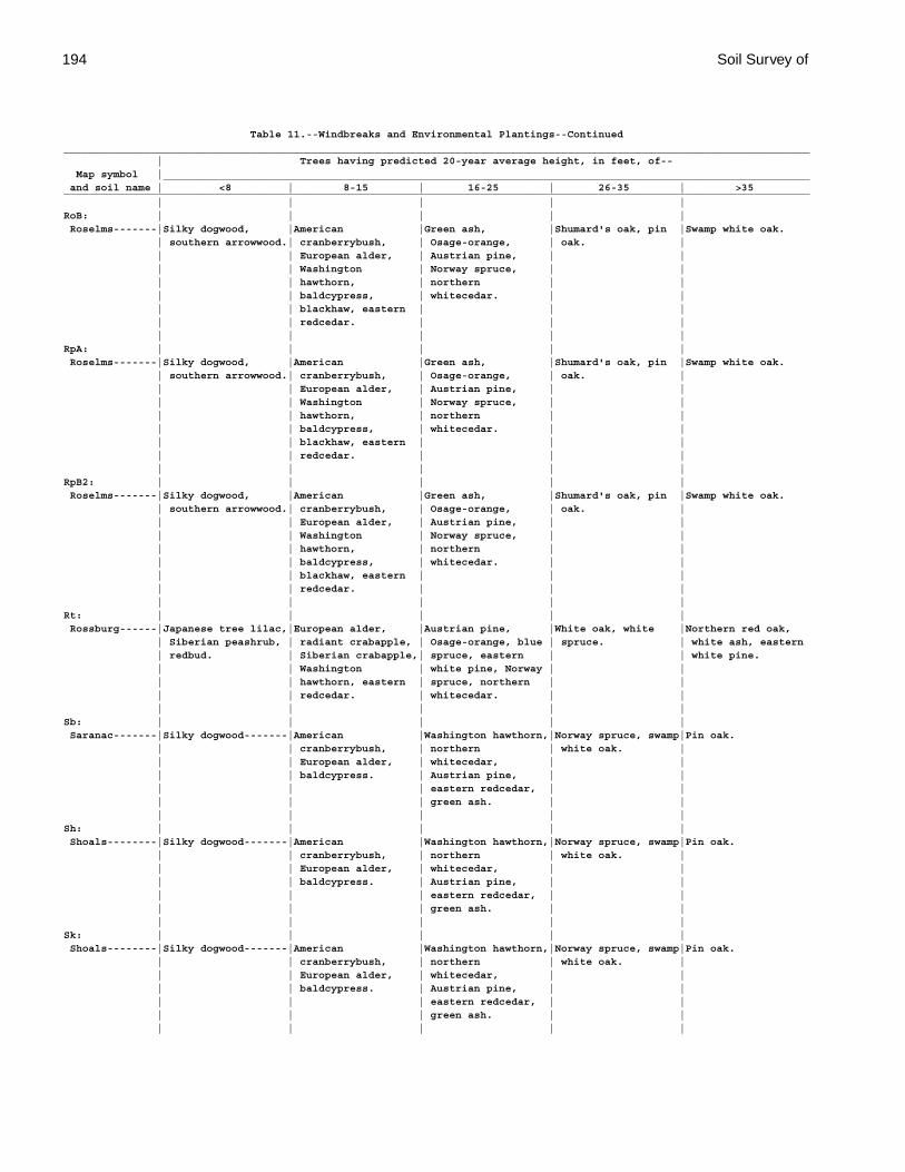
194 Soil Survey of
Table 11.--Windbreaks and Environmental Plantings--Continued________________________________________________________________________________________________________________________ | Trees having predicted 20-year average height, in feet, of-- Map symbol |________________________________________________________________________________________________________ and soil name | <8 | 8-15 | 16-25 | 26-35 | >35________________________________________________________________________________________________________________________ | | | | |RoB: | | | | | Roselms-------|Silky dogwood, |American |Green ash, |Shumard's oak, pin |Swamp white oak. | southern arrowwood.| cranberrybush, | Osage-orange, | oak. | | | European alder, | Austrian pine, | | | | Washington | Norway spruce, | | | | hawthorn, | northern | | | | baldcypress, | whitecedar. | | | | blackhaw, eastern | | | | | redcedar. | | | | | | | |RpA: | | | | | Roselms-------|Silky dogwood, |American |Green ash, |Shumard's oak, pin |Swamp white oak. | southern arrowwood.| cranberrybush, | Osage-orange, | oak. | | | European alder, | Austrian pine, | | | | Washington | Norway spruce, | | | | hawthorn, | northern | | | | baldcypress, | whitecedar. | | | | blackhaw, eastern | | | | | redcedar. | | | | | | | |RpB2: | | | | | Roselms-------|Silky dogwood, |American |Green ash, |Shumard's oak, pin |Swamp white oak. | southern arrowwood.| cranberrybush, | Osage-orange, | oak. | | | European alder, | Austrian pine, | | | | Washington | Norway spruce, | | | | hawthorn, | northern | | | | baldcypress, | whitecedar. | | | | blackhaw, eastern | | | | | redcedar. | | | | | | | |Rt: | | | | | Rossburg------|Japanese tree lilac,|European alder, |Austrian pine, |White oak, white |Northern red oak, | Siberian peashrub, | radiant crabapple, | Osage-orange, blue | spruce. | white ash, eastern | redbud. | Siberian crabapple,| spruce, eastern | | white pine. | | Washington | white pine, Norway | | | | hawthorn, eastern | spruce, northern | | | | redcedar. | whitecedar. | | | | | | |Sb: | | | | | Saranac-------|Silky dogwood-------|American |Washington hawthorn,|Norway spruce, swamp|Pin oak. | | cranberrybush, | northern | white oak. | | | European alder, | whitecedar, | | | | baldcypress. | Austrian pine, | | | | | eastern redcedar, | | | | | green ash. | | | | | | |Sh: | | | | | Shoals--------|Silky dogwood-------|American |Washington hawthorn,|Norway spruce, swamp|Pin oak. | | cranberrybush, | northern | white oak. | | | European alder, | whitecedar, | | | | baldcypress. | Austrian pine, | | | | | eastern redcedar, | | | | | green ash. | | | | | | |Sk: | | | | | Shoals--------|Silky dogwood-------|American |Washington hawthorn,|Norway spruce, swamp|Pin oak. | | cranberrybush, | northern | white oak. | | | European alder, | whitecedar, | | | | baldcypress. | Austrian pine, | | | | | eastern redcedar, | | | | | green ash. | | | | | | |
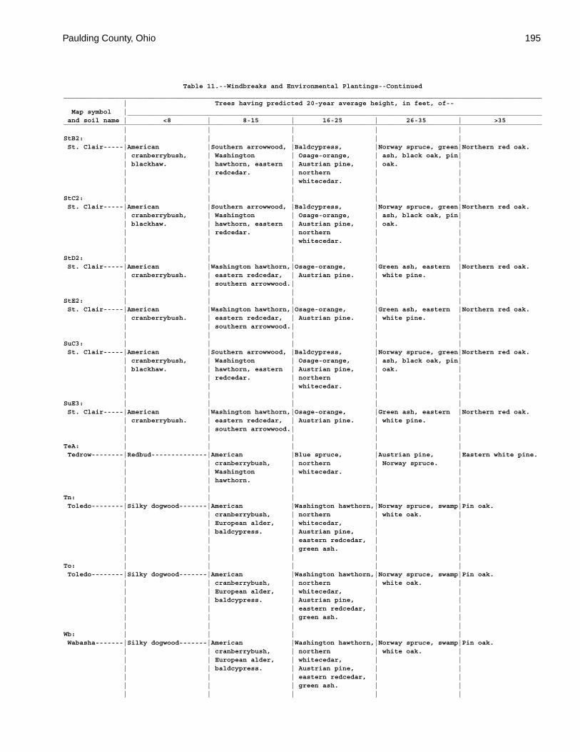
Paulding County, Ohio 195
Table 11.--Windbreaks and Environmental Plantings--Continued________________________________________________________________________________________________________________________ | Trees having predicted 20-year average height, in feet, of-- Map symbol |________________________________________________________________________________________________________ and soil name | <8 | 8-15 | 16-25 | 26-35 | >35________________________________________________________________________________________________________________________ | | | | |StB2: | | | | | St. Clair-----|American |Southern arrowwood, |Baldcypress, |Norway spruce, green|Northern red oak. | cranberrybush, | Washington | Osage-orange, | ash, black oak, pin| | blackhaw. | hawthorn, eastern | Austrian pine, | oak. | | | redcedar. | northern | | | | | whitecedar. | | | | | | |StC2: | | | | | St. Clair-----|American |Southern arrowwood, |Baldcypress, |Norway spruce, green|Northern red oak. | cranberrybush, | Washington | Osage-orange, | ash, black oak, pin| | blackhaw. | hawthorn, eastern | Austrian pine, | oak. | | | redcedar. | northern | | | | | whitecedar. | | | | | | |StD2: | | | | | St. Clair-----|American |Washington hawthorn,|Osage-orange, |Green ash, eastern |Northern red oak. | cranberrybush. | eastern redcedar, | Austrian pine. | white pine. | | | southern arrowwood.| | | | | | | |StE2: | | | | | St. Clair-----|American |Washington hawthorn,|Osage-orange, |Green ash, eastern |Northern red oak. | cranberrybush. | eastern redcedar, | Austrian pine. | white pine. | | | southern arrowwood.| | | | | | | |SuC3: | | | | | St. Clair-----|American |Southern arrowwood, |Baldcypress, |Norway spruce, green|Northern red oak. | cranberrybush, | Washington | Osage-orange, | ash, black oak, pin| | blackhaw. | hawthorn, eastern | Austrian pine, | oak. | | | redcedar. | northern | | | | | whitecedar. | | | | | | |SuE3: | | | | | St. Clair-----|American |Washington hawthorn,|Osage-orange, |Green ash, eastern |Northern red oak. | cranberrybush. | eastern redcedar, | Austrian pine. | white pine. | | | southern arrowwood.| | | | | | | |TeA: | | | | | Tedrow--------|Redbud--------------|American |Blue spruce, |Austrian pine, |Eastern white pine. | | cranberrybush, | northern | Norway spruce. | | | Washington | whitecedar. | | | | hawthorn. | | | | | | | |Tn: | | | | | Toledo--------|Silky dogwood-------|American |Washington hawthorn,|Norway spruce, swamp|Pin oak. | | cranberrybush, | northern | white oak. | | | European alder, | whitecedar, | | | | baldcypress. | Austrian pine, | | | | | eastern redcedar, | | | | | green ash. | | | | | | |To: | | | | | Toledo--------|Silky dogwood-------|American |Washington hawthorn,|Norway spruce, swamp|Pin oak. | | cranberrybush, | northern | white oak. | | | European alder, | whitecedar, | | | | baldcypress. | Austrian pine, | | | | | eastern redcedar, | | | | | green ash. | | | | | | |Wb: | | | | | Wabasha-------|Silky dogwood-------|American |Washington hawthorn,|Norway spruce, swamp|Pin oak. | | cranberrybush, | northern | white oak. | | | European alder, | whitecedar, | | | | baldcypress. | Austrian pine, | | | | | eastern redcedar, | | | | | green ash. | | | | | | |
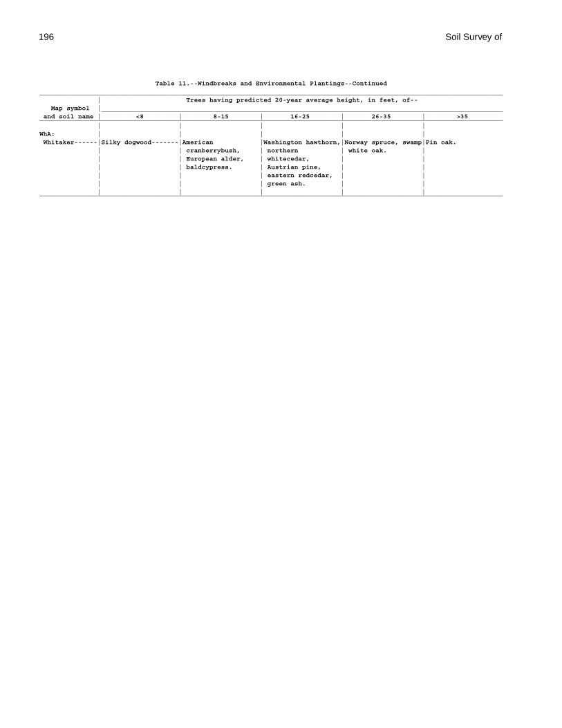
196 Soil Survey of
Table 11.--Windbreaks and Environmental Plantings--Continued________________________________________________________________________________________________________________________ | Trees having predicted 20-year average height, in feet, of-- Map symbol |________________________________________________________________________________________________________ and soil name | <8 | 8-15 | 16-25 | 26-35 | >35________________________________________________________________________________________________________________________ | | | | |WhA: | | | | | Whitaker------|Silky dogwood-------|American |Washington hawthorn,|Norway spruce, swamp|Pin oak. | | cranberrybush, | northern | white oak. | | | European alder, | whitecedar, | | | | baldcypress. | Austrian pine, | | | | | eastern redcedar, | | | | | green ash. | | | | | | |________________________________________________________________________________________________________________________
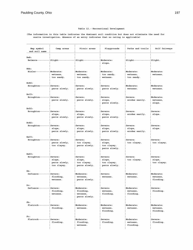
Paulding County, Ohio 197
Table 12.--Recreational Development
(The information in this table indicates the dominant soil condition but does not eliminate the need for onsite investigation. Absence of an entry indicates that no rating is applicable)
________________________________________________________________________________________________________________ | | | | | Map symbol | Camp areas | Picnic areas | Playgrounds | Paths and trails | Golf fairways and soil name | | | | |________________________________________________________________________________________________________________ | | | | |BeB: | | | | | Belmore---------|Slight------------|Slight------------|Moderate: |Slight------------|Slight. | | | slope. | | | | | | |BkA: | | | | | Bixler----------|Moderate: |Moderate: |Moderate: |Moderate: |Moderate: | wetness, | wetness, | too sandy, | wetness, | wetness. | too sandy. | too sandy. | wetness. | too sandy. | | | | | |BrB2: | | | | | Broughton-------|Severe: |Severe: |Severe: |Moderate: |Moderate: | percs slowly. | percs slowly. | percs slowly. | wetness. | wetness. | | | | |BrC2: | | | | | Broughton-------|Severe: |Severe: |Severe: |Severe: |Moderate: | percs slowly. | percs slowly. | slope, | erodes easily. | wetness, | | | percs slowly. | | slope. | | | | |BrD2: | | | | | Broughton-------|Severe: |Severe: |Severe: |Severe: |Severe: | slope, | slope, | slope, | erodes easily. | slope. | percs slowly. | percs slowly. | percs slowly. | | | | | | |BrE2: | | | | | Broughton-------|Severe: |Severe: |Severe: |Severe: |Severe: | slope, | slope, | slope, | slope, | slope. | percs slowly. | percs slowly. | percs slowly. | erodes easily. | | | | | |BsC3: | | | | | Broughton-------|Severe: |Severe: |Severe: |Severe: |Severe: | percs slowly, | too clayey, | slope, | too clayey. | too clayey. | too clayey. | percs slowly. | too clayey, | | | | | percs slowly. | | | | | | |BsD3: | | | | | Broughton-------|Severe: |Severe: |Severe: |Severe: |Severe: | slope, | slope, | slope, | too clayey. | slope, | percs slowly, | too clayey, | too clayey, | | too clayey. | too clayey. | percs slowly. | percs slowly. | | | | | | |Db: | | | | | Defiance--------|Severe: |Moderate: |Severe: |Moderate: |Moderate: | flooding, | wetness, | wetness. | wetness. | wetness, | wetness. | percs slowly. | | | flooding. | | | | |Dc: | | | | | Defiance--------|Severe: |Moderate: |Severe: |Moderate: |Severe: | flooding, | flooding, | wetness, | wetness, | flooding. | wetness. | wetness, | flooding. | flooding. | | | percs slowly. | | | | | | | |Fb: | | | | | Flatrock--------|Severe: |Moderate: |Moderate: |Moderate: |Moderate: | flooding. | wetness. | wetness, | wetness. | wetness, | | | flooding. | | flooding. | | | | |Fc: | | | | | Flatrock--------|Severe: |Moderate: |Severe: |Moderate: |Severe: | flooding. | flooding, | flooding. | wetness, | flooding. | | wetness. | | flooding. | | | | | |
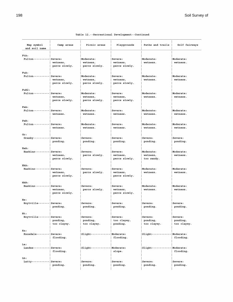
198 Soil Survey of
Table 12.--Recreational Development--Continued________________________________________________________________________________________________________________ | | | | | Map symbol | Camp areas | Picnic areas | Playgrounds | Paths and trails | Golf fairways and soil name | | | | |________________________________________________________________________________________________________________ | | | | |FtA: | | | | | Fulton----------|Severe: |Moderate: |Severe: |Moderate: |Moderate: | wetness, | wetness, | wetness, | wetness. | wetness. | percs slowly. | percs slowly. | percs slowly. | | | | | | |FuA: | | | | | Fulton----------|Severe: |Moderate: |Severe: |Moderate: |Moderate: | wetness, | wetness, | wetness, | wetness. | wetness. | percs slowly. | percs slowly. | percs slowly. | | | | | | |FuB2: | | | | | Fulton----------|Severe: |Moderate: |Severe: |Moderate: |Moderate: | wetness, | wetness, | wetness, | wetness. | wetness. | percs slowly. | percs slowly. | percs slowly. | | | | | | |FxA: | | | | | Fulton----------|Severe: |Moderate: |Severe: |Moderate: |Moderate: | wetness. | wetness. | wetness. | wetness. | wetness. | | | | |FxB: | | | | | Fulton----------|Severe: |Moderate: |Severe: |Moderate: |Moderate: | wetness. | wetness. | wetness. | wetness. | wetness. | | | | |Gr: | | | | | Granby----------|Severe: |Severe: |Severe: |Severe: |Severe: | ponding. | ponding. | ponding. | ponding. | ponding. | | | | |HaA: | | | | | Haskins---------|Severe: |Severe: |Severe: |Moderate: |Moderate: | wetness, | percs slowly. | wetness, | wetness, | wetness. | percs slowly. | | percs slowly. | too sandy. | | | | | |HkA: | | | | | Haskins---------|Severe: |Severe: |Severe: |Moderate: |Moderate: | wetness, | percs slowly. | wetness, | wetness. | wetness. | percs slowly. | | percs slowly. | | | | | | |HkB: | | | | | Haskins---------|Severe: |Severe: |Severe: |Moderate: |Moderate: | wetness, | percs slowly. | wetness, | wetness. | wetness. | percs slowly. | | percs slowly. | | | | | | |Hs: | | | | | Hoytville-------|Severe: |Severe: |Severe: |Severe: |Severe: | ponding. | ponding. | ponding. | ponding. | ponding. | | | | |Ht: | | | | | Hoytville-------|Severe: |Severe: |Severe: |Severe: |Severe: | ponding, | ponding, | too clayey, | ponding, | ponding, | too clayey. | too clayey. | ponding. | too clayey. | too clayey. | | | | |Kn: | | | | | Knoxdale--------|Severe: |Slight------------|Moderate: |Slight------------|Moderate: | flooding. | | flooding. | | flooding. | | | | |La: | | | | | Landes----------|Severe: |Slight------------|Moderate: |Slight------------|Moderate: | flooding. | | slope. | | flooding. | | | | |Lb: | | | | | Latty-----------|Severe: |Severe: |Severe: |Severe: |Severe: | ponding. | ponding. | ponding. | ponding. | ponding. | | | | |
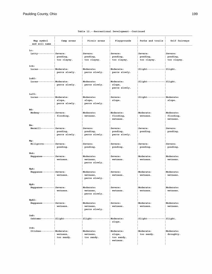
Paulding County, Ohio 199
Table 12.--Recreational Development--Continued________________________________________________________________________________________________________________ | | | | | Map symbol | Camp areas | Picnic areas | Playgrounds | Paths and trails | Golf fairways and soil name | | | | |________________________________________________________________________________________________________________ | | | | |Lc: | | | | | Latty-----------|Severe: |Severe: |Severe: |Severe: |Severe: | ponding, | ponding, | ponding, | ponding, | ponding, | too clayey. | too clayey. | too clayey. | too clayey. | too clayey. | | | | |LtA: | | | | | Lucas-----------|Moderate: |Moderate: |Moderate: |Slight------------|Slight. | percs slowly. | percs slowly. | percs slowly. | | | | | | |LuB2: | | | | | Lucas-----------|Moderate: |Moderate: |Moderate: |Slight------------|Slight. | percs slowly. | percs slowly. | slope, | | | | | percs slowly. | | | | | | |LuC2: | | | | | Lucas-----------|Moderate: |Moderate: |Severe: |Slight------------|Moderate: | slope, | slope, | slope. | | slope. | percs slowly. | percs slowly. | | | | | | | |Md: | | | | | Medway----------|Severe: |Moderate: |Moderate: |Moderate: |Moderate: | flooding. | wetness. | flooding, | wetness. | flooding, | | | wetness. | | wetness. | | | | |Me: | | | | | Mermill---------|Severe: |Severe: |Severe: |Severe: |Severe: | ponding, | ponding, | ponding, | ponding. | ponding. | percs slowly. | percs slowly. | percs slowly. | | | | | | |Mg: | | | | | Millgrove-------|Severe: |Severe: |Severe: |Severe: |Severe: | ponding. | ponding. | ponding. | ponding. | ponding. | | | | |NnA: | | | | | Nappanee--------|Severe: |Moderate: |Severe: |Moderate: |Moderate: | wetness. | wetness, | wetness. | wetness. | wetness. | | percs slowly. | | | | | | | |NpA: | | | | | Nappanee--------|Severe: |Moderate: |Severe: |Moderate: |Moderate: | wetness. | wetness, | wetness. | wetness. | wetness. | | percs slowly. | | | | | | | |NpB: | | | | | Nappanee--------|Severe: |Moderate: |Severe: |Moderate: |Moderate: | wetness. | wetness, | wetness. | wetness. | wetness. | | percs slowly. | | | | | | | |NpB2: | | | | | Nappanee--------|Severe: |Moderate: |Severe: |Moderate: |Moderate: | wetness. | wetness, | wetness. | wetness. | wetness. | | percs slowly. | | | | | | | |OsB: | | | | | Oshtemo---------|Slight------------|Slight------------|Moderate: |Slight------------|Slight. | | | slope. | | | | | | |OtB: | | | | | Ottokee---------|Moderate: |Moderate: |Moderate: |Moderate: |Moderate: | wetness, | wetness, | slope, | too sandy. | droughty. | too sandy. | too sandy. | too sandy, | | | | | wetness. | | | | | | |
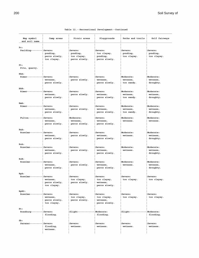
200 Soil Survey of
Table 12.--Recreational Development--Continued________________________________________________________________________________________________________________ | | | | | Map symbol | Camp areas | Picnic areas | Playgrounds | Paths and trails | Golf fairways and soil name | | | | |________________________________________________________________________________________________________________ | | | | |Pc: | | | | | Paulding--------|Severe: |Severe: |Severe: |Severe: |Severe: | ponding, | ponding, | too clayey, | ponding, | ponding, | percs slowly, | too clayey, | ponding, | too clayey. | too clayey. | too clayey. | percs slowly. | percs slowly. | | | | | | |Pt: | | | | | Pits, quarry. | | | | | | | | | |RkA: | | | | | Rimer-----------|Severe: |Severe: |Severe: |Moderate: |Moderate: | wetness, | percs slowly. | wetness, | wetness, | wetness, | percs slowly. | | percs slowly. | too sandy. | droughty. | | | | |RkB: | | | | | Rimer-----------|Severe: |Severe: |Severe: |Moderate: |Moderate: | wetness, | percs slowly. | wetness, | wetness, | wetness, | percs slowly. | | percs slowly. | too sandy. | droughty. | | | | |RmA: | | | | | Rimer-----------|Severe: |Severe: |Severe: |Moderate: |Moderate: | wetness, | percs slowly. | wetness, | wetness, | wetness, | percs slowly. | | percs slowly. | too sandy. | droughty. | | | | | Fulton----------|Severe: |Moderate: |Severe: |Moderate: |Moderate: | wetness, | wetness, | wetness, | wetness. | wetness. | percs slowly. | percs slowly. | percs slowly. | | | | | | |RnA: | | | | | Roselms---------|Severe: |Severe: |Severe: |Moderate: |Moderate: | wetness, | percs slowly. | wetness, | wetness. | wetness, | percs slowly. | | percs slowly. | | droughty. | | | | |RoA: | | | | | Roselms---------|Severe: |Severe: |Severe: |Moderate: |Moderate: | wetness, | percs slowly. | wetness, | wetness. | wetness, | percs slowly. | | percs slowly. | | droughty. | | | | |RoB: | | | | | Roselms---------|Severe: |Severe: |Severe: |Moderate: |Moderate: | wetness, | percs slowly. | wetness, | wetness. | wetness, | percs slowly. | | percs slowly. | | droughty. | | | | |RpA: | | | | | Roselms---------|Severe: |Severe: |Severe: |Severe: |Severe: | wetness, | too clayey, | too clayey, | too clayey. | too clayey. | percs slowly, | percs slowly. | wetness, | | | too clayey. | | percs slowly. | | | | | | |RpB2: | | | | | Roselms---------|Severe: |Severe: |Severe: |Severe: |Severe: | wetness, | too clayey, | too clayey, | too clayey. | too clayey. | percs slowly, | percs slowly. | wetness, | | | too clayey. | | percs slowly. | | | | | | |Rt: | | | | | Rossburg--------|Severe: |Slight------------|Moderate: |Slight------------|Moderate: | flooding. | | flooding. | | flooding. | | | | |Sb: | | | | | Saranac---------|Severe: |Severe: |Severe: |Severe: |Severe: | flooding, | wetness. | wetness. | wetness. | wetness. | wetness. | | | | | | | | |
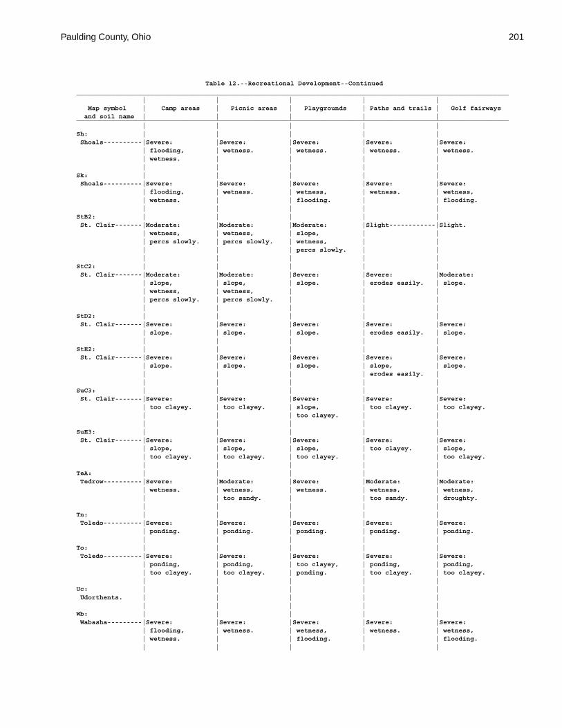
Paulding County, Ohio 201
Table 12.--Recreational Development--Continued________________________________________________________________________________________________________________ | | | | | Map symbol | Camp areas | Picnic areas | Playgrounds | Paths and trails | Golf fairways and soil name | | | | |________________________________________________________________________________________________________________ | | | | |Sh: | | | | | Shoals----------|Severe: |Severe: |Severe: |Severe: |Severe: | flooding, | wetness. | wetness. | wetness. | wetness. | wetness. | | | | | | | | |Sk: | | | | | Shoals----------|Severe: |Severe: |Severe: |Severe: |Severe: | flooding, | wetness. | wetness, | wetness. | wetness, | wetness. | | flooding. | | flooding. | | | | |StB2: | | | | | St. Clair-------|Moderate: |Moderate: |Moderate: |Slight------------|Slight. | wetness, | wetness, | slope, | | | percs slowly. | percs slowly. | wetness, | | | | | percs slowly. | | | | | | |StC2: | | | | | St. Clair-------|Moderate: |Moderate: |Severe: |Severe: |Moderate: | slope, | slope, | slope. | erodes easily. | slope. | wetness, | wetness, | | | | percs slowly. | percs slowly. | | | | | | | |StD2: | | | | | St. Clair-------|Severe: |Severe: |Severe: |Severe: |Severe: | slope. | slope. | slope. | erodes easily. | slope. | | | | |StE2: | | | | | St. Clair-------|Severe: |Severe: |Severe: |Severe: |Severe: | slope. | slope. | slope. | slope, | slope. | | | | erodes easily. | | | | | |SuC3: | | | | | St. Clair-------|Severe: |Severe: |Severe: |Severe: |Severe: | too clayey. | too clayey. | slope, | too clayey. | too clayey. | | | too clayey. | | | | | | |SuE3: | | | | | St. Clair-------|Severe: |Severe: |Severe: |Severe: |Severe: | slope, | slope, | slope, | too clayey. | slope, | too clayey. | too clayey. | too clayey. | | too clayey. | | | | |TeA: | | | | | Tedrow----------|Severe: |Moderate: |Severe: |Moderate: |Moderate: | wetness. | wetness, | wetness. | wetness, | wetness, | | too sandy. | | too sandy. | droughty. | | | | |Tn: | | | | | Toledo----------|Severe: |Severe: |Severe: |Severe: |Severe: | ponding. | ponding. | ponding. | ponding. | ponding. | | | | |To: | | | | | Toledo----------|Severe: |Severe: |Severe: |Severe: |Severe: | ponding, | ponding, | too clayey, | ponding, | ponding, | too clayey. | too clayey. | ponding. | too clayey. | too clayey. | | | | |Uc: | | | | | Udorthents. | | | | | | | | | |Wb: | | | | | Wabasha---------|Severe: |Severe: |Severe: |Severe: |Severe: | flooding, | wetness. | wetness, | wetness. | wetness, | wetness. | | flooding. | | flooding. | | | | |

202 Soil Survey of
Table 12.--Recreational Development--Continued________________________________________________________________________________________________________________ | | | | | Map symbol | Camp areas | Picnic areas | Playgrounds | Paths and trails | Golf fairways and soil name | | | | |________________________________________________________________________________________________________________ | | | | |WhA: | | | | | Whitaker--------|Severe: |Moderate: |Severe: |Moderate: |Moderate: | wetness. | wetness. | wetness. | wetness. | wetness. | | | | |________________________________________________________________________________________________________________
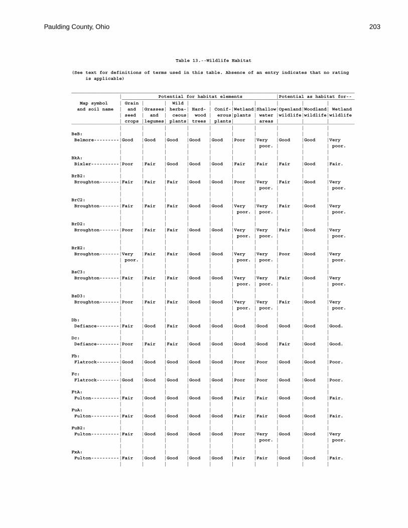
Paulding County, Ohio 203
Table 13.--Wildlife Habitat
(See text for definitions of terms used in this table. Absence of an entry indicates that no rating is applicable)
_____________________________________________________________________________________________________ | Potential for habitat elements |Potential as habitat for-- ___________________________________________________________________________________ Map symbol | Grain | | Wild | | | | | | | and soil name | and |Grasses| herba-| Hard- | Conif-|Wetland|Shallow|Openland|Woodland| Wetland | seed | and | ceous| wood | erous|plants | water |wildlife|wildlife|wildlife | crops |legumes| plants| trees | plants| | areas | | |_____________________________________________________________________________________________________ | | | | | | | | | |BeB: | | | | | | | | | | Belmore---------|Good |Good |Good |Good |Good |Poor |Very |Good |Good |Very | | | | | | | poor. | | | poor. | | | | | | | | | |BkA: | | | | | | | | | | Bixler----------|Poor |Fair |Good |Good |Good |Fair |Fair |Fair |Good |Fair. | | | | | | | | | |BrB2: | | | | | | | | | | Broughton-------|Fair |Fair |Fair |Good |Good |Poor |Very |Fair |Good |Very | | | | | | | poor. | | | poor. | | | | | | | | | |BrC2: | | | | | | | | | | Broughton-------|Fair |Fair |Fair |Good |Good |Very |Very |Fair |Good |Very | | | | | | poor. | poor. | | | poor. | | | | | | | | | |BrD2: | | | | | | | | | | Broughton-------|Poor |Fair |Fair |Good |Good |Very |Very |Fair |Good |Very | | | | | | poor. | poor. | | | poor. | | | | | | | | | |BrE2: | | | | | | | | | | Broughton-------|Very |Fair |Fair |Good |Good |Very |Very |Poor |Good |Very | poor. | | | | | poor. | poor. | | | poor. | | | | | | | | | |BsC3: | | | | | | | | | | Broughton-------|Fair |Fair |Fair |Good |Good |Very |Very |Fair |Good |Very | | | | | | poor. | poor. | | | poor. | | | | | | | | | |BsD3: | | | | | | | | | | Broughton-------|Poor |Fair |Fair |Good |Good |Very |Very |Fair |Good |Very | | | | | | poor. | poor. | | | poor. | | | | | | | | | |Db: | | | | | | | | | | Defiance--------|Fair |Good |Fair |Good |Good |Good |Good |Good |Good |Good. | | | | | | | | | |Dc: | | | | | | | | | | Defiance--------|Poor |Fair |Fair |Good |Good |Good |Good |Fair |Good |Good. | | | | | | | | | |Fb: | | | | | | | | | | Flatrock--------|Good |Good |Good |Good |Good |Poor |Poor |Good |Good |Poor. | | | | | | | | | |Fc: | | | | | | | | | | Flatrock--------|Good |Good |Good |Good |Good |Poor |Poor |Good |Good |Poor. | | | | | | | | | |FtA: | | | | | | | | | | Fulton----------|Fair |Good |Good |Good |Good |Fair |Fair |Good |Good |Fair. | | | | | | | | | |FuA: | | | | | | | | | | Fulton----------|Fair |Good |Good |Good |Good |Fair |Fair |Good |Good |Fair. | | | | | | | | | |FuB2: | | | | | | | | | | Fulton----------|Fair |Good |Good |Good |Good |Poor |Very |Good |Good |Very | | | | | | | poor. | | | poor. | | | | | | | | | |FxA: | | | | | | | | | | Fulton----------|Fair |Good |Good |Good |Good |Fair |Fair |Good |Good |Fair. | | | | | | | | | |
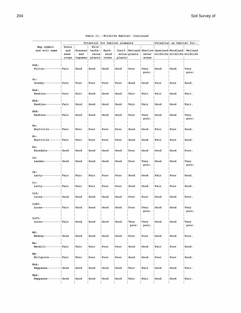
204 Soil Survey of
Table 13.--Wildlife Habitat--Continued_____________________________________________________________________________________________________ | Potential for habitat elements |Potential as habitat for-- ___________________________________________________________________________________ Map symbol | Grain | | Wild | | | | | | | and soil name | and |Grasses| herba-| Hard- | Conif-|Wetland|Shallow|Openland|Woodland| Wetland | seed | and | ceous| wood | erous|plants | water |wildlife|wildlife|wildlife | crops |legumes| plants| trees | plants| | areas | | |_____________________________________________________________________________________________________ | | | | | | | | | |FxB: | | | | | | | | | | Fulton----------|Fair |Good |Good |Good |Good |Poor |Very |Good |Good |Very | | | | | | | poor. | | | poor. | | | | | | | | | |Gr: | | | | | | | | | | Granby----------|Poor |Poor |Poor |Poor |Poor |Good |Good |Poor |Poor |Good. | | | | | | | | | |HaA: | | | | | | | | | | Haskins---------|Poor |Fair |Good |Good |Good |Fair |Fair |Fair |Good |Fair. | | | | | | | | | |HkA: | | | | | | | | | | Haskins---------|Fair |Good |Good |Good |Good |Fair |Fair |Good |Good |Fair. | | | | | | | | | |HkB: | | | | | | | | | | Haskins---------|Fair |Good |Good |Good |Good |Poor |Very |Good |Good |Very | | | | | | | poor. | | | poor. | | | | | | | | | |Hs: | | | | | | | | | | Hoytville-------|Fair |Fair |Poor |Poor |Poor |Good |Good |Fair |Poor |Good. | | | | | | | | | |Ht: | | | | | | | | | | Hoytville-------|Fair |Fair |Poor |Poor |Poor |Good |Good |Fair |Poor |Good. | | | | | | | | | |Kn: | | | | | | | | | | Knoxdale--------|Good |Good |Good |Good |Good |Poor |Good |Good |Good |Poor. | | | | | | | | | |La: | | | | | | | | | | Landes----------|Good |Good |Good |Good |Good |Poor |Very |Good |Good |Very | | | | | | | poor. | | | poor. | | | | | | | | | |Lb: | | | | | | | | | | Latty-----------|Fair |Fair |Fair |Poor |Poor |Good |Good |Fair |Poor |Good. | | | | | | | | | |Lc: | | | | | | | | | | Latty-----------|Fair |Fair |Fair |Poor |Poor |Good |Good |Fair |Poor |Good. | | | | | | | | | |LtA: | | | | | | | | | | Lucas-----------|Good |Good |Good |Good |Good |Poor |Poor |Good |Good |Poor. | | | | | | | | | |LuB2: | | | | | | | | | | Lucas-----------|Fair |Good |Good |Good |Good |Poor |Very |Good |Good |Very | | | | | | | poor. | | | poor. | | | | | | | | | |LuC2: | | | | | | | | | | Lucas-----------|Fair |Good |Good |Good |Good |Very |Very |Good |Good |Very | | | | | | poor. | poor. | | | poor. | | | | | | | | | |Md: | | | | | | | | | | Medway----------|Good |Good |Good |Good |Good |Poor |Poor |Good |Good |Poor. | | | | | | | | | |Me: | | | | | | | | | | Mermill---------|Fair |Fair |Fair |Poor |Poor |Good |Good |Fair |Poor |Good. | | | | | | | | | |Mg: | | | | | | | | | | Millgrove-------|Fair |Fair |Poor |Poor |Poor |Good |Good |Poor |Poor |Good. | | | | | | | | | |NnA: | | | | | | | | | | Nappanee--------|Good |Good |Good |Good |Good |Fair |Fair |Good |Good |Fair. | | | | | | | | | |NpA: | | | | | | | | | | Nappanee--------|Good |Good |Good |Good |Good |Fair |Fair |Good |Good |Fair. | | | | | | | | | |

Paulding County, Ohio 205
Table 13.--Wildlife Habitat--Continued_____________________________________________________________________________________________________ | Potential for habitat elements |Potential as habitat for-- ___________________________________________________________________________________ Map symbol | Grain | | Wild | | | | | | | and soil name | and |Grasses| herba-| Hard- | Conif-|Wetland|Shallow|Openland|Woodland| Wetland | seed | and | ceous| wood | erous|plants | water |wildlife|wildlife|wildlife | crops |legumes| plants| trees | plants| | areas | | |_____________________________________________________________________________________________________ | | | | | | | | | |NpB: | | | | | | | | | | Nappanee--------|Good |Good |Good |Good |Good |Poor |Poor |Good |Good |Poor. | | | | | | | | | |NpB2: | | | | | | | | | | Nappanee--------|Good |Good |Good |Good |Good |Poor |Poor |Good |Good |Poor. | | | | | | | | | |OsB: | | | | | | | | | | Oshtemo---------|Fair |Good |Good |Good |Good |Poor |Very |Good |Good |Very | | | | | | | poor. | | | poor. | | | | | | | | | |OtB: | | | | | | | | | | Ottokee---------|Poor |Fair |Good |Fair |Fair |Poor |Very |Fair |Fair |Very | | | | | | | poor. | | | poor. | | | | | | | | | |Pc: | | | | | | | | | | Paulding--------|Fair |Fair |Poor |Poor |Poor |Good |Good |Fair |Poor |Good. | | | | | | | | | |Pt: | | | | | | | | | | Pits, quarry. | | | | | | | | | | | | | | | | | | | |RkA: | | | | | | | | | | Rimer-----------|Poor |Fair |Good |Good |Good |Fair |Fair |Fair |Good |Fair. | | | | | | | | | |RkB: | | | | | | | | | | Rimer-----------|Poor |Fair |Good |Good |Good |Poor |Very |Fair |Good |Very | | | | | | | poor. | | | poor. | | | | | | | | | |RmA: | | | | | | | | | | Rimer-----------|Poor |Fair |Good |Good |Good |Fair |Fair |Fair |Good |Fair. | | | | | | | | | | Fulton----------|Fair |Good |Good |Good |Good |Fair |Fair |Good |Good |Fair. | | | | | | | | | |RnA: | | | | | | | | | | Roselms---------|Fair |Good |Good |Good |Good |Fair |Poor |Good |Good |Poor. | | | | | | | | | |RoA: | | | | | | | | | | Roselms---------|Fair |Good |Good |Good |Good |Fair |Poor |Good |Good |Poor. | | | | | | | | | |RoB: | | | | | | | | | | Roselms---------|Fair |Good |Good |Good |Good |Poor |Very |Good |Good |Very | | | | | | | poor. | | | poor. | | | | | | | | | |RpA: | | | | | | | | | | Roselms---------|Fair |Good |Good |Good |Good |Fair |Poor |Good |Good |Poor. | | | | | | | | | |RpB2: | | | | | | | | | | Roselms---------|Fair |Good |Good |Good |Good |Poor |Very |Good |Good |Very | | | | | | | poor. | | | poor. | | | | | | | | | |Rt: | | | | | | | | | | Rossburg--------|Good |Good |Good |Good |Good |Poor |Very |Good |Good |Very | | | | | | | poor. | | | poor. | | | | | | | | | |Sb: | | | | | | | | | | Saranac---------|Poor |Poor |Fair |Poor |Poor |Good |Good |Fair |Poor |Good. | | | | | | | | | |Sh: | | | | | | | | | | Shoals----------|Poor |Fair |Fair |Good |Good |Fair |Fair |Fair |Good |Fair. | | | | | | | | | |Sk: | | | | | | | | | | Shoals----------|Poor |Fair |Fair |Good |Good |Fair |Fair |Fair |Good |Fair. | | | | | | | | | |
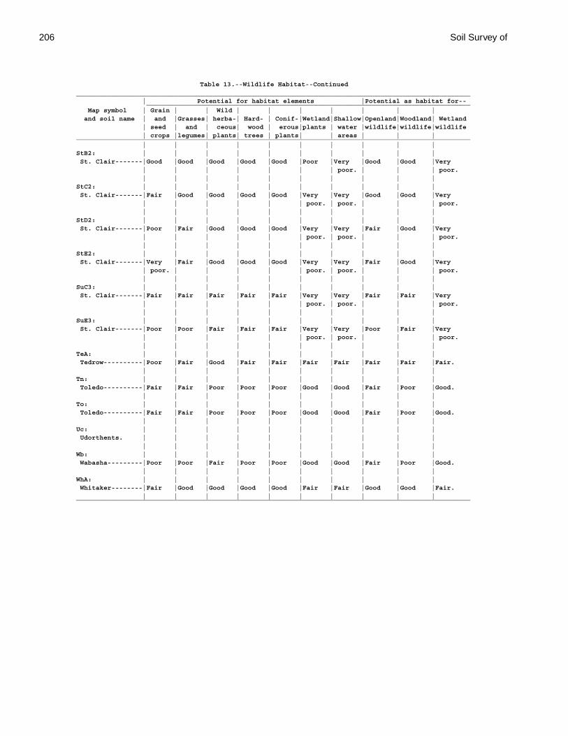
206 Soil Survey of
Table 13.--Wildlife Habitat--Continued_____________________________________________________________________________________________________ | Potential for habitat elements |Potential as habitat for-- ___________________________________________________________________________________ Map symbol | Grain | | Wild | | | | | | | and soil name | and |Grasses| herba-| Hard- | Conif-|Wetland|Shallow|Openland|Woodland| Wetland | seed | and | ceous| wood | erous|plants | water |wildlife|wildlife|wildlife | crops |legumes| plants| trees | plants| | areas | | |_____________________________________________________________________________________________________ | | | | | | | | | |StB2: | | | | | | | | | | St. Clair-------|Good |Good |Good |Good |Good |Poor |Very |Good |Good |Very | | | | | | | poor. | | | poor. | | | | | | | | | |StC2: | | | | | | | | | | St. Clair-------|Fair |Good |Good |Good |Good |Very |Very |Good |Good |Very | | | | | | poor. | poor. | | | poor. | | | | | | | | | |StD2: | | | | | | | | | | St. Clair-------|Poor |Fair |Good |Good |Good |Very |Very |Fair |Good |Very | | | | | | poor. | poor. | | | poor. | | | | | | | | | |StE2: | | | | | | | | | | St. Clair-------|Very |Fair |Good |Good |Good |Very |Very |Fair |Good |Very | poor. | | | | | poor. | poor. | | | poor. | | | | | | | | | |SuC3: | | | | | | | | | | St. Clair-------|Fair |Fair |Fair |Fair |Fair |Very |Very |Fair |Fair |Very | | | | | | poor. | poor. | | | poor. | | | | | | | | | |SuE3: | | | | | | | | | | St. Clair-------|Poor |Poor |Fair |Fair |Fair |Very |Very |Poor |Fair |Very | | | | | | poor. | poor. | | | poor. | | | | | | | | | |TeA: | | | | | | | | | | Tedrow----------|Poor |Fair |Good |Fair |Fair |Fair |Fair |Fair |Fair |Fair. | | | | | | | | | |Tn: | | | | | | | | | | Toledo----------|Fair |Fair |Poor |Poor |Poor |Good |Good |Fair |Poor |Good. | | | | | | | | | |To: | | | | | | | | | | Toledo----------|Fair |Fair |Poor |Poor |Poor |Good |Good |Fair |Poor |Good. | | | | | | | | | |Uc: | | | | | | | | | | Udorthents. | | | | | | | | | | | | | | | | | | | |Wb: | | | | | | | | | | Wabasha---------|Poor |Poor |Fair |Poor |Poor |Good |Good |Fair |Poor |Good. | | | | | | | | | |WhA: | | | | | | | | | | Whitaker--------|Fair |Good |Good |Good |Good |Fair |Fair |Good |Good |Fair. | | | | | | | | | |_____________________________________________________________________________________________________
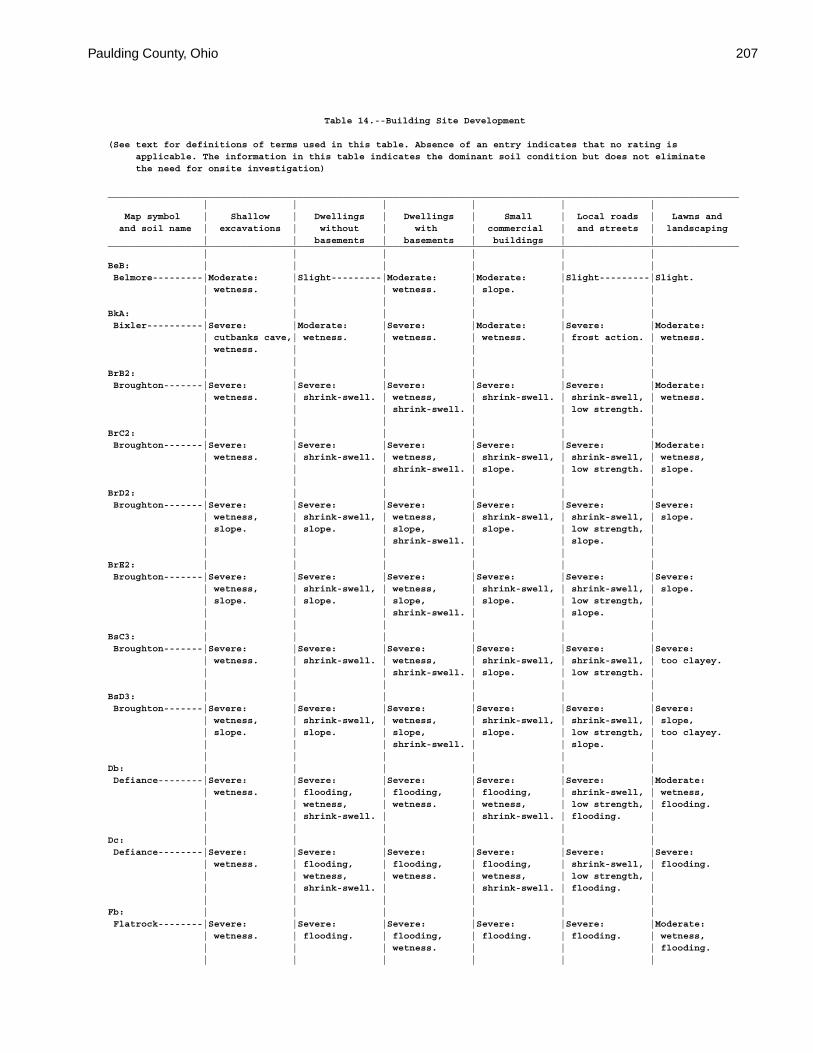
Paulding County, Ohio 207
Table 14.--Building Site Development
(See text for definitions of terms used in this table. Absence of an entry indicates that no rating is applicable. The information in this table indicates the dominant soil condition but does not eliminate the need for onsite investigation)
_________________________________________________________________________________________________________________ | | | | | | Map symbol | Shallow | Dwellings | Dwellings | Small | Local roads | Lawns and and soil name | excavations | without | with | commercial | and streets | landscaping | | basements | basements | buildings | |_________________________________________________________________________________________________________________ | | | | | |BeB: | | | | | | Belmore---------|Moderate: |Slight---------|Moderate: |Moderate: |Slight---------|Slight. | wetness. | | wetness. | slope. | | | | | | | |BkA: | | | | | | Bixler----------|Severe: |Moderate: |Severe: |Moderate: |Severe: |Moderate: | cutbanks cave,| wetness. | wetness. | wetness. | frost action. | wetness. | wetness. | | | | | | | | | | |BrB2: | | | | | | Broughton-------|Severe: |Severe: |Severe: |Severe: |Severe: |Moderate: | wetness. | shrink-swell. | wetness, | shrink-swell. | shrink-swell, | wetness. | | | shrink-swell. | | low strength. | | | | | | |BrC2: | | | | | | Broughton-------|Severe: |Severe: |Severe: |Severe: |Severe: |Moderate: | wetness. | shrink-swell. | wetness, | shrink-swell, | shrink-swell, | wetness, | | | shrink-swell. | slope. | low strength. | slope. | | | | | |BrD2: | | | | | | Broughton-------|Severe: |Severe: |Severe: |Severe: |Severe: |Severe: | wetness, | shrink-swell, | wetness, | shrink-swell, | shrink-swell, | slope. | slope. | slope. | slope, | slope. | low strength, | | | | shrink-swell. | | slope. | | | | | | |BrE2: | | | | | | Broughton-------|Severe: |Severe: |Severe: |Severe: |Severe: |Severe: | wetness, | shrink-swell, | wetness, | shrink-swell, | shrink-swell, | slope. | slope. | slope. | slope, | slope. | low strength, | | | | shrink-swell. | | slope. | | | | | | |BsC3: | | | | | | Broughton-------|Severe: |Severe: |Severe: |Severe: |Severe: |Severe: | wetness. | shrink-swell. | wetness, | shrink-swell, | shrink-swell, | too clayey. | | | shrink-swell. | slope. | low strength. | | | | | | |BsD3: | | | | | | Broughton-------|Severe: |Severe: |Severe: |Severe: |Severe: |Severe: | wetness, | shrink-swell, | wetness, | shrink-swell, | shrink-swell, | slope, | slope. | slope. | slope, | slope. | low strength, | too clayey. | | | shrink-swell. | | slope. | | | | | | |Db: | | | | | | Defiance--------|Severe: |Severe: |Severe: |Severe: |Severe: |Moderate: | wetness. | flooding, | flooding, | flooding, | shrink-swell, | wetness, | | wetness, | wetness. | wetness, | low strength, | flooding. | | shrink-swell. | | shrink-swell. | flooding. | | | | | | |Dc: | | | | | | Defiance--------|Severe: |Severe: |Severe: |Severe: |Severe: |Severe: | wetness. | flooding, | flooding, | flooding, | shrink-swell, | flooding. | | wetness, | wetness. | wetness, | low strength, | | | shrink-swell. | | shrink-swell. | flooding. | | | | | | |Fb: | | | | | | Flatrock--------|Severe: |Severe: |Severe: |Severe: |Severe: |Moderate: | wetness. | flooding. | flooding, | flooding. | flooding. | wetness, | | | wetness. | | | flooding. | | | | | |
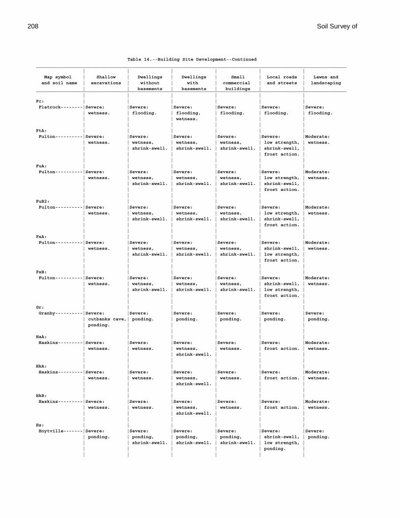
208 Soil Survey of
Table 14.--Building Site Development--Continued_________________________________________________________________________________________________________________ | | | | | | Map symbol | Shallow | Dwellings | Dwellings | Small | Local roads | Lawns and and soil name | excavations | without | with | commercial | and streets | landscaping | | basements | basements | buildings | |_________________________________________________________________________________________________________________ | | | | | |Fc: | | | | | | Flatrock--------|Severe: |Severe: |Severe: |Severe: |Severe: |Severe: | wetness. | flooding. | flooding, | flooding. | flooding. | flooding. | | | wetness. | | | | | | | | |FtA: | | | | | | Fulton----------|Severe: |Severe: |Severe: |Severe: |Severe: |Moderate: | wetness. | wetness, | wetness, | wetness, | low strength, | wetness. | | shrink-swell. | shrink-swell. | shrink-swell. | shrink-swell, | | | | | | frost action. | | | | | | |FuA: | | | | | | Fulton----------|Severe: |Severe: |Severe: |Severe: |Severe: |Moderate: | wetness. | wetness, | wetness, | wetness, | low strength, | wetness. | | shrink-swell. | shrink-swell. | shrink-swell. | shrink-swell, | | | | | | frost action. | | | | | | |FuB2: | | | | | | Fulton----------|Severe: |Severe: |Severe: |Severe: |Severe: |Moderate: | wetness. | wetness, | wetness, | wetness, | low strength, | wetness. | | shrink-swell. | shrink-swell. | shrink-swell. | shrink-swell, | | | | | | frost action. | | | | | | |FxA: | | | | | | Fulton----------|Severe: |Severe: |Severe: |Severe: |Severe: |Moderate: | wetness. | wetness, | wetness, | wetness, | shrink-swell, | wetness. | | shrink-swell. | shrink-swell. | shrink-swell. | low strength, | | | | | | frost action. | | | | | | |FxB: | | | | | | Fulton----------|Severe: |Severe: |Severe: |Severe: |Severe: |Moderate: | wetness. | wetness, | wetness, | wetness, | shrink-swell, | wetness. | | shrink-swell. | shrink-swell. | shrink-swell. | low strength, | | | | | | frost action. | | | | | | |Gr: | | | | | | Granby----------|Severe: |Severe: |Severe: |Severe: |Severe: |Severe: | cutbanks cave,| ponding. | ponding. | ponding. | ponding. | ponding. | ponding. | | | | | | | | | | |HaA: | | | | | | Haskins---------|Severe: |Severe: |Severe: |Severe: |Severe: |Moderate: | wetness. | wetness. | wetness, | wetness. | frost action. | wetness. | | | shrink-swell. | | | | | | | | |HkA: | | | | | | Haskins---------|Severe: |Severe: |Severe: |Severe: |Severe: |Moderate: | wetness. | wetness. | wetness, | wetness. | frost action. | wetness. | | | shrink-swell. | | | | | | | | |HkB: | | | | | | Haskins---------|Severe: |Severe: |Severe: |Severe: |Severe: |Moderate: | wetness. | wetness. | wetness, | wetness. | frost action. | wetness. | | | shrink-swell. | | | | | | | | |Hs: | | | | | | Hoytville-------|Severe: |Severe: |Severe: |Severe: |Severe: |Severe: | ponding. | ponding, | ponding, | ponding, | shrink-swell, | ponding. | | shrink-swell. | shrink-swell. | shrink-swell. | low strength, | | | | | | ponding. | | | | | | |
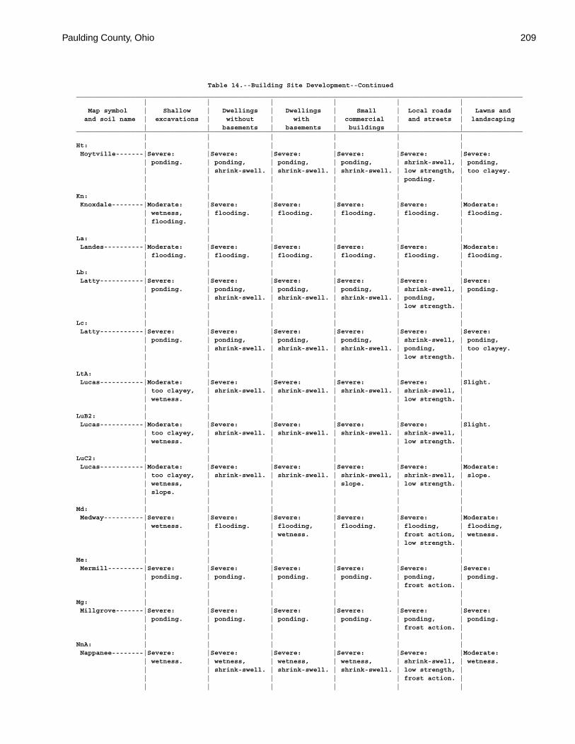
Paulding County, Ohio 209
Table 14.--Building Site Development--Continued_________________________________________________________________________________________________________________ | | | | | | Map symbol | Shallow | Dwellings | Dwellings | Small | Local roads | Lawns and and soil name | excavations | without | with | commercial | and streets | landscaping | | basements | basements | buildings | |_________________________________________________________________________________________________________________ | | | | | |Ht: | | | | | | Hoytville-------|Severe: |Severe: |Severe: |Severe: |Severe: |Severe: | ponding. | ponding, | ponding, | ponding, | shrink-swell, | ponding, | | shrink-swell. | shrink-swell. | shrink-swell. | low strength, | too clayey. | | | | | ponding. | | | | | | |Kn: | | | | | | Knoxdale--------|Moderate: |Severe: |Severe: |Severe: |Severe: |Moderate: | wetness, | flooding. | flooding. | flooding. | flooding. | flooding. | flooding. | | | | | | | | | | |La: | | | | | | Landes----------|Moderate: |Severe: |Severe: |Severe: |Severe: |Moderate: | flooding. | flooding. | flooding. | flooding. | flooding. | flooding. | | | | | |Lb: | | | | | | Latty-----------|Severe: |Severe: |Severe: |Severe: |Severe: |Severe: | ponding. | ponding, | ponding, | ponding, | shrink-swell, | ponding. | | shrink-swell. | shrink-swell. | shrink-swell. | ponding, | | | | | | low strength. | | | | | | |Lc: | | | | | | Latty-----------|Severe: |Severe: |Severe: |Severe: |Severe: |Severe: | ponding. | ponding, | ponding, | ponding, | shrink-swell, | ponding, | | shrink-swell. | shrink-swell. | shrink-swell. | ponding, | too clayey. | | | | | low strength. | | | | | | |LtA: | | | | | | Lucas-----------|Moderate: |Severe: |Severe: |Severe: |Severe: |Slight. | too clayey, | shrink-swell. | shrink-swell. | shrink-swell. | shrink-swell, | | wetness. | | | | low strength. | | | | | | |LuB2: | | | | | | Lucas-----------|Moderate: |Severe: |Severe: |Severe: |Severe: |Slight. | too clayey, | shrink-swell. | shrink-swell. | shrink-swell. | shrink-swell, | | wetness. | | | | low strength. | | | | | | |LuC2: | | | | | | Lucas-----------|Moderate: |Severe: |Severe: |Severe: |Severe: |Moderate: | too clayey, | shrink-swell. | shrink-swell. | shrink-swell, | shrink-swell, | slope. | wetness, | | | slope. | low strength. | | slope. | | | | | | | | | | |Md: | | | | | | Medway----------|Severe: |Severe: |Severe: |Severe: |Severe: |Moderate: | wetness. | flooding. | flooding, | flooding. | flooding, | flooding, | | | wetness. | | frost action, | wetness. | | | | | low strength. | | | | | | |Me: | | | | | | Mermill---------|Severe: |Severe: |Severe: |Severe: |Severe: |Severe: | ponding. | ponding. | ponding. | ponding. | ponding, | ponding. | | | | | frost action. | | | | | | |Mg: | | | | | | Millgrove-------|Severe: |Severe: |Severe: |Severe: |Severe: |Severe: | ponding. | ponding. | ponding. | ponding. | ponding, | ponding. | | | | | frost action. | | | | | | |NnA: | | | | | | Nappanee--------|Severe: |Severe: |Severe: |Severe: |Severe: |Moderate: | wetness. | wetness, | wetness, | wetness, | shrink-swell, | wetness. | | shrink-swell. | shrink-swell. | shrink-swell. | low strength, | | | | | | frost action. | | | | | | |
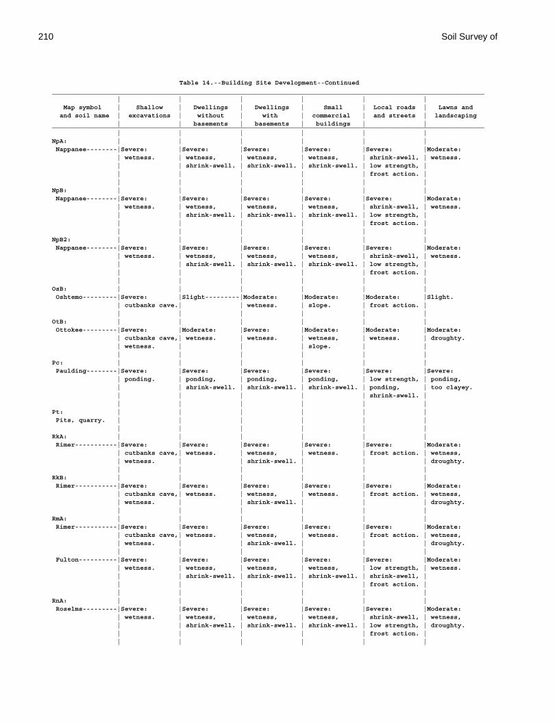
210 Soil Survey of
Table 14.--Building Site Development--Continued_________________________________________________________________________________________________________________ | | | | | | Map symbol | Shallow | Dwellings | Dwellings | Small | Local roads | Lawns and and soil name | excavations | without | with | commercial | and streets | landscaping | | basements | basements | buildings | |_________________________________________________________________________________________________________________ | | | | | |NpA: | | | | | | Nappanee--------|Severe: |Severe: |Severe: |Severe: |Severe: |Moderate: | wetness. | wetness, | wetness, | wetness, | shrink-swell, | wetness. | | shrink-swell. | shrink-swell. | shrink-swell. | low strength, | | | | | | frost action. | | | | | | |NpB: | | | | | | Nappanee--------|Severe: |Severe: |Severe: |Severe: |Severe: |Moderate: | wetness. | wetness, | wetness, | wetness, | shrink-swell, | wetness. | | shrink-swell. | shrink-swell. | shrink-swell. | low strength, | | | | | | frost action. | | | | | | |NpB2: | | | | | | Nappanee--------|Severe: |Severe: |Severe: |Severe: |Severe: |Moderate: | wetness. | wetness, | wetness, | wetness, | shrink-swell, | wetness. | | shrink-swell. | shrink-swell. | shrink-swell. | low strength, | | | | | | frost action. | | | | | | |OsB: | | | | | | Oshtemo---------|Severe: |Slight---------|Moderate: |Moderate: |Moderate: |Slight. | cutbanks cave.| | wetness. | slope. | frost action. | | | | | | |OtB: | | | | | | Ottokee---------|Severe: |Moderate: |Severe: |Moderate: |Moderate: |Moderate: | cutbanks cave,| wetness. | wetness. | wetness, | wetness. | droughty. | wetness. | | | slope. | | | | | | | |Pc: | | | | | | Paulding--------|Severe: |Severe: |Severe: |Severe: |Severe: |Severe: | ponding. | ponding, | ponding, | ponding, | low strength, | ponding, | | shrink-swell. | shrink-swell. | shrink-swell. | ponding, | too clayey. | | | | | shrink-swell. | | | | | | |Pt: | | | | | | Pits, quarry. | | | | | | | | | | | |RkA: | | | | | | Rimer-----------|Severe: |Severe: |Severe: |Severe: |Severe: |Moderate: | cutbanks cave,| wetness. | wetness, | wetness. | frost action. | wetness, | wetness. | | shrink-swell. | | | droughty. | | | | | |RkB: | | | | | | Rimer-----------|Severe: |Severe: |Severe: |Severe: |Severe: |Moderate: | cutbanks cave,| wetness. | wetness, | wetness. | frost action. | wetness, | wetness. | | shrink-swell. | | | droughty. | | | | | |RmA: | | | | | | Rimer-----------|Severe: |Severe: |Severe: |Severe: |Severe: |Moderate: | cutbanks cave,| wetness. | wetness, | wetness. | frost action. | wetness, | wetness. | | shrink-swell. | | | droughty. | | | | | | Fulton----------|Severe: |Severe: |Severe: |Severe: |Severe: |Moderate: | wetness. | wetness, | wetness, | wetness, | low strength, | wetness. | | shrink-swell. | shrink-swell. | shrink-swell. | shrink-swell, | | | | | | frost action. | | | | | | |RnA: | | | | | | Roselms---------|Severe: |Severe: |Severe: |Severe: |Severe: |Moderate: | wetness. | wetness, | wetness, | wetness, | shrink-swell, | wetness, | | shrink-swell. | shrink-swell. | shrink-swell. | low strength, | droughty. | | | | | frost action. | | | | | | |
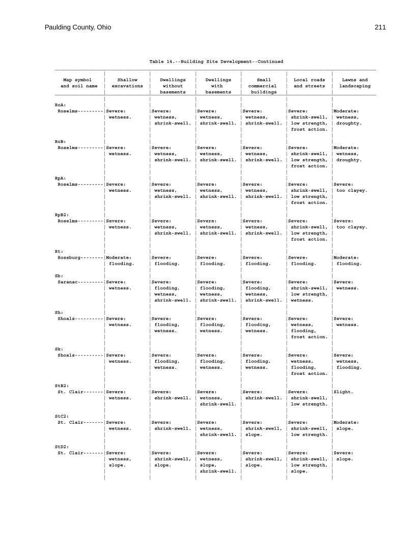
Paulding County, Ohio 211
Table 14.--Building Site Development--Continued_________________________________________________________________________________________________________________ | | | | | | Map symbol | Shallow | Dwellings | Dwellings | Small | Local roads | Lawns and and soil name | excavations | without | with | commercial | and streets | landscaping | | basements | basements | buildings | |_________________________________________________________________________________________________________________ | | | | | |RoA: | | | | | | Roselms---------|Severe: |Severe: |Severe: |Severe: |Severe: |Moderate: | wetness. | wetness, | wetness, | wetness, | shrink-swell, | wetness, | | shrink-swell. | shrink-swell. | shrink-swell. | low strength, | droughty. | | | | | frost action. | | | | | | |RoB: | | | | | | Roselms---------|Severe: |Severe: |Severe: |Severe: |Severe: |Moderate: | wetness. | wetness, | wetness, | wetness, | shrink-swell, | wetness, | | shrink-swell. | shrink-swell. | shrink-swell. | low strength, | droughty. | | | | | frost action. | | | | | | |RpA: | | | | | | Roselms---------|Severe: |Severe: |Severe: |Severe: |Severe: |Severe: | wetness. | wetness, | wetness, | wetness, | shrink-swell, | too clayey. | | shrink-swell. | shrink-swell. | shrink-swell. | low strength, | | | | | | frost action. | | | | | | |RpB2: | | | | | | Roselms---------|Severe: |Severe: |Severe: |Severe: |Severe: |Severe: | wetness. | wetness, | wetness, | wetness, | shrink-swell, | too clayey. | | shrink-swell. | shrink-swell. | shrink-swell. | low strength, | | | | | | frost action. | | | | | | |Rt: | | | | | | Rossburg--------|Moderate: |Severe: |Severe: |Severe: |Severe: |Moderate: | flooding. | flooding. | flooding. | flooding. | flooding. | flooding. | | | | | |Sb: | | | | | | Saranac---------|Severe: |Severe: |Severe: |Severe: |Severe: |Severe: | wetness. | flooding, | flooding, | flooding, | shrink-swell, | wetness. | | wetness, | wetness, | wetness, | low strength, | | | shrink-swell. | shrink-swell. | shrink-swell. | wetness. | | | | | | |Sh: | | | | | | Shoals----------|Severe: |Severe: |Severe: |Severe: |Severe: |Severe: | wetness. | flooding, | flooding, | flooding, | wetness, | wetness. | | wetness. | wetness. | wetness. | flooding, | | | | | | frost action. | | | | | | |Sk: | | | | | | Shoals----------|Severe: |Severe: |Severe: |Severe: |Severe: |Severe: | wetness. | flooding, | flooding, | flooding, | wetness, | wetness, | | wetness. | wetness. | wetness. | flooding, | flooding. | | | | | frost action. | | | | | | |StB2: | | | | | | St. Clair-------|Severe: |Severe: |Severe: |Severe: |Severe: |Slight. | wetness. | shrink-swell. | wetness, | shrink-swell. | shrink-swell, | | | | shrink-swell. | | low strength. | | | | | | |StC2: | | | | | | St. Clair-------|Severe: |Severe: |Severe: |Severe: |Severe: |Moderate: | wetness. | shrink-swell. | wetness, | shrink-swell, | shrink-swell, | slope. | | | shrink-swell. | slope. | low strength. | | | | | | |StD2: | | | | | | St. Clair-------|Severe: |Severe: |Severe: |Severe: |Severe: |Severe: | wetness, | shrink-swell, | wetness, | shrink-swell, | shrink-swell, | slope. | slope. | slope. | slope, | slope. | low strength, | | | | shrink-swell. | | slope. | | | | | | |
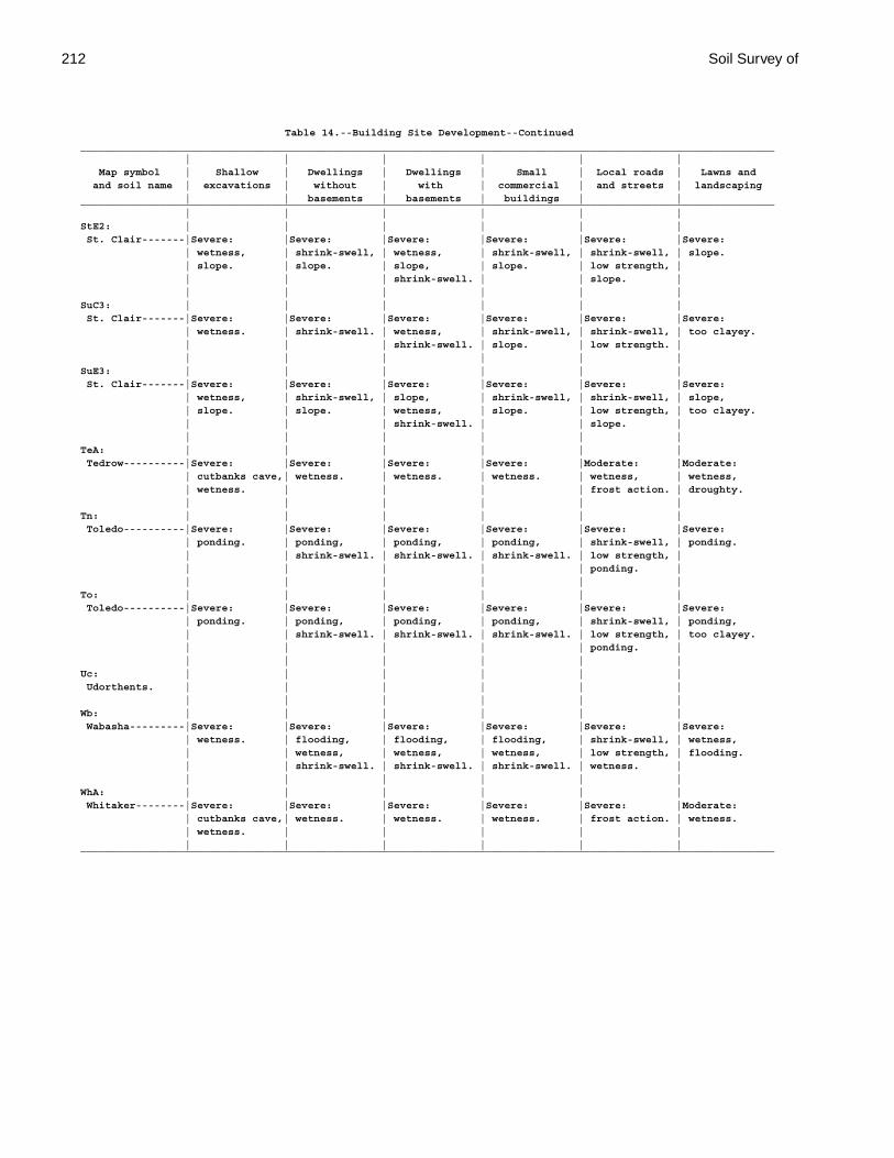
212 Soil Survey of
Table 14.--Building Site Development--Continued_________________________________________________________________________________________________________________ | | | | | | Map symbol | Shallow | Dwellings | Dwellings | Small | Local roads | Lawns and and soil name | excavations | without | with | commercial | and streets | landscaping | | basements | basements | buildings | |_________________________________________________________________________________________________________________ | | | | | |StE2: | | | | | | St. Clair-------|Severe: |Severe: |Severe: |Severe: |Severe: |Severe: | wetness, | shrink-swell, | wetness, | shrink-swell, | shrink-swell, | slope. | slope. | slope. | slope, | slope. | low strength, | | | | shrink-swell. | | slope. | | | | | | |SuC3: | | | | | | St. Clair-------|Severe: |Severe: |Severe: |Severe: |Severe: |Severe: | wetness. | shrink-swell. | wetness, | shrink-swell, | shrink-swell, | too clayey. | | | shrink-swell. | slope. | low strength. | | | | | | |SuE3: | | | | | | St. Clair-------|Severe: |Severe: |Severe: |Severe: |Severe: |Severe: | wetness, | shrink-swell, | slope, | shrink-swell, | shrink-swell, | slope, | slope. | slope. | wetness, | slope. | low strength, | too clayey. | | | shrink-swell. | | slope. | | | | | | |TeA: | | | | | | Tedrow----------|Severe: |Severe: |Severe: |Severe: |Moderate: |Moderate: | cutbanks cave,| wetness. | wetness. | wetness. | wetness, | wetness, | wetness. | | | | frost action. | droughty. | | | | | |Tn: | | | | | | Toledo----------|Severe: |Severe: |Severe: |Severe: |Severe: |Severe: | ponding. | ponding, | ponding, | ponding, | shrink-swell, | ponding. | | shrink-swell. | shrink-swell. | shrink-swell. | low strength, | | | | | | ponding. | | | | | | |To: | | | | | | Toledo----------|Severe: |Severe: |Severe: |Severe: |Severe: |Severe: | ponding. | ponding, | ponding, | ponding, | shrink-swell, | ponding, | | shrink-swell. | shrink-swell. | shrink-swell. | low strength, | too clayey. | | | | | ponding. | | | | | | |Uc: | | | | | | Udorthents. | | | | | | | | | | | |Wb: | | | | | | Wabasha---------|Severe: |Severe: |Severe: |Severe: |Severe: |Severe: | wetness. | flooding, | flooding, | flooding, | shrink-swell, | wetness, | | wetness, | wetness, | wetness, | low strength, | flooding. | | shrink-swell. | shrink-swell. | shrink-swell. | wetness. | | | | | | |WhA: | | | | | | Whitaker--------|Severe: |Severe: |Severe: |Severe: |Severe: |Moderate: | cutbanks cave,| wetness. | wetness. | wetness. | frost action. | wetness. | wetness. | | | | | | | | | | |_________________________________________________________________________________________________________________
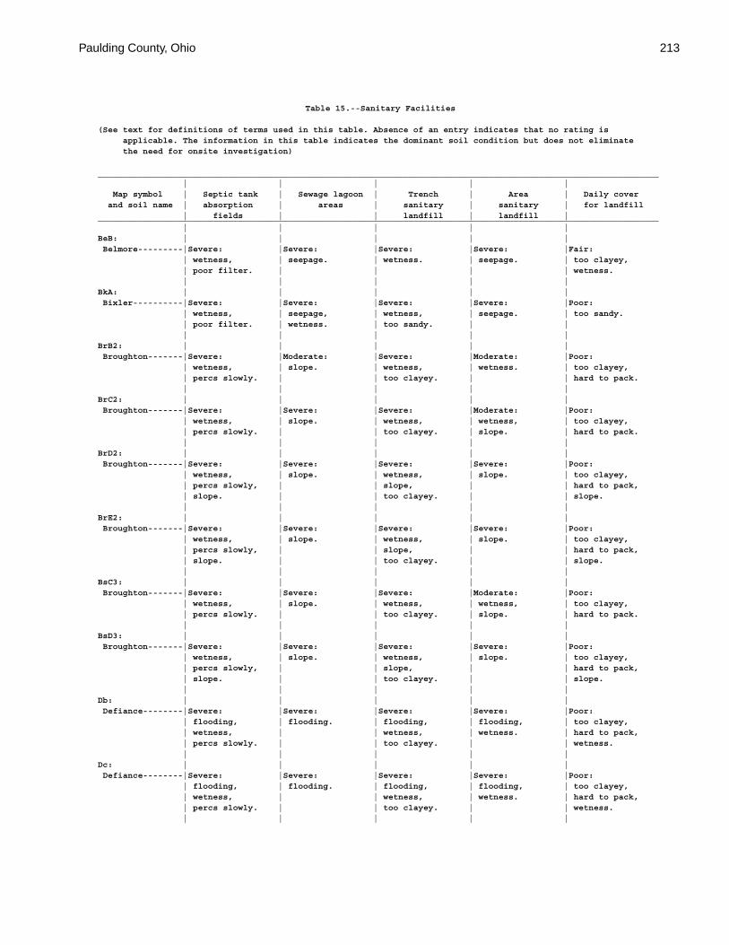
Paulding County, Ohio 213
Table 15.--Sanitary Facilities
(See text for definitions of terms used in this table. Absence of an entry indicates that no rating is applicable. The information in this table indicates the dominant soil condition but does not eliminate the need for onsite investigation)
________________________________________________________________________________________________________________ | | | | | Map symbol | Septic tank | Sewage lagoon | Trench | Area | Daily cover and soil name | absorption | areas | sanitary | sanitary | for landfill | fields | | landfill | landfill |________________________________________________________________________________________________________________ | | | | |BeB: | | | | | Belmore---------|Severe: |Severe: |Severe: |Severe: |Fair: | wetness, | seepage. | wetness. | seepage. | too clayey, | poor filter. | | | | wetness. | | | | |BkA: | | | | | Bixler----------|Severe: |Severe: |Severe: |Severe: |Poor: | wetness, | seepage, | wetness, | seepage. | too sandy. | poor filter. | wetness. | too sandy. | | | | | | |BrB2: | | | | | Broughton-------|Severe: |Moderate: |Severe: |Moderate: |Poor: | wetness, | slope. | wetness, | wetness. | too clayey, | percs slowly. | | too clayey. | | hard to pack. | | | | |BrC2: | | | | | Broughton-------|Severe: |Severe: |Severe: |Moderate: |Poor: | wetness, | slope. | wetness, | wetness, | too clayey, | percs slowly. | | too clayey. | slope. | hard to pack. | | | | |BrD2: | | | | | Broughton-------|Severe: |Severe: |Severe: |Severe: |Poor: | wetness, | slope. | wetness, | slope. | too clayey, | percs slowly, | | slope, | | hard to pack, | slope. | | too clayey. | | slope. | | | | |BrE2: | | | | | Broughton-------|Severe: |Severe: |Severe: |Severe: |Poor: | wetness, | slope. | wetness, | slope. | too clayey, | percs slowly, | | slope, | | hard to pack, | slope. | | too clayey. | | slope. | | | | |BsC3: | | | | | Broughton-------|Severe: |Severe: |Severe: |Moderate: |Poor: | wetness, | slope. | wetness, | wetness, | too clayey, | percs slowly. | | too clayey. | slope. | hard to pack. | | | | |BsD3: | | | | | Broughton-------|Severe: |Severe: |Severe: |Severe: |Poor: | wetness, | slope. | wetness, | slope. | too clayey, | percs slowly, | | slope, | | hard to pack, | slope. | | too clayey. | | slope. | | | | |Db: | | | | | Defiance--------|Severe: |Severe: |Severe: |Severe: |Poor: | flooding, | flooding. | flooding, | flooding, | too clayey, | wetness, | | wetness, | wetness. | hard to pack, | percs slowly. | | too clayey. | | wetness. | | | | |Dc: | | | | | Defiance--------|Severe: |Severe: |Severe: |Severe: |Poor: | flooding, | flooding. | flooding, | flooding, | too clayey, | wetness, | | wetness, | wetness. | hard to pack, | percs slowly. | | too clayey. | | wetness. | | | | |
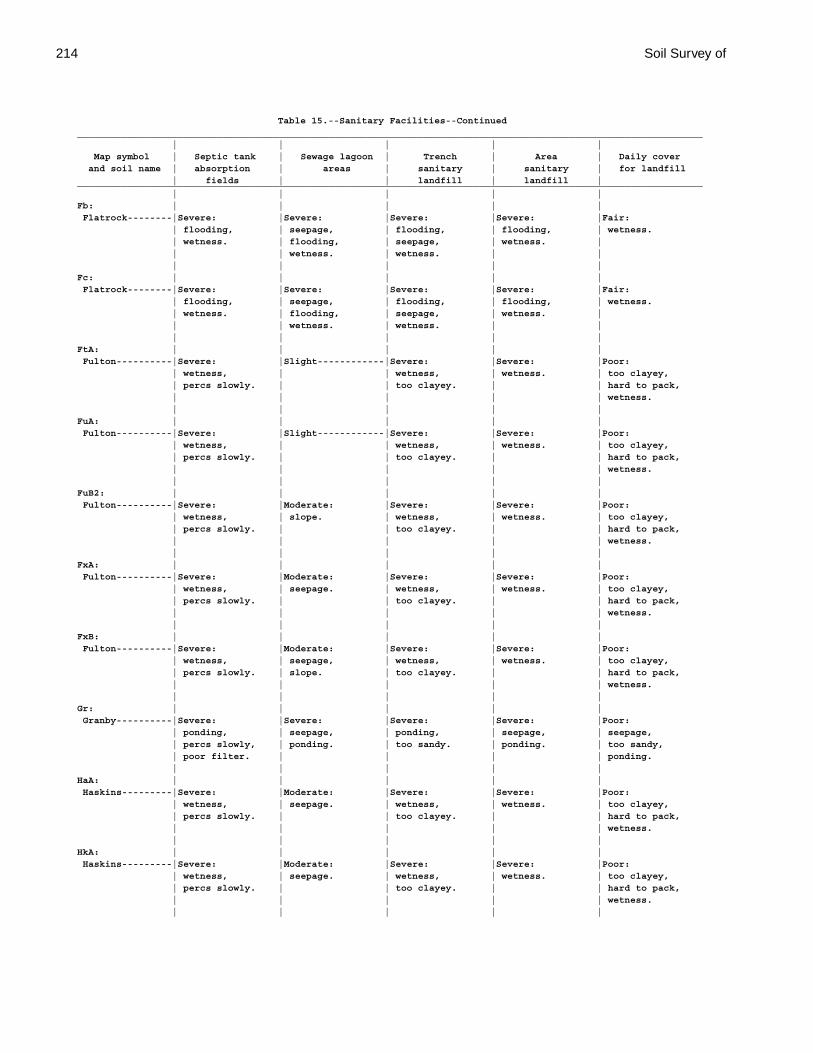
214 Soil Survey of
Table 15.--Sanitary Facilities--Continued________________________________________________________________________________________________________________ | | | | | Map symbol | Septic tank | Sewage lagoon | Trench | Area | Daily cover and soil name | absorption | areas | sanitary | sanitary | for landfill | fields | | landfill | landfill |________________________________________________________________________________________________________________ | | | | |Fb: | | | | | Flatrock--------|Severe: |Severe: |Severe: |Severe: |Fair: | flooding, | seepage, | flooding, | flooding, | wetness. | wetness. | flooding, | seepage, | wetness. | | | wetness. | wetness. | | | | | | |Fc: | | | | | Flatrock--------|Severe: |Severe: |Severe: |Severe: |Fair: | flooding, | seepage, | flooding, | flooding, | wetness. | wetness. | flooding, | seepage, | wetness. | | | wetness. | wetness. | | | | | | |FtA: | | | | | Fulton----------|Severe: |Slight------------|Severe: |Severe: |Poor: | wetness, | | wetness, | wetness. | too clayey, | percs slowly. | | too clayey. | | hard to pack, | | | | | wetness. | | | | |FuA: | | | | | Fulton----------|Severe: |Slight------------|Severe: |Severe: |Poor: | wetness, | | wetness, | wetness. | too clayey, | percs slowly. | | too clayey. | | hard to pack, | | | | | wetness. | | | | |FuB2: | | | | | Fulton----------|Severe: |Moderate: |Severe: |Severe: |Poor: | wetness, | slope. | wetness, | wetness. | too clayey, | percs slowly. | | too clayey. | | hard to pack, | | | | | wetness. | | | | |FxA: | | | | | Fulton----------|Severe: |Moderate: |Severe: |Severe: |Poor: | wetness, | seepage. | wetness, | wetness. | too clayey, | percs slowly. | | too clayey. | | hard to pack, | | | | | wetness. | | | | |FxB: | | | | | Fulton----------|Severe: |Moderate: |Severe: |Severe: |Poor: | wetness, | seepage, | wetness, | wetness. | too clayey, | percs slowly. | slope. | too clayey. | | hard to pack, | | | | | wetness. | | | | |Gr: | | | | | Granby----------|Severe: |Severe: |Severe: |Severe: |Poor: | ponding, | seepage, | ponding, | seepage, | seepage, | percs slowly, | ponding. | too sandy. | ponding. | too sandy, | poor filter. | | | | ponding. | | | | |HaA: | | | | | Haskins---------|Severe: |Moderate: |Severe: |Severe: |Poor: | wetness, | seepage. | wetness, | wetness. | too clayey, | percs slowly. | | too clayey. | | hard to pack, | | | | | wetness. | | | | |HkA: | | | | | Haskins---------|Severe: |Moderate: |Severe: |Severe: |Poor: | wetness, | seepage. | wetness, | wetness. | too clayey, | percs slowly. | | too clayey. | | hard to pack, | | | | | wetness. | | | | |
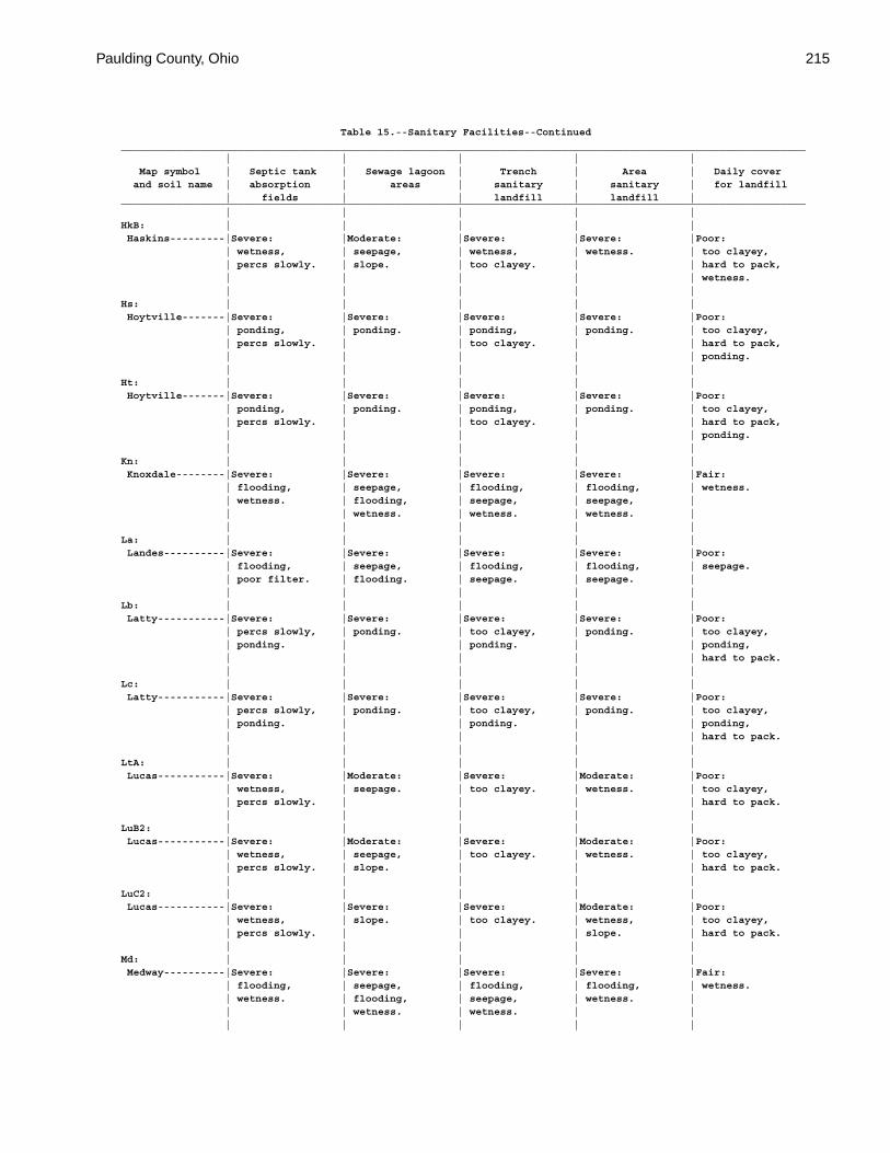
Paulding County, Ohio 215
Table 15.--Sanitary Facilities--Continued________________________________________________________________________________________________________________ | | | | | Map symbol | Septic tank | Sewage lagoon | Trench | Area | Daily cover and soil name | absorption | areas | sanitary | sanitary | for landfill | fields | | landfill | landfill |________________________________________________________________________________________________________________ | | | | |HkB: | | | | | Haskins---------|Severe: |Moderate: |Severe: |Severe: |Poor: | wetness, | seepage, | wetness, | wetness. | too clayey, | percs slowly. | slope. | too clayey. | | hard to pack, | | | | | wetness. | | | | |Hs: | | | | | Hoytville-------|Severe: |Severe: |Severe: |Severe: |Poor: | ponding, | ponding. | ponding, | ponding. | too clayey, | percs slowly. | | too clayey. | | hard to pack, | | | | | ponding. | | | | |Ht: | | | | | Hoytville-------|Severe: |Severe: |Severe: |Severe: |Poor: | ponding, | ponding. | ponding, | ponding. | too clayey, | percs slowly. | | too clayey. | | hard to pack, | | | | | ponding. | | | | |Kn: | | | | | Knoxdale--------|Severe: |Severe: |Severe: |Severe: |Fair: | flooding, | seepage, | flooding, | flooding, | wetness. | wetness. | flooding, | seepage, | seepage, | | | wetness. | wetness. | wetness. | | | | | |La: | | | | | Landes----------|Severe: |Severe: |Severe: |Severe: |Poor: | flooding, | seepage, | flooding, | flooding, | seepage. | poor filter. | flooding. | seepage. | seepage. | | | | | |Lb: | | | | | Latty-----------|Severe: |Severe: |Severe: |Severe: |Poor: | percs slowly, | ponding. | too clayey, | ponding. | too clayey, | ponding. | | ponding. | | ponding, | | | | | hard to pack. | | | | |Lc: | | | | | Latty-----------|Severe: |Severe: |Severe: |Severe: |Poor: | percs slowly, | ponding. | too clayey, | ponding. | too clayey, | ponding. | | ponding. | | ponding, | | | | | hard to pack. | | | | |LtA: | | | | | Lucas-----------|Severe: |Moderate: |Severe: |Moderate: |Poor: | wetness, | seepage. | too clayey. | wetness. | too clayey, | percs slowly. | | | | hard to pack. | | | | |LuB2: | | | | | Lucas-----------|Severe: |Moderate: |Severe: |Moderate: |Poor: | wetness, | seepage, | too clayey. | wetness. | too clayey, | percs slowly. | slope. | | | hard to pack. | | | | |LuC2: | | | | | Lucas-----------|Severe: |Severe: |Severe: |Moderate: |Poor: | wetness, | slope. | too clayey. | wetness, | too clayey, | percs slowly. | | | slope. | hard to pack. | | | | |Md: | | | | | Medway----------|Severe: |Severe: |Severe: |Severe: |Fair: | flooding, | seepage, | flooding, | flooding, | wetness. | wetness. | flooding, | seepage, | wetness. | | | wetness. | wetness. | | | | | | |
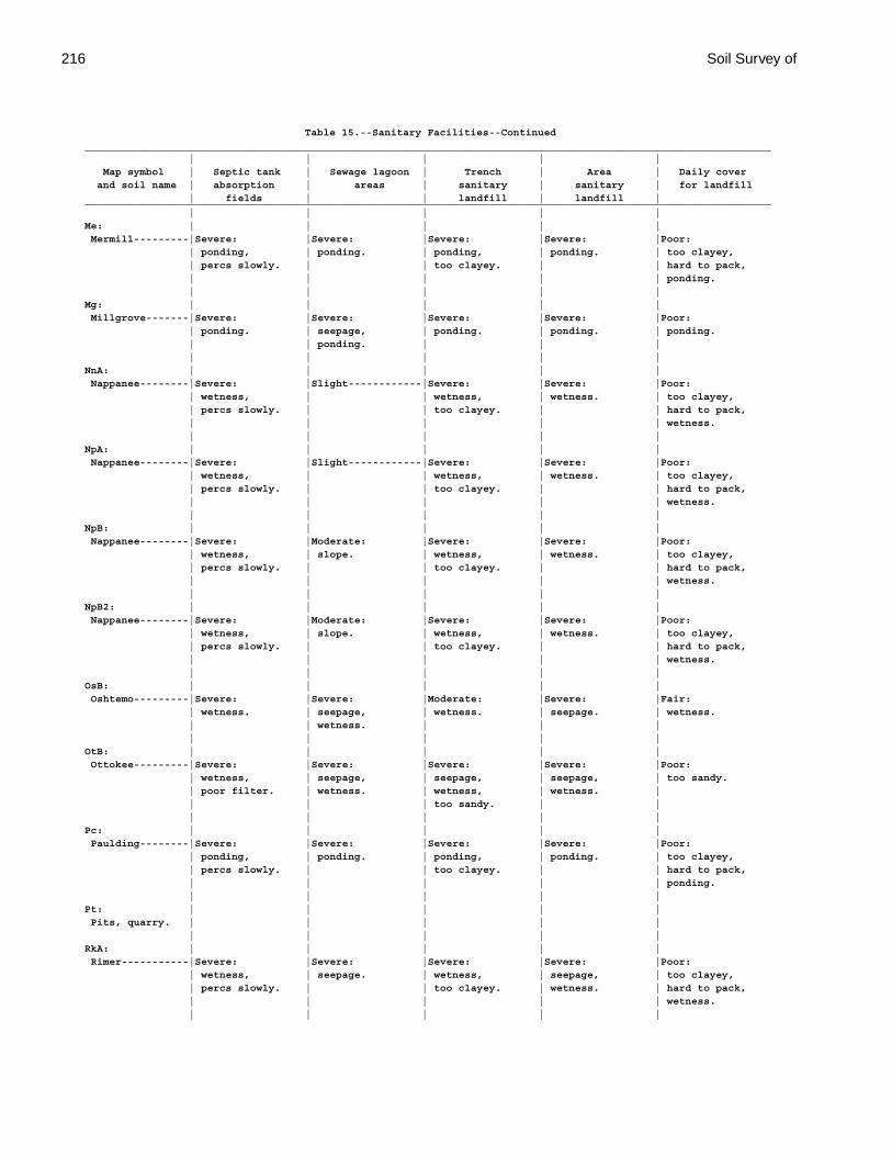
216 Soil Survey of
Table 15.--Sanitary Facilities--Continued________________________________________________________________________________________________________________ | | | | | Map symbol | Septic tank | Sewage lagoon | Trench | Area | Daily cover and soil name | absorption | areas | sanitary | sanitary | for landfill | fields | | landfill | landfill |________________________________________________________________________________________________________________ | | | | |Me: | | | | | Mermill---------|Severe: |Severe: |Severe: |Severe: |Poor: | ponding, | ponding. | ponding, | ponding. | too clayey, | percs slowly. | | too clayey. | | hard to pack, | | | | | ponding. | | | | |Mg: | | | | | Millgrove-------|Severe: |Severe: |Severe: |Severe: |Poor: | ponding. | seepage, | ponding. | ponding. | ponding. | | ponding. | | | | | | | |NnA: | | | | | Nappanee--------|Severe: |Slight------------|Severe: |Severe: |Poor: | wetness, | | wetness, | wetness. | too clayey, | percs slowly. | | too clayey. | | hard to pack, | | | | | wetness. | | | | |NpA: | | | | | Nappanee--------|Severe: |Slight------------|Severe: |Severe: |Poor: | wetness, | | wetness, | wetness. | too clayey, | percs slowly. | | too clayey. | | hard to pack, | | | | | wetness. | | | | |NpB: | | | | | Nappanee--------|Severe: |Moderate: |Severe: |Severe: |Poor: | wetness, | slope. | wetness, | wetness. | too clayey, | percs slowly. | | too clayey. | | hard to pack, | | | | | wetness. | | | | |NpB2: | | | | | Nappanee--------|Severe: |Moderate: |Severe: |Severe: |Poor: | wetness, | slope. | wetness, | wetness. | too clayey, | percs slowly. | | too clayey. | | hard to pack, | | | | | wetness. | | | | |OsB: | | | | | Oshtemo---------|Severe: |Severe: |Moderate: |Severe: |Fair: | wetness. | seepage, | wetness. | seepage. | wetness. | | wetness. | | | | | | | |OtB: | | | | | Ottokee---------|Severe: |Severe: |Severe: |Severe: |Poor: | wetness, | seepage, | seepage, | seepage, | too sandy. | poor filter. | wetness. | wetness, | wetness. | | | | too sandy. | | | | | | |Pc: | | | | | Paulding--------|Severe: |Severe: |Severe: |Severe: |Poor: | ponding, | ponding. | ponding, | ponding. | too clayey, | percs slowly. | | too clayey. | | hard to pack, | | | | | ponding. | | | | |Pt: | | | | | Pits, quarry. | | | | | | | | | |RkA: | | | | | Rimer-----------|Severe: |Severe: |Severe: |Severe: |Poor: | wetness, | seepage. | wetness, | seepage, | too clayey, | percs slowly. | | too clayey. | wetness. | hard to pack, | | | | | wetness. | | | | |
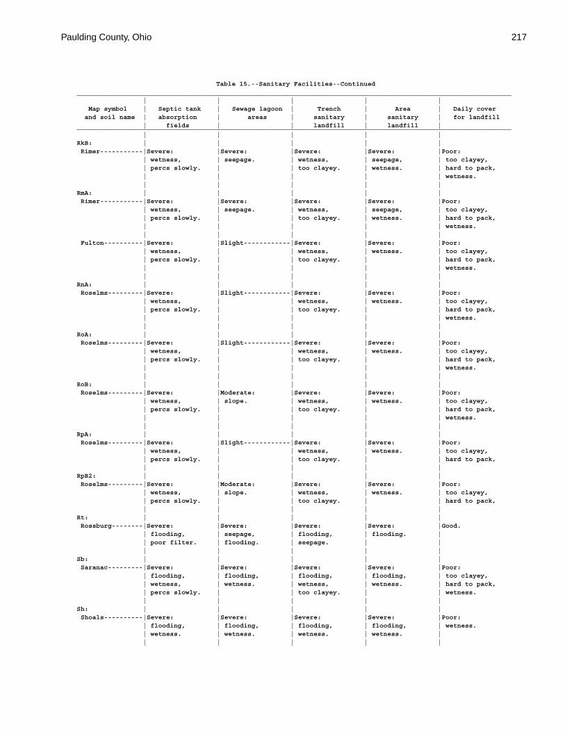
Paulding County, Ohio 217
Table 15.--Sanitary Facilities--Continued________________________________________________________________________________________________________________ | | | | | Map symbol | Septic tank | Sewage lagoon | Trench | Area | Daily cover and soil name | absorption | areas | sanitary | sanitary | for landfill | fields | | landfill | landfill |________________________________________________________________________________________________________________ | | | | |RkB: | | | | | Rimer-----------|Severe: |Severe: |Severe: |Severe: |Poor: | wetness, | seepage. | wetness, | seepage, | too clayey, | percs slowly. | | too clayey. | wetness. | hard to pack, | | | | | wetness. | | | | |RmA: | | | | | Rimer-----------|Severe: |Severe: |Severe: |Severe: |Poor: | wetness, | seepage. | wetness, | seepage, | too clayey, | percs slowly. | | too clayey. | wetness. | hard to pack, | | | | | wetness. | | | | | Fulton----------|Severe: |Slight------------|Severe: |Severe: |Poor: | wetness, | | wetness, | wetness. | too clayey, | percs slowly. | | too clayey. | | hard to pack, | | | | | wetness. | | | | |RnA: | | | | | Roselms---------|Severe: |Slight------------|Severe: |Severe: |Poor: | wetness, | | wetness, | wetness. | too clayey, | percs slowly. | | too clayey. | | hard to pack, | | | | | wetness. | | | | |RoA: | | | | | Roselms---------|Severe: |Slight------------|Severe: |Severe: |Poor: | wetness, | | wetness, | wetness. | too clayey, | percs slowly. | | too clayey. | | hard to pack, | | | | | wetness. | | | | |RoB: | | | | | Roselms---------|Severe: |Moderate: |Severe: |Severe: |Poor: | wetness, | slope. | wetness, | wetness. | too clayey, | percs slowly. | | too clayey. | | hard to pack, | | | | | wetness. | | | | |RpA: | | | | | Roselms---------|Severe: |Slight------------|Severe: |Severe: |Poor: | wetness, | | wetness, | wetness. | too clayey, | percs slowly. | | too clayey. | | hard to pack, | | | | |RpB2: | | | | | Roselms---------|Severe: |Moderate: |Severe: |Severe: |Poor: | wetness, | slope. | wetness, | wetness. | too clayey, | percs slowly. | | too clayey. | | hard to pack, | | | | |Rt: | | | | | Rossburg--------|Severe: |Severe: |Severe: |Severe: |Good. | flooding, | seepage, | flooding, | flooding. | | poor filter. | flooding. | seepage. | | | | | | |Sb: | | | | | Saranac---------|Severe: |Severe: |Severe: |Severe: |Poor: | flooding, | flooding, | flooding, | flooding, | too clayey, | wetness, | wetness. | wetness, | wetness. | hard to pack, | percs slowly. | | too clayey. | | wetness. | | | | |Sh: | | | | | Shoals----------|Severe: |Severe: |Severe: |Severe: |Poor: | flooding, | flooding, | flooding, | flooding, | wetness. | wetness. | wetness. | wetness. | wetness. | | | | | |
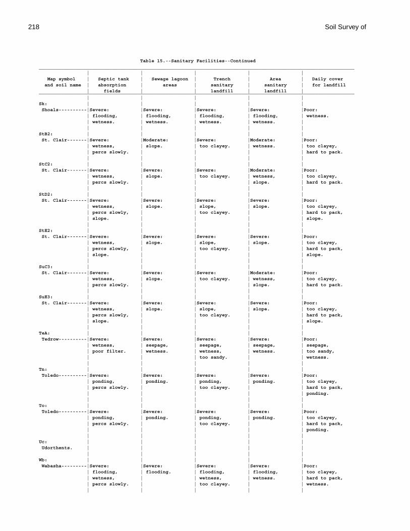
218 Soil Survey of
Table 15.--Sanitary Facilities--Continued________________________________________________________________________________________________________________ | | | | | Map symbol | Septic tank | Sewage lagoon | Trench | Area | Daily cover and soil name | absorption | areas | sanitary | sanitary | for landfill | fields | | landfill | landfill |________________________________________________________________________________________________________________ | | | | |Sk: | | | | | Shoals----------|Severe: |Severe: |Severe: |Severe: |Poor: | flooding, | flooding, | flooding, | flooding, | wetness. | wetness. | wetness. | wetness. | wetness. | | | | | |StB2: | | | | | St. Clair-------|Severe: |Moderate: |Severe: |Moderate: |Poor: | wetness, | slope. | too clayey. | wetness. | too clayey, | percs slowly. | | | | hard to pack. | | | | |StC2: | | | | | St. Clair-------|Severe: |Severe: |Severe: |Moderate: |Poor: | wetness, | slope. | too clayey. | wetness, | too clayey, | percs slowly. | | | slope. | hard to pack. | | | | |StD2: | | | | | St. Clair-------|Severe: |Severe: |Severe: |Severe: |Poor: | wetness, | slope. | slope, | slope. | too clayey, | percs slowly, | | too clayey. | | hard to pack, | slope. | | | | slope. | | | | |StE2: | | | | | St. Clair-------|Severe: |Severe: |Severe: |Severe: |Poor: | wetness, | slope. | slope, | slope. | too clayey, | percs slowly, | | too clayey. | | hard to pack, | slope. | | | | slope. | | | | |SuC3: | | | | | St. Clair-------|Severe: |Severe: |Severe: |Moderate: |Poor: | wetness, | slope. | too clayey. | wetness, | too clayey, | percs slowly. | | | slope. | hard to pack. | | | | |SuE3: | | | | | St. Clair-------|Severe: |Severe: |Severe: |Severe: |Poor: | wetness, | slope. | slope, | slope. | too clayey, | percs slowly, | | too clayey. | | hard to pack, | slope. | | | | slope. | | | | |TeA: | | | | | Tedrow----------|Severe: |Severe: |Severe: |Severe: |Poor: | wetness, | seepage, | seepage, | seepage, | seepage, | poor filter. | wetness. | wetness, | wetness. | too sandy, | | | too sandy. | | wetness. | | | | |Tn: | | | | | Toledo----------|Severe: |Severe: |Severe: |Severe: |Poor: | ponding, | ponding. | ponding, | ponding. | too clayey, | percs slowly. | | too clayey. | | hard to pack, | | | | | ponding. | | | | |To: | | | | | Toledo----------|Severe: |Severe: |Severe: |Severe: |Poor: | ponding, | ponding. | ponding, | ponding. | too clayey, | percs slowly. | | too clayey. | | hard to pack, | | | | | ponding. | | | | |Uc: | | | | | Udorthents. | | | | | | | | | |Wb: | | | | | Wabasha---------|Severe: |Severe: |Severe: |Severe: |Poor: | flooding, | flooding. | flooding, | flooding, | too clayey, | wetness, | | wetness, | wetness. | hard to pack, | percs slowly. | | too clayey. | | wetness. | | | | |

Paulding County, Ohio 219
Table 15.--Sanitary Facilities--Continued________________________________________________________________________________________________________________ | | | | | Map symbol | Septic tank | Sewage lagoon | Trench | Area | Daily cover and soil name | absorption | areas | sanitary | sanitary | for landfill | fields | | landfill | landfill |________________________________________________________________________________________________________________ | | | | |WhA: | | | | | Whitaker--------|Severe: |Severe: |Severe: |Severe: |Poor: | wetness. | seepage, | seepage, | wetness. | wetness. | | wetness. | wetness. | | | | | | |________________________________________________________________________________________________________________
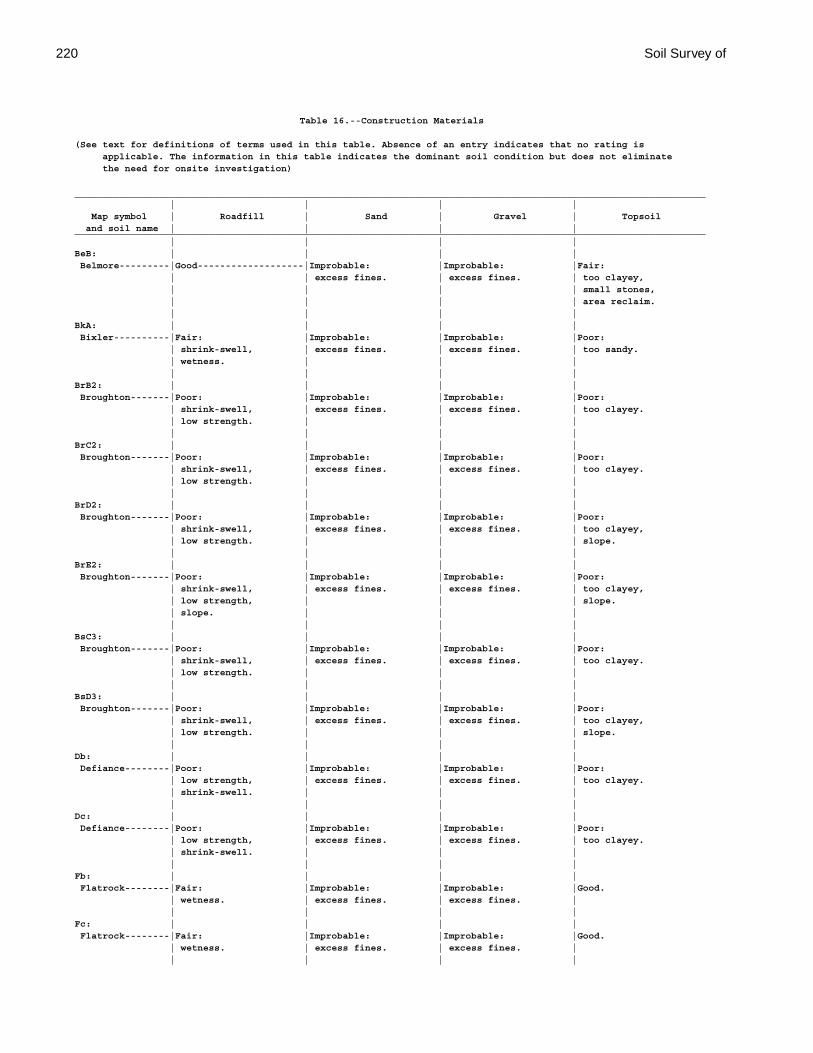
220 Soil Survey of
Table 16.--Construction Materials
(See text for definitions of terms used in this table. Absence of an entry indicates that no rating is applicable. The information in this table indicates the dominant soil condition but does not eliminate the need for onsite investigation)
_________________________________________________________________________________________________________________ | | | | Map symbol | Roadfill | Sand | Gravel | Topsoil and soil name | | | |_________________________________________________________________________________________________________________ | | | |BeB: | | | | Belmore---------|Good-------------------|Improbable: |Improbable: |Fair: | | excess fines. | excess fines. | too clayey, | | | | small stones, | | | | area reclaim. | | | |BkA: | | | | Bixler----------|Fair: |Improbable: |Improbable: |Poor: | shrink-swell, | excess fines. | excess fines. | too sandy. | wetness. | | | | | | |BrB2: | | | | Broughton-------|Poor: |Improbable: |Improbable: |Poor: | shrink-swell, | excess fines. | excess fines. | too clayey. | low strength. | | | | | | |BrC2: | | | | Broughton-------|Poor: |Improbable: |Improbable: |Poor: | shrink-swell, | excess fines. | excess fines. | too clayey. | low strength. | | | | | | |BrD2: | | | | Broughton-------|Poor: |Improbable: |Improbable: |Poor: | shrink-swell, | excess fines. | excess fines. | too clayey, | low strength. | | | slope. | | | |BrE2: | | | | Broughton-------|Poor: |Improbable: |Improbable: |Poor: | shrink-swell, | excess fines. | excess fines. | too clayey, | low strength, | | | slope. | slope. | | | | | | |BsC3: | | | | Broughton-------|Poor: |Improbable: |Improbable: |Poor: | shrink-swell, | excess fines. | excess fines. | too clayey. | low strength. | | | | | | |BsD3: | | | | Broughton-------|Poor: |Improbable: |Improbable: |Poor: | shrink-swell, | excess fines. | excess fines. | too clayey, | low strength. | | | slope. | | | |Db: | | | | Defiance--------|Poor: |Improbable: |Improbable: |Poor: | low strength, | excess fines. | excess fines. | too clayey. | shrink-swell. | | | | | | |Dc: | | | | Defiance--------|Poor: |Improbable: |Improbable: |Poor: | low strength, | excess fines. | excess fines. | too clayey. | shrink-swell. | | | | | | |Fb: | | | | Flatrock--------|Fair: |Improbable: |Improbable: |Good. | wetness. | excess fines. | excess fines. | | | | |Fc: | | | | Flatrock--------|Fair: |Improbable: |Improbable: |Good. | wetness. | excess fines. | excess fines. | | | | |
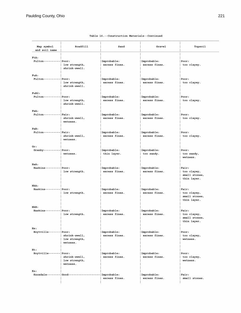
Paulding County, Ohio 221
Table 16.--Construction Materials--Continued_________________________________________________________________________________________________________________ | | | | Map symbol | Roadfill | Sand | Gravel | Topsoil and soil name | | | |_________________________________________________________________________________________________________________ | | | |FtA: | | | | Fulton----------|Poor: |Improbable: |Improbable: |Poor: | low strength, | excess fines. | excess fines. | too clayey. | shrink-swell. | | | | | | |FuA: | | | | Fulton----------|Poor: |Improbable: |Improbable: |Poor: | low strength, | excess fines. | excess fines. | too clayey. | shrink-swell. | | | | | | |FuB2: | | | | Fulton----------|Poor: |Improbable: |Improbable: |Poor: | low strength, | excess fines. | excess fines. | too clayey. | shrink-swell. | | | | | | |FxA: | | | | Fulton----------|Fair: |Improbable: |Improbable: |Poor: | shrink-swell, | excess fines. | excess fines. | too clayey. | wetness. | | | | | | |FxB: | | | | Fulton----------|Fair: |Improbable: |Improbable: |Poor: | shrink-swell, | excess fines. | excess fines. | too clayey. | wetness. | | | | | | |Gr: | | | | Granby----------|Poor: |Improbable: |Improbable: |Poor: | wetness. | thin layer. | too sandy. | too sandy, | | | | wetness. | | | |HaA: | | | | Haskins---------|Poor: |Improbable: |Improbable: |Fair: | low strength. | excess fines. | excess fines. | too clayey, | | | | small stones, | | | | thin layer. | | | |HkA: | | | | Haskins---------|Poor: |Improbable: |Improbable: |Fair: | low strength. | excess fines. | excess fines. | too clayey, | | | | small stones, | | | | thin layer. | | | |HkB: | | | | Haskins---------|Poor: |Improbable: |Improbable: |Fair: | low strength. | excess fines. | excess fines. | too clayey, | | | | small stones, | | | | thin layer. | | | |Hs: | | | | Hoytville-------|Poor: |Improbable: |Improbable: |Poor: | shrink-swell, | excess fines. | excess fines. | too clayey, | low strength, | | | wetness. | wetness. | | | | | | |Ht: | | | | Hoytville-------|Poor: |Improbable: |Improbable: |Poor: | shrink-swell, | excess fines. | excess fines. | too clayey, | low strength, | | | wetness. | wetness. | | | | | | |Kn: | | | | Knoxdale--------|Good-------------------|Improbable: |Improbable: |Fair: | | excess fines. | excess fines. | small stones. | | | |
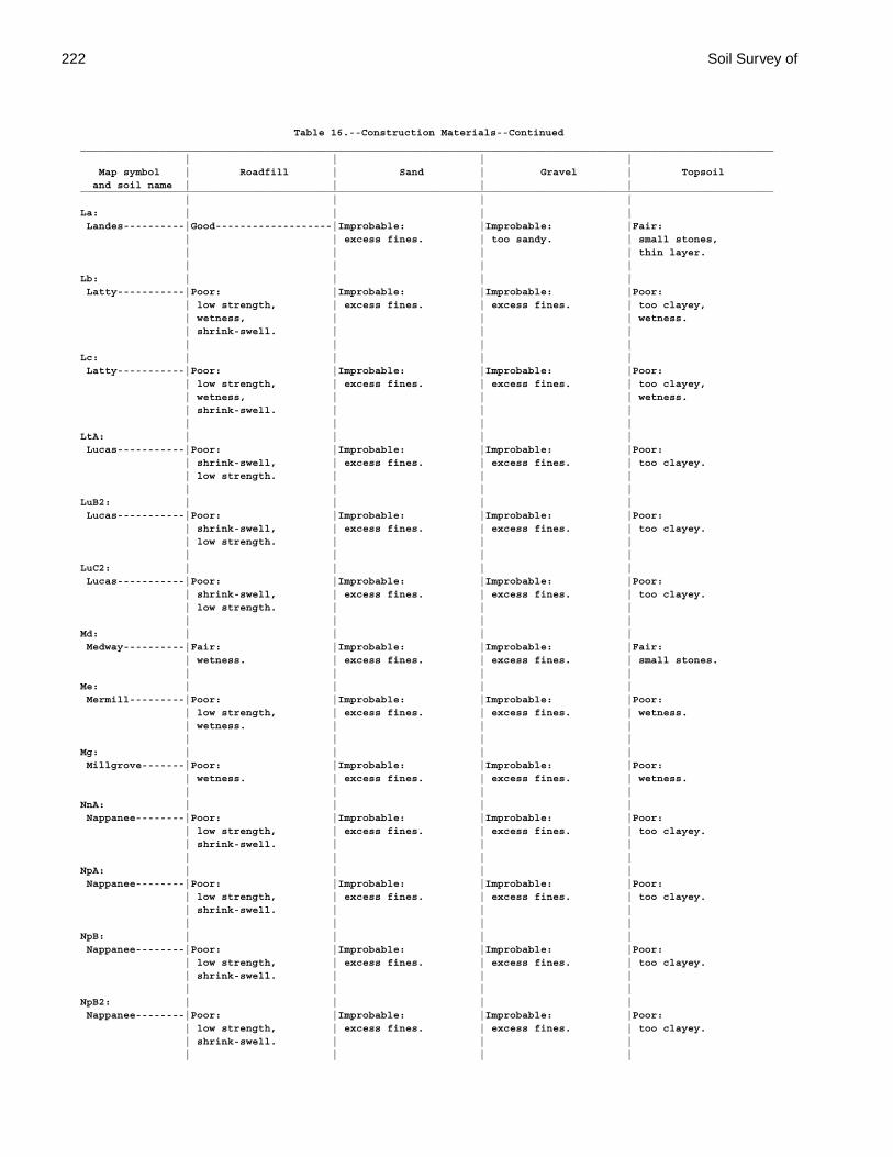
222 Soil Survey of
Table 16.--Construction Materials--Continued_________________________________________________________________________________________________________________ | | | | Map symbol | Roadfill | Sand | Gravel | Topsoil and soil name | | | |_________________________________________________________________________________________________________________ | | | |La: | | | | Landes----------|Good-------------------|Improbable: |Improbable: |Fair: | | excess fines. | too sandy. | small stones, | | | | thin layer. | | | |Lb: | | | | Latty-----------|Poor: |Improbable: |Improbable: |Poor: | low strength, | excess fines. | excess fines. | too clayey, | wetness, | | | wetness. | shrink-swell. | | | | | | |Lc: | | | | Latty-----------|Poor: |Improbable: |Improbable: |Poor: | low strength, | excess fines. | excess fines. | too clayey, | wetness, | | | wetness. | shrink-swell. | | | | | | |LtA: | | | | Lucas-----------|Poor: |Improbable: |Improbable: |Poor: | shrink-swell, | excess fines. | excess fines. | too clayey. | low strength. | | | | | | |LuB2: | | | | Lucas-----------|Poor: |Improbable: |Improbable: |Poor: | shrink-swell, | excess fines. | excess fines. | too clayey. | low strength. | | | | | | |LuC2: | | | | Lucas-----------|Poor: |Improbable: |Improbable: |Poor: | shrink-swell, | excess fines. | excess fines. | too clayey. | low strength. | | | | | | |Md: | | | | Medway----------|Fair: |Improbable: |Improbable: |Fair: | wetness. | excess fines. | excess fines. | small stones. | | | |Me: | | | | Mermill---------|Poor: |Improbable: |Improbable: |Poor: | low strength, | excess fines. | excess fines. | wetness. | wetness. | | | | | | |Mg: | | | | Millgrove-------|Poor: |Improbable: |Improbable: |Poor: | wetness. | excess fines. | excess fines. | wetness. | | | |NnA: | | | | Nappanee--------|Poor: |Improbable: |Improbable: |Poor: | low strength, | excess fines. | excess fines. | too clayey. | shrink-swell. | | | | | | |NpA: | | | | Nappanee--------|Poor: |Improbable: |Improbable: |Poor: | low strength, | excess fines. | excess fines. | too clayey. | shrink-swell. | | | | | | |NpB: | | | | Nappanee--------|Poor: |Improbable: |Improbable: |Poor: | low strength, | excess fines. | excess fines. | too clayey. | shrink-swell. | | | | | | |NpB2: | | | | Nappanee--------|Poor: |Improbable: |Improbable: |Poor: | low strength, | excess fines. | excess fines. | too clayey. | shrink-swell. | | | | | | |

Paulding County, Ohio 223
Table 16.--Construction Materials--Continued_________________________________________________________________________________________________________________ | | | | Map symbol | Roadfill | Sand | Gravel | Topsoil and soil name | | | |_________________________________________________________________________________________________________________ | | | |OsB: | | | | Oshtemo---------|Good-------------------|Improbable: |Improbable: |Fair: | | excess fines. | excess fines. | small stones, | | | | area reclaim. | | | |OtB: | | | | Ottokee---------|Fair: |Probable---------------|Improbable: |Poor: | wetness. | | too sandy. | too sandy. | | | |Pc: | | | | Paulding--------|Poor: |Improbable: |Improbable: |Poor: | low strength, | excess fines. | excess fines. | too clayey, | wetness, | | | wetness. | shrink-swell. | | | | | | |Pt: | | | | Pits, quarry. | | | | | | | |RkA: | | | | Rimer-----------|Poor: |Improbable: |Improbable: |Good. | low strength, | excess fines. | excess fines. | | shrink-swell. | | | | | | |RkB: | | | | Rimer-----------|Poor: |Improbable: |Improbable: |Good. | low strength, | excess fines. | excess fines. | | shrink-swell. | | | | | | |RmA: | | | | Rimer-----------|Poor: |Improbable: |Improbable: |Good. | low strength, | excess fines. | excess fines. | | shrink-swell. | | | | | | | Fulton----------|Poor: |Improbable: |Improbable: |Poor: | low strength, | excess fines. | excess fines. | too clayey. | shrink-swell. | | | | | | |RnA: | | | | Roselms---------|Poor: |Improbable: |Improbable: |Poor: | shrink-swell, | excess fines. | excess fines. | too clayey. | low strength. | | | | | | |RoA: | | | | Roselms---------|Poor: |Improbable: |Improbable: |Poor: | shrink-swell, | excess fines. | excess fines. | too clayey. | low strength. | | | | | | |RoB: | | | | Roselms---------|Poor: |Improbable: |Improbable: |Poor: | shrink-swell, | excess fines. | excess fines. | too clayey. | low strength. | | | | | | |RpA: | | | | Roselms---------|Poor: |Improbable: |Improbable: |Poor: | shrink-swell, | excess fines. | excess fines. | too clayey. | low strength. | | | | | | |RpB2: | | | | Roselms---------|Poor: |Improbable: |Improbable: |Poor: | shrink-swell, | excess fines. | excess fines. | too clayey. | low strength. | | | | | | |
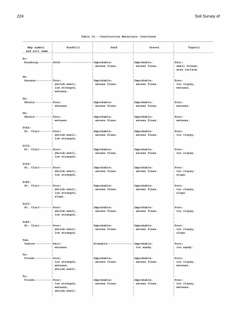
224 Soil Survey of
Table 16.--Construction Materials--Continued_________________________________________________________________________________________________________________ | | | | Map symbol | Roadfill | Sand | Gravel | Topsoil and soil name | | | |_________________________________________________________________________________________________________________ | | | |Rt: | | | | Rossburg--------|Good-------------------|Improbable: |Improbable: |Fair: | | excess fines. | excess fines. | small stones, | | | | area reclaim. | | | |Sb: | | | | Saranac---------|Poor: |Improbable: |Improbable: |Poor: | shrink-swell, | excess fines. | excess fines. | too clayey, | low strength, | | | wetness. | wetness. | | | | | | |Sh: | | | | Shoals----------|Poor: |Improbable: |Improbable: |Poor: | wetness. | excess fines. | excess fines. | wetness. | | | |Sk: | | | | Shoals----------|Poor: |Improbable: |Improbable: |Poor: | wetness. | excess fines. | excess fines. | wetness. | | | |StB2: | | | | St. Clair-------|Poor: |Improbable: |Improbable: |Poor: | shrink-swell, | excess fines. | excess fines. | too clayey. | low strength. | | | | | | |StC2: | | | | St. Clair-------|Poor: |Improbable: |Improbable: |Poor: | shrink-swell, | excess fines. | excess fines. | too clayey. | low strength. | | | | | | |StD2: | | | | St. Clair-------|Poor: |Improbable: |Improbable: |Poor: | shrink-swell, | excess fines. | excess fines. | too clayey, | low strength. | | | slope. | | | |StE2: | | | | St. Clair-------|Poor: |Improbable: |Improbable: |Poor: | shrink-swell, | excess fines. | excess fines. | too clayey, | low strength, | | | slope. | slope. | | | | | | |SuC3: | | | | St. Clair-------|Poor: |Improbable: |Improbable: |Poor: | shrink-swell, | excess fines. | excess fines. | too clayey. | low strength. | | | | | | |SuE3: | | | | St. Clair-------|Poor: |Improbable: |Improbable: |Poor: | shrink-swell, | excess fines. | excess fines. | too clayey, | low strength. | | | slope. | | | |TeA: | | | | Tedrow----------|Fair: |Probable---------------|Improbable: |Poor: | wetness. | | too sandy. | too sandy. | | | |Tn: | | | | Toledo----------|Poor: |Improbable: |Improbable: |Poor: | low strength, | excess fines. | excess fines. | too clayey, | wetness, | | | wetness. | shrink-swell. | | | | | | |To: | | | | Toledo----------|Poor: |Improbable: |Improbable: |Poor: | low strength, | excess fines. | excess fines. | too clayey, | wetness, | | | wetness. | shrink-swell. | | | | | | |
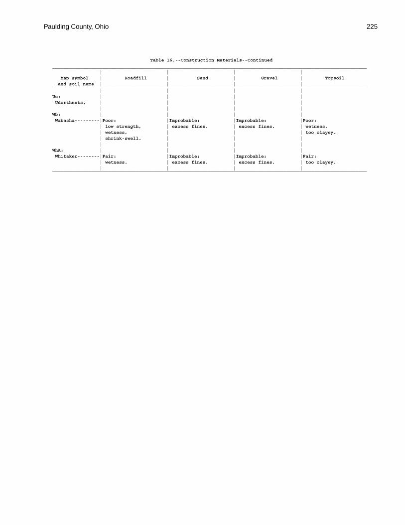
Paulding County, Ohio 225
Table 16.--Construction Materials--Continued_________________________________________________________________________________________________________________ | | | | Map symbol | Roadfill | Sand | Gravel | Topsoil and soil name | | | |_________________________________________________________________________________________________________________ | | | |Uc: | | | | Udorthents. | | | | | | | |Wb: | | | | Wabasha---------|Poor: |Improbable: |Improbable: |Poor: | low strength, | excess fines. | excess fines. | wetness, | wetness, | | | too clayey. | shrink-swell. | | | | | | |WhA: | | | | Whitaker--------|Fair: |Improbable: |Improbable: |Fair: | wetness. | excess fines. | excess fines. | too clayey. | | | |_________________________________________________________________________________________________________________
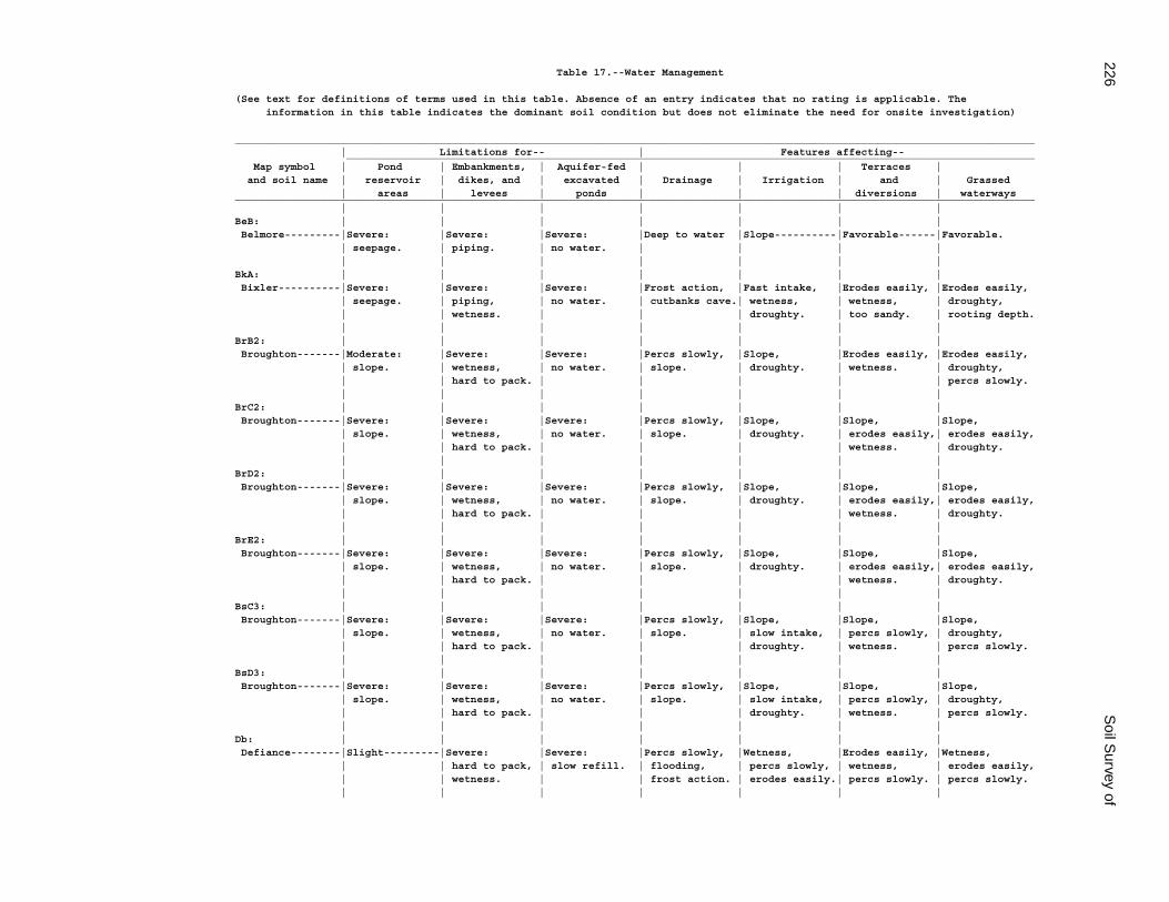
226S
oil Survey of
Table 17.--Water Management
(See text for definitions of terms used in this table. Absence of an entry indicates that no rating is applicable. The information in this table indicates the dominant soil condition but does not eliminate the need for onsite investigation)
_________________________________________________________________________________________________________________________________ | Limitations for-- | Features affecting-- _______________________________________________________________________________________________________________ Map symbol | Pond | Embankments, | Aquifer-fed | | | Terraces | and soil name | reservoir | dikes, and | excavated | Drainage | Irrigation | and | Grassed | areas | levees | ponds | | | diversions | waterways_________________________________________________________________________________________________________________________________ | | | | | | |BeB: | | | | | | | Belmore---------|Severe: |Severe: |Severe: |Deep to water |Slope----------|Favorable------|Favorable. | seepage. | piping. | no water. | | | | | | | | | | |BkA: | | | | | | | Bixler----------|Severe: |Severe: |Severe: |Frost action, |Fast intake, |Erodes easily, |Erodes easily, | seepage. | piping, | no water. | cutbanks cave.| wetness, | wetness, | droughty, | | wetness. | | | droughty. | too sandy. | rooting depth. | | | | | | |BrB2: | | | | | | | Broughton-------|Moderate: |Severe: |Severe: |Percs slowly, |Slope, |Erodes easily, |Erodes easily, | slope. | wetness, | no water. | slope. | droughty. | wetness. | droughty, | | hard to pack. | | | | | percs slowly. | | | | | | |BrC2: | | | | | | | Broughton-------|Severe: |Severe: |Severe: |Percs slowly, |Slope, |Slope, |Slope, | slope. | wetness, | no water. | slope. | droughty. | erodes easily,| erodes easily, | | hard to pack. | | | | wetness. | droughty. | | | | | | |BrD2: | | | | | | | Broughton-------|Severe: |Severe: |Severe: |Percs slowly, |Slope, |Slope, |Slope, | slope. | wetness, | no water. | slope. | droughty. | erodes easily,| erodes easily, | | hard to pack. | | | | wetness. | droughty. | | | | | | |BrE2: | | | | | | | Broughton-------|Severe: |Severe: |Severe: |Percs slowly, |Slope, |Slope, |Slope, | slope. | wetness, | no water. | slope. | droughty. | erodes easily,| erodes easily, | | hard to pack. | | | | wetness. | droughty. | | | | | | |BsC3: | | | | | | | Broughton-------|Severe: |Severe: |Severe: |Percs slowly, |Slope, |Slope, |Slope, | slope. | wetness, | no water. | slope. | slow intake, | percs slowly, | droughty, | | hard to pack. | | | droughty. | wetness. | percs slowly. | | | | | | |BsD3: | | | | | | | Broughton-------|Severe: |Severe: |Severe: |Percs slowly, |Slope, |Slope, |Slope, | slope. | wetness, | no water. | slope. | slow intake, | percs slowly, | droughty, | | hard to pack. | | | droughty. | wetness. | percs slowly. | | | | | | |Db: | | | | | | | Defiance--------|Slight---------|Severe: |Severe: |Percs slowly, |Wetness, |Erodes easily, |Wetness, | | hard to pack, | slow refill. | flooding, | percs slowly, | wetness, | erodes easily, | | wetness. | | frost action. | erodes easily.| percs slowly. | percs slowly. | | | | | | |
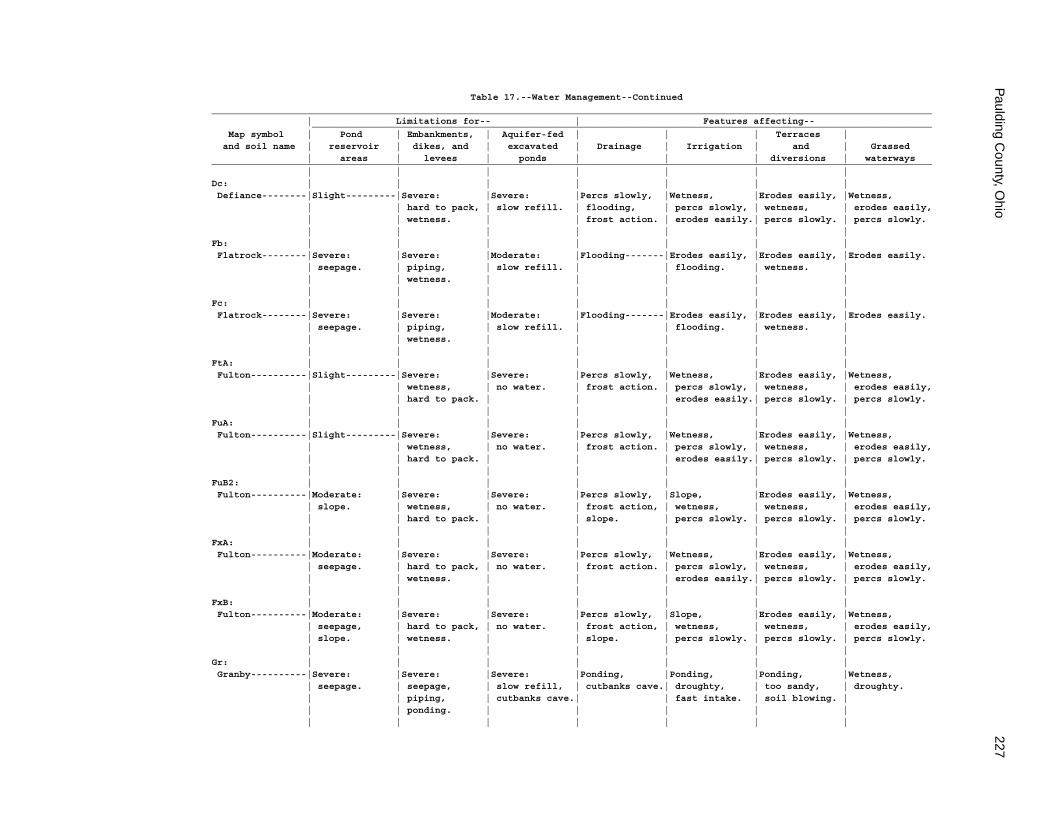
Paulding C
ounty, Ohio
227
Table 17.--Water Management--Continued_________________________________________________________________________________________________________________________________ | Limitations for-- | Features affecting-- _______________________________________________________________________________________________________________ Map symbol | Pond | Embankments, | Aquifer-fed | | | Terraces | and soil name | reservoir | dikes, and | excavated | Drainage | Irrigation | and | Grassed | areas | levees | ponds | | | diversions | waterways_________________________________________________________________________________________________________________________________ | | | | | | |Dc: | | | | | | | Defiance--------|Slight---------|Severe: |Severe: |Percs slowly, |Wetness, |Erodes easily, |Wetness, | | hard to pack, | slow refill. | flooding, | percs slowly, | wetness, | erodes easily, | | wetness. | | frost action. | erodes easily.| percs slowly. | percs slowly. | | | | | | |Fb: | | | | | | | Flatrock--------|Severe: |Severe: |Moderate: |Flooding-------|Erodes easily, |Erodes easily, |Erodes easily. | seepage. | piping, | slow refill. | | flooding. | wetness. | | | wetness. | | | | | | | | | | | |Fc: | | | | | | | Flatrock--------|Severe: |Severe: |Moderate: |Flooding-------|Erodes easily, |Erodes easily, |Erodes easily. | seepage. | piping, | slow refill. | | flooding. | wetness. | | | wetness. | | | | | | | | | | | |FtA: | | | | | | | Fulton----------|Slight---------|Severe: |Severe: |Percs slowly, |Wetness, |Erodes easily, |Wetness, | | wetness, | no water. | frost action. | percs slowly, | wetness, | erodes easily, | | hard to pack. | | | erodes easily.| percs slowly. | percs slowly. | | | | | | |FuA: | | | | | | | Fulton----------|Slight---------|Severe: |Severe: |Percs slowly, |Wetness, |Erodes easily, |Wetness, | | wetness, | no water. | frost action. | percs slowly, | wetness, | erodes easily, | | hard to pack. | | | erodes easily.| percs slowly. | percs slowly. | | | | | | |FuB2: | | | | | | | Fulton----------|Moderate: |Severe: |Severe: |Percs slowly, |Slope, |Erodes easily, |Wetness, | slope. | wetness, | no water. | frost action, | wetness, | wetness, | erodes easily, | | hard to pack. | | slope. | percs slowly. | percs slowly. | percs slowly. | | | | | | |FxA: | | | | | | | Fulton----------|Moderate: |Severe: |Severe: |Percs slowly, |Wetness, |Erodes easily, |Wetness, | seepage. | hard to pack, | no water. | frost action. | percs slowly, | wetness, | erodes easily, | | wetness. | | | erodes easily.| percs slowly. | percs slowly. | | | | | | |FxB: | | | | | | | Fulton----------|Moderate: |Severe: |Severe: |Percs slowly, |Slope, |Erodes easily, |Wetness, | seepage, | hard to pack, | no water. | frost action, | wetness, | wetness, | erodes easily, | slope. | wetness. | | slope. | percs slowly. | percs slowly. | percs slowly. | | | | | | |Gr: | | | | | | | Granby----------|Severe: |Severe: |Severe: |Ponding, |Ponding, |Ponding, |Wetness, | seepage. | seepage, | slow refill, | cutbanks cave.| droughty, | too sandy, | droughty. | | piping, | cutbanks cave.| | fast intake. | soil blowing. | | | ponding. | | | | | | | | | | | |
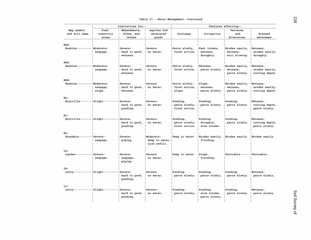
228S
oil Survey of
Table 17.--Water Management--Continued_________________________________________________________________________________________________________________________________ | Limitations for-- | Features affecting-- _______________________________________________________________________________________________________________ Map symbol | Pond | Embankments, | Aquifer-fed | | | Terraces | and soil name | reservoir | dikes, and | excavated | Drainage | Irrigation | and | Grassed | areas | levees | ponds | | | diversions | waterways_________________________________________________________________________________________________________________________________ | | | | | | |HaA: | | | | | | | Haskins---------|Moderate: |Severe: |Severe: |Percs slowly, |Fast intake, |Erodes easily, |Wetness, | seepage. | hard to pack, | no water. | frost action. | wetness, | wetness, | erodes easily, | | wetness. | | | droughty. | soil blowing. | droughty. | | | | | | |HkA: | | | | | | | Haskins---------|Moderate: |Severe: |Severe: |Percs slowly, |Wetness, |Erodes easily, |Wetness, | seepage. | hard to pack, | no water. | frost action. | percs slowly. | wetness, | erodes easily, | | wetness. | | | | percs slowly. | rooting depth. | | | | | | |HkB: | | | | | | | Haskins---------|Moderate: |Severe: |Severe: |Percs slowly, |Slope, |Erodes easily, |Wetness, | seepage, | hard to pack, | no water. | frost action, | wetness, | wetness, | erodes easily, | slope. | wetness. | | slope. | percs slowly. | percs slowly. | rooting depth. | | | | | | |Hs: | | | | | | | Hoytville-------|Slight---------|Severe: |Severe: |Ponding, |Ponding, |Ponding, |Wetness, | | hard to pack, | no water. | percs slowly, | percs slowly. | percs slowly. | rooting depth, | | ponding. | | frost action. | | | percs slowly. | | | | | | |Ht: | | | | | | | Hoytville-------|Slight---------|Severe: |Severe: |Ponding, |Ponding, |Ponding, |Wetness, | | hard to pack, | no water. | percs slowly, | droughty, | percs slowly. | rooting depth, | | ponding. | | frost action. | slow intake. | | percs slowly. | | | | | | |Kn: | | | | | | | Knoxdale--------|Severe: |Severe: |Moderate: |Deep to water |Erodes easily, |Erodes easily |Erodes easily. | seepage. | piping. | deep to water,| | flooding. | | | | | slow refill. | | | | | | | | | | |La: | | | | | | | Landes----------|Severe: |Severe: |Severe: |Deep to water |Slope, |Favorable------|Favorable. | seepage. | seepage, | no water. | | flooding. | | | | piping. | | | | | | | | | | | |Lb: | | | | | | | Latty-----------|Slight---------|Severe: |Severe: |Ponding, |Ponding, |Ponding, |Wetness, | | hard to pack, | no water. | percs slowly. | percs slowly. | percs slowly. | percs slowly. | | ponding. | | | | | | | | | | | |Lc: | | | | | | | Latty-----------|Slight---------|Severe: |Severe: |Ponding, |Ponding, |Ponding, |Wetness, | | hard to pack, | no water. | percs slowly. | slow intake, | percs slowly. | percs slowly. | | ponding. | | | percs slowly. | | | | | | | | |
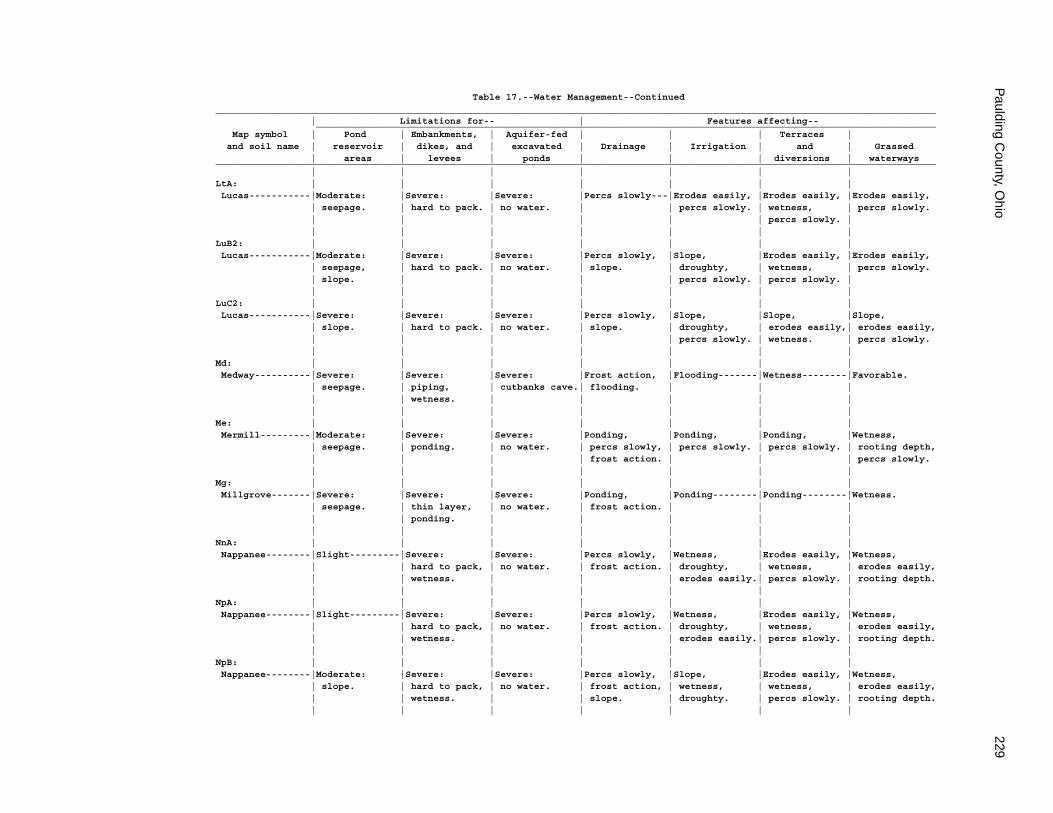
Paulding C
ounty, Ohio
229
Table 17.--Water Management--Continued_________________________________________________________________________________________________________________________________ | Limitations for-- | Features affecting-- _______________________________________________________________________________________________________________ Map symbol | Pond | Embankments, | Aquifer-fed | | | Terraces | and soil name | reservoir | dikes, and | excavated | Drainage | Irrigation | and | Grassed | areas | levees | ponds | | | diversions | waterways_________________________________________________________________________________________________________________________________ | | | | | | |LtA: | | | | | | | Lucas-----------|Moderate: |Severe: |Severe: |Percs slowly---|Erodes easily, |Erodes easily, |Erodes easily, | seepage. | hard to pack. | no water. | | percs slowly. | wetness, | percs slowly. | | | | | | percs slowly. | | | | | | | |LuB2: | | | | | | | Lucas-----------|Moderate: |Severe: |Severe: |Percs slowly, |Slope, |Erodes easily, |Erodes easily, | seepage, | hard to pack. | no water. | slope. | droughty, | wetness, | percs slowly. | slope. | | | | percs slowly. | percs slowly. | | | | | | | |LuC2: | | | | | | | Lucas-----------|Severe: |Severe: |Severe: |Percs slowly, |Slope, |Slope, |Slope, | slope. | hard to pack. | no water. | slope. | droughty, | erodes easily,| erodes easily, | | | | | percs slowly. | wetness. | percs slowly. | | | | | | |Md: | | | | | | | Medway----------|Severe: |Severe: |Severe: |Frost action, |Flooding-------|Wetness--------|Favorable. | seepage. | piping, | cutbanks cave.| flooding. | | | | | wetness. | | | | | | | | | | | |Me: | | | | | | | Mermill---------|Moderate: |Severe: |Severe: |Ponding, |Ponding, |Ponding, |Wetness, | seepage. | ponding. | no water. | percs slowly, | percs slowly. | percs slowly. | rooting depth, | | | | frost action. | | | percs slowly. | | | | | | |Mg: | | | | | | | Millgrove-------|Severe: |Severe: |Severe: |Ponding, |Ponding--------|Ponding--------|Wetness. | seepage. | thin layer, | no water. | frost action. | | | | | ponding. | | | | | | | | | | | |NnA: | | | | | | | Nappanee--------|Slight---------|Severe: |Severe: |Percs slowly, |Wetness, |Erodes easily, |Wetness, | | hard to pack, | no water. | frost action. | droughty, | wetness, | erodes easily, | | wetness. | | | erodes easily.| percs slowly. | rooting depth. | | | | | | |NpA: | | | | | | | Nappanee--------|Slight---------|Severe: |Severe: |Percs slowly, |Wetness, |Erodes easily, |Wetness, | | hard to pack, | no water. | frost action. | droughty, | wetness, | erodes easily, | | wetness. | | | erodes easily.| percs slowly. | rooting depth. | | | | | | |NpB: | | | | | | | Nappanee--------|Moderate: |Severe: |Severe: |Percs slowly, |Slope, |Erodes easily, |Wetness, | slope. | hard to pack, | no water. | frost action, | wetness, | wetness, | erodes easily, | | wetness. | | slope. | droughty. | percs slowly. | rooting depth. | | | | | | |
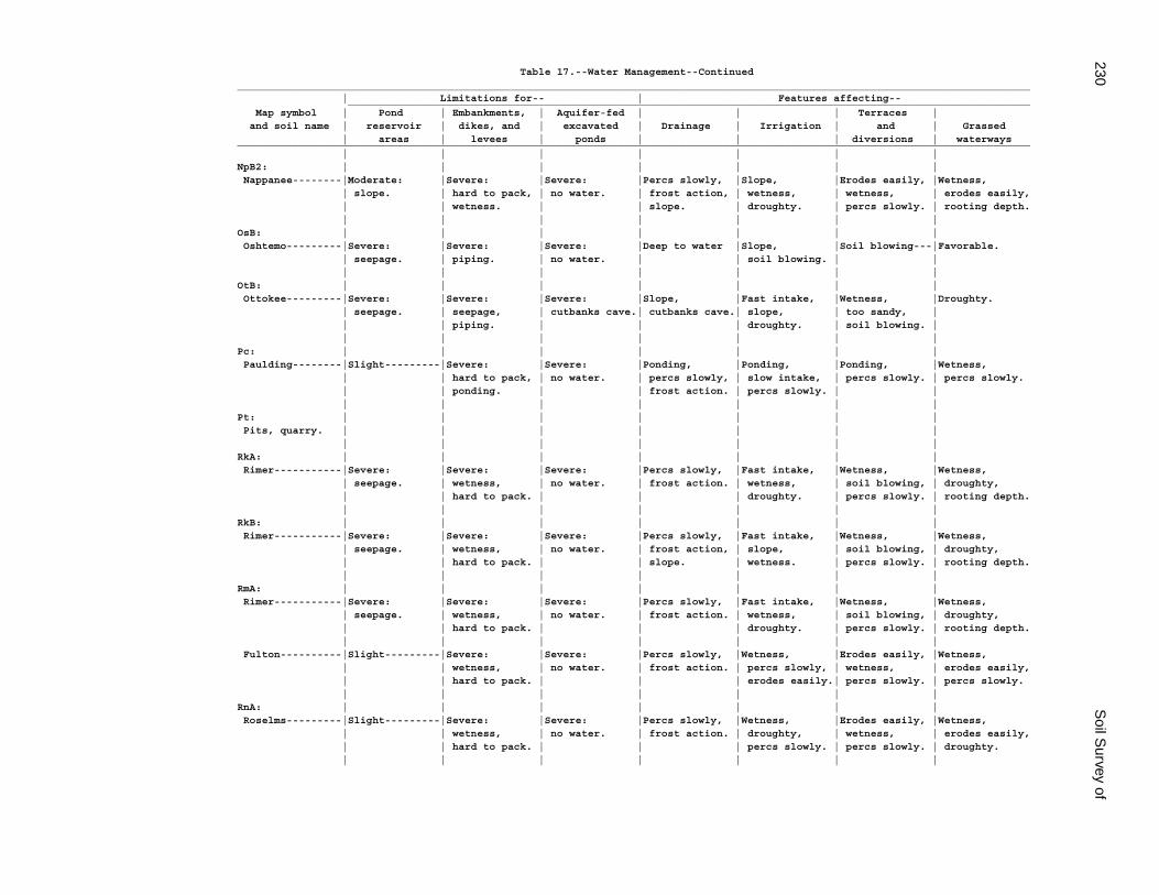
230S
oil Survey of
Table 17.--Water Management--Continued_________________________________________________________________________________________________________________________________ | Limitations for-- | Features affecting-- _______________________________________________________________________________________________________________ Map symbol | Pond | Embankments, | Aquifer-fed | | | Terraces | and soil name | reservoir | dikes, and | excavated | Drainage | Irrigation | and | Grassed | areas | levees | ponds | | | diversions | waterways_________________________________________________________________________________________________________________________________ | | | | | | |NpB2: | | | | | | | Nappanee--------|Moderate: |Severe: |Severe: |Percs slowly, |Slope, |Erodes easily, |Wetness, | slope. | hard to pack, | no water. | frost action, | wetness, | wetness, | erodes easily, | | wetness. | | slope. | droughty. | percs slowly. | rooting depth. | | | | | | |OsB: | | | | | | | Oshtemo---------|Severe: |Severe: |Severe: |Deep to water |Slope, |Soil blowing---|Favorable. | seepage. | piping. | no water. | | soil blowing. | | | | | | | | |OtB: | | | | | | | Ottokee---------|Severe: |Severe: |Severe: |Slope, |Fast intake, |Wetness, |Droughty. | seepage. | seepage, | cutbanks cave.| cutbanks cave.| slope, | too sandy, | | | piping. | | | droughty. | soil blowing. | | | | | | | |Pc: | | | | | | | Paulding--------|Slight---------|Severe: |Severe: |Ponding, |Ponding, |Ponding, |Wetness, | | hard to pack, | no water. | percs slowly, | slow intake, | percs slowly. | percs slowly. | | ponding. | | frost action. | percs slowly. | | | | | | | | |Pt: | | | | | | | Pits, quarry. | | | | | | | | | | | | | |RkA: | | | | | | | Rimer-----------|Severe: |Severe: |Severe: |Percs slowly, |Fast intake, |Wetness, |Wetness, | seepage. | wetness, | no water. | frost action. | wetness, | soil blowing, | droughty, | | hard to pack. | | | droughty. | percs slowly. | rooting depth. | | | | | | |RkB: | | | | | | | Rimer-----------|Severe: |Severe: |Severe: |Percs slowly, |Fast intake, |Wetness, |Wetness, | seepage. | wetness, | no water. | frost action, | slope, | soil blowing, | droughty, | | hard to pack. | | slope. | wetness. | percs slowly. | rooting depth. | | | | | | |RmA: | | | | | | | Rimer-----------|Severe: |Severe: |Severe: |Percs slowly, |Fast intake, |Wetness, |Wetness, | seepage. | wetness, | no water. | frost action. | wetness, | soil blowing, | droughty, | | hard to pack. | | | droughty. | percs slowly. | rooting depth. | | | | | | | Fulton----------|Slight---------|Severe: |Severe: |Percs slowly, |Wetness, |Erodes easily, |Wetness, | | wetness, | no water. | frost action. | percs slowly, | wetness, | erodes easily, | | hard to pack. | | | erodes easily.| percs slowly. | percs slowly. | | | | | | |RnA: | | | | | | | Roselms---------|Slight---------|Severe: |Severe: |Percs slowly, |Wetness, |Erodes easily, |Wetness, | | wetness, | no water. | frost action. | droughty, | wetness, | erodes easily, | | hard to pack. | | | percs slowly. | percs slowly. | droughty. | | | | | | |
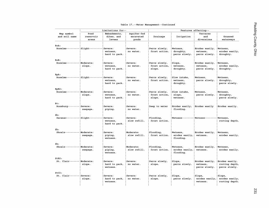
Paulding C
ounty, Ohio
231
Table 17.--Water Management--Continued_________________________________________________________________________________________________________________________________ | Limitations for-- | Features affecting-- _______________________________________________________________________________________________________________ Map symbol | Pond | Embankments, | Aquifer-fed | | | Terraces | and soil name | reservoir | dikes, and | excavated | Drainage | Irrigation | and | Grassed | areas | levees | ponds | | | diversions | waterways_________________________________________________________________________________________________________________________________ | | | | | | |RoA: | | | | | | | Roselms---------|Slight---------|Severe: |Severe: |Percs slowly, |Wetness, |Erodes easily, |Wetness, | | wetness, | no water. | frost action. | droughty, | wetness, | erodes easily, | | hard to pack. | | | percs slowly. | percs slowly. | droughty. | | | | | | |RoB: | | | | | | | Roselms---------|Moderate: |Severe: |Severe: |Percs slowly, |Slope, |Erodes easily, |Wetness, | slope. | wetness, | no water. | frost action, | wetness, | wetness, | erodes easily, | | hard to pack. | | slope. | droughty. | percs slowly. | droughty. | | | | | | |RpA: | | | | | | | Roselms---------|Slight---------|Severe: |Severe: |Percs slowly, |Slow intake, |Wetness, |Wetness, | | wetness, | no water. | frost action. | wetness, | percs slowly. | droughty, | | hard to pack. | | | droughty. | | percs slowly. | | | | | | |RpB2: | | | | | | | Roselms---------|Moderate: |Severe: |Severe: |Percs slowly, |Slow intake, |Wetness, |Wetness, | slope. | wetness, | no water. | frost action, | slope, | percs slowly. | droughty, | | hard to pack. | | slope. | wetness. | | percs slowly. | | | | | | |Rt: | | | | | | | Rossburg--------|Severe: |Severe: |Severe: |Deep to water |Erodes easily, |Erodes easily |Erodes easily. | seepage. | piping. | no water. | | flooding. | | | | | | | | |Sb: | | | | | | | Saranac---------|Slight---------|Severe: |Severe: |Flooding, |Wetness--------|Wetness--------|Wetness, | | wetness, | slow refill. | frost action. | | | rooting depth. | | hard to pack. | | | | | | | | | | | |Sh: | | | | | | | Shoals----------|Moderate: |Severe: |Moderate: |Flooding, |Wetness, |Erodes easily, |Wetness, | seepage. | piping, | slow refill. | frost action. | erodes easily,| wetness. | erodes easily. | | wetness. | | | flooding. | | | | | | | | |Sk: | | | | | | | Shoals----------|Moderate: |Severe: |Moderate: |Flooding, |Wetness, |Erodes easily, |Wetness, | seepage. | piping, | slow refill. | frost action. | erodes easily,| wetness. | erodes easily. | | wetness. | | | flooding. | | | | | | | | |StB2: | | | | | | | St. Clair-------|Moderate: |Severe: |Severe: |Percs slowly, |Slope, |Erodes easily, |Erodes easily, | slope. | hard to pack, | no water. | slope. | percs slowly. | wetness, | rooting depth, | | wetness. | | | | percs slowly. | percs slowly. | | | | | | |StC2: | | | | | | | St. Clair-------|Severe: |Severe: |Severe: |Percs slowly, |Slope, |Slope, |Slope, | slope. | hard to pack, | no water. | slope. | percs slowly. | erodes easily,| erodes easily, | | wetness. | | | | wetness. | rooting depth. | | | | | | |
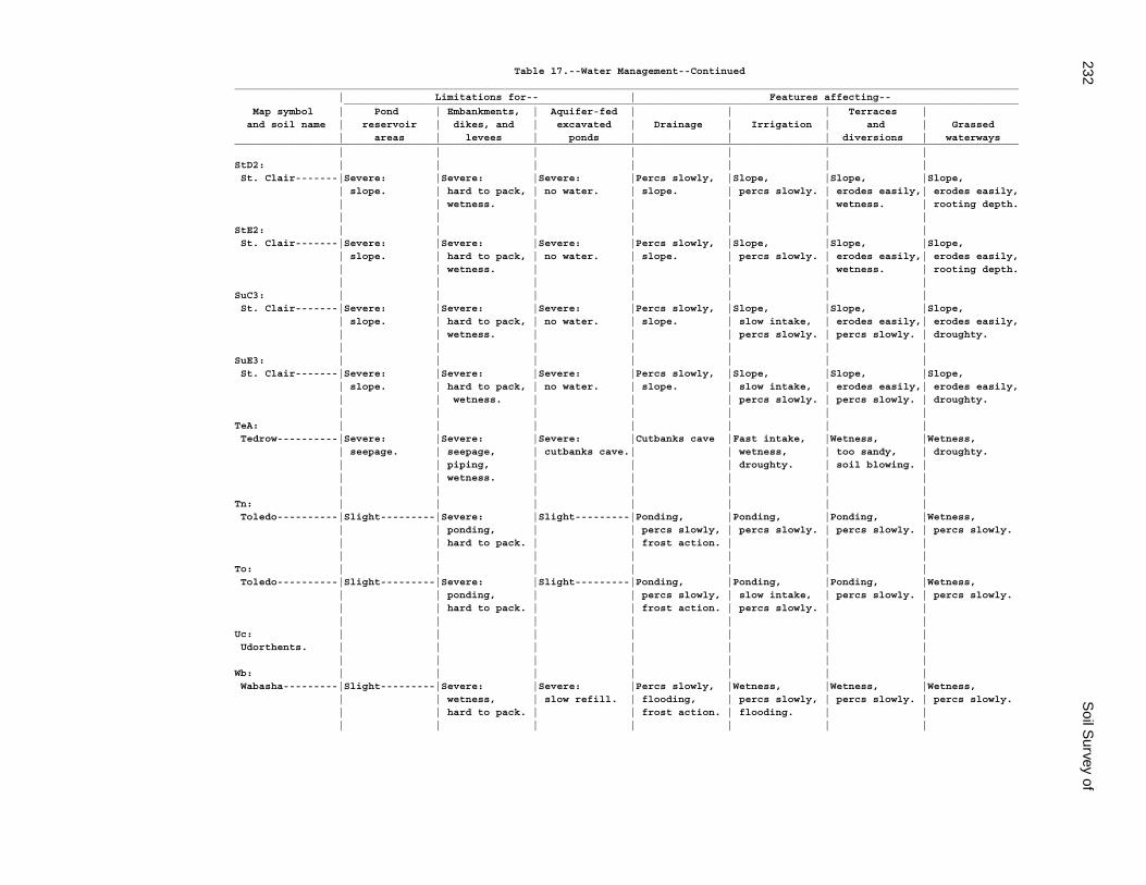
232S
oil Survey of
Table 17.--Water Management--Continued_________________________________________________________________________________________________________________________________ | Limitations for-- | Features affecting-- _______________________________________________________________________________________________________________ Map symbol | Pond | Embankments, | Aquifer-fed | | | Terraces | and soil name | reservoir | dikes, and | excavated | Drainage | Irrigation | and | Grassed | areas | levees | ponds | | | diversions | waterways_________________________________________________________________________________________________________________________________ | | | | | | |StD2: | | | | | | | St. Clair-------|Severe: |Severe: |Severe: |Percs slowly, |Slope, |Slope, |Slope, | slope. | hard to pack, | no water. | slope. | percs slowly. | erodes easily,| erodes easily, | | wetness. | | | | wetness. | rooting depth. | | | | | | |StE2: | | | | | | | St. Clair-------|Severe: |Severe: |Severe: |Percs slowly, |Slope, |Slope, |Slope, | slope. | hard to pack, | no water. | slope. | percs slowly. | erodes easily,| erodes easily, | | wetness. | | | | wetness. | rooting depth. | | | | | | |SuC3: | | | | | | | St. Clair-------|Severe: |Severe: |Severe: |Percs slowly, |Slope, |Slope, |Slope, | slope. | hard to pack, | no water. | slope. | slow intake, | erodes easily,| erodes easily, | | wetness. | | | percs slowly. | percs slowly. | droughty. | | | | | | |SuE3: | | | | | | | St. Clair-------|Severe: |Severe: |Severe: |Percs slowly, |Slope, |Slope, |Slope, | slope. | hard to pack, | no water. | slope. | slow intake, | erodes easily,| erodes easily, | | wetness. | | | percs slowly. | percs slowly. | droughty. | | | | | | |TeA: | | | | | | | Tedrow----------|Severe: |Severe: |Severe: |Cutbanks cave |Fast intake, |Wetness, |Wetness, | seepage. | seepage, | cutbanks cave.| | wetness, | too sandy, | droughty. | | piping, | | | droughty. | soil blowing. | | | wetness. | | | | | | | | | | | |Tn: | | | | | | | Toledo----------|Slight---------|Severe: |Slight---------|Ponding, |Ponding, |Ponding, |Wetness, | | ponding, | | percs slowly, | percs slowly. | percs slowly. | percs slowly. | | hard to pack. | | frost action. | | | | | | | | | |To: | | | | | | | Toledo----------|Slight---------|Severe: |Slight---------|Ponding, |Ponding, |Ponding, |Wetness, | | ponding, | | percs slowly, | slow intake, | percs slowly. | percs slowly. | | hard to pack. | | frost action. | percs slowly. | | | | | | | | |Uc: | | | | | | | Udorthents. | | | | | | | | | | | | | |Wb: | | | | | | | Wabasha---------|Slight---------|Severe: |Severe: |Percs slowly, |Wetness, |Wetness, |Wetness, | | wetness, | slow refill. | flooding, | percs slowly, | percs slowly. | percs slowly. | | hard to pack. | | frost action. | flooding. | | | | | | | | |
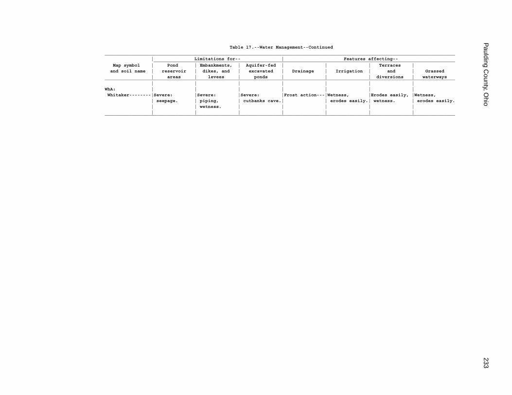
Paulding C
ounty, Ohio
233
Table 17.--Water Management--Continued_________________________________________________________________________________________________________________________________ | Limitations for-- | Features affecting-- _______________________________________________________________________________________________________________ Map symbol | Pond | Embankments, | Aquifer-fed | | | Terraces | and soil name | reservoir | dikes, and | excavated | Drainage | Irrigation | and | Grassed | areas | levees | ponds | | | diversions | waterways_________________________________________________________________________________________________________________________________ | | | | | | |WhA: | | | | | | | Whitaker--------|Severe: |Severe: |Severe: |Frost action---|Wetness, |Erodes easily, |Wetness, | seepage. | piping, | cutbanks cave.| | erodes easily.| wetness. | erodes easily. | | wetness. | | | | | | | | | | | |_________________________________________________________________________________________________________________________________

234S
oil Survey of
Table 18.--Engineering Index Properties
(Absence of an entry indicates that data were not estimated)
_____________________________________________________________________________________________________________________________ | | | Classification | Fragments | Percentage passing | | Map symbol | Depth | USDA texture |___________________________|_____________| sieve number-- |Liquid| Plas- and soil name | | | | | >10 | 3-10 |___________________________| limit|ticity | | | Unified | AASHTO |inches|inches| 4 | 10 | 40 | 200 | |index_____________________________________________________________________________________________________________________________ | In | | | | Pct | Pct | | | | | Pct | | | | | | | | | | | | |BeB: | | | | | | | | | | | | Belmore---------| 0-6 |Loam-----------|ML, CL-ML, CL|A-4 | 0 | 0 |85-100|85-100|60-90 |50-80 | 20-32| 3-10 | 6-39 |Sandy clay |SC, SC-SM, |A-4, A-6 | 0 | 0 |85-100|75-100|55-75 |40-70 | 20-36| 4-14 | | loam, clay | CL, CL-ML | | | | | | | | | | | loam, loam. | | | | | | | | | | | 39-75 |Sandy loam, |SM, SC, |A-2, A-4, A-1| 0 | 0 |80-100|55-85 |30-75 |15-60 | 10-30| NP-10 | | very gravelly | SC-SM, ML | | | | | | | | | | | loam, gravelly| | | | | | | | | | | | coarse sandy | | | | | | | | | | | | loam. | | | | | | | | | | | 75-80 |Clay loam, |CL |A-7, A-6 | 0-1 | 0-5 | 100 |85-100|80-100|75-95 | 25-50| 10-25 | | silty clay | | | | | | | | | | | | loam, silty | | | | | | | | | | | | clay. | | | | | | | | | | | | | | | | | | | | | |BkA: | | | | | | | | | | | | Bixler----------| 0-10 |Loamy sand-----|SM |A-2 | 0 | 0 | 100 |90-100|50-70 |15-30 | 0 | NP | 10-28 |Loamy sand, |SM |A-2, A-4 | 0 | 0 | 100 |90-100|60-85 |20-45 | 0 | NP | | sand. | | | | | | | | | | | 28-36 |Sandy loam, |SM, SC-SM, |A-2, A-4 | 0 | 0 | 100 | 100 |60-90 |30-70 | 10-25| NP-10 | | loam, fine | SC, ML | | | | | | | | | | | sandy loam. | | | | | | | | | | | 36-74 |Silt loam, |CL, ML, SC, |A-4, A-6 | 0 | 0 | 100 | 100 |70-100|35-90 | 10-35| 3-20 | | silty clay | SM | | | | | | | | | | | loam, very | | | | | | | | | | | | fine sandy | | | | | | | | | | | | loam. | | | | | | | | | | | 74-80 |Clay, silty |CL, CH |A-7 | 0 | 0-2 | 100 | 100 |80-100|70-100| 40-60| 18-34 | | clay, silty | | | | | | | | | | | | clay loam. | | | | | | | | | | | | | | | | | | | | | |BrB2: | | | | | | | | | | | | Broughton-------| 0-6 |Silty clay loam|CL |A-6, A-7 | 0 | 0 | 100 | 100 |95-100|90-95 | 35-50| 15-28 | 6-17 |Clay-----------|CH |A-7 | 0 | 0 | 100 | 100 |95-100|90-100| 60-85| 30-50 | 17-80 |Clay-----------|CH |A-7 | 0 | 0 | 100 | 100 |90-100|90-100| 60-85| 30-50 | | | | | | | | | | | |BrC2: | | | | | | | | | | | | Broughton-------| 0-8 |Silty clay loam|CL |A-6, A-7 | 0 | 0 | 100 | 100 |95-100|90-95 | 35-50| 15-28 | 8-18 |Clay-----------|CH |A-7 | 0 | 0 | 100 | 100 |95-100|90-100| 60-85| 30-50 | 18-80 |Clay-----------|CH |A-7 | 0 | 0 | 100 | 100 |90-100|90-100| 60-85| 30-50 | | | | | | | | | | | |
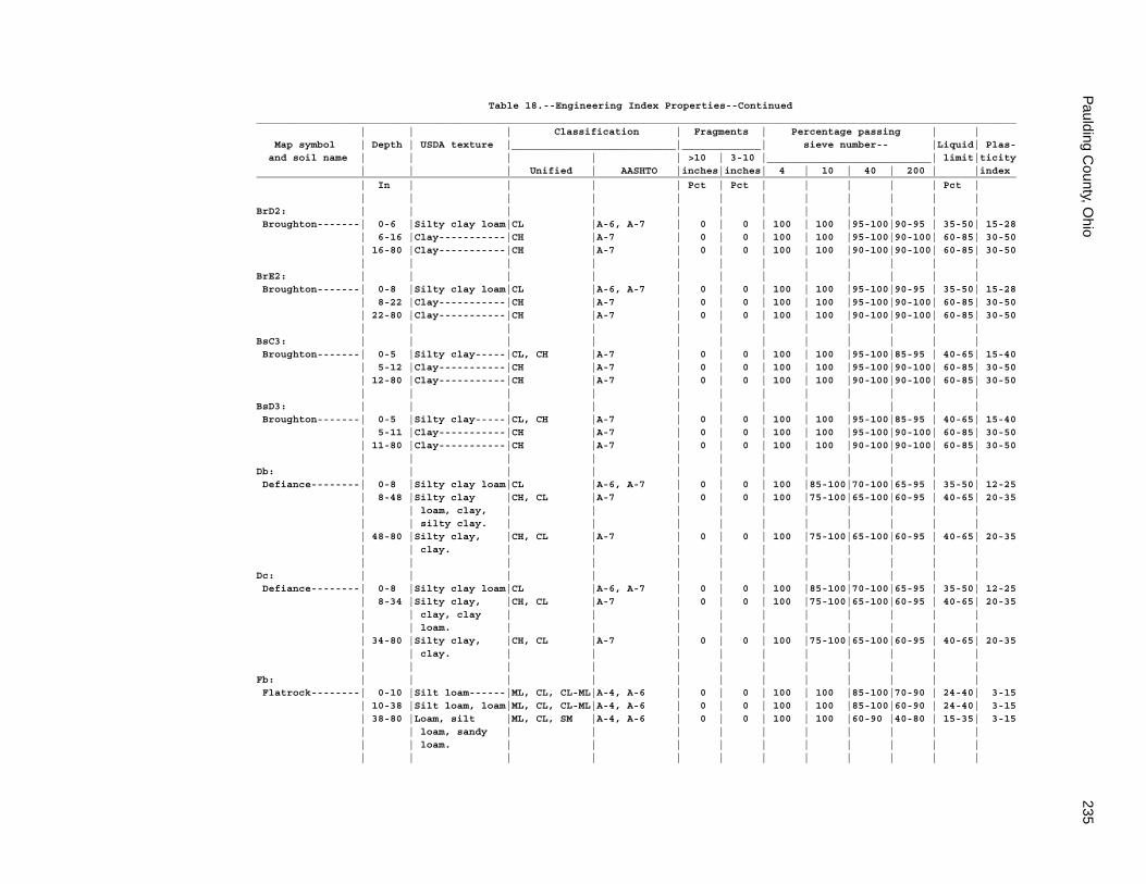
Paulding C
ounty, Ohio
235
Table 18.--Engineering Index Properties--Continued_____________________________________________________________________________________________________________________________ | | | Classification | Fragments | Percentage passing | | Map symbol | Depth | USDA texture |___________________________|_____________| sieve number-- |Liquid| Plas- and soil name | | | | | >10 | 3-10 |___________________________| limit|ticity | | | Unified | AASHTO |inches|inches| 4 | 10 | 40 | 200 | |index_____________________________________________________________________________________________________________________________ | In | | | | Pct | Pct | | | | | Pct | | | | | | | | | | | | |BrD2: | | | | | | | | | | | | Broughton-------| 0-6 |Silty clay loam|CL |A-6, A-7 | 0 | 0 | 100 | 100 |95-100|90-95 | 35-50| 15-28 | 6-16 |Clay-----------|CH |A-7 | 0 | 0 | 100 | 100 |95-100|90-100| 60-85| 30-50 | 16-80 |Clay-----------|CH |A-7 | 0 | 0 | 100 | 100 |90-100|90-100| 60-85| 30-50 | | | | | | | | | | | |BrE2: | | | | | | | | | | | | Broughton-------| 0-8 |Silty clay loam|CL |A-6, A-7 | 0 | 0 | 100 | 100 |95-100|90-95 | 35-50| 15-28 | 8-22 |Clay-----------|CH |A-7 | 0 | 0 | 100 | 100 |95-100|90-100| 60-85| 30-50 | 22-80 |Clay-----------|CH |A-7 | 0 | 0 | 100 | 100 |90-100|90-100| 60-85| 30-50 | | | | | | | | | | | |BsC3: | | | | | | | | | | | | Broughton-------| 0-5 |Silty clay-----|CL, CH |A-7 | 0 | 0 | 100 | 100 |95-100|85-95 | 40-65| 15-40 | 5-12 |Clay-----------|CH |A-7 | 0 | 0 | 100 | 100 |95-100|90-100| 60-85| 30-50 | 12-80 |Clay-----------|CH |A-7 | 0 | 0 | 100 | 100 |90-100|90-100| 60-85| 30-50 | | | | | | | | | | | |BsD3: | | | | | | | | | | | | Broughton-------| 0-5 |Silty clay-----|CL, CH |A-7 | 0 | 0 | 100 | 100 |95-100|85-95 | 40-65| 15-40 | 5-11 |Clay-----------|CH |A-7 | 0 | 0 | 100 | 100 |95-100|90-100| 60-85| 30-50 | 11-80 |Clay-----------|CH |A-7 | 0 | 0 | 100 | 100 |90-100|90-100| 60-85| 30-50 | | | | | | | | | | | |Db: | | | | | | | | | | | | Defiance--------| 0-8 |Silty clay loam|CL |A-6, A-7 | 0 | 0 | 100 |85-100|70-100|65-95 | 35-50| 12-25 | 8-48 |Silty clay |CH, CL |A-7 | 0 | 0 | 100 |75-100|65-100|60-95 | 40-65| 20-35 | | loam, clay, | | | | | | | | | | | | silty clay. | | | | | | | | | | | 48-80 |Silty clay, |CH, CL |A-7 | 0 | 0 | 100 |75-100|65-100|60-95 | 40-65| 20-35 | | clay. | | | | | | | | | | | | | | | | | | | | | |Dc: | | | | | | | | | | | | Defiance--------| 0-8 |Silty clay loam|CL |A-6, A-7 | 0 | 0 | 100 |85-100|70-100|65-95 | 35-50| 12-25 | 8-34 |Silty clay, |CH, CL |A-7 | 0 | 0 | 100 |75-100|65-100|60-95 | 40-65| 20-35 | | clay, clay | | | | | | | | | | | | loam. | | | | | | | | | | | 34-80 |Silty clay, |CH, CL |A-7 | 0 | 0 | 100 |75-100|65-100|60-95 | 40-65| 20-35 | | clay. | | | | | | | | | | | | | | | | | | | | | |Fb: | | | | | | | | | | | | Flatrock--------| 0-10 |Silt loam------|ML, CL, CL-ML|A-4, A-6 | 0 | 0 | 100 | 100 |85-100|70-90 | 24-40| 3-15 | 10-38 |Silt loam, loam|ML, CL, CL-ML|A-4, A-6 | 0 | 0 | 100 | 100 |85-100|60-90 | 24-40| 3-15 | 38-80 |Loam, silt |ML, CL, SM |A-4, A-6 | 0 | 0 | 100 | 100 |60-90 |40-80 | 15-35| 3-15 | | loam, sandy | | | | | | | | | | | | loam. | | | | | | | | | | | | | | | | | | | | | |
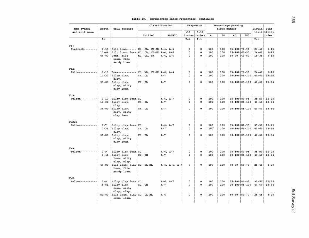
236S
oil Survey of
Table 18.--Engineering Index Properties--Continued_____________________________________________________________________________________________________________________________ | | | Classification | Fragments | Percentage passing | | Map symbol | Depth | USDA texture |___________________________|_____________| sieve number-- |Liquid| Plas- and soil name | | | | | >10 | 3-10 |___________________________| limit|ticity | | | Unified | AASHTO |inches|inches| 4 | 10 | 40 | 200 | |index_____________________________________________________________________________________________________________________________ | In | | | | Pct | Pct | | | | | Pct | | | | | | | | | | | | |Fc: | | | | | | | | | | | | Flatrock--------| 0-13 |Silt loam------|ML, CL, CL-ML|A-4, A-6 | 0 | 0 | 100 | 100 |85-100|70-90 | 24-40| 3-15 | 13-44 |Silt loam, loam|ML, CL, CL-ML|A-4, A-6 | 0 | 0 | 100 | 100 |85-100|60-90 | 24-40| 3-15 | 44-80 |Loam, silt |ML, CL, SM |A-4, A-6 | 0 | 0 | 100 | 100 |60-90 |40-80 | 15-35| 3-15 | | loam, fine | | | | | | | | | | | | sandy loam. | | | | | | | | | | | | | | | | | | | | | |FtA: | | | | | | | | | | | | Fulton----------| 0-10 |Loam-----------|CL, ML, CL-ML|A-6, A-4 | 0 | 0 | 100 | 100 |85-100|70-90 | 24-40| 3-16 | 10-37 |Silty clay, |CH, CL |A-7 | 0 | 0 | 100 | 100 |90-100|85-100| 40-60| 18-34 | | clay. | | | | | | | | | | | 37-80 |Silty clay, |CH, CL |A-7 | 0 | 0 | 100 | 100 |90-100|85-100| 40-60| 18-34 | | clay, silty | | | | | | | | | | | | clay loam. | | | | | | | | | | | | | | | | | | | | | |FuA: | | | | | | | | | | | | Fulton----------| 0-10 |Silty clay loam|CL |A-6, A-7 | 0 | 0 | 100 | 100 |95-100|80-95 | 35-50| 12-25 | 10-38 |Silty clay, |CH, CL |A-7 | 0 | 0 | 100 | 100 |90-100|85-100| 40-60| 18-34 | | clay. | | | | | | | | | | | 38-80 |Silty clay, |CH, CL |A-7 | 0 | 0 | 100 | 100 |90-100|85-100| 40-60| 18-34 | | clay, silty | | | | | | | | | | | | clay loam. | | | | | | | | | | | | | | | | | | | | | |FuB2: | | | | | | | | | | | | Fulton----------| 0-7 |Silty clay loam|CL |A-6, A-7 | 0 | 0 | 100 | 100 |95-100|80-95 | 35-50| 12-25 | 7-31 |Silty clay, |CH, CL |A-7 | 0 | 0 | 100 | 100 |90-100|85-100| 40-60| 18-34 | | clay. | | | | | | | | | | | 31-80 |Silty clay, |CH, CL |A-7 | 0 | 0 | 100 | 100 |90-100|85-100| 40-60| 18-34 | | clay, silty | | | | | | | | | | | | clay loam. | | | | | | | | | | | | | | | | | | | | | |FxA: | | | | | | | | | | | | Fulton----------| 0-9 |Silty clay loam|CL |A-6, A-7 | 0 | 0 | 100 | 100 |95-100|80-95 | 35-50| 12-25 | 9-44 |Silty clay |CL, CH |A-7 | 0 | 0 | 100 | 100 |90-100|85-100| 40-60| 18-34 | | loam, silty | | | | | | | | | | | | clay, clay. | | | | | | | | | | | 44-80 |Silt loam, clay|CL, CL-ML |A-4, A-6, A-7| 0 | 0 | 100 | 100 |60-80 |50-70 | 25-45| 8-20 | | loam, fine | | | | | | | | | | | | sandy loam. | | | | | | | | | | | | | | | | | | | | | |FxB: | | | | | | | | | | | | Fulton----------| 0-8 |Silty clay loam|CL |A-6, A-7 | 0 | 0 | 100 | 100 |95-100|80-95 | 35-50| 12-25 | 8-51 |Silty clay |CL, CH |A-7 | 0 | 0 | 100 | 100 |90-100|85-100| 40-60| 18-34 | | loam, silty | | | | | | | | | | | | clay, clay. | | | | | | | | | | | 51-80 |Silt loam, clay|CL, CL-ML |A-4 | 0 | 0 | 100 | 100 |60-80 |50-70 | 25-45| 8-20 | | loam, loam. | | | | | | | | | | | | | | | | | | | | | |
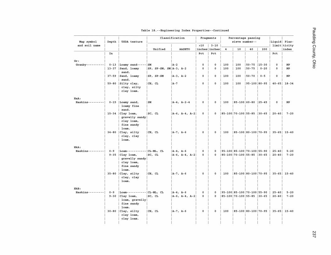
Paulding C
ounty, Ohio
237
Table 18.--Engineering Index Properties--Continued_____________________________________________________________________________________________________________________________ | | | Classification | Fragments | Percentage passing | | Map symbol | Depth | USDA texture |___________________________|_____________| sieve number-- |Liquid| Plas- and soil name | | | | | >10 | 3-10 |___________________________| limit|ticity | | | Unified | AASHTO |inches|inches| 4 | 10 | 40 | 200 | |index_____________________________________________________________________________________________________________________________ | In | | | | Pct | Pct | | | | | Pct | | | | | | | | | | | | |Gr: | | | | | | | | | | | | Granby----------| 0-13 |Loamy sand-----|SM |A-2 | 0 | 0 | 100 | 100 |50-75 |15-30 | 0 | NP | 13-37 |Sand, loamy |SP, SP-SM, SM|A-3, A-2 | 0 | 0 | 100 | 100 |50-75 | 0-20 | 0 | NP | | sand. | | | | | | | | | | | 37-59 |Sand, loamy |SP, SP-SM |A-3, A-2 | 0 | 0 | 100 | 100 |50-70 | 0-5 | 0 | NP | | sand. | | | | | | | | | | | 59-80 |Silty clay, |CH, CL |A-7 | 0 | 0 | 100 | 100 |95-100|80-95 | 40-65| 18-34 | | clay, silty | | | | | | | | | | | | clay loam. | | | | | | | | | | | | | | | | | | | | | |HaA: | | | | | | | | | | | | Haskins---------| 0-15 |Loamy sand, |SM |A-4, A-2-4 | 0 | 0 | 100 |85-100|60-80 |25-45 | 0 | NP | | loamy fine | | | | | | | | | | | | sand. | | | | | | | | | | | 15-34 |Clay loam, |SC, CL |A-6, A-4, A-2| 0 | 0 |85-100|70-100|55-85 |30-65 | 20-40| 7-20 | | gravelly sandy| | | | | | | | | | | | clay loam, | | | | | | | | | | | | fine sandy | | | | | | | | | | | | loam. | | | | | | | | | | | 34-80 |Clay, silty |CH, CL |A-7, A-6 | 0 | 0 | 100 |85-100|80-100|70-95 | 35-65| 15-40 | | clay, clay | | | | | | | | | | | | loam. | | | | | | | | | | | | | | | | | | | | | |HkA: | | | | | | | | | | | | Haskins---------| 0-9 |Loam-----------|CL-ML, CL |A-4, A-6 | 0 | 0 |95-100|85-100|70-100|55-90 | 25-40| 5-20 | 9-35 |Clay loam, |SC, CL |A-6, A-4, A-2| 0 | 0 |85-100|70-100|55-85 |30-65 | 20-40| 7-20 | | gravelly sandy| | | | | | | | | | | | clay loam, | | | | | | | | | | | | fine sandy | | | | | | | | | | | | loam. | | | | | | | | | | | 35-80 |Clay, silty |CH, CL |A-7, A-6 | 0 | 0 | 100 |85-100|80-100|70-95 | 35-65| 15-40 | | clay, clay | | | | | | | | | | | | loam. | | | | | | | | | | | | | | | | | | | | | |HkB: | | | | | | | | | | | | Haskins---------| 0-9 |Loam-----------|CL-ML, CL |A-4, A-6 | 0 | 0 |95-100|85-100|70-100|55-90 | 25-40| 5-20 | 9-30 |Clay loam, |SC, CL |A-6, A-4, A-2| 0 | 0 |85-100|70-100|55-85 |30-65 | 20-40| 7-20 | | loam, gravelly| | | | | | | | | | | | fine sandy | | | | | | | | | | | | loam. | | | | | | | | | | | 30-80 |Clay, silty |CH, CL |A-7, A-6 | 0 | 0 | 100 |85-100|80-100|70-95 | 35-65| 15-40 | | clay loam, | | | | | | | | | | | | clay loam. | | | | | | | | | | | | | | | | | | | | | |
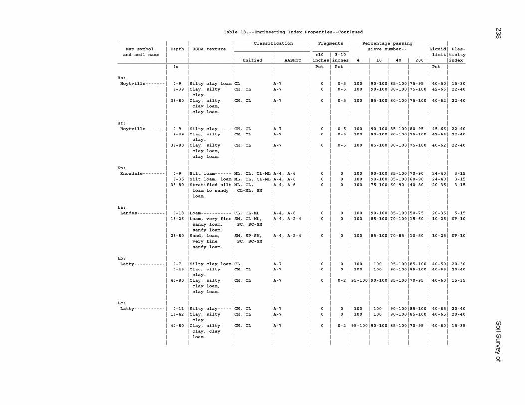
238S
oil Survey of
Table 18.--Engineering Index Properties--Continued_____________________________________________________________________________________________________________________________ | | | Classification | Fragments | Percentage passing | | Map symbol | Depth | USDA texture |___________________________|_____________| sieve number-- |Liquid| Plas- and soil name | | | | | >10 | 3-10 |___________________________| limit|ticity | | | Unified | AASHTO |inches|inches| 4 | 10 | 40 | 200 | |index_____________________________________________________________________________________________________________________________ | In | | | | Pct | Pct | | | | | Pct | | | | | | | | | | | | |Hs: | | | | | | | | | | | | Hoytville-------| 0-9 |Silty clay loam|CL |A-7 | 0 | 0-5 | 100 |90-100|85-100|75-95 | 40-50| 15-30 | 9-39 |Clay, silty |CH, CL |A-7 | 0 | 0-5 | 100 |90-100|80-100|75-100| 42-66| 22-40 | | clay. | | | | | | | | | | | 39-80 |Clay, silty |CH, CL |A-7 | 0 | 0-5 | 100 |85-100|80-100|75-100| 40-62| 22-40 | | clay loam, | | | | | | | | | | | | clay loam. | | | | | | | | | | | | | | | | | | | | | |Ht: | | | | | | | | | | | | Hoytville-------| 0-9 |Silty clay-----|CH, CL |A-7 | 0 | 0-5 | 100 |90-100|85-100|80-95 | 45-66| 22-40 | 9-39 |Clay, silty |CH, CL |A-7 | 0 | 0-5 | 100 |90-100|80-100|75-100| 42-66| 22-40 | | clay. | | | | | | | | | | | 39-80 |Clay, silty |CH, CL |A-7 | 0 | 0-5 | 100 |85-100|80-100|75-100| 40-62| 22-40 | | clay loam, | | | | | | | | | | | | clay loam. | | | | | | | | | | | | | | | | | | | | | |Kn: | | | | | | | | | | | | Knoxdale--------| 0-9 |Silt loam------|ML, CL, CL-ML|A-4, A-6 | 0 | 0 | 100 |90-100|85-100|70-90 | 24-40| 3-15 | 9-35 |Silt loam, loam|ML, CL, CL-ML|A-4, A-6 | 0 | 0 | 100 |90-100|85-100|60-90 | 24-40| 3-15 | 35-80 |Stratified silt|ML, CL, |A-4, A-6 | 0 | 0 | 100 |75-100|60-90 |40-80 | 20-35| 3-15 | | loam to sandy | CL-ML, SM | | | | | | | | | | | loam. | | | | | | | | | | | | | | | | | | | | | |La: | | | | | | | | | | | | Landes----------| 0-18 |Loam-----------|CL, CL-ML |A-4, A-6 | 0 | 0 | 100 |90-100|85-100|50-75 | 20-35| 5-15 | 18-26 |Loam, very fine|SM, CL-ML, |A-4, A-2-4 | 0 | 0 | 100 |85-100|70-100|15-60 | 10-25| NP-10 | | sandy loam, | SC, SC-SM | | | | | | | | | | | sandy loam. | | | | | | | | | | | 26-80 |Sand, loam, |SM, SP-SM, |A-4, A-2-4 | 0 | 0 | 100 |85-100|70-85 |10-50 | 10-25| NP-10 | | very fine | SC, SC-SM | | | | | | | | | | | sandy loam. | | | | | | | | | | | | | | | | | | | | | |Lb: | | | | | | | | | | | | Latty-----------| 0-7 |Silty clay loam|CL |A-7 | 0 | 0 | 100 | 100 |95-100|85-100| 40-50| 20-30 | 7-45 |Clay, silty |CH, CL |A-7 | 0 | 0 | 100 | 100 |90-100|85-100| 40-65| 20-40 | | clay. | | | | | | | | | | | 45-80 |Clay, silty |CH, CL |A-7 | 0 | 0-2 |95-100|90-100|85-100|70-95 | 40-60| 15-35 | | clay loam, | | | | | | | | | | | | clay loam. | | | | | | | | | | | | | | | | | | | | | |Lc: | | | | | | | | | | | | Latty-----------| 0-11 |Silty clay-----|CH, CL |A-7 | 0 | 0 | 100 | 100 |90-100|85-100| 40-65| 20-40 | 11-42 |Clay, silty |CH, CL |A-7 | 0 | 0 | 100 | 100 |90-100|85-100| 40-65| 20-40 | | clay. | | | | | | | | | | | 42-80 |Clay, silty |CH, CL |A-7 | 0 | 0-2 |95-100|90-100|85-100|70-95 | 40-60| 15-35 | | clay, clay | | | | | | | | | | | | loam. | | | | | | | | | | | | | | | | | | | | | |
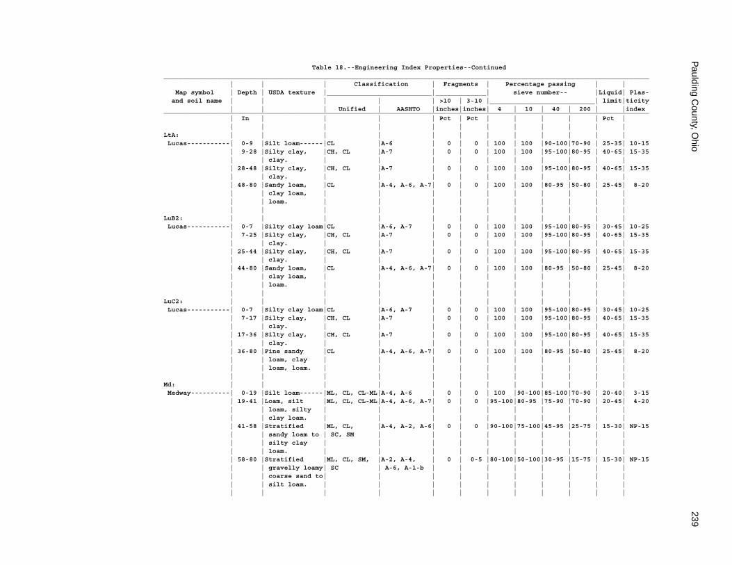
Paulding C
ounty, Ohio
239
Table 18.--Engineering Index Properties--Continued_____________________________________________________________________________________________________________________________ | | | Classification | Fragments | Percentage passing | | Map symbol | Depth | USDA texture |___________________________|_____________| sieve number-- |Liquid| Plas- and soil name | | | | | >10 | 3-10 |___________________________| limit|ticity | | | Unified | AASHTO |inches|inches| 4 | 10 | 40 | 200 | |index_____________________________________________________________________________________________________________________________ | In | | | | Pct | Pct | | | | | Pct | | | | | | | | | | | | |LtA: | | | | | | | | | | | | Lucas-----------| 0-9 |Silt loam------|CL |A-6 | 0 | 0 | 100 | 100 |90-100|70-90 | 25-35| 10-15 | 9-28 |Silty clay, |CH, CL |A-7 | 0 | 0 | 100 | 100 |95-100|80-95 | 40-65| 15-35 | | clay. | | | | | | | | | | | 28-48 |Silty clay, |CH, CL |A-7 | 0 | 0 | 100 | 100 |95-100|80-95 | 40-65| 15-35 | | clay. | | | | | | | | | | | 48-80 |Sandy loam, |CL |A-4, A-6, A-7| 0 | 0 | 100 | 100 |80-95 |50-80 | 25-45| 8-20 | | clay loam, | | | | | | | | | | | | loam. | | | | | | | | | | | | | | | | | | | | | |LuB2: | | | | | | | | | | | | Lucas-----------| 0-7 |Silty clay loam|CL |A-6, A-7 | 0 | 0 | 100 | 100 |95-100|80-95 | 30-45| 10-25 | 7-25 |Silty clay, |CH, CL |A-7 | 0 | 0 | 100 | 100 |95-100|80-95 | 40-65| 15-35 | | clay. | | | | | | | | | | | 25-44 |Silty clay, |CH, CL |A-7 | 0 | 0 | 100 | 100 |95-100|80-95 | 40-65| 15-35 | | clay. | | | | | | | | | | | 44-80 |Sandy loam, |CL |A-4, A-6, A-7| 0 | 0 | 100 | 100 |80-95 |50-80 | 25-45| 8-20 | | clay loam, | | | | | | | | | | | | loam. | | | | | | | | | | | | | | | | | | | | | |LuC2: | | | | | | | | | | | | Lucas-----------| 0-7 |Silty clay loam|CL |A-6, A-7 | 0 | 0 | 100 | 100 |95-100|80-95 | 30-45| 10-25 | 7-17 |Silty clay, |CH, CL |A-7 | 0 | 0 | 100 | 100 |95-100|80-95 | 40-65| 15-35 | | clay. | | | | | | | | | | | 17-36 |Silty clay, |CH, CL |A-7 | 0 | 0 | 100 | 100 |95-100|80-95 | 40-65| 15-35 | | clay. | | | | | | | | | | | 36-80 |Fine sandy |CL |A-4, A-6, A-7| 0 | 0 | 100 | 100 |80-95 |50-80 | 25-45| 8-20 | | loam, clay | | | | | | | | | | | | loam, loam. | | | | | | | | | | | | | | | | | | | | | |Md: | | | | | | | | | | | | Medway----------| 0-19 |Silt loam------|ML, CL, CL-ML|A-4, A-6 | 0 | 0 | 100 |90-100|85-100|70-90 | 20-40| 3-15 | 19-41 |Loam, silt |ML, CL, CL-ML|A-4, A-6, A-7| 0 | 0 |95-100|80-95 |75-90 |70-90 | 20-45| 4-20 | | loam, silty | | | | | | | | | | | | clay loam. | | | | | | | | | | | 41-58 |Stratified |ML, CL, |A-4, A-2, A-6| 0 | 0 |90-100|75-100|45-95 |25-75 | 15-30| NP-15 | | sandy loam to | SC, SM | | | | | | | | | | | silty clay | | | | | | | | | | | | loam. | | | | | | | | | | | 58-80 |Stratified |ML, CL, SM, |A-2, A-4, | 0 | 0-5 |80-100|50-100|30-95 |15-75 | 15-30| NP-15 | | gravelly loamy| SC | A-6, A-1-b | | | | | | | | | | coarse sand to| | | | | | | | | | | | silt loam. | | | | | | | | | | | | | | | | | | | | | |
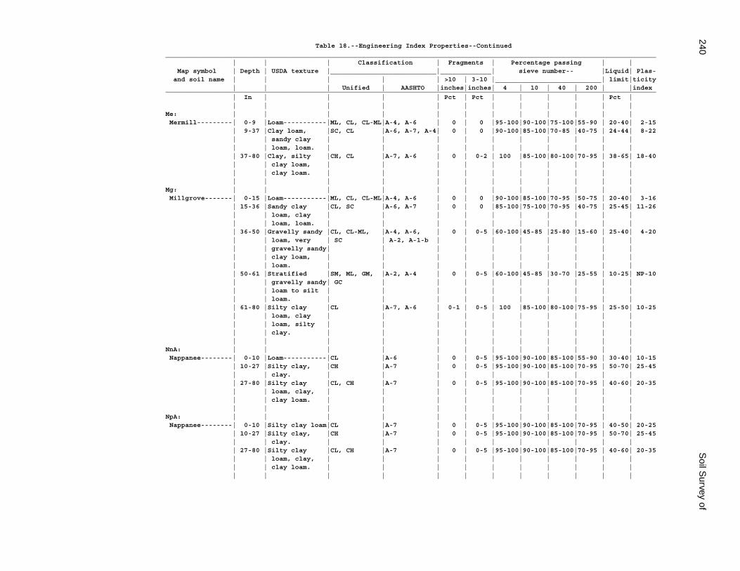
240S
oil Survey of
Table 18.--Engineering Index Properties--Continued_____________________________________________________________________________________________________________________________ | | | Classification | Fragments | Percentage passing | | Map symbol | Depth | USDA texture |___________________________|_____________| sieve number-- |Liquid| Plas- and soil name | | | | | >10 | 3-10 |___________________________| limit|ticity | | | Unified | AASHTO |inches|inches| 4 | 10 | 40 | 200 | |index_____________________________________________________________________________________________________________________________ | In | | | | Pct | Pct | | | | | Pct | | | | | | | | | | | | |Me: | | | | | | | | | | | | Mermill---------| 0-9 |Loam-----------|ML, CL, CL-ML|A-4, A-6 | 0 | 0 |95-100|90-100|75-100|55-90 | 20-40| 2-15 | 9-37 |Clay loam, |SC, CL |A-6, A-7, A-4| 0 | 0 |90-100|85-100|70-85 |40-75 | 24-44| 8-22 | | sandy clay | | | | | | | | | | | | loam, loam. | | | | | | | | | | | 37-80 |Clay, silty |CH, CL |A-7, A-6 | 0 | 0-2 | 100 |85-100|80-100|70-95 | 38-65| 18-40 | | clay loam, | | | | | | | | | | | | clay loam. | | | | | | | | | | | | | | | | | | | | | |Mg: | | | | | | | | | | | | Millgrove-------| 0-15 |Loam-----------|ML, CL, CL-ML|A-4, A-6 | 0 | 0 |90-100|85-100|70-95 |50-75 | 20-40| 3-16 | 15-36 |Sandy clay |CL, SC |A-6, A-7 | 0 | 0 |85-100|75-100|70-95 |40-75 | 25-45| 11-26 | | loam, clay | | | | | | | | | | | | loam, loam. | | | | | | | | | | | 36-50 |Gravelly sandy |CL, CL-ML, |A-4, A-6, | 0 | 0-5 |60-100|45-85 |25-80 |15-60 | 25-40| 4-20 | | loam, very | SC | A-2, A-1-b | | | | | | | | | | gravelly sandy| | | | | | | | | | | | clay loam, | | | | | | | | | | | | loam. | | | | | | | | | | | 50-61 |Stratified |SM, ML, GM, |A-2, A-4 | 0 | 0-5 |60-100|45-85 |30-70 |25-55 | 10-25| NP-10 | | gravelly sandy| GC | | | | | | | | | | | loam to silt | | | | | | | | | | | | loam. | | | | | | | | | | | 61-80 |Silty clay |CL |A-7, A-6 | 0-1 | 0-5 | 100 |85-100|80-100|75-95 | 25-50| 10-25 | | loam, clay | | | | | | | | | | | | loam, silty | | | | | | | | | | | | clay. | | | | | | | | | | | | | | | | | | | | | |NnA: | | | | | | | | | | | | Nappanee--------| 0-10 |Loam-----------|CL |A-6 | 0 | 0-5 |95-100|90-100|85-100|55-90 | 30-40| 10-15 | 10-27 |Silty clay, |CH |A-7 | 0 | 0-5 |95-100|90-100|85-100|70-95 | 50-70| 25-45 | | clay. | | | | | | | | | | | 27-80 |Silty clay |CL, CH |A-7 | 0 | 0-5 |95-100|90-100|85-100|70-95 | 40-60| 20-35 | | loam, clay, | | | | | | | | | | | | clay loam. | | | | | | | | | | | | | | | | | | | | | |NpA: | | | | | | | | | | | | Nappanee--------| 0-10 |Silty clay loam|CL |A-7 | 0 | 0-5 |95-100|90-100|85-100|70-95 | 40-50| 20-25 | 10-27 |Silty clay, |CH |A-7 | 0 | 0-5 |95-100|90-100|85-100|70-95 | 50-70| 25-45 | | clay. | | | | | | | | | | | 27-80 |Silty clay |CL, CH |A-7 | 0 | 0-5 |95-100|90-100|85-100|70-95 | 40-60| 20-35 | | loam, clay, | | | | | | | | | | | | clay loam. | | | | | | | | | | | | | | | | | | | | | |
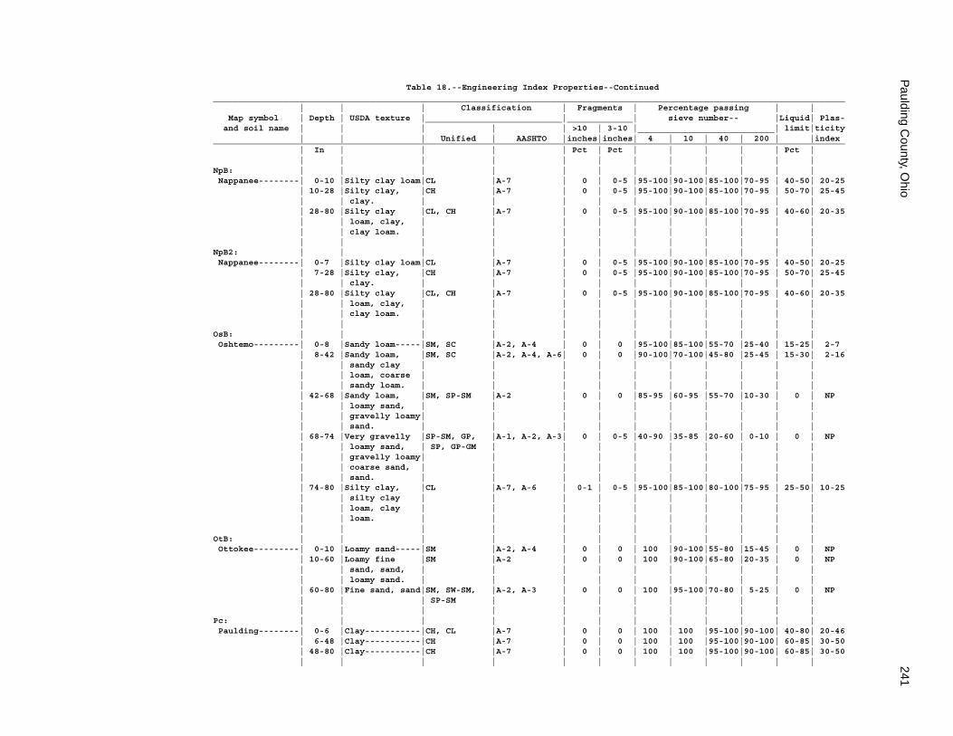
Paulding C
ounty, Ohio
241
Table 18.--Engineering Index Properties--Continued_____________________________________________________________________________________________________________________________ | | | Classification | Fragments | Percentage passing | | Map symbol | Depth | USDA texture |___________________________|_____________| sieve number-- |Liquid| Plas- and soil name | | | | | >10 | 3-10 |___________________________| limit|ticity | | | Unified | AASHTO |inches|inches| 4 | 10 | 40 | 200 | |index_____________________________________________________________________________________________________________________________ | In | | | | Pct | Pct | | | | | Pct | | | | | | | | | | | | |NpB: | | | | | | | | | | | | Nappanee--------| 0-10 |Silty clay loam|CL |A-7 | 0 | 0-5 |95-100|90-100|85-100|70-95 | 40-50| 20-25 | 10-28 |Silty clay, |CH |A-7 | 0 | 0-5 |95-100|90-100|85-100|70-95 | 50-70| 25-45 | | clay. | | | | | | | | | | | 28-80 |Silty clay |CL, CH |A-7 | 0 | 0-5 |95-100|90-100|85-100|70-95 | 40-60| 20-35 | | loam, clay, | | | | | | | | | | | | clay loam. | | | | | | | | | | | | | | | | | | | | | |NpB2: | | | | | | | | | | | | Nappanee--------| 0-7 |Silty clay loam|CL |A-7 | 0 | 0-5 |95-100|90-100|85-100|70-95 | 40-50| 20-25 | 7-28 |Silty clay, |CH |A-7 | 0 | 0-5 |95-100|90-100|85-100|70-95 | 50-70| 25-45 | | clay. | | | | | | | | | | | 28-80 |Silty clay |CL, CH |A-7 | 0 | 0-5 |95-100|90-100|85-100|70-95 | 40-60| 20-35 | | loam, clay, | | | | | | | | | | | | clay loam. | | | | | | | | | | | | | | | | | | | | | |OsB: | | | | | | | | | | | | Oshtemo---------| 0-8 |Sandy loam-----|SM, SC |A-2, A-4 | 0 | 0 |95-100|85-100|55-70 |25-40 | 15-25| 2-7 | 8-42 |Sandy loam, |SM, SC |A-2, A-4, A-6| 0 | 0 |90-100|70-100|45-80 |25-45 | 15-30| 2-16 | | sandy clay | | | | | | | | | | | | loam, coarse | | | | | | | | | | | | sandy loam. | | | | | | | | | | | 42-68 |Sandy loam, |SM, SP-SM |A-2 | 0 | 0 |85-95 |60-95 |55-70 |10-30 | 0 | NP | | loamy sand, | | | | | | | | | | | | gravelly loamy| | | | | | | | | | | | sand. | | | | | | | | | | | 68-74 |Very gravelly |SP-SM, GP, |A-1, A-2, A-3| 0 | 0-5 |40-90 |35-85 |20-60 | 0-10 | 0 | NP | | loamy sand, | SP, GP-GM | | | | | | | | | | | gravelly loamy| | | | | | | | | | | | coarse sand, | | | | | | | | | | | | sand. | | | | | | | | | | | 74-80 |Silty clay, |CL |A-7, A-6 | 0-1 | 0-5 |95-100|85-100|80-100|75-95 | 25-50| 10-25 | | silty clay | | | | | | | | | | | | loam, clay | | | | | | | | | | | | loam. | | | | | | | | | | | | | | | | | | | | | |OtB: | | | | | | | | | | | | Ottokee---------| 0-10 |Loamy sand-----|SM |A-2, A-4 | 0 | 0 | 100 |90-100|55-80 |15-45 | 0 | NP | 10-60 |Loamy fine |SM |A-2 | 0 | 0 | 100 |90-100|65-80 |20-35 | 0 | NP | | sand, sand, | | | | | | | | | | | | loamy sand. | | | | | | | | | | | 60-80 |Fine sand, sand|SM, SW-SM, |A-2, A-3 | 0 | 0 | 100 |95-100|70-80 | 5-25 | 0 | NP | | | SP-SM | | | | | | | | | | | | | | | | | | | | |Pc: | | | | | | | | | | | | Paulding--------| 0-6 |Clay-----------|CH, CL |A-7 | 0 | 0 | 100 | 100 |95-100|90-100| 40-80| 20-46 | 6-48 |Clay-----------|CH |A-7 | 0 | 0 | 100 | 100 |95-100|90-100| 60-85| 30-50 | 48-80 |Clay-----------|CH |A-7 | 0 | 0 | 100 | 100 |95-100|90-100| 60-85| 30-50 | | | | | | | | | | | |
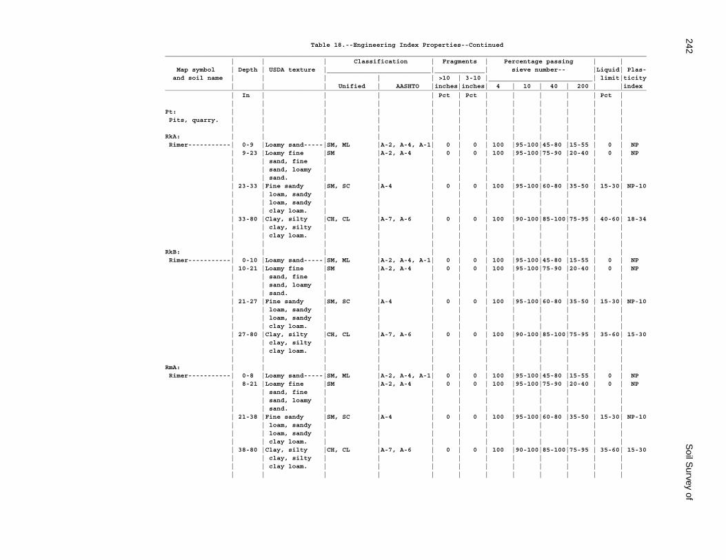
242S
oil Survey of
Table 18.--Engineering Index Properties--Continued_____________________________________________________________________________________________________________________________ | | | Classification | Fragments | Percentage passing | | Map symbol | Depth | USDA texture |___________________________|_____________| sieve number-- |Liquid| Plas- and soil name | | | | | >10 | 3-10 |___________________________| limit|ticity | | | Unified | AASHTO |inches|inches| 4 | 10 | 40 | 200 | |index_____________________________________________________________________________________________________________________________ | In | | | | Pct | Pct | | | | | Pct | | | | | | | | | | | | |Pt: | | | | | | | | | | | | Pits, quarry. | | | | | | | | | | | | | | | | | | | | | | | |RkA: | | | | | | | | | | | | Rimer-----------| 0-9 |Loamy sand-----|SM, ML |A-2, A-4, A-1| 0 | 0 | 100 |95-100|45-80 |15-55 | 0 | NP | 9-23 |Loamy fine |SM |A-2, A-4 | 0 | 0 | 100 |95-100|75-90 |20-40 | 0 | NP | | sand, fine | | | | | | | | | | | | sand, loamy | | | | | | | | | | | | sand. | | | | | | | | | | | 23-33 |Fine sandy |SM, SC |A-4 | 0 | 0 | 100 |95-100|60-80 |35-50 | 15-30| NP-10 | | loam, sandy | | | | | | | | | | | | loam, sandy | | | | | | | | | | | | clay loam. | | | | | | | | | | | 33-80 |Clay, silty |CH, CL |A-7, A-6 | 0 | 0 | 100 |90-100|85-100|75-95 | 40-60| 18-34 | | clay, silty | | | | | | | | | | | | clay loam. | | | | | | | | | | | | | | | | | | | | | |RkB: | | | | | | | | | | | | Rimer-----------| 0-10 |Loamy sand-----|SM, ML |A-2, A-4, A-1| 0 | 0 | 100 |95-100|45-80 |15-55 | 0 | NP | 10-21 |Loamy fine |SM |A-2, A-4 | 0 | 0 | 100 |95-100|75-90 |20-40 | 0 | NP | | sand, fine | | | | | | | | | | | | sand, loamy | | | | | | | | | | | | sand. | | | | | | | | | | | 21-27 |Fine sandy |SM, SC |A-4 | 0 | 0 | 100 |95-100|60-80 |35-50 | 15-30| NP-10 | | loam, sandy | | | | | | | | | | | | loam, sandy | | | | | | | | | | | | clay loam. | | | | | | | | | | | 27-80 |Clay, silty |CH, CL |A-7, A-6 | 0 | 0 | 100 |90-100|85-100|75-95 | 35-60| 15-30 | | clay, silty | | | | | | | | | | | | clay loam. | | | | | | | | | | | | | | | | | | | | | |RmA: | | | | | | | | | | | | Rimer-----------| 0-8 |Loamy sand-----|SM, ML |A-2, A-4, A-1| 0 | 0 | 100 |95-100|45-80 |15-55 | 0 | NP | 8-21 |Loamy fine |SM |A-2, A-4 | 0 | 0 | 100 |95-100|75-90 |20-40 | 0 | NP | | sand, fine | | | | | | | | | | | | sand, loamy | | | | | | | | | | | | sand. | | | | | | | | | | | 21-38 |Fine sandy |SM, SC |A-4 | 0 | 0 | 100 |95-100|60-80 |35-50 | 15-30| NP-10 | | loam, sandy | | | | | | | | | | | | loam, sandy | | | | | | | | | | | | clay loam. | | | | | | | | | | | 38-80 |Clay, silty |CH, CL |A-7, A-6 | 0 | 0 | 100 |90-100|85-100|75-95 | 35-60| 15-30 | | clay, silty | | | | | | | | | | | | clay loam. | | | | | | | | | | | | | | | | | | | | | |
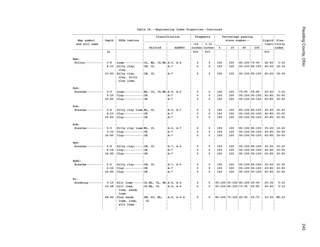
Paulding C
ounty, Ohio
243
Table 18.--Engineering Index Properties--Continued_____________________________________________________________________________________________________________________________ | | | Classification | Fragments | Percentage passing | | Map symbol | Depth | USDA texture |___________________________|_____________| sieve number-- |Liquid| Plas- and soil name | | | | | >10 | 3-10 |___________________________| limit|ticity | | | Unified | AASHTO |inches|inches| 4 | 10 | 40 | 200 | |index_____________________________________________________________________________________________________________________________ | In | | | | Pct | Pct | | | | | Pct | | | | | | | | | | | | |RmA: | | | | | | | | | | | | Fulton----------| 0-8 |Loam-----------|CL, ML, CL-ML|A-6, A-4 | 0 | 0 | 100 | 100 |85-100|70-90 | 24-40| 3-16 | 8-33 |Silty clay, |CH, CL |A-7 | 0 | 0 | 100 | 100 |90-100|85-100| 40-60| 18-34 | | clay. | | | | | | | | | | | 33-80 |Silty clay, |CH, CL |A-7 | 0 | 0 | 100 | 100 |90-100|85-100| 40-60| 18-34 | | clay, silty | | | | | | | | | | | | clay loam. | | | | | | | | | | | | | | | | | | | | | |RnA: | | | | | | | | | | | | Roselms---------| 0-9 |Loam-----------|ML, CL, CL-ML|A-4, A-6 | 0 | 0 | 100 | 100 |75-95 |55-80 | 20-40| 3-16 | 9-29 |Clay-----------|CH |A-7 | 0 | 0 | 100 | 100 |95-100|90-100| 60-80| 30-50 | 29-80 |Clay-----------|CH |A-7 | 0 | 0 | 100 | 100 |95-100|90-100| 60-85| 30-50 | | | | | | | | | | | |RoA: | | | | | | | | | | | | Roselms---------| 0-8 |Silty clay loam|ML, CL |A-6, A-7 | 0 | 0 | 100 | 100 |85-100|80-100| 35-45| 10-20 | 8-23 |Clay-----------|CH |A-7 | 0 | 0 | 100 | 100 |95-100|90-100| 60-80| 30-50 | 23-80 |Clay-----------|CH |A-7 | 0 | 0 | 100 | 100 |95-100|90-100| 60-85| 30-50 | | | | | | | | | | | |RoB: | | | | | | | | | | | | Roselms---------| 0-9 |Silty clay loam|ML, CL |A-6, A-7 | 0 | 0 | 100 | 100 |85-100|80-100| 35-45| 10-20 | 9-30 |Clay-----------|CH |A-7 | 0 | 0 | 100 | 100 |95-100|90-100| 60-80| 30-50 | 30-80 |Clay-----------|CH |A-7 | 0 | 0 | 100 | 100 |95-100|90-100| 60-85| 30-50 | | | | | | | | | | | |RpA: | | | | | | | | | | | | Roselms---------| 0-8 |Silty clay-----|CH, CL |A-7, A-6 | 0 | 0 | 100 | 100 |90-100|85-100| 35-66| 15-35 | 8-34 |Clay-----------|CH |A-7 | 0 | 0 | 100 | 100 |95-100|90-100| 60-80| 30-50 | 34-80 |Clay-----------|CH |A-7 | 0 | 0 | 100 | 100 |95-100|90-100| 60-85| 30-50 | | | | | | | | | | | |RpB2: | | | | | | | | | | | | Roselms---------| 0-6 |Silty clay-----|CH, CL |A-7, A-6 | 0 | 0 | 100 | 100 |90-100|85-100| 35-66| 15-35 | 6-26 |Clay-----------|CH |A-7 | 0 | 0 | 100 | 100 |95-100|90-100| 60-80| 30-50 | 26-80 |Clay-----------|CH |A-7 | 0 | 0 | 100 | 100 |95-100|90-100| 60-85| 30-50 | | | | | | | | | | | |Rt: | | | | | | | | | | | | Rossburg--------| 0-15 |Silt loam------|CL-ML, CL, ML|A-4, A-6 | 0 | 0 |95-100|90-100|80-100|60-90 | 20-35| 5-15 | 15-48 |Silt loam, |CL-ML, CL |A-4, A-6 | 0 | 0 |90-100|85-100|70-95 |50-80 | 20-40| 5-15 | | loam, sandy | | | | | | | | | | | | loam. | | | | | | | | | | | 48-80 |Fine sandy |SM, SC, ML, |A-4, A-2-4 | 0 | 0 |80-100|70-100|45-90 |25-70 | 10-25| NP-10 | | loam, loam, | CL | | | | | | | | | | | silt loam. | | | | | | | | | | | | | | | | | | | | | |
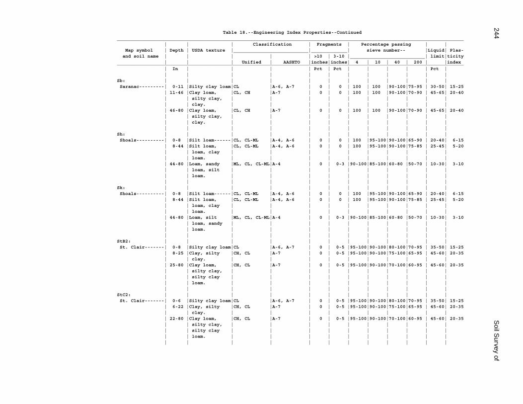
244S
oil Survey of
Table 18.--Engineering Index Properties--Continued_____________________________________________________________________________________________________________________________ | | | Classification | Fragments | Percentage passing | | Map symbol | Depth | USDA texture |___________________________|_____________| sieve number-- |Liquid| Plas- and soil name | | | | | >10 | 3-10 |___________________________| limit|ticity | | | Unified | AASHTO |inches|inches| 4 | 10 | 40 | 200 | |index_____________________________________________________________________________________________________________________________ | In | | | | Pct | Pct | | | | | Pct | | | | | | | | | | | | |Sb: | | | | | | | | | | | | Saranac---------| 0-11 |Silty clay loam|CL |A-6, A-7 | 0 | 0 | 100 | 100 |90-100|75-95 | 30-50| 15-25 | 11-46 |Clay loam, |CL, CH |A-7 | 0 | 0 | 100 | 100 |90-100|70-90 | 45-65| 20-40 | | silty clay, | | | | | | | | | | | | clay. | | | | | | | | | | | 46-80 |Clay loam, |CL, CH |A-7 | 0 | 0 | 100 | 100 |90-100|70-90 | 45-65| 20-40 | | silty clay, | | | | | | | | | | | | clay. | | | | | | | | | | | | | | | | | | | | | |Sh: | | | | | | | | | | | | Shoals----------| 0-8 |Silt loam------|CL, CL-ML |A-4, A-6 | 0 | 0 | 100 |95-100|90-100|65-90 | 20-40| 6-15 | 8-44 |Silt loam, |CL, CL-ML |A-4, A-6 | 0 | 0 | 100 |95-100|90-100|75-85 | 25-45| 5-20 | | loam, clay | | | | | | | | | | | | loam. | | | | | | | | | | | 44-80 |Loam, sandy |ML, CL, CL-ML|A-4 | 0 | 0-3 |90-100|85-100|60-80 |50-70 | 10-30| 3-10 | | loam, silt | | | | | | | | | | | | loam. | | | | | | | | | | | | | | | | | | | | | |Sk: | | | | | | | | | | | | Shoals----------| 0-8 |Silt loam------|CL, CL-ML |A-4, A-6 | 0 | 0 | 100 |95-100|90-100|65-90 | 20-40| 6-15 | 8-44 |Silt loam, |CL, CL-ML |A-4, A-6 | 0 | 0 | 100 |95-100|90-100|75-85 | 25-45| 5-20 | | loam, clay | | | | | | | | | | | | loam. | | | | | | | | | | | 44-80 |Loam, silt |ML, CL, CL-ML|A-4 | 0 | 0-3 |90-100|85-100|60-80 |50-70 | 10-30| 3-10 | | loam, sandy | | | | | | | | | | | | loam. | | | | | | | | | | | | | | | | | | | | | |StB2: | | | | | | | | | | | | St. Clair-------| 0-8 |Silty clay loam|CL |A-6, A-7 | 0 | 0-5 |95-100|90-100|80-100|70-95 | 35-50| 15-25 | 8-25 |Clay, silty |CH, CL |A-7 | 0 | 0-5 |95-100|90-100|75-100|65-95 | 45-60| 20-35 | | clay. | | | | | | | | | | | 25-80 |Clay loam, |CH, CL |A-7 | 0 | 0-5 |95-100|90-100|70-100|60-95 | 45-60| 20-35 | | silty clay, | | | | | | | | | | | | silty clay | | | | | | | | | | | | loam. | | | | | | | | | | | | | | | | | | | | | |StC2: | | | | | | | | | | | | St. Clair-------| 0-6 |Silty clay loam|CL |A-6, A-7 | 0 | 0-5 |95-100|90-100|80-100|70-95 | 35-50| 15-25 | 6-22 |Clay, silty |CH, CL |A-7 | 0 | 0-5 |95-100|90-100|75-100|65-95 | 45-60| 20-35 | | clay. | | | | | | | | | | | 22-80 |Clay loam, |CH, CL |A-7 | 0 | 0-5 |95-100|90-100|70-100|60-95 | 45-60| 20-35 | | silty clay, | | | | | | | | | | | | silty clay | | | | | | | | | | | | loam. | | | | | | | | | | | | | | | | | | | | | |
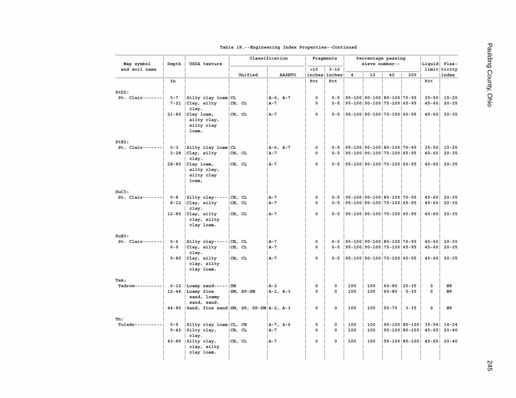
Paulding C
ounty, Ohio
245
Table 18.--Engineering Index Properties--Continued_____________________________________________________________________________________________________________________________ | | | Classification | Fragments | Percentage passing | | Map symbol | Depth | USDA texture |___________________________|_____________| sieve number-- |Liquid| Plas- and soil name | | | | | >10 | 3-10 |___________________________| limit|ticity | | | Unified | AASHTO |inches|inches| 4 | 10 | 40 | 200 | |index_____________________________________________________________________________________________________________________________ | In | | | | Pct | Pct | | | | | Pct | | | | | | | | | | | | |StD2: | | | | | | | | | | | | St. Clair-------| 0-7 |Silty clay loam|CL |A-6, A-7 | 0 | 0-5 |95-100|90-100|80-100|70-95 | 35-50| 15-25 | 7-21 |Clay, silty |CH, CL |A-7 | 0 | 0-5 |95-100|90-100|75-100|65-95 | 45-60| 20-35 | | clay. | | | | | | | | | | | 21-80 |Clay loam, |CH, CL |A-7 | 0 | 0-5 |95-100|90-100|70-100|60-95 | 45-60| 20-35 | | silty clay, | | | | | | | | | | | | silty clay | | | | | | | | | | | | loam. | | | | | | | | | | | | | | | | | | | | | |StE2: | | | | | | | | | | | | St. Clair-------| 0-3 |Silty clay loam|CL |A-6, A-7 | 0 | 0-5 |95-100|90-100|80-100|70-95 | 35-50| 15-25 | 3-28 |Clay, silty |CH, CL |A-7 | 0 | 0-5 |95-100|90-100|75-100|65-95 | 45-60| 20-35 | | clay. | | | | | | | | | | | 28-80 |Clay loam, |CH, CL |A-7 | 0 | 0-5 |95-100|90-100|70-100|60-95 | 45-60| 20-35 | | silty clay, | | | | | | | | | | | | silty clay | | | | | | | | | | | | loam. | | | | | | | | | | | | | | | | | | | | | |SuC3: | | | | | | | | | | | | St. Clair-------| 0-8 |Silty clay-----|CH, CL |A-7 | 0 | 0-5 |95-100|90-100|85-100|70-95 | 45-60| 20-35 | 8-12 |Clay, silty |CH, CL |A-7 | 0 | 0-5 |95-100|90-100|75-100|65-95 | 45-60| 20-35 | | clay. | | | | | | | | | | | 12-80 |Clay, silty |CH, CL |A-7 | 0 | 0-5 |95-100|90-100|70-100|60-95 | 45-60| 20-35 | | clay, silty | | | | | | | | | | | | clay loam. | | | | | | | | | | | | | | | | | | | | | |SuE3: | | | | | | | | | | | | St. Clair-------| 0-6 |Silty clay-----|CH, CL |A-7 | 0 | 0-5 |95-100|90-100|85-100|70-95 | 45-60| 20-35 | 6-9 |Clay, silty |CH, CL |A-7 | 0 | 0-5 |95-100|90-100|75-100|65-95 | 45-60| 20-35 | | clay. | | | | | | | | | | | 9-80 |Clay, silty |CH, CL |A-7 | 0 | 0-5 |95-100|90-100|70-100|60-95 | 45-60| 20-35 | | clay, silty | | | | | | | | | | | | clay loam. | | | | | | | | | | | | | | | | | | | | | |TeA: | | | | | | | | | | | | Tedrow----------| 0-12 |Loamy sand-----|SM |A-2 | 0 | 0 | 100 | 100 |60-80 |20-35 | 0 | NP | 12-44 |Loamy fine |SM, SP-SM |A-2, A-3 | 0 | 0 | 100 | 100 |60-80 | 5-35 | 0 | NP | | sand, loamy | | | | | | | | | | | | sand, sand. | | | | | | | | | | | 44-80 |Sand, fine sand|SM, SP, SP-SM|A-2, A-3 | 0 | 0 | 100 | 100 |50-70 | 3-35 | 0 | NP | | | | | | | | | | | |Tn: | | | | | | | | | | | | Toledo----------| 0-9 |Silty clay loam|CL, CH |A-7, A-6 | 0 | 0 | 100 | 100 |90-100|80-100| 35-54| 14-24 | 9-43 |Silty clay, |CH, CL |A-7 | 0 | 0 | 100 | 100 |95-100|80-100| 45-65| 20-40 | | clay. | | | | | | | | | | | 43-80 |Silty clay, |CH, CL |A-7 | 0 | 0 | 100 | 100 |95-100|80-100| 45-65| 20-40 | | clay, silty | | | | | | | | | | | | clay loam. | | | | | | | | | | | | | | | | | | | | | |
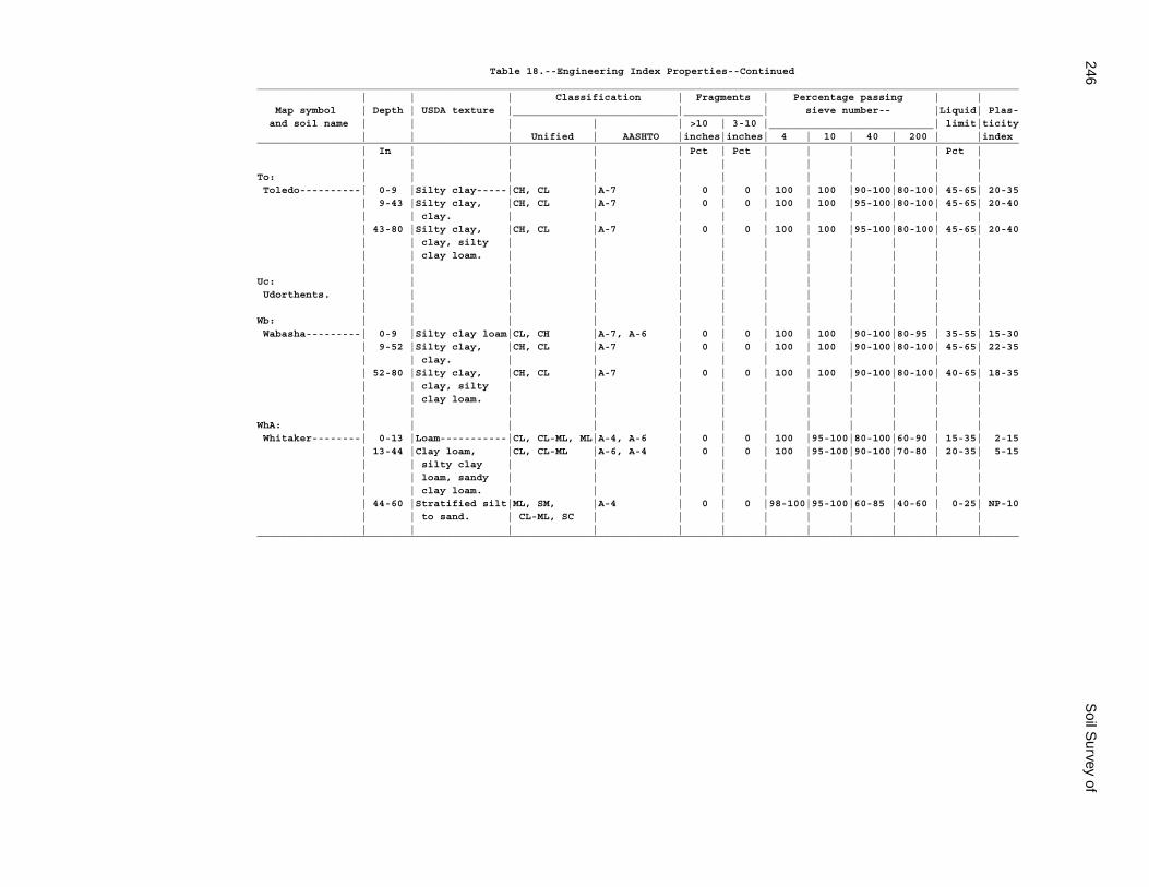
246S
oil Survey of
Table 18.--Engineering Index Properties--Continued_____________________________________________________________________________________________________________________________ | | | Classification | Fragments | Percentage passing | | Map symbol | Depth | USDA texture |___________________________|_____________| sieve number-- |Liquid| Plas- and soil name | | | | | >10 | 3-10 |___________________________| limit|ticity | | | Unified | AASHTO |inches|inches| 4 | 10 | 40 | 200 | |index_____________________________________________________________________________________________________________________________ | In | | | | Pct | Pct | | | | | Pct | | | | | | | | | | | | |To: | | | | | | | | | | | | Toledo----------| 0-9 |Silty clay-----|CH, CL |A-7 | 0 | 0 | 100 | 100 |90-100|80-100| 45-65| 20-35 | 9-43 |Silty clay, |CH, CL |A-7 | 0 | 0 | 100 | 100 |95-100|80-100| 45-65| 20-40 | | clay. | | | | | | | | | | | 43-80 |Silty clay, |CH, CL |A-7 | 0 | 0 | 100 | 100 |95-100|80-100| 45-65| 20-40 | | clay, silty | | | | | | | | | | | | clay loam. | | | | | | | | | | | | | | | | | | | | | |Uc: | | | | | | | | | | | | Udorthents. | | | | | | | | | | | | | | | | | | | | | | | |Wb: | | | | | | | | | | | | Wabasha---------| 0-9 |Silty clay loam|CL, CH |A-7, A-6 | 0 | 0 | 100 | 100 |90-100|80-95 | 35-55| 15-30 | 9-52 |Silty clay, |CH, CL |A-7 | 0 | 0 | 100 | 100 |90-100|80-100| 45-65| 22-35 | | clay. | | | | | | | | | | | 52-80 |Silty clay, |CH, CL |A-7 | 0 | 0 | 100 | 100 |90-100|80-100| 40-65| 18-35 | | clay, silty | | | | | | | | | | | | clay loam. | | | | | | | | | | | | | | | | | | | | | |WhA: | | | | | | | | | | | | Whitaker--------| 0-13 |Loam-----------|CL, CL-ML, ML|A-4, A-6 | 0 | 0 | 100 |95-100|80-100|60-90 | 15-35| 2-15 | 13-44 |Clay loam, |CL, CL-ML |A-6, A-4 | 0 | 0 | 100 |95-100|90-100|70-80 | 20-35| 5-15 | | silty clay | | | | | | | | | | | | loam, sandy | | | | | | | | | | | | clay loam. | | | | | | | | | | | 44-60 |Stratified silt|ML, SM, |A-4 | 0 | 0 |98-100|95-100|60-85 |40-60 | 0-25| NP-10 | | to sand. | CL-ML, SC | | | | | | | | | | | | | | | | | | | | |_____________________________________________________________________________________________________________________________
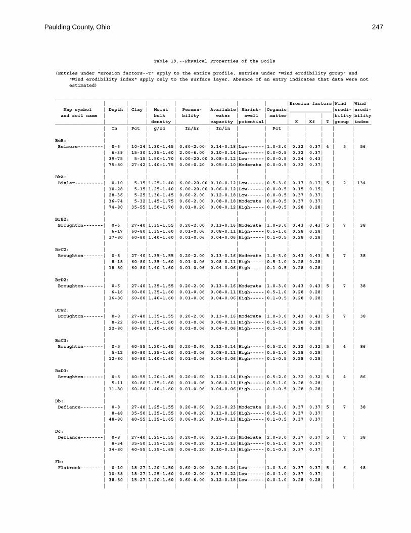
Paulding County, Ohio 247
Table 19.--Physical Properties of the Soils
(Entries under "Erosion factors--T" apply to the entire profile. Entries under "Wind erodibility group" and "Wind erodibility index" apply only to the surface layer. Absence of an entry indicates that data were not estimated)
________________________________________________________________________________________________________________ | | | | | | | |Erosion factors|Wind |Wind Map symbol | Depth | Clay | Moist | Permea- |Available| Shrink- |Organic|_______________|erodi-|erodi- and soil name | | | bulk | bility | water | swell | matter| | | |bility|bility | | | density | |capacity |potential| | K | Kf | T |group |index________________________________________________________________________________________________________________ | In | Pct | g/cc | In/hr | In/in | | Pct | | | | | | | | | | | | | | | | |BeB: | | | | | | | | | | | | Belmore---------| 0-6 | 10-24|1.30-1.45| 0.60-2.00 |0.14-0.18|Low------|1.0-3.0| 0.32| 0.37| 4 | 5 | 56 | 6-39 | 15-30|1.35-1.60| 2.00-6.00 |0.10-0.14|Low------|0.0-0.5| 0.32| 0.37| | | | 39-75 | 5-15|1.50-1.70| 6.00-20.00|0.08-0.12|Low------|0.0-0.5| 0.24| 0.43| | | | 75-80 | 27-42|1.40-1.75| 0.06-0.20 |0.05-0.10|Moderate |0.0-0.5| 0.32| 0.37| | | | | | | | | | | | | | |BkA: | | | | | | | | | | | | Bixler----------| 0-10 | 5-15|1.25-1.40| 6.00-20.00|0.10-0.12|Low------|0.5-3.0| 0.17| 0.17| 5 | 2 | 134 | 10-28 | 5-15|1.25-1.40| 6.00-20.00|0.06-0.12|Low------|0.0-0.5| 0.15| 0.15| | | | 28-36 | 5-25|1.30-1.45| 0.60-2.00 |0.12-0.18|Low------|0.0-0.5| 0.37| 0.37| | | | 36-74 | 5-32|1.45-1.75| 0.60-2.00 |0.08-0.18|Moderate |0.0-0.5| 0.37| 0.37| | | | 74-80 | 35-55|1.50-1.70| 0.01-0.20 |0.08-0.12|High-----|0.0-0.5| 0.28| 0.28| | | | | | | | | | | | | | |BrB2: | | | | | | | | | | | | Broughton-------| 0-6 | 27-40|1.35-1.55| 0.20-2.00 |0.13-0.16|Moderate |1.0-3.0| 0.43| 0.43| 5 | 7 | 38 | 6-17 | 60-80|1.35-1.60| 0.01-0.06 |0.08-0.11|High-----|0.5-1.0| 0.28| 0.28| | | | 17-80 | 60-80|1.40-1.60| 0.01-0.06 |0.04-0.06|High-----|0.1-0.5| 0.28| 0.28| | | | | | | | | | | | | | |BrC2: | | | | | | | | | | | | Broughton-------| 0-8 | 27-40|1.35-1.55| 0.20-2.00 |0.13-0.16|Moderate |1.0-3.0| 0.43| 0.43| 5 | 7 | 38 | 8-18 | 60-80|1.35-1.60| 0.01-0.06 |0.08-0.11|High-----|0.5-1.0| 0.28| 0.28| | | | 18-80 | 60-80|1.40-1.60| 0.01-0.06 |0.04-0.06|High-----|0.1-0.5| 0.28| 0.28| | | | | | | | | | | | | | |BrD2: | | | | | | | | | | | | Broughton-------| 0-6 | 27-40|1.35-1.55| 0.20-2.00 |0.13-0.16|Moderate |1.0-3.0| 0.43| 0.43| 5 | 7 | 38 | 6-16 | 60-80|1.35-1.60| 0.01-0.06 |0.08-0.11|High-----|0.5-1.0| 0.28| 0.28| | | | 16-80 | 60-80|1.40-1.60| 0.01-0.06 |0.04-0.06|High-----|0.1-0.5| 0.28| 0.28| | | | | | | | | | | | | | |BrE2: | | | | | | | | | | | | Broughton-------| 0-8 | 27-40|1.35-1.55| 0.20-2.00 |0.13-0.16|Moderate |1.0-3.0| 0.43| 0.43| 5 | 7 | 38 | 8-22 | 60-80|1.35-1.60| 0.01-0.06 |0.08-0.11|High-----|0.5-1.0| 0.28| 0.28| | | | 22-80 | 60-80|1.40-1.60| 0.01-0.06 |0.04-0.06|High-----|0.1-0.5| 0.28| 0.28| | | | | | | | | | | | | | |BsC3: | | | | | | | | | | | | Broughton-------| 0-5 | 40-55|1.20-1.45| 0.20-0.60 |0.12-0.14|High-----|0.5-2.0| 0.32| 0.32| 5 | 4 | 86 | 5-12 | 60-80|1.35-1.60| 0.01-0.06 |0.08-0.11|High-----|0.5-1.0| 0.28| 0.28| | | | 12-80 | 60-80|1.40-1.60| 0.01-0.06 |0.04-0.06|High-----|0.1-0.5| 0.28| 0.28| | | | | | | | | | | | | | |BsD3: | | | | | | | | | | | | Broughton-------| 0-5 | 40-55|1.20-1.45| 0.20-0.60 |0.12-0.14|High-----|0.5-2.0| 0.32| 0.32| 5 | 4 | 86 | 5-11 | 60-80|1.35-1.60| 0.01-0.06 |0.08-0.11|High-----|0.5-1.0| 0.28| 0.28| | | | 11-80 | 60-80|1.40-1.60| 0.01-0.06 |0.04-0.06|High-----|0.1-0.5| 0.28| 0.28| | | | | | | | | | | | | | |Db: | | | | | | | | | | | | Defiance--------| 0-8 | 27-40|1.25-1.55| 0.20-0.60 |0.21-0.23|Moderate |2.0-3.0| 0.37| 0.37| 5 | 7 | 38 | 8-48 | 35-50|1.35-1.55| 0.06-0.20 |0.11-0.16|High-----|0.5-1.0| 0.37| 0.37| | | | 48-80 | 40-55|1.35-1.65| 0.06-0.20 |0.10-0.13|High-----|0.1-0.5| 0.37| 0.37| | | | | | | | | | | | | | |Dc: | | | | | | | | | | | | Defiance--------| 0-8 | 27-40|1.25-1.55| 0.20-0.60 |0.21-0.23|Moderate |2.0-3.0| 0.37| 0.37| 5 | 7 | 38 | 8-34 | 35-50|1.35-1.55| 0.06-0.20 |0.11-0.16|High-----|0.5-1.0| 0.37| 0.37| | | | 34-80 | 40-55|1.35-1.65| 0.06-0.20 |0.10-0.13|High-----|0.1-0.5| 0.37| 0.37| | | | | | | | | | | | | | |Fb: | | | | | | | | | | | | Flatrock--------| 0-10 | 18-27|1.20-1.50| 0.60-2.00 |0.20-0.24|Low------|1.0-3.0| 0.37| 0.37| 5 | 6 | 48 | 10-38 | 18-27|1.25-1.60| 0.60-2.00 |0.17-0.22|Low------|0.0-1.0| 0.37| 0.37| | | | 38-80 | 15-27|1.20-1.60| 0.60-6.00 |0.12-0.18|Low------|0.0-1.0| 0.28| 0.28| | | | | | | | | | | | | | |
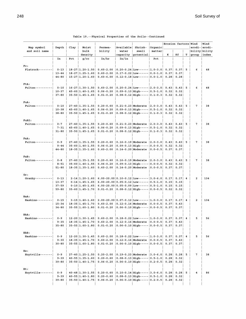
248 Soil Survey of
Table 19.--Physical Properties of the Soils--Continued________________________________________________________________________________________________________________ | | | | | | | |Erosion factors|Wind |Wind Map symbol | Depth | Clay | Moist | Permea- |Available| Shrink- |Organic|_______________|erodi-|erodi- and soil name | | | bulk | bility | water | swell | matter| | | |bility|bility | | | density | |capacity |potential| | K | Kf | T |group |index________________________________________________________________________________________________________________ | In | Pct | g/cc | In/hr | In/in | | Pct | | | | | | | | | | | | | | | | |Fc: | | | | | | | | | | | | Flatrock--------| 0-13 | 18-27|1.20-1.50| 0.60-2.00 |0.20-0.24|Low------|1.0-3.0| 0.37| 0.37| 5 | 6 | 48 | 13-44 | 18-27|1.25-1.60| 0.60-2.00 |0.17-0.22|Low------|0.0-1.0| 0.37| 0.37| | | | 44-80 | 15-27|1.20-1.60| 0.60-6.00 |0.12-0.18|Low------|0.0-1.0| 0.28| 0.28| | | | | | | | | | | | | | |FtA: | | | | | | | | | | | | Fulton----------| 0-10 | 16-27|1.30-1.50| 0.60-2.00 |0.20-0.24|Low------|2.0-3.0| 0.43| 0.43| 5 | 6 | 48 | 10-37 | 45-60|1.40-1.65| 0.06-0.20 |0.09-0.13|High-----|0.5-1.0| 0.32| 0.32| | | | 37-80 | 35-50|1.45-1.65| 0.01-0.20 |0.08-0.12|High-----|0.1-0.3| 0.32| 0.32| | | | | | | | | | | | | | |FuA: | | | | | | | | | | | | Fulton----------| 0-10 | 27-40|1.35-1.55| 0.20-0.60 |0.21-0.23|Moderate |2.0-3.0| 0.43| 0.43| 5 | 7 | 38 | 10-38 | 45-60|1.40-1.65| 0.06-0.20 |0.09-0.13|High-----|0.5-1.0| 0.32| 0.32| | | | 38-80 | 35-50|1.45-1.65| 0.01-0.20 |0.08-0.12|High-----|0.1-0.3| 0.32| 0.32| | | | | | | | | | | | | | |FuB2: | | | | | | | | | | | | Fulton----------| 0-7 | 27-40|1.35-1.55| 0.20-0.60 |0.21-0.23|Moderate |2.0-3.0| 0.43| 0.43| 5 | 7 | 38 | 7-31 | 45-60|1.40-1.65| 0.06-0.20 |0.09-0.13|High-----|0.5-1.0| 0.32| 0.32| | | | 31-80 | 35-50|1.45-1.65| 0.01-0.20 |0.08-0.12|High-----|0.1-0.3| 0.32| 0.32| | | | | | | | | | | | | | |FxA: | | | | | | | | | | | | Fulton----------| 0-9 | 27-40|1.35-1.55| 0.20-0.60 |0.16-0.19|Moderate |2.0-3.0| 0.43| 0.43| 5 | 7 | 38 | 9-44 | 35-60|1.40-1.55| 0.06-0.20 |0.09-0.13|High-----|0.0-0.5| 0.32| 0.32| | | | 44-80 | 18-35|1.35-1.60| 0.60-2.00 |0.14-0.20|Moderate |0.0-0.5| 0.37| 0.37| | | | | | | | | | | | | | |FxB: | | | | | | | | | | | | Fulton----------| 0-8 | 27-40|1.35-1.55| 0.20-0.60 |0.16-0.19|Moderate |2.0-3.0| 0.43| 0.43| 5 | 7 | 38 | 8-51 | 35-60|1.40-1.55| 0.06-0.20 |0.09-0.13|High-----|0.0-0.5| 0.32| 0.32| | | | 51-80 | 18-35|1.35-1.60| 0.60-2.00 |0.14-0.20|Moderate |0.0-0.5| 0.37| 0.37| | | | | | | | | | | | | | |Gr: | | | | | | | | | | | | Granby----------| 0-13 | 2-14|1.20-1.60| 6.00-20.00|0.10-0.12|Low------|3.0-6.0| 0.17| 0.17| 4 | 2 | 134 | 13-37 | 0-14|1.45-1.65| 6.00-20.00|0.05-0.12|Low------|0.5-1.0| 0.15| 0.15| | | | 37-59 | 0-10|1.45-1.65| 6.00-20.00|0.05-0.09|Low------|0.5-1.0| 0.15| 0.15| | | | 59-80 | 35-60|1.45-1.70| 0.01-0.20 |0.08-0.12|High-----|0.0-0.5| 0.32| 0.32| | | | | | | | | | | | | | |HaA: | | | | | | | | | | | | Haskins---------| 0-15 | 3-15|1.40-1.60| 2.00-20.00|0.07-0.12|Low------|1.0-3.0| 0.17| 0.17| 4 | 2 | 134 | 15-34 | 18-35|1.45-1.70| 0.60-2.00 |0.12-0.16|Moderate |0.0-0.5| 0.37| 0.43| | | | 34-80 | 35-55|1.60-1.80| 0.01-0.20 |0.06-0.10|High-----|0.0-0.5| 0.37| 0.37| | | | | | | | | | | | | | |HkA: | | | | | | | | | | | | Haskins---------| 0-9 | 12-20|1.30-1.45| 0.60-2.00 |0.18-0.22|Low------|1.0-3.0| 0.37| 0.37| 4 | 5 | 56 | 9-35 | 18-35|1.45-1.70| 0.60-2.00 |0.12-0.16|Moderate |0.0-0.5| 0.37| 0.43| | | | 35-80 | 35-55|1.60-1.80| 0.01-0.20 |0.06-0.10|High-----|0.0-0.5| 0.37| 0.37| | | | | | | | | | | | | | |HkB: | | | | | | | | | | | | Haskins---------| 0-9 | 12-20|1.30-1.45| 0.60-2.00 |0.18-0.22|Low------|1.0-3.0| 0.37| 0.37| 4 | 5 | 56 | 9-30 | 18-35|1.45-1.70| 0.60-2.00 |0.12-0.16|Moderate |0.0-0.5| 0.37| 0.43| | | | 30-80 | 35-55|1.60-1.80| 0.01-0.20 |0.06-0.10|High-----|0.0-0.5| 0.37| 0.37| | | | | | | | | | | | | | |Hs: | | | | | | | | | | | | Hoytville-------| 0-9 | 27-40|1.25-1.50| 0.20-2.00 |0.19-0.23|Moderate |3.0-6.0| 0.28| 0.28| 5 | 7 | 38 | 9-39 | 40-55|1.35-1.60| 0.20-0.60 |0.08-0.13|High-----|0.5-1.0| 0.28| 0.32| | | | 39-80 | 35-50|1.40-1.75| 0.06-0.20 |0.06-0.10|High-----|0.2-0.5| 0.28| 0.32| | | | | | | | | | | | | | |Ht: | | | | | | | | | | | | Hoytville-------| 0-9 | 40-48|1.30-1.55| 0.20-0.60 |0.10-0.14|High-----|3.0-6.0| 0.28| 0.28| 5 | 4 | 86 | 9-39 | 40-55|1.40-1.80| 0.20-0.60 |0.08-0.13|High-----|0.5-1.0| 0.28| 0.32| | | | 39-80 | 35-50|1.40-1.75| 0.06-0.20 |0.06-0.10|High-----|0.2-0.5| 0.28| 0.32| | | | | | | | | | | | | | |
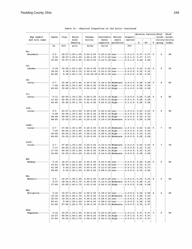
Paulding County, Ohio 249
Table 19.--Physical Properties of the Soils--Continued________________________________________________________________________________________________________________ | | | | | | | |Erosion factors|Wind |Wind Map symbol | Depth | Clay | Moist | Permea- |Available| Shrink- |Organic|_______________|erodi-|erodi- and soil name | | | bulk | bility | water | swell | matter| | | |bility|bility | | | density | |capacity |potential| | K | Kf | T |group |index________________________________________________________________________________________________________________ | In | Pct | g/cc | In/hr | In/in | | Pct | | | | | | | | | | | | | | | | |Kn: | | | | | | | | | | | | Knoxdale--------| 0-9 | 18-27|1.20-1.50| 0.60-2.00 |0.20-0.24|Low------|1.0-3.0| 0.37| 0.37| 5 | 6 | 48 | 9-35 | 18-27|1.25-1.60| 0.60-2.00 |0.17-0.22|Low------|0.0-1.0| 0.37| 0.37| | | | 35-80 | 15-27|1.20-1.60| 0.60-6.00 |0.12-0.18|Low------|0.0-1.0| 0.28| 0.28| | | | | | | | | | | | | | |La: | | | | | | | | | | | | Landes----------| 0-18 | 10-22|1.20-1.40| 0.60-6.00 |0.20-0.22|Low------|1.0-2.0| 0.32| 0.32| 4 | 5 | 56 | 18-26 | 5-18|1.60-1.70| 2.00-6.00 |0.10-0.15|Low------|0.0-2.0| 0.32| 0.32| | | | 26-80 | 5-18|1.60-1.70| 6.00-20.00|0.05-0.15|Low------|0.0-2.0| 0.20| 0.20| | | | | | | | | | | | | | |Lb: | | | | | | | | | | | | Latty-----------| 0-7 | 35-40|1.30-1.45| 0.20-0.60 |0.18-0.20|Moderate |3.0-5.0| 0.28| 0.28| 5 | 4 | 86 | 7-45 | 45-60|1.35-1.65| 0.06-0.20 |0.09-0.13|High-----|0.5-1.0| 0.28| 0.28| | | | 45-80 | 35-45|1.50-1.70| 0.01-0.06 |0.06-0.12|High-----|0.1-0.5| 0.28| 0.28| | | | | | | | | | | | | | |Lc: | | | | | | | | | | | | Latty-----------| 0-11 | 40-55|1.30-1.50| 0.06-0.20 |0.11-0.14|High-----|3.0-5.0| 0.28| 0.28| 5 | 4 | 86 | 11-42 | 45-60|1.35-1.65| 0.06-0.20 |0.09-0.13|High-----|0.5-1.0| 0.28| 0.28| | | | 42-80 | 35-45|1.50-1.70| 0.01-0.06 |0.06-0.12|High-----|0.1-0.5| 0.28| 0.28| | | | | | | | | | | | | | |LtA: | | | | | | | | | | | | Lucas-----------| 0-9 | 20-27|1.30-1.50| 0.60-2.00 |0.22-0.24|Low------|1.0-3.0| 0.43| 0.43| 5 | 6 | 48 | 9-28 | 45-60|1.35-1.60| 0.06-0.20 |0.08-0.14|High-----|0.0-0.5| 0.32| 0.32| | | | 28-48 | 45-60|1.35-1.60| 0.06-0.20 |0.08-0.14|High-----|0.0-0.5| 0.32| 0.32| | | | 48-80 | 15-35|1.30-1.60| 0.20-2.00 |0.14-0.20|Moderate |0.0-0.5| 0.28| 0.28| | | | | | | | | | | | | | |LuB2: | | | | | | | | | | | | Lucas-----------| 0-7 | 27-40|1.35-1.55| 0.20-0.60 |0.16-0.19|Moderate |1.0-3.0| 0.43| 0.43| 5 | 7 | 38 | 7-25 | 45-60|1.35-1.60| 0.06-0.20 |0.08-0.14|High-----|0.0-0.5| 0.32| 0.32| | | | 25-44 | 45-60|1.35-1.60| 0.06-0.20 |0.08-0.14|High-----|0.0-0.5| 0.32| 0.32| | | | 44-80 | 15-35|1.30-1.60| 0.20-2.00 |0.14-0.20|Moderate |0.0-0.5| 0.28| 0.28| | | | | | | | | | | | | | |LuC2: | | | | | | | | | | | | Lucas-----------| 0-7 | 27-40|1.35-1.55| 0.20-0.60 |0.16-0.19|Moderate |1.0-3.0| 0.43| 0.43| 5 | 7 | 38 | 7-17 | 45-60|1.35-1.60| 0.06-0.20 |0.08-0.14|High-----|0.0-0.5| 0.32| 0.32| | | | 17-36 | 45-60|1.35-1.60| 0.06-0.20 |0.08-0.14|High-----|0.0-0.5| 0.32| 0.32| | | | 36-80 | 15-35|1.30-1.60| 0.20-2.00 |0.14-0.20|Moderate |0.0-0.5| 0.28| 0.28| | | | | | | | | | | | | | |Md: | | | | | | | | | | | | Medway----------| 0-19 | 18-27|1.20-1.45| 0.60-2.00 |0.20-0.24|Low------|3.0-6.0| 0.28| 0.28| 5 | 6 | 48 | 19-41 | 18-32|1.20-1.50| 0.60-2.00 |0.14-0.18|Low------|0.5-1.0| 0.32| 0.37| | | | 41-58 | 5-30|1.20-1.60| 0.60-6.00 |0.11-0.15|Low------|0.5-1.0| 0.32| 0.37| | | | 58-80 | 5-30|1.20-1.60| 0.60-6.00 |0.08-0.15|Low------|0.3-0.5| 0.32| 0.49| | | | | | | | | | | | | | |Me: | | | | | | | | | | | | Mermill---------| 0-9 | 14-27|1.25-1.50| 0.60-2.00 |0.18-0.24|Low------|3.0-6.0| 0.32| 0.32| 4 | 6 | 48 | 9-37 | 18-35|1.50-1.70| 0.60-2.00 |0.12-0.16|Moderate |0.5-1.0| 0.28| 0.32| | | | 37-80 | 35-55|1.60-1.75| 0.01-0.20 |0.06-0.10|High-----|0.2-0.5| 0.28| 0.28| | | | | | | | | | | | | | |Mg: | | | | | | | | | | | | Millgrove-------| 0-15 | 15-27|1.30-1.50| 0.60-2.00 |0.18-0.22|Low------|3.0-8.0| 0.24| 0.28| 4 | 6 | 48 | 15-36 | 18-35|1.40-1.70| 0.60-2.00 |0.12-0.16|Moderate |0.0-0.5| 0.28| 0.32| | | | 36-50 | 15-30|1.25-1.60| 0.60-2.00 |0.08-0.15|Low------|0.0-0.5| 0.20| 0.43| | | | 50-61 | 5-18|1.25-1.60| 2.00-6.00 |0.08-0.12|Low------|0.0-0.5| 0.28| 0.55| | | | 61-80 | 27-42|1.40-1.75| 0.06-0.20 |0.05-0.10|Moderate |0.0-0.5| 0.32| 0.37| | | | | | | | | | | | | | |NnA: | | | | | | | | | | | | Nappanee--------| 0-10 | 20-27|1.30-1.50| 0.60-2.00 |0.20-0.24|Low------|1.0-3.0| 0.37| 0.37| 3 | 6 | 48 | 10-27 | 45-60|1.40-1.65| 0.06-0.20 |0.08-0.14|High-----|0.5-1.0| 0.37| 0.37| | | | 27-80 | 35-50|1.50-1.75| 0.06-0.20 |0.06-0.12|High-----|0.0-0.5| 0.37| 0.37| | | | | | | | | | | | | | |
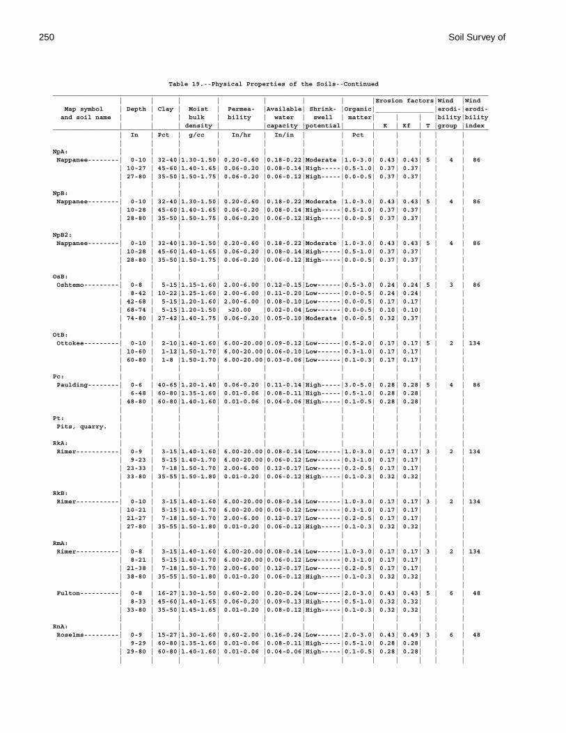
250 Soil Survey of
Table 19.--Physical Properties of the Soils--Continued________________________________________________________________________________________________________________ | | | | | | | |Erosion factors|Wind |Wind Map symbol | Depth | Clay | Moist | Permea- |Available| Shrink- |Organic|_______________|erodi-|erodi- and soil name | | | bulk | bility | water | swell | matter| | | |bility|bility | | | density | |capacity |potential| | K | Kf | T |group |index________________________________________________________________________________________________________________ | In | Pct | g/cc | In/hr | In/in | | Pct | | | | | | | | | | | | | | | | |NpA: | | | | | | | | | | | | Nappanee--------| 0-10 | 32-40|1.30-1.50| 0.20-0.60 |0.18-0.22|Moderate |1.0-3.0| 0.43| 0.43| 5 | 4 | 86 | 10-27 | 45-60|1.40-1.65| 0.06-0.20 |0.08-0.14|High-----|0.5-1.0| 0.37| 0.37| | | | 27-80 | 35-50|1.50-1.75| 0.06-0.20 |0.06-0.12|High-----|0.0-0.5| 0.37| 0.37| | | | | | | | | | | | | | |NpB: | | | | | | | | | | | | Nappanee--------| 0-10 | 32-40|1.30-1.50| 0.20-0.60 |0.18-0.22|Moderate |1.0-3.0| 0.43| 0.43| 5 | 4 | 86 | 10-28 | 45-60|1.40-1.65| 0.06-0.20 |0.08-0.14|High-----|0.5-1.0| 0.37| 0.37| | | | 28-80 | 35-50|1.50-1.75| 0.06-0.20 |0.06-0.12|High-----|0.0-0.5| 0.37| 0.37| | | | | | | | | | | | | | |NpB2: | | | | | | | | | | | | Nappanee--------| 0-10 | 32-40|1.30-1.50| 0.20-0.60 |0.18-0.22|Moderate |1.0-3.0| 0.43| 0.43| 5 | 4 | 86 | 10-28 | 45-60|1.40-1.65| 0.06-0.20 |0.08-0.14|High-----|0.5-1.0| 0.37| 0.37| | | | 28-80 | 35-50|1.50-1.75| 0.06-0.20 |0.06-0.12|High-----|0.0-0.5| 0.37| 0.37| | | | | | | | | | | | | | |OsB: | | | | | | | | | | | | Oshtemo---------| 0-8 | 5-15|1.15-1.60| 2.00-6.00 |0.12-0.15|Low------|0.5-3.0| 0.24| 0.24| 5 | 3 | 86 | 8-42 | 10-22|1.25-1.60| 2.00-6.00 |0.11-0.20|Low------|0.0-0.5| 0.24| 0.24| | | | 42-68 | 5-15|1.20-1.60| 2.00-6.00 |0.08-0.10|Low------|0.0-0.5| 0.17| 0.17| | | | 68-74 | 5-15|1.20-1.50| >20.00 |0.02-0.04|Low------|0.0-0.5| 0.10| 0.10| | | | 74-80 | 27-42|1.40-1.75| 0.06-0.20 |0.05-0.10|Moderate |0.0-0.5| 0.32| 0.37| | | | | | | | | | | | | | |OtB: | | | | | | | | | | | | Ottokee---------| 0-10 | 2-10|1.40-1.60| 6.00-20.00|0.09-0.12|Low------|0.5-2.0| 0.17| 0.17| 5 | 2 | 134 | 10-60 | 1-12|1.50-1.70| 6.00-20.00|0.06-0.10|Low------|0.3-1.0| 0.17| 0.17| | | | 60-80 | 1-8 |1.50-1.70| 6.00-20.00|0.03-0.06|Low------|0.1-0.3| 0.17| 0.17| | | | | | | | | | | | | | |Pc: | | | | | | | | | | | | Paulding--------| 0-6 | 40-65|1.20-1.40| 0.06-0.20 |0.11-0.14|High-----|3.0-5.0| 0.28| 0.28| 5 | 4 | 86 | 6-48 | 60-80|1.35-1.60| 0.01-0.06 |0.08-0.11|High-----|0.5-1.0| 0.28| 0.28| | | | 48-80 | 60-80|1.40-1.60| 0.01-0.06 |0.04-0.06|High-----|0.1-0.5| 0.28| 0.28| | | | | | | | | | | | | | |Pt: | | | | | | | | | | | | Pits, quarry. | | | | | | | | | | | | | | | | | | | | | | | |RkA: | | | | | | | | | | | | Rimer-----------| 0-9 | 3-15|1.40-1.60| 6.00-20.00|0.08-0.14|Low------|1.0-3.0| 0.17| 0.17| 3 | 2 | 134 | 9-23 | 5-15|1.40-1.70| 6.00-20.00|0.06-0.12|Low------|0.3-1.0| 0.17| 0.17| | | | 23-33 | 7-18|1.50-1.70| 2.00-6.00 |0.12-0.17|Low------|0.2-0.5| 0.17| 0.17| | | | 33-80 | 35-55|1.50-1.80| 0.01-0.20 |0.06-0.12|High-----|0.1-0.3| 0.32| 0.32| | | | | | | | | | | | | | |RkB: | | | | | | | | | | | | Rimer-----------| 0-10 | 3-15|1.40-1.60| 6.00-20.00|0.08-0.14|Low------|1.0-3.0| 0.17| 0.17| 3 | 2 | 134 | 10-21 | 5-15|1.40-1.70| 6.00-20.00|0.06-0.12|Low------|0.3-1.0| 0.17| 0.17| | | | 21-27 | 7-18|1.50-1.70| 2.00-6.00 |0.12-0.17|Low------|0.2-0.5| 0.17| 0.17| | | | 27-80 | 35-55|1.50-1.80| 0.01-0.20 |0.06-0.12|High-----|0.1-0.3| 0.32| 0.32| | | | | | | | | | | | | | |RmA: | | | | | | | | | | | | Rimer-----------| 0-8 | 3-15|1.40-1.60| 6.00-20.00|0.08-0.14|Low------|1.0-3.0| 0.17| 0.17| 3 | 2 | 134 | 8-21 | 5-15|1.40-1.70| 6.00-20.00|0.06-0.12|Low------|0.3-1.0| 0.17| 0.17| | | | 21-38 | 7-18|1.50-1.70| 2.00-6.00 |0.12-0.17|Low------|0.2-0.5| 0.17| 0.17| | | | 38-80 | 35-55|1.50-1.80| 0.01-0.20 |0.06-0.12|High-----|0.1-0.3| 0.32| 0.32| | | | | | | | | | | | | | | Fulton----------| 0-8 | 16-27|1.30-1.50| 0.60-2.00 |0.20-0.24|Low------|2.0-3.0| 0.43| 0.43| 5 | 6 | 48 | 8-33 | 45-60|1.40-1.65| 0.06-0.20 |0.09-0.13|High-----|0.5-1.0| 0.32| 0.32| | | | 33-80 | 35-50|1.45-1.65| 0.01-0.20 |0.08-0.12|High-----|0.1-0.3| 0.32| 0.32| | | | | | | | | | | | | | |RnA: | | | | | | | | | | | | Roselms---------| 0-9 | 15-27|1.30-1.60| 0.60-2.00 |0.16-0.24|Low------|2.0-3.0| 0.43| 0.49| 3 | 6 | 48 | 9-29 | 60-80|1.35-1.60| 0.01-0.06 |0.08-0.11|High-----|0.5-1.0| 0.28| 0.28| | | | 29-80 | 60-80|1.40-1.60| 0.01-0.06 |0.04-0.06|High-----|0.1-0.5| 0.28| 0.28| | | | | | | | | | | | | | |
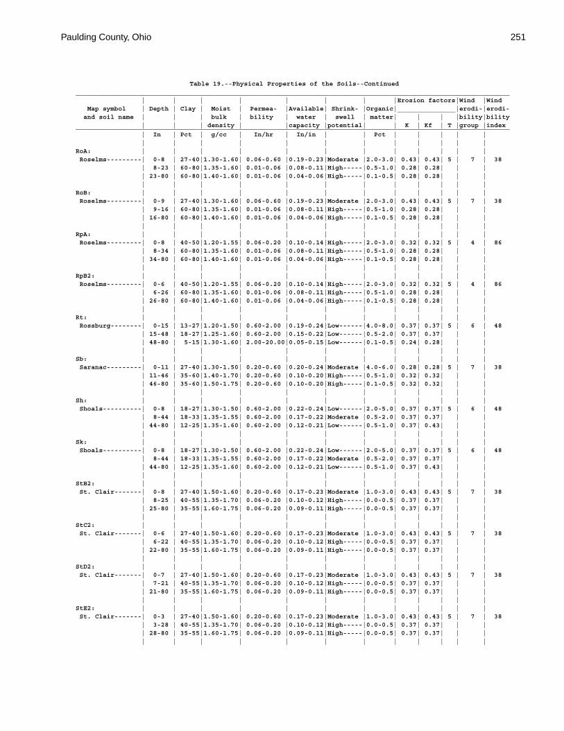
Paulding County, Ohio 251
Table 19.--Physical Properties of the Soils--Continued________________________________________________________________________________________________________________ | | | | | | | |Erosion factors|Wind |Wind Map symbol | Depth | Clay | Moist | Permea- |Available| Shrink- |Organic|_______________|erodi-|erodi- and soil name | | | bulk | bility | water | swell | matter| | | |bility|bility | | | density | |capacity |potential| | K | Kf | T |group |index________________________________________________________________________________________________________________ | In | Pct | g/cc | In/hr | In/in | | Pct | | | | | | | | | | | | | | | | |RoA: | | | | | | | | | | | | Roselms---------| 0-8 | 27-40|1.30-1.60| 0.06-0.60 |0.19-0.23|Moderate |2.0-3.0| 0.43| 0.43| 5 | 7 | 38 | 8-23 | 60-80|1.35-1.60| 0.01-0.06 |0.08-0.11|High-----|0.5-1.0| 0.28| 0.28| | | | 23-80 | 60-80|1.40-1.60| 0.01-0.06 |0.04-0.06|High-----|0.1-0.5| 0.28| 0.28| | | | | | | | | | | | | | |RoB: | | | | | | | | | | | | Roselms---------| 0-9 | 27-40|1.30-1.60| 0.06-0.60 |0.19-0.23|Moderate |2.0-3.0| 0.43| 0.43| 5 | 7 | 38 | 9-16 | 60-80|1.35-1.60| 0.01-0.06 |0.08-0.11|High-----|0.5-1.0| 0.28| 0.28| | | | 16-80 | 60-80|1.40-1.60| 0.01-0.06 |0.04-0.06|High-----|0.1-0.5| 0.28| 0.28| | | | | | | | | | | | | | |RpA: | | | | | | | | | | | | Roselms---------| 0-8 | 40-50|1.20-1.55| 0.06-0.20 |0.10-0.14|High-----|2.0-3.0| 0.32| 0.32| 5 | 4 | 86 | 8-34 | 60-80|1.35-1.60| 0.01-0.06 |0.08-0.11|High-----|0.5-1.0| 0.28| 0.28| | | | 34-80 | 60-80|1.40-1.60| 0.01-0.06 |0.04-0.06|High-----|0.1-0.5| 0.28| 0.28| | | | | | | | | | | | | | |RpB2: | | | | | | | | | | | | Roselms---------| 0-6 | 40-50|1.20-1.55| 0.06-0.20 |0.10-0.14|High-----|2.0-3.0| 0.32| 0.32| 5 | 4 | 86 | 6-26 | 60-80|1.35-1.60| 0.01-0.06 |0.08-0.11|High-----|0.5-1.0| 0.28| 0.28| | | | 26-80 | 60-80|1.40-1.60| 0.01-0.06 |0.04-0.06|High-----|0.1-0.5| 0.28| 0.28| | | | | | | | | | | | | | |Rt: | | | | | | | | | | | | Rossburg--------| 0-15 | 13-27|1.20-1.50| 0.60-2.00 |0.19-0.24|Low------|4.0-8.0| 0.37| 0.37| 5 | 6 | 48 | 15-48 | 18-27|1.25-1.60| 0.60-2.00 |0.15-0.22|Low------|0.5-2.0| 0.37| 0.37| | | | 48-80 | 5-15|1.30-1.60| 2.00-20.00|0.05-0.15|Low------|0.1-0.5| 0.24| 0.28| | | | | | | | | | | | | | |Sb: | | | | | | | | | | | | Saranac---------| 0-11 | 27-40|1.30-1.50| 0.20-0.60 |0.20-0.24|Moderate |4.0-6.0| 0.28| 0.28| 5 | 7 | 38 | 11-46 | 35-60|1.40-1.70| 0.20-0.60 |0.10-0.20|High-----|0.5-1.0| 0.32| 0.32| | | | 46-80 | 35-60|1.50-1.75| 0.20-0.60 |0.10-0.20|High-----|0.1-0.5| 0.32| 0.32| | | | | | | | | | | | | | |Sh: | | | | | | | | | | | | Shoals----------| 0-8 | 18-27|1.30-1.50| 0.60-2.00 |0.22-0.24|Low------|2.0-5.0| 0.37| 0.37| 5 | 6 | 48 | 8-44 | 18-33|1.35-1.55| 0.60-2.00 |0.17-0.22|Moderate |0.5-2.0| 0.37| 0.37| | | | 44-80 | 12-25|1.35-1.60| 0.60-2.00 |0.12-0.21|Low------|0.5-1.0| 0.37| 0.43| | | | | | | | | | | | | | |Sk: | | | | | | | | | | | | Shoals----------| 0-8 | 18-27|1.30-1.50| 0.60-2.00 |0.22-0.24|Low------|2.0-5.0| 0.37| 0.37| 5 | 6 | 48 | 8-44 | 18-33|1.35-1.55| 0.60-2.00 |0.17-0.22|Moderate |0.5-2.0| 0.37| 0.37| | | | 44-80 | 12-25|1.35-1.60| 0.60-2.00 |0.12-0.21|Low------|0.5-1.0| 0.37| 0.43| | | | | | | | | | | | | | |StB2: | | | | | | | | | | | | St. Clair-------| 0-8 | 27-40|1.50-1.60| 0.20-0.60 |0.17-0.23|Moderate |1.0-3.0| 0.43| 0.43| 5 | 7 | 38 | 8-25 | 40-55|1.35-1.70| 0.06-0.20 |0.10-0.12|High-----|0.0-0.5| 0.37| 0.37| | | | 25-80 | 35-55|1.60-1.75| 0.06-0.20 |0.09-0.11|High-----|0.0-0.5| 0.37| 0.37| | | | | | | | | | | | | | |StC2: | | | | | | | | | | | | St. Clair-------| 0-6 | 27-40|1.50-1.60| 0.20-0.60 |0.17-0.23|Moderate |1.0-3.0| 0.43| 0.43| 5 | 7 | 38 | 6-22 | 40-55|1.35-1.70| 0.06-0.20 |0.10-0.12|High-----|0.0-0.5| 0.37| 0.37| | | | 22-80 | 35-55|1.60-1.75| 0.06-0.20 |0.09-0.11|High-----|0.0-0.5| 0.37| 0.37| | | | | | | | | | | | | | |StD2: | | | | | | | | | | | | St. Clair-------| 0-7 | 27-40|1.50-1.60| 0.20-0.60 |0.17-0.23|Moderate |1.0-3.0| 0.43| 0.43| 5 | 7 | 38 | 7-21 | 40-55|1.35-1.70| 0.06-0.20 |0.10-0.12|High-----|0.0-0.5| 0.37| 0.37| | | | 21-80 | 35-55|1.60-1.75| 0.06-0.20 |0.09-0.11|High-----|0.0-0.5| 0.37| 0.37| | | | | | | | | | | | | | |StE2: | | | | | | | | | | | | St. Clair-------| 0-3 | 27-40|1.50-1.60| 0.20-0.60 |0.17-0.23|Moderate |1.0-3.0| 0.43| 0.43| 5 | 7 | 38 | 3-28 | 40-55|1.35-1.70| 0.06-0.20 |0.10-0.12|High-----|0.0-0.5| 0.37| 0.37| | | | 28-80 | 35-55|1.60-1.75| 0.06-0.20 |0.09-0.11|High-----|0.0-0.5| 0.37| 0.37| | | | | | | | | | | | | | |
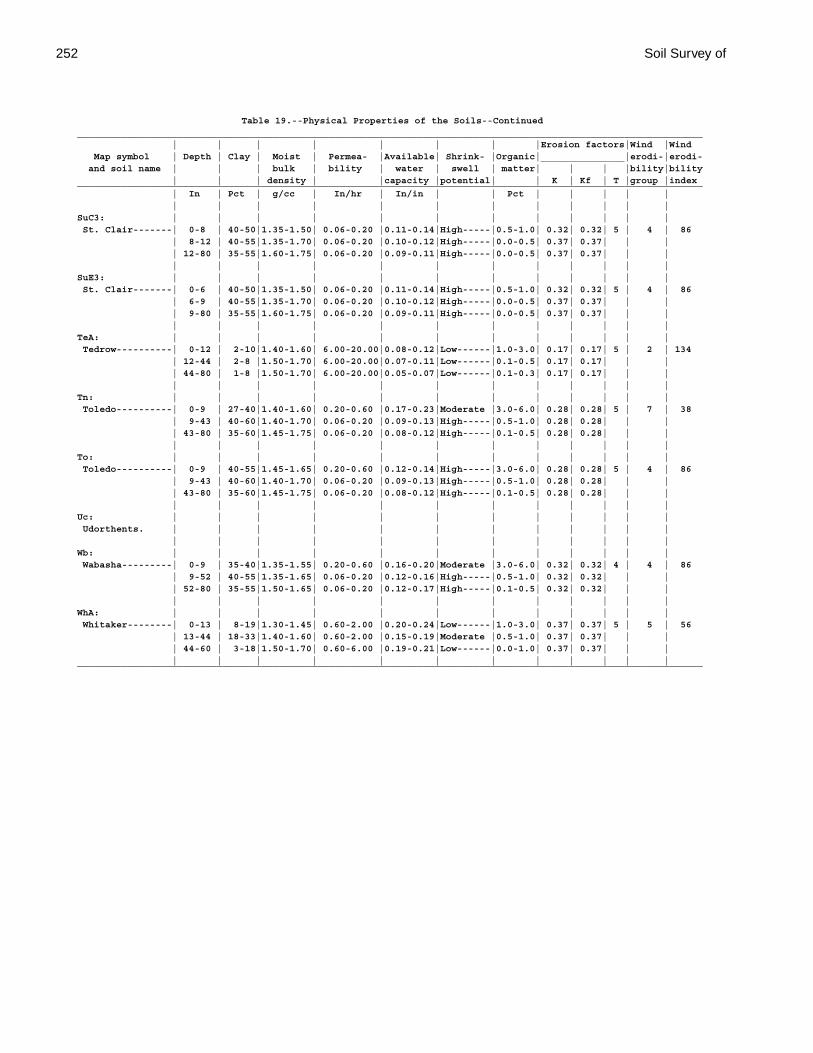
252 Soil Survey of
Table 19.--Physical Properties of the Soils--Continued________________________________________________________________________________________________________________ | | | | | | | |Erosion factors|Wind |Wind Map symbol | Depth | Clay | Moist | Permea- |Available| Shrink- |Organic|_______________|erodi-|erodi- and soil name | | | bulk | bility | water | swell | matter| | | |bility|bility | | | density | |capacity |potential| | K | Kf | T |group |index________________________________________________________________________________________________________________ | In | Pct | g/cc | In/hr | In/in | | Pct | | | | | | | | | | | | | | | | |SuC3: | | | | | | | | | | | | St. Clair-------| 0-8 | 40-50|1.35-1.50| 0.06-0.20 |0.11-0.14|High-----|0.5-1.0| 0.32| 0.32| 5 | 4 | 86 | 8-12 | 40-55|1.35-1.70| 0.06-0.20 |0.10-0.12|High-----|0.0-0.5| 0.37| 0.37| | | | 12-80 | 35-55|1.60-1.75| 0.06-0.20 |0.09-0.11|High-----|0.0-0.5| 0.37| 0.37| | | | | | | | | | | | | | |SuE3: | | | | | | | | | | | | St. Clair-------| 0-6 | 40-50|1.35-1.50| 0.06-0.20 |0.11-0.14|High-----|0.5-1.0| 0.32| 0.32| 5 | 4 | 86 | 6-9 | 40-55|1.35-1.70| 0.06-0.20 |0.10-0.12|High-----|0.0-0.5| 0.37| 0.37| | | | 9-80 | 35-55|1.60-1.75| 0.06-0.20 |0.09-0.11|High-----|0.0-0.5| 0.37| 0.37| | | | | | | | | | | | | | |TeA: | | | | | | | | | | | | Tedrow----------| 0-12 | 2-10|1.40-1.60| 6.00-20.00|0.08-0.12|Low------|1.0-3.0| 0.17| 0.17| 5 | 2 | 134 | 12-44 | 2-8 |1.50-1.70| 6.00-20.00|0.07-0.11|Low------|0.1-0.5| 0.17| 0.17| | | | 44-80 | 1-8 |1.50-1.70| 6.00-20.00|0.05-0.07|Low------|0.1-0.3| 0.17| 0.17| | | | | | | | | | | | | | |Tn: | | | | | | | | | | | | Toledo----------| 0-9 | 27-40|1.40-1.60| 0.20-0.60 |0.17-0.23|Moderate |3.0-6.0| 0.28| 0.28| 5 | 7 | 38 | 9-43 | 40-60|1.40-1.70| 0.06-0.20 |0.09-0.13|High-----|0.5-1.0| 0.28| 0.28| | | | 43-80 | 35-60|1.45-1.75| 0.06-0.20 |0.08-0.12|High-----|0.1-0.5| 0.28| 0.28| | | | | | | | | | | | | | |To: | | | | | | | | | | | | Toledo----------| 0-9 | 40-55|1.45-1.65| 0.20-0.60 |0.12-0.14|High-----|3.0-6.0| 0.28| 0.28| 5 | 4 | 86 | 9-43 | 40-60|1.40-1.70| 0.06-0.20 |0.09-0.13|High-----|0.5-1.0| 0.28| 0.28| | | | 43-80 | 35-60|1.45-1.75| 0.06-0.20 |0.08-0.12|High-----|0.1-0.5| 0.28| 0.28| | | | | | | | | | | | | | |Uc: | | | | | | | | | | | | Udorthents. | | | | | | | | | | | | | | | | | | | | | | | |Wb: | | | | | | | | | | | | Wabasha---------| 0-9 | 35-40|1.35-1.55| 0.20-0.60 |0.16-0.20|Moderate |3.0-6.0| 0.32| 0.32| 4 | 4 | 86 | 9-52 | 40-55|1.35-1.65| 0.06-0.20 |0.12-0.16|High-----|0.5-1.0| 0.32| 0.32| | | | 52-80 | 35-55|1.50-1.65| 0.06-0.20 |0.12-0.17|High-----|0.1-0.5| 0.32| 0.32| | | | | | | | | | | | | | |WhA: | | | | | | | | | | | | Whitaker--------| 0-13 | 8-19|1.30-1.45| 0.60-2.00 |0.20-0.24|Low------|1.0-3.0| 0.37| 0.37| 5 | 5 | 56 | 13-44 | 18-33|1.40-1.60| 0.60-2.00 |0.15-0.19|Moderate |0.5-1.0| 0.37| 0.37| | | | 44-60 | 3-18|1.50-1.70| 0.60-6.00 |0.19-0.21|Low------|0.0-1.0| 0.37| 0.37| | | | | | | | | | | | | | |________________________________________________________________________________________________________________

Paulding County, Ohio 253
Table 20.--Chemical Properties of the Soils
(Absence of an entry indicates that data were not estimated)
______________________________________________________________ | | | | | Map symbol | Depth | Clay | Cation- | Soil | Calcium and soil name | | |exchange |reaction |carbonate | | |capacity | |______________________________________________________________ | In | Pct |meq/100g | pH | Pct | | | | |BeB: | | | | | Belmore---------| 0-6 | 10-24| 5.0-17.0| 5.6-7.3 | --- | 6-39 | 15-30| 6.0-18.0| 4.5-7.3 | --- | 39-75 | 5-15| 2.0-9.0 | 7.4-8.4 | 10-30 | 75-80 | 27-42|14.0-30.0| 7.4-8.4 | 15-30 | | | | |BkA: | | | | | Bixler----------| 0-10 | 5-15| 2.0-15.0| 5.1-7.3 | --- | 10-28 | 5-15| 2.0-9.0 | 5.6-7.3 | --- | 28-36 | 5-25| 2.0-15.0| 5.6-7.3 | --- | 36-74 | 5-32| 2.0-19.0| 6.1-8.4 | 0-15 | 74-80 | 35-55|14.0-33.0| 7.4-8.4 | 10-30 | | | | |BrB2: | | | | | Broughton-------| 0-6 | 27-40|13.0-30.0| 4.5-7.3 | --- | 6-17 | 60-80|24.0-50.0| 5.6-7.8 | 0-15 | 17-80 | 60-80|24.0-48.0| 7.4-8.4 | 15-25 | | | | |BrC2: | | | | | Broughton-------| 0-8 | 27-40|13.0-30.0| 4.5-7.3 | --- | 8-18 | 60-80|24.0-50.0| 5.6-7.8 | 0-15 | 18-80 | 60-80|24.0-48.0| 7.4-8.4 | 15-25 | | | | |BrD2: | | | | | Broughton-------| 0-6 | 27-40|13.0-30.0| 4.5-7.3 | --- | 6-16 | 60-80|24.0-50.0| 5.6-7.8 | 0-15 | 16-80 | 60-80|24.0-48.0| 7.4-8.4 | 15-25 | | | | |BrE2: | | | | | Broughton-------| 0-8 | 27-40|13.0-30.0| 4.5-7.3 | --- | 8-22 | 60-80|24.0-50.0| 5.6-7.8 | 0-15 | 22-80 | 60-80|24.0-48.0| 7.4-8.4 | 15-25 | | | | |BsC3: | | | | | Broughton-------| 0-5 | 40-55|17.0-37.0| 5.1-7.3 | --- | 5-12 | 60-80|24.0-50.0| 5.6-7.8 | 0-15 | 12-80 | 60-80|24.0-48.0| 7.4-8.4 | 15-25 | | | | |BsD3: | | | | | Broughton-------| 0-5 | 40-55|17.0-37.0| 5.1-7.3 | --- | 5-11 | 60-80|24.0-50.0| 5.6-7.8 | 0-15 | 11-80 | 60-80|24.0-48.0| 7.4-8.4 | 15-25 | | | | |Db: | | | | | Defiance--------| 0-8 | 27-40|15.0-30.0| 6.1-7.8 | --- | 8-48 | 35-50|14.0-30.0| 5.6-7.8 | --- | 48-80 | 40-55|16.0-33.0| 6.6-7.8 | 0-10 | | | | |Dc: | | | | | Defiance--------| 0-8 | 27-40|15.0-30.0| 6.1-7.8 | --- | 8-34 | 35-50|14.0-30.0| 5.6-7.8 | --- | 34-80 | 40-55|16.0-33.0| 6.6-7.8 | 0-10 | | | | |Fb: | | | | | Flatrock--------| 0-10 | 18-27| 9.0-20.0| 5.6-7.3 | --- | 10-38 | 18-27| 7.0-17.0| 6.1-7.8 | 0-5 | 38-80 | 15-27| 6.0-17.0| 6.6-8.4 | 0-20 | | | | |

254 Soil Survey of
Table 20.--Chemical Properties of the Soils--Continued______________________________________________________________ | | | | | Map symbol | Depth | Clay | Cation- | Soil | Calcium and soil name | | |exchange |reaction |carbonate | | |capacity | |______________________________________________________________ | In | Pct |meq/100g | pH | Pct | | | | |Fc: | | | | | Flatrock--------| 0-13 | 18-27| 9.0-20.0| 5.6-7.3 | --- | 13-44 | 18-27| 7.0-17.0| 6.1-7.8 | 0-5 | 44-80 | 15-27| 6.0-17.0| 6.6-8.4 | 0-20 | | | | |FtA: | | | | | Fulton----------| 0-10 | 16-27|14.0-24.0| 5.1-7.3 | --- | 10-37 | 45-60|22.0-36.0| 5.1-7.3 | --- | 37-80 | 35-50|14.0-30.0| 7.4-8.4 | 10-30 | | | | |FuA: | | | | | Fulton----------| 0-10 | 27-40|15.0-30.0| 5.1-7.3 | --- | 10-38 | 45-60|22.0-36.0| 5.1-7.3 | --- | 38-80 | 35-50|14.0-30.0| 7.4-8.4 | 10-30 | | | | |FuB2: | | | | | Fulton----------| 0-7 | 27-40|15.0-30.0| 5.1-7.3 | --- | 7-31 | 45-60|22.0-36.0| 5.1-7.3 | --- | 31-80 | 35-50|14.0-30.0| 7.4-8.4 | 10-30 | | | | |FxA: | | | | | Fulton----------| 0-9 | 27-40|15.0-30.0| 5.1-7.3 | --- | 9-44 | 35-59|14.0-36.0| 5.1-7.8 | 0-10 | 44-80 | 18-35| 7.0-21.0| 6.6-8.4 | 10-30 | | | | |FxB: | | | | | Fulton----------| 0-8 | 27-40|15.0-30.0| 5.1-7.3 | --- | 8-51 | 35-59|14.0-36.0| 5.1-7.8 | 0-10 | 51-80 | 18-35| 7.0-21.0| 6.6-8.4 | 10-30 | | | | |Gr: | | | | | Granby----------| 0-13 | 2-14|10.0-15.0| 5.1-7.3 | --- | 13-37 | 0-14| 2.0-10.0| 5.6-7.3 | --- | 37-59 | 0-10| 1.0-4.0 | 6.6-8.4 | 5-15 | 59-80 | 35-60|14.0-36.0| 7.4-8.4 | 15-25 | | | | |HaA: | | | | | Haskins---------| 0-15 | 3-15| 2.0-15.0| 4.5-7.3 | --- | 15-34 | 18-35| 7.0-21.0| 5.1-7.3 | --- | 34-80 | 35-55|14.0-33.0| 6.1-8.4 | 0-30 | | | | |HkA: | | | | | Haskins---------| 0-9 | 12-20| 6.0-15.0| 4.5-7.3 | --- | 9-35 | 18-35| 7.0-21.0| 5.1-7.3 | --- | 35-80 | 35-55|14.0-33.0| 6.1-8.4 | 0-30 | | | | |HkB: | | | | | Haskins---------| 0-9 | 12-20| 6.0-15.0| 4.5-7.3 | --- | 9-30 | 18-35| 7.0-21.0| 5.1-7.3 | --- | 30-80 | 35-55|14.0-33.0| 6.1-8.4 | 0-30 | | | | |Hs: | | | | | Hoytville-------| 0-9 | 27-40|17.0-35.0| 6.1-7.3 | --- | 9-39 | 40-55|16.0-32.0| 6.1-7.8 | 0-15 | 39-80 | 35-50|14.0-30.0| 7.4-8.4 | 15-25 | | | | |Ht: | | | | | Hoytville-------| 0-9 | 40-48|24.0-40.0| 6.1-7.3 | --- | 9-39 | 40-55|16.0-32.0| 6.1-7.8 | 0-15 | 39-80 | 35-50|14.0-30.0| 7.4-8.4 | 15-25 | | | | |
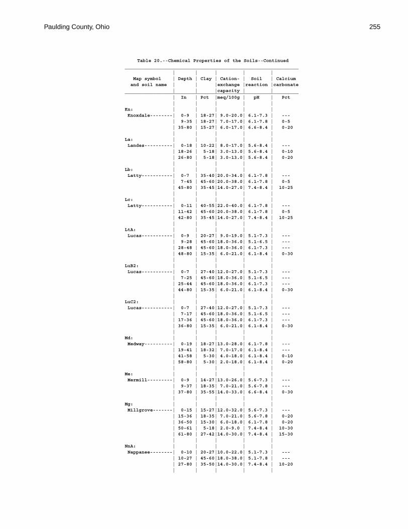
Paulding County, Ohio 255
Table 20.--Chemical Properties of the Soils--Continued______________________________________________________________ | | | | | Map symbol | Depth | Clay | Cation- | Soil | Calcium and soil name | | |exchange |reaction |carbonate | | |capacity | |______________________________________________________________ | In | Pct |meq/100g | pH | Pct | | | | |Kn: | | | | | Knoxdale--------| 0-9 | 18-27| 9.0-20.0| 6.1-7.3 | --- | 9-35 | 18-27| 7.0-17.0| 6.1-7.8 | 0-5 | 35-80 | 15-27| 6.0-17.0| 6.6-8.4 | 0-20 | | | | |La: | | | | | Landes----------| 0-18 | 10-22| 8.0-17.0| 5.6-8.4 | --- | 18-26 | 5-18| 3.0-13.0| 5.6-8.4 | 0-10 | 26-80 | 5-18| 3.0-13.0| 5.6-8.4 | 0-20 | | | | |Lb: | | | | | Latty-----------| 0-7 | 35-40|20.0-34.0| 6.1-7.8 | --- | 7-45 | 45-60|20.0-38.0| 6.1-7.8 | 0-5 | 45-80 | 35-45|14.0-27.0| 7.4-8.4 | 10-25 | | | | |Lc: | | | | | Latty-----------| 0-11 | 40-55|22.0-40.0| 6.1-7.8 | --- | 11-42 | 45-60|20.0-38.0| 6.1-7.8 | 0-5 | 42-80 | 35-45|14.0-27.0| 7.4-8.4 | 10-25 | | | | |LtA: | | | | | Lucas-----------| 0-9 | 20-27| 9.0-19.0| 5.1-7.3 | --- | 9-28 | 45-60|18.0-36.0| 5.1-6.5 | --- | 28-48 | 45-60|18.0-36.0| 6.1-7.3 | --- | 48-80 | 15-35| 6.0-21.0| 6.1-8.4 | 0-30 | | | | |LuB2: | | | | | Lucas-----------| 0-7 | 27-40|12.0-27.0| 5.1-7.3 | --- | 7-25 | 45-60|18.0-36.0| 5.1-6.5 | --- | 25-44 | 45-60|18.0-36.0| 6.1-7.3 | --- | 44-80 | 15-35| 6.0-21.0| 6.1-8.4 | 0-30 | | | | |LuC2: | | | | | Lucas-----------| 0-7 | 27-40|12.0-27.0| 5.1-7.3 | --- | 7-17 | 45-60|18.0-36.0| 5.1-6.5 | --- | 17-36 | 45-60|18.0-36.0| 6.1-7.3 | --- | 36-80 | 15-35| 6.0-21.0| 6.1-8.4 | 0-30 | | | | |Md: | | | | | Medway----------| 0-19 | 18-27|13.0-28.0| 6.1-7.8 | --- | 19-41 | 18-32| 7.0-17.0| 6.1-8.4 | --- | 41-58 | 5-30| 4.0-18.0| 6.1-8.4 | 0-10 | 58-80 | 5-30| 2.0-18.0| 6.1-8.4 | 0-20 | | | | |Me: | | | | | Mermill---------| 0-9 | 14-27|13.0-26.0| 5.6-7.3 | --- | 9-37 | 18-35| 7.0-21.0| 5.6-7.8 | --- | 37-80 | 35-55|14.0-33.0| 6.6-8.4 | 0-30 | | | | |Mg: | | | | | Millgrove-------| 0-15 | 15-27|12.0-32.0| 5.6-7.3 | --- | 15-36 | 18-35| 7.0-21.0| 5.6-7.8 | 0-20 | 36-50 | 15-30| 6.0-18.0| 6.1-7.8 | 0-20 | 50-61 | 5-18| 2.0-9.0 | 7.4-8.4 | 10-30 | 61-80 | 27-42|14.0-30.0| 7.4-8.4 | 15-30 | | | | |NnA: | | | | | Nappanee--------| 0-10 | 20-27|10.0-22.0| 5.1-7.3 | --- | 10-27 | 45-60|18.0-38.0| 5.1-7.8 | --- | 27-80 | 35-50|14.0-30.0| 7.4-8.4 | 10-20 | | | | |
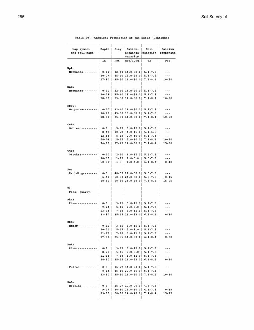
256 Soil Survey of
Table 20.--Chemical Properties of the Soils--Continued______________________________________________________________ | | | | | Map symbol | Depth | Clay | Cation- | Soil | Calcium and soil name | | |exchange |reaction |carbonate | | |capacity | |______________________________________________________________ | In | Pct |meq/100g | pH | Pct | | | | |NpA: | | | | | Nappanee--------| 0-10 | 32-40|14.0-30.0| 5.1-7.3 | --- | 10-27 | 45-60|18.0-38.0| 5.1-7.8 | --- | 27-80 | 35-50|14.0-30.0| 7.4-8.4 | 10-20 | | | | |NpB: | | | | | Nappanee--------| 0-10 | 32-40|14.0-30.0| 5.1-7.3 | --- | 10-28 | 45-60|18.0-38.0| 5.1-7.8 | --- | 28-80 | 35-50|14.0-30.0| 7.4-8.4 | 10-20 | | | | |NpB2: | | | | | Nappanee--------| 0-10 | 32-40|14.0-30.0| 5.1-7.3 | --- | 10-28 | 45-60|18.0-38.0| 5.1-7.8 | --- | 28-80 | 35-50|14.0-30.0| 7.4-8.4 | 10-20 | | | | |OsB: | | | | | Oshtemo---------| 0-8 | 5-15| 3.0-12.0| 5.1-7.3 | --- | 8-42 | 10-22| 4.0-15.0| 5.1-6.5 | --- | 42-68 | 5-15| 2.0-10.0| 5.1-7.3 | --- | 68-74 | 5-15| 2.0-10.0| 7.4-8.4 | 10-20 | 74-80 | 27-42|14.0-30.0| 7.4-8.4 | 15-30 | | | | |OtB: | | | | | Ottokee---------| 0-10 | 2-10| 4.0-12.0| 5.6-7.3 | --- | 10-60 | 1-12| 1.0-6.0 | 5.6-7.3 | --- | 60-80 | 1-8 | 1.0-4.0 | 6.1-8.4 | 0-12 | | | | |Pc: | | | | | Paulding--------| 0-6 | 40-65|22.0-50.0| 5.6-7.3 | --- | 6-48 | 60-80|24.0-50.0| 5.6-7.8 | 0-15 | 48-80 | 60-80|24.0-48.0| 7.4-8.4 | 15-25 | | | | |Pt: | | | | | Pits, quarry. | | | | | | | | | |RkA: | | | | | Rimer-----------| 0-9 | 3-15| 3.0-15.0| 5.1-7.3 | --- | 9-23 | 5-15| 2.0-9.0 | 5.1-7.3 | --- | 23-33 | 7-18| 3.0-11.0| 5.1-7.3 | --- | 33-80 | 35-55|14.0-33.0| 6.1-8.4 | 0-30 | | | | |RkB: | | | | | Rimer-----------| 0-10 | 3-15| 3.0-15.0| 5.1-7.3 | --- | 10-21 | 5-15| 2.0-9.0 | 5.1-7.3 | --- | 21-27 | 7-18| 3.0-11.0| 5.1-7.3 | --- | 27-80 | 35-55|14.0-33.0| 6.1-8.4 | 0-30 | | | | |RmA: | | | | | Rimer-----------| 0-8 | 3-15| 3.0-15.0| 5.1-7.3 | --- | 8-21 | 5-15| 2.0-9.0 | 5.1-7.3 | --- | 21-38 | 7-18| 3.0-11.0| 5.1-7.3 | --- | 38-80 | 35-55|14.0-33.0| 6.1-8.4 | 0-30 | | | | | Fulton----------| 0-8 | 16-27|14.0-24.0| 5.1-7.3 | --- | 8-33 | 45-60|22.0-36.0| 5.1-7.3 | --- | 33-80 | 35-50|14.0-30.0| 7.4-8.4 | 10-30 | | | | |RnA: | | | | | Roselms---------| 0-9 | 15-27|10.0-20.0| 4.5-7.3 | --- | 9-29 | 60-80|24.0-50.0| 4.5-7.8 | 0-15 | 29-80 | 60-80|24.0-48.0| 7.4-8.4 | 15-25 | | | | |
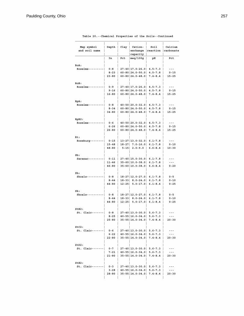
Paulding County, Ohio 257
Table 20.--Chemical Properties of the Soils--Continued______________________________________________________________ | | | | | Map symbol | Depth | Clay | Cation- | Soil | Calcium and soil name | | |exchange |reaction |carbonate | | |capacity | |______________________________________________________________ | In | Pct |meq/100g | pH | Pct | | | | |RoA: | | | | | Roselms---------| 0-8 | 27-40|17.0-26.0| 4.5-7.3 | --- | 8-23 | 60-80|24.0-50.0| 4.5-7.8 | 0-15 | 23-80 | 60-80|24.0-48.0| 7.4-8.4 | 15-25 | | | | |RoB: | | | | | Roselms---------| 0-9 | 27-40|17.0-26.0| 4.5-7.3 | --- | 9-16 | 60-80|24.0-50.0| 4.5-7.8 | 0-15 | 16-80 | 60-80|24.0-48.0| 7.4-8.4 | 15-25 | | | | |RpA: | | | | | Roselms---------| 0-8 | 40-50|20.0-32.0| 4.5-7.3 | --- | 8-34 | 60-80|24.0-50.0| 4.5-7.8 | 0-15 | 34-80 | 60-80|24.0-48.0| 7.4-8.4 | 15-25 | | | | |RpB2: | | | | | Roselms---------| 0-6 | 40-50|20.0-32.0| 4.5-7.3 | --- | 6-26 | 60-80|24.0-50.0| 4.5-7.8 | 0-15 | 26-80 | 60-80|24.0-48.0| 7.4-8.4 | 15-25 | | | | |Rt: | | | | | Rossburg--------| 0-15 | 13-27|13.0-32.0| 6.1-7.8 | --- | 15-48 | 18-27| 7.0-16.0| 6.1-7.8 | 0-10 | 48-80 | 5-15| 2.0-9.0 | 6.6-8.4 | 10-30 | | | | |Sb: | | | | | Saranac---------| 0-11 | 27-40|15.0-30.0| 6.1-7.8 | --- | 11-46 | 35-60|10.0-38.0| 6.1-7.8 | --- | 46-80 | 35-60|10.0-38.0| 6.6-8.4 | 0-20 | | | | |Sh: | | | | | Shoals----------| 0-8 | 18-27|12.0-27.0| 6.1-7.8 | 0-5 | 8-44 | 18-33| 8.0-24.0| 6.1-7.8 | 0-10 | 44-80 | 12-25| 5.0-17.0| 6.1-8.4 | 0-25 | | | | |Sk: | | | | | Shoals----------| 0-8 | 18-27|12.0-27.0| 6.1-7.8 | 0-5 | 8-44 | 18-33| 8.0-24.0| 6.1-7.8 | 0-10 | 44-80 | 12-25| 5.0-17.0| 6.1-8.4 | 0-25 | | | | |StB2: | | | | | St. Clair-------| 0-8 | 27-40|13.0-30.0| 5.6-7.3 | --- | 8-25 | 40-55|16.0-34.0| 5.6-7.3 | --- | 25-80 | 35-55|14.0-34.0| 7.4-8.4 | 20-30 | | | | |StC2: | | | | | St. Clair-------| 0-6 | 27-40|13.0-30.0| 5.6-7.3 | --- | 6-22 | 40-55|16.0-34.0| 5.6-7.3 | --- | 22-80 | 35-55|14.0-34.0| 7.4-8.4 | 20-30 | | | | |StD2: | | | | | St. Clair-------| 0-7 | 27-40|13.0-30.0| 5.6-7.3 | --- | 7-21 | 40-55|16.0-34.0| 5.6-7.3 | --- | 21-80 | 35-55|14.0-34.0| 7.4-8.4 | 20-30 | | | | |StE2: | | | | | St. Clair-------| 0-3 | 27-40|13.0-30.0| 5.6-7.3 | --- | 3-28 | 40-55|16.0-34.0| 5.6-7.3 | --- | 28-80 | 35-55|14.0-34.0| 7.4-8.4 | 20-30 | | | | |
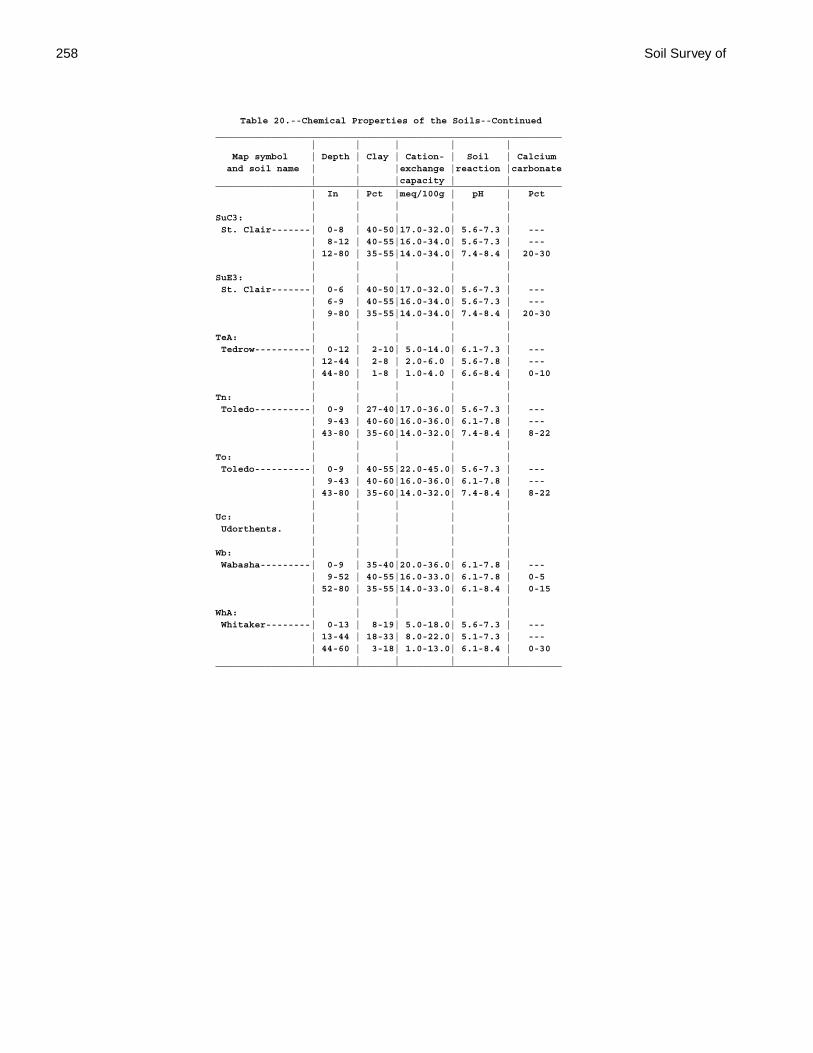
258 Soil Survey of
Table 20.--Chemical Properties of the Soils--Continued______________________________________________________________ | | | | | Map symbol | Depth | Clay | Cation- | Soil | Calcium and soil name | | |exchange |reaction |carbonate | | |capacity | |______________________________________________________________ | In | Pct |meq/100g | pH | Pct | | | | |SuC3: | | | | | St. Clair-------| 0-8 | 40-50|17.0-32.0| 5.6-7.3 | --- | 8-12 | 40-55|16.0-34.0| 5.6-7.3 | --- | 12-80 | 35-55|14.0-34.0| 7.4-8.4 | 20-30 | | | | |SuE3: | | | | | St. Clair-------| 0-6 | 40-50|17.0-32.0| 5.6-7.3 | --- | 6-9 | 40-55|16.0-34.0| 5.6-7.3 | --- | 9-80 | 35-55|14.0-34.0| 7.4-8.4 | 20-30 | | | | |TeA: | | | | | Tedrow----------| 0-12 | 2-10| 5.0-14.0| 6.1-7.3 | --- | 12-44 | 2-8 | 2.0-6.0 | 5.6-7.8 | --- | 44-80 | 1-8 | 1.0-4.0 | 6.6-8.4 | 0-10 | | | | |Tn: | | | | | Toledo----------| 0-9 | 27-40|17.0-36.0| 5.6-7.3 | --- | 9-43 | 40-60|16.0-36.0| 6.1-7.8 | --- | 43-80 | 35-60|14.0-32.0| 7.4-8.4 | 8-22 | | | | |To: | | | | | Toledo----------| 0-9 | 40-55|22.0-45.0| 5.6-7.3 | --- | 9-43 | 40-60|16.0-36.0| 6.1-7.8 | --- | 43-80 | 35-60|14.0-32.0| 7.4-8.4 | 8-22 | | | | |Uc: | | | | | Udorthents. | | | | | | | | | |Wb: | | | | | Wabasha---------| 0-9 | 35-40|20.0-36.0| 6.1-7.8 | --- | 9-52 | 40-55|16.0-33.0| 6.1-7.8 | 0-5 | 52-80 | 35-55|14.0-33.0| 6.1-8.4 | 0-15 | | | | |WhA: | | | | | Whitaker--------| 0-13 | 8-19| 5.0-18.0| 5.6-7.3 | --- | 13-44 | 18-33| 8.0-22.0| 5.1-7.3 | --- | 44-60 | 3-18| 1.0-13.0| 6.1-8.4 | 0-30 | | | | |______________________________________________________________

Paulding County, Ohio 259
Table 21.--Water Features
(See text for definitions of terms used in this table. Absence of an entry indicates that the feature is not a concern or that data were not estimated)
______________________________________________________________________________________________________________ | | Flooding | High water table and ponding _____________________________________________________________________________________ Map symbol |Hydro-| | | | Water | | | | Maximum and soil name |logic | Frequency | Duration | Months | table | Kind of | Months | Ponding | ponding |group | | | | depth |water table| | duration | depth______________________________________________________________________________________________________________ | | | | | Ft | | | | Ft | | | | | | | | |BeB: | | | | | | | | | Belmore---------| B |None-------| --- | --- | 3.0-6.0 |Perched----| Nov-May | --- | --- | | | | | | | | |BkA: | | | | | | | | | Bixler----------| C |None-------| --- | --- | 1.5-3.0 |Perched----| Nov-May | --- | --- | | | | | | | | |BrB2: | | | | | | | | | Broughton-------| D |None-------| --- | --- | 1.5-3.0 |Perched----| Jan-Apr | --- | --- | | | | | | | | |BrC2: | | | | | | | | | Broughton-------| D |None-------| --- | --- | 1.5-3.0 |Perched----| Jan-Apr | --- | --- | | | | | | | | |BrD2: | | | | | | | | | Broughton-------| D |None-------| --- | --- | 1.5-3.0 |Perched----| Jan-Apr | --- | --- | | | | | | | | |BrE2: | | | | | | | | | Broughton-------| D |None-------| --- | --- | 1.5-3.0 |Perched----| Jan-Apr | --- | --- | | | | | | | | |BsC3: | | | | | | | | | Broughton-------| D |None-------| --- | --- | 1.5-3.0 |Perched----| Jan-Apr | --- | --- | | | | | | | | |BsD3: | | | | | | | | | Broughton-------| D |None-------| --- | --- | 1.5-3.0 |Perched----| Jan-Apr | --- | --- | | | | | | | | |Db: | | | | | | | | | Defiance--------| D |Occasional |Brief-----| Jan-May | 1.0-2.5 |Apparent---| Dec-May | --- | --- | | | | | | | | |Dc: | | | | | | | | | Defiance--------| D |Frequent---|Brief-----| Jan-May | 1.0-2.5 |Apparent---| Dec-May | --- | --- | | | | | | | | |Fb: | | | | | | | | | Flatrock--------| B |Occasional |Brief-----| Dec-Apr | 1.5-3.0 |Apparent---| Dec-Apr | --- | --- | | | | | | | | |Fc: | | | | | | | | | Flatrock--------| B |Frequent---|Brief-----| Dec-Apr | 1.5-3.0 |Apparent---| Dec-Apr | --- | --- | | | | | | | | |FtA: | | | | | | | | | Fulton----------| D |None-------| --- | --- | 1.0-2.5 |Perched----| Dec-May | --- | --- | | | | | | | | |FuA: | | | | | | | | | Fulton----------| D |None-------| --- | --- | 1.0-2.5 |Perched----| Dec-May | --- | --- | | | | | | | | |FuB2: | | | | | | | | | Fulton----------| D |None-------| --- | --- | 1.0-2.5 |Perched----| Dec-May | --- | --- | | | | | | | | |FxA: | | | | | | | | | Fulton----------| D |None-------| --- | --- | 1.0-2.5 |Perched----| Dec-May | --- | --- | | | | | | | | |FxB: | | | | | | | | | Fulton----------| D |None-------| --- | --- | 1.0-2.5 |Perched----| Dec-May | --- | --- | | | | | | | | |Gr: | | | | | | | | | Granby----------| A/D |None-------| --- | --- | 0.0-1.0 |Apparent---| Nov-Jun |Brief-----| 1.0 | | | | | | | | |HaA: | | | | | | | | | Haskins---------| C |None-------| --- | --- | 1.0-2.5 |Perched----| Jan-Apr | --- | --- | | | | | | | | |
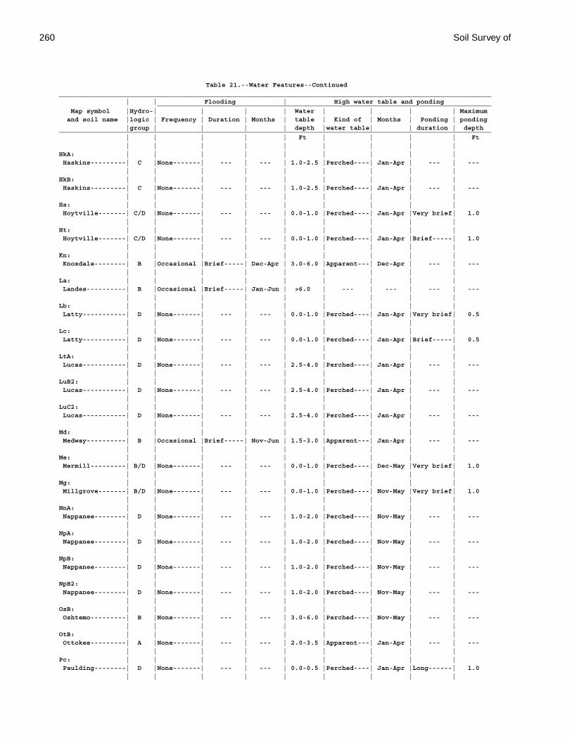
260 Soil Survey of
Table 21.--Water Features--Continued______________________________________________________________________________________________________________ | | Flooding | High water table and ponding _____________________________________________________________________________________ Map symbol |Hydro-| | | | Water | | | | Maximum and soil name |logic | Frequency | Duration | Months | table | Kind of | Months | Ponding | ponding |group | | | | depth |water table| | duration | depth______________________________________________________________________________________________________________ | | | | | Ft | | | | Ft | | | | | | | | |HkA: | | | | | | | | | Haskins---------| C |None-------| --- | --- | 1.0-2.5 |Perched----| Jan-Apr | --- | --- | | | | | | | | |HkB: | | | | | | | | | Haskins---------| C |None-------| --- | --- | 1.0-2.5 |Perched----| Jan-Apr | --- | --- | | | | | | | | |Hs: | | | | | | | | | Hoytville-------| C/D |None-------| --- | --- | 0.0-1.0 |Perched----| Jan-Apr |Very brief| 1.0 | | | | | | | | |Ht: | | | | | | | | | Hoytville-------| C/D |None-------| --- | --- | 0.0-1.0 |Perched----| Jan-Apr |Brief-----| 1.0 | | | | | | | | |Kn: | | | | | | | | | Knoxdale--------| B |Occasional |Brief-----| Dec-Apr | 3.0-6.0 |Apparent---| Dec-Apr | --- | --- | | | | | | | | |La: | | | | | | | | | Landes----------| B |Occasional |Brief-----| Jan-Jun | >6.0 | --- | --- | --- | --- | | | | | | | | |Lb: | | | | | | | | | Latty-----------| D |None-------| --- | --- | 0.0-1.0 |Perched----| Jan-Apr |Very brief| 0.5 | | | | | | | | |Lc: | | | | | | | | | Latty-----------| D |None-------| --- | --- | 0.0-1.0 |Perched----| Jan-Apr |Brief-----| 0.5 | | | | | | | | |LtA: | | | | | | | | | Lucas-----------| D |None-------| --- | --- | 2.5-4.0 |Perched----| Jan-Apr | --- | --- | | | | | | | | |LuB2: | | | | | | | | | Lucas-----------| D |None-------| --- | --- | 2.5-4.0 |Perched----| Jan-Apr | --- | --- | | | | | | | | |LuC2: | | | | | | | | | Lucas-----------| D |None-------| --- | --- | 2.5-4.0 |Perched----| Jan-Apr | --- | --- | | | | | | | | |Md: | | | | | | | | | Medway----------| B |Occasional |Brief-----| Nov-Jun | 1.5-3.0 |Apparent---| Jan-Apr | --- | --- | | | | | | | | |Me: | | | | | | | | | Mermill---------| B/D |None-------| --- | --- | 0.0-1.0 |Perched----| Dec-May |Very brief| 1.0 | | | | | | | | |Mg: | | | | | | | | | Millgrove-------| B/D |None-------| --- | --- | 0.0-1.0 |Perched----| Nov-May |Very brief| 1.0 | | | | | | | | |NnA: | | | | | | | | | Nappanee--------| D |None-------| --- | --- | 1.0-2.0 |Perched----| Nov-May | --- | --- | | | | | | | | |NpA: | | | | | | | | | Nappanee--------| D |None-------| --- | --- | 1.0-2.0 |Perched----| Nov-May | --- | --- | | | | | | | | |NpB: | | | | | | | | | Nappanee--------| D |None-------| --- | --- | 1.0-2.0 |Perched----| Nov-May | --- | --- | | | | | | | | |NpB2: | | | | | | | | | Nappanee--------| D |None-------| --- | --- | 1.0-2.0 |Perched----| Nov-May | --- | --- | | | | | | | | |OsB: | | | | | | | | | Oshtemo---------| B |None-------| --- | --- | 3.0-6.0 |Perched----| Nov-May | --- | --- | | | | | | | | |OtB: | | | | | | | | | Ottokee---------| A |None-------| --- | --- | 2.0-3.5 |Apparent---| Jan-Apr | --- | --- | | | | | | | | |Pc: | | | | | | | | | Paulding--------| D |None-------| --- | --- | 0.0-0.5 |Perched----| Jan-Apr |Long------| 1.0 | | | | | | | | |
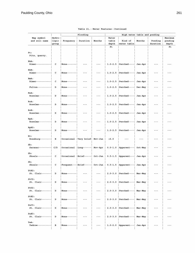
Paulding County, Ohio 261
Table 21.--Water Features--Continued______________________________________________________________________________________________________________ | | Flooding | High water table and ponding _____________________________________________________________________________________ Map symbol |Hydro-| | | | Water | | | | Maximum and soil name |logic | Frequency | Duration | Months | table | Kind of | Months | Ponding | ponding |group | | | | depth |water table| | duration | depth______________________________________________________________________________________________________________ | | | | | Ft | | | | Ft | | | | | | | | |Pt: | | | | | | | | | Pits, quarry. | | | | | | | | | | | | | | | | | |RkA: | | | | | | | | | Rimer-----------| C |None-------| --- | --- | 1.0-2.5 |Perched----| Jan-Apr | --- | --- | | | | | | | | |RkB: | | | | | | | | | Rimer-----------| C |None-------| --- | --- | 1.0-2.5 |Perched----| Jan-Apr | --- | --- | | | | | | | | |RmA: | | | | | | | | | Rimer-----------| C |None-------| --- | --- | 1.0-2.5 |Perched----| Jan-Apr | --- | --- | | | | | | | | | Fulton----------| D |None-------| --- | --- | 1.0-2.5 |Perched----| Dec-May | --- | --- | | | | | | | | |RnA: | | | | | | | | | Roselms---------| D |None-------| --- | --- | 1.0-2.5 |Perched----| Jan-Apr | --- | --- | | | | | | | | |RoA: | | | | | | | | | Roselms---------| D |None-------| --- | --- | 1.0-2.5 |Perched----| Jan-Apr | --- | --- | | | | | | | | |RoB: | | | | | | | | | Roselms---------| D |None-------| --- | --- | 1.0-2.5 |Perched----| Jan-Apr | --- | --- | | | | | | | | |RpA: | | | | | | | | | Roselms---------| D |None-------| --- | --- | 1.0-2.5 |Perched----| Jan-Apr | --- | --- | | | | | | | | |RpB2: | | | | | | | | | Roselms---------| D |None-------| --- | --- | 1.0-2.5 |Perched----| Jan-Apr | --- | --- | | | | | | | | |Rt: | | | | | | | | | Rossburg--------| B |Occasional |Very brief| Nov-Jun | >6.0 | --- | --- | --- | --- | | | | | | | | |Sb: | | | | | | | | | Saranac---------| C/D |Occasional |Long------| Nov-Apr | 0.0-1.0 |Apparent---| Oct-May | --- | --- | | | | | | | | |Sh: | | | | | | | | | Shoals----------| C |Occasional |Brief-----| Oct-Jun | 0.5-1.5 |Apparent---| Jan-Apr | --- | --- | | | | | | | | |Sk: | | | | | | | | | Shoals----------| C |Frequent---|Brief-----| Oct-Jun | 0.5-1.5 |Apparent---| Jan-Apr | --- | --- | | | | | | | | |StB2: | | | | | | | | | St. Clair-------| D |None-------| --- | --- | 2.0-3.0 |Perched----| Mar-May | --- | --- | | | | | | | | |StC2: | | | | | | | | | St. Clair-------| D |None-------| --- | --- | 2.0-3.0 |Perched----| Mar-May | --- | --- | | | | | | | | |StD2: | | | | | | | | | St. Clair-------| D |None-------| --- | --- | 2.0-3.0 |Perched----| Mar-May | --- | --- | | | | | | | | |StE2: | | | | | | | | | St. Clair-------| D |None-------| --- | --- | 2.0-3.0 |Perched----| Mar-May | --- | --- | | | | | | | | |SuC3: | | | | | | | | | St. Clair-------| D |None-------| --- | --- | 2.0-3.0 |Perched----| Mar-May | --- | --- | | | | | | | | |SuE3: | | | | | | | | | St. Clair-------| D |None-------| --- | --- | 2.0-3.0 |Perched----| Mar-May | --- | --- | | | | | | | | |TeA: | | | | | | | | | Tedrow----------| B |None-------| --- | --- | 1.0-2.0 |Apparent---| Jan-Apr | --- | --- | | | | | | | | |
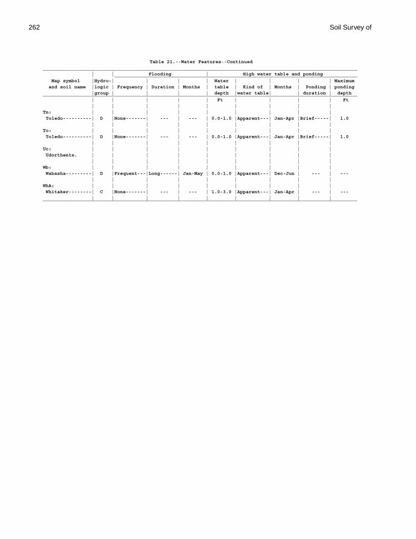
262 Soil Survey of
Table 21.--Water Features--Continued______________________________________________________________________________________________________________ | | Flooding | High water table and ponding _____________________________________________________________________________________ Map symbol |Hydro-| | | | Water | | | | Maximum and soil name |logic | Frequency | Duration | Months | table | Kind of | Months | Ponding | ponding |group | | | | depth |water table| | duration | depth______________________________________________________________________________________________________________ | | | | | Ft | | | | Ft | | | | | | | | |Tn: | | | | | | | | | Toledo----------| D |None-------| --- | --- | 0.0-1.0 |Apparent---| Jan-Apr |Brief-----| 1.0 | | | | | | | | |To: | | | | | | | | | Toledo----------| D |None-------| --- | --- | 0.0-1.0 |Apparent---| Jan-Apr |Brief-----| 1.0 | | | | | | | | |Uc: | | | | | | | | | Udorthents. | | | | | | | | | | | | | | | | | |Wb: | | | | | | | | | Wabasha---------| D |Frequent---|Long------| Jan-May | 0.0-1.0 |Apparent---| Dec-Jun | --- | --- | | | | | | | | |WhA: | | | | | | | | | Whitaker--------| C |None-------| --- | --- | 1.0-3.0 |Apparent---| Jan-Apr | --- | --- | | | | | | | | |______________________________________________________________________________________________________________
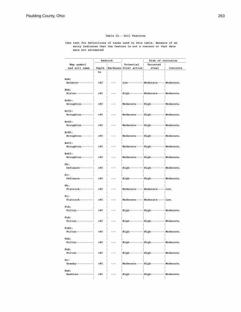
Paulding County, Ohio 263
Table 22.--Soil Features
(See text for definitions of terms used in this table. Absence of an entry indicates that the feature is not a concern or that data were not estimated)
_________________________________________________________________________ | Bedrock | | Risk of corrosion ________________ _________________________ Map symbol | | | Potential | Uncoated | and soil name | Depth |Hardness|frost action| steel | Concrete_________________________________________________________________________ | In | | | | | | | | |BeB: | | | | | Belmore---------| >80 | --- |Low---------|Moderate----|Moderate. | | | | |BkA: | | | | | Bixler----------| >80 | --- |High--------|Moderate----|Moderate. | | | | |BrB2: | | | | | Broughton-------| >80 | --- |Moderate----|High--------|Moderate. | | | | |BrC2: | | | | | Broughton-------| >80 | --- |Moderate----|High--------|Moderate. | | | | |BrD2: | | | | | Broughton-------| >80 | --- |Moderate----|High--------|Moderate. | | | | |BrE2: | | | | | Broughton-------| >80 | --- |Moderate----|High--------|Moderate. | | | | |BsC3: | | | | | Broughton-------| >80 | --- |Moderate----|High--------|Moderate. | | | | |BsD3: | | | | | Broughton-------| >80 | --- |Moderate----|High--------|Moderate. | | | | |Db: | | | | | Defiance--------| >80 | --- |High--------|High--------|Moderate. | | | | |Dc: | | | | | Defiance--------| >80 | --- |High--------|High--------|Moderate. | | | | |Fb: | | | | | Flatrock--------| >80 | --- |Moderate----|Moderate----|Low. | | | | |Fc: | | | | | Flatrock--------| >80 | --- |Moderate----|Moderate----|Low. | | | | |FtA: | | | | | Fulton----------| >80 | --- |High--------|High--------|Moderate. | | | | |FuA: | | | | | Fulton----------| >80 | --- |High--------|High--------|Moderate. | | | | |FuB2: | | | | | Fulton----------| >80 | --- |High--------|High--------|Moderate. | | | | |FxA: | | | | | Fulton----------| >80 | --- |High--------|High--------|Moderate. | | | | |FxB: | | | | | Fulton----------| >80 | --- |High--------|High--------|Moderate. | | | | |Gr: | | | | | Granby----------| >80 | --- |Moderate----|High--------|Moderate. | | | | |HaA: | | | | | Haskins---------| >80 | --- |High--------|High--------|Moderate. | | | | |
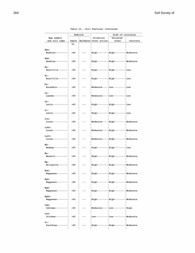
264 Soil Survey of
Table 22.--Soil Features--Continued_________________________________________________________________________ | Bedrock | | Risk of corrosion ________________ _________________________ Map symbol | | | Potential | Uncoated | and soil name | Depth |Hardness|frost action| steel | Concrete_________________________________________________________________________ | In | | | | | | | | |HkA: | | | | | Haskins---------| >80 | --- |High--------|High--------|Moderate. | | | | |HkB: | | | | | Haskins---------| >80 | --- |High--------|High--------|Moderate. | | | | |Hs: | | | | | Hoytville-------| >80 | --- |High--------|High--------|Low. | | | | |Ht: | | | | | Hoytville-------| >80 | --- |High--------|High--------|Low. | | | | |Kn: | | | | | Knoxdale--------| >80 | --- |Moderate----|Low---------|Low. | | | | |La: | | | | | Landes----------| >80 | --- |Moderate----|Low---------|Low. | | | | |Lb: | | | | | Latty-----------| >80 | --- |High--------|High--------|Low. | | | | |Lc: | | | | | Latty-----------| >80 | --- |High--------|High--------|Low. | | | | |LtA: | | | | | Lucas-----------| >80 | --- |Moderate----|High--------|Moderate. | | | | |LuB2: | | | | | Lucas-----------| >80 | --- |Moderate----|High--------|Moderate. | | | | |LuC2: | | | | | Lucas-----------| >80 | --- |Moderate----|High--------|Moderate. | | | | |Md: | | | | | Medway----------| >80 | --- |High--------|High--------|Low. | | | | |Me: | | | | | Mermill---------| >80 | --- |High--------|High--------|Moderate. | | | | |Mg: | | | | | Millgrove-------| >80 | --- |High--------|High--------|Moderate. | | | | |NnA: | | | | | Nappanee--------| >80 | --- |High--------|High--------|Moderate. | | | | |NpA: | | | | | Nappanee--------| >80 | --- |High--------|High--------|Moderate. | | | | |NpB: | | | | | Nappanee--------| >80 | --- |High--------|High--------|Moderate. | | | | |NpB2: | | | | | Nappanee--------| >80 | --- |High--------|High--------|Moderate. | | | | |OsB: | | | | | Oshtemo---------| >80 | --- |Moderate----|Low---------|High. | | | | |OtB: | | | | | Ottokee---------| >80 | --- |Low---------|Low---------|Moderate. | | | | |Pc: | | | | | Paulding--------| >80 | --- |High--------|High--------|Moderate. | | | | |

Paulding County, Ohio 265
Table 22.--Soil Features--Continued_________________________________________________________________________ | Bedrock | | Risk of corrosion ________________ _________________________ Map symbol | | | Potential | Uncoated | and soil name | Depth |Hardness|frost action| steel | Concrete_________________________________________________________________________ | In | | | | | | | | |Pt: | | | | | Pits, quarry. | | | | | | | | | |RkA: | | | | | Rimer-----------| >80 | --- |High--------|High--------|Moderate. | | | | |RkB: | | | | | Rimer-----------| >80 | --- |High--------|High--------|Moderate. | | | | |RmA: | | | | | Rimer-----------| >80 | --- |High--------|High--------|Moderate. | | | | | Fulton----------| >80 | --- |High--------|High--------|Moderate. | | | | |RnA: | | | | | Roselms---------| >80 | --- |High--------|High--------|High. | | | | |RoA: | | | | | Roselms---------| >80 | --- |High--------|High--------|High. | | | | |RoB: | | | | | Roselms---------| >80 | --- |High--------|High--------|High. | | | | |RpA: | | | | | Roselms---------| >80 | --- |High--------|High--------|High. | | | | |RpB2: | | | | | Roselms---------| >80 | --- |High--------|High--------|High. | | | | |Rt: | | | | | Rossburg--------| >80 | --- |Moderate----|Low---------|Low. | | | | |Sb: | | | | | Saranac---------| >80 | --- |High--------|High--------|Low. | | | | |Sh: | | | | | Shoals----------| >80 | --- |High--------|High--------|Low. | | | | |Sk: | | | | | Shoals----------| >80 | --- |High--------|High--------|Low. | | | | |StB2: | | | | | St. Clair-------| >80 | --- |Moderate----|High--------|Moderate. | | | | |StC2: | | | | | St. Clair-------| >80 | --- |Moderate----|High--------|Moderate. | | | | |StD2: | | | | | St. Clair-------| >80 | --- |Moderate----|High--------|Moderate. | | | | |StE2: | | | | | St. Clair-------| >80 | --- |Moderate----|High--------|Moderate. | | | | |SuC3: | | | | | St. Clair-------| >80 | --- |Moderate----|High--------|Moderate. | | | | |SuE3: | | | | | St. Clair-------| >80 | --- |Moderate----|High--------|Moderate. | | | | |TeA: | | | | | Tedrow----------| >80 | --- |Moderate----|Low---------|Moderate. | | | | |
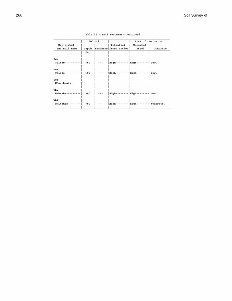
266 Soil Survey of
Table 22.--Soil Features--Continued_________________________________________________________________________ | Bedrock | | Risk of corrosion ________________ _________________________ Map symbol | | | Potential | Uncoated | and soil name | Depth |Hardness|frost action| steel | Concrete_________________________________________________________________________ | In | | | | | | | | |Tn: | | | | | Toledo----------| >80 | --- |High--------|High--------|Low. | | | | |To: | | | | | Toledo----------| >80 | --- |High--------|High--------|Low. | | | | |Uc: | | | | | Udorthents. | | | | | | | | | |Wb: | | | | | Wabasha---------| >80 | --- |High--------|High--------|Low. | | | | |WhA: | | | | | Whitaker--------| >80 | --- |High--------|High--------|Moderate. | | | | |_________________________________________________________________________
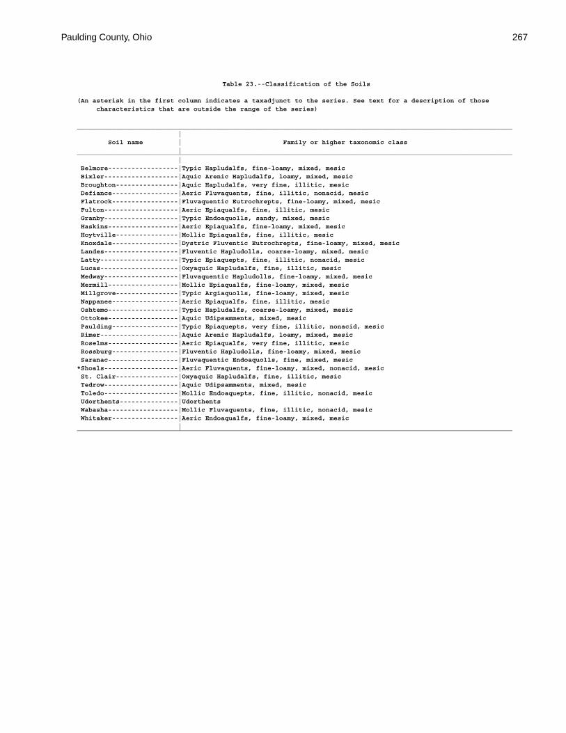
Paulding County, Ohio 267
Table 23.--Classification of the Soils
(An asterisk in the first column indicates a taxadjunct to the series. See text for a description of those characteristics that are outside the range of the series)
________________________________________________________________________________________________________________ | Soil name | Family or higher taxonomic class |________________________________________________________________________________________________________________ | Belmore------------------|Typic Hapludalfs, fine-loamy, mixed, mesic Bixler-------------------|Aquic Arenic Hapludalfs, loamy, mixed, mesic Broughton----------------|Aquic Hapludalfs, very fine, illitic, mesic Defiance-----------------|Aeric Fluvaquents, fine, illitic, nonacid, mesic Flatrock-----------------|Fluvaquentic Eutrochrepts, fine-loamy, mixed, mesic Fulton-------------------|Aeric Epiaqualfs, fine, illitic, mesic Granby-------------------|Typic Endoaquolls, sandy, mixed, mesic Haskins------------------|Aeric Epiaqualfs, fine-loamy, mixed, mesic Hoytville----------------|Mollic Epiaqualfs, fine, illitic, mesic Knoxdale-----------------|Dystric Fluventic Eutrochrepts, fine-loamy, mixed, mesic Landes-------------------|Fluventic Hapludolls, coarse-loamy, mixed, mesic Latty--------------------|Typic Epiaquepts, fine, illitic, nonacid, mesic Lucas--------------------|Oxyaquic Hapludalfs, fine, illitic, mesic Medway-------------------|Fluvaquentic Hapludolls, fine-loamy, mixed, mesic Mermill------------------|Mollic Epiaqualfs, fine-loamy, mixed, mesic Millgrove----------------|Typic Argiaquolls, fine-loamy, mixed, mesic Nappanee-----------------|Aeric Epiaqualfs, fine, illitic, mesic Oshtemo------------------|Typic Hapludalfs, coarse-loamy, mixed, mesic Ottokee------------------|Aquic Udipsamments, mixed, mesic Paulding-----------------|Typic Epiaquepts, very fine, illitic, nonacid, mesic Rimer--------------------|Aquic Arenic Hapludalfs, loamy, mixed, mesic Roselms------------------|Aeric Epiaqualfs, very fine, illitic, mesic Rossburg-----------------|Fluventic Hapludolls, fine-loamy, mixed, mesic Saranac------------------|Fluvaquentic Endoaquolls, fine, mixed, mesic*Shoals-------------------|Aeric Fluvaquents, fine-loamy, mixed, nonacid, mesic St. Clair----------------|Oxyaquic Hapludalfs, fine, illitic, mesic Tedrow-------------------|Aquic Udipsamments, mixed, mesic Toledo-------------------|Mollic Endoaquepts, fine, illitic, nonacid, mesic Udorthents---------------|Udorthents Wabasha------------------|Mollic Fluvaquents, fine, illitic, nonacid, mesic Whitaker-----------------|Aeric Endoaqualfs, fine-loamy, mixed, mesic |________________________________________________________________________________________________________________


269
Interpretive Groups
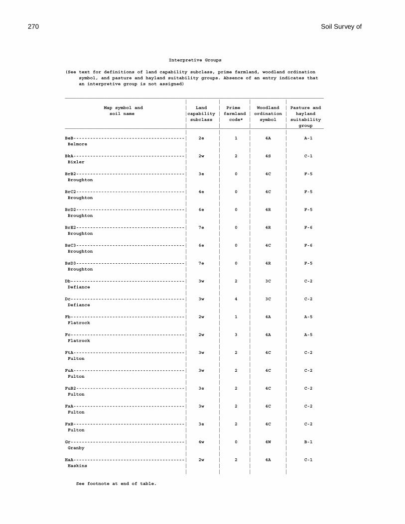
270 Soil Survey of
Interpretive Groups
(See text for definitions of land capability subclass, prime farmland, woodland ordination symbol, and pasture and hayland suitability groups. Absence of an entry indicates that an interpretive group is not assigned)
_____________________________________________________________________________________________ | | | | Map symbol and | Land | Prime | Woodland | Pasture and soil name |capability | farmland | ordination | hayland | subclass | code* | symbol | suitability | | | | group_____________________________________________________________________________________________ | | | |BeB----------------------------------------| 2e | 1 | 4A | A-1 Belmore | | | | | | | |BkA----------------------------------------| 2w | 2 | 4S | C-1 Bixler | | | | | | | |BrB2---------------------------------------| 3e | 0 | 4C | F-5 Broughton | | | | | | | |BrC2---------------------------------------| 4e | 0 | 4C | F-5 Broughton | | | | | | | |BrD2---------------------------------------| 6e | 0 | 4R | F-5 Broughton | | | | | | | |BrE2---------------------------------------| 7e | 0 | 4R | F-6 Broughton | | | | | | | |BsC3---------------------------------------| 6e | 0 | 4C | F-6 Broughton | | | | | | | |BsD3---------------------------------------| 7e | 0 | 4R | F-5 Broughton | | | | | | | |Db-----------------------------------------| 3w | 2 | 3C | C-2 Defiance | | | | | | | |Dc-----------------------------------------| 3w | 4 | 3C | C-2 Defiance | | | | | | | |Fb-----------------------------------------| 2w | 1 | 4A | A-5 Flatrock | | | | | | | |Fc-----------------------------------------| 2w | 3 | 4A | A-5 Flatrock | | | | | | | |FtA----------------------------------------| 3w | 2 | 4C | C-2 Fulton | | | | | | | |FuA----------------------------------------| 3w | 2 | 4C | C-2 Fulton | | | | | | | |FuB2---------------------------------------| 3e | 2 | 4C | C-2 Fulton | | | | | | | |FxA----------------------------------------| 3w | 2 | 4C | C-2 Fulton | | | | | | | |FxB----------------------------------------| 3e | 2 | 4C | C-2 Fulton | | | | | | | |Gr-----------------------------------------| 4w | 0 | 4W | B-1 Granby | | | | | | | |HaA----------------------------------------| 2w | 2 | 4A | C-1 Haskins | | | | | | | |
See footnote at end of table.
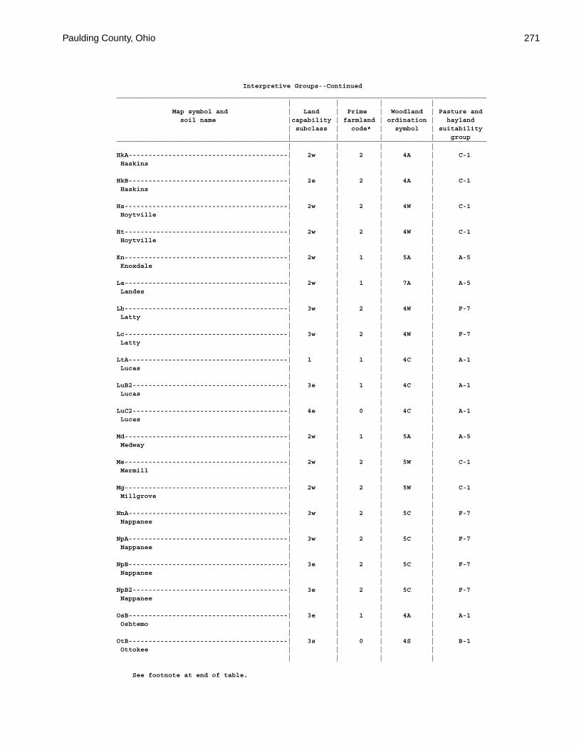
Paulding County, Ohio 271
Interpretive Groups--Continued_____________________________________________________________________________________________ | | | | Map symbol and | Land | Prime | Woodland | Pasture and soil name |capability | farmland | ordination | hayland | subclass | code* | symbol | suitability | | | | group_____________________________________________________________________________________________ | | | |HkA----------------------------------------| 2w | 2 | 4A | C-1 Haskins | | | | | | | |HkB----------------------------------------| 2e | 2 | 4A | C-1 Haskins | | | | | | | |Hs-----------------------------------------| 2w | 2 | 4W | C-1 Hoytville | | | | | | | |Ht-----------------------------------------| 2w | 2 | 4W | C-1 Hoytville | | | | | | | |Kn-----------------------------------------| 2w | 1 | 5A | A-5 Knoxdale | | | | | | | |La-----------------------------------------| 2w | 1 | 7A | A-5 Landes | | | | | | | |Lb-----------------------------------------| 3w | 2 | 4W | F-7 Latty | | | | | | | |Lc-----------------------------------------| 3w | 2 | 4W | F-7 Latty | | | | | | | |LtA----------------------------------------| 1 | 1 | 4C | A-1 Lucas | | | | | | | |LuB2---------------------------------------| 3e | 1 | 4C | A-1 Lucas | | | | | | | |LuC2---------------------------------------| 4e | 0 | 4C | A-1 Lucas | | | | | | | |Md-----------------------------------------| 2w | 1 | 5A | A-5 Medway | | | | | | | |Me-----------------------------------------| 2w | 2 | 5W | C-1 Mermill | | | | | | | |Mg-----------------------------------------| 2w | 2 | 5W | C-1 Millgrove | | | | | | | |NnA----------------------------------------| 3w | 2 | 5C | F-7 Nappanee | | | | | | | |NpA----------------------------------------| 3w | 2 | 5C | F-7 Nappanee | | | | | | | |NpB----------------------------------------| 3e | 2 | 5C | F-7 Nappanee | | | | | | | |NpB2---------------------------------------| 3e | 2 | 5C | F-7 Nappanee | | | | | | | |OsB----------------------------------------| 3e | 1 | 4A | A-1 Oshtemo | | | | | | | |OtB----------------------------------------| 3s | 0 | 4S | B-1 Ottokee | | | | | | | |
See footnote at end of table.

272 Soil Survey of
Interpretive Groups--Continued_____________________________________________________________________________________________ | | | | Map symbol and | Land | Prime | Woodland | Pasture and soil name |capability | farmland | ordination | hayland | subclass | code* | symbol | suitability | | | | group_____________________________________________________________________________________________ | | | |Pc-----------------------------------------| 3w | 0 | 4W | F-7 Paulding | | | | | | | |Pt. | | | | Pits, quarry | | | | | | | |RkA----------------------------------------| 2w | 0 | 4A | C-1 Rimer | | | | | | | |RkB----------------------------------------| 2e | 0 | 4A | C-1 Rimer | | | | | | | |RmA----------------------------------------| 2w | 0 | | Rimer-------------------------------------| | | 4A | C-1 | | | | Fulton------------------------------------| | | 4C | C-2 | | | |RnA----------------------------------------| 3w | 0 | 3C | F-7 Roselms | | | | | | | |RoA----------------------------------------| 3w | 0 | 3C | F-7 Roselms | | | | | | | |RoB----------------------------------------| 3w | 0 | 3C | F-7 Roselms | | | | | | | |RpA----------------------------------------| 3w | 0 | 3C | F-7 Roselms | | | | | | | |RpB2---------------------------------------| 3w | 0 | 3C | F-7 Roselms | | | | | | | |Rt-----------------------------------------| 2w | 1 | 5A | A-5 Rossburg | | | | | | | |Sb-----------------------------------------| 3w | 2 | 5W | C-3 Saranac | | | | | | | |Sh-----------------------------------------| 2w | 2 | 5W | C-3 Shoals | | | | | | | |Sk-----------------------------------------| 2w | 4 | 5W | C-3 Shoals | | | | | | | |StB2---------------------------------------| 3e | 1 | 3C | F-5 St. Clair | | | | | | | |StC2---------------------------------------| 4e | 0 | 3C | F-5 St. Clair | | | | | | | |StD2---------------------------------------| 6e | 0 | 3R | F-5 St. Clair | | | | | | | |StE2---------------------------------------| 7e | 0 | 3R | F-6 St. Clair | | | | | | | |SuC3---------------------------------------| 6e | 0 | 3C | F-5 St. Clair | | | | | | | |SuE3---------------------------------------| 7e | 0 | 3R | F-5 St. Clair | | | | | | | |
See footnote at end of table.
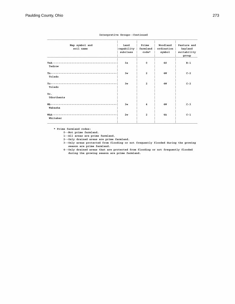
Paulding County, Ohio 273
Interpretive Groups--Continued_____________________________________________________________________________________________ | | | | Map symbol and | Land | Prime | Woodland | Pasture and soil name |capability | farmland | ordination | hayland | subclass | code* | symbol | suitability | | | | group_____________________________________________________________________________________________ | | | |TeA----------------------------------------| 3s | 0 | 4S | B-1 Tedrow | | | | | | | |Tn-----------------------------------------| 3w | 2 | 4W | C-2 Toledo | | | | | | | |To-----------------------------------------| 3w | 2 | 4W | C-2 Toledo | | | | | | | |Uc. | | | | Udorthents | | | | | | | |Wb-----------------------------------------| 3w | 4 | 4W | C-3 Wabasha | | | | | | | |WhA----------------------------------------| 2w | 2 | 4A | C-1 Whitaker | | | | | | | |_____________________________________________________________________________________________
* Prime farmland codes: 0--Not prime farmland. 1--All areas are prime farmland. 2--Only drained areas are prime farmland. 3--Only areas protected from flooding or not frequently flooded during the growing season are prime farmland. 4--Only drained areas that are protected from flooding or not frequently flooded during the growing season are prime farmland.

The Natural Resources Conservation Service (NRCS) is committed to making itsinformation accessible to all of its customers and employees. If you are experiencingaccessibility issues and need assistance, please contact our Helpdesk by phone at1-800-457-3642 or by e-mail at [email protected]. For assistance withpublications that include maps, graphs, or similar forms of information, you may alsowish to contact our State or local office. You can locate the correct office and phonenumber at http://offices.sc.egov.usda.gov/locator/app.
NRCS Accessibility Statement