Embed Size (px)
Citation preview

Section 12 Wicklow County Council
Proposed Waste Soils Recovery Facility &
Eco-Park at Pretty Bush – Volume 2 – Main EIS
LW15/247/01 Page 181 of 289
12 SOILS, GEOLOGY AND HYDROGEOLOGY
This section of the report addresses soils, geology and hydrogeology in the existing environment, identifies potential impacts of the proposed development and outlines measures to mitigate potential impacts.
12.1 Methodology This section was prepared having regard to the publication “Guidelines for the Preparation of Soils, Geology
and Hydrogeology Chapters in Environmental Impact Statements” by the Institute of Geologists of Ireland (1). It was prepared using available published literature and included a walkover survey of the site and results of ground investigations.
The literature reviewed included:
1. ‘Geology of Kildare-Wicklow’ (Sheet 16, Geological Survey of Ireland, 1994) (2) 2. ‘General Soil Map of Ireland’ (National Soil Survey, 1980) (3)
In addition to the above information, ground investigations were undertaken during October 2015 to provide additional information. The fieldwork included soil sampling, rotary drilling, the installation and sampling of groundwater monitoring wells and laboratory testing of soil and water samples. The information obtained
from these investigations is also referenced in this report. Following the compilation of site data and published information on the existing environment, the details of
the proposed development were appraised to identify potential impacts on geology, soils and hydrogeology. The site layout is shown in Figure 3-4.
12.1.1 Study Area
It is proposed to deposit up to 200,000 tonnes of surplus dredge spoil material, mainly silt, clay and gravel at the site, arising from the flood defence works being carried on the River Dargle in Bray.
The placement of the surplus dredge spoil will raise existing ground levels to facilitate the development of an Eco-park for long term community benefit use. The proposed development is described in Section 3 of this EIS.
The location of the proposed facility is shown in Figure 1-1 with the proposed material placement plan outlined in Figure 3.7. The proposed layout of the associated development areas at the facility is shown in Figure 3.8.
The study area is defined as the area within the existing site boundary. The site is currently covered in vegetation. It is the intention to clear the site of vegetation prior to importing
dredge spoil to the site. Historic mapping for the site shows no evidence of any industrial use for the site. Historically, the site has been subdivided pastures and the historic 6” sheet for the site suggests that the ground was boggy and
possibly unsuitable for tillage or pasture compared with the surrounding land. It is possible that the reason for this is that bedrock is shallow and probable low permeability with thin soil cover.
The 1995 aerial photographs for the site suggest that the northern part of the site was cleared of vegetation and may have been quarried (and later backfilled) or just backfilled. It is therefore expected that some fill material is present in the northeast corner of the site. The remainder of the site appears to have been largely undisturbed in recent years.
Section 12 Wicklow County Council
Proposed Waste Soils Recovery Facility &
Eco-Park at Pretty Bush – Volume 2 – Main EIS
LW15/247/01 Page 182 of 289
12.1.2 Consultation The scope for this appraisal has been informed by pre-application consultation with Wicklow County Council,
prescribed bodies and other interested parties as summarised in Section 6 of the EIS.
The Geological Survey of Ireland (GSI) responded to the consultation request in October 2015. The GSI responded that there is no site of geological heritage interest within the perimeter of the study boundary. The
audit of County Geological Sites for County Wicklow was carried out in 2014. The GSI stated that the closest sites of interest are the ‘Glen of the Downs’ and the ‘Wicklow- Greystones Coast’. The GSI also stated that they lie within a 2 km radius of the proposed site, however, due to their scale and nature, they are unlikely
to be affected by the proposed facility.
12.2 Existing Environment
12.2.1 Overburden Geology The main soil associations within this part of County Wicklow are Acid Brown Earths (75%) with associated Gleys (15%) and Brown Podzolics (10%). The main Quaternary sediments identified in this area of County Wicklow are glacial till deposits derived from the underlying sandstone and shale which underlies the area.
Additionally, limestone sands and gravels underlie the area to the southwest and southeast of the site. The site itself is underlain by shallow bedrock, with little or no quaternary overburden. The Quaternary deposits are shown in Figure 12.1.
12.2.2 Bedrock Geology The GSI publication ‘Geology of Kildare-Wicklow’ (2) is the reference source for the description of the bedrock
geology of the region. The GSI 1:100,000 scale bedrock geology map (Sheet 16) shows that Cambrian Bray
Head Formation underlies the site. The bedrock geology of the site and surrounding area is shown in Figure 12.2.
The Bray Head Formation covers the majority of the Wicklow area and comprises greywacke sandstones and siltstones interbedded with green, purple, red and grey slates and massive quartzites. Bedrock at the site is close to the surface and exposed in parts.
12.2.3 Ground Investigations Three rotary drilled boreholes were undertaken by Priority Geotechnical Limited (PGL) under the direction of FTC. The boreholes were undertaken near the three corners of the site as shown in Figure 12.5. The boreholes
were primarily undertaken in order to install groundwater monitoring wells. A summary of the borehole locations and ground conditions is presented in Table 12.1. Detailed borehole logs are presented in the ground investigations report in Appendix 14.
Table 12.1: Summary of Boreholes
Borehole GPS Coordinates Ground Level
(mAOD) Overburden Bedrock Depth
X (ING) Y (ING)
RC01 (down- gradient)
328986.5 209453.5 48.550 Gravelly Cobbles and Clay
9.3m
RC02 (up- gradient)
328846.3 209365.9 52.274 Sand, Clay, Gravel
4.5m
RC03 (down- gradient)
329082.9 209053.0 43.592 Not recovered 0.4m

TCSsS
Made
Made
MadeMade
Made
Made
Rck
Rck
Mbs
Mbs
Mbs
IrSTCSsS
IrSTCSsS
IrSTCSsS
IrSTCSsS
A
AA
A
A
GLs
GLs
RckRck
Made
Made GLs
IrSTCSsS
GLs
GLs
GLs
GLs
GLs
GLs
MadeGLs
IrSTCSsS
IrSTCSsSGLs
IrSTCSsS
Rck
TCSsS
GLs
GLs
GLs
Rck
TCSsS
IrSTCSsS
IrSTCSsS
IrSTCSsS
IrSTCSsS
IrSTCSsS
Rck
Rck
Rck
GLs
GLs
A
RckRck
A
A
Made
Made
Made
Made
MadeMadeMade
Made
A
A
AMadeMade
MadeRck
A
Rck
IrSTCSsSA
Made
Made
MadeL
15/10/2015DateName Of Client
Wicklow County Council
Name Of Job
EIS for proposed Kilquade Waste Soils Recovery Facility
Title Of Figure
Quaternary Geology Map
Scale Used @ A4Figure No.
12.1 Rev
Mapping Reproduced Under Licence from the Ordnance Survey Ireland Licence No. EN 0001214 © Government of Ireland
A
LegendStudy Boundary
Subsoils DataA, alluviumGLs, limestone sands and gravels -CarboniferousL, lake sedimentMade, made groundMbs, beach / raised beach sandRck, bedrock at surface
CONSULTANTS IN ENGINEERING & ENVIRONMENTAL SCIENCES
Core House, Pouladuff Rd, Cork, Ireland.T:+353-21-4964133, F:+353-21-4464Unit 16 J5 Plaza, North Park Business Park, Dublin 11, Ireland. T:+353-1-6583500, F:+353-1-6583501
www.fehilytimoney.ie, E: [email protected]
Doc: R:\Map Production\2015\LW15\247\01\Workspace\MXD\LE15-247-01_Figure12-1_QuaternaryGeologyMap_A4.mxd
«1N
1:25,000
0 0.5 1Kilometers
Co. Wicklow


50
80
BR
BR
BR
BR
19/10/2015Date
Wicklow County Council
Name Of Job
Waste Licence, Planning & EIS for Waste Soils Recovery Facility
Title Of Figure
Bedrock Geology Map
Scale Used @ A4Figure No.
12.2 Rev
Mapping Reproduced Under Licence from the Ordnance Survey Ireland Licence No. EN 0001215 © Government of Ireland
A
LegendStudy Boundary
Bedrock GeologyBR: Bray Head FormationDip of Bedding in DegreesStructural Linework
CONSULTANTS IN ENGINEERING & ENVIRONMENTAL SCIENCES
Core House, Pouladuff Rd, Cork, Ireland.T:+353-21-4964133, F:+353-21-4464Unit 16 J5 Plaza, North Park Business Park, Dublin 11, Ireland. T:+353-1-6583500, F:+353-1-6583501
www.fehilytimoney.ie, E: [email protected]
Doc: R:\Map Production\2015\LW15\247\01\Workspace\MXD\LW15-247-01_Figure12-2_Bedrock Geology Map _A4.mxd
«1N
1:25,000
0 0.5 1 1.5Kilometers
Co. Wicklow
65


Section 12 Wicklow County Council
Proposed Waste Soils Recovery Facility &
Eco-Park at Pretty Bush – Volume 2 – Main EIS
LW15/247/01 Page 185 of 289
12.2.4 Materials Analysis Two surface soil samples were recovered from the site and tested for a range of analyses in order to provide
a baseline for possible contamination on the site. The results of the soil analysis are presented in Appendix
15 and the results are summarised in Table 12.1.
Analysis was also undertaken of the dredge spoil material proposed for acceptance in order to verify the nature of the material to be imported from the River Dargle Flood Scheme works. Three separate periods of sampling work were undertaken by Gavin and Doherty Geosolutions in February 2015, October 2015 and April 2016. The three individual reports on the dredge material sampled are presented in Appendix 16.
These samples were compared the Waste Acceptance Criteria (WAC) limit values, which classify various wastes as suitable for acceptance at different types of landfill facilities, based on their composition. These
criteria are laid down in Council Decision 2003/33/EC and the limit values with which the material is compared are those classified as “inert waste”.
It should be noted that these limit values are examined for comparison only, to substantiate the inert nature of the material. As the proposed waste soils recovery activity is not a landfilling activity, the requirement of Council Decision 2003/33/EC and Directive 1999/31/EC on the landfilling of waste, to which it relates, do not apply to the proposed waste activity.
The results of the testing undertaken on the dredge spoil material are summarised in Table 12.2, Table 12.3 and Table 12.4 and are compared with the Inert WAC limit values identified for comparison.
It should be noted that a single sample of the dredge spoil material which was sampled in February 2015 slightly exceeds the comparable WAC inert criteria limit for Total Organic Carbon (TOC). However, this result
is consistent with a similar exceedance within an in-situ soil sample analysed from the Pretty Bush site and this exceedance is not considered significant in the context of the development. Furthermore, no WAC inert
criteria limits were exceeded for any of the samples obtained from the more recent sampling of dredge spoil material in October 2015 and April 2016.


Section 12 Wicklow County Council
Proposed Waste Soils Recovery Facility &
Eco-Park at Pretty Bush – Volume 2 – Main EIS
LW15/247/01 Page 186 of 289
Table 12-1: Summary of Soil/Eluate Test Results for In-Situ Soils at Pretty Bush
Parameter Units
Pretty Bush Soil Samples Landfill Waste Acceptance Criteria
(WAC) Limits for Inert Wastes
TP TP Inert Stable Hazardous
1B 2B
Solid Waste
TOC % 1.81 3.38 3 5 6
Sum of BTEX mg/kg <0.024 <0.024 6 - -
Sum of 7 PCBs mg/kg <0.021 <0.021 1 - -
Mineral oil mg/kg 13.5 25.3 500 - -
PAH sum of 6 mg/kg - - -
PAH sum of 17 mg/kg <10 <10 100 - -
10:1 Eluate
Arsenic mg/kg 0.00383 0.00395 0.5 2 25
Barium mg/kg 0.0142 0.0286 20 100 300
Cadmium mg/kg <0.001 <0.001 0.04 1 5
Chromium mg/kg 0.00599 0.00619 0.5 10 70
Copper mg/kg 0.0288 0.0254 2 50 100
Mercury mg/kg 0.000165 0.000146 0.01 0.2 2
Molybdenum mg/kg <0.0024 <0.0024 0.5 10 30
Nickel mg/kg 0.0119 0.0121 0.4 10 40
Lead mg/kg 0.00678 0.0476 0.5 10 50
Antimony mg/kg 0.00272 0.00395 0.06 0.7 5
Selenium mg/kg 0.0142 0.0303 0.1 0.5 7
Zinc mg/kg 0.0175 0.0389 4 50 200
Chloride mg/kg <20 <20 800 15000 25000
Fluoride mg/kg <5 <5 10 150 500
Sulphate as SO4 mg/kg <20 <20 1000 20000 50000
Total Dissolved Solids mg/kg 105 180 4000 60000 10000
Phenol mg/kg <0.02 <0.02 1 - -
Dissolved Organic Carbon mg/kg 90.1 82.7 500 800 1000

Section 12 Wicklow County Council
Proposed Waste Soils Recovery Facility &
Eco-Park at Pretty Bush – Volume 2 – Main EIS
LW15/247/01 Page 187 of 289
Table 12-2: Summary of Soil/Eluate Test Results for Incoming Material (Test 1: 23/02/15)
Parameter Units
Incoming Material Samples
Landfill Waste Acceptance
Criteria (WAC) Limits for Inert
Wastes
TP1 1.1
TP1 3.5
TP2 0.9
TP2 1.2
TP3 2.5
TP6 0.95
TP6 3.3
TP7 2
TP8 2.05
TP9 2.8
Inert Stable Hazardous
Solid Waste
TOC % 0.82 0.46 0.47 0.46 0.28 1.34 0.6 3.19 0.2 0.2 3 5 6
Sum of BTEX mg/kg 0.027 <0.025 <0.025 <0.025 <0.025 <0.025 <0.025 <0.025 <0.025 <0.025 6 - -
Sum of 7 PCBs mg/kg <0.035 <0.035 <0.035 <0.035 <0.035 <0.035 <0.035 <0.035 <0.035 <0.035 1 - -
Mineral oil mg/kg <45 <45 <45 <45 <45 <45 <45 <45 <45 <45 500 - -
PAH sum of 6 mg/kg 0.39 <0.22 <0.22 <0.22 <0.22 <0.22 <0.22 14.39 <0.22 <0.22 - - -
PAH sum of 17 mg/kg 1.03 <0.64 <0.64 <0.64 <0.64 <0.64 <0.64 34.77 <0.64 <0.64 100 - -
10:1 Eluate
Arsenic mg/kg <0.025 <0.025 <0.025 <0.025 <0.025 <0.025 <0.025 <0.025 <0.025 <0.025 0.5 2 25
Barium mg/kg 0.11 0.04 0.07 0.07 0.05 0.04 0.06 0.21 <0.03 <0.03 20 100 300
Cadmium mg/kg <0.005 <0.005 <0.005 <0.005 <0.005 <0.005 <0.005 <0.005 <0.005 <0.005 0.04 1 5
Chromium mg/kg <0.015 <0.015 <0.015 <0.015 <0.015 <0.015 <0.015 <0.015 <0.015 <0.015 0.5 10 70
Copper mg/kg <0.07 <0.07 <0.07 <0.07 <0.07 <0.07 <0.07 <0.07 <0.07 <0.07 2 50 100
Mercury mg/kg 0.0021 0.0011 0.0012 0.0013 0.0006 0.0025 0.0057 0.0028 0.0007 0.0018 0.01 0.2 2
Molybdenum mg/kg 0.03 <0.02 <0.02 <0.02 <0.02 <0.02 <0.02 0.06 <0.02 <0.02 0.5 10 30
Nickel mg/kg <0.02 <0.02 <0.02 <0.02 <0.02 <0.02 <0.02 0.03 <0.02 <0.02 0.4 10 40
Lead mg/kg <0.05 <0.05 <0.05 <0.05 <0.05 <0.05 <0.05 <0.05 <0.05 <0.05 0.5 10 50
Antimony mg/kg <0.02 <0.02 <0.02 <0.02 <0.02 <0.02 <0.02 <0.02 <0.02 <0.02 0.06 0.7 5
Selenium mg/kg <0.03 <0.03 <0.03 <0.03 <0.03 <0.03 <0.03 <0.03 <0.03 <0.03 0.1 0.5 7
Zinc mg/kg <0.03 <0.03 <0.03 <0.03 <0.03 <0.03 <0.03 <0.03 <0.03 <0.03 4 50 200
Chloride mg/kg 5 5 <3 <3 <3 7 <3 21 5.6 10.3 800 15000 25000
Fluoride mg/kg <3 <3 <3 <3 <3 <3 <3 <3 <3 <3 10 150 500
Sulphate as SO4 mg/kg 32.9 13.8 26.6 24.2 30.6 77.9 9.9 37.7 5.6 10.3 1000 20000 50000
Total Dissolved Solids mg/kg 1531 920 940 470 840 1810 1021 1481 1631 830 4000 60000 10000
Phenol mg/kg <0.1 <0.1 <0.1 <0.1 <0.1 <0.1 <0.1 <0.1 <0.1 <0.1 1 - -
Dissolved Organic
Carbon mg/kg 60 60 40 50 40 40 50 100 30 <20 500 800 1000

Section 12 Wicklow County Council
Proposed Waste Soils Recovery Facility &
Eco-Park at Pretty Bush – Volume 2 – Main EIS
LW15/247/01 Page 188 of 289
Table 12-3: Summary of Soil/Eluate Test Results for Incoming Material (Test 2: 21/10/15)
Parameter Units
Incoming Material Samples
Landfill Waste Acceptance Criteria
(WAC) Limits for Inert
Wastes
1 2 3 4 5 6 7 8 9 10 11 Inert Stable Hazar-
dous
Solid Waste
TOC % 0.2 0.16 0.12 0.14 0.22 0.18 0.16 0.2 0.14 0.05 0.17 3 5 6
Sum of BTEX mg/kg <0.025 <0.025 <0.025 <0.025 <0.025 <0.025 <0.025 <0.025 <0.025 <0.025 <0.025 6 - -
Sum of 7 PCBs mg/kg <0.035 <0.035 <0.035 <0.035 <0.035 <0.035 <0.035 <0.035 <0.035 <0.035 <0.035 1 - -
Mineral oil mg/kg <45 <45 <45 <45 <45 <45 <45 <45 <45 <45 <45 500 - -
PAH sum of 6 mg/kg <0.22 <0.22 <0.22 <0.22 <0.22 <0.22 <0.22 <0.22 <0.22 <0.22 <0.22 - - -
PAH sum of 17 mg/kg <0.64 <0.64 <0.64 <0.64 <0.64 <0.64 <0.64 <0.64 <0.64 <0.64 <0.64 100 - -
10:1 Eluate
Arsenic mg/kg 0.054 <0.025 0.033 <0.025 <0.025 <0.025 <0.025 <0.025 0.032 <0.025 0.035 0.5 2 25
Barium mg/kg <0.03 <0.03 <0.03 <0.03 <0.03 <0.03 <0.03 <0.03 <0.03 <0.03 <0.03 20 100 300
Cadmium mg/kg <0.005 <0.005 <0.005 <0.005 <0.005 <0.005 <0.005 <0.005 <0.005 <0.005 <0.005 0.04 1 5
Chromium mg/kg <0.015 <0.015 <0.015 <0.015 <0.015 <0.015 <0.015 <0.015 <0.015 <0.015 <0.015 0.5 10 70
Copper mg/kg <0.07 <0.07 <0.07 <0.07 <0.07 <0.07 <0.07 <0.07 <0.07 <0.07 <0.07 2 50 100
Mercury mg/kg 0.0049 0.0049 0.0043 0.0046 0.0049 0.0063 0.0045 0.0001 0.0003 0.0003 0.0002 0.01 0.2 2
Molybdenum mg/kg <0.02 <0.02 <0.02 <0.02 <0.02 <0.02 <0.02 <0.02 <0.02 <0.02 <0.02 0.5 10 30
Nickel mg/kg <0.02 <0.02 <0.02 <0.02 <0.02 <0.02 <0.02 <0.02 <0.02 <0.02 <0.02 0.4 10 40
Lead mg/kg <0.05 <0.05 <0.05 <0.05 <0.05 <0.05 <0.05 <0.05 <0.05 <0.05 <0.05 0.5 10 50
Antimony mg/kg <0.02 <0.02 <0.02 <0.02 <0.02 <0.02 <0.02 <0.02 <0.02 <0.02 <0.02 0.06 0.7 5
Selenium mg/kg <0.03 <0.03 <0.03 <0.03 <0.03 <0.03 <0.03 <0.03 <0.03 <0.03 <0.03 0.1 0.5 7
Zinc mg/kg <0.03 <0.03 <0.03 <0.03 <0.03 <0.03 <0.03 <0.03 <0.03 <0.03 <0.03 4 50 200
Chloride mg/kg 10 <3 <3 <3 <3 4 <3 <3 <3 <3 <3 800 15000 25000
Fluoride mg/kg <3 <3 <3 <3 <3 <3 <3 <3 <3 <3 <3 10 150 500
Sulphate as SO4 mg/kg 40.4 3.4 23.7 17.1 15.6 14.7 15.1 17.2 35 19.6 18.5 1000 20000 50000
Total Dissolved Solids mg/kg 120 800 720 620 720 1040 660 520 <100 540 860 4000 60000 10000
Phenol mg/kg <0.1 <0.1 <0.1 <0.1 <0.1 <0.1 <0.1 <0.1 <0.1 <0.1 <0.1 1 - -
Dissolved Organic Carbon
mg/kg 30 30 30 30 30 30 30 40 30 30 30 500 800 1000

Section 12 Wicklow County Council
Proposed Waste Soils Recovery Facility &
Eco-Park at Pretty Bush – Volume 2 – Main EIS
LW15/247/01 Page 189 of 289
Table 12-4: Summary of Soil/Eluate Test Results for Incoming Material (Test 3: 13/04/16)
Parameter Units
Incoming Material Samples Landfill Waste Acceptance Criteria
(WAC) Limits for Inert Wastes
Sample 1 Sample 3 Sample 5 Sample 7 Sample 9 Inert Stable Hazar-
dous
Solid Waste
TOC % 0.15 0.16 0.22 0.19 0.17 3 5 6
Sum of BTEX mg/kg <0.025 <0.025 <0.025 <0.025 <0.025 6 - -
Sum of 7 PCBs mg/kg <0.035 <0.035 <0.035 <0.035 <0.035 1 - -
Mineral oil mg/kg <45 <45 <45 <45 <45 500 - -
PAH sum of 6 mg/kg <0.22 <0.22 <0.22 <0.22 <0.22 - - -
PAH sum of 17 mg/kg <0.64 <0.64 <0.64 <0.64 <0.64 100 - -
10:1 Eluate
Arsenic mg/kg 0.063 <0.025 0.037 <0.025 0.044 0.5 2 25
Barium mg/kg <0.03 <0.03 <0.03 <0.03 <0.03 20 100 300
Cadmium mg/kg <0.005 <0.005 <0.005 <0.005 <0.005 0.04 1 5
Chromium mg/kg <0.015 <0.015 <0.015 <0.015 <0.015 0.5 10 70
Copper mg/kg <0.07 <0.07 <0.07 <0.07 <0.07 2 50 100
Mercury mg/kg 0.0004 0.0004 0.0003 0.0006 0.0004 0.01 0.2 2
Molybdenum mg/kg <0.02 <0.02 <0.02 <0.02 <0.02 0.5 10 30
Nickel mg/kg <0.02 <0.02 <0.02 <0.02 <0.02 0.4 10 40
Lead mg/kg <0.05 <0.05 <0.05 <0.05 <0.05 0.5 10 50
Antimony mg/kg <0.02 <0.02 <0.02 <0.02 <0.02 0.06 0.7 5
Selenium mg/kg <0.03 <0.03 <0.03 <0.03 <0.03 0.1 0.5 7
Zinc mg/kg 0.04 0.04 0.03 <0.03 <0.03 4 50 200
Chloride mg/kg 64 74 66 66 85 800 15000 25000
Fluoride mg/kg <3 <3 <3 <3 <3 10 150 500
Sulphate as SO4 mg/kg 133.2 141.3 128.5 127.9 151.3 1000 20000 50000
Total Dissolved Solids mg/kg 780 810 710 1040 840 4000 60000 10000
Phenol mg/kg <0.1 <0.1 <0.1 <0.1 <0.1 1 - -
Dissolved Organic Carbon mg/kg 30 30 30 20 20 500 800 1000

Section 12 Wicklow County Council
Proposed Waste Soils Recovery Facility &
Eco-Park at Pretty Bush – Volume 2 – Main EIS
LW15/247/01 Page 190 of 289
12.2.5 Hydrogeology The groundwater section of the GSI website classifies the bedrock underlying the site as a ‘Poor Aquifer (Pl)’, with bedrock which is ‘generally unproductive except locally’ as shown in Figure 12.3.
Groundwater within the aquifer occurs mainly within fracture zones which may occur within the rocks. Well
specific capacities are generally around 50 m3/day according to the available GSI information, abstracted mainly by domestic properties and farms.
The GSI lists four wells within 1km of the site boundary and a total of 26 wells within 2km, as shown on Figure 12.5. The wells in this area are mostly constructed to depths of between 12m and 48m according to
the data available on the GSI website. It is likely that other properties in the area are also served by groundwater wells for which there is no publically available information. Groundwater vulnerability, as defined by the GSI, is the term used to represent the intrinsic geological and
hydrogeological characteristics that determine the ease with which groundwater could be contaminated by human activities.
The vulnerability of an aquifer to contamination is influenced by the leaching characteristics of the topsoil, the permeability and thickness of the subsoil, the presence of an unsaturated zone, the type of aquifer, and the amount and form of recharge (the hydrologic process where water moves downward from surface water
to groundwater). Groundwater vulnerability is determined mainly according to the thickness and permeability of the subsoil that underlies the topsoil, as these properties strongly influence the travel times and attenuation processes of contaminants that could be released into the subsurface from below the topsoil (as in the case of contaminants from landfills, septic tank systems and underground storage tanks). The type of recharge is
also considered where indirect recharge (termed ‘point recharge’ in Ireland) can occur through swallow holes or sinking streams.
The GSI distribution of vulnerability for the area is predominantly ‘Extreme’ due to shallow bedrock with a small area of ‘High’ vulnerability at the southern end of the site as shown in Figure 12.4.
The assessed vulnerability for the majority of the site is shown in Table 12.5. The table illustrates the standard ratings of vulnerability used by the GSI, with the existing site conditions highlighted based on the findings of the ground investigations.
Table 12.5: Groundwater Vulnerability
Vulnerability Rating
Hydrogeological Conditions
Subsoil Permeability (Type) and Thickness
High Permeability (Sand/gravel)
Moderate Permeability
(e.g., Sandy soil)
Low Permeability
(e.g., Clayey subsoil, clay, peat)
Extreme (E) 0 - 3.0 m 0 - 3.0 m 0 - 3.0 m
High (H) > 3.0 m 3.0 -10.0 m 3.0 - 5.0 m
Moderate (M) Not applicable >10.0 m 5.0 - 10.0 m
Low (L) Not applicable Not applicable >10 m
Based on the findings from the desk study and verified by site investigation works and visual assessment
onsite, the sub-soil thickness on the site is considered to mostly less than 3 m, hence the assessed vulnerability for the site is ‘Extreme’. This suggests that any potential contamination would encounter limited attenuation prior to reaching bedrock.
The overburden deposits of till have generally moderate permeability and may therefore act as a confining layer (where present), preventing the free movement of surface water to the underlying aquifer within the bedrock. The regional topography of the site is generally sloping gently towards the east, although locally,
the site comprises two distinct valleys which flow towards the south and southeast. Groundwater at the site is expected to flow in the general direction of the regional topography and surface water courses which flow predominantly from northwest to southeast.


!.
!.
!.!.
!.
!.
!.!.
!. !.!.
!.!.!.!.
!.
!.
!.!.
!.!.
!.
Pl
19/10/2015DateName Of Client
Wicklow County Council
Name Of Job
Waste Licence, Planning & EIS for Waste Soils Recovery Facility
Title Of Figure
Aquifer Classification
Scale Used @ A4Figure No.
12.3 Rev
Mapping Reproduced Under Licence from the Ordnance Survey Ireland Licence No. EN 0001214 © Government of Ireland
A
LegendStudy Boundary2km Buffer of Site Boundary1km Buffer of Site Boundary
Aquifer ClassificationPl: Poor Aquifer Bedrock GenerallyUnproductive Except LocallyGW Well (100m-200m Accuracy)GW Well (500m-1km Accuracy)GW Well (50m-100m Accuracy)
!. GW Wells (10m-50m) AccuracySand and Gravel Aquifers
CONSULTANTS IN ENGINEERING & ENVIRONMENTAL SCIENCES
Core House, Pouladuff Rd, Cork, Ireland.T:+353-21-4964133, F:+353-21-4464Unit 16 J5 Plaza, North Park Business Park, Dublin 11, Ireland. T:+353-1-6583500, F:+353-1-6583501
www.fehilytimoney.ie, E: [email protected]
Doc: R:\Map Production\2015\LW15\247\01\Workspace\MXD\LW15-247-01_Figure12-3_Aquifer Classification _A4.mxd
«1N
1:25,000
0 0.5 1 1.5Kilometers
Co. Wicklow


15/10/2015Date
Wicklow County Council
Name Of Job
Waste Licence, Planning & EIS for Waste Soils Recovery Facility
Title Of Figure
Groundwater Vulnerability
Scale Used @ A4Figure No.
12.4 Rev
Mapping Reproduced Under Licence from the Ordnance Survey Ireland Licence No. EN 0001215 © Government of Ireland
A
LegendStudy Boundary
Groundwater VulnerabilityE - ExtremeH - HighL - LowM - MediumWaterX (Rock Near Surface or Karst)
CONSULTANTS IN ENGINEERING & ENVIRONMENTAL SCIENCES
Core House, Pouladuff Rd, Cork, Ireland.T:+353-21-4964133, F:+353-21-4464Unit 16 J5 Plaza, North Park Business Park, Dublin 11, Ireland. T:+353-1-6583500, F:+353-1-6583501
www.fehilytimoney.ie, E: [email protected]
Doc: R:\Map Production\2015\LW15\247\01\Workspace\MXD\LE15-247-01_Figure12-4_GroundwaterVulnerability Map _A4.mxd
«1N
1:25,000
0 0.5 1 1.5Kilometers
Co. Wicklow


")
")
")
UVGW1
UVGW2
UVGW3
05/05/2016Date
Wicklow County Council
Name Of Job
Waste Licence, Planning & EIS for Waste Soils Recovery Facility
Title Of Figure
Borehole and groundwater well locations
Scale Used @ A4Figure No.
12.5Rev
Mapping Reproduced Under Licence from the Ordnance Survey Ireland Licence No. EN 0001215 © Government of Ireland
A
Legend
") Groundwater Monitoring Points /Borehole LocationsStudy Boundary
CONSULTANTS IN ENGINEERING & ENVIRONMENTAL SCIENCES
Core House, Pouladuff Rd, Cork, Ireland.T:+353-21-4964133, F:+353-21-4464
Unit 16 J5 Plaza, North Park Business Park, Dublin 11, Ireland. T:+353-1-6583500, F:+353-1-6583501
www.fehilytimoney.ie, E: [email protected]
Doc: R:\Map Production\2015\LW15\247\01\Workspace\MXD\LW15-247-01_Figure12-5_BoreholeAndGroundwaterWellLocationsMap_A4.mxd
«1N
1:5,000
0 100 200Meters
Co. Wicklow


")
")
")
UVBH0142.39 MOD
UVBH0251.26 MOD
UVBH0341.33 MOD
50 47 48 49 46 45 44 43 42
50
49
48
47
46
45
44
43
06/05/2016Date
Wicklow County Council
Name Of Job
Waste Licence, Planning & EIS for Waste Soils Recovery Facility
Title Of Figure
Groundwater Flow Direction
Scale Used @ A4Figure No.
12.6Rev
Mapping Reproduced Under Licence from the Ordnance Survey Ireland Licence No. EN 0001215 © Government of Ireland
A
LegendStudy Boundary
") Borehole Locations BH01, 328486.5, 209453.5 BH02, 328846.5, 209365.9 BH03, 329082.9, 209053
CONSULTANTS IN ENGINEERING & ENVIRONMENTAL SCIENCES
Core House, Pouladuff Rd, Cork, Ireland.T:+353-21-4964133, F:+353-21-4464
Unit 16 J5 Plaza, North Park Business Park, Dublin 11, Ireland. T:+353-1-6583500, F:+353-1-6583501
www.fehilytimoney.ie, E: [email protected]
Doc: R:\Map Production\2015\LW15\247\01\Workspace\MXD\LW15-247-01_Figure12-6_GroundwaterFlowDirectionMap_A4.mxd
«1N
1:3,000
0 100 200Meters
Co. Wicklow
Groundwater Levels
42 43 44 45
4647484950
Groundwater Flow Direction

Section 12 Wicklow County Council
Proposed Waste Soils Recovery Facility &
Eco-Park at Pretty Bush – Volume 2 – Main EIS
LW15/247/01 Page 195 of 289
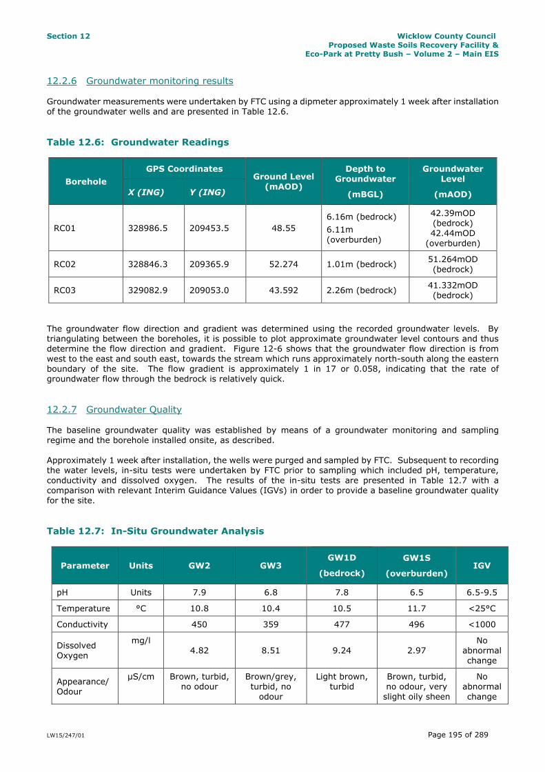
12.2.6 Groundwater monitoring results Groundwater measurements were undertaken by FTC using a dipmeter approximately 1 week after installation of the groundwater wells and are presented in Table 12.6.
Table 12.6: Groundwater Readings
Borehole
GPS Coordinates Ground Level
(mAOD)
Depth to Groundwater
(mBGL)
Groundwater Level
(mAOD) X (ING) Y (ING)
RC01 328986.5 209453.5 48.55
6.16m (bedrock)
6.11m
(overburden)
42.39mOD (bedrock) 42.44mOD
(overburden)
RC02 328846.3 209365.9 52.274 1.01m (bedrock) 51.264mOD
(bedrock)
RC03 329082.9 209053.0 43.592 2.26m (bedrock) 41.332mOD
(bedrock)
The groundwater flow direction and gradient was determined using the recorded groundwater levels. By triangulating between the boreholes, it is possible to plot approximate groundwater level contours and thus determine the flow direction and gradient. Figure 12-6 shows that the groundwater flow direction is from
west to the east and south east, towards the stream which runs approximately north-south along the eastern boundary of the site. The flow gradient is approximately 1 in 17 or 0.058, indicating that the rate of groundwater flow through the bedrock is relatively quick.
12.2.7 Groundwater Quality The baseline groundwater quality was established by means of a groundwater monitoring and sampling regime and the borehole installed onsite, as described.
Approximately 1 week after installation, the wells were purged and sampled by FTC. Subsequent to recording the water levels, in-situ tests were undertaken by FTC prior to sampling which included pH, temperature,
conductivity and dissolved oxygen. The results of the in-situ tests are presented in Table 12.7 with a comparison with relevant Interim Guidance Values (IGVs) in order to provide a baseline groundwater quality for the site.
Table 12.7: In-Situ Groundwater Analysis
Parameter Units GW2 GW3 GW1D
(bedrock)
GW1S
(overburden) IGV
pH Units 7.9 6.8 7.8 6.5 6.5-9.5
Temperature °C 10.8 10.4 10.5 11.7 <25°C
Conductivity 450 359 477 496 <1000
Dissolved Oxygen
mg/l 4.82 8.51 9.24 2.97
No abnormal change
Appearance/ Odour
µS/cm Brown, turbid, no odour
Brown/grey, turbid, no
odour
Light brown, turbid
Brown, turbid, no odour, very
slight oily sheen
No abnormal
change

Section 12 Wicklow County Council
Proposed Waste Soils Recovery Facility &
Eco-Park at Pretty Bush – Volume 2 – Main EIS
LW15/247/01 Page 196 of 289
Groundwater samples were also recovered by FTC after purging the wells and sent to Alcontrol’s UKAS accredited laboratory for analysis. The results of the analysis are presented in Appendix 17 to this EIS. A
summary of results is given in Table 12.8 with a comparison with relevant Interim Guidance Values (IGVs). With the exception of exceedances in coliforms, manganese, chloride, potassium and iron, the remaining values are below the IGVs set by the EPA. It is likely that the exceedances of manganese, chloride, potassium
and iron reflect the chemical composition of the bedrock and groundwater in this area and these levels would not be considered unusual. The bacteriological exceedances (coliforms) may reflect contamination of the groundwater caused by nearby septic tanks or agricultural activities.
Table 12.8: Groundwater Analysis Results
Parameter Units GW2 GW3 GW1D
(bedrock)
GW1S
(overburden) IGV
Coliforms, Total
CFU/100ml 8160 13000 >242000 >242000 0
Coliforms, Faecal
CFU/100ml 47 >100 >100 68 0
Suspended solids, Total
mg/l 236 40400 1260 381 -
Alkalinity, Total as CaCO3
mg/l
150 600 160 225
No
abnormal
change
BOD, filtered mg/l <1 <1 <1 <1 -
Organic Carbon, Total
mg/l
<3 <3 <3 20.3
No
abnormal
change
Ammoniacal
Nitrogen as N mg/l <0.2 0.644 <0.2 0.713 -
Fluoride mg/l <0.5 <0.5 <0.5 <0.5 1.0
COD, unfiltered
mg/l 49.1 230 51.2 180 -
Conductivity @ 20°C
mS/cm 0.396 0.437 0.388 0.424 1.0
Silicon mg/l 5.62 5.54 4.11 3.47
No
abnormal
change
Aluminium µg/l <2.9 11 5.16 72.6 200
Antimony µg/l <0.16 0.565 <0.16 <0.16 -
Arsenic µg/l <0.12 0.988 1.91 2.53 10
Barium µg/l 1.91 5.39 13 54 100
Beryllium µg/l <0.07 <0.07 <0.07 <0.07 -
Boron µg/l 9.65 10.4 16.2 63.1 100
Cadmium µg/l <0.1 <0.1 <0.1 0.116 5
Chromium µg/l 1.3 1.43 1.38 3.45 30
Cobalt µg/l <0.06 1.29 1.21 6.84 -
Copper µg/l <0.85 1.35 0.903 2.4 30
Lead µg/l <0.02 0.035 <0.02 0.156 10
Manganese µg/l 0.607 1480 926 8500 50
Molybdenum µg/l <0.24 3.25 1.48 1.02 -
Nickel µg/l 0.506 3.28 1.65 4.54 20

Section 12 Wicklow County Council
Proposed Waste Soils Recovery Facility &
Eco-Park at Pretty Bush – Volume 2 – Main EIS
LW15/247/01 Page 197 of 289
Parameter Units GW2 GW3 GW1D
(bedrock)
GW1S
(overburden) IGV
Phosphorous µg/l <6.3 <6.3 <6.3 1.09 -
Selenium µg/l <0.39 1.2 0.68 1.09 -
Tellerium µg/l <2 <2 <2 <2 -
Thallium µg/l <0.96 <0.96 <0.96 <0.96 -
Tin µg/l 3.68 4.28 2.17 4.17 -
Uranium µg/l <1.5 <1.5 3.18 <1.5 9
Titanium µg/l <1.5 <1.5 <1.5 <1.5 -
Vanadium µg/l 0.413 0.54 0.718 1.1 -
Zinc µg/l 2.21 0.67 1.29 2.28 100
Mercury µg/l <0.01 <0.01 <0.01 <0.01 1
Sulphate mg/l 32.8 16.4 26.7 32.6 200
Chloride mg/l 26.4 30.2 41.1 29.2 30
Nitrate mg/l <0.0152 <0.0152 0.0167 <0.0152 0.1
Phosphate (ortho) as PO4
mg/l <0.05 <0.05 0.053 <0.05 0.03
Total Oxidised Nitrogen as N
mg/l
6.46 8.68 1.7 0.341
No
abnormal
change
Cyanide, Total mg/l <0.05 <0.05 <0.05 <0.05 0.01
Calcium mg/l 42.9 53 54 57.4 200
Sodium mg/l 23.1 16.7 20.9 21.6 150
Magnesium mg/l 13.6 13.2 9.49 5.64 50
Potassium mg/l 1.24 3.47 2.3 6.04 5
Iron mg/l <0.019 <0.019 <0.019 0.493 0.2
pH Units 8.02 7.82 7.82 7.31 6.5-9.5
Phenol mg/l <0.002 <0.002 <0.002 <0.002 0.0005
Cresols mg/l <0.006 <0.006 0.01 <0.006 -
Xylenols mg/l <0.008 <0.008 <0.008 <0.008 -
Phenols mg/l <0.016 <0.016 <0.016 <0.016 0.0005
Silver µg/l <1.5 <1.5 <1.5 <1.5 -
12.2.8 Existing Slope Stability The GSI online Landslides Viewer was accessed on 19 October 2015. There are no known landslides close to
the site. The nearest recorded landslide is in the Wicklow hills, approximately 10km west of the site. Slope stability is not expected to be an issue on this site providing earthworks and construction are undertaken in line with best practice with the design and supervision of an experienced geotechnical engineer.

Section 12 Wicklow County Council
Proposed Waste Soils Recovery Facility &
Eco-Park at Pretty Bush – Volume 2 – Main EIS
LW15/247/01 Page 198 of 289
12.3 Potential Impacts The potential impacts of the development on the geology, hydrogeology and slope stability of the site are
assessed below.
12.3.1 Impact Appraisal Methodology The following elements of the development were examined in order to determine the potential impacts on the
geology and hydrogeology aspects of the proposed development:
characterisation of the topography, geology and geomorphology of the site
appraisal of stability issues, in the context of the existing environment and the proposed development evaluation of the risks and potential impacts of the proposed development
The following sections detail the potential impacts that have been identified from the appraisal methodology presented above. Appropriate mitigation measures are then proposed to avoid or adequately mitigate these impacts.
12.3.2 Assessment of Significance of Geological Impact on the Receiving Environment An impact rating has been developed for each phase of the development of the site based on the NRA guidance, as recommended by the Institute of Geologists of Ireland (IGI). The importance (sensitivity) of
the receiving environment was first identified. Then the magnitude of the potential geological and hydrogeological impact was estimated. This determines the significance of the impact prior to the application of mitigation measures.
The criteria for rating site importance of the geological features is set out in Table 12.9.
Table 12-9: Criteria for Rating Site importance of Geological/Hydrogeological Features
Importance Criteria Typical Example
Extremely High (Hydrogeology
only)
Attribute has a high quality or value on an international
scale.
Groundwater supports river, wetland or surface water body ecosystem protected by EU legislation e.g. SAC or
SPA status.
Very High Attribute has a high quality,
significance or value on a regional or national scale. Degree or extent of soil
contamination is significant on a national or regional scale.
Volume of peat and/or soft organic soil underlying the site is significant on a national or
regional scale.
Geological feature on a regional or national scale (NHA).
Large existing quarry or pit. Proven economically extractable mineral resource.
Regionally Important Aquifer with multiple wellfields.
Groundwater supports river, wetland or surface water body ecosystem protected by national legislation e.g. NHA status.
Regionally important potable water source supplying >2,500 homes.
Inner source protection area for regionally important
water source.
High Attribute has a high quality, significance or value on a local scale.
Contaminated soil on site with previous heavy industrial usage.
Large recent landfill site for mixed wastes.

Section 12 Wicklow County Council
Proposed Waste Soils Recovery Facility &
Eco-Park at Pretty Bush – Volume 2 – Main EIS
LW15/247/01 Page 199 of 289
Importance Criteria Typical Example
Degree or extent of soil contamination is significant on
a local scale.
Volume of peat and/or soft organic soil underlying the site
is significant on a local scale.
Geological feature of high value on a local scale (County
Geological Site).
Well drained and/or high fertility soils.
Moderately sized existing quarry or pit. Marginally economic extractable mineral resource.
Regionally Important Aquifer.
Groundwater provides large proportion of baseflow to local rivers. Locally important potable water source supplying
>1,000 homes. Outer source protection area for regionally important
water source. Inner source protection area for locally important water
source.
Medium Attribute has a medium quality, significance or value
on a local scale.
Degree or extent of soil
contamination is moderate on a local scale.
Volume of peat and/or soft organic soil underlying the site is moderate on a local scale.
Contaminated soil on site with previous light industrial usage.
Small recent landfill site for mixed wastes.
Moderately drained and/or moderate fertility soils.
Small existing quarry or pit.
Sub- economic extractable mineral resource. Locally important Aquifer.
Potable water source supplying >50 homes.
Outer source protection area for locally important water source.
Low Attribute has a low quality, significance or value on a local scale.
Degree or extent of soil contamination is minor on a local scale.
Volume of peat and/or soft organic soil underlying the site
is small on a local scale.
Large historical and/or recent site for construction and demolition wastes.
Small historical and/or recent landfill site for construction and demolition wastes. Poorly drained and/or low fertility soils.
Uneconomic extractable mineral resource. Poor bedrock aquifer.
Potable water source supplying <50 homes.
Generally, the site geology and hydrogeology ranks as Low importance as the site is underlain by a Poor bedrock aquifer which is generally unproductive except locally. Although there are several groundwater wells
registered in this area, it is understood that the vast majority of homes and businesses in the area use mains water supply and do not rely on groundwater wells.

Section 12 Wicklow County Council
Proposed Waste Soils Recovery Facility &
Eco-Park at Pretty Bush – Volume 2 – Main EIS
LW15/247/01 Page 200 of 289
12.3.3 Assessment of Magnitude of the Impact on Geology Attribute (NRA, 2008) The assessment of the magnitude of an impact incorporates the timing, scale, size and duration of the potential impact. The magnitude criteria for geological and hydrogeological impacts are defined as set out in
Table 12.10.
Table 12-10: Estimation of Magnitude of Impact on Geological & Hydrogeological Features
Magnitude Criterion Description and Example
Large Adverse Results in loss of attribute
and/or quality and integrity of attribute
Loss of high proportion of future quarry or pit reserves
Irreversible loss of high proportion of local high fertility soils
Removal of entirety of geological heritage feature Requirement to excavate / remediate entire waste site
Requirement to excavate and replace high proportion of peat
organic soils and/or soft mineral soils beneath
alignment Removal of large proportion of aquifer Changes to aquifer or unsaturated zone resulting in
extensive change to existing water supply springs and wells, river baseflow or ecosystems
Potential high risk of pollution to groundwater from routine run-off.
Calculated risk of serious pollution incident >2% annually.
Moderate Adverse
Results in impact on integrity of attribute or loss of part of attribute
Loss of moderate proportion of future quarry or pit reserves
Removal of part of geological heritage feature
Irreversible loss of moderate proportion of local high fertility soils
Requirement to excavate / remediate significant proportion of waste site
Requirement to excavate and replace moderate proportion of peat,
Organic soils and/or soft mineral soils beneath
alignment. Removal of moderate proportion of aquifer. Changes to aquifer or unsaturated zone resulting in
moderate changes to existing water supply of springs and wells, river baseflow or ecosystems.
Potential medium risk of pollution to groundwater from routine run-off
Calculated risk of serious pollution >1% annually
Small Adverse Results in minor impact on integrity of attribute or loss of small part of
attribute
Loss of small proportion of future quarry or pit reserves Removal of small part of geological heritage feature Irreversible loss of small proportion of local high
fertility soils and/or High proportion of local low fertility soils Requirement to excavate / remediate small proportion
of waste site Requirement to excavate and replace small proportion
of peat. Organic soils and/or soft mineral soils beneath
alignment. Removal of small proportion of aquifer.

Section 12 Wicklow County Council
Proposed Waste Soils Recovery Facility &
Eco-Park at Pretty Bush – Volume 2 – Main EIS
LW15/247/01 Page 201 of 289
Magnitude Criterion Description and Example
Changes to aquifer or unsaturated zone resulting in minor change to water supply of springs and wells,
river baseflow or ecosystems.
Potential low risk of pollution to groundwater from routine run-off.
Calculated risk of serious pollution incident >0.5% annually.
Negligible Results in an impact on attribute but of insufficient magnitude to affect either
use or integrity
No measurable changes in attributes. Calculated risk of serious pollution incident <0.5%
annually.
Minor Beneficial Results in minor
improvement of attribute quality
Minor enhancement of geological heritage feature
Moderate Beneficial
Results in moderate improvement of attribute quality
Moderate enhancement of geological heritage feature
Major Beneficial
Results in major improvement of attribute quality
Major enhancement of geological heritage feature
Generally, the unmitigated impact on the geological environment is considered to be a small adverse effect based on the impact and attributes given in Table 12.10. The reason for this is the perceived low risk of pollution to the aquifer which may be caused as a result of the importation of potentially contaminated
sediments or contamination caused by leaks and spills from construction plant or materials.
12.3.4 Assessment of Significance of Geological Impacts (NRA, 2008) The matrix in Table 12.11 over determines the significance of the impacts based on the importance and
magnitude of the impacts as determined by Tables 12.9 and 12.10.
Table 12-11: Ratings of Significant Environmental Impacts for Geology & Hydrogeology
Importance
of Attribute
Magnitude of Impact
Negligible Small Adverse Moderate Adverse
Large Adverse
Extremely High Imperceptible Significant Profound Profound
Very High Imperceptible Significant/ Moderate
Profound/ Significant
Profound
High Imperceptible Moderate/
Slight
Significant/
Moderate Profound/Significant
Medium Imperceptible Slight Moderate Significant
Low Imperceptible Imperceptible Slight Slight/Moderate
The determination of the significance of each impact for this site is presented over.

Section 12 Wicklow County Council
Proposed Waste Soils Recovery Facility &
Eco-Park at Pretty Bush – Volume 2 – Main EIS
LW15/247/01 Page 202 of 289
12.3.5 Potential Impacts due to the Importation and Placement of Soils – Direct & Indirect The following on-site activities have been identified as the sources of potential risks to the geology and hydrogeology from the development:
Importation of dredge spoil and topsoil Placement of dredge spoil and topsoil
Earthworks and movement of soils by plant and machinery Drainage
The importation and placement of dredge spoil and topsoils and interference with existing site drainage is a direct permanent effect that, without mitigation, could alter the existing hydrogeological balance of the site.
The construction works may impose hydrogeological impacts by modifying the natural seepage of the soils, which may deprive ditches and streams of their natural supply of water which may lead to a reduced baseflow and reduced recharge to the bedrock aquifer.
Earthworks can have a direct permanent impact on the exposed soils and rock in the form of increased erosion and sediment release that could also have additional impacts on water quality (due to sedimentation of water
courses). Soil compaction may occur due to movement of construction traffic. This could occur particularly within areas of topsoil which are highly compressible. This could lead to an increase in runoff and subsequently to an
increase in erosion. The magnitude of these potential impacts at the development site, prior to mitigation, is considered to be of
slight significance.
12.3.6 Potential Impact on Groundwater – Direct & Indirect Removal of topsoil and subsoil during construction may result in the exposure of the underlying rock to
sources of contamination and may temporarily increase the vulnerability of the aquifer whether or not the rock is exposed. Chemical pollution may occur as a result of spillage or leakage of fuels or refuelling activities etc. Chemical pollutants i.e. fuel may enter groundwater supplies and have implications for damage to ecology
and local water supplies such as groundwater wells in the area, particularly those located down-gradient of the site.
The importation of soils may result in an increased direct risk of contamination of the underlying groundwater from contaminants within the imported dredge spoil if not properly controlled or regulated. In addition, erosion and run-off from the imported soils may also directly affect the quality of the groundwater if not properly mitigated.
The construction of additional drainage channels and other infrastructure may result in localised drawdown of the water table and, where gravel is used during construction, may also result in localised preferential
drainage pathways. The changes in the drainage regime may also result in changes to the moisture content of the soils which may have implications for sediment transport, flooding and erosion (described in Section 13 Hydrology and Water Quality).
The magnitude of these potential impacts at the development site, prior to mitigation, is considered to be of slight significance.
A standalone Environmental Risk Assessment (ERA) to assess potential impact on groundwater has also been prepared and is provided in Appendix 18 to this EIS.

Section 12 Wicklow County Council
Proposed Waste Soils Recovery Facility &
Eco-Park at Pretty Bush – Volume 2 – Main EIS
LW15/247/01 Page 203 of 289
12.3.7 Potential Impact of Slope Failure – Direct & Indirect There is no perceived risk of slope instability on the site at present, given the low soil cover on exiting slopes and the extent of established vegetation at the site and on existing slopes. During construction, importation
of dredge spoil will result in slightly steeper slopes which will increase the risk of slope stability slightly. The
main risk would be of slope failure during placement of material during construction.
The magnitude of these potential impacts, prior to mitigation, is considered to be of imperceptible significance.
12.3.8 Potential Cumulative Impacts on Geology and Hydrogeology
There are no other developments of any significance within the area of the proposed development and hence there are no potential cumulative impacts on the geology and hydrogeology of the site.
12.4 Mitigation Measures for Geology, Hydrogeology & Slope Stability The following sections outline appropriate mitigation measures to avoid or reduce the potential impact of the
proposed development.
12.1.1 Mitigation by Design With regard to the proposed development, detailed design best practice will be implemented as follows:
The works will be designed and checked by a suitably qualified and experienced geotechnical engineer
or engineering geologist, and hydrologist or drainage engineer.
The designers will carry out a design risk assessment to evaluate risk levels for the construction, operation and maintenance of the works. Identified risks will be minimised by the application of the principles of avoidance, prevention and protection. Information on residual risks will be recorded and
relayed to appropriate parties.
A method statement for each element of the works will be prepared prior to any element of the work
being carried out.
Details of the relevant assumptions, relating to methods and sequencing of work will be provided to
the contractor.
No amendments to the designed works will be made without the prior approval of a suitably qualified and experienced engineering geologist or geotechnical engineer familiar with earthworks.
The construction and environmental management plan for construction will provide for the checking by suitably qualified and experienced staff of equipment, materials storage and materials transfer areas, as well as drainage structures, on a regular basis.
Earthworks will be monitored by suitably qualified and experienced geotechnical personnel.
The programming of the works will be such that earthworks are not scheduled to be carried out during severe weather conditions. Where such weather is forecast, suitable measures will be taken to secure the works.
12.4.1 Mitigation Measures for the Importation and Placement of Soils Imported spoil will be placed and levelled as quickly as possible after unloading on the site. Any temporary stockpiles will be covered overnight to prevent erosion and sedimentation.
To mitigate against possible contamination of the exposed bedrock/aquifer, refueling of machinery and plant will only occur offsite or in specially designated areas such as site compounds, using designated refueling bowsers.

Section 12 Wicklow County Council
Proposed Waste Soils Recovery Facility &
Eco-Park at Pretty Bush – Volume 2 – Main EIS
LW15/247/01 Page 204 of 289
12.4.2 Mitigation Measures for Groundwater To prevent potential impacts resulting from the importation and placement of potential contaminants within the dredge spoil material, the waste identification and characterisation procedures outlined in Section 3.3.4
previously, will be applied – in summary, these being the requirements for a Letter of Suitability of each 5,000
tonnes of material imported to the site and carrying out of weekly random characterisation of all types of material being brought to site.
In order to mitigate against contamination reaching the water table, refuelling and vehicle maintenance will be undertaken only within designated areas which will be bunded to prevent runoff. Additional mitigation
measures such as spoil bunding and silt fences will also be provided adjacent to excavations and construction as required in order to reduce run-off and sedimentation of watercourses. Further details are given in Section 13 Hydrology and Water Quality.
In order to further protect the hydrogeology of the area, the existing groundwater wells will be monitored for water level and water quality before, during and after the Construction Phase to ensure that there is no long term impact on the hydrogeology of the area.
12.4.3 Mitigation Measures for Slope Stability As outlined in Section 12.3.7, the risk of slope failure or slope instability within soil or rock on the site is assessed as imperceptible. No detailed mitigation measures are therefore required, however design and
construction best practice will be implemented which will ensure that the long-term stability of the site is maintained during construction and operation of the site. In particular, the following will be undertaken:
Existing and imported spoil will be assessed prior to construction work by a suitably experienced and qualified geotechnical engineer to ensure that no slope stability issues arise before, during or after the construction phase of the work.
Spoil will be placed in accordance with an engineering specification to ensure that safe slopes and the
necessary compaction levels are achieved. On-site testing will be undertaken under the direction of a geotechnical engineer to ensure that the
required compaction, moisture content and density are achieved during placement of the soils.
Initial and final topography will be surveyed and reviewed by the geotechnical engineer to ensure that no slope stability issues will occur.
12.5 Residual Impacts after Mitigation Residual impacts on the soils, geology and hydrogeology after implementation of the mitigation measures
listed are predicted to be imperceptible.
12.6 Conclusion & Summary The following conclusions can be drawn, in relation to soils, geology and hydrogeology:
the site geology typically consists of a thin cover of topsoil, subsoil overlying shallow siltstone or sandstone bedrock
no peat was observed on the site drainage of the area comprises surface runoff with natural drains which drain towards drainage ditches
to the east and west of the site which flow to the Kilcoole Stream the site is mostly covered with low scrub vegetation
The available information indicates that the proposed development at has a negligible risk of slope instability. A site walkover was undertaken on the site in order to assess the potential impacts on the geology and
hydrogeology.

Section 12 Wicklow County Council
Proposed Waste Soils Recovery Facility &
Eco-Park at Pretty Bush – Volume 2 – Main EIS
LW15/247/01 Page 205 of 289
Mitigation measures have been proposed with regard to the design and construction of the proposed development. Provided that these mitigation measures are carefully implemented, the residual risks to the
geology and hydrogeology associated with the construction of the site are considered to be imperceptible.
12.7 References EPA (2003) Towards Setting Guideline Values for the Protection of Groundwater in Ireland. Environmental Protection Agency.
GSI (1994) Geology of Kildare-Wicklow (Sheet 16). Geological Survey of Ireland. National Soil Survey (1980) General Soil Map of Ireland. National Soil Survey of Ireland.
NRA (2008) Environmental Impact Assessment of National Road Schemes – A Practical Guide. National Roads Authority