Embed Size (px)
Citation preview

SOPAC Member Countries National Capacity Assessments: Tsunami Warning and Mitigation Systems
REPUBLIC OF NAURU
24 – 26 February 2009

N A U R U T S U N A M I C A P A C I T Y A S S E S S M E N T R E P O R T
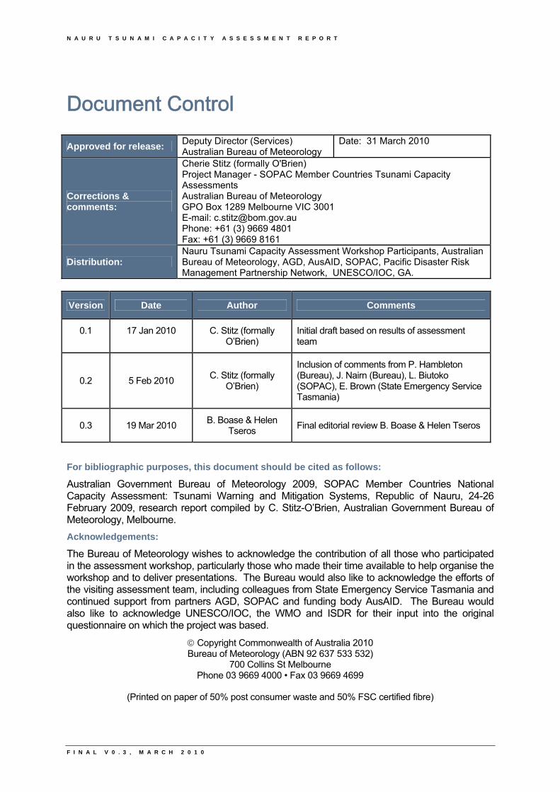
Document Control
Approved for release: Deputy Director (Services) Australian Bureau of Meteorology
Date: 31 March 2010
Corrections & comments:
Cherie Stitz (formally O'Brien) Project Manager - SOPAC Member Countries Tsunami Capacity Assessments Australian Bureau of Meteorology GPO Box 1289 Melbourne VIC 3001 E-mail: [email protected] Phone: +61 (3) 9669 4801 Fax: +61 (3) 9669 8161
Distribution: Nauru Tsunami Capacity Assessment Workshop Participants, Australian Bureau of Meteorology, AGD, AusAID, SOPAC, Pacific Disaster Risk Management Partnership Network, UNESCO/IOC, GA.
Version Date Author Comments
0.1 17 Jan 2010 C. Stitz (formally O’Brien)
Initial draft based on results of assessment team
0.2 5 Feb 2010 C. Stitz (formally
O’Brien)
Inclusion of comments from P. Hambleton (Bureau), J. Nairn (Bureau), L. Biutoko (SOPAC), E. Brown (State Emergency Service Tasmania)
0.3 19 Mar 2010 B. Boase & Helen
Tseros Final editorial review B. Boase & Helen Tseros
For bibliographic purposes, this document should be cited as follows:
Australian Government Bureau of Meteorology 2009, SOPAC Member Countries National Capacity Assessment: Tsunami Warning and Mitigation Systems, Republic of Nauru, 24-26 February 2009, research report compiled by C. Stitz-O’Brien, Australian Government Bureau of Meteorology, Melbourne.
Acknowledgements:
The Bureau of Meteorology wishes to acknowledge the contribution of all those who participated in the assessment workshop, particularly those who made their time available to help organise the workshop and to deliver presentations. The Bureau would also like to acknowledge the efforts of the visiting assessment team, including colleagues from State Emergency Service Tasmania and continued support from partners AGD, SOPAC and funding body AusAID. The Bureau would also like to acknowledge UNESCO/IOC, the WMO and ISDR for their input into the original questionnaire on which the project was based.
Copyright Commonwealth of Australia 2010 Bureau of Meteorology (ABN 92 637 533 532)
700 Collins St Melbourne Phone 03 9669 4000 • Fax 03 9669 4699
(Printed on paper of 50% post consumer waste and 50% FSC certified fibre)
F I N A L V 0 . 3 , M A R C H 2 0 1 0

N A U R U T S U N A M I C A P A C I T Y A S S E S S M E N T R E P O R T
F I N A L V 0 . 3 , M A R C H 2 0 1 0
N A U R U T S U N A M I C A P A C I T Y A S S E S S M E N T R E P O R T
F I N A L V 0 . 3 , M A R C H 2 0 1 0
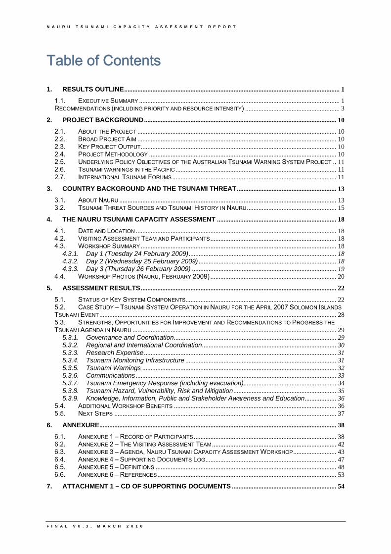
Table of Contents
1. RESULTS OUTLINE.................................................................................................................................. 1 1.1. EXECUTIVE SUMMARY ......................................................................................................................... 1 RECOMMENDATIONS (INCLUDING PRIORITY AND RESOURCE INTENSITY) ......................................................... 3
2. PROJECT BACKGROUND .................................................................................................................... 10 2.1. ABOUT THE PROJECT ........................................................................................................................ 10 2.2. BROAD PROJECT AIM ........................................................................................................................ 10 2.3. KEY PROJECT OUTPUT...................................................................................................................... 10 2.4. PROJECT METHODOLOGY ................................................................................................................. 10 2.5. UNDERLYING POLICY OBJECTIVES OF THE AUSTRALIAN TSUNAMI WARNING SYSTEM PROJECT .. 11 2.6. TSUNAMI WARNINGS IN THE PACIFIC ................................................................................................. 11 2.7. INTERNATIONAL TSUNAMI FORUMS ................................................................................................... 11
3. COUNTRY BACKGROUND AND THE TSUNAMI THREAT ............................................................ 13 3.1. ABOUT NAURU ................................................................................................................................... 13 3.2. TSUNAMI THREAT SOURCES AND TSUNAMI HISTORY IN NAURU...................................................... 15
4. THE NAURU TSUNAMI CAPACITY ASSESSMENT ........................................................................ 18 4.1. DATE AND LOCATION ......................................................................................................................... 18 4.2. VISITING ASSESSMENT TEAM AND PARTICIPANTS ............................................................................ 18 4.3. WORKSHOP SUMMARY ...................................................................................................................... 18
4.3.1. Day 1 (Tuesday 24 February 2009) ......................................................................................... 18 4.3.2. Day 2 (Wednesday 25 February 2009) ................................................................................... 18 4.3.3. Day 3 (Thursday 26 February 2009) ....................................................................................... 19
4.4. WORKSHOP PHOTOS (NAURU, FEBRUARY 2009) ............................................................................ 20 5. ASSESSMENT RESULTS ...................................................................................................................... 22
5.1. STATUS OF KEY SYSTEM COMPONENTS........................................................................................... 22 5.2. CASE STUDY – TSUNAMI SYSTEM OPERATION IN NAURU FOR THE APRIL 2007 SOLOMON ISLANDS
TSUNAMI EVENT ............................................................................................................................................... 28 5.3. STRENGTHS, OPPORTUNITIES FOR IMPROVEMENT AND RECOMMENDATIONS TO PROGRESS THE
TSUNAMI AGENDA IN NAURU ........................................................................................................................... 29 5.3.1. Governance and Coordination.................................................................................................. 29 5.3.2. Regional and International Coordination................................................................................. 30 5.3.3. Research Expertise .................................................................................................................... 31 5.3.4. Tsunami Monitoring Infrastructure ........................................................................................... 31 5.3.5. Tsunami Warnings ..................................................................................................................... 32 5.3.6. Communications ......................................................................................................................... 33 5.3.7. Tsunami Emergency Response (including evacuation)........................................................ 34 5.3.8. Tsunami Hazard, Vulnerability, Risk and Mitigation .............................................................. 35 5.3.9. Knowledge, Information, Public and Stakeholder Awareness and Education................... 36
5.4. ADDITIONAL WORKSHOP BENEFITS .................................................................................................. 36 5.5. NEXT STEPS ...................................................................................................................................... 37
6. ANNEXURE............................................................................................................................................... 38 6.1. ANNEXURE 1 – RECORD OF PARTICIPANTS ...................................................................................... 38 6.2. ANNEXURE 2 – THE VISITING ASSESSMENT TEAM ........................................................................... 42 6.3. ANNEXURE 3 – AGENDA, NAURU TSUNAMI CAPACITY ASSESSMENT WORKSHOP.......................... 43 6.4. ANNEXURE 4 – SUPPORTING DOCUMENTS LOG............................................................................... 47 6.5. ANNEXURE 5 – DEFINITIONS ............................................................................................................. 48 6.6. ANNEXURE 6 – REFERENCES ............................................................................................................ 53
7. ATTACHMENT 1 – CD OF SUPPORTING DOCUMENTS ............................................................... 54

N A U R U T S U N A M I C A P A C I T Y A S S E S S M E N T R E P O R T
F I N A L V 0 . 3 , M A R C H 2 0 1 0
N A U R U T S U N A M I C A P A C I T Y A S S E S S M E N T R E P O R T
F I N A L V 0 . 3 , M A R C H 2 0 1 0
Acronyms ACG Australian Consul-General AFTN Aeronautical Fixed Telecommunications Network AGD Australian Attorney-General’s Department (Australia) ATWS Australian Tsunami Warning System AusAID Australian Agency for International Development Bureau Australian Bureau of Meteorology D Document (e.g. Document 39 = D39) DFAT Australian Department of Foreign Affairs and Trade DRM Disaster Risk Management DRM Act Disaster Risk Management Act EEZ Exclusive Economic Zone EMA Emergency Management Australia
EU European Union GA Geoscience Australia GDP Gross Domestic Product GIS Geographic Information Systems GTS Global Telecommunications System ICG Intergovernmental Coordination Group IOC Intergovernmental Oceanographic Commission ISDR International Strategy for Disaster Reduction ITSU ICG for the Tsunami Warning System in the Pacific JMA Japan Meteorological Agency MBES Multi-Beam Echo-Sounder Mw Moment Magnitude
NACOS Nauru and Australian Governments Compact of Settlement NDRM Council National Disaster Risk Management Council NDRM Plan National Disaster Risk Management Plan NEOC National Emergency Operations Centre NFS Nauru Flight Services NGOs Non-Government Organisations PGSP Pacific Governance Support Programme PICs Pacific Island Countries PPRR Prevention, Preparedness, Response, Recovery PRAN Pacific Regional Assistance to Nauru PTWC Pacific Tsunami Warning Center PTWS Pacific Tsunami Warning and Mitigation System SMS Short Message Service SOPAC Pacific Islands Applied Geoscience Commission SOPs Standard Operating Procedures SPREP South Pacific Regional Environment Programme UNESCO United Nations Educational, Scientific and Cultural Organization USA United States of America UTC Coordinated Universal Time VHF Very High Frequency WMO World Meteorological Organisation

N A U R U T S U N A M I C A P A C I T Y A S S E S S M E N T R E P O R T
F I N A L V 0 . 3 , M A R C H 2 0 1 0

N A U R U T S U N A M I C A P A C I T Y A S S E S S M E N T R E P O R T
1
1. Results Outline
F I N A L V 0 . 3 , M A R C H 2 0 1 0

N A U R U T S U N A M I C A P A C I T Y A S S E S S M E N T R E P O R T
F I N A L V 0 . 3 , M A R C H 2 0 1 0
N A U R U T S U N A M I C A P A C I T Y A S S E S S M E N T R E P O R T
F I N A L V 0 . 3 , M A R C H 2 0 1 0 P A G E 1
1. Results Outline
1.1. Executive Summary
The Island Republic of Nauru (hereafter referred to as Nauru) is a country comprised of a single coral atoll of 21 square kilometres located approximately 47 kilometres south of the equator. The country’s population of approximately 10,000 people reside primarily along the coastal fringes (D16). The country’s National Disaster Risk Management Plan (NDRM Plan, D12) identifies the tsunami hazard in Nauru as being a high level of risk. This risk rating reflects Nauru’s own perception of the tsunami risk probably based on verbal history of wave inundation events (thought to most frequently due to atmospheric elevation of sea level) as well as the high level of community response when a tsunami warning is received in Nauru.
Nauru is located further from major subduction trenches capable of generating tsunami than many other Pacific Island Countries (PICs). The country generally has a greater lead time (typical tsunami travel times from the South Solomon’s and New Hebrides trenches are between 2.5 to 3 hours) for warnings and appears in a lower hazard category (Pearce, 2008). Thomas and Burbidge (2009) supports this and states that the tsunami hazard for Nauru (for a 2000 year return period) “originates predominately from the Solomon’s, New Hebrides and Kurils trenches, with smaller contributions from the Mariana, Philippines and Peru trenches”. Atolls can also be somewhat protected as they often have steep drop-offs in which ocean depths increase very rapidly with distance from the fringing reef therefore minimising tsunami shoaling (the process by which tsunami wave heights increase as they approach the shore) and subsequent inundation (Thomas, Burbidge, Cummins, 2007).
However, even relatively small tsunami, when timed with high tides may have a significant impact on communities on low lying atolls (Pearce, 2008). Tsunami wave heights, less than 10cm on most occasions, have been recorded in Nauru in recent times. Even these seemingly small changes in sea-level due to tsunami could adversely impact on day-to-day activities in Nauru, such as unloading of fuel. Nauru has also historically experienced wave inundation from storm surge (1994, refer to D22). Further understanding of Nauru’s tsunami risk would be beneficial to ensure appropriate National planning for response to this hazard.
It is important that Nauru takes steps now to improve their agency and community response to tsunami warning messages received from the Pacific Tsunami Warning Center (PTWC). The National Capacity Assessment of Pacific Islands Applied Geoscience Commission (SOPAC) Member Countries: Tsunami Warning and Mitigation Systems project aims to work in collaboration with the member countries of SOPAC to assess their capacity to receive, communicate and respond effectively to tsunami warnings. The Tsunami Capacity Assessment of the ability of Nauru to receive, communicate and effectively respond to tsunami warnings took place in a workshop held from 24 – 26 February 2009 in Nauru.
The workshop was facilitated by a team of visiting experts and attended by some forty Nauru Government agency representatives, Community groups and the private sector to discuss key areas of tsunami warning and mitigation in Nauru by completing a comprehensive questionnaire in session and via presentations, site visits and meetings.
As well as outlining Nauru’s current status, strengths and opportunities for improvement with regard to tsunami warning and mitigation, a list of recommendations were formulated by the Visiting Assessment Team in consultation with national participants. The aim of these recommendations is to guide further capacity development programs to target improvements in Nauru’s tsunami warning and mitigation system and Disaster Risk Management (DRM) in the country more generally.
N A U R U T S U N A M I C A P A C I T Y A S S E S S M E N T R E P O R T
F I N A L V 0 . 3 , M A R C H 2 0 1 0 P A G E 2
Nauru has developed a sound framework for DRM in recent times by adoption of their 2009 Disaster Risk Management Act (DRM Act, D11). The 2009 NDRM Plan (D12) is also in place and provides an overarching framework for the development of specific disaster risk reduction and disaster management plans. Although the NDRM Plan (D12) outlines lead and support agencies for emergency response, further sub plans are required to address warning and response to specific hazards, including tsunami.
Currently, the Nauru Flight Services (NFS, Department of Civil Aviation) unofficially receive PTWC and Japan Meteorological Agency (JMA) tsunami advisory information 24x7 via the Aeronautical Fixed Telecommunications Network (AFTN) from Brisbane Flight Service (Air Services Australia). It was also unclear between Nauru Tsunami Capacity Assessment Workshop participants who the official PTWC in-country contact is. This needs to be clarified by the Nauru Government with PTWC. In addition, processes for communicating warnings between national agencies and dissemination of warnings to the community need to be formalised. The Tsunami Capacity Assessment process in Nauru therefore identified the need for a National Tsunami Emergency Sub-Plan and tsunami warning and response Standard Operating Procedures (SOPs).
Nauru participants in workshop identified development and testing of DRM plans at an organisation, community and national level (including planning coordination between agencies), communication systems and education programs as priorities for enhancing their nations tsunami warning and mitigation system. The workshop’s resulting recommendations reflected these priorities. In brief, high and very high priority recommendations made include:
• Advocacy to garner support and commitment of government agencies and non government entities, including the private sector, to support the NDRM Plan (D12)
• Identify and assess regulatory instruments for disaster risk reduction and disaster management, seek agency input into prioritisation and development of DRM sub-plans, including a tsunami sub-plan.
• Enhance the Mitigation and Preparedness Advisory Committee to include consideration of preparedness for the tsunami hazard.
• Develop, approve, share and maintain national tsunami warning and response SOPs for each agency involved in the tsunami warning and response process in Nauru.
• Complete a National Tsunami Emergency Sub-Plan using Prevention, Preparedness, Response, Recovery (PPRR) methodology.
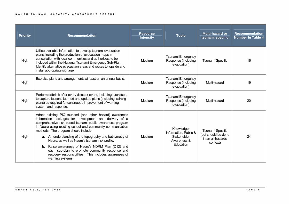
• Utilise available information to develop tsunami evacuation plans, including the production of evacuation maps in consultation with local communities and authorities, to be included within the National Tsunami Emergency Sub-Plan.
• Exercise plans and arrangements at least on an annual basis.
• Perform debriefs after every disaster event, including exercises, to capture lessons learned and update plans (including training plans).
• Develop a tsunami risk profile for Nauru based on tsunami hazard studies completed for the Southwest Pacific Nations to date, tsunami numerical deep ocean modelling carried out by international agencies, research of previous inundation events and Geographic Information Systems (GIS) data (existing bathymetry and topography).
• Adapt existing PIC tsunami (and other hazard) awareness information packages for development and delivery of a comprehensive risk based tsunami public awareness program in Nauru using existing school and community communication methods.
• Completion of a training needs analysis and development of a national training framework for DRM in Nauru that includes tsunami in a multi-hazard context (including a training database to track progress).
Nauru workshop participants are encouraged to use this National Tsunami Capacity Assessment report to guide both national projects and aid funded projects to achieve targeted improvements in
N A U R U T S U N A M I C A P A C I T Y A S S E S S M E N T R E P O R T
F I N A L V 0 . 3 , M A R C H 2 0 1 0 P A G E 3
Nauru’s tsunami warning and mitigation system. In turn, this will assist in improving systems for other natural hazards. Contingent on the availability of human and financial resources, the Australian Bureau of Meteorology (the Bureau) and project partners will aim to work with potential donors to bring the findings of this project to their attention on a country and regional scale. This will be done in the hope of further capacity development projects being undertaken.
Recommendations (including priority and resource intensity)
Table 2 outlines the priority and resource intensity for recommendations made to improve Nauru’s tsunami warning and mitigation system. Both the priority and resource intensity are based on the consensus of the visiting Tsunami Capacity Assessment Team after discussions held within the Tsunami Capacity Assessment Workshop. It is recognised that Table 2 may not reflect the opinions of all individuals involved in the workshop as priorities vary depending on personal responsibilities and areas of interest. Each recommendation is important in its own right to achieve holistic improvements in Nauru’s tsunami warning and mitigation system.
The priority ranking and resource intensity scale used as a basis for allocating a priority and resource intensity to each recommendation is explained in Table 1. The Very High priority recommendations should be seriously considered as requiring urgent completion. Low resource intensity recommendations are considered the ‘low-hanging fruit’ that are achievable with very few additional resources.
Table 1: Priority ranking and resource intensity scale
PRIORITY RESOURCE INTENSITY
Very High
Low – Recommendation currently being progressed or could possibly be progressed within the capacity of existing in-country resources (funds and staff).
High
Medium – Recommendation could be progressed by existing staff or with a low to moderate number of additional staff and/or expertise and a moderate level of additional in-country funds. May or may not require external funding.
Medium High – Recommendation would require a high level of additional staff and/or expertise and funds. External funding support is likely to be required.
Low Very High – Recommendation would require a very high level of additional staff and funds. External funding support will be required.
N A U R U T S U N A M I C A P A C I T Y A S S E S S M E N T R E P O R T
Table 2: Priority and anticipated resource intensity for completion of recommendations made for improving Nauru’s tsunami warning and mitigation system.
Priority Recommendation Resource Intensity
Topic Multi-hazard or
tsunami specific Recommendation Number In Table 4
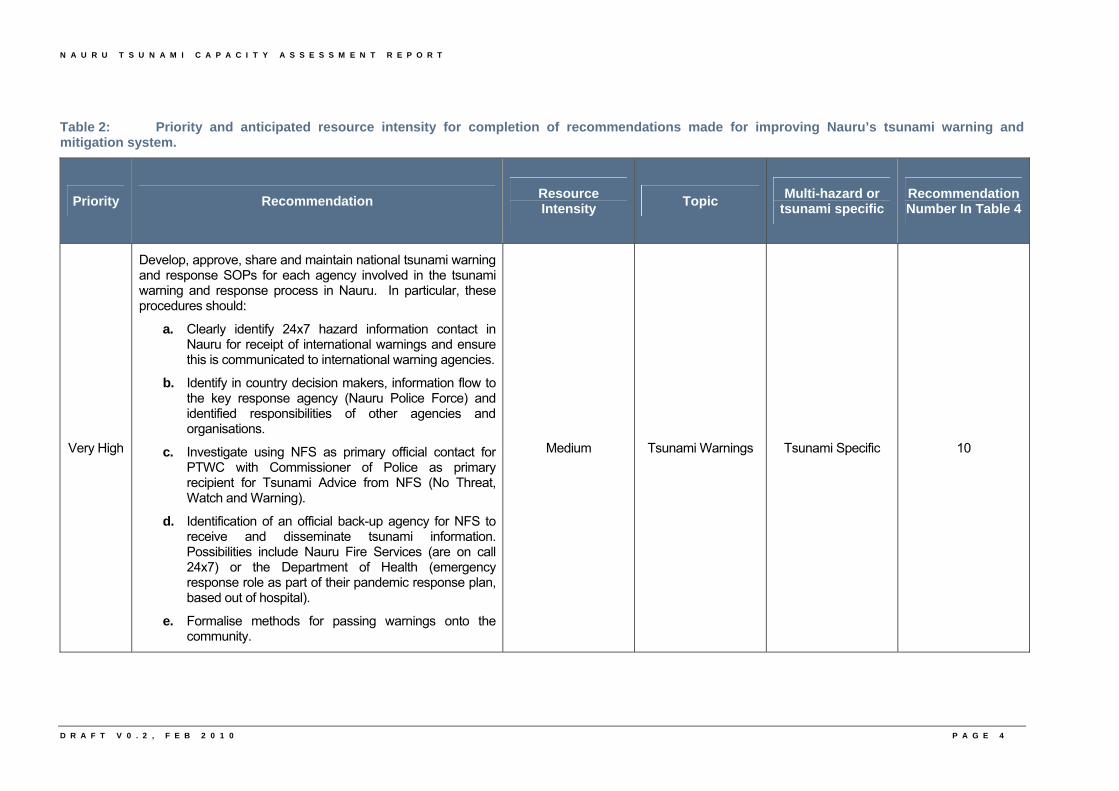
Very High
Develop, approve, share and maintain national tsunami warning and response SOPs for each agency involved in the tsunami warning and response process in Nauru. In particular, these procedures should:
a. Clearly identify 24x7 hazard information contact in Nauru for receipt of international warnings and ensure this is communicated to international warning agencies.
b. Identify in country decision makers, information flow to the key response agency (Nauru Police Force) and identified responsibilities of other agencies and organisations.
c. Investigate using NFS as primary official contact for PTWC with Commissioner of Police as primary recipient for Tsunami Advice from NFS (No Threat, Watch and Warning).
d. Identification of an official back-up agency for NFS to receive and disseminate tsunami information. Possibilities include Nauru Fire Services (are on call 24x7) or the Department of Health (emergency response role as part of their pandemic response plan, based out of hospital).
e. Formalise methods for passing warnings onto the community.
Medium Tsunami Warnings Tsunami Specific 10
D R A F T V 0 . 2 , F E B 2 0 1 0 P A G E 4
N A U R U T S U N A M I C A P A C I T Y A S S E S S M E N T R E P O R T
D R A F T V 0 . 2 , F E B 2 0 1 0 P A G E 5
Priority Recommendation Resource Intensity
Topic Multi-hazard or
tsunami specific Recommendation Number In Table 4
High Advocacy to garner support and commitment of government agencies and non government entities, including the private sector, to support the NDRM Plan (D12).
Low Governance & Coordination
Multi-hazard 1
High Enhance the Mitigation and Preparedness Advisory Committee to include consideration of preparedness for the tsunami hazard.
Low Governance & Coordination
Multi-hazard 3
High
Identify and assess regulatory instruments for disaster risk reduction and disaster management, seek agency input into prioritisation and development of DRM sub-plans, including a tsunami sub-plan.
Medium Governance & Coordination
Multi-hazard 2
High
In the proposed National Tsunami Emergency Sub-Plan, formalise the use of existing communication mechanisms to disseminate tsunami warnings to the community. In particular, the use of Nauru Police Force using vehicles driving around the island issuing verbal warnings.
Low Communications Multi-hazard 14
High
NFS to provide an interpretation of the international tsunami warning to localise the threat to Nauru using available scientific information (deep ocean tsunami models, sea level data, travel time software etc) to support a matrix for community warning and evacuation action based on possible scenarios.
Medium Tsunami Warnings Tsunami Specific 11
High
Develop a National Tsunami Emergency Sub-Plan using PPRR methodology combined with clear governance and planning templates and guidelines for Emergency Management sub-plans (including at the agency and community level) to ensure consistency.
Medium Tsunami Emergency Response (including
evacuation) Multi-hazard 15
N A U R U T S U N A M I C A P A C I T Y A S S E S S M E N T R E P O R T
D R A F T V 0 . 2 , F E B 2 0 1 0 P A G E 6
Priority Recommendation Resource Intensity
Topic Multi-hazard or
tsunami specific Recommendation Number In Table 4
High
Utilise available information to develop tsunami evacuation plans, including the production of evacuation maps in consultation with local communities and authorities, to be included within the National Tsunami Emergency Sub-Plan. Identify alternative evacuation areas and routes to topside and install appropriate signage.
Medium Tsunami Emergency Response (including
evacuation) Tsunami Specific 16
High Exercise plans and arrangements at least on an annual basis.
Medium Tsunami Emergency Response (including
evacuation) Multi-hazard 19
High
Perform debriefs after every disaster event, including exercises, to capture lessons learned and update plans (including training plans) as required for continuous improvement of warning system and response.
Medium Tsunami Emergency Response (including
evacuation) Multi-hazard 20
High
Adapt existing PIC tsunami (and other hazard) awareness information packages for development and delivery of a comprehensive risk based tsunami public awareness program in Nauru using existing school and community communication methods. The program should include:
a. An understanding of the topography and bathymetry of Nauru, as well as Nauru’s tsunami risk profile;
b. Raise awareness of Nauru’s NDRM Plan (D12) and each sub-plan to promote community response and recovery responsibilities. This includes awareness of warning systems.
Medium
Knowledge, Information, Public &
Stakeholder Awareness &
Education
Tsunami Specific (but should be done
in an all-hazards context)
24
N A U R U T S U N A M I C A P A C I T Y A S S E S S M E N T R E P O R T
D R A F T V 0 . 2 , F E B 2 0 1 0 P A G E 7
Priority Recommendation Resource Intensity
Topic Multi-hazard or
tsunami specific Recommendation Number In Table 4
High
Develop and deliver a tsunami competency based training program to staff responsible for issuing tsunami warnings for Nauru. This training should be developed based on operational SOPs.
Medium
Knowledge, Information, Public &
Stakeholder Awareness &
Education
Tsunami Specific 27
High
Implement a training needs analysis and development of a national training framework for DRM in Nauru (including a training database to track progress). Develop appropriate training for all levels and across the various sectors to match roles and responsibilities as identified in the NDRM Plan (D12) and sub-plans. Tsunami should be included in this multi-hazard training approach.
Medium
Knowledge, Information, Public &
Stakeholder Awareness &
Education
Multi-hazard 28
High
Develop a tsunami risk profile for Nauru based on tsunami hazard studies completed for the Southwest Pacific Nations to date, tsunami numerical deep ocean modelling carried out by international agencies, research of previous inundation events and GIS data (existing bathymetry and topography). This will inform development and building codes.
High Tsunami Hazard,
Vulnerability, Risk & Mitigation
Tsunami Specific 21
Medium Conduct regular meetings of the National Disaster Risk Management Council (NDRM Council).
Low Governance & Coordination
Multi-hazard 4
Medium Identify emergency management resources and capabilities in a Disaster Response Register. Low
Tsunami Emergency Response (including
evacuation) Multi-hazard 18
Medium Consider vulnerability of critical facilities and infrastructure, particularly when considering new construction and unloading of fuel during tsunami events.
Low Tsunami Hazard,
Vulnerability, Risk & Mitigation
Multi-hazard 22
N A U R U T S U N A M I C A P A C I T Y A S S E S S M E N T R E P O R T
D R A F T V 0 . 2 , F E B 2 0 1 0 P A G E 8
Priority Recommendation Resource Intensity
Topic Multi-hazard or
tsunami specific Recommendation Number In Table 4
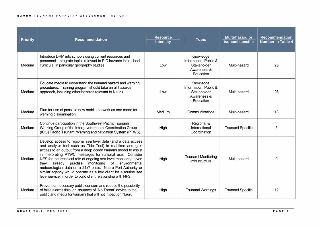
Medium
Introduce DRM into schools using current resources and personnel. Integrate topics relevant to PIC hazards into school curricula, in particular geography studies. Low
Knowledge, Information, Public &
Stakeholder Awareness &
Education
Multi-hazard 25
Medium
Educate media to understand the tsunami hazard and warning procedures. Training program should take an all hazards approach, including other hazards relevant to Nauru. Low
Knowledge, Information, Public &
Stakeholder Awareness &
Education
Multi-hazard 26
Medium Plan for use of possible new mobile network as one mode for warning dissemination.
Medium Communications Multi-hazard 13
Medium Continue participation in the Southwest Pacific Tsunami Working Group of the Intergovernmental Coordination Group (ICG) Pacific Tsunami Warning and Mitigation System (PTWS).
High Regional & International Coordination
Tsunami Specific 5
Medium
Develop access to regional sea level data (and a data access and analysis tool such as Tide Tool) in real-time and gain access to an output from a deep ocean tsunami model to assist in interpreting PTWC messages for national use. Consider NFS for the technical role of ongoing sea level monitoring given they already practise monitoring of environmental meteorological data on a 24x7 basis. Nauru Port Authority or similar agency would operate as a key client for a routine sea level service, in order to build client relationship with NFS.
High Tsunami Monitoring
Infrastructure Multi-hazard 9
Medium Prevent unnecessary public concern and reduce the possibility of false alarms through issuance of “No Threat” advice to the public and media for tsunami that will not impact on Nauru.
High Tsunami Warnings Tsunami Specific 12
N A U R U T S U N A M I C A P A C I T Y A S S E S S M E N T R E P O R T
D R A F T V 0 . 2 , F E B 2 0 1 0 P A G E 9
Priority Recommendation Resource Intensity
Topic Multi-hazard or
tsunami specific Recommendation Number In Table 4
Low
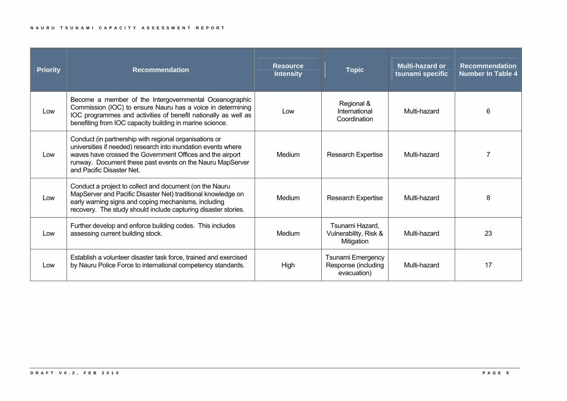
Become a member of the Intergovernmental Oceanographic Commission (IOC) to ensure Nauru has a voice in determining IOC programmes and activities of benefit nationally as well as benefiting from IOC capacity building in marine science.
Low Regional & International Coordination
Multi-hazard 6
Low
Conduct (in partnership with regional organisations or universities if needed) research into inundation events where waves have crossed the Government Offices and the airport runway. Document these past events on the Nauru MapServer and Pacific Disaster Net.
Medium Research Expertise Multi-hazard 7
Low
Conduct a project to collect and document (on the Nauru MapServer and Pacific Disaster Net) traditional knowledge on early warning signs and coping mechanisms, including recovery. The study should include capturing disaster stories.
Medium Research Expertise Multi-hazard 8
Low Further develop and enforce building codes. This includes assessing current building stock. Medium
Tsunami Hazard, Vulnerability, Risk &
Mitigation Multi-hazard 23
Low Establish a volunteer disaster task force, trained and exercised by Nauru Police Force to international competency standards. High
Tsunami Emergency Response (including
evacuation) Multi-hazard 17

N A U R U T S U N A M I C A P A C I T Y A S S E S S M E N T R E P O R T
D R A F T V 0 . 2 , F E B 2 0 1 0
N A U R U T S U N A M I C A P A C I T Y A S S E S S M E N T R E P O R T
2
2. Project Background
D R A F T V 0 . 2 , F E B 2 0 1 0

N A U R U T S U N A M I C A P A C I T Y A S S E S S M E N T R E P O R T
D R A F T V 0 . 2 , F E B 2 0 1 0
N A U R U T S U N A M I C A P A C I T Y A S S E S S M E N T R E P O R T
F I N A L V 0 . 3 , M A R C H 2 0 1 0 P A G E 1 0
2. Project Background
2.1. About the Project
The National Capacity Assessment of SOPAC Member Countries: Tsunami Warning and Mitigation Systems project aims to work in collaboration with the member countries of SOPAC to assess their capacity to receive, communicate and respond effectively to tsunami warnings. The Bureau is the lead implementing agency, in partnership with the Australian Attorney-General’s Department (AGD), (formerly Emergency Management Australia (EMA)), SOPAC, and with the assistance of the IOC a division of the United Nations Educational, Scientific and Cultural Organization (UNESCO). The project is funded by the Australian Agency for International Development (AusAID) under the Pacific Governance Support Programme (PGSP). It is implemented under an agreement (Schedule 5 to the Record of Understanding 14304, June 2006) between AusAID and the Bureau. The fourteen SOPAC member countries participating in the project are the Cook Islands, the Federated States of Micronesia, Fiji, Kiribati, the Marshall Islands, Nauru, Niue, Palau, Papua New Guinea, Samoa, the Solomon Islands, Tonga, Tuvalu and Vanuatu.
2.2. Broad Project Aim
By undertaking an assessment of the capacity of individual nations to manage tsunami events, the project aims to better guide donor funding towards achieving targeted improvements in the tsunami warning and mitigation systems in the respective countries.
2.3. Key Project Output
The key deliverable of the project is a comprehensive set of reports, including one national report specific to each country, detailing the strengths and opportunities for improvement of the country with regard to tsunami warning and mitigation. The national report for each country also includes recommendations to address priority issues. These reports will then feed into a consolidated Regional report that will aim to identify common issues across the Region with regard to tsunami warnings and mitigation.
2.4. Project Methodology
National assessments in each SOPAC member country have been conducted by visiting teams including experts in the fields of tsunami warnings, emergency management, disaster risk reduction and data and warning communications. The visiting team meets with in-country experts during four-day workshop involving government agencies, the private sector, Non-Government Organisations (NGOs) and regional and international organisations involved in tsunami and DRM.
The workshop aims to complete a questionnaire covering all aspects of tsunami warning and mitigation and gather information to support questionnaire responses. This information then feeds into the national report. Consultation with individual countries before completion of the report is an integral part of the report writing process.
N A U R U T S U N A M I C A P A C I T Y A S S E S S M E N T R E P O R T
F I N A L V 0 . 3 , M A R C H 2 0 1 0 P A G E 1 1
The questionnaire for the PICs is a modified version of that used for the Indian Ocean equivalent project. The Indian Ocean questionnaire was jointly developed by UNESCO/IOC, SOPAC, the World Meteorological Organisation (WMO) and the International Strategy for Disaster Reduction (ISDR). Details of the Indian Ocean equivalent project can be found at http://www.ioc-tsunami.org/index.php?Itemid=978&id=275&option=com_content&task=view
2.5. Underlying Policy Objectives of the Australian Tsunami Warning System Project
The Bureau in partnership with Geoscience Australia (GA) and AGD, has recently completed a four-year project to establish the Australian Tsunami Warning System (ATWS). One of the three policy objectives of the ATWS project was “To contribute to the facilitation of tsunami warnings for the South West Pacific” (DFAT, 2006). The Tsunami Capacity Assessment project and this report, contributes to the achievement of this policy objective. Also, as part of the implementation of the ATWS, Australia has and will continue to contribute to the facilitation of more effective tsunami advisory bulletins to Pacific Island nations through the provision of seismic and sea level observations to the PTWC in Hawaii.
2.6. Tsunami warnings in the Pacific
Tsunami messages for the Pacific Ocean are issued by the PTWC in Hawaii as the United States of America (USA) contribution to the PTWS. Individual countries are then responsible for using this advice to distribute national tsunami warnings to their communities. PTWC messages can be Tsunami Warnings, Tsunami Watches, Tsunami Advisories and Tsunami Information Bulletin/Statement. For the purpose of this report, products from the PTWC will be referred to generically as ‘tsunami messages’.
A full definition of each PTWC product products can be found at
http://www.prh.noaa.gov/ptwc/about_messages.php
2.7. International Tsunami Forums
Under the auspices of the IOC, the ICG/PTWS (formerly known as ICG for the Tsunami Warning System in the Pacific (ITSU)) was first convened in 1968 (IOC, 2009). This is an international cooperative effort involving many IOC Member States of the Pacific Region. The ICG/PTWS meets regularly to review progress and coordinate activities resulting in improvements of the service (IOC, 2009).
The Working Group on Tsunami Warning and Mitigation in the Southwest Pacific Ocean was formed at the ICG/PTWS-XXI meeting in Melbourne in early May 2006 with the aim of enhancing tsunami warning and mitigation in the Southwest Pacific Ocean. The membership of the working group is composed of representatives from IOC Member States and other countries in the region (as members and observers). SOPAC provides secretariat support. The Working Group is currently chaired by a representative of New Zealand, with vice-chairs from Fiji and Samoa.
N A U R U T S U N A M I C A P A C I T Y A S S E S S M E N T R E P O R T
F I N A L V 0 . 3 , M A R C H 2 0 1 0 P A G E 1 2
The Working Group has a number of Terms of Reference and this project is directly relevant to the following Terms of Reference:
• To evaluate capabilities of countries in the Southwest Pacific Region for providing end-to-end tsunami warning and mitigation services;
• To ascertain requirements from countries in the Southwest Pacific Region for the tsunami warning and mitigation services;
• To facilitate capacity building and the sharing of tsunami information in the region;
• To support the further development of the virtual centre of expertise in a multi-hazards context within SOPAC in line with the Regional Early Warning Strategy; and
• To facilitate the inclusion of tsunami hazard and response information into curricula, and development and dissemination of education materials.

N A U R U T S U N A M I C A P A C I T Y A S S E S S M E N T R E P O R T
F I N A L V 0 . 3 , M A R C H 2 0 1 0
N A U R U T S U N A M I C A P A C I T Y A S S E S S M E N T R E P O R T
3
3. Country Background and the Tsunami
Threat
F I N A L V 0 . 3 , M A R C H 2 0 1 0

N A U R U T S U N A M I C A P A C I T Y A S S E S S M E N T R E P O R T
F I N A L V 0 . 3 , M A R C H 2 0 1 0
N A U R U T S U N A M I C A P A C I T Y A S S E S S M E N T R E P O R T
F I N A L V 0 . 3 , M A R C H 2 0 1 0 P A G E 1 3
3. Country Background and the Tsunami Threat
3.1. About Nauru
Nauru is a country comprised of a single coral atoll of 21 square kilometres located approximately 47 kilometres south of the equator. Nauru has an Exclusive Economic Zone (EEZ) of 320 square kilometres (D13). The country’s population of approximately 10,000 people reside primarily along the coastal fringes (D16). Most of the population are indigenous Nauruan of primarily Micronesian origin with some 800 other Pacific Islander, Chinese, Australian and New Zealand expatriates (DFAT, 2009).
Nauru is one of the world’s smallest independent, democratic states. Its constitution, adopted at independence in 1968, established it as a republic with a Westminster style parliamentary system of government. The Constitution has been undergoing a process of review since 2004 (DFAT, 2009). The President is currently elected by and responsible to the unicameral Parliament and, in an unusual variation of the Westminster system, is both head of government and head of state. This is expected to change to the President being popularly-elected after an upcoming Referendum (DFAT, 2009).
The country’s revenue base is narrow and heavily reliant upon fishing licences which are the only sizable and sustainable revenue item (D13). Nauru has no national based fishing industry (DFAT, 2009). Phosphate production, which first began to decline in the 1980s (after commencing as early as 1907) ceased altogether in 2003 (DFAT, 2009). The government has developed a debt management strategy. Local infrastructure, including power generation, drinking water and health services, have been adversely affected in recent years by the decline in national income leading to actions such as power rationing (DFAT, 2009).
Nauru is isolated and, with little subsistence farming on island, is dependent on shipping (a supply ship once every six weeks and intermittent phosphate and fuel ships) and air services that operate flights twice weekly for the provision of food and other supplies, mostly from Australia (DFAT, 2009). Fuel ships pump fuel ashore through piping linked up to the tank farm.
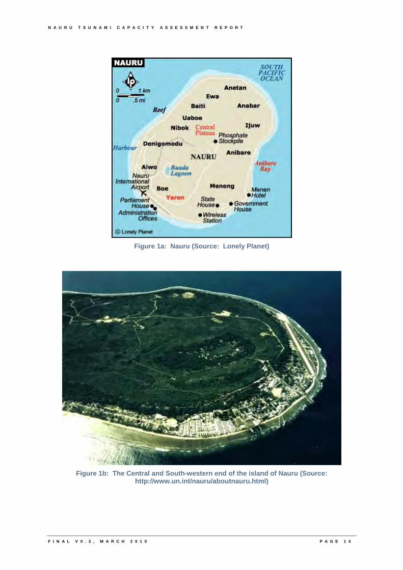
Phosphate mining in the central plateau has left a barren terrain of jagged coral pinnacles, up to 15metres (49 feet) high. Coral cliffs surround the central plateau. The highest point of the plateau is 65 metres (213 feet) above sea level (UN, 2009). The island is surrounded by a coral reef, exposed at low tide and has a fertile coastal belt 150 to 300 metres (492 to 984 feet) wide (UN, 2009). The only presently fertile areas are the narrow coastal belt, where there are coconut palms, pandanus trees, and the land surrounding Buada lagoon, where bananas, and some vegetables are grown. Some secondary vegetation grows over the coral pinnacles (UN, 2009). Nauru’s major environmental risk is the mined-out phosphate lands that cover almost 90% of the island (D13).
N A U R U T S U N A M I C A P A C I T Y A S S E S S M E N T R E P O R T
Figure 1a: Nauru (Source: Lonely Planet)
Figure 1b: The Central and South-western end of the island of Nauru (Source:
http://www.un.int/nauru/aboutnauru.html)
F I N A L V 0 . 3 , M A R C H 2 0 1 0 P A G E 1 4
N A U R U T S U N A M I C A P A C I T Y A S S E S S M E N T R E P O R T
F I N A L V 0 . 3 , M A R C H 2 0 1 0 P A G E 1 5
3.2. Tsunami Threat Sources and Tsunami History in Nauru
An overview of potential tsunami threat sources and tsunami history in Nauru is outlined below. This information should be treated as general background and does not attempt to provide a comprehensive picture of tsunami hazard, vulnerability and associated risk for Nauru. Such a study is outside the scope of this project.
Nauru lists examples of the nation’s sources of disaster in “Examples of Disaster Element” (D2). The list includes natural hazards such as sea surge or tsunami, risks associated with the provision of essential services (such as fuel spills) and risk exacerbated by the country’s isolation. The NDRM Plan (D12) identifies the tsunami hazard as being a high level of risk. This risk rating reflects Nauru’s own perception of the tsunami risk probably based on verbal history of wave inundation events (thought to most frequently due to atmospheric elevation of sea level) as well as the high level of community response when a tsunami warning is received in Nauru.
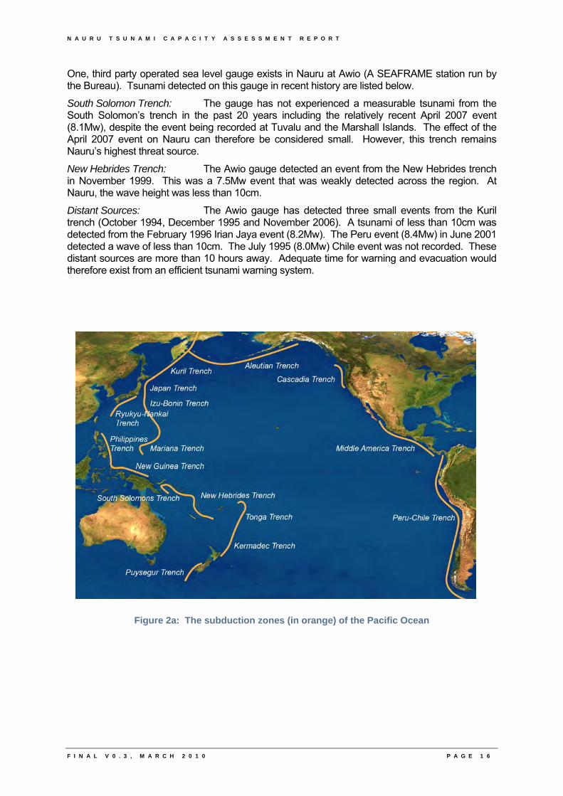
Nauru is located further from major subduction trenches capable of generating tsunami than many other Pacific Island Countries (PICs). The country generally has a greater lead time (typical tsunami travel times from the South Solomon’s and New Hebrides trenches are between 2.5 to 3 hours) for warnings and appears in a lower hazard category (Pearce, 2008). Atolls can also be somewhat protected as they often have steep drop-offs in which ocean depths increase very rapidly with distance from the fringing reef therefore minimising tsunami shoaling (the process by which tsunami wave heights increase as they approach the shore) and subsequent inundation (Thomas, Burbidge, Cummins, 2007).
However, even relatively small tsunami, when timed with high tides may have a significant impact on communities on low lying atolls (Pearce, 2008). Tsunami wave heights, less than 10cm on most occasions, have been recorded in Nauru in recent times. Even these seemingly small changes in sea-level due to tsunami could adversely impact on day-to-day activities in Nauru, such as unloading of fuel. Nauru has also historically experienced wave inundation from storm surge (1994, refer to D22).
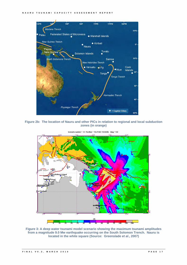
Thomas, Burbidge and Cummins (2007) completed A Preliminary Study into the Tsunami Hazard faced by Southwest Pacific Nations. Scenarios for an 8.5 Moment Magnitude (Mw) and 9.0 Mw earthquakes were used to investigate normalised offshore (to a notional depth of 50 metres) wave amplitudes for tsunami caused by earthquakes along subduction zones (Refer Figure 2). In this study, Nauru’s maximum amplitude for all tide gauges for all Mw 9 tsunami was 31cm with the most significant source region being the South Solomons (amplitude greater than 75cm at 50m depth or single most significant source region if no amplitude exceeds 75cm). For a Mw 8.5 tsunami the maximum amplitude reduced to 20m with the South Solomons still remaining the most significant source region. The two maximum amplitudes mentioned for Nauru in this study were the lowest of all countries included in the study.
A further study completed by Thomas and Burbidge (2009) attempts to answer the question “which Pacific nations might experience offshore amplitudes large enough to potentially result in hazardous inundation, what are the probabilities of experiencing these amplitudes and from which subduction zones might these tsunami originate”. The report states that in comparison to other PICs included in the study, Nauru’s has a “relatively low [tsunami] hazard” with maximum amplitudes computed at about 1 metre for a return period of 2000 years and about 0.2 metres for a return period of 100 years. Thomas and Burbidge (2009) states that the tsunami hazard for a 2000 year return period “originates predominately from the Solomon’s, New Hebrides and Kurils trenches, with smaller contributions from the Mariana, Philippines and Peru trenches”.
The Australian Bureau of Meteorology’s deep ocean model-based tsunami prediction system supports the key threat source for Nauru being the South Solomon’s trench, with typical tsunami travel times from this source and the New Hebrides trenches being between 2.5 to 3 hours.
N A U R U T S U N A M I C A P A C I T Y A S S E S S M E N T R E P O R T
One, third party operated sea level gauge exists in Nauru at Awio (A SEAFRAME station run by the Bureau). Tsunami detected on this gauge in recent history are listed below.
South Solomon Trench: The gauge has not experienced a measurable tsunami from the South Solomon’s trench in the past 20 years including the relatively recent April 2007 event (8.1Mw), despite the event being recorded at Tuvalu and the Marshall Islands. The effect of the April 2007 event on Nauru can therefore be considered small. However, this trench remains Nauru’s highest threat source.
New Hebrides Trench: The Awio gauge detected an event from the New Hebrides trench in November 1999. This was a 7.5Mw event that was weakly detected across the region. At Nauru, the wave height was less than 10cm.
Distant Sources: The Awio gauge has detected three small events from the Kuril trench (October 1994, December 1995 and November 2006). A tsunami of less than 10cm was detected from the February 1996 Irian Jaya event (8.2Mw). The Peru event (8.4Mw) in June 2001 detected a wave of less than 10cm. The July 1995 (8.0Mw) Chile event was not recorded. These distant sources are more than 10 hours away. Adequate time for warning and evacuation would therefore exist from an efficient tsunami warning system.
Figure 2a: The subduction zones (in orange) of the Pacific Ocean
F I N A L V 0 . 3 , M A R C H 2 0 1 0 P A G E 1 6
N A U R U T S U N A M I C A P A C I T Y A S S E S S M E N T R E P O R T
F I N A L V 0 . 3 , M A R C H 2 0 1 0 P A G E 1 7
Figure 2b: The location of Nauru and other PICs in relation to regional and local subduction zones (in orange)
Figure 3: A deep water tsunami model scenario showing the maximum tsunami amplitudes from a magnitude 9.0 Mw earthquake occurring on the South Solomon Trench. Nauru is
located in the white square (Source: Greenslade et al., 2007)

N A U R U T S U N A M I C A P A C I T Y A S S E S S M E N T R E P O R T
D R A F T V 0 . 2 , F E B 2 0 1 0
N A U R U T S U N A M I C A P A C I T Y A S S E S S M E N T R E P O R T
4
4. The Nauru Tsunami Capacity Assessment
D R A F T V 0 . 2 , F E B 2 0 1 0

N A U R U T S U N A M I C A P A C I T Y A S S E S S M E N T R E P O R T
D R A F T V 0 . 2 , F E B 2 0 1 0
N A U R U T S U N A M I C A P A C I T Y A S S E S S M E N T R E P O R T
F I N A L V 0 . 3 , M A R C H 2 0 1 0 P A G E 1 8
4. The Nauru Tsunami Capacity Assessment
4.1. Date and Location
The Tsunami Capacity Assessment of the ability of Nauru to receive, communicate and effectively respond to tsunami warnings took place from 24 – 26 February 2009 at the Menen Hotel in Nauru.
4.2. Visiting Assessment Team and Participants
The Visiting Assessment Team was made up of those outlined in Annexure 2. The focal points in Nauru for the completion of the workshop and project more generally were Brian Thomson, Superintendent-Operations Advisor, Nauru Police Force and Berilyn Jeremiah, Nauru Aid Management Unit. A full list of workshop participants can be found in Annexure 1.
4.3. Workshop Summary
For a copy of the full agenda for the workshop see Annexure 3.
4.3.1. Day 1 (Tuesday 24 February 2009)
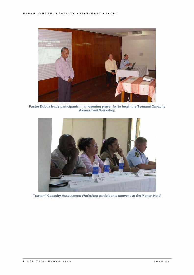
The plenary workshop session was opened by John Nairn (Supervising Meteorologist, South Australia, Bureau of Meteorology) who welcomed participants and invited the Nauru Police Commissioner Mr Cedric Netto to open proceedings. John Nairn replied to the Commissioners welcome then invited Pastor Dubua to provide an opening prayer.
John Nairn then provided a presentation on the nature of tsunami and considerations associated with tsunami warning systems. Following morning tea, Elke Browne (Assistant Director Operations & Resources, State Emergency Service, Tasmania, Australia) provided a short presentation on emergency management considerations. This was immediately followed by workshop discussions, led by various members of the Tsunami Capacity Assessment Team. The day finished with Pastor Dubua providing closing a prayer.
4.3.2. Day 2 (Wednesday 25 February 2009)
Although no formal sessions were undertaken on the second working day of the Nauru Assessment visit, the Tsunami Capacity Assessment Team undertook to visit a number of Nauru-based organisations and Australian diplomatic staff.
The visited organisations were happy to supply supplementary information, additional to the official workshop. This included anecdotal evidence, photographs, electronic and paper documentation. Results from these visits were then fed into the Tsunami Capacity Assessment Questionnaire and relevant recommendations. Visit locations and participants are listed below:
• Elke Browne and Pina Soccio visited Roy Harris (Nauru Fire Chief)
• Litea Biukoto and Pina Soccio visited Alamanda Laitu (University of South Pacific, Nauru Campus)
N A U R U T S U N A M I C A P A C I T Y A S S E S S M E N T R E P O R T
F I N A L V 0 . 3 , M A R C H 2 0 1 0 P A G E 1 9
• Litea Biukoto and Pina Soccio visited Joanna Olsson and Dominic Appi (Nauru Media Bureau)
• Litea Biukoto and Pina Soccio visited Camilla Solomon, Sasi Kumar and Klenny Harris (Chief Secretary’s Office)
• Paul Hambleton visited Marcus Tanner (ICT Office, Civic Centre)
• Kemp Detenamo (Nauru Port Authority) was visited
• Paul Hambleton visited Hasseldon Buraman (Nauru Flight Services)
• John Nairn visited Brian Thomson (Australian Federal Police, Nauru Mission)
4.3.3. Day 3 (Thursday 26 February 2009)
In the morning the Tsunami Capacity Assessment Team compiled the draft Tsunami Capacity Assessment Questionnaire and recommendations on how Nauru’s tsunami warning and mitigation system could be improved.
The workshop re-convened in the afternoon. The Tsunami Capacity Assessment Team providing a preliminary results presentation of key findings and draft recommendations for the consideration of all participants. Participants were provided with a CD of all presentations and copies of materials collected from various Nauru agencies, as well as the draft Tsunami Capacity Assessment Questionnaire and recommendations. Pastor Dubua provided a closing prayer and the workshop was drawn to a close.
Participants were then invited to a small function in the hotel as a token of the Tsunami Capacity Assessment Team’s appreciation for their involvement.
N A U R U T S U N A M I C A P A C I T Y A S S E S S M E N T R E P O R T
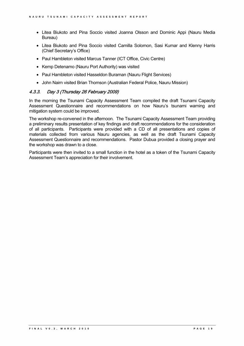
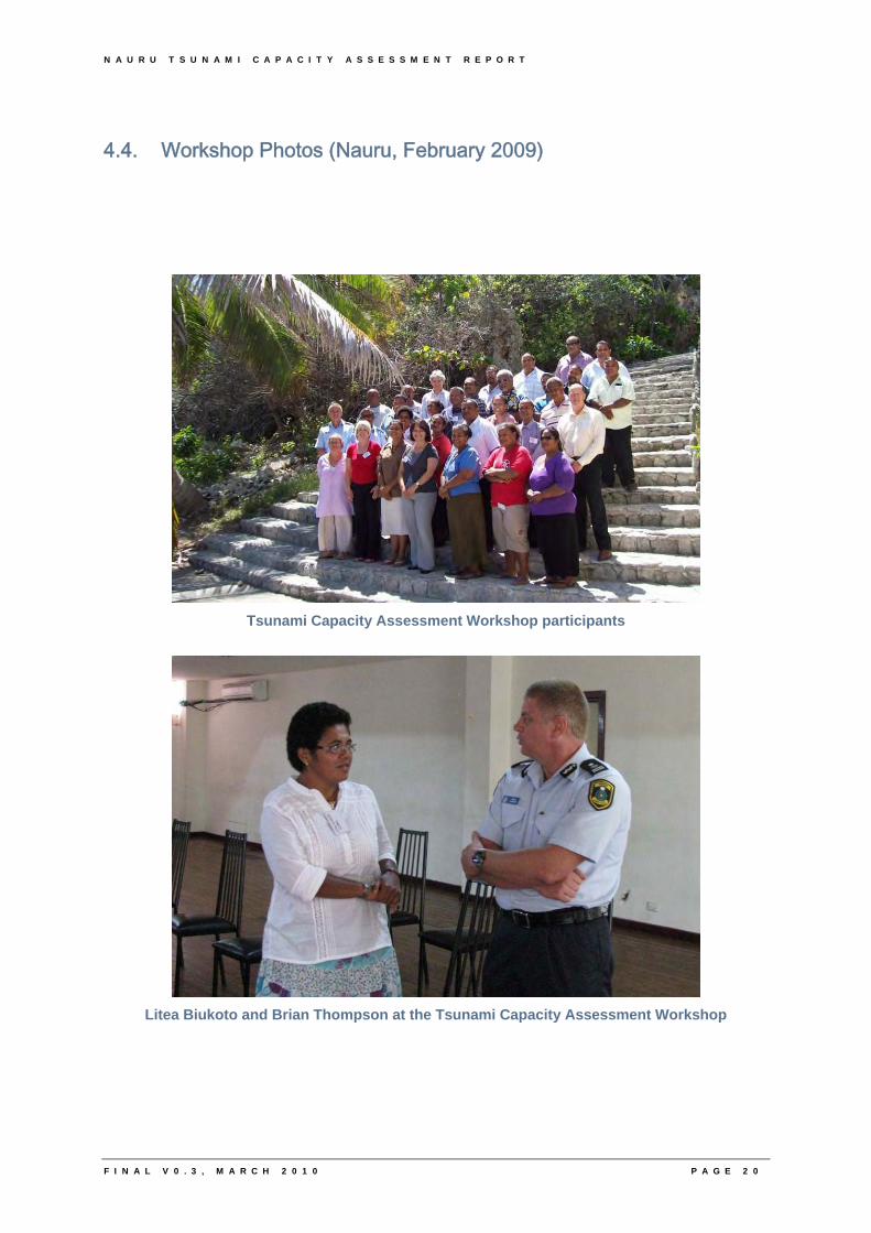
4.4. Workshop Photos (Nauru, February 2009)
Tsunami Capacity Assessment Workshop participants
Litea Biukoto and Brian Thompson at the Tsunami Capacity Assessment Workshop
F I N A L V 0 . 3 , M A R C H 2 0 1 0 P A G E 2 0
N A U R U T S U N A M I C A P A C I T Y A S S E S S M E N T R E P O R T
F I N A L V 0 . 3 , M A R C H 2 0 1 0 P A G E 2 1
Pastor Dubua leads participants in an opening prayer for to begin the Tsunami Capacity
Assessment Workshop
Tsunami Capacity Assessment Workshop participants convene at the Menen Hotel

N A U R U T S U N A M I C A P A C I T Y A S S E S S M E N T R E P O R T
5
5. Assessment Results
F I N A L V 0 . 3 , M A R C H 2 0 1 0

N A U R U T S U N A M I C A P A C I T Y A S S E S S M E N T R E P O R T
F I N A L V 0 . 3 , M A R C H 2 0 1 0
N A U R U T S U N A M I C A P A C I T Y A S S E S S M E N T R E P O R T
F I N A L V 0 . 3 , M A R C H 2 0 1 0 P A G E 2 2
5. Assessment Results
5.1. Status of Key System Components
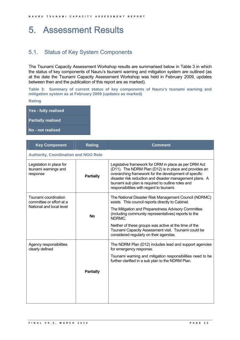
The Tsunami Capacity Assessment Workshop results are summarised below in Table 3 in which the status of key components of Nauru’s tsunami warning and mitigation system are outlined (as at the date the Tsunami Capacity Assessment Workshop was held in February 2009, updates between then and the publication of this report are as marked).
Table 3: Summary of current status of key components of Nauru’s tsunami warning and mitigation system as at February 2009 (updates as marked)
Rating
Yes - fully realised
Partially realised
No - not realised
Key Component Rating Comment
Authority, Coordination and NGO Role
Legislation in place for tsunami warnings and response
Partially
Legislative framework for DRM in place as per DRM Act (D11). The NDRM Plan (D12) is in place and provides an overarching framework for the development of specific disaster risk reduction and disaster management plans. A tsunami sub plan is required to outline roles and responsibilities with regard to tsunami.
Tsunami coordination committee or effort at a National and local level
No
The National Disaster Risk Management Council (NDRMC) exists. This council reports directly to Cabinet.
The Mitigation and Preparedness Advisory Committee (including community representatives) reports to the NDRMC.
Neither of these groups was active at the time of the Tsunami Capacity Assessment visit. Tsunami could be considered regularly on their agendas.
Agency responsibilities clearly defined
Partially
The NDRM Plan (D12) includes lead and support agencies for emergency response.
Tsunami warning and mitigation responsibilities need to be further clarified in a sub plan to the NDRM Plan.
N A U R U T S U N A M I C A P A C I T Y A S S E S S M E N T R E P O R T
F I N A L V 0 . 3 , M A R C H 2 0 1 0 P A G E 2 3
Key Component Rating Comment
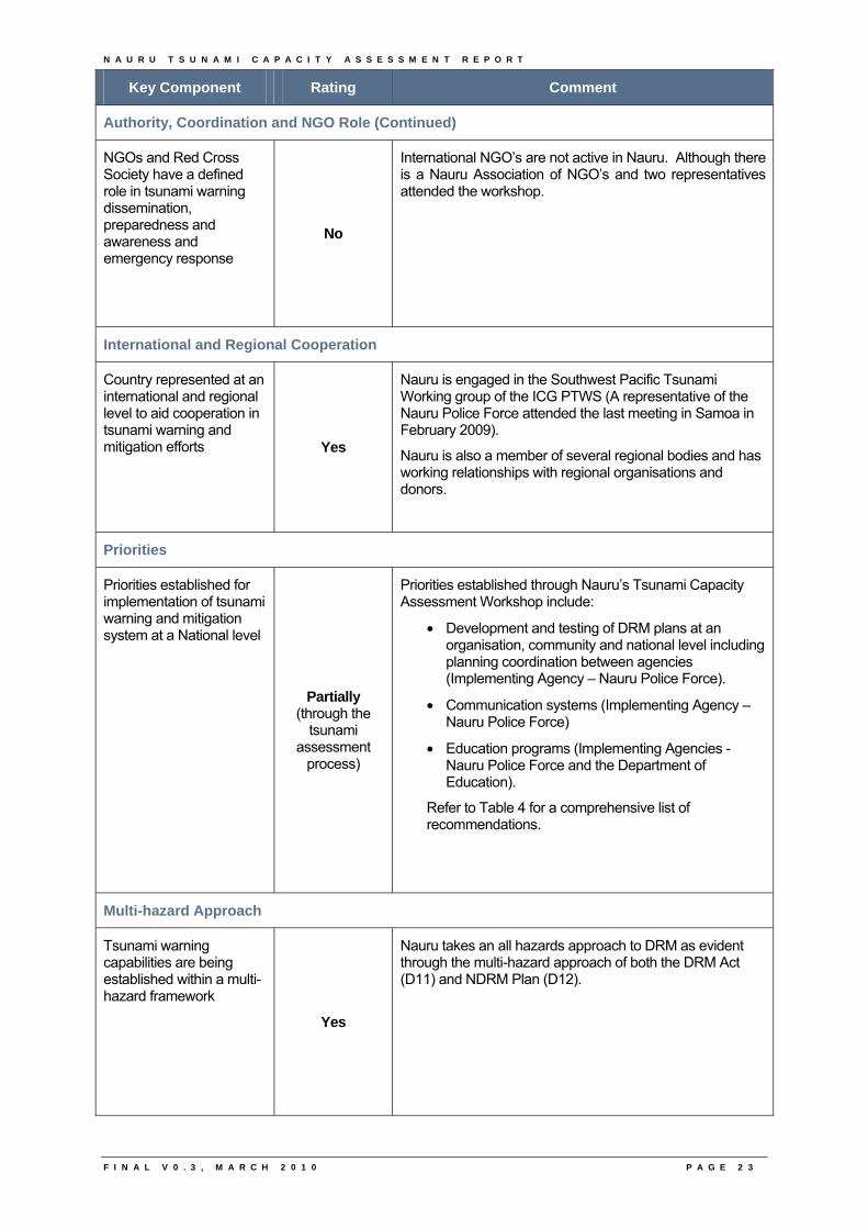
Authority, Coordination and NGO Role (Continued)
NGOs and Red Cross Society have a defined role in tsunami warning dissemination, preparedness and awareness and emergency response
No
International NGO’s are not active in Nauru. Although there is a Nauru Association of NGO’s and two representatives attended the workshop.
International and Regional Cooperation
Country represented at an international and regional level to aid cooperation in tsunami warning and mitigation efforts Yes
Nauru is engaged in the Southwest Pacific Tsunami Working group of the ICG PTWS (A representative of the Nauru Police Force attended the last meeting in Samoa in February 2009).
Nauru is also a member of several regional bodies and has working relationships with regional organisations and donors.
Priorities
Priorities established for implementation of tsunami warning and mitigation system at a National level
Partially (through the
tsunami assessment
process)
Priorities established through Nauru’s Tsunami Capacity Assessment Workshop include:
• Development and testing of DRM plans at an organisation, community and national level including planning coordination between agencies (Implementing Agency – Nauru Police Force).
• Communication systems (Implementing Agency – Nauru Police Force)
• Education programs (Implementing Agencies - Nauru Police Force and the Department of Education).
Refer to Table 4 for a comprehensive list of recommendations.
Multi-hazard Approach
Tsunami warning capabilities are being established within a multi-hazard framework
Yes
Nauru takes an all hazards approach to DRM as evident through the multi-hazard approach of both the DRM Act (D11) and NDRM Plan (D12).
N A U R U T S U N A M I C A P A C I T Y A S S E S S M E N T R E P O R T
F I N A L V 0 . 3 , M A R C H 2 0 1 0 P A G E 2 4
Key Component Rating Comment
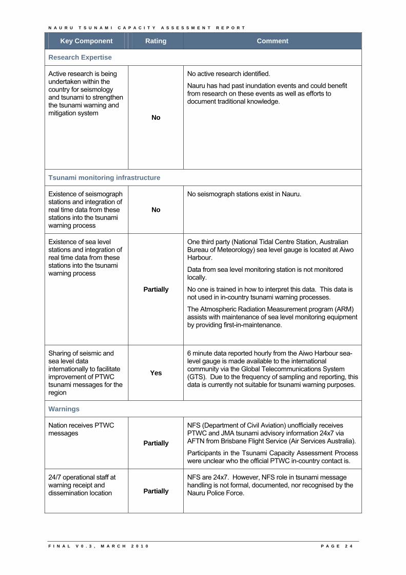
Research Expertise
Active research is being undertaken within the country for seismology and tsunami to strengthen the tsunami warning and mitigation system
No
No active research identified.
Nauru has had past inundation events and could benefit from research on these events as well as efforts to document traditional knowledge.
Tsunami monitoring infrastructure
Existence of seismograph stations and integration of real time data from these stations into the tsunami warning process
No
No seismograph stations exist in Nauru.
Existence of sea level stations and integration of real time data from these stations into the tsunami warning process
Partially
One third party (National Tidal Centre Station, Australian Bureau of Meteorology) sea level gauge is located at Aiwo Harbour.
Data from sea level monitoring station is not monitored locally.
No one is trained in how to interpret this data. This data is not used in in-country tsunami warning processes.
The Atmospheric Radiation Measurement program (ARM) assists with maintenance of sea level monitoring equipment by providing first-in-maintenance.
Sharing of seismic and sea level data internationally to facilitate improvement of PTWC tsunami messages for the region
Yes
6 minute data reported hourly from the Aiwo Harbour sea-level gauge is made available to the international community via the Global Telecommunications System (GTS). Due to the frequency of sampling and reporting, this data is currently not suitable for tsunami warning purposes.
Warnings
Nation receives PTWC messages
Partially
NFS (Department of Civil Aviation) unofficially receives PTWC and JMA tsunami advisory information 24x7 via AFTN from Brisbane Flight Service (Air Services Australia).
Participants in the Tsunami Capacity Assessment Process were unclear who the official PTWC in-country contact is.
24/7 operational staff at warning receipt and dissemination location
Partially
NFS are 24x7. However, NFS role in tsunami message handling is not formal, documented, nor recognised by the Nauru Police Force.
N A U R U T S U N A M I C A P A C I T Y A S S E S S M E N T R E P O R T
F I N A L V 0 . 3 , M A R C H 2 0 1 0 P A G E 2 5
Key Component Rating Comment
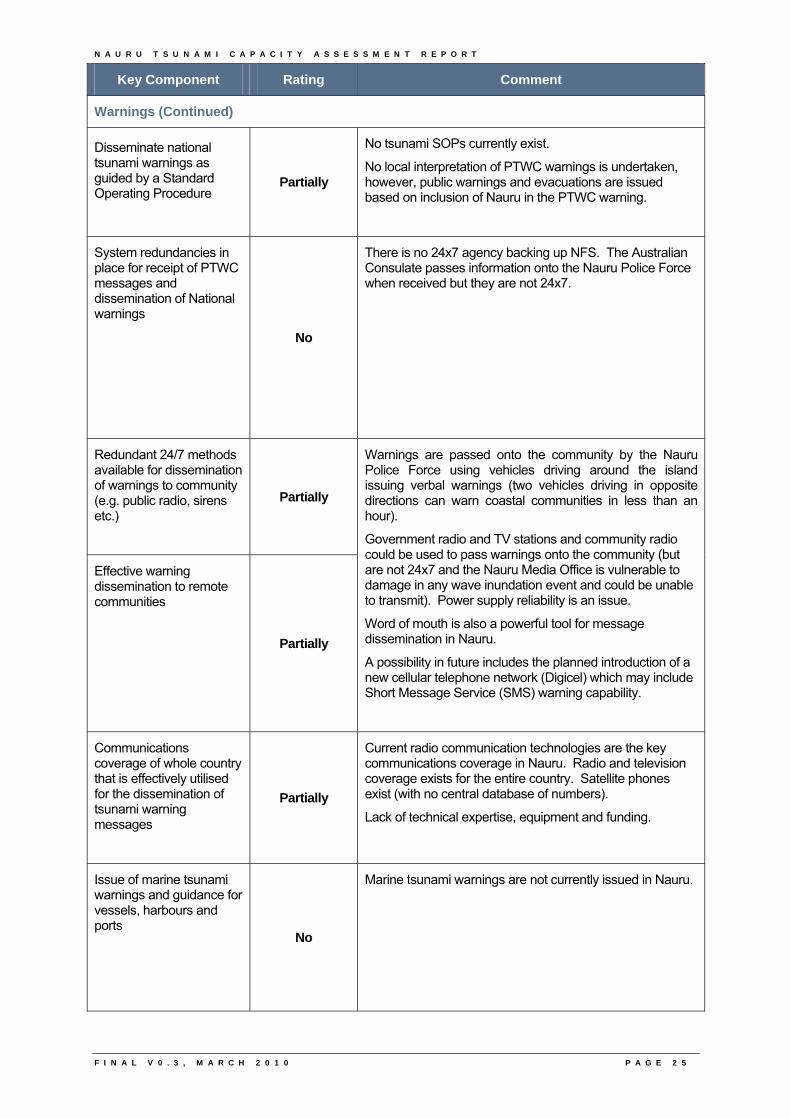
Warnings (Continued)
Disseminate national tsunami warnings as guided by a Standard Operating Procedure
Partially
No tsunami SOPs currently exist.
No local interpretation of PTWC warnings is undertaken, however, public warnings and evacuations are issued based on inclusion of Nauru in the PTWC warning.
System redundancies in place for receipt of PTWC messages and dissemination of National warnings
No
There is no 24x7 agency backing up NFS. The Australian Consulate passes information onto the Nauru Police Force when received but they are not 24x7.
Redundant 24/7 methods available for dissemination of warnings to community (e.g. public radio, sirens etc.)
Partially
Effective warning dissemination to remote communities
Partially
Warnings are passed onto the community by the Nauru Police Force using vehicles driving around the island issuing verbal warnings (two vehicles driving in opposite directions can warn coastal communities in less than an hour).
Government radio and TV stations and community radio could be used to pass warnings onto the community (but are not 24x7 and the Nauru Media Office is vulnerable to damage in any wave inundation event and could be unable to transmit). Power supply reliability is an issue.
Word of mouth is also a powerful tool for message dissemination in Nauru.
A possibility in future includes the planned introduction of a new cellular telephone network (Digicel) which may include Short Message Service (SMS) warning capability.
Communications coverage of whole country that is effectively utilised for the dissemination of tsunami warning messages
Partially
Current radio communication technologies are the key communications coverage in Nauru. Radio and television coverage exists for the entire country. Satellite phones exist (with no central database of numbers).
Lack of technical expertise, equipment and funding.
Issue of marine tsunami warnings and guidance for vessels, harbours and ports
No
Marine tsunami warnings are not currently issued in Nauru.
N A U R U T S U N A M I C A P A C I T Y A S S E S S M E N T R E P O R T
F I N A L V 0 . 3 , M A R C H 2 0 1 0 P A G E 2 6
Key Component Rating Comment
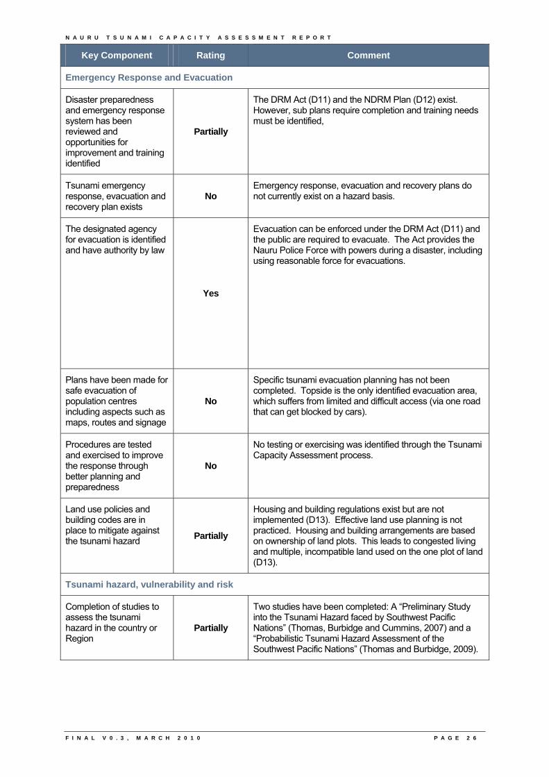
Emergency Response and Evacuation
Disaster preparedness and emergency response system has been reviewed and opportunities for improvement and training identified
Partially
The DRM Act (D11) and the NDRM Plan (D12) exist. However, sub plans require completion and training needs must be identified,
Tsunami emergency response, evacuation and recovery plan exists
No Emergency response, evacuation and recovery plans do not currently exist on a hazard basis.
The designated agency for evacuation is identified and have authority by law
Yes
Evacuation can be enforced under the DRM Act (D11) and the public are required to evacuate. The Act provides the Nauru Police Force with powers during a disaster, including using reasonable force for evacuations.
Plans have been made for safe evacuation of population centres including aspects such as maps, routes and signage
No
Specific tsunami evacuation planning has not been completed. Topside is the only identified evacuation area, which suffers from limited and difficult access (via one road that can get blocked by cars).
Procedures are tested and exercised to improve the response through better planning and preparedness
No
No testing or exercising was identified through the Tsunami Capacity Assessment process.
Land use policies and building codes are in place to mitigate against the tsunami hazard
Partially
Housing and building regulations exist but are not implemented (D13). Effective land use planning is not practiced. Housing and building arrangements are based on ownership of land plots. This leads to congested living and multiple, incompatible land used on the one plot of land (D13).
Tsunami hazard, vulnerability and risk
Completion of studies to assess the tsunami hazard in the country or Region
Partially
Two studies have been completed: A “Preliminary Study into the Tsunami Hazard faced by Southwest Pacific Nations” (Thomas, Burbidge and Cummins, 2007) and a “Probabilistic Tsunami Hazard Assessment of the Southwest Pacific Nations” (Thomas and Burbidge, 2009).
N A U R U T S U N A M I C A P A C I T Y A S S E S S M E N T R E P O R T
F I N A L V 0 . 3 , M A R C H 2 0 1 0 P A G E 2 7
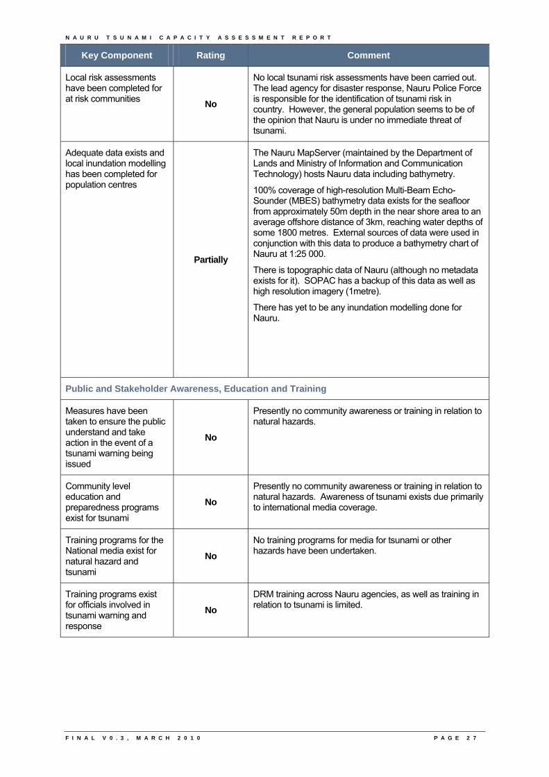
Key Component Rating Comment
Local risk assessments have been completed for at risk communities
No
No local tsunami risk assessments have been carried out. The lead agency for disaster response, Nauru Police Force is responsible for the identification of tsunami risk in country. However, the general population seems to be of the opinion that Nauru is under no immediate threat of tsunami.
Adequate data exists and local inundation modelling has been completed for population centres
Partially
The Nauru MapServer (maintained by the Department of Lands and Ministry of Information and Communication Technology) hosts Nauru data including bathymetry.
100% coverage of high-resolution Multi-Beam Echo-Sounder (MBES) bathymetry data exists for the seafloor from approximately 50m depth in the near shore area to an average offshore distance of 3km, reaching water depths of some 1800 metres. External sources of data were used in conjunction with this data to produce a bathymetry chart of Nauru at 1:25 000.
There is topographic data of Nauru (although no metadata exists for it). SOPAC has a backup of this data as well as high resolution imagery (1metre).
There has yet to be any inundation modelling done for Nauru.
Public and Stakeholder Awareness, Education and Training
Measures have been taken to ensure the public understand and take action in the event of a tsunami warning being issued
No
Presently no community awareness or training in relation to natural hazards.
Community level education and preparedness programs exist for tsunami
No
Presently no community awareness or training in relation to natural hazards. Awareness of tsunami exists due primarily to international media coverage.
Training programs for the National media exist for natural hazard and tsunami
No
No training programs for media for tsunami or other hazards have been undertaken.
Training programs exist for officials involved in tsunami warning and response
No
DRM training across Nauru agencies, as well as training in relation to tsunami is limited.
N A U R U T S U N A M I C A P A C I T Y A S S E S S M E N T R E P O R T
F I N A L V 0 . 3 , M A R C H 2 0 1 0 P A G E 2 8
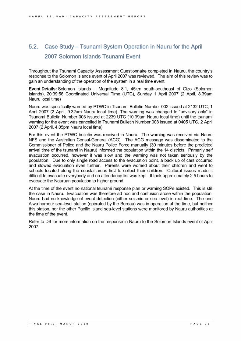
5.2. Case Study – Tsunami System Operation in Nauru for the April 2007 Solomon Islands Tsunami Event
Throughout the Tsunami Capacity Assessment Questionnaire completed in Nauru, the country’s response to the Solomon Islands event of April 2007 was reviewed. The aim of this review was to gain an understanding of the operation of the system in a real time event.
Event Details: Solomon Islands – Magnitude 8.1, 45km south-southeast of Gizo (Solomon Islands), 20:39:56 Coordinated Universal Time (UTC), Sunday 1 April 2007 (2 April, 8.39am Nauru local time)
Nauru was specifically warned by PTWC in Tsunami Bulletin Number 002 issued at 2132 UTC, 1 April 2007 (2 April, 9.32am Nauru local time). The warning was changed to “advisory only” in Tsunami Bulletin Number 003 issued at 2239 UTC (10.39am Nauru local time) until the tsunami warning for the event was cancelled in Tsunami Bulletin Number 008 issued at 0405 UTC, 2 April 2007 (2 April, 4.05pm Nauru local time)
For this event the PTWC bulletin was received in Nauru. The warning was received via Nauru NFS and the Australian Consul-General (ACG). The ACG message was disseminated to the Commissioner of Police and the Nauru Police Force manually (30 minutes before the predicted arrival time of the tsunami in Nauru) informed the population within the 14 districts. Primarily self evacuation occurred, however it was slow and the warning was not taken seriously by the population. Due to only single road access to the evacuation point, a back up of cars occurred and slowed evacuation even further. Parents were worried about their children and went to schools located along the coastal areas first to collect their children. Cultural issues made it difficult to evacuate everybody and no attendance list was kept. It took approximately 2.5 hours to evacuate the Nauruan population to higher ground.
At the time of the event no national tsunami response plan or warning SOPs existed. This is still the case in Nauru. Evacuation was therefore ad hoc and confusion arose within the population. Nauru had no knowledge of event detection (either seismic or sea-level) in real time. The one Aiwa harbour sea-level station (operated by the Bureau) was in operation at the time, but neither this station, nor the other Pacific Island sea-level stations were monitored by Nauru authorities at the time of the event.
Refer to D6 for more information on the response in Nauru to the Solomon Islands event of April 2007.
N A U R U T S U N A M I C A P A C I T Y A S S E S S M E N T R E P O R T
F I N A L V 0 . 3 , M A R C H 2 0 1 0 P A G E 2 9
5.3. Strengths, Opportunities for Improvement and Recommendations to Progress the Tsunami Agenda in Nauru
Based on the discussions during the workshop with in-country participants and the supporting documentation collected during the visit, the visiting team formulated the following strengths, opportunities for improvement and recommendations under key topics which they believe will progress the tsunami agenda in Nauru.
Table 4 – Strengths, opportunities for improvement and recommendations under key topics
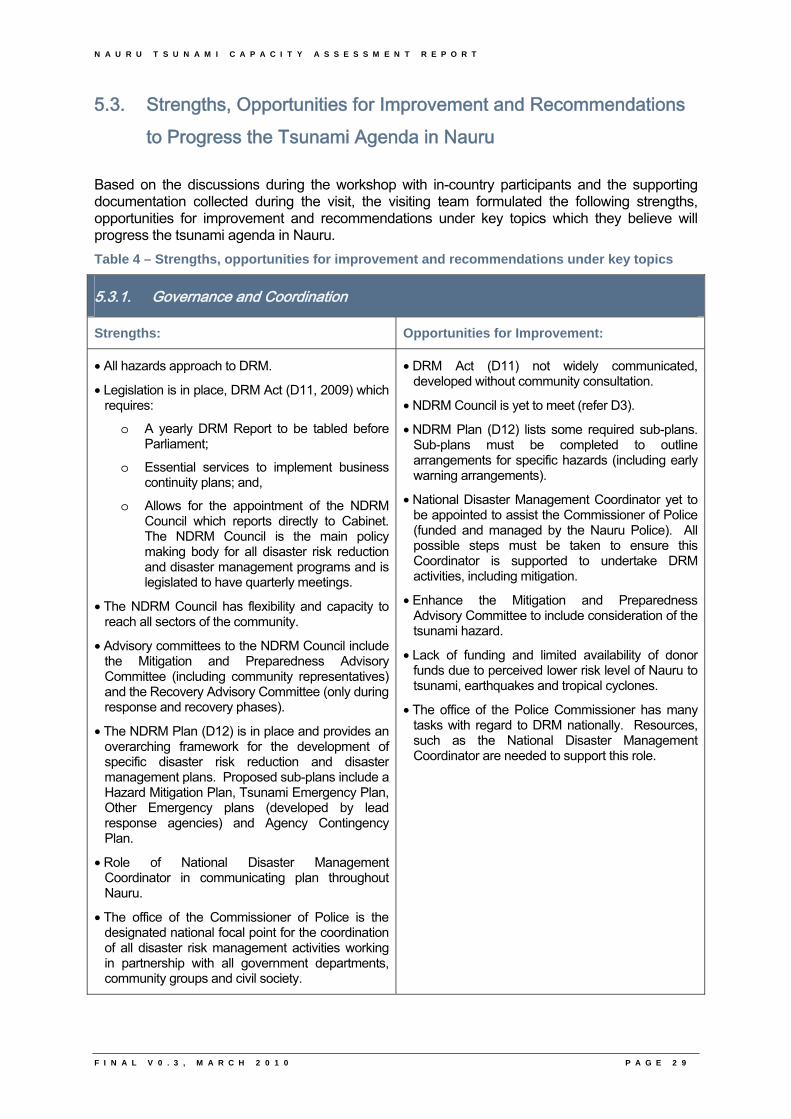
5.3.1. Governance and Coordination
Strengths: Opportunities for Improvement:
• All hazards approach to DRM.
• Legislation is in place, DRM Act (D11, 2009) which requires:
o A yearly DRM Report to be tabled before Parliament;
o Essential services to implement business continuity plans; and,
o Allows for the appointment of the NDRM Council which reports directly to Cabinet. The NDRM Council is the main policy making body for all disaster risk reduction and disaster management programs and is legislated to have quarterly meetings.
• The NDRM Council has flexibility and capacity to reach all sectors of the community.
• Advisory committees to the NDRM Council include the Mitigation and Preparedness Advisory Committee (including community representatives) and the Recovery Advisory Committee (only during response and recovery phases).
• The NDRM Plan (D12) is in place and provides an overarching framework for the development of specific disaster risk reduction and disaster management plans. Proposed sub-plans include a Hazard Mitigation Plan, Tsunami Emergency Plan, Other Emergency plans (developed by lead response agencies) and Agency Contingency Plan.
• Role of National Disaster Management Coordinator in communicating plan throughout Nauru.
• The office of the Commissioner of Police is the designated national focal point for the coordination of all disaster risk management activities working in partnership with all government departments, community groups and civil society.
• DRM Act (D11) not widely communicated, developed without community consultation.
• NDRM Council is yet to meet (refer D3).
• NDRM Plan (D12) lists some required sub-plans. Sub-plans must be completed to outline arrangements for specific hazards (including early warning arrangements).
• National Disaster Management Coordinator yet to be appointed to assist the Commissioner of Police (funded and managed by the Nauru Police). All possible steps must be taken to ensure this Coordinator is supported to undertake DRM activities, including mitigation.
• Enhance the Mitigation and Preparedness Advisory Committee to include consideration of the tsunami hazard.
• Lack of funding and limited availability of donor funds due to perceived lower risk level of Nauru to tsunami, earthquakes and tropical cyclones.
• The office of the Police Commissioner has many tasks with regard to DRM nationally. Resources, such as the National Disaster Management Coordinator are needed to support this role.
N A U R U T S U N A M I C A P A C I T Y A S S E S S M E N T R E P O R T
F I N A L V 0 . 3 , M A R C H 2 0 1 0 P A G E 3 0
Governance and Coordination (Continued)
Recommendations:
1. Advocacy to garner support and commitment of government agencies and non government entities, including the private sector, to support the NDRM Plan (D12).
2. Identify and assess regulatory instruments for disaster risk reduction and disaster management, seek agency input into prioritisation and development of DRM sub-plans, including a tsunami sub-plan.
3. Enhance the Mitigation and Preparedness Advisory Committee to include consideration of preparedness for the tsunami hazard.
4. Conduct regular meetings of the NDRM Council.
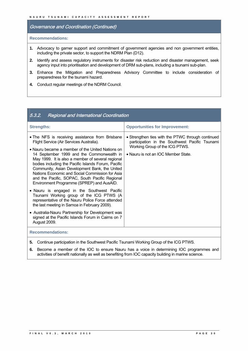
5.3.2. Regional and International Coordination
Strengths: Opportunities for Improvement:
• The NFS is receiving assistance from Brisbane Flight Service (Air Services Australia).
• Nauru became a member of the United Nations on 14 September 1999 and the Commonwealth in May 1999. It is also a member of several regional bodies including the Pacific Islands Forum, Pacific Community, Asian Development Bank, the United Nations Economic and Social Commission for Asia and the Pacific, SOPAC, South Pacific Regional Environment Programme (SPREP) and AusAID.
• Nauru is engaged in the Southwest Pacific Tsunami Working group of the ICG PTWS (A representative of the Nauru Police Force attended the last meeting in Samoa in February 2009).
• Australia-Nauru Partnership for Development was signed at the Pacific Islands Forum in Cairns on 7 August 2009.
• Strengthen ties with the PTWC through continued participation in the Southwest Pacific Tsunami Working Group of the ICG PTWS.
• Nauru is not an IOC Member State.
Recommendations:
5. Continue participation in the Southwest Pacific Tsunami Working Group of the ICG PTWS.
6. Become a member of the IOC to ensure Nauru has a voice in determining IOC programmes and activities of benefit nationally as well as benefiting from IOC capacity building in marine science.
N A U R U T S U N A M I C A P A C I T Y A S S E S S M E N T R E P O R T
F I N A L V 0 . 3 , M A R C H 2 0 1 0 P A G E 3 1
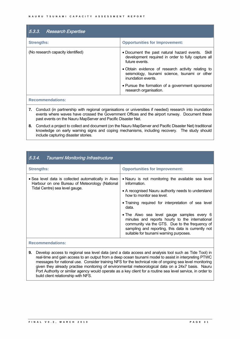
5.3.3. Research Expertise
Strengths: Opportunities for Improvement:
(No research capacity identified) • Document the past natural hazard events. Skill development required in order to fully capture all future events.
• Obtain evidence of research activity relating to seismology, tsunami science, tsunami or other inundation events.
• Pursue the formation of a government sponsored research organisation.
Recommendations:
7. Conduct (in partnership with regional organisations or universities if needed) research into inundation events where waves have crossed the Government Offices and the airport runway. Document these past events on the Nauru MapServer and Pacific Disaster Net.
8. Conduct a project to collect and document (on the Nauru MapServer and Pacific Disaster Net) traditional knowledge on early warning signs and coping mechanisms, including recovery. The study should include capturing disaster stories.
5.3.4. Tsunami Monitoring Infrastructure
Strengths: Opportunities for Improvement:
• Sea level data is collected automatically in Aiwo Harbour on one Bureau of Meteorology (National Tidal Centre) sea level gauge.
• Nauru is not monitoring the available sea level information.
• A recognised Nauru authority needs to understand how to monitor sea level.
• Training required for interpretation of sea level data.
• The Aiwo sea level gauge samples every 6 minutes and reports hourly to the international community via the GTS. Due to the frequency of sampling and reporting, this data is currently not suitable for tsunami warning purposes.
Recommendations:
9. Develop access to regional sea level data (and a data access and analysis tool such as Tide Tool) in real-time and gain access to an output from a deep ocean tsunami model to assist in interpreting PTWC messages for national use. Consider training NFS for the technical role of ongoing sea level monitoring given they already practise monitoring of environmental meteorological data on a 24x7 basis. Nauru Port Authority or similar agency would operate as a key client for a routine sea level service, in order to build client relationship with NFS.
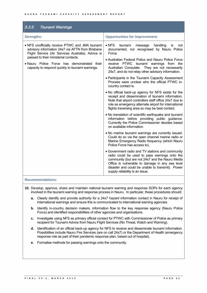
N A U R U T S U N A M I C A P A C I T Y A S S E S S M E N T R E P O R T
F I N A L V 0 . 3 , M A R C H 2 0 1 0 P A G E 3 2
5.3.5. Tsunami Warnings
Strengths: Opportunities for Improvement:
• NFS unofficially receive PTWC and JMA tsunami advisory information 24x7 via AFTN from Brisbane Flight Service (Air Services Australia). Advice is passed to their ministerial contacts.
• Nauru Police Force has demonstrated their capacity to respond quickly to tsunami warnings.
• NFS tsunami message handling is not documented, nor recognised by Nauru Police Force.
• Australian Federal Police and Nauru Police Force receive PTWC tsunami warnings from the Australian Consulate. They are not necessarily 24x7, and do not relay other advisory information.
• Participants in the Tsunami Capacity Assessment Process were unclear who the official PTWC in-country contact is.
• No official back-up agency for NFS exists for the receipt and dissemination of tsunami information. Note that airport controllers staff office 24x7 due to role as emergency alternate airport for international flights traversing area so may be best contact.
• No translation of scientific earthquake and tsunami information before providing public guidance. Currently the Police Commissioner decides based on available information.
• No marine tsunami warnings are currently issued. Could do so via the open channel marine radio or Marine Emergency Radio frequency (which Nauru Police Force has access to).
• Government radio and TV stations and community radio could be used to pass warnings onto the community (but are not 24x7 and the Nauru Media Office is vulnerable to damage in any sea level disaster and could be unable to transmit). Power supply reliability is an issue.
Recommendations:
10. Develop, approve, share and maintain national tsunami warning and response SOPs for each agency involved in the tsunami warning and response process in Nauru. In particular, these procedures should:
a. Clearly identify and provide authority for a 24x7 hazard information contact in Nauru for receipt of international warnings and ensure this is communicated to international warning agencies.
b. Identify in-country decision makers, information flow to the key response agency (Nauru Police Force) and identified responsibilities of other agencies and organisations.
c. Investigate using NFS as primary official contact for PTWC with Commissioner of Police as primary recipient for Tsunami Advice from Nauru Flight Services (No Threat, Watch and Warning).
d. Identification of an official back-up agency for NFS to receive and disseminate tsunami information. Possibilities include Nauru Fire Services (are on call 24x7) or the Department of Health (emergency response role as part of their pandemic response plan, based out of hospital).
e. Formalise methods for passing warnings onto the community.
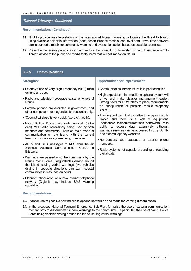
N A U R U T S U N A M I C A P A C I T Y A S S E S S M E N T R E P O R T
F I N A L V 0 . 3 , M A R C H 2 0 1 0 P A G E 3 3
Tsunami Warnings (Continued)
Recommendations (Continued):
11. NFS to provide an interpretation of the international tsunami warning to localise the threat to Nauru using available scientific information (deep ocean tsunami models, sea level data, travel time software etc) to support a matrix for community warning and evacuation action based on possible scenarios.
12. Prevent unnecessary public concern and reduce the possibility of false alarms through issuance of “No Threat” advice to the public and media for tsunami that will not impact on Nauru.
5.3.6. Communications
Strengths: Opportunities for Improvement:
• Extensive use of Very High Frequency (VHF) radio on land and sea.
• Radio and television coverage exists for whole of Nauru.
• Satellite phones are available in government and other non-government agencies for response only.
• ‘Coconut wireless’ is very quick (word of mouth).
• Nauru Police Force have radio network (voice only). VHF radio increasingly being used by both mariners and commercial users as main mode of communication on the island with the current telecommunications system being unreliable.
• AFTN and GTS messages to NFS from the Air Services Australia Communication Centre in Brisbane.
• Warnings are passed onto the community by the Nauru Police Force using vehicles driving around the island issuing verbal warnings (two vehicles driving in opposite directions can warn coastal communities in less than an hour).
• Planned introduction of a new cellular telephone network (Digicel) may include SMS warning capability.
• Communication infrastructure is in poor condition.
• High expectation that mobile telephone system will arrive and make disaster management easier. Strong need for DRM plans to place requirements on configuration of possible mobile telephony system.
• Funding and technical expertise to interpret data is limited and there is a lack of equipment. Inadequate telecommunications bandwidth limits ability to access data extensively although warnings services can be accessed through AFTN and external agency websites.
• No centrally kept database of satellite phone numbers.
• Radio systems not capable of sending or receiving digital data.
Recommendations:
13. Plan for use of possible new mobile telephone network as one mode for warning dissemination.
14. In the proposed National Tsunami Emergency Sub-Plan, formalise the use of existing communication mechanisms to disseminate tsunami warnings to the community. In particular, the use of Nauru Police Force using vehicles driving around the island issuing verbal warnings.
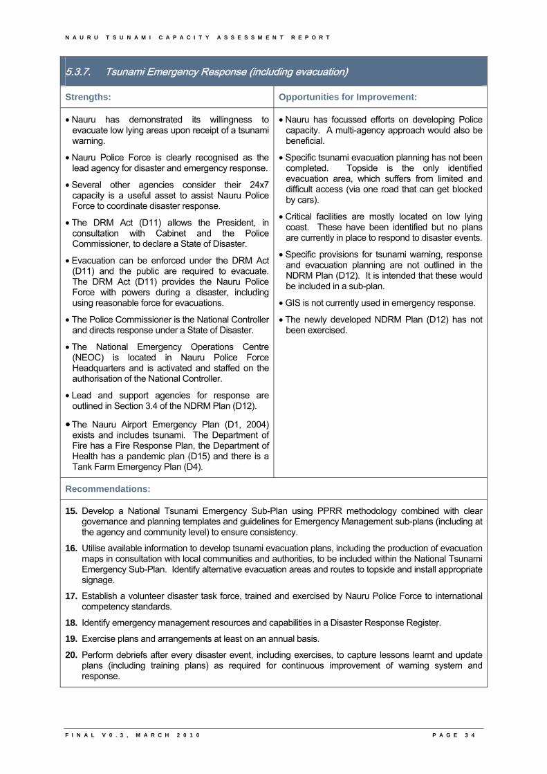
N A U R U T S U N A M I C A P A C I T Y A S S E S S M E N T R E P O R T
F I N A L V 0 . 3 , M A R C H 2 0 1 0 P A G E 3 4
5.3.7. Tsunami Emergency Response (including evacuation)
Strengths: Opportunities for Improvement:
• Nauru has demonstrated its willingness to evacuate low lying areas upon receipt of a tsunami warning.
• Nauru Police Force is clearly recognised as the lead agency for disaster and emergency response.
• Several other agencies consider their 24x7 capacity is a useful asset to assist Nauru Police Force to coordinate disaster response.
• The DRM Act (D11) allows the President, in consultation with Cabinet and the Police Commissioner, to declare a State of Disaster.
• Evacuation can be enforced under the DRM Act (D11) and the public are required to evacuate. The DRM Act (D11) provides the Nauru Police Force with powers during a disaster, including using reasonable force for evacuations.
• The Police Commissioner is the National Controller and directs response under a State of Disaster.
• The National Emergency Operations Centre (NEOC) is located in Nauru Police Force Headquarters and is activated and staffed on the authorisation of the National Controller.
• Lead and support agencies for response are outlined in Section 3.4 of the NDRM Plan (D12).
• The Nauru Airport Emergency Plan (D1, 2004) exists and includes tsunami. The Department of Fire has a Fire Response Plan, the Department of Health has a pandemic plan (D15) and there is a Tank Farm Emergency Plan (D4).
• Nauru has focussed efforts on developing Police capacity. A multi-agency approach would also be beneficial.
• Specific tsunami evacuation planning has not been completed. Topside is the only identified evacuation area, which suffers from limited and difficult access (via one road that can get blocked by cars).
• Critical facilities are mostly located on low lying coast. These have been identified but no plans are currently in place to respond to disaster events.
• Specific provisions for tsunami warning, response and evacuation planning are not outlined in the NDRM Plan (D12). It is intended that these would be included in a sub-plan.
• GIS is not currently used in emergency response.
• The newly developed NDRM Plan (D12) has not been exercised.
Recommendations:
15. Develop a National Tsunami Emergency Sub-Plan using PPRR methodology combined with clear governance and planning templates and guidelines for Emergency Management sub-plans (including at the agency and community level) to ensure consistency.
16. Utilise available information to develop tsunami evacuation plans, including the production of evacuation maps in consultation with local communities and authorities, to be included within the National Tsunami Emergency Sub-Plan. Identify alternative evacuation areas and routes to topside and install appropriate signage.
17. Establish a volunteer disaster task force, trained and exercised by Nauru Police Force to international competency standards.
18. Identify emergency management resources and capabilities in a Disaster Response Register.
19. Exercise plans and arrangements at least on an annual basis.
20. Perform debriefs after every disaster event, including exercises, to capture lessons learnt and update plans (including training plans) as required for continuous improvement of warning system and response.
N A U R U T S U N A M I C A P A C I T Y A S S E S S M E N T R E P O R T
F I N A L V 0 . 3 , M A R C H 2 0 1 0 P A G E 3 5
5.3.8. Tsunami Hazard, Vulnerability, Risk and Mitigation
Strengths: Opportunities for Improvement:
• Access to higher ground is a short distance from the exposed coastal zone (although serviced by only one road that gets jammed with traffic).
• Nauru’s eastern coastline and benthic contours show evidence of large scale slump. This ancient event would have produced a catastrophic tsunami. Whilst this event was remote, it remains useful in raising Nauru’s community awareness to a past history of hazards.
• Storm surge events have inundated the coastline.
• The Nauru MapServer (maintained by the Department of Lands and Ministry of Information and Communication Technology) hosts Nauru data including bathymetry.
• 100% coverage of high-resolution MBES data exists for the seafloor from approximately 50 m depth in the near shore area to an average offshore distance of 3 km, reaching water depths of some 1800 m. External sources of data were used in conjunction with this data to produce a bathymetry chart of Nauru at 1 : 25 000. Refer to D23.
• There is topographic data of Nauru (although no metadata exists for it). SOPAC has a backup of this data as well as high resolution imagery (1 m).
• GA has completed a Preliminary and Probabilistic Tsunami Hazard for the Southwest Pacific, including Palau.
• National perception that Nauru is very safe may hinder acceptance of mitigation strategies.
• Need for records of coastal inundation, in order to understand local hazards, and discriminate storm surge from possible tsunami events.
• No risk assessment or inundation studies have been conducted specific to Nauru’s communities.
• Housing and building regulations exist but are not implemented (D13). Effective land use planning is not practiced. Housing and building arrangements are based on ownership of land plots. This leads to congested living and multiple, incompatible land used on the one plot of land (D13).
• GIS, GPS and MapServer training has been undertaken in Nauru with European Union (EU) funding (D19).
Recommendations:
21. Develop a tsunami risk profile for Nauru based on tsunami hazard studies completed for the Southwest Pacific Nations to date, tsunami numerical deep ocean modelling carried out by international agencies, research of previous inundation events and GIS data (existing bathymetry and topography). This will inform development and building codes.
22. Consider vulnerability of critical facilities and infrastructure, particularly when considering new construction and unloading of fuel during tsunami events.
23. Further develop and enforce building codes. This includes assessing current building stock.
N A U R U T S U N A M I C A P A C I T Y A S S E S S M E N T R E P O R T
F I N A L V 0 . 3 , M A R C H 2 0 1 0 P A G E 3 6
5.3.9. Knowledge, Information, Public and Stakeholder Awareness and Education
Strengths: Opportunities for Improvement:
• Awareness of tsunami exists due primarily to international media coverage.
• Existing methods can be used to educate the community (for example, press releases from the Government Information Office, community noticeboards, community social gatherings, District Primary Healthcare workers, Nauru Media Bureau).
• Presently no community awareness or training in relation to natural hazards.
• Limited funding at present for community education programs, material printing etc.
Recommendations:
24. Adapt existing PIC tsunami (and other hazard) awareness information packages for development and delivery of a comprehensive risk based tsunami public awareness program in Nauru using existing school and community communication methods. The program should include:
a. An understanding of the topography and bathymetry of Nauru, as well as Nauru’s tsunami risk profile; and
b. Raise awareness of Nauru’s NDRM Plan (D12) and each sub-plan to promote community response and recovery responsibilities. This includes awareness of warning systems.
25. Introduce DRM into schools using current resources and personnel. Integrate topics relevant to PIC hazards into school curricula, in particular geography studies.
26. Educate media to understand the tsunami hazard and warning procedures. Training program should take an all hazards approach, including other hazards relevant to Nauru.
27. Develop and deliver a tsunami competency based training program to staff responsible for issuing tsunami warnings for Nauru. This training should be developed based on operational SOPs.
28. Implement a training needs analysis and development of a national training framework for DRM in Nauru (including a training database to track progress). Develop appropriate training for all levels and across the various sectors to match roles and responsibilities as identified in the NDRM Plan (D12) and sub-plans. Tsunami should be included in this multi-hazard training approach.
5.4. Additional Workshop Benefits
In addition to this report, additional benefits of the Tsunami Capacity Assessment Workshop in Nauru were:
• Facilitation of working relationships between agencies and organisations involved in tsunami warning and mitigation within Nauru;
• Exchange of information on national activities and capabilities within Nauru; and
• Enhanced working relationships between Nauru participants, the Bureau, Tasmania State Emergency Services and SOPAC.
N A U R U T S U N A M I C A P A C I T Y A S S E S S M E N T R E P O R T
F I N A L V 0 . 3 , M A R C H 2 0 1 0 P A G E 3 7
5.5. Next Steps
Nauru will receive three key material outcomes from the Tsunami Capacity Assessment project:
1. The completed questionnaire in electronic format with scanned copies of all supporting documentation collected in-country:
2. A comprehensive National Report in a standard format which aims to summarise information collected from the visits and is consumable for non-technically minded recipients (this document); and
3. A copy of the final regional Report which will outline common themes across the region.
At the agreement of the country project results will be posted on websites such as the Bureau, SOPAC and Pacific Disaster Net.
Once approved by the country the Bureau will facilitate dissemination of reports to regional and international donors and other stakeholders to ensure maximum exposure of results. Contingent on the availability of human and financial resources, the Australian Bureau of Meteorology and project partners will aim to work with potential donors to bring the findings of this project to their attention on a country and regional scale. This will be done to facilitate further capacity development projects being undertaken based on the results of this project.
Nauru workshop participants are encouraged to use this National Tsunami Capacity Assessment report to guide both national projects and aid funded projects to achieve targeted improvements of Nauru’s tsunami warning and mitigation system. In turn, this will assist in improving systems for other natural hazards.
N A U R U T S U N A M I C A P A C I T Y A S S E S S M E N T R E P O R T
F I N A L V 0 . 3 , M A R C H 2 0 1 0
6. Annexure
6

N A U R U T S U N A M I C A P A C I T Y A S S E S S M E N T R E P O R T
F I N A L V 0 . 3 , M A R C H 2 0 1 0
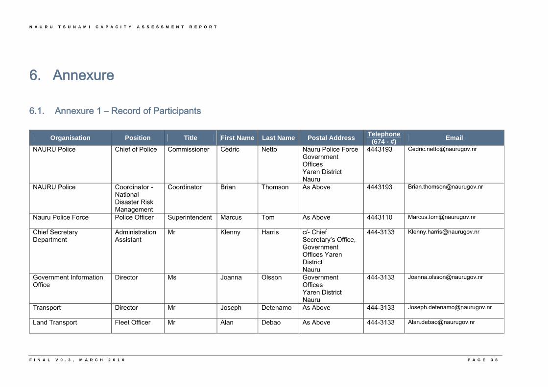
N A U R U T S U N A M I C A P A C I T Y A S S E S S M E N T R E P O R T
6. Annexure
6.1. Annexure 1 – Record of Participants
Organisation Position Title First Name Last Name Postal Address Telephone
(674 - #) Email
NAURU Police Chief of Police Commissioner Cedric Netto Nauru Police Force Government Offices Yaren District Nauru
4443193 [email protected]
NAURU Police Coordinator - National Disaster Risk Management
Coordinator Brian Thomson As Above 4443193 [email protected]
Nauru Police Force Police Officer Superintendent Marcus Tom As Above 4443110 [email protected]
Chief Secretary Department
Administration Assistant
Mr Klenny Harris c/- Chief Secretary’s Office, Government Offices Yaren District Nauru
444-3133 [email protected]
Government Information Office
Director Ms Joanna Olsson Government Offices Yaren District Nauru
444-3133 [email protected]
Transport Director Mr Joseph Detenamo As Above 444-3133 [email protected]
Land Transport Fleet Officer Mr Alan Debao As Above 444-3133 [email protected]
F I N A L V 0 . 3 , M A R C H 2 0 1 0 P A G E 3 8
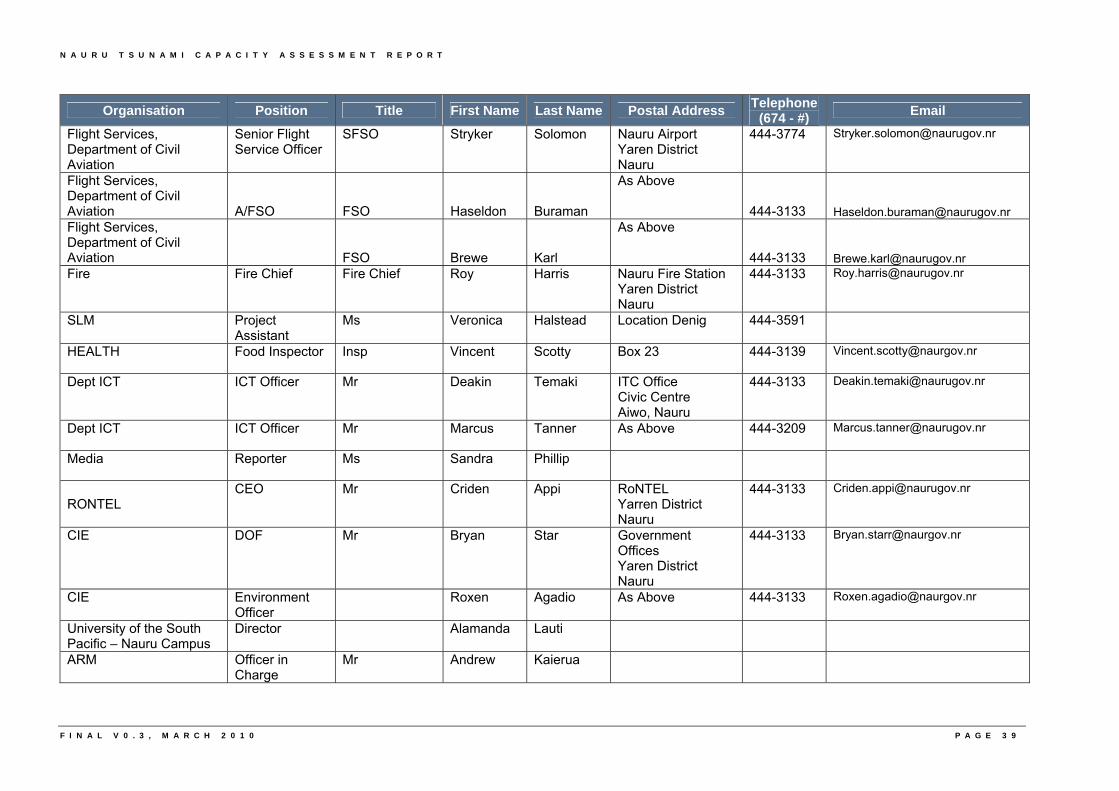
N A U R U T S U N A M I C A P A C I T Y A S S E S S M E N T R E P O R T
F I N A L V 0 . 3 , M A R C H 2 0 1 0 P A G E 3 9
Organisation Position Title First Name Last Name Postal Address Telephone
(674 - #) Email
Flight Services, Department of Civil Aviation
Senior Flight Service Officer
SFSO Stryker Solomon Nauru Airport Yaren District Nauru
444-3774 [email protected]
Flight Services, Department of Civil Aviation A/FSO FSO Haseldon Buraman
As Above
444-3133 [email protected] Flight Services, Department of Civil Aviation FSO Brewe Karl
As Above
444-3133 [email protected] Fire Fire Chief Fire Chief Roy Harris Nauru Fire Station
Yaren District Nauru
444-3133 [email protected]
SLM Project Assistant
Ms Veronica Halstead Location Denig 444-3591
HEALTH Food Inspector Insp Vincent Scotty Box 23 444-3139 [email protected]
Dept ICT ICT Officer Mr Deakin Temaki ITC Office Civic Centre Aiwo, Nauru
444-3133 [email protected]
Dept ICT ICT Officer Mr Marcus Tanner As Above 444-3209 [email protected]
Media Reporter Ms Sandra Phillip
RONTEL
CEO Mr Criden Appi RoNTEL Yarren District Nauru
444-3133 [email protected]
CIE DOF Mr Bryan Star Government Offices Yaren District Nauru
444-3133 [email protected]
CIE Environment Officer
Roxen Agadio As Above 444-3133 [email protected]
University of the South Pacific – Nauru Campus
Director Alamanda Lauti
ARM Officer in Charge
Mr Andrew Kaierua
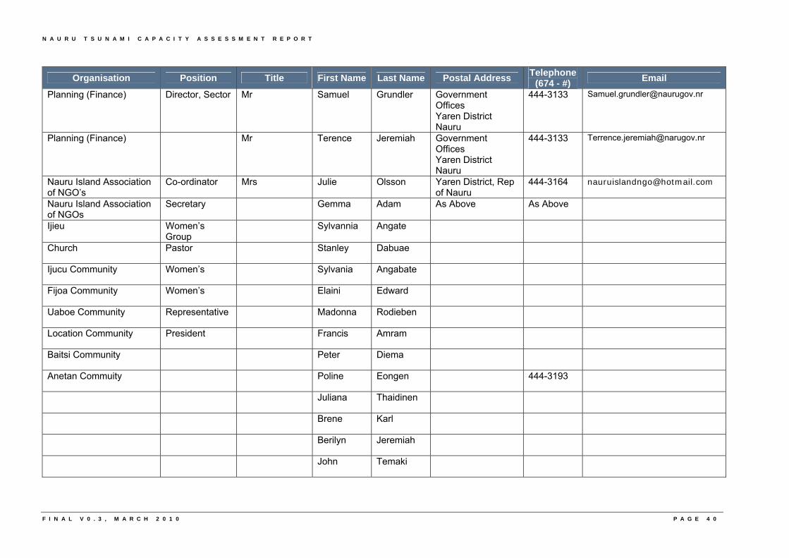
N A U R U T S U N A M I C A P A C I T Y A S S E S S M E N T R E P O R T
F I N A L V 0 . 3 , M A R C H 2 0 1 0 P A G E 4 0
Organisation Position Title First Name Last Name Postal Address Telephone
(674 - #) Email
Planning (Finance) Director, Sector Mr Samuel Grundler Government Offices Yaren District Nauru
444-3133 [email protected]
Planning (Finance) Mr Terence Jeremiah Government Offices Yaren District Nauru
444-3133 [email protected]
Nauru Island Association of NGO’s
Co-ordinator Mrs Julie Olsson Yaren District, Rep of Nauru
444-3164 [email protected]
Nauru Island Association of NGOs
Secretary Gemma Adam As Above As Above
Ijieu Women’s Group
Sylvannia Angate
Church Pastor Stanley Dabuae
Ijucu Community Women’s Sylvania Angabate
Fijoa Community Women’s Elaini Edward
Uaboe Community Representative Madonna Rodieben
Location Community President Francis Amram
Baitsi Community Peter Diema
Anetan Commuity Poline Eongen 444-3193
Juliana Thaidinen
Brene Karl
Berilyn Jeremiah
John Temaki
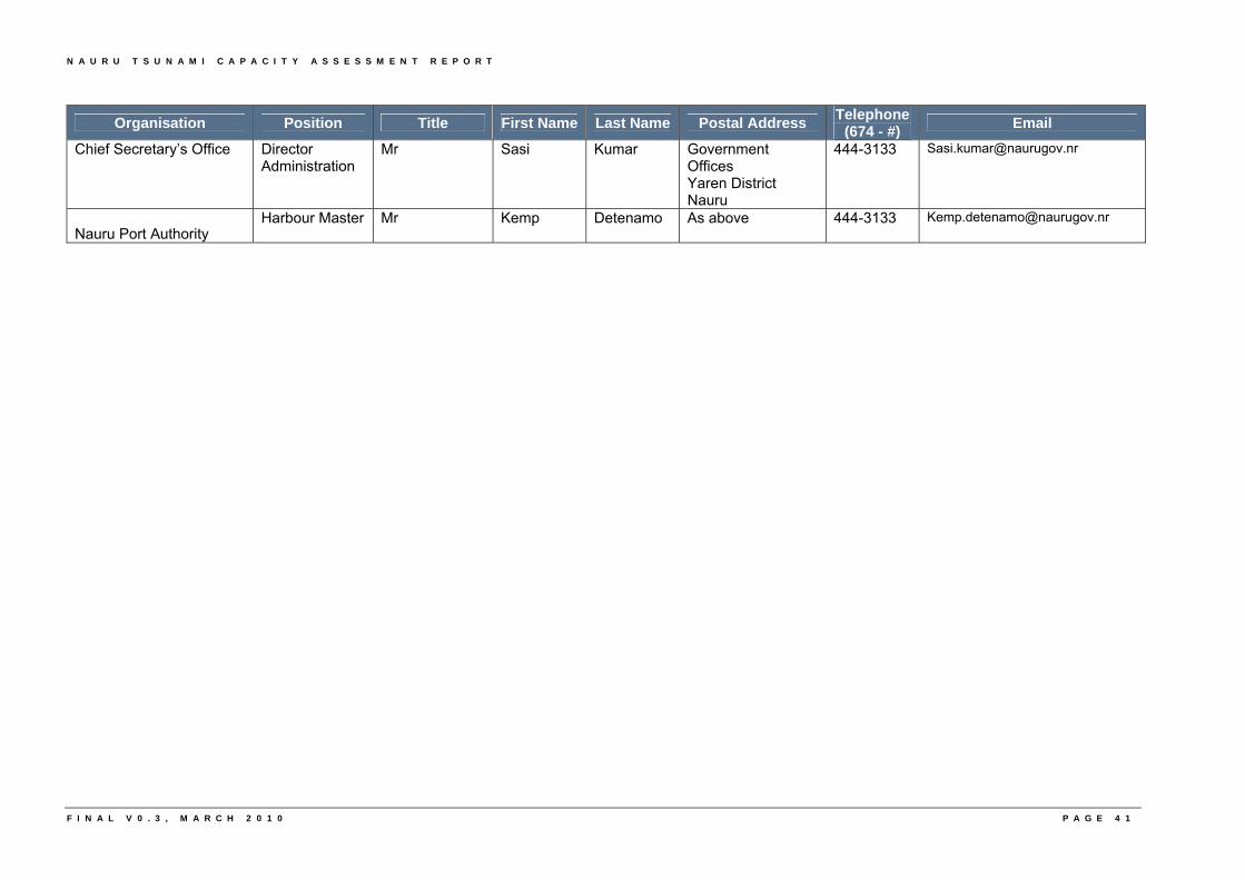
N A U R U T S U N A M I C A P A C I T Y A S S E S S M E N T R E P O R T
F I N A L V 0 . 3 , M A R C H 2 0 1 0 P A G E 4 1
Organisation Position Title First Name Last Name Postal Address Telephone
(674 - #) Email
Chief Secretary’s Office Director Administration
Mr Sasi Kumar Government Offices Yaren District Nauru
444-3133 [email protected]
Nauru Port Authority Harbour Master Mr Kemp Detenamo As above 444-3133 [email protected]
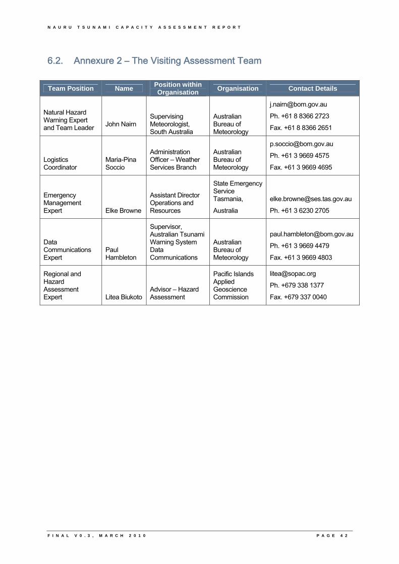
N A U R U T S U N A M I C A P A C I T Y A S S E S S M E N T R E P O R T
F I N A L V 0 . 3 , M A R C H 2 0 1 0 P A G E 4 2
6.2. Annexure 2 – The Visiting Assessment Team
Team Position Name Position within Organisation
Organisation Contact Details
Natural Hazard Warning Expert and Team Leader John Nairn
Supervising Meteorologist, South Australia
Australian Bureau of Meteorology
Ph. +61 8 8366 2723
Fax. +61 8 8366 2651
Logistics Coordinator
Maria-Pina Soccio
Administration Officer – Weather Services Branch
Australian Bureau of Meteorology
Ph. +61 3 9669 4575
Fax. +61 3 9669 4695
Emergency Management Expert Elke Browne
Assistant Director Operations and Resources
State Emergency Service Tasmania,
Australia
Ph. +61 3 6230 2705
Data Communications Expert
Paul Hambleton
Supervisor, Australian Tsunami Warning System Data Communications
Australian Bureau of Meteorology
Ph. +61 3 9669 4479
Fax. +61 3 9669 4803
Regional and Hazard Assessment Expert Litea Biukoto
Advisor – Hazard Assessment
Pacific Islands Applied Geoscience Commission
Ph. +679 338 1377
Fax. +679 337 0040
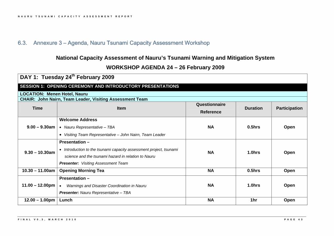
N A U R U T S U N A M I C A P A C I T Y A S S E S S M E N T R E P O R T
6.3. Annexure 3 – Agenda, Nauru Tsunami Capacity Assessment Workshop
National Capacity Assessment of Nauru’s Tsunami Warning and Mitigation System
WORKSHOP AGENDA 24 – 26 February 2009
DAY 1: Tuesday 24th February 2009
SESSION 1: OPENING CEREMONY AND INTRODUCTORY PRESENTATIONS
LOCATION: Menen Hotel, Nauru CHAIR: John Nairn, Team Leader, Visiting Assessment Team
Time Item Questionnaire
Reference Duration Participation
9.00 – 9.30am
Welcome Address
• Nauru Representative – TBA
• Visiting Team Representative – John Nairn, Team Leader
NA 0.5hrs Open
9.30 – 10.30am
Presentation –
• Introduction to the tsunami capacity assessment project, tsunami
science and the tsunami hazard in relation to Nauru
Presenter: Visiting Assessment Team
NA 1.0hrs Open
10.30 – 11.00am Opening Morning Tea NA 0.5hrs Open
11.00 – 12.00pm
Presentation –
• Warnings and Disaster Coordination in Nauru
Presenter: Nauru Representative – TBA
NA 1.0hrs Open
12.00 – 1.00pm Lunch NA 1hr Open
F I N A L V 0 . 3 , M A R C H 2 0 1 0 P A G E 4 3
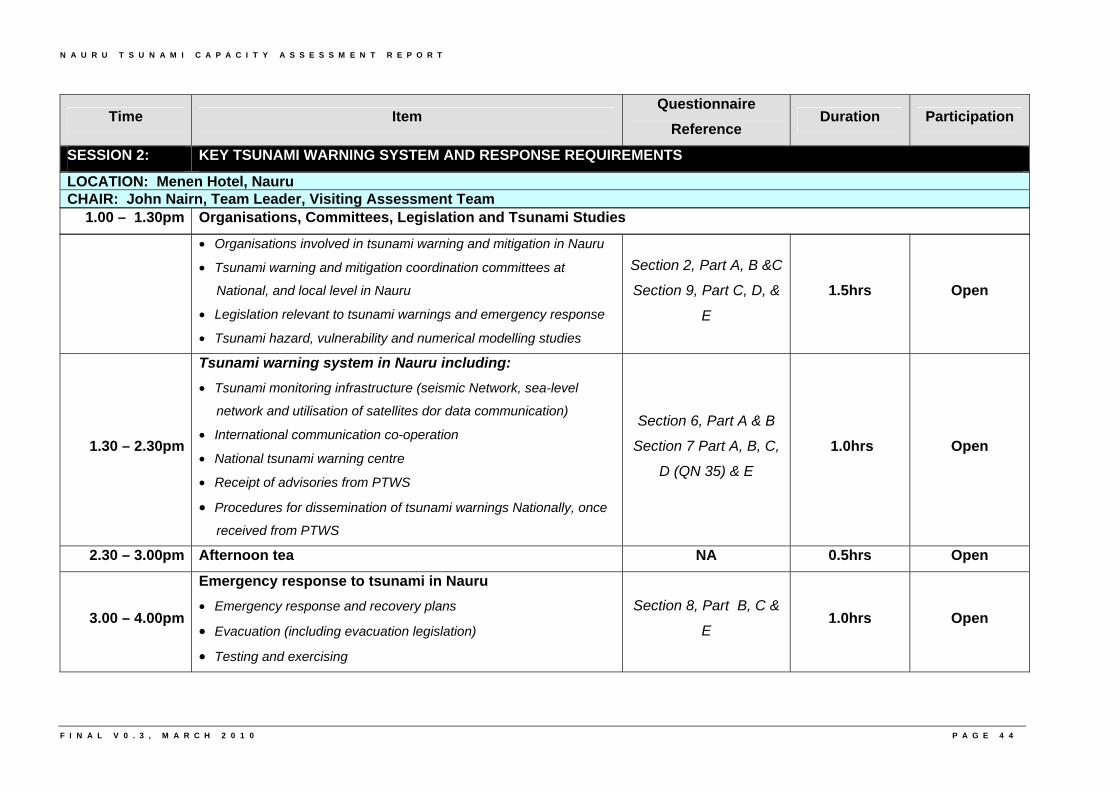
N A U R U T S U N A M I C A P A C I T Y A S S E S S M E N T R E P O R T
LOCATION: Menen Hotel, Nauru CHAIR: John Nairn, Team Leader, Visiting Assessment Team
• Organisations involved in tsunami warning and mitigation in Nauru
• Tsunami warning and mitigation coordination committees at
National, and local level in Nauru
• Legislation relevant to tsunami warnings and emergency response
• Tsunami hazard, vulnerability and numerical modelling studies
Section 2, Part A, B &C
Section 9, Part C, D, &
E
1.5hrs Open
1.30 – 2.30pm
Tsunami warning system in Nauru including: • Tsunami monitoring infrastructure (seismic Network, sea-level
network and utilisation of satellites dor data communication)
• International communication co-operation
• National tsunami warning centre
• Receipt of advisories from PTWS
• Procedures for dissemination of tsunami warnings Nationally, once
received from PTWS
Section 6, Part A & B
Section 7 Part A, B, C,
D (QN 35) & E
1.0hrs Open
2.30 – 3.00pm Afternoon tea NA 0.5hrs Open
3.00 – 4.00pm
Emergency response to tsunami in Nauru
• Emergency response and recovery plans
• Evacuation (including evacuation legislation)
• Testing and exercising
Section 8, Part B, C &
E 1.0hrs Open
Time Item Questionnaire
Reference Duration Participation
SESSION 2: KEY TSUNAMI WARNING SYSTEM AND RESPONSE REQUIREMENTS
1.00 – 1.30pm Organisations, Committees, Legislation and Tsunami Studies
F I N A L V 0 . 3 , M A R C H 2 0 1 0 P A G E 4 4
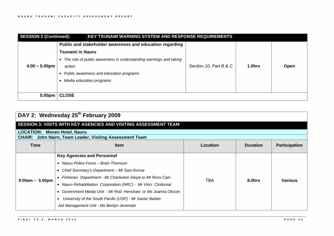
N A U R U T S U N A M I C A P A C I T Y A S S E S S M E N T R E P O R T
4.00 – 5.00pm
Public and stakeholder awareness and education regarding
Tsunami in Nauru
• The role of public awareness in understanding warnings and taking
action
• Public awareness and education programs
• Media education programs
Section 10, Part B & C 1.0hrs Open
5.00pm CLOSE
SESSION 2 (Continued): KEY TSUNAMI WARNING SYSTEM AND RESPONSE REQUIREMENTS
DAY 2: Wednesday 25th February 2009
SESSION 3: VISITS WITH KEY AGENCIES AND VISITING ASSESSMENT TEAM
LOCATION: Menen Hotel, Nauru CHAIR: John Nairn, Team Leader, Visiting Assessment Team
Time Item Location Duration Participation
9.00am – 5.00pm
Key Agencies and Personnel
• Nauru Police Force – Brian Thomson
• Chief Secretary’s Department – Mr Sasi Kumar
• Fisheries Department - Mr Charleston Deiye or Mr Ross Cain
• Nauru Rehabilitation Corporation (NRC) - Mr Vinci Clodumar
• Government Media Unit - Mr Rod Henshaw or Ms Joanna Olsson
• University of the South Pacific (USP) - Mr Xavier Barker
Aid Management Unit - Ms Berilyn Jeremiah
TBA 8.0hrs Various
F I N A L V 0 . 3 , M A R C H 2 0 1 0 P A G E 4 5
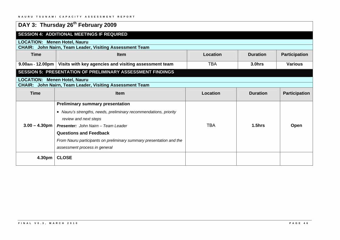
N A U R U T S U N A M I C A P A C I T Y A S S E S S M E N T R E P O R T
F I N A L V 0 . 3 , M A R C H 2 0 1 0 P A G E 4 6
DAY 3: Thursday 26th February 2009
SESSION 4: ADDITIONAL MEETINGS IF REQUIRED
LOCATION: Menen Hotel, Nauru CHAIR: John Nairn, Team Leader, Visiting Assessment Team
Time Item Location Duration Participation
9.00am - 12.00pm Visits with key agencies and visiting assessment team TBA 3.0hrs Various
SESSION 5: PRESENTATION OF PRELIMINARY ASSESSMENT FINDINGS
LOCATION: Menen Hotel, Nauru CHAIR: John Nairn, Team Leader, Visiting Assessment Team
Time Item Location Duration Participation
3.00 – 4.30pm
Preliminary summary presentation
• Nauru’s strengths, needs, preliminary recommendations, priority
review and next steps
Presenter: John Nairn – Team Leader
Questions and Feedback
From Nauru participants on preliminary summary presentation and the
assessment process in general
TBA 1.5hrs Open
4.30pm CLOSE
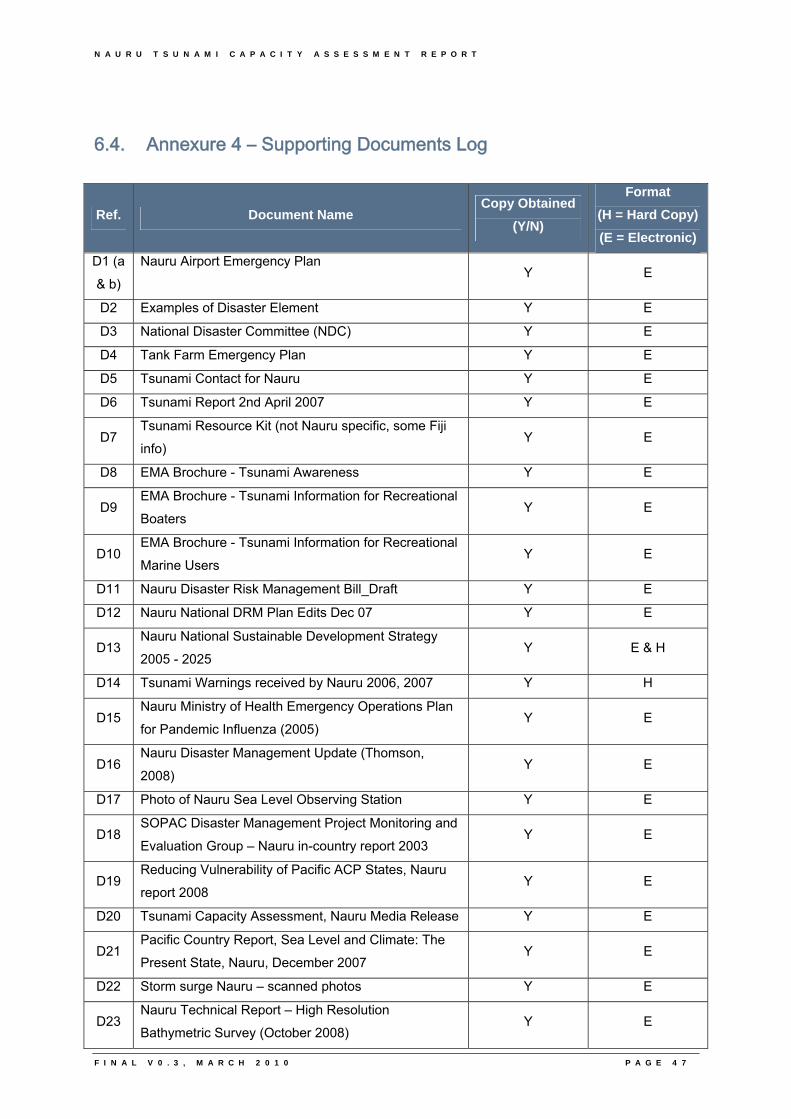
N A U R U T S U N A M I C A P A C I T Y A S S E S S M E N T R E P O R T
F I N A L V 0 . 3 , M A R C H 2 0 1 0 P A G E 4 7
6.4. Annexure 4 – Supporting Documents Log
Ref. Document Name Copy Obtained
(Y/N)
Format
(H = Hard Copy)
(E = Electronic)
D1 (a
& b)
Nauru Airport Emergency Plan Y E
D2 Examples of Disaster Element Y E
D3 National Disaster Committee (NDC) Y E
D4 Tank Farm Emergency Plan Y E
D5 Tsunami Contact for Nauru Y E
D6 Tsunami Report 2nd April 2007 Y E
D7 Tsunami Resource Kit (not Nauru specific, some Fiji
info) Y E
D8 EMA Brochure - Tsunami Awareness Y E
D9 EMA Brochure - Tsunami Information for Recreational
Boaters Y E
D10 EMA Brochure - Tsunami Information for Recreational
Marine Users Y E
D11 Nauru Disaster Risk Management Bill_Draft Y E
D12 Nauru National DRM Plan Edits Dec 07 Y E
D13 Nauru National Sustainable Development Strategy
2005 - 2025 Y E & H
D14 Tsunami Warnings received by Nauru 2006, 2007 Y H
D15 Nauru Ministry of Health Emergency Operations Plan
for Pandemic Influenza (2005) Y E
D16 Nauru Disaster Management Update (Thomson,
2008) Y E
D17 Photo of Nauru Sea Level Observing Station Y E
D18 SOPAC Disaster Management Project Monitoring and
Evaluation Group – Nauru in-country report 2003 Y E
D19 Reducing Vulnerability of Pacific ACP States, Nauru
report 2008 Y E
D20 Tsunami Capacity Assessment, Nauru Media Release Y E
D21 Pacific Country Report, Sea Level and Climate: The
Present State, Nauru, December 2007 Y E
D22 Storm surge Nauru – scanned photos Y E
D23 Nauru Technical Report – High Resolution
Bathymetric Survey (October 2008) Y E
N A U R U T S U N A M I C A P A C I T Y A S S E S S M E N T R E P O R T
F I N A L V 0 . 3 , M A R C H 2 0 1 0 P A G E 4 8
6.5. Annexure 5 – Definitions
Used in reports for SOPAC Member Countries National Capacity Assessment: Tsunami Warning and Mitigation Systems Source: United Nations, International Strategy for Disaster Reduction, 2009 Capacity A combination of all the strengths and resources available within a community, society or organization that can reduce the level of risk, or the effects of a disaster. Capacity may include physical, institutional, social or economic means as well as skilled personal or collective attributes such as leadership and management. Capacity may also be described as capability. Capacity building Efforts aimed to develop human skills or societal infrastructures within a community or organization needed to reduce the level of risk. In extended understanding, capacity building also includes development of institutional, financial, political and other resources, such as technology at different levels and sectors of the society. Disaster A serious disruption of the functioning of a community or a society causing widespread human, material, economic or environmental losses which exceed the ability of the affected community or society to cope using its own resources. A disaster is a function of the risk process. It results from the combination of hazards, conditions of vulnerability and insufficient capacity or measures to reduce the potential negative consequences of risk. Disaster risk management The systematic process of using administrative decisions, organization, operational skills and capacities to implement policies, strategies and coping capacities of the society and communities to lessen the impacts of natural hazards and related environmental and technological disasters. This comprises all forms of activities, including structural and non-structural measures to avoid (prevention) or to limit (mitigation and preparedness) adverse effects of hazards. Disaster risk reduction (disaster reduction)
The reduction of disaster risks and adverse impacts of natural hazards, through systematic efforts to analyse and manage the causes of disasters, including through avoidance of hazards, reduced social and economic vulnerability to hazards, and improved preparedness for adverse events
N A U R U T S U N A M I C A P A C I T Y A S S E S S M E N T R E P O R T
F I N A L V 0 . 3 , M A R C H 2 0 1 0 P A G E 4 9
Early warning The provision of timely and effective information, through identified institutions, that allow individuals exposed to a hazard, to take action to avoid or reduce their risk and prepare for effective response. Early warning systems include of three primary elements: (i) forecasting of impending events; (ii) processing and dissemination of warnings to political authorities and population; and (iii) undertaking appropriate and timely actions. Emergency management The organization and management of resources and responsibilities for dealing with all aspects of emergencies, in particularly preparedness, response and rehabilitation. Emergency management involves plans, structures and arrangements established to engage the normal endeavours of government, voluntary and private agencies in a comprehensive and coordinated way to respond to the whole spectrum of emergency needs. This is also known as disaster management. Geographic information systems (GIS) Analysis that combine relational databases with spatial interpretation and outputs often in form of maps. A more elaborate definition is that of computer programmes for capturing, storing, checking, integrating, analysing and displaying data about the earth that is spatially referenced. Geographical information systems are increasingly being utilised for hazard and vulnerability mapping and analysis, as well as for the application of disaster risk management measures. Hazard A potentially damaging physical event, phenomenon and/or human activity, which may cause the loss of life or injury, property damage, social and economic disruption or environmental degradation. Hazards can include latent conditions that may represent future threats and can have different origins: natural (geological, hydrometeorological and biological) and/or induced by human processes (environmental degradation and technological hazards). Hazards can be single, sequential or combined in their origin and effects. Each hazard is characterised by its location, intensity, frequency and probability. Land-use planning Branch of physical and socio-economic planning that determines the means and assesses the values or limitations of various options in which land is to be utilized, with the corresponding effects on different segments of the population or interests of a community taken into account in resulting decisions.
Land-use planning involves studies and mapping, analysis of environmental and hazard data, formulation of alternative land-use decisions and design of a long-range plan for different geographical and administrative scales.
Land-use planning can help to mitigate disasters and reduce risks by discouraging high-density settlements and construction of key installations in hazard-prone areas, control of population density and expansion, and in the siting of service routes for transport, power, water, sewage and other critical facilities.
N A U R U T S U N A M I C A P A C I T Y A S S E S S M E N T R E P O R T
F I N A L V 0 . 3 , M A R C H 2 0 1 0 P A G E 5 0
Mitigation Structural and non-structural measures undertaken to limit the adverse impact of natural hazards, environmental degradation and technological hazards. Natural hazards Natural processes or phenomena occurring in the biosphere that may constitute a damaging event. Natural hazards can be classified by origin namely: geological, hydrometeorological or biological. Hazardous events can vary in magnitude or intensity, frequency, duration, area of extent, speed of onset, spatial dispersion and temporal spacing. Preparedness Activities and measures taken in advance to ensure effective response to the impact of hazards, including the issuance of timely and effective early warnings and the temporary removal of people and property from a threatened location. Prevention
Activities to provide outright avoidance of the adverse impact of hazards and means to minimize related environmental, technological and biological disasters.
Depending on social and technical feasibility and cost/benefit considerations, investing in preventive measures is justified in areas frequently affected by disasters. In the context of public awareness and education, related to disaster risk reduction changing attitudes and behaviour contribute to promoting a "culture of prevention".
Public awareness The processes of informing the general population, increasing levels of consciousness about risks and how people can act to reduce their exposure to hazards. This is particularly important for public officials in fulfilling their responsibilities to save lives and property in the event of a disaster. Public awareness activities support changes in behaviour leading towards a culture of prevention. This involves public information, dissemination, education, radio or television broadcasts and the use of printed media, as well as, the establishment of information centres and networks and community and participation actions. Recovery Decisions and actions taken after a disaster with a view to restoring or improving the pre-disaster living conditions of the stricken community, while encouraging and facilitating necessary adjustments to reduce disaster risk. Recovery (rehabilitation and reconstruction) affords an opportunity to develop and apply disaster risk reduction measures.
N A U R U T S U N A M I C A P A C I T Y A S S E S S M E N T R E P O R T
F I N A L V 0 . 3 , M A R C H 2 0 1 0 P A G E 5 1
Relief / response The provision of assistance or intervention during or immediately after a disaster to meet the life preservation and basic subsistence needs of those people affected. It can be of an immediate, short-term, or protracted duration. Resilience / resilient The capacity of a system, community or society potentially exposed to hazards to adapt, by resisting or changing in order to reach and maintain an acceptable level of functioning and structure. This is determined by the degree to which the social system is capable of organizing itself to increase its capacity for learning from past disasters for better future protection and to improve risk reduction measures. Risk The probability of harmful consequences, or expected losses (deaths, injuries, property, livelihoods, economic activity disrupted or environment damaged) resulting from interactions between natural or human induced hazards and vulnerable conditions. Conventionally risk is expressed by the notation Risk = Hazards x Vulnerability Some disciplines also include the concept of exposure to refer particularly to the physical aspects of vulnerability. Beyond expressing a possibility of physical harm, it is crucial to recognize that risks are inherent or can be created or exist within social systems. It is important to consider the social contexts in which risks occur and that people therefore do not necessarily share the same perceptions of risk and their underlying causes. Risk assessment/analysis A methodology to determine the nature and extent of risk by analysing potential hazards and evaluating existing conditions of vulnerability that could pose a potential threat or harm to people, property, livelihoods and the environment on which they depend. The process of conducting a risk assessment is based on a review of both the technical features of hazards such as their location, intensity, frequency and probability; and also the analysis of the physical, social, economic and environmental dimensions of vulnerability and exposure, while taking particular account of the coping capabilities pertinent to the risk scenarios. Structural / non-structural measures Structural measures refer to any physical construction to reduce or avoid possible impacts of hazards, which include engineering measures and construction of hazard-resistant and protective structures and infrastructure. Non-structural measures refer to policies, awareness, knowledge development, public commitment, and methods and operating practices, including participatory mechanisms and the provision of information, which can reduce risk and related impacts.
N A U R U T S U N A M I C A P A C I T Y A S S E S S M E N T R E P O R T
F I N A L V 0 . 3 , M A R C H 2 0 1 0 P A G E 5 2
Vulnerability A set of conditions and processes resulting from physical, social, economic, and environmental factors, which increase the susceptibility of a community to the impact of hazards.

N A U R U T S U N A M I C A P A C I T Y A S S E S S M E N T R E P O R T
F I N A L V 0 . 3 , M A R C H 2 0 1 0
N A U R U T S U N A M I C A P A C I T Y A S S E S S M E N T R E P O R T
F I N A L V 0 . 3 , M A R C H 2 0 1 0 P A G E 5 3
6.6. Annexure 6 – References
• Australian Agency for International Development (AusAID) and Australian Bureau of Meteorology 2006, Schedule 5 to the Record of Understanding 14304 in relation to cooperation between the Australian Bureau of Meteorology and AusAID for SOPAC Member Countries National Capacity Assessment: Tsunami Warning and Mitigation Systems, AusAID, Canberra.
• Intergovernmental Oceanographic Commission, a division of the United Nations
Educational, Scientific and Cultural Organisation, Assessment of Capacity Building Requirements or an Effective and Durable Tsunami Warning and Mitigation System in the Indian Ocean, Consolidated Report for Countries Affected by the 26 December 2004 Tsunami, viewed 2008, <http://ioc3.unesco.org/indotsunami/nationalassessments.htm>
• Nauru Country Brief - September 2009, Australian Department of Foreign Affairs and
Trade, Canberra, viewed December 2009, <http://www.dfat.gov.au/geo/nauru/nauru_brief.html>
• Nauru Country Profile – date unknown, Republic of Nauru Permanent Mission to the
United Nations, New York, viewed January 2010, <http://www.un.int/nauru/countryprofile.html>
• IOC’s Tsunami Program, Intergovernmental Coordination Group for the Pacific
Tsunami Warning System (ICG/PTWS), International Tsunami Information Centre October, viewed January 2009, <http://ioc3.unesco.org/itic/contents.php?id=179>
• Pacific Tsunami Warning Center 2008, National Oceanographic and Atmospheric
Administration (NOAA), U.S.A, viewed January, 2009, <http://www.prh.noaa.gov/ptwc>
• Pearce, H. 2008. SOPAC / GA Tsunami Hazard and Risk Assessment Project,
Inventory of Geospatial Data and Options for Tsunami Inundation & Risk Modelling. Phase 1: PIC Summary. SOPAC Miscellaneous Report No. 657.
• Terminology: Basic terms of disaster risk reduction March 2004, United Nations,
International Strategy for Disaster Reduction, viewed January, 2007, <http://www.unisdr.org/eng/library/lib-terminology-eng%20home.htm>
• Thomas, C. and Burbidge, D. 2009. A Probabilistic Tsunami Hazard Assessment of
the Southwest Pacific Nations. Geoscience Australia Professional Opinion No. 2009/02.
• Thomas, C., Burbidge, D., Cummings, P. 2007. A Preliminary study into the Tsunami
Hazard faced by Southwest Pacific Nations. Risk and Impact Analysis Group, Geoscience Australia.

N A U R U T S U N A M I C A P A C I T Y A S S E S S M E N T R E P O R T
F I N A L V 0 . 3 , M A R C H 2 0 1 0

N A U R U T S U N A M I C A P A C I T Y A S S E S S M E N T R E P O R T
7
7. CD Attachment
F I N A L V 0 . 3 , M A R C H 2 0 1 0

N A U R U T S U N A M I C A P A C I T Y A S S E S S M E N T R E P O R T
F I N A L V 0 . 3 , M A R C H 2 0 1 0
N A U R U T S U N A M I C A P A C I T Y A S S E S S M E N T R E P O R T
F I N A L V 0 . 3 , M A R C H 2 0 1 0 P A G E 5 4
7. Attachment 1 – CD of Supporting Documents a. Assessment Questionnaire
b. Supporting Documents
c. Presentations

N A U R U T S U N A M I C A P A C I T Y A S S E S S M E N T R E P O R T
F I N A L V 0 . 3 , M A R C H 2 0 1 0


![National Institute of Technology, Hamirpur2018/08/15 · National Institute of Technology Hamirpur [I-I-PI] Chairman Member Member Member Member Member Member Member 201 1/ 65 Dr.R.L.Sharma,](https://img.pdfslide.net/doc/110x75/5f297161e38dfc50516f3156/national-institute-of-technology-20180815-national-institute-of-technology.jpg)