Embed Size (px)
Citation preview

South Asian Urban and City Management Course
The Urban Environmental Challenge
ENVIRONMENTAL GEOSCIENCE IN URBAN LAND-USE PLANNING: ADVICE FOR PLANNERS AND
DECISION MAKERS
Do you know your ground?
John Powell, British Geological Survey

The Relevance of Geology to Environmental Management
• The environment is not limited to on and above the earth’s surface….
• Geology is not just: • Scientists with hammers and instruments• Producing pretty, but incomprehensible, maps
• Too many decision-makers are unaware of critical contribution geology can make

What is Environmental Geoscience
• Defined as : the interaction between people and their physical environment
• geology and geochemistry (rocks and soils)
• hydrogeology (groundwater)
• engineering geology/geotechnical engineering
• geomorphology (slope analysis/landslip)
• geophysics (seismic risk)

Man and his environment: nothing new!
If a builder builds a house and does not make its construction firm - and the house collapsesand causes the death of the owner - the builder shall be put to death……..if it destroysproperty, he shall restore whatever it destroyed, and because he did not make the house which he built firm and it collapsed, he shall rebuild the house which collapsed at his own expense.Hammurabi, of Babylon (2067-2025 BC)
Be mindful, when visiting a new city, of the air, the soils and the waterHippocrates, 500 BC
….and lo there was a great earthquake….and every mountain and island were moved out of their place (refers to Jordan Rift Valley)Revelation VI: 12,14
Nature to be commanded must be obeyedSir Francis Bacon
No engineering structure is better is better than the material of which, and on which, it is builtA B Brink, 1979
Why is it important to land-use planning?
• to guide planners, developers to recognise constraints on development - and opportunities for sustainable development
• factors include: hazards, resources and conservation
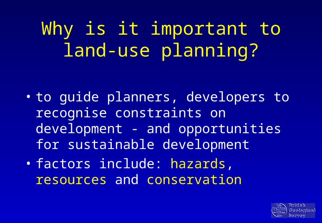
Major Geo-hazards• slope instability (landslides, mudflows)• natural subsidence (caves, dissolution)• heave and settlement (shrink-swell clays)• seismic risk (earthquakes)• flood risk (river and coastal)• volcanic activity (ash-fall, mudflows, lava)• rising/falling groundwater• toxic and explosive gases (radon; methane)• contaminated /polluted land

Man-induced Hazards
• Mine spoil
• Mining-induced subsidence
• Slope instability in quarries etc.
• Landfill (gas and leachate)
• Groundwater pollution
• Industrial/mining pollution (soils & water)
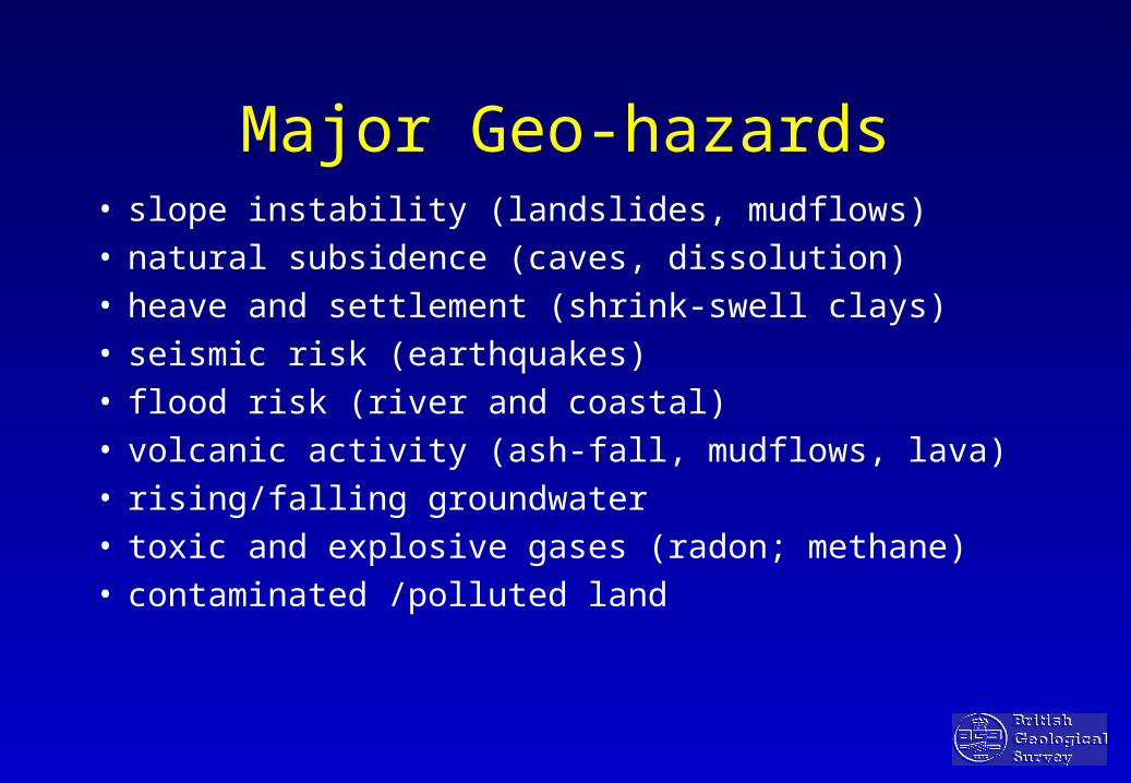
Natural Resources
• Minerals - aggregates; building stone
• Water - surface water and groundwater
• Land and soil - agriculture & construction
• Conservation - natural and geological sites

Shaft
Glacial Till
Landfill-domestic wasteLandfill-domestic waste
Fireclay Coal
Coal extraction following removal of contaminated domestic landfill

The Relevance of Geology to Environmental Management
• Increased financial costs – eg poor use of natural
resources (sterilisation) and damage to property
Ignoring geological factors leads to:
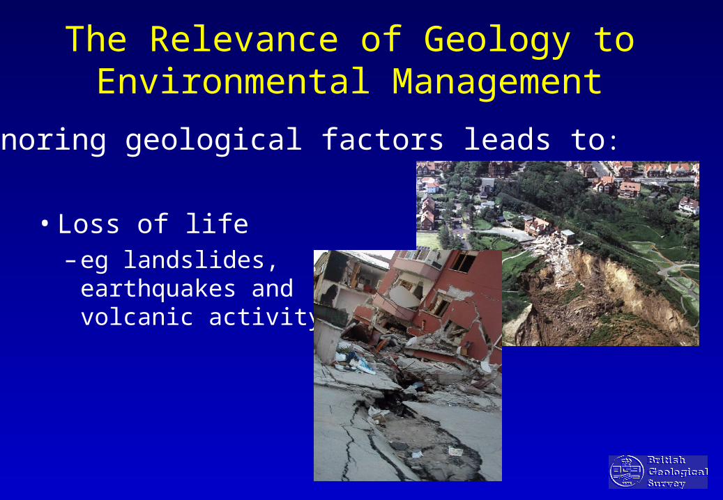
The Relevance of Geology to Environmental Management
• Loss of life– eg landslides,
earthquakes and volcanic activity
Ignoring geological factors leads to:

Volcanic hazard prediction
Mud flow (lahar) probability (Chile)
View
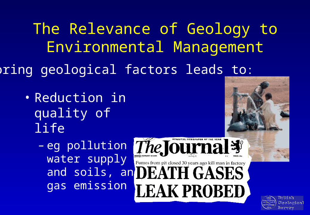
The Relevance of Geology to Environmental Management
• Reduction in quality of life– eg pollution of water
supply and soils, and gas emission
Ignoring geological factors leads to:

Urban Groundwater
Aquifer
Groundwater Abstraction
Urban wells Waste &Industrial Effluent Disposal
Irrigation
Water Supply Waste Water
Peri-urban wells
Use
Disposal
Rainfall Sewage
Re-use
+- Treatment
Interaction of groundwater supply and wastewater disposal in a city
Landfill
Surface water
after Foster et al, 1998
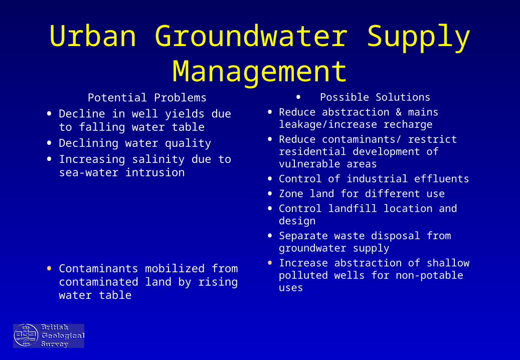
Urban Groundwater Supply Management
Potential Problems
• Decline in well yields due to falling water table
• Declining water quality
• Increasing salinity due to sea-water intrusion
• Contaminants mobilized from contaminated land by rising water table
• Possible Solutions
• Reduce abstraction & mains leakage/increase recharge
• Reduce contaminants/ restrict residential development of vulnerable areas
• Control of industrial effluents
• Zone land for different use
• Control landfill location and design
• Separate waste disposal from groundwater supply
• Increase abstraction of shallow polluted wells for non-potable uses
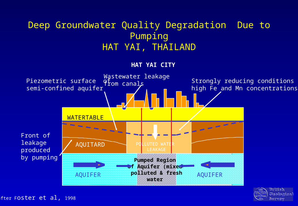
Deep Groundwater Quality Degradation Due to PumpingHAT YAI, THAILAND
Pumped Region of Aquifer (mixed polluted & fresh
water
HAT YAI CITY
WATERTABLE
AQUIFER AQUIFER
AQUITARD POLLUTED WATER LEAKAGE
Piezometric surface ofsemi-confined aquifer
Strongly reducing conditionshigh Fe and Mn concentrations
Front of leakage produced by pumping
Wastewater leakagefrom canals
after Foster et al, 1998

Water Management Solutions
• Encourage use of groundwater within city limits for non-potable use
• Line canals and/or install mains sewerage system/treatment plants
• Incentives for more efficient water use & reduce leakage
• Develop peri-urban wells to meet increased potable supply

Landfill site criteria• Sound site selection is a key factor
• Criteria must include geology, groundwater flow
• Groundwater and surface water protection must be considered
• Dispersal or treatment of noxious gases and leachate?
• Leachate control - natural retention or limited release

COASTPLAN: Environmental geology review and planning
Tourism
Residentialand high rise

Jakarta: key coastal environmental issues:
Subsidence
Coastal pollution
and fish stocks
Poor foundation conditions/illegal building practice
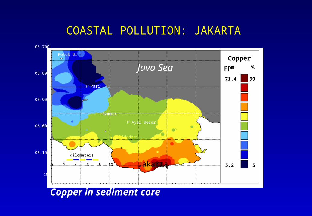
COASTAL POLLUTION: JAKARTA
5
10
25
50
75
90
9599
15
%
Jakarta
Java Sea
106.500 106.600 106.700 106.800 106.900 107.000
06.100
05.900
05.800
05.700
06.000
Copperppm
5.2
5.8
6.2
9.1
15.6
24.0
41.6
49.471.4
P Pari
P Ayer Besar
P Bidadari
Rambut
0 2 4 6 8 10
Kilometers
Copper in sediment core
Kotok Br
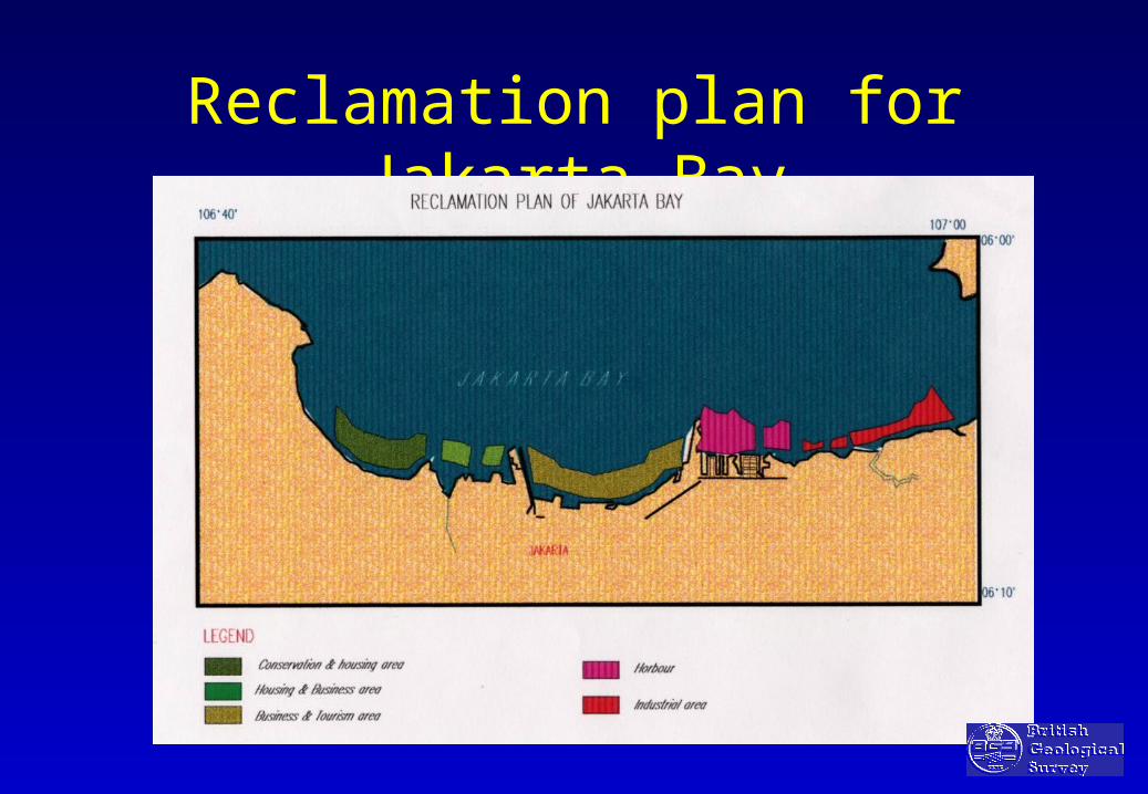
Reclamation plan for Jakarta Bay
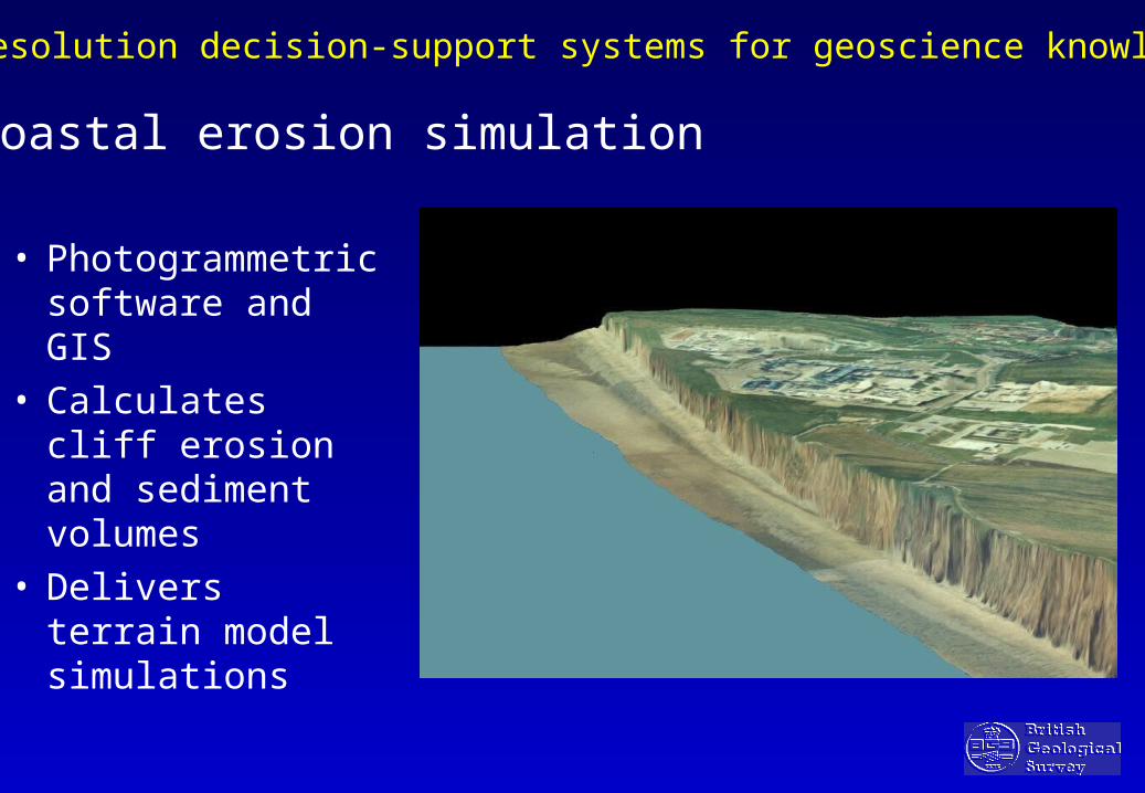
High resolution decision-support systems for geoscience knowledge
Coastal erosion simulation
• Photogrammetric software and GIS
• Calculates cliff erosion and sediment volumes
• Delivers terrain model simulations
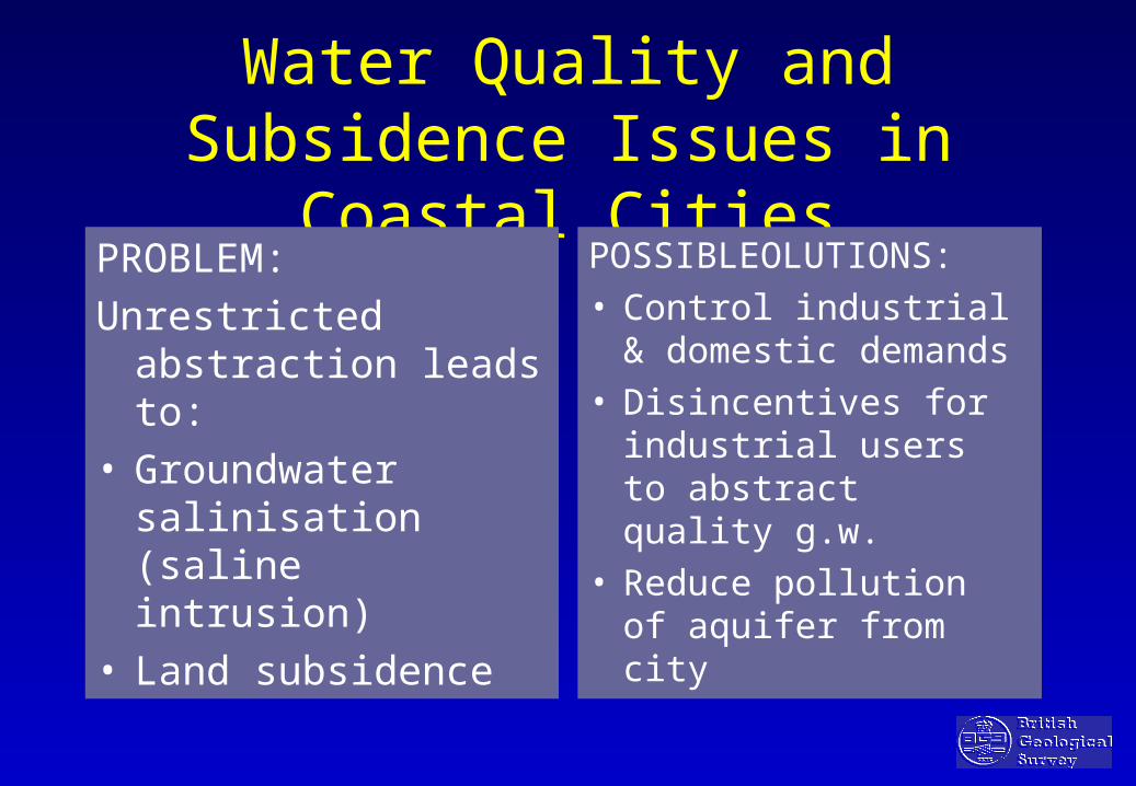
Water Quality and Subsidence Issues in Coastal Cities
PROBLEM:
Unrestricted abstraction leads to:
• Groundwater salinisation (saline intrusion)
• Land subsidence
POSSIBLEOLUTIONS:• Control industrial &
domestic demands• Disincentives for
industrial users to abstract quality g.w.
• Reduce pollution of aquifer from city

SOLUTIONS:ADVANTAGES OF GIS
• SEPARATE MAP LAYERS
• LINKS MAPS AND DATABASES
• QUERY DATA AND MAPS
• THEMATIC MAPS
• COLOUR PAPER COPIES
• SIMPLE GIS PACKAGE (eg. Map Info)
• LANDSAT IMAGES/PHOTOGRAPHS

Location of old mine shafts in an urban coalfield (UK

Land Use In Wolverhampton City
KeyIndustrialResidentialAllotmentsCemeteriesGreen BeltOther Open SpacePublic Open SpaceSports GroundsRailwayUnclassified

Lead in surface soils (-2mm) Wolverhampton
ppm percentile
1342 99
637 95
475 90
297 75
181 50
117 25
98 15
87 10
75 5

Urban Environmental GIS
QUARRYING/MINERALSDATABASE
MS ACCESS
GEOTECHNICALDATABASE
MS ACCESS
HYDRO -GEOLOGICAL
DATABASE
MS ACCESS
HYDRO-GEOLOGICAL
WATERAUTHORITYDATABASE
GEOTECHNICAL
DATA FROMPUBLIC
& PRIVATESECTOR
GEOGRAPHICALINFORMATION SYSTEM
(GIS)
‘LAYERS’1 GEOLOGY2 LANDSAT IMAGES3 DATA POINTS4 PLANNING ZONES5 TOPOGRAPHICAL MAP6 SEISMIC RISK+ OTHERS
CITYMUNICI-PALITYPLANNINGMAPS
CARTO-GRAPHICALOFFICETOPOGRA-PHICAL MAPBASE
1 LANDSAT INTERPRETATION2 AERIAL PHOTOGRAPHY3 RAPID FIELD SURVEY4 SCAN TOPO MAP5 VECTOR DIGITISATION6 DEVELOP MAP DATABASE
OUTPUTS
GEOLOGICAL MAP OF CITY
THEMATIC MAPS⟨ LANDSLIDE /SEISMIC
RISK⟨ POOR FOUNDATION
CONDITIONS⟨ POLLUTION SOURCES⟨ QUARRIES⟨ LANDFILL
DATA-SETS
⟨ WELLS⟨ POLLUTION HAZARD⟨ GEOTECHNICAL
PARAMETERS
CITY GEOLOGICALMAP
⟨ VARIABLE SCALE⟨ EDITABLE LINEWORK⟨ COMPUTER or HARD-
COPY
USERS:⟨ CITY/MUNICIPALITY⟨ GOVERNMENT MINISTERIES⟨ PRIVATE SECTOR DEVELOPMENT⟨ CIVIL ENGINEERING AND
GEOTECHNICAL COMPANIES⟨ PLANNERS: MAPS, DATA, AND
QUARRIES (Data to a ttract inwardinvestment to country)
WITHIN PROJECTOTHER DATASOURCES
OTHER DATASOURCES

GIS LAYERS
• TOPOGRPHICAL LAYER (1:50K)
• PLANNING MAPS
• LANDSAT IMAGES
• GEOLOGY LAYERS
BEDROCK
SUPERFICIAL DEPOSITS
FAULTS/STRUCTURAL
GEOHAZARDS

Screen-based Query: Planning Zones and Minerals Resources
Aqaba City
Low Cost Housing
Tourist Facilities
ISRAEL
Industrial Zone
Port Facilities
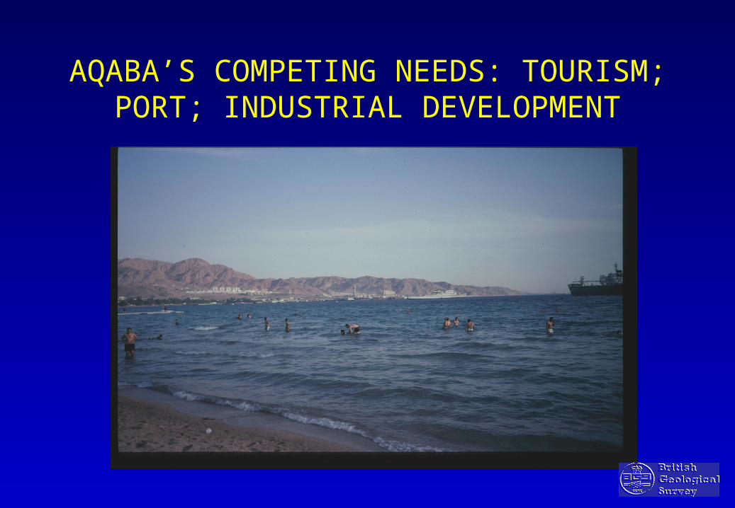
AQABA’S COMPETING NEEDS: TOURISM; PORT; INDUSTRIAL DEVELOPMENT

Query using satellite imagery
Gulf of AqabaImran Monzogranite
Imran Monzogranite:
•Industrial feldspar prospect
•Exploited for marble
•Non-aquifer
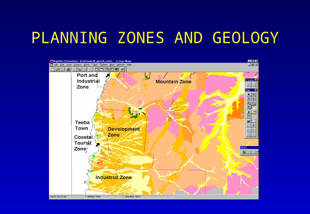
PLANNING ZONES AND GEOLOGY

Query using Satellite Image and Geological Map
Yammaniya Clay
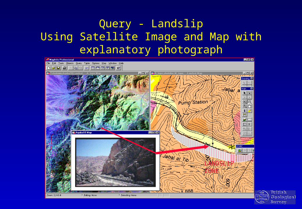
Query - LandslipUsing Satellite Image and Map with explanatory
photograph
LANDSLIPZONE

Reporting GIS data to end-users
Superficial deposits at siteTaplow gravels
Artificial deposits at sitemade ground < 5m
Boreholes at siteNone
Solid geologyLondon Clay
Boreholes within search radius
Reference TQ48SW19Length - 3.65mName - Metropolitan Borough works no 48E - 542560N - 0182280

IT REQUIREMENTS: URBAN ENVIRONMENTAL GIS
Computer hardware
• PC; Pentium II/III processor with + 64 Mb RAM; 4 Mb video card; and 17inch colour monitor.
• Hewlett Packard Ink-jet 450C AO Colour ink-jet plotter.
• Epsom GT 12000A3 colour scanner.
• Digitiser (or use bureau facilities)
Computer software
• GIS software eg: MapInfo Professional/ ARCVIEW
• Microsoft Office Pro 98 English & Small business edition, plus
• Computer Database eg: ACCESS or ORACLE
• Landsat TM digital data on CD

Essentials of Good Practice for Planning Authorities
• commitment and awareness - earth science data
• increase availability and accessibility
• efficient storage, handling & retrieval of earth science data
• develop a procedural framework
• make use of expert advice• allocate resources (data collection/archives)
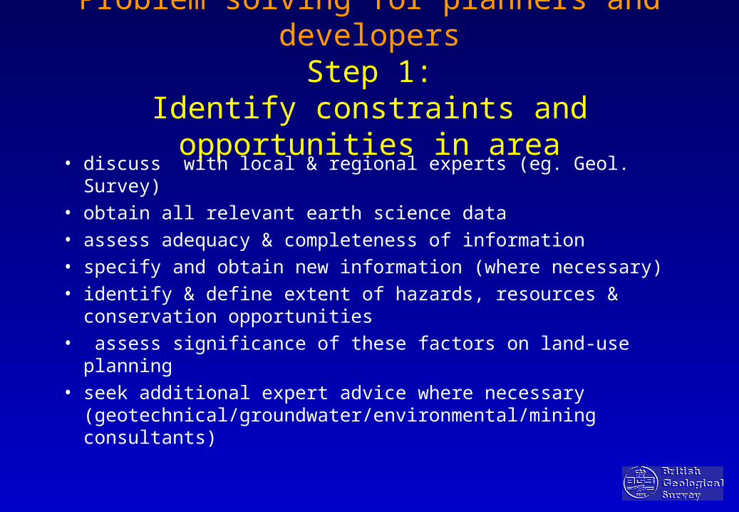
Problem solving for planners and developersStep 1:
Identify constraints and opportunities in area
• discuss with local & regional experts (eg. Geol. Survey)
• obtain all relevant earth science data
• assess adequacy & completeness of information
• specify and obtain new information (where necessary)
• identify & define extent of hazards, resources & conservation opportunities
• assess significance of these factors on land-use planning
• seek additional expert advice where necessary (geotechnical/groundwater/environmental/mining consultants)

Problem solving for planners and developersStep 2:
Storage and handling of earth science data • Archival records (maps, records, SI)
• Computerised Databases (spreadsheets and relational databases)
• Geographical Information Systems (GIS)
• Output in the form of easy to use maps and guides designed for the non-specialist

Problem solving for planners and developersStep 3:
Regional and National Planning Guidance
• aimed at regulating the development and use of land in the public interest to provide:
• guidance: to public and private sector
• incentive: to local authorities to make best use of land
• control: prevent development against the public interest & allow consideration of all stakeholders
Insurance: a way of mitigating post-catastrophe loss in the developing
world?• Efficient means of getting funds ‘on the ground’
quickly after a natural catastrophe• Funds come directly from international financial
institutions• Concept supported by the Development Banks; aid
funds contribute to premiums• Risk must be interpreted, processed and presented in a
form useable by the financial industry
#
####
####### #
#
###
## ### #######
##### ##
###
##########
#
##
##
####### ###### ####
##### ##
#
#
###
####
#
##
#
#
#####
#
##
####
#
####
#
##########
###
### #
####
###
##
#
#####
#
#
# #####
###
# ##
#
#
#
####
#
########### ##
#######
# ##
#
####
#
## ## ##
##
#
##
##
#
##
###
####
#
##
#
##
###
#
##
# #
#
#
######
###
# ##
##
####
##
##
#
#
#
######
######
############
######
## ##
####
####
###
##############
####
#
#
#
#######
#####
#####
####
# ### #####
#
#
#
##
#
#
###
#
#
# ###
####
#
####
##### #
#####
#### # #
##
##
###
##
#######
#
#
#
########## #
##
###
#
######
#### ##
#
## ###
#
#
###
#### ###
#
####
####
####
####
## #
#
#
#
#
#
###
#
#
#
## ##
# #
##
###
#
# #
#
# ####
#
###
#
#
##
#######
#
###
## ########
#
##
######### #####
###
##
#
###
###
##
##
##
####
####
#
####
#
###
Little Burstead
Hutton, Essex
Great Burstead
South Green, Essex
CM11 2CM12 9
CM12 9AB#
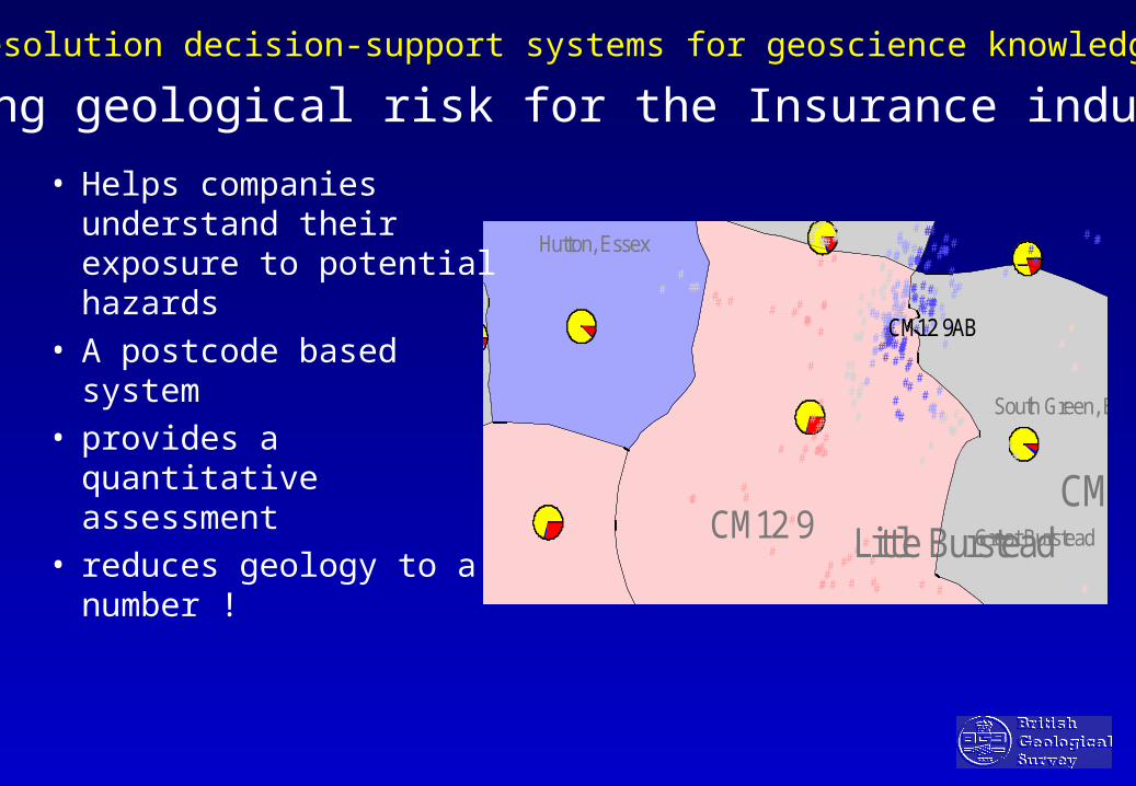
Assessing geological risk for the Insurance industry
• Helps companies understand their exposure to potential hazards
• A postcode based system
• provides a quantitative assessment
• reduces geology to a number !
High resolution decision-support systems for geoscience knowledge

CONCLUSIONS• The Way Forward: Political Realism and Practical Steps
• Politically difficult: ‘Out of public sight - out of political mind’
• Regulatory intervention: Long term benefits vs. Immediate public impact
• BUT: To postpone protection/regulation policies leads to more costly and intractable problems in the long run
• Requires consensus - through public debate with stakeholders