Embed Size (px)
Citation preview
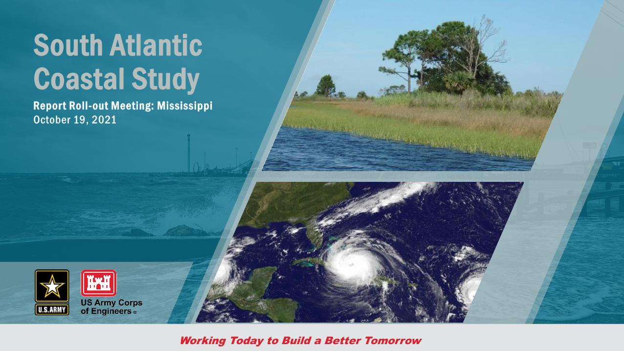
South Atlantic Coastal StudyRepor t Roll-out Meeting: MississippiOctober 19, 2021
22
Housekeeping
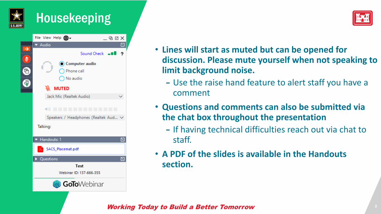
• Lines will start as muted but can be opened for discussion. Please mute yourself when not speaking to limit background noise.
– Use the raise hand feature to alert staff you have a comment
• Questions and comments can also be submitted via the chat box throughout the presentation
– If having technical difficulties reach out via chat to staff.
• A PDF of the slides is available in the Handouts section.
3
Team Introduction
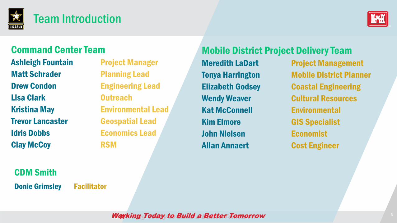
Command Center TeamAshleigh Fountain Project ManagerMatt Schrader Planning LeadDrew Condon Engineering LeadLisa Clark OutreachKristina May Environmental LeadTrevor Lancaster Geospatial LeadIdris Dobbs Economics LeadClay McCoy RSM
Mobile District Project Delivery TeamMeredith LaDart Project ManagementTonya Harrington Mobile District PlannerElizabeth Godsey Coastal EngineeringWendy Weaver Cultural ResourcesKat McConnell EnvironmentalKim Elmore GIS SpecialistJohn Nielsen EconomistAllan Annaert Cost Engineer
CDM SmithDonie Grimsley Facilitator
4
Virtual Poll – What type of organization do you represent?
State/Local Agency Academia
Non-Governmental Agency Other
Federal Agency/Tribal Nations
5
South Atlantic Coastal Study (SACS) Report Roll-out Meeting: Agenda
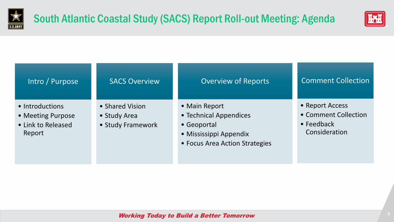
Intro / Purpose
• Introductions• Meeting Purpose• Link to Released
Report
SACS Overview
• Shared Vision• Study Area• Study Framework
Comment Collection
• Report Access• Comment Collection• Feedback
Consideration
Overview of Reports
• Main Report• Technical Appendices• Geoportal• Mississippi Appendix• Focus Area Action Strategies
66
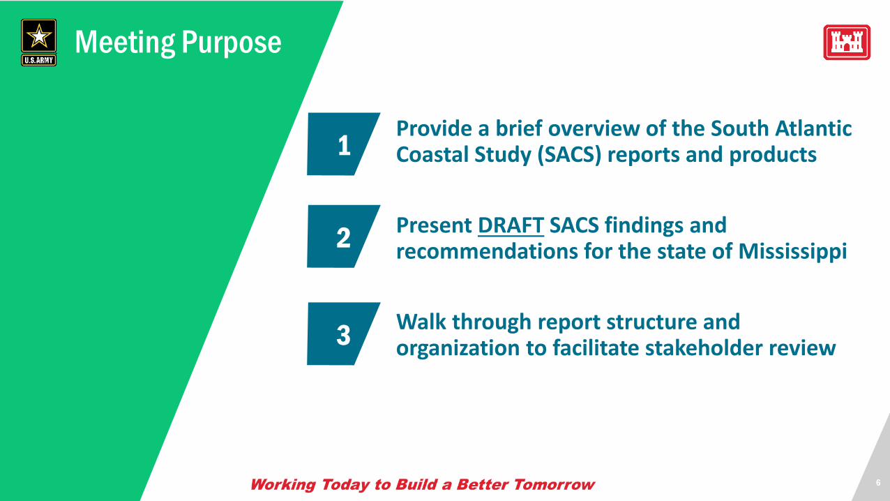
Meeting Purpose
Provide a brief overview of the South Atlantic Coastal Study (SACS) reports and products
Present DRAFT SACS findings and recommendations for the state of Mississippi
Walk through report structure and organization to facilitate stakeholder review
2
3
1
7
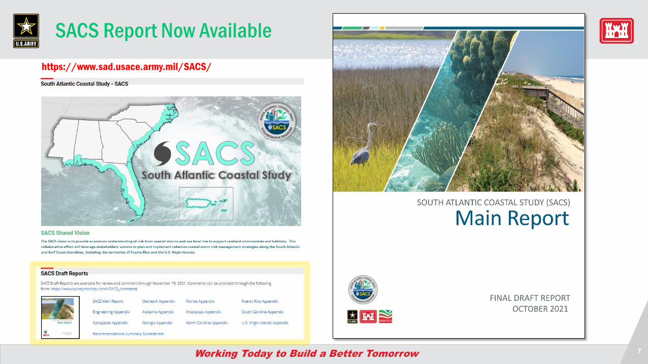
SACS Report Now Availablehttps://www.sad.usace.army.mil/SACS/
8
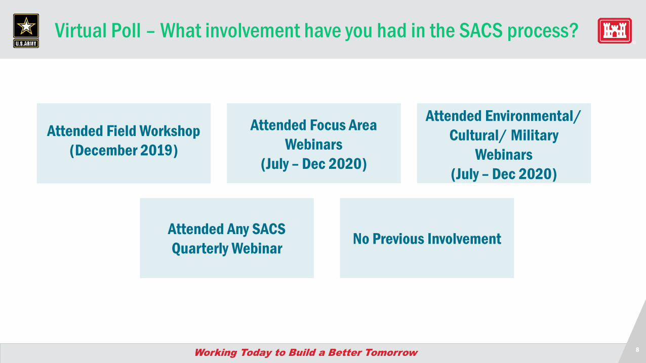
Virtual Poll – What involvement have you had in the SACS process?
Attended Field Workshop (December 2019)
Attended Focus Area Webinars
(July – Dec 2020)
Attended Environmental/ Cultural/ Military
Webinars(July – Dec 2020)
Attended Any SACS Quarterly Webinar No Previous Involvement

SACS Overview
10
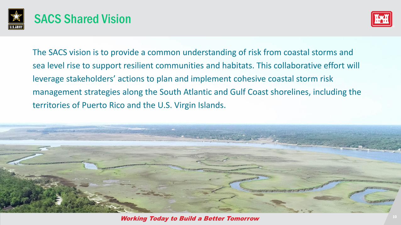
SACS Shared Vision
The SACS vision is to provide a common understanding of risk from coastal storms and sea level rise to support resilient communities and habitats. This collaborative effort will leverage stakeholders’ actions to plan and implement cohesive coastal storm risk management strategies along the South Atlantic and Gulf Coast shorelines, including the territories of Puerto Rico and the U.S. Virgin Islands.
11
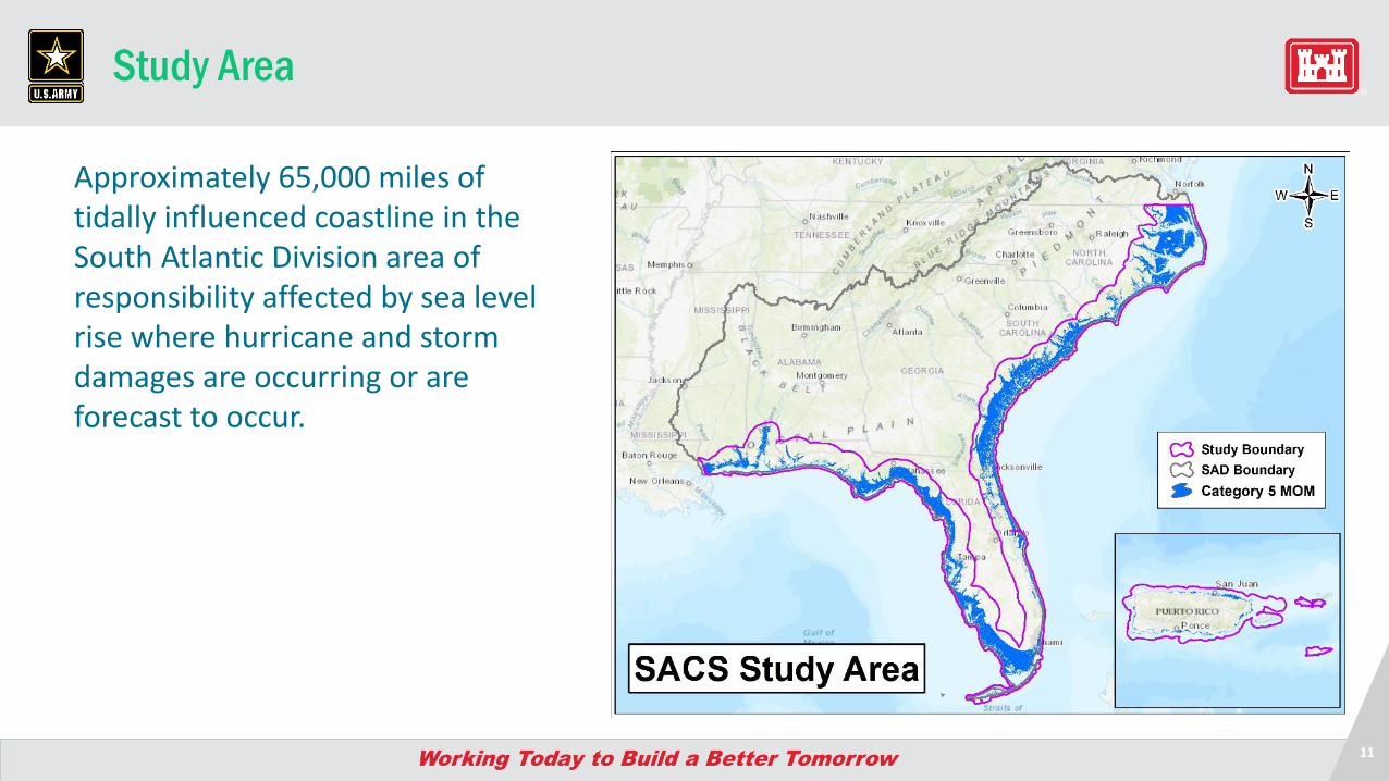
Study Area
Approximately 65,000 miles of tidally influenced coastline in the South Atlantic Division area of responsibility affected by sea level rise where hurricane and storm damages are occurring or are forecast to occur.
12
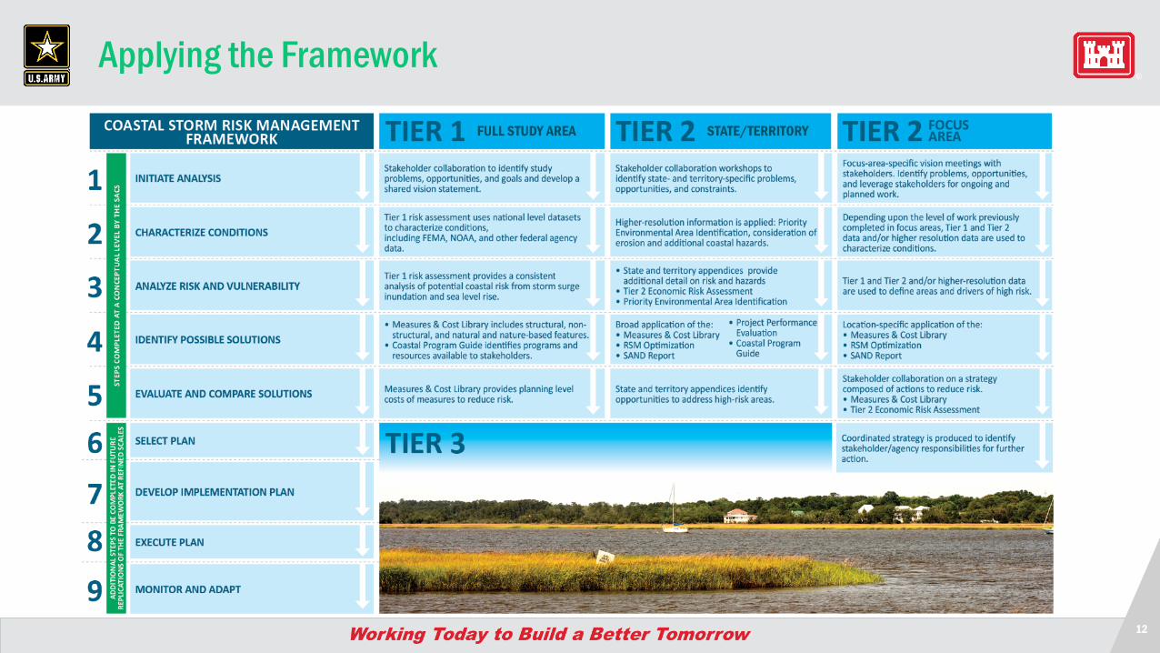
Applying the Framework
FULL STUDY AREA STATE/TERRITORY
13
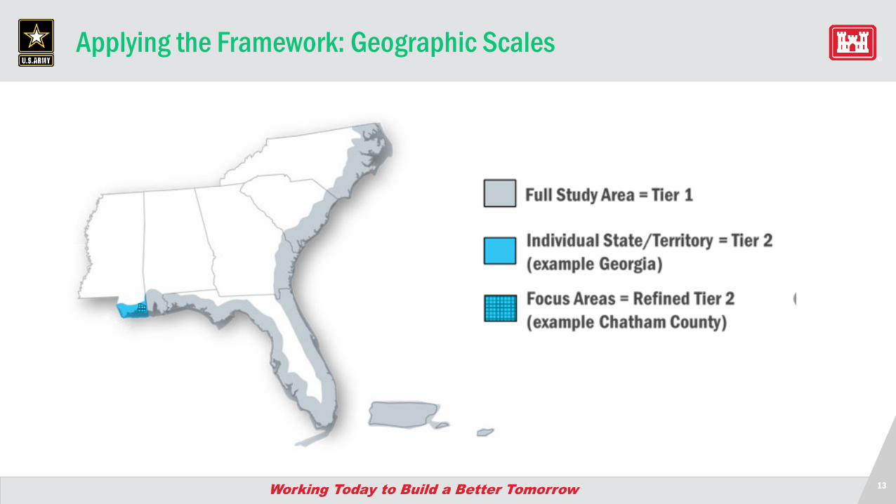
Applying the Framework: Geographic Scales
Overview of Reports
15
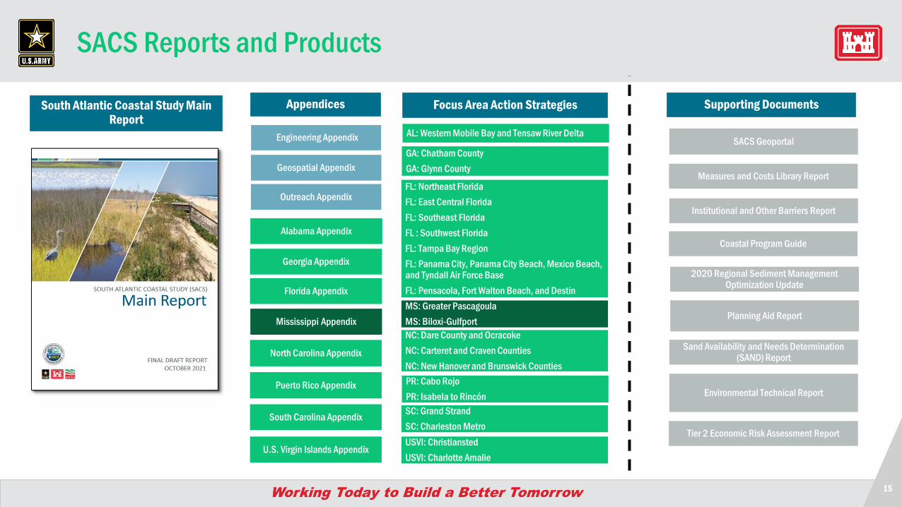
SACS Reports and Products
South Atlantic Coastal Study Main Report
AL: Western Mobile Bay and Tensaw River DeltaEngineering Appendix
Geospatial Appendix
Alabama Appendix
Georgia Appendix
North Carolina Appendix
Puerto Rico Appendix
South Carolina Appendix
U.S. Virgin Islands Appendix
Mississippi Appendix
Florida Appendix
Outreach Appendix
Appendices Focus Area Action Strategies
GA: Chatham CountyGA: Glynn County
FL: Northeast FloridaFL: East Central FloridaFL: Southeast FloridaFL : Southwest FloridaFL: Tampa Bay RegionFL: Panama City, Panama City Beach, Mexico Beach, and Tyndall Air Force BaseFL: Pensacola, Fort Walton Beach, and Destin
Supporting Documents
Measures and Costs Library Report
Institutional and Other Barriers Report
Coastal Program Guide
2020 Regional Sediment Management Optimization Update
Sand Availability and Needs Determination (SAND) Report
SACS Geoportal
Planning Aid Report
Environmental Technical Report
Tier 2 Economic Risk Assessment Report
MS: Greater PascagoulaMS: Biloxi-GulfportNC: Dare County and OcracokeNC: Carteret and Craven CountiesNC: New Hanover and Brunswick CountiesPR: Cabo RojoPR: Isabela to RincónSC: Grand StrandSC: Charleston MetroUSVI: ChristianstedUSVI: Charlotte Amalie
16
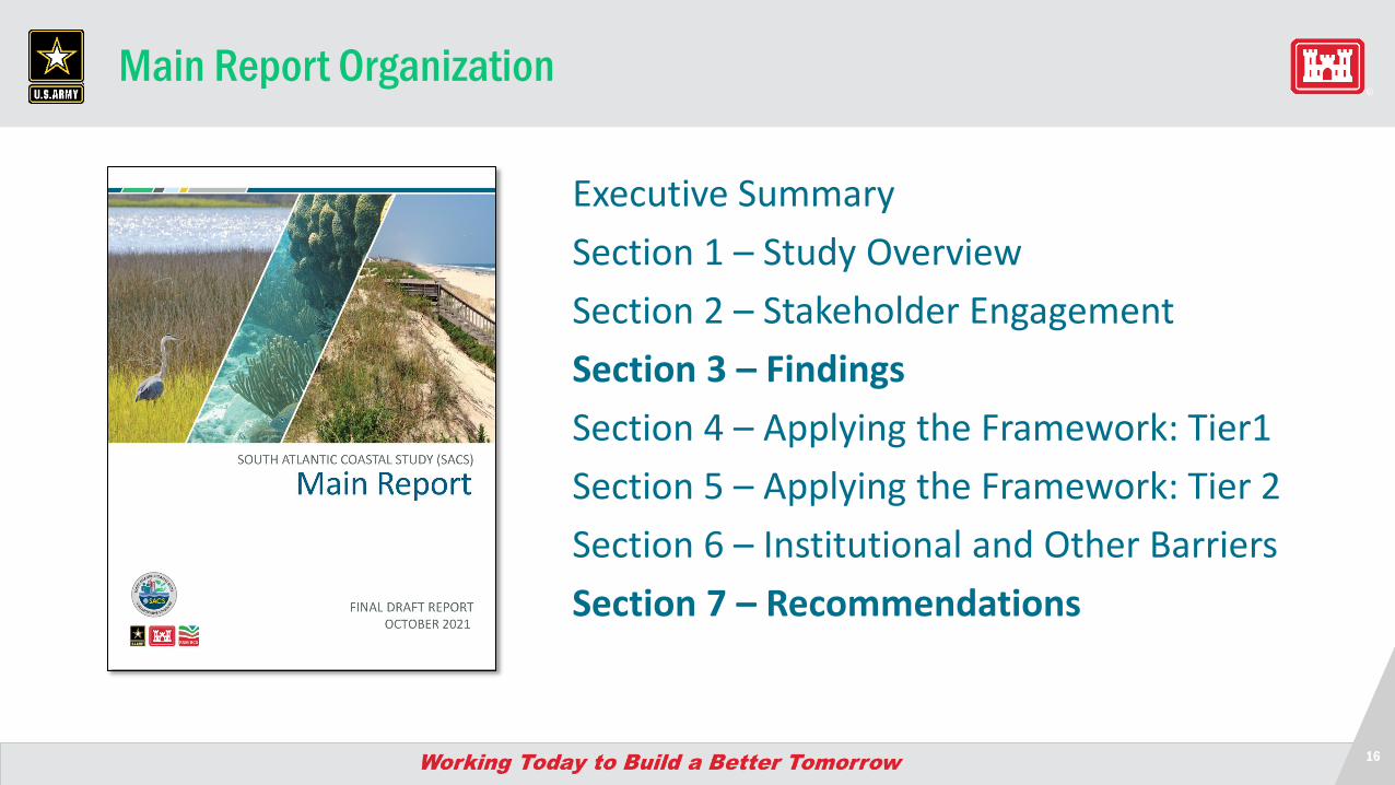
Main Report Organization
Executive SummarySection 1 – Study OverviewSection 2 – Stakeholder EngagementSection 3 – Findings Section 4 – Applying the Framework: Tier1Section 5 – Applying the Framework: Tier 2Section 6 – Institutional and Other BarriersSection 7 – Recommendations
17
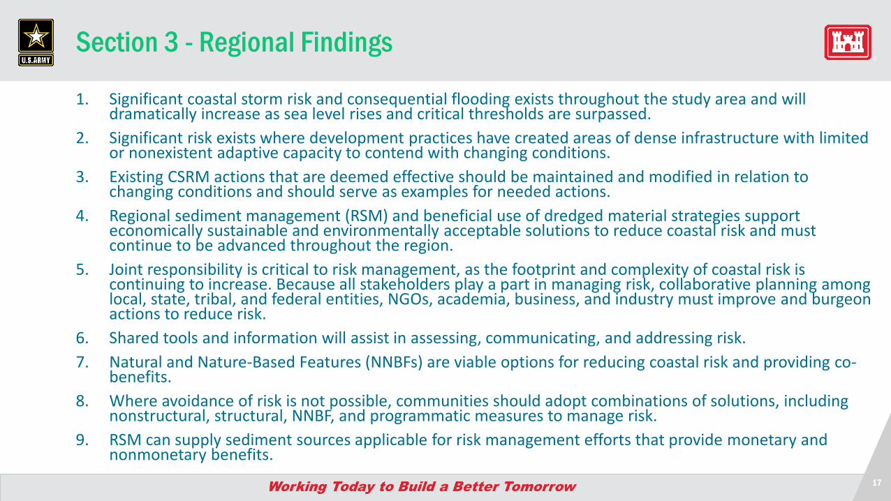
Section 3 - Regional Findings
1. Significant coastal storm risk and consequential flooding exists throughout the study area and will dramatically increase as sea level rises and critical thresholds are surpassed.
2. Significant risk exists where development practices have created areas of dense infrastructure with limited or nonexistent adaptive capacity to contend with changing conditions.
3. Existing CSRM actions that are deemed effective should be maintained and modified in relation to changing conditions and should serve as examples for needed actions.
4. Regional sediment management (RSM) and beneficial use of dredged material strategies support economically sustainable and environmentally acceptable solutions to reduce coastal risk and must continue to be advanced throughout the region.
5. Joint responsibility is critical to risk management, as the footprint and complexity of coastal risk is continuing to increase. Because all stakeholders play a part in managing risk, collaborative planning among local, state, tribal, and federal entities, NGOs, academia, business, and industry must improve and burgeon actions to reduce risk.
6. Shared tools and information will assist in assessing, communicating, and addressing risk.7. Natural and Nature-Based Features (NNBFs) are viable options for reducing coastal risk and providing co-
benefits.8. Where avoidance of risk is not possible, communities should adopt combinations of solutions, including
nonstructural, structural, NNBF, and programmatic measures to manage risk.9. RSM can supply sediment sources applicable for risk management efforts that provide monetary and
nonmonetary benefits.
19
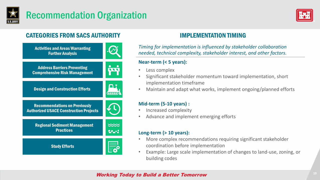
Recommendation Organization
Near-term (< 5 years): • Less complex• Significant stakeholder momentum toward implementation, short
implementation timeframe• Maintain and adapt what works, implement ongoing/planned efforts
Mid-term (5-10 years) :• Increased complexity• Advance and implement emerging efforts
Long-term (> 10 years): • More complex recommendations requiring significant stakeholder
coordination before implementation• Example: Large scale implementation of changes to land-use, zoning, or
building codes
IMPLEMENTATION TIMINGTiming for implementation is influenced by stakeholder collaboration needed, technical complexity, stakeholder interest, and other factors.
Activities and Areas Warranting Further Analysis
Address Barriers Preventing Comprehensive Risk Management
Design and Construction Efforts
Recommendations on Previously Authorized USACE Construction Projects
Regional Sediment Management Practices
Study Efforts
CATEGORIES FROM SACS AUTHORITY
20
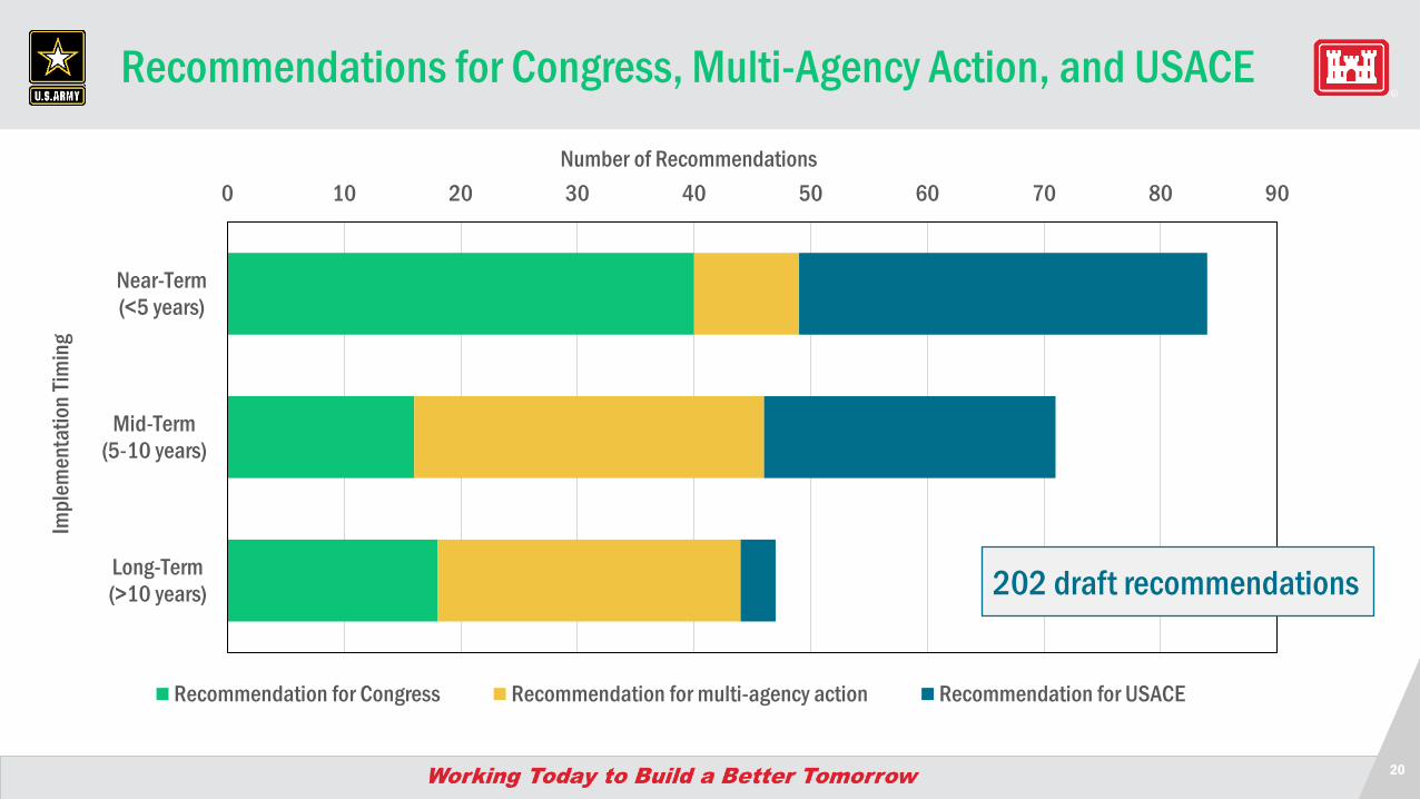
Recommendations for Congress, Multi-Agency Action, and USACE
0 10 20 30 40 50 60 70
PRIORITY (Level 1)
PRIORITY (Level 2)
PRIORITY (Level 3)
Other Recommendations
Number of Recommendations
Recommendation for Congress Recommendation for multi-agency action Recommendation for USACE
0 10 20 30 40 50 60 70 80 90
Near-Term(<5 years)
Mid-Term(5-10 years)
Long-Term(>10 years)
Number of Recommendations
Impl
emen
tatio
n Tim
ing
Recommendation for Congress Recommendation for multi-agency action Recommendation for USACE
202 draft recommendations
21
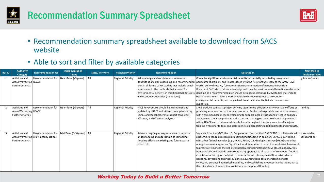
Recommendation Summary Spreadsheet
• Recommendation summary spreadsheet available to download from SACS website
• Able to sort and filter by available categoriesRec ID
Authority Category
Recommendation for Implementation
TimingState/ Territory Regional Priority Recommendation Description
Next Step to Implementation
1 Activities and Areas Warranting Further Analysis
Recommendation for USACE
Near-Term (<5 years) All Regional Priority Acknowledge and consider environmental benefits as a factor in deciding on a recommended plan in all future CSRM studies that include beach nourishment. Use methods that account for environmental benefits in traditional habitat units and economic quantities (monetized).
Given the significant environmental benefits incidentally provided by many beach nourishment projects, and in accordance with the Assistant Secretary of the Army (Civil Works) policy directive, “Comprehensive Documentation of Benefits in Decision Document,” efforts to fully acknowledge and consider environmental benefits as a factor in deciding on a recommended plan should be made in all future CSRM studies that include beach nourishment. Future work should also include methods to account for environmental benefits, not only in traditional habitat units, but also in economic quantities.
guidance/policy
2 Activities and Areas Warranting Further Analysis
Recommendation for USACE
Near-Term (<5 years) All Regional Priority SACS key products should be maintained and updated by USACE and utilized, as applicable, by USACE and stakeholders to support consistent, efficient, and effective analyses.
SACS products can assist project delivery teams more efficiently carry out study efforts by providing a common set of tools and products. Products also provide users and reviewers with a common baseline/understanding to support more efficient and effective analyses and reviews. SACS key products and associated training on their use should be provided within USACE and to interested stakeholders throughout the study area, ideally in joint training with other federal and state agencies incorporating additional tools and products.
funding
3 Activities and Areas Warranting Further Analysis
Recommendation for multi-agency action
Mid-Term (5-10 years) All Regional Priority Advance ongoing interagency work to improve understanding and application of compound flooding effects on existing and future coastal storm risk.
Separate from the SACS, the U.S. Congress has directed the USACE ERDC to collaborate with academia to conduct research into compound flooding. In addition, USACE is partnering with other federal agencies (e.g., NOAA, FEMA, U.S. Geological Survey [USGS]) and other non-governmental agencies. Significant work is required to establish a cohesive framework to proactively manage the risk presented by compound flooding events. At maturity, this framework should provide an encompassing approach to all aspects of compound flooding effects in coastal regions subject to both coastal and pluvial/fluvial flood-risk drivers, updating/developing technical guidance, advancing long-term monitoring of data collection, enhanced numerical modeling, and establishing a robust statistical approach to the coincidence of events that contribute to compound flooding.
stakeholder collaboration
22
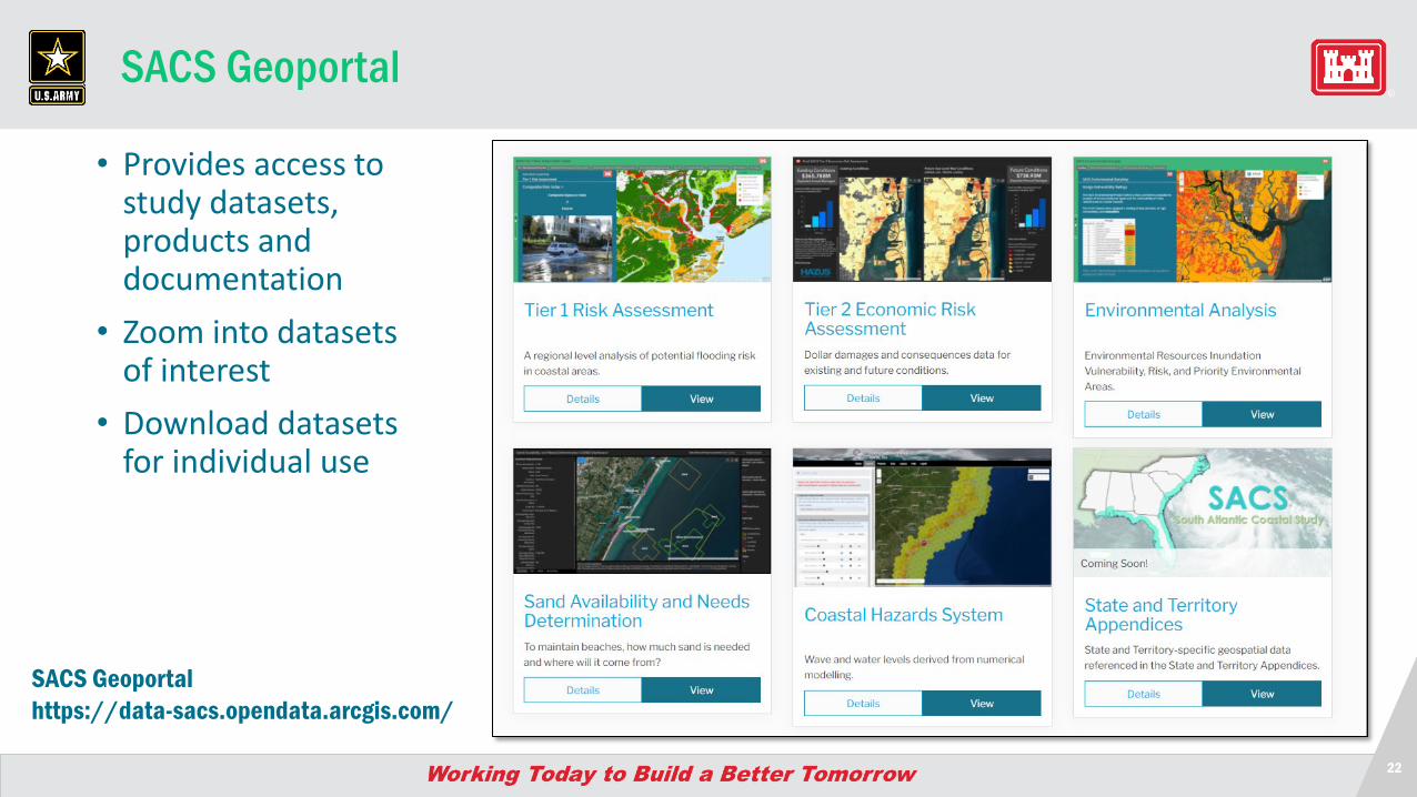
SACS Geoportal
• Provides access to study datasets, products and documentation
• Zoom into datasets of interest
• Download datasets for individual use
SACS Geoportalhttps://data-sacs.opendata.arcgis.com/
23
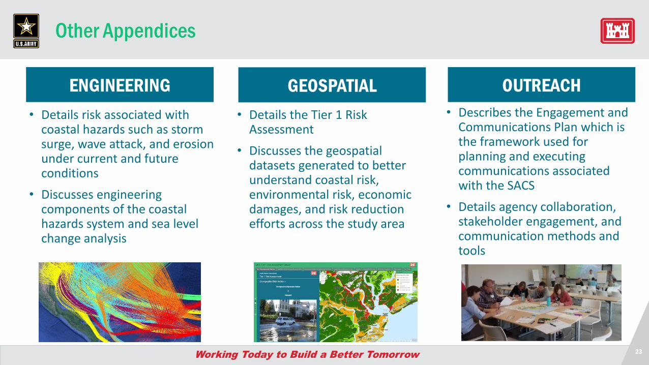
Other Appendices
• Details risk associated with coastal hazards such as storm surge, wave attack, and erosion under current and future conditions
• Discusses engineering components of the coastal hazards system and sea level change analysis
• Details the Tier 1 Risk Assessment
• Discusses the geospatial datasets generated to better understand coastal risk, environmental risk, economic damages, and risk reduction efforts across the study area
• Describes the Engagement and Communications Plan which is the framework used for planning and executing communications associated with the SACS
• Details agency collaboration, stakeholder engagement, and communication methods and tools
ENGINEERING GEOSPATIAL OUTREACH
Questions
25
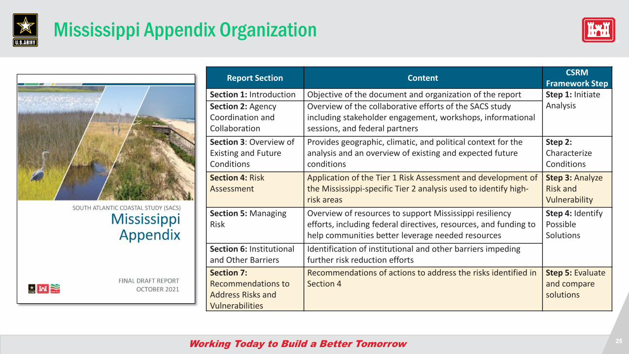
Mississippi Appendix Organization
Report Section Content CSRM Framework Step
Section 1: Introduction Objective of the document and organization of the report Step 1: Initiate AnalysisSection 2: Agency
Coordination and Collaboration
Overview of the collaborative efforts of the SACS study including stakeholder engagement, workshops, informational sessions, and federal partners
Section 3: Overview of Existing and Future Conditions
Provides geographic, climatic, and political context for the analysis and an overview of existing and expected future conditions
Step 2: Characterize Conditions
Section 4: Risk Assessment
Application of the Tier 1 Risk Assessment and development of the Mississippi-specific Tier 2 analysis used to identify high-risk areas
Step 3: Analyze Risk and Vulnerability
Section 5: Managing Risk
Overview of resources to support Mississippi resiliency efforts, including federal directives, resources, and funding to help communities better leverage needed resources
Step 4: Identify Possible Solutions
Section 6: Institutional and Other Barriers
Identification of institutional and other barriers impeding further risk reduction efforts
Section 7: Recommendations to Address Risks and Vulnerabilities
Recommendations of actions to address the risks identified in Section 4
Step 5: Evaluate and compare solutions

26
Section 4 - Risk Assessment
Definitions of risk components as utilized in the SACS include:
Hazard – In a general sense, hazard is anything that is a potential source of harm to a valued asset (human, animal, natural, economic, and social)
Exposure – Describes who and what may be harmed by the flood hazard. Exposure incorporates a description of where the flooding occurs at a given frequency, and what assets exist in that area.
Vulnerability – Susceptibility of harm to human beings, property, and the environment when exposed to a hazard. Depth-damage functions, depth-mortality functions, and other similar relationships can be used to describe vulnerability.
Risk – Combination of likelihood and harm to people, property, infrastructure, and other assets.
27
Section 4 - Risk Assessment
• Analysis performed per planning reach– Tier 1: summary of findings from the
consistent assessment across study area
– Tier 2: more refined state-specific assessment• Economic risk• Risk to environmental resources• Risk to cultural resources
28
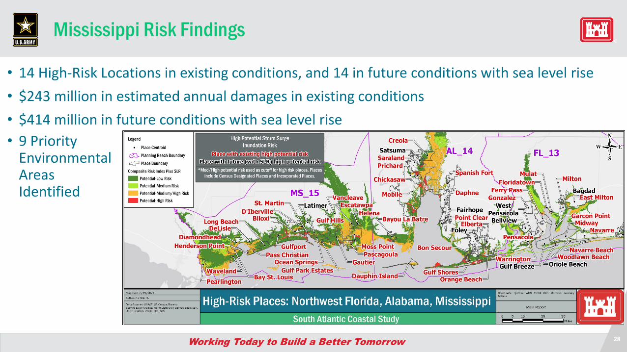
Mississippi Risk Findings
• 14 High-Risk Locations in existing conditions, and 14 in future conditions with sea level rise• $243 million in estimated annual damages in existing conditions • $414 million in future conditions with sea level rise• 9 Priority
Environmental Areas Identified
29
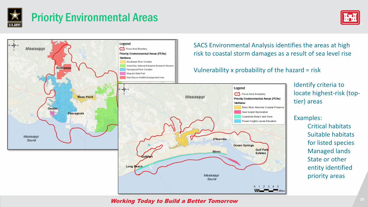
Priority Environmental Areas
SACS Environmental Analysis identifies the areas at high risk to coastal storm damages as a result of sea level rise
Vulnerability x probability of the hazard = risk
Identify criteria to locate highest-risk (top-tier) areas
Examples:Critical habitatsSuitable habitats for listed speciesManaged landsState or other entity identified priority areas
30
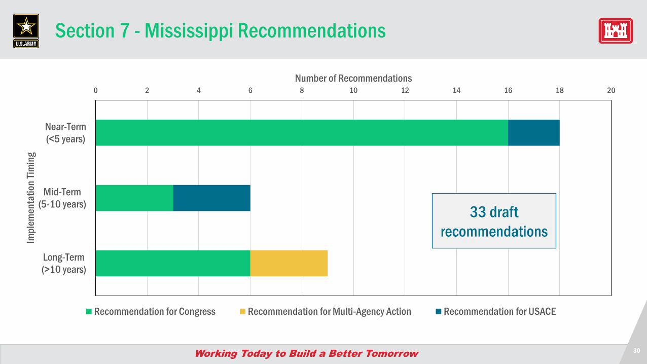
Section 7 - Mississippi Recommendations
0 2 4 6 8 10 12 14 16 18 20
Near-Term(<5 years)
Mid-Term(5-10 years)
Long-Term(>10 years)
Number of Recommendations
Impl
emen
tatio
n Tim
ing
Recommendation for Congress Recommendation for Multi-Agency Action Recommendation for USACE
33 draft recommendations
31
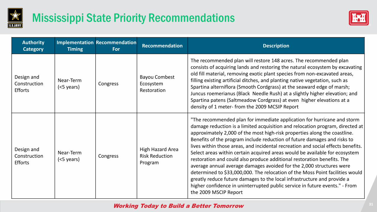
Mississippi State Priority Recommendations
Authority Category
Implementation Timing
Recommendation For Recommendation Description
Design and Construction Efforts
Near-Term (<5 years) Congress
Bayou Combest Ecosystem Restoration
The recommended plan will restore 148 acres. The recommended plan consists of acquiring lands and restoring the natural ecosystem by excavating old fill material, removing exotic plant species from non-excavated areas, filling existing artificial ditches, and planting native vegetation, such as Spartina alterniflora (Smooth Cordgrass) at the seaward edge of marsh; Juncus roemerianus (Black Needle Rush) at a slightly higher elevation; and Spartina patens (Saltmeadow Cordgrass) at even higher elevations at a density of 1 meter- from the 2009 MCSIP Report
Design and Construction Efforts
Near-Term (<5 years) Congress
High Hazard Area Risk Reduction Program
"The recommended plan for immediate application for hurricane and storm damage reduction is a limited acquisition and relocation program, directed at approximately 2,000 of the most high-risk properties along the coastline. Benefits of the program include reduction of future damages and risks to lives within those areas, and incidental recreation and social effects benefits. Select areas within certain acquired areas would be available for ecosystem restoration and could also produce additional restoration benefits. The average annual average damages avoided for the 2,000 structures were determined to $33,000,000. The relocation of the Moss Point facilities would greatly reduce future damages to the local infrastructure and provide a higher confidence in uninterrupted public service in future events." - From the 2009 MSCIP Report
32
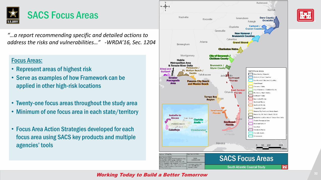
Focus Areas:• Represent areas of highest risk• Serve as examples of how Framework can be
applied in other high-risk locations
• Twenty-one focus areas throughout the study area• Minimum of one focus area in each state/territory
• Focus Area Action Strategies developed for each focus area using SACS key products and multiple agencies’ tools
SACS Focus Areas
“…a report recommending specific and detailed actions to address the risks and vulnerabilities…” -WRDA’16, Sec. 1204
33
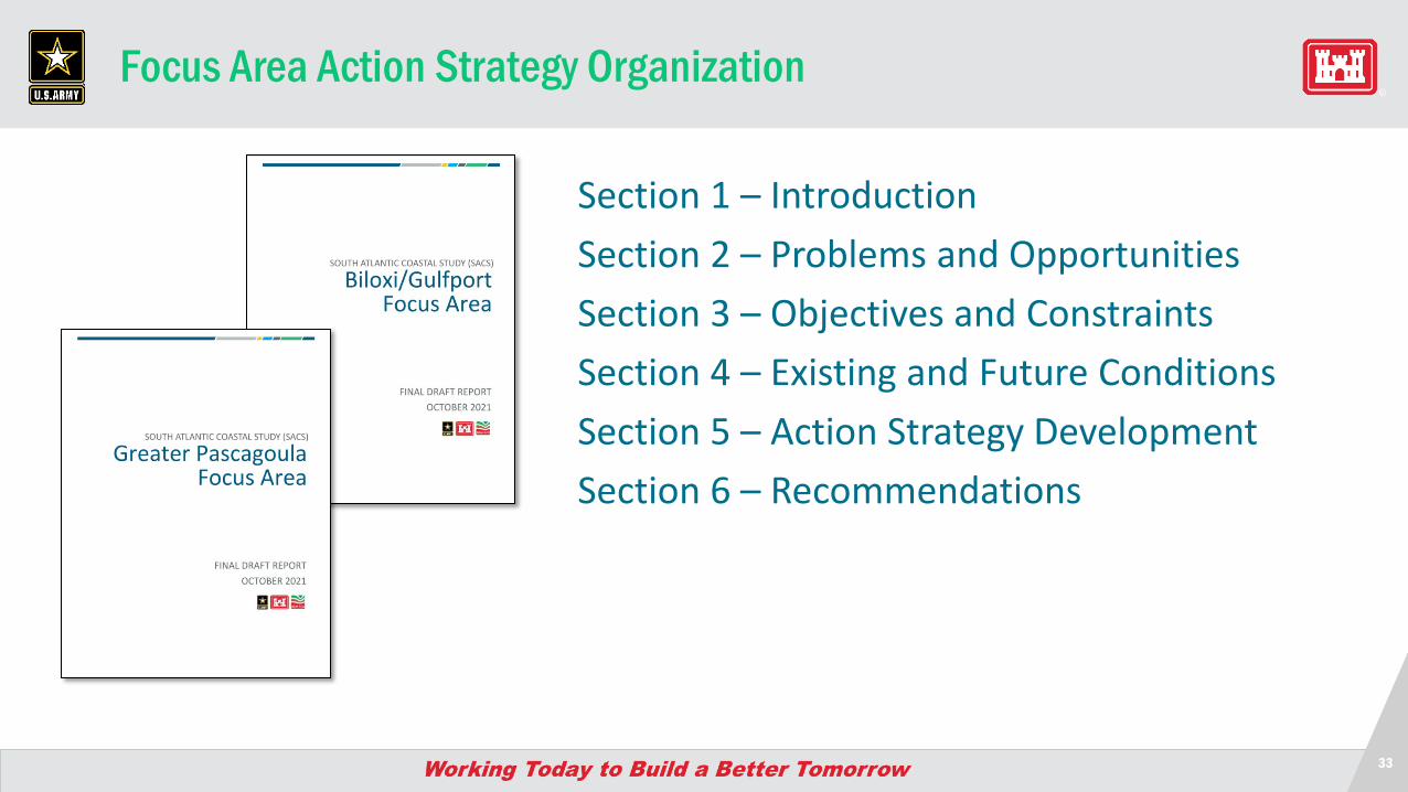
Focus Area Action Strategy Organization
Section 1 – IntroductionSection 2 – Problems and OpportunitiesSection 3 – Objectives and ConstraintsSection 4 – Existing and Future ConditionsSection 5 – Action Strategy DevelopmentSection 6 – Recommendations
34
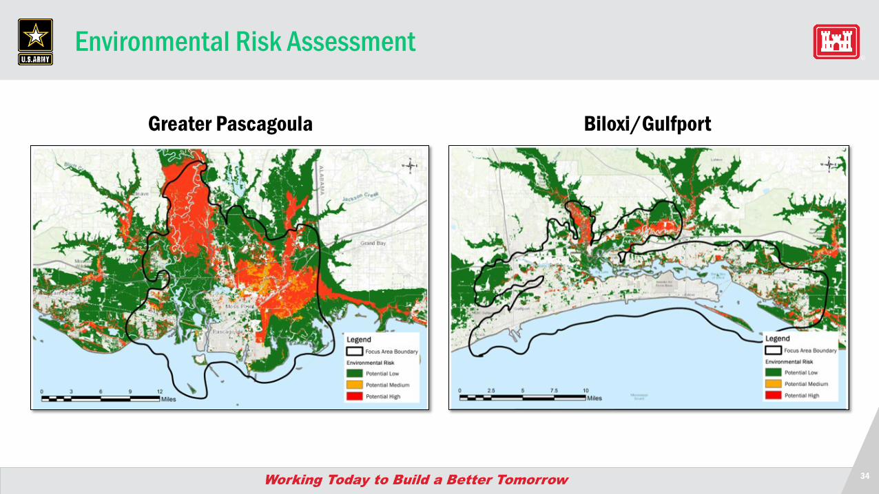
Environmental Risk Assessment
Biloxi/Gulfport Greater Pascagoula
35
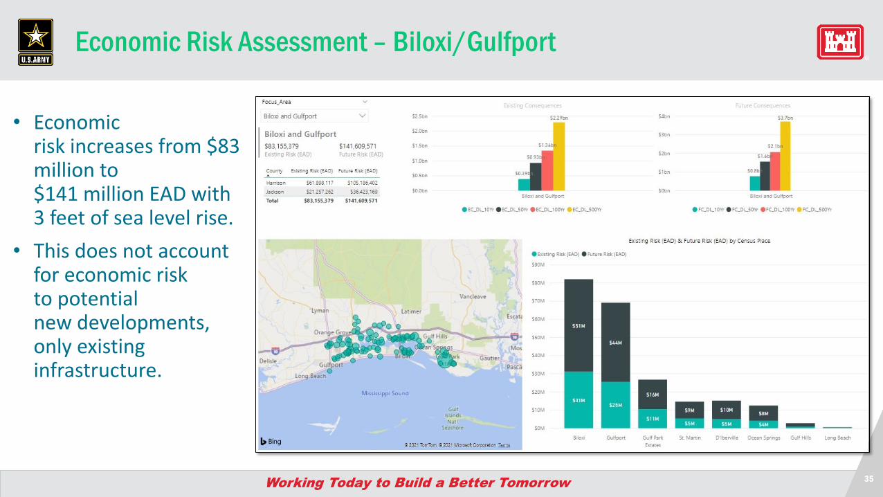
Economic Risk Assessment – Biloxi/Gulfport
• Economic risk increases from $83 million to $141 million EAD with 3 feet of sea level rise.
• This does not account for economic risk to potential new developments, only existinginfrastructure.
36
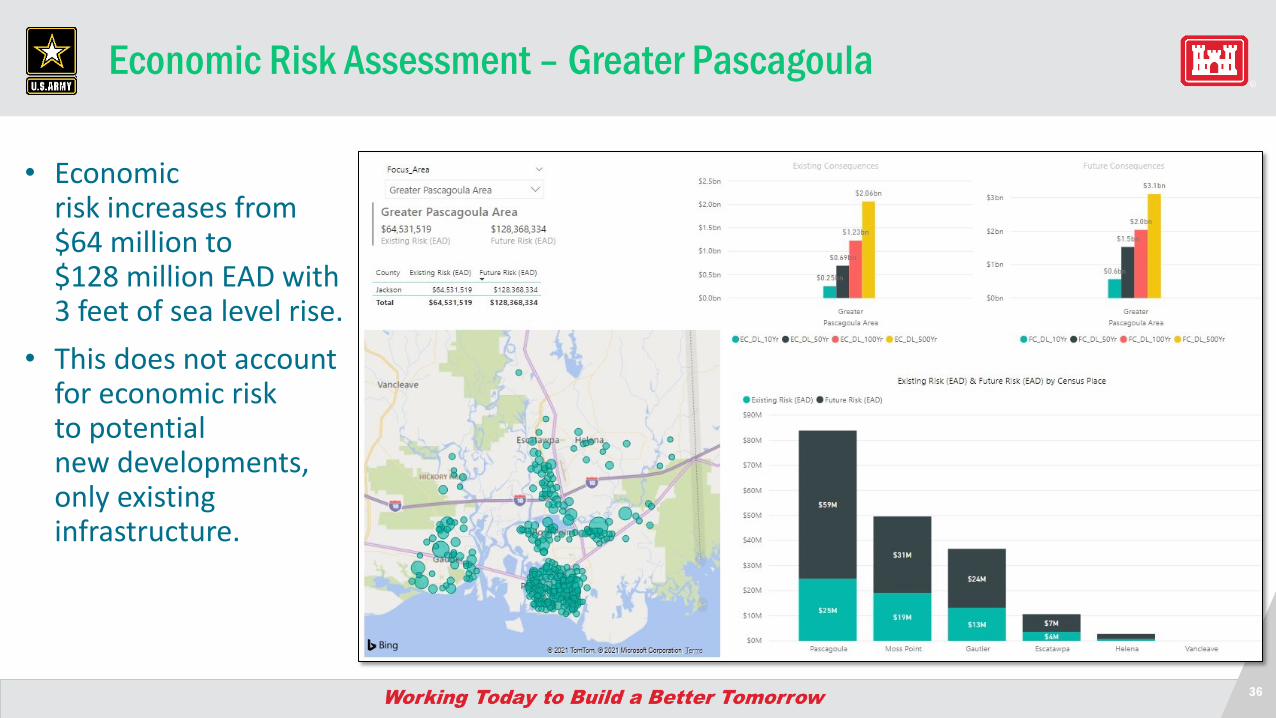
Economic Risk Assessment – Greater Pascagoula
• Economic risk increases from $64 million to $128 million EAD with 3 feet of sea level rise.
• This does not account for economic risk to potential new developments, only existinginfrastructure.
37
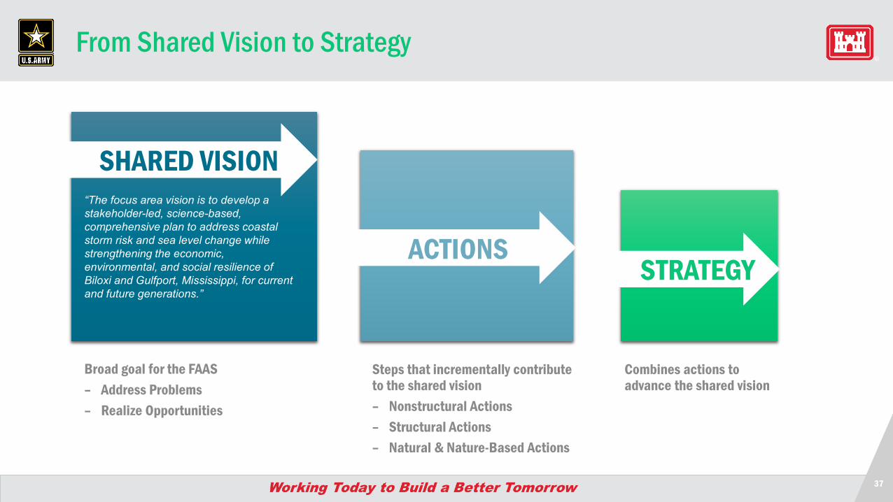
From Shared Vision to Strategy
SHARED VISION
ACTIONS
Steps that incrementally contribute to the shared vision– Nonstructural Actions– Structural Actions– Natural & Nature-Based Actions
Broad goal for the FAAS– Address Problems– Realize Opportunities
Combines actions to advance the shared vision
“The focus area vision is to develop a stakeholder-led, science-based, comprehensive plan to address coastal storm risk and sea level change while strengthening the economic, environmental, and social resilience of Biloxi and Gulfport, Mississippi, for current and future generations.”
STRATEGY
38
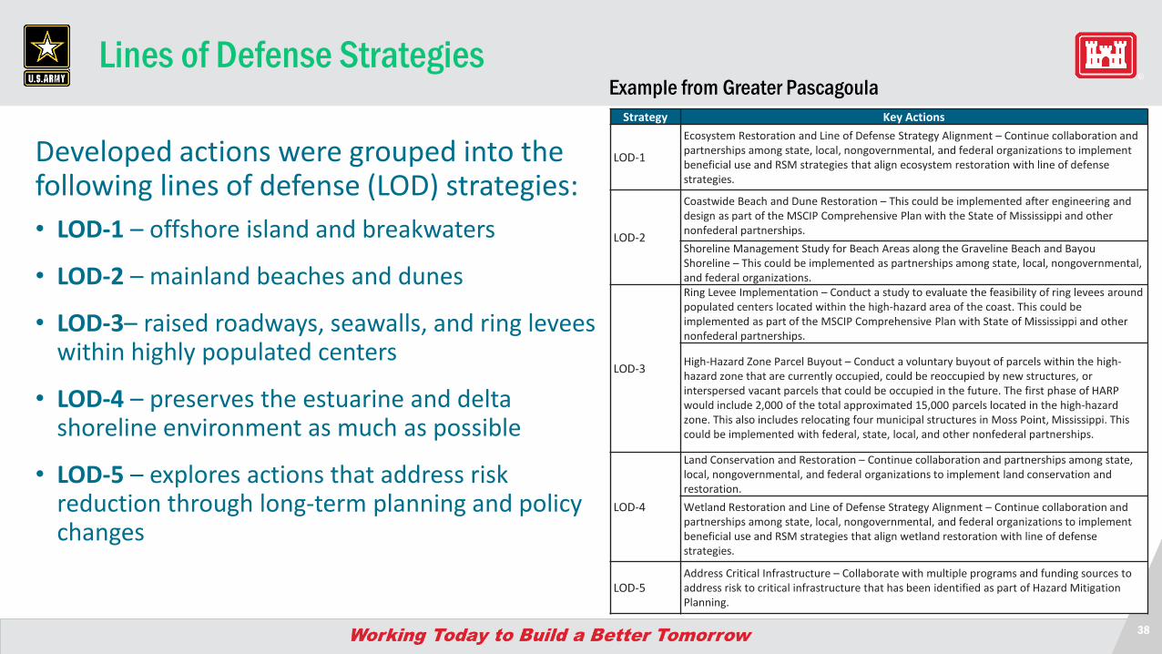
Lines of Defense Strategies
Developed actions were grouped into the following lines of defense (LOD) strategies:• LOD-1 – offshore island and breakwaters
• LOD-2 – mainland beaches and dunes
• LOD-3– raised roadways, seawalls, and ring levees within highly populated centers
• LOD-4 – preserves the estuarine and delta shoreline environment as much as possible
• LOD-5 – explores actions that address risk reduction through long-term planning and policy changes
Strategy Key Actions
LOD-1
Ecosystem Restoration and Line of Defense Strategy Alignment – Continue collaboration and partnerships among state, local, nongovernmental, and federal organizations to implement beneficial use and RSM strategies that align ecosystem restoration with line of defense strategies.
LOD-2
Coastwide Beach and Dune Restoration – This could be implemented after engineering and design as part of the MSCIP Comprehensive Plan with the State of Mississippi and other nonfederal partnerships. Shoreline Management Study for Beach Areas along the Graveline Beach and Bayou Shoreline – This could be implemented as partnerships among state, local, nongovernmental, and federal organizations.
LOD-3
Ring Levee Implementation – Conduct a study to evaluate the feasibility of ring levees around populated centers located within the high-hazard area of the coast. This could be implemented as part of the MSCIP Comprehensive Plan with State of Mississippi and other nonfederal partnerships.
High-Hazard Zone Parcel Buyout – Conduct a voluntary buyout of parcels within the high-hazard zone that are currently occupied, could be reoccupied by new structures, or interspersed vacant parcels that could be occupied in the future. The first phase of HARP would include 2,000 of the total approximated 15,000 parcels located in the high-hazard zone. This also includes relocating four municipal structures in Moss Point, Mississippi. This could be implemented with federal, state, local, and other nonfederal partnerships.
LOD-4
Land Conservation and Restoration – Continue collaboration and partnerships among state, local, nongovernmental, and federal organizations to implement land conservation and restoration.Wetland Restoration and Line of Defense Strategy Alignment – Continue collaboration and partnerships among state, local, nongovernmental, and federal organizations to implement beneficial use and RSM strategies that align wetland restoration with line of defense strategies.
LOD-5Address Critical Infrastructure – Collaborate with multiple programs and funding sources to address risk to critical infrastructure that has been identified as part of Hazard Mitigation Planning.
Example from Greater Pascagoula
39
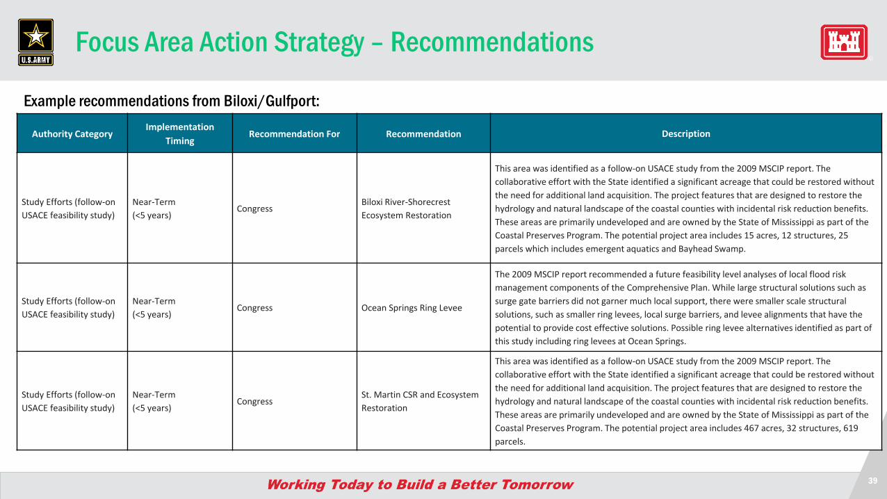
Focus Area Action Strategy – Recommendations
Example recommendations from Biloxi/Gulfport:
Authority CategoryImplementation
TimingRecommendation For Recommendation Description
Study Efforts (follow-on USACE feasibility study)
Near-Term (<5 years)
CongressBiloxi River-Shorecrest Ecosystem Restoration
This area was identified as a follow-on USACE study from the 2009 MSCIP report. The collaborative effort with the State identified a significant acreage that could be restored without the need for additional land acquisition. The project features that are designed to restore the hydrology and natural landscape of the coastal counties with incidental risk reduction benefits. These areas are primarily undeveloped and are owned by the State of Mississippi as part of the Coastal Preserves Program. The potential project area includes 15 acres, 12 structures, 25 parcels which includes emergent aquatics and Bayhead Swamp.
Study Efforts (follow-on USACE feasibility study)
Near-Term (<5 years)
Congress Ocean Springs Ring Levee
The 2009 MSCIP report recommended a future feasibility level analyses of local flood risk management components of the Comprehensive Plan. While large structural solutions such as surge gate barriers did not garner much local support, there were smaller scale structural solutions, such as smaller ring levees, local surge barriers, and levee alignments that have the potential to provide cost effective solutions. Possible ring levee alternatives identified as part of this study including ring levees at Ocean Springs.
Study Efforts (follow-on USACE feasibility study)
Near-Term (<5 years)
CongressSt. Martin CSR and Ecosystem Restoration
This area was identified as a follow-on USACE study from the 2009 MSCIP report. The collaborative effort with the State identified a significant acreage that could be restored without the need for additional land acquisition. The project features that are designed to restore the hydrology and natural landscape of the coastal counties with incidental risk reduction benefits. These areas are primarily undeveloped and are owned by the State of Mississippi as part of the Coastal Preserves Program. The potential project area includes 467 acres, 32 structures, 619 parcels.
Comment Collection
41
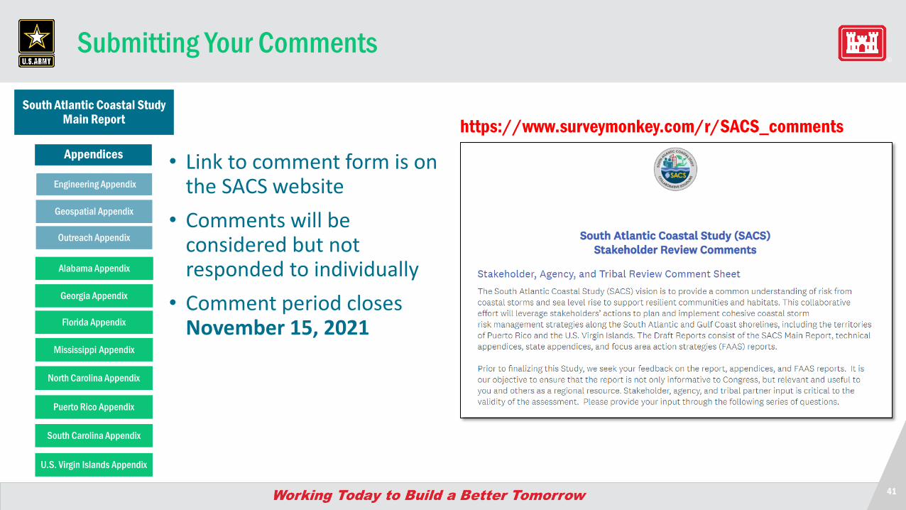
Submitting Your Comments
• Link to comment form is on the SACS website
• Comments will be considered but not responded to individually
• Comment period closes November 15, 2021
https://www.surveymonkey.com/r/SACS_commentsSouth Atlantic Coastal Study
Main Report
Engineering Appendix
Geospatial Appendix
Alabama Appendix
Georgia Appendix
North Carolina Appendix
Puerto Rico Appendix
South Carolina Appendix
U.S. Virgin Islands Appendix
Mississippi Appendix
Florida Appendix
Outreach Appendix
Appendices
42
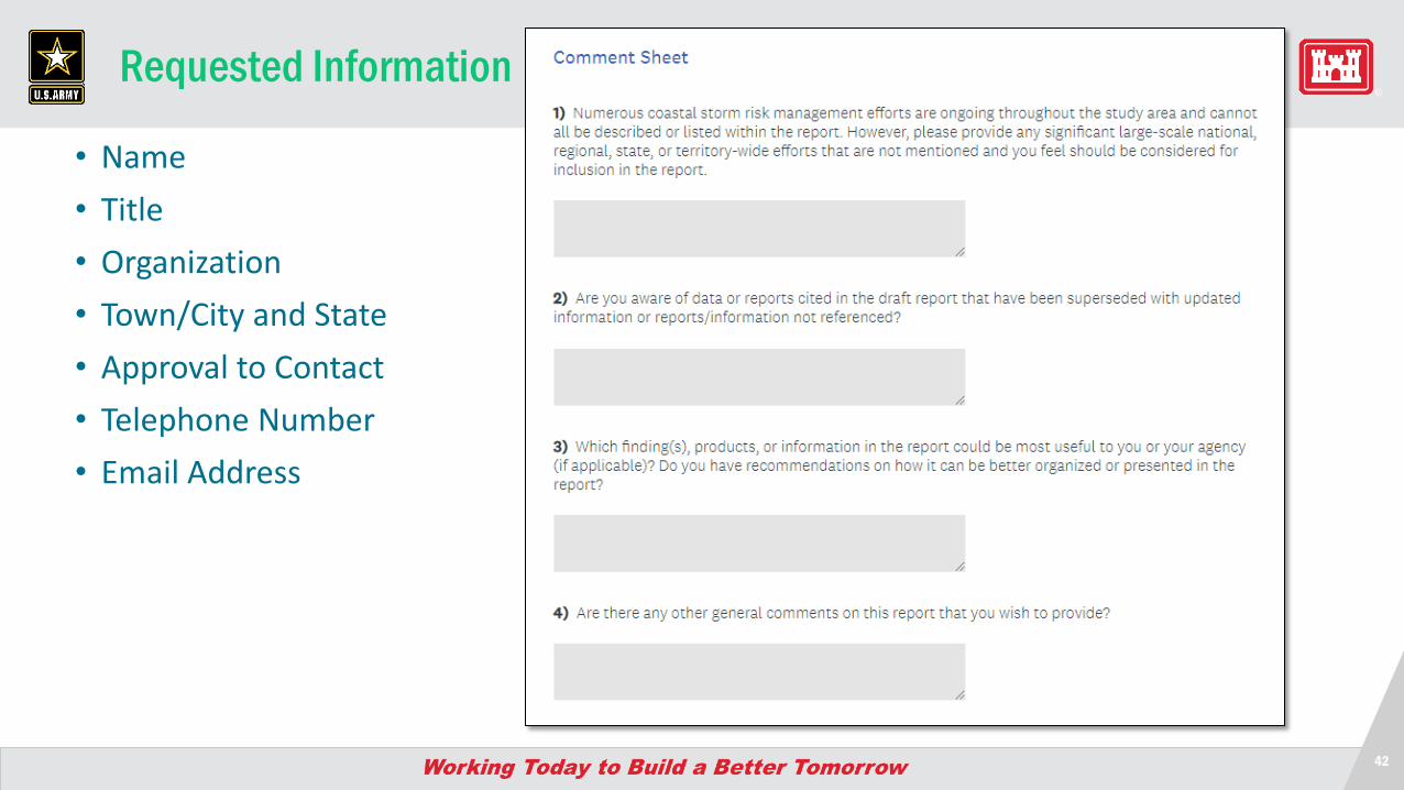
Requested Information
• Name• Title• Organization• Town/City and State• Approval to Contact• Telephone Number• Email Address
Questions and Discussion
44
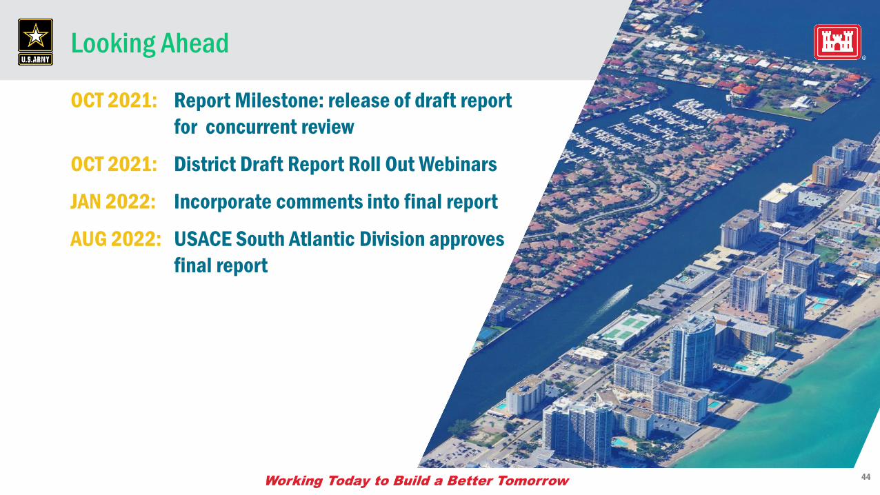
Looking Ahead
OCT 2021: Report Milestone: release of draft report for concurrent review
OCT 2021: District Draft Report Roll Out Webinars
JAN 2022: Incorporate comments into final report
AUG 2022: USACE South Atlantic Division approves final report
4545
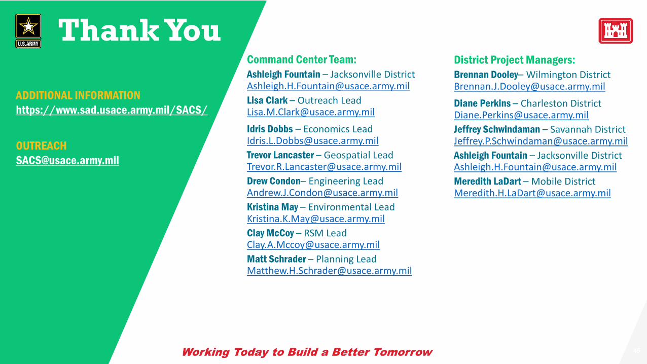
Thank You
ADDITIONAL INFORMATIONhttps://www.sad.usace.army.mil/SACS/
Command Center Team:Ashleigh Fountain – Jacksonville District [email protected] Clark – Outreach [email protected]
Idris Dobbs – Economics [email protected] Lancaster – Geospatial [email protected] Condon– Engineering [email protected] May – Environmental [email protected] McCoy – RSM [email protected] Schrader – Planning [email protected]
District Project Managers:Brennan Dooley– Wilmington [email protected]
Diane Perkins – Charleston [email protected] Schwindaman – Savannah District [email protected] Fountain – Jacksonville District [email protected] LaDart – Mobile District [email protected]