Embed Size (px)
Citation preview

SOUTH BEACH TRAILS CONNECTOR PROJECTDel Norte County, CaliforniaLSC Transportation Consultants
Streamline Planning
PROJECT REPORTJuly 2011
Funded through a Caltrans Environmental Justice: Context-Sensitive Planning Grant

Draft Project rePort | iii
ContentsINTRODUCTION ....................................................................................................................................... 1
PROJECT BACKGROUND ...................................................................................................................... 2
PURPOSE AND NEED STATEMENT ....................................................................................................... 4
EXISTING CONDITIONS – TRAFFIC ..................................................................................................... 10
EXISTING CONDITIONS – PHYSICAL .................................................................................................. 17
ALTERNATIVES STUDIED ..................................................................................................................... 28At-Grade Crossings . . . . . . . . . . . . . . . . . . . . . . . . . . . . . . . . . . . . . . . . . . . . . . . . . . . . . . . . . . . . . 28
Below-Grade Crossings . . . . . . . . . . . . . . . . . . . . . . . . . . . . . . . . . . . . . . . . . . . . . . . . . . . . . . . . . . 33
Above-Grade Crossings . . . . . . . . . . . . . . . . . . . . . . . . . . . . . . . . . . . . . . . . . . . . . . . . . . . . . . . . . . 37
Alternatives Analysis . . . . . . . . . . . . . . . . . . . . . . . . . . . . . . . . . . . . . . . . . . . . . . . . . . . . . . . . . . . . 40
COMMUNITY INVOLVEMENT ................................................................................................................ 44
PREFERRED ALTERNATIVE – CONCEPTUAL PLAN ELEMENTS .................................................... 46Design Parameters . . . . . . . . . . . . . . . . . . . . . . . . . . . . . . . . . . . . . . . . . . . . . . . . . . . . . . . . . . . . . . 46
Conceptual Plans . . . . . . . . . . . . . . . . . . . . . . . . . . . . . . . . . . . . . . . . . . . . . . . . . . . . . . . . . . . . . . . 46
Potential Costs . . . . . . . . . . . . . . . . . . . . . . . . . . . . . . . . . . . . . . . . . . . . . . . . . . . . . . . . . . . . . . . . . 51
Potential Environmental Impacts & Permitting Requirements . . . . . . . . . . . . . . . . . . . . . . . . . . . . . 52
FUNDING SOURCES ............................................................................................................................. 60
NEXT STEPS .......................................................................................................................................... 63
REFERENCES ........................................................................................................................................ 64
APPENDICES ......................................................................................................................................... 65Public Meeting Record & Survey Cards . . . . . . . . . . . . . . . . . . . . . . . . . . . . . . . . . . . . . . . . . . . . . . 66
Promotional Flyers . . . . . . . . . . . . . . . . . . . . . . . . . . . . . . . . . . . . . . . . . . . . . . . . . . . . . . . . . . . . . . 96
Project Contacts . . . . . . . . . . . . . . . . . . . . . . . . . . . . . . . . . . . . . . . . . . . . . . . . . . . . . . . . . . . . . . . . 97


Draft Project rePort | 1
IntroductionThe South Beach Trails Connector Project is an opportunity to improve the safety, well-being, and economic op-portunities for the people of Crescent City, and the broader region of Del Norte County . The project is supported through a joint partnership between the Del Norte Local Transportation Commission (DNLTC), the Redwood National and State Parks (RNSP), and the Elk Valley Rancheria, California (Tribe), a federally recognized Tribe . In 2010, the Tribe received grant funding through the Caltrans Environmental Justice: Context Sensitive Planning grant program to determine the feasibility for creating a safe and accessible bicycle, pedestrian, and equestrian crossing across US Highway 101 . The potential crossing would connect proposed and existing trails on both sides of the highway thereby improving community mobility and regional recreation opportunities and allowing the Tribe to safely access their ancestral lands currently bisected by the highway . Together with Local, State, and National partners, the Tribe shares a broadly supported vision for an interconnected trail system necessary to support transportation improvements, recreation opportunities and economic development in the region .
As US Highway 101 approaches Crescent City from the South it passes directly through State, National, and Tribal lands . These lands contain an extensive network of planned and existing trails on both sides of the highway, but because there is not a safe means of crossing, the highway has long been seen as an impediment to pedestrian safety, regional trail connectivity, and economic development . Discussions regarding a potential crossing location have been ongoing for over 10 years. The result of those discussions led to the identification of a specific study area where potential crossing locations for either an at-grade or grade-separated crossing facility could be evalu-ated . The study area is south of Crescent City on US 101 from the Humboldt Road/Enderts Beach Road/US 101 intersection south to the Hamilton Road/US 101 intersection . The crossing will connect the Del Norte Coast Red-woods State Park and Mill Creek Acquisition to South Beach and Tribal properties . The intent of this preliminary evaluation is to identify a safe and feasible crossing location and crossing type which meets Redwood National and State Park’s, the County’s, Tribe’s, and the public’s desires along with satisfying California Department of Transpor-tation (Caltrans) requirements. This document summarizes the project’s findings and recommendations in order to provide the necessary information for either the Tribe, RNSP, or Caltrans to continue the planning process with the development of a Project Study Report .
INTRODUCTION
Project Vicinity Map

SOUTH BEACH TRAILS CONNECTOR PROJECT | Del Norte County, California2 | Draft Project rePort
Project BackgroundProject Development
In February 2010, the Tribe was awarded the Environmental Justice Grant . The grant is “intended to promote the involvement of low-income and minority communities, and Native American Tribal Governments, in the planning for transportation projects to prevent or mitigate disproportionate, negative impacts while improving their mobility, access, safety , and opportunities for affordable housing and economic development” . As such, the project goals for the South Beach Trail Connector include improving connectivity through transportation, mobility, and access improvements for both residents and visitors along with providing opportunities for economic development .
Making a safe connection between the trail systems on either side of US Highway 101 is an important step towards expanding access and mobility for community members, visitors and the Tribe . During the summer, the average daily total number of cars traveling on US Highway 101 within the project study area peaks at 7,600 (http://traffic-counts .dot .ca .gov/2009all/Route101i .htm) . There is currently no safe way to walk or bicycle across the highway, and compounding the problem is the fact that significant speeding violations and a history of high accident rates have been documented by the California Highway Patrol . Redwood National and State Parks currently has existing and planned trails and recreation opportunities on either side of the highway and providing a safe connection between the trail systems will increase trail utilization and enable residents to access the beach without a car .
Tribal properties and members are also divided by the highway. The Tolowa Indians are historically a fishing, hunt-ing, and gathering people who lived in kin-based villages . Basic production and distribution for subsistence were organized on communal or collective principles . All members of a village were entitled to the fruits of the land and water and they could all hunt and fish in their aboriginal territories. At the ocean’s edge, harvesting smelt and shellfish are culturally significant for the Tribe. For the Tolowa people of the Elk Valley Rancheria, a safe connection between the Tribe’s lands on both sides of the highway will enable the Tribe to access their land and maintain their connection to significant cultural activities and history.
Project Background
Project Study Area

Draft Project rePort | 3
Project Background
Del Norte County is one of California’s poorest . Over 23% of all families in the county are considered to live below the poverty level and the median household income is $38,252 (http://quickfacts .census .gov/qfd/states/06/06015 .html) . Similarly, the median household income for members of the Elk Valley Rancheria is $18,750 (U .S . Census Bureau, 2002) . The lower income levels seen in Del Norte County are partly the result of a regional economic transition from resource extraction to a tourism and recreation based economy . Each year tourism and recreational travel contribute millions of dollars to the Del Norte economy . Travelers spent an estimated $105 .1 million dollars in Del Norte County in 2008, generating $46 .6 million in earnings and providing an estimated 1,740 jobs (Dean Run-yan & Associates, 2010) . By creating regional trail networks, tourists will be encouraged to visit Del Norte County for ecotourism and outdoor recreation . Leveraging the value of regional recreation assets is also an important way for the County to capture much needed revenue from lands managed by public agencies .
The project involved a multitude of participating agencies including representatives from the County, Del Norte Local Transportation Commission, the Tribe, Redwood National and State Parks, Caltrans, California Department of Fish and Game, and Friends of Del Norte. These groups have long recognized the benefits of connecting the regional trail system and providing a link for Tribal members to safely access their traditional Tolowa sites . In an ef-fort to achieve the shared goal of creating a safe pedestrian, bicycle and equestrian crossing of US Highway 101, a steering committee representing the various participating agencies and a team of consultants undertook an evalu-ation of the site conditions, transportation issues and environmental factors in order to understand how best to link the existing and planned trails on both sides of the highway . The team evaluated seven different crossing possibili-ties with both at-grade and grade-separated options using an alternatives analysis prepared by the consultants .
The alternatives analysis provided a tool whereby the seven crossing options could be fairly evaluated . The steer-ing committee determined the criteria by which each alternative should be evaluated, and how the criteria should be weighted in relationship to one another . After vetting the alternatives with the steering committee, the options were discussed with community members during a public workshop . This input was amended with follow-up comments from interested parties and a neighboring property owner and a record of the public input is contained in Appendix A of this document . This document is a compilation of the various crossing alternatives that were considered, and it also summarizes how the various alternatives were evaluated, and ultimately, how a preferred alternative was selected .

SOUTH BEACH TRAILS CONNECTOR PROJECT | Del Norte County, California4 | Draft Project rePort
Purpose and Need
Purpose and NeedNeed
US 101 bisects Tribal properties and RNSP’s holdings and offers no safe way to cross the highway without a ve-hicle . Trails on either side of the highway are disconnected, which limits economic and recreational activity . There are no cross-walks, overpasses, underpasses, signals or roundabouts to provide a safe crossing method for pedes-trians, hikers, cyclists, horseback riders or other non-motorized users . This section of US 101 has one of the highest rates of speeding and accidents in Del Norte County, increasing the danger to pedestrians who attempt to cross the highway . Although there is an extensive network of trails in the RNSP’s properties on either side of the highway, the trails are not connected, impeding economic and recreational activities in the region .
Numerous agencies and groups have long recognized the need to provide a safe method for crossing US Highway 101 for pedestrians, hikers, cyclists, horseback riders or other non-motorized trail users . In many instances, the de-sired connection is specifically identified in the plans and strategies prepared by regional and local planning jurisdic-tions and by the Tribe . A summary of relevant planning objectives is outlined below:
Elk Valley Rancheria, CaliforniaThe Tribe currently has properties both east and west of the highway. This land use separation makes it difficult for Tribal members to access lands and recreation facilities on either side of the highway without using a car . Without a safe means of crossing, community and Tribal members have no way to access parts of their own lands without motorized transport . They are unable to cross the highway to walk on the beach and join in traditional Tribe activi-ties on Tribal lands . With a median household income of $18,750 (2002 US Census data, updated information not yet available), many Tribal members do not own vehicles or if they do, they cannot afford fuel for leisure activities . A safe highway crossing would provide the opportunity for Tribal members to walk to the beach and enjoy traditional activities as they could access cultural sites .
Trail and Backcountry Management Plan Environmental Assessment (Redwood National Park), April 2009This document initiates a long-term program to expand the RNSP’s trail system so it will integrate the existing trail system within the four parks and create trail connections to link the parks with adjacent public lands in Del Norte County . The plan proposes a link to connect existing and planned trails within the Redwood National and State Park to the Coast-to-Crest Trail . Creating this link requires crossing US 101 south of Crescent City in Del Norte County . The link would join two of the best-known long-distance trails in the western US and create a route circling the entire state of California. The document’s “Proposed Trail G” was identified as the link to connect the Coastal Trail at Crescent Beach with the Rellim Ridge hiking trail, the Mill Creek Horse Trail, and the Little Bald Hills Trail in Six Rivers National Forest. The document’s proposed crossing of US 101 was identified as being within the current project study area (about 4 miles south of Crescent City near Crescent Beach) . In order to create the connection a safe crossing of US 101 is needed to accommodate pedestrians, cyclists, and equestrians .
Redwood National and State Parks General Management Plan, 1999Creating the linkage between the trail systems is also identified as a high priority in the Redwood National and State Parks General Management Plan . In 2002, California State Parks (CSP) acquired the Mill Creek lands between Del Norte Coast and Jedediah Smith Redwoods State Parks . The General Plan Amendment for this acquisition includes the trails described above . The trails would be connected to the Coastal Trail and other recreation opportunities via the US 101 crossing location .

Draft Project rePort | 5
Purpose and Need
Del Norte County and Crescent City 2010 Bicycle Facilities Plan UpdateThis document includes policies supporting the construction of bicycle facilities that connect work, school, shop-ping, recreation, and other activity centers . The plan lists two objectives which the highway crossing would help accomplish:
• Objective I-2c . Develop the Hobbs Wall Trail, the Coastal Trail, the Coast to Caves and Coast to Crest Trails as links to recreational areas, including the Redwood National and State Parks .
• Objective I-2f . Encourage connectivity between federal, state, and local bicycle and trail facilities .
Del Norte County Regional Transportation Plan, 2007Regional Transportation Plans (RTPs) are 20-year programmatic documents containing general transportation re-lated policies, guidelines, and capital improvement project lists for all transportation facilities/modes including roads, bridges, transit, aviation, goods movement, pedestrian and bicycle facilities, and transportation demand manage-ment . Both short-term and long-term improvements are included . The plan describes the importance of trails for both transportation and recreation and therefore the local economy .
“Tourism and recreation are an important sector of the northern California economy . Recreational travelers spent an estimated $89 .4 million dollars in Del Norte County in 2004 (Dean Runyon & Associates, 2005) . Del Norte County views tourism as an economic sector providing significant opportunities for growth and has endorsed increased in-vestment in tourism marketing (CEDS 2006-2008; An Economic Evaluation of Public Investment in Tourism Market-ing, March 2006) .”
The plan describes the Coast to Crest/Coast to Caves Trailway and its potential to attract a variety of trail users and be a regional trail destination . As noted in the Redwood National Park Trail and Backcountry Management Plan, a safe crossing of US 101 is needed within the current project study area to connect the Coast-to-Crest trail to trail with the Coast to Caves trail .
Relevant trail improvement projects identified in the RTP’s Action Elements include supporting the Hobbs Wall Trail development as a Crescent City to Redwood National Park recreation/non-motorized travel link and the connection to the Coast-to-Crest and Coast-to-Caves Trailway .
Del Norte County Comprehensive Economic Development Strategy, 2006-2008The Comprehensive Economic Development Strategy (CEDS) is the result of a planning process with extensive community participation to address the economic problems and potential for the Del Norte County area . The plan describes the area’s economic background and establishes a vision with goals and objectives for economic growth . The five key goals of the CEDS are:
• Make critical improvements to local infrastructure .
• Promote the successful expansion of the tourism industry .
• Provide direct support for business retention and expansion .
• Enhance interagency and intergovernmental communication .
• Participate in the development of a comprehensive employee support system as a way of ensuring that employ-ees thrive and businesses flourish.
The South Beach Trails Connector Project directly moves forward the first, second, and third goals while indirectly helping to promote the fourth and fifth goals. Recreation is a key economic driver in the region. A safe trail crossing will help develop a trail system that can be a regional tourist destination while also serving the mobility needs of the existing community .

SOUTH BEACH TRAILS CONNECTOR PROJECT | Del Norte County, California6 | Draft Project rePort
Purpose and Need
Del Norte County General Plan, 2003The County General Plan provides a long-term (20 year) vision for development and includes goals, policies, and standards related to land use, housing, conservation, open space, circulation, recreational and cultural resources, scenic resources, and noise and safety . A review of the relevant policies supporting the trail and crossing develop-ment is discussed below .
Recreational and Cultural ResourcesThe County shall encourage the interconnection of pedestrian and bicycle trails between Federal Forest, Park and Recreational Area lands, National and State Park lands, State Highway and County trails .
The County shall work with other public agencies, such as the City of Crescent City, Local Transportation Commis-sion, Department of Fish and Game, Harbor District, US Forest Service, and State and National Park Services to coordinate the development of equestrian, pedestrian, and bicycle trails .
The County shall promote the development of a regional trail and path system linking residential areas to local rec-reational areas, such as Crescent City to Redwood National and State Parks, and recreational areas to each other . The County encourages the use of existing public and quasi-public rights-of-way, including former railroad rights-of-way .
Wild Rivers Regional Blueprint PlanThe Wild Rivers Regional Blueprint Plan was prepared by the Del Norte Local Transportation Commission in 2009 in order to communicate a regional consensus throughout the Del Norte area regarding planning issues . Pertaining to the South Beach Trails Connector study, this Plan’s Growth Principles include:
• Principle One: “Improve mobility and reduce dependency on single-occupant vehicle trips .
• Principle Two: “Create safe and walkable communities .”
• Principal Seven: “Promote a diverse and prosperous economy, especially through small entrepreneurial busi-nesses and through support of the travel and tourism industry .”
A safe trail crossing of US 101 would help meet these established principles .
Crescent City Beach Area

Draft Project rePort | 7
Purpose and Need
Del Norte County Local Coastal ProgramThe Coastal Element of the Del Norte County General Plan was created to help guide land use policy decisions within the Coastal Zone area, which includes the segments of US Highway 101 within the current project study area . The document is a result of the California Coastal Act of 1976, which set forth the criteria for Local Coastal Pro-grams .
Del Norte County’s Local Coastal Program (LCP) consists of ten regulatory sections and two special study sections . In all sections of the document, the South Beach area is considered an important resource . This is primarily due to its popularity as a tourist and recreational attraction, as well as its situation as the southerly gateway to Crescent City and northerly entrance to units of the Redwood National and State Parks . Issues within this area that may impact a trail crossing include obtrusive signing, extensive litter, and private land ownership which may limit public access opportunities .
Discussions pertinent to and supporting the trail access to recreation opportunities are found in two main sections: Public Access and Recreation .
Public AccessSouth Beach Specific Policy RecommendationsThe County and Redwood National and State Parks should cooperate in a comprehensive plan to enhance the recreation and visual qualities of this area .
RecreationPer the Recreation section of the Coastal Plan, the following policy recommendations have been made:
Present Local PoliciesThe development of a regional trail and path system linking residential areas to local recreational areas, Crescent City to the Redwood National and State Parks and recreational areas to each other should be explored giving strong consideration to existing public and quasi-public rights-of-way including railroad rights-of-way .
Area Specific Recreation Proposals – South BeachThe South Beach area, located to the south of the city limits, provides recreational opportunities . Land uses are primarily commercial, recreational, industrial and agricultural; however some motels and other tourist uses are also in the area . An oil storage facility is located along the eastern US Highway 101 right-of-way at the northerly end of South Beach. The following are specific policy recommendations for this area.
• Access easements – Dedication of vertical and lateral access easement should be sought by the state .
• Funding – In the event of easement acquisitions, funds for maintenance and liability shall be provided by the state .
• Cooperative Planning – The County, Harbor District, Redwood National and State Parks should cooperate in a comprehensive plan to enhance the visual and recreational qualities of this area .

SOUTH BEACH TRAILS CONNECTOR PROJECT | Del Norte County, California8 | Draft Project rePort
Purpose and Need
California Transportation Plan 2025The California Transportation Plan (CTP) is a long-range transportation policy plan that provides a vision of the state’s future mobility needs . The intent of the plan is to guide transportation investments and decisions at all levels of government and the private sector . The vision encompasses all types of transportation facilities such as roads, bicycle facilities, and airports as well as goods movement . The document is very broad in nature and was devel-oped in consultation with the state’s 44 Regional Transportation Planning Agencies as well as the general public .
The following discussion describes how the South Beach Trails Connector Project would help meet the transporta-tion goals set forth in the CTP .
• Improve Mobility and Accessibility – The crossing will provide infrastructure needed for safe and accessible trails connectivity . It will create a well-connected trail network and establish a community partnership to address the long standing issue of accessibility and connectivity .
• Preserve the Transportation System – The current Redwood National and State Parks trail systems are unde-rutilized because of a lack of connectivity . Within the Mill Creek Acquisition and along South Beach, trails are highly utilized . Addressing infrastructure development to promote the use of these trails by providing a safe and effective means of crossing US 101 will increase the use of existing trails, not just by park visitors, but by the community, including commuters and Tribal members currently separated by US 101 .
• Support the Economy – Tourism and recreational travel contribute millions of dollars annually to the Del Norte County economy . Travelers spent an estimated $105 .1 million dollars in Del Norte County in 2008, generating $46 .6 million in earnings and providing an estimated 1,740 jobs (Dean Runyan & Associates, 2010) . By con-necting the trail networks, tourists will be encouraged to visit Del Norte County for ecotourism and outdoor recreation . Within the County, approximately 80 percent of the total land area is public land managed by public agencies . State and National Parks and other natural scenic assets managed by the State and Federal Govern-ment provide recreation and tourism employment as well as economic benefits to the County. However, neither California nor the United States of America pays property tax in the County, and the community must find ways to capture new revenue sources from these public lands .
• Enhance Public Safety and Security – During the summer, the average daily total number of cars traveling on US 101 in the project area peaks at 7,700 . There is currently no safe way to walk or bike across US 101 in this area. The California Highway Patrol reports that there are significant speeding violations, a history of high ac-cident rates and serious accidents . This project will help ensure safe crossing for trail connectivity and access .
• Reflect Community Values – Del Norte County has terrain and mild weather that is ideal for bicycling, hiking, horseback riding and other recreational activities . The trail connection will be developed with the full participa-tion of the Tribe and other stakeholders such as Redwood National and State Parks (RNSP) and Del Norte County Local Transportation Commission . This is a valuable project to Tribal members – it will link them to their ocean-side land . It has a broader purpose of linking one of the area’s most established neighborhoods to beaches and trails . An essential community value is gathering partners on infrastructure projects and working together to benefit all. This project will be successful because it benefits from broad support for safe access to beaches and RNSP lands .
• Enhance the Environment – Del Norte County contains many recreational resources that attract large numbers of tourists each summer, including the Redwoods National and State Park and the Six Rivers National Forest . Redwood National and State Park is classified as a World Heritage Site and International Biosphere Reserve, attracting an average of 400,000 visitors annually (State and National Parks) . By augmenting and expanding the regional trails system with the South Beach Trails Connector, mobility will increase and environmentally-friendly tourism will be promoted . For the Tolowa people of the Elk Valley Rancheria, California this project protects their access to significant cultural history.

Draft Project rePort | 9
Purpose and Need
Purpose
The purpose of the South Beach Trails Connector Project is to evaluate the feasibility of a pedestrian/cyclist/equestrian crossing of US 101 between Humboldt Road and Hamilton Road . The South Beach Trails Connector Project identifies the proposed crossing location and the recommended type of crossing facility. A safe crossing will increase mobility, economic opportunity, community connectivity and access to recreational attractions on Tribal and Redwood National and State Park’s properties and in the community at large . The crossing will support and promote a healthier, more environmentally friendly lifestyle by connecting the region’s extensive network of trails and expanding access for non-motorized modes of transport including walking, hiking, cycling and horseback riding . Additionally, identifying an appropriate crossing location will help Redwood National and State Parks develop an ap-propriate trail alignment to connect the Mill Creek trail system to the broader regional trail network .

SOUTH BEACH TRAILS CONNECTOR PROJECT | Del Norte County, California10 | Draft Project rePort
Southbound NorthboundLocation/Direction
DateStart TimeEnd TimeWeather
Humboldt Rd
10/13/201011:10 AM12:20 PMSunny, no
clouds
0.3 mile south of Humboldt Rd
10/13/201010:10 AM11:08 AM
Sunny, no clouds
Hamilton Rd
10/13/20101:18 PM2:08 PM
Sunny, no clouds
Hamilton Rd
10/13/20101:18 PM2:18 PM
Sunny, no clouds
0.3 mile south of Humboldt Rd
10/13/201010:10 AM11:10 AM
Sunny, no clouds
Humboldt Rd
10/13/201011:10 AM12:20 PMSunny, no
clouds
Min 35 40 24 34 45 35Max 70 66 61 56 67 66Mean 54 .4 53 .9 48 .3 45 .2 56 .2 53 .2Median 55 54 49 45 56 55Mode 55 57 52 48 56 5685th Percentile 59 58 55 50 61 58
Observed Vehicle Speed Data Along US 101 – Counts conducted by Streamline Planning
As indicated, average (median) speeds at the northern two count locations range from 54 to 56 MPH, while the average speeds at Hamilton Road were 45 MPH in the northbound direction and 49 MPH in the southbound direc-tion. Traffic engineers typically focus on the 85th percentile speed in assessing speed conditions (the speed which is exceeded by 15 percent of all drivers) . The 85th-percentile travel speeds on US 101 are between 55 and 61 MPH, with an exception at the location along the uphill (southbound) portion of US 101 at Hamilton Road, which had an 85th-percentile speed of 50 MPH .
Existing Conditions – TrafficThe South Beach Trails Connection Project proposes to construct a shared pedestrian/bicycle/equestrian trail to connect land uses on both sides of US 101 south of Crescent City in Del Norte County, California . This section dis-cusses the opportunities and constraints of providing an at-grade crossing of US 101 between its intersections with Hamilton Road on the south and Humboldt Road/Enderts Beach Road on the north . It does not address a potential overpass or underpass, as the location of such a structure is not a traffic engineering issue. Therefore the discus-sion focuses on whether a marked crosswalk is warranted based on potential use and where an at-grade crossing might be located within the study . It should be noted that an at-grade crossing is inconsistent with Caltrans’ prac-tices on high-speed facilities. According to the District’s Traffic Safety Office, a marked crosswalk is unlikely to be supported due to the high vehicular speeds within the study area . The at-grade crossing alternative is evaluated as part of this study in order to ensure all options are evaluated .
Study Area Characteristics
The segment of US 101 through the study area is approximately 1 .2 miles in length . Traveling northbound, the highway traverses an average downgrade of 5 .5 percent, dropping approximately 350 feet . The southern portion (approximately 0 .75 mile) of this highway segment is characterized by heavily forested, steep cross slopes with an average grade of approximately 6.8 percent. There are two through traffic lanes for uphill southbound traffic and one through traffic lane for downhill northbound traffic. The northern portion of this highway segment is character-ized by a moderate grade (approximately 3 .0 percent), with open space on both sides of the highway . There is one through traffic lane for each direction of traffic. Caltrans reports an Annual Average Daily Traffic (AADT) count of 5,000 on US 101, immediately south of Humboldt Road (http://traffic-counts.dot.ca.gov/2009all/Route101i.htm).
The posted speed limit on US 101 throughout the study area is 55 MPH . There is a posted truck speed limit of 40 MPH for northbound downhill truck traffic in place immediately north of Hamilton Road. Speed surveys conducted at three locations along the corridor for both directions of travel are provided .
Existing Conditions – Traffic

Draft Project rePort | 11
Existing Conditions – Traffic
Traf
fic a
nd S
peed
Dat
a M
ap

SOUTH BEACH TRAILS CONNECTOR PROJECT | Del Norte County, California12 | Draft Project rePort
Existing Conditions – Traffic
The most recent analysis of potential roadway improvements at the US 101/Humboldt Road/Enderts Beach Road intersection is documented in the Elk Valley Rancheria Casino Relocation Traffic Study completed by W-Trans in March 2006 . This study recommended the provision of a northbound deceleration/right turn lane from US 101 onto Humboldt Road as the only improvement to the intersection .
Current Crossing Demand
The following trail crossing demand could reasonably exist today if there was a trail and a crossing .
Redwood National and State Parks Recreational DemandAt present, Redwood National and State Parks have extensive non-motorized trails on both the east and west sides of US 101 in the study area, but no connection across the highway . Without a good crossing opportunity and a trail to connect the existing trails, the current crossing demand is low. However, based on the current traffic counts of the area a trail linkage and crossing facility would likely induce a demand for a crossing . To the west, the Coastal Trail heads south from the south end of Enderts Beach Road, and is open to both hikers and bicyclists . To the east, the Rellim Ridge Trail roughly parallels US 101 between Hamilton Road on the south and Howland Hill Road on the North . Along with the Mill Creek Horse Trail, the Rellim Ridge Trail makes an attractive loop route 9 to 11 miles in length (depending on the access point) that is open to both hikers and equestrians . There is no available information regarding use levels on these existing trails .
The traffic counts that pertain to the study area are Redwood National and State Park traffic counts conducted on Enderts Beach Road just south of US 101 . In 2009, the busiest month (May) had a total of 12,776 one-way vehicle-trips . This corresponds to an average daily volume of 412 one-way vehicle-trips per day . (It is also worth noting that this is the greatest volume counted at any of the six Parks’ count locations in the Redwood National and State Park .)
Based on the observed proportions of visitors interested in non-auto travel in other recreational areas (like Lake Tahoe) the assumptions of an average of 3 persons per car and 10 percent of visitors being interested in accessing trails were used . Using the average of 3 .0 persons per car, and dividing by 2 to convert to round trips, this corre-sponds to approximately 620 persons per day accessing the Park via Enderts Beach Road . While many are simply visiting the picnic ground or overlook or are accessing the Coastal Trail, a reasonable estimate based on informa-tion with similar recreation opportunities is that at least 10 percent would access inland trails via a new connection crossing US 101, if available . This corresponds to 62 round trip person-trips, or 124 one-way person-trips per day in the peak visitation period . Applying the 15 percent in peak-hour factor, this corresponds to 19 crossing in the peak-hour which is essentially the same level identified by Caltrans as providing a good justification for a designated crossing. This means that the project is justified assuming no additional development in the area.
Potential Future Crossing Demand
As discussed below, there are two key potential future “generators” of crossing activity in the study area .
Potential Relocated Elk Valley Rancheria CasinoThe Tribe is considering plans to relocate and expand the existing casino along Elk Valley Road to a new site along the east side of Humboldt Road near the intersection with Sand Mine Road . The Elk Valley Rancheria Casino Relo-cation Traffic Impact Study (W-Trans, 2006) presents an analysis of this potential casino/hotel project. The project evaluated in the study consisted of 40,000 square feet of casino floor area, 156 hotel rooms, and 20,000 square feet of conference meeting floor area. The study indicates that the overall project would generate 3,442 daily one-way vehicle trips, of which 1,392 would be generated by the hotel and the remaining 2,050 by the casino .
Hotel guests would be the key source of persons interested in a walk or cycle from the resort site to the beach . In other recreational/scenic areas, many guests staying at casino resorts are observed to combine both gaming with outdoor recreational/exercise activities . As shown in the Estimate of Potential US 101 Crossing Activity Table, assuming an average occupancy of 2 .5 guests per hotel room, approximately 390 guests would stay at the hotel on a given night . The site of the proposed relocated casino is approximately 2,500 feet north of the crossing study
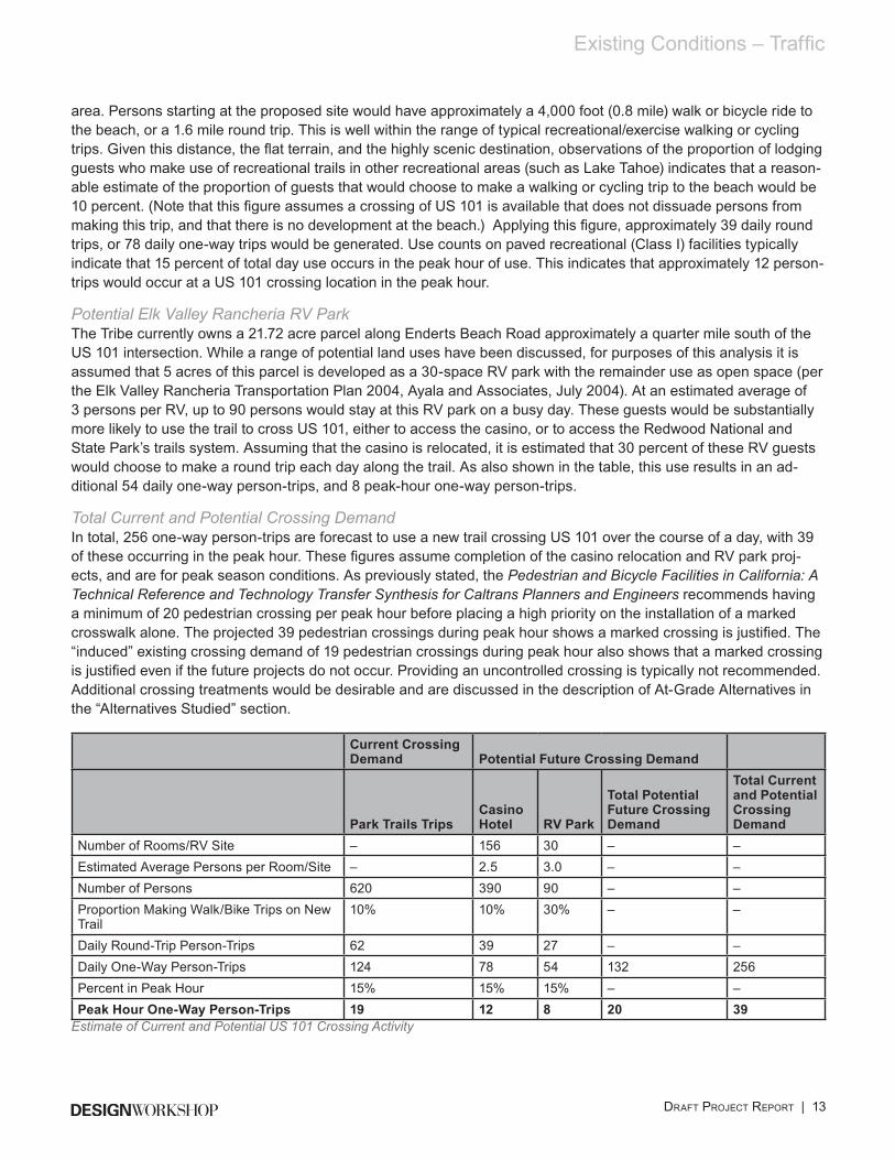
Draft Project rePort | 13
area . Persons starting at the proposed site would have approximately a 4,000 foot (0 .8 mile) walk or bicycle ride to the beach, or a 1 .6 mile round trip . This is well within the range of typical recreational/exercise walking or cycling trips. Given this distance, the flat terrain, and the highly scenic destination, observations of the proportion of lodging guests who make use of recreational trails in other recreational areas (such as Lake Tahoe) indicates that a reason-able estimate of the proportion of guests that would choose to make a walking or cycling trip to the beach would be 10 percent. (Note that this figure assumes a crossing of US 101 is available that does not dissuade persons from making this trip, and that there is no development at the beach.) Applying this figure, approximately 39 daily round trips, or 78 daily one-way trips would be generated . Use counts on paved recreational (Class I) facilities typically indicate that 15 percent of total day use occurs in the peak hour of use . This indicates that approximately 12 person-trips would occur at a US 101 crossing location in the peak hour .
Potential Elk Valley Rancheria RV ParkThe Tribe currently owns a 21 .72 acre parcel along Enderts Beach Road approximately a quarter mile south of the US 101 intersection . While a range of potential land uses have been discussed, for purposes of this analysis it is assumed that 5 acres of this parcel is developed as a 30-space RV park with the remainder use as open space (per the Elk Valley Rancheria Transportation Plan 2004, Ayala and Associates, July 2004) . At an estimated average of 3 persons per RV, up to 90 persons would stay at this RV park on a busy day . These guests would be substantially more likely to use the trail to cross US 101, either to access the casino, or to access the Redwood National and State Park’s trails system . Assuming that the casino is relocated, it is estimated that 30 percent of these RV guests would choose to make a round trip each day along the trail . As also shown in the table, this use results in an ad-ditional 54 daily one-way person-trips, and 8 peak-hour one-way person-trips .
Total Current and Potential Crossing DemandIn total, 256 one-way person-trips are forecast to use a new trail crossing US 101 over the course of a day, with 39 of these occurring in the peak hour. These figures assume completion of the casino relocation and RV park proj-ects, and are for peak season conditions . As previously stated, the Pedestrian and Bicycle Facilities in California: A Technical Reference and Technology Transfer Synthesis for Caltrans Planners and Engineers recommends having a minimum of 20 pedestrian crossing per peak hour before placing a high priority on the installation of a marked crosswalk alone. The projected 39 pedestrian crossings during peak hour shows a marked crossing is justified. The “induced” existing crossing demand of 19 pedestrian crossings during peak hour also shows that a marked crossing is justified even if the future projects do not occur. Providing an uncontrolled crossing is typically not recommended. Additional crossing treatments would be desirable and are discussed in the description of At-Grade Alternatives in the “Alternatives Studied” section .
Current Crossing Demand Potential Future Crossing Demand
Park Trails TripsCasino Hotel RV Park
Total Potential Future Crossing Demand
Total Current and Potential Crossing Demand
Number of Rooms/RV Site – 156 30 – –Estimated Average Persons per Room/Site – 2 .5 3 .0 – –Number of Persons 620 390 90 – –Proportion Making Walk/Bike Trips on New Trail
10% 10% 30% – –
Daily Round-Trip Person-Trips 62 39 27 – –Daily One-Way Person-Trips 124 78 54 132 256Percent in Peak Hour 15% 15% 15% – –Peak Hour One-Way Person-Trips 19 12 8 20 39
Estimate of Current and Potential US 101 Crossing Activity
Existing Conditions – Traffic

SOUTH BEACH TRAILS CONNECTOR PROJECT | Del Norte County, California14 | Draft Project rePort
Sight Distance Considerations
Sight distance is an important design criterion at pedestrian crossing locations . Adequate sight distance is impor-tant both to provide drivers with adequate time to react to the presence of a pedestrian/cyclist/equestrian in the crosswalk and come to a safe stop and to provide pedestrians/cyclists with an adequate opportunity to choose a gap in oncoming traffic. The Caltrans Highway Design Manual provides the pertinent stopping sight distance crite-ria . The base stopping sight distances for a roadway with a 60 MPH design speed is 580 feet . For sustained grades of 3 percent or more (such as the study area roadway), this value is increased by 20 percent in the downhill direc-tion, resulting in a northbound minimum sight distance of 696 feet .
Potential At-Grade Crossing Locations Based on Sight Distance ConsiderationsTo determine locations acceptable for a trail crossing location for the purposes of this preliminary analysis, LSC staff visited the site and measured sight distance at various locations . Areas with adequate sight distance (where a line of sight for approaching drivers equals or exceeds the figures identified above) have sufficient stopping sight distance for a trail crossing location . As shown in the Sight Distance Considerations Map, there are three portions of US 101 with adequate sight distance:
• The northernmost 2,400 feet of the study area south from Humboldt Road/Enderts Beach Road . The constraint at the southern end is a rock outcropping on the west side of US 101 (on the inside of the horizontal curve) that limits sight distance for northbound (downhill) traffic.
• A location at Milepost (MP) 22 .90 . This location, which is approximately three-quarters of the way from Hum-boldt Road to Hamilton Road is on a short section of relatively tangent alignment just to the north of a cut bank on the west side of the highway . Horizontal curves on either end limit this area of potential crossing to approxi-mately 100 feet in length .
• At the south side of the US 101/Hamilton Road intersection . Adequate sight distance is also available at this intersection . A crossing on the south side of the intersection would take advantage of the islands (currently striped pavement) separating the US 101 through lanes, and separating the northbound 101 through and right turn lanes . Caltrans staff, however, indicate that there is a high accident rate at this intersection . As such, it may not be an appropriate location for a crossing .
The remainder of the corridor does not have adequate driver sight distance in one or both directions . In particu-lar, the presence of cut banks on the west side of the highway and along the inside of horizontal curves precludes crossing locations along much of the corridor .
Existing Conditions – Traffic

Draft Project rePort | 15
Sig
ht D
ista
nce
Con
side
ratio
ns M
ap
Existing Conditions – Traffic
SOUTH BEACH TRAILS CONNECTOR PROJECT | Del Norte County, California16 | Draft Project rePort
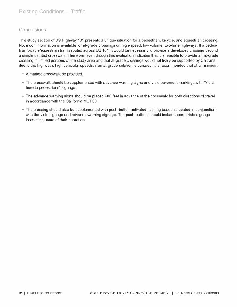
Conclusions
This study section of US Highway 101 presents a unique situation for a pedestrian, bicycle, and equestrian crossing . Not much information is available for at-grade crossings on high-speed, low volume, two-lane highways . If a pedes-trian/bicycle/equestrian trail is routed across US 101, it would be necessary to provide a developed crossing beyond a simple painted crosswalk . Therefore, even though this evaluation indicates that it is feasible to provide an at-grade crossing in limited portions of the study area and that at-grade crossings would not likely be supported by Caltrans due to the highway’s high vehicular speeds, if an at-grade solution is pursued, it is recommended that at a minimum:
• A marked crosswalk be provided .
• The crosswalk should be supplemented with advance warning signs and yield pavement markings with “Yield here to pedestrians” signage .
• The advance warning signs should be placed 400 feet in advance of the crosswalk for both directions of travel in accordance with the California MUTCD .
• The crossing should also be supplemented with push-button activated flashing beacons located in conjunction with the yield signage and advance warning signage . The push-buttons should include appropriate signage instructing users of their operation .
Existing Conditions – Traffic

Draft Project rePort | 17
Existing Conditions – Physical
Existing Conditions – PhysicalThe project area is located in the northwestern portion of California . The climate is cool and moist with heavy fogs a daily occurrence during the summer. The site analysis examined factors including slope, wetlands, flood zones, and soils . Potential cultural resources were not noted as being likely within the study area . However, lands close to Enderts Beach are noted as having potential cultural significance, as they are used for cultural gatherings and a smelt fishery. The mapped resource information described below was field verified and a site imagery database was compiled .
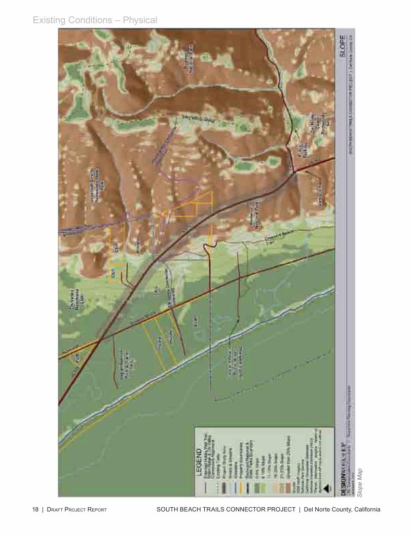
Slope
Project area and adjacent slopes range from relatively level to extremely steep . In the northern portion of the study area, slopes are between 0-5% and 5-10% . These grades extend from the Humboldt Road intersection south to where the passing lane begins near milepost (MP) 23.50. The flatter slopes (0-5%) facilitate at-grade crossing op-portunities but create engineering issues for the trail connecting to the Redwood National and State Park’s system . The trail would require engineered fill for drainage, and ongoing maintenance would likely be more expensive than for a trail with a greater slope .
Near MP 23.50 the highway profile becomes elevated above the surrounding terrain for about 500’. This condition presents the opportunity for an underpass crossing as extensive excavation would not be required . An abandoned cattle underpass is also thought to be located in this area .
As US 101 continues south to Hamilton Road, the terrain east of the highway rises considerably and creates a cut slope condition . With grades greater than 25%, the terrain also drops off quickly on the west side of the highway as it merges into the low-lying lands adjacent the coast . Rock outcroppings west of the highway occur in two locations . This creates a situation where the roadway is depressed and an above-grade crossing may connect the adjacent, elevated landforms . However, making the grades work for the trail connections to the above-grade crossing would be difficult.
Wetlands
Wetlands from the National Wetlands Inventory are shown on project study maps. Wetlands are identified near the Humboldt Road/US 101 intersection . The wetlands extend approximately 1000’ south of the intersection on both sides of the highway . As the road continues south, no additional wetlands are shown near the roadway .
Flood Zones
According to the Federal Emergency Management Agency (FEMA) Q3 flood data, the project study area does not have any mapped areas of Special Flood Hazard Areas (SFHA). Areas designated as SFHA are subject to flood-ing by the 1% annual chance flood or a 1-year flood event. There are SFHAs noted north of the project area and the area around the Humboldt Road intersection has a history of flooding or standing water according to residents. FEMA mapping shows the project area as being either within Zone X (500-year flood event) or Zone D (areas in which flood hazards are undetermined but possible).
Soils
Soils information comes from the National Resources Conservation Service (NRCS) Soil Survey Geographic (SSURGO) database 2008 Soil Survey of Redwood National and State Parks (RNSP) . This information was avail-able for the project area within RNSP boundaries, but no soils have been mapped for the northern portion of the study area . For mapped areas, the Sisterrocks-Sasquatch-Houda complex is illustrated as being within the project area . This soil type is not ideal for trail development as it has steep slopes ranging from 30% to 75% .
SOUTH BEACH TRAILS CONNECTOR PROJECT | Del Norte County, California18 | Draft Project rePort
Slo
pe M
ap
Existing Conditions – Physical

Draft Project rePort | 19
Existing Conditions – Physical
Wet
land
s M
ap

SOUTH BEACH TRAILS CONNECTOR PROJECT | Del Norte County, California20 | Draft Project rePort
Floo
d Zo
nes
Map
Existing Conditions – Physical

Draft Project rePort | 21
Existing Conditions – Physical
Soi
ls M
ap

SOUTH BEACH TRAILS CONNECTOR PROJECT | Del Norte County, California22 | Draft Project rePort
Existing Conditions – Physical
Synthesis of Traffic and Physical Conditions
Findings from both the traffic analysis and site analysis are combined into a summary graphic which illustrates the overall opportunities for potential crossing locations. Seven options are identified – two at-grade, three below-grade, and two above-grade . In addition to the resources previously described, the elk corridor and potential regional gateway location are shown . Currently, an elk herd corridor crosses US 101 . No elk crossing signs currently exist for this portion of US 101 but they are being considered due to elk/vehicle collisions in the area . It is predicted that the elk herd will increase in numbers which will increase the conflict between vehicles and elk movements across the highway . Therefore, the project considers the potential for designing an underpass or overpass crossing to accom-modate elk movement .
Del Norte Local Transportation Commission completed a Highway 101 Traffic Calming and Gateway Treatment Plan in 2010. The project described the need to slow traffic entering Crescent City from the south along US 101. The Plan identified the creation of a regional gateway within the project study area as an initial gateway element to help drivers recognize the transition into the community . A potential gateway location is shown on the map to illustrate the opportunity to combine the gateway with the highway crossing in order to reinforce the traffic calming improve-ments .
Elk Crossing Highway 101 in Study Area
Elk Crossing Highway 101 in Study Area

Draft Project rePort | 23
Existing Conditions – Physical
Trai
l Cro
ssin
g O
ppor
tuni
ties
& C
onst
rain
ts M
ap
SOUTH BEACH TRAILS CONNECTOR PROJECT | Del Norte County, California24 | Draft Project rePort
Existing Conditions – Physical
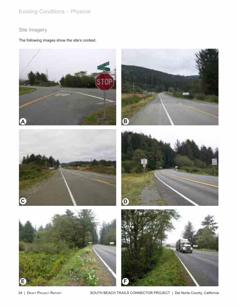
Site Imagery
The following images show the site’s context .
A
D
B
E F
C

Draft Project rePort | 25
Existing Conditions – Physical
A
C
D
B
E
FPrivate
Private
Private
EVR
DFG
CSPCSP
Elk Valley Rancheria
(EVR)
Depart. of Fish &
Game (DFG)
Redwood National Park
Jedediah Smith Redwoods State
Park
US 101
Humboldt
Enderts Beach
Hamilton
Elk Valley Connector
(potential) Rellim
Ridg
e
Conne
ctor (
poten
tial)
Hobbs W
all Trail
(potential)
Crescent B
each
Trail
NorthScale 1” = 1.5 Miles0 0.375 mi. 0.75 mi. 1.5 mi.

SOUTH BEACH TRAILS CONNECTOR PROJECT | Del Norte County, California26 | Draft Project rePort
Existing Conditions – Physical
G
J
H
K L
I

Draft Project rePort | 27
Existing Conditions – Physical
H
G
I
KL
J
Private
Private
Private
EVR
DFG
CSPCSP
Elk Valley Rancheria
(EVR)
Depart. of Fish &
Game (DFG)
Redwood National Park
Jedediah Smith Redwoods State
Park
US 101
Humboldt
Enderts Beach
Hamilton
Elk Valley Connector
(potential) Rellim
Ridg
e
Conne
ctor (
poten
tial)
Hobbs W
all Trail
(potential)
Crescent B
each
Trail
NorthScale 1” = 1.5 Miles0 0.375 mi. 0.75 mi. 1.5 mi.

SOUTH BEACH TRAILS CONNECTOR PROJECT | Del Norte County, California28 | Draft Project rePort
Alternatives StudiedSeven potential crossing options rose to the top after synthesis of the site analysis and opportunities/constraints data. Two of the locations are at-grade crossing alternatives and five are grade-separated alternatives.
At-Grade Alternatives
The location of at-grade crossings is highly dependent on traffic considerations such as sight distance and highway speed . An at-grade crossing facility is typically the least expensive type, but it has the highest probability for vehicu-lar and pedestrian/cyclist/equestrian conflict. Equestrian users do not prefer at-grade crossings as the horse may be spooked by passing traffic while waiting for an opening to cross.
Potential Trail Crossing TreatmentsThere are several treatments available to make an at-grade trail crossing safer and more efficient for trail users. It is important to note that providing an uncontrolled at-grade crossing on a high-speed highway is generally not a recommended practice . Therefore, it is not recommended that a marked crosswalk be installed anywhere along US 101 in the study area without also installing an adequate series of advance warning devices to alert approaching drivers to the presence of the trail crossing location . Even with such enhancements, Caltrans may not support an at-grade crossing . However, in order to fully evaluate the alternatives, this section provides a summary of the vari-ous warning and control devices that can be used at crossings and any warrants applicable to their implementation .
There have been many studies conducted to assess the safety and efficiency of various treatments for mid-block or non-intersection pedestrian crossing locations . National Cooperative Highway Research Project (NCHRP) Report 562 (hereon referred to as the NCHRP Report) provides a discussion and statistical analysis of many different types of crossing treatments . The study discusses the effectiveness of crossing treatments in terms of the percentage of drivers that yield to pedestrians or comply with the treatment . Following is a discussion of pedestrian crossing treat-ments for mid-block locations .
Marked Crosswalks and Pedestrian Refuge IslandsA marked crosswalk provides a defined path for pedestrians to cross a roadway. Marked crosswalks can serve sev-eral purposes including channelizing pedestrians to cross the road in a single specific location and making drivers aware of encountering a pedestrian crossing location . There have been several studies conducted to determine the effects that marked crosswalks have on pedestrian safety . The studies conclude that the addition of marked cross-walks does not increase pedestrian safety versus locations with unmarked crosswalks . In many cases, especially in the case of wide and high-speed roadways, the addition of a marked crosswalk will actually decrease pedes-trian safety . The recommendations of these studies state that a combination of crossing treatments in addition to a marked crosswalk are preferred for increased pedestrian safety and efficiency.
The California Manual on Uniform Traffic Control Devices (Caltrans, 2010, based on Federal Highway Administra-tion MUTCD, 2003) (California MUTCD) does not specify minimum pedestrian crossing volume warrants for the installation of marked crosswalks at mid-block locations . However, Pedestrian and Bicycle Facilities in California: A Technical Reference and Technology Transfer Synthesis for Caltrans Planners and Engineers (prepared for Cal-trans by Alta Planning + Design in July 2005) states that “It is recommended that a minimum of 20 pedestrian cross-ing per peak hour (or 15 or more elderly and/or child pedestrians) exist at a location before placing a high priority on the installation of a marked crosswalk alone.” Comparing this figure with the estimated use levels discussed previ-ously, a designated crossing location is a potential alternative in this study area .
The California MUTCD states the following guidelines in agreement with studies concluding that marked crosswalks in certain locations can be less safe than unmarked crosswalks:
“Crosswalks should not be installed at uncontrolled locations on four-lane or wider roadways with a speed limit greater than 40 MPH and average daily traffic (ADT) is greater than 12,000 with no raised median present, or an ADT greater than 15,000 when a raised median is present.”
Alternatives Studied

Draft Project rePort | 29
Page Title
Example of an at-grade crossing Example of warning beacon sign
Existing Conditions – Traffic
The California MUTCD recommends that additional signs and/or pavement markings be installed at mid-block crosswalk locations to make drivers more aware of their presence . Examples of additional warning treatments for a mid-block crosswalk location are the use of an advance yield bar accompanied by the “Yield Here for Pedestrians” sign . The California MUTCD does not specify a minimum pedestrian volume warrant for the use of these treat-ments . The California MUTCD does state, however, that if a yield pavement marking is used, it must be accompa-nied with appropriate signage . In addition, the yield bar should be placed between 20 and 50 feet in advance of the crosswalk and that the space in between should be clear of visual obstructions (i .e . on-street parking) .
Crosswalks may also be enhanced by the addition of a raised median or pedestrian refuge island . Raised curbs are not permitted on roadways with speeds of 55 MPH . Therefore, a raised median or pedestrian refuge island en-hancements would not be approved for this project and is not presented as an option .
Warning BeaconsThe use of warning beacons at crosswalk locations is common throughout the United States . Crosswalk warning beacons consist of a single or series of flashing yellow signals. They can be implemented in numerous configura-tions (e.g. overhead, side of roadway, with signs, single flasher, alternating flashers, in advance of crossing loca-tion, etc.) to address issues specific to the locations where they are being used. Some pedestrian crossing warning beacons operate continuously, while others are pedestrian actuated . Warning beacons at crosswalk locations are most effective if they operate only when a pedestrian is present, as warning beacons that flash continuously quickly become routine and are subconsciously ignored by drivers . Therefore, an active (push-button activated) or passive (no action required) pedestrian detection system should be used with the warning beacon .
Vehicle yielding rates are generally higher for pedestrian crossing warning beacons with active detection than bea-cons with passive detection . This is due to imperfections in the passive detection technology, which tend on occa-sion to produce “false calls .” A false call occurs when the detector senses a pedestrian and activates the beacon, when in actuality there is no pedestrian present . This phenomenon has a similar effect to a beacon that continu-ously flashes. A common cause of false calls is the mistaken detection of a vehicle in the right-lane as a pedestrian waiting to cross on the curb . Rain is also a common source of false calls for passive detection . For pedestrian warn-ing beacons with active (push-button) detection, it is important to provide conspicuous and straightforward signage that provides pedestrians instructions on the proper procedures for use of the warning beacon .
SOUTH BEACH TRAILS CONNECTOR PROJECT | Del Norte County, California30 | Draft Project rePort
Page Title Existing Conditions – Traffic
Vehicle yielding rates for overhead warning beacons at crosswalks on four-lane roadways were between 30 and 75 percent for push-button activated beacons . The NCHRP Report only conducted studies of pedestrian warning beacons at locations with speed limits of 30 and 35 MPH . There was limited statistical correlation between driver compliance rates and speed limits for pedestrian warning beacons. Based on the data it would be difficult to esti-mate the driver yielding rate at a beacon controlled crosswalk location on a roadway with the higher posted speeds of 55 MPH present on US 101 south of Crescent City .
There are limited guidelines for the installation and use of warning beacons at pedestrian crossings . The California MUTCD specifies that a flashing warning beacon “may be used as emphasis for a mid-block crosswalk.” There is no pedestrian crossing volume warrant for the installation of warning beacons . The California MUTCD provides the design standards for warning beacons regarding size and placement within the proper field of view.
Full Pedestrian Traffic SignalThe use of a full traffic signal at a mid-block pedestrian crossing location is governed by the Pedestrian Volume Warrant (Warrant 4) in the California MUTCD. A full traffic signal at a pedestrian crossing location is a very re-strictive traffic control measure and therefore, requires a high pedestrian crossing volume to justify. The MUTCD contains both a 4-hour pedestrian volume warrant and a peak hour pedestrian volume warrant . The 4-hour war-rant requires 100 pedestrians for each of any four hours of an average day and the peak hour pedestrian warrant requires 190 pedestrians for any one hour of an average day . The warrant criteria also requires that there be fewer than 60 adequate gaps in traffic during the peak pedestrian crossing times. The warrant volumes may be reduced by up to 50 percent at locations where the average pedestrian crossing speed is less than 4 feet per second .
The minimum pedestrian crossing warrant values far exceed the crossing demand for US 101 south of Crescent City. Therefore, the use a full traffic signal is not appropriate at mid-block crossing locations on US 101 or at the US 101/Humboldt Road/Enderts Beach Road intersection .
Options Considered
Because the highway has a posted speed limit of 55 MPH, raised curbs are not permitted and a pedestrian refuge island does not make sense, as it would lengthen the crossing distance without having curbing or other enhance-ments to slow traffic. Therefore the at-grade crossing options were considered to be striped facilities with advanced warning signage that would include push-button activated flashing beacons. Yield signage and striping could also be used .
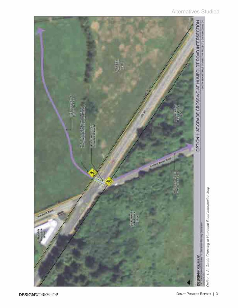
Option 1: At-Grade Crossing at Humboldt Road IntersectionOption 1 is located at the Humboldt Road/Enderts Beach Road/US 101 intersection . The crossing would be signed and striped as previously described . Trail connections to the Hobbs Wall Trail in the Redwood National and State Park’s trail system would likely pass through some wetlands and require additional engineering to ensure adequate drainage . The location is currently used by residents traveling via bike along Enderts Beach Road to the day use facilities .
Option 2: At-Grade Crossing Near Existing DrivewaysOption 2 is located south of the Humboldt Road/Enderts Beach/US 101 intersection near two access drives . The location has adequate sight distance and is located in closer proximity to the potential Hobbs Wall Trail . The cross-ing would be signed and striped as previously described . The crossing is a mid-block crossing, and therefore has higher risk of pedestrian/vehicular conflict than a crossing at a defined intersection.
Draft Project rePort | 31
Alternatives Studied
Opt
ion
1: A
t-Gra
de C
ross
ing
at H
umbo
ldt R
oad
Inte
rsec
tion
Map

SOUTH BEACH TRAILS CONNECTOR PROJECT | Del Norte County, California32 | Draft Project rePort
Alternatives Studied
Opt
ion
2: A
t-Gra
de C
ross
ing
Nea
r Exi
stin
g D
rivew
ays
Map

Draft Project rePort | 33
Below-Grade Crossings
Three below-grade crossing options are identified. The effective-ness of grade-separated crossings, such as below-grade and above-grade options, depends on the user’s perception of acces-sibility and ease of crossing . Users weigh the perceived safety ben-efits of the grade-separated facility against effort and time issues. To maximize the use of grade separated crossings, they should be located in the normal or expected path of major pedestrian move-ments . The location and design of the grade-separated options are such that a user connecting from the identified trails would stay on the trail and use the crossing . Traits include:
• Require about 10-12 feet of vertical clearance .
• More expensive to construct than at-grade crossings and may require roadway improvements such as guardrails .
• May have security problems and must address drainage .
• Can be used by wildlife .
• Lighting should be provided for safety .
• Clear sight lines allow users to see oncoming users or other obstructions prior to entering underpass .
Option 3: Underpass Near Existing DrivewaysOption 3 is located in the same place as Option 2 but uses an underpass to cross the highway . The crossing location is the most direct route between the Tribe’s properties and the beach and trail systems west of the highway if the Hobbs Wall Trail is not built . The underpass would require excavation to go under the road . The location is closer to the wetlands than other underpass options and may impact hydrology and drainage more than the other underpass options .
Option 4: Underpass Near Start of Passing LaneOption 4 is located about 2000 feet south of the Humboldt Road/Enderts Beach Road/US 101 intersection . The southbound pass-ing lane begins in this area . The roadway is elevated above the surrounding terrain which would simplify the construction of an underpass facility . The structure would still need to ensure adequate drainage, but it is less likely to interfere with groundwater movement than Option 3 . Private property is located east of the structure, but the facilities will be built entirely within the 160 foot ROW and not require an easement onto private property . The crossing is easily accessible from the Hobbs Wall Trail alignment .
Option 5: Underpass Just South of Where Passing Lane StartsOption 5 is located about 2400 feet south of the Humboldt Road/Enderts Beach Road/US 101 intersection . Its description is similar to that of Option 4 . The difference is that the Parks’ lands are adjacent to the ROW . It is also slightly closer to the Hobbs Wall Trail align-ment .
Alternatives Studied
Example of a below grade crossing
Example of a below grade crossing

SOUTH BEACH TRAILS CONNECTOR PROJECT | Del Norte County, California34 | Draft Project rePort
Opt
ion
3: U
nder
pass
Nea
r Exi
stin
g D
rivew
ays
Alternatives Studied

Draft Project rePort | 35
Alternatives Studied
Opt
ion
4: U
nder
pass
Nea
r Sta
rt of
Pas
sing
Lan
e

SOUTH BEACH TRAILS CONNECTOR PROJECT | Del Norte County, California36 | Draft Project rePort
Alternatives Studied
Opt
ion
5: U
nder
pass
Jus
t Sou
th o
f Whe
re P
assi
ng L
ane
Sta
rts
Draft Project rePort | 37
Alternatives Studied
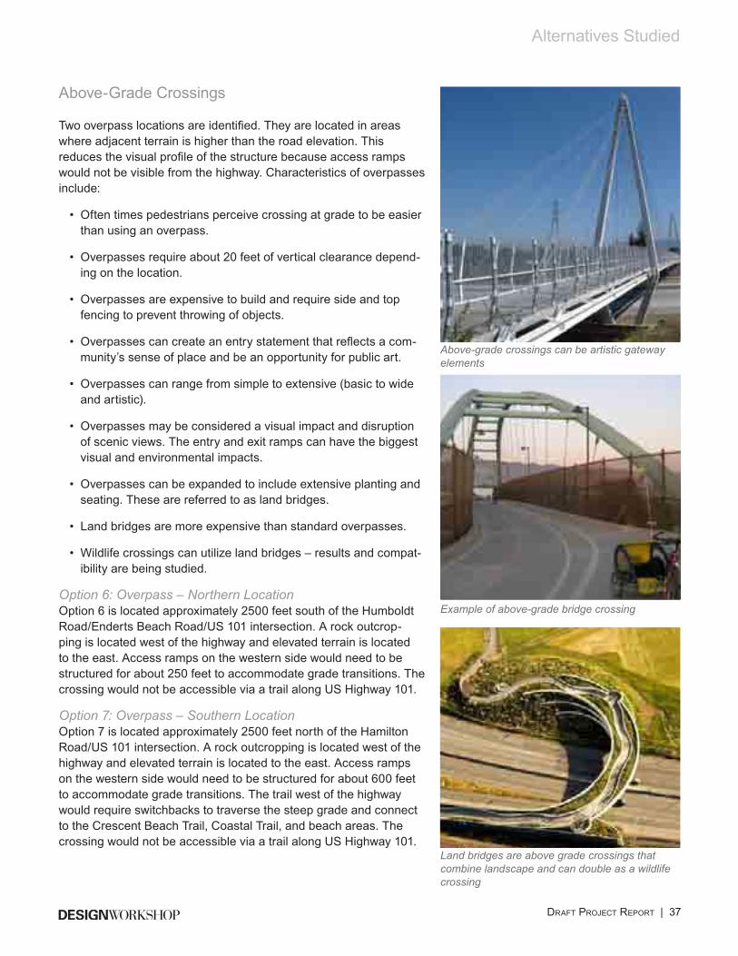
Above-Grade Crossings
Two overpass locations are identified. They are located in areas where adjacent terrain is higher than the road elevation . This reduces the visual profile of the structure because access ramps would not be visible from the highway . Characteristics of overpasses include:
• Often times pedestrians perceive crossing at grade to be easier than using an overpass .
• Overpasses require about 20 feet of vertical clearance depend-ing on the location .
• Overpasses are expensive to build and require side and top fencing to prevent throwing of objects .
• Overpasses can create an entry statement that reflects a com-munity’s sense of place and be an opportunity for public art .
• Overpasses can range from simple to extensive (basic to wide and artistic) .
• Overpasses may be considered a visual impact and disruption of scenic views . The entry and exit ramps can have the biggest visual and environmental impacts .
• Overpasses can be expanded to include extensive planting and seating . These are referred to as land bridges .
• Land bridges are more expensive than standard overpasses .
• Wildlife crossings can utilize land bridges – results and compat-ibility are being studied .
Option 6: Overpass – Northern LocationOption 6 is located approximately 2500 feet south of the Humboldt Road/Enderts Beach Road/US 101 intersection . A rock outcrop-ping is located west of the highway and elevated terrain is located to the east . Access ramps on the western side would need to be structured for about 250 feet to accommodate grade transitions . The crossing would not be accessible via a trail along US Highway 101 .
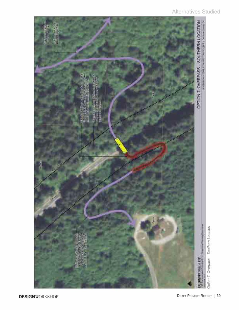
Option 7: Overpass – Southern LocationOption 7 is located approximately 2500 feet north of the Hamilton Road/US 101 intersection . A rock outcropping is located west of the highway and elevated terrain is located to the east . Access ramps on the western side would need to be structured for about 600 feet to accommodate grade transitions . The trail west of the highway would require switchbacks to traverse the steep grade and connect to the Crescent Beach Trail, Coastal Trail, and beach areas . The crossing would not be accessible via a trail along US Highway 101 .
Above-grade crossings can be artistic gateway elements
Example of above-grade bridge crossing
Land bridges are above grade crossings that combine landscape and can double as a wildlife crossing

SOUTH BEACH TRAILS CONNECTOR PROJECT | Del Norte County, California38 | Draft Project rePort
Alternatives Studied
Opt
ion
6: O
verp
ass
– N
orth
ern
Loca
tion
Draft Project rePort | 39
Alternatives Studied
Opt
ion
7: O
verp
ass
– S
outh
ern
Loca
tion

SOUTH BEACH TRAILS CONNECTOR PROJECT | Del Norte County, California40 | Draft Project rePort
Alternatives Analysis
In addition to preliminary review by the steering committee and the public, the alternatives were evaluated based on standard trail development and crossing criteria. Originally 18 different criteria were identified to rank the vari-ous trail crossing alternatives, but the steering committee consolidated the list into the 5 categories listed below . In addition to consolidating the criteria, the steering committee also assigned the weighted value of each criterion and rated each of the trail connection alternatives .
Evaluation Criteria• Safety (weighted multiplier of 5): Determined to be the most important .
• Users (weighted multiplier of 4): Determined to be very important .
• Public Feedback (weighted multiplier of 3): Determined to be important .
• Total Cost of Ownership (weighted multiplier of 2): Determined to have importance, but it shouldn’t be highly weighted in relation to the other categories .
• Resource Impacts (weighted multiplier of 3): Determined to be important .
The final ratings are illustrated in the Alternatives Analysis Ratings Matrix. The ratings are relative within each category depending on if an Option had a clear disadvantage (red), no clear advantage or disadvantage (yellow), or a clear advantage (green) in comparison to the other Options . The ratings were then transferred to a numerical system to allow for weighting and comparison of the total results . Red was given one point, yellow two points, and green three points .
The qualitative analysis of impacts is primarily based on the information shown on the maps within the “Exist-ing Conditions – Physical” section as well as standard trail planning considerations, such as user preferences . The mapped data includes information collected through a records search of available local, state, and national data. The potential sea level rise as mapped by the Pacific Institute for the Sister Rocks quadrangle area was also reviewed to consider impacts from potential future flooding and groundwater level increases. Public feedback is a summary of responses from the public workshop . Costs information summarizes both capital costs, based on research from similar projects, and long-term maintenance costs, based on historical experience from the Redwood National and State Park’s staff .
As previously mentioned, at-grade crossings on a high-speed highway are not a recommended practice . Caltrans’ District Traffic Safety Office also indicated that marked crosswalks are unlikely to be supported due to the high vehicular speeds within this study area . Although evaluated as part of the project, the results of the Alternatives Analysis as well as Caltrans’ initial evaluation confirm that an at-grade crossing is not the recommended option.
Options 4 and 5 received the most favorable ratings as seen in the Weighted Alternatives Analysis Matrix . The steering committee determined that there was no significant difference between Option 4 and 5 since they were lo-cated about 400 feet apart . Therefore this project report describes one preferred alternative – an underpass alterna-tive located in the vicinity of Options 4 and 5. More detailed engineering and design will determine the final crossing location within this defined area and will provide more quantitative analysis of the crossing’s impacts and costs.
Alternatives Studied

Draft Project rePort | 41
Alternatives Studied
SOUTH BEACH TRAILS CONNECTOR PROJECT | Del Norte County, California1 | Alternatives Analysis
South Beach Trails Connector ProjectAlternatives Analysis
Category
option 1at-grade
Crossing at Humboldt
road interseCtion
option 2at-grade Crossing
near existing driveways
option 3underpass
near existing driveways
option 4underpass near start of passing
lane
option 5underpass Just soutH of wHere
passing lane starts
option 6overpass – nortHern loCation
option 7overpass
– soutHern loCation
safety
Pedestrian/vehicle conflict
highest
Pedestrian/vehicle conflict
highest
Potential for transients
hanging out
Potential for transients
hanging out
Potential for transients
hanging out
Lowest potential conflicts
Lowest potential conflicts
users (Combined
from users Categories
below)
Score: 1.667 Score: 1.667 Score: 3 Score: 3 Score: 3 Score: 2.667 Score: 2.667
users –pedestrian
Crossing type is compatible
with pedestrian usage, but they must stop and look for a gap
in traffic
Crossing type is compatible
with pedestrian usage, but they must stop and look for a gap
in traffic
Crossing type is compatible
with pedestrian usage
Crossing type is compatible
with pedestrian usage
Crossing type is compatible
with pedestrian usage
Crossing type is compatible
with pedestrian usage
Crossing type is compatible
with pedestrian usage
users –biCyClists
Crossing type is compatible with bicyclist
usage, but they must stop and look for a gap
in traffic
Crossing type is compatible with bicyclist
usage, but they must stop and look for a gap
in traffic
Crossing type is compatible with bicyclist
usage
Crossing type is compatible with bicyclist
usage
Crossing type is compatible with bicyclist
usage
Crossing type is compatible with bicyclist
usage
Crossing type is compatible with bicyclist
usage
users –equestrian
Crossing type is difficult for
equestrian users
Crossing type is difficult for
equestrian users
Crossing type is easier for equestrian
users
Crossing type is easier for equestrian
users
Crossing type is easier for equestrian
users
Crossing type is acceptable
for equestrian users
depending on design
Crossing type is acceptable
for equestrian users
depending on design
publiC feedbaCk
Most Preferred: Survey: ranked
#3 (15%) Dots: ranked #3 (8 green dots, 18%)
Least Preferred: Survey: ranked
#3 (tied at 15%) Dots:
ranked #1 (tied at 14 red dots,
36%)
Most Preferred:Survey: ranked
#6 (last 0%)Dots: ranked
#6 (last, tied 0 green dots)
Least Preferred: Survey: ranked
#1 (25%)Dots: ranked #1 (tied at 14 red dots, 36%)
Most Preferred: Survey: ranked #5 (tied at 5%) Dots: ranked #5 (2 green dots, 5%)
Least Preferred: ranked #5 (tied
for last). No red dots or
least preferred votes.
Most Preferred Survey: ranked #2 (15-20%)Dots: Ranked #1 (18 green
dots, 41%)Least Preferred: Survey: ranked
#4 (5%)Dots: ranked
#4 (2 red dots, 5%)
Most Preferred Survey: ranked
#1 (40%)Dots: ranked #2 (9 green dots, 20%)
Least Preferred: ranked # 5
(tied for last). No red dots or least preferred
votes.
Most Preferred Survey: ranked
#4 (5-10%) Dots: ranked
#6 (last, tied 0 green dots)
Least Preferred:Survey: ranked
#2 (20%)Dots: ranked
#3 (4 red dots, 10%)
Most Preferred Survey: ranked #5 (tied at 5%)Dots: ranked #4 (7 green
dots)Least Preferred:Survey: ranked #3 (tied at 5%) Dots: ranked
#2 (5 red dots, 13%)
Alternatives Analysis Rating Matrix - Page One
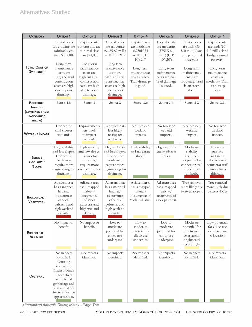
SOUTH BEACH TRAILS CONNECTOR PROJECT | Del Norte County, California42 | Draft Project rePortSOUTH BEACH TRAILS CONNECTOR PROJECT | Del Norte County, California2 | Alternatives Analysis
South Beach Trails Connector ProjectAlternatives Analysis
Category option 1 option 2 option 3 option 4 option 5 option 6 option 7
total Cost of ownersHip
Capital costs for crossing are minimal (less than $20,000)
Long term maintenance
costs are high, and trail construction costs are high due to poor drainage.
Capital costs for crossing are minimal (less than $20,000)
Long term maintenance
costs are high, and trail construction costs are high due to poor drainage.
Capital costs are moderate
($1.25-$2 mill.) (CIP 10’x20’)
Long term maintenance
costs are high, and trail construction costs are high due to poor drainage.
Capital costs are moderate
($750K-$1 mill.) (CIP
10’x20’)
Long term maintenance costs are low. Trail drainage
is good.
Capital costs are moderate
($750K-$1 mill.) (CIP
10’x20’)
Long term maintenance costs are low. Trail drainage
is good.
Capital costs are high ($6-
$10 mill.) (land bridge - visual
gateway)
Long term maintenance
costs are moderate. Trail
is on steep slope.
Capital costs are high ($6-
$10 mill.) (land bridge - visual
gateway)
Long term maintenance
costs are moderate. Trail
is on steep slope.
resourCe impaCts
(Combined from Categories
below)
Score: 1.8 Score: 2 Score: 2 Score: 2.6 Score: 2.6 Score: 2.2 Score: 2.2
wetland impaCt
Connector trail crosses
wetlands
Improvements less likely to impact wetlands.
Improvements less likely to impact wetlands.
No foreseen wetland impacts.
No foreseen wetland impacts.
No foreseen wetland impact.
No foreseen wetland impact.
soils / geology /
slope
High stability and low slopes.
Connector trails may
require more engineering for
drainage.
High stability and low slopes.
Connector trails may
require more engineering for
drainage.
High stability and low slopes.
Connector trails may
require more engineering for
drainage.
High stability and moderate
slopes.
High stability and moderate
slopes.
Moderate stability
and steep slopes make
connector trail connections
difficult.
Moderate stability
and steep slopes make
connector trail connections
difficult.
biologiCal – vegetation
Adjacent area has a mapped
habitat/occurrence
of Viola palustris and high wetland
density.
Adjacent area has a mapped
habitat/occurrence
of Viola palustris and high wetland
density.
Adjacent area has a mapped
habitat/occurrence
of Viola palustris and high wetland
density.
Adjacent area has a mapped
habitat/occurrence of Viola palustris.
Adjacent area has a mapped
habitat/occurrence of Viola palustris.
Tree removal more likely due to steep slopes.
Tree removal more likely due to steep slopes.
biologiCal – wildlife
No impact or benefit.
No impact or benefit.
Low to moderate
potential for elk to use underpass.
Low to moderate
potential for elk to use underpass.
Low to moderate
potential for elk to use underpass.
Moderate potential for
elk to use overpass if engineered accordingly.
Low potential for elk to use overpass due to location.
Cultural
No impacts identified. Crossing
is closer to Enderts beach
where there are cultural
gatherings and a smelt fishery for interpretive opportunities.
No impacts identified.
No impacts identified.
No impacts identified.
No impacts identified.
No impacts identified.
No impacts identified.
Alternatives Analysis Rating Matrix - Page Two
Alternatives Studied

Draft Project rePort | 43
Alternatives Studied
Project area location of selected alternative with elevated roadway condition
Category Option 1: At-Grade Crossing at Humboldt Road Intersection
Option 2: At-Grade Crossing Near Existing Driveways
Option 3: Underpass Near Existing Driveways
Option 4: Underpass Near Start of Passing Lane
Option 5: Underpass Just South of Where Passing Lane Starts
Option 6: Overpass – Northern Location
Option 7: Overpass – Southern Location
Weighted (multiplier)
Safety 5 5 10 10 10 15 15 5Users 6 .64 6 .64 12 12 12 10 .64 10 .64 4Public Feedback
6 3 3 9 9 6 6 3
Total Cost of Ownership
4 4 2 4 4 2 2 2
Resource Impacts
5 .4 6 6 7 .8 7 .8 6 .6 6 .6 3
TOTAL 27.04 24.64 33 42.8 42.8 40.24 40.24Weighted Alternatives Analysis Matrix

SOUTH BEACH TRAILS CONNECTOR PROJECT | Del Norte County, California44 | Draft Project rePort
Community InvolvementThe proposed crossing serves the needs of the community and the agencies and organizations represented by the steering committee members . A transparent community involvement process was developed to direct the project . First, a steering committee was formed to represent agency and organization stakeholders and community mem-bers . Second, a public workshop was held to gather direct public input . Third, meetings were held with adjacent property owners and the public sent additional comments via email . This allowed those who could not attend the meeting to provide comments .
Steering Committee
Property owners directly affected by the trail or the connecting trail include the Tribe, Redwood National and State Parks, Caltrans, and the California Department of Fish and Game . Representatives from these entities and from Del Norte Local Transportation Commission, Del Norte County Board of Supervisors, and Friends of Del Norte comprised the steering committee . The committee provided feedback and guided the project so it would meet the community’s vision and needs . Members of local bike groups were also invited, but not able to attend due to work commitments .
The group met four times. The first meeting established the project vision, goals and objectives. Committee mem-bers provided background information and described the project’s history . The second meeting reviewed the site analysis and potential crossing options. The committee determined if there was missing information, identified additional crossings to be evaluated, and confirmed the agenda for the public workshop. The third meeting allowed members to select the preferred alternative through rating and weighting the options in the alternatives analysis . The final meeting was a presentation of the completed Project Report to the steering committee and a discussion of the next steps .
In addition to the steering committee meetings, the consultants met separately with Caltrans and California Depart-ment of Fish and Game to gather specific input regarding their needs and direction for the project.
Public Workshop
On December 6, 2010, a public workshop was held in the Elk Valley Rancheria Tribal Office Conference Room. Flyers were distributed electronically to the steering committee and other area groups and organizations. The flyers were posted in public areas such as supermarkets, restaurants, and coffee shops. The flyers were also handed out to the public the day of the meeting . A public notice was placed in the local newspaper and ran for two weeks prior to the meeting .
The purpose of the meeting was to understand the public’s preference for a crossing . The seven options were presented along with a summary of the site analysis and pros and cons of crossing types . Responses were cap-tured through a question/answer session, through a questionnaire/comment card, and through a dot-exercise . The questionnaire asked the following four questions and provided space for additional comments .
• For this project, do you prefer an at-grade crossing or a grade-separated crossing? Reasons, if any?
• For this project, if a grade-separated crossing is used do you prefer an underpass or an overpass? Reasons, if any?
• Out of the options shown today, which is your most preferred? Reasons, if any?
• Out of the options shown today, which is your least preferred? Reasons, if any?
Community Involvement

Draft Project rePort | 45
Community Involvement
The dot-exercise allowed participants to further clarify what options they liked/disliked . Each person was given two green dots and two red dots . They were asked to use the green dots to indicate their most preferred option(s) and the red dots to indicate their least preferred option(s) . They could use both of their green dots on one option or choose two separate options . Likewise, they could use both of their red dots on one option or choose separate op-tions . The dots were placed directly onto the maps on display .
Over 30 people attended the meeting and another followed up by providing comments via email . The meeting re-sults are listed below .
• Grade-separated versus at-grade (questionnaire): 65% of attendees preferred a grade-separated crossing . Primary reasons included safety, accommodation of equestrian use, and a perception that construction of an underpass seemed more feasible than an overpass .
• Type of grade-separated crossing (questionnaire): 70% of attendees preferred an underpass to an overpass . Visual impact and costs of the overpass were listed as negatives .
• Most preferred (questionnaire): Option 5 (40%) and Option 4 (20%) received most votes . Option 1 was third highest (15%) .
• Most preferred (dot exercise): Option 4 (41%) and Option 5 (20%) received the most votes . Option 1 (18%) and Option 7 (16%) received the next highest amounts of votes .
• Least preferred (questionnaire): Option 2 (25%) and Option 6 (20%) received the most votes . Option 1, Option 3, and Option 7 each had 15% of the votes .
• Least preferred (dot exercise): Option 1 (36%) and Option 2 (36%) received the most votes . Option 6 (10%) and Option 7 (13%) received the next highest amounts of votes .
• There was clear preference for both Options 4 and 5 . Options 3 and 2 were clearly the least preferred . Option 1 had mixed results, as some people preferred Option 1 but more people disliked it . Options 6 & 7 had mixed results as well, but more people preferred Options 6 & 7 than those that disliked them .
An invitation to the workshop was sent via mail to the adjacent private property owner . They were not able to attend, but following the meeting, Chris Howard met personally with them . The property owners completed a questionnaire/comment card and submitted it to the consultant . They expressed concern with any trail system that would bring transients near their property and were concerned about underpass options that may be perceived unsafe . It was understood that such issues must be addressed in the design of the crossing and that patrol may be needed to ensure transients do not inhabit the underpass .
SOUTH BEACH TRAILS CONNECTOR PROJECT | Del Norte County, California46 | Draft Project rePort
Preferred Alternative – Conceptual Plan ElementsThe preferred alternative is a grade-separated, underpass crossing located approximately 2000 feet to 2400 feet south of the Humboldt Road/Enderts Beach Road/US 101 intersection . This location allows for the trail to pass under the existing raised roadway .
It is not the intent of this document to provide detailed engineered or traffic-related designs. Rather, the focus is on describing and illustrating the project elements which should be included based on the results of the site analysis, steering committee direction, and public input . As a result, it is anticipated that future project work will include more detailed engineering to address site specific conditions and more specifically define the project location and poten-tial impacts .
Design Parameters
Throughout the project, several requirements were identified as important for the project to succeed, but the most important requirement was safety . Safety was the key reason for desiring a grade-separated crossing versus an at-grade crossing. Underpasses minimize the pedestrian/vehicular conflict, but they can be perceived as unsafe if they are not well-lit or if they are seen to be transient hang-outs . The following design parameters should be incor-porated to minimize this issue:
• Provide abundant lighting . Provide high light levels (minimum 10 footcandles) . Entries should be conspicuous and lit and use lighting separated from the roadway lighting . Interior spaces should be lit and vandal-resistant .
• Maintain visibility of the horizon and views through the structure opening . Users should be able to see the end of the crossing . The crossing alignment should be straight, short and as open as possible .
• Maintain cleanliness of the structure . Regular maintenance adds to a sense of security .
• Use a detailed architectural design of the interior walls . Bright color schemes with artwork and glazing for a vandal-resistant finish discourage graffiti and enhance the welcoming quality of the structure.
• Consider the use of video-monitors to allow for surveillance and discourage loitering .
• Consider patrolling to discourage loitering .
• Use signage to provide user guidance – no stopping and trail usage guidelines .
The underpass must accommodate pedestrians, bicyclists, and equestrians . A 12 foot vertical clearance and horizontal width of 20 feet is recommended . The horizontal dimension allows for a 15 foot multi-use trail corridor to accommodate bicyclists and equestrians who might enter the underpass at the same time . The additional 5 feet al-lows for drainage needs to be addressed . Overall, the larger, more open dimensions of 12 feet X 20 feet are recom-mended because they will allow maximum light and visibility into the facility . Wildlife experts should be engaged to see if modifications would also allow the underpass to serve as a crossing for elk. A cast in place structure (either box or arch could be used) is recommended due to the potential presence of wet soils . Protective guardrails should be added to the roadway design to keep the structure short and minimize ventilation issues .
Trail approaches should not exceed 5% grades . A trail connection to Tribal properties should be incorporated in the highway ROW to provide the most direct trail connection for Tribal members . Once the trail reaches Tribal lands east of the highway, it may then be set further from the roadway to buffer users from traffic. A connection to the bike route along Humboldt Road may be desirable as a future project and should be considered .
Conceptual Plans
The following pages illustrate where the structure might be located, what the general layout might be, and how it might look based on example imagery derived from other underpasses .
Preferred Alternative – Conceptual Plan Elements

Draft Project rePort | 47
Preferred Alternative – Conceptual Plan Elements
Preferred Alternative Site Context Scale 1”=300’
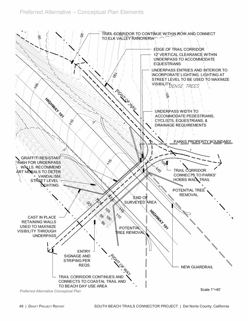
SOUTH BEACH TRAILS CONNECTOR PROJECT | Del Norte County, California48 | Draft Project rePort
Preferred Alternative Conceptual Plan Scale 1”=40’
Preferred Alternative – Conceptual Plan Elements

Draft Project rePort | 49
Pre
ferr
ed A
ltern
ativ
e S
ectio
n/E
leva
tion
– C
once
ptua
l Pla
n
Sca
le 1
”=20
’
Preferred Alternative – Conceptual Plan Elements

SOUTH BEACH TRAILS CONNECTOR PROJECT | Del Norte County, California50 | Draft Project rePort
Preferred Alternative Conceptual Diagram
Architectural and artistic treatment of interior walls can discourage vandalism
Short, well-lit structures allow users to easily see the end and spot potential obstacles
Preferred Alternative – Conceptual Plan Elements
Trail connection to beach day use areas,
Coastal Trail, and Tribal property
Trail connection to Tribal properties along right of way
Note: Layout is conceptual and provided to illustrate the project location. Grading, tree removal, and additional features such as lighting and signage would be part of project.
Underpass location
Guardrail
Underpass location & connection to Hobbs Wall Trail – National & State Parks’ & Tribal properties connection

Draft Project rePort | 51
Lighting and vandal-resistant finishes should be integrated into the project design
Potential Costs
This estimate, with the current level of design detail, is provided to give an “order of magnitude” type estimate to be used for planning purposes . The costs only include the underpass itself and not the trail connections, as the focus of this study was just the location of the crossing . The costs assume the underpass includes elements shown in the “Conceptual Plans” section . Based on project cost data from projects of similar type and scale, construction costs are anticipated to range from between $1,300,000 to $1,900,000 . At this conceptual level there are several unknowns, such as underground utilities and drainage, that could greatly affect the actual construc-tion price for this project .
Potential permitting and environmental documentation costs include those described in the following section “Potential Environmental Impacts & Permitting Requirements” . These costs are typically higher for the northern California area due to environmental and permitting complexity . The costs for permitting, environmenal docu-mentation, and design/engineering and are estimated to be between $325,000 and $525,000 .
A more detailed cost estimate with construction and permitting/sup-port costs would be completed with the Combined Project Study Report/Project Report as part of the next step .
The range of costs typically associated with underpass construction include elements such as:
Preferred Alternative – Conceptual Plan Elements
• Underpass structure,
• Temporary traffic control,
• Path,
• Drainage,
• Lighting,
• Pavement restoration,
• Railings,
• Retaining walls,
• Landscape/revegetation,
• Utilities,
• Right-of-way,
• Architectural treatments,
• Grading/excavation, and
• Design/engineering and permitting .

SOUTH BEACH TRAILS CONNECTOR PROJECT | Del Norte County, California52 | Draft Project rePort
Potential Environmental Impacts & Permitting Requirements
Environmental ImpactsPotential environmental impacts to the surrounding area resulting from the construction of the preferred alternative are described below .
AestheticsAesthetic impacts would be minimal as no flashing approach lights would be required at this location as they would be for an at-grade crossing and below-grade crossings are less conspicuous than above-grade crossings . A below grade crossing will not require improvements that block views of Crescent Beach and surrounding visual resources . Architectural design should be used to ensure trail users do not find the below-grade crossing less appealing than an at-grade or above-grade crossing .
AgricultureThe area around this option is not suitable for or currently used for agriculture, therefore no impact to agriculture is expected as a result of this option .
Air QualityImpacts to air quality are likely to be beneficial, as more residents and tourists would walk or ride bikes instead of driving to Enderts Beach and other attractions from the Park or Crescent City . Air quality could be impacted during construction, but impacts would likely be negligible .
BiologyThe roadway is already slightly elevated at the preferred crossing location and construction would be simplified in comparison to other locations which would result in less disturbance of soil and ground compaction . However these impacts are still likely to occur. The crossing will likely have a beneficial impact of increasing habitat connectivity for mobile species as this area is in an apparent wildlife corridor which is currently impeded by the roadway. It is diffi-cult to assess which species will utilize the crossing, however there are multiple mammals in the area, including elk, which could potentially benefit from the addition of this crossing.
The addition of roads and trails into areas generally increases the potential for invasive species and pollution into natural areas . Pollution is generally in the form of small items of trash that are unintentionally discarded on and near trails, however larger articles of solid waste can also be more easily dumped near trails . Many invasive spe-cies utilize animal vectors for dispersal and an increase in trails and/or use in natural areas often corresponds with an increase in the abundance of invasive species . A management plan could be implemented to keep the trail cor-ridor clean and remove invasive species on a regular basis .
The proposed project is mostly within existing highway right-of-way, minimizing impacts to adjacent wetlands or habitat for rare and threatened species . This area has a mapped habitat/occurrence of rare Viola palustris, but no existing habitat is located near the crossing and there are no mapped wetlands .
CulturalThis area is mostly within existing right-of-way, minimizing potential impacts to cultural resources . It is close to Enderts beach where there are cultural gatherings and a smelt fishery. A new trail alignment is needed to reach the crossing, which could cause potential impacts to cultural resources. Cultural resource specialists can assist in final trail alignments to avoid impacts .
GeologySlopes in this area are low; and stability is high, and these factors indicate that impacts to geology are minimal . Soils are better drained for trail connections in this location .
Preferred Alternative – Conceptual Plan Elements

Draft Project rePort | 53
Preferred Alternative – Conceptual Plan Elements
Greenhouse GasThis area is predicted to be outside of future rising sea levels . Improvements here are unlikely to impact wetlands, which affect greenhouse gases . Sea level rise may affect groundwater elevations and therefore any below grade crossings .
HazardsThis project is not expected to increase the risk of any potential hazards .
HydrologyCrossing construction could potentially impact site runoff and affect wetland areas to the west of the proposed crossing . This area is more xeric than alternative locations and has better drainage, and impacts to wetlands and hydrology would be minimal . This area is fairly well-drained and there may be fewer concerns with trail connections . This area is not subject to tsunami and flood inundation. Engineering can also be focused to address drainage con-cerns .
Land UseThis crossing is close to one existing residence . It provides linkages between recreational properties and residential properties . Additionally, it provides a link between Tribal properties .
Mineral ResourcesMineral resources are not known to be in the area . The area is not currently used for mineral resources extraction or processing .
NoiseThe preferred alternative is near private land . Nearby fauna such as birds and mammals may be impacted by noise pollution and an increased use of the area, especially if construction or other activity takes place during nesting or breeding seasons . Construction protocols and timing can be used to minimize impacts .
Population and HousingThis project is not expected to have an impact on population or housing .
Public ServicesThis project is not expected to have an impact on public services in the area .
RecreationThe proposed project is close to existing and proposed trail systems, though it is further from the Crescent City Marsh, Crescent Beach and residences off Humboldt Road than other options that were considered . The project is expected to have an overall beneficial impact to recreation as it will open up additional areas to pedestrians and cyclists .
TrafficThis project is expected to reduce trail user/bike and vehicular traffic conflicts for those using trail systems. Poten-tial trail users and vehicular traffic would have fewer negative interactions in this location than alternative locations. The visual aspects of the crossing could slow traffic, especially northbound traffic which is often traveling over the posted speed limit .
UtilitiesThis project is not expected to have an impact on utilities in the area, as they are available adjacent to the site . Some additional lighting and other electronic devices may cause a minor increase in the need for utilities in the area .

SOUTH BEACH TRAILS CONNECTOR PROJECT | Del Norte County, California54 | Draft Project rePort
Permitting RequirementsThe following permits may be necessary before constructing any trails in Del Norte County . The process can be initiated by any applicant (Tribe, Redwood National and State Parks, County, Caltrans, i .e .) . Because the connecting trail is primarily on Redwood National and State Park land, it is likely they would be the trails applicant, which would require National Environmental Policy Act (NEPA) approval . The trail portions on federal land might also require a federal consistency finding from the California Coastal Commission. The project would also require both a lateral easement and an easement for the underpass crossing from Caltrans . Caltrans approval would require California Environmental Quality Act (CEQA) environmental documentation as described below .
The lead for the actual crossing is likely to be the Elk Valley Rancheria, California (Tribe) . Other agencies could act as the lead if they will be the entity to carry out the project . Which-ever entity will act first on the project also determines who the lead should be. The lead entity will complete CEQA requirements and subsequently obtain approval through the Cali-fornia Coastal Commission, with referrals to other listed agencies . Project approval would likely take place under an encroachment permit with Caltrans, with a combined Project Report/Project Study Report to streamline the project development process . A Coastal De-velopment Permit from the State will be necessary for the Caltrans portion and their project process expectations should be confirmed at the project onset. Connecting land ownerships will also require approval from those agencies/entities . State and private lands will generally require both state and federal approvals; federal or Tribal lands may require federal agency approvals only .
Should impacts to wetlands be proposed, federal requirements will require obtaining an Army Corps of Engineering (Corps) permit with consultation through National Oceanic and Atmospheric Administration (NOAA) Fisheries and US Fish and Wildlife Service (USFWS) . Regional Water Quality Clean Water Act Section 401 Certification will also be required for non-Tribal lands (the Environmental Protection Agency issues water quality certifications on Tribal lands) . The California Department of Fish and Game may also need to approve a Lake and Streambed Agreement (1600 Agreement) depending on trail locations (not re-quired on federal or Tribal lands) .
It is also important to note that, even though this document focuses on the crossing alter-native, the preference will likely be for the crossing and the trail projects to be evaluated as one . Since the underpass project and connecting trails project are related, a combined CEQA/NEPA document that analyzes the whole project, most likely a Negative Declaration/Finding of No Significant Impact document would be desirable. This is also something that the Tribe, Redwood National and State Parks, or the Del Norte Local Transportation Com-mission could put together for the approving agencies, especially if they could find funding. The environmental approvals could also be combined with a design/engineering project grant .
Likewise, trail proposals that require extensions to existing trail segments in order to reach the US 101 crossing will require a separate review/permitting process that will similarly re-quire permitting as described above . More detail on agency requirements is provided below .
Preferred Alternative – Conceptual Plan Elements

Draft Project rePort | 55
Local RequirementsDel Norte County Coastal Development PermitThe proposed alignment is within the California Coastal Zone . The Del Norte County Com-munity Development Department was mandated to establish policies in accordance with the Coastal Act of 1976 . The purpose of the Coastal Development Permit is to ensure proposed projects do not cause serious health, safety or welfare problems, or adversely impact coastal resources, including scenic bluffs, dunes, coastal wetlands, and native plant and animal species .
For any portion of the project not on Tribal or federal lands, the County has an approved Local Coastal Program consisting of the County General Plan and Zoning Ordinance . A draft general plan update has been recently prepared but is not currently in effect . The Planning Department (707-464-7254) can help determine what permits might be needed . As for permitting, with the exception of any federal ownership, the County would be involved in the permitting process (Coastal Grading Permit) as it is within the County’s appeal jurisdic-tion. Development within the shaded areas of the Post Local Coastal Program Certification Permit and Appeal Jurisdiction map requires County Planning Commission approval of a Coastal Development Permit or Coastal Grading Permit . If a permit is required, the applica-tion and plot plan checklist can be obtained at the Community Development Department office. The County website is http://www.co.del-norte.ca.us/
Elk Valley Rancheria, California Elk Valley Rancheria, California (Tribe) is currently implementing the grant for the develop-ment of the South Beach Trails Connector Project . The Tribe owns properties east of US 101, Martin Ranch, and a parcel of land west of the highway . The Tribe will process any entitlements or environmental review for those portions of the project, such as trail connec-tions, that fall within their Trust holdings . The Tribe or Redwood National and State Parks may be the lead for the actual crossing . The lead will complete CEQA/NEPA requirements (http://www .dot .ca .gov/dist1/d1projects/envprocess .htm ) and subsequently obtain approval through the California Coastal Commission, with referrals to other listed agencies .
State RequirementsCaltransAny trails constructed in Caltrans right-of-way must meet Caltrans specifications. The cur-rent process likely to place will not have Caltrans as the lead agency . Rather, Caltrans will require an encroachment permit application for any right-of-way ingress on state highways (http://www .dot .ca .gov/hq/traffops/developserv/permits/) and the preparation of a combined Project Study Report/Project Report (http://www .dot .ca .gov/hq/traffops/developserv/permits/pdf/publications/PEER_booklet .pdf) .
California Coastal Commission, North District OfficeThe California Coastal Commission, North District Office, requires an Application for Coastal Development Permit to be filed for development projects within their jurisdiction. Development within the coastal zone may not commence until a coastal development permit has been issued by either the California Coastal Commission or a local government that has a Commission-certified local coastal program. The online checklist notes that project plans and site plans, related environmental documents, verification of all other permits and approvals of relevant public agencies must be submitted as part of the application packet . Agencies mentioned in the application packet include the Army Corps, the Regional Water Quality Control Board, Department of Fish and Game, and State Lands Commission . Ad-ditional requirements are:
Preferred Alternative – Conceptual Plan Elements

SOUTH BEACH TRAILS CONNECTOR PROJECT | Del Norte County, California56 | Draft Project rePort
• Grading, drainage and erosion plans;
• The amount of cut and fill and the amount of import and export of materials; and
• Geology and soils reports .
The online checklist and permit application can be found at: http://www .coastal .ca .gov/cdp/cdp-forms .html .
California Department of Fish and Game, Northern Regional DepartmentFor non-Tribal or federal lands, the California Department of Fish and Game (DFG) is responsible for conserving, protecting, and managing California’s fish, wildlife, and native plant resources. This includes waterways with intermittent flow and ephemeral streams and watercourses . To meet this responsibility, the Fish and Game Code (Section 1602) requires an entity to notify the agency of any proposed activity that may substantially modify a river, stream, or lake . Covered activities include: substantially diverting or obstructing the natu-ral flow of any river, stream or lake; substantially changing or using any material from the bed, channel or bank of, any river, stream or lake; and deposition of debris, waste or other material containing crumbled, flaked, or ground pavement where it may pass into any river, stream or lake .
Work undertaken within a floodplain may also require a notification to DFG. If the DFG determines that the activity may substantially adversely affect fish and wildlife resources, a Lake or Streambed Alteration Agreement will be prepared . Before beginning an activity in Del Norte County that would require DFG notification, a notification form with the cor-responding fee must be submitted to the applicable regional office. For Del Norte County, the Northern Regional Department of Fish and Game main office is located at: 601 Locust Street, Redding CA 96001, (530) 225-2300. A local field office is located at 619 Second Street, Eureka, CA 95501, (707) 445-6493 . The review process is largely driven by the DFG land manager responsible over the proposed project location. The notification form, instruc-tion sheets and fee schedule can be found online at: http://www .dfg .ca .gov/habcon/1600/forms .html
California Environmental Quality Act and the State Clearinghouse and Planning UnitThe California Environmental Quality Act (CEQA) requires state and local agencies to iden-tify the significant environmental impacts of a project and to avoid or mitigate those impacts where feasible . If CEQA is required (i .e . the project is not found to be exempt based on the current CEQA Guidelines), a local or state agency must act as the lead CEQA agency . Most projects that will physically develop the land are subject to the provisions of CEQA . The basic CEQA requirements consist of a procedural and substantive review .
At a minimum, an initial review of the project and the project’s environmental effects will be performed . Depending on the effects, a more substantial review may be needed which would result in an environmental impact report (EIR) . The State Clearinghouse and Planning Unit (SCH) of the Governor’s Office of Planning and Research coordinates the state-level review of CEQA environmental documents . The CEQA guidelines are available online at: http://ceres.ca.gov/ceqa/guidelines/. CEQA notification forms and filing instructions can be found at: http://www .opr .ca .gov/index .php?a=sch/environmental .html#forms . CEQA compli-ance occurs when a lead agency proposes to take action approving a project . If Redwood National and State Parks is the lead agency they will comply with both CEQA and NEPA . For trail connections on non-Tribal or federal lands subsequent CEQA compliance may be necessary . The Coastal Commission, through their review process, implements CEQA through their CEQA equivalent process .
Preferred Alternative – Conceptual Plan Elements

Draft Project rePort | 57
Preferred Alternative – Conceptual Plan Elements
California State Lands CommissionThe California State Lands Commission has wide-ranging mandates for the protection of California’s natural environment . The State Lands Commission has jurisdiction and manage-ment control over certain State public lands, which includes the land under navigable and tidal waterways . The State Lands Commission has a multiple use management policy to assure the land provides the greatest possible public benefit. If there are plans to construct improvements on land held by the State Lands Commission, an inquiry should be made by telephone at (916) 574-1940 . A staff person assigned to the geographic location of the proj-ect site can help determine if the project is within the State Lands Commission’s jurisdiction . If a written inquiry is required, staff will then determine the extent of the State’s property in-terest in the project site and determine if a formal application must be submitted . The State Lands Commission office is located at: 100 Howe Avenue, Suite 100 South, Sacramento, CA 95825-8202 .
California State ParksThe California State Parks Department Trails Policy requires that a formal trails planning process be completed prior to implementing changes in existing trail uses, in their designs or realignments, or for new trail construction and existing trail elimination . Where timely de-velopment of an overall unit trail system plan is not possible, existing trails will be evaluated singly as staff time and funding are available for management determination of their poten-tial for enhanced-use status . Any such planning process regarding use changes for single or multiple trails within a park unit will require public participation . California State Parks has an internal environmental and archaeological review process . Any proposal must also be reviewed by other state regulating agencies . California State Parks can partner with other agencies on projects . A coastal permit would be required for all coastal management units .
North Coast Regional Water Quality Control BoardAnyone proposing to conduct a project on non-Tribal lands that requires a federal permit or involves dredge or fill activities that may result in a discharge to US surface waters and/or “Waters of the State” are required to obtain a Clean Water Act Section 401 Water Quality Certification and/or Waste Discharge Requirements (Dredge/Fill Projects) from the North Coast Regional Water Quality Control Board (NCRWQCB), verifying that the project activi-ties will comply with state water quality standards .
The most common federal permit for dredge and fill activities is a Clean Water Act Section 404 permit issued by the Army Corps . Section 401 of the Clean Water Act grants each state the right to ensure that the State’s interests are protected on any federally permitted activ-ity occurring in or adjacent to Waters of the State . In California, the Regional Water Quality Control Boards are mandated to ensure protection of the State’s waters . When a proposed project requires a Corps Clean Water Act Section 404 permit, falls under other federal jurisdiction, and has the potential to impact Waters of the State the Regional Water Qual-ity Control Board will regulate the project and associated activities through a Water Quality Certification determination (Section 401). However, if a proposed project does not require a federal permit, but does involve dredge or fill activities that may result in a discharge to Waters of the State, the Regional Board has the option to regulate the project under its state authority in the form of Waste Discharge Requirements or Waiver of Waste Discharge Requirements .
Before the Regional Water Quality Control Board can issue a permit, the project applicant must provide proof of compliance with CEQA-California Environmental Quality Act . Under CEQA the Regional Board exercises its authorities to require minimization and mitigation of impacts to “Waters of the State”. At a minimum, any beneficial uses lost must be replaced by
SOUTH BEACH TRAILS CONNECTOR PROJECT | Del Norte County, California58 | Draft Project rePort
Preferred Alternative – Conceptual Plan Elements
a mitigation project of at least equal function, value and overall area . If the project is located within or adjacent to “Waters of the State”, and the proposed project may impact those wa-ters, a Water Quality Certification and/or Waste Discharge Requirements (dredge/fill proj-ects) permit is required . The rules and regulations apply to all “Waters of the State”, includ-ing isolated wetlands and stream channels that may be dry during much of the year, have been modified in the past, look like a depression or drainage ditch, have no riparian corridor, or are on private land . If there are questions, it is a good idea to call the regulatory agencies in the area for clarification. If it is determined that a Water Quality Certification and/or Waste Discharge Requirements (Dredge/Fill Projects) is needed, the process is summarized in the Corps description below .
The North Coast Regional Water Quality Control Board is located at 5550 Skylane Blvd ., Suite A in Santa Rosa, CA 95403 . The phone number is (707) 576-2220 . A link to the ap-plication packet and the fee schedule calculator can be found at: http://www .waterboards .ca.gov/northcoast/water_issues/programs/water_quality_certification.shtml
Federal RequirementsNational Environmental Policy ActNational Environmental Policy Act (NEPA) review is required for all projects that are located on Tribal or federal lands or funded by federal funds . Unlike CEQA, NEPA compliance/regulations and procedures are determined by each federal agency . (See regulations for each agency at http://ceq .hss .doe .gov/nepa/agencies .cfm) . If Caltrans is lead agency then Caltrans has their own guidance for complying with both CEQA/NEPA requirements .
National Park Service, Redwood National and State ParkCalifornia State Parks and the National Park Service cooperatively manage the Redwood National and State Parks . These agencies review plans and proposals of neighbors that may potentially impact the resources of the Redwood National and State Parks including Timber Harvest Plans . For environmental review during planning and other management efforts park managers consult with NOAA Fisheries Service, USFWS, and the DFG . The agencies approach future park management at a programmatic level, as demonstrated by the Redwood National Park Trail and Backcountry Management Plan and Environmental Assessment, April 2009 .
US Army Corps of EngineersThe US Army Corps of Engineers (Corps) is responsible for issuing Section 404 permits . Section 404 of the Clean Water Act regulates the discharge of dredged, excavated or fill material in wetlands, streams, rivers, and other US waters . There are three basic types of permits: Standard Permits, General Permits and Letters of Permission . Standard permits are required for projects with potentially significant impacts to aquatic resources. General Permits cover projects that will have minimal impacts on aquatic resources, and Letters of Permission are granted on a shorter timeline . Most states have a general permit pending for most general 404 permits, which enables the 404 permit to be handled during the state per-mitting process . Permit forms can be completed online, printed and mailed via United States Postal Service . The permit forms and online instruction sheets can be found at: http://www .spn .usace .army .mil/regulatory/apply .html . The US Army Corps of Engineers, San Francisco District, oversees the waters in Del Norte County . Agency (contact information: 1455 Market Street, San Francisco, CA 94103-1398, (415) 503-6800). A local field office (601 Startare Dr., Eureka, CA 95502; 707-443-0855), will process the applications and conduct field reviews for specific projects.

Draft Project rePort | 59
Preferred Alternative – Conceptual Plan Elements
National Oceanic and Atmospheric Administration Fisheries ServiceNational Oceanic and Atmospheric Administration (NOAA) Fisheries Service (aka National Marine Fisheries Service), a division of the US Department of Commerce, is the federal agency charged with the stewardship of living marine resources and their habitat within the US and ocean waters within the US Exclusive Economic Zone . NOAA Fisheries Service ad-ministers the Endangered Species Act for most endangered or threatened marine plant and animal species . Most likely for this project they will be involved through consultation with any federal permitting, such as the Corps permit process or when waters of the United States are involved. Species they may specifically be concerned about include Coastal Cutthroat trout .
The Northwest Regional Office has jurisdiction of above stated waters in Northern Califor-nia, including Del Norte County . An overview of the permit types issued by NOAA Fisheries Service, with links to more detailed information, can be found at: http://www .nwr .noaa .gov/Permits/Index .cfm . Online authorizations and permit forms for protected species are avail-able at: https://apps.nmfs.noaa.gov/index.cfm. The Southwest Regional Office is located at: 501 West Ocean Boulevard, Suite 4200, Long Beach, CA 90802-4213; (562) 980-4000 . A local field office is located in Arcata, CA (NMFS Arcata Area Office 1655 Heindon Rd., Arcata, CA (707) 825-5160) .
US Fish and Wildlife ServiceThe US Fish and Wildlife Service (USFWS) is typically involved if any listed federal species, not addressed by NOAA, is expected to be impacted by the proposed project . Most likely for this project they will be involved through consultation with any federal permitting, such as the Corps permit process or when waters of the United States are involved . Species they may specifically be concerned about include Western Snowy plover, Tidewater goby, Stel-lar sealion, Hippolyta Frittilary and Western lily. A local field office is located in Arcata, CA (1655 Heindon Rd . Arcata, CA . (707) 822-7201) .
Regional RequirementsNorth Coast Unified Air Quality Management DistrictConstruction activities that may cause air contaminants require an Authority to Construct Permit from the North Coast Unified Air Quality Management District. The general require-ments causing a permit requirement are found in Rule 102, and are as follows:
• 1.1: No person shall cause or permit the construction or modification of any new source of air contaminants, including an indirect source, without first obtaining an Authority to Construct Permit from the Air Pollution Control Officer, which specifies the location and design of such new source and incorporates necessary permit conditions so as to en-sure compliance with applicable Rules and Regulations and State and Federal Ambient Air Quality Standards .
• 1.2: The Air Pollution Control Officer shall not approve such construction for any source of air contaminants subject to Section 1.1 or 2.0 or modification unless the applicant demonstrates to the satisfaction of the Air Pollution Control Officer that the new source can reasonably be expected to comply with all applicable State and Federal laws and Air Quality Management District Rules and Regulations. North Coast Unified Air Qual-ity Management District office is located at: 2300 Myrtle Avenue, Eureka, CA 95501. Phone: 707-443-3093 Email: support@ncuaqmd .org, Permits forms are available at: http://www .ncuaqmd .org/index .php?page=permit .forms Agency website: http://www .ncuaqmd.org/files/rules/reg%201/New%20Rule%20102.pdf.

SOUTH BEACH TRAILS CONNECTOR PROJECT | Del Norte County, California60 | Draft Project rePort
Funding SourcesThe following is a discussion of the various federal, state and local sources that could po-tentially be used to implement this project, through additional planning, design, construction and environmental mitigation . It is important to note that there are different funding sources for different types of projects . Jurisdictions are bound by strict rules in obtaining and using transportation funds . Some funding sources are “discretionary,” meaning they can be used for general operations and maintenance, not tied to a specific project or type of project. However, even these discretionary funds must be used to directly benefit the transportation system they are collected for . For example, funds derived from gasoline taxes can only be spent on roads. State and federal grant funding is even more specific. There are several sources of grant funds, each designated to a specific type of facility (e.g. bridges or state highways), and/or for a specific type of project (e.g. reconstruction or storm damage). This system makes it critical for local jurisdictions to pursue various funding sources for various projects simultaneously, and to have the flexibility to implement projects as funding be-comes available . In addition to recurring money, many competitive grants are available for transportation projects but success in obtaining these types of funds is difficult to predict.
Federal Sources
Safe, Accountable, Flexible, and Efficient Transportation Equity Act – A Legacy for Users (SAFETEA-LU)On August 10, 2005, President Bush signed the Safe, Accountable, Flexible, and Efficient Transportation Equity Act – A Legacy for Users (SAFETEA-LU), providing $286 .4 billion in guaranteed funding for federal surface transportation programs over six years through Fis-cal Year (FY) 2009, including $52 .6 billion for federal transit programs . Although Congress has approved an extension of funding through 2011, a complete extension of the bill is still under debate . Traditionally, the federal transportation bill has been funded through federal gas taxes. As vehicles have become more efficient, there is less revenue to draw from and an increase in the tax is politically unpopular in these hard economic times . As a result of the uncertainty, many large transportation improvement projects are being delayed .
SAFETEA-LU includes several programs that could provide funding for the South Beach Trails Connector project, though it should be emphasized that these funds are discretionary and are not guaranteed .
Federal Lands Highway Program – The Federal Lands Highway Program provides funding for roadway improvements and transit facilities within public lands, national parks, and Na-tive American reservations through the Public Lands Highway Program, Indian Reservation Roads Program, Refuge Roads Program, and Park Roads and Parkways Program . In addi-tion, Federal Lands Highway Program funds can be used as the state/local match for most types of federal-aid highway funded projects . The American Recovery and Reinvestment Act authorized an additional $550 million for the Federal Lands Highway Program through 2010 . The federal share of this program is 100 percent .
• Indian Reservation Roads – Indian Reservation Roads are public roads that provide ac-cess to and within Indian reservations, Indian trust land, restricted Indian land, and Alas-ka native villages . A portion of Federal Lands Highway Program funds are dedicated to improvement projects on Indian Reservation Roads . Indian Reservation Roads funds can be used for any type Title 23 transportation project (including pedestrian walkways and bicycle transportation facilities) providing access to or within federal or Indian lands
Funding Sources

Draft Project rePort | 61
Funding Sources
and may be used for the state/local matching share for apportioned federal-aid highway funds . The Tribe receives an annual allocation of Indian Reservation Roads funds .
• The Park Roads and Parkways Program provides funding for the design, construction, reconstruction, maintenance, or improvement of roads and bridges that provide access to or are within a unit of the National Park Service . Park Roads and Parkways Program funds can be used for any type of Title 23 transportation project (including pedestrian walkways and bicycle transportation facilities) providing access to or within National Park Service lands and may be used for the State/local matching share for apportioned Federal-aid Highway Funds . Projects are selected by the National Park Service .
• Public Lands Highway Discretionary provides funding for the planning, design, construc-tion, reconstruction of improvement of roads and bridges that are within or adjacent to or provide access to public lands and Indian reservations . Public Lands Highway Discre-tionary funds have also been used for transit facilities, parking lots, roadside rest areas, bike trails, walkways and transportation planning activities . Applications for projects are submit through Caltrans to the Federal Highway Administration .
Recreational Trails Program – The Recreational Trails Program provides funds to the states to develop and maintain recreational trails and trail-related facilities for both non-motorized and motorized recreational trail uses including hiking, bicycling, in-line skating, equestrian use, cross-country skiing, snowmobiling, off-road motorcycling, all-terrain vehicle riding, four-wheel driving, or using other off-road motorized vehicles . In California, the program is administered through the California State Parks Department . Eligible applicants include public entities and non-profit organizations with management authority over public lands. Eligible projects include: acquisition for easements for recreational trails, construction of new trails, and development of trailside and trailhead facilities . A 12 percent local match is required .
State Sources
Transportation funding in California is a complex issue, and is far from certain . A brief summary of the various improvement programs that have particular pertinence to the South Beach Trails Connector Project is as follows:
State Transportation Improvement Program (STIP) – consists of two broad capital transportation improvement programs: (1) the regional program funded by 75 percent of new STIP funding, and (2) the interregional program funded by 25 percent of new STIP funding . Brief summaries of these programs are provided below along with other state funding sources:
Regional Transportation Improvement Program (RTIP) – The RTIP receives 75 percent of the STIP funding . The 75 percent portion is subdivided by formula into county shares . Caltrans and the Del Norte Local Transportation Commission can program funds which are apportioned to the region and allocated by the Del Norte Local Transportation Commission . These funds may be used to finance some projects that are “off” the state highway system. This “regional share” must be relied on to fund capacity increasing projects on much of the state highway system .

SOUTH BEACH TRAILS CONNECTOR PROJECT | Del Norte County, California62 | Draft Project rePort
Interregional Transportation Improvement Program (ITIP) – The ITIP receives the remaining 25 percent of the STIP funding . This program is controlled and programmed by Caltrans, although regional agencies provide input on the specific ITIP projects for their region. One of the goals of the program is to encourage regional agencies and the state to establish partnerships to conduct certain projects . For the rural California counties, a challenge to use ITIP funding is the very limited availability of “local match” for ITIP-funded programs . (However, RTIP funds can be used as match for the ITIP program .) In actuality, Caltrans receives 15 percent for state highway projects on the interregional system; potential projects must compete statewide for the remaining funds . Much of the state highway system is not eligible for interregional funding and must rely on the regional share to fund capacity improvement projects .
Although STIP funds may be used for public transit (including buses), intercity rail, pedestrian and bicycle facilities, grade separations, transportation system management, transportation demand management, soundwalls, intermodal facilities, and safety, the primary purpose of the program is to fund roadway improvements on the state highway system .
Transportation Enhancement – Transportation Enhancement funds are programmed as a subset of the STIP program . Transportation Enhancement projects must be related to surface transportation, but are intended to be enhancements that go beyond the normal transportation project functions . Projects eligible for Transportation Enhancement funding include acquisition of scenic easements, scenic or historic highway programs, landscaping, rehabilitation of historic transportation buildings, preservation of existing and abandoned railway corridors, pedestrian/bikeway improvements, the acquisition of abandoned right-of-way for conversion to pedestrian/bicycle trails, and safety education activities for pedestrians and bicyclists . The Del Norte Local Transportation Commission is responsible for ranking Transportation Enhancement projects countywide, but the California Transportation Commission makes final funding decisions. California receives about $74 million per year for Transportation Enhancement funding through SAFETEA-LU as a set aside from the Surface Transportation Program . Transportation Enhancement funds are the most likely source of state funding for the South Beach Trails Connector Project .
Del Norte Local Transportation Commission receives other recurring funding sources such as federal Regional Surface Transportation Program and state Transportation Development Act funds which may be used for bicycle and pedestrian projects but are generally used for other purposes in the region such as roadway rehabilitation or public transit . Additionally the annual level of funding for these sources for all types of projects is less than $200,000 . Although Regional Surface Transportation Program and Transportation Development Act funds will not be a primary funding source for the South Beach Trails Connector Project, they could provide a small amount of financial assistance.
Funding Sources

Draft Project rePort | 63
Next Steps
Next StepsThis document provides planning-level information to meet the requirements for the Environmental Justice Grant Program . The intent of this preliminary evaluation is to identify a safe and feasible crossing location and crossing type which meets the Tribe’s Redwood National and State Park’s, the County’s, and the public’s desires along with satisfying California Department of Transportation (Caltrans) requirements . This document summarizes the project’s findings and recommendations for an underpass crossing.
The next step is for the project proponent to complete the required engineering studies and documentation as re-quired by Caltrans for approval to design and construct within the right-of-way . Based on the type of project antici-pated, a Combined Project Study Report/Project Report (PSR/PR) is likely to be the appropriate documentation . After the project proponent submits an encroachment request . The district permit engineer will determine the ap-propriate level of documentation and if a Combined PSR/PR can be used . A Combined PSR/PR is generally used for non-complex projects with a project cost greater than $1,000,000 . Undercrossing projects that are not part of an interchange are usually covered with a Combined PSR/PR .
The Combined PSR/PR will include more detailed engineering and complete quantitative information regarding the project’s design, impacts, costs, schedule, and risks in order to move forward in the development process and qualify the project for funding . It is usually an engineering document and requires the seal or stamp of a registered civil engineer or another appropriate professional . Caltrans will assign a project coordinator to coordinate the project approval, meet with the project proponent to determine the type of project approval and environmental documenta-tion needed, and provide a copy of the Combined PSR/PR outline . Requirements for completing a PR and PSR can be found in Caltrans Project Development Procedures Manual, Appendix K and L, respectively .
“The purpose of the Combined PSR/PR is to streamline the project development process by providing for the prep-aration of a single engineering report for non-complex, noncontroversial State highway projects that are funded by others and that cost over $1,000,000 for construction . The Combined PSR/PR documents agreement on the scope and estimated costs . The Combined PSR/PR eliminates the separate processing of a PSR and should expedite project delivery . It constitutes project approval to proceed with design and as such serves as the Project Report . Although one report is prepared, it is expected that the report will address issues affecting operation, maintenance, and any potential for tort liability on the State highway, and that the proposed work will conform to current Caltrans policies, practices, and standards .” (Caltrans, Project Development Procedures Manual, March 2010)
In addition to the Combined PSR/PR, the applicant must submit a draft cooperative agreement (CA) or highway im-provement agreements (HIA) . Caltrans will coordinate the review of the Combined PSR/PR and CA or HIA by Cal-trans and the Federal Highway Agency . Once it is found satisfactory, the document is recommended for approval by the District Director. The District Director’s signature signifies approval of the project concept. When accompanied with approved environmental documentation, it is the authorization to enter into a CA or HIA for the study, design, and construction of the project . A cooperative agreement, ready to sign, must be attached to the combined PSR/PR . Additional information can be found in Chapter 9 of the Project Development Procedures Manual, pages 9-57 and 9-58 .
As previously stated, It is important to note that, even though this document focuses on the crossing alternative, the preference will likely be for the crossing and the trail projects/connections to be evaluated as one . Since the under-pass project and connecting trails project are related, combining the projects will strengthen the information sup-porting the need for a crossing facility . This is something that the Tribe and/or Redwood National and State Parks could put together for the approving agencies .

SOUTH BEACH TRAILS CONNECTOR PROJECT | Del Norte County, California64 | Draft Project rePort
DocumentsAyala and Associates . July 2004 . “Elk Valley Rancheria Transportation Plan 2004 .”
Alta Planning + Design . Prepared for Caltrans . July 2005 . “Pedestrian and Bicycle Facilities in California: A Technical Reference and Technology Transfer Synthesis for Caltrans Planners and Engineers .”
Caltrans . April 2006 . “California Transportation Plan 2025 .”
Caltrans . 2010 . “California MUTCD .” based on Federal Highway Administration MUTCD, 2003 .
Caltrans . March 2010 . “Project Development Procedures Manual .”
County of Del Norte . 1983 . “Del Norte County General Plan Coastal Element Local Coastal Program .”
County of Del Norte . 2003 . “Del Norte County General Plan .”
County of Del Norte . May 2006 . “Comprehensive Economic Development Strategy, Del Norte County, California 2006-2008 .” Del Norte County Board of Supervisors .
Dean Runyan & Associates . 2005 . “California Travel Impacts by County” . California Travel and Tourism Commission .
Dean Runyan & Associates . 2010 . “California Travel Impacts by County 1992-2008 . 2009 Preliminary State and Regional Estimates” . California Travel and Tourism Commission .
Del Norte Local Transportation Commission . “Wild Rivers Regional Blueprint Plan .”
Del Norte Local Transportation Commission . June 2007 . “2007 Regional Transportation Plan .”
Del Norte Local Transportation Commission . July 2010 . “Del Norte County and Crescent City 2010 Bicycle Facilities Plan Update .”
Del Norte Local Transportation Commission and LSC Transportation Consultants. 2010. “Highway 101 Traffic Calming and Gateway Treatment Plan .”
National Cooperative Highway Research Project 2006 . “Report 562 . Improving Pedestrian Safety at Unsignalized Crossings .”
Redwood National and State Parks . 1999 . “General Management Plan/General Plan .” Humboldt and Del Norte Counties, California .
Redwood National Park . April 2009 . “Trail and Backcountry Management Plan Environmental Assessment .”
U .S . Census Bureau . 2002 .
W-Trans. March 2006. “Elk Valley Rancheria Casino Relocation Traffic Study.”
Web Siteshttp://quickfacts .census .gov/qfd/states/06/06015 .html
http://traffic-counts.dot.ca.gov/2009all/Route101i.htm
http://www .dot .ca .gov/hq/traffops/developserv/permits/pdf/publications/PEER_booklet .pdf
References

Draft Project rePort | 65
APPENDICES
Appendix A: Public Meeting Record & Survey Cards
Appendix B: Promotional Flyer
Appendix C: Project Contacts

SOUTH BEACH TRAILS CONNECTOR PROJECT | Del Norte County, California66 | Draft Project rePort
Appendix A – Public Meeting Record and Survey Cards

Draft Project rePort | 67
Appendix A – Public Meeting Record and Survey Cards

SOUTH BEACH TRAILS CONNECTOR PROJECT | Del Norte County, California68 | Draft Project rePort
Appendix A – Public Meeting Record and Survey Cards

Draft Project rePort | 69
Appendix A – Public Meeting Record and Survey Cards
DESIGNWORKSHOP Asheville • Aspen • Austin • Denver • Phoenix • Salt Lake City • Tahoe
128 Market Street, Suite 3E, PO Box 5666, Stateline, NV 89449 • (tel) 775-588-5929 • (fax) 775-588-1559 www.designworkshop.com
1
Meeting Record To: Chris Howard
From: Stephanie Grigsby
Date: November 10, 2010
Project Name: South Beach Trails Connector
Project #: 4685
Subject: Steering Committee 1 Meeting Minutes
Meeting Date: November 8, 2010
Start/End: 1:00 – 2:30
Location: Elk Valley Rancheria Tribal Office Conference Room
Copy To: Meeting Attendees
Following are the minutes of the above referenced meeting. The following people were present: DAVID FINIGAN, DEL NORTE COUNTY BOARD OF SUPERVISORS, COUNTY SUPERVISOR DON GILLESPIE, FRIENDS OF DEL NORTE, BOARD MEMBER/CITIZEN JEFF BOMKE, CALIFORNIA STATE PARKS, SUPERINTENDENT JOHN D. GREEN, ELK VALLEY RANCHERIA, VICE CHAIRMAN STEVE CHANEY, NATIONAL PARK SERVICE, SUPERINTENDENT LYNN E. LEVI, NATIONAL PARK SERVICE, ROADS & TRAILS LEADER CALEB WATERS, NATIONAL PARK SERVICE, FACILITY OPERATIONS SPECIALIST BARNEY RILEY, NATIONAL PARK SERVICE, CHIEF OF MAINTENANCE BRIAN R. MERRILL, CALIFORNIA STATE PARKS, SENIOR ENGINEER GEOLOGIST CHRIS HOWARD, ELK VALLEY RANCHERIA, DIRECTOR TAMERA LEIGHTON, DEL NORTE LOCAL TRANSPORTATION COMMISSION, EXECUTIVE DIRECTOR STEPHANIE GRIGSBY, DESIGN WORKSHOP JEFF ZIMMERER, CALTRANS, TRAFFIC SAFETY (VIA TELECONFERENCE) GORDON SHAW, LSC TRANSPORTATION CONSULTANTS (VIA TELECONFERENCE) BOB BROWN, STREAMLINE PLANNING (VIA TELECONFERENCE) STEVE NOLL, DESIGN WORKSHOP (VIA TELECONFERENCE)
Design Workshop, Inc. Landscape Architecture Land Planning Urban Design Strategic Services
Meeting M eet ing Conference Call

SOUTH BEACH TRAILS CONNECTOR PROJECT | Del Norte County, California70 | Draft Project rePort
Asheville • Aspen • Austin • Denver • Phoenix • Salt Lake City • Tahoe
128 Market Street, Suite 3E, PO Box 5666, Stateline, NV 89449 • (tel) 775-588-5929 • (fax) 775-588-1559 www.designworkshop.com
2
Items in bold print indicate what action is required, who will perform the action and the deadline to complete action. 1. Introductions and Project Desires
a. Stakeholders noted key elements of the project and why it is important to their agency/organization and the community. Elk Valley Rancheria – Chris Howard: The project has been talked about for the past
10 years and it is now time to get it moving and get something done to safely cross US 101. The Tribe received a Caltrans Environmental Justice Grant to fund this feasibility study.
Del Norte County – David Finigan: Glad to see that it is moving forward. It is an important community project. We have been talking about trails for a while and how to safely move people across the highway. There has been anecdotal evidence of a cattle underpass that could be potentially used as an underpass.
National & State Parks – Steve Cheney/Jeff Bomke: With the completion of the coastal trail and other connecting trails, there needs to be a way to connect the system across US 101. It will be helpful for the Mill Creek General Plan Amendment to know where the trail will cross the highway.
Del Norte Local Transportation Commission – Tamera Leighton: The LTC supports multi-modal transportation and provides access to funding. An important element in their view is to understand how to build the crossing and a coordinated trail system in the long run.
2. Presentation of Current Project Findings
a. The project area includes US 101 from Hamilton Road north to Humboldt Road. The intent is to find an appropriate crossing location for a multi-use trail that includes equestrian, bicyclists, hikers, and pedestrians. Options include overpasses, underpasses, and at-grade crossings. It was clarified that an extension of the Coastal Trail north to the Harbor’s planned trail was not part of the project.
b. Discussion elements: The crossing numbers are conservative. The calculations are conservative, yet still
show that marked crossing is justified. Clarify from where users of the potential Elk Valley Resort would be coming. The
question was asked to understand use patterns and to confirm that the crossing would not better serve the resort if it was north of where shown with the purple line (Hobbs Wall Trail connector). The Resort development may be some time in the future. It is important that the crossing work well for the Parks. The location does not need to be close to the Humboldt intersection for it to be used by Resort guests.
Consider what type of facilities the different trail user groups (equestrian, bicyclists, and hikers) will need. For example, it would be difficult for equestrians to use a traditional overpass. Likewise, equestrians do not like at-grade crossings.
Caltrans would probably not want a raised island as part of a pedestrian refuge. They do not like curbs on roadways over 45 MPH. The highway is 55 MPH at this location.
Appendix A – Public Meeting Record and Survey Cards
Draft Project rePort | 71
Asheville • Aspen • Austin • Denver • Phoenix • Salt Lake City • Tahoe 128 Market Street, Suite 3E, PO Box 5666, Stateline, NV 89449 • (tel) 775-588-5929 • (fax) 775-588-1559
www.designworkshop.com 3
A striped island would be possible, but then you are widening the amount of roadway the user must cross.
There was a general preference to not have an at-grade crossing. An overpass or underpass would be preferable.
Consider the costs and impacts of building trail approaches (connecting the crossing to Hobbs Wall Trail). Trails need to have good drainage. This can be harder to achieve on level terrain and requires more expensive construction techniques. The trail approaches that are on steeper terrain would be more desirable. This favors having the crossing close to where the tree-line begins (where the number 6 picture is shown or just south of there).
What is the right-of-way distance at the location where an underpass seems to be feasible? The R/W is approximately 320’ in width.
Considerations in building an underpass include creating proper drainage and addressing vagrants who might use the underpass for shelter. Not having good drainage would be a continual maintenance issue. Fencing, lighting, and patrolling could be used to address vagrant issues.
It was noted that trail approaches for an underpass are typically shorter than those for an overpass. Underpasses typically have a 10’ high clear zone as they pass under a roadway. Overpasses may have to be 20’ above the road. In order meet ADA requirements, the trail approaches for an underpass may have fewer impacts. This would not be the case if the road is aligned below adjacent landforms. In this scenario an overpass might use the topography to pass over the roadway.
The crossing must be ADA as part of Caltrans requirements. It is their right-of-way. Regardless of whether the trail is ADA, the crossing must be. Additionally, Elk Valley Rancheria Resort guests would probably want accessibility.
Parks and the local equestrian users want multi-use trails. Be sure to meet the needs of those users.
Parking is not anticipated to be along US 101. Users would be directed to parking areas off the highway. Having a grade-separated crossing would deter people from parking along the road to access the trail. Way-finding is important.
Ask Chris for contact information for the wildlife consultant that talked about building a wildlife overpass in Montana. He could be a resource. The Elk herd is going to grow.
3. Overall Thoughts to Move Forward
a. Although there was not a great deal of favor for the at-grade option, it should be included in the study and the presentation of options to the community. It could have some level of flashing beacon (potentially a pedestrian activated sign). It would be striped, but it may not include a widened roadway profile.
b. Create similar graphics for the underpass and overpass options as the graphics for the at-grade crossing. Show where they might be more specifically located. At the tree-line for the underpass
Appendix A – Public Meeting Record and Survey Cards

SOUTH BEACH TRAILS CONNECTOR PROJECT | Del Norte County, California72 | Draft Project rePort
Asheville • Aspen • Austin • Denver • Phoenix • Salt Lake City • Tahoe
128 Market Street, Suite 3E, PO Box 5666, Stateline, NV 89449 • (tel) 775-588-5929 • (fax) 775-588-1559 www.designworkshop.com
4
South of the tree-line for the overpass (where the landform is high on both sides). If the overpass is used for a gateway and is one of the larger land bridges to also allow for the wildlife crossing, it could have a great wow factor as people come into the town.
c. Provide a value analysis for the options. This is intended to be done after the public workshop.
4. Upcoming Public Workshop
The public workshop will potentially be December 2nd from 4 to 7. It will be open house format with 2 presentation times. It is not mandatory for the Steering Committee members to be there, but it is desired that one representative from each agency be there to make a statement of support and to help give background to the project.
The Steering Committee will also be emailed promotion flyers to email to their contacts in order to get more attendees.
Stephanie will email the group to confirm the meeting place and time.
END OF NOTES The record herein is considered to be an accurate depiction of the discussion and/or decisions made during the meeting unless written clarification is received by Design Workshop within five (5) working days upon receipt of this meeting record. Attachments: 1. Presentation Maps
Appendix A – Public Meeting Record and Survey Cards

Draft Project rePort | 73
Appendix A – Public Meeting Record and Survey Cards

SOUTH BEACH TRAILS CONNECTOR PROJECT | Del Norte County, California74 | Draft Project rePort
Appendix A – Public Meeting Record and Survey Cards

Draft Project rePort | 75
Appendix A – Public Meeting Record and Survey Cards

SOUTH BEACH TRAILS CONNECTOR PROJECT | Del Norte County, California76 | Draft Project rePort
Appendix A – Public Meeting Record and Survey Cards

Draft Project rePort | 77
Appendix A – Public Meeting Record and Survey Cards

SOUTH BEACH TRAILS CONNECTOR PROJECT | Del Norte County, California78 | Draft Project rePort
Appendix A – Public Meeting Record and Survey Cards

Draft Project rePort | 79
Appendix A – Public Meeting Record and Survey Cards

SOUTH BEACH TRAILS CONNECTOR PROJECT | Del Norte County, California80 | Draft Project rePort
Appendix A – Public Meeting Record and Survey Cards

Draft Project rePort | 81
Appendix A – Public Meeting Record and Survey Cards

SOUTH BEACH TRAILS CONNECTOR PROJECT | Del Norte County, California82 | Draft Project rePort
Appendix A – Public Meeting Record and Survey Cards

Draft Project rePort | 83
Appendix A – Public Meeting Record and Survey Cards

SOUTH BEACH TRAILS CONNECTOR PROJECT | Del Norte County, California84 | Draft Project rePort
Appendix A – Public Meeting Record and Survey Cards

Draft Project rePort | 85
Appendix A – Public Meeting Record and Survey Cards

SOUTH BEACH TRAILS CONNECTOR PROJECT | Del Norte County, California86 | Draft Project rePort
Appendix A – Public Meeting Record and Survey Cards

Draft Project rePort | 87
Appendix A – Public Meeting Record and Survey Cards

SOUTH BEACH TRAILS CONNECTOR PROJECT | Del Norte County, California88 | Draft Project rePort
Appendix A – Public Meeting Record and Survey Cards

Draft Project rePort | 89
Appendix A – Public Meeting Record and Survey Cards

SOUTH BEACH TRAILS CONNECTOR PROJECT | Del Norte County, California90 | Draft Project rePort
Appendix A – Public Meeting Record and Survey Cards

Draft Project rePort | 91
Appendix A – Public Meeting Record and Survey Cards

SOUTH BEACH TRAILS CONNECTOR PROJECT | Del Norte County, California92 | Draft Project rePort
Appendix A – Public Meeting Record and Survey Cards

Draft Project rePort | 93
Appendix A – Public Meeting Record and Survey Cards

SOUTH BEACH TRAILS CONNECTOR PROJECT | Del Norte County, California94 | Draft Project rePort
Appendix A – Public Meeting Record and Survey Cards

Draft Project rePort | 95
Appendix A – Public Meeting Record and Survey Cards

SOUTH BEACH TRAILS CONNECTOR PROJECT | Del Norte County, California96 | Draft Project rePort
Help Create a Ped/Bike/Equestrian Crossing for US 101
You are invited to participate in the
South Beach Trails Connector Project Public Workshop
(Project Area Includes US 101 from Humboldt Road south to Hamilton Road)
*Light Meal Provided*
For additional informationContact Stephanie Grigsby at 775-588-5929 or via email at [email protected]
Individuals with disabilities may call Stephanie Grigsby to request auxiliary aids such as necessary special assistance or accommodations to participate in the public workshop.
The meeting will be an open house format with project
representatives available to answer questions and give
feedback. Formal presentations will be at
4:15 and 5:30.
Agenda
Redwood National & State Parks
Elk Valley Rancheria
Crescent City Harbor
Existing & Planned Trails
Potential Hobbs Wall Trail with
Connectors
STUdy AREA
When: Monday, december 6th, 4:00 to 7:00 PM
Where:Elk Valley Rancheria Community Center 2332 Howland Hill Road, Crescent City, CA
What you Will do: Give direction and feedback on potential crossing locations and types
Appendix B – Promotional Flyer

Draft Project rePort | 97
Appendix C – Project Contacts
Project ContactsAgency/Organization Contact Person Phone/EmailElk Valley Rancheria, California Chris Howard, Project Manager, Director
Public Relation, Economic Development and Environmental Services
707-464-4580choward@elk-valley .com
Elk Valley Rancheria, California John D . Green, Vice Chair 707-464-4680Del Norte Local Transportation Commission
Tamera Leighton, Executive Director 707-465-3878tamera@dnltc .org
Caltrans,Planning
Tasha Ahlstrand, Associate Transportation Planner
707-441-4540tatiana_ahlstrand@dot .ca .gov
Del Norte County,County Supervisors
David Finigan, District 5 Supervisor 707-464-7204 [email protected]
National Park Service – Redwood National & State Park
Steve Chaney, Superintendent 707-465-7300steve_chaney@nps .gov
National Park Service – Redwood National & State Park
Lynn Erickson-Levi, Trail Crew Leader 707-465-7364lynn_erickson-levi@nps .gov
National Park Service – Redwood National & State Park
Caleb Waters, Facility Operations Specialist caleb_water@nps .gov
National Park Service – Redwood National & State Park
Barney Riley, Facility Manager 707-465-7303barney_riley@nps .gov
California State Parks – Redwoods State Parks
Jeff Bomke, Superintendent 707-465-7332jeff_bomke@partner .nps .gov
California State Parks – Redwoods State Parks
Brian Merrill, Senior Engineer Geologist 707-445-5344bmerr@parks .ca .gov
California Department of Fish & Game – Northern Region, Region 1
Karen Kovacs, Wildlife Program Manager 530-225-2312kkovacs@dfg .ca .gov
California Department of Fish & Game – Northern Region, Region 1
Eric Haney, Regional Resource Assessment Coordinator
530-225-2052ehaney@dfg .ca .gov
California Department of Fish & Game – Shasta Valley, Horseshoe Ranch and North Coast Wildlife Areas
Bob Smith, Wildlife Habitat Supervisor II 530-459-3926rsmith@dfg .ca .gov
Friends of Del Norte Don Gillespie 707-487-4300dwgillespie7@gmail .com