Embed Size (px)
Citation preview
Upper Richland County South Carolina
Historical and Architectural
Inventory
Edwards-Pitman Environmental, Inc.
June 2002
Upper Richland County, South Carolina
Historical and Architectural Inventory
Edwards-Pitman Environmental, Inc.
Jennifer F. Martin Nicholas G. Theos Sarah A. Woodard
Funded by
The Richland County Conservation Commission
and
The South Carolina Department of Archives and History
June 2002
The activity that is the subject of this report has been financed in part with Federal funds from the National Park Service, U.S. Department of
the Interior, and administered by the South Carolina Department of Archives and History. However, the contents and opinions do not necessarily reflect
the views or policies of the Department of the Interior.
This program receives Federal financial assistance for identification and protection of historic properties. Under Title VI of the Civil Rights
Act of 1964, Section 504 of the Rehabilitation Act of 1973, and the Age Discrimination Act of 1975, as amended, the U. S. Department of the
Interior prohibits discrimination on the basis of race, color, national origin, disability or age in its federally assisted programs. If you believe
you have been discriminated against in any program, activity, or facility as described above, or if you desire further information please write to:
Office of Equal Opportunity, National Park Service, 1849 C Street, N.W., Washington DC 20240.
Acknowledgements Several individuals provided assistance without which we would not have been able to carry out this survey. Daniel J. Vivian, who served as the Survey Coordinator for the South Carolina State Historic Preservation Office during the majority of the project, offered excellent advice and technical assistance. Nick, Sarah and I wish him the best in his new job in Washington, D.C. Brad Sauls, the Grants Coordinator for the SHPO, made sure the project ran smoothly and gracefully took over the project after Dan’s resignation. Ash Miller, who, like Dan Vivian, left his position while we were working on the project, exuded an air of professionalism and warmth that made the project totally enjoyable. We also wish him well in his new endeavor. Ashley Jacobs, who took over Ash Miller’s position at the Richland County Administrator’s office, provided much assistance as the project concluded. Leigh Edwards, a consultant for the Palmetto Trust, accompanied us in the field and showed a sincere interest in the survey. The staffs of the South Carolina Archives Search Room, the South Caroliniana and Thomas Cooper libraries at the University of South Carolina and the local history room at the Richland County Public Library delivered their assistance in a timely and friendly manner. We also acknowledge the outstanding citizens of upper Richland County without whom this project would have been impossible. Many, many people provided historical information and directions to resources we might otherwise have overlooked. The people in and around Pontiac, Blythewood, Cedar Creek, White Rock, Ballentine and everywhere in between showed the genuine hospitality for which we South Carolinians are known. In particular, we would like to recognize Margaret DuBard, Pepper Ellisor, Fred York and Connie Martin, each of whom accompanied us in the field. Finally, we would like to thank Paige, Parker, Janice and Spencer Allen for providing us a home base from which to work. We extend our deepest gratitude to all of you. Jennifer Martin Durham, North Carolina 12 June 2002
Upper Richland County, South Carolina
Historical and Architectural Inventory
Table of Contents Figures and Plates 1 I. Introduction 2 II. Project Summary 2 III. Project Objectives 3 IV. Survey Methodology 5 V. Historical Overview 7
Geographic Setting 7 Native American Era: 12,000 B.P. to Circa 1730 10 Early Settlement to the Civil War: Circa 1730 to 1861 12 A Society Transformed: The Civil War to 1900 24 A New Century Dawns: 1900 to World War II 31 Upper Richland County in the Post World War II Era 42
VI. Brief Profiles of Towns and Communities in Upper Richland County 44 VII. Bibliography 47 VIII. Evaluation of Recorded Properties 52 IX. Data Gaps 55 X. Recommendations 55 XI. South Carolina Division of Archives and History National Register Evaluations 56 X. Appendices 58
Observations on Potential Historic Districts in Forest Acres and Arcadia Lakes
Inventory Report by Quad Map
National Register Criteria
Upper Richland County, South Carolina
Historical and Architectural Inventory
List of Figures and Plates Figures 1. Map of Survey Area 4 2. Map of the Province of South Carolina (1779) 13 3. Geological and Agricultural Map of Richland County (1873) 26 4. Township Map of Richland County (1932) 33 5. Highway and Railroad Map of Richland County (1945) 37 Plates 1. Copy of Documentary Photograph of the Eleazer House at Spring Hill 14 2. John Jacob Calhoun Koon House 23 3. (Former) W.E. Boney Store in Blythewood 29 4. Ballentine House at Ballentine 35 5. Pine Grove School 40
2
I. Introduction In July 2001, the Richland County Conservation Commission and the South Carolina State Historic Preservation Office (SCSHPO) engaged Edwards-Pitman Environmental, Inc. to conduct an intensive architectural survey of upper Richland County and the Olympia Mill village. Because the Olympia Survey covers a specific area with a common history dating to a particular era, that survey report is under a separate cover. All information relating to the boundaries of the survey area, survey methodology and the number of properties documented that follows pertains specifically to the survey of Upper Richland County, South Carolina. An initial planning meeting was held in the Richland County Administrator’s office on 25 July 2001. Among those in attendance were Andrew Pitman, Nicholas Theos and Jennifer Martin representing Edwards-Pitman Environmental, Inc.; Margaret DuBard, a member of the Richland County Conservation Commission; Daniel J. Vivian and Brad Sauls of the SCSHPO; T. Patrick Brennan, Executive Director of Historic Columbia Foundation; Leigh Edwards, a consultant for the Palmetto Conservation Foundation and Ash Miller, the project’s local coordinator who also served as the county’s staff person for the Richland County Conservation Commission. On 27 July, the contract for the survey was signed and work was underway. Fieldwork took place from August through October 2001. Data for each resource surveyed was entered into the Department of Archives and History Survey Database in the late fall and winter of 2001 and early 2002. In January and February of 2002, historians for Edwards-Pitman Environmental conducted further research on the history of the county and prepared this final report. II. Project Summary
A. Name of Survey
Upper Richland County Historical and Architectural Inventory
B. Precise Boundaries of the Survey Area
The Richland County border acts as the north, east and west boundaries of the survey area. The southern boundary of the survey area follows the northern side of Interstate 20 to the point where it intersects with Interstate 77. The southern boundary of the survey area then proceeds south along the east side of Interstate 77 to the junction with the northern boundary of Fort Jackson Military Reservation. The boundary extends eastward along the northern boundary of Fort Jackson to its intersection with U.S. Highway 601, and then north along U.S. 601 to the Kershaw County line.
Upper Richland County Historical and Architectural Inventory Edwards-Pitman Environmental, Inc. June 2002
3
The survey area consists of the unincorporated area north of the City of Columbia and Fort Jackson, and the incorporated areas of Blythewood, Arcadia Lakes and Forest Acres. The survey area included only the portion of the incorporated area of Irmo in Richland County.
C. Number of Properties Surveyed
436
D. Number of Square Miles Surveyed
315
E. Names and Affiliations of Surveyors
Edwards-Pitman Environmental, Inc. employs all surveyors who worked on the Upper Richland County Historical and Architectural Inventory. Nicholas G. Theos served as Project Manager. Jennifer F. Martin served as Senior Historian and Sarah A. Woodard was Project Historian. The Edwards-Pitman Environmental, Inc. staff assigned to the project meet the Secretary of the Interior’s Professional Qualification Standards set forth in 36 CFR Part 61.
F. Dates of Survey
The survey began in July 2001 and was completed in February 2002.
III. Project Objectives Architectural historians with Edwards-Pitman Environmental, Inc. undertook the architectural survey of upper Richland County as part of the South Carolina Department of Archives and History’s Statewide Survey of Historic Places which forms the bedrock of the historic preservation program in the state. The primary objectives of the survey program are to gather, organize and present information about historic properties in photographs, words, maps and drawings. During the Upper Richland County survey, the surveyors sought to identify historic resources, record their locations and evaluate their significance in a local, statewide and national context. This project, coupled with the survey of lower Richland County and the city-wide survey of Columbia, both of which took place in 1992 and 1993, will complete the overall comprehensive architectural inventory of the county and promote a richer understanding of the region’s historical and architectural development.
Upper Richland County Historical and Architectural Inventory Edwards-Pitman Environmental, Inc. June 2002

4
Figure 1: Map of Survey Area (From Richland County GIS)
Upper Richland County Historical and Architectural Inventory Edwards-Pitman Environmental, Inc. June 2002
5
Edwards-Pitman Environmental was also charged with making recommendations about the potential existence of historic districts in Forest Acres and Arcadia Lakes, two incorporated and adjacent communities north of downtown Columbia. The objective was to assess whether or not historic districts might be formed in either community in the next several years. At present, the majority of each community’s resources are not yet fifty years old. IV. Survey Methodology The survey of Upper Richland County followed the Secretary of the Interior’s Standards for Identification and Evaluation (36 CFR 61.3 and 6 and 61.4[b]). The principal fieldwork took place August through October 2001 with follow up in January 2002. Jennifer Martin, Nicholas Theos and Sarah Woodard served as the principal investigators. During the fieldwork stage, all roads in the upper section of the county were traveled, resource locations were recorded on United States Geological Survey (USGS) topographical maps, individual survey forms were completed, on-site interviews were conducted where possible and all resources were documented with black and white photographs. The resources that appeared potentially eligible for listing in the National Register of Historic Places were further documented with color slides. The surveyors employed several criteria in deciding the properties to survey. The survey encompassed all resources of historic, architectural or cultural significance that are roughly fifty years old or older. Besides buildings, resources recorded included bridges, landscapes and selected cemeteries that might possess artistic or cultural significance, contain graves of important persons or associated with an important church. The survey also included a wide range of agricultural and domestic outbuildings. The surveyors enlisted a priority system during the project to ensure that the most significant and intact resources of every type were documented. Common resource types that had undergone significant alteration or which had deterioration to the point that their integrity had been compromised were not surveyed. The surveyors made every attempt to discover the names of the families or individuals historically associated with the dwellings documented, especially those that appeared to possess architectural historical significance. The surveyors knocked on doors, and if no one answered, they left a letter explaining the survey and asking that the property owner or occupant contact them. While many people were home and able to offer information, a good number of residents were not present and did not contact the surveyors. For the properties for which additional information could not be obtained—such as a family name associated with a dwelling—the house is recorded as “house, unidentified.” This identification in no way diminishes the importance of those properties. These properties were recorded with the same attention to detail as those properties identified by name. In addition to properties fifty at least fifty years old, the survey included some late twentieth century resources that possess exceptional historical or architectural qualities or
Upper Richland County Historical and Architectural Inventory Edwards-Pitman Environmental, Inc. June 2002

6
that stand as the only representative of an important cultural or social group. The surveyors remained flexible about the fifty-year guideline in order to assure that the results of the project did not become quickly outdated.
Upper Richland County Historical and Architectural Inventory Edwards-Pitman Environmental, Inc. June 2002
7
V. Historical Overview Introduction Upper Richland County is not a distinct and cohesive geographic entity. The region of the county north of Columbia has a shared history to some extent, but settlement occurred at different times throughout the area, agricultural production varied according to soil conditions, transportation routes differed and the pace of development has not been consistent. But, upper Richland County is homogenous in one respect: it stands in the shadow of Columbia, the state’s capital, and to some extent, lower Richland County, which historically enjoyed more prosperity because of generally more fertile soil. Today, upper Richland County stands as an area of extremes. Near Killian, where before the Civil War Columbians established a resort to escape a notoriously hot and humid capital city, gated golf course communities contain million dollar homes and upscale clubhouses. Further east, where the soil has never been productive, time has moved more slowly and the only sign of modern development are the gas stations and fast food restaurants surrounding one exit off Interstate 20. Farther west, near Irmo and Ballentine, housing developments and shopping centers with “big box” stores create a landscape common to cities throughout South Carolina and the southeast. But, just beyond the development, the rural character of this county persists. A few miles to the north and east of Irmo, one can sit on the rocky and steep bank of the picturesque Broad River and neither hear nor see any signs of sprawl and the hectic lifestyle it creates. Just north of the golf course communities are places like the Cedar Creek community where time seems to have stood still. And in this area where progress is juxtaposed with a resilient rural character are the lifelong residents who tell old tales of the railroad, the river and farming. If there is one thing that unites upper Richland County, it is her people and their ability to respect the past and the architectural landscape that their history created. Geographic Setting Upper Richland County encompasses 315 square miles in the geographic center of the region known as the Midlands. The boundaries of the upper portion of the county have varied since the its establishment in 1785 as portions of Fairfield and Lexington counties were incorporated into Richland County. Today, upper Richland County is bounded to the north by Fairfield County; to the west by Lexington County; to the northeast by Kershaw County and to the south by the Columbia city limits, the northern boundary of Fort Jackson and Interstate 20.1 The northwest third of the county lies in the physiographic province known as the Piedmont Plateau, while the remaining portion of upper Richland County falls in the Atlantic Coastal Plain. The northern portion of the Coastal Plain in Richland County is known as the Sand Hills, a distinct geographic area
Upper Richland County Historical and Architectural Inventory
1 Sumter County forms the eastern boundary. The Lower Richland County survey covered the area that abuts Sumter County that lies east of U.S. 601.
Edwards-Pitman Environmental, Inc. June 2002
8
of gentle hills and sandy soils.2 The Fall Line, which separates the Piedmont Plateau from the Coastal Plain, extends north from near Columbia, runs just west of U.S. 21 to Blythewood and then southeast to Kershaw County.3
Rolling hills generally characterize the northern portion of the county where the highest elevation reaches about 550 feet. The area above Columbia is blessed with numerous creeks and the expansive Broad River, which flows southeasterly and joins the Saluda in Columbia. The Broad and Saluda are tributaries that form the Congaree River. One of the most unexpected topographical features of northern Richland County is the precipitous river banks along the Broad River and Big Cedar Creek that have formed over thousands of years. Soil quality in upper Richland County varies. The topography in the Piedmont Plateau provides surface drainage, but below the surface, drainage can be more problematic because of the presence of clays. For this reason row crops are not particularly well suited to the area. The Sandhills allow drainage, but because of soil texture, this drainage can be rapid and excessive. Nutrients are often lacking in Sandhill soils, but these soils can be improved with some effort. The sandy soil in the eastern part of upper Richland County has never been well suited to intensive agriculture, limiting the area to the production of forest products. For this reason the area just north of and east of Fort Jackson has always been sparsely settled.4
Fields and woods cover the Piedmont Plateau in the northwestern section of the county. Historically, mostly cropland covered the Piedmont, but cultivated acreage is now less common. The trees and brush currently occupying this section consists of loblolly pine, red cedar, oak and hickory trees. An intermittent canopy, dispersed plants and areas of bare soil characterize vegetation in the Sandhills. Turkey oak and long leaf pine were the most common indigenous trees, but now the area is typically planted with loblolly and slash pine. The area retains several unusual plants such as wild rosemary, sparkleberry, wooden goldenrod and sand myrtle.5 As the outlying area around South Carolina’s capital city, several major transportation corridors traverse upper Richland County from north to south. Interstate 26 runs roughly northwest-southwest through the western portion of the survey area. Interstate 77, which begins at a junction with I-26 just south of Columbia, extends northward through the study area toward Charlotte, North Carolina, eventually ending in Cleveland, Ohio. U.S. 321 and U.S. 21 extend north-south and U.S. 601, also running north-south, skirts the eastern edge of the study area. Interstate 20, which forms the approximate southern
Upper Richland County Historical and Architectural Inventory
2 Carl B. Lawrence. “Soil Survey of Richland County, South Carolina” (Washington: Department of Agriculture, Soil Conservation Service, 1978), 1-2. 3 Michael Trinkley, “Cultural Resources Survey of a Portion of the Kaiser Tract, Richland County, South Carolina” (Columbia: Chicora Foundation, Inc., 2000), 5. 4 Charles F. Kovacik and John J. Winberry, South Carolina: A Geography (Boulder: Westview Press, 1987), 41. 5 Kovacik and Winberry, 44-45.
Edwards-Pitman Environmental, Inc. June 2002
9
boundary of upper Richland County, remains the only road that connects the eastern and western sides of the study area. No other roads provide a crossing for the Broad River in the county above I-20. The closest river crossing north of I-20 is at Peak in neighboring Newberry County. In addition to highways, the Southern Railway and the CSX Railroad extend through the upper half of the county. One branch of the Southern follows the Broad River, while another branch is aligned with S.C. 555 until it reaches U.S. 21 where it follows that corridor through Blythewood and into Fairfield County. The CSX enters the northern half of the county at Irmo, proceeds northward through Ballentine and then on to White Rock. Several communities, some incorporated, others unincorporated, dot the landscape of upper Richland County. Official signs mark the boundaries of places such as Ballentine, White Rock, Blythewood, Irmo, Cedar Creek and Pontiac. The majority of towns in the study area developed and thrived because of their proximity to the railroad. Other communities exist more informally and their boundaries are more undefined; Langfords Crossroads functions as an important landmark in the northeastern part of the county. The names of former communities on the Broad River, such as Bookman and Frost, remain on current maps, but few or no buildings remain. In the northwest part of the county, Spring Hill, marked by a church and a few houses, is one of the oldest communities and served as a stop on an old trade route between Charleston and Asheville.
Upper Richland County Historical and Architectural Inventory Edwards-Pitman Environmental, Inc. June 2002
10
Native American Era: 12,000 B.P. to Circa 1730 No conclusive evidence exists to suggest when the earliest people settled in central South Carolina, but archeologists have found evidence of the Paleoindian Period, which dated from about 12,000 to 10,000 B.P. This evidence is in the form of projectile points, scrapers and drills. Archaeologists suggest that the Paleoindian occupation in South Carolina was widespread, but not intensive. Because Paleoindian tools have been found across the state, archaeologists generally agree that these nomadic groups functioned as a band and were foragers and hunters.6
Archaeologists typically agree that the Archaic Period in South Carolina dates from 10,000 to 3,000 B.P. It does not represent a dramatic break from the Paleoindian Period, but a gradual transition resulting in an increase in the diversity of material culture and a move toward a more modern climate. People of the period relied on an array of small mammals, such as white-tailed deer, and settled in a few very large and intensely occupied sites and a network of smaller sites used for foraging or some other purpose.7 The Woodland Period is thought by some archaeologists to have begun with the introduction of pottery about 4,500 B.P. and continued to about 2,300 B.P. Others see the period beginning about 3,000 B.P. or as late as 2,500 B.P. with the introduction of fabric-pressed pottery which suggests an influence from northern cultures.8 A reliance on hunting and gathering characterized the Woodland economy, but there was also an increasing emphasis on agriculture. The maturation of agriculture allowed for a growth in population and the development of more settled groups. Evidence of more sedentary villages is found in postholes that suggest the presence of permanent or semi-permanent structures. During this period, projective points became smaller indicating a move towards stalking type behavior in hunting practices.9 A number of advances marked the Mississippian period in central South Carolina. Agriculture based on the cultivation of corn, beans and squash and a more ceremonial community life characterize the period. Peoples of the Mississippian period advanced into South Carolina by A.D. 1150, following the Fall Zone and settling in the major river valleys. Because of the presence of hostile Woodland peoples, many Mississippian sites show evidence of encircling palisades. It was during this phase that ceremonial mounds were built at the center of villages containing thatched roof dwellings. Mississippian peoples established a trade network that extended across the Coastal Plain.10
During the historic period, the Congaree, Wateree, Catawba and Cherokee were the most important tribes associated with the area that is now Richland County. The earliest written evidence of Native occupation in central South Carolina came from John Lawson,
Upper Richland County Historical and Architectural Inventory
6 Trinkley, 11. 7 Trinkley, 15-16. 8 Trinkley, 16. 9 Kovacik and Winberry, 56. 10 Kovacik and Winberry, 57-59.
Edwards-Pitman Environmental, Inc. June 2002
11
an explorer hired by the lords proprietors, who traveled in South and North Carolina in 1700. Lawson reported on a settlement of Congaree in central South Carolina. Historians are not certain that the Congaree settlement of about a dozen houses was in present-day Richland County, but Lawson’s account provides a useful description of Natives in the region.11 After the Yemassee War (1715-1716), in which approximately fifteen tribes unsuccessfully attempted to drive out white settlers, the Congaree left central South Carolina to join the Catawba. The Wateree followed and by 1740, both tribes were no longer a presence in central South Carolina. The Cherokee, who had refused to side with Natives in the war and instead backed the English, continued to trade along the path that connected their territory to Charleston. They remained a presence until after the Cherokee War (1760-1761) when they abandoned any claim to land south of the current border between Anderson and Abbeville counties.12
Upper Richland County Historical and Architectural Inventory
11 John Hammond Moore, Columbia and Richland County: A South Carolina Community, 1740-1990 (Columbia: University of South Carolina Press, 1993), 5-6. 12 Moore, 8; 19-20.
Edwards-Pitman Environmental, Inc. June 2002
12
Early Settlement to the Civil War: Circa 1730-1861 The earliest white people to live in the area that would become Richland County were Indian traders and cattlemen. In 1730 Royal Governor Robert Johnson proposed a plan to encourage further settlement of interior South Carolina. The Board of Trade, prompted by Johnson, authorized the survey of eleven townships to help defend colonists from Natives and the Spanish and to encourage white settlement to balance out an increasing black population. Present day Richland County was located between two of the townships eventually formed, Saxe Gotha on the Congaree River and Fredericksburg on the Wateree River.13 When white settlers first came to what is now Richland County, the area was part of Craven County. Craven was one of four counties established in South Carolina as units of local government, mostly for the purpose of holding elections. The designation endured until the American Revolution as a vague geographical division.14
According to Robert Mills, settlement in present-day Richland County began about 1740 and for some time inhabitants were almost completely dependent on the raising of cattle. Early residents grew vegetables for their own consumption and cleared trees in order to establish homesteads. According to Mills, one of the first substantial settlements occurred at the junction of Broad River and Cane Creek where Benjamin Singleton cleared land to raise cattle. Other historians contend that around the same time a group of pioneers settled on several creeks in lower Richland County with the goal of establishing farms.15 As whites established homesteads, Natives remained a threat and the area was not considered safe until the 1755 Cherokee Indian treaty ceded the area to the colony. 16 Around the middle of the eighteenth century, German and Swiss from Orangeburg settled at the junction of Little River, Cane Creek and Kinsler’s Creek and Scots-Irish settlers migrated from Virginia and the northern colonies.17
The Formation of Richland County In 1757, authorities established St. Mark’s Parish as an election district, which stretched from the Santee River to the border with North Carolina and included Richland County.18 In 1768, after complaints from backcountry residents of a lack of judicial services, the General Assembly passed an act that divided the province into seven judicial districts,
Upper Richland County Historical and Architectural Inventory
13 Walter B. Edgar, South Carolina: A History (Columbia: University of South Carolina Press, 1998), 54. 14 “Inventory of the County Archives of South Carolina: No. 40, Richland County” (Columbia: South Carolina Historic Records Survey Project, April 1940), 8. 15 Moore, 10. 16 Robert Mills, Statistics of South Carolina, Including a View of Its Natural, Civil, and Military History, General and Particular (1826; Spartanburg: Reprint Company, 1972), 693. 17 Elizabeth D. English, “Historical Background,” in Richland County Economic and Social (Columbia: University of South Carolina, 1924), 5. 18 Moore, 17.
Edwards-Pitman Environmental, Inc. June 2002
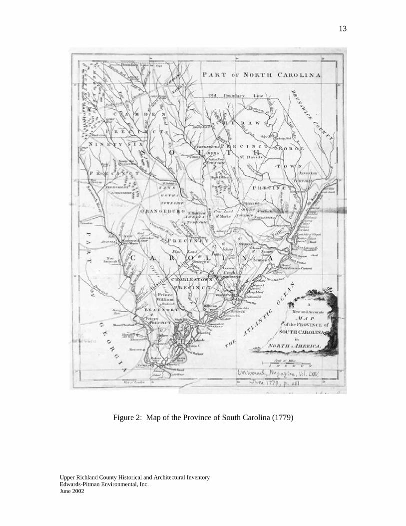
13
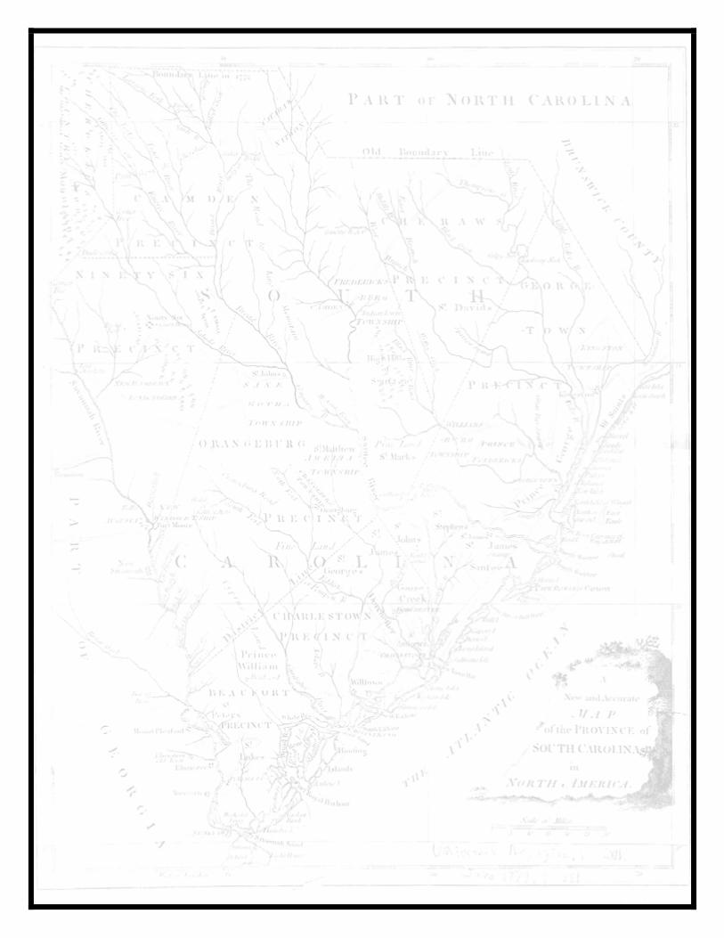
Figure 2: Map of the Province of South Carolina (1779)
Upper Richland County Historical and Architectural Inventory Edwards-Pitman Environmental, Inc. June 2002
14
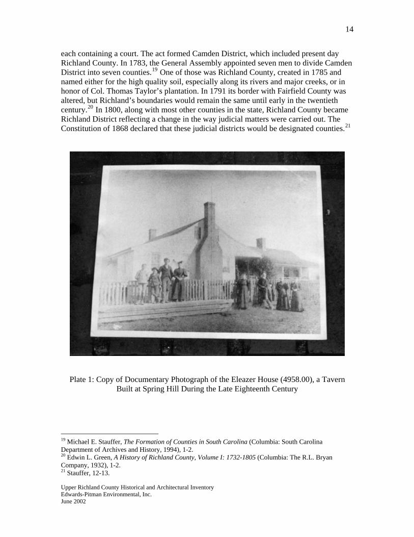
each containing a court. The act formed Camden District, which included present day Richland County. In 1783, the General Assembly appointed seven men to divide Camden District into seven counties.19 One of those was Richland County, created in 1785 and named either for the high quality soil, especially along its rivers and major creeks, or in honor of Col. Thomas Taylor’s plantation. In 1791 its border with Fairfield County was altered, but Richland’s boundaries would remain the same until early in the twentieth century.20 In 1800, along with most other counties in the state, Richland County became Richland District reflecting a change in the way judicial matters were carried out. The Constitution of 1868 declared that these judicial districts would be designated counties.21
Plate 1: Copy of Documentary Photograph of the Eleazer House (4958.00), a Tavern Built at Spring Hill During the Late Eighteenth Century
19 Michael E. Stauffer, The Formation of Counties in South Carolina (Columbia: South Carolina Department of Archives and History, 1994), 1-2. 20 Edwin L. Green, A History of Richland County, Volume I: 1732-1805 (Columbia: The R.L. Bryan Company, 1932), 1-2.
Upper Richland County Historical and Architectural Inventory
21 Stauffer, 12-13.
Edwards-Pitman Environmental, Inc. June 2002
15
Population Characteristics
In 1790, the county’s population numbered 3,930 with one of three persons in the county being black.22 Settlement in Richland County remained heaviest in the lower section where the Congaree and Wateree rivers provided excellent farm land. People were living in upper Richland County by the end of the eighteenth century, but the extent of settlement is uncertain. Those who came to the area above Columbia made homes along the bank of the Broad River or on the creeks that fed the Broad. Among the earliest settlers in the northern half of the county were Germans who came to Dutch Fork (a corruption of the German Deutsch), an area west of the Broad River, in the 1730s. These settlers cultivated wheat, hemp, flax and tobacco and raised sheep, cattle, hogs and horses that they transported to market in Charleston, which was the capital at the time.23 They arrived in South Carolina primarily from the Rhineland region of Germany where years of warfare had created chaos and land was in short supply. There were also many German-speaking Swiss, who, unlike Germans who worshipped in the Lutheran Church, attended the Reformed Church.24 Christian Kinsler established himself at the mouth of Crane Creek in the 1740s. Hans Rubesome made his home where Cedar Creek flowed into the river. Among the other German surnames that appeared in the mid eighteenth century were Faust, Seestrunk, Dancer, Graddick and Mintz.25 In addition to Germans, Scots-Irish, English and Africans made their way to upper Richland County. Among the earliest English settlers was Thomas Nightingale who settled on Little Cedar Creek where he built cattle pens. Other English surnames from the earliest phase of settlement included Curry, Smith and Moore.26 Several communities were established in upper Richland County by the early nineteenth century. A post office was set up in 1829 at a place called Colonel’s Creek, just southeast of present-day Pontiac. The Rice Creek post office, just east of present day Blythewood, first operated in 1831 with Ephraim Peck as the first post master. In 1839, the Cedar Creek post office was established with Timothy Center as the first postmaster. Post offices appeared at Level, a stop along the Charlotte and South Carolina Railroad, and Little River Depot on the Greenville and Columbia Railroad in 1851.27 Slavery was more widespread in lower Richland County than in the upper portion of the county before the Civil War. The emergence of cotton as a market crop around 1800 escalated slavery in the area above Columbia, but the larger slaveholders still lived on
Upper Richland County Historical and Architectural Inventory
22 “1790 Census for Richland County,” http://www.rootsweb.com/~usgenweb/sc/census/sca_1790.html (8 February 2002. 23 James Everett Kibler Jr., ed., Fireside Tales: Stories of Old Dutch Fork (Columbia: Dutch Fork Press, 1984), 6. 24 Gene Able, ed. Irmo and the Dutch Fork Legacy: A Centennial Celebration (Irmo: The Independent News, 1990), 4-5. 25 Green, 31. 26 Able, 5; Green, 32. 27 Harvey S. Teal and Robert J. Stets, South Carolina Postal History (Lake Oswego, Oregon: Raven Press, 1989), 101.
Edwards-Pitman Environmental, Inc. June 2002
16
plantations along the Wateree and Congaree rivers. In upper Richland County most slaveowners held fewer than five slaves. William Dubard represented the typical slaveholder in the area. In 1820, he and his wife and their eight children owned two slaves to help with the farm work. Members of the English family were atypical for upper Richland County. In 1820, brothers Joseph, Jonathan and Robert English owned a total of fifty-seven slaves. On the eve of the Civil War, the number of large slaveholders had increased in upper Richland County.28 Martha Bookter owned ninety-two slaves and had twenty slave houses on her property. Samuel Bookhart owned sixty-six slaves.29
As in the rest of the South, slaves in Richland County endured degrading treatment, especially after a series of rebellions in the early nineteenth century injected fear into the white community. In 1823, Richland County established a patrol to ensure that slaves found off their plantations had permission to move about. In 1848, the following plea from “A Citizen of the Sandhills” appeared in The Daily Telegraph, a Columbia newspaper:
The [people living outside of Columbia] have long been subjected to aggressions and annoyances of various kinds from negroes, who from notoriously bad character, are forced by dread of the marshal to betake themselves beyond the limits of town in pursuit of their evil practices which evil has suddenly been much increased by the influx of laborers on the railroads going forward. Unusual vigilance is now required and hence-forward patrol law will be rigidly enforced in the different beats. The residents of the sand hills are determined to abate the nuisance in the most summary and effectual manner practicable.30
Measures to control both enslaved and free blacks in the county continued up until the Civil War.31
Upper Richland County Historical and Architectural Inventory
Free blacks were among the earliest settlers in upper Richland County. Oz Bowman and his wife Charity came to Dutch Fork around 1803. Bowman was born in Maryland and his wife in Virginia. The couple’s oldest son, Miles, was born in Irmo and became a successful farmer with large holdings in both Lexington and Richland counties. He helped establish a brush arbor that eventually became Oak Grove African Methodist Episcopal Church on Kennerly Road.32
28 Manuscript Census of Population, 1820: Richland County, South Carolina (Raleigh: North Carolina State Archives). 29 Manuscript Slave Census, 1860: Richland County, South Carolina (Raleigh: North Carolina State Archives). 30 The Daily Telegraph (Columbia), 4 November 1848. 31 Lisa Briggitte Gore Randle, “The History of African Americans in Richland County” (master’s thesis, University of South Carolina, 1999), 22. 32 Able, 22; The Columbia Record, 28 July 1986.
Edwards-Pitman Environmental, Inc. June 2002
17
The population of both whites and black rose dramatically from 1800 until the outbreak of the Civil War. In 1800, the population of whites numbered just under three thousand, while the black population was 3,168. By 1810, 3,468 whites and 5,559 blacks lived in the county. By 1840, the population of Richland County had reached 16,397. Free persons numbered 5,733, while 10,664 slaves lived in the county. 33 In 1850, 6,764 whites, 501 free blacks and 12,978 enslaved blacks lived in Richland County. On the eve of the war, in 1860, over eighteen thousand people lived in the county and of those, 11,444 were black.34 Both historically and in the modern era, most blacks in the county have lived in lower Richland County or in Columbia.
Agriculture Corn and wheat grown on small farms characterized the county’s agriculture in the first half of the eighteenth century. Most of the corn was consumed locally and livestock skins and furs and wheat and flour were the major exports.35 The most important settlement and trading post in the region had been established at Granby in 1735. Situated on land between the Congaree River and Congaree Creek, it served as the point from which trade goods were shipped between the backcountry and Charleston. New crops emerged in the county in the late eighteenth century. Indigo was mainly grown along the Congaree and Wateree in lower Richland County. Tobacco was not widely grown in Richland, but tobacco inspection stations were established in Winnsboro in Fairfield County and Friday’s Ferry near Columbia in the 1780s. Cotton production, especially after the introduction of the cotton gin in 1793, boosted agriculture in Richland County. In 1799 Wade Hampton introduced extensive cotton culture to the county when he produced 600 bags on 600 acres in the lower part of the county. Although cotton was not grown in upper Richland on the scale that it was grown on in the lower portion of the county, the crop did have an impact on the area by creating more of a market-based agricultural economy. In places like Dutch Fork, where farmers of German descent had traditionally produced everything they needed, including food crops and animals for meat and materials for shoes and clothing, cotton created a market economy for many large landowners.36 The labor-intensive nature of the crop also created social and cultural changes by encouraging the escalation of slavery in the county. In 1800, blacks, most of whom were slaves, outnumbered whites in Richland County.37 The cotton economy that relied on slavery also brought change to the county’s foreign-born residents. The market system
Upper Richland County Historical and Architectural Inventory
33 Randle, 33. 34 Population of the United States in 1860; Compiled from the Original Returns of the Eighth Census (Washington: Government Printing Office, 1864), 448-450. 35 Moore, 62-63. 36 Able, 15. 37 Moore, 64-66.
Edwards-Pitman Environmental, Inc. June 2002
18
dramatically affected Dutch Fork, which had remained predominantly German-speaking into the very early nineteenth century. This society, isolated by the Saluda River to the west and the Broad River to the east, began to open up to outsiders who traveled to the Fork to buy cotton. English speaking schools appeared and some churches began to hold services in English.38 At the onset of the antebellum period Richland County relied heavily on cotton production. The 1840 census reveals that the county produced over 1.2 million pounds of the crop, compared to just over 330 thousand bushels of corn. Other crops produced included oats (63,325 bushels), potatoes (42,584 bushels), hay (1,976 tons) and wool (5,436 pounds). Among livestock, swine, which formed a large part of the southern diet, outnumbered all other animals with 14,709 produced. Neat cattle (8,878) and poultry (5,206) figured somewhat prominently in the agricultural output as recorded in the census.39 By 1850 Richland District produced nearly 11,400 bales of cotton, ranking twelfth among the twenty-nine districts in the state. Richland ranked second in the production of hay (2,469 tons) and ninth in peas (49,098 bushels).40 Sweet potatoes (94,364 bushels) proved another important crop in that year’s census. The county ranked second in the production of wine with 2,200 gallons.41 According to Robert Mills, while the climate would support a vast range of crops, including rice, indigo, wheat, rye, barley, oats and tobacco, the antebellum economy relied heavily on cotton.42
The 1860 agriculture census reveals that the county’s production of cotton decreased from previous years just before the beginning of the war. Figures for that year indicate that the county produced a little less than ten thousand bales of ginned cotton. The production of corn remained high at over 223 thousand bushels. Other crops of significance included sweet potatoes (39,782 bushels), peas and beans (23,909 bushels), oats (18,125 bushels) and wheat (7,235 bushels). Richland was one of eight counties that produced no tobacco. Swine production was down just before the war with 11,613 heads produced. The number of sheep and milk cows hovered around two thousand each.43
Upper Richland County Historical and Architectural Inventory
38 Able, 15-16. 39 Compendium of the Enumeration of the Inhabitants and Statistics of the United States as Obtained at the Department of State from Returns of the Sixth Census (Washington: Thomas Allen, 1841), 191-192 (Hereafter cited as Returns of the Sixth Census). 40 Todd D. Hejlik and Michael Trinkley, “Archaeological Survey of the Central Electric Power Cooperative Langford to Whitepond 69kV Transmission Line, Richland and Kershaw Counties” (Columbia: Chicora Foundation, Inc., 28 January 1999), 4. 41 Compendium of the Seventh Census of the United States: 1850 (Washington: Robert Armstrong Public Printer, 1853), 346. 42 Mills, 693. 43 Population of the United States in 1860; Compiled from the Original Returns of the Eighth Census (Washington, D.C.: Government Printing Office, 1864), 128-130.
Edwards-Pitman Environmental, Inc. June 2002
19
Transportation
By the end of the eighteenth century, Richland County had become a regional crossroads where former Native Indian paths were transformed into routes that led to major regional markets. One of the most important linked Asheville with Charleston and extended through Dutch Fork roughly along the route of present-day U.S. 176. Spring Hill was a stop along this route and a mid- to late-eighteenth-century tavern (4958.00) still stands near the community. In 1820, several roads stretched across the northern half of the county. Marmaduke Coates’ map of Richland County from that year labels a road parallel to and on the west side of the Broad River as “the road to Newberry Courthouse.” Coates’ map shows the “road to Chester Courthouse” as following present day Monticello Road on the east side of the Broad River. A north-south running road corresponding to modern U.S. 321 is labeled “road to Winnsborough.”44
The county’s many water crossings led more industrious citizens to find ways to provide access across rivers. John Compty owned the earliest known ferry across the Broad River. He attempted to build a bridge at the site, but in 1791 high water destroyed the partially completed structure. In 1811, Henry McGowen, who married Compty’s widow, gained control of the ferry. In 1828, a bridge, known as the Broad River Bridge, was built at the site. Around the same time Henry McGowan took over Compty’s ferry, Christopher Sharp established a similar operation three miles up river. In 1824, Sarah Sharp took over the ferry operation following her husband’s death.45 “Sharp’s Ferry” is indicated on Marmaduke Coates’ 1820 map of the county as located near Frost and on the rear property of the state’s modern-day correctional facility on Broad River Road.46
The development of a railroad network in South Carolina proved a fledgling effort until the 1850s. The Columbia Railroad Company, which sought to establish a line to connect Branchville with Columbia, was chartered in 1833, with the first trains reaching Columbia in 1842. A branch was extended to Camden in 1848. Through the subscription of its citizens, Columbia emerged as the Backcountry’s railroad hub before the war. In 1852, the Charlotte and South Carolina Railroad was completed. Workers finished the Greenville and Columbia Railroad the next year. By 1860 a network of three railroads spread across the state with Columbia positioned between the port city of Charleston and the Piedmont cities of Greenville, Charlotte, Laurens, Spartanburg and Anderson.47 The South Carolina General Assembly passed an act to charter the Columbia, Newberry and Laurens Railroad in 1885. The CN&L functioned as one of nine abbreviated or “pocket railroads” in the state that did not exceed seventy-five miles in length. The railroad company, which established the town of Irmo as a watering stop, completed the
Upper Richland County Historical and Architectural Inventory
44 Marmaduke Coates, “Map of Richland County, 1820,” In the Collection of the South Carolina State Archives, Columbia, South Carolina. 45 Green, 118; 120. 46 Coates map. 47 Kovacik and Winberry, 97-98.
Edwards-Pitman Environmental, Inc. June 2002
20
line near the end of the century. The town of Irmo gets its name from the first two letters of the names of the rail line’s secretary-treasurer, C.J. Iredell, and its first president, H.C. Mosely. 48
Early Industry Prior to the Civil War, industry in Richland County remained limited to small, localized operations. In 1840, a tannery, a pottery and a wagon and carriage builder operated in the county. The most prevalent industries were small milling concerns. That year nineteen water-powered gristmills and twenty-one saw mills occupied the county.49 These enterprises appeared on creeks feeding the Broad River in upper Richland County soon after settlement. In the early nineteenth century Freshley’s mill operated on Wateree Creek in Dutch Fork northeast of present-day White Rock; Goodwin’s Mill was on Gills Creek northeast of Columbia and Mulder’s Mill and Watkin’s Mill had been established on Crane’s Creek.50
Another industry associated with upper Richland County was brick making. The Broad River produced clay, which gave rise to an industry that enjoyed an enduring presence in the county. The area just above Columbia that would become known for its brick making attracted John Drayton’s attention in 1800:
On the heights adjacent to the Broad River, and about six miles from Faust’s Ford, many beautiful specimens of clay appear towards the summit of the hills. Their colors are various; partaking of almost all the shades from red to a light yellow. And their consistencies are such as to give some appearance of ochres.51
Apparently, Drayton is describing the area just to the north of present I-20 on the east side of the river.
Churches and Schools
It is likely that the earliest church in the northern portion of the county was established on Upper Cedar Creek around the time of the American Revolution. The congregation was a German Reformed branch of the Presbyterians called the German Protestant Church of Appii Forum and served as one of fifteen German churches in interior South Carolina. The congregation met in a log building with a dirt floor. According to a Lutheran minister
Upper Richland County Historical and Architectural Inventory
48 Able, 129-130. 49 Returns of the Sixth Census, 194-200. 50 Robert Mills, Mills’ Atlas of the State of South Carolina, 1825, A New Facsimile Edition of the Original Published in 1825 (Columbia: Lucy Hampton Bostic and Fant H. Thornley, 1938). 51 John Drayton, A View of South Carolina, as Respects Her Natural and Civil Concerns (Charleston: W.P. Young, 1802), 53.
Edwards-Pitman Environmental, Inc. June 2002
21
writing in 1874, “this congregation, having been so long neglected by our Lutheran and German Reformed ministers, became at last absorbed by and into a Methodist congregation in the vicinity.”52
German settlers in Dutch Fork organized Bethel Lutheran around 1762 and built a log chapel on High Hill Creek, a site now under the waters of Lake Murray. Sometime in the late eighteenth century, the congregation built a second church, this one of hewn logs, about two and a half miles from the original building. Services were held in German until 1822, an issue of contention among some members who broke off from Bethel and established their own English-speaking churches. The Bethel congregates built a new church in 1843. The construction of Lake Murray forced the move of the congregation to White Rock where it built the current chapel (4924) in 1929.53 Bethlehem Lutheran Church organized in the 1780s. The first church building associated with the congregation— supposedly a log building with a dirt floor—was called Ellisor Church because it stood in an area where several members of the Ellisor family lived near Broad River Road. The congregation erected a new building just before the Civil War, this one called the Bookman Church for its location among members of the Bookman family. The congregation moved to its present site (5021) on Broad River Road in 1899.54
Another early congregation in upper Richland County was Sandy Level Baptist near Blythewood. The Twenty Five Mile Creek Church, likely established around 1772 as a branch of the Congaree Church, served as Sandy Plain’s mother church. In 1767 Bryan McLendon received a Royal Grant of 100 acres at the headwaters of Twenty Five Mile Creek. In 1772, he received an additional 200 hundred acres adjoining the earlier grant. McLendon gave a portion of his grant for the construction of a church, most likely Twenty Five Mile Creek Church which was built around 1785. In 1843, it became Sandy Level Baptist Church. The congregation later split and those retaining the church name built a new house of worship west of Blythewood in 1856. That building (4815.00) still stands.55 Colonel’s Creek Baptist, located in the northeast corner of the county by 1800, and Crooked Run Baptist, first sited on Crane Creek around 1800 and later on Cedar Creek, were other early Baptist churches in Richland.56
Upper Richland County Historical and Architectural Inventory
52 Green, 124-125; G.D. Bernheim, History of the German Settlements and the Lutheran Church in North and South Carolina (Philadelphia, 1872; reprint Baltimore: Regional Publishing Company, 1975), 168, 237. 53 Able, 37. 54 Ibid., 39. 55 H.B. McLean, “Town of Blythewood,” unpublished document, Richland County Public Library, Local History Room, 1992, 1, 3. 56 Green, 127-128.
Edwards-Pitman Environmental, Inc. June 2002
22
By 1850, Methodist and Baptist churches outnumbered all others in the county with eight and seven edifices respectively. One Presbyterian church, one Catholic church, one synagogue and one Lutheran church stood within the boundaries of the county.57 Little is known of the earliest schools in upper Richland County, but evidence suggests that formal schools were rare to nonexistent, especially until soon after the American Revolution. In the early nineteenth century, a school had been established at Spring Hill and a school called Piedmont stood somewhere on Kennerly Road east of present-day Irmo.58 By 1850, 185 students attended sixteen public schools; each school had one teacher. Sixteen hundred dollars of public funds were devoted to these schools.59 According to one source, schools in the county before 1860 “were of the simplest type, plain, one-room long structures, in most instances, and heated by a chimney, with fireplace, at one end—one to three windows generally closed by wooden shutters.”60 Private schools were more common before the war. In 1850, thirty-four teachers instructed 650 students at twenty-five schools in the county. These schools were endowed with a little over fifteen thousand dollars.61 Sometime before 1860, a school in Columbia owned by Baptist minister Rev. John Zealey and called Belle Haven moved to Blythewood on Dr. S.W. Bookhart’s property. Bookhart became sole owner and called the school Blythewood Female Institute. About seventy-five girls attended the school located several miles west of town. An advertisement in a local paper indicated that boarding cost sixty-five dollars and classes such as English, music and painting cost an extra twenty-five dollars.62
Upper Richland as a Resort Area Before the Civil War, sections of the county above Columbia enjoyed popularity as summer respites that offered residents of lower Richland relief from heat and disease. Families established several settlements in the early nineteenth century at places such as Rice Creek Springs, which John Drayton described as “efficacious in curing ring worms, cutaneous disorders and rheumatisms.”63 Columbians resorted at Lightwood Knot Springs, near Killian before the Civil War.64 In May 1850, the City of Columbia
Upper Richland County Historical and Architectural Inventory
57 This figure does not take into account the number of Lutheran churches in Dutch Fork because that area was not transferred to Richland County from Lexington County until the early twentieth century. Note that nineteen Lutheran churches stood in Lexington County in 1850; Compendium of the Seventh Census of the United States: 1850, 349-351. 58 Able, 58. 59 A Compendium of the Seventh Census of the United States: 1850 , 342. 60 Henry Willingham Fulmer, “Development of Education in Dutch Fork of Lexington and Richland Counties, South Carolina” (master’s thesis, University of South Carolina, 1944), 1. 61 A Compendium of the Seventh Census of the United States: 1850, 342. 62 Fitz Hugh McMaster, History of Fairfield County, South Carolina from ‘Before the White Man Came’ to 1942 (Columbia: The State Commercial Printing Company, 1946), 68-69. 63 Drayton, 49. 64 J.F. Williams, Old and New Columbia (Columbia: Epworth Orphanage Press, 1929), 102
Edwards-Pitman Environmental, Inc. June 2002
23
sponsored a municipal picnic at Lightwood Knot Springs. Trains from the Charlotte Railroad carried the guests from the city to the springs on what was a brand new rail line.65 The Cedar Creek community, known for its cool temperatures, also gained favor as a resort for those in the lower reaches of the county.
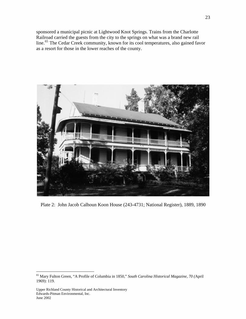
Plate 2: John Jacob Calhoun Koon House (243-4731; National Register), 1889, 1890
Upper Richland County Historical and Architectural Inventory
65 Mary Fulton Green, “A Profile of Columbia in 1850,” South Carolina Historical Magazine, 70 (April 1969): 119.
Edwards-Pitman Environmental, Inc. June 2002
24
A Society Transformed: The Civil War to 1900 The Civil War and Reconstruction in South Carolina jolted white and black society in a monumental way. On the most basic level, the war left the behind a devastated landscape where crops, livestock and farms laid destroyed. Perhaps more significant in the long run were the changes that occurred in the social structure of South Carolinians’ everyday lives. Tenancy and sharecropping replaced slavery as the major labor system on farms in the state. The end of the war also signaled an increase in the cultivation of cotton and a decrease in the size of farms. The post war period proved to also be a time of great reform and improvement in government, education and personal rights.
Upper Richland as a Theater of the Civil War
The first year of the Civil War emerged as a time of great support for the Southern Cause. A good deal of flag waving and parading occurred, particularly in Columbia. In 1861 Lightwood Knot Springs near Killian, which had been a summer resort for Columbians, was transformed into a site for the mobilization of Confederate troops. Excursion trains from Columbia took onlookers to Killian to view the training activities. In 1862, the military camp was designated an official reception center for troops.66
In the end, the war devastated the Richland County landscape with Columbia suffering the most damage. Upper Richland County played a role in the war in several ways. Before Sherman’s destruction of Columbia in February 1865, a Union detachment swept through Dutch Fork. The group proceeded through present-day Irmo on their way to the Broad River. They camped at Freshley’s Mill before proceeding to Fairfield County.67 Evidence also exists that a detachment camped at a house located on modern-day U.S. 176 near the present-day Peak exit off I-26. As they exited Columbia and headed toward Winnsboro, troops under Sherman’s command left livestock for dead, destroyed crops and vandalized railroad tracks. A particularly intriguing story associated with Sherman’s troops’ pillaging of the upper Richland County countryside involves the Lever House (4985.00) on U.S. 176 near White Rock. According to accounts, as Union troops were marching out of Columbia they made their way through Dutch Fork. One company came upon the commodious house late one evening and decided to stay for the night. The next morning the troops started a fire in an attempt to burn the house. Because all the males in the family had been called to war, the females in the family managed to extinguish the fire. The soldiers, noticing from some distance that the house was not on fire, returned to again attempt to burn the house. On three separate occasions the soldiers tried to light the fire, only to have it put out by the Lever women. As the troops returned to the house to attempt to set it ablaze for a third time, one of the women of the Lever family stood on the porch, axe in hand, to prevent the soldiers from entering. According to stories, the commander of the
Upper Richland County Historical and Architectural Inventory
66 The State, 24 January 1928; Moore, 189. 67 Able, 16.
Edwards-Pitman Environmental, Inc. June 2002
25
Union troops was so impressed that he ordered the house spared from fire and assigned a soldier to guard it against destruction by any other troops.68
Population Trends The first census taken after the Civil War showed that the population of Richland County increased during the decade. In 1870, just over twenty-three thousand people lived in the county, representing an increase in population of about forty-seven hundred people. The black population—at 15,177—was just less than double the white population of 7,842.69 In 1880, the total population had increased by over five thousand people. The number of black citizens had gone up by 4,211, while the white population had increased by a little over thirteen hundred. Near the end of Reconstruction, nearly twelve thousand whites and just fewer than twenty-five thousand blacks lived in the county.70
In Richland County and across the South whites and blacks sought to separate themselves from each other after the war. Social interaction became segregated. For most whites, the goal was to prevent miscegenation. But for blacks the motivation stemmed from a need to assert their freedom. Blacks settled in small enclaves in rural areas and in sections of established towns. The most substantial post-war black community formed at Piney Grove. Ex-slaves and free persons established Piney Grove around 1875 just northeast of Columbia. Among those who settled there were Albert Faust, Frank Hyler, Willis Steward, Frank Ludiway and John Belton and their families. These early residents worshiped under brush arbors until the first church, the Piney Grove African Methodist Church, was built. A small school was later attached to the church.71 Other communities of blacks formed in Irmo, Dutch Fork, Littleton near the Little River on the east side of the Broad River, in and around Blythewood and at Cedar Creek. The separation of races proved most profound in the county’s churches. Before the war, blacks belonged to the same denominations as whites. Blacks formed the majority in the Methodist churches of South Carolina and nearly outnumbered whites in the Episcopal faith. After the war, due in part of Northern missionaries and from their own desires to carve out their own identities, blacks established their own churches. Blacks in upper Richland County and elsewhere in the state joined northern branches of Baptist, Methodist and Presbyterian churches and formed congregations of the most prominent black churches, the African Methodist Episcopal Church and the African Methodist Zion Episcopal Church.72
Upper Richland County Historical and Architectural Inventory
68 The State, 31 August 1960. 69 The Statistics of the Population of the United States, 1870 (Washington: Government Printing Office, 1872), 427. 70 The Statistics of the Population of the United States by States, Counties, and Minor Civil Divisions, 1880 (Washington: Government Printing Office, 1881), 77. 71 Able, 25-26. 72 Edgar, 382.
Edwards-Pitman Environmental, Inc. June 2002
26
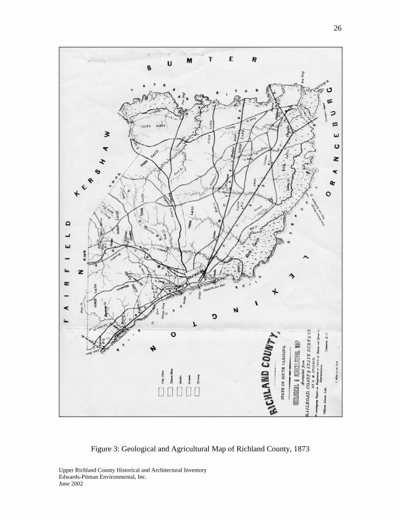
Figure 3: Geological and Agricultural Map of Richland County, 1873
Upper Richland County Historical and Architectural Inventory Edwards-Pitman Environmental, Inc. June 2002
27
Education and Religion
The educational system in upper Richland County underwent great change in the post Civil War era. Under the 1868 constitution the state established a formal educational system that required free universal public education for all children, black and white. Officials did not set up segregated schools—the constitution did not mandate it—but by nature of settlement patterns, most schools were segregated by race.73 By the time of the next census in 1870, black students in Richland County outnumbered white students 524 to 378.74
By 1881, Richland County’s nine school districts operated fifty-six schools with the session lasting about three and a half months. A total of 980 white students and just over twenty-seven hundred blacks attended schools in the county. Not only did black students greatly outnumber whites, but also the total number of male students outnumbered females by fewer than twenty. Of the seventy teachers employed in the county in 1882, thirty-two were black.75
The 1895 constitution proved devastating to blacks’ ability to receive an education. Beginning in 1895, local school boards became controlled by white Democrats who gained more autonomy over schools under their jurisdictions. The constitution also mandated separate schools for blacks and whites. With white schools boards overseeing funding for schools for both races, black students hardly had an opportunity to receive a decent education. The 1895 constitution had set the tone for black education in South Carolina for the next fifty years.76
Religion remained an important part of society in the post war years. With emancipation, blacks established their own churches separate from the white congregations with which they worshiped prior to the war. In 1870, twenty-seven churches stood in the county, a relatively low number compared to other South Carolina counties such as Edgefield County which had eighty-two houses of worships. Methodist and Baptist churches were most numerous, followed in order from most to least by Episcopalian, Lutheran, Presbyterian, Roman Catholic and Jewish. These trends in religious popularity would continue into the twentieth century.77
Agriculture
In the aftermath of war, agriculture in the rural part of Richland County had to adjust to the changes in labor and the poor state of crops. The first census after the war indicates
Upper Richland County Historical and Architectural Inventory
73 David Gregory Blick, “Preservation and Interpretation of the Rural African-American Schoolhouses of Richland County, South Carolina, 1895-1954,” (master’s thesis, University of South Carolina, 1995), 22. 74 The Statistics of the Population of the United States, 1870, 428. 75 State Board of Agriculture of South Carolina, South Carolina Resources and Population, Institutions, and Industries (Charleston: Walker, Evans & Cogswell, 1883), 545-546. 76 Ibid. 77 The Statistic of the Population of the United States, 1870, 555.
Edwards-Pitman Environmental, Inc. June 2002
28
that cotton production in the county fell dramatically to 5,453 bales. Only fourteen other counties produced fewer bales that year. The production of corn (121,495 bushels) and sweet potatoes (12,805 bushels) remained high. Corn production increased in the 1870s and 1880s, but not as much as the production of cotton, which nearly doubled from 1870 to 1880.78
The livestock population decreased after the war except in the 1880s when the number of mules and swine went up. The number of farms increased after the war, with most containing ten to fifty acres. By 1890 the value of the county’s farm land and farm buildings had risen above the 1860 values. One of the most important changes in agriculture came with the 1877 passage of the stock law that required farmers to fence in their livestock.79
Transportation Sherman’s campaign disrupted rail traffic in upper Richland County. In early 1866, a seven-mile gap still existed in the line from Columbia to Greenville. Repairs were made to the line from Columbia to Charlotte more quickly. In the spring of 1866, officials of the Charlotte and South Carolina Railroad held a contest between a team of black workers and a team of white workers with each group starting at opposite ends of the tracks and moving toward the center as they repaired the rails. In five weeks, the crews laid sixteen miles of track and officials considered the contest a tie. To commend each team’s hard work, the company held a barbecue for whites at Lightwood Knot Springs and a similar celebration for blacks at Killian’s Mill.80
The late nineteenth century proved a time for change in the county’s railroads. On 1 February 1883, a new union depot opened in downtown Columbia. After a merger with a rail line that extended to Augusta, the Charlotte and South Carolina Railroad became the Charlotte, Columbia and Augusta Railroad. In 1878 the Richmond and Danville Railroad acquired a substantial interest in the Charlotte, Columbia and Augusta Railroad, but the line that ran from the Queen City through South Carolina’s capital to Augusta remained a separate corporation. In June 1890, the Columbia, Newberry and Laurens Railroad began service between the capital and Prosperity. During the last decade of the nineteenth century, three lines running through Columbia—the Charlotte, Columbia and Augusta; Columbia and Greenville and Richmond; and Spartanburg, Union and Columbia—became part of the Richmond and Danville system. Later at the end of the century, the Southern Railway swallowed up the Richmond and Danville system.81
Upper Richland County Historical and Architectural Inventory
78 The Statistics of the Wealth and Industry of the United States from the Original Returns of the Ninth Census, 1870 (Washington: Government Printing Office, 1872) 79 Moore, 210, 229-230. 80 Moore, 212. 81 Moore, 236; John F. Stover, The Railroads of the South, 1865-1900 (Chapel Hill: University of North Carolina Press, 1955), 235.
Edwards-Pitman Environmental, Inc. June 2002
29
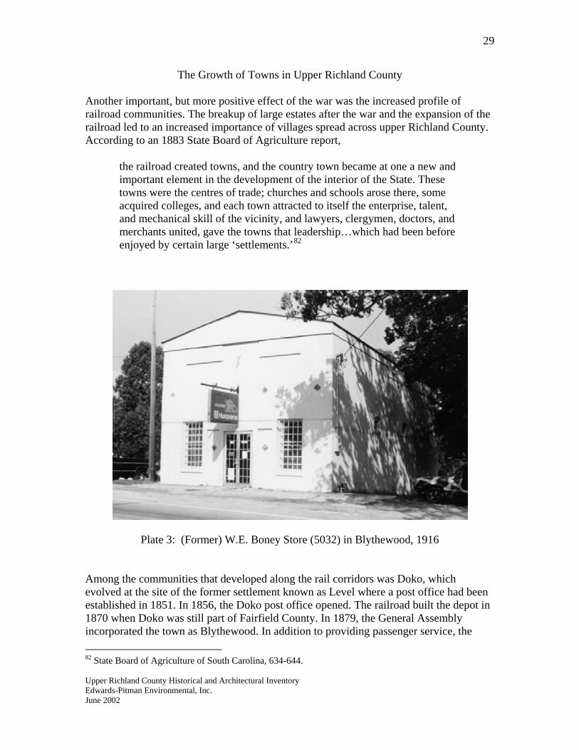
The Growth of Towns in Upper Richland County Another important, but more positive effect of the war was the increased profile of railroad communities. The breakup of large estates after the war and the expansion of the railroad led to an increased importance of villages spread across upper Richland County. According to an 1883 State Board of Agriculture report,
the railroad created towns, and the country town became at one a new and important element in the development of the interior of the State. These towns were the centres of trade; churches and schools arose there, some acquired colleges, and each town attracted to itself the enterprise, talent, and mechanical skill of the vicinity, and lawyers, clergymen, doctors, and merchants united, gave the towns that leadership…which had been before enjoyed by certain large ‘settlements.’82
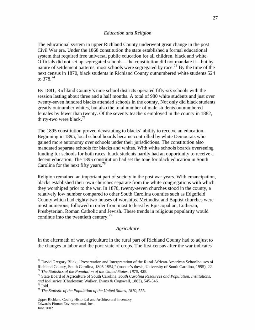
Plate 3: (Former) W.E. Boney Store (5032) in Blythewood, 1916
Among the communities that developed along the rail corridors was Doko, which evolved at the site of the former settlement known as Level where a post office had been established in 1851. In 1856, the Doko post office opened. The railroad built the depot in 1870 when Doko was still part of Fairfield County. In 1879, the General Assembly incorporated the town as Blythewood. In addition to providing passenger service, the
Upper Richland County Historical and Architectural Inventory
82 State Board of Agriculture of South Carolina, 634-644.
Edwards-Pitman Environmental, Inc. June 2002
30
railroad provided shipment for local products including lumber, cord wood, shingles, naval stores, mineral spirits and cotton.83 Among the other rail communities that developed along the railroad in the nineteenth century were Frost’s Mill and Littleton on the line that led to Greenville and Sharp’s, located just above Killian.
Upper Richland County Historical and Architectural Inventory
83 McLean, n.p.
Edwards-Pitman Environmental, Inc. June 2002
31
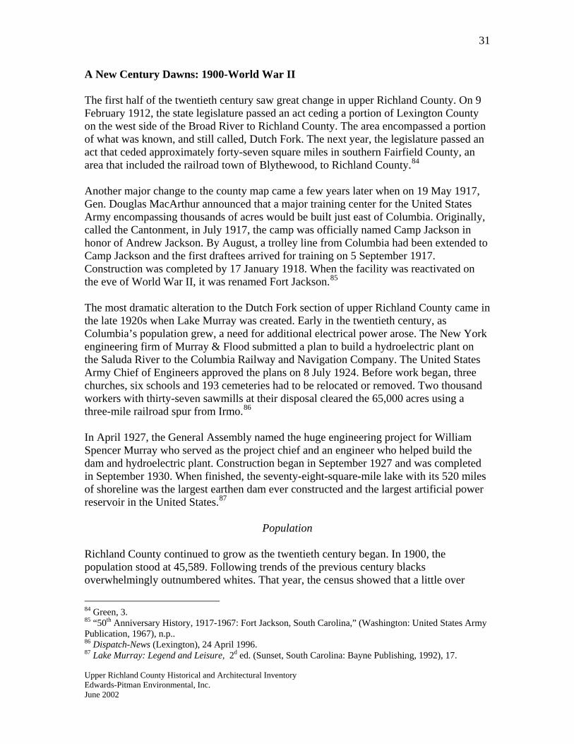
A New Century Dawns: 1900-World War II The first half of the twentieth century saw great change in upper Richland County. On 9 February 1912, the state legislature passed an act ceding a portion of Lexington County on the west side of the Broad River to Richland County. The area encompassed a portion of what was known, and still called, Dutch Fork. The next year, the legislature passed an act that ceded approximately forty-seven square miles in southern Fairfield County, an area that included the railroad town of Blythewood, to Richland County.84 Another major change to the county map came a few years later when on 19 May 1917, Gen. Douglas MacArthur announced that a major training center for the United States Army encompassing thousands of acres would be built just east of Columbia. Originally, called the Cantonment, in July 1917, the camp was officially named Camp Jackson in honor of Andrew Jackson. By August, a trolley line from Columbia had been extended to Camp Jackson and the first draftees arrived for training on 5 September 1917. Construction was completed by 17 January 1918. When the facility was reactivated on the eve of World War II, it was renamed Fort Jackson.85
The most dramatic alteration to the Dutch Fork section of upper Richland County came in the late 1920s when Lake Murray was created. Early in the twentieth century, as Columbia’s population grew, a need for additional electrical power arose. The New York engineering firm of Murray & Flood submitted a plan to build a hydroelectric plant on the Saluda River to the Columbia Railway and Navigation Company. The United States Army Chief of Engineers approved the plans on 8 July 1924. Before work began, three churches, six schools and 193 cemeteries had to be relocated or removed. Two thousand workers with thirty-seven sawmills at their disposal cleared the 65,000 acres using a three-mile railroad spur from Irmo.86 In April 1927, the General Assembly named the huge engineering project for William Spencer Murray who served as the project chief and an engineer who helped build the dam and hydroelectric plant. Construction began in September 1927 and was completed in September 1930. When finished, the seventy-eight-square-mile lake with its 520 miles of shoreline was the largest earthen dam ever constructed and the largest artificial power reservoir in the United States.87
Population Richland County continued to grow as the twentieth century began. In 1900, the population stood at 45,589. Following trends of the previous century blacks overwhelmingly outnumbered whites. That year, the census showed that a little over
Upper Richland County Historical and Architectural Inventory
84 Green, 3. 85 “50th Anniversary History, 1917-1967: Fort Jackson, South Carolina,” (Washington: United States Army Publication, 1967), n.p.. 86 Dispatch-News (Lexington), 24 April 1996. 87 Lake Murray: Legend and Leisure, 2d ed. (Sunset, South Carolina: Bayne Publishing, 1992), 17.
Edwards-Pitman Environmental, Inc. June 2002
32
twenty-eight thousand blacks and 17,513 whites made their home in Richland County. The 1900 census also differentiated between the populations in the upper township and lower township: the former had 3,309 inhabitants and 11,186 people lived in the lower township. It remains uncertain as what boundaries the census takers used in determining the border between the upper and lower townships, but neither division contained the Columbia Township whose population was counted separately.88
The next census indicated that the tide was turning in regard to the racial makeup of Richland County. The white population began to catch up with the black population. Part of the narrowing of gap between the numbers of black and white citizens can be attributed to the black migration in which hordes of blacks left the South for what they perceived as better jobs and improved treatment in the North. In 1910, the white population was 25,609 and the black population was 29,533. The next year a census was taken—1920—whites outnumbered blacks 41,623 to 36,499. By 1930, the white population surpassed the black population by over ten thousand people. On the eve of World War II, well over sixty-two thousand whites lived in the county compared to just over forty-eight thousand blacks.89
Great Depression
The state had undergone economic hard times in the 1920s, but the crash of the stock market had an indelible effect on the state and Richland County. Many farmers lost their land and unemployment rates in Richland County were higher than thirty percent. Banks failed, cotton prices plummeted and businesses closed.90 Throughout the 1930s, the myriad of relief programs associated with President Franklin Roosevelt’s New Deal helped county residents and aided with the improvement of Richland’s infrastructure. The Civilian Conservation Corps (CCC) was perhaps the most popular program of the New Deal. It put hundreds of county men to work building parks and roads. The most high profile CCC project in upper Richland County is Sesquicentennial Park (4761) located on Two Notch Road. Workers built bridges, picnic shelters, the fire tower, stone walls and the large bathhouse at the center of the park. Among the CCC camps established was Camp Pontiac in the eastern part of upper Richland County. The Works Progress Administration (WPA) also stayed active in the county building roads and making improvements to buildings, working with the county’s historical documents and interviewing ex-slaves. By 1940, over twenty-seven hundred
Upper Richland County Historical and Architectural Inventory
88 Twelfth Census of the United States Taken in the Year 1900 (Washington: United States Census Office, 1901), 354. 89 Census of the United States, 1910, Abstract of the Census with Supplement for South Carolina (Washington: Government Printing Office, 1913), 596; Fourteenth Census of the United States, Taken in the Year 1920, Volume III: Population (Washington: Government Printing Office, 1923), 933. Fifteenth Census of the United States: 1930, Volume I, Population (Washington: Government Printing Office, 1931), 994; Sixteenth Census of the United States: 1940, Volume I, Population (Washington: Government Printing Office, 1941), 998. 90 Edgar, 500.
Edwards-Pitman Environmental, Inc. June 2002
33
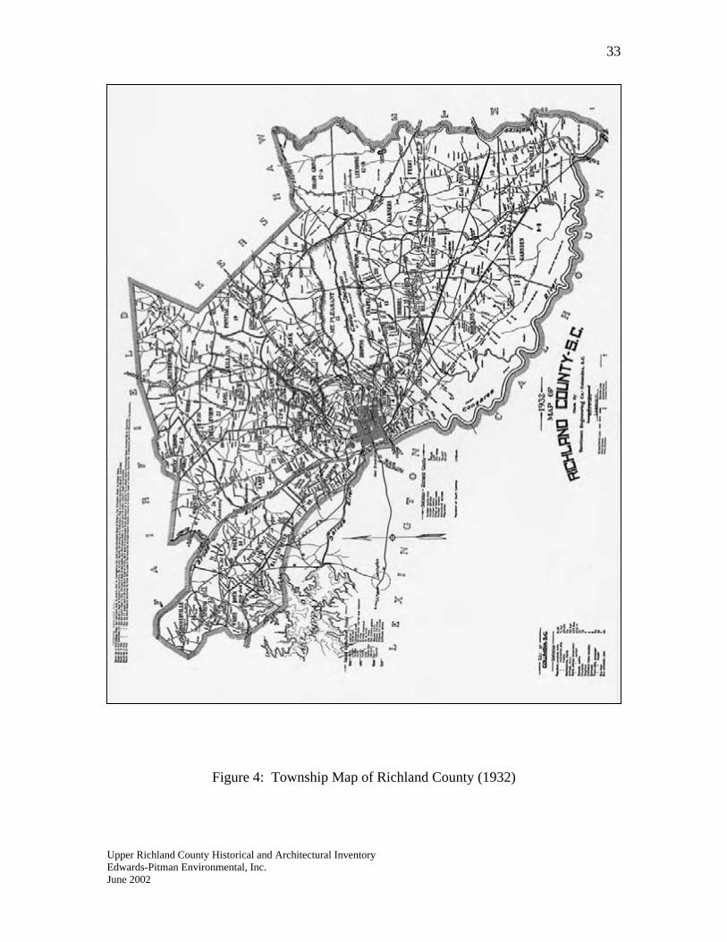
Figure 4: Township Map of Richland County (1932)
Upper Richland County Historical and Architectural Inventory Edwards-Pitman Environmental, Inc. June 2002
34
people in Richland County worked for the WPA. Workers with the Public Works Administration (PWA) built new buildings and structures including two concrete bridges (4882, 4883) over Cedar Creek, the Richland County courthouse, dormitories for the University of South Carolina and a large, modern building at the South Carolina Tuberculosis Sanatorium (5440.14) at State Park on Farrow Road.91
Agriculture
In 1900, just fewer than three thousand farms operated in Richland County; ten years later that number had increased by about six hundred. By 1920, 3,452 farms operated and small farms—under fifty acres—remained the commanding fixture on the agricultural landscape of Richland County. Cotton continued to dominate the county’s fields; census figures show that for the year 1919, 46,910 acres of the county’s farmland produced 26,690 bales. Farmers produced almost five hundred and fifty thousand bushels of corn on 36,804 acres.92 In 1924, one observer noted that “the greater part of this area is handled by tenants who work small farms, with few modern improvements and inefficient agricultural practices.” By this time about sixty percent of the county was under cultivation, with the rest covered in pine, oak, hickory and dogwood trees. In the aftermath of the boll weevil, farmers attempted to diversify their crops and truck farming became popular.93
By 1940, the census showed that the number of farms had dropped in Richland County from 1935 figure. One-fourth contained ten to twenty-nine acres, while twenty-two had more than a thousand acres. Tenants operated half of the county’s 2,428 farms.94 One out of five county farmhouses had electricity that year and around the same number stood along paved roads. Crops remained the same as in previous years with corn, cow peas, cotton and sweet potatoes dominating.95
Transportation In the 1920s three trunk carriers operated rail lines through Richland County: the Seaboard, Southern and Atlantic Coast.96 With the advent of the automobile, citizens and government placed a greater emphasis on road construction and improvement. Often counties raised money to give to the state’s highway department, which had been
Upper Richland County Historical and Architectural Inventory
91 Moore, 341-342. 92 Fourteenth Census of the United States Taken in the Year 1920, Volume VI: Agriculture (Washington: Government Printing Office: 1922), 280, 290. 93 Elisabeth D. English, “Natural Resources,” in Richland County: Economic and Social (Columbia: University of South Carolina, 1924), 29-30. 94 Sixteenth Census of the United States: 1940, Agriculture: Volume I, Statistics for Counties (Washington: Government Printing Office, 1942), 436-487, passim. 95 Moore, 343-343. 96 Moore, 292.
Edwards-Pitman Environmental, Inc. June 2002
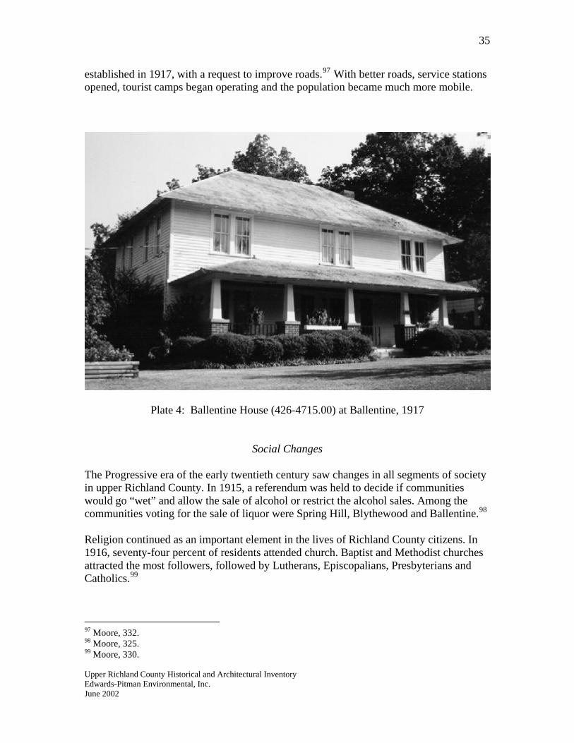
35
established in 1917, with a request to improve roads.97 With better roads, service stations opened, tourist camps began operating and the population became much more mobile.
Plate 4: Ballentine House (426-4715.00) at Ballentine, 1917
Social Changes The Progressive era of the early twentieth century saw changes in all segments of society in upper Richland County. In 1915, a referendum was held to decide if communities would go “wet” and allow the sale of alcohol or restrict the alcohol sales. Among the communities voting for the sale of liquor were Spring Hill, Blythewood and Ballentine.98
Religion continued as an important element in the lives of Richland County citizens. In 1916, seventy-four percent of residents attended church. Baptist and Methodist churches attracted the most followers, followed by Lutherans, Episcopalians, Presbyterians and Catholics.99
97 Moore, 332. 98 Moore, 325.
Upper Richland County Historical and Architectural Inventory
99 Moore, 330.
Edwards-Pitman Environmental, Inc. June 2002
36
The brutal treatment endured by blacks in Richland County in the early twentieth century created unease among the county’s majority population. Lynching—although more common in South Carolina during the late nineteenth century—remained a threat. Blacks continued to suffer in the realm of criminal justice. In the early 1920s county law enforcement officers staged a manhunt in the swamps around Blythewood for a black man who allegedly killed a popular Columbia police officer. The strong sentiment that the man did not commit the act did little to assuage the searchers.100
In a few small measures, the station of blacks improved in the 1920s. One observer noted in 1924 that “the colored race is steadily increasing its land holdings as is evidenced by the fact that in 1920 in Richland County there were 469 farms owned by [negroes].” That figure represented about nineteen percent of all farms in the county and showed an improvement over 1910 figures when blacks owned about eleven percent of farms.101
Rural electrification was one of the most dramatic changes to affect rural Richland County in the early twentieth century. In 1930 less than three percent of the state’s rural homes had electricity. In Richland County, electricity served only 186 of the 2,787 farmhouses.102 For rural residents, this meant that they had to carry water from springs or use hand pumps on wells. Food had to be kept in springhouses and meals were cooked on wood stoves. Farm operations remained inefficient as all work was performed by hand or mule. In 1931, the legislature created the South Carolina Power Rate Investigating Committee to study the power industry in the state. The committee reported to the General Assembly that the lack of electricity in the rural parts of the state had been detrimental to agriculture, and more specifically, to the move toward diversification in crop production. In 1933 the legislature passed the South Carolina Rural Electrification Act (REA) in order to establish a public rural-electric construction program wherein rural homes along state highways would get electricity. In 1935, President Roosevelt created the federal REA, which preempted the state’s programs, but worked with a state committee in determining where to establish service. Until interrupted by World War II, rural electrification advanced dramatically in South Carolina since the early 1930s and improved the lives of families across the state.103
Advances in Healthcare Healthcare emerged as an important issue in the 1910s and 1920s. During the period a private tuberculosis camp operated at Ridgewood. According to one contemporary observer, “various organizations have erected shacks at the Ridgewood Camp, but there
Upper Richland County Historical and Architectural Inventory
100 Moore, 386. 101 English, “Natural Resources,” 44. 102 Fifteenth Census of the United States: 1930, Agriculture: Volume II, the Southern States (Washington: Government Printing Office), 507. 103 D. Clayton Brown, “Modernizing Rural Life: South Carolina’s Push for Public Rural Electrification, South Carolina Historical Magazine 99 (January 1998): 68-85, passim.
Edwards-Pitman Environmental, Inc. June 2002
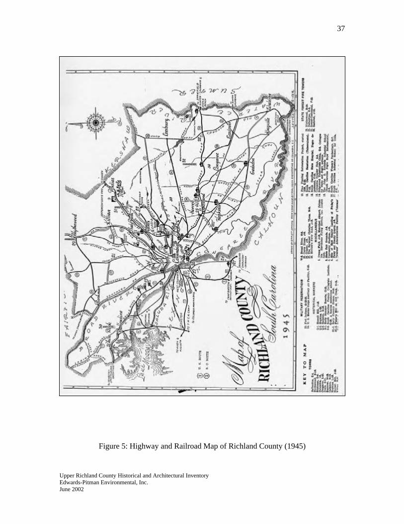
37
Figure 5: Highway and Railroad Map of Richland County (1945) Upper Richland County Historical and Architectural Inventory Edwards-Pitman Environmental, Inc. June 2002
38
is always a waiting list of those for whom there is as yet no room.”104 In 1914, the State of South Carolina took a leadership role in the treatment of tuberculosis when the General Assembly appropriated ten thousand dollars to establish a facility north of Columbia to help victims of a disease that was killing hundreds of those who contracted it.105 This initial funding was “for the erection and maintenance of a tuberculosis camp by the State Board of Health to be located on land now owned by or hereafter donated to the State.”106 George R. Rembert, a representative to the State House from Richland County, suffered from the disease and was instrumental in securing early funding for the tuberculosis sanatorium. After his death, his widow, Anne Iredell Rembert, continued the campaign for establishment of a state-funded tuberculosis center.107 In 1915, a committee headed by Dr. Robert Wilson, an early advocate for the establishment of a tuberculosis hospital, selected a site (5440.00) located eight miles north of Columbia at State Park and described as “situated in the rolling sand hills of Richland County, overlooking undulating valleys and a panoramic spread of pine-crested ridges.”108 The first patients—all white males—were admitted in May 1915 and housed in a frame open-air pavilion that held sixteen beds. From the start a working farm encompassed a substantial portion of the sanatorium and the food produced helped to feed patients. Workers grew corn and sweet potatoes and raised Holstein cows whose milk was purported to help in the treatment of tuberculosis. In 1915, the sanatorium’s farm reported having a mule, three cows and seventeen swine. In 1916, the legislature appropriated more funding and by the end of that year a women’s ward and an administration building (5440.09) had been completed.109 A publication from the 1920s described the administration building as “a handsome two-story dwelling of modern architecture type, with a large piazza in the front.”110
In 1918, the sanatorium began admitting African American patients; previously they could only receive treatment at a camp in Sumter County. In 1920, the “Negro ward,” as
Upper Richland County Historical and Architectural Inventory
104 English, “Natural Resources,” 25. 105 Andrew Peeples, ed. “South Carolina State Board of Health: A Brochure Describing the Organization and Services of the South Carolina State Board of Health” (Columbia: South Carolina State Board of Health, 1941), n.p. 106 Ben F. Wyman, M.D., “The South Carolina Sanatorium” (Columbia: South Carolina State Board of Health, 1953), 1, report in the collection of the South Caroliniana Library, University of South Carolina, Columbia. 107 “South Carolina and Palmetto Sanatoria, State Park, South Carolina” (Columbia: South Carolina State Board of Health, ca. 1920), n.p. , pamphlet in the collection of the South Caroliniana Library, University of South Carolina, Columbia. 108 Joyce Covington, “In the Beginning,” Update 8 (Fall/Winter 1978): 7; Ibid. 109 Wyman, 4. 110 “South Carolina and Palmetto Sanatoria, State Park, South Carolina,” n.p.
Edwards-Pitman Environmental, Inc. June 2002
39
it was known, was built from the designs of architect C.C. Wilson. The section of the complex reserved for African American patients was named the Palmetto Sanatorium.111 In the 1920s, the state, with the additional funding from the Grand Lodge of Ancient Free Masons of South Carolina, built infirmary cottages, adult and children’s wards, servant’s houses and an incinerator. In the early 1930s, the complex expanded with the addition of a garage, a nurses’ home, physicians’ homes and a dairyman’s cottage. In 1933, the state built an Art Deco-style chapel and community building (5440.05) containing a library, guest rooms, a barber shop and post office. The Board of Health’s annual report for that year described the building as “a splendid fireproof building, modernistic in design.”112
The most substantial building at the State Park facility is the hospital building (5440.14) which was completed in 1938 with funding from a state bond issue and the Public Works Administration (PWA). The State Board of Health’s building committee chose J.A. Jones Construction Company to construct the six-story fireproof building designed to house nearly three hundred patients. By the early 1940s, the monumental building was expanded to hold 550 beds. According to the Board of Health’s executive director during the period, the new building was “equipped with every facility for the scientific treatment of tuberculosis, [and] placed South Carolina in the forefront with one of the best tuberculosis hospitals in the South.”113
Building at State Park continued up until and after World War II. Additional residential cottages were built throughout the 200-acre complex. In 1949, the Palmetto building (5440.03), a dining hall, was completed. In 1951, a 200-bed building was constructed and in 1955, a large brick building (5440.01) for housing female African American patients was completed. The architectural firm of Lafaye and Lafaye designed the one-story building which was built to accommodate a second floor, but none was ever built. The “handsome, finely-equipped facility” was fitted with an intercom system over which nurses and patients could communicate, terrazzo floors, tiled bathrooms and a large hall to accommodate church services.114
In 1953, the State Board of Health requested to be relieved of responsibility of the operation and maintenance of the state sanatorium. On 1 July, a board of trustees took over those duties.115 In the 1960s, tuberculosis began being treated on an outpatient basis. In 1983, when State Park ceased operating as a tuberculosis sanatorium, only thirteen patients remained. Most were sent home, but those who could not return home were sent to the Byrnes Medical Center at the South Carolina State Department of Mental Health where they remained until they were well enough to go home or until they passed
Upper Richland County Historical and Architectural Inventory
111 Wyman, 5-6. 112 Wyman, 13. 113 Peeples, n.p. 114 Covington, 8; The Columbia Record, 27 July 1955. 115 Wyman, 27.
Edwards-Pitman Environmental, Inc. June 2002
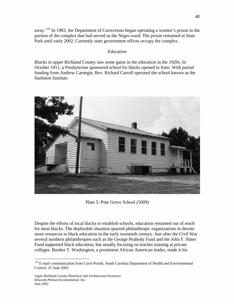
40
away.116 In 1983, the Department of Corrections began operating a women’s prison in the portion of the complex that had served as the Negro ward. The prison remained at State Park until early 2002. Currently state government offices occupy the complex.
Education
Blacks in upper Richland County saw some gains in the education in the 1920s. In October 1911, a Presbyterian sponsored school for blacks opened in Irmo. With partial funding from Andrew Carnegie, Rev. Richard Carroll operated the school known as the Harbison Institute.
Plate 5: Pine Grove School (5009) Despite the efforts of local blacks to establish schools, education remained out of reach for most blacks. The deplorable situation spurred philanthropic organizations to devote more resources to black education in the early twentieth century. Just after the Civil War several northern philanthropies such as the George Peabody Fund and the John F. Slater Fund supported black education, but usually focusing on teacher training at private colleges. Booker T. Washington, a prominent African American leader, made it his
Upper Richland County Historical and Architectural Inventory
116 E-mail communication from Carol Pozsik, South Carolina Department of Health and Environmental Control, 21 June 2002.
Edwards-Pitman Environmental, Inc. June 2002
41
mission to direct more aid at rural public schools. One of his early successes came when he convinced wealthy Quaker Anne T. Jeanes to endow a foundation to aid black education. Upon her death in 1908, the Jeanes Fund received one million dollars to pay black educators to supervise novice teachers in the rural South. The success of the Jeanes Fund led the John F. Slater Fund to redirect its support from private institutions of higher learning to public high schools, colleges and industrial training programs. The period’s most prominent philanthropy geared toward black public education was the Julius Rosenwald Fund, a far-reaching program that helped to improve black education by offering matching grants aimed at building schools in the rural South. The Fund helped build schools in fifteen southern states, including several in Richland County. Among the Rosenwald schools built in upper Richland County were the Monteith School on North Main Street, the Line School near Ballentine and Pine Grove School on Piney Woods Road.117 Piney Grove School (5009) was built in 1923-1924 and is the only Rosenwald School still standing in upper Richland County.
Upper Richland County Historical and Architectural Inventory
117 Blick, 43-44.
Edwards-Pitman Environmental, Inc. June 2002
42
Upper Richland County in the Post World War II Era The area of Richland County above Columbia underwent significant change after the end of World War II. The most obvious change has been the transformation of the bucolic landscape with the encroachment of urban development into once rural sections. Many rural residents abandoned farming for more lucrative occupations and native born residents left the area only to be replaced with citizens from outside the county and state. The population increased by thirty-six percent from 1940 to 1950 with non-whites making up 35.4 percent of the totals. Professional occupations, construction trades and manufacturing had become the most common jobs among citizens. After the war, the number of farms in the county (2,444) remained consistent with pre-war figures and only 5.9 percent of the population worked in agriculture.118
The increase in population coupled with a decrease in the number of farms continued throughout the rest of the twentieth century. By 1960, the county’s population jumped to just over two hundred thousand and the number of farms dropped to 1,167; about seventy-seven of those were cotton farms.119 In 1997, Richland County had only 350 farms.120
Inequities in the quality of education between blacks and whites remained problematic after the war. In 1948, a columnist for The Columbia Record issued a plea to education leaders in South Carolina to provide equal pay to African American teachers and equal opportunities for learning to all students. The writer appealed to leaders to work “toward the gradual elimination of all discrimination between the races, accomplished in such a manner as to preserve what South Carolina has instead of destroying it.”121
A positive change toward that end came in May 1954 when the United States Supreme Court ruled in the case Brown v. Board of Education that the law of separate but equal facilities was unconstitutional. The white reaction in South Carolina was overwhelmingly negative and the actual integration of schools would not come until sixteen years after Brown. In 1956, the state legislature passed a series of laws meant to undermine Brown. White schools defied federal law by not allowing blacks, or closing altogether in order to avoid desegregation. In the early and mid-1960s, the tide began to turn as some of South Carolina’s leaders began to accept integration.122
In order to comply with Title VI of the 1964 Civil Rights Act, Richland County schools instituted the Freedom of Choice program in 1967. Under the plan, each student or his or
Upper Richland County Historical and Architectural Inventory
118 County and City Data Book, 1952 (Washington: Government Printing Office, 1953), 352. 119 County and City Data Book, 1967 (Washington: Government Printing Office, 1967), 322, 330. 120 South Carolina State and County Data, 1997 Census of Agriculture (Washington: U.S. Department of Agriculture, 1999.), 169. 121 The Columbia Record, 18 December 1948. 122 Walter B. Edgar, South Carolina in the Modern Age (Columbia: University of South Carolina Press, 1992), 101-107.
Edwards-Pitman Environmental, Inc. June 2002
43
her parent chose the school the student would attend. The result of the plan was that the school system remained mostly segregated.123 In January 1969, the federal government ruled that the Freedom of Choice plan did not comply with the Civil Rights Act. In the summer of 1970, principals, administrators and supervisors from Richland County attended desegregation workshops hosted by the University of South Carolina Desegregation Center, a facility set up to assist in the transition to fully integrated schools. In late August 1970, Richland County schools opened for the year as fully integrated.124
Upper Richland County Historical and Architectural Inventory
123 The State, 10 February 1967. 124 The Columbia Record, 29 January 1969; The Columbia Record, 3 August 1970.
Edwards-Pitman Environmental, Inc. June 2002
44
VI. Brief Profiles of Towns and Communities in Upper Richland County Blythewood Blythewood, upper Richland County’s most substantial town, was originally known as Doko and is sited along an old wagon road that connected Charlotte and Columbia. According to some sources, “Doko” was a Native American name for “watering place.” Another less accepted theory is that the name comes from the Latin “aqua” or the Italian “acqua.”125 Doko evolved at the site of the former settlement known as Level where a post office had been established in 1851. In 1856, the Doko post office opened and a depot for the Charlotte, Columbia and Augusta Railroad was built in 1870 when the town was still part of Fairfield County. Eventually, Southern Railway took over line that ran through town. According to local tradition, the town’s current name came from Dr. S.W. Bookhart, director of the Blythewood Female Institute, who did not like the name Doko and in 1877 suggested “Blythewood” after noticing, what he called the “blithe and pretty” woods around the town.126 In 1879, the General Assembly incorporated the town as Blythewood. In addition to providing passenger service, the railroad provided shipment for local products including lumber, pulpwood, cord wood, shingles, naval stores, mineral spirits and cotton.127 In January 1913, The State newspaper reported that a delegation from Blythewood appeared before the legislature to express its support for annexation. According to the newspaper, people living in neighboring counties generally desired to live in Richland County. The paper remarked that “Columbia’s good railroad facilities accounts in part for the desire of citizens of sections of other counties to join Richland county and the fact that people who live many miles from Columbia do their shopping here is another good reason for desiring annexation.” In 1913, the state legislature passed an act ceding forty-seven square miles in southern Fairfield County to Richland County. The tract encompassed the town of Blythewood. 128
Throughout the first half of the twentieth century, Blythewood thrived as a rail town and a center of commerce for area farmers. Education was a priority for residents and in the early twentieth century a one-room wooden school stood in town along what is now U.S. 21. In the 1920s, the school was expanded to include additional classrooms and an auditorium. In 1939 the original school was torn down and a gymnasium built at the site. In 1951, a one-story brick school building was constructed.129
Upper Richland County Historical and Architectural Inventory
125 The Columbia Record, 10 August 1983. 126 The State, 5 October 1979. 127 McLean, n.p. 128 The Columbia Record, 6 January 1913. 129 Dubard et al, 5.
Edwards-Pitman Environmental, Inc. June 2002
45
Passenger traffic ended in the 1950s leaving the depot to fall out of service; it was demolished in June 1968.130 The landscape and pace of life began to change dramatically in the 1980s with the completion of Interstate 77 through northern Richland County. Since that time, the area’s growth has exploded. Fast food restaurants, gas stations, hotels, shops and restaurants stand near the main exit ramp from the interstate. The area has also become home to several industrial and large-scale commercial enterprises which stand along I-77. Farther from the interstate, upscale housing developments, many with golf courses, have attracted families to the Blythewood area. Blythewood is the hometown of William N. Grey who served as the state’s first African American Senate page.131
Cedar Creek The community of Cedar Creek is located twenty miles north of Columbia. The topography differs greatly from that in the rest of the county and temperatures in Cedar Creek are generally eight to ten degrees cooler than the capital city’s. Thick forests of cedar and pine trees stand in this settlement. Big Cedar Creek and Little Cedar Creek, the major water courses flowing through the community, attracted Native Americans and white settlers from the earliest period. Among the first families to settler here were the Meetzes, Graddicks, Dansbys, Kinslers, Centers, Bookerts, Dubards, Levers and Howells. The first post office for this section was named Lever—it operated from the early nineteenth century until 1906. Grist mills and saw mills were the predominant industries in Cedar Creek.132
Today, Cedar Creek retains its rural character and the natural qualities that first attracted residents. A strong sense of community remains as does an appreciation for the area’s history. Because of its remote location away from interstate highways and the city of Columbia, Cedar Creek stands as the most pristine historic community in upper Richland County. Spring Hill The community of Spring Hill is northwest of Columbia, halfway between Irmo and Prosperity. Named in 1791 for the springs at the foot of the stone hills, the settlement developed along Wateree Creek and the drover’s road that connected Charleston and Asheville. The earliest settlers at Spring Hill were Germans who migrated from Charleston and Pennsylvania to get free land in what was then the backcountry of South Carolina. Before the Civil War, the community contained a post office, schools, a tavern and Spring Hill Baptist Church. The church closed after functioning from 1838 to 1849. Spring Hill prospered after the war and became home to Mt. Olivet Lutheran Church. Several mills and a blacksmith’s shop stood along Wateree Creek. A two-story general
Upper Richland County Historical and Architectural Inventory
130 The State, 2 September 1999. 131 The Columbia Record, 22 January 1969. 132 DuBard et al, 85.
Edwards-Pitman Environmental, Inc. June 2002
46
store with a post office stood along the drover’s road, a route that eventually became U.S. 176.133
The school at Spring Hill closed in 1937 and the community declined throughout the twentieth century.134 Today, a few houses, the modern sanctuary of Mt. Olivet Church and the cemetery (4957) containing a few tombstones associated with the Baptist church that stood here before the Civil War are all that remain of Spring Hill. White Rock Germans emigrating from Charleston and Pennsylvania founded the community of White Rock in the eighteenth century. The community prospered as a stop on the Columbia, Newberry and Laurens Railroad—nicknamed “the Crooked, Noisy and Late”—which became part of the Atlantic Coast Line Railroad and later the CSX line. In 1911, Ralanza Melissa Rauch Lowman established the Lowman Home here. Promotional material for the facility described the White Rock as “picturesque and beautiful.”135 The home operated a working farm and by the beginning of World War II, sixty-two residents lived at the home.136
Presently, Lowman Home dominates the community of White Rock. From 1957 until 1975, twenty-eight cottages were built to house residents. An additional forty-one units were built in the early 1990s and a nursing center was completed in 1992. Well over two hundred residents live and receive treatment at Lowman Home.137
Upper Richland County Historical and Architectural Inventory
133 Historical Marker Erected by the Mt. Olivet Lutheran Church; Mrs. R.B. Hilborn, History of Mt. Olivet Lutheran Church, Spring Hill, Chapin, South Carolina (Chapin: Mt. Olivet Lutheran Church, 1973), 7-9. 134 Fulmer, 5. 135 The State, 2 September 1999; “Lowman Home for the Aged and Helpless, White Rock, South Carolina” (White Rock: Lowman Home, ca. 1920), pamphlet in the Collection of the South Caroliniana Library, University of South Carolina, Columbia. 136 Lake Murray: Legend and Leisure (2nd edition), 130-131. 137 Ibid, 131.
Edwards-Pitman Environmental, Inc. June 2002
47
VII. Bibliography Maps Coates, Marmaduke. Map of Richland County, 1820. South Carolina State Archives Map Collection. Map of Richland County, 1945. Drawn by Emmet Conniffe from a Map Made by
Tomlinson Engineering. South Carolina Department of Archives and History Map Collection.
Map of Richland District from Robert. Mills’ Atlas of the State of South Carolina, 1825. South Carolina State Archives Map Collection. Richland County Geological and Agricultural Map, 1873. Compiled from Railroad,
Coast and State Surveys by E.M. Stoeber. South Carolina State Archives Map Collection.
Primary Sources The Columbia Record. The Daily Telegraph (Columbia). Manuscript Census of Population, 1820: Richland County, South Carolina. Manuscript Slave Census, 1860: Richland County, South Carolina. News-Dispatch (Lexington). The State (Columbia). Secondary Sources “50th Anniversary History, 1917-1967: Fort Jackson, South Carolina.” Washington:
United States Army Publication, 1967. 1790 Census for Richland County. <www://rootsweb.com/~usgenweb.com/sc/ census/sca_1790.html> Able, Gene, ed. Irmo and the Dutch Fork Legacy: A Centennial Celebration. Irmo: the
Independent News, 1990.
Upper Richland County Historical and Architectural Inventory Edwards-Pitman Environmental, Inc. June 2002
48
Berheim, G.D. History of the German Settlements and the Lutheran Church in North and
South Carolina. Philadelphia, 1872: reprint, Baltimore: Regional Publishing Company, 1975.
Blick, David Gregory. “Preservation and Intepretation of the Rural African-American
Schoolhouses of Richland County, South Carolina, 1895-1954.” Master’s thesis, University of South Carolina, 1995.
Blick, David Gregory. “Richland County’s Rural African-American Schoolhouses, 1895- 1954.” Columbia: Historic Columbia Foundation, 1995. Brown, D. Clayton. “Modernizing Rural Life: South Carolina’s Push for Public Rural
Electrification.” South Carolina Historical Magazine 99 (January 1998): 68-85. Census of the United States, 1910, Abstract of the Census with Supplement for South
Carolina. Washington: Government Printing Office, 1913. Compendium of the Enumeration of the Inhabitants and Statistics of the United States as
Obtained at the Department of State from Returns of the Sixth Census. Washington: Thomas Allen, 1841.
Compendium of the Seventh Census of the United States: 1850. Washington: Robert
Armstrong Public Printer, 1853. Corkran, David H. The Carolina Indian Frontier. Tricentennial Booklet Number 6,
Published for the South Carolina Tricentennial Commission. Columbia: University of South Carolina Press, 1970.
County and City Data Book, 1952. Washington: Government Printing Office, 1953. County and City Data Book, 1967. Washington: Government Printing Office, 1968. Covington, Joyce. “In the Beginning.” Update 8 (Fall/Winter 1978): 2-9. Drayton, John. A View of South Carolina, as Respects Her Natural and Civil Concerns.
Charleston: W.P. Young, 1802. Dubard, Margaret et al. Blythewood Scrapbook: An Informal History of the People and
Places of Blythewood and Cedar Creek, South Carolina. Blythewood: Blythewood Garden Club, 1994.
Edgar, Walter B. South Carolina: A History. Columbia: University of South Carolina
Press, 1998.
Upper Richland County Historical and Architectural Inventory Edwards-Pitman Environmental, Inc. June 2002
49
Edgar, Walter B. South Carolina in the Modern Age. Columbia: University of South Carolina, 1992.
English, Elizabeth. “Historical Background,” in Richland County Economic and Social.
Columbia: University of South Carolina, 1924. English, Elizabeth. “Natural Resources,” in Richland County Economic and Social. Columbia: University of South Carolina, 1924. Fifteenth Census of the United States: 1930, Agriculture: Volume II, the Southern States.
Washington: Government Printing Office, 1931. Fifteenth Census of the United States: 1930, Volume I, Population. Washington:
Government Printing Office, 1931.
Fourteenth Census of the United States, Taken in the Year 1920, Volume III: Population. Washington: Government Printing Office, 1923.
Fourteenth Census of the United States, Taken in the Year 1920, Volume VI: Agriculture. Washington: Government Printing Office, 1922.
Fulmer, Henry Willingham. “Development of Education in Dutch Fork of Lexington and
Richland Counties, South Carolina.” Master’s thesis, University of South Carolina, 1944.
Green, Edwin L. A History of Richland County, Volume I: 1732-1805. Columbia: The
R.L. Bryan Company, 1932. Green, Mary Fulton. “A Profile of Columbia in 1850.” South Carolina Historical
Magazine. 70 (April 1969): 104-121. Hejlik, Todd D. and Michael Trinkley. “Archaeological Survey of the Central Electric
Power Cooperative, Langford to Whitepond 69kV Transmission Line, Richland and Kershaw Counties.” Columbia: Chicora Foundation, Inc., 28 January 1999.
Hilborn, Mrs. R.B. History of Mt. Olivet Lutheran Church, Spring Hill, Chapin, South Carolina. Chapin: Mt. Olivet Lutheran Church, 1973. “Inventory of the County Archives of South Carolina: No. 40, Richland County.”
Columbia: South Carolina Historic Records Project, 1940. Kibler, James Everett, Jr. ed. Fireside Tales of Old Dutch Fork. Columbia: Dutch Fork
Press, 1984.
Kovacik, Charles F. and John J. Winberry. South Carolina: A Geography. Boulder:
Upper Richland County Historical and Architectural Inventory Edwards-Pitman Environmental, Inc. June 2002
50
Westview Press, 1987. Lake Murray: Legend and Leisure (2nd Edition). Sunset, South Carolina: Bayne
Publishing, 1992. Lawrence, Carl B. “Soil Survey of Richland County, South Carolina.” Washington:
Department of Agriculture, Soil Conservation Service, 1978. McLean, H.B. “Town of Blythewood.” Unpublished document in the Richland County
Public Library, 1992. McMaster, Fitz Hugh. History of Fairfield County, South Carolina from ‘Before the
White Man Came’ to 1942. Columbia: The State Commercial Printing Company, 1946.
Mills, Robert. Statistics of South Carolina, Including a View of Its Natural, Civil, and
Military History, General and Particular (1826). Reprint: Spartanburg: Reprint Company, 1972.
Moore, John Hammond. Columbia and Richland County: A South Carolina Community,
1740-1990. Columbia: University of South Carolina Press, 1993. Peeples, Andrew, ed. “South Carolina State Board of Health: A Brochure Describing the
Organization and Services of the South Carolina State Board of Health.” Columbia: South Carolina State Board of Health, 1941.
Population of the United States in 1860: Compiled from the Original Returns of the
Eighth Census. Washington: Government Printing Office, 1864. Randle, Lisa Briggitte Gore. “The History of African Americans in Richland County.”
Master’s Thesis, University of South Carolina, 1999. Sixteenth Census of the United States: 1940, Volume I, Population. Washington:
Government Printing Office, 1941.
Sixteenth Census of the United States: 1940, Agriculture: Volume I, Statistics for Counties. Washington: Government Printing Office, 1942.
“South Carolina and Palmetto Sanatoria, State Park, South Carolina.” Columbia: South Carolina State Board of Health, ca. 1920. Pamphlet in the Collection of the South Caroliniana Library, University of South Carolina, Columbia. South Carolina State and County Data, 1997 Census of Agriculture. Washington: U.S.
Department of Agriculture, 1999.
Upper Richland County Historical and Architectural Inventory Edwards-Pitman Environmental, Inc. June 2002
51
Staffer, Michael E. The Formation of Counties in South Carolina. Columbia: South Carolina Department of Archives and History, 1994.
State Board of Agriculture of South Carolina. South Carolina Resources and Population, Institutions, and Industries. Charleston: Walker, Evans & Cogswell, 1883. The Statistics of the Population of the United States, 1870. Washington: Government
Printing Office, 1872. The Statistics of the Population of the United States by States, Counties, and Minor Civil
Divisions, 1880. Washington: Government Printing Office, 1881. The Statistics of the Wealth and Industry of the United States from the Original Returns
of the Ninth Census, 1870. Washington: Government Printing Office, 1872. Stover, John F. The Railroads of the South, 1865-1900. Chapel Hill: University of North
Carolina Press, 1955.
Teal, Harvey S. and Robert J. Stets. South Carolina Postal History. Lake Oswego, Oregon: Raven Press, 1989.
Trinkley, Michael. “Cultural Resources Survey of a Portion of the Kaiser Tract, Richland
County, South Carolina.” Columbia: Chicora Foundation, Inc., 2000. Twelfth Census of the United States Taken in the Year 1900. Washington: United States
Census Office, 1901. Williams, J.F. Old and New Columbia. Columbia: Epworth Orphanage Press, 1929. Wyman, Ben F., M.D. “The South Carolina Sanatorium.” Columbia: South Carolina
State Board of Health, 1953. Report in the Collection of the South Caroliniana Library at the University of South Carolina, Columbia.
Upper Richland County Historical and Architectural Inventory Edwards-Pitman Environmental, Inc. June 2002
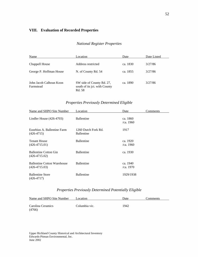
52
VIII. Evaluation of Recorded Properties
National Register Properties
Name Location Date Date Listed Chappell House Address restricted ca. 1830 3/27/86 George P. Hoffman House N. of County Rd. 54 ca. 1855 3/27/86 John Jacob Calhoun Koon SW side of County Rd. 27, ca. 1890 3/27/86 Farmstead south of its jct. with County
Rd. 58
Properties Previously Determined Eligible
Name and SHPO Site Number Location Date Comments Lindler House (426-4703) Ballentine ca. 1860
/ca. 1960 Eusebius A. Ballentine Farm 1260 Dutch Fork Rd. 1917 (426-4715) Ballentine Tenant House Ballentine ca. 1920 (426-4715.01) /ca. 1960 Ballentine Cotton Gin Ballentine ca. 1930 (426-4715.02) Ballentine Cotton Warehouse Ballentine ca. 1940 (426-4715.03) /ca. 1970 Ballentine Store Ballentine 1929/1938 (426-4717)
Properties Previously Determined Potentially Eligible
Name and SHPO Site Number Location Date Comments Carolina Ceramics Columbia vic. 1942 (4766)
Upper Richland County Historical and Architectural Inventory
Edwards-Pitman Environmental, Inc. June 2002

53
An Analysis of Upper Richland County’s Historic Architecture
I. Pre-1800 Architecture Architecture dating to the eighteenth century is rare in upper Richland County. Early dwellings in the area were typically unpretentious in both form and style. Because of an abundance of timber in the Sand Hills and Piedmont Plateau, early buildings were overwhelmingly simple, log, plank or crude frame structures. These dwellings typically featured an engaged or recessed porch, a climatic adaptation that allowed for the free movement of air into the interior.
Potentially Eligible Resources Two pre-1800 houses were identified during the survey, although it is likely that several others stand in the survey area. The Johannes Steven Eleazer House (4958.00) at Spring Hill is likely the earliest standing building in upper Richland County. This coastal plain cottage, which stands in good condition, is purported to date to ca. 1752, but additional research is needed to confirm this early date. Nevertheless, material evidence suggests the house likely predates 1800. The Eleazer house served as a tavern on the stage road that led from Columbia to Asheville. The Stephen Smith Jr. House (4896), a late eighteenth century plank house, stands in fair condition in the Cedar Creek community. Although the rear shed is partially collapsed, the house remains sound. II. Pre-Civil War Architecture Upper Richland County’s architecture evolved in the early nineteenth century. As the eighteenth century progressed into the early antebellum period, carpenters’ and builders’ sense of technique, form and fashion advanced. Central-passage plans began to replace hall-parlor plans, moldings became more detailed and mantels reflected styles found in pattern books of the period. These dwellings also mirrored the maturation of the local agricultural economy. The Federal and Greek Revival styles and vernacular adaptations of the styles gained popularity among well-to-do farmers and an emerging planter class who built houses that reflected their their standing in society and the confidence they had in the land and the wealth it could produce. Middling farmers built in the traditional cottage plain cottage form—a style that would endure into the early twentieth century. Just as dwellings from the first half of the nineteenth century showed the emergence of more sophisticated styles, churches were built in similar fashions. The Greek Revival influence was seen in country churches throughout upper Richland County.
Upper Richland County Historical and Architectural Inventory Edwards-Pitman Environmental, Inc. June 2002
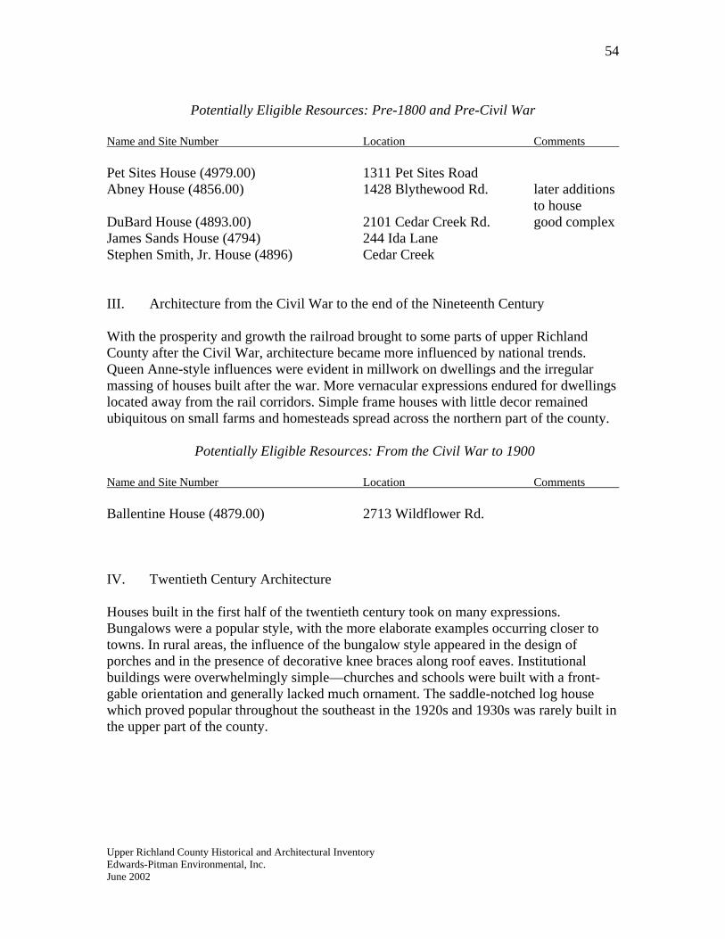
54
Potentially Eligible Resources: Pre-1800 and Pre-Civil War
Name and Site Number Location Comments
Pet Sites House (4979.00) 1311 Pet Sites Road Abney House (4856.00) 1428 Blythewood Rd. later additions to house DuBard House (4893.00) 2101 Cedar Creek Rd. good complex James Sands House (4794) 244 Ida Lane Stephen Smith, Jr. House (4896) Cedar Creek III. Architecture from the Civil War to the end of the Nineteenth Century With the prosperity and growth the railroad brought to some parts of upper Richland County after the Civil War, architecture became more influenced by national trends. Queen Anne-style influences were evident in millwork on dwellings and the irregular massing of houses built after the war. More vernacular expressions endured for dwellings located away from the rail corridors. Simple frame houses with little decor remained ubiquitous on small farms and homesteads spread across the northern part of the county.
Potentially Eligible Resources: From the Civil War to 1900
Name and Site Number Location Comments Ballentine House (4879.00) 2713 Wildflower Rd. IV. Twentieth Century Architecture Houses built in the first half of the twentieth century took on many expressions. Bungalows were a popular style, with the more elaborate examples occurring closer to towns. In rural areas, the influence of the bungalow style appeared in the design of porches and in the presence of decorative knee braces along roof eaves. Institutional buildings were overwhelmingly simple—churches and schools were built with a front-gable orientation and generally lacked much ornament. The saddle-notched log house which proved popular throughout the southeast in the 1920s and 1930s was rarely built in the upper part of the county.
Upper Richland County Historical and Architectural Inventory
Edwards-Pitman Environmental, Inc. June 2002
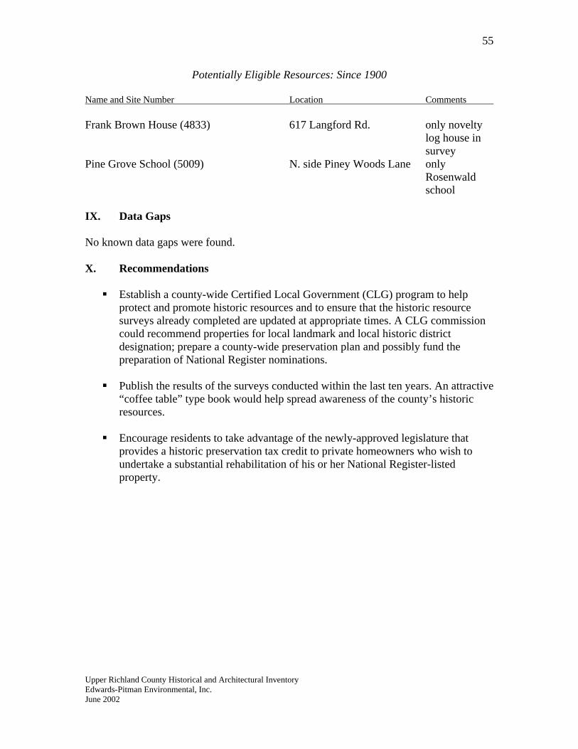
55
Potentially Eligible Resources: Since 1900
Name and Site Number Location Comments Frank Brown House (4833) 617 Langford Rd. only novelty
log house in survey
Pine Grove School (5009) N. side Piney Woods Lane only Rosenwald school IX. Data Gaps No known data gaps were found. X. Recommendations Establish a county-wide Certified Local Government (CLG) program to help
protect and promote historic resources and to ensure that the historic resource surveys already completed are updated at appropriate times. A CLG commission could recommend properties for local landmark and local historic district designation; prepare a county-wide preservation plan and possibly fund the preparation of National Register nominations.
Publish the results of the surveys conducted within the last ten years. An attractive
“coffee table” type book would help spread awareness of the county’s historic resources.
Encourage residents to take advantage of the newly-approved legislature that
provides a historic preservation tax credit to private homeowners who wish to undertake a substantial rehabilitation of his or her National Register-listed property.
Upper Richland County Historical and Architectural Inventory Edwards-Pitman Environmental, Inc. June 2002
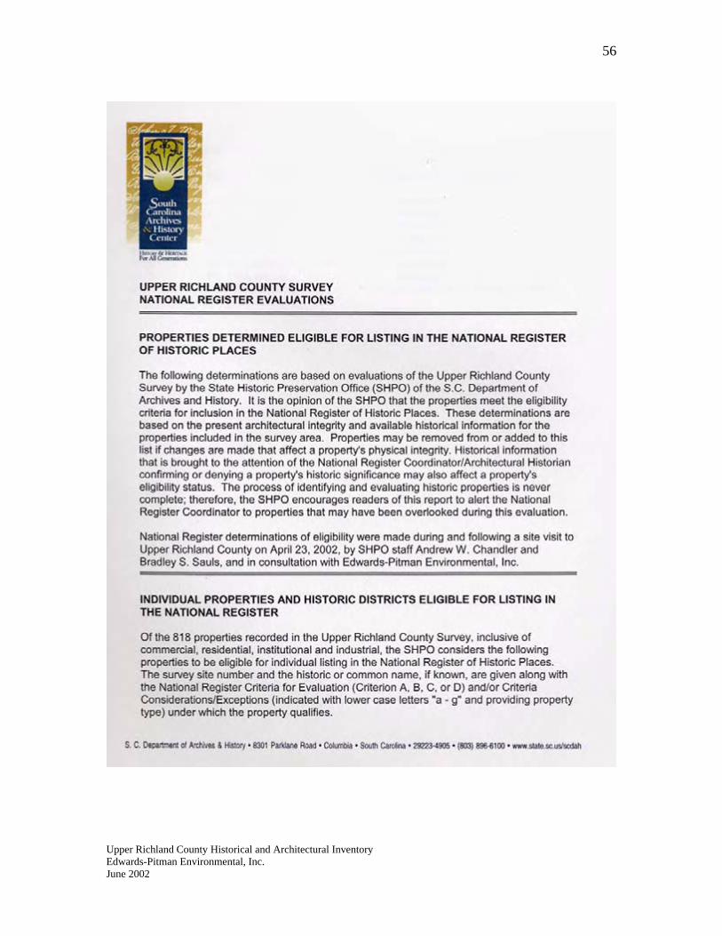
56
Upper Richland County Historical and Architectural Inventory Edwards-Pitman Environmental, Inc. June 2002
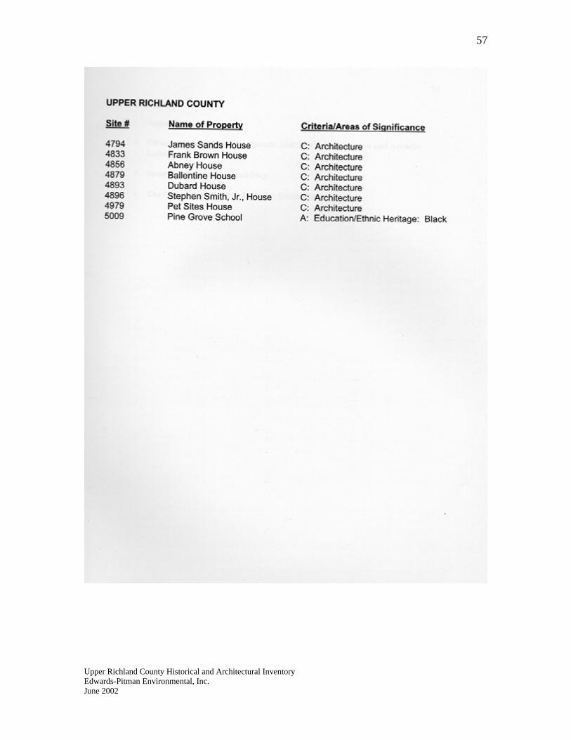
57
Upper Richland County Historical and Architectural Inventory Edwards-Pitman Environmental, Inc. June 2002
58
X. Appendices Observations on Potential Historic Districts in Forest Acres and Arcadia
Lakes Inventory Report by Quad Map
The National Register Criteria for Evaluation
Upper Richland County Historical and Architectural Inventory Edwards-Pitman Environmental, Inc. June 2002
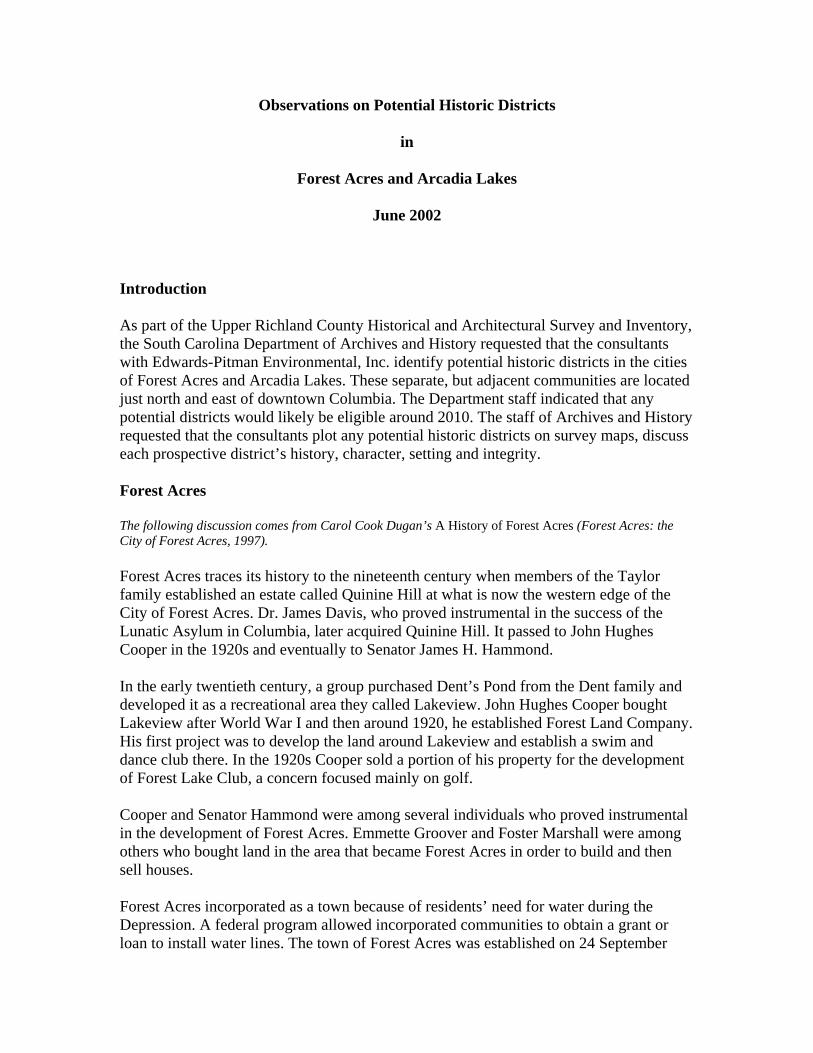
Observations on Potential Historic Districts
in
Forest Acres and Arcadia Lakes
June 2002
Introduction As part of the Upper Richland County Historical and Architectural Survey and Inventory, the South Carolina Department of Archives and History requested that the consultants with Edwards-Pitman Environmental, Inc. identify potential historic districts in the cities of Forest Acres and Arcadia Lakes. These separate, but adjacent communities are located just north and east of downtown Columbia. The Department staff indicated that any potential districts would likely be eligible around 2010. The staff of Archives and History requested that the consultants plot any potential historic districts on survey maps, discuss each prospective district’s history, character, setting and integrity. Forest Acres The following discussion comes from Carol Cook Dugan’s A History of Forest Acres (Forest Acres: the City of Forest Acres, 1997). Forest Acres traces its history to the nineteenth century when members of the Taylor family established an estate called Quinine Hill at what is now the western edge of the City of Forest Acres. Dr. James Davis, who proved instrumental in the success of the Lunatic Asylum in Columbia, later acquired Quinine Hill. It passed to John Hughes Cooper in the 1920s and eventually to Senator James H. Hammond. In the early twentieth century, a group purchased Dent’s Pond from the Dent family and developed it as a recreational area they called Lakeview. John Hughes Cooper bought Lakeview after World War I and then around 1920, he established Forest Land Company. His first project was to develop the land around Lakeview and establish a swim and dance club there. In the 1920s Cooper sold a portion of his property for the development of Forest Lake Club, a concern focused mainly on golf. Cooper and Senator Hammond were among several individuals who proved instrumental in the development of Forest Acres. Emmette Groover and Foster Marshall were among others who bought land in the area that became Forest Acres in order to build and then sell houses. Forest Acres incorporated as a town because of residents’ need for water during the Depression. A federal program allowed incorporated communities to obtain a grant or loan to install water lines. The town of Forest Acres was established on 24 September
1935 with John Hughes Cooper as mayor. Eventually the town’s original boundaries expanded to the north. The town’s population exploded during the post-World War II era. In 1940, 323 people lived in Forest Acres. By 1950, the population had grown to 3,240. In 1970, the population stood at 6,808. By 1990, over seven thousand people lived in Forest Acres. Arcadia Lakes Arcadia Lakes was settled in the early twentieth century and became an incorporated community on 30 October 1959. In 1960, 316 residents lived in the town. By 1990 that number had grown to approximately 900. Arcadia Lakes occupies 2,228 acres. Recommendations In late October 2001, the consultants—using City of Columbia maps and a City of Forest Acres map—conducted an extensive windshield survey over a two-day period. They drove every street and road in both cities and photographed several outstanding examples of post-World War II domestic architecture. As a result of the survey, discussion with a few residents and research into the history of both cities, the consultants determined that potential historic districts could not be identified in either city. Several outstanding early and mid-twentieth century dwellings stand in each city. Forest Acres, especially, possesses some of the most distinct post-war modernist houses in central South Carolina. In addition, each city might potentially hold significance in the area of social history as an example of suburban communities that developed during the post-World War II period. However, the consultants concluded that the resources that might potentially contribute to the significance of a district were distributed in a manner that compromised a potential district’s continuity. In other words, potentially contributing resources are interspersed with much later houses thereby compromising a potential district’s integrity. From the consultant’s observations, it appears that the growth each community experienced from the 1960s to the present has compromised the qualities of feeling and association necessary for the formation of a historic district.
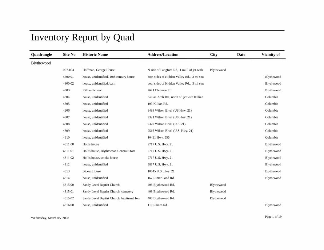
Inventory Report by QuadQuadrangle Site No Historic Name Address/Location City Date Vicinity of
Blythewood007-004 Hoffman, George House N side of Langford Rd, .1 mi E of jct with Blythewood
4800.01 house, unidentified, 19th century house both sides of Hidden Valley Rd., .3 mi sou Blythewood
4800.02 house, unidentified, barn both sides of Hidden Valley Rd., .3 mi sou Blythewood
4803 Killian School 2621 Clemson Rd. Blythewood
4804 house, unidentified Killian Arch Rd., north of jct with Killian Columbia
4805 house, unidentified 103 Killian Rd. Columbia
4806 house, unidentified 9499 Wilson Blvd. (US Hwy. 21) Columbia
4807 house, unidentified 9321 Wilson Blvd. (US Hwy. 21) Columbia
4808 house, unidentified 9320 Wilson Blvd. (U.S. 21) Columbia
4809 house, unidentified 9516 Wilson Blvd. (U.S. Hwy. 21) Columbia
4810 house, unidentified 10421 Hwy. 555 Columbia
4811.00 Hollis house 9717 U.S. Hwy. 21 Blythewood
4811.01 Hollis house, Blythewood General Store 9717 U.S. Hwy. 21 Blythewood
4811.02 Hollis house, smoke house 9717 U.S. Hwy. 21 Blythewood
4812 house, unidentified 9817 U.S. Hwy. 21 Blythewood
4813 Bloom House 10645 U.S. Hwy. 21 Blythewood
4814 house, unidentified 167 Rimer Pond Rd. Blythewood
4815.00 Sandy Level Baptist Church 408 Blythewood Rd. Blythewood
4815.01 Sandy Level Baptist Church, cemetery 408 Blythewood Rd. Blythewood
4815.02 Sandy Level Baptist Church, baptismal font 408 Blythewood Rd. Blythewood
4816.00 house, unidentified 110 Raines Rd. Blythewood
Wednesday, March 05, 2008 Page 1 of 19

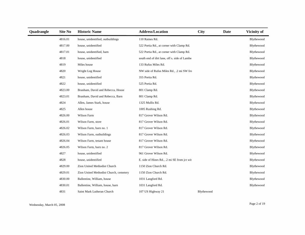
Quadrangle Site No Historic Name Address/Location City Date Vicinity of
4816.01 house, unidentified, outbuildings 110 Raines Rd. Blythewood
4817.00 house, unidentified 522 Portia Rd., at corner with Clamp Rd. Blythewood
4817.01 house, unidentified, barn 522 Portia Rd., at corner with Clamp Rd. Blythewood
4818 house, unidentified south end of dirt lane, off s. side of Lambe Blythewood
4819 Miles house 133 Rufus Miles Rd. Blythewood
4820 Wright Log House NW side of Rufus Miles Rd., .2 mi SW fro Blythewood
4821 house, unidentified 355 Portia Rd. Blythewood
4822 house, unidentified 525 Portia Rd. Blythewood
4823.00 Branham, David and Rebecca, House 801 Clamp Rd. Blythewood
4823.01 Branham, David and Rebecca, Barn 801 Clamp Rd. Blythewood
4824 Allen, James Stark, house 1325 Mullis Rd. Blythewood
4825 Allen house 1005 Rushing Rd. Blythewood
4826.00 Wilson Farm 817 Grover Wilson Rd. Blythewood
4826.01 Wilson Farm, store 817 Grover Wilson Rd. Blythewood
4826.02 Wilson Farm, barn no. 1 817 Grover Wilson Rd. Blythewood
4826.03 Wilson Farm, outbuildings 817 Grover Wilson Rd. Blythewood
4826.04 Wilson Farm, tenant house 817 Grover Wilson Rd. Blythewood
4826.05 Wilson Farm, barn no. 2 817 Grover Wilson Rd. Blythewood
4827 house, unidentified 961 Grover Wilson Rd. Blythewood
4828 house, unidentified E. side of Hines Rd., .2 mi SE from jct wit Blythewood
4829.00 Zion United Methodist Church 1150 Zion Church Rd. Blythewood
4829.01 Zion United Methodist Church, cemetery 1150 Zion Church Rd. Blythewood
4830.00 Ballentine, William, house 1031 Langford Rd. Blythewood
4830.01 Ballentine, William, house, barn 1031 Langford Rd. Blythewood
4831 Saint Mark Lutheran Church 107 US Highway 21 Blythewood
Wednesday, March 05, 2008 Page 2 of 19

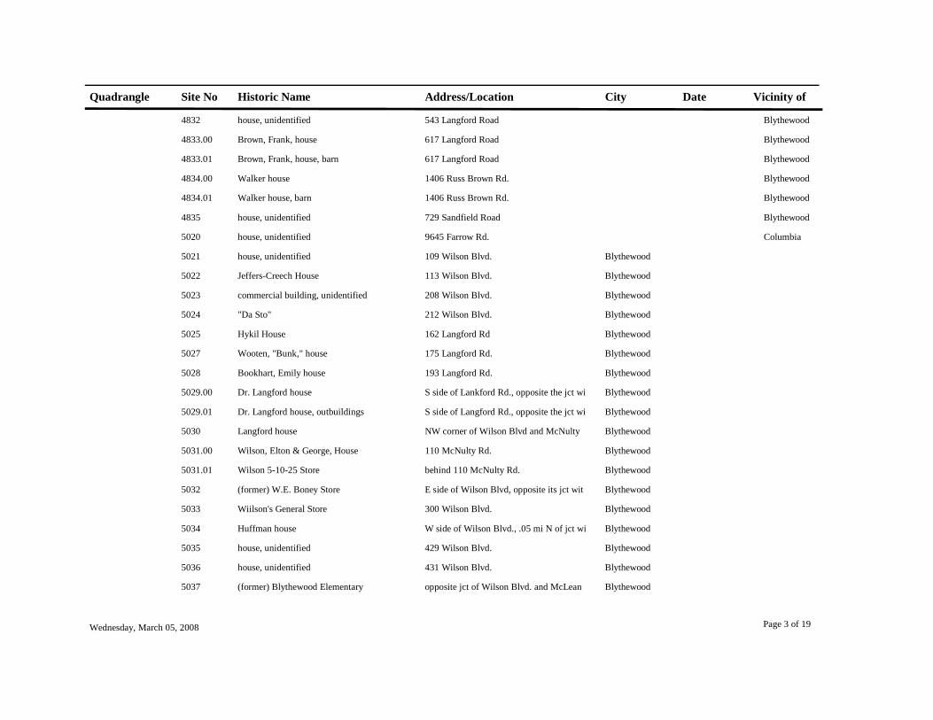
Quadrangle Site No Historic Name Address/Location City Date Vicinity of
4832 house, unidentified 543 Langford Road Blythewood
4833.00 Brown, Frank, house 617 Langford Road Blythewood
4833.01 Brown, Frank, house, barn 617 Langford Road Blythewood
4834.00 Walker house 1406 Russ Brown Rd. Blythewood
4834.01 Walker house, barn 1406 Russ Brown Rd. Blythewood
4835 house, unidentified 729 Sandfield Road Blythewood
5020 house, unidentified 9645 Farrow Rd. Columbia
5021 house, unidentified 109 Wilson Blvd. Blythewood
5022 Jeffers-Creech House 113 Wilson Blvd. Blythewood
5023 commercial building, unidentified 208 Wilson Blvd. Blythewood
5024 "Da Sto" 212 Wilson Blvd. Blythewood
5025 Hykil House 162 Langford Rd Blythewood
5027 Wooten, "Bunk," house 175 Langford Rd. Blythewood
5028 Bookhart, Emily house 193 Langford Rd. Blythewood
5029.00 Dr. Langford house S side of Lankford Rd., opposite the jct wi Blythewood
5029.01 Dr. Langford house, outbuildings S side of Langford Rd., opposite the jct wi Blythewood
5030 Langford house NW corner of Wilson Blvd and McNulty Blythewood
5031.00 Wilson, Elton & George, House 110 McNulty Rd. Blythewood
5031.01 Wilson 5-10-25 Store behind 110 McNulty Rd. Blythewood
5032 (former) W.E. Boney Store E side of Wilson Blvd, opposite its jct wit Blythewood
5033 Wiilson's General Store 300 Wilson Blvd. Blythewood
5034 Huffman house W side of Wilson Blvd., .05 mi N of jct wi Blythewood
5035 house, unidentified 429 Wilson Blvd. Blythewood
5036 house, unidentified 431 Wilson Blvd. Blythewood
5037 (former) Blythewood Elementary opposite jct of Wilson Blvd. and McLean Blythewood
Wednesday, March 05, 2008 Page 3 of 19

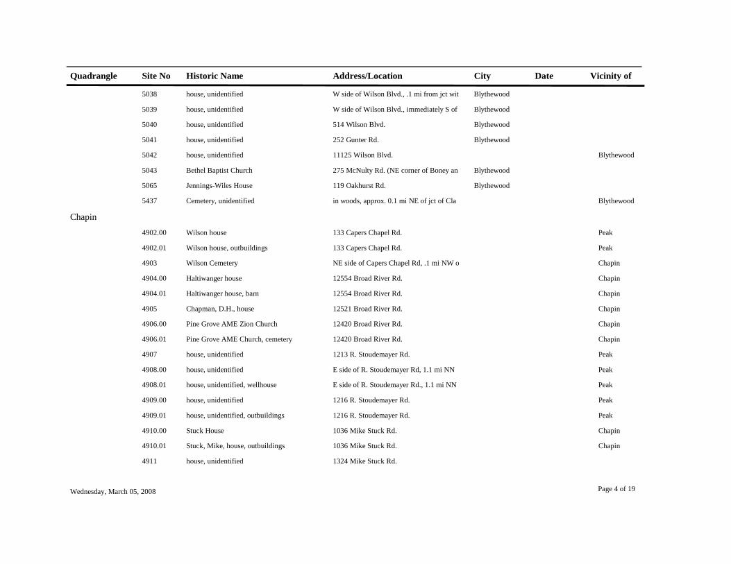
Quadrangle Site No Historic Name Address/Location City Date Vicinity of
5038 house, unidentified W side of Wilson Blvd., .1 mi from jct wit Blythewood
5039 house, unidentified W side of Wilson Blvd., immediately S of Blythewood
5040 house, unidentified 514 Wilson Blvd. Blythewood
5041 house, unidentified 252 Gunter Rd. Blythewood
5042 house, unidentified 11125 Wilson Blvd. Blythewood
5043 Bethel Baptist Church 275 McNulty Rd. (NE corner of Boney an Blythewood
5065 Jennings-Wiles House 119 Oakhurst Rd. Blythewood
5437 Cemetery, unidentified in woods, approx. 0.1 mi NE of jct of Cla Blythewood
Chapin4902.00 Wilson house 133 Capers Chapel Rd. Peak
4902.01 Wilson house, outbuildings 133 Capers Chapel Rd. Peak
4903 Wilson Cemetery NE side of Capers Chapel Rd, .1 mi NW o Chapin
4904.00 Haltiwanger house 12554 Broad River Rd. Chapin
4904.01 Haltiwanger house, barn 12554 Broad River Rd. Chapin
4905 Chapman, D.H., house 12521 Broad River Rd. Chapin
4906.00 Pine Grove AME Zion Church 12420 Broad River Rd. Chapin
4906.01 Pine Grove AME Church, cemetery 12420 Broad River Rd. Chapin
4907 house, unidentified 1213 R. Stoudemayer Rd. Peak
4908.00 house, unidentified E side of R. Stoudemayer Rd, 1.1 mi NN Peak
4908.01 house, unidentified, wellhouse E side of R. Stoudemayer Rd., 1.1 mi NN Peak
4909.00 house, unidentified 1216 R. Stoudemayer Rd. Peak
4909.01 house, unidentified, outbuildings 1216 R. Stoudemayer Rd. Peak
4910.00 Stuck House 1036 Mike Stuck Rd. Chapin
4910.01 Stuck, Mike, house, outbuildings 1036 Mike Stuck Rd. Chapin
4911 house, unidentified 1324 Mike Stuck Rd.
Wednesday, March 05, 2008 Page 4 of 19

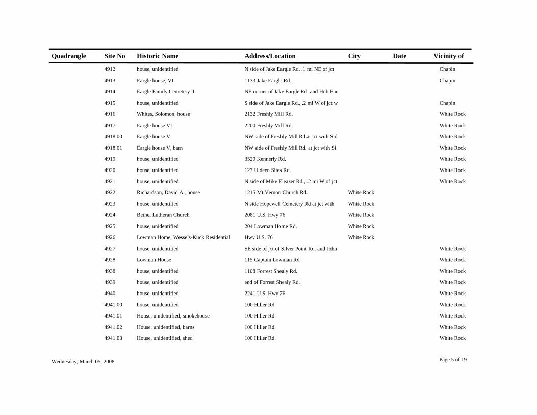
Quadrangle Site No Historic Name Address/Location City Date Vicinity of
4912 house, unidentified N side of Jake Eargle Rd, .1 mi NE of jct Chapin
4913 Eargle house, VII 1133 Jake Eargle Rd. Chapin
4914 Eargle Family Cemetery II NE corner of Jake Eargle Rd. and Hub Ear
4915 house, unidentified S side of Jake Eargle Rd., .2 mi W of jct w Chapin
4916 Whites, Solomon, house 2132 Freshly Mill Rd. White Rock
4917 Eargle house VI 2200 Freshly Mill Rd. White Rock
4918.00 Eargle house V NW side of Freshly Mill Rd at jct with Sid White Rock
4918.01 Eargle house V, barn NW side of Freshly Mill Rd. at jct with Si White Rock
4919 house, unidentified 3529 Kennerly Rd. White Rock
4920 house, unidentified 127 Uldeen Sites Rd. White Rock
4921 house, unidentified N side of Mike Eleazer Rd., .2 mi W of jct White Rock
4922 Richardson, David A., house 1215 Mt Vernon Church Rd. White Rock
4923 house, unidentified N side Hopewell Cemetery Rd at jct with White Rock
4924 Bethel Lutheran Church 2081 U.S. Hwy 76 White Rock
4925 house, unidentified 204 Lowman Home Rd. White Rock
4926 Lowman Home, Wessels-Kuck Residential Hwy U.S. 76 White Rock
4927 house, unidentified SE side of jct of Silver Point Rd. and John White Rock
4928 Lowman House 115 Captain Lowman Rd. White Rock
4938 house, unidentified 1108 Forrest Shealy Rd. White Rock
4939 house, unidentified end of Forrest Shealy Rd. White Rock
4940 house, unidentified 2241 U.S. Hwy 76 White Rock
4941.00 house, unidentified 100 Hiller Rd. White Rock
4941.01 House, unidentified, smokehouse 100 Hiller Rd. White Rock
4941.02 House, unidentified, barns 100 Hiller Rd. White Rock
4941.03 House, unidentified, shed 100 Hiller Rd. White Rock
Wednesday, March 05, 2008 Page 5 of 19

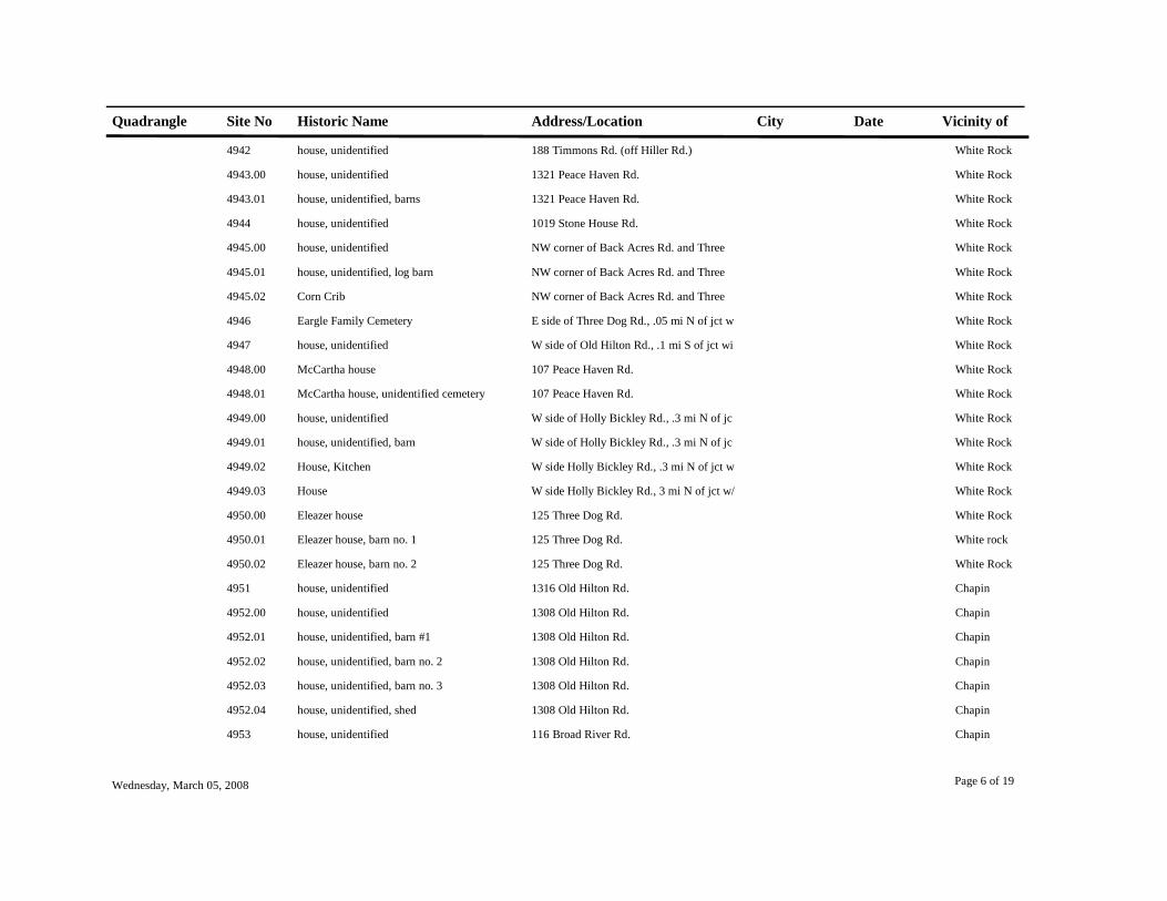
Quadrangle Site No Historic Name Address/Location City Date Vicinity of
4942 house, unidentified 188 Timmons Rd. (off Hiller Rd.) White Rock
4943.00 house, unidentified 1321 Peace Haven Rd. White Rock
4943.01 house, unidentified, barns 1321 Peace Haven Rd. White Rock
4944 house, unidentified 1019 Stone House Rd. White Rock
4945.00 house, unidentified NW corner of Back Acres Rd. and Three White Rock
4945.01 house, unidentified, log barn NW corner of Back Acres Rd. and Three White Rock
4945.02 Corn Crib NW corner of Back Acres Rd. and Three White Rock
4946 Eargle Family Cemetery E side of Three Dog Rd., .05 mi N of jct w White Rock
4947 house, unidentified W side of Old Hilton Rd., .1 mi S of jct wi White Rock
4948.00 McCartha house 107 Peace Haven Rd. White Rock
4948.01 McCartha house, unidentified cemetery 107 Peace Haven Rd. White Rock
4949.00 house, unidentified W side of Holly Bickley Rd., .3 mi N of jc White Rock
4949.01 house, unidentified, barn W side of Holly Bickley Rd., .3 mi N of jc White Rock
4949.02 House, Kitchen W side Holly Bickley Rd., .3 mi N of jct w White Rock
4949.03 House W side Holly Bickley Rd., 3 mi N of jct w/ White Rock
4950.00 Eleazer house 125 Three Dog Rd. White Rock
4950.01 Eleazer house, barn no. 1 125 Three Dog Rd. White rock
4950.02 Eleazer house, barn no. 2 125 Three Dog Rd. White Rock
4951 house, unidentified 1316 Old Hilton Rd. Chapin
4952.00 house, unidentified 1308 Old Hilton Rd. Chapin
4952.01 house, unidentified, barn #1 1308 Old Hilton Rd. Chapin
4952.02 house, unidentified, barn no. 2 1308 Old Hilton Rd. Chapin
4952.03 house, unidentified, barn no. 3 1308 Old Hilton Rd. Chapin
4952.04 house, unidentified, shed 1308 Old Hilton Rd. Chapin
4953 house, unidentified 116 Broad River Rd. Chapin
Wednesday, March 05, 2008 Page 6 of 19

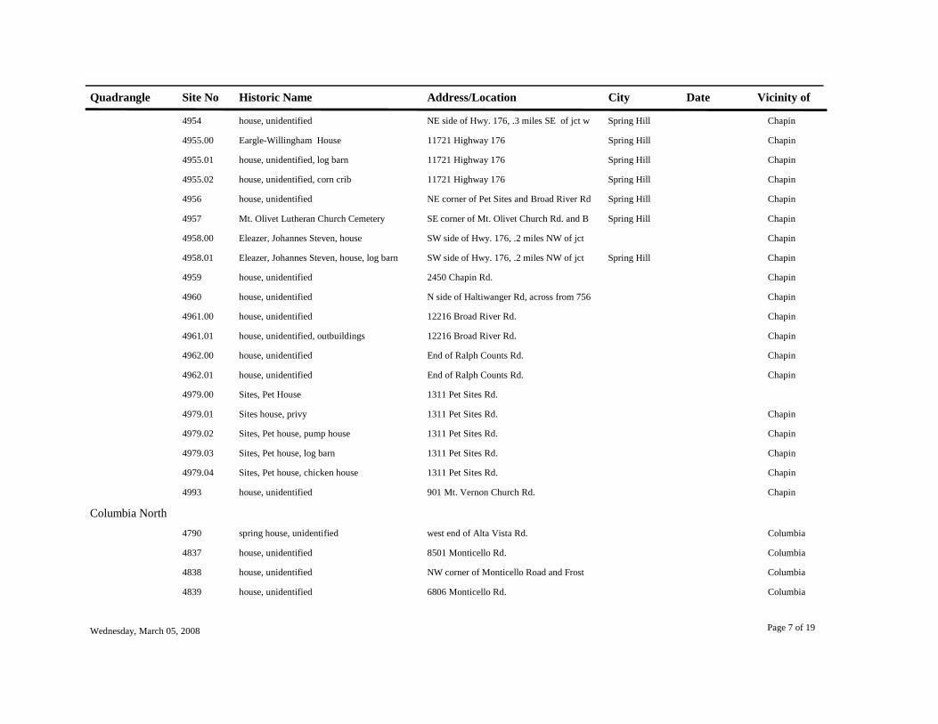
Quadrangle Site No Historic Name Address/Location City Date Vicinity of
4954 house, unidentified NE side of Hwy. 176, .3 miles SE of jct w Spring Hill Chapin
4955.00 Eargle-Willingham House 11721 Highway 176 Spring Hill Chapin
4955.01 house, unidentified, log barn 11721 Highway 176 Spring Hill Chapin
4955.02 house, unidentified, corn crib 11721 Highway 176 Spring Hill Chapin
4956 house, unidentified NE corner of Pet Sites and Broad River Rd Spring Hill Chapin
4957 Mt. Olivet Lutheran Church Cemetery SE corner of Mt. Olivet Church Rd. and B Spring Hill Chapin
4958.00 Eleazer, Johannes Steven, house SW side of Hwy. 176, .2 miles NW of jct Chapin
4958.01 Eleazer, Johannes Steven, house, log barn SW side of Hwy. 176, .2 miles NW of jct Spring Hill Chapin
4959 house, unidentified 2450 Chapin Rd. Chapin
4960 house, unidentified N side of Haltiwanger Rd, across from 756 Chapin
4961.00 house, unidentified 12216 Broad River Rd. Chapin
4961.01 house, unidentified, outbuildings 12216 Broad River Rd. Chapin
4962.00 house, unidentified End of Ralph Counts Rd. Chapin
4962.01 house, unidentified End of Ralph Counts Rd. Chapin
4979.00 Sites, Pet House 1311 Pet Sites Rd.
4979.01 Sites house, privy 1311 Pet Sites Rd. Chapin
4979.02 Sites, Pet house, pump house 1311 Pet Sites Rd. Chapin
4979.03 Sites, Pet house, log barn 1311 Pet Sites Rd. Chapin
4979.04 Sites, Pet house, chicken house 1311 Pet Sites Rd. Chapin
4993 house, unidentified 901 Mt. Vernon Church Rd. Chapin
Columbia North4790 spring house, unidentified west end of Alta Vista Rd. Columbia
4837 house, unidentified 8501 Monticello Rd. Columbia
4838 house, unidentified NW corner of Monticello Road and Frost Columbia
4839 house, unidentified 6806 Monticello Rd. Columbia
Wednesday, March 05, 2008 Page 7 of 19

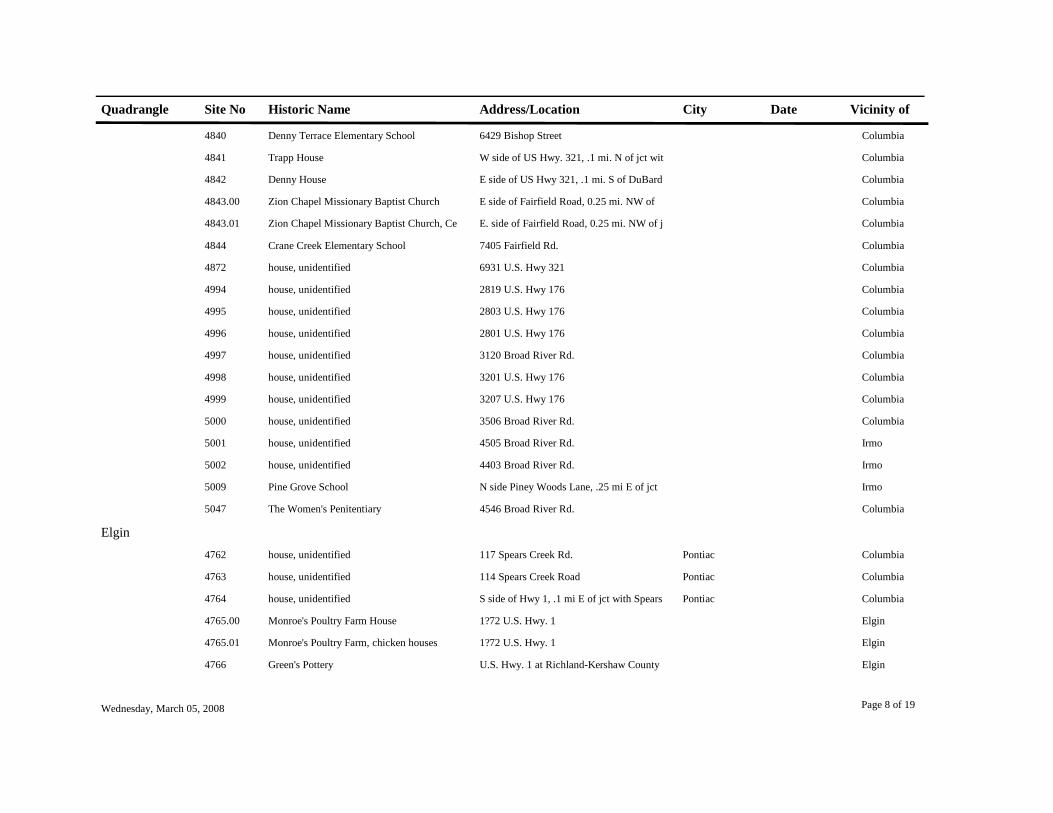
Quadrangle Site No Historic Name Address/Location City Date Vicinity of
4840 Denny Terrace Elementary School 6429 Bishop Street Columbia
4841 Trapp House W side of US Hwy. 321, .1 mi. N of jct wit Columbia
4842 Denny House E side of US Hwy 321, .1 mi. S of DuBard Columbia
4843.00 Zion Chapel Missionary Baptist Church E side of Fairfield Road, 0.25 mi. NW of Columbia
4843.01 Zion Chapel Missionary Baptist Church, Ce E. side of Fairfield Road, 0.25 mi. NW of j Columbia
4844 Crane Creek Elementary School 7405 Fairfield Rd. Columbia
4872 house, unidentified 6931 U.S. Hwy 321 Columbia
4994 house, unidentified 2819 U.S. Hwy 176 Columbia
4995 house, unidentified 2803 U.S. Hwy 176 Columbia
4996 house, unidentified 2801 U.S. Hwy 176 Columbia
4997 house, unidentified 3120 Broad River Rd. Columbia
4998 house, unidentified 3201 U.S. Hwy 176 Columbia
4999 house, unidentified 3207 U.S. Hwy 176 Columbia
5000 house, unidentified 3506 Broad River Rd. Columbia
5001 house, unidentified 4505 Broad River Rd. Irmo
5002 house, unidentified 4403 Broad River Rd. Irmo
5009 Pine Grove School N side Piney Woods Lane, .25 mi E of jct Irmo
5047 The Women's Penitentiary 4546 Broad River Rd. Columbia
Elgin4762 house, unidentified 117 Spears Creek Rd. Pontiac Columbia
4763 house, unidentified 114 Spears Creek Road Pontiac Columbia
4764 house, unidentified S side of Hwy 1, .1 mi E of jct with Spears Pontiac Columbia
4765.00 Monroe's Poultry Farm House 1?72 U.S. Hwy. 1 Elgin
4765.01 Monroe's Poultry Farm, chicken houses 1?72 U.S. Hwy. 1 Elgin
4766 Green's Pottery U.S. Hwy. 1 at Richland-Kershaw County Elgin
Wednesday, March 05, 2008 Page 8 of 19

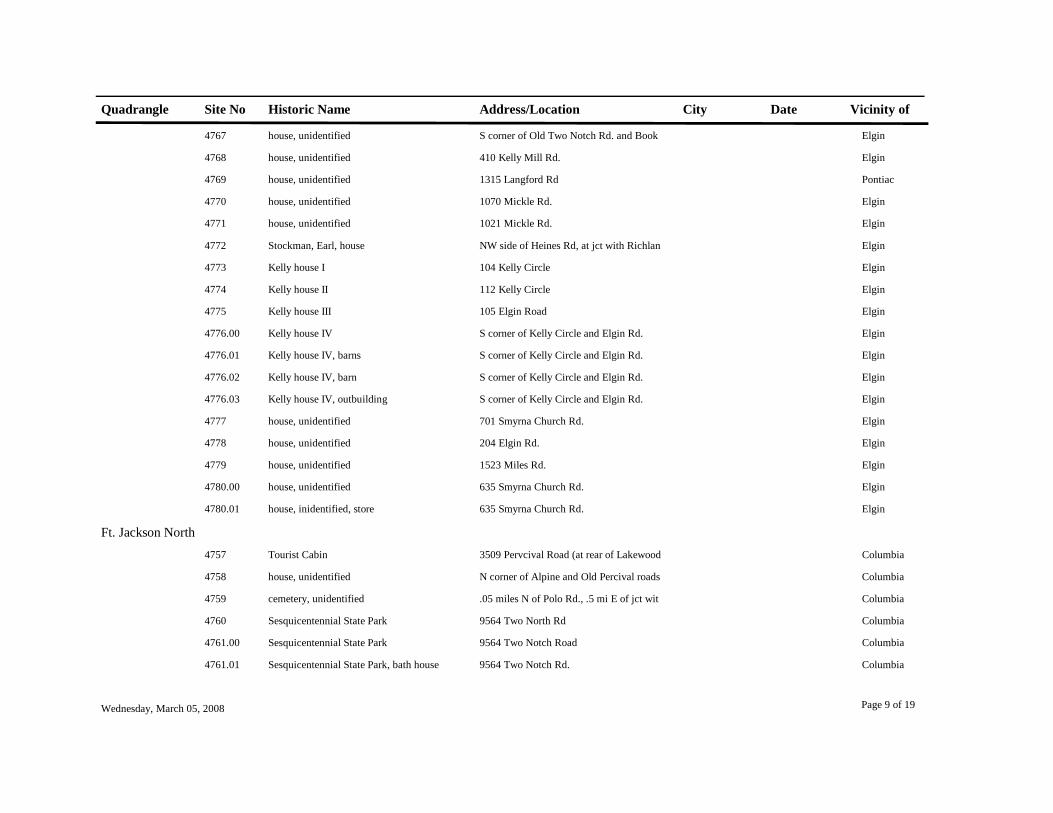
Quadrangle Site No Historic Name Address/Location City Date Vicinity of
4767 house, unidentified S corner of Old Two Notch Rd. and Book Elgin
4768 house, unidentified 410 Kelly Mill Rd. Elgin
4769 house, unidentified 1315 Langford Rd Pontiac
4770 house, unidentified 1070 Mickle Rd. Elgin
4771 house, unidentified 1021 Mickle Rd. Elgin
4772 Stockman, Earl, house NW side of Heines Rd, at jct with Richlan Elgin
4773 Kelly house I 104 Kelly Circle Elgin
4774 Kelly house II 112 Kelly Circle Elgin
4775 Kelly house III 105 Elgin Road Elgin
4776.00 Kelly house IV S corner of Kelly Circle and Elgin Rd. Elgin
4776.01 Kelly house IV, barns S corner of Kelly Circle and Elgin Rd. Elgin
4776.02 Kelly house IV, barn S corner of Kelly Circle and Elgin Rd. Elgin
4776.03 Kelly house IV, outbuilding S corner of Kelly Circle and Elgin Rd. Elgin
4777 house, unidentified 701 Smyrna Church Rd. Elgin
4778 house, unidentified 204 Elgin Rd. Elgin
4779 house, unidentified 1523 Miles Rd. Elgin
4780.00 house, unidentified 635 Smyrna Church Rd. Elgin
4780.01 house, inidentified, store 635 Smyrna Church Rd. Elgin
Ft. Jackson North4757 Tourist Cabin 3509 Pervcival Road (at rear of Lakewood Columbia
4758 house, unidentified N corner of Alpine and Old Percival roads Columbia
4759 cemetery, unidentified .05 miles N of Polo Rd., .5 mi E of jct wit Columbia
4760 Sesquicentennial State Park 9564 Two North Rd Columbia
4761.00 Sesquicentennial State Park 9564 Two Notch Road Columbia
4761.01 Sesquicentennial State Park, bath house 9564 Two Notch Rd. Columbia
Wednesday, March 05, 2008 Page 9 of 19

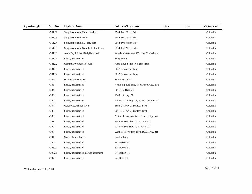
Quadrangle Site No Historic Name Address/Location City Date Vicinity of
4761.02 Sesquicentennial Picnic Shelter 9564 Two Notch Rd. Columbia
4761.03 Sesquicentennial Pond 9564 Two Notch Rd. Columbia
4761.04 Sesquicentennial St. Park, dam 9564 Two Notch Rd. Columbia
4761.05 Sesquicentennial State Park, fire tower 9564 Two Notch Rd. Columbia
4781.00 Anna Boyd School Neighborhood W side of state hwy 555, N of Crafts-Farro Columbia
4781.01 house, unidentified Terry Drive Columbia
4781.02 Community Church of God Anna Boyd School Neighborhood Columbia
4781.03 house, unidentified 8037 Brookmont Lane Columbia
4781.04 house, unidentified 8052 Brookmont Lane Columbia
4782 schools, unidentified 19 Beckman Rd. Columbia
4783 house, unidentified N end of paved lane, W of Farrow Rd., nea Columbia
4784 house, unidentified 7601 US Hwy. 21 Columbia
4785 house, unidentified 7949 US Hwy. 21 Columbia
4786 house, unidentified E side of US Hwy. 21, .05 N of jct with N Columbia
4787 warehouse, unidentified 8808 US Hwy 21 (Wilson Blvd.) Columbia
4788 house, unidentified 9001 US Hwy 21 (Wilson Blvd.) Columbia
4789 house, unidentified N side of Boylston Rd, .15 mi. E of jct wit Columbia
4791 house, unidentified 2903 Wilson Blvd. (U.S. Hwy. 21) Columbia
4792 house, unidentified 9153 Wilson Blvd. (U.S. Hwy. 21) Columbia
4793 house, unidentified West side of Wilson Blvd. (U.S. Hwy. 21), Columbia
4794 Sands, James, house 244 Ida Lane Columbia
4795 house, unidentified 261 Rabon Rd. Columbia
4796.00 house, unidentified 316 Rabon Rd. Columbia
4796.01 house, unidentified, garage apartment 346 Rabon Rd. Columbia
4797 house, unidentified 747 Ross Rd. Columbia
Wednesday, March 05, 2008 Page 10 of 19

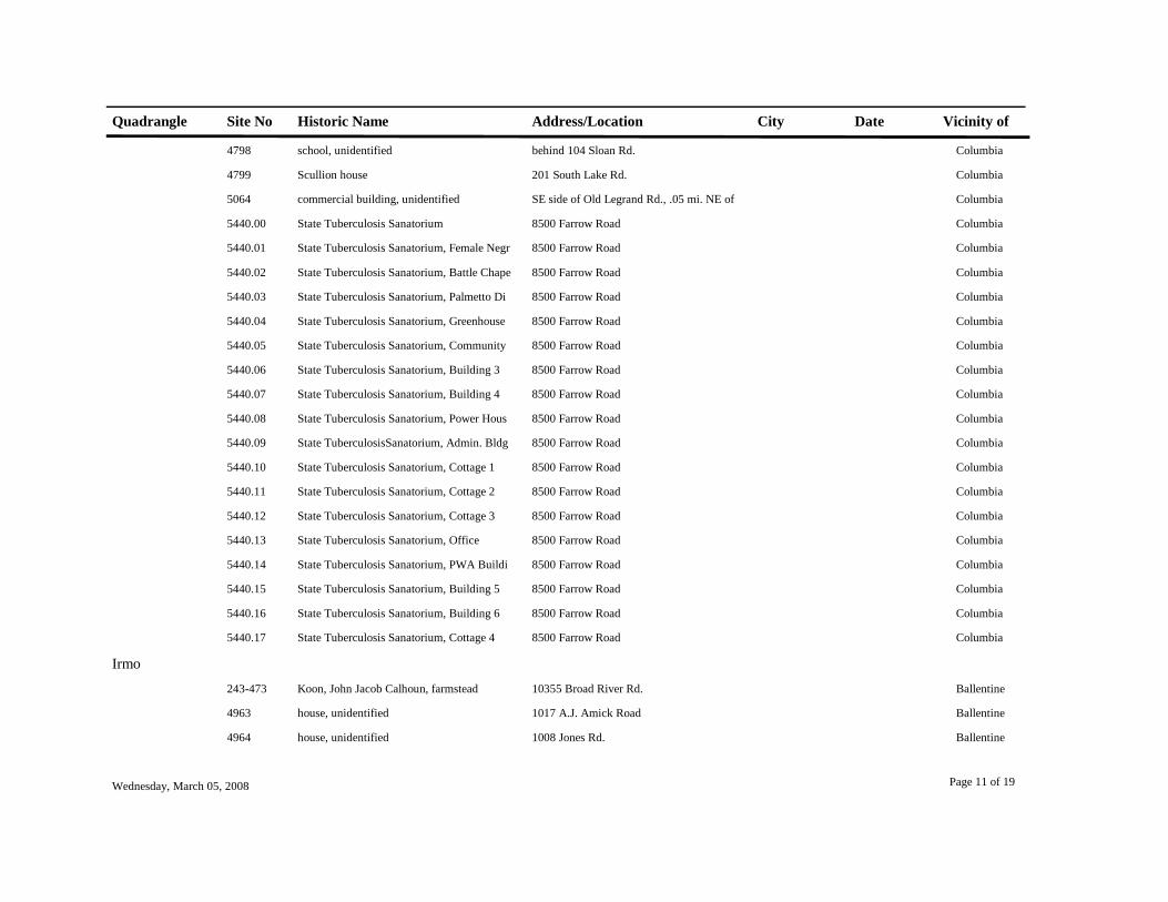
Quadrangle Site No Historic Name Address/Location City Date Vicinity of
4798 school, unidentified behind 104 Sloan Rd. Columbia
4799 Scullion house 201 South Lake Rd. Columbia
5064 commercial building, unidentified SE side of Old Legrand Rd., .05 mi. NE of Columbia
5440.00 State Tuberculosis Sanatorium 8500 Farrow Road Columbia
5440.01 State Tuberculosis Sanatorium, Female Negr 8500 Farrow Road Columbia
5440.02 State Tuberculosis Sanatorium, Battle Chape 8500 Farrow Road Columbia
5440.03 State Tuberculosis Sanatorium, Palmetto Di 8500 Farrow Road Columbia
5440.04 State Tuberculosis Sanatorium, Greenhouse 8500 Farrow Road Columbia
5440.05 State Tuberculosis Sanatorium, Community 8500 Farrow Road Columbia
5440.06 State Tuberculosis Sanatorium, Building 3 8500 Farrow Road Columbia
5440.07 State Tuberculosis Sanatorium, Building 4 8500 Farrow Road Columbia
5440.08 State Tuberculosis Sanatorium, Power Hous 8500 Farrow Road Columbia
5440.09 State TuberculosisSanatorium, Admin. Bldg 8500 Farrow Road Columbia
5440.10 State Tuberculosis Sanatorium, Cottage 1 8500 Farrow Road Columbia
5440.11 State Tuberculosis Sanatorium, Cottage 2 8500 Farrow Road Columbia
5440.12 State Tuberculosis Sanatorium, Cottage 3 8500 Farrow Road Columbia
5440.13 State Tuberculosis Sanatorium, Office 8500 Farrow Road Columbia
5440.14 State Tuberculosis Sanatorium, PWA Buildi 8500 Farrow Road Columbia
5440.15 State Tuberculosis Sanatorium, Building 5 8500 Farrow Road Columbia
5440.16 State Tuberculosis Sanatorium, Building 6 8500 Farrow Road Columbia
5440.17 State Tuberculosis Sanatorium, Cottage 4 8500 Farrow Road Columbia
Irmo243-473 Koon, John Jacob Calhoun, farmstead 10355 Broad River Rd. Ballentine
4963 house, unidentified 1017 A.J. Amick Road Ballentine
4964 house, unidentified 1008 Jones Rd. Ballentine
Wednesday, March 05, 2008 Page 11 of 19


Quadrangle Site No Historic Name Address/Location City Date Vicinity of
4969 house, unidentified S side US 76, just eat of Marina Rd. Ballentine
4970 Salem United Methodist Church 1321 Salem Church Rd. Ballentine
4971 house, unidentified end of Bauknight Rd. Ballentine
5003 house, unidentified 7200 Broad River Rd. Irmo
5004 house, unidentified 1364 Lykes Lane Irmo
5005 St. Paul AME Church 835 Kennerly Rd. Irmo
5006 house, unidentified 1556 Kennerly Rd. Irmo
5007 Bookman House SW side of Kennerly Rd., .1 mi NW of Sw Irmo
5008.00 fire tower, unidentified SE side Fire tower Rd., .1 mi from Wester Irmo
5008.01 fire tower, unidentified, keepers house SE side Fire tower Rd., .1 mi from Wester Irmo
5008.02 fire tower, unidentified, shed SE side Fire tower Rd., .1 mi from Wester Irmo
5010 house, unidentified 811 Piney Grove Rd. Irmo
5011 house, unidentified 8001 Broad River Rd. Irmo
5012 Bethlehem Lutheran Church 10000 Broad River Rd. Irmo
5013 house, unidentified 1028 James Ballentine Rd. Irmo
5014 Ballentine, Milford Store 1000 Dutch Fork Rd. Dutch Fork Irmo
5015 Ballentine, Milford, house S side of jct of U.S. Hwys 76 and 176 Dutch Fork Irmo
5016 house, unidentified 1011 Dutch Fork Rd. Ballentine
5017 Monts-Meetze house 3001 S.C. Hwy 6 Ballentine
5018 house, unidentified 1412 Farming Creek Rd. Ballentine
5019 Meetze, Ernest, house 1309 Farming Creek Rd. Ballentine
5044.00 Meetze, Fletcher, house 1112 Farming Creek Rd. Irmo
5044.01 Meetze, Fletcher, house, shoe shop 1112 Farming Creek Rd. Irmo
5044.02 Meetze, Fletcher, house, potato house 1112 Farming Creek Rd. Irmo
5044.03 Meetze, Fletcher, house, log house 1112 Farming Creek Rd. Irmo
Wednesday, March 05, 2008 Page 12 of 19

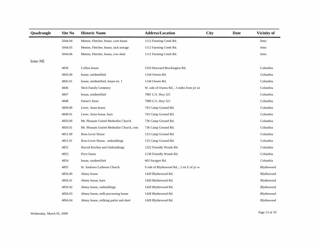
Quadrangle Site No Historic Name Address/Location City Date Vicinity of
5044.04 Meetze, Fletcher, house, corn house 1112 Farming Creek Rd. Irmo
5044.05 Meetze, Fletcher, house, tack storage 1112 Farming Creek Rd. Irmo
5044.06 Meetze, Fletcher, house, cow shed 1112 Farming Creek Rd. Irmo
Irmo NE4836 Collins house 2333 Heyward Brockington Rd. Columbia
4845.00 house, unidentified 1144 Owens Rd. Columbia
4845.01 house, unidentified, house no. 1 1144 Owens Rd. Columbia
4846 Slich Family Cemetery W. side of Owens Rd., .3 miles from jct wi Columbia
4847 house, unidentified 7881 U.S. Hwy 321 Columbia
4848 Fetner's Store 7989 U.S. Hwy 321 Columbia
4849.00 Lever, Anna house 743 Camp Ground Rd. Columbia
4849.01 Lever, Anna house, barn 743 Camp Ground Rd. Columbia
4850.00 Mt. Pleasant United Methodist Church 736 Camp Ground Rd. Columbia
4850.01 Mt. Pleasant United Methodist Church, cem 736 Camp Ground Rd. Columbia
4851.00 Ross-Lever House 133 Camp Ground Rd. Columbia
4851.01 Ross-Lever House, outbuildings 133 Camp Ground Rd. Columbia
4852 Havrid Kitchen and Outbuildings 1322 Friendly Woods Rd. Columbia
4853 Price house 1138 Friendly Woods Rd. Columbia
4854 house, unidentified 603 Swygert Rd. Columbia
4855 St. Andrews Lutheran Church S side of Blythewood Rd., .2 mi E of jct w Blythewood
4856.00 Abney house 1428 Blythewood Rd. Blythewood
4856.01 Abney house, barn 1428 Blythewood Rd. Blythewood
4856.02 Abney house, outbuildings 1428 Blythewood Rd. Blythewood
4856.03 Abney house, milk processing house 1428 Blythewood Rd. Blythewood
4856.04 Abney house, milking parlor and shed 1428 Blythewood Rd. Blythewood
Wednesday, March 05, 2008 Page 13 of 19

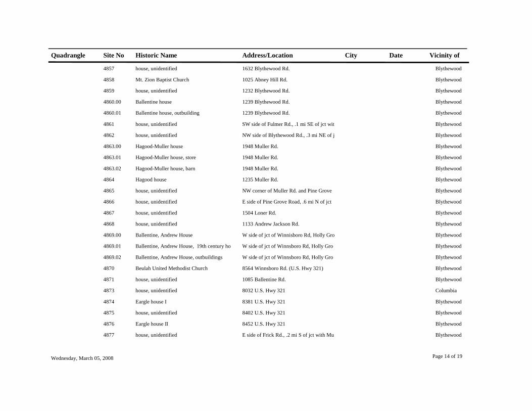
Quadrangle Site No Historic Name Address/Location City Date Vicinity of
4857 house, unidentified 1632 Blythewood Rd. Blythewood
4858 Mt. Zion Baptist Church 1025 Abney Hill Rd. Blythewood
4859 house, unidentified 1232 Blythewood Rd. Blythewood
4860.00 Ballentine house 1239 Blythewood Rd. Blythewood
4860.01 Ballentine house, outbuilding 1239 Blythewood Rd. Blythewood
4861 house, unidentified SW side of Fulmer Rd., .1 mi SE of jct wit Blythewood
4862 house, unidentified NW side of Blythewood Rd., .3 mi NE of j Blythewood
4863.00 Hagood-Muller house 1948 Muller Rd. Blythewood
4863.01 Hagood-Muller house, store 1948 Muller Rd. Blythewood
4863.02 Hagood-Muller house, barn 1948 Muller Rd. Blythewood
4864 Hagood house 1235 Muller Rd. Blythewood
4865 house, unidentified NW corner of Muller Rd. and Pine Grove Blythewood
4866 house, unidentified E side of Pine Grove Road, .6 mi N of jct Blythewood
4867 house, unidentified 1504 Loner Rd. Blythewood
4868 house, unidentified 1133 Andrew Jackson Rd. Blythewood
4869.00 Ballentine, Andrew House W side of jct of Winnisboro Rd, Holly Gro Blythewood
4869.01 Ballentine, Andrew House, 19th century ho W side of jct of Winnsboro Rd, Holly Gro Blythewood
4869.02 Ballentine, Andrew House, outbuildings W side of jct of Winnsboro Rd, Holly Gro Blythewood
4870 Beulah United Methodist Church 8564 Winnsboro Rd. (U.S. Hwy 321) Blythewood
4871 house, unidentified 1085 Ballentine Rd. Blythewood
4873 house, unidentified 8032 U.S. Hwy 321 Columbia
4874 Eargle house I 8381 U.S. Hwy 321 Blythewood
4875 house, unidentified 8402 U.S. Hwy 321 Blythewood
4876 Eargle house II 8452 U.S. Hwy 321 Blythewood
4877 house, unidentified E side of Frick Rd., .2 mi S of jct with Mu Blythewood
Wednesday, March 05, 2008 Page 14 of 19

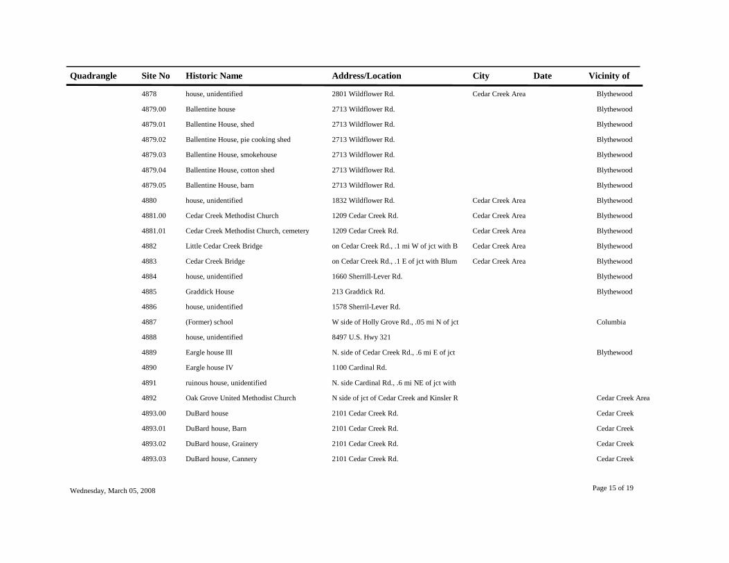
Quadrangle Site No Historic Name Address/Location City Date Vicinity of
4878 house, unidentified 2801 Wildflower Rd. Cedar Creek Area Blythewood
4879.00 Ballentine house 2713 Wildflower Rd. Blythewood
4879.01 Ballentine House, shed 2713 Wildflower Rd. Blythewood
4879.02 Ballentine House, pie cooking shed 2713 Wildflower Rd. Blythewood
4879.03 Ballentine House, smokehouse 2713 Wildflower Rd. Blythewood
4879.04 Ballentine House, cotton shed 2713 Wildflower Rd. Blythewood
4879.05 Ballentine House, barn 2713 Wildflower Rd. Blythewood
4880 house, unidentified 1832 Wildflower Rd. Cedar Creek Area Blythewood
4881.00 Cedar Creek Methodist Church 1209 Cedar Creek Rd. Cedar Creek Area Blythewood
4881.01 Cedar Creek Methodist Church, cemetery 1209 Cedar Creek Rd. Cedar Creek Area Blythewood
4882 Little Cedar Creek Bridge on Cedar Creek Rd., .1 mi W of jct with B Cedar Creek Area Blythewood
4883 Cedar Creek Bridge on Cedar Creek Rd., .1 E of jct with Blum Cedar Creek Area Blythewood
4884 house, unidentified 1660 Sherrill-Lever Rd. Blythewood
4885 Graddick House 213 Graddick Rd. Blythewood
4886 house, unidentified 1578 Sherril-Lever Rd.
4887 (Former) school W side of Holly Grove Rd., .05 mi N of jct Columbia
4888 house, unidentified 8497 U.S. Hwy 321
4889 Eargle house III N. side of Cedar Creek Rd., .6 mi E of jct Blythewood
4890 Eargle house IV 1100 Cardinal Rd.
4891 ruinous house, unidentified N. side Cardinal Rd., .6 mi NE of jct with
4892 Oak Grove United Methodist Church N side of jct of Cedar Creek and Kinsler R Cedar Creek Area
4893.00 DuBard house 2101 Cedar Creek Rd. Cedar Creek
4893.01 DuBard house, Barn 2101 Cedar Creek Rd. Cedar Creek
4893.02 DuBard house, Grainery 2101 Cedar Creek Rd. Cedar Creek
4893.03 DuBard house, Cannery 2101 Cedar Creek Rd. Cedar Creek
Wednesday, March 05, 2008 Page 15 of 19

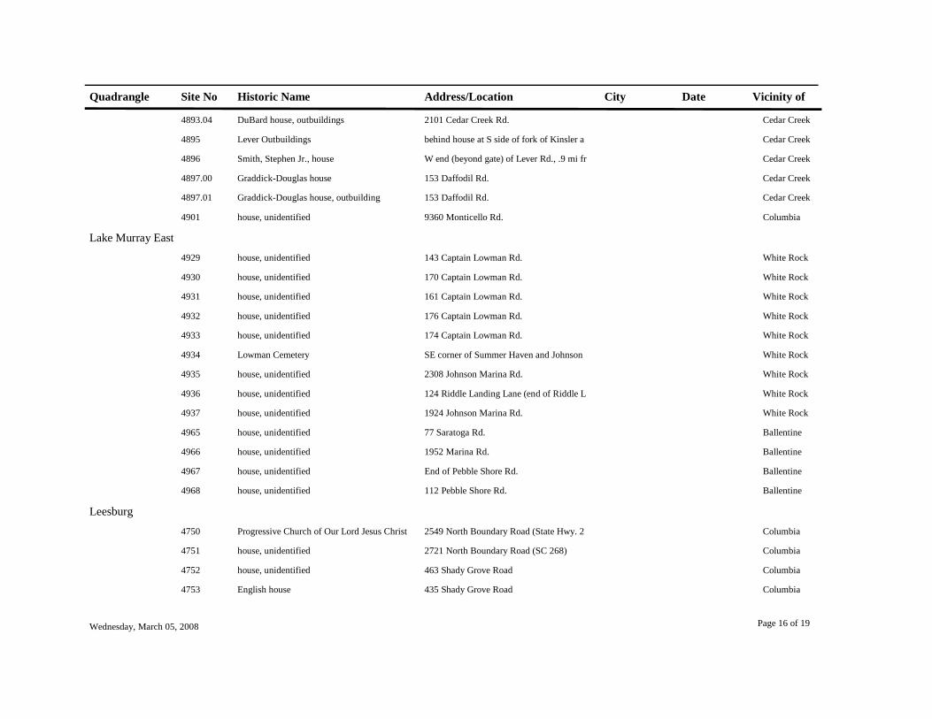
Quadrangle Site No Historic Name Address/Location City Date Vicinity of
4893.04 DuBard house, outbuildings 2101 Cedar Creek Rd. Cedar Creek
4895 Lever Outbuildings behind house at S side of fork of Kinsler a Cedar Creek
4896 Smith, Stephen Jr., house W end (beyond gate) of Lever Rd., .9 mi fr Cedar Creek
4897.00 Graddick-Douglas house 153 Daffodil Rd. Cedar Creek
4897.01 Graddick-Douglas house, outbuilding 153 Daffodil Rd. Cedar Creek
4901 house, unidentified 9360 Monticello Rd. Columbia
Lake Murray East4929 house, unidentified 143 Captain Lowman Rd. White Rock
4930 house, unidentified 170 Captain Lowman Rd. White Rock
4931 house, unidentified 161 Captain Lowman Rd. White Rock
4932 house, unidentified 176 Captain Lowman Rd. White Rock
4933 house, unidentified 174 Captain Lowman Rd. White Rock
4934 Lowman Cemetery SE corner of Summer Haven and Johnson White Rock
4935 house, unidentified 2308 Johnson Marina Rd. White Rock
4936 house, unidentified 124 Riddle Landing Lane (end of Riddle L White Rock
4937 house, unidentified 1924 Johnson Marina Rd. White Rock
4965 house, unidentified 77 Saratoga Rd. Ballentine
4966 house, unidentified 1952 Marina Rd. Ballentine
4967 house, unidentified End of Pebble Shore Rd. Ballentine
4968 house, unidentified 112 Pebble Shore Rd. Ballentine
Leesburg4750 Progressive Church of Our Lord Jesus Christ 2549 North Boundary Road (State Hwy. 2 Columbia
4751 house, unidentified 2721 North Boundary Road (SC 268) Columbia
4752 house, unidentified 463 Shady Grove Road Columbia
4753 English house 435 Shady Grove Road Columbia
Wednesday, March 05, 2008 Page 16 of 19

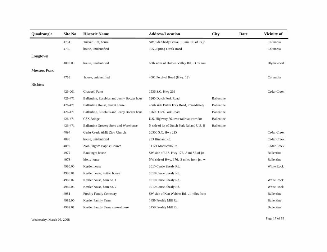
Quadrangle Site No Historic Name Address/Location City Date Vicinity of
4754 Tucker, Jim, house SW Side Shady Grove, 1.3 mi. SE of its jc Columbia
4755 house, unidentified 1055 Spring Creek Road Columbia
Longtown4800.00 house, unidentified both sides of Hidden Valley Rd., .3 mi sou Blythewood
Messers Pond4756 house, unidentified 4001 Percival Road (Hwy. 12) Columbia
Richtex426-001 Chappell Farm 1536 S.C. Hwy 269 Cedar Creek
426-471 Ballentine, Eusebius and Jenny Boozer hous 1260 Dutch Fork Road Ballentine
426-471 Ballentine House, tenant house north side Dutch Fork Road, immediately Ballentine
426-471 Ballentine, Eusebius and Jenny Boozer hous 1260 Dutch Fork Road Ballentine
426-471 CSX Bridge U.S. Highway 76, over railroad corridor Ballentine
426-471 Ballentine Grocery Store and Warehouse N side of jct of Dutch Fork Rd and U.S. H Ballentine
4894 Cedar Creek AME Zion Church 10300 S.C. Hwy 215 Cedar Creek
4898 house, unidentified 233 Hinnant Rd. Cedar Creek
4899 Zion Pilgrim Baptist Church 11121 Monticello Rd. Cedar Creek
4972 Baukinght house SW side of U.S. Hwy 176, .8 mi SE of jct Ballentine
4973 Metts house NW side of Hwy. 176, .3 miles from jct. w Ballentine
4980.00 Kestler house 1010 Carrie Shealy Rd. White Rock
4980.01 Kestler house, cotton house 1010 Carrie Shealy Rd.
4980.02 Kestler house, barn no. 1 1010 Carrie Shealy Rd. White Rock
4980.03 Kestler house, barn no. 2 1010 Carrie Shealy Rd. White Rock
4981 Freshly Family Cemetery SW side of Ken Webber Rd., .1 miles from Ballentine
4982.00 Kestler Family Farm 1459 Freshly Mill Rd. Ballentine
4982.01 Kestler Family Farm, smokehouse 1459 Freshly Mill Rd. Ballentine
Wednesday, March 05, 2008 Page 17 of 19

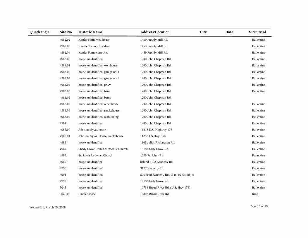
Quadrangle Site No Historic Name Address/Location City Date Vicinity of
4982.02 Kestler Farm, well house 1459 Freshly Mill Rd. Ballentine
4982.03 Kesstler Farm, corn shed 1459 Freshly Mill Rd. Ballentine
4982.04 Kestler Farm, corn shed 1459 Freshly Mill Rd. Ballentine
4983.00 house, unidentified 1200 John Chapman Rd. Ballantine
4983.01 house, unidentified, well house 1200 John Chapman Rd. Ballantine
4983.02 house, unidentified, garage no. 1 1200 John Chapman Rd. Ballantine
4983.03 house, unidentified, garage no. 2 1200 John Chapman Rd. Ballantine
4983.04 house, unidentified, privy 1200 John Chapman Rd. Ballantine
4983.05 house, unidentified, barn 1200 John Chapman Rd. Ballantine
4983.06 house, unidentified, barns 1200 John Chapman Rd.
4983.07 house, unidentified, other house 1200 John Chapman Rd. Ballantine
4983.08 house, unidentified, smokehouse 1200 John Chapman Rd. Ballentine
4983.09 house, unidentified, outbuilding 1200 John Chapman Rd. Ballentine
4984 house, unidentified 1400 John Chapman Rd. Ballentine
4985.00 Johnson, Sylas, house 11218 U.S. Highway 176 Ballentine
4985.01 Johnson, Sylas, House, smokehouse 11218 US Hwy. 176 Ballentine
4986 house, unidentified 1105 Julius Richardson Rd. Ballentine
4987 Shady Grove United Methodist Church 1918 Shady Grove Rd. Ballentine
4988 St. John's Lutheran Church 1028 St. Johns Rd. Ballentine
4989 house, unidentified behind 3102 Kennerly Rd. Ballentine
4990 house, unidentified 3127 Kennerly Rd. Ballentine
4991 house, unidentified S. side of Kennerly Rd., .6 miles east of jct Ballentine
4992 house, unidentified 1818 Shady Grove Rd. Ballentine
5045 house, unidentified 10734 Broad River Rd. (U.S. Hwy 176) Ballentine
5046.00 Lindler house 10803 Broad River Rd Irmo
Wednesday, March 05, 2008 Page 18 of 19

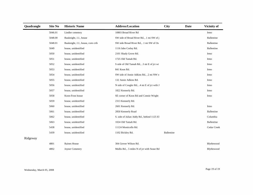
Quadrangle Site No Historic Name Address/Location City Date Vicinity of
5046.01 Lindler cemetery 10803 Broad River Rd Irmo
5048.00 Bauknight, J.J., house SW side of Broad River Rd., .1 mi SW of j Ballentine
5048.01 Bauknight, J.J., house, corn crib SW side Broad River Rd., .1 mi SW of Os Ballentine
5049 house, unidentified 1116 Jabo Corley Rd. Ballentine
5050 house, unidentified 2101 Shady Grove Rd. Irmo
5051 house, unidentified 1725 Old Tamah Rd. Irmo
5052 house, unidentified S side of Old Tamah Rd., .3 mi E of jct wi Irmo
5053 house, unidentified 841 Koon Rd. Irmo
5054 house, unidentified SW side of Annie Adkins Rd., .2 mi NW o Irmo
5055 house, unidentified 132 Annie Adkins Rd. Irmo
5056 house, unidentified N side of Coogler Rd., .4 mi E of jct with J Irmo
5057 house, unidentified 1822 Kennerly Rd. Irmo
5058 Koon-Frost house SE corner of Koon Rd and Connie Wright Irmo
5059 house, unidentified 2313 Kennerly Rd.
5060 house, unidentified 2601 Kennerly Rd. Irmo
5061 house, unidentified 2850 Kennerly Road Ballentine
5062 house, unidentified S. side of Julian Addy Rd., behind 1125 El Columbia
5063 house, unidentified 1024 Old Tamah Rd. Ballentine
5438 house, unidentified 11124 Monticello Rd. Cedar Creek
5439 house, unidentified 1102 Bickley Rd. Ballentine
Ridgeway4801 Raines House 304 Grover Wilson Rd. Blythewood
4802 Joyner Cemetery Mullis Rd., .5 miles N of jct with Sease Rd Blythewood
Wednesday, March 05, 2008 Page 19 of 19