Embed Size (px)
Citation preview
SOUTH-CENTRAL NEW MEXICO PROVINCE (026) By W.C. Butler
INTRODUCTION
This frontier petroleum province covers about 39,900 sq mi, primarily in the easternmost part of the Basin
and Range Physiographic Province; it has no production. For a more complete description of this
province, see Butler (1988b) and Grant and Foster (1989).
Major present-day geologic and geographic features may be characterized by sector. The northwest
sector is in the southeastern Colorado Plateau Physiographic Province (see the description of the
Northern Arizona Province 024). Small northeast-trending rift basins and the Zuni Mountains occupy
this sector. The southwest sector is a major Cenozoic volcanic terrain (Mogollon Plateau–Datil Volcanic
Field) in a zone of transition between the less complex structure of the stable Colorado Plateau and the
more complex Basin and Range block-faulted crust of middle and late Cenozoic age. In the eastern sector
asymmetrical north-trending horsts, grabens, and half-grabens are superimposed on older structures.
Specifically, these features include the Mesilla, Jornada del Muerto, and Tularosa Basins to the south and
the Estancia Basin to the north. The Rio Grande River divides this province exactly in half and flows
south along the axis of the Rio Grande rift system.
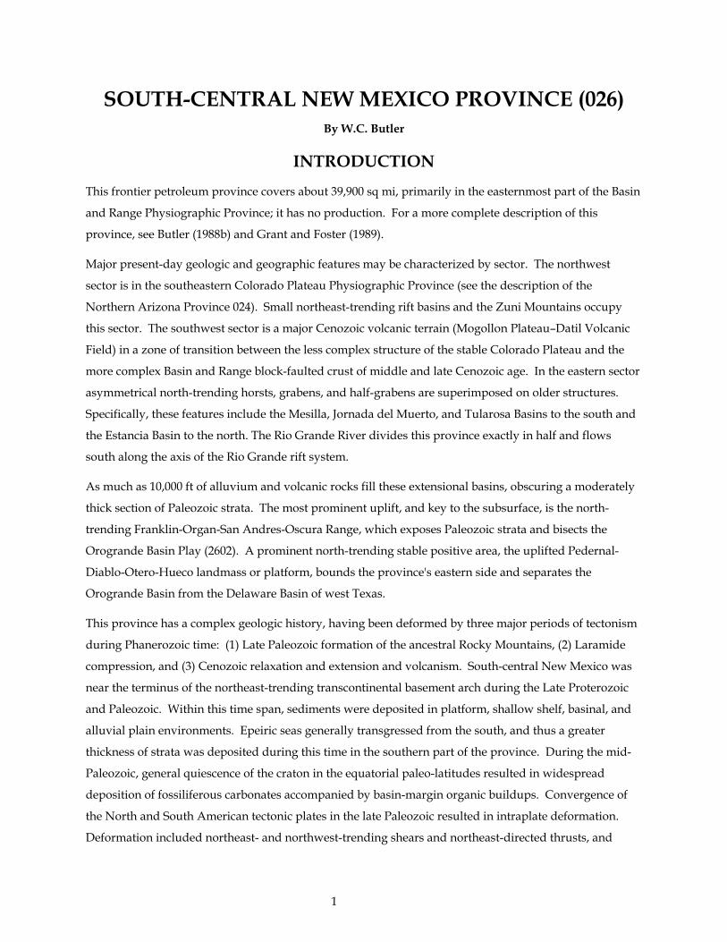
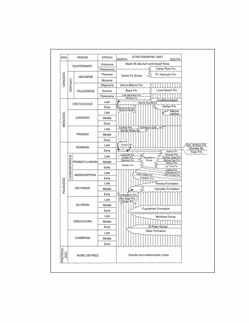
As much as 10,000 ft of alluvium and volcanic rocks fill these extensional basins, obscuring a moderately
thick section of Paleozoic strata. The most prominent uplift, and key to the subsurface, is the north-
trending Franklin-Organ-San Andres-Oscura Range, which exposes Paleozoic strata and bisects the
Orogrande Basin Play (2602). A prominent north-trending stable positive area, the uplifted Pedernal-
Diablo-Otero-Hueco landmass or platform, bounds the province's eastern side and separates the
Orogrande Basin from the Delaware Basin of west Texas.
This province has a complex geologic history, having been deformed by three major periods of tectonism
during Phanerozoic time: (1) Late Paleozoic formation of the ancestral Rocky Mountains, (2) Laramide
compression, and (3) Cenozoic relaxation and extension and volcanism. South-central New Mexico was
near the terminus of the northeast-trending transcontinental basement arch during the Late Proterozoic
and Paleozoic. Within this time span, sediments were deposited in platform, shallow shelf, basinal, and
alluvial plain environments. Epeiric seas generally transgressed from the south, and thus a greater
thickness of strata was deposited during this time in the southern part of the province. During the mid-
Paleozoic, general quiescence of the craton in the equatorial paleo-latitudes resulted in widespread
deposition of fossiliferous carbonates accompanied by basin-margin organic buildups. Convergence of
the North and South American tectonic plates in the late Paleozoic resulted in intraplate deformation.
Deformation included northeast- and northwest-trending shears and northeast-directed thrusts, and
1
basement uplifts such as the Zuni, Florida-Burro, and Pedernal. Seaways connected new depocenters,
such as the Orogrande Basin, which is the principal play of this province, with the Pedregosa, Delaware,
and Paradox Basins. Permian redbed sediments encroached toward the Orogrande Basin from the coastal
plains on the east, north, and west; coeval basin-centered evaporites were also deposited.
Triassic and Jurassic strata are not well represented in the province, which depositionally represents an
erosional surface shifting from highlands to interior lowlands and coastal plains. Nascent opening of the
Gulf of Mexico (Chihuahua Trough) deposited as much as 750 ft of marine Jurassic sediments in the
southernmost Mesilla Basin. Continued opening near the New Mexico–Mexico border resulted in an
east-west Early Cretaceous rift, extending into southeastern Arizona. A thick Late Cretaceous section of
marine sands and shales and continental fluvial clastics and paludal coals was deposited as seas
transgressed and regressed from the north-northeast and from the south-southwest; about 3,000 ft of this
section is preserved. Laramide compression from the southwest rejuvenated older fault-bounded
structures and other paleo-zones of weakness (for example thrust faults) and created basement-cored
uplifts. Plutons, with attendant rich mineralization, intruded the province. Early Tertiary uplift
provided cyclic alluvial–fluvial fan gravels and deltaic clastics to continental interior-drained basins and
small lakes.
Clockwise Oligocene rotation of the Colorado Plateau crustal block opened up the Rio Grande rift south
of El Paso, Texas; the extensional spreading migrated northward in scissor-style during Neogene and
Quaternary time. See Rieker (1979) for a thorough description of the Rio Grande Rift area.
Two hypothetical conventional plays were assessed in this province. They are Orogrande Basin Play
(2602) and Mesilla–Mimbres Basins Play (2603).
2

ACKNOWLEDGMENTS
Scientists affiliated with the American Association of Petroleum Geologists and from various State
geological surveys contributed significantly to play concepts and definitions. Their contributions are
gratefully acknowledged.
3
CONVENTIONALPLAYS
2602. OROGRANDE BASIN PLAY (HYPOTHETICAL)
This hypothetical combination oil and nonassociated gas play is in the Basin and Range Physiographic
Province (Rio Grande Rift) of south-central New Mexico. It is based on the association of Mississippian
through Permian thermally mature source rocks and porous reef reservoir rocks, particularly of the
fossiliferous limestones of the Magdalena Group of Pennsylvanian age in the Orogrande Basin. As
implied in the introductory section, abundant Paleozoic and Mesozoic structural and stratigraphic traps
occur in the deep, under-explored Tertiary rift basins.
The total thickness of Paleozoic, Mesozoic, and Cenozoic rocks in this play may be as much as 25,000 ft.
The Paleozoic section is 4,0008,500 ft thick; it wedges out generally northward, but also eastward from
basin to shelf, where the number and magnitude of disconformities increase. Alternating source and
reservoir beds of Pennsylvanian age, which have the most petroleum potential in the Orogrande Basin,
are generally 1,000–3,300 ft thick and are thickest in the central Tularosa Basin. Important lateral and
stratigraphic variations are present in the many isolated, disconnected outcrops that expose the key
stratigraphic units along the north-south backbone of the play (for example, the Franklin-Organ-San
Andres-Oscura Uplift). Important stratigraphic units are also exposed in the Sacramento and Hueco
Mountains on the east-central and southeast margins, respectively, of this play. Each uplift has its own
local stratigraphic terminology, thus making correlation of units and names throughout this play a
complicated endeavor.
Reservoirs: Potential reservoirs are primarily the porous carbonates of the Magdalena Group, including
phylloid algal mounds, banks, and bioherms from 75 to 100 ft thick. Other Pennsylvanian reservoir facies
include cyclic porous and permeable algal reefs, calcarenites, coquinas, and deltaic quartz sandstones in
association with beds of carbonaceous shale and dark, fetid petroliferous limestones. Bioherms also occur
in Mississippian (Lake Valley Formation) and Permian strata and reach a maximum thickness of 350 ft;
these, as well as other Permian petroliferous carbonates, are considered reservoir quality. Upper
Paleozoic evaporite beds or dense impermeable carbonates, well-cemented or tight clastics, and
numerous intercalated shale units throughout the Paleozoic section could seal the reservoirs.
Source rocks: The most promising source rocks are organic-rich, brown to black shales of the
Pennsylvanian Panther Seep Formation and, secondarily, the Mississippian Helms Formation. Less
significant source rocks might include Ordovician and Silurian dolostones and dark basinal Devonian
shales, as well as carbonates and shales of the Lower Permian Hueco Group. Vitrinite reflectance data
from outcrops in the play range from about Ro 0.6 to 1.2 percent around the play's periphery to 4.0
percent in the central San Andres Mountains uplift. Probably half of the potential Mississippian through
Permian source rocks are in the oil window, and the rest are in the thermal dry gas phase.
4
Timing and migration: Timing of generation and migration are highly speculative, but may have
occurred from Early Cretaceous to mid-Tertiary time.
Traps: The complex evolution of this area, as simply outlined in the introduction section of this province,
has created many types of traps. Stratigraphic traps are in the form of pinchouts around the basin
margin, erosional unconformities, and carbonate-biohermal buildups. Structural traps involve thrusts
and folds of primarily Laramide age. Accumulations may also occur along the high-angle listric Tertiary
faults, if sealed, or in drag folds; however, this intense late Tertiary to Holocene faulting, in conjunction
with possible fresh-water flushing of reservoirs, is likewise a serious deterrent to reservoir and trap
integrity. Because of the extensive faulting, depths to targets in the play have a wide range, from 2,000 to
20,000 ft.
Exploration status and resource potential: In spite of the thick alluvial overburden, the eolian dunes,
and the pyroclastic rocks that cover 90–95 percent of this play, the number and excellent quality of
hydrocarbon shows in the few Pennsylvanian and Permian penetrations indicate the probable existence
of commercial hydrocarbons (Pyron and Gray, 1985). Oil seeps are not known in the play. Very sparse
borehole data make this play difficult to assess. Military land, about half of the play, is off-limits to
exploration and drilling; drilling density is about one borehole per 150 sq mi to an average depth of 4,250
ft. About 0.5 percent of the area has been explored to the level of the play reservoirs. Most shows
occurred between 2,430 and 8,600 ft deep. The deepest wildcat well was drilled in the Mesilla Basin; it
reached a TD of 21,759 ft, where it tested porous gas-bearing Ordovician strata.
The shelf strata of the Orogrande Basin have been compared to the contemporaneous highly productive
reservoirs of the Delaware Basin of west Texas. Mississippian through Permian formations of the
Delaware Basin have a cumulative production of more than 3 BBO and 5.0 TCF of nonassociated gas
(Robertson and Broadhead, 1993).
2603. MESILLA-MIMBRES BASINS PLAY (HYPOTHETICAL)
This Basin and Range hypothetical oil and nonassociated gas play is primarily in the Mesilla Bolson (Las
Cruces Graben). It is west and northwest of El Paso, Texas, and west of the Rio Grande River in the
Tertiary- and Quaternary-faulted Rio Grande Rift. Almost all of the surface rocks are Cenozoic volcanics
and basin-fill alluvium. Geographically, the play covers both provinces 025 and 026 and the
Pennsylvanian Orogrande Basin. Because the play is based solely on one excellent deep gas show in
lower Paleozoic carbonates, it is highly speculative and its boundary is purely conjectural.
Reservoirs: The potential for reservoir rocks is as yet poorly understood but is within a 1,000- to 2,000-ft-
thick stratigraphic section that increases in thickness from north to south. This section includes units
within the Ordovician carbonates of the El Paso and Montoya Dolomite Groups; several thin sandstone
5
beds may also be included in these groups. The Silurian Fusselman Formation, a carbonate unit that
shows good porosity and permeability at a drilling depth of 20,900 ft, and the Cambrian-Ordovician Bliss
Formation, a quartz sandstone, are equally important as reservoirs. Tight impermeable carbonates seal
the reservoirs.
Source rocks: Source rocks are the same as the reservoir units, except for the Bliss Formation; the thermal
maturity of these rocks is about equally divided between the zones for generating oil and dry gas.
Timing and migration: Timing of hydrocarbon generation and migration are unknown but may have
been from late Paleozoic to Laramide time. Lateral migration was probably not extensive.
Traps: Reservoir and source rocks are within two arcuate north-south-trending fault-bounded rifts in the
southwestern flank of the Rio Grande Rift. An east-west cross-section perpendicular to the bounding
faults would show these rift blocks as tilted stair-steps having a maximum combined offset of about
13,000 ft on listric faults. It is conceivable that these normal faults may have also created traps if sealed
and if hydrocarbon migration was very late. The most likely potential traps would exist in the fractured
and vuggy dolomites and in the lateral porosity pinchouts that may be either stratigraphic or diagenetic.
Significant interformational disconformities between the El Paso and Montoya Formations and between
the Montoya and Fusselman Formations might be impermeable in places and trap hydrocarbons in the
numerous late Paleozoic and Laramide folds. Additional potential traps were created by local Laramide
thrusting. Whether the mid-Tertiary to Holocene faulting has ruptured traps and (or) allowed flushing by
fresh water is unknown, but is very probable. Targets are from 5,000 to 24,000 ft deep, the deepest being
off the southern flanks of the central-basin horst.
Exploration status: This play is poorly explored by drilling. However, Thompson and Bieberman (1975)
related that the Grimm, et al. no. 1 Mobil–32 well, drilled in the eastern part of this play, demonstrated a
definite petroleum potential for the Rio Grande Rift. It was drilled on a faulted anticline on the basis of
seismic data. The Silurian was encountered at 20,900 ft and the Ordovician at 21,555 ft; total depth was
21,759 ft. Shows were found in several units, including the Ordovician section. Because of difficult hole
conditions, none of the seven drill-stem tests could be completed. Problems such as drill pipe twisting off
and drill collars and tools being lost in the hole prevented a complete evaluation of the drilled section as
well as the subjacent El Paso Group and Bliss Formation.
6

UNCONVENTIONAL PLAYS
There are no unconventional plays described in this province report. However, unconventional plays
listed in the surrounding provinces may include parts of this province. Individual unconventional plays
are usually discussed under the province in which the play is principally located.
7
REFERENCES
Aiken, C.L.V., Laughlin, A.W., and West, F.G., 1978, Residual Bouguer gravity anomaly map of New Mexico: University of California Los Alamos Scientific Laboratory LA-7466-map/UC-11, scale 1:500,000.
Aiken, C.L.V., and Sumner, J.S., 1974, A geophysical and geological investigation of potentially favorable areas for petroleum exploration in southeastern Arizona: Arizona Oil and Gas Conservation Commission Report of Investigations 3, 40 p.
Allin, D.L., 1990, Colorado Plateau subsurface water flow key: Oil and Gas Journal, v. 88, no. 30, July 23, p. 52-54.
American Geophysical Union, 1989, Sedimentation and tectonics of western North America, v. 3: Washington, D.C., American Geophysical Union, 28th International Geological Congress, 477 p.
Anderson, O.J., Lucas, S.G., Love, D.W., and Cather, S.M., eds., 1989, Southeastern Colorado Plateau: New Mexico Geological Society, 40th Field Conference Guidebook, 348 p.
Anderson, R.Y., and Harshbarger, J.W., eds., 1958, Black Mesa Basin--Guide book of northeastern Arizona: Arizona Geological Society, 9th Field Conference, 205 p.
Anschutz, P.F., 1980, The overthrust belt--Will it double U.S. gas reserves?: World Oil, v. 190, no. 1, p. 111-116.
Arizona Oil and Gas Conservation Commission, 1961, Oil, gas and helium in Arizona: Phoenix, Arizona, Arizona Development Board, 108 p.
Arizona Oil and Gas Conservation Commission, 1987, State of Arizona well location map four: Phoenix, Arizona, August, 38 p.
Arizona Oil and Gas Conservation Commission, 1992, Arizona well location map and report: Arizona Geological Survey Oil and Gas Publication OG-12, 22 p., scale 1:500,000.
Armentrout, J.M., Cole, M.R., and TerBest, Harry, Jr., eds., 1979, Cenozoic paleogeography of the western United States: Society of Economic Paleontologists and Mineralogists, Pacific Coast Section Symposium 3, 335 p.
Armstrong, A.K., Kottlowski, F.E., Stewart, W.J., Mamet, B.L., Baltz, E.H., Siemers, W.T., and Thompson, Sam, III, 1979, The Mississippian and Pennsylvanian (Carboniferous) Systems in the United States--New Mexico: U.S. Geological Survey Professional Paper 1110-W, 27 p.
Arnold, E.C., and Hill, J.M., comps., 1981, New Mexico's energy resources '80: New Mexico Bureau of Mines and Mineral Resources Circular 181, 59 p.
Baars, D.L., ed., 1979, Permianland: Four Corners Geological Society Guidebook, 9th Field Conference and Field Symposium, 186 p.
Baars, D.L., 1983, The Colorado Plateau--A geologic history: Albuquerque, New Mexico, University of New Mexico Press, 279 p.
8
Bahr, C.W., 1962, The Holbrook anticline, Navajo County, Arizona, in Weber, R.H., and Peirce, H.W., eds., Guidebook of the Mogollon Rim region east-central Arizona: New Mexico Geological Society, 13th Field Conference, p. 118-122.
Barwin, J.R., 1969, Oil possibilities in Arizona: Oil and Gas Journal, v. 67, no. 35, p. 186-188.
Barwin, J.R., King, R.W., and Hassenfratz, C.A., 1971, Future oil and gas potential of northeast Arizona, in Cram, I.H., ed., Future petroleum provinces of the United States--Their geology and potential: American Association of Petroleum Geologists Memoir 15, p. 449-469.
Bayer, K.C., comp., 1983, Generalized structural, lithologic and physiographic provinces in the fold and thrust belts of the United States: U.S. Geological Survey map, scale 1:2,500,000.
Bayley, R.W., and Muehlberger, W.R., 1968, Basement rock map of the United States: U.S. Geological Survey Map, scale 1:2,500,000.
Bayliss, G.S., and Schwarzer, R.R., 1992, New Mexico hydrocarbon source rock evaluation project--New Well Peak section in Big Hatchet Mountains, Hidalgo County, New Mexico: New Mexico Bureau of Mines and Mineral Resources, Open-File Report 379, (revised January, 1992), unpaginated.
Beal, C.H., 1948, reconnaissance of the geology and oil possibilities of Baja California, Mexico: Geological Society of America Memoir 31, 138 p.
Beatty, Barbara, and Wilkinson, P.A.K., eds., 1986, Frontiers in geology and ore deposits of Arizona and the Southwest: Arizona Geological Society Digest, V. XVI, 554 p.
Beikman, H.M., Peterson, J.A., Huber, D.F., and Butler, W.C., 1986, Metallic mineral and mineral-fuel resource potential map of Arizona showing major mineral deposits: U.S. Geological Survey Map Mineral Investigations Resource Map MR-94, scale 1:1,000,000.
Beus, S.S., 1989, Devonian and Mississippian geology of Arizona, in Jenney, J.P., and Reynolds, S.J., eds., Geologic evolution of Arizona: Arizona Geological Society Digest, V. 17, p. 287-311.
Billingsley, G.H., 1978, A synopsis of stratigraphy in the western Grand Canyon: Flagstaff, Arizona, Museum of Northern Arizona Research Paper 16, 26 p.
Bilodeau, W.L., and Lindberg, F.A., 1983, Early Cretaceous tectonics and sedimentation in southern Arizona, southwestern New Mexico and northern Sonora, Mexico, in Reynolds, M.W., and Dolly, E.D., eds., Mesozoic paleogeography of west-central United States: Society of Economic Mineralogists and Paleontologists, Symposium 2, p. 173-188.
Blackwell, D.D., 1978, Heat flow and energy loss in the westerm United States, in Smith, R.B., and Eaton, G.P., eds., Cenozoic tectonics and regional geophysics of the Western Cordillera: Geological Society of America Memoir 152, p. 175-208.
Blakey, R.C., 1979, Oil impregnated carbonate rocks of the Timpweap Member Moenkopi Formation, Hurricane Cliffs area, Utah and Arizona: Utah Geology, v. 6, p. 45-53.
Brady, B.T., 1984, Selected geologic and hydrologic characteristics of the Basin and Range Province, westerm United States, coal, oil and gas wells, seeps and tar sandstone occurrences: U.S. Geological Survey Miscellaneous Investigations Series Map I-1522-E, scale 1:2,500,000.
9
Branson, C.C., ed., 1962, Pennsylvanian system in the United States--A symposium: American Association of Petroleum Geologists, 508 p.
Brennan, D.J., 1989, Hydrocarbon possibilities in Yuma area, Arizona [abs.]: American Association of Petroleum Geologists Bulletin, v. 73, no. 3, p. 337.
Broadhead, R.F., and Black, BA., 1989, Petroleum exploration wells drilled in west-central New Mexico, in Anderson, O.J., and others, eds., South eastern Colorado Plateau: New Mexico Geological Society, 40th Field Conference Guidebook, p. 287-296.
Bryant, D.L., 1968, Diagnostic characteristics of the Paleozoic formations of southeastern Arizona, in Titley, S.R., ed., Southern Arizona guidebook III: Tucson, Arizona, Arizona Geological Society, p. 33-47.
Butler, W.C., 1971, Permian sedimentary environments in southeastern Arizona, in McCullough, E.J., ed., Arizona Geological Society Digest, V. IX, p. 71-94.
Butler, W.C., 1985, Petroleum potential of the Hualapai Indian Reservation in northwestern Arizona--A preliminary qualitative assessment for the tribe: unpublished U.S. Geological Survey and Bureau of Indian Affairs Administrative Report, on file at Bureau of Indian Affairs, 20 p.
Butler, W.C., 1988a, The rationale for assessment of undiscovered, economically recoverable oil and gas in central and northern Arizona Play analyses of seven favorable areas: U.S. Geological Survey Open-File Report 87-450-V, 145 p.
Butler, W.C., 1988b, The rationale for assessment of undiscovered, economically recoverable oil and gas in south-central New Mexico--A geologic overview and play analysis of two favorable areas: U.S. Geological Survey Open-File Report 88-450-B, 134 p.
Butler, W.C., 1989a, The geologic setting of southern Arizona and southwestern New Mexico, with a rationale for assessment of undiscovered, economically recoverable oil and gas--A summary of four potential plays: U.S. Geological Survey Open-File Report 88-450-M, 150 p.
Butler, W.C., 1989b, Strategic crude oil storage in Arizona evaporite masses--An initial description, evaluation, and selected references of four potential sites: unpublished U.S. Geological Survey Administrative Report, on file with the Branch of Petroleum Geology, Denver, Colorado, 109 p.
Butler, W.C., 1992, Elevation data for the Precambrian surface in the central and southern Colorado Plateau and vicinity: U.S. Geological Survey Open File Report 92-194, 69 p.
Callender, J.F., Wilt, J.C., and Clemons, R.E., eds., 1978, Land of Cochise Southeastern Arizona: New Mexico Geological Society Guidebook, 29th Field Conference, 372 p.
Cather, S.M., and Johnson, B.D., 1984, Eocene tectonics and depositional setting of west-central New Mexico and eastern Arizona: New Mexico Bureau of Mines and Mineral Resources Circular 192, 33 p.
Chapin, C.E., ed., 1983, Socorro region II: New Mexico Geological Society, 34th Field Conference Guidebook, 344 p.
10
Christiansen, R.L., and Lipman, P.W., 1972, Cenozoic volcanism and plate tectonic evolution of the westerm United States, II. Late Cenozoic: Philosophical Transactions of the Royal Society of London, Series A, v. 271, no. 1213, p. 249-284.
Clemons, R.E., King, W.E., and Mack, G.H., eds., 1986, Truth or Consequences region: New Mexico Geological Society, 37th Field Conference Guidebook.
Clemons, R.E., and Lawton, T.F., 1991, Petrographic and well log analysis of four exploration wells in southwestern New Mexico: New Mexico Bureau of Mines and Mineral Technology Open-File Report 381, 97 p.
Condie, K.C., 1981, Precambrian rocks of the southwestern United States and adjacent areas of Mexico: New Mexico Bureau of Mines and Mineral Resources, Resource Map 13, scale 1:500,000.
Condie, K.C., 1982, Plate-tectonics model for Proterozoic continental accretion in the Southwestern United States: Geology, v. 10, p. 37-42.
Coney, P.J., 1979, Tertiary evolution of Cordilleran metamorphic core complexes, in Armentrout, J.M., Cole, M.R., and TerBest, H., Jr., eds., Cenozoic paleogeography of the westerm United States: Society of Economic Paleontologists and Mineralogists, Symposium 3, p. 15-28.
Conley, J.N., and Giardina, S., Jr., 1979, Favorable and potentially favorable areas for hydrocarbon and geothermal energy sources in northeastern Arizona: Arizona Oil and Gas Conservation Commission, Report of Investigations 7, 56 p.
Corbitt, L.L., and Woodward, L.A., 1973, Tectonic framework of Cordilleran foldbelt in southwestern New Mexico: American Association of Petroleum Geologists Bulletin, v. 57, p. 2207-2216.
Cordoba, D.A., Wengerd, S.A., and Shomaker, John, eds., 1969, Guidebook of the Border Region: New Mexico Geological Society, 20th Field Conference, 218 p.
Crysdale, B.L., and Schenk, C.J., 1988, Bitumen-bearing deposits of the United States: U.S. Geological Survey Bulletin 1874, 45 p.
Dane, C.H., and Bachman, G.O., 1965, Geologic map of New Mexico: U.S. Geological Survey and New Mexico Bureau of Mines and Mineral Resources, scale 1:500,000.
Davis, G.H., 1978, Monocline fold pattern of the Colorado Plateau, in Matthews, V., III, ed., Laramide folding associated with basement block faulting in the westerm United States: Geological Society of America Memoir 151, p. 215-233.
Davis, G.H., 1979, Laramide folding and faulting in southeastern Arizona: American Journal of Science, v. 279, p. 543-569.
Davis, G.H., and VandenDolder, E.M., eds., 1987, Geologic diversity of Arizona and its margins--Excursions to choice areas: Arizona Bureau of Geology and Mineral Technology, Geological Survey Branch Special Paper 5, 422 p.
DeFord, R.K., and Kehle, R.O., Chairmen, 1976, Geothermal gradient map of North America: American Association of Petroleum Geologists and U.S. Geological Survey, scale 1:5,000,000.
11
Desborough, G.A., Poole, F.G., Daws, T.A., and Scarborough, R.B., 1984, Hydrocarbon source rock evaluation of the Middle Proterozoic Apache Group Gila County Arizona, in Woodward, J., and others, eds., Hydrocarbon source rocks of the Greater Rocky Mountain region: Rocky Mountain Association of Geologists Symposium, p. 51-55.
Dickinson, W.R., 1981, Plate tectonic evolution of the southern Cordillera, in Dickinson, W.R., and Payne, W.D., eds., Relations of tectonics to ore deposits in the southern Cordillera: Arizona Geological Society Digest, V. XIV, p. 113-135.
Dickinson, W.R., 1989, Tectonic setting of Arizona through geologic time, in Jenney, J.P., and Reynolds, S.J., eds., Geologic evolution of Arizona: Arizona Geological Society Digest, V. 17, p. 1-16.
Dickinson, W.R., and Klute, M.A., eds., 1987, Mesozoic rocks of southern Arizona and adjacent areas: Arizona Geological Society Digest, V. 18, 394 p.
Dixon, G.H., Baltz, D.H., and Stipp, T.F., 1954, Records of wells drilled for oil and gas in New Mexico: U.S. Geological Survey Circular 33, 79 p.
Drewes, H.D., 1981, Tectonics of southeastern Arizona: U.S. Geological Survey Professional Paper 1144, 96 p.
Eberly, L.D., and Stanley, T.B., Jr., 1978, Cenozoic stratigraphy and geologic history of southwestern Arizona: Geological Society of America Bulletin, v. 89, p. 921-940.
Elston, D.P., 1979, Late Precambrian Sixtymile Formation and orogeny at top of the Grand Canyon Supergroup, northern Arizona: U.S. Geological Survey Professional Paper 1092, 20 p.
Elston, D.P., 1989, Grand Canyon Supergroup, northern Arizona--Stratigraphic summary and preliminary paleomagnetic correlations with parts of other North American Proterozoic successions, in Jenney, J.P., and Reynolds, S.J., eds., Geologic evolution of Arizona: Arizona Geological Society Digest, V. 17, p. 259-272.
Fassett, J.E., ed., 1978, Oil and gas fields of the Four Corners area, v. I and II: Four Corners Geological Society, 727 p.
Foster, R.W., 1964, Stratigraphy and petroleum possibilities of Catron County, New Mexico: New Mexico Bureau of Mines and Mineral Resources Bulletin 85, 55 p.
Foster, R.W., 1978, Oil and gas evaluation of White Sands Missile Range and Fort Bliss Military Reservation, south-central New Mexico: New Mexico Bureau of Mines and Mineral Resources, Open-File Report 92, 60 p.
Fouch, T.D., and Magathan, E.R., eds., 1980, Paleozoic paleogeography of the west-central United States: Society of Economic Paleontologists and Mineralogists, Symposium 1, 431 p.
Frazier, W.J., and Schwimmer, D.R., 1987, Regional stratigraphy of North America: New York, New York, Plenum Press, 719 p.
Fritz, M., 1990, Precambrian source sparks imaginations--Chuar inspires quest in the West: American Association of Petroleum Geologists Explorer, October, p. 8-9.
12
Frost, E.G., and Martin, D.L., eds., 1982, Mesozoic-Cenozoic tectonic evolution of the Colorado River Region, California, Arizona, and Nevada: San Diego, California, Cordilleran Publishers, Inc., Anderson-Hamilton Volume, (published in conjunction with a symposium and field trip for the Geological Society of America), 608 p.
Gehrels, G.E., and Spencer, J.E., eds., 1990, Geologic excursions through the Sonoran Desert region, Arizona and Sonora: Arizona Geological Society Special Paper 7, Field-Trip Guidebook, Cordilleran Section, Geological Society of America, 202 p.
Gerrard, T.A., 1966, Environmental studies of Fort Apache Member, Supai Formation, east-central Arizona: American Association of Petroleum Geologists Bulletin, v. 50, p. 2434-2463.
Giardina, S., Jr., 1979, Geologic review of northwestern Arizona for petroleum exploration investigators: Arizona Oil and Gas Conservation Commission, Special Publication No. 4, 72 p.
Grant, P.R., Jr., and Foster, R.W., 1989, Future petroleum provinces in New Mexico--Discovering new reserves: New Mexico Bureau of Mines and Mineral Resources, 94 p. (17" x 22" folio), prepared for the New Mexico Research and Development Institute.
Greenwood, E., Kottlowski, F.E., and Thompson, S., III, 1977, Petroleum potential and stratigraphy of Pedregosa Basin--Comparison with Permian and Orogrande Basins: American Association of Petroleum Geologists Bulletin, v. 61, p. 1448-1469.
Grim, P.J., and Berry, G.W., 1979, Geothermal energy in the westerm United States, in Muffler, L.J.P., ed., Assessment of geothermal resources of the United States--1978: National Oceanic and Atmospheric Administration, National Geophysics Solar-Terrestrial Data Center and U.S. Geological Survey Circular 790, scale 1:2,500,000.
Gurgel, K.D., ed., 1983, Energy resources map of Utah: Utah Geological and Mineral Survey Map 68, scale 1:500,000.
Gustafson, V.O., 1981, Petroleum geology of the Devonian and Mississippian rocks of the Four Corners region, in Wiegand, D.L., ed., Geology of the Paradox Basin: Rocky Mountain Association of Geologists Field Conference Guidebook, p. 101-109.
Guzman, A.B., 1981, Petroleum prospects in Mexico's Altar Desert: Oil and Gas Journal, v. 79, no. 34, August 24th, p. 110-126.
Hamblin, W.K., 1965, Origin of "reverse drag" on the downthrown side of normal faults: Geological Society of America Bulletin, v. 76, p. 1145-1164.
Harding, L.E., and Coney, P.J., 1985, The geology of the McCoy Mountains Formation, southeastern California and southwestern Arizona: Geological Society of America Bulletin, v. 96, p. 755-769.
Harrison, G.C., 1976, Facies analysis of the Devonian of the Black Mesa Basin, Arizona: Flagstaff, Arizona, Northern Arizona University, unpublished M.S. thesis, 57 p.
Hawley, J.W., and Lozinsky, R.P., 1992, Hydrogeologic framework of the Mesilla Basin in New Mexico and western Texas: New Mexico Bureau of Mines and Mineral Resources, Open-File Report 323, 55 p.
13
Hayes, P.T., 1970, Cretaceous paleogeography of southern Arizona and adjacent areas: U.S. Geological Survey Professional Paper 658-B, 42 p.
Hayes, P.T., 1975, Cambrian and Ordovician rocks of southern Arizona and New Mexico and westernmost Texas: U.S. Geological Survey Professional Paper 873, 98 p.
Hereford, Richard, 1977, Deposition of the Tapeats Sandstone (Cambrian) in central Arizona: Geological Society of America Bulletin, v. 88, p. 199-211.
Heylmun, E.B., 1960, Kanab--The oil signs are there: Oil and Gas Journal, v. 58, no. 24, p. 168-171.
Heylmun, E.B., 1981, Geology of promising Holbrook Basin: Oil and Gas Journal, v. 79, p. 117-118, 123.
Hills, J.M., and Kottlowski, F.E., coordinators, 1983, Correlation of stratigraphic units in North America--Southwest/southwest mid-continent correlation chart, Lindberg, F.A., ed.: American Association of Petroleum Geologists COSUNYA chart.
Hintze, L.F., comp., 1980, Geologic map of Utah: Utah Geologic and Mineralogic Survey, scale 1:500,000.
Hintze, L.F., 1988, Geologic history of Utah--A field guide to Utah's rocks: Brigham Young University Geology Studies Special Publication 7, 204 p.
Huddle, J.W., and Dobrovolny, E., 1952, Devonian and Mississippian rocks of central Arizona: U.S. Geological Survey Professional Paper 233-D, p. 67-112.
Hunt, C.B., 1956, Cenozoic geology of the Colorado Plateau: U.S. Geological Survey Professional Paper 279, 99 p.
Ijirigho, B.T., 1977, Pennsylvanian subsurface stratigraphy of the Black Mesa Basin and Four Corners area in northeastern Arizona: Tucson, Arizona, University of Arizona, unpublished M.S. thesis, 62 p.
Jenney, J.P., and Stone, Claudia, eds., 1980, Studies in western Arizona: Arizona Geological Society Digest, V. XII, 322 p.
Jenney, J.P., and Reynolds, S.J., eds., 1989, Geologic evolution of Arizona: Arizona Geological Society Digest 17, 866 p.
Jordan, C.F., Jr., 1971, Lower Permian stratigraphy of southern New Mexico and West Texas: Houston, Texas, Rice University, unpublished Ph.D. dissertation, 136 p.
Kashfi, M.S., 1983, Upper Devonian source and reservoir rocks in the Black Mesa Basin, northeastern Arizona: Oil and Gas Journal, v. 81, no. 50, December 12, p. 151-159.
Kelley, V.C., and Clinton, N.J., 1960, Fracture systems and tectonic elements of the Colorado Plateau: University of New Mexico Publications in Geology no. 6, 104 p.
Keith, S.B., and Wilt, J.C., 1986, Laramide orogeny in Arizona and adjacent regions--A strato-tectonic synthesis, in Beatty, B., and Wilkinson, P.A.K., eds., Frontiers in geology and ore deposits of Arizona and the Southwest: Arizona Geological Society Digest, V. XVI, p. 502-554.
Kent, W.N., and Rawson, R.R., 1989, Depositional environments of the Mississippian Redwall Limestone in northeastern Arizona, in Fouch, T.D., and Magathan, E.R., eds., Paleozoic paleogeography of
14
west-central United States: Society of Economic Paleontologists and Mineralogists, Symposium 1, p. 101-109.
Kluth, C.F., 1986, Plate tectonics of the ancestral Rocky Mountains, in Peterson, J.A., ed., Paleotectonics and sedimentation in the Rocky Mountain region, United States: American Association of Petroleum Geologists Memoir 41, p. 353-369.
Koons, E.D., 1945, Geology of the Uinkaret Plateau, northern Arizona: Geological Society of America Bulletin, v. 56, p. 151-180.
Kottlowski, F.E., 1965, Sedimentary basins of south-central and south-western New Mexico: American Association of Petroleum Geologists Bulletin, v. 49, p. 2120-2139.
Kottlowski, F.E., 1977, New Mexico geology and petroleum potential: Interstate Oil Compact Commission Committee Bulletin, v. 19, December, no. 2, p. 26-30.
Kron, A., and Stix, J., 1982, Geothermal gradient map of the United States: National Oceanic and Atmospheric Administration, National Geophysics Data Center, prepared for Los Alamos National Laboratory, University of California, scale 1:2,500,000.
Lessentine, R.H., 1965, Kaiparowits and Black Mesa Basin--Stratigraphic synthesis: American Association of Petroleum Geologists Bulletin, v. 49, p. 1997-2019.
Lochman-Balk, C., 1972, Cambrian System, in Mallory, W.W., ed., Geologic atlas of the Rocky Mountain region: Rocky Mountain Association of Geologists, p. 60-75.
Lovejoy, E.M.P., 1973, Major Early Cenozoic deformation along Hurricane Fault zone, Utah and Arizona: American Association of Petroleum Geologists Bulletin, v. 57, p. 510-519.
Luedke, R.G., and Smith, R.L., 1978, Map showing distribution, composition, and age of Late Cenozoic volcanic centers in Arizona and New Mexico: U.S. Geological Survey Miscellaneous Investigations Series Map I-1091-A, scale 1:1,000,000.
Lyth, A.L., Jr., 1971, Summary of possible future petroleum potential, region 3, Western Rocky Mountains, in Cram, I.H., ed., Future petroleum provinces of the United States--Their geology and potential: American Association of Petroleum Geologists Memoir 15, vol. 1, p. 406-412.
Mack, G.H., Lawton, T.F., and Lucas, S.G., eds., 1988, Cretaceous and Laramide tectonic evolution of southwestern New Mexico: New Mexico Geological Society, 39th Field Conference Guidebook, 216 p.
McKee, E.D., 1967, Arizona and western New Mexico, in Paleotectonic investigations of the Permian System in the United States: U.S. Geological Survey Professional Paper 515-J, p. 200-223.
McKee, E.D., 1975, Arizona, in McKee, E.D., and Crosby, E.J., eds., Paleotectonic investigations of the Pennsylvanian System in the United States: U.S. Geological Survey Professional Paper 853-P, p. 293-309.
McKee, E.D., 1979, Arizona, in Craig, L.C., and Conner, C.W., coordinators, Paleotectonic investigations of the Mississippian System in the United States, pt. 1: U.S. Geological Survey Professional Paper 1010-L, p. 198-207.
15
McKee, E.D., 1982, The Supai Group of Grand Canyon: U.S. Geological Survey Professional Paper 1173, 504 p.
McKenny, J.W., and Masters, J.A., 1968, Dineh-bi-Keyah Field, Apache County, Arizona: American Association of Petroleum Geologists Bulletin, v. 52, p. 2045-2057.
Mallory, W.W., ed., 1972, Geologic atlas of the Rocky Mountain region: Rocky Mountain Association of Geologists, 331 p.
Muehlberger, W.R., 1980, Texas lineament revisited, in Dickerson, P.W., and Hoffer, J.M., eds., Trans-Pecos region guidebook: New Mexico Geological Society 31st Field Conference, p. 113-121.
Nations, J.D., Brennan, D.J., and Ybarra, R.A., 1989, Oil and gas in Arizona, in Jenney, J.P., and Reynolds, S.J., eds., Geologic evolution of Arizona: Arizona Geological Society Digest, V. 17, p. 795-816.
Nations, J.D., Conway, C.M., and Swann, G.A., eds., 1986, Geology of central and northern Arizona: Geological Society of America Field Trip Guidebook for Rocky Mountain Section, Flagstaff, Arizona, Northern Arizona University, Geology Department, 176 p.
Nations, J.D., Doss, A.K., and Ybarra, R.A., 1983a, Geologic setting of oil and gas exploration in Arizona, in Fassett, J.E., ed., Oil and gas fields of the Four Corners area, V. III: Four Corners Geological Society, p. 763-772.
Nations, J.D., Doss, A.K., and Ybarra, R.A., 1983b, Stratigraphy and oil and gas production of Arizona, 1978-1983, in Fassett, J.E., ed., Oil and gas fields of the Flour Corners area, V. III: Four Corners Geological Society, p. 832-843.
Nations, J.D., and Eaton, J.G., eds., 1991, Stratigraphy, depositional environments, and sedimentary tectonics of the western margin, Cretaceous westerm Interior Seaway: Geological Society of America Special Paper 260.
Nations, J.D., Landye, J.J., and Hevly, R.H., 1982, Location and chronology of Tertiary sedimentary deposits in Arizona--A review, in Ingersoll, R.V., and Woodburne, M.O., eds., Cenozoic nonmarine deposits of California and Arizona: Society of Economic Paleontologists and Mineralogists, Pacific Coast Section Symposium, p. 107-122.
Nations, J.D., and Ranney, W.D.R., 1989, Geologic model of a Cenozoic basin in Arizona, in Tooker, E.W., ed., Arizona's industrial rock and mineral resources--Workshop proceedings: U.S. Geological Survey Bulletin 1905, [in cooperation with Arizona Geological Survey], p. 44-53.
Nations, J.D., and Stump, E., 1981, Geology of Arizona: Dubuque, Iowa, Kendall Hunt Publishing Company, 210 p.
Nations, J.D., Wilt, J.C., and Hevly, R.H., 1985, Cenozoic paleogeography of Arizona, in Flores, R.M., and Kaplan, S.S., eds., Cenozoic paleogeography of the west-central United States: Society of Economic Paleontologists and Mineralogists, Rocky Mountain Paleogeography Symposium 3, p. 335-355.
Oil and Gas Journal, 1979, Arizona area offers good potential for new finds: Oil and Gas Journal, v. 77, no. 44, p. 203-204.
Olmsted, R.H., Loeltz, O.J., and Irelan, B., 1973, Geohydrology of the Yuma area, Arizona and California: U.S. Geological Survey Professional Paper 486-H, 227 p.
16
Oppenheimer, J.M., and Sumner, J.S., 1980, Depth-to-bedrock map, Basin and Range Province, Arizona: Tucson, Arizona, University of Arizona, Department of Geosciences, scale 1:1,000,000.
O'Sullivan, R.B., 1969, Crude oil, natural gas, and other associated gases, in Mineral and water resources of Arizona: Arizona Bureau of Mines Bulletin 180, p. 70-91.
Peirce, H.W., 1976a, Tectonic significance of Basin and Range thick evaporite deposits: Arizona Geological Society Digest V. X, p. 325-339.
Peirce, H.W., 1976b, Elements of Paleozoic tectonism in Arizona: Arizona Geological Society Digest V. X, p. 37-57.
Peirce, H.W., 1979, The Mississippian and Pennsylvanian (Carboniferous) Systems in the United States--Arizona: U.S. Geological Survey Professional Paper 1110-Z, 20 p.
Peirce, H.W., 1981, Major Arizona salt deposits: Arizona Bureau of Geology and Mineral Technology Fieldnotes, v. 11, no. 4, p. 1-4.
Peirce, H.W., 1982, The search for petroleum in Arizona: Arizona Bureau of Geology and Mineral Technology, Fieldnotes, v. 12, no. 2, p. 1-5.
Peirce, H.W., and Gerrard, T.A., 1966, Evaporites of the Permian Holbrook Basin, Arizona, in Rau, J.L., ed., Second symposium on salt: Northern Ohio Geological Society, v. 1, p. 1-10.
Peirce, H.W., Jones, Nile, and Rogers, Ralph, 1977, A survey of uranium favorability of Paleozoic rocks in the Mogollon Rim and Slope region east-central Arizona: Arizona Bureau of Geology and Mineral Technology Circular 19, 70 p.
Peirce, H.W., Keith, S.B., and Wilt, J.C., 1970 (reprinted 1975), Coal, oil, natural gas, helium, and uranium in Arizona: Arizona Bureau of Mines Bulletin 182, 289 p. and 19 plates.
Peirce, H.W., and Scurlock, J.R., 1972, Arizona well information: Arizona Bureau of Mines Bulletin 185, 195 p.
Peterson, J.A., ed., 1986, Paleotectonics and sedimentation in the Rocky Mountain region, United States: American Association of Petroleum Geologists Memoir 41, 693 p.
Plauchut, Bernard, Tardy, Marc, Blanchet, Rene, Zimmermann, Matthis, Cabezas, Pascal, Rosaz, Thierry, and Sosson, Marc, 1989, Etude Geologique des Cordilleres Nord-Americanines; Les lineaments du Texas et Caltam entre Cordilleres Americanines et Sierras Madres Mexicaines--Nature, origine et evolution structurale; Les montagnes rocheuses meridionales au centre-ouest du Nouveau-Mexique; Le passage des Cordilleres Nord-Americaines aux Sierras Madres Mexicaines le long du Texas lineament geologie du SW du Nouveau Mexique; Tectoniques superposees dans le sud-est de l'Arizona: New Mexico Bureau of Mines and Mineral Resources Open-File Report 385, 76 p.
Poole, F.G., and 8 others, 1967, Devonian of the Southwestern United States, in Oswald, D.H., ed., International Symposium on the Devonian System: Society of Petroleum Geologists, Proceedings, v. 1, September 1967, Calgary, Canada, p. 879-912.
Pray, L.C., 1977, Stratigraphic and structural features of the Sacramento Mountain escarpment, New Mexico, in Butler, J.H., ed., Geology of the Sacramento Mountains, Otero County, New Mexico: West Texas Geological Society Guidebook, Publication no. 1977-68, p. 73-89.
17
Pye, W.D., 1967, Arizona--A new frontier to explore: Oil and Gas Journal, v. 65, May 8th, p. 168-172.
Pyron, A.J., and Gray, J.H., 1985, Don't ignore the Orogrande; its potential is promising: World Oil, May, p. 59-67.
Rauzi, S.L., 1990, Distribution of Proterozoic hydrocarbon source rock in northern Arizona and southern Utah: Phoenix, Arizona, Arizona Oil and Gas Conservation Commission Special Publication 5, 38 p.; map scale 1:500,000.
Rauzi, S.L., 1992, Exploration well tests salt near Phoenix [Arizona], in Arizona Geology: Arizona Geological Survey, v. 22, no. 4, p. 910.
Rauzi, S.L., 1993, Oil and natural gas occurrence in Arizona: Arizona Geological Survey Publication OG-35 (OGCC Chart C-1).
Rauzi, S.L., 1994, Implications of live oil shows in eastern Arizona geothermal test: Arizona Geological Survey Open-File Report 94-1, 16 p; 12 maps, scale 1:500,000.
Reif, D.M., and Robinson, J.P., 1981, Geophysical, geochemical, and petrographic data and regional correlation from the Arizona State A-1 well, Pinal County, Arizona: Arizona Geological Society Digest, V. XIII, p. 99-109.
Reiter, M., Mansure, A.J., and Shearer, C., 1979, Geothermal characteristics of the Colorado Plateau: Tectonophysics, v. 61, p. 183-195.
Reynolds, M.W., Palacas, J.G., and Elston, D.P., 1988, Potential petroleum source rocks in the Late Proterozoic Chuar Group, Grand Canyon, Arizona, in Carter, L.M.H., ed., USGS research on energy resources--1988, Program and abstracts: U.S. Geological Survey Circular 1025, p. 49-50.
Reynolds, S.J., 1988, Geologic map of Arizona: Arizona Geological Survey Map 26, scale 1:1,000,000.
Reynolds, S.J., Roddy, M.S., and Welty, J.W., 1986, Map of Paleozoic rocks and conodont alteration indices in Arizona: Arizona Bureau of Geology and Mineral Technology Open-File Report 86-1, scale 1:1,000,000.
Reynolds, S.J., and Trapp, R.A., 1986, Computerized databases and database access programs of the Arizona Geological Survey: Arizona Geological Survey Open-File Report 86-7, 69 p.
Reynolds, S.J., Welty, J.W., and Spencer, J.E., 1986, Volcanic history of Arizona: Arizona Bureau of Geology and Mineral Technology Field Notes, v. 16, no. 2, p. 1-5.
Rieker, R.E., ed., 1979, Rio Grande Rift--Tectonics and magmatism: Washington, D.C., American Geophysical Union, 438 p.
Robertson, J.M., and Broadhead, R.F., project directors, 1993, Atlas of major Rocky Mountain gas reservoirs: New Mexico Bureau of Mines and Mineral Resources (published for a consortium of agencies including Gas Research Institute, U.S. Department of Energy, Colorado Geological Survey, Utah Geological Survey, and Geological Survey of Wyoming), 206 p. (oversize).
Ross, C.A., and Ross, J.R.P., 1986, Paleozoic paleotectonics and sedimentation in Arizona and New Mexico, in Peterson, J.A., ed., Paleotectonics and sedimentation in the Rocky Mountain region, United States: American Association of Petroleum Geologists Memoir 41, p. 653-668.
18
Roybal, G.H., 1981, Facies development in a Lower Cretaceous coral-rudist patch reef (Mural Limestone, southeast Arizona): Rocky Mountain Association of Geologists, The Mountain Geologist, v. 18, no. 3, p. 46-56.
Ryder, R.T., 1983a, Petroleum potential of wilderness lands in Arizona, in Miller, B.M., ed., Petroleum potential of wilderness lands in the westerm United States: U.S. Geological Survey Circular 902-C, p. 1-22.
Ryder, R.T., 1983b, Petroleum potential of wilderness lands in New Mexico, in Miller, B.M., ed., Petroleum potential of wilderness lands in the Western United States: U.S. Geological Survey Circular 902-I, p. 1-33.
Schmidt, Nancy, Reynolds, S.J., and Horstman, K.C., 1991, AZGEOBIB--A preliminary list of references on the geology of Arizona: Arizona Geological Survey Open-File Report 91-4, 302 p.
Scurlock, J.R., 1971, Geologic structure map of northern Arizona: Phoenix, Arizona, Arizona Oil and Gas Conservation Commission, scale 1:375,000.
Seager, W.R., 1983, Laramide wrench faults, basement-cored uplifts, and complementary basins in southern New Mexico: New Mexico Bureau of Mines and Mineral Resources, New Mexico Geology, v. 5, no. 4, p. 69-76.
Seager, W.R., Clemons, R.E., and Callender, J.F., eds., 1975, Guidebook of the Las Cruces country: New Mexico Geological Society, 26th Field Conference, 345 p.
Seager, W.R., and Morgan, P., 1979, Rio Grande Rift in southern New Mexico, West Texas, and northern Chihuahua, in Riecker, R.E., ed., Rio Grande Rift--Tectonism and magmatism: Washington, D.C., American Geophysical Union, p. 87-106.
Shride, A.F., 1967, Younger Precambrian geology in southern Arizona: U.S. Geological Survey Professional Paper 566, 89 p.
Smith, R.B., and Eaton, G.P., eds., 1978, Cenozoic tectonics and regional geophysics of the western Cordillera: Geological Society of America Memoir 152, 388 p.
Stewart, W.J., ed., 1969, Delaware Basin exploration guidebook: West Texas Geological Society Publication no. 68-55a, 170 p.
Stone, Claudia, and Jenney, J.P., eds., 1981: Arizona Geological Society Digest, V. XIII, 193 p.
Stone, Claudia, and Witcher, J.C., 1982, Geothermal energy in Arizona--Final contract report: Arizona Bureau of Geology and Mineral Technology for the U.S. Department of Energy, Contract No. DE-FC07-79ID12009, 398 p.
Sumner, J.S., 1975, Bouguer gravity map of Arizona: Tucson, Arizona, University of Arizona Laboratory of Geophysics, scale 1:1,000,000.
Sumner, J.S., 1985, Crustal geology of Arizona as interpreted from magnetic, gravity, and geologic data, in Hinze, W.J., ed., The utility of regional gravity and magnetic anomaly maps: Society of Exploration Geophysicists, p. 164-180.
19
Sylvester, A.G., comp., 1984, Wrench fault tectonics: American Association of Petroleum Geologists Reprint Series no. 23, 374 p.
Teichert, C., 1965, Devonian rocks and paleogeography of central Arizona: U.S. Geological Survey Professional Paper 464, 181 p.
Terra Graphics, 1977, Oil and gas production map of the western United States: Denver, Colorado, Terra Graphics, scale approximately 1:3,250,000.
Thompson, G.A., and Zoback, M.L., 1979, Regional geophysics of the Colorado Plateau: Tectonophysics, v. 61, p. 149-181.
Thompson, Sam, III, 1981, Analyses of petroleum source and reservoir rocks in southwestern New Mexico--Petroleum source rocks in exploration wells drilled to Paleozoic or Mesozoic units, Hidalgo and Grant Counties, New Mexico: New Mexico Bureau of Mines and Mineral Resources Open-File Report OF-153, 120 p.
Thompson, Sam, III, 1982, Oil and gas exploration wells in southwestern New Mexico, in Powers, R.B., ed., Geologic studies of the Cordilleran thrust belt, v. II: Rocky Mountain Association of Geologists, p. 521-535.
Thompson, Sam, III, and Bierberman, R.A., 1975, Oil and gas exploration wells in Do–a Ana County, New Mexico, in Seager, W.R., Clemons, R.E., and Callender, J.F., eds., Guidebook of the Las Cruces Country: New Mexico Geological Society, 26th Field Conference, p. 171-174.
Thompson, Sam, III, and Jacka, A.D., 1981, Pennsylvanian stratigraphy, petrography, and petroleum geology of Big Hatchet Peak section, Hidalgo County, New Mexico: New Mexico Bureau of Mines and Mineral Resources Circular 176, 129 p.
Titley, S.R., ed., 1968, Southern Arizona Guidebook III: Arizona Geological Society (in cooperation with the Geological Society of America), 354 p.
Tooker, E.W., comp.-ed., 1989, Arizona's industrial rock and mineral resources--Workshop proceedings: U.S. Geological Survey Bulletin 1905 (with the Arizona Geological Survey), 93 p.
Tovar R, J.C., 1981, Provincias con posibilidades petroleras en el Distrito de Chihuahua: Boletin de la Asociacion Mexicana de Geologos Petroleros, v. 33, no. 1, p. 25-51.
Tucker, M.L., 1983, Geochemical correlation of crude oil and source rocks in Black Mesa Basin, northeastern Arizona: Flagstaff, Arizona, Northern Arizona University, unpublished M.S. thesis, 80 p.
Turner, D.S., 1968, Natural gas in Black Mesa Basin, northeastern Arizona, in Beebe, W., ed., Natural gases of North America: American Association of Petroleum Geologists Memoir 9, v. 2, p. 1357-1370.
Wardlaw, B.R., and Harris, A.G., 1984, Conodont-based thermal maturation of Paleozoic rocks in Arizona: American Association of Petroleum Geologists Bulletin, v. 69, p. 1101-1106.
Weiss, Emanuel, 1991, Regional ground-water flow in upper and middle Paleozoic rocks in southeastern Utah and adjacent parts of Arizona, Colorado, and New Mexico: U.S. Geological Survey Water-Resources Investigations Report 90-4079, 57 p.
20
Wengerd, S.A., 1970, Petroleum prospects in southwesternmost New Mexico, in Woodward, L.A., ed., Guidebook of the Tyrone--Big Hatchet Mountains Florida Mountains region: New Mexico Geological Society, 21st Field Conference, p. 91-104.
Wilson, E.D., 1962, A rŽsumŽ of the geology of Arizona: Arizona Bureau of Mines Bulletin 171, 140 p.
Wilson, E.D., and Moore, R.T., 1962, Geologic cross-sections of Arizona 1-8: Arizona Bureau of Mines, horizontal scale 1 inch equals 3 miles, vertical scale 1 inch equals 500 feet.
Wilson, E.D., Moore, R.T., and Cooper, J.R., 1969, Geologic map of Arizona: Arizona Bureau of Mines and U.S. Geological Survey, scale 1:500,000.
Wilson, J.L., 1989, Lower and Middle Pennsylvanian strata in the Orogrande and Pedregosa Basins, New Mexico: New Mexico Bureau of Geology and Mineral Resources Bulletin 124, 16 p.
Wilt, J.C., and Jenney, J.P., eds., 1976, Tectonic digest: Arizona Geological Society digest, V. X, 430 p.; 4 plates.
Woodward-Clyde Consultants, 1983, Overview of the regional geology of the Paradox Basin study region, for the U.S. Department of Energy, Office of Nuclear Waste Isolation, ONWI-92, distribution category UC-70: San Francisco, California, 433 p.
Woodward, L.A., ed., 1970, Guidebook of the Tyrone--Big Hatchet Mountains Florida Mountains region: New Mexico Geological Society, 21st Field Conference, 162 p.
Woodward, L.A., 1973, Structural framework and tectonic evolution of the Four Corners region of the Colorado Plateau, in James, H.L., ed., Guidebook of Monument Valley and vicinity Arizona and Utah: New Mexico Geological Society, 24th Field Conference, p. 94-98.
Woodward, L.A., comp., 1984, Tectonic map of the Rocky Mountain region of the United States, in Sloss, L.L., ed., Sedimentary cover--North American craton: Geological Society of America Decade of North American Geology Project, v. D-2, plate 2, scale 1:2,500,000.
Woodward, L.A., and Duchene, H.R., 1981, Overthrust belt of southwestern New Mexico: Comparison with Wyoming-Utah overthrust belt: American Association of Petroleum Geologists Bulletin, v. 65, p. 722-729.
Woodward, L.A., and Grant, P.R., 1986, Central-western New Mexico--An exploration frontier for oil and gas, in Clemons, R.E., King, W.E., and Mack, G.H., eds., Truth or Consequences region: New Mexico Geological Society Guidebook, 37th Field Conference, p. 307-314.
Woodward, L.A., and Northrop, S.A., eds., 1976, Tectonics and mineral resources of Southwestern North America: New Mexico Geological Society Special Publication no. 6, 218 p.
Wrucke, C.T., and Armstrong, A.K., 1987, Paleozoic stratigraphic section in Dry Canyon, Whetstone Mountains, Cochise County, Arizona, in Hill, M.L., ed., Centennial field guide volume 1: Geological Society of America, Cordilleran Section, p. 29-34.
21
Wrucke, C.T., Otton, J.K., and Desborough, G.A., 1986, Summary and origin of the mineral commodities in the Middle Proterozoic Apache Group in central Arizona, in Geatty, B., and Wilkinson, P.A.K., eds., Frontiers in geology and ore deposits of Arizona and the Southwest: Arizona Geological Society Digest, V. XVI, p. 12-17.
Young, R.A., 1979, Laramide deformation, erosion, and plutonism along the southwestern margin of the Colorado Plateau: Tectonophysics, v. 61, p. 25-47.
Zietz, I., comp., 1982, Composite magnetic anomaly map of the United States: U.S. Geological Survey and
Society of Exploration Geophysicists, scale 1:2,500,000.
22
ERA PERIOD
QUATERNARY
CRETACEOUS
JURASSIC
TRIASSIC
PERMIAN
DEVONIAN
SILURIAN
ORDOVICIAN
CAMBRIAN
EPOCH
Holocene
Pleistocene
Pliocene
Miocene
Oligocene
Eocene
Paleocene
Late
Late
Middle
Early
Early
Late
Late
Middle
Early
Late
Middle
Early
Late
Middle
Early
Late
Middle
Early
Late
Middle
Early
Late
Middle
Early
Early
Late
Early
STRATIGRAPHIC UNIT
Basin-fill alluvium and basalt flows
Dakota Sandstone
NORTH SOUTH
CE
NO
ZO
IC
TE
RT
IAR
Y
ME
SO
ZO
IC
CA
RB
ON
IFE
RO
US
PA
LEO
ZO
ICP
RO
TE
RO
Z
OIC
NONE DEFINED
NEOGENE
PALEOGENE
PENNSYLVANIAN
MISSISSIPPIAN
Camp Rice Fm.
Ft. Hancock Fm.Santa Fe Group
Sierra Blanco Fm.
Love Ranch Fm.
Undifferentiated
Baca Fm.
Cub Mountain Fm. McRae Fm.
Mesaverde Gp. Mancos Shale
➤
Sarten Fm.
Marine clastics
Chinle Fm. Dockum Grp. Santa Rosa Ss.
Abo Fm. Hueco Fm.
Hueco Fm. Bursum Fm.
Panther Seep Fm. Bishop Cap Fm.
Berino Fm.
La Tuna Fm.
Helms Fm.
Las Cruces Fm.Caballero Fm.
Lake Valley Fm. Rancheria Fm.
Laborcita Fm. Holder Fm.
Beeman Fm.
Gobler Fm.
Magdalena Group
Percha Formation
Canutillo Formation
Fusselman Formation
Bliss Formation
Montoya Group
El Paso Group
Granite and metamorphic rocks
➤
➤
➤
San Andres Fm. Glorieta Ss. Yeso Fm.
Contadero Fm. Sly Gap Fm. Onate Fm.