Embed Size (px)
Citation preview

SOUTH FLORIDA WATER MANAGEMENT DISTRICT ENVIRONMENTAL RESOURCE PERMIT NO. 49-00477-S-03
14901 S ORANGE BLOSSOM TRAILORLANDO, FL 32837
TUPPERWARE SERVICES INC
This Environmental Resource Permit Modification authorizes construction and operation of a stormwater management system (SWMS) serving a 7.7 acre commercial development for a project known as Venezia.
OSCEOLA COUNTY, SEC 4 TWP 25S RGE 29ESEC 3 TWP 25S RGE 29E
See Special Condition No:1.
This is to notify you of the District's agency action for Permit Application No. 150128-7, dated January 28, 2015. This action is taken pursuant to the provisions of Chapter 373, Part IV, Florida Statues (F.S).
Based on the information provided, District rules have been adhered to and an Environmental Resource Permit is in effect for this project subject to:
1. Not receiving a filed request for a Chapter 120, Florida Statutes, administrative hearing.
2.
3.
4.
Should you object to these conditions, please refer to the attached "Notice of Rights" which addresses the procedures to be followed if you desire a public hearing or other review of the proposed agency action. Please contact this office if you have any questions concerning this matter. If we do not hear from you in accordance with the "Notice of Rights," we will assume that you concur with the District's action.
CERTIFICATE OF SERVICE
I HEREBY CERTIFY THAT this written notice has been mailed or electronically transmitted to the Permittee (and the persons listed in the attached distribution list) this , in accordance with Section 120.60(3), F.S. Notice was also electronically posted on this date through a link on the home page of the District's website (my.sfwmd.gov/ePermitting).
BY:______________________________Charles Walter, P.G.Regulatory AdministratorOrlando Service Center
PERMITTEE:
PROJECT DESCRIPTION:
PERMITDURATION:
DEERFIELD LAND CORPORATION14901 S ORANGE BLOSSOM TRAILORLANDO, FL 32837
PROJECT LOCATION:
DATE ISSUED:
the attached 5 Exhibit(s)
the attached 18 General Conditions (See Pages : 2 - 4 of 6),
the attached 12 Special Conditions (See Pages : 5 - 6 of 6) and
Page 1 of 6
18 June 2015
rsons listed in the attached diselectrororororonininnnnnnnnnicacacacacacaccccacacacaccccacacacacaccccaccacacacacccccacaccccacacacacccacacacccalllllllllllllllllllllllllllllllllllllllllllllllllllllllllllllllllllllllllllllly y y yy yyyy y yyy yyy y y y yyy y yyyyy y yyy yyyyy y y y y y y yy y yy y y y y y y y y y y y y y y y y y y popoppopopppopppppppppopopppppopopopopppppopoppoppopopopopopopopopopopopopopopopopopopopoppopopoppopoppopopopppppopoppppppopopoppppopoppopoppoppopppopoppopoppoppostededeeeeeededeeeeeeedededededededeeededededededeededededeeeededeededeededeededed on thiswmd.d.d.d.d.d.d.d.d.d.d.d.d.d.d.d.d.d.d.d.d.d.d.d.d.d.d.d.d.d.d.d.d.d.d.dd.dd.d.ddd.d.dd.ddd.d.d.dd.d.d.dd.d.d.d.d.ddd.d.dd.d.d.d.dd.d.dd.d.ddd.d.gogogogogogogogogogogogggogogogogoggogogogogogogogogogogogogogogoggoggggogoggggogoggggogoggogggogogogogogoogoooogogoogoooogoogooogogoooogogogogogogogogoooogogogogogogogogoogogogogogogogogogogogogogogogogogogogogogogoggogogogogoggogogogogogoggogogogovv/v/v/v/v/v/v/v/v/vv/v/v/v/v/v/v/v/v/v/vv/v/v/v/v/v/v/v/v/v/v/v/v/v/v/v/v/v/v/v/v/v/v/v/v/v/v/v/v/v/v/v/vv/v/v/v/v/vv/v/v/v/v/vvv/v/vvvv/vvvv/v/vvvvvvvvvvvvvvvvvvvvvvvvvvvv/vvvvv/v/v/ePeeeePePePePePePePePePePePePePePePeePePePePePeePePePePePePePeeePePePePeeePePePePePePePePePePePePePePePePePePePePePePePePePePePePePePePePePePePeePePePePeePePeePePePePeeeePeePeeeePePePeeeePePeeeePeeePeeePeeePePeee ererererererereererereerereeereeeeeeeereeeeeeereereereeeeeeeereerereeeeererereererereeeerererereerererereeereeererereererererermimmimmimmmimimmimimmimimimimmimimimmmimmimimmmimmimmmimmmimmmmmmmmmmmmmimmmmmmmmmmmmmmmmmmmmmmmmmmmmmmmmmmmmimmmmmmmmmmmmmimimimimimimimmmmmmmmimimimimimimimimimimimimmmmmmimimmmmmm tttttttttttttttttttttttttttttttttttttttttttttttttttttttttttttttttttttttttttttttttttt inininininininininininininininininininininininininininininininininininininininininininininininiiningggggg)ggg)ggggg)g)ggggg)ggg)gggg)ggg)g)g)g)ggg)g)g)g)gg)g)g)g)g)g)g)g)g)gg)g)g)g)g)g)g)g)g)gg)g)g)g)g)g)g)g)g)g)g)g)ggggggg)ggggggggg)g)g)g)g)g)g)g)g)g)g)g)g)g)g)g)g)gg)g)g)g)g)ggggggg)gggggggg ..................
___________________________________________ ___________________________ ____________________Charles Walter P.G.


GENERAL CONDITIONS
1.
2.
3.
4.
5.
6.
7.
8.
All activities shall be implemented following the plans, specifications and performance criteria approved by this permit. Any deviations must be authorized in a permit modification in accordance with Rule 62-330.315, F.A.C. Any deviations that are not so authorized shall subject the permittee to enforcement actionand revocation of the permit under Chapter 373, F.S. (2012).
A complete copy of this permit shall be kept at the work site of the permitted activity during the construction phase, and shall be available for review at the work site upon request by the Agency staff. The permittee shall require the contractor to review the complete permit prior to beginning construction.
Activities shall be conducted in a manner that does not cause or contribute to violations of state water quality standards. Performance-based erosion and sediment control best management practices shall be installed immediately prior to, and be maintained during and after construction as needed, to prevent adverse impacts to the water resources and adjacent lands. Such practices shall be in accordance with the"State of Florida Erosion and Sediment Control Designer and Reviewer Manual" (Florida Department of Environmental Protection and Florida Department of Transportation June 2007), and the "Florida Stormwater Erosion and Sedimentation Control Inspector's Manual" (Florida Department of Environmental Protection, Nonpoint Source Management Section, Tallahassee, Florida, July 2008), unless a project-specific erosion and sediment control plan is approved or other water quality control measures are required as part of the permit.
At least 48 hours prior to beginning the authorized activities, the permittee shall submit to the Agency a fully executed Form 62-330.350(1), "Construction Commencement Notice" indicating the expected start and completion dates. If available, an Agency website that fulfills this notification requirement may be usedin lieu of the form.
Unless the permit is transferred under Rule 62-330.340, F.A.C., or transferred to an operating entity underRule 62-330.310, F.A.C., the permittee is liable to comply with the plans, terms and conditions of the permit for the life of the project or activity.
Within 30 days after completing construction of the entire project, or any independent portion of the project, the permittee shall provide the following to the Agency, as applicable:a. For an individual, private single-family residential dwelling unit, duplex, triplex, or quadruplex- "Construction Completion and Inspection Certification for Activities Associated With a Private Single-Family Dwelling Unit"[Form 62-330.310(3)]; orb. For all other activities- "As-Built Certification and Request for Conversion to Operational Phase" [Form62-330.310(1)].c. If available, an Agency website that fulfills this certification requirement may be used in lieu of the form.
If the final operation and maintenance entity is a third party:a. Prior to sales of any lot or unit served by the activity and within one year of permit issuance, or within 30 days of as- built certification, whichever comes first, the permittee shall submit, as applicable, a copy ofthe operation and maintenance documents (see sections 12.3 thru 12.3.3 of Applicant's Handbook VolumeI) as filed with the Department of State, Division of Corporations and a copy of any easement, plat, or deedrestriction needed to operate or maintain the project, as recorded with the Clerk of the Court in the County in which the activity is located.b. Within 30 days of submittal of the as- built certification, the permittee shall submit "Request for Transfer of Environmental Resource Permit to the Perpetual Operation Entity" [Form 62-330.310(2)] to transfer the permit to the operation and maintenance entity, along with the documentation requested in theform. If available, an Agency website that fulfills this transfer requirement may be used in lieu of the form.
The permittee shall notify the Agency in writing of changes required by any other regulatory agency that
Application No.: 150128-7Page 2 of 6

GENERAL CONDITIONS
9.
10.
11.
12.
13.
14.
15.
16.
require changes to the permitted activity, and any required modification of this permit must be obtained prior to implementing the changes.
This permit does not:a. Convey to the permittee any property rights or privileges, or any other rights or privileges other than those specified herein or in Chapter 62-330, F.A.C.;b. Convey to the permittee or create in the permittee any interest in real property;c. Relieve the permittee from the need to obtain and comply with any other required federal, state, and local authorization, law, rule, or ordinance; ord. Authorize any entrance upon or work on property that is not owned, held in easement, or controlled by the permittee.
Prior to conducting any activities on state-owned submerged lands or other lands of the state, title to which is vested in the Board of Trustees of the Internal Improvement Trust Fund, the permittee must receive all necessary approvals and authorizations under Chapters 253 and 258, F.S. Written authorization that requires formal execution by the Board of Trustees of the Internal Improvement Trust Fund shall not be considered received until it has been fully executed.
The permittee shall hold and save the Agency harmless from any and all damages, claims, or liabilities that may arise by reason of the construction, alteration, operation, maintenance, removal, abandonment oruse of any project authorized by the permit.
The permittee shall notify the Agency in writing:a. Immediately if any previously submitted information is discovered to be inaccurate; andb. Within 30 days of any conveyance or division of ownership or control of the property or the system, other than conveyance via a long-term lease, and the new owner shall request transfer of the permit in accordance with Rule 62-330.340, F.A.C. This does not apply to the sale of lots or units in residential or commercial subdivisions or condominiums where the stormwater management system has been completed and converted to the operation phase.
Upon reasonable notice to the permittee, Agency staff with proper identification shall have permission to enter, inspect, sample and test the project or activities to ensure conformity with the plans and specifications authorized in the permit.
If any prehistoric or historic artifacts, such as pottery or ceramics, stone tools or metal implements, dugout canoes, or any other physical remains that could be associated with Native American cultures, or early colonial or American settlement are encountered at any time within the project site area, work involving subsurface disturbance in the immediate vicinity of such discoveries shall cease. The permittee or other designee shall contact the Florida Department of State, Division of Historical Resources, Compliance and Review Section, at (850) 245-6333 or (800) 847-7278, as well as the appropriate permitting agency office. Such subsurface work shall not resume without verbal or written authorization from the Division of Historical Resources. If unmarked human remains are encountered, all work shall stop immediately and notification shall be provided in accordance with Section 872.05, F.S.
Any delineation of the extent of a wetland or other surface water submitted as part of the permit application, including plans or other supporting documentation, shall not be considered binding unless a specific condition of this permit or a formal determination under Rule 62-330.201, F.A.C., provides otherwise.
The permittee shall provide routine maintenance of all components of the stormwater management systemto remove trapped sediments and debris. Removed materials shall be disposed of in a landfill or other
Application No.: 150128-7Page 3 of 6

GENERAL CONDITIONS
17.
18.
uplands in a manner that does not require a permit under Chapter 62-330, F.A.C., or cause violations of state water quality standards.
This permit is issued based on the applicant's submitted information that reasonably demonstrates that adverse water resource-related impacts will not be caused by the completed permit activity. If any adverseimpacts result, the Agency will require the permittee to eliminate the cause, obtain any necessary permit modification, and take any necessary corrective actions to resolve the adverse impacts.
A Recorded Notice of Environmental Resource Permit may be recorded in the county public records in accordance with Rule 62-330.090(7), F.A.C. Such notice is not an encumbrance upon the property.
Application No.: 150128-7Page 4 of 6

SPECIAL CONDITIONS
1.
2.
3.
4.
5.
6.
7.
8.
9.
10.
11.
The construction phase of this permit shall expire on
Operation of the stormwater management system shall be the responsibility of OSCEOLA CORPORATE CENTER MASTER OWNERS' ASSOCIATION, INC..
Discharge Facilities:
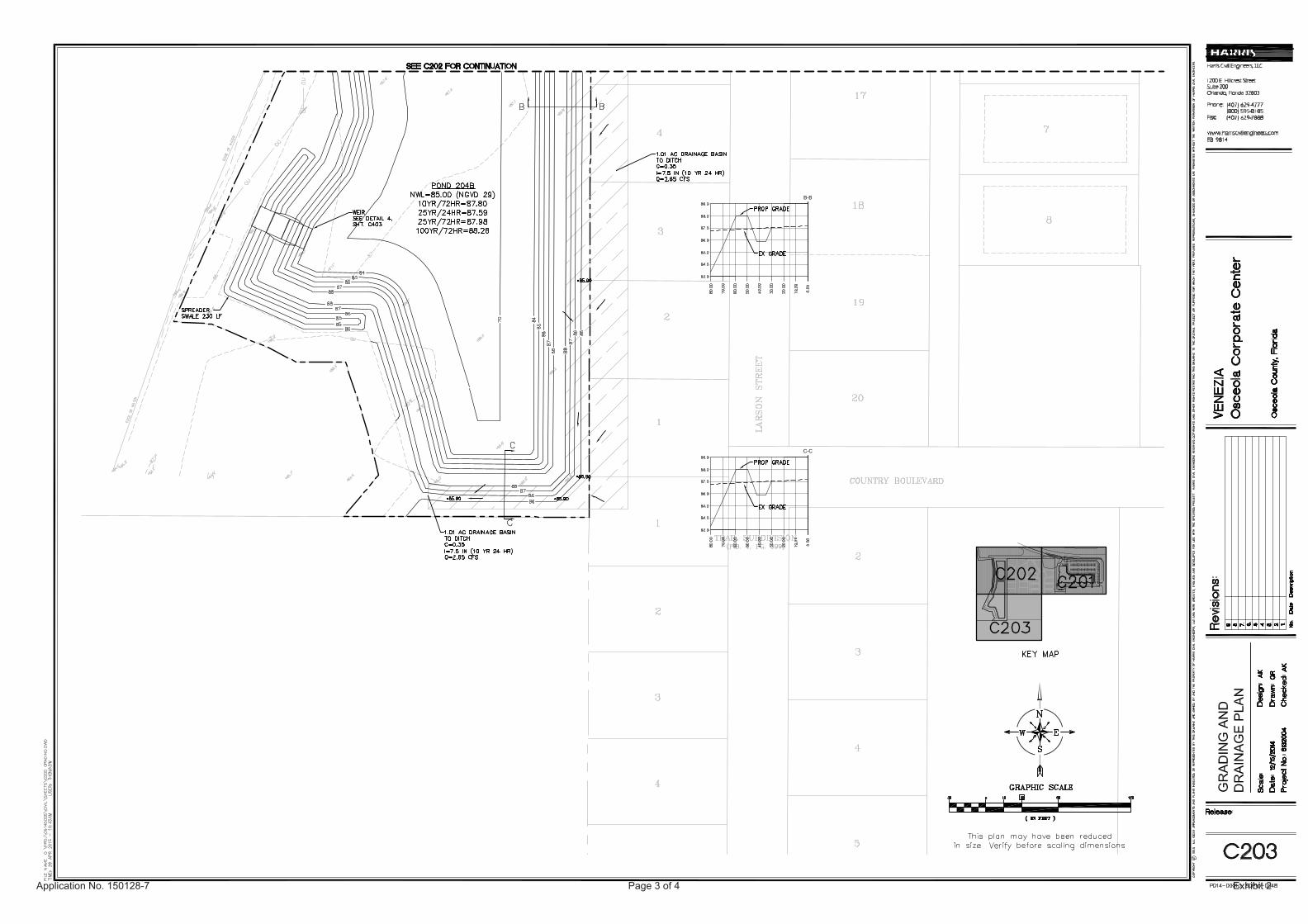
1-7.5' W X .8' H BROAD CRESTED weir with crest at elev. 87.5' NAVD 88. 1-3" dia. CIRCULAR ORIFICE with invert at elev. 85' NAVD 88. 10 LF of 2' dia. REINFORCED CONCRETE PIPE culvert.
Receiving body : Wetland E Control elev : 85 feet NAVD 88.
Lake side slopes shall be no steeper than 4:1 (horizontal:vertical) to a depth of two feet below the control elevation. Side slopes shall be nurtured or planted from 2 feet below to 1 foot above control elevation to insure vegetative growth, unless shown on the plans.
A stable, permanent and accessible elevation reference shall be established on or within one hundred (100) feet of all permitted discharge structures no later than the submission of the certification report. Thelocation of the elevation reference must be noted on or with the certification report.
Minimum building floor elevation: BASIN: Ponds 204 A/B - 88.29 feet NAVD 88.
Minimum parking lot elevation: Basin: Ponds 204 A/B - 87.90 feet NAVD 88.
Prior to commencement of construction and in accordance with the work schedule in Exhibit No. 3, the permittee shall submit documentation that 2.18 credits have been deducted from the ledger for QuickdrawMitigation Bank.
Prior to any future construction, the permittee shall apply for and receive a permit modification. As part of the permit application, the applicant for that phase shall provide documentation verifying that the proposedconstruction is consistent with the design of the master stormwater management system, including the land use and site grading assumptions.
This permit does not supersede or delete any requirements for other applications covered in Permit No. 49-00477-S-03 unless otherwise specified herein.
Prior to initiating construction activities associated with this Environmental Resource Permit (ERP), the permittee is required to hold a pre-construction meeting with field representatives, consultants, contractors, District Environmental Resource Compliance (ERC) staff, and any other local government entities as necessary.
The purpose of the pre-construction meeting is to discuss construction methods, sequencing, best management practices, identify work areas, staking and roping of preserves where applicable, and to facilitate coordination and assistance amongst relevant parties.
To schedule a pre-construction meeting, please contact ERC staff from the Orlando Service Center at (407) 858-6100 or via e-mail at: [email protected]. When sending a request for a pre-construction meeting, please include the application number, permit number, and contact name and phone number.
Application No.: 150128-7Page 5 of 6
18 June 2020

SPECIAL CONDITIONS
12. The following are exhibits to this permit. Exhibits noted as incorporated by reference are available on the District's ePermitting website (http://my.sfwmd.gov/ePermitting) under this application number.Exhibit No. 1 Location MapExhibit No. 2 Drainage Plans, Pages 1 - 4Exhibit No. 3 Work Credits, Pages 1 - 5Exhibit No. 4 Project Site Map, Page1Exhibit No. 5 Basin Map Page 1
Application No.: 150128-7Page 6 of 6


150128-7App.no. :
erp_staff_report.rdf
Page 1 of 7
July 5, 2015Last Date For Agency Action:
INDIVIDUAL ENVIRONMENTAL RESOURCE PERMIT STAFF REPORT
Project Name:
49-00477-S-03Permit No.:
Special Drainage District:
Osceola County,Location: S3/T25S/R29ES4/T25S/R29E
Tupperware Services IncDeerfield Land Corporation
Permittee :
9.35 acresProject Area:
Project Land Use:
4.08
2.18Offsite Mitigation Credits-Mit.Bank: Quickdraw Mitigation Bank
Environmental Resource (New Construction/Operation)Application Type:
Occ Master Owners' Association, Inc.Operating Entity :
Sovereign Submerged Lands: No
Total Acres Wetland Onsite:
NA
This Environmental Resource Permit Modification authorizes construction and operation of a stormwater management system (SWMS) serving a 7.7 acre commercial development for a project known as Venezia.
Stormwater runoff from the commercial parcel will be collected and conveyed via inlets and culverts to an on-site, in series dry retention - wet detention pond system that will provide water quality treatment and attenuation (Exhibit 2). The wet detention pond will discharge through its control structure- spreader swale to adjacent Wetland E.
Issuance of this permit constitutes certification of compliance with state water quality standards in accordance with Chapter 62-330.062 Florida Administrative Code (F.A.C.)
Venezia
Commercial
PROJECT SUMMARY:
LAKE TOHOPEKALIGADrainage Basin:
LAKE TOHOPEKALIGA via EXISTING WETLANDReceiving Body: CLASS IIIClass:
4.08Total Acres Impacted Onsite :
NoConservation Easement To District :
150128-7Application No.:
10.69 acresPermit Area:

150128-7App.no. :
erp_staff_report.rdf
Page 2 of 7
LAND USE:
WATER QUANTITY :
Building CoverageImperviousPerviousWater Mgnt Acreage
This Phase
.643.542.992.18
9.35Total:
Discharge Storm Frequency : 25 YEAR-3 DAY 11.7 inchesDesign Rainfall :
Ponds 204 A/BDrainage to WL H
Basin
15.1117.47
Allow Disch (cfs)
Pre Vs Postn/a
Method Of Determination
14.684.57
Peak Disch (cfs)
87.9985.11
Peak Stage( ft, NAVD 88)
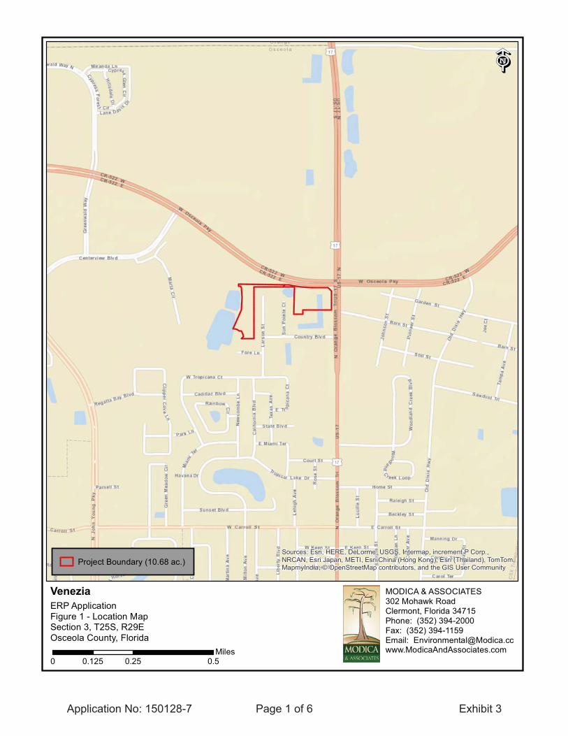
The site is located in the southwest corner of the SR441 and Osceola Parkway intersection within the Osceola Corporate Center in Osceola County. Refer to Exhibit 1 for a location map. The site is currently undeveloped.
For information on the wetlands and surface waters within the project, please refer to the Wetlands and Surface Waters section of this staff report.
This project is for construction of a new 7.7 acre commercial parcel that is located within Basin 204 (Exhibit 5) with surface parking and stormwater management. The total project area is 9.35 acres (Exhibit4) including approximately 1.65 acres that will be disturbed, but remain unpaved and not be directed to the SWMS. Another 1.34 acre area will essentially remain undisturbed, and is not included as project area. Runoff from the combined 2.99 acre area will assist in the hydration of Wetlands E & H that border the project area. There are 4.08 acres of wetland impacts and 0.11 acres of surface water impacts proposed with mitigation bank credit purchase consisting of 2.18 credits at Quickdraw Mitigation Bank to offset impacts.
PROJECT EVALUATION:
Construction
As shown in the table below, the proposed project discharge is within the allowable limit for the area.Please refer to Exhibit 4 for a comprehensive breakdown of offsite discharge from the permit area.
Discharge Rate :
acresacresacresacres
Project:
PROJECT SITE DESCRIPTION:
BACKGROUND:

150128-7App.no. :
erp_staff_report.rdf
Page 3 of 7
Proposed Min.Parking Elev.( ft, NAVD 88)
Ponds 204 A/B
Basin
7.70
Area (Acres)
85
Ctrl Elev( ft, NAVD 88)
85.00
WSWT Ctrl Elev( ft, NAVD 88)
Wet Season Soil Borings
Method Of Determination
Control Elevation :
Ponds 204 A/BBasin
D204Str.#
Wetland EReceiving Body
Receiving Body :
Parking Lot Storm Frequency : 10 YEAR-1 DAY 7.4 inchesDesign Rainfall :
Ponds 204 A/B 87.9
Peak Stage( ft, NAVD 88)
87.9
Building Storm Frequency : 100 YEAR-3 DAY 14.4 inchesDesign Rainfall :
Ponds 204 A/B
Basin
88.29
Peak Stage( ft, NAVD 88)
N/A
FEMA Elevation( ft, NAVD 88)
88.29
Proposed Min. Finished Floors ( ft, NAVD 88)
No adverse water quality impacts are anticipated as a result of the proposed project. Water quality treatment in excess of 2.5" times percentage of impervious surfaces is provided in the on-site wet detention pond for the 7.7 acre commercial parcel.
WATER QUALITY :
As shown in the following table, minimum parking lot elevations have been set at or above the calculated design storm flood elevation.
Parking Lot Design :
As shown in the following table and the attached exhibits, minimum finished floor elevations have been set at or above the calculated design storm flood elevation.
Finished Floors :
Basin
Basin
Discharge Structures:Bleeders:
Culverts:
Weirs:
D204
Str#
1
Count
Circular Orifice
Type Width Length
3"
Dia. InvertAngle
BasinD204Str#
1Count
Reinforced Concrete PipeType Width
10'Length
2'Dia.
BasinPonds 204 A/B
D204Str#
1Count
Broad CrestedType
7.5'Width
.8'Height Length Dia.
Invert Elev.
85
87.5 (crest)Elev.
Ponds 204 A/B
Ponds 204 A/B
Height
Note: The units for all the elevation values of structures are ( ft, NAVD 88)

150128-7App.no. :
erp_staff_report.rdf
Page 4 of 7
A pre-vs. post phosphorus analysis was conducted.
Ponds 204 A/B
Basin
Wet Detention
Treatment Method
.81
Vol Req.d (ac-ft)
3.94
VolProv'd
CONSTRUCTION MOD -Venezia
25aSW
AA Type
.00
TimeLag (Yrs)
Pres.Adj.Factor
PostFluccs
AdjDelta
-2.162.000
Total:
Pre-Development Post-Development
DirectDirect
WETLANDS:
Wetland Inventory :
Treatment
Wetlands And Other Surface Waters:
The project area contains wetlands and surface waters totaling 4.19 acres. Please see Exhibit 3 for wetland and surface water locations. The wetlands can be generally described as mixed forested wetlands and the surface waters can be described as reservoirs. Additional wetland descriptions are located in the epermitting file.
The project will result in impacts to 4.08 acres of wetlands and 0.11 acres of surface waters as described in the table below. A conservation easement over wetlands and surface water was released by the Governing Board during the 2015 June board meeting. Exhibit 3 identifies the locations wetlands/surface waters that will be impacted. The permittee is proposing to purchase mitigation bank credits which will provide regionally significant habitat value. These credits will provide long-term sustainable ecological benefits. The amount of mitigation was determined by using the Unified Mitigation Assessment Method in Chapter 62-345, F.A.C. The final scores can be found in the permit file.
The proposed mitigation (2.18 credits at Quickdraw Mitigation Bank) is not located within the same basin as the impacts, but in accordance with the conceptual permit (App. # 941101-4) approximately 468.47 acres of wetlands were preserved under a conservation easement within the boundaries of the conceptual permit. Therefore pursuant to Section 10.2.8 of Volume I, the project will not result in unacceptable cumulative impacts to the basin.
SiteId
SiteType
ONON
4.08.11
.53
Acreage (Acres)
CurrentWo Pres
630530
PreFluccs
WithProject
-.530.000
FunctionalGain / Loss
530630
Fluccs CodeReservoirsWetland Forested Mixed
Description
4.19 -2.16
RiskFactor

150128-7App.no. :
erp_staff_report.rdf
Page 5 of 7
Pursuant to Chapter 62-330.310 Florida Administrative Code (F.A.C.), Individual Permits will not be converted from the construction phase to the operation phase until construction completion certification of the project is submitted to and accepted by the District. This includes compliance with all permit conditions, except for any long term maintenance and monitoring requirements. It is suggested that the permittee retain the services of an appropriate professional registered in the State of Florida for periodic observation of construction of the project.
For projects permitted with an operating entity that is different from the permittee, it should be noted that until the construction completion certification is accepted by the District and the permit is transferred to an acceptable operating entity pursuant to Sections 12.1-12.3 of the Applicant's Handbook Volume I and Section 62-330.310, F.A.C., the permittee is liable for operation and maintenance in compliance with the terms and conditions of this permit.
In accordance with Section 373.416(2), F.S., unless revoked or abandoned, all stormwater management systems and works permitted under Part IV of Chapter 373, F.S., must be operated and maintained in perpetuity.
The efficiency of stormwater management systems, dams, impoundments, and most other project components will decrease over time without periodic maintenance. The operation and maintenance entity must perform periodic inspections to identify if there are any deficiencies in structural integrity, degradationdue to insufficient maintenance, or improper operation of projects that may endanger public health, safety, or welfare, or the water resources. If deficiencies are found, the operation and maintenance entity will be responsible for correcting the deficiencies in a timely manner to prevent compromises to flood protection and water quality. See Section 12.4 of Applicant's Handbook Volume I for Minimum Operation and Maintenance Standards.
MITBANK QUICKDRAW MITIGATION BANK
2.18
Fresh Water Herbaceous 2.18Mitigation Bank Cr Used
Total:
Type Of Credits Number Of Credits
CERTIFICATION, OPERATION, AND MAINTENANCE:

150128-7App.no. :
erp_staff_report.rdf
Page 6 of 7
The applicant has indicated that reclaimed public water supply from Toho Water Authority will be used asa source for irrigation water for the project.
The applicant has indicated that dewatering is required for construction of this project. Prior to any construction activities, the applicant will submit a dewatering application for District approval.
This permit does not release the permittee from obtaining all necessary Water Use authorization(s) prior to the commencement of activities which will require such authorization, including construction dewateringand irrigation.
The proposed project is not located within or adjacent to a Comprehensive Everglades Restoration Project component.
Toho Water Authority
Toho Water Authority
A District Right-of-Way Permit is not required for this project.
No information has been received that indicates the presence of archaeological or historical resources in the project area or indicating that the project will have any effect upon significant historic properties listed, or eligible for listing in the National Register of Historic Places.
The issuance of this permit constitutes a finding of consistency with the Florida Coastal Management Program.
No third party has contacted the District with concerns about this application.
There has been no enforcement activity associated with this application.
RELATED CONCERNS:
Water Use Permit Status:
CERP:
Potable Water Supplier:
Waste Water System/Supplier:
Right-Of-Way Permit Status:
Historical/Archeological Resources:
DEO/CZM Consistency Review:
Third Party Interest:
Enforcement:

150128-7App.no. :
erp_staff_report.rdf
Page 7 of 7
STAFF REVIEW:
NATURAL RESOURCE MANAGEMENT:
SURFACE WATER MANAGEMENT:
Jennifer Thomson
Mark S. Daron, P.E.
DIVISION APPROVAL:
__________________________________ DATE:__________________________
__________________________________ DATE:__________________________MaMaMaMaaMaMaMaMaMaMaMaaMaaMaMaMaaMaaaMaMaMaMaaaaMaMaMaMaMaMaMaaaaMaMaMaMaMaMaaaaMaMaMaMaaaaMaMaMaMaMaaaMaMaMaMaMaMaMaaMaMaMaMaMaaMaMaMaMaaMaMaMaMaaMaMaMaaaMaMaMaMaMaMaMaMaMaMaMaMaMaMaMaMaMaMaMaMaMaMaMaMaMaMarkrk S. Daron, P.E.____________________________________________________________________________________________________________________ June 18, 2015
NATURAL RESOURCE MANAGEMEN
GEMENT:
JeJeJeJeJeJeJeJeJeJeJeJeJeJeJeJeJeJeJeJeJeJeJeJeJeJeJeJeJeJeJeJeJeJeJeJeJeJeJeJeJeJeJeJeJeJeJeJeJeJeJeJeJeJeJeJeJeJeJeJeJeJeJeJeJeJeJeJeJeJeJeJeJeJeJeJeJeJeJeJeJeJeJeJeJeJeJeJeJeJeJeJeJeJeJeJeJeJeJeJeJeJeJeJeJeJeJeJeJeJeJeJennifer Thohohohohohohohohohohohohohohohohohohohohohohohohohohohohohohohohohohohohohohohohohohohohohohohohohohohohohohohohohohohohohohohohohohohohohohohohohohohohohohohomson___________________ _______________________________________________________________________________________________________________________________________________________________________ ____________________
SUUUUUUUUUURFRFFFFFFRFRFRFRFRFFRFRFRFRFRFRFRFRFFRFRFRFRFRFRFRFFRRFRFRFRFRFRRFRFRFRFRRFRFRFRFRFRFRFRFRFRFRFRFRFRFRRFRFRFRFRFRFRFRFRFRFFRFRFRFRFRFFRRRFRFRFRFRFRFRFFRFRFRRRFRFRFRFRFRFRFRRFRFRFRFRRRRRFRFRFRFRRRRFRRFRFRFRRRRRRFRRRRRRFRFRRRRRFRRRRRFRFRRFRFACACACACACACACACACACACACACACACACACACACACACACACACACACACACAAAAACACACACAAAAACACACACACACAACACACACAAACACACACAAAACACACAAACACACACACACACACACACAACACACAACACACACAACACACACACACACACACACACAACACAAACAACAAAACACAAAAAAAAAAAAAAAA E WAWAWWAWAWAWAWAWAWAWAWAWAWAAWAWAWAWAWAWAWAWAWAWAWAWAWAWAAWWWAWAWAWAWAWAWAWAAWAWAWWAWAWAWAWAWAWAWAAWWAWAWAWAAWAWAWWAWAWAWAWAWAWAAWAAWAWAWAWAWAWAWWWAWAWAWAWAAWWAWAWAWAWAWAWAWAWAWAWAWAWAWAWAWAWAWAWAWAWAWWAWWAWAWAWAWWAWAWAWAAWWAWAWAWAWAWWWWAWAWAWAAWAWWWWWAWAWAWAAAAAWAWWAWAAWAAAAWWWAWAWAAAAWAWAWWAWAWAWAAAWAWAWAWAWAWAAAWWAWAWAWAWAAAAWAWAWAWAWAAWWWAWAWAWAAAAAAWAAWWAWAWAWAAAAWAWWAWAWAWAWAWAAAAAAAAWWAWWAWAWAWAWAAAAAWWWWAWAWAWAWAAAWWWAWAWAAWAAAWAWAWAWAWAWAAAAAAAAWAWAAATETETTETETETTETTTTTTETTTTTTTTETTTETTTETTTTETTTTETTETETETTTTTTTTTTTETETTTETETETTETETETETETETETETETETETETETETETETETTETETTTTETETTTTETETETTETETETTTTTETTTTETETETTTETETETETETETETETETETER MANAGE
JeJeJeJeJeJeJeJeJeJeJeJeJeJeJeJeJennifer ThomsonJune 18, 2015

CR-522
US
-17
US
-92
US
-441
SR
-500
SR
-600
CR
-527
W OSCEOLA PKWY
N J
OH
N Y
OU
NG
PK
WY
W CARROLL ST
N O
RA
NG
E B
LOS
SO
M T
RL
E OSCEOLA PKWY
OR
ANG
E A
VE
CR
-531
OLD
DIXIE H
WY
CR
-423
N J
OH
N Y
OU
NG
PK
WY
W OSCEOLA PKWY
CR-522N J
OH
N Y
OU
NG
PK
WY
OLD
DIX
IE H
WY
N O
RA
NG
E B
LOS
SO
M T
RL
W CARROLL ST
GARDEN STBARN ST
SA
MP
LE S
T
OR
AN
GE
AV
EE CARROLL ST
STILL ST
W JACKSON ST
HOME ST
CENTERVIEW BLVD
SAWDUST TRLM
ARTA C
IR
CO
RA
L AV
E
N C
EN
TRA
L AV
ELA
RS
ON
ST
TAM
PA A
VE
E MARTIN ST
LONE EAGLE DR
MA
RTI
NA
AVE
MIAMI TER
E JACKSON ST
TROPICAL LAKE DR
E FLETCHER ST
GR
EEN
WALD
WAY N
KISSIMMEE DR
W TROPICANA CT
TEXA
S A
VE
LIB
ER
TY B
LVD
SUNSET BLVD
LEH
IGH
AV
E
KEN
T PL
MIRANDA LN
AMBERWOOD BLVD N B
EA
UM
ON
T AV
E
CADILLAC BLVD
MARY LEE RD
CR
ES
TED
CIR
PARK LN
REGATTA BAY BLVDRAV
EN
WO
OD
LN
CARLTON ST
SU
N P
OIN
TE C
TE
TRO
PIC
ANA
CT
RAVENWO
OD CIR
LONG BAY CT
SAGO PALM BLVD
HAVANA DR
CR
OW
N C
T
SUR
REY
CT
W CARROLL ST
STILL ST
Orange County Appraiser, Osceola County Appraiser, Polk County
¯REGULATION DIVISION
South Florida Water Management District
Osceola COUNTY, FLExhibit No: 1Exhibit Created On: 2015-06-18
Application Number: 150128-7
Permit No: 49-00477-S-03
Project Name: VENEZIA
Created by Regulation GIS Section
Application
0 2,3001,150Feet

Application No. 150128-7 Page 1 of 4 Exhibit 2

Application No. 150128-7 Page 2 of 4 Exhibit 2
Application No. 150128-7 Page 3 of 4 Exhibit 2

Application No. 150128-7 Page 4 of 4 Exhibit 2
Sources: Esri, HERE, DeLorme, USGS, Intermap, increment P Corp.,NRCAN, Esri Japan, METI, Esri China (Hong Kong), Esri (Thailand), TomTom,MapmyIndia, © OpenStreetMap contributors, and the GIS User Community
VeneziaERP ApplicationFigure 1 - Location MapSection 3, T25S, R29EOsceola County, Florida
Ë
Project Boundary (10.68 ac.)
MODICA & ASSOCIATES302 Mohawk RoadClermont, Florida 34715Phone: (352) 394-2000Fax: (352) 394-1159Email: [email protected]
0 0.25 0.50.125Miles
Application No: 150128-7 Page 1 of 6 Exhibit 3

Source: Esri, DigitalGlobe, GeoEye, i-cubed, Earthstar Geographics,CNES/Airbus DS, USDA, USGS, AEX, Getmapping, Aerogrid, IGN, IGP,swisstopo, and the GIS User Community
VeneziaERP ApplicationFigure 2 - Aerial PhotographSection 3, T25S, R29EOsceola County, Florida
Ë
Project Boundary (10.68 ac.)
MODICA & ASSOCIATES302 Mohawk RoadClermont, Florida 34715Phone: (352) 394-2000Fax: (352) 394-1159Email: [email protected]
0 200 400100Feet
Application No: 150128-7 Page 2 of 6 Exhibit 3

434
630 534
832
743
743 743
534
534
630
Source: Esri, DigitalGlobe, GeoEye, i-cubed, Earthstar Geographics,CNES/Airbus DS, USDA, USGS, AEX, Getmapping, Aerogrid, IGN, IGP,swisstopo, and the GIS User Community
VeneziaERP ApplicationFigure 4- Land Use MapSection 3, T25S, R29EOsceola County, Florida
Ë
Project Boundary (10.68 ac.)434, Hardwood-Conifer Mixed
534, Reservoir less than 10 acres (1.63 ac.)
630, Wetland Forested Mixed (2.75 ac.)743, Spoil Areas (1.17 ac.)
832, Utility Easement
MODICA & ASSOCIATES302 Mohawk RoadClermont, Florida 34715Phone: (352) 394-2000Fax: (352) 394-1159Email: [email protected]
0 200 400100Feet
Application No: 150128-7 Page 3 of 6 Exhibit 3

Venezia
��������
� ���������� ����� ����������
����������� ���� ���� ��!�������" ���� ���� ����TOTALS 4.08 2.18
UMAM SUMMARY
Application No: 150128-7 Page 4 of 6 Exhibit 3

Work Schedule Requirements
South Florida Water Management District
150128-7Application No :
Exhibit No : 3
Page 1 of 1
CREDIT PURCHASE
SUBMIT MITIGATION BANK DOCUMENTATION
SUBMIT RECORDED CONSERVATION EASEMENT RELEASE
Activity
31-AUG-15
30-SEP-15
Due DateMitigation Plan ID:
Application No: 150128-7 Page 5 of 6 Exhibit 3

Application No: 150128-7 Page 6 of 6 Exhibit 3

Application No. 150128-7 Page 1 of 1 Exhibit 4

Application No.: 150128-7 Page 1 of 1 Exhibit 5

STAFF REPORT DISTRIBUTION LIST
#$%$&�
!'���!���(���Permit No:
Application No: �����)��
INTERNAL DISTRIBUTION
*���(���+/�������"+���9����;��<=�����*��>(������?@�$�
EXTERNAL DISTRIBUTION
B@���������<� ��C���(��D������B@�������������;��������F�� �������
������������=����$/F$����������$/F$�D����������%�#�����
GOVERNMENT AGENCIES
��D�;/������������@��>�����������F=����+( �����?��$@G������F����+$�������
B$���F����������"�����F�D��$����������F
BBBBBBBBB B
B


![SOUTH FLORIDA WATER MANAGEMENT DISTRICT …occ.tupperware.com/Folder 2/VI.20 - SFWMD Permmit Modification t… · ORLANDO, FL 32837 ... Family Dwelling Unit"[Form 62-330.310(3)];](https://img.pdfslide.net/doc/110x75/60181dd818b8e91bf1081964/south-florida-water-management-district-occ-2vi20-sfwmd-permmit-modification.jpg)