Embed Size (px)
Citation preview
City of London
Southdale Road West Improvements Pine Valley Boulevard to Colonel Talbot Road Schedule ‘C’ Municipal Class Environmental Assessment Environmental Study Report
Prepared by:
AECOM
410 – 250 York Street, Citi Plaza 519 673 0510 tel
London, ON, Canada N6A 6K2 519 673 5975 fax
www.aecom.com
March 2019 Project Number: 60542198

City of London
Southdale Road West Improvements
Environmental Study Report
RPT.Final Southdale ESR-2019 03 27-Pam.V2-Final
Distribution List
# Hard Copies PDF Required Association / Company Name
2 Yes City of London
Revision History
Revision # Date Revised By: Revision Description
1 2019/02/10 P.McAllister City Division comments (December 18, 2018, January 18, 2019, and March 21, 2019)
City of London
Southdale Road West Improvements
Environmental Study Report
AECOM: 2015-04-13
© 2009-2015 AECOM Canada Ltd. All Rights Reserved.
RPT.Final Southdale ESR-2019 03 27-Pam.V2-Final
Statement of Qualifications and Limitations
The attached Report (the “Report”) has been prepared by AECOM Canada Ltd. (“AECOM”) for the benefit of the Client (“Client”) in
accordance with the agreement between AECOM and Client, including the scope of work detailed therein (the “Agreement”).
The information, data, recommendations and conclusions contained in the Report (collectively, the “Information”):
▪ is subject to the scope, schedule, and other constraints and limitations in the Agreement and the qualifications
contained in the Report (the “Limitations”);
▪ represents AECOM’s professional judgement in light of the Limitations and industry standards for the preparation of
similar reports;
▪ may be based on information provided to AECOM which has not been independently verified;
▪ has not been updated since the date of issuance of the Report and its accuracy is limited to the time period and
circumstances in which it was collected, processed, made or issued;
▪ must be read as a whole and sections thereof should not be read out of such context;
▪ was prepared for the specific purposes described in the Report and the Agreement; and
▪ in the case of subsurface, environmental or geotechnical conditions, may be based on limited testing and on the
assumption that such conditions are uniform and not variable either geographically or over time.
AECOM shall be entitled to rely upon the accuracy and completeness of information that was provided to it and has no
obligation to update such information. AECOM accepts no responsibility for any events or circumstances that may have
occurred since the date on which the Report was prepared and, in the case of subsurface, environmental or geotechnical
conditions, is not responsible for any variability in such conditions, geographically or over time.
AECOM agrees that the Report represents its professional judgement as described above and that the Information has been
prepared for the specific purpose and use described in the Report and the Agreement, but AECOM makes no other
representations, or any guarantees or warranties whatsoever, whether express or implied, with respect to the Report, the
Information or any part thereof.
Without in any way limiting the generality of the foregoing, any estimates or opinions regarding probable construction costs or
construction schedule provided by AECOM represent AECOM’s professional judgement in light of its experience and the
knowledge and information available to it at the time of preparation. Since AECOM has no control over market or economic
conditions, prices for construction labour, equipment or materials or bidding procedures, AECOM, its directors, officers and
employees are not able to, nor do they, make any representations, warranties or guarantees whatsoever, whether express or
implied, with respect to such estimates or opinions, or their variance from actual construction costs or schedules, and accept no
responsibility for any loss or damage arising therefrom or in any way related thereto. Persons relying on such estimates or
opinions do so at their own risk.
Except (1) as agreed to in writing by AECOM and Client; (2) as required by-law; or (3) to the extent used by governmental
reviewing agencies for the purpose of obtaining permits or approvals, the Report and the Information may be used and relied
upon only by Client.
AECOM accepts no responsibility, and denies any liability whatsoever, to parties other than Client who may obtain access to the
Report or the Information for any injury, loss or damage suffered by such parties arising from their use of, reliance upon, or
decisions or actions based on the Report or any of the Information (“improper use of the Report”), except to the extent those
parties have obtained the prior written consent of AECOM to use and rely upon the Report and the Information. Any injury, loss
or damages arising from improper use of the Report shall be borne by the party making such use.
This Statement of Qualifications and Limitations is attached to and forms part of the Report and any use of the Report is subject
to the terms hereof.
City of London
Southdale Road West Improvements
Environmental Study Report
Error! Reference source not found.
Error! Reference source not found.
RPT.Final Southdale ESR-2019 03 27-Pam.V2-Final
List of Acronyms BRT Bus Rapid Transit CHAR Cultural Heritage Assessment Report COTTFN Chippewa of the Thames First Nation CSP Corrugated steel pipe CWA Clean Water Act DBH Diameter at Breast Height EA Environmental Assessment EAA Environmental Assessment Act EBL East Bound Left Turn Lane EBT East Bound Through Lane EBTR East Bound Through Right Lane ECA Environmental Compliance Approval EIS Environmental Impact Study ELC Ecological Land Classification END Endangered ESA Endangered Species Act
ESR Environmental Study Report GMIS Growth Management Implementation Strategy IPZ Intake Protection Zone HVA Highly Vulnerable Area LOS Level of Service MOECC Ministry of the Environment and Climate Change MECP Ministry of the Environment, Conservation and Parks MTCS Ontario Ministry of Tourism, Culture & Sport MCEA Municipal Class Environmental Assessment MEA Ontario Municipal Engineers Association MNRF Ontario Ministry of Natural Resources & Forestry NBL North Bound Left Turn Lane NBT North Bound Through Lane OP Official Plan O’Reg. Ontario Regulation PIC Public Information Centre PPS Provincial Policy Statement PSW Provincially Significant Wetland PTTW Permit to Take Water PVC Polyvinyl Chloride ROW Right-of-Way SAR Species at Risk SARA Species at Risk Act SBL South Bound Left Turn Lane SBT South Bound Through Lane SC Special Concern SGRA Significant Groundwater Recharge Area SPP Source Protection Plan SWAP Southwest Area Plan SWP Source Water Protection SWH Significant Wildlife Habitat SWM Stormwater Management SWMF Stormwater Management Facility TDM Transportation Demand Management THR Threatened TMP Transportation Master Plan UTRCA Upper Thames River Conservation Authority V/C Volume to Capacity Ratio WBL West Bound Left Turn Lane WBT West Bound Through Lane WBTR West Bound Through Right Lane WHPA Well Head Protection Area
City of London
Southdale Road West Improvements
Environmental Study Report
Error! Reference source not found.
Error! Reference source not found.
RPT.Final Southdale ESR-2019 03 27-Pam.V2-Final i
Executive Summary
Introduction
The City of London (the City) has completed a Municipal Class Environmental Assessment (MCEA) study to
address necessary transportation infrastructure requirements along the Southdale Road West and Bostwick Road
corridors. The Southdale Road West Improvements MCEA (hereafter the “Project”) is classified as a Schedule ‘C’
project in the Municipal Engineers Association (MEA) MCEA process (October 2000, as amended in 2007, 2011
and 2015), where project activities are subject to the full environmental assessment (EA) planning process of the
MCEA.
Background The City of London continues to develop and grow as a municipality. To accommodate this growth, new
infrastructure is required that recognizes the capacity needs of planned growth and the objectives of protecting
established communities and businesses. Southdale Road West is one of the major east-west arterial thoroughfare
and access roadways into the City of London, connecting the southwest corner of the City
and areas to the west, through to the central and easterly areas of the City. It serves as a major corridor for
economic, social, urban, and transportation development, and is located at the south and west edges of existing
built up area, the north edge of what will be an area of future development in the near term.
This widening project was identified as a priority in the City of London’s 2030 Transportation Master Plan (TMP),
the guiding policy document for future transportation planning and as part of the Growth Management
Implementation Strategy (GMIS) for transportation projects. The need for capacity improvements was also
identified as part of the 2014 Development Charge Background Study, including phasing, and has been further
updated as part of the 2019 DC Transportation Background Study. The City of London is considering the widening
of this corridor from Colonel Talbot Road to Pine Valley Boulevard, from 2 to 4 lanes, to be staged for construction
from Pine Valley Boulevard to Farnham Road, and from Farnham Road to Colonel Talbot Road.
While not covered in the TMP, Bostwick Road improvements, from Southdale Road West to north of Pack Road,
have been considered in this study to support anticipated future development within and adjacent to the study area.
Problem/Opportunity Statement The MCEA Problem/Opportunity Statement provides the basis for the need and justification for this project and
aligns with the recommendations of the TMP.
Problem: As the City of London continues to grow and develop, new transportation infrastructure is
required that recognizes the capacity needs of planned growth and the objectives of protecting
established communities and businesses. Significant growth is anticipated along the south side of
Southdale Road West between Tillmann Road and Pine Valley Boulevard, and some areas along
the
corridor are experiencing traffic delays during peak periods. In addition, the new Southwest
Optimist Community Centre and YMCA will increase vehicular, pedestrian and cycling traffic along
this section of Southdale Road West. Considering this, and modeling through the City’s
Transportation Master Plan, the existing two lane road will not have sufficient capacity to
accommodate the projected growth and number of road users. Improvements are also needed on
Bostwick Road from Southdale Road West to Pack Road. It is anticipated that the existing two lane
City of London
Southdale Road West Improvements
Environmental Study Report
Error! Reference source not found.
Error! Reference source not found.
RPT.Final Southdale ESR-2019 03 27-Pam.V2-Final ii
roads will not have sufficient capacity to accommodate the projected growth and number of road
users.
Five year collision review indicates rear-end collisions were reported as the most prevalent type of
traffic impact in the study area. This can be attributed to relatively high speed limits and the lack of
passing opportunities.
Opportunity: By following the Complete Streets approach, there is an opportunity to improve
Southdale Road West (Pine Valley Boulevard to Colonel Talbot Road) and Bostwick Road (Pack
Road to Southdale Road West) to accommodate the existing and future traffic demand (including
transit and active transportation), and provide better connectivity to adjacent neighbourhoods for
the overall road network.
A ‘Complete Street’ is designed for all ages, abilities and modes of travel. On Complete Streets, safe and
comfortable access for pedestrians, bicycles, transit uses and people with disabilities in not an afterthought, but an
integral planning feature (Source: Complete Streets Canada).
This project also has the ability to align with the principles of Vision Zero, a global movement that has been
adopted by the City to eliminate traffic injuries and fatalities caused by vehicular collisions. Vision Zero London is
the City’s road safety strategy to reduce the number and severity of collisions occurring within the City and
increase road safety for cyclists, motorist and pedestrians. (Source: City of London).
Alternative Planning Solutions For the purposes of the Southdale Road West Improvements MCEA, planning solutions to the undertaking include:
1. Do Nothing – Assumes no improvements will be made beyond those already planned and approved.
2. Limit Growth – Assumes no improvements will be made beyond those already planned and approved and includes measures to limit development in the study area.
3. Road Network Improvements – Includes potential improvements to nearby east/west roads (Commissioners Road and Pack Road/Bradley Avenue Extension)
4. Operational Improvements – Includes the implementation of additional turn lanes, traffic signal coordination, etc.
5. Road Widening – Includes widening of Southdale Road West to provide additional traffic lanes to increase capacity.
6. Transportation Demand Management (TDM) – Includes measures to reduce vehicle volumes by using bike lanes, and promoting transit.
The above identified alternative solutions were screened against the problem and opportunity statement identified
in Section 5 of this Report. The evaluation of alternative solutions is comprised of a two-step process. Firstly, Do
Nothing, Limit Growth and Road Network Improvements were screened out because it was determined that these
solutions will not address the project needs as identified in the problem and opportunity statement in Section 4.
Do Nothing – This was not carried forward for further assessment. Although this solution avoids impacts to natural
environment, archaeological and cultural resources and costs less compared to other solutions, it does not address
transportation planning and does not address the problem and opportunity statement identified for this project.
City of London
Southdale Road West Improvements
Environmental Study Report
Error! Reference source not found.
Error! Reference source not found.
RPT.Final Southdale ESR-2019 03 27-Pam.V2-Final iii
Limit Growth – This option was not carried forward as it does not comply with current City policies and does not
address the problem and opportunity statement.
Road Network Improvements – This option was not carried forward for further assessment as it offers only limited
improvements to capacity and level of service on Southdale Road West due to planned growth along corridor and
marginal diversion of traffic on other roads. This option does not address the problem and opportunity statement for
this project.
Next, the remaining alternative solutions, (Operational Improvements, Road Widening and TDM), were carried
forward for further assessment and were evaluated against the criteria developed for the project in order to
determine the preferred recommended solution.
Alternative Design Solutions At the end of Phase 2 of the MCEA process, the recommended preferred solution for the project was to widen
Southdale Road West and Bostwick Road from 2 lanes to 4 lanes. Phase 3 identifies the alignment for the
preferred solution of widening and evaluates intersection types (roundabouts or signalized).
The evaluation and identification of the preferred design is divided into two components:
A: Road Widening Concepts
• Evaluate widening of Southdale Road West to the north, widening to the south, and widening from the
centerline.
• Evaluate widening of Bostwick Road to the west, widening to the east, and widening about the centerline.
B: Intersection Concepts:
• Evaluate alternatives for the intersection (signalized or roundabout) at Southdale Road West and Colonel
Talbot Road.
• Evaluate alternatives for the intersection (signalized or roundabout) at Southdale Road West and Bostwick
Road.
Preferred Design Solution The Preferred Design for Southdale Road West and Bostwick Road (Figure ES1) considered transportation
facilities for all road users (motorists, transit, cyclists and pedestrians as per the City’s Complete Streets
requirements) and potential impacts to natural, socio-economic and cultural features and costs. The preferred
design was selected, developed and refined through extensive consultation with agencies, stakeholders and the
public.
Summary of Preferred Design
Summary Preferred Rationale
Road Alignment –
Southdale Road West
Widen to the south • Fewer property owners impacted
• Less property acquisition required
• Less encroachment s on existing park, SWMF,
Hydro One infrastructure
• Overall lower capital costs
Road Alignment –
Bostwick Road
Widen from the centerline • More equitable property acquisition from multiple
property owners
• Less encroachment into either of the natural
features
SOUTHDALE ROAD WEST
!(
London
()401
()402
Ma
p lo
ca
tio
n:
P:\
60
54
21
98
City
of
Lo
nd
on
- S
ou
thd
ale
Ro
ad
EA
\90
0-C
AD
_G
IS\9
20
-92
9 (
GIS
-Gra
ph
ics
)\E
A F
igu
res\m
xd
\Re
po
rt\F
igu
re 8
-1 P
ref
De
sig
n C
on
ce
pt.
mx
d
Da
te S
ave
d:
8/2
0/2
01
8 2
:57
:09
PM
Use
r N
am
e:
ad
am
sp
1
1:4,500Aug, 2018
Datum:Source:
Figure ES1P#: 60542198
0 200100
Metres
NAD 1983 UTM Zone 17NLIO, AECOM, City ofLondon
* when printed 11"x17"
This drawing has been prepared for the use of AECOM's client and may not beused, reproduced or relied upon by third parties, except as agreed by AECOMand its client, as required by law or for use by governmental reviewing agencies.AECOM accepts no responsibility, and denies any liability whatsoever, to anyparty that modifies this drawing without AECOM's express written consent.
° °
Southdale Road West ImprovementsEnvironmental Assessment
Preferred DesignConcept
SOUTHDALE ROAD WEST
FARNHAM ROAD
BO
ST
WIC
K R
OA
D
FA
RN
HA
MRO
AD
SO
UT
HD
AL
ER
OA
DW
ES
T
BOSTWICK ROAD
Legend
Study Area
Edge of Pavement
Sidewalk
City of London
Southdale Road West Improvements
Environmental Study Report
Error! Reference source not found.
Error! Reference source not found.
RPT.Final Southdale ESR-2019 03 27-Pam.V2-Final iv
Intersection – Southdale
Road and Colonel Talbot
Road
Roundabout (2 lane) • More equitable property acquisition from multiple
property owners
Intersection – Southdale
Road and Bostwick Road
Signalized • Less property acquisition required
• Lower overall capital costs
• No known impacts on natural features or
archaeological resources
Cross Section Elements
The proposed right-of-way widths along both Southdale Road West and Bostwick Road will generally be
standardized to 36.0m wide, with localized widenings or adjustments at the intersections. In accordance with the
London Plan, the road is classified as a Civic Boulevard, which dictates certain cross-sectional elements and
design criteria. As a result, the cross sections for each road will generally be standardized where feasible and
practical. The cross sections will include dedicated sidewalks on both sides, as well as uni-directional bike paths in
each boulevard. Some details of each cross section may vary subject to the location along the corridor, due to the
presence of significant utilities or other features that may warrant a modified alignment of the sidewalks and/or bike
paths.
Each of the intersections within the study area will be reconstructed. All existing signalized intersections will
generally be maintained, and reconstructed to accommodate the widened Southdale Road West or Bostwick Road
cross section.
The Colonel Talbot Road intersection will be reconstructed, implementing a 2-lane roundabout at this location. The
current proposed alignment and layout was created to minimize impacts to existing properties and utilities. The
exact layout of the intersection will need to be further refined during detailed design to address any final grading
transitions to adjacent properties or the adjacent SWM facility.
Construction Staging and Traffic Detouring Completion of the full scope of the proposed work will be a significant undertaking. As a result, traffic through and
within the project area would be impacted in some fashion over a number of years. Based on similarly completed
projects, it is anticipated that each phase of the project would take approximately 2 years to fully complete, all
subject to project timing and available budgets. Therefore, consideration should be given to the staging and
sequencing of construction and traffic management.
Preliminary Implementation Schedule
Project
Phase
Project Component Anticipated Timing
(2019 Transportation Background Study)
Phase 1
Southdale Road:
Farnham Road to Pine Valley Boulevard
Construction: 2022 (0-5 years)
Phase 2 Bostwick Road:
Southdale Road West to south limits of study area
Construction: 2025
Phase 3
Southdale Road:
Colonel Talbot Road to Farnham Road
Construction: 2031
To accommodate the potential 2-year construction window for each phase, the project is to be reviewed to
determine what impacts may occur to the local residents and traveling public during that time. Each phase will have
varying degrees of impact, with the most significant impact occurring during the first year of each phase.
City of London
Southdale Road West Improvements
Environmental Study Report
Error! Reference source not found.
Error! Reference source not found.
RPT.Final Southdale ESR-2019 03 27-Pam.V2-Final v
The project may also be further subdivided to consider the reconstruction of the Colonel Talbot Road intersection to
construct the new roundabout. This may be implemented due to its shorter construction period, and affords the
opportunity to address a significant traffic bottleneck within the corridor. This project is presently identified in the
2019 DC Transportation Background Study to be completed in 2024.
The actual staging and duration of the project will be reviewed further as part of detailed design, and could be
adjusted subject to design and approvals timing, complexity of construction, approved budgets, and other factors
that may alter the overall project duration or how it is constructed.
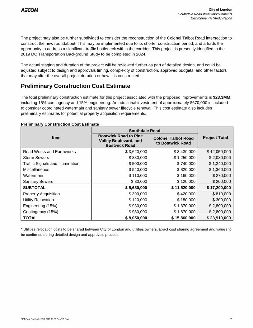
Preliminary Construction Cost Estimate
The total preliminary construction estimate for this project associated with the proposed improvements is $23.3MM,
including 15% contingency and 15% engineering. An additional investment of approximately $670,000 is included
to consider coordinated watermain and sanitary sewer lifecycle renewal. This cost estimate also includes
preliminary estimates for potential property acquisition requirements.
Preliminary Construction Cost Estimate
Item
Southdale Road
Project Total Bostwick Road to Pine Valley Boulevard, and
Bostwick Road
Colonel Talbot Road to Bostwick Road
Road Works and Earthworks $ 3,620,000 $ 8,430,000 $ 12,050,000
Storm Sewers $ 830,000 $ 1,250,000 $ 2,080,000
Traffic Signals and Illumination $ 500,000 $ 740,000 $ 1,240,000
Miscellaneous $ 540,000 $ 820,000 $ 1,360,000
Watermain $ 110,000 $ 160,000 $ 270,000
Sanitary Sewers $ 80,000 $ 120,000 $ 200,000
SUBTOTAL $ 5,680,000 $ 11,520,000 $ 17,200,000
Property Acquisition $ 390,000 $ 420,000 $ 810,000
Utility Relocation $ 120,000 $ 180,000 $ 300,000
Engineering (15%) $ 930,000 $ 1,870,000 $ 2,800,000
Contingency (15%) $ 930,000 $ 1,870,000 $ 2,800,000
TOTAL $ 8,050,000 $ 15,860,000 $ 23,910,000
* Utilities relocation costs to be shared between City of London and utilities owners. Exact cost sharing agreement and values to
be confirmed during detailed design and approvals process.
City of London
Southdale Road West Improvements
Environmental Study Report
Error! Reference source not found.
Error! Reference source not found.
RPT.Final Southdale ESR-2019 03 27-Pam.V2-Final
Table of Contents
page
1. Introduction ...................................................................................................................... 1
1.1 Introduction ........................................................................................................................ 1
1.2 Background ....................................................................................................................... 1
1.3 Study Purpose and Objectives ........................................................................................... 2
1.4 Study Area ......................................................................................................................... 2
1.5 Project Team Organization ................................................................................................ 3
2. Planning Process ............................................................................................................. 4
2.1 Municipal Class Environmental Assessment Process ........................................................ 4
2.1.1 MCEA Documentation and Filing ............................................................................ 5
2.2 Planning Studies and Policy Context ................................................................................. 6
2.2.1 Provincial Policy Statement .................................................................................... 6
2.2.2 Climate Change ..................................................................................................... 6
2.2.3 Source Water Protection ........................................................................................ 6
2.2.4 The London Plan .................................................................................................... 7
2.2.5 Transportation Master Plan .................................................................................... 8
2.2.6 Development Charge Study ................................................................................... 8
2.2.7 Cycling Master Plan ............................................................................................... 8
2.2.8 Bus Rapid Transit Master Plan ............................................................................... 9
2.2.9 Strategic Plan ......................................................................................................... 9
2.2.10 Southwest London Area Plan – Transportation Servicing Report ........................... 9
2.2.11 City of London MCEAs ........................................................................................... 9
2.2.12 Upper Thames River Conservation Authority Policies .......................................... 11
3. Consultation ................................................................................................................... 12
3.1 Consultation and Communication Program ...................................................................... 12
3.2 Public Consultation .......................................................................................................... 12
3.2.1 Public Information Centre #1 ................................................................................ 13
3.2.2 Public Information Centre #2 ................................................................................ 13
3.3 Agency Consultation ........................................................................................................ 14
3.4 Indigenous Consultation .................................................................................................. 15
4. Project Need and Justification ...................................................................................... 17
4.1 Project Need and Justification .......................................................................................... 17
4.2 Problem and Opportunity Statement ................................................................................ 19
5. Existing Conditions ....................................................................................................... 21
5.1 Transportation/Traffic ....................................................................................................... 21
5.1.1 Existing Corridor Conditions ................................................................................. 21
5.1.2 Other Transportation ............................................................................................ 22
5.1.2.1 Active Transportation ......................................................................................... 22
City of London
Southdale Road West Improvements
Environmental Study Report
Error! Reference source not found.
Error! Reference source not found.
RPT.Final Southdale ESR-2019 03 27-Pam.V2-Final
5.1.2.2 London Transit ................................................................................................... 24
5.1.3 Collision Data ....................................................................................................... 24
5.1.4 Existing Structures ............................................................................................... 25
5.1.5 Utilities and Municipal Services ............................................................................ 26
5.2 Socio-Economic Environment .......................................................................................... 27
5.2.1 Existing Land Use ................................................................................................ 27
5.2.2 Future Land Use .................................................................................................. 28
5.3 Cultural Environment ....................................................................................................... 29
5.3.1 Archaeology ......................................................................................................... 29
5.3.2 Built Heritage ........................................................................................................ 30
5.4 Natural Environment ........................................................................................................ 30
5.4.1 Aquatic Environment ............................................................................................ 30
5.4.1 Terrestrial Environment ........................................................................................ 31
5.4.2 Vegetation Communities ...................................................................................... 31
5.4.3 Wetlands .............................................................................................................. 33
5.4.4 Species at Risk .................................................................................................... 33
5.4.5 Breeding Birds ...................................................................................................... 34
5.4.6 Significant Wildlife Habitat Assessment ................................................................ 34
5.4.7 Tree Inventory ...................................................................................................... 34
6. Alternative Planning Solutions ..................................................................................... 35
6.1 Identification of Alternative Planning Solutions ................................................................. 35
6.2 Evaluation of Planning Solutions ...................................................................................... 36
6.3 Summary of Planning Solutions Evaluation ...................................................................... 36
7. Alternative Design Solutions ........................................................................................ 38
7.1 Design Criteria ................................................................................................................. 38
7.2 Alternative Design Solutions ............................................................................................ 39
7.3 Evaluation Criteria ........................................................................................................... 40
7.4 Summary Evaluation ........................................................................................................ 41
8. Project Description ........................................................................................................ 44
8.1 Preliminary Design Criteria .............................................................................................. 44
8.2 Cross Section Elements ................................................................................................... 45
8.3 Intersections .................................................................................................................... 45
8.4 Pavement Design ............................................................................................................ 46
8.5 Municipal Servicing .......................................................................................................... 46
8.5.1 Sanitary Sewers and Watermains ........................................................................ 46
8.5.2 Drainage and Hydrology ....................................................................................... 46
8.6 Utility Relocation .............................................................................................................. 47
8.7 Retaining Walls ................................................................................................................ 48
8.8 Noise Attenuation Walls ................................................................................................... 48
8.9 Urban Design ................................................................................................................... 48
8.10 Traffic Signals and Illumination ........................................................................................ 49
8.11 Adjacent Developments ................................................................................................... 50
8.12 Construction Staging and Traffic Detouring ...................................................................... 50
8.13 Preliminary Construction Cost Estimate ........................................................................... 51
City of London
Southdale Road West Improvements
Environmental Study Report
Error! Reference source not found.
Error! Reference source not found.
RPT.Final Southdale ESR-2019 03 27-Pam.V2-Final
9. Recommended Mitigation Measures / Monitoring ...................................................... 53
9.1 Commitment Highlights .................................................................................................... 53
9.2 Permits and Approvals ..................................................................................................... 54
9.2.1 Ministry of Environment, Conservation and Parks ................................................ 54
9.2.2 Upper Thames River Conservation Authority ........................................................ 54
9.2.3 Ministry of Natural Resources and Forestry .......................................................... 54
9.2.4 Ministry of Tourism, Culture and Sport ................................................................. 54
9.2.5 Ministry of Infrastructure ....................................................................................... 54
9.2.6 Indigenous Communities ...................................................................................... 54
9.3 Construction Mitigation .................................................................................................... 55
9.4 Climate Change ............................................................................................................... 58
9.4.1.1 Potential Construction Effects ........................................................................... 58 9.4.1.2 Potential Operation Effects ................................................................................ 58 9.4.1.3 Mitigation ........................................................................................................... 59
9.5 Proposed Construction Monitoring ................................................................................... 59
9.6 Post Construction Monitoring ........................................................................................... 59
10. Summary......................................................................................................................... 60
10.1 Summary ......................................................................................................................... 60
List of Figures
Figure 1.1: Study Area
Figure 2.1: MCEA Planning Process
Figure 2.2: City of London MCEA Studies
Figure 5.1: Existing Lane Configurations
Figure 5.2: Traffic Volumes (2017)
Figure 5.3: Existing Active Transportation Network
Figure 5.4: Existing Land Use
Figure 5.5: Proposed Future Development
Figure 5.6: Archaeological Assessment Potential
Figure 5.7: Aquatic Assessment
Figure 5.8: Ecological Land Classification
Figure 7.1: Intersection Concepts (Southdale Road West and Colonel Talbot Road)
Figure 7.2: Intersection Concepts (Southdale Road West and Bostwick Road)
Figure 7.3: Recommended Design
Figure 8.1: Cross Section – Southdale Road West
Figure 8.2: Cross Section – Bostwick Road
Figure 8.3: Southdale Road West/Colonel Talbot Road Intersection Rendering
Figure 8.4: Detour Plan
City of London
Southdale Road West Improvements
Environmental Study Report
Error! Reference source not found.
Error! Reference source not found.
RPT.Final Southdale ESR-2019 03 27-Pam.V2-Final
List of Tables
Table 1.1: Study Team
Table 2.1: Road Improvements (TMP)
Table 3.1: Public Consultation Notices
Table 3.2: Agency Comments
Table 4.1: Level of Service Description
Table 4.2: Existing Intersection Operations
Table 4.3: Future Intersection Operations (2035)
Table 5.1: Summary of Collisions
Table 5.2: Existing Land Uses
Table 5.3: Active Development
Table 5.4: Registered Archaeological Sites
Table 5.5: SAR assessment
Table 6.1: Evaluation Criteria for Planning Solutions
Table 6.2: Evaluation of Planning Solutions
Table 7.1: City of London Transportation Design Requirements
Table 7.2: Evaluation of Intersection Alternatives (Southdale Road West and Colonel Talbot Road)
Table 7.3: Evaluation of Intersection Alternatives (Southdale Road West and Bostwick Road)
Table 7.4: Evaluation Criteria for Design Concepts
Table 7.5: 7.9: Evaluation Summaries
Table 8.1: Preliminary Design Criteria
Table 8.2 Recommended Pavement Structural Thicknesses
Table 8.3: Preliminary Implementation Schedule
Table 8.4: Preliminary Construction Cost Estimate
Table 9.1: Mitigation Measures (Construction)
Table 9.2: Mitigation Measures (Natural Environment)
Appendices
Appendix A:
Appendix B:
Appendix C:
Appendix D:
Consultation and Communications
A.1 Notice of Study Commencement
A.2 Public Information Centre #1
A.3 Public Information Centre #2
A.4 Notice of Study Completion
A.5 Agency Correspondence
A.6 Indigenous Consultation
Background Reports
B.1 Transportation Background Report
B.2 Archaeological Assessment
B.3 Cultural Heritage Assessment Report
B.4 Environmental Impact Study (under separate cover)
Design Evaluation
C.1 Evaluation of Road Widening Improvements
C.2 Evaluation of Intersection Improvements
Design Details
D.1 Preliminary Design Report & Drainage and Storm Water Management Report
City of London
Southdale Road West Improvements
Environmental Study Report
Error! Reference source not found.
Error! Reference source not found.
RPT.Final Southdale ESR-2019 03 27-Pam.V2-Final 1
1. Introduction
1.1 Introduction
The City of London (the City) has completed a Municipal Class Environmental Assessment (MCEA) study to
address necessary transportation infrastructure requirements along the Southdale Road West and Bostwick Road
corridors. The Southdale Road West Improvements MCEA (hereafter the “Project”) is classified as a Schedule ‘C’
project in the Municipal Engineers Association (MEA) MCEA process (October 2000, as amended in 2007, 2011
and 2015), where project activities are subject to the full environmental assessment (EA) planning process of the
MCEA.
The study included:
• public and agency consultation;
• identification and evaluation of alternatives solutions;
• the evaluation of alternative design concepts for the selected preferred solution;
• an assessment of the effects associated with the preferred design; and
• identification of measures required to mitigate any potential adverse effects.
These findings and results, along with a record of review agency and stakeholder consultation have been
documented in this Environmental Study Report (ESR) and made available for a 30-day public and agency review.
1.2 Background
The City of London continues to develop and grow as a municipality. To accommodate this growth, new
infrastructure is required that recognizes the capacity needs of planned growth and the objectives of protecting
established communities and businesses. Southdale Road West is one of the major east-west arterial thoroughfare
and access roadways into the City of London, connecting the southwest corner of the City and areas to the west,
through to the central and easterly areas of the City. It serves as a major corridor for economic, social, urban, and
transportation development, and is located at the south and west edges of existing built up area, the north edge of
what will be an area of future development in the near term.
This widening project was identified as a priority in the City of London’s 2030 Transportation Master Plan (TMP),
the guiding policy document for future transportation planning and as part of the Growth Management
Implementation Strategy (GMIS) for transportation projects. The need for capacity improvements and phasing was
also identified as part of the 2014 Development Charge Background Study. The City of London is considering the
widening of this corridor from Colonel Talbot Road to Pine Valley Boulevard, from 2 to 4 lanes, to be staged for
construction from Pine Valley Boulevard to Farnham Road in 2022 and from Farnham Road to Colonel Talbot Road
in 2026.
Bostwick Road, from Southdale Road West to north of Pack Road, while not covered in the TMP, improvements to
this corridor have been considered in this study to support anticipated future development within and adjacent to
the study area.
City of London
Southdale Road West Improvements
Environmental Study Report
Error! Reference source not found.
Error! Reference source not found.
RPT.Final Southdale ESR-2019 03 27-Pam.V2-Final 2
1.3 Study Purpose and Objectives
The purpose of this MCEA study is to provide a comprehensive and environmentally sound planning process,
which is open to public participation, to select the preferred transportation improvements for the study area. The
objectives of this study include:
• Provide an opportunity to identify road and intersection improvements;
• Protect the environment, as defined in the Environmental Assessment Act (EAA), through the wise
management of resources;
• Consult with affected and interested agencies, Indigenous communities, key stakeholders, and the public;
• Identify a range of alternative solutions and design concepts that incorporate concerns raised during the
planning process;
• Identify measures needed to mitigate impacts associated with the recommended solution and design
concept;
• Prepare preliminary design for the undertaking; and
• Prepare an ESR that documents all consultation input and complies with the requirements of the MCEA
process for Schedule ‘C’ undertakings.
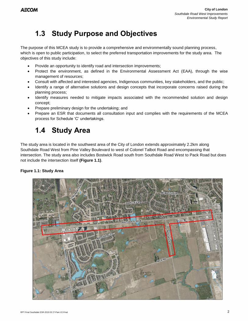
1.4 Study Area
The study area is located in the southwest area of the City of London extends approximately 2.2km along
Southdale Road West from Pine Valley Boulevard to west of Colonel Talbot Road and encompassing that
intersection. The study area also includes Bostwick Road south from Southdale Road West to Pack Road but does
not include the intersection itself (Figure 1.1).
Figure 1.1: Study Area
City of London
Southdale Road West Improvements
Environmental Study Report
Error! Reference source not found.
Error! Reference source not found.
RPT.Final Southdale ESR-2019 03 27-Pam.V2-Final 3
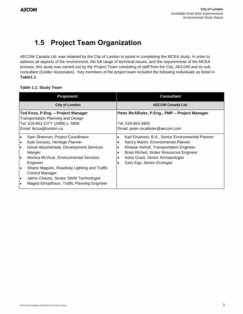
1.5 Project Team Organization
AECOM Canada Ltd. was retained by the City of London to assist in completing the MCEA study. In order to
address all aspects of the environment, the full range of technical issues, and the requirements of the MCEA
process, this study was carried out by the Project Team consisting of staff from the City, AECOM and its sub-
consultant (Golder Associates). Key members of the project team included the following individuals as listed in
Table1.1:
Table 1.1: Study Team
Proponent: Consultant
City of London AECOM Canada Ltd.
Ted Koza, P.Eng. – Project Manager
Transportation Planning and Design
Tel: 519-661-CITY (2489) x. 5806
Email: [email protected]
Peter McAllister, P.Eng., PMP – Project Manager
Tel: 519-963-5865
Email: [email protected]
• Sam Shannon, Project Coordinator
• Kyle Gonyou, Heritage Planner
• Ismail Abushehada, Development Services
Manger
• Monica McVicar, Environmental Services
Engineer
• Shane Maguire, Roadway Lighting and Traffic
Control Manager
• Jaime Chaves, Senior SWM Technologist
• Maged Elmadhoon, Traffic Planning Engineer
• Karl Grueneis, B.A., Senior Environmental Planner
• Nancy Martin, Environmental Planner
• Khawar Ashraf, Transportation Engineer
• Brian Richert, Water Resources Engineer
• Adria Grant, Senior Archaeologist
• Gary Epp, Senior Ecologist
City of London
Southdale Road West Improvements
Environmental Study Report
Error! Reference source not found.
Error! Reference source not found.
RPT.Final Southdale ESR-2019 03 27-Pam.V2-Final 4
2. Planning Process
2.1 Municipal Class Environmental Assessment Process
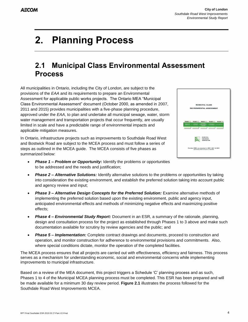
All municipalities in Ontario, including the City of London, are subject to the
provisions of the EAA and its requirements to prepare an Environmental
Assessment for applicable public works projects. The Ontario MEA “Municipal
Class Environmental Assessment” document (October 2000, as amended in 2007,
2011 and 2015) provides municipalities with a five-phase planning procedure,
approved under the EAA, to plan and undertake all municipal sewage, water, storm
water management and transportation projects that occur frequently, are usually
limited in scale and have a predictable range of environmental impacts and
applicable mitigation measures.
In Ontario, infrastructure projects such as improvements to Southdale Road West
and Bostwick Road are subject to the MCEA process and must follow a series of
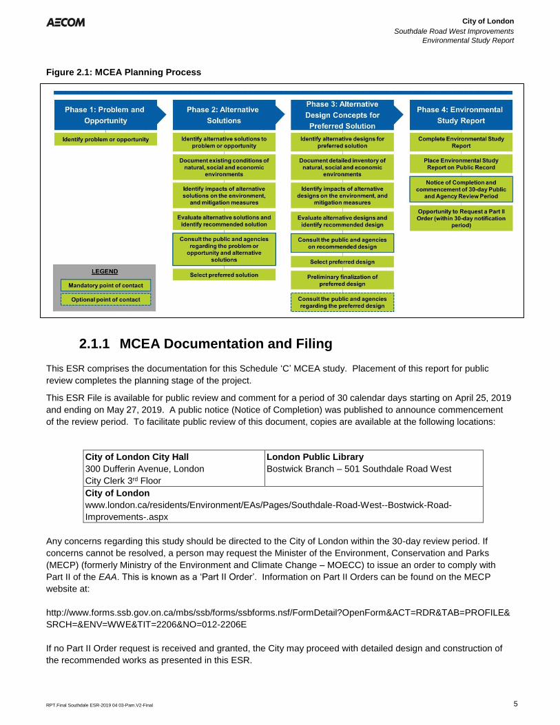
steps as outlined in the MCEA guide. The MCEA consists of five phases as
summarized below:
• Phase 1 – Problem or Opportunity: Identify the problems or opportunities
to be addressed and the needs and justification;
• Phase 2 – Alternative Solutions: Identify alternative solutions to the problems or opportunities by taking
into consideration the existing environment, and establish the preferred solution taking into account public
and agency review and input;
• Phase 3 – Alternative Design Concepts for the Preferred Solution: Examine alternative methods of
implementing the preferred solution based upon the existing environment, public and agency input,
anticipated environmental effects and methods of minimizing negative effects and maximizing positive
effects;
• Phase 4 – Environmental Study Report: Document in an ESR, a summary of the rationale, planning,
design and consultation process for the project as established through Phases 1 to 3 above and make such
documentation available for scrutiny by review agencies and the public; and
• Phase 5 – Implementation: Complete contract drawings and documents, proceed to construction and
operation, and monitor construction for adherence to environmental provisions and commitments. Also,
where special conditions dictate, monitor the operation of the completed facilities.
The MCEA process ensures that all projects are carried out with effectiveness, efficiency and fairness. This process serves as a mechanism for understanding economic, social and environmental concerns while implementing improvements to municipal infrastructure.
Based on a review of the MEA document, this project triggers a Schedule ‘C’ planning process and as such,
Phases 1 to 4 of the Municipal MCEA planning process must be completed. This ESR has been prepared and will
be made available for a minimum 30 day review period. Figure 2.1 illustrates the process followed for the
Southdale Road West Improvements MCEA.
City of London
Southdale Road West Improvements
Environmental Study Report
Error! Reference source not found.
Error! Reference source not found.
RPT.Final Southdale ESR-2019 04 03-Pam.V2-Final 5
Figure 2.1: MCEA Planning Process
2.1.1 MCEA Documentation and Filing
This ESR comprises the documentation for this Schedule ‘C’ MCEA study. Placement of this report for public
review completes the planning stage of the project.
This ESR File is available for public review and comment for a period of 30 calendar days starting on April 25, 2019
and ending on May 27, 2019. A public notice (Notice of Completion) was published to announce commencement
of the review period. To facilitate public review of this document, copies are available at the following locations:
City of London City Hall
300 Dufferin Avenue, London
City Clerk 3rd Floor
London Public Library
Bostwick Branch – 501 Southdale Road West
City of London
www.london.ca/residents/Environment/EAs/Pages/Southdale-Road-West--Bostwick-Road-
Improvements-.aspx
Any concerns regarding this study should be directed to the City of London within the 30-day review period. If
concerns cannot be resolved, a person may request the Minister of the Environment, Conservation and Parks
(MECP) (formerly Ministry of the Environment and Climate Change – MOECC) to issue an order to comply with
Part II of the EAA. This is known as a ‘Part II Order’. Information on Part II Orders can be found on the MECP
website at:
http://www.forms.ssb.gov.on.ca/mbs/ssb/forms/ssbforms.nsf/FormDetail?OpenForm&ACT=RDR&TAB=PROFILE&
SRCH=&ENV=WWE&TIT=2206&NO=012-2206E
If no Part II Order request is received and granted, the City may proceed with detailed design and construction of
the recommended works as presented in this ESR.
City of London
Southdale Road West Improvements
Environmental Study Report
Error! Reference source not found.
Error! Reference source not found.
RPT.Final Southdale ESR-2019 03 27-Pam.V2-Final 6
2.2 Planning Studies and Policy Context
2.2.1 Provincial Policy Statement
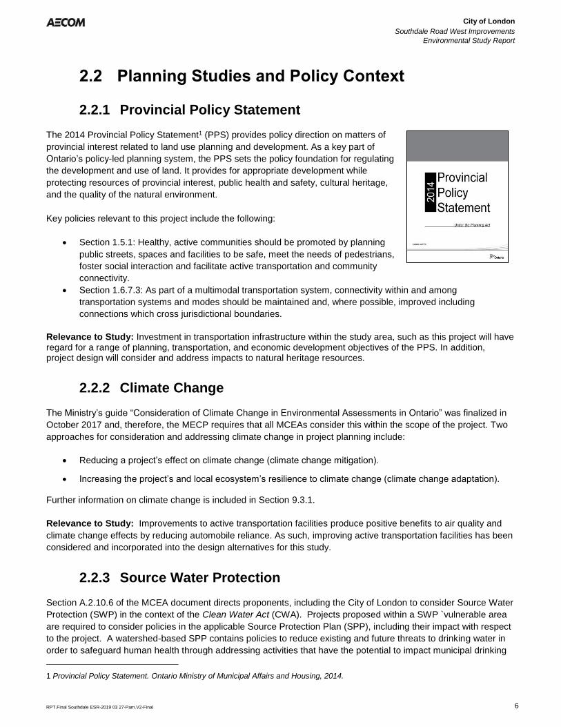
The 2014 Provincial Policy Statement1 (PPS) provides policy direction on matters of
provincial interest related to land use planning and development. As a key part of
Ontario’s policy-led planning system, the PPS sets the policy foundation for regulating
the development and use of land. It provides for appropriate development while
protecting resources of provincial interest, public health and safety, cultural heritage,
and the quality of the natural environment.
Key policies relevant to this project include the following:
• Section 1.5.1: Healthy, active communities should be promoted by planning
public streets, spaces and facilities to be safe, meet the needs of pedestrians,
foster social interaction and facilitate active transportation and community
connectivity.
• Section 1.6.7.3: As part of a multimodal transportation system, connectivity within and among
transportation systems and modes should be maintained and, where possible, improved including
connections which cross jurisdictional boundaries.
Relevance to Study: Investment in transportation infrastructure within the study area, such as this project will have regard for a range of planning, transportation, and economic development objectives of the PPS. In addition, project design will consider and address impacts to natural heritage resources.
2.2.2 Climate Change
The Ministry’s guide “Consideration of Climate Change in Environmental Assessments in Ontario” was finalized in
October 2017 and, therefore, the MECP requires that all MCEAs consider this within the scope of the project. Two
approaches for consideration and addressing climate change in project planning include:
• Reducing a project’s effect on climate change (climate change mitigation).
• Increasing the project’s and local ecosystem’s resilience to climate change (climate change adaptation).
Further information on climate change is included in Section 9.3.1.
Relevance to Study: Improvements to active transportation facilities produce positive benefits to air quality and
climate change effects by reducing automobile reliance. As such, improving active transportation facilities has been
considered and incorporated into the design alternatives for this study.
2.2.3 Source Water Protection
Section A.2.10.6 of the MCEA document directs proponents, including the City of London to consider Source Water
Protection (SWP) in the context of the Clean Water Act (CWA). Projects proposed within a SWP `vulnerable area
are required to consider policies in the applicable Source Protection Plan (SPP), including their impact with respect
to the project. A watershed-based SPP contains policies to reduce existing and future threats to drinking water in
order to safeguard human health through addressing activities that have the potential to impact municipal drinking
1 Provincial Policy Statement. Ontario Ministry of Municipal Affairs and Housing, 2014.
City of London
Southdale Road West Improvements
Environmental Study Report
Error! Reference source not found.
Error! Reference source not found.
RPT.Final Southdale ESR-2019 03 27-Pam.V2-Final 7
water systems. The Thames - Sydenham & Region Drinking Water Source Protection Plan is the relevant SPP for
this project, and contains policies that address current and potential threats to municipal drinking water supply.
There are four types of vulnerable areas covered by the SPP:
1. Intake protection zones (IPZs) – An IPZ is the area around a surface body of water where water is drawn inand conveyed for municipal drinking water.
2. Highly vulnerable aquifers (HVAs) – Aquifers are underground layers of water that supply wells. HVAs aresusceptible to contamination due to their proximity to the ground surface or where the types of materials inthe ground around it are highly permeable.
3. Significant groundwater recharge areas (SGRAs) - SGRAs are characterized as having porous soils (e.g.sand or gravel), which allow for water to easily seep into the ground and flow to an aquifer.
4. Wellhead protection areas (WHPAs) – WHPAs are areas of land around a municipal well where land useactivities have the greatest potential to affect the quality of water flowing into the well.
Relevance to Study: The relevance of the policies of the SPP has been considered in this study. However, the
study area is within a SGRA where the vulnerability score is low. Although it is designated as a vulnerable area,
there are no significant, moderate or low drinking water quality threats associated with this project.
2.2.4 The London Plan
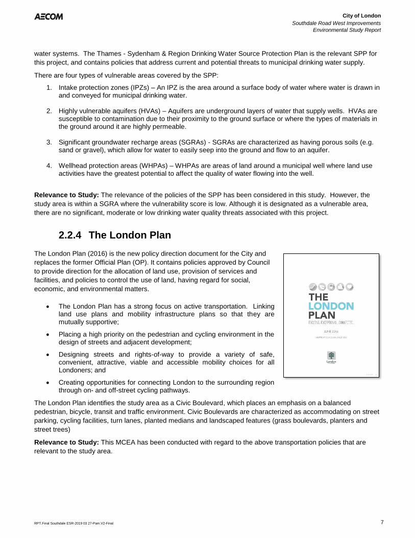
The London Plan (2016) is the new policy direction document for the City and
replaces the former Official Plan (OP). It contains policies approved by Council
to provide direction for the allocation of land use, provision of services and
facilities, and policies to control the use of land, having regard for social,
economic, and environmental matters.
• The London Plan has a strong focus on active transportation. Linkingland use plans and mobility infrastructure plans so that they aremutually supportive;
• Placing a high priority on the pedestrian and cycling environment in thedesign of streets and adjacent development;
• Designing streets and rights-of-way to provide a variety of safe,convenient, attractive, viable and accessible mobility choices for allLondoners; and
• Creating opportunities for connecting London to the surrounding regionthrough on- and off-street cycling pathways.
The London Plan identifies the study area as a Civic Boulevard, which places an emphasis on a balanced
pedestrian, bicycle, transit and traffic environment. Civic Boulevards are characterized as accommodating on street
parking, cycling facilities, turn lanes, planted medians and landscaped features (grass boulevards, planters and
street trees)
Relevance to Study: This MCEA has been conducted with regard to the above transportation policies that are
relevant to the study area.
City of London
Southdale Road West Improvements
Environmental Study Report
Error! Reference source not found.
Error! Reference source not found.
RPT.Final Southdale ESR-2019 03 27-Pam.V2-Final 8
2.2.5 Transportation Master Plan
The City of London 2030 TMP was completed in 2013 and is a long-term
transportation strategy which will help guide the City’s transportation and land use
decisions to 2030.
The key goal of the TMP is to provide viable and attractive travel choices to
encourage a shift from the private automobile to more sustainable modes, thus
reducing the need for road widenings while maintaining overall levels of service and
providing environmental benefits
The TMP identified the need to widen Southdale Road West from 2 to 4 through
lanes with a two-way centre left-turn lane. The proposed improvements are
required to accommodate planned development and resulting travel demand. The
recommended road improvements are summarized in Table 2.1.
Table 2.1: Road Improvements (TMP)
Project Limits Improvements TMP Timeline
Southdale Road West
Phase 1 - Colonel Talbot
Road to Farnham Road
2 to 4 through lanes with centre
turn lane
2027-2032
Phase 2 - Farnham Road
to Pine Valley Boulevard
2 to 4 through lanes with centre
turn lane
2027-2032
Intersection Improvements Southdale Road West &
Colonel Talbot Road
Addition of WBR Lane 2017-2022
Increasing active transportation targets is also mandated within the TMP. Current active transportation usage is
identified at 9% of all city-wide transportation modes (also includes transit, auto and other modes not specified). By
2030, the City has a targeted increase in active transportation to 15%, an overall increase of over 60%.
Relevance to Study: Overall growth in the southwest area of the city has significant impact on transportation
congestion. Road and active transportation improvements considered in this study will help to address current and
ongoing transportation congestion.
2.2.6 Development Charge Study
Development charges provide a method for municipalities to recover cost associated with growth. The growth
transportation needs for the City of London were identified in the June 2014 Development Charges Background
Study. The Southdale Road West corridor was identified for widening from two to four lanes with a centre turning
lane from Colonel Talbot Road to Pine Valley Boulevard. Farnham Road to Pine Valley Road widening is expected
to commence in 2022 while Colonel Talbot Road to Farnham Road widening is expected to commence in 2026.
This precedes the 2027-2032 recommended TMP year provided in the 2030 TMP
2.2.7 Cycling Master Plan
London ON Bikes, the City’s Cycling Master Plan, guides the planning, design, development and programming of
improvements to the cycling network. Within the study area, this plan recommends in-boulevard cycling facilities. In
the surrounding area, the Cycling Master Plan recommends bike lanes, signed bike routes, and paved shoulders.
City of London
Southdale Road West Improvements
Environmental Study Report
Error! Reference source not found.
Error! Reference source not found.
RPT.Final Southdale ESR-2019 03 27-Pam.V2-Final 9
Relevance to the Study: This study provides an opportunity to capture specific elements of building a connected
cycling network across the City in the preferred solution and design concept.
2.2.8 Bus Rapid Transit Master Plan
Shift Rapid Transit Master Plan defines what, where and how bus rapid transit (BRT) will be implemented within
London. Shift builds upon the existing recommendations presented in the City’s OP and the TMP.
Relevance to Study: The recommended rapid transit corridors are not in the vicinity of the Southdale Road West
MCEA study area, however, improvements to the local public transit service levels are expected to enhance
connectivity to the rapid transit lines.
2.2.9 Strategic Plan
The City of London’s Strategic Plan (2015-2019) sets out a broad direction for the future of London. It identifies
Council’s vision, mission, values, strategic areas for focus and the specific strategies that define how Council will
respond to the needs and aspirations of Londoners.
Relevance to Study: As part of the City’s initiative for “Building a Sustainable City,” the Strategic Plan identifies the
management of upgrading of transportation infrastructure as part of its focus on robust infrastructure.
2.2.10 Southwest London Area Plan – Transportation Servicing Report
The Southwest London Area Plan (SWAP) is a comprehensive secondary plan to establish a vision, principles and
policies for the evolution of the southwest planning area of London into a vibrant community featuring mixed-use
development with a range of residential densities, good walkability and high-quality urban design. The study
horizon for this report is to 2037. The Transportation Servicing Report, conducted by AECOM in May 2010, outlines
the future recommended major and minor roadworks and associated timing necessary for significant growth within
the SWAP study area. The Transportation Servicing Report recommended the following major road works to
service the secondary plan area:
▪ 2 lane upgrades on Bostwick Road from Pack Road to Southdale Road West;
▪ 2 lane to 4 lane upgrades on Southdale Road West from Wonderland Road South to Wharncliffe Road South.
To service an anticipated City-wide population of 675, 000, over a 20 year planning horizon, the Southdale
Road West and Bostwick Road corridors are to be protected for future ultimate widening to six lanes.
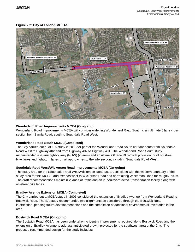
2.2.11 City of London MCEAs
The City of London has recently undertaken several MCEA studies to examine transportation corridors within the
City and determine improvements to ameliorate traffic congestion and support increased active transportation
participation. The studies listed below and shown on Figure 2.2 are adjacent to the Southdale Road West study
area or in close proximity.
City of London
Southdale Road West Improvements
Environmental Study Report
Error! Reference source not found.
Error! Reference source not found.
RPT.Final Southdale ESR-2019 03 27-Pam.V2-Final 10
Figure 2.2: City of London MCEAs
Wonderland Road Improvements MCEA (On-going)
Wonderland Road Improvements MCEA will consider widening Wonderland Road South to an ultimate 6 lane cross
section from Sarnia Road, south to Southdale Road West.
Wonderland Road South MCEA (Completed)
The City carried out a MCEA study in 2015 for part of the Wonderland Road South corridor south from Southdale
Road West to Highway 402 and from Highway 402 to Highway 401. The Wonderland Road South study
recommended a 4 lane right-of-way (ROW) (interim) and an ultimate 6 lane ROW with provision for of on-street
bike lanes and right-turn lanes on all approaches to the intersection, including Southdale Road West.
Southdale Road West/Wickerson Road Improvements MCEA (On-going)
The study area for the Southdale Road West/Wickerson Road MCEA coincides with the western boundary of the
study area for this MCEA, and extends west to Wickerson Road and north along Wickerson Road for roughly 700m.
The draft recommendations maintain 2 lanes of traffic and an in-boulevard active transportation facility along with
on-street bike lanes.
Bradley Avenue Extension MCEA (Completed)
The City carried out a MCEA study in 2005 considered the extension of Bradley Avenue from Wonderland Road to
Bostwick Road. The EA study recommended two alignments be considered through the Bostwick Road
intersection, pending future development plans and the completion of additional environmental inventories in the
area.
Bostwick Road MCEA (On-going)
The Bostwick Road MCEA has been undertaken to identify improvements required along Bostwick Road and the
extension of Bradley Avenue to address anticipated growth projected for the southwest area of the City. The
proposed recommended design for the study includes:
City of London
Southdale Road West Improvements
Environmental Study Report
Error! Reference source not found.
Error! Reference source not found.
RPT.Final Southdale ESR-2019 03 27-Pam.V2-Final 11
• Realignment of Bostwick Road to connect with the future Kilbourne Road;
• Bostwick Road reconstruction and realignment of 2 lanes widened on east side of centreline (interim);
• Bostwick Road ultimate widening to 4 lanes (2035);
• 4 lane ultimate roundabout (2035) at Bostwick Road and Pack Road, 2 lane interim roundabout;
• Continuous on-road buffered bike lanes; and
• Southerly shift of Pack Road for Bradley Avenue extension.
Relevance to the Study: Future road improvements for the Southdale Road West and Bostwick Road study
corridors will support the implementation strategy for each of these MCEAs. Where study areas are adjacent to this
study, efforts are made to provide a seamless roadway and active transportation transition between study areas.
2.2.12 Upper Thames River Conservation Authority Policies
Portions of the study area are within the Upper Thames River Conservation Authority (UTRCA) regulated area.
Regulated areas are established where development could be subject to flooding, erosion or dynamic beaches, or
where interference with wetlands and alterations to shorelines and watercourses might have an adverse effect on
those environmental features. Any proposed development, interference or alteration within a Regulated Area would
require a permit from UTRCA under the Development, Interference with Wetlands and Alterations to Shorelines and
Watercourses, Ontario Regulation (O.Reg.) 157/06.
Relevance to the Study: The planning and design of roads, and culverts will involve construction in regulated
areas and permitting will be required prior to project construction.
City of London
Southdale Road West Improvements
Environmental Study Report
Error! Reference source not found.
Error! Reference source not found.
RPT.Final Southdale ESR-2019 03 27-Pam.V2-Final 12
3. Consultation
3.1 Consultation and Communication Program
The involvement of the community – residents, agencies, stakeholders, Indigenous communities, and those who
may be potentially affected by a project – is an integral part of the MCEA process. The purpose of consultation
process is to provide an opportunity for stakeholder groups and the public to gain an understanding of the study
process; contribute to the process for development and selection of alternatives/design concepts; and provide
feedback and advice at important stages in the MCEA process. Specifically, the objectives of the consultation
efforts are to:
• Generate awareness of the project and provide opportunities for involvement throughout the planning
process; and
• Facilitate constructive input from public and agency stakeholders at key points in the MCEA process, prior
to decision-making.
The MCEA process requires three points of contact for Schedule ‘C’ projects which are:
• The first point of mandatory contact is made at the end of Phase 2 when the proponent has identified a
problem statement, and developed, assessed, and evaluated alternative solutions to the problem based on
the social, natural, and economic environments that could be impacted by the project. This initial contact is
issued to invite the public and stakeholders to comment on the potential impacts and local sensitivities.
• The second point of mandatory contact is made during Phase 3 to invite the public and stakeholders to
review and provide feedback on the assessment and evaluation of alternative design concepts based on
their potential impacts on the environment.
• The third point of mandatory contact is when the ESR is complete. The ESR documents the entire planning
process through Phases 1, 2 and 3. A proponent is required to place the ESR on the public record for at
least 30 calendar days which provides the public and stakeholders the opportunity to review and make
submissions to the MECP.
A summary of the consultation activities undertaken for this study is provided in this section.
3.2 Public Consultation
Public notices were issued throughout the course of the study to notify agencies, local stakeholders, Indigenous
communities and the public of the status of the project, provide notification of the Public Information Centres (PICs),
and to invite feedback on the project.
At the beginning of the study, a Notice of Study Commencement (discretionary point of contact) was mailed to the
public and review agencies. The notice presented an overview of the project and how to participate in the study.
Notices for PICs and Study Completion were also distributed as part of this study. A list of public notices that were
issued as part of the study are provided in Table 3.1.
All notices were listed on the City’s website (www.london.ca/residents/Environment/EAs/Pages/Southdale-Road-
West--Bostwick-Road-Improvements-.aspx).
City of London
Southdale Road West Improvements
Environmental Study Report
Error! Reference source not found.
Error! Reference source not found.
RPT.Final Southdale ESR-2019 04 03-Pam.V2-Final 13
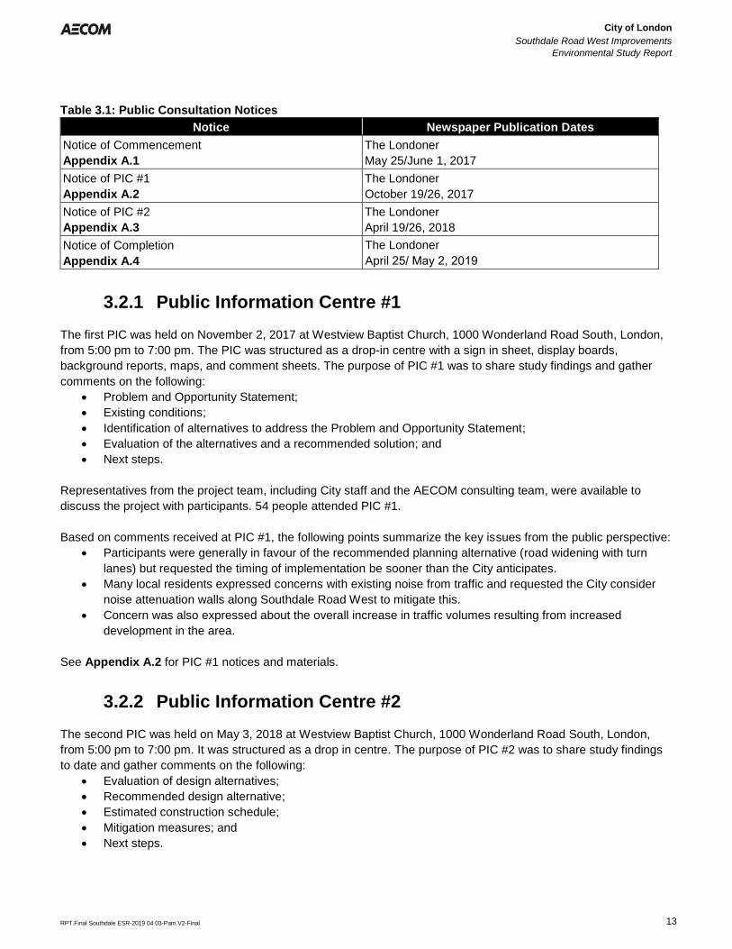
Table 3.1: Public Consultation Notices
Notice Newspaper Publication Dates
Notice of Commencement
Appendix A.1
The Londoner
May 25/June 1, 2017
Notice of PIC #1
Appendix A.2
The Londoner
October 19/26, 2017
Notice of PIC #2
Appendix A.3
The Londoner
April 19/26, 2018
Notice of Completion
Appendix A.4
The Londoner
April 25/ May 2, 2019
3.2.1 Public Information Centre #1
The first PIC was held on November 2, 2017 at Westview Baptist Church, 1000 Wonderland Road South, London,
from 5:00 pm to 7:00 pm. The PIC was structured as a drop-in centre with a sign in sheet, display boards,
background reports, maps, and comment sheets. The purpose of PIC #1 was to share study findings and gather
comments on the following:
• Problem and Opportunity Statement;
• Existing conditions;
• Identification of alternatives to address the Problem and Opportunity Statement;
• Evaluation of the alternatives and a recommended solution; and
• Next steps.
Representatives from the project team, including City staff and the AECOM consulting team, were available to
discuss the project with participants. 54 people attended PIC #1.
Based on comments received at PIC #1, the following points summarize the key issues from the public perspective:
• Participants were generally in favour of the recommended planning alternative (road widening with turn
lanes) but requested the timing of implementation be sooner than the City anticipates.
• Many local residents expressed concerns with existing noise from traffic and requested the City consider
noise attenuation walls along Southdale Road West to mitigate this.
• Concern was also expressed about the overall increase in traffic volumes resulting from increased
development in the area.
See Appendix A.2 for PIC #1 notices and materials.
3.2.2 Public Information Centre #2
The second PIC was held on May 3, 2018 at Westview Baptist Church, 1000 Wonderland Road South, London,
from 5:00 pm to 7:00 pm. It was structured as a drop in centre. The purpose of PIC #2 was to share study findings
to date and gather comments on the following:
• Evaluation of design alternatives;
• Recommended design alternative;
• Estimated construction schedule;
• Mitigation measures; and
• Next steps.
City of London
Southdale Road West Improvements
Environmental Study Report
Error! Reference source not found.
Error! Reference source not found.
RPT.Final Southdale ESR-2019 03 27-Pam.V2-Final 14
Representatives from the project team, including City staff and the AECOM team, were available to discuss the
project with participants. Fifty-one members of the public attended PIC #2.
Issues and comments raised at PIC #2 included:
• The roundabout at Southdale Road West and Colonel Talbot Road received mostly praise, some
individuals had concerns about the safely of roundabouts.
• People were pleased that a signalized intersection was the preferred alternative at Southdale Road West
and Bostwick Road.
• Noise attenuation was of concern, and residents would at least like to have it considered during detailed
design.
See Appendix A.3 for PIC #2 notices and materials.
3.3 Agency Consultation
All relevant agencies and authorities were contacted at the project initiation stage through correspondence notifying
them of the study commencement and requesting their comments. All of these agencies were included in the
project mailing list, which was updated regularly to ensure accuracy. They were also notified of the PICs and the
Notice of Completion. The following section provides a summary of correspondence with external agencies. Agency
correspondence can be found in Appendix A.5. Table 3.2 identifies the comments received from agencies as part
of this project.
Table 3.2: Agency Comments
Agency Comment Response
Ministry of Tourism,
Culture and Sport
(June 30, 2017)
• MTCS provided an outline of the MCEA
requirements as they relate to archaeological
resources and built heritage and cultural
heritage landscapes.
• This study has undertaken the
necessary studies to fulfill the
requirements of MTCS.
• See Section 5.3
Ministry of Tourism,
Culture and Sport
(December 01, 2017)
• MTCS acknowledged built heritage and
cultural heritage landscapes have been
screened out and requested updates on
Stage 2 archaeological assessments.
• the Stage 2 archaeological
assessment will be completed as
part of detailed design.
Ministry of Natural
Resources and
Forestry
(July 17, 2017)
• MNRF provided details relating to natural
areas, Species at Risk and Significant Wildlife
Habitat.
• This information was used as
background for the natural heritage
studies.
• See Section 5.4
Infrastructure Ontario
(April 20, 2018)
• IO provided an outline of requirements to be
fulfilled by the project proponent which
includes the Provincial Crown’s’ Indigenous
Duty to Consult, requirements for MOI Public
Works MCEAs and MTCS requirements.
• Consultation with IO will be
undertaken to determine potential
requirements for land acquisition.
MECP
(June 20, 2017)
• MECP provided information on the following:
o Requirements for duty to consult with
Indigenous communities; and
o Requirements for work within Source
Water Protection areas.
• This study has undertaken the
necessary requirements to fulfill the
Duty to Consult. See Section 3.4 for
details of Indigenous consultation.
SWP is addressed in Section 2.2.3
of this study.
UTRCA
(June 19, 2018)
• UTRCA provided information on SWP within
the study area.
• SWP is addressed in Section 2.2.3
of this study.
City of London
Southdale Road West Improvements
Environmental Study Report
Error! Reference source not found.
Error! Reference source not found.
RPT.Final Southdale ESR-2019 03 27-Pam.V2-Final 15
3.4 Indigenous Consultation
The City of London is committed to proactively identifying and addressing potential impacts of the Southdale Road
West MCEA on the interests and rights of interested Indigenous communities within proximity to the City.
Consultation with Indigenous communities is important for the project in order to identify and address specific
cultural and heritage interests, as well as potential impacts to established or asserted Indigenous or treaty rights or
Land Claims that Indigenous communities may have within the area. Consultation activities were conducted in
accordance with the guidelines provided in the MCEA (MEA 2000) and the Code of Practice – Consultation in
Ontario’s Environmental Assessment Process (MECP 2014).
The duty to consult with Indigenous communities is triggered when a proponent contemplates decisions or actions
that may adversely impact asserted or established Indigenous or Treaty rights. Although ultimate legal
responsibility to meet the duty to consult requirements lies with the Crown, the City undertakes a procedural aspect
of the Crown’s duty. As part of this procedural responsibility, the City will notify the Director of the Environmental
Approvals Branch if the project has the potential to adversely affect an Indigenous or Treaty right. This procedural
aspect would be solely to provide information regarding the proposal and to gather information about the potential
impacts of the asserted project on potential or established Aboriginal or Treaty rights.
The City initiated consultation with Indigenous communities that have previously engaged in London infrastructure
planning / development projects and are anticipated to have interest in the project, and other recognized
Indigenous communities and organizations. A list of communities and groups that were included in correspondence
for this project is provided below. All Indigenous correspondence is included in Appendix A.6.
• Aamjiwnaang
• Alderville First Nation
• Assembly of First Nations
• Associated Iroquois and Allied Indians
• Aundeck-Omni-Kaning
• Beausoleil
• Bkejwanong Territory (Walpole Island) First
Nation
• Caldwell First Nation
• Chiefs of Ontario
• Chippewas of Georgina Island
• Chippewas of Kettle and Stony Point
• Chippewas of Nawash First Nation
• Chippewas of Rama First Nation
• Chippewas of the Thames First Nation
• Curve Lake
• Delaware Nation (Moravian of the Thames)
• Hiawatha First Nation
• Iroquois Caucus
• London District Chiefs Council
• M'Chigeeng First Nation
• Metis Nation of Ontario
• Mississaugas of Scugog Island First Nation
• Mississaugas of the Credit
• Mohawks of Akwesasne
• Mohawks of the Bay of Quinte
• Munsee-Delaware Nation
• Oneida Nation of the Thames
• Saugeen First Nation
• Sheguiandah First Nation
• Six Nations of the Grand River Territory
• Union of Ontario Indians
• Zhiibaahaasing First Nation
Correspondence was received from the following Indigenous communities:
• Rama First Nation (June 02, 2017) advised that project information has been forwarded to
Rama First Nation Council and to Karry Sandy McKenzie, Coordinator/Negotiator for Williams Treaties First
Nation Process.
• Rama First Nation (October 26, 2017) advised that project information has been forwarded to
Rama First Nation Council and to Karry Sandy McKenzie, Coordinator/Negotiator for Williams Treaties First
Nation Process.
City of London
Southdale Road West Improvements
Environmental Study Report
Error! Reference source not found.
Error! Reference source not found.
RPT.Final Southdale ESR-2019 03 27-Pam.V2-Final 16
• Caldwell First Nation (April 23, 2018) advised of elected new leadership and the First Nation community
asserts if rights to land and waters of the Three Fires Confederacy. Continued consultation will be
determined by the community if necessary.
• Rama First Nation (April 27, 2018) advised that project information has been forwarded to
Rama First Nation Council and to Karry Sandy McKenzie, Coordinator/Negotiator for Williams Treaties First
Nation Process.
• Mississaugas of the New Credit First Nation (June 22, 2018) advised the study is not within their Treaty
Territory and asked to be removed from the project mailing list.
• Chippewas of the Thames First Nation (July 10, 2018) advised the project is within the London Township
Treaty (1796) area to which COTTFN is a signatory. The study area is also within the Big Bear Creek
Additions to Reserve land selection area and the COTTFN Traditional Territory. Their concern is minimal
for this project. However, they requested to be circulated on the material from PIC #2 and the ESR and
Environmental Impact Study (EIS).
City of London
Southdale Road West Improvements
Environmental Study Report
Error! Reference source not found.
Error! Reference source not found.
RPT.Final Southdale ESR-2019 03 27-Pam.V2-Final 17
4. Project Need and Justification
4.1 Project Need and Justification
Phase 1 of the five-phase Municipal MCEA planning process requires the proponent of an undertaking (i.e., the
City) to first document factors leading to the conclusion that an improvement is needed, and develop a clear
statement of the identified problems or opportunities to be investigated. As such, the Problem and Opportunity
Statement is the principal starting point in the undertaking of a MCEA and becomes the central theme and
integrating element of the project. It also assists in setting the scope of the project.
In developing the Problem/Opportunity Statement for this study, the following traffic conditions were considered.
The Transportation Background Report (Appendix B.1) provides a description of existing transportation issues,
future travel demand and future traffic operations within the study area. The transportation analysis conducted for
this study indicates that the existing two-lane roads have deficiencies in the way that they meet existing demands.
These issues would be exacerbated by the projected growth in the number of road users.
With the opening of the Bostwick Community Centre, YMCA and library in 2018 and anticipated increased future
residential development along the study corridor, the existing two-lane road will not have enough capacity to
accommodate the projected growth.
The evaluation of roadway traffic conditions can be described in terms of the level of service (LOS) provided during
peak traffic periods (AM and PM). At an intersection, the level of service is determined based on the average delay
that a vehicle experiences in passing through an intersection. LOS ‘A’ designates an excellent level of service with
little delay, while LOS ‘F’ indicates a poor level of service and significant delay. The Volume/Capacity (V/C) ratio
represents how close to capacity a road or intersection movement is, based on existing or projected traffic volumes
versus the maximum number of vehicles that could be accommodated. A V/C ratio below 0.5 means that less than
half the capacity is being used by vehicles; this is generally associated with good operating conditions. As the V/C
approaches 1.0, traffic conditions worsen and operations are generally very poor. In future scenarios, the V/C can
exceed 1.0, resulting in significant projected traffic delays.
Table 4.1: Level of Service Descriptions
LOS Signalized Intersections
Description Avg. Delay
A Very seldom does a vehicle wait longer than one red light. The approach appears open, turns are easily made and drivers have freedom of operation.
≤10 sec
B An occasional green light is fully used and many greens approach full use. Many drivers begin to feel somewhat restricted within groups of vehicles approaching the intersection.
≤20 sec
C Intersection operation is stable but often has fully used greens. Drivers feel more restricted and occasionally may wait more than one red light. Queues may develop behind turning vehicles.
≤35 sec
D Drivers experience increasing restriction and instability of traffic flow. There are substantial delays to vehicles during short peaks within the peak hour, but there is enough time with lower demand to permit occasional clearing of queues and prevent excessive backups.
≤55 sec
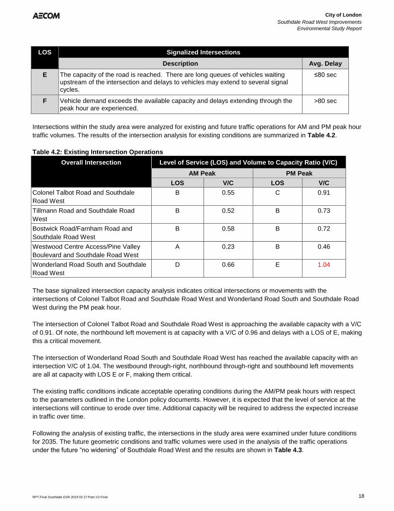
City of London
Southdale Road West Improvements
Environmental Study Report
Error! Reference source not found.
Error! Reference source not found.
RPT.Final Southdale ESR-2019 03 27-Pam.V2-Final 18
LOS Signalized Intersections
Description Avg. Delay
E The capacity of the road is reached. There are long queues of vehicles waiting upstream of the intersection and delays to vehicles may extend to several signal cycles.
≤80 sec
F Vehicle demand exceeds the available capacity and delays extending through the peak hour are experienced.
>80 sec
Intersections within the study area were analyzed for existing and future traffic operations for AM and PM peak hour
traffic volumes. The results of the intersection analysis for existing conditions are summarized in Table 4.2.
Table 4.2: Existing Intersection Operations
Overall Intersection Level of Service (LOS) and Volume to Capacity Ratio (V/C)
AM Peak PM Peak
LOS V/C LOS V/C
Colonel Talbot Road and Southdale
Road West
B 0.55 C 0.91
Tillmann Road and Southdale Road
West
B 0.52 B 0.73
Bostwick Road/Farnham Road and
Southdale Road West
B 0.58 B 0.72
Westwood Centre Access/Pine Valley
Boulevard and Southdale Road West
A 0.23 B 0.46
Wonderland Road South and Southdale
Road West
D 0.66 E 1.04
The base signalized intersection capacity analysis indicates critical intersections or movements with the
intersections of Colonel Talbot Road and Southdale Road West and Wonderland Road South and Southdale Road
West during the PM peak hour.
The intersection of Colonel Talbot Road and Southdale Road West is approaching the available capacity with a V/C
of 0.91. Of note, the northbound left movement is at capacity with a V/C of 0.96 and delays with a LOS of E, making
this a critical movement.
The intersection of Wonderland Road South and Southdale Road West has reached the available capacity with an
intersection V/C of 1.04. The westbound through-right, northbound through-right and southbound left movements
are all at capacity with LOS E or F, making them critical.
The existing traffic conditions indicate acceptable operating conditions during the AM/PM peak hours with respect
to the parameters outlined in the London policy documents. However, it is expected that the level of service at the
intersections will continue to erode over time. Additional capacity will be required to address the expected increase
in traffic over time.
Following the analysis of existing traffic, the intersections in the study area were examined under future conditions
for 2035. The future geometric conditions and traffic volumes were used in the analysis of the traffic operations
under the future “no widening” of Southdale Road West and the results are shown in Table 4.3.
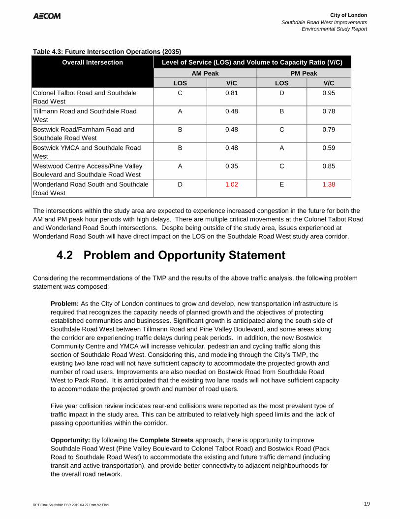
City of London
Southdale Road West Improvements
Environmental Study Report
Error! Reference source not found.
Error! Reference source not found.
RPT.Final Southdale ESR-2019 03 27-Pam.V2-Final 19
Table 4.3: Future Intersection Operations (2035)
Overall Intersection Level of Service (LOS) and Volume to Capacity Ratio (V/C)
AM Peak PM Peak
LOS V/C LOS V/C
Colonel Talbot Road and Southdale
Road West
C 0.81 D 0.95
Tillmann Road and Southdale Road
West
A 0.48 B 0.78
Bostwick Road/Farnham Road and
Southdale Road West
B 0.48 C 0.79
Bostwick YMCA and Southdale Road
West
B 0.48 A 0.59
Westwood Centre Access/Pine Valley
Boulevard and Southdale Road West
A 0.35 C 0.85
Wonderland Road South and Southdale
Road West
D 1.02 E 1.38
The intersections within the study area are expected to experience increased congestion in the future for both the
AM and PM peak hour periods with high delays. There are multiple critical movements at the Colonel Talbot Road
and Wonderland Road South intersections. Despite being outside of the study area, issues experienced at
Wonderland Road South will have direct impact on the LOS on the Southdale Road West study area corridor.
4.2 Problem and Opportunity Statement
Considering the recommendations of the TMP and the results of the above traffic analysis, the following problem
statement was composed:
Problem: As the City of London continues to grow and develop, new transportation infrastructure is
required that recognizes the capacity needs of planned growth and the objectives of protecting
established communities and businesses. Significant growth is anticipated along the south side of
Southdale Road West between Tillmann Road and Pine Valley Boulevard, and some areas along
the corridor are experiencing traffic delays during peak periods. In addition, the new Bostwick
Community Centre and YMCA will increase vehicular, pedestrian and cycling traffic along this
section of Southdale Road West. Considering this, and modeling through the City’s TMP, the
existing two lane road will not have sufficient capacity to accommodate the projected growth and
number of road users. Improvements are also needed on Bostwick Road from Southdale Road
West to Pack Road. It is anticipated that the existing two lane roads will not have sufficient capacity
to accommodate the projected growth and number of road users.
Five year collision review indicates rear-end collisions were reported as the most prevalent type of
traffic impact in the study area. This can be attributed to relatively high speed limits and the lack of
passing opportunities within the corridor.
Opportunity: By following the Complete Streets approach, there is opportunity to improve
Southdale Road West (Pine Valley Boulevard to Colonel Talbot Road) and Bostwick Road (Pack
Road to Southdale Road West) to accommodate the existing and future traffic demand (including
transit and active transportation), and provide better connectivity to adjacent neighbourhoods for
the overall road network.
City of London
Southdale Road West Improvements
Environmental Study Report
Error! Reference source not found.
Error! Reference source not found.
RPT.Final Southdale ESR-2019 03 27-Pam.V2-Final 20
A ‘Complete Street’ is designed for all ages, abilities and modes of travel. On Complete Streets, safe and
comfortable access for pedestrians, bicycles, transit uses and people with disabilities in not an afterthought, but an
integral planning feature (Source: Complete Streets Canada).
This project also has the ability to align with the principles of Vision Zero, a global movement that has been
adopted by the City to eliminate traffic injuries and fatalities caused by vehicular collisions. Vision Zero London is
the City’s road safety strategy to reduce the number and severity of collisions occurring within the City and
increase road safety for cyclists, motorist and pedestrians. (Source: City of London).
City of London
Southdale Road West Improvements
Environmental Study Report
Error! Reference source not found.
Error! Reference source not found.
RPT.Final Southdale ESR-2019 03 27-Pam.V2-Final 21
5. Existing Conditions
The following section documents current conditions, including existing traffic and transportation facilities, the socio-
economic environment, natural environment, cultural environment and existing infrastructure within the study area.
5.1 Transportation/Traffic
5.1.1 Existing Corridor Conditions
Southdale Road West is an arterial corridor which operates in an east-west direction through the City’s southwest
area. It serves as a major corridor for economic, social and urban development. The study area is located on the
southern edge of the existing built up urban area.
Bostwick Road is an arterial corridor which operates in a north-south direction and intersects with Southdale Road
West. This corridor operates parallel to the arterial Wonderland Road South and provides an alternative, less
congested, route to and from Highway 402.
Within the study area, the majority of Southdale Road West has 2 travelled lanes, one in each direction. Sections of
Southdale Road West, at the east and west limits, have 3 to 4 travelled lanes, where they connect to widened
roadways. At signalized intersections and driveway locations, localized left-turn lanes are present. On-street
parking is prohibited throughout the study area. Similarly, Bostwick Road has 2 lanes of traffic, one in each of the
northbound and southbound directions.
On Southdale Road West, the posted speed limit is 70km/h where there is no existing development on the south
side of the road, and 60km/h elsewhere. Within the study area, Bostwick Road has a speed limit of 70 km/h.
The study area contains four (4) signalized intersections and one key unsignalized intersection. The intersection of
Southdale Road West and Wonderland Road South is outside of the study area but was included in the analysis
due to the close proximity to the signalized intersection of Southdale Road West and Pine Valley Boulevard.
A diagram of Southdale Road West and the turning lanes at the key intersections is illustrated in Figure 5.1 and
Traffic Volumes are presented in Figure 5.2. The Transportation Background Report is included in Appendix B.1.
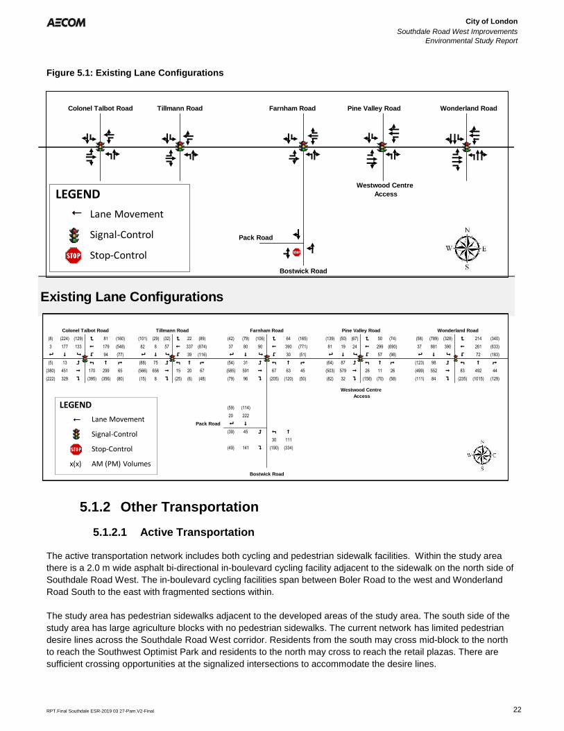
City of London
Southdale Road West Improvements
Environmental Study Report
Error! Reference source not found.
Error! Reference source not found.
RPT.Final Southdale ESR-2019 03 27-Pam.V2-Final 22
Figure 5.1: Existing Lane Configurations
Figure 5.2: Traffic Volumes (2017)
5.1.2 Other Transportation
5.1.2.1 Active Transportation
The active transportation network includes both cycling and pedestrian sidewalk facilities. Within the study area
there is a 2.0 m wide asphalt bi-directional in-boulevard cycling facility adjacent to the sidewalk on the north side of
Southdale Road West. The in-boulevard cycling facilities span between Boler Road to the west and Wonderland
Road South to the east with fragmented sections within.
The study area has pedestrian sidewalks adjacent to the developed areas of the study area. The south side of the
study area has large agriculture blocks with no pedestrian sidewalks. The current network has limited pedestrian
desire lines across the Southdale Road West corridor. Residents from the south may cross mid-block to the north
to reach the Southwest Optimist Park and residents to the north may cross to reach the retail plazas. There are
sufficient crossing opportunities at the signalized intersections to accommodate the desire lines.
112 1512
2212
Pack Road
Bostwick Road
Westwood Centre
Access
Existing Lane Configurations
Colonel Talbot Road Tillmann Road Farnham Road Pine Valley Road Wonderland Road
LEGEND
Lane Movement
Signal-Control
Stop-Control
112 1512
(8) (224) (129) < 81 (160) (101) (29) (32) < 22 (89) (42) (79) (106) < 64 (165) (139) (50) (67) < 50 (74) 2112 (58) (789) (328) < 214 (340)
3 177 133 ! 179 (548) ## 82 8 57 ! 337 (874) 37 80 90 ! 390 (771) 1812 81 19 24 ! 299 (690) 37 881 390 ! 261 (633)
8 $ 9 > 94 (77) 8 $ 9 > 39 (116) 8 $ 9 > 30 (51) 8 $ 9 > 57 (98) 8 $ 9 > 72 (183)
(5) 13 = : # ; (88) 75 = : # ; (54) 31 = : # ; (64) 87 = : # ; (123) 98 = : # ;
(380) 451 " 170 299 65 (566) 656 " 15 20 67 (585) 591 " 67 63 45 (503) 579 " 26 11 26 (499) 552 " 83 492 44
(222) 329 ? (395) (356) (80) (15) 8 ? (25) (6) (48) (79) 96 ? (205) (120) (50) (82) 32 ? (158) (70) (58) (111) 84 ? (235) (1015) (129)
2212
(59) (114)
20 222
Pack Road 8 $
(39) 45 = : #
30 111
(49) 141 ? (190) (334)
Wonderland Road
Bostwick Road
Westwood Centre
Access
Colonel Talbot Road Tillmann Road Farnham Road Pine Valley Road
LEGEND
Lane Movement
Signal-Control
Stop-Control
x(x) AM (PM) Volumes
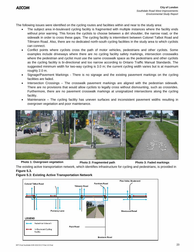
City of London
Southdale Road West Improvements
Environmental Study Report
Error! Reference source not found.
Error! Reference source not found.
RPT.Final Southdale ESR-2019 03 27-Pam.V2-Final 23
The following issues were identified on the cycling routes and facilities within and near to the study area:
• The subject area in-boulevard cycling facility is fragmented with multiple instances where the facility ends
without prior warning. This forces the cyclists to choose between a dirt shoulder, the narrow road, or the
sidewalk in order to cross these gaps. The cycling facility is intermittent between Colonel Talbot Road and
Tillmann Road. Also, there are no dedicated north-south cycling facilities in the study area to which cyclists
can connect.
• Conflict points where cyclists cross the path of motor vehicles, pedestrians and other cyclists. Some
examples include driveways where there are no cycling facility safety markings, intersection crosswalks
where the pedestrian and cyclist must use the same crosswalk space as the pedestrians and other cyclists
as the cycling facility is bi-directional and too narrow according to Ontario Traffic Manual Standards. The
suggested minimum width for two-way cycling is 3.0 m; the current cycling width varies but is at maximum
roughly 2.0 m.
• Signage/Pavement Markings - There is no signage and the existing pavement markings on the cycling
facilities are faded.
• Intersection Crossings – The crosswalk pavement markings are aligned with the pedestrian sidewalk.
There are no provisions that would allow cyclists to legally cross without dismounting, such as crossrides.
Furthermore, there are no pavement crosswalk markings at unsignalized intersections along the cycling
facility.
• Maintenance – The cycling facility has uneven surfaces and inconsistent pavement widths resulting in
overgrown vegetation and poor maintenance.
Photo 1: Overgrown vegetation Photo 2: Fragmented path Photo 3: Faded markings
The existing active transportation network, which identifies infrastructure for cycling and pedestrians, is provided in
Figure 5.3.
Figure 5.3: Existing Active Transportation Network
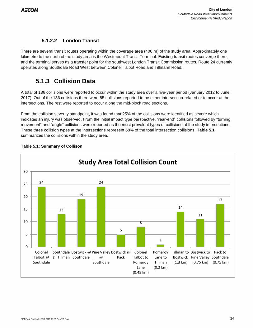
City of London
Southdale Road West Improvements
Environmental Study Report
Error! Reference source not found.
Error! Reference source not found.
RPT.Final Southdale ESR-2019 03 27-Pam.V2-Final 24
24
13
19
24
5
8
1
14
11
17
0
5
10
15
20
25
30
ColonelTalbot @Southdale
Southdale@ Tillman
Bostwick @Southdale
Pine Valley@
Southdale
Bostwick @Pack
ColonelTalbot toPomeroy
Lane(0.45 km)
PomeroyLane toTillman(0.2 km)
Tillman toBostwick(1.3 km)
Bostwick toPine Valley(0.75 km)
Pack toSouthdale (0.75 km)
Study Area Total Collision Count
5.1.2.2 London Transit
There are several transit routes operating within the coverage area (400 m) of the study area. Approximately one
kilometre to the north of the study area is the Westmount Transit Terminal. Existing transit routes converge there,
and the terminal serves as a transfer point for the southwest London Transit Commission routes. Route 24 currently
operates along Southdale Road West between Colonel Talbot Road and Tillmann Road.
5.1.3 Collision Data
A total of 136 collisions were reported to occur within the study area over a five-year period (January 2012 to June
2017). Out of the 136 collisions there were 85 collisions reported to be either intersection-related or to occur at the
intersections. The rest were reported to occur along the mid-block road sections.
From the collision severity standpoint, it was found that 25% of the collisions were identified as severe which
indicates an injury was observed. From the initial impact type perspective, “rear-end” collisions followed by “turning
movement” and “angle” collisions were reported as the most prevalent types of collisions at the study intersections.
These three collision types at the intersections represent 68% of the total intersection collisions. Table 5.1
summarizes the collisions within the study area.
Table 5.1: Summary of Collison
City of London
Southdale Road West Improvements
Environmental Study Report
Error! Reference source not found.
Error! Reference source not found.
RPT.Final Southdale ESR-2019 03 27-Pam.V2-Final 25
5.1.4 Existing Structures
Within the study area there are two culverts:
Culvert Condition
Southdale Road West
General Condition
• Length of storm drain
pipe could not be
determined.
• Skew could not be
determined
• The road is in fair to
good condition with light
raveling and localized
light progressive edge
cracking.
• The vegetated
embankments are in fair
to good condition.
South end (outlet)
• Approximately 2.5m precast pipe
• Light to medium scour at the base of the outlet pipe
• Light to medium loss of galvanized protection coating on the railing on
top of the wingwalls and headwall.
• Galvanized gate installed at the outlet with medium buildup of debris on
the gate.
• Several broken and corroded gabion baskets with missing rocks along
the south embankments.
• Narrow vertical cracking with efflorescence staining on the headwall.
Light spalling of the parging and light scaling.
• Narrow to medium cracking with efflorescence staining on the wingwalls.
• Light scaling and flaking of the parging on the wingwalls.
• There are 3 concrete posts to dissipate stream flow energy at the outlet
end of the structure. Light scaling with narrow cracking. The front (north
face) of the posts appears to have a steel channel.
North End
Inlet was not found.
• No inlets at the ditch
Bostwick Road
General Condition
• Approximately 16-17 m
long
• The road is in fair to
good condition with light
raveling and localized
light progressive edge
cracking.
• The vegetated
embankments are in fair
to good condition.
Except for a fair to poor
localized washout at
east outlet.
East end
• 5’’ corrugated steel pipe (CSP) at east,
▪ water coming out of the pipe (active),
▪ Light to medium corrosion on the invert and below waterline.
▪ Light flaking of the steel.
▪ Light to medium loss of galvanized protection coating in the CSP.
▪ Galvanized rodent grate installed at east end.
• 21’’ CSP is buried due to washout.
West end
• Approximately 21-inch CSP at west end
• Medium to severe corrosion on the invert and below waterline (lower half
of the pipe)
• Light to medium flaking of the steel.
• Light to severe loss of galvanized protection coating in the CSP.
• There was not rodent grate at west end.
• Water noted at 10% of the pipe.
• Light build-up of grassed vegetation in the pipe.
• Limited inspection inside the pipe but there appears to be some shifting of the
pipe and deformation.
City of London
Southdale Road West Improvements
Environmental Study Report
Error! Reference source not found.
Error! Reference source not found.
RPT.Final Southdale ESR-2019 03 27-Pam.V2-Final 26
5.1.5 Utilities and Municipal Services
The following utilities and municipal services are located within the study corridor:
Existing Sanitary Sewers
• 200 mm diameter sanitary sewer – north side extending east of Pomeroy Lane to Tillmann Road
• 200 mm diameter sanitary sewer located on the south side of Southdale Road West, extending west of
Pomeroy Road almost to Colonel Talbot Road.
• 150 mm and 300 mm diameter polyvinyl chloride (PVC) forcemains located on the east side of Colonel
Talbot, south of Southdale Road.
• 300 mm diameter PVC forcemain located on the east side of Colonel Talbot Road, south of Southdale
Road West continues north along the east side of Colonel Talbot Road
• 150 mm diameter forcemain cross the Colonel Talbot Road and Southdale Road West intersection and
continues along the west side of Colonel Talbot Road.
Due to their recent age, it is anticipated that the existing sanitary sewers will remain in place. The need to replace
or relocate the existing forcemains may be triggered in the event that their current location (horizontal and vertical)
conflicts with the new roadway and or new municipal infrastructure.
Existing Storm Sewers
• 1200 mm diameter storm sewer along the south side of Southdale Road West, extending to just east and
west of Pomeroy Lane, complete with storm sewer crossings to the north to convey flows from the existing
northerly developments.
• 975 mm diameter storm sewer extends further east, complete with 900 mm diameter storm sewer
crossings, again to accommodate flows from the development to the north.
• 300 mm to 450 mm diameter storm sewers to convey local drainage in isolated areas.
• 2250 mm diameter storm sewer crosses Southdale Road West, just east of Bostwick Road, conveying
flows from the north to the existing Thornicroft Drain.
Existing Watermains
• 400 and 600 mm diameter watermains along the Southdale Road West from Pine Valley Boulevard to
Byron Hills Drive, and along Bostwick Road, all connected to the low pressure distribution system.
• 600 mm diameter PVC watermain along the south side of Southdale Road West, from Wonderland Road
South to Bostwick Road. This watermain also extends southerly along the east side of Bostwick Road to
Pack Road, connecting to an existing 600mm diameter concrete pressure pipe (CPP) watermain on Pack
Road.
• A 300 mm diameter PVC watermain is also located on the north side of Southdale Road West, from
Wonderland Road South to just west of Pine Valley Boulevard, and is part of the high pressure distribution
system.
• A 600 mm diameter PVC watermain is located on the north side of Southdale Road West extending from
Colonel Talbot Road to just east of Pomeroy Lane. The previous 400 mm diameter ductile iron (DI)
watermain was abandoned and remains in place. A 400 mm diameter PVC watermain continues east of
Pomeroy Lane, terminating just east of Tillmann Road, then continues as a 400 mm diameter CPP
watermain up to Bostwick Road.
• A 400 mm diameter DI watermain (poly encased) is located south of the centreline along Southdale Road
West, extending west of Colonel Talbot Road to Byron Hills Drive.
• A 400 mm diameter DI watermain extends north of Southdale Road West on Colonel Talbot Road, while a
250 mm diameter PVC watermain extends south.
All watermains and associated appurtenances, including valve, air release, and/or drain chambers, are intended to
be protected and remain in place. However, the condition and age of the concrete watermain should be evaluated
City of London
Southdale Road West Improvements
Environmental Study Report
Error! Reference source not found.
Error! Reference source not found.
RPT.Final Southdale ESR-2019 03 27-Pam.V2-Final 27
at the time of detailed design to determine if replacement is warranted. Adjustments to chamber lids may be
required subject to the final road and boulevard elevations. Fire hydrant spacing will be reviewed to ensure proper
fire protection coverage throughout the corridor.
Existing Utilities, Signals and Street Lighting
• Telephone, cable, gas mains and overhead hydro lines exist along the Southdale Road West ROW,
Bostwick Road, and Colonel Talbot Road. Significant hydro infrastructure is located along the north side of
the Southdale Road West corridor, including a substation at the east limit of the subject area, and a hydro
corridor extending to the south.
• A 300 mm diameter high pressure gas main is located along the south limits of the existing Southdale Road
West ROW. A gas substation is also located near the east end of the study area, adjacent to the hydro
corridor.
Where possible, the existing utilities will be protected and kept in place. Relocation of the existing hydro pole line
along the north side of the road and the high pressure gas main on the south side would be a significant
undertaking, therefore the proposed road reconstruction should have regard for these impacts. Where required,
localized relocations may be required if their existing location (horizontal and vertical) conflict with the new roadway
and/or new municipal infrastructure.
5.2 Socio-Economic Environment
5.2.1 Existing Land Use
Along the north side of Southdale Road West and at the major intersections with Colonel Talbot Road and
Wonderland Road South, the study area is characterized by significant urban and commercial development. While
the portions of the study area south of Southdale Road West and on either side of Bostwick Road are comprised of
active agricultural fields.
The existing socio-economic environment was examined to provide land use designations, as well as
neighbourhood profiles for potentially impacted neighbourhoods within the study area. A desktop review of the
study area was undertaken to identify significant socio-economic features, including residential areas, commercial
areas, employment lands, recreational uses, and parks and open spaces. An overview of existing land use is
provided in Table 5.2 and on Figure 5.4.
Table 5.2: Existing Land Uses within the Study Area
Southdale Road West Segment North Side South Side
Southdale Road West
(Pine Valley Road to Bostwick
Road/Farnham Road)
• Medium Density Residential
• Utilities (Hydro transmission
substation)
• Large Scale Commercial
• Bostwick Community
Centre/YMCA/library
• Agriculture
Southdale Road West
(Bostwick Road to Tillmann Road)
• Medium Density Residential
• Low Density Residential
• Open space (Southwest Optimist
SWM, Southwest Optimist Park)
• Agriculture
• Vacant Land (future development)
Southdale Road West
(Tillmann Road to Colonel Talbot
Road)
• Medium Density Residential
• Low Density Residential
• Agriculture
• Open space (North Talbot Wetland)
• Medium Density Residential
• High Density Residential
• Vacant Land (active/future
development)
• Large Scale Commercial
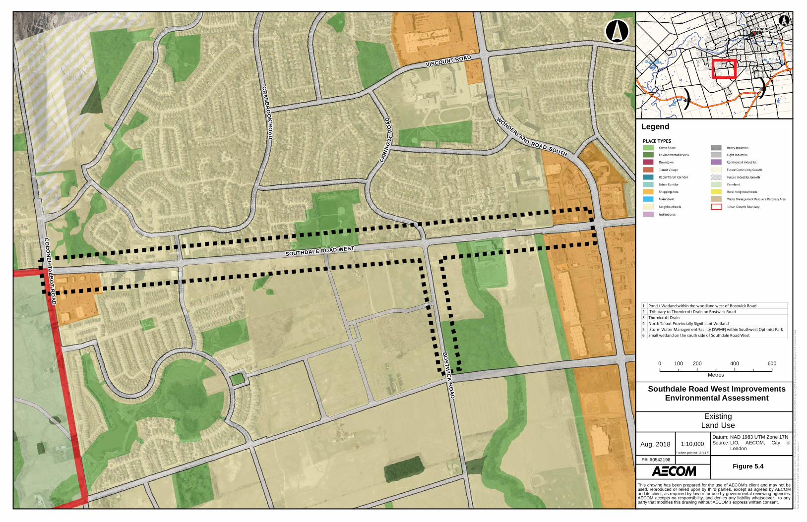
SOUTHDALE ROAD WEST
VISCOUNT ROAD
WO
NDERLAND
ROAD SOUTH
CO
LO
NE
LTA
LB
OT
RO
AD
BO
ST
WIC
K R
OA
D
FA
RN
HA
MR
OA
D
CR
AN
BR
OO
KR
OA
D
!(
London
()401
()402
Ma
p lo
ca
tio
n:
P:\
60
54
21
98
City
of
Lo
nd
on
- S
ou
thd
ale
Ro
ad
EA
\90
0-C
AD
_G
IS\9
20
-92
9 (
GIS
-Gra
ph
ics
)\E
A F
igu
res\m
xd
\Re
po
rt\F
igu
re 5
-4 L
an
du
se
.mx
d
Da
te S
ave
d:
8/1
7/2
01
8 2
:54
:21
PM
Use
r N
am
e:
ad
am
sp
1
1:10,000Aug, 2018
Datum:Source:
Figure 5.4P#: 60542198
0 200 400 600100
Metres
NAD 1983 UTM Zone 17NLIO, AECOM, City ofLondon
* when printed 11"x17"
This drawing has been prepared for the use of AECOM's client and may not beused, reproduced or relied upon by third parties, except as agreed by AECOMand its client, as required by law or for use by governmental reviewing agencies.AECOM accepts no responsibility, and denies any liability whatsoever, to anyparty that modifies this drawing without AECOM's express written consent.
°°
Legend
1 Pond / Wetland within the woodland west of Bostwick Road2 Tributary to Thornicroft Drain on Bostwick Road3 Thornicroft Drain4 North Talbot Provincially Significant Wetland5 Storm Water Management Facility (SWMF) within Southwest Optimist Park6 Small wetland on the south side of Southdale Road West
Southdale Road West ImprovementsEnvironmental Assessment
ExistingLand Use
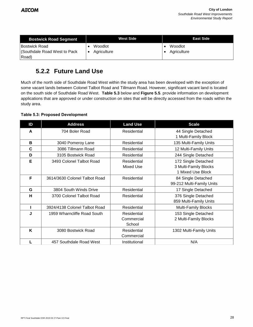
City of London
Southdale Road West Improvements
Environmental Study Report
Error! Reference source not found.
Error! Reference source not found.
RPT.Final Southdale ESR-2019 03 27-Pam.V2-Final 28
Bostwick Road Segment West Side East Side
Bostwick Road
(Southdale Road West to Pack
Road)
• Woodlot
• Agriculture
• Woodlot
• Agriculture
5.2.2 Future Land Use
Much of the north side of Southdale Road West within the study area has been developed with the exception of
some vacant lands between Colonel Talbot Road and Tillmann Road. However, significant vacant land is located
on the south side of Southdale Road West. Table 5.3 below and Figure 5.5. provide information on development
applications that are approved or under construction on sites that will be directly accessed from the roads within the
study area.
Table 5.3: Proposed Development
ID Address Land Use Scale
A 704 Boler Road Residential 44 Single Detached
1 Multi-Family Block
B 3040 Pomeroy Lane Residential 135 Multi-Family Units
C 3086 Tillmann Road Residential 12 Multi-Family Units
D 3105 Bostwick Road Residential 244 Single Detached
E 3493 Colonel Talbot Road Residential
Mixed Use
172 Single Detached
3 Multi-Family Blocks
1 Mixed Use Block
F 3614/3630 Colonel Talbot Road Residential 84 Single Detached
99-212 Multi-Family Units
G 3804 South Winds Drive Residential 17 Single Detached
H 3700 Colonel Talbot Road Residential 376 Single Detached
859 Multi-Family Units
I 3924/4138 Colonel Talbot Road Residential Multi-Family Blocks
J 1959 Wharncliffe Road South Residential
Commercial
School
153 Single Detached
2 Multi-Family Blocks
K 3080 Bostwick Road Residential
Commercial
1302 Multi-Family Units
L 457 Southdale Road West Institutional N/A
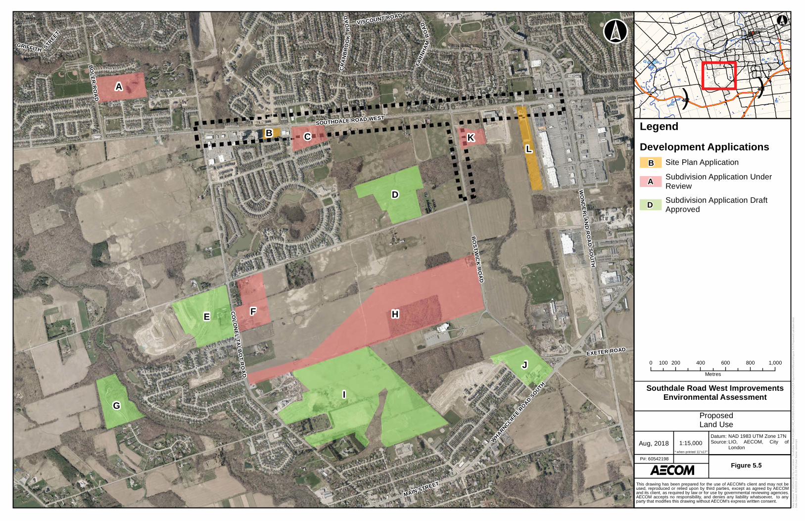
CO
LO
NE
L T
AL
BO
T R
OA
D
WO
ND
ER
LA
ND
RO
AD
SO
UT
H
BO
ST
WIC
K R
OA
D
SOUTHDALE ROAD WEST
EXETER ROAD
VISCOUNT ROAD
GRIFFITH STR
EET
MAIN STREET
CR
AN
BR
OO
KR
OA
D
BO
LE
R R
OA
D
FA
RN
HA
MR
OA
D
WH
AR
NC
LIF
FE R
OA
D S
OU
TH
B
A
C
D
E HF
G
I
J
K
L
!(
London
()401
()402
Ma
p lo
ca
tio
n:
P:\
60
54
21
98
City
of
Lo
nd
on
- S
ou
thd
ale
Ro
ad
EA
\90
0-C
AD
_G
IS\9
20
-92
9 (
GIS
-Gra
ph
ics
)\E
A F
igu
res\m
xd
\Re
po
rt\F
igu
re 5
-5 P
rop
os
ed
La
nd
us
e.m
xd
Da
te S
ave
d:
8/2
0/2
01
8 1
2:3
1:3
3 P
M U
se
r N
am
e:
ad
am
sp
1
1:15,000Aug, 2018
Datum:Source:
Figure 5.5P#: 60542198
0 200 400 600 800 1,000100
Metres
NAD 1983 UTM Zone 17NLIO, AECOM, City ofLondon
* when printed 11"x17"
This drawing has been prepared for the use of AECOM's client and may not beused, reproduced or relied upon by third parties, except as agreed by AECOMand its client, as required by law or for use by governmental reviewing agencies.AECOM accepts no responsibility, and denies any liability whatsoever, to anyparty that modifies this drawing without AECOM's express written consent.
°°
Southdale Road West ImprovementsEnvironmental Assessment
ProposedLand Use
Legend
Development Applications
Site Plan Application
Subdivision Application Under
Review
Subdivision Application DraftApproved
B
A
D
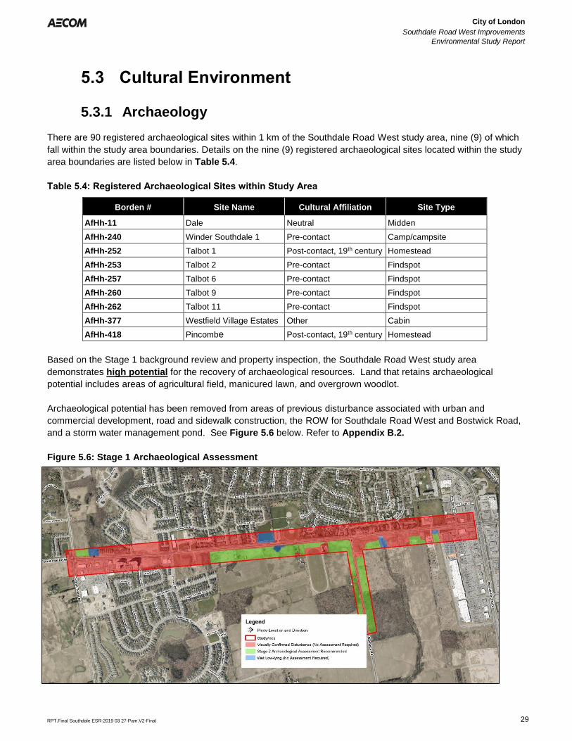
City of London
Southdale Road West Improvements
Environmental Study Report
Error! Reference source not found.
Error! Reference source not found.
RPT.Final Southdale ESR-2019 03 27-Pam.V2-Final 29
5.3 Cultural Environment
5.3.1 Archaeology
There are 90 registered archaeological sites within 1 km of the Southdale Road West study area, nine (9) of which
fall within the study area boundaries. Details on the nine (9) registered archaeological sites located within the study
area boundaries are listed below in Table 5.4.
Table 5.4: Registered Archaeological Sites within Study Area
Borden # Site Name Cultural Affiliation Site Type
AfHh-11 Dale Neutral Midden
AfHh-240 Winder Southdale 1 Pre-contact Camp/campsite
AfHh-252 Talbot 1 Post-contact, 19th century Homestead
AfHh-253 Talbot 2 Pre-contact Findspot
AfHh-257 Talbot 6 Pre-contact Findspot
AfHh-260 Talbot 9 Pre-contact Findspot
AfHh-262 Talbot 11 Pre-contact Findspot
AfHh-377 Westfield Village Estates Other Cabin
AfHh-418 Pincombe Post-contact, 19th century Homestead
Based on the Stage 1 background review and property inspection, the Southdale Road West study area
demonstrates high potential for the recovery of archaeological resources. Land that retains archaeological
potential includes areas of agricultural field, manicured lawn, and overgrown woodlot.
Archaeological potential has been removed from areas of previous disturbance associated with urban and
commercial development, road and sidewalk construction, the ROW for Southdale Road West and Bostwick Road,
and a storm water management pond. See Figure 5.6 below. Refer to Appendix B.2.
Figure 5.6: Stage 1 Archaeological Assessment
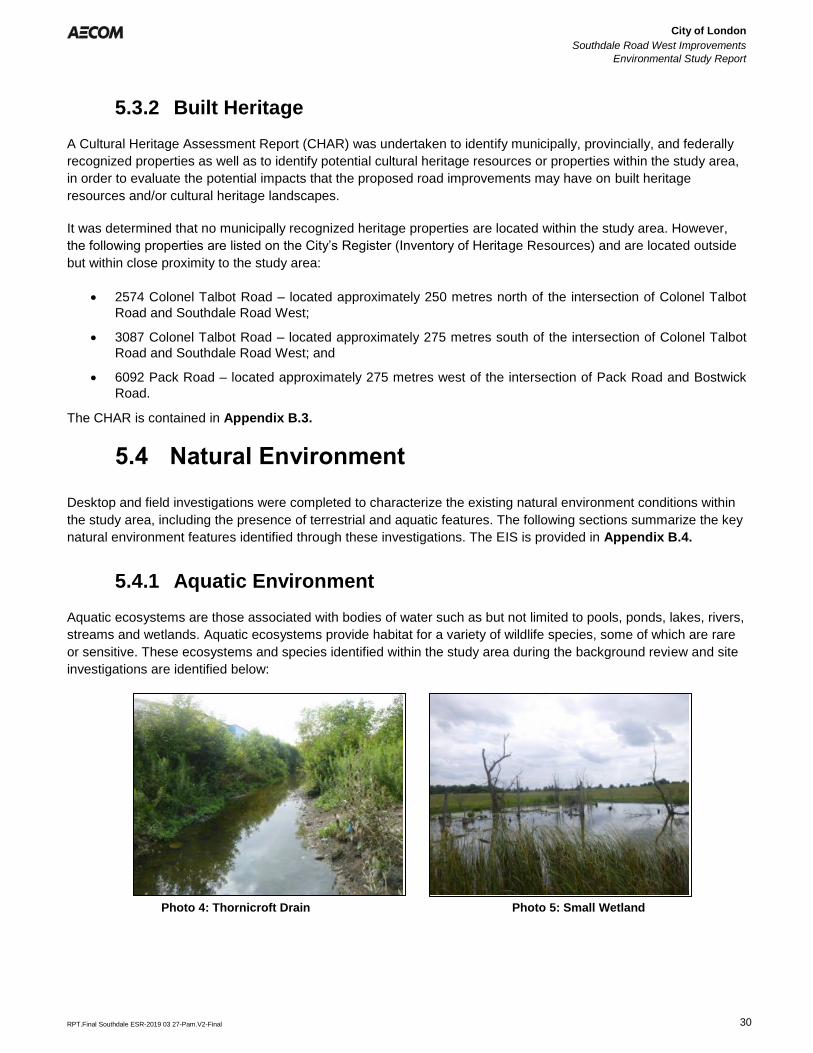
City of London
Southdale Road West Improvements
Environmental Study Report
Error! Reference source not found.
Error! Reference source not found.
RPT.Final Southdale ESR-2019 03 27-Pam.V2-Final 30
5.3.2 Built Heritage
A Cultural Heritage Assessment Report (CHAR) was undertaken to identify municipally, provincially, and federally
recognized properties as well as to identify potential cultural heritage resources or properties within the study area,
in order to evaluate the potential impacts that the proposed road improvements may have on built heritage
resources and/or cultural heritage landscapes.
It was determined that no municipally recognized heritage properties are located within the study area. However,
the following properties are listed on the City’s Register (Inventory of Heritage Resources) and are located outside
but within close proximity to the study area:
• 2574 Colonel Talbot Road – located approximately 250 metres north of the intersection of Colonel Talbot
Road and Southdale Road West;
• 3087 Colonel Talbot Road – located approximately 275 metres south of the intersection of Colonel Talbot
Road and Southdale Road West; and
• 6092 Pack Road – located approximately 275 metres west of the intersection of Pack Road and Bostwick
Road.
The CHAR is contained in Appendix B.3.
5.4 Natural Environment
Desktop and field investigations were completed to characterize the existing natural environment conditions within
the study area, including the presence of terrestrial and aquatic features. The following sections summarize the key
natural environment features identified through these investigations. The EIS is provided in Appendix B.4.
5.4.1 Aquatic Environment
Aquatic ecosystems are those associated with bodies of water such as but not limited to pools, ponds, lakes, rivers,
streams and wetlands. Aquatic ecosystems provide habitat for a variety of wildlife species, some of which are rare
or sensitive. These ecosystems and species identified within the study area during the background review and site
investigations are identified below:
Photo 4: Thornicroft Drain Photo 5: Small Wetland
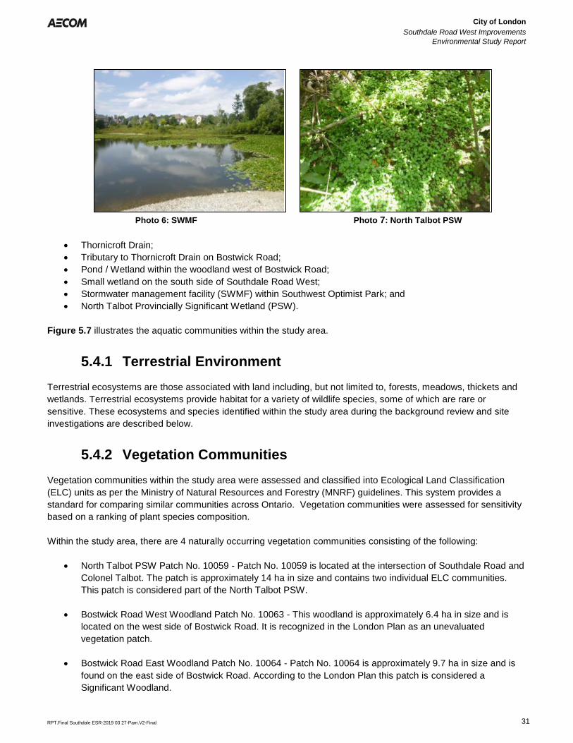
City of London
Southdale Road West Improvements
Environmental Study Report
Error! Reference source not found.
Error! Reference source not found.
RPT.Final Southdale ESR-2019 03 27-Pam.V2-Final 31
• Thornicroft Drain;
• Tributary to Thornicroft Drain on Bostwick Road;
• Pond / Wetland within the woodland west of Bostwick Road;
• Small wetland on the south side of Southdale Road West;
• Stormwater management facility (SWMF) within Southwest Optimist Park; and
• North Talbot Provincially Significant Wetland (PSW).
Figure 5.7 illustrates the aquatic communities within the study area.
5.4.1 Terrestrial Environment
Terrestrial ecosystems are those associated with land including, but not limited to, forests, meadows, thickets and
wetlands. Terrestrial ecosystems provide habitat for a variety of wildlife species, some of which are rare or
sensitive. These ecosystems and species identified within the study area during the background review and site
investigations are described below.
5.4.2 Vegetation Communities
Vegetation communities within the study area were assessed and classified into Ecological Land Classification
(ELC) units as per the Ministry of Natural Resources and Forestry (MNRF) guidelines. This system provides a
standard for comparing similar communities across Ontario. Vegetation communities were assessed for sensitivity
based on a ranking of plant species composition.
Within the study area, there are 4 naturally occurring vegetation communities consisting of the following:
• North Talbot PSW Patch No. 10059 - Patch No. 10059 is located at the intersection of Southdale Road and
Colonel Talbot. The patch is approximately 14 ha in size and contains two individual ELC communities.
This patch is considered part of the North Talbot PSW.
• Bostwick Road West Woodland Patch No. 10063 - This woodland is approximately 6.4 ha in size and is
located on the west side of Bostwick Road. It is recognized in the London Plan as an unevaluated
vegetation patch.
• Bostwick Road East Woodland Patch No. 10064 - Patch No. 10064 is approximately 9.7 ha in size and is
found on the east side of Bostwick Road. According to the London Plan this patch is considered a
Significant Woodland.
Photo 6: SWMF Photo 7: North Talbot PSW
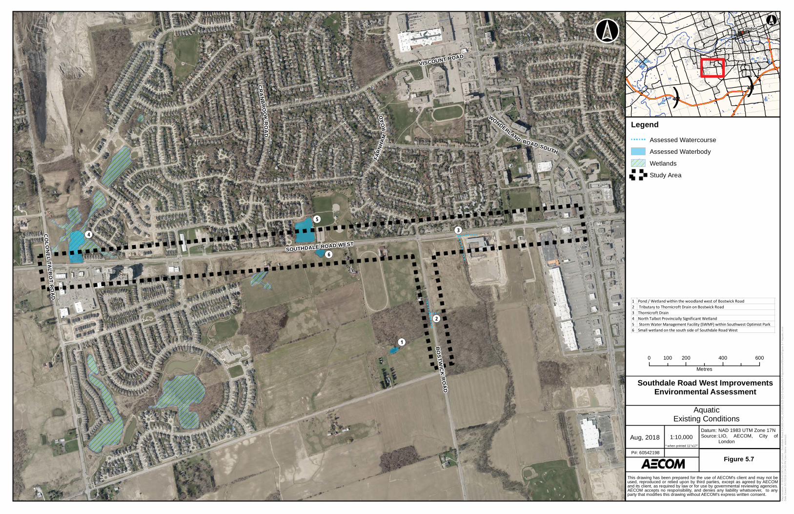
SOUTHDALE ROAD WEST
VISCOUNT ROAD
WO
NDERLAND
ROAD SOUTH
CO
LO
NE
LT
AL
BO
TR
OA
D
BO
ST
WIC
K R
OA
D
FA
RN
HA
MR
OA
D
CR
AN
BR
OO
KR
OA
D
!(2
!(3
!(6
!(5
!(4
!(1
!(
London
()401
()402
Ma
p lo
ca
tio
n:
P:\
60
54
21
98
City
of
Lo
nd
on
- S
ou
thd
ale
Ro
ad
EA
\90
0-C
AD
_G
IS\9
20
-92
9 (
GIS
-Gra
ph
ics
)\E
A F
igu
res\m
xd
\Re
po
rt\F
igu
re 5
-7 A
qu
atic
.mxd
Da
te S
ave
d:
8/1
7/2
01
8 2
:34
:59
PM
Use
r N
am
e:
ad
am
sp
1
1:10,000Aug, 2018
Datum:Source:
Figure 5.7P#: 60542198
0 200 400 600100
Metres
NAD 1983 UTM Zone 17NLIO, AECOM, City ofLondon
* when printed 11"x17"
This drawing has been prepared for the use of AECOM's client and may not beused, reproduced or relied upon by third parties, except as agreed by AECOMand its client, as required by law or for use by governmental reviewing agencies.AECOM accepts no responsibility, and denies any liability whatsoever, to anyparty that modifies this drawing without AECOM's express written consent.
°°
Legend
Assessed Watercourse
Assessed Waterbody
Wetlands
Study Area
1 Pond / Wetland within the woodland west of Bostwick Road2 Tributary to Thornicroft Drain on Bostwick Road3 Thornicroft Drain4 North Talbot Provincially Significant Wetland5 Storm Water Management Facility (SWMF) within Southwest Optimist Park6 Small wetland on the south side of Southdale Road West
Southdale Road West ImprovementsEnvironmental Assessment
AquaticExisting Conditions
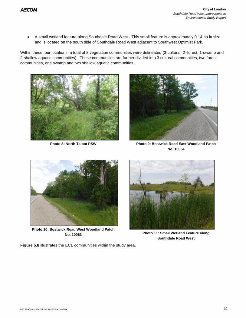
City of London
Southdale Road West Improvements
Environmental Study Report
Error! Reference source not found.
Error! Reference source not found.
RPT.Final Southdale ESR-2019 03 27-Pam.V2-Final 32
• A small wetland feature along Southdale Road West - This small feature is approximately 0.14 ha in size
and is located on the south side of Southdale Road West adjacent to Southwest Optimist Park.
Within these four locations, a total of 8 vegetation communities were delineated (3-cultural, 2–forest, 1-swamp and
2-shallow aquatic communities). These communities are further divided into 3 cultural communities, two forest
communities, one swamp and two shallow aquatic communities.
Photo 8: North Talbot PSW Photo 9: Bostwick Road East Woodland Patch
No. 10064
Photo 10: Bostwick Road West Woodland Patch
No. 10063 Photo 11: Small Wetland Feature along
Southdale Road West
Figure 5.8 illustrates the ECL communities within the study area.
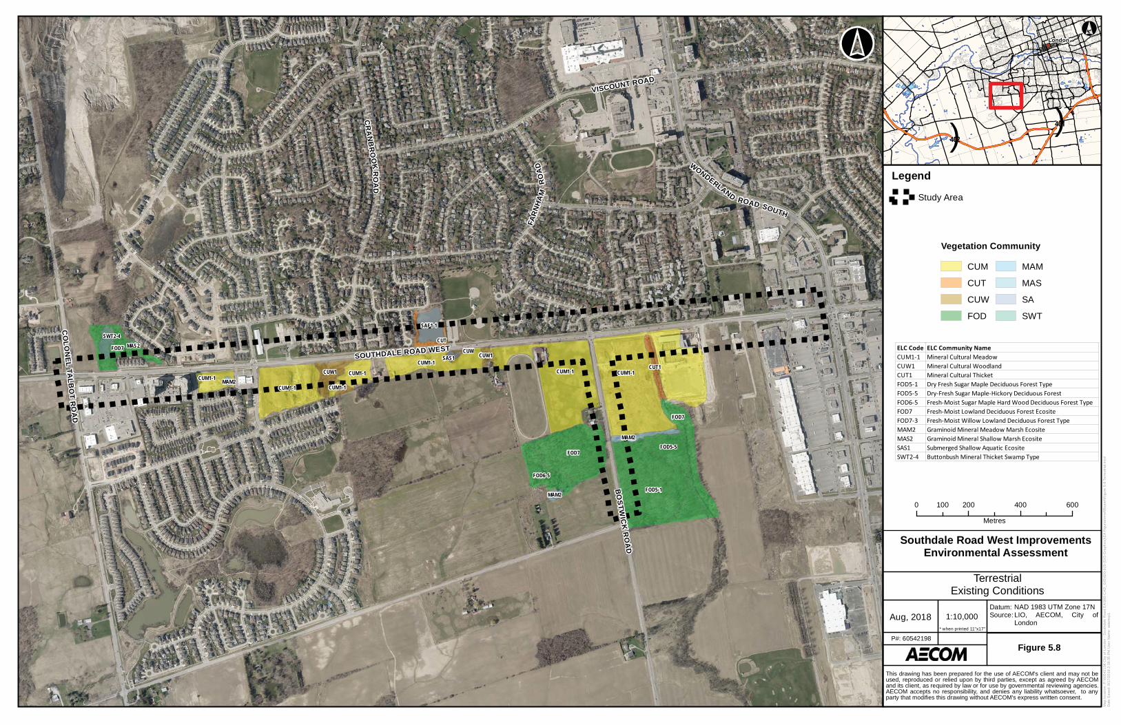
SOUTHDALE ROAD WEST
VISCOUNT ROAD
WO
NDERLAND
ROAD SOUTH
CO
LO
NE
LT
AL
BO
TR
OA
D
BO
ST
WIC
K R
OA
D
FA
RN
HA
MR
OA
D
CR
AN
BR
OO
KR
OA
D
SWT2-4MAS2FOD7
CUM1-1 MAM2CUM1-1
CUW1
CUM1-1
CUM1-1
CUM1-1SAS1
CUW
CUT
SAF1-1
CUW1
FOD7
MAM2
FOD5-1
FOD7
CUT1CUM1-1CUM1-1
FOD6-5
FOD5-5
MAM2
!(
London
()401
()402
Ma
p lo
ca
tio
n:
P:\
60
54
21
98
City
of
Lo
nd
on
- S
ou
thd
ale
Ro
ad
EA
\90
0-C
AD
_G
IS\9
20
-92
9 (
GIS
-Gra
ph
ics
)\E
A F
igu
res\m
xd
\Re
po
rt\F
igu
re 5
-8 T
err
estr
ial.m
xd
Da
te S
ave
d:
8/1
7/2
01
8 2
:39
:35
PM
Use
r N
am
e:
ad
am
sp
1
1:10,000Aug, 2018
Datum:Source:
Figure 5.8P#: 60542198
0 200 400 600100
Metres
NAD 1983 UTM Zone 17NLIO, AECOM, City ofLondon
* when printed 11"x17"
This drawing has been prepared for the use of AECOM's client and may not beused, reproduced or relied upon by third parties, except as agreed by AECOMand its client, as required by law or for use by governmental reviewing agencies.AECOM accepts no responsibility, and denies any liability whatsoever, to anyparty that modifies this drawing without AECOM's express written consent.
°°
Legend
Study Area
Vegetation Community
CUM
CUT
CUW
FOD
MAM
MAS
SA
SWT
ELC Code ELC Community NameCUM1-1 Mineral Cultural MeadowCUW1 Mineral Cultural WoodlandCUT1 Mineral Cultural ThicketFOD5-1 Dry Fresh Sugar Maple Deciduous Forest TypeFOD5-5 Dry-Fresh Sugar Maple-Hickory Deciduous ForestFOD6-5 Fresh-Moist Sugar Maple Hard Wood Deciduous Forest TypeFOD7 Fresh-Moist Lowland Deciduous Forest EcositeFOD7-3 Fresh-Moist Willow Lowland Deciduous Forest TypeMAM2 Graminoid Mineral Meadow Marsh EcositeMAS2 Graminoid Mineral Shallow Marsh EcositeSAS1 Submerged Shallow Aquatic EcositeSWT2-4 Buttonbush Mineral Thicket Swamp Type
Southdale Road West ImprovementsEnvironmental Assessment
TerrestrialExisting Conditions
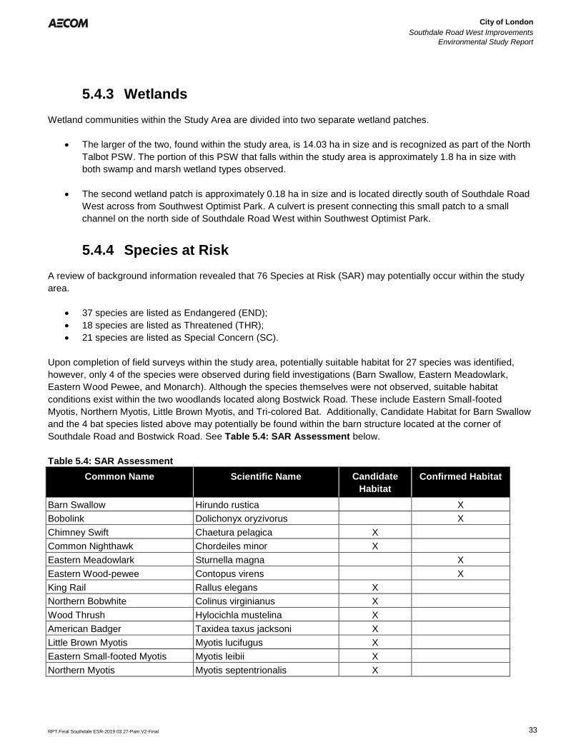
City of London
Southdale Road West Improvements
Environmental Study Report
Error! Reference source not found.
Error! Reference source not found.
RPT.Final Southdale ESR-2019 03 27-Pam.V2-Final 33
5.4.3 Wetlands
Wetland communities within the Study Area are divided into two separate wetland patches.
• The larger of the two, found within the study area, is 14.03 ha in size and is recognized as part of the North
Talbot PSW. The portion of this PSW that falls within the study area is approximately 1.8 ha in size with
both swamp and marsh wetland types observed.
• The second wetland patch is approximately 0.18 ha in size and is located directly south of Southdale Road
West across from Southwest Optimist Park. A culvert is present connecting this small patch to a small
channel on the north side of Southdale Road West within Southwest Optimist Park.
5.4.4 Species at Risk
A review of background information revealed that 76 Species at Risk (SAR) may potentially occur within the study
area.
• 37 species are listed as Endangered (END);
• 18 species are listed as Threatened (THR);
• 21 species are listed as Special Concern (SC).
Upon completion of field surveys within the study area, potentially suitable habitat for 27 species was identified,
however, only 4 of the species were observed during field investigations (Barn Swallow, Eastern Meadowlark,
Eastern Wood Pewee, and Monarch). Although the species themselves were not observed, suitable habitat
conditions exist within the two woodlands located along Bostwick Road. These include Eastern Small-footed
Myotis, Northern Myotis, Little Brown Myotis, and Tri-colored Bat. Additionally, Candidate Habitat for Barn Swallow
and the 4 bat species listed above may potentially be found within the barn structure located at the corner of
Southdale Road and Bostwick Road. See Table 5.4: SAR Assessment below.
Table 5.4: SAR Assessment
Common Name Scientific Name Candidate
Habitat
Confirmed Habitat
Barn Swallow Hirundo rustica X
Bobolink Dolichonyx oryzivorus X
Chimney Swift Chaetura pelagica X
Common Nighthawk Chordeiles minor X
Eastern Meadowlark Sturnella magna X
Eastern Wood-pewee Contopus virens X
King Rail Rallus elegans X
Northern Bobwhite Colinus virginianus X
Wood Thrush Hylocichla mustelina X
American Badger Taxidea taxus jacksoni X
Little Brown Myotis Myotis lucifugus X
Eastern Small-footed Myotis Myotis leibii X
Northern Myotis Myotis septentrionalis X
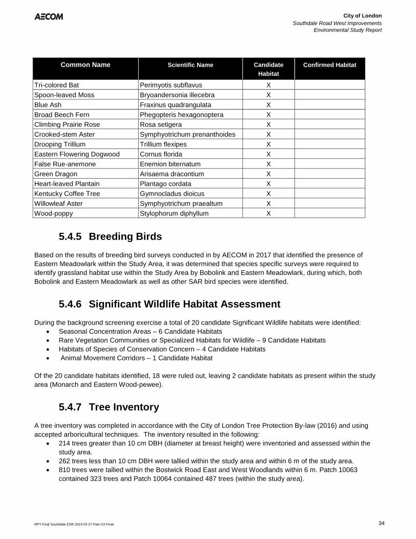
City of London
Southdale Road West Improvements
Environmental Study Report
Error! Reference source not found.
Error! Reference source not found.
RPT.Final Southdale ESR-2019 03 27-Pam.V2-Final 34
Common Name Scientific Name Candidate
Habitat
Confirmed Habitat
Tri-colored Bat Perimyotis subflavus X
Spoon-leaved Moss Bryoandersonia illecebra X
Blue Ash Fraxinus quadrangulata X
Broad Beech Fern Phegopteris hexagonoptera X
Climbing Prairie Rose Rosa setigera X
Crooked-stem Aster Symphyotrichum prenanthoides X
Drooping Trillium Trillium flexipes X
Eastern Flowering Dogwood Cornus florida X
False Rue-anemone Enemion biternatum X
Green Dragon Arisaema dracontium X
Heart-leaved Plantain Plantago cordata X
Kentucky Coffee Tree Gymnocladus dioicus X
Willowleaf Aster Symphyotrichum praealtum X
Wood-poppy Stylophorum diphyllum X
5.4.5 Breeding Birds
Based on the results of breeding bird surveys conducted in by AECOM in 2017 that identified the presence of
Eastern Meadowlark within the Study Area, it was determined that species specific surveys were required to
identify grassland habitat use within the Study Area by Bobolink and Eastern Meadowlark, during which, both
Bobolink and Eastern Meadowlark as well as other SAR bird species were identified.
5.4.6 Significant Wildlife Habitat Assessment
During the background screening exercise a total of 20 candidate Significant Wildlife habitats were identified:
• Seasonal Concentration Areas – 6 Candidate Habitats
• Rare Vegetation Communities or Specialized Habitats for Wildlife – 9 Candidate Habitats
• Habitats of Species of Conservation Concern – 4 Candidate Habitats
• Animal Movement Corridors – 1 Candidate Habitat
Of the 20 candidate habitats identified, 18 were ruled out, leaving 2 candidate habitats as present within the study
area (Monarch and Eastern Wood-pewee).
5.4.7 Tree Inventory
A tree inventory was completed in accordance with the City of London Tree Protection By-law (2016) and using
accepted arboricultural techniques. The inventory resulted in the following:
• 214 trees greater than 10 cm DBH (diameter at breast height) were inventoried and assessed within the
study area.
• 262 trees less than 10 cm DBH were tallied within the study area and within 6 m of the study area.
• 810 trees were tallied within the Bostwick Road East and West Woodlands within 6 m. Patch 10063
contained 323 trees and Patch 10064 contained 487 trees (within the study area).
City of London
Southdale Road West Improvements
Environmental Study Report
Error! Reference source not found.
Error! Reference source not found.
RPT.Final Southdale ESR-2019 03 27-Pam.V2-Final 35
6. Alternative Planning Solutions
6.1 Identification of Alternative Planning Solutions
For the purposes of the Southdale Road West Improvements MCEA, planning solutions to the undertaking include:
1. Do Nothing – Assumes no improvements will be made beyond those already planned and approved.
2. Limit Growth - Assumes no improvements will be made beyond those already planned and approved andincludes measures to limit development in the study area.
3. Road Network Improvements – Includes potential improvements to nearby east/west roads(Commissioners Road and Pack Road/Bradley Avenue Extension).
4. Operational Improvements – includes the implementation of additional turn lanes, traffic signalcoordination, etc.
5. Road Widening – includes widening of Southdale Road West to provide additional traffic lanes to increasecapacity.
6. Transportation Demand Management (TDM) – Includes measures to reduce vehicle volumes by usingbike lanes, and promoting transit.
The above identified alternative solutions were screened against the problem and opportunity statement identified
in Section 4 of this Report. The evaluation of alternative solutions is comprised of a two-step process. Firstly, Do
Nothing, Limit Growth and Road Network Improvements were screened out because it was determined that these
solutions will not address the project needs as identified in the problem and opportunity statement in Section 4.
Do Nothing – This was not carried forward for further assessment as, although this solution avoids impacts to
natural environment, archaeological and cultural resources and costs less compared to other solutions, it does not
address transportation planning and does not address the problem and opportunity statement identified for this
project.
Limit Growth – This option was not carried forward as it does not comply with current City policies and does not
address the problem and opportunity statement.
Road Network Improvements - This option was not carried forward for further assessment as it offers only limited
improvements to capacity and level of service on Southdale Road West due to planned growth along corridor and
marginal diversion of traffic on other roads. This option does not address the problem and opportunity statement for
this project.
Next, the remaining alternative solutions, (Operational Improvements, Road Widening and TDM), were carried
forward for further assessment and were evaluated against the criteria developed for the project in order to
determine the preferred recommended solution (see Section 6.3).
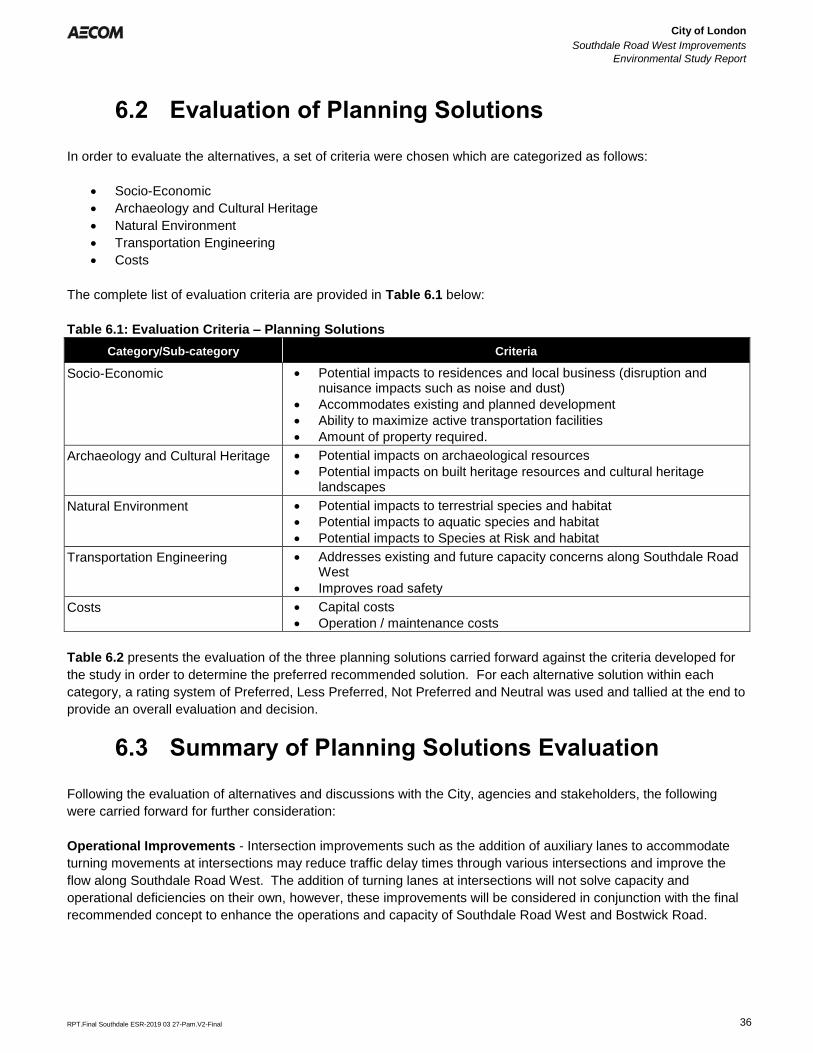
City of London
Southdale Road West Improvements
Environmental Study Report
Error! Reference source not found.
Error! Reference source not found.
RPT.Final Southdale ESR-2019 03 27-Pam.V2-Final 36
6.2 Evaluation of Planning Solutions
In order to evaluate the alternatives, a set of criteria were chosen which are categorized as follows:
• Socio-Economic
• Archaeology and Cultural Heritage
• Natural Environment
• Transportation Engineering
• Costs
The complete list of evaluation criteria are provided in Table 6.1 below:
Table 6.1: Evaluation Criteria – Planning Solutions
Category/Sub-category Criteria
Socio-Economic • Potential impacts to residences and local business (disruption andnuisance impacts such as noise and dust)
• Accommodates existing and planned development
• Ability to maximize active transportation facilities
• Amount of property required.
Archaeology and Cultural Heritage • Potential impacts on archaeological resources
• Potential impacts on built heritage resources and cultural heritagelandscapes
Natural Environment • Potential impacts to terrestrial species and habitat
• Potential impacts to aquatic species and habitat
• Potential impacts to Species at Risk and habitat
Transportation Engineering • Addresses existing and future capacity concerns along Southdale RoadWest
• Improves road safety
Costs • Capital costs
• Operation / maintenance costs
Table 6.2 presents the evaluation of the three planning solutions carried forward against the criteria developed for
the study in order to determine the preferred recommended solution. For each alternative solution within each
category, a rating system of Preferred, Less Preferred, Not Preferred and Neutral was used and tallied at the end to
provide an overall evaluation and decision.
6.3 Summary of Planning Solutions Evaluation
Following the evaluation of alternatives and discussions with the City, agencies and stakeholders, the following
were carried forward for further consideration:
Operational Improvements - Intersection improvements such as the addition of auxiliary lanes to accommodate
turning movements at intersections may reduce traffic delay times through various intersections and improve the
flow along Southdale Road West. The addition of turning lanes at intersections will not solve capacity and
operational deficiencies on their own, however, these improvements will be considered in conjunction with the final
recommended concept to enhance the operations and capacity of Southdale Road West and Bostwick Road.
City of London
Southdale Road West Improvements
Environmental Study Report
Error! Reference source not found.
Error! Reference source not found.
RPT.Final Southdale ESR-2019 03 27-Pam.V2-Final 37
Road Widening – This option is carried forward for further assessment as it addresses the problem and
opportunity statement and satisfies the socio-economic and transportation engineering criteria. This option has
potential to impact archaeological resources and the natural environment, however, this solution may also provide
some opportunity for the enhancement and protection of the natural environment.
TDM – the provision of TDM measures will not fully address anticipated future travel demands on the future growth
within the study area. However, improvements to transit and active transportation facilities in the study area if
implemented with additional infrastructure improvements can address the objectives of this study. These
improvements will be considered in conjunction with the final recommended design concept to enhance the
operations and capacity of Southdale Road West.
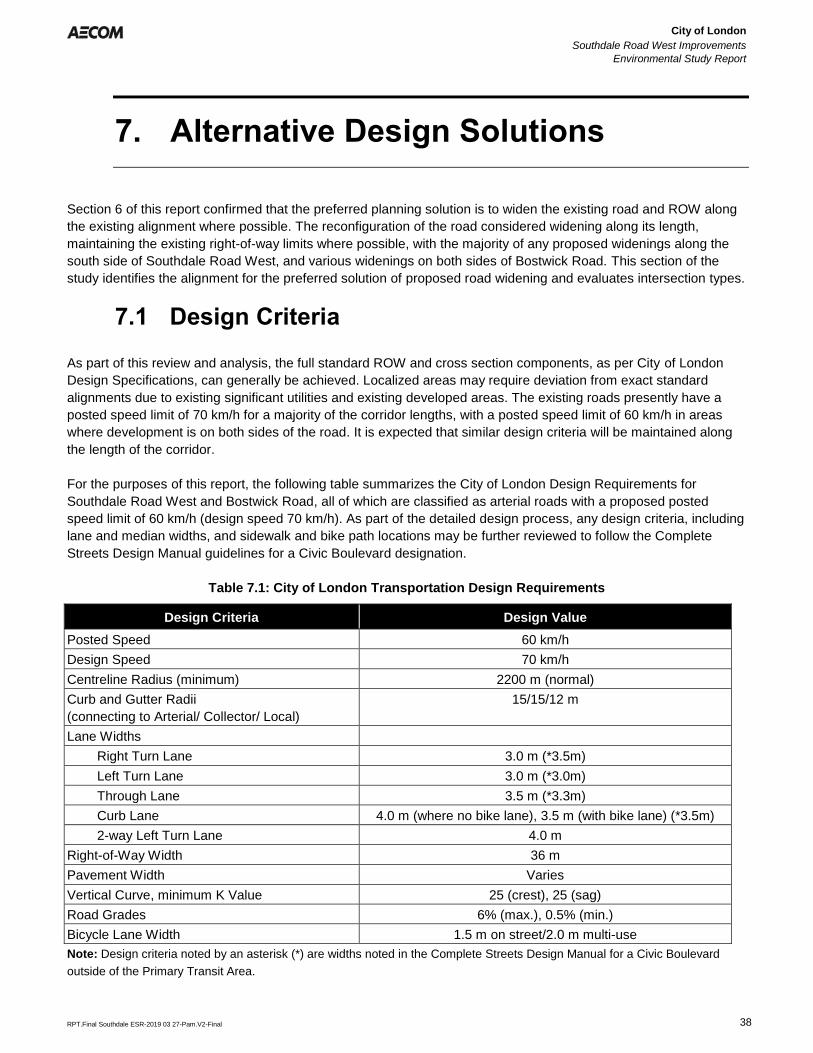
City of London
Southdale Road West Improvements
Environmental Study Report
Error! Reference source not found.
Error! Reference source not found.
RPT.Final Southdale ESR-2019 03 27-Pam.V2-Final 38
7. Alternative Design Solutions
Section 6 of this report confirmed that the preferred planning solution is to widen the existing road and ROW along
the existing alignment where possible. The reconfiguration of the road considered widening along its length,
maintaining the existing right-of-way limits where possible, with the majority of any proposed widenings along the
south side of Southdale Road West, and various widenings on both sides of Bostwick Road. This section of the
study identifies the alignment for the preferred solution of proposed road widening and evaluates intersection types.
7.1 Design Criteria
As part of this review and analysis, the full standard ROW and cross section components, as per City of London
Design Specifications, can generally be achieved. Localized areas may require deviation from exact standard
alignments due to existing significant utilities and existing developed areas. The existing roads presently have a
posted speed limit of 70 km/h for a majority of the corridor lengths, with a posted speed limit of 60 km/h in areas
where development is on both sides of the road. It is expected that similar design criteria will be maintained along
the length of the corridor.
For the purposes of this report, the following table summarizes the City of London Design Requirements for
Southdale Road West and Bostwick Road, all of which are classified as arterial roads with a proposed posted
speed limit of 60 km/h (design speed 70 km/h). As part of the detailed design process, any design criteria, including
lane and median widths, and sidewalk and bike path locations may be further reviewed to follow the Complete
Streets Design Manual guidelines for a Civic Boulevard designation.
Table 7.1: City of London Transportation Design Requirements
Design Criteria Design Value
Posted Speed 60 km/h
Design Speed 70 km/h
Centreline Radius (minimum) 2200 m (normal)
Curb and Gutter Radii
(connecting to Arterial/ Collector/ Local)
15/15/12 m
Lane Widths
Right Turn Lane 3.0 m (*3.5m)
Left Turn Lane 3.0 m (*3.0m)
Through Lane 3.5 m (*3.3m)
Curb Lane 4.0 m (where no bike lane), 3.5 m (with bike lane) (*3.5m)
2-way Left Turn Lane 4.0 m
Right-of-Way Width 36 m
Pavement Width Varies
Vertical Curve, minimum K Value 25 (crest), 25 (sag)
Road Grades 6% (max.), 0.5% (min.)
Bicycle Lane Width 1.5 m on street/2.0 m multi-use
Note: Design criteria noted by an asterisk (*) are widths noted in the Complete Streets Design Manual for a Civic Boulevard
outside of the Primary Transit Area.
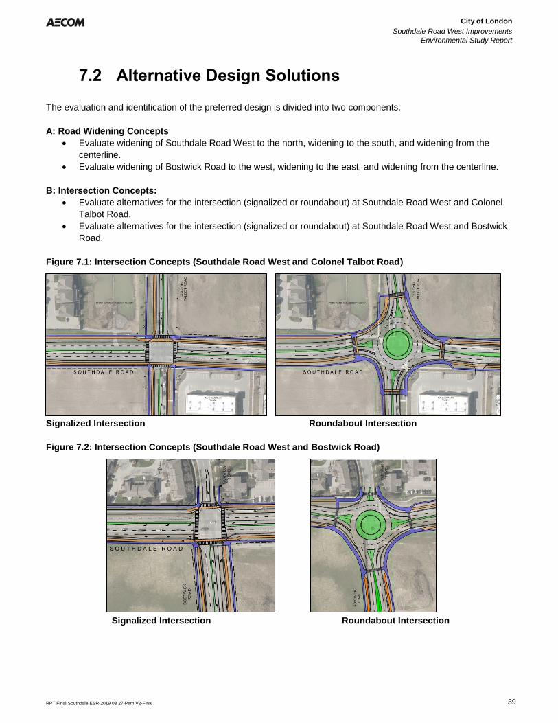
City of London
Southdale Road West Improvements
Environmental Study Report
Error! Reference source not found.
Error! Reference source not found.
RPT.Final Southdale ESR-2019 03 27-Pam.V2-Final 39
7.2 Alternative Design Solutions
The evaluation and identification of the preferred design is divided into two components:
A: Road Widening Concepts
• Evaluate widening of Southdale Road West to the north, widening to the south, and widening from the
centerline.
• Evaluate widening of Bostwick Road to the west, widening to the east, and widening from the centerline.
B: Intersection Concepts:
• Evaluate alternatives for the intersection (signalized or roundabout) at Southdale Road West and Colonel
Talbot Road.
• Evaluate alternatives for the intersection (signalized or roundabout) at Southdale Road West and Bostwick
Road.
Figure 7.1: Intersection Concepts (Southdale Road West and Colonel Talbot Road)
Signalized Intersection Roundabout Intersection
Figure 7.2: Intersection Concepts (Southdale Road West and Bostwick Road)
Signalized Intersection Roundabout Intersection
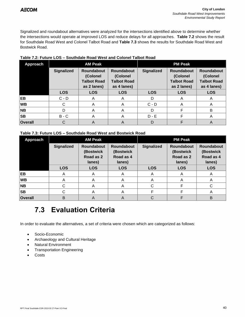
City of London
Southdale Road West Improvements
Environmental Study Report
Error! Reference source not found.
Error! Reference source not found.
RPT.Final Southdale ESR-2019 03 27-Pam.V2-Final 40
Signalized and roundabout alternatives were analyzed for the intersections identified above to determine whether
the intersections would operate at improved LOS and reduce delays for all approaches. Table 7.2 shows the result
for Southdale Road West and Colonel Talbot Road and Table 7.3 shows the results for Southdale Road West and
Bostwick Road.
Table 7.2: Future LOS – Southdale Road West and Colonel Talbot Road
Approach AM Peak PM Peak
Signalized Roundabout
(Colonel
Talbot Road
as 2 lanes)
Roundabout
(Colonel
Talbot Road
as 4 lanes)
Signalized Roundabout
(Colonel
Talbot Road
as 2 lanes)
Roundabout
(Colonel
Talbot Road
as 4 lanes)
LOS LOS LOS LOS LOS LOS
EB C - D A A D A A
WB C A A C - D A A
NB D A A D F B
SB B - C A A D - E F A
Overall C A A D F A
Table 7.3: Future LOS – Southdale Road West and Bostwick Road
Approach AM Peak PM Peak
Signalized Roundabout
(Bostwick
Road as 2
lanes)
Roundabout
(Bostwick
Road as 4
lanes)
Signalized Roundabout
(Bostwick
Road as 2
lanes)
Roundabout
(Bostwick
Road as 4
lanes)
LOS LOS LOS LOS LOS LOS
EB A A A A A A
WB A A A A A A
NB C A A C F C
SB C A A F F A
Overall B A A C F B
7.3 Evaluation Criteria
In order to evaluate the alternatives, a set of criteria were chosen which are categorized as follows:
• Socio-Economic
• Archaeology and Cultural Heritage
• Natural Environment
• Transportation Engineering
• Costs
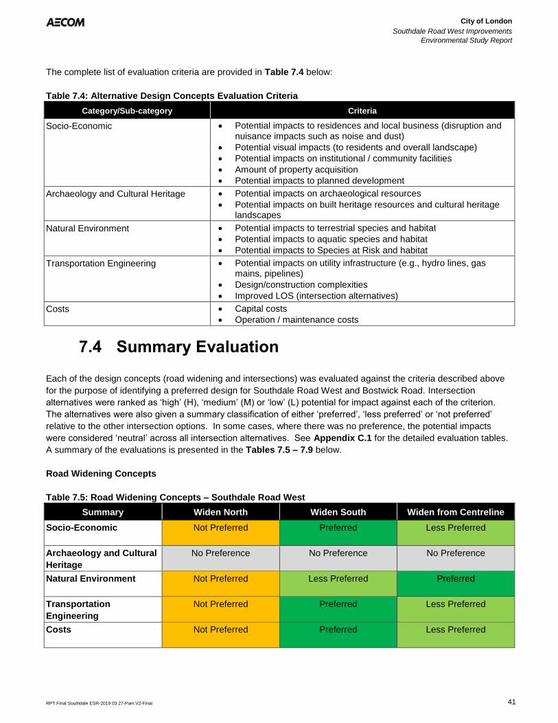
City of London
Southdale Road West Improvements
Environmental Study Report
Error! Reference source not found.
Error! Reference source not found.
RPT.Final Southdale ESR-2019 03 27-Pam.V2-Final 41
The complete list of evaluation criteria are provided in Table 7.4 below:
Table 7.4: Alternative Design Concepts Evaluation Criteria
Category/Sub-category Criteria
Socio-Economic • Potential impacts to residences and local business (disruption andnuisance impacts such as noise and dust)
• Potential visual impacts (to residents and overall landscape)
• Potential impacts on institutional / community facilities
• Amount of property acquisition
• Potential impacts to planned development
Archaeology and Cultural Heritage • Potential impacts on archaeological resources
• Potential impacts on built heritage resources and cultural heritagelandscapes
Natural Environment • Potential impacts to terrestrial species and habitat
• Potential impacts to aquatic species and habitat
• Potential impacts to Species at Risk and habitat
Transportation Engineering • Potential impacts on utility infrastructure (e.g., hydro lines, gasmains, pipelines)
• Design/construction complexities
• Improved LOS (intersection alternatives)
Costs • Capital costs
• Operation / maintenance costs
7.4 Summary Evaluation
Each of the design concepts (road widening and intersections) was evaluated against the criteria described above
for the purpose of identifying a preferred design for Southdale Road West and Bostwick Road. Intersection
alternatives were ranked as ‘high’ (H), ‘medium’ (M) or ‘low’ (L) potential for impact against each of the criterion.
The alternatives were also given a summary classification of either ‘preferred’, ‘less preferred’ or ‘not preferred’
relative to the other intersection options. In some cases, where there was no preference, the potential impacts
were considered ‘neutral’ across all intersection alternatives. See Appendix C.1 for the detailed evaluation tables.
A summary of the evaluations is presented in the Tables 7.5 – 7.9 below.
Road Widening Concepts
Table 7.5: Road Widening Concepts – Southdale Road West
Summary Widen North Widen South Widen from Centreline
Socio-Economic Not Preferred Preferred Less Preferred
Archaeology and Cultural
Heritage
No Preference No Preference No Preference
Natural Environment Not Preferred Less Preferred Preferred
Transportation
Engineering
Not Preferred Preferred Less Preferred
Costs Not Preferred Preferred Less Preferred
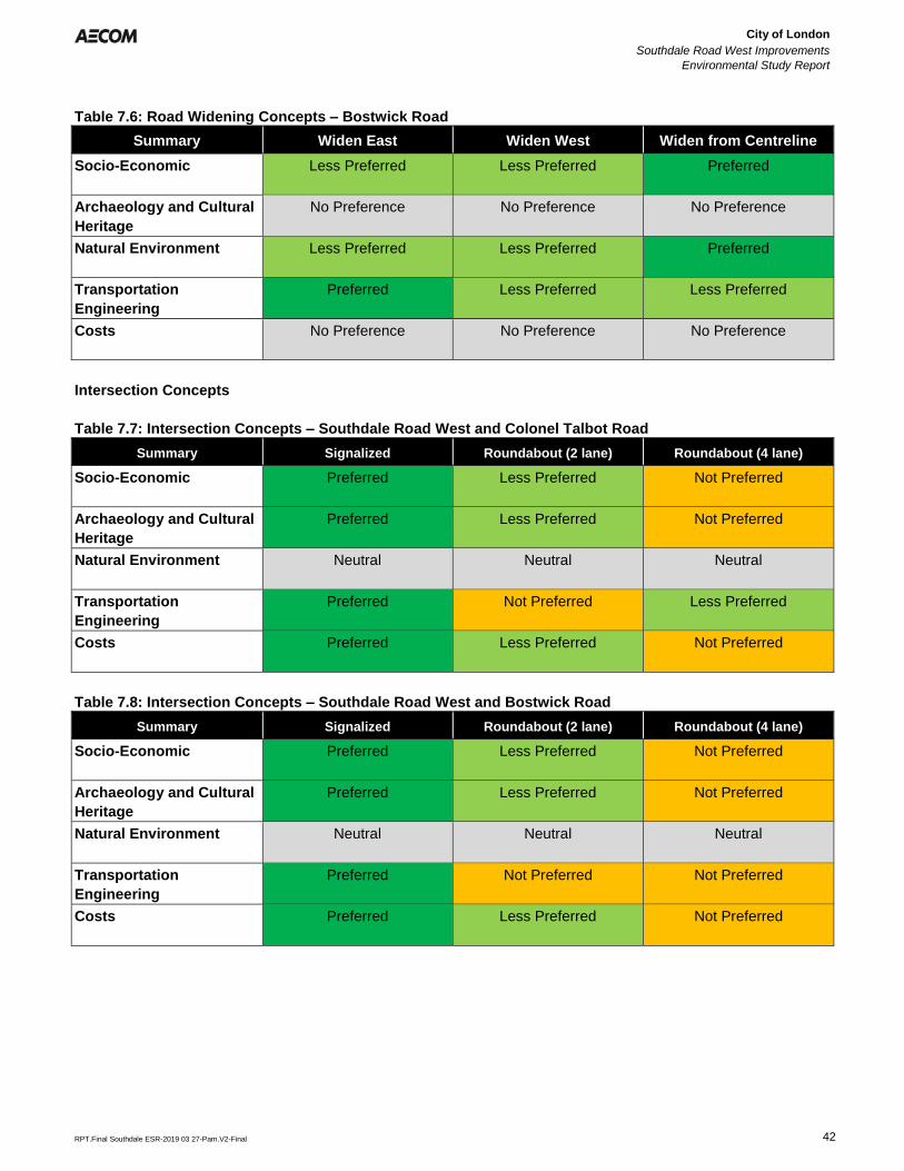
City of London
Southdale Road West Improvements
Environmental Study Report
Error! Reference source not found.
Error! Reference source not found.
RPT.Final Southdale ESR-2019 03 27-Pam.V2-Final 42
Table 7.6: Road Widening Concepts – Bostwick Road
Summary Widen East Widen West Widen from Centreline
Socio-Economic Less Preferred Less Preferred Preferred
Archaeology and Cultural
Heritage
No Preference No Preference No Preference
Natural Environment Less Preferred Less Preferred Preferred
Transportation
Engineering
Preferred Less Preferred Less Preferred
Costs No Preference No Preference No Preference
Intersection Concepts
Table 7.7: Intersection Concepts – Southdale Road West and Colonel Talbot Road
Summary Signalized Roundabout (2 lane) Roundabout (4 lane)
Socio-Economic Preferred Less Preferred Not Preferred
Archaeology and Cultural
Heritage
Preferred Less Preferred Not Preferred
Natural Environment Neutral Neutral Neutral
Transportation
Engineering
Preferred Not Preferred Less Preferred
Costs Preferred Less Preferred Not Preferred
Table 7.8: Intersection Concepts – Southdale Road West and Bostwick Road
Summary Signalized Roundabout (2 lane) Roundabout (4 lane)
Socio-Economic Preferred Less Preferred Not Preferred
Archaeology and Cultural
Heritage
Preferred Less Preferred Not Preferred
Natural Environment Neutral Neutral Neutral
Transportation
Engineering
Preferred Not Preferred Not Preferred
Costs Preferred Less Preferred Not Preferred
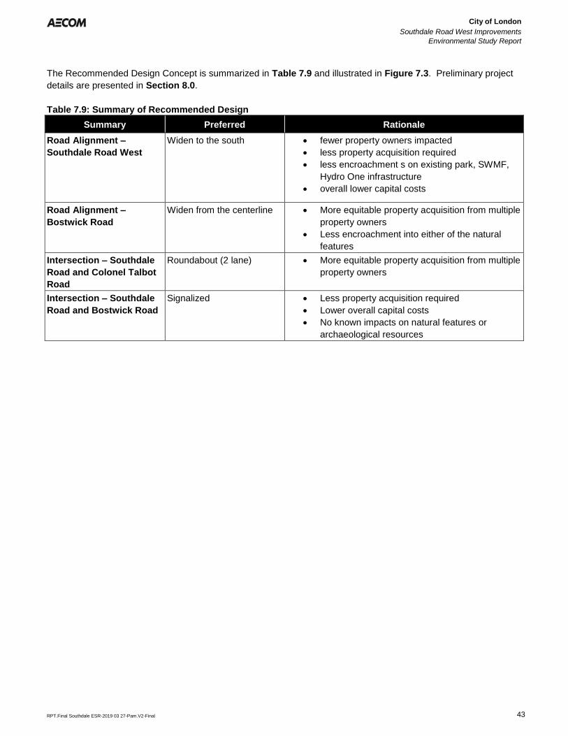
City of London
Southdale Road West Improvements
Environmental Study Report
Error! Reference source not found.
Error! Reference source not found.
RPT.Final Southdale ESR-2019 03 27-Pam.V2-Final 43
The Recommended Design Concept is summarized in Table 7.9 and illustrated in Figure 7.3. Preliminary project
details are presented in Section 8.0.
Table 7.9: Summary of Recommended Design
Summary Preferred Rationale
Road Alignment –
Southdale Road West
Widen to the south • fewer property owners impacted
• less property acquisition required
• less encroachment s on existing park, SWMF,
Hydro One infrastructure
• overall lower capital costs
Road Alignment –
Bostwick Road
Widen from the centerline • More equitable property acquisition from multiple
property owners
• Less encroachment into either of the natural
features
Intersection – Southdale
Road and Colonel Talbot
Road
Roundabout (2 lane) • More equitable property acquisition from multiple
property owners
Intersection – Southdale
Road and Bostwick Road
Signalized • Less property acquisition required
• Lower overall capital costs
• No known impacts on natural features or
archaeological resources
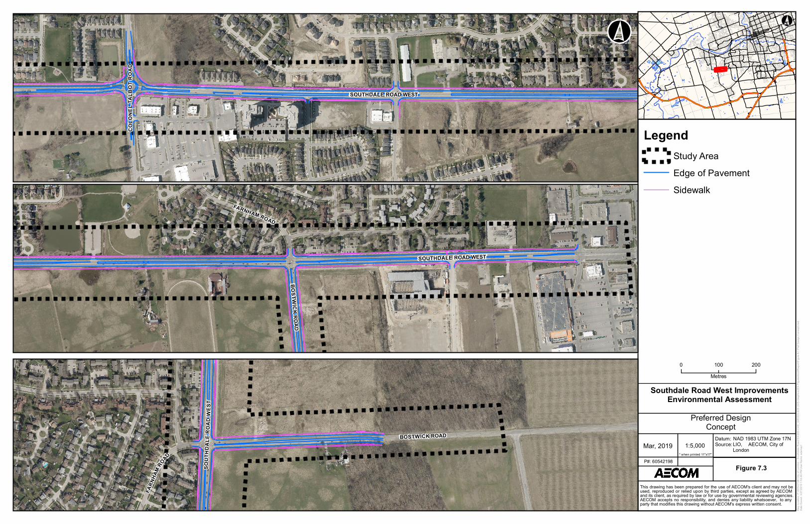
COLO
NELT
ALBO
TROA
D
SOUTHDALE ROAD WEST
Map l
ocati
on: P
:\605
4219
8 City
of Lo
ndon
- Sou
thdale
Roa
d EA\
900-C
AD_G
IS\92
0-929
(GIS
-Grap
hics)\
EA Fi
gures
\mxd
\Rep
ort\Fi
gure
8-1 Pr
ef De
sign C
once
pt.mx
dDa
te Sa
ved:
3/27/2
019 1
:53:40
PM U
ser N
ame:
adam
sp11:5,000Mar, 2019
Datum:Source:
Figure 7.3P#: 60542198
0 200100Metres
NAD 1983 UTM Zone 17NLIO, AECOM, City ofLondon
* when printed 11"x17"
This drawing has been prepared for the use of AECOM's client and may not beused, reproduced or relied upon by third parties, except as agreed by AECOMand its client, as required by law or for use by governmental reviewing agencies.AECOM accepts no responsibility, and denies any liability whatsoever, to anyparty that modifies this drawing without AECOM's express written consent.
°°
Southdale Road West ImprovementsEnvironmental Assessment
Preferred DesignConcept
FARNHAM ROAD
SOUTHDALE ROAD WEST
BOSTWICK ROAD
FARN
HAM
ROAD
SOUT
HDAL
ER O
ADW
E ST
BOSTWICK ROAD
LegendStudy AreaEdge of PavementSidewalk
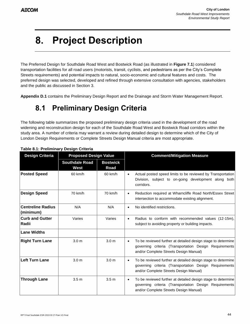
City of London
Southdale Road West Improvements
Environmental Study Report
Error! Reference source not found.
Error! Reference source not found.
RPT.Final Southdale ESR-2019 03 27-Pam.V2-Final 44
8. Project Description
The Preferred Design for Southdale Road West and Bostwick Road (as illustrated in Figure 7.1) considered
transportation facilities for all road users (motorists, transit, cyclists, and pedestrians as per the City’s Complete
Streets requirements) and potential impacts to natural, socio-economic and cultural features and costs. The
preferred design was selected, developed and refined through extensive consultation with agencies, stakeholders
and the public as discussed in Section 3.
Appendix D.1 contains the Preliminary Design Report and the Drainage and Storm Water Management Report.
8.1 Preliminary Design Criteria
The following table summarizes the proposed preliminary design criteria used in the development of the road
widening and reconstruction design for each of the Southdale Road West and Bostwick Road corridors within the
study area. A number of criteria may warrant a review during detailed design to determine which of the City of
London Design Requirements or Complete Streets Design Manual criteria are most appropriate.
Table 8.1: Preliminary Design Criteria
Design Criteria Proposed Design Value Comment/Mitigation Measure
Southdale Road
West
Bostwick
Road
Posted Speed 60 km/h 60 km/h • Actual posted speed limits to be reviewed by Transportation
Division, subject to on-going development along both
corridors.
Design Speed 70 km/h 70 km/h • Reduction required at Wharncliffe Road North/Essex Street
intersection to accommodate existing alignment.
Centreline Radius
(minimum)
N/A N/A • No identified restrictions.
Curb and Gutter
Radii
Varies Varies • Radius to conform with recommended values (12-15m),
subject to avoiding property or building impacts.
Lane Widths
Right Turn Lane 3.0 m 3.0 m • To be reviewed further at detailed design stage to determine
governing criteria (Transportation Design Requirements
and/or Complete Streets Design Manual)
Left Turn Lane 3.0 m 3.0 m • To be reviewed further at detailed design stage to determine
governing criteria (Transportation Design Requirements
and/or Complete Streets Design Manual)
Through Lane 3.5 m 3.5 m • To be reviewed further at detailed design stage to determine
governing criteria (Transportation Design Requirements
and/or Complete Streets Design Manual)
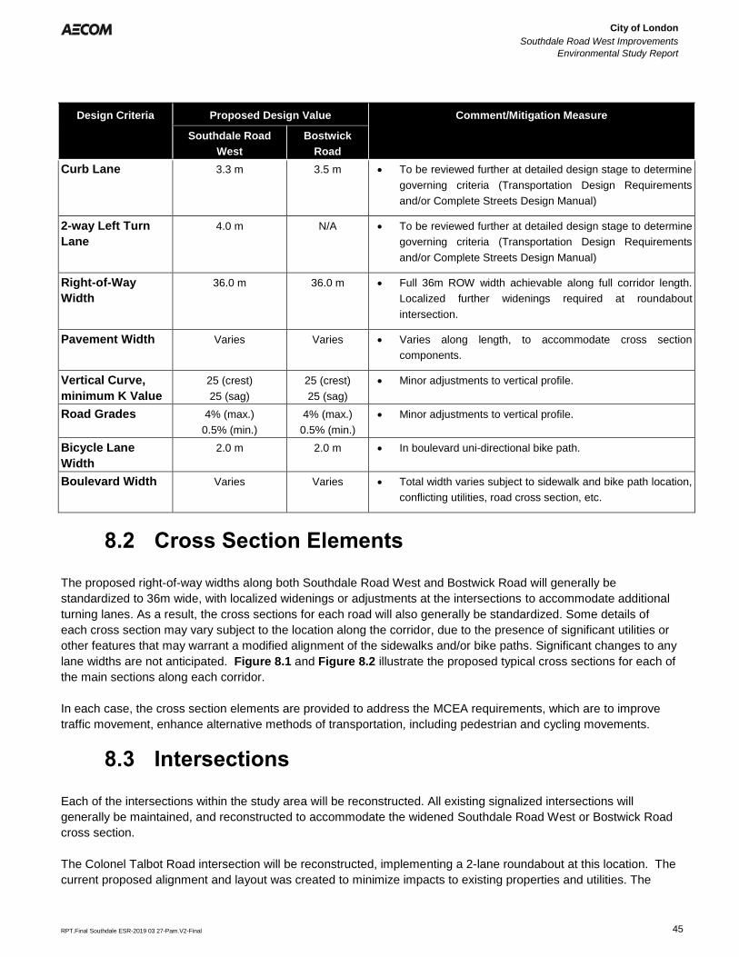
City of London
Southdale Road West Improvements
Environmental Study Report
Error! Reference source not found.
Error! Reference source not found.
RPT.Final Southdale ESR-2019 03 27-Pam.V2-Final 45
Design Criteria Proposed Design Value Comment/Mitigation Measure
Southdale Road
West
Bostwick
Road
Curb Lane 3.3 m 3.5 m • To be reviewed further at detailed design stage to determine
governing criteria (Transportation Design Requirements
and/or Complete Streets Design Manual)
2-way Left Turn
Lane
4.0 m N/A • To be reviewed further at detailed design stage to determine
governing criteria (Transportation Design Requirements
and/or Complete Streets Design Manual)
Right-of-Way
Width
36.0 m 36.0 m • Full 36m ROW width achievable along full corridor length.
Localized further widenings required at roundabout
intersection.
Pavement Width Varies Varies • Varies along length, to accommodate cross section
components.
Vertical Curve,
minimum K Value
25 (crest)
25 (sag)
25 (crest)
25 (sag)
• Minor adjustments to vertical profile.
Road Grades 4% (max.)
0.5% (min.)
4% (max.)
0.5% (min.)
• Minor adjustments to vertical profile.
Bicycle Lane
Width
2.0 m 2.0 m • In boulevard uni-directional bike path.
Boulevard Width Varies Varies • Total width varies subject to sidewalk and bike path location,
conflicting utilities, road cross section, etc.
8.2 Cross Section Elements
The proposed right-of-way widths along both Southdale Road West and Bostwick Road will generally be
standardized to 36m wide, with localized widenings or adjustments at the intersections to accommodate additional
turning lanes. As a result, the cross sections for each road will also generally be standardized. Some details of
each cross section may vary subject to the location along the corridor, due to the presence of significant utilities or
other features that may warrant a modified alignment of the sidewalks and/or bike paths. Significant changes to any
lane widths are not anticipated. Figure 8.1 and Figure 8.2 illustrate the proposed typical cross sections for each of
the main sections along each corridor.
In each case, the cross section elements are provided to address the MCEA requirements, which are to improve
traffic movement, enhance alternative methods of transportation, including pedestrian and cycling movements.
8.3 Intersections
Each of the intersections within the study area will be reconstructed. All existing signalized intersections will
generally be maintained, and reconstructed to accommodate the widened Southdale Road West or Bostwick Road
cross section.
The Colonel Talbot Road intersection will be reconstructed, implementing a 2-lane roundabout at this location. The
current proposed alignment and layout was created to minimize impacts to existing properties and utilities. The
60542198SOUTHDALE ROAD IMPROVEMENTSCOLONEL TALBOT ROAD TO PINE VALLEY BOULEVARD
THIS DRAWING HAS BEEN PREPARED FOR USE OF
AECOM'S CLIENT AND MAY NOT BE USED,
REPRODUCED OR RELIED UPON BY THIRD
PARTIES, EXCEPT AS AGREED BY AECOM AND ITS
CLIENT, AS REQUIRED BY LAW OR FOR USE BY
GOVERNMENTAL REVIEWING AGENCIES. AECOM
ACCEPTS NO RESPONSIBILITY, AND DENIES ANY
LIABILITY WHATSOEVER, TO ANY PARTY THAT
MODIFIES THIS DRAWING WITHOUT AECOM'S
EXPRESS WRITTEN CONSENT. DO NOT SCALE
THIS DOCUMENT. ALL MEASUREMENTS MUST BE
OBTAINED FROM STATED DIMENSIONS.
PRELIMINARY
Figure 8.1
Southdale Road
Cross Section Alternatives
60542198SOUTHDALE ROAD IMPROVEMENTSCOLONEL TALBOT ROAD TO PINE VALLEY BOULEVARD
THIS DRAWING HAS BEEN PREPARED FOR USE OF
AECOM'S CLIENT AND MAY NOT BE USED,
REPRODUCED OR RELIED UPON BY THIRD
PARTIES, EXCEPT AS AGREED BY AECOM AND ITS
CLIENT, AS REQUIRED BY LAW OR FOR USE BY
GOVERNMENTAL REVIEWING AGENCIES. AECOM
ACCEPTS NO RESPONSIBILITY, AND DENIES ANY
LIABILITY WHATSOEVER, TO ANY PARTY THAT
MODIFIES THIS DRAWING WITHOUT AECOM'S
EXPRESS WRITTEN CONSENT. DO NOT SCALE
THIS DOCUMENT. ALL MEASUREMENTS MUST BE
OBTAINED FROM STATED DIMENSIONS.
PRELIMINARY
Figure 8.2
Bostwick Road
City of London
Southdale Road West Improvements
Environmental Study Report
Error! Reference source not found.
Error! Reference source not found.
RPT.Final Southdale ESR-2019 03 27-Pam.V2-Final 46
exact layout of the intersection will need to be further refined during detailed design to address any final grading
transitions to adjacent properties or the adjacent SWM facility.
Figure 8.3 illustrates the proposed layout for the Southdale Road West and Colonel Talbot Road intersection.
8.4 Pavement Design
As part of the geotechnical review completed by Golder Associates, the following pavement structure is
recommended for preliminary design, based on Southdale Road West being considered an arterial road and
Bostwick Road being considered a collector road.
Table 8.2 Recommended Pavement Structural Thicknesses
Component Thickness (mm)
Southdale Road West Bostwick Road
HL-3 Surface Asphalt * 50 50
HL-8 Base Asphalt * 130 (2 lifts @ 65 mm) 100 (2 lifts @ 50 mm)
Granular ‘A’ Base 150 150
Granular ‘B’ Subbase 450 450
* Superpave equivalents to also be considered
Golder Associates recommends that the proposed pavement structure be reassessed and optimized during
detailed design, particularly in areas that may encounter deeper fills or replacement of peat material.
8.5 Municipal Servicing
8.5.1 Sanitary Sewers and Watermains
As part of the widening and reconstruction of Southdale Road West and Bostwick Road, within the project limits,
the sanitary and watermain servicing may require localized sewer servicing and/or watermain replacement or
relocation subject to condition or conflicts with the new road alignment. It is anticipated that the storm sewer
servicing will require localized replacements and reconfiguration, and new storm sewer servicing, to accommodate
the widened road.
All existing sanitary sewers are proposed to remain in place. No sewer replacement works or installation of new
sewers are proposed, subject to further review at the detailed design stage.
All existing watermains are proposed to remain in place. No watermain replacement works or installation of new
watermains are immediately proposed for the subject area, however, may fall within the timeframe of the phased
construction. The City of London has undertaken a review of the High Level Water Distribution System for the
Talbot Village Subdivision and surrounding area. The project has been identified in the 2019 One Water – Growth
Servicing DC Study that considers a 300mm diameter water (SDW2) on Bostwick Road, from Southdale Road to
150m south of Pack Road, to be constructed in 2025. It is anticipated that this work could be coordinated with the
road upgrades, subject to project timing and further review at the detailed design stage.
8.5.2 Drainage and Hydrology
The existing mostly two-lane rural cross-section of Southdale Road West, Colonel Talbot Road to Pine Valley
Boulevard, will ultimately consist of an urbanized cross section complete with curb and gutter, storm sewer
City of London
Southdale Road West Improvements
Environmental Study Report
Error! Reference source not found.
Error! Reference source not found.
RPT.Final Southdale ESR-2019 03 27-Pam.V2-Final 47
servicing, and increased impervious boulevards and sidewalks, including bike paths. An assessment of roadway
drainage and storm water management was completed to determine appropriate drainage and water quality control
requirements to alleviate existing conveyance issues and mitigate impacts of the proposed modifications (widening)
to Southdale Road West and Bostwick Road, and associated increase in impervious surface area. The drainage
within the existing road corridors is mainly conveyed via roadside ditching and entrance culverts, ultimately to
existing ditch-inlet catchbasins or open watercourses. The roadway widening activities will require the development
of the following drainage solution:
• Urbanized Southdale Road West Corridor: Establish curb and gutters, and storm sewer network along road
corridor to provide a more uniform drainage system;
• Increased Inlet Capacity and Attenuation Storage: Provide increase inlet capacity and attenuation volume
in proximity to 3040 Pomeroy Lane to mitigate major overland flow from being directed through the
adjacent private site. Storage volume provided via the roadside ditches and attenuated via ditch-inlet
catchbasins will no longer be available when the road cross-section is urbanized;
• Provide Water Quality Control: Water quality treatment will be provided by existing storm water
management facilities, and where there is inadequate capacity or no storm water facility upstream of an
existing outlet, an oil/grit separator (OGS) unit will be sized to treat the proposed widened road impervious
area. The proposed OGS units will remove 78% TSS, above the 70% TSS required as per the Dingman
Creek Subwatershed Study (2005)
• Low Impact Development (LID) Measures: Low Impact Development (LID) measures and associated sizing
will be reviewed at detailed design stage to help reduced increased runoff volume due to the proposed
widening. The footprint of any proposed LID measures are to be located within the proposed ROW cross-
section.; and,
• Conveyance Capacity: Confirm adequate inlet capacity to existing SWM facilities, culverts, and open-
channels (Thornicroft Drain & Southwest Optimist Park).
Work to be completed as part of the detailed design includes finalizing the following:
• Confirm the existing tributary areas to Southdale Road West, and discharge locations;
• Confirm existing quantity and quality control treatment volumes in SWM facilities adjacent to Southdale
Road West road widening corridor;
• Confirm Southwest Optimist Park open channel / closed conveyance system design;
• Finalize storm sewer design for Southdale Road West and SWM facility inlets;
• Finalize opportunities for implementing Low Impact Development (LID) measures within the right-of-way;
and,
• Finalize OGS sizing and locations where treatment is required.
Appendix D.1 includes the Drainage and Storm Water Management Report which provides preliminary design
guidance on the above-noted.
8.6 Utility Relocation
Based on the current proposed road layout, including sidewalk and bike paths, efforts have been made to minimize
disruption to existing utilities. Specifically, the sidewalk and bike path alignment in the northerly boulevard has been
adjusted in some locations to avoid a significant hydro pole line. Localized pole and aerial service line relocations
will be required in some areas along the corridor. Exact impacts to be determined during further detailed design
review.
There is an existing Hydro One corridor located near the east limit of the corridor, crossing Southdale Road West.
The current proposed layout identifies a sidewalk to cross their existing corridor, requiring either an agreement or
purchase of the road widening to accommodate the sidewalk installation. Localized grading on to the corridor may
also be required to complete the sidewalk installation. Further discussions with Hydro One will be required to
City of London
Southdale Road West Improvements
Environmental Study Report
Error! Reference source not found.
Error! Reference source not found.
RPT.Final Southdale ESR-2019 03 27-Pam.V2-Final 48
determine the acceptable approach, or alternatively the sidewalk and bike path alignments may need to be
adjusted to avoid the existing corridor.
There is an existing high pressure gas main along the south limit of the corridor. Based on the proposed road cross
section, the gas main would end up beneath the new sidewalk and/or bike path along the length of the corridor. In
most areas it is expected that cover will be increased over the gas main, but should be reviewed further during
detailed design to determine if there are any areas that may have reduced cover.
There is an existing Union Gas substation located near the east limit of the corridor. The current proposed layout
identifies a sidewalk to cross their existing property, requiring either an agreement or purchase of the road widening
to accommodate the sidewalk installation. Localized grading on to Union Gas property may also be required to
complete the sidewalk installation. Further discussions with Union Gas will be required to determine the acceptable
approach, or alternatively the sidewalk and bike path alignments may need to be adjusted to avoid the existing
property.
Any existing telecom utilities are anticipated to remain in place, with the exception of localized relocations where
pedestals or vaults may conflict with proposed infrastructure. Some initial plans have been presented by the
telecom utility companies for new infrastructure to be installed along the Southdale Road West corridor and at the
Colonel Talbot Road intersection in the near future. Where possible the new layout has considered the preliminary
road and intersection layout. Further review during detailed design is warranted to ensure there are no new
conflicts as a result of the new installations.
8.7 Retaining Walls
Based on the current proposed vertical and horizontal profiles, and the proposed road cross section, retaining walls
are not anticipated to be required along the length of the corridor. Further review is warranted during detailed
design to determine final impacts adjacent to existing properties to determine the need for any retaining walls. If
required, it is anticipated that the walls would be low height and in localized areas where existing property grades
need to be maintained or to avoid other conflicts.
8.8 Noise Attenuation Walls
Based on a review of the proposed road widening and proximity to the rear of residential units along Southdale
Road West, it appears that new noise attenuation walls may be required in a localized area. Noise attenuation walls
are anticipated along the northerly right-of-way limit, for lots backing on to the corridor, in accordance with City
policy. The area from approximately 100m west of Farnham Road, to approximately 350m west of Farnham Road
appears to warrant new noise attention walls. The existing fencing is board-on-board fencing and does not appear
to meet the intent of a noise attenuation fence. All other existing developed areas appear to have noise attenuation
walls installed as part of the original subdivision development. The need and installation of any noise attenuation
walls will be subject to current City of London policies and procedures, and considered further during detailed
design.
8.9 Urban Design
While the new proposed corridor appears to have significant space within the road and boulevards to implement
urban design features, incorporating significant features may be difficult. Due to sidewalk and bike paths having
separated alignments, the boulevards then have reduced space on either side to accommodate larger plantings or
other features.
City of London
Southdale Road West Improvements
Environmental Study Report
Error! Reference source not found.
Error! Reference source not found.
RPT.Final Southdale ESR-2019 03 27-Pam.V2-Final 49
There may be considerable opportunities to utilize centre medians along the length of the road corridor. There are
limited accesses along the north side of the corridor, which may permit the installation of centre medians in lieu of
left turn lanes. However, the location and extent of the medians will be subject to review to consider possible future
street or site accesses from the south as those lands develop.
The proposed roundabout at the Colonel Talbot Road intersection also affords an opportunity for urban design and
landscaping features, however, will need to be reviewed to ensure sight lines are not obstructed.
Once the final road and boulevard layouts are confirmed, the following landscaping and urban design opportunities
may include, but not limited to:
• hard surface treatments of boulevard areas or medians, using stamped/exposed aggregate concrete;
• planter boxes in boulevards and/or medians;
• banners added to street light poles, particularly in higher pedestrian areas such as fronting the Bostwick
YMCA, Colonel Talbot Road roundabout, or Southwest Optimist Park;
• public art space in higher profile areas, such as the Bostwick YMCA or incorporated in to future
development areas;
• enhanced surface treatment at higher use pedestrian crossing area, such as near the Bostwick YMCA or at
the Colonel Talbot Road roundabout; and
• street tree planting or other landscaping in larger public space areas, or where larger boulevard areas may
result.
The implementation of these features may be limited by the available areas, however, opportunities should be
explored to provide enhancements along the corridor where possible. This may also include consideration for future
enhancements to be implemented as development opportunities occur along this corridor.
8.10 Traffic Signals and Illumination
Due to the widened intersections and roads, any traffic signals at existing intersections and the street lights along
the length of the project area will be impacted.
Traffic signals that presently exist that would require reconfiguration are at Tillmann Road, Bostwick Road, the
Bostwick YMCA entrance, and at Pine Valley Boulevard. The traffic signals at the Colonel Talbot Road intersection
are anticipated to be removed as part of the reconstruction of the intersection to a roundabout.
Each intersection will be reviewed at the time of detailed design to determine if any relocations are required or if a
full reconstruction is warranted, as directed by the City of London Traffic Roadway Lighting and Traffic Control
Division.
There are no existing dedicated pedestrian crossing locations within the corridor. It is not anticipated that separate
pedestrian crossings will be constructed as part of the proposed works. This will be reviewed further during detailed
design to confirm if there is a warrant for any required pedestrian crossings.
The majority of the corridor is serviced with street light poles and luminaires, with limited area utilizing the existing
hydro pole line for pole mounted fixtures. It is anticipated that the existing hydro poles could be used for pole
mounted fixtures, as a result of the road being widened, however, the arrangement and clearance from hydro
infrastructure will need to be reviewed further to determine of the poles can be utilized. Alternatively, all new, or
relocated existing, street light poles and luminaires can be implemented along the length of the corridor.
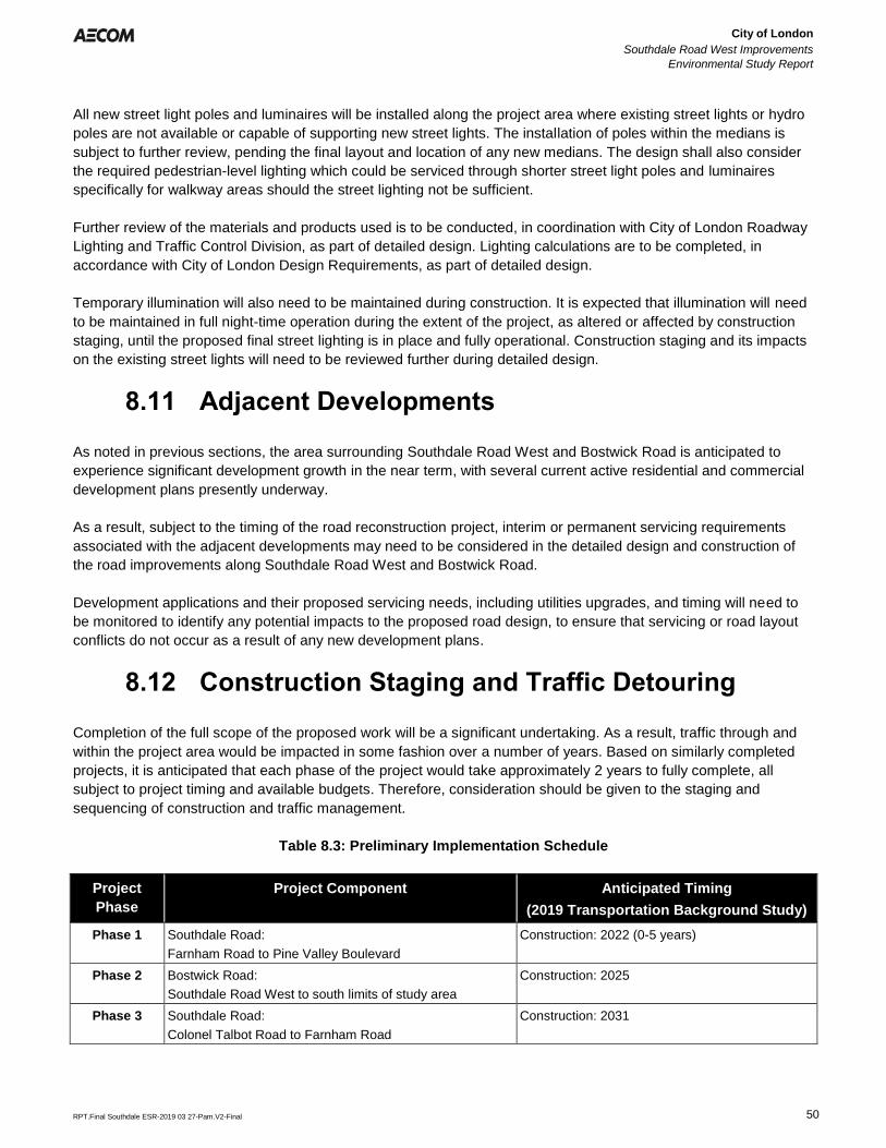
City of London
Southdale Road West Improvements
Environmental Study Report
Error! Reference source not found.
Error! Reference source not found.
RPT.Final Southdale ESR-2019 03 27-Pam.V2-Final 50
All new street light poles and luminaires will be installed along the project area where existing street lights or hydro
poles are not available or capable of supporting new street lights. The installation of poles within the medians is
subject to further review, pending the final layout and location of any new medians. The design shall also consider
the required pedestrian-level lighting which could be serviced through shorter street light poles and luminaires
specifically for walkway areas should the street lighting not be sufficient.
Further review of the materials and products used is to be conducted, in coordination with City of London Roadway
Lighting and Traffic Control Division, as part of detailed design. Lighting calculations are to be completed, in
accordance with City of London Design Requirements, as part of detailed design.
Temporary illumination will also need to be maintained during construction. It is expected that illumination will need
to be maintained in full night-time operation during the extent of the project, as altered or affected by construction
staging, until the proposed final street lighting is in place and fully operational. Construction staging and its impacts
on the existing street lights will need to be reviewed further during detailed design.
8.11 Adjacent Developments
As noted in previous sections, the area surrounding Southdale Road West and Bostwick Road is anticipated to
experience significant development growth in the near term, with several current active residential and commercial
development plans presently underway.
As a result, subject to the timing of the road reconstruction project, interim or permanent servicing requirements
associated with the adjacent developments may need to be considered in the detailed design and construction of
the road improvements along Southdale Road West and Bostwick Road.
Development applications and their proposed servicing needs, including utilities upgrades, and timing will need to
be monitored to identify any potential impacts to the proposed road design, to ensure that servicing or road layout
conflicts do not occur as a result of any new development plans.
8.12 Construction Staging and Traffic Detouring
Completion of the full scope of the proposed work will be a significant undertaking. As a result, traffic through and
within the project area would be impacted in some fashion over a number of years. Based on similarly completed
projects, it is anticipated that each phase of the project would take approximately 2 years to fully complete, all
subject to project timing and available budgets. Therefore, consideration should be given to the staging and
sequencing of construction and traffic management.
Table 8.3: Preliminary Implementation Schedule
Project
Phase
Project Component Anticipated Timing
(2019 Transportation Background Study)
Phase 1
Southdale Road:
Farnham Road to Pine Valley Boulevard
Construction: 2022 (0-5 years)
Phase 2 Bostwick Road:
Southdale Road West to south limits of study area
Construction: 2025
Phase 3
Southdale Road:
Colonel Talbot Road to Farnham Road
Construction: 2031
City of London
Southdale Road West Improvements
Environmental Study Report
Error! Reference source not found.
Error! Reference source not found.
RPT.Final Southdale ESR-2019 03 27-Pam.V2-Final 51
To accommodate the potential 2-year construction window for each phase, the project is to be reviewed to
determine what impacts may occur to the local residents and traveling public during that time. Each phase will have
varying degrees of impact, with the most significant impact occurring during the first year of each phase.
The project may also be further subdivided to consider the reconstruction of the Colonel Talbot Road intersection to
construct the new roundabout. This may be implemented due to its shorter construction period, and affords the
opportunity to address a significant traffic bottleneck within the corridor. This project is presently identified in the
2019 DC Transportation Background Study to be completed in 2024.
In each Phase it is anticipated that two lanes of traffic would be maintained at all times whenever possible.
Localized closures may be required due to challenging servicing issues or completion of roadworks in a more timely
manner. Any closures will be thoroughly reviewed to ensure it is required and to minimize the duration of closure to
the traveling public.
Figure 8.4 identifies an overall detour plan to be established, to route traffic around the project area during
construction, which generally diverts traffic to the other major arterial roads, being Wonderland Road and Westdel
Bourne. Bostwick Road will be available as a detour route, subject to the final phasing and staging of the
construction work.
The actual staging and duration of the project will be reviewed further as part of detailed design, and could be
adjusted subject to design and approvals timing, complexity of construction, approved budgets, and other factors
that may alter the overall project duration or how it is constructed.
8.13 Preliminary Construction Cost Estimate
A preliminary construction cost estimate for this project has been prepared, including road reconstruction, utility
relocations, and engineering, and is included in Appendix D.2.
Property acquisition will be required in order to accommodate the full proposed road widenings and reconstruction
of Southdale Road West and Bostwick Road. Subject to the timing of development along these corridors, road
widening dedications would also be provided as part of those applicable developments. The cost of any property
acquisition will be subject to project timing, market costs, and any development timing along the corridor. For the
purposes of the construction estimate, property acquisition costs have not been estimated based on current market
value and land area required.
Total project costing may also be impacted as a result of the phasing limits and timing.
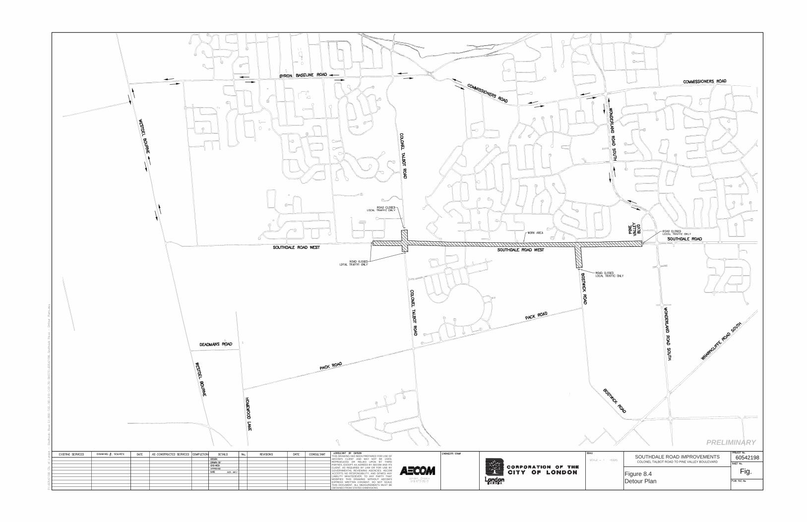
60542198SOUTHDALE ROAD IMPROVEMENTSCOLONEL TALBOT ROAD TO PINE VALLEY BOULEVARD
THIS DRAWING HAS BEEN PREPARED FOR USE OF
AECOM'S CLIENT AND MAY NOT BE USED,
REPRODUCED OR RELIED UPON BY THIRD
PARTIES, EXCEPT AS AGREED BY AECOM AND ITS
CLIENT, AS REQUIRED BY LAW OR FOR USE BY
GOVERNMENTAL REVIEWING AGENCIES. AECOM
ACCEPTS NO RESPONSIBILITY, AND DENIES ANY
LIABILITY WHATSOEVER, TO ANY PARTY THAT
MODIFIES THIS DRAWING WITHOUT AECOM'S
EXPRESS WRITTEN CONSENT. DO NOT SCALE
THIS DOCUMENT. ALL MEASUREMENTS MUST BE
OBTAINED FROM STATED DIMENSIONS.
PRELIMINARY
Fig. Figure 8.4
Detour Plan
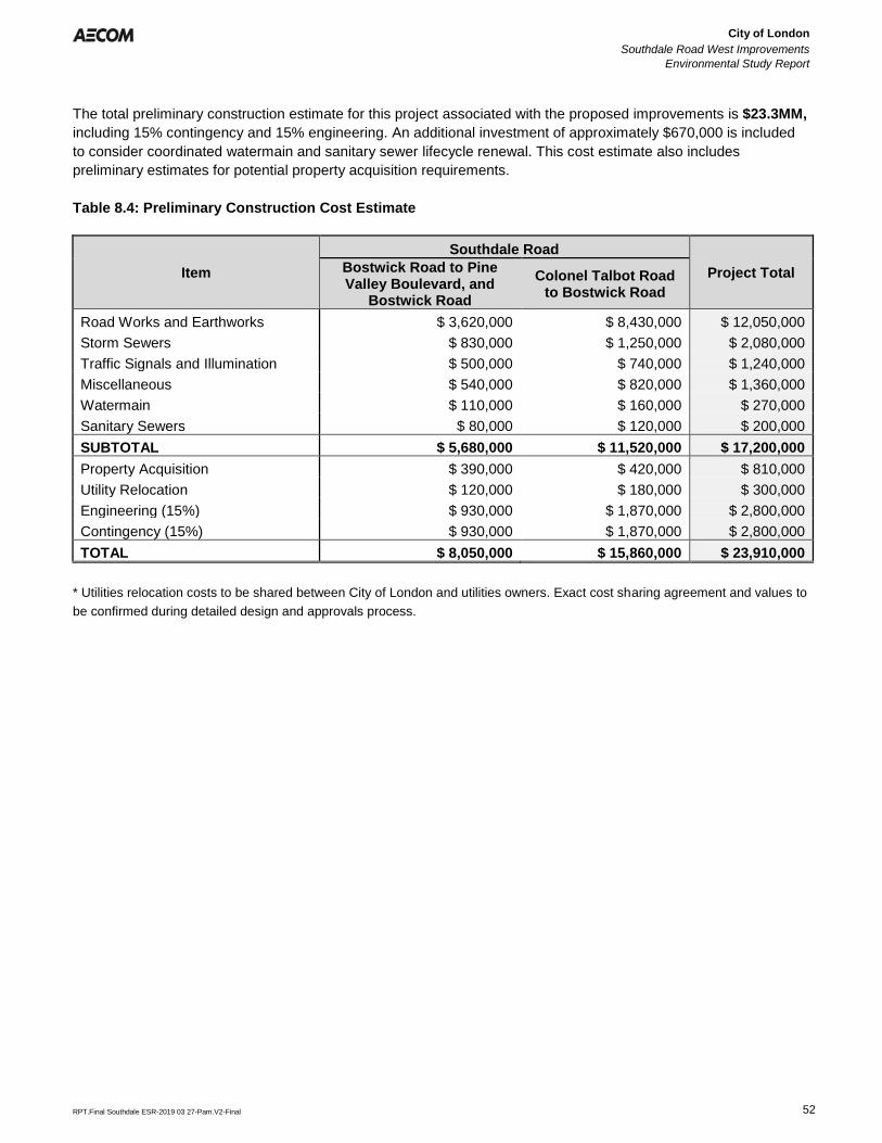
City of London
Southdale Road West Improvements
Environmental Study Report
Error! Reference source not found.
Error! Reference source not found.
RPT.Final Southdale ESR-2019 03 27-Pam.V2-Final 52
The total preliminary construction estimate for this project associated with the proposed improvements is $23.3MM,
including 15% contingency and 15% engineering. An additional investment of approximately $670,000 is included
to consider coordinated watermain and sanitary sewer lifecycle renewal. This cost estimate also includes
preliminary estimates for potential property acquisition requirements.
Table 8.4: Preliminary Construction Cost Estimate
Item
Southdale Road
Project Total Bostwick Road to Pine Valley Boulevard, and
Bostwick Road
Colonel Talbot Road to Bostwick Road
Road Works and Earthworks $ 3,620,000 $ 8,430,000 $ 12,050,000
Storm Sewers $ 830,000 $ 1,250,000 $ 2,080,000
Traffic Signals and Illumination $ 500,000 $ 740,000 $ 1,240,000
Miscellaneous $ 540,000 $ 820,000 $ 1,360,000
Watermain $ 110,000 $ 160,000 $ 270,000
Sanitary Sewers $ 80,000 $ 120,000 $ 200,000
SUBTOTAL $ 5,680,000 $ 11,520,000 $ 17,200,000
Property Acquisition $ 390,000 $ 420,000 $ 810,000
Utility Relocation $ 120,000 $ 180,000 $ 300,000
Engineering (15%) $ 930,000 $ 1,870,000 $ 2,800,000
Contingency (15%) $ 930,000 $ 1,870,000 $ 2,800,000
TOTAL $ 8,050,000 $ 15,860,000 $ 23,910,000
* Utilities relocation costs to be shared between City of London and utilities owners. Exact cost sharing agreement and values to
be confirmed during detailed design and approvals process.
City of London
Southdale Road West Improvements
Environmental Study Report
Error! Reference source not found.
Error! Reference source not found.
RPT.Final Southdale ESR-2019 03 27-Pam.V2-Final 53
9. Recommended Mitigation Measures /Monitoring
The implementation of the Project has the potential to create positive and negative effects. Avoidance of negative
effects has been a key consideration throughout Phases 1 through 3 of the Project and has been discussed with
agencies, stakeholders, and the public.
Effects can be generally divided into two (2) main categories: construction-related effects (which are temporary in
nature) and effects related to the operation and maintenance of the Project (effects that are permanent). Negative
effects caused by the Project are avoided to the extent possible; however, in cases where negative effects cannot
be fully avoided, mitigation measures will be required during construction, and operation and maintenance of the
Project.
9.1 Commitment Highlights
The purpose of this section is to section is to detail the recommended mitigation measures and necessary
monitoring as the project moves into detailed design and construction.
Natural Environments:
• A detailed Tree Inventory and Preservation Plan should be conducted once the final design is completed;
• An Erosion and Sediment Control Plan should be prepared during detailed design;
• A detailed Construction Sequencing Plan;
• A detailed SAR and Wildlife Handling Protocol should be developed prior to the initiation of construction;
• A Notice of Activity is to be prepared with the associated Habitat Management Plan at detailed design;
• Any in water-works will require a plan to relocate fish encountered within the construction footprint. This
should be prepared during detailed design.;
• Wherever possible, habitat for SAR should be compensated for and/or enhanced;
• An edge management plan shall be prepared once construction has been completed along Bostwick Road
for Patch No 10063; and
• A detailed restoration plan utilizing native plantings and native seed mixes following City specifications
should be developed and followed.
Social Environment:
• Traffic management plan is to be developed to minimize disruption during construction;
• Access to existing properties, businesses, institutions and commercial areas are to be maintained during
and after construction; and
• Infrastructure is to be implemented to support active and healthy lifestyles (walking, cycling).
Archaeology and Cultural Heritage:
• The completion of a Stage 2 Archaeological Assessment is to be undertaken during detailed design for any
areas identified by the Stage 1 archaeological assessment as requiring further archaeological fieldwork;
• No impacts to existing archaeological and cultural heritage resources is to occur; and
• No impacts to existing properties identified by the CHAR are anticipated, but should be considered
City of London
Southdale Road West Improvements
Environmental Study Report
Error! Reference source not found.
Error! Reference source not found.
RPT.Final Southdale ESR-2019 03 27-Pam.V2-Final 54
9.2 Permits and Approvals
9.2.1 Ministry of Environment, Conservation and Parks
MECP approvals may include a Permit To Take Water (PTTW) should there be groundwater taking of more than
50,000 litres per day. Based on the anticipated scope of construction the need for a PTTW is not anticipated, but
should be reviewed further at the time of detailed design to confirm exact requirements. An Environmental
Compliance Approval (ECA) application and approval will be required for the new local storm sewers and any
required storm water management works.
9.2.2 Upper Thames River Conservation Authority
In accordance with O.Reg 157/06, a Development Interference with Wetlands and Alteration to Watercourses and
Shoreline Regulation permit will be required from UTRCA prior to construction within the regulated area.
9.2.3 Ministry of Natural Resources and Forestry
Ecological investigations determined that there is potential habitat for 27 SAR species within the study area. It is
recommended that correspondence with MNRF during detailed design be undertaken to confirm if the completion of
MNRF’s Information Gathering Form (to determine if authorization under the Endangered Species Act is necessary)
is required.
The proposed road work will potentially result in the removal of 1.35 ha of habitat for Bobolink and Eastern
Meadowlark, a Notice of Activity (NOA) and a Habitat Management Plan will need to be prepared for the MNRF
prior to commencing development in accordance with Ontario Regulation 242/08.
9.2.4 Ministry of Tourism, Culture and Sport
Acceptance of the Stage 2 Archaeological Assessment (if required) will be necessary.
9.2.5 Ministry of Infrastructure
Consultation with MOI is to be undertaken/continue during detailed design to identify lands controlled by IO, which
can include Hydro One, and determine how to proceed. The City of London may initiate initial consultation with the
MOI and/or Hydro One directly to commence discussions and review of any land acquisition or access needs.
9.2.6 Indigenous Communities
A copy of the ESR and any associated reports will be provided to Chippewa of the Thames First Nation as
requested.
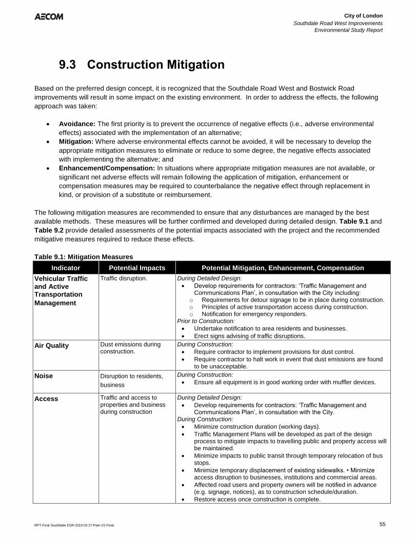
City of London
Southdale Road West Improvements
Environmental Study Report
Error! Reference source not found.
Error! Reference source not found.
RPT.Final Southdale ESR-2019 03 27-Pam.V2-Final 55
9.3 Construction Mitigation
Based on the preferred design concept, it is recognized that the Southdale Road West and Bostwick Road
improvements will result in some impact on the existing environment. In order to address the effects, the following
approach was taken:
• Avoidance: The first priority is to prevent the occurrence of negative effects (i.e., adverse environmental
effects) associated with the implementation of an alternative;
• Mitigation: Where adverse environmental effects cannot be avoided, it will be necessary to develop the
appropriate mitigation measures to eliminate or reduce to some degree, the negative effects associated
with implementing the alternative; and
• Enhancement/Compensation: In situations where appropriate mitigation measures are not available, or
significant net adverse effects will remain following the application of mitigation, enhancement or
compensation measures may be required to counterbalance the negative effect through replacement in
kind, or provision of a substitute or reimbursement.
The following mitigation measures are recommended to ensure that any disturbances are managed by the best
available methods. These measures will be further confirmed and developed during detailed design. Table 9.1 and
Table 9.2 provide detailed assessments of the potential impacts associated with the project and the recommended
mitigative measures required to reduce these effects.
Table 9.1: Mitigation Measures
Indicator Potential Impacts Potential Mitigation, Enhancement, Compensation
Vehicular Traffic and Active Transportation
Management
Traffic disruption. During Detailed Design:
• Develop requirements for contractors: ‘Traffic Management andCommunications Plan’, in consultation with the City including:
o Requirements for detour signage to be in place during construction.o Principles of active transportation access during construction.o Notification for emergency responders.
Prior to Construction:
• Undertake notification to area residents and businesses.
• Erect signs advising of traffic disruptions.
Air Quality Dust emissions during construction.
During Construction:
• Require contractor to implement provisions for dust control.
• Require contractor to halt work in event that dust emissions are foundto be unacceptable.
Noise Disruption to residents,
business
During Construction:
• Ensure all equipment is in good working order with muffler devices.
Access Traffic and access to properties and business during construction
During Detailed Design:
• Develop requirements for contractors: ‘Traffic Management andCommunications Plan’, in consultation with the City.
During Construction:
• Minimize construction duration (working days).
• Traffic Management Plans will be developed as part of the designprocess to mitigate impacts to travelling public and property access willbe maintained.
• Minimize impacts to public transit through temporary relocation of busstops.
• Minimize temporary displacement of existing sidewalks. • Minimizeaccess disruption to businesses, institutions and commercial areas.
• Affected road users and property owners will be notified in advance(e.g. signage, notices), as to construction schedule/duration.
• Restore access once construction is complete.
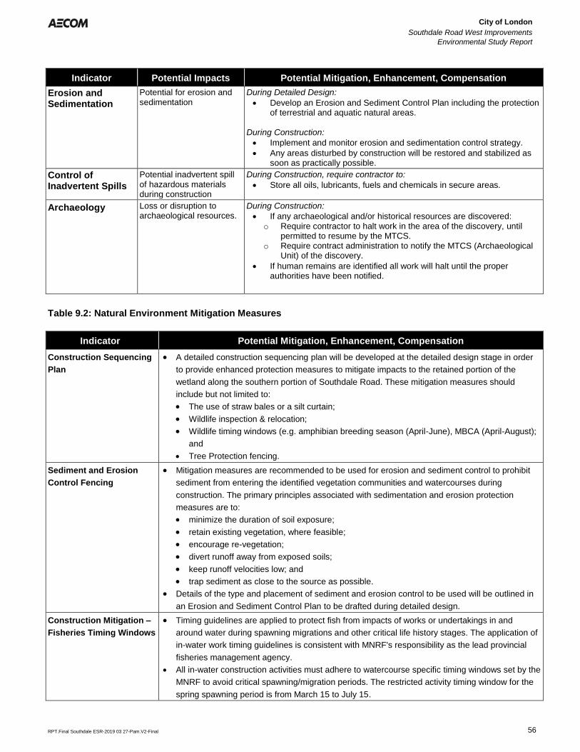
City of London
Southdale Road West Improvements
Environmental Study Report
Error! Reference source not found.
Error! Reference source not found.
RPT.Final Southdale ESR-2019 03 27-Pam.V2-Final 56
Indicator Potential Impacts Potential Mitigation, Enhancement, Compensation
Erosion and Sedimentation
Potential for erosion and sedimentation
During Detailed Design:
• Develop an Erosion and Sediment Control Plan including the protectionof terrestrial and aquatic natural areas.
During Construction:
• Implement and monitor erosion and sedimentation control strategy.
• Any areas disturbed by construction will be restored and stabilized assoon as practically possible.
Control of Inadvertent Spills
Potential inadvertent spill of hazardous materials during construction
During Construction, require contractor to:
• Store all oils, lubricants, fuels and chemicals in secure areas.
Archaeology Loss or disruption to archaeological resources.
During Construction:
• If any archaeological and/or historical resources are discovered:o Require contractor to halt work in the area of the discovery, until
permitted to resume by the MTCS.o Require contract administration to notify the MTCS (Archaeological
Unit) of the discovery.
• If human remains are identified all work will halt until the properauthorities have been notified.
Table 9.2: Natural Environment Mitigation Measures
Indicator Potential Mitigation, Enhancement, Compensation
Construction Sequencing
Plan
• A detailed construction sequencing plan will be developed at the detailed design stage in order
to provide enhanced protection measures to mitigate impacts to the retained portion of the
wetland along the southern portion of Southdale Road. These mitigation measures should
include but not limited to:
• The use of straw bales or a silt curtain;
• Wildlife inspection & relocation;
• Wildlife timing windows (e.g. amphibian breeding season (April-June), MBCA (April-August);
and
• Tree Protection fencing.
Sediment and Erosion
Control Fencing
• Mitigation measures are recommended to be used for erosion and sediment control to prohibit
sediment from entering the identified vegetation communities and watercourses during
construction. The primary principles associated with sedimentation and erosion protection
measures are to:
• minimize the duration of soil exposure;
• retain existing vegetation, where feasible;
• encourage re-vegetation;
• divert runoff away from exposed soils;
• keep runoff velocities low; and
• trap sediment as close to the source as possible.
• Details of the type and placement of sediment and erosion control to be used will be outlined in
an Erosion and Sediment Control Plan to be drafted during detailed design.
Construction Mitigation –
Fisheries Timing Windows
• Timing guidelines are applied to protect fish from impacts of works or undertakings in and
around water during spawning migrations and other critical life history stages. The application of
in-water work timing guidelines is consistent with MNRF's responsibility as the lead provincial
fisheries management agency.
• All in-water construction activities must adhere to watercourse specific timing windows set by the
MNRF to avoid critical spawning/migration periods. The restricted activity timing window for the
spring spawning period is from March 15 to July 15.
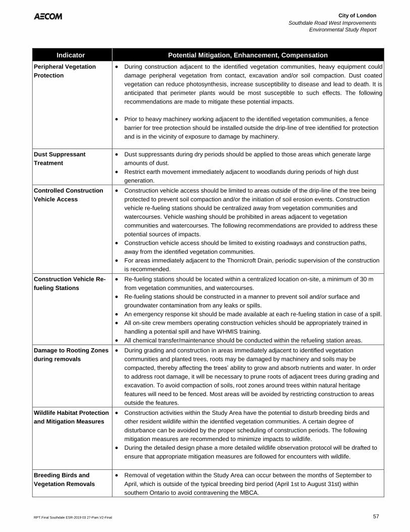
City of London
Southdale Road West Improvements
Environmental Study Report
Error! Reference source not found.
Error! Reference source not found.
RPT.Final Southdale ESR-2019 03 27-Pam.V2-Final 57
Indicator Potential Mitigation, Enhancement, Compensation
Peripheral Vegetation
Protection
• During construction adjacent to the identified vegetation communities, heavy equipment could
damage peripheral vegetation from contact, excavation and/or soil compaction. Dust coated
vegetation can reduce photosynthesis, increase susceptibility to disease and lead to death. It is
anticipated that perimeter plants would be most susceptible to such effects. The following
recommendations are made to mitigate these potential impacts.
• Prior to heavy machinery working adjacent to the identified vegetation communities, a fence
barrier for tree protection should be installed outside the drip-line of tree identified for protection
and is in the vicinity of exposure to damage by machinery.
Dust Suppressant
Treatment
• Dust suppressants during dry periods should be applied to those areas which generate large
amounts of dust.
• Restrict earth movement immediately adjacent to woodlands during periods of high dust
generation.
Controlled Construction
Vehicle Access
• Construction vehicle access should be limited to areas outside of the drip-line of the tree being
protected to prevent soil compaction and/or the initiation of soil erosion events. Construction
vehicle re-fueling stations should be centralized away from vegetation communities and
watercourses. Vehicle washing should be prohibited in areas adjacent to vegetation
communities and watercourses. The following recommendations are provided to address these
potential sources of impacts.
• Construction vehicle access should be limited to existing roadways and construction paths,
away from the identified vegetation communities.
• For areas immediately adjacent to the Thornicroft Drain, periodic supervision of the construction
is recommended.
Construction Vehicle Re-
fueling Stations
• Re-fueling stations should be located within a centralized location on-site, a minimum of 30 m
from vegetation communities, and watercourses.
• Re-fueling stations should be constructed in a manner to prevent soil and/or surface and
groundwater contamination from any leaks or spills.
• An emergency response kit should be made available at each re-fueling station in case of a spill.
• All on-site crew members operating construction vehicles should be appropriately trained in
handling a potential spill and have WHMIS training.
• All chemical transfer/maintenance should be conducted within the refueling station areas.
Damage to Rooting Zones
during removals
• During grading and construction in areas immediately adjacent to identified vegetation
communities and planted trees, roots may be damaged by machinery and soils may be
compacted, thereby affecting the trees’ ability to grow and absorb nutrients and water. In order
to address root damage, it will be necessary to prune roots of adjacent trees during grading and
excavation. To avoid compaction of soils, root zones around trees within natural heritage
features will need to be fenced. Most areas will be avoided by restricting construction to areas
outside the features.
Wildlife Habitat Protection
and Mitigation Measures
• Construction activities within the Study Area have the potential to disturb breeding birds and
other resident wildlife within the identified vegetation communities. A certain degree of
disturbance can be avoided by the proper scheduling of construction periods. The following
mitigation measures are recommended to minimize impacts to wildlife.
• During the detailed design phase a more detailed wildlife observation protocol will be drafted to
ensure that appropriate mitigation measures are followed for encounters with wildlife.
Breeding Birds and
Vegetation Removals
• Removal of vegetation within the Study Area can occur between the months of September to
April, which is outside of the typical breeding bird period (April 1st to August 31st) within
southern Ontario to avoid contravening the MBCA.
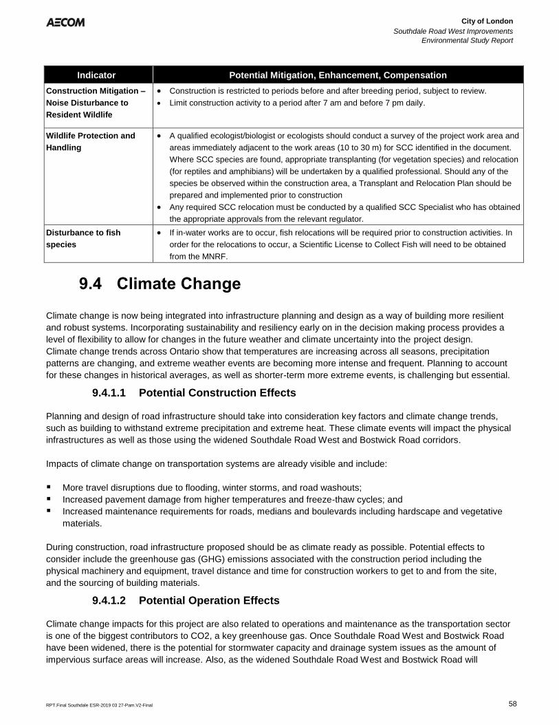
City of London
Southdale Road West Improvements
Environmental Study Report
Error! Reference source not found.
Error! Reference source not found.
RPT.Final Southdale ESR-2019 03 27-Pam.V2-Final 58
Indicator Potential Mitigation, Enhancement, Compensation
Construction Mitigation –
Noise Disturbance to
Resident Wildlife
• Construction is restricted to periods before and after breeding period, subject to review.
• Limit construction activity to a period after 7 am and before 7 pm daily.
Wildlife Protection and
Handling
• A qualified ecologist/biologist or ecologists should conduct a survey of the project work area and
areas immediately adjacent to the work areas (10 to 30 m) for SCC identified in the document.
Where SCC species are found, appropriate transplanting (for vegetation species) and relocation
(for reptiles and amphibians) will be undertaken by a qualified professional. Should any of the
species be observed within the construction area, a Transplant and Relocation Plan should be
prepared and implemented prior to construction
• Any required SCC relocation must be conducted by a qualified SCC Specialist who has obtained
the appropriate approvals from the relevant regulator.
Disturbance to fish
species
• If in-water works are to occur, fish relocations will be required prior to construction activities. In
order for the relocations to occur, a Scientific License to Collect Fish will need to be obtained
from the MNRF.
9.4 Climate Change
Climate change is now being integrated into infrastructure planning and design as a way of building more resilient
and robust systems. Incorporating sustainability and resiliency early on in the decision making process provides a
level of flexibility to allow for changes in the future weather and climate uncertainty into the project design.
Climate change trends across Ontario show that temperatures are increasing across all seasons, precipitation
patterns are changing, and extreme weather events are becoming more intense and frequent. Planning to account
for these changes in historical averages, as well as shorter-term more extreme events, is challenging but essential.
9.4.1.1 Potential Construction Effects
Planning and design of road infrastructure should take into consideration key factors and climate change trends,
such as building to withstand extreme precipitation and extreme heat. These climate events will impact the physical
infrastructures as well as those using the widened Southdale Road West and Bostwick Road corridors.
Impacts of climate change on transportation systems are already visible and include:
▪ More travel disruptions due to flooding, winter storms, and road washouts;
▪ Increased pavement damage from higher temperatures and freeze-thaw cycles; and
▪ Increased maintenance requirements for roads, medians and boulevards including hardscape and vegetative
materials.
During construction, road infrastructure proposed should be as climate ready as possible. Potential effects to
consider include the greenhouse gas (GHG) emissions associated with the construction period including the
physical machinery and equipment, travel distance and time for construction workers to get to and from the site,
and the sourcing of building materials.
9.4.1.2 Potential Operation Effects
Climate change impacts for this project are also related to operations and maintenance as the transportation sector
is one of the biggest contributors to CO2, a key greenhouse gas. Once Southdale Road West and Bostwick Road
have been widened, there is the potential for stormwater capacity and drainage system issues as the amount of
impervious surface areas will increase. Also, as the widened Southdale Road West and Bostwick Road will
City of London
Southdale Road West Improvements
Environmental Study Report
Error! Reference source not found.
Error! Reference source not found.
RPT.Final Southdale ESR-2019 03 27-Pam.V2-Final 59
increase its capacity in terms of vehicular traffic volume, there is the potential to increase GHG emissions
compared to current emissions.
9.4.1.3 Mitigation
Mitigation measure to minimize climate change impacts and impacts to individuals using Southdale Road West and
Bostwick Road in the future may include (but are not limited to) updating plans for weather emergencies, closures
and rerouting, and traveler information systems to include future climate change projections. As the amount of
impervious surface areas will increase, appropriate stormwater capacity should be considered to mitigate additional
runoff, climate change and the likelihood of extreme precipitation.
9.5 Proposed Construction Monitoring
Contract tender documents will address mitigation in an explicit manner to ensure that compliance is maintained.
The provision of an experienced field representative to review construction will ensure that the project follows
contract specifications and does not unnecessarily impact vegetation, the community or aquatic environment.
9.6 Post Construction Monitoring
Following construction, the reconstructed roadway and operation of the storm sewer is not expected to result in any
negative impacts. Post construction monitoring will be required following construction to ensure that any
disturbances have been properly restored (e.g. grading, seeding and planting). All outlets and culverts will be
regularly inspected and maintained. Post construction monitoring details will be developed during Detailed Design.
City of London
Southdale Road West Improvements
Environmental Study Report
Error! Reference source not found.
Error! Reference source not found.
RPT.Final Southdale ESR-2019 03 27-Pam.V2-Final 60
10. Summary
10.1 Summary
The ESR covers the process required to ensure that the proposed active transportation improvements meet the
requirements of the EAA. The MCEA planning process has not identified any significant environmental concerns
that cannot be addressed by incorporating established mitigation measures during construction.
The proposed improvements resolve the problem/opportunity statement identified in this report. A preliminary
evaluation of potential impacts has been included in the evaluation, which indicates minor and predictable impacts
that can be addressed by recommended mitigation measures as presented in Section 9. The proposed mitigation
measures will further be developed at detailed design and will form commitments that will be adhered to by the City.
Appropriate public notification and opportunity for comment was provided and no comments were received that
could not adequately be addressed. Subject to receiving MCEA clearance following the 30 day review period, the
City will complete the detailed design and permitting-approvals phase and proceed to construction as outlined in
the ESR.

aecom.com