Embed Size (px)
Citation preview
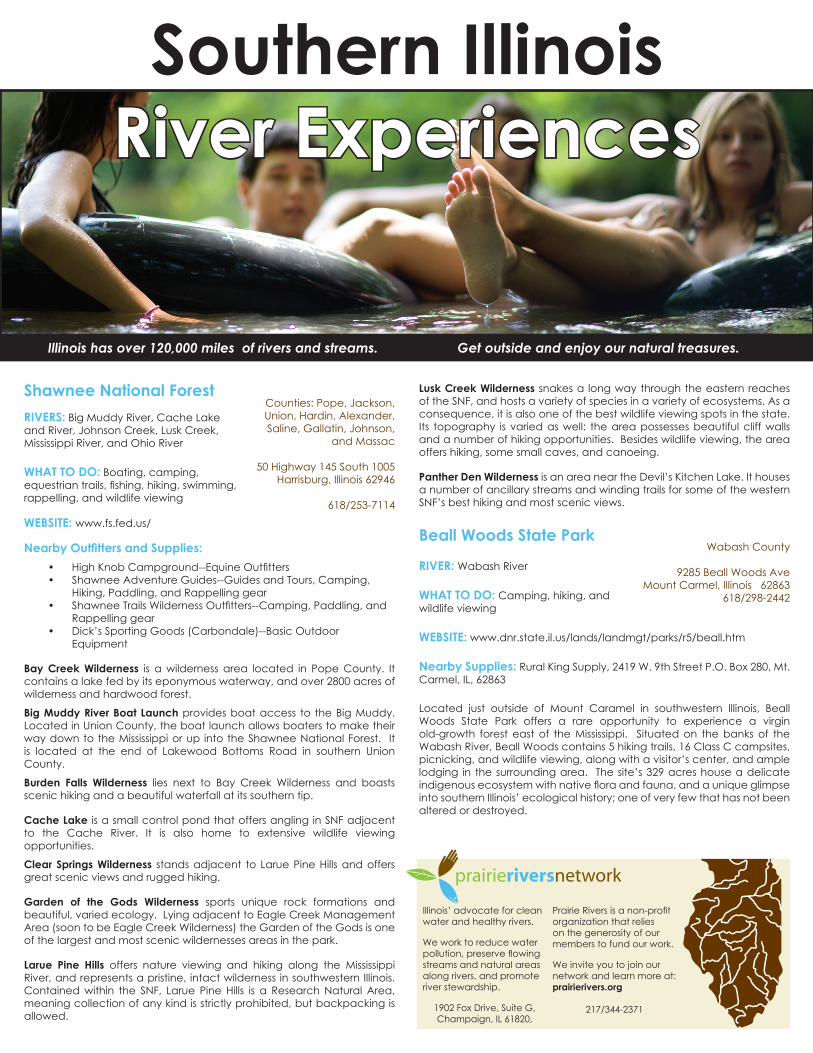
Southern Illinois River Experiences
Shawnee National ForestRIVERS: Big Muddy River, Cache Lake and River, Johnson Creek, Lusk Creek, Mississippi River, and Ohio River
WHAT TO DO: Boating, camping, equestrian trails, fishing, hiking, swimming, rappelling, and wildlife viewing
WEBSITE: www.fs.fed.us/
Nearby Outfitters and Supplies:• High Knob Campground--Equine Outfitters• Shawnee Adventure Guides--Guides and Tours, Camping,
Hiking, Paddling, and Rappelling gear• Shawnee Trails Wilderness Outfitters--Camping, Paddling, and
Rappelling gear• Dick’s Sporting Goods (Carbondale)--Basic Outdoor
Equipment
Bay Creek Wilderness is a wilderness area located in Pope County. It contains a lake fed by its eponymous waterway, and over 2800 acres of wilderness and hardwood forest.
Big Muddy River Boat Launch provides boat access to the Big Muddy. Located in Union County, the boat launch allows boaters to make their way down to the Mississippi or up into the Shawnee National Forest. It is located at the end of Lakewood Bottoms Road in southern Union County.
Burden Falls Wilderness lies next to Bay Creek Wilderness and boasts scenic hiking and a beautiful waterfall at its southern tip.
Cache Lake is a small control pond that offers angling in SNF adjacent to the Cache River. It is also home to extensive wildlife viewing opportunities.
Clear Springs Wilderness stands adjacent to Larue Pine Hills and offers great scenic views and rugged hiking.
Garden of the Gods Wilderness sports unique rock formations and beautiful, varied ecology. Lying adjacent to Eagle Creek Management Area (soon to be Eagle Creek Wilderness) the Garden of the Gods is one of the largest and most scenic wildernesses areas in the park.
Larue Pine Hills offers nature viewing and hiking along the Mississippi River, and represents a pristine, intact wilderness in southwestern Illinois. Contained within the SNF, Larue Pine Hills is a Research Natural Area, meaning collection of any kind is strictly prohibited, but backpacking is allowed.
Illinoishasover120,000milesofriversandstreams. Getoutsideandenjoyournaturaltreasures.
Illinois’ advocate for clean water and healthy rivers.
We work to reduce water pollution, preserve flowing streams and natural areas along rivers, and promote river stewardship.
1902 Fox Drive, Suite G,Champaign, IL 61820,
Prairie Rivers is a non-profit organization that relies on the generosity of our members to fund our work.
We invite you to join our network and learn more at: prairierivers.org
217/344-2371
Counties: Pope, Jackson, Union, Hardin, Alexander, Saline, Gallatin, Johnson,
and Massac
50 Highway 145 South 1005Harrisburg, Illinois 62946
618/253-7114
Wabash County
9285 Beall Woods AveMount Carmel, Illinois 62863
618/298-2442
Lusk Creek Wilderness snakes a long way through the eastern reaches of the SNF, and hosts a variety of species in a variety of ecosystems. As a consequence, it is also one of the best wildlife viewing spots in the state. Its topography is varied as well: the area possesses beautiful cliff walls and a number of hiking opportunities. Besides wildlife viewing, the area offers hiking, some small caves, and canoeing.
Panther Den Wilderness is an area near the Devil’s Kitchen Lake. It houses a number of ancillary streams and winding trails for some of the western SNF’s best hiking and most scenic views.
Beall Woods State Park
RIVER: Wabash River
WHAT TO DO: Camping, hiking, and wildlife viewing
WEBSITE: www.dnr.state.il.us/lands/landmgt/parks/r5/beall.htm
Nearby Supplies: Rural King Supply, 2419 W. 9th Street P.O. Box 280, Mt. Carmel, IL, 62863
Located just outside of Mount Caramel in southwestern Illinois, Beall Woods State Park offers a rare opportunity to experience a virgin old-growth forest east of the Mississippi. Situated on the banks of the Wabash River, Beall Woods contains 5 hiking trails, 16 Class C campsites, picnicking, and wildlife viewing, along with a visitor’s center, and ample lodging in the surrounding area. The site’s 329 acres house a delicate indigenous ecosystem with native flora and fauna, and a unique glimpse into southern Illinois’ ecological history; one of very few that has not been altered or destroyed.

Cache River State Natural AreaRIVER: Cache River
WHAT TO DO: Wildlife viewing, hiking, fishing, and canoeing
WEBSITE: dnr.state.il.us/lands/landmgt/parks/r5/cachervr.htm
Nearby Supplies: White Crane Pirogues and Canoe Rentals on the Cache (canoe rental and tours), 618/201-4090
Ancient and beautiful, the Cache River watershed houses two distinct subunits (the Upper and Lower Cache River Areas) that are each home to enormous levels of biodiversity, including some of the finest wetland ecosystems in the lower 48 states. As part of the conservation-oriented Cache River Wetlands Joint Venture which aims to protect 60,000 acres of wetlands along 50 miles of the Cache River riparian area, the Cache River State Natural Area protects 15,000 acres. The northernmost cypress and tupelo swamp in the US, the Cache River SNA’s blackwater swamps, floodplains, and forests, are monuments to Illinois’ commitment to conservation and restoration. Its position at the crossroads of the country provides a unique habitat for a wide variety of migratory species, creating wildlife viewing opportunities like nowhere else.
The Cache River SNA houses six miles of canoe trails, immersing visitors in its lush aquatic and swamp ecosystems, and twenty miles of foot trail throughout the park’s land. The area also offers ample angling and hiking, and some wildlife viewing. A sizable information center, the Barkhausen Cache River Wetland Center provides more information about the area and is located at 8885 State Route 37 South, Cypress, IL. It is reachable by phone at 618/657-2064.
Fort Massac State ParkRIVER: Ohio River
WHAT TO DO: Boating, camping, fishing, hiking, and wildlife viewing
WEBSITE: dnr.state.il.us/lands/landmgt/parks/r5/frmindex.htm
Nearby Supplies: Gander Mtn., 3240 James Sanders Blvd, Paducah, KY 42003, Phone: 270/538-0444
Next to the bustling city of Metropolis, Fort Massac State Park is a historical preserve and recreation area where American history and nature converge. The fort itself is an integral part of regional history as a key point at America’s great rivers’ crossroads, while the surrounding area offers beautiful nature viewing and scenic trails. The structure is also situated just beside the Ohio River, where visitors can use a public boat dock and fish for species including carp, bullhead, and large mouth bass. Visitors are instructed to call and verify camp and trail availability before making their visit.
Johnson Creek Recreation Area, Shawnee National ForestRIVER: Johnson Creek and Kinkaid Lake
WHAT TO DO: Camping, fishing, picnicking, boating, and hiking
WEBSITE: www.fs.fed.us/
Nearby Supplies: Shawnee Trails Wilderness Outfitters
Offering year-round boating, March-December camping, and summer swimming, Johnson Creek Recreation Area is a popular recreation destination in Shawnee National Forest. The area sports a campground, two picnic areas, a two lane boat dock, and a number of hiking trails. It is situated in the SNF, connected to Kinkaid Lake and near the Big Muddy
River. Its beach is a unique recreation feature for the area (one of only two such beaches in the region) and amenities more advanced than more rugged campgrounds.
Kaskaskia River State Fish and Wildlife AreaRIVER: Kaskaskia River and Baldwin Lake
WHAT TO DO: Fishing, picnicking, hiking, and boating
WEBSITE: dnr.state.il.us/lands/landmgt/parks/r4/kaskas.htm
Nearby Supplies: Rich’s Rod & Reel Repair (Used rod and reel, plus repair), New Athens, IL, 618/475-9922, 618/475-3624
Not to be confused with its northeastern cousin, the Kaskaskia River State Fish and Wildlife Management Area, the Kaskaskia River State Fish and Wildlife Area snakes along the Kaskaskia housing over 20,000 acres of aquatic environment in southwestern Illinois. Located between Fayetteville and the Kaskaskia’s eventual joining point to the Mississippi, the area’s main feature is Baldwin Lake, a man-made basin and cooling pond. The area offers excellent catfish angling on 36 miles of river, as well as numerous boating slips located along the river in Fayetteville, New Athens, Evansville, White Swan, and just outside of Baldwin on Route 154. The area contains 12 miles of hiking trails allowing nature enthusiasts to observe the riparian habitat, as well as a variety of wildlife. Baldwin Lake, a large, man-made reservoir, offers recreational boating and angling as well.
Pere Marquette State ParkRIVER: Mississippi River, Illinois River
WHAT TO DO: boating, fishing, biking, hiking, equestrian trails, and wildlife viewing.
WEBSITE: dnr.state.il.us/lands/landmgt/parks/r4/peremarq.htm
Twelve miles of hiking trails, twenty miles of equestrian trails, and access to both the Illinois and Mississippi Rivers define the experience of Pere Marquette State Park. Offering excellent fishing opportunities and exceptional bird watching, Pere Marquette captures the ecosystem surrounding the Mississippi and Illinois River Basins. Boaters can launch from two on-site ramps with no motor restriction. There is ample lodging as well, with 80 Class A campsites, two Rent-A-Camp cabins, and a conference center with over 70 total guest rooms. A 20 mile bike trail connects Pere Marquette to the historic city of Alton, IL as well.
Saline County State Fish and Wildlife AreaRIVER: Saline River, Glen O. Jones Lake
WHAT TO DO: Camping, equestrian trails, fishing, hiking, boating, and wildlife viewing
WEBSITE: www.dnr.state.il.us/lands/landmgt/parks/r5/saline.htm
Nearby Supplies: Concession stand on-site for basic supplies. Strictly Outdoors, 835 East Poplar Street, Harrisburg, IL 62946, 618/253-5300
Saline County State Conservation Area is a family- friendly recreation area located near the banks of the Saline River and Glen O. Jones Lake. The area spans over 1,000 acres, with 4 trails stretching nine rugged miles that twist through the site’s backwoods and along the river bank. Seasonal tent and trailer camping is available by permit in a large camping area. The site provides drinking water, fireplaces, and trailer disposal, while a concession stand located within the camping area offers supplies, boat rentals, and fishing bait.
Johnson County
930 Sunflower Lane, off Highway 37
Belknap, IL 62908618/634-9678
Massac County
1308 E. 5th StMetropolis, IL 62960
618/524-4712
Jackson County
South of Ava, IL, off of Highway 151, Ava, IL, 62907
618/833-8576
St. Clair, Monroe and Randolph Counties
10981 Conservation
Rd, Baldwin, IL 62217 618/785-2555
Jersey County
13112 Visitor Center Lane Grafton, IL 62037
618/786-3323
Gallatin County
85 Glen O. Jones Road, Equality, IL, 62934
618/276-4405