Embed Size (px)
Citation preview
##
A
Sussuca
R i v e rK a i a
1017 1017
OkugoCamp(PS)
1600
1700
700
700
600
700
700
700
700
800
800
700
700
900
800
800
700
800
800
900
700
600
800
900
700
800
800
600
600
800
800
800
700
1000
1000
800
700
1100
1000
800
700
700
700
900
800
700
1000
700
900
800
700
900
900
700
1100
900
800
700
900
900
900
1000
600
800700
600
800
700
900
1600
900
800
700
1000
1100
900
900 900
1500
800
1400
1000
800
800
700
800
700
700
1000
800
700
900
800
800
900
1500
800
1100
1000
800
800
900
800
700
900
900
800
700
700
1600
800
1100
700
1600
700
700
800
600
1000900
1100
800
900
1600
900
900
900
700
1600
1300
700
1000
1500
1100
1400
700
1600
700
700 900
900900
700
900
900
900
800
900
1000
700
900
1100
800
900
1400
1300
1300
800
900
1000
900
900
1000
1500
700
600
15001400
900
1000
1500
700
900
700
1000
1400
1000
900
900
1400 13001300
1200
1100
700
900
1200
1300
1100 1200
800
800
900
900
900
1000
900
8001100
1000
600
800
900
800
800
600
800
700
Source: Esri, DigitalGlobe, GeoEye, i-cubed, Earthstar Geographics, CNES/Airbus DS, USDA, USGS, AEX, Getmapping, Aerogrid,IGN, IGP, swisstopo, and the GIS User Community
35°20'0"E
35°20'0"E
35°15'0"E
35°15'0"E
35°10'0"E
35°10'0"E
35°5'0"E
35°5'0"E
35°0'0"E
35°0'0"E
6°35
'0"N
6°35
'0"N
6°30
'0"N
6°30
'0"N
6°25
'0"N
6°25
'0"N
6°20
'0"N
6°20
'0"N
!ITopographic Data: Shuttle Radar Topography Mission(SRTM 1") (30m)Copyright: USGSSource: USGSRoad Data: OSMOther Data: USGS, UNCS, NASA, NGAAnalysis : UNITAR / UNOSATProduction: UNITAR / UNOSATAnalysis conducted with ArcGIS v10.2Coordinate System: WGS 1984 UTM zone 36NProjection: Transverse MercatorDatum: WGS 1984Units: MeterThe depiction and use of boundaries, geographicnames and related data shown here are not warrantedto be error-free nor do they imply official endorsementor acceptance by the United Nations. UNOSAT is aprogram of the United Nations Institute for Training andResearch (UNITAR), providing satellite imagery andrelated geographic information, research and analysisto UN humanitarian and development agencies andtheir implementing partners.This work by UNITAR/UNOSAT is licensed under aCreative Commons Attribution-NonCommercial-ShareAlike 3.0 Unported License.
Contact Information: [email protected]/7 Hotl ine: +41 76 487 4998
www.unitar.org/unosat
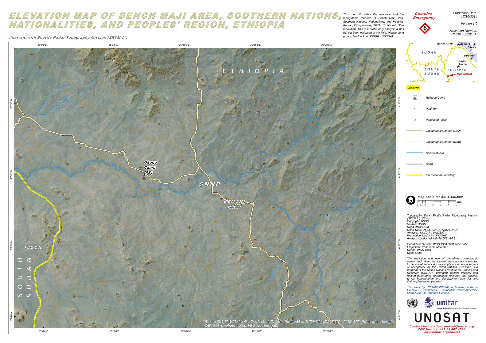
This map illustrates the overview and thetopographic features in Bench Maji Area,Southern Nations, Nationalities, and Peoples'Region, Ethiopia using SRTM 1" data with 30mresolution. This is a preliminary analysis & hasnot yet been validated in the field. Please sendground feedback to UNITAR / UNOSAT.
!!"
Complex Emergency
¥¦¬
¥¦¬
¥¦¬¥¦¬ ¥¦¬
AddisAbaba
Djibouti
AsmaraKhartoumSana'a
S U D A N
S O U T HS U D A N
E T H I O P I A
Production Date:17/10/2014Version 1.0
Activation Number:RC20140228ETHAnalysis with Shuttle Radar Topography Mission (SRTM 1")
0 1 2 3 4 50.5Km
LEGEND
Map ExtentF
Map Scale for A3: 1:150,000
A Refugee Camp
# Peak (m)
Populated Place
Topographic Contour (100m)
Topographic Contour (50m)
River Network
Road
International Boundary