Embed Size (px)
Citation preview
Southern Pinelands Natural Heritage Trail Scenic Byway Corridor Management Plan Task 3: Intrinsic Qualities November 2008 Taintor & Associates, Inc. Whiteman Consulting, Ltd. Paul Daniel Marriott and Associates

Southern Pinelands Natural Heritage Trail Task 3: Intrinsic Qualities Scenic Byway Corridor Management Plan November 2008
CONTENTS
PART 1: INTRINSIC QUALITIES................................................................................................. 1
1. Introduction ............................................................................................................................. 3 Overview: Primary, Secondary and Tertiary Intrinsic Qualities ............................................................ 3
2. Natural Quality ........................................................................................................................ 5 Introduction........................................................................................................................................... 5 Environmental History and Context...................................................................................................... 6 Indicators of Significance...................................................................................................................... 7 Significance as a Leader in Environmental Stewardship ................................................................... 17 The Major Natural Resources of the Pinelands and Their Significance............................................. 17
3. Recreational Quality ............................................................................................................. 27 Visitation and Accessibility ................................................................................................................. 27 Public Lands ....................................................................................................................................... 28 Recreational Activities ........................................................................................................................ 32
4. Historic Quality ..................................................................................................................... 47 Introduction......................................................................................................................................... 47 Historic Themes and Resources ........................................................................................................ 51
5. Scenic Quality ....................................................................................................................... 67
6. Archaeological Quality .........................................................................................................69
7. Cultural Quality ..................................................................................................................... 71
PART 2: MAJOR PUBLIC-ACCESSIBLE NATURAL AND RECREATIONAL QUALITY SITES AND RESOURCES ..................................................................................................... 73
1. Introduction ........................................................................................................................... 75
2. Northern Loop ....................................................................................................................... 77 Mullica River ....................................................................................................................................... 77 Wharton State Forest ......................................................................................................................... 78 Batsto Village...................................................................................................................................... 80 Batsto Natural Area ............................................................................................................................ 81 Batona Trail ........................................................................................................................................ 82 Bass River State Forest...................................................................................................................... 84 Green Bank State Forest.................................................................................................................... 85 Port Republic Wildlife Management Area........................................................................................... 85 Edwin B. Forsythe National Wildlife Refuge....................................................................................... 86
3. Central Section...................................................................................................................... 89 Great Egg Harbor National Scenic and Recreational River ............................................................... 89
Southern Pinelands Natural Heritage Trail Task 3: Intrinsic Qualities Scenic Byway Corridor Management Plan November 2008
Makepeace Lake Wildlife Management Area..................................................................................... 90 Weymouth Furnace (Atlantic County Park System)........................................................................... 92 Lake Lenape Park (Atlantic County Park System) ............................................................................. 93 Gaskill Park (Atlantic County Park System) ....................................................................................... 94 Great Egg Harbor River Wildlife Management Area .......................................................................... 95 Estell Manor Park (Atlantic County Park System).............................................................................. 96 Gibson Creek Wildlife Management Area .......................................................................................... 98 Lester C. MacNamara (Tuckahoe) Wildlife Management Area.......................................................... 99
4. Southern Loop..................................................................................................................... 103 Maurice River National Scenic and Recreational River ................................................................... 103 Peaslee Wildlife Management Area ................................................................................................. 104 Belleplain State Forest ..................................................................................................................... 106 Eldora Nature Preserve Nature Conservancy’s Delaware Bayshores Office and Visitor Site ......... 108 Dennis Creek Wildlife Management Area – Jakes Landing ............................................................. 109 Cape May National Wildlife Refuge (Great Cedar Swamp Section) ................................................ 110
APPENDICES........................................................................................................................... 113 Appendix 1: Web Links..................................................................................................................... 113 Appendix 2: List of Works Consulted ............................................................................................... 121 Appendix 3: Maps............................................................................................................................. 123
Figures
Figure 1: Canoe and Kayak Access in the Mullica River and Great Egg Harbor River Watersheds.......... 35 Figure 2: Periods of Significance of National Register Historic Districts .................................................... 51 Figure 3: 1770s Map of Mullica River Showing Batsto, The Forks and Chestnut Neck ............................. 54
Tables Table 1: U.S. and International Biosphere Reserves.................................................................................... 8 Table 2: NJ Audubon Important Birding Areas ........................................................................................... 14 Table 3: Federal List of Threatened and Endangered Species in NJ Pinelands........................................ 24 Table 4: NJ Category 1 Strongly Invasive and Widespread Plant Species ................................................ 25 Table 5: NJ Category 2 Invasive But Not As Widespread (Yet) ................................................................. 25 Table 6: State Forest Attendance, July 1, 2005 – June 30, 2006............................................................... 27 Table 7: Proximity to Urban Centers........................................................................................................... 28 Table 8: State Wildlife Management Areas Along the Southern Pinelands Natural Heritage Trail ............ 30 Table 9: Boat access areas......................................................................................................................... 36 Table 10: Ponds, Lakes and Reservoirs for Fishing ................................................................................... 44 Table 11: Rivers for Fishing ........................................................................................................................ 44

Southern Pinelands Natural Heritage Trail 1 Task 3: Intrinsic Qualities Scenic Byway Corridor Management Plan November 2008
PART 1: INTRINSIC QUALITIES

Southern Pinelands Natural Heritage Trail 3 Task 3: Intrinsic Qualities Scenic Byway Corridor Management Plan November 2008
1. Introduction The Pinelands is one of the most extensively studied regions in the nation. It has in place one of the most sophisticated regional land management programs in the country. In this context, the identification of the “intrinsic qualities” of the SPNHT scenic byway is not intended to add detail to the inventory work already performed in the region. Rather, this section of the Corridor Management Plan integrates existing data and information in a way that will allow the byway to build its program in a sound, sophisticated manner that meshes with the other good work being done in the Pinelands on a day to day basis. This chapter has three clear objectives, consistent with the project’s directive and the requirements of the National Scenic Byways Program.
First, it identifies the regionally and nationally significant intrinsic qualities upon which the Federal Highway Administration might grant America’s Byways® (i.e., National Scenic Byway or All-American Road) status for this route. Our purpose in this section is to highlight those resources for the reader so that he or she can easily understand the qualities and significance of those resources.
Second, this section provides an inventory of resources sufficient to allow byway
managers to generally know what-is-where in order to guide decision-making. For example, a corridor management plan is not meant to be the last word on the presence and management of endangered species – many other agencies and documents cover that material within their scope of responsibility. Rather, this document’s role is to flag the presence of issues related to endangered species in order to ensure that byway strategies support, rather than undermine, resource protection.
Third, this section is designed to provide the reader with a sufficient understanding of the
region’s intrinsic qualities so as to build a firm foundation on the ways in which natural systems, residents and visitors can benefit from byway designation. In other words, this section is not designed to be an encyclopedic review of all literature and information associated with this well-studied region’s history, people, resources and activities. Instead, it is designed to provide the critical information upon which to build interpretive programs, resource management strategies unique to the byway, and visitor experiences that both protect the resources and satisfy the traveler.
Overview: Primary, Secondary and Tertiary Intrinsic Qualities Primary Quality: Natural The primary intrinsic quality of the Southern Pinelands Natural Heritage Trail is its natural quality. The ecological significance of the New Jersey Pinelands is recognized both nationally and internationally through designations including U.S. National Reserve, World Biosphere Reserve, Jacques Cousteau National Estuarine Research Reserve, and National Wild and Scenic Rivers. Natural qualities, not only define the Southern Pinelands independently of the other intrinsic qualities, but they are the underpinnings of the secondary and tertiary qualities as well.

Southern Pinelands Natural Heritage Trail 4 Task 3: Intrinsic Qualities Scenic Byway Corridor Management Plan November 2008
Secondary/Supporting Qualities: Recreational and Historic Recreational and Historic resources and opportunities along the byway are supporting qualities that significantly increase the byway’s appeal to a diverse base of users, and enrich the story and the experience of the byway’s Natural Qualities. Recreational opportunities along the Southern Natural Heritage Trail are abundant, regionally and nationally noteworthy, and inextricably tied to the natural resources of the area, its rivers, forests, and diverse ecosystems. Hiking, boating, canoeing and kayaking, bicycling, birding, hunting and fishing take place along the byway in state, county and municipal parks, and along rivers, streams, estuaries and marshes that can be rated as some of the most scenic in the country. Recreational use of the areas natural resources draws a wide audience of participants to the region, enhancing the area’s potential for supporting commercial ventures, and increasing the pool of environmental stewards concerned with protecting those resources and opportunities. Historic resources are also plentiful throughout the area of the byway. Stories of burial grounds, charming colonial settlements, early industrial development and transportation and communi-cation routes are common throughout New Jersey and along the Atlantic Seaboard. What distinguishes these stories in the Pinelands, making them both more valuable historically and more marketable economically, are the relationships, resources, hardships and opportunities associated with life and living in the unique landscape of the Pinelands. With this concept as a core consideration, the theme of history along the SPNHT becomes a rare, little-known and fascinating tale of rugged individualism, fierce independence and environmental accommo-dation and stewardship.
Tertiary Qualities: Scenic, Archaeological and Cultural Scenic qualities are oftentimes extensions of natural qualities, though they also include our perceptions of the built environment. Generically they refer to views, commonly expansive or long views of a distinctive landscape. Because the landscape of the Pinelands, as viewed from the roads of the byway, offers little topography and limited viewsheds when considering the entire corridor, scenic qualities are considered a tertiary quality. This is not meant to diminish the splendor of these views, rather it is more reflective of the number in comparison to other qualities. Archaeological and cultural qualities though compelling and sometimes unique, are likewise, more limited in number than historic qualities, so are also considered tertiary.
Southern Pinelands Natural Heritage Trail 5 Task 3: Intrinsic Qualities Scenic Byway Corridor Management Plan November 2008
2. Natural Quality Natural Quality applies to those features in the visual environment that are in a relatively undisturbed state. These features predate the arrival of human populations and may include geological formations, fossils, landform, water bodies, vegetation, and wildlife. There may be evidence of human activity, but the natural features reveal minimal disturbances.
National Scenic Byways Program – Interim Policy
Introduction The New Jersey Pinelands is a rare natural and cultural environment; it is one of just a few healthy pine barrens systems on the entire planet. The New Jersey Pinelands is the largest pine barrens complex in the world, and the mosaic of globally rare upland and wetland communities and species found here is significant not only regionally and nationally, but internationally as well. The region is an outer coastal plain under which lies one of the largest freshwater aquifers in the world, the Kirkwood-Cohansey Aquifer. The land literally floats on this sandy aquifer and supports a delicate and rare mixture of vegetative and animal habitats mingling between inland and intertidal/coastal ecosystems. As a result, the New Jersey Pinelands or “Pine Barrens” (as the region is also known) has received designations and pursues an approach to environmental protection that give it regional, national and international significance worthy of America’s Byways status. Congress established the 1.1 million acre Pinelands National Reserve, the country's first national reserve, under the National Parks and Recreation Act of 1978. Under this designation, the National Park Service was given authorization to guide special ecosystem planning. At the state level, the Pinelands Protection Act of 1979 provided for implementation of the federal bill. A Pinelands Commission was established which created a comprehensive management plan (CMP) to balance protection and development interests; the plan was adopted in 1980 and approved in 1981. The comprehensive management plan established a 337,000-acre core preservation district to be maintained in its natural state through strict regulation of develop-ment, and a protection area where there are various categories of land use (forest, agriculture, regional growth, rural development, pinelands, towns and villages, military and federal institutions) based on existing natural features and projected need. The Pinelands Commission, a regional planning and regulatory agency, was created and given special planning abilities to protect the region’s environment and character while encouraging healthy local communities. In 1981, the Commission produced the Pinelands Comprehensive Management Plan and it was enacted. Then, in 1983, the United Nations Environmental Science and Cultural Organization (UNESCO), named the region a U.S. Biosphere Reserve. In 1988 it was recognized as an International Biosphere Reserve. Today, at over 1.1 million acres, the Pinelands is the largest collection of open space resources between Boston and Washington. It is, in effect, a national park for the Atlantic seaboard although the land is owned through a mixture of public and private entities and allows a variety of rural land uses. The Pinelands is an island of natural and rural land within an ocean of urbanization along the East Coast of the United States.
Southern Pinelands Natural Heritage Trail 6 Task 3: Intrinsic Qualities Scenic Byway Corridor Management Plan November 2008
Environmental History and Context Pre-European Settlement As sea levels dropped and the Atlantic coastal shelf emerged approximately five million years ago, a series of geo-physical phenomena came together to form what is now known as the Outer Coastal Plain of New Jersey – the Pinelands. Being a flat, low-lying plain with a vast aquifer beneath, the Pinelands possessed a water table that was in most areas either just below ground level or just above. While the flat topography prevented the creation of ponds and lakes, extensive swamps developed over broad expanses of the landscape. Much of this slowly circulating water was frozen most of the year during the Wisconsin Period (the most recent glaciation, which ended about ten thousand years ago.) The glaciers only reached as far south as central New Jersey, and thus this portion of the state was largely unglaciated, but nonetheless frigid for much of the year. Sandy soils predominated, with scattered pockets and layers of various clays, gravels and marl. These soils were generally extremely porous and consequently could retain only low levels of nutrients. Underlying them were great deposits of a soluble form of iron, known as limonite. Once the glaciers to the north retreated and the climate warmed, the modern flora and fauna of the Pinelands began to invade. Situated as it was along the mid-Atlantic coast, the region attracted species from both north and south, which commingled here as nowhere else. Hybrids of plant and animal species native to more northerly and more southerly climes developed under the unusual local conditions. Over the centuries, as generations of these variant species decayed, a thin, organic layer formed and the abundant waters of the Pinelands became more acidic. The waters penetrated to the deposits of limonite, i.e., the iron bearing strata below, carrying the mineral to the surface where it accumulated as a hardened crust along the banks of the languid streams. The unprecedented combination of high acidity, organic materials and dissolved iron resulted in the famous “tea colored” water of the Pinelands. As the glaciers withdrew and the land became more hospitable, the first human inhabitants of the Pinelands arrived, perhaps ten thousand years ago or more. Their life was, at least initially, not an easy one. They probably encountered a tundra-like environment, which only gradually became more diverse over succeeding millennia. Over time though, the climate became more hospitable, the food more plentiful and, as a consequence, the numbers of humans grew.
Post-European Settlement By the time Europeans arrived, this unique ecological zone had been fully formed in its modern configuration for at least seven to eight millennia. The land was criss-crossed with a dense, dendritic pattern of rivers, creeks and small streams. Pitch pine and oak upland forests seemed to stretch endlessly in all directions, interspersed with cedar and hardwood swamps; all of it was filled with exotic floral species never before encountered. The unorthodox surroundings presented both opportunities and limits to the newcomers, but the limits were more immediately apparent. The sandy soils were not promising for agriculture and this prevented full-scale clearing and settlement for more than a century after the rest of the colony. In fact, the Pinelands was never settled as intensively as the rest of New Jersey. The colonists settled along the coast and on the Inner Coastal Plain, the narrow strip of more fertile land near the Delaware River. Forays into the Pinelands for wood, game, fur and other resources were common in these years and river landings were well established by the mid-eighteenth century. Yet the region remained distinctly underpopulated, at least until furnaces

Southern Pinelands Natural Heritage Trail 7 Task 3: Intrinsic Qualities Scenic Byway Corridor Management Plan November 2008
and forges were built in the interior in the latter 1700s to exploit the potential of the seemingly limitless supply of limonite iron. Thereafter, a rural version of the Industrial Revolution took hold as iron smelting was followed by glass production and other, more modest manufactories. Like iron casting, glassmaking was another specific response to the natural conditions, the abundant local sands being high in silica and ideal for the production of window glass and hollow wares. Unfortunately, these pursuits put a tremendous strain on the native environment, particularly the forests, which were relentlessly harvested to sate the voracious appetite of the iron and glass furnaces. In the end, however, due to a mix of economic, technological and social forces, industry in the Pinelands ebbed and a gradual depopulation occurred in the mid to latter nineteenth century as people sought gainful employment elsewhere. The Pinelands were allowed to slowly recover and the forests reclaimed much of their prior domain. The remaining human population sup-ported itself with more environmentally compatible activities, such as berry farming, small-scale colliering (the making of charcoal) for home heating and “working the cycle” (seasonal harvest of the natural bounty). The outcome was an environment that restored itself according to the gamut of nature – soil, climate, hydrology and the like – and a human subculture that had developed over three centuries in response to those conditions. Thus, the Pinelands has not been a static, immutable environment. A tundra, or perhaps a boreal forest, ten thousand years ago, it changed enormously in the succeeding five or so millennia, primarily due to climatic conditions. Relatively stable for several thousand years thereafter, it changed again, and in a much more accelerated fashion, as a result of human presence, particularly in the eighteenth and nineteenth centuries. Since then, the region has largely, but not completely, regained the diverse range of plant and animal species and the unbroken forested tracts that were familiar to ancient Native Americans.
Indicators of Significance International Biosphere Reserve Designation In 1988, the United Nations identified the Pinelands as an International Biosphere Reserve. An international biosphere reserve is a special designation to identify and conserve special and unusual ecosystems in the world, as discussed by the National Park Service in the following text:
What do natural areas as diverse as Big Bend National Park in Texas, Everglades National Park in Florida, and Gates of the Arctic National Park in Alaska all have in common? Apart from all being units of the National Park System, they are part of a select group of internationally recognized sites that have been designated International Biosphere Reserves. Biosphere Reserves are designed to meet one of the most difficult challenges the world is facing as it in the 21st century: How to maintain and conserve the diversity of plants, animals and micro-organisms which make up our living "biosphere" while at the same time meet the material needs of an increasing population. In other words, how to reconcile conservation of biological resources with their sustainable use. In 1968, the UNESCO Conference on the Conservation and Rational Use of the Biosphere took a look at this issue, and it gave rise to the launching of the Man and the Biosphere (MAB) Program within UNESCO. The Biosphere Reserve concept was a key element for achieving MAB's objective to strike a balance between the apparently conflicting goals of conserving biodiversity, promoting economic and social development and maintaining associated cultural values.

Southern Pinelands Natural Heritage Trail 8 Task 3: Intrinsic Qualities Scenic Byway Corridor Management Plan November 2008
Biosphere Reserves’ Purpose Each Biosphere Reserve is intended to fulfill three basic functions, including: 1) conservation of important biological resources; 2) development of environmentally sound economic growth; and 3) support for research, monitoring, education, and information exchange related to conservation issues. To carry out these activities, they are organized into three interrelated zones, known as the core area, the buffer zone and the transition area. The core area is legally protected from activity which would adversely affect its natural features. This area could be used for such activities as hiking, diving, bird watching, educational field trips, scientific research and monitoring of plant and animal life. The buffer zone is an "adjacent managed use area" that might be used for lumbering, grazing, and fishing activities, settlements, recreational facilities etc., managed to benefit local residents and the local environment. The transition area is the larger region in which local residents, cultural groups, economic interests, scientists, or managing agencies work together to link conservation and economic development guided by the cultural values of the local community.
In the United States, there are 47 U.S. and International biosphere reserves. Each is listed below with its year of designation by the United Nations. The Pinelands Reserve was the first national reserve and became the 43rd U.S. site listed with UNESCO.
Table 1: U.S. and International Biosphere Reserves
1. Aleutian Islands National Wildlife Refuge (1976)
2. Big Bend National Park (1976) 3. Cascade Head, Oregon (1976) 4. Central Plains Experimental Range (1976) 5. Channel Islands National Park (1976) 6. Coram Experimental Forest (1976) 7. Denali National Park (1976) 8. Desert Biosphere Reserve (1976) 9. Everglades & Dry Tortugas (1976) 10. Fraser Experimental Forest (1976) 11. Glacier National Park (1976) 12. H. J. Andrews Experimental Forest (1976) 13. Hubbard Brook Experimental Forest
(1976) 14. Jornada Biosphere Reserve (1976) 15. Luquillo Biosphere Reserve (1976) 16. Noatak Biosphere Reserve (1976) 17. Olympic National Park (1976) 18. Organ Pipe Cactus National Monument
(1976) 19. Rocky Mountain National Park (1976) 20. San Dimas Experimental Forest (1976) 21. San Joaquin Biosphere Reserve (1976) 22. Sequoia-Kings Canyon national
parks(1976) 23. Stanislaus-Tuolumne Experimental Forest
(1976) 24. Three Sisters Wilderness (1976) 25. Virgin Islands National Park (1976) 26. Yellowstone National Park (1976)
27. Beaver Creek Experimental Watershed (1976)
28. Konza Prairie (1978) 29. Niwot Ridge (1979) 30. University of Michigan Biological Station
(1979) 31. Virginia Coast Reserve (1979) 32. Hawaiian Islands Biosphere Reserve (1980) 33. Isle Royale National Park (1981) 34. Big Thicket National Preserve (1981) 35. Guánica Biosphere Reserve (1981) (see
Guánica ) 36. California Coast Ranges Biosphere Reserve
(1983) 37. Central Gulf Coast Plain Biosphere Reserve
(1983) 38. South Atlantic Coastal Plain Biosphere
Reserve (1983) 39. Mojave and Colorado Deserts Biosphere
Reserve (1984) 40. Carolinian-South Atlantic Biosphere Reserve
(1986) 41. Glacier Bay-Admiralty Island (1986) 42. Golden Gate Biosphere Reserve (1988) 43. New Jersey Pinelands (1988) 44. Southern Appalachian Biosphere Reserve
(1988) 45. Champlain-Adirondack Biosphere Reserve
(1989) 46. Mammoth Cave Area (1990; expanded 1996) 47. Land Between The Lakes Area (1991)
Thus, the Pinelands National Reserve is a member of a family of internationally recognized significant natural areas in the United States. This designation alone provides ample evidence
Southern Pinelands Natural Heritage Trail 9 Task 3: Intrinsic Qualities Scenic Byway Corridor Management Plan November 2008
of the route’s ability to meet the National Scenic Byway Program’s criteria for regional significance, but the region has acquired a number of other significant national and regional designations that underscore the importance of the Pine Barrens.
National Wildlife Refuges The National Wildlife Refuge system, created by Theodore Roosevelt in 1903, is over 100 years old, includes more than 540 refuge areas, and over 36,000 fee and easement waterfowl produc-tion areas. The mission of the National Wildlife Refuge System is to administer a national net-work of lands and waters for the conservation, management and where appropriate, restoration of the fish, wildlife and plant resources and their habitats within the United States for the benefit of present and future generations of Americans
Edwin B. Forsythe National Wildlife Refuge The Refuge consists of more than 46,000 acres of coastal habitats and receives almost 200,000 visitors each year. The refuge’s location in one of the Atlantic Flyway’s most active flight paths makes it an important link in the vast network of national wildlife refuges administered nation-wide by the U.S. Fish and Wildlife Service. The diking system used at the Refuge provides habitat for fresh water, brackish and salt water bird species including Atlantic brant, American black duck, clapper rail, willet, peregrine falcons, ospreys, bald eagles and many others.
Cape May National Wildlife Refuge (Cedar Swamp Section) Established in January of 1989, Cape May National Wildlife Refuge is one of the newest refuges in the National Wildlife Refuge System. The refuge provides critical habitat for migratory birds and other wildlife. It supports 317 bird species, 42 mammal species, 55 reptile and amphibian species and numerous fish, shellfish, and other invertebrates. The refuge has upland and low-land forests, fields, barrier beach, salt marsh and salt meadows cut through by meandering tidal creeks and ponds.
National Estuarine Research Reserve Jacques Cousteau National Estuarine Research Reserve The National Estuarine Research Reserves System is a network of 27 areas representing different biogeographic regions of the United States that are protected for long-term research, water-quality monitoring, education and coastal stewardship. Established by the Coastal Zone Management Act of 1972, as amended, the reserve system is a partnership program between the National Oceanic and Atmospheric Administration (NOAA) and the coastal states. NOAA provides funding, national guidance and technical assistance. Each reserve is managed on daily basis by a lead state agency or university, with input from local partners. The Jacques Cousteau National Estuarine Research Reserve encompasses 114,000 acres of tidal freshwater, brackish and salt marshes and pine-oak upland buffer zones within the Mullica River-Great Bay ecosystem, and is described as “one of the least disturbed estuaries in the densely populated urban corridor of the northeastern United States.” The Jacques Cousteau Coastal Education Center in Tuckerton serves as the hub for K-12 professional development training and Coastal Decision Maker Training in the state and surrounding region. The “Life on the Edge” exhibit at Tuckerton Seaport acts as the gateway to the reserve by promoting knowledge of the habitats within the Jacques Cousteau Reserve, communicating estuarine research and empowering visitors to be part of decision-making and stewardship of coastal communities. The Cousteau reserve includes the Rutgers University Marine Field Station in Little Egg Harbor Township.
Southern Pinelands Natural Heritage Trail 10 Task 3: Intrinsic Qualities Scenic Byway Corridor Management Plan November 2008
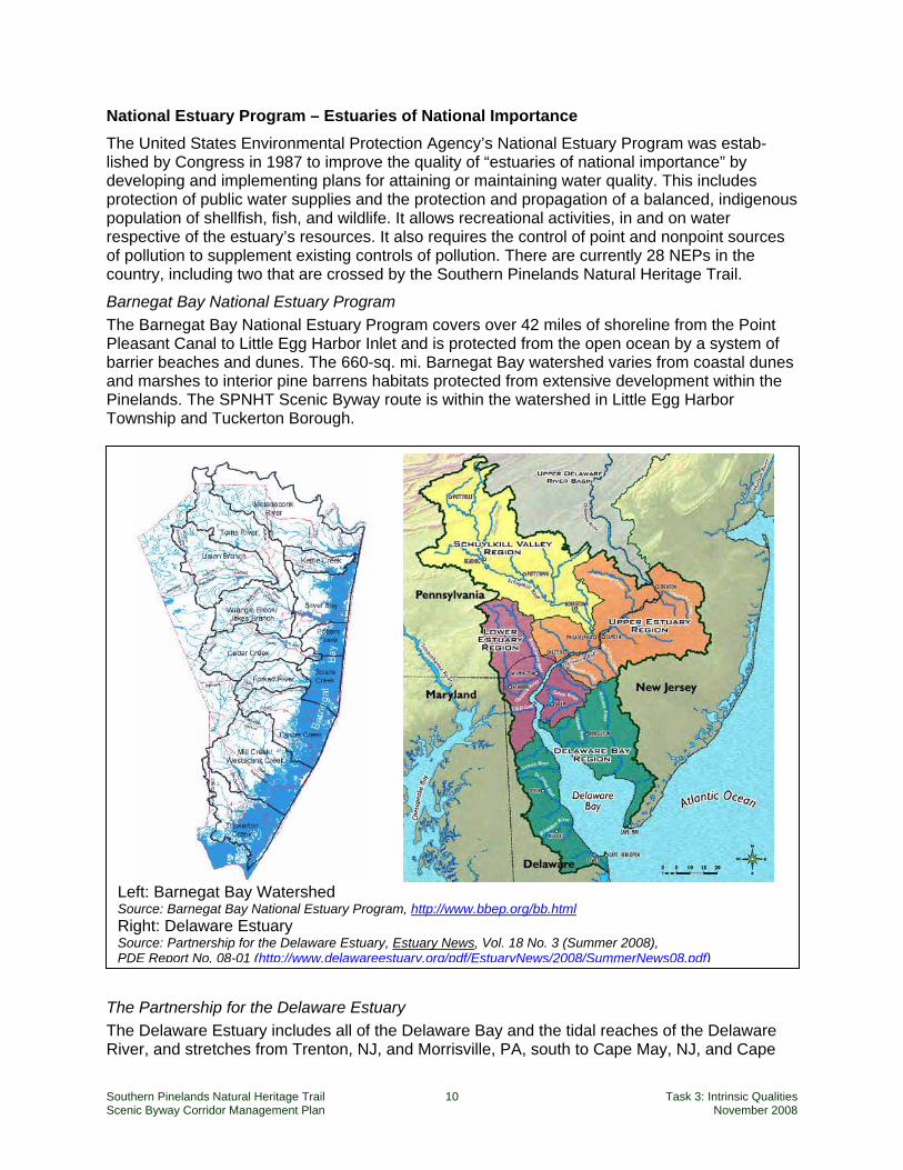
National Estuary Program – Estuaries of National Importance The United States Environmental Protection Agency’s National Estuary Program was estab-lished by Congress in 1987 to improve the quality of “estuaries of national importance” by developing and implementing plans for attaining or maintaining water quality. This includes protection of public water supplies and the protection and propagation of a balanced, indigenous population of shellfish, fish, and wildlife. It allows recreational activities, in and on water respective of the estuary’s resources. It also requires the control of point and nonpoint sources of pollution to supplement existing controls of pollution. There are currently 28 NEPs in the country, including two that are crossed by the Southern Pinelands Natural Heritage Trail.
Barnegat Bay National Estuary Program The Barnegat Bay National Estuary Program covers over 42 miles of shoreline from the Point Pleasant Canal to Little Egg Harbor Inlet and is protected from the open ocean by a system of barrier beaches and dunes. The 660-sq. mi. Barnegat Bay watershed varies from coastal dunes and marshes to interior pine barrens habitats protected from extensive development within the Pinelands. The SPNHT Scenic Byway route is within the watershed in Little Egg Harbor Township and Tuckerton Borough.
The Partnership for the Delaware Estuary The Delaware Estuary includes all of the Delaware Bay and the tidal reaches of the Delaware River, and stretches from Trenton, NJ, and Morrisville, PA, south to Cape May, NJ, and Cape
Left: Barnegat Bay Watershed Source: Barnegat Bay National Estuary Program, http://www.bbep.org/bb.html Right: Delaware Estuary Source: Partnership for the Delaware Estuary, Estuary News, Vol. 18 No. 3 (Summer 2008), PDE Report No. 08-01 (http://www.delawareestuary.org/pdf/EstuaryNews/2008/SummerNews08.pdf)
Southern Pinelands Natural Heritage Trail 11 Task 3: Intrinsic Qualities Scenic Byway Corridor Management Plan November 2008
Henlopen, DE. The Delaware River watershed encompasses 13,539 square miles, including 216 tributaries in New York, Pennsylvania, New Jersey and Delaware. The portions of the SPNHT Scenic Byway in Maurice River, Upper and Dennis Townships and Woodbine Borough are within the watershed. The Delaware Estuary provides habitat for more than 130 species of finfish, as well as clams, oysters and crabs. The second largest concentration of migrating shorebirds in the Western Hemisphere is found in the Estuary, along with habitat for 15 different species of waterfowl, which total more than half-a-million individuals who either migrate through or spend the winter in the Estuary. Also found in the Delaware Estuary is the largest population of spawning horseshoe crabs in the world.
National Wild and Scenic Rivers The Wild and Scenic Rivers Act of 1968 responded to our country’s concern over the deterior-ation and loss of our river resources. The Act strives to balance protection for the country's most outstanding free-flowing rivers with compatible development. To accomplish this, the Act specifically:
• Prohibits dams and other federally assisted water resources projects that would adversely affect river values;
• Protects outstanding natural, cultural, or recreational values; • Ensures water quality is maintained; and • Requires the creation of a comprehensive river management plan that addresses
resource protection, development of lands and facilities, user capacities, and other management practices necessary to achieve purposes of the Act.
To qualify for designation as a National Wild and Scenic River a river or river segment must be in a free flowing condition and must be deemed to have one or more “outstanding remarkable” scenic, recreational, geologic, fish and wildlife, historic, cultural or other similar values.
Maurice River National Scenic and Recreational River The Maurice River corridor is an unusually pristine coastal river with national and internationally important resources. As part of the Atlantic flyway, its clean waters and related habitats are vitally important to the migration of shorebirds, songbirds, waterfowl, raptors, rails and fish. The river supports New Jersey's largest stand of wild rice and 53 percent of the animal species that the state has recognized as endangered, excluding marine mammals. The river is a critical link between the Pinelands National Reserve and the Delaware Estuary. The Maurice River meets with the byway in the village of Port Elizabeth, where it also accepts the waters of the Manumuskin River, another National Scenic and Recreational River.
Great Egg Harbor National Scenic and Recreational River Starting as a trickle near Berlin, NJ, the Great Egg Harbor River gradually widens as it picks up the waters of 17 tributaries on its way to Great Egg Harbor and the Atlantic Ocean, including the Tuckahoe and South Rivers, both included as part of the Great Egg Harbor National Scenic and Recreational River. Established as a Wild and Scenic River by Congress in 1992, nearly all of this 129-mile river system rests within the Pinelands National Reserve, draining 304 square miles of pristine wetlands in the heart of the Pine Barrens. The river's proximity to millions of people, together with it being the largest canoeing river in the Pine Barrens, makes the Great Egg an important recreation destination. It intersects the byway in Mays Landing.

Southern Pinelands Natural Heritage Trail 12 Task 3: Intrinsic Qualities Scenic Byway Corridor Management Plan November 2008
EPA Outstanding Natural Resource Waters All waters in the Pinelands have been designated by the U.S. Environmental Protection Agency as Outstanding Natural Resource Waters that are to be protected from any change in water quality.
State Forests and State Parks State Forests and Parks are managed by the New Jersey Department of Environmental Protec-tion Division of Parks and Forests. Together the Division manages 41 parks, 11 forest three recreation areas and 50 historic sites and districts. The Division of Parks and Forests includes the State Forest Service, Forest Fire Service, Natural Lands Management, Historic Preservation and Education and Interpretation each unit serving a special purpose but together providing comprehensive management to the states natural and cultural resources. The state forests and parks located along the scenic byway are listed below.
Wharton State Forest Wharton State Forest consists of over 115,000 acres. It is the largest single tract within New Jersey state park system. A significant portion of this State Forest lies within the byway corridor. Along with its large size and thus its impact on habitat protection, this forest is regionally significant for its restoration and protection of Pinelands upland evergreen forests and stunted pine forests. Batsto Village is within Wharton State Forest. The site was a former iron bog and glassmaking village from 1767 until 1866. Purchased by the state in the 1930s, the site today houses historically preserved buildings from the late 1900s and early 20th century. One of two visitor centers within the Wharton State Forest is located here. An excellent interpretive presentation at the state park visitors center makes this a regionally important environmental resource. Green Bank State Forest is a small section of state forest land that lies adjacent to the hamlet of Green Bank. It is part of Wharton State Forest and offers river access and scenic views of the Mullica River.
Bass River State Forest Bass River State Forest was the first forest acquired by the state of New Jersey in 1905 for public recreation, water conservation, and wildlife and timber management. Lake Absegami, a 67-acre lake created in the 1930's, is the center of the forest's recreational activities and pro-vides an area for swimming and a serene setting for boating and canoeing. This is one of the best places to see the rare, stunted forest ecosystem known as the Pygmy forest.
Belleplain State Forest In the southern pinelands, the forests reflect better soil conditions and less fire damage than elsewhere in the region. Belleplain State Forest consists of 20,000 acres. It was established in 1928 for public recreation, timber production, wildlife management and conservation of water supplies. This forest received substantial support from the Civilian Conservation Corps. Today, its driving and hiking trails offer an intimate connection to this ecosystem.
State Wildlife Management Areas and Natural Areas State Wildlife Management Areas and Natural Areas are multiple-use public lands administered by the Division of Fish and Wildlife and managed by the Division's Bureau of Land Management
Southern Pinelands Natural Heritage Trail 13 Task 3: Intrinsic Qualities Scenic Byway Corridor Management Plan November 2008
for fish and wildlife habitat and a variety of wildlife-associated recreation. While hunting and fishing are likely the two activities most associated with the Division, WMAs are also prime locations for birding, wildlife viewing and photography, cross country skiing, hiking and mountain biking. The mission of the New Jersey Division of Fish and Wildlife is to protect and manage the State's fish and wildlife to maximize their long-term biological, recreational and economic values for all New Jerseyans. Following is a listing of Wildlife Management Areas and other natural areas along the byway.
Wading River Wildlife Management Area This WMA offers hunting, canoeing and general access to the Wading River and pine forests.
Swan Bay Wildlife Management Area This 3,372 acre site is generally bounded by Route 542, the Wading River, the Mullica River and the village of Lower Bank. A dirt ramp boat launch is located at the end of Turtle Road (RT 542) for car-top or small duck boats only.
Port Republic Wildlife Management Area This area lies along the Mullica River and offers boat ramps and access for fishing in the Mullica. The area is 1,347 acres in size.
Batsto Natural Area This natural area is located within Wharton State Forest and is comprised of two sections bordering the Batsto and Mullica rivers and contains several forest communities that are representative of the New Jersey Pine Barrens.
Makepeace Lake Wildlife Management Area This 10,145 acre area features a beautiful lake and surrounding forested lands laced with pine roads. The lake provides important nesting and resting grounds for a variety of bird species. The WMA is divided north and south by the Atlantic City Expressway. (The northern area features a shooting range and thus should not be highlighted for the average byway visitor access.)
Gibson Creek Wildlife Management Area This is a 1,203-acre protected area adjacent to Highway 557 near Oakville section of Estell Manor City. Trails offer access for walking, hiking and hunting.
Tuckahoe (Lester G. MacNamara) Wildlife Management Area The scenic Tuckahoe River winds its way to the Great Egg Harbor River and Bay through an expanse of salt marsh and tidal creeks that are excellent for bird watching. Six brackish water impoundments on the upland edges of the tract also provide good bird-watching opportunities. Located on the edge of the Pine Barrens, the woodlands bordering the salt marsh are a mixture of pine and oak trees.
Peaslee Wildlife Management Area One of the largest wildlife management areas in the state, Peaslee has thousands of acres of upland pine-oak forests and lowland bogs. Its longest border is the upper part of the Tuckahoe River. Old cranberry bogs are in the early stages of succession, and offer excellent freshwater marsh habitats. Explore the diverse habitats: the wooded edge, pinelands, cedar bog, hardwood swamp, scrub oak forests, sweet ferns, grassy fields, and yellow-clover pasture.
Southern Pinelands Natural Heritage Trail 14 Task 3: Intrinsic Qualities Scenic Byway Corridor Management Plan November 2008
Dennis Creek Wildlife Management Area – Jakes Landing A vast expanse of waving acres of marsh grass is visible from here. Several tidal creeks and drainage canals traverse this area providing channels for marine fish to spawn.
Nongovernmental Recognition Eldora Nature Preserve (The Nature Conservancy’s Delaware Bayshore Office and Visitors Center) The Eldora Nature Preserve is the first preserve established by The Nature Conservancy in New Jersey for the conservation of insects, particularly moths and butterflies. One will also find the Nature Conservancy’s Delaware Bayshore Office, interpretive exhibits, several aquariums, a display of local moths and butterflies, a gift shop, butterfly garden, and a hummingbird garden. A nature trail leads through woodlands on the way to the marsh.
New Jersey Important Bird Areas Site Descriptions1 The New Jersey Audubon Society has identified 11 Important Bird Areas within the byway corridor. Each represents an unusually rich habitat for a number of bird species. (Numbers refer to the Audubon Society’s identification system.)
Table 2: NJ Audubon Important Birding Areas
82. Wharton State Forest 83. Southern Pinelands Macrosite 85. Mullica River Corridor 86. Bass River Marsh 95. Edwin Forsythe NWR – Brigantine Division
108. Maurice River Corridor 109. Peaslee WMA 110. Belleplain State Forest 111. Lester G .Macnamara (Tuckahoe) WMA 112. Cape May NWR Great Cedar Swamp Division 114. Dennis Creek WMA (and Corson WMA)
Source: http://www.njaudubon.org/Conservation/IBBA/IBBA%2008%20brochure%207%C2%BDx11map.pdf
The following site descriptions, from New Jersey Audubon, summarize the significance of these nine sites for wildlife habitat.
Wharton State Forest Wharton State Forest is the largest single tract of land within the New Jersey State Park System and is a major component of the largest remaining contiguous forest blocks in the state. Located in the Pinelands Region, the area is composed of mature pine forest, oak forest, pine/oak forest, Atlantic white cedar (Chamaecyparis thyoides) swamps, Tupelo/ Maple swamps and fallow cranberry bogs. The site includes the headwaters of the Mullica and Batso Rivers and the southern headwaters of Rancocas Creek. Friendship Bogs and several privately owned parcels are also included in this site.
Southern Pine Barrens Macrosite 1 New Jersey Important Bird Areas Site Guide, http://www.njaudubon.org/Tools2.Net/Ibba/SiteListing.aspx (accessed 7/21/2008).
Southern Pinelands Natural Heritage Trail 15 Task 3: Intrinsic Qualities Scenic Byway Corridor Management Plan November 2008
This IBA macrosite encompasses mostly oak-pine forests in the Southern portion of the state. The forest species mix is distinct from the Northern Pine Barrens IBA. The Southern Pine Barrens is characterized by well-drained loamy sand which supports a lower pine to oak ratio and a distinct avian community. In addition to the oak-pine forests, this site also includes more typical coastal habitats including non-tidal wetlands, open water and riparian areas. This site also supports extensive hardwood swamps and early successional habitats including the typical Pine Barrens scrub-shrub community and grasslands. The Pinelands largest and most pristine watershed drains into the Mullica River in the northern part of the Southern Pine Barrens IBA. The site encompasses several Natural Heritage Priority Sites and includes or intersects Edwin B. Forsythe National Wildlife Refuge (NWR) - Brigantine Division, Maurice River Corridor, Peaslee Wildlife Management Area (WMA), Belleplain State Forest, Mullica River Corridor, Atlantic City Airport, Cape May NWR - Great Cedar Swamp Division, Bear Swamp Natural Area, Buckshutem WMA, and Millville (Edward G. Bevans) WMA IBAs.
Mullica River Corridor Located in the central pinelands of southern New Jersey, the Mullica River drains the largest and most pristine watersheds in the Pinelands. Habitats adjacent to the river include mixed upland forest, primarily dominated by pitch-pine (Pinus rigida) and forested wetland composed of Atlantic white cedar (Chamaecyparis thyoides). Tidal salt and brackish marshes dominate the area.
Bass River Marsh Bass River Marsh is located north of Port Republic and bordered by the Mullica and Wading Rivers to the southwest and to the east by Bass River State Forest (SF) and Edwin B. Forsythe National Wildlife Refuge (NWR). This site includes the fresh and saltwater wetlands of the lower portion of Bass River and forms an arm of the Mullica River Estuary. Portions of the site are contained within Edwin B. Forsythe NWR and Bass River State Forest while a significant land base remains in private ownership.
Edwin B. Forsythe National Wildlife Refuge – Brigantine Division The Brigantine Division of Edwin B. Forsythe National Wildlife Refuge was originally estab-lished in 1939 to protect important wintering habitat for waterfowl, especially American Black Ducks and Brant. In 1984 the two divisions were combined under the Forsythe name and in 1986 the refuge was designated a Wetland of International Importance for its ability to support a wide variety of waterbirds throughout the year. The Brigantine Division features Little Beach, a refuge for beach nesting birds, and 1415 acres impounded marsh habitat that support a diversity of wildlife. The site intersects the Little Egg Inlet Natural Heritage Priority Macrosite, designated by the New Jersey Department of Environmental Protection as some of NJ’s most significant habitats.
Maurice River Corridor This site includes the Maurice River, its associated riparian habitats, Union Lake and three major tributaries; the Menantico, Manumuskin and Muskee Creeks. The open waters of the Maurice River are flanked by extensive tidal salt marsh and large tracts of undeveloped forested wetland and upland forest. The Maurice River drains the southwestern portion of the Pinelands and serves as a valuable link between the Pinelands National Reserve and the Delaware Estuary. The brackish wild rice marshes in the upper portion of the site are the largest stands in New Jersey. The site includes the Maurice River North and the Maurice River South Natural Heritage Priority Sites, designated by the New Jersey
Southern Pinelands Natural Heritage Trail 16 Task 3: Intrinsic Qualities Scenic Byway Corridor Management Plan November 2008
Department of Environmental Protection (NJDEP) as some of the most significant natural areas in NJ. In 1993, the Maurice River and its tributaries were recognized as a Wild and Scenic River by the National Park Service. This designation protects the waters of many rivers throughout the country from inappropriate uses. The river boasts a rich history dating back to the Lenni Lenape Indians who depended on the river’s resources for survival. Its extensive maritime history includes oystering, crabbing and other fisheries.
Peaslee Wildlife Management Area Peaslee Wildlife Management Area (WMA) is bordered by the Manumuskin River to the west and the Tuckahoe River to the east. It is the second largest WMA in New Jersey and is also the southern-most example of a true Pine Barrens community, characterized by a predominance of pine-oak forest. Other habitat types found in this IBA include grasslands, cultivated fields and forested wetlands. The site intersects the Manumuskin Natural Heritage Priority Site, which encompasses the Manumuskin River and extensive freshwater marsh dominated by wild rice.
Belleplain State Forest Located in northwest Cape May County, Belleplain State Forest contains mixed oak-pine forests, Atlantic white cedar (Chamaecyparis thyoides) and hardwood swamps, grasslands, shrub/scrub habitat and several lakes. This site includes the contiguous wetlands of the Woodbine Bogs Natural Heritage Priority Site as well as Lake Nummy, a 26 acre lake named for the last Lenni Lenape Indian chief. In 1933, shortly after Belleplain was established, the Civilian Conservation Corps (CCC) set up camp to provide labor for the forest. For eight years, the CCC constructed the State Forest’s headquarters, maintenance buildings, a road system, bridges, dams and Lake Nummy. Belleplain State Forest was established to provide recreation, wildlife management, timber production and water conservation.
Tuckahoe (Lester G. MacNamara) Wildlife Management Area The Tuckahoe Wildlife Management Area (WMA) straddles Atlantic and Cape May Counties in southern New Jersey. It is bordered by the Great Egg Harbor River to the northeast and is intersected by the Middle and Tuckahoe Rivers. This site is composed of a diversity of habitats including extensive tidal salt marsh, mixed upland forest, and freshwater rivers and impoundments. The site includes the Tuckahoe Corbin Salt Marsh Natural Heritage Priority Macrosite, designated by NJ Department of Environmental Protection (NJDEP) as some of the state’s most significant natural areas.
Cape May National Wildlife Refuge – Great Cedar Swamp Division The Cape May National Wildlife Refuge (NWR), composed of the Delaware Bay Division, the Great Cedar Swamp Division and Two Mile Beach Unit, was established in 1989 with the purchase of 90 acres from The Nature Conservancy. The Great Cedar Swamp Division is located in Upper and Dennis Townships and encompasses 7700 acres of the Great Cedar Swamp a large Atlantic white cedar (Chamaecyparis thyoides) swamp. The site contains significant amounts of old-growth hardwood swamp and contiguous upland forest as well as salt marsh and grassland areas. The site includes the Great Cedar Swamp Natural Heritage Priority Macrosite, containing a large organic-soil wetland in the headwaters of Dennis Creek and Cedar Swamp Creek.
Southern Pinelands Natural Heritage Trail 17 Task 3: Intrinsic Qualities Scenic Byway Corridor Management Plan November 2008
Dennis Creek Wildlife Management Area (and Corson WMA) This site borders the Delaware Bay from Reeds Beach at Bidwell Creek in Cape May County northwest to Thompsons Beach in Cumberland County. It contains the vast expanses of tidal salt marsh of Dennis Creek and Corson WMAs. This IBA also includes the Dennis Creek Marsh Natural Heritage Priority Macrosite, several bayside beaches including Reeds, Moores and Thompsons Beaches and is intersected by West and Dennis Creeks.
Significance as a Leader in Environmental Stewardship The Pinelands National Reserve includes portions of seven southern New Jersey counties, and encompasses over 1.1 million acres of farms, forests and wetlands. It contains 56 communities, from hamlets to suburbs, with over 700,000 permanent residents. The environment is distin-guished by being habitat for over a thousand species of plants and animals – almost 100 of which are threatened or endangered. As a Biosphere Reserve, the region’s nationally significant resources are protected through a program of local land use management supported by federal financial and technical assistance. Land use and environmental management is administered through the Pinelands Commission. Specific planning areas have been designated for environmental protection, forestry and agriculture, with growth being directed and encouraged in and around areas capable of accommodating further development. As a Biosphere Reserve, the Pinelands also serves as a laboratory for fostering a harmonious relationship between humans and their environment through a program of research that inte-grates the social, physical and biological sciences. In addition, special programs are in place to protect open space and natural areas. Planting of indigenous species is encouraged. Farm lands are protected. For the byway traveler, an important part of visiting the Pinelands will be gaining an under-standing of how this region integrates environmental protection with ongoing community growth and change. This knowledge may influence visitors’ attitudes and actions in their own hometown communities.
The Major Natural Resources of the Pinelands and Their Significance This section reviews the environmental structure of the region and discusses elements of significance. This structure is central to how the Southern Pinelands Natural Heritage Trail will be interpreted for the visitor.
A Byway in a Subtle Landscape The landscape of the New Jersey Pinelands is full of complexity and richness, but it is not a landscape that offers up its richness easily to the untrained eye. For the average byway visitor, much of the corridor will appear to be very similar: lots of pine trees and lots of oak trees. The landscape is varied in many places by dramatic views of coastal areas and marshes, but between those views lies a very homogeneous landscape of pine forest. A challenge for this byway is presenting an experience that helps both experienced and novice naturalists enjoy the route.
Southern Pinelands Natural Heritage Trail 18 Task 3: Intrinsic Qualities Scenic Byway Corridor Management Plan November 2008
The following discussion presents an overview of the significant and distinctive qualities of the corridor landscape accompanied by ideas on how these qualities might be translated for byway users. The discussion attempts to bridge a gap between the existing scientific and “nature-expert” literature and the ways in which a byway might act as a guide and teacher for the uninitiated traveler. This byway certainly offers a perfect destination for “ecologically educated” travelers, that is, people who are fascinated and well-informed about plants, birds and other aspects of the natural world. These “eco-travelers” will be a central focus for the byway’s marketing efforts. However, in order to both widen the general public’s awareness of the Pinelands and to provide an enjoyable travel experience for the “non-eco” traveler, this byway must consider ways to translate this subtle landscape to a broader audience.
Vegetative Communities The core region of the New Jersey Pinelands complex consists of a mosaic of upland, aquatic, and wetland habitats occupying a contiguous area of over 1.1 million acres on the outer section of the Atlantic Coastal Plain of southeastern New Jersey. The byway corridor extends from the southern end of the Pinelands region to a point northward about midway through the region. The Pinelands is distinctive for the widespread occurrence of dry pine, oak, and heath communities in a humid, temperate, deciduous forest climate. The presence of pine barrens in this climate results from the success of low-nutrient and fire-adapted species in invading and maintaining themselves competitively over the last several thousand years on the sandy, well-drained, nutrient-poor soils. Pinelands vegetation is also distinctive for its strong differentiation of plant communities in an area of low topographical relief. The uplands and lowlands have communities that are quite distinct from one another, controlled primarily by soil moisture differences. These upland and lowland communities are described below.
Uplands Within the Pine Barrens, three major upland vegetative communities define the region.
1. The oak-pine forests dominated by post oak and blackjack oak are the tallest of the three forest types. Larger tree-form oaks are more dominant than are pines, and shortleaf pine often dominates over pitch pine. The dominant oak species is generally black oak to the north of the Mullica River and southern red oak to the south of the Mullica River, with varying abundance of chestnut, scarlet, and white oak. The understory and shrub layers are generally dominated by heaths such as lowbush blueberry, black huckleberry and mountain laurel as well as sweet fern and inkberry. The areas along the southern portion of the byway corridor (e.g., Belleplain State Forest and nearby wildlife management areas) present these upland forest ecosystems with an emphasis on the oak-pine and cedar dominated forest types.
2. At the other extreme, the dwarf pine plains contain short pitch pines and blackjack oaks that are often less than 9 feet (3 m) tall. The community is dominated by dwarf (less than 11 feet) pines, along with blackjack and scrub oak. These trees are all characteristic of pine barrens areas experiencing frequent wildfires. The shrub and herb layers are generally dominated by sheep laurel and mountain laurel, sweet fern, and sand-myrtle, and ground covers such as wintergreen, bearberry, trailing arbutus and patches of broom crowberry, Pyxie moss and false heather are often abundant in the dwarf pine plains. This community has evolved under severe environmental
Southern Pinelands Natural Heritage Trail 19 Task 3: Intrinsic Qualities Scenic Byway Corridor Management Plan November 2008
conditions, including frequent fires and nutrient-poor soils. These fire-maintained communities are primarily located at the northern end of the byway, north and east of the Mullica and Wading Rivers and south of Cedar Creek. The extent of these communities is generally defined by the firesheds, i.e., those extensive upland areas between major waterbodies that are susceptible to uninterrupted burns. Bass River State Forest and portions of Wharton Forest along the byway offer the best examples of these types.
3. Between these two extremes lie the pine-shrub-oak forests, a rare community dominated by pitch pines. In the pine-oak forests, there is less than 25% cover of oak trees, including black oak, chestnut oak, scarlet oak, and white oak. These forest types occur in various locations throughout the region.
Lowland Communities Lowland areas in the Pinelands support a diversity of wetland communities, including Atlantic white cedar swamps, hardwood swamps, pitch pine lowland forests, shrub swamps, marshes, and pine barren savannas. The wetland forests of the Pinelands are dominated by Atlantic white cedar, red maple and black gum, with pitch pine, gray birch and sassafras as associates. In the Atlantic white cedar swamps, stands of white cedar are relatively dense. Tall pitch pines, red maple, black gum, and sweetbay sometimes form an understory, and the shrub layer contains highbush blueberry, dangleberry, swamp azalea, sweet pepperbush, fetterbush and bayberry. Bass River State Forest and Belleplain State Forest both offer good examples of cedar swamps. There is a sparse but diverse herbaceous vegetation layer in many lowland areas with thick hummocks and mats of Sphagnum mosses. Many streams in the Pinelands flow through narrow (generally not more than 1,000 feet wide) bands of Atlantic white cedar swamps from their headwaters all the way to the limit of tidal influence. Hardwood swamps in the Pinelands are dominated by red maple, with black gum and sweetbay as associates. Hardwood swamps are often contiguous with cedar swamps and may replace cedar swamps after extensive logging. Pitch pine lowland forests are dominated by dense stands of pitch pine, with lesser numbers of red maple and black gum, and a well-developed understory including black huckleberry, sheep laurel, and dangleberry, with leatherleaf in the wetter sites. These lowland forests occur as fringing swamps along streams in the pine barrens and in depressions and other poorly drained sites. Canoeing and hiking along the many rivers of the byway corridor will introduce visitors to these lowland systems.
Inland Wetlands Herbaceous wetlands occur around depressions and along streams in the pine barrens. Near the ponds are fragrant waterlily, yellow waterlily, bladderworts and other submerged and floating-leaved vegetation. Peat mosses, sedges, rushes, pipeworts, chain and other emergent plants occur along the shorelines of ponds and streams. Pine barren savannas are grass and sedge- dominated wet meadow communities that occur in floodplains of pine barrens streams; they are often separated from the streams by a levee and vegetated by lowland broomsedge, Torrey's dropseed, bullsedge, coast sedge and golden crest. This community type in the Pinelands has been reduced in extent from thousands of

Southern Pinelands Natural Heritage Trail 20 Task 3: Intrinsic Qualities Scenic Byway Corridor Management Plan November 2008
acres to no more than 1,000 acres at present. Most pine barren savannas have succeeded into shrub and forested swamps due to a lack of natural or human disturbance. Pine barren shrub swamps are dominated by leatherleaf, often associated with highbush blueberry or inkberry and growing on Sphagnum mats. Coastal plain intermittent ponds (vernal ponds) with seasonally fluctuating water levels have seasonally saturated soils typically dominated by sedges and panic and muhly grasses and usually contain several rare species. Belleplain State Forest, the Tuckahoe Wildlife Management Area, Makepeace Lake WMA and Bass River State Forest all offer good access to wetland environments.
Rivers and Lakes Surface waters in the Pinelands include streams, lakes, and bogs. Pine barrens streams flow in broad shallow valleys and mostly flow east and south. The streams are slow-flowing, with sand and gravel substrates. Ground water discharge accounts for 89% of annual stream discharge. Close contact with the underlying aquifer keeps the streams relatively cool (about 25°C [77°F] in summer). The stream waters are generally of exceptional quality, rich in humic acids that give these streams their characteristic brown tea color, low in dissolved solids, and quite acidic, with an average pH of about 4.4. While these high-quality acid waters support indigenous fish and amphibian communities that are tolerant of the acidity of the waters, they are inhospitable to many non-indigenous plant and animal species.
Mullica River Batsto River Wading River Oswego River Bass River Nacote Creek
Great Egg Harbor River Tuckahoe River Dennis Creek (Jake’s Landing) Maurice River Manumuskin Creek
The Mullica, Great Egg Harbor, Tuckahoe and Maurice Rivers have extensive tidal estuaries as well as remote freshwater courses. Lakes within the byway corridor:
Batsto Lake Lake Absegami Lake Nummy
Lake Lenape Makepeace Lake
All of these water bodies are accessible from the byway. Canoeing or kayaking along these routes will introduce the traveler to views and habitats that cannot be seen from the car.
Southern Pinelands Natural Heritage Trail 21 Task 3: Intrinsic Qualities Scenic Byway Corridor Management Plan November 2008
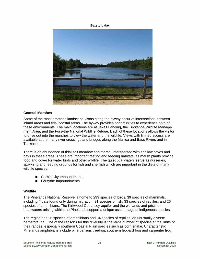
Batsto Lake
Coastal Marshes Some of the most dramatic landscape vistas along the byway occur at intersections between inland areas and tidal/coastal areas. The byway provides opportunities to experience both of these environments. The main locations are at Jakes Landing, the Tuckahoe Wildlife Manage-ment Area, and the Forsythe National Wildlife Refuge. Each of these locations allows the visitor to drive out into the marshes to view the water and the wildlife. Views with limited access are available at the many river crossings and bridges along the Mullica and Bass Rivers and in Tuckerton. There is an abundance of tidal salt meadow and marsh, interspersed with shallow coves and bays in these areas. These are important resting and feeding habitats, as marsh plants provide food and cover for water birds and other wildlife. The quiet tidal waters serve as nurseries, spawning and feeding grounds for fish and shellfish which are important in the diets of many wildlife species.
Corbin City Impoundments Forsythe Impoundments
Wildlife The Pinelands National Reserve is home to 299 species of birds, 39 species of mammals, including 4 bats found only during migration, 91 species of fish, 33 species of reptiles, and 26 species of amphibians. The Kirkwood-Cohansey aquifer and the wetlands and pristine headwaters arising within the Pinelands support a unique assemblage of indigenous species. The region has 26 species of amphibians and 34 species of reptiles, an unusually diverse herpetofauna. One of the reasons for this diversity is the large number of species at the limits of their ranges, especially southern Coastal Plain species such as corn snake. Characteristic Pinelands amphibians include pine barrens treefrog, southern leopard frog and carpenter frog.
Southern Pinelands Natural Heritage Trail 22 Task 3: Intrinsic Qualities Scenic Byway Corridor Management Plan November 2008
Many amphibian species are unable to establish viable populations in undisturbed areas of the central Pinelands, probably due to the low pH of the surface waters. Eastern tiger salamander occurs on the outskirts of the Pinelands where the surface waters have a higher pH. Wood turtle occurs at the fringes of the Pinelands, along the Inner Coastal Plain in the northwestern Pinelands. Thirty-four species of native mammals are known to reside in the New Jersey Pinelands, and four additional species of bats are found during migration. Each spring and fall tens of thousands of migrating ducks and geese, wading birds and shore-birds concentrate in the coastal waters in the eastern edge of the byway corridor. They linger to rest and feed on the rich resources of the area, thus providing visitors with spectacular viewing and photo opportunities. Several migratory species, including the black duck, remain at the refuge through summer to nest and raise their young. Atlantic brant and black ducks also overwinter here. Peregrine falcons and ospreys frequent refuge wetlands and take advantage of the nesting platforms erected for their use. Bald eagles use refuge habitats along the Mullica River, and occasionally forage over refuge impoundments. There are about 70 species of birds breeding in the Pinelands inland of tidal areas. Abundant birds in the Pinelands include rufous-sided towhee found throughout the Pinelands in areas of scrubby undergrowth, and gray catbird which prefers to nest in dense thickets near water. Oak-pine woodlands support insectivorous vireos and flycatchers such as red-eyed vireo and warblers such as black-and-white warbler and ovenbird. Pine and prairie warblers nest in pine-oak forests, with pine warbler preferring tall pines and prairie warbler preferring the more open scrubby areas. Riverine lowland areas support feeding and nesting by a variety of waterbirds and waterfowl such as blue heron, green heron and wood duck. Cedar swamps support insectivores such as eastern wood pewee, wood thrush, and yellow warbler. Mature pine forests support the greatest diversity of breeding birds, with fewer species in mature oak forests and in pine plains communities. Barred owl breed in lowlands in the Pinelands, with a stronghold in Belleplain State Forest and the watershed of the Maurice and Manumuskin Rivers. Pairs of bald eagles nest in Belleplain State Forest and along the Mullica River, and several of the tidal rivers that drain the Pinelands are important wintering areas for the eagle. Pristine headwater streams in the Pinelands support a unique assemblage of flora and fauna. Some of the more pristine headwater streams in the Pinelands, based on lack of sewage input and percent of unaltered land cover in the watershed, include the West Branch of the Wading River, the Batsto River, and the upper Mullica River. Fish in the Pinelands are, for the most part, acid-tolerant species and are an important part of the region's biodiversity. Restricted species include banded sunfish, yellow bullhead, pirate perch, blackbanded sunfish, mud sunfish, and swamp darter. Species that are widespread in the Pinelands streams are American eel , eastern mudminnow , redfin pickerel, chain pickerel, creek chubsucker, tadpole madtom, bluespotted sunfish, and tessellated darter. Pinelands fish are generally found in areas of abundant vegetation. The dominant open sandy bottom streams are home to some of the darters. The swamp darter prefers moderate currents, while the tessellated darter is found in the higher gradient streams. The stream margins and backwaters
Southern Pinelands Natural Heritage Trail 23 Task 3: Intrinsic Qualities Scenic Byway Corridor Management Plan November 2008
are the preferred habitat for eastern mudminnow and the Pinelands’ most dominant fish, the creek chubsucker. The profusely vegetated areas, especially the quiet backwaters, are home to the majority of New Jersey Pinelands fish species. American eel, chain and redfin pickerel, and yellow bullhead are dominant in the vegetated areas. Others common to the Pinelands vegetated habitats include brown bullhead and more secretive species such as tadpole madtom and pirate perch. The bluespotted sunfish is common throughout the state, whereas the occurrence of black-banded and banded sunfish is restricted to the Pinelands habitats. The saline waters of the Mullica River and Great Egg Harbor estuaries buffer the acid waters draining the Pinelands, enabling common peripheral fish species intolerant of acid waters to occur. Impoundments, including lakes, mill ponds and cranberry bogs created by man’s damming and diversion activities account for a high percentage of Pinelands water bodies, and are home to a diversity of native and adapted fish species including: the commonly found swamp darter, golden shiner, pumpinkseed, and yellow perch and a peripheral species, the redbreasted sunfish. Several non-native game species are stocked including bluegill, largemouth bass and black crappies. Trout are stocked for put-and-take fishery.2 Anadromous fish found in the Mullica River system include winter flounder, bluefish, weakfish, summer flounder, Atlantic menhaden and black sea bass. The Great Egg Harbor River system provides spawning and nursery areas for blueback, herring, alewife and striped bass. Other anadromous species found include hickory shad, Atlantic menhaden, and the catadromous species American eel.3 The most prominent game fish in typical Pine Barrens waters is the chain pickerel identified by its long duckbilled snout. Striped bass is a seasonal game fish. Other species such are largemouth bass, bluegills, black crappies and trout are stocked.4
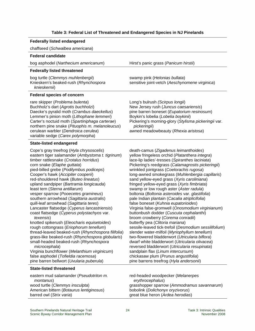
Threatened and Endangered Species The Pinelands supports a number of endemic plant and animal species, several glacial relict species, and a few northern and numerous southern species that reach their geographical Coastal Plain limits in the Pinelands. Also, 24 plant taxa (type localities) were described from specimens originally discovered growing in the New Jersey Pinelands. There are 223 species of special threatened or endangered emphasis in the New Jersey Pinelands, incorporating 84 species of plants and 75 species of birds, and including the following federally and state-listed species.
2 Significant Habitats and Habitat Complexes of the New York Bight Watershed (U.S. Fish and Wildlife
Service, 1997) 3 Significant Habitats and Habitat Complexes of the New York Bight Watershed (U.S. Fish and Wildlife Service, 1997) 4 Vertebrates Of The Pine Barrens by Robert W Hastings, Listing of Dominant or Distinctive Vertebrates of the Pine Barrens
Southern Pinelands Natural Heritage Trail 24 Task 3: Intrinsic Qualities Scenic Byway Corridor Management Plan November 2008
Table 3: Federal List of Threatened and Endangered Species in NJ Pinelands
Federally listed endangered
chaffseed (Schwalbea americana)
Federal candidate
bog asphodel (Narthecium americanum) Hirst’s panic grass (Panicum hirstii)
Federally listed threatened
bog turtle (Clemmys muhlenbergii) Knieskern’s beaked-rush (Rhynchospora
knieskernii)
swamp pink (Helonias bullata) sensitive joint-vetch (Aeschynomene virginica)
Federal species of concern
rare skipper (Problema bulenta) Buchholz’s dart (Agrotis buchholzi) Daecke’s pyralid moth (Crambus daeckellus) Lemmer’s pinion moth (Lithophane lemmeri) Carter’s noctuid moth (Spartiniphaga carterae) northern pine snake (Pituophis m. melanoleucus) cerulean warbler (Dendroica cerulea) variable sedge (Carex polymorpha)
Long’s bulrush (Scirpus longii) New Jersey rush (Juncus caesariensis) pine barren boneset (Eupatorium resinosum) Boykin’s lobelia (Lobelia boykinii) Pickering’s morning-glory (Stylisma pickeringii var.
pickeringii) awned meadowbeauty (Rhexia aristosa)
State-listed endangered
Cope’s gray treefrog (Hyla chrysoscelis) eastern tiger salamander (Ambystoma t. tigrinum) timber rattlesnake (Crotalus horridus) corn snake (Elaphe guttata) pied-billed grebe (Podilymbus podiceps) Cooper’s hawk (Accipiter cooperii) red-shouldered hawk (Buteo lineatus) upland sandpiper (Bartramia longicauda) least tern (Sterna antillarum) vesper sparrow (Pooecetes gramineus) southern arrowhead (Sagittaria australis) quill-leaf arrowhead (Sagittaria teres) Lancaster flatsedge (Cyperus lancastriensis) coast flatsedge (Cyperus polystachyos var.
texensis) knotted spikerush (Eleocharis equisetoides) rough cottongrass (Eriophorum tenellum) thread-leaved beaked-rush (Rhynchospora filifolia) grass-like beaked-rush (Rhynchospora globularis) small-headed beaked-rush (Rhynchospora
microcephala) Virginia bunchflower (Melanthium virginicum) false asphodel (Tofieldia racemosa) pine barren bellwort (Uvularia puberula)
death-camus (Zigadenus leimanthoides) yellow fringeless orchid (Platanthera integra) lace-lip ladies’-tresses (Spiranthes laciniata) Pickering’s reedgrass (Calamagrostis pickeringii) wrinkled jointgrass (Coelorachis rugosa) long-awned smokegrass (Muhlenbergia capillaris) sand yellow-eyed grass (Xyris caroliniana) fringed yellow-eyed grass (Xyris fimbriata) swamp or low rough aster (Aster radula) boltonia (Boltonia asteroides var. glastifolia) pale Indian plantain (Cacalia atriplicifolia) false boneset (Kuhnia eupatorioides) Virginia false-gromwell (Onosmodium virginianum) buttonbush dodder (Cuscuta cephalanthi) broom crowberry (Corema conradii) butterfly pea (Clitoria mariana) sessile-leaved tick-trefoil (Desmodium sessilifolium) slender water-milfoil (Myriophyllum tenellum) two-flowered bladderwort (Utricularia biflora) dwarf white bladderwort (Utricularia olivacea) reversed bladderwort (Utricularia resupinata) sandplain flax (Linum intercursum) chickasaw plum (Prunus angustifolia) pine barrens treefrog (Hyla andersonii)
State-listed threatened
eastern mud salamander (Pseudotriton m. montanus)
wood turtle (Clemmys insculpta) American bittern (Botaurus lentiginosus) barred owl (Strix varia)
red-headed woodpecker (Melanerpes erythrocephalus)
grasshopper sparrow (Ammodramus savannarum) bobolink (Dolichonyx oryzivorus) great blue heron (Ardea herodias)
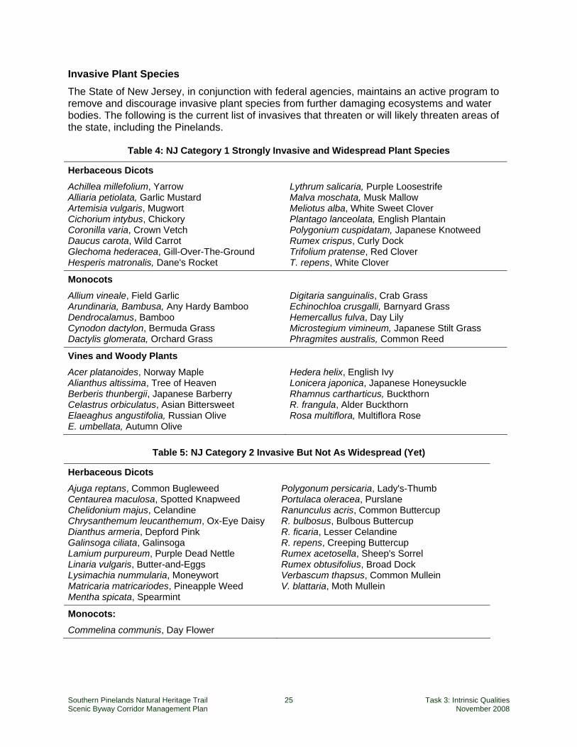
Southern Pinelands Natural Heritage Trail 25 Task 3: Intrinsic Qualities Scenic Byway Corridor Management Plan November 2008
Invasive Plant Species The State of New Jersey, in conjunction with federal agencies, maintains an active program to remove and discourage invasive plant species from further damaging ecosystems and water bodies. The following is the current list of invasives that threaten or will likely threaten areas of the state, including the Pinelands.
Table 4: NJ Category 1 Strongly Invasive and Widespread Plant Species
Herbaceous Dicots Achillea millefolium, Yarrow Alliaria petiolata, Garlic Mustard Artemisia vulgaris, Mugwort Cichorium intybus, Chickory Coronilla varia, Crown Vetch Daucus carota, Wild Carrot Glechoma hederacea, Gill-Over-The-Ground Hesperis matronalis, Dane's Rocket
Lythrum salicaria, Purple Loosestrife Malva moschata, Musk Mallow Meliotus alba, White Sweet Clover Plantago lanceolata, English Plantain Polygonium cuspidatam, Japanese Knotweed Rumex crispus, Curly Dock Trifolium pratense, Red Clover T. repens, White Clover
Monocots Allium vineale, Field Garlic Arundinaria, Bambusa, Any Hardy Bamboo Dendrocalamus, Bamboo Cynodon dactylon, Bermuda Grass Dactylis glomerata, Orchard Grass
Digitaria sanguinalis, Crab Grass Echinochloa crusgalli, Barnyard Grass Hemercallus fulva, Day Lily Microstegium vimineum, Japanese Stilt Grass Phragmites australis, Common Reed
Vines and Woody Plants Acer platanoides, Norway Maple Alianthus altissima, Tree of Heaven Berberis thunbergii, Japanese Barberry Celastrus orbiculatus, Asian Bittersweet Elaeaghus angustifolia, Russian Olive E. umbellata, Autumn Olive
Hedera helix, English Ivy Lonicera japonica, Japanese Honeysuckle Rhamnus cartharticus, Buckthorn R. frangula, Alder Buckthorn Rosa multiflora, Multiflora Rose
Table 5: NJ Category 2 Invasive But Not As Widespread (Yet)
Herbaceous Dicots Ajuga reptans, Common Bugleweed Centaurea maculosa, Spotted Knapweed Chelidonium majus, Celandine Chrysanthemum leucanthemum, Ox-Eye Daisy Dianthus armeria, Depford Pink Galinsoga ciliata, Galinsoga Lamium purpureum, Purple Dead Nettle Linaria vulgaris, Butter-and-Eggs Lysimachia nummularia, Moneywort Matricaria matricariodes, Pineapple Weed Mentha spicata, Spearmint
Polygonum persicaria, Lady's-Thumb Portulaca oleracea, Purslane Ranunculus acris, Common Buttercup R. bulbosus, Bulbous Buttercup R. ficaria, Lesser Celandine R. repens, Creeping Buttercup Rumex acetosella, Sheep's Sorrel Rumex obtusifolius, Broad Dock Verbascum thapsus, Common Mullein V. blattaria, Moth Mullein
Monocots: Commelina communis, Day Flower
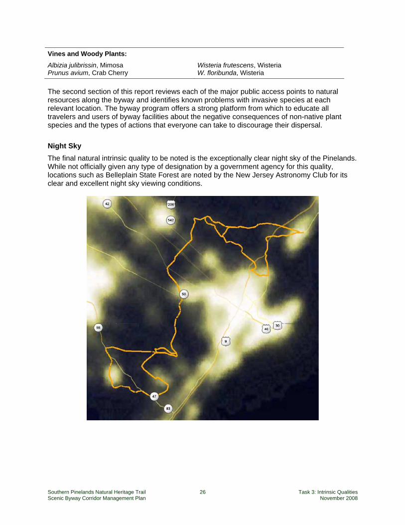
Southern Pinelands Natural Heritage Trail 26 Task 3: Intrinsic Qualities Scenic Byway Corridor Management Plan November 2008
Vines and Woody Plants: Albizia julibrissin, Mimosa Prunus avium, Crab Cherry
Wisteria frutescens, Wisteria W. floribunda, Wisteria
The second section of this report reviews each of the major public access points to natural resources along the byway and identifies known problems with invasive species at each relevant location. The byway program offers a strong platform from which to educate all travelers and users of byway facilities about the negative consequences of non-native plant species and the types of actions that everyone can take to discourage their dispersal.
Night Sky The final natural intrinsic quality to be noted is the exceptionally clear night sky of the Pinelands. While not officially given any type of designation by a government agency for this quality, locations such as Belleplain State Forest are noted by the New Jersey Astronomy Club for its clear and excellent night sky viewing conditions.
Southern Pinelands Natural Heritage Trail 27 Task 3: Intrinsic Qualities Scenic Byway Corridor Management Plan November 2008
3. Recreational Quality Recreational Quality involves outdoor recreational activities directly associated with and dependent upon the natural and cultural elements of the corridor’s landscape. The recreational activities provide opportunities for active and passive recreational experiences. They include, but are not limited to, downhill skiing, rafting, boating, fishing, and hiking. Driving the road itself may qualify as a pleasurable recreational experience. The recreational activities may be seasonal, but the quality and importance of the recreational activities as seasonal operations must be well recognized.
National Scenic Byways Program – Interim Policy The Southern Pinelands Natural Heritage Trail provides access to a wide range of recreational opportunities based on the region’s natural resources and public lands. Primary recreational activities include boating, hiking, camping, birding, bicycling, hunting and fishing.
Visitation and Accessibility No comprehensive figures are available for participation in recreation along the Southern Pinelands Natural Heritage Trail, but visitation figures for several key public land units provide an indication of the area’s significance for nature-based recreation. Table 6 lists annual visitation to the three state forests through which the scenic byway passes. The total at these three state forests represents 11 percent of the total attendance at all New Jersey state parks and state forests (14 percent excluding Liberty State Park opposite Manhattan, which accounts for one quarter of all visitors to New Jersey state parks and forests).
Table 6: State Forest Attendance, July 1, 2005 – June 30, 2006
Southern Pinelands State Forests: Bass River State Forest 113,755 Belleplain State Forest 427,624 Brendan T. Byrne State Forest/Wharton State Forest 1,372,611 Southern Pinelands Total 1,913,990 Total for all New Jersey State Parks and Forests 17,836,548 Source: Fiscal Year 2006 Attendance Report, Division of Parks and Forestry; cited in 2008–2012 New Jersey Statewide Comprehensive Outdoor Recreation Plan (New Jersey Department of Environmental Protection, Green Acres Program, November 2007), Table 8, p. 25. Totals include all areas and historic sites that are assigned to the state forest.
Other visitation figures include the following:
The Edwin P. Forsythe National Wildlife Refuge receives about 200,000 visitors per year.
Batsto Village attracts over 100,000 visitors annually.5 The byway’s recreational significance is enhanced by its proximity to population centers and transportation corridors. Mays Landing, near the midpoint of the byway, is only 30 minutes from Atlantic City, less than an hour from Philadelphia, 1.5 hours from Trenton, and about 2.5 hours from New York City and Baltimore. More than 7 million people reside within 50 miles of the 5 http://www.nj.gov/dca/njht/funded/sitedetails/batsto_village.html.
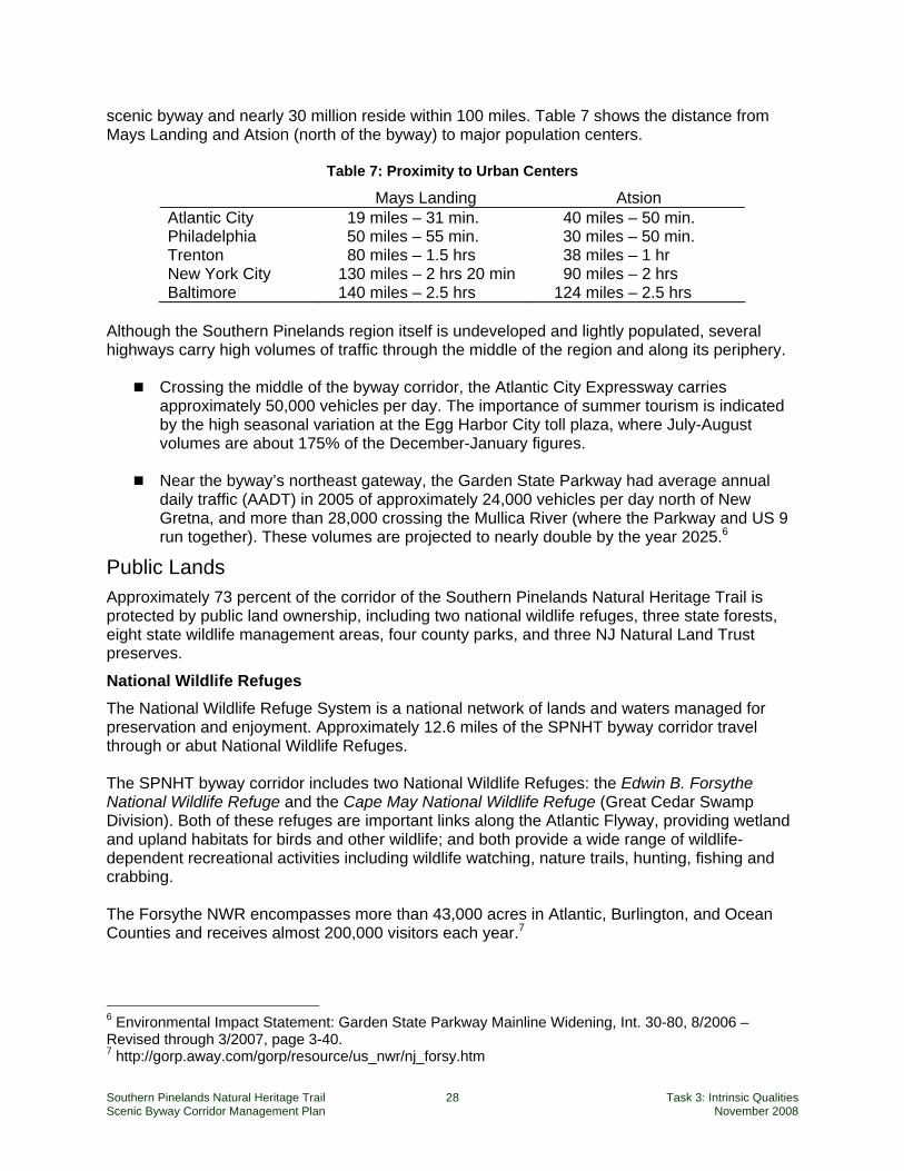
Southern Pinelands Natural Heritage Trail 28 Task 3: Intrinsic Qualities Scenic Byway Corridor Management Plan November 2008
scenic byway and nearly 30 million reside within 100 miles. Table 7 shows the distance from Mays Landing and Atsion (north of the byway) to major population centers.
Table 7: Proximity to Urban Centers
Mays Landing Atsion Atlantic City 19 miles – 31 min. 40 miles – 50 min. Philadelphia 50 miles – 55 min. 30 miles – 50 min. Trenton 80 miles – 1.5 hrs 38 miles – 1 hr New York City 130 miles – 2 hrs 20 min 90 miles – 2 hrs Baltimore 140 miles – 2.5 hrs 124 miles – 2.5 hrs
Although the Southern Pinelands region itself is undeveloped and lightly populated, several highways carry high volumes of traffic through the middle of the region and along its periphery.
Crossing the middle of the byway corridor, the Atlantic City Expressway carries approximately 50,000 vehicles per day. The importance of summer tourism is indicated by the high seasonal variation at the Egg Harbor City toll plaza, where July-August volumes are about 175% of the December-January figures.
Near the byway’s northeast gateway, the Garden State Parkway had average annual
daily traffic (AADT) in 2005 of approximately 24,000 vehicles per day north of New Gretna, and more than 28,000 crossing the Mullica River (where the Parkway and US 9 run together). These volumes are projected to nearly double by the year 2025.6
Public Lands Approximately 73 percent of the corridor of the Southern Pinelands Natural Heritage Trail is protected by public land ownership, including two national wildlife refuges, three state forests, eight state wildlife management areas, four county parks, and three NJ Natural Land Trust preserves.
National Wildlife Refuges The National Wildlife Refuge System is a national network of lands and waters managed for preservation and enjoyment. Approximately 12.6 miles of the SPNHT byway corridor travel through or abut National Wildlife Refuges. The SPNHT byway corridor includes two National Wildlife Refuges: the Edwin B. Forsythe National Wildlife Refuge and the Cape May National Wildlife Refuge (Great Cedar Swamp Division). Both of these refuges are important links along the Atlantic Flyway, providing wetland and upland habitats for birds and other wildlife; and both provide a wide range of wildlife-dependent recreational activities including wildlife watching, nature trails, hunting, fishing and crabbing. The Forsythe NWR encompasses more than 43,000 acres in Atlantic, Burlington, and Ocean Counties and receives almost 200,000 visitors each year.7
6 Environmental Impact Statement: Garden State Parkway Mainline Widening, Int. 30-80, 8/2006 – Revised through 3/2007, page 3-40. 7 http://gorp.away.com/gorp/resource/us_nwr/nj_forsy.htm

Southern Pinelands Natural Heritage Trail 29 Task 3: Intrinsic Qualities Scenic Byway Corridor Management Plan November 2008
The Cape May NWR protects over 1100 acres and provides critical habitat to a wide variety of migratory birds and other wildlife including 317 bird species, 42 mammal species, 55 reptile and amphibian species, and numerous fish, shellfish and other invertebrates. In 1992 the Cape May NWR was designated a Wetland of International Importance under The Convention on Wetlands of International Importance (otherwise known as the Ramsar Convention).8
State Parks and Forests Approximately 154.2 miles of the SPNHT byway corridor cross through or abut state parks, forests, or wildlife management areas. Wharton State Forest is the largest single tract of land in the New Jersey state park system, comprising approximately 110,000 acres of contiguous land in Burlington, Camden and Atlantic Counties. It is the location of the historic Batsto Village, a former bog iron and glass manufac-turing site from 1766 to 1867 as well Crowley’s Landing Recreation Area that offers a boat launch ramp and swimming area along the banks of the Mullica River. Bass River State Forest is comprised of approximately 23,000 acres of non-contiguous land in Bass River Township, Burlington County, with the main entrance and visitor center on Stage Road. Lake Absegami State Recreation area with its 62 acre lake is a state recreation area within the Bass River State Forest. Belleplain State Forest is approximately 15,600 acres of non-contiguous land in Dennis Township, Cape May County. It includes Lake Nummy (a converted Cranberry Bog), a popular swimming, boating, and fishing area.
State Wildlife Management Areas Wildlife Management Areas (WMAs) in New Jersey offer a variety of wildlife-associated recreation within most areas. In addition to hunting and fishing, WMAs are also prime locations for birding, wildlife viewing and photography, cross country skiing, hiking and mountain biking. The Southern Pinelands Natural Heritage Trail abuts portions of or provides access to ten Wildlife Management Areas, listed in Table 8.
8 http://www.fws.gov/northeast/capemay/AboutTheRefuge.html
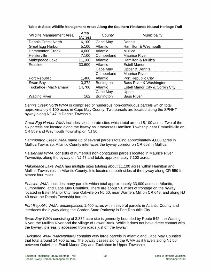
Southern Pinelands Natural Heritage Trail 30 Task 3: Intrinsic Qualities Scenic Byway Corridor Management Plan November 2008
Table 8: State Wildlife Management Areas Along the Southern Pinelands Natural Heritage Trail
Wildlife Management Area Area (Acres) County Municipality
Dennis Creek North 6,100 Cape May Dennis Great Egg Harbor 5,100 Atlantic Hamilton & Weymouth Hammonton Creek 4,000 Atlantic Mullica Heislerville 7,100 Cumberland Maurice River Makepeace Lake 11,100 Atlantic Hamilton & Mullica Peaslee 33,600 Atlantic Estell Manor Cape May Upper & Dennis Cumberland Maurice River Port Republic 1,400 Atlantic Port Republic City Swan Bay 3,372 Burlington Bass River & Washington Tuckahoe (MacNamara) 14,700 Atlantic Estell Manor City & Corbin City Cape May Upper Wading River 162 Burlington Bass River
Dennis Creek North WMA is comprised of numerous non-contiguous parcels which total approximately 6,100 acres in Cape May County. Two parcels are located along the SPNHT byway along NJ 47 in Dennis Township. Great Egg Harbor WMA includes six separate sites which total around 5,100 acres. Two of the six parcels are located along the byway as it traverses Hamilton Township near Emmellsville on CR 559 and Weymouth Township on NJ 50. Hammonton Creek WMA made up of several parcels totaling approximately 4,000 acres in Mullica Township, Atlantic County interfaces the byway corridor on CR 658 in Mullica. Heislerville WMA, consists of numerous non-contiguous parcels located in Maurice River Township, along the byway on NJ 47 and totals approximately 7,100 acres. Makepeace Lake WMA has multiple sites totaling about 11,100 acres within Hamilton and Mullica Townships, in Atlantic County. It is located on both sides of the byway along CR 559 for almost four miles. Peaslee WMA, includes many parcels which total approximately 33,600 acres in Atlantic, Cumberland, and Cape May Counties. There are about 5.6 miles of frontage on the byway located in Estell Manor City near Oakville on NJ 50, near Warners Mill on CR 649, and along NJ 49 near the Dennis Township border. Port Republic WMA, encompasses 1,400 acres within several parcels in Atlantic County and interfaces the byway along the Garden State Parkway in Port Republic City. Swan Bay WMA consisting of 3,372 acre site is generally bounded by Route 542, the Wading River, the Mullica River and the village of Lower Bank. While it does not have direct contact with the byway, it is easily accessed from roads just off the byway. Tuckahoe WMA (MacNamara) contains very large parcels in Atlantic and Cape May Counties that total around 14,700 acres. The byway passes along the WMA as it travels along NJ 50 between Oakville in Estell Manor City and Tuckahoe in Upper Township.
Southern Pinelands Natural Heritage Trail 31 Task 3: Intrinsic Qualities Scenic Byway Corridor Management Plan November 2008
Wading River WMA is a small (162 acres) Management Area along the east bank of the Wading River and extending to Hammonton Road in Bass River Township. It includes the 86 acre Wading River Special Use Area dedicated to youth waterfowing.
New Jersey Natural Lands Trust The New Jersey Natural Lands Trust (NJNLT) is an independent agency within the New Jersey Department of Environmental Protection which acquires open space for preservation in the land’s natural state. The Trust manages properties for conservation and invites passive use of the land by the public where such use does not adversely impact natural resources. Approxi-mately 4.3 miles of the SPNHT byway corridor travel through lands under the protection of the NJNLT in four locations in Atlantic County – Clark’s Landing Preserve and another unnamed property along CR 624 in Galloway Township, John’s Woods Preserve in Hamilton Township (which abuts Weymouth Furnace County Park), and Three Rivers Preserve (which is located within the Atlantic County Park at Lake Lenape).
County Parks Of the five counties the byway travels through, only Atlantic and Ocean County have county parks along its course. Approximately 17.6 miles of the SPNHT byway corridor travels through or abuts county parkland. Stanley “Tip” Seaman County Park, the sole Ocean County Park on the byway, lies on the southern shore of Lake Pohatcong in Tuckerton Borough. This 22-acre recreational park is widely known as the site of the Ocean County Decoy and Gunning Show, now in its 26th year. This nationally-acclaimed event highlights the working decoy and the South Jersey waterfowling heritage. The park is located on Route 9. The extensive Atlantic County park system abuts portions of the byway alignment, offering historic and archaeological sites as well as opportunities for nature walks, picnicking, boating, canoeing, swimming and camping. Cabins can also be rented at the Atlantic County park at Lake Lenape (Mays Landing, Hamilton Township). Atlantic County operates three county parks along the SPNHT byway, consisting of seven areas which are listed and briefly described as follows: Weymouth Furnace County Park, located along the byway on Weymouth Road (Route 559) in Hamilton Township is approximately 11 acres in size, though it is bounded by two other public open spaces and a private space open to the public. People visit the park site, primarily, to see the ruins of the mill buildings and their foundations, which are the remains of an early industrial center, and/or as a popular starting point for canoeing on the Great Egg Harbor River. Atlantic County Park at Lake Lenape, located in Mays Landing is the largest site in the County Park system, encompassing 1921 acres of land and the entire surface of Lake Lenape. The Park is bordered on its west by the Great Egg Harbor Wildlife Management Area. In addition to a wide array of recreational activities, the park protects a major portion of the “Wild and Scenic” Great Egg Harbor River. Contained within a part of the park is privately-owned Three Rivers Reserve. Estell Manor County Park is located in Estell Manor City with 1,714 acres of land and a small amount of frontage on the Great Egg Harbor National and Scenic River. There are many trails, athletic fields, and picnic areas as well the Warren Fox Nature Center and a former glassworks
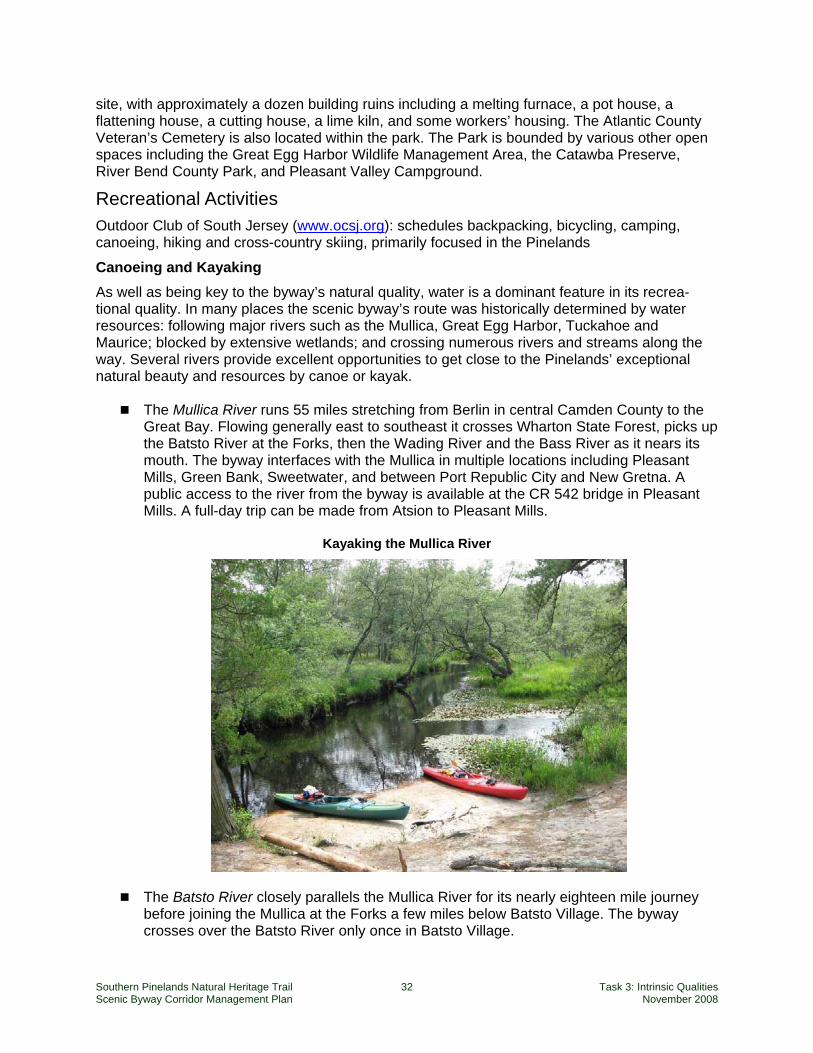
Southern Pinelands Natural Heritage Trail 32 Task 3: Intrinsic Qualities Scenic Byway Corridor Management Plan November 2008
site, with approximately a dozen building ruins including a melting furnace, a pot house, a flattening house, a cutting house, a lime kiln, and some workers’ housing. The Atlantic County Veteran’s Cemetery is also located within the park. The Park is bounded by various other open spaces including the Great Egg Harbor Wildlife Management Area, the Catawba Preserve, River Bend County Park, and Pleasant Valley Campground.
Recreational Activities Outdoor Club of South Jersey (www.ocsj.org): schedules backpacking, bicycling, camping, canoeing, hiking and cross-country skiing, primarily focused in the Pinelands
Canoeing and Kayaking As well as being key to the byway’s natural quality, water is a dominant feature in its recrea-tional quality. In many places the scenic byway’s route was historically determined by water resources: following major rivers such as the Mullica, Great Egg Harbor, Tuckahoe and Maurice; blocked by extensive wetlands; and crossing numerous rivers and streams along the way. Several rivers provide excellent opportunities to get close to the Pinelands’ exceptional natural beauty and resources by canoe or kayak.
The Mullica River runs 55 miles stretching from Berlin in central Camden County to the Great Bay. Flowing generally east to southeast it crosses Wharton State Forest, picks up the Batsto River at the Forks, then the Wading River and the Bass River as it nears its mouth. The byway interfaces with the Mullica in multiple locations including Pleasant Mills, Green Bank, Sweetwater, and between Port Republic City and New Gretna. A public access to the river from the byway is available at the CR 542 bridge in Pleasant Mills. A full-day trip can be made from Atsion to Pleasant Mills.
Kayaking the Mullica River
The Batsto River closely parallels the Mullica River for its nearly eighteen mile journey before joining the Mullica at the Forks a few miles below Batsto Village. The byway crosses over the Batsto River only once in Batsto Village.
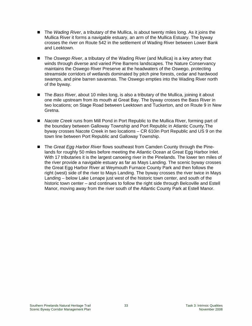
Southern Pinelands Natural Heritage Trail 33 Task 3: Intrinsic Qualities Scenic Byway Corridor Management Plan November 2008
The Wading River, a tributary of the Mullica, is about twenty miles long. As it joins the Mullica River it forms a navigable estuary, an arm of the Mullica Estuary. The byway crosses the river on Route 542 in the settlement of Wading River between Lower Bank and Leektown.
The Oswego River, a tributary of the Wading River (and Mullica) is a key artery that
winds through diverse and varied Pine Barrens landscapes. The Nature Conservancy maintains the Oswego River Preserve at the headwaters of the Oswego, protecting streamside corridors of wetlands dominated by pitch pine forests, cedar and hardwood swamps, and pine barren savannas. The Oswego empties into the Wading River north of the byway.
The Bass River, about 10 miles long, is also a tributary of the Mullica, joining it about
one mile upstream from its mouth at Great Bay. The byway crosses the Bass River in two locations; on Stage Road between Leektown and Tuckerton, and on Route 9 in New Gretna.
Nacote Creek runs from Mill Pond in Port Republic to the Mullica River, forming part of
the boundary between Galloway Township and Port Republic in Atlantic County.The byway crosses Nacote Creek in two locations – CR 610in Port Republic and US 9 on the town line between Port Republic and Galloway Township.
The Great Egg Harbor River flows southeast from Camden County through the Pine-
lands for roughly 50 miles before meeting the Atlantic Ocean at Great Egg Harbor Inlet. With 17 tributaries it is the largest canoeing river in the Pinelands. The lower ten miles of the river provide a navigable estuary as far as Mays Landing. The scenic byway crosses the Great Egg Harbor River at Weymouth Furnace County Park and then follows the right (west) side of the river to Mays Landing. The byway crosses the river twice in Mays Landing – below Lake Lenape just west of the historic town center, and south of the historic town center – and continues to follow the right side through Belcoville and Estell Manor, moving away from the river south of the Atlantic County Park at Estell Manor.
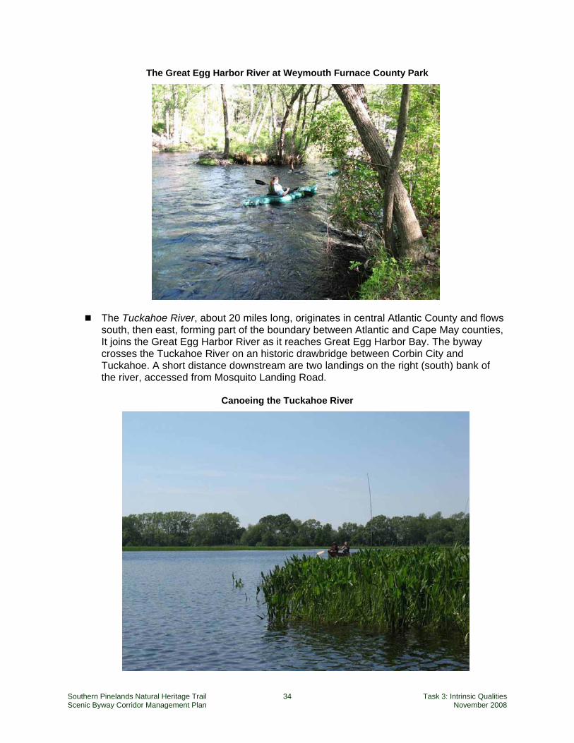
Southern Pinelands Natural Heritage Trail 34 Task 3: Intrinsic Qualities Scenic Byway Corridor Management Plan November 2008
The Great Egg Harbor River at Weymouth Furnace County Park
The Tuckahoe River, about 20 miles long, originates in central Atlantic County and flows south, then east, forming part of the boundary between Atlantic and Cape May counties, It joins the Great Egg Harbor River as it reaches Great Egg Harbor Bay. The byway crosses the Tuckahoe River on an historic drawbridge between Corbin City and Tuckahoe. A short distance downstream are two landings on the right (south) bank of the river, accessed from Mosquito Landing Road.
Canoeing the Tuckahoe River
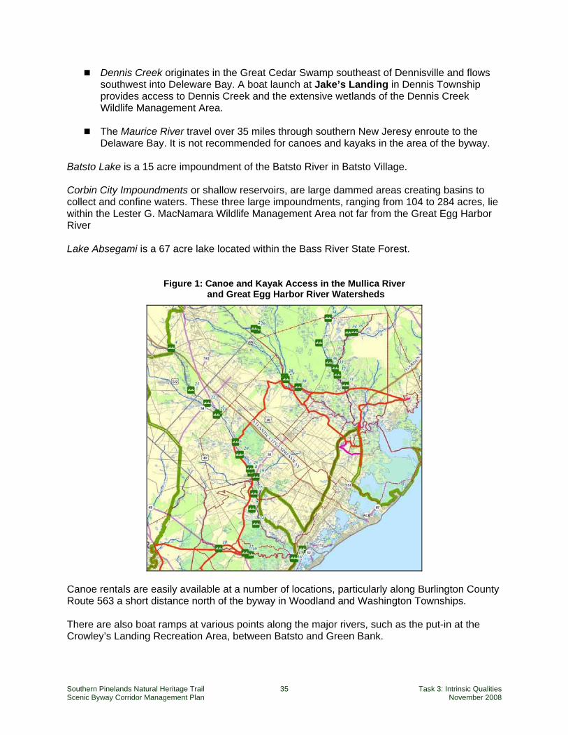
Southern Pinelands Natural Heritage Trail 35 Task 3: Intrinsic Qualities Scenic Byway Corridor Management Plan November 2008
Dennis Creek originates in the Great Cedar Swamp southeast of Dennisville and flows southwest into Deleware Bay. A boat launch at Jake’s Landing in Dennis Township provides access to Dennis Creek and the extensive wetlands of the Dennis Creek Wildlife Management Area.
The Maurice River travel over 35 miles through southern New Jeresy enroute to the
Delaware Bay. It is not recommended for canoes and kayaks in the area of the byway. Batsto Lake is a 15 acre impoundment of the Batsto River in Batsto Village. Corbin City Impoundments or shallow reservoirs, are large dammed areas creating basins to collect and confine waters. These three large impoundments, ranging from 104 to 284 acres, lie within the Lester G. MacNamara Wildlife Management Area not far from the Great Egg Harbor River Lake Absegami is a 67 acre lake located within the Bass River State Forest.
Figure 1: Canoe and Kayak Access in the Mullica River and Great Egg Harbor River Watersheds
Canoe rentals are easily available at a number of locations, particularly along Burlington County Route 563 a short distance north of the byway in Woodland and Washington Townships. There are also boat ramps at various points along the major rivers, such as the put-in at the Crowley’s Landing Recreation Area, between Batsto and Green Bank.
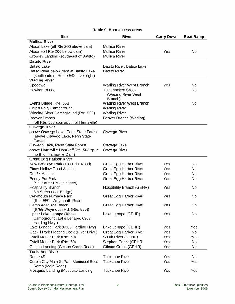
Southern Pinelands Natural Heritage Trail 36 Task 3: Intrinsic Qualities Scenic Byway Corridor Management Plan November 2008
Table 9: Boat access areas
Site River Carry Down Boat Ramp Mullica River Atsion Lake (off Rte 206 above dam) Mullica River Atsion (off Rte 206 below dam) Mullica River Yes No Crowley Landing (southeast of Batsto) Mullica River Batsto River Batsto Lake Batsto River, Batsto Lake Batso River below dam at Batsto Lake
(south side of Route 542, river right) Batsto River
Wading River Speedwell Wading River West Branch Yes No Hawken Bridge Tulpehocken Creek
(Wading River West Branch)
No
Evans Bridge, Rte. 563 Wading River West Branch No Chip's Folly Campground Wading River Winding River Campground (Rte. 559) Wading River Beaver Branch
(off Rte. 563 spur south of Harrisville) Beaver Branch (Wading)
Oswego River above Oswego Lake, Penn State Forest
(above Oswego Lake, Penn State Forest)
Oswego River
Oswego Lake, Penn State Forest Oswego Lake above Harrisville Dam (off Rte. 563 spur
north of Harrisville Dam) Oswego River
Great Egg Harbor River New Brooklyn Park (100 Erial Road) Great Egg Harbor River Yes No Piney Hollow Road Access Great Egg Harbor River Yes No Rte 54 Access Great Egg Harbor River Yes No Penny Pot Park
(Spur of 561 & 8th Street) Great Egg Harbor River Yes No
Hospitality Branch 8th Street near Bridge)
Hospitality Branch (GEHR) Yes No
Weymouth Furnace Park (Rte. 559 - Weymouth Road)
Great Egg Harbor River Yes No
Camp Acagisca Beach (6755 Weymouth Rd. (Rte. 559))
Great Egg Harbor River Yes No
Upper Lake Lenape (Above Campground, Lake Lenape, 6303 Harding Hwy.)
Lake Lenape (GEHR) Yes No
Lake Lenape Park (6303 Harding Hwy) Lake Lenape (GEHR) Yes Yes Gaskill Park Floating Dock (River Drive) Great Egg Harbor River Yes No Estell Manor Park (Rte. 50) South River (GEHR) Yes Yes Estell Manor Park (Rte. 50) Stephen Creek (GEHR) Yes No Gibson Landing (Gibson Creek Road) Gibson Creek (GEHR) Yes No Tuckahoe River Route 49 Tuckahoe River Yes No Corbin City Main St Park Municipal Boat
Ramp (Main Road) Tuckahoe River Yes Yes
Mosquito Landing (Mosquito Landing Tuckahoe River Yes Yes
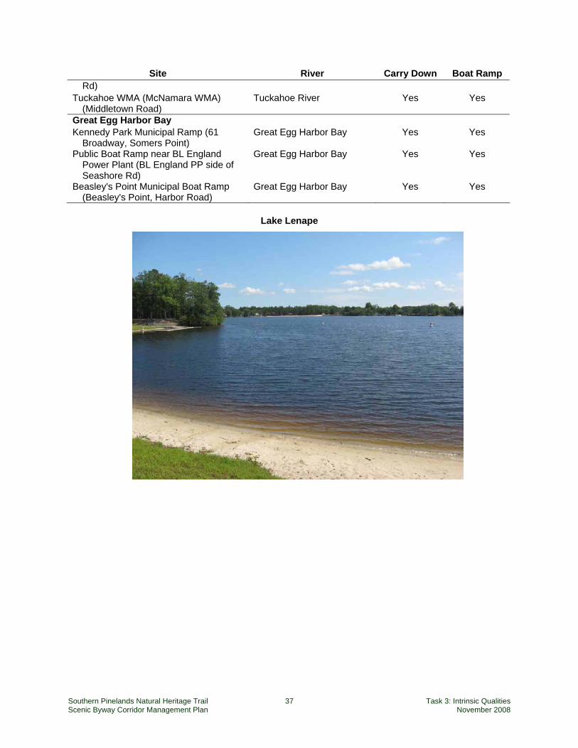
Southern Pinelands Natural Heritage Trail 37 Task 3: Intrinsic Qualities Scenic Byway Corridor Management Plan November 2008
Site River Carry Down Boat Ramp Rd)
Tuckahoe WMA (McNamara WMA) (Middletown Road)
Tuckahoe River Yes Yes
Great Egg Harbor Bay Kennedy Park Municipal Ramp (61
Broadway, Somers Point) Great Egg Harbor Bay Yes Yes
Public Boat Ramp near BL England Power Plant (BL England PP side of Seashore Rd)
Great Egg Harbor Bay Yes Yes
Beasley's Point Municipal Boat Ramp (Beasley's Point, Harbor Road)
Great Egg Harbor Bay Yes Yes
Lake Lenape
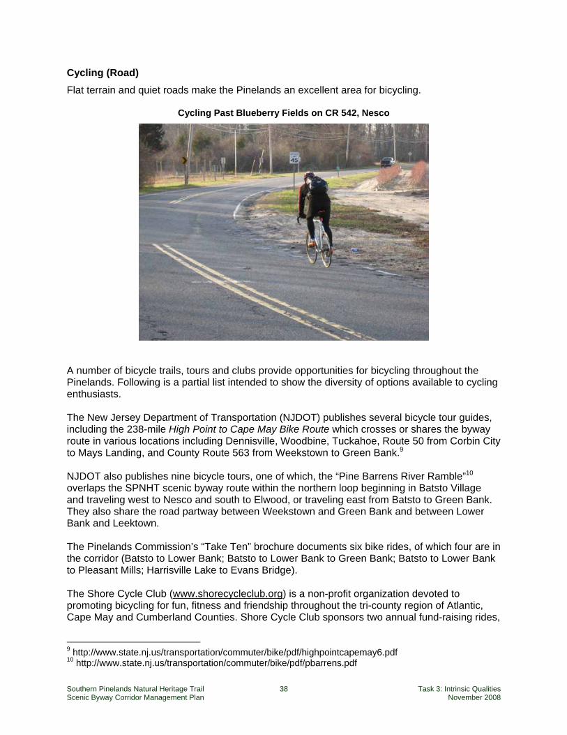
Southern Pinelands Natural Heritage Trail 38 Task 3: Intrinsic Qualities Scenic Byway Corridor Management Plan November 2008
Cycling (Road) Flat terrain and quiet roads make the Pinelands an excellent area for bicycling.
Cycling Past Blueberry Fields on CR 542, Nesco
A number of bicycle trails, tours and clubs provide opportunities for bicycling throughout the Pinelands. Following is a partial list intended to show the diversity of options available to cycling enthusiasts. The New Jersey Department of Transportation (NJDOT) publishes several bicycle tour guides, including the 238-mile High Point to Cape May Bike Route which crosses or shares the byway route in various locations including Dennisville, Woodbine, Tuckahoe, Route 50 from Corbin City to Mays Landing, and County Route 563 from Weekstown to Green Bank.9 NJDOT also publishes nine bicycle tours, one of which, the “Pine Barrens River Ramble”10 overlaps the SPNHT scenic byway route within the northern loop beginning in Batsto Village and traveling west to Nesco and south to Elwood, or traveling east from Batsto to Green Bank. They also share the road partway between Weekstown and Green Bank and between Lower Bank and Leektown. The Pinelands Commission’s “Take Ten” brochure documents six bike rides, of which four are in the corridor (Batsto to Lower Bank; Batsto to Lower Bank to Green Bank; Batsto to Lower Bank to Pleasant Mills; Harrisville Lake to Evans Bridge). The Shore Cycle Club (www.shorecycleclub.org) is a non-profit organization devoted to promoting bicycling for fun, fitness and friendship throughout the tri-county region of Atlantic, Cape May and Cumberland Counties. Shore Cycle Club sponsors two annual fund-raising rides,
9 http://www.state.nj.us/transportation/commuter/bike/pdf/highpointcapemay6.pdf 10 http://www.state.nj.us/transportation/commuter/bike/pdf/pbarrens.pdf
Southern Pinelands Natural Heritage Trail 39 Task 3: Intrinsic Qualities Scenic Byway Corridor Management Plan November 2008
both based on the Southern Pinelands Natural Heritage Trail and including much of the scenic byway route:
- Jerry Hanclich Pinelands Triple Loop (May): “an early season century ride through the flat and scenic New Jersey Pinelands. The ride starts and ends at beautiful historic Batsto Village Park where rest room facilities and ample free parking are available. The ride consists of three (3) individual loops: Loop # 1 - 36 miles, Loop # 2 - 29 miles, and Loop # 3 - 35 miles. You can ride 1, 2 or all 3 loops to ride up to 100 miles.” (http://www.shorecycleclub.org/pinelands.htm).
- Belleplain Fall Century (October): “a late season century ride through the flat and scenic
southern New Jersey forests and small towns. The ride has two separate loops that start and end at Belleplain State Forest. You can wind your way through Cape May and Cumberland counties and rest at the scenic East Point Lighthouse on the Delaware Bay. The morning loop has a 35 or a 50 mile loop. The afternoon loop has a 28 or a 50 mile loop. The two loops can be combined for a Metric Century (63 mi.) or a Full Century (100 mi.)” (http://www.shorecycleclub.org/belleplain.htm).
The Atlantic County Bikeway, part of the Atlantic County Park System, uses 7.6 miles of abandoned rail corridor of the Pennsylvania-Reading Seashore Lines. The ten-foot wide trail has two-foot shoulders and an asphalt surface meant for both bicyclists and pedestrians. It runs between the Shore Mall in Egg Harbor Township to the Atlantic County Vocational Technical School in Mays Landing in Hamilton Township and has a trailhead parking area at each end as well as one at English Creek Avenue in Egg Harbor Township. There are plans for extending the bikeway west to the Cumberland County Line, running between Gaskill Park in Mays Landing to an area near the Buena Vista Campground in Buena Vista.
Additional bike routes along the byway corridor and throughout the state can be found on www.njbikemap.com.
Off-Road Biking Off-road biking takes place along the byway within some publicly owned lands and likely along unposted public or private sand roads throughout the Pinelands as well. While trails, both official and unofficial cover hundreds of miles around the byway, the partial listing below highlights some of the most known and frequently used. Belleplain State Forest hosts 40 miles of trails, each marked with signs indicating its designated use, including a 15 mile route that includes paved and unpaved roads and parts of several trails which connects Lake Nummy with East Creek Pond Wharton State Forest includes miles of unpaved roads for mountain biking as well as a new eighteen plus miles long Batsto Penn Creek Off-Road Bicycle Trail. The Penn Creek Trail extends the nested Batsto Fire Tower Trail for a long singletrack bike/hike only loop. Estell Manor Park welcomes bicycling on all its trails (except the Swamp Trail Boardwalk) and will even lend a bike for free at the Nature Center. The properties along the byway owned and managed by the New Jersey Natural Lands Trust including Clark’s Landing Preserve and another unnamed property along CR 624 in Galloway Township, John’s Woods Preserve in Hamilton Township (which abuts Weymouth Furnace
Southern Pinelands Natural Heritage Trail 40 Task 3: Intrinsic Qualities Scenic Byway Corridor Management Plan November 2008
County Park), and Three Rivers Preserve (which is located within the Atlantic County Park at Lake Lenape) welcome bicycling on its preserves where it does not conflict with sensitive ecological areas. The Trust does not have marked or maintained trails at these preserves but old woods roads or similar unmarked trail features are used. Off-road biking is advocated for by a number of bicycle organizations dedicated to the sport and key to advancing the development and publication of trails. Two such organizations are the Jersey Off Road Bicycle Association and the Jersey Action Riders. The Jersey Off Road Bicycle Association (JORBA), formed in 1999, is a non-profit organization dedicated to serving off road cyclists within the trail user community. It is an educational and charitable entity, organized to encourage volunteerism and responsibility, and advocate and foster off-road cycling as a healthy, environmentally sound, and sustainable activity. The Jersey Action Riders (J.A.R.), a local chapter of JOBRA, is a social and recreational mountain bike club based in southern New Jersey. In addition to their scheduled rides they offer beginner riding clinics and bike/camping trips. They are also active in trail marking and maintenance programs including one at Wharton State Forest.
Hiking Hiking, one of the most popular recreational pursuits in the region’s parks and natural areas, will provide the hiker with unlimited opportunities to observe a diversity of ecosystems and wildlife. Again, what follows is a sample of the region’s trails, condensed to give an overview of the breath of experiences available. The Batona Trail (“BAck TO NAture”) is a 50-mile hiking trail linking Bass River, Wharton and Brendan Byrne (Lebanon) State Forests. All but four miles of the Trail is within these three state forests. The southern trailhead is in Bass River State Forest on Stage Road, about one-half mile west of the Southern Pinelands Natural Heritage Trail scenic byway. From the trailhead, the trail heads north through Bass River State Forest to Beaver Branch, then bears west crossing the Wading River at Evans Bridge on County Route 563, and continues west to Batsto, where it turns north. This southerly leg of the trail represents about 18 miles, or about 36 percent of the total trail length. Along the Southern Pinelands Natural Heritage Trail scenic byway, designated access and parking for the Batona Trail include the State Forest Office at Batsto and at the southern trailhead, at the recreation area in Bass River State Forest. Permitted uses along the trail are hiking, backpacking, nature observation and cross country skiing (horseback riding and biking are permitted where the trail merges with sand roads in state forests).11 Bass River State Forest has eight easy walking (non-ADA accessible) trails from 1 to 3.2 miles. The 1/2 mile self-guided Absegami Trail includes a wooden foot bridge with benches. All trails start at the second parking lot at the beach. Animals, birds and plant life of the Pine Barrens may be found. A trail brochure is available at the office, or on the portion of the Pink Trail that passes through the old Civilian Conservation Corps camp near East Greenbush Road. This guide describes the camp foundations.12
11 http://members.aol.com/batona/BatonaTrailGuide.html 12 http://www.state.nj.us/dep/parksandforests/parks/bass.html#trails
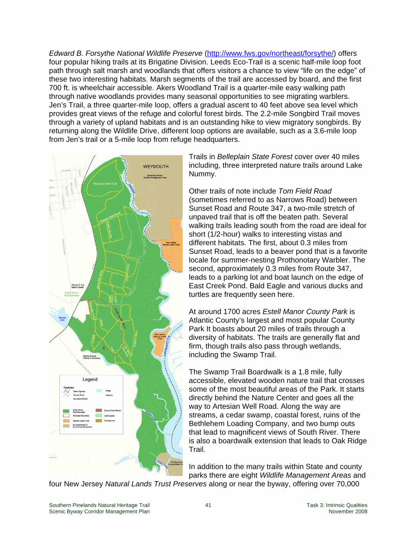
Southern Pinelands Natural Heritage Trail 41 Task 3: Intrinsic Qualities Scenic Byway Corridor Management Plan November 2008
Edward B. Forsythe National Wildlife Preserve (http://www.fws.gov/northeast/forsythe/) offers four popular hiking trails at its Brigatine Division. Leeds Eco-Trail is a scenic half-mile loop foot path through salt marsh and woodlands that offers visitors a chance to view “life on the edge” of these two interesting habitats. Marsh segments of the trail are accessed by board, and the first 700 ft. is wheelchair accessible. Akers Woodland Trail is a quarter-mile easy walking path through native woodlands provides many seasonal opportunities to see migrating warblers. Jen’s Trail, a three quarter-mile loop, offers a gradual ascent to 40 feet above sea level which provides great views of the refuge and colorful forest birds. The 2.2-mile Songbird Trail moves through a variety of upland habitats and is an outstanding hike to view migratory songbirds. By returning along the Wildlife Drive, different loop options are available, such as a 3.6-mile loop from Jen’s trail or a 5-mile loop from refuge headquarters.
Trails in Belleplain State Forest cover over 40 miles including, three interpreted nature trails around Lake Nummy. Other trails of note include Tom Field Road (sometimes referred to as Narrows Road) between Sunset Road and Route 347, a two-mile stretch of unpaved trail that is off the beaten path. Several walking trails leading south from the road are ideal for short (1/2-hour) walks to interesting vistas and different habitats. The first, about 0.3 miles from Sunset Road, leads to a beaver pond that is a favorite locale for summer-nesting Prothonotary Warbler. The second, approximately 0.3 miles from Route 347, leads to a parking lot and boat launch on the edge of East Creek Pond. Bald Eagle and various ducks and turtles are frequently seen here. At around 1700 acres Estell Manor County Park is Atlantic County’s largest and most popular County Park It boasts about 20 miles of trails through a diversity of habitats. The trails are generally flat and firm, though trails also pass through wetlands, including the Swamp Trail. The Swamp Trail Boardwalk is a 1.8 mile, fully accessible, elevated wooden nature trail that crosses some of the most beautiful areas of the Park. It starts directly behind the Nature Center and goes all the way to Artesian Well Road. Along the way are streams, a cedar swamp, coastal forest, ruins of the Bethlehem Loading Company, and two bump outs that lead to magnificent views of South River. There is also a boardwalk extension that leads to Oak Ridge Trail. In addition to the many trails within State and county parks there are eight Wildlife Management Areas and
four New Jersey Natural Lands Trust Preserves along or near the byway, offering over 70,000
Southern Pinelands Natural Heritage Trail 42 Task 3: Intrinsic Qualities Scenic Byway Corridor Management Plan November 2008
combined acres of hiking opportunities. Hiking in these areas can be along access roads, unmarked trails or throughout the woods with the use of a compass, GPS, or other way finding device. Before hiking in Wildlife Management Areas or Trust Preserves, hikers should familiarize themselves with the terrain, hunting seasons, restricted regions, and other site regulations or constraints.
Camping Camping is available in state forests, a number of county parks and within commercial facilities along the byway. Belleplain State Forest provides a range of options for camping. The Lake Nummy Recreation Area has 169 tent and trailer sites, two group sites accommodating up to 75 people each, 14 lean-tos (up to six people each), and four yurts (up to four people each). There is also a group cabin on the shore of East Creek Pond.13 Bass River State Forest has 176 tent and trailer sites for up to six persons, six group sites for up to 25 persons, and nine lean-tos for up to six persons. There are also six seasonal lakeside shelters (up to 4 people each) and six lake front cabins (up to 6 people each).14 Wharton State Forest accommodates campers at multiple sites and with a range of amenities. The Atsion campsites contain 50 tent and trailer sites with fire rings and picnic tables. Potable water, flush toilets and showers are within walking distance. Godfrey Bridge holds another 49 tent and trailer sites (21 feet or less) with water, picnic tables, fire rings and pit toilets. Primitive campsites are at Bodine Field, Hawkins Bridge, Batona, Mullica River and Goshen Pond. Each has hand pumps for water and pit toilets. Buttonwood Hill and Lower Forge sites have no water. Mullica River and Lower Forge can only be accessed by hiking, canoeing or horseback; motor vehicles are not permitted. All other areas are accessible by motor vehicles. Wharton State Forest also maintains nine furnished cabins on Atsion Lake, each with screened porch, fireplace, refrigerator, hot and cold running water, and a bathroom with toilet and shower. All cabins are designed for people with disabilities and accommodate between four to eight people.15 The Atlantic County Park system has three units with camping facilities along the scenic byway. The Camp Acagisca camping area has three group sites (up to 20 people each) and eight platform tents (for six to ten people) that are available seasonally. Estell Manor Park has eight sites for up to six people, and one group site for up to 20 people. Lake Lenape Park has 18 sites for up to six people. Private, commercial campgrounds are also abundant along the byway corridor offering camping sites that range from the most basic to full amenities, and including cabins with the same diversity of services and facilities.
Hunting and Fishing Hunting and fishing in the Pinelands are activities that have gone hand in hand with human habitation throughout the region’s history. Shell middens attest to the area’s early fishing history,
13 http://www.state.nj.us/dep/parksandforests/parks/belle.html 14 http://www.state.nj.us/dep/parksandforests/parks/bass.html 15 http://www.state.nj.us/dep/parksandforests/parks/wharton.html#camp
Southern Pinelands Natural Heritage Trail 43 Task 3: Intrinsic Qualities Scenic Byway Corridor Management Plan November 2008
and the composition itself of the Pine Barren forest found by the European settlers was considered to be modified and shaped by the native American inhabitants who regularly burned the woods to facilitate their hunting, leaving many upland sites, dominated by large pines with little undergrowth. Whereas, historically the harvesting of the areas wildlife was for sustenance, today it is primarily for recreation. Four State Wildlife Management Areas, totaling over 70,000 acres can be found around the Southern Pinelands Natural Heritage Trail. This state system of protected lands is administered by the Division of Fish and Wildlife's Bureau of Land Management and is specifically managed to enhance wildlife populations and provide for wildlife-oriented recreation for New Jersey residents and visitors from out of state. In its early years, Wildlife Management Area lands were purchased entirely by funds from the sale of hunting and fishing licenses. Since the 1960’s funding has diversified, and so too has the mission of the Wildlife Manage Areas system, broadening from “Public Shooting and Fishing Grounds" to areas where fish and wildlife habitat is protected and enhanced, while providing a variety of compatible recreational and educational opportunities. The following public lands are open to hunting along the SPNHT. Wildlife Management Areas
Dennis Creek Gibson Creek Great Egg Harbor River Heislerville
Makepeace Peaslee Port Republic
Swan Bay Tuckahoe (Macnamara) Wading River
State Forests
Bass River Belleplain Wharton
National Wildlife Refuges Cape May NWR Edward B. Forsythe NWR
Table 10 lists ponds, lakes and reservoirs with public access and a good population of desirable species available.
Southern Pinelands Natural Heritage Trail 44 Task 3: Intrinsic Qualities Scenic Byway Corridor Management Plan November 2008
Table 10: Ponds, Lakes and Reservoirs for Fishing16
Water Body
Nearest Byway Town
Area (acres)
Car Top Launch
Boat Ramp
Outboard Allowed
Park
Batsto Lake Batsto 40 Y N E Batsto Natural Area (Wharton SF)
East Creek Pond Eldora 62 Y N E Belleplain SF Egg Harbor City Lake
Egg Harbor City 30 N N N
Lake Absegami Tuckerton, New Gretna
63 Y N E Bass River SF
Lake Lenape Mays Landing 350 Y Y L Lake Lenape County Park
Lake Nummy Woodbine 26 Y N E Belleplain SF Makepeace Lake Elwood 300 Y N E Makepeace
Lake WMA Maple Lake Estell Manor 35 Y N N Maple Lake
WMA Mill Pond Port Republic 32 Y N E Pohatcong Lake Tuckerton 33 N N N Tuckahoe Lake Tuckahoe 10 Y N E Tuckahoe WMA
E = Electric outboards only L = limited to 10 hp maximum Table 11 is a partial listing of rivers that offer fishing opportunities and are easily accessible from along or near the byway.
Table 11: Rivers for Fishing17
River Area Length (mi.) Ave. Width (ft.) Batsto River Wharton State Forest 5.0 30 Manumuskin River Manumuskin River Preserve 4.2 20 Mullica River Wharton State Forest 14.0 150 Oswego River Wharton State Forest 2.5 30 Wading River Wharton State Forest 4.3 30
Bird and Wildlife Watching
Bird and Wildlife Watching is a rapidly growing recreational activity which based on some survey results involves over 40% of the adult U.S. population. While bird and wildlife watching activities can range from watching birds and squirrels in back yards or urban decks to taking trips to the remote forests across the globe, according to the New Jersey Department of Environmental Protection the money spent on travel, lodging, food and equipment associated with this activity contributes nearly 20 billion dollars to the national economy.
New Jersey is looking to capitalize on the significance of this growing recreational pursuit with its Wildlife Diversity Tours / Watchable Wildlife projects, undertaken by the DEPs Division of Fish and Wildlife. Coordinated by the Endangered and Non-game Species Program, the division has created the New Jersey Wildlife Viewing Guide (1997) which lists the state’s best sites for wildlife viewing including sites proximal to the byway. 16 NJDEP Division of Fish and Wildlife, “Places to Fish: Ponds, Lakes and Reservoirs,” http://www.state.nj.us/dep/fgw/fishplc.htm 17 NJDEP Division of Fish and Wildlife, “Places to Fish: Rivers and Streams,” http://www.state.nj.us/dep/fgw/fishstrm.htm
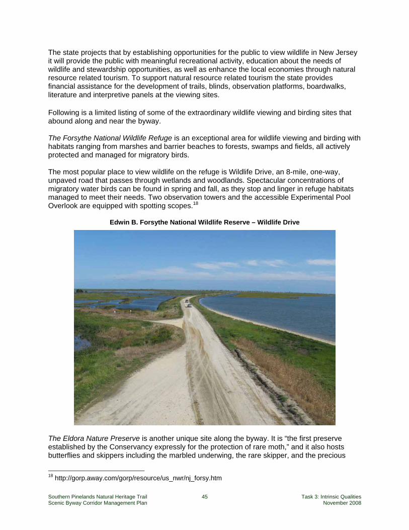
Southern Pinelands Natural Heritage Trail 45 Task 3: Intrinsic Qualities Scenic Byway Corridor Management Plan November 2008
The state projects that by establishing opportunities for the public to view wildlife in New Jersey it will provide the public with meaningful recreational activity, education about the needs of wildlife and stewardship opportunities, as well as enhance the local economies through natural resource related tourism. To support natural resource related tourism the state provides financial assistance for the development of trails, blinds, observation platforms, boardwalks, literature and interpretive panels at the viewing sites.
Following is a limited listing of some of the extraordinary wildlife viewing and birding sites that abound along and near the byway. The Forsythe National Wildlife Refuge is an exceptional area for wildlife viewing and birding with habitats ranging from marshes and barrier beaches to forests, swamps and fields, all actively protected and managed for migratory birds. The most popular place to view wildlife on the refuge is Wildlife Drive, an 8-mile, one-way, unpaved road that passes through wetlands and woodlands. Spectacular concentrations of migratory water birds can be found in spring and fall, as they stop and linger in refuge habitats managed to meet their needs. Two observation towers and the accessible Experimental Pool Overlook are equipped with spotting scopes.18
Edwin B. Forsythe National Wildlife Reserve – Wildlife Drive
The Eldora Nature Preserve is another unique site along the byway. It is “the first preserve established by the Conservancy expressly for the protection of rare moth,” and it also hosts butterflies and skippers including the marbled underwing, the rare skipper, and the precious
18 http://gorp.away.com/gorp/resource/us_nwr/nj_forsy.htm
Southern Pinelands Natural Heritage Trail 46 Task 3: Intrinsic Qualities Scenic Byway Corridor Management Plan November 2008
underwing. Trails lead through pine-oak woodlands and marsh edges, an old orchard, and open upland fields. Bald eagles and other raptors winter at the preserve, and migrating songbirds and hawks rest and feed in the woods each spring and fall. Grassland birds such as grasshopper and vesper sparrows find habitat in the preserve’s open fields.
River crossings on the byway sometimes offer an opportunity to view some magnificent wildlife. The New Jersey Department of Environmental Protection has confirmed that there is a bald eagle nesting site in the vicinity of the Wading River bridge on Burlington County Route 542 (Washington and Bass River Townships) and that eagle sightings are not unusual, especially in the winter months. New Jersey Audubon is expanding its IBA (Important Bird Area) program into the Important Bird and Birding Area (IBBA) Program, to identify “both sites that are essential for sustaining native bird populations (IBAs), and areas that are exceptional for birdwatching (Important Birding Areas).”19 As discussed above, there are eleven IBA sites along the SPNHT byway, however, only one of those has been identified as an IBBA – the Edwin B. Forsythe National Wildlife Refuge.
Scenic Railroad Trains first started steaming into Atlantic City in 1854 when the Atlantic City Railroad was completed by Reading Railroad. Rail access and ridership increased steadily and by 1901 competition between the West Jersey and Seashore and the Atlantic City Railroad incited competitions between the two lines to be the first to reach their destinations. On the Cape May lines, the trains were in sight of each other for eleven miles between Cape May Court House and Cape May and over the last five miles to Cape May the tracks were only fifty feet apart. However by the 1920’s rail travel had passed its golden years and ridership began to decline forcing the two competitors to merge in June of 1933, creating the Pennsylvania-Reading Seashore Lines. In 1976 Conrail took control of the struggling Pennsylvania-Reading Seashore Lines along with several other small railroads of South Jersey. By 1981 passenger service to Cape May was discontinued and the last freight train ran to Cape May Point on in 1983.
The story of rail travel, however, did not end there. In January 1984, Tony Macrie, a private investor, entered into a long-term lease agreement with the New Jersey Transit Corp to operate trains on the 27 miles of dormant track. Twelve years later, after millions of dollars of private and public investment, service between Cold Spring and Cape May Courthouse become a reality.
Today, the Cape May Seashore Line operates trains over thirteen beautiful miles of track between Cape May Courthouse and Cape May City, as well as thirty miles between the villages of Richland and Tuckahoe. In addition to its regularly scheduled services, the Cape May Seashore Line offers charter excursions and special event rides including foliage tours, an afternoon wine and a Santa express.
19 http://www.njaudubon.org/Conservation/IBBA/Process.html (accessed 7/21/2008).
Southern Pinelands Natural Heritage Trail 47 Task 3: Intrinsic Qualities Scenic Byway Corridor Management Plan November 2008
4. Historic Quality Historic Quality encompasses legacies of the past that are distinctly associated with physical elements of the landscape, whether natural or manmade, that are of such historic significance that they educate the viewer and stir an appreciation for the past. The historic elements reflect the actions of people and may include buildings, settlement patterns, and other examples of human activity. Historic features can be inventoried, mapped, and interpreted. They possess integrity of location, design, setting, material, workmanship, feeling, and association.
National Scenic Byways Program – Interim Policy
Introduction All human history and industry associated with the Pinelands is intimately tied to the physical landscape and resources of the area. More than most regions in New Jersey and many in the Northeast, the Pinelands provides a glimpse into the complex natural systems that shaped early settlement patterns. The landscape features, protected on a regional scale and interpreted by various federal and state entities, help the modern visitor understand how Native Americans, European colonists and later settlers adapted their lives and livelihoods to the natural resources and features of the landscape. The Southern Pinelands Natural Heritage Trail provides an insight into the isolation of many early settlements, the dependence on natural waterways for transport and communication, and the development of communities close to the natural resources that offered early industrial and commercial opportunities. The historic sites that will best distinguish the SPNHT scenic byway from other byways in the state and nation will reinforce this intimate relationship between land and people. The historic quality of the Southern Pinelands Natural Heritage Trail scenic byway is linked to the relationships between the people of the Pinelands and the natural environment. The history of much of the Atlantic Seaboard is associated with the conquest and domestication of the “wilderness” European colonists first encountered. Forests were cleared, roads and canals were built, water power was harnessed and cities and towns, and farms and orchards spread west to the Appalachian Mountains. In the Pinelands, however, the dense forests and wetlands made travel difficult, soils were not conducive to agriculture, and the absence of water power limited early industrial growth. As a result settlement was sparse, and a culture of independence, subsistence and ingenuity developed. Natural resources were harvested for ship building, iron production and glass making. Settlements relied heavily on a communication and commercial network based on the intricate waterways of the region. Many industrial enterprises rose and fell during brief periods of prosperity, but few were sustainable based on natural resources or commercial viability. Today this history of development helps define the land and communities along the SPNHT and provides themes and stories through which visitors can understand and appreciate the byway. Individual architectural sites, burial grounds, industrial remains and agricultural prospects, while individually interesting (and arguably significant) are a far more potent representation of a unique cultural legacy when viewed collectively based on their shared history and resources, and their most common association – relevance to the natural features of the area.

Southern Pinelands Natural Heritage Trail 48 Task 3: Intrinsic Qualities Scenic Byway Corridor Management Plan November 2008
Heritage Qualities: Archaeological, Historic and Cultural
Of the six intrinsic qualities defined by the National Scenic Byways Program, three are closely related to human activity:
Archaeological quality involves physical evidence of historic or prehistoric human life activity, including ruins, artifacts and structural remains;
Historic quality encompasses buildings, settlement patterns, and other legacies of the past that “possess integrity of location, design, setting, material, workmanship, feeling, and association”; and
Cultural quality relates to “evidence and expressions of the customs or traditions of a distinct group of people” that are currently practiced.
These three categories overlap and the distinctions among them are not always apparent. It is often a subjective judgment whether a particular resource or group of resources should be identified as “archaeological” or “historic,” and sometimes both labels apply to different aspects of the same site. As a group these may be considered “people” or “heritage” qualities, as distinguished from the other three qualities (natural, recreational and scenic) which are based primarily on the natural landscape. The Southern Pinelands Natural Heritage Trail contains important and interesting archaeological sites, including the ruins at Weymouth Furnace, the Bethlehem Loading Company, and Estell Manor Glass Works. However, the primary story of the scenic byway is one of history rather than archaeology, and the emphasis in this report is therefore on historic quality. These archaeological sites are included in the discussion of historic quality, and they are also identified further on in the brief section on archaeological quality.
Southern Pinelands Natural Heritage Trail 49 Task 3: Intrinsic Qualities Scenic Byway Corridor Management Plan November 2008
The Scenic Byway’s Role in Recognizing and Protecting Local Historic Resources Because designation as a National Scenic Byway or All-American Road requires the presence of intrinsic qualities that are significant at the national or regional (i.e., multi-state) level, byway sponsors often claim national significance for all historic sites along a route. However, many local historic resources do not meet this threshold of significance, but are nonetheless important in establishing a context and enhancing the visitor’s overall experience. That is, in addition to recognizing those resources that qualify a route for national designation, the local planning and management should be cognizant of those intrinsic qualities that draw people to the byway and those that play an important supporting role. Antietam National Battlefield in Maryland provides an illustration. The battlefield itself is nationally significant as the site of one of the most important battles of the American Civil War, and has long been protected by the National Park Service. The farms and historic villages that surround the battlefield are not in themselves destinations for the heritage traveler – their history of architecture and settlement are common throughout the Great Valley of the Appalachian Mountains – but they provide a valuable contribution to the character and setting of the battlefield, and their protection and conservation are important, and highly valued by the local and state governments. Antietam Battlefield and the surrounding communities learned from the experience of the nearby Gettysburg Battlefield how the loss of context can negatively impact the principal destination. Rampant and uncontrolled development in Gettysburg, Pennsylvania, visible from the protected areas of the national battlefield, has compromised the primary heritage destination and diminished the battlefield’s desirability as a quality visitor destination. Few people will travel across the nation to visit Sharpsburg, Maryland (the village adjacent to Antietam), or to admire the cornfields of Washington County, where the battlefield is located. But visitors do appreciate the contribution that these historic sites provide to the unspoiled setting of the national battlefield. The local and state governments recognized this, and implemented programs for the preservation of farmland, viewsheds and heritage resources critical to maintaining the integrity of Antietam National Battlefield as a significant and a quality visitor destination. A similar philosophy may be applied to the SPNHT byway. Many of the historic, cultural and archaeological qualities along the route do not have national (or regional) significance as defined by the National Scenic Byway Program even though they may be recognized by the National or New Jersey Registers of Historic Places. Nonetheless, these individual sites – churches, cemeteries, farms – provide the context from which the history of the region may be understood. So while travelers may not travel to the Pinelands to visit a historic church or cemetery, their presence (and preservation and conservation) reinforce the stories.

Southern Pinelands Natural Heritage Trail 50 Task 3: Intrinsic Qualities Scenic Byway Corridor Management Plan November 2008
Historic Districts The byway route passes through a number of areas that have been designated as historic districts in recognition of clusters of related historic resources. These districts represent settlement patterns and the relationship of communities to navigable waterways, industrial and commercial activities. Through their geographic relationships to one another, they help tell the story of how natural features shaped the relationships of communities, people and enterprise in the Pinelands. The following twelve historic districts along the byway route are listed on the National [N] and/or State [S] Registers of Historic Places, or have been identified by the State Historic Preservation Office as potential districts [P]:
Tuckerton Historic District [P] Port Republic Historic District [N, S] Pleasant Mills Historic District [N, S] Green Bank Historic District [P] Batsto Village Historic District [N, S] Mullica River-Chestnut Neck Archaeological Historic District [S] Estell Glass Works Industrial Historic District [N, S] Mays Landing Historic District [N, S] Belcoville Loading Company Mays Landing Archaeological Historic District [N, S] South Tuckahoe Historic District [N, S] Marshallville Historic District [N, S] Dennisville Historic District [N, S]
These state and nationally recognized historic districts support the concept of national and regional significance for the SPNHT. Sites and districts that have been recognized by the National Register of Historic Places or the New Jersey Historic Preservation Office have been evaluated through standard practices and reviews in the historic preservation profession. The notable number of state and nationally recognized historic districts located along the byway corridor is thus a strong endorsement of the historic significance of the scenic byway, and easily recognized by those unfamiliar with the region. Each site and district listed on the National Register of Historic Places is identified with a specific “period of significance,” defined as “the span of time during which significant events and activities occurred.” These periods of significance are summarized in the National Register’s online database (http://www.nr.nps.gov/) in 25- and 50-year intervals. As the following chart illustrates, several of the historic districts along the scenic byway route have extensive periods of significance.
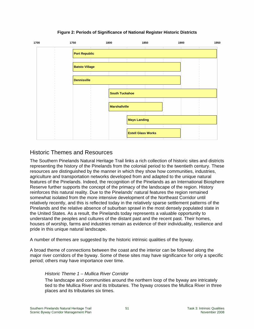
Southern Pinelands Natural Heritage Trail 51 Task 3: Intrinsic Qualities Scenic Byway Corridor Management Plan November 2008
Figure 2: Periods of Significance of National Register Historic Districts
Port Republic
Batsto Village
Dennisville
Marshallville
Mays Landing
Estell Glass Works
South Tuckahoe
1700 1750 1800 1850 1900 1950
Historic Themes and Resources The Southern Pinelands Natural Heritage Trail links a rich collection of historic sites and districts representing the history of the Pinelands from the colonial period to the twentieth century. These resources are distinguished by the manner in which they show how communities, industries, agriculture and transportation networks developed from and adapted to the unique natural features of the Pinelands. Indeed, the recognition of the Pinelands as an International Biosphere Reserve further supports the concept of the primacy of the landscape of the region. History reinforces this natural reality. Due to the Pinelands’ natural features the region remained somewhat isolated from the more intensive development of the Northeast Corridor until relatively recently, and this is reflected today in the relatively sparse settlement patterns of the Pinelands and the relative absence of suburban sprawl in the most densely populated state in the United States. As a result, the Pinelands today represents a valuable opportunity to understand the peoples and cultures of the distant past and the recent past. Their homes, houses of worship, farms and industries remain as evidence of their individuality, resilience and pride in this unique natural landscape. A number of themes are suggested by the historic intrinsic qualities of the byway. A broad theme of connections between the coast and the interior can be followed along the major river corridors of the byway. Some of these sites may have significance for only a specific period; others may have importance over time.
Historic Theme 1 – Mullica River Corridor The landscape and communities around the northern loop of the byway are intricately tied to the Mullica River and its tributaries. The byway crosses the Mullica River in three places and its tributaries six times.
Southern Pinelands Natural Heritage Trail 52 Task 3: Intrinsic Qualities Scenic Byway Corridor Management Plan November 2008
Historic Theme 2 – Great Egg Harbor River Corridor The central spine of the byway follows the Great Egg Harbor River crossing it three times and being most evident at Mays Landing.
Historic Theme 3 – Tuckahoe River Corridor In the southern loop the byway follows the Tuckahoe River from Tuckahoe to Head of River.
Overlapping the river corridor themes are (a) coastal trade and industry and (b) churches and cemeteries.
Historic Theme 4 – Coastal Trade and Industry
Historic Theme 5 – Churches and Cemeteries Finally, a number of sites don’t fit neatly into categories, and some identified sites are off the byway route. As noted in the earlier sidebar, these resources are important because they both tell individual stories and because they offer additional context for the collection of historic resources along the byway.
Historic Resource Group 6 – Individual Resources The resources defining the historic quality of the Southern Pinelands Natural Heritage Trail are presented and briefly described below, and are shown on the Historic, Cultural, and Scenic Qualities and Resources Map.
Historic Theme 1 – Mullica River Corridor The northern loop of the Southern Pinelands Natural Heritage Trail follows both sides of the Mullica River from the coast to Batsto Village. This section of the byway is rich in history, and is blessed with two excellent interpretive centers at Batsto and Tuckerton. The Batsto Village visitors center located in Wharton State Forest, in addition to providing administrative services (brochures, schedules, tickets, and comfort stations) houses a museum that offers a history of Batsto, an 18th century iron and glass making community. The Tuckerton Seaport museum showcases historic maritime traditions and skills, and includes an exhibit area by the Jacques Cousteau National Estuarine Research Reserve focusing on the relationship between the interior of the Pinelands and the New Jersey coast. The following description of historic resources in the Mullica River Corridor begins with Batsto Village,
Mullica River Corridor Historic Sites and Districts on the Southern Pinelands
Natural Heritage Trail (East to West)
Mullica River/Chestnut Neck
Archaeological Historic District North side:
Tuckerton New Gretna Wading River Lower Bank Green Bank Herman * Crowley’s Landing
South side:
Chestnut Neck Port Republic Clark’s Landing Gloucester Landing Weekstown Sweetwater The Forks Pleasant Mills
Batsto Village
Southern Pinelands Natural Heritage Trail 53 Task 3: Intrinsic Qualities Scenic Byway Corridor Management Plan November 2008
perhaps the best known and most visited historic site in the Pinelands, and a key site for introducing visitors to the Pinelands and interpreting the region’s natural and historic resources. It then describes sites north of the Mullica River beginning at Tuckerton and moving inland to Batsto. Finally it describes sites south of the Mullica River beginning at Chestnut Neck and moving inland.
Batsto Village National and State Registers of Historic Places
Boundaries: Area: 12,000 acres Features: 20 buildings and 2 structures Year Listed: 1971 National Register Periods of Significance:
1750-1799, 1800-1824, 1825-1849, 1850-1874, 1875-1899 Batsto was a major industrial village which produced iron from local ores from 1766 to 1855. The village at one time contained a sawmill, grist mill, over 60 houses, a mansion and a large farm complex. Many of these structures have been restored by the state. Batsto Village illustrates how natural resources and human activity and enterprise were able to benefit from the raw materials and features of the Pinelands. Located today in the Wharton State Forest, Batsto Village features an interpretive center showcasing the history of the region, environmental systems and industrial development. Historic structures showcase the early nineteenth century glass-making enterprise that was once a significant industrial operation in the Pinelands.
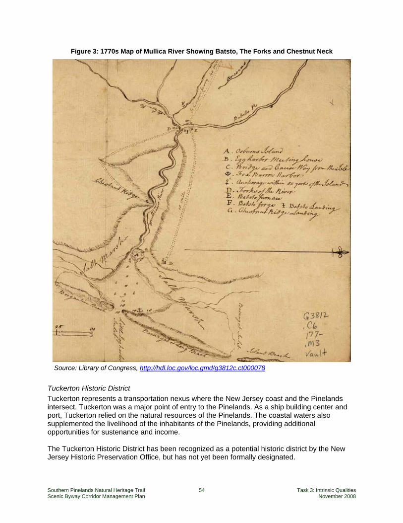
Southern Pinelands Natural Heritage Trail 54 Task 3: Intrinsic Qualities Scenic Byway Corridor Management Plan November 2008
Figure 3: 1770s Map of Mullica River Showing Batsto, The Forks and Chestnut Neck
Source: Library of Congress, http://hdl.loc.gov/loc.gmd/g3812c.ct000078
Tuckerton Historic District Tuckerton represents a transportation nexus where the New Jersey coast and the Pinelands intersect. Tuckerton was a major point of entry to the Pinelands. As a ship building center and port, Tuckerton relied on the natural resources of the Pinelands. The coastal waters also supplemented the livelihood of the inhabitants of the Pinelands, providing additional opportunities for sustenance and income. The Tuckerton Historic District has been recognized as a potential historic district by the New Jersey Historic Preservation Office, but has not yet been formally designated.
Southern Pinelands Natural Heritage Trail 55 Task 3: Intrinsic Qualities Scenic Byway Corridor Management Plan November 2008
Today Tuckerton, a 3.8 square mile borough, located between the Pine Barrens and the bay, is a densely settled town of around 3,500 people. It represents one of the more urban settlements along the byway, and hosts the Seaport Museum, considered a principle interpretive center for the corridor.
New Gretna New Gretna, located between the Wading and Bass Rivers contains a number of well preserved 18th and 19th century structures and is one of the better preserved 19th century settlements in the Pinelands. It was identified as a potential historic district in the 1993 Survey of Potential Historic Districts in the Pinelands, but has not yet been designated. The Bead Wreck Site at New Gretna, where the scattered remains of a wooden vessel are burried under the waters of the Mullica River is listed on the National Register of Historic Places as site #88001899.
Wading River Wading River is a small settlement at a bridge crossing on the Wading River. Its cluster of houses, including seven dating to the 19th century, imparts a historic sense of community. The 1993 Survey determined that it is not a potential historic district site.
Lower Bank Lower Bank, believed to have been founded about 1645, by the area’s first white settler, a Swede named Eric Mullica, was once noted for its winter fisheries, lumbering and ship building. In the 1800’s it was a thriving village that included a school house, a saw mill, two stores, Methodist Episcopal Church, forty dwellings, and a post office. However by the end of the nineteenth century the lumber resources were nearly depleted causing a change in industry. Lower Bank today still reflects its earlier history through well preserved architecture and development patterns.
Green Bank Historic District Green Bank has retained much of its historic settlement pattern and community character even while it has incorporated newer residential development. Founded in the 18th century, and noted as host to the first bridge across the Mullica River in 1858, as well as one of the areas glasshouses, its collection of wood frame houses, historic church and cemetery cause it to be recognized as a potential historic district by the New Jersey Historic Preservation Office, though it has not been so designated.
Herman City Herman City a glassmaking village where the mason jar was invented in 1858 is today an archaeological site where ruins exist but most of the village has been reclaimed by the forest.
Crowley’s Landing or Crowleytown Crowleytown enjoyed its heyday as a glasshouse settlement in the late 1800’s. No buildings remain today, though it is a potential archaeological site.
Mullica River-Chestnut Neck Archaeological Historic District State Register of Historic Places
Year Listed on National Register: 1976 The historic district parallels the Mullica River and is located in Atlantic County (Egg Harbor City, Galloway Township), Burlington County (Bass River Township, Washington Township) and Ocean County (Little Egg Harbor Township). The Mullica River-Chestnut Neck Archaeological Historic District includes the site of the original settlement of Chestnut Neck, a center for smugglers during the colonial period and privateers during the Revolutionary War, as well as the
Southern Pinelands Natural Heritage Trail 56 Task 3: Intrinsic Qualities Scenic Byway Corridor Management Plan November 2008
remains of vessels destroyed and sunk by the British in 1778. At least two of these vessels have been located in the Mullica River. This is a significant archaeological site containing the remains of sunken wooden ships.
Chestnut Neck Chestnut Neck, a thriving trade center, and privateering stronghold at the beginning of the Revolutionary War, was destroyed, along with ten ships by the British in the Battle of Chestnut Neck in 1778. Today, little is left to tell the story except a monument (erected in 1911) marking the site of the Battle of Chestnut Neck. At the top of the monument is a statue of a Minute Man guarding the river.
Port Republic Historic District National and State Registers of Historic Places
Boundaries: Mill St., Clark’s Landing Rd., Adams Ave., Port Republic--Smithville Rd. and Riverside Dr., Port Republic City
Area: 1,000 acres Features: 110 buildings Year Listed on National Register: 1991 National Register Periods of Significance:
1750-1799, 1800-1824, 1825-1849, 1850-1874, 1875-1899, 1900-1924, 1925-1949 Port Republic shows the reliance on the navigable waterways of the region and also represents the transportation nexus between the interior Pinelands and the New Jersey coast. The community was settled in 1637 and served as a refuge for residents of nearby Chestnut Neck during a British attack during the Revolutionary War. It is typical of the many small port settlements that accessed the waterways for commerce and communication during the colonial period. Port Republic remains a rural residential riverine community with gracious historic homes, some dating to the 18th century.
Clark’s Landing This is an unmarked historic landing site.
Gloucester Landing This is an unmarked historic landing site.
Weekstown The village of Weekstown today is primarily 20th century housing, however the 1988 Pineland Villages andTowns Historic Area Delineations report notes that there may be an archaeological remnant of the early village still intact.
Sweetwater Sweetwater was one of a number of villages in the Pinelands with hidden coves that served well the privateering interests that flourished in the area during the Revolutionary War. The licensed pirates split their captured cargos with the American government, providing a revenue stream to the Continental Congress. Present day Sweetwater however is primarily a 20th century rural residential village..
Southern Pinelands Natural Heritage Trail 57 Task 3: Intrinsic Qualities Scenic Byway Corridor Management Plan November 2008
The Forks The village of Sweetwater encompasses a small 18th century settlement on the southern bank of the Mullica River once known as “The Forks”.
Pleasant Mills Pleasant Mills was a gristmill as early as 1740, however, the major development of the village centered on a fulling mill which converted to a cotton mill and then a paper mill that produced until about 1926. Mill ruins as well as three 18th century houses and a small catholic cemetery of the iron furnace era remain standing today. Pleasant Mills is listed on both the National and State Register of Historic Places.
Historic Theme 2 – The Great Egg Harbor River Corridor Estellville Estell Manor Estell Glass Works Belcoville Bethlehem Loading Company Mays Landing Plant Archaeological Historic District* Mays Landing Historic District Walker’s Forge* Weymouth Church Weymouth Furnace* Canal at Weymouth Furnace*
The central spine of the byway, following the Great Egg Harbor River offers a rich account of the industries and the settlements that were manifested to exploit the resources of the Pinelands. The following description of historic resources follows the central spine from north to south.
Estellville Estellville hosts New Jersey’s best preserved glass making house (called glass houses), unique for its stone construction. This important rural industry supported the 19th century population after the decline of the furnaces and forges.
Estell Manor Estell Manor, originally laid out along the Pennsylvania-Reading Seashore Line in the 19th century, remains a sparsely populated settlement along the byway.
Estellville Glass Works Industrial Historic District National and State Registers of Historic Places
Location: Bounded roughly by Estell Manor Park, Stevens Cr. and NJ 50, Estell Manor City
Area: 120 acres Features: 4 buildings Year Listed on National Register: 1991 National Register Periods of Significance:
1825-1849, 1850-1874, 1875-1899 Estellville’s historic district designation is due primarily to its archaeological deposits and its association with the glass industry. The ruins of the glasshouse, the glassmaster’s mansion, a Methodist church and cemetery, along with two former residences can be found here.
Southern Pinelands Natural Heritage Trail 58 Task 3: Intrinsic Qualities Scenic Byway Corridor Management Plan November 2008
Belcoville The village of Belcoville (short for Bethlehem Loading Company) was established in 1917-1918 to house and support the munitions plant of the Bethlehem Loading Company, built nearby. The complex occupied portions of the over 10,000 acre site from Hamilton Township to Gibsons Landing roughly between the present Route 50 and the Great Egg Harbor River. Belcoville’s population neared 10,000 at its peak and in addition to the munitions plant the complex contained a bowling alley, theater, post office, school, gym, laundry, central heating plant, power station, water and sewerage, railroad line, newspaper, band, and church Today homes of this historic complex are still inhabited. The Belcoville 1918 Post Office, unused, but still intact has recently been recommended to the New Jersey register of Historic Places.
Bethlehem Loading Company Mays Landing Plant Archaeological Historic District Year Listed on National Register: 2006
The Bethlehem Loading Company munitions plant, constructed in 1918 included 24 miles of track along with administration buildings, cafeterias, change houses, police buildings, and military barracks to house 1,100 soldiers to guard the plant. In addition, the village of Belcoville (Belco – short for Bethlehem Loading Company) was built, some distance away to house and sustain the thousands of workers (and their families) needed to run the plant. The munitions plant was closed and abandoned at the end of the war and later dismantled. The plant’s concrete foundations and the rail beds are all that remain in present day Estell Manor Park. While this is an archaeological site, it is discussed here because it provides context for the historic village of Belcoville.
Mays Landing Historic District National and State Registers of Historic Places
Location: Bounded by Lake Lenape and Great Egg Harbor River, Mays Landing Area: 1470 acres Features: 259 buildings, 3 structures, 3 objects Year Listed on National Register: 1990 National Register Periods of Significance:
1825-1849, 1850-1874, 1875-1899, 1900-1924, 1925-1949
Mays Landing reached the height of its shipbuilding era by the mid 19th century producing around one hundred vessels from 1830 to 1880. However, by the end of the century, wood shipbuilding began to disappear along with the area’s forests. Today Mays Landing represents one of the more urban centers along the byway. It has retained much of its historic character including a densely settled main street, with a mix of commercial and residential uses and a historic cotton mill complex preserved through redevelopment.
Walker’s Forge Walker's Forge located on South River, just east of present Belcoville was built in 1820, and employed approximately one hundred men. The local iron industry died out after the 1860's as the supply of bog ore and wood was depleted. (The old bog iron furnaces required charcoal from 1,000 acres of woods per year.) Limited visible clues remain, though the site is documented and open to the public.
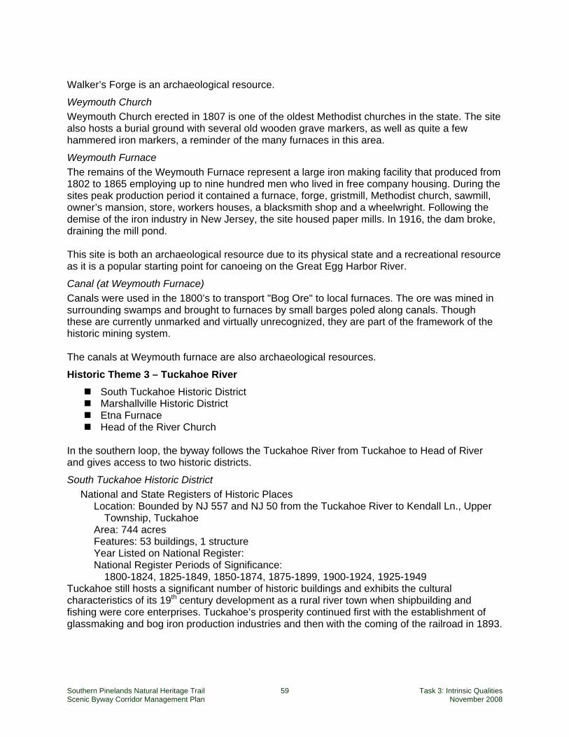
Southern Pinelands Natural Heritage Trail 59 Task 3: Intrinsic Qualities Scenic Byway Corridor Management Plan November 2008
Walker’s Forge is an archaeological resource.
Weymouth Church Weymouth Church erected in 1807 is one of the oldest Methodist churches in the state. The site also hosts a burial ground with several old wooden grave markers, as well as quite a few hammered iron markers, a reminder of the many furnaces in this area.
Weymouth Furnace The remains of the Weymouth Furnace represent a large iron making facility that produced from 1802 to 1865 employing up to nine hundred men who lived in free company housing. During the sites peak production period it contained a furnace, forge, gristmill, Methodist church, sawmill, owner’s mansion, store, workers houses, a blacksmith shop and a wheelwright. Following the demise of the iron industry in New Jersey, the site housed paper mills. In 1916, the dam broke, draining the mill pond. This site is both an archaeological resource due to its physical state and a recreational resource as it is a popular starting point for canoeing on the Great Egg Harbor River.
Canal (at Weymouth Furnace) Canals were used in the 1800’s to transport "Bog Ore" to local furnaces. The ore was mined in surrounding swamps and brought to furnaces by small barges poled along canals. Though these are currently unmarked and virtually unrecognized, they are part of the framework of the historic mining system. The canals at Weymouth furnace are also archaeological resources.
Historic Theme 3 – Tuckahoe River South Tuckahoe Historic District Marshallville Historic District Etna Furnace Head of the River Church
In the southern loop, the byway follows the Tuckahoe River from Tuckahoe to Head of River and gives access to two historic districts.
South Tuckahoe Historic District National and State Registers of Historic Places
Location: Bounded by NJ 557 and NJ 50 from the Tuckahoe River to Kendall Ln., Upper Township, Tuckahoe
Area: 744 acres Features: 53 buildings, 1 structure Year Listed on National Register: National Register Periods of Significance:
1800-1824, 1825-1849, 1850-1874, 1875-1899, 1900-1924, 1925-1949 Tuckahoe still hosts a significant number of historic buildings and exhibits the cultural characteristics of its 19th century development as a rural river town when shipbuilding and fishing were core enterprises. Tuckahoe’s prosperity continued first with the establishment of glassmaking and bog iron production industries and then with the coming of the railroad in 1893.
Southern Pinelands Natural Heritage Trail 60 Task 3: Intrinsic Qualities Scenic Byway Corridor Management Plan November 2008
Marshallville Historic District National and State Registers of Historic Places
Location: bounded roughly by Marshallville Rd. at Co. Rt. 557 in Marshallville Area: 850 acres Features: 12 buildings, 1 structure Year Listed on National Register: 1989 National Register Periods of Significance:
1800-1824, 1825-1849, and1850-1874 Well preserved 19th Century homes of the early glassmaking village of Marshallville remain along the settlement’s main road.
Etna Furnace The Etna Furnace remains located on the Tuckahoe River below Head of the River, are part of the legacy of the Iron Industry in the Pinelands that lasted roughly a century from the 1750’s to the 1860’s. The Etna Furnace, later called Tuckahoe Furnace, was a small installation that produced bar iron, nails and spikes used in the local shipbuilding industry in Tuckahoe and Mays landing.
Head of River Church The Head of River Church (1792) served the area’s Methodist mission started in 1780. When the area’s bog industry declined, the population dropped, however; regular services were held until 1916. The church and adjoining 1751 Baptist cemetery is on the New Jersey and National Register of Historic Places site and is a New Jersey Coastal Heritage Trail destination.
Historic Theme 4 – Coastal Trade and Industry While the major rivers provided essential links between the coast and the interior of the Southern Pinelands region, another theme has to do with the trade and industry concentrated along the coast, as represented in a number of settlements around the periphery of the Pinelands.
Tuckerton New Gretna Port Republic Dennisville Historic District Port Elizabeth Delsea Drive Historic District
Tuckerton Discussed above under Mullica River Corridor.
New Gretna Discussed above under Mullica River Corridor.
Port Republic Discussed above under Mullica River Corridor.
Dennisville Historic District Location: Bounded roughly by Petersburg Rd., Main St., Church Rd., Hall Ave., Fidler and
Academy Rds, and NJ 47 Area: 600 acres Features: 58 buildings and 1 structure Year Listed on National Register: 1987

Southern Pinelands Natural Heritage Trail 61 Task 3: Intrinsic Qualities Scenic Byway Corridor Management Plan November 2008
National Register Periods of Significance: 1750-1799, 1800-1824, 1825-1849, 1850-1874, and 1875-1899
In its early history Dennisville’s primary industries were lumber and ship building. Many residents mined cedar trees out of the local swamps and associated with this harvesting were several talented shipwrights. These industries brought wealth to some of the village’s citizens who built elegant homes. Today, 69 sites are included in the Dennisville Historic District, of which, 58 are historically significant. In addition to its houses, Dennisville is known for being the first Cape May County town to have a post office, established in 1802.
Port Elizabeth20 Port Elizabeth tells a story of lands changed by people and their ties to it. Three years after its founding in 1785, a dam was built on the Manumuskin River, a tributary of the Maurice giving the town prominence as one of the state’s federally-designated ports. Upstream lands dried out crating a valuable resource for farmers. Downstream, wharves were built for shipping providing an outlet for early industrial products including glass. While Port Elizabeth’s early industrial activity did not survive, reminders of its history have, including Port Elizabeth Friends Cemetery (c.1709) where the the Town’s Founder Elizabeth Clark Bodly rests under a stone simply etched with the letters EB. Other historic structures include Eagle Glass Works Hotel (1807) Port Elizabeth Library, St. Elizabeth Roman Catholic church (1810), Port Elizabeth United Methodist Church (1827) and John Boggs Hall (1854).21
Delsea Drive The Pinelands Commission’s 1993 Survey of Potential Historic Districts in the Pinelands identifies Delsea Dirve passing through or near the settlements of Port Elizabeth, Bricksboro, Dorchester, Leesburg, Heislerville, Delmont, Eldora, North Dennis and Dennisville, as a potential historic district that uses the roadway to link historic hamlets. These early centers of shipbuilding, whaling, cedar production, agriculture and maritime trade offer some of the best preserved 18th and 19th century residences, farms and villages in the state.
Historic Theme 5 – Churches and Cemeteries The byway route links a number of nineteenth-century churches and cemeteries which are important to the local communities telling the story of the early religious and social beliefs that guided the people of the Pinelands and providing evidence of historic settlement patterns. The following is not meant to be a complete listing, but a representative of the diversity that exists. Some of these are also listed within historic districts or as sites within the themes discussed above. Listing them as a stand along theme, however shows their relevance to a particular group or market. These historic resources include:
Weymouth Church and Cemetery Pleasant Mills Methodist Church St. Mary’s Cemetery Boling cemetery Mays Landing Presbyterian Church Head of the River Church 1709 Friends Meeting House and Cemetery Brotherhood Synagogue of Woodbine
20 http://www.mauricerivertwp.org/history.html 21 http://en.wikipedia.org/wiki/Port_Elizabeth,_New_Jersey
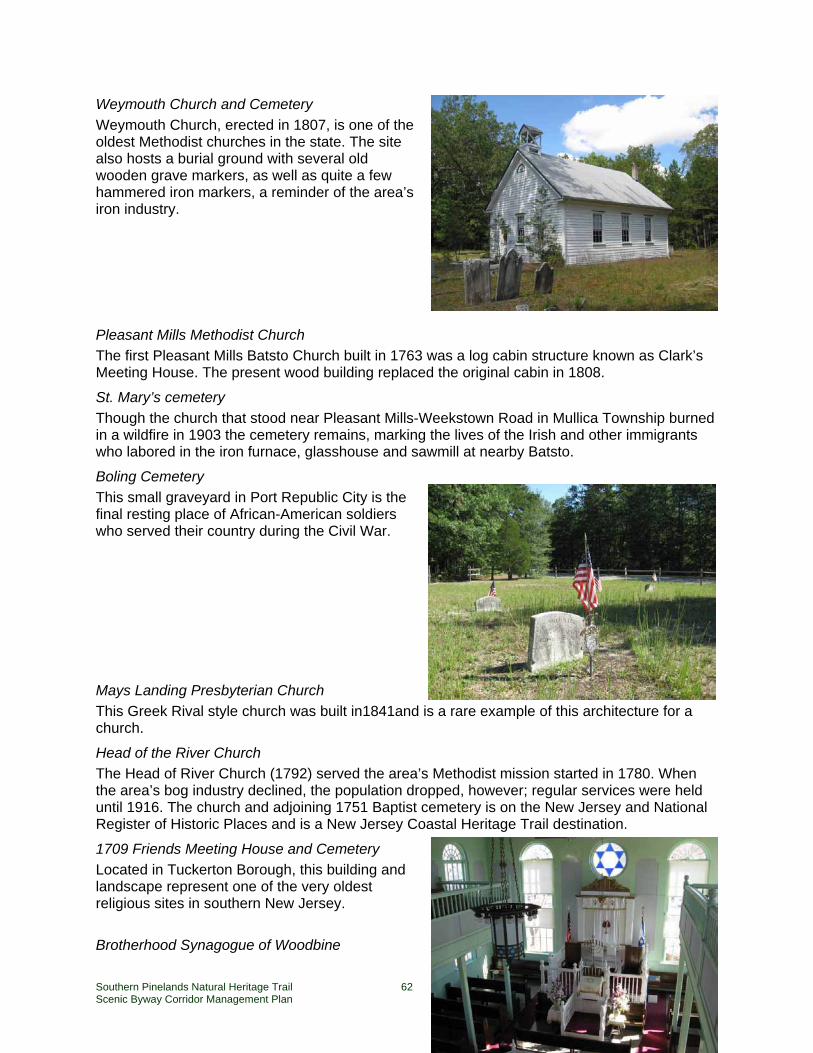
Southern Pinelands Natural Heritage Trail 62 Task 3: Intrinsic Qualities Scenic Byway Corridor Management Plan November 2008
Weymouth Church and Cemetery Weymouth Church, erected in 1807, is one of the oldest Methodist churches in the state. The site also hosts a burial ground with several old wooden grave markers, as well as quite a few hammered iron markers, a reminder of the area’s iron industry.
Pleasant Mills Methodist Church The first Pleasant Mills Batsto Church built in 1763 was a log cabin structure known as Clark’s Meeting House. The present wood building replaced the original cabin in 1808.
St. Mary’s cemetery Though the church that stood near Pleasant Mills-Weekstown Road in Mullica Township burned in a wildfire in 1903 the cemetery remains, marking the lives of the Irish and other immigrants who labored in the iron furnace, glasshouse and sawmill at nearby Batsto.
Boling Cemetery This small graveyard in Port Republic City is the final resting place of African-American soldiers who served their country during the Civil War.
Mays Landing Presbyterian Church This Greek Rival style church was built in1841and is a rare example of this architecture for a church.
Head of the River Church The Head of River Church (1792) served the area’s Methodist mission started in 1780. When the area’s bog industry declined, the population dropped, however; regular services were held until 1916. The church and adjoining 1751 Baptist cemetery is on the New Jersey and National Register of Historic Places and is a New Jersey Coastal Heritage Trail destination.
1709 Friends Meeting House and Cemetery Located in Tuckerton Borough, this building and landscape represent one of the very oldest religious sites in southern New Jersey.
Brotherhood Synagogue of Woodbine
Southern Pinelands Natural Heritage Trail 63 Task 3: Intrinsic Qualities Scenic Byway Corridor Management Plan November 2008
Once the center of the Jewish life in Woodbine, this antique brick building now houses the Sam Azeez Museum of Woodbine History. The synagogue is listed on the National Register of Historic Places.
Historic Resource Group 6 – Individual Resources Finally, a number of sites with local or regional significance do not fit neatly into categories, including some identified sites that are off the byway route. These outliers are nevertheless important as they tell individual stories as well as contribute regional context to other historic resources.
Woodbine Eldora Dorothy (off-route) Smithville Bass River State Forest – CCC camp Historic Railroads
The following descriptions are of resources that are outside the geographical reach of the byway or outside the identified themes.
Woodbine Woodbine, established in 1891, was one of several Jewish communities founded along the rail lines in the Pinelands, to give haven to the Eastern European Jews. Within two years the town’s settlers cleared the forest and built a town of thriving farms turning Woodbine into a model agricultural community. Within four years an agricultural college was started. Though agriculture did not prove to be a sustainable livelihood, Woodbine continued as a viable ethnic community into the 1950s. Today agriculture has been replaced by industry but the residential center of Woodbine still uses the same grid that was originally laid out in 1891 and the agricultural college campus exists as a state-run training facility. The Sam Azeez Museum of Woodbine Heritage, housed in the 114-year-old Brotherhood Synagogue, celebrates the history of Woodbine.
Eldora Eldora is an intact and marginally altered example of a remote, agricultural community of the 19th century. The sparsely settled center is graced by a church and cemetery along with several residences and commercial outlets. Farmhouses and fields lie along the outskirts of the center. The Pinelands Commission1993 Survey of Potential Historic Districts in the Pinelands identifies Eldora as a potential historic district; however designation has not been granted to date.
Dorothy Dorothy is a diffuse 19th century railroad settlement with a broad street grid that was planned but never full developed. The railroad lines still dominate the village center, though few buildings of
Southern Pinelands Natural Heritage Trail 64 Task 3: Intrinsic Qualities Scenic Byway Corridor Management Plan November 2008
that era remain. Remnants of the poultry farms that thrived in this area before World War II are scattered outside the village center.
Smithville Smithville, located 15 miles from Atlantic City, is primarily known for “Historic Smithville” an outside mall with shops and restaurants housed in late 18th-century buildings arranged along cobblestone streets and boardwalks. The original settlement began building its popularity around 1787 when James Baremore built what is now Smithville Inn, a single room along a well-traveled stagecoach route. The family business continued and by 1874 it had grown to six times its original size. Sometime after the turn of the 19th century, however the inn was abandoned until it was rediscovered and opened as a restaurant in the mid 20th century. Building on the restaurant’s success, the owners brought historic homes and other buildings from southern New Jersey's past to the Town of Historic Smithville where they restored and converted them to shops, eateries and accommodations.
Bass River State Forest – CCC camp In 1933, Franklin D. Roosevelt created the Civilian Conservation Corps to create work for unemployed men during the Great Depression. A CCC camp with over 200 men was established at Bass River State Forest (1933-1942) where they built the park’s infrastructure including roads, trails, bridges, towers, shelters, picnic areas, cabins, campgrounds, and created the 67-acre Lake Absegami, by damming two streams. A CCC Memorial and the foundations of the Camp that housed the workers help to tell this story.
Historic railroads As they did across the country, railroads helped shape southern New Jersey and impacted Pinelands towns, villages and settlements as they journeyed between the bay and cities west of the Pinelands. A registered historic rail district, potential districts, and a historic railroad station can be found along the SPNHT, helping to tell the stories of the multiple rail lines crossing the Pinelands.
Camden and Atlantic Railroad Historic District includes the historic rail bed and remaining railroad elements of the Camden and Atlantic Rail Route, crossing the byway in Mullica Township. Camden and Atlantic Railroad, organized in 1852, originated in Camden, New Jersey, traveled through the Pine Barrens and terminated at a town to be named Atlantic City. By 1896, the Pennsylvania Railroad had consolidated this and other local lines under the West Jersey and Seashore Railroad Company. Pennsylvania Reading Seashore Line (circa 1933) from Pennsylvania to Cape May was a joint venture of the Pennsylvania Railroad and Reading Railroad in southern New Jersey. Both railroads had built rail networks in the region, but the Great Depression cut into profits and the two companies joined their southern New Jersey lines into one company. A portion of the West Jersey and Atlantic Railroad between Mays Landing, Hamilton Township and Pleasantville City, Atlantic County, is eligible for listing on the National Register of Historic Places as a linear historic district. The line is significant for its importance in opening the region to development, as an example of its typical railroad engineering and architecture in the late 19th century, and for its potential as a historic archaeological site. Tuckahoe Railroad Station Historic Site

Southern Pinelands Natural Heritage Trail 65 Task 3: Intrinsic Qualities Scenic Byway Corridor Management Plan November 2008
The Tuckahoe Railraod Station, located in Tuckahoe, just off the byway, is a restored 1890s wood frame building, originally built to accommodate rail stops of the Pennsylvania Reading Seashore Lines that ran between Pennsylvania and Cape May. It is a National and State registered historic place as well as part of the South Tuckahoe Historic District

Southern Pinelands Natural Heritage Trail 67 Task 3: Intrinsic Qualities Scenic Byway Corridor Management Plan November 2008
5. Scenic Quality Scenic Quality is the heightened visual experience derived from the view of natural and manmade elements of the visual environment of the scenic byway corridor. The characteristics of the landscape are strikingly distinct and offer a pleasing and most memorable visual experience. All elements of the landscape—landform, water, vegetation, and manmade development—contribute to the quality of the corridor’s visual environment. Everything present is in harmony and shares in the intrinsic qualities.
National Scenic Byways Program – Interim Policy The byway route is exceptional in New Jersey for its natural beauty. Several segments of the byway offer lovely scenic drives in the spring and fall, including Weatherby Road through the Peaslee Management Area and Weymouth-Elwood Road, County Route 623 through the Makepeace Lake Wildlife Management Area. The tranquil beauty of the pine and oak forest is featured at almost every point along the route, but nowhere more so than on Burlington County Route 542, Wading River-Leektown Road and Stage Road, and on Clarks Landing Road, where tall cedar stands frame the road. From the vantage point of the tower in the historic mansion at Batsto, one can view a carpet of green to the horizon in all directions, a vast forest on a scale not equaled anywhere else in the state. Much of the route is bordered on both sides by dense forests, but several river crossings present scenic vistas of marshes and bays that are unsurpassed in New Jersey, including the Wading River crossing at the settlement of Wading River and the Mullica River crossings at Green Bank and along the Garden State Parkway. There are also marvelous views of the placid Tuckahoe River (from Aetna Road), the Great Egg Harbor River (from Route 559 in Mays Landing), and the almost endless salt marshes at the Delaware Bay (from Delsea Drive).

Southern Pinelands Natural Heritage Trail 69 Task 3: Intrinsic Qualities Scenic Byway Corridor Management Plan November 2008
6. Archaeological Quality Archaeological Quality involves those characteristics of the scenic byways corridor that are physical evidence of historic or prehistoric human life or activity that are visible and capable of being inventoried and interpreted. The scenic byway corridor’s archeological interest, as identified through ruins, artifacts, structural remains, and other physical evidence have scientific significance that educate the viewer and stir an appreciation for the past.
National Scenic Byways Program – Interim Policy Like historic quality, archaeological quality is associated with the people of the Pinelands and their dynamic relationship with the landscape. Along and around the SPNHT archaeological resources are more limited than natural, historic and recreational resources and are, therefore, considered a tertiary focus for corridor management. The criterion for considering the contribution of archaeological sites to this byway’s significance is the extent to which such sites reinforce for the byway traveler the relationships between people and the land – either community or natural resources. The following archaeological quality summary describes the key archaeological sites along the byway that can be seen by, and interpreted to, visitors.
Early Settlement and Industry The Mullica River-Chestnut Neck Archaeological Historic District, listed in the National Register of Historic Places, is a significant archaeological site containing the remains of sunken wooden ships. This historic district reinforces the concepts of transportation and industry reliant on the natural features (water and timber) of the Pinelands. Without the schooners and sloops constructed in the area, and able to navigate the waters of the Pinelands, early settlements such as Mays Landing and early industrial sites, such as Batsto, could not have developed. The Dennis Creek Landing Archaeological Historic District is another example of how the rivers, as transportation and communication corridors, shaped communities. Both these archaeological sites reveal the importance of trade as a means of economic stability and the value of raw materials and agricultural produce as early determinants of the culture of the area. Shipping (as both an industry through ship-building and as an economic activity) was an essential component to the largely water-based transportation network of the Pinelands. Towns and industries were located along navigable waterways affording access to the larger transportation and economic network of the Atlantic seaboard. Weymouth Furnace County Park and Weymouth Canal are near the byway’s intersection with the Black Horse Pike , on the site of an early iron furnace. Herman City ruins on Pleasant Mills Road mark the existence of an early glassmaking village.
Modern Industrial Sites The Bethlehem Loading Company Mays Landing Plant Archaeological Historic District and the Estellville Glassworks Industrial Historic District are referred to as modern industrial sites.

Southern Pinelands Natural Heritage Trail 71 Task 3: Intrinsic Qualities Scenic Byway Corridor Management Plan November 2008
7. Cultural Quality Cultural Quality is evidence and expressions of the customs or traditions of a distinct group of people. Cultural features including, but not limited to, crafts, music, dance, rituals, festivals, speech, food, special events, vernacular architecture, etc., are currently practiced. The cultural qualities of the corridor could highlight one or more significant communities and/or ethnic traditions.
Cultural intrinsic qualities for the Pinelands continue to be represented by the traditions and local practices of the “Pineys,” as many in the Pinelands choose to self-identify themselves. For the SPNHT byway, contemporary cultural traditions and practices are often evolved from the historic cultural traditions and ways of the region. The cultural quality summary below outlines the cultural intrinsic qualities that exist along the byway.
Transportation and Settlement The greatest concentration of population is typically found at the convergences of natural and constructed lines of communication – especially when multiple eras of transportation accommodation or development are present (the intersection of navigable waterways, with stable soils, nineteenth-century turnpikes, railroads and early twentieth-century state and federal highways). For example, Mays Landing was founded as an inland port on the Great Egg Harbor River and later benefited from the development and proximity of the Black Horse Pike, the construction of the Atlantic City Railroad (1854, part of the Reading Railroad) and the designation of US Route 40 (1926). New Gretna, also a port town on the Mullica River, benefited from construction of Ocean Drive and its later designation as US Route 9 (1926), while Woodbine was served by the West Jersey and Seashore Railroad (1863). Similarly, historic bridges are indicators of significant community investment showcasing past connections and principal travel routes. The Green Bank Road Bridge over the Mullica River, New Jersey Route 50 Bridge over the Tuckahoe River and the Weymouth Road Bridge over the Great Egg Harbor River showcase significant connections and linkages within the Pinelands. Other reminders of transportation infrastructure include the historic Gulf Station in Port Republic and the Tuckahoe railroad station. While technological advances in the late nineteenth century and after enabled wetlands and waterways to be crossed with greater ease, much of the settlement pattern of the Pinelands had been established. Therefore, many of the “new” transportation connections such as railroads and early state and US highways were more responsive to the historic settlement patterns of the region, rather than directive. It wasn’t until the mid-twentieth century when roads such as the Atlantic City Expressway and the Garden State Parkway were constructed relatively independently of the settlement patterns of the Pinelands.
The Cultural Landscape The Southern Pinelands region possesses a distinctive cultural landscape that defines and reinforces the character of the region. The cultural landscape, defined by the patterns and relationships of human activity on the land is richly textured and nuanced throughout the Pinelands and along the SPNHT scenic byway route. Character defining features include long straight highways surrounded by dense stands of pine that shift alignment when meeting rivers and streams throughout the region. Crossroads within the area support historic settlements that have retained a great level of integrity from one to the next. Rather than a blur of suburban
Southern Pinelands Natural Heritage Trail 72 Task 3: Intrinsic Qualities Scenic Byway Corridor Management Plan November 2008
sprawl, evident along so much of the Atlantic seaboard, individual communities in the Pinelands, and along the byway route in particular, still possess a high level of individual integrity. Leaving Dennisville, Woodbine, Elwood, Port Republic or Wading River, one soon encounters a landscape of woodlands, wetlands or agricultural lands. These “voids” in architectural and industrial development reinforce the historic culture of isolation and independence, so much a part of the cultural of the Pinelands. Blueberry fields west of Batsto Village and cranberry bogs west of Wading River and near Belleplain line the byway, reinforcing the agrarian heritage and unique field patterns and agricultural structures adapted to these farming practices. The cultural landscape can be roughly divided between the northern and southern loops of the SPNHT and “read” for patterns distinctive to each—the southern loop presenting more open agricultural lands and the northern loop more of a wooded, enclosed landscape, as recognized by the Bass River State Forest Historic District, for example. Consistent to both, however, is the independent character of towns and settlements and the relatively strong line between agricultural/woodland areas and community edges. These town edges are a distinctive feature of the cultural landscape of the area and show close the relationship between settlements and the land. In much of the Northeast, these historic boundaries have been eroded by years of suburban development, commercial strips, and interstate highways. In the Pinelands a strong pattern on the landscape is clearly evident to a traveler along the byway route. For the past 30 years this traditional cultural landscape has been protected by the land use policies of the Pinelands Commission.
Southern Pinelands Natural Heritage Trail 73 Task 3: Intrinsic Qualities Scenic Byway Corridor Management Plan November 2008
PART 2: MAJOR PUBLIC-ACCESSIBLE NATURAL AND RECREATIONAL QUALITY SITES AND RESOURCES

Southern Pinelands Natural Heritage Trail 75 Task 3: Intrinsic Qualities Scenic Byway Corridor Management Plan November 2008
1. Introduction The following section presents an inventory of the public owned and publicly accessible natural resource sites and resources along the Southern Pinelands Natural Heritage Trail Scenic Byway. The 21 areas in this inventory provide the backbone of the natural and recreational quality destinations along the byway. The byway corridor consists of three distinctive sections:
a Northern Loop, defined by the Mullica River watershed and nearby coastal resources; a Central Segment, along the Great Egg Harbor River and Tuckahoe River; and a Southern Loop, including Belleplain State Forest and the Delaware Bayshore coastal
areas. The sites and resources in the inventory are grouped into these byway sections as follows:
Northern Loop Mullica River Wharton State Forest Batsto Village Batsto Natural Area Batona Trail Bass River State Forest Green Bank State Forest Port Republic Wildlife Management Area Edwin B. Forsythe National Wildlife Refuge Central Segment Great Egg Harbor National Scenic and Recreational River Makepeace Lake Wildlife Management Area Weymouth Furnace Lake Lenape Park Gaskill Park Estell Manor Park Gibson Wildlife Management Area Tuckahoe (Lester G. MacNamara) Wildlife Management Refuge Southern Loop Maurice River National Scenic and Recreational River Peaslee Wildlife Management Area Belleplain State Forest Eldora Nature Preserve (The Nature Conservancy) Dennis Creek Wildlife Management Area (Jakes Landing) Cape May National Wildlife Refuge
The information below presents the basic qualities of each site, current threats (e.g., invasive species, habitat degradation, etc.), opportunities and basic contact information for future use in tourism promotion. The strategy and implementation phases of this plan will describe what might be done at each site to create an integrated visitor experience that presents the overall environmental theme of the Southern Pinelands Natural Heritage Trail.

Southern Pinelands Natural Heritage Trail 77 Task 3: Intrinsic Qualities Scenic Byway Corridor Management Plan November 2008
2. Northern Loop Mullica River Wharton State Forest Batsto Village Batsto Natural Area Batona Trail Bass River State Forest Green Bank State Forest Port Republic Wildlife Management Area Edwin B. Forsythe National Wildlife Refuge
Mullica River Overview The 55 mile long Mullica River drains a 568 square mile area in the central Pinelands, and stretches from Berlin, in central Camden County to the Great Bay. 21 miles of the river, from Batsto to the bay is tidally influenced, with salt water extending as far upstream as Lower Bank The lower Mullica River (and Great Bay) have been designated a National Estuarine Research Reserve for research and education to be managed by the New Jersey Division of Fish, Game and Wildlife and Rutgers University. The Mullica is an important resource both for the diversity of species it supports and the quality of recreational experiences it offers.
Significant/Interesting Natural Qualities The Mullica River watershed is the largest in the Pinelands and includes two of the states most pristine rivers: Wading River and Batsto River. The main stem of the river, from near Batsto Village to the bay is tidal, experiences various degrees of salinity and tides. The Mullica River is designated an Important Bird Area by the NJ Audubon Society. Many species of waterfowl, raptors, wading birds and shorebirds inhabit the salt, brackish and freshwater marshes of the Mullica River corridor including Bald Eagles, Ospreys and Northern Harriers . The corridor offers one of the largest wintering populations of Bald Eagles in the state and one of the top sites in the northeast for wintering Golden Eagles. Wintering waterfowl includes a concentration of up to 300 Tundra Swans. The Mullica River Corridor also provides valuable stopover habitat for hundreds of species of migratory passerines and waterfowl. Common peripheral fish species intolerant of the acid waters of Pinelands freshwater streams occur in the lower reaches of the Mullica River and anadromous fish, including blueback herring, alewife, hickory shad and striped bass spawn in streams and tributaries The history of the known peoples of the Mullica River stretches back over 8,000 years with evidence of these pre-historic cultures found at over 100 sites along the Mullica River and its tributaries. At the time of contact with early settlers these natives were known as the Linni Lenape. Eric Palsson Mullica began the first European settlement of the area in 1697. By the time of the Revolutionary War, more than 30 homesteads stretched along the Mullica from Tuckerton to Wading Rivers. Industrial and commercial ventures exploited the natural resources of the land and water and included shipbuilding, pirating, and iron, glass, cotton and paper making.
Existing Interpretation There is no interpretation of the Mullica River along the byway.
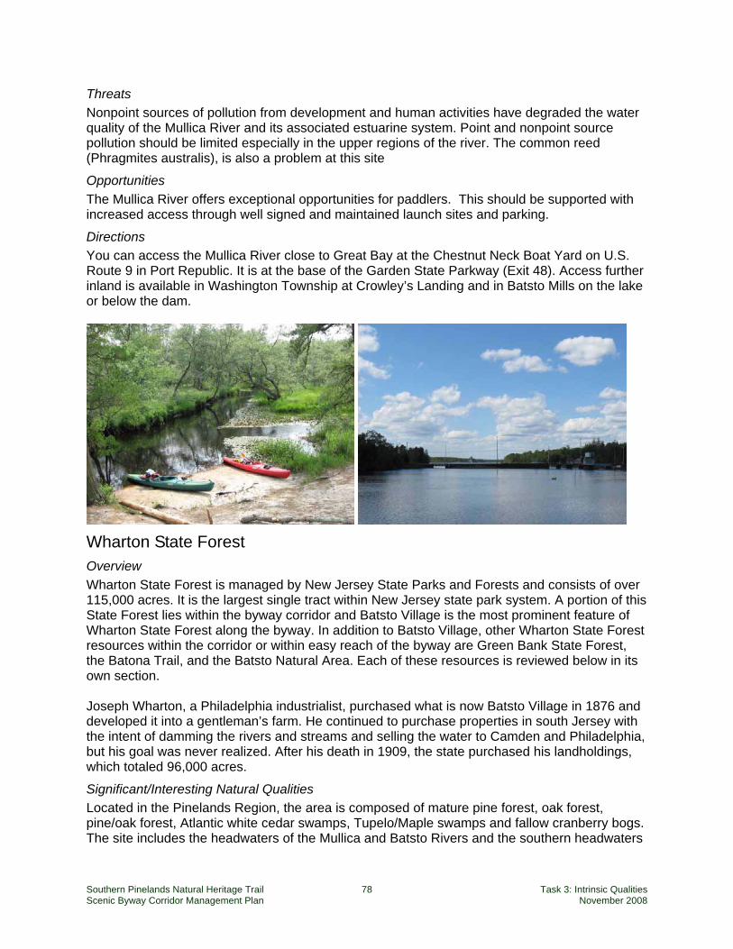
Southern Pinelands Natural Heritage Trail 78 Task 3: Intrinsic Qualities Scenic Byway Corridor Management Plan November 2008
Threats Nonpoint sources of pollution from development and human activities have degraded the water quality of the Mullica River and its associated estuarine system. Point and nonpoint source pollution should be limited especially in the upper regions of the river. The common reed (Phragmites australis), is also a problem at this site
Opportunities The Mullica River offers exceptional opportunities for paddlers. This should be supported with increased access through well signed and maintained launch sites and parking.
Directions You can access the Mullica River close to Great Bay at the Chestnut Neck Boat Yard on U.S. Route 9 in Port Republic. It is at the base of the Garden State Parkway (Exit 48). Access further inland is available in Washington Township at Crowley’s Landing and in Batsto Mills on the lake or below the dam.
Wharton State Forest Overview Wharton State Forest is managed by New Jersey State Parks and Forests and consists of over 115,000 acres. It is the largest single tract within New Jersey state park system. A portion of this State Forest lies within the byway corridor and Batsto Village is the most prominent feature of Wharton State Forest along the byway. In addition to Batsto Village, other Wharton State Forest resources within the corridor or within easy reach of the byway are Green Bank State Forest, the Batona Trail, and the Batsto Natural Area. Each of these resources is reviewed below in its own section. Joseph Wharton, a Philadelphia industrialist, purchased what is now Batsto Village in 1876 and developed it into a gentleman’s farm. He continued to purchase properties in south Jersey with the intent of damming the rivers and streams and selling the water to Camden and Philadelphia, but his goal was never realized. After his death in 1909, the state purchased his landholdings, which totaled 96,000 acres.
Significant/Interesting Natural Qualities Located in the Pinelands Region, the area is composed of mature pine forest, oak forest, pine/oak forest, Atlantic white cedar swamps, Tupelo/Maple swamps and fallow cranberry bogs. The site includes the headwaters of the Mullica and Batsto Rivers and the southern headwaters
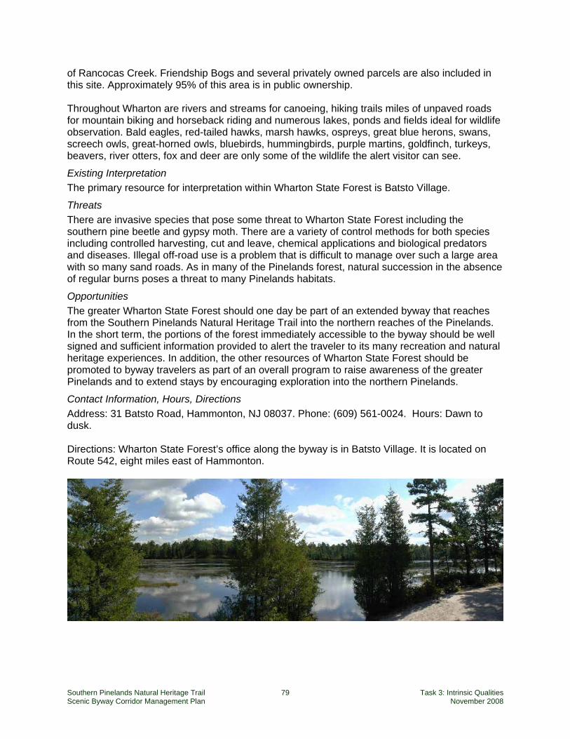
Southern Pinelands Natural Heritage Trail 79 Task 3: Intrinsic Qualities Scenic Byway Corridor Management Plan November 2008
of Rancocas Creek. Friendship Bogs and several privately owned parcels are also included in this site. Approximately 95% of this area is in public ownership. Throughout Wharton are rivers and streams for canoeing, hiking trails miles of unpaved roads for mountain biking and horseback riding and numerous lakes, ponds and fields ideal for wildlife observation. Bald eagles, red-tailed hawks, marsh hawks, ospreys, great blue herons, swans, screech owls, great-horned owls, bluebirds, hummingbirds, purple martins, goldfinch, turkeys, beavers, river otters, fox and deer are only some of the wildlife the alert visitor can see.
Existing Interpretation The primary resource for interpretation within Wharton State Forest is Batsto Village.
Threats There are invasive species that pose some threat to Wharton State Forest including the southern pine beetle and gypsy moth. There are a variety of control methods for both species including controlled harvesting, cut and leave, chemical applications and biological predators and diseases. Illegal off-road use is a problem that is difficult to manage over such a large area with so many sand roads. As in many of the Pinelands forest, natural succession in the absence of regular burns poses a threat to many Pinelands habitats.
Opportunities The greater Wharton State Forest should one day be part of an extended byway that reaches from the Southern Pinelands Natural Heritage Trail into the northern reaches of the Pinelands. In the short term, the portions of the forest immediately accessible to the byway should be well signed and sufficient information provided to alert the traveler to its many recreation and natural heritage experiences. In addition, the other resources of Wharton State Forest should be promoted to byway travelers as part of an overall program to raise awareness of the greater Pinelands and to extend stays by encouraging exploration into the northern Pinelands.
Contact Information, Hours, Directions Address: 31 Batsto Road, Hammonton, NJ 08037. Phone: (609) 561-0024. Hours: Dawn to dusk. Directions: Wharton State Forest’s office along the byway is in Batsto Village. It is located on Route 542, eight miles east of Hammonton.
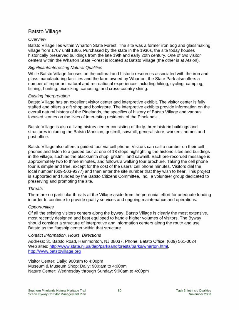
Southern Pinelands Natural Heritage Trail 80 Task 3: Intrinsic Qualities Scenic Byway Corridor Management Plan November 2008
Batsto Village Overview Batsto Village lies within Wharton State Forest. The site was a former iron bog and glassmaking village from 1767 until 1866. Purchased by the state in the 1930s, the site today houses historically preserved buildings from the late 19th and early 20th century. One of two visitor centers within the Wharton State Forest is located at Batsto Village (the other is at Atsion).
Significant/Interesting Natural Qualities While Batsto Village focuses on the cultural and historic resources associated with the iron and glass manufacturing facilities and the farm owned by Wharton, the State Park also offers a number of important natural and recreational experiences including hiking, cycling, camping, fishing, hunting, picnicking, canoeing, and cross-country skiing.
Existing Interpretation Batsto Village has an excellent visitor center and interpretive exhibit. The visitor center is fully staffed and offers a gift shop and bookstore. The interpretive exhibits provide information on the overall natural history of the Pinelands, the specifics of history of Batsto Village and various focused stories on the lives of interesting residents of the Pinelands . Batsto Village is also a living history center consisting of thirty-three historic buildings and structures including the Batsto Mansion, gristmill, sawmill, general store, workers' homes and post office. Batsto Village also offers a guided tour via cell phone. Visitors can call a number on their cell phones and listen to a guided tour at one of 18 stops highlighting the historic sites and buildings in the village, such as the blacksmith shop, gristmill and sawmill. Each pre-recorded message is approximately two to three minutes, and follows a walking tour brochure. Taking the cell phone tour is simple and free, except for the cost of the users’ cell phone minutes. Visitors dial the local number (609-503-9377) and then enter the site number that they wish to hear. This project is supported and funded by the Batsto Citizens Committee, Inc., a volunteer group dedicated to preserving and promoting the site.
Threats There are no particular threats at the Village aside from the perennial effort for adequate funding in order to continue to provide quality services and ongoing maintenance and operations.
Opportunities Of all the existing visitors centers along the byway, Batsto Village is clearly the most extensive, most recently designed and best equipped to handle higher volumes of visitors. The Byway should consider a structure of interpretive and information centers along the route and use Batsto as the flagship center within that structure.
Contact Information, Hours, Directions Address: 31 Batsto Road, Hammonton, NJ 08037. Phone: Batsto Office: (609) 561-0024 Web sites: http://www.state.nj.us/dep/parksandforests/parks/wharton.html, http://www.batstovillage.org Visitor Center: Daily: 900:am to 4:00pm Museum & Museum Shop: Daily: 900:am to 4:00pm Nature Center: Wednesday through Sunday: 9:00am to 4:00pm
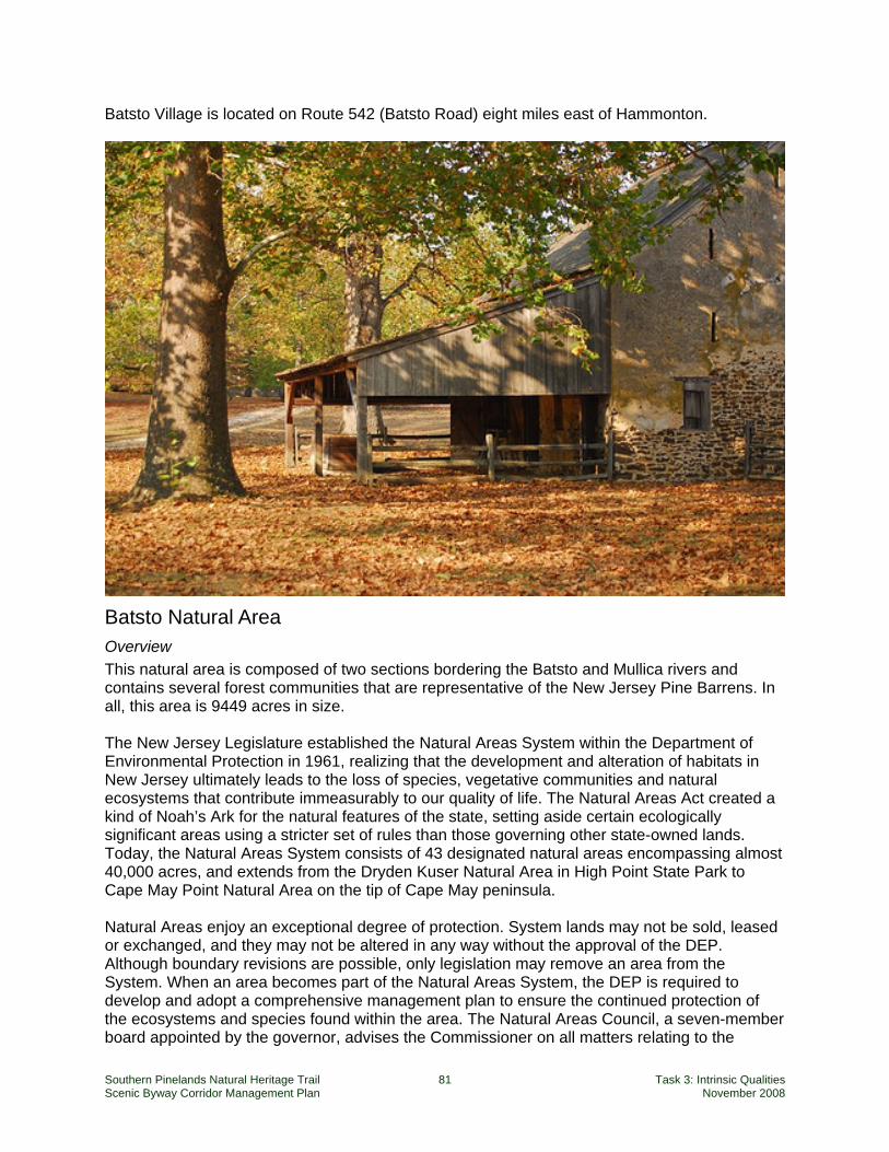
Southern Pinelands Natural Heritage Trail 81 Task 3: Intrinsic Qualities Scenic Byway Corridor Management Plan November 2008
Batsto Village is located on Route 542 (Batsto Road) eight miles east of Hammonton.
Batsto Natural Area Overview This natural area is composed of two sections bordering the Batsto and Mullica rivers and contains several forest communities that are representative of the New Jersey Pine Barrens. In all, this area is 9449 acres in size. The New Jersey Legislature established the Natural Areas System within the Department of Environmental Protection in 1961, realizing that the development and alteration of habitats in New Jersey ultimately leads to the loss of species, vegetative communities and natural ecosystems that contribute immeasurably to our quality of life. The Natural Areas Act created a kind of Noah’s Ark for the natural features of the state, setting aside certain ecologically significant areas using a stricter set of rules than those governing other state-owned lands. Today, the Natural Areas System consists of 43 designated natural areas encompassing almost 40,000 acres, and extends from the Dryden Kuser Natural Area in High Point State Park to Cape May Point Natural Area on the tip of Cape May peninsula. Natural Areas enjoy an exceptional degree of protection. System lands may not be sold, leased or exchanged, and they may not be altered in any way without the approval of the DEP. Although boundary revisions are possible, only legislation may remove an area from the System. When an area becomes part of the Natural Areas System, the DEP is required to develop and adopt a comprehensive management plan to ensure the continued protection of the ecosystems and species found within the area. The Natural Areas Council, a seven-member board appointed by the governor, advises the Commissioner on all matters relating to the
Southern Pinelands Natural Heritage Trail 82 Task 3: Intrinsic Qualities Scenic Byway Corridor Management Plan November 2008
System. The Natural Areas System Rules at N.J.A.C. 7:5A provide detailed procedures for classification and designation of natural areas, development of management plans, allowable uses and practices, procedures for conducting research and scientific activities, and revising boundaries. The rules also contain a list of all designated State Natural Areas, including a management objective for each.
Significant/Interesting Natural Qualities This natural area demonstrates a wide variety of Pinelands habitats, especially southern swamps and floodplains. Rare plant and animal species are present and protected.
Existing Interpretation There are nature trails within the Natural Area and a trail guide is available at the interpretive center at Batsto Village.
Threats There are no significant threats to this natural area given the level of protection and State Park management.
Opportunities This area offers a nice microcosm of preserved Pinelands habitats. While it should be mentioned in the byway program, it could be subject to overuse due to inappropriate levels of byway promotion.
Contact Information, Hours, Directions Address: 31 Batsto Road, mmonton, NJ 08037. Telephone: Batsto Office: (609) 561-0024 Web sites: http://www.state.nj.us/dep/parksandforests/parks/wharton.html, http://www.batstovillage.org. Hours: Dawn to dusk Batsto Natural Area is located within Wharton State Forest.
Batona Trail Overview The Batona trail began in 1961 when the Batona Hiking Club charted and cleared a trail from Carpenter Spring in Lebanon State Forest to Batsto in Wharton State Forest. Subsequent expansion culminated in 1987 with the Batona Trail now stretching from Ong's Hat on Lebanon State Forest, through Batsto and Wharton State Forest, and on to Bass River State Forest, a total of approximately 50 miles. The trail is maintained jointly by the Batona Hiking Club and the State Park Service. Batona stands for BAck TO NAture. It was planned as a wilderness trail, yet is an easy to follow trail, mostly flat lands, with some sugar sand trails and wetter areas as one passes through the cedar swamps. The Batona Trail is marked with prominent pink blazes, making it very easy to follow. It is accessible at many points as it crosses a number of roads. (Source: http://www.njpinelandsanddownjersey.com )
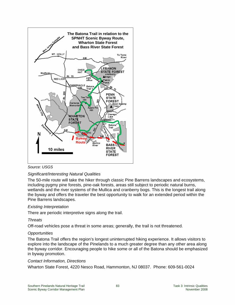
Southern Pinelands Natural Heritage Trail 83 Task 3: Intrinsic Qualities Scenic Byway Corridor Management Plan November 2008
Source: USGS
Significant/Interesting Natural Qualities The 50-mile route will take the hiker through classic Pine Barrens landscapes and ecosystems, including pygmy pine forests, pine-oak forests, areas still subject to periodic natural burns, wetlands and the river systems of the Mullica and cranberry bogs. This is the longest trail along the byway and offers the traveler the best opportunity to walk for an extended period within the Pine Barrens landscapes.
Existing Interpretation There are periodic interpretive signs along the trail.
Threats Off-road vehicles pose a threat in some areas; generally, the trail is not threatened.
Opportunities The Batona Trail offers the region’s longest uninterrupted hiking experience. It allows visitors to explore into the landscape of the Pinelands to a much greater degree than any other area along the byway corridor. Encouraging people to hike some or all of the Batona should be emphasized in byway promotion.
Contact Information, Directions Wharton State Forest, 4220 Nesco Road, Hammonton, NJ 08037. Phone: 609-561-0024
Byway Route
The Batona Trail in relation to the SPNHT Scenic Byway Route,
Wharton State Forest and Bass River State Forest
Southern Pinelands Natural Heritage Trail 84 Task 3: Intrinsic Qualities Scenic Byway Corridor Management Plan November 2008
Along the byway corridor, the Batona Trail can be accessed from either Batsto Village or Bass River State Forest.
Bass River State Forest Overview Bass River State Forest was the first forest acquired by the state of New Jersey in 1905 for public recreation, water conservation, and wildlife and timber management. Lake Absegami, a 67-acre lake created in the 1930s, is the center of the forest's recreational activities and provides an area for swimming and a serene setting for boating and canoeing. This is one of the best places to see the rare, stunted forest ecosystem known as the pygmy forest. A pygmy forest is comprised of pitch pines and oaks that often reach a mature height of only 4 to 6 feet. The park has a 67 acre lake and trails that wander through wetlands or you can see in Atlantic white cedars, orchids and insect eating plants. The Batona Trail ends in the park.
Significant/Interesting Natural Qualities Two distinct state natural areas are defined within Bass River State Forest:
Absegami Natural Area (128 acres): A self guided nature trail loops through this wetland forest, where Atlantic white cedars share the canopy with red maple and magnolia. The Pinelands white cedar swamp and surrounding oak-pine forest community make up the Absegami Natural Area.
West Pine Plains Natural Area (3,830 acres): This unique stunted forest ecosystem,
known locally as the Pygmy Forest, is globally rare and supports an extensive forest of pine and oak trees that may obtain a canopy height of only four feet at maturity. New Jersey contains the largest acreage of this forest community type worldwide. The area also supports an endangered plant species - the broom crowberry - and numerous rare species of moths.
Existing Interpretation The State Forest an interpretive pavilion along the South Shore Road and there are signs along the trails in the Forest. As noted, there is a self-guided nature tour in the Absegami Natural Area.
Threats Threats include natural forest succession and pine beetles.
Opportunities This area offers the only opportunity along the byway corridor to see and experience the pygmy pine forest. Along with the generally peaceful and beautiful nature of Bass River State Forest, this feature should be emphasized.
Contact Information, Hours, Directions Hours: Open daily from dawn to dusk. Telephone: 609-296-1114. Web: njparksandforests.org Bass River State Forest lies directly on Stage Road between Tuckerton and Batsto.
Southern Pinelands Natural Heritage Trail 85 Task 3: Intrinsic Qualities Scenic Byway Corridor Management Plan November 2008
Green Bank State Forest Overview This small state forest lies adjacent to the hamlet of Green Bank. The forest property offers a picnic area and gathering space with a portable bathroom and a pavilion. Steps lead down to a small, but very nice walkway along the Mullica River.
Significant/Interesting Natural Qualities The most significant aspect of this State Forest is its convenient location to Green Bank. It acts as a public park and river access point for visitors to the hamlet.
Existing Interpretation There is no interpretation at this site.
Threats There are no threats to this State Forest.
Opportunities It is easy for people to miss this gem; better signage is needed to alert visitors to this public asset.
Contact Information, Hours, Directions Hours: Open daily from dawn to dusk. Telephone: NJ Division of FG&W (856) 629-0090. Green Bank State Forest lies just east of the hamlet of Green Bank.
Port Republic Wildlife Management Area Overview This 1457 acre Wildlife Management Area lies north, east and south of the village of Port Republic in four tracts and can be accessed from the byway (West Clarks Landing Road), near the Garden State Parkway. Pitney Road, just south of the byway, also borders the WMA. The area offers hunting and nature observation in a mixed wetland and hardwood forest setting. The WMA offers access to the Mullica River on its northern boundary.
Significant/Interesting Natural Qualities The area offers no significant qualities, but is a good example of riverfront habitats in the salt water portion of the Mullica River. This is a quiet, peaceful area that merits inclusion in the byway natural resources program.
Existing Interpretation There is no interpretation at this site.
Opportunities Signage and improved awareness will increase usage of this site.
Contact Information, Hours, Directions Hours: Open daily from dawn to dusk. Telephone: NJ Division of FG&W (856) 629-0090. Follow Clarks Landing Road to an unpaved road parallel to the Garden State Parkway.
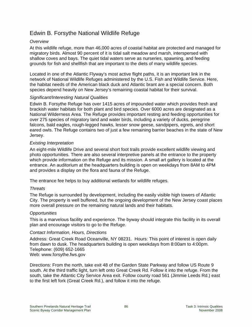
Southern Pinelands Natural Heritage Trail 86 Task 3: Intrinsic Qualities Scenic Byway Corridor Management Plan November 2008
Edwin B. Forsythe National Wildlife Refuge Overview At this wildlife refuge, more than 46,000 acres of coastal habitat are protected and managed for migratory birds. Almost 90 percent of it is tidal salt meadow and marsh, interspersed with shallow coves and bays. The quiet tidal waters serve as nurseries, spawning, and feeding grounds for fish and shellfish that are important to the diets of many wildlife species. Located in one of the Atlantic Flyway’s most active flight paths, it is an important link in the network of National Wildlife Refuges administered by the U.S. Fish and Wildlife Service. Here, the habitat needs of the American black duck and Atlantic brant are a special concern. Both species depend heavily on New Jersey’s remaining coastal habitat for their survival.
Significant/Interesting Natural Qualities Edwin B. Forsythe Refuge has over 1415 acres of impounded water which provides fresh and brackish water habitats for both plant and bird species. Over 6000 acres are designated as a National Wilderness Area. The Refuge provides important resting and feeding opportunities for over 275 species of migratory land and water birds, including a variety of ducks, peregrine falcons, bald eagles, rough-legged hawks, lesser snow geese, sandpipers, egrets, and short eared owls. The Refuge contains two of just a few remaining barrier beaches in the state of New Jersey.
Existing Interpretation An eight-mile Wildlife Drive and several short foot trails provide excellent wildlife viewing and photo opportunities. There are also several interpretive panels at the entrance to the property which provide information on the Refuge and its mission. A small art gallery is located at the entrance. An auditorium at the headquarters building is open on weekdays from 8AM to 4PM and provides a display on the flora and fauna of the Refuge. The entrance fee helps to buy additional wetlands for wildlife refuges.
Threats The Refuge is surrounded by development, including the easily visible high towers of Atlantic City. The property is well buffered, but the ongoing development of the New Jersey coast places more overall pressure on the remaining natural lands and their habitats.
Opportunities This is a marvelous facility and experience. The byway should integrate this facility in its overall plan and encourage visitors to go to the Refuge.
Contact Information, Hours, Directions Address: Great Creek Road Oceanville, NY 08231. Hours: This point of interest is open daily from dawn to dusk. The headquarters building is open weekdays from 8:00am to 4:00pm. Telephone: (609) 652-1665 Web: www.forsythe.fws.gov Directions: From the north, take exit 48 of the Garden State Parkway and follow US Route 9 south. At the third traffic light, turn left onto Great Creek Rd. Follow it into the refuge. From the south, take the Atlantic City Service Area exit. Follow county road 561 (Jimmie Leeds Rd.) east to the first left fork (Great Creek Rd.), and follow it into the refuge.
Southern Pinelands Natural Heritage Trail 87 Task 3: Intrinsic Qualities Scenic Byway Corridor Management Plan November 2008

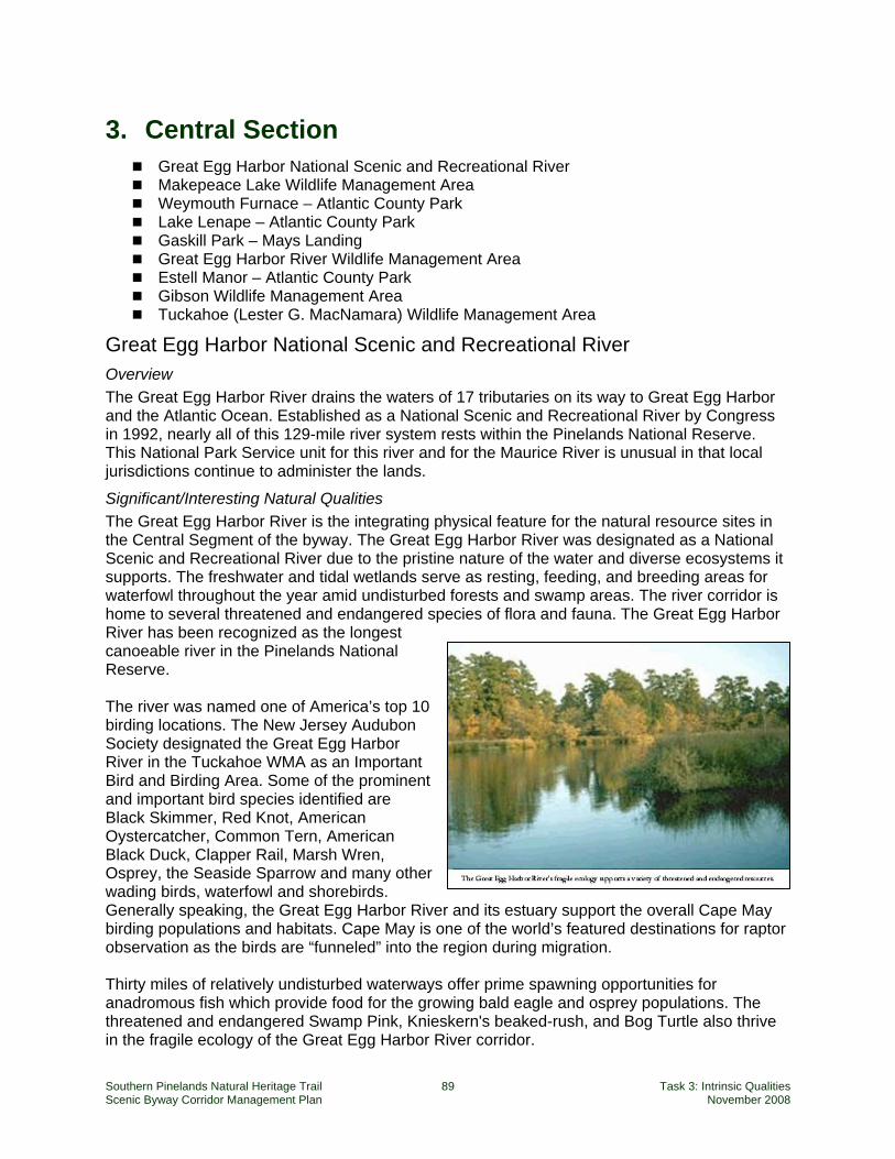
Southern Pinelands Natural Heritage Trail 89 Task 3: Intrinsic Qualities Scenic Byway Corridor Management Plan November 2008
3. Central Section Great Egg Harbor National Scenic and Recreational River Makepeace Lake Wildlife Management Area Weymouth Furnace – Atlantic County Park Lake Lenape – Atlantic County Park Gaskill Park – Mays Landing Great Egg Harbor River Wildlife Management Area Estell Manor – Atlantic County Park Gibson Wildlife Management Area Tuckahoe (Lester G. MacNamara) Wildlife Management Area
Great Egg Harbor National Scenic and Recreational River Overview The Great Egg Harbor River drains the waters of 17 tributaries on its way to Great Egg Harbor and the Atlantic Ocean. Established as a National Scenic and Recreational River by Congress in 1992, nearly all of this 129-mile river system rests within the Pinelands National Reserve. This National Park Service unit for this river and for the Maurice River is unusual in that local jurisdictions continue to administer the lands.
Significant/Interesting Natural Qualities The Great Egg Harbor River is the integrating physical feature for the natural resource sites in the Central Segment of the byway. The Great Egg Harbor River was designated as a National Scenic and Recreational River due to the pristine nature of the water and diverse ecosystems it supports. The freshwater and tidal wetlands serve as resting, feeding, and breeding areas for waterfowl throughout the year amid undisturbed forests and swamp areas. The river corridor is home to several threatened and endangered species of flora and fauna. The Great Egg Harbor River has been recognized as the longest canoeable river in the Pinelands National Reserve. The river was named one of America’s top 10 birding locations. The New Jersey Audubon Society designated the Great Egg Harbor River in the Tuckahoe WMA as an Important Bird and Birding Area. Some of the prominent and important bird species identified are Black Skimmer, Red Knot, American Oystercatcher, Common Tern, American Black Duck, Clapper Rail, Marsh Wren, Osprey, the Seaside Sparrow and many other wading birds, waterfowl and shorebirds. Generally speaking, the Great Egg Harbor River and its estuary support the overall Cape May birding populations and habitats. Cape May is one of the world’s featured destinations for raptor observation as the birds are “funneled” into the region during migration. Thirty miles of relatively undisturbed waterways offer prime spawning opportunities for anadromous fish which provide food for the growing bald eagle and osprey populations. The threatened and endangered Swamp Pink, Knieskern's beaked-rush, and Bog Turtle also thrive in the fragile ecology of the Great Egg Harbor River corridor.
Southern Pinelands Natural Heritage Trail 90 Task 3: Intrinsic Qualities Scenic Byway Corridor Management Plan November 2008
The region is rich in history. Evidence of the Lenape Indians before occupation by Europeans in the early 1700s can be found. Remnants of structures which converted bog iron into cannon balls during the Revolutionary War, blast furnaces, sawmills, glass factories and brick and tile works are also visible in the corridor. The recreational activities along the river are numerous and include backpacking, biking, bird watching, boating, camping, fishing, hiking, hunting, kayaking, nature walks, stargazing, and wildlife viewing.22
Existing Interpretation There is no coordinated interpretive approach for the river. Existing interpretation has been sponsored and designed by the National Park Service in some locations, specifically on the Tuckahoe WMA auto drive.
Threats While 25% of the lands along the Great Egg Harbor River are in public ownership and most of the lands are covered by the regulations of the Pinelands Commission, there is a high quantity of development near the mouth of the river with lower density development upstream within the watershed. Coastal development, the presence of many roads and established communities all contribute to non-point source pollution and other types of habitat-impairing impacts (e.g., boat disturbances, noise, etc.).
Opportunities This river is a defining element in the Pinelands region and its presence is a uniting feature for the natural resources and the character of the Central Segment of the Southern Pinelands Natural Heritage Trail. However, today, unless travelers are actively seeking out the Great Egg Harbor River they may have only a peripheral awareness of the river from a few signs at bridge crossings. The byway program must encourage and direct travelers to the sites reviewed in this section so that they can experience firsthand the many faces of this river and the habitats it creates and supports.
Contact Information, Hours, Directions Hours: Generally, the public access points to the river are open dawn to dusk Contact at National Park Service: Paul Kenney, National Park Service, 200 Chestnut Street Philadelphia, PA 19106. Telephone: 215-597-5823
Directions Along the byway, one can access the river at Weymouth Furnace, Gaskill Park, Estell Manor and Tuckahoe WMA. The Atlantic County Park, Penny Pot, is a short drive up Route 322 and is a popular canoeing and kayaking launch point on the Great Egg Harbor River.
Makepeace Lake Wildlife Management Area Overview Makepeace Lake is one of the jewels along the byway. It is a state-managed Wildlife Management Area of just over 11,000 acres. It consists of two tracts, separated by the Atlantic City Expressway. The northern tract contains a shooting range and for safety concerns, it will be excluded from byway programming and left for use to its current users, the hunting public. The southern portion contains Makepeace Lake a significant amount of land all around the lake. It is easily accessible, very scenic, contains various interesting habitats and parking is available. 22 http://www.nps.gov/nero/rivers/greategg.htm
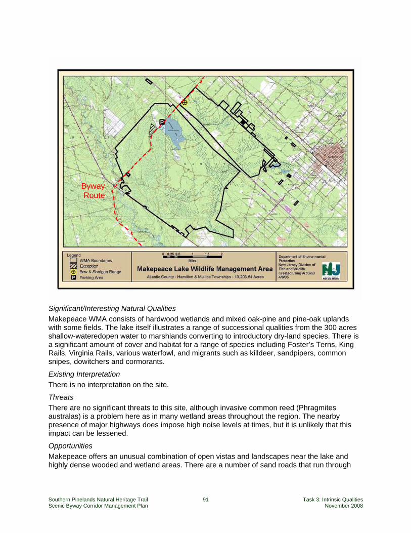
Southern Pinelands Natural Heritage Trail 91 Task 3: Intrinsic Qualities Scenic Byway Corridor Management Plan November 2008
Significant/Interesting Natural Qualities Makepeace WMA consists of hardwood wetlands and mixed oak-pine and pine-oak uplands with some fields. The lake itself illustrates a range of successional qualities from the 300 acres shallow-wateredopen water to marshlands converting to introductory dry-land species. There is a significant amount of cover and habitat for a range of species including Foster’s Terns, King Rails, Virginia Rails, various waterfowl, and migrants such as killdeer, sandpipers, common snipes, dowitchers and cormorants.
Existing Interpretation There is no interpretation on the site.
Threats There are no significant threats to this site, although invasive common reed (Phragmites australas) is a problem here as in many wetland areas throughout the region. The nearby presence of major highways does impose high noise levels at times, but it is unlikely that this impact can be lessened.
Opportunities Makepeace offers an unusual combination of open vistas and landscapes near the lake and highly dense wooded and wetland areas. There are a number of sand roads that run through
Byway Route
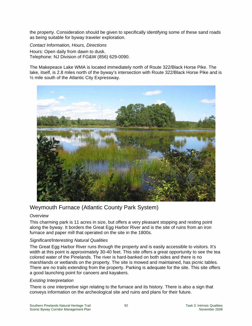
Southern Pinelands Natural Heritage Trail 92 Task 3: Intrinsic Qualities Scenic Byway Corridor Management Plan November 2008
the property. Consideration should be given to specifically identifying some of these sand roads as being suitable for byway traveler exploration.
Contact Information, Hours, Directions Hours: Open daily from dawn to dusk. Telephone: NJ Division of FG&W (856) 629-0090. The Makepeace Lake WMA is located immediately north of Route 322/Black Horse Pike. The lake, itself, is 2.8 miles north of the byway’s intersection with Route 322/Black Horse Pike and is ½ mile south of the Atlantic City Expressway.
Weymouth Furnace (Atlantic County Park System) Overview This charming park is 11 acres in size, but offers a very pleasant stopping and resting point along the byway. It borders the Great Egg Harbor River and is the site of ruins from an iron furnace and paper mill that operated on the site in the 1800s.
Significant/Interesting Natural Qualities The Great Egg Harbor River runs through the property and is easily accessible to visitors. It’s width at this point is approximately 30-40 feet. This site offers a great opportunity to see the tea colored water of the Pinelands. The river is hard-banked on both sides and there is no marshlands or wetlands on the property. The site is mowed and maintained, has picnic tables. There are no trails extending from the property. Parking is adequate for the site. This site offers a good launching point for canoers and kayakers.
Existing Interpretation There is one interpretive sign relating to the furnace and its history. There is also a sign that conveys information on the archeological site and ruins and plans for their future.
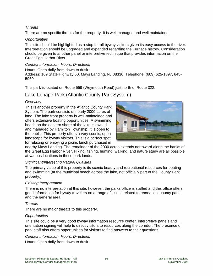
Southern Pinelands Natural Heritage Trail 93 Task 3: Intrinsic Qualities Scenic Byway Corridor Management Plan November 2008
Threats There are no specific threats for the property. It is well managed and well maintained.
Opportunities This site should be highlighted as a stop for all byway visitors given its easy access to the river. Interpretation should be upgraded and expanded regarding the Furnace history. Consideration should be given to another panel or interpretive technique that provides information on the Great Egg Harbor River.
Contact Information, Hours, Directions Hours: Open daily from dawn to dusk. Address: 109 State Highway 50, Mays Landing, NJ 08330. Telephone: (609) 625-1897, 645-5960 This park is located on Route 559 (Weymouth Road) just north of Route 322.
Lake Lenape Park (Atlantic County Park System) Overview This is another property in the Atlantic County Park System. The park consists of nearly 2000 acres of land. The lake front property is well-maintained and offers extensive boating opportunities. A swimming beach on the eastern shore of the lake is owned and managed by Hamilton Township. It is open to the public. This property offers a very scenic, open landscape for byway visitors. This is a perfect spot for relaxing or enjoying a picnic lunch purchased in nearby Mays Landing. The remainder of the 2000 acres extends northward along the banks of the Great Egg Harbor River. Hiking, fishing, hunting, walking, and nature study are all possible at various locations in these park lands.
Significant/Interesting Natural Qualities The primary value of this property is its scenic beauty and recreational resources for boating and swimming (at the municipal beach across the lake, not officially part of the County Park property.)
Existing Interpretation There is no interpretation at this site, however, the parks office is staffed and this office offers good information for byway travelers on a range of issues related to recreation, county parks and the general area.
Threats There are no major threats to this property.
Opportunities This site could be a very good byway information resource center. Interpretive panels and orientation signing will help to direct visitors to resources along the corridor. The presence of park staff also offers opportunities for visitors to find answers to their questions.
Contact Information, Hours, Directions Hours: Open daily from dawn to dusk.
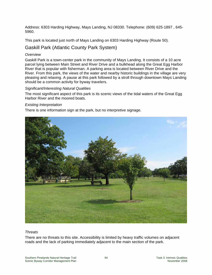
Southern Pinelands Natural Heritage Trail 94 Task 3: Intrinsic Qualities Scenic Byway Corridor Management Plan November 2008
Address: 6303 Harding Highway, Mays Landing, NJ 08330. Telephone: (609) 625-1897 , 645-5960. This park is located just north of Mays Landing on 6303 Harding Highway (Route 50).
Gaskill Park (Atlantic County Park System) Overview Gaskill Park is a town-center park in the community of Mays Landing. It consists of a 10 acre parcel lying between Main Street and River Drive and a bulkhead along the Great Egg Harbor River that is popular with fisherman. A parking area is located between River Drive and the River. From this park, the views of the water and nearby historic buildings in the village are very pleasing and relaxing. A pause at this park followed by a stroll through downtown Mays Landing should be a common activity for byway travelers.
Significant/Interesting Natural Qualities The most significant aspect of this park is its scenic views of the tidal waters of the Great Egg Harbor River and the moored boats.
Existing Interpretation There is one information sign at the park, but no interpretive signage.
Threats There are no threats to this site. Accessibility is limited by heavy traffic volumes on adjacent roads and the lack of parking immediately adjacent to the main section of the park.
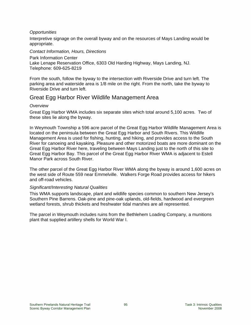
Southern Pinelands Natural Heritage Trail 95 Task 3: Intrinsic Qualities Scenic Byway Corridor Management Plan November 2008
Opportunities Interpretive signage on the overall byway and on the resources of Mays Landing would be appropriate.
Contact Information, Hours, Directions Park Information Center Lake Lenape Reservation Office, 6303 Old Harding Highway, Mays Landing, NJ. Telephone: 609-625-8219 From the south, follow the byway to the intersection with Riverside Drive and turn left. The parking area and waterside area is 1/8 mile on the right. From the north, take the byway to Riverside Drive and turn left.
Great Egg Harbor River Wildlife Management Area Overview Great Egg Harbor WMA includes six separate sites which total around 5,100 acres. Two of these sites lie along the byway. In Weymouth Township a 596 acre parcel of the Great Egg Harbor Wildlife Management Area is located on the peninsula between the Great Egg Harbor and South Rivers. This Wildlife Management Area is used for fishing, hunting, and hiking, and provides access to the South River for canoeing and kayaking. Pleasure and other motorized boats are more dominant on the Great Egg Harbor River here, traveling between Mays Landing just to the north of this site to Great Egg Harbor Bay. This parcel of the Great Egg Harbor River WMA is adjacent to Estell Manor Park across South River. The other parcel of the Great Egg Harbor River WMA along the byway is around 1,600 acres on the west side of Route 559 near Emmelville. Walkers Forge Road provides access for hikers and off-road vehicles.
Significant/Interesting Natural Qualities This WMA supports landscape, plant and wildlife species common to southern New Jersey's Southern Pine Barrens. Oak-pine and pine-oak uplands, old-fields, hardwood and evergreen wetland forests, shrub thickets and freshwater tidal marshes are all represented. The parcel in Weymouth includes ruins from the Bethlehem Loading Company, a munitions plant that supplied artillery shells for World War I.
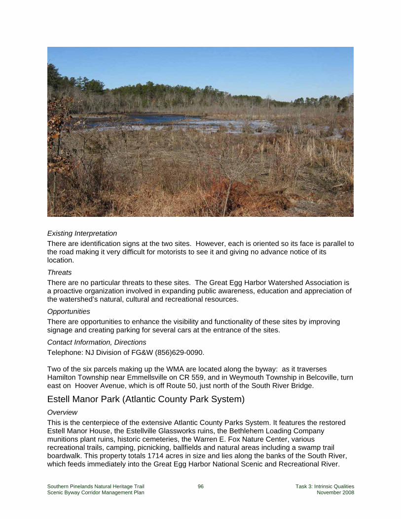
Southern Pinelands Natural Heritage Trail 96 Task 3: Intrinsic Qualities Scenic Byway Corridor Management Plan November 2008
Existing Interpretation There are identification signs at the two sites. However, each is oriented so its face is parallel to the road making it very difficult for motorists to see it and giving no advance notice of its location.
Threats There are no particular threats to these sites. The Great Egg Harbor Watershed Association is a proactive organization involved in expanding public awareness, education and appreciation of the watershed’s natural, cultural and recreational resources.
Opportunities There are opportunities to enhance the visibility and functionality of these sites by improving signage and creating parking for several cars at the entrance of the sites.
Contact Information, Directions Telephone: NJ Division of FG&W (856)629-0090. Two of the six parcels making up the WMA are located along the byway: as it traverses Hamilton Township near Emmellsville on CR 559, and in Weymouth Township in Belcoville, turn east on Hoover Avenue, which is off Route 50, just north of the South River Bridge.
Estell Manor Park (Atlantic County Park System) Overview This is the centerpiece of the extensive Atlantic County Parks System. It features the restored Estell Manor House, the Estellville Glassworks ruins, the Bethlehem Loading Company munitions plant ruins, historic cemeteries, the Warren E. Fox Nature Center, various recreational trails, camping, picnicking, ballfields and natural areas including a swamp trail boardwalk. This property totals 1714 acres in size and lies along the banks of the South River, which feeds immediately into the Great Egg Harbor National Scenic and Recreational River.
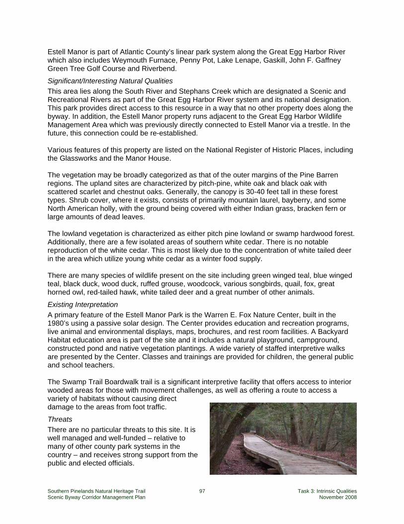
Southern Pinelands Natural Heritage Trail 97 Task 3: Intrinsic Qualities Scenic Byway Corridor Management Plan November 2008
Estell Manor is part of Atlantic County’s linear park system along the Great Egg Harbor River which also includes Weymouth Furnace, Penny Pot, Lake Lenape, Gaskill, John F. Gaffney Green Tree Golf Course and Riverbend.
Significant/Interesting Natural Qualities This area lies along the South River and Stephans Creek which are designated a Scenic and Recreational Rivers as part of the Great Egg Harbor River system and its national designation. This park provides direct access to this resource in a way that no other property does along the byway. In addition, the Estell Manor property runs adjacent to the Great Egg Harbor Wildlife Management Area which was previously directly connected to Estell Manor via a trestle. In the future, this connection could be re-established. Various features of this property are listed on the National Register of Historic Places, including the Glassworks and the Manor House. The vegetation may be broadly categorized as that of the outer margins of the Pine Barren regions. The upland sites are characterized by pitch-pine, white oak and black oak with scattered scarlet and chestnut oaks. Generally, the canopy is 30-40 feet tall in these forest types. Shrub cover, where it exists, consists of primarily mountain laurel, bayberry, and some North American holly, with the ground being covered with either Indian grass, bracken fern or large amounts of dead leaves. The lowland vegetation is characterized as either pitch pine lowland or swamp hardwood forest. Additionally, there are a few isolated areas of southern white cedar. There is no notable reproduction of the white cedar. This is most likely due to the concentration of white tailed deer in the area which utilize young white cedar as a winter food supply. There are many species of wildlife present on the site including green winged teal, blue winged teal, black duck, wood duck, ruffed grouse, woodcock, various songbirds, quail, fox, great horned owl, red-tailed hawk, white tailed deer and a great number of other animals.
Existing Interpretation A primary feature of the Estell Manor Park is the Warren E. Fox Nature Center, built in the 1980’s using a passive solar design. The Center provides education and recreation programs, live animal and environmental displays, maps, brochures, and rest room facilities. A Backyard Habitat education area is part of the site and it includes a natural playground, campground, constructed pond and native vegetation plantings. A wide variety of staffed interpretive walks are presented by the Center. Classes and trainings are provided for children, the general public and school teachers. The Swamp Trail Boardwalk trail is a significant interpretive facility that offers access to interior wooded areas for those with movement challenges, as well as offering a route to access a variety of habitats without causing direct damage to the areas from foot traffic.
Threats There are no particular threats to this site. It is well managed and well-funded – relative to many of other county park systems in the country – and receives strong support from the public and elected officials.
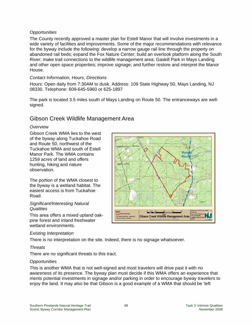
Southern Pinelands Natural Heritage Trail 98 Task 3: Intrinsic Qualities Scenic Byway Corridor Management Plan November 2008
Byway Route
Opportunities The County recently approved a master plan for Estell Manor that will involve investments in a wide variety of facilities and improvements. Some of the major recommendations with relevance for the byway include the following: develop a narrow gauge rail line through the property on abandoned rail beds; expand the Fox Nature Center; build an overlook platform along the South River; make trail connections to the wildlife management area; Gaskill Park in Mays Landing and other open space properties; improve signage; and further restore and interpret the Manor House.
Contact Information, Hours, Directions Hours: Open daily from 7:30AM to dusk. Address: 109 State Highway 50, Mays Landing, NJ 08330. Telephone: 609-645-5960 or 625-1897 The park is located 3.5 miles south of Mays Landing on Route 50. The entranceways are well-signed.
Gibson Creek Wildlife Management Area Overview Gibson Creek WMA lies to the west of the byway along Tuckahoe Road and Route 50, northwest of the Tuckahoe WMA and south of Estell Manor Park. The WMA contains 1259 acres of land and offers hunting, hiking and nature observation. The portion of the WMA closest to the byway is a wetland habitat. The easiest access is from Tuckahoe Road.
Significant/Interesting Natural Qualities This area offers a mixed upland oak-pine forest and inland freshwater wetland environments.
Existing Interpretation There is no interpretation on the site. Indeed, there is no signage whatsoever.
Threats There are no significant threats to this tract.
Opportunities This is another WMA that is not well-signed and most travelers will drive past it with no awareness of its presence. The byway plan must decide if this WMA offers an experience that merits potential investments in signage and/or parking in order to encourage byway travelers to enjoy the land. It may also be that Gibson is a good example of a WMA that should be ‘left
Southern Pinelands Natural Heritage Trail 99 Task 3: Intrinsic Qualities Scenic Byway Corridor Management Plan November 2008
alone’, i.e., not promoted in order to discourage over-visitation. Its overall size is small compared to MacNamara and thus it will be more heavily impacted by more visitation.
Contact Information, Hours, Directions Address: CR 631/Tuckahoe Rd., Tuckahoe, NJ. Phone: (609) 628-2103. Web site: www.njfishandwildlife.org. North of Corbin City, turn northwest on Tuckahoe Road. Parking is along the road edge.
Lester C. MacNamara (Tuckahoe) Wildlife Management Area Overview The Lester G. MacNamara Wildlife Management Area (WMA), formerly the Tuckahoe WMA, contains 34,231 acres of primarily tidal wetland with mixed upland forests. It straddles Atlantic and Cape May Counties and is bordered by the Great Egg Harbor River to the northeast and is intersected by the Middle and Tuckahoe Rivers.
Significant/Interesting Natural Qualities This site is composed of a diversity of habitats including extensive tidal salt marsh, mixed upland forest, and freshwater rivers and impoundments. The site includes the Tuckahoe Corbin Salt Marsh Natural Heritage Priority Macrosite, designated by NJ Department of Environmental Protection (NJDEP) as some of the state’s most significant natural areas. The site is also a New Jersey Audubon Important Birding Area. The MacNamara WMA provides breeding and foraging habitat for state-endangered Northern Harriers and Peregrine Falcons. This site likely contains one third of New Jersey’s Least Bittern population and harbors a significant portion of the state’s King Rail population. The MacNamara WMA is also one of the best places in New Jersey for wintering raptors including Bald Eagles, Short-eared Owls, Rough-legged Hawks. The freshwater impoundment provide wintering habitat for waterfowl such as Tundra Swans.
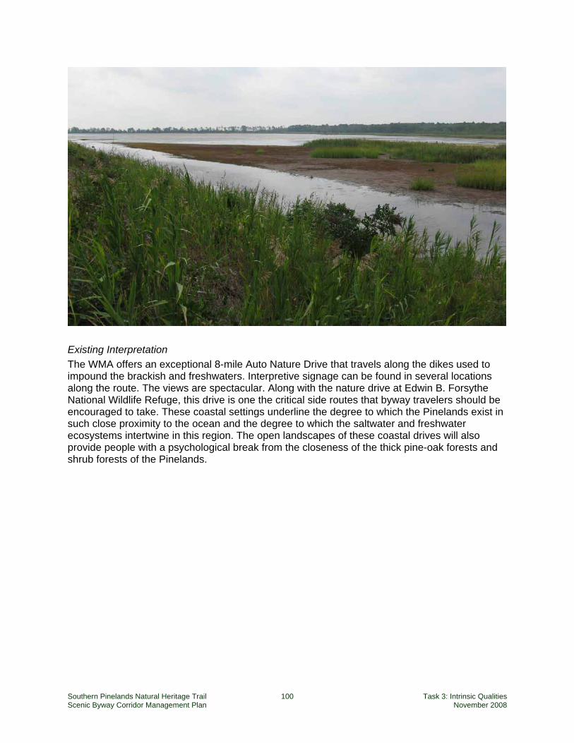
Southern Pinelands Natural Heritage Trail 100 Task 3: Intrinsic Qualities Scenic Byway Corridor Management Plan November 2008
Existing Interpretation The WMA offers an exceptional 8-mile Auto Nature Drive that travels along the dikes used to impound the brackish and freshwaters. Interpretive signage can be found in several locations along the route. The views are spectacular. Along with the nature drive at Edwin B. Forsythe National Wildlife Refuge, this drive is one the critical side routes that byway travelers should be encouraged to take. These coastal settings underline the degree to which the Pinelands exist in such close proximity to the ocean and the degree to which the saltwater and freshwater ecosystems intertwine in this region. The open landscapes of these coastal drives will also provide people with a psychological break from the closeness of the thick pine-oak forests and shrub forests of the Pinelands.
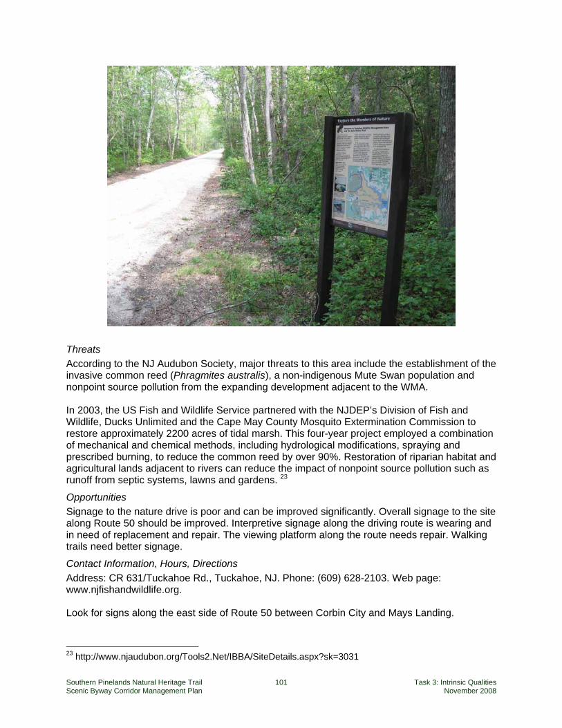
Southern Pinelands Natural Heritage Trail 101 Task 3: Intrinsic Qualities Scenic Byway Corridor Management Plan November 2008
Threats According to the NJ Audubon Society, major threats to this area include the establishment of the invasive common reed (Phragmites australis), a non-indigenous Mute Swan population and nonpoint source pollution from the expanding development adjacent to the WMA. In 2003, the US Fish and Wildlife Service partnered with the NJDEP’s Division of Fish and Wildlife, Ducks Unlimited and the Cape May County Mosquito Extermination Commission to restore approximately 2200 acres of tidal marsh. This four-year project employed a combination of mechanical and chemical methods, including hydrological modifications, spraying and prescribed burning, to reduce the common reed by over 90%. Restoration of riparian habitat and agricultural lands adjacent to rivers can reduce the impact of nonpoint source pollution such as runoff from septic systems, lawns and gardens. 23
Opportunities Signage to the nature drive is poor and can be improved significantly. Overall signage to the site along Route 50 should be improved. Interpretive signage along the driving route is wearing and in need of replacement and repair. The viewing platform along the route needs repair. Walking trails need better signage.
Contact Information, Hours, Directions Address: CR 631/Tuckahoe Rd., Tuckahoe, NJ. Phone: (609) 628-2103. Web page: www.njfishandwildlife.org. Look for signs along the east side of Route 50 between Corbin City and Mays Landing.
23 http://www.njaudubon.org/Tools2.Net/IBBA/SiteDetails.aspx?sk=3031
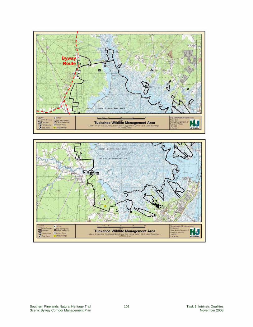
Southern Pinelands Natural Heritage Trail 102 Task 3: Intrinsic Qualities Scenic Byway Corridor Management Plan November 2008
Byway Route
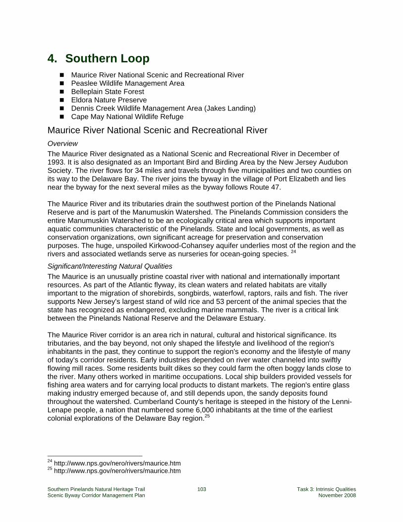
Southern Pinelands Natural Heritage Trail 103 Task 3: Intrinsic Qualities Scenic Byway Corridor Management Plan November 2008
4. Southern Loop Maurice River National Scenic and Recreational River Peaslee Wildlife Management Area Belleplain State Forest Eldora Nature Preserve Dennis Creek Wildlife Management Area (Jakes Landing) Cape May National Wildlife Refuge
Maurice River National Scenic and Recreational River Overview The Maurice River designated as a National Scenic and Recreational River in December of 1993. It is also designated as an Important Bird and Birding Area by the New Jersey Audubon Society. The river flows for 34 miles and travels through five municipalities and two counties on its way to the Delaware Bay. The river joins the byway in the village of Port Elizabeth and lies near the byway for the next several miles as the byway follows Route 47. The Maurice River and its tributaries drain the southwest portion of the Pinelands National Reserve and is part of the Manumuskin Watershed. The Pinelands Commission considers the entire Manumuskin Watershed to be an ecologically critical area which supports important aquatic communities characteristic of the Pinelands. State and local governments, as well as conservation organizations, own significant acreage for preservation and conservation purposes. The huge, unspoiled Kirkwood-Cohansey aquifer underlies most of the region and the rivers and associated wetlands serve as nurseries for ocean-going species. 24
Significant/Interesting Natural Qualities The Maurice is an unusually pristine coastal river with national and internationally important resources. As part of the Atlantic flyway, its clean waters and related habitats are vitally important to the migration of shorebirds, songbirds, waterfowl, raptors, rails and fish. The river supports New Jersey's largest stand of wild rice and 53 percent of the animal species that the state has recognized as endangered, excluding marine mammals. The river is a critical link between the Pinelands National Reserve and the Delaware Estuary. The Maurice River corridor is an area rich in natural, cultural and historical significance. Its tributaries, and the bay beyond, not only shaped the lifestyle and livelihood of the region's inhabitants in the past, they continue to support the region's economy and the lifestyle of many of today's corridor residents. Early industries depended on river water channeled into swiftly flowing mill races. Some residents built dikes so they could farm the often boggy lands close to the river. Many others worked in maritime occupations. Local ship builders provided vessels for fishing area waters and for carrying local products to distant markets. The region's entire glass making industry emerged because of, and still depends upon, the sandy deposits found throughout the watershed. Cumberland County's heritage is steeped in the history of the Lenni-Lenape people, a nation that numbered some 6,000 inhabitants at the time of the earliest colonial explorations of the Delaware Bay region.25
24 http://www.nps.gov/nero/rivers/maurice.htm 25 http://www.nps.gov/nero/rivers/maurice.htm
Southern Pinelands Natural Heritage Trail 104 Task 3: Intrinsic Qualities Scenic Byway Corridor Management Plan November 2008
Existing Interpretation There is no interpretation of the Maurice River along the byway today. There are large signs indicating the river crossing at the edge of Port Elizabeth, but there is no interpretation associated with these signs.
Threats The river corridor is the focus of efforts by many organizations and agencies to protect land and habitat, but the corridor is damaged by sand and gravel operations, urban runoff from Millville and Vineland, and development. Additionally, the common reed (Phragmites australis) is an aggressive invasive plant species which has replaced much of the beneficial marsh vegetation along creek channels, e.g., spartina or bullrush habitats. Canada Geese grazing and feeding is a major threat to the river’s wild rice marshes. Control of P. australis is difficult; there are no significant biological control methods available. Herbicides are typically used to control populations. 26
Opportunities The byway approaches the Maurice River only in Port Elizabeth and there is limited access to the river at that location. Information must be provided to byway travelers on how they can more easily get down to the river. A good example of providing this opportunity might be a signed and designated spur route to the village of Mauricetown. The trip takes one across the beautiful marshlands of the Maurice River. There is a bridge and public access parking and a boat launch at the base of the bridge.
Contact Information, Hours, Directions Hours: no facilities and therefore no hours of operation The National Park Service staff person associated with the Maurice River is Paul Kenney. There is also a citizens group that advocates for the Maurice River. Their webpage is www.cumauriceriver.org. Directions: To reach the bridge crossing with the byway, follow Route 55 south to Port Elizabeth or Route 47 north from Dennisville to Port Elizabeth.
Peaslee Wildlife Management Area Overview At over 33,000 acres, Peaslee is one of the state’s largest wildlife management areas. It lies to the north of Route 548 and east of the village of Port Elizabeth. Peaslee offers a full range of hunting and wildlife viewing opportunities. Unofficial and unmarked parking areas are provided up some of the sand roads that run into the Management Area. There is very little signing that indicates the edges of the WMA.
Significant/Interesting Natural Qualities Peaslee is part of the New Jersey Audubon’s designation of the Southern Pine Barrens Important Birding Area (IBA). Peaslee and nearby areas are predominantly oak-pine forests.
26 http://www.njaudubon.org/Tools2.Net/IBBA/SiteDetails.aspx?sk=3048
Southern Pinelands Natural Heritage Trail 105 Task 3: Intrinsic Qualities Scenic Byway Corridor Management Plan November 2008
The forest species mix is distinct from the Northern Pine Barrens and is characterized by well-drained loamy sand which supports a lower pine to oak ratio and a distinct avian community. This site also supports extensive hardwood swamps and early successional habitats including the typical Pine Barrens scrub-shrub community and grasslands.27 Peaslee has thousands of acres of upland oak-pine forests and lowland bogs. Its longest border is the upper part of the Tuckahoe River. Old cranberry bogs and a mill are in the early stages of succession, and offer excellent freshwater marsh habitats. It offers diverse Pinelands habitats: the wooded edge, pinelands, cedar bog, hardwood swamp, scrub oak forests, sweet ferns, grassy fields, and yellow-clover pasture. 28
Existing Interpretation There is no interpretation present on this site today.
Threats Peaslee and nearby Belleplain State Forest are under state ownership and management. Adjacent private lands to the north of Peaslee are seeing some development. All lands within this portion of the byway corridor are managed as Forest Lands by the Pinelands Commission; thus development is minimal. Pine beetle infestations are increasing. Natural succession – uncontrolled by fire – is threatening some of the classic Pinelands habitats. Illegal off-road vehicle use is sometimes a problem in this area.
Opportunities Peaslee offers one of the longest, uninterrupted stretches of tall-stand, oak-pine forest on the byway. Peaslee meshes with the boundaries of Belleplain State Forest which offers similar habitats. Together, these two tracts comprise an area of over 34,000 acres. Today, there are no signs that welcome visitors to the WMA or indicate where one might park or walk. Selected parking areas and trails would open this area to byway visitors without resulting in large scale intrusions on the WMA’s habitats.
Contact Information, Hours, Directions Hours: Open daily from dawn to dusk. Telephone: NJ Division of FG&W (856) 629-0090 Directions: Follow State Road 55 to its end in Port Elizabeth and turn left onto Route 548.
27 http://www.njaudubon.org/Tools2.Net/IBBA/SiteDetails.aspx?sk=3341 28 http://www.nps.gov/archive/neje/cumberla.htm
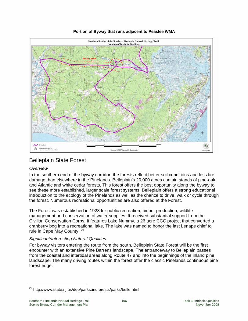
Southern Pinelands Natural Heritage Trail 106 Task 3: Intrinsic Qualities Scenic Byway Corridor Management Plan November 2008
Portion of Byway that runs adjacent to Peaslee WMA
Belleplain State Forest Overview In the southern end of the byway corridor, the forests reflect better soil conditions and less fire damage than elsewhere in the Pinelands. Belleplain’s 20,000 acres contain stands of pine-oak and Atlantic and white cedar forests. This forest offers the best opportunity along the byway to see these more established, larger scale forest systems. Belleplain offers a strong educational introduction to the ecology of the Pinelands as well as the chance to drive, walk or cycle through the forest. Numerous recreational opportunities are also offered at the Forest. The Forest was established in 1928 for public recreation, timber production, wildlife management and conservation of water supplies. It received substantial support from the Civilian Conservation Corps. It features Lake Nummy, a 26 acre CCC project that converted a cranberry bog into a recreational lake. The lake was named to honor the last Lenape chief to rule in Cape May County. 29
Significant/Interesting Natural Qualities For byway visitors entering the route from the south, Belleplain State Forest will be the first encounter with an extensive Pine Barrens landscape. The entranceway to Belleplain passes from the coastal and intertidal areas along Route 47 and into the beginnings of the inland pine landscape. The many driving routes within the forest offer the classic Pinelands continuous pine forest edge.
29 http://www.state.nj.us/dep/parksandforests/parks/belle.html
Peaslee WMA
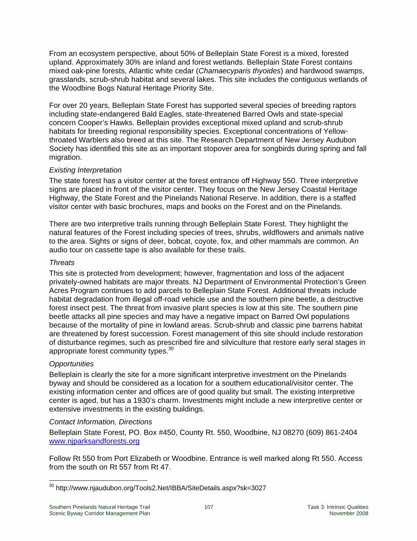
Southern Pinelands Natural Heritage Trail 107 Task 3: Intrinsic Qualities Scenic Byway Corridor Management Plan November 2008
From an ecosystem perspective, about 50% of Belleplain State Forest is a mixed, forested upland. Approximately 30% are inland and forest wetlands. Belleplain State Forest contains mixed oak-pine forests, Atlantic white cedar (Chamaecyparis thyoides) and hardwood swamps, grasslands, scrub-shrub habitat and several lakes. This site includes the contiguous wetlands of the Woodbine Bogs Natural Heritage Priority Site. For over 20 years, Belleplain State Forest has supported several species of breeding raptors including state-endangered Bald Eagles, state-threatened Barred Owls and state-special concern Cooper’s Hawks. Belleplain provides exceptional mixed upland and scrub-shrub habitats for breeding regional responsibility species. Exceptional concentrations of Yellow-throated Warblers also breed at this site. The Research Department of New Jersey Audubon Society has identified this site as an important stopover area for songbirds during spring and fall migration.
Existing Interpretation The state forest has a visitor center at the forest entrance off Highway 550. Three interpretive signs are placed in front of the visitor center. They focus on the New Jersey Coastal Heritage Highway, the State Forest and the Pinelands National Reserve. In addition, there is a staffed visitor center with basic brochures, maps and books on the Forest and on the Pinelands. There are two interpretive trails running through Belleplain State Forest. They highlight the natural features of the Forest including species of trees, shrubs, wildflowers and animals native to the area. Sights or signs of deer, bobcat, coyote, fox, and other mammals are common. An audio tour on cassette tape is also available for these trails.
Threats This site is protected from development; however, fragmentation and loss of the adjacent privately-owned habitats are major threats. NJ Department of Environmental Protection’s Green Acres Program continues to add parcels to Belleplain State Forest. Additional threats include habitat degradation from illegal off-road vehicle use and the southern pine beetle, a destructive forest insect pest. The threat from invasive plant species is low at this site. The southern pine beetle attacks all pine species and may have a negative impact on Barred Owl populations because of the mortality of pine in lowland areas. Scrub-shrub and classic pine barrens habitat are threatened by forest succession. Forest management of this site should include restoration of disturbance regimes, such as prescribed fire and silviculture that restore early seral stages in appropriate forest community types.30
Opportunities Belleplain is clearly the site for a more significant interpretive investment on the Pinelands byway and should be considered as a location for a southern educational/visitor center. The existing information center and offices are of good quality but small. The existing interpretive center is aged, but has a 1930’s charm. Investments might include a new interpretive center or extensive investments in the existing buildings.
Contact Information, Directions Belleplain State Forest, PO. Box #450, County Rt. 550, Woodbine, NJ 08270 (609) 861-2404 www.njparksandforests.org Follow Rt 550 from Port Elizabeth or Woodbine. Entrance is well marked along Rt 550. Access from the south on Rt 557 from Rt 47.
30 http://www.njaudubon.org/Tools2.Net/IBBA/SiteDetails.aspx?sk=3027
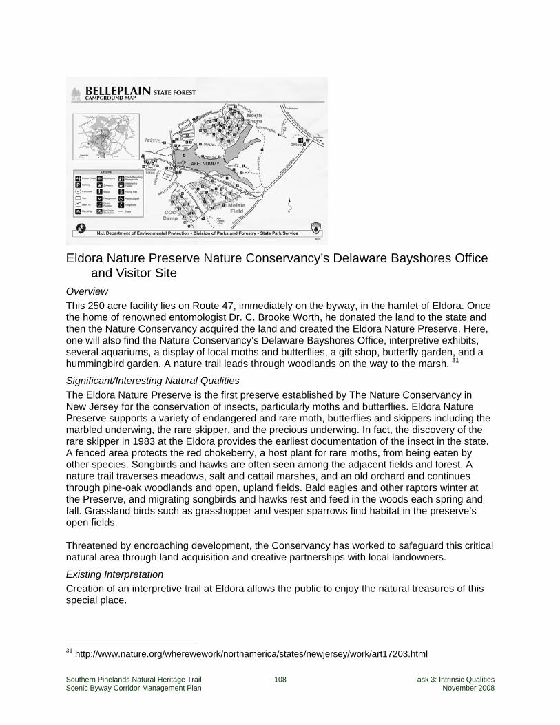
Southern Pinelands Natural Heritage Trail 108 Task 3: Intrinsic Qualities Scenic Byway Corridor Management Plan November 2008
Eldora Nature Preserve Nature Conservancy’s Delaware Bayshores Office and Visitor Site
Overview This 250 acre facility lies on Route 47, immediately on the byway, in the hamlet of Eldora. Once the home of renowned entomologist Dr. C. Brooke Worth, he donated the land to the state and then the Nature Conservancy acquired the land and created the Eldora Nature Preserve. Here, one will also find the Nature Conservancy’s Delaware Bayshores Office, interpretive exhibits, several aquariums, a display of local moths and butterflies, a gift shop, butterfly garden, and a hummingbird garden. A nature trail leads through woodlands on the way to the marsh. 31
Significant/Interesting Natural Qualities The Eldora Nature Preserve is the first preserve established by The Nature Conservancy in New Jersey for the conservation of insects, particularly moths and butterflies. Eldora Nature Preserve supports a variety of endangered and rare moth, butterflies and skippers including the marbled underwing, the rare skipper, and the precious underwing. In fact, the discovery of the rare skipper in 1983 at the Eldora provides the earliest documentation of the insect in the state. A fenced area protects the red chokeberry, a host plant for rare moths, from being eaten by other species. Songbirds and hawks are often seen among the adjacent fields and forest. A nature trail traverses meadows, salt and cattail marshes, and an old orchard and continues through pine-oak woodlands and open, upland fields. Bald eagles and other raptors winter at the Preserve, and migrating songbirds and hawks rest and feed in the woods each spring and fall. Grassland birds such as grasshopper and vesper sparrows find habitat in the preserve’s open fields. Threatened by encroaching development, the Conservancy has worked to safeguard this critical natural area through land acquisition and creative partnerships with local landowners.
Existing Interpretation Creation of an interpretive trail at Eldora allows the public to enjoy the natural treasures of this special place.
31 http://www.nature.org/wherewework/northamerica/states/newjersey/work/art17203.html
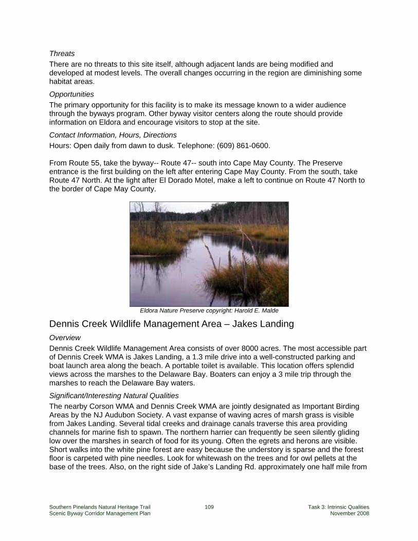
Southern Pinelands Natural Heritage Trail 109 Task 3: Intrinsic Qualities Scenic Byway Corridor Management Plan November 2008
Threats There are no threats to this site itself, although adjacent lands are being modified and developed at modest levels. The overall changes occurring in the region are diminishing some habitat areas.
Opportunities The primary opportunity for this facility is to make its message known to a wider audience through the byways program. Other byway visitor centers along the route should provide information on Eldora and encourage visitors to stop at the site.
Contact Information, Hours, Directions Hours: Open daily from dawn to dusk. Telephone: (609) 861-0600. From Route 55, take the byway-- Route 47-- south into Cape May County. The Preserve entrance is the first building on the left after entering Cape May County. From the south, take Route 47 North. At the light after El Dorado Motel, make a left to continue on Route 47 North to the border of Cape May County.
Eldora Nature Preserve copyright: Harold E. Malde
Dennis Creek Wildlife Management Area – Jakes Landing Overview Dennis Creek Wildlife Management Area consists of over 8000 acres. The most accessible part of Dennis Creek WMA is Jakes Landing, a 1.3 mile drive into a well-constructed parking and boat launch area along the beach. A portable toilet is available. This location offers splendid views across the marshes to the Delaware Bay. Boaters can enjoy a 3 mile trip through the marshes to reach the Delaware Bay waters.
Significant/Interesting Natural Qualities The nearby Corson WMA and Dennis Creek WMA are jointly designated as Important Birding Areas by the NJ Audubon Society. A vast expanse of waving acres of marsh grass is visible from Jakes Landing. Several tidal creeks and drainage canals traverse this area providing channels for marine fish to spawn. The northern harrier can frequently be seen silently gliding low over the marshes in search of food for its young. Often the egrets and herons are visible. Short walks into the white pine forest are easy because the understory is sparse and the forest floor is carpeted with pine needles. Look for whitewash on the trees and for owl pellets at the base of the trees. Also, on the right side of Jake’s Landing Rd. approximately one half mile from
Southern Pinelands Natural Heritage Trail 110 Task 3: Intrinsic Qualities Scenic Byway Corridor Management Plan November 2008
Rt. 47, is the centuries-old cemetery of the Ludlam family, proprietors of these lands in the late eighteenth and early nineteenth centuries.32
Existing Interpretation There is no interpretation at this site.
Threats Major threats to the Dennis WMA include change in hydrology, stormwater discharge, non-compatible agriculture and development of adjacent privately-owned lands. Development in adjacent areas along Route 47 generates non-point sources of pollution, such as runoff from septic systems, lawns and gardens which impair the natural ability of the wetlands to purify and absorb water filtering into the bay. The practice of salt marsh ditching to control mosquito populations and create tillable land likely impacts the hydrology in portions of the site. Additionally, the common reed (Phragmites australis), an aggressive invasive plant species, has replaced much of the beneficial marsh vegetation along creek channels. Oil spills occasionally affect this region as it contains the nation’s third largest petrochemical port. Protection and restoration of privately-owned parcels adjacent to this area can be accomplished by promoting landowner incentives for protecting and managing habitat and by prioritizing parcels for acquisition.33
Opportunities Along this Route 47 portion of the byway, this site offers the best opportunity for the traveler to enter into the coastal marshlands and be close to saltwater. Jake’s Landing is very special site in which to spend a few minutes up to a couple of hours. Interpretation should be placed on the site. Consideration should be given to developing a formal trail through the site.
Contact Information, Hours, Directions Hours: This unmanaged point of interest is open daily from dawn to dusk. Telephone: NJ Division of F&W (609) 292-9450. Follow state roads 55 & 47 south from Millville to the community of North Dennis. Watch for the intersection of CR557. Travel 0.3 miles further south on SR47 to Jake's Landing Road. Turn west (right) on Jake's Landing Road, and follow it to the end - approximately 1.5 miles to the parking lot, boat ramp, and Dennis Creek.
Cape May National Wildlife Refuge (Great Cedar Swamp Section) Overview Established in January of 1989, Cape May National Wildlife Refuge is one of the newest refuges in the National Wildlife Refuge System. The Refuge can be accessed from the byway by traveling east of Woodbine on Route 550 and then south on Route 610 towards Dennisville. The total refuge is 800 acres. The Great Cedar Swamp Division is located in Upper and Dennis Townships near the towns of Woodbine and Dennisville. This area has the largest contiguous forest on the refuge and is part of the Pinelands National Reserve and the Great Egg Harbor National Scenic and Recreational River. This division protects mostly hardwood swamp, salt marsh, and bog habitat along with some forested uplands and grassland areas. This site offers the byway’s best viewing opportunities for Atlantic white cedar stands, a variety of warblers, including prothonotary and 32 http://www.njwildlifetrails.org/BwtWeb/SiteDetails.aspx?si=44 33 http://www.njaudubon.org/Tools2.Net/IBBA/SiteDetails.aspx?sk=3020
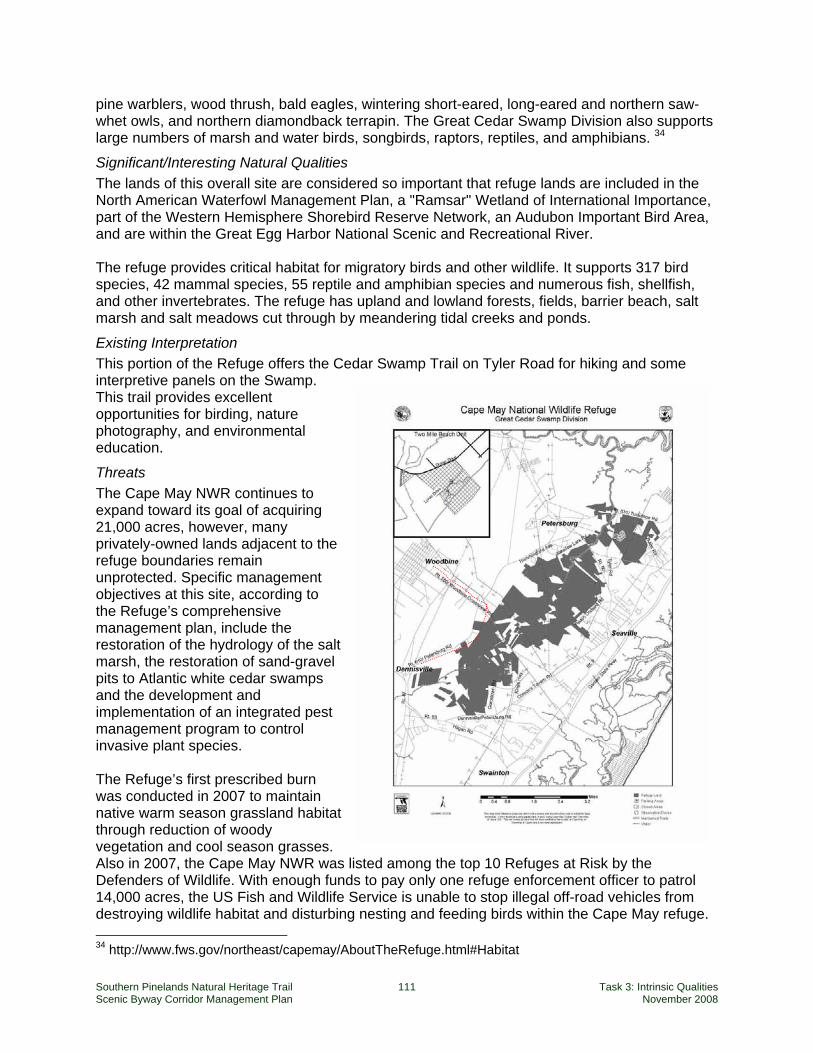
Southern Pinelands Natural Heritage Trail 111 Task 3: Intrinsic Qualities Scenic Byway Corridor Management Plan November 2008
pine warblers, wood thrush, bald eagles, wintering short-eared, long-eared and northern saw-whet owls, and northern diamondback terrapin. The Great Cedar Swamp Division also supports large numbers of marsh and water birds, songbirds, raptors, reptiles, and amphibians. 34
Significant/Interesting Natural Qualities The lands of this overall site are considered so important that refuge lands are included in the North American Waterfowl Management Plan, a "Ramsar" Wetland of International Importance, part of the Western Hemisphere Shorebird Reserve Network, an Audubon Important Bird Area, and are within the Great Egg Harbor National Scenic and Recreational River. The refuge provides critical habitat for migratory birds and other wildlife. It supports 317 bird species, 42 mammal species, 55 reptile and amphibian species and numerous fish, shellfish, and other invertebrates. The refuge has upland and lowland forests, fields, barrier beach, salt marsh and salt meadows cut through by meandering tidal creeks and ponds.
Existing Interpretation This portion of the Refuge offers the Cedar Swamp Trail on Tyler Road for hiking and some interpretive panels on the Swamp. This trail provides excellent opportunities for birding, nature photography, and environmental education.
Threats The Cape May NWR continues to expand toward its goal of acquiring 21,000 acres, however, many privately-owned lands adjacent to the refuge boundaries remain unprotected. Specific management objectives at this site, according to the Refuge’s comprehensive management plan, include the restoration of the hydrology of the salt marsh, the restoration of sand-gravel pits to Atlantic white cedar swamps and the development and implementation of an integrated pest management program to control invasive plant species. The Refuge’s first prescribed burn was conducted in 2007 to maintain native warm season grassland habitat through reduction of woody vegetation and cool season grasses. Also in 2007, the Cape May NWR was listed among the top 10 Refuges at Risk by the Defenders of Wildlife. With enough funds to pay only one refuge enforcement officer to patrol 14,000 acres, the US Fish and Wildlife Service is unable to stop illegal off-road vehicles from destroying wildlife habitat and disturbing nesting and feeding birds within the Cape May refuge. 34 http://www.fws.gov/northeast/capemay/AboutTheRefuge.html#Habitat
Southern Pinelands Natural Heritage Trail 112 Task 3: Intrinsic Qualities Scenic Byway Corridor Management Plan November 2008
Opportunities The Cedar Swamp section offers an exceptionally under-visited area for byway travelers. Signage, parking and interpretation are all opportunities at this site.
Contact Information, Hours, Directions Hours: The office is open weekdays from 8:00am to 4:00pm. The refuge is open daily from dawn to dusk. Telephone: (609) 463-0994 . Directions: From exit 10 of the Garden State Parkway at Cape May Courthouse, turn south on US Route 9. Then turn west (right) on county road 658 (Hand Avenue.) Turn south on state road 47, then immediately west onto Kimbles Beach Rd. The entrance to the office is ahead.

Southern Pinelands Natural Heritage Trail 113 Task 3: Intrinsic Qualities Scenic Byway Corridor Management Plan November 2008
APPENDICES Appendix 1: Web Links
Scenic Byways National Scenic Byways Program
America’s Byways® Community http://www.bywaysonline.org/
See America’s Byways http://www.seeamerica.org/byways/index.html
New Jersey Scenic Byways Program
Bayshore Heritage Byway http://www.bayshoreheritagebyway.org/
New Jersey Scenic Byways Program http://www.state.nj.us/transportation/community/scenic/
New Jersey’s Delaware River Scenic Byway http://delawareriverscenicbyway.org/
Scenic Byways in New Jersey http://www.pdcbank.state.nj.us/transportation/community/scenic/
Southern Pinelands Natural Heritage Trail – Corridor Management Plan Website http://www.njpinelandstrail.com/
New Jersey Pinelands / Pine Barrens Burlington County Library-Pinelands Resources
http://www.burlco.lib.nj.us/pinelands/
New Jersey Pine Barrens & Down Jersey: Exploring the history, culture, & ecology of South Jersey http://www.njpinelandsanddownjersey.com/open/
New Jersey Pinelands Commission http://www.state.nj.us/pinelands/
NJPineBarrens.com http://www.njpinebarrens.com/
County and Municipal Web Sites New Jersey County and Municipal Web Sites
http://www.nj.gov/nj/govinfo/county/localgov.html
Ocean County http://www.co.ocean.nj.us/
Southern Pinelands Natural Heritage Trail 114 Task 3: Intrinsic Qualities Scenic Byway Corridor Management Plan November 2008
Tuckerton Borough http://www.tuckertonborough.com/
Little Egg Harbor Township http://www.leht.com/
Burlington County http://www.co.burlington.nj.us/
Bass River Township (none)
Washington Township (none)
Atlantic County http://www.aclink.org/
Mullica Township http://www.mullicatownship.org/
Egg Harbor City http://www.eggharborcity.org/
City of Port Republic (none)
Galloway Township http://www.gallowaytwp-nj.gov/
Hamilton Township http://www.townshipofhamilton.com/
Weymouth Township http://www.weymouthnj.org/
Estell Manor City (none)
City of Corbin City (none)
Cape May County http://www.co.cape-may.nj.us/
Upper Township http://www.uppertownship.com/
Borough of Woodbine http://www.boroughofwoodbine.net/
Dennis Township http://www.dennistwp.org/frmset.htm
Cumberland County http://www.co.cumberland.nj.us/
Maurice River Township http://www.mauricerivertwp.org/
Southern Pinelands Natural Heritage Trail 115 Task 3: Intrinsic Qualities Scenic Byway Corridor Management Plan November 2008
New Jersey State Agencies New Jersey DEP – Coastal Programs
http://njiway.net/dep/landuse/coast.html
New Jersey DEP – Division of Fish & Wildlife – Wildlife Management Areas http://www.state.nj.us/dep/fgw/wmaland.htm
New Jersey DEP – Division of Parks and Forestry http://www.state.nj.us/dep/parksandforests/
New Jersey DEP – Historic Preservation Office (HPO) http://www.nj.gov/dep/hpo/
New Jersey DEP – Laws & Regulations http://njiway.net/dep/landuse/njsa_njac.html
New Jersey HPO – New Jersey /National Registers of Historic Places http://www.nj.gov/dep/hpo/1identify/nrsr_lists.htm
Maps and GIS Data GIS data – Garden State Greenways
http://www.gardenstategreenways.org/data.htm
GISPilot.com – New Jersey State and City GIS links http://www.gispilot.com/States/NewJersey.html
New Jersey DEP – Bureau of Geographic Information Systems http://www.nj.gov/dep/gis/
New Jersey DOT Geographic Information Systems – Home http://www.state.nj.us/transportation/gis/
New Jersey Geographic Information Network https://njgin.state.nj.us/NJ_NJGINExplorer/index.jsp
New Jersey GIS Coverages on Internet http://www.state.nj.us/dep/watershedmgt/gis.htm#GIS%20Coverages%20Available
New Jersey Historical Maps http://mapmaker.rutgers.edu/MAPS.html
New Jersey Orthophotos http://njgin.nj.gov/OIT_IW/index.jsp
New Jersey Roads County routes in New Jersey
http://en.wikipedia.org/wiki/County_routes_in_New_Jersey
New Jersey Highway Ends http://www.njroads.org/ends/index.html
New Jersey Roads http://www.alpsroads.net/roads/nj/
Southern Pinelands Natural Heritage Trail 116 Task 3: Intrinsic Qualities Scenic Byway Corridor Management Plan November 2008
Natural Resources An Overview of Nonindigenous Plant Species in New Jersey (NJDEP, 2004)
http://www.nj.gov/dep/parksandforests/natural/heritage/InvasiveReport.pdf
Forging Links Between Protected Areas and the Tourism Sector: How Tourism Can Benefit Conservation (United Nations Environment Programme, 2005) http://www.uneptie.org/pc/tourism/documents/forging%20links/Forging%20links%20final.pdf
Garden State Greenways http://www.gardenstategreenways.org/data.htm
Natural Lands Trust Preserve Blog http://natlands.typepad.com/nlt_preserve_blog/
New Jersey Audubon Society: New Jersey Important Bird Areas Site Guide http://www.njaudubon.org/Tools2.Net/Ibba/SiteListing.aspx
Pinelands Preservation Alliance, protecting the New Jersey Pine Barrens http://www.pinelandsalliance.org/
Plants of Southern New Jersey http://www.cumauriceriver.org/botany/index.html
Significant Habitats and Habitat Complexes of the New York Bight Watershed (U.S. Fish and Wildlife Service, 1997)
New Jersey Pinelands: http://training.fws.gov/library/pubs5/web_link/text/nj_pine.htm
Mullica River–Great Bay Estuary http://training.fws.gov/library/pubs5/web_link/text/mr_gbe.htm
Great Egg Harbor Estuary http://training.fws.gov/library/pubs5/web_link/text/gr_egg.htm
Terrestrial Ecoregions of the World – Atlantic Coastal Pine Barrens (NA0504) (World Wildlife Fund) http://www.worldwildlife.org/wildworld/profiles/terrestrial/na/na0504_full.html
The National Parks Service http://www.state.nj.us/dep/parksandforests/parks/bass.html
The Nature Conservancy in New Jersey – Eldora Nature Preserve http://www.nature.org/wherewework/northamerica/states/newjersey/work/art17203.html
Vertebrates Of The Pine Barrens by Robert W Hastings, Listing of Dominant or Distinctive Vertebrates of the Pine Barrens http://www.bcls.lib.nj.us/pinelands/vertebrate.shtml
Western Hemisphere Shorebird Reserve Network http://www.whsrn.org
Rivers and Watersheds
Great Egg Harbor Watershed Association http://www.gehwa.org/
Great Egg Harbor River Wild and Scenic River http://www.gehwa.org/Wild&ScenicFiles.htm
Southern Pinelands Natural Heritage Trail 117 Task 3: Intrinsic Qualities Scenic Byway Corridor Management Plan November 2008
Maurice Wild and Scenic River http://www.nps.gov/ncrc/programs/pwsr/maurice_pwsr_sub.html
Citizens United to Protect the Maurice River and its Tributaries, Inc. http://www.cumauriceriver.org/
The Wild and Scenic Maurice River http://mauriceriver.igc.org/
Maurice River Wild and Scenic River Management Plan www.co.cumberland.nj.us/filestorage/173/251/2048/761/Maurice_Scenic_plan_with_maps.pdf
Mullica River watershed buildout http://marine.rutgers.edu/pt/research/buildout-pdf/mullicabuildout.pdf
Estuaries
Barnegat Bay National Estuary Program http://www.bbep.org/bbnep.html
Jacques Cousteau National Estuarine Research Reserve http://www.jcnerr.org/index.html (GIS data: http://www.crssa.rutgers.edu/projects/jcgis/repos.html)
Partnership for the Delaware Estuary, a National Estuary Program http://delawareestuary.org/
Recreational Resources General
Recreational Opportunities Guide (Pinelands Commission website) http://www.nj.gov/pinelands/pastimes/guide/
Bicycling
Bike trails in Southern New Jersey – photos of bicycling in The Jersey Shore on Worldisround http://www.worldisround.com/articles/14568/index.html
High Point to Cape May Bicycle Touring Route Location Study http://www.mainstreetsusa.com/bicycleroute/
New Jersey Bicycle and Pedestrian Resource Center http://www.njbikeped.org/
New Jersey Statewide Bicycle and Pedestrian Master Plan http://www.bikemap.com/RBA/
Paddling
George & Leona’s PineyPaddlers http://www.pineypaddlers.com/
Southern Pinelands Natural Heritage Trail 118 Task 3: Intrinsic Qualities Scenic Byway Corridor Management Plan November 2008
Jersey Shore Sea Kayak Association – Launch Site Directory http://www.jsska.org/launchsites
Birding
New Jersey Audubon Society http://www.njaudubon.org/Sites
New Jersey Birding and Wildlife Trails – Delaware Bayshore Trails http://www.njwildlifetrails.org/DBloops.htm
Hunting and Fishing
New Jersey Wildlife Management Areas http://www.state.nj.us/dep/fgw/wmaland.htm
Historical Resources Federal Programs and Resources
Advisory Council on Historic Preservation http://www.achp.gov/
Historic American Building Survey/Historic American Engineering Record (Library of Congress) http://memory.loc.gov/ammem/collections/habs_haer/
Historic American Buildings Survey (HABS) http://www.nps.gov/hdp/habs/index.htm
Historic American Engineering Record (HAER) http://www.nps.gov/hdp/haer/index.htm
Historic American Landscape Survey (HALS) http://www.nps.gov/hdp/hals/index.htm
National Register of Historic Places http://www.nps.gov/nr/
Resorts & Recreation: An Historic Theme Study of the New Jersey Heritage Trail Route http://www.nps.gov/history/history/online_books/nj1/index.htm
Local Histories
Atlantic County historic sites http://www.aclink.org/PARKS/mainpages/historic.asp
Battle of Chestnut Creek http://en.wikipedia.org/wiki/Battle_of_Chestnut_Neck
Guide to the Records of the Baron de Hirsch Fund, undated, 1819-1983*I-80* http://www.cjh.org/nhprc/BaronFund.html#series4
Lower Bank http://freepages.genealogy.rootsweb.ancestry.com/~batsto/Towns/Lowerbank/Lowerbank.html
Southern Pinelands Natural Heritage Trail 119 Task 3: Intrinsic Qualities Scenic Byway Corridor Management Plan November 2008
Weymouth http://www.weymouthnj.org/weymouth_history.htm
WPA Writers Project – Pinelands tours http://www.njpinelandsanddownjersey.com/open/index.php?module=documents&JAS_DocumentManager_op=categories&category=111
Heritage Areas
Alliance of National Heritage Areas http://nationalheritageareas.com/index_1.php
Cultural Heritage Tourism http://www.culturalheritagetourism.org/
Garden State Greenways http://www.gardenstategreenways.org/
LostinJersey.com http://www.lostinjersey.com/
National Heritage Areas Program – Research, Publications, Data http://www.nps.gov/history/heritageareas/REP/research.htm
National Heritage Areas Program, National Park Service http://www.nps.gov/history/heritageareas/
New Jersey Coastal Heritage Trail http://www.nps.gov/neje/ http://www.nps.gov/archive/neje/home.htm
New Jersey Programs and Resources
New Jersey Department of Agriculture—Farmland Preservation Program http://www.state.nj.us/agriculture/sadc/index.shtml
New Jersey Historic Preservation Office http://www.state.nj.us/dep/hpo/
New Jersey Historic Trust http://www.njht.org/
New Jersey Preservation Groups – The Newark Public Library http://www.npl.org/Pages/Collections/njicpres.html
New Jersey Preservation Organizations http://www.preservationdirectory.com/preservationorganizations_nj.html
New Jersey State Register of Historic Places / National Register of Historic Places site lists:
Atlantic County http://www.nj.gov/dep/hpo/1identify/lists/atlantic.pdf
Burlington County http://www.nj.gov/dep/hpo/1identify/lists/burlington.pdf
Cape May County http://www.nj.gov/dep/hpo/1identify/lists/cape_may.pdf
Southern Pinelands Natural Heritage Trail 120 Task 3: Intrinsic Qualities Scenic Byway Corridor Management Plan November 2008
Cumberland County http://www.nj.gov/dep/hpo/1identify/lists/cumberland.pdf
Ocean County http://www.nj.gov/dep/hpo/1identify/lists/ocean.pdf
Preservation New Jersey http://www.preservationnj.org/
Rutgers University—Historic Preservation Program http://historicpreservation.rutgers.edu/
The New Jersey Historical Society http://www.jerseyhistory.org/outsideresources.html
Other Useful Sites
American Farmland Trust http://www.farmland.org/about/default.asp?gclid=CJ_77tf-9JUCFQNfFQodq0jlhg
Archaeological Institute of America http://www.archaeological.org/
Association of American Geographers—Cultural and Human Geography http://www.aag.org/careers/Cultural_Human_Geography.html
Glynwood Center—Farmland, Conservation and Land Preservation http://www.glynwood.org/
Heritage Preservation http://www.heritagepreservation.org/
Historic Roads http://www.historicroads.org
International Council on Monuments and Sites http://www.icomos.org/
National Trust for Historic Preservation http://www.nationaltrust.org/
Preservation Directory http://www.preservationdirectory.com/
Society for Commercial Archaeology http://www.sca-roadside.org/
Society for Industrial Archaeology http://www.sia-web.org/
Helpful Publications Available Online
Consulting Under Section 106 of the National Historic Preservation Act”: A Practitioners Guide for Transportation Officials http://environment.transportation.org/pdf/PG06.pdf
Cultural Landscapes and the National Register http://crm.cr.nps.gov/archive/25-01/25-01-11.pdf
Southern Pinelands Natural Heritage Trail 121 Task 3: Intrinsic Qualities Scenic Byway Corridor Management Plan November 2008
Appendix 2: List of Works Consulted Books and Reports Bell, Trudy E., and Lilly, D.. 1999. Best Bike Rides in New York, New Jersey, and Pennsylvania.
Guilford, CT: The Globe Pequot Press.
Breden, T. F., J. M. Hartman, M. Anzelone, and J. F. Kelly. 2006. Endangered Plant Species Populations in New Jersey: Health and Threats. Trenton: New Jersey Department of Environmental Protection, Division of Parks and Forestry, Office of Natural Lands Management, Natural Heritage Program.
Cawley, J., and Cawley, M. 2007. Exploring the Little Rivers of New Jersey. revised by Little Rivers Club. New Brunswick: Rutgers University Press.
Collins, B. R., and Russell, E. W. B., ed. 1988. Protecting the New Jersey Pinelands: A New Direction in Land-Use Management. New Brunswick: Rutgers University Press.
Di Ionno, M. 2007. Backroads, New Jersey: Driving at the Speed of Life. New Brunswick: Rutgers University Press.
Forman, R. T. T., ed. 1998. Pine Barrens: Ecosystem and Landscape. New Brunswick: Rutgers University Press.
Heide, R., and Gilman, J. 2007. Backroads of New Jersey: Your Guide to NJ’s Most Scenic Backroad Adventures. St. Paul: Voyageur Press.
Javins, M. ____. The Best in Tent Camping: New Jersey. Birmingham, AL: Menasha Ridge Press.
Kenley, K. ____. Quiet Water New Jersey. Boston: Appalachian Mountain Club Books.
McPhee, J. 1968. The Pine Barrens. New York: Farrar, Straus and Giroux.
New Jersey Department of Transportation. 2006. High Point Cape May Bike Route. Trenton.
New Jersey Pinelands Commission. 1986. Natural and Cultural Resources Analyses of Selected Industrial Parks in the New Jersey Pinelands.
New Jersey Pinelands Commission. 1988. Pinelands Villages and Towns: Historic Area Delineations.
New Jersey Pinelands Commission. 1991. Pinelands Cultural Resource Management Plan for Historic Period Sites.
New Jersey Pinelands Commission. 1993. A Survey of Potential Historic Districts in the Pinelands.
New Jersey Pinelands Commission. 2002. Comprehensive Management Plan: The Third Progress Report On Plan Implementation. New Lisbon, NJ.
New Jersey Pinelands Commission. n.d. Pinelands Guide: Recreational Opportunities, Historic Sites, Nature Centers, and Field Trips. New Lisbon, NJ.
Parnes, R. 2002. Paddling the New Jersey Barrens, sixth edition. Guilford, CT: The Globe Pequot Press.
Pinelands Preservation Alliance. 2008 (draft). Gardening with Nature: A Guide to Native Plant Landscaping in the New Jersey Pinelands (brochure).
Southern Pinelands Natural Heritage Trail 122 Task 3: Intrinsic Qualities Scenic Byway Corridor Management Plan November 2008
Santelli, R. 1998. Guide to the New Jersey Shore From Sandy Hook to Cape May, Fourth Edition. Old Saybrook, CT: The Globe Pequot Press
Santelli, R. 1998. Short Bike Rides in New Jersey. 4th ed. Guilford, CT: The Globe Pequot Press.
Snyder, D., and S. R. Kaufman. 2004. An Overview of Nonindigenous Plant Species in New Jersey. Trenton: New Jersey Department of Environmental Protection, Division of Parks and Forestry, Office of Natural Lands Management, Natural Heritage Program.
U.S. Department of the Interior, National Park Service. 1998. Pinelands Interpretation Plan. Philadelphia.
Westervelt, K., E. Largay, R. Coxe, W. McAvoy, S. Perles, G. Podniesinski, L. Sneddon, and K. Strakosch Walz. 2006. A Guide to the Natural Communities of the Delaware Estuary: Version 1. Arlington, Virginia: NatureServe.
Zampella, R. A., N. A. Procopio III, M. U. Du Brul, and J. F. Bunnell. 2008. An Ecological-Integrity Assessment of the New Jersey Pinelands: A Comprehensive Assessment of the Landscape and Aquatic and Wetland Systems of the Region. New Lisbon, NJ: The Pinelands Commission.
Zatz, A. ____. Best Hikes with Children: New Jersey. The Mountaineers Books.
Maps and Brochures New Jersey Pinelands Commission. n.d. Pinelands Guide: Recreational Opportunities, Historic
Sites, Nature Centers and Field Trips.
Pine Barrens Tourism Coalition. n.d. Escape, explore, replenish: Wilderness, Historic Sites, Adventures: NJ Pine Barrens … the wilderness in your backyard.
State of New Jersey and U.S. Department of the Interior, National Park Service. New Jersey Coastal Heritage Trail.
National Park Service, U.S. Department of the Interior. Great Egg Harbor River.
National Park Service, U.S. Department of the Interior. Maurice River.
New Jersey Audubon Society. Birding for Boaters: Common Birds of New Jersey’s Coastal Waters.

Southern Pinelands Natural Heritage Trail 123 Task 3: Intrinsic Qualities Scenic Byway Corridor Management Plan November 2008
Appendix 3: Maps