Embed Size (px)
Citation preview

City of Columbus - Franklin Township - Jackson Township :: Franklin County, Ohio
City of ColumbusDepartment of DevelopmentPlanning Division
Southwest Area Plan


Franklin Township Board of TrusteesTimothy GuytonDon CookPaul JohnsonBonnie Watkinson, Fiscal Officer
Jackson Township Board of TrusteesDavid BurrisStephen BowshierWilliam Lotz Sr.William Forrester, Fiscal Officer
Southwest Area Plan City of Columbus · Franklin Township · Jackson Township :: Franklin County, Ohio
CommissionersPaula BrooksMarilyn BrownJohn O’Grady
City of Columbus Mayor Michael B. Coleman
Columbus City CouncilMichael C. MentelHearcel F. CraigAndrew J. Ginther A. Troy MillerEileen Y. PaleyCharleta B. Tavares Priscilla R. Tyson

iv
In the spirit of regional cooperation and coordination, we respectively present the South-west Area Plan to both the Columbus City Council and the Franklin County Board of Commissioners. The plan is a result of a collaborative process among the city of Colum-bus, Franklin County, Franklin Township, Jackson Township, the Southwest Area Com-mission and the many interested citizens and stakeholders in the Southwest Area.
The plan outlines a common vision for the future development of the Southwest Area that is a result of extensive community input and outreach to all of the area’s jurisdictions. The plan contains key recommendations in the areas of land use, parks and open spaces, economic development, urban design, transportation and regional coordination.
The plan will be implemented cooperatively by the area’s jurisdictions and the Southwest Area Commission through the review of rezoning applications and the planning of future public improvements and initiatives.
We would like to thank the Southwest Area Commission and the many community mem-bers who dedicated their time and resources to this planning process. It is their insight and determination that is directly responsible for the development of the plan and their leadership will continue to implement the plan’s recommendations.
Sincerely,
Boyce Safford, IIIDirector, Department of DevelopmentCity of Columbus
James SchimmerDirector, Economic Development and PlanningFranklin County
Letter from the Directors

City of Columbus Department of DevelopmentBoyce Safford III, DirectorMike Stevens, Deputy DirectorNichole Brandon, Deputy Director
Planning DivisionVince Papsidero, AICP, AdministratorKevin Wheeler, Assistant Administrator
Development CommissionMichael J. Fitzpatrick, ChairJohn A. Ingwersen, Vice ChairMarty AndersonMaria Manta ConroyJohn A. Cooley
Southwest Area Plan Working CommitteeRalph Horn, Chair, Southwest Area CommissionRandy Banks, Southwest City SchoolsLinda Burkey, Green Lawn Cemetery Don Cook, Franklin Township TrusteeTim Guyton, Franklin Township TrusteeEverett Kirk, Southwest Area CommissionMichael Lilly, Jackson Township AdministratorClyde Miller, Southwest Area CommissionJen Miller, Southwest Area CommissionReverend John PalmerShawn Paynemiller, Columbus Housing Network
Photo creditsAGE Development CorporationColumbus Metropolitan Library Columbus Planning DivisionFranklin County MSI Designpedbikeimages.orgState of Indiana
Franklin County Economic Development and Planning DepartmentJim Schimmer, DirectorLee Brown, Planning Administrator
Franklin County Planning CommissionDouglas Cochran, Chairman Benjamin DrakeWilliam FlahertyVince PapsideroSteven SalayWilbur SmithR.J. SontagKevin WheelerNancy M. White
Franklin County Rural Zoning CommissionDavid Brobst, ChairmanJim DaleyRobert GarvinJoe Martin
Prepared by:City of ColumbusAdrienne Joly, AICP, Project ManagerBrent Warren, Long Range PlannerDevayani Puranik, Long Range PlannerDaniel Thomas, Urban Design ManagerDan Ferdelman, Urban DesignerCorrin Wendell, Urban DesignerElsie Stiger, Graphic Designer
Franklin CountyBen Weiner, Project ManagerMatt Brown, PlannerScott Fulton, PlannerAnthony Hray, Assistant PlannerElise Yablonsky, Graduate Intern
Plan adoptionColumbus City Council: March 2, 2009 Franklin County Board of Commissioners: April 14, 2009
Southwest Area Plan
Please direct inquires to:City of ColumbusDepartment of DevelopmentPlanning Division109 North Front StreetColumbus, Ohio 43215614-645-8664development.columbus.gov
Franklin CountyEconomic Development and Planning150 South Front StreetFSL Suite 10Columbus, Ohio 43215 614-462-3094www.franklincountyohio.gov/edp

vi

Element 1 - IntroductionWhat is a plan? 2History 4Key Recommendations 7Planning Process Summary 8
Element 2 - Existing ConditionsSummary of Findings 11Opportunities and Constraints 14Land Use and Zoning 15Urban Form 18Transportation 20Community Facilities 25Natural Environment 28Public Input 30
Element 3 - RecommendationsParks and Open Space 34Land Use 38Cooper Stadium 47Urban Design Standards 50Transportation 53Industrial Uses 58Regionalism 60
Element 4 - ImplementationEducation and Outreach 62Plan Amendment and Revision 63Development Review Checklist 63Action-Oriented Recommendations 68
Plan Summary 71
Map indexSouthwest Planning Area 3Existing Land Use 16Existing Zoning 17Urban Form 19Traffic Counts and COTA Routes 22Sidewalks and Trails 23Community Facilities 27Natural Resources 29Public Workshop Results 32Future Land Use 41Transportation Plan 54
Table indexPopulation and Housing Trends 12Demographics 12Business Sectors 13City of Columbus Zoning 15Jackson Township Zoning 15Franklin County Zoning 15Major Roadways 20Corresponding Zoning Districts 39General Guidelines 64Site-Specific Guidelines 64Commercial Development 65Industrial Development 66Residential Development 67Transportation 67Recommendations Chart 68
Contents

viii

Element Highlights: � This plan consist of four elements: Introduction, Existing Conditions, Plan Recommendations
and Implementation � The Southwest Area has a rich history, with several historic sites � Recommendations concern parks, land use, urban design, transportation, economic
development and regional coordination � The plan’s recommendations result directly from public input
Element 1
Introduction
2
What is a plan?
The Southwest Area Plan provides an opportu-nity for the community to help shape and direct the pattern of growth and development within their neighborhoods. The area planning process addresses urban design, land use, transportation, economic development, and natural resources and open space. The goal of the plan is to develop a shared vision unique to the planning area by bringing together a range of community stakeholders. The Southwest Area Plan:
� Identifies strengths and assets
� Identifies area needs and concerns
� Represents a vision defined by the community
� Sets goals for improving the area
� Recommends specific actions and strategies to accomplish goals
� Identifies the resources and respon-sible parties that can help implement the recommendations
Adoption of the plan will help the Southwest Area in a number of ways. The adopted plan will:
� Clearly reflect the neighborhood’s desires for the future
� Provide a framework for zoning and other land use decisions
� Inform appropriate capital improvement priorities for the neighborhood
� Provide design guidelines for the design of new development
A neighborhood plan does not address the following:
� A plan does not resolve disputes between property owners.
� A plan does not solve issues unrelated to the built and natural environment, such as health care, code enforcement and public safety.
� A plan does not “force” public and private entities to do something that they would not otherwise do.
� A plan is not zoning, though it provides the policy basis for zoning and related develop-ment decisions.
Plan Format
The plan consists of four elements: Introduc-tion, Existing Conditions, Plan Recommenda-tions and Implementation Strategy. The bulk of the plan consists of the Plan Recommendations element, which includes text, maps, charts, photos and other illustrations. The recommenda-tions are organized by Development Principles that apply to the Southwest Area. Policies are developed for each Development Principle to help guide its implementation. Guidelines and strategies are then formulated to implement the policies.
Element 1
Introduction
Introduction 3
Figure 1: Planning Area and Jurisdictional Boundaries
§̈¦270
§̈¦71
MOUND
FRANK
EAKIN
DYER
HA
RMO
N
BR
OW
N
HART
SULLIVANT
HARDY
GA
NTZ
HA
GU
E
STIMMEL
HO
OV
ER
BRIGGS
CLIME
MARLANE
WA
YN
E
GREENLAWN
EUR
EKA
BIG RUNALKIRE
HOME
WHITTIER
SONORA
STRINGTOWN
EMIG
MC
CO
MB
EDWARDS
LON
GW
OO
D
BR
OW
N
GA
NTZ
MOUND
FRANK
EAKIN
DYER
HA
RMO
N
BR
OW
N
HART
SULLIVANT
HARDY
GA
NTZ
HA
GU
E
STIMMEL
HO
OV
ER
BRIGGS
CLIME
MARLANE
WA
YN
E
GREENLAWN
EUR
EKA
BIG RUNALKIRE
HOME
WHITTIER
SONORA
STRINGTOWN
EMIG
MC
CO
MB
EDWARDS
LON
GW
OO
D
BR
OW
N
GA
NTZ
Planning Area
Columbus
Grove City
Urbancrest
Franklin Township
Jackson Township0 0.5 10.25
Miles
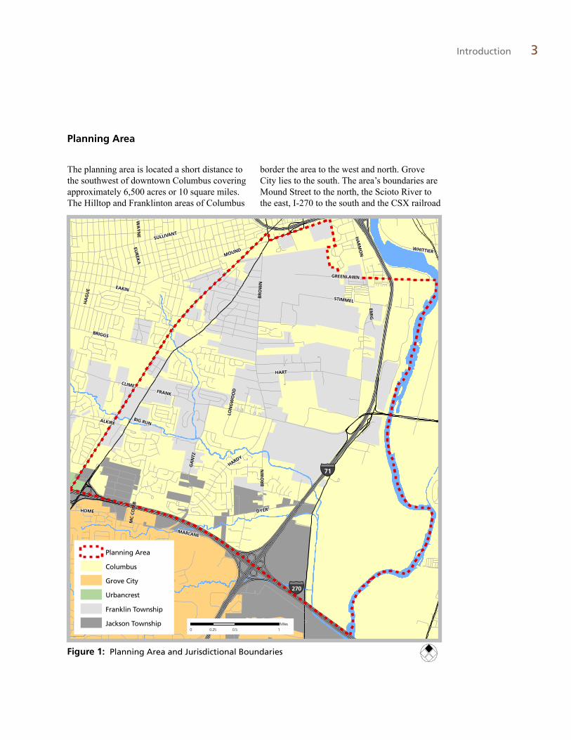
The planning area is located a short distance to the southwest of downtown Columbus covering approximately 6,500 acres or 10 square miles. The Hilltop and Franklinton areas of Columbus
border the area to the west and north. Grove City lies to the south. The area’s boundaries are Mound Street to the north, the Scioto River to the east, I-270 to the south and the CSX railroad
Planning Area

4 Southwest Area Plan
Green Lawn Cemetery, 1889
1“Earthworks of Franklin County.” Ohio Archaeological and Historical Quarterly. Volume II (1888).
Brown Residence, 1897 (Brown Road and Dyer Road)
Harrisburg Pike, 1933 (South of Grove City)
tracks to the west. There are five jurisdictions within the planning area boundary – Columbus, Franklin County, Franklin Township, Jackson Township and the village of Urbancrest.
History
In 1803 when Franklin County was formed, the Southwest Planning Area was part of Franklin Township. The area is just south of the pioneer village of the county, Franklinton, which was settled in August 1797. There is discussion of two ancient circular mounds (perhaps from the Adena culture) 3 miles southwest of the 1888 borders of Columbus on Harrisburg Pike, but little is known about the land before European settlement.
The two principal activities in the area during the 19th century were farming and quarries. Land for a state quarry was purchased in 1845 and encompassed 50 acres along the banks of the Scioto River. The stone from this quarry was used in building the Ohio Statehouse, the Ohio Penitentiary and other state institutions.
In 1848 Green Lawn Cemetery, originally encompassing 83 acres, was opened by a non-profit corporation in the northern section of the planning area. The cemetery’s trustees prided themselves on their nonsectarian policy, although a chapel was added to the cemetery grounds 54 years later. The cemetery holds numerous monuments and is the resting place of many prominent figures in Columbus history. Another cemetery in the area, Mt. Calvary, was opened in the 1870s.
Introduction 5
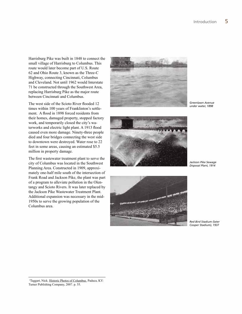
Greenlawn Avenue under water, 1898
Jackson Pike Sewage Disposal Plant, 1914
Red Bird Stadium (later Cooper Stadium), 1937
2Taggart, Nick. Historic Photos of Columbus. Paduca, KY: Turner Publishing Company, 2007. p. 55.
Harrisburg Pike was built in 1848 to connect the small village of Harrisburg to Columbus. This route would later become part of U.S. Route 62 and Ohio Route 3, known as the Three-C Highway, connecting Cincinnati, Columbus and Cleveland. Not until 1962 would Interstate 71 be constructed through the Southwest Area, replacing Harrisburg Pike as the major route between Cincinnati and Columbus.
The west side of the Scioto River flooded 12 times within 100 years of Franklinton’s settle-ment. A flood in 1898 forced residents from their homes, damaged property, stopped factory work, and temporarily closed the city’s wa-terworks and electric light plant. A 1913 flood caused even more damage. Ninety-three people died and four bridges connecting the west side to downtown were destroyed. Water rose to 22 feet in some areas, causing an estimated $5.5 million in property damage.
The first wastewater treatment plant to serve the city of Columbus was located in the Southwest Planning Area. Constructed in 1909, approxi-mately one-half mile south of the intersection of Frank Road and Jackson Pike, the plant was part of a program to alleviate pollution in the Olen-tangy and Scioto Rivers. It was later replaced by the Jackson Pike Wastewater Treatment Plant. Additional expansion was necessary in the mid-1950s to serve the growing population of the Columbus area.

6 Southwest Area Plan
Workhouse on Jackson Pike
Southwest Area prior to construction of 1-71
Red Bird Stadium (now Cooper Stadium) on West Mound Street opened in 1932. It first housed the Red Birds minor-league baseball team, then the Columbus Jets from 1955 to 1970, and finally the International League’s Columbus Clippers.
In 1933, the City used its land along the west bank of the Scioto River to construct the City Workhouse after much of the original City Workhouse building, located in Franklinton, had been destroyed by a tornado in 1929. The Jack-son Pike site now holds the Franklin County Corrections Center.
In 1951, the Franklin County Children Services Board relocated from Sunbury Road to Gantz Road at Frank Road. Franklin Village, a facility that provided temporary housing for children awaiting placement in foster homes, was also built that year at the same location. It served the children of Franklin County for 45 years, finally closing due to the popularization of foster homes and private residential facilities.
Central Point Shopping Center, a major com-mercial attraction for the area, was constructed at the northwestern edge of the planning area in 1952.
The Women’s Correctional Institution on Jack-son Pike was built in 1963.
In 1983, both the Federal Emergency Man-agement Agency and the city of Columbus classified areas west of the Scioto River as a floodplain. Strict building requirements and floodplain regulations were imposed. Construc-tion on a seven mile flood wall to mitigate potential flooding began in 1993. This joint city/federal effort, the West Columbus Protection Project, took nearly 10 years to complete and cost over $120 million. The project alleviates the constraints associated with floodplain devel-opment in the northern part of the planning area.
The 1960s through 1990s saw substantial resi-dential and commercial development throughout the area. Southwest Square shopping center was built in 1987, today providing the area’s only full-service grocery store.

Introduction 7
Key Recommendations
Key recommendations from the plan are:
� Parks and Open Space. The plan offers a concept for the redevelopment of the former Franklin County Children Services site at the southwest corner of Frank Road and Gantz Road. The preferred use of the site is a mix of offices, a passive park and a community facility.
� Land Use. The concentration of commer-cial uses at key locations along the area’s major corridors and the preservation of ex-isting residential areas are the main focuses of the plan’s land use recommendations.
� Urban Design. Design guidelines for new residential and commercial development are provided to ensure new development contributes to the overall attractiveness of the area and to increase design compatibil-ity between commercial and industrial land uses abutting residential areas.
� Transportation. Sidewalk, trail, crosswalk enhancements and bicycle facilities are recommended to increase safety for pedes-trians and to connect neighborhoods.
� Economic Development. The land use plan protects prime industrial land for targeted business development.
� Regional Coordination. Key projects and issues are identified where regional coordi-nation is necessary to successfully imple-ment the plan’s recommendations.
Residents arriving for a public workshop

8 Southwest Area Plan
Planning Process Summary
The Southwest Area Plan is a collaboration among four area jurisdictions – Columbus, Franklin County, Franklin Township and Jackson Township. The plan was initiated at the request of the Southwest Area Commission.
The planning process follows a standard model of data gathering and analysis, alternative concept analysis, consensus through commu-nity participation, plan preparation and plan implementation. A working committee consist-ing of various stakeholders in the neighbor-hood was formed and met from March 2008 to November 2008 to provide input and guidance. The in-depth participation from the members of the committee was a critical component in preparing a long-range plan that was responsive to the identified needs and aspirations of the community.
Four public workshops were held over the course of the planning process to gauge public opinion on a range of land use and urban design issues. Workshop topics included issues and opportunities identification, visioning, plan text review, and finally the draft plan open house.
Reviewing design concepts at visioning workshop

Element Highlights: � The Southwest Area has several distinct neighborhoods, corridors and districts � The majority of parkland is hard for residents to access � Public input reflects concerns about land use conflicts and a strong desire for a recreation center � The area has a wide range of land uses, including residential, commercial and industrial � Zoning regulations are administered by three different local governments
Element 2
Existing Conditions

10
The Existing Conditions element of the plan provides a summary of the planning area’s physical attributes, including land use, urban form, transportation, community facilities and the natural environment. This element also reviews existing zoning, community demographics and other factors that will influence future development. The Existing Conditions element concludes with a sum-mary of two important pieces of public input: stakeholder interviews that were conducted in the early stages of the process and a sum-mary of the top priorities identified by the community at the first public workshop for the plan.
Element 2
Existing Conditions
Five jurisdictions make up the Southwest Area

Existing Conditions 11
Element 2
Existing ConditionsSummary of Findings
Demographics
� The population increased by 13.4 percent between 1990 (13,717) and 2000 (15,846).
Employment
� Established employment center with over 8,000 jobs located in the planning area.
� Retail, services and transportation are the strongest sectors.
� Businesses are clustered along the major corridors of Harrisburg Pike, Frank Road and Harmon Avenue.
Opportunities and Constraints
� Opportunities exist on two sites that are owned by Franklin County.
� There are opportunities to create gateways into the planning area at underutilized sites and along major corridors.
� The 100-year floodplain represents a constraint to development in a portion of the planning area, although the Franklinton Floodwall reduces this threat.
Land Use and Zoning
� Landfills, quarries and other industrial uses make up over 32 percent of the planning area.
� Residential uses represent 28 percent of the area’s land use.
Urban Form
� The Southwest Area gateways lack distin-guishing features.
� Corridors (Frank Road and Harrisburg Pike) convey a utilitarian image instead of being reflective of the community.
Transportation
� The planning area has good access to the highway system.
� Harrisburg Pike and Frank Road carry high traffic volumes.
� Heavy truck traffic on Frank Road, espe-cially near Interstate 71.
� Most of the arterials lack sidewalks.
� There are no bicycle facilities.
� The area has moderate access to transit.
Community Facilities and Infrastructure
� Five parks are located within the planning area; however the majority of the park acreage is Berliner Park, which is not easily accessible by residents due to distance and physical barriers (Interstate 71).
� Five schools are centrally located within the planning area.
� A multi-use trail exists along the west side of the Scioto River. An east-west trail is proposed along Big Run.
� There are no libraries, senior centers, post offices or major health care facilities lo-cated in the Southwest Area.
Natural Resources
� The Scioto River and its tributaries Big Run and Early Run are the defining natural features in the planning area.

12 Southwest Area Plan
Demographics
The 2000 U.S. Census provides the most accurate demographic informa-tion for the Southwest Area. The area includes 15,846 residents and 6,084 households. From 1990 to 2000, the area experienced population growth of 13.4 percent. Projections for the period between 2000 and 2030 show a slower growth rate of 6.1 percent.
Table 1: Population and Housing TrendsPopulation Housing Units
1990* 13,717 4,950
2000* 15,846 6,084
2005** 16,772 6,389
2030** 16,892 7,230
Increase 23.1% 46.1%*US Census
**Estimates, MORPC
Table 2: Demographics SW Planning Area Columbus
Race Number Percent Number PercentWhite 14,034 88.6% 483,332 67.9%
Black 1,146 7.2% 174,065 24.5%
Asian 295 1.9% 24,495 3.4%
Other/Mixed Race 371 2.3% 29,578 4.2%
Age
Under 18 4,151 26.2% 171,868 24.2%
18 to 34 4,116 26.0% 238,924 33.6%
35 to 59 5,605 35.4% 217,331 30.5%
60 & above 1,974 12.5% 83,347 11.7%
Total 15,846 711,470 Source: 2000 US Census

Existing Conditions 13
Table 3: Business SectorsNAICS Sector Number of
BusinessesPercentage
Accommodation and Food Services 26 7%
Administrative and Support 19 5%
Agricultural, Forestry, Fishing, Hunting 2 1%
Arts, Entertainment, and Recreation 4 1%
Construction 34 9%
Educational 3 1%
Finance and Insurance 13 3%
Health Care and Social Assistance 12 3%
Manufacturing 18 5%
Miscellaneous 28 7%
Other Services 56 15%
Professional Scientific and Technical 6 2%
Public Administration 9 2%
Real Estate 17 4%
Retail 66 17%
Transportation 37 10%
Wholesale Trade 29 8%
Total 379 100%
Employment
According to data compiled from the Reference USA database, there are approximately 379 busi-nesses operating in the Southwest Area. The Mid Ohio Regional Planning Commission tracks local employment for use in traffic and land use analy-sis. MORPC’s data indicates that the Southwest Area had over 8,000 employees in 2000.
The majority of businesses are located north of Frank Road. Major thoroughfares with con-centrations of businesses include Harrisburg Pike—a mix of auto-related, dining and retail locations—and Frank Road, Harmon Avenue and Hardy Parkway—which contain mostly trucking, contracting and manufacturing businesses.
MORPC Traffic Analysis Zone data estimates the presence of over 525,000 square feet of office floor area in 2005, down almost 40,000 square feet from 2000. This estimate is based on a broad definition of office space and uses, as there are few actual office buildings in the area. Trucks are the major industrial compo-nent. There are more than 30 trucking-related services, equipment suppliers and dealers. There are over 25 contractors (electric, paving, sewer, excavating, etc.), a landfill and several solid waste facilities.
There are no community reinvestment areas, job ready sites or other economic incentive districts currently designated in the area.
Neighborhood market on Harrisburg Pike

14 Southwest Area Plan
Opportunities and Constraints
The Opportunities and Constraints section summarizes the key physical attributes that have an influence on development—either as a constraint or as an opportunity. Opportunities can be underutilized sites or corridors, typically identified as development opportunities or pri-orities. Constraints can include environmental factors such as the floodplain or incompatible land uses.
New development and redevelopment oppor-tunities exist within the Southwest Area. The area has not been the subject of many studies or plans over the years Therefore, the follow-ing opportunities have been identified through stakeholder interviews, existing condition research, old planning documents and input received at public workshops.
Cooper Stadium
Opened as Red Bird Stadium, Cooper Stadium was home to professional baseball in Columbus for 76 years. The 2008 season was the last for the Columbus Clippers at Cooper Stadium. In April 2009, the Clippers moved to a new facil-ity in downtown Columbus, Huntington Park. Franklin County owns the 15,000-seat historic stadium, located on 46 acres. The county is actively pursuing a redevelopment plan for the site.
Former Franklin County Children Services Facility on Gantz Road
The 74-acre former Franklin County Children Services site, owned by Franklin County, sits in the center of the planning area on the southwest corner of Frank and Gantz Roads. The site has rolling topography that includes the confluence of Big Run and Early Run. Abandoned struc-tures have been demolished. Franklin County has expressed a strong desire to pursue rede-velopment of this site according to the commu-nity’s needs and wishes.
Central Point
Once a regional shopping destination, the Central Point shopping center is located at a prominent intersection in the planning area. This site has substantial redevelopment capacity.
Cooper Stadium, former home to the Columbus Clippers

Existing Conditions 15
Land Use and Zoning
The Southwest Area is characterized by a wide range of land uses. The mix of existing land use is illustrated in the accompanying chart and tables. The highest percentage of land in the planning area is residential, the majority of which (97 percent) is single family. The second highest percentage of land in the area is categorized as landfills and quarries. When this category is combined with industrial, they collectively make up over 32 percent of the planning area.
Parks and open spaces account for approximate-ly 13 percent of the land in the Southwest Area, although only about one-third of that land is publicly-owned parks. The open space category is made up of cemeteries (historic Green Lawn Cemetery is 360 acres) and the Phoenix Golf Links golf course.
The 10 percent of institutional land includes five schools, nearly two dozen churches and 473 acres of government-owned land. Of particular interest is the 74-acre, county-owned site at 1951 Gantz Road that used to house Franklin Village, a temporary housing facility run by Franklin County Children Services. The site is now cleared of buildings and has been identified by this process as one of the opportunity sites.
Commercial uses make up approximately 7 percent of the land use in the planning area, the majority of which can be classified as Commu-nity Commercial. There is very little Regional Commercial, meaning that the businesses in the Southwest Area generally serve their surround-ing neighborhoods and do not draw customers from outside the area. About a third of the com-mercial uses in the area are automobile-related.
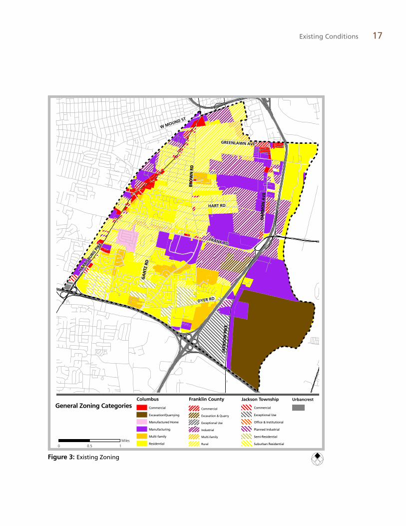
Zoning Administration
Three different regulations govern zoning in the Southwest Area. In Columbus, zoning is regu-lated by Title 33 of the Columbus City Codes. Franklin Township follows the Franklin County Zoning Resolution, while Jackson Township has adopted its own separate township zoning resolution.
Existing Land Use Residential - 28%
Landfills and Quarries - 19%
Industrial - 13%
Parks/Open Space - 13%
Institutional - 10%
Vacant - 8%
Commercial - 7%
Agriculture - 1%
Office - .5%
Residential 28%Landfills/Quarries 19%Industrial 13%Parks/Open Space 13%Institutional 10%Vacant 8%Commercial 7%Agriculture 1%Office 0.5%
Existing Land Use
Table 4: City of Columbus Zoning Category Acres Percent
Commercial 100.5 4.0%
Excavation/Quarrying 807.9 32.5%
Manufactured Home 66.1 2.7%
Multi-family 252.9 10.2%
Residential 1,262.2 50.7%
Total 2,489.7
Table 6: Franklin County ZoningDistrict Acres Percent
CC Community Commercial 6.9 0.3%
CS Community Service District 59.9 2.4%
EQ Excavation and Quarry 60.4 2.5%
EU Exceptional Use 5.1 0.2%
GI General Industrial 537.5 21.9%
LI Limited Industrial 250.9 10.2%
NC Neighborhood Commercial 4.7 0.2%
R-12 Urban Residential 1.1 0.0%
R-24 Multi-family Apartment 69.4 2.8%
RI Restricted Industrial 4.2 0.2%
Rural Rural 1,449.8 59.1%
SCPD Select Commercial Planned 0.6 0.0%
SO Suburban Office 2.2 0.1%
Total 2,452.7
Table 5: Jackson Township Zoning Category Acres Percent
Community Service 9.0 2.2%
Exceptional Use 183.2 45.4%
Office-Institutional 1.8 0.5%
Planned Industrial 12.4 3.1%
Semi-Residential 119.2 29.6%
Suburban Residential 77.5 19.2%
Total 403.3

16 Southwest Area Plan
MOUND
FRANK
EAKIN
DYER
HA
RMO
N
BR
OW
N
GA
NTZ
HART
HO
OV
ER
SULLIVANT
HARDY
HA
GU
E
STIMMEL
STRINGTOWN
BRIGGS
CLIME
MARLANE
WA
YN
E
GREENLAWN
EUR
EKA
BIG RUN
ALKIRE
HOME
WHITTIER
SONORA MC
DO
WELL
KINGSTON
EMIG
MC
CO
MB
LON
GW
OO
D
BR
OW
N
GA
NTZ
JAC
KSO
N P
IKE
GA
NTZ
HA
RRIS
BURG
LITTLE
HOPKINS
ROSEMONT
BELMEAD
BLUE ROCK
MIDLAND
Residential
Commercial
Mixed Use
Industrial
Institutional
Office
Parks/Open Space
Agriculture
Vacant
Landfills and Quarries 0 0.5 10.25Miles
Figure 2: Existing Land Use
Existing Conditions 17
HARRIS
BURG
PIK
E
FRANK RD
HA
RM
ON
AV
E
JAC
KSO
N P
IKE
HART RD
GA
NTZ
RD
BR
OW
N R
D
GREENLAWN AVE
W MOUND ST
DYER RD
HARRIS
BURG
PIK
E
FRANK RD
HA
RM
ON
AV
E
JAC
KSO
N P
IKE
HART RD
GA
NTZ
RD
BR
OW
N R
D
GREENLAWN AVE
W MOUND ST
DYER RD
General Zoning Categories
0 10.5Miles
Columbus
Commercial
Excavation/Quarrying
Manufactured Home
Manufacturing
Multi-family
Residential
Franklin County
Commercial
Excavation & Quarry
Exceptional Use
Industrial
Multi-family
Rural
Jackson Township
Commercial
Exceptional Use
Office & Institutional
Planned Industrial
Semi-Residential
Suburban Residential
Urbancrest
Figure 3: Existing Zoning

18 Southwest Area Plan
Urban Form
The existing urban form map for the Southwest Area il-lustrates the overall design and organization of the neighbor-hood, including its gateways, landmarks, primary corridors, districts and edges.
Gateways
Gateways are major entry points to the community and aid in establishing its image. The Southwest Area gateways lack distinguishing features such as welcome signage or landscape treatments that would inform travelers of their entrance into the area.
Corridors
Corridors also convey a community’s image. The primary corridors of the Southwest Area are its major roadways: Interstate 71, Harrisburg Pike (U.S. 62-OH-3), Frank Road, Brown Road and a stream corridor, Big Run.
Interstate 71: A six-lane highly-trafficked highway, Interstate 71 cuts north-south through the east side of the planning area, separating the area closest to the Scioto River from the more residential and commercial western side. Also, the Franklinton Floodwall follows much of Interstate.
Harrisburg Pike: On the west side of the planning area, Harrisburg Pike runs north-south. It contains a mix of old and new businesses, as well as established residences. The route is historically significant as part of the Three-C highway that connected Cincinnati, Columbus and Cleveland before the interstate system was constructed. With only two lanes, a lower speed limit and less traffic, it is better suited to pedestrian and neighborhood-oriented retail.
Frank Road: Frank Road is four lanes and serves as the major east-west corridor through the area. Depending on the area, Frank Road is mostly a mix of residences and industrial uses, with a few retail uses. Serving dual pur-poses of a major thoroughfare and a residential street, the community is challenged with minimizing the impact of “eyesore” uses (industrial, trucking, etc.) and encouraging safe pedestrian and bicycle travel. Special consideration should be given to landscaping and screening, pedestrian and site access, and building and parking setbacks.
Big Run: Big Run is a scenic asset and potential recre-ation corridor for the area. It flows through the existing Willow Creek Park. Plans for the park’s extension follow the stream almost to confluence with Early Run. Early Run flows through the middle of the former Franklin County Children Services site, a development opportunity for the Southwest Area. Big Run has strong recreational potential.
Districts
Districts share common design elements and characteris-tics, setting them apart from other sections of the plan-ning area. Districts are generally grouped as commercial, residential, industrial and open space. Certain areas mix uses and become activity centers (or “nodes”), bringing people together for business, social and civic reasons. Commercial uses are primarily located along Harrisburg Pike. The reuse of old houses as businesses is common along Harrisburg Pike, especially south of Briggs Road, while post-1950s commercial development is common to the north. Residential districts are located throughout the western portion of the planning area, with historic development primarily in the northwest, along Harrisburg Pike, Hart Road and Richter Road. Historic development is also scattered along Brown Road, Gantz Road, Dyer Road and Frank Road. More-recent development fills is found between these older roads.
Residential areas can be categorized into large-lot, early suburban and suburban residential-style development. Large-lot residential areas include both older and contem-porary suburban style homes on lots of one acre or larger. Early suburban refers to the portion of the planning area which generally consists of pre-World War II-era homes built on a traditional grid street system. Suburban residen-tial refers to the most recent residential development in the planning area, generally consisting of homes built as a subdivision within the last 30 to 40 years.
Edges
Edges of the Southwest Area are the Scioto River, In-terstate 270, the CSX Railroad, West Mound Street, Mt. Calvary Avenue and Greenlawn Avenue. Interstate 71 also acts as an edge, separating the more densely used west from correctional facilities, quarries, industry, Berliner Park and the Phoenix Golf Links to the east.

Existing Conditions 19
!
!
!
!!
!
!
@
@
@
@
@
@
@
HARRIS
BURG
PIK
E
FRANK RD
HA
RM
ON
AV
E
JAC
KSO
N P
IKE
HART RD
GA
NTZ
RD
BR
OW
N R
D
GREENLAWN AVE
W MOUND ST
DYER RD
HARRIS
BURG
PIK
E
FRANK RD
HA
RM
ON
AV
E
JAC
KSO
N P
IKE
HART RD
GA
NTZ
RD
BR
OW
N R
D
GREENLAWN AVE
W MOUND ST
DYER RD
270
71
0 0.5 10.25Miles
Major Commercial Corridors
Corridors
Greenways
Residential Districts
Large Lot
Suburban
Early Suburban
Multifamily
@ Gateways
! Nodes
Opportunity Sites
Landmarks: Historic, Archeological and Cultural Resources
Landmarks are major buildings, structures, or other locations that act as place-makers that help to define the character and image of the community, positive or negative. Green Lawn Cemetery, vast and historic, is perhaps the most
prominent landmark in the Southwest Area. Other landmarks include Green Lawn Abbey, Mt. Calvary Cemetery, Union Methodist Cem-etery, Cooper Stadium, Berliner Park, Phoenix Golf Links, multiple quarries, Jackson Pike Wastewater Treatment Plant, Franklin County Correctional and Work Release Facilities, and Jackson Pike Transfer Station.
Figure 4: Urban Form

20 Southwest Area Plan
Transportation
Highways, Roads and Streets
The Southwest Area enjoys excellent access to the city’s highway system with Interstates 70, 71 and 270 within or near the planning area. Four-lane arterials, collectors and local streets complete the transportation network. The table below identifies the major roadways from the Columbus Thoroughfare Plan (1993) and the Franklin County 2020 Thoroughfare Plan. It
lists each road’s classification along with a brief description. Classifications are used to protect needed rights-of-way and to plan for future development and redevelopment. The classifica-tion assigned to a given roadway will affect the possibility and nature of future enhancements such as pedestrian facilities, curb cuts, access points, intersection configurations, speed limits, pavement widths, right-of-way requirements and traffic calming devices.
Table 7: Major Roadways
Road
Classification (Columbus/Franklin County)
Min. ROW width (Columbus/Franklin County)
Min. pavement width (Columbus/Franklin County) Description (Columbus)
I-270 Freeway Varies Varies Right-of-way and pavement widths necessary to accommodate traffic needs
I-71 Freeway Varies Varies Right-of-way and pavement widths necessary to accommodate traffic needs.
Harrisburg Pike 4-2D / Major arterial
120 feet / 120 feet 72 feet / 48 feet Four moving lanes with median divider on mainline sections
Brown Road 4-2 / Minor arterial
100 feet / 100 feet 56 feet / 36 feet Two-way arterials that includes four moving lanes
Mound Street 4-2D / Minor arterial
120 feet / 100 feet 72 feet / 36 feet Four moving lanes with median divider on mainline sections
Frank Road 4-2D / Major arterial
120 feet / 120 feet 72 feet / 48 feet Four moving lanes with median divider on mainline sections
Harmon Avenue C / Minor arterial 60 feet / 100 feet 36 feet / 36 feet Two moving lanes and two parking or additional moving lanes in two directions
Stimmel Road C / Collector 60 feet / 80 feet 36 feet / 36 feet Two moving lanes and two parking or additional moving lanes in two directions
Hardy Parkway C / Unclassified 60 feet / 60 feet 36 feet / 22 feet Two moving lanes and two parking or additional moving lanes in two directions
Gantz Road C / Minor arterial 60 feet / 100 feet 36 feet / 36 feet Two moving lanes and two parking or additional moving lanes in two directions
Hart Road - / Minor arterial - / 100 feet - / 36 feet
Greenlawn Avenue
- / Minor arterial - / 100 feet - / 36 feet
Hopkins Avenue - / Collector - / 80 feet - / 36 feet

Existing Conditions 21
Traffic counts, or average daily traffic (ADT), is a measure of how busy a roadway is. ADT is de-termined by the total volume of vehicle traffic, in both directions, that passes a point during a 24-hour period. This allows transportation plan-ners to determine priorities for roadway proj-ects, document traffic volume trends, and assess the functionality of individual roadways and the roadway system as a whole. The Mid-Ohio Regional Planning Commission collects traffic counts from a variety of sources and publishes the data in the form of maps. The Traffic Counts map illustrates traffic volumes for streets in the Southwest Area.
Current road projects planned for the area include adding turn lanes and sidewalks to Har-risburg Pike from south of Briggs Road to north of Hopkins Avenue by the Ohio Department of Transportation. Construction is expected to be-gin in May 2009 and finish by December 2010. The project will also include improving the intersection of Harrisburg Pike and Clime Road.
Franklin County is also conducting a minor widening of Alkire Road from west of Manley Way to Harrisburg Pike. The project includes widening the road from two to three lanes and replacing a railroad bridge over Alkire Road. Jackson Township is resurfacing roads in the Emersonia subdivision in the southwest corner of the planning area. The city of Columbus does not have any current or planned road projects within the planning area.
Road maintenance responsibilities
Resurfacing and general maintenance of road-ways in the city of Columbus are the respon-sibility of the Department of Public Service, Transportation Division.
In the unincorporated areas, various entities are responsible for road maintenance duties. The
Franklin County Engineer’s Office is respon-sible for the maintenance of county-designated roads. Franklin and Jackson Townships are responsible for township-designated main roads and subdivision roads in their respective juris-dictions. The Ohio Department of Transporta-tion is responsible for Harrisburg Pike.
Transit
The Central Ohio Transit Authority (COTA) provides bus and paratransit service for the Southwest Area in the form of two local routes, Route 3 - West Mound and Route 15 - Grove City. Both routes travel through the planning area and terminate at a location outside of the
Southwest Area. The frequency of both routes increased in September 2008. A third route, Route 17 - Greenlawn Gantz, formerly served the area. It is anticipated that COTA will resume this route. The majority of bus stops are marked only by a freestanding sign and lack shelters, benches and concrete pads.
Bus stop along Harrisburg Pike

22 Southwest Area Plan
FRANK RD
HA
RM
ON
AV
E
JAC
KSO
N P
IKE
HART RD
GA
NTZ
RD
BR
OW
N R
D GREENLAWN AVEW MOUND ST
DYER RD
HA
RRIS
BURG
PIK
E
FRANK RD
HA
RM
ON
AV
E
JAC
KSO
N P
IKE
HART RD
GA
NTZ
RD
BR
OW
N R
D GREENLAWN AVEW MOUND ST
DYER RD
HA
RRIS
BURG
PIK
E
Traffic Counts and COTA Routes
0 0.5 10.25Miles
Average Daily Traffic Count400 - 3,900
3,900 - 9,000
9,000 - 15,000
15,000 - 36,000
Route 3, West Mound
Route 15, Grove City
FRANK RD
HA
RM
ON
AV
E
JAC
KSO
N P
IKE
HART RD
GA
NTZ
RD
BR
OW
N R
D GREENLAWN AVEW MOUND ST
DYER RD
HA
RRIS
BURG
PIK
E
FRANK RD
HA
RM
ON
AV
E
JAC
KSO
N P
IKE
HART RD
GA
NTZ
RD
BR
OW
N R
D GREENLAWN AVEW MOUND ST
DYER RD
HA
RRIS
BURG
PIK
E
Traffic Counts and COTA Routes
0 0.5 10.25Miles
Average Daily Traffic Count400 - 3,900
3,900 - 9,000
9,000 - 15,000
15,000 - 36,000
Route 3, West Mound
Route 15, Grove City
Figure 5: Traffic Counts and COTA Routes

Existing Conditions 23
Figure 6: Sidewalks and Trails
HARRIS
BURG
PIK
E
FRANK RDH
AR
MO
N A
VE
JAC
KSO
N P
IKE
HART RD
GA
NTZ
RD
BR
OW
N R
D
GREENLAWN AVE
W MOUND ST
DYER RD
HARRIS
BURG
PIK
E
FRANK RDH
AR
MO
N A
VE
JAC
KSO
N P
IKE
HART RD
GA
NTZ
RD
BR
OW
N R
D
GREENLAWN AVE
W MOUND ST
DYER RD
0 0.5 10.25Miles
Sidewalk
No sidewalk
Multi-Purpose Trail: Existing
Multi-Purpose Trail: Planned

24 Southwest Area Plan
Rail
The western boundary of the planning area is formed by the CSX railroad tracks. Data shows that one train runs along these tracks each day. At-grade crossings are located on Eakins Road, Briggs Road and Frank Road and an overpass exists on Alkire Road.
Sidewalks and Multi-Use Trails
Sidewalks and trails serve a number of functions for a community. Their most basic purpose is to allow for the safe passage of pedestrians. They connect neighborhoods to services, children to schools, provide opportunities for exercise and serve as an alternative mode of transportation.
Much of the planning area is without sidewalks. Newer residential developments generally con-tain sidewalks along the interior streets, while older residential areas and the major roadways lack these facilities. Harrisburg Pike, Gantz Road, Dyer Road, Brown Road, Harmon Av-
enue, Stimmel Road and Hart Road do not have sidewalks on either side of the street.
Areas with narrow sidewalks include the north side of Frank Road, east of Brown Road. The south side of Frank Road lacks sidewalks altogether.
At the northern boundary of the planning area, sidewalks line the south side of Mound Street from Harrisburg Pike east to the Mount Cavalry cemetery.
The west side of Hardy Parkway has sidewalks south of Willow Creek Park. Beginning south of Rockcreek Drive, Hardy Parkway has side-walks on both sides of the street.
The Lower Scioto multi-use trail is a ten-foot wide, paved surface that runs along the Scioto River’s west bank. The trail links to the Upper Scioto Trail in downtown Columbus. It cur-rently ends at Frank Road, but future plans call for it to extend westwardly along Frank Road to provide east/west access. Other trails planned for the area include a trail along Big Run that would eventually connect to the Scioto Trail.
The city has completed the Columbus Bicenten-nial Bikeways Plan to guide the development of an on-street and off-street bicycle transportation system, calling for several bike-related projects within the Southwest Area. The Plan Recom-mendations element reflects the facilities identi-fied in the bikeways plan.
Many area streets lack sidewalks

Existing Conditions 25
Community Facilities and Infrastructure
Recreation and Park Facilities
The Southwest Planning Area has 296 acres of park, parkland and recreational space. Five parks are located in the northeastern and south-ern portions of the planning area. The parks in the south are adjacent to residential areas, while those in the northeast are near the Interstate 71 and the Scioto River.
City of Columbus policy is to provide 5.5 acres of parkland per 1,000 residents. Based solely on this calculation, the area seems to have suffi-cient park acreage for its approximately 16,000 residents. Upon further inspection, however, the vast majority (77 percent) of the acreage comes from Berliner Park, a regional facility that is difficult to access by foot or bike because of its location between Interstate 71 and the Scioto River.
The area lacks smaller neighborhood parks that are within walking distance of residential areas, particularly the residential areas to the north of Frank Road.
No recreation centers are located within the planning area’s borders. In 2009, due to budget constraints, the city of Columbus closed the nearby Sullivant Gardens Recreation Center. Community groups are working with Columbus to reopen the center with limited programming.
As of April 2009, the closest open recreation centers are the Dodge Recreation Center at 667 Sullivant Avenue and the Westgate Recreation Center at 455 South Westgate Avenue. The Big Run Athletic Complex is also nearby, at 4205 Clime Road.
Willow Creek Park

26 Southwest Area Plan
Schools
The planning area is served by the South-West-ern City School District and the Columbus City School District. Columbus City School District has no schools located within the planning area boundaries. South-Western City School District has five schools in the area. There are three elementary schools (grades K-4) in the planning area: Finland Elementary School, James A. Har-mon Elementary and East Franklin Elementary School. James A. Harmon Elementary offers an after-school facility. The district has one intermediate school, Franklin Woods Intermedi-ate School, serving grade levels five and six. Middle school-age children attend the district’s Finland Middle School. High school students typically attend Franklin Heights, located ap-proximately 2 miles outside the planning area.
One private school, Central Baptist Schools, is located in the planning area. Operated by Central Baptist Church, the school offers classes from kindergarten through high school. Imagine Harrisburg Pike Community School, a charter school, operates at Harrisburg Pike and Mound Street.
Municipal Facilities and Safety Services
Police and fire services are provided to the Southwest Area by the city of Columbus and Franklin Township. Columbus Police Precincts 8 and 10 patrol the area. Precinct 8’s substation is located at 2070 Sullivant Avenue and Precinct 10’s substation is located at 4215 Clime Road. The nearest Columbus Fire Station is station 12, located at 3200 Sullivant Avenue.
The Franklin Township fire station is located on Frank Road within the planning area. The town-ship provides fire and limited police service in Franklin Township. The Franklin County Sheriff’s Office provides police protection for Franklin and Jackson Townships.
Other Community Facilities
Green Lawn Abbey
Located on Greenlawn Avenue west of Harmon Avenue is Green Lawn Abbey, an architecturally significant early-20th century mausoleum. The abbey was recently listed on the National Reg-ister of Historic Places. Green Lawn Abbey’s occupants include numerous public officials and prominent families. Efforts are underway to renovate the building and restore its operation as a mausoleum.
There are no libraries, senior centers, post of-fices or major health care facilities located in the Southwest Area. The Franklin Branch of the Grove City Public Library (now Southwest Public Libraries) opened at 973 Harrisburg Pike within the planning area in 1974. The branch was closed in 1978 due to lack of use.
Stormwater Facilities
The area is largely served by stormwater conveyance infrastructure constructed in the first half of the 20th century. Older residential areas are drained by county-maintained peti-tion ditches. Due to modifications to the ditch system in the 1960s and 1970s, stormwater backups are a problem after heavy rains. The Whims Ditch has been a particular problem for residents of the Southwest Area. The drainage way was modified numerous times, resulting in a configuration that leads to inefficient drainage, even after moderate rain. Whims Ditch-related legal complaints have been filed, but the prob-lem remains unresolved.
Green Lawn Abbey, an historic cultural resource

Existing Conditions 27
"SÆc
Æc
Æc
!.
!.
!.
!.!.!>
!>!>
!>
®v
#*
n
n nn
n n
n n
n
n
n
n
n n
n
nnn
n
nn
n
n
n
n
n nn
n
n
nn
nn
n
n
n
!.
!. nn
HARRIS
BURG
PIK
E
FRANK RDH
AR
MO
N A
VE
JAC
KSO
N P
IKE
HART RD
GA
NTZ
RD
GREENLAWN AVE
W MOUND ST
DYER RD
Franklin TownshipFire Station 193 &Police Dept Offices
Jackson TownshipFire Station 202
James AHarmon
Elementary FinlandElementary
FinlandMiddle School
East FranklinSchool
WILLOW CREEK PARK
STONERIDGEPARK
BERLINERPARK
MCCOYPARK
BR
OW
N R
D
PLAYGROUND
CentralBaptistSchool
SullivantElementary
Franklin WoodsIntermediate
Community Facilities
0 0.5 10.25Miles
Parks
!. Fire Stations
®v Hospitals
#* Police Substations
Æc Public Libraries
!> Recreation Centers
n Schools
"S Senior Centers
Figure 7: Community Facilities

28 Southwest Area Plan
Natural Environment
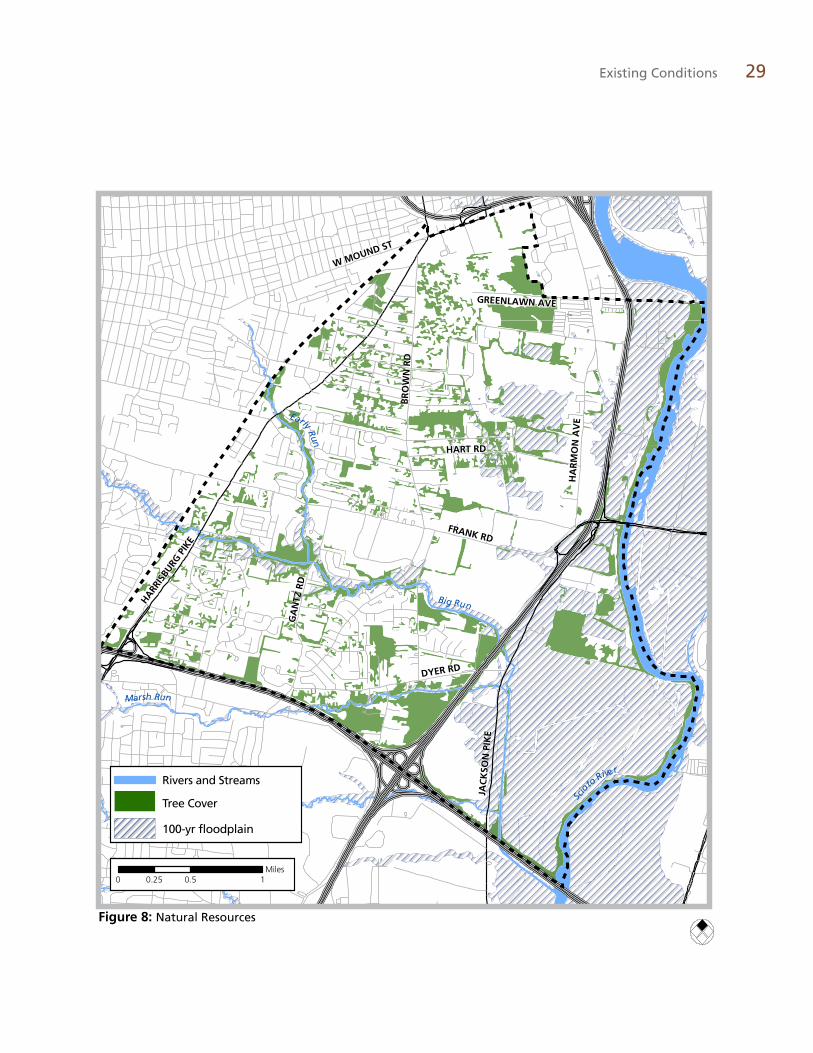
Natural Resource Base
The area has a mix of developed and rural land. The most prominent natural feature is the Scioto River, which defines the eastern boundary of the planning area. At more than 231 miles in length, the Scioto River is one of the largest rivers in the state. Three tributaries to the Scioto cross the planning area from west to east: Big Run, Early Run and March Run.
Tree Cover
The Southwest Area was historically farmed, excavated and used for industrial purposes, as evidenced by minimal tree cover (see Natural Resources map). Most trees are located along the Scioto River, within parks and scattered throughout residential areas.
Floodplains, Slopes and Wetlands
The Southwest Area has a history of flooding due to its proximity to the Scioto River and the flat topography. This has been largely alleviated by the completion of the Franklinton Floodwall. The Federal Emergency Management Agency released new flood maps in 2008 to reflect changes. Much of the floodplain-designated land north of Frank Road and east of Brown Road is now outside of the 100-year floodplain. As a consequence, most property owners are not required to carry flood insurance and properties are not subject to development restrictions for land located within a floodplain.
The planning area may contain a number of undesignated wetlands. These wetlands are predominantly located along the streams, the Scioto River and in low-lying areas. The south-western portion of the planning area has the highest elevation. The lowest points are found near the river.
Early Run
Existing Conditions 29
HARRIS
BURG
PIK
E
FRANK RD
HA
RM
ON
AV
E
JAC
KSO
N P
IKE
HART RD
GA
NTZ
RD
BR
OW
N R
D
GREENLAWN AVE
W MOUND ST
DYER RD
HARRIS
BURG
PIK
E
FRANK RD
HA
RM
ON
AV
E
JAC
KSO
N P
IKE
HART RD
GA
NTZ
RD
BR
OW
N R
D
GREENLAWN AVE
W MOUND ST
DYER RD
Big Run
Early Run
Scio
to River
Marsh Run
0 0.5 10.25Miles
Rivers and Streams
Tree Cover
100-yr floodplain
Figure 8: Natural Resources
30 Southwest Area Plan
Public Input
Stakeholder Interviews
A series of interviews were conducted at the be-ginning of the planning process. The interviews aimed to gain a preliminary understanding of the issues facing the Southwest Area. Eleven individuals that live, work or own a business in the area provided valuable information on a wide variety of topics.
Summary of Findings
� Concerns about conflicts between industrial and residential land uses
� Wishes for improved retail businesses and shopping areas
� Widely-praised highway access
� Need for sidewalks and bicycle access
� Desire for streetlights among township residents
� Strong desire for recreation center
Land Use
The most common issue surrounding land use is the incompatibility of industrial uses near residential areas. Some of the negative impacts of industrial uses include heavy truck traffic in the area and environmental considerations (dust, noise and odor). Many of the interview partici-pants cited the residential neighborhoods as one of the Southwest Area’s strongest assets. There is a good supply and variety of housing types and prices within the neighborhoods.
Some interviewees expressed concern regard-ing the lack of variety among retail businesses in the area. With the exception of the Southwest Square shopping center, most retail areas are seen as depressed, vacant or dilapidated.
Urban Form
The Southwest Area lacks identifying features or gateways that convey the community’s im-age. There was no agreement on the location that would be considered a gateway to the com-munity. However, many agree that the overall impression or image of the community is poor. This is due to the number of industrial uses along the major corridors, the lack of sidewalks and neighborhoods without streetlights.
Transportation
In general, interview participants believe the area has excellent access to the road transporta-tion network. The area is centrally located with easy access to major highways. There is traffic congestion in the morning and evening com-mutes on Harrisburg Pike and Frank Road.
Walking and biking is unsafe and unattractive for Southwest Area residents as most roads lack sidewalks. Harrisburg Pike and Brown Road were identified as particularly dangerous for pedestrians. Residents who are forced to walk out of necessity find it difficult to walk along the road’s shoulder.
Transit access is limited. Higher-volume bus lines travel along Harrisburg Pike and Mound Street, but Brown Road and Frank Road have no transit access.
Since lower incomes result in one- or no-car households, people paid particular attention to travel by other modes of transportation.
Community Facilities and Infrastructure
Participants feel that the area is not well-served by community facilities. There is no easily-ac-cessible park for people who live north of Frank Road. There is no building for community meetings — a recreation center, senior center and teen center were all mentioned as needed facilities for the area.
Residents see a glaring lack of a recreation center. Without a place to play or participate in organized activities, stakeholders felt that some children turn to vandalism and other problematic activities.

Existing Conditions 31
There is no nearby library or farmers’ market. Residents are also worried that recreation op-portunities will decrease now that the Clippers have left Cooper Stadium.
Residents have poor access to medical and den-tal care. Many families living in the planning area don’t have health insurance. Among those who do, the lack of a nearby neighborhood medical center leads many to go without care.
Natural Resources
The clean-up of area streams is the main natural resource concern of interviewees. A storm sewer overflow that empties into Early Run has detri-mental impacts on the stream. Some participants thought that the streams could be used for rec-reational purposes if the environmental con-cerns were addressed. However, some people expressed doubt that they were large enough to provide for recreation or that area residents wouldn’t use them for that reason.
Safety Services
Interviewees believe fire protection is satisfac-tory. Due to Columbus-Franklin Township jurisdictional lines, police protection can be a challenge. Many expressed frustration at police refusing to answer a call they believe is in an-other jurisdiction.
Public Workshop
At the first public workshop for the Southwest Area Plan, about 40 residents and stakeholders participated in exercises aimed at identifying the issues within the planning area. A total of 395 pieces of input were received at the workshop by means of four different exercises. Every piece of input received was entered verbatim into a database, categorized by Plan Element (e.g. Land Use, Transportation, etc.) and as-signed a theme. The data was then queried by theme to identify the top priorities, which are given below:
� Need community center (recreation/senior center, library)
� Need streetlights
� Need more sidewalks
� Clean up area/properties
� Reduce crime/improve public services
� Increase bus service
� Limit pollution from industrial areas
� Need a more diverse mix of businesses
Other exercises sought to obtain qualitative in-formation from residents by asking them to use maps to identify their favorite and least favorite places within the planning area, places where they feel safe or unsafe to walk or bike and places where they think opportunities for future development exist. Respondents seemed to like the existing parks and community facilities in the area the best, while the Frank Road corridor was overwhelmingly the least favorite place in the planning area. Residents expressed a con-cern for the ability to bike and walk on Brown Road, Frank Road and Harrisburg Pike. Con-cerning places where development could occur, participants indicated a strong desire to see the former Franklin County Children’s Services site redeveloped. There was also significant inter-est in Cooper Stadium and the intersection of Brown and Frank Roads. The public input, and the existing condition research described above, provides an excellent base of information to serve as a starting point for the plan.
Mapping exercises at first public workshop

32 Southwest Area Plan
Figure 9: Public Workshop Results

Element Highlights
The Southwest Area Plan recommends the following: � A public preference for a recreation center and passive park at the former Franklin County
Children Services site, coupled with office development to fund the public improvements � Provide a no-disturb zone along waterways to protect stream health � Allow redevelopment of major shopping centers as mixed-use areas � Enhance sense of place by using urban design standards for new development � Provide buffering between residential and industrial land uses, while maintaining industrial
zoning for job creation � Improve the transportation system for pedestrians, bicyclists and transit users
Element 3
Plan Recommendations

34 Southwest Area Plan
Element 3
Plan Recommendations
The Plan Recommendations Element is orga-nized around six development principles, which represent residents’ aspirations for the South-west Area. The development principles corre-spond to the priorities identified by the commu-nity early in the planning process. Supporting policies follow each development principle. Guidelines and strategies accompany each policy providing direction on implementation.
Together, the development principles, poli-cies and guidelines/strategies are designed to progress from broad to specific. This creates a framework for future decision-making in the ar-eas of land use, transportation and urban design.
Land use and transportation plans are included in the body of this text along with pictures and renderings that illustrate the recommendations.
Parks and Open SpaceIncrease and maintain parks, recreational facilities and open spaces.
Parks, open spaces and recreational facili-ties serve several critical roles for communi-ties. They improve the quality of life for area residents, promote active and healthy lifestyles, protect significant natural resources and act as transitions between land uses. They also stabi-lize neighborhoods and enhance property val-ues. The existing park and open space network in the Southwest Area is disconnected.
Although the area enjoys a generous amount of overall park acreage due to Berliner Park, a regional sports facility, it lacks neighborhood-scale parks and amenities.
The park, recreation and open space recommen-dations in the plan are intended to enhance the area’s park and open space system by ensuring that new development provides adequate park space, protecting natural resources from the impacts of growth and developing new parks within the area.
Open space in the Southwest Area
Plan Recommendations | Parks and Open Space 35
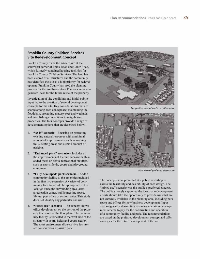
Franklin County Children Services Site Redevelopment Concept
Franklin County owns the 74-acre site at the southwest corner of Frank Road and Gantz Road, which formerly contained housing facilities for Franklin County Children Services. The land has been cleared of all structures and the community has identified the site as a high priority for redevel-opment. Franklin County has used the planning process for the Southwest Area Plan as a vehicle to generate ideas for the future reuse of the property.
Investigation of site conditions and initial public input led to the creation of several development concepts for the site. Key considerations that are shared among each concept are: maintaining the floodplain, protecting mature trees and wetlands, and establishing connections to neighboring properties. The four concepts provide a range of development options that are described below.
1. “As is” scenario –� Focusing on protecting existing natural resources with a minimal amount of improvements, such as walking trails, seating areas and a small amount of parking.
2. “Enhanced park” scenario – Includes all the improvements of the first scenario with an added focus on active recreational facilities, such as sports fields, courts and playground equipment.
3. “Fully developed” park scenario –� Adds a community facility to the amenities included in the first two scenarios. A variety of com-munity facilities could be appropriate in this location since the surrounding area lacks a recreation center, public meeting space, library, post office or senior center. This study does not identify any particular end user.
4. “Mixed use” scenario –� The concept shows office development on the portion of the prop-erty that is out of the floodplain. The commu-nity facility is relocated to the west side of the stream with sports fields and courts nearby. The most environmentally-sensitive features are conserved as a passive park.
Perspective view of preferred alternative
The concepts were presented at a public workshop to assess the feasibility and desirability of each design. The “mixed use” scenario was the public’s preferred concept. The public strongly supported the idea that redevelopment efforts should take the opportunity to provide uses that are not currently available in the planning area, including park space and offices for new business development. Input also suggested a desire for a revenue-generation develop-ment scheme to pay for the construction and operation of a community facility and park. The recommendations are based on the preferred development concept and offer strategies for the future development of the site.
Plan view of preferred alternative

36 Southwest Area Plan
Policy A The redevelopment of the former Franklin County Children Services site should meet both the needs of the community and those of Franklin County.
Guidelines/Strategies:
� The site should be redeveloped with a mix of uses that include a community facility, passive park, limited active recreational facilities and offices.
� The approximately 17 acres at the northeast quadrant of the site that are located outside of the 100 year floodplain are appropriate for office development.
� As indicated on the future land use map, a passive park should be the predominant use of this site. The park should be designed in a sensitive manner to highlight and comple-ment the natural environment. Walking and biking trails, restoration of Big and Early Runs, benches and wildlife viewing areas could be constructed as part of the park.
� A community facility should be developed according to the development concept in the plan. The county should actively work with private and public interests to locate a user and develop a community facility.
� Entrances to the site should serve as gate-ways and provide a cohesive identity for the park, as well as the surrounding com-munity. Gateways should include signage, landscaping or other types of amenities that enhance the character of the area.
� Crime prevention and public safety should be a priority for the facility. This priority should be reflected in design and light-ing of public spaces, using established Crime Prevention Through Environmental Design (CPTED) measures to reduce inci-dences of fear and crime, and design safer environments.
� Pathways should be provided that offer direct connections from public streets, adja-cent neighborhoods and other on-site uses.
Former site of Franklin Village
Example of a multi-purpose trail
Example of a gateway leading into a park

Plan Recommendations | Parks and Open Space 37
� Primary vehicular access to the site should be provided from Gantz Road. Should development of a community facility war-rant vehicular access to Frank Road, the possibility of using a right-in/right-out only access point should be explored.
� A wetland mitigation bank could be a component of the passive park portion of the site.
� Specific active recreation facilities should be programmed based on community needs at the time of park development.
� Franklin County’s ownership of the former Children’s Services site offers two cost advantages in the development of a new park. First, county ownership avoids land acquisition costs. Second, selling a por-tion of the site for office development can generate funds to construct and operate a recreation center or other facility.
Responsibilities for ownership and opera-tion are another consideration for park plan-ning. The county could maintain owner-ship, but the park operator would still need to be determined.
Policy B All residents should be within one-half mile of a neighborhood or community park.
Guidelines/Strategies:
� Ensure that abandoned quarries are restored with land uses that are compatible with the community and maximize recreational reuse potential where appropriate.
� Develop and integrate lakes resulting from quarry reclamation with greenways along area creeks and the Scioto River.
� New developments should contribute their fair share of park land acquisition and development costs to ensure that local standards are met for such new develop-ment. The published standard for the city of Columbus for overall park acreage is 5.5 acres per 1,000 residents.
� Future residential development should propose a hierarchy of park types and sizes depending upon the size and density of the development.
� No more than 25 percent of open space and parks provided in conjunction with new development should be comprised of stormwater facilities.
� Parks and open space should be designed to protect and augment natural features such as streams, ponds, wetlands and wooded tracts.
� Parks should be located contiguous to other open space in order to create larger park facilities and build the community’s green infrastructure.
Policy C Natural systems should be conserved and protected from impacts of development.
Guidelines/Strategies:
� Tree cover and wetlands should be con-served and incorporated into new develop-ment as open space features.
� Provide a minimum 150-foot no-disturb zone along all creeks, waterways and ra-vines. The width of the no-disturb zone will vary depending on the waterway and city of Columbus and Franklin County Stormwater Drainage Manual requirements.
Sidewalks and paths should connect throughout a site

38 Southwest Area Plan
� The 100-year floodplain should be preserved.
� Alternative methods to manage stormwater should be considered, such as bioswales, vegetated swales, native landscaping, and naturalized detention and retention basins, which minimize imperious surfaces.
� Natural features, including mature trees, slopes, wetlands and ponds, should be identi-fied on site plans submitted as part of any zoning or variance application. Limitation/development text should be used to ensure their preservation.
� A minimum of 35 percent of the mature trees on any development site should be preserved. Mature trees are defined as trees having a caliper of 6 inches or greater at a point 4 feet above grade.
The 35 percent minimum tree preservation requirement is in addition to those preserved as part of the regulated floodway or areas set aside for compliance with the city’s or any county parkland dedication ordinance.
� Tree preservation measures should be den-sity-neutral. Any development densities that apply to the area of tree preservation may be transferred to the developable portion of the site. The overall site density would not change, but the net density of the develop-able portion of the site would be higher.
� Steps should be taken to protect notable trees (20 inches or greater in diameter at 4 feet above grade). This will be particularly im-portant in instances when trees are isolated from other tree preservation areas.
To ensure trees remain protected, tree protection measures and/or tree protection areas should be incorporated into construc-tion documents, site plans and development text through the zoning process whenever possible.
� Measures should be taken during the con-struction process to protect the trees intended for preservation, such as fencing around drip edge and avoidance of good compaction.
Land UseEnsure a variety and availability of appropriately compatible residential, commercial and industrial settings.
Land use is the central element of the Southwest Area Plan. Land use planning is a collabora-tive process that combines technical analysis and community input to determine future uses and densities within a given area. The resulting future land use map and accompanying policies (collectively referred to as the land use plan) are the tools that will guide future growth and de-velopment in the Southwest Area. Land use also provides the legal basis for zoning.
To determine the future land use for the South-west Area, the broad land uses of residential, commercial and industrial have been divided into more specific categories based on density and intensity of use. The land use categories are illustrated on the future land use map to provide a visual reference to the locations of each category. Definitions give context on the intent of each cat-egory and offer examples of the types of develop-ment that is anticipated.
Each land use category corresponds to a range of specific zoning districts, helping to provide a consistent structure for the evaluation of develop-ment proposals (rezoning requests, variances or use permit applications). Development proposals will be evaluated in terms of their compatibility with the future land use plan, as well as other factors including infrastructure capacity, urban design requirements, natural resource protection and traffic circulation.
Open space near subdivisions provides buffers from
neighboring uses

Plan Recommendations | Land Use 39
Table 8: Corresponding Zoning Districts
Land Use CategoryColumbus Zoning Districts
Franklin County Zoning Districts
Jackson Township Zoning Districts
Industrial M, M1, EQ GI, LI, PIP I2, PI
Light Industrial M2 RI, PIP I1, PI
Institutional None None None
Landfills and Quarries EQ, Landfills are a prohibited use EQ EQ
CommunityCommercial
C3, CPD, a limited range of C4 uses may be appropriate
CC, SCPD, a limited range of CS uses may be appropriate, PSC
CC, a limited range CS may be appropriate, PC, MUC
Neighborhood Commercial
C1 NC, SCPD, PSC NC, PC, MUC
Office C2, CPD SO, SCPD OI
Open Space None EU ACOS, EU
Park None EU ACOS, EU
Semi-Rural Residential R, LRR Rural, LDR, R-1, R-2 R, SR
Low Density Residential SR, R1, PUD R-4, R-8 S, PR
Medium Low Density Residential
R2, R3, R2F, R4, AR12, ARO, PUD R-8, R-12 PR

40 Southwest Area Plan
Southwest Area Plan Land Use Categories
Semi-Rural ResidentialThe Semi-Rural category includes both large residential lots with on-lot well and wastewater disposal systems, and moderately low-density single-family residential develop-ment with access to centralized water and/or sewer service. These areas generally lack curbs, gutters and sidewalks. Density is less than 3 units/acre.
Low Density ResidentialThis category generally permits single-family detached homes that have access to centralized water and sewer ser-vice. Developments in this category typically have curbs, gutters and sidewalks. Density is 3-6 units/acre.
Medium-Low Density ResidentialThis category includes a variety of multi-family units such as duplexes, townhouses, condominiums and low-density apartments. Density is 6-12 units/acre.
Neighborhood CommercialThe function of this category is to provide localized com-mercial areas for the daily use of neighborhood residents. These areas contain multiple functions and act as local centers of activity. Examples include small-scale retail es-tablishments, office and dwelling units located above other permitted uses. Neighborhood commercial uses should be located at key intersections and nodes along minor arteri-als, and collectors that intersect with arterials. These uses should be integrated into surrounding neighborhoods with sidewalks, bike paths and/or greenways.
Community CommercialThis category allows low-to-medium intensity retail, office, or other commercial uses that primarily serve local area pa-trons and do not include more intense general commercial characteristics. Examples include neighborhood shopping centers, offices with professional and business services, and other public and semi-public uses. The category may also allow mixed-use development with a residential component.
Light IndustrialThis category allows for non-hazardous, low-intensity industrial uses, including light manufacturing, assembling and processing, warehousing and distribution, and mixed business parks containing compatible industrial and non-industrial uses. These areas also serve as job centers and benefit to the local economy.
IndustrialThis category allows for a broad range of uses. These areas help stabilize and diversify the local economy and serve as job centers for the region. Uses are typically incompatible with the surrounding areas, need a large amount of land for their operation and should generally be separated from neighborhoods for public safety and environmental reasons. These uses should be designed to minimize the potential adverse impacts on the surrounding community, with par-ticular attention to how they transition to other land uses.
InstitutionalThis category allows large governmental buildings, com-plexes, police and fire facilities, hospitals, sewage treat-ment and storm water control facilities, schools and other uses considered public or quasi-public such as libraries and public utility facilities.
OfficeThis category provides for large planned office areas and for small-lot office conversions as a transition from residential to commercial uses along primary and second-ary streets. Permitted uses include business, professional, and financial offices, as well as offices for individuals and non-profit organizations.
ParkThis category allows public parks and recreational areas such as playgrounds, sports fields and buildings commonly associated with the principal activity, including recreation centers.
Open SpaceThis category applies to existing open areas and areas that are planned to remain open space in the future. It may consist of passive recreational areas, land reserves, areas owned by public entities for future development as parks, or usage of large areas of permanent open land, such as cemeteries, greenways and public and private golf courses.
Landfills and QuarriesDue to unique operational needs and potential impacts, this category is specific to landfills and quarries. The design of these uses should be sensitive to the needs of the land, residents and other adjacent uses.
Open Space Stream Buffer This category covers environmentally-sensitive land that includes streamways and the 100-year floodplain. No con-struction, parking lots, dredging or filling should be permit-ted. Permissible uses include passive and active recreation, including trails. If a stream buffer is permanently protected, development density may be transferred elsewhere on the same property or an immediately-adjacent property.

Plan Recommendations | Land Use 41
JAC
KSO
N P
IKE
GA
NTZ
HA
RRIS
BURG
LITTLE
HOPKINS
ROSEMONT
BLUE ROCK
MIDLAND
MOUND
FRANK
EAKIN
DYER
HA
RM
ON
BR
OW
N
SULLIVANT
HART
HA
GU
E
HARDY
STIMMEL
BRIGGS
CLIME
MARLANE
WA
YN
EEU
REK
A
GREENLAWN
ALKIRE
BIG RUN
WHITTIER
HOME
FRO
NT
MC
CO
MB
LON
GW
OO
D
BR
OW
N
JAC
KSO
N P
IKE
GA
NTZ
HA
RRIS
BURG
LITTLE
HOPKINS
ROSEMONT
BLUE ROCK
MIDLAND
MOUND
FRANK
EAKIN
DYER
HA
RM
ON
BR
OW
N
SULLIVANT
HART
HA
GU
E
HARDY
STIMMEL
BRIGGS
CLIME
MARLANE
WA
YN
EEU
REK
A
GREENLAWN
ALKIRE
BIG RUN
WHITTIER
HOME
FRO
NT
MC
CO
MB
LON
GW
OO
D
BR
OW
N
Semi-Rural Residential
Low Density Residential
Medium Low Density Residential
Neighborhood Commercial
Community Commercial
Light Industrial
Industrial
Institutional
Office
Park
Open Space
Open Space Stream Buffer
Landfills and Quarries
0 0.5 10.25Miles
Figure 10: Future Land Use
Future Land Use Map
The intent of the Southwest Area Plan’s future land use map is to preserve open space along
stream channels, reinforce established residen-tial areas, introduce office uses and revitalize Central Point and Southwest Square as the primary commercial nodes for the area.

42 Southwest Area Plan
Policy A Corridors should be the focus of daily activity for people living along the corridor and in surrounding neighborhoods, and for those working along the corridor.
Guidelines/Strategies:
Brown Road
� The Brown Road corridor should maintain its predomi-nantly residential and limited commercial character.
� The area around Brown Road between Little Avenue and Hopkins Avenue should contain neighborhood-serving commercial uses.
� Discourage auto-oriented uses, such as auto-repair, drive through commercial, and vehicular sales to preserve this as a neighborhood-focused, walkable corridor.
� The intersection of Brown Road and Frank Road is the gateway into the Southwest Area’s neighborhoods. Retail and office uses should be the focus of any redevelopment.
Commercial building on Brown Road Residential building on Brown Road
Scioto RiverB
RO
WN
RO
AD

Plan Recommendations | Land Use 43
Harrisburg Pike
� Rezoning individual, undersized parcels to a commercial district is discouraged along Harrisburg Pike. Limited commercial uses may be appropriate when a sufficient number of parcels have been assembled to form a unified development proposal consistent with current commercial land demand. These types of proposals should be evaluated based on their adherence to the recommended design guidelines, par-ticularly in terms of having a single access point, sufficient parking, compatibility of scale and required setbacks.
� Office development should be focused at specific points along the corridor as indicated on the future land use map. Office uses economically diversify the corridor, create employment opportunities for area residents and help to form a buffer between existing incompatible land uses.
� As shown on the future land use map, rezoning to a non-residential district should be discouraged along both sides of Harris-burg Pike at the following locations:
• Between Rosemount Avenue and Belmead Avenue
• Between Frank Road and Big Run Road
• Between Alkire Road and Blue Rock Boulevard
� The west side of Harrisburg Pike between Midland Avenue and Franklin Avenue should remain predominantly residential except if parcels can be combined into larger redevelopment sites.
� Discourage auto-oriented uses, such as auto-repair, drive through commercial and vehicular sales.
Scioto River
HARR
ISBURG PIK
E
� The areas around Central Point (Harrisburg Pike and Mound Street) and the Southwest Square shopping center (Harrisburg Pike between Eakin Road and Briggs Road) are the commercial nodes for the entire South-west Area. The most intensive commercial uses should be located in these nodes to avoid retail uses elsewhere along the Har-risburg Pike Corridor.

44 Southwest Area Plan
Harrisburg Pike Redevelopment Concept
Harrisburg Pike dates back to the 1840s. Some of the current architecture, particularly the residential properties, reflects this past. Exam-ining existing land uses along Harrisburg Pike shows a mix of homes, small offices, retail shopping centers and isolated industrial sites. Largely a two-lane road, heavy vehicular traffic and many access points makes visibility difficult and creates conflicts between vehicles and pedestrians. The majority of the corridor does not have sidewalks; pedestrians use the shoulder of the road.
The corridor was the focus of an exercise at the visioning workshop. Participants were present-ed with several redevelopment scenarios for the two types of development that currently exist along Harrisburg Pike: 1) small, residential lots being converted into offices or other commer-cial uses and 2) large commercial shopping centers. It is important to note that the city does not own these sites, nor does it plan to acquire these sites. The design concepts are meant to il-lustrate a vision for future development at these locations and along Harrisburg Pike.
Residential Conversions
To gather residents’ preferences for any pro-posed residential-to-office conversions along Harrisburg Pike, three development concepts were prepared that illustrated different uses and development standards:1) promote resi-dential uses by maintaining existing homes; 2) promote small business use by converting houses to offices while maintaining the resi-dential look of the buildings and 3) promote the assembly of parcels for any future redevel-opment. Participants evaluated the concepts and completed a survey concerning future uses along the corridor. Concept 2 (illustrated on this page) was the community’s preferred development concept.
Visioning exercise study area
The residential appearance of
buildings should be maintained if
converted to offices
When homes transition to offices,
parking should be located in the side or rear of the structures

Plan Recommendations | Land Use 45
Southwest Square shopping center
Excess parking at Southwest Square shopping center
Large commercial shopping centers
Built in the 1950s and occupying a prominent corner in the planning area, Central Point Shopping Center has long served as a regional shopping and entertainment destination. South-west Square, at Harrisburg Pike and Eakin Road, is similar in size and function, with the only full-service grocery store in the area. Both are retail shopping centers with a moder-ate amount of vacant retail space. Redevelop-ment concepts for the shopping centers were presented to workshop participants, focusing on improving building layout and pedestrian movement among buildings. Residents favored redevelopment of the shopping centers into walkable, mixed-use centers that provide a variety of shops and services.

46 Southwest Area Plan
Frank Road
� As the gateway to the Southwest Area’s neighborhoods, the intersection of Frank Road and Brown Road should be developed with community commercial and office uses.
� Discourage rezoning individual, undersized parcels to commercial districts along the north side of Frank Road. Limited com-mercial uses may be appropriate when a sufficient number of parcels have been assembled to form a unified development proposal. These types of proposals should be evaluated based on their adherence to the recommended design guidelines, es-pecially in terms of having a single access point, sufficient parking, compatibility of scale and sufficient setbacks.
� Maintain existing industrial land use on the south side of Frank Road, east of Gantz Road and on both sides of Frank Road, east of Brown Road.
Scioto River
FRANK ROAD
Scioto RiverMOUND STREET
Frank Road streetscape
Mound Street
� Community commercial uses are appropriate for Mound Street.

Plan Recommendations | Land Use 47
Guiding Principles
� Comprehensive. Redevelopment proposals should be evaluated for the overall impact on the community including environmental, quality of life and economic considerations.
� Immediacy. Most agree that the presence of a large, vacant site would be a detriment to the community. This commonality should provide an incentive for all parties to work cooperatively when considering redevelopment proposals.
� Positive impact. Located between the Southwest and Franklin-ton areas, redevelopment of the site must be beneficial for both communities. Examples of positive benefits could be job creation, adding an asset/amenity for the area, providing enhanced retail op-portunities or a use that triggers additional private investment.
� Maximize economic development potential. Previous studies conducted by Franklin County indicated a strong preference for economic growth for the Cooper Stadium site and surrounding area. This includes an increased tax base, job creation and retention of jobs in the surrounding areas.
� Feasibility. Redevelopment proposals should be achievable. The relative ease or difficulty of reuse scenarios should be evaluated. Environmental impact, community support, freeway access and market conditions are factors to consider.
� Access. Currently, highway access is only available from the east. This has implications for the commercial value of the site because customers traveling from the west would not have direct access to the site. While improved highway access is desirable, it seems un-likely due to expense and space requirements. Any redevelopment scenario should take into account access limitations and study the financial impacts on their business. Also, uses that generate signifi-cant traffic should study impacts on adjacent neighborhoods due to increased cut-through traffic.
� Sensitivity. Redevelopment proposals should acknowledge and respect the character of the neighboring cemeteries.
� Mixed Uses. If the reuse of the existing facility is not feasible, a range of commercial and office uses may be appropriate on the Cooper Stadium site.
� Cemetery Access. Redevelopment proposals should consider the possibility of improving access to Greenlawn Cemetery. By reorienting the entry the cemetery would have easier access and a ceremonial entrance suitable to the historic cemetery.
� Adaptive Reuse. Reuse of the existing structure should be encouraged.
Cooper Stadium
Cooper Stadium has served as a cultural and entertainment hub for the Southwest Area and the entire metropolitan region since its open-ing in 1932. The final season of minor league baseball concluded in 2008 and redevelop-ment of the site is a priority for the commu-nity. The main ways the Southwest Area Plan will influence redevelopment are through the plan’s land use and urban design recommen-dations. These are the overall guidelines con-cerning the future use and form of whatever may be built at this location.
In recognition of the significance and poten-tial impact to the community that redevelop-ment of Cooper Stadium presents, the plan outlines criteria to keep in mind as redevelop-ment proposals are shaped and evaluated.
The guiding principles below form that criterion. The principles are adapted from the Cooper Alternative Plan, a study prepared for Franklin County in 2005 that investigated re-use concepts for feasibility and impact. The principles convey the major issues that are important to the community and have re-ceived community support. They should serve as a reference for governmental agencies, potential developers and the public.

48 Southwest Area Plan
Policy B New residential development should be consistent and compatible with the land use, density and pattern of the surrounding area.
Guidelines/Strategies:
� Infill development within existing resi-dential areas should develop according to the future land use map. Recommended residential land use categories are: Semi-Rural (SR), less than three dwelling units/acre; Low Density (L), 3-6 dwelling units/acre and Medium Density (M), 6-12 dwell-ing units/acre.
� Non-residential uses are not appropriate in existing residential areas with the excep-tion of the Neighborhood Commercial and Institutional areas designated on the future land use map.
� The average density for residential devel-opment in the Southwest Area is approxi-mately five dwelling units per acre. Should
What is density?
A measurement of the amount of development located within an area. Density is measured by the number of dwelling units per acre for residential development.
parcels in townships annex to the city of Columbus, new development should be developed according to the Low Density (L) category.
� New development should respect the rural feel of existing corridors (Brown Road, Dyer Road and Gantz Road, south of Frank Road) by maintaining larger lots along the corridors and locating denser develop-ment to the interior of development sites. Setbacks for new residential dwellings built along the area’s rural corridors should be compatible with existing residential development.
� New streets should connect to and logically extend external street systems at multiple locations. Subdivisions should connect to existing street stubs and offer stubs for future, adjacent development.
� New residential housing should offer a range of housing types, sizes and price points.
� New residential developments should have features that contribute to a healthy lifestyle, encourage social interaction and sustain property values, such as sidewalks, trails, bicycle paths, open spaces, play areas and front porches.
� Streets that form a “T” intersection should be visually terminated with a building cen-tered on the terminus, a public park or other feature that provides visual interest and a sense of place.
� Only permitted use home occupations should be allowed. To retain residential character, more-intense home occupations should not be approved, including those currently available with a conditional use permit. The county should pursue an amendment to the zoning resolution to al-low only permitted home occupations.
Residential area

Plan Recommendations | Land Use 49
Policy C Prime industrial space should be protected to provide an opportunity for Columbus and Franklin County to support targeted industries and business clusters and to redevelop underutilized sites for economic development purposes.
Guidelines/Strategies:
� Discourage the rezoning of currently com-mercially- and industrially-zoned land to residential use.
� Utilize urban design standards to improve the image and quality of life of the area which will in turn attract new businesses.
� Follow the land use plan closely to locate new businesses on vacant or underutilized land that takes advantage of available infrastructure.
� Protect and encourage non-polluting green businesses within the planning area.
� Identify procedural barriers to site devel-opment and re-development. Consider establishing processes to speed the approval process for business relocations.
� Use economic development tools, such as Enterprise Zones from the city of Colum-bus and the Micro Enterprise Loan Program from Franklin County, to spur the redevel-opment of large underdeveloped and vacant parcels.
Industrial area

50 Southwest Area Plan
Urban Design StandardsUse urban design standards to enhance sense of place and create cohesion.
The quality of the built environment is a reflec-tion of a community’s character and identity. Community input suggested that the area’s neighborhoods are its strongest asset, yet the poor visual environment of the major corridors does not convey a strong image. A poor image is more than an aesthetic issue; it can have sig-nificant economic consequences as individuals and businesses may be less likely to invest in an area considered undesirable.
The design standards recommended here should be used as a tool to promote high-quality devel-opment, which will present a positive image of the area. They will also help to ensure long-term economic viability by maintaining property val-ues and encouraging additional development.
Policy A New commercial and mixed-use development should be held to a high standard, both in terms of its location and the quality of design and materials.
Guidelines/Strategies:
� Consider the development of commer-cial zoning overlay designations for the Southwest Area. Possibilities include the Regional Commercial Overlay on Mound Street and Frank Road and the Community Commercial Overlay on Harrisburg Pike.
� Until an overlay is implemented, the fol-lowing guidelines should be utilized in the review of development applications.
• The placement of buildings should be consistent with the appropriate commer-cial overlay, with the front elevation ori-ented to address the street and entryways facing the street frontage, and clearly demarcated.
• Parking should be hidden to the great-est extent possible by locating it to the
rear or side of a building or by extensive landscaping.
• Building design should incorporate patterns and materials that provide visual interest. This should be accomplished through the use of changes in color, materials, or relief, such as the inclusion of beltlines, pilasters, re-cesses and pop outs (offsetting planes). Flat, plain building walls should be discouraged.
• Building surfaces over 20 feet high or 50 feet in length should be relieved with a change of wall plane or by other means that provide strong shadow and visual interest.
• A consistent level of detailing and finish should be provided for all sides of a build-ing, known as “four-sided” architecture.
• Wall signs should be compatible with the size and scale of the building facades and general streetscape. Signs should not ob-scure or interfere with architectural lines and details.
• Freeway, pole signs, billboards, sign bench-es, roof signs, large overhanging signs, LED and other such electronic or digital signs, and excessively large signs that interfere with visual character are discouraged.
What is a zoning overlay?
A regulatory tool that identifies special provisions in addition to an underlying zoning district. An overlay can be applied in areas where design and neighborhood character are of special concern.
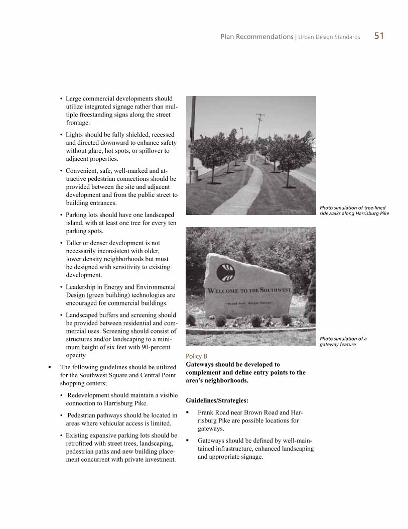
Plan Recommendations | Urban Design Standards 51
• Large commercial developments should utilize integrated signage rather than mul-tiple freestanding signs along the street frontage.
• Lights should be fully shielded, recessed and directed downward to enhance safety without glare, hot spots, or spillover to adjacent properties.
• Convenient, safe, well-marked and at-tractive pedestrian connections should be provided between the site and adjacent development and from the public street to building entrances.
• Parking lots should have one landscaped island, with at least one tree for every ten parking spots.
• Taller or denser development is not necessarily inconsistent with older, lower density neighborhoods but must be designed with sensitivity to existing development.
• Leadership in Energy and Environmental Design (green building) technologies are encouraged for commercial buildings.
• Landscaped buffers and screening should be provided between residential and com-mercial uses. Screening should consist of structures and/or landscaping to a mini-mum height of six feet with 90-percent opacity.
� The following guidelines should be utilized for the Southwest Square and Central Point shopping centers;
• Redevelopment should maintain a visible connection to Harrisburg Pike.
• Pedestrian pathways should be located in areas where vehicular access is limited.
• Existing expansive parking lots should be retrofitted with street trees, landscaping, pedestrian paths and new building place-ment concurrent with private investment.
Policy B Gateways should be developed to complement and define entry points to the area’s neighborhoods.
Guidelines/Strategies:
� Frank Road near Brown Road and Har-risburg Pike are possible locations for gateways.
� Gateways should be defined by well-main-tained infrastructure, enhanced landscaping and appropriate signage.
Photo simulation of tree-lined sidewalks along Harrisburg Pike
Photo simulation of a gateway feature

52 Southwest Area Plan
Policy C New residential development should utilize design standards to reinforce a sense of community and preserve the integrity of neighborhoods.
Guidelines/Strategies:
� Developments should create a positive sense of identity at their entries through landscaping, decorative fencing and complementary signage. A common identification monument should be used at all entry points. Entry features should be placed in a platted or recorded reserve, with a homeowner or condominium associa-tion assuming ownership and maintenance responsibilities.
� Exterior materials within developments should be complementary, but not uniform.
� Walled and gated communities are strongly discouraged.
� Garages should be located behind the house or, if facing a street frontage, should not exceed 40 percent of the width of the housing façade (including the garage) and should be recessed at least three feet from the front elevation of the house.
� Houses should not back onto streets, parks or natural features.
� Subdivisions should be designed to respect existing lot pattern established within neighbor-hoods to maintain community character.
Policy D Industrial development should be designed to increase compatibility between residential and abutting uses and to mitigate environmental impacts.
Guidelines/Strategies:
� Buildings should exhibit a “corporate” architec-tural character of high quality materials, design and color. Where feasible, natural materials should be used on front façades that are com-patible with the remaining elevation treatments in terms of color.
� Landscaping should be used to soften industrial buildings along front elevations or elevations that face public streets.
� Buildings should be oriented so that loading, storage and other external activities, as well as building features that generate noise are not facing public rights-of-ways or residential or institutional uses.
� Accessory uses should be screened from the public right-of-way and adjacent residential and institutional uses to their full height by a solid masonry wall (not cement block) or wooden fence of a color or material that is complemen-tary to the principal building.
� Parking should be hidden to the greatest extent possible by locating it to the rear or side of a building, or by extensive landscaping. Parking lots used primarily by semitrucks or other large vehicles require more intensive screening when located adjacent to residentially-zoned land.
� Gravel parking lots are not permitted by city and county code. Variances to this standard are strongly discouraged.
� Where feasible, safe bike and pedestrian access should be provided to encourage employees to use these modes of transportation.
Example of industrial building with architectural character

Plan Recommendations | Transportation 53
TransportationPeople will be able to get around by walking, car, transit and bicycle.
A recent trend in transportation planning is to look at roads in the context of a larger circula-tion system that includes vehicles, pedestrians, cyclists and transit. An integrated system eases congestion by distributing vehicular traffic and offering alternative modes of travel for area residents, visitors and businesses. Benefits include reduced congestion, increased public safety and improved air quality.
Like other areas in central Ohio, the Southwest Area developed around the automobile. Land use patterns and the road network maximize ve-hicular capacity and access. Many of the area’s main arterials and neighborhood streets don’t have sidewalks or biking facilities, making pe-destrian travel difficult and unsafe. The South-west Area Plan’s transportation recommenda-tions are aimed at supplementing the existing road network with facilities for pedestrians, cyclists and transit.
Transportation Plan
Transportation-related improvements recom-mended for the Southwest Area are shown on the Transportation Plan. The purpose of the Transportation Plan is to offer alternative modes of transportation and to increase safety for pe-destrians, cyclists and transit users. The plan in-tegrates adopted Columbus and Franklin County plans, policies and programs to ensure continu-ity and efficiency of the circulation system as it crosses jurisdictional boundaries.
Transportation Map
The proposed multi-use trails shown in green on the map include the Big Run Trail and the southern extension of the Scioto Trail, which are identified on the Central Ohio Greenways Map, a joint effort of Columbus Recreation and Parks, Metro Parks and the Mid-Ohio Regional Plan-ning Commission. The Bicentennial Bikeways
Plan also recognizes the potential of these two projects to greatly improve the network of recreational trails in Columbus. The Bikeways Plan recommends additional trails along Frank Road, Mound Street and Stimmel Road, as well as bike lanes, lane road widenings and paved shoulders throughout the planning area. The Early Run Multi-Use Trail is a proposal that has not appeared in previous plans, but has been identified by the community for its potential to connect the former Children Services site with Harrisburg Pike.
Many area roads lack sidewalks

54 Southwest Area Plan
HARRIS
BURG
PIK
E
FRANK RD
HA
RM
ON
AV
E
JAC
KSO
N P
IKE
HART RD
GA
NTZ
RD
BR
OW
N R
D
GREENLAWN AVE
W MOUND ST
DYER RD
HOPKINS AVE
BRO
WN
RD
HARDY
PARK
WAY
ST
STIMMEL RD
HARRIS
BURG
PIK
E
FRANK RD
HA
RM
ON
AV
E
JAC
KSO
N P
IKE
HART RD
GA
NTZ
RD
BR
OW
N R
D
GREENLAWN AVE
W MOUND ST
DYER RD
HOPKINS AVE
BRO
WN
RD
HARDY
PARK
WAY
ST
STIMMEL RD
Transportation Plan
Existing COTA Bus Shelters
Proposed pedestrian access
Proposed COTA Bus Shelters
0 0.5 10.25Miles
Existing Multi-Use Trail
Proposed Bikeways and Multi-Use Trails
_̂
_̂
Lower Priority
Higher Priority Lane Road Widening
Lane
Paved Shoulder
Multi-Use Trail/Shared Use Path
Early Run Multi-Use Trail/Shared Use PathProposed Sidewalks
Figure 11: Transportation Plan
Existing COTA Bus Shelters
Proposed pedestrian access
Proposed COTA Bus Shelters
Existing Multi-Use Trail
Proposed Bikeways and Multi-Use Trails
_̂
Lower Priority
Higher Priority Lane Road Widening
Lane
Paved Shoulder
Multi-Use Trail/Shared Use Path
Early Run Multi-Use Trail/Shared Use PathProposed Sidewalks

Plan Recommendations | Transportation 55
Policy A Public transportation should be expanded accordingly in response to increased demand and to support future development.
Guidelines/Strategies:
� In accordance with COTA’s 2006 Long Range Transit Plan, Route 17 should be reinstated.
� COTA should work with the Southwest Area Commission concerning the final alignment of Route 17 through the planning area.
� The frequency of Route 15 should be increased.
� Development should provide pedestrian access to transit stops. New development or redevelopment projects should coordinate with COTA on constructions or possible relocation of bus stops.
� Bus stops should be provided in all neighborhoods. Particular focus should
be given to the construction of bus stops along Harrisburg Pike. At a minimum, bus stops should consist of a concrete pad and signage. Shelters, benches and amenities, such as trash cans and newsracks, should be included when funding allows.
� As COTA expands the number of Park and Ride facilities, consideration should be given to locating a facility in the Southwest Area.
Policy B Accommodations should be made for bicycling according to adopted bike plans.
Guidelines/Strategies:
� Implement the Columbus Bicentennial Bikeways Plan, by:
Phase 1
• Paved shoulder along Briggs Road, from Eureka Avenue to Harrisburg Pike (adja-cent to planning area)
Left: Frank Road does not have bicycling facilities
Far left: COTA bus stop with trash can and concrete pad

56 Southwest Area Plan
• Shared use path along Frank Road from Brown Road to the Scioto Trail
• Shared use path along the Scioto River from SR 104 to Interstate 270 (extension of the Scioto Trail)
Phase 2
• Bike lane on Frank Road from Harrisburg Pike to Brown Road
Phase 3
• Bike lane on Clime Road, from Georges-ville Road to Harrisburg Pike
• Shared use path along Greenlawn Av-enue, from the Scioto River to Harmon Avenue
• Lane road widening of Harmon Avenue, from Greenlawn Avenue to Frank Road
• Shared use path along Mound Street, from Central Avenue to Souder Avenue
• Paved shoulder along Hardy Parkway, from Gantz Road to Frank Road
• Shared use path along Gantz Road, from Hardy Parkway to Dyer Road
• Shared use path along Big Run Creek, from the Scioto River to Georgesville Road
• Lane road widening of Dyer Road, from Gantz Road to Jackson Pike
• Lane road widening of Jackson Pike, from Frank Road to US I-270
• Shared use path along Stimmel Road, from Berliner Park to Whim’s Ditch, and then south along Whim’s Ditch to Frank Road
� Construct a shared use path/multi-use along Early Run, from the former Franklin County Children Services site to Harrisburg Pike.
Policy C Road improvements and enhancements should be context sensitive and contribute to a pedestrian friendly, walkable environment.
Guidelines/Strategies:
� Future road improvements and enhance-ment projects should include pedestrian facilities, including five-foot or wider side-walks that are set back from the pavement, with street trees, pedestrian-scaled lighting and signs, landscaping, bike racks, and street furniture where funding is available.
� Road improvements should be consistent with relevant Complete Streets policies and guidelines.
� Additional curb cuts along Harrisburg Pike should be discouraged. When sites with an overabundant number of curb cuts are redeveloped, access should be reconfigured with input from the government entity responsible for road maintenance.
Description of bike facilities:
Shared use path/multi-use trail – provides a completely separated right of way for the exclusive use of bicycles and pedestrians with crossflow minimized
Lane road widening – roadway must be widened to provide striped lane for one-way travel on a street or highway
Lane – provides a striped lane for one-way travel on a street or highway
Paved shoulder – provides extra room for bicyclists and motorists along roadway
Bike lane

Plan Recommendations | Transportation 57
� At signalized intersections with high pedes-trian use, crosswalks should be provided and clearly delineated with an alternative pavement material, such as brick or tex-tured/colored pavement. Crosswalks should also utilize timers, enhanced signage, or bumpouts where feasible. Crosswalks should be provided at the safest cross-ing locations of an intersection, therefore pedestrian crossings may sometimes be prohibited on certain crossing legs. The fol-lowing intersections in particular should be considered for enhancements: Frank Road and Brown Road; Frank Road and Har-risburg Pike; Harrisburg Pike and Mound Street; and Brown Road and Hopkins Avenue.
� Street trees are recommended on all public and private streets.
Policy D Neighborhoods should have an interconnected street and sidewalk system with connections to existing and future residential, commercial, civic and cultural areas, and to existing and planned paths and trail systems.
Guidelines/Strategies:
� As identified by the city of Columbus’ Safewalks Program, sidewalks should be constructed on Mound Street, Harrisburg Pike, Frank Road , Brown Road, Hardy Parkway, Gantz Road, Dyer Road, Stim-mel Road, Hart Road, Harmon Avenue and Jackson Pike.
� When possible, all sidewalks should be a minimum of five feet to comfortably permit side by side walking and be separated from the street to promote pedestrian safety.
� The segments of Harrisburg Pike and Brown Road, north of Frank Road are the primary priority for sidewalks. Harrisburg Pike south of Frank Road, Gantz Road and improved (wider, separated from the street)
sidewalks along Mound Street are the secondary priority. The remaining segments listed above are the third priority.
� An enhanced or improved crossing treat-ment should be considered from the former Children Services site to the north side of Frank Road.
� Sidewalks should be provided along the main thoroughfares within the planning area regardless of jurisdiction.
� Franklin County should explore the use of pedestrian access easements to provide safe and accessible travel for area residents. Easements would abut the right-of-way, and sidewalks would be constructed by the owner upon development and/or redevelop-ment of a property. Because current state law prohibits counties from assigning main-tenance responsibility to adjacent prop-erty owners, as is the current practice by municipalities, this mechanism would allow for sidewalks to be constructed without Franklin County assuming maintenance.
Example of an enhanced pedestrian crossing

58 Southwest Area Plan
Industrial UsesMinimize negative impacts of industrial uses on residential areas.
In many situations, a mix of land uses supports vibrant, sustainable neighborhoods. In others, the separation of incompatible land uses, such as homes and industry, is still necessary when the potential for adverse impacts exists. The Southwest Area has a wide range of industrial uses within its boundaries. This includes large scale operations within the eastern portion of the planning area and smaller, isolated industrial sites along the Frank Road and Harrisburg Pike corridors. The resulting pattern of development includes numerous instances where industri-ally zoned land is adjacent to residences. The following recommendations are intended to pro-vide adequate transition of land uses and mini-mize environmental impacts on area residents.
Policy A Existing neighborhoods should be protected from industrial encroachment and from other incompatible uses.
Guidelines/Strategies:
� Industrial sites should have direct access to major truck routes and freeways to mini-mize traffic impact on residential streets.
� Landscaped buffers and screening are recommended between non-compatible land uses, such as residential and commer-cial and/or industrial uses, as well as other sensitive land use transitions.
� Appropriate physical transitions and sepa-ration should be provided by using green space, fencing, setbacks or orientation between industrial uses and other surround-ing uses.
� A 200-foot buffer should be provided between industrial uses and existing or planned residential uses.
Open, landscaped area separating industrial uses from residential area

Plan Recommendations | Industrial Uses 59
� Within any required buffer, screening should be provided between an indus-trial site and all adjacent residential uses. Screening should include one of the follow-ing treatments:
• The primary preference is a mound or berm with sufficient width and slope to fully screen the industrial use. The mound or berm should be landscaped and placed within a landscape easement. The face of the mound should not be located closer than 15 feet to the residen-tial property line. The mound should be designed and graded so that water will not be trapped between the mound and the residential property. The area between the top of the mound and the residen-tial property should be landscaped with evergreen trees. Five evergreen trees with a minimum height of five feet and five evergreen trees with a minimum height of three feet should be planted for every 100 linear feet of mound. Trees should be grouped to give a natural appearance.
• When site conditions do not allow a mound or berm, a 6-foot high decorative wall constructed of materials comple-mentary to the principal building should be constructed between 8 to 15 feet of the property line. Evergreen and/or decidu-ous trees should be planted and evenly spaced at a ratio of one tree per 20 linear feet on the outside of the wall.
� Screening materials should be compatible with a building’s principal materials.
� New development should not add to exist-ing environmental concerns, including drainage, water quality and air quality.
� When considering a rezoning for a new quarry, the following should be carefully considered:
• To adequately protect waterways, a minimum 200-foot stream buffer, planted with native plants, should be provided from the top of bank. In order to en-sure the buffer zone is maintained and performing its intended functions, ap-plicants should consider placing the area in a conservation easement held by the Franklin County Soil and Water Conser-vation District or another government or non-profit entity.
• No dams or dikes should be con-structed that deny the river access to the floodplain.
• To protect sub-surface water in areas near wells, only “wet” method extraction should be permitted; there should be no pumping of ground water.

60 Southwest Area Plan
RegionalismEntities in the area should coordinate on regional issues.
The Southwest Area Plan defines a vision for the future of the area and lays out a conceptual framework for how the area’s communities can work together to implement the recommenda-tions in this plan. As the plan was prepared through a partnership among the communities within the area, the communities should also adopt a regional approach to implementation.
Policy A Issues of area-wide significance, requiring the city of Columbus, Franklin County, Franklin Township and Jackson Township to coordinate, should be addressed in a timely fashion.
Guidelines/Strategies:
� Encourage local units of government to part-ner with one another in order to improve the provision of services to area residents and to become more efficient.
� The Southwest Area Commission should serve a communication and coordination role for all the jurisdictions within the area. In order to ensure consistent application of the plan’s recommendations, the townships and the area commission should consider having township rezoning applications go
before the area commission for an informal review.
� Coordinate with other public and private agencies in the area to provide multiple uses in new public facilities. In particular, the city, county and townships should work towards the construction and operation of a community facility at the former Franklin County Children’s Services site at Frank and Gantz roads.
� An integrated greenway system following MORPC and city of Columbus plans should be developed.
� Local governments should coordinate among each other and with the Ohio Depart-ment of Transportation to ensure sidewalks and bike paths are included in all road proj-ects within the area.
� Streetlights should be provided on arterial and neighborhood streets. New develop-ment should install streetlights concurrent with construction. Retrofitting neighbor-hoods with streetlights should follow pro-grams established by the local jurisdictions.
� Local governments should work with non-profit preservation groups to preserve and restore the area’s historic and cultural resources. Resources such as Green Lawn Cemetery and Green Lawn Abbey contrib-ute to the community’s character and attract visitors by offering historic walking tours and other special events.
Workshop participants review redevelopment
concepts

Element Highlights: � The Southwest Area Commission will serve as a primary entity for implementing this plan � Organization, education and outreach are essential to achieving the plan’s goals � New development will use a checklist to ensure compatibility with this plan � Local governments will continue working together to implement this plan
Element 4
Implementation Strategy

62
The most effective way to implement the provi-sions of the Southwest Area Plan is through the consistent and unified advocacy of the Southwest Area Commission. The commission will need to work in concert with the city of Columbus, Franklin County, Franklin Township, Jackson Township and other stakeholders, in-cluding community development corporations, business and civic associations, development-related agencies, churches and social service agencies. The most typical mechanism for plan implementation is the review of development proposals for consistency with the plan. Addi-tionally, the plan can be used proactively to seek investment in the area, advocate for neighbor-hood issues, pursue grant funding and guide capital improvements.
Major implementation elements include:
� Organization, education and outreach
� Plan amendment and revision
� Development review checklist
� Chart of action oriented related recommendations
Organization, Education and Outreach
Organizational, educational and outreach mechanisms can play a key role in area plan implementation. Potential mechanisms include:
� The formation of an area plan implemen-tation committee of the Southwest Area Commission that would consist of area commissioners and other stakeholders. Alternatively, an existing area commission committee could take responsibility for plan implementation.
� Quarterly meetings of the committee in or-der to foster the implementation of priority projects and goals from the area plan.
� An annual report to the area commission and community on progress and concerns regarding the plan’s implementation, pre-pared by the implementation committee.
� Coordination and communication with the Columbus Planning Division and Franklin County Economic Development and Plan-ning, both of which can serve as a resource to the committee in its plan implementation efforts. Other city, county and township de-partments/staff may also provide assistance as necessary.
� The Southwest Area Commission website should be utilized to keep the community informed of implementation progress. An email list should be created to supplement existing information distribution systems.
� Copies of the plan and/or its executive summary, which should be distributed to key stakeholders and community agen-cies, including community development corporations, developers, civic associa-tions, schools, libraries, and social service agencies.
Element 4
Implementation Strategy

Implementation Strategy 63
Plan Amendment and Revision
Area plans should be regularly reviewed and updated to ensure timeliness and relevancy. Minor amendments and brief updates may be considered on an as-needed basis. A more com-plete review and revision of an area plan should be considered within 10 years of adoption.
Development Review Checklist
The development review checklist summarizes the plan’s development guidelines and recom-mendations. It is designed for stakeholders to use in the review of development proposals for consistency with plan provisions. When a rezon-ing request is presented to the Southwest Area Commission, for example, the checklist can be used to see how closely the proposal follows the plan’s recommendations.
In addition to zoning and variance requests, the checklist can also be used for investments in community facilities and infrastructure, and for any other initiatives or requests impact-ing the built environment in the Southwest Area. Guidelines from an area plan are not city or county code/regulations, but as part of an adopted plan they serve as city and county policy. This provides a basis for stakeholders to review development proposals and make sure the guidelines are considered.
The development review checklist also pro-vides a clear, concise record of stakeholder input at each stage of project consideration. The checklist will be maintained in a database by the Columbus Planning Division and Franklin County Economic Development and Planning Department and made available to all city, county and township departments for the review of development applications.
Users of the checklist are strongly encouraged to review additional background information for each item on the checklist by referencing the relevant plan section. The “Conditions to Approval” column is intended to note specific conditions that the proposal must incorporate in order to meet that standard. The “Mitigat-ing Circumstances” column should be used to note specific reasons why the proposal is not expected to meet that standard. Nothing in the checklist is intended to speak to the develop-ment proposal’s conformance with other city, county or state code requirements and policies.
Below are recommendations regarding the use of the development review checklists:
� Applicants for a zoning and/or variance are encouraged to review a development review checklist and incorporate its provi-sions in their proposals.
� Neighborhood civic associations, business associations, agencies and other stakehold-ers should use the checklist as an organiz-ing element for their review and comment on development proposals.
� Area commissions should submit one ap-proved checklist evaluation to the city as part of their recommendation in response to any development proposal.
� Development Department staff should use the checklist for their internal review of zoning and variance applications for consis-tency with the plan.
� City or county staff should consider the checklist submitted by an area commission in the development of a staff position or response to development proposals.
� City departments or county offices should use the checklist as community facilities and infrastructure investments are made.
� Updated or modified project proposals should receive updated checklist evaluation by appropriate parties.

64 Southwest Area Plan
GENERAL GUIDELINES
Standards Yes No N/AConditions to Approval
Mitigating Circumstances
The developer has reviewed the recommendations of the Southwest Area Plan
A site plan of the project been submitted
The proposal is consistent with the land use plan (pp. 38-41)
Parking is hidden to the greatest extent possible by locating it to the rear or side of a building or by extensive landscaping. (p. 50)
Pedestrian access is provided to transit stops. (p. 55)
Natural features (like mature trees, slopes, wetlands, and ponds) are identified on the site plan (p. 38)
Wetlands and 35 percent of mature trees on the site are preserved (p. 38)
Notable trees (those 20-30 inches or greater in diameter at 4 feet above grade) are preserved (p. 38)
Tree protection measures are incorporated into site plans and development text (p. 38)
A minimum 150-foot no-disturb zone along all creeks, waterways and ravines is provided (p. 37)
The 100-year floodplain is preserved (p. 38)
The proposal includes alternative methods to manage stormwater (p. 38)
No more than 25 percent of open space or parks provided in conjunction with new development is comprised of stormwater facilities (p. 37)
SITE-SPECIFIC GUIDELINES
Standards Yes No N/AConditions to Approval
Mitigating Circumstances
For Brown Road: the plan adheres to the guidelines listed on page 42
For Harrisburg Pike: the plan adheres to the guidelines listed on page 43 to 44
Frank Road: the plan adheres to the guidelines listed on page 46
For Mound Street: the plan calls for community commercial uses (p. 46)
For the Cooper Stadium site: the plan adheres to the guidelines listed on page 47
For the former Franklin County Children Services site: the plan adheres to guidelines on pages 35 to 37

Development Review Checklist 65
COMMERCIAL DEVELOPMENT
Standards Yes No N/AConditions to Approval
Mitigating Circumstances
The proposal is consistent with the land use plan (pp. 38-41)
Buildings are oriented to the street, entrances face the street and are clearly demarcated (p. 50)
Building design incorporates patterns and materials that provide visual interest (p. 50)
Building surfaces over 20 feet high or 50 feet in length are relieved with a change of wall plane or by other means that provide visual interest (p. 50)
A consistent level of detailing and finish is provided for all sides of a building (p. 50)
The proposed signage is appropriate according to the standards listed on pages 50 and 51
Lights are fully shielded, recessed and directed downward (p. 51)
Parking lots have one landscaped island, with at least one tree, for every 10 parking spots (p. 51)
Quality pedestrian connections are provided between the site and adjacent development and from the public street to building entrances (p. 51)
Buildings meet Leadership in Energy and Environmental Design (green building) standards (p. 51)
Landscaped buffers and screening are provided between residential and commercial uses (p. 51)
For Mound Street and Frank Road, the building is placed in a manner consistent with the Regional Commercial Overlay (p. 50)
For Harrisburg Pike, the building is placed in a manner consistent with the Community Commercial Overlay (p. 50)
For Southwest Square or Central Point shopping centers, the plan adheres to the guidelines listed on page 51
This checklist is an organizational tool and is not a substitute for the full plan text

66 Southwest Area Plan
INDUSTRIAL DEVELOPMENT
Standards Yes No N/AConditions to Approval
Mitigating Circumstances
The proposal is consistent with the land use plan (pp. 38-41)
The site has direct access to major truck routes and freeways (p. 58)
Buildings exhibit a “corporate” architectural character of high quality materials, design and color (p. 52)
Landscaping is used to soften buildings along elevations that face public streets (p. 52)
Buildings are oriented so that loading, storage and other noise-generating activities are not facing public rights-of-way or residential or institutional uses (p. 52)
Accessory uses are screened to their full height by a solid masonry wall or wooden fence of a color or material that is complementary to the principal building (p. 52)
Increased screening provided for parking lots to be used primarily by semis or other large vehicles (p. 52)
Safe bike and pedestrian access is provided (p. 52)
No gravel parking areas are proposed (p.52)
A 200-foot landscaped buffer is provided if the site is adjacent to existing or planned residential uses (p. 58)
Landscaped buffers and transition areas provided between residential and industrial uses through green space, fencing setbacks and site orientation (p. 58)
Buffer, if provided, follows the guidelines for screening listed on page 59
The proposal positively addresses any existing environmental concerns, such as drainage, water quality or air quality (p. 59)
For new quarries, the proposal adheres to the guidelines listed on page 59

Development Review Checklist 67
RESIDENTIAL DEVELOPMENT
Standards Yes No N/AConditions to Approval
Mitigating Circumstances
The proposal is consistent with the land use plan (pp. 38-41)
A range of housing types, sizes and price points is provided (p. 48)
Subdivisions connect to existing street stubs and offer stubs for future, adjacent development (p. 48)
New streets connect to and logically extend external street systems at multiple locations (p. 48)
Streets that form a “T” intersection visually terminate with a building centered on the terminus, a public park or other feature that provides visual interest and a sense of place (p. 48)
The development respects the rural feel of those corridors defined on page 48
Proposal does not involve rezoning of commercial or industrially zoned land (p. 49)
The development creates a positive sense of identity at its entries through landscaping, decorative fencing and complementary signage (p. 52)
Houses front onto all streets, parks and/or natural features (p. 52)
Exterior materials are complementary and not uniform (p. 52)
Proposal does not incorporate walled or gated access (p. 52)
Garages are located behind the house. If not, they are recessed 3 feet from the front elevation of the house and make up less than 40 percent of the housing façade (p. 52)
The development is designed to respect existing lot patterns established within neighborhoods (p. 52)
TRANSPORTATION
Standards Yes No N/AConditions to Approval
Mitigating Circumstances
The proposal is consistent with the transportation plan (p. 54)
Public transportation is being considered (p. 55)
The proposal includes 5-foot or wider sidewalks that are set back from the pavement (p. 56)
The proposal includes street trees, pedestrian-scaled lighting, landscaping, bike racks and street furniture (p. 56)
Road improvements are consistent with Complete Streets policies (p. 56)
Sidewalks are provided along main thoroughfares (p. 57)

68 Southwest Area Plan
Action-Oriented Recommendations
The plan also includes recommendations that are action-oriented. These recommendations are not utilized for the review of development applications, but are pro-active in nature and require action on the part of the Southwest Area Commission in cooperation with each political jurisdiction and other stakeholders. A chart is provided below that lists these action-oriented recommendations, referencing the plan element in which they are recommended.
It is recommended that upon adoption of an area plan, the Southwest Area Commission utilize the chart to prioritize the recommendations. Part of the prioritization process should include discussion with the city of Columbus and where appropriate Franklin County, Franklin Township and Jackson Township and any other potentially
responsible parties to determine their feasibil-ity. This information can then be used to inform the prioritization process. After priorities are established and agreed upon, the top recom-mendations should be addressed as part of the aforementioned quarterly meeting of the plan implementation subcommittee.
The action-oriented plan recommendations are maintained in a database by the Columbus Plan-ning Division and made available to city depart-ments. The database will have the capacity to be queried by plan and the year it was adopted, recommendation type, if recommendation is funded or not, if recommendation is a rezoning recommendation, and if the recommendation would result in a capital improvement.
ACTION-ORIENTED RECOMMENDATIONS CHART
General Recommendations Responsible Parties
Protect and encourage non-polluting green businesses within the planning area. (p. 49)
Columbus Planning Division, Franklin County Economic Development and Planning, SWAC
Identify procedural barriers to site development and re-development. Consider establishing processes to speed the approval process for business relocations. (p. 49)
Columbus Planning Division, Franklin County Economic Development and Planning, SWAC
Encourage local units of government to partner with one another in order to improve the provision of services to area residents and to become more efficient. (p. 60)
Columbus Planning Division, Franklin County Economic Development and Planning, Franklin and Jackson Townships, SWAC
Consider the development of commercial overlay designations for the Southwest Area. Possibilities include the Regional Commercial Overlay on Mound Street and Frank Road and the Community Commercial Overlay on Harrisburg Pike. (p. 50)
Columbus Planning Division, Franklin County Economic Development and Planning, SWAC
Frank Road near Brown Road and Harrisburg Pike should be considered as possible locations for gateways. (p. 50) SWAC
Use economic development tools, such as Enterprise Zones from the City of Columbus and the Micro Enterprise Loan Program from Franklin County, to spur the redevelopment of large underdeveloped and vacant parcels. (p. 49)
Columbus Planning Division, Columbus Economic Development Division, Franklin County Economic Development and Planning, SWAC

Action-Oriented Recommendations 69
Transportation Recommendations
In accordance with COTA’s Long Range Transit Plan, reinstate Route 17. (p. 55) COTA, SWAC
Determine the final alignment of Route 17 through the planning area. (p. 55) COTA, SWAC
The frequency of Route 15 should be increased. (p. 55) COTA, SWAC
Bus stops should be provided in all neighborhoods. Particular focus should be given to the construction of bus stops along Harrisburg Pike. (p. 55) COTA, SWAC
Implement the recommendations of the Columbus Bicentennial Bikeways Plan. (as listed on pp. 55-56)
Columbus Transportation Division, Columbus Recreation and Parks, Franklin County Engineer’s Office
Construct a shared use path along Early Run, from the former Franklin County Children’s Services site to Harrisburg Pike. (p. 56)
Columbus Transportation Division, Columbus Recreation and Parks, Franklin County Engineer’s Office
At signalized intersections with high pedestrian use, crosswalks should be provided and clearly delineated with an alternative pavement material, such as brick or textured/colored pavement. (p. 57)
Columbus Transportation Division, Franklin County Engineer’s Office
Sidewalks should be provided along all of the main thoroughfares within the planning area, as prioritized in the Transportation Plan. (p. 54)
Columbus Transportation Division, Franklin County Engineer’s Office, SWAC
A pedestrian connection, including crosswalk, pedestrian refuge island and pedestrian signal, should be installed from the former Children’s Services site to the north side of Frank Road. (p. 57)
Columbus Transportation Division, Franklin County Engineer’s Office, SWAC
Franklin County should explore the use of pedestrian access easements to provide safe and accessible travel for area residents. (p. 57)
Franklin County Engineer’s Office, Franklin County Economic Development and Planning
Regional Coordination
Coordinate with other public agencies in the area to pursue the design and construction of public facilities to have multiple uses. In particular, the city, county and townships should work towards the construction and operation of a community facility at the former Children Services site at Frank and Gantz Roads. (p. 60)
Columbus Planning Division, Franklin County Economic Development and Planning, Franklin and Jackson Townships, Metro Parks, SWAC
An integrated greenway system following MORPC and City of Columbus plans should be developed. (p. 60)
Columbus Transportation Division, Columbus Recreation and Parks, Franklin County Engineer’s Office, MORPC
Local governments should coordinate among each other and with the Ohio Department of Transportation to ensure sidewalks and bike paths are included in all road projects within the area. (p. 60)
Columbus Planning Division, Franklin County Economic Development and Planning, Franklin and Jackson Townships, SWAC
The Southwest Area Commission should serve a communication and coordination role for all the jurisdictions within the area. (p. 60) SWAC

70 Southwest Area Plan

Plan Summary Southwest Area Plan
The Southwest Area Plan is a guide for future land use throughout areas of Columbus, Franklin Township and Jackson Township. The plan includes recommendations for the future: how land should be used, what new buildings should look like and how people travel around the community. The plan also includes desired public improvements, such as gateway signs and areas that need sidewalks.
Recommendations follow the plan’s development principles: Parks and Open Space, Land Use, Urban Design, Transportation and Regionalism
Parks and Open Space
Parks, open spaces and recreation areas serve critical roles for communities. They improve quality of life, promote active and healthy lifestyles, protect natural resources and serve as buffers between land uses.
- A redeveloped former Franklin County Children Services site should meet both needs of the community and those of Franklin County
- The redeveloped site should include a mix of uses that includes a park - All residents should be within one-half mile of a park - Natural areas should be conserved and protected from impacts of development
City of Columbus · Franklin Township · Jackson Township :: Franklin County, Ohio
Land use is the plan’s central element. Planning for land use combines technical analysis with community input to determine which land uses are best suited to a given area. The plan’s future land use map shows the locations of desired future land uses. Recommendations include:
- Ensuring a variety of appropriately compatible land uses - Promoting key corridors as the focuses of daily activity - Encouraging new residential development that is consistent and compatible
with surrounding areas - Following the Cooper Alternative Plan guidelines for Cooper Stadium - Minimizing impacts of industrial uses on residential areas
A high-quality built environment reflects a community’s character and identity. Design standards should be used as a tool to promote high-quality development. This type of development ensures long-term economic viability by maintaining property values and stimulating additional development. Recommendations include:
- New commercial and mixed use development should be built to better standards, both in terms of location and design quality
- Install gateways to complement and define neighborhood entry points - New residential development should promote a sense of community - Industrial development should held to higher standards
Plan Summary Southwest Area Plan
Land Use
Urban Design

The Southwest Area Plan looks at the complete transportation system: vehicles, pedestrians, bicyclists and transit users. Planning for a variety of transportation options reduces congestion, increases public health and safety, and improves air quality. Recommendations include:
- Improving safety for pedestrians by installing sidewalks - Expanding the bicycle network, both on- and off-road - Enhancing the road network to contribute to a walkable environment - Expanding public transit
The Southwest Area Plan defines a vision for the future and explains the steps participating communities can take to achieve that vision. Just as the plan was prepared through a multi-community partnership, the plan’s implementation requires cooperation. Recommendations include:
- Partnerships among communities to improve the delivery of services - Coordinating through the Southwest Area Commission - Jointly planning for new public facilities - Working with non-profit groups to preserve cultural and historic sites
Plan Summary Southwest Area Plan
Transportation
Implementation and Regionalism

Future Land Use Map Southwest Area Plan
JAC
KSO
N P
IKE
GA
NTZ
HA
RRIS
BURG
LITTLE
HOPKINS
ROSEMONT
BLUE ROCK
MIDLAND
MOUND
FRANK
EAKIN
DYER
HA
RM
ON
BR
OW
N
SULLIVANT
HART
HA
GU
E
HARDY
STIMMEL
BRIGGS
CLIME
MARLANE
WA
YN
EEU
REK
A
GREENLAWN
ALKIRE
BIG RUN
WHITTIER
HOME
FRO
NT
MC
CO
MB
LON
GW
OO
D
BR
OW
N
JAC
KSO
N P
IKE
GA
NTZ
HA
RRIS
BURG
LITTLE
HOPKINS
ROSEMONT
BLUE ROCK
MIDLAND
MOUND
FRANK
EAKIN
DYER
HA
RM
ON
BR
OW
N
SULLIVANT
HART
HA
GU
E
HARDY
STIMMEL
BRIGGS
CLIME
MARLANE
WA
YN
EEU
REK
A
GREENLAWN
ALKIRE
BIG RUN
WHITTIER
HOME
FRO
NT
MC
CO
MB
LON
GW
OO
D
BR
OW
N
Semi-Rural Residential
Low Density Residential
Medium Low Density Residential
Neighborhood Commercial
Community Commercial
Light Industrial
Industrial
Institutional
Office
Park
Open Space
Open Space Stream Buffer
Landfills and Quarries
0 0.5 10.25Miles
City of Columbus · Franklin Township · Jackson Township :: Franklin County, Ohio

Disclaimer: We produced the maps, figures, tables and other information in this plan only for Columbus and Franklin County business purposes. While we made every effort to include complete information, the maps, figures, tables and other information are not guaranteed to be accurate. The content of this plan is for reference purposes only and shouldn’t be used for any survey, engineering or commercial purpose.

Economic Development and Planning Department150 South Front StreetFSL Suite 10Columbus, Ohio 43215
Tel. 614-462-3094Fax 614-462-7155www.franklincountyohio.gov/edp
City of Columbus
Department of DevelopmentPlanning Division109 North Front StreetColumbus, Ohio 43215
Tel. 614-645-8664Fax 614-645-1483development.columbus.gov
Produced by: