Embed Size (px)
Citation preview
Mail Processing CenterFederal Aviation AdministrationSouthwest Regional OfficeObstruction Evaluation Group10101 Hillwood ParkwayFort Worth, TX 76177
Aeronautical Study No.2019-AWP-4216-OE
Page 1 of 3
Issued Date: 05/02/2019
Steven BossiAtlantis Group Land Use Consultants2488 Historic Decatur Road, Suite 220San Diego, CA 92106
** DETERMINATION OF NO HAZARD TO AIR NAVIGATION **
The Federal Aviation Administration has conducted an aeronautical study under the provisions of 49 U.S.C.,Section 44718 and if applicable Title 14 of the Code of Federal Regulations, part 77, concerning:
Structure: Building Riverwalk NE Corner on Fashion Valley RdLocation: San Diego, CALatitude: 32-46-01.00N NAD 83Longitude: 117-10-16.00WHeights: 32 feet site elevation (SE)
200 feet above ground level (AGL)232 feet above mean sea level (AMSL)
This aeronautical study revealed that the structure does not exceed obstruction standards and would not be ahazard to air navigation provided the following condition(s), if any, is(are) met:
It is required that FAA Form 7460-2, Notice of Actual Construction or Alteration, be e-filed any time theproject is abandoned or:
_____ At least 10 days prior to start of construction (7460-2, Part 1)__X__ Within 5 days after the construction reaches its greatest height (7460-2, Part 2)
Based on this evaluation, marking and lighting are not necessary for aviation safety. However, if marking/lighting are accomplished on a voluntary basis, we recommend it be installed in accordance with FAA Advisorycircular 70/7460-1 L Change 2.
This determination expires on 11/02/2020 unless:
(a) the construction is started (not necessarily completed) and FAA Form 7460-2, Notice of ActualConstruction or Alteration, is received by this office.
(b) extended, revised, or terminated by the issuing office.(c) the construction is subject to the licensing authority of the Federal Communications Commission
(FCC) and an application for a construction permit has been filed, as required by the FCC, within6 months of the date of this determination. In such case, the determination expires on the dateprescribed by the FCC for completion of construction, or the date the FCC denies the application.

Page 2 of 3
NOTE: REQUEST FOR EXTENSION OF THE EFFECTIVE PERIOD OF THIS DETERMINATION MUSTBE E-FILED AT LEAST 15 DAYS PRIOR TO THE EXPIRATION DATE. AFTER RE-EVALUATIONOF CURRENT OPERATIONS IN THE AREA OF THE STRUCTURE TO DETERMINE THAT NOSIGNIFICANT AERONAUTICAL CHANGES HAVE OCCURRED, YOUR DETERMINATION MAY BEELIGIBLE FOR ONE EXTENSION OF THE EFFECTIVE PERIOD.
This determination is based, in part, on the foregoing description which includes specific coordinates, heights,frequency(ies) and power. Any changes in coordinates, heights, and frequencies or use of greater power, exceptthose frequencies specified in the Colo Void Clause Coalition; Antenna System Co-Location; Voluntary BestPractices, effective 21 Nov 2007, will void this determination. Any future construction or alteration, includingincrease to heights, power, or the addition of other transmitters, requires separate notice to the FAA.Thisdetermination includes all previously filed frequencies and power for this structure.
If construction or alteration is dismantled or destroyed, you must submit notice to the FAA within 5 days afterthe construction or alteration is dismantled or destroyed.
This determination does include temporary construction equipment such as cranes, derricks, etc., which may beused during actual construction of the structure. However, this equipment shall not exceed the overall heights asindicated above. Equipment which has a height greater than the studied structure requires separate notice to theFAA.
This determination concerns the effect of this structure on the safe and efficient use of navigable airspaceby aircraft and does not relieve the sponsor of compliance responsibilities relating to any law, ordinance, orregulation of any Federal, State, or local government body.
If we can be of further assistance, please contact our office at (424) 405-7643, or [email protected]. Onany future correspondence concerning this matter, please refer to Aeronautical Study Number 2019-AWP-4216-OE.
Signature Control No: 402782052-404548410 ( DNE )Karen McDonaldSpecialist
Attachment(s)Map(s)
Page 3 of 3
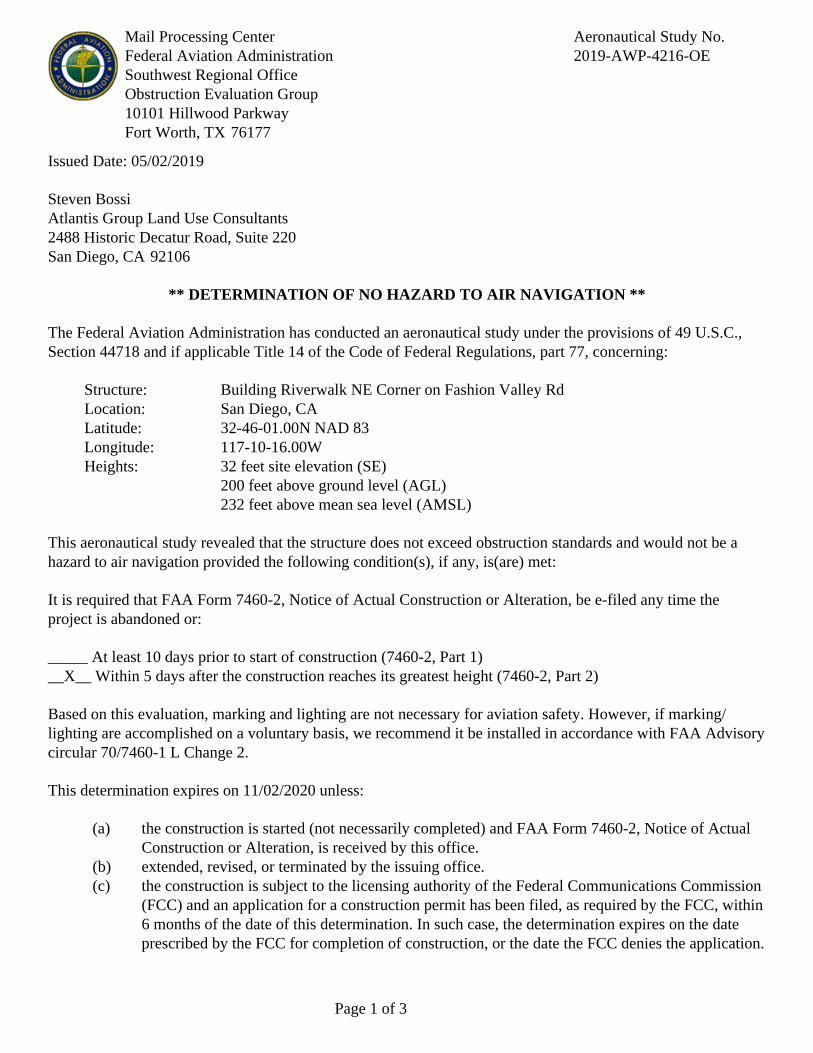
TOPO Map for ASN 2019-AWP-4216-OE

Mail Processing CenterFederal Aviation AdministrationSouthwest Regional OfficeObstruction Evaluation Group10101 Hillwood ParkwayFort Worth, TX 76177
Aeronautical Study No.2019-AWP-4212-OE
Page 1 of 3
Issued Date: 05/02/2019
Steven BossiAtlantis Group Land Use Consultants2488 Historic Decatur Road, Suite 220San Diego, CA 92106
** DETERMINATION OF NO HAZARD TO AIR NAVIGATION **
The Federal Aviation Administration has conducted an aeronautical study under the provisions of 49 U.S.C.,Section 44718 and if applicable Title 14 of the Code of Federal Regulations, part 77, concerning:
Structure: Building Riverwalk NE Corner on Friars RdLocation: San Diego, CALatitude: 32-46-03.00N NAD 83Longitude: 117-10-27.00WHeights: 61 feet site elevation (SE)
87 feet above ground level (AGL)148 feet above mean sea level (AMSL)
This aeronautical study revealed that the structure does not exceed obstruction standards and would not be ahazard to air navigation provided the following condition(s), if any, is(are) met:
It is required that FAA Form 7460-2, Notice of Actual Construction or Alteration, be e-filed any time theproject is abandoned or:
_____ At least 10 days prior to start of construction (7460-2, Part 1)__X__ Within 5 days after the construction reaches its greatest height (7460-2, Part 2)
Based on this evaluation, marking and lighting are not necessary for aviation safety. However, if marking/lighting are accomplished on a voluntary basis, we recommend it be installed in accordance with FAA Advisorycircular 70/7460-1 L Change 2.
This determination expires on 11/02/2020 unless:
(a) the construction is started (not necessarily completed) and FAA Form 7460-2, Notice of ActualConstruction or Alteration, is received by this office.
(b) extended, revised, or terminated by the issuing office.(c) the construction is subject to the licensing authority of the Federal Communications Commission
(FCC) and an application for a construction permit has been filed, as required by the FCC, within6 months of the date of this determination. In such case, the determination expires on the dateprescribed by the FCC for completion of construction, or the date the FCC denies the application.

Page 2 of 3
NOTE: REQUEST FOR EXTENSION OF THE EFFECTIVE PERIOD OF THIS DETERMINATION MUSTBE E-FILED AT LEAST 15 DAYS PRIOR TO THE EXPIRATION DATE. AFTER RE-EVALUATIONOF CURRENT OPERATIONS IN THE AREA OF THE STRUCTURE TO DETERMINE THAT NOSIGNIFICANT AERONAUTICAL CHANGES HAVE OCCURRED, YOUR DETERMINATION MAY BEELIGIBLE FOR ONE EXTENSION OF THE EFFECTIVE PERIOD.
This determination is based, in part, on the foregoing description which includes specific coordinates, heights,frequency(ies) and power. Any changes in coordinates, heights, and frequencies or use of greater power, exceptthose frequencies specified in the Colo Void Clause Coalition; Antenna System Co-Location; Voluntary BestPractices, effective 21 Nov 2007, will void this determination. Any future construction or alteration, includingincrease to heights, power, or the addition of other transmitters, requires separate notice to the FAA.Thisdetermination includes all previously filed frequencies and power for this structure.
If construction or alteration is dismantled or destroyed, you must submit notice to the FAA within 5 days afterthe construction or alteration is dismantled or destroyed.
This determination does include temporary construction equipment such as cranes, derricks, etc., which may beused during actual construction of the structure. However, this equipment shall not exceed the overall heights asindicated above. Equipment which has a height greater than the studied structure requires separate notice to theFAA.
This determination concerns the effect of this structure on the safe and efficient use of navigable airspaceby aircraft and does not relieve the sponsor of compliance responsibilities relating to any law, ordinance, orregulation of any Federal, State, or local government body.
If we can be of further assistance, please contact our office at (424) 405-7643, or [email protected]. Onany future correspondence concerning this matter, please refer to Aeronautical Study Number 2019-AWP-4212-OE.
Signature Control No: 402781424-404548411 ( DNE )Karen McDonaldSpecialist
Attachment(s)Map(s)

Page 3 of 3
TOPO Map for ASN 2019-AWP-4212-OE

Mail Processing CenterFederal Aviation AdministrationSouthwest Regional OfficeObstruction Evaluation Group10101 Hillwood ParkwayFort Worth, TX 76177
Aeronautical Study No.2019-AWP-4223-OE
Page 1 of 3
Issued Date: 05/02/2019
Steven BossiAtlantis Group Land Use Consultants2488 Historic Decatur Road, Suite 220San Diego, CA 92106
** DETERMINATION OF NO HAZARD TO AIR NAVIGATION **
The Federal Aviation Administration has conducted an aeronautical study under the provisions of 49 U.S.C.,Section 44718 and if applicable Title 14 of the Code of Federal Regulations, part 77, concerning:
Structure: Building Riverwalk SE CornerLocation: San Diego, CALatitude: 32-45-43.00N NAD 83Longitude: 117-10-21.00WHeights: 26 feet site elevation (SE)
200 feet above ground level (AGL)226 feet above mean sea level (AMSL)
This aeronautical study revealed that the structure does not exceed obstruction standards and would not be ahazard to air navigation provided the following condition(s), if any, is(are) met:
It is required that FAA Form 7460-2, Notice of Actual Construction or Alteration, be e-filed any time theproject is abandoned or:
_____ At least 10 days prior to start of construction (7460-2, Part 1)__X__ Within 5 days after the construction reaches its greatest height (7460-2, Part 2)
Based on this evaluation, marking and lighting are not necessary for aviation safety. However, if marking/lighting are accomplished on a voluntary basis, we recommend it be installed in accordance with FAA Advisorycircular 70/7460-1 L Change 2.
This determination expires on 11/02/2020 unless:
(a) the construction is started (not necessarily completed) and FAA Form 7460-2, Notice of ActualConstruction or Alteration, is received by this office.
(b) extended, revised, or terminated by the issuing office.(c) the construction is subject to the licensing authority of the Federal Communications Commission
(FCC) and an application for a construction permit has been filed, as required by the FCC, within6 months of the date of this determination. In such case, the determination expires on the dateprescribed by the FCC for completion of construction, or the date the FCC denies the application.

Page 2 of 3
NOTE: REQUEST FOR EXTENSION OF THE EFFECTIVE PERIOD OF THIS DETERMINATION MUSTBE E-FILED AT LEAST 15 DAYS PRIOR TO THE EXPIRATION DATE. AFTER RE-EVALUATIONOF CURRENT OPERATIONS IN THE AREA OF THE STRUCTURE TO DETERMINE THAT NOSIGNIFICANT AERONAUTICAL CHANGES HAVE OCCURRED, YOUR DETERMINATION MAY BEELIGIBLE FOR ONE EXTENSION OF THE EFFECTIVE PERIOD.
This determination is based, in part, on the foregoing description which includes specific coordinates, heights,frequency(ies) and power. Any changes in coordinates, heights, and frequencies or use of greater power, exceptthose frequencies specified in the Colo Void Clause Coalition; Antenna System Co-Location; Voluntary BestPractices, effective 21 Nov 2007, will void this determination. Any future construction or alteration, includingincrease to heights, power, or the addition of other transmitters, requires separate notice to the FAA.Thisdetermination includes all previously filed frequencies and power for this structure.
If construction or alteration is dismantled or destroyed, you must submit notice to the FAA within 5 days afterthe construction or alteration is dismantled or destroyed.
This determination does include temporary construction equipment such as cranes, derricks, etc., which may beused during actual construction of the structure. However, this equipment shall not exceed the overall heights asindicated above. Equipment which has a height greater than the studied structure requires separate notice to theFAA.
This determination concerns the effect of this structure on the safe and efficient use of navigable airspaceby aircraft and does not relieve the sponsor of compliance responsibilities relating to any law, ordinance, orregulation of any Federal, State, or local government body.
If we can be of further assistance, please contact our office at (424) 405-7643, or [email protected]. Onany future correspondence concerning this matter, please refer to Aeronautical Study Number 2019-AWP-4223-OE.
Signature Control No: 402782440-404548412 ( DNE )Karen McDonaldSpecialist
Attachment(s)Map(s)
Page 3 of 3
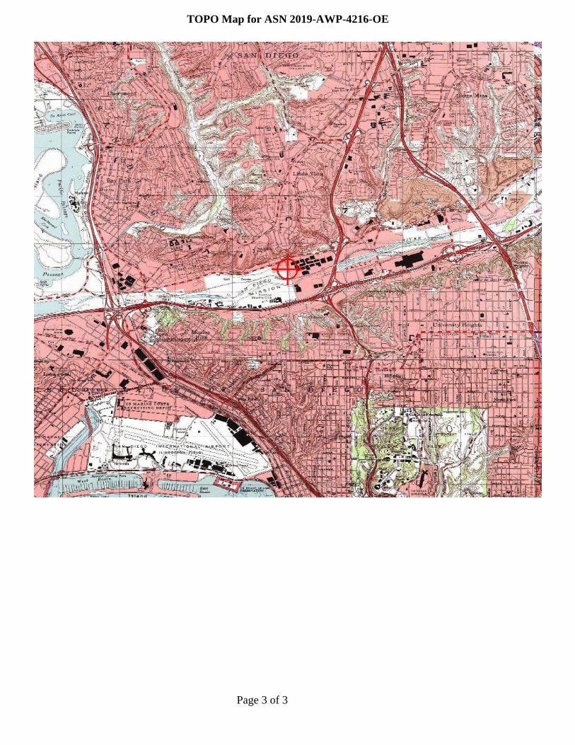
TOPO Map for ASN 2019-AWP-4223-OE

Mail Processing CenterFederal Aviation AdministrationSouthwest Regional OfficeObstruction Evaluation Group10101 Hillwood ParkwayFort Worth, TX 76177
Aeronautical Study No.2019-AWP-4218-OE
Page 1 of 3
Issued Date: 05/02/2019
Steven BossiAtlantis Group Land Use Consultants2488 Historic Decatur Road, Suite 220San Diego, CA 92106
** DETERMINATION OF NO HAZARD TO AIR NAVIGATION **
The Federal Aviation Administration has conducted an aeronautical study under the provisions of 49 U.S.C.,Section 44718 and if applicable Title 14 of the Code of Federal Regulations, part 77, concerning:
Structure: Building Riverwalk SE Corner on Fashion Valley RoadLocation: San Diego, CALatitude: 32-45-42.00N NAD 83Longitude: 117-10-12.00WHeights: 32 feet site elevation (SE)
200 feet above ground level (AGL)232 feet above mean sea level (AMSL)
This aeronautical study revealed that the structure does not exceed obstruction standards and would not be ahazard to air navigation provided the following condition(s), if any, is(are) met:
It is required that FAA Form 7460-2, Notice of Actual Construction or Alteration, be e-filed any time theproject is abandoned or:
_____ At least 10 days prior to start of construction (7460-2, Part 1)__X__ Within 5 days after the construction reaches its greatest height (7460-2, Part 2)
Based on this evaluation, marking and lighting are not necessary for aviation safety. However, if marking/lighting are accomplished on a voluntary basis, we recommend it be installed in accordance with FAA Advisorycircular 70/7460-1 L Change 2.
This determination expires on 11/02/2020 unless:
(a) the construction is started (not necessarily completed) and FAA Form 7460-2, Notice of ActualConstruction or Alteration, is received by this office.
(b) extended, revised, or terminated by the issuing office.(c) the construction is subject to the licensing authority of the Federal Communications Commission
(FCC) and an application for a construction permit has been filed, as required by the FCC, within6 months of the date of this determination. In such case, the determination expires on the dateprescribed by the FCC for completion of construction, or the date the FCC denies the application.

Page 2 of 3
NOTE: REQUEST FOR EXTENSION OF THE EFFECTIVE PERIOD OF THIS DETERMINATION MUSTBE E-FILED AT LEAST 15 DAYS PRIOR TO THE EXPIRATION DATE. AFTER RE-EVALUATIONOF CURRENT OPERATIONS IN THE AREA OF THE STRUCTURE TO DETERMINE THAT NOSIGNIFICANT AERONAUTICAL CHANGES HAVE OCCURRED, YOUR DETERMINATION MAY BEELIGIBLE FOR ONE EXTENSION OF THE EFFECTIVE PERIOD.
This determination is based, in part, on the foregoing description which includes specific coordinates, heights,frequency(ies) and power. Any changes in coordinates, heights, and frequencies or use of greater power, exceptthose frequencies specified in the Colo Void Clause Coalition; Antenna System Co-Location; Voluntary BestPractices, effective 21 Nov 2007, will void this determination. Any future construction or alteration, includingincrease to heights, power, or the addition of other transmitters, requires separate notice to the FAA.Thisdetermination includes all previously filed frequencies and power for this structure.
If construction or alteration is dismantled or destroyed, you must submit notice to the FAA within 5 days afterthe construction or alteration is dismantled or destroyed.
This determination does include temporary construction equipment such as cranes, derricks, etc., which may beused during actual construction of the structure. However, this equipment shall not exceed the overall heights asindicated above. Equipment which has a height greater than the studied structure requires separate notice to theFAA.
This determination concerns the effect of this structure on the safe and efficient use of navigable airspaceby aircraft and does not relieve the sponsor of compliance responsibilities relating to any law, ordinance, orregulation of any Federal, State, or local government body.
If we can be of further assistance, please contact our office at (424) 405-7643, or [email protected]. Onany future correspondence concerning this matter, please refer to Aeronautical Study Number 2019-AWP-4218-OE.
Signature Control No: 402782258-404548413 ( DNE )Karen McDonaldSpecialist
Attachment(s)Map(s)
Page 3 of 3
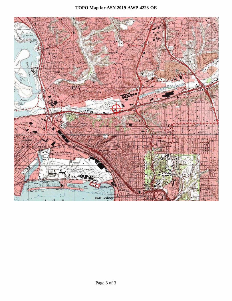
TOPO Map for ASN 2019-AWP-4218-OE

Mail Processing CenterFederal Aviation AdministrationSouthwest Regional OfficeObstruction Evaluation Group10101 Hillwood ParkwayFort Worth, TX 76177
Aeronautical Study No.2019-AWP-4217-OE
Page 1 of 3
Issued Date: 05/02/2019
Steven BossiAtlantis Group Land Use Consultants2488 Historic Decatur Road, Suite 220San Diego, CA 92106
** DETERMINATION OF NO HAZARD TO AIR NAVIGATION **
The Federal Aviation Administration has conducted an aeronautical study under the provisions of 49 U.S.C.,Section 44718 and if applicable Title 14 of the Code of Federal Regulations, part 77, concerning:
Structure: Building Riverwalk NE Corner on Fashion Valley Rd 2Location: San Diego, CALatitude: 32-45-57.00N NAD 83Longitude: 117-10-17.00WHeights: 33 feet site elevation (SE)
200 feet above ground level (AGL)233 feet above mean sea level (AMSL)
This aeronautical study revealed that the structure does not exceed obstruction standards and would not be ahazard to air navigation provided the following condition(s), if any, is(are) met:
It is required that FAA Form 7460-2, Notice of Actual Construction or Alteration, be e-filed any time theproject is abandoned or:
_____ At least 10 days prior to start of construction (7460-2, Part 1)__X__ Within 5 days after the construction reaches its greatest height (7460-2, Part 2)
Based on this evaluation, marking and lighting are not necessary for aviation safety. However, if marking/lighting are accomplished on a voluntary basis, we recommend it be installed in accordance with FAA Advisorycircular 70/7460-1 L Change 2.
This determination expires on 11/02/2020 unless:
(a) the construction is started (not necessarily completed) and FAA Form 7460-2, Notice of ActualConstruction or Alteration, is received by this office.
(b) extended, revised, or terminated by the issuing office.(c) the construction is subject to the licensing authority of the Federal Communications Commission
(FCC) and an application for a construction permit has been filed, as required by the FCC, within6 months of the date of this determination. In such case, the determination expires on the dateprescribed by the FCC for completion of construction, or the date the FCC denies the application.

Page 2 of 3
NOTE: REQUEST FOR EXTENSION OF THE EFFECTIVE PERIOD OF THIS DETERMINATION MUSTBE E-FILED AT LEAST 15 DAYS PRIOR TO THE EXPIRATION DATE. AFTER RE-EVALUATIONOF CURRENT OPERATIONS IN THE AREA OF THE STRUCTURE TO DETERMINE THAT NOSIGNIFICANT AERONAUTICAL CHANGES HAVE OCCURRED, YOUR DETERMINATION MAY BEELIGIBLE FOR ONE EXTENSION OF THE EFFECTIVE PERIOD.
This determination is based, in part, on the foregoing description which includes specific coordinates, heights,frequency(ies) and power. Any changes in coordinates, heights, and frequencies or use of greater power, exceptthose frequencies specified in the Colo Void Clause Coalition; Antenna System Co-Location; Voluntary BestPractices, effective 21 Nov 2007, will void this determination. Any future construction or alteration, includingincrease to heights, power, or the addition of other transmitters, requires separate notice to the FAA.Thisdetermination includes all previously filed frequencies and power for this structure.
If construction or alteration is dismantled or destroyed, you must submit notice to the FAA within 5 days afterthe construction or alteration is dismantled or destroyed.
This determination does include temporary construction equipment such as cranes, derricks, etc., which may beused during actual construction of the structure. However, this equipment shall not exceed the overall heights asindicated above. Equipment which has a height greater than the studied structure requires separate notice to theFAA.
This determination concerns the effect of this structure on the safe and efficient use of navigable airspaceby aircraft and does not relieve the sponsor of compliance responsibilities relating to any law, ordinance, orregulation of any Federal, State, or local government body.
If we can be of further assistance, please contact our office at (424) 405-7643, or [email protected]. Onany future correspondence concerning this matter, please refer to Aeronautical Study Number 2019-AWP-4217-OE.
Signature Control No: 402782095-404548414 ( DNE )Karen McDonaldSpecialist
Attachment(s)Map(s)

Page 3 of 3
TOPO Map for ASN 2019-AWP-4217-OE

Mail Processing CenterFederal Aviation AdministrationSouthwest Regional OfficeObstruction Evaluation Group10101 Hillwood ParkwayFort Worth, TX 76177
Aeronautical Study No.2019-AWP-4215-OE
Page 1 of 3
Issued Date: 05/02/2019
Steven BossiAtlantis Group Land Use Consultants2488 Historic Decatur Road, Suite 220San Diego, CA 92106
** DETERMINATION OF NO HAZARD TO AIR NAVIGATION **
The Federal Aviation Administration has conducted an aeronautical study under the provisions of 49 U.S.C.,Section 44718 and if applicable Title 14 of the Code of Federal Regulations, part 77, concerning:
Structure: Building Riverwalk NE CornerLocation: San Diego, CALatitude: 32-45-58.00N NAD 83Longitude: 117-10-26.00WHeights: 40 feet site elevation (SE)
87 feet above ground level (AGL)127 feet above mean sea level (AMSL)
This aeronautical study revealed that the structure does not exceed obstruction standards and would not be ahazard to air navigation provided the following condition(s), if any, is(are) met:
It is required that FAA Form 7460-2, Notice of Actual Construction or Alteration, be e-filed any time theproject is abandoned or:
_____ At least 10 days prior to start of construction (7460-2, Part 1)__X__ Within 5 days after the construction reaches its greatest height (7460-2, Part 2)
Based on this evaluation, marking and lighting are not necessary for aviation safety. However, if marking/lighting are accomplished on a voluntary basis, we recommend it be installed in accordance with FAA Advisorycircular 70/7460-1 L Change 2.
This determination expires on 11/02/2020 unless:
(a) the construction is started (not necessarily completed) and FAA Form 7460-2, Notice of ActualConstruction or Alteration, is received by this office.
(b) extended, revised, or terminated by the issuing office.(c) the construction is subject to the licensing authority of the Federal Communications Commission
(FCC) and an application for a construction permit has been filed, as required by the FCC, within6 months of the date of this determination. In such case, the determination expires on the dateprescribed by the FCC for completion of construction, or the date the FCC denies the application.
Page 2 of 3
NOTE: REQUEST FOR EXTENSION OF THE EFFECTIVE PERIOD OF THIS DETERMINATION MUSTBE E-FILED AT LEAST 15 DAYS PRIOR TO THE EXPIRATION DATE. AFTER RE-EVALUATIONOF CURRENT OPERATIONS IN THE AREA OF THE STRUCTURE TO DETERMINE THAT NOSIGNIFICANT AERONAUTICAL CHANGES HAVE OCCURRED, YOUR DETERMINATION MAY BEELIGIBLE FOR ONE EXTENSION OF THE EFFECTIVE PERIOD.
This determination is based, in part, on the foregoing description which includes specific coordinates, heights,frequency(ies) and power. Any changes in coordinates, heights, and frequencies or use of greater power, exceptthose frequencies specified in the Colo Void Clause Coalition; Antenna System Co-Location; Voluntary BestPractices, effective 21 Nov 2007, will void this determination. Any future construction or alteration, includingincrease to heights, power, or the addition of other transmitters, requires separate notice to the FAA.Thisdetermination includes all previously filed frequencies and power for this structure.
If construction or alteration is dismantled or destroyed, you must submit notice to the FAA within 5 days afterthe construction or alteration is dismantled or destroyed.
This determination does include temporary construction equipment such as cranes, derricks, etc., which may beused during actual construction of the structure. However, this equipment shall not exceed the overall heights asindicated above. Equipment which has a height greater than the studied structure requires separate notice to theFAA.
This determination concerns the effect of this structure on the safe and efficient use of navigable airspaceby aircraft and does not relieve the sponsor of compliance responsibilities relating to any law, ordinance, orregulation of any Federal, State, or local government body.
If we can be of further assistance, please contact our office at (424) 405-7643, or [email protected]. Onany future correspondence concerning this matter, please refer to Aeronautical Study Number 2019-AWP-4215-OE.
Signature Control No: 402782038-404548415 ( DNE )Karen McDonaldSpecialist
Attachment(s)Map(s)
Page 3 of 3
TOPO Map for ASN 2019-AWP-4215-OE
Mail Processing CenterFederal Aviation AdministrationSouthwest Regional OfficeObstruction Evaluation Group10101 Hillwood ParkwayFort Worth, TX 76177
Aeronautical Study No.2019-AWP-4207-OE
Page 1 of 3
Issued Date: 05/02/2019
Steven BossiAtlantis Group Land Use Consultants2488 Historic Decatur Road, Suite 220San Diego, CA 92106
** DETERMINATION OF NO HAZARD TO AIR NAVIGATION **
The Federal Aviation Administration has conducted an aeronautical study under the provisions of 49 U.S.C.,Section 44718 and if applicable Title 14 of the Code of Federal Regulations, part 77, concerning:
Structure: Building Riverwalk W Corner by MTS 2Location: San Diego, CALatitude: 32-45-51.00N NAD 83Longitude: 117-11-06.00WHeights: 33 feet site elevation (SE)
87 feet above ground level (AGL)120 feet above mean sea level (AMSL)
This aeronautical study revealed that the structure does not exceed obstruction standards and would not be ahazard to air navigation provided the following condition(s), if any, is(are) met:
It is required that FAA Form 7460-2, Notice of Actual Construction or Alteration, be e-filed any time theproject is abandoned or:
_____ At least 10 days prior to start of construction (7460-2, Part 1)__X__ Within 5 days after the construction reaches its greatest height (7460-2, Part 2)
Based on this evaluation, marking and lighting are not necessary for aviation safety. However, if marking/lighting are accomplished on a voluntary basis, we recommend it be installed in accordance with FAA Advisorycircular 70/7460-1 L Change 2.
This determination expires on 11/02/2020 unless:
(a) the construction is started (not necessarily completed) and FAA Form 7460-2, Notice of ActualConstruction or Alteration, is received by this office.
(b) extended, revised, or terminated by the issuing office.(c) the construction is subject to the licensing authority of the Federal Communications Commission
(FCC) and an application for a construction permit has been filed, as required by the FCC, within6 months of the date of this determination. In such case, the determination expires on the dateprescribed by the FCC for completion of construction, or the date the FCC denies the application.

Page 2 of 3
NOTE: REQUEST FOR EXTENSION OF THE EFFECTIVE PERIOD OF THIS DETERMINATION MUSTBE E-FILED AT LEAST 15 DAYS PRIOR TO THE EXPIRATION DATE. AFTER RE-EVALUATIONOF CURRENT OPERATIONS IN THE AREA OF THE STRUCTURE TO DETERMINE THAT NOSIGNIFICANT AERONAUTICAL CHANGES HAVE OCCURRED, YOUR DETERMINATION MAY BEELIGIBLE FOR ONE EXTENSION OF THE EFFECTIVE PERIOD.
This determination is based, in part, on the foregoing description which includes specific coordinates, heights,frequency(ies) and power. Any changes in coordinates, heights, and frequencies or use of greater power, exceptthose frequencies specified in the Colo Void Clause Coalition; Antenna System Co-Location; Voluntary BestPractices, effective 21 Nov 2007, will void this determination. Any future construction or alteration, includingincrease to heights, power, or the addition of other transmitters, requires separate notice to the FAA.Thisdetermination includes all previously filed frequencies and power for this structure.
If construction or alteration is dismantled or destroyed, you must submit notice to the FAA within 5 days afterthe construction or alteration is dismantled or destroyed.
This determination does include temporary construction equipment such as cranes, derricks, etc., which may beused during actual construction of the structure. However, this equipment shall not exceed the overall heights asindicated above. Equipment which has a height greater than the studied structure requires separate notice to theFAA.
This determination concerns the effect of this structure on the safe and efficient use of navigable airspaceby aircraft and does not relieve the sponsor of compliance responsibilities relating to any law, ordinance, orregulation of any Federal, State, or local government body.
If we can be of further assistance, please contact our office at (424) 405-7643, or [email protected]. Onany future correspondence concerning this matter, please refer to Aeronautical Study Number 2019-AWP-4207-OE.
Signature Control No: 402780853-404548416 ( DNE )Karen McDonaldSpecialist
Attachment(s)Map(s)
Page 3 of 3
TOPO Map for ASN 2019-AWP-4207-OE

Mail Processing CenterFederal Aviation AdministrationSouthwest Regional OfficeObstruction Evaluation Group10101 Hillwood ParkwayFort Worth, TX 76177
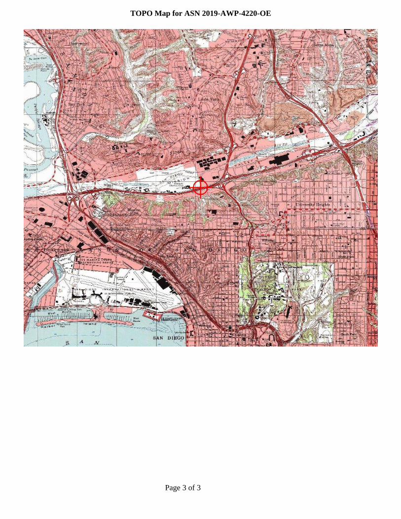
Aeronautical Study No.2019-AWP-4220-OE
Page 1 of 3
Issued Date: 05/02/2019
Steven BossiAtlantis Group Land Use Consultants2488 Historic Decatur Road, Suite 220San Diego, CA 92106
** DETERMINATION OF NO HAZARD TO AIR NAVIGATION **
The Federal Aviation Administration has conducted an aeronautical study under the provisions of 49 U.S.C.,Section 44718 and if applicable Title 14 of the Code of Federal Regulations, part 77, concerning:
Structure: Building Riverwalk SE Corner on Fashion Valley Road 2Location: San Diego, CALatitude: 32-45-40.00N NAD 83Longitude: 117-10-10.00WHeights: 26 feet site elevation (SE)
200 feet above ground level (AGL)226 feet above mean sea level (AMSL)
This aeronautical study revealed that the structure does not exceed obstruction standards and would not be ahazard to air navigation provided the following condition(s), if any, is(are) met:
It is required that FAA Form 7460-2, Notice of Actual Construction or Alteration, be e-filed any time theproject is abandoned or:
_____ At least 10 days prior to start of construction (7460-2, Part 1)__X__ Within 5 days after the construction reaches its greatest height (7460-2, Part 2)
Based on this evaluation, marking and lighting are not necessary for aviation safety. However, if marking/lighting are accomplished on a voluntary basis, we recommend it be installed in accordance with FAA Advisorycircular 70/7460-1 L Change 2.
This determination expires on 11/02/2020 unless:
(a) the construction is started (not necessarily completed) and FAA Form 7460-2, Notice of ActualConstruction or Alteration, is received by this office.
(b) extended, revised, or terminated by the issuing office.(c) the construction is subject to the licensing authority of the Federal Communications Commission
(FCC) and an application for a construction permit has been filed, as required by the FCC, within6 months of the date of this determination. In such case, the determination expires on the dateprescribed by the FCC for completion of construction, or the date the FCC denies the application.

Page 2 of 3
NOTE: REQUEST FOR EXTENSION OF THE EFFECTIVE PERIOD OF THIS DETERMINATION MUSTBE E-FILED AT LEAST 15 DAYS PRIOR TO THE EXPIRATION DATE. AFTER RE-EVALUATIONOF CURRENT OPERATIONS IN THE AREA OF THE STRUCTURE TO DETERMINE THAT NOSIGNIFICANT AERONAUTICAL CHANGES HAVE OCCURRED, YOUR DETERMINATION MAY BEELIGIBLE FOR ONE EXTENSION OF THE EFFECTIVE PERIOD.
This determination is based, in part, on the foregoing description which includes specific coordinates, heights,frequency(ies) and power. Any changes in coordinates, heights, and frequencies or use of greater power, exceptthose frequencies specified in the Colo Void Clause Coalition; Antenna System Co-Location; Voluntary BestPractices, effective 21 Nov 2007, will void this determination. Any future construction or alteration, includingincrease to heights, power, or the addition of other transmitters, requires separate notice to the FAA.Thisdetermination includes all previously filed frequencies and power for this structure.
If construction or alteration is dismantled or destroyed, you must submit notice to the FAA within 5 days afterthe construction or alteration is dismantled or destroyed.
This determination does include temporary construction equipment such as cranes, derricks, etc., which may beused during actual construction of the structure. However, this equipment shall not exceed the overall heights asindicated above. Equipment which has a height greater than the studied structure requires separate notice to theFAA.
This determination concerns the effect of this structure on the safe and efficient use of navigable airspaceby aircraft and does not relieve the sponsor of compliance responsibilities relating to any law, ordinance, orregulation of any Federal, State, or local government body.
If we can be of further assistance, please contact our office at (424) 405-7643, or [email protected]. Onany future correspondence concerning this matter, please refer to Aeronautical Study Number 2019-AWP-4220-OE.
Signature Control No: 402782341-404548417 ( DNE )Karen McDonaldSpecialist
Attachment(s)Map(s)
Page 3 of 3
TOPO Map for ASN 2019-AWP-4220-OE

Mail Processing CenterFederal Aviation AdministrationSouthwest Regional OfficeObstruction Evaluation Group10101 Hillwood ParkwayFort Worth, TX 76177
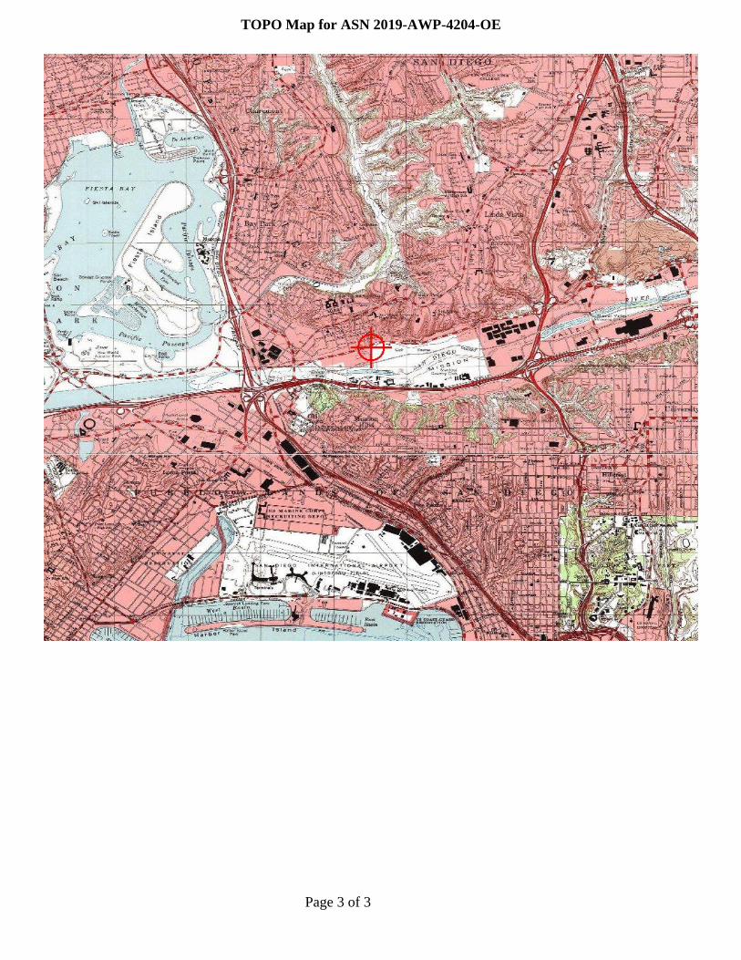
Aeronautical Study No.2019-AWP-4204-OE
Page 1 of 3
Issued Date: 05/02/2019
Steven BossiAtlantis Group Land Use Consultants2488 Historic Decatur Road, Suite 220San Diego, CA 92106
** DETERMINATION OF NO HAZARD TO AIR NAVIGATION **
The Federal Aviation Administration has conducted an aeronautical study under the provisions of 49 U.S.C.,Section 44718 and if applicable Title 14 of the Code of Federal Regulations, part 77, concerning:
Structure: Building Riverwalk NW Corner on Friars Rd 2Location: San Diego, CALatitude: 32-45-56.00N NAD 83Longitude: 117-11-12.00WHeights: 36 feet site elevation (SE)
87 feet above ground level (AGL)123 feet above mean sea level (AMSL)
This aeronautical study revealed that the structure does not exceed obstruction standards and would not be ahazard to air navigation provided the following condition(s), if any, is(are) met:
It is required that FAA Form 7460-2, Notice of Actual Construction or Alteration, be e-filed any time theproject is abandoned or:
_____ At least 10 days prior to start of construction (7460-2, Part 1)__X__ Within 5 days after the construction reaches its greatest height (7460-2, Part 2)
Based on this evaluation, marking and lighting are not necessary for aviation safety. However, if marking/lighting are accomplished on a voluntary basis, we recommend it be installed in accordance with FAA Advisorycircular 70/7460-1 L Change 2.
This determination expires on 11/02/2020 unless:
(a) the construction is started (not necessarily completed) and FAA Form 7460-2, Notice of ActualConstruction or Alteration, is received by this office.
(b) extended, revised, or terminated by the issuing office.(c) the construction is subject to the licensing authority of the Federal Communications Commission
(FCC) and an application for a construction permit has been filed, as required by the FCC, within6 months of the date of this determination. In such case, the determination expires on the dateprescribed by the FCC for completion of construction, or the date the FCC denies the application.

Page 2 of 3
NOTE: REQUEST FOR EXTENSION OF THE EFFECTIVE PERIOD OF THIS DETERMINATION MUSTBE E-FILED AT LEAST 15 DAYS PRIOR TO THE EXPIRATION DATE. AFTER RE-EVALUATIONOF CURRENT OPERATIONS IN THE AREA OF THE STRUCTURE TO DETERMINE THAT NOSIGNIFICANT AERONAUTICAL CHANGES HAVE OCCURRED, YOUR DETERMINATION MAY BEELIGIBLE FOR ONE EXTENSION OF THE EFFECTIVE PERIOD.
This determination is based, in part, on the foregoing description which includes specific coordinates, heights,frequency(ies) and power. Any changes in coordinates, heights, and frequencies or use of greater power, exceptthose frequencies specified in the Colo Void Clause Coalition; Antenna System Co-Location; Voluntary BestPractices, effective 21 Nov 2007, will void this determination. Any future construction or alteration, includingincrease to heights, power, or the addition of other transmitters, requires separate notice to the FAA.Thisdetermination includes all previously filed frequencies and power for this structure.
If construction or alteration is dismantled or destroyed, you must submit notice to the FAA within 5 days afterthe construction or alteration is dismantled or destroyed.
This determination does include temporary construction equipment such as cranes, derricks, etc., which may beused during actual construction of the structure. However, this equipment shall not exceed the overall heights asindicated above. Equipment which has a height greater than the studied structure requires separate notice to theFAA.
This determination concerns the effect of this structure on the safe and efficient use of navigable airspaceby aircraft and does not relieve the sponsor of compliance responsibilities relating to any law, ordinance, orregulation of any Federal, State, or local government body.
If we can be of further assistance, please contact our office at (424) 405-7643, or [email protected]. Onany future correspondence concerning this matter, please refer to Aeronautical Study Number 2019-AWP-4204-OE.
Signature Control No: 402779046-404548418 ( DNE )Karen McDonaldSpecialist
Attachment(s)Map(s)
Page 3 of 3
TOPO Map for ASN 2019-AWP-4204-OE

Mail Processing CenterFederal Aviation AdministrationSouthwest Regional OfficeObstruction Evaluation Group10101 Hillwood ParkwayFort Worth, TX 76177
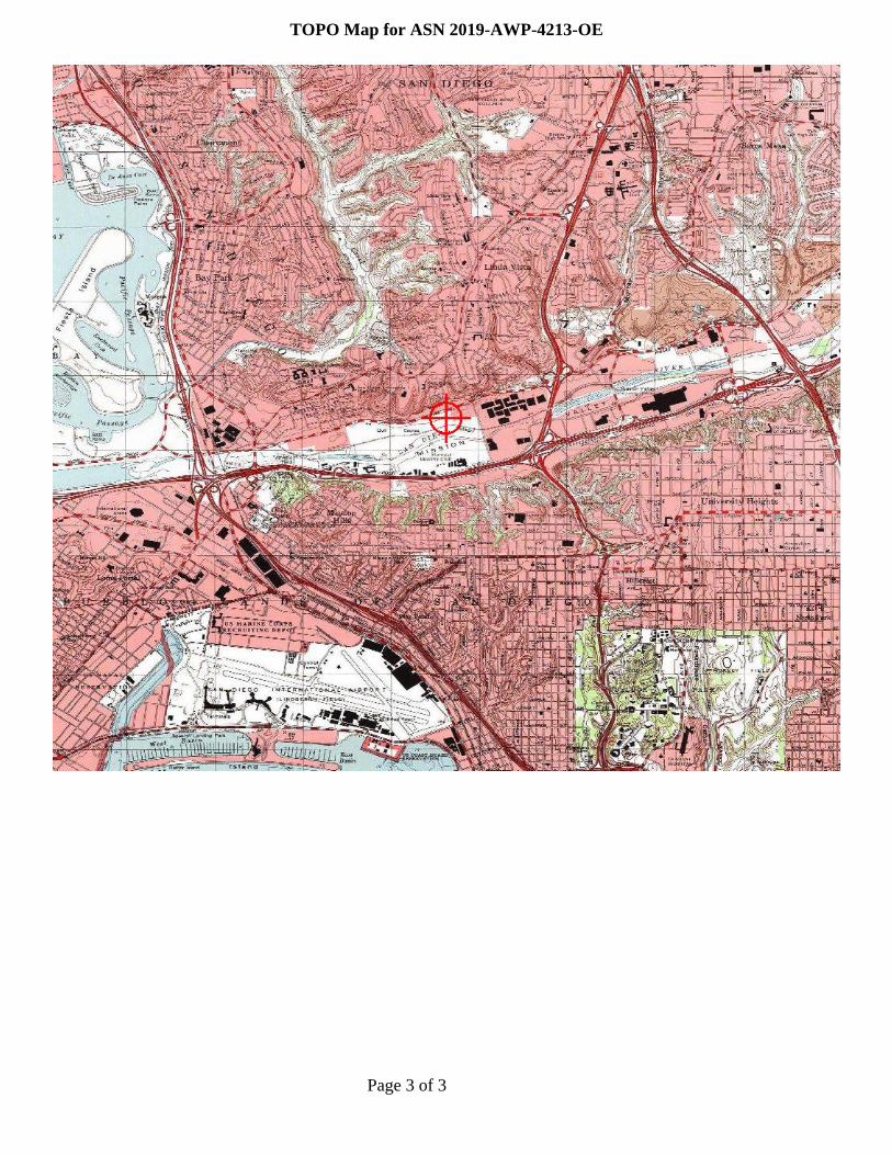
Aeronautical Study No.2019-AWP-4213-OE
Page 1 of 3
Issued Date: 05/02/2019
Steven BossiAtlantis Group Land Use Consultants2488 Historic Decatur Road, Suite 220San Diego, CA 92106
** DETERMINATION OF NO HAZARD TO AIR NAVIGATION **
The Federal Aviation Administration has conducted an aeronautical study under the provisions of 49 U.S.C.,Section 44718 and if applicable Title 14 of the Code of Federal Regulations, part 77, concerning:
Structure: Building Riverwalk NE Corner on Friars Rd 2Location: San Diego, CALatitude: 32-46-00.00N NAD 83Longitude: 117-10-29.00WHeights: 49 feet site elevation (SE)
87 feet above ground level (AGL)136 feet above mean sea level (AMSL)
This aeronautical study revealed that the structure does not exceed obstruction standards and would not be ahazard to air navigation provided the following condition(s), if any, is(are) met:
It is required that FAA Form 7460-2, Notice of Actual Construction or Alteration, be e-filed any time theproject is abandoned or:
_____ At least 10 days prior to start of construction (7460-2, Part 1)__X__ Within 5 days after the construction reaches its greatest height (7460-2, Part 2)
Based on this evaluation, marking and lighting are not necessary for aviation safety. However, if marking/lighting are accomplished on a voluntary basis, we recommend it be installed in accordance with FAA Advisorycircular 70/7460-1 L Change 2.
This determination expires on 11/02/2020 unless:
(a) the construction is started (not necessarily completed) and FAA Form 7460-2, Notice of ActualConstruction or Alteration, is received by this office.
(b) extended, revised, or terminated by the issuing office.(c) the construction is subject to the licensing authority of the Federal Communications Commission
(FCC) and an application for a construction permit has been filed, as required by the FCC, within6 months of the date of this determination. In such case, the determination expires on the dateprescribed by the FCC for completion of construction, or the date the FCC denies the application.

Page 2 of 3
NOTE: REQUEST FOR EXTENSION OF THE EFFECTIVE PERIOD OF THIS DETERMINATION MUSTBE E-FILED AT LEAST 15 DAYS PRIOR TO THE EXPIRATION DATE. AFTER RE-EVALUATIONOF CURRENT OPERATIONS IN THE AREA OF THE STRUCTURE TO DETERMINE THAT NOSIGNIFICANT AERONAUTICAL CHANGES HAVE OCCURRED, YOUR DETERMINATION MAY BEELIGIBLE FOR ONE EXTENSION OF THE EFFECTIVE PERIOD.
This determination is based, in part, on the foregoing description which includes specific coordinates, heights,frequency(ies) and power. Any changes in coordinates, heights, and frequencies or use of greater power, exceptthose frequencies specified in the Colo Void Clause Coalition; Antenna System Co-Location; Voluntary BestPractices, effective 21 Nov 2007, will void this determination. Any future construction or alteration, includingincrease to heights, power, or the addition of other transmitters, requires separate notice to the FAA.Thisdetermination includes all previously filed frequencies and power for this structure.
If construction or alteration is dismantled or destroyed, you must submit notice to the FAA within 5 days afterthe construction or alteration is dismantled or destroyed.
This determination does include temporary construction equipment such as cranes, derricks, etc., which may beused during actual construction of the structure. However, this equipment shall not exceed the overall heights asindicated above. Equipment which has a height greater than the studied structure requires separate notice to theFAA.
This determination concerns the effect of this structure on the safe and efficient use of navigable airspaceby aircraft and does not relieve the sponsor of compliance responsibilities relating to any law, ordinance, orregulation of any Federal, State, or local government body.
If we can be of further assistance, please contact our office at (424) 405-7643, or [email protected]. Onany future correspondence concerning this matter, please refer to Aeronautical Study Number 2019-AWP-4213-OE.
Signature Control No: 402781786-404548419 ( DNE )Karen McDonaldSpecialist
Attachment(s)Map(s)
Page 3 of 3
TOPO Map for ASN 2019-AWP-4213-OE
Mail Processing CenterFederal Aviation AdministrationSouthwest Regional OfficeObstruction Evaluation Group10101 Hillwood ParkwayFort Worth, TX 76177
Aeronautical Study No.2019-AWP-4205-OE
Page 1 of 3
Issued Date: 05/02/2019
Steven BossiAtlantis Group Land Use Consultants2488 Historic Decatur Road, Suite 220San Diego, CA 92106
** DETERMINATION OF NO HAZARD TO AIR NAVIGATION **
The Federal Aviation Administration has conducted an aeronautical study under the provisions of 49 U.S.C.,Section 44718 and if applicable Title 14 of the Code of Federal Regulations, part 77, concerning:
Structure: Building Riverwalk NW Corner on Friars RdLocation: San Diego, CALatitude: 32-45-55.00N NAD 83Longitude: 117-11-09.00WHeights: 31 feet site elevation (SE)
87 feet above ground level (AGL)118 feet above mean sea level (AMSL)
This aeronautical study revealed that the structure does not exceed obstruction standards and would not be ahazard to air navigation provided the following condition(s), if any, is(are) met:
It is required that FAA Form 7460-2, Notice of Actual Construction or Alteration, be e-filed any time theproject is abandoned or:
_____ At least 10 days prior to start of construction (7460-2, Part 1)__X__ Within 5 days after the construction reaches its greatest height (7460-2, Part 2)
Based on this evaluation, marking and lighting are not necessary for aviation safety. However, if marking/lighting are accomplished on a voluntary basis, we recommend it be installed in accordance with FAA Advisorycircular 70/7460-1 L Change 2.
This determination expires on 11/02/2020 unless:
(a) the construction is started (not necessarily completed) and FAA Form 7460-2, Notice of ActualConstruction or Alteration, is received by this office.
(b) extended, revised, or terminated by the issuing office.(c) the construction is subject to the licensing authority of the Federal Communications Commission
(FCC) and an application for a construction permit has been filed, as required by the FCC, within6 months of the date of this determination. In such case, the determination expires on the dateprescribed by the FCC for completion of construction, or the date the FCC denies the application.
Page 2 of 3
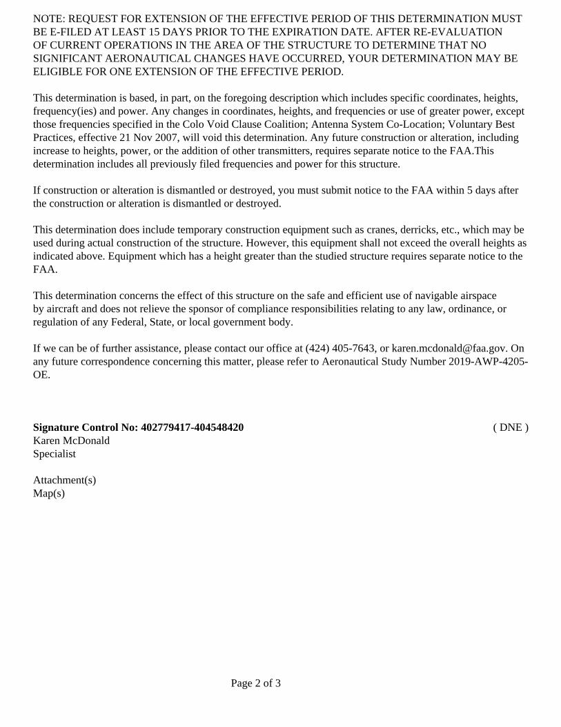
NOTE: REQUEST FOR EXTENSION OF THE EFFECTIVE PERIOD OF THIS DETERMINATION MUSTBE E-FILED AT LEAST 15 DAYS PRIOR TO THE EXPIRATION DATE. AFTER RE-EVALUATIONOF CURRENT OPERATIONS IN THE AREA OF THE STRUCTURE TO DETERMINE THAT NOSIGNIFICANT AERONAUTICAL CHANGES HAVE OCCURRED, YOUR DETERMINATION MAY BEELIGIBLE FOR ONE EXTENSION OF THE EFFECTIVE PERIOD.
This determination is based, in part, on the foregoing description which includes specific coordinates, heights,frequency(ies) and power. Any changes in coordinates, heights, and frequencies or use of greater power, exceptthose frequencies specified in the Colo Void Clause Coalition; Antenna System Co-Location; Voluntary BestPractices, effective 21 Nov 2007, will void this determination. Any future construction or alteration, includingincrease to heights, power, or the addition of other transmitters, requires separate notice to the FAA.Thisdetermination includes all previously filed frequencies and power for this structure.
If construction or alteration is dismantled or destroyed, you must submit notice to the FAA within 5 days afterthe construction or alteration is dismantled or destroyed.
This determination does include temporary construction equipment such as cranes, derricks, etc., which may beused during actual construction of the structure. However, this equipment shall not exceed the overall heights asindicated above. Equipment which has a height greater than the studied structure requires separate notice to theFAA.
This determination concerns the effect of this structure on the safe and efficient use of navigable airspaceby aircraft and does not relieve the sponsor of compliance responsibilities relating to any law, ordinance, orregulation of any Federal, State, or local government body.
If we can be of further assistance, please contact our office at (424) 405-7643, or [email protected]. Onany future correspondence concerning this matter, please refer to Aeronautical Study Number 2019-AWP-4205-OE.
Signature Control No: 402779417-404548420 ( DNE )Karen McDonaldSpecialist
Attachment(s)Map(s)
Page 3 of 3
TOPO Map for ASN 2019-AWP-4205-OE

Mail Processing CenterFederal Aviation AdministrationSouthwest Regional OfficeObstruction Evaluation Group10101 Hillwood ParkwayFort Worth, TX 76177
Aeronautical Study No.2019-AWP-4210-OE
Page 1 of 3
Issued Date: 05/02/2019
Steven BossiAtlantis Group Land Use Consultants2488 Historic Decatur Road, Suite 220San Diego, CA 92106
** DETERMINATION OF NO HAZARD TO AIR NAVIGATION **
The Federal Aviation Administration has conducted an aeronautical study under the provisions of 49 U.S.C.,Section 44718 and if applicable Title 14 of the Code of Federal Regulations, part 77, concerning:
Structure: Building Riverwalk N on Friars RdLocation: San Diego, CALatitude: 32-45-56.00N NAD 83Longitude: 117-10-53.00WHeights: 47 feet site elevation (SE)
200 feet above ground level (AGL)247 feet above mean sea level (AMSL)
This aeronautical study revealed that the structure does not exceed obstruction standards and would not be ahazard to air navigation provided the following condition(s), if any, is(are) met:
It is required that FAA Form 7460-2, Notice of Actual Construction or Alteration, be e-filed any time theproject is abandoned or:
_____ At least 10 days prior to start of construction (7460-2, Part 1)__X__ Within 5 days after the construction reaches its greatest height (7460-2, Part 2)
Based on this evaluation, marking and lighting are not necessary for aviation safety. However, if marking/lighting are accomplished on a voluntary basis, we recommend it be installed in accordance with FAA Advisorycircular 70/7460-1 L Change 2.
This determination expires on 11/02/2020 unless:
(a) the construction is started (not necessarily completed) and FAA Form 7460-2, Notice of ActualConstruction or Alteration, is received by this office.
(b) extended, revised, or terminated by the issuing office.(c) the construction is subject to the licensing authority of the Federal Communications Commission
(FCC) and an application for a construction permit has been filed, as required by the FCC, within6 months of the date of this determination. In such case, the determination expires on the dateprescribed by the FCC for completion of construction, or the date the FCC denies the application.

Page 2 of 3
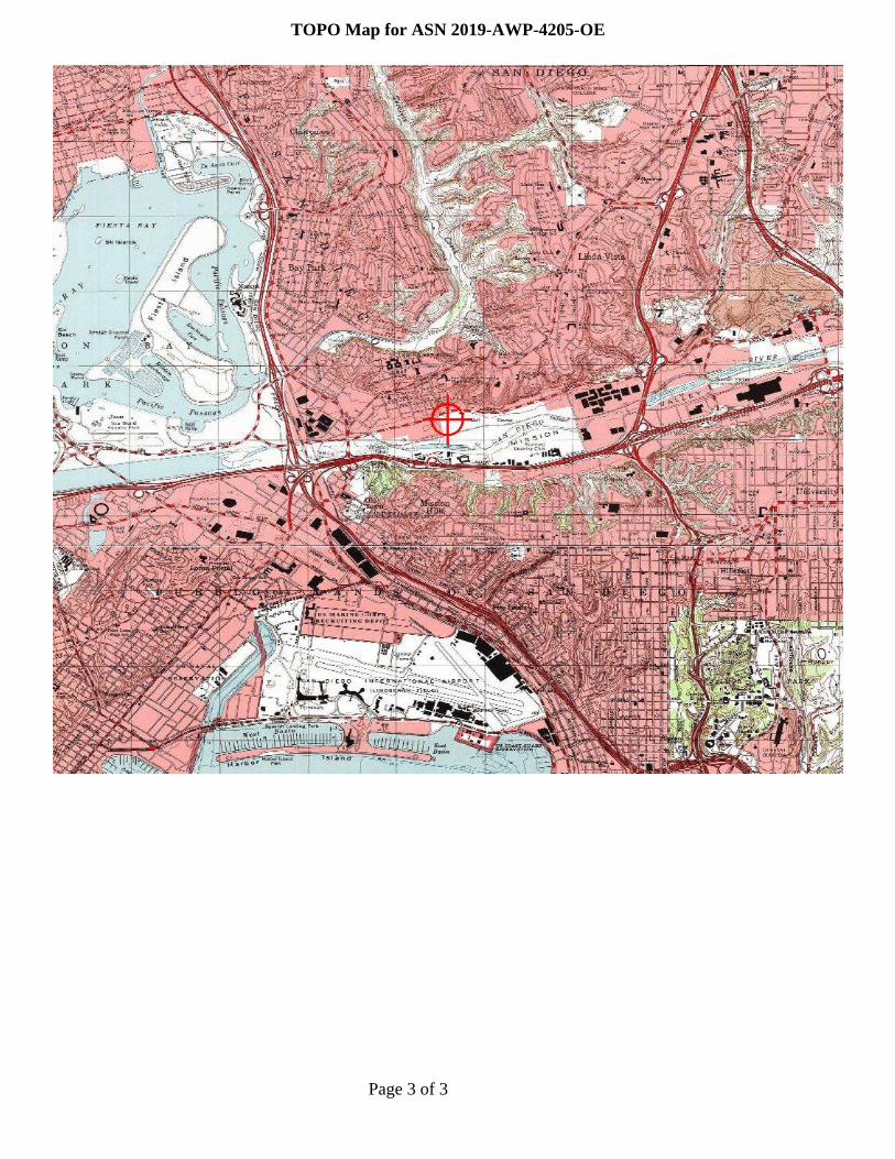
NOTE: REQUEST FOR EXTENSION OF THE EFFECTIVE PERIOD OF THIS DETERMINATION MUSTBE E-FILED AT LEAST 15 DAYS PRIOR TO THE EXPIRATION DATE. AFTER RE-EVALUATIONOF CURRENT OPERATIONS IN THE AREA OF THE STRUCTURE TO DETERMINE THAT NOSIGNIFICANT AERONAUTICAL CHANGES HAVE OCCURRED, YOUR DETERMINATION MAY BEELIGIBLE FOR ONE EXTENSION OF THE EFFECTIVE PERIOD.
This determination is based, in part, on the foregoing description which includes specific coordinates, heights,frequency(ies) and power. Any changes in coordinates, heights, and frequencies or use of greater power, exceptthose frequencies specified in the Colo Void Clause Coalition; Antenna System Co-Location; Voluntary BestPractices, effective 21 Nov 2007, will void this determination. Any future construction or alteration, includingincrease to heights, power, or the addition of other transmitters, requires separate notice to the FAA.Thisdetermination includes all previously filed frequencies and power for this structure.
If construction or alteration is dismantled or destroyed, you must submit notice to the FAA within 5 days afterthe construction or alteration is dismantled or destroyed.
This determination does include temporary construction equipment such as cranes, derricks, etc., which may beused during actual construction of the structure. However, this equipment shall not exceed the overall heights asindicated above. Equipment which has a height greater than the studied structure requires separate notice to theFAA.
This determination concerns the effect of this structure on the safe and efficient use of navigable airspaceby aircraft and does not relieve the sponsor of compliance responsibilities relating to any law, ordinance, orregulation of any Federal, State, or local government body.
If we can be of further assistance, please contact our office at (424) 405-7643, or [email protected]. Onany future correspondence concerning this matter, please refer to Aeronautical Study Number 2019-AWP-4210-OE.
Signature Control No: 402781325-404548421 ( DNE )Karen McDonaldSpecialist
Attachment(s)Map(s)
Page 3 of 3
TOPO Map for ASN 2019-AWP-4210-OE

Mail Processing CenterFederal Aviation AdministrationSouthwest Regional OfficeObstruction Evaluation Group10101 Hillwood ParkwayFort Worth, TX 76177
Aeronautical Study No.2019-AWP-4206-OE
Page 1 of 3
Issued Date: 05/02/2019
Steven BossiAtlantis Group Land Use Consultants2488 Historic Decatur Road, Suite 220San Diego, CA 92106
** DETERMINATION OF NO HAZARD TO AIR NAVIGATION **
The Federal Aviation Administration has conducted an aeronautical study under the provisions of 49 U.S.C.,Section 44718 and if applicable Title 14 of the Code of Federal Regulations, part 77, concerning:
Structure: Building Riverwalk W Corner by MTSLocation: San Diego, CALatitude: 32-45-48.00N NAD 83Longitude: 117-11-11.00WHeights: 18 feet site elevation (SE)
87 feet above ground level (AGL)105 feet above mean sea level (AMSL)
This aeronautical study revealed that the structure does not exceed obstruction standards and would not be ahazard to air navigation provided the following condition(s), if any, is(are) met:
It is required that FAA Form 7460-2, Notice of Actual Construction or Alteration, be e-filed any time theproject is abandoned or:
_____ At least 10 days prior to start of construction (7460-2, Part 1)__X__ Within 5 days after the construction reaches its greatest height (7460-2, Part 2)
Based on this evaluation, marking and lighting are not necessary for aviation safety. However, if marking/lighting are accomplished on a voluntary basis, we recommend it be installed in accordance with FAA Advisorycircular 70/7460-1 L Change 2.
This determination expires on 11/02/2020 unless:
(a) the construction is started (not necessarily completed) and FAA Form 7460-2, Notice of ActualConstruction or Alteration, is received by this office.
(b) extended, revised, or terminated by the issuing office.(c) the construction is subject to the licensing authority of the Federal Communications Commission
(FCC) and an application for a construction permit has been filed, as required by the FCC, within6 months of the date of this determination. In such case, the determination expires on the dateprescribed by the FCC for completion of construction, or the date the FCC denies the application.

Page 2 of 3
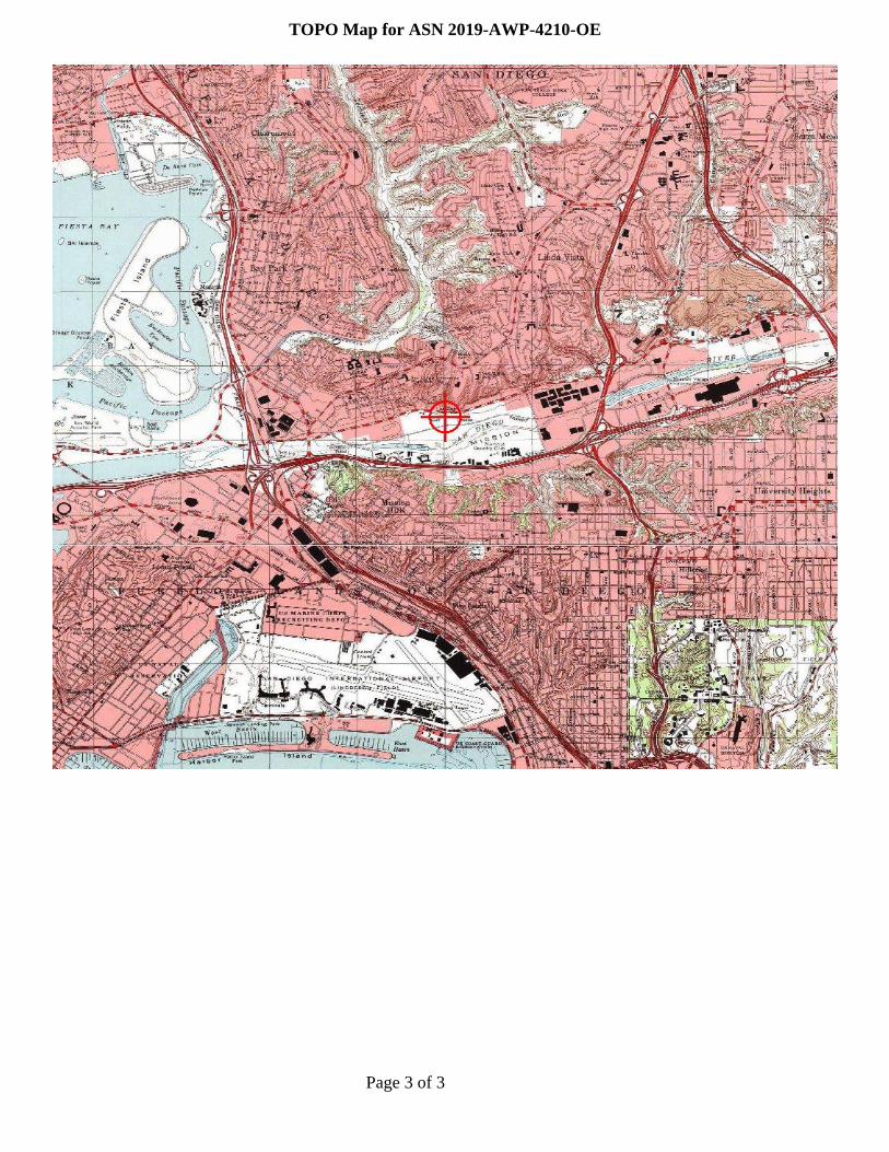
NOTE: REQUEST FOR EXTENSION OF THE EFFECTIVE PERIOD OF THIS DETERMINATION MUSTBE E-FILED AT LEAST 15 DAYS PRIOR TO THE EXPIRATION DATE. AFTER RE-EVALUATIONOF CURRENT OPERATIONS IN THE AREA OF THE STRUCTURE TO DETERMINE THAT NOSIGNIFICANT AERONAUTICAL CHANGES HAVE OCCURRED, YOUR DETERMINATION MAY BEELIGIBLE FOR ONE EXTENSION OF THE EFFECTIVE PERIOD.
This determination is based, in part, on the foregoing description which includes specific coordinates, heights,frequency(ies) and power. Any changes in coordinates, heights, and frequencies or use of greater power, exceptthose frequencies specified in the Colo Void Clause Coalition; Antenna System Co-Location; Voluntary BestPractices, effective 21 Nov 2007, will void this determination. Any future construction or alteration, includingincrease to heights, power, or the addition of other transmitters, requires separate notice to the FAA.Thisdetermination includes all previously filed frequencies and power for this structure.
If construction or alteration is dismantled or destroyed, you must submit notice to the FAA within 5 days afterthe construction or alteration is dismantled or destroyed.
This determination does include temporary construction equipment such as cranes, derricks, etc., which may beused during actual construction of the structure. However, this equipment shall not exceed the overall heights asindicated above. Equipment which has a height greater than the studied structure requires separate notice to theFAA.
This determination concerns the effect of this structure on the safe and efficient use of navigable airspaceby aircraft and does not relieve the sponsor of compliance responsibilities relating to any law, ordinance, orregulation of any Federal, State, or local government body.
If we can be of further assistance, please contact our office at (424) 405-7643, or [email protected]. Onany future correspondence concerning this matter, please refer to Aeronautical Study Number 2019-AWP-4206-OE.
Signature Control No: 402780637-404548422 ( DNE )Karen McDonaldSpecialist
Attachment(s)Map(s)
Page 3 of 3
TOPO Map for ASN 2019-AWP-4206-OE
Mail Processing CenterFederal Aviation AdministrationSouthwest Regional OfficeObstruction Evaluation Group10101 Hillwood ParkwayFort Worth, TX 76177
Aeronautical Study No.2019-AWP-4209-OE
Page 1 of 3
Issued Date: 05/02/2019
Steven BossiAtlantis Group Land Use Consultants2488 Historic Decatur Road, Suite 220San Diego, CA 92106
** DETERMINATION OF NO HAZARD TO AIR NAVIGATION **
The Federal Aviation Administration has conducted an aeronautical study under the provisions of 49 U.S.C.,Section 44718 and if applicable Title 14 of the Code of Federal Regulations, part 77, concerning:
Structure: Building Riverwalk W Corner by MTS 3Location: San Diego, CALatitude: 32-45-52.00N NAD 83Longitude: 117-10-56.00WHeights: 42 feet site elevation (SE)
200 feet above ground level (AGL)242 feet above mean sea level (AMSL)
This aeronautical study revealed that the structure does exceed obstruction standards but would not be a hazardto air navigation provided the following condition(s), if any, is(are) met:
It is required that FAA Form 7460-2, Notice of Actual Construction or Alteration, be e-filed any time theproject is abandoned or:
_____ At least 10 days prior to start of construction (7460-2, Part 1)__X__ Within 5 days after the construction reaches its greatest height (7460-2, Part 2)
Based on this evaluation, marking and lighting are not necessary for aviation safety. However, if marking/lighting are accomplished on a voluntary basis, we recommend it be installed in accordance with FAA Advisorycircular 70/7460-1 L Change 2.
This determination expires on 11/02/2020 unless:
(a) the construction is started (not necessarily completed) and FAA Form 7460-2, Notice of ActualConstruction or Alteration, is received by this office.
(b) extended, revised, or terminated by the issuing office.(c) the construction is subject to the licensing authority of the Federal Communications Commission
(FCC) and an application for a construction permit has been filed, as required by the FCC, within6 months of the date of this determination. In such case, the determination expires on the dateprescribed by the FCC for completion of construction, or the date the FCC denies the application.
Page 2 of 3
NOTE: REQUEST FOR EXTENSION OF THE EFFECTIVE PERIOD OF THIS DETERMINATION MUSTBE E-FILED AT LEAST 15 DAYS PRIOR TO THE EXPIRATION DATE. AFTER RE-EVALUATIONOF CURRENT OPERATIONS IN THE AREA OF THE STRUCTURE TO DETERMINE THAT NOSIGNIFICANT AERONAUTICAL CHANGES HAVE OCCURRED, YOUR DETERMINATION MAY BEELIGIBLE FOR ONE EXTENSION OF THE EFFECTIVE PERIOD.
This determination is based, in part, on the foregoing description which includes specific coordinates, heights,frequency(ies) and power. Any changes in coordinates, heights, and frequencies or use of greater power exceptthose frequencies specified in the Colo Void Clause Coalition; Antenna System Co-Location; Voluntary BestPractices, effective 21 Nov 2007, will void this determination. Any future construction or alteration includingincrease to heights, power, or the addition of other transmitters, requires separate notice to the FAA. Thisdetermination includes all previously filed frequencies and power for this structure.
If construction or alteration is dismantled or destroyed, you must submit notice to the FAA within 5 days afterthe construction or alteration is dismantled or destroyed.
This determination does include temporary construction equipment such as cranes, derricks, etc., which may beused during actual construction of the structure. However, this equipment shall not exceed the overall heights asindicated above. Equipment which has a height greater than the studied structure requires separate notice to theFAA.
This determination concerns the effect of this structure on the safe and efficient use of navigable airspaceby aircraft and does not relieve the sponsor of compliance responsibilities relating to any law, ordinance, orregulation of any Federal, State, or local government body.
If we can be of further assistance, please contact our office at (424) 405-7643, or [email protected]. Onany future correspondence concerning this matter, please refer to Aeronautical Study Number 2019-AWP-4209-OE.
Signature Control No: 402781205-404548990 ( EBO )Karen McDonaldSpecialist
Attachment(s)Map(s)

Page 3 of 3
TOPO Map for ASN 2019-AWP-4209-OE

Mail Processing CenterFederal Aviation AdministrationSouthwest Regional OfficeObstruction Evaluation Group10101 Hillwood ParkwayFort Worth, TX 76177
Aeronautical Study No.2019-AWP-4221-OE
Page 1 of 3
Issued Date: 05/02/2019
Steven BossiAtlantis Group Land Use Consultants2488 Historic Decatur Road, Suite 220San Diego, CA 92106
** DETERMINATION OF NO HAZARD TO AIR NAVIGATION **
The Federal Aviation Administration has conducted an aeronautical study under the provisions of 49 U.S.C.,Section 44718 and if applicable Title 14 of the Code of Federal Regulations, part 77, concerning:
Structure: Building Riverwalk SE Corner on Hotel Circle NLocation: San Diego, CALatitude: 32-45-38.00N NAD 83Longitude: 117-10-19.00WHeights: 25 feet site elevation (SE)
200 feet above ground level (AGL)225 feet above mean sea level (AMSL)
This aeronautical study revealed that the structure does exceed obstruction standards but would not be a hazardto air navigation provided the following condition(s), if any, is(are) met:
It is required that FAA Form 7460-2, Notice of Actual Construction or Alteration, be e-filed any time theproject is abandoned or:
_____ At least 10 days prior to start of construction (7460-2, Part 1)__X__ Within 5 days after the construction reaches its greatest height (7460-2, Part 2)
Based on this evaluation, marking and lighting are not necessary for aviation safety. However, if marking/lighting are accomplished on a voluntary basis, we recommend it be installed in accordance with FAA Advisorycircular 70/7460-1 L Change 2.
This determination expires on 11/02/2020 unless:
(a) the construction is started (not necessarily completed) and FAA Form 7460-2, Notice of ActualConstruction or Alteration, is received by this office.
(b) extended, revised, or terminated by the issuing office.(c) the construction is subject to the licensing authority of the Federal Communications Commission
(FCC) and an application for a construction permit has been filed, as required by the FCC, within6 months of the date of this determination. In such case, the determination expires on the dateprescribed by the FCC for completion of construction, or the date the FCC denies the application.

Page 2 of 3
NOTE: REQUEST FOR EXTENSION OF THE EFFECTIVE PERIOD OF THIS DETERMINATION MUSTBE E-FILED AT LEAST 15 DAYS PRIOR TO THE EXPIRATION DATE. AFTER RE-EVALUATIONOF CURRENT OPERATIONS IN THE AREA OF THE STRUCTURE TO DETERMINE THAT NOSIGNIFICANT AERONAUTICAL CHANGES HAVE OCCURRED, YOUR DETERMINATION MAY BEELIGIBLE FOR ONE EXTENSION OF THE EFFECTIVE PERIOD.
This determination is based, in part, on the foregoing description which includes specific coordinates, heights,frequency(ies) and power. Any changes in coordinates, heights, and frequencies or use of greater power exceptthose frequencies specified in the Colo Void Clause Coalition; Antenna System Co-Location; Voluntary BestPractices, effective 21 Nov 2007, will void this determination. Any future construction or alteration includingincrease to heights, power, or the addition of other transmitters, requires separate notice to the FAA. Thisdetermination includes all previously filed frequencies and power for this structure.
If construction or alteration is dismantled or destroyed, you must submit notice to the FAA within 5 days afterthe construction or alteration is dismantled or destroyed.
This determination does include temporary construction equipment such as cranes, derricks, etc., which may beused during actual construction of the structure. However, this equipment shall not exceed the overall heights asindicated above. Equipment which has a height greater than the studied structure requires separate notice to theFAA.
This determination concerns the effect of this structure on the safe and efficient use of navigable airspaceby aircraft and does not relieve the sponsor of compliance responsibilities relating to any law, ordinance, orregulation of any Federal, State, or local government body.
If we can be of further assistance, please contact our office at (424) 405-7643, or [email protected]. Onany future correspondence concerning this matter, please refer to Aeronautical Study Number 2019-AWP-4221-OE.
Signature Control No: 402782359-404548991 ( EBO )Karen McDonaldSpecialist
Attachment(s)Map(s)
Page 3 of 3
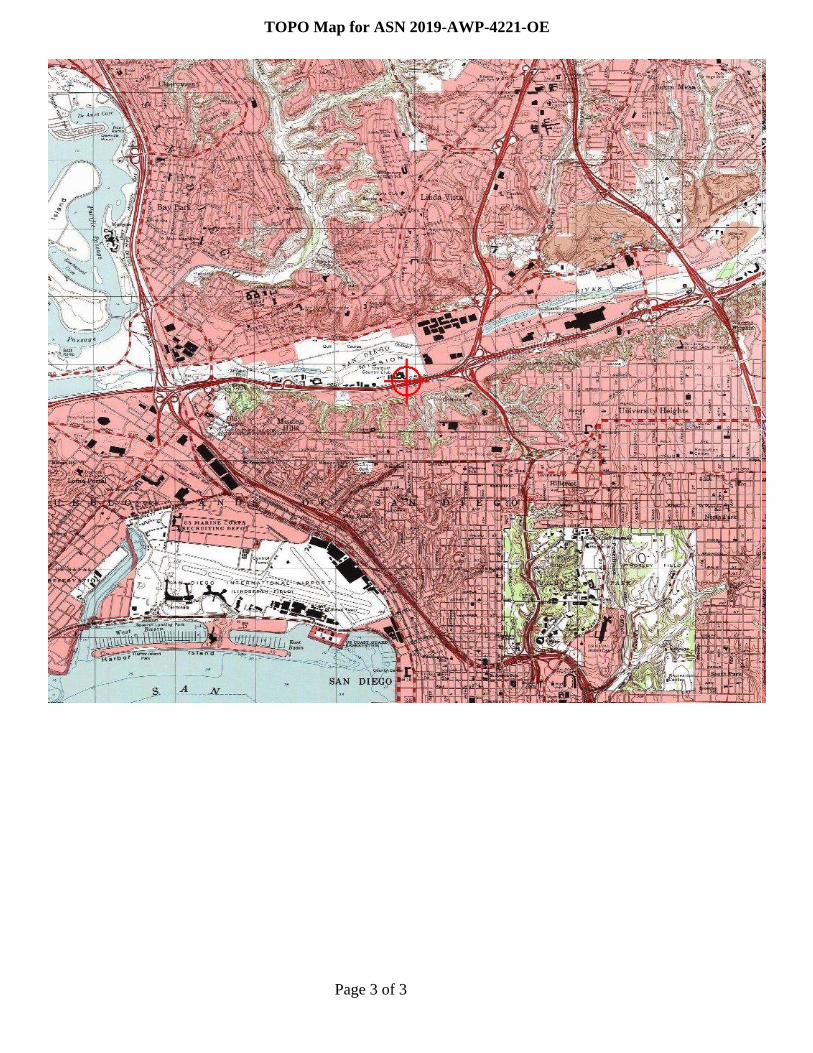
TOPO Map for ASN 2019-AWP-4221-OE