Embed Size (px)
Citation preview

SOUTHWEST TRAVIS COUNTY GROWTH DIALOG
Advisory Panel Final Report May 31, 2005
TRANSMITTAL MEMO To: Sam Biscoe, Travis County Judge Ron Davis, Travis County Commissioner, Precinct 1 Karen Sonleitner, Travis County Commissioner, Precinct 1 Gerald Daugherty, Travis County Commissioner, Precinct 1 Margaret Gomez, Travis County Commissioner, Precinct 1 Joe Beal, General Manager, LCRA From: Advisory Panel, Southwest Travis County Growth Dialog Date: May 31, 2005 Subject: Final Report
The Advisory Panel for the Southwest Travis County Growth Dialog is pleased to transmit the attached final report of their recommendations. Commencing in September 2004 and continuing through May 2005 the Growth Dialog has given each of the Panel members an important opportunity to learn about southwest Travis County and the issues confronting its future. Through the Dialog we have come to value even more this unique area we call our community, our home. It is our hope that the area’s residents and landowners and, Travis County and LCRA will find the attached report’s vision and recommendation proposals to be a valuable resource for future decision making. We would like to personally thank the numerous individuals and the agencies that supported our efforts during the Growth Dialog and in completion of the final report. First and foremost, we would like to thank Travis County Commissioner Gerald Daugherty and LCRA General Manager Joe Beal for having the foresight to initiate this process and confidence that the community would work together to create a vision for future growth in southwestern Travis County. Travis County and Lower Colorado River Authority (LCRA) co-sponsored the initiative to provide a forum for open, honest discussion of community stakeholders. Also, we would also like to thank Bob Moore and Barbara Smith of Commissioner Daugherty’s office for their support and help throughout every phase of this process. The Growth Dialog could not have been productive without the attendance and support of Travis County Transportation and Natural Resources (TNR), including but not limited to Executive Manager, Joe Gieselman, Charles Burg, John Kuhl and Anna Bowlin. Tom Nuckols, with the Travis County Attorney’s office was instrumental in discussions relating to the report and implementation of the recommendations. TNR staff undertook the mapping research needed to create the Conceptual Plan Map and maintained the
i
Growth Dialog’s information on the county website. TNR also provided a meeting facility at their Precinct 3 building on Hamilton Pool Road as needed. LCRA’s staff support in the Dialog meetings was invaluable and included Executive Manager Frank McCamant, Stan Casey, Tom Hegemier and Fred Crawford. Theresa Noyes of LCRA provided mapping support that gave a professional look and feel to all our mapping discussions. We are also grateful to Joseph Lessard for facilitating the Growth Dialog process and keeping us on track and on schedule. Without Joe’s leadership, the process would not have been successful. Finally, we would like to thank the Village of Bee Caves for providing a regular meeting place for the growth dialog forum. City Manager James Fisher and his staff were gracious hosts throughout the Dialog.
ii
SOUTHWEST TRAVIS COUNTY GROWTH DIALOG
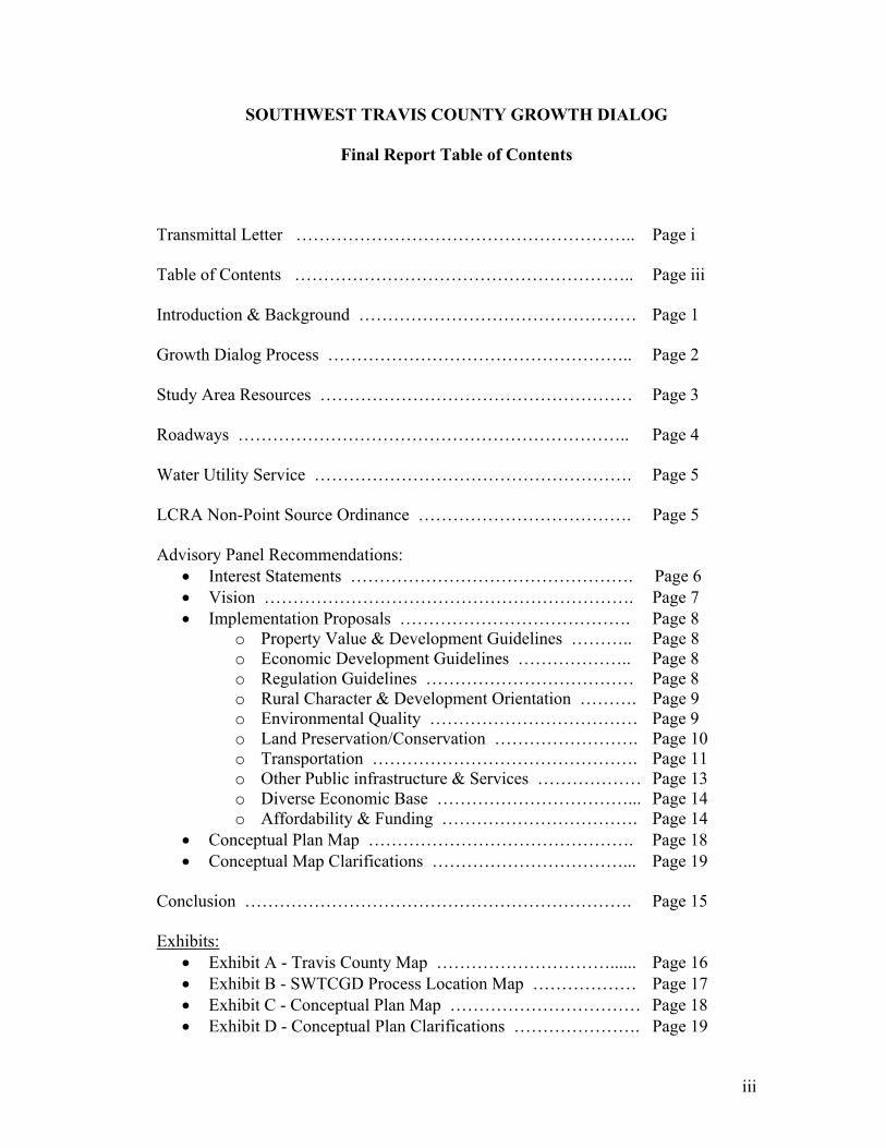
Final Report Table of Contents Transmittal Letter ………………………………………………….. Page i Table of Contents ………………………………………………….. Page iii Introduction & Background ………………………………………… Page 1
Growth Dialog Process …………………………………………….. Page 2 Study Area Resources ……………………………………………… Page 3 Roadways ………………………………………………………….. Page 4 Water Utility Service ………………………………………………. Page 5
LCRA Non-Point Source Ordinance ………………………………. Page 5 Advisory Panel Recommendations:
• Interest Statements …………………………………………. Page 6 • Vision ………………………………………………………. Page 7 • Implementation Proposals …………………………………. Page 8
o Property Value & Development Guidelines ……….. Page 8 o Economic Development Guidelines ……………….. Page 8 o Regulation Guidelines ……………………………… Page 8 o Rural Character & Development Orientation ………. Page 9 o Environmental Quality ……………………………… Page 9 o Land Preservation/Conservation ……………………. Page 10 o Transportation ………………………………………. Page 11 o Other Public infrastructure & Services ……………… Page 13 o Diverse Economic Base ……………………………... Page 14 o Affordability & Funding ……………………………. Page 14
• Conceptual Plan Map ………………………………………. Page 18 • Conceptual Map Clarifications ……………………………... Page 19
Conclusion …………………………………………………………. Page 15 Exhibits:
• Exhibit A - Travis County Map …………………………...... Page 16 • Exhibit B - SWTCGD Process Location Map ……………… Page 17 • Exhibit C - Conceptual Plan Map …………………………… Page 18 • Exhibit D - Conceptual Plan Clarifications …………………. Page 19
iii
iv
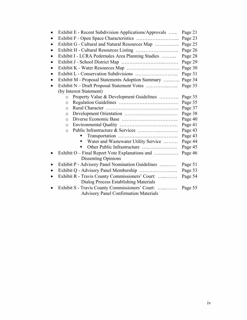
• Exhibit E - Recent Subdivision Applications/Approvals …... Page 21 • Exhibit F - Open Space Characteristics ……………………... Page 23 • Exhibit G - Cultural and Natural Resources Map …………… Page 25 • Exhibit H - Cultural Resources Listing ……………………... Page 26 • Exhibit I - LCRA Pedernales Area Planning Studies …….... Page 28 • Exhibit J - School District Map ……………………...……… Page 29 • Exhibit K - Water Resources Map …………………………… Page 30 • Exhibit L - Conservation Subdivisions ……………………... Page 31 • Exhibit M - Proposal Statements Adoption Summary …...….. Page 34 • Exhibit N – Draft Proposal Statement Votes …………...…... Page 35 (by Interest Statement)
o Property Value & Development Guidelines ………… Page 35 o Regulation Guidelines ………………………………. Page 35 o Rural Character ……………………………………… Page 37 o Development Orientation …………………………… Page 38 o Diverse Economic Base …………………………….. Page 40 o Environmental Quality ……………………………… Page 41 o Public Infrastructure & Services ……………………. Page 43
Transportation ………………………………. Page 43 Water and Wastewater Utility Service ……… Page 44 Other Public Infrastructure …………………. Page 45
• Exhibit O – Final Report Vote Explanations and …………… Page 46 Dissenting Opinions
• Exhibit P - Advisory Panel Nomination Guidelines …..…… Page 51 • Exhibit Q - Advisory Panel Membership ……….………….. Page 53 • Exhibit R - Travis County Commissioners’ Court: …...……. Page 54
Dialog Process Establishing Materials • Exhibit S - Travis County Commissioners’ Court: …...……. Page 55
Advisory Panel Confirmation Materials
SOUTHWEST TRAVIS COUNTY DIALOG PROCESS Final Report April 28, 2005
Introduction & Background Central Texas continues to prove itself a popular destination for individuals and families seeking to live in a location with a diverse economy, high standard of living and desirable natural environment. Population growth in Travis County is estimated to be averaging 2.4% annually since the 2000 census. Travis County’s growing population of home buyers has identified the Texas Hill Country as a preferred location for middle to high income residential development. Dominating the western portion of Travis County, the Texas Hill Country environment provides scenic vistas, recreational opportunities and a sense of Texas history to its residents. Development interest in the southwest portion of Travis County has increased over the last two years as convenient new development alternatives in the more developed and previously more growth oriented northwest portion of the County have been reduced. Supporting this trend is the interest of home buyers to live within the Lake Travis Independent School District; acknowledged for its quality of education (see Exhibit “J”). Responding to growth and market conditions, development interests have begun requesting approvals for residential lot subdivisions and the provision of utility services to the southwest in what has to date been a rural area of the County. Pressure for new development here has in turn sparked growing concern among the area’s current residents and landowners that future development be undertaken so as to protect the area’s quality of life, water quality and long-term property values. Responding to community and development interests, the County and the Lower Colorado River Authority (LCRA), acting as co-sponsor, initiated the Southwest Travis County Growth Dialog to provide a forum for open, honest and inclusive discussion by interested parties on the area’s future. This final report has been drafted to convey the recommendations developed within the Growth Dialog for managing the economic development of southwest Travis County. Participants in the Growth Dialog have worked to assemble a set of recommendations that address the interests of involved stakeholders and recognize the opportunities and obstacles to protecting the long-term viability of the area’s cultural, natural and economic environment. Participants understand that these recommendations are the first step in an on-going process to affirm and, in a practical sense, actualize the community’s values to the benefit of all involved. The final report was adopted by the advisory panel by a vote of 11 for, 4 against and 1 abstaining; Exhibit “O” provides a record of the advisory panel’s vote on the final report and related explanations or dissenting opinions from advisory panel members. The report is organized into subsections that explain the Growth Dialog’s process and document the area’s resources and development issues. The final sections provide the Advisory Panel’s recommendations for review and follow-up by the sponsoring governmental entities.
1
Growth Dialog Process Acting as co-sponsors, Travis County and LCRA initiated the Southwest Travis County Growth Dialog (the Growth Dialog or SWTCGD) to seek community and stakeholder input on growth-related issues in southwestern Travis County (the study area). The study area addressed in the Growth Dialog is defined as the unincorporated area of Travis County (outside municipal corporate and extraterritorial boundaries) bounded to the west and south by the County boundary, to the north by Lake Travis and the Village of Briarcliff extraterritorial jurisdiction (ETJ) and, to the east by the City of Austin and City of Lakeway ETJ boundaries (Exhibit “A”, Travis County Map, Exhibit “B”, SWTCGD Process Location Map and Exhibit “C”, Conceptual Plan Map). To facilitate this initiative, an advisory panel of interested individuals was established to help identify community desires related to development within the study area and to formulate a set of growth-related recommendations. Working with a professional facilitator, the advisory panel was charged to work within a timeframe that would allow its input to be available for consideration during development of the FY-2005 Travis County operating and capital improvement budgets. The dialog process was conducted between September 1, 2004 and May 1, 2005 and involved 16 individuals designated as voting members of the advisory panel with an additional 16 individuals designated to serve as alternate members should any voting members be unable to attend. Voting membership positions on the advisory panel were allocated to representatives from the following stakeholder interests or groups:
• Neighborhoods and concerned homeowners (five voting member positions) • Other area property owners such as owners of agriculture and commercial
property (five voting member positions) • Economic and development interests (three voting member positions) • Environmental and preservation interests (three voting member positions) • Other public interest organizations (three voting member positions available but
unfilled) The advisory panel acted to seek participant consensus whenever possible but relied on majority vote (over half of attending voting members) for all final recommendations. Voting and alternate members each participated in the panel discussions freely but only voting members participated in decision making votes. Nominations for individuals to fill voting and alternate member positions on the advisory panel were solicited from the community through meetings held for study area residents and landowners and other interested parties (Exhibit “P”, Advisory Panel Nomination Guidelines). Nominees were interviewed to confirm their interest and commitment to participate in the Growth Dialog and a list of final nominees was presented to the Travis County Commissioners Court for confirmation (see Exhibit “S”). Upon confirmation the advisory panel was charged by the Commissioners Court to complete the following tasks divided into two phases:
2
Phase I – Develop a conceptual plan for the study area comprised of the following tasks or products: • Draft a general outline or vision statement that can serve to guide the course of
development in Southwest Travis County over the next 20 years. • Identify the public amenities, services and infrastructure necessary to support the
general vision and quality of life for the area’s residents • Identify key public and governmental service changes or initiatives deemed
necessary to support the general vision • Solicit general community input/feedback on the vision statement and public
service support requirements • Draft a report to Travis County and LCRA outlining the panel’s vision statement
and support recommendations and public input findings.
Phase II – Implementation Feedback Provide a forum for public comment on staff plans or recommendations to implement the advisory panel’s report or findings.
To meet the panel’s charge it undertook to communicate with the Hamilton Pool Road Forum (a previously impaneled citizen’s panel sponsored by LCRA studying issues for a sub-portion of the study area) and held two public forums to solicit comment from study area residents. Including the public forums, 21 meetings have been held to date by the advisory panel. With a final public forum to be scheduled after this report; the panel will have held 22 meetings over the term of its existence. It is anticipated that following receipt of this final report, support staff from the sponsors will be charged with addressing the advisory panel’s recommendations as appropriate in developing and implementing service delivery plans. Specific staff follow-up is expected in the development of recommendations for new or updated development regulations, financial feasibility reports and capital improvements programming. It is understood that all panel recommendations and staff proposals are subject to the consideration and adoption by the respective implementing entity, Travis County or LCRA. Study Area Resources The study area in southwest Travis County is an environmentally diverse and beautiful Hill Country setting. Glenrose limestone predominately underlies the rolling landscape, which forms naturally benched terrain. Soils in the study area are those of the Brackett Association that are characterized as shallow, gravelly, calcareous, loamy soils overlying interbedded limestone and marl. These shallow, loose soils over limestone are susceptible to erosion, particularly if they lose vegetative cover The area is traversed by a number of clear, ephemeral and perennial creeks that feed into the Pedernales River or Lake Travis and the Colorado River. These include Barton Creek, Cypress Creek, Fall Creek, Hamilton Creek, Rocky Creek, Bee Creek, Lick Creek and other un-named drainages. These creeks are fed, in part, by spring flow that recharges through the porous Hensel Sand and Cow Creek limestone formations. The springs of the study area are a tremendous natural and cultural asset and are arguably what makes this area unique. The best known include those associated with Westcave
3

Preserve, Hamilton Pool, Levi Rock Shelter and others along Bee Creek, Rocky Creek and smaller drainages. Wildlife and diverse flora are also notable assets in the study area. Common Hill Country species of wildlife and vegetation can be found along with more unique species and communities. A live oak-juniper-cedar elm savannah is common on upland areas and scattered madrones can be found on less disturbed upland sites. The diverse bottomlands have bald cypress, sycamore, little walnut and Texas Oak as dominant canopy species. Grasslands have in many cases been managed well in this traditional Texas ranching setting and it is not uncommon to see upland pastures with little bluestem and species of grama as dominants. Open areas in bottomlands tend to be dominated by seep and Lindheimer muhly and switchgrass in better managed pastures. Some open space has been set aside by local government and landowners and includes Westcave Preserve (26acres), Hamilton Pool Preserve (232acres), Pace Bend Park (1,100-acres), the Shield Ranch (6,343acres), and the Little Barton tract (928acres). These tracts, as well as other appropriately managed areas, provide habitat for unique species such as the golden-cheeked warbler, black-capped vireo, Palamedes swallowtail butterfly, redbay, Texabama croton and bracted twistflower. All of these species are so unique that they have either federally endangered status or other conservation designations indicative of their rare or endemic status. The area supports healthy populations of more common wildlife species as well such as white-tailed deer, turkey, feral hogs and a variety of songbirds, small mammals, reptiles and amphibians. Hill Country and western species such as black-tailed rattlesnakes, “mountain boomers” (collared lizards), rock squirrels, ringtail cats and even mountain lions begin to occur in the study area. The ranching families of this region have left a wonderful legacy in a beautiful area. Many of these ranches can trace continued ownership and management for a century or more. This occupation, as well as that of American Indians before them, results in historic and prehistoric sites scattered throughout the study area that are worthy of further study and preservation. The historic cultural sites in the study area that are known to the advisory panel are listed on the attached Cultural Resources Listing (Exhibit “H”) and indicated on the Cultural and Natural Resources Map (Exhibit “G”). These sites have been identified through the study area’s recorded and oral history; approximate locations are indicated and have not been field checked. Roadways Many of the roadways in the study area do not meet current county standards. The Standards for Construction of Streets and Drainage in Subdivisions was adopted by the Commissioners Court of Travis County as the development standard for the unincorporated areas of county. These development regulations, which are also known as Chapter 82, regulate the streets and drainage in subdivisions, construction plans and site plans. One new County roadway is proposed for the study area although funding has not yet been identified for its right of way acquisition or construction. The road would connect
4
Highway 71 to Hamilton Pool Road; current project name is the Reimers/Peacock Road (see Exhibit “C”).
Water Utility Service For the past 20 years, LCRA has been planning a centralized water supply system to compensate for the lack of groundwater in the area. The original planning zone established in a 1996 study included 41 areas of growth later updated with Capital Area Metropolitan Planning Organization (CAMPO) data represented by traffic and serial zones. The projected population of LCRA’s service area in this region was developed from these estimates. These estimates assume that LCRA would serve approximately 50 to 60 percent of the area’s total population. Updated versions of LCRA’s proposed water utility master plan reflect growth occurring and expected to continue to occur in the region (See attached map of study area). Generally, water transmission lines are to be constructed along major transportation corridors (such as Hamilton Pool Road and Highway 71). Additionally, several loop lines have been proposed to provide system reliability and to meet water needs in the Hamilton Pool Road and Sawyer Ranch Road areas. In December 2004, LCRA’s Board of Directors approved contracts for the sale of water to properties along Hamilton Pool Road, and in February 2005 to properties along Highway 71. The Board has approved funding for pipeline design and acquisition of easements. LCRA’s master plan for water service to the area is depicted on Exhibit “I”. LCRA Non-Point Source (NPS) Ordinance The NPS Pollution Program consists of two performance-based ordinances, the Lake Travis Non-point-Source Pollution Control Ordinance and the Upper Highland Lakes Non-point-Source Pollution Control ordinances. Only the Lake Travis Ordinance is in effect in the Study Area. Both ordinances include standards that developers and landowners must meet before proceeding with a project. Three key indicator pollutants are targeted for removal: total suspended solids, total phosphorus, and oil and grease. LCRA offers four types of permits for construction, which is typically the source of pollutants regulated by its ordinances: a Type I permit for development; Type II for utilities; Type III for standard dredge and fill (this is for homeowners seeking to stabilize the shoreline of their property); and Type IV for shoreline development. LCRA also has prepared a NPS Technical Manual to assist developers in meeting the performance standards of the ordinances. The technical manual is in its third edition, last revised in July 1998.
Since September 2004, LCRA has been facilitating two stakeholder processes to review and recommend changes to the Lake Travis and Upper Highland Lakes ordinances. The stakeholder process is scheduled to wrap up at the end of May. After staff review of stakeholder recommendations, a meeting for the public to review and comment on the draft revisions will be scheduled. LCRA plans to schedule public meetings in late June or early July. Once these public meetings conclude and comments are reviewed, staff plans to discuss the recommendations with the LCRA Board of Directors in August with action on the revisions by the Board in September. It should be noted that this schedule could be extended because of unforeseen circumstances between now and September. Also during this period, staff will be working with a consultant to update the technical manual with current science and technology that has been developed over the past six
5

years. LCRA plans to convene a peer review group to make recommendations on the proposed revisions to the technical manual. This process is also scheduled for completion in September. Advisory Panel Recommendations Early in the Growth Dialog process the advisory panel began to identify important community interests that needed addressing for it to accomplish its charge. At its December 2, 2004 meeting the panel adopted interest statements to be addressed in developing implementation recommendations. The advisory panel passed by unanimous vote a motion to adopt these interest statements.
Interest Statements 1. Property Value & Development Concerns
Preserve property owners’ land value potential and their flexibility to make land use decisions with minimal regulatory and financial pressure
2. Regulation Guidelines
Develop fair, stable and predictable programs and regulatory requirements
3. Rural Character Recommendations Preserve the “rural character” of the study area
(The term “preserve” is not to be interpreted as literally preserving or freezing conditions at the current state. “rural character” is defined to be large contiguous open spaces of ranching, farming or natural areas.)
4. Development Orientation Recommendations
Preserve the “Hill Country character” of the study area
(“Hill Country character” includes the quiet character of the area as well as its views, greenways/green spaces, etc.)
5. Diverse Economic Base Recommendations
Promote economic opportunity and social diversity
6. Environmental Quality Recommendations Protect and manage, and restore when feasible, the environmental quality of the air, water, land and wildlife habitat
(Feasibility is understood to include economic and financial feasibility.) 7. Public Infrastructure & Services
Preserve the quality of life by providing safe and timely public roads and adequate utilities and public services
To guide the work of the panel in addressing the interest statements the advisory panel also crafted a vision statement describing the desired outcome of the panel’s
6
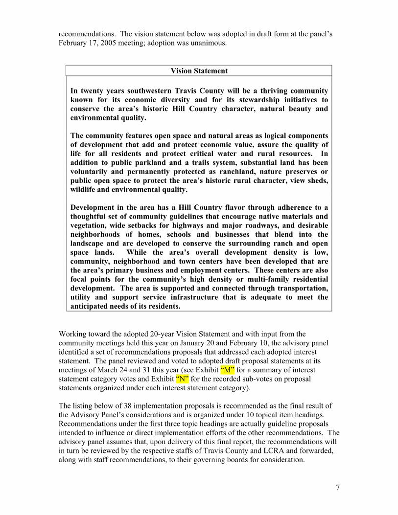
recommendations. The vision statement below was adopted in draft form at the panel’s February 17, 2005 meeting; adoption was unanimous.
Vision Statement In twenty years southwestern Travis County will be a thriving community known for its economic diversity and for its stewardship initiatives to conserve the area’s historic Hill Country character, natural beauty and environmental quality. The community features open space and natural areas as logical components of development that add and protect economic value, assure the quality of life for all residents and protect critical water and rural resources. In addition to public parkland and a trails system, substantial land has been voluntarily and permanently protected as ranchland, nature preserves or public open space to protect the area’s historic rural character, view sheds, wildlife and environmental quality. Development in the area has a Hill Country flavor through adherence to a thoughtful set of community guidelines that encourage native materials and vegetation, wide setbacks for highways and major roadways, and desirable neighborhoods of homes, schools and businesses that blend into the landscape and are developed to conserve the surrounding ranch and open space lands. While the area’s overall development density is low, community, neighborhood and town centers have been developed that are the area’s primary business and employment centers. These centers are also focal points for the community’s high density or multi-family residential development. The area is supported and connected through transportation, utility and support service infrastructure that is adequate to meet the anticipated needs of its residents.
Working toward the adopted 20-year Vision Statement and with input from the community meetings held this year on January 20 and February 10, the advisory panel identified a set of recommendations proposals that addressed each adopted interest statement. The panel reviewed and voted to adopted draft proposal statements at its meetings of March 24 and 31 this year (see Exhibit “M” for a summary of interest statement category votes and Exhibit “N” for the recorded sub-votes on proposal statements organized under each interest statement category). The listing below of 38 implementation proposals is recommended as the final result of the Advisory Panel’s considerations and is organized under 10 topical item headings. Recommendations under the first three topic headings are actually guideline proposals intended to influence or direct implementation efforts of the other recommendations. The advisory panel assumes that, upon delivery of this final report, the recommendations will in turn be reviewed by the respective staffs of Travis County and LCRA and forwarded, along with staff recommendations, to their governing boards for consideration.
7
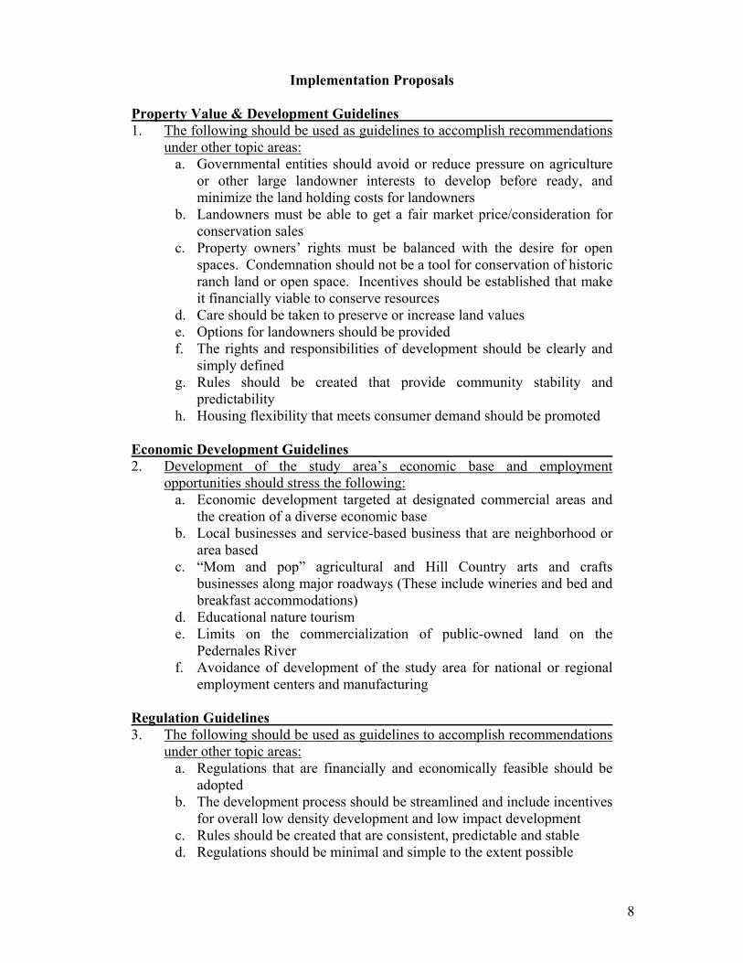
Implementation Proposals
Property Value & Development Guidelines 1. The following should be used as guidelines to accomplish recommendations
under other topic areas: a. Governmental entities should avoid or reduce pressure on agriculture
or other large landowner interests to develop before ready, and minimize the land holding costs for landowners
b. Landowners must be able to get a fair market price/consideration for conservation sales
c. Property owners’ rights must be balanced with the desire for open spaces. Condemnation should not be a tool for conservation of historic ranch land or open space. Incentives should be established that make it financially viable to conserve resources
d. Care should be taken to preserve or increase land values e. Options for landowners should be provided f. The rights and responsibilities of development should be clearly and
simply defined g. Rules should be created that provide community stability and
predictability h. Housing flexibility that meets consumer demand should be promoted
Economic Development Guidelines 2. Development of the study area’s economic base and employment
opportunities should stress the following: a. Economic development targeted at designated commercial areas and
the creation of a diverse economic base b. Local businesses and service-based business that are neighborhood or
area based c. “Mom and pop” agricultural and Hill Country arts and crafts
businesses along major roadways (These include wineries and bed and breakfast accommodations)
d. Educational nature tourism e. Limits on the commercialization of public-owned land on the
Pedernales River f. Avoidance of development of the study area for national or regional
employment centers and manufacturing
Regulation Guidelines 3. The following should be used as guidelines to accomplish recommendations
under other topic areas: a. Regulations that are financially and economically feasible should be
adopted b. The development process should be streamlined and include incentives
for overall low density development and low impact development c. Rules should be created that are consistent, predictable and stable d. Regulations should be minimal and simple to the extent possible
8

e. Strict enforcement and accountability by regulatory agencies should be maintained
f. Enforcement of deed restrictions should be stressed g. The fractionalization of government jurisdiction should be minimized h. Private-public partnerships should be created to deal with specific
problems or issues
Rural Character & Development Orientation Recommendations 4. Retain the unique flavor of the Hill Country – The Texas Hill Country
should be preserved for its distinctive character and heritage. The look and feel of new development in southwest Travis County should strive to express and preserve this unique area’s setting and life style. This Hill Country character evokes a sense of place and family through an appreciation of quiet open spaces, respect for the land and nature, dark skies and a regard for history and quiet integrity. Programs or regulations that promote and protect these characteristics through preservation of the physical environment should be established by the following:
a. Promote the use of native building materials b. Encourage native Hill Country landscaping, materials and xeriscaping
and minimize the disruption of natural areas from construction activity and for installed landscaping
c. Adopt dark skies lighting guidelines d. Protect ridgelines e. Promote underground utilities f. Promote the clustering of commercial centers rather than continuous
retail strips or roadways (see Exhibits “C“ and “D” for desired types and locations of commercial development)
g. Establish a minimum lot size but allow development right transfers from undeveloped properties to cluster developments. Seek legislation, if necessary, to enable transferable development rights
h. Remove the loophole for mobile home trailer parks (manufactured homes)
i. Encourage establishing a wildflower program along Highway 71 and arterial roadways
5. Support the application and maintenance of agriculture and wildlife tax
exemptions Environmental Quality Recommendations 6. Environmental regulations and programs should be adopted for the study
area. Consideration should be given to the following topics: a. Protection of creeks and water quality b. Protection of critical environmental features consistent with the joint
County/City code c. Protection of beneficial trees and vegetation d. Rainwater collection, conservation of groundwater and other
alternatives to surface water and the adoption of incentives for rainwater collection, grey water and wastewater reuse
9
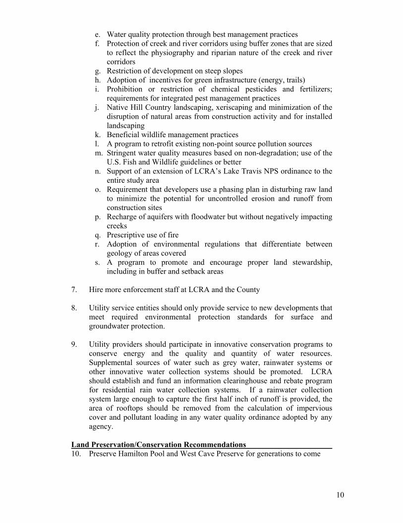
e. Water quality protection through best management practices f. Protection of creek and river corridors using buffer zones that are sized
to reflect the physiography and riparian nature of the creek and river corridors
g. Restriction of development on steep slopes h. Adoption of incentives for green infrastructure (energy, trails) i. Prohibition or restriction of chemical pesticides and fertilizers;
requirements for integrated pest management practices j. Native Hill Country landscaping, xeriscaping and minimization of the
disruption of natural areas from construction activity and for installed landscaping
k. Beneficial wildlife management practices l. A program to retrofit existing non-point source pollution sources m. Stringent water quality measures based on non-degradation; use of the
U.S. Fish and Wildlife guidelines or better n. Support of an extension of LCRA’s Lake Travis NPS ordinance to the
entire study area o. Requirement that developers use a phasing plan in disturbing raw land
to minimize the potential for uncontrolled erosion and runoff from construction sites
p. Recharge of aquifers with floodwater but without negatively impacting creeks
q. Prescriptive use of fire r. Adoption of environmental regulations that differentiate between
geology of areas covered s. A program to promote and encourage proper land stewardship,
including in buffer and setback areas 7. Hire more enforcement staff at LCRA and the County 8. Utility service entities should only provide service to new developments that
meet required environmental protection standards for surface and groundwater protection.
9. Utility providers should participate in innovative conservation programs to
conserve energy and the quality and quantity of water resources. Supplemental sources of water such as grey water, rainwater systems or other innovative water collection systems should be promoted. LCRA should establish and fund an information clearinghouse and rebate program for residential rain water collection systems. If a rainwater collection system large enough to capture the first half inch of runoff is provided, the area of rooftops should be removed from the calculation of impervious cover and pollutant loading in any water quality ordinance adopted by any agency.
Land Preservation/Conservation Recommendations 10. Preserve Hamilton Pool and West Cave Preserve for generations to come
10

11. A Historic Ranch Land Conservation Program should be developed that includes dedicated funding sources and/or tax incentives in its implementation. Goals of the program are to preserve Hill Country historic homes and structures as well as the view sheds, dark skies and the character of the area.
12. Travis County should adopt a Hill Country Conservation Development Area
Agreement ordinance that authorizes a “Hill Country Conservation Subdivision” as a Planned Unit Development (PUD). Adoption of the ordinance would give landowners the legal right to lock in a development agreement that is attached to or runs with the land in exchange for agreeing to develop their property as a conservation style subdivision. An agreement would grant landowners the right to future development approvals if they meet minimum criteria established for conservation subdivisions (see Exhibit “L”).
13. Open space should be preserved for water quality and water quantity
purposes; once acquired the land should also be managed for the benefit of wildlife. Land acquisition should stress connectivity of the preserved land and each property should be under a land management plan that considers the removal of cedar to the maximum extent appropriate. The program should proactively identify and acquire open space and must have dedicated sources of funding, such as bond authority, for acquisition.
Preservation of 6,000 acres under the combined initiatives for open space preservation, historic ranch land conservation (see recommendation 11 above) and conservation subdivisions (see recommendation 12 above) should be targeted and pursued (see Exhibits “C”, “D” and “F”).
14. Scenic corridor setbacks on property adjacent to all major roadways should
be provided when possible for native landscaping, property signage and for the roadside sale of local produce and regional arts and crafts. Incentives or compensation would be provided for these scenic corridor setbacks. For example, scenic corridor easements might be purchased from frontage properties along Hill Country Roadways that establish the scenic corridors setbacks and act as potential right of way acquisition areas if needed in the future.
15. Trails, parks and greenbelts featuring regional connectivity should be
purchased, if not donated, to provide public recreation opportunities in the study area.
Transportation Recommendations 16. Study area roads will be safe and adequate to handle the actual traffic
demand with rights of way provided for potential future expansion. 17. Travis County should develop a comprehensive transportation plan for the
study area based on the recommendations of the advisory panel and include
11
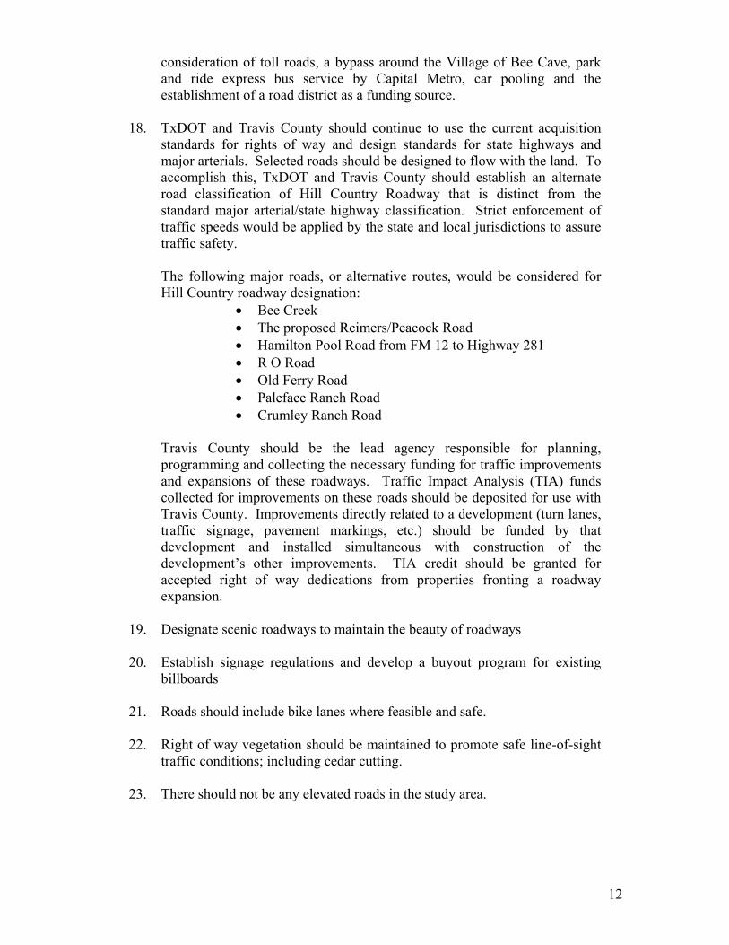
consideration of toll roads, a bypass around the Village of Bee Cave, park and ride express bus service by Capital Metro, car pooling and the establishment of a road district as a funding source.
18. TxDOT and Travis County should continue to use the current acquisition
standards for rights of way and design standards for state highways and major arterials. Selected roads should be designed to flow with the land. To accomplish this, TxDOT and Travis County should establish an alternate road classification of Hill Country Roadway that is distinct from the standard major arterial/state highway classification. Strict enforcement of traffic speeds would be applied by the state and local jurisdictions to assure traffic safety.
The following major roads, or alternative routes, would be considered for Hill Country roadway designation:
• Bee Creek • The proposed Reimers/Peacock Road • Hamilton Pool Road from FM 12 to Highway 281 • R O Road • Old Ferry Road • Paleface Ranch Road • Crumley Ranch Road
Travis County should be the lead agency responsible for planning, programming and collecting the necessary funding for traffic improvements and expansions of these roadways. Traffic Impact Analysis (TIA) funds collected for improvements on these roads should be deposited for use with Travis County. Improvements directly related to a development (turn lanes, traffic signage, pavement markings, etc.) should be funded by that development and installed simultaneous with construction of the development’s other improvements. TIA credit should be granted for accepted right of way dedications from properties fronting a roadway expansion.
19. Designate scenic roadways to maintain the beauty of roadways 20. Establish signage regulations and develop a buyout program for existing
billboards 21. Roads should include bike lanes where feasible and safe. 22. Right of way vegetation should be maintained to promote safe line-of-sight
traffic conditions; including cedar cutting. 23. There should not be any elevated roads in the study area.
12
24. Hamilton Pool Road should be designed for a speed limit of 55 miles per hour but should not be expanded or improved so as to become an alternative to Highway 71 and Highway 290 for east-west connections to Highway 281.
25. Developments that have significant traffic impacts should be required to do
a TIA to identify related roadway improvement needs. Travis County should seek to identify up-front funding sources to assist in funding needed roadway improvements or to reimburse developers when appropriate for excess capacity improvements. The TIA process should be applied regionally through interlocal agreements between Travis, Burnet, Hays and Blanco counties
Other Public Infrastructure & Services Recommendations 26. The community should receive adequate prior notification of development
activities and pending governmental or agency actions. Signs, e-mailed notices, development process Internet site, etc. should be employed to assure there are no development or governmental approval/enforcement surprises. Governmental enforcement agencies with overlapping jurisdictions or related interests should jointly maintain a one-stop complaint process and notify the community.
27. The county should exercise the powers granted by the State Legislature in
Senate Bill 873. The county should create a master plan. 28. Impervious cover limits should not be adopted for the study area. If such a
limit is proposed and/or adopted, the specific limits and guidelines for such a proposal should be established with the participation of an advisory panel involving landowners. Landowners should receive compensation for the impacts of impervious cover limits on development potential beyond those that are acceptable to the landowners.
29. A Taking Impact Analysis should be performed to evaluate the
implementation of buffer, view corridors, setbacks, etc. 30. LCRA should subsidize the extension of water service to existing
subdivisions and well users. 31. Emergency services must be adequate for the population and area
characteristics 32. Future school sites necessary to serve the study area should be identified and
purchased if not donated. 33. Travis County and LCRA should coordinate with other governmental
entities/agencies with jurisdiction over areas adjacent to the study area to request they consider adopting similar or complementary programs and regulations as those adopted in response to the Southwest Travis County Growth Dialog Process.
13
Diverse Economic Base Recommendations 34. Housing opportunities should maximize the potential for developing a
diverse community economically and culturally. An affordable housing program that supports the Hill Country character should be developed for the study area that targets the provision of housing that teachers, police officers and firefighters can afford. Mixed family residential development, such as apartments and townhouses, should be encouraged as part of the program. The program should include incentives for affordable housing development.
35. A task force should be established to promote and support economic
development that meets the Economic Development Guidelines.
Affordability & Funding 36. Promote conservation development and lower overall density; use tax
incentives, fast track incentives, etc. Adopt a utility tap fee schedule that encourages conservation development and lower overall density.
37. Consider establishing organizational entities to implement and/or manage
the recommendations including for example (see also recommendation 17 above):
a. Establish a soil and water conservation district b. Establish a land conservancy to manage acquired open space
38. The option to establish a ground water conservation district covering that
portion of the study area not already under such a district should be evaluated and established only if deemed beneficial and an enhancement to the resource.
Simultaneous with development of the implementation proposals the advisory panel worked to develop a series of maps that represent the current and envisioned study area. Presented in the exhibits section of this report these maps and accompanying clarification and listings documents summarize this work. Most important among these maps and documents are Exhibit “C”, the Conceptual Plan Map and the accompanying Exhibit “D”, the Concept Map Clarifications/Examples, both adopted as part of the advisory panel’s recommendations. These materials provide information on the desired location for commercial development, supported roadway improvements, recommended open space and preserve set-asides and identify subdivision applications submitted or approved to date.
14

Conclusion Taken as a whole, the vision statement, implementation proposals and Conceptual Plan Map documents adopted by the Growth Dialog’s advisory panel is a set of community-based recommendations that attempts to preserve southwest Travis County’s cultural and environmental character while also firmly protecting the land value and economic potential of the area. The advisory panel believes that sustaining the area’s existing character to the extent possible firmly establishes the area’s market desirability and long-term economic value. Finally, implementing these recommendations will promote the region’s Hill Country character and provide cultural, environmental and recreational amenities of value to all of Travis County both now and in the long-term.
15
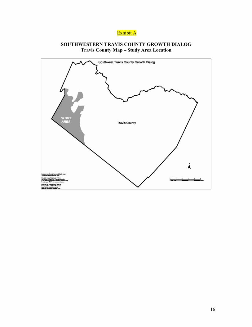
Exhibit A
SOUTHWESTERN TRAVIS COUNTY GROWTH DIALOG Travis County Map – Study Area Location
16
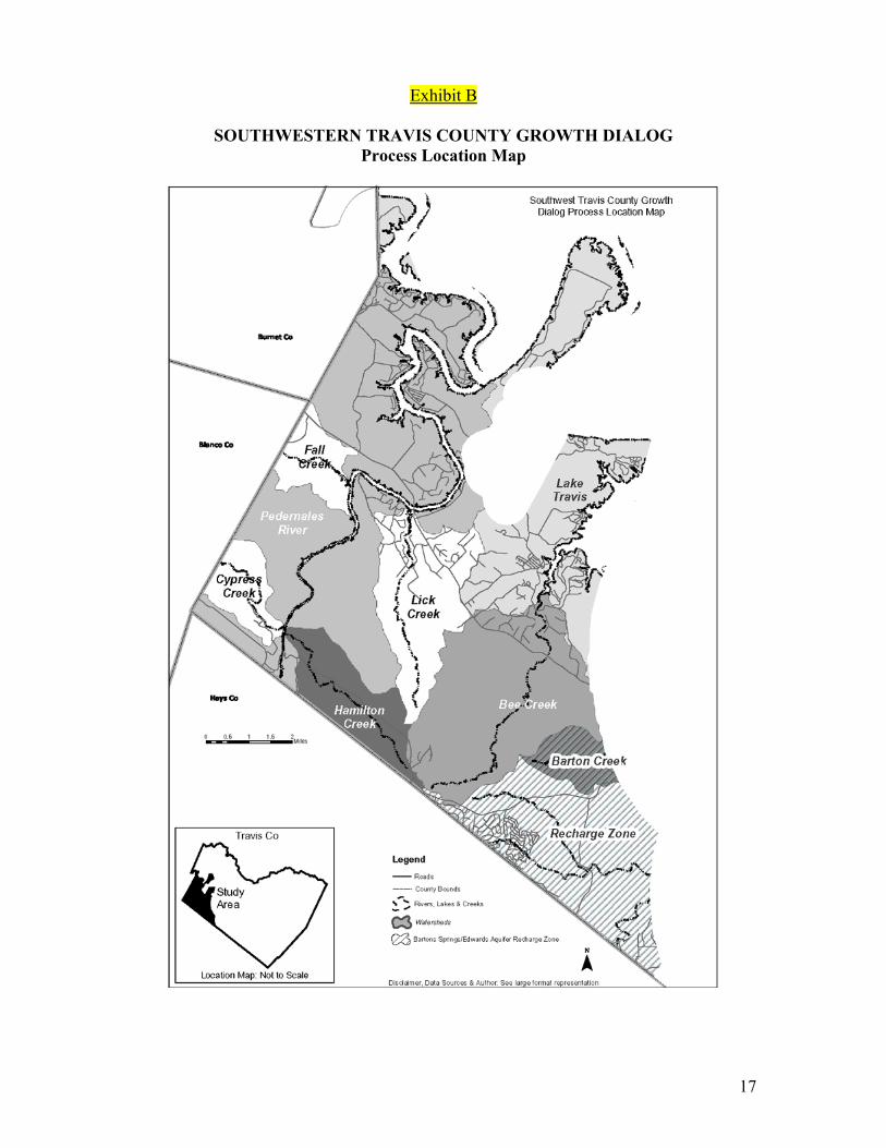
Exhibit B
SOUTHWESTERN TRAVIS COUNTY GROWTH DIALOG
Process Location Map
17
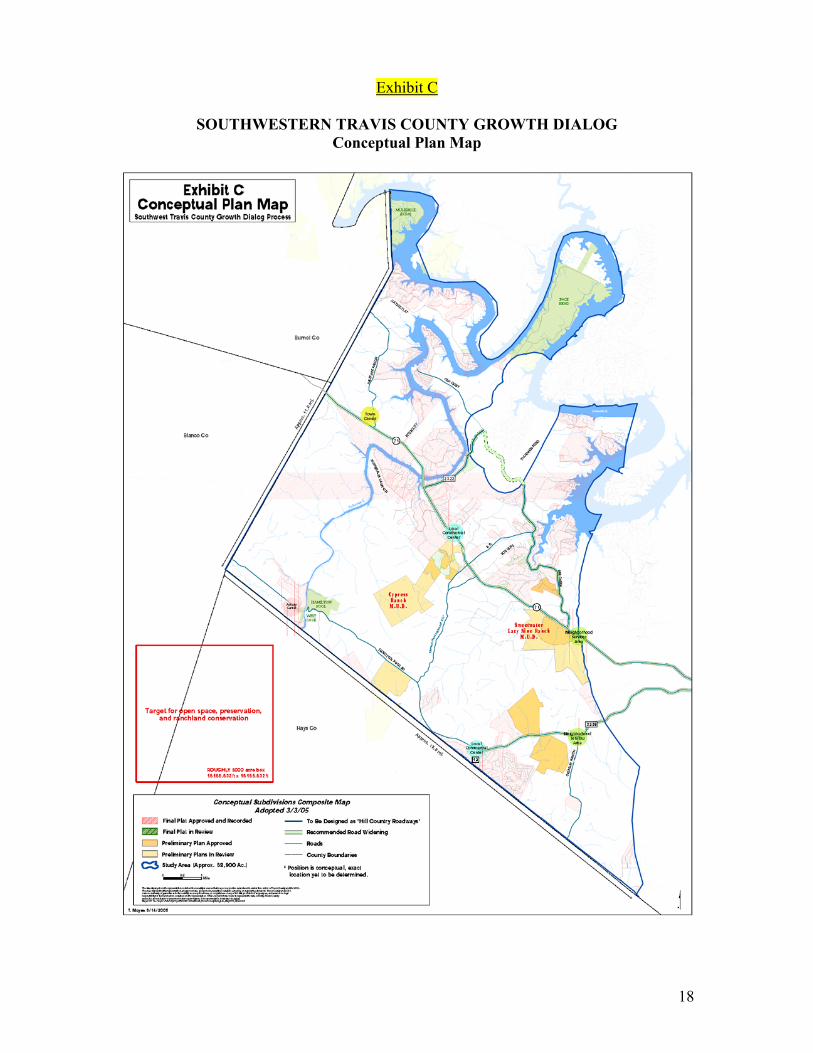
Exhibit C
SOUTHWESTERN TRAVIS COUNTY GROWTH DIALOG
Conceptual Plan Map
18
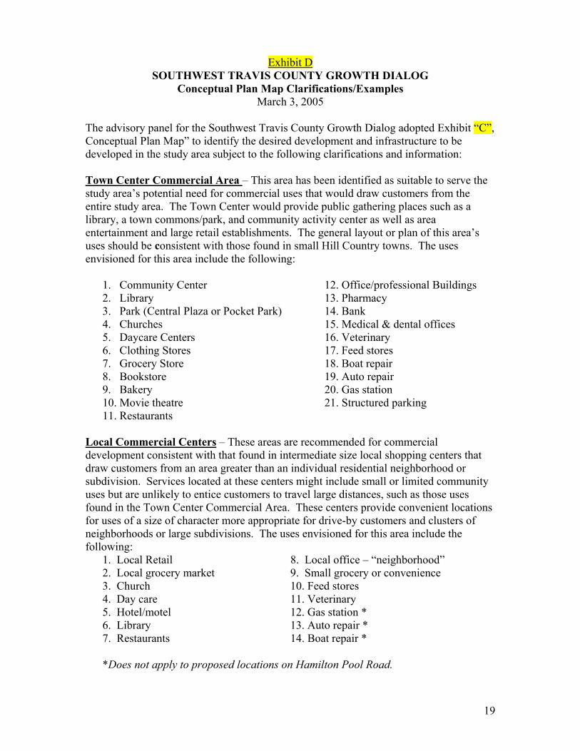
Exhibit D
SOUTHWEST TRAVIS COUNTY GROWTH DIALOG Conceptual Plan Map Clarifications/Examples
March 3, 2005 The advisory panel for the Southwest Travis County Growth Dialog adopted Exhibit “C”, Conceptual Plan Map” to identify the desired development and infrastructure to be developed in the study area subject to the following clarifications and information: Town Center Commercial Area – This area has been identified as suitable to serve the study area’s potential need for commercial uses that would draw customers from the entire study area. The Town Center would provide public gathering places such as a library, a town commons/park, and community activity center as well as area entertainment and large retail establishments. The general layout or plan of this area’s uses should be consistent with those found in small Hill Country towns. The uses envisioned for this area include the following:
1. Community Center 12. Office/professional Buildings 2. Library 13. Pharmacy 3. Park (Central Plaza or Pocket Park) 14. Bank 4. Churches 15. Medical & dental offices 5. Daycare Centers 16. Veterinary 6. Clothing Stores 17. Feed stores 7. Grocery Store 18. Boat repair 8. Bookstore 19. Auto repair 9. Bakery 20. Gas station 10. Movie theatre 21. Structured parking 11. Restaurants
Local Commercial Centers – These areas are recommended for commercial development consistent with that found in intermediate size local shopping centers that draw customers from an area greater than an individual residential neighborhood or subdivision. Services located at these centers might include small or limited community uses but are unlikely to entice customers to travel large distances, such as those uses found in the Town Center Commercial Area. These centers provide convenient locations for uses of a size of character more appropriate for drive-by customers and clusters of neighborhoods or large subdivisions. The uses envisioned for this area include the following: 1. Local Retail 8. Local office – “neighborhood” 2. Local grocery market 9. Small grocery or convenience 3. Church 10. Feed stores 4. Day care 11. Veterinary 5. Hotel/motel 12. Gas station * 6. Library 13. Auto repair * 7. Restaurants 14. Boat repair * *Does not apply to proposed locations on Hamilton Pool Road.
19

Neighborhood Service Areas – These areas are recommended for uses that are consistent with those found in small neighborhood or convenience retail centers. The businesses located in these centers stress convenience and cater to those wishing short drive times. The uses envisioned for these areas include neighborhood essential services and small local retail such as the following:
1. Small grocery or convenience 2. Country Inns/ B&Bs/ Lodges 3. Restaurant 4. Feed stores 5. Gas station * 6. Auto/Boat repair *
*Does not apply to proposed locations on Hamilton Pool Road.
Activity Center – This center is designated for uses that are consistent with those found in very small neighborhood and retail tourist activity centers. Services provided at this location are only for the convenience of those living or enjoying recreational activities in the immediate area. The uses envisioned for this area include the following:
1. Small grocery or convenience 2. Country Inns/ B&Bs/ Lodges 3. Local Restaurant 4. Nature Tourism Activities/Business 5. Farmers Market 6. Recreation/Sports Shop
Open Space, Preserves and Historic Ranchland Area – A 6,000-acre area is recommended for acquisition and/or preservation within the study area (see also Exhibits “C” and “F” of the Southwest Travis County Growth Dialog Final Report). This goal total represents approximately 10 percent of the study area, which is estimated to be 58,900 acres.
20

Exhibit E
SOUTHWESTERN TRAVIS COUNTY GROWTH DIALOG Subdivision Applications Activity Jan. 1, 2003 through May 19, 2005
21
Exhibit E – Page 2
22

Exhibit F
SOUTHWESTERN TRAVIS COUNTY GROWTH DIALOG
Open Spaces Characteristics/Criteria The below guidelines have been adopted by the advisory panel of the Southwest Travis County Growth Dialog as appropriate guidance in developing or acquiring open space lands, preserve lands and historic sites.
I. Design Guidelines 1. Large tracts to lower per acre costs and provide real management utility 2. Connectivity to other like uses (existing parks, preserves, intact riparian or upland
zones) 3. Proximity to infrastructure if needed (e.g., parks) 4. Maximum ridgelines and riparian protection for wildlife and view sheds 5. Acquisition of areas important to watershed protection (recharge zones, steep slopes,
etc.)
II. Goals 6. Water Quality and General Ecological Diversity
a. Quality Riparian Zones i. Perennial streams, rivers or lakes
ii. Head waters (intermittent) iii. spring and seep outlets iv. rapids and plunge pools (waterfalls and swimming pools) v. Mature woodlands: bald cypress, pecan/walnut, sycamore and
other hardwoods with scattered mature ashe juniper vi. Mesic (wet) canyons with fern banks, seep and Lindheimer muhly,
switchgrass and other native riparian grass stands, rare species presence and /or habitat(golden-cheeked warbler, canyon mock-orange, red bay)
b. Quality Upland Zones i. Savannah with quality native grass stands: big and little bluestem,
indian grass, etc. which is not overgrazed or is purple three-awn or KR bluestem dominated
ii. Lack of invasive levels of immature invader shrubs and trees such as Ashe juniper, mesquite, baccharis (poverty weed) and old growth cedar to support golden-cheeked warblers
iii. Presence of shinneries (low dense mottes of shin oaks and other quality native shrubs) which could potentially support black-capped vireos
c. Geological Features Important to Recharge i. Hensel sand, Edwards and Cow Creek Limestone Units that
support perched water tables and springs. Examples include areas upstream of Levi Springs, Hogge Springs (Pogue Hollow),
23
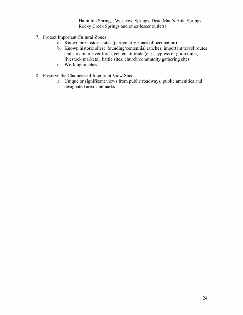
Hamilton Springs, Westcave Springs, Dead Man’s Hole Springs, Rocky Creek Springs and other lesser outlets)
7. Protect Important Cultural Zones
a. Known pre-historic sites (particularly zones of occupation) b. Known historic sites: founding/centennial ranches, important travel routes
and stream or river fords, centers of trade (e.g., cypress or grain mills, livestock markets), battle sites, church/community gathering sites
c. Working ranches 8. Preserve the Character of Important View Sheds
a. Unique or significant views from public roadways, public amenities and designated area landmarks
24
Exhibit G
SOUTHWESTERN TRAVIS COUNTY GROWTH DIALOG Cultural and Natural Resources Map
25
Exhibit H
SOUTHWEST TRAVIS COUNTY GROWTH DIALOG
Cultural Resources Listing April 13, 2005
The below listed historic sites or structures have been identified as worthy of note by the Advisory Panel of the Southwest Travis County Growth Dialog and are indicated on Exhibit “G”, Natural and Cultural Resources Map”. The location of these resources are indicated based on the area’s verbal history and have not been verified by field visits. Fall Creek Cemetery and Methodist Church: Located in the corner of Travis, Blanco and Burnet counties. The cemetery is still in use with the oldest grave dated 1880. There was a Methodist church on this site dating from 1881. In 1919 the original structure was sold and dismantled only to be found “gone up in flames” when the purchaser returned to collect the wood and nails. Fall Creek: Fall Creek is located at this same intersection of Travis, Blanco and Burnet counties. The creek flows into the Pedernales River and along the way cascades 40 feet down a limestone cliff. Haynie Flat Cemetery and School are located in Travis and Burnet counties near the Pedernales River. The land was used for cotton until about 1940 when the land was then used for ranching. Turner, Buffalo and Backbone Crossings: Turner Crossing is located at the Pedernales River near the Property Owners Park of Lick Creek Subdivision. This was a ferry bounded by the Turner Ranch on the west bank and John Bowles’ property on the east. Due to lack of rainfall and heavy irrigation of rice fields in Colorado County and adjacent counties, the water receded making the ferry inoperable. The Buffalo and Backbone crossings are also located in the area near the end of Pedernales Canyon Trail. Mud, Texas was located at what is now Pace Bend Park. Underwater due to the development of Lake Travis - Moon River Restaurant and bar is said to house the Mud School. Maxey Cemetery is located close to the Moon River Restaurant and Bar. Old Ferry Road led to A.M. Cox Crossing/low water crossing; a ferry crossing and a cable car crossing. In 1941, backwater from Marshall Ford Dam covered the bridge now in the Lake Travis basin. Turner Farms is now Muleshoe Park (LCRA). There was also a Molasses Mill located on the farm. The town of Clover; the Cox Low Water Crossing and the St. Burton Crossing are also in the area.
26

Levi Rock Shelter is an archeological site located on Lick Creek and named after Malcom Levi, the owner of the ranch when the site was discovered. In 1977 Dr. H. L. Alexander found what he believed to be on the earliest settlements in America believed to be from 40,000 to 100,000 years old. Wallace Cemetery is located in Lick Creek Ranch subdivision off of Deer Trail. Star Hill Ranch houses several historic places: The Pontotoc, Texas Country Church circa 1899; Willow Springs, TX “Rosenwald” School circa 1920; A Bee Cave area farm house circa 1910. The Fitzhugh Baptist Church is scheduled to become a part of the Star Hill Ranch. Shield Ranch located off Hamilton Pool Road is the site of the Haas House, the Doppenschmidt-Haas House, a family cemetery and the Holeman Store. All restored by the Shield family. Puryear Homestead on the Kozmetsky Ranch was at one time part of the Peacock Ranch; owned by the Puryear family and now the Kozmetsky family. The Kozmetsky’s preserved the old homestead of the Puryear family and have fenced it. The Puryear Family Cemetery is located off Hamilton Pool Road near the Travis/Hays County lines. Hamilton Pool Fish Camp, located off Hamilton Pool Road, is part of the Milton Reimers Ranch and has welcomed fishermen and rock climbers to the property ($2.00) for years Hamilton Pool is a Hill Country Treasure known to Texans and out of town/state vacationers as one of the most wonderful swimming holes in the state. It was designated a Preserve by Travis County Commissioner’s Court in 1990. Hammetts Crossing: In 1874 this ford was knows as the Austin Llano Road and a postal and stagecoach route. It was an important means to cross the Pedernales River and is located near West Cave Preserve on Hamilton Pool Road. In 1925 the present low water bridge was built. West Cave Preserve is located near Hammetts Crossing/Pedernales River. It is a natural wonder and a Hill Country Treasure. The LCRA acquired the property in 1983 and operates it in partnership with Westcave Preserve Corporation.
27
Exhibit I
SOUTHWESTERN TRAVIS COUNTY GROWTH DIALOG LCRA Pedernales Area Planning Studies
28
Exhibit J
SOUTHWESTERN TRAVIS COUNTY GROWTH DIALOG School District Map
29
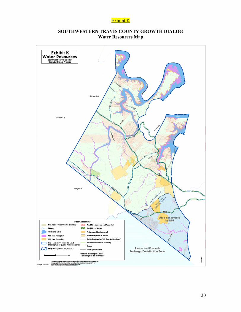
Exhibit K
SOUTHWESTERN TRAVIS COUNTY GROWTH DIALOG Water Resources Map
30
Exhibit L
The following document is intended to both provide an overview of what a conservation subdivision might include, as well as to provide details of what might be included as part of the ecological assessment that would precede a conservation subdivision’s layout and design. The Lady Bird Johnson Wildflower Center is in the process of both further refining this document, and developing voluntary guidelines for conservation subdivision development. The inclusion of this material here is intended for general information purposes only.
Conservation Subdivisions
Prepared by Steve Windhager, Lady Bird Johnson Wildflower Center Over 22 million people live in Texas, a population that is expected to nearly double by the year 2050. Much of this growth is occurring in suburbs, sprawling away from cities that are mostly built out. Rural areas are absorbing an increasing share of population growth, driven by the increasing cost of living in urban city centers, dissatisfaction with suburban life or the desire for more land and open space. Wildlife habitat and water resources are threatened by this expansion onto the rural landscape. In order to accommodate population growth through 2040, the Texas Water Development Board estimates that 14 additional water supply reservoirs will be needed, adversely affecting over 36,000 acres of wetlands and riparian areas. It is this rural fringe with undisturbed wetlands, aquifers and forests that has the most to lose from human settlement, and therefore, the most to gain from an alternative to the prevailing method of sprawling residential development. Acknowledging the need to plan for impending growth while conserving natural resources, many planners, architects and government agencies across the country recently have begun experimenting with the concept of conservation development. This style of residential development usually entails clustering of homes in order to preserve sensitive natural features as permanently protected open space. Developers can typically build the same number of dwelling units as they would have in a conventional subdivision, preserving their economic incentives, while providing permanently protected open space by building homes in clusters with smaller lot sizes but with much greater value due to the adjacent natural areas. Conservation subdivisions are a way to protect the natural heritage of rural America while also expanding land development practices to incorporate the principles of regional identity, land conservation and land stewardship. It is a way to develop natural and agricultural lands in a way that allows for housing while permanently protecting at least half of this space for future generations. Conservation subdivisions differ from traditional subdivisions in that they attempt to preserve the most important parts of the tract as permanently protected open space. Because this is the goal, the development process differs slightly from that of a standard development. The first step is to conduct a thorough ecological site assessment of the tract, which will help identify those areas most in need of preservation (based on water
31

quality, wildlife habitat, views, or other identified goals). Then, the layout of the subdivision is planned with the goal of preserving as much of these areas as is possible. Minimum preservation amounts would be 50% of the total tract area, with half credit for land preserved that is unbuildable or mandated to be preserved due to other ordinances. The following document identifies the items that should be considered in an ecological assessment of the site.
Ecological Assessments for Conservation Development
An ecological assessment is designed to ensure that what is conserved as part of a conservation development is significant and meaningful. A site analysis map is required and should be submitted with the site concept plan. The purpose of the site analysis map is to ensure that the important site features have been adequately identified prior to development of a site design. The below information should be mapped or preferably, contained in a geospatial database such as ArcView and should include the following features:
• Property boundaries. Identify by name and ownership all adjoining lands beyond 100 ft. of the site
• Existing roads and structures • Total acreage of the site • North arrow, scale, date and name of surveyor (individual and company) • Existing land use - i.e. Ranchland, farmland, park land etc… • Location, widths, and names of all public and private easements • Unusual or special aspects about the site. Features that are unique to the site. • Identification of recharge features (as defined by TCEQ). • Identification of significant land features including sinkholes, caves, seeps, steep
bluffs, large rock outcroppings or significant geologic features, and non-regulated wetlands
• Topographic contours at no more than 10 foot intervals with delineation of slopes greater than 25%
• Creeks and other water features, both seasonal and perennial • Ridgelines • Endangered species habitat • Plant communities (including the following information
o their relative importance to the region (defined by the County based on The Nature Conservancy’s work)
o the current condition o restoration potential
• Soils and geology • Historic / Cultural / Archeological sites • Existing open/undeveloped space contiguous to the tract being assessed • Location of the tract within the watershed • Identification of brownfields or other environmental hazards • Existing manmade features (e.g. roads, transmission lines, sewage, etc.)
32
The ecologists/biologists conducting this assessment should then work with engineers/land planners to determine the most sensitive sites to avoid (and protect) and the least valuable upon which to develop. The ecologists/biologists should be involved not only in locating areas for housing developments, but also for roadways, trails, water treatment features as well as other features that could encroach upon or pass through, or otherwise impact ecological systems to be protected. Once the project has been designed, ecologists/biologists should design a long-term management plan that will enhance or preserve the values identified for conservation. In most cases, this would mean designing restoration and management practices designed to maintain or enhance diversity, habitat for species of interest, or other identified goals.
Incorporating the Ecological Assessment into the Planning Process
1. All legal regulations involving endangered species, cultural resources, recharge features, or other regulated natural resources should be followed. Additional buffers around these areas beyond that legally required should be encouraged. When possible, endangered species habitat should be improved under the protection of a “Safe Harbor” permit.
2. Those habitats deemed most valuable (based on region importance, current condition and restoration potential) will be preserved with no more than 10% encroachment into this habitat, with development concentrated on those areas deemed to be of lesser value.
3. Creeks (perennial and ephemeral) should have a minimum of 150 foot buffers surrounding them except where they must be crossed.
4. At least 75% of the significant landscape features identified should be preserved. 5. Open space preserved should be connected (internally through the tract) through
creeks and ridgelines to preserve maximum wildlife value and be contiguous with existing open space on adjacent tracts.
6. Total impervious cover should be between 15 and 25%.
33
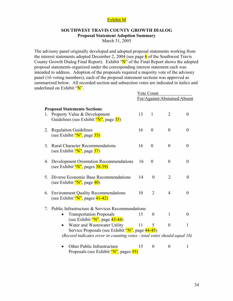
Exhibit M
SOUTHWEST TRAVIS COUNTY GROWTH DIALOG Proposal Statement Adoption Summary
March 31, 2005 The advisory panel originally developed and adopted proposal statements working from the interest statements adopted December 2, 2004 (see page 6 of the Southwest Travis County Growth Dialog Final Report). Exhibit “N” of the Final Report shows the adopted proposal statements organized under the corresponding interest statement each was intended to address. Adoption of the proposals required a majority vote of the advisory panel (16 voting members); each of the proposal statement sections was approved as summarized below. All recorded section and subsection votes are indicated in italics and underlined on Exhibit “N”.
Vote Count For/Against/Abstained/Absent
Proposal Statements Sections: 1. Property Value & Development 13 1 2 0
Guidelines (see Exhibit “N”, page 35)
2. Regulation Guidelines 16 0 0 0 (see Exhibit “N”, page 35)
3. Rural Character Recommendations 16 0 0 0
(see Exhibit “N”, page 37)
4. Development Orientation Recommendations 16 0 0 0 (see Exhibit “N”, pages 38-39)
5. Diverse Economic Base Recommendations 14 0 2 0
(see Exhibit “N”, page 40)
6. Environment Quality Recommendations 10 2 4 0 (see Exhibit “N”, pages 41-42)
7. Public Infrastructure & Services Recommendations
• Transportation Proposals 15 0 1 0 (see Exhibit “N”, page 43-44)
• Water and Wastewater Utility 11 5 0 1 Service Proposals (see Exhibit “N”, page 44-45)
(Record indicates error in counting votes - total votes should equal 16) • Other Public Infrastructure 15 0 0 1 Proposals (see Exhibit “N”, pages 45)
34
Exhibit N
SOUTHWEST TRAVIS COUNTY GROWTH DIALOG Draft Proposal Statement Votes (by Interest Statement)
March 24, 2005 1. Property Value & Development Guidelines
(Motion to adopt this section passed: 13 for, 1 against, 2 abstained)
(Interest to be addressed: Preserve property owners land value potential and their flexibility to make land use decisions with minimal regulatory and financial pressure)
The following should be used as guidelines to accomplish recommendations under the other interests: 1.1. Governments entities should avoid or reduce pressure on agriculture or other
large landowner interests to develop before ready, and minimize the land holding costs for landowners
1.2. Landowners must be able to get a fair market price/consideration for conservation sales
1.3. Property owners’ rights must be balanced with the desire for open spaces. Condemnation should not be a tool for conservation of historic ranch land or open space. Incentives should be established that make it financially viable to conserve resources
1.4. Care should be taken to preserve or increase land values 1.5. Options for landowners should be provided 1.6. The Rights and responsibilities of development should be clearly and simply
defined 1.7. Rules should be adopted that provide community stability and predictability 1.8. Housing flexibility that meets consumer demand should be promoted
2. Regulation Guidelines
(Motion to adopt this section passed: 16 for, 0 against, 0 abstained)
(Interest to be addressed: Develop fair, stable and predicable programs and regulatory requirements)
The following should be used as guidelines to accomplish recommendations under other interests: 2.1. Regulations that are financially and economically feasible should be adopted 2.2. The development process should be streamlined and include incentives for
overall low density development and low impact development (Motion to include passed: 16 for, 0 against, 0 abstained)
2.3. Rules should be created that are consistent, predictable and stable 2.4. Regulations should be minimal and simple to the extent possible
(Motion to include passed: 16 for, 0 against, 0 abstained)
35

2.5. Strict enforcement and accountability by regulatory agencies should be maintained
2.6. Enforcement of deed restrictions should be stressed 2.7. The fractionalization of government jurisdiction should be minimized 2.8. Private-public partnerships should be created to deal with specific problems or
issues
36
3. Rural Character Recommendations
(Motion to adopt this section passed: 16 for, 0 against, 0 abstained) (Interest to be Addressed: Preserve1 the “rural character”2 of the study area)
3.1. A Historic Ranch Land Conservation Program should be developed that
includes dedicated funding sources and/or tax incentives in its implementation. Goals of the program are to preserve Hill Country historic homes and structures as well as the view sheds, dark skies and the character of the area.
3.2. Support the application and maintenance of agriculture and wildlife tax
exemptions (Motion to include passed: 9 for, 5 against, 2 abstained)
Footnotes: 1) Not to be interpreted as literally preserving or freezing conditions at the current state 2) Large contiguous open spaces of ranching, farming or natural areas
37
4. Development Orientation Recommendations
(Motion to adopt this section passed: 16 for, 0 against, 0 abstained) (Interest to be addressed: Preserve the “Hill Country character”3, 4 of the study area)
4.1. Retain the unique flavor of the Hill Country – The Texas Hill Country should be
preserved for its distinctive character and heritage. The look and feel of new development in southwest Travis County should strive to express and preserve this unique area’s setting and life style. This Hill Country character evokes a sense of place and family through an appreciation of quiet open spaces, respect for the land and nature, dark skies, and a regard for history and quiet integrity. Programs or regulations that promote and protect these characteristics through presentation of the physical environment should be established by the following: 4.1.1. Adopt dark skies lighting guidelines
(Motion to include passed: 10 for, 5 against, 1 abstained) 4.1.2. Preserve Hamilton Pool and West Cave Preserve for generations to
come 4.1.3. Protect ridgelines
(Motion to include passed: 12 for, 4 against, 0 abstained) 4.1.4. Preserve historic buildings and areas
(this item was deleted in the final report as a duplicate of item 3.1 by the following vote: 11 for, 1 against, 4 abstained or undecided)
4.1.5. Promote underground utilities 4.1.6. Promote the use of native building materials 4.1.7. Encourage native Hill Country landscaping, materials and xeriscaping
and minimize the disruption of natural areas from construction activity and for installed landscaping
4.1.8. Promote the clustering of commercial centers rather than continuous retail strips or roadways
4.1.9. Designate scenic roadways in order to maintain the beauty of roadways 4.1.10. Promote conservation development and lower overall density; use tax
incentives, fast track incentives, etc. Adopt a utility tap fee schedule that encourages conservation development and lower overall density. (Motion to include passed: 14 for, 2 against, 0 abstained)
4.1.11. Establish signage regulations (Motion to include passed: 12 for, 4 against, 0 abstained) and develop a buyout program for existing billboards (Motion to include passed: 16 for, 0 against, 0 abstained)
4.1.12. Encourage development of a trails system program (Motion to include passed: 13 for, 2 against, 1 abstained) (this item was deleted in the final report as a duplicate of item 7.14 by the following vote: 11 for, 1 against, 4 abstained or undecided)
4.1.13. Protect creeks and water quality
38
4.1.14. Establish a minimum lot size but allow development right transfers from undeveloped properties to cluster developments. Seek legislation, if necessary, to enable transferable development rights (Motion to delete failed: 8 for, 8 against, 0 abstained)
4.1.15. Travis County should adopt a Hill Country Conservation Development Area Agreement ordinance that authorizes a “Hill Country Conservation Subdivision” as a Planned Unit Development (PUD). Adoption of the ordinance would give landowners the legal right to lock in a development agreement that is attached to or runs with the land in exchange for agreeing to develop their property as a conservation style subdivision. An agreement would grant landowners the right to future development approvals if they meet minimum criteria established for conservation subdivisions.
4.1.16. Remove the loophole for mobile home trailer parks (manufactured homes) (Motion to include passed: 12 for, 4 against, 0 abstained)
4.1.17. Encourage establishing a wildflower program along SH71 and arterial roadways (Motion to include passed: 15 for, 1 against, 0 abstained)
4.2. The community should receive adequate prior notification of development
activities and pending governmental or agency actions. Signs, e-mailed notices, development process Internet site, etc. should be employed to assure there are no development or governmental approval/enforcement surprises. Governmental enforcement agencies with overlapping jurisdictions or related interests should jointly maintain a one-stop complaint process and notify the community. (Motion to delete failed: 8 for, 8 against, 0 abstained)
4.3. The county should exercise the powers granted by the State Legislature in
Senate Bill 873. The county should create a master plan. (Motion to include passed: 16 for, 0 against, 0 abstained)
Footnotes: 3) Includes retaining the quiet character of the area 4) Quiet, views, greenways/green spaces, wildlife, etc.
39
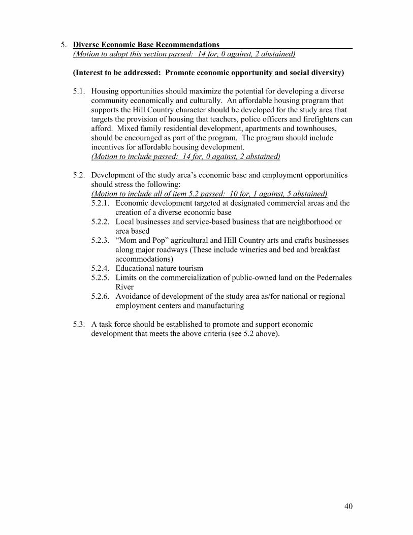
5. Diverse Economic Base Recommendations
(Motion to adopt this section passed: 14 for, 0 against, 2 abstained) (Interest to be addressed: Promote economic opportunity and social diversity)
5.1. Housing opportunities should maximize the potential for developing a diverse
community economically and culturally. An affordable housing program that supports the Hill Country character should be developed for the study area that targets the provision of housing that teachers, police officers and firefighters can afford. Mixed family residential development, apartments and townhouses, should be encouraged as part of the program. The program should include incentives for affordable housing development. (Motion to include passed: 14 for, 0 against, 2 abstained)
5.2. Development of the study area’s economic base and employment opportunities
should stress the following: (Motion to include all of item 5.2 passed: 10 for, 1 against, 5 abstained) 5.2.1. Economic development targeted at designated commercial areas and the
creation of a diverse economic base 5.2.2. Local businesses and service-based business that are neighborhood or
area based 5.2.3. “Mom and Pop” agricultural and Hill Country arts and crafts businesses
along major roadways (These include wineries and bed and breakfast accommodations)
5.2.4. Educational nature tourism 5.2.5. Limits on the commercialization of public-owned land on the Pedernales
River 5.2.6. Avoidance of development of the study area as/for national or regional
employment centers and manufacturing 5.3. A task force should be established to promote and support economic
development that meets the above criteria (see 5.2 above).
40
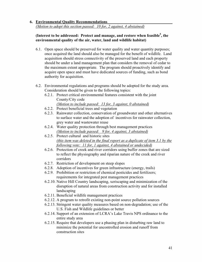
6. Environmental Quality Recommendations
(Motion to adopt this section passed: 10 for, 2 against, 4 abstained) (Interest to be addressed: Protect and manage, and restore when feasible5, the environmental quality of the air, water, land and wildlife habitat)
6.1. Open space should be preserved for water quality and water quantity purposes;
once acquired the land should also be managed for the benefit of wildlife. Land acquisition should stress connectivity of the preserved land and each property should be under a land management plan that considers the removal of cedar to the maximum extent appropriate. The program should proactively identify and acquire open space and must have dedicated sources of funding, such as bond authority for acquisition.
6.2. Environmental regulations and programs should be adopted for the study area.
Consideration should be given to the following topics: 6.2.1. Protect critical environmental features consistent with the joint
County/City code (Motion to include passed: 13 for, 3 against, 0 abstained)
6.2.2. Protect beneficial trees and vegetation 6.2.3. Rainwater collection, conservation of groundwater and other alternatives
to surface water and the adoption of incentives for rainwater collection, grey water and wastewater reuse
6.2.4. Water quality protection through best management practices (Motion to include passed: 9 for, 4 against, 3 abstained)
6.2.5. Protect cultural and historic sites (this item was deleted in the final report as a duplicate of item 3.1 by the following vote: 11 for, 1 against, 4 abstained or undecided)
6.2.6. Protection of creek and river corridors using buffer zones that are sized to reflect the physiography and riparian nature of the creek and river corridors
6.2.7. Restriction of development on steep slopes 6.2.8. Adoption of incentives for green infrastructure (energy, trails) 6.2.9. Prohibition or restriction of chemical pesticides and fertilizers;
requirements for integrated pest management practices 6.2.10. Native Hill Country landscaping, xeriscaping and minimization of the
disruption of natural areas from construction activity and for installed landscaping
6.2.11. Beneficial wildlife management practices 6.2.12. A program to retrofit existing non-point source pollution sources 6.2.13. Stringent water quality measures based on non-degradation; use of the
U.S. Fish and Wildlife guidelines or better 6.2.14. Support of an extension of LCRA’s Lake Travis NPS ordinance to the
entire study area 6.2.15. Require that developers use a phasing plan in disturbing raw land to
minimize the potential for uncontrolled erosion and runoff from construction sites
41

6.2.16. Recharge of aquifers with floodwater but without negatively impacting creeks
6.2.17. Prescriptive use of fire 6.2.18. Adopt of environmental regulations that differentiate between geology
of areas covered 6.2.19. A program to promote and encourage proper land stewardship, including
in buffer and setback areas
6.3. Consider establishing organizational entities to implement and/or manage the recommendations including for example: 6.3.1. Establish a soil and water conservation district 6.3.2. Establish a land conservancy to manage acquired open space
6.4. Hire more enforcement staff at LCRA and the County 6.5. Impervious cover limits should not be adopted for the study area. If such a limit
is proposed and/or adopted, the specific limits and guidelines for such a proposal should be established with the participation of an advisory panel involving landowners. Landowners should receive compensation for the impacts of impervious cover limits on development potential beyond those that are acceptable to the landowners. (Motion to include passed: 11 for, 3 against, 2 abstained)
6.6. A Taking Impact Analysis should be performed to evaluate the implementation
of buffer, view corridors, setbacks, etc. (Motion to include passed: 9 for, 6 against, 1 abstained)
6.7. LCRA should subsidize the extension of water service to existing subdivisions
and well users. (Motion to include passed: 10 for, 4 against, 2 abstained)
Footnotes: 5) Feasibility includes economic and financial feasibility
42
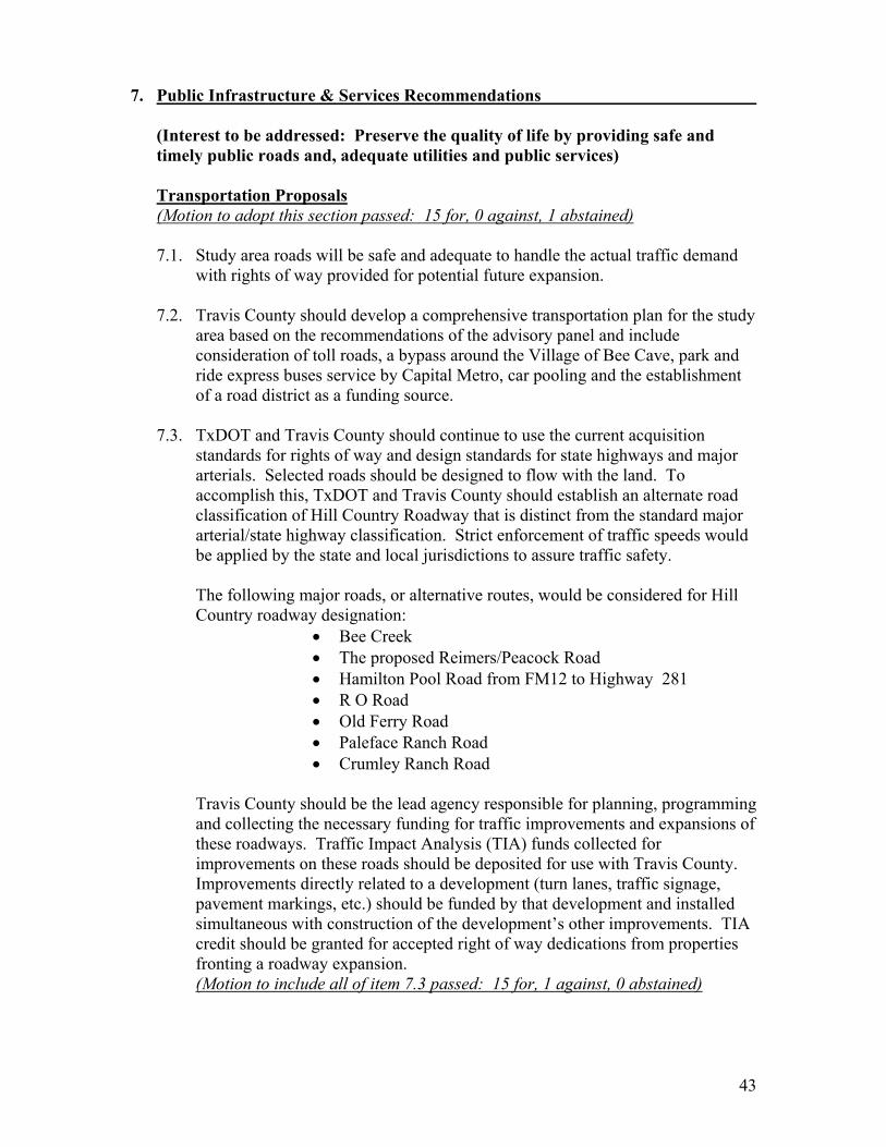
7. Public Infrastructure & Services Recommendations
(Interest to be addressed: Preserve the quality of life by providing safe and timely public roads and, adequate utilities and public services)
Transportation Proposals (Motion to adopt this section passed: 15 for, 0 against, 1 abstained) 7.1. Study area roads will be safe and adequate to handle the actual traffic demand
with rights of way provided for potential future expansion. 7.2. Travis County should develop a comprehensive transportation plan for the study
area based on the recommendations of the advisory panel and include consideration of toll roads, a bypass around the Village of Bee Cave, park and ride express buses service by Capital Metro, car pooling and the establishment of a road district as a funding source.
7.3. TxDOT and Travis County should continue to use the current acquisition
standards for rights of way and design standards for state highways and major arterials. Selected roads should be designed to flow with the land. To accomplish this, TxDOT and Travis County should establish an alternate road classification of Hill Country Roadway that is distinct from the standard major arterial/state highway classification. Strict enforcement of traffic speeds would be applied by the state and local jurisdictions to assure traffic safety.
The following major roads, or alternative routes, would be considered for Hill Country roadway designation:
• Bee Creek • The proposed Reimers/Peacock Road • Hamilton Pool Road from FM12 to Highway 281 • R O Road • Old Ferry Road • Paleface Ranch Road • Crumley Ranch Road
Travis County should be the lead agency responsible for planning, programming and collecting the necessary funding for traffic improvements and expansions of these roadways. Traffic Impact Analysis (TIA) funds collected for improvements on these roads should be deposited for use with Travis County. Improvements directly related to a development (turn lanes, traffic signage, pavement markings, etc.) should be funded by that development and installed simultaneous with construction of the development’s other improvements. TIA credit should be granted for accepted right of way dedications from properties fronting a roadway expansion. (Motion to include all of item 7.3 passed: 15 for, 1 against, 0 abstained)
43

7.4. Scenic corridor setbacks on property adjacent to all major roadways should be provided when possible for native landscaping, property signage and, for the roadside sale of local produce and regional arts and crafts. Incentives or compensation would be provided for these scenic corridor setbacks. For example, scenic corridor easements might be purchased from frontage properties along Hill Country roadways that establish the scenic corridors setbacks and act as potential right of way acquisition areas if needed in the future. (Motion to include passed: 12 for, 1 against, 3 abstained)
7.5. Right of way vegetation should be maintained to promote safe line-of-sight
traffic conditions; including cedar cutting. 7.6. There should not be any elevated roads in the study area. 7.7. Hamilton Pool Road should not be expanded or improved so as to become an
alternative to Highway 71 and Highway 290 for east-west connections to Highway 281.
7.8. Roads should include bike lanes where feasible and safe. 7.9. Developments that have significant traffic impacts should be required to do a
TIA to identify related roadway improvement needs. Travis County should seek to identify up-front funding sources to assist in funding needed roadway improvements or to reimburse developers when appropriate for excess capacity improvements. The TIA process should be applied regionally through interlocal agreements between Travis, Burnet, Hays and Blanco counties
Water and Wastewater Utility Service Proposals (Motion to adopt this subsection passed: 11 for, 5 against, 0 abstained, 1 absent; record indicates error in counting votes - total votes should equal 16) 7.10. Utility service entities should only provide service to new developments that
meet required environmental protection standards for surface and groundwater protection.
7.11. Utility providers should participate in innovative conservation programs to
conserve energy and the quality and quantity of water resources. Supplemental sources of water such as grey water, rainwater systems or other innovative water collection systems should be promoted. LCRA should establish and fund an information clearinghouse and rebate program for residential rain water collection systems. If a rainwater collection system large enough to capture the first half inch of runoff is provided, the area of rooftops should be removed from the calculation of impervious cover and pollutant loading in any water quality ordinance adopted by any agency. (Motion to include passed: 9 for, 7 against, 0 abstained)
44

7.12. The option to establish a ground water conservation district covering that
portion of the study area not already under such a district should be evaluated and established only if deemed beneficial and an enhancement to the resource. (Motion to delete failed: 7 for, 8 against, 1 abstained)
Other Public Infrastructure Proposals (Motion to adopt this section passed: 15 for, 0 against, 0 abstained, 1 absent) 7.13. Emergency services must be adequate for the population and area characteristics 7.14. Trails, parks and greenbelts featuring regional connectivity should be
purchased, if not donated, to provide public recreation opportunities in the study area. (Motion to include passed: 15 for, 0 against, 0 abstained, 1 absent)
7.15. Future school sites necessary to serve the study area should be identified and
purchased if not donated. (Motion to include passed: 15 for, 0 against, 0 abstained, 1 absent)
7.16. Travis County and LCRA should coordinate with other governmental
entities/agencies with jurisdiction over areas adjacent to the study area to request they consider adopting similar or complementary programs and regulations as those adopted in response to the Southwest Travis County Growth Dialog Process.
45
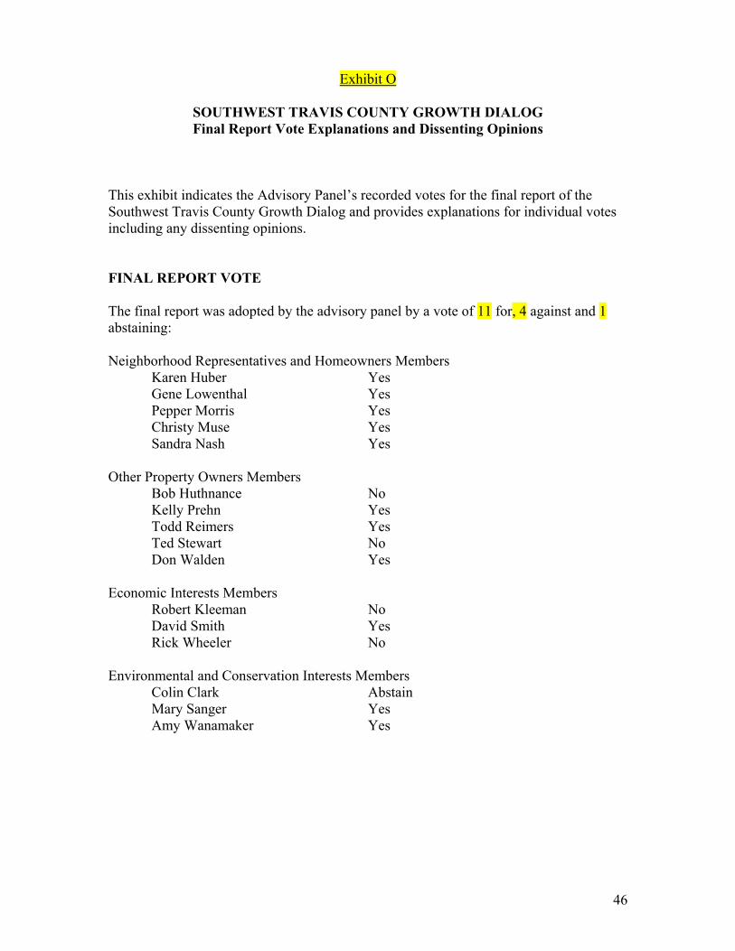
Exhibit O
SOUTHWEST TRAVIS COUNTY GROWTH DIALOG Final Report Vote Explanations and Dissenting Opinions
This exhibit indicates the Advisory Panel’s recorded votes for the final report of the Southwest Travis County Growth Dialog and provides explanations for individual votes including any dissenting opinions. FINAL REPORT VOTE The final report was adopted by the advisory panel by a vote of 11 for, 4 against and 1 abstaining: Neighborhood Representatives and Homeowners Members
Karen Huber Yes Gene Lowenthal Yes Pepper Morris Yes Christy Muse Yes Sandra Nash Yes
Other Property Owners Members
Bob Huthnance No Kelly Prehn Yes Todd Reimers Yes Ted Stewart No Don Walden Yes
Economic Interests Members
Robert Kleeman No David Smith Yes Rick Wheeler No
Environmental and Conservation Interests Members
Colin Clark Abstain Mary Sanger Yes Amy Wanamaker Yes
46

EXPLANATIONS AND DISSENTING OPINIONS Statement From:
Karen Huber, Advisory Panel Voting Member Pepper Morris, Advisory Panel Voting Member Christy Muse, Advisory Panel Voting Member Mary Sanger, Advisory Panel Voting Member
May 24, 2005
The Honorable Gerald Daugherty Travis County Commissioners Court Travis County Courthouse P.O. Box 1748 Austin, TX 78701 Dear Commissioner Daugherty: For the past eight months, we have served on the Southwest Travis County Growth Dialogue. The growth dialogue process was not without its moments of impassioned discourse, but we would like to point out that at the end of the day, this diverse group agreed on far more than it disagreed. In reading the final report, we hope you will keep in mind that of the 12 items the panel voted on, including the vision statement, the interest statement, the proposal statements, the recommendations, and conceptual map, six received unanimous votes (16 votes). No item received less than 10 favorable votes, and the one item receiving ten votes also had four abstentions and one nay vote. The final votes indicate a substantial agreement on a vision for southwest Travis County and the steps that should be undertaken to fulfill this vision. Comments at the public hearings have been thoroughly incorporated into the vision and recommendations, and, we believe, that the Panel’s report accurately describes the views of the majority of the landowners, homeowners, ranchers and business owners living in the Southwest Travis County. The most contentious items that surfaced during the Panel’s discussions regarded water and wastewater utility service. Some members of the Panel did not feel there was sufficient time to fully delve into the complexities of these topics, therefore we recommend that a fact based discussion on water quality and wastewater take place for interested panel members (and possibly others) before the Court engages in a public discussion of these topics. We would also like to clarify several other issues. The Growth Dialogue panel never contemplated imposing walking, biking, hiking or any other type of trail on any one’s private property, and the Panel did not advocate using condemnation procedures to accomplish any of its objectives. We would like to acknowledge that the Panel discussed impervious cover, the science and geographical situations that
47
lead communities to enact impervious cover regulations. In the final recommendation, we recognized there might be a future need for the County Commissioners Court to think about impervious cover regulations in order to protect ground and surface water resources; however, the final report clearly states that no discussions would take place without the full engagement of landowners in the form of a committee and other means of public involvement. Any representation of these issues that contradicts this description is a misrepresentation of the Panel and its work. We commend you for implementing this process, and providing an opportunity for a representative group of Travis County residents to discuss the future options for an inspiring and vital area of our community. Obviously by establishing the Growth Dialogue, you recognize the history, the intrinsic beauty and the abundant and significant natural resources of this area. Most members of this community join you in a great appreciation of southwest Travis County. As you know, this is the area of the County that is most often shown-off to visitors, recollected when thinking about our community; its landscape lures tourist and homesteaders; its river, creeks and flora have been described for decades in books of fiction and non-fiction, and, importantly, it is a treasured “recreational area” for Travis County residents. For all these reasons we thank you for taking the leadership in addressing the issues that the area faces. We would like to express our appreciation to Bob Moore, Kyna Simmons, Joe Gieselman, Tom Nuckols, John Kuhl and the Travis County staff who provided support and assistance. In addition, we want to recognize the positive contribution of Tom Hegemier of the LCRA. Our process would not have succeeded or met the promised time-line if it had not been for Joe Lessard. He was substantive in his approach, even-handed in his facilitation, and worked hard on behalf of the County and the Panel. The implementation of the panel’s recommendations will demonstrate the true value of the process you put in motion, and we offer our assistance to you and the Court in finding the most efficient and timely steps to fully realize the Panel’s – the community’s – proposals. Thank you for the opportunity to work with you, and for your leadership on issues of community-wide interest and concern. Best regards, Karen Huber Pepper Morris Christy Muse Mary Sanger
48
Statement From:
Bob Huthnance, Advisory Panel Voting Member RE: SWTCGD – Final Draft Report So much good work went into the Growth Dialog process, I am encouraged to explain my vote and the reasoning behind it. There were some points decided upon that would not be good policy for the county. The point of most concern involved the U.S. Fish and Wildlife. The discussions during our formal meetings presented little concern; however, there were later discussions that brought to light a much broader concept. Therefore, I must cast a "No" vote. Sincerely, Bob
Statement From:
Robert Kleeman, Advisory Panel Voting Member: RE: SWTCGD – Vote Record
I do support forwarding the report to the Commissioners Court and the LCRA to keep the process moving. Although I think that the work group accomplished a lot and the final report contains many good suggestions that I support, the final report also contains several recommendations that I do not consider good public policy. I understand the vote to be one on the substance of the report. Since there are recommendations that I can not support, I vote no.
Statement From:
Rich Wheeler, Advisory Panel Voting Member RE: SWTCGD – Vote Record
After much consideration, I have concluded that I am compelled to vote NO on the Final Report. While the report is as accurate an account of the work of the Advisory Panel, there are enough potentially contradictory issues and goals as to make its implementation suspect. For example, I strongly disagree that the County should exercise any powers under SB 873 and should not get into regulation of land usage. Other items that are problematic for me include, but are not necessarily limited to, the following:
49
Regional connectivity of trails, parks and greenbelts is not in the best economic interest of land owners unless stringent controls and law enforcement are part of the program. Preservation of open space for water quality and quantity is a subterfuge and potentially adverse and burdensome for land owners who may not pursue development projects until the market comes to their property. Hamilton Pool Rd. needs to be improved and expanded to accommodate traffic demands first and foremost. Hwy 71 West should be given the highest priority for improvement in order to move traffic through the study area and avoid becoming the next 183. US Fish & Wildlife guidelines should not be used for water quality measures. They are a special case for species taking allowances only. Protection of "critical environmental features" is subjective at best and is another form of land use limitation without consideration of land owner rights or economic interest. There are others but I'm bumping up against other deadlines. Suffice it to say that I appreciate your work and found the entire process to be of value. However, too many panaceas were being reached for on too many issues; especially given the climate change that occurred with the moratorium and current legislative issues. Thanx again, Rick Wheeler
50

Exhibit P
SOUTHWEST TRAVIS COUNTY GROWTH DIALOG Advisory Panel Nomination Guidelines
September 8, 2004 The following is a set of nomination criteria or requirements for filling voting and alternate voting positions on the Advisory Panel:
1. Nominated individuals must commit to attend meetings over the course of the
Southwest Travis County Growth Dialog Process. The process is to conclude May 1, 2005, and regular meetings are expected to occur every two or three weeks. More frequent meetings may be held as necessary to meet scheduled milestones.
2. The Travis County Commissioners Court must confirm all appointments of voting
members and their alternates. 3. Voting membership on the panel will be comprised of community representatives
not currently serving in the position of elected official, governmental staff or member of a governmental board or commission with discretionary authority.
4. Membership will be allocated between stakeholder groups as follows:
a. Neighborhood representatives and concerned homeowners from the study area (five voting member positions)
Members should be balanced by geographic location and between large and small property owners
b. Other study area property owners such as owners of agriculture/ranching
and commercial property (five voting member positions)
Appointments should be balanced between agriculture/ranching interests and commercial property interests
c. Economic and development interests (three voting member positions)
Appointments should include land planning/engineering and investor representatives
d. Environmental and preservation interests (three voting member positions)
Appointments should be individuals with expertise in the study area’s environmental characteristics or from community recognized environment/preservation groups
e. Other public interest organizations (three voting member positions)
51

Appointments should be made to assure the overall balance of the Advisory Panel and only from groups or individuals that cannot fall under another of the above stakeholder categories
52
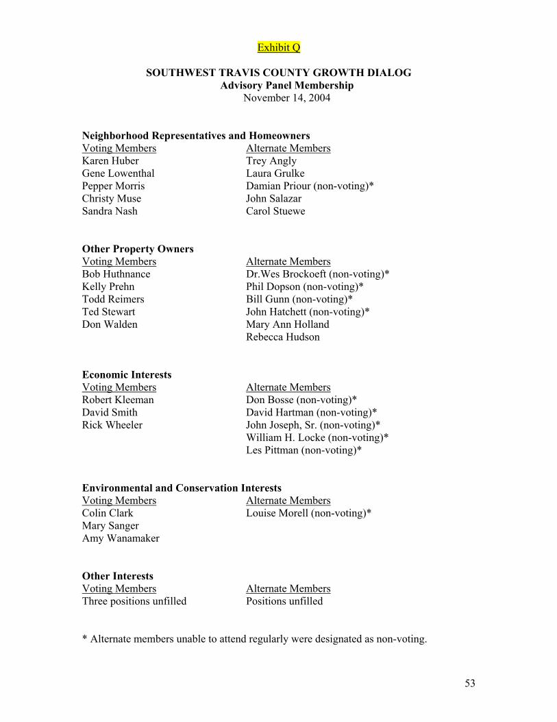
Exhibit Q
SOUTHWEST TRAVIS COUNTY GROWTH DIALOG Advisory Panel Membership
November 14, 2004 Neighborhood Representatives and Homeowners Voting Members Alternate Members Karen Huber Trey Angly Gene Lowenthal Laura Grulke Pepper Morris Damian Priour (non-voting)* Christy Muse John Salazar Sandra Nash Carol Stuewe Other Property Owners Voting Members Alternate Members Bob Huthnance Dr.Wes Brockoeft (non-voting)* Kelly Prehn Phil Dopson (non-voting)* Todd Reimers Bill Gunn (non-voting)* Ted Stewart John Hatchett (non-voting)* Don Walden Mary Ann Holland Rebecca Hudson Economic Interests Voting Members Alternate Members Robert Kleeman Don Bosse (non-voting)* David Smith David Hartman (non-voting)* Rick Wheeler John Joseph, Sr. (non-voting)* William H. Locke (non-voting)* Les Pittman (non-voting)* Environmental and Conservation Interests Voting Members Alternate Members Colin Clark Louise Morell (non-voting)* Mary Sanger Amy Wanamaker Other Interests Voting Members Alternate Members Three positions unfilled Positions unfilled * Alternate members unable to attend regularly were designated as non-voting.
53
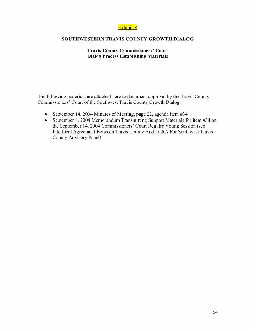
Exhibit R
SOUTHWESTERN TRAVIS COUNTY GROWTH DIALOG
Travis County Commissioners’ Court Dialog Process Establishing Materials
The following materials are attached here to document approval by the Travis County Commissioners’ Court of the Southwest Travis County Growth Dialog:
• September 14, 2004 Minutes of Meeting, page 22, agenda item #34 • September 8, 2004 Memorandum Transmitting Support Materials for item #34 on
the September 14, 2004 Commissioners’ Court Regular Voting Session (see Interlocal Agreement Between Travis County And LCRA For Southwest Travis County Advisory Panel)
54
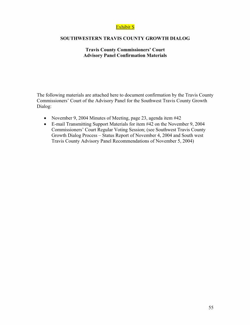
55
Exhibit S
SOUTHWESTERN TRAVIS COUNTY GROWTH DIALOG
Travis County Commissioners’ Court
Advisory Panel Confirmation Materials
The following materials are attached here to document confirmation by the Travis County Commissioners’ Court of the Advisory Panel for the Southwest Travis County Growth Dialog:
• November 9, 2004 Minutes of Meeting, page 23, agenda item #42 • E-mail Transmitting Support Materials for item #42 on the November 9, 2004
Commissioners’ Court Regular Voting Session; (see Southwest Travis County Growth Dialog Process – Status Report of November 4, 2004 and South west Travis County Advisory Panel Recommendations of November 5, 2004)


![[PPT]Ragam Dialog - Culang Cileung | culang … · Web viewRagam Dialog Dialog Manusia- Komputer Pengertian dialog: Umum, dialog adalah proses komunikasi antara 2 atau lebih agen,](https://img.pdfslide.net/doc/110x75/5c85348109d3f2fe508bab22/pptragam-dialog-culang-cileung-culang-web-viewragam-dialog-dialog-manusia-.jpg)